
Main Text - Dunkettle Interchange Improvement Scheme
224
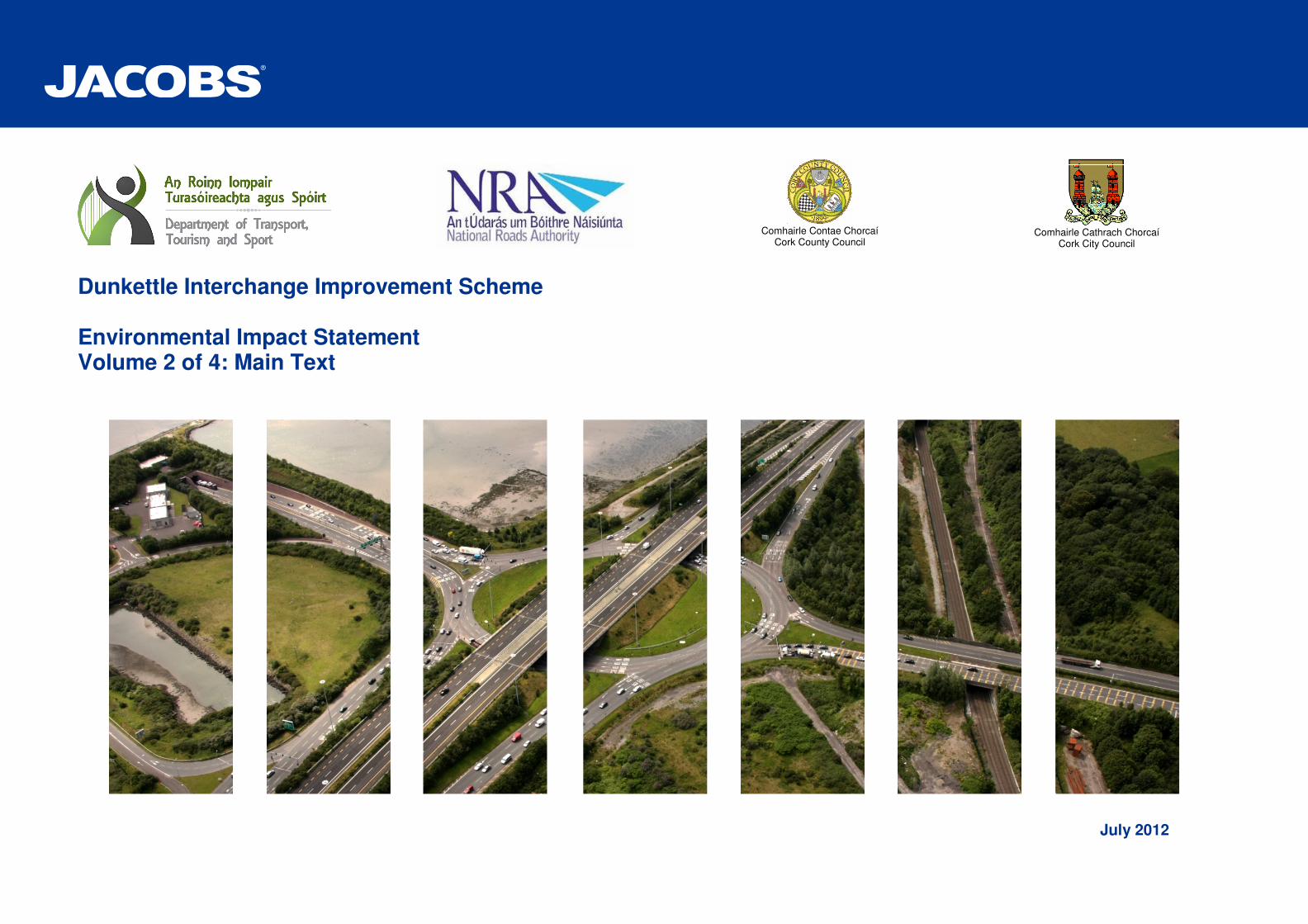
Dunkettle Interchange Improvement Scheme Environmental Impact Statement Volume 2 of 4: Main Text July 2012 Comhairle Contae Chorcaí Cork County Council Comhairle Cathrach Chorcaí Cork City Council
-
Upload
khangminh22 -
Category
Documents
-
view
2 -
download
0
Transcript of Main Text - Dunkettle Interchange Improvement Scheme
Dunkettle Interchange Improvement Scheme Environmental Impact Statement Volume 2 of 4: Main Text
July 2012
Comhairle Contae Chorcaí Cork County Council
Comhairle Cathrach Chorcaí Cork City Council

Contents
1 Introduction & Need for the Proposed Road Development 1
1.1 Existing Interchange 2
1.2 Need for the Scheme 4
1.3 Integration with Policy Objectives 10
1.4 Scheme Objectives 12
1.5 Non Statutory Public Consultation & Display 14
1.6 Legislative Requirement for an EIS 17
2 Description of the Proposed Road Development 18
2.1 Location 18
2.2 Existing Interchange Details 18
2.3 Description of the Proposed Development 20
2.4 Traffic Assessment of Proposed Road Development 27
2.5 Compatibility of Proposed Road Development with Scheme Objectives 29
3 Outline of Alternatives 30
3.1 Introduction 30
3.2 ‘Do-Minimum’ / ‘Do-Nothing’ Alternatives 30
3.3 Traffic Management Alternatives 31
3.4 Infrastructure Alternatives 32
3.5 Infrastructure Alternatives Appraisal 34
3.6 Preferred Alternative 35
4 Socio-Economics 36
4.1 Introduction 36
4.2 Description of the Existing Environment 36
4.3 Appraisal Method used for Assessment of Impacts 40
4.4 Predicted Impacts of the Proposed Development 41
4.5 Proposed Mitigation and Avoidance Measures 42
4.6 Difficulties Encountered in Compiling Information 42
4.7 Cumulative Impacts and Impact Interrelations 43
4.8 Residual Impacts 43
5 Flora and Fauna 44
5.1 Introduction 44
5.2 Methodology 44
5.3 Description of the Existing Environment 49
5.4 Appraisal Method used for Assessment of Impacts 69
5.5 Predicted Impacts of the Proposed Development 69
5.6 Proposed Mitigation and Avoidance Measures 81
5.7 Residual Impacts 90
5.8 Difficulties Encountered in Compiling Information 91
5.9 Cumulative Impacts and Impact Interrelations 92
6 Hydrology, Geomorphology & Hydromorphology 96
6.1 Introduction 96
6.2 Hydrology Water Quality Assessment 96
6.3 Geomorphological and Hydromorphological Environment 113
6.4 References 118
7 Geology , Soils and Hydrogeology 119
7.1 Introduction 119
7.2 Soils and Geology 119
7.3 Hydrogeology 125
8 Air Quality & Climate 132
8.1 Introduction 132
8.2 Description of the Existing Environment 133
8.3 Appraisal Method used for Assessment of Impacts 135
8.4 Predicted Impacts of the Proposed Development 136
8.5 Proposed Mitigation and Avoidance Measures 140
8.6 Difficulties Encountered in Compiling Information 141
8.7 Cumulative Impacts and Impact Interrelations 141
8.8 References 141
9 Noise & Vibration 143
9.1 Introduction 143
9.2 Description of the Existing Environment 143
9.3 Appraisal Method used for Assessment of Noise Impacts 144
9.4 Predicted Operational Noise Impacts of the Proposed Development 146
9.5 Proposed Noise Mitigation and Avoidance Measures 149
9.6 Construction Noise Impacts & Mitigation Measures 153
9.7 Vibration 154
9.8 Difficulties Encountered in Compiling Information 155
9.9 Cumulative Impacts and Impact Interrelations 155
10 Landscape and Visual 156
10.1 Introduction 156
10.2 Description of the Existing Environment 156
10.3 Appraisal Method used for Assessment of Impacts 158
10.4 Predicted Impacts of the Proposed Development 159
10.5 Proposed Mitigation and Avoidance Measures 162
10.6 Difficulties Encountered in Compiling Information 165
10.7 Cumulative Impacts and Impact Interrelations 165
11 Archaeology, Cultural Heritage and Architectural Heritage 166
11.1 Introduction 166
11.2 Archaeology and Cultural Heritage 166
11.3 Architectural Heritage 172
11.4 References 179
12 Waste Management 181
12.1 Introduction 181

12.2 Description of the Existing Environment 181
12.3 Appraisal Method used for Assessment of Impacts 181
12.4 Predicted Impacts of the Proposed Development 181
12.5 Proposed Mitigation and Avoidance Measures 182
12.6 Difficulties Encountered in Compiling Information 183
12.7 Cumulative Impacts and Impact Interrelations 183
13 Material Assets 185
13.1 Introduction 185
13.2 Description of the Existing Environment 185
13.3 Appraisal Method used for Assessment of Impacts 185
13.4 Predicted Impacts of the Proposed Development 186
13.5 Proposed Mitigation and Avoidance Measures 186
13.6 Difficulties Encountered in Compiling Information 187
13.7 Cumulative Impacts and Impact Interrelations 187
14 Inter-relationships between Environmental Factors 188
14.1 Introduction 188
15 Schedule of Environmental Commitments 191
15.1 Introduction 191
15.2 Socio-Economic 192
15.3 Flora and Fauna 192
15.4 Hydrology, Geomorphology and Hydromorphology 201
15.5 Geology, Soils and Hydrogeology 203
15.6 Air Quality and Climate 207
15.7 Noise and Vibration 208
15.8 Landscape and Visual 209
15.9 Archaeology, Cultural Heritage and Architectural Heritage 210
15.10 Waste 212
15.11 Material Assets 214

Tables
Table 1.1: Specialist Sub-Consultant Inputs 1 Table 1.2: Modelled Flows through the existing Dunkettle Interchange 6 Table 1.3: Medium Growth AADT Figures 7 Table 1.4: Journey Times through Dunkettle Interchange (2010 Base min:sec) 8 Table 1.5: Forecast Journey Times through Dunkettle Interchange (2016 Medium
Growth) 8 Table 1.6: Forecast Journey Times through Dunkettle Interchange (2031 Medium
Growth) 8 Table 1.7: Maximum Volume to Capacity Ratios through Dunkettle Interchange
(2010) 9 Table 1.8: Maximum Volume to Capacity Ratios through Dunkettle Interchange
(2016 Medium Growth) 9 Table 1.9: Maximum Volume to Capacity Ratios through Dunkettle Interchange
(2031 Medium Growth) 9 Table 1.10: Dunkettle Interchange Improvement Scheme Objectives 13 Table 2.1: Existing and Alternative Network Access points 21 Table 2.2: Outfall Locations 26 Table 2.3: Forecast Journey Times through Dunkettle Interchange (2016 Medium
Growth) 28 Table 2.4: Forecast Journey Times through Dunkettle Interchange (2031 Medium
Growth) 28 Table 2.5: Maximum Volume to Capacity through Dunkettle Interchange (2016
Medium Growth) 29 Table 2.6: Maximum Volume to Capacity through Dunkettle Interchange (2031
Medium Growth) 29 Table 2.7: Objective Compatibility 29 Table 3.1: Scheme Objectives vs Do-Nothing & Do-Minimum Alternatives 31 Table 3.2: Project Appraisal Framework Matrix 35 Table 4.1: Future Population –Enhanced CASP Projections 36 Table 4.2: Gross Value Added by Construction Sub-sector (€m) 37 Table 4.3: Gross Value Added Breakdown (€m) 38 Table 4.4: Future Employment - Enhanced CASP Projections 38 Table 4.5: Persons Engaged in Construction Activities (number) 38 Table 4.6: Unemployment by Sector, 2005-2011 39 Table 4.7: Commuting Patterns - Time 39 Table 4.8: Commuting Patterns - Distance 39 Table 4.9: Commuting Patterns - Means 40 Table 4.10: Summary of Impacts 43 Table 5.1: Ecological Surveys and Survey Dates at Dunkettle 2010-2012 46 Table 5.2: Bat Survey Dates at Dunkettle 2010-2012 46 Table 5.3: Locations of Bat Surveys at Dunkettle during Spring/Summer/Autumn
2011 47 Table 5.4: Wintering Wetland Bird Survey 2010/2011 - Times & Weather at
Dunkettle 47 Table 5.5: Locations of Sites Surveyed during the Fish Survey for the Proposed
Development. 48 Table 5.6: All Designated Sites within 15km of the Proposed Development 52 Table 5.7: Records of Protected, Red-listed or Notable Flora Recorded in the
Desk Study in the vicinity of the Proposed Development 52 Table 5.8: Records of Protected, Rare or Notable Fauna Species recorded in the
Desk Study within 10km Grid Square W77 53 Table 5.9: Protected Wintering Bird Species and Cork Harbour SPA Qualifying
Interests recorded in iWeBS Dunkettle Count sector (2004-2009). 54
Table 5.10: WFD monitoring results Lough Mahon Estuary during October 2008 - fish species and abundances by net type. Adapted from Kelly et al, (2009). 54
Table 5.11: Number of each Species Captured by each gear type in Lough Mahon Estuary in October 2010. Adapted from IFI (2010) 54
Table 5.12: Number of each Species Captured by each gear type in the Glashaboy Estuary, October 2010. Adapted from IFI (2010). 55
Table 5.13: The Principle Shore Angling marks in Cork Harbour and the Main Angling Species present (adapted from Dunlop & Green, 1992). Distance from Proposed Development. 55
Table 5.14: The Main Fishing Bait Collection areas in Cork Harbour and the main Bait Species present (adapted from Dunlop & Green, 1992). Distance from Proposed Development. 55
Table 5.15: Summary of Habitats within Zone of Influence (Heritage Council Classification) 56
Table 5.16: Summary of Habitats Recorded within ZoI (JNCC Marine Biotope Classification) 57
Table 5.17: Summary of Habitats Recorded within ZoI (JNCC Marine Biotope Classification 58
Table 5.18: Summary of Rare / Notable Flora recorded within the ZoI of the Proposed Development 58
Table 5.19: Summary of Invasive Species Recorded within the ZoI of the Proposed Development 59
Table 5.20: Summary of Mammal Fauna Recorded in surveys in ZoI and Wider Area from December 2010- March 2012 60
Table 5.21: Wintering Birds of Conservation Concern recorded within ZoI from December 2010- March 2011 (Includes part of Cork Harbour SPA and Dunkettle Shore pNHA) 60
Table 5.22: Wintering Birds of Conservation Concern within the ZoI recorded in Undesignated Intertidal Areas in December 2010- March 2011. 61
Table 5.23: Summary of Breeding Birds of Conservation Importance Recorded in Spring/Summer 2011 within the ZoI and wider area 62
Table 5.24: Summary of Locations and Survey Dates of All Bat Surveys (Car Transect, Anabat, Manned Dusk/Dawn & Manned Activity) 63
Table 5.25: Summary of Bat Passes/hr at Anabat Survey Locations 63 Table 5.26: Lepidoptera (Butterflies) 67 Table 5.27: Summary Ecological Valuation and Identification of Key Ecological
Receptors (in Grey) 69 Table 5.28: Summary of Habitat Losses (Area/Length) and Overall Impact
Significance for Key Ecological Receptors (K.E.R’s) outside Designated Areas 73
Table 5.29: Summary of Locations, Invasive Potential and Legal Status of Invasive Plant Species within the ZoI of the Proposed Development 74
Table 5.30: Summary of Construction Phase Impacts 77 Table 5.31: Literature Review Summary of Usage of Culverts by Bats 79 Table 5.32: Summary of Potential Habitat Severance Impacts to Bats 79 Table 5.33: Summary of Existing and Proposed Culvert Dimensions to Inform
assessment of Potential Severance Impacts to Otter and Badger 79 Table 5.34: Summary of Operation Phase Impacts 80 Table 5.35: Summary of Construction Phase Mitigation 88 Table 5.36: Summary of Landscaping Mitigation for Bat Road Crossings 88 Table 5.37: Summary of Operation Phase Mitigation 89 Table 5.38: Summary of Residual Impacts during Construction after Mitigation 91 Table 5.39: Summary of Residual Impacts during Operation after Mitigation 91 Table 6.1: Intertidal Mudflats in the Study Area 98 Table 6.2: Other Wetland areas in the Study Area 99 Table 6.3: Minor Watercourses in the Study Area 99
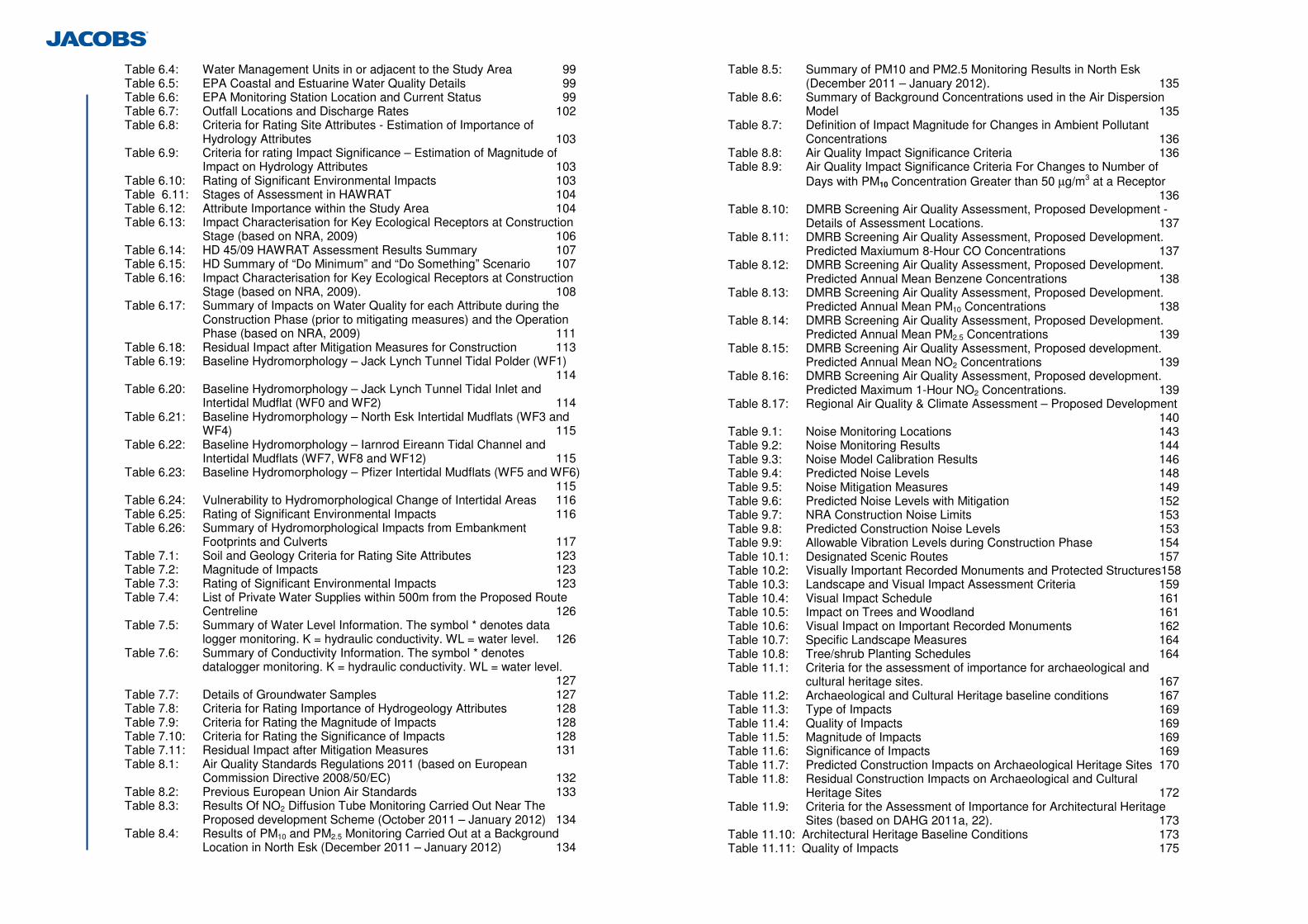
Table 6.4: Water Management Units in or adjacent to the Study Area 99 Table 6.5: EPA Coastal and Estuarine Water Quality Details 99 Table 6.6: EPA Monitoring Station Location and Current Status 99 Table 6.7: Outfall Locations and Discharge Rates 102 Table 6.8: Criteria for Rating Site Attributes - Estimation of Importance of
Hydrology Attributes 103 Table 6.9: Criteria for rating Impact Significance – Estimation of Magnitude of
Impact on Hydrology Attributes 103 Table 6.10: Rating of Significant Environmental Impacts 103 Table 6.11: Stages of Assessment in HAWRAT 104 Table 6.12: Attribute Importance within the Study Area 104 Table 6.13: Impact Characterisation for Key Ecological Receptors at Construction
Stage (based on NRA, 2009) 106 Table 6.14: HD 45/09 HAWRAT Assessment Results Summary 107 Table 6.15: HD Summary of “Do Minimum” and “Do Something” Scenario 107 Table 6.16: Impact Characterisation for Key Ecological Receptors at Construction
Stage (based on NRA, 2009). 108 Table 6.17: Summary of Impacts on Water Quality for each Attribute during the
Construction Phase (prior to mitigating measures) and the Operation Phase (based on NRA, 2009) 111
Table 6.18: Residual Impact after Mitigation Measures for Construction 113 Table 6.19: Baseline Hydromorphology – Jack Lynch Tunnel Tidal Polder (WF1)
114 Table 6.20: Baseline Hydromorphology – Jack Lynch Tunnel Tidal Inlet and
Intertidal Mudflat (WF0 and WF2) 114 Table 6.21: Baseline Hydromorphology – North Esk Intertidal Mudflats (WF3 and
WF4) 115 Table 6.22: Baseline Hydromorphology – Iarnrod Eireann Tidal Channel and
Intertidal Mudflats (WF7, WF8 and WF12) 115 Table 6.23: Baseline Hydromorphology – Pfizer Intertidal Mudflats (WF5 and WF6)
115 Table 6.24: Vulnerability to Hydromorphological Change of Intertidal Areas 116 Table 6.25: Rating of Significant Environmental Impacts 116 Table 6.26: Summary of Hydromorphological Impacts from Embankment
Footprints and Culverts 117 Table 7.1: Soil and Geology Criteria for Rating Site Attributes 123 Table 7.2: Magnitude of Impacts 123 Table 7.3: Rating of Significant Environmental Impacts 123 Table 7.4: List of Private Water Supplies within 500m from the Proposed Route
Centreline 126 Table 7.5: Summary of Water Level Information. The symbol * denotes data
logger monitoring. K = hydraulic conductivity. WL = water level. 126 Table 7.6: Summary of Conductivity Information. The symbol * denotes
datalogger monitoring. K = hydraulic conductivity. WL = water level. 127
Table 7.7: Details of Groundwater Samples 127 Table 7.8: Criteria for Rating Importance of Hydrogeology Attributes 128 Table 7.9: Criteria for Rating the Magnitude of Impacts 128 Table 7.10: Criteria for Rating the Significance of Impacts 128 Table 7.11: Residual Impact after Mitigation Measures 131 Table 8.1: Air Quality Standards Regulations 2011 (based on European
Commission Directive 2008/50/EC) 132 Table 8.2: Previous European Union Air Standards 133 Table 8.3: Results Of NO2 Diffusion Tube Monitoring Carried Out Near The
Proposed development Scheme (October 2011 – January 2012) 134 Table 8.4: Results of PM10 and PM2.5 Monitoring Carried Out at a Background
Location in North Esk (December 2011 – January 2012) 134
Table 8.5: Summary of PM10 and PM2.5 Monitoring Results in North Esk (December 2011 – January 2012). 135
Table 8.6: Summary of Background Concentrations used in the Air Dispersion Model 135
Table 8.7: Definition of Impact Magnitude for Changes in Ambient Pollutant Concentrations 136
Table 8.8: Air Quality Impact Significance Criteria 136 Table 8.9: Air Quality Impact Significance Criteria For Changes to Number of
Days with PM10 Concentration Greater than 50 µg/m3 at a Receptor 136
Table 8.10: DMRB Screening Air Quality Assessment, Proposed Development - Details of Assessment Locations. 137
Table 8.11: DMRB Screening Air Quality Assessment, Proposed Development. Predicted Maxiumum 8-Hour CO Concentrations 137
Table 8.12: DMRB Screening Air Quality Assessment, Proposed Development. Predicted Annual Mean Benzene Concentrations 138
Table 8.13: DMRB Screening Air Quality Assessment, Proposed Development. Predicted Annual Mean PM10 Concentrations 138
Table 8.14: DMRB Screening Air Quality Assessment, Proposed Development. Predicted Annual Mean PM2.5 Concentrations 139
Table 8.15: DMRB Screening Air Quality Assessment, Proposed development. Predicted Annual Mean NO2 Concentrations 139
Table 8.16: DMRB Screening Air Quality Assessment, Proposed development. Predicted Maximum 1-Hour NO2 Concentrations. 139
Table 8.17: Regional Air Quality & Climate Assessment – Proposed Development 140
Table 9.1: Noise Monitoring Locations 143 Table 9.2: Noise Monitoring Results 144 Table 9.3: Noise Model Calibration Results 146 Table 9.4: Predicted Noise Levels 148 Table 9.5: Noise Mitigation Measures 149 Table 9.6: Predicted Noise Levels with Mitigation 152 Table 9.7: NRA Construction Noise Limits 153 Table 9.8: Predicted Construction Noise Levels 153 Table 9.9: Allowable Vibration Levels during Construction Phase 154 Table 10.1: Designated Scenic Routes 157 Table 10.2: Visually Important Recorded Monuments and Protected Structures158 Table 10.3: Landscape and Visual Impact Assessment Criteria 159 Table 10.4: Visual Impact Schedule 161 Table 10.5: Impact on Trees and Woodland 161 Table 10.6: Visual Impact on Important Recorded Monuments 162 Table 10.7: Specific Landscape Measures 164 Table 10.8: Tree/shrub Planting Schedules 164 Table 11.1: Criteria for the assessment of importance for archaeological and
cultural heritage sites. 167 Table 11.2: Archaeological and Cultural Heritage baseline conditions 167 Table 11.3: Type of Impacts 169 Table 11.4: Quality of Impacts 169 Table 11.5: Magnitude of Impacts 169 Table 11.6: Significance of Impacts 169 Table 11.7: Predicted Construction Impacts on Archaeological Heritage Sites 170 Table 11.8: Residual Construction Impacts on Archaeological and Cultural
Heritage Sites 172 Table 11.9: Criteria for the Assessment of Importance for Architectural Heritage
Sites (based on DAHG 2011a, 22). 173 Table 11.10: Architectural Heritage Baseline Conditions 173 Table 11.11: Quality of Impacts 175

Table 11.12: Duration of Impacts 175 Table 11.13: Type of Impacts 175 Table 11.14: Significance of Impact Matrix 175 Table 11.15: Definition of Levels of Significance of Impact for Architectural Heritage
sites 176 Table 11.16: Predicted Construction Impacts on Architectural Heritage Sites 176 Table 11.17: Predicted Operation Impacts on Architectural Heritage Sites 177 Table 11.18: Residual Construction Impacts on Architectural Heritage Sites 178 Table 11.19: Residual Operation Impacts on Architectural Heritage Sites 178 Table 12.1: Residual Impact after Mitigation Measures 183 Table 13.1: Summary of Existing Utilities in the Existing Environment 185 Table 13.2: Material Assets Assessment Criteria 186 Table 13.3: Utility Mitigation Measures 187 Table 14:1 Relationships between the Environmental Aspects 189 Table 14.2: Explanatory Notes on the Relationships between the Environmental
Aspects 190

Images
Image 1.1: National Road Network 2 Image 1.2: Aerial Photograph of Existing Dunkettle Interchange 3 Image 1.3: South West Region Map of the NSS 4 Image 1.4: AM Peak Traffic at the Dunkettle Interchange (taken from the North
East) 5 Image 1.5: AM Peak Traffic at the Dunkettle Interchange (taken from the North) 5 Image 1.6: Main Traffic Movements through the Interchange 7 Image 1.7: AADT and Journey Time Reference Figure 8 Image 1.8: NSS National Transport Framework 10 Image 1.9: Public Consultation Advertisement 14 Image 1.10: Photo of Public Consultation 15 Image 1.11: Do you own or occupy property with the Study Area? 15 Image 1.12: Do you currently use the Interchange? 15 Image 1.13: Do you generally support the need to improve the existing Dunkettle
Interchange? 15 Image 1.14: If you support the need for improvements to the existing Dunkettle
Interchange, please rank the following 4 objectives in terms of their importance to you (1 being most important, 4 being least important) 15
Image 1.15: Category of Comment received from the General Public 16 Image 1.16: Public preference for Interchange Option where stated in their
response 16 Image 1.17: Press Cutting from the Evening Echo Wednesday April 6th 2011 16 Image 1.18: Photo of Public Display Presentation Boards 17 Image 2.1 Top Left: Aerial view of Western Approach to Dunkettle Interchange19 Image 2.2 Bottom Left: Aerial view of Southern Approach to Dunkettle
Interchange 19 Image 2.3 Top Right: Aerial view of Northern Approach to Dunkettle Interchange
19 Image 2.4 Bottom Right: Aerial view of Eastern Approach to Dunkettle
Interchange 19 Image 2.5: 2016 Do-Minimum vs Proposed Development Journey Times 28 Image 2.6: 2031 Do-Minimum vs Proposed Development Journey Times 28 Image 7.1: Generic Conceptual Site Model demonstrating potential Points of
Compliance 122 Image 9.1: Extent of Low Noise Surface on Link A 149 Image 9.2: Extent of Low Noise Surface of Link D 150 Image 9.3: Extent of Low Noise Surface on Link H 150 Image 9.4: Extent of Low Noise Surface on Link T1 150 Image 9.5: Extent of Low Noise Surface on Link T2 150
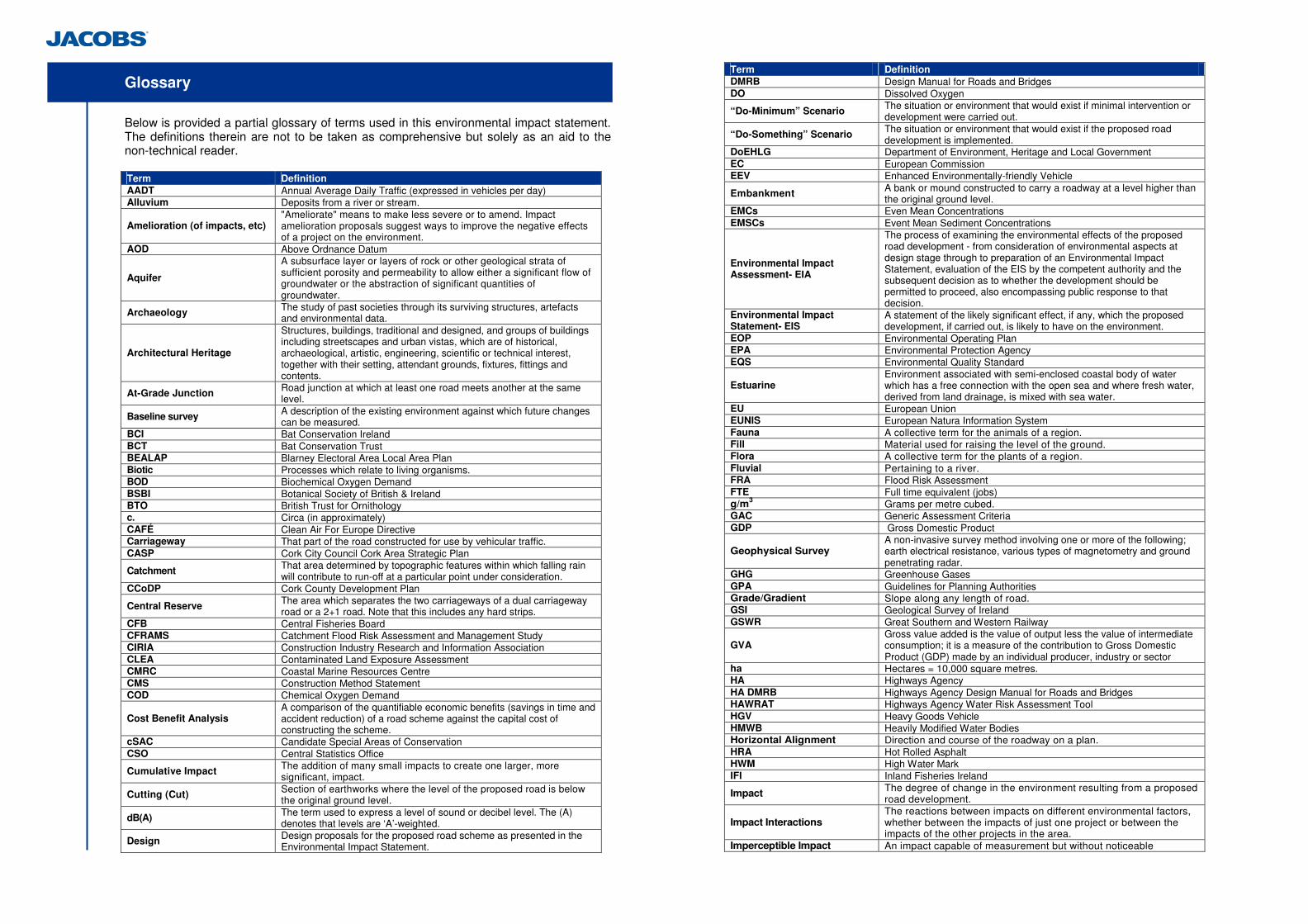
Glossary
Below is provided a partial glossary of terms used in this environmental impact statement. The definitions therein are not to be taken as comprehensive but solely as an aid to the non-technical reader. Term Definition AADT Annual Average Daily Traffic (expressed in vehicles per day) Alluvium Deposits from a river or stream.
Amelioration (of impacts, etc) "Ameliorate" means to make less severe or to amend. Impact amelioration proposals suggest ways to improve the negative effects of a project on the environment.
AOD Above Ordnance Datum
Aquifer
A subsurface layer or layers of rock or other geological strata of sufficient porosity and permeability to allow either a significant flow of groundwater or the abstraction of significant quantities of groundwater.
Archaeology The study of past societies through its surviving structures, artefacts and environmental data.
Architectural Heritage
Structures, buildings, traditional and designed, and groups of buildings including streetscapes and urban vistas, which are of historical, archaeological, artistic, engineering, scientific or technical interest, together with their setting, attendant grounds, fixtures, fittings and contents.
At-Grade Junction Road junction at which at least one road meets another at the same level.
Baseline survey A description of the existing environment against which future changes can be measured.
BCI Bat Conservation Ireland BCT Bat Conservation Trust BEALAP Blarney Electoral Area Local Area Plan Biotic Processes which relate to living organisms. BOD Biochemical Oxygen Demand BSBI Botanical Society of British & Ireland BTO British Trust for Ornithology c. Circa (in approximately) CAFÉ Clean Air For Europe Directive Carriageway That part of the road constructed for use by vehicular traffic. CASP Cork City Council Cork Area Strategic Plan
Catchment That area determined by topographic features within which falling rain will contribute to run-off at a particular point under consideration.
CCoDP Cork County Development Plan
Central Reserve The area which separates the two carriageways of a dual carriageway road or a 2+1 road. Note that this includes any hard strips.
CFB Central Fisheries Board CFRAMS Catchment Flood Risk Assessment and Management Study CIRIA Construction Industry Research and Information Association CLEA Contaminated Land Exposure Assessment CMRC Coastal Marine Resources Centre CMS Construction Method Statement COD Chemical Oxygen Demand
Cost Benefit Analysis A comparison of the quantifiable economic benefits (savings in time and accident reduction) of a road scheme against the capital cost of constructing the scheme.
cSAC Candidate Special Areas of Conservation CSO Central Statistics Office
Cumulative Impact The addition of many small impacts to create one larger, more significant, impact.
Cutting (Cut) Section of earthworks where the level of the proposed road is below the original ground level.
dB(A) The term used to express a level of sound or decibel level. The (A) denotes that levels are ‘A’-weighted.
Design Design proposals for the proposed road scheme as presented in the Environmental Impact Statement.
Term Definition DMRB Design Manual for Roads and Bridges DO Dissolved Oxygen
“Do-Minimum” Scenario The situation or environment that would exist if minimal intervention or development were carried out.
“Do-Something” Scenario The situation or environment that would exist if the proposed road development is implemented.
DoEHLG Department of Environment, Heritage and Local Government EC European Commission EEV Enhanced Environmentally-friendly Vehicle
Embankment A bank or mound constructed to carry a roadway at a level higher than the original ground level.
EMCs Even Mean Concentrations EMSCs Event Mean Sediment Concentrations
Environmental Impact Assessment- EIA
The process of examining the environmental effects of the proposed road development - from consideration of environmental aspects at design stage through to preparation of an Environmental Impact Statement, evaluation of the EIS by the competent authority and the subsequent decision as to whether the development should be permitted to proceed, also encompassing public response to that decision.
Environmental Impact Statement- EIS
A statement of the likely significant effect, if any, which the proposed development, if carried out, is likely to have on the environment.
EOP Environmental Operating Plan EPA Environmental Protection Agency EQS Environmental Quality Standard
Estuarine Environment associated with semi-enclosed coastal body of water which has a free connection with the open sea and where fresh water, derived from land drainage, is mixed with sea water.
EU European Union EUNIS European Natura Information System Fauna A collective term for the animals of a region. Fill Material used for raising the level of the ground. Flora A collective term for the plants of a region. Fluvial Pertaining to a river. FRA Flood Risk Assessment FTE Full time equivalent (jobs) g/m3 Grams per metre cubed. GAC Generic Assessment Criteria GDP Gross Domestic Product
Geophysical Survey A non-invasive survey method involving one or more of the following; earth electrical resistance, various types of magnetometry and ground penetrating radar.
GHG Greenhouse Gases GPA Guidelines for Planning Authorities Grade/Gradient Slope along any length of road. GSI Geological Survey of Ireland GSWR Great Southern and Western Railway
GVA Gross value added is the value of output less the value of intermediate consumption; it is a measure of the contribution to Gross Domestic Product (GDP) made by an individual producer, industry or sector
ha Hectares = 10,000 square metres. HA Highways Agency HA DMRB Highways Agency Design Manual for Roads and Bridges HAWRAT Highways Agency Water Risk Assessment Tool HGV Heavy Goods Vehicle HMWB Heavily Modified Water Bodies Horizontal Alignment Direction and course of the roadway on a plan. HRA Hot Rolled Asphalt HWM High Water Mark IFI Inland Fisheries Ireland
Impact The degree of change in the environment resulting from a proposed road development.
Impact Interactions The reactions between impacts on different environmental factors, whether between the impacts of just one project or between the impacts of the other projects in the area.
Imperceptible Impact An impact capable of measurement but without noticeable
Term Definition consequences.
Indirect Impact Impacts on the environment which are not a direct result of the project, often produced away from the project or as a result of a complex pathway.
Infrastructure Basic public facilities e.g. roads, sewers, water supply, telephones and electricity.
IPPC Integrated Pollution Prevention and Control ISO International Standards Organisation ITS Intelligent Transport Systems IUCN International Union for Conservation of Nature and Natural Resources IWeBS Irish Wetland Bird Survey Data JLT Jack Lynch Tunnel KER's Key Ecological Receptor's l/s Litres per second.
Landtake Land required for the construction of the proposed new road. The area of land between the fence lines.
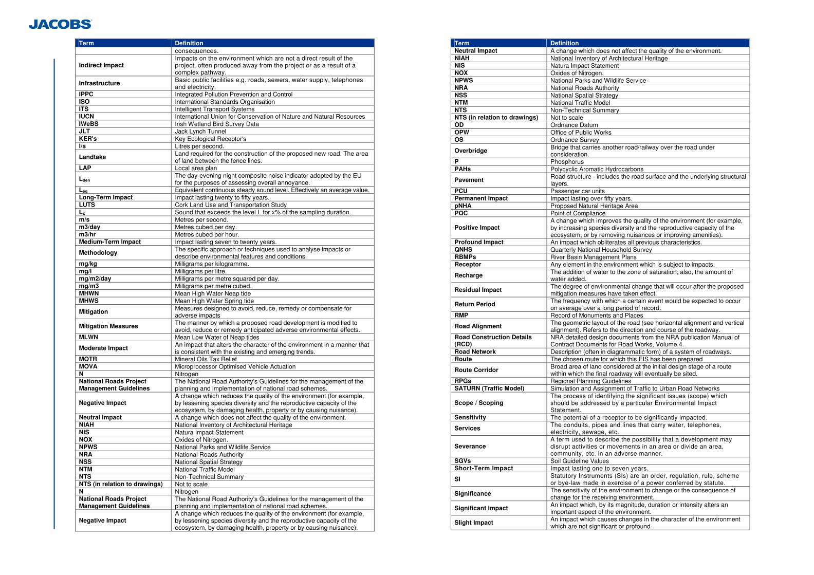
LAP Local area plan
Lden The day-evening night composite noise indicator adopted by the EU for the purposes of assessing overall annoyance.
Leq Equivalent continuous steady sound level. Effectively an average value. Long-Term Impact Impact lasting twenty to fifty years. LUTS Cork Land Use and Transportation Study Lx Sound that exceeds the level L for x% of the sampling duration. m/s Metres per second. m3/day Metres cubed per day. m3/hr Metres cubed per hour. Medium-Term Impact Impact lasting seven to twenty years.
Methodology The specific approach or techniques used to analyse impacts or describe environmental features and conditions
mg/kg Milligrams per kilogramme. mg/l Milligrams per litre. mg/m2/day Milligrams per metre squared per day. mg/m3 Milligrams per metre cubed. MHWN Mean High Water Neap tide MHWS Mean High Water Spring tide
Mitigation Measures designed to avoid, reduce, remedy or compensate for adverse impacts
Mitigation Measures The manner by which a proposed road development is modified to avoid, reduce or remedy anticipated adverse environmental effects.
MLWN Mean Low Water of Neap tides
Moderate Impact An impact that alters the character of the environment in a manner that is consistent with the existing and emerging trends.
MOTR Mineral Oils Tax Relief MOVA Microprocessor Optimised Vehicle Actuation N Nitrogen National Roads Project Management Guidelines
The National Road Authority’s Guidelines for the management of the planning and implementation of national road schemes.
Negative Impact A change which reduces the quality of the environment (for example, by lessening species diversity and the reproductive capacity of the ecosystem, by damaging health, property or by causing nuisance).
Neutral Impact A change which does not affect the quality of the environment. NIAH National Inventory of Architectural Heritage NIS Natura Impact Statement NOX Oxides of Nitrogen. NPWS National Parks and Wildlife Service NRA National Roads Authority NSS National Spatial Strategy NTM National Traffic Model NTS Non-Technical Summary NTS (in relation to drawings) Not to scale N Nitrogen National Roads Project Management Guidelines
The National Road Authority’s Guidelines for the management of the planning and implementation of national road schemes.
Negative Impact A change which reduces the quality of the environment (for example, by lessening species diversity and the reproductive capacity of the ecosystem, by damaging health, property or by causing nuisance).
Term Definition Neutral Impact A change which does not affect the quality of the environment. NIAH National Inventory of Architectural Heritage NIS Natura Impact Statement NOX Oxides of Nitrogen. NPWS National Parks and Wildlife Service NRA National Roads Authority NSS National Spatial Strategy NTM National Traffic Model NTS Non-Technical Summary NTS (in relation to drawings) Not to scale OD Ordnance Datum OPW Office of Public Works OS Ordnance Survey
Overbridge Bridge that carries another road/railway over the road under consideration.
P Phosphorus PAHs Polycyclic Aromatic Hydrocarbons
Pavement Road structure - includes the road surface and the underlying structural layers.
PCU Passenger car units Permanent Impact Impact lasting over fifty years. pNHA Proposed Natural Heritage Area POC Point of Compliance
Positive Impact A change which improves the quality of the environment (for example, by increasing species diversity and the reproductive capacity of the ecosystem, or by removing nuisances or improving amenities).
Profound Impact An impact which obliterates all previous characteristics. QNHS Quarterly National Household Survey RBMPs River Basin Management Plans Receptor Any element in the environment which is subject to impacts.
Recharge The addition of water to the zone of saturation; also, the amount of water added.
Residual Impact The degree of environmental change that will occur after the proposed mitigation measures have taken effect.
Return Period The frequency with which a certain event would be expected to occur on average over a long period of record.
RMP Record of Monuments and Places
Road Alignment The geometric layout of the road (see horizontal alignment and vertical alignment). Refers to the direction and course of the roadway.
Road Construction Details (RCD)
NRA detailed design documents from the NRA publication Manual of Contract Documents for Road Works, Volume 4.
Road Network Description (often in diagrammatic form) of a system of roadways. Route The chosen route for which this EIS has been prepared
Route Corridor Broad area of land considered at the initial design stage of a route within which the final roadway will eventually be sited.
RPGs Regional Planning Guidelines SATURN (Traffic Model) Simulation and Assignment of Traffic to Urban Road Networks
Scope / Scoping The process of identifying the significant issues (scope) which should be addressed by a particular Environmental Impact Statement.
Sensitivity The potential of a receptor to be significantly impacted.
Services The conduits, pipes and lines that carry water, telephones, electricity, sewage, etc.
Severance A term used to describe the possibility that a development may disrupt activities or movements in an area or divide an area, community, etc. in an adverse manner.
SGVs Soil Guideline Values Short-Term Impact Impact lasting one to seven years.
SI Statutory Instruments (SIs) are an order, regulation, rule, scheme or bye-law made in exercise of a power conferred by statute.
Significance The sensitivity of the environment to change or the consequence of change for the receiving environment.
Significant Impact An impact which, by its magnitude, duration or intensity alters an important aspect of the environment.
Slight Impact An impact which causes changes in the character of the environment which are not significant or profound.
Term Definition
Slip Road Length of one-way road at a junction that connects roads usually at different levels.
SMR Sites and Monuments Record SO2 Sulphur Dioxide SPA Special Protection Area
Spring A flow of water that occurs where the water table intercepts the ground surface.
Statutory Consultees
Organisations and authorities stipulated by legislation (in Acts and Regulations) that are to be sent a copy of the scheme environmental impact statement, together with a notice in the prescribed form stating that the road authority has made an application to An Bord Pleanála for an approval of the proposed road development.
Statutory Instrument An order, regulation, rule, scheme or bye-law made in exercise of power conferred by statute.
Summary of Mitigation Measures/Environmental Commitments
A list of all the environmental mitigation measures that the road authority proposes to undertake in conjunction with the construction of the scheme.
SWCH Surface water channels SWRBDMP South West River Basin District Management Plan SWRFB South Western Regional Fisheries Board SWRPG South West Regional Planning Guidelines Temporary Impact An impact which is not permanent or lasting. TRL UK Transport Research Laboratory TSAS Trophic Status Assessment Scheme TSS Total Suspended Solids
Underbridge Bridge that carries the road under consideration above another road or railway.
Term Definition
Underpass A way or passage below another road or structure to facilitate traffic flow.
Underpass (Pedestrian) A way or passage below another road or structure to facilitate pedestrians or cyclists.
UNFCCC United Nations Framework Convention on Climate Change
Unsaturated zone The zone between the land surface and the water table, in which pores and fissures are only partially filled with water. Also known as the vadose zone.
V/C Volume to Capacity ratio
Verge Strip adjacent to and abutting the hard shoulder of carriageway of a road - usually grassed.
Vertical Alignment Direction and course of the roadway in profile. VID Visual Impact Drawing VIS Visual Impact Schedule VOCs Volatile Organic Compounds
Water Table The surface at which pore water pressure in an aquifer is equal to atmospheric pressure, and which separates the saturated zone from the unsaturated zone.
WFD Water Framework Directive WHO World Health Organisation WMU Water Management Unit ZoI Zone of Influence
95th Percentile Flow The flow rate (expressed in m3/s) at a given location on a river which over the long-term is equalled or exceeded 95% of the time.
1
1 Introduction & Need for the Proposed Road Development
The National Roads Authority (NRA) has developed proposals for the improvement of the existing Dunkettle Interchange in County Cork. The existing interchange is an important intersection of a number of key national routes including the M8/N8 Dublin to Cork route, the N25 Cork to Waterford route and the N40 Southern Ring Road (through the Jack Lynch Tunnel). The design of the ‘Dunkettle Interchange Improvement Scheme’, hereinafter also referred to as the ‘proposed development’ or ‘scheme’, has been developed to assist in the preparation of the environmental assessment of the scheme and to establish land take requirements. This Environmental Impact Statement (EIS) has been prepared on behalf of the NRA by Jacobs Engineering Ireland Ltd, including specialist input from sub-consultants and individuals for the aspects outlined in Table 1.1. This EIS presents a statement of the likely effects on the environment of the proposed development and includes a description of the measures envisaged in order to avoid, reduce and where possible, remedy any identified significant adverse effects. The EIS documents have been subdivided into the following 4 Volumes for ease of use: Volume 1: Non Technical Summary Volume 2: Main Text Volume 3: Figures Volume 4: Appendices The location of the scheme is shown in Figure 1.1.1 in Volume 3 of this EIS. This Chapter 1 of this EIS is subdivided into the following elements; 1.1 Existing Interchange 1.2 Need for the Scheme 1.3 Integration with Policy Objectives 1.4 Scheme Objectives 1.5 Non Statutory Public Consultation & Display 1.6 Legislative Requirement for EIS
Aspect Sub-Consultant Further Sub Consultant Detail
Evelyn Moorkens - Independent Consultant
Molluscs
Ger Morgan - University College Cork
Marine benthic fauna & sediment analysis
Eamon O Donnell - Independent Consultant Ken Bond - University College Cork
Lepidoptera
Stephen McCormick - Independent Consultant Waterbeetles
Flora and Fauna and Natura Impact Statement
Scott Cawley Ltd Aebhin Cawley and Robert Fennelly
Ecofact Ltd Fisheries
Landscape and Visual
Brady Shipman Martin (BSM) David Bosonnet
- -
Aspect Sub-Consultant Further Sub Consultant
Detail
Noise and Vibration
AWN Consulting Stephen Smyth
- -
Planning Services
Simon Clear & Associates Simon Clear
- -
Air Quality and Climate
AWN Consulting Claire Lynch - -
Table 1.1: Specialist Sub-Consultant Inputs
2
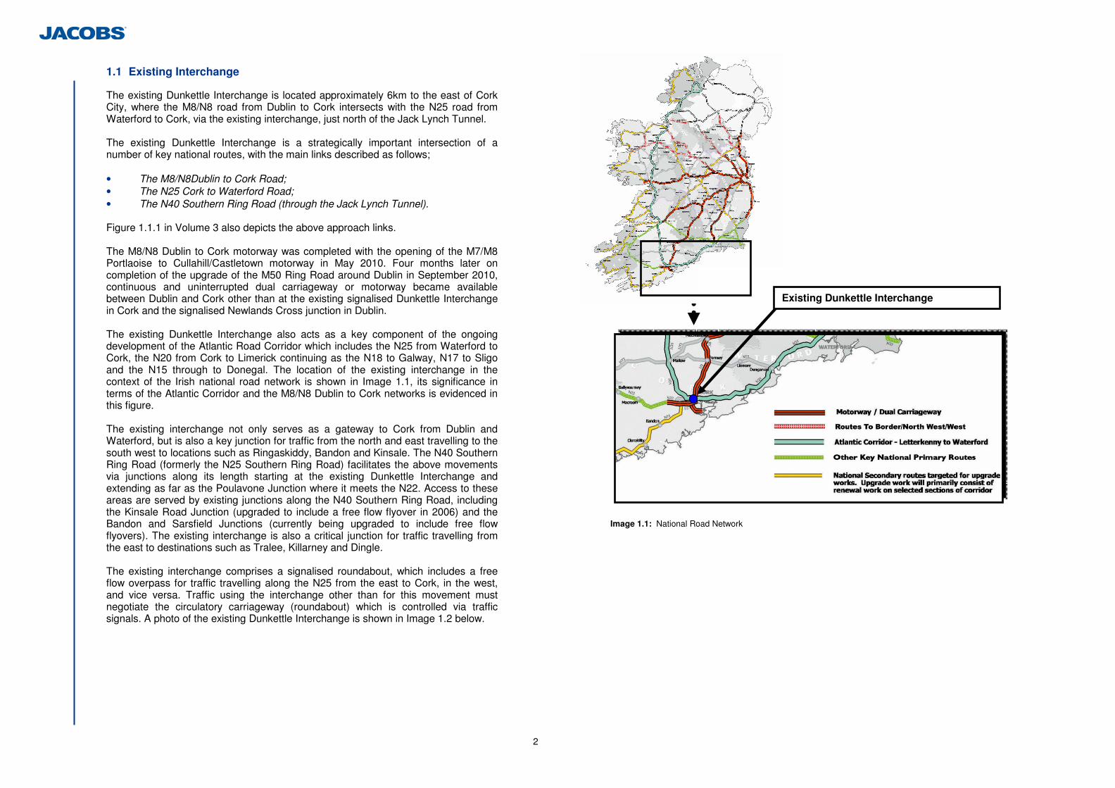
1.1 Existing Interchange
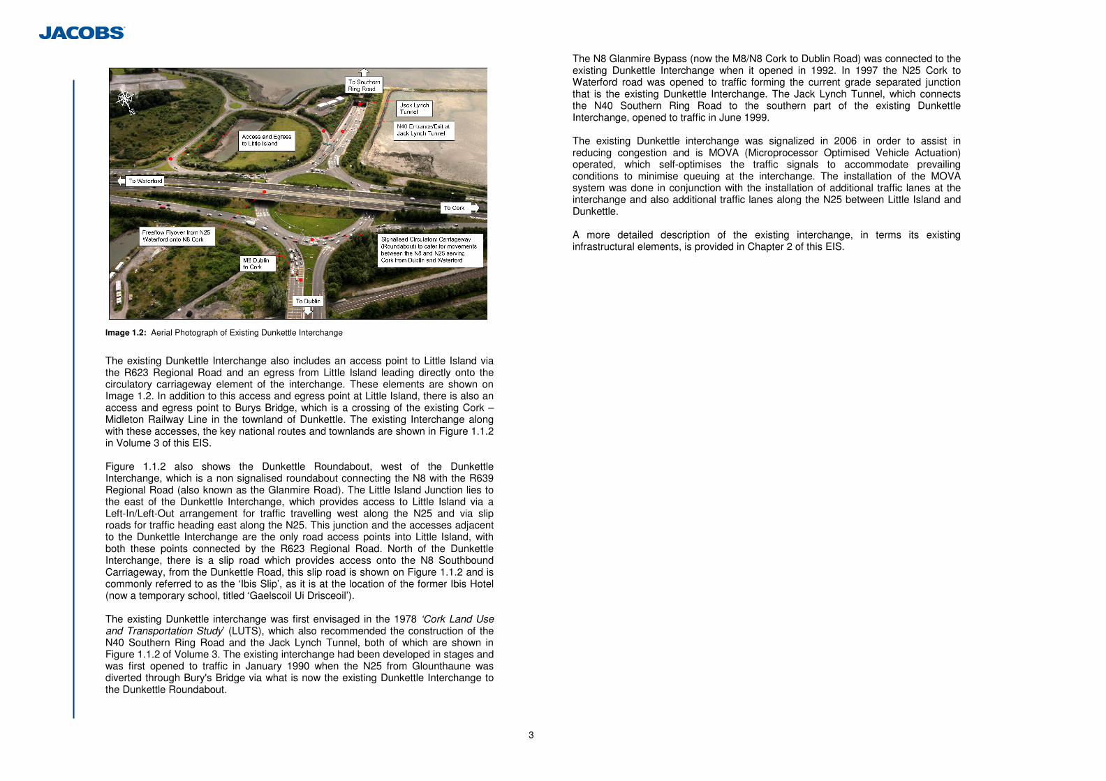
The existing Dunkettle Interchange is located approximately 6km to the east of Cork City, where the M8/N8 road from Dublin to Cork intersects with the N25 road from Waterford to Cork, via the existing interchange, just north of the Jack Lynch Tunnel. The existing Dunkettle Interchange is a strategically important intersection of a number of key national routes, with the main links described as follows; • The M8/N8Dublin to Cork Road; • The N25 Cork to Waterford Road; • The N40 Southern Ring Road (through the Jack Lynch Tunnel). Figure 1.1.1 in Volume 3 also depicts the above approach links. The M8/N8 Dublin to Cork motorway was completed with the opening of the M7/M8 Portlaoise to Cullahill/Castletown motorway in May 2010. Four months later on completion of the upgrade of the M50 Ring Road around Dublin in September 2010, continuous and uninterrupted dual carriageway or motorway became available between Dublin and Cork other than at the existing signalised Dunkettle Interchange in Cork and the signalised Newlands Cross junction in Dublin. The existing Dunkettle Interchange also acts as a key component of the ongoing development of the Atlantic Road Corridor which includes the N25 from Waterford to Cork, the N20 from Cork to Limerick continuing as the N18 to Galway, N17 to Sligo and the N15 through to Donegal. The location of the existing interchange in the context of the Irish national road network is shown in Image 1.1, its significance in terms of the Atlantic Corridor and the M8/N8 Dublin to Cork networks is evidenced in this figure. The existing interchange not only serves as a gateway to Cork from Dublin and Waterford, but is also a key junction for traffic from the north and east travelling to the south west to locations such as Ringaskiddy, Bandon and Kinsale. The N40 Southern Ring Road (formerly the N25 Southern Ring Road) facilitates the above movements via junctions along its length starting at the existing Dunkettle Interchange and extending as far as the Poulavone Junction where it meets the N22. Access to these areas are served by existing junctions along the N40 Southern Ring Road, including the Kinsale Road Junction (upgraded to include a free flow flyover in 2006) and the Bandon and Sarsfield Junctions (currently being upgraded to include free flow flyovers). The existing interchange is also a critical junction for traffic travelling from the east to destinations such as Tralee, Killarney and Dingle. The existing interchange comprises a signalised roundabout, which includes a free flow overpass for traffic travelling along the N25 from the east to Cork, in the west, and vice versa. Traffic using the interchange other than for this movement must negotiate the circulatory carriageway (roundabout) which is controlled via traffic signals. A photo of the existing Dunkettle Interchange is shown in Image 1.2 below.
Image 1.1: National Road Network
Existing Dunkettle Interchange
3
Image 1.2: Aerial Photograph of Existing Dunkettle Interchange
The existing Dunkettle Interchange also includes an access point to Little Island via the R623 Regional Road and an egress from Little Island leading directly onto the circulatory carriageway element of the interchange. These elements are shown on Image 1.2. In addition to this access and egress point at Little Island, there is also an access and egress point to Burys Bridge, which is a crossing of the existing Cork – Midleton Railway Line in the townland of Dunkettle. The existing Interchange along with these accesses, the key national routes and townlands are shown in Figure 1.1.2 in Volume 3 of this EIS. Figure 1.1.2 also shows the Dunkettle Roundabout, west of the Dunkettle Interchange, which is a non signalised roundabout connecting the N8 with the R639 Regional Road (also known as the Glanmire Road). The Little Island Junction lies to the east of the Dunkettle Interchange, which provides access to Little Island via a Left-In/Left-Out arrangement for traffic travelling west along the N25 and via slip roads for traffic heading east along the N25. This junction and the accesses adjacent to the Dunkettle Interchange are the only road access points into Little Island, with both these points connected by the R623 Regional Road. North of the Dunkettle Interchange, there is a slip road which provides access onto the N8 Southbound Carriageway, from the Dunkettle Road, this slip road is shown on Figure 1.1.2 and is commonly referred to as the ‘Ibis Slip’, as it is at the location of the former Ibis Hotel (now a temporary school, titled ‘Gaelscoil Ui Drisceoil’). The existing Dunkettle interchange was first envisaged in the 1978 ‘Cork Land Use and Transportation Study’ (LUTS), which also recommended the construction of the N40 Southern Ring Road and the Jack Lynch Tunnel, both of which are shown in Figure 1.1.2 of Volume 3. The existing interchange had been developed in stages and was first opened to traffic in January 1990 when the N25 from Glounthaune was diverted through Bury's Bridge via what is now the existing Dunkettle Interchange to the Dunkettle Roundabout.
The N8 Glanmire Bypass (now the M8/N8 Cork to Dublin Road) was connected to the existing Dunkettle Interchange when it opened in 1992. In 1997 the N25 Cork to Waterford road was opened to traffic forming the current grade separated junction that is the existing Dunkettle Interchange. The Jack Lynch Tunnel, which connects the N40 Southern Ring Road to the southern part of the existing Dunkettle Interchange, opened to traffic in June 1999. The existing Dunkettle interchange was signalized in 2006 in order to assist in reducing congestion and is MOVA (Microprocessor Optimised Vehicle Actuation) operated, which self-optimises the traffic signals to accommodate prevailing conditions to minimise queuing at the interchange. The installation of the MOVA system was done in conjunction with the installation of additional traffic lanes at the interchange and also additional traffic lanes along the N25 between Little Island and Dunkettle. A more detailed description of the existing interchange, in terms its existing infrastructural elements, is provided in Chapter 2 of this EIS.
N40
4
1.2 Need for the Scheme
1.2.1 Strategic Need
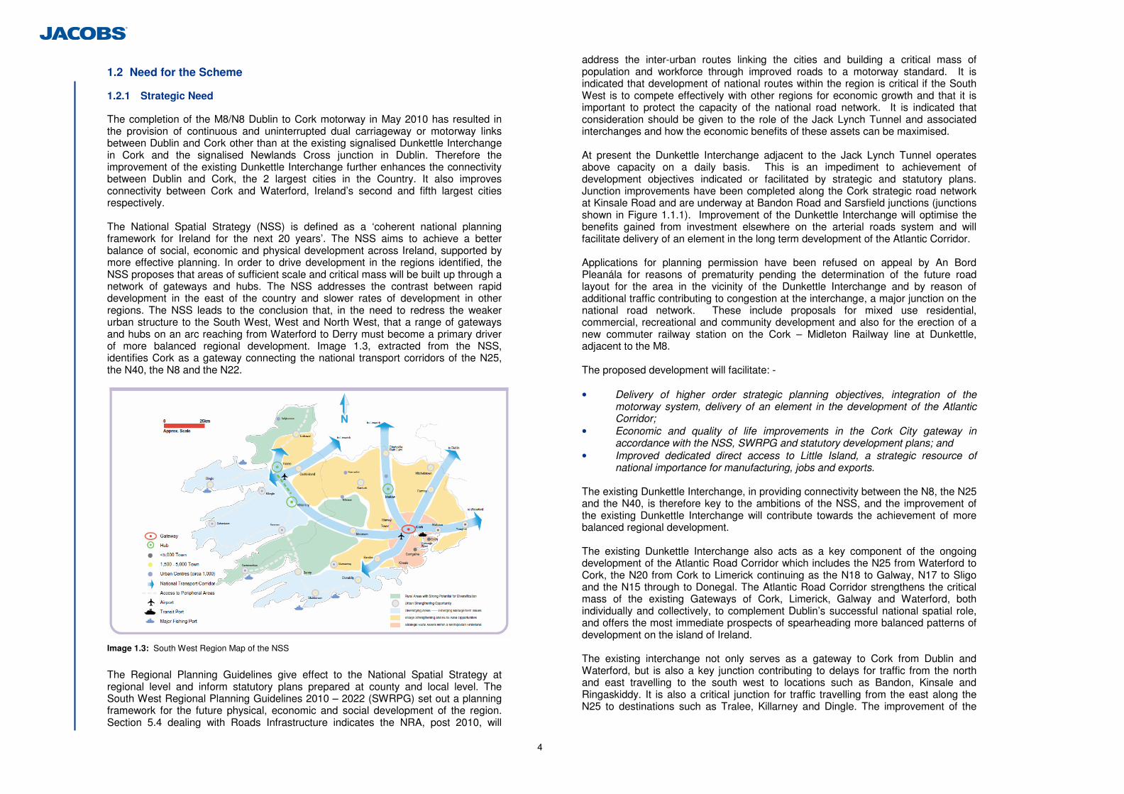
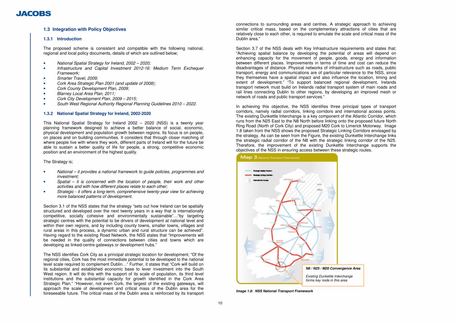
The completion of the M8/N8 Dublin to Cork motorway in May 2010 has resulted in the provision of continuous and uninterrupted dual carriageway or motorway links between Dublin and Cork other than at the existing signalised Dunkettle Interchange in Cork and the signalised Newlands Cross junction in Dublin. Therefore the improvement of the existing Dunkettle Interchange further enhances the connectivity between Dublin and Cork, the 2 largest cities in the Country. It also improves connectivity between Cork and Waterford, Ireland’s second and fifth largest cities respectively. The National Spatial Strategy (NSS) is defined as a ‘coherent national planning framework for Ireland for the next 20 years’. The NSS aims to achieve a better balance of social, economic and physical development across Ireland, supported by more effective planning. In order to drive development in the regions identified, the NSS proposes that areas of sufficient scale and critical mass will be built up through a network of gateways and hubs. The NSS addresses the contrast between rapid development in the east of the country and slower rates of development in other regions. The NSS leads to the conclusion that, in the need to redress the weaker urban structure to the South West, West and North West, that a range of gateways and hubs on an arc reaching from Waterford to Derry must become a primary driver of more balanced regional development. Image 1.3, extracted from the NSS, identifies Cork as a gateway connecting the national transport corridors of the N25, the N40, the N8 and the N22.
Image 1.3: South West Region Map of the NSS
The Regional Planning Guidelines give effect to the National Spatial Strategy at regional level and inform statutory plans prepared at county and local level. The South West Regional Planning Guidelines 2010 – 2022 (SWRPG) set out a planning framework for the future physical, economic and social development of the region. Section 5.4 dealing with Roads Infrastructure indicates the NRA, post 2010, will
address the inter-urban routes linking the cities and building a critical mass of population and workforce through improved roads to a motorway standard. It is indicated that development of national routes within the region is critical if the South West is to compete effectively with other regions for economic growth and that it is important to protect the capacity of the national road network. It is indicated that consideration should be given to the role of the Jack Lynch Tunnel and associated interchanges and how the economic benefits of these assets can be maximised. At present the Dunkettle Interchange adjacent to the Jack Lynch Tunnel operates above capacity on a daily basis. This is an impediment to achievement of development objectives indicated or facilitated by strategic and statutory plans. Junction improvements have been completed along the Cork strategic road network at Kinsale Road and are underway at Bandon Road and Sarsfield junctions (junctions shown in Figure 1.1.1). Improvement of the Dunkettle Interchange will optimise the benefits gained from investment elsewhere on the arterial roads system and will facilitate delivery of an element in the long term development of the Atlantic Corridor. Applications for planning permission have been refused on appeal by An Bord Pleanála for reasons of prematurity pending the determination of the future road layout for the area in the vicinity of the Dunkettle Interchange and by reason of additional traffic contributing to congestion at the interchange, a major junction on the national road network. These include proposals for mixed use residential, commercial, recreational and community development and also for the erection of a new commuter railway station on the Cork – Midleton Railway line at Dunkettle, adjacent to the M8. The proposed development will facilitate: - • Delivery of higher order strategic planning objectives, integration of the
motorway system, delivery of an element in the development of the Atlantic Corridor;
• Economic and quality of life improvements in the Cork City gateway in accordance with the NSS, SWRPG and statutory development plans; and
• Improved dedicated direct access to Little Island, a strategic resource of national importance for manufacturing, jobs and exports.
The existing Dunkettle Interchange, in providing connectivity between the N8, the N25 and the N40, is therefore key to the ambitions of the NSS, and the improvement of the existing Dunkettle Interchange will contribute towards the achievement of more balanced regional development. The existing Dunkettle Interchange also acts as a key component of the ongoing development of the Atlantic Road Corridor which includes the N25 from Waterford to Cork, the N20 from Cork to Limerick continuing as the N18 to Galway, N17 to Sligo and the N15 through to Donegal. The Atlantic Road Corridor strengthens the critical mass of the existing Gateways of Cork, Limerick, Galway and Waterford, both individually and collectively, to complement Dublin’s successful national spatial role, and offers the most immediate prospects of spearheading more balanced patterns of development on the island of Ireland. The existing interchange not only serves as a gateway to Cork from Dublin and Waterford, but is also a key junction contributing to delays for traffic from the north and east travelling to the south west to locations such as Bandon, Kinsale and Ringaskiddy. It is also a critical junction for traffic travelling from the east along the N25 to destinations such as Tralee, Killarney and Dingle. The improvement of the
5
existing interchange will serve to facilitate access to these areas, promoting business, tourism and general integration. 1.2.2 Scheme Specific Need
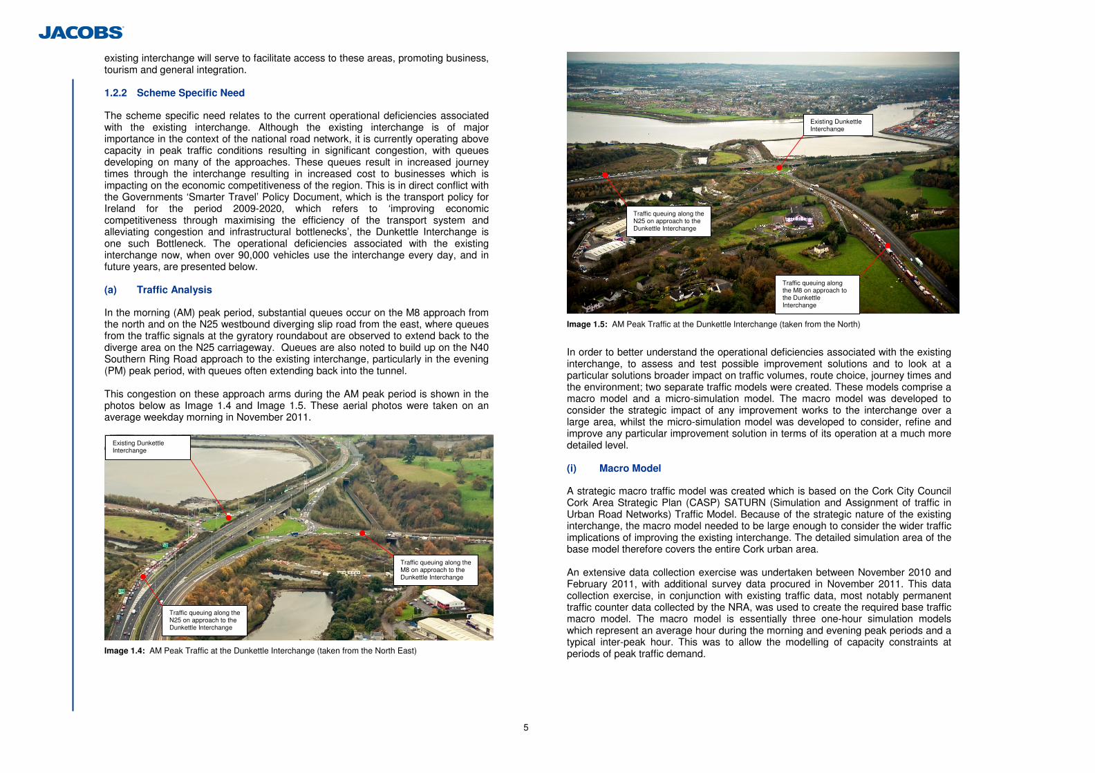
The scheme specific need relates to the current operational deficiencies associated with the existing interchange. Although the existing interchange is of major importance in the context of the national road network, it is currently operating above capacity in peak traffic conditions resulting in significant congestion, with queues developing on many of the approaches. These queues result in increased journey times through the interchange resulting in increased cost to businesses which is impacting on the economic competitiveness of the region. This is in direct conflict with the Governments ‘Smarter Travel’ Policy Document, which is the transport policy for Ireland for the period 2009-2020, which refers to ‘improving economic competitiveness through maximising the efficiency of the transport system and alleviating congestion and infrastructural bottlenecks’, the Dunkettle Interchange is one such Bottleneck. The operational deficiencies associated with the existing interchange now, when over 90,000 vehicles use the interchange every day, and in future years, are presented below. (a) Traffic Analysis
In the morning (AM) peak period, substantial queues occur on the M8 approach from the north and on the N25 westbound diverging slip road from the east, where queues from the traffic signals at the gyratory roundabout are observed to extend back to the diverge area on the N25 carriageway. Queues are also noted to build up on the N40 Southern Ring Road approach to the existing interchange, particularly in the evening (PM) peak period, with queues often extending back into the tunnel. This congestion on these approach arms during the AM peak period is shown in the photos below as Image 1.4 and Image 1.5. These aerial photos were taken on an average weekday morning in November 2011.
Image 1.4: AM Peak Traffic at the Dunkettle Interchange (taken from the North East)
Image 1.5: AM Peak Traffic at the Dunkettle Interchange (taken from the North)
In order to better understand the operational deficiencies associated with the existing interchange, to assess and test possible improvement solutions and to look at a particular solutions broader impact on traffic volumes, route choice, journey times and the environment; two separate traffic models were created. These models comprise a macro model and a micro-simulation model. The macro model was developed to consider the strategic impact of any improvement works to the interchange over a large area, whilst the micro-simulation model was developed to consider, refine and improve any particular improvement solution in terms of its operation at a much more detailed level. (i) Macro Model
A strategic macro traffic model was created which is based on the Cork City Council Cork Area Strategic Plan (CASP) SATURN (Simulation and Assignment of traffic in Urban Road Networks) Traffic Model. Because of the strategic nature of the existing interchange, the macro model needed to be large enough to consider the wider traffic implications of improving the existing interchange. The detailed simulation area of the base model therefore covers the entire Cork urban area. An extensive data collection exercise was undertaken between November 2010 and February 2011, with additional survey data procured in November 2011. This data collection exercise, in conjunction with existing traffic data, most notably permanent traffic counter data collected by the NRA, was used to create the required base traffic macro model. The macro model is essentially three one-hour simulation models which represent an average hour during the morning and evening peak periods and a typical inter-peak hour. This was to allow the modelling of capacity constraints at periods of peak traffic demand.
Traffic queuing along the M8 on approach to the Dunkettle Interchange
Existing Dunkettle Interchange
Traffic queuing along the N25 on approach to the Dunkettle Interchange
Traffic queuing along the M8 on approach to the Dunkettle Interchange
Traffic queuing along the N25 on approach to the Dunkettle Interchange
Existing Dunkettle Interchange
6
The chosen model time periods for the macro model were; • AM: average hour between 7am and 10am inclusive; • IP: average hour between 10am and 4pm inclusive; and • PM: average hour between 4pm and 7pm inclusive. All time periods refer to an average weekday in November 2010. The model was calibrated and validated to reflect actual observed traffic flows within the detailed simulation area. (ii) Micro-Simulation Model
Whilst the macro model was developed as a strategic modelling tool to derive forecast levels of traffic on key roads in the Cork area and journey times along key routes, particularly through Dunkettle for the purposes of environmental and economic appraisal; a separate more detailed model was required to assist with the design of the proposed development. This more detailed traffic model, which is a micro-simulation model, was developed using S-Paramics software. This base micro-simulation model was developed by ILTP Consulting. This micro-simulation model covers a much smaller area than the macro model, but represents the road network within that area in much greater detail.
The micro-simulation model better represents traffic behaviour in terms of merging & diverging, queuing, lane discipline etc and therefore better considers the impact of small design changes to the proposed development, such as merging and taper details and roundabout entry widths etc. The micro-simulation model was used only for the purposes of refining the proposed development, described in Chapter 2, in terms of its detailed design to improve its operational performance. (iii) Traffic Flows
As a result of the above traffic model production, it is possible to review the macro traffic model to examine traffic movements within the detailed simulation area, which includes the Dunkettle Interchange. Table 1.2 indicates the modelled pattern of movement through the interchange in 2010. Flows are by time period because of the variability in traffic movements between the various time periods modelled. They are provided in percentages of overall passenger car units (PCU) per hour. Each car or Light Goods Vehicle equals one PCU. Larger vehicles equate to more than one PCU to reflect their increased size, weight, slower acceleration etc and in this instance, a Heavy Goods Vehicle equals 2.5 PCUs. References in Table 1.2 to the exit for Burys Bridge refers to the left-in access point providing access to Burys Bridge and references to the exit comprising the R623 refer to traffic accessing the R623 in Little Island via the slip road just north of the Jack Lynch Tunnel. These access points are shown in Figure 1.1.2 in Volume 3.
Time Period (2010) AM IP PM
Approach Exit % PCU Total % PCU Total % PCU Total
Burys Bridge 0.8% 1.3% 0.7%
N25 (E) 3.4% 7.7% 8.7%
R623 7.0% 3.7% 3.2%
Jack Lynch Tunnel 78.6% 76.5% 78.2%
N8 (W) 10.2% 9.6% 8.5%
N8 (North) to:
N8 (N) 0.0% 1.2% 0.7%
R623 1.5% 0.4% 0.1%
Jack Lynch Tunnel 51.3% 52.6% 49.7%
N8 (W) 44.6% 41.0% 44.7%
N8 (N) 2.6% 6.0% 5.5%
Burys Bridge 0.0% 0.0% 0.0%
N25 (East) to:
N25 (E) 0.0% 0.0% 0.0%
N8 (W) 19.3% 29.8% 20.9%
N8 (N) 24.1% 21.0% 26.7%
Burys Bridge 3.9% 4.3% 6.1%
N25 (E) 45.1% 43.0% 45.0%
R623 7.6% 1.9% 1.3%
Jack Lynch Tunnel (South) to:
Jack Lynch Tunnel 0.0% 0.0% 0.0%
N8 (N) 4.6% 10.3% 10.5%
Burys Bridge 1.9% 5.8% 4.2%
N25 (E) 49.4% 53.5% 56.4%
R623 11.2% 5.1% 2.2%
Jack Lynch Tunnel 32.9% 25.3% 26.7%
N8 (West) to:
N8 (W) 0.0% 0.0% 0.0% Table 1.2: Modelled Flows through the existing Dunkettle Interchange AM Traffic (between 7am and 10am) In the AM time period, over 75% of traffic movements from the N8 (North) towards the interchange, continue through the Jack Lynch Tunnel, with much smaller percentages travelling in other directions from this approach. The highest traffic movements through the existing Dunkettle Interchange in the AM from the N25 to the east of Dunkettle is into the Jack Lynch Tunnel southbound and towards the N8 to the west, these movements account for more than 95% of the movements from the east in the AM. Note that movements from the east headed west are already freeflow (using the existing flyover above the signalised roundabout). From the Jack Lynch Tunnel in the AM, the majority of traffic that uses the interchange is heading east along the N25. The majority of traffic from the N8 (West) is headed east along the N25, which is already catered for via the existing freeflow flyover. PM Traffic (between 4pm and 7pm) In the PM time period, the dominant flows through the interchange are from the Jack Lynch Tunnel towards the N25 (East) and headed north along the N8. As with the AM, the majority of flows from the N8 (North) and the N25 (East) are headed south via the Jack Lynch Tunnel.
7
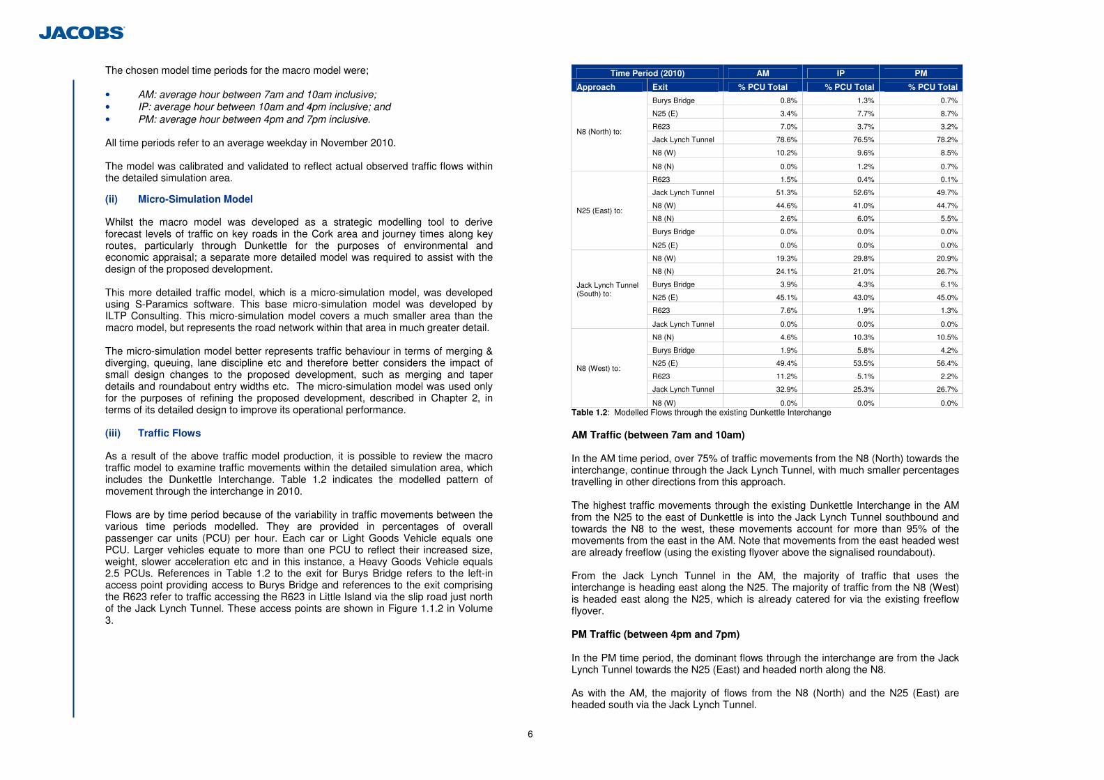
There is also a significant flow from the N8 (West) to the N25 (East) and vice versa, which, as stated above, is already catered for via an existing freeflow arrangement. Inter-Peak Traffic (between 10am and 4pm) Traffic flows are generally lower in the inter-peak period, although the flow in both directions between the N25 (East) and the Jack Lynch Tunnel is significant. These main movements, excluding those which are already catered for via the existing freeflow flyover, are depicted in Image 1.6 below. The Image also contains details of the Annual Average Daily Traffic (AADT) making these movements. The AADT is the total traffic flow on a particular section of road each year divided by 365, therefore it relates to a 24hour period as opposed to the AM, Interpeak and PM periods referred to above. Image 1.6 below depicts one-way AADT as the image is depicting flows in one particular direction through the interchange only. The AADT figures provided in Image 1.6 have been rounded to the nearest 500 vehicles. These main traffic movements are consistent with those movements most affected by congestion in the AM and PM peak time periods.
Image 1.6: Main Traffic Movements through the Interchange
The 2 way AADT traffic flows on the main links associated with the existing interchange (M8 from the North, N25 from the East, N40 from the South and the N8 from the West) are presented in Table 1.3 for the existing interchange in the base year, which is 2010, and also for future forecast years comprising 2016 and 2031. The year 2016 has been assumed as the ‘Year of Opening’ of the proposed development referred to in this EIS, with 2031 being the ‘Design Year’ to which the proposed development has been designed for. These future year traffic flows are based on the NRA National Traffic Model (NTM). The NTM was prepared on behalf of the NRA in 2008 (and updated in 2010) as a
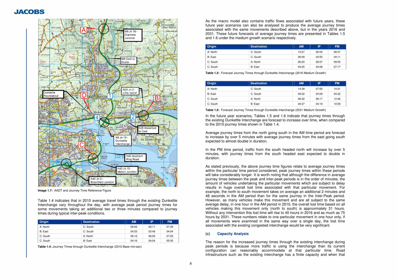
means of forecasting future traffic growth to be used in the assessment of national road schemes around the country. It takes account of various national policies such as Smarter Travel and updated national government population projections. In calculating traffic growth forecasts, the NTM takes account of population growth forecasts, economic growth forecasts and forecast rates of car ownership. Due to uncertainty in forecasting, three scenarios are considered – low growth, medium growth and high growth. Further details in relation to traffic growth forecasts are available from the NRA publication ‘Project Appraisal Guidelines (2011) Unit 20.1: Demographic and Economic Forecasting for the National Traffic Model’. Note that for the purposes of environemtal appraisal and subsequent mitigation, high growth traffic forecasts were used, this is a conservative approach to ensure sufficient levels of mitigation are adopted. However, in this section for the purposes of comparison of traffic growth in Cork (and its impact on the operation of the Dunkettle Interchange), Table 1.3 is based on the medium traffic growth forecast projections. The reference locations in Table 1.3 should be cross referenced with Image 1.7, which identifies the locations to which the traffic figures relate.
Ref Description 2010 2016 2031
1 M8 Glanmire – Dunkettle 18,400 20,500 23,500
2 N25 Dunkettle – Little Island 51,100 53,800 58,700
3 N40 Jack Lynch Tunnel 59,700 62,700 67,000
4 N8 Lower Glanmire Road (east of Dunkettle Roundabout) 40,400 43,000 45,800
Table 1.3: Medium Growth AADT Figures
Table 1.3 indicates that traffic on each of the main links associated with the existing Interchange is forecast to increase over time. As a result of these forecast increased traffic flows through the existing interchange, the problems associated with queuing and congestion will be further exacerbated. (b) Modelled Journey Times through Dunkettle Interchange
The macro traffic model, as well as being able to provide current and future traffic flow details, can also be used to derive average journey times between particular points in any of the three time periods which have been modelled (AM, Inter-Peak and PM). Therefore it can also be analysed to produce average journey times through the existing Dunkettle Interchange. For the purposes of this analysis, the start and end points for these journeys were taken as immediately downstream of the junctions to the north, east, south and west of the existing interchange, also identified in Image 1.7 as follows; A. To the north: the south facing diverging slip road at the M8 Glanmire Interchange; B. To the east: the west facing slip roads at the N25 Little Island Interchange; C. To the south: the north facing slip roads at the N40 Mahon Junction; and D. To the west: immediately east of the Dunkettle Roundabout. Table 1.4 shows these modelled journey times in all three modelled time periods in 2010 for the main traffic movements identified in Image 1.6, note these are average journey times in each of these periods (i.e. in the PM time period, the average journey time between the hours of 4pm and 7pm), and therefore the peak journey time will be longer. This table is useful as you can compare the inter-peak journey times, when the interchange is generally uncongested, with the peak journey times (AM and PM) to see the average increase in journey times as a result of this congestion.
13,000
7,000
13,000
7,500
8
Image 1.7: AADT and Journey Time Reference Figure
Table 1.4 indicates that in 2010 average travel times through the existing Dunkettle Interchange vary throughout the day, with average peak period journey times for some movements taking an additional two or three minutes compared to journey times during typical inter-peak conditions.
Origin Destination AM IP PM
A: North C: South 09:05 06:17 07:39
B: East C: South 04:53 03:49 04:04
C: South A: North 06:12 06:02 07:20
C: South B: East 04:16 04:04 05:30
Table 1.4: Journey Times through Dunkettle Interchange (2010 Base min:sec)
As the macro model also contains traffic flows associated with future years, these future year scenarios can also be analysed to produce the average journey times associated with the same movements described above, but in the years 2016 and 2031. These future forecasts of average journey times are presented in Tables 1.5 and 1.6 under the medium growth scenario respectively.
Origin Destination AM IP PM
A: North C: South 10:27 06:55 08:37
B: East C: South 06:09 03:55 04:11
C: South A: North 06:20 06:07 09:05
C: South B: East 04:25 04:08 07:17
Table 1.5: Forecast Journey Times through Dunkettle Interchange (2016 Medium Growth)
Origin Destination AM IP PM
A: North C: South 14:39 07:55 10:31
B: East C: South 09:22 04:09 04:22
C: South A: North 06:32 06:17 12:46
C: South B: East 04:37 04:19 10:59
Table 1.6: Forecast Journey Times through Dunkettle Interchange (2031 Medium Growth)
In the future year scenarios, Tables 1.5 and 1.6 indicate that journey times through the existing Dunkettle Interchange are forecast to increase over time, when compared to the 2010 journey times shown in Table 1.4.
Average journey times from the north going south in the AM time period are forecast to increase by over 5 minutes with average journey times from the east going south expected to almost double in duration. In the PM time period, traffic from the south headed north will increase by over 5 minutes, with journey times from the south headed east expected to double in duration. As stated previously, the above journey time figures relate to average journey times within the particular time period considered, peak journey times within these periods will take considerably longer. It is worth noting that although the difference in average journey times between the peak and inter-peak periods is in the order of minutes, the amount of vehicles undertaking the particular movements which are subject to delay results in huge overall lost time associated with that particular movement. For example, the north to south movement takes on average an additional 2 minutes and 48 seconds in the AM period than for the same journey in the Inter-Peak period. However, as many vehicles make this movement and are all subject to the same average delay, in one hour in the AM period in 2010, the overall lost time based on all vehicles making this movement only (north to south) is approximately 31 hours. Without any intervention this lost time will rise to 40 hours in 2016 and as much as 75 hours by 2031. These numbers relate to one particular movement in one hour only, if all movements were examined in the same way over a single day, the lost time associated with the existing congested interchange would be very significant.
(c) Capacity Analysis
The reason for the increased journey times through the existing interchange during peak periods is because more traffic is using the interchange than its current configuration can reasonably accommodate at that particular time. Road infrastructure such as the existing interchange has a finite capacity and when that
9
capacity is reached, its ability to function deteriorates leading to congestion and increased journey times as per the existing situation. Capacity can be defined as the maximum sustainable flow rate at which vehicles can reasonably be expected to traverse a road link or junction during a specified time period, normally one hour. At capacity, the traffic stream has no ability to dissipate any disruption and any incident can be expected to result in flow breakdown with queues developing. The capacity of the interchange for the main movements identified in the above tables was considered for each of the individual links contributing towards those movements. This capacity was then compared to the actual flow, or volume, of traffic using that particular link and a ratio of volume to capacity was determined for each of these movements. Table 1.7 indicates the Volume to Capacity ratio (V/C) on each of the journey time routes through the existing Dunkettle Interchange defined earlier. The results are provided in ratio format, i.e. a figure of 1 means that the capacity of a particular link has been reached whilst a ratio above 1 means a link is operating above capacity. In this instance a ratio of 1 or above means that there is likely to be a breakdown in vehicular flow, where flow is forced with vehicles moving in lockstep with the vehicle in front of it with frequent slowing required. Table 1.7 indicates that the existing interchange is failing to cope with current levels of demand in 2010. Of particular note is traffic from the north in both the AM and PM time periods and the south to north and south to east movements in the PM time period. All of these movements are operating in excess of capacity. These overcapacity movements are highlighted in pink. The east to south movement in the AM is operating very close to capacity.
Origin Destination AM IP PM
A: North C: South 1.05 0.88 1.03
B: East C: South 0.98 0.72 0.84
C: South A: North 0.73 0.63 1.01
C: South B: East 0.73 0.81 1.01
Table 1.7: Maximum Volume to Capacity Ratios through Dunkettle Interchange (2010)
The above table essentially confirms the particular problem areas and periods referred to in Section 1.2.2 (a), i.e. there is insufficient capacity at the existing interchange for traffic travelling from the north to all locations particularly in the AM time period and for traffic from the south wishing to travel north or east in the PM time period. Also, traffic from the east in the AM time period wishing to head south has also generally reached capacity. This is consistent with observed queuing and delay issues at the interchange, as depicted in Images 1.4 and 1.5. As traffic levels increase, without any intervention which improves the capacity of the existing interchange, its existing capacity will be further affected. This is presented in Tables 1.8 and 1.9 below, which indicate the forecast V/C ratios under the medium growth scenario in 2016 and 2031 respectively. These tables highlight that the traffic growth forecast to occur over the specified period under the medium growth scenario will lead to further movements becoming over-saturated.
Origin Destination AM IP PM
A: North C: South 1.05 1.02 1.06
B: East C: South 1.03 0.79 0.89
C: South A: North 0.78 0.67 1.05
C: South B: East 0.78 0.78 1.05
Table 1.8: Maximum Volume to Capacity Ratios through Dunkettle Interchange (2016 Medium Growth)
Based on Table 1.8, as soon as 2016 under the medium growth scenario, traffic from the north will be operating in excess of capacity in all time periods. There is also deterioration in traffic movements from the east to the south in the AM and for movements from the south in the PM time period. Further traffic growth between 2016 and 2031, under the medium growth scenario, results in further deterioration, as outlined in Table 1.9. Traffic movements from the south in the PM are now considerably above capacity, which will result in additional queuing and delay in the Jack Lynch Tunnel (JLT) in the evening peak period.
Origin Destination AM IP PM
A: North C: South 1.11 1.05 1.07
B: East C: South 1.06 0.90 0.90
C: South A: North 0.88 0.77 1.12
C: South B: East 0.88 0.87 1.12
Table 1.9: Maximum Volume to Capacity Ratios through Dunkettle Interchange (2031 Medium Growth)
The above analysis of the existing interchange serves to identify and confirm the operational issues known to currently occur in the area in the morning and evening peak periods. Insufficient capacity at the existing interchange is resulting in queuing, delay and consequential increases in journey times. These issues will intensify as traffic volumes grow resulting in increased journey times, not only for movements which are currently above capacity, but also in relation to movements which are currently not subject to delay and also in time periods which at present do not suffer from congestion at the existing interchange. Therefore there are operational deficiencies associated with the existing interchange which is driving the specific need for improvement works to the existing interchange.
10
1.3 Integration with Policy Objectives
1.3.1 Introduction
The proposed scheme is consistent and compatible with the following national, regional and local policy documents, details of which are outlined below; • National Spatial Strategy for Ireland, 2002 – 2020; • Infrastructure and Capital Investment 2012-16: Medium Term Exchequer
Framework; • Smarter Travel, 2009; • Cork Area Strategic Plan 2001 (and update of 2008); • Cork County Development Plan, 2009; • Blarney Local Area Plan, 2011; • Cork City Development Plan, 2009 – 2015; • South West Regional Authority Regional Planning Guidelines 2010 – 2022. 1.3.2 National Spatial Strategy for Ireland, 2002-2020
This National Spatial Strategy for Ireland 2002 – 2020 (NSS) is a twenty year planning framework designed to achieve a better balance of social, economic, physical development and population growth between regions. Its focus is on people, on places and on building communities. It considers that through closer matching of where people live with where they work, different parts of Ireland will for the future be able to sustain a better quality of life for people, a strong, competitive economic position and an environment of the highest quality. The Strategy is; • National – it provides a national framework to guide policies, programmes and
investment; • Spatial – it is concerned with the location of people, their work and other
activities and with how different places relate to each other; • Strategic - it offers a long-term, comprehensive twenty-year view for achieving
more balanced patterns of development. Section 3.1 of the NSS states that the strategy “sets out how Ireland can be spatially structured and developed over the next twenty years in a way that is internationally competitive, socially cohesive and environmentally sustainable”…“by targeting strategic centres with the potential to be drivers of development at national level and within their own regions, and by including county towns, smaller towns, villages and rural areas in this process, a dynamic urban and rural structure can be achieved”. Having regard to the existing Road Network, the NSS states that “Improvements will be needed in the quality of connections between cities and towns which are developing as linked-centre gateways or development hubs.” The NSS identifies Cork City as a principal strategic location for development; “Of the regional cities, Cork has the most immediate potential to be developed to the national level scale required to complement Dublin…” Further, it states that “Cork will build on its substantial and established economic base to lever investment into the South West region. It will do this with the support of its scale of population, its third level institutions and the substantial capacity for growth identified in the Cork Area Strategic Plan.” “However, not even Cork, the largest of the existing gateways, will approach the scale of development and critical mass of the Dublin area for the foreseeable future. The critical mass of the Dublin area is reinforced by its transport
connections to surrounding areas and centres. A strategic approach to achieving similar critical mass, based on the complementary attractions of cities that are relatively close to each other, is required to emulate the scale and critical mass of the Dublin area.” Section 3.7 of the NSS deals with Key Infrastructure requirements and states that; “Achieving spatial balance by developing the potential of areas will depend on enhancing capacity for the movement of people, goods, energy and information between different places. Improvements in terms of time and cost can reduce the disadvantages of distance. Physical networks of infrastructure such as roads, public transport, energy and communications are of particular relevance to the NSS, since they themselves have a spatial impact and also influence the location, timing and extent of development.” “To support balanced regional development, Irelands transport network must build on Irelands radial transport system of main roads and rail lines connecting Dublin to other regions, by developing an improved mesh or network of roads and public transport services.” In achieving this objective, the NSS identifies three principal types of transport corridors, namely radial corridors, linking corridors and international access points. The existing Dunkettle Interchange is a key component of the Atlantic Corridor, which runs from the N25 East to the N8 North before linking onto the proposed future North Ring Road (North of Cork City) and proposed M20 Cork to Limerick Motorway. Image 1.8 taken from the NSS shows the proposed Strategic Linking Corridors envisaged by the strategy. As can be seen from the Figure, the existing Dunkettle Interchange links the strategic radial corridor of the N8 with the strategic linking corridor of the N25. Therefore, the improvement of the existing Dunkettle Interchange supports the objectives of the NSS in ensuring access between these strategic routes.
Image 1.8: NSS National Transport Framework
N8 / N25 / M20 Convergence Area Existing Dunkettle Interchange forms key node in this area
11
1.3.3 Infrastructure and Capital Investment 2012-16: Medium Term Exchequer Framework
In November 2011, the Department of Public Expenditure and Reform presented the findings of a Government-wide review of infrastructure and capital investment policy, which, attempts to ensure that Irelands stock of Infrastructure is capable of facilitating economic growth given the context of tight fiscal constraints. In this regard, it highlights that sharp prioritisation of investment is paramount, with 2 of the main infrastructure priorities of the framework being; • Ensuring adequate maintenance of the National Road network in order to
protect the value of previous investments • Targeting the improvement of specific road segments where there is a clear
economic justification In relation to the first point above, the existing Dunkettle Interchange was originally designed in the 1980’s. The local and national traffic flows associated with that design and the growth predictions did not anticipate the unprecedented development growth in the greater Cork environs in the intervening period. Therefore the proposed improvement scheme is required to protect the value of the investment associated with the existing interchange. In relation to the second point, the upgrade of the existing Dunkettle Interchange is very much a targeted improvement initiative, the details associated with the economic justification of same is included in the Cost Benefit Analysis Report produced in relation to the proposed development. Therefore, the proposed improvement of the existing Dunkettle Interchange is consistent with the Infrastructure and Capital Investment Framework published in November 2011. 1.3.4 Smarter Travel, 2009
Smarter Travel, A Sustainable Transport Future, is defined as the transport policy for Ireland for the period 2009-2020. The policy recognises the vital importance of continued investment in transport to ensure an efficient economy and continued social development, but it also sets out the necessary steps to ensure that people choose more sustainable transport modes such as walking, cycling and public transport. The policy is a response to the fact that continued growth in demand for road transport is not sustainable from a number of angles; it will lead to further congestion, further local air pollution, contribute to global warming, and result in negative impacts to health through promoting increasingly sedentary lifestyles. Chapter 3 of the policy document in relation to Smarter Travel, outlines the Key Goals of the initiative as follows: • Improve quality of life and accessibility to transport for all and, in particular, for
people with reduced mobility and those who may experience isolation due to lack of transport
• Improve economic competitiveness through maximising the efficiency of the transport system and alleviating congestion and infrastructural bottlenecks
• Minimise the negative impacts of transport on the local and global environment through reducing localised air pollutants and greenhouse gas emissions
• Reduce overall travel demand and commuting distances travelled by the private car
• Improve security of energy supply by reducing dependency on imported fossil fuels.
The second Key Goal as defined within the policy document, in relation to maximising the efficiency of the transport system and alleviating congestion and infrastructure bottlenecks aligns entirely with the ambitions of the Dunkettle Interchange improvement scheme in particular. 1.3.5 Cork Area Strategic Plan, 2001 (Updated in 2008)
The Cork Area Strategic Plan (CASP) is a broad policy document identifying the nature and scale of growth required to allow the Cork region to prosper and compete on a national and international scale and to ensure quality of life for its citizens over a 20 year period. The CASP Update, dated July 2008 adheres to the key goals of the original CASP and takes account of revisions needed to reflect economic, market and policy developments since the original CASP was prepared and places particular emphasis on the implementation of policies to achieve the goals of the CASP. In particular, CASP sets out a framework to enable the city region to: • Attain Critical Mass; • Integrate Land Use and Transport; • Make efficient use of investment in infrastructure; • Provide a high quality environment; and • Improve the competitiveness and attractiveness of the region CASP recognises the importance of transport infrastructure investment in achieving this aspiration: “the creation of an integrated transport system is proposed based upon state of the art public transport facilities and a well managed roads system, which are central to improving mobility, accessibility and connectivity.” The following road schemes are identified within CASP as being critical and essential to the growth and development of the CASP region and the achievement of the CASP goals; • Eastern section of the North Ring Road as part of the Atlantic Corridor • Appropriate Interchanges • N20 Cork to Limerick • N72 Mallow to Fermoy including key links to the N20 Atlantic Corridor • Jack Lynch Tunnel and Dunkettle Interchange Upgrade • N8 Cork Dublin Motorway CASP also suggests “that consideration be given by the NRA to developing a future optimal layout at Dunkettle Interchange in order to address future capacity requirements”. Therefore CASP clearly recognises the importance of the upgrade of the existing Dunkettle interchange and any upgrade or improvements works would be consistent with the objectives of CASP.
12
1.3.6 Cork County Development Plan 2009
The Cork County Development Plan cites as objective INF 3-3, “It is an objective to seek the support of the National Roads Authority in the implementation of the following major projects: • Cork South Ring Road Interchanges • Cork North Ring Road • N20 Cork to Limerick • N28 Cork Ringaskiddy route upgrade • Atlantic Corridor • Park and Ride schemes • N71 – Cork - Clonakilty – Skibbereen and Bantry • M/N20 Blarney – Mallow – Limerick • N22 Ballincollig – Macroom – Ballyvourney • N25 Carrigtwohill – Midleton – Youghal • N72 Mallow Northern Relief Road • N72 Mallow to Fermoy • N73 Mallow to Mitchelstown • Dunkettle Interchange Upgrade Further, INF 2-2 (A) states that “it is an objective of the Plan to support investment that will enhance transport choice within the Atlantic Corridor”. Therefore the improvement of the existing Dunkettle interchange is consistent with policy objectives of the Cork County Development Plan 2009. 1.3.7 Blarney Electoral Area Local Area Plan
The Blarney Electoral Area includes Dunkettle. The Blarney Electoral Local Area Plan (formally made by Cork County Council on the 25th of July, 2011) focuses on the local-level implementation of the overall strategy for the County set out in the County Development Plan 2009, with which, in law, it is obliged to be consistent. This plan has been prepared taking the year 2020 as its ‘horizon’ year so that there can be the best degree of alignment with the Regional Planning Guidelines for the South West Region 2010, the Cork Area Strategic Plan (Update) 2008 and the County Development Plan 2009 and its adopted Variations. Section 2.2.53 states that one of the key road infrastructure projects within the electoral area which it supports is the upgrade of the Dunkettle Interchange. It further states, in Section 3.3.3, that there is an urgent requirement for the provision of cycle facilities including cycle links from Glanmire to the City and Little Island to facilitate commuters. 1.3.8 Cork City Development Plan 2009-2015
The Cork City Development Plan covers the area of Cork City which does not extend to the existing interchange. However, Policy 5.11 of the Cork City Development Plan states that it is the policy of the City Council to co-operate with Cork County Council and the National Roads Authority in the planning and provision of National Road Schemes on the following road projects; • South Ring Road Interchanges (Bandon and Sarsfield) • Northern Ring Road • N20 Cork to Limerick
• N28 Cork Ringaskiddy route upgrade • Dunkettle Interchange Therefore the Cork City Development plan is cognisant of the improvement of the existing Dunkettle Interchange and any upgrade or improvement works would therefore be consistent with this Development Plan. 1.3.9 South West Regional Authority Regional Planning Guidelines 2010 - 2022
The South West Regional Authority is the statutory authority for the South West Region of Ireland. The Planning and Development Act, 2000 requires Regional Authorities to make Regional Planning Guidelines in respect of their region and to review the Guidelines at intervals not exceeding six years. The Regional Planning Guidelines (RPGs) is a strategic policy document designed to steer the future growth of the region over the medium to long term and works to implement the strategic planning frameworks set out in the NSS. The RPG sets out high level strategies, in line with the NSS and promotes the overall sustainability and growth of the region. Chapter 5 of the RPG sets out the key physical infrastructure needs for the region, providing an integrated framework for future land use and national investment in infrastructure. Within Chapter 5, the M8 linking Cork – Dublin gateways including upgrading of the Dunkettle Interchange is included as a strategic road investment which is of significance. In addition, the RPG also states that ‘’it is an objective to encourage the development of strategies for walking and cycling” and that “objectives and actions are put in place to achieve safety in the provision of improved access to cycle paths and pedestrian walkways which are integrated with the public transport network”. Note that the proposed development has had regard to the ‘Spatial Planning and National Roads’ document published by the Department of the Environment, Community and Local Government in January 2012. 1.4 Scheme Objectives
The scheme objectives are driven by the need to improve the current operational deficiencies associated with the existing interchange. This existing problem, if not resolved, will be exacerbated by traffic growth predicted to occur between the present year and the schemes Design Year, 2031. In addition to the core objectives associated with addressing the existing operational issues, the scheme objectives also includes the minimisation of environmental impacts and consideration of sustainable transport modes including pedestrian and cyclist facilities and railway connectivity within the proposed development. The proposed development objectives are outlined in Table 1.10.
13
No Objective
1 Improve capacity through the existing Dunkettle Interchange thereby reducing congestion.
2 Make best use of the existing Dunkettle Infrastructure thus minimising the impact of the scheme as much as possible and minimise disruption to road users through unnecessary demolition and reconstruction.
3 Separate local traffic movements from strategic traffic in so far as practicable.
4 Provide separate clearly designated lanes for each traffic movement with minimal weaving or crossover in so far as practicable.
5 Provide dedicated pedestrian and cycle connectivity through the junction area away from the busy corridors/arteries.
6 Minimise impact on adjacent environmentally sensitive sites.
7
Integrate with national, regional and local policy by improving capacity through the existing Dunkettle Interchange and thus facilitating connectivity between the N8 and N25 strategic routes and linkage to potential Cork/ Midleton local rail station and Park & Ride options.
8 Provide consideration of access to a future railway station in the vicinity and associated Park & Ride facilities. Any such access should also be accessible by pedestrians and cyclists.
9
Provide planning certainty in the area by establishing the design and layout of the improvement works to the existing interchange, thereby enabling better assessment of future planning applications in the area in the context of the proposed improvement works.
Table 1.10: Dunkettle Interchange Improvement Scheme Objectives
As can be noted above, the improvement works not only comprise specific traffic related improvements, but also includes the consideration of additional sustainable transport modes including pedestrian and cyclist facilities and railway connectivity. The above objectives are considered in more detail as follows; Objective 1: Improve capacity through the existing Dunkettle Interchange thereby reducing congestion
The existing Dunkettle Interchange does not cater for the current traffic demand at the junction particularly in the morning and evening peak periods. Objective 1 identifies the need to improve the junction capacity thereby reducing congestion. Congestion at a junction is measured on the basis of capacity versus flow. As a junction comprises a series of road links, any improvement works will need to demonstrate that in the Design Year (defined as 15 years after the year of opening) the junction links will need to have a capacity that is greater than the traffic flow attempting to use that road link where practicable.
Objective 2: Make best use of the existing Dunkettle Infrastructure thus minimising the impact of the scheme as much as possible and minimise disruption to road users through unnecessary demolition and reconstruction.
As this is an improvement scheme to an existing interchange, Objective 2 is to make best use of the infrastructure associated with the existing interchange (existing east-west flyover, structures etc). The main benefits of this is that it should reduce the construction cost associated with the improvement works and further, it should improve the constructability of a particular solution, i.e. the ability to construct a particular solution whilst maintaining traffic using the existing interchange.
In addition to the above, the reuse or retention of existing elements of infrastructure presents a more sustainable solution than abandoning existing functional structures.
Objective 3: Separate local traffic movements from strategic traffic in so far as practicable.
The existing interchange not only comprises the national arteries of the N8, the N25 and the N40 road links, but also includes other local access links. By removing these local access links from the more strategic traffic associated with the N8, N25 and N40 road links, capacity and safety at the interchange can be improved.
Objective 4: Provide separate clearly designated lanes for each traffic movement with minimal weaving or crossover in so far as practicable.
It is an operational goal that any particular solution avoids complex weaving or driving manoeuvres which could lead to safety issues and driver confusion or frustration.
Objective 5: Provide dedicated pedestrian and cycle connectivity through the junction area away from the busy corridors/arteries.
There are no pedestrian or cycle facilities provided as part of the existing interchange layout and it is currently very difficult and unsafe to cycle through the interchange including the east to west movement. It is an objective of the scheme to ensure that any solution also includes the provision of pedestrian and cyclist connectivity through the proposed scheme. This facility should coincide with other planned pedestrian and cyclist facilities in the area and also separate these movements from the main traffic movements through the interchange where possible. This objective therefore promotes more sustainable transport modes and will also assist in accessibility between the various areas currently severed by the existing interchange.
Objective 6: Minimise impact on adjacent environmentally sensitive sites.
The natural constraints within the study area include environmentally sensitive sites. It is a specific objective of the proposed scheme to minimise the impact on any of these sites. Although this would normally be considered good practice in the development of any road scheme, given the constrained nature associated with improvement works to an existing junction and also the proximity of environmentally sensitive sites adjacent to the existing interchange, the protection of these sites needs to be at the forefront of the schemes development.
Objective 7: Integrate with national, regional and local policy by improving capacity through the existing Dunkettle Interchange and thus facilitating connectivity between the N8 and N25 strategic routes and linkage to potential Cork/Midleton local rail station and Park & Ride options.
The Need for the Scheme in terms of its integration with national, regional and local policy is identified in Chapter 1. This includes the significance of the scheme in the context of the National Spatial Strategy, Smarter Travel and the proposed Atlantic Corridor Road scheme.
Objective 8: Provide consideration of access to a future railway station in the vicinity and associated Park & Ride facilities. Any such access should also be accessible by pedestrians and cyclists.
Iarnród Éireann’s ‘Moving into the Future’ publication includes for the provision of a new railway station and park and ride facility at Dunkettle as part of its Cork Commuter Network. A previous planning application submitted by Irish Rail (8th April
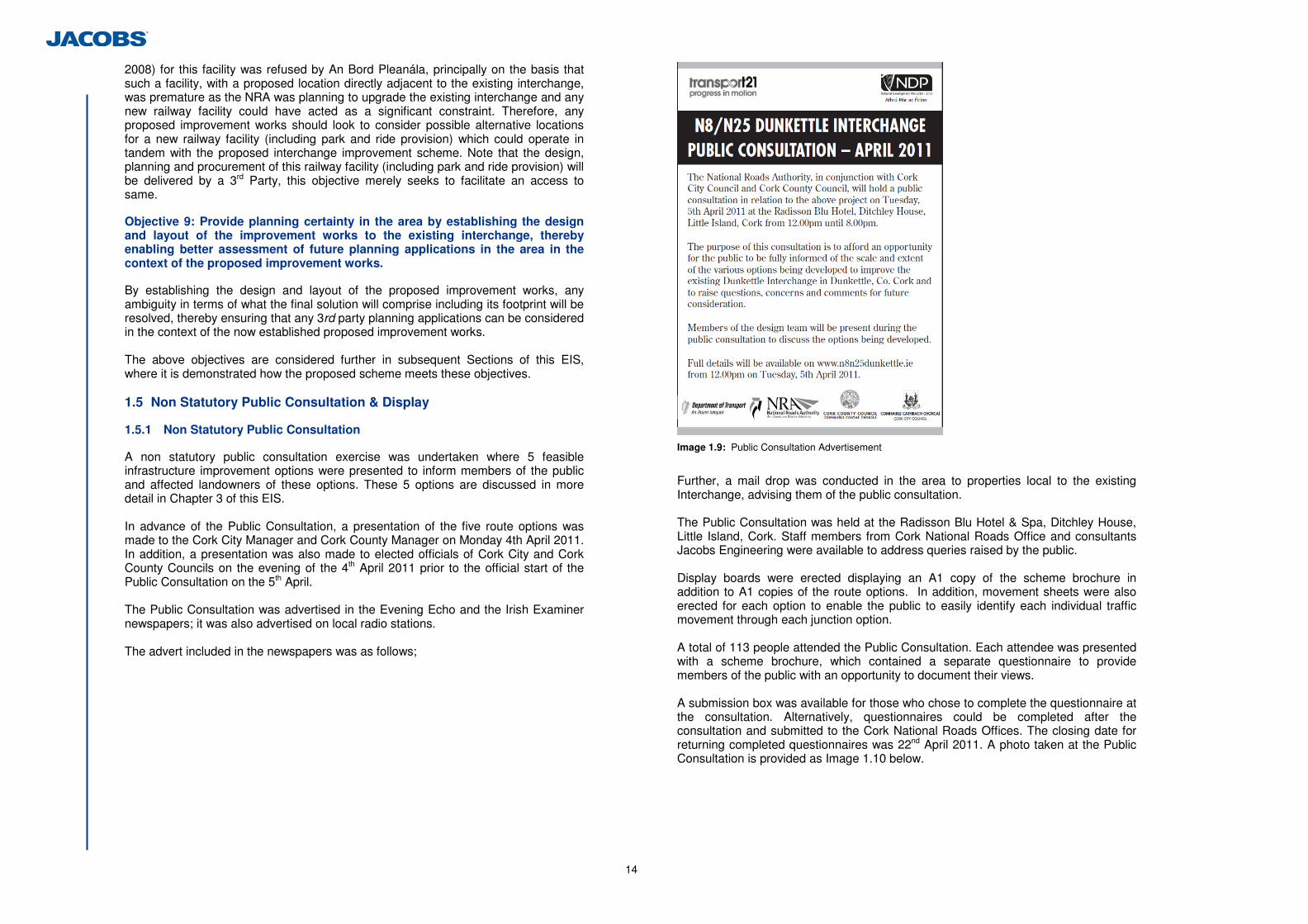
14
2008) for this facility was refused by An Bord Pleanála, principally on the basis that such a facility, with a proposed location directly adjacent to the existing interchange, was premature as the NRA was planning to upgrade the existing interchange and any new railway facility could have acted as a significant constraint. Therefore, any proposed improvement works should look to consider possible alternative locations for a new railway facility (including park and ride provision) which could operate in tandem with the proposed interchange improvement scheme. Note that the design, planning and procurement of this railway facility (including park and ride provision) will be delivered by a 3rd Party, this objective merely seeks to facilitate an access to same.
Objective 9: Provide planning certainty in the area by establishing the design and layout of the improvement works to the existing interchange, thereby enabling better assessment of future planning applications in the area in the context of the proposed improvement works.
By establishing the design and layout of the proposed improvement works, any ambiguity in terms of what the final solution will comprise including its footprint will be resolved, thereby ensuring that any 3rd party planning applications can be considered in the context of the now established proposed improvement works. The above objectives are considered further in subsequent Sections of this EIS, where it is demonstrated how the proposed scheme meets these objectives. 1.5 Non Statutory Public Consultation & Display
1.5.1 Non Statutory Public Consultation
A non statutory public consultation exercise was undertaken where 5 feasible infrastructure improvement options were presented to inform members of the public and affected landowners of these options. These 5 options are discussed in more detail in Chapter 3 of this EIS. In advance of the Public Consultation, a presentation of the five route options was made to the Cork City Manager and Cork County Manager on Monday 4th April 2011. In addition, a presentation was also made to elected officials of Cork City and Cork County Councils on the evening of the 4th April 2011 prior to the official start of the Public Consultation on the 5th April. The Public Consultation was advertised in the Evening Echo and the Irish Examiner newspapers; it was also advertised on local radio stations. The advert included in the newspapers was as follows;
Image 1.9: Public Consultation Advertisement
Further, a mail drop was conducted in the area to properties local to the existing Interchange, advising them of the public consultation. The Public Consultation was held at the Radisson Blu Hotel & Spa, Ditchley House, Little Island, Cork. Staff members from Cork National Roads Office and consultants Jacobs Engineering were available to address queries raised by the public. Display boards were erected displaying an A1 copy of the scheme brochure in addition to A1 copies of the route options. In addition, movement sheets were also erected for each option to enable the public to easily identify each individual traffic movement through each junction option. A total of 113 people attended the Public Consultation. Each attendee was presented with a scheme brochure, which contained a separate questionnaire to provide members of the public with an opportunity to document their views. A submission box was available for those who chose to complete the questionnaire at the consultation. Alternatively, questionnaires could be completed after the consultation and submitted to the Cork National Roads Offices. The closing date for returning completed questionnaires was 22nd April 2011. A photo taken at the Public Consultation is provided as Image 1.10 below.
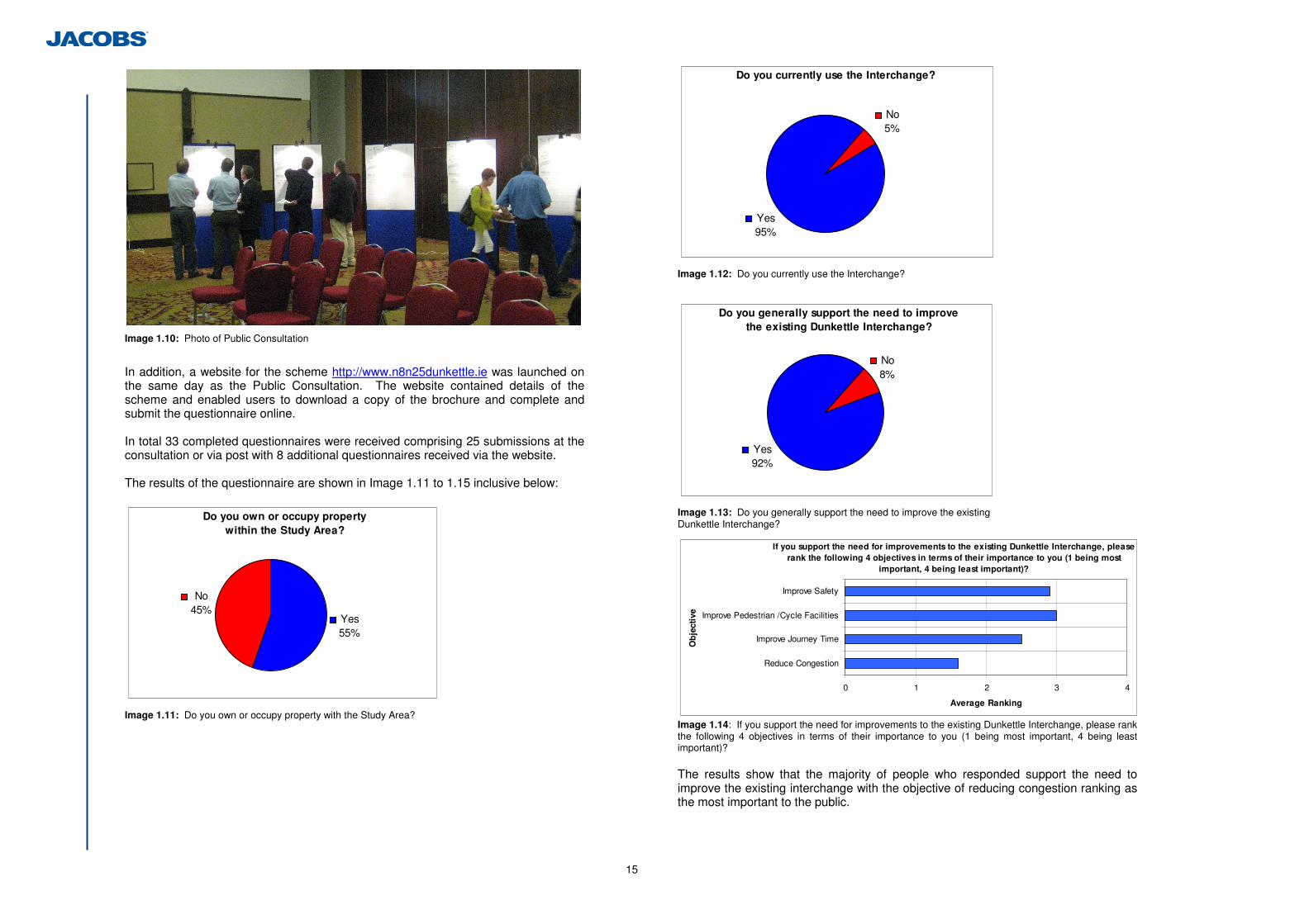
15
Image 1.10: Photo of Public Consultation
In addition, a website for the scheme http://www.n8n25dunkettle.ie was launched on the same day as the Public Consultation. The website contained details of the scheme and enabled users to download a copy of the brochure and complete and submit the questionnaire online. In total 33 completed questionnaires were received comprising 25 submissions at the consultation or via post with 8 additional questionnaires received via the website. The results of the questionnaire are shown in Image 1.11 to 1.15 inclusive below:
Do you own or occupy propertywithin the Study Area?
No45%
Yes55%
Image 1.11: Do you own or occupy property with the Study Area?
Do you currently use the Interchange?
Yes95%
No5%
Image 1.12: Do you currently use the Interchange?
Do you generally support the need to improve the existing Dunkettle Interchange?
Yes92%
No8%
Image 1.13: Do you generally support the need to improve the existing Dunkettle Interchange?
If you support the need for improvements to the existing Dunkettle Interchange, please rank the following 4 objectives in terms of their importance to you (1 being most
important, 4 being least important)?
0 1 2 3 4
Reduce Congestion
Improve Journey Time
Improve Pedestrian /Cycle Facilities
Improve Safety
Ob
ject
ive
Average Ranking
Image 1.14: If you support the need for improvements to the existing Dunkettle Interchange, please rank the following 4 objectives in terms of their importance to you (1 being most important, 4 being least important)? The results show that the majority of people who responded support the need to improve the existing interchange with the objective of reducing congestion ranking as the most important to the public.
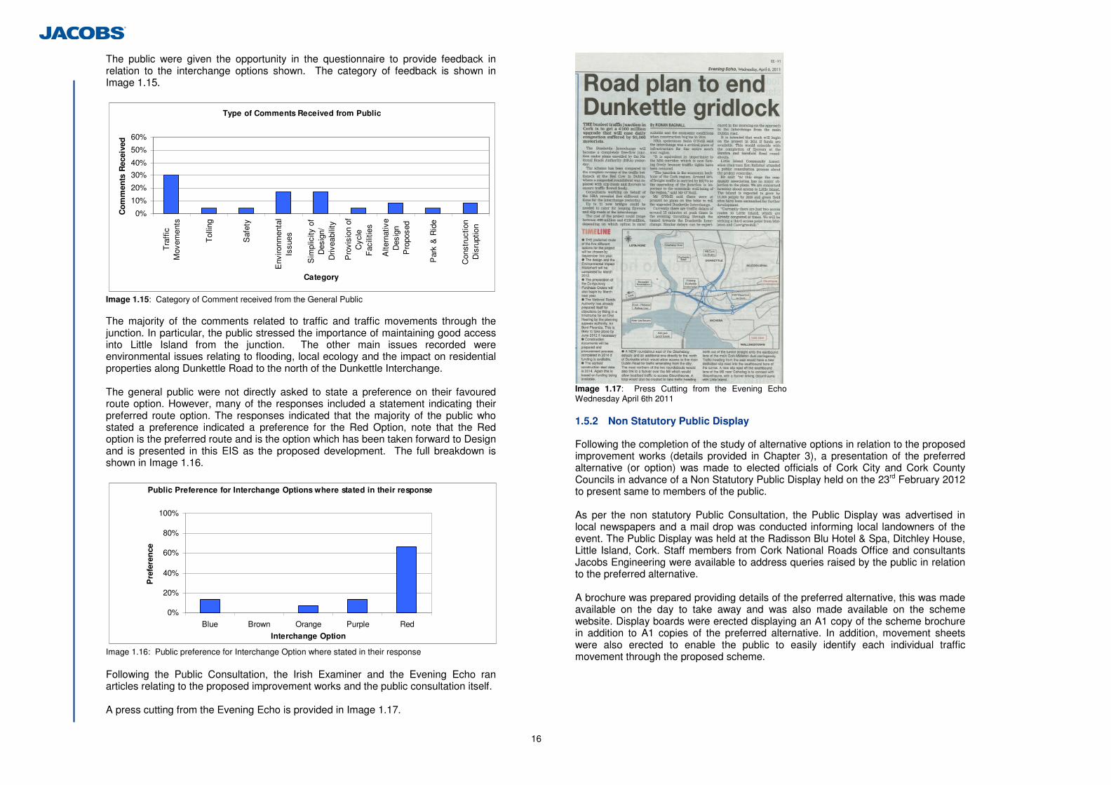
16
The public were given the opportunity in the questionnaire to provide feedback in relation to the interchange options shown. The category of feedback is shown in Image 1.15.
Type of Comments Received from Public
0%
10%
20%
30%
40%
50%
60%
Tra
ffic
Mov
emen
ts
Tol
ling
Saf
ety
Env
ironm
enta
lIs
sues
Sim
plic
ity o
fD
esig
n/D
rivea
bilit
y
Pro
visi
on o
fC
ycle
Fac
ilitie
s
Alte
rnat
ive
Des
ign
Pro
pose
d
Par
k &
Rid
e
Con
stru
ctio
nD
isru
ptio
n
Category
Co
mm
ents
Rec
eive
d
Image 1.15: Category of Comment received from the General Public The majority of the comments related to traffic and traffic movements through the junction. In particular, the public stressed the importance of maintaining good access into Little Island from the junction. The other main issues recorded were environmental issues relating to flooding, local ecology and the impact on residential properties along Dunkettle Road to the north of the Dunkettle Interchange. The general public were not directly asked to state a preference on their favoured route option. However, many of the responses included a statement indicating their preferred route option. The responses indicated that the majority of the public who stated a preference indicated a preference for the Red Option, note that the Red option is the preferred route and is the option which has been taken forward to Design and is presented in this EIS as the proposed development. The full breakdown is shown in Image 1.16.
Public Preference for Interchange Options where stated in their response
0%
20%
40%
60%
80%
100%
Blue Brown Orange Purple Red
Interchange Option
Pre
fere
nce
Image 1.16: Public preference for Interchange Option where stated in their response Following the Public Consultation, the Irish Examiner and the Evening Echo ran articles relating to the proposed improvement works and the public consultation itself. A press cutting from the Evening Echo is provided in Image 1.17.
Image 1.17: Press Cutting from the Evening Echo Wednesday April 6th 2011 1.5.2 Non Statutory Public Display
Following the completion of the study of alternative options in relation to the proposed improvement works (details provided in Chapter 3), a presentation of the preferred alternative (or option) was made to elected officials of Cork City and Cork County Councils in advance of a Non Statutory Public Display held on the 23rd February 2012 to present same to members of the public. As per the non statutory Public Consultation, the Public Display was advertised in local newspapers and a mail drop was conducted informing local landowners of the event. The Public Display was held at the Radisson Blu Hotel & Spa, Ditchley House, Little Island, Cork. Staff members from Cork National Roads Office and consultants Jacobs Engineering were available to address queries raised by the public in relation to the preferred alternative. A brochure was prepared providing details of the preferred alternative, this was made available on the day to take away and was also made available on the scheme website. Display boards were erected displaying an A1 copy of the scheme brochure in addition to A1 copies of the preferred alternative. In addition, movement sheets were also erected to enable the public to easily identify each individual traffic movement through the proposed scheme.
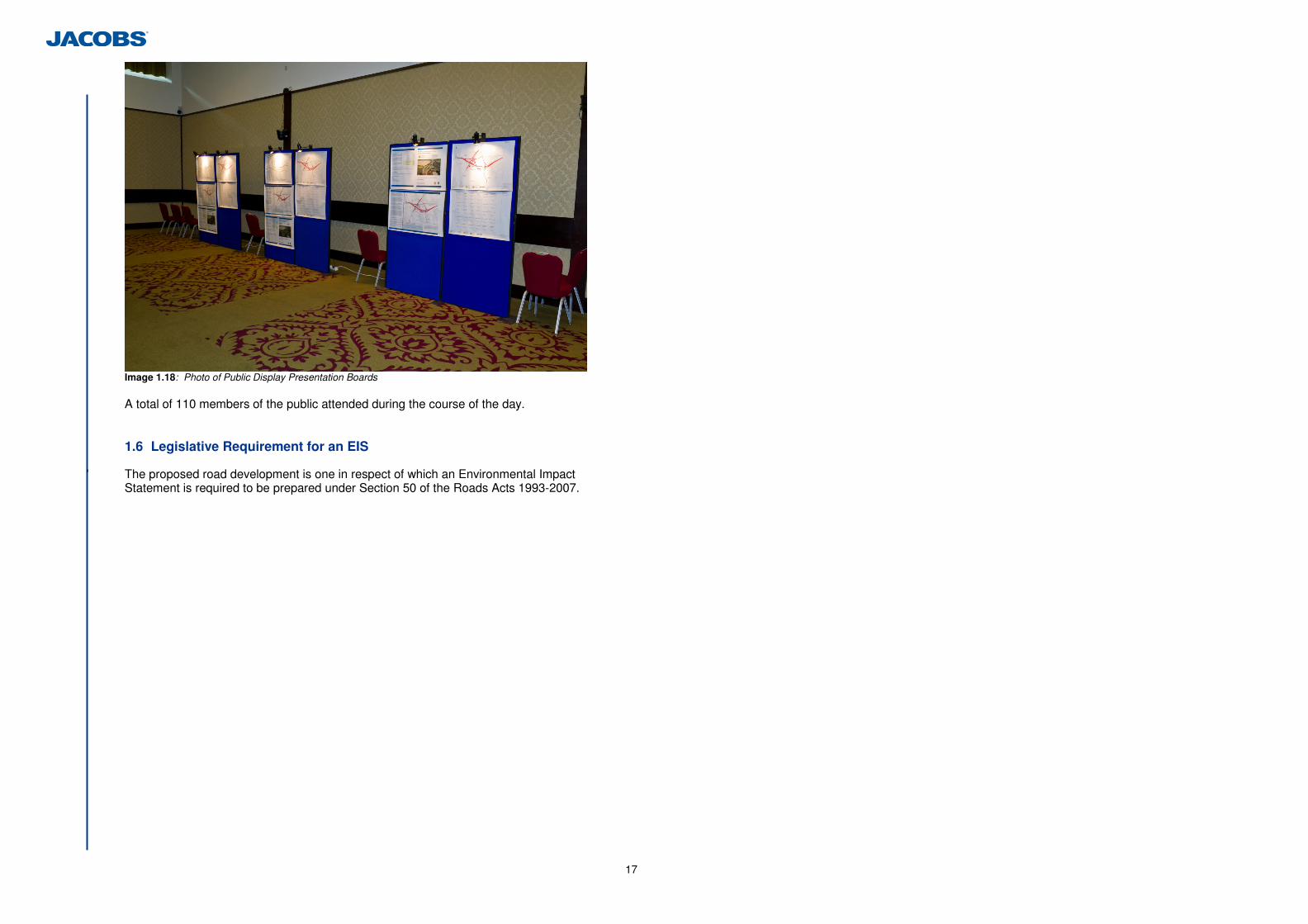
17
Image 1.18: Photo of Public Display Presentation Boards A total of 110 members of the public attended during the course of the day. 1.6 Legislative Requirement for an EIS
' The proposed road development is one in respect of which an Environmental Impact Statement is required to be prepared under Section 50 of the Roads Acts 1993-2007.
18
2 Description of the Proposed Road Development
2.1 Location
The existing Dunkettle Interchange is located approximately 6km to the east of Cork City, where the M8/N8 road from Dublin to Cork intersects with the N25 road from Waterford to Cork, via the existing interchange, just north of the Jack Lynch Tunnel. Its location is shown in Figure 1.1.1 in Volume 3 of this Report. The location of the proposed development is consistent with the location of the existing interchange, given the nature of the scheme which comprises the improvement of the existing interchange. 2.2 Existing Interchange Details
Given the nature of the scheme, the existing interchange which is proposed to be improved, needs to be explained in detail in order to add context to the description of the proposed development. The existing interchange comprises a grade separated signalised roundabout in which the roundabout passes underneath the N25 Cork to Waterford road which runs in an east/ west direction. The roundabout, oval in shape and 4 lanes wide with a minimum Inscribed Circle Diameter of 125m, is situated at a level of approximately +6.9m AOD at the northern side of the roundabout with a fall of approximately 2.7m to the southern side of the roundabout to a level of approximately 4.2m. The N25 crosses the roundabout at a level of approximately +12.8m AOD and +13.3m AOD at the western and eastern bridges respectively. The embankment of the existing interchange, running east/ west, provides a physical barrier in which any new link must pass over, through or under. As such, the existing two bridges constrain the physical number of lanes than can pass through the embankment. The N25 continues west from Dunkettle Interchange crossing the Cork-Midleton railway (Bridge M3, reference Image 2.1) at high skew a distance of 300m from the interchange and then the Glashaboy River (Bridge M1) at a distance of approximately 575m east of the interchange before terminating at the Dunkettle Roundabout. Bridge M3 provides a constraint for any tie-in to the west of the junction in terms of the number of lanes and the vertical and horizontal alignment across the railway. The M8 Cork to Dublin road is constructed to dual carriageway standard and consists of running carriageways with a width of 7.5m, a 3m hard-shoulder and a central median of approximately 9m. This section of the M8 was subsequently upgraded to motorway designation in 2009, commencing at a distance of 400m north of Dunkettle Interchange (Image 2.2). The M8 approaches the Dunkettle interchange from the north on a falling vertical gradient of approximately 5% falling from a level of approximately 50m AOD to the interchange level of approximately 6m AOD over a distance of approximately 1km (Image 2.2). On the immediate approach to the interchange the M8 crosses over a local road (Bridge D3) known locally as the Dunkettle Road at a distance of approximately 385m from Dunkettle interchange before continuing on embankment over the falling topography. The M8 crosses the Cork-Midleton railway (Bridge D1) line at a distance of 85m from the interchange.
The combination of the required minimum headroom at Bridges D1 and D3 and the existing vertical gradient on the road is a constraint to lowering the alignment of this road on approach to the interchange. The N40 Southern Ring Road passes underneath Lough Mahon via the Jack Lynch Tunnel and is an immersed tube tunnel comprising twin traffic bores of two lanes of uni-directional carriageway divided by a Central Service/Emergency Escape passageway. The northern exit portal is located approximately 230m south of the Dunkettle Interchange. Upon leaving the tunnel, the road passes through the northern approach ramp comprising a 120m long, 40m wide open top reinforced concrete boat unit and 75m long in situ northern section which terminates at approximately 45m south of the Dunkettle Interchange (Image 2.3). The in-situ northern approach ramp also contains a 32m long, 10m wide ramp serving as a slip to Little Island and the Tunnel Maintenance Building. The N40 Southern Ring Road leaves the tunnel at a level of approximately -6.7m AOD and approaches the interchange from the south on a rising gradient of 5%. The Jack Lynch Tunnel entrance is a physical barrier which fixes the vertical and horizontal tie-in to the N40 Southern Ring Road. The tunnel also constrains the number and width of the carriageway lanes at this tie-in point. The northern approach portal constrains the approach to the tunnel to a lesser degree. Any changes to the northern approach ramp and in particular the boat unit shall require a substantial and complex amount of construction works. Access to and from the local road network in the vicinity of the junction is also provided at Dunkettle Interchange. Access from Dunkettle Road and Glounthaune is provided via a slip road from Dunkettle road to the M8 southbound at a distance of 200 m north of the interchange (Image 2.2). Access from Dunkettle Road and Glounthaune to the N25 Cork to Waterford eastbound is from a slip road located approximately 900m east of the interchange (Image 2.4).
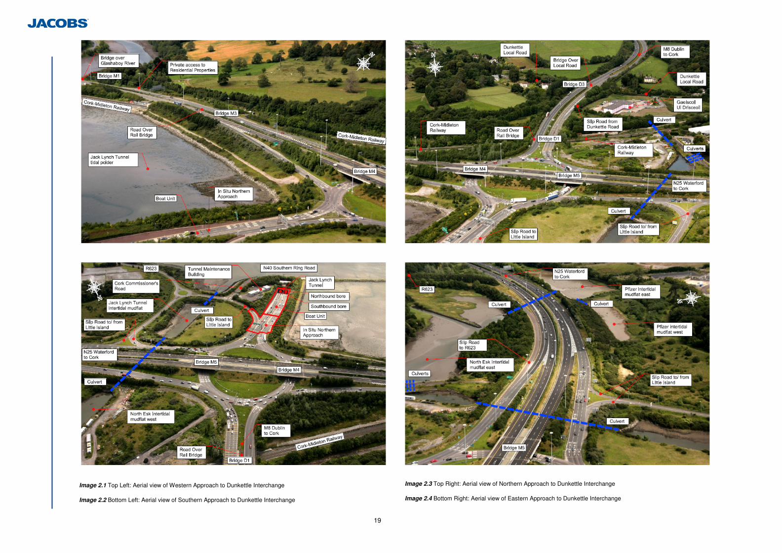
19
Image 2.1 Top Left: Aerial view of Western Approach to Dunkettle Interchange
Image 2.2 Bottom Left: Aerial view of Southern Approach to Dunkettle Interchange
Image 2.3 Top Right: Aerial view of Northern Approach to Dunkettle Interchange
Image 2.4 Bottom Right: Aerial view of Eastern Approach to Dunkettle Interchange
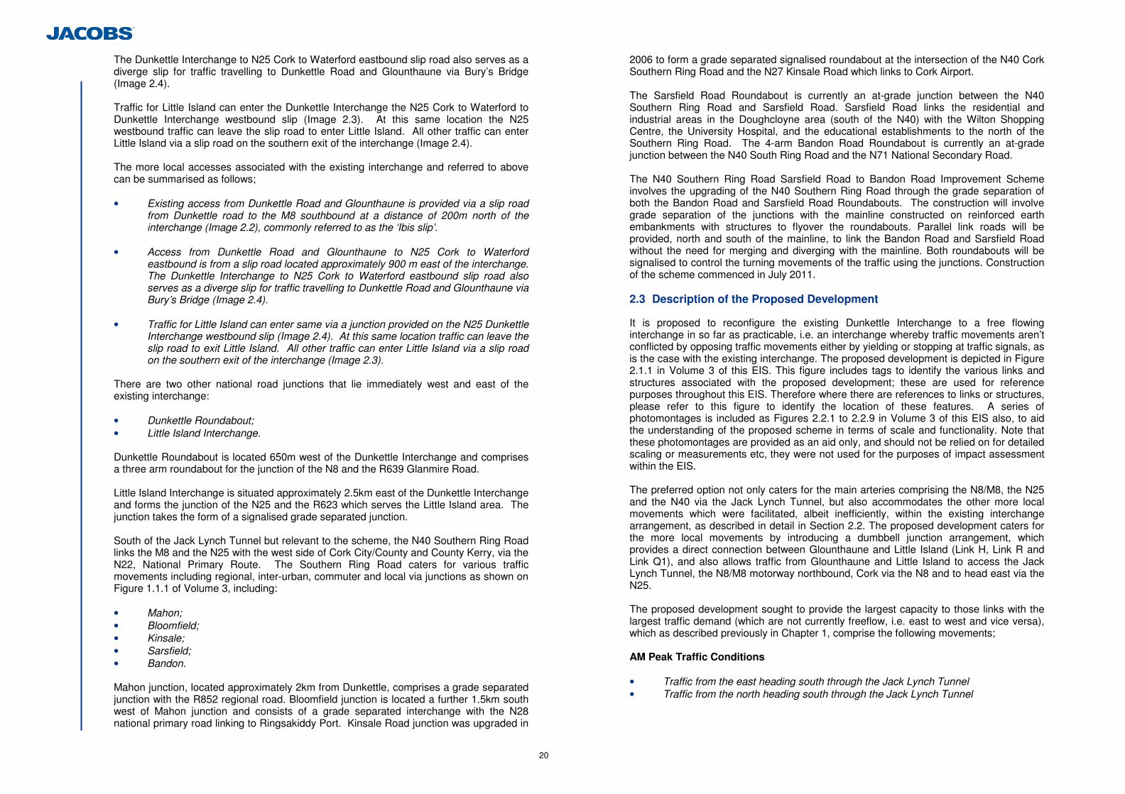
20
The Dunkettle Interchange to N25 Cork to Waterford eastbound slip road also serves as a diverge slip for traffic travelling to Dunkettle Road and Glounthaune via Bury’s Bridge (Image 2.4). Traffic for Little Island can enter the Dunkettle Interchange the N25 Cork to Waterford to Dunkettle Interchange westbound slip (Image 2.3). At this same location the N25 westbound traffic can leave the slip road to enter Little Island. All other traffic can enter Little Island via a slip road on the southern exit of the interchange (Image 2.4). The more local accesses associated with the existing interchange and referred to above can be summarised as follows; • Existing access from Dunkettle Road and Glounthaune is provided via a slip road
from Dunkettle road to the M8 southbound at a distance of 200m north of the interchange (Image 2.2), commonly referred to as the ‘Ibis slip’.
• Access from Dunkettle Road and Glounthaune to N25 Cork to Waterford
eastbound is from a slip road located approximately 900 m east of the interchange. The Dunkettle Interchange to N25 Cork to Waterford eastbound slip road also serves as a diverge slip for traffic travelling to Dunkettle Road and Glounthaune via Bury’s Bridge (Image 2.4).
• Traffic for Little Island can enter same via a junction provided on the N25 Dunkettle
Interchange westbound slip (Image 2.4). At this same location traffic can leave the slip road to exit Little Island. All other traffic can enter Little Island via a slip road on the southern exit of the interchange (Image 2.3).
There are two other national road junctions that lie immediately west and east of the existing interchange: • Dunkettle Roundabout; • Little Island Interchange. Dunkettle Roundabout is located 650m west of the Dunkettle Interchange and comprises a three arm roundabout for the junction of the N8 and the R639 Glanmire Road. Little Island Interchange is situated approximately 2.5km east of the Dunkettle Interchange and forms the junction of the N25 and the R623 which serves the Little Island area. The junction takes the form of a signalised grade separated junction. South of the Jack Lynch Tunnel but relevant to the scheme, the N40 Southern Ring Road links the M8 and the N25 with the west side of Cork City/County and County Kerry, via the N22, National Primary Route. The Southern Ring Road caters for various traffic movements including regional, inter-urban, commuter and local via junctions as shown on Figure 1.1.1 of Volume 3, including: • Mahon; • Bloomfield; • Kinsale; • Sarsfield; • Bandon. Mahon junction, located approximately 2km from Dunkettle, comprises a grade separated junction with the R852 regional road. Bloomfield junction is located a further 1.5km south west of Mahon junction and consists of a grade separated interchange with the N28 national primary road linking to Ringsakiddy Port. Kinsale Road junction was upgraded in
2006 to form a grade separated signalised roundabout at the intersection of the N40 Cork Southern Ring Road and the N27 Kinsale Road which links to Cork Airport. The Sarsfield Road Roundabout is currently an at-grade junction between the N40 Southern Ring Road and Sarsfield Road. Sarsfield Road links the residential and industrial areas in the Doughcloyne area (south of the N40) with the Wilton Shopping Centre, the University Hospital, and the educational establishments to the north of the Southern Ring Road. The 4-arm Bandon Road Roundabout is currently an at-grade junction between the N40 South Ring Road and the N71 National Secondary Road. The N40 Southern Ring Road Sarsfield Road to Bandon Road Improvement Scheme involves the upgrading of the N40 Southern Ring Road through the grade separation of both the Bandon Road and Sarsfield Road Roundabouts. The construction will involve grade separation of the junctions with the mainline constructed on reinforced earth embankments with structures to flyover the roundabouts. Parallel link roads will be provided, north and south of the mainline, to link the Bandon Road and Sarsfield Road without the need for merging and diverging with the mainline. Both roundabouts will be signalised to control the turning movements of the traffic using the junctions. Construction of the scheme commenced in July 2011. 2.3 Description of the Proposed Development
It is proposed to reconfigure the existing Dunkettle Interchange to a free flowing interchange in so far as practicable, i.e. an interchange whereby traffic movements aren’t conflicted by opposing traffic movements either by yielding or stopping at traffic signals, as is the case with the existing interchange. The proposed development is depicted in Figure 2.1.1 in Volume 3 of this EIS. This figure includes tags to identify the various links and structures associated with the proposed development; these are used for reference purposes throughout this EIS. Therefore where there are references to links or structures, please refer to this figure to identify the location of these features. A series of photomontages is included as Figures 2.2.1 to 2.2.9 in Volume 3 of this EIS also, to aid the understanding of the proposed scheme in terms of scale and functionality. Note that these photomontages are provided as an aid only, and should not be relied on for detailed scaling or measurements etc, they were not used for the purposes of impact assessment within the EIS. The preferred option not only caters for the main arteries comprising the N8/M8, the N25 and the N40 via the Jack Lynch Tunnel, but also accommodates the other more local movements which were facilitated, albeit inefficiently, within the existing interchange arrangement, as described in detail in Section 2.2. The proposed development caters for the more local movements by introducing a dumbbell junction arrangement, which provides a direct connection between Glounthaune and Little Island (Link H, Link R and Link Q1), and also allows traffic from Glounthaune and Little Island to access the Jack Lynch Tunnel, the N8/M8 motorway northbound, Cork via the N8 and to head east via the N25. The proposed development sought to provide the largest capacity to those links with the largest traffic demand (which are not currently freeflow, i.e. east to west and vice versa), which as described previously in Chapter 1, comprise the following movements; AM Peak Traffic Conditions • Traffic from the east heading south through the Jack Lynch Tunnel • Traffic from the north heading south through the Jack Lynch Tunnel
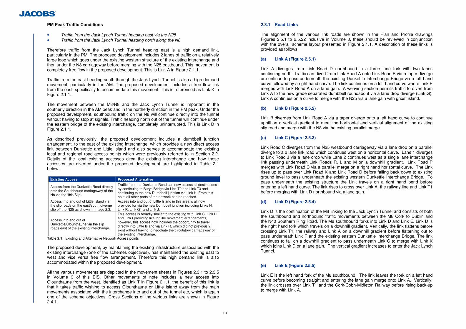
21
PM Peak Traffic Conditions • Traffic from the Jack Lynch Tunnel heading east via the N25 • Traffic from the Jack Lynch Tunnel heading north along the N8 Therefore traffic from the Jack Lynch Tunnel heading east is a high demand link, particularly in the PM. The proposed development includes 2 lanes of traffic on a relatively large loop which goes under the existing western structure of the existing interchange and then under the N8 carriageway before merging with the N25 eastbound. This movement is completely free flow in the proposed development. This is Link A in Figure 2.1.1. Traffic from the east heading south through the Jack Lynch Tunnel is also a high demand movement, particularly in the AM. The proposed development includes a free flow link from the east, specifically to accommodate this movement. This is referenced as Link K in Figure 2.1.1. The movement between the M8/N8 and the Jack Lynch Tunnel is important in the southerly direction in the AM peak and in the northerly direction in the PM peak. Under the proposed development, southbound traffic on the N8 will continue directly into the tunnel without having to stop at signals. Traffic heading north out of the tunnel will continue under the eastern bridge of the existing interchange, completely uninterrupted. This is Link D in Figure 2.1.1. As described previously, the proposed development includes a dumbbell junction arrangement, to the east of the existing interchange, which provides a new direct access link between Dunkettle and Little Island and also serves to accommodate the existing local and regional road access points which were previously referred to in Section 2.2. Details of the local existing accesses circa the existing interchange and how these accesses are diverted under the proposed development are highlighted in Table 2.1 below.
Existing Access Proposed Alternative
Access from the Dunkettle Road directly onto the Southbound carriageway of the N8 via the ‘Ibis Slip’.
Traffic from the Dunkettle Road can now access all destinations by continuing to Burys Bridge via Link T2 and Link T3 and continuing to the new Dumbbell junction via Link H. From this point all other parts of the network can be reached.
Access into and out of Little Island via the slip roads on the east/south diverge slip off the N25 as shown in Image 2.3.
Access into and out of Little Island in this area is all now provided for via the new Dumbbell junction including Links H, Link R, Link Q1 and Link J.
Access into and out of Dunkettle/Glounthaune via the slip roads east of the existing interchange.
This access is broadly similar to the existing with Link G, Link H and Link I providing like for like movement arrangements, however, this access now includes the opportunity to travel directly into Little Island via Link R, which did not previously exist without having to negotiate the circulatory carriageway of the existing interchange.
Table 2.1: Existing and Alternative Network Access points The proposed development, by maintaining the existing infrastructure associated with the existing interchange (one of the schemes objectives), has maintained the existing east to west and vice versa free flow arrangement. Therefore this high demand link is also accommodated within the proposed development. All the various movements are depicted in the movement sheets in Figures 2.3.1 to 2.3.5 in Volume 3 of this EIS. Other movements of note includes a new access into Glounthaune from the west, identified as Link T in Figure 2.1.1, the benefit of this link is that it takes traffic wishing to access Glounthaune or Little Island away from the main movements associated with the interchange into and out of the tunnel etc, which is again one of the scheme objectives. Cross Sections of the various links are shown in Figure 2.4.1.
2.3.1 Road Links
The alignment of the various link roads are shown in the Plan and Profile drawings Figures 2.5.1 to 2.5.22 inclusive in Volume 3, these should be reviewed in conjunction with the overall scheme layout presented in Figure 2.1.1. A description of these links is provided as follows; (a) Link A (Figure 2.5.1)
Link A diverges from Link Road D northbound in a three lane fork with two lanes continuing north. Traffic can divert from Link Road A onto Link Road B via a taper diverge or continue to pass underneath the existing Dunkettle Interchange Bridge via a left hand curve followed by a right hand curve. The link continues on a left hand curve where Link E merges with Link Road A on a lane gain. A weaving section permits traffic to divert from Link A to the new grade separated dumbbell roundabout via a lane drop diverge (Link G). Link A continues on a curve to merge with the N25 via a lane gain with ghost island. (b) Link B (Figure 2.5.2)
Link B diverges from Link Road A via a taper diverge onto a left hand curve to continue uphill on a vertical gradient to meet the horizontal and vertical alignment of the existing slip road and merge with the N8 via the existing parallel merge. (c) Link C (Figure 2.5.3)
Link Road C diverges from the N25 westbound carriageway via a lane drop on a parallel diverge to a 2 lane link road which continues west on a horizontal curve. Lane 1 diverges to Link Road J via a lane drop while Lane 2 continues west as a single lane interchange link passing underneath Link Roads R, L and M on a downhill gradient. Link Road P merges with Link Road C via a parallel merge on a right hand horizontal curve. The Link rises up to pass over Link Road K and Link Road D before falling back down to existing ground level to pass underneath the existing western Dunkettle Interchange Bridge. To pass underneath the existing structure the Link travels on a right hand bend before entering a left hand curve. The link rises to cross over Link A, the railway line and Link T1 before merging with Link D northbound via a lane gain. (d) Link D (Figure 2.5.4)
Link D is the continuation of the M8 linking to the Jack Lynch Tunnel and consists of both the southbound and northbound traffic movements between the M8 Cork to Dublin and the N40 Southern Ring Road. The M8 southbound forks into Link D and Link E. Link D is the right hand fork which travels on a downhill gradient. Vertically, the link flattens before crossing Link T1, the railway and Link A on a downhill gradient before flattening out to pass underneath Link F and the existing eastern Dunkettle Interchange Bridge. The link continues to fall on a downhill gradient to pass underneath Link C to merge with Link K which joins Link D on a lane gain. The vertical gradient increases to enter the Jack Lynch Tunnel.
(e) Link E (Figure 2.5.5)
Link E is the left hand fork of the M8 southbound. The link leaves the fork on a left hand curve before becoming straight and entering the lane gain merge onto Link A. Vertically, the link crosses over Link T1 and the Cork-Cobh-Midleton Railway before rising back-up to merge with Link A.
22
(f) Link F (Figure 2.5.6)
Link F diverges from the N8 eastbound via a taper diverge. The Link travels straight before travelling through a left hand and then a right hand curve before travelling straight to a parallel merge onto Link D. (g) Link G (Figure 2.5.7)
Link G is a short link from Link A to the north roundabout of the grade separated dumbbell roundabout. The Link diverges from Link A on a lane drop onto a left hand curve into an uphill vertical gradient. An additional lane is generated to give a 2 lane entry to the roundabout. (h) Link H (Figure 2.5.8)
Link H links the Bury’s Bridge with the north roundabout of the grade separated dumbbell roundabout along the line of the existing slip roads to and from the N25 eastbound. The Link rises above the existing road level before entering the roundabout. (i) Link I (Figure 2.5.9)
Link I leaves the northern dumbbell roundabout on a left hand curve followed by a short straight into a merge with the N25 eastbound. The Link falls from the roundabout to the level of the existing N25. (j) Link J (Figure 2.5.10)
Link J diverts from Link C via a lane drop into an uphill gradient to rise up to the level of the southern dumbbell roundabout. The Link leaves Link C on a straight before passing through a left hand curve on approach to the roundabout.
(k) Link K (Figure 2.5.11)
Link K diverts from the N25 westbound via a taper diverge and immediately starts to drop vertically to pass underneath Link M. The road leaves the back of the nose on a right hand curve into a short straight where Link L joins on a parallel merge. The link starts to rise back up on an uphill gradient. The link swings south on a left hand curve and starts to fall towards the Jack Lynch Tunnel to merge with Link D southbound on a lane gain before entering the Jack Lynch Tunnel. (l) Link L (Figure 2.5.12)
Link L leaves the southern dumbbell roundabout and immediately rises to pass over Link C on a left hand curve before falling to pass underneath Link M and merge with Link K on a parallel merge. (m) Link M (Figure 2.5.13)
Link M leaves the southern dumbbell roundabout as a 2-lane link before reaching a fork diverge. Link M continues as the right hand fork to pass over Links C and L into a left hand curve to merge with the N25 westbound. (n) Link P (Figure 2.5.14)
Link P commences as the left hand fork of the diverge of Link M. The Link is on a downhill gradient and left hand curve. The link then merges with Link C on a parallel merge.
(o) Link Q1, Q2 & Q3 (Figure 2.5.15 – 2.5.17)
Link Q1 begins at the southern roundabout of the dumbbell interchange and continues south, initially on a downhill gradient as it leaves the roundabout before flattening off in advance of tying in with the existing R623 Regional Road in Little Island. Link Q2 and Q3 are the tie in spurs off the roundabout and onto the existing R623. (p) Link R (Figure 2.5.18)
Link R is the connector road between the dumbbell roundabouts which is straight horizontally over the existing N25, Link A, Link K and Link C. (q) Link T1 (Figure 2.5.19)
Link T1 diverges from the N8 eastbound via a taper diverge. Traffic diverges onto Link U via a taper diverge or continues parallel to the railway on Link T1 to pass underneath Link C, Link D and Link E before starting to the new roundabout with Dunkettle Road. (r) Link T2 (Figure 2.5.20)
Link T2 is the realignment of the existing Dunkettle Road to the new three-arm roundabout with Link T1. The link enters the roundabout on a downhill vertical gradient. (s) Link T3 (Figure 2.5.21)
Link T3 is a short section of road between the new roundabout with the realigned Dunkettle Road and Link T1 and the existing roundabout at Bury’s Bridge. (t) Link U (Figure 2.5.22)
Link U diverts from Link T1 on a taper diverge. The link rises on an uphill gradient on a left hand curve to the merge with the M8 northbound. 2.3.2 Structures
In addition to the above road links, various structures were required in order to carry the various links over and under each other such that the links could remain freeflow. The location of these structures, which includes bridges and retaining walls, is shown in Figure 2.1.1. General arrangement drawings depicting the overall form and nature of these structures is provided in Figures 2.6.1 to Figures 2.6.13 for all bridges, and Figures 2.6.14 to 2.6.20 for retaining walls. A description of these structures is provided as follows; (a) ST01 – N25 Overbridge (Figure 2.6.1)
The proposed bridge is a three-span structure. The deck will comprise precast pretensioned concrete beams composite with in-situ reinforced concrete deck. The deck will be integral with and supported on intermediate piers and concrete columns sleeved through reinforced earth abutments. The reinforced concrete piers and abutments will be supported on piled foundations. Full height abutments were used for this overbridge to avoid the entry and exits flares to the roundabouts to minimise the deck width. A minimum 4.5m set-back has been allowed from the edge of the pavement.
23
(b) ST02 Link L Underbridge (Figure 2.6.2)
The proposed structure is a single span structure. The deck will comprise precast prestressed beams with a composite in-situ reinforced concrete deck slab. The deck will be fully integral and supported on concrete columns sleeved through reinforced earth abutments. The abutment foundations are supported on piles. The south east wingwall extends into Retaining Wall No 6. A minimum 2m set-back has been allowed from the edge of the pavement.
(c) ST03 Link M Underbridge (Figure 2.6.3)
The proposed structure is a single span structure. The deck will comprise precast prestressed beams with a composite in-situ reinforced concrete deck slab. The deck will be fully integral and supported on concrete columns sleeved through reinforced earth abutments. The abutment foundations are supported on piles. The south east wingwall extends into Retaining Wall No 6. A minimum 2m set-back has been allowed from the edge of the pavement.
(d) ST04 Link M Underbridge 2 (Figure 2.6.4)
The proposed structure is a single span structure. The deck will comprise precast prestressed beams with a composite in-situ reinforced concrete deck slab. The deck will be fully integral and supported on concrete columns sleeved through reinforced earth abutments. The abutment foundations are supported on piles. A minimum 2m set-back has been allowed from the edge of the pavement. (e) ST05 Link C Underbridge (Figure 2.6.5)
The proposed structure is a two-span structure. The deck will comprise precast prestressed beams with a composite in-situ reinforced concrete deck slab. The deck will be integral with and supported on an intermediate pier and concrete columns sleeved through reinforced earth abutments. The reinforced concrete piers and abutments will be supported on piled foundations. A two-span structure has been adopted with a central support in the back of the nose due to constraints relating to headroom over Link K and D. A minimum 2m set-back has been allowed from the edge of the hard-strip. (f) ST06 Link F Dunkettle Bridge Widening (Figure 2.6.6)
The proposed structure is a single span structure which abuts but is structurally independent from the existing western overbridge of Dunkettle Interchange. The structure comprises a single square span to match the existing structure. The deck will comprise precast prestressed beams with a composite in-situ reinforced concrete deck slab. The deck will be fully integral and supported on full height reinforced concrete abutments with full height wingwalls. The abutment foundations are supported on piles. A minimum 2m set-back has been allowed from the edge of the hard-strip.
(g) ST07 Link F Underbridge (Figure 2.6.7)
ST07 is a single span structure which runs adjacent, but independent from the existing eastern overbridge of Dunkettle Interchange. The structure comprises a single square span. The deck will comprise precast prestressed beams with a composite in-situ reinforced concrete deck slab. The deck will be fully integral and supported on full height reinforced concrete abutments with full height wingwalls. The abutment foundations are supported on piles. ST07 utilises reinforced concrete abutments and a shorter span than the existing overbridge to minimise the span of the structure due to constraints relating to available headroom over Links F and D. A minimum 2m set-back has been allowed from the edge of the hard-strip. (h) ST08 Link C & D Rail Bridge (Figure 2.6.8 & 2.6.9)
ST08 is a three span structure spanning Link A, the Cork-Cobh-Midleton railway and Link T1. The construction of ST08 will require the demolition of the existing M8 Railway Bridge. The width of the deck varies across the span of the structure to accommodate the horizontal curvature of Link C. The varying deck width is accommodated through a tapered deck with the beam spacing varying at each support. The deck will comprise precast prestressed beams with a composite in-situ reinforced concrete deck slab. The deck will be fully integral at the northern abutment and intermediate piers with a semi-integral abutment provided at the higher skew southern abutment. The abutments comprise concrete columns sleeved through reinforced earth abutments. The reinforced concrete piers and abutments will be supported on piled foundations. The location of the intermediate piers have been located to avoid the location of the existing piles of the foundation of the M8 railway bridge to avoid the requirement for deep excavation next to the railway and within the track support zone. (i) ST09 Link E Rail Bridge (Figure 2.6.10)
The proposed structure is a two-span structure. The deck will comprise precast prestressed beams with a composite in-situ reinforced concrete deck slab. The deck will be integral with and supported on intermediate piers and concrete columns sleeved through reinforced earth abutments. The reinforced concrete piers and abutments will be supported on piled foundations. A minimum 2m set-back has been allowed from the edge of the pavement of Link T1 with a minimum 4.5m set-back to the railway. A double parapet has not been used due to constraints on headroom to the railway and Link T1 resulting from the increase in width of the deck due to this arrangement. (j) ST10 M8 Structure D3 Widening (Figure 2.6.11)
The existing structure comprises a single span structure comprising contiguous precast beams with an in situ infill deck supported on reinforced concrete abutments on spread foundations. It is proposed to demolish the existing deck edge to extend the structure through the placement of additional beams and infill. The new deck edge will be structurally continuous with the existing deck. New reinforced concrete abutment will be cast supported on spread foundations on bedrock. The new abutment will be dowelled to the existing abutment.
24
(k) ST11 Widening of Jack Lynch Tunnel Boat Unit and Northern In Situ Approach. (Figure 2.6.12)
The northern approach ramp of the Jack Lynch comprises a 120m long, 40m wide open top reinforced concrete boat unit and 75m long in situ northern section which terminates at approximately 45m south of the Dunkettle Interchange. The existing walls of the Northern Insitu approach will be required to be demolished with an extended base and new walls cast onto the structure. The extension of the structure will use the same structural form as the original structure. The boat unit shall require partial demolishment of an 11m length of the south east wall and a small extension slab cast onto the existing structure. A secant pile wall or sheet pile wall shall be constructed to enable demolishment of the existing wall and to act as a permanent structure in the widened structure. The new wall will be structurally independent of the existing structure. A reinforced concrete corbel and facing will be cast onto the face of the new piled wall. (l) ST12 Bury’s Bridge Footbridge (Figure 2.6.13)
The single span footbridge shall comprise a steel truss with steel deck plate. The truss will be supported on reinforced concrete bankseats founded on piles. The structure shall over-span the existing wingwalls of the existing Bury’s Bridge. Solid infill sheeting will be provided to a height of 1.8m above deck level with the remainder of the truss infilled with mesh. (m) Retaining Wall RW01 (Figure 2.6.14)
Retaining Wall RW01 is a reinforced earth retaining wall for the purpose of retaining Link T1 and avoiding the existing Cork-Midleton railway line. (n) Retaining Wall RW02 (Figure 2.6.15)
Retaining Wall RW02 is a reinforced concrete retaining wall for the purpose of retaining the level difference between Link A and Link C. (o) Retaining Wall RW03 (Figure 2.6.16)
Retaining Wall RW03 is an extension of Retaining Wall RW02 but is of a different structural form. RW03 is a reinforced earth retaining wall for the purpose of retaining the level difference between Link A and Link C. (p) Retaining Wall RW04 (Figure 2.6.17)
Retaining Wall RW04 is a reinforced concrete retaining wall for the purpose of the retention of the abutment side slope of the existing eastern Dunkettle Overbridge and Structure ST06. Temporary geotechnical works may be required to enable excavation of a steep earthworks slope adjacent to and beneath the level of the existing piled abutment. This may consist of ground freezing, soil nails or other geotechnical solutions. (q) Retaining Wall RW05 (Figure 2.6.18)
Retaining Wall RW04 is a reinforced concrete retaining wall for the purpose of the retention of the abutment side slope of the existing western Dunkettle Overbridge. Temporary geotechnical works may be required to enable excavation of a steep earthworks slope adjacent to and beneath the level of the existing piled abutment. This may consist of ground freezing, soil nails or other geotechnical solutions.
(r) Retaining Wall RW06 (Figure 2.6.19)
Retaining Wall RW06 is a reinforced earth retaining wall for the purpose of retention of Link M and Link L to minimise the impact on the existing intertidal area. (s) Retaining Wall RW07 (Figure 2.6.20)
Retaining Wall RW07 is a reinforced earth retaining wall for the purpose of retention of Link J and avoiding the existing Pfizer Pharmaceutical site and Cara Partners fire retention pond. (t) Gantries (Figures 2.6.21 & 2.6.22)
In addition to the structures associated with bridges and retaining walls, gantries are also required in order to appropriately sign the scheme such that drivers are informed of decision making points on approaches to the various links and manoeuvres can be executed in a timely and safe manner which minimises disruption to other road users. The locations of these gantries are shown in Figure 2.6.21. Gantry structures shall consist of either portal span structures or cantilever structures in accordance with the NRA Road Construction Details.
Where gantries require man access for the maintenance of overhead lane control signals, LED matrix VMS and rotating prism VMS sign faces associated with the operation of the Jack Lynch Tunnel, these gantries shall be constructed to a similar form to the gantries installed on the M50 upgrade scheme and are as shown in Figure 2.6.22. 2.3.3 Pedestrian & Cyclist facilities
Another objective of the scheme was the inclusion of pedestrian and cyclist facilities in conjunction with the proposed development. Various alternatives were considered in this regard which sought to achieve the following objectives; • Comply with other policy and planning objectives in relation to cyclist and
pedestrian facilities in the area such that any solution would be consistent with existing policy;
• Establish a safe facility that segregates where possible any pedestrian and cyclist movements away from the main interchange solution, thereby improving safety; and
• Ensure that the facility is sufficiently attractive to potential users that it is likely to be used, i.e. people and cyclists can often avoid facilities which have been provided on the basis that their use would take significantly extra time or be overly complex.
The proposed development includes the provision of pedestrian and cyclist facilities as depicted in Figure 2.7.1. The facility as provided, connects Little Island and Glouthanune in a north to south and vice versa direction, it also connects Glounthaune to Glanmire in an east to west, and vice versa, direction. It therefore caters for all movements in all directions through the junction. The facility begins at the Dunkettle Roundabout, thereby facilitating future connection to any additional facilities proposed along the Glanmire road or the Lower Glanmire Road. A crossing point is included in the eastern splitter island of the Dunkettle Roundabout, this enables a cyclist to be on the correct side of the road for onward travel to Cork for cyclists travelling from the east. The facility runs adjacent to the N8, on the northern side of the existing carriageway, and continues along the proposed Link T1, before pedestrians and cyclists have to cross Link U (to avoid the diverge associated with the same link) onto the
25
southern side of Link T1, where the facility continues towards Glounthaune. The use of Link T1 for the facility, means that pedestrians and cyclists are segregated from the main interchange arrangement, which was one of the objectives that had been sought. This part of the facility runs as far as the proposed roundabout, and allows pedestrians or cyclists to either gain access to Dunkettle Road, or alternatively to the existing Burys Bridge Roundabout, where pedestrians or cyclists can travel east towards Carrigtwohill and Midleton or go south towards Little Island. A new bridge is proposed over the existing railway line to facilitate pedestrians and cyclists wishing to travel between Burys Bridge and Little Island. It is Structure Reference ST12, and a general arrangement of this structure is depicted in Figure 2.6.13. This new bridge is required as there is insufficient width available to have a segregated facility over the existing Burys Bridge. Pedestrians or Cyclists can then access Little Island via the fully segregated shared footway and cyclist facility. There are 2 roundabouts to be negotiated in this movement, but standard crossing points have been included such that these can be negotiated safely. By linking Little Island to Glounthaune, and Glounthaune to the west via the proposed Link T1, the proposed pedestrian and cyclist facility complies with the Blarney Local Area Plan (August 2011), which states as an objective in relation to Glanmire, under Section 3.3.3; the ‘provision of cycle facilities including cycle links to the City and Little Island to facilitate commuters’. Pedestrians and cyclists can now access Little Island via Dunkettle Road and Burys Bridge or via the Glanmire Road and Link T1. The proposed arrangement is direct, does not require the use of structures which require to be ascended and descended via parallel ramps etc, and is a segregated facility. Therefore it should be attractive to pedestrians and cyclists alike and promote cycling and walking in the area. It should also be noted that the entire interchange proposal area will be lit, thereby adding further safety to the proposed pedestrian and cyclist facility. 2.3.4 Park and Ride Access
As stated previously, Iarnród Éireann’s ‘Moving into the Future’ publication includes for the provision of a new railway station and park and ride facility at Dunkettle as part of its Cork Commuter Network. A previous planning application submitted by Irish Rail (8th April 2008) for this facility was refused by An Bord Pleanála, principally on the basis that such a facility, with a proposed location directly adjacent to the existing interchange, was premature as the NRA was planning to upgrade the existing Interchange and any new railway facility could have acted as a significant constraint. Therefore, the proposed solution also included the consideration of possible alternative locations for a new railway facility (including park and ride provision) which could operate in tandem with the proposed interchange improvement scheme. This was progressed originally as part of the Route Selection Process, whereby various locations were considered in conjunction with various interchange improvement solutions. The assessment for Park & Ride is based upon the available area for the facility in combination with the following criteria identified through preliminary consultation with Iarnród Éireann: • Access to and from the M8; • Located as far west as practicable; • Located on a straight section of railway track; • Good visibility from surrounding road network. 2 potential sites were investigated as part of the route selection process in relation to the then Red Route (now the proposed development). The first location was the area between the former Ibis Hotel and the existing railway line, the second location was in the existing Iarnród Éireann Freight Yard in North Esk, east of the existing link road connecting Burys Bridge with the left in/left out facility on the N25 (proposed to be replaced by Link H in the
proposed development). Note this second location was identified as the 2nd preferred option location in the ‘Dunkettle Park and Ride Feasibility Study’ produced by Arup on behalf of Cork County Council in January 2006. The proposed interchange development facilitates such a facility at these locations as it would provide access to them from the M8, they are not as far west as the original location proposed by Iarnród Éireann but is generally not significantly further east, they are on a straight section of railway track and have good visibility from the surrounding road network. Therefore they comply with the outline objectives identified by Iarnród Éireann. Further, as the proposed pedestrian and cyclist facility runs adjacent to Links T1 and H, it means that pedestrians and cyclists would have direct access to the park and ride facility at either potential location if the proposed development were progressed, thereby further promoting sustainable, integrated transport solutions. This access point is identified in Figure 2.7.1. The potential locations identified for the park and ride facility have been passed to the National Transport Authority (NTA) for their consideration as part of the consultation process with the NTA for the proposed Dunkettle Interchange Upgrade Scheme environmental impact assessment. 2.3.5 Lighting.
A lighting design for the scheme has been carried out in accordance with BS EN 5489-1:2003 and BS EN 13201:2003 and NRA TD 22/09, with each road Link lit to the appropriate lighting class based on its character and projected traffic flow. Consideration has been given to minimising the light spillage into adjacent areas beyond the road boundary, many of which are environmentally sensitive due to wildlife habitats etc. This has been achieved through careful selection of apparatus and positioning in these areas, and the inclusion of louvres where required.
The existing N25 and intersection are lit utilising high mast lighting, and given the complex and widespread area enclosed by the new intersection, it is intended that the existing arrangement be retained and extended to cover the various road links within the central area. Slip roads around the periphery of the intersection, as well as the N8 have been lit using conventional columns, incorporating standard road lighting luminaires with flat glass optics, many of which, it is proposed, will be fitted with louvres to reduce backward light spill beyond the road boundary. It should be noted that the existing lighting on the N8, as it approaches from the north, consists of twin bracket columns installed in the central reservation. Due to the additional slip roads in this area, the existing lighting requires to be replaced and, for maintenance purposes, it is proposed that these will be installed in the verge.
2.3.6 Drainage
A drainage solution has been prepared for the proposed development. An effective drainage system is required for the scheme to ensure the efficient removal of rainfall from the carriageway thereby reducing the safety implications of standing water on a carriageway carrying significant volumes of traffic. The design principles employed ensure that there is no adverse impact on the receiving environment (existing watercourses, habitats, increased risk of flooding etc). The preliminary drainage design solution comprises the following systems: • Kerbs and gullys • Combined Kerb and Drainage Blocks, and
26
• Surface Water Channels.
Kerbs and gullys with a carrier drain has been the principle drainage system used on the scheme in areas of both embankment and cuttings. Surface water channels (SWCH) have been used on a number of embankments and have been supplemented with carrier drains where necessary to accommodate higher flow rates. The scheme comprises numerous structures and combined kerb and drainage blocks will be used to facilitate the drainage of these sections of carriageway.
Where a kerb and gully or SWCH drainage system is used for carriageway run-off, it will be supplemented by narrow filter drains, connected to the surface water system to allow drainage of the carriageway sub-grade.
Where required, interceptor ditches will be provided at the top of cuttings or at the bottom of embankments where the surface water and sub-surface water from the adjoining land, flows towards the scheme. The water collected by this separate system will discharge directly into existing watercourses or waterbodies.
The design and analysis of the carriageway drainage networks has been modelled using the WinDes software package which is the industry standard software for this type of analysis and which uses the Modified Rational Method to determine the flow rates along the carriageway and subsequent discharge rates at the outfall locations.
(a) Outfall Locations
The drainage for the scheme has been divided into 4 networks. Each of these networks has a distinct outfall point which is an existing receiver, typically an existing inter-tidal pond.
Runoff calculations have been carried out and the discharge rates obtained at each of the proposed outfall locations determined. These calculations assumed a return period of 1 year (highest intensity storm expected in 1 given year) and was checked for surcharging of the drainage system against a return period of 5 years. A summary of the outfall locations is given in Table 2.2. These can be referenced against the drainage outfall locations depicted in Figure 2.8.1 contained in Volume 3 of this EIS.
Network Colour Outfall Location
Red Existing watercourse to the north of Link T1
Blue Existing inter-tidal pond to the east of the Jack Lynch Tunnel southbound entrance
Brown Existing inter-tidal pond to the east of the Jack Lynch Tunnel southbound entrance
Magenta Existing inter-tidal pond directly west of the southern roundabout of the new grade separated dumbbell junction.
Table 2.2: Outfall Locations
Carriageway stormwater runoff can impact on receiving watercourses in two ways:
• Rate of discharge – if the rate of discharge from the proposed road exceeds that of
the existing “greenfield” catchment area then it is possible that overloading of the existing watercourse could occur, causing localised flooding and erosion of watercourse banks within the catchment.
• Quality – carriageway runoff can contain pollutants from the carriageway because of the traffic loading on the carriageway.
In order to minimise the risk of overloading the existing receiver to which the carriageway runoff is being discharged to, it is important to design the outfall so that the rate of discharge does not exceed that of the existing “greenfield” catchment area, i.e. return the runoff rate to the flows that were present in the existing scenario without the proposed development. This has been achieved through the use of attenuation ponds at the proposed outfall locations.
Attenuation ponds are considered an appropriate method for providing suitable storage and a controlled means of discharge. The attenuation ponds will store the runoff, allow a degree of settlement to occur within the ponds permanent pool and control the discharge into the receiving environment to that of the “greenfield” run off rate. An additional benefit of attenuation ponds is that they can also provide a degree of protection against accidental spillage on the road from entering a receiving watercourse, giving the relevant authority time to organise appropriate remedial measures.
Carriageway runoff may contain pollutants that can have an adverse effect on the quality of the water within the receiving watercourse or waterbody and therefore it is important that the drainage system proposed would provide a form of treatment to ensure that any negative impact is reduced. Therefore constructed wetland systems have been incorporated into the proposed development in tandem with the attenuation ponds to ensure the quality of the runoff at the outfall locations.
The constructed wetland systems would provide mitigation against the impact of the quality of the carriageway runoff. Constructed wetland systems have been shown to remove high percentages of suspended solids, phosphorous and metals. They can also reduce the Biological Oxygen Demand of stormwater runoff. Pollutant removal is achieved through actions of both filtration and biological activity, it achieves this by adhesion to aquatic vegetation and aerobic decomposition. The wetland shall have a permanent pool of water at varying depths, and shall ‘drain down’ additional runoff water in no less than 24 hours for treatment while discharging into the receiving watercourse. Further detail in relation to the benefits of the proposed outfall treatment features are included in Chapter 6 Hydrology, Geomorphology and Hydromorphology.
These pond locations and layouts are depicted in Figure 2.8.2. 2.3.7 Flood Compensatory Areas
There is a network of interconnected intertidal mudflats amongst the existing Dunkettle Interchange and slip roads. Many of these intertidal mudflats are sheltered, enclosed areas due to the landscaping treatments on embankments around the existing interchange/slip roads, and are subject to delayed filling and emptying by tidal flows due to the culverting of incoming marine waters. The intertidal mudflats are connected both together, and to the Cork Harbour Estuary by a series of culverts, the majority of which are large diameter, pipe culverts. The intertidal mudflats act as a series of individual basins, which are filled and emptied sequentially as the tide rises and falls. Details in relation to the operation of these intertidal mudflats are provided in Chapter 6 Hydrology, Geomorphology and Hydromorphology, with the locations of same provided in Figure 5.1.1. The OPW have not recorded any floods events adjacent to the existing Interchange. The OPW have recorded flood events in the vicinity of Glanmire Village north of the existing Interchange and east of the Glashaboy River. The Blarney Local Area plan does identify the areas associated with the above interconnected mudflats and areas in the immediate vicinity of these areas as being ‘susceptible to flooding’, both in North Esk and Little Island. In order to better understand the flood risk associated with the existing environment and in order to consider the impacts of the proposed development to flooding in the area, a flood risk assessment (FRA), in line with the Office of Public Works (OPW) Guidelines for
27
Planning Authorities (GPA) 20: The Planning System and Flood Risk Management (OPW, 2009), has been conducted for the proposed development and is contained in Appendix 6.6. The primary objective of the FRA was to construct a hydraulic model of the Dunkettle Interchange and intertidal mudflats to assess the flood risk in the existing situation and with the proposed development in operation. Both situations were assessed for an extreme tidal event (0.5% Annual Exceedance Probability). As areas of existing intertidal mudflats are being lost as a result of the footprint of the proposed development, compensatory areas of flood storage have been included to compensate for these lost areas. These have been located and sized so as to maintain the existing tidal flow regime to allow inundation of areas at similar levels in the tidal cycle by providing like for like storage as close as possible to those mudflat areas which are being lost. These compensatory flood storage areas are depicted in Figure 2.8.2 which also shows the means by which these new compensatory flood areas are connected. Figure 2.8.2 also depicts the areas of existing intertidal mudflats which are being lost as a result of the proposed development. The FRA concluded that all across the study area, comparison of model predictions between the existing and the proposed road development, including the compensatory flood areas, demonstrate that the proposed works do not increase the flood risk to the surrounding area, nor is the proposed development at risk of flooding. Further, these compensatory flood areas have also been employed as mitigation to lost ecological habitat, this is described in detail in Chapter 5 Flora and Fauna. 2.3.8 Signalisation of Dunkettle Roundabout
In addition to the improvement works proposed to the existing Dunkettle Interchange, as an additional measure to maximise the benefits of the proposed development, traffic signals have been included on the Dunkettle Roundabout. These traffic signals will comprise signal heads on all approach arms comprising the N8 Lower Glanmire Road, the R639 Glanmire Road and on the N8 approach to the Dunkettle Roundabout from the east. Signal heads will also be included on the circulatory carriageway of the roundabout, to stop vehicles in order to give way to vehicles who have been given a green light on a particular approach arm. The general location of the signal heads are shown in Figure 2.7.1. Additional lining and signage will also be required as a result of the traffic signals. The inclusion of these traffic signals has been incorporated into the traffic appraisal of the proposed development.
2.4 Traffic Assessment of Proposed Road Development
Chapter 1 presented details of the operational deficiencies associated with the existing interchange in terms of increased journey times during peak periods as a result of congestion at the existing interchange. It also provided details in relation to volume to capacity ratios of the various movements through the existing interchange. This detail was provided for the existing situation and was also presented based on future traffic growth projections for 2016 and 2031, the ‘year of opening’ and ‘design year’ respectively. As one of the scheme objectives is to improve capacity at the existing interchange thereby reducing congestion, the proposed development needs to demonstrate such improved capacity with resultant reductions in journey times for 2016 and 2031. The macro SATURN Traffic Model referred to in Chapter 1 was therefore used to assess the impact of the proposed development on journey times and capacity. 2.4.1 Modelled Journey Times through the Proposed Development
Tables 2.3 and 2.4 show forecast journey times through the Dunkettle Interchange, for both the existing situation (Do Minimum) and with the proposed development in place (Do Something), in all three modelled time periods under the medium growth scenario, for 2016 and 2031 respectively. These tables also show the differences between the 2 scenarios; figures are given in minutes and seconds (mm:ss). The extents of the routes along which journey times are forecast are as set out in Section 1.2.2 in Chapter 1 and depicted in Image 1.7, provided again as follows; A. To the north: the south facing diverging slip road at the M8 Glanmire Interchange; B. To the east: the west facing slip roads at the N25 Little Island Interchange; C. To the south: the north facing slip roads at the N40 Mahon Junction; and D. To the west: immediately east of the Dunkettle Roundabout. As stated above, these locations are consistent with those used in Chapter 1 of this EIS where the operational deficiencies of the existing interchange were considered. These tables show that the proposed development will reduce the journey times associated with the main traffic movements in the relevant time periods where congestion currently exists, compared to the existing situation. As can be seen from Tables 2.3 and 2.4, some journeys are likely to see a significant reduction in journey times. Notable improvements in journey time as a result of the proposed development are journeys from the north to the south, particularly during the AM period and journeys from the south to the north and east, particularly in the PM period. These are the movements forecast to experience the greatest increase in delays in the existing situation and therefore likely to experience the greatest travel time benefits under the proposed development. A small increase in travel times for the east to south movement, of up to ten seconds, is indicated in the PM time period in 2031. This is principally due to the kilometre per hour speed restriction imposed between the northern portal of the Jack Lynch Tunnel and the proposed interchange due to requirements in relation to safe stopping site distances associated with the proposed development. Journey time savings are forecast in the AM time period for this movement because under the Do Minimum scenario the volume of traffic queuing back from the signals at the existing gyratory creates a delay associated with this movement.
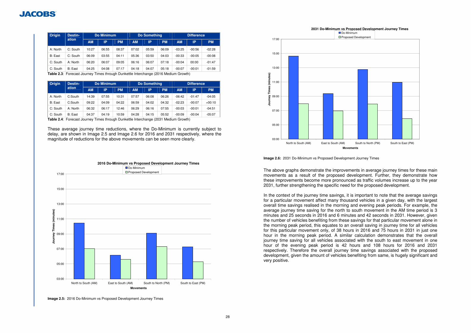
28
Do Minimum Do Something Difference Origin Destin-ation
AM IP PM AM IP PM AM IP PM
A: North C: South 10:27 06:55 08:37 07:02 05:59 06:09 -03:25 -00:56 -02:28
B: East C: South 06:09 03:55 04:11 05:36 03:50 04:03 -00:33 -00:05 -00:08
C: South A: North 06:20 06:07 09:05 06:16 06:07 07:18 -00:04 00:00 -01:47
C: South B: East 04:25 04:08 07:17 04:18 04:07 05:18 -00:07 -00:01 -01:59
Table 2.3: Forecast Journey Times through Dunkettle Interchange (2016 Medium Growth)
Do Minimum Do Something Difference Origin Destin-ation
AM IP PM AM IP PM AM IP PM
A: North C:South 14:39 07:55 10:31 07:57 06:08 06:26 -06:42 -01:47 -04:05
B: East C:South 09:22 04:09 04:22 06:59 04:02 04:32 -02:23 -00:07 +00:10
C: South A: North 06:32 06:17 12:46 06:29 06:16 07:55 -00:03 -00:01 -04:51
C: South B: East 04:37 04:19 10:59 04:28 04:15 05:52 -00:09 -00:04 -05:07
Table 2.4: Forecast Journey Times through Dunkettle Interchange (2031 Medium Growth) These average journey time reductions, where the Do-Minimum is currently subject to delay, are shown in Image 2.5 and Image 2.6 for 2016 and 2031 respectively, where the magnitude of reductions for the above movements can be seen more clearly.
2016 Do-Minimum vs Proposed Development Journey Times
03:00
05:00
07:00
09:00
11:00
13:00
15:00
17:00
North to South (AM) East to South (AM) South to North (PM) South to East (PM)
Movements
Jou
rney
Tim
es (
min
ute
s)
Do-Minimum
Proposed Development
Image 2.5: 2016 Do-Minimum vs Proposed Development Journey Times
2031 Do-Minimum vs Proposed Development Journey Times
03:00
05:00
07:00
09:00
11:00
13:00
15:00
17:00
North to South (AM) East to South (AM) South to North (PM) South to East (PM)
Movements
Jou
rney
Tim
es (
min
ute
s)
Do-Minimum
Proposed Development
Image 2.6: 2031 Do-Minimum vs Proposed Development Journey Times
The above graphs demonstrate the improvements in average journey times for these main movements as a result of the proposed development. Further, they demonstrate how these improvements become more pronounced as traffic volumes increase up to the year 2031, further strengthening the specific need for the proposed development. In the context of the journey time savings, it is important to note that the average savings for a particular movement affect many thousand vehicles in a given day, with the largest overall time savings realised in the morning and evening peak periods. For example, the average journey time saving for the north to south movement in the AM time period is 3 minutes and 25 seconds in 2016 and 6 minutes and 42 seconds in 2031. However, given the number of vehicles benefiting from these savings for that particular movement alone in the morning peak period, this equates to an overall saving in journey time for all vehicles for this particular movement only, of 38 hours in 2016 and 75 hours in 2031 in just one hour in the morning peak period. A similar calculation demonstrates that the overall journey time saving for all vehicles associated with the south to east movement in one hour of the evening peak period is 42 hours and 108 hours for 2016 and 2031 respectively. Therefore the overall journey time savings associated with the proposed development, given the amount of vehicles benefiting from same, is hugely significant and very positive.
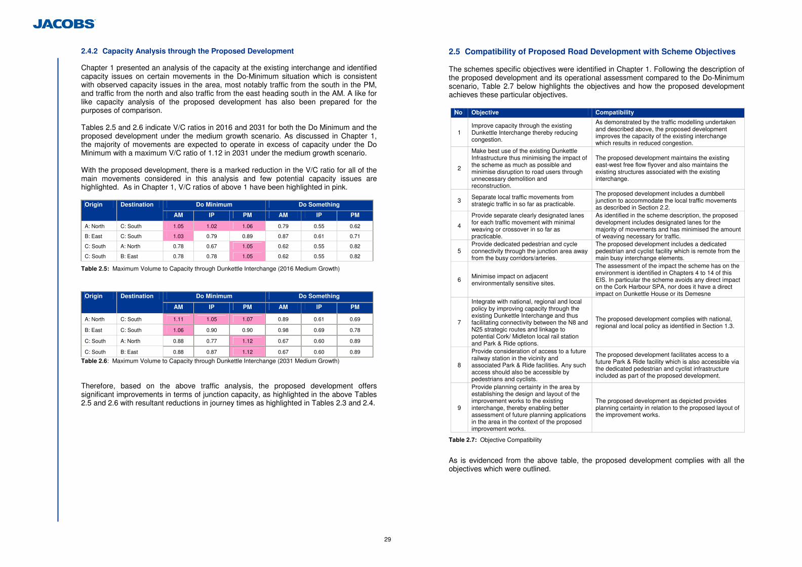
29
2.4.2 Capacity Analysis through the Proposed Development
Chapter 1 presented an analysis of the capacity at the existing interchange and identified capacity issues on certain movements in the Do-Minimum situation which is consistent with observed capacity issues in the area, most notably traffic from the south in the PM, and traffic from the north and also traffic from the east heading south in the AM. A like for like capacity analysis of the proposed development has also been prepared for the purposes of comparison. Tables 2.5 and 2.6 indicate V/C ratios in 2016 and 2031 for both the Do Minimum and the proposed development under the medium growth scenario. As discussed in Chapter 1, the majority of movements are expected to operate in excess of capacity under the Do Minimum with a maximum V/C ratio of 1.12 in 2031 under the medium growth scenario. With the proposed development, there is a marked reduction in the V/C ratio for all of the main movements considered in this analysis and few potential capacity issues are highlighted. As in Chapter 1, V/C ratios of above 1 have been highlighted in pink.
Do Minimum Do Something Origin Destination
AM IP PM AM IP PM
A: North C: South 1.05 1.02 1.06 0.79 0.55 0.62
B: East C: South 1.03 0.79 0.89 0.87 0.61 0.71
C: South A: North 0.78 0.67 1.05 0.62 0.55 0.82
C: South B: East 0.78 0.78 1.05 0.62 0.55 0.82
Table 2.5: Maximum Volume to Capacity through Dunkettle Interchange (2016 Medium Growth)
Do Minimum Do Something Origin Destination
AM IP PM AM IP PM
A: North C: South 1.11 1.05 1.07 0.89 0.61 0.69
B: East C: South 1.06 0.90 0.90 0.98 0.69 0.78
C: South A: North 0.88 0.77 1.12 0.67 0.60 0.89
C: South B: East 0.88 0.87 1.12 0.67 0.60 0.89
Table 2.6: Maximum Volume to Capacity through Dunkettle Interchange (2031 Medium Growth) Therefore, based on the above traffic analysis, the proposed development offers significant improvements in terms of junction capacity, as highlighted in the above Tables 2.5 and 2.6 with resultant reductions in journey times as highlighted in Tables 2.3 and 2.4.
2.5 Compatibility of Proposed Road Development with Scheme Objectives
The schemes specific objectives were identified in Chapter 1. Following the description of the proposed development and its operational assessment compared to the Do-Minimum scenario, Table 2.7 below highlights the objectives and how the proposed development achieves these particular objectives.
No Objective Compatibility
1 Improve capacity through the existing Dunkettle Interchange thereby reducing congestion.
As demonstrated by the traffic modelling undertaken and described above, the proposed development improves the capacity of the existing interchange which results in reduced congestion.
2
Make best use of the existing Dunkettle Infrastructure thus minimising the impact of the scheme as much as possible and minimise disruption to road users through unnecessary demolition and reconstruction.
The proposed development maintains the existing east-west free flow flyover and also maintains the existing structures associated with the existing interchange.
3 Separate local traffic movements from strategic traffic in so far as practicable.
The proposed development includes a dumbbell junction to accommodate the local traffic movements as described in Section 2.2.
4
Provide separate clearly designated lanes for each traffic movement with minimal weaving or crossover in so far as practicable.
As identified in the scheme description, the proposed development includes designated lanes for the majority of movements and has minimised the amount of weaving necessary for traffic.
5 Provide dedicated pedestrian and cycle connectivity through the junction area away from the busy corridors/arteries.
The proposed development includes a dedicated pedestrian and cyclist facility which is remote from the main busy interchange elements.
6 Minimise impact on adjacent environmentally sensitive sites.
The assessment of the impact the scheme has on the environment is identified in Chapters 4 to 14 of this EIS. In particular the scheme avoids any direct impact on the Cork Harbour SPA, nor does it have a direct impact on Dunkettle House or its Demesne
7
Integrate with national, regional and local policy by improving capacity through the existing Dunkettle Interchange and thus facilitating connectivity between the N8 and N25 strategic routes and linkage to potential Cork/ Midleton local rail station and Park & Ride options.
The proposed development complies with national, regional and local policy as identified in Section 1.3.
8
Provide consideration of access to a future railway station in the vicinity and associated Park & Ride facilities. Any such access should also be accessible by pedestrians and cyclists.
The proposed development facilitates access to a future Park & Ride facility which is also accessible via the dedicated pedestrian and cyclist infrastructure included as part of the proposed development.
9
Provide planning certainty in the area by establishing the design and layout of the improvement works to the existing interchange, thereby enabling better assessment of future planning applications in the area in the context of the proposed improvement works.
The proposed development as depicted provides planning certainty in relation to the proposed layout of the improvement works.
Table 2.7: Objective Compatibility
As is evidenced from the above table, the proposed development complies with all the objectives which were outlined.
30
3 Outline of Alternatives
3.1 Introduction
Various alternative solutions were considered to address the scheme objectives. This comprised 7 different infrastructure type options, i.e. options which included civil engineering works to improve capacity thereby reducing congestion, and 18 different traffic management options, which comprised solutions to control demand and manage traffic within the confines of the existing infrastructure. A ‘Do Nothing’ and a ‘Do Minimum’ alternative were also considered. A route selection process was undertaken which culminated in the production of a Route Selection Report. The Route Selection Report was prepared in accordance with the NRA Project Management Guidelines and the assessment was undertaken in accordance with these guidelines and the NRA Environmental Appraisal and Construction Guidelines. 3.1.1 Assessment Process
A Route Selection Report was prepared to identify a suitable Study Area for the examination of alternative improvement works to the existing Dunkettle Interchange, to identify key constraints within that Study Area, to develop feasible improvement options and to carry out a systematic assessment of the options leading to the selection of a preferred alternative, or option. As stated above, 3 types of alternatives were considered which can be grouped as follows; • Do-Nothing & Do-Minimum Alternatives; • Traffic Management Alternatives; • Infrastructure Alternatives. The consideration of the above alternative types is discussed below. 3.2 ‘Do-Minimum’ / ‘Do-Nothing’ Alternatives
One of the initial steps in the Route Selection process was the consideration of ‘Do-Nothing’ and ‘Do-Minimum’ options/alternatives. These alternatives, in relation to this study, are identified and considered as follows; 3.2.1 Do-Nothing Alternative
The ‘Do-Nothing’ alternative comprised an investigation of the existing road infrastructure and its ability to meet future demands for traffic and safety without any upgrade or junction improvement works, other than routine maintenance. Therefore in the case of the existing Dunkettle Interchange, the Do-Nothing scenario represents the base case, i.e. the current junction in its current form with only routine maintenance accounted for in its current and future ability to meet traffic and safety demands. 3.2.2 Do-Minimum Alternative
The NRA Project Appraisal Guidelines states that the Do-Minimum alternative should include those transportation facilities and services that are either committed or planned within the appraisal period. To provide a basis of comparison the Do-Minimum alternative must include the following features:
• The maintenance of existing facilities and services in the study area; • The completion and maintenance of committed projects or policies in the study
area that have successfully completed their environmental review; and • The continuation of existing transportation policies. The Do-Minimum alternative for the Dunkettle Interchange was based on the definition that only ‘committed’ improvements are included meaning typically those that have been progressed through planning and are either under construction or are programmed into the capital expenditure budget. A less conservative approach would have involved including not only ‘committed’ improvements but also other ‘planned’ improvements. Such ‘planned’ improvements could have included the Cork Northern Ring Road or the M20 Cork to Limerick Motorway scheme. However, given the uncertainty surrounding these and other potential improvements in the current fiscally constrained environment, the adoption of planned but non-committed projects could have resulted in the reliance on improvements within the alternatives being tested which may not happen (at least in a reasonable timeframe). This could have suggested a reliance on these non-committed schemes for the improvement works to the existing Dunkettle Interchange. Therefore the Do-Minimum alternative for the purposes of this study includes only the addition of the improvement works to the N40 Southern Ring Road Sarsfield Road to Bandon Road Improvement Scheme, the construction of which commenced in July 2011. The scheme comprises the upgrading of over 3 kilometres of the N40 Southern Ring Road including; • Grade separation at Sarsfield Road Roundabout and Bandon Road Roundabout; • Construction of a realigned dual carriageway along the new route; • Construction of new parallel link roads between Sarsfield Road and Bandon Road; • Demolition of existing pedestrian bridges at Sarsfield Road Roundabout and near
Bandon Road Roundabout; • New Cycleways and footpaths; and • Installation of traffic signals, signage including gantry signs, public lighting, noise
barriers etc. No other infrastructure schemes were incorporated in the Do-Minimum alternative.
31
3.2.3 Consideration of Do-Nothing and Do-Minimum Alternatives
One of the requirements which apply to the definition of an alternative is that it must respond to those transportation problems which have been identified. In other words, they must address the scheme objectives which have already been identified. In the case of the ‘Do-Nothing’ and ‘Do-Minimum’ alternatives, these are considered in Table 3.1 below, in relation to the scheme objectives;
No Objective Do-Nothing Do-Minimum
1 Improve capacity through the existing Dunkettle Interchange thereby reducing congestion.
The Do-Nothing alternative will not improve capacity or reduce congestion at the existing junction.
The Do-Minimum alternative has no impact on capacity and minimal impact on congestion at the existing junction.
2
Make best use of the existing Dunkettle Infrastructure thus minimising the impact of the scheme as much as possible and minimise disruption to road users through unnecessary demolition and reconstruction.
The Do-Nothing alternative has no impact on the existing infrastructure but this objective assumes a particular Do-Something option is progressed.
The Do-Minimum alternative has no impact on the existing infrastructure but this objective assumes a particular Do-Something option is progressed.
3 Separate local traffic movements from strategic traffic in so far as practicable.
The Do-Nothing alternative will not separate these movements.
The Do-Minimum alternative will not separate these movements.
4
Provide separate clearly designated lanes for each traffic movement with minimal weaving or crossover in so far as practicable.
The Do-Nothing alternative will not satisfy this objective.
The Do-Minimum alternative will not satisfy this objective.
5 Provide dedicated pedestrian and cycle connectivity through the junction area away from the busy corridors/arteries.
The Do-Nothing alternative will not satisfy this objective.
The Do-Minimum alternative will not satisfy this objective.
6 Minimise impact on adjacent environmentally sensitive sites.
The Do-Nothing alternative does satisfy this objective, but this objective assumes a particular Do-Something option is progressed.
The Do-Minimum alternative does satisfy this objective, but this objective assumes a particular Do-Something option is progressed.
7
Integrate with national, regional and local policy by improving capacity through the existing Dunkettle Interchange and thus facilitating connectivity between the N8 and N25 strategic routes and linkage to potential Cork/ Midleton local rail station and Park & Ride options.
The Do-Nothing alternative will not satisfy this objective.
The Do-Minimum alternative will not satisfy this objective.
8
Provide consideration of access to a future railway station in the vicinity and associated Park & Ride facilities. Any such access should also be accessible by pedestrians and cyclists.
The Do-Nothing alternative will not satisfy this objective.
The Do-Minimum alternative will not satisfy this objective.
9
Provide planning certainty in the area by establishing the design and layout of the improvement works to the existing interchange, thereby enabling better assessment of future planning applications in the area in the context of the proposed improvement works.
The Do-Nothing alternative will not satisfy this objective.
The Do-Minimum alternative will not satisfy this objective.
Table 3.1: Scheme Objectives vs Do-Nothing & Do-Minimum Alternatives
As can be seen from Table 3.1, neither the Do-Nothing nor Do-Minimum alternatives respond to the scheme objectives. Therefore, they could not be considered feasible alternatives to be taken forward for further consideration. However, it should be noted that the Do-Minimum alternative is relied upon elsewhere as it provided the baseline for establishing the economic, integration, safety, environmental and accessibility impacts of the Do-Something alternatives, i.e. those options which comprise improvement works directed specifically at the objectives of the Dunkettle Interchange Improvement scheme. Therefore all elements of the Do-Minimum alternative must be part of each other alternative which was considered. As the Do-Minimum alternative is currently under construction, it is entirely appropriate that any Do-Something alternatives included these improvement works within its base case. 3.3 Traffic Management Alternatives
In addition to the Do-Minimum and Do-Nothing alternatives, various traffic management alternatives/options were also considered. The identified traffic management alternative options fell into three categories: • Intelligent Transport Systems (ITS) measures involving access control, incident
detection and variable mandatory speed limits; • Fiscal measures, i.e. tolling (single and multi-point); and • A combination of both fiscal and ITS measures. (a) ITS measures involving access control, incident detection and variable
mandatory speed limits.
Access control was considered in the form of ramp metering. Ramp metering involves the use of traffic signals to control the flow rate of vehicles joining the main carriageway during peak periods, in this instance along the N40 Southern Ring Road. Access control was considered on the eastbound access ramps of the Mahon, Sarsfield and Kinsale junctions. The rationale for these alternatives was to reduce the flow of traffic into the Jack Lynch Tunnel from the Southern Ring Road and so reduce congestion at the Dunkettle Interchange. Variable Mandatory Speed Limits were considered in parallel with incident detection on the Southern Ring Road with and without access control. Variable speed limits have the purpose of keeping traffic moving during peak periods at a steady rate (i.e. without “shockwaves”) and so minimise rear end collisions, journey time delay and improve reliability. Traffic flow information is passed through a computer system which calculates an appropriate speed limit. Incident detection involves the provision of advisory speed limits and warnings in the event of an upstream traffic related incident. In addition to reducing the risk of secondary collisions such a system may also provide motorists with an opportunity to change route and not add to the delay caused by the incident. (b) Fiscal measures (Single and Multi-Point Tolling)
The rationale for fiscal alternatives/options is that these would divert sufficient demand away from the Dunkettle Interchange and thereby ease congestion. Both single and multi point tolling options were considered. Single point tolling options assume a barrier free toll facility at the Jack Lynch Tunnel intercepting traffic to and from the Dunkettle Interchange. The toll paid would be a fixed toll independent of distance travelled. The purpose of the toll would be to reduce traffic passing through the Dunkettle Interchange and so provide congestion relief. In addition to single point tolling, three forms of multi-point tolling were also considered:
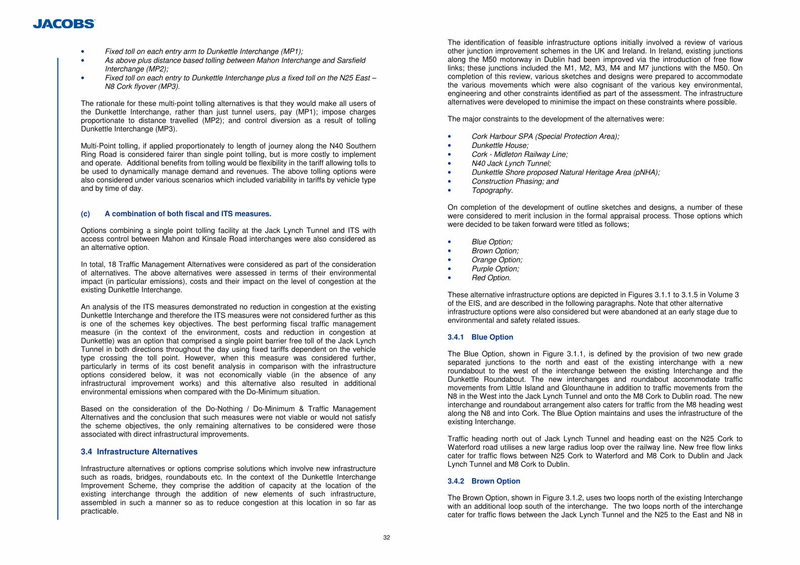
32
• Fixed toll on each entry arm to Dunkettle Interchange (MP1); • As above plus distance based tolling between Mahon Interchange and Sarsfield
Interchange (MP2); • Fixed toll on each entry to Dunkettle Interchange plus a fixed toll on the N25 East –
N8 Cork flyover (MP3). The rationale for these multi-point tolling alternatives is that they would make all users of the Dunkettle Interchange, rather than just tunnel users, pay (MP1); impose charges proportionate to distance travelled (MP2); and control diversion as a result of tolling Dunkettle Interchange (MP3). Multi-Point tolling, if applied proportionately to length of journey along the N40 Southern Ring Road is considered fairer than single point tolling, but is more costly to implement and operate. Additional benefits from tolling would be flexibility in the tariff allowing tolls to be used to dynamically manage demand and revenues. The above tolling options were also considered under various scenarios which included variability in tariffs by vehicle type and by time of day. (c) A combination of both fiscal and ITS measures.
Options combining a single point tolling facility at the Jack Lynch Tunnel and ITS with access control between Mahon and Kinsale Road interchanges were also considered as an alternative option. In total, 18 Traffic Management Alternatives were considered as part of the consideration of alternatives. The above alternatives were assessed in terms of their environmental impact (in particular emissions), costs and their impact on the level of congestion at the existing Dunkettle Interchange. An analysis of the ITS measures demonstrated no reduction in congestion at the existing Dunkettle Interchange and therefore the ITS measures were not considered further as this is one of the schemes key objectives. The best performing fiscal traffic management measure (in the context of the environment, costs and reduction in congestion at Dunkettle) was an option that comprised a single point barrier free toll of the Jack Lynch Tunnel in both directions throughout the day using fixed tariffs dependent on the vehicle type crossing the toll point. However, when this measure was considered further, particularly in terms of its cost benefit analysis in comparison with the infrastructure options considered below, it was not economically viable (in the absence of any infrastructural improvement works) and this alternative also resulted in additional environmental emissions when compared with the Do-Minimum situation. Based on the consideration of the Do-Nothing / Do-Minimum & Traffic Management Alternatives and the conclusion that such measures were not viable or would not satisfy the scheme objectives, the only remaining alternatives to be considered were those associated with direct infrastructural improvements. 3.4 Infrastructure Alternatives
Infrastructure alternatives or options comprise solutions which involve new infrastructure such as roads, bridges, roundabouts etc. In the context of the Dunkettle Interchange Improvement Scheme, they comprise the addition of capacity at the location of the existing interchange through the addition of new elements of such infrastructure, assembled in such a manner so as to reduce congestion at this location in so far as practicable.
The identification of feasible infrastructure options initially involved a review of various other junction improvement schemes in the UK and Ireland. In Ireland, existing junctions along the M50 motorway in Dublin had been improved via the introduction of free flow links; these junctions included the M1, M2, M3, M4 and M7 junctions with the M50. On completion of this review, various sketches and designs were prepared to accommodate the various movements which were also cognisant of the various key environmental, engineering and other constraints identified as part of the assessment. The infrastructure alternatives were developed to minimise the impact on these constraints where possible. The major constraints to the development of the alternatives were: • Cork Harbour SPA (Special Protection Area); • Dunkettle House; • Cork - Midleton Railway Line; • N40 Jack Lynch Tunnel; • Dunkettle Shore proposed Natural Heritage Area (pNHA); • Construction Phasing; and • Topography. On completion of the development of outline sketches and designs, a number of these were considered to merit inclusion in the formal appraisal process. Those options which were decided to be taken forward were titled as follows; • Blue Option; • Brown Option; • Orange Option; • Purple Option; • Red Option. These alternative infrastructure options are depicted in Figures 3.1.1 to 3.1.5 in Volume 3 of the EIS, and are described in the following paragraphs. Note that other alternative infrastructure options were also considered but were abandoned at an early stage due to environmental and safety related issues. 3.4.1 Blue Option
The Blue Option, shown in Figure 3.1.1, is defined by the provision of two new grade separated junctions to the north and east of the existing interchange with a new roundabout to the west of the interchange between the existing Interchange and the Dunkettle Roundabout. The new interchanges and roundabout accommodate traffic movements from Little Island and Glounthaune in addition to traffic movements from the N8 in the West into the Jack Lynch Tunnel and onto the M8 Cork to Dublin road. The new interchange and roundabout arrangement also caters for traffic from the M8 heading west along the N8 and into Cork. The Blue Option maintains and uses the infrastructure of the existing Interchange. Traffic heading north out of Jack Lynch Tunnel and heading east on the N25 Cork to Waterford road utilises a new large radius loop over the railway line. New free flow links cater for traffic flows between N25 Cork to Waterford and M8 Cork to Dublin and Jack Lynch Tunnel and M8 Cork to Dublin. 3.4.2 Brown Option
The Brown Option, shown in Figure 3.1.2, uses two loops north of the existing Interchange with an additional loop south of the interchange. The two loops north of the interchange cater for traffic flows between the Jack Lynch Tunnel and the N25 to the East and N8 in
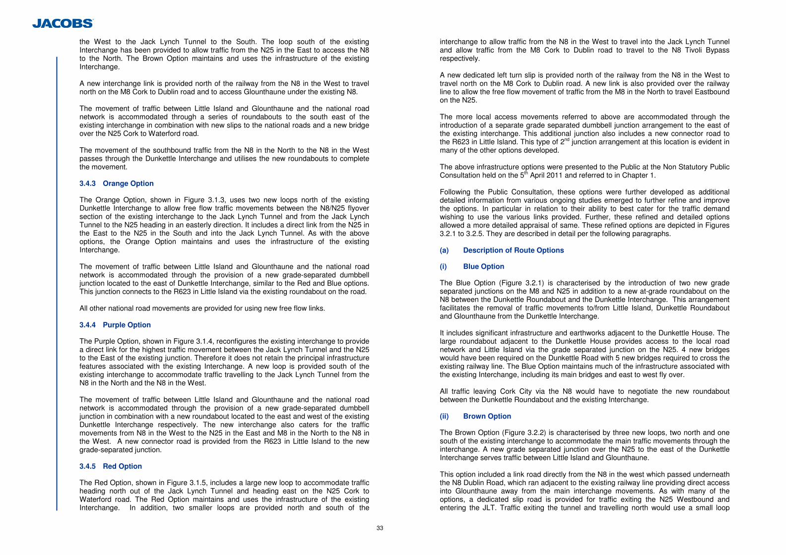
33
the West to the Jack Lynch Tunnel to the South. The loop south of the existing Interchange has been provided to allow traffic from the N25 in the East to access the N8 to the North. The Brown Option maintains and uses the infrastructure of the existing Interchange. A new interchange link is provided north of the railway from the N8 in the West to travel north on the M8 Cork to Dublin road and to access Glounthaune under the existing N8. The movement of traffic between Little Island and Glounthaune and the national road network is accommodated through a series of roundabouts to the south east of the existing interchange in combination with new slips to the national roads and a new bridge over the N25 Cork to Waterford road. The movement of the southbound traffic from the N8 in the North to the N8 in the West passes through the Dunkettle Interchange and utilises the new roundabouts to complete the movement. 3.4.3 Orange Option
The Orange Option, shown in Figure 3.1.3, uses two new loops north of the existing Dunkettle Interchange to allow free flow traffic movements between the N8/N25 flyover section of the existing interchange to the Jack Lynch Tunnel and from the Jack Lynch Tunnel to the N25 heading in an easterly direction. It includes a direct link from the N25 in the East to the N25 in the South and into the Jack Lynch Tunnel. As with the above options, the Orange Option maintains and uses the infrastructure of the existing Interchange. The movement of traffic between Little Island and Glounthaune and the national road network is accommodated through the provision of a new grade-separated dumbbell junction located to the east of Dunkettle Interchange, similar to the Red and Blue options. This junction connects to the R623 in Little Island via the existing roundabout on the road. All other national road movements are provided for using new free flow links. 3.4.4 Purple Option
The Purple Option, shown in Figure 3.1.4, reconfigures the existing interchange to provide a direct link for the highest traffic movement between the Jack Lynch Tunnel and the N25 to the East of the existing junction. Therefore it does not retain the principal infrastructure features associated with the existing Interchange. A new loop is provided south of the existing interchange to accommodate traffic travelling to the Jack Lynch Tunnel from the N8 in the North and the N8 in the West. The movement of traffic between Little Island and Glounthaune and the national road network is accommodated through the provision of a new grade-separated dumbbell junction in combination with a new roundabout located to the east and west of the existing Dunkettle Interchange respectively. The new interchange also caters for the traffic movements from N8 in the West to the N25 in the East and M8 in the North to the N8 in the West. A new connector road is provided from the R623 in Little Island to the new grade-separated junction. 3.4.5 Red Option
The Red Option, shown in Figure 3.1.5, includes a large new loop to accommodate traffic heading north out of the Jack Lynch Tunnel and heading east on the N25 Cork to Waterford road. The Red Option maintains and uses the infrastructure of the existing Interchange. In addition, two smaller loops are provided north and south of the
interchange to allow traffic from the N8 in the West to travel into the Jack Lynch Tunnel and allow traffic from the M8 Cork to Dublin road to travel to the N8 Tivoli Bypass respectively. A new dedicated left turn slip is provided north of the railway from the N8 in the West to travel north on the M8 Cork to Dublin road. A new link is also provided over the railway line to allow the free flow movement of traffic from the M8 in the North to travel Eastbound on the N25. The more local access movements referred to above are accommodated through the introduction of a separate grade separated dumbbell junction arrangement to the east of the existing interchange. This additional junction also includes a new connector road to the R623 in Little Island. This type of 2nd junction arrangement at this location is evident in many of the other options developed. The above infrastructure options were presented to the Public at the Non Statutory Public Consultation held on the 5th April 2011 and referred to in Chapter 1. Following the Public Consultation, these options were further developed as additional detailed information from various ongoing studies emerged to further refine and improve the options. In particular in relation to their ability to best cater for the traffic demand wishing to use the various links provided. Further, these refined and detailed options allowed a more detailed appraisal of same. These refined options are depicted in Figures 3.2.1 to 3.2.5. They are described in detail per the following paragraphs. (a) Description of Route Options
(i) Blue Option
The Blue Option (Figure 3.2.1) is characterised by the introduction of two new grade separated junctions on the M8 and N25 in addition to a new at-grade roundabout on the N8 between the Dunkettle Roundabout and the Dunkettle Interchange. This arrangement facilitates the removal of traffic movements to/from Little Island, Dunkettle Roundabout and Glounthaune from the Dunkettle Interchange. It includes significant infrastructure and earthworks adjacent to the Dunkettle House. The large roundabout adjacent to the Dunkettle House provides access to the local road network and Little Island via the grade separated junction on the N25. 4 new bridges would have been required on the Dunkettle Road with 5 new bridges required to cross the existing railway line. The Blue Option maintains much of the infrastructure associated with the existing Interchange, including its main bridges and east to west fly over. All traffic leaving Cork City via the N8 would have to negotiate the new roundabout between the Dunkettle Roundabout and the existing Interchange. (ii) Brown Option
The Brown Option (Figure 3.2.2) is characterised by three new loops, two north and one south of the existing interchange to accommodate the main traffic movements through the interchange. A new grade separated junction over the N25 to the east of the Dunkettle Interchange serves traffic between Little Island and Glounthaune. This option included a link road directly from the N8 in the west which passed underneath the N8 Dublin Road, which ran adjacent to the existing railway line providing direct access into Glounthaune away from the main interchange movements. As with many of the options, a dedicated slip road is provided for traffic exiting the N25 Westbound and entering the JLT. Traffic exiting the tunnel and travelling north would use a small loop
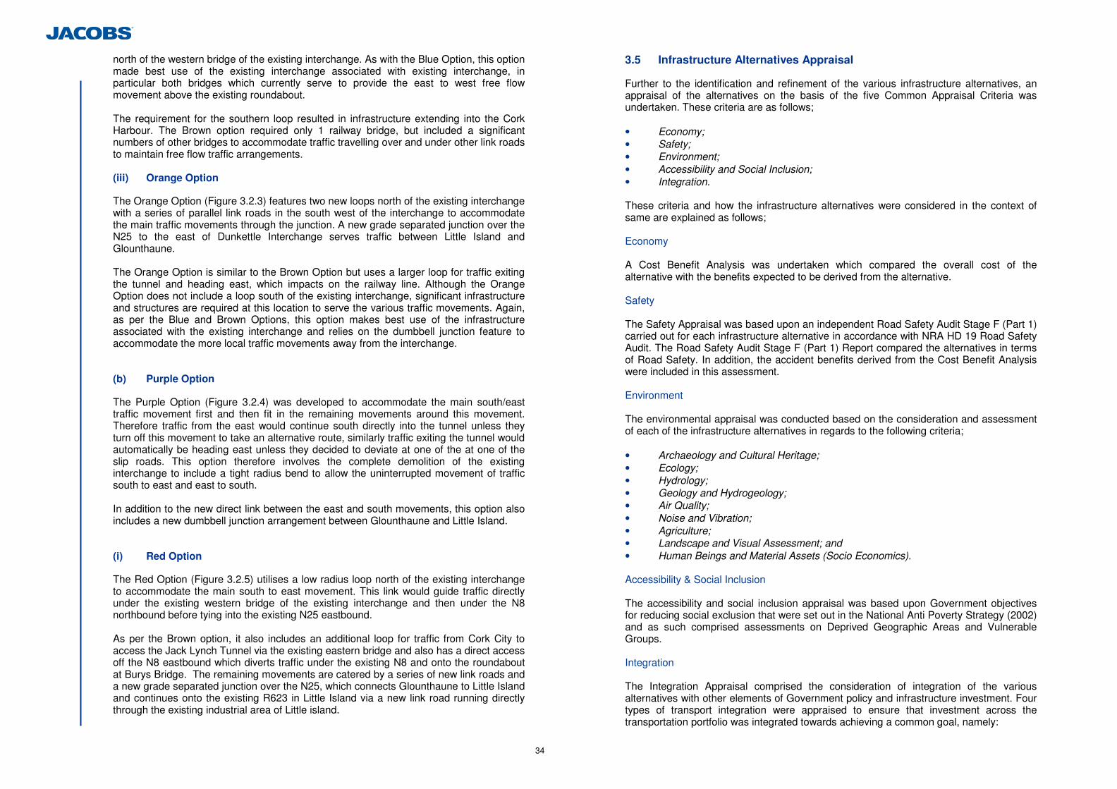
34
north of the western bridge of the existing interchange. As with the Blue Option, this option made best use of the existing interchange associated with existing interchange, in particular both bridges which currently serve to provide the east to west free flow movement above the existing roundabout. The requirement for the southern loop resulted in infrastructure extending into the Cork Harbour. The Brown option required only 1 railway bridge, but included a significant numbers of other bridges to accommodate traffic travelling over and under other link roads to maintain free flow traffic arrangements. (iii) Orange Option
The Orange Option (Figure 3.2.3) features two new loops north of the existing interchange with a series of parallel link roads in the south west of the interchange to accommodate the main traffic movements through the junction. A new grade separated junction over the N25 to the east of Dunkettle Interchange serves traffic between Little Island and Glounthaune. The Orange Option is similar to the Brown Option but uses a larger loop for traffic exiting the tunnel and heading east, which impacts on the railway line. Although the Orange Option does not include a loop south of the existing interchange, significant infrastructure and structures are required at this location to serve the various traffic movements. Again, as per the Blue and Brown Options, this option makes best use of the infrastructure associated with the existing interchange and relies on the dumbbell junction feature to accommodate the more local traffic movements away from the interchange. (b) Purple Option
The Purple Option (Figure 3.2.4) was developed to accommodate the main south/east traffic movement first and then fit in the remaining movements around this movement. Therefore traffic from the east would continue south directly into the tunnel unless they turn off this movement to take an alternative route, similarly traffic exiting the tunnel would automatically be heading east unless they decided to deviate at one of the at one of the slip roads. This option therefore involves the complete demolition of the existing interchange to include a tight radius bend to allow the uninterrupted movement of traffic south to east and east to south. In addition to the new direct link between the east and south movements, this option also includes a new dumbbell junction arrangement between Glounthaune and Little Island. (i) Red Option
The Red Option (Figure 3.2.5) utilises a low radius loop north of the existing interchange to accommodate the main south to east movement. This link would guide traffic directly under the existing western bridge of the existing interchange and then under the N8 northbound before tying into the existing N25 eastbound. As per the Brown option, it also includes an additional loop for traffic from Cork City to access the Jack Lynch Tunnel via the existing eastern bridge and also has a direct access off the N8 eastbound which diverts traffic under the existing N8 and onto the roundabout at Burys Bridge. The remaining movements are catered by a series of new link roads and a new grade separated junction over the N25, which connects Glounthaune to Little Island and continues onto the existing R623 in Little Island via a new link road running directly through the existing industrial area of Little island.
3.5 Infrastructure Alternatives Appraisal
Further to the identification and refinement of the various infrastructure alternatives, an appraisal of the alternatives on the basis of the five Common Appraisal Criteria was undertaken. These criteria are as follows; • Economy; • Safety; • Environment; • Accessibility and Social Inclusion; • Integration. These criteria and how the infrastructure alternatives were considered in the context of same are explained as follows; Economy A Cost Benefit Analysis was undertaken which compared the overall cost of the alternative with the benefits expected to be derived from the alternative. Safety The Safety Appraisal was based upon an independent Road Safety Audit Stage F (Part 1) carried out for each infrastructure alternative in accordance with NRA HD 19 Road Safety Audit. The Road Safety Audit Stage F (Part 1) Report compared the alternatives in terms of Road Safety. In addition, the accident benefits derived from the Cost Benefit Analysis were included in this assessment. Environment The environmental appraisal was conducted based on the consideration and assessment of each of the infrastructure alternatives in regards to the following criteria; • Archaeology and Cultural Heritage; • Ecology; • Hydrology; • Geology and Hydrogeology; • Air Quality; • Noise and Vibration; • Agriculture; • Landscape and Visual Assessment; and • Human Beings and Material Assets (Socio Economics). Accessibility & Social Inclusion The accessibility and social inclusion appraisal was based upon Government objectives for reducing social exclusion that were set out in the National Anti Poverty Strategy (2002) and as such comprised assessments on Deprived Geographic Areas and Vulnerable Groups. Integration The Integration Appraisal comprised the consideration of integration of the various alternatives with other elements of Government policy and infrastructure investment. Four types of transport integration were appraised to ensure that investment across the transportation portfolio was integrated towards achieving a common goal, namely:
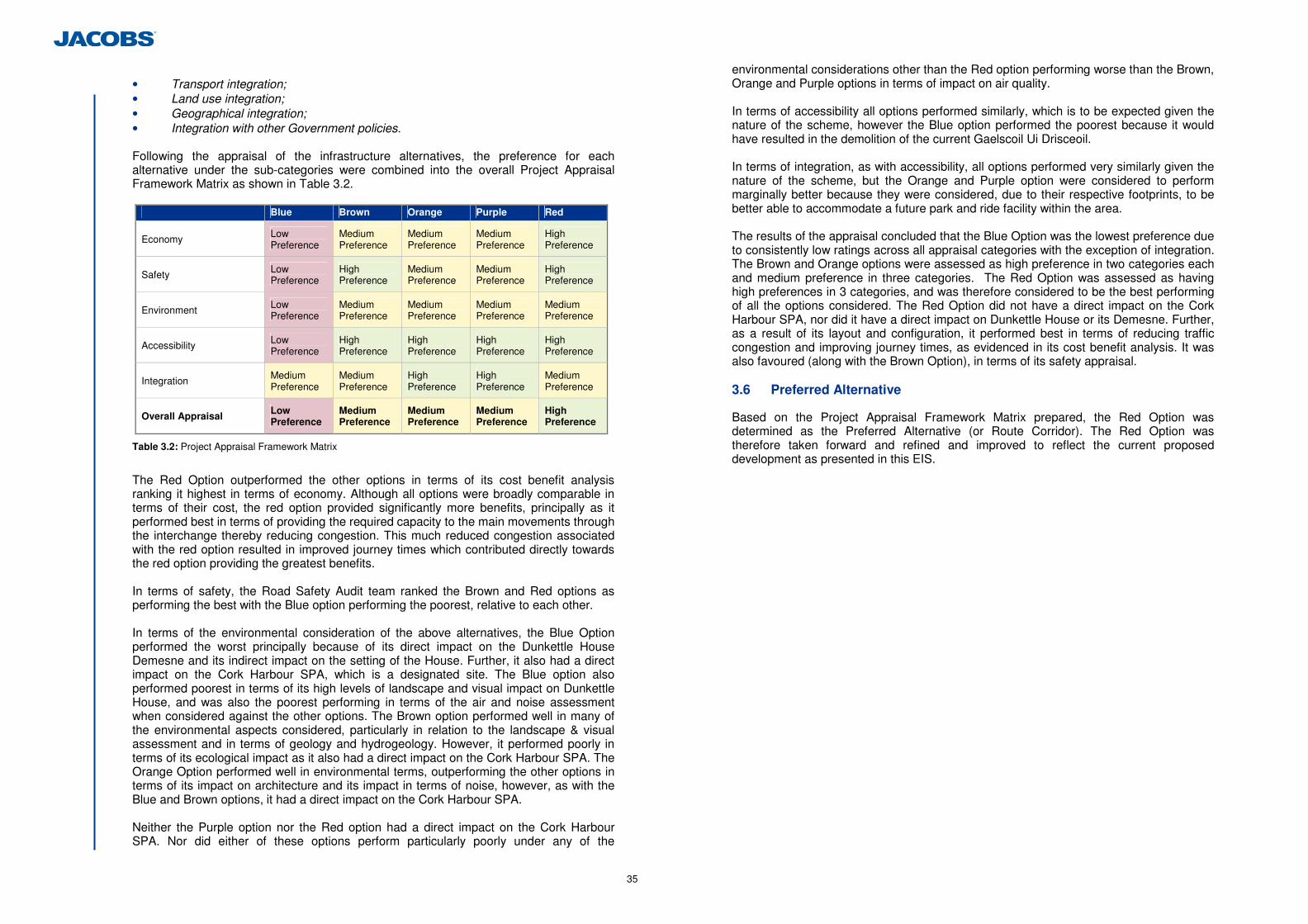
35
• Transport integration; • Land use integration; • Geographical integration; • Integration with other Government policies. Following the appraisal of the infrastructure alternatives, the preference for each alternative under the sub-categories were combined into the overall Project Appraisal Framework Matrix as shown in Table 3.2.
Blue Brown Orange Purple Red
Economy Low Preference
Medium Preference
Medium Preference
Medium Preference
High Preference
Safety Low Preference
High Preference
Medium Preference
Medium Preference
High Preference
Environment Low Preference
Medium Preference
Medium Preference
Medium Preference
Medium Preference
Accessibility Low Preference
High Preference
High Preference
High Preference
High Preference
Integration Medium Preference
Medium Preference
High Preference
High Preference
Medium Preference
Overall Appraisal Low Preference
Medium Preference
Medium Preference
Medium Preference
High Preference
Table 3.2: Project Appraisal Framework Matrix
The Red Option outperformed the other options in terms of its cost benefit analysis ranking it highest in terms of economy. Although all options were broadly comparable in terms of their cost, the red option provided significantly more benefits, principally as it performed best in terms of providing the required capacity to the main movements through the interchange thereby reducing congestion. This much reduced congestion associated with the red option resulted in improved journey times which contributed directly towards the red option providing the greatest benefits. In terms of safety, the Road Safety Audit team ranked the Brown and Red options as performing the best with the Blue option performing the poorest, relative to each other. In terms of the environmental consideration of the above alternatives, the Blue Option performed the worst principally because of its direct impact on the Dunkettle House Demesne and its indirect impact on the setting of the House. Further, it also had a direct impact on the Cork Harbour SPA, which is a designated site. The Blue option also performed poorest in terms of its high levels of landscape and visual impact on Dunkettle House, and was also the poorest performing in terms of the air and noise assessment when considered against the other options. The Brown option performed well in many of the environmental aspects considered, particularly in relation to the landscape & visual assessment and in terms of geology and hydrogeology. However, it performed poorly in terms of its ecological impact as it also had a direct impact on the Cork Harbour SPA. The Orange Option performed well in environmental terms, outperforming the other options in terms of its impact on architecture and its impact in terms of noise, however, as with the Blue and Brown options, it had a direct impact on the Cork Harbour SPA. Neither the Purple option nor the Red option had a direct impact on the Cork Harbour SPA. Nor did either of these options perform particularly poorly under any of the
environmental considerations other than the Red option performing worse than the Brown, Orange and Purple options in terms of impact on air quality. In terms of accessibility all options performed similarly, which is to be expected given the nature of the scheme, however the Blue option performed the poorest because it would have resulted in the demolition of the current Gaelscoil Ui Drisceoil. In terms of integration, as with accessibility, all options performed very similarly given the nature of the scheme, but the Orange and Purple option were considered to perform marginally better because they were considered, due to their respective footprints, to be better able to accommodate a future park and ride facility within the area. The results of the appraisal concluded that the Blue Option was the lowest preference due to consistently low ratings across all appraisal categories with the exception of integration. The Brown and Orange options were assessed as high preference in two categories each and medium preference in three categories. The Red Option was assessed as having high preferences in 3 categories, and was therefore considered to be the best performing of all the options considered. The Red Option did not have a direct impact on the Cork Harbour SPA, nor did it have a direct impact on Dunkettle House or its Demesne. Further, as a result of its layout and configuration, it performed best in terms of reducing traffic congestion and improving journey times, as evidenced in its cost benefit analysis. It was also favoured (along with the Brown Option), in terms of its safety appraisal. 3.6 Preferred Alternative
Based on the Project Appraisal Framework Matrix prepared, the Red Option was determined as the Preferred Alternative (or Route Corridor). The Red Option was therefore taken forward and refined and improved to reflect the current proposed development as presented in this EIS.
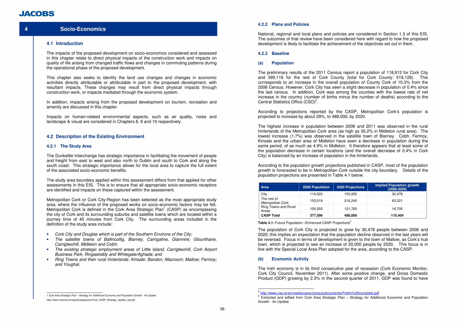
36
4 Socio-Economics
4.1 Introduction
The impacts of the proposed development on socio-economics considered and assessed in this chapter relate to direct physical impacts of the construction work and impacts on quality of life arising from changed traffic flows and changes in commuting patterns during the operational phase of the proposed development. This chapter also seeks to identify the land use changes and changes in economic activities directly attributable or attributable in part to the proposed development, with resultant impacts. These changes may result from direct physical impacts through construction work, or impacts mediated through the economic system. In addition, impacts arising from the proposed development on tourism, recreation and amenity are discussed in this chapter. Impacts on human-related environmental aspects, such as air quality, noise and landscape & visual are considered in Chapters 8, 9 and 10 respectively. 4.2 Description of the Existing Environment
4.2.1 The Study Area
The Dunkettle Interchange has strategic importance in facilitating the movement of people and freight from east to west and also north to Dublin and south to Cork and along the south coast. This strategic importance allows for the local area to capture the full extent of the associated socio-economic benefits. The study area boundary applied within this assessment differs from that applied for other assessments in this EIS. This is to ensure that all appropriate socio-economic receptors are identified and impacts on these captured within the assessment. Metropolitan Cork or Cork City-Region has been selected as the most appropriate study area, where the influence of the proposed works on socio-economic factors may be felt. Metropolitan Cork is defined in the Cork Area Strategic Plan1 (CASP) as encompassing the city of Cork and its surrounding suburbs and satellite towns which are located within a journey time of 45 minutes from Cork City. The surrounding areas included in the definition of the study area include: • Cork City and Douglas which is part of the Southern Environs of the City; • The satellite towns of Ballincollig, Blarney, Carrigaline, Glanmire, Glounthane,
Carrigtwohill, Midleton and Cobh; • The existing strategic employment areas of Little Island, Carrigtwohill, Cork Airport
Business Park, Ringaskiddy and Whitegate/Aghada; and • Ring Towns and their rural hinterlands: Kinsale; Bandon; Macroom; Mallow; Fermoy;
and Youghal.
1 Cork Area Strategic Plan – Strategy for Additional Economic and Population Growth - An Update
http://www.corkcity.ie/casp/strategicplan/Final_CASP_Strategy_Update_opt.pdf
4.2.2 Plans and Policies
National, regional and local plans and policies are considered in Section 1.3 of this EIS. The outcomes of that review have been considered here with regard to how the proposed development is likely to facilitate the achievement of the objectives set out in them. 4.2.3 Baseline
(a) Population
The preliminary results of the 2011 Census report a population of 118,912 for Cork City and 399,116 for the rest of Cork County (total for Cork County: 518,128). This corresponds to an increase in the overall population of County Cork of 10.3% from the 2006 Census. However, Cork City has seen a slight decrease in population of 0.4% since the last census. In addition, Cork was among the counties with the lowest rate of net increase in the country (number of births minus the number of deaths) according to the Central Statistics Office (CSO)2. According to projections reported by the CASP, Metropolitan Cork’s population is projected to increase by about 29%, to 488,000, by 2020. The highest increase in population between 2006 and 2011 was observed in the rural hinterlands of the Metropolitan Cork area (as high as 30.2% in Midleton rural area). The lowest increase (1.7%) was observed in the satellite town of Blarney. Cobh, Fermoy, Kinsale and the urban area of Midleton have seen a decrease in population during the same period, of as much as 4.9% in Midleton. It therefore appears that at least some of the population decrease in certain locations (and the overall decrease of 0.4% in Cork City) is balanced by an increase of population in the hinterlands. According to the population growth projections published in CASP, most of the population growth is forecasted to be in Metropolitan Cork outside the city boundary. Details of the population projections are presented in Table 4.1 below.
Area 2006 Population 2020 Projections Implied Population growth (2006-2020)
City 119,522 150,000 30,478 The rest of Metropolitan Cork
153,019 216,240 63,221
Ring Towns and Rural Areas 105,055 121,760 16,705
CASP Total 377,596 488,000 110,404
Table 4.1: Future Population –Enhanced CASP Projections3
The population of Cork City is projected to grow by 30,478 people between 2006 and 2020; this implies an expectation that the population decline observed in the last years will be reversed. Focus in terms of development is given to the town of Mallow, as Cork’s hub town, which is projected to see an increase of 20,000 people by 2020. This focus is in line with the Special Local Area Plan adopted for the area, according to the CASP. (b) Economic Activity
The Irish economy is in its third consecutive year of recession (Cork Economic Monitor, Cork City Council, November 2011). After some positive change, and Gross Domestic Product (GDP) growing by 2.3% in the second quarter of 2011, GDP was found to have
2 http://www.cso.ie/en/media/csoie/census/documents/Prelim%20complete.pdf 3 Extracted and edited from Cork Area Strategic Plan – Strategy for Additional Economic and Population Growth - An Update
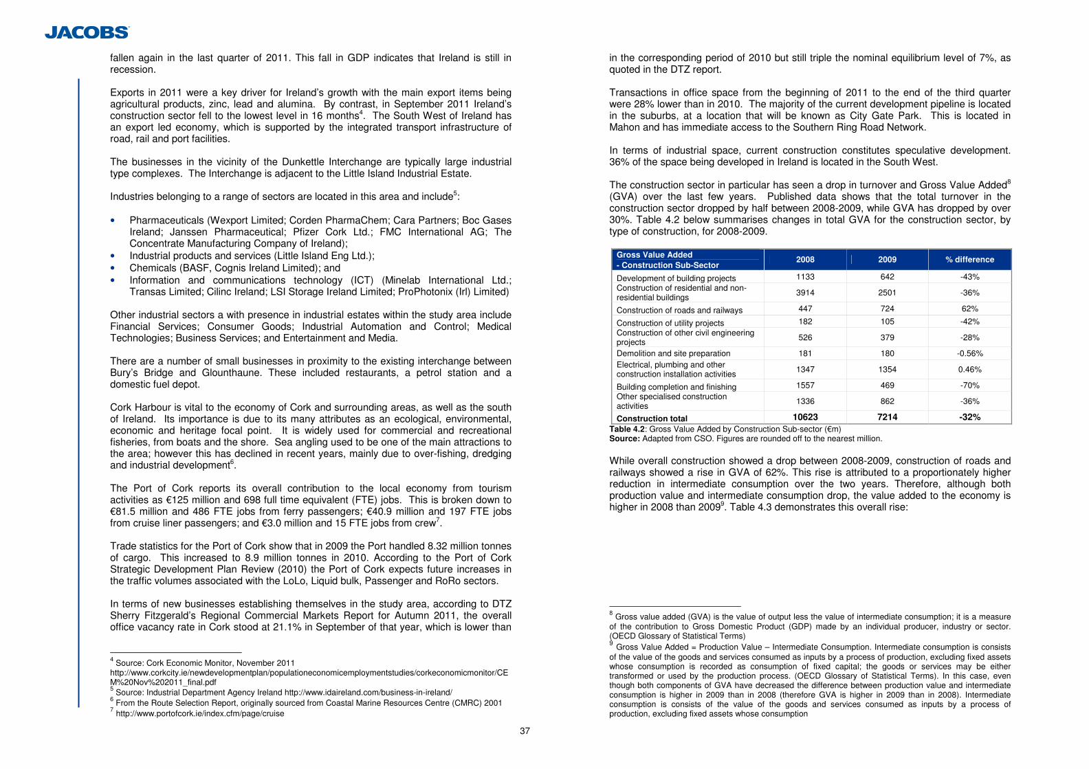
37
fallen again in the last quarter of 2011. This fall in GDP indicates that Ireland is still in recession. Exports in 2011 were a key driver for Ireland’s growth with the main export items being agricultural products, zinc, lead and alumina. By contrast, in September 2011 Ireland’s construction sector fell to the lowest level in 16 months4. The South West of Ireland has an export led economy, which is supported by the integrated transport infrastructure of road, rail and port facilities. The businesses in the vicinity of the Dunkettle Interchange are typically large industrial type complexes. The Interchange is adjacent to the Little Island Industrial Estate. Industries belonging to a range of sectors are located in this area and include5: • Pharmaceuticals (Wexport Limited; Corden PharmaChem; Cara Partners; Boc Gases
Ireland; Janssen Pharmaceutical; Pfizer Cork Ltd.; FMC International AG; The Concentrate Manufacturing Company of Ireland);
• Industrial products and services (Little Island Eng Ltd.); • Chemicals (BASF, Cognis Ireland Limited); and • Information and communications technology (ICT) (Minelab International Ltd.;
Transas Limited; Cilinc Ireland; LSI Storage Ireland Limited; ProPhotonix (Irl) Limited)
Other industrial sectors a with presence in industrial estates within the study area include Financial Services; Consumer Goods; Industrial Automation and Control; Medical Technologies; Business Services; and Entertainment and Media. There are a number of small businesses in proximity to the existing interchange between Bury’s Bridge and Glounthaune. These included restaurants, a petrol station and a domestic fuel depot. Cork Harbour is vital to the economy of Cork and surrounding areas, as well as the south of Ireland. Its importance is due to its many attributes as an ecological, environmental, economic and heritage focal point. It is widely used for commercial and recreational fisheries, from boats and the shore. Sea angling used to be one of the main attractions to the area; however this has declined in recent years, mainly due to over-fishing, dredging and industrial development6. The Port of Cork reports its overall contribution to the local economy from tourism activities as €125 million and 698 full time equivalent (FTE) jobs. This is broken down to €81.5 million and 486 FTE jobs from ferry passengers; €40.9 million and 197 FTE jobs from cruise liner passengers; and €3.0 million and 15 FTE jobs from crew7. Trade statistics for the Port of Cork show that in 2009 the Port handled 8.32 million tonnes of cargo. This increased to 8.9 million tonnes in 2010. According to the Port of Cork Strategic Development Plan Review (2010) the Port of Cork expects future increases in the traffic volumes associated with the LoLo, Liquid bulk, Passenger and RoRo sectors. In terms of new businesses establishing themselves in the study area, according to DTZ Sherry Fitzgerald’s Regional Commercial Markets Report for Autumn 2011, the overall office vacancy rate in Cork stood at 21.1% in September of that year, which is lower than
4 Source: Cork Economic Monitor, November 2011 http://www.corkcity.ie/newdevelopmentplan/populationeconomicemploymentstudies/corkeconomicmonitor/CEM%20Nov%202011_final.pdf 5 Source: Industrial Department Agency Ireland http://www.idaireland.com/business-in-ireland/ 6 From the Route Selection Report, originally sourced from Coastal Marine Resources Centre (CMRC) 2001 7 http://www.portofcork.ie/index.cfm/page/cruise
in the corresponding period of 2010 but still triple the nominal equilibrium level of 7%, as quoted in the DTZ report. Transactions in office space from the beginning of 2011 to the end of the third quarter were 28% lower than in 2010. The majority of the current development pipeline is located in the suburbs, at a location that will be known as City Gate Park. This is located in Mahon and has immediate access to the Southern Ring Road Network. In terms of industrial space, current construction constitutes speculative development. 36% of the space being developed in Ireland is located in the South West. The construction sector in particular has seen a drop in turnover and Gross Value Added8 (GVA) over the last few years. Published data shows that the total turnover in the construction sector dropped by half between 2008-2009, while GVA has dropped by over 30%. Table 4.2 below summarises changes in total GVA for the construction sector, by type of construction, for 2008-2009.
Gross Value Added - Construction Sub-Sector
2008 2009 % difference
Development of building projects 1133 642 -43% Construction of residential and non-residential buildings
3914 2501 -36%
Construction of roads and railways 447 724 62%
Construction of utility projects 182 105 -42% Construction of other civil engineering projects 526 379 -28%
Demolition and site preparation 181 180 -0.56% Electrical, plumbing and other construction installation activities 1347 1354 0.46%
Building completion and finishing 1557 469 -70% Other specialised construction activities
1336 862 -36%
Construction total 10623 7214 -32% Table 4.2: Gross Value Added by Construction Sub-sector (€m) Source: Adapted from CSO. Figures are rounded off to the nearest million. While overall construction showed a drop between 2008-2009, construction of roads and railways showed a rise in GVA of 62%. This rise is attributed to a proportionately higher reduction in intermediate consumption over the two years. Therefore, although both production value and intermediate consumption drop, the value added to the economy is higher in 2008 than 20099. Table 4.3 demonstrates this overall rise:
8 Gross value added (GVA) is the value of output less the value of intermediate consumption; it is a measure of the contribution to Gross Domestic Product (GDP) made by an individual producer, industry or sector. (OECD Glossary of Statistical Terms) 9 Gross Value Added = Production Value – Intermediate Consumption. Intermediate consumption is consists of the value of the goods and services consumed as inputs by a process of production, excluding fixed assets whose consumption is recorded as consumption of fixed capital; the goods or services may be either transformed or used by the production process. (OECD Glossary of Statistical Terms). In this case, even though both components of GVA have decreased the difference between production value and intermediate consumption is higher in 2009 than in 2008 (therefore GVA is higher in 2009 than in 2008). Intermediate consumption is consists of the value of the goods and services consumed as inputs by a process of production, excluding fixed assets whose consumption
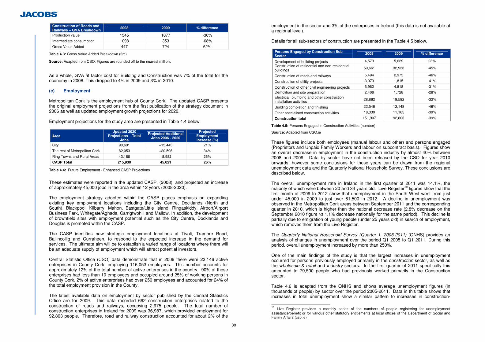
38
Construction of Roads and Railways – GVA Breakdown
2008 2009 % difference
Production value 1545 1077 -30% Intermediate consumption 1098 353 -68% Gross Value Added 447 724 62%
Table 4.3: Gross Value Added Breakdown (€m)
Source: Adapted from CSO. Figures are rounded off to the nearest million.
As a whole, GVA at factor cost for Building and Construction was 7% of the total for the economy in 2008. This dropped to 4% in 2009 and 3% in 2010. (c) Employment
Metropolitan Cork is the employment hub of County Cork. The updated CASP presents the original employment projections from the first publication of the strategy document in 2006 as well as updated employment growth projections for 2020. Employment projections for the study area are presented in Table 4.4 below.
Area Updated 2020
Projections – Total Jobs
Projected Additional Jobs 2006 - 2020
Projected Employment Increase (%)
City 90,691 +15,443 21%
The rest of Metropolitan Cork 82,053 +20,596 34%
Ring Towns and Rural Areas 43,186 +8,982 26%
CASP Total 215,930 45,021 26%
Table 4.4: Future Employment - Enhanced CASP Projections
These estimates were reported in the updated CASP, (2008), and projected an increase of approximately 45,000 jobs in the area within 12 years (2008-2020). The employment strategy adopted within the CASP places emphasis on expanding existing key employment locations including the City Centre, Docklands (North and South), Blackpool, Kilbarry, Mahon, Eastgate/Little Island, Ringaskiddy, Airport/Airport Business Park, Whitegate/Aghada, Carrigtwohill and Mallow. In addition, the development of brownfield sites with employment potential such as the City Centre, Docklands and Douglas is promoted within the CASP. The CASP identifies new strategic employment locations at Tivoli, Tramore Road, Ballincollig and Curraheen, to respond to the expected increase in the demand for services. The ultimate aim will be to establish a varied range of locations where there will be an adequate supply of employment which will attract potential investors. Central Statistic Office (CSO) data demonstrate that in 2009 there were 23,146 active enterprises in County Cork, employing 116,053 employees. This number accounts for approximately 12% of the total number of active enterprises in the country. 90% of these enterprises had less than 10 employees and occupied around 25% of working persons in County Cork. 2% of active enterprises had over 250 employees and accounted for 24% of the total employment provision in the County. The latest available data on employment by sector published by the Central Statistics Office are for 2009. This data recorded 662 construction enterprises related to the construction of roads and railways, occupying 2,975 people. The total number of construction enterprises in Ireland for 2009 was 36,987, which provided employment for 92,803 people. Therefore, road and railway construction accounted for about 2% of the
employment in the sector and 3% of the enterprises in Ireland (this data is not available at a regional level). Details for all sub-sectors of construction are presented in the Table 4.5 below.
Persons Engaged by Construction Sub-Sector
2008 2009 % difference
Development of building projects 4,573 5,629 23% Construction of residential and non-residential buildings 59,661 32,933 -45%
Construction of roads and railways 5,494 2,975 -46%
Construction of utility projects 3,073 1,815 -41%
Construction of other civil engineering projects 6,962 4,818 -31%
Demolition and site preparation 2,406 1,728 -28% Electrical, plumbing and other construction installation activities 28,862 19,592 -32%
Building completion and finishing 22,546 12,148 -46%
Other specialised construction activities 18,330 11,165 -39%
Construction total 151,907 92,803 -39%
Table 4.5: Persons Engaged in Construction Activities (number)
Source: Adapted from CSO.ie These figures include both employees (manual labour and other) and persons engaged (Proprietors and Unpaid Family Workers and labour on subcontract basis). Figures show an overall decrease in employment in the construction industry by almost 40% between 2008 and 2009. Data by sector have not been released by the CSO for year 2010 onwards; however some conclusions for these years can be drawn from the regional unemployment data and the Quarterly National Household Survey. These conclusions are described below. The overall unemployment rate in Ireland in the first quarter of 2011 was 14.1%, the majority of which were between 20 and 34 years old. Live Register10 figures show that the first month of 2009 to 2012 show that unemployment in the South West went from just under 45,000 in 2009 to just over 61,500 in 2012. A decline in unemployment was observed in the Metropolitan Cork areas between September 2011 and the corresponding quarter in 2010, which is higher than the national decrease rate (2.8% decrease on the September 2010 figure vs.1.1% decrease nationally for the same period). This decline is partially due to emigration of young people (under 25 years old) in search of employment, which removes them from the Live Register. The Quarterly National Household Survey (Quarter 1, 2005-2011) (QNHS) provides an analysis of changes in unemployment over the period Q1 2005 to Q1 2011. During this period, overall unemployment increased by more than 250%. One of the main findings of the study is that the largest increases in unemployment occurred for persons previously employed primarily in the construction sector, as well as the wholesale & retail and industry sectors. In the first quarter of 2011 specifically this amounted to 79,500 people who had previously worked primarily in the Construction sector. Table 4.6 is adapted from the QNHS and shows average unemployment figures (in thousands of people) by sector over the period 2005-2011. Data in this table shows that increases in total unemployment show a similar pattern to increases in construction-
10 Live Register provides a monthly series of the numbers of people registering for unemployment assistance/benefit or for various other statutory entitlements at local offices of the Department of Social and Family Affairs (cso.ie)
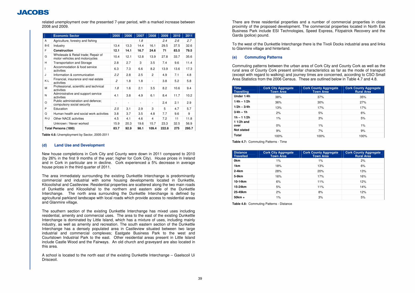
39
related unemployment over the presented 7-year period, with a marked increase between 2008 and 2009.
Economic Sector 2005 2006 2007 2008 2009 2010 2011
A Agriculture, forestry and fishing 1.8 2.4 2.6 2.7
B-E Industry 13.4 13.3 14.4 16.1 29.5 37.5 32.6
F Construction 12.1 14.1 16.7 24.6 71 83.5 79.5
G Wholesale & Retail trade; Repair of motor vehicles and motorcycles 10.4 12.1 12.8 13.9 27.8 33.7 35.6
H Transportation and Storage 2.8 2.7 3 3.5 7.4 9.6 11.4
I Accommodation & food service activities 6.3 7.3 6.6 8.2 13.9 13.6 17.3
J Information & communication 2.2 2.8 2.5 2 4.9 7.1 4.8
K-L Financial, insurance and real estate activities
2 1.8 1.8 - 3.8 5.2 5.8
M Professional, scientific and technical activities
1.8 1.6 2.1 3.5 8.2 10.6 9.4
N Administrative and support service activities 4.1 3.8 4.9 6.1 8.4 11.7 10.2
O Public administration and defence; compulsory social security - - - - 2.4 2.1 2.9
P Education 2.5 3.1 2.9 3 5 4.7 5.7
Q Human health and social work activities 3.8 3.7 3.5 4.8 7.7 9.6 9
R-U Other NACE activities 4.5 4.1 4.6 4 7.2 11 11.8
Unknown / Never worked 15.9 20.3 19.6 15.7 23.3 32.5 56.9
Total Persons (‘000) 83.7 92.9 98.1 109.4 222.8 275 295.7
Table 4.6: Unemployment by Sector, 2005-2011
(d) Land Use and Development
New house completions in Cork City and County were down in 2011 compared to 2010 (by 26% in the first 9 months of the year; higher for Cork City). House prices in Ireland and in Cork in particular are in decline. Cork experienced a 5% decrease in average house prices in the third quarter of 2011. The area immediately surrounding the existing Dunkettle Interchange is predominantly commercial and industrial with some housing developments located in Dunkettle, Kilcoolishal and Castleview. Residential properties are scattered along the two main roads of Dunkettle and Kilcoolishal to the northern and eastern side of the Dunkettle Interchange. The north area surrounding the Dunkettle Interchange is defined by agricultural parkland landscape with local roads which provide access to residential areas and Glanmire village. The southern section of the existing Dunkettle Interchange has mixed uses including residential, amenity and commercial uses. The area to the east of the existing Dunkettle Interchange is dominated by Little Island, which has a mixture of uses, including mainly industry, as well as amenity and recreation. The south eastern section of the Dunkettle Interchange has a densely populated area in Castleview situated between two large industrial and commercial complexes; Eastgate Business Park to the west and Courtstown Industrial Park to the east. Other residential areas present in Little Island include Castle Wood and the Fairways. An old church and graveyard are also located in this area. A school is located to the north east of the existing Dunkettle Interchange – Gaelscoil Ui Drisceoil.
There are three residential properties and a number of commercial properties in close proximity of the proposed development. The commercial properties located in North Esk Business Park include ESI Technologies, Speed Express, Fitzpatrick Recovery and the Garda (police) pound. To the west of the Dunkettle Interchange there is the Tivoli Docks industrial area and links to Glanmire village and hinterland. (e) Commuting Patterns
Commuting patterns between the urban area of Cork City and County Cork as well as the rural area of County Cork present similar characteristics as far as the mode of transport (except with regard to walking) and journey times are concerned, according to CSO Small Area Statistics from the 2006 Census. These are outlined below in Table 4.7 and 4.8. Time Travelling
Cork City Aggregate Town Area
Cork County Aggregate Town Area
Cork County Aggregate Rural Area
Under 1/4h 38% 37% 35% 1/4h – 1/2h 36% 30% 27% 1/2h – 3/4h 13% 17% 17% 3/4h – 1h 2% 5% 6% 1h – 1 1/2h 1% 3% 5% 1 1/2h and over 0% 1% 1% Not stated 9% 7% 9% Total 100% 100% 100%
Table 4.7: Commuting Patterns - Time
Distance Travelled
Cork City Aggregate Town Area
Cork County Aggregate Town Area
Cork County Aggregate Rural Area
0km 1% 1% 2%
1km 18% 13% 6%
2-4km 28% 20% 13%
5-9km 16% 17% 16%
10-14km 6% 11% 12%
15-24km 5% 11% 14%
25-49km 2% 8% 12%
50km + 1% 3% 5%
Table 4.8: Commuting Patterns - Distance
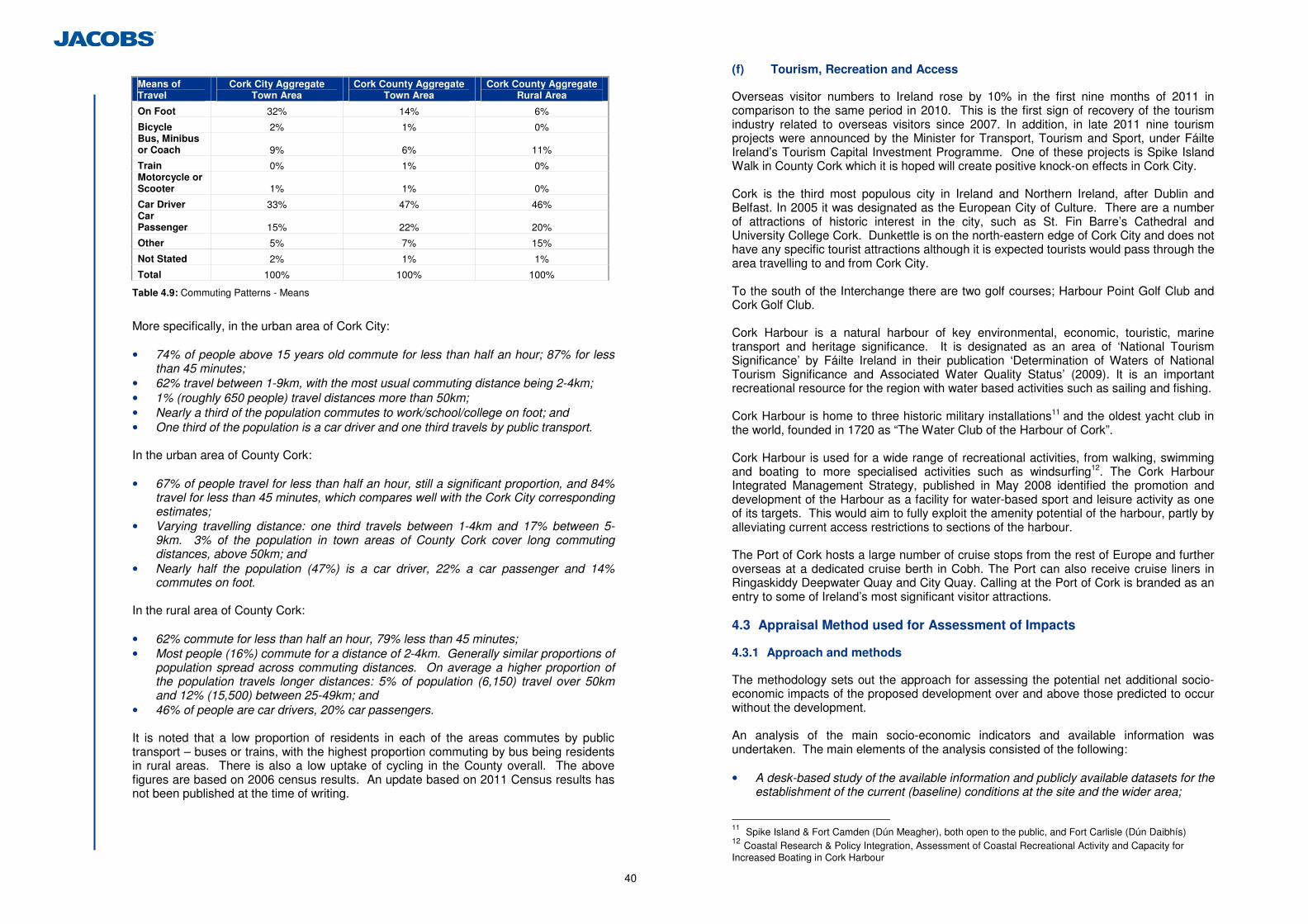
40
Means of Travel
Cork City Aggregate Town Area
Cork County Aggregate Town Area
Cork County Aggregate Rural Area
On Foot 32% 14% 6%
Bicycle 2% 1% 0% Bus, Minibus or Coach 9% 6% 11%
Train 0% 1% 0% Motorcycle or Scooter 1% 1% 0%
Car Driver 33% 47% 46% Car Passenger 15% 22% 20%
Other 5% 7% 15%
Not Stated 2% 1% 1%
Total 100% 100% 100%
Table 4.9: Commuting Patterns - Means
More specifically, in the urban area of Cork City: • 74% of people above 15 years old commute for less than half an hour; 87% for less
than 45 minutes; • 62% travel between 1-9km, with the most usual commuting distance being 2-4km; • 1% (roughly 650 people) travel distances more than 50km; • Nearly a third of the population commutes to work/school/college on foot; and • One third of the population is a car driver and one third travels by public transport.
In the urban area of County Cork: • 67% of people travel for less than half an hour, still a significant proportion, and 84%
travel for less than 45 minutes, which compares well with the Cork City corresponding estimates;
• Varying travelling distance: one third travels between 1-4km and 17% between 5-9km. 3% of the population in town areas of County Cork cover long commuting distances, above 50km; and
• Nearly half the population (47%) is a car driver, 22% a car passenger and 14% commutes on foot.
In the rural area of County Cork: • 62% commute for less than half an hour, 79% less than 45 minutes; • Most people (16%) commute for a distance of 2-4km. Generally similar proportions of
population spread across commuting distances. On average a higher proportion of the population travels longer distances: 5% of population (6,150) travel over 50km and 12% (15,500) between 25-49km; and
• 46% of people are car drivers, 20% car passengers.
It is noted that a low proportion of residents in each of the areas commutes by public transport – buses or trains, with the highest proportion commuting by bus being residents in rural areas. There is also a low uptake of cycling in the County overall. The above figures are based on 2006 census results. An update based on 2011 Census results has not been published at the time of writing.
(f) Tourism, Recreation and Access
Overseas visitor numbers to Ireland rose by 10% in the first nine months of 2011 in comparison to the same period in 2010. This is the first sign of recovery of the tourism industry related to overseas visitors since 2007. In addition, in late 2011 nine tourism projects were announced by the Minister for Transport, Tourism and Sport, under Fáilte Ireland’s Tourism Capital Investment Programme. One of these projects is Spike Island Walk in County Cork which it is hoped will create positive knock-on effects in Cork City. Cork is the third most populous city in Ireland and Northern Ireland, after Dublin and Belfast. In 2005 it was designated as the European City of Culture. There are a number of attractions of historic interest in the city, such as St. Fin Barre’s Cathedral and University College Cork. Dunkettle is on the north-eastern edge of Cork City and does not have any specific tourist attractions although it is expected tourists would pass through the area travelling to and from Cork City. To the south of the Interchange there are two golf courses; Harbour Point Golf Club and Cork Golf Club. Cork Harbour is a natural harbour of key environmental, economic, touristic, marine transport and heritage significance. It is designated as an area of ‘National Tourism Significance’ by Fáilte Ireland in their publication ‘Determination of Waters of National Tourism Significance and Associated Water Quality Status’ (2009). It is an important recreational resource for the region with water based activities such as sailing and fishing. Cork Harbour is home to three historic military installations11 and the oldest yacht club in the world, founded in 1720 as “The Water Club of the Harbour of Cork”. Cork Harbour is used for a wide range of recreational activities, from walking, swimming and boating to more specialised activities such as windsurfing12. The Cork Harbour Integrated Management Strategy, published in May 2008 identified the promotion and development of the Harbour as a facility for water-based sport and leisure activity as one of its targets. This would aim to fully exploit the amenity potential of the harbour, partly by alleviating current access restrictions to sections of the harbour. The Port of Cork hosts a large number of cruise stops from the rest of Europe and further overseas at a dedicated cruise berth in Cobh. The Port can also receive cruise liners in Ringaskiddy Deepwater Quay and City Quay. Calling at the Port of Cork is branded as an entry to some of Ireland’s most significant visitor attractions. 4.3 Appraisal Method used for Assessment of Impacts
4.3.1 Approach and methods
The methodology sets out the approach for assessing the potential net additional socio-economic impacts of the proposed development over and above those predicted to occur without the development. An analysis of the main socio-economic indicators and available information was undertaken. The main elements of the analysis consisted of the following: • A desk-based study of the available information and publicly available datasets for the
establishment of the current (baseline) conditions at the site and the wider area;
11 Spike Island & Fort Camden (Dún Meagher), both open to the public, and Fort Carlisle (Dún Daibhís) 12 Coastal Research & Policy Integration, Assessment of Coastal Recreational Activity and Capacity for Increased Boating in Cork Harbour
41
• A review of relevant planning guidelines, plans and strategic documents; • A review of consultation responses received in relation to the proposed development; • the identification of key socio-economic impacts; and • A site visit (March 2012) to verify the outcomes of the desk based assessment. Information was also sourced from: • National statistics web pages such as the Central Statistics Office (CSO) on
population, demographics, employment status, etc.; • Local council and community web pages; and • Major planning applications were consulted.
As noted above, as part of the desk assessment relevant national, regional and local policies were reviewed. These included the: • National Development Plan (2007 – 2013); • National Spatial Strategy for Ireland (2002 – 2020); • Atlantic Gateways Initiative; • Regional Planning Guidelines for the South West Region 2010 – 2022; • Cork Area Strategic Plan 2001 – 2020 (as amended with an updated strategy for
additional economic and population growth in 2008,); • Cork City Development Plan (2009-2015); • Cork County Development Plan (2009 - 2015); • Blarney Electoral Area Local Area Plan (LAP) 2011; and • Carrigaline Electoral Area LAP 2011. A review of some of these documents is provided within Section 1.3 of the EIS. The methodology is consistent with all relevant guidance on socio-economic assessment relating to infrastructure and development schemes. These include but are not limited to; • Environmental Protection Agency EIA Advice Notes (2003); • National Roads Authority Environmental Impact Assessment of National Road
Schemes – A Practical Guide (2008); • UK Government Treasury Green Book (2003); • Additionality Guide (English Partnerships) (2008); and • Fáilte Ireland guidelines on the treatment of Tourism in an Environmental Impact
Assessment (2007). 4.4 Predicted Impacts of the Proposed Development
4.4.1 Construction
(a) Economic Activity and Employment
The construction phase of the proposed development will result in direct construction employment positions over a 24 month period. The likely number of construction-related jobs can be estimated using assumptions used as standard in assessments of major capital works. The capital cost for the upgrade of the Dunkettle Interchange has been estimated at approximately €75m. Using the accepted assumption that one person year of employment equates to approximately €96k of capital construction expenditure. This assumption leads to an estimate of 782 person years of employment relating to the construction of the
scheme. As the construction period is projected to last for 24 months, this equates to 391 construction related jobs associated with the scheme. Given the nature of the construction industry locally and the capacity within that industry to take up work wherever available, it is possible that 75% of these jobs will be realised within the study area (Metropolitan Cork). The remainder are likely to be realised either regionally or nationally, with no expectation that jobs will be created outside of Ireland. The value of these jobs, in terms of gross value added (GVA) will depend on whether they are skilled or unskilled positions. The total GVA at factor cost in Ireland in 2009 was €144,605m, while it was €7,214m for the construction sector. The average GVA contribution of each employee in the construction sector in Ireland in the same year was €77,735. Therefore, it can be expected that the GVA associated with the construction jobs realised through the proposed development will be in the region of €30m (at 2009 terms). This equates to 0.4% of the GVA realised by the sector for that year and would therefore constitute a minor contribution to the total economic output for the construction sector. It has not been possible to obtain regional employment data for the construction sector; however the overall image depicted by total country statistics shows that the level of employment and output from the construction sector locally would be strengthened by the contribution of the proposed development; to a slight to possibly moderate extent at the local / regional level. Indirect expenditure (resulting in additional employment) is likely to be generated in the area as a result of the works during the construction stage of the proposed development. This will mainly be related to the service industries in the area. It is anticipated that material supplies and services will be sourced locally where feasible, therefore creating a positive socio-economic impact in and around Cork. Any indirect income generated locally through increased employment and knock-on economic activity, in the form of increased trade in local shops, petrol stations, restaurants, temporary accommodation and other services is captured within the GVA estimates presented above. Impacts on local businesses may result from increased traffic related to construction, causing temporary inconvenience to road users. However as many of the local businesses do not rely on passing trade this impact is thought to be Slight. (b) Commuting Patterns and Health and Safety
During the construction period, there are likely to be minor additional delays to commuters using the interchange as a result of traffic management and diversions required to facilitate the construction of the proposed development. Reduced speed limits which will be in force around the construction works will mean that no additional health and safety risks will arise at the site. Works are required around Gaelscoil Ui Drisceoil as the proposed development will require a small amount of land take from the school’s yard and construction will therefore be located in close proximity to the school children using the playing area. This area will be appropriately secured with fencing to ensure no potential for health and safety issues. (c) Tourism, Recreation and Access
The construction works will be centred on the existing Dunkettle Interchange and surrounding areas. While the works will be visible from residential areas, industrial and commercial developments, there is no significant impact expected on tourism as the
42
works will not alter the character of the area. Visitors may however experience some delays caused to travel during the construction period. The land take required will not infringe on land where recreational activities are carried out. It is therefore not anticipated that the proposed development would have any significant impact on local or regional recreational activities. Access rights will be maintained during the construction period, so no impact, in addition to the minor delays noted above, will be expected with regard to access in and around the interchange. (d) Land Use and Development
Construction works will be undertaken within lands acquired for the proposed development. The majority of these lands were previously acquired and used for road development by Cork County Council, or private industrial/business uses. As such the works will not have a significant negative impact on the land use and development of the area. 4.4.2 Operation
(a) Economic Activity and Employment
No significant negative impacts on the local economy and businesses have been identified as a result of the operation of the proposed development. The overall positive impact of relieving the congestion around the Dunkettle Interchange is envisaged to facilitate the movement of people and freight. These improvements will in turn lead to time and fuel savings, improvements in access and overall improvements in road transport connectivity within the region. Aside from the individual economic savings, this may in turn invite further economic opportunities to this region in terms of increased economic activity. The improvements are also likely to benefit tourism businesses in the wider area due to the anticipated improvements in access which occurs as a result. (b) Commuting Patterns and Health and Safety
One of the objectives of the proposed development is to provide dedicated pedestrian and cyclist connectivity through the interchange area, thereby encouraging alternative, more sustainable, modes of travel. This facility will run east to west through the existing interchange and also connect Glounthaune to Little Island, connect to other planned pedestrian and cyclist facilities in the area and, as far as possible, keep these distinct from the main traffic movements through the interchange. As the majority of people in County Cork choose to drive or are a passenger in a car for commuting purposes, the increased capacity of the interchange resulting from the upgrade would serve to improve commuting times for people using this interchange during their commute. The design for the proposed development also aims to ensure a reduction in the potential for accidents by separating out local and strategic traffic, thereby reducing potential traffic conflicts. The design of the proposed development also ensures minimal weaving or cross over between lanes which will also serve this purpose. A large proportion of people in urban areas walk and cycle to work. Therefore the dedicated pedestrian and cycle way will also result in a reduction in the potential for
accidents at the interchange; and by making cycling safer it is hoped that the proposed development will serve to facilitate the increased use of bicycles for commuting purposes. (c) Tourism, Recreation and Access
The proposed development is not expected to impact negatively on tourism or recreation once operational. As is the case for construction impacts, there is no significant impact expected on tourism and the proposed development will not alter the character of the area. No recreational land is being affected by the proposed development therefore no impact on recreation is expected. Access provisions for two residential properties to the west side of the proposed development, to the east of Dunkettle Roundabout, will be altered to facilitate the operation of the proposed development. This will result in additional journey distances for those residents to access routes to the west, as they will be required to first travel to Bury’s Roundabout to access westbound lanes. The significance of this change is considered to be Slight. (d) Land Use and Development
The proposed development requires approximately 50 hectares of land take. The principal landowners within this area are Cork City Council and Cork County Council. These lands were acquired previously by the Council for construction of the existing Dunkettle Interchange, the N25 and the Jack Lynch Tunnel. Other land owners include CIE, IDA, Pfizer, private developers and private owners. The required land take is not expected to interfere with regular business operations of local businesses. Significant land take will be required from Pfizer and BASF, to the south of the proposed development. This land is currently not in use by the facility. Access to either of these businesses will not be impeded. Land take will not affect any residential properties. 4.5 Proposed Mitigation and Avoidance Measures
No significant impacts have been identified therefore no mitigation measures are required. It should however be noted that the impact assessment relies on appropriate traffic and safety management during the construction period to minimise impacts to road users, local residents and local business interests in the vicinity of the proposed development. 4.6 Difficulties Encountered in Compiling Information
4.6.1 Baseline Data
Local area statistics are presented in a variety of forms by different source documents. There has therefore been a need to present information in the existing environment which covered a number of local area boundaries and time periods. This is not considered to impact on the quality or robustness of the impact assessment as presented.

43
4.7 Cumulative Impacts and Impact Interrelations
No significant impacts on the local communities or other socio-economic receptors are therefore expected. 4.8 Residual Impacts
Table 4.10 presents a summary of the expected residual impacts of the proposed development on socio-economic receptors; people, communities and businesses.
Table 4.10: Summary of Impacts
It is evident from this table that the operation of the proposed development is expected to deliver significant benefits to road users and specifically commuters, and is also likely to provide significant economic benefits as a result of its strategic importance for business and tourism connections to all parts of the country. The construction of the proposed development will also provide an estimated 391 construction jobs over the construction period. The majority of these positions are expected to be filled from within the local area. This is considered to be of minor or possibly moderate significance to the local economy given the current situation with regard to unemployment and the nature of the construction industry.
Impact Category Construction (Temporary) Operation Economic activity and employment Slight/ Moderate positive Slight /Moderate Positive
Commuting patterns and health and safety Slight Negative Moderate Positive
Tourism, recreation and access No Impact Slight Negative - Access
Land use and development No Impact Slight Negative - Land Take
Slight Positive - Development

44
5 Flora and Fauna
5.1 Introduction
This chapter of the EIS considers and assesses the potential direct, indirect and cumulative ecological impacts on terrestrial and aquatic ecology of the proposed development within its zone of influence. 5.1.1 Proposed Development Location
The proposed development is located at the site of the existing Dunkettle Interchange in County Cork. The footprint of the proposed development is predominantly characterised by the existing interchange infrastructure, associated semi-mature plantation woodland, and pockets of inland intertidal wetland habitats. Access to these wetlands is mostly limited by the road infrastructure. Despite the existing interchange links providing round-the-clock disturbance from noise, light and surface water discharges, there are diverse habitats and species in close proximity to the existing roadway. The coastal waters within the vicinity of the proposed development are part of Upper Cork Harbour and include the intertidal zone of Lough Mahon (code SW_060_0750) to the south west of Little Island and to a lesser extent the lower reach of the Glashaboy Estuary (code SW_060_0800). With the exception of the Glashaboy and the western shore of Little Island, the intertidal areas within the study area have weak linkage to Lough Mahon, all being connected to same via culverts. These poorly connected highly modified intertidal areas that are separated from Lough Mahon by culverts comprise the bulk of the study area. These mudflats are of little fisheries value given that they hold only a small amount of water at low tide. 5.2 Methodology
The methodology undertaken as part of the assessment is detailed in the following sections. 5.2.1 Desk Study
The desk study involved a review of relevant legislation and policy and consultation with relevant ecological bodies. (a) Relevant Legislation and Policy Context
This assessment has had regard to the following policy documents and legislation: (i) National and International Legislation
• The Roads Act 1993, & Roads Act 2007 as amended; • The Planning & Development Act 2000 & the Planning and Development
(Amendment) Act, 2010 (as amended) hereafter referred to as the Planning Acts; • The Wildlife Act 1976 as amended by the Wildlife (Amendment) Act, 2000 (as
amended) hereafter referred to as the Wildlife Acts; • European Communities (Environmental Impact Assessment) Regulations 1989 to
2001; • European Commission (EC) Habitats Directive 92/43/EEC (as amended); • EC Birds Directive 2009/147/EC; • European Communities (Birds and Natural Habitats) Regulations 2011 (as amended)
hereafter referred to as the Birds and Habitats Regulations;
• Flora (Protection) Order, 1999; • Environment (Miscellaneous Provisions) Act 2011; • The Fisheries (Consolidation) Act 1959; and • The Local Government (Water Pollution) Act, 1977 (as amended by Sections 3 and
24 of the 1990 Act.
(ii) Relevant Policies and Plans
• National Biodiversity Plan, 2011-2016; • Cork County Development Plan 2009 (2nd Edition); • Blarney Electoral Area Local Area Plan 2011; • Draft Cork Harbour Study 2010; • County Cork Biodiversity Action Plan 2009-2014; and • Cork City Biodiversity Action Plan 2009 – 2014. (iii) Relevant Guidelines
• Guidelines for Ecological Impact Assessment in the United Kingdom: Terrestrial, Freshwater and Coastal Environments (Institute of Ecology and Environmental Management, 2006);
• Guidelines for Ecological Impact Assessment in Britain and Ireland: Marine and Coastal (Institute of Ecology and Environmental Management, 2006);
• Advice Notes on Current Practice (in preparation of Environmental Impact Statements) (Environmental Protection Agency, 2003);
• Guidelines on the information to be contained in Environmental Impact Statements (EPA, 2002);
• Environmental Impact Assessment of National Road Schemes – A Practical Guide (NRA, 2008);
• Guidelines for Assessment of Ecological Impacts of National Road Schemes (NRA, 2009a);
• NRA Environmental Assessment and Construction Series Guidelines (NRA, 2006-2009a);
• National Roads Project Management Guidelines (NRA, 2010); • Design Manual for Roads and Bridges (Highways Agency, 2001 and amendments); • Draft Guidance for Planning Authorities on Drainage and Reclamation of Wetlands
(Department of Environment, Community and Local Government, 2011); • Bat Surveys: Good Practice Guidelines (Bat Conservation Trust UK, 2012); • Bats & Lighting Guidance Notes for Planners, engineers, architects and developers
(Bat Conservation Ireland, December 2010); • Bats in Buildings Guidance Notes for Planners, engineers, architects and developers
(Bat Conservation Ireland, December 2010); • Bat Mitigation Guidelines for Ireland (NPWS, 2006); • Bat Mitigation Guidelines (English Nature, 2004); • Maintenance and Protection of the Inland Fisheries Resource during road
construction and improvement works. Requirements of the Southern Regional Fisheries Board (Southern Regional Fisheries Board, 2007); and
• Barn Owls and Major Roads. Results and Recommendations from a 15 year Research Project (Ramsden, 2001).
(b) Consultation
The following organisations with relevance to ecology were consulted. Any correspondence received has been included in Appendix 5.1 of this EIS. • An Taisce; • Badgerwatch Ireland;
45
• Bat Conservation Ireland; • BirdWatch Ireland; • Coastwatch; • Coillte; • Cork County Bat Group; • Cork County Council Heritage Officer; • Department of Environment, Heritage and Local Government; • Irish Peatland Conservation Council; • Irish Whale & Dolphin Group; • Irish Wildlife Trust; • NPWS local and regional staff; • The Botanical Society of British & Ireland (BSBI) Vice County recorder (Co Cork); • Tree Council of Ireland; and • Woodlands of Ireland.
In addition to written correspondence, meetings were held with National Parks and Wildlife Service (NPWS) district and regional staff on the 1st April 2011 and the 15th July 2011 to discuss the results of the ecological field survey work as well as the likely significant impacts of the proposed development. The meeting minutes from these meetings are included in Appendix 5.2. Additional consultation to that in Appendix 5.1 in relation to specific species or habitats, or other ecological queries is presented in Appendix 5.3. In a meeting on 18th May 2012, Inland Fisheries Ireland (IFI) confirmed that sediment control and release/suspended solids must be controlled during the construction phase, and that the construction phasing should be such that it minimises the potential for an increase in suspended solids. IFI confirmed the assessement findings that the intertidal mudflats have a low fisheries value currently. (c) Desktop Data Sources
The following sources were consulted during the desktop study; • Environmental Protection Agency online databases on water quality (Available online
at http://www.epa.ie/whatwedo/assessment/spatial/webmapping/ Accessed 30/04/2012;
• Ordnance Survey Mapping available from www.osi.ie • Aerial photography available from www.osi.ie and Google Maps
http://maps.google.com/ ; • Online data available on Natura 2000 sites as held by the National Parks and Wildlife
Service (NPWS) from www.npws.ie. Obtained 12/01/2012 and re-checked as being up to date on 15/06/2012;
• Information on the South Western River Basin District from www.wfdireland.ie; • Information on soils, geology and hydrogeology in the area available from www.gsi.ie; • Information on the location, nature and design of the proposed development supplied
by the project design team; • Environmental Impact Statement for Dunkettle & Balinglanna Lands (Chapter 7 –
Ecology) (O’Flynn Construction, 2007); • Birdwatch Ireland and British Trust for Ornithology Bird Atlas 2007-2011 online
database. Available online at http://blx1.bto.org/atlas/main/data-home.jsp?Refresh=true. Accessed 23/04/2012;
• Protected and rare species data provided by the National Parks & Wildlife Service Research Branch;
• Irish Wetland Bird Survey Data (IWeBS) 2004-2008 for relevant sub-sites;
• Unpublished IWeBS data for areas outside formal count areas provided by Dr. Tom Gittings;
• Cork Barn Owl Research Project Reports for 2009 & 2010 (Lusby et al., 2009, 2010); • Botanical Society for the British Isles website – Species Distribution Maps; • Available online at http://www.bsbi.org.uk/. Accessed on various dates; • National Biodiversity Data Centre – Species Distribution Maps; • Available online at www.biodiversityireland.ie/ accessed on various dates; • All Ireland Red Data lists for vascular flora, mammals, butterflies, non-marine
molluscs, dragonflies & damselflies, amphibians and fish (see reference list); • Cork Harbour Survey Report (Southwestern Regional Fisheries Board, 2006) –
fisheries, bird, and marine mammal distribution maps for Cork Harbour including Dunkettle;.
• A previous study of the Glashaboy River as part of an aquatic ecology and fisheries assessment carried out by Ecofact for the Cork Northern Ring Road was reviewed (Ecofact, 2008).;
• Transitional water fish surveys have been carried out in Lough Mahon and the Glashaboy River Estuary as part of the programme of monitoring for the Water Framework Directive (WFD). Fish sampling was carried out in Lough Mahon in October 2008 by staff from the Central Fisheries Board (CFB) and the South Western Regional Fisheries Board (SWRFB) (Kelly et al, 2009). Fish stock surveys were also conducted in Greater Cork Harbour as part of the programme of fish monitoring for the WFD by staff from Inland Fisheries Ireland (IFI, 2010). The results of the above transitional water surveys was accessed from the website of Inland Fisheries Ireland (IFI). Available online at http://www.fisheriesireland.ie/);
• Lough Mahon WFD fish sampling 2008 (available online at http://www.wfdfish.ie/wp-content/uploads/2009/09/Lough-Mahon1.pdf);
• Lough Mahon and Glashaboy WFD fish sampling 2010 (available online at http://www.wfdfish.ie/wp-content/uploads/2011/02/SWRBD_Cork_TW_preliminary_report_2010.pdf);
• Water Framework Directive fish stock survey of the Glashaboy 2011 (available online at http://www.wfdfish.ie/wp-content/uploads/2011/08/SWRBD_prel_report_2011.pdf);
• Water Framework Directive water maps (available online at http://www.wfdireland.ie/maps.html); and
• International Union for Conservation of Nature and Natural Resources (IUCN) Red List of Threatened Species (available online at http://www.iucnredlist.org).
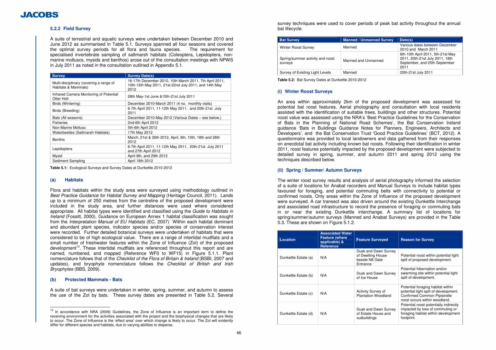
46
5.2.2 Field Survey
A suite of terrestrial and aquatic surveys were undertaken between December 2010 and June 2012 as summarised in Table 5.1. Surveys spanned all four seasons and covered the optimal survey periods for all flora and fauna species. The requirement for specialised invertebrate sampling of saltmarsh habitats (Coleoptera, Lepidoptera, non-marine molluscs, mysids and benthos) arose out of the consultation meetings with NPWS in July 2011 as noted in the consultation outlined in Appendix 5.1.
Survey Survey Date(s)
Multi-disciplinary (covering a range of Habitats & Mammals)
16-17th December 2010, 10th March 2011, 7th April 2011, 10th-12th May 2011, 21st-22nd July 2011, and 14th May 2012
Infrared Camera Monitoring of Potential Otter Holt
28th May-1st June &15th-21st July 2011
Birds (Wintering) December 2010-March 2011 (4 no. monthly visits)
Birds (Breeding) 6-7th April 2011, 11-12th May 2011, and 20th-21st July 2011
Bats (All seasons) December 2010-May 2012 (Various Dates – see below.) Fisheries 2nd-6th April 2012 Non-Marine Mollusc 5th-6th April 2012 Waterbeetles (Saltmarsh Habitats) 17th May 2012
Benthic March, 21st & 26th 2012, April, 9th, 10th, 18th and 26th 2012
Lepidoptera 6-7th April 2011, 11-12th May 2011, 20th-21st July 2011 and 27th April 2012
Mysid April 9th, and 29th 2012 Sediment Sampling April 18th 2012
Table 5.1: Ecological Surveys and Survey Dates at Dunkettle 2010-2012
(a) Habitats
Flora and habitats within the study area were surveyed using methodology outlined in Best Practice Guidance for Habitat Survey and Mapping (Heritage Council, 2011). Lands up to a minimum of 250 metres from the centreline of the proposed development were included in the study area, and further distances were used where considered appropriate. All habitat types were identified and classified using the Guide to Habitats in Ireland (Fossitt, 2000). Guidance on European Annex 1 habitat classification was sought from the Interpretation Manual of EU Habitats (EC, 2007) Within each habitat dominant and abundant plant species, indicator species and/or species of conservation interest were recorded. Further detailed botanical surveys were undertaken of habitats that were considered to be of high ecological value. There are a range of intertidal mudflats and a small number of freshwater features within the Zone of Influence (ZoI) of the proposed development13. These intertidal mudflats are referenced throughout this report and are named, numbered, and mapped (Reference WF0 to WF15) in Figure 5.1.1. Plant nomenclature follows that of the Checklist of the Flora of Britain & Ireland (BSBI, 2007 and updates), and bryophyte nomenclature follows the Checklist of British and Irish Bryophytes (BBS, 2009). (b) Protected Mammals - Bats
A suite of bat surveys were undertaken in winter, spring, summer, and autumn to assess the use of the ZoI by bats. These survey dates are presented in Table 5.2. Several
13 In accordance with NRA (2009) Guidelines, the Zone of Influence is an important term to define the receiving environment for the activities associated with the project and the biophysical changes that are likely to occur. The Zone of Influence is the ‘effect area’ over which change is likely to occur. The ZoI will evidently differ for different species and habitats, due to varying abilities to disperse.
survey techniques were used to cover periods of peak bat activity throughout the annual bat lifecycle.
Bat Survey Manned / Unmanned Survey Date(s)
Winter Roost Survey Manned Various dates between December 2010 and March 2011
Spring/summer activity and roost surveys Manned and Unmanned
6th-10th April 2011, 5th-21st May 2011, 20th-21st July 2011, 18th September, and 25th September 2011
Survey of Existing Light Levels Manned 20th-21st July 2011
Table 5.2: Bat Survey Dates at Dunkettle 2010-2012
(i) Winter Roost Surveys
An area within approximately 2km of the proposed development was assessed for potential bat roost features. Aerial photography and consultation with local residents assisted with the identification of suitable trees, buildings and other structures. Potential roost value was assessed using the NRA’s ‘Best Practice Guidelines for the Conservation of Bats in the Planning of National Road Schemes’, the Bat Conservation Ireland guidance ‘Bats in Buildings Guidance Notes for Planners, Engineers, Architects and Developers’, and the Bat Conservation Trust ‘Good Practice Guidelines’ (BCT, 2012). A questionnaire was provided to local landowners and data gathered from their responses on anecdotal bat activity including known bat roosts. Following their identification in winter 2011, roost features potentially impacted by the proposed development were subjected to detailed survey in spring, summer, and autumn 2011 and spring 2012 using the techniques described below. (ii) Spring / Summer/ Autumn Surveys
The winter roost survey results and analysis of aerial photography informed the selection of a suite of locations for Anabat recorders and Manual Surveys to include habitat types favoured for foraging, and potential commuting belts with connectivity to potential or confirmed roosts. Only areas within the Zone of Influence of the proposed development were surveyed. A car transect was also driven around the existing Dunkettle Interchange and associated road infrastructure to record the presence of foraging or commuting bats in or near the existing Dunkettle interchange. A summary list of locations for spring/summer/autumn surveys (Manned and Anabat Surveys) are provided in the Table 5.3. These are shown on Figure 5.1.2.
Location
Associated Water Feature (where applicable) & Reference
Feature Surveyed Reason for Survey
Dunkettle Estate (a) N/A
Dusk and Dawn Survey of Dwelling House beside N8 Gate Entrance
Potential roost within potential light spill of proposed development.
Dunkettle Estate (b) N/A Dusk and Dawn Survey of Ice House
Potential hibernation and/or swarming site within potential light spill of development.
Dunkettle Estate (c) N/A Activity Survey of Plantation Woodland
Potential foraging habitat within potential light spill of development. Confirmed Common Pipistrelle roost occurs within woodland.
Dunkettle Estate (d) N/A Dusk and Dawn Survey of Estate House and outbuildings
Potential roost potentially indirectly impacted by loss of commuting or foraging habitat within development footprint.
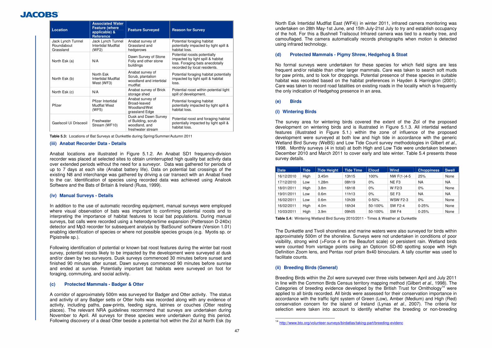
47
Location
Associated Water Feature (where applicable) & Reference
Feature Surveyed Reason for Survey
Jack Lynch Tunnel Roundabout Grassland
Jack Lynch Tunnel Intertidal Mudflat (WF2)
Anabat survey of Grassland and hedgerows
Potential foraging habitat potentially impacted by light spill & habitat loss.
North Esk (a) N/A Dawn Survey of Stone Folly and other stone buildings
Potential roosts potentially impacted by light spill & habitat loss. Foraging bats anecdotally recorded by local residents.
North Esk (b) North Esk Intertidal Mudflat West (WF3)
Anabat survey of Scrub, plantation woodland and intertidal mudflat
Potential foraging habitat potentially impacted by light spill & habitat loss.
North Esk (c) N/A Anabat survey of Brick storage shed
Potential roost within potential light spill of development.
Pfizer Pfizer Intertidal Mudflat West (WF5)
Anabat survey of Broad-leaved Woodland/Wet grassland Edge
Potential foraging habitat potentially impacted by light spill & habitat loss.
Gaelscoil Uí Drisceoil Freshwater Stream (WF10)
Dusk and Dawn Survey of Building, scrub woodland, and freshwater stream
Potential roost and foraging habitat potentially impacted by light spill & habitat loss.
Table 5.3: Locations of Bat Surveys at Dunkettle during Spring/Summer/Autumn 2011
(iii) Anabat Recorder Data - Details
Anabat locations are illustrated in Figure 5.1.2. An Anabat SD1 frequency-division recorder was placed at selected sites to obtain uninterrupted high quality bat activity data over extended periods without the need for a surveyor. Data was gathered for periods of up to 7 days at each site (Anabat battery life). Data on potential bat crossings of the existing N8 and interchange was gathered by driving a car transect with an Anabat fixed to the car. Identification of species using recorded data was achieved using Analook Software and the Bats of Britain & Ireland (Russ, 1999). (iv) Manual Surveys - Details
In addition to the use of automatic recording equipment, manual surveys were employed where visual observation of bats was important to confirming potential roosts and to interpreting the importance of habitat features to local bat populations. During manual surveys, bat calls were recorded using a heterodyne/time expansion (Pettersson D-240x) detector and Mp3 recorder for subsequent analysis by ‘BatSound’ software (Version 1.01) enabling identification of species or where not possible species groups (e.g. Myotis sp. or Pipistrelle sp.). Following identification of potential or known bat roost features during the winter bat roost survey, potential roosts likely to be impacted by the development were surveyed at dusk and/or dawn by two surveyors. Dusk surveys commenced 30 minutes before sunset and finished 90 minutes after sunset. Dawn surveys commenced 90 minutes before sunrise and ended at sunrise. Potentially important bat habitats were surveyed on foot for foraging, commuting, and social activity. (c) Protected Mammals - Badger & Otter
A corridor of approximately 500m was surveyed for Badger and Otter activity. The status and activity of any Badger setts or Otter holts was recorded along with any evidence of activity, including paths, paw-prints, feeding signs, latrines or couches (Otter resting places). The relevant NRA guidelines recommend that surveys are undertaken during November to April. All surveys for these species were undertaken during this period. Following discovery of a dead Otter beside a potential holt within the ZoI at North Esk (by
North Esk Intertidal Mudflat East (WF4)) in winter 2011, infrared camera monitoring was undertaken on 28th May-1st June, and 15th July-21st July to try and establish occupancy of the holt. For this a Bushnell Trailscout Infrared camera was tied to a nearby tree, and camouflaged. The camera automatically records photographs when motion is detected using infrared technology. (d) Protected Mammals - Pigmy Shrew, Hedgehog & Stoat
No formal surveys were undertaken for these species for which field signs are less frequent and/or reliable than other larger mammals. Care was taken to search soft muds for paw prints, and to look for droppings. Potential presence of these species in suitable habitat was recorded based on the habitat preferences in Hayden & Harrington (2001). Care was taken to record road fatalities on existing roads in the locality which is frequently the only indication of Hedgehog presence in an area. (e) Birds
(i) Wintering Birds
The survey area for wintering birds covered the extent of the ZoI of the proposed development on wintering birds and is illustrated in Figure 5.1.3. All intertidal wetland features (illustrated in Figure 5.1.) within the zone of influence of the proposed development were surveyed at both low and high tide in accordance with the generic Wetland Bird Survey (WeBS) and Low Tide Count survey methodologies in Gilbert et al., 1998. Monthly surveys (4 in total) at both High and Low Tide were undertaken between December 2010 and March 2011 to cover early and late winter. Table 5.4 presents these survey details.
Date Tide Tide Height Tide Time Cloud Wind Choppiness Swell
16/12/2010 High 3.45m 13h15 100% NW F(1-)4-5 25% None
17/12/2010 Low 1.28m 08h19 0% NE F3 NA NA
18/01/2011 High 3.8m 16h18 0% W F2/3 0% None
19/01/2011 Low 0.6m 11h13 0% SE F3 NA NA
16/02/2011 Low 0.6m 10h39 0-50% WSW F2-3 0% None
16/02/2011 High 4.0m 16h34 50-100% SW F2-4 0-25% None
10/03/2011 High 3.9m 09h05 50-100% SW F4 0-25% None
Table 5.4: Wintering Wetland Bird Survey 2010/2011 - Times & Weather at Dunkettle
The Dunkettle and Tivoli shorelines and marine waters were also surveyed for birds within approximately 500m of the shoreline. Surveys were not undertaken in conditions of poor visibility, strong wind (>Force 4 on the Beaufort scale) or persistent rain. Wetland birds were counted from vantage points using an Opticron SD-80 spotting scope with High Definition Zoom lens, and Pentax roof prism 8x40 binoculars. A tally counter was used to facilitate counts.
(ii) Breeding Birds (General)
Breeding Birds within the ZoI were surveyed over three visits between April and July 2011 in line with the Common Birds Census territory mapping method (Gilbert et al., 1998). The Categories of breeding evidence developed by the British Trust for Ornithology14 were applied to all birds recorded. All birds were assessed for their conservation importance in accordance with the traffic light system of Green (Low), Amber (Medium) and High (Red) conservation concern for the island of Ireland (Lynas et al., 2007). The criteria for selection were taken into account to identify whether the breeding or non-breeding
14 http://www.bto.org/volunteer-surveys/birdatlas/taking-part/breeding-evidenc
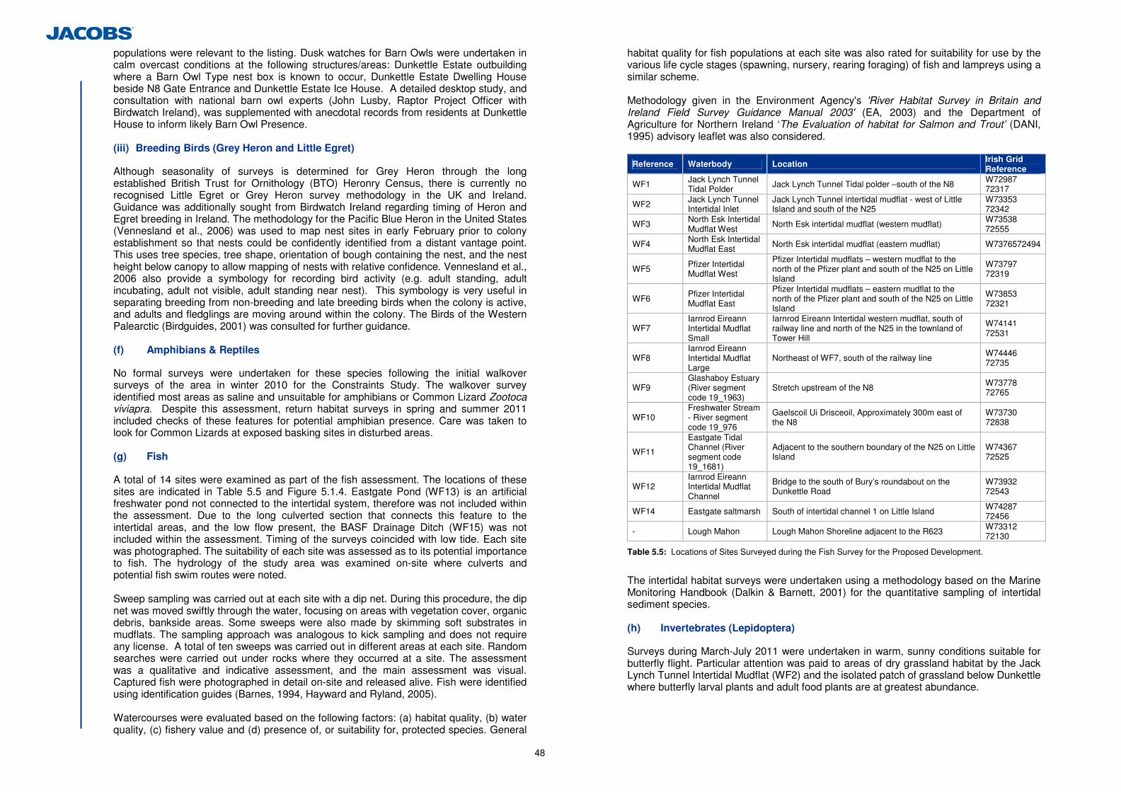
48
populations were relevant to the listing. Dusk watches for Barn Owls were undertaken in calm overcast conditions at the following structures/areas: Dunkettle Estate outbuilding where a Barn Owl Type nest box is known to occur, Dunkettle Estate Dwelling House beside N8 Gate Entrance and Dunkettle Estate Ice House. A detailed desktop study, and consultation with national barn owl experts (John Lusby, Raptor Project Officer with Birdwatch Ireland), was supplemented with anecdotal records from residents at Dunkettle House to inform likely Barn Owl Presence.
(iii) Breeding Birds (Grey Heron and Little Egret)
Although seasonality of surveys is determined for Grey Heron through the long established British Trust for Ornithology (BTO) Heronry Census, there is currently no recognised Little Egret or Grey Heron survey methodology in the UK and Ireland. Guidance was additionally sought from Birdwatch Ireland regarding timing of Heron and Egret breeding in Ireland. The methodology for the Pacific Blue Heron in the United States (Vennesland et al., 2006) was used to map nest sites in early February prior to colony establishment so that nests could be confidently identified from a distant vantage point. This uses tree species, tree shape, orientation of bough containing the nest, and the nest height below canopy to allow mapping of nests with relative confidence. Vennesland et al., 2006 also provide a symbology for recording bird activity (e.g. adult standing, adult incubating, adult not visible, adult standing near nest). This symbology is very useful in separating breeding from non-breeding and late breeding birds when the colony is active, and adults and fledglings are moving around within the colony. The Birds of the Western Palearctic (Birdguides, 2001) was consulted for further guidance.
(f) Amphibians & Reptiles
No formal surveys were undertaken for these species following the initial walkover surveys of the area in winter 2010 for the Constraints Study. The walkover survey identified most areas as saline and unsuitable for amphibians or Common Lizard Zootoca viviapra. Despite this assessment, return habitat surveys in spring and summer 2011 included checks of these features for potential amphibian presence. Care was taken to look for Common Lizards at exposed basking sites in disturbed areas. (g) Fish
A total of 14 sites were examined as part of the fish assessment. The locations of these sites are indicated in Table 5.5 and Figure 5.1.4. Eastgate Pond (WF13) is an artificial freshwater pond not connected to the intertidal system, therefore was not included within the assessment. Due to the long culverted section that connects this feature to the intertidal areas, and the low flow present, the BASF Drainage Ditch (WF15) was not included within the assessment. Timing of the surveys coincided with low tide. Each site was photographed. The suitability of each site was assessed as to its potential importance to fish. The hydrology of the study area was examined on-site where culverts and potential fish swim routes were noted. Sweep sampling was carried out at each site with a dip net. During this procedure, the dip net was moved swiftly through the water, focusing on areas with vegetation cover, organic debris, bankside areas. Some sweeps were also made by skimming soft substrates in mudflats. The sampling approach was analogous to kick sampling and does not require any license. A total of ten sweeps was carried out in different areas at each site. Random searches were carried out under rocks where they occurred at a site. The assessment was a qualitative and indicative assessment, and the main assessment was visual. Captured fish were photographed in detail on-site and released alive. Fish were identified using identification guides (Barnes, 1994, Hayward and Ryland, 2005).
Watercourses were evaluated based on the following factors: (a) habitat quality, (b) water quality, (c) fishery value and (d) presence of, or suitability for, protected species. General
habitat quality for fish populations at each site was also rated for suitability for use by the various life cycle stages (spawning, nursery, rearing foraging) of fish and lampreys using a similar scheme. Methodology given in the Environment Agency's 'River Habitat Survey in Britain and Ireland Field Survey Guidance Manual 2003' (EA, 2003) and the Department of Agriculture for Northern Ireland ‘The Evaluation of habitat for Salmon and Trout’ (DANI, 1995) advisory leaflet was also considered.
Reference Waterbody Location Irish Grid Reference
WF1 Jack Lynch Tunnel Tidal Polder Jack Lynch Tunnel Tidal polder –south of the N8 W72987
72317
WF2 Jack Lynch Tunnel Intertidal Inlet
Jack Lynch Tunnel intertidal mudflat - west of Little Island and south of the N25
W73353 72342
WF3 North Esk Intertidal Mudflat West
North Esk intertidal mudflat (western mudflat) W73538 72555
WF4 North Esk Intertidal Mudflat East North Esk intertidal mudflat (eastern mudflat) W7376572494
WF5 Pfizer Intertidal Mudflat West
Pfizer Intertidal mudflats – western mudflat to the north of the Pfizer plant and south of the N25 on Little Island
W73797 72319
WF6 Pfizer Intertidal Mudflat East
Pfizer Intertidal mudflats – eastern mudflat to the north of the Pfizer plant and south of the N25 on Little Island
W73853 72321
WF7 Iarnrod Eireann Intertidal Mudflat Small
Iarnrod Eireann Intertidal western mudflat, south of railway line and north of the N25 in the townland of Tower Hill
W74141 72531
WF8 Iarnrod Eireann Intertidal Mudflat Large
Northeast of WF7, south of the railway line W74446 72735
WF9 Glashaboy Estuary (River segment code 19_1963)
Stretch upstream of the N8 W73778 72765
WF10 Freshwater Stream - River segment code 19_976
Gaelscoil Ui Drisceoil, Approximately 300m east of the N8
W73730 72838
WF11
Eastgate Tidal Channel (River segment code 19_1681)
Adjacent to the southern boundary of the N25 on Little Island
W74367 72525
WF12 Iarnrod Eireann Intertidal Mudflat Channel
Bridge to the south of Bury’s roundabout on the Dunkettle Road
W73932 72543
WF14 Eastgate saltmarsh South of intertidal channel 1 on Little Island W74287 72456
- Lough Mahon Lough Mahon Shoreline adjacent to the R623 W73312 72130
Table 5.5: Locations of Sites Surveyed during the Fish Survey for the Proposed Development.
The intertidal habitat surveys were undertaken using a methodology based on the Marine Monitoring Handbook (Dalkin & Barnett, 2001) for the quantitative sampling of intertidal sediment species. (h) Invertebrates (Lepidoptera)
Surveys during March-July 2011 were undertaken in warm, sunny conditions suitable for butterfly flight. Particular attention was paid to areas of dry grassland habitat by the Jack Lynch Tunnel Intertidal Mudflat (WF2) and the isolated patch of grassland below Dunkettle where butterfly larval plants and adult food plants are at greatest abundance.
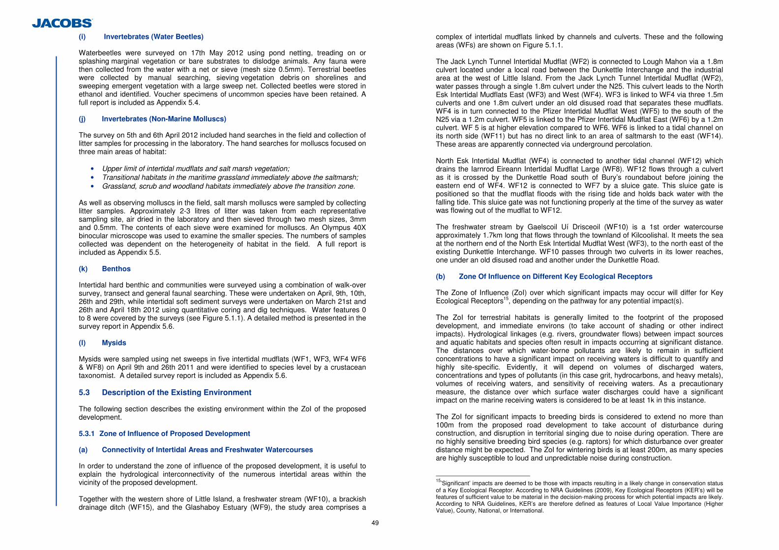
49
(i) Invertebrates (Water Beetles)
Waterbeetles were surveyed on 17th May 2012 using pond netting, treading on or splashing marginal vegetation or bare substrates to dislodge animals. Any fauna were then collected from the water with a net or sieve (mesh size 0.5mm). Terrestrial beetles were collected by manual searching, sieving vegetation debris on shorelines and sweeping emergent vegetation with a large sweep net. Collected beetles were stored in ethanol and identified. Voucher specimens of uncommon species have been retained. A full report is included as Appendix 5.4. (j) Invertebrates (Non-Marine Molluscs)
The survey on 5th and 6th April 2012 included hand searches in the field and collection of litter samples for processing in the laboratory. The hand searches for molluscs focused on three main areas of habitat:
• Upper limit of intertidal mudflats and salt marsh vegetation; • Transitional habitats in the maritime grassland immediately above the saltmarsh; • Grassland, scrub and woodland habitats immediately above the transition zone.
As well as observing molluscs in the field, salt marsh molluscs were sampled by collecting litter samples. Approximately 2-3 litres of litter was taken from each representative sampling site, air dried in the laboratory and then sieved through two mesh sizes, 3mm and 0.5mm. The contents of each sieve were examined for molluscs. An Olympus 40X binocular microscope was used to examine the smaller species. The numbers of samples collected was dependent on the heterogeneity of habitat in the field. A full report is included as Appendix 5.5. (k) Benthos
Intertidal hard benthic and communities were surveyed using a combination of walk-over survey, transect and general faunal searching. These were undertaken on April, 9th, 10th, 26th and 29th, while intertidal soft sediment surveys were undertaken on March 21st and 26th and April 18th 2012 using quantitative coring and dig techniques. Water features 0 to 8 were covered by the surveys (see Figure 5.1.1). A detailed method is presented in the survey report in Appendix 5.6.
(l) Mysids
Mysids were sampled using net sweeps in five intertidal mudflats (WF1, WF3, WF4 WF6 & WF8) on April 9th and 26th 2011 and were identified to species level by a crustacean taxonomist. A detailed survey report is included as Appendix 5.6. 5.3 Description of the Existing Environment
The following section describes the existing environment within the ZoI of the proposed development. 5.3.1 Zone of Influence of Proposed Development
(a) Connectivity of Intertidal Areas and Freshwater Watercourses
In order to understand the zone of influence of the proposed development, it is useful to explain the hydrological interconnectivity of the numerous intertidal areas within the vicinity of the proposed development.
Together with the western shore of Little Island, a freshwater stream (WF10), a brackish drainage ditch (WF15), and the Glashaboy Estuary (WF9), the study area comprises a
complex of intertidal mudflats linked by channels and culverts. These and the following areas (WFs) are shown on Figure 5.1.1. The Jack Lynch Tunnel Intertidal Mudflat (WF2) is connected to Lough Mahon via a 1.8m culvert located under a local road between the Dunkettle Interchange and the industrial area at the west of Little Island. From the Jack Lynch Tunnel Intertidal Mudflat (WF2), water passes through a single 1.8m culvert under the N25. This culvert leads to the North Esk Intertidal Mudflats East (WF3) and West (WF4). WF3 is linked to WF4 via three 1.5m culverts and one 1.8m culvert under an old disused road that separates these mudflats. WF4 is in turn connected to the Pfizer Intertidal Mudflat West (WF5) to the south of the N25 via a 1.2m culvert. WF5 is linked to the Pfizer Intertidal Mudflat East (WF6) by a 1.2m culvert. WF 5 is at higher elevation compared to WF6. WF6 is linked to a tidal channel on its north side (WF11) but has no direct link to an area of saltmarsh to the east (WF14). These areas are apparently connected via underground percolation.
North Esk Intertidal Mudflat (WF4) is connected to another tidal channel (WF12) which drains the Iarnrod Eireann Intertidal Mudflat Large (WF8). WF12 flows through a culvert as it is crossed by the Dunkettle Road south of Bury’s roundabout before joining the eastern end of WF4. WF12 is connected to WF7 by a sluice gate. This sluice gate is positioned so that the mudflat floods with the rising tide and holds back water with the falling tide. This sluice gate was not functioning properly at the time of the survey as water was flowing out of the mudflat to WF12. The freshwater stream by Gaelscoil Uí Drisceoil (WF10) is a 1st order watercourse approximately 1.7km long that flows through the townland of Kilcoolishal. It meets the sea at the northern end of the North Esk Intertidal Mudflat West (WF3), to the north east of the existing Dunkettle Interchange. WF10 passes through two culverts in its lower reaches, one under an old disused road and another under the Dunkettle Road. (b) Zone Of Influence on Different Key Ecological Receptors
The Zone of Influence (ZoI) over which significant impacts may occur will differ for Key Ecological Receptors15, depending on the pathway for any potential impact(s). The ZoI for terrestrial habitats is generally limited to the footprint of the proposed development, and immediate environs (to take account of shading or other indirect impacts). Hydrological linkages (e.g. rivers, groundwater flows) between impact sources and aquatic habitats and species often result in impacts occurring at significant distance. The distances over which water-borne pollutants are likely to remain in sufficient concentrations to have a significant impact on receiving waters is difficult to quantify and highly site-specific. Evidently, it will depend on volumes of discharged waters, concentrations and types of pollutants (in this case grit, hydrocarbons, and heavy metals), volumes of receiving waters, and sensitivity of receiving waters. As a precautionary measure, the distance over which surface water discharges could have a significant impact on the marine receiving waters is considered to be at least 1k in this instance. The ZoI for significant impacts to breeding birds is considered to extend no more than 100m from the proposed road development to take account of disturbance during construction, and disruption in territorial singing due to noise during operation. There are no highly sensitive breeding bird species (e.g. raptors) for which disturbance over greater distance might be expected. The ZoI for wintering birds is at least 200m, as many species are highly susceptible to loud and unpredictable noise during construction. 15’Significant’ impacts are deemed to be those with impacts resulting in a likely change in conservation status of a Key Ecological Receptor. According to NRA Guidelines (2009), Key Ecological Receptors (KER’s) will be features of sufficient value to be material in the decision-making process for which potential impacts are likely. According to NRA Guidelines, KER’s are therefore defined as features of Local Value Importance (Higher Value), County, National, or International.
50
The ZoI for Pigmy Shrew is expected to be limited to no more than 100m due to their small territory sizes and sedentary lifecycle. The ZoI for Otters, Badgers, Stoat, and Hedgehogs may extend over greater distances than small mammal and bird species due to their ability to disperse many kilometres from their natal site. Impacts to bats may potentially occur at distances up to 13km due to known long-distance foraging of Irish Leisler Bats from their nursery roost sites (Shiels et al., 2006). The ZoI for non-marine molluscs is likely to be limited to several hundred metres due to the restricted habitat niche and poor dispersal ability of these species. The ZoI for Lepdioptera (Moths and butterflies) may extend from several hundred meters for very small ‘micromoth’ species to many kilometres for larger species. 5.3.2 Desk Study
(a) Designated Sites
All Designated Sites within 1km (Figure 5.1.5), and 15km of the development (Figure 5.1.6) have been mapped. If a development has potential to cause any significant direct or indirect impacts upon an SAC or SPA (together termed the ‘Natura 2000’ network of sites), a screening for Appropriate Assessment of the development must be carried out in accordance with Article 6 of the EC Habitats Directive. It has been determined that an Appropriate Assessment will be required for the proposed development due to the potential for adverse effects to the integrity of the Cork Harbour SPA. On that basis, a Natura Impact Statement (NIS) has been produced for submission to the Competent Authority (in this case, An Board Pleanala). The NIS has been provided as a stand-alone document separate to this EIS, but is also contained within Appendix 5.7. The NIS has addressed the Dunkettle Shore pNHA (Site Code 1082) and Douglas River Estuary pNHA (Site Code 1046) in so far as these sites share much of their boundaries (and qualifying interests) with the Cork Harbour SPA. There are however two areas of the Dunkettle Shore pNHA which are outside the Cork Harbour SPA boundary. These two areas (Little Egret & Grey Heron Colony at Pfizer, and North Esk intertidal mudflat) are separately assessed in this chapter under Designated Sites. A detailed analysis of Natura 2000 sites is presented in the Natura Impact Statement. This chapter of the EIS provides a full baseline description of all designated sites within the ZoI, but assesses impacts to nationally designated sites only (proposed Natural Heritage Areas (pNHAs) and Natural Heritage Areas NHAs), as the NIS separately assesses impacts to all Natura 2000 sites, with summaries included within this chapter. Candidate Special Areas of Conservation (cSAC) are designated under the EC Habitats Directive (92/43/EEC) as amended, which is transposed into Irish law through a variety of legislation including the Birds and Habitats Regulations and the Planning Acts. The legislation enables the protection of certain habitats (listed on Annex I of the Directive) and/ or species (listed on Annex II). Special Protection Areas (SPAs) are designated under the Birds Directive (2009/147/EC). This allows for the protection of protected bird species listed on Annex I of the Directive, regularly occurring populations of migratory species (such as ducks, geese or waders), and areas of international importance for migratory birds. National Heritage Areas (NHAs) are designations under the Wildlife Acts in order to protect habitats, species or geology of national importance. Many of the NHAs in Ireland overlap with Natura 2000 sites. Although many NHA designations are not yet fully in force under this legislation (referred to as ‘proposed NHAs’ or pNHAs), they are offered protection in the meantime under planning legislation which requires that planning authorities give due regard to their protection in planning policies and decisions.16
16 Source: NPWS Website. Available online at http://www.npws.ie/protectedsites/naturalheritageareasnha/. Accessed 13/06/2012
The area covered by the proposed development is adjacent to the Cork Harbour SPA (Site Code 4030). The SPA abuts the proposed development to the west and south, and includes the lower estuarine reaches of the Glashaboy River (0.1km to the west of the proposed development), the Jack Lynch Intertidal Polder (WF1) along the shore beside the Jack Lynch Tunnel (0km to the southwest), and the Dunkettle/Little Island Shoreline which forms part of the intertidal zone of Lough Mahon. The Great Island Channel cSAC is located 2km to the east of the proposed development, and is potentially indirectly physically connected with the proposed development via a permanently wet linear tidal channel hereafter named the Eastgate Tidal Channel (WF11). However drainage is from east to west only, so there is no tidal linkage between intertidal areas receiving run-off from development site, and the Great Island Channel cSAC. WF11 drains into the Pfizer Intertidal Mudflat East (WF6). The proposed development is located within intertidal mudflats that are designated as the Dunkettle shore pNHA but the Cork Harbour SPA is not directly impacted. The pNHA boundary partially coincides with the Cork Harbour SPA in the estuarine and coastal areas adjacent to the footprint of the development (outlined above). In addition to intertidal mudflat and saltmarsh habitat, the Dunkettle shore pNHA also includes woodland on the steep banks of the Glashaboy River 0.2km to the northwest of the proposed development, and plantation woodland containing a Little Egret Egretta garzetta and Grey Heron Ardea cinerea colony on lands in the townland of Inchera owned by the Pfizer Pharmaceutical Company. The colony is located within 10 metres of the proposed development. The Douglas River Estuary pNHA (Site code 1046) is located 0.3km south of the proposed development on the far shore of Lough Mahon, and is coincident with the Cork Harbour SPA boundary there. The Glanmire Wood pNHA (1054) occurs 0.5km north of the proposed development where it forms the wooded slopes of the Glashaboy River. The Glanmire Wood pNHA adjoins the Dunkettle Shore pNHA to the south. There are no further SPAs or cSACs within 1km of the site. There are 17 further pNHAs within 15km, however there are no significant hydrological or other linkages with any of them. Table 5.6 presents these sites.
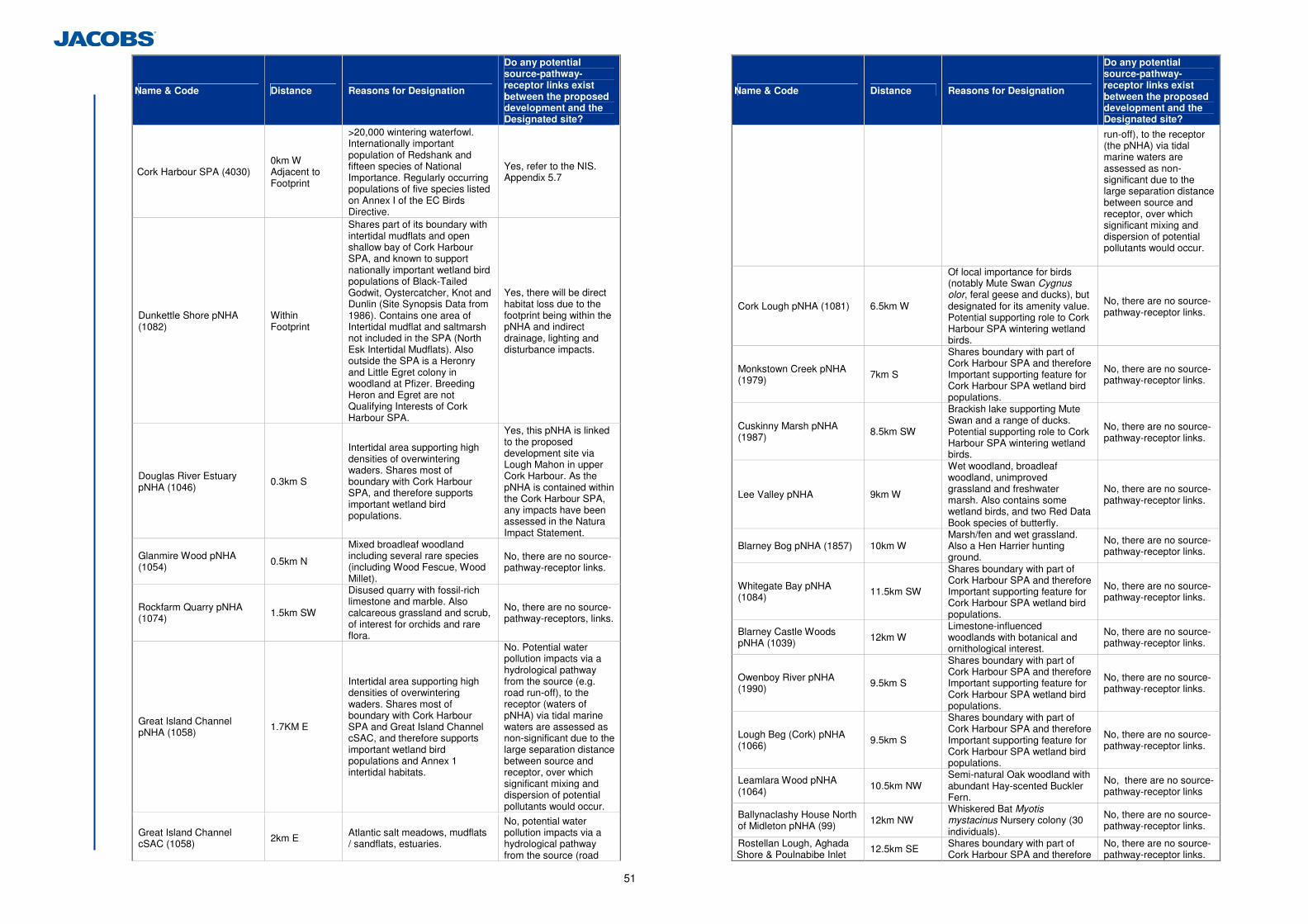
51
Site Name & Code Distance Reasons for Designation
Do any potential source-pathway-receptor links exist between the proposed development and the Designated site?
Cork Harbour SPA (4030) 0km W Adjacent to Footprint
>20,000 wintering waterfowl. Internationally important population of Redshank and fifteen species of National Importance. Regularly occurring populations of five species listed on Annex I of the EC Birds Directive.
Yes, refer to the NIS. Appendix 5.7
Dunkettle Shore pNHA (1082)
Within Footprint
Shares part of its boundary with intertidal mudflats and open shallow bay of Cork Harbour SPA, and known to support nationally important wetland bird populations of Black-Tailed Godwit, Oystercatcher, Knot and Dunlin (Site Synopsis Data from 1986). Contains one area of Intertidal mudflat and saltmarsh not included in the SPA (North Esk Intertidal Mudflats). Also outside the SPA is a Heronry and Little Egret colony in woodland at Pfizer. Breeding Heron and Egret are not Qualifying Interests of Cork Harbour SPA.
Yes, there will be direct habitat loss due to the footprint being within the pNHA and indirect drainage, lighting and disturbance impacts.
Douglas River Estuary pNHA (1046)
0.3km S
Intertidal area supporting high densities of overwintering waders. Shares most of boundary with Cork Harbour SPA, and therefore supports important wetland bird populations.
Yes, this pNHA is linked to the proposed development site via Lough Mahon in upper Cork Harbour. As the pNHA is contained within the Cork Harbour SPA, any impacts have been assessed in the Natura Impact Statement.
Glanmire Wood pNHA (1054) 0.5km N
Mixed broadleaf woodland including several rare species (including Wood Fescue, Wood Millet).
No, there are no source-pathway-receptor links.
Rockfarm Quarry pNHA (1074) 1.5km SW
Disused quarry with fossil-rich limestone and marble. Also calcareous grassland and scrub, of interest for orchids and rare flora.
No, there are no source-pathway-receptors, links.
Great Island Channel pNHA (1058) 1.7KM E
Intertidal area supporting high densities of overwintering waders. Shares most of boundary with Cork Harbour SPA and Great Island Channel cSAC, and therefore supports important wetland bird populations and Annex 1 intertidal habitats.
No. Potential water pollution impacts via a hydrological pathway from the source (e.g. road run-off), to the receptor (waters of pNHA) via tidal marine waters are assessed as non-significant due to the large separation distance between source and receptor, over which significant mixing and dispersion of potential pollutants would occur.
Great Island Channel cSAC (1058) 2km E Atlantic salt meadows, mudflats
/ sandflats, estuaries.
No, potential water pollution impacts via a hydrological pathway from the source (road
Site Name & Code Distance Reasons for Designation
Do any potential source-pathway-receptor links exist between the proposed development and the Designated site?
run-off), to the receptor (the pNHA) via tidal marine waters are assessed as non-significant due to the large separation distance between source and receptor, over which significant mixing and dispersion of potential pollutants would occur.
Cork Lough pNHA (1081) 6.5km W
Of local importance for birds (notably Mute Swan Cygnus olor, feral geese and ducks), but designated for its amenity value. Potential supporting role to Cork Harbour SPA wintering wetland birds.
No, there are no source-pathway-receptor links.
Monkstown Creek pNHA (1979) 7km S
Shares boundary with part of Cork Harbour SPA and therefore Important supporting feature for Cork Harbour SPA wetland bird populations.
No, there are no source-pathway-receptor links.
Cuskinny Marsh pNHA (1987) 8.5km SW
Brackish lake supporting Mute Swan and a range of ducks. Potential supporting role to Cork Harbour SPA wintering wetland birds.
No, there are no source-pathway-receptor links.
Lee Valley pNHA 9km W
Wet woodland, broadleaf woodland, unimproved grassland and freshwater marsh. Also contains some wetland birds, and two Red Data Book species of butterfly.
No, there are no source-pathway-receptor links.
Blarney Bog pNHA (1857) 10km W Marsh/fen and wet grassland. Also a Hen Harrier hunting ground.
No, there are no source-pathway-receptor links.
Whitegate Bay pNHA (1084) 11.5km SW
Shares boundary with part of Cork Harbour SPA and therefore Important supporting feature for Cork Harbour SPA wetland bird populations.
No, there are no source-pathway-receptor links.
Blarney Castle Woods pNHA (1039) 12km W
Limestone-influenced woodlands with botanical and ornithological interest.
No, there are no source-pathway-receptor links.
Owenboy River pNHA (1990) 9.5km S
Shares boundary with part of Cork Harbour SPA and therefore Important supporting feature for Cork Harbour SPA wetland bird populations.
No, there are no source-pathway-receptor links.
Lough Beg (Cork) pNHA (1066) 9.5km S
Shares boundary with part of Cork Harbour SPA and therefore Important supporting feature for Cork Harbour SPA wetland bird populations.
No, there are no source-pathway-receptor links.
Leamlara Wood pNHA (1064)
10.5km NW Semi-natural Oak woodland with abundant Hay-scented Buckler Fern.
No, there are no source-pathway-receptor links
Ballynaclashy House North of Midleton pNHA (99) 12km NW
Whiskered Bat Myotis mystacinus Nursery colony (30 individuals).
No, there are no source-pathway-receptor links.
Rostellan Lough, Aghada Shore & Poulnabibe Inlet 12.5km SE Shares boundary with part of
Cork Harbour SPA and therefore No, there are no source-pathway-receptor links.
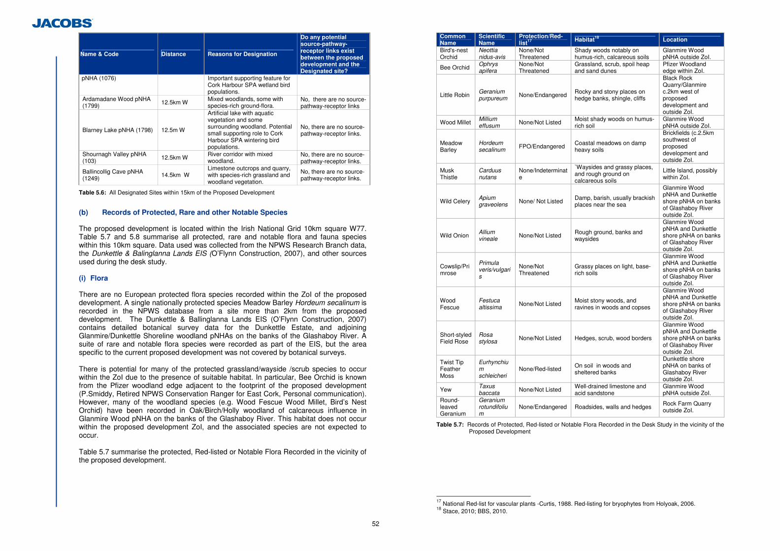
52
Site Name & Code Distance Reasons for Designation
Do any potential source-pathway-receptor links exist between the proposed development and the Designated site?
pNHA (1076) Important supporting feature for Cork Harbour SPA wetland bird populations.
Ardamadane Wood pNHA (1799) 12.5km W Mixed woodlands, some with
species-rich ground-flora. No, there are no source-pathway-receptor links
Blarney Lake pNHA (1798) 12.5m W
Artificial lake with aquatic vegetation and some surrounding woodland. Potential small supporting role to Cork Harbour SPA wintering bird populations.
No, there are no source-pathway-receptor links.
Shournagh Valley pNHA (103) 12.5km W River corridor with mixed
woodland. No, there are no source-pathway-receptor links.
Ballincollig Cave pNHA (1249) 14.5km W
Limestone outcrops and quarry, with species-rich grassland and woodland vegetation.
No, there are no source-pathway-receptor links.
Table 5.6: All Designated Sites within 15km of the Proposed Development
(b) Records of Protected, Rare and other Notable Species
The proposed development is located within the Irish National Grid 10km square W77. Table 5.7 and 5.8 summarise all protected, rare and notable flora and fauna species within this 10km square. Data used was collected from the NPWS Research Branch data, the Dunkettle & Balinglanna Lands EIS (O’Flynn Construction, 2007), and other sources used during the desk study. (i) Flora
There are no European protected flora species recorded within the ZoI of the proposed development. A single nationally protected species Meadow Barley Hordeum secalinum is recorded in the NPWS database from a site more than 2km from the proposed development. The Dunkettle & Ballinglanna Lands EIS (O’Flynn Construction, 2007) contains detailed botanical survey data for the Dunkettle Estate, and adjoining Glanmire/Dunkettle Shoreline woodland pNHAs on the banks of the Glashaboy River. A suite of rare and notable flora species were recorded as part of the EIS, but the area specific to the current proposed development was not covered by botanical surveys. There is potential for many of the protected grassland/wayside /scrub species to occur within the ZoI due to the presence of suitable habitat. In particular, Bee Orchid is known from the Pfizer woodland edge adjacent to the footprint of the proposed development (P.Smiddy, Retired NPWS Conservation Ranger for East Cork, Personal communication). However, many of the woodland species (e.g. Wood Fescue Wood Millet, Bird’s Nest Orchid) have been recorded in Oak/Birch/Holly woodland of calcareous influence in Glanmire Wood pNHA on the banks of the Glashaboy River. This habitat does not occur within the proposed development ZoI, and the associated species are not expected to occur. Table 5.7 summarise the protected, Red-listed or Notable Flora Recorded in the vicinity of the proposed development.
Common Name
Scientific Name
Protection/Red-list17 Habitat18 Location
Bird's-nest Orchid
Neottia nidus-avis
None/Not Threatened
Shady woods notably on humus-rich, calcareous soils
Glanmire Wood pNHA outside ZoI.
Bee Orchid Ophrys apifera
None/Not Threatened
Grassland, scrub, spoil heap and sand dunes
Pfizer Woodland edge within ZoI.
Little Robin Geranium purpureum None/Endangered Rocky and stony places on
hedge banks, shingle, cliffs
Black Rock Quarry/Glanmire c.2km west of proposed development and outside ZoI.
Wood Millet Millium effusum None/Not Listed Moist shady woods on humus-
rich soil Glanmire Wood pNHA outside ZoI.
Meadow Barley
Hordeum secalinum FPO/Endangered Coastal meadows on damp
heavy soils
Brickfields (c.2.5km southwest of proposed development and outside ZoI.
Musk Thistle
Carduus nutans
None/Indeterminate
`Waysides and grassy places, and rough ground on calcareous soils
Little Island, possibly within ZoI.
Wild Celery Apium graveolens None/ Not Listed Damp, barish, usually brackish
places near the sea
Glanmire Wood pNHA and Dunkettle shore pNHA on banks of Glashaboy River outside ZoI.
Wild Onion Allium vineale None/Not Listed Rough ground, banks and
waysides
Glanmire Wood pNHA and Dunkettle shore pNHA on banks of Glashaboy River outside ZoI.
Cowslip/Primrose
Primula veris/vulgaris
None/Not Threatened
Grassy places on light, base-rich soils
Glanmire Wood pNHA and Dunkettle shore pNHA on banks of Glashaboy River outside ZoI.
Wood Fescue
Festuca altissima None/Not Listed Moist stony woods, and
ravines in woods and copses
Glanmire Wood pNHA and Dunkettle shore pNHA on banks of Glashaboy River outside ZoI.
Short-styled Field Rose
Rosa stylosa None/Not Listed Hedges, scrub, wood borders
Glanmire Wood pNHA and Dunkettle shore pNHA on banks of Glashaboy River outside ZoI.
Twist Tip Feather Moss
Eurhynchium schleicheri
None/Red-listed On soil in woods and sheltered banks
Dunkettle shore pNHA on banks of Glashaboy River outside ZoI.
Yew Taxus baccata None/Not Listed Well-drained limestone and
acid sandstone Glanmire Wood pNHA outside ZoI.
Round-leaved Geranium
Geranium rotundifolium
None/Endangered Roadsides, walls and hedges Rock Farm Quarry outside ZoI.
Table 5.7: Records of Protected, Red-listed or Notable Flora Recorded in the Desk Study in the vicinity of the Proposed Development
17 National Red-list for vascular plants -Curtis, 1988. Red-listing for bryophytes from Holyoak, 2006. 18 Stace, 2010; BBS, 2010.
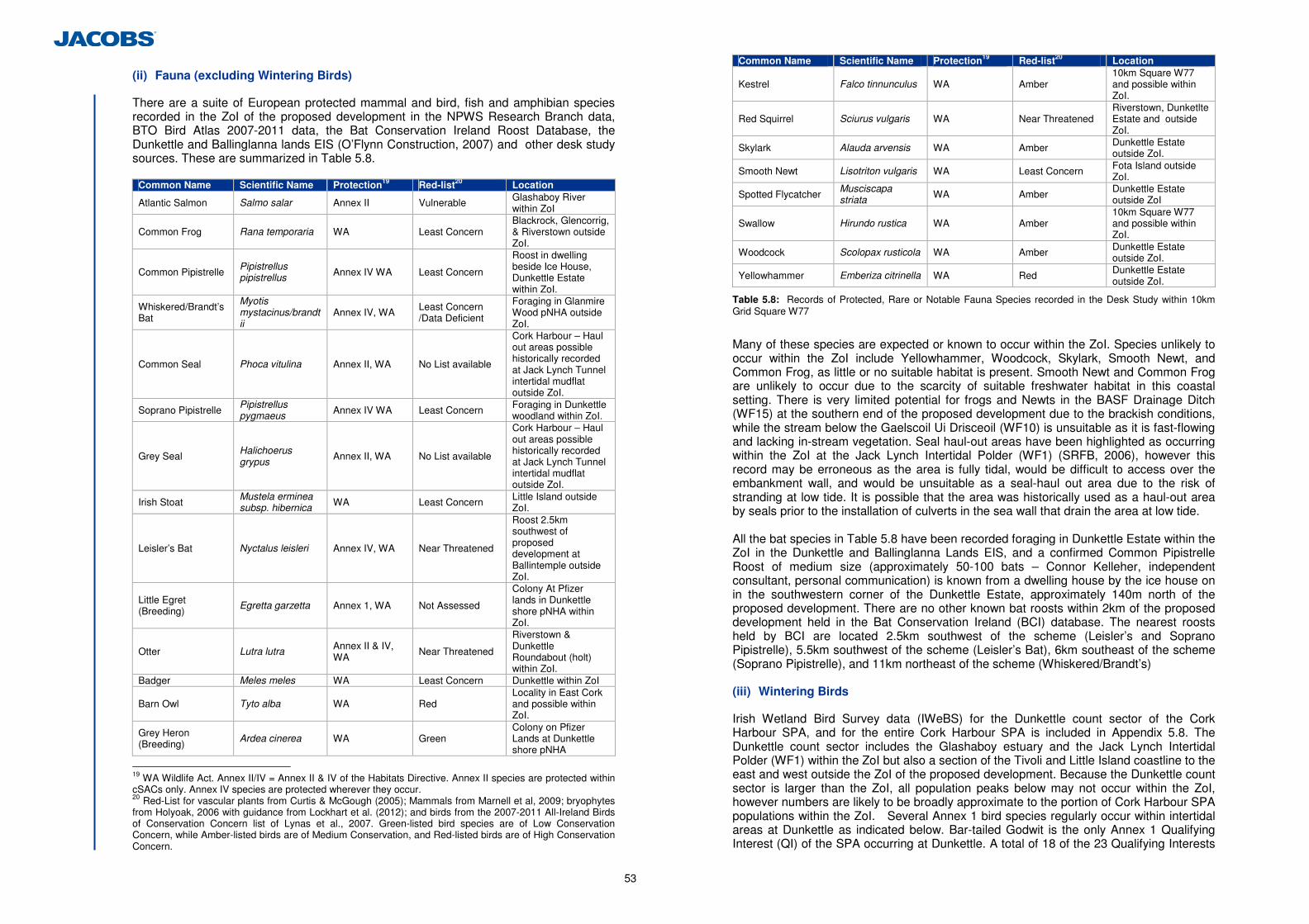
53
(ii) Fauna (excluding Wintering Birds)
There are a suite of European protected mammal and bird, fish and amphibian species recorded in the ZoI of the proposed development in the NPWS Research Branch data, BTO Bird Atlas 2007-2011 data, the Bat Conservation Ireland Roost Database, the Dunkettle and Ballinglanna lands EIS (O’Flynn Construction, 2007) and other desk study sources. These are summarized in Table 5.8.
Common Name Scientific Name Protection19 Red-list20 Location
Atlantic Salmon Salmo salar Annex II Vulnerable Glashaboy River within ZoI
Common Frog Rana temporaria WA Least Concern Blackrock, Glencorrig, & Riverstown outside ZoI.
Common Pipistrelle Pipistrellus pipistrellus Annex IV WA Least Concern
Roost in dwelling beside Ice House, Dunkettle Estate within ZoI.
Whiskered/Brandt’s Bat
Myotis mystacinus/brandtii
Annex IV, WA Least Concern /Data Deficient
Foraging in Glanmire Wood pNHA outside ZoI.
Common Seal Phoca vitulina Annex II, WA No List available
Cork Harbour – Haul out areas possible historically recorded at Jack Lynch Tunnel intertidal mudflat outside ZoI.
Soprano Pipistrelle Pipistrellus pygmaeus Annex IV WA Least Concern Foraging in Dunkettle
woodland within ZoI.
Grey Seal Halichoerus grypus Annex II, WA No List available
Cork Harbour – Haul out areas possible historically recorded at Jack Lynch Tunnel intertidal mudflat outside ZoI.
Irish Stoat Mustela erminea subsp. hibernica WA Least Concern Little Island outside
ZoI.
Leisler’s Bat Nyctalus leisleri Annex IV, WA Near Threatened
Roost 2.5km southwest of proposed development at Ballintemple outside ZoI.
Little Egret (Breeding)
Egretta garzetta Annex 1, WA Not Assessed
Colony At Pfizer lands in Dunkettle shore pNHA within ZoI.
Otter Lutra lutra Annex II & IV, WA
Near Threatened
Riverstown & Dunkettle Roundabout (holt) within ZoI.
Badger Meles meles WA Least Concern Dunkettle within ZoI
Barn Owl Tyto alba WA Red Locality in East Cork and possible within ZoI.
Grey Heron (Breeding)
Ardea cinerea WA Green Colony on Pfizer Lands at Dunkettle shore pNHA
19 WA Wildlife Act. Annex II/IV = Annex II & IV of the Habitats Directive. Annex II species are protected within cSACs only. Annex IV species are protected wherever they occur. 20 Red-List for vascular plants from Curtis & McGough (2005); Mammals from Marnell et al, 2009; bryophytes from Holyoak, 2006 with guidance from Lockhart et al. (2012); and birds from the 2007-2011 All-Ireland Birds of Conservation Concern list of Lynas et al., 2007. Green-listed bird species are of Low Conservation Concern, while Amber-listed birds are of Medium Conservation, and Red-listed birds are of High Conservation Concern.
Common Name Scientific Name Protection19 Red-list20 Location
Kestrel Falco tinnunculus WA Amber 10km Square W77 and possible within ZoI.
Red Squirrel Sciurus vulgaris WA Near Threatened Riverstown, Dunketlte Estate and outside ZoI.
Skylark Alauda arvensis WA Amber Dunkettle Estate outside ZoI.
Smooth Newt Lisotriton vulgaris WA Least Concern Fota Island outside ZoI.
Spotted Flycatcher Musciscapa striata WA Amber Dunkettle Estate
outside ZoI
Swallow Hirundo rustica WA Amber 10km Square W77 and possible within ZoI.
Woodcock Scolopax rusticola WA Amber Dunkettle Estate outside ZoI.
Yellowhammer Emberiza citrinella WA Red Dunkettle Estate outside ZoI.
Table 5.8: Records of Protected, Rare or Notable Fauna Species recorded in the Desk Study within 10km Grid Square W77
Many of these species are expected or known to occur within the ZoI. Species unlikely to occur within the ZoI include Yellowhammer, Woodcock, Skylark, Smooth Newt, and Common Frog, as little or no suitable habitat is present. Smooth Newt and Common Frog are unlikely to occur due to the scarcity of suitable freshwater habitat in this coastal setting. There is very limited potential for frogs and Newts in the BASF Drainage Ditch (WF15) at the southern end of the proposed development due to the brackish conditions, while the stream below the Gaelscoil Ui Drisceoil (WF10) is unsuitable as it is fast-flowing and lacking in-stream vegetation. Seal haul-out areas have been highlighted as occurring within the ZoI at the Jack Lynch Intertidal Polder (WF1) (SRFB, 2006), however this record may be erroneous as the area is fully tidal, would be difficult to access over the embankment wall, and would be unsuitable as a seal-haul out area due to the risk of stranding at low tide. It is possible that the area was historically used as a haul-out area by seals prior to the installation of culverts in the sea wall that drain the area at low tide. All the bat species in Table 5.8 have been recorded foraging in Dunkettle Estate within the ZoI in the Dunkettle and Ballinglanna Lands EIS, and a confirmed Common Pipistrelle Roost of medium size (approximately 50-100 bats – Connor Kelleher, independent consultant, personal communication) is known from a dwelling house by the ice house on in the southwestern corner of the Dunkettle Estate, approximately 140m north of the proposed development. There are no other known bat roosts within 2km of the proposed development held in the Bat Conservation Ireland (BCI) database. The nearest roosts held by BCI are located 2.5km southwest of the scheme (Leisler’s and Soprano Pipistrelle), 5.5km southwest of the scheme (Leisler’s Bat), 6km southeast of the scheme (Soprano Pipistrelle), and 11km northeast of the scheme (Whiskered/Brandt’s) (iii) Wintering Birds
Irish Wetland Bird Survey data (IWeBS) for the Dunkettle count sector of the Cork Harbour SPA, and for the entire Cork Harbour SPA is included in Appendix 5.8. The Dunkettle count sector includes the Glashaboy estuary and the Jack Lynch Intertidal Polder (WF1) within the ZoI but also a section of the Tivoli and Little Island coastline to the east and west outside the ZoI of the proposed development. Because the Dunkettle count sector is larger than the ZoI, all population peaks below may not occur within the ZoI, however numbers are likely to be broadly approximate to the portion of Cork Harbour SPA populations within the ZoI. Several Annex 1 bird species regularly occur within intertidal areas at Dunkettle as indicated below. Bar-tailed Godwit is the only Annex 1 Qualifying Interest (QI) of the SPA occurring at Dunkettle. A total of 18 of the 23 Qualifying Interests
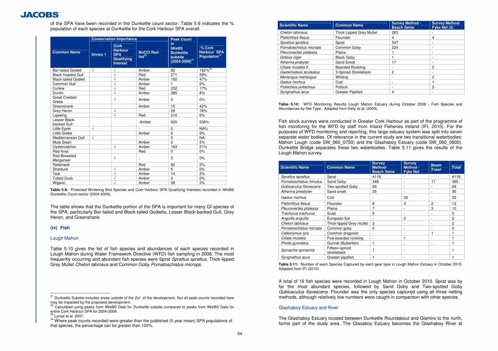
54
of the SPA have been recorded in the Dunketlle count sector. Table 5.9 indicates the % population of each species at Dunkettle for the Cork Harbour SPA overall.
Conservation Importance
Common Name Annex 1
Cork Harbour SPA Qualifying Interest
BoCCI Red-list23
Peak Count in IWeBS Dunkettle subsite (2004-2009)21
% Cork Harbour SPA Population22
Bar-tailed Godwit √ √ Amber 82 182%24 Black-headed Gull √ Red 271 29% Black-tailed Godwit √ Amber 192 47% Common Gull √ Amber 1 0% Curlew √ Red 232 17% Dunlin √ Amber 385 8% Great Crested Grebe √ Amber 0 0%
Greenshank Amber 15 42% Grey Heron √ - 29 78% Lapwing √ Red 210 6% Lesser Black-backed Gull -Amber 620 238%
Little Egret √ - 0 NA% Little Grebe Amber 6 9% Mediterranean Gull √ - 0 NA Mute Swan Amber 2 5% Oystercatcher √ Amber 163 21% Red Knot Red 0 0% Red-Breasted Merganser √ - 0 0%
Redshank Red 82 5% Shelduck √ Amber 6 0% Teal √ Amber 14 2% Tufted Duck √ Amber 0 0% Wigeon √ Amber 58 3%
Table 5.9: Protected Wintering Bird Species and Cork Harbour SPA Qualifying Interests recorded in iWeBS Dunkettle Count sector (2004-2009).
The table shows that the Dunkettle portion of the SPA is important for many QI species of the SPA, particularly Bar-tailed and Black-tailed Godwits, Lesser Black-backed Gull, Grey Heron, and Greenshank. (iv) Fish
Lough Mahon Table 5.10 gives the list of fish species and abundances of each species recorded in Lough Mahon during Water Framework Directive (WFD) fish sampling in 2008. The most frequently occurring and abundant fish species were Sprat Sprattus sprattus, Thick-lipped Grey Mullet Chelon labrosus and Common Goby Pomatoschistus microps.
21 Dunkettle Subsite includes areas outside of the ZoI of the development. Not all peak counts recorded here may be impacted by the proposed development. 22 Calculated using peaks from IWeBS Data for Dunkettle subsite compared to peaks from IWeBS Data for entire Cork Harbour SPA for 2004-2009. 23 Lynas et al. 2007. 24 Where peak counts recorded were greater than the published (5 year mean) SPA populations of that species, the percentage can be greater than 100%.
Scientific Name Common Name Survey Method -Beach Seine
Survey Method- Fyke Net (3)
Chelon labrosus Thick Lipped Grey Mullet 263 - Platichthys flesus Flounder 4 4 Sprattus sprattus Sprat 547 - Pomatoschistus microps Common Goby 224 - Pleuronectes platessa Plaice 1 - Gobius niger Black Goby 1 - Atherina prebyter Sand Smelt 17 - Ciliata mustela 5- Bearded Rockling - 2 Gasterosteus aculeatus 3-Spined Stickleback 2 - Merlangus merlangus Whiting - 2 Gadus morhua Cod - 1 Pollachius pollachius Pollock - 3 Syngnathus acus Greater Pipefish 4 -
Table 5.10: WFD Monitoring Results Lough Mahon Estuary during October 2008 - Fish Species and Abundances by Net Type. Adapted from Kelly et al, (2009).
Fish stock surveys were conducted in Greater Cork Harbour as part of the programme of fish monitoring for the WFD by staff from Inland Fisheries Ireland (IFI, 2010). For the purposes of WFD monitoring and reporting, this large estuary system was split into seven separate water bodies. Of relevance in the current study are two transitional waterbodies: Mahon Lough (code SW_060_0750) and the Glashaboy Estuary (code SW_060_0800). Dunkettle Bridge separates these two waterbodies. Table 5.11 gives the results of the Lough Mahon survey.
Scientific Name Common Name Survey Method- Beach Seine
Survey Method - Fyke Net
Beam Trawl Total
Sprattus sprattus Sprat 4118 - - 4118 Pomatoschistus minutus Sand Goby 348 - 17 365 Gobiusculus flavescens Two-spotted Goby 69 - - 69 Atherina presbyter Sand smelt 35 - - 35
Gadus morhua Cod - 33 - 33
Platichthys flesus Flounder 8 3 2 13 Pleuronectes platessa Plaice 7 - 3 10 Trachurus trachurus Scad 5 - - 5 Anguilla anguilla European Eel - 2 - 2 Chelon labrosus Thick-lipped Grey mullet 2 - - 2 Pomatoschistus microps Common goby 2 - - 2 Callionymus lyra Common dragonet - - 1 1 Ciliata mustela Five-bearded rockling - 1 - 1 Pholis gunnellus Gunnel (Butterfish) 1 - - 1
Spinachia spinachia Fifteen-spined stickleback
1 - - 1
Syngnathus acus Greater pipefish 1 - - 1
Table 5.11: Number of each Species Captured by each gear type in Lough Mahon Estuary in October 2010. Adapted from IFI (2010)
A total of 16 fish species were recorded in Lough Mahon in October 2010. Sprat was by far the most abundant species, followed by Sand Goby and Two-spotted Goby Gobiusculus flavescens. Flounder was the only species captured using all three netting methods, although relatively low numbers were caught in comparison with other species.
Glashaboy Estuary and River The Glashaboy Estuary located between Dunkettle Roundabout and Glamire to the north, forms part of the study area. The Glasaboy Estuary becomes the Glashaboy River at
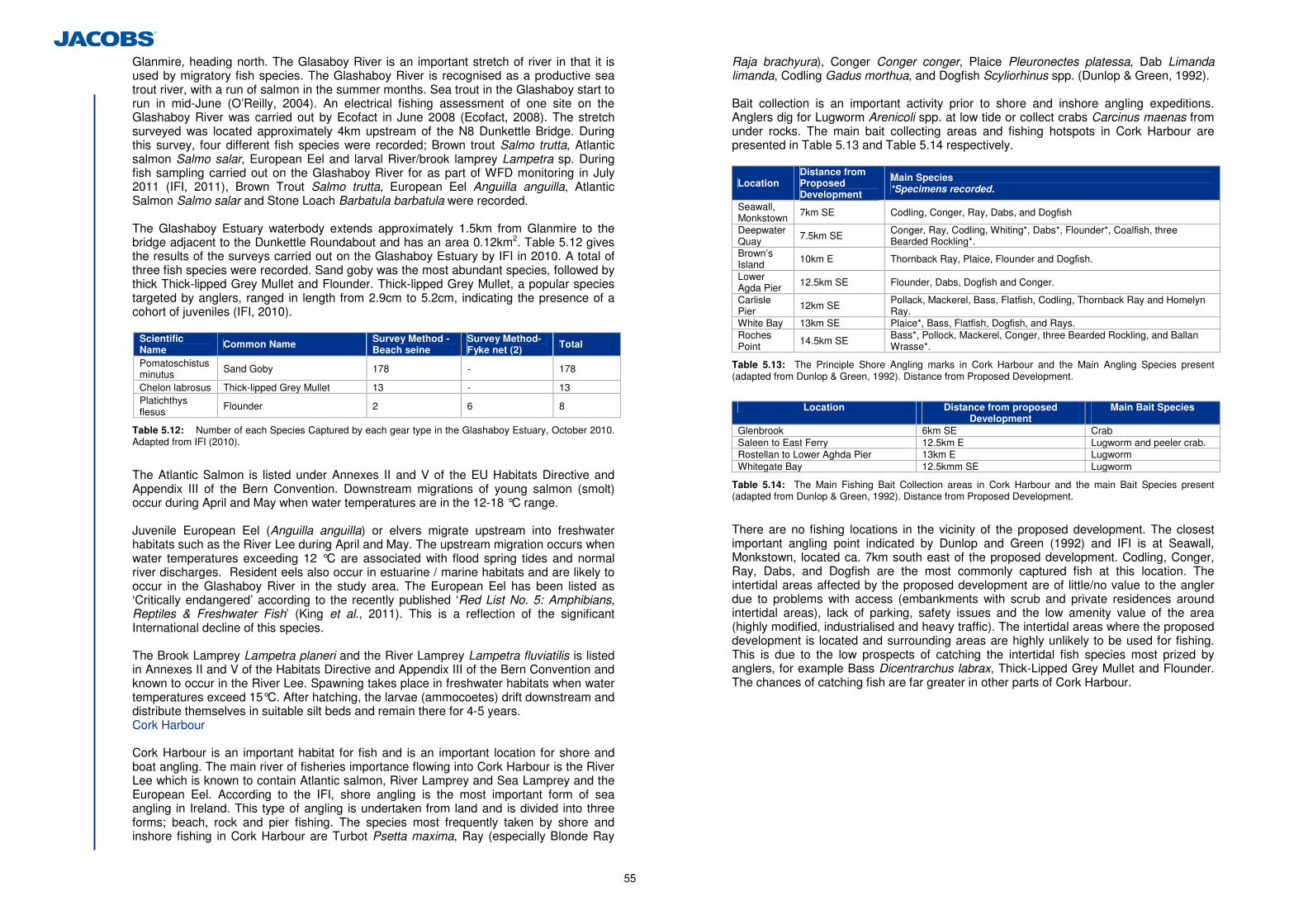
55
Glanmire, heading north. The Glasaboy River is an important stretch of river in that it is used by migratory fish species. The Glashaboy River is recognised as a productive sea trout river, with a run of salmon in the summer months. Sea trout in the Glashaboy start to run in mid-June (O’Reilly, 2004). An electrical fishing assessment of one site on the Glashaboy River was carried out by Ecofact in June 2008 (Ecofact, 2008). The stretch surveyed was located approximately 4km upstream of the N8 Dunkettle Bridge. During this survey, four different fish species were recorded; Brown trout Salmo trutta, Atlantic salmon Salmo salar, European Eel and larval River/brook lamprey Lampetra sp. During fish sampling carried out on the Glashaboy River for as part of WFD monitoring in July 2011 (IFI, 2011), Brown Trout Salmo trutta, European Eel Anguilla anguilla, Atlantic Salmon Salmo salar and Stone Loach Barbatula barbatula were recorded. The Glashaboy Estuary waterbody extends approximately 1.5km from Glanmire to the bridge adjacent to the Dunkettle Roundabout and has an area 0.12km2. Table 5.12 gives the results of the surveys carried out on the Glashaboy Estuary by IFI in 2010. A total of three fish species were recorded. Sand goby was the most abundant species, followed by thick Thick-lipped Grey Mullet and Flounder. Thick-lipped Grey Mullet, a popular species targeted by anglers, ranged in length from 2.9cm to 5.2cm, indicating the presence of a cohort of juveniles (IFI, 2010).
Scientific Name Common Name Survey Method -
Beach seine Survey Method- Fyke net (2) Total
Pomatoschistus minutus Sand Goby 178 - 178
Chelon labrosus Thick-lipped Grey Mullet 13 - 13 Platichthys flesus
Flounder 2 6 8
Table 5.12: Number of each Species Captured by each gear type in the Glashaboy Estuary, October 2010. Adapted from IFI (2010).
The Atlantic Salmon is listed under Annexes II and V of the EU Habitats Directive and Appendix III of the Bern Convention. Downstream migrations of young salmon (smolt) occur during April and May when water temperatures are in the 12-18 °C range. Juvenile European Eel (Anguilla anguilla) or elvers migrate upstream into freshwater habitats such as the River Lee during April and May. The upstream migration occurs when water temperatures exceeding 12 °C are associated with flood spring tides and normal river discharges. Resident eels also occur in estuarine / marine habitats and are likely to occur in the Glashaboy River in the study area. The European Eel has been listed as ‘Critically endangered’ according to the recently published ‘Red List No. 5: Amphibians, Reptiles & Freshwater Fish’ (King et al., 2011). This is a reflection of the significant International decline of this species.
The Brook Lamprey Lampetra planeri and the River Lamprey Lampetra fluviatilis is listed in Annexes II and V of the Habitats Directive and Appendix III of the Bern Convention and known to occur in the River Lee. Spawning takes place in freshwater habitats when water temperatures exceed 15°C. After hatching, the larvae (ammocoetes) drift downstream and distribute themselves in suitable silt beds and remain there for 4-5 years. Cork Harbour
Cork Harbour is an important habitat for fish and is an important location for shore and boat angling. The main river of fisheries importance flowing into Cork Harbour is the River Lee which is known to contain Atlantic salmon, River Lamprey and Sea Lamprey and the European Eel. According to the IFI, shore angling is the most important form of sea angling in Ireland. This type of angling is undertaken from land and is divided into three forms; beach, rock and pier fishing. The species most frequently taken by shore and inshore fishing in Cork Harbour are Turbot Psetta maxima, Ray (especially Blonde Ray
Raja brachyura), Conger Conger conger, Plaice Pleuronectes platessa, Dab Limanda limanda, Codling Gadus morthua, and Dogfish Scyliorhinus spp. (Dunlop & Green, 1992). Bait collection is an important activity prior to shore and inshore angling expeditions. Anglers dig for Lugworm Arenicoli spp. at low tide or collect crabs Carcinus maenas from under rocks. The main bait collecting areas and fishing hotspots in Cork Harbour are presented in Table 5.13 and Table 5.14 respectively.
Location Distance from Proposed Development
Main Species *Specimens recorded.
Seawall, Monkstown 7km SE Codling, Conger, Ray, Dabs, and Dogfish
Deepwater Quay 7.5km SE Conger, Ray, Codling, Whiting*, Dabs*, Flounder*, Coalfish, three
Bearded Rockling*. Brown’s Island 10km E Thornback Ray, Plaice, Flounder and Dogfish.
Lower Agda Pier 12.5km SE Flounder, Dabs, Dogfish and Conger.
Carlisle Pier 12km SE Pollack, Mackerel, Bass, Flatfish, Codling, Thornback Ray and Homelyn
Ray. White Bay 13km SE Plaice*, Bass, Flatfish, Dogfish, and Rays. Roches Point 14.5km SE Bass*, Pollock, Mackerel, Conger, three Bearded Rockling, and Ballan
Wrasse*.
Table 5.13: The Principle Shore Angling marks in Cork Harbour and the Main Angling Species present (adapted from Dunlop & Green, 1992). Distance from Proposed Development.
Location Distance from proposed
Development Main Bait Species
Glenbrook 6km SE Crab Saleen to East Ferry 12.5km E Lugworm and peeler crab. Rostellan to Lower Aghda Pier 13km E Lugworm Whitegate Bay 12.5kmm SE Lugworm
Table 5.14: The Main Fishing Bait Collection areas in Cork Harbour and the main Bait Species present (adapted from Dunlop & Green, 1992). Distance from Proposed Development.
There are no fishing locations in the vicinity of the proposed development. The closest important angling point indicated by Dunlop and Green (1992) and IFI is at Seawall, Monkstown, located ca. 7km south east of the proposed development. Codling, Conger, Ray, Dabs, and Dogfish are the most commonly captured fish at this location. The intertidal areas affected by the proposed development are of little/no value to the angler due to problems with access (embankments with scrub and private residences around intertidal areas), lack of parking, safety issues and the low amenity value of the area (highly modified, industrialised and heavy traffic). The intertidal areas where the proposed development is located and surrounding areas are highly unlikely to be used for fishing. This is due to the low prospects of catching the intertidal fish species most prized by anglers, for example Bass Dicentrarchus labrax, Thick-Lipped Grey Mullet and Flounder. The chances of catching fish are far greater in other parts of Cork Harbour.
56
5.3.3 Field Survey Results
(a) Habitats
Habitats recorded within the vicinity of the proposed development are illustrated in Figure 5.1.7 and listed in Table 5.15 below. Habitat Descriptions and species lists by habitat type are provided in Appendix 5.9.
Heritage Council Habitat Category
Heritage Council Habitat & Code
Priority Habitat in Cork City BAP25
Corresponding EU Habitat and goodness of fit according to EC, 2007
Artificial Lakes & Ponds (FL8) – Eastgate Pond (WF13) -
Depositing/Lowland Rivers (FW2) – Freshwater Stream at Gaelscoil Ui Drisceoil (WF10)
√ - Freshwater (F)
Drainage Ditches (FW4) - Improved Grassland (GA1) - Amenity Grassland (GA2) Dry Neutral & Calcareous Grassland (GS1) √ -
Dry Meadows and Grassy Verges (GS2)
√ -
Grassland and Marsh (G)
Wet Grassland (GS4) - - (Mixed) Broad-leaved Woodland (WD1)
- -
Mixed Broad-leaved Woodland (WD2)
Scattered Trees and Parkland (WD5) - -
Scrub (WS1) - - Hedgerows (WL1) - -
Woodland & Scrub (W)
Treelines (WL2) - - Exposed Rock and Disturbed Ground (ED
Recolonising Bare Ground (ED3)
- -
- -
Stone Walls and other stonework (BL1) - -
Earth Banks (BL2) - - Cultivated and Built Ground (BL)
Buildings and Artificial Surfaces (BL3) - -
Lower Salt Marsh (CM1) √
Contains mix of three Annex 1 habitats; Atlantic Salt Meadows (1330), Spartina Swards (1320) , and Inland Salt Meadows (1340).
Upper Salt Marsh (CM2) √ Contains mix of two Annex 1 habitats; Atlantic Salt Meadows (1330) Mediterranean Salt Meadows (1410).
Sea Walls and Jetties (CC1) - - Sheltered Rocky Shores (LR3) - -
Coastland (C)
Mud Shores (LS4) √ Corresponds to Annex 1 habitat 'mudflats and sandflats not covered by sea water at low tide (1140)'.
Sea Inlets and Bays (MW2) - Corresponds to Annex 1 habitat Large shallow inlets and bays (1160). Marine Water
Body (MW) Estuaries (MW4) – The Glashaboy River - Corresponds to Annex 1 habitat
Estuaries (1130).
Table 5.15: Summary of Habitats within Zone of Influence (Heritage Council Classification)
25 Biodiversity Action Plan
(i) Habitat Descriptions (Joint Nature Conservation Commitee Marine Biotope Categories)
Overview The eight main intertidal areas (excluding freshwater features, channels and drainage ditches within the study area) WF1-WF8 all have broadly similar structural features in common and consequently contain a broadly similar range of habitat types. The size varies with WF1 the largest, accounting for a greater area than all the other water features combined. Essentially each feature is configured with the majority of their base areas composed of soft sediment intertidal, principally muddy, with a narrow perimeter of rock armour or shingle-type hard substrate with varying densities of brown seaweed (macroalgal) cover. This applies substantially to WF1, WF2, WF3, WF4, and WF6. In contrast, WF5, WF7 and WF8 have little or no hard substrate perimeter and consequently have limited macro-algal cover, although WF8 is an exception where the estuarine brown seaweed Fucus ceranoides, both drifting and attached is quite a prominent feature. In some water features, the expanse of muddy habitat has been encroached on to varying degrees by Sea Club-Rush (mainly) and Cord-grass (to a lesser extent), forming a saltmarsh habitat in those areas. The latter is the case especially for WF4, WF6 and WF8. Communities Present A prominent feature of the hard-substrate intertidal areas is the presence of heavy growths of the Brown Seaweed Ascophyllum nodosum on rock armour in particular but also on intertidal gravel and scattered cobble. Ascophyllum is invariably accompanied by a narrower band of Bladdered Wrack Fucus vesiculosus immediately above it on the shore at most sites and by Serrated Wrack Fucus serratus below it, however this is only the case in WF1 and WF3, where the rock-armour is present at sufficient depth to accommodate it. Horned Wrack Fucus ceranoides, a close relative of Fucus vesiculosus and Sprialled Wrack Fucus spiralis is typical of upper estuarine low estuarine conditions extending into almost fully freshwater environments. Within the study area it occurs abundantly in the northern part of WF3 where a small stream has its upper estuarine course, as well as in the eastern end of WF6 and around all of WF8, where it is the only brown seaweed present. In the latter two water features its presence it thought to signify the presence there of a greater freshwater influence. Another algal genus which is prominent within the study area is Spirulina Seaweed Enteromorpha which forms a generally narrow upper shore band in virtually all of the water features. Red algae Rhodophyta generally is limited and only occurs in small amounts in localised areas e.g. around tidal culverts or in the case of the southern rock armour embankment in WF1 where there was local tidal currents/flushing, namely in WF1-WF4.
Faunal communities on the hard benthos are generally of low diversity, which is not untypical for upper estuarine environments. The barnacle Elminius modestus was one of the more widespread species occurring generally only on large boulders or large stable cobble; it is in highest densities on the insides of culverts where it would benefit from strong tidal currents. Young shore crabs were recorded in several water features where hard substrate was present although generally in low densities. Gammarid amphipods tend to be numerous throughout, under heavy seaweed cover, especially if the latter was over muddy gravel. The small isopod Lekanesphaera sp. is common under stones over muddy sand in the NE corner of WFI. Common or Blue Mussels Mytilus edulis are locally common in crevices in rock armour where there is a good flush of water, e.g. along the middle and lower parts of the FW1 southern embankment. They are also prominent in patches adjoining the outflows/inflow from the main culverts at WF2, WF3/WF4, where they benefit from strong currents experienced in close proximity to the culverts. Finally, epiphytic hydroids are present on Fucus serratus in tidally flushed areas of the southern embankment of WF1.
57
Infaunal communities identified in soft sediment habitats across the survey area are typical of upper estuarine conditions. Overall, infaunal diversity is low across all sites. The most dominant species identified in the area is the ragworm Hediste diversicolor which was present in all of the surveyed water features WF1 – WF5, although much reduced at WF1. A total of three biotopes were identified across the survey area; with Corophium and Hediste mixed upper estuarine biotopes present in WF8, WF7 and WF5; Streblospio and Hediste mixed upper estuarine biotopes present at WF1, WF4 and WF6; and Hediste and Oligochaete mixed biotopes present at WF2 and WF3. These are typical upper estuarine communities. Habitat Classification The benthic habitats encountered within the study area have been classified using Fossitt (2000) and the Joint Nature ConServation Committee (JNCC) system of Marine Habitat Classification. Like all habitat classification exercises, it suffers from a degree of latitude, as most habitats tend not to be exactly described by the categories used in classifications, being more or less typical of the cited categories. That notwithstanding, Table 5.16 presents the considered classifications for the eight water features based on field surveys.
Water Feature
Heritage Council Classification JNCC Marine Biotope Classification
Hard Benthos Soft Benthos
Hard Benthos Soft Benthos
WF1 CC1 LR3 LS4 LR.LLR.FVS.AscVS LS.LMu.UEst.Hed.Str
WF2 CC1 LR3 LS4 LR.LLR.FVS.AscVS LS.LMu.UEst.Hed.Ol
WF3 CC1 LR3 LS4 LR.LLR.FVS.AscVS LR.LLR.FVS.Fcer LS.LMu.UEst.Hed.Ol
WF4 CC1 LR3 LS4 LR.LLR.FVS.AscVS LS.LMu.UEst.Hed.Str
WF5 LR3 LS4 LR.LLR.FVS.AscVS LS.LMu.UEst.Hed.Cvol
WF6 CC1 LR3 LS4 LR.LLR.FVS.AscVS LR.LLR.FVS.Fcer LS.LMu.UEst.Hed.Str
WF7 - - LS4 - LS.LMu.UEst.Hed.Cvol
WF8 - - LS4 LR.LLR.FVS.Fcer LS.LMu.UEst.Hed.Cvoll
Table 5.16: Summary of Habitats Recorded within ZoI (JNCC Marine Biotope Classification)
Key to Habitat Descriptions: Heritage Council Classification (Fossitt, 2000) A further description of the key habitats under the Heritage Council Classification contained in Table 5.16 is presented in the following paragraphs. CC1: Sea wall, piers and jetties, i.e. artificial substrata of built stone, concrete, metal, wood or plastic, which would have similar communities to natural rock and stone substrata and hence could also fall under the related habitat LR3.
LR3: Sheltered rock shores. This category includes sheltered to extremely sheltered rock shores of bedrock, and stable accumulations of boulders, cobbles and pebbles. Sheltered rocky shores are characterised by very heavy growths of fucoids. In situations where salinity is reduced through inputs of freshwater, Horned Wrack (Fucus ceranoides), and ephemeral green seaweed (Cladophora spp.) may be common. (Fossitt 2000). The above is just a partial description of the habitat type from Fossitt but what is clear is that the Dunkettle examples are quite species poor in comparison, probably due to the more upper estuarine location and the elevated turbidity typical of these areas. LS4: Mud shores. - These substrates contain at least 30% fines below 63µm in diameter and have characteristic species such as the polychaete worm Hediste diversicolor
(ragworm), the bivalve Scrobicularia plana, the burrowing crustacean Corophium sp., and oligochate worms etc., the latter being more prominent in low salinity situations. Key to habitat descriptions: JNCC Habitat Classifications (Connor et al, 2004) A further description of the key habitats under the JNCC Habitat Classification contained in Table 5.17 is given below; LR.LLR.FVS.AscVS: (Ascophyllum nodosum and Fucus vesiculosus on variable salinity mid eulittoral rock). This JNCC classification would be encompassed in Fossit’s LR3 but would fit the Dunkettle examples more precisely because the JNCC version takes account of the variable salinity factor. LR.LLR.FVS.Fcer: (Fucus ceranoides on reduced salinity eulittoral rock). The Dunkettle examples, especially in WF3 would fit this category very closely and elsewhere less so, given that in some (e.g. WF 8 in particular) there is very little hard substrate despite the fact that there is plenty of F. ceranoides. LS.LMu.UEst.Hed.Str (Hediste diversicolor and Streblospio shrubsolii in littoral sandy mud). These muddy communities are located in several water features in the Dunkettle area. They are typical of mud and sandy mud shores in sheltered marine inlets and estuaries subject to variable or reduced salinity. This was present in WF1, WF4 and WF6. LS.LMu.UEst.Hed.Cvol (Hediste diversicolor and Corophium volutator in littoral mud). This biotope is typical of sheltered estuarine shores of sandy mud, which may become firm and compacted if present in the upper shore where there is more time for drainage between high tides. An anoxic layer is usually present within the first 5 cm of the sediment. This biotope is present in the WF5, WF7 and WF8. LS.LMu.UEst.Hed.Ol (Hediste diversicolor and oligochaetes in littoral mud). A species-poor community found in mud or slightly sandy mud in low salinity conditions, typically at the head of estuaries such as those identified at WF2 and WF3. The infauna is dominated by the ragworm Hediste diversicolor and oligochaetes, including tubificids and Heterochaeta costata, can be abundant, as well as spionids. The mud is often very soft and fluid, with a 'wet' surface appearance, or it may be compacted and form steep banks in the upper parts of macro-tidal estuaries and along saltmarsh creeks. Table 5.17 provides a summary of the habitats recorded in the ZoI as classified under the JNCC Marine Biotope Classification.
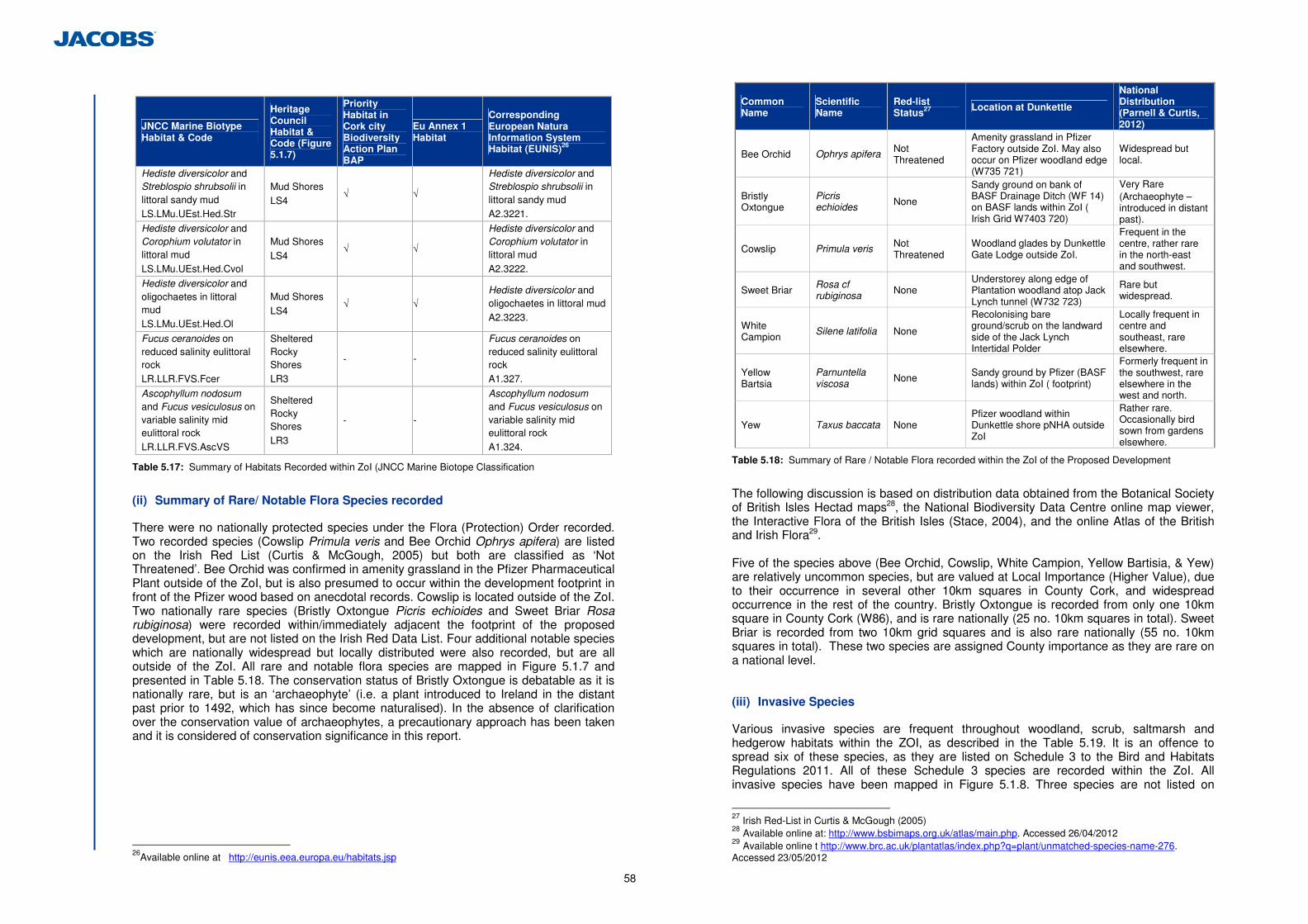
58
JNCC Marine Biotype Habitat & Code
Heritage Council Habitat & Code (Figure 5.1.7)
Priority Habitat in Cork city Biodiversity Action Plan BAP
Eu Annex 1 Habitat
Corresponding European Natura Information System Habitat (EUNIS)26
Hediste diversicolor and Streblospio shrubsolii in littoral sandy mud LS.LMu.UEst.Hed.Str
Mud Shores LS4
√ √
Hediste diversicolor and Streblospio shrubsolii in littoral sandy mud A2.3221.
Hediste diversicolor and Corophium volutator in littoral mud LS.LMu.UEst.Hed.Cvol
Mud Shores LS4
√ √
Hediste diversicolor and Corophium volutator in littoral mud A2.3222.
Hediste diversicolor and oligochaetes in littoral mud LS.LMu.UEst.Hed.Ol
Mud Shores LS4
√ √ Hediste diversicolor and oligochaetes in littoral mud A2.3223.
Fucus ceranoides on reduced salinity eulittoral rock LR.LLR.FVS.Fcer
Sheltered Rocky Shores LR3
- -
Fucus ceranoides on reduced salinity eulittoral rock A1.327.
Ascophyllum nodosum and Fucus vesiculosus on variable salinity mid eulittoral rock LR.LLR.FVS.AscVS
Sheltered Rocky Shores LR3
- -
Ascophyllum nodosum and Fucus vesiculosus on variable salinity mid eulittoral rock A1.324.
Table 5.17: Summary of Habitats Recorded within ZoI (JNCC Marine Biotope Classification
(ii) Summary of Rare/ Notable Flora Species recorded
There were no nationally protected species under the Flora (Protection) Order recorded. Two recorded species (Cowslip Primula veris and Bee Orchid Ophrys apifera) are listed on the Irish Red List (Curtis & McGough, 2005) but both are classified as ‘Not Threatened’. Bee Orchid was confirmed in amenity grassland in the Pfizer Pharmaceutical Plant outside of the ZoI, but is also presumed to occur within the development footprint in front of the Pfizer wood based on anecdotal records. Cowslip is located outside of the ZoI. Two nationally rare species (Bristly Oxtongue Picris echioides and Sweet Briar Rosa rubiginosa) were recorded within/immediately adjacent the footprint of the proposed development, but are not listed on the Irish Red Data List. Four additional notable species which are nationally widespread but locally distributed were also recorded, but are all outside of the ZoI. All rare and notable flora species are mapped in Figure 5.1.7 and presented in Table 5.18. The conservation status of Bristly Oxtongue is debatable as it is nationally rare, but is an ‘archaeophyte’ (i.e. a plant introduced to Ireland in the distant past prior to 1492, which has since become naturalised). In the absence of clarification over the conservation value of archaeophytes, a precautionary approach has been taken and it is considered of conservation significance in this report.
26Available online at http://eunis.eea.europa.eu/habitats.jsp
Common Name
Scientific Name
Red-list Status27 Location at Dunkettle
National Distribution (Parnell & Curtis, 2012)
Bee Orchid Ophrys apifera Not Threatened
Amenity grassland in Pfizer Factory outside ZoI. May also occur on Pfizer woodland edge (W735 721)
Widespread but local.
Bristly Oxtongue
Picris echioides None
Sandy ground on bank of BASF Drainage Ditch (WF 14) on BASF lands within ZoI ( Irish Grid W7403 720)
Very Rare (Archaeophyte – introduced in distant past).
Cowslip Primula veris Not Threatened
Woodland glades by Dunkettle Gate Lodge outside ZoI.
Frequent in the centre, rather rare in the north-east and southwest.
Sweet Briar Rosa cf rubiginosa None
Understorey along edge of Plantation woodland atop Jack Lynch tunnel (W732 723)
Rare but widespread.
White Campion
Silene latifolia None
Recolonising bare ground/scrub on the landward side of the Jack Lynch Intertidal Polder
Locally frequent in centre and southeast, rare elsewhere.
Yellow Bartsia
Parnuntella viscosa None Sandy ground by Pfizer (BASF
lands) within ZoI ( footprint)
Formerly frequent in the southwest, rare elsewhere in the west and north.
Yew Taxus baccata None Pfizer woodland within Dunkettle shore pNHA outside ZoI
Rather rare. Occasionally bird sown from gardens elsewhere.
Table 5.18: Summary of Rare / Notable Flora recorded within the ZoI of the Proposed Development
The following discussion is based on distribution data obtained from the Botanical Society of British Isles Hectad maps28, the National Biodiversity Data Centre online map viewer, the Interactive Flora of the British Isles (Stace, 2004), and the online Atlas of the British and Irish Flora29. Five of the species above (Bee Orchid, Cowslip, White Campion, Yellow Bartisia, & Yew) are relatively uncommon species, but are valued at Local Importance (Higher Value), due to their occurrence in several other 10km squares in County Cork, and widespread occurrence in the rest of the country. Bristly Oxtongue is recorded from only one 10km square in County Cork (W86), and is rare nationally (25 no. 10km squares in total). Sweet Briar is recorded from two 10km grid squares and is also rare nationally (55 no. 10km squares in total). These two species are assigned County importance as they are rare on a national level. (iii) Invasive Species
Various invasive species are frequent throughout woodland, scrub, saltmarsh and hedgerow habitats within the ZOI, as described in the Table 5.19. It is an offence to spread six of these species, as they are listed on Schedule 3 to the Bird and Habitats Regulations 2011. All of these Schedule 3 species are recorded within the ZoI. All invasive species have been mapped in Figure 5.1.8. Three species are not listed on
27 Irish Red-List in Curtis & McGough (2005) 28 Available online at: http://www.bsbimaps.org.uk/atlas/main.php. Accessed 26/04/2012 29 Available online t http://www.brc.ac.uk/plantatlas/index.php?q=plant/unmatched-species-name-276. Accessed 23/05/2012
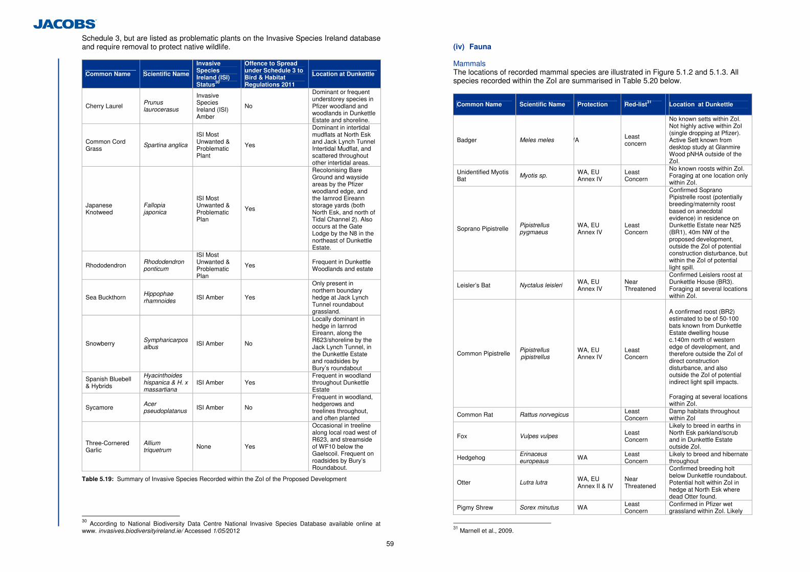
59
Schedule 3, but are listed as problematic plants on the Invasive Species Ireland database and require removal to protect native wildlife.
Common Name Scientific Name
Invasive Species Ireland (ISI) Status30
Offence to Spread under Schedule 3 to Bird & Habitat Regulations 2011
Location at Dunkettle
Cherry Laurel Prunus laurocerasus
Invasive Species Ireland (ISI) Amber
No
Dominant or frequent understorey species in Pfizer woodland and woodlands in Dunkettle Estate and shoreline.
Common Cord Grass Spartina anglica
ISI Most Unwanted & Problematic Plant
Yes
Dominant in intertidal mudflats at North Esk and Jack Lynch Tunnel Intertidal Mudflat, and scattered throughout other intertidal areas.
Japanese Knotweed
Fallopia japonica
ISI Most Unwanted & Problematic Plan
Yes
Recolonising Bare Ground and wayside areas by the Pfizer woodland edge, and the Iarnrod Eireann storage yards (both North Esk, and north of Tidal Channel 2). Also occurs at the Gate Lodge by the N8 in the northeast of Dunkettle Estate.
Rhododendron Rhododendron ponticum
ISI Most Unwanted & Problematic Plan
Yes Frequent in Dunkettle Woodlands and estate
Sea Buckthorn Hippophae rhamnoides ISI Amber Yes
Only present in northern boundary hedge at Jack Lynch Tunnel roundabout grassland.
Snowberry Sympharicarpos albus ISI Amber No
Locally dominant in hedge in Iarnrod Eireann, along the R623/shoreline by the Jack Lynch Tunnel, in the Dunkettle Estate and roadsides by Bury’s roundabout
Spanish Bluebell & Hybrids
Hyacinthoides hispanica & H. x massartiana
ISI Amber Yes Frequent in woodland throughout Dunkettle Estate
Sycamore Acer pseudoplatanus ISI Amber No
Frequent in woodland, hedgerows and treelines throughout, and often planted
Three-Cornered Garlic
Allium triquetrum None Yes
Occasional in treeline along local road west of R623, and streamside of WF10 below the Gaelscoil. Frequent on roadsides by Bury’s Roundabout.
Table 5.19: Summary of Invasive Species Recorded within the ZoI of the Proposed Development
30 According to National Biodiversity Data Centre National Invasive Species Database available online at www. invasives.biodiversityireland.ie/ Accessed 1/05/2012
(iv) Fauna
Mammals The locations of recorded mammal species are illustrated in Figure 5.1.2 and 5.1.3. All species recorded within the ZoI are summarised in Table 5.20 below.
Common Name Scientific Name Protection Red-list31 Location at Dunkettle
Badger Meles meles WA Least concern
No known setts within ZoI. Not highly active within ZoI (single dropping at Pfizer). Active Sett known from desktop study at Glanmire Wood pNHA outside of the ZoI.
Unidentified Myotis Bat
Myotis sp. WA, EU Annex IV
Least Concern
No known roosts within ZoI. Foraging at one location only within ZoI.
Soprano Pipistrelle Pipistrellus pygmaeus
WA, EU Annex IV
Least Concern
Confirmed Soprano Pipistrelle roost (potentially breeding/maternity roost based on anecdotal evidence) in residence on Dunkettle Estate near N25 (BR1), 40m NW of the proposed development, outside the ZoI of potential construction disturbance, but within the ZoI of potential light spill.
Leisler’s Bat Nyctalus leisleri WA, EU Annex IV
Near Threatened
Confirmed Leislers roost at Dunkettle House (BR3). Foraging at several locations within ZoI.
Common Pipistrelle Pipistrellus pipistrellus
WA, EU Annex IV
Least Concern
A confirmed roost (BR2) estimated to be of 50-100 bats known from Dunkettle Estate dwelling house c.140m north of western edge of development, and therefore outside the ZoI of direct construction disturbance, and also outside the ZoI of potential indirect light spill impacts. Foraging at several locations within ZoI.
Common Rat Rattus norvegicus Least Concern
Damp habitats throughout within ZoI
Fox Vulpes vulpes Least Concern
Likely to breed in earths in North Esk parkland/scrub and in Dunkettle Estate outside ZoI.
Hedgehog Erinaceus europeaus WA Least
Concern Likely to breed and hibernate throughout
Otter Lutra lutra WA, EU Annex II & IV
Near Threatened
Confirmed breeding holt below Dunkettle roundabout. Potential holt within ZoI in hedge at North Esk where dead Otter found.
Pigmy Shrew Sorex minutus WA Least Concern
Confirmed in Pfizer wet grassland within ZoI. Likely
31 Marnell et al., 2009.
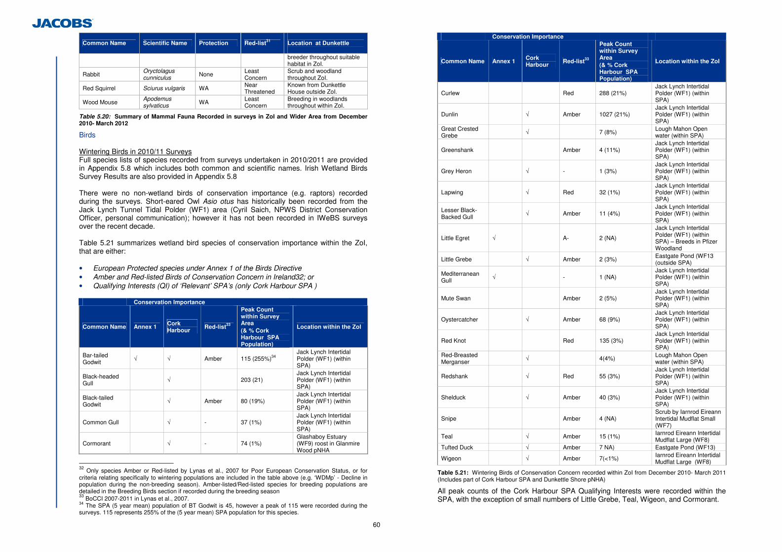
60
Common Name Scientific Name Protection Red-list31 Location at Dunkettle breeder throughout suitable habitat in ZoI.
Rabbit Oryctolagus cunniculus None Least
Concern Scrub and woodland throughout ZoI.
Red Squirrel Sciurus vulgaris WA Near Threatened
Known from Dunkettle House outside ZoI.
Wood Mouse Apodemus sylvaticus WA Least
Concern Breeding in woodlands throughout within ZoI.
Table 5.20: Summary of Mammal Fauna Recorded in surveys in ZoI and Wider Area from December 2010- March 2012
Birds Wintering Birds in 2010/11 Surveys Full species lists of species recorded from surveys undertaken in 2010/2011 are provided in Appendix 5.8 which includes both common and scientific names. Irish Wetland Birds Survey Results are also provided in Appendix 5.8 There were no non-wetland birds of conservation importance (e.g. raptors) recorded during the surveys. Short-eared Owl Asio otus has historically been recorded from the Jack Lynch Tunnel Tidal Polder (WF1) area (Cyril Saich, NPWS District Conservation Officer, personal communication); however it has not been recorded in IWeBS surveys over the recent decade. Table 5.21 summarizes wetland bird species of conservation importance within the ZoI, that are either: • European Protected species under Annex 1 of the Birds Directive • Amber and Red-listed Birds of Conservation Concern in Ireland32; or • Qualifying Interests (QI) of ‘Relevant’ SPA’s (only Cork Harbour SPA )
Conservation Importance
Common Name Annex 1 Cork Harbour
Red-list33
Peak Count within Survey Area (& % Cork Harbour SPA Population)
Location within the ZoI
Bar-tailed Godwit
√ √ Amber 115 (255%)34 Jack Lynch Intertidal Polder (WF1) (within SPA)
Black-headed Gull
√ 203 (21) Jack Lynch Intertidal Polder (WF1) (within SPA)
Black-tailed Godwit √ Amber 80 (19%)
Jack Lynch Intertidal Polder (WF1) (within SPA)
Common Gull √ - 37 (1%) Jack Lynch Intertidal Polder (WF1) (within SPA)
Cormorant √ - 74 (1%) Glashaboy Estuary (WF9) roost in Glanmire Wood pNHA
32 Only species Amber or Red-listed by Lynas et al., 2007 for Poor European Conservation Status, or for criteria relating specifically to wintering populations are included in the table above (e.g. ‘WDMp’ - Decline in population during the non-breeding season). Amber-listed/Red-listed species for breeding populations are detailed in the Breeding Birds section if recorded during the breeding season 33 BoCCI 2007-2011 in Lynas et al., 2007. 34 The SPA (5 year mean) population of BT Godwit is 45, however a peak of 115 were recorded during the surveys. 115 represents 255% of the (5 year mean) SPA population for this species.
Conservation Importance
Common Name Annex 1 Cork Harbour
Red-list33
Peak Count within Survey Area (& % Cork Harbour SPA Population)
Location within the ZoI
Curlew Red 288 (21%) Jack Lynch Intertidal Polder (WF1) (within SPA)
Dunlin √ Amber 1027 (21%) Jack Lynch Intertidal Polder (WF1) (within SPA)
Great Crested Grebe √ 7 (8%) Lough Mahon Open
water (within SPA)
Greenshank Amber 4 (11%) Jack Lynch Intertidal Polder (WF1) (within SPA)
Grey Heron √ - 1 (3%) Jack Lynch Intertidal Polder (WF1) (within SPA)
Lapwing √ Red 32 (1%) Jack Lynch Intertidal Polder (WF1) (within SPA)
Lesser Black-Backed Gull
√ Amber 11 (4%) Jack Lynch Intertidal Polder (WF1) (within SPA)
Little Egret √ A- 2 (NA)
Jack Lynch Intertidal Polder (WF1) (within SPA) – Breeds in Pfizer Woodland
Little Grebe √ Amber 2 (3%) Eastgate Pond (WF13 (outside SPA)
Mediterranean Gull √ - 1 (NA)
Jack Lynch Intertidal Polder (WF1) (within SPA)
Mute Swan Amber 2 (5%) Jack Lynch Intertidal Polder (WF1) (within SPA)
Oystercatcher √ Amber 68 (9%) Jack Lynch Intertidal Polder (WF1) (within SPA)
Red Knot Red 135 (3%) Jack Lynch Intertidal Polder (WF1) (within SPA)
Red-Breasted Merganser
√ 4(4%) Lough Mahon Open water (within SPA)
Redshank √ Red 55 (3%) Jack Lynch Intertidal Polder (WF1) (within SPA)
Shelduck √ Amber 40 (3%) Jack Lynch Intertidal Polder (WF1) (within SPA)
Snipe Amber 4 (NA) Scrub by Iarnrod Eireann Intertidal Mudflat Small (WF7)
Teal √ Amber 15 (1%) Iarnrod Eireann Intertidal Mudflat Large (WF8)
Tufted Duck √ Amber 7 NA) Eastgate Pond (WF13)
Wigeon √ Amber 7(<1%) Iarnrod Eireann Intertidal Mudflat Large (WF8)
Table 5.21: Wintering Birds of Conservation Concern recorded within ZoI from December 2010- March 2011 (Includes part of Cork Harbour SPA and Dunkettle Shore pNHA)
All peak counts of the Cork Harbour SPA Qualifying Interests were recorded within the SPA, with the exception of small numbers of Little Grebe, Teal, Wigeon, and Cormorant.
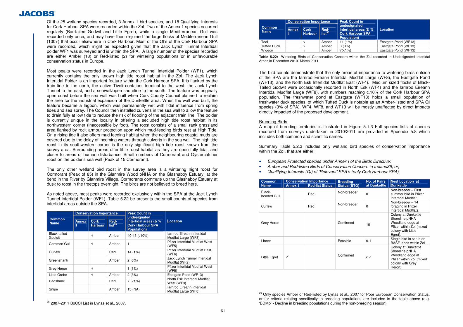
61
Of the 25 wetland species recorded, 3 Annex 1 bird species, and 18 Qualifying Interests for Cork Harbour SPA were recorded within the ZoI. Two of the Annex 1 species occurred regularly (Bar-tailed Godwit and Little Egret), while a single Mediterranean Gull was recorded only once, and may have then re-joined the large flocks of Mediterranean Gull (100+) that occur elsewhere in Cork Harbour. Most of the QI’s of the Cork Harbour SPA were recorded, which might be expected given that the Jack Lynch Tunnel Intertidal polder WF1 was surveyed and is within the SPA. A large number of the species recorded are either Amber (13) or Red-listed (2) for wintering populations or in unfavourable conservation status in Europe. Most peaks were recorded in the Jack Lynch Tunnel Intertidal Polder (WF1), which currently contains the only known high tide roost habitat in the ZoI. The Jack Lynch Intertidal Polder is an important feature within the Cork Harbour SPA. It is flanked by the train line to the north, the active Tivoli container terminal to the west, the Jack Lynch Tunnel to the east, and a seawall/open shoreline to the south. The feature was originally open coast before the sea wall was built when Cork County Council planned to reclaim the area for the industrial expansion of the Dunkettle area. When the wall was built, the feature became a lagoon, which was permanently wet with tidal influence from spring tides and sea spray. The Council then installed culverts in the sea wall to allow the feature to drain fully at low tide to reduce the risk of flooding of the adjacent train line. The polder is currently unique in the locality in offering a secluded high tide roost habitat in its northwestern corner (inaccessible by foot). The roost consists of a small rank grassland area flanked by rock armour protection upon which mud-feeding birds rest at High Tide. On a rising tide it also offers mud feeding habitat when the neighbouring coastal muds are covered due to the delay of incoming waters through culverts in the sea wall. The high tide roost in its southwestern corner is the only significant high tide roost known from the survey area. Surrounding areas offer little roost habitat as they are open fully tidal, and closer to areas of human disturbance. Small numbers of Cormorant and Oystercatcher roost on the polder’s sea wall (Peak of 15 Cormorant). The only other wetland bird roost in the survey area is a wintering night roost for Cormorant (Peak of 85) in the Glanmire Wood pNHA on the Glashaboy Estuary, at the bend in the River by Glanmire Village. Cormorants commute up the Glashaboy Estuary at dusk to roost in the treetops overnight. The birds are not believed to breed here. As noted above, most peaks were recorded exclusively within the SPA at the Jack Lynch Tunnel Intertidal Polder (WF1). Table 5.22 be presents the small counts of species from intertidal areas outside the SPA.
Conservation Importance
Common Name Annex
1 Cork Harbour
Red-list35
Peak Count in undesignated intertidal areas (& % Cork Harbour SPA Population)
Location
Black-tailed Godwit √ Amber 40-45 (c10%) Iarnrod Eireann Intertidal
Mudflat Large (WF8)
Common Gull √ Amber 1 Pfizer Intertidal Mudflat West (WF5)
Curlew Red 14 (1%) Pfizer Intertidal Mudflat East (WF6)
Greenshank Amber 2 (6%) Jack Lynch Tunnel Intertidal Mudflat (WF2)
Grey Heron √ 1 (3%) Pfizer Intertidal Mudflat West (WF5)
Little Grebe √ Amber 2 (3%) Eastgate Pond (WF13)
Redshank Red 7 (<1%) North Esk Intertidal Mudflat West (WF3)
Snipe Amber 13 (NA) Iarnrod Eireann Intertidal Mudflat Large (WF8)
35 2007-2011 BoCCI List in Lynas et al., 2007.
Conservation Importance
Common Name Annex
1 Cork Harbour
Red-list35
Peak Count in undesignated intertidal areas (& % Cork Harbour SPA Population)
Location
Teal √ Amber 11 (1%) Eastgate Pond (WF13) Tufted Duck √ Amber 3 (3%) Eastgate Pond (WF13) Wigeon √ Amber 7(<1%) Eastgate Pond (WF13)
Table 5.22: Wintering Birds of Conservation Concern within the ZoI recorded in Undesignated Intertidal Areas in December 2010- March 2011.
The bird counts demonstrate that the only areas of importance to wintering birds outside of the SPA are the Iarnród Éireann Intertidal Mudflat Large (WF8), the Eastgate Pond (WF13), and the North Esk Intertidal Mudflat East (WF4). Medium sized flocks of Black-Tailed Godwit were occasionally recorded in North Esk (WF4) and the Iarnrod Eireann Intertidal Mudflat Large (WF8), with numbers reaching c.10% of the Cork Harbour SPA population. The freshwater pond at Eastgate (WF13) holds a small population of freshwater duck species, of which Tufted Duck is notable as an Amber-listed and SPA QI species (3% of SPA). WF4, WF8, and WF13 will be mostly unaffected by direct impacts directly impacted of the proposed development. Breeding Birds A map of breeding territories is illustrated in Figure 5.1.3 Full species lists of species recorded from surveys undertaken in 2010/2011 are provided in Appendix 5.8 which includes both common and scientific names. Summary Table 5.2.3 includes only wetland bird species of conservation importance within the ZoI, that are either: • European Protected species under Annex I of the Birds Directive; • Amber and Red-listed Birds of Conservation Concern in Ireland36; or; • Qualifying Interests (QI) of ‘Relevant’ SPA’s (only Cork Harbour SPA).
Conservation Importance Common
Name Annex 1 Red-list Status Breeding Status (BTO)
No. of Pairs at Dunkettle
Nest Location at Dunkettle
Black-headed Gull Red Non-breeder
0
Non-breeder – First summer bird in Pfizer Intertidal Mudflat.
Curlew Red Non-breeder 0
Non-breeder – 14 foraging in Pfizer Intertidal Mudflats.
Grey Heron
Confirmed
10
Colony at Dunkettle Shoreline pNHA Woodland edge at Pfizer within ZoI (mixed colony with Little Egret).
Linnet Possible 0-1 Single bird in scrub on BASF lands within ZoI.
Little Egret � Confirmed
c.7
Colony at Dunkettle Shoreline pNHA Woodland edge at Pfizer within ZoI (mixed colony with Grey Heron).
36 Only species Amber or Red-listed by Lynas et al., 2007 for Poor European Conservation Status, or for criteria relating specifically to breeding populations are included in the table above (e.g. ‘BDMp’ - Decline in breeding populations during the non-breeding season).
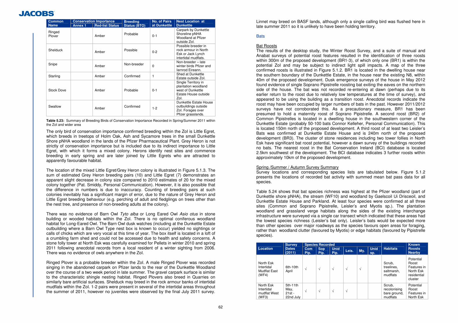
62
Conservation Importance Common Name Annex 1 Red-list Status
Breeding Status (BTO)
No. of Pairs at Dunkettle
Nest Location at Dunkettle
Ringed Plover
Amber Probable
0-1
Carpark by Dunkettle Shoreline pNHA Woodland at Pfizer outside ZoI.
Shelduck
Amber Possible
0-2
Possible breeder in rock armour in North Esk or Jack Lynch intertidal mudflats.
Snipe
Amber Non-breeder
0 Non-breeder – late winter birds Pfizer and Iarnrod Eireann.
Starling Amber Confirmed 1 Shed at Dunkettle Estate outside ZoI.
Stock Dove Amber Probable 0-1
Single Territory in plantation woodland west of Dunkettle Estate House outside ZoI.
Swallow
Amber Confirmed
1-2
Dunkettle Estate House outbuildings outside ZoI. Forages over Pfizer grasslands.
Table 5.23: Summary of Breeding Birds of Conservation Importance Recorded in Spring/Summer 2011 within the ZoI and wider area
The only bird of conservation importance confirmed breeding within the ZoI is Little Egret, which breeds in treetops of Holm Oak, Ash and Sycamore trees in the small Dunkettle Shore pNHA woodland in the lands of the Pfizer Pharmaceutical Plant. Grey Heron is not strictly of conservation importance but is included due to its indirect importance to Little Egret, with which it forms a mixed colony. Herons identify nest sites and commence breeding in early spring and are later joined by Little Egrets who are attracted to apparently favourable habitat. The location of the mixed Little Egret/Grey Heron colony is illustrated in Figure 5.1.3. The sum of estimated Grey Heron breeding pairs (10) and Little Egret (7) demonstrates an apparent slight decrease in colony size compared to 2010 estimates of 20 for the mixed colony together (Pat. Smiddy, Personal Communication). However, it is also possible that the difference in numbers is due to inaccuracy. Counting of breeding pairs at such colonies inevitably has a significant margin of error, due to the nature of Grey Heron and Little Egret breeding behaviour (e.g. perching of adult and fledglings on trees other than the nest tree, and presence of non-breeding adults at the colony). There was no evidence of Barn Owl Tyto alba or Long Eared Owl Asio otus in stone building or wooded habitats within the ZoI. There is no optimal coniferous woodland habitat for Long-Eared Owl. The Barn Owl dusk watches (including at the Dunkettle Estate outbuilding where a Barn Owl Type nest box is known to occur) yielded no sightings or calls of chicks which are very vocal at this time of year. The box itself is located in a loft of a crumbling farm shed and could not be accessed due to health and safety concerns. A stone folly tower at North Esk was carefully examined for Pellets in winter 2010 and spring 2011 following anecdotal records from a local resident of a winter sighting from 2006. There was no evidence of owls anywhere in the ZoI. Ringed Plover is a probable breeder within the ZoI. A male Ringed Plover was recorded singing in the abandoned carpark on Pfizer lands to the rear of the Dunkettle Woodland over the course of a two week period in late summer. The gravel carpark surface is similar to the characteristic shingle nesting habitat. Ringed Plovers also breed in Quarries on similarly bare artificial surfaces. Shelduck may breed in the rock armour banks of intertidal mudflats within the ZoI. 1-2 pairs were present in several of the intertidal areas throughout the summer of 2011, however no juveniles were observed by the final July 2011 survey.
Linnet may breed on BASF lands, although only a single calling bird was flushed here in late summer 2011 so it is unlikely to have been holding territory. Bats Bat Roosts The results of the desktop study, the Winter Roost Survey, and a suite of manual and Anabat surveys of potential roost features resulted in the identification of three roosts within 300m of the proposed development (BR1-3), of which only one (BR1) is within the potential ZoI and may be subject to indirect light spill impacts. A map of the three confirmed roosts is illustrated in Figure 5.1.2. BR1 is located in the dwelling house near the southern boundary of the Dunkettle Estate, in the house near the existing N8, within 40m of the proposed development. Dusk emergence surveys of the house in May 2012 found evidence of single Soprano Pipistrelle roosting bat exiting the eaves on the northern side of the house. The bat was not recorded re-entering at dawn (perhaps due to its earlier return to the roost due to relatively low temperatures at the time of survey), and appeared to be using the building as a transition roost. Anecdotal records indicate the roost may have been occupied by larger numbers of bats in the past. However 2011/2012 surveys have not corroborated this. As a precautionary measure, BR1 has been presumed to hold a maternity roost of Soprano Pipistrelle. A second roost (BR2) of Common Pipistrelles is located in a dwelling house in the southwestern corner of the Dunkettle Estate (probably 50-100 bats Connor Kelleher, Personal Communication). This is located 150m north of the proposed development. A third roost of at least two Leisler’s Bats was confirmed at Dunkettle Estate House and is 240m north of the proposed development (BR3). The cluster of stone residences including two tower follies in North Esk have significant bat roost potential, however a dawn survey of the buildings recorded no bats. The nearest roost in the Bat Conservation Ireland (BCI) database is located 2.5km southwest of the development. The BCI database indicates 3 further roosts within approximately 10km of the proposed development. Spring /Summer / Autumn Survey Summary Survey locations and corresponding species lists are tabulated below. Figure 5.1.2 presents the locations of recorded bat activity with summed mean bat pass data for all species. Table 5.24 shows that bat species richness was highest at the Pfizer woodland (part of Dunkettle shore pNHA), the stream (WF10) and woodland by Gaelscoil Ui Drisceoil, and Dunkettle Estate House and Parkland. At least four species were confirmed at all three sites (Common and Soprano Pipistrelle, Leisler’s and Myotis sp.). The plantation woodland and grassland verge habitats along the sides of the existing interchange infrastructure were surveyed via a single car transect which indicated that these areas had the lowest species richness (Leisler’s bat only). Leisler’s bats would be expected more than other species over major roadways as the species favours open areas for foraging, rather than woodland clutter (favoured by Myotis) or edge habitats (favoured by Pipistrelle species).
Species Recorded Location
Survey Dates (2011)
Com Pip.
Sop Pip.
UnidPip. Leis. My. Unid
sp. Habitats
Known Roosts Nearby
North Esk Intertidal Mudflat East (WF4)
6th-10th April √ √ √ √ √
Scrub, treelines, saltmarsh, mudflats
Potential Roost Features in North Esk residential cluster
North Esk Intertidal mudflat West (WF3)
5th-11th May, 21st -22nd July
√ √ √ √
Scrub, recolonising bare ground, mudflats
Potential Roost Features in North Esk
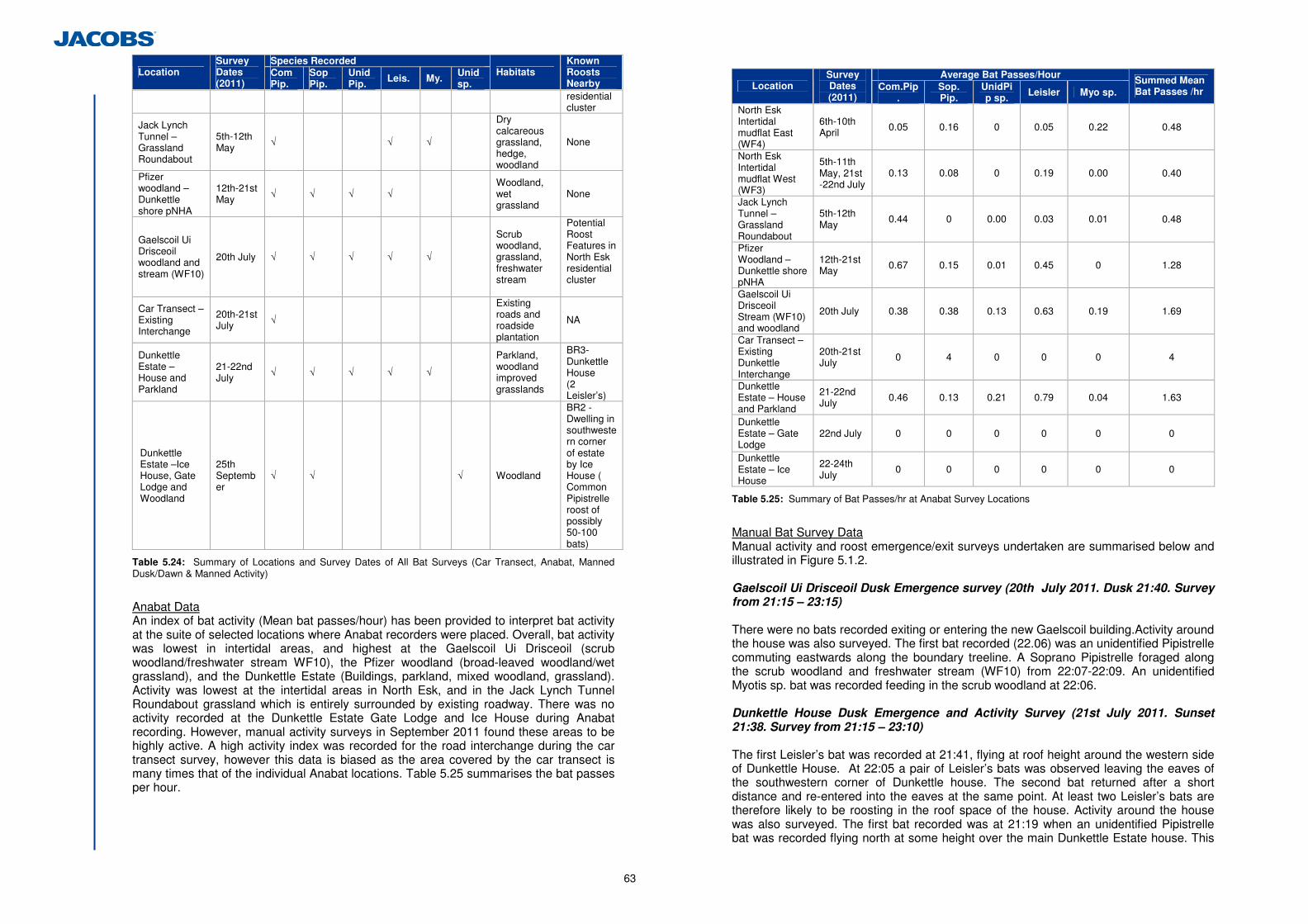
63
Species Recorded Location
Survey Dates (2011)
Com Pip.
Sop Pip.
UnidPip. Leis. My. Unid
sp. Habitats
Known Roosts Nearby residential cluster
Jack Lynch Tunnel – Grassland Roundabout
5th-12th May
√ √ √
Dry calcareous grassland, hedge, woodland
None
Pfizer woodland – Dunkettle shore pNHA
12th-21st May √ √ √ √
Woodland, wet grassland
None
Gaelscoil Ui Drisceoil woodland and stream (WF10)
20th July √ √ √ √ √
Scrub woodland, grassland, freshwater stream
Potential Roost Features in North Esk residential cluster
Car Transect – Existing Interchange
20th-21st July √
Existing roads and roadside plantation
NA
Dunkettle Estate – House and Parkland
21-22nd July √ √ √ √ √
Parkland, woodland improved grasslands
BR3-Dunkettle House (2 Leisler’s)
Dunkettle Estate –Ice House, Gate Lodge and Woodland
25th September
√ √ √ Woodland
BR2 -Dwelling in southwestern corner of estate by Ice House ( Common Pipistrelle roost of possibly 50-100 bats)
Table 5.24: Summary of Locations and Survey Dates of All Bat Surveys (Car Transect, Anabat, Manned Dusk/Dawn & Manned Activity)
Anabat Data An index of bat activity (Mean bat passes/hour) has been provided to interpret bat activity at the suite of selected locations where Anabat recorders were placed. Overall, bat activity was lowest in intertidal areas, and highest at the Gaelscoil Ui Drisceoil (scrub woodland/freshwater stream WF10), the Pfizer woodland (broad-leaved woodland/wet grassland), and the Dunkettle Estate (Buildings, parkland, mixed woodland, grassland). Activity was lowest at the intertidal areas in North Esk, and in the Jack Lynch Tunnel Roundabout grassland which is entirely surrounded by existing roadway. There was no activity recorded at the Dunkettle Estate Gate Lodge and Ice House during Anabat recording. However, manual activity surveys in September 2011 found these areas to be highly active. A high activity index was recorded for the road interchange during the car transect survey, however this data is biased as the area covered by the car transect is many times that of the individual Anabat locations. Table 5.25 summarises the bat passes per hour.
Average Bat Passes/Hour
Location Survey Dates (2011)
Com.Pip.
Sop. Pip.
UnidPip sp. Leisler Myo sp.
Summed Mean Bat Passes /hr
North Esk Intertidal mudflat East (WF4)
6th-10th April 0.05 0.16 0 0.05 0.22
0.48
North Esk Intertidal mudflat West (WF3)
5th-11th May, 21st -22nd July
0.13 0.08 0 0.19 0.00
0.40
Jack Lynch Tunnel – Grassland Roundabout
5th-12th May
0.44 0 0.00 0.03 0.01
0.48
Pfizer Woodland – Dunkettle shore pNHA
12th-21st May
0.67 0.15 0.01 0.45 0
1.28
Gaelscoil Ui Drisceoil Stream (WF10) and woodland
20th July 0.38 0.38 0.13 0.63 0.19
1.69
Car Transect – Existing Dunkettle Interchange
20th-21st July 0 4 0 0 0 4
Dunkettle Estate – House and Parkland
21-22nd July 0.46 0.13 0.21 0.79 0.04
1.63
Dunkettle Estate – Gate Lodge
22nd July 0 0 0 0 0 0
Dunkettle Estate – Ice House
22-24th July
0 0 0 0 0 0
Table 5.25: Summary of Bat Passes/hr at Anabat Survey Locations
Manual Bat Survey Data Manual activity and roost emergence/exit surveys undertaken are summarised below and illustrated in Figure 5.1.2.
Gaelscoil Ui Drisceoil Dusk Emergence survey (20th July 2011. Dusk 21:40. Survey from 21:15 – 23:15) There were no bats recorded exiting or entering the new Gaelscoil building.Activity around the house was also surveyed. The first bat recorded (22.06) was an unidentified Pipistrelle commuting eastwards along the boundary treeline. A Soprano Pipistrelle foraged along the scrub woodland and freshwater stream (WF10) from 22:07-22:09. An unidentified Myotis sp. bat was recorded feeding in the scrub woodland at 22:06.
Dunkettle House Dusk Emergence and Activity Survey (21st July 2011. Sunset 21:38. Survey from 21:15 – 23:10) The first Leisler’s bat was recorded at 21:41, flying at roof height around the western side of Dunkettle House. At 22:05 a pair of Leisler’s bats was observed leaving the eaves of the southwestern corner of Dunkettle house. The second bat returned after a short distance and re-entered into the eaves at the same point. At least two Leisler’s bats are therefore likely to be roosting in the roof space of the house. Activity around the house was also surveyed. The first bat recorded was at 21:19 when an unidentified Pipistrelle bat was recorded flying north at some height over the main Dunkettle Estate house. This
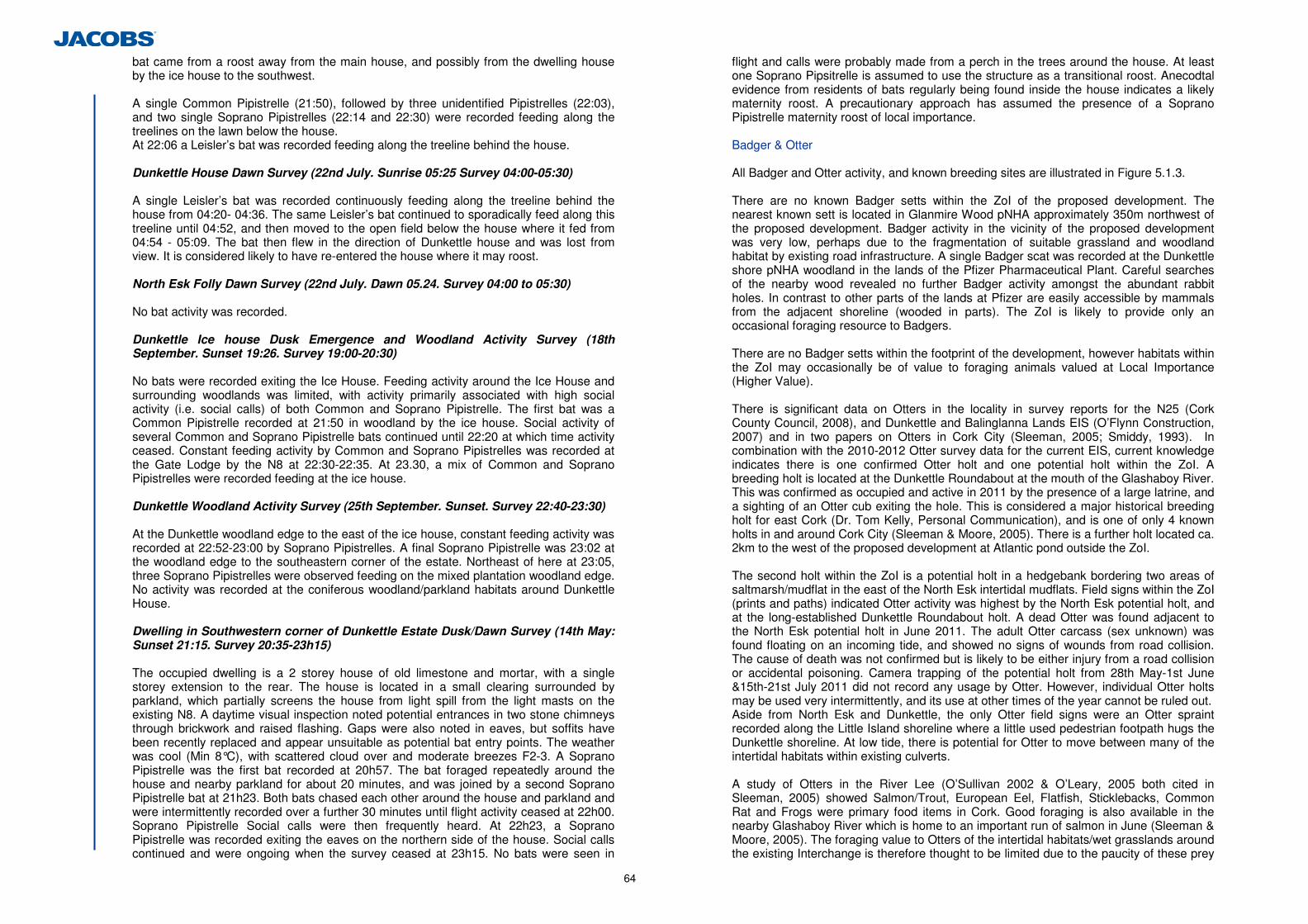
64
bat came from a roost away from the main house, and possibly from the dwelling house by the ice house to the southwest.
A single Common Pipistrelle (21:50), followed by three unidentified Pipistrelles (22:03), and two single Soprano Pipistrelles (22:14 and 22:30) were recorded feeding along the treelines on the lawn below the house. At 22:06 a Leisler’s bat was recorded feeding along the treeline behind the house. Dunkettle House Dawn Survey (22nd July. Sunrise 05:25 Survey 04:00-05:30) A single Leisler’s bat was recorded continuously feeding along the treeline behind the house from 04:20- 04:36. The same Leisler’s bat continued to sporadically feed along this treeline until 04:52, and then moved to the open field below the house where it fed from 04:54 - 05:09. The bat then flew in the direction of Dunkettle house and was lost from view. It is considered likely to have re-entered the house where it may roost. North Esk Folly Dawn Survey (22nd July. Dawn 05.24. Survey 04:00 to 05:30) No bat activity was recorded. Dunkettle Ice house Dusk Emergence and Woodland Activity Survey (18th September. Sunset 19:26. Survey 19:00-20:30) No bats were recorded exiting the Ice House. Feeding activity around the Ice House and surrounding woodlands was limited, with activity primarily associated with high social activity (i.e. social calls) of both Common and Soprano Pipistrelle. The first bat was a Common Pipistrelle recorded at 21:50 in woodland by the ice house. Social activity of several Common and Soprano Pipistrelle bats continued until 22:20 at which time activity ceased. Constant feeding activity by Common and Soprano Pipistrelles was recorded at the Gate Lodge by the N8 at 22:30-22:35. At 23.30, a mix of Common and Soprano Pipistrelles were recorded feeding at the ice house. Dunkettle Woodland Activity Survey (25th September. Sunset. Survey 22:40-23:30) At the Dunkettle woodland edge to the east of the ice house, constant feeding activity was recorded at 22:52-23:00 by Soprano Pipistrelles. A final Soprano Pipistrelle was 23:02 at the woodland edge to the southeastern corner of the estate. Northeast of here at 23:05, three Soprano Pipistrelles were observed feeding on the mixed plantation woodland edge. No activity was recorded at the coniferous woodland/parkland habitats around Dunkettle House. Dwelling in Southwestern corner of Dunkettle Estate Dusk/Dawn Survey (14th May: Sunset 21:15. Survey 20:35-23h15) The occupied dwelling is a 2 storey house of old limestone and mortar, with a single storey extension to the rear. The house is located in a small clearing surrounded by parkland, which partially screens the house from light spill from the light masts on the existing N8. A daytime visual inspection noted potential entrances in two stone chimneys through brickwork and raised flashing. Gaps were also noted in eaves, but soffits have been recently replaced and appear unsuitable as potential bat entry points. The weather was cool (Min 8°C), with scattered cloud over and moderate breezes F2-3. A Soprano Pipistrelle was the first bat recorded at 20h57. The bat foraged repeatedly around the house and nearby parkland for about 20 minutes, and was joined by a second Soprano Pipistrelle bat at 21h23. Both bats chased each other around the house and parkland and were intermittently recorded over a further 30 minutes until flight activity ceased at 22h00. Soprano Pipistrelle Social calls were then frequently heard. At 22h23, a Soprano Pipistrelle was recorded exiting the eaves on the northern side of the house. Social calls continued and were ongoing when the survey ceased at 23h15. No bats were seen in
flight and calls were probably made from a perch in the trees around the house. At least one Soprano Pipsitrelle is assumed to use the structure as a transitional roost. Anecodtal evidence from residents of bats regularly being found inside the house indicates a likely maternity roost. A precautionary approach has assumed the presence of a Soprano Pipistrelle maternity roost of local importance. Badger & Otter All Badger and Otter activity, and known breeding sites are illustrated in Figure 5.1.3. There are no known Badger setts within the ZoI of the proposed development. The nearest known sett is located in Glanmire Wood pNHA approximately 350m northwest of the proposed development. Badger activity in the vicinity of the proposed development was very low, perhaps due to the fragmentation of suitable grassland and woodland habitat by existing road infrastructure. A single Badger scat was recorded at the Dunkettle shore pNHA woodland in the lands of the Pfizer Pharmaceutical Plant. Careful searches of the nearby wood revealed no further Badger activity amongst the abundant rabbit holes. In contrast to other parts of the lands at Pfizer are easily accessible by mammals from the adjacent shoreline (wooded in parts). The ZoI is likely to provide only an occasional foraging resource to Badgers.
There are no Badger setts within the footprint of the development, however habitats within the ZoI may occasionally be of value to foraging animals valued at Local Importance (Higher Value). There is significant data on Otters in the locality in survey reports for the N25 (Cork County Council, 2008), and Dunkettle and Balinglanna Lands EIS (O’Flynn Construction, 2007) and in two papers on Otters in Cork City (Sleeman, 2005; Smiddy, 1993). In combination with the 2010-2012 Otter survey data for the current EIS, current knowledge indicates there is one confirmed Otter holt and one potential holt within the ZoI. A breeding holt is located at the Dunkettle Roundabout at the mouth of the Glashaboy River. This was confirmed as occupied and active in 2011 by the presence of a large latrine, and a sighting of an Otter cub exiting the hole. This is considered a major historical breeding holt for east Cork (Dr. Tom Kelly, Personal Communication), and is one of only 4 known holts in and around Cork City (Sleeman & Moore, 2005). There is a further holt located ca. 2km to the west of the proposed development at Atlantic pond outside the ZoI. The second holt within the ZoI is a potential holt in a hedgebank bordering two areas of saltmarsh/mudflat in the east of the North Esk intertidal mudflats. Field signs within the ZoI (prints and paths) indicated Otter activity was highest by the North Esk potential holt, and at the long-established Dunkettle Roundabout holt. A dead Otter was found adjacent to the North Esk potential holt in June 2011. The adult Otter carcass (sex unknown) was found floating on an incoming tide, and showed no signs of wounds from road collision. The cause of death was not confirmed but is likely to be either injury from a road collision or accidental poisoning. Camera trapping of the potential holt from 28th May-1st June &15th-21st July 2011 did not record any usage by Otter. However, individual Otter holts may be used very intermittently, and its use at other times of the year cannot be ruled out. Aside from North Esk and Dunkettle, the only Otter field signs were an Otter spraint recorded along the Little Island shoreline where a little used pedestrian footpath hugs the Dunkettle shoreline. At low tide, there is potential for Otter to move between many of the intertidal habitats within existing culverts. A study of Otters in the River Lee (O’Sullivan 2002 & O’Leary, 2005 both cited in Sleeman, 2005) showed Salmon/Trout, European Eel, Flatfish, Sticklebacks, Common Rat and Frogs were primary food items in Cork. Good foraging is also available in the nearby Glashaboy River which is home to an important run of salmon in June (Sleeman & Moore, 2005). The foraging value to Otters of the intertidal habitats/wet grasslands around the existing Interchange is therefore thought to be limited due to the paucity of these prey
65
items in intertidal areas compared to their abundance in the nearby Glashaboy and Lee Rivers. Although the Otter is widespread in Ireland and Cork, the species is currently Near Threatened in Ireland and on a global basis (Marnell et al., 2009). The national population is estimated at 6,416 female individuals (NPWS conservation Status Assessment for Otter). Taking a conservative approach it is assumed that 2 females may occur within the ZoI and that the Otter population within the ZoI is of County Importance. Protected Mammals - Pigmy Shrew, Hedgehog & Stoat There were neither field signs nor desktop records of stoat within the ZoI. There is no optimal rocky scrub habitat for Stoat (Hayden & Harrington, 2001). A single Pigmy Shrew was recorded in the wet grassland at Pfizer during July 2011 habitat surveys as target noted in Figure 5.1.3. However, this species is presumed to occur throughout the proposed development in suitable habitat. The species nests in long grasses in dense vegetation (including damp conditions) or under rocks or logs, occurring wherever adequate insect food supplies exist (i.e. it is absent from heavily sprayed areas). Breeding is from April to October (Hayden and Harrington, 2001). Suitable grassland and dense wooded cover is abundant within the ZoI. Given the minimum territory size of 200m2
(Hayden & Harrington) and the grassland/hedgerow/plantation areas available, it is considered likely there may be numerous territories within the ZoI. There are no known national or county population estimates for the species in Ireland as it is common and widespread and not currently of conservation concern (Marnell et al, 2009). There were no Hedgehogs or Hedgehog field signs observed during field surveys, however they are nocturnal, and field signs are less frequently observed than for other mammals. They are presumed to occur within grassland, woodland, hedges, and gardens within the ZoI. Breeding is from May to October (Hayden and Harrington, 2001). It is considered likely there may be numerous territories within the study area. There are no known national or county population estimates for the species in Ireland where they are common and widespread in Ireland and not currently of conservation concern (Marnell et al, 2009). The Pigmy Shrew and Hedgehog populations within the ZoI are valued at Local Importance (Higher Value).
Protected Amphibians & Reptiles There is limited freshwater habitat for amphibians within the ZoI, and no non-linear features (i.e. ponds) particularly favoured by newts. The Eastgate Pond (WF13) will not be impacted by the proposed development. There are two habitats containing some freshwater within the ZoI, but these are unsuitable as Common Frog or Smooth Newt breeding habitats. The drainage ditch at BASF (WF15) appears to receive freshwater inputs from nearby industrial sources but is also brackish due to inputs from the nearby Pfizer Intertidal Mudflat East (WF6). The freshwater stream below the Gaelscoil Ui Drisceoil (WF10), is fast-flowing and lacking in-stream vegetation. No amphibians were recorded during multidisciplinary habitat surveys and precautionary checks of these features. There were no Common Lizards recorded basking in rocky, scrubby or grassy areas. Common Frog occurs on the grounds of Dunsland House in wet grassland and streamside habitats, but this located c. 250m north of the proposed development and outside of the ZoI. Fish Jack Lynch Tunnel Intertidal Polder (WF1) The substrate in this feature was mostly mud. Along the margins, there is rock cover with fucoids attached. The bed of this lagoon is significantly higher than the adjacent Lough
Mahon. When the tide drops below the level of the culverts, the lagoon is still drained by diffuse percolation through the rocks that form the polder. Deeper parts of this lagoon are likely to hold water at all times. It was considered that Thick-lipped Grey Mullet may enter this lagoon but probably vacate the area during low tide. Flounder and other regularly occurring fish in Lough Mahon including plaice are considered to use this lagoon as a nursery area. This lagoon is not considered an important nursery or foraging area for intertidal fish given its detached nature from Lough Mahon however. The rocky shore area is deemed unsuitable for intertidal fish during low tide given that it dries out at these times. Fish were not recorded in this area during sweep searches or by searching underneath rocks. If this area was an important area for fish, it is likely that at least small numbers of fish would have been recorded. Jack Lynch Tunnel Intertidal Mudflat (WF2) The substrate in this area is mostly of gravel. At this site, there is a channel that carries water from upstream areas to Lough Mahon. During low tide the mean depth of water in the channel is approximately 40cm and the maximum depth of the channel is estimated as ca. 1m. This mudflat was considered likely to be used by small numbers of fish such as mullet, gobies and sticklebacks moving from Lough Mahon to intertidal areas to the north and vice versa. No fish were recorded in this area during the field survey and this area is not considered an important nursery area. North Esk Intertidal Mudflat West (WF3) The western Esk mudflat is a small area of ca. 0.1ha. This mudflat is bordered by steep sides comprising boulders and rocks with fucoid cover. The area of the western mudflat varies little from low to high tide, being confined by the steep sides. The importance of this area to fish is that is provides a link from Lough Mahon to the mudflats to the east. This small area is not considered an important nursery site for fish given its small size and large tidal fluctuations. WF10 meets the sea within this mudflat and the tidal reach of this channel could be used by small numbers of juvenile mullet, particularly at high tide. This area is generally of little importance to foraging and juvenile fish taking into account its small size. North Esk Intertidal Mudflat East (WF4) This is an area of intertidal mud with some vegetation at the upper shore level. The eastern mudflat has a shallow channel that carried water from upstream areas at low tide. At low tide, this channel has a wetted width of ca. 3m and a mean depth of ca. 30cm. The substrate of the channel is almost entirely of mud, with a small proportion of rock and some woody debris. Rocks along parts of the channel have a cover of fucoids. This mudflat is deemed a suitable habitat for juvenile Flounder and Thick-lipped Grey Mullet. The value of this area for fish is limited however given that it is mostly above water level at low tide. Three adult Thick-lipped Grey Mullet were seen at this site with the rising tide. These fish were considered opportunistic as this species usually occur in much larger shoals. This area is deemed to be occasionally used by feeding adult mullet. No other fish were recorded at this site. Thick-lipped Grey Mullet has been assessed as ‘Least Concern’ by the IUCN because it is a widespread species with no known major widespread threats. It occupies pelagic habitats near shores, forming schools, frequently entering lagoons and estuaries. This species spawns at sea in coastal surface water in February-April. Juveniles easily adapt to freshwater and at a length of around 20 mm move to coastal lagoons and estuaries in April-June. Juveniles feed on zooplankton; adults feed on algae, vegetal detritus and sediment (Freyhof and Kottelat, 2008). Thick-lipped Mullet are extremely hardy and
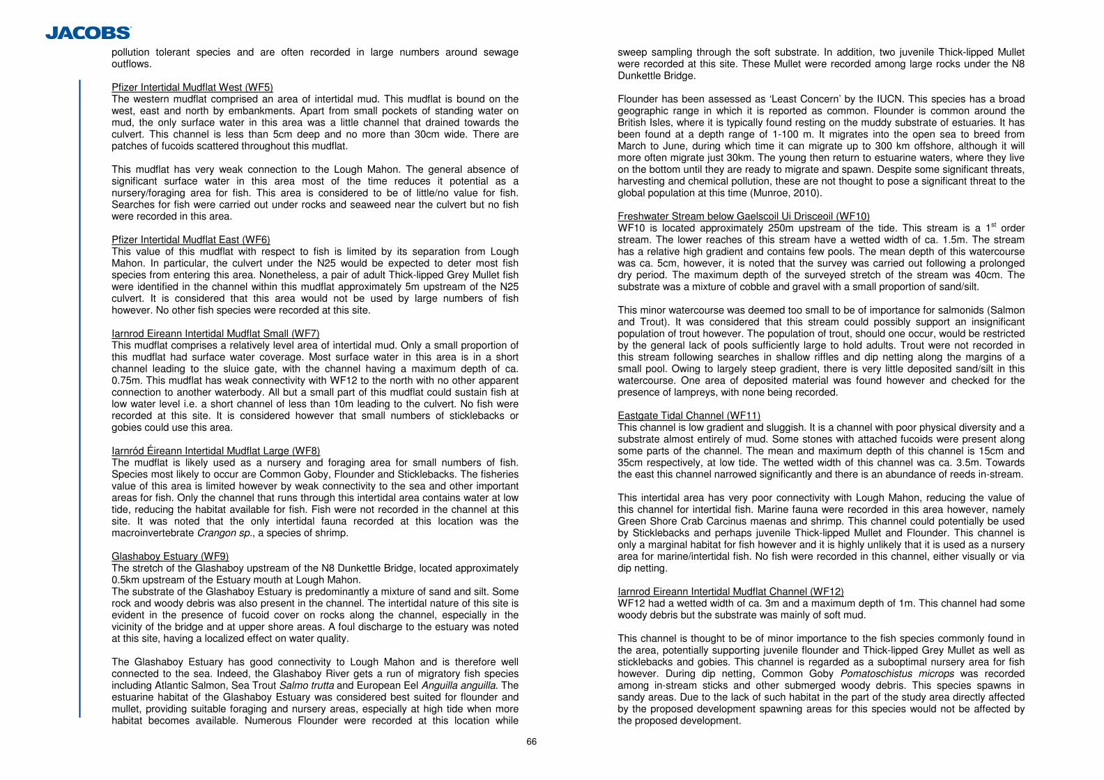
66
pollution tolerant species and are often recorded in large numbers around sewage outflows.
Pfizer Intertidal Mudflat West (WF5) The western mudflat comprised an area of intertidal mud. This mudflat is bound on the west, east and north by embankments. Apart from small pockets of standing water on mud, the only surface water in this area was a little channel that drained towards the culvert. This channel is less than 5cm deep and no more than 30cm wide. There are patches of fucoids scattered throughout this mudflat. This mudflat has very weak connection to the Lough Mahon. The general absence of significant surface water in this area most of the time reduces it potential as a nursery/foraging area for fish. This area is considered to be of little/no value for fish. Searches for fish were carried out under rocks and seaweed near the culvert but no fish were recorded in this area. Pfizer Intertidal Mudflat East (WF6) This value of this mudflat with respect to fish is limited by its separation from Lough Mahon. In particular, the culvert under the N25 would be expected to deter most fish species from entering this area. Nonetheless, a pair of adult Thick-lipped Grey Mullet fish were identified in the channel within this mudflat approximately 5m upstream of the N25 culvert. It is considered that this area would not be used by large numbers of fish however. No other fish species were recorded at this site. Iarnrod Eireann Intertidal Mudflat Small (WF7) This mudflat comprises a relatively level area of intertidal mud. Only a small proportion of this mudflat had surface water coverage. Most surface water in this area is in a short channel leading to the sluice gate, with the channel having a maximum depth of ca. 0.75m. This mudflat has weak connectivity with WF12 to the north with no other apparent connection to another waterbody. All but a small part of this mudflat could sustain fish at low water level i.e. a short channel of less than 10m leading to the culvert. No fish were recorded at this site. It is considered however that small numbers of sticklebacks or gobies could use this area. Iarnród Éireann Intertidal Mudflat Large (WF8) The mudflat is likely used as a nursery and foraging area for small numbers of fish. Species most likely to occur are Common Goby, Flounder and Sticklebacks. The fisheries value of this area is limited however by weak connectivity to the sea and other important areas for fish. Only the channel that runs through this intertidal area contains water at low tide, reducing the habitat available for fish. Fish were not recorded in the channel at this site. It was noted that the only intertidal fauna recorded at this location was the macroinvertebrate Crangon sp., a species of shrimp. Glashaboy Estuary (WF9) The stretch of the Glashaboy upstream of the N8 Dunkettle Bridge, located approximately 0.5km upstream of the Estuary mouth at Lough Mahon. The substrate of the Glashaboy Estuary is predominantly a mixture of sand and silt. Some rock and woody debris was also present in the channel. The intertidal nature of this site is evident in the presence of fucoid cover on rocks along the channel, especially in the vicinity of the bridge and at upper shore areas. A foul discharge to the estuary was noted at this site, having a localized effect on water quality. The Glashaboy Estuary has good connectivity to Lough Mahon and is therefore well connected to the sea. Indeed, the Glashaboy River gets a run of migratory fish species including Atlantic Salmon, Sea Trout Salmo trutta and European Eel Anguilla anguilla. The estuarine habitat of the Glashaboy Estuary was considered best suited for flounder and mullet, providing suitable foraging and nursery areas, especially at high tide when more habitat becomes available. Numerous Flounder were recorded at this location while
sweep sampling through the soft substrate. In addition, two juvenile Thick-lipped Mullet were recorded at this site. These Mullet were recorded among large rocks under the N8 Dunkettle Bridge. Flounder has been assessed as ‘Least Concern’ by the IUCN. This species has a broad geographic range in which it is reported as common. Flounder is common around the British Isles, where it is typically found resting on the muddy substrate of estuaries. It has been found at a depth range of 1-100 m. It migrates into the open sea to breed from March to June, during which time it can migrate up to 300 km offshore, although it will more often migrate just 30km. The young then return to estuarine waters, where they live on the bottom until they are ready to migrate and spawn. Despite some significant threats, harvesting and chemical pollution, these are not thought to pose a significant threat to the global population at this time (Munroe, 2010). Freshwater Stream below Gaelscoil Ui Drisceoil (WF10) WF10 is located approximately 250m upstream of the tide. This stream is a 1st order stream. The lower reaches of this stream have a wetted width of ca. 1.5m. The stream has a relative high gradient and contains few pools. The mean depth of this watercourse was ca. 5cm, however, it is noted that the survey was carried out following a prolonged dry period. The maximum depth of the surveyed stretch of the stream was 40cm. The substrate was a mixture of cobble and gravel with a small proportion of sand/silt. This minor watercourse was deemed too small to be of importance for salmonids (Salmon and Trout). It was considered that this stream could possibly support an insignificant population of trout however. The population of trout, should one occur, would be restricted by the general lack of pools sufficiently large to hold adults. Trout were not recorded in this stream following searches in shallow riffles and dip netting along the margins of a small pool. Owing to largely steep gradient, there is very little deposited sand/silt in this watercourse. One area of deposited material was found however and checked for the presence of lampreys, with none being recorded.
Eastgate Tidal Channel (WF11) This channel is low gradient and sluggish. It is a channel with poor physical diversity and a substrate almost entirely of mud. Some stones with attached fucoids were present along some parts of the channel. The mean and maximum depth of this channel is 15cm and 35cm respectively, at low tide. The wetted width of this channel was ca. 3.5m. Towards the east this channel narrowed significantly and there is an abundance of reeds in-stream. This intertidal area has very poor connectivity with Lough Mahon, reducing the value of this channel for intertidal fish. Marine fauna were recorded in this area however, namely Green Shore Crab Carcinus maenas and shrimp. This channel could potentially be used by Sticklebacks and perhaps juvenile Thick-lipped Mullet and Flounder. This channel is only a marginal habitat for fish however and it is highly unlikely that it is used as a nursery area for marine/intertidal fish. No fish were recorded in this channel, either visually or via dip netting. Iarnrod Eireann Intertidal Mudflat Channel (WF12) WF12 had a wetted width of ca. 3m and a maximum depth of 1m. This channel had some woody debris but the substrate was mainly of soft mud. This channel is thought to be of minor importance to the fish species commonly found in the area, potentially supporting juvenile flounder and Thick-lipped Grey Mullet as well as sticklebacks and gobies. This channel is regarded as a suboptimal nursery area for fish however. During dip netting, Common Goby Pomatoschistus microps was recorded among in-stream sticks and other submerged woody debris. This species spawns in sandy areas. Due to the lack of such habitat in the part of the study area directly affected by the proposed development spawning areas for this species would not be affected by the proposed development.
67
Common Goby is listed as a protected fauna species under Appendix III of the Bern Convention (Maitland, 1994). The Common Goby has been assessed as ‘Least Concern’ by the IUCN. This species has a broad distribution and has been described as abundant at certain localities within its range. The common goby is found along all British and Irish coasts. The Common Goby occurs from Norway to Mauritania and its range includes the Baltic Sea, the western Mediterranean and the Canary Islands. The Common Goby is an inshore, benthic species that occurs in sandy shallows, often around estuaries and the brackish waters of salt marshes. During reproduction, males build nests in sandy substrate and are responsible for caring for the unhatched eggs. As the Common Goby is an inshore species, its habitat quality may be deleteriously impacted by coastal development and pollution discharges such as sewage effluent. However, these threats are not known across the entire range of this species and so will only be causing localised declines in abundance, if they are impacting this species at all. There are no known major threats to this species at present, and it is therefore not likely to be undergoing significant population declines across its range. (Van Tassel, 2010). Eastgate Saltmarsh (WF14) WF14 comprises mostly wet grassland and scrub. There are two shallow marshy depressions within this area that hold small amounts of water. These wet areas had no apparent connection to WF11 which is located less than 50m to the north. WF14 and WF15 have no value to fish in the study area given that they are disconnected from other watercourses in the area. Furthermore, these areas are likely prone to drying out. No fish were recorded at this site. Jack Lynch Tunnel Tidal Inlet (WF0) This area is exposed to the full tidal fluctuations of Lough Mahon. Water draining from the mudflats to the north of the N25 at low tide passes through an inlet of Lough Mahon in this area. The mid and upper shore of Little Island at this location comprises shingle and rock, with fucoids attached to the rocks. The substrate grades to a mixture of mud and gravel, and eventually to mudflat at extreme low water level. The substrate of the inlet area consists primarily of gravel. This part of Lough Mahon is representative of the shoreline along Cork Harbour. Fish species most likely to occur in this area are Sprat, Sand goby, Two-spotted goby, Flounder and Plaice. Other species previously recorded in less abundance and also likely to occur in this area include Sand smelt Atherina presbyter, Thick-lipped Grey Mullet and Common goby. No fish were found during searches carried out in small pools along the shore or by dip net surveying.
Invertebrates (Lepidoptera) There were no butterfly species recorded within the ZoI listed as Near Threatened, ‘Vulnerable’ or ‘Endangered’ on the Irish Red-list (Regan et al., 2010). There are no Red-lists for other Lepidopteran species, nor any included in the Cork County Biodiversity Plan priority species lists. The small number of species recorded in Table 5.26 are common in Cork and in the Republic of Ireland. The population within the ZoI is valued at Local Importance (Higher Value).
Common Name Scientific Name Red-List
Status37 Distribution
Common Blue Polyommatus icarus Least Concern
Recolonising Bare Ground below Dunkettle Estate only
Peacock Inachis io Least Concern Common throughout
Small White Pieris rapae Least Concern
Common throughout
Large White Pieris brassicae Least Concern
Common throughout
Table 5.26: Lepidoptera (Butterflies) Invertebrates (Non-Marine Molluscs) Detailed species lists of non-marine mollsucan communities recorded are provided in Appendix 5.5. There were no mollusc species recorded within saltmarsh within the ZoI listed as Vulnerable, Endangered, or Critically Endangered on the Irish Red-list (Byrne et al., 2009). There are no species included in the Cork County Biodiversity Plan priority species lists. The population within the ZoI is valued at Local Importance (Higher Value). Invertebrates (Water Beetles) A detailed survey report with species lists of waterbeetle communities in saltmarsh habitats are provided in Appendix 5.4 Most of the aquatic habitats were tidal and subject to more or less complete inundation by sea water and therefore were unlikely to be suitable for the majority of brackish waterbeetle species. However, Ochthebius marinus was found to be fairly abundant at WF4, WF7 and WF14 where it occurs in very shallow water or crawling in mud at water margins. This species is Near Threatened on the Irish Red Data Book (Foster et al., 2009), and is a priority species on the County Cork Biodiversity Action Plan. As it has been recorded from only 12 locations in Ireland, the site at Dunkettle is valued as Nationally important. Excluding WF4, 7 and 14 where Octhebius marinus occurs, other areas are valued as County Importance due to presence of several uncommon species. Invertebrates (Benthos) Detailed species lists of benthic communities recorded are provided in Appendix 5.6 There are no red data lists for these species. There are no benthic species included in the Cork County or City Biodiversity Plan priority species lists. The population within the ZoI is valued at Local Importance (Higher Value). Invertebrates (Mysids) There are no red data lists for these species. There are no Mysid species included in the Cork County or City Biodiversity Plan priority species lists. Only two Mysid species were recorded (Praunus flexuosus and Neomysis integer), and these are both common species valued at Local Importance (Lower Value). 5.3.4 Summary Ecological Valuation and Identification of Key Ecological Receptors
Table 5.27 summarises the ecological evaluation of all receptors taking into consideration legal protection, conservation status and local abundance. Key Ecological Receptors (KER’s)38 are identified in grey in the table. Species, habitats and features not qualifying as KER’s are not subjected to impact assessment in line with NRA guidelines (NRA,
37 All-Ireland Butterfly Red-list of Regan et al., 2010. 38 In accordance with NRA guidelines (2009a), impact assessment is only undertaken of ‘Key Ecological Receptor’s’ (KER’s). These are features within the Zone of Influence of the scheme which are defined by the NRA (2009a) as “both of sufficient value to be material in decision making, and likely to be affected significantly”. According to the NRA guidelines, KER’s are of Local Importance (Higher Value) or higher as per NRA value criteria. Features of Local Importance (Lower Value) are not Key Ecological Receptors and are excluded from impact assessment. The Zone of Influence for each KER is defined in section 5.3.1
68
2009a). Natura 2000 Designated sites are listed in the table below but these have been assessed separately in the Natura Impact Statement in Appendix 5.7.
Habitat/Species Ecological Valuation (as per NRA, 2009)
Potential Source- Pathway- Receptor Link
Key Ecological Receptor
Designated Sites
Cork Harbour SPA International Yes Yes (See NIS) Appendix 5.7
Birds - Little Egret Breeding Colony at Pfizer (Dunkettle shore pNHA)
International Yes Yes
Mud Shores (LS4) (Dunkettle shore pNHA outside Cork Harbour SPA)
National Yes Yes
Lower Salt Marsh (CM1) (Dunkettle shore pNHA outside Cork Harbour SPA)
County Yes Yes
Upper Salt Marsh (CM2) (Dunkettle shore pNHA outside Cork Harbour SPA)
County Yes Yes
Wintering Birds (Dunkettle Shore pNHA outside Cork Harbour SPA)
Local Value (Higher Importance) Yes Yes
Uncommon Flora – Bee Orchid (Dunkettle Shore pNHA)
Local Value (Higher Importance) Yes Yes
Great Island Channel cSAC International No No (See NIS)
Appendix 5.7 Glanmire Wood pNHA National No No
Other designated sites within 15km County-International No No
Habitats (Non-Designated Sites)
Shallow Inlets and Bays (MW2)
International - Assessed under Cork Harbour SPA Yes Yes (See NIS)
Appendix 5.7 Estuaries (MW4) – The Glashaboy River
International - Assessed under Cork Harbour SPA Yes Yes (See NIS)
Appendix 5.7
Mud Shores (LS4) – Outside Designated Areas
National Yes Yes
Lower Salt Marsh (CM1) County Yes Yes Upper Salt Marsh (CM2) County Yes Yes
Depositing/Lowland Rivers (FW2) – Stream (WF10) below Gaelscoil
Local Value (Higher Importance) Yes Yes
Drainage Ditches (FW4) – Brackish Stream at BASF
Local Value (Higher Importance) Yes Yes
Dry Neutral & Calcareous Grassland (GS1)
Local Value (Higher Importance) Yes Yes
Dry Meadows and Grassy Verges (GS2)
Local Value (Higher Importance) Yes Yes
Wet Grassland (GS4)
Local Value (Higher Importance) Yes Yes
(Mixed) Broad-leaved Woodland
Local Value (Higher Importance) Yes Yes
Habitat/Species Ecological Valuation (as per NRA, 2009)
Potential Source- Pathway- Receptor Link
Key Ecological Receptor
(WD1) Mixed Broad-leaved Woodland (WD2)
Local Value (Higher Importance) Yes Yes
Hedgerows (WL1) Local Value (Higher Importance) Yes Yes
Treelines (WL2) Local Value (Higher Importance) Yes Yes
Recolonising Bare Ground (ED3)
Local Value (Higher Importance) Yes Yes
Earth Banks (BL2) Local Value (Higher Importance) Yes Yes
Sea Walls and Jetties (CC1)
Local Value (Higher Importance) Yes Yes
Artificial Lakes& Ponds (FL8)
Local Value (Higher Importance) No No
Improved Grassland (GA1)
Local Value (Lower Importance) No No
Amenity Grassland (GA2)
Local Value (Lower Importance) No No
Scattered Trees and Parkland (WD5)
Local Value (Higher Importance) No No
Scrub (WS1) Local Value (Lower Importance) Yes No
Stone Walls and other stonework (BL1)
Local Value (Higher Importance) Yes No
Buildings and Artificial Surfaces (BL3)
Local Value (Lower Importance) Yes No
Protected Species Otters - holts at Glanmire and North Esk
County Yes Yes
Fish in Lough Mahon (Migratory European Eel, Atlantic Salmon, Lamprey, Sea Trout)
County Yes Yes
Bats - Soprano Pipistrelle Bat Roost (BR1) in Dwelling on Dunkettle Estate by N8 (40m from proposed development)
Local Value (Higher Importance) Yes Yes
Birds - Ringed Plover Breeding Pair at Pfizer
Local Value (Higher Importance) Yes Yes
Birds - Shelduck Breeding Pair at Pfizer/North Esk
Local Value (Higher Importance) Yes Yes
Birds - Green-listed Breeding Birds throughout
Local Value (Higher Importance) Yes Yes
Badger – Foraging Habitat
Local Value (Higher Importance) Yes Yes
Pigmy Shrew - Breeding and Hibernating Habitat
Local Value (Higher Importance) Yes Yes
Hedgehog - Breeding and Hibernating Habitat
Local Value (Higher Importance) Yes Yes
Bats - Leisler’s Bat Roost in Dunkettle House (BR3)
Local Value (Higher Importance) Yes Yes
69
Habitat/Species Ecological Valuation (as per NRA, 2009)
Potential Source- Pathway- Receptor Link
Key Ecological Receptor
Fish in Glashaboy Estuary (Migratory European Eel, Atlantic Salmon, Lamprey, Sea Trout)
Local Value (Higher Importance) Yes Yes
Fish - Lamprey species in Lough Mahon (migratory)
Local Value (Higher Importance) Yes Yes
Bats - Foraging Habitat of at least 4 species
Local Value (Higher Importance) Yes Yes
Birds – Wintering birds outside Designated Sites
Local Value (Higher Importance) Yes Yes
Fish - Common Goby in Intertidal Areas
Local Value (Lower Importance) Yes Yes
Bats - Common Pipistrelle Bat Roost 140m from proposed development (BR2)
County No No
Common Frog Local Value (Higher Importance) No No
Birds - Cormorant Roost in Glanmire Wood pNHA
Local Value (Higher Importance) No No
Birds - Breeding Birds at Dunkettle House (Starling, Stock Dove, Swallow)
Local Value (Higher Importance) No No
Unprotected Species Invertebrates (Water Beetles in Saltmarsh)
County-National Importance Yes Yes
Rare Flora – Bristly Oxtongue County Importance Yes Yes Rare Flora – Sweet Briar County Importance Yes Yes
Lepidoptera – Butterflies
Local Value (Higher Importance) Yes Yes
Invertebrates Non-marine Molluscs in Saltmarsh Habitats
Local Value (Higher Importance) Yes Yes
Benthos Local Value (Higher Importance) Yes Yes
Uncommon Flora – Bee Orchid
Local Value (Higher Importance) No No
Uncommon Flora – Yellow Bartsia
Local Value (Higher Importance) No No
Uncommon Flora – Yew
Local Value (Higher Importance) No No
Uncommon Flora – White Campion
Local Value (Higher Importance) No No
Notable Flora – Cowslip
Local Value (Higher Importance) No No
Other Fish (Thick-lipped Grey Mullet, Flounder, Plaice, Sprat)
Local Value (Lower Importance) No No
Mysids Local Value (Lower Importance) Yes No
Table 5.27: Summary Ecological Valuation and Identification of Key Ecological Receptors (in Grey)
5.4 Appraisal Method used for Assessment of Impacts
5.4.1 Ecological Evaluation Criteria
The criteria used to assess the ecological value and significance of habitats is shown in Appendix 5.11, which follows Guidelines for assessment of Ecological Impacts of National Road Schemes (NRA, 2009a) and is consistent with the approach recommended in the Guidelines for Ecological Impact Assessment (IEEM, 2006). 5.4.2 Impact Assessment Criteria
The impact of development on ecology has been assessed according to: • Guidelines on the information to be contained in Environmental Impact Statements
(Environmental Protection Agency, 2002); • Guidelines for Ecological Impact Assessment (Institute of Ecology and Environmental
Management, 2006); and • Guidelines for assessment of Ecological Impacts of National Road Schemes (NRA,
2009). Details of the Impact Assessment methodology are provided in Appendix 5.11 In accordance with NRA guidelines (2009a), impact assessment is only undertaken of ‘Key Ecological Receptors’ (KER’s). These are features within the Zone of Influence of the scheme which are “both of sufficient value to be material in decision making and likely to be affected significantly”. According to NRA guidelines (NRA, 2009a), KER’s are of Local Importance (Higher Value) or higher as per NRA value criteria. Features of Local Importance (Lower Value) are not Key Ecological Receptors and are excluded from impact assessment. The Zone of Influence for each KER is defined in Section 5.3.1. 5.5 Predicted Impacts of the Proposed Development
5.5.1 Characteristics of the Proposed Development
A detailed description of the proposed development is provided in Chapter 2. Key sources of potential ecological impact arising from the proposed development include habitat loss of intertidal and terrestrial habitats during construction, noise and physical disturbance during construction, surface water run-off during construction, spread of invasive species during construction, sediment disposal during construction, road crossings of water features creating obstructions to mammal movement during operation, culvert design, proposed road drainage during operation, and proposed lighting during operation. These are detailed in the impact assessment section (below) where relevant. 5.5.2 Impacts to Designated Sites
The Natura Impact Statement has identified potentially likely impacts to a single Natura 2000 site which has been identified as a Key Ecological Receptor (termed a ‘Relevant Site’ in the NIS). This is the Cork Harbour SPA (directly adjacent to the proposed development). Potential impacts to the Great Island Channel cSAC (c. 2km east of proposed development) were ruled out due to distance and characteristics of impact pathway. This chapter addresses potential impacts to one nationally designated site classed as a ‘Key Receptor’, namely the Dunkettle shore pNHA which is within the footprint of the proposed development. The Dunkettle Shore pNHA is also discussed in the NIS as it relates to its supporting role in providing wetland habitat for Qualifying Interests of the SPA. Another pNHA within the ZoI (Douglas Estuary pNHA) is addressed in the NIS, as its boundary is entirely shared with the Cork Harbour SPA.
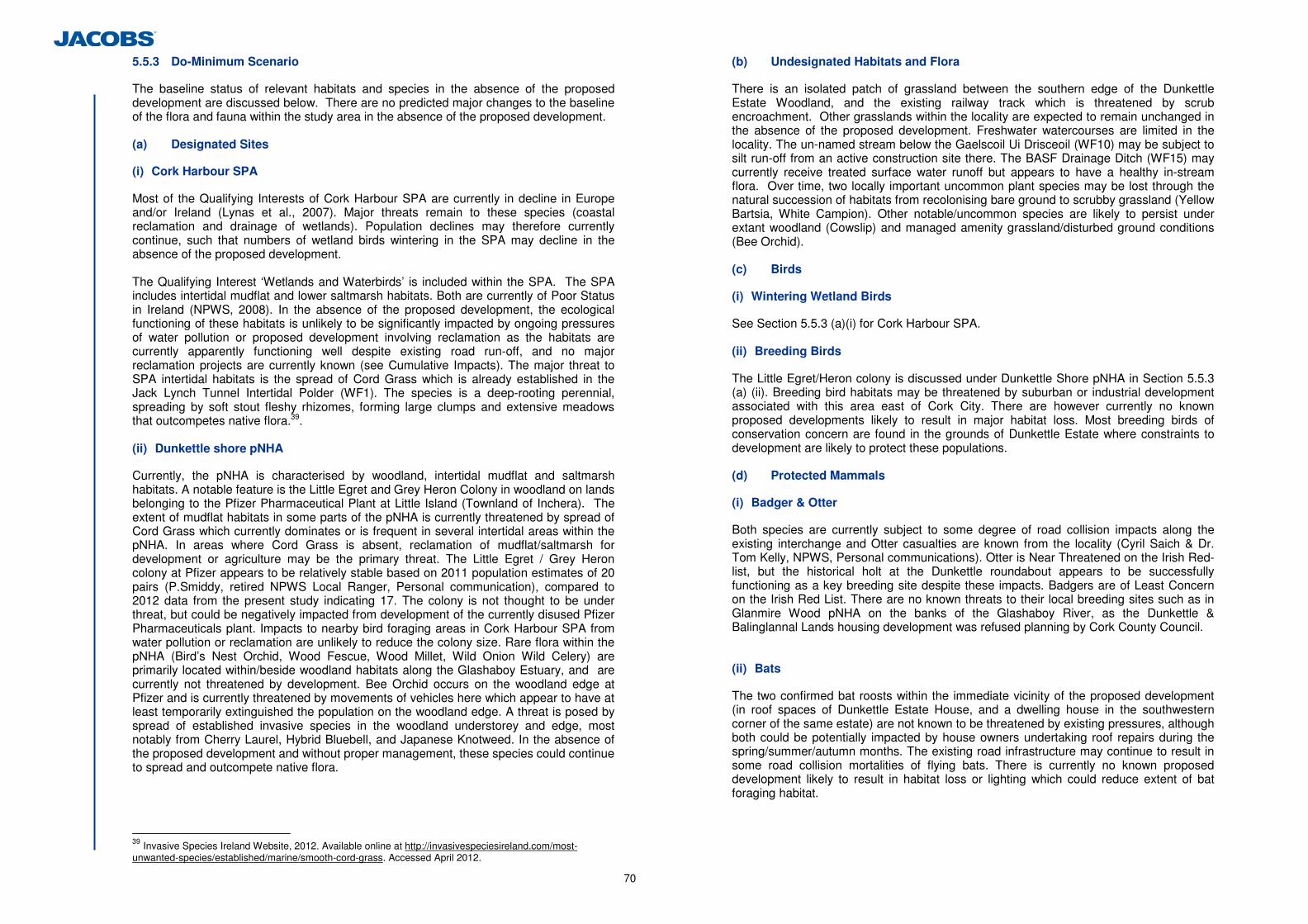
70
5.5.3 Do-Minimum Scenario
The baseline status of relevant habitats and species in the absence of the proposed development are discussed below. There are no predicted major changes to the baseline of the flora and fauna within the study area in the absence of the proposed development. (a) Designated Sites
(i) Cork Harbour SPA
Most of the Qualifying Interests of Cork Harbour SPA are currently in decline in Europe and/or Ireland (Lynas et al., 2007). Major threats remain to these species (coastal reclamation and drainage of wetlands). Population declines may therefore currently continue, such that numbers of wetland birds wintering in the SPA may decline in the absence of the proposed development. The Qualifying Interest ‘Wetlands and Waterbirds’ is included within the SPA. The SPA includes intertidal mudflat and lower saltmarsh habitats. Both are currently of Poor Status in Ireland (NPWS, 2008). In the absence of the proposed development, the ecological functioning of these habitats is unlikely to be significantly impacted by ongoing pressures of water pollution or proposed development involving reclamation as the habitats are currently apparently functioning well despite existing road run-off, and no major reclamation projects are currently known (see Cumulative Impacts). The major threat to SPA intertidal habitats is the spread of Cord Grass which is already established in the Jack Lynch Tunnel Intertidal Polder (WF1). The species is a deep-rooting perennial, spreading by soft stout fleshy rhizomes, forming large clumps and extensive meadows that outcompetes native flora.39. (ii) Dunkettle shore pNHA
Currently, the pNHA is characterised by woodland, intertidal mudflat and saltmarsh habitats. A notable feature is the Little Egret and Grey Heron Colony in woodland on lands belonging to the Pfizer Pharmaceutical Plant at Little Island (Townland of Inchera). The extent of mudflat habitats in some parts of the pNHA is currently threatened by spread of Cord Grass which currently dominates or is frequent in several intertidal areas within the pNHA. In areas where Cord Grass is absent, reclamation of mudflat/saltmarsh for development or agriculture may be the primary threat. The Little Egret / Grey Heron colony at Pfizer appears to be relatively stable based on 2011 population estimates of 20 pairs (P.Smiddy, retired NPWS Local Ranger, Personal communication), compared to 2012 data from the present study indicating 17. The colony is not thought to be under threat, but could be negatively impacted from development of the currently disused Pfizer Pharmaceuticals plant. Impacts to nearby bird foraging areas in Cork Harbour SPA from water pollution or reclamation are unlikely to reduce the colony size. Rare flora within the pNHA (Bird’s Nest Orchid, Wood Fescue, Wood Millet, Wild Onion Wild Celery) are primarily located within/beside woodland habitats along the Glashaboy Estuary, and are currently not threatened by development. Bee Orchid occurs on the woodland edge at Pfizer and is currently threatened by movements of vehicles here which appear to have at least temporarily extinguished the population on the woodland edge. A threat is posed by spread of established invasive species in the woodland understorey and edge, most notably from Cherry Laurel, Hybrid Bluebell, and Japanese Knotweed. In the absence of the proposed development and without proper management, these species could continue to spread and outcompete native flora.
39 Invasive Species Ireland Website, 2012. Available online at http://invasivespeciesireland.com/most-unwanted-species/established/marine/smooth-cord-grass. Accessed April 2012.
(b) Undesignated Habitats and Flora
There is an isolated patch of grassland between the southern edge of the Dunkettle Estate Woodland, and the existing railway track which is threatened by scrub encroachment. Other grasslands within the locality are expected to remain unchanged in the absence of the proposed development. Freshwater watercourses are limited in the locality. The un-named stream below the Gaelscoil Ui Drisceoil (WF10) may be subject to silt run-off from an active construction site there. The BASF Drainage Ditch (WF15) may currently receive treated surface water runoff but appears to have a healthy in-stream flora. Over time, two locally important uncommon plant species may be lost through the natural succession of habitats from recolonising bare ground to scrubby grassland (Yellow Bartsia, White Campion). Other notable/uncommon species are likely to persist under extant woodland (Cowslip) and managed amenity grassland/disturbed ground conditions (Bee Orchid). (c) Birds
(i) Wintering Wetland Birds
See Section 5.5.3 (a)(i) for Cork Harbour SPA. (ii) Breeding Birds
The Little Egret/Heron colony is discussed under Dunkettle Shore pNHA in Section 5.5.3 (a) (ii). Breeding bird habitats may be threatened by suburban or industrial development associated with this area east of Cork City. There are however currently no known proposed developments likely to result in major habitat loss. Most breeding birds of conservation concern are found in the grounds of Dunkettle Estate where constraints to development are likely to protect these populations. (d) Protected Mammals
(i) Badger & Otter
Both species are currently subject to some degree of road collision impacts along the existing interchange and Otter casualties are known from the locality (Cyril Saich & Dr. Tom Kelly, NPWS, Personal communications). Otter is Near Threatened on the Irish Red-list, but the historical holt at the Dunkettle roundabout appears to be successfully functioning as a key breeding site despite these impacts. Badgers are of Least Concern on the Irish Red List. There are no known threats to their local breeding sites such as in Glanmire Wood pNHA on the banks of the Glashaboy River, as the Dunkettle & Balinglannal Lands housing development was refused planning by Cork County Council. (ii) Bats
The two confirmed bat roosts within the immediate vicinity of the proposed development (in roof spaces of Dunkettle Estate House, and a dwelling house in the southwestern corner of the same estate) are not known to be threatened by existing pressures, although both could be potentially impacted by house owners undertaking roof repairs during the spring/summer/autumn months. The existing road infrastructure may continue to result in some road collision mortalities of flying bats. There is currently no known proposed development likely to result in habitat loss or lighting which could reduce extent of bat foraging habitat.
71
(iii) Pigmy Shrew and Hedgehog
There is abundant habitat in the locality that is not currently under threat of development. Both species are of Least Concern on the Irish Red-List. (e) Invertebrates
There is abundant habitat in the locality that is not currently under threat of development. No species recorded are listed on Irish Red-Lists or are priority species in the Cork City and County Development Plans. (f) Fish
The current Water Framework Directive Water Quality status of the Glashaboy River and Mahon Bay is intermediate40. Water quality threats to fisheries in these water bodies and in inland intertidal areas will remain in the absence of the proposed development due to likely pressure from existing road run-off41, sewage and industrial discharges. If left unmanaged, natural silting up of culverts draining intertidal mudflat areas may result in the blocking of tidal flows and loss of fish habitat. There are no predicted changes to the baseline of the fish or other fauna/flora on which fish depend within the study area in the absence of the proposed development. 5.5.4 Construction Phase Impacts
Potential Impacts during construction may arise from:
• Habitat Lost for road infrastructure; • Surface Water Run-off into receiving waters; • Noise/disturbance to fauna; • Crossing of water features; • Disposal of mud sediments; • Spread of invasive species.
Habitat loss to Key Ecological Receptors in terrestrial and aquatic zones will be caused by construction of:
• Roadway and embankments; • Attenuation ponds and constructed wetlands; • Creation of compensatory intertidal areas in grassland/wooded habitats; • Construction of the landtake fence-line and; • Construction of temporary storage areas.
(a) Designated Sites
Following the assessment, it was determined that 1 SPA, and 2 pNHAs fall within the ZoI of the proposed development. Of these, only the Dunkettle Shore pNHA is within the development footprint and will be subject to direct and indirect potential impacts. Impacts to this site are addressed below. Potential Impacts to Cork Harbour SPA (adjacent to the proposed development) have been assessed as likely in the absence of mitigation, but all potential impacts are fully addressed by mitigation in the Natura Impact Statement in Appendix 5.7. Potential impacts to the Douglas River Estuary pNHA are assessed within the NIS under the Cork Harbour SPA, with which the Douglas River Estuary pNHA shares
40 Data on water quality from the EPA online database available online at: http://gis.epa.ie/betazone/envision/. Accessed April 2012 41 Elevated concentrations of Copper recorded in mud sediments in WF2 following sediment analysis at one of the outfall points for the existing road may be due to the existing run-off
its boundary. There are no potential source-pathway-receptor links between the proposed development and the nearby Glanmire Wood pNHA (0.2km N), or any other pNHAs.
(i) Dunkettle shore pNHA
Surface Water Run-off into Mudshores (LS4) and Saltmarsh (CM1 & CM2) Surface waters generated during construction may carry silts, oils, cementitious materials or other toxic pollutants overland or by the local drainage network and into North Esk Intertidal Mudflats East (WF3) and West (WF4) and saltmarsh habitats present here before draining into Lough Mahon in Upper Cork Harbour. In the absence of mitigation, contaminants discharged to these areas during the 24 months of construction could reduce the biological and chemical water quality status in designated receiving waters, thereby affecting mud-dwelling invertebrates and foraging birds and mammals. These estuarine habitats are regularly exposed to turbid water so that a certain amount of increased suspended solids during construction will have little impact on the communities in each of the water features. Nevertheless, excessive sedimentation, in particular over extensive areas of the intertidal mud-flats, could lead to smothering of burrowing infauna. Furthermore, due to its connection with the wider Cork Harbour, excessive silt loss could also impact on the wider inner harbour area. This would constitute a moderate to major adverse and short-term impact were it to occur. The likelihood of solids release during construction is high. More significant however would be if large volumes of mud were displaced by the construction of the road e.g. across WF5 and WF6 and if this mud were to deposit elsewhere either within the designated site (WF4) or elsewhere, where it could smother benthic invertebrates. Damage to these communities could also occur due to run-off following spillage of cementitious materials or oil during construction which could result in major adverse impacts. Short-term impacts on fauna and flora within these water features in question and in the upper Cork Harbour area could occur depending on the volumes of the spills. Taking account of the current intermediate status of the Lough Mahon receiving waters (EPA database), run-off may result in indirect, short-medium term, negative, reversible impacts significant at County level. Loss of Intertidal Mudflat & Saltmarsh Habitat (Dunkettle Shore pNHA) There will be direct loss of intertidal mudflats (Mud Shores (LS4)), and both Upper (CM1) and Lower Saltmarsh habitats (CM2) from landtake for the proposed development. Small areas of Annex 1 intertidal mudflats (0.05ha), Upper and Lower saltmarsh (0.04ha) will be lost at North Esk Intertidal Mudflats East and West (WF3 and WF4) within the pNHA. This habitat corresponds to the JNCC Marine Biotype habitat (LR.LLR.FVS.AscVS: (Ascophyllum nodosum and Fucus vesiculosus on variable salinity mid eulittoral rock), and soft sediment intertidal: LS.LMu.UEst.Hed.Str (Hediste diversicolor and Streblospio shrubsolii in littoral sandy mud). Loss of intertidal habitats outside the pNHA boundary is assessed under Non-designated Habitats. The proposed development will not significantly adversely impact on the ecological functioning of the Dunkettle Shore pNHA because these two habitats are well represented in the rest of the site. Habitat loss impacts will be near-certain, negative, long-term, irreversible, and significant at a Local Level due to the small areas involved relative to the extent of unimpacted mudflat and saltmarsh habitat in the Dunkettle Shore pNHA.
72
Alteration of Flow Regime to Intertidal Areas Any significant change in the rate at which the water features fill or empty, e.g. due to a changes in the diameter of culverts being used, could alter the ecology of the water features if it altered the rates of erosion or deposition on the mud flats. The change in flow regime has been assessed as indirect, long term, negative, reversible impact.
Invasive Species Spread to Pfizer Woodland (Dunkettle Shore pNHA) There are no direct impacts to terrestrial habitats, however there is potential for indirect impacts to the woodland at Pfizer and a locally important Bee Orchid population on the woodland edge by Link P (Ch. 200-400). This area is outside the development footprint, but within the likely working area. There is potential for spread of invasive species to the woodland from Japanese Knotweed currently established nearby on the eastern woodland edge (see Figure 5.1.8). Japanese Knotweed plant fragments on the eastern woodland edge may be disturbed during construction activities, and be spread on clothing, equipment or vehicle tyre tracks to become established in new areas of the woodland to the west. Native Yew and woodland flora species are located in the woodland interior and would not be impacted. Invasive Spanish/Hybrid bluebells also occurs within the woodland interior and will not be spread by activities in the surrounding habitats. Anecdotal records (P. Smiddy, retired NPWS Local Ranger Personal communication) indicate Bee Orchid occurs on the northern woodland edge below the Heron/Egret colony. Bee Orchids were not found in July 2011 habitat surveys, but may have been inadvertently destroyed by maintenance works during spring/summer 2011. However they may remain in the seed bank along the northern woodland edge where it could occur in the future. Assuming presence of Bee Orchid, spread of Japanese Knotweed around the Pfizer woodland edge could result in probable, indirect, long-term, negative, reversible loss of the local populations of the plant. This is assessed as significant at a Local Level. Invasive Species Spread to North Esk Intertidal Habitats (Dunkettle Shore pNHA) Cord Grass is established in Annex I intertidal mudflat and Lower Saltmarsh habitats in the North Esk Intertidal Mudflat (East) at proposed Link G, and within 50m of the proposed Link H. Disturbance of fruiting plants by construction staff or vehicles may assist in their spread by seed, while spread by rhizomatous growth will continue in the absence of active management. Under Schedule 3 to the Bird and Natural Habitat Regulations 2011, it is an offence to allow or cause Cord Grass to disperse, spread, or otherwise cause to grow. In the absence of mitigation, probable, negative, indirect, long-term, reversible loss of Intertidal mudflat and Saltmarsh habitats will occur and be significant at a County Level.
Disturbance to Little Egret/Heron Colony (Dunkettle Shore pNHA) The proposed development will result in indirect disturbance to the Little Egret and Grey Heron Colony which is listed on the NPWS site synopsis for the pNHA, and is likely the primary reason for inclusion of the woodland at Pfizer within the Dunkettle shore pNHA. The proposed development is primarily located within wet grassland and scrub to the north of the woodland. Proposed Link P, Chainage 200-300 and associated attenuation ponds will be located respectively within c. 20m and 10m of the nearest nest on the northern woodland edge. A temporary storage area is also proposed to the south of the woodland in a disused carpark within the lands owned by Pfizer Pharmaceutical Plant. Construction of the proposed development will take approximately 24 months. If construction is undertaken during the combined breeding season for Egrets and Herons (February-July), during which noise, physical disturbance and regular human presence in view of birds nesting in the treetops is near-certain to result in impacts to breeding success of both species. Movement of staff and vehicles along the woodland edge between the nearby proposed
temporary storage area, and the proposed development would create significant disturbance around the entire perimeter of the colony. The magnitude of potential impact on pair-bonding, or productivity is difficult to assess. The Fota Island Little Egret/ Grey Heron colony in Cork City to the east of the development appears relatively unaffected by its location next to a busy railway station with regular trains passing. The colony is also located within a wildlife park which attracts large numbers of visitors all summer and is exposed to significant human activity throughout the day. Human disturbance is a feature of most other colonies in south-eastern Ireland (Ronayne, 2010). However, the response of breeding birds to disturbance will vary across sites and there is a trade-off between disturbance, and quality of nest site/foraging areas. Little Egrets are generally tolerant of disturbance except where persecuted (Birdguides, 2003-2006). Grey Heron responses are site specific as a Polish study indicates human disturbance is of negligible importance (Jakubas, 2005), but Italian colonies preferentially selected breeding habitat away from human disturbance (Alieri and Fasola 1992a, Fasola and Alieri 1992a), and populations have declined with increased human population density elsewhere in Europe (Dybbro, 1970). Disturbance leading to abandonment by Grey Heron (who breed from February to July) may lead to abandonment by Little Egrets (breeding later in April/May) due to Egrets’ preference for mixed colonies. Little Egrets have the ability to shift among nesting sites, even over thousands of kilometres in response to adverse conditions (Hafner et al. in press).
Birds become accustomed to disturbance only if it is of a predictable nature, and require time to habituate. There is a low extant disturbance regime at the Pfizer Pharmaceutical Plnat (on private lands), primarily from movements of ESB maintenance vehicles and staff around the woodland. Prolonged loud noises and movement of construction staff in a previously undisturbed area are predicted to have a probable indirect, short-medium negative, reversible impact on productivity, and could result in partial colony abandonment to a site elsewhere in Cork. The extent of potential colony abandonment will depend on the intensity and duration of disturbance. It is unlikely that the entire colony would readily abandon the breeding site at Pfizer following the construction period. This judgement is based on evidence of tolerance of both species to disturbance, and the high value of foraging habitat in nearby Cork Harbour SPA (including the adjacent Jack Lynch Tunnel Intertidal Polder WF1), and the lack of direct impact to the nest site. The Polder is the primary feeding area for many of the birds from the colony due to proximity and low human disturbance. The Pfizer colony of c. 7 Little Egret pairs is valued at International Importance because the Little Egret is an Annex I species, and the Pfizer breeding population may account for at least 1% of the Irish breeding population. There is no published estimate for the national breeding population, but this is likely to be in the region of 400-500 pairs (John Lusby, BirdWatch Ireland personal communication). In the absence of mitigation, a worst-case potential disturbance impact would result in a probable, short-medium term reduction in colony size of a portion of Egret and/or Heron pairs during the construction period. The overall impact is assessed at a County Level. Disturbance of Wintering Birds (Dunkettle Shore pNHA) The noise and physical disturbance during construction will be of an unpredictable nature and will therefore disturb and displace foraging wetland birds from the North Esk Intertidal Mudflats WF3 and WF4 (including any piling or blasting). This may include occasional flocks of Black-tailed Godwit of up to 40 birds. These impacts are temporary-short-term, and may only apply during certain times of construction period (i.e. not on weekends or bank holidays). This near-certain, negative, indirect, temporary-short-term, reversible disturbance impact is assessed as significant at a Local Level.
73
Loss of Wintering Bird Foraging Habitat (Dunkettle Shore pNHA) Overall, the pNHA is considered to be of International Importance to wintering birds because the pNHA boundary coincides with areas of the SPA including the Jack Lynch Tunnel Intertidal Polder (WF1) and the Glashaboy Estuary (WF9). However the area of mudflats partially within the footprint of the scheme is outside the SPA. This area of North Esk Intertidal Mudflats is valued at Local Importance (Higher Value) to wintering birds. This area has occasionally held significant numbers of Black-tailed Godwit, but not on a regular basis. A single flock of 40 Black-tailed Godwit was recorded at North Esk in 1997 (Dr. Tom Gittings, UCC Entomologist, Personal communication). This equates to 28% of the population required for national importance, but only 9% of the internationally important populations required for SPA designation (Boland & Crowe, 2007). A single Black-tailed Godwit was recorded in North Esk during field surveys in March 2011, and the numbers recorded in 1997 were not recorded in the five previous months of surveys. Singles or small numbers of Greenshank and Black-headed Gull were also recorded. The area of mudflat loss is small, so the largely retained North Esk mudflat will continue to offer a feeding resource during site operation. There may be a temporary abandonment of the site (<1 year) until birds become accustomed to the new road infrastructure. The near-certain, long-term, irreversible loss of very small areas of foraging habitat is assessed as significant at Local Level.
(b) Non-Designated Sites
(i) Habitats
Surface Water Run-off into Mud Shores (LS4) and Saltmarsh (CM1/2) As described for Intertidal Habitats within Designated Sites above, surface waters generated during construction may carry silts, oils, cementitious material or other toxic chemicals overland or by the local drainage network. In the case of non-designated intertidal areas, contaminants in surface waters may impact on the Iarnród Éireann Intertidal Mudflat Small (WF7), the Pfizer Intertidal Mudflats West (WF5) and East (WF6), the Jack Lynch Intertidal Mudflat (WF2) and saltmarsh habitats in these areas. In the absence of mitigation, and taking into account the Annex 1 status of these habitats, and the poor conservation status of intertidal mudflat, lower saltmarsh, and upper saltmarsh habitats in Ireland (NPWS, 2008) these impacts are probable, indirect, short-medium term, negative, reversible, and significant at County level. Chapter 6 Hydrology, Geomorphology and Hydromorphology has used a different rating system in accordance with the NRA guidelines, (but chosen an equivalent impact level) for impact magnitude, and concluded impacts to undesignated areas of mudflat would be ‘Moderate’ (WF2, WF7, WF8) to ‘Large’ (WF5, WF6). Surface Water Run-off into Freshwater streams and Drainage Ditches Potential impacts of contaminated run-off entering the freshwater stream by Gaelscoil Ui Drisceoil (WF10), and the brackish drainage ditch at BASF (WF15) are less significant than for the Annex 1 intertidal areas above. In the absence of mitigation, potential impacts are probable, indirect, short-medium term, negative, reversible, and significant at Local level. Chapter 6 Hydrology, Geomorphology and Hydromorphology has used a different rating system (but chosen an equivalent impact level) for impact magnitude, and concluded impacts to WF10 and WF15 would be ‘Moderate’. Habitat Loss Table 5.28 summarises potential habitat loss impacts to terrestrial and aquatic habitats outside Designated Sites. This includes all habitats outside Designated Sites (pNHAs/cSACs/SPAs) but includes Annex I Habitats under the Habitats Directive occurring outside Designated Sites. Annex I status highlights that these habitats are of
European Importance and in many cases the habitats are threatened or of poor conservation status according to the NPWS Status of EU Protected Habitats and Species in Ireland. Table 5.28 summarises all these impacts to Key Ecological Receptors. All habitat loss impacts are near-certain, negative, direct, long-term and irreversible.
K.E.R Habitats & Heritage Council Code
Annex I Habitat
Ecological Value
Habitat Loss Overall Impact Significance
Mud Shores (LS4) outside Designated Sites
√ National 1.05ha (0.05ha additionally lost from Dunkettle Shore pNHA)
County
Lower Salt Marsh (CM1) outside Designated Sites
√ County 0.29ha (0.04ha additionally lost from Dunkettle Shore pNHA)
County
Upper Salt Marsh (CM2) outside Designated Sites
√ County 0.06ha Local
Depositing/Lowland Rivers (FW2) – Freshwater stream at Gaelscoil
- Local Value (Higher Importance)
c. 52m Local
Drainage Ditches (FW4) - Local Value (Higher
Importance) c. 303m Local
Dry Neutral & Calcareous Grassland (GS1)
- Local Value (Higher Importance)
0.53ha Local
Dry Meadows and Grassy Verges (GS2)
- Local Value (Higher Importance) 0.15ha Local
Wet Grassland (GS4) - Local Value (Higher
Importance) 1.56ha Local
(Mixed) Broad-leaved Woodland (WD1)
- Local Value (Higher Importance) 0.6ha Local
Mixed Broad-leaved Woodland (WD2) - Local Value (Higher
Importance) 1.56ha Local
Hedgerows (WL1) - Local Value (Higher Importance)
1.51km Local
Treelines (WL2) - Local Value (Higher Importance) 1.33km Local
Recolonising Bare Ground (ED3) - Local Value (Higher
Importance) 9.73ha Local
Sea Walls and Jetties (CC1)/ Sheltered Rocky Shores (LR3)
- Local Value (Higher Importance) 0.68km Local
Table 5.28: Summary of Habitat Losses (Area/Length) and Overall Impact Significance for Key Ecological Receptors (K.E.R’s) outside Designated Areas
There will be habitat loss of significant areas of nationally important Annex 1 Mud Shore (or ‘intertidal mudflat’) habitat, with impacts significant at County level. There will also be losses of small areas of nationally important Annex 1 saltmarsh habitats. The extent of Lower Saltmarsh loss is far greater than Upper Saltmarsh, resulting in impacts of County level significance for Lower Saltmarsh, compared to Local significance for Upper Saltmarsh. Habitat loss impacts to Mixed woodland (WD1 and WD2), Wet grassland (GS4), Dry and calcareous grassland (GS1), Hedgerow (WL1), and Treeline (WL2) are all valued at Local Importance (Higher Value) due to their scarcity in the locality and the significant areas being removed relative to current extent. Habitat loss impacts to Dry meadows and grassy verges and seawall habitats, (also valued at Local Importance (Higher Value)) are
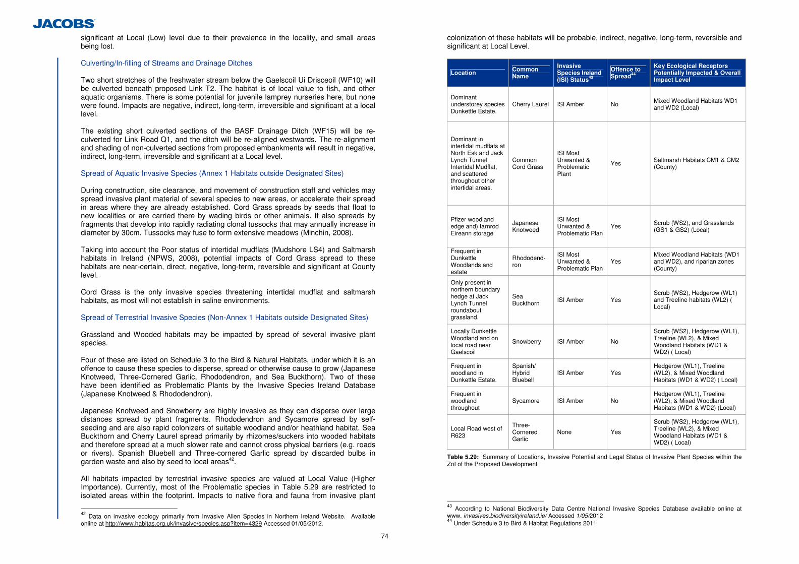
74
significant at Local (Low) level due to their prevalence in the locality, and small areas being lost.
Culverting/In-filling of Streams and Drainage Ditches Two short stretches of the freshwater stream below the Gaelscoil Ui Drisceoil (WF10) will be culverted beneath proposed Link T2. The habitat is of local value to fish, and other aquatic organisms. There is some potential for juvenile lamprey nurseries here, but none were found. Impacts are negative, indirect, long-term, irreversible and significant at a local level. The existing short culverted sections of the BASF Drainage Ditch (WF15) will be re-culverted for Link Road Q1, and the ditch will be re-aligned westwards. The re-alignment and shading of non-culverted sections from proposed embankments will result in negative, indirect, long-term, irreversible and significant at a Local level.
Spread of Aquatic Invasive Species (Annex 1 Habitats outside Designated Sites) During construction, site clearance, and movement of construction staff and vehicles may spread invasive plant material of several species to new areas, or accelerate their spread in areas where they are already established. Cord Grass spreads by seeds that float to new localities or are carried there by wading birds or other animals. It also spreads by fragments that develop into rapidly radiating clonal tussocks that may annually increase in diameter by 30cm. Tussocks may fuse to form extensive meadows (Minchin, 2008). Taking into account the Poor status of intertidal mudflats (Mudshore LS4) and Saltmarsh habitats in Ireland (NPWS, 2008), potential impacts of Cord Grass spread to these habitats are near-certain, direct, negative, long-term, reversible and significant at County level. Cord Grass is the only invasive species threatening intertidal mudflat and saltmarsh habitats, as most will not establish in saline environments. Spread of Terrestrial Invasive Species (Non-Annex 1 Habitats outside Designated Sites) Grassland and Wooded habitats may be impacted by spread of several invasive plant species. Four of these are listed on Schedule 3 to the Bird & Natural Habitats, under which it is an offence to cause these species to disperse, spread or otherwise cause to grow (Japanese Knotweed, Three-Cornered Garlic, Rhododendron, and Sea Buckthorn). Two of these have been identified as Problematic Plants by the Invasive Species Ireland Database (Japanese Knotweed & Rhododendron).
Japanese Knotweed and Snowberry are highly invasive as they can disperse over large distances spread by plant fragments. Rhododendron and Sycamore spread by self-seeding and are also rapid colonizers of suitable woodland and/or heathland habitat. Sea Buckthorn and Cherry Laurel spread primarily by rhizomes/suckers into wooded habitats and therefore spread at a much slower rate and cannot cross physical barriers (e.g. roads or rivers). Spanish Bluebell and Three-cornered Garlic spread by discarded bulbs in garden waste and also by seed to local areas42.
All habitats impacted by terrestrial invasive species are valued at Local Value (Higher Importance). Currently, most of the Problematic species in Table 5.29 are restricted to isolated areas within the footprint. Impacts to native flora and fauna from invasive plant
42 Data on invasive ecology primarily from Invasive Alien Species in Northern Ireland Website. Available online at http://www.habitas.org.uk/invasive/species.asp?item=4329 Accessed 01/05/2012.
colonization of these habitats will be probable, indirect, negative, long-term, reversible and significant at Local Level.
Location Common Name
Invasive Species Ireland (ISI) Status43
Offence to Spread44
Key Ecological Receptors Potentially Impacted & Overall Impact Level
Dominant understorey species Dunkettle Estate.
Cherry Laurel ISI Amber No Mixed Woodland Habitats WD1 and WD2 (Local)
Dominant in intertidal mudflats at North Esk and Jack Lynch Tunnel Intertidal Mudflat, and scattered throughout other intertidal areas.
Common Cord Grass
ISI Most Unwanted & Problematic Plant
Yes Saltmarsh Habitats CM1 & CM2 (County)
Pfizer woodland edge and) Iarnrod Eireann storage
Japanese Knotweed
ISI Most Unwanted & Problematic Plan
Yes Scrub (WS2), and Grasslands (GS1 & GS2) (Local)
Frequent in Dunkettle Woodlands and estate
Rhododend-ron
ISI Most Unwanted & Problematic Plan
Yes Mixed Woodland Habitats (WD1 and WD2), and riparian zones (County)
Only present in northern boundary hedge at Jack Lynch Tunnel roundabout grassland.
Sea Buckthorn ISI Amber Yes
Scrub (WS2), Hedgerow (WL1) and Treeline habitats (WL2) ( Local)
Locally Dunkettle Woodland and on local road near Gaelscoil
Snowberry ISI Amber No
Scrub (WS2), Hedgerow (WL1), Treeline (WL2), & Mixed Woodland Habitats (WD1 & WD2) ( Local)
Frequent in woodland in Dunkettle Estate.
Spanish/ Hybrid Bluebell
ISI Amber Yes Hedgerow (WL1), Treeline (WL2), & Mixed Woodland Habitats (WD1 & WD2) ( Local)
Frequent in woodland throughout
Sycamore ISI Amber No Hedgerow (WL1), Treeline (WL2), & Mixed Woodland Habitats (WD1 & WD2) (Local)
Local Road west of R623
Three-Cornered Garlic
None Yes
Scrub (WS2), Hedgerow (WL1), Treeline (WL2), & Mixed Woodland Habitats (WD1 & WD2) ( Local)
Table 5.29: Summary of Locations, Invasive Potential and Legal Status of Invasive Plant Species within the ZoI of the Proposed Development
43 According to National Biodiversity Data Centre National Invasive Species Database available online at www. invasives.biodiversityireland.ie/ Accessed 1/05/2012 44 Under Schedule 3 to Bird & Habitat Regulations 2011
75
(ii) Rare & Notable Flora (Outside Designated Sites)
There are no protected, endangered, or vulnerable plant species within the ZoI of the proposed development. There will be no potential impacts to two populations listed as Not Threatened on the Irish Red-list as they are both outside the ZoI. Cowslip occurs within the Dunkettle Estate woodlands by the gate lodge, and Bee Orchid is within Amenity grassland within the Pfizer Pharmaceutical Plant outside the ZoI. There is potential for Bee Orchid to occur within the ZoI at the Pfizer woodland edge, this has been assessed under Designated Sites (Dunkettle Shore pNHA), Section 5.5.3 (a) (ii). There are two species of rare plants valued at County Importance within the ZoI. A small population of Bristly Oxtongue is within the footprint of Link Q1 in recolonising bare ground by the brackish BASF drainage ditch. The species was not found elsewhere in the locality despite careful searches. The loss of the single plant is near-certain and will result in a long-term, negative, irreversible impact significant at a County Level. Several shrubs of Sweet Briar occur within the ZoI, in a 20m long section of woodland adjacent to Link B and A. The species was not found elsewhere, and is valued at County Importance due to its national rarity. Without mitigation, construction activity could result in the loss of part or all of the plants. The potential loss of at least some of the plants is probable, and may result in a long-term, negative, irreversible impact significant at a County Level. White Campion, Yew and Yellow Bartsia are uncommon plants valued at Local Importance (Higher Value) but are located outside of the ZoI in scrub by the Jack Lynch Intertidal Polder (WF1), and in recolonising bare ground at BASF respectively. No impacts are predicted. (iii) Birds
Wintering Wetland Birds (Outside Designated Sites) Potential Impacts to wetland birds within Cork Harbour SPA are assessed and addressed in the Natura Impact Statement in Appendix 5.7. Potential impacts to wintering birds in the North Esk Intertidal Mudflats are assessed under Designated Sites (Dunkettle Shore pNHA) in Section 5.5.3 (a) (ii). The loss of intertidal mudflat habitats for landtake in the Jack Lynch Tunnel Intertidal Mudflat (WF2) and Iarnród Éireann Intertidal Mudflat Small (WS7) will not significantly impact on wintering bird foraging resources. Detailed desktop and field survey data indicates that singles or very small numbers of wintering birds feed in these areas (Greenshank, Curlew, Mallard, Snipe, Redshank, Teal), and no Annex 1 species occur with the exception of occasional Little Egret individuals. There are no raptors (including Short-Eared Owl) or other non-wetland wintering birds of conservation importance (e.g. passerines) within the ZoI. Disturbance to foraging birds during the non-breeding season is likely to temporarily displace feeding birds from intertidal areas to nearby Lough Mahon or other intertidal areas. The near-certain, long-term, irreversible loss of foraging habitat impact is assessed as significant at Local level in the absence of mitigation.
Breeding Birds Potential Impacts to the Little Egret/Grey Heron colony are assessed under Designated Sites (Dunkettle Shore pNHA), Section 5.5.3 (a) (ii). All but three of the recorded Amber-listed birds of conservation concern are outside the ZoI. A single breeding territory of Ringed Plover (Amber-listed) could be lost within the footprint of a temporary storage area at the disused carpark south of the Pfizer woodland. It is
possible the bird will not return to the site post-construction. This would result in a probable, short-long term, reversible loss at a Local Level (Higher Importance). It is likely that 1-2 pairs of Amber-listed Shelduck may breed in rock gabion or grass bank habitats in Pfizer intertidal mudflats. The overall impact significance of the probable, long-term, irreversible loss of potential Shelduck breeding habitat is at a Local level. All 28 of the breeding green-listed species in Appendix 5.8 will be impacted by habitat loss. These are all common species, including Blackcap Sylvia atricapilla, Whitethroat Sylvia communis, and other common passerines and waterfowl. The overall impact from bird breeding habitat loss (scrub, grassland, hedgerow, mixed woodland, and intertidal wetland) to green-listed birds is negative, long-term, irreversible, and significant at a Local Level. (iv) Protected Mammals - Badger & Otter
Construction impacts to these species may involve direct disturbance of breeding or resting places, and loss of foraging areas. There are no direct impacts to Badger setts, which are located outside of the ZoI. There will be no indirect impacts to Badger setts from blasting or other physical disturbance due to the separation distance of the nearest known sett from the proposed development (350m). There are no holts within the footprint of the proposed development. However, two holts are within the ZoI of construction works, but only one will be subject to potential impacts from groundworks at the north esk. The long-established Glanmire holt at the Dunkettle Roundabout is located approximately 210m west of the proposed development and is outside of the potential Zol of construction disturbance. The potential holt at North Esk consists of two holes in an earth bank approximately 40m west of proposed Link H (Chainage 330) A Otter carcass was found in the mudflat north of the holt WF4 in June 2011 was an unconfirmed but likely road casualty. The potential holt may be directly impacted by construction of the proposed North Roundabout and proposed Links G, H, and I. Earthworks could cause collapse of the holt resulting in injury or death of resident Otters, potentially including Otter cubs. Cubs could be present at any time of the year. In the absence of mitigation, Otters in the potential holt at North Esk will be subject to, probable temporary-short-term disturbance impacts during the period of construction, which may result in decreases in breeding success at a Local Level. (v) Protected Mammals -Bats
Bat Roosts There are no confirmed bat roosts within the footprint of the proposed development. There will be no significant direct or indirect impacts to the three bat identified roosts in the Dunkettle Estate during construction. These roosts are respectively located 40m (BR1), 140m (BR2), and 300m (BR3) from the proposed development and shown on Figure 5.1.2. Bat Foraging Habitat Construction of the proposed development will involve loss of mixed woodland, hedgerow, and treeline habitat where at least four species of bat have been recorded. None of the lost habitat will sever connectivity with known roosts. This habitat loss will however likely result in negative, long-term, irreversible loss of foraging habitat at: • Gaelscoil Ui Drisceoil (Link E and Link T1);
76
• The Jack Lynch Tunnel Intertidal Mudflat – WF2 (Links C and P ); • Pfizer Intertidal Mudflat West – WF5 (Mini loop north of Link FM); • The treelines/woodland east of BASF (Link L & Link K). This negative permanent, reversible impact may have an overall impact at Local Level. (vi) Protected Mammals - Pigmy Shrew and Hedgehog
There are confirmed Pigmy Shrew, and presumed Hedgehog populations in suitable grassland and wooded habitats within the footprint of the Proposed Development. Site clearance at any time of year is likely to result in injury or mortality as the species breed and hibernate in similar habitat. Population level impacts would be greatest in the combined breeding season for the species when juveniles would be present in nests (April-October). Site clearance will result in near-certain, temporary, irreversible mortality of small numbers of Pigmy Shrews & Hedgehogs with impacts to local populations significant at Local levels. Potential Impacts would be greater during the breeding season, but remain at a Local Level. (vii) Protected Amphibians
There are no known amphibians within the footprint of the works. The nearest known Common Frog breeding site is in Dunsland House, located 250m northeast of the proposed development, and upstream of it. No significant impacts are predicted. (viii) Invertebrates (Lepidoptera)
Loss of dry Grassland habitats (GS1/GS2) will result in loss of small areas of Lepidoptera overwintering and feeding sites, and mortality of caterpillars/adult butterflies. All recorded species are common, widespread, and of Least Concern on the Irish Red-list. Impacts will be short-term, negative, direct, irreversible and significant on a Local Level. (ix) Invertebrates (Non-Marine Molluscs)
Loss of dry Lower and Upper saltmarsh habitats (CM1/CM2) will result in loss of small areas of molluscan habitat, and mortality of local populations including some saltmarsh indicator species. There are many examples of this, and better developed salt marsh habitats in county Cork. No recorded species are on the Irish Red-list (see Appendix 5.5), however, on a local level, the areas surveyed provide an excellent addition to biodiversity. Impacts will be short-term, negative, direct, irreversible and significant on a Local Level. (x) Invertebrates (Water Beetles)
Portions of the Nationally important populations of Octhebius marinus occurring in WF7 and WF14 may be permanently lost during construction, when tidal flows are redirected from mud habitats to facilitate earth works and embankment construction (i.e. when working in the dry). Only the northern fringe of WF14 will be impacted to a minor degree. Habitat supporting populations in the North Esk Intertidal Mudflat (WF4) will be unimpacted, and may act as repopulating sources to WF7 and WF14 during restoration of tidal flows after construction. Success of natural repopulation in WF7 will be reliant on the suitable brackish habitat in the form of re-contoured flood attenuation areas established. In the absence of mitigation, impacts will be short-term, negative, direct, reversible and significant on a Local Level. (xi) Invertebrates (Benthos)
In-stream works during construction will directly impact upon benthic communities in soft and hard substrates. Impacts will be direct, negative, irreversible, and significant at a Local Level.
(xii) Protected Fish
Impacts to Fish in the Glashaboy Estuary The Glashaboy River Estuary lies immediately west of the proposed development. The proposed works would not present a barrier to salmonid, lamprey and eel migration within the Glashaboy River as there would be no instream works in this watercourse. The effect of increased suspended solids in estuarine environments is considered negligible given the natural fluctuations in suspended solids in these areas. Indeed, Little 2000 in the Biology of Soft Shores and Estuaries, points out that estuaries are well known for the paucity of suspension feeders such as sea squirts, hydroids, and sponges probably due to the clogging of the feeding apparatus with silt. Barnes (1994) notes that brackish water habitats usually have impoverished fauna due to fluctuations in salinity and water levels. Due to the connection with both fresh water and marine systems, brackish waters often contain a number of hardy freshwater and marine species (Barnes, 1994). The fact that the intertidal waters of the study area are influenced by freshwater inputs (e.g. River Lee, Glashaboy River) means that the potential for impacts on fish is reduced. The intertidal fish species that occur in the Glashaboy Estuary include Thick-lipped Grey Mullet and Flounder with this area being an important nursery area for these species. There may be noticeable changes in the character of the estuarine environment but fish would not be affected. Movements of migratory fish would not be affected. The probable impact of the proposed development on these species at construction phase is direct, negative, short-term, and significant at the Local Level. Impacts to Fish in Lough Mahon Many fish species occur in Lough Mahon. The majority of estuarine opportunists drift into estuaries as larvae from eggs and when as young fish become demersal, they take advantage of the rich benthic food sources in sub-littoral sediments, on intertidal mudflats and salt marshes. Estuaries and coastal waters worldwide thus contain immense numbers of 0 group (i.e. less than 1 year old) fish that use them as nursery grounds before emigrating to the open ocean as recruits to their adult populations (Little, 2000). With the falling tide, Lough Mahon receives intertidal water from the area where the proposed development is located. There would be permanent, long-term, localised and irreversible mudflat removal/loss within the footprint of the proposed development. Mudflat area would be reduced at the Jack Lynch Tunnel Intertidal Mudflat (WF2), North Esk Intertidal Mudflat West (WF3), Pfizer Intertidal Mudflat West (WF5) and East (WF6) and Iarnrod Eireann Intertidal Mudflat Small (WF7). These areas have not been identified as Key Ecological Receptors with respect to fish due the weak linkage of these areas to the sea and the fact that they hold little water at low tide. Suspended sediment due to runoff of soil from construction areas, or due to disturbance of fine sub-surface sediments in the course of construction and excavation in mudflats would not be expected to have significant impacts on the marine fish that occur in Lough Mahon given their natural tolerance to suspended solids. The probable impact of the proposed development on these species at construction phase is direct, negative, short-term (c. 5 years), and significant at the County Level.
Great Channel Island The Great Island Channel is situated ca. 2km east of the proposed development. There would be no direct impacts on this area. Indirect impacts are unlikely given the distance from the proposed development. The site is not a Key Ecological Receptor (nor a ‘Relevant’ site in the NIS).
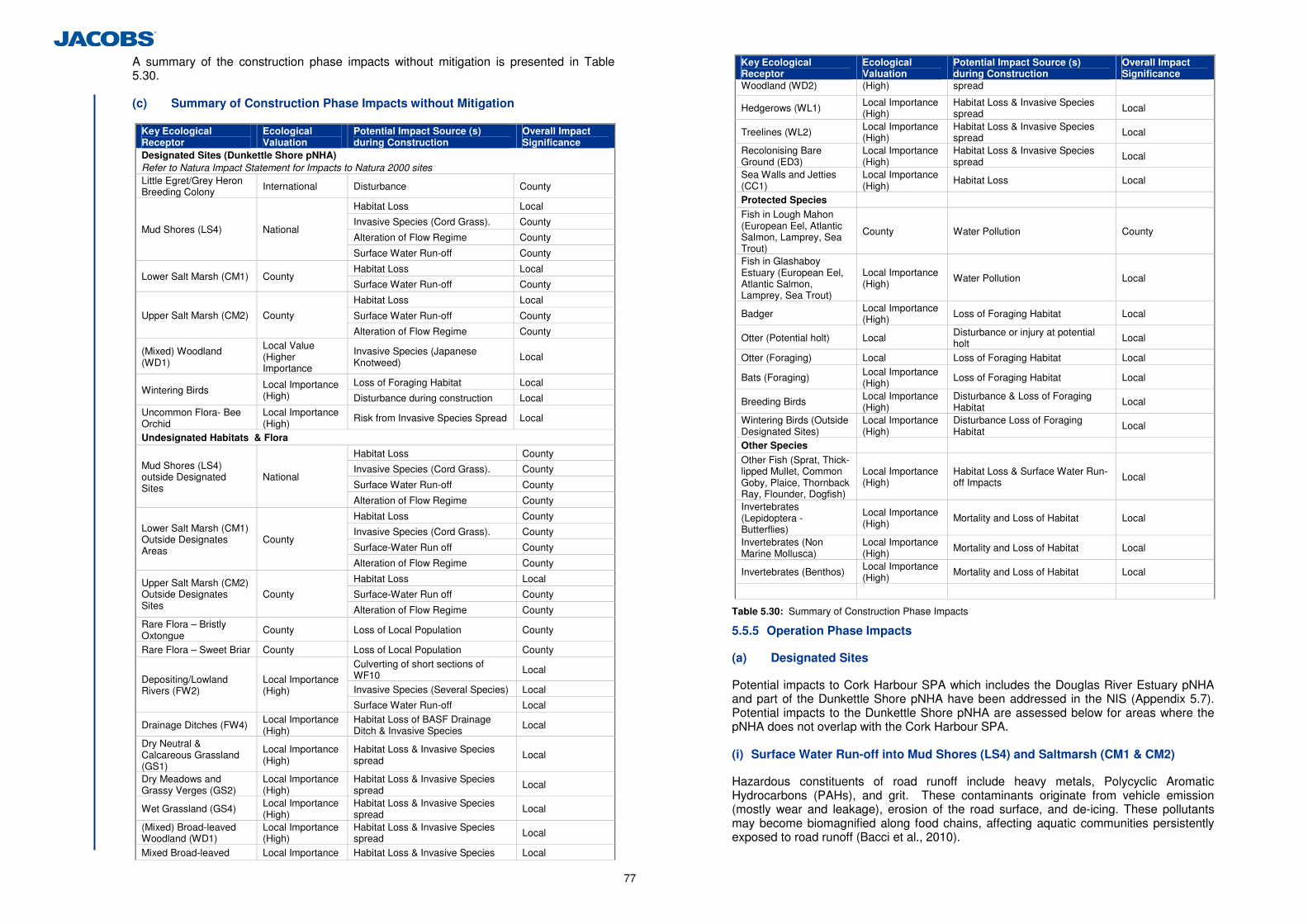
77
A summary of the construction phase impacts without mitigation is presented in Table 5.30. (c) Summary of Construction Phase Impacts without Mitigation
Key Ecological Receptor
Ecological Valuation
Potential Impact Source (s) during Construction
Overall Impact Significance
Designated Sites (Dunkettle Shore pNHA) Refer to Natura Impact Statement for Impacts to Natura 2000 sites Little Egret/Grey Heron Breeding Colony International Disturbance County
Habitat Loss Local
Invasive Species (Cord Grass). County
Alteration of Flow Regime County Mud Shores (LS4) National
Surface Water Run-off County
Habitat Loss Local Lower Salt Marsh (CM1) County
Surface Water Run-off County
Habitat Loss Local
Surface Water Run-off County Upper Salt Marsh (CM2) County
Alteration of Flow Regime County
(Mixed) Woodland (WD1)
Local Value (Higher Importance
Invasive Species (Japanese Knotweed)
Local
Loss of Foraging Habitat Local Wintering Birds Local Importance
(High) Disturbance during construction Local Uncommon Flora- Bee Orchid
Local Importance (High)
Risk from Invasive Species Spread Local
Undesignated Habitats & Flora
Habitat Loss County
Invasive Species (Cord Grass). County
Surface Water Run-off County
Mud Shores (LS4) outside Designated Sites
National
Alteration of Flow Regime County
Habitat Loss County
Invasive Species (Cord Grass). County
Surface-Water Run off County
Lower Salt Marsh (CM1) Outside Designates Areas
County
Alteration of Flow Regime County
Habitat Loss Local
Surface-Water Run off County Upper Salt Marsh (CM2) Outside Designates Sites
County
Alteration of Flow Regime County Rare Flora – Bristly Oxtongue
County Loss of Local Population County
Rare Flora – Sweet Briar County Loss of Local Population County Culverting of short sections of WF10 Local
Invasive Species (Several Species) Local Depositing/Lowland Rivers (FW2)
Local Importance (High)
Surface Water Run-off Local
Drainage Ditches (FW4) Local Importance (High)
Habitat Loss of BASF Drainage Ditch & Invasive Species
Local
Dry Neutral & Calcareous Grassland (GS1)
Local Importance (High)
Habitat Loss & Invasive Species spread
Local
Dry Meadows and Grassy Verges (GS2)
Local Importance (High)
Habitat Loss & Invasive Species spread
Local
Wet Grassland (GS4) Local Importance (High)
Habitat Loss & Invasive Species spread
Local
(Mixed) Broad-leaved Woodland (WD1)
Local Importance (High)
Habitat Loss & Invasive Species spread Local
Mixed Broad-leaved Local Importance Habitat Loss & Invasive Species Local
Key Ecological Receptor
Ecological Valuation
Potential Impact Source (s) during Construction
Overall Impact Significance
Woodland (WD2) (High) spread
Hedgerows (WL1) Local Importance (High)
Habitat Loss & Invasive Species spread Local
Treelines (WL2) Local Importance (High)
Habitat Loss & Invasive Species spread Local
Recolonising Bare Ground (ED3)
Local Importance (High)
Habitat Loss & Invasive Species spread
Local
Sea Walls and Jetties (CC1)
Local Importance (High)
Habitat Loss Local
Protected Species Fish in Lough Mahon (European Eel, Atlantic Salmon, Lamprey, Sea Trout)
County Water Pollution County
Fish in Glashaboy Estuary (European Eel, Atlantic Salmon, Lamprey, Sea Trout)
Local Importance (High)
Water Pollution Local
Badger Local Importance (High) Loss of Foraging Habitat Local
Otter (Potential holt) Local Disturbance or injury at potential holt Local
Otter (Foraging) Local Loss of Foraging Habitat Local
Bats (Foraging) Local Importance (High)
Loss of Foraging Habitat Local
Breeding Birds Local Importance (High)
Disturbance & Loss of Foraging Habitat
Local
Wintering Birds (Outside Designated Sites)
Local Importance (High)
Disturbance Loss of Foraging Habitat
Local
Other Species Other Fish (Sprat, Thick-lipped Mullet, Common Goby, Plaice, Thornback Ray, Flounder, Dogfish)
Local Importance (High)
Habitat Loss & Surface Water Run-off Impacts Local
Invertebrates (Lepidoptera - Butterflies)
Local Importance (High)
Mortality and Loss of Habitat Local
Invertebrates (Non Marine Mollusca)
Local Importance (High)
Mortality and Loss of Habitat Local
Invertebrates (Benthos) Local Importance (High)
Mortality and Loss of Habitat Local
Table 5.30: Summary of Construction Phase Impacts
5.5.5 Operation Phase Impacts
(a) Designated Sites
Potential impacts to Cork Harbour SPA which includes the Douglas River Estuary pNHA and part of the Dunkettle Shore pNHA have been addressed in the NIS (Appendix 5.7). Potential impacts to the Dunkettle Shore pNHA are assessed below for areas where the pNHA does not overlap with the Cork Harbour SPA. (i) Surface Water Run-off into Mud Shores (LS4) and Saltmarsh (CM1 & CM2)
Hazardous constituents of road runoff include heavy metals, Polycyclic Aromatic Hydrocarbons (PAHs), and grit. These contaminants originate from vehicle emission (mostly wear and leakage), erosion of the road surface, and de-icing. These pollutants may become biomagnified along food chains, affecting aquatic communities persistently exposed to road runoff (Bacci et al., 2010).
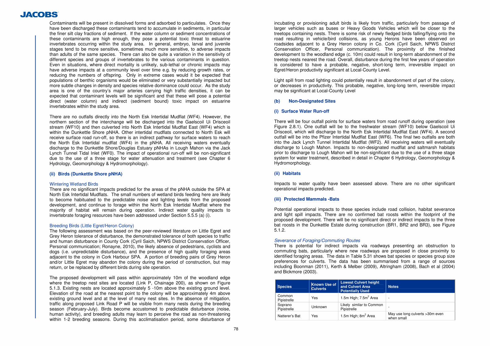
78
Contaminants will be present in dissolved forms and adsorbed to particulates. Once they have been discharged these contaminants tend to accumulate in sediments, in particular the finer silt clay fractions of sediment. If the water column or sediment concentrations of these contaminants are high enough, they pose a potential toxic threat to estuarine invertebrates occurring within the study area. In general, embryo, larval and juvenile stages tend to be more sensitive, sometimes much more sensitive, to adverse impacts than adults of the same species. There can also be quite a variation in the sensitivity of different species and groups of invertebrates to the various contaminants in question. Even in situations, where direct mortality is unlikely, sub-lethal or chronic impacts may have adverse impacts at a community level over time e.g. by reducing growth rates, or reducing the numbers of offspring. Only in extreme cases would it be expected that populations of benthic organisms would be eliminated or very substantially impacted but more subtle changes in density and species relative dominance could occur. As the study area is one of the country’s major arteries carrying high traffic densities, it can be expected that contaminant levels will be significant and that these will pose a potential direct (water column) and indirect (sediment bound) toxic impact on estuarine invertebrates within the study area. There are no outfalls directly into the North Esk Intertidal Mudflat (WF4). However, the northern section of the interchange will be discharged into the Gaelscoil Ui Drisceoil stream (WF10) and then culverted into North Esk Intertidal Mudflat East (WF4) which is within the Dunkettle Shore pNHA. Other intertidal mudflats connected to North Esk will receive surface road run-off, so there is an indirect pathway for surface waters to reach the North Esk Intertidal mudflat (WF4) in the pNHA. All receiving waters eventually discharge to the Dunkettle Shore/Douglas Estuary pNHAs in Lough Mahon via the Jack Lynch Tunnel Tidal Inlet (WF0). The impact of operational run-off will be non-significant due to the use of a three stage for water attenuation and treatment (see Chapter 6 Hydrology, Geomorphology & Hydromorphology).
(ii) Birds (Dunkettle Shore pNHA)
Wintering Wetland Birds There are no significant impacts predicted for the areas of the pNHA outside the SPA at North Esk Intertidal Mudflats. The small numbers of wetland birds feeding here are likely to become habituated to the predictable noise and lighting levels from the proposed development, and continue to forage within the North Esk Intertidal Mudflat where the majority of habitat will remain during operation. Indirect water quality impacts to invertebrate foraging resources have been addressed under Section 5.5.5 (a) (i). Breeding Birds (Little Egret/Heron Colony) The following assessment was based on the peer-reviewed literature on Little Egret and Grey Heron tolerance of disturbance, the demonstrated tolerance of both species to traffic and human disturbance in County Cork (Cyril Saich, NPWS District Conservation Officer, Personal communication; Ronayne, 2010), the likely absence of pedestrians, cyclists and dogs (i.e. unpredictable disturbance), and the presence of high quality foraging areas adjacent to the colony in Cork Harbour SPA. A portion of breeding pairs of Grey Heron and/or Little Egret may abandon the colony during the period of construction, but may return, or be replaced by different birds during site operation. The proposed development will pass within approximately 10m of the woodland edge where the treetop nest sites are located (Link P, Chainage 200), as shown on Figure 5.1.3. Existing nests are located approximately 5 -10m above the existing ground level. Elevation of the road at the nearest point to the colony will be approximately 4m above existing ground level and at the level of many nest sites. In the absence of mitigation, traffic along proposed Link Road P will be visible from many nests during the breeding season (February-July). Birds become accustomed to predictable disturbance (noise, human activity), and breeding adults may learn to perceive the road as non-threatening within 1-2 breeding seasons. During this acclimatisation period, some disturbance of
incubating or provisioning adult birds is likely from traffic, particularly from passage of larger vehicles such as buses or Heavy Goods Vehicles which will be closer to the treetops containing nests. There is some risk of newly fledged birds falling/flying onto the road resulting in vehicle/bird collisions, as young Herons have been observed on roadsides adjacent to a Grey Heron colony in Co. Cork (Cyril Saich, NPWS District Conservation Officer, Personal communication). The proximity of the finished development to the woodland edge (c. 10m) could result in long-term abandonment of the treetop nests nearest the road. Overall, disturbance during the first few years of operation is considered to have a probable, negative, short-long term, irreversible impact on Egret/Heron productivity significant at Local-County Level. Light spill from road lighting could potentially result in abandonment of part of the colony, or decreases in productivity. This probable, negative, long-long term, reversible impact may be significant at Local-County Level
(b) Non-Designated Sites
(i) Surface Water Run-off
There will be four outfall points for surface waters from road runoff during operation (see Figure 2.8.1). One outfall will be to the freshwater stream (WF10) below Gaelscoil Ui Drisceoil, which will discharge to the North Esk Intertidal Mudflat East (WF4). A second outfall will be into the Pfizer Intertidal Mudflat East (WF6). The final two outfalls are both into the Jack Lynch Tunnel Intertidal Mudflat (WF2). All receiving waters will eventually discharge to Lough Mahon. Impacts to non-designated mudflat and saltmarsh habitats prior to discharge to Lough Mahon will be non-significant due to the use of a three stage system for water treatment, described in detail in Chapter 6 Hydrology, Geomorphology & Hydromorphology. (ii) Habitats
Impacts to water quality have been assessed above. There are no other significant operational impacts predicted.
(iii) Protected Mammals -Bats
Potential operational impacts to these species include road collision, habitat severance and light spill impacts. There are no confirmed bat roosts within the footprint of the proposed development. There will be no significant direct or indirect impacts to the three bat roosts in the Dunkettle Estate during construction (BR1, BR2 and BR3), see Figure 5.1.2. Severance of Foraging/Commuting Routes There is potential for indirect impacts via roadways presenting an obstruction to commuting bats, particularly where new roadways are proposed in close proximity to identified foraging areas. The data in Table 5.31 shows bat species or species group size preferences for culverts. The data has been summarised from a range of sources including Boonman (2011), Kerth & Melber (2009), Altringham (2008), Bach et al (2004) and Bickmore (2003).
Species Known Use of Culverts
Lowest Culvert height and Culvert Area Potentially Used
Notes
Common Pipistrelle
Yes 1.5m High; 7.5m2 Area -
Soprano Pipistrelle Unknown Likely similar to Common
Pipistrelle -
Natterer’s Bat Yes 1.5m High; 8m2 Area May use long culverts >30m even when small
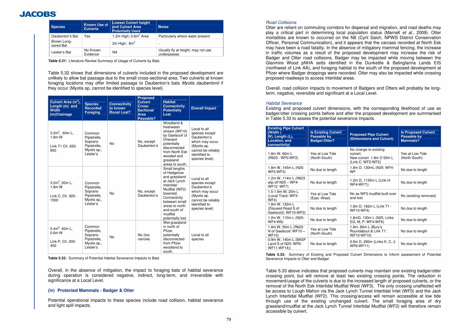
79
Species Known Use of Culverts
Lowest Culvert height and Culvert Area Potentially Used
Notes
Daubenton’s Bat Yes 1.2m High; 0.6m2 Area Particularly where water present Brown Long-eared Bat 2m High; 6m2 -
Leisler’s Bat No Known Evidence NA Usually fly at height, may not use
underpasses
Table 5.31: Literature Review Summary of Usage of Culverts by Bats
Table 5.32 shows that dimensions of culverts included in the proposed development are unlikely to allow bat passage due to the small cross-sectional area. Two culverts at known foraging locations may offer limited passage to Daubenton’s bats Myotis daubentonii if they occur (Myotis sp, cannot be identified to species level).
Culvert Area (m2), Length (m) and Width (m)Chainage
Species Recorded Foraging
Connectivity to known Roost Lost?
Proposed Culvert Cross-Sectional Area Passable?
Habitat Connectivity Potentially Lost
Overall Impact
3.2m2, 60m L, 1.8m W Link T1 Ch. 650-850
Common Pipistrelle, Soprano Pipistrelle, Myotis sp., Leisler’s
No No, except Daubenton’s
Woodland & freshwater stream (WF10) by Gaelscoil Ui Drisceoil potentially disconnected from North Esk wooded and grassland areas to south.
Local to all species except Daubenton’s which may occur (Myotis sp. cannot be reliably identified to species level).
3.2m2, 50m L, 1.8m W Link C, Ch. 920-1500
Common Pipistrelle, Soprano Pipistrelle, Myotis sp., Leisler’s
No No, except Daubenton’s
Small lengths of Hedgerow and grassland at Jack Lynch Intertidal Mudflat (WF2) bisected. Connectivity between small areas to north and south of mudflat potentially lost
Local to all species except Daubenton’s which may occur (Myotis sp. cannot be reliably identified to species level)
0.4m2,, 40m L, 0.6m W Link P, Ch. 200-450
Common Pipistrelle, Soprano Pipistrelle, Myotis sp., Leisler’s
No No (too narrow)
Wet grassland in north of Pfizer potentially disconnected from Pfizer woodland to south.
Local to all species
Table 5.32: Summary of Potential Habitat Severance Impacts to Bats
Overall, in the absence of mitigation, the impact to foraging bats of habitat severance during operation is considered negative, indirect, long-term, and irreversible with significance at a Local Level.
(iv) Protected Mammals - Badger & Otter
Potential operational impacts to these species include road collision, habitat severance and light spill impacts.
Road Collisions Otter are reliant on commuting corridors for dispersal and migration, and road deaths may play a critical part in determining local population status (Marnell et al., 2009). Otter mortalities are known to occurred on the N8 (Cyril Saich, NPWS District Conservation Officer, Personal Communication), and it appears that the carcass recorded at North Esk may have been a road fatality. In the absence of mitigatory mammal fencing, the increase in traffic volumes as a result of the proposed development may increase the risk of Badger and Otter road collisions. Badger may be impacted while moving between the Glanmire Wood pNHA setts identified in the Dunkettle & Balinglanna Lands EIS (northwest of Link AA), and foraging habitat to the south of the proposed development at Pfizer where Badger droppings were recorded. Otter may also be impacted while crossing proposed roadways to access intertidal areas. Overall, road collision impacts to movement of Badgers and Otters will probably be long-term, negative, reversible and significant at a Local Level. Habitat Severance Existing and proposed culvert dimensions, with the corresponding likelihood of use as badger/otter crossing points before and after the proposed development are summarised in Table 5.33 to assess the potential severance impacts.
Existing Pipe Culvert (Width ( W), Length (L), Location, and connectivity(
Is Existing Culvert Passable by Badger/Otter?
Proposed Pipe Culvert (Dimensions and Culvert)
Is Proposed Culvert Passable by Mammals?
1.8m W, 60m L (R623 : WF0-WF2)
Yes at Low Tide (North-South)
No change to existing culvert. New culvert 1.8m D 50m L (Link C: WF2-WF2)
Yes at Low Tide (North-South)
1.8m W, 145m L (N25: WF2-WF3) No due to length 1.8m D, 130mL (N25: WF4-
WF No due to length
1.2m W, 114m L (R623 slip off N25 – WF4-WF12 -WF7)
No due to length 1.2m D, 1135m L (Link H: WF4-WF7)) No due to length
1.5-1.8m W, 20m L (Local Track: WF3-WF4)
Yes at Low Tide (East -West)
No as WF3 mudflat built over and lost No (existing removed)
1.8m W, 132m L (Disused Road S of Gaelscoil): WF10-WF3)
No due to length 1.8m D, 182m L (Link T1 -WF10-WF4) No due to length
1.2m W, 110m L (N25: WF4-W6) No due to length 1.8mD, 130m L (N25, Links
EG, M, P: WF4-WF6) No due to length
1.8m W, 50m L (R623 N of Gaelscoil: WF10 –WF10)
Yes at Low Tide (North-South)
1.8m, 80m L (Bury’s Roundabout & Link T1: WF10-WF10)
No due to length
0.9m W, 140m L (BASF Land S of N25: WF6- WF11-WF14))
No due to length 0.9m D, 280m (Links K, C, J: WF6-WF11) No due to length
Table 5.33: Summary of Existing and Proposed Culvert Dimensions to Inform assessment of Potential Severance Impacts to Otter and Badger
Table 5.33 above indicates that proposed culverts may maintain one existing badger/otter crossing point, but will remove at least two existing crossing points. The reduction in movement/usage of the culverts is due to the increased length of proposed culverts, or the removal of the North Esk Intertidal Mudflat West (WF3). The only crossing unaffected will be access to Lough Mahon via the Jack Lynch Tunnel Intertidal Inlet (WF0) and the Jack Lynch Intertidal Mudflat (WF2). This crossing/access will remain accessible at low tide through use of the existing unchanged culvert. The small foraging area of dry grassland/mudflat at the Jack Lynch Tunnel Intertidal Mudflat (WF2) will therefore remain accessible by culvert.
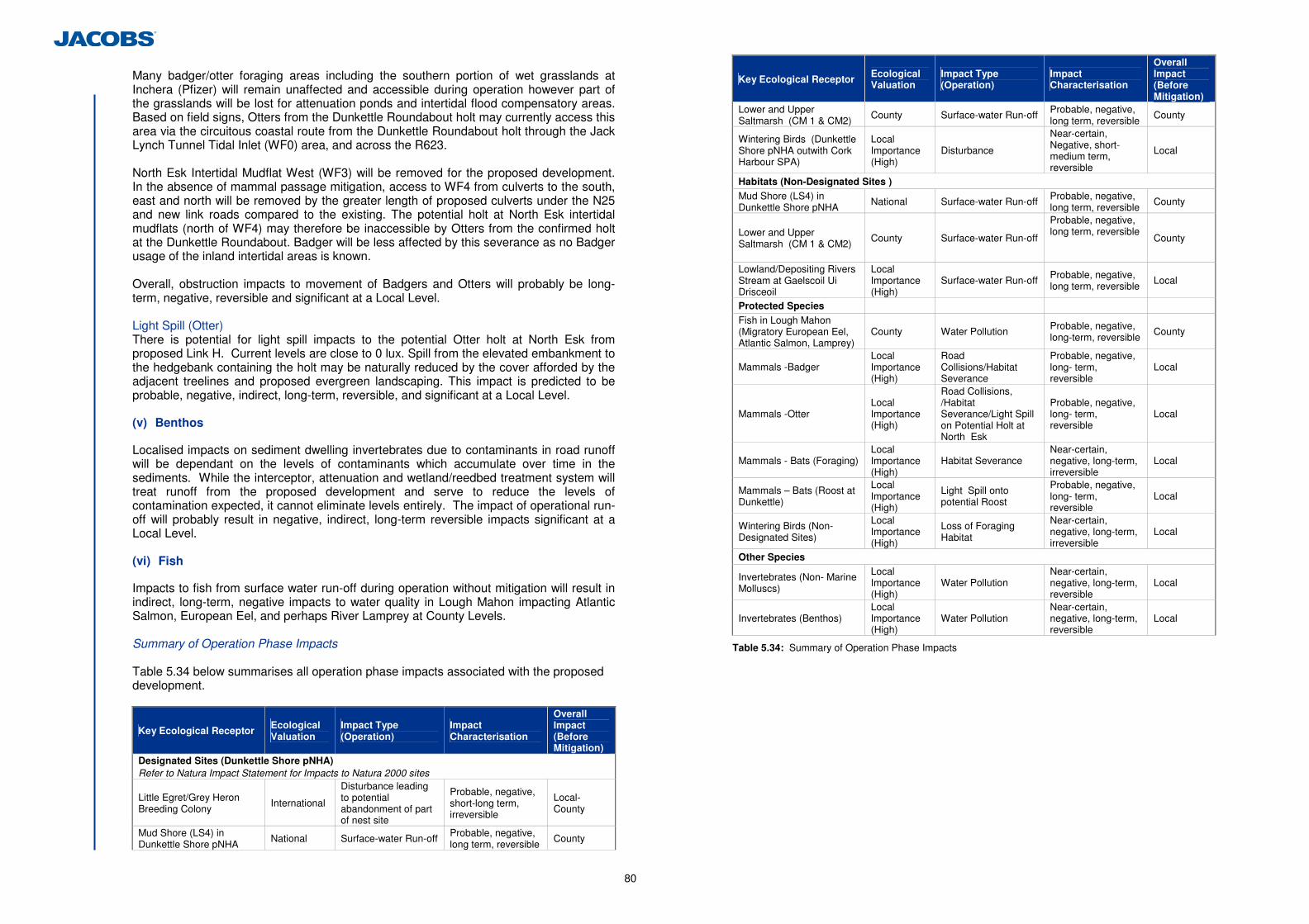
80
Many badger/otter foraging areas including the southern portion of wet grasslands at Inchera (Pfizer) will remain unaffected and accessible during operation however part of the grasslands will be lost for attenuation ponds and intertidal flood compensatory areas. Based on field signs, Otters from the Dunkettle Roundabout holt may currently access this area via the circuitous coastal route from the Dunkettle Roundabout holt through the Jack Lynch Tunnel Tidal Inlet (WF0) area, and across the R623.
North Esk Intertidal Mudflat West (WF3) will be removed for the proposed development. In the absence of mammal passage mitigation, access to WF4 from culverts to the south, east and north will be removed by the greater length of proposed culverts under the N25 and new link roads compared to the existing. The potential holt at North Esk intertidal mudflats (north of WF4) may therefore be inaccessible by Otters from the confirmed holt at the Dunkettle Roundabout. Badger will be less affected by this severance as no Badger usage of the inland intertidal areas is known. Overall, obstruction impacts to movement of Badgers and Otters will probably be long-term, negative, reversible and significant at a Local Level. Light Spill (Otter) There is potential for light spill impacts to the potential Otter holt at North Esk from proposed Link H. Current levels are close to 0 lux. Spill from the elevated embankment to the hedgebank containing the holt may be naturally reduced by the cover afforded by the adjacent treelines and proposed evergreen landscaping. This impact is predicted to be probable, negative, indirect, long-term, reversible, and significant at a Local Level. (v) Benthos
Localised impacts on sediment dwelling invertebrates due to contaminants in road runoff will be dependant on the levels of contaminants which accumulate over time in the sediments. While the interceptor, attenuation and wetland/reedbed treatment system will treat runoff from the proposed development and serve to reduce the levels of contamination expected, it cannot eliminate levels entirely. The impact of operational run-off will probably result in negative, indirect, long-term reversible impacts significant at a Local Level. (vi) Fish
Impacts to fish from surface water run-off during operation without mitigation will result in indirect, long-term, negative impacts to water quality in Lough Mahon impacting Atlantic Salmon, European Eel, and perhaps River Lamprey at County Levels. Summary of Operation Phase Impacts Table 5.34 below summarises all operation phase impacts associated with the proposed development.
Key Ecological Receptor Ecological Valuation
Impact Type (Operation)
Impact Characterisation
Overall Impact (Before Mitigation)
Designated Sites (Dunkettle Shore pNHA) Refer to Natura Impact Statement for Impacts to Natura 2000 sites
Little Egret/Grey Heron Breeding Colony
International
Disturbance leading to potential abandonment of part of nest site
Probable, negative, short-long term, irreversible
Local- County
Mud Shore (LS4) in Dunkettle Shore pNHA
National Surface-water Run-off Probable, negative, long term, reversible
County
Key Ecological Receptor Ecological Valuation
Impact Type (Operation)
Impact Characterisation
Overall Impact (Before Mitigation)
Lower and Upper Saltmarsh (CM 1 & CM2)
County Surface-water Run-off Probable, negative, long term, reversible
County
Wintering Birds (Dunkettle Shore pNHA outwith Cork Harbour SPA)
Local Importance (High)
Disturbance
Near-certain, Negative, short-medium term, reversible
Local
Habitats (Non-Designated Sites )
Mud Shore (LS4) in Dunkettle Shore pNHA
National Surface-water Run-off Probable, negative, long term, reversible
County
Lower and Upper Saltmarsh (CM 1 & CM2)
County Surface-water Run-off
Probable, negative, long term, reversible
County
Lowland/Depositing Rivers Stream at Gaelscoil Ui Drisceoil
Local Importance (High)
Surface-water Run-off Probable, negative, long term, reversible
Local
Protected Species Fish in Lough Mahon (Migratory European Eel, Atlantic Salmon, Lamprey)
County Water Pollution Probable, negative, long-term, reversible
County
Mammals -Badger Local Importance (High)
Road Collisions/Habitat Severance
Probable, negative, long- term, reversible
Local
Mammals -Otter Local Importance (High)
Road Collisions, /Habitat Severance/Light Spill on Potential Holt at North Esk
Probable, negative, long- term, reversible
Local
Mammals - Bats (Foraging) Local Importance (High)
Habitat Severance Near-certain, negative, long-term, irreversible
Local
Mammals – Bats (Roost at Dunkettle)
Local Importance (High)
Light Spill onto potential Roost
Probable, negative, long- term, reversible
Local
Wintering Birds (Non-Designated Sites)
Local Importance (High)
Loss of Foraging Habitat
Near-certain, negative, long-term, irreversible
Local
Other Species
Invertebrates (Non- Marine Molluscs)
Local Importance (High)
Water Pollution Near-certain, negative, long-term, reversible
Local
Invertebrates (Benthos) Local Importance (High)
Water Pollution Near-certain, negative, long-term, reversible
Local
Table 5.34: Summary of Operation Phase Impacts
81
5.6 Proposed Mitigation and Avoidance Measures
5.6.1 Construction- Phase Mitigation
(a) Designated Sites (Cork Harbour SPA)
(i) Screening of Working Area beside WF1 during Construction
Prior to commencement of construction, 3m high solid hoarding will be erected along the southwestern boundary along the length of proposed Link B (Ch. 0-300). The hoarding will remain in place for the duration of construction. No movement of construction staff or vehicles will be permitted south of the hoarding on the existing track that forms the perimeter of WF1.
(ii) Construction Phasing
A construction phasing of the proposed development (in terms of work locations, creation of new storage/intertidal areas, temporary and permanent culverts) will be established to maintain connectivity through the intertidal areas during construction, and requires that compensatory flood areas are created prior to any existing areas being lost.
(iii) Erosion and Sediment/Silt Control Plan
Prior to commencement of construction, the contractor will implement the following measures through a Construction Method Statement (CMS). These measures are based on the following best practice guidelines to ensure that water bodies are adequately protected during construction work: • Construction Industry Research and Information Association CIRIA C648: Control of
water pollution from linear construction projects: Technical guidance (Murnane et al. 2006)
• CIRIA C648: Control of water pollution from linear construction projects: Site guide (Murnane et al. 2006)
• DMRB HD33/06: Surface and sub-surface drainage systems for highways. Design Manual for Roads and Bridges. Volume 4: 2, (2006).
• NRA (2005a). Guidelines for the crossing of watercourses during the construction of National Road Schemes.
• SRFB (2007). Maintenance and Protection of the Inland Fisheries Resource during Road Construction and Improvement Works. Requirements of the Southern Regional Fisheries Board.
The construction contractor will implement the following mitigation measures, via the CMS, for release of sediment/silt control:
• Provision of measures to prevent the release of sediment over baseline conditions45
to Lough Mahon during the construction work. Baseline conditions will be established in accordance with details provided in Section 6.2.9 (a)(i). These measures will include but not be limited to silt fences, silt curtains, settlement lagoons, filter materials, and stockpile seeding;
• Provision of measures to minimise the release of sediment from the newly excavated flood compensation areas to Lough Mahon and the North Esk Intertidal Mudflat (WF4)
45
Baseline suspended sediment levels in Lough Mahon will be established as outlined in Chapter 6
Hydrology, Hydromorphology and Geomorphology.
These measures will include but not be limited to silt fences, silt curtains, settlement lagoons, filter materials, and stockpile seeding;
• Provision of measures to minimise the displacement and subsequent erosion and release of soft sediment, particularly from WF6, WF5, WF7 and WF4. These measures will include but not be limited to silt fences, silt curtains, settlement lagoons, filter materials, and stockpile seeding;
• Provision of measures to handle, store and re-use where feasible material removed from the intertidal mudflats;
• Provision of measures to minimise any run-off into the Jack Lynch Tidal Polder (WF1), by diverting drainage into WF2 instead;
• Provision of exclusion zones and barriers (sediment fences) between earthworks, stockpiles and temporary surfaces and watercourses to prevent sediment washing into the watercourses;
• Excavated sediment/materials from Pfizer Intertidal Mudflat West (WF5) and East (WF6) will be retained and re-used within flood compensation intertidal areas;
• Temporary construction surface drainage and sediment control measures will be in place before earthworks commence;
• Pouring of cementitious materials for the works will be carried out in the dry and allowed to cure for 48 hours before re-flooding. Pumped concrete will be monitored to ensure no accidental discharge. Mixer washings and excess concrete will not be discharged to surface water;
• No storage of hydrocarbons or any polluting chemicals will occur within 50 m of a watercourse. Fuel storage tanks will be bunded to a capacity at least 110% of the volume of the storage tank. Re-fuelling of plant will not occur within 50 m of any watercourse and only in bunded refuelling areas;
• Emergency procedures and spillage kits will be available and construction staff will be familiar with emergency procedures;
• Implementation of measures to minimise waste and ensure correct handling, storage and disposal of waste (most notably wet concrete, pile arisings and asphalt);
• Response measures to potential pollution incidents; • Methods to stabilise watercourse banks that have been cleared of vegetation; • Maintenance of machinery to be used in-stream; • Removal and replacement of stream bed material in diverted watercourses; • Any contaminated land will be managed in accordance with Made Ground
Management/Mitigation Measures in Section 12.5.1. Prior to construction, areas of intertidal areas proposed for removal for the development footprint will be dredged (and stored in sealed and bunded stockpiles until required) prior to use as substrates for the flood compensation areas required for the proposed development.
(iv) Control of Invasive Cord Grass during Construction
Refer to Section 5.6.1 (b) (iii) for control of invasive Cord Grass during construction. (b) Designated Sites (Dunkettle Shore pNHA)
(i) Surface Water Run-off (Dunkettle Shore pNHA)
Refer to Chapter 6 Hydrology, Geomorphology & Hydromorphology, and Chapter 7 Geology, Soils and Hydrogeology for mitigation measures to prevent pollution incidents from surface water run-off, or earthworks during construction. These are not repeated in this chapter of the EIS and readers should refer to those chapters for details.
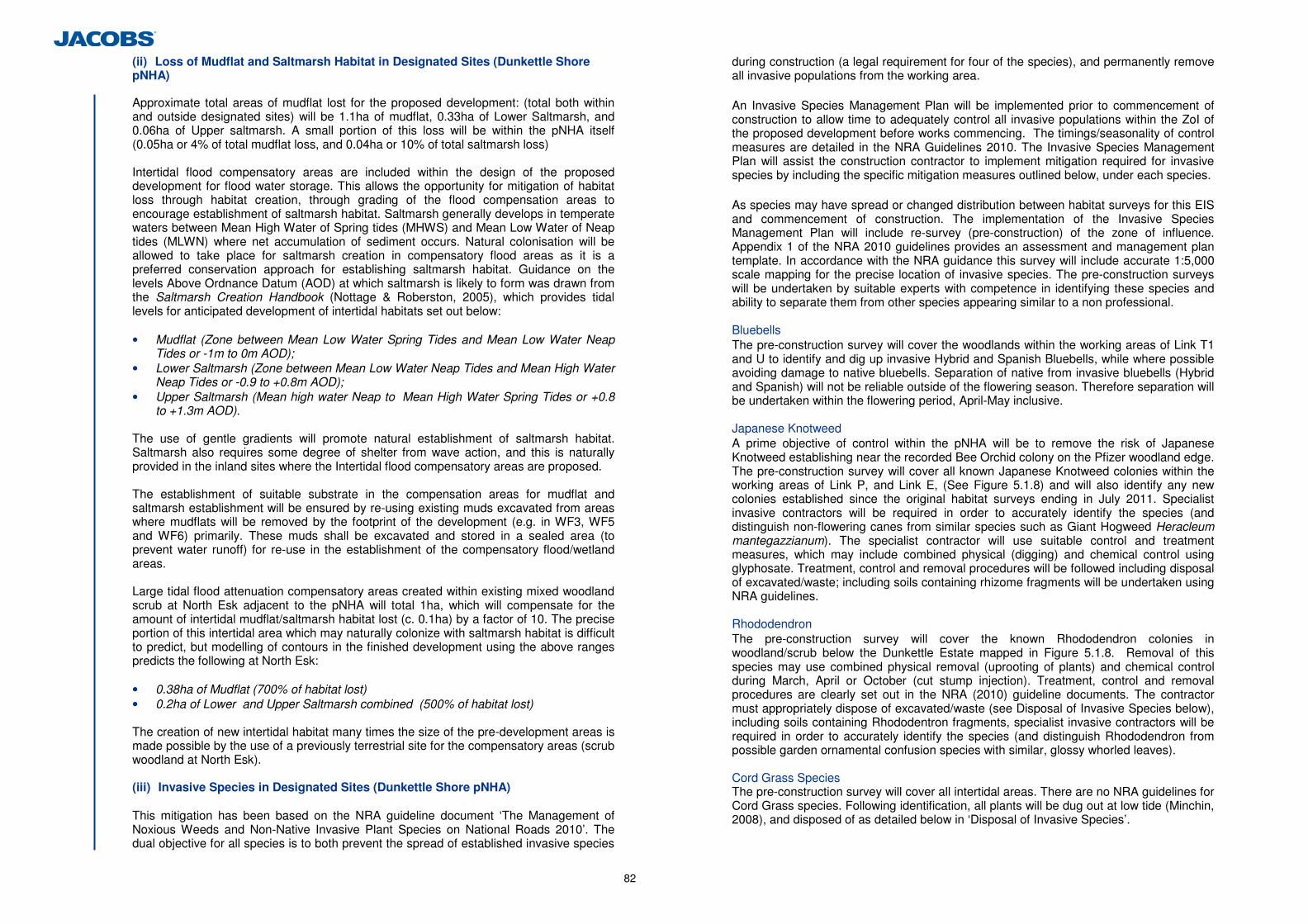
82
(ii) Loss of Mudflat and Saltmarsh Habitat in Designated Sites (Dunkettle Shore pNHA)
Approximate total areas of mudflat lost for the proposed development: (total both within and outside designated sites) will be 1.1ha of mudflat, 0.33ha of Lower Saltmarsh, and 0.06ha of Upper saltmarsh. A small portion of this loss will be within the pNHA itself (0.05ha or 4% of total mudflat loss, and 0.04ha or 10% of total saltmarsh loss) Intertidal flood compensatory areas are included within the design of the proposed development for flood water storage. This allows the opportunity for mitigation of habitat loss through habitat creation, through grading of the flood compensation areas to encourage establishment of saltmarsh habitat. Saltmarsh generally develops in temperate waters between Mean High Water of Spring tides (MHWS) and Mean Low Water of Neap tides (MLWN) where net accumulation of sediment occurs. Natural colonisation will be allowed to take place for saltmarsh creation in compensatory flood areas as it is a preferred conservation approach for establishing saltmarsh habitat. Guidance on the levels Above Ordnance Datum (AOD) at which saltmarsh is likely to form was drawn from the Saltmarsh Creation Handbook (Nottage & Roberston, 2005), which provides tidal levels for anticipated development of intertidal habitats set out below:
• Mudflat (Zone between Mean Low Water Spring Tides and Mean Low Water Neap
Tides or -1m to 0m AOD); • Lower Saltmarsh (Zone between Mean Low Water Neap Tides and Mean High Water
Neap Tides or -0.9 to +0.8m AOD); • Upper Saltmarsh (Mean high water Neap to Mean High Water Spring Tides or +0.8
to +1.3m AOD).
The use of gentle gradients will promote natural establishment of saltmarsh habitat. Saltmarsh also requires some degree of shelter from wave action, and this is naturally provided in the inland sites where the Intertidal flood compensatory areas are proposed.
The establishment of suitable substrate in the compensation areas for mudflat and saltmarsh establishment will be ensured by re-using existing muds excavated from areas where mudflats will be removed by the footprint of the development (e.g. in WF3, WF5 and WF6) primarily. These muds shall be excavated and stored in a sealed area (to prevent water runoff) for re-use in the establishment of the compensatory flood/wetland areas. Large tidal flood attenuation compensatory areas created within existing mixed woodland scrub at North Esk adjacent to the pNHA will total 1ha, which will compensate for the amount of intertidal mudflat/saltmarsh habitat lost (c. 0.1ha) by a factor of 10. The precise portion of this intertidal area which may naturally colonize with saltmarsh habitat is difficult to predict, but modelling of contours in the finished development using the above ranges predicts the following at North Esk: • 0.38ha of Mudflat (700% of habitat lost) • 0.2ha of Lower and Upper Saltmarsh combined (500% of habitat lost) The creation of new intertidal habitat many times the size of the pre-development areas is made possible by the use of a previously terrestrial site for the compensatory areas (scrub woodland at North Esk). (iii) Invasive Species in Designated Sites (Dunkettle Shore pNHA)
This mitigation has been based on the NRA guideline document ‘The Management of Noxious Weeds and Non-Native Invasive Plant Species on National Roads 2010’. The dual objective for all species is to both prevent the spread of established invasive species
during construction (a legal requirement for four of the species), and permanently remove all invasive populations from the working area. An Invasive Species Management Plan will be implemented prior to commencement of construction to allow time to adequately control all invasive populations within the ZoI of the proposed development before works commencing. The timings/seasonality of control measures are detailed in the NRA Guidelines 2010. The Invasive Species Management Plan will assist the construction contractor to implement mitigation required for invasive species by including the specific mitigation measures outlined below, under each species.
As species may have spread or changed distribution between habitat surveys for this EIS and commencement of construction. The implementation of the Invasive Species Management Plan will include re-survey (pre-construction) of the zone of influence. Appendix 1 of the NRA 2010 guidelines provides an assessment and management plan template. In accordance with the NRA guidance this survey will include accurate 1:5,000 scale mapping for the precise location of invasive species. The pre-construction surveys will be undertaken by suitable experts with competence in identifying these species and ability to separate them from other species appearing similar to a non professional.
Bluebells
The pre-construction survey will cover the woodlands within the working areas of Link T1 and U to identify and dig up invasive Hybrid and Spanish Bluebells, while where possible avoiding damage to native bluebells. Separation of native from invasive bluebells (Hybrid and Spanish) will not be reliable outside of the flowering season. Therefore separation will be undertaken within the flowering period, April-May inclusive.
Japanese Knotweed
A prime objective of control within the pNHA will be to remove the risk of Japanese Knotweed establishing near the recorded Bee Orchid colony on the Pfizer woodland edge. The pre-construction survey will cover all known Japanese Knotweed colonies within the working areas of Link P, and Link E, (See Figure 5.1.8) and will also identify any new colonies established since the original habitat surveys ending in July 2011. Specialist invasive contractors will be required in order to accurately identify the species (and distinguish non-flowering canes from similar species such as Giant Hogweed Heracleum mantegazzianum). The specialist contractor will use suitable control and treatment measures, which may include combined physical (digging) and chemical control using glyphosate. Treatment, control and removal procedures will be followed including disposal of excavated/waste; including soils containing rhizome fragments will be undertaken using NRA guidelines.
Rhododendron
The pre-construction survey will cover the known Rhododendron colonies in woodland/scrub below the Dunkettle Estate mapped in Figure 5.1.8. Removal of this species may use combined physical removal (uprooting of plants) and chemical control during March, April or October (cut stump injection). Treatment, control and removal procedures are clearly set out in the NRA (2010) guideline documents. The contractor must appropriately dispose of excavated/waste (see Disposal of Invasive Species below), including soils containing Rhododentron fragments, specialist invasive contractors will be required in order to accurately identify the species (and distinguish Rhododendron from possible garden ornamental confusion species with similar, glossy whorled leaves).
Cord Grass Species
The pre-construction survey will cover all intertidal areas. There are no NRA guidelines for Cord Grass species. Following identification, all plants will be dug out at low tide (Minchin, 2008), and disposed of as detailed below in ‘Disposal of Invasive Species’.
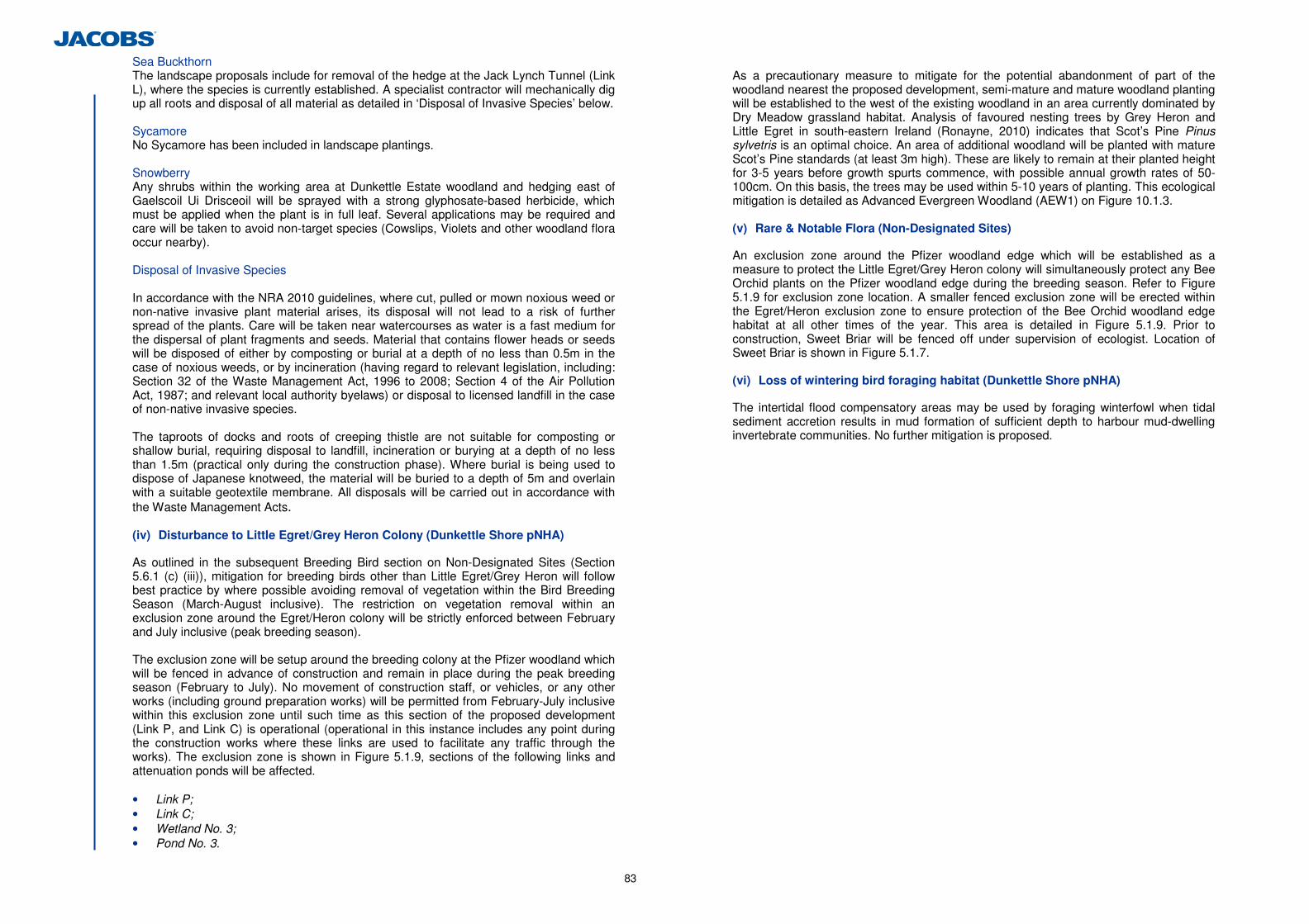
83
Sea Buckthorn The landscape proposals include for removal of the hedge at the Jack Lynch Tunnel (Link L), where the species is currently established. A specialist contractor will mechanically dig up all roots and disposal of all material as detailed in ‘Disposal of Invasive Species’ below.
Sycamore No Sycamore has been included in landscape plantings. Snowberry
Any shrubs within the working area at Dunkettle Estate woodland and hedging east of Gaelscoil Ui Drisceoil will be sprayed with a strong glyphosate-based herbicide, which must be applied when the plant is in full leaf. Several applications may be required and care will be taken to avoid non-target species (Cowslips, Violets and other woodland flora occur nearby).
Disposal of Invasive Species
In accordance with the NRA 2010 guidelines, where cut, pulled or mown noxious weed or non-native invasive plant material arises, its disposal will not lead to a risk of further spread of the plants. Care will be taken near watercourses as water is a fast medium for the dispersal of plant fragments and seeds. Material that contains flower heads or seeds will be disposed of either by composting or burial at a depth of no less than 0.5m in the case of noxious weeds, or by incineration (having regard to relevant legislation, including: Section 32 of the Waste Management Act, 1996 to 2008; Section 4 of the Air Pollution Act, 1987; and relevant local authority byelaws) or disposal to licensed landfill in the case of non-native invasive species.
The taproots of docks and roots of creeping thistle are not suitable for composting or shallow burial, requiring disposal to landfill, incineration or burying at a depth of no less than 1.5m (practical only during the construction phase). Where burial is being used to dispose of Japanese knotweed, the material will be buried to a depth of 5m and overlain with a suitable geotextile membrane. All disposals will be carried out in accordance with the Waste Management Acts. (iv) Disturbance to Little Egret/Grey Heron Colony (Dunkettle Shore pNHA)
As outlined in the subsequent Breeding Bird section on Non-Designated Sites (Section 5.6.1 (c) (iii)), mitigation for breeding birds other than Little Egret/Grey Heron will follow best practice by where possible avoiding removal of vegetation within the Bird Breeding Season (March-August inclusive). The restriction on vegetation removal within an exclusion zone around the Egret/Heron colony will be strictly enforced between February and July inclusive (peak breeding season). The exclusion zone will be setup around the breeding colony at the Pfizer woodland which will be fenced in advance of construction and remain in place during the peak breeding season (February to July). No movement of construction staff, or vehicles, or any other works (including ground preparation works) will be permitted from February-July inclusive within this exclusion zone until such time as this section of the proposed development (Link P, and Link C) is operational (operational in this instance includes any point during the construction works where these links are used to facilitate any traffic through the works). The exclusion zone is shown in Figure 5.1.9, sections of the following links and attenuation ponds will be affected. • Link P; • Link C; • Wetland No. 3; • Pond No. 3.
As a precautionary measure to mitigate for the potential abandonment of part of the woodland nearest the proposed development, semi-mature and mature woodland planting will be established to the west of the existing woodland in an area currently dominated by Dry Meadow grassland habitat. Analysis of favoured nesting trees by Grey Heron and Little Egret in south-eastern Ireland (Ronayne, 2010) indicates that Scot’s Pine Pinus sylvetris is an optimal choice. An area of additional woodland will be planted with mature Scot’s Pine standards (at least 3m high). These are likely to remain at their planted height for 3-5 years before growth spurts commence, with possible annual growth rates of 50-100cm. On this basis, the trees may be used within 5-10 years of planting. This ecological mitigation is detailed as Advanced Evergreen Woodland (AEW1) on Figure 10.1.3.
(v) Rare & Notable Flora (Non-Designated Sites)
An exclusion zone around the Pfizer woodland edge which will be established as a measure to protect the Little Egret/Grey Heron colony will simultaneously protect any Bee Orchid plants on the Pfizer woodland edge during the breeding season. Refer to Figure 5.1.9 for exclusion zone location. A smaller fenced exclusion zone will be erected within the Egret/Heron exclusion zone to ensure protection of the Bee Orchid woodland edge habitat at all other times of the year. This area is detailed in Figure 5.1.9. Prior to construction, Sweet Briar will be fenced off under supervision of ecologist. Location of Sweet Briar is shown in Figure 5.1.7. (vi) Loss of wintering bird foraging habitat (Dunkettle Shore pNHA)
The intertidal flood compensatory areas may be used by foraging winterfowl when tidal sediment accretion results in mud formation of sufficient depth to harbour mud-dwelling invertebrate communities. No further mitigation is proposed.
84
(c) Non Designated Sites
(i) Habitat Loss (Non-Designated Sites)
Mudflat and Saltmarsh habitat loss (Non-Designated Sites) Similarly to the mitigation described for loss of these habitats from the pNHA designated sites, loss of mudflat, lower saltmarsh and upper saltmarsh outside the pNHA will be compensated for by the grading of integrated design features – Intertidal Flood attenuation areas. These may in time develop the mud substrates and invertebrate communities characteristic of the habitat. Grassland, scrub and mixed woodland habitats will be cleared and flooded to create these new intertidal habitats. Saltmarsh establishment on the margins of the flood attenuation areas will be encouraged by establishing the gradients and tidal levels set out in the literature that are generally likely to result in plant colonization (see construction phase mitigation for Designated Sites). As previously noted, the areas of saltmarsh likely to form is difficult to predict, however modelling of finished contours predicts that the loss of 1.05ha of mudflat, 0.28ha of Lower Saltmarsh, and 0.11ha of Upper Saltmarsh will be compensated for by creation of: • 0.77ha of Mudflat (73% of habitat lost); • 0.62ha of Lower Saltmarsh ( 221% of habitat lost); • 0.14ha of Upper Saltmarsh (127% of habitat lost). Grassland Habitat Loss (Non-Designated Sites) Dry Meadows (GS1), Dry Neutral and Calcareous (GS2), and Wet Grassland (GS4) will all be lost as a result of the proposed development, therefore species-rich native seed mixes will be incorporated into roadside verge landscaping to mitigate loss of these habitats (as illustrated in Figure 10.1.3 Landscaping Mitigation). All mixes will be Irish wild-sourced. The Biodiversity Wildflower Meadow Mixture (WF03) will be the primary mix used. However grassed areas beside the Jack Lynch Tunnel Intertidal Mudflat (Link C) will use the Wild Flora for Dry Limy Soil mixture (MM09). A nutrient-poor soil will be required for the MM09 seed mixture, and will be sourced from turves from the Jack Lynch Tunnel Roundabout Grassland. Losses of wet grassland will be partially mitigated by use of the Wetland Wild Flora mixture (EC05) on the banks of all proposed attenuation pond and constructed wetland features. All species mixes are detailed in Appendix 5.12. Woodland/Hedgerow Habitat Loss (Non-Designated Sites) Woodland landscaping along roadsides of the proposed development will include only native species. None of the species on the Invasive Species Ireland National Invasive Species database will be included (see Appendix 5.13). Cherry Laurel and Sycamore are commonly planted but are invasive species on the ISI database and will be excluded from all landscaping.
Culverting of Freshwater Stream (WF10) Instream works will be undertaken in accordance with the NRA guidelines for crossing of watercourses during construction of the proposed development in relation to culvert design and installation suitable for fish passage, namely:
• Culvert slope (and hence flow levels through culvert); • Level of the culvert bottom (invert) below the level of the natural stream bed; • Design of pools at entrance and exit to culvert for fish passage; and • Maintenance of minimum water level within culvert.
WF10 contains some potential for lamprey nurseries in mud substrates. Prior to undertaking culverting works, a qualified ecologist will monitor disturbed areas of the bank during culverting, collect any displaced lampreys to a fresh water bucket (King et al., 2008), and return these to the nearest section of water upstream of the works. Habitat Loss of Drainage Ditch (WF15) Re-alignment of the BASF drainage ditch (WF15) westwards will be undertaken in accordance with the NRA guidelines for crossing of watercourses during construction of the proposed development and existing brackish plant communities within this feature will be retained. The feature will be revegetated using the EC05 Wetland seed mix previously described for Wet Grassland Habitat Loss mitigation in this section.
(ii) Invasive Species (Non-Designated Sites)
Invasive Species Management Plans will be undertaken for the Dunkettle pNHA. These plans will include the assessment and control of invasive plant populations in all habitats within the ZoI, including Non-Designated Sites (see Section 5.6.1 (a) (ii)).
(iii) Birds (Non-Designated Sites)
Wintering Birds (Non-Designated Sites) Intertidal flood compensation areas are mitigated by design, however as they will be created using existing muds in the Pfizer Intertidal Mudflats East and West (WF5 and WF6) and Iarnrod Eireann Intertidal Mudflat Small (WF7) as previously described, this will offset loss of wintering bird foraging habitat in future years of operation, if mud substrates and mud-dwelling invertebrate communities establish. Breeding Birds (Non-Designated Sites) Vegetation (e.g. hedgerows, woodland, trees, scrub and grassland) will not be removed where practicable between March and August inclusive, to avoid impacts on nesting birds and breeding small mammals. Although the Wildlife Acts provide an exemption from this seasonal restriction for road construction, there is no exemption provided for the nest destruction. Where the construction programme does not allow this seasonal restriction to be observed, then these areas will be inspected by a suitably qualified ecologist for the presence of breeding birds prior to clearance. Where nests are found, the appointed ecologist will need to make a recommendation as to whether a licence is required for vegetation removal. Areas found not to contain nests must be cleared within 3 days of the survey, or further surveys will be required.
Planting of woodland, hedgerow and grassland habitats along the proposed development as detailed in 10.1.3 Landscaping Proposals will provide compensatory habitat for some bird species, but many species may not nest within the vicinity of a large road due to drowning out of bird song by traffic noise. A total of 20 nest boxes will be erected by an ecologist in suitable locations away from the busy junctions/roadways in the locations indicated in Figure 5.1.9. Boxes will be erected on tree trunks at heights above 2.5m, facing in a north to easterly direction away from the prevailing southwesterly wind. 10 no. open-fronted boxes, and 10 no. hole nest boxes will be used to accommodate a wider range of bird species. Open-fronted boxes will be erected under deep cover of ivy or scrub. Hole nest boxes may be erected in more open situations.
(iv) Protected Mammals - Bats
There are no confirmed bat roosts within the footprint of the proposed development. There will be no significant direct or indirect impacts to the three bat roosts in the Dunkettle
85
Estate during construction therefore no mitigation is required. These roosts are respectively located 40m (BR1), 140m (BR2), and 300m (BR3) from the proposed development. (v) Protected Mammals - Badger & Otter
General Guidelines Badger and otter mitigation measures implemented will comply with the following national, and UK guidelines: • Guidelines for the Treatment of Badgers Prior to the Construction of National Road
Schemes (National Roads Authority, 2009) – contains specification for mammal ledges which will be applied to the dry underpasses used to accommodate badgers and otters;
• Guidelines for the Treatment of Otters Prior to the Construction of National Road Schemes (National Roads Authority, 2009); and
• Design Manual for Roads and Bridges: Nature Conservation Advice in Relation to Otters (Highways Agency, 1999).
Disturbance to Potential Otter Holt There is a potential Otter holt at North Esk within 40m of proposed Link H (Chainage 330). In order to prevent disturbance or potential injury to Otters during construction, the holt will be temporarily excluded under License from the NPWS. Otter is listed on Annex IV of the EU Habitats Directive. Therefore, in accordance with NPWS Guidance on compliance with protection of Annex IV species (NPWS Circular 2/07), a derogation licence application has been included with this EIS (Appendix 5.14) and was submitted to the NPWS in July 2012.
(vi) Protected Mammals - Pigmy Shrew & Hedgehog
Implementation of mitigation for breeding birds will avoid vegetation removal during March-August inclusive where practicable. This existing mitigation will simultaneously avoid the majority of the main breeding season for both Pigmy Shrew and Hedgehog species which run from April-October (Hayden & Harrington, 2001). Four hedgehog nest boxes46 will also be installed in woodland and scrub areas at Dunkettle North Esk, and Pfizer as illustrated in Figure 5.1.9. Boxes will be placed in deep scrub or wooded areas away from obvious paths of disturbance by humans or dogs. (vii) Invertebrates (Water Beetles)
During construction, a number of shallow pools (2m wide and 0.5m deep) will be created outside the working areas, but in the vicinity of WF7 to act as refuges for Octhebius marinus during the works. These shallow pools will be kept wet throughout construction and topped up with brackish water as required. (viii) Invertebrates (Benthos & Mysids)
Newly developed intertidal areas, in areas of flood compensation will become colonised by all the characteristic soft sediment infaunal invertebrates recorded during the field survey provided the substrate which develops is comparable to that which currently exists in the various intertidal areas within the development, i.e. predominantly mud and sandy mud.
46 Available from http://www.nestbox.co.uk/Hedgehog-Nest-Box.html.
(ix) Fish
Mudflat habitat and associated channels within mudflats directly affected by road construction will be lost. Although the resident fish communities are valued as low value, the creation of intertidal flood compensation areas as an integrated design feature will be beneficial to maintaining these existing communities.
Designated work areas will be identified and cordoned off prior to construction to limit disturbance to mudflats. Adjacent areas will be disturbed as little as possible to reduce the impact of the remaining mudflats. The contractor must have regard to the NRA Guidelines: ‘Guidelines for the Crossing of Watercourses during the Construction of National Road Schemes’ in relation to culvert design and installation suitable for fish passage, namely;
• Culvert slope (and hence flow levels through culvert); • Level of the culvert bottom (invert) below the level of the natural stream bed; • Design of pools at entrance and exit to culvert for fish passage; and • Maintenance of minimum water level within culvert. The proposed works are not located within a river corridor used by migratory fish such as Atlantic Salmon, lampreys or European Eel. To this end, there is no mitigation required with regard to the timing of the works.
(d) Summary of Construction Phase Mitigation
Key Ecological Receptor
Ecological Valuation
Construction Impact Type
Overall Impact Significance
Construction Phase Mitigation Measure
Designated Sites (Dunkettle Shore pNHA) Refer to Natura Impact Statement for Mitigation for Natura 2000 sites
Disturbance during Operation including abandonment of treetops nearest the road
County
No works within exclusion zone from nest site during February-July inclusive (see Figure 5.1.9). Compensatory planting of Scots Pine (3-5m) on northern and western woodland edge (see Landscape Drawing Figure 10.1.3.)
Little Egret/Grey Heron Colony (Dunkettle Shoreline pNHA)
International
Light spill Local-County Louvres fitted to luminaires on Link P to reduce light spill. This will be tested to ensure light levels close to existing levels.
Water Quality of Intertidal Mudflat and Saltmarsh (Dunkettle Shoreline pNHA)
National Surface Water Run-off County
Pollution Prevention Measures have been provided in Chapter 6 Hydrology, Geomorphology & Hydromorphology, and Chapter 7 Geology, Soils and Hydrogeology. All these measure present will be included in the EOP for the proposed development.
Mud Shores (LS4) (Dunkettle Shoreline pNHA)
National Habitat Loss Local
The intertidal flood compensatory areas themselves are integrated design features of the proposed development. However, grading of these areas and sheltered condition as set out in Literature (Nottage & Robertson, 2005) and use of mud substrate taken from removal of Intertidal areas will allow colonisation by natural succession.
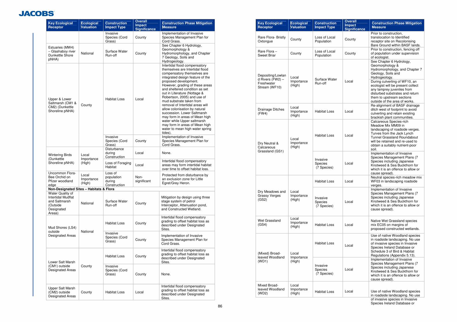
86
Key Ecological Receptor
Ecological Valuation
Construction Impact Type
Overall Impact Significance
Construction Phase Mitigation Measure
Invasive Species (Cord Grass)
County Implementation of Invasive Species Management Plan for Cord Grass.
Estuaries (MW4) – Glashaboy river Dunkettle Shore pNHA)
National Surface Water Run-off County
See Chapter 6 Hydrology, Geomorphology & Hydromorphology, and Chapter 7 Geology, Soils and Hydrogeology.
Habitat Loss Local
Intertidal flood compensatory themselves are Intertidal flood compensatory themselves are integrated design feature of the proposed development. However, grading of these areas and sheltered condition as set out in Literature (Nottage & Robertson, 2005) and use of mud substrate taken from removal of Intertidal areas will allow colonisation by natural succession. Lower Saltmarsh may form in areas of Mean high water while Upper saltmarsh may form in areas of Mean high water to mean high water spring tides).
Upper & Lower Saltmarsh (CM1 & CM2) (Dunkettle Shoreline pNHA)
County
Invasive Species (Cord Grass)
County Implementation of Invasive Species Management Plan for Cord Grass.
Disturbance during Construction
Local None. Wintering Birds (Dunkettle Shoreline pNHA)
Local Importance (High) Loss of Foraging
Habitat Local Intertidal flood compensatory areas may form intertidal habitat over time to offset habitat loss.
Uncommon Flora- Bee Orchid on Pfizer woodland edge
Local Importance (High)
Loss of population during Construction
Non-significant
Protected from disturbance by an exclusion zone for Little Egret/Grey Heron.
Non-Designated Sites – Habitats & Flora Water Quality of Intertidal Mudflat and Saltmarsh (Outside Designated Areas)
National Surface Water Run-off County
Mitigation by design using three stage system of petrol Interceptor, Attenuation pond, and Constructed Wetland.
Habitat Loss County Intertidal flood compensatory grading to offset habitat loss as described under Designated Sites. Mud Shores (LS4)
outside Designated Areas
National Invasive Species (Cord Grass)
County Implementation of Invasive Species Management Plan for Cord Grass.
Habitat Loss County Intertidal flood compensatory grading to offset habitat loss as described under Designated Sites. Lower Salt Marsh
(CM1) outside Designated Areas
County Invasive Species (Cord Grass)
County None.
Upper Salt Marsh (CM2) outside Designated Areas
County Habitat Loss Local Intertidal flood compensatory grading to offset habitat loss as described under Designated Sites.
Key Ecological Receptor
Ecological Valuation
Construction Impact Type
Overall Impact Significance
Construction Phase Mitigation Measure
Rare Flora- Bristly Oxtongue County Loss of Local
Population County Prior to construction, translocation to Identified receptor site on Recolonising Bare Ground within BASF lands.
Rare Flora – Sweet Briar County Loss of Local
Population County Prior to construction, fencing off of population under supervision of ecologist. See Chapter 6 Hydrology, Geomorphology & Hydromorphology, and Chapter 7 Geology, Soils and Hydrogeology. Depositing/Lowlan
d Rivers (FW2) – Freshwater Stream (WF10)
Local Importance (High)
Surface Water Run-off Local During culverting of WF10, an
ecologist will be present collect any lamprey juveniles from disturbed substrates and return them to upstream sections outside of the area of works.
Drainage Ditches (FW4)
Local Importance (High)
Habitat Loss Local Re-alignment of BASF drainage ditch west of footprint to avoid culverting and retain existing brackish plant communities.
Habitat Loss Local
Calcareous Species-rich Meadow Mix MM09 in landscaping of roadside verges. Turves from the Jack Lynch Tunnel Grassland Roundabout will be retained and re-used to obtain a suitably nutrient-poor soil.
Dry Neutral & Calcareous Grassland (GS1)
Local Importance (High)
Invasive Species (7 Species)
Local
Implementation of Invasive Species Management Plans (7 Species including Japanese Knotweed & Sea Buckthorn for which it is an offence to allow or cause spread).
Habitat Loss Local Neutral species-rich meadow mix WF03 in landscaping roadside verges.
Dry Meadows and Grassy Verges (GS2)
Local Importance (High) Invasive
Species (7 Species)
Local
Implementation of Invasive Species Management Plans (7 Species including Japanese Knotweed & Sea Buckthorn for which it is an offence to allow or cause spread).
Wet Grassland (GS4)
Local Importance (High)
Habitat Loss Local Native Wet Grassland species mix EC05 on margins of proposed constructed wetlands.
Habitat Loss Local
Use of native Woodland species in roadside landscaping. No use of invasive species in Invasive Species Ireland Database or Schedule 3 of Bird & Habitat Regulations (Appendix 5.13). (Mixed) Broad-
leaved Woodland (WD1)
Local Importance (High)
Invasive Species (7 Species)
Local
Implementation of Invasive Species Management Plans (7 Species including Japanese Knotweed & Sea Buckthorn for which it is an offence to allow or cause spread).
Mixed Broad-leaved Woodland (WD2)
Local Importance (High) Habitat Loss
Local Use of native Woodland species
in roadside landscaping. No use of invasive species in Invasive Species Ireland Database or
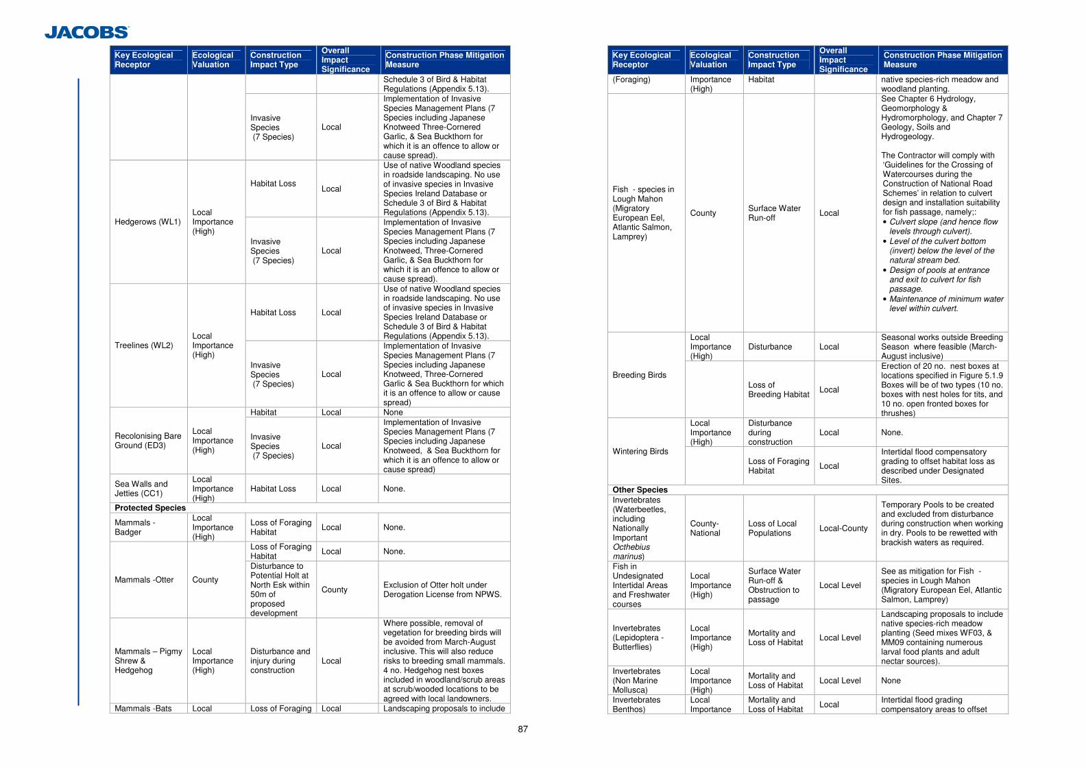
87
Key Ecological Receptor
Ecological Valuation
Construction Impact Type
Overall Impact Significance
Construction Phase Mitigation Measure
Schedule 3 of Bird & Habitat Regulations (Appendix 5.13).
Invasive Species (7 Species)
Local
Implementation of Invasive Species Management Plans (7 Species including Japanese Knotweed Three-Cornered Garlic, & Sea Buckthorn for which it is an offence to allow or cause spread).
Habitat Loss Local
Use of native Woodland species in roadside landscaping. No use of invasive species in Invasive Species Ireland Database or Schedule 3 of Bird & Habitat Regulations (Appendix 5.13).
Hedgerows (WL1) Local Importance (High)
Invasive Species (7 Species)
Local
Implementation of Invasive Species Management Plans (7 Species including Japanese Knotweed, Three-Cornered Garlic, & Sea Buckthorn for which it is an offence to allow or cause spread).
Habitat Loss Local
Use of native Woodland species in roadside landscaping. No use of invasive species in Invasive Species Ireland Database or Schedule 3 of Bird & Habitat Regulations (Appendix 5.13).
Treelines (WL2) Local Importance (High)
Invasive Species (7 Species)
Local
Implementation of Invasive Species Management Plans (7 Species including Japanese Knotweed, Three-Cornered Garlic & Sea Buckthorn for which it is an offence to allow or cause spread)
Habitat Local None
Recolonising Bare Ground (ED3)
Local Importance (High)
Invasive Species (7 Species)
Local
Implementation of Invasive Species Management Plans (7 Species including Japanese Knotweed, & Sea Buckthorn for which it is an offence to allow or cause spread)
Sea Walls and Jetties (CC1)
Local Importance (High)
Habitat Loss Local None.
Protected Species
Mammals - Badger
Local Importance (High)
Loss of Foraging Habitat Local None.
Loss of Foraging Habitat Local None.
Mammals -Otter County Disturbance to Potential Holt at North Esk within 50m of proposed development
County Exclusion of Otter holt under Derogation License from NPWS.
Mammals – Pigmy Shrew & Hedgehog
Local Importance (High)
Disturbance and injury during construction
Local
Where possible, removal of vegetation for breeding birds will be avoided from March-August inclusive. This will also reduce risks to breeding small mammals. 4 no. Hedgehog nest boxes included in woodland/scrub areas at scrub/wooded locations to be agreed with local landowners.
Mammals -Bats Local Loss of Foraging Local Landscaping proposals to include
Key Ecological Receptor
Ecological Valuation
Construction Impact Type
Overall Impact Significance
Construction Phase Mitigation Measure
(Foraging) Importance (High)
Habitat native species-rich meadow and woodland planting.
Fish - species in Lough Mahon (Migratory European Eel, Atlantic Salmon, Lamprey)
County Surface Water Run-off Local
See Chapter 6 Hydrology, Geomorphology & Hydromorphology, and Chapter 7 Geology, Soils and Hydrogeology. The Contractor will comply with ‘Guidelines for the Crossing of Watercourses during the Construction of National Road Schemes’ in relation to culvert design and installation suitability for fish passage, namely;: • Culvert slope (and hence flow
levels through culvert). • Level of the culvert bottom
(invert) below the level of the natural stream bed.
• Design of pools at entrance and exit to culvert for fish passage.
• Maintenance of minimum water level within culvert.
Local Importance (High)
Disturbance Local Seasonal works outside Breeding Season where feasible (March-August inclusive)
Breeding Birds
Loss of Breeding Habitat Local
Erection of 20 no. nest boxes at locations specified in Figure 5.1.9 Boxes will be of two types (10 no. boxes with nest holes for tits, and 10 no. open fronted boxes for thrushes)
Local Importance (High)
Disturbance during construction
Local None.
Wintering Birds
Loss of Foraging Habitat Local
Intertidal flood compensatory grading to offset habitat loss as described under Designated Sites.
Other Species Invertebrates (Waterbeetles, including Nationally Important Octhebius marinus)
County-National
Loss of Local Populations Local-County
Temporary Pools to be created and excluded from disturbance during construction when working in dry. Pools to be rewetted with brackish waters as required.
Fish in Undesignated Intertidal Areas and Freshwater courses
Local Importance (High)
Surface Water Run-off & Obstruction to passage
Local Level See as mitigation for Fish - species in Lough Mahon (Migratory European Eel, Atlantic Salmon, Lamprey)
Invertebrates (Lepidoptera - Butterflies)
Local Importance (High)
Mortality and Loss of Habitat Local Level
Landscaping proposals to include native species-rich meadow planting (Seed mixes WF03, & MM09 containing numerous larval food plants and adult nectar sources).
Invertebrates (Non Marine Mollusca)
Local Importance (High)
Mortality and Loss of Habitat Local Level None
Invertebrates Benthos)
Local Importance
Mortality and Loss of Habitat Local Intertidal flood grading
compensatory areas to offset
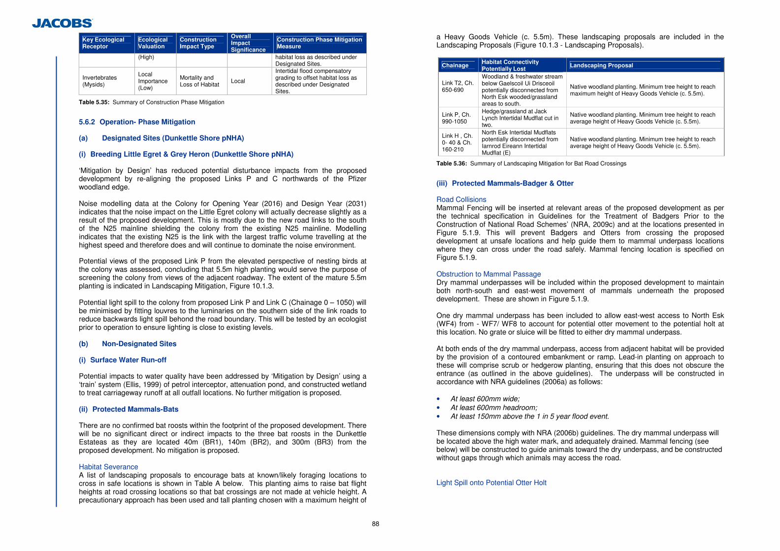
88
Key Ecological Receptor
Ecological Valuation
Construction Impact Type
Overall Impact Significance
Construction Phase Mitigation Measure
(High) habitat loss as described under Designated Sites.
Invertebrates (Mysids)
Local Importance (Low)
Mortality and Loss of Habitat Local
Intertidal flood compensatory grading to offset habitat loss as described under Designated Sites.
Table 5.35: Summary of Construction Phase Mitigation
5.6.2 Operation- Phase Mitigation
(a) Designated Sites (Dunkettle Shore pNHA)
(i) Breeding Little Egret & Grey Heron (Dunkettle Shore pNHA)
‘Mitigation by Design’ has reduced potential disturbance impacts from the proposed development by re-aligning the proposed Links P and C northwards of the Pfizer woodland edge. Noise modelling data at the Colony for Opening Year (2016) and Design Year (2031) indicates that the noise impact on the Little Egret colony will actually decrease slightly as a result of the proposed development. This is mostly due to the new road links to the south of the N25 mainline shielding the colony from the existing N25 mainline. Modelling indicates that the existing N25 is the link with the largest traffic volume travelling at the highest speed and therefore does and will continue to dominate the noise environment. Potential views of the proposed Link P from the elevated perspective of nesting birds at the colony was assessed, concluding that 5.5m high planting would serve the purpose of screening the colony from views of the adjacent roadway. The extent of the mature 5.5m planting is indicated in Landscaping Mitigation, Figure 10.1.3. Potential light spill to the colony from proposed Link P and Link C (Chainage 0 – 1050) will be minimised by fitting louvres to the luminaries on the southern side of the link roads to reduce backwards light spill behond the road boundary. This will be tested by an ecologist prior to operation to ensure lighting is close to existing levels. (b) Non-Designated Sites
(i) Surface Water Run-off
Potential impacts to water quality have been addressed by ‘Mitigation by Design’ using a ‘train’ system (Ellis, 1999) of petrol interceptor, attenuation pond, and constructed wetland to treat carriageway runoff at all outfall locations. No further mitigation is proposed. (ii) Protected Mammals-Bats
There are no confirmed bat roosts within the footprint of the proposed development. There will be no significant direct or indirect impacts to the three bat roosts in the Dunkettle Estateas as they are located 40m (BR1), 140m (BR2), and 300m (BR3) from the proposed development. No mitigation is proposed. Habitat Severance A list of landscaping proposals to encourage bats at known/likely foraging locations to cross in safe locations is shown in Table A below. This planting aims to raise bat flight heights at road crossing locations so that bat crossings are not made at vehicle height. A precautionary approach has been used and tall planting chosen with a maximum height of
a Heavy Goods Vehicle (c. 5.5m). These landscaping proposals are included in the Landscaping Proposals (Figure 10.1.3 - Landscaping Proposals).
Chainage Habitat Connectivity Potentially Lost
Landscaping Proposal
Link T2, Ch. 650-690
Woodland & freshwater stream below Gaelscoil Ui Drisceoil potentially disconnected from North Esk wooded/grassland areas to south.
Native woodland planting. Minimum tree height to reach maximum height of Heavy Goods Vehicle (c. 5.5m).
Link P, Ch. 990-1050
Hedge/grassland at Jack Lynch Intertidal Mudflat cut in two.
Native woodland planting. Minimum tree height to reach average height of Heavy Goods Vehicle (c. 5.5m).
Link H , Ch. 0- 40 & Ch. 160-210
North Esk Intertidal Mudflats potentially disconnected from Iarnrod Eireann Intertidal Mudflat (E)
Native woodland planting. Minimum tree height to reach average height of Heavy Goods Vehicle (c. 5.5m).
Table 5.36: Summary of Landscaping Mitigation for Bat Road Crossings
(iii) Protected Mammals-Badger & Otter
Road Collisions Mammal Fencing will be inserted at relevant areas of the proposed development as per the technical specification in Guidelines for the Treatment of Badgers Prior to the Construction of National Road Schemes’ (NRA, 2009c) and at the locations presented in Figure 5.1.9. This will prevent Badgers and Otters from crossing the proposed development at unsafe locations and help guide them to mammal underpass locations where they can cross under the road safely. Mammal fencing location is specified on Figure 5.1.9. Obstruction to Mammal Passage Dry mammal underpasses will be included within the proposed development to maintain both north-south and east-west movement of mammals underneath the proposed development. These are shown in Figure 5.1.9.
One dry mammal underpass has been included to allow east-west access to North Esk (WF4) from - WF7/ WF8 to account for potential otter movement to the potential holt at this location. No grate or sluice will be fitted to either dry mammal underpass.
At both ends of the dry mammal underpass, access from adjacent habitat will be provided by the provision of a contoured embankment or ramp. Lead-in planting on approach to these will comprise scrub or hedgerow planting, ensuring that this does not obscure the entrance (as outlined in the above guidelines). The underpass will be constructed in accordance with NRA guidelines (2006a) as follows: • At least 600mm wide; • At least 600mm headroom; • At least 150mm above the 1 in 5 year flood event. These dimensions comply with NRA (2006b) guidelines. The dry mammal underpass will be located above the high water mark, and adequately drained. Mammal fencing (see below) will be constructed to guide animals toward the dry underpass, and be constructed without gaps through which animals may access the road.
Light Spill onto Potential Otter Holt
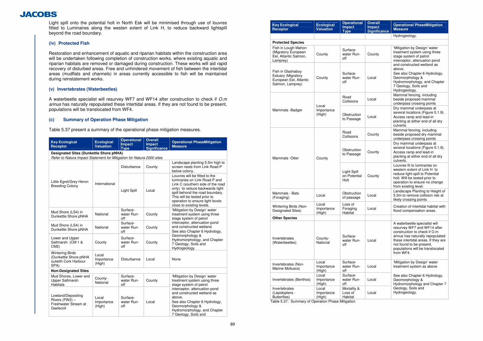
89
Light spill onto the potential holt in North Esk will be minimised through use of louvres fitted to Luminaires along the westen extent of Link H, to reduce backward lightspill beyond the road boundary. (iv) Protected Fish
Restoration and enhancement of aquatic and riparian habitats within the construction area will be undertaken following completion of construction works, where existing aquatic and riparian habitats are removed or damaged during construction. These works will aid rapid recovery of disturbed areas. Free and unhindered movement of fish between the intertidal areas (mudflats and channels) in areas currently accessible to fish will be maintained during reinstatement works. (v) Invertebrates (Waterbeetles)
A waterbeetle specialist will resurvey WF7 and WF14 after construction to check if O.m arinus has naturally repopulated these intertidal areas. If they are not found to be present, populations will be translocated from WF4.
(c) Summary of Operation Phase Mitigation
Table 5.37 present a summary of the operational phase mitigation measures.
Key Ecological Receptor
Ecological Valuation
Operational Impact Type
Overall Impact Significance
Operational PhaseMitigation Measure
Designated Sites (Dunkettle Shore pNHA) Refer to Natura Impact Statement for Mitigation for Natura 2000 sites
Disturbance County Landscape planting 5.5m high to screen nests from Link Road P below colony.
Little Egret/Grey Heron Breeding Colony
International
Light Spill Local
Louvres will be fitted to the luminaries on Link Road P and Link C (southern side of the road only) to reduce backwards light spill behond the road boundary. This will be tested prior to operation to ensure light levels close to existing levels.
Mud Shore (LS4) in Dunkettle Shore pNHA
National Surface-water Run-off
County
Mud Shore (LS4) in Dunkettle Shore pNHA
National Surface-water Run-off
County
Lower and Upper Saltmarsh (CM 1 & CM2)
County Surface-water Run-off
County
‘Mitigation by Design’ water treatment system using three stage system of petrol interceptor, attenuation pond and constructed wetland. See also Chapter 6 Hydrology, Geomorphology & Hydromorphology, and Chapter 7 Geology, Soils and Hydrogeology.
Wintering Birds (Dunkettle Shore pNHA outwith Cork Harbour SPA)
Local Importance (High)
Disturbance Local None
Non-Designated Sites
Mud Shores, Lower and Upper Saltmarsh Habitats
County-National
Surface-water Run-off
County
Lowland/Depositing Rivers (FW2) – Freshwater Stream at Gaelscoil
Local Importance (High)
Surface-water Run-off
Local
‘Mitigation by Design’ water treatment system using three stage system of petrol interceptor, attenuation pond and constructed wetland as above. See also Chapter 6 Hydrology, Geomorphology & Hydromorphology, and Chapter 7 Geology, Soils and
Key Ecological Receptor
Ecological Valuation
Operational Impact Type
Overall Impact Significance
Operational PhaseMitigation Measure
Hydrogeology.
Protected Species
Fish in Lough Mahon (Migratory European Eel, Atlantic Salmon, Lamprey)
County Surface-water Run-off
County
Fish in Glashaboy Estuary (Migratory European Eel, Atlantic Salmon, Lamprey)
County Surface-water Run-off
Local
‘Mitigation by Design’ water treatment system using three stage system of petrol interceptor, attenuation pond and constructed wetland as above. See also Chapter 6 Hydrology, Geomorphology & Hydromorphology, and Chapter 7 Geology, Soils and Hydrogeology.
Road Collisions
Local Mammal fencing, including beside proposed mammal underpass crossing points
Mammals -Badger Local Importance (High) Obstruction
to Passage Local
Dry mammal underpass at several locations (Figure 5.1.9). Access ramp and lead-in planting at either end of all dry culverts.
Road Collisions
County Mammal fencing, including beside proposed dry mammal underpass crossing points
Obstruction to Passage County
Dry mammal underpass at several locations (Figure 5.1.9). Access ramp and lead-in planting at either end of all dry culverts.
Mammals -Otter County
Light Spill on Potential Holt
County
Louvres fit to luminaries on western extent of Link H to reduce light spill to Potential holt. Will be tested prior to operation to ensure no change from existing level.
Mammals - Bats (Foraging) Local Obstruction
of passage Local Landscape Planting to Height of 5.5m to remove collision risk at likely crossing points
Wintering Birds (Non-Designated Sites)
Local Importance (High)
Loss of Foraging Habitat
Local Creation of intertidal habitat with flood compensation areas.
Other Species
Invertebrates (Waterbeetles)
County-National
Surface-water Run-off
Local
A waterbeetle specialist will resurvey WF7 and WF14 after construction to check if O.m arinus has naturally repopulated these intertidal areas. If they are not found to be present, populations will be translocated from WF4.
Invertebrates (Non- Marine Molluscs)
Local Importance (High)
Surface-water Run-off
Local
Invertebrates (Benthos) Local Importance (High)
Surface-water Run-off
Local
Invertebrates (Lepidoptera - Butterflies)
Local Importance (High)
Mortality & Loss of Habitat
Local
‘Mitigation by Design’ water treatment system as above See also Chapter 6 Hydrology, Geomorphology & Hydromorphology and Chapter 7 Geology, Soils and Hydrogeology.
Table 5.37: Summary of Operation Phase Mitigation
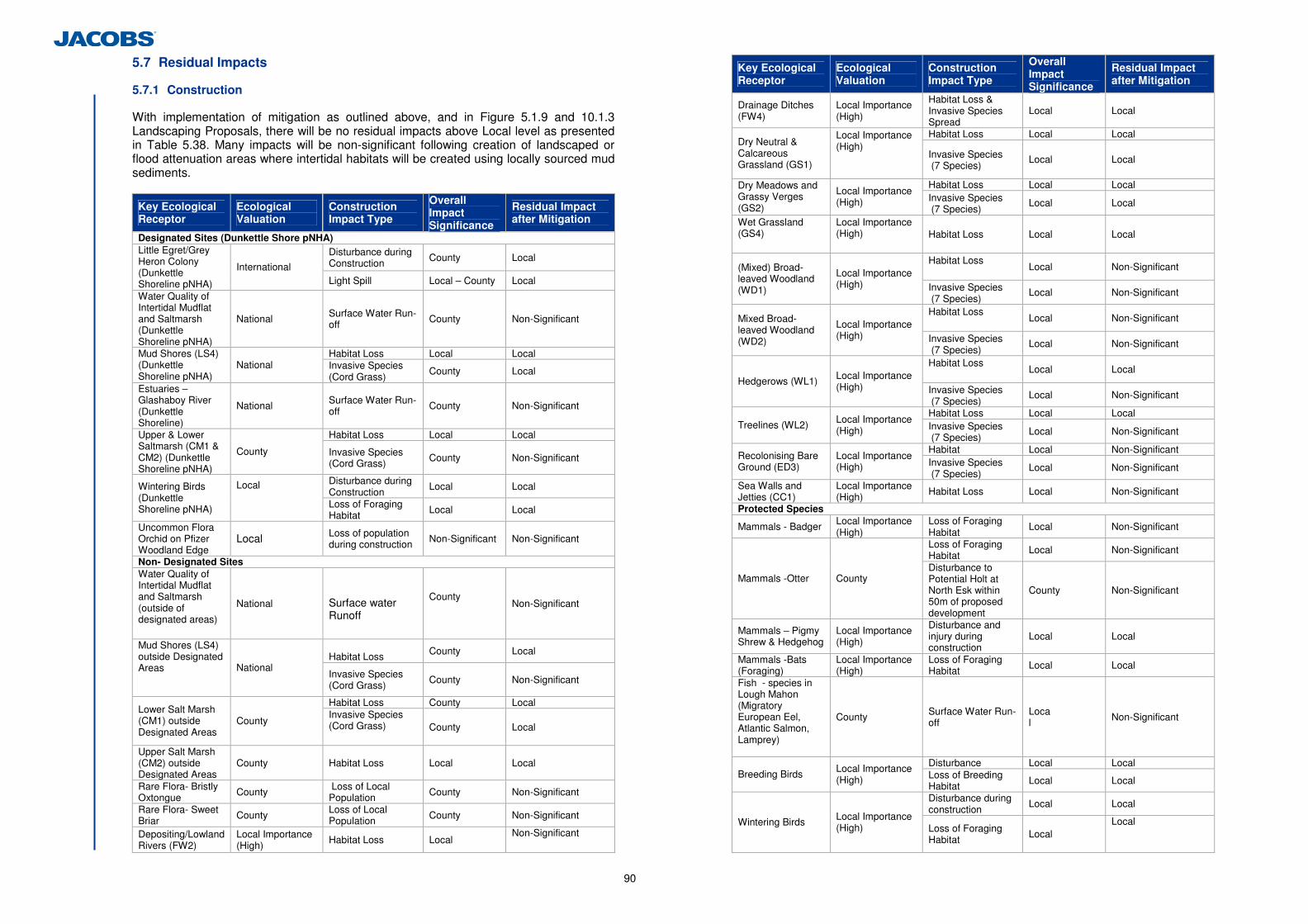
90
5.7 Residual Impacts
5.7.1 Construction
With implementation of mitigation as outlined above, and in Figure 5.1.9 and 10.1.3 Landscaping Proposals, there will be no residual impacts above Local level as presented in Table 5.38. Many impacts will be non-significant following creation of landscaped or flood attenuation areas where intertidal habitats will be created using locally sourced mud sediments.
Key Ecological Receptor
Ecological Valuation
Construction Impact Type
Overall Impact Significance
Residual Impact after Mitigation
Designated Sites (Dunkettle Shore pNHA) Disturbance during Construction County Local
Little Egret/Grey Heron Colony (Dunkettle Shoreline pNHA)
International Light Spill Local – County Local
Water Quality of Intertidal Mudflat and Saltmarsh (Dunkettle Shoreline pNHA)
National Surface Water Run-off County Non-Significant
Habitat Loss Local Local Mud Shores (LS4) (Dunkettle Shoreline pNHA)
National Invasive Species (Cord Grass)
County Local
Estuaries – Glashaboy River (Dunkettle Shoreline)
National Surface Water Run-off County Non-Significant
Habitat Loss Local Local Upper & Lower Saltmarsh (CM1 & CM2) (Dunkettle Shoreline pNHA)
County Invasive Species (Cord Grass) County Non-Significant
Disturbance during Construction Local Local Wintering Birds
(Dunkettle Shoreline pNHA)
Local Loss of Foraging
Habitat Local Local
Uncommon Flora Orchid on Pfizer Woodland Edge
Local Loss of population during construction Non-Significant Non-Significant
Non- Designated Sites Water Quality of Intertidal Mudflat and Saltmarsh (outside of designated areas)
National Surface water Runoff
County Non-Significant
Habitat Loss County Local
Mud Shores (LS4) outside Designated Areas
National Invasive Species (Cord Grass) County Non-Significant
Habitat Loss County Local Lower Salt Marsh (CM1) outside Designated Areas
County Invasive Species (Cord Grass)
County Local
Upper Salt Marsh (CM2) outside Designated Areas
County Habitat Loss Local Local
Rare Flora- Bristly Oxtongue County Loss of Local
Population County Non-Significant Rare Flora- Sweet Briar County Loss of Local
Population County Non-Significant
Depositing/Lowland Rivers (FW2)
Local Importance (High) Habitat Loss Local Non-Significant
Key Ecological Receptor
Ecological Valuation
Construction Impact Type
Overall Impact Significance
Residual Impact after Mitigation
Drainage Ditches (FW4)
Local Importance (High)
Habitat Loss & Invasive Species Spread
Local Local
Habitat Loss Local Local Dry Neutral & Calcareous Grassland (GS1)
Local Importance (High)
Invasive Species (7 Species) Local Local
Habitat Loss Local Local Dry Meadows and Grassy Verges (GS2)
Local Importance (High) Invasive Species
(7 Species) Local Local
Wet Grassland (GS4)
Local Importance (High)
Habitat Loss Local Local
Habitat Loss Local Non-Significant (Mixed) Broad-
leaved Woodland (WD1)
Local Importance (High) Invasive Species
(7 Species) Local Non-Significant
Habitat Loss Local Non-Significant Mixed Broad-
leaved Woodland (WD2)
Local Importance (High) Invasive Species
(7 Species) Local Non-Significant
Habitat Loss Local Local
Hedgerows (WL1) Local Importance (High) Invasive Species
(7 Species) Local Non-Significant
Habitat Loss Local Local Treelines (WL2) Local Importance
(High) Invasive Species (7 Species) Local Non-Significant
Habitat Local Non-Significant Recolonising Bare Ground (ED3)
Local Importance (High) Invasive Species
(7 Species) Local Non-Significant
Sea Walls and Jetties (CC1)
Local Importance (High) Habitat Loss Local Non-Significant
Protected Species
Mammals - Badger Local Importance (High)
Loss of Foraging Habitat Local Non-Significant
Loss of Foraging Habitat Local Non-Significant
Mammals -Otter County Disturbance to Potential Holt at North Esk within 50m of proposed development
County Non-Significant
Mammals – Pigmy Shrew & Hedgehog
Local Importance (High)
Disturbance and injury during construction
Local Local
Mammals -Bats (Foraging)
Local Importance (High)
Loss of Foraging Habitat Local Local
Fish - species in Lough Mahon (Migratory European Eel, Atlantic Salmon, Lamprey)
County Surface Water Run-off
Loca l Non-Significant
Disturbance Local Local Breeding Birds Local Importance
(High) Loss of Breeding Habitat Local Local Disturbance during construction Local Local
Wintering Birds Local Importance (High) Loss of Foraging
Habitat Local Local
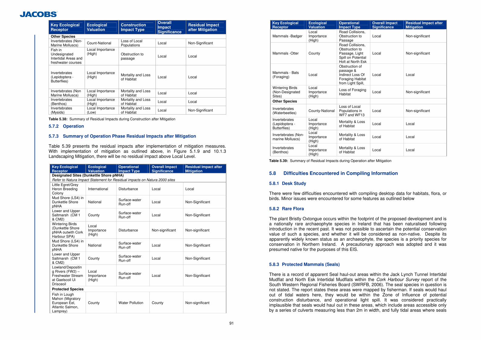
91
Key Ecological Receptor
Ecological Valuation
Construction Impact Type
Overall Impact Significance
Residual Impact after Mitigation
Other Species Invertebrates (Non- Marine Molluscs) Count-National Loss of Local
Populations Local Non-Significant
Fish in Undesignated Intertidal Areas and freshwater courses
Local Importance (High)
Obstruction to passage Local Local
Invertebrates (Lepidoptera - Butterflies)
Local Importance (High)
Mortality and Loss of Habitat Local Local
Invertebrates (Non Marine Mollusca)
Local Importance (High)
Mortality and Loss of Habitat Local Local
Invertebrates (Benthos)
Local Importance (High)
Mortality and Loss of Habitat Local Local
Invertebrates (Mysids)
Local Importance (Low)
Mortality and Loss of Habitat Local Non-Significant
Table 5.38: Summary of Residual Impacts during Construction after Mitigation
5.7.2 Operation
5.7.3 Summary of Operation Phase Residual Impacts after Mitigation
Table 5.39 presents the residual impacts after implementation of mitigation measures. With implementation of mitigation as outlined above, in Figure 5.1.9 and 10.1.3 Landscaping Mitigation, there will be no residual impact above Local Level.
Key Ecological Receptor
Ecological Valuation
Operational Impact Type
Overall Impact Significance
Residual Impact after Mitigation
Designated Sites (Dunkettle Shore pNHA) Refer to Natura Impact Statement for Residual impacts on Natura 2000 sites Little Egret/Grey Heron Breeding Colony
International Disturbance Local Local
Mud Shore (LS4) in Dunkettle Shore pNHA
National Surface-water Run-off
Local Non-Significant
Lower and Upper Saltmarsh (CM 1 & CM2)
County Surface-water Run-off Local Non-Significant
Wintering Birds (Dunkettle Shore pNHA outwith Cork Harbour SPA)
Local Importance (High)
Disturbance Non-significant Non-significant
Mud Shore (LS4) in Dunkettle Shore pNHA
National Surface-water Run-off
Local Non-Significant
Lower and Upper Saltmarsh (CM 1 & CM2)
County Surface-water Run-off
Local Non-Significant
Lowland/Depositing Rivers (FW2) – Freshwater Stream at Gaelscoil Ui Drisceoil
Local Importance (High)
Surface-water Run-off
Local Non-Significant
Protected Species
Fish in Lough Mahon (Migratory European Eel, Atlantic Salmon, Lamprey)
County Water Pollution County Non-significant
Key Ecological Receptor
Ecological Valuation
Operational Impact Type
Overall Impact Significance
Residual Impact after Mitigation
Mammals -Badger Local Importance (High)
Road Collisions, Obstruction to Passage
Local Non-significant
Mammals -Otter County
Road Collisions, Obstruction to Passage, Light Spill on Potential Holt at North Esk
Local Non-significant
Mammals - Bats (Foraging) Local
Obstruction of passage & Indirect Loss Of Foraging Habitat from Light Spill,
Local Local
Wintering Birds (Non-Designated Sites)
Local Importance (High)
Loss of Foraging Habitat
Local Non-significant
Other Species
Invertebrates (Waterbeetles)
County-National Loss of Local Populations in WF7 and WF13
Local Non-significant
Invertebrates (Lepidoptera - Butterflies)
Local Importance (High)
Mortality & Loss of Habitat
Local Local
Invertebrates (Non-marine Molluscs)
Local Importance (High)
Mortality & Loss of Habitat
Local Local
Invertebrates (Benthos)
Local Importance (High)
Mortality & Loss of Habitat Local Local
Table 5.39: Summary of Residual Impacts during Operation after Mitigation
5.8 Difficulties Encountered in Compiling Information
5.8.1 Desk Study
There were few difficulties encountered with compiling desktop data for habitats, flora, or birds. Minor issues were encountered for some features as outlined below 5.8.2 Rare Flora
The plant Bristly Oxtongue occurs within the footprint of the proposed development and is a nationally rare archaeophyte species in Ireland that has been naturalised following introduction in the recent past. It was not possible to ascertain the potential conservation value of such a species, and whether it will be considered as non-native. Despite its apparently widely known status as an archaeophyte, the species is a priority species for conservation in Northern Ireland. A precautionary approach was adopted and it was presumed native for the purposes of this EIS.
5.8.3 Protected Mammals (Seals)
There is a record of apparent Seal haul-out areas within the Jack Lynch Tunnel Intertidal Mudflat and North Esk Intertidal Mudflats within the Cork Harbour Survey report of the South Western Regional Fisheries Board (SWRFB, 2006). The seal species in question is not stated. The report states these areas were mapped by fisherman. If seals would haul out of tidal waters here, they would be within the Zone of Influence of potential construction disturbance, and operational light spill. It was considered practically implausible that seals would haul out in these areas, which include areas accessible only by a series of culverts measuring less than 2m in width, and fully tidal areas where seals
92
would become stranded at low tide. Consultation with the SWRFB and Dr. Tom Kelly of UCC failed to establish the reason for the mapping of these apparently unsuitable areas as seal haul-out sites. It was presumed that either these areas were mapped in error, or that these areas historically provided seal haul-out areas prior to reclamation of the Little Island and Dunkettle shore, when seals could swim unhindered into these areas. 5.8.4 Field Surveys
No difficulties were encountered undertaking field surveys. Survey of habitat (March-September), mammal (December-March), breeding bird (February-July), wintering bird (December-March), fish (April-May), and terrestrial invertebrates (April-June) were conducted within optimal seasons contained within the NRA guidelines. (i) Protected Mammals (Otter)
The status of a potential otter holt in a hedge bank in North Esk within the Zone of Influence of the proposed development could not be established during an intensive desk study, repeated field survey looking for otter field signs within/beside the hole, and use of an infrared camera to monitor the hole over a period of more than a week (28th May-1st June & 15th-21st July 2011). Otter holts may be used very infrequently, and it can be difficult to confirm use of a potential hole by otter. A precautionary approach was used to presume that the hole is an active holt due to the presence of footprints in nearby mud, and an otter carcass in the adjacent mudflats. (ii) Invertebrates (Lepdioptera)
Survey of Lepdioptera was optimal and undertaken over numerous visits between December 2010 and July 2011, and June 2012. 5.9 Cumulative Impacts and Impact Interrelations
Consideration was given to all existing or proposed projects that could act in combination with the proposed development to impact on Key Ecological Features. Available planning sources were analysed for details of any relevant existing or proposed residential, retail, industrial, recreational or other projects or activities. Zoning for the localities around the proposed development were also examined to assess the likely existing and future development pressures on the locality. The lands within large areas of the ZoI of the proposed development are unzoned. This includes lands at Inchera and Little Island which are local industrial hubs in this part of East Cork. Zonings relevant to different sources of impact are discussed in their relevant section below. 5.9.1 Water Quality
Chapter 6 Hydrology, Geomorphology & Hydromorphology, and Chapter 7 Geology, Soils and Hydrogeology have concluded that impacts to surface and groundwaters will be imperceptible after mitigation. There is no potential for cumulative impacts. 5.9.2 Habitat Loss
The Draft Cork Harbour Study (Cork County Council, 2010) includes proposals for vehicular and pedestrian access ways that could result in loss of intertidal mudflat along the northern boundary of the SPA at the Jack Lynch Intertidal Mudflat. This could act in combination with loss of mudflats outside the SPA as part of the proposed development. The proposal by Cork County Council for the N22 Northern Ring Road to link the N22 Ballincollig Bypass to the N8 Glanmire Bypass could also cumulatively impact upon Annex 1 estuarine, intertidal mudflat or woodland habitats. There are no other known projects which may cumulatively act to reduce areas of Annex 1 intertidal habitats in the locality. The intertidal mudflat and saltmarsh habitats at North Esk within the Dunkettle Shore
pNHA are likely to be protected from development under policies of the Cork County and City Development Plan due to their pNHA status. The Blarney Local Area Plan has zoned the Dunkettle & Balinglanna Lands for 1200 houses under zoning M1 - Mixed Use, general development, opportunity/proposal site. This could cumulatively act with the proposed development to reduce areas of woodland/hedged/grassland habitats in the Dunkettle Area however the previous application by O’Flynn construction in 2007 was refused. The woodlands on the Dunkettle Estate are unlikely to be cumulatively impacted by clearance for other projects or plans as these are zoned in the Blarney Local Area Plan as G1 (Open Space, Park) under Local Authority Zone (Glanmire O-8). A proposal for a Dunkettle Train Station on the Midleton Line on the existing Iarnrod Eireann lands northeast of North Esk includes an associated park and ride proposal was refused by An Bord Pleanála in 2009, however the proposal is still included in the Cork County Development Plan. If built, this proposal could result in cumulative habitat loss of locally valuable habitats, and/or result in invasive species spread. 5.9.3 Impacts to Fauna
The NIS has addressed all issues to designated sites, including the potential impact of light spill and disturbance from a pedestrian pathway proposed under the Draft Cork Harbour Study. All existing and proposed roadways will act in combination with the proposed development to reduce passage of mammal species. However, cumulative road collision impacts are unlikely as the proposed development will include mammal fencing to mitigate such impacts. Various fishing activities including commercial, recreational and illegal fishing takes place in Cork Harbour. The main fishing activities within the harbour are potting for shrimp, crab and lobster and to a lesser extent small boat trawling for flounder, plaice and codling. A short season for pelagic trawling for sprat is carried out in winter (Corepoint, 2008). While a limited number of pelagic vessels operate from Cork Harbour, it is an important hub for deep sea angling activities. Angling boats operate primarily from Crosshaven and Passage West and target the fishing grounds within and adjacent to the harbour. Fish catches within the Harbour itself are limited to small scale activities (Corepoint, 2008).
Poaching of bass Dicentrarchus labrax has become a big problem in the East Cork area and Cork Harbour area over the last 12 months. In November 2011 there were reputed landings of over 40 boxes of bass on one occasion and 17 boxes on another in East Cork. In the Harbour there have been several reported landings of between 4 and 6 boxes of bass at a time (Cork Angling Hub website). All these activities have the potential to act in combination with impacts of the proposed development to water quality to impact upon fish stock in intertidal and marine waters within the ZoI of the proposed development.

93
5.9.4 References
Alieri, R and Fasola, M (1992a) Breeding Site Requirements for Herons, pp. 206–9. Special Publication No. 20. International Wildfowl Research Bureau, Slimbridge.
Altringham, J. (2008). Westbury bypass bat ecology and mitigation: Proof of evidence by Professor John Altringham on behalf of the White Horse Alliance.
Atkinson, P.W., S. Crooks, A. Grant and M. Rehfisch, (2001). The success of creation and restoration schemes in producing intertidal habitat suitable for waterbirds. English Nature Research Report No. 425 NPWS, Date??) Background to the Conservation assessment for the Otter Lutra lutra. Conservation Status Assessment Report. Available online at http://www.npws.ie/media/npws/publications/ca/media,6279,en.pdf. Accessed 20/04/2012 Bacci, F. O’Reilly, S. O., Morgan, G., Heffron, J.J., O’Halloran, J., & Foley, A.M. (2010). Abatement Technologies for road surface run-off. Proceedings of ITRN2010, 31st August to 1st September 2010, University College Dublin, Ireland
Bach, L. Burkhardt, P. & Limpens, H.J.G.A. (2004). Tunnels as a possibility to connect bat habitats. Mammalia 68: 411-420.
Barnes, R.S.K. (1994). The brackish-water fauna of north-western Europe: An identification key. Cambridge University Press.
Bickmore, C (2003). Review of work carried out on the trunk road network in Wales for Bats. Catherine Bickmore associates, London.
Boonman, B. (2011). Factors determining the use of culverts underneath highways and railway tracks by bats in lowland Areas. Lutra 43, 3-16 Connor, D.W., Allen, J.H., Golding, N., Howell, K.L., Lieberknecht, L.M., Northen, K.O. & Reker, J.B. (2004). The Marine Habitat Classification for Britain and Ireland Version 04.05 JNCC, Peterborough ISBN 1 861 07561 8 (internet version) COREPOINT (2008). (Eds.) Cummins, V., Griffin, P., Gault, J., O’Mahony, C. & O’Suilleabhain D. Cork Harbour Integrated Management Strategy: 2008. Corepoint: Coastal Research and Policy Integration, EU Interreg IIIB project. PP35. Cork Angling Hub website: http://corkharbouranglinghub.blogspot.com/2012/01/bass-protection.html Cork County Council. (2008). N25 Dunkettle to Carrigtwohill Otter Survey Report by Halcrow Barry Ltd. Clutter-adaptation of bat species predicts their use of under-motorway passageways of contrasting sizes – a natural experiment Curtis, T.G.F., & McGough, H.N. (2005) The Irish Red Data Book 1 Vascular Plants. Updated Version.
Dalkin, M. and Barnett, B. (2001). Procedural Guideline No. 3-6: Quantitative sampling of intertidal sediment species using cores. in Marine Monitoring Handbook, 2001. Edited by Davies J. (senior editor), Baxter, J., Bradley, M., Connor, D., Khan, J., Murray, E., Sanderson, W., Turnbull, C. and M. Vincent. pp 253 - 257. Joint Nature Conservation Committee. Department of Environment, Community and Local Government, (2011). Guidance for Planning Authorities on Drainage and Reclamation of Wetlands (Department of Environment, Community and Local Government, 2011) Dunlop, N. & Green, P. (1992). Saltwater Fishing, Gill and McMillan, Dublin European Commission, (1999). Guidelines for the assessment of indirect and cumulative impacts as well as Impact Interactions. Office for official publications of the European Communities. European Commission, (2007 ) Interpretation Manual of EU Habitats. Office for official publications of the European Communities. Ecofact (2008) Cork Northern Ring Road - Aquatic Ecology and Fisheries Assessment. Commissioned by Fehily Timony Gifford Consultants Ltd. Ells, J. B. (1999). Design Considerations for the Use of Vegetative Controls for the Treatment of Highway Discharges. Impacts of Urban Growth on Surface Water and Groundwater Quality (Proceedings of IUGG 99 Symposium H55, Birmingham, July 1999). IAHS Publ. No. 259. Environment Agency (2003) River Habitat Survey in Britain and Ireland: Field Survey Guidance Manual. River Habitat Survey Manual: 2003 version, Environment Agency, 136 pp. Fasola, M and Alieri, R (1992a) Conservation of heronry sites in North Italian agricultural landscapes. Biol. Cons. 62, 219–28. Freyhof, J. & Kottelat, M. (2008). Chelon labrosus. In: IUCN 2011. IUCN Red List of Threatened Species. Version 2011.2. <www.iucnredlist.org>. Downloaded on 19 April 2012. Haydyn, T., Harrington, R. (2001) Exploring Irish Mammals,Town House, Dublin Hayward, P and Ryland, J.S (2005) Handbook of the marine fauna of north-west Europe. Oxford University Press. Inland Fisheries Ireland (2010) Sampling Fish for the Water Framework Directive - Transitional Waters (2010), Greater Cork Harbour. Inland Fisheries Ireland (2011) Preliminary Synopsis of WFD Surveillance Monitoring Fish Stock Surveys at river sites in the South Western River Basin District, July 2011. International Union for Conservation of Nature (2011). The IUCN Red List of Threatened Species. Version 2011.2. Institute of Ecology and Environmental Management (2006) Guidelines for Ecological Impact Assessment in Britain and Ireland - Marine and Coastal.

94
Institute of Ecology and Environmental Management (2010) Guidelines for Ecological Impact Assessment in Britain and Ireland - Marine and Coastal. Kelly, F., Harrison, A., Connor, L., Wightman, G., Matson, R., Morrissey, E., O’Callaghan, R., Feeney, R., Hanna, G., Lordan, M. and Rocks, K. (2009) Sampling Fish for the Water Framework Directive – Transitional Waters 2008 - Lough Mahon. Central and Regional Fisheries Boards.
King, J.L., Marnell, F., Kingston, N., Rosell, R., Boylan, P., Caffrey, J.M., FitzPatrick, Ú., Gargan, P.G., Kelly, F.L., O’Grady, M.F., Poole, R., Roche, W.K. & Cassidy, D. (2011) Ireland Red List No. 5: Amphibians, Reptiles & Freshwater Fish. National Parks and Wildlife Service, Department of Arts, Heritage and the Gaeltacht, Dublin, Ireland. Little, C. (2000) The Biology of Soft Shores and Estuaries. Oxford University Press Inc, New York. Lockhart, N., Hodgetts, N., & Holyoak, D. (2012) Rare and Threatened Bryophytes of Ireland Lusby, J., Watson, D., Nagle, T. 2010. Cork Barn Owl Research Project Report for 2010 Minchin, D. 2008. Spartina anglica. Data sheet for Delivering Alien Species Inventories for Europe. Available online at http://www.europe-aliens.org/pdf/Spartina_anglica.pdf Accessed 1/05/2012 Maitland, P.S. (1994) Conservation of freshwater fish in Europe. Convention on the Conservation of European Wildlife and Natural Habitats. Nature and the Environment, No. 66. Council of Europe Press, 1994. Munroe, T.A. (2010). Platichthys flesus. In: IUCN 2011. IUCN Red List of Threatened Species. Version 2011.2. <www.iucnredlist.org>. Downloaded on 19 April 2012. Lusby, J., Watson, D., Nagle, T. (2009). Cork Barn Owl Research Project Report for 2009 Marnell, F., Kingston, N. & Looney, D. (2009). Ireland Red List No. 3: Terrestrial
Mammals, National Parks and Wildlife Service, Department of the Environment, Heritage
and Local Government, Dublin, Ireland.
McDonald, M.A. 2006. The Indirect Effects of Increased Nutrient Inputs on Birds in the UK. Royal Society for the Protection of Birds Research Report 21. Available online at http://www.rspb.org.uk/Images/nutrientreview_tcm9-132777.pdf Accessed 10/05/2012. Murphy, D.F. (2004). Requirements for the Protection of Fisheries Habitat during Construction and Development Works at River Sites. Eastern Regional Fisheries Board, Dublin.
National Roads Authority (2000). National Roads Project Management Guidelines. National Roads Authority
National Roads Authority (2005a). Best Practice Guidelines for the Conservation of Bats in the Planning of National Road Schemes. National Roads Authority
National Roads Authority (2005b). Guidelines for the Crossing of Watercourses During the Construction of National Road Schemes. Written by Natura Environmental Consultants. National Roads Authority.
National Roads Authority (2006-2009a). Environmental Assessment and Construction Series Guidelines. National Roads Authority
National Roads Authority (2006a). Guidelines for the Treatment of Badgers Prior to the Construction of National Road Schemes. National Roads Authority.
National Roads Authority (2006b). Guidelines for the Treatment of Otters Prior to the Construction of National Road Schemes. National Roads Authority.
National Roads Authority (2006c). Best Practice Guidelines for the Conservation of Bats in the Planning of National Road Schemes Written by Keeley, B. National Roads Authority.
National Roads Authority (2006d). Guidelines for the Protection of Trees, Hedgerows and Scrub Prior to, During and Post Construction of National Road Schemes. National Roads Authority.
National Roads Authority (2007) Guidelines for the Creation and Maintenance of an Environmental Operating Plan. National Roads Authority, 2007.
National Roads Authority (2008). Environmental Impact Assessment of National Road Schemes – A Practical Guide. National Roads Authority.
National Roads Authority (2009a). Guidelines for assessment of Ecological Impacts of National Road Schemes. Written by Cresswell, W., Nairn, R. National Roads Authority.
National Roads Authority (2009b). Ecological Surveying Techniques for Protected Flora and Fauna during the Planning of National Road Schemes. National Roads Authority
Smiddy, P. (1993). The Status of the Otter in East Cork and West Waterford. Irish Naturalists Journal 22, 236-240 O’Donoghue, P. and Smiddy, P. (2008). Little Egret Expansion in Ireland: Cork – A Case Study. Article (p. 14) in Institute of Ecology and Environmental Management Quarterly Magazine In Practice O’Mahoney, T. (2011). Wildflowers of Cork City and county, Collins. O’ Reilly, P. (2004) Rivers of Ireland – a flyfisher’s Guide. 5th Ed. Merlin Unwin Books. Regan, E.C., Nelson, B., Aldwell, B., Bertrand, C., Bond, K., Harding, J., Nash, D., Nixon, D., & Wilson, C.J. (2010) Ireland Red List No. 4 – Butterflies. National Parks and Wildlife Service, Department of the Environment, Heritage and Local Government, Ireland. Russ, (1999).Bat Sounds of Britain and Ireland Shiel, C.B, Shiel, R.E, & Fairley, J.S. (2006). Seasonal Changes in the foraging behaviour of Leisler’s Bats (Nyctalus leisleri) in Ireland as revealed by radio telemetry. Journal of Zoology 249, 347-358. Sleeman, D. P., & Moore, P.G. (2005). Otters Lutra lutra in Cork City. Irish Naturalists Journal 28, 73-79
Southern Regional Fisheries Board (SRFB), (2007). Maintenance and Protection of the Inland Fisheries Resource During Road Construction and Improvement Works. Requirements of the Southern Regional Fisheries Board. Revision 4 Southwestern Regional Fisheries Board (SWRFB) (2006). Cork Harbour Survey. Report produced by the Cork and District Draft Net Fisherman’s Association for the SWRFB. Stace, C.A. (2004). Interactive Flora of the British Isles CD-ROM. ETI Bioinformatics.

95
Stace, C.A. (2010). New Flora of the British Isles. Third Edition, Cambridge University Press. Van Tassell, J.L. (2010). Pomatoschistus microps. In: IUCN 2011. IUCN Red List of Threatened Species. Version 2011.2. <www.iucnredlist.org>. Downloaded on 19 April 2012. Vennesland, R. D., & Norman, D.M. (2006) Survey Protocol for Measurement of Nesting Productivity at Pacific Great Blue Heron Nesting Colonies. Report for Heron Working Group. Available online at http://www.heronworkinggroup.org/Heron%20Working%20Group%20Great%20Blue%20Heron%20Colony%20Survey%20Protocol%20-%20FINAL%20-%20November%202006.pdf Accessed 20/04/2012.
96
6 Hydrology, Geomorphology & Hydromorphology
6.1 Introduction
This chapter considers and assesses the existing hydrological, geomorphologic and hydromorphological environment and the likely significant potential impacts associated with both the construction and operation of the proposed development. The potential impact on various hydrological aspects such as flooding, geomorphology/ hydromorphology, water quality and amenity value likely to be caused by the proposed development have been identified as a result of: • Water quality impact on receiving estuaries, streams and intertidal mudflat habitats
from routine carriageway runoff (heavy metals, organics, nutrients, hydrocarbons, suspended solids, and to a lesser extent coliforms, etc) and from accidental spillages (agricultural spillage i.e. milk, oil/chemical spillages, bulk liquid cement);
• Removal of flood storage as a result of the scheme footprint; • Removal, crossing and encroachment of the intertidal mudflat habitats; and • Construction work in or adjacent to watercourses. 6.2 Hydrology Water Quality Assessment
6.2.1 Introduction
This section describes the existing hydrological environment and the likely significant potential impacts on water quality associated with both the construction and operation of the proposed development. (a) Guidance & Legislation
This assessment was undertaken having regard to the following guidance documents: • Environmental Protection Agency (EPA) Guidelines on the Information to be
contained in the Environmental Impact Statement (EPA, 2002); • EPA Advice notes on current practice in the preparation of Environmental Impact
Statement (EPA, 2003); • NRA Environmental Impact Assessment for National Road Schemes– A Practical
Guide (NRA, 2008); • NRA 2010 Project Management Guidelines (NRA, 2010); • NRA Guidelines on Procedures for Assessment and Treatment of Geology,
Hydrology and Hydrogeology for National Road Schemes (NRA 2009); • Highways Agency Design Manual for Roads and Bridges (HA DMRB) Volume II,
Section 3: Environmental Assessment Techniques, Part 10 Road Drainage and the Water Environment; and
• Office of Public Works (OPW) Guidelines for Planning Authorities (GPA) 20: The Planning System and Flood Risk Management (OPW, 2009).
The EU Water Framework Directive (2000/60/EC) established a framework for the protection of both surface and ground waters. Transposing legislation outlines the water protection and water management measures required in Ireland to maintain high status of waters where it exists, prevent any deterioration in existing water status and achieve at least ‘good’ status for all waters by 2015. This is currently being achieved through the implementation of River Basin Management Plans (RBMPs). The RBMP of relevance to this assessment (the South West RBMP 2009-2015) was adopted in 2009 and includes a
programme of measures required to facilitate the achievement of the Water Framework Directive (WFD) objectives. The programme of measures to be implemented includes full implementation of existing legislation including the Bathing Water Quality Regulations (including the development of Bathing Water Management Plans), Water Pollution Acts, Water Services Act, Integrated Pollution Prevention and Control (IPPC) regulations, Urban Wastewater Treatment regulations, the Foreshore Acts and the Birds and Habitats Directives (particularly the Appropriate Assessment process). Other important pieces of national legislation pertaining to the hydrological environment include: • SI 792 of 2009, European Communities Environmental Objective (Surface Water)
Regulations 2009; • SI 294 of 1984, European Community Environmental (Quality of Surface Water
Intended for Human Consumption) Regulations 1984 as amended; • SI 293 of 1988, European Communities (Quality of Salmonid Waters) Regulations
1988; • SI 268 of 2006, European Communities (Quality of Shellfish Waters) Regulations
2006 as amended; and • SI 155 of 1992, Quality of Bathing Waters Regulation 1992 as amended. (b) Desk Study
A desk study was carried out to collate the available information on the hydrology of the study area (250 m beyond the landtake boundary of the proposed development). The following data sources were referred to during this assessment: • Ordinance Survey of Ireland (current and historic mapping); • Environmental Protection Agency:
- Water Quality Monitoring Database and Reports; and - EPA flow and water level measurements (EPA Hydronet System).
• Water Framework Directive Ireland Database (http://www.wfdireland.ie/); • The South West River Basin District Management Plan (SWRBDMP) and associated
Water Management Unit (WMU) Action Plans; • National Parks and Wildlife Service (designated sites); • Cork County Council Development Plan 2009; • Cork City Council Development Plan 2009-2015; • Inland Fisheries Ireland (IFI); • Office of Public Works; and • The Lee Catchment Flood Risk Assessment and Management Study (CFRAMS)
(OPW 2009). (c) Hydrological Field Surveys
A number of field studies have been undertaken in order to gain an understanding of the hydrological environment in the vicinity of the proposed development. Walkover assessments were carried out on several occasions during 2011 (January, February, August and September) within the proposed development footprint and extended as required to include other relevant hydrological aspects. Visual inspections were made of the intertidal mudflat areas, Glashaboy River/Estuary, Lee Estuary, Lough Mahon and the minor watercourses and drainage ditches in the study area.
97
Surveys in August 2011 included the assessment of the baseline hydromorphology (physical form) and basic flow and sediment dynamics of the interconnected wetlands through the area. A simple visual assessment of the tidal mudflats and wetland areas was made at both low tide and high tide. Observations were also made of the ebb tide flow from the intertidal mudflats. In relation to the Flood Risk Assessment a topographical survey of the intertidal areas was undertaken by Murphy Surveys Ltd in April 2012 in the form of cross-sections taken across the intertidal mudflat areas. Murphy Surveys Ltd also conducted a survey of the culverts which connect each individual intertidal area. (d) Baseline Water Quality Monitoring
Baseline water quality monitoring was undertaken in line with the NRA Guidelines in March 2012. Water quality samples were taken at high, medium and low tide at several locations, see Figure 6.1.1 for locations and Appendix 6.5 for photos of the sampling location at high and low tide. In Situ sampling provided results for the following suite of parameters: • Temperature; • pH; • Conductivity; • Dissolved Oxygen (DO); and • Transparency. The following physico-chemical parameters were analysed for collected samples in an internationality accredited laboratory47: • Biochemical Oxygen Demand (BOD); • Ammoniacal Nitrogen; • Suspended Solids; • Nitrate; • Orthophosphate; • Total Hardness; • Zinc (total); • Copper (dissolved); and • Petroleum Hydrocarbons. 6.2.2 Consultation
Consultation on the hydrological impact assessment was undertaken with the following organisations: • The Environmental Protection Agency; • National Parks and Wildlife Service; • Office of Public Work ; and • Inland Fisheries Ireland. See also Chapter 5 Flora and Fauna and Appendix 5.1 and 5.3 for consultation undertaken as part of the terrestrial and aquatic ecological impacts assessment.
47 Severn Trent Services Analytical Services UKAS accredited laboratory for a range of parameters
6.2.3 Description of the Existing Environment
(a) Study area
In line with the ‘NRA Guidelines on Procedures for Assessment and Treatment of Geology, Hydrology and Hydrogeology for National Road Schemes’, the study area extends 250m beyond the landtake boundary of the proposed development. Where required the study area extends beyond this to account for potential impacts outside this 250m extent. The study area lies within Hydrometric Area 19 within the South Western River Basin District. The catchment of this hydrometric area is drained by the Glashaboy River (141 km2) with all associated watercourses entering tidal water in the Lee Estuary east of the Jack Lynch Tunnel. (b) Surface Water Features
The surface water features within the study area are shown in Figure 5.1.1. The major watercourses within and adjacent to the study area are as follows: • Lough Mahon (SW_060_0750); • The Lower Lee Estuary (SW_060_0900); and • The Glashaboy River (19-1961) & Glashaboy Estuary (SW_060_0750). Part of the Lough Mahon transitional water body falls within the study area, see Figure 5.1.1. This area comprises only a small fraction of the overall water body. Lough Mahon is part of Upper Cork Harbour and covers an area of over 12 km². Cork Harbour which encompasses Lough Mahon has a surface water area of around 100km2 and is a large, sheltered, naturally deepwater harbour. Strong estuarine influences dominate the upper reaches of the harbour in particular. The coastline of Cork Harbour is mixed, consisting of built infrastructure, shallow cliffs, intertidal mudflats, reedbeds, shingle and rocky foreshores, which are exposed by the tide48 . Several of Cork City’s southern suburbs, including Blackrock, Mahon, Douglas and Rochestown lie along the shores of Lough Mahon. Little Island, one of the major centres of chemical and pharmaceutical activities in the country, is located on the eastern side of Lough Mahon Estuary. Cork city’s sewage outfall pipe is also located in Cork Harbour. A shipping channel passes through the middle of Cork Harbour, allowing large ocean going vessels access to the Port of Cork. Oil pollution from shipping in Cork Harbour is considered a general threat (Kelly et al., 2009).
The River Lee Estuary lies immediately southwest and upstream of the study area. The Estuary covers an area of 0.89 km². The vast majority of riverbank, shoreline and channel in this waterbody has been modified and manipulated over time to allow for urban development (channelisation of the river, reclamation, building of retaining walls, dredging, construction of piers and platform structures). The Glashaboy River flows south towards its estuary north west of the existing Dunkettle Interchange forming part of the greater Cork Harbour. The predominant bed type in the estuary is a thin layer of mud which covers a mix of gravel and stones. The east side of the estuary is heavily wooded while the west side is bordered by the Glanmire Road (R-639). The estuary covers an area of 0.12 km² and is influenced mainly by the river environment. 48 Atlas of Cork City - The Challenge of Change Contemporary Marine Geography of Cork Harbour Valerie Cummins and Vicki O Donnell (2005)
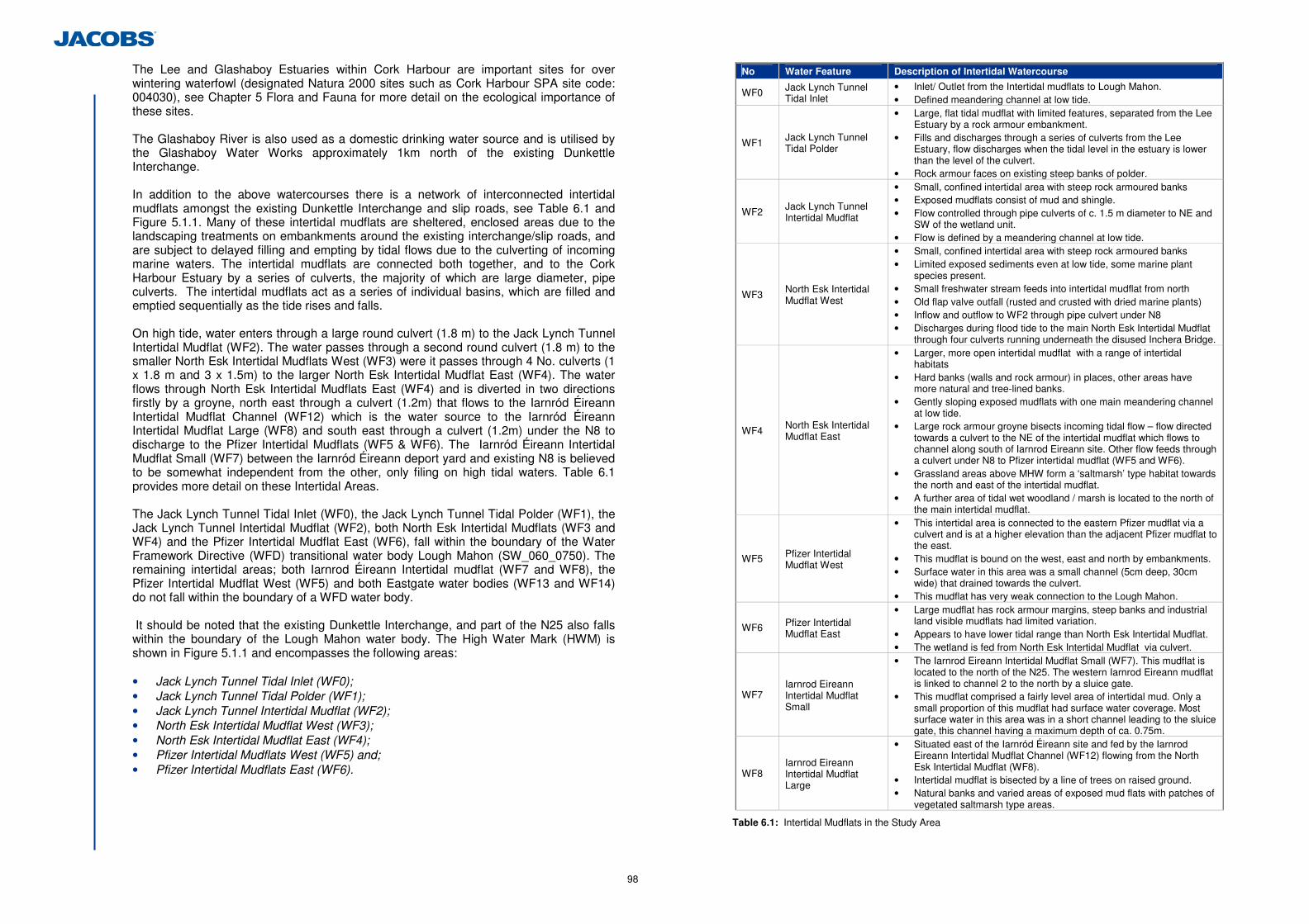
98
The Lee and Glashaboy Estuaries within Cork Harbour are important sites for over wintering waterfowl (designated Natura 2000 sites such as Cork Harbour SPA site code: 004030), see Chapter 5 Flora and Fauna for more detail on the ecological importance of these sites. The Glashaboy River is also used as a domestic drinking water source and is utilised by the Glashaboy Water Works approximately 1km north of the existing Dunkettle Interchange. In addition to the above watercourses there is a network of interconnected intertidal mudflats amongst the existing Dunkettle Interchange and slip roads, see Table 6.1 and Figure 5.1.1. Many of these intertidal mudflats are sheltered, enclosed areas due to the landscaping treatments on embankments around the existing interchange/slip roads, and are subject to delayed filling and empting by tidal flows due to the culverting of incoming marine waters. The intertidal mudflats are connected both together, and to the Cork Harbour Estuary by a series of culverts, the majority of which are large diameter, pipe culverts. The intertidal mudflats act as a series of individual basins, which are filled and emptied sequentially as the tide rises and falls. On high tide, water enters through a large round culvert (1.8 m) to the Jack Lynch Tunnel Intertidal Mudflat (WF2). The water passes through a second round culvert (1.8 m) to the smaller North Esk Intertidal Mudflats West (WF3) were it passes through 4 No. culverts (1 x 1.8 m and 3 x 1.5m) to the larger North Esk Intertidal Mudflat East (WF4). The water flows through North Esk Intertidal Mudflats East (WF4) and is diverted in two directions firstly by a groyne, north east through a culvert (1.2m) that flows to the Iarnród Éireann Intertidal Mudflat Channel (WF12) which is the water source to the Iarnród Éireann Intertidal Mudflat Large (WF8) and south east through a culvert (1.2m) under the N8 to discharge to the Pfizer Intertidal Mudflats (WF5 & WF6). The Iarnród Éireann Intertidal Mudflat Small (WF7) between the Iarnród Éireann deport yard and existing N8 is believed to be somewhat independent from the other, only filing on high tidal waters. Table 6.1 provides more detail on these Intertidal Areas. The Jack Lynch Tunnel Tidal Inlet (WF0), the Jack Lynch Tunnel Tidal Polder (WF1), the Jack Lynch Tunnel Intertidal Mudflat (WF2), both North Esk Intertidal Mudflats (WF3 and WF4) and the Pfizer Intertidal Mudflat East (WF6), fall within the boundary of the Water Framework Directive (WFD) transitional water body Lough Mahon (SW_060_0750). The remaining intertidal areas; both Iarnrod Éireann Intertidal mudflat (WF7 and WF8), the Pfizer Intertidal Mudflat West (WF5) and both Eastgate water bodies (WF13 and WF14) do not fall within the boundary of a WFD water body. It should be noted that the existing Dunkettle Interchange, and part of the N25 also falls within the boundary of the Lough Mahon water body. The High Water Mark (HWM) is shown in Figure 5.1.1 and encompasses the following areas: • Jack Lynch Tunnel Tidal Inlet (WF0); • Jack Lynch Tunnel Tidal Polder (WF1); • Jack Lynch Tunnel Intertidal Mudflat (WF2); • North Esk Intertidal Mudflat West (WF3); • North Esk Intertidal Mudflat East (WF4); • Pfizer Intertidal Mudflats West (WF5) and; • Pfizer Intertidal Mudflats East (WF6).
No Water Feature Description of Intertidal Watercourse
WF0 Jack Lynch Tunnel Tidal Inlet
• Inlet/ Outlet from the Intertidal mudflats to Lough Mahon. • Defined meandering channel at low tide.
WF1 Jack Lynch Tunnel Tidal Polder
• Large, flat tidal mudflat with limited features, separated from the Lee Estuary by a rock armour embankment.
• Fills and discharges through a series of culverts from the Lee Estuary, flow discharges when the tidal level in the estuary is lower than the level of the culvert.
• Rock armour faces on existing steep banks of polder.
WF2 Jack Lynch Tunnel Intertidal Mudflat
• Small, confined intertidal area with steep rock armoured banks • Exposed mudflats consist of mud and shingle. • Flow controlled through pipe culverts of c. 1.5 m diameter to NE and
SW of the wetland unit. • Flow is defined by a meandering channel at low tide.
WF3 North Esk Intertidal Mudflat West
• Small, confined intertidal area with steep rock armoured banks • Limited exposed sediments even at low tide, some marine plant
species present. • Small freshwater stream feeds into intertidal mudflat from north • Old flap valve outfall (rusted and crusted with dried marine plants) • Inflow and outflow to WF2 through pipe culvert under N8 • Discharges during flood tide to the main North Esk Intertidal Mudflat
through four culverts running underneath the disused Inchera Bridge.
WF4 North Esk Intertidal Mudflat East
• Larger, more open intertidal mudflat with a range of intertidal habitats
• Hard banks (walls and rock armour) in places, other areas have more natural and tree-lined banks.
• Gently sloping exposed mudflats with one main meandering channel at low tide.
• Large rock armour groyne bisects incoming tidal flow – flow directed towards a culvert to the NE of the intertidal mudflat which flows to channel along south of Iarnrod Eireann site. Other flow feeds through a culvert under N8 to Pfizer intertidal mudflat (WF5 and WF6).
• Grassland areas above MHW form a ‘saltmarsh’ type habitat towards the north and east of the intertidal mudflat.
• A further area of tidal wet woodland / marsh is located to the north of the main intertidal mudflat.
WF5 Pfizer Intertidal Mudflat West
• This intertidal area is connected to the eastern Pfizer mudflat via a culvert and is at a higher elevation than the adjacent Pfizer mudflat to the east.
• This mudflat is bound on the west, east and north by embankments. • Surface water in this area was a small channel (5cm deep, 30cm
wide) that drained towards the culvert. • This mudflat has very weak connection to the Lough Mahon.
WF6 Pfizer Intertidal Mudflat East
• Large mudflat has rock armour margins, steep banks and industrial land visible mudflats had limited variation.
• Appears to have lower tidal range than North Esk Intertidal Mudflat. • The wetland is fed from North Esk Intertidal Mudflat via culvert.
WF7 Iarnrod Eireann Intertidal Mudflat Small
• The Iarnrod Eireann Intertidal Mudflat Small (WF7). This mudflat is located to the north of the N25. The western Iarnrod Eireann mudflat is linked to channel 2 to the north by a sluice gate.
• This mudflat comprised a fairly level area of intertidal mud. Only a small proportion of this mudflat had surface water coverage. Most surface water in this area was in a short channel leading to the sluice gate, this channel having a maximum depth of ca. 0.75m.
WF8 Iarnrod Eireann Intertidal Mudflat Large
• Situated east of the Iarnród Éireann site and fed by the Iarnrod Eireann Intertidal Mudflat Channel (WF12) flowing from the North Esk Intertidal Mudflat (WF8).
• Intertidal mudflat is bisected by a line of trees on raised ground. • Natural banks and varied areas of exposed mud flats with patches of
vegetated saltmarsh type areas.
Table 6.1: Intertidal Mudflats in the Study Area
99
No Water Feature Description of other Wetland Areas
WF13 Eastgate Pond • This small freshwater pond is located north west of the Eastgate Business Park.
WF14 Eastgate Saltmarsh • This small saltmarsh area is located west of the Eastgate Pond and
comprises mostly wet grassland scrub. There are shallow marshy depressions that hold small amount of water.
Table 6.2: Other Wetland areas in the Study Area
There are four minor watercourses/drainage ditches in the study area none of which are classed as WFD water bodies. The Gaelscoil Uí Drisceoil stream (WF10) is an EPA 1st order stream.
No. Water Feature Description of Minor Watercourses
WF10 Gaelscoil Uí Drisceoil stream
• This stream is an EPA 1st order watercourse which is approximately 1.7km long.
• It meets the sea at the North Esk Intertidal Mudflat West (WF3) to the north east of the Dunkettle Interchange.
• This stream passes through two culverts in its lower reaches, one under an old disused road and another under the Dunkettle Road.
WF12 Iarnrod Eireann Intertidal Mudflat Channel
• An open channel which discharges from the North Esk Intertidal Mudflat East (WF4) to fill and empty the Iarnrod Eireann Intertidal Mudflat Large (WF8).
• The straightened channel c. 3m wide, tidal range appears to vary by c. 1m.
• Embankment with tree-lining runs along south bank adjacent to the non-tidal pond
• Silt / mud bed with limited vegetation
WF11 Eastgate Tidal Channel
• An intertidal watercourse that drains the north western part of Little Island.
• This watercourse runs along the southern embankment of the N25. • This intertidal channel flows west into a long culvert towards the
Pfizer intertidal mudflats.
WF15 BASF Drainage Ditch
• A drainage ditch on undeveloped greenfield lands belonging to BASF.
• The ditch appears to drain the Pfizer Intertidal Mudflat (East), as evidenced by the brackish influence in plant communities.
• The saline conditions are likely to be diluted by freshwater inputs from nearby industrial water treatment ponds.
Table 6.3: Minor Watercourses in the Study Area
(c) Overview of Surface Water Quality
(i) Water Quality and the Water Framework Directive Classification
The study area lies within the SWRBD and the following Water Management Units (WMU): • The Transitional and Coastal WMU; • The Glashaboy WMU; and • The Lower Lee WMU.
Water bodies of relevance, their current status, if they are heavily modified water bodies (HMWB), reasons for failing to achieve good status and the date when they must achieve good status by, are summarised in Table 6.4. The Lee Estuary and Lough Mahon are protected as nutrient sensitive estuaries.
Water Body HMWB Waterbody Code Type Current Status49
Element causing less than good
Achieve Good Status by
Lough Mahon Yes IE_SW_060_0750 Transitional Good N/A N/A
Lee (Cork) Estuary Lower
Yes IE_SW_060_0900 Transitional Moderate o DIN50 o Ecological o Fish
2021
Glashaboy Estuary No IE_SW_060_0800 Transitional Good N/A N/A
Glashaboy River No IE_SW_19_1961 River Good N/A N/A
Table 6.4: Water Management Units in or adjacent to the Study Area
(ii) Water Quality and EPA Classification
The EPA published the report ‘Water Quality in Ireland 2007-2009’ in 2011. The status of individual estuarine and coastal water bodies was assessed using the EPA’s Trophic Status Assessment Scheme (TSAS). This is the assessment required under the Urban Waste Water Treatment Directive (91/271/EEC) and Nitrates Directive (91/676/EEC). The TSAS compares the compliance of individual parameters against a set of criteria indicative of trophic state. These criteria fall into three different categories which broadly capture the cause effect relationship of the eutrophication process, namely nutrient enrichment, accelerated plant growth, and disturbance to the level of dissolved oxygen normally present (EPA, 2011). The estuarine/coastal waterbodies in or adjacent to the study area are: • Glashaboy Estuary; • Lee Cork Estuary Lower; and • Lough Mahon. Table 6.5 summarises the status of the water quality estuarine water bodies of relevance to this assessment.
Waterbody Eutrophic 07-09
Glashaboy Estuary Intermediate
Lee Cork Estuary Lower Intermediate
Lough Mahon Intermediate
Table 6.5: EPA Coastal and Estuarine Water Quality Details
The EPA assesses the water quality of rivers and streams across Ireland using a biological assessment method. The EPA assigns biological river quality (biotic index) ratings from Q5 – Q1 to watercourse sections. Q5 denotes a watercourse with good water quality and high community diversity, whereas Q1 denotes very low community diversity and a bad water quality. The nearest monitoring station in the study area is within the Glashaboy River approx 2 km north of the existing interchange. Table 6.6 details the current Q water quality status of this river.
EPA Station No Location Q Value Status
19G010600 d/s Butlerstown River confluence - Glashaboy (Lough Mahon) 4 Good
Table 6.6: EPA Monitoring Station Location and Current Status
49 Status taken from EPA Envision Mapper May 2012 50 Dissolve inorganic Nitrogen
100
(d) Baseline Water Quality monitoring results
Baseline water quality monitoring was undertaken in March 2012 in the various intertidal mudflat areas, see Figure 6.1.1, in line with the NRA Guidelines on Procedures for Assessment and Treatment of Geology, Hydrology and Hydrogeology for National Road Schemes. Water quality sampling was undertaken at high, medium and low tide51 at several locations. The results of this monitoring are detailed in Appendix 6.1 and 6.2. Where available, these results are compared to the standards in the European Communities Environmental Objective (Surface Water) Regulations, S.I. 272 of 2009. Physico-chemical analysis results for the water samples show few exceedences of the guideline limits and there is no indication of pollution within the Intertidal areas. Suspended solids results are considered representative of the estuarine/intertidal environment of the study area. (e) Flow Measurements
Flow measurements are taken throughout the Republic of Ireland by the OPW and the EPA. There are no OPW monitoring stations in the study area. The EPA measure water level and flow in the Glashaboy Rivers at station no. 19032 (Meadowbrook: E172917, N75280) and the Lee River at station no. 19011(Leemount: E160932, N71695). (f) Water Supply Sources
The study area is served by the Glashaboy Water Works north of the existing Dunkettle Interchange which is connected to the main County Council water supply. The supply is considered a regional water supply. Water is abstracted from the Glashaboy River (SW_ABS0157) to serve the Glashaboy water works. This abstraction point is located over 1 km upstream of the existing crossing of the Glashaboy Estuary. (g) Ecological Designations
There are a number of designated sites within 15km of the proposed development. Those which lie within 5 km are detailed below. Full details of all the designated areas are included in Chapter 5, Flora and Fauna. There are two international and four nationally designated sites within 5km of the proposed development, see location of all the designated sites within 15km of the proposed development in Figure 5.1.6. • Cork Harbour Special Protection Area (SPA, site code: 4030); • Great Island Channel candidate Special Area of Conservation (cSAC, site code:
1058); • Dunkettle Shore proposed Natural Heritage Area (pNHA, site code: 1082); • Glanmire Wood pNHA (site code: 1054); • Douglas River Estuary pNHA (site code: 1046) and; • Rockfarm Quarry pNHA (site code: 1074). The Cork Harbour SPA is located immediately adjacent to the proposed development and includes the Jack Lynch Tidal Polder (WF1). The Great Island cSAC lies approximately 2km east of the proposed development.
51 Samples were not possible for some locations at low and mid tide due to lack of water in the watercourse/intertidal mudflat.
The Dunkettle Shoreline pNHA is located within the footprint of the proposed development. The Glanmire Woods pNHA is located 0.5 km north, the Douglas River Estuary pNHA is located 0.3 km south and the Rockfarm Quarry pNHA is located 1.5 km south west of the proposed development. (h) Fisheries
The River Lee is designated as a Salmonid River under EU freshwater Fish Directive (78/659/EEC). The Glashaboy River is likely to support salmonid species and other fisheries, which are sensitive to changes in physical and chemical conditions. Within Cork Harbour, designated Salmonid Waters are present at Cuskinny Bay, Monkstown, Crosshaven, Haulbowline Island, Marino Point and Great Island. Cork Harbour provides important spawning and nursery areas for several species of sea fish, which are sensitive to changes in physical and chemical conditions. Aquaculture is important within the Harbour and includes the largest Irish producer of native and Pacific oysters within the inner harbour. The Harbour includes the Cork Great Island North Channel Shellfish Area. Consultation with the IFI has revealed the presence of 4 internationally protected fish species (listed on Annex II of the Habitats Directive) within Cork Harbour as follows: • Atlantic Salmon (Salmo salar); • Sea Lamprey (Petromyzon marinus); • River Lamprey (Lampetra fluviatilis); and • Twaite Shad (Alosa fallax). A range of freshwater and marine species are present in the Glashaboy River/Estuary and Harbour as follows: • Sea Trout (Salmo trutta morpha trutta); • Brown Trout (Salmo trutta); • Lamprey; and • Mullet. A fishery impact assessment was conducted in April 2012 and included baseline conditions of the intertidal areas in the study area, see Chapter 5, Flora and Fauna. Field studies conducted in the intertidal areas found the following species: • Thick- lipped Grey Mullet (Chelon labrosus); • Flounder (Platichthys flesus); and • Common Goby (Pomatoschistus microps). The intertidal mudflats are not considered to be a fishery, and have little or no fisheries potential. The findings of the fisheries assessment were confirmed by IFI on the 8th May 2012 during a site meeting. There are no known angling points or bait digging areas within the study area. The nearest angling mark to the study area is at Monkstown some 7 km south east, at the southern end of the Lough Mahon water body. (i) Amenity Areas
Cork Harbour is considered one of Ireland’s five major tourism areas with both an established tourist base with a yet un-exploited potential for future development (Coastal Marine Resources Centre (CMRC 2006). An objective of the Cork Harbour Integrated Management Strategy (2008) is to promote and develop the harbour as a facility for water-
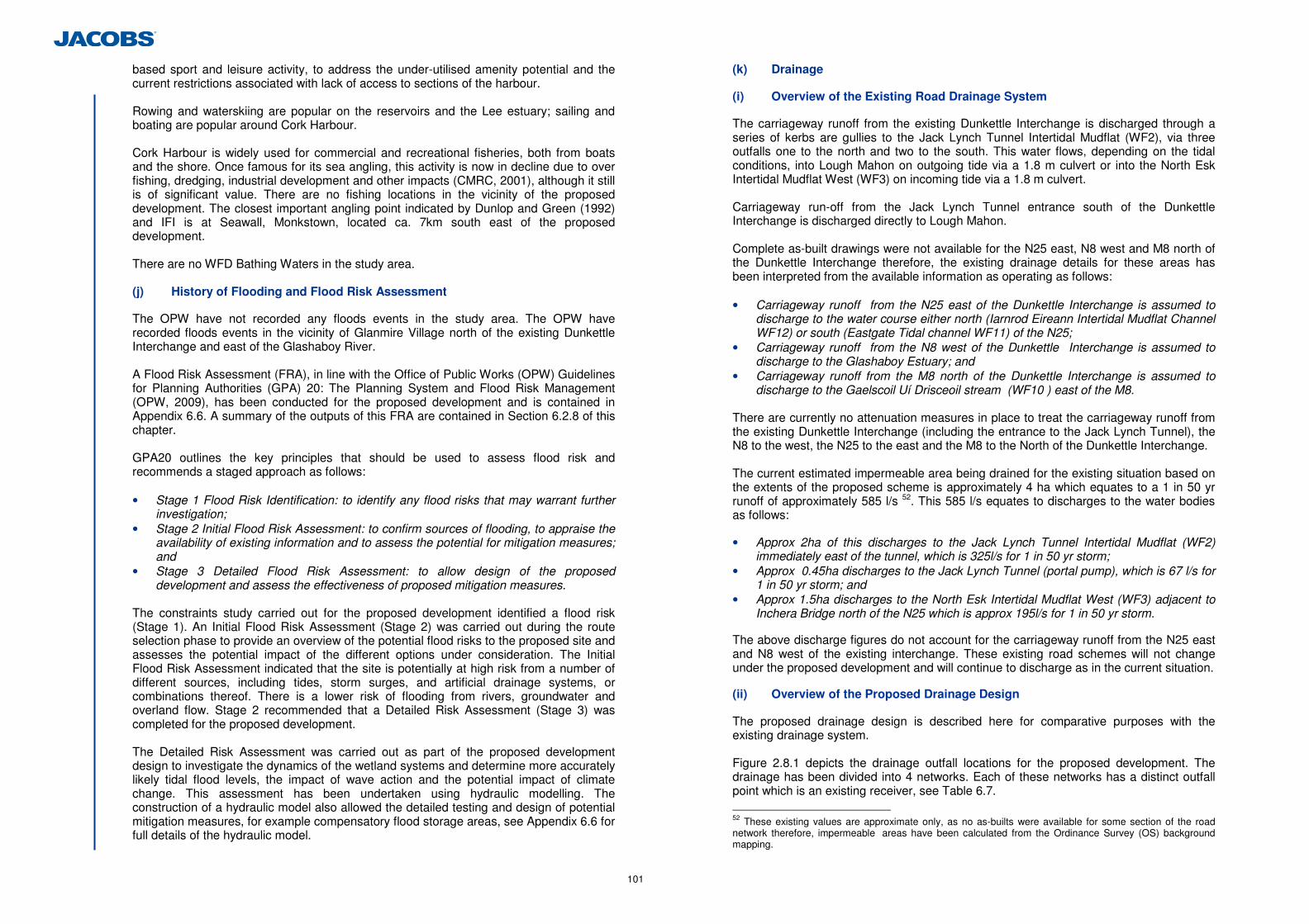
101
based sport and leisure activity, to address the under-utilised amenity potential and the current restrictions associated with lack of access to sections of the harbour. Rowing and waterskiing are popular on the reservoirs and the Lee estuary; sailing and boating are popular around Cork Harbour. Cork Harbour is widely used for commercial and recreational fisheries, both from boats and the shore. Once famous for its sea angling, this activity is now in decline due to over fishing, dredging, industrial development and other impacts (CMRC, 2001), although it still is of significant value. There are no fishing locations in the vicinity of the proposed development. The closest important angling point indicated by Dunlop and Green (1992) and IFI is at Seawall, Monkstown, located ca. 7km south east of the proposed development. There are no WFD Bathing Waters in the study area. (j) History of Flooding and Flood Risk Assessment
The OPW have not recorded any floods events in the study area. The OPW have recorded floods events in the vicinity of Glanmire Village north of the existing Dunkettle Interchange and east of the Glashaboy River. A Flood Risk Assessment (FRA), in line with the Office of Public Works (OPW) Guidelines for Planning Authorities (GPA) 20: The Planning System and Flood Risk Management (OPW, 2009), has been conducted for the proposed development and is contained in Appendix 6.6. A summary of the outputs of this FRA are contained in Section 6.2.8 of this chapter. GPA20 outlines the key principles that should be used to assess flood risk and recommends a staged approach as follows: • Stage 1 Flood Risk Identification: to identify any flood risks that may warrant further
investigation; • Stage 2 Initial Flood Risk Assessment: to confirm sources of flooding, to appraise the
availability of existing information and to assess the potential for mitigation measures; and
• Stage 3 Detailed Flood Risk Assessment: to allow design of the proposed development and assess the effectiveness of proposed mitigation measures.
The constraints study carried out for the proposed development identified a flood risk (Stage 1). An Initial Flood Risk Assessment (Stage 2) was carried out during the route selection phase to provide an overview of the potential flood risks to the proposed site and assesses the potential impact of the different options under consideration. The Initial Flood Risk Assessment indicated that the site is potentially at high risk from a number of different sources, including tides, storm surges, and artificial drainage systems, or combinations thereof. There is a lower risk of flooding from rivers, groundwater and overland flow. Stage 2 recommended that a Detailed Risk Assessment (Stage 3) was completed for the proposed development. The Detailed Risk Assessment was carried out as part of the proposed development design to investigate the dynamics of the wetland systems and determine more accurately likely tidal flood levels, the impact of wave action and the potential impact of climate change. This assessment has been undertaken using hydraulic modelling. The construction of a hydraulic model also allowed the detailed testing and design of potential mitigation measures, for example compensatory flood storage areas, see Appendix 6.6 for full details of the hydraulic model.
(k) Drainage
(i) Overview of the Existing Road Drainage System
The carriageway runoff from the existing Dunkettle Interchange is discharged through a series of kerbs are gullies to the Jack Lynch Tunnel Intertidal Mudflat (WF2), via three outfalls one to the north and two to the south. This water flows, depending on the tidal conditions, into Lough Mahon on outgoing tide via a 1.8 m culvert or into the North Esk Intertidal Mudflat West (WF3) on incoming tide via a 1.8 m culvert. Carriageway run-off from the Jack Lynch Tunnel entrance south of the Dunkettle Interchange is discharged directly to Lough Mahon. Complete as-built drawings were not available for the N25 east, N8 west and M8 north of the Dunkettle Interchange therefore, the existing drainage details for these areas has been interpreted from the available information as operating as follows: • Carriageway runoff from the N25 east of the Dunkettle Interchange is assumed to
discharge to the water course either north (Iarnrod Eireann Intertidal Mudflat Channel WF12) or south (Eastgate Tidal channel WF11) of the N25;
• Carriageway runoff from the N8 west of the Dunkettle Interchange is assumed to discharge to the Glashaboy Estuary; and
• Carriageway runoff from the M8 north of the Dunkettle Interchange is assumed to discharge to the Gaelscoil Uí Drisceoil stream (WF10 ) east of the M8.
There are currently no attenuation measures in place to treat the carriageway runoff from the existing Dunkettle Interchange (including the entrance to the Jack Lynch Tunnel), the N8 to the west, the N25 to the east and the M8 to the North of the Dunkettle Interchange. The current estimated impermeable area being drained for the existing situation based on the extents of the proposed scheme is approximately 4 ha which equates to a 1 in 50 yr runoff of approximately 585 l/s 52. This 585 l/s equates to discharges to the water bodies as follows:
• Approx 2ha of this discharges to the Jack Lynch Tunnel Intertidal Mudflat (WF2)
immediately east of the tunnel, which is 325l/s for 1 in 50 yr storm; • Approx 0.45ha discharges to the Jack Lynch Tunnel (portal pump), which is 67 l/s for
1 in 50 yr storm; and • Approx 1.5ha discharges to the North Esk Intertidal Mudflat West (WF3) adjacent to
Inchera Bridge north of the N25 which is approx 195l/s for 1 in 50 yr storm. The above discharge figures do not account for the carriageway runoff from the N25 east and N8 west of the existing interchange. These existing road schemes will not change under the proposed development and will continue to discharge as in the current situation. (ii) Overview of the Proposed Drainage Design
The proposed drainage design is described here for comparative purposes with the existing drainage system. Figure 2.8.1 depicts the drainage outfall locations for the proposed development. The drainage has been divided into 4 networks. Each of these networks has a distinct outfall point which is an existing receiver, see Table 6.7.
52 These existing values are approximate only, as no as-builts were available for some section of the road network therefore, impermeable areas have been calculated from the Ordinance Survey (OS) background mapping.
102
Runoff calculations have been undertaken and an initial indication of the discharge rates obtained at each of the proposed outfall locations determined. These calculations assumed a return period of 1 year (highest intensity storm expected in 1 given year) and were checked for surcharging of the drainage system against a return period of 5 years. A summary of the outfall locations and discharge rates is also given in Table 6.7. These can be referenced against the drainage outfall locations depicted in Figure 2.8.1.
Network No. Network Colour Outfall Location Discharge Rate (l/s)
1 Red Gaelscoil Uí Drisceoil stream (WF10) to the north of Link T1 13.9
2 Blue Jack Lynch Tunnel Intertidal Mudflat (WF2) to the east of the Jack Lynch Tunnel southbound entrance
20.5
3 Green Jack Lynch Tunnel Intertidal Mudflat (WF2) to the east of the Jack Lynch Tunnel southbound entrance
26.5
4 Magenta Pfizer Intertidal Mudflats East (WF6) directly west of the southern roundabout of the new grade separated dumbbell junction.
8
Table 6.7: Outfall Locations and Discharge Rates
Carriageway stormwater runoff can impact on receiving watercourses in two ways:
• Rate of discharge – if the rate of discharge from the proposed road exceeds that of
the existing “greenfield” catchment area then it is possible that overloading of the existing watercourse could occur, causing localised flooding and erosion of watercourse banks within the catchment.
• Quality – carriageway runoff can contain pollutants from the carriageway because of the traffic loading on the carriageway.
In order to minimise the risk of overloading the existing receiver to which the carriageway runoff is being discharged to, it is important to design the outfall so that the rate of discharge does not exceed that of the existing “greenfield” catchment area, i.e. return the runoff rate to the flows that were present in the existing scenario without the proposed development. This has been achieved through the use of attenuation ponds at the proposed outfall locations.
Consultation on the drainage system for the proposed development was carried out with the NPWS on the 1st April and 15th July 2011. In view of this consultation a three stage attenuation system is required for the proposed development consisting of:
1. Oil/petrol Interceptor; 2. Initial Attenuation Pond; and 3. Constructed Wetland.
An oil/petrol interceptor will be provided between the carriageway drainage outfall and the attenuation pond within each drainage network. These will also serve to buffer any potential impacts of accidental spillage on the road from entering a watercourse, allowing time to organise remedial measures.
Attenuation ponds are considered an appropriate method for providing suitable storage and a controlled means of discharge. The attenuation ponds will store the runoff, allow a degree of settlement to occur and control the discharge into the receiving environment to that of the “greenfield” run-off rate. An additional benefit of attenuation ponds is that they can also provide a degree of protection against accidental spillage on the road from entering a receiving watercourse, giving the relevant authority time to organise appropriate remedial measures. On this basis, a penstock valve will be located between the attenuation pond and constructed wetland/reedbed to enable the system to be closed off in the event of accidental spillage.
Carriageway runoff may contain pollutants that can have an adverse effect on the quality of the water within the receiving watercourse or waterbody and therefore it is important that the drainage system proposed would provide a form of treatment to ensure that any negative impact is reduced. It is therefore proposed to provide constructed wetland systems in tandem with the attenuation ponds to ensure the quality of the runoff at the outfall locations.
The constructed wetland systems would provide mitigation against the impact of carriageway runoff. Constructed wetland systems have been shown to remove high percentages of suspended solids, phosphorous and metals. They can also reduce the Biological Oxygen Demand of stormwater runoff. Pollutant removal is achieved through actions of both filtration and biological activity; they achieve this by adhesion to aquatic vegetation and aerobic decomposition. The wetlands shall each have a permanent pool of water at varying depths, and shall ‘drain down’ additional runoff water in no less than 24 hours for treatment while discharging into the receiving watercourse.
Typical expected treatment values are as follows for the attenuation pond/wetland system53:
• 70% to 95% for total suspended solids (TSS); • 50% to 85% for hydrocarbons; • 40% to 75% for various metals; and • up to 40% for the dissolved metal fraction.
The entire impermeable area being drained by the proposed development is approx 9 hectares (including 4 hectares of existing impermeable area). This equates to a total runoff for the 1 in 50 yr storm event of 1400l/s. However, when attenuated the flow is less than 140l/s, of which 70 l/s equates to discharges via the new attenuation measures as follows:
• Network 1 has a contributing area of 1.96ha and outfalls to the North Esk Intertidal
Mudflat East (WF4) at Inchera bridge North of the N25. Total attenuated discharge is 13.9l/s;
• Network 2 has a contributing area of 2.525ha and outfalls to the Jack Lynch Tunnel Intertidal mudflat (WF2) immediately east of the J.L tunnel. Total attenuated discharge is 20.5l/s;
• Network 3 has a contributing area of 3.54ha and outfalls to Jack Lynch Tunnel Intertidal mudflat (WF2) immediately east of the J.L tunnel. Total attenuated discharge is 26.5l/s; and
• Network 4 has a contributing area of 1.00ha and outfalls to the area of retained Pfizer Intertidal Mudflat East (WF6) south west of the new dumbbell junction. Total attenuated discharge is 8.0l/s.
Approx 67l/s of carriageway runoff (un-attenuated) from the entrance to the Jack Lynch Tunnel south of the proposed development will continue to be discharged to the Jack Lynch Tunnel portal sump and ultimately to Lough Mahon.
6.2.4 Appraisal Method used for Assessment of Impacts
The following hydrological impact assessment methodology is in accordance with the NRA Guidelines on Procedures for Assessment and Treatment of Geology, Hydrology and Hydrogeology for National Road Schemes (NRA 2009), specifically Section 5.6.
53 EPA (2000) Impact Assessment of Highway Drainage on Surface Water Quality 2000-MS-13-M2 Main Report. The following report is also cited, Mudge, G. and Ellis, J. (2001). Guidelines for the Environmental Management of Highways. Technical report, Chapter 4, 67-102, The Institution of Highways and Transportation, London, UK.
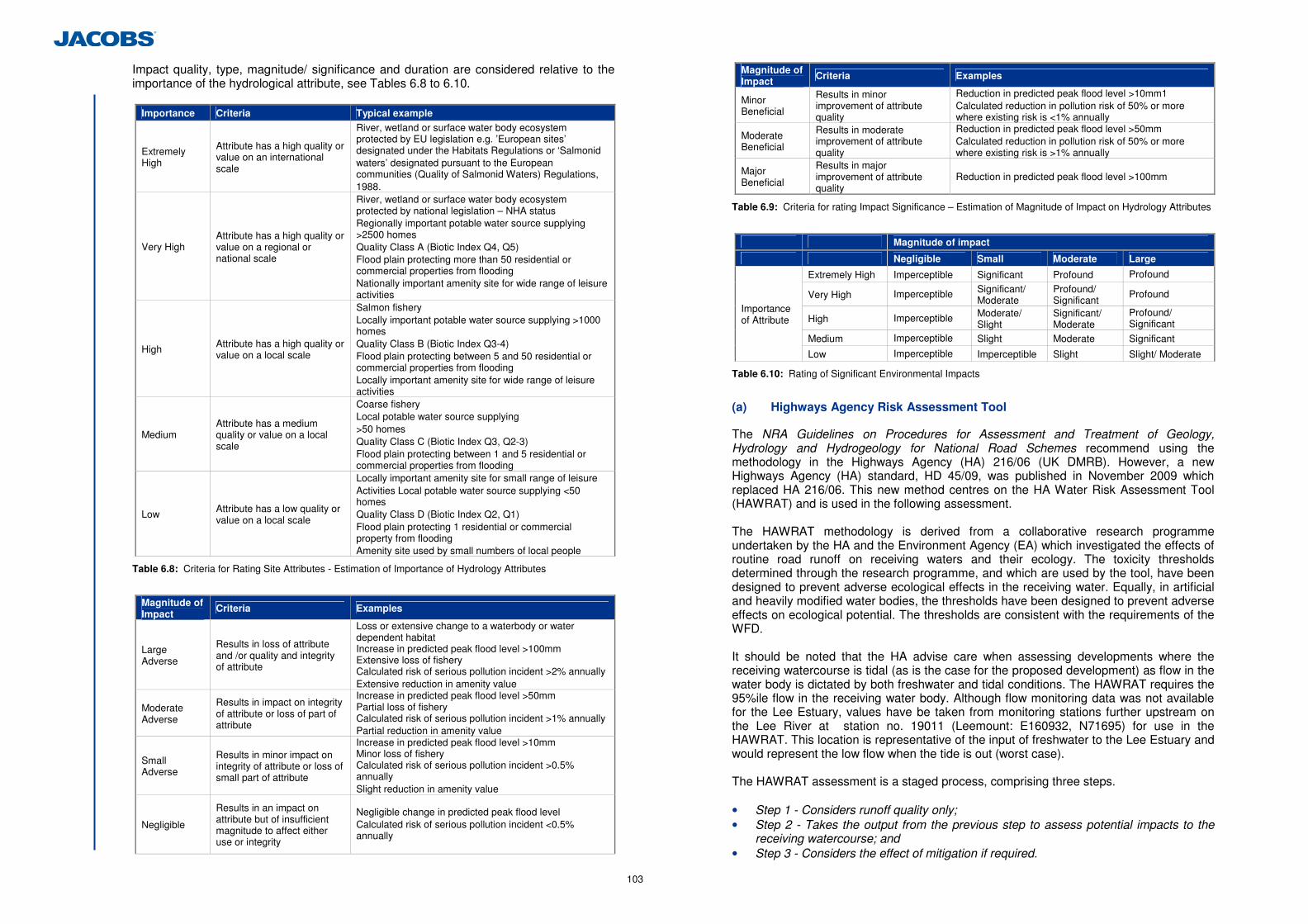
103
Impact quality, type, magnitude/ significance and duration are considered relative to the importance of the hydrological attribute, see Tables 6.8 to 6.10.
Importance Criteria Typical example
Extremely High
Attribute has a high quality or value on an international scale
River, wetland or surface water body ecosystem protected by EU legislation e.g. ’European sites’ designated under the Habitats Regulations or ‘Salmonid waters’ designated pursuant to the European communities (Quality of Salmonid Waters) Regulations, 1988.
Very High Attribute has a high quality or value on a regional or national scale
River, wetland or surface water body ecosystem protected by national legislation – NHA status Regionally important potable water source supplying >2500 homes Quality Class A (Biotic Index Q4, Q5) Flood plain protecting more than 50 residential or commercial properties from flooding Nationally important amenity site for wide range of leisure activities
High Attribute has a high quality or value on a local scale
Salmon fishery Locally important potable water source supplying >1000 homes Quality Class B (Biotic Index Q3-4) Flood plain protecting between 5 and 50 residential or commercial properties from flooding Locally important amenity site for wide range of leisure activities
Medium Attribute has a medium quality or value on a local scale
Coarse fishery Local potable water source supplying >50 homes Quality Class C (Biotic Index Q3, Q2-3) Flood plain protecting between 1 and 5 residential or commercial properties from flooding
Low Attribute has a low quality or value on a local scale
Locally important amenity site for small range of leisure Activities Local potable water source supplying <50 homes Quality Class D (Biotic Index Q2, Q1) Flood plain protecting 1 residential or commercial property from flooding Amenity site used by small numbers of local people
Table 6.8: Criteria for Rating Site Attributes - Estimation of Importance of Hydrology Attributes
Magnitude of Impact
Criteria Examples
Large Adverse
Results in loss of attribute and /or quality and integrity of attribute
Loss or extensive change to a waterbody or water dependent habitat Increase in predicted peak flood level >100mm Extensive loss of fishery Calculated risk of serious pollution incident >2% annually Extensive reduction in amenity value
Moderate Adverse
Results in impact on integrity of attribute or loss of part of attribute
Increase in predicted peak flood level >50mm Partial loss of fishery Calculated risk of serious pollution incident >1% annually Partial reduction in amenity value
Small Adverse
Results in minor impact on integrity of attribute or loss of small part of attribute
Increase in predicted peak flood level >10mm Minor loss of fishery Calculated risk of serious pollution incident >0.5% annually Slight reduction in amenity value
Negligible
Results in an impact on attribute but of insufficient magnitude to affect either use or integrity
Negligible change in predicted peak flood level Calculated risk of serious pollution incident <0.5% annually
Magnitude of Impact Criteria Examples
Minor Beneficial
Results in minor improvement of attribute quality
Reduction in predicted peak flood level >10mm1 Calculated reduction in pollution risk of 50% or more where existing risk is <1% annually
Moderate Beneficial
Results in moderate improvement of attribute quality
Reduction in predicted peak flood level >50mm Calculated reduction in pollution risk of 50% or more where existing risk is >1% annually
Major Beneficial
Results in major improvement of attribute quality
Reduction in predicted peak flood level >100mm
Table 6.9: Criteria for rating Impact Significance – Estimation of Magnitude of Impact on Hydrology Attributes
Magnitude of impact
Negligible Small Moderate Large
Extremely High Imperceptible Significant Profound Profound
Very High Imperceptible Significant/ Moderate
Profound/ Significant
Profound
High Imperceptible Moderate/ Slight
Significant/ Moderate
Profound/ Significant
Medium Imperceptible Slight Moderate Significant
Importance of Attribute
Low Imperceptible Imperceptible Slight Slight/ Moderate
Table 6.10: Rating of Significant Environmental Impacts
(a) Highways Agency Risk Assessment Tool
The NRA Guidelines on Procedures for Assessment and Treatment of Geology, Hydrology and Hydrogeology for National Road Schemes recommend using the methodology in the Highways Agency (HA) 216/06 (UK DMRB). However, a new Highways Agency (HA) standard, HD 45/09, was published in November 2009 which replaced HA 216/06. This new method centres on the HA Water Risk Assessment Tool (HAWRAT) and is used in the following assessment. The HAWRAT methodology is derived from a collaborative research programme undertaken by the HA and the Environment Agency (EA) which investigated the effects of routine road runoff on receiving waters and their ecology. The toxicity thresholds determined through the research programme, and which are used by the tool, have been designed to prevent adverse ecological effects in the receiving water. Equally, in artificial and heavily modified water bodies, the thresholds have been designed to prevent adverse effects on ecological potential. The thresholds are consistent with the requirements of the WFD. It should be noted that the HA advise care when assessing developments where the receiving watercourse is tidal (as is the case for the proposed development) as flow in the water body is dictated by both freshwater and tidal conditions. The HAWRAT requires the 95%ile flow in the receiving water body. Although flow monitoring data was not available for the Lee Estuary, values have be taken from monitoring stations further upstream on the Lee River at station no. 19011 (Leemount: E160932, N71695) for use in the HAWRAT. This location is representative of the input of freshwater to the Lee Estuary and would represent the low flow when the tide is out (worst case). The HAWRAT assessment is a staged process, comprising three steps. • Step 1 - Considers runoff quality only; • Step 2 - Takes the output from the previous step to assess potential impacts to the
receiving watercourse; and • Step 3 - Considers the effect of mitigation if required.
104
The following pollutants have been incorporated within the assessment process (HAWRAT): • Soluble pollutants associated with acute pollution impacts, expressed as Even Mean
Concentrations (EMCs) for dissolved copper and zinc; • Sediment-bound pollutants associated with chronic pollution impacts, expressed as
Event Mean Sediment Concentrations (EMSCs) for total copper, zinc, cadmium, pyrene, fluoranthene, anthracene, phenanthrene and total polycyclic aromatic hydrocarbons (PAH).
Table 6.11 outlines the inputs and output of the HAWRAT.
Stage of Assessment Inputs Outputs
Step 1 Runoff quality
• Traffic volume • Geographic location • 10 years of rainfall data, ~1000
rainfall events (embedded in HAWRAT)
• Runoff concentrations of soluble pollutants and sediment-bound pollutants for each event
• Pass/Fail standards
Step 2 In river
• Outputs from Step 1 • Area draining to outfall • Characteristics of receiving
watercourse
• Concentration of soluble pollutants after dilution
• Stream velocity at low flow • Deposition index (extent of
sediment coverage) • Pass/Fail standards • Percentage settlement required
to comply with deposition index • Annual average concentrations of
soluble pollutants
Step 3 After mitigation
• Outputs from Steps 1 and 2 • Existing and proposed mitigation
Measures • Treatment of soluble pollutants • Flow attenuation • Settlement of sediments
• Concentration of soluble pollutants after treatment
• Concentration of soluble pollutants after further dilution
• Pass/Fail standards • Annual average concentrations of
soluble pollutants after mitigation
Table 6.11: Stages of Assessment in HAWRAT
6.2.5 Attribute Importance
Table 6.12 summarises the importance of the attributes within the study area based on the NRA Guidelines on Procedures for Assessment and Treatment of Geology, Hydrology and Hydrogeology for National Road Schemes.
Attribute Attribute Importance Rationale
Lough Mahon including the Jack Lynch Tunnel Tidal Inlet (WF0) Extremely High Part of the Cork Harbour SPA
Glashaboy Estuary (WF9) Extremely High Part of the Cork Harbour SPA
Glashaboy River Very High Regionally important water supply source
Lee Estuary Very High Part of this waterbody falls within the boundary of the Douglas River Estuary pNHA
Jack Lynch Tunnel Tidal Polder (WF1)
Extremely High Part of the Cork Harbour SPA
Jack Lynch Tunnel Intertidal Mudflat (WF2)
High Source of water to North Esk Intertidal Mudflat West (WF3) and the Dunkettle Shore pNHA
North Esk Intertidal Mudflat West (WF3) & North Esk Intertidal Mudflat East (WF4)
Very High Part of Dunkettle Shore pNHA
Attribute Attribute Importance Rationale
Pfizer Intertidal Mudflats West (WF5) Pfizer Intertidal Mudflats East (WF6)
Medium Value on a local scale due to connectivity with the wider cork harbour SPA and Dunkettle Shore pNHA
Iarnrod Eireann Intertidal Mudflat Small (WF7) & Iarnrod Eireann Intertidal Mudflat Large (WF8)
Medium Value on a local scale due to connectivity with the wider cork harbour SPA and Dunkettle Shore pNHA
Other Watercourse and Channels (WF10, WF11, WF12, WF6) Medium
Value on a local scale due to connectivity with the wider cork harbour SPA and Dunkettle Shore pNHA
Other Wetlands (W13, WF14) Low Value on a local scale
Table 6.12: Attribute Importance within the Study Area
6.2.6 Predicted Impacts of the Proposed Development
This section considers and assesses the impact of the proposed development with regards to water quality and geomorphology aspects. Flooding Impacts are addressed in the FRA specialist report contained in Appendix 6.6. (a) Construction Impacts
During the construction phase there is the potential for pollution of surface water features from sediment loading and associated anthropogenic polluting substances entering watercourses54 as a result of surface water runoff or spills on-site. Potential sources during the construction phase include: • Construction within and adjacent to watercourses including culverts and
embankments; • Excavations including those related to flood compensation areas, construction and
removal of intertidal mudflat areas; • Stockpiling of materials; • Run-off from exposed bare soil surfaces including from the new flood compensation
areas; • Accidental spillage of anthropogenic polluting substances in or adjacent to
watercourses; and • Construction plant and vehicle washing. In terms of the physico-chemical parameters relating to water quality, the main potential contaminant during the construction phase will be suspended solids. Suspended solids concentrations could cause aquatic ecological problems which include clogging fish gills, smothering spawning grounds, reducing light penetration for flora growth, and adding bacteria and algae to the water. Nutrients are often associated with the solids (inorganic nutrients such as phosphorus and organic such as hydrocarbons, sewage if present) and in turn can cause significant deterioration of water quality and damage to aquatic life due to eutrophication of the water environment and eventually to fish-kills due to lowering of oxygen supply. Figure 2.8.2 details the location of the proposed new culverts, watercourse diversion and new flood compensatory areas for the proposed development. Figure 2.8.1 and Section 2.3.6 detail the proposed drainage design showing the locations of the four new attenuation pond/wetland systems. The construction period for the proposed project will be approximately 24 months. There will be no construction works within the Lee or Glashaboy Estuaries.
54 In the context of this assessment watercourses includes the intertidal mudflat areas detailed in Figure 5.1.1.
105
There will be some construction work to the immediate north east of the Jack Lynch Tunnel Tidal Polder (WF1). However, these works will not fall within the boundary of the Cork Harbour SPA. Construction works within and adjacent to the Jack Lynch Tunnel Intertidal Mudflat (WF2) will involve the installation of a new 1.8 m culvert and associated embankment works in and adjacent to the mudflat. Two flood compensatory areas will also be created to the east of this area: • The Jack Lynch Tunnel Flood Compensation Area 1 (south); and • The Jack Lynch Tunnel Flood Compensation Area 2 (north). The construction of these flood compensation areas will include the removal of hardstanding/ vegetation and the excavation of soils. These flood compensation areas will then need to be connected to the existing/remaining intertidal wetland network by allowing the tidal waters to enter the area. The installation of drainage and attenuation systems associated with the operational road will also be installed east and west of the Jack Lynch Tunnel Intertidal Mudflat (WF2); consisting of two pond/wetland attenuation systems. Details of the proposed drainage network are presented in Section 6.2.3 (k) (ii) of this chapter. Construction works in the area of the North Esk Intertidal Mudflats East and West (WF3 and WF4) will include the installation of two 1.8 m culverts that will connect the new flood compensatory area adjacent to the Jack Lynch Tunnel Intertidal Mudflat (WF2) to the North Esk Intertidal Mudflat (WF3) under the existing N25. The area immediately south of the existing North Esk Intertidal Mudflat East (WF4) will be excavated to provide a new flood compensation area, the North Esk Flood Compensation Area. Embankment works will be undertaken on the eastern portion of the North Esk Intertidal Mudflat West (WF3), resulting in the removal of this Mudflat. As a result of this embankment the existing watercourse north of the North Esk Intertidal Mudflat will require culverting to join the North Esk Intertidal Mudflat East (WF4). This watercourse will also require a second new 1.8 m culvert to the north to connect to the open channel, see Figure 2.8.2. Construction works are proposed in the area of the Pfizer Intertidal Mudflats (WF5 and WF6) including excavation of substantial portions of both the intertidal mudflats areas. The majority of the existing intertidal mudflats will be lost to the footprint of the proposed development. A small portion of the Pfizer Intertidal Mudflats East (WF6) will be retained with the addition of some flood compensatory area to the south west. Construction works are significantly less in the Iarnrod Eireann Intertidal Mudflats (WF7 & WF8). A portion of the Iarnrod Eireann Intertidal Mudflat Small (WF7) will be lost to the footprint of the proposed development and there will be the creation of a new small area of flood compensation area to the west. WF8 will remain unchanged.
Sediment sources during the construction phase can be attributed to the following: • Those associated with wash-out and erosion of bare soils during normal earth-
movements and stockpiling; • Erosion from newly excavated/created flood compensation areas; and • Displacement and subsequent erosion of large volumes of soft sediment, particularly
from the Pfizer Intertidal Mudflat East (WF6) and to a lesser extent WF5, WF7 and WF4, by virtue of their smaller areas, during the construction of the new infrastructure.
Potential impacts from the construction works in the absence of construction phase mitigation measures on the various sensitive receptors (watercourses and intertidal mudflats) are described below. The North Esk Intertidal Mudflats East and West (WF3 and WF4) form part of the Dunkettle Shore pNHA, which is considered to be an attribute of very high importance using the NRA guidelines classification. Any impacts associated with increased sediment release during construction could have an impact on this pNHA. Ecological Impacts on the Dunkettle Shore pNHA are considered in full in Chapter 5, Flora & Fauna. Impacts on water quality from the construction of the proposed development are considered to be direct, temporary, negative, and significant. The Jack Lynch Intertidal Mudflat Area (WF2) is considered to be an attribute of high importance due to its connectivity to the Cork Harbour SPA and Dunkettle Shore pNHA, and in accordance with the NRA guidelines classification of attributes. Any impacts associated with increased sediment release during construction could have an impact on the SPA and/or pNHA. Ecological Impacts on Cork Harbour SPA and Dunkettle Shore pNHA are considered in full in Chapter 5, Flora & Fauna. The impacts to Jack Lynch Intertidal Mudflat Areas (WF2) are considered to be direct, temporary, negative, and significant. The majority of the Pfizer Intertidal Mudflats (WF5 and WF6) will be lost to the footprint of the proposed development. Impacts with regard to water quality are considered direct , temporary, negative, and significant. Any impacts associated with increased sediment release during construction could have an impact outside of the proposed development footprint, due to the transport of sediment. The ultimate discharge point of the intertidal areas is to Lough Mahon. The importance of this attribute is considered extremely high in accordance with the NRA guidelines, as it forms part of the Cork Harbour SPA. Thus impacts during construction would be considered to be an indirect, temporary, negative and significant. A NIS in line with the requirement of the Habitats Directive has been prepared (see Appendix 5.6), with regards to any potential effects on the Natura 2000 network as a result of the proposed development (including the Cork Harbour SPA). Impacts on the Iarnród Éireann Intertidal Mudflat Small and Large (WF7 and WF8), an attribute of medium importance due to the transport of sediment on incoming tide, are considered indirect, temporary, negative, and moderate. Impacts on the watercourse and channels (WF10, WF11 and WF12), attributes of medium importance due to the transport of sediment on the incoming tide, are considered indirect temporary, negative and moderate. Impacts on Eastgate Pond (WF13) and Eastgate Saltmarsh (WF14) are considered indirect, temporary, negative, and imperceptible due to the limited connectivity to the other intertidal areas and the limited construction works in the vicinity of these water bodies. Impacts due to the transport of sediment on the incoming tide on the Glashaboy River/Estuary and Lee Estuary are unlikely and are considered indirect, temporary, negative, and imperceptible. Due to the estuarine environment of the study area, the transport of sediment or accidental releases during construction would be via releases from the Jack Lynch Tunnel tidal inlet (with pollutants carried up on the rising tide); however, on rising tide water would travel into the intertidal areas. There is no potential for direct or indirect impacts on a falling tide. A variety of construction materials and chemical substances are likely to be used in the works which could have various polluting potentials if spilled adjacent to or into a
106
watercourse. This may result in temporary minor to moderate negative impacts on watercourses. A large or particularly hazardous spillage could lead to short term significant negative impacts on the water environment (particularly Lough Mahon). There will be some construction work to the immediate north east of the Jack Lynch Tunnel Tidal Polder (WF1), and in the absence of mitigation and due to the proximity of the work to the Cork Harbour SPA, there is a risk of polluting substances from construction entering the tidal polder. Impacts are therefore considered to be indirect temporary negative and significant. Fisheries are considered and assessed in Chapter 5 Flora and Fauna. Table 6.13 summaries the impact on key ecological receptors with regards to fish during the construction stage. The intertidal mudflats are not considered to be a fishery, and have little or no fisheries potential.
Key Receptor
Overall evaluation
Impact Type Impact
Glashaboy Estuary
This part of the river is of local importance (higher value) with regard to fish.
Potential for suspended solids pollution and hydrocarbon contamination. Impacts affecting the movement of fish during construction stage.
Imperceptible negative impact probable at a local level in the short term (ca. 5 yrs). Movements of migratory fish would not be affected.
Lough Mahon
Lough Mahon is of County Importance with regard to fish.
Polluting materials may be transported from the proposed development into Lough Mahon during construction.
Probable Slight negative effect at the County level in the short-term (ca. 5 years).
Great Island Channel
This area is of county importance with respect to fish.
Pollutants potentially transported to this area by tidal currents. Unlikely to be significantly affected as drainage from the proposed scheme is to the west, and not towards Great Channel Island to the east.
Probable Imperceptible negative impact on the county importance of this site with respect to fish in the short term.
Table 6.13: Impact Characterisation for Key Ecological Receptors at Construction Stage (based on NRA, 2009)
This abstraction point of the Glashaboy Water works is located over 1km upstream of the existing crossing of the Glashaboy Estuary and over 2 km from the Jack Lynch Tunnel Tidal Inlet (WF0). Potential impacts associated with increased sediment release arising during construction could impact on this drinking water supply to the Glashaboy Water Works. This impact would potentially occur due to the transport of sediment on the incoming tidal water which flows up the Glashaboy Estuary. This impact however is considered highly unlikely due to the distance from the proposed works to the Glashaboy abstraction point, and the nature of the estuarine environment. Impacts are considered indirect, short term, negative, and imperceptible. Cork Harbour as a whole is considered an amenity value of very high importance. However, amenity value in the study area and immediate surrounds is limited due to the industrial nature of the study area which includes Port of Cork to the west and Little Island industrial Estate to the east. Impacts on amenity during construction will be indirect temporary, negative, and imperceptible, during the construction phase.
(b) Operation Impacts
(i) Water Quality Impacts - Normal Operation
During routine operation, pollutants, for example oils and hydrocarbons from fuel combustion and salts or herbicides from road maintenance, will be deposited on the road surfaces. The implications for water quality relate to the potential for these pollutants to be transported in surface run-off and enter the water environment via the road drainage system. The impact will depend on the volume and type of traffic using the road, the provision of pollution control measures, and the sensitivity of the receiving watercourse.
The concentration of contaminants is widely accepted to be dependent on traffic volumes experienced on the carriageway. The UK Design Manual for Roads and Bridges (DMRB-UK, 1998) restricts pollution impacts on receiving waters to roads mainly with more than 30,000 average annual daily traffic (AADT). Traffic figures using the existing Interchange at present and forecast in the future (i.e. Do Minimum), and with the proposed development in place, are as follows: • In 2010 (current situation existing Dunkettle Interchange) the AADT is in the region of
90,000; • By 2031 (future situation existing Dunkettle Interchange – Do-Minimum), the AADT
would be greater than 100,000 with increased queuing traffic; and • By 2031, (future situation, proposed development in place), AADT for the interchange
will be greater than 100,000 with reduced queuing traffic. The outfall treatment system associated with the drainage design of the proposed development as detailed in Section 6.2.3 (k) (ii) has been included following consultation with the NPWS. The sensitivity of a receptor (receiving watercourse) is influenced by the flow of the receiving watercourse, which partly depends on the watercourses’ catchment area. The flow determines the amount of available dilution for pollutants. Where road drainage discharges to watercourses at locations close to their source, the impact of the discharge on receiving water quality may be locally more noticeable. The ultimate discharge point of the proposed development is Lough Mahon via the intertidal mudflat areas.
The entire impermeable area being drained by the proposed Interchange is approximately 9ha as described in Section 6.2.3 (k) (ii).
The HAWRAT was used to assess the carriageway runoff from the proposed development on the Lough Mahon water body. Two assessments were undertaken:
• A non cumulative assessment for outfalls 2 & 3 for soluble acute impact and sediment
chronic impact: and • Cumulative Assessment Outfalls 1-4 - soluble acute impact only.
The total area discharging to the Lough Mahon Water body from Networks 2 and 3 is 6.065 hectares and the total area discharging to Lough Mahon from Networks 1 to 4 combined is 9 hectares. Networks are presented in Figure 2.8.1.
The HAWRAT was used to asses the impacts from acute and chronic pollution on Lough Mahon water body (see input and output details in Appendix 6.3). Using this assessment Step 1, (worst case scenario) which considers the runoff quality only, is failed against the toxicity threshold 55 . The assessment is then moved to Step 2 which takes the output from the previous step to assess potential impacts to the receiving watercourse, in this case Lough Mahon. Step 2 is passed (see Table 6.14). This concludes that no further mitigation measures are required.
If Step 2 is passed the assessment tool does not need to move to Step 3 where mitigation measures are accounted for. The pollution risk estimated at Steps 1 and 2 assumes the drainage system includes no pollution control (or attenuation) measures to mitigate the risk. However, from consultation with the NPWS the drainage design has nevertheless incorporated attenuation measures.
The outputs (annual average concentrations for soluble pollutants, dissolved copper and dissolved zinc) were also compared against the Environmental Quality Standards (EQS)
55 The toxicity thresholds determined through the research programme and which are used by the tool, have been designed to prevent adverse ecological effects in the receiving water.
107
in the European Communities Environmental Objective (Surface Water) Regulations 2009 and in both cases levels are significantly below the Annual Average AA-EQS.
Assessment Type
Receptor
Step 1- Runoff Quality prior to any Pre -treatment and Discharge to a Waterbody
Step 2 –In River Impacts(after Dilution and Dispersion)
Conclusion
Non Cumulative Assessment Outfall 2 & 3
Lough Mahon Fail Pass
Indicates that there will be no short-term impact associated with road runoff before attenuation measures No further treatment required for soluble metals and sediment
Cumulative Assessment Outfall 1-4 - Soluble Acute Impact only
Lough Mahon Fail Pass
Indicates that there will be no short-term impact associated with road runoff before attenuation measures No further treatment required for soluble metals
Table 6.14: HD 45/09 HAWRAT Assessment Results Summary
To assess the impact from the proposed development against existing baseline conditions the Do Minimum is compared to the Do Something scenario, see Table 6.15.
Factor Do Minimum Do Something
AADT 2010 2031
90,000 +100,000
N/A +100,000
Impermeable Area (hectares) 4 9
Discharge Total (l/s) 585 1400
Discharge Rate (l/s) 585 140
Attenuation measures none 3 stage system
Table 6.15: HD Summary of “Do Minimum” and “Do Something” Scenario
The pollutant load entering the drainage system is related to the AADT traffic on the interchange which will increase by approx 20-25% on existing levels in the Do Minimum and Do Something scenarios by 2031. Under the proposed development (Do Something) 4 ha of previously unattenuated carriageway runoff will now be subject to attenuation measures. In addition, under the Do Something scenario, journey times through the interchange will be reduced resulting in less pollutant load to the environment compared to the Do Minimum scenario where queuing and journeys times through the interchange will potentially increase with increased traffic levels. Overall, the results of the assessment indicate that impacts to the water quality of Lough Mahon (including WF0 and WF2) from the operational phase of the proposed development would be considered to be indirect, long term, neutral to negligible and positive due to increased pollutant removal in the proposed development drainage system.
North Esk Intertidal Mudflat West (WF 3) will be removed as part of the proposed development. Carriageway runoff entering the North Esk Intertidal Mudflat East (WF4) from the M8, north of the existing Dunkettle Interchange (via Gaelscoil Uí Drisceoil stream (WF10)), on incoming tide from WF2 and from the BASF Drainage Ditch (WF15) will now be subject to attenuation measures. Impacts to the water quality of North Esk intertidal Mudflat (WF4) from the operational phase of the proposed development would be considered direct, long term, neutral to positive, imperceptible. There will be no direct discharge to the Iarnrod Eireann Intertidal Mudflats or channel (WF7, WF8 & WF12) and the remaining Pfizer Intertidal Area (WF5 & WF6). Any carriageway runoff entering these mudflats on the incoming tide will be subject to attenuation measures under the proposed development. Impacts to the water quality on these water bodies from the operational phase of the proposed development would be considered indirect, long term, neutral to positive, imperceptible. Due to the estuarine nature of the study area, impacts to the water quality of the Glashaboy River/Estuary (WF9), the Jack Lynch Tidal Polder (WF1) and Lee Estuary from the operational phase of the proposed development would be considered indirect, long term, neutral, imperceptible. There will be no discharges to the other mudflats in the study area (WF13 & WF 14) or the Eastgate Tidal Channel (WF11). It is therefore considered that these water features will not be affected by the proposed development. (ii) Accidental Spillage Risk Assessment
There remains a risk of hydrocarbon and other dangerous substance contamination as a result of accidental spillage by vehicles using the interchange during the operational phase of the proposed development. This risk is also present for the existing Dunkettle Interchange. The HA considers that in:
Circumstances where an outfall discharges within close proximity to (i.e. within 1 km) a protected area for conservation, or could affect important drinking water supplies or other important abstractions, a higher standard of protection will be required such that the risk of a serious pollution incident has an annual probability of less than 0.5%.
The probability of accidental spillage has been calculated for each link using the HA Method D Spillage Risk Assessment and the outputs are included in Appendix 6.4. Prior to the inclusion of mitigation measures the probability was calculated as 2.7 x 10 -4. This is less than 0.5% (0.027%) therefore, the likelihood of a serous pollution incident is low and measures are not required to further reduce the risk of a serious pollution incident. (iii) Other Potential Impacts
Cork Harbour as a whole is considered an amenity value of very high importance. However, amenity in the study area and surrounds are limited due to the nature of the existing area. Impacts on amenity in the areas during operation will be indirect, long term, neutral, imperceptible. Table 6.16 summarises the impact on key ecological receptors with regards to fish during the operation of the proposed development. The intertidal mudflats are not considered to be a fishery, and have little or no fisheries potential. The fisheries impact assessment is contained within Chapter 5, Flora & Fauna.

108
Key Receptor Overall evaluation Impact Type Impact
Glashaboy Estuary
The Glashaboy River is used by Atlantic Salmon, European Eel, and perhaps River Lamprey. This part of the river is of local importance (higher value).
Potential accidental discharges of pollutants from road or road traffic are considered to be probable, though unlikely during operation phase
Imperceptible negative impact probable at a local level in the long term.
Lough Mahon Lough Mahon is of County Importance with regard to fish.
The operational phase of the road will result in potential ongoing water pollution impacts resulting from run-off
Probable Slight negative effect at the County level in the long-term.
Great Island Channel
This area is of County importance with respect to fish.
Suspended solids and other pollutants potentially transported to this area by tidal currents. Unlikely that this area would be significantly affected as drainage from the proposed development is to the west, and not towards Great Channel Island to the east.
No change to this site with respect to fish in the short/long-term.
Table 6.16: Impact Characterisation for Key Ecological Receptors at Construction Stage (based on NRA, 2009).
Table 6.17 summarises the impacts on water quality for each attribute during the construction and the operation phase prior to mitigation (based on NRA, 2009). .
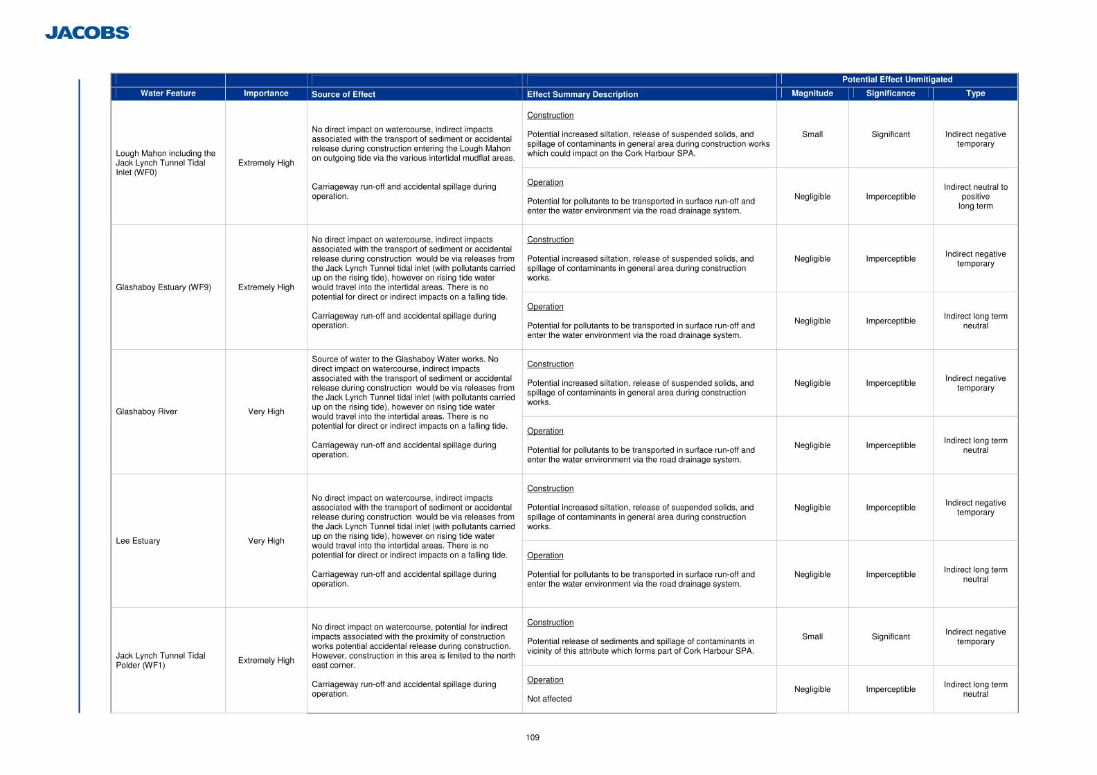
109
Potential Effect Unmitigated
Water Feature Importance Source of Effect Effect Summary Description Magnitude Significance Type
Construction Potential increased siltation, release of suspended solids, and spillage of contaminants in general area during construction works which could impact on the Cork Harbour SPA.
Small Significant
Indirect negative temporary
Lough Mahon including the Jack Lynch Tunnel Tidal Inlet (WF0)
Extremely High
No direct impact on watercourse, indirect impacts associated with the transport of sediment or accidental release during construction entering the Lough Mahon on outgoing tide via the various intertidal mudflat areas. Carriageway run-off and accidental spillage during operation.
Operation Potential for pollutants to be transported in surface run-off and enter the water environment via the road drainage system.
Negligible Imperceptible Indirect neutral to
positive long term
Construction Potential increased siltation, release of suspended solids, and spillage of contaminants in general area during construction works.
Negligible Imperceptible Indirect negative temporary
Glashaboy Estuary (WF9) Extremely High
No direct impact on watercourse, indirect impacts associated with the transport of sediment or accidental release during construction would be via releases from the Jack Lynch Tunnel tidal inlet (with pollutants carried up on the rising tide), however on rising tide water would travel into the intertidal areas. There is no potential for direct or indirect impacts on a falling tide. Carriageway run-off and accidental spillage during operation.
Operation Potential for pollutants to be transported in surface run-off and enter the water environment via the road drainage system.
Negligible Imperceptible Indirect long term neutral
Construction Potential increased siltation, release of suspended solids, and spillage of contaminants in general area during construction works.
Negligible Imperceptible Indirect negative temporary
Glashaboy River Very High
Source of water to the Glashaboy Water works. No direct impact on watercourse, indirect impacts associated with the transport of sediment or accidental release during construction would be via releases from the Jack Lynch Tunnel tidal inlet (with pollutants carried up on the rising tide), however on rising tide water would travel into the intertidal areas. There is no potential for direct or indirect impacts on a falling tide. Carriageway run-off and accidental spillage during operation.
Operation Potential for pollutants to be transported in surface run-off and enter the water environment via the road drainage system.
Negligible Imperceptible Indirect long term neutral
Construction Potential increased siltation, release of suspended solids, and spillage of contaminants in general area during construction works.
Negligible Imperceptible Indirect negative temporary
Lee Estuary Very High
No direct impact on watercourse, indirect impacts associated with the transport of sediment or accidental release during construction would be via releases from the Jack Lynch Tunnel tidal inlet (with pollutants carried up on the rising tide), however on rising tide water would travel into the intertidal areas. There is no potential for direct or indirect impacts on a falling tide. Carriageway run-off and accidental spillage during operation.
Operation Potential for pollutants to be transported in surface run-off and enter the water environment via the road drainage system.
Negligible Imperceptible Indirect long term neutral
Construction Potential release of sediments and spillage of contaminants in vicinity of this attribute which forms part of Cork Harbour SPA.
Small Significant Indirect negative temporary
Jack Lynch Tunnel Tidal Polder (WF1)
Extremely High
No direct impact on watercourse, potential for indirect impacts associated with the proximity of construction works potential accidental release during construction. However, construction in this area is limited to the north east corner. Carriageway run-off and accidental spillage during operation.
Operation Not affected
Negligible Imperceptible Indirect long term neutral
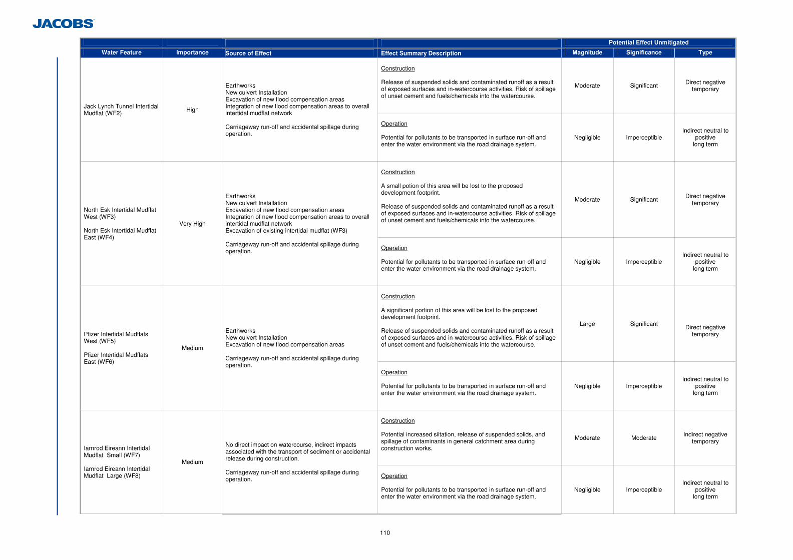
110
Potential Effect Unmitigated
Water Feature Importance Source of Effect Effect Summary Description Magnitude Significance Type
Construction Release of suspended solids and contaminated runoff as a result of exposed surfaces and in-watercourse activities. Risk of spillage of unset cement and fuels/chemicals into the watercourse.
Moderate Significant Direct negative temporary
Jack Lynch Tunnel Intertidal Mudflat (WF2)
High
Earthworks New culvert Installation Excavation of new flood compensation areas Integration of new flood compensation areas to overall intertidal mudflat network Carriageway run-off and accidental spillage during operation.
Operation Potential for pollutants to be transported in surface run-off and enter the water environment via the road drainage system.
Negligible Imperceptible Indirect neutral to
positive long term
Construction A small potion of this area will be lost to the proposed development footprint. Release of suspended solids and contaminated runoff as a result of exposed surfaces and in-watercourse activities. Risk of spillage of unset cement and fuels/chemicals into the watercourse.
Moderate Significant Direct negative temporary
North Esk Intertidal Mudflat West (WF3) North Esk Intertidal Mudflat East (WF4)
Very High
Earthworks New culvert Installation Excavation of new flood compensation areas Integration of new flood compensation areas to overall intertidal mudflat network Excavation of existing intertidal mudflat (WF3) Carriageway run-off and accidental spillage during operation.
Operation Potential for pollutants to be transported in surface run-off and enter the water environment via the road drainage system.
Negligible Imperceptible Indirect neutral to
positive long term
Construction A significant portion of this area will be lost to the proposed development footprint. Release of suspended solids and contaminated runoff as a result of exposed surfaces and in-watercourse activities. Risk of spillage of unset cement and fuels/chemicals into the watercourse.
Large Significant
Direct negative temporary Pfizer Intertidal Mudflats
West (WF5) Pfizer Intertidal Mudflats East (WF6)
Medium
Earthworks New culvert Installation Excavation of new flood compensation areas Carriageway run-off and accidental spillage during operation.
Operation Potential for pollutants to be transported in surface run-off and enter the water environment via the road drainage system.
Negligible Imperceptible Indirect neutral to
positive long term
Construction Potential increased siltation, release of suspended solids, and spillage of contaminants in general catchment area during construction works.
Moderate Moderate Indirect negative temporary
Iarnrod Eireann Intertidal Mudflat Small (WF7) Iarnrod Eireann Intertidal Mudflat Large (WF8)
Medium
No direct impact on watercourse, indirect impacts associated with the transport of sediment or accidental release during construction. Carriageway run-off and accidental spillage during operation.
Operation Potential for pollutants to be transported in surface run-off and enter the water environment via the road drainage system.
Negligible Imperceptible Indirect neutral to
positive long term
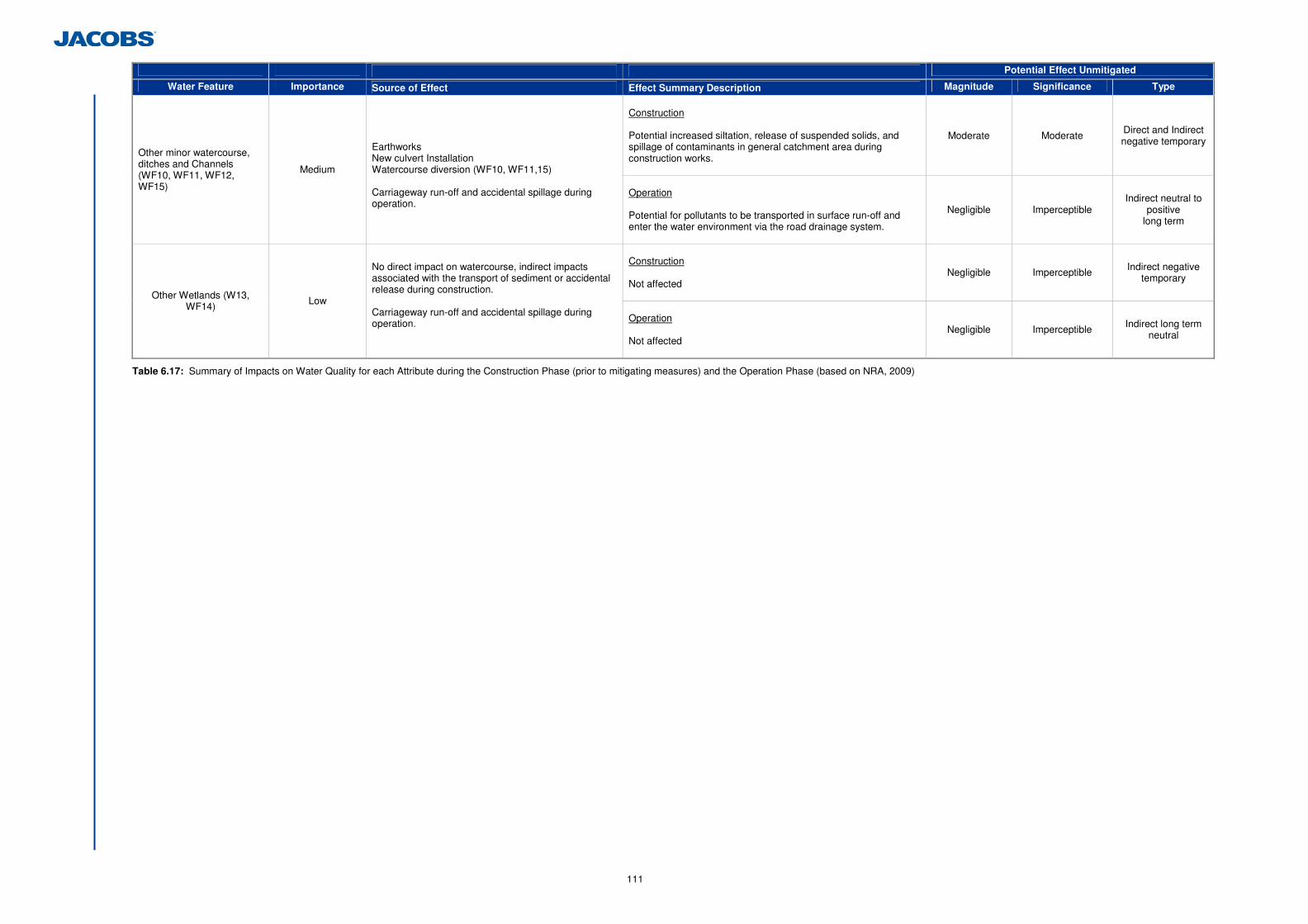
111
Potential Effect Unmitigated
Water Feature Importance Source of Effect Effect Summary Description Magnitude Significance Type
Construction Potential increased siltation, release of suspended solids, and spillage of contaminants in general catchment area during construction works.
Moderate Moderate Direct and Indirect negative temporary
Other minor watercourse, ditches and Channels (WF10, WF11, WF12, WF15)
Medium
Earthworks New culvert Installation Watercourse diversion (WF10, WF11,15) Carriageway run-off and accidental spillage during operation.
Operation Potential for pollutants to be transported in surface run-off and enter the water environment via the road drainage system.
Negligible Imperceptible Indirect neutral to
positive long term
Construction Not affected
Negligible Imperceptible Indirect negative temporary
Other Wetlands (W13, WF14) Low
No direct impact on watercourse, indirect impacts associated with the transport of sediment or accidental release during construction. Carriageway run-off and accidental spillage during operation.
Operation Not affected
Negligible Imperceptible Indirect long term neutral
Table 6.17: Summary of Impacts on Water Quality for each Attribute during the Construction Phase (prior to mitigating measures) and the Operation Phase (based on NRA, 2009)
112
6.2.7 Do-Minimum Scenario Impact
The physico-chemical status of the watercourse, specifically Lough Mahon, could potentially decrease with increased traffic levels, increased incidence of queuing, and subsequent increased pollutant load entering Lough Mahon via an unattenuated drainage system. 6.2.8 Flood Risk
A flood risk assessment (FRA) in line with the Office of Public Works (OPW) Guidelines for Planning Authorities (GPA) 20: The Planning System and Flood Risk Management (OPW, 2009), has been undertaken. The full report is contained in Appendix 6.6. The primary objective of the FRA was to construct a hydraulic model of the Dunkettle Interchange and intertidal mudflats to assess the flood risk in the existing situation and with the proposed development in operation. Both situations were assessed for an extreme tidal event (0.5% Annual Exceedance Probability) and compensatory flood intertidal areas included to allow inundation of areas at similar levels in the tidal cycle. The FRA concluded that all across the study area, comparison of model predictions between the existing and the proposed road scheme situation demonstrate that the proposed works do not increase the flood risk. Peak water levels within the intertidal areas are comparable in both situations. Only a slight increase in the Pfizer Intertidal Mudflat East (WF6) is predicted in the proposed situation, however this has no consequence on the flood risk as no properties are located nearby. 6.2.9 Proposed Mitigation and Avoidance Measures
(a) Construction Phase Mitigation
All construction works will be completed in line with the recommendations of the Construction Industry Research and Information Association (CIRIA) and NRA guidelines identified below: • ‘Guidelines for the Crossing of Watercourses during the Construction of National
Road Schemes’ (NRA, 2005); • CIRIA C649 Control of Water Pollution from Linear Construction Projects: Site Guide
(Murnane et al. 2006); and • ‘Control of Water Pollution from Construction Sites, Guidance for Consultants and
Contractors’ (CIRIA, 2001).
The construction contractor will prepare an erosion and sediment/silt control plan prior to commencing the construction works. To prevent or reduce the amount of sediment released into watercourses, the sediment/silt control plan will include the following measures to be implemented by the contractor: • Provision of measures to prevent the release of sediment concentrations over
baseline conditions56 to Lough Mahon during the construction works will include but not be limited to silt fences, silt curtains, settlement lagoons, filter materials, and stockpile seeding;
• Provision of measures to minimise the release of sediment from the newly excavated flood compensation areas to Lough Mahon and the North Esk Intertidal Mudflat (WF4). These measures will include but not be limited to silt curtains, settlement lagoons, filter materials and stockpile seeding.
56 The contractor will establish baseline suspended sediment in Lough Mahon as outlined in Section 6.2.9(a)(i) - Proposed Monitoring
• Provision of measures to minimise the displacement and subsequent erosion and release of soft sediment, particularly from WF6, WF5, WF7 and WF4. These measures will include but not be limited to silt curtains, settlement lagoons, filter materials and stockpile seeding.
• Provision of measures to handle, store and re-use where feasible material removed from the intertidal mudflats;
• Provision of measures to minimise any run-off into the Jack Lynch Tidal Polder (WF1), by diverting temporary drainage into WF2 instead; and
• Provision of exclusion zones and barriers (sediment fences) between earthworks, stockpiles and temporary surfaces and watercourses to prevent sediment washing into the watercourses.
Measures to control the release of sediment will include but not be limited to silt fences, silt curtains, settlement lagoons, filter materials, and stockpile seeding.
Excavated sediment/materials from Pfizer Intertidal Mudflat West (WF5) and East (WF6) will be retained and re-used within flood compensation intertidal areas.
Temporary construction surface drainage and sediment control measures will be in place before earthworks commence.
Pouring of cementitious materials for the works will be carried out in the dry and allowed to cure for 48 hours before re-flooding. Pumped concrete will be monitored to ensure no accidental discharge. Mixer washings and excess concrete will not be discharged to surface water.
No storage of hydrocarbons or any toxic chemicals will occur within 50 m of a watercourse. Fuel storage tanks will be bunded to a capacity at least 110% of the volume of the storage tank. Re-fuelling of plant will not occur within 50 m of any watercourse and only in bunded refuelling areas. Emergency procedures and spillage kits will be available and construction staff will be familiar with emergency procedures.
Implementation of measures to minimise waste and ensure correct handling, storage and disposal of waste (most notably wet concrete, pile arisings and asphalt). (i) Monitoring
A monitoring programme will be required at the pre construction and construction stage.
Baseline values for Total Suspended Solids (TSS), pH, Dissolved Oxygen (DO) and Temperature of the water will be established at:
• The Jack Lynch Tunnel Tidal Inlet (WF0) • Within the River Lee Channel 400m upstream (south west) of the Jack Lynch
Tunnel Tidal Inlet (WF0) • Within the River Lee Channel 400m downstream (south east) of the Jack
Lynch Tunnel Tidal Inlet (WF0)
Pre construction monitoring will be undertaken once a week over a 12 month period, prior to the commencement of construction. The results of this preconstruction monitoring of baseline conditions will be used to calculate a 90%ile trigger value for each parameter.
During the construction phase the construction contractor will monitor the levels of Total Suspended Solids (TSS), pH, Dissolved Oxygen (DO) and Temperature at the same locations once a week for the duration of the following works:
• Earthworks movements and stockpiling;

113
• Excavation and creation of flood compensation areas; • Excavation and movement of marine sediment from WF2, WF3, WF4, WF5,
WF6, WF7; • Works within intertidal areas;
The construction monitoring results will be compared with those results established in pre construction monitoring.
The above monitoring will allow the contractor to demonstrate the success of the mitigation measures employed in maintaining any sediment release within the trigger value established. (b) Operation Phase Mitigation
Measures to attenuate and treat the carriageway runoff have been incorporated into the drainage design of the proposed development as detailed on Section 6.2.3 (k) (ii) and in Section 2.3.6. No further mitigation is required in relation to surface water quality. 6.2.10 Difficulties Encountered in Compiling Information
A complete set of as built drawings were not available to confirm the complete drainage design of the existing Dunkettle Interchange and surrounding road network. The HAWRAT requires the 95%ile flow in the receiving water body. Although flow monitoring data was not available for the Lee Estuary, values have be taken from monitoring stations further upstream on the Lee River at station no. 19011 (Leemount: E160932, N71695) for use in the HAWRAT. This location is representative of the input of freshwater to the Lee Estuary and would represent the low flow when the tide is out (worst case). 6.2.11 Residual Impacts
The residual impacts associated with the proposed development after implementation of the mandatory mitigation measures during the construction phase is detailed in Table 6.18. Impacts associated with the construction phase are considered short term.
Attribute Importance Significance Pre Mitigation
Significance Post Mitigation
Lough Mahon including the Jack Lynch Tunnel Tidal Inlet (WF0) Extremely High Significant Imperceptible
Glashaboy Estuary (WF9) Extremely High Imperceptible Imperceptible Glashaboy River Very High Imperceptible Imperceptible
Lee Estuary Very High Imperceptible Imperceptible
Jack Lynch Tunnel Tidal Polder (WF1) Extremely High Significant Imperceptible Jack Lynch Tunnel Intertidal Mudflat (WF2) High Significant Imperceptible North Esk Intertidal Mudflat West (WF3) North Esk Intertidal Mudflat East (WF4)
Very High Significant Imperceptible
Pfizer Intertidal Mudflats West (WF5) Pfizer Intertidal Mudflats East (WF6)
Medium Significant Imperceptible
Iarnrod Eireann Intertidal Mudflat Small (WF7) Iarnrod Eireann Intertidal Mudflat Large (WF8)
Medium Moderate Imperceptible
Other Watercourse and Channels (WF10, WF11, WF12, WF6) Medium Moderate Imperceptible
Other Wetlands (W13, WF14) Low Imperceptible Imperceptible
Table 6.18: Residual Impact after Mitigation Measures for Construction
The drainage design for the proposed scheme has been considered in the operational impact assessment which has concluded no significant impact as a result of the proposed development in terms of water quality. Residual impacts on the water quality of the proposed development will be neutral, long term, negligible. 6.2.12 Impact Interrelations & Cumulative Impacts Assessment
Hydrology interrelates to other aspects such as Flora and Fauna and Hydrogeology. Deterioration of surface water quality in the study area as a result of the proposed development can impact on flora and fauna within the study area. In turn, deterioration of the groundwater quality in the study area could impact on the surface water quality in the study area. These interrelations have been included in the overall impact assessment for each aspect. Other projects within the vicinity of the propose development could result in cumulative impacts during the construction phase if these projects were to run concurrently. However, any new project will be subject to planning requirements and where required, EIA and Appropriate Assessment to address the impacts. 6.2.13 Water Framework Directive Compliance
The EU Water Framework Directive has introduced environmental targets with specific objectives including: • Prevention of deterioration in the status of surface water bodies; and • Protection, enhancement and restoration of all surface water bodies with the aim of
achieving good ecological and chemical status by 2015. As described above, the proposed development will not cause the deterioration of water quality within the water bodies adjacent to the proposed development either during construction (with implementation of appropriate mitigation measures) or during the subsequent operational phase. Section 6.3 below illustrates that the proposed development will not result in any significant hydromorphological impacts, while the flora and fauna assessment presented in Chapter 5 concluded that there would be no significant residual impacts to aquatic ecology and fish following implementation of mitigation measures. It can therefore be concluded that overall, the proposed development will not compromise the ability of the Lough Mahon WFD designated waterbody from achieving good status, and the development is therefore in compliance with the provisions of the WFD.
6.3 Geomorphological and Hydromorphological Environment
6.3.1 Introduction
This section describes the existing geomorphological and hydromorphological environment and the likely significant potential impacts associated with both the construction and operation of the proposed development. (a) Geomorphology and Environmental Impact Assessment
The National Roads Authority Guidelines on Procedures for Assessment and Treatment of Geology, Hydrology and Hydrogeology for National Road Schemes (2009) which
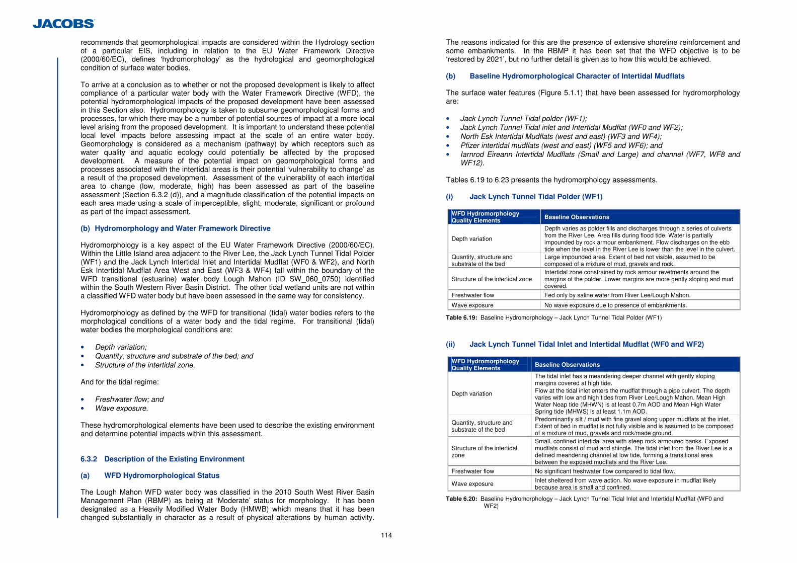
114
recommends that geomorphological impacts are considered within the Hydrology section of a particular EIS, including in relation to the EU Water Framework Directive (2000/60/EC), defines ‘hydromorphology’ as the hydrological and geomorphological condition of surface water bodies.
To arrive at a conclusion as to whether or not the proposed development is likely to affect compliance of a particular water body with the Water Framework Directive (WFD), the potential hydromorphological impacts of the proposed development have been assessed in this Section also. Hydromorphology is taken to subsume geomorphological forms and processes, for which there may be a number of potential sources of impact at a more local level arising from the proposed development. It is important to understand these potential local level impacts before assessing impact at the scale of an entire water body. Geomorphology is considered as a mechanism (pathway) by which receptors such as water quality and aquatic ecology could potentially be affected by the proposed development. A measure of the potential impact on geomorphological forms and processes associated with the intertidal areas is their potential ‘vulnerability to change’ as a result of the proposed development. Assessment of the vulnerability of each intertidal area to change (low, moderate, high) has been assessed as part of the baseline assessment (Section 6.3.2 (d)), and a magnitude classification of the potential impacts on each area made using a scale of imperceptible, slight, moderate, significant or profound as part of the impact assessment. (b) Hydromorphology and Water Framework Directive
Hydromorphology is a key aspect of the EU Water Framework Directive (2000/60/EC). Within the Little Island area adjacent to the River Lee, the Jack Lynch Tunnel Tidal Polder (WF1) and the Jack Lynch Intertidal Inlet and Intertidal Mudflat (WF0 & WF2), and North Esk Intertidal Mudflat Area West and East (WF3 & WF4) fall within the boundary of the WFD transitional (estuarine) water body Lough Mahon (ID SW_060_0750) identified within the South Western River Basin District. The other tidal wetland units are not within a classified WFD water body but have been assessed in the same way for consistency. Hydromorphology as defined by the WFD for transitional (tidal) water bodies refers to the morphological conditions of a water body and the tidal regime. For transitional (tidal) water bodies the morphological conditions are: • Depth variation; • Quantity, structure and substrate of the bed; and • Structure of the intertidal zone. And for the tidal regime: • Freshwater flow; and • Wave exposure. These hydromorphological elements have been used to describe the existing environment and determine potential impacts within this assessment. 6.3.2 Description of the Existing Environment
(a) WFD Hydromorphological Status
The Lough Mahon WFD water body was classified in the 2010 South West River Basin Management Plan (RBMP) as being at ‘Moderate’ status for morphology. It has been designated as a Heavily Modified Water Body (HMWB) which means that it has been changed substantially in character as a result of physical alterations by human activity.
The reasons indicated for this are the presence of extensive shoreline reinforcement and some embankments. In the RBMP it has been set that the WFD objective is to be ‘restored by 2021’, but no further detail is given as to how this would be achieved. (b) Baseline Hydromorphological Character of Intertidal Mudflats
The surface water features (Figure 5.1.1) that have been assessed for hydromorphology are: • Jack Lynch Tunnel Tidal polder (WF1); • Jack Lynch Tunnel Tidal inlet and Intertidal Mudflat (WF0 and WF2); • North Esk Intertidal Mudflats (west and east) (WF3 and WF4); • Pfizer intertidal mudflats (west and east) (WF5 and WF6); and • Iarnrod Eireann Intertidal Mudflats (Small and Large) and channel (WF7, WF8 and
WF12). Tables 6.19 to 6.23 presents the hydromorphology assessments.
(i) Jack Lynch Tunnel Tidal Polder (WF1)
WFD Hydromorphology Quality Elements Baseline Observations
Depth variation
Depth varies as polder fills and discharges through a series of culverts from the River Lee. Area fills during flood tide. Water is partially impounded by rock armour embankment. Flow discharges on the ebb tide when the level in the River Lee is lower than the level in the culvert.
Quantity, structure and substrate of the bed
Large impounded area. Extent of bed not visible, assumed to be composed of a mixture of mud, gravels and rock.
Structure of the intertidal zone Intertidal zone constrained by rock armour revetments around the margins of the polder. Lower margins are more gently sloping and mud covered.
Freshwater flow Fed only by saline water from River Lee/Lough Mahon.
Wave exposure No wave exposure due to presence of embankments.
Table 6.19: Baseline Hydromorphology – Jack Lynch Tunnel Tidal Polder (WF1)
(ii) Jack Lynch Tunnel Tidal Inlet and Intertidal Mudflat (WF0 and WF2)
WFD Hydromorphology Quality Elements Baseline Observations
Depth variation
The tidal inlet has a meandering deeper channel with gently sloping margins covered at high tide. Flow at the tidal inlet enters the mudflat through a pipe culvert. The depth varies with low and high tides from River Lee/Lough Mahon. Mean High Water Neap tide (MHWN) is at least 0.7m AOD and Mean High Water Spring tide (MHWS) is at least 1.1m AOD.
Quantity, structure and substrate of the bed
Predominantly silt / mud with fine gravel along upper mudflats at the inlet. Extent of bed in mudflat is not fully visible and is assumed to be composed of a mixture of mud, gravels and rock/made ground.
Structure of the intertidal zone
Small, confined intertidal area with steep rock armoured banks. Exposed mudflats consist of mud and shingle. The tidal inlet from the River Lee is a defined meandering channel at low tide, forming a transitional area between the exposed mudflats and the River Lee.
Freshwater flow No significant freshwater flow compared to tidal flow.
Wave exposure Inlet sheltered from wave action. No wave exposure in mudflat likely because area is small and confined.
Table 6.20: Baseline Hydromorphology – Jack Lynch Tunnel Tidal Inlet and Intertidal Mudflat (WF0 and WF2)
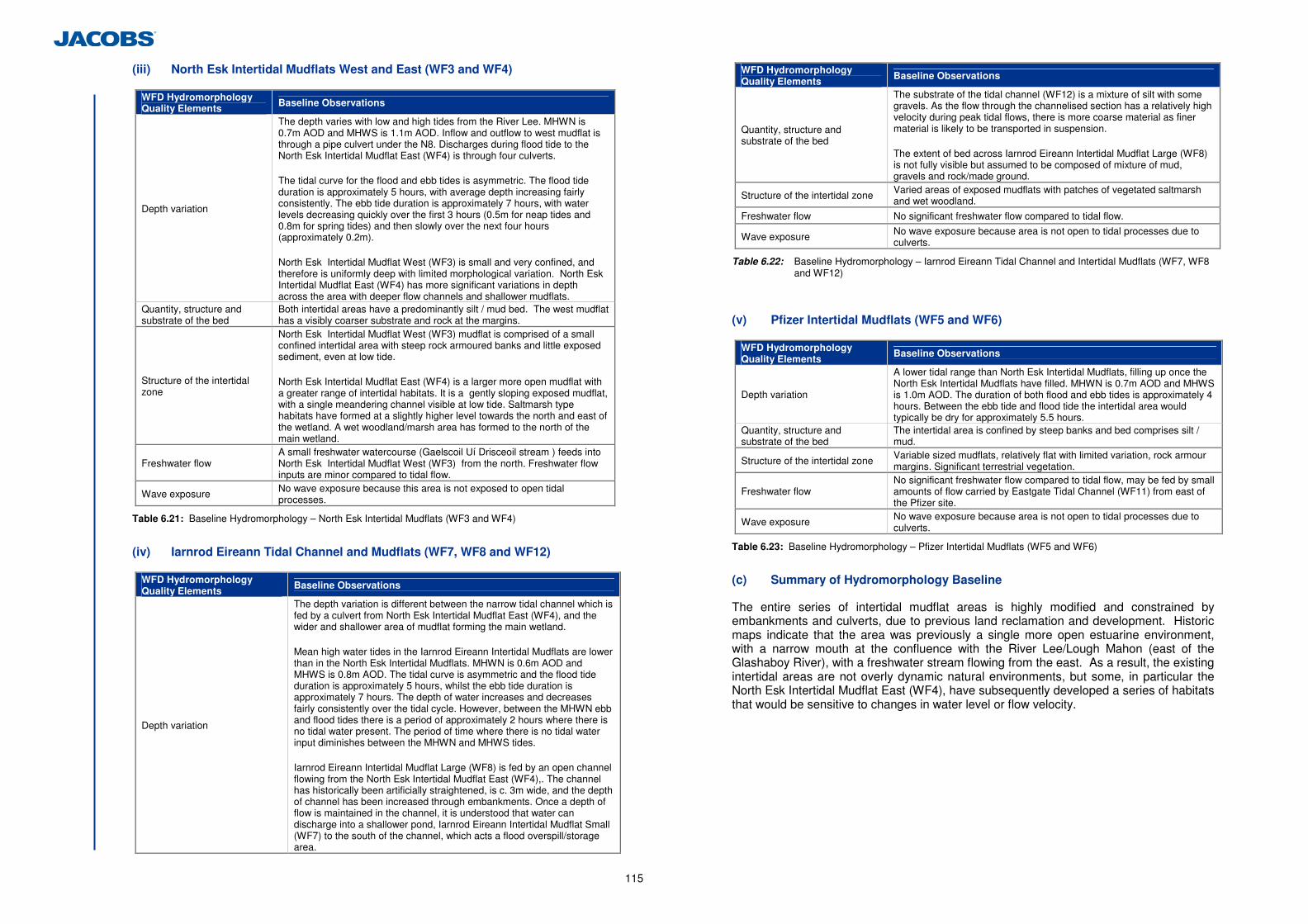
115
(iii) North Esk Intertidal Mudflats West and East (WF3 and WF4)
WFD Hydromorphology Quality Elements Baseline Observations
Depth variation
The depth varies with low and high tides from the River Lee. MHWN is 0.7m AOD and MHWS is 1.1m AOD. Inflow and outflow to west mudflat is through a pipe culvert under the N8. Discharges during flood tide to the North Esk Intertidal Mudflat East (WF4) is through four culverts. The tidal curve for the flood and ebb tides is asymmetric. The flood tide duration is approximately 5 hours, with average depth increasing fairly consistently. The ebb tide duration is approximately 7 hours, with water levels decreasing quickly over the first 3 hours (0.5m for neap tides and 0.8m for spring tides) and then slowly over the next four hours (approximately 0.2m). North Esk Intertidal Mudflat West (WF3) is small and very confined, and therefore is uniformly deep with limited morphological variation. North Esk Intertidal Mudflat East (WF4) has more significant variations in depth across the area with deeper flow channels and shallower mudflats.
Quantity, structure and substrate of the bed
Both intertidal areas have a predominantly silt / mud bed. The west mudflat has a visibly coarser substrate and rock at the margins.
Structure of the intertidal zone
North Esk Intertidal Mudflat West (WF3) mudflat is comprised of a small confined intertidal area with steep rock armoured banks and little exposed sediment, even at low tide. North Esk Intertidal Mudflat East (WF4) is a larger more open mudflat with a greater range of intertidal habitats. It is a gently sloping exposed mudflat, with a single meandering channel visible at low tide. Saltmarsh type habitats have formed at a slightly higher level towards the north and east of the wetland. A wet woodland/marsh area has formed to the north of the main wetland.
Freshwater flow A small freshwater watercourse (Gaelscoil Uí Drisceoil stream ) feeds into North Esk Intertidal Mudflat West (WF3) from the north. Freshwater flow inputs are minor compared to tidal flow.
Wave exposure No wave exposure because this area is not exposed to open tidal processes.
Table 6.21: Baseline Hydromorphology – North Esk Intertidal Mudflats (WF3 and WF4)
(iv) Iarnrod Eireann Tidal Channel and Mudflats (WF7, WF8 and WF12)
WFD Hydromorphology Quality Elements
Baseline Observations
Depth variation
The depth variation is different between the narrow tidal channel which is fed by a culvert from North Esk Intertidal Mudflat East (WF4), and the wider and shallower area of mudflat forming the main wetland. Mean high water tides in the Iarnrod Eireann Intertidal Mudflats are lower than in the North Esk Intertidal Mudflats. MHWN is 0.6m AOD and MHWS is 0.8m AOD. The tidal curve is asymmetric and the flood tide duration is approximately 5 hours, whilst the ebb tide duration is approximately 7 hours. The depth of water increases and decreases fairly consistently over the tidal cycle. However, between the MHWN ebb and flood tides there is a period of approximately 2 hours where there is no tidal water present. The period of time where there is no tidal water input diminishes between the MHWN and MHWS tides. Iarnrod Eireann Intertidal Mudflat Large (WF8) is fed by an open channel flowing from the North Esk Intertidal Mudflat East (WF4),. The channel has historically been artificially straightened, is c. 3m wide, and the depth of channel has been increased through embankments. Once a depth of flow is maintained in the channel, it is understood that water can discharge into a shallower pond, Iarnrod Eireann Intertidal Mudflat Small (WF7) to the south of the channel, which acts a flood overspill/storage area.
WFD Hydromorphology Quality Elements Baseline Observations
Quantity, structure and substrate of the bed
The substrate of the tidal channel (WF12) is a mixture of silt with some gravels. As the flow through the channelised section has a relatively high velocity during peak tidal flows, there is more coarse material as finer material is likely to be transported in suspension. The extent of bed across Iarnrod Eireann Intertidal Mudflat Large (WF8) is not fully visible but assumed to be composed of mixture of mud, gravels and rock/made ground.
Structure of the intertidal zone Varied areas of exposed mudflats with patches of vegetated saltmarsh and wet woodland.
Freshwater flow No significant freshwater flow compared to tidal flow.
Wave exposure No wave exposure because area is not open to tidal processes due to culverts.
Table 6.22: Baseline Hydromorphology – Iarnrod Eireann Tidal Channel and Intertidal Mudflats (WF7, WF8 and WF12)
(v) Pfizer Intertidal Mudflats (WF5 and WF6)
WFD Hydromorphology Quality Elements
Baseline Observations
Depth variation
A lower tidal range than North Esk Intertidal Mudflats, filling up once the North Esk Intertidal Mudflats have filled. MHWN is 0.7m AOD and MHWS is 1.0m AOD. The duration of both flood and ebb tides is approximately 4 hours. Between the ebb tide and flood tide the intertidal area would typically be dry for approximately 5.5 hours.
Quantity, structure and substrate of the bed
The intertidal area is confined by steep banks and bed comprises silt / mud.
Structure of the intertidal zone Variable sized mudflats, relatively flat with limited variation, rock armour margins. Significant terrestrial vegetation.
Freshwater flow No significant freshwater flow compared to tidal flow, may be fed by small amounts of flow carried by Eastgate Tidal Channel (WF11) from east of the Pfizer site.
Wave exposure No wave exposure because area is not open to tidal processes due to culverts.
Table 6.23: Baseline Hydromorphology – Pfizer Intertidal Mudflats (WF5 and WF6)
(c) Summary of Hydromorphology Baseline
The entire series of intertidal mudflat areas is highly modified and constrained by embankments and culverts, due to previous land reclamation and development. Historic maps indicate that the area was previously a single more open estuarine environment, with a narrow mouth at the confluence with the River Lee/Lough Mahon (east of the Glashaboy River), with a freshwater stream flowing from the east. As a result, the existing intertidal areas are not overly dynamic natural environments, but some, in particular the North Esk Intertidal Mudflat East (WF4), have subsequently developed a series of habitats that would be sensitive to changes in water level or flow velocity.
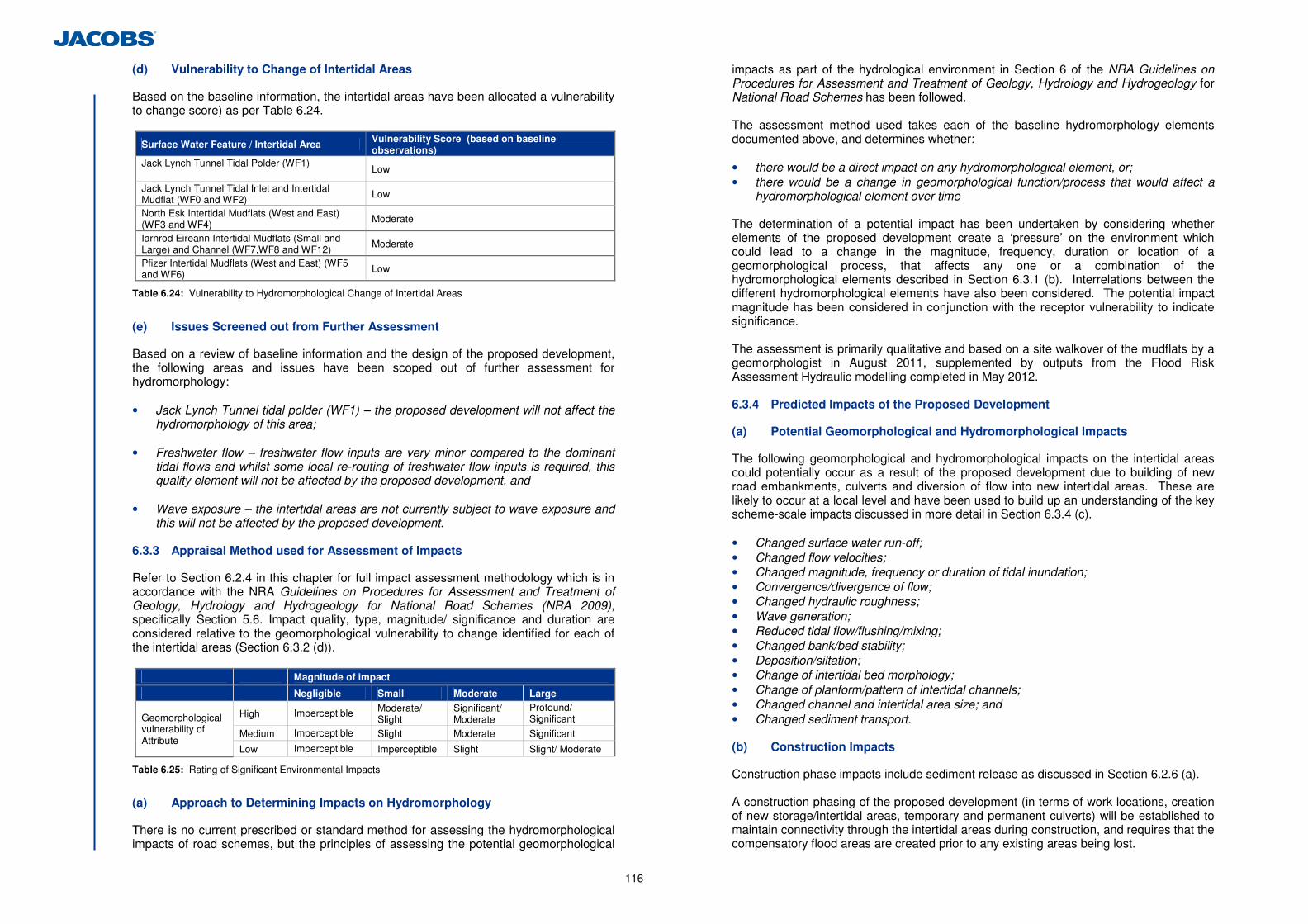
116
(d) Vulnerability to Change of Intertidal Areas
Based on the baseline information, the intertidal areas have been allocated a vulnerability to change score) as per Table 6.24.
Surface Water Feature / Intertidal Area Vulnerability Score (based on baseline observations)
Jack Lynch Tunnel Tidal Polder (WF1)
Low
Jack Lynch Tunnel Tidal Inlet and Intertidal Mudflat (WF0 and WF2) Low
North Esk Intertidal Mudflats (West and East) (WF3 and WF4)
Moderate
Iarnrod Eireann Intertidal Mudflats (Small and Large) and Channel (WF7,WF8 and WF12) Moderate
Pfizer Intertidal Mudflats (West and East) (WF5 and WF6) Low
Table 6.24: Vulnerability to Hydromorphological Change of Intertidal Areas
(e) Issues Screened out from Further Assessment
Based on a review of baseline information and the design of the proposed development, the following areas and issues have been scoped out of further assessment for hydromorphology: • Jack Lynch Tunnel tidal polder (WF1) – the proposed development will not affect the
hydromorphology of this area; • Freshwater flow – freshwater flow inputs are very minor compared to the dominant
tidal flows and whilst some local re-routing of freshwater flow inputs is required, this quality element will not be affected by the proposed development, and
• Wave exposure – the intertidal areas are not currently subject to wave exposure and
this will not be affected by the proposed development.
6.3.3 Appraisal Method used for Assessment of Impacts
Refer to Section 6.2.4 in this chapter for full impact assessment methodology which is in accordance with the NRA Guidelines on Procedures for Assessment and Treatment of Geology, Hydrology and Hydrogeology for National Road Schemes (NRA 2009), specifically Section 5.6. Impact quality, type, magnitude/ significance and duration are considered relative to the geomorphological vulnerability to change identified for each of the intertidal areas (Section 6.3.2 (d)).
Magnitude of impact
Negligible Small Moderate Large
High Imperceptible Moderate/ Slight
Significant/ Moderate
Profound/ Significant
Medium Imperceptible Slight Moderate Significant
Geomorphological vulnerability of Attribute
Low Imperceptible Imperceptible Slight Slight/ Moderate
Table 6.25: Rating of Significant Environmental Impacts
(a) Approach to Determining Impacts on Hydromorphology
There is no current prescribed or standard method for assessing the hydromorphological impacts of road schemes, but the principles of assessing the potential geomorphological
impacts as part of the hydrological environment in Section 6 of the NRA Guidelines on Procedures for Assessment and Treatment of Geology, Hydrology and Hydrogeology for National Road Schemes has been followed. The assessment method used takes each of the baseline hydromorphology elements documented above, and determines whether: • there would be a direct impact on any hydromorphological element, or; • there would be a change in geomorphological function/process that would affect a
hydromorphological element over time The determination of a potential impact has been undertaken by considering whether elements of the proposed development create a ‘pressure’ on the environment which could lead to a change in the magnitude, frequency, duration or location of a geomorphological process, that affects any one or a combination of the hydromorphological elements described in Section 6.3.1 (b). Interrelations between the different hydromorphological elements have also been considered. The potential impact magnitude has been considered in conjunction with the receptor vulnerability to indicate significance. The assessment is primarily qualitative and based on a site walkover of the mudflats by a geomorphologist in August 2011, supplemented by outputs from the Flood Risk Assessment Hydraulic modelling completed in May 2012.
6.3.4 Predicted Impacts of the Proposed Development
(a) Potential Geomorphological and Hydromorphological Impacts
The following geomorphological and hydromorphological impacts on the intertidal areas could potentially occur as a result of the proposed development due to building of new road embankments, culverts and diversion of flow into new intertidal areas. These are likely to occur at a local level and have been used to build up an understanding of the key scheme-scale impacts discussed in more detail in Section 6.3.4 (c). • Changed surface water run-off; • Changed flow velocities; • Changed magnitude, frequency or duration of tidal inundation; • Convergence/divergence of flow; • Changed hydraulic roughness; • Wave generation; • Reduced tidal flow/flushing/mixing; • Changed bank/bed stability; • Deposition/siltation; • Change of intertidal bed morphology; • Change of planform/pattern of intertidal channels; • Changed channel and intertidal area size; and • Changed sediment transport. (b) Construction Impacts
Construction phase impacts include sediment release as discussed in Section 6.2.6 (a). A construction phasing of the proposed development (in terms of work locations, creation of new storage/intertidal areas, temporary and permanent culverts) will be established to maintain connectivity through the intertidal areas during construction, and requires that the compensatory flood areas are created prior to any existing areas being lost.
117
(c) Operational Impacts on Hydromorphology
The elements of the proposed development considered to impact on hydromorphology are:
• Loss of intertidal area mudflats due to the creation of road embankments (impacts on
‘structure of intertidal zone’ and ‘depth variation’), and • Replacement, extension or addition of culverts (impacts on ‘quantity, structure and
substrate of the bed’).
The loss of large areas of mudflats within the intertidal areas from the road embankment footprints, leading to impacts on the ‘structure of the intertidal zone’, would be the most significant potential impact of the proposed development. However this has been recognised and included for within the design by the proposed creation of a series of new intertidal areas that will replicate as closely as possible the existing levels of the intertidal zone. As opposed to mitigation this in an intrinsic part of the design. Although at a local level the loss of existing individual areas of intertidal zone structure would be extensive, it is considered that at the overall scheme level, with creation of the new intertidal areas, the impacts on hydromorphology at the water body scale (Lough Mahon) would be imperceptible. The replacement, extension or addition of culverts could potentially impact the discharge and velocity of ebb and flood flows and the amount of sediment carried into and out of the intertidal areas, thereby impacting the ‘quantity, structure and substrate of the bed’ of the mudflats. However the replacement pipes will be of the same number and similar overall size as the existing system, and have been sized and located to maintain the flow through the series of intertidal areas during both construction and operation. There may be local impacts (such as small areas of scour of the bed or alterations to local flow dynamics) where new culvert inlets and outlets are proposed but these are not considered significant at a water body scale. The potential impacts on hydromorphology from road embankments and culverts on each intertidal area (at local level) are summarised below.
Surface Water Feature / Intertidal Area Potential Impacts on Hydromorphology Impact Significance
Jack Lynch Tunnel tidal inlet and intertidal mudflat (WF0 and WF2)
Impact on structure of intertidal zone from construction of embankment across intertidal area, offset by creation of replacement intertidal areas. New culvert through road embankment would only have a very local impact on structure and substrate of bed.
Imperceptible
North Esk intertidal mudflats (west and east) (WF3 and WF4)
Loss of west intertidal area from construction of embankment across intertidal area, offset by creation of replacement intertidal areas. New culvert to south east intertidal area would relocate the inflow and outflow from the intertidal area, and slightly alter the speed of tidal flow on the ebb tide. This would have a short to medium term impact on structure and substrate of bed and structure of the intertidal zone through changes in flow velocities and direction affecting local erosion and deposition of silts/muds.
Slight
Iarnrod Eireann intertidal mudflats (small and large) and channel (WF7,WF8 and WF12)
Loss of part of small intertidal area offset by creation of an adjacent replacement area. Minor extension to existing culvert would not affect tidal channel.
Imperceptible
Pfizer intertidal mudflats (west and east) (WF5 and WF6)
Loss of part of west and east intertidal areas from construction of embankment across intertidal area, offset by creation of replacement intertidal areas adjacent to the Jack Lynch Tunnel Tidal Intertidal Mudflat (WF2).
Imperceptible
Table 6.26: Summary of Hydromorphological Impacts from Embankment Footprints and Culverts
(d) Do-Minimum Scenario Impacts
If the proposed development is not constructed, the intertidal areas would continue to function under their current operation, assuming that the culverts and banks are maintained. As the existing system has a highly modified morphology, there would not be any significant change in geomorphological forms or processes at either the local level or entire water body scale (Lough Mahon) over time. 6.3.5 Proposed Mitigation and Avoidance Measures
(a) Construction Phase Mitigation
Construction phase mitigation for geomorphology and hydromorphology is detailed in Section 6.2.9 (a) under the hydrology assessment. (b) Operation Phase Mitigation
Within the proposed replacement storage/intertidal areas, the base level will be graded/contoured to allow lower, saltmarsh, upper saltmarsh and mudflat habitat to re-establish (i.e. to allow inundation of areas at similar levels in the tidal cycle) by natural adaptation/regeneration of these features over time. See Chapter 5, Flora and Fauna for further details. 6.3.6 Difficulties Encountered in Compiling Information
No difficulties were encountered during the assessment.
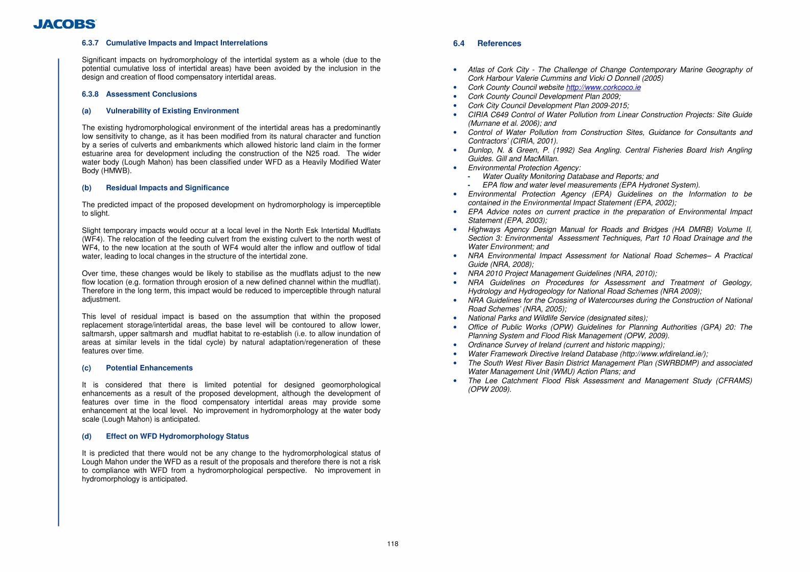
118
6.3.7 Cumulative Impacts and Impact Interrelations
Significant impacts on hydromorphology of the intertidal system as a whole (due to the potential cumulative loss of intertidal areas) have been avoided by the inclusion in the design and creation of flood compensatory intertidal areas. 6.3.8 Assessment Conclusions
(a) Vulnerability of Existing Environment
The existing hydromorphological environment of the intertidal areas has a predominantly low sensitivity to change, as it has been modified from its natural character and function by a series of culverts and embankments which allowed historic land claim in the former estuarine area for development including the construction of the N25 road. The wider water body (Lough Mahon) has been classified under WFD as a Heavily Modified Water Body (HMWB). (b) Residual Impacts and Significance
The predicted impact of the proposed development on hydromorphology is imperceptible to slight. Slight temporary impacts would occur at a local level in the North Esk Intertidal Mudflats (WF4). The relocation of the feeding culvert from the existing culvert to the north west of WF4, to the new location at the south of WF4 would alter the inflow and outflow of tidal water, leading to local changes in the structure of the intertidal zone. Over time, these changes would be likely to stabilise as the mudflats adjust to the new flow location (e.g. formation through erosion of a new defined channel within the mudflat). Therefore in the long term, this impact would be reduced to imperceptible through natural adjustment.
This level of residual impact is based on the assumption that within the proposed replacement storage/intertidal areas, the base level will be contoured to allow lower, saltmarsh, upper saltmarsh and mudflat habitat to re-establish (i.e. to allow inundation of areas at similar levels in the tidal cycle) by natural adaptation/regeneration of these features over time. (c) Potential Enhancements
It is considered that there is limited potential for designed geomorphological enhancements as a result of the proposed development, although the development of features over time in the flood compensatory intertidal areas may provide some enhancement at the local level. No improvement in hydromorphology at the water body scale (Lough Mahon) is anticipated. (d) Effect on WFD Hydromorphology Status
It is predicted that there would not be any change to the hydromorphological status of Lough Mahon under the WFD as a result of the proposals and therefore there is not a risk to compliance with WFD from a hydromorphological perspective. No improvement in hydromorphology is anticipated.
6.4 References
• Atlas of Cork City - The Challenge of Change Contemporary Marine Geography of
Cork Harbour Valerie Cummins and Vicki O Donnell (2005) • Cork County Council website http://www.corkcoco.ie • Cork County Council Development Plan 2009; • Cork City Council Development Plan 2009-2015; • CIRIA C649 Control of Water Pollution from Linear Construction Projects: Site Guide
(Murnane et al. 2006); and • Control of Water Pollution from Construction Sites, Guidance for Consultants and
Contractors’ (CIRIA, 2001). • Dunlop, N. & Green, P. (1992) Sea Angling. Central Fisheries Board Irish Angling
Guides. Gill and MacMillan. • Environmental Protection Agency:
- Water Quality Monitoring Database and Reports; and - EPA flow and water level measurements (EPA Hydronet System).
• Environmental Protection Agency (EPA) Guidelines on the Information to be contained in the Environmental Impact Statement (EPA, 2002);
• EPA Advice notes on current practice in the preparation of Environmental Impact Statement (EPA, 2003);
• Highways Agency Design Manual for Roads and Bridges (HA DMRB) Volume II, Section 3: Environmental Assessment Techniques, Part 10 Road Drainage and the Water Environment; and
• NRA Environmental Impact Assessment for National Road Schemes– A Practical Guide (NRA, 2008);
• NRA 2010 Project Management Guidelines (NRA, 2010); • NRA Guidelines on Procedures for Assessment and Treatment of Geology,
Hydrology and Hydrogeology for National Road Schemes (NRA 2009); • NRA Guidelines for the Crossing of Watercourses during the Construction of National
Road Schemes’ (NRA, 2005); • National Parks and Wildlife Service (designated sites); • Office of Public Works (OPW) Guidelines for Planning Authorities (GPA) 20: The
Planning System and Flood Risk Management (OPW, 2009). • Ordinance Survey of Ireland (current and historic mapping); • Water Framework Directive Ireland Database (http://www.wfdireland.ie/); • The South West River Basin District Management Plan (SWRBDMP) and associated
Water Management Unit (WMU) Action Plans; and • The Lee Catchment Flood Risk Assessment and Management Study (CFRAMS)
(OPW 2009).
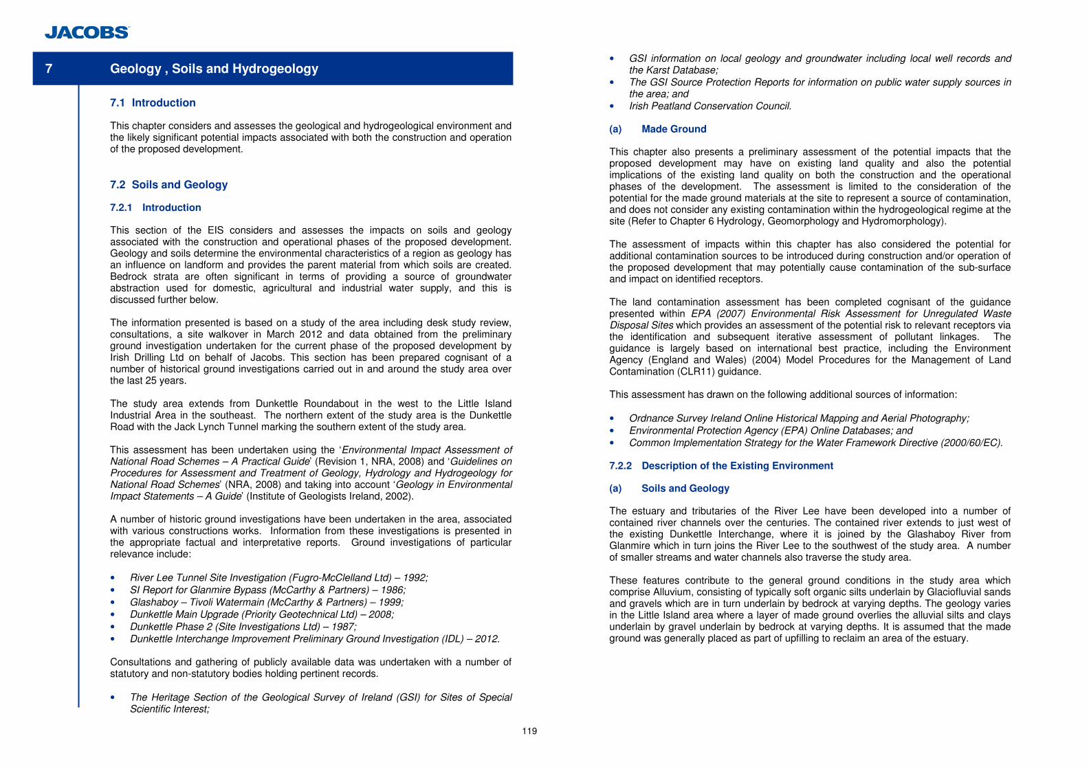
119
7 Geology , Soils and Hydrogeology
7.1 Introduction
This chapter considers and assesses the geological and hydrogeological environment and the likely significant potential impacts associated with both the construction and operation of the proposed development.
7.2 Soils and Geology
7.2.1 Introduction
This section of the EIS considers and assesses the impacts on soils and geology associated with the construction and operational phases of the proposed development. Geology and soils determine the environmental characteristics of a region as geology has an influence on landform and provides the parent material from which soils are created. Bedrock strata are often significant in terms of providing a source of groundwater abstraction used for domestic, agricultural and industrial water supply, and this is discussed further below. The information presented is based on a study of the area including desk study review, consultations, a site walkover in March 2012 and data obtained from the preliminary ground investigation undertaken for the current phase of the proposed development by Irish Drilling Ltd on behalf of Jacobs. This section has been prepared cognisant of a number of historical ground investigations carried out in and around the study area over the last 25 years. The study area extends from Dunkettle Roundabout in the west to the Little Island Industrial Area in the southeast. The northern extent of the study area is the Dunkettle Road with the Jack Lynch Tunnel marking the southern extent of the study area. This assessment has been undertaken using the ‘Environmental Impact Assessment of National Road Schemes – A Practical Guide’ (Revision 1, NRA, 2008) and ‘Guidelines on Procedures for Assessment and Treatment of Geology, Hydrology and Hydrogeology for National Road Schemes’ (NRA, 2008) and taking into account ‘Geology in Environmental Impact Statements – A Guide’ (Institute of Geologists Ireland, 2002). A number of historic ground investigations have been undertaken in the area, associated with various constructions works. Information from these investigations is presented in the appropriate factual and interpretative reports. Ground investigations of particular relevance include: • River Lee Tunnel Site Investigation (Fugro-McClelland Ltd) – 1992; • SI Report for Glanmire Bypass (McCarthy & Partners) – 1986; • Glashaboy – Tivoli Watermain (McCarthy & Partners) – 1999; • Dunkettle Main Upgrade (Priority Geotechnical Ltd) – 2008; • Dunkettle Phase 2 (Site Investigations Ltd) – 1987; • Dunkettle Interchange Improvement Preliminary Ground Investigation (IDL) – 2012.
Consultations and gathering of publicly available data was undertaken with a number of statutory and non-statutory bodies holding pertinent records. • The Heritage Section of the Geological Survey of Ireland (GSI) for Sites of Special
Scientific Interest;
• GSI information on local geology and groundwater including local well records and the Karst Database;
• The GSI Source Protection Reports for information on public water supply sources in the area; and
• Irish Peatland Conservation Council. (a) Made Ground
This chapter also presents a preliminary assessment of the potential impacts that the proposed development may have on existing land quality and also the potential implications of the existing land quality on both the construction and the operational phases of the development. The assessment is limited to the consideration of the potential for the made ground materials at the site to represent a source of contamination, and does not consider any existing contamination within the hydrogeological regime at the site (Refer to Chapter 6 Hydrology, Geomorphology and Hydromorphology). The assessment of impacts within this chapter has also considered the potential for additional contamination sources to be introduced during construction and/or operation of the proposed development that may potentially cause contamination of the sub-surface and impact on identified receptors. The land contamination assessment has been completed cognisant of the guidance presented within EPA (2007) Environmental Risk Assessment for Unregulated Waste Disposal Sites which provides an assessment of the potential risk to relevant receptors via the identification and subsequent iterative assessment of pollutant linkages. The guidance is largely based on international best practice, including the Environment Agency (England and Wales) (2004) Model Procedures for the Management of Land Contamination (CLR11) guidance. This assessment has drawn on the following additional sources of information: • Ordnance Survey Ireland Online Historical Mapping and Aerial Photography; • Environmental Protection Agency (EPA) Online Databases; and • Common Implementation Strategy for the Water Framework Directive (2000/60/EC). 7.2.2 Description of the Existing Environment
(a) Soils and Geology
The estuary and tributaries of the River Lee have been developed into a number of contained river channels over the centuries. The contained river extends to just west of the existing Dunkettle Interchange, where it is joined by the Glashaboy River from Glanmire which in turn joins the River Lee to the southwest of the study area. A number of smaller streams and water channels also traverse the study area. These features contribute to the general ground conditions in the study area which comprise Alluvium, consisting of typically soft organic silts underlain by Glaciofluvial sands and gravels which are in turn underlain by bedrock at varying depths. The geology varies in the Little Island area where a layer of made ground overlies the alluvial silts and clays underlain by gravel underlain by bedrock at varying depths. It is assumed that the made ground was generally placed as part of upfilling to reclaim an area of the estuary.
120
(i) Near Surface Soils (Natural)
A large proportion of the study area is recorded as being underlain by Mineral Alluvium soils. Acid brown Earths/ Brown Podzolics are encountered towards the area north of the existing Dunkettle Interchange.
Areas of Renzinas Lithosols occur in the areas surrounding the part of the Little Island Estate which is outside of the study area. (ii) Overburden Geology
The geological formations underlying the study area have been identified from the Geological Survey of Ireland’s (GSI's) 1995 geological mapping. This has been supplemented by the findings of various historic ground investigations and the recent ground investigation works carried out in March and April 2012. The recent investigations concentrated on confirming the findings of the desk study review, published geology and available historical records. The general geotechnical characteristics of the substrata present were also determined. The general geological sequence underlying the site includes alluvium underlain by Glaciofluvial deposits of sands and gravels. Peat has not been recorded, however, there is potential for localised peat deposits to be present in areas of marshy land to the north east of the existing Dunkettle Interchange.
Alluvial materials are deposited by river action and have been identified in areas near to the River Lee and a number of streams and channels which traverse the site. It is anticipated that alluvium will underlie the majority of the site area. Within areas of former floodplain the alluvium lies beneath a layer of made ground which consists of typically stiff occasionally soft and firm gravelly clay with cobbles and boulders. The alluvium comprises typically soft to firm grey silts which have been found to be locally organic and have been encountered at depths ranging from 1.0m to 11.0m below ground level and extending to depths of up to 18.7m below ground level. The alluvium was found to be present in thicknesses up to 8m. Glaciofluvial deposits were identified within the study area on the GSI’s Quaternary geology map. The Glaciofluvial deposits generally underlie the alluvium and are described as sand with coarse gravel and cobbles. These sands and gravels are shown to be present towards the north-east, east and south of the existing Dunkettle Interchange being encountered from 3.0m to 10.0m below ground level. These sands and gravels have been recorded at thicknesses in excess of 37m in the area north east of the existing Dunkettle Interchange. Cohesive Glacial Till is generally not present within the study area other than in locally thin and inconsistent layers associated with the Glaciofluvial sands and gravels. These soils are generally stiff, well graded and variable with gravel lenses and typified by a minimal clay mineral content.
The general geological sequence underlying the Little Island area includes made ground underlain by Glaciofluvial deposits of sands and gravels. (iii) Bedrock Geology
The bedrock underlying the study area is Old Red Sandstone of the Gyleen formation which is of Devonian age. Carboniferous mudstones of the Cork Group lie to the north of the Interchange. To the south of the existing Dunkettle Interchange is a band of Dinantian
Lower Impure Limestone. No known karst features have been identified in the immediate vicinity of the Dunkettle Interchange. The geological logs do not indicate any evidence of large cavities or conduits within bedrock. The solid geology of the site is largely dictated by an east-west trending fault, which runs parallel and close to the alignment of the existing N25. The historic site investigations and recent ground investigation indicate a rockhead surface generally dipping to the south and west of the study area. Bedrock comprises very strong grey thinly laminated mudstone and strong white Limestone breccia being encountered to the north and east of the existing Dunkettle Interchange at 15m and 13.2m below ground level respectively. Bedrock was also encountered at 30.60m in a borehole to the north of the existing interchange indicating a potentially variable rockhead level. The presence of calcified limestone breccia is considered likely to be associated with the broken rock around the east-west trending fault. In the centre and south of the study area boreholes where taken to 50m and 30m depth respectively without encountering bedrock and were terminated in dense gravels.
The bedrock underlying the Little Island area is of limestone formation. A borehole drilled during the preliminary ground investigation in the Wallingstown area of Little Island indicates a rockhead surface at approximately 13.0mbgl. (iv) Economic Geology
No active mines or quarries have been identified within the study area. Given the estuarine and floodplain nature of the environment, it is considered unlikely that any infilled disused quarries are present other than on the higher ground to the north of the study area. (v) Geological Heritage
There are no geological heritage sites within the study area. The closest site of interest is “Rock Farm Quarry” (pNHA 1074) which is approximately 0.5km from the south eastern boundary of the study area. (vi) Construction Materials
A very localised area of cut is proposed as part of the alignment for the proposed development. These cut sections are located in an area to the north of the existing Dunkettle Interchange and the railway line. Made ground comprising very stiff slightly sandy gravelly silt/clay with cobbles was found to overlie natural soils consisting of medium dense gravel and cobbles at this location. It is considered that a significant proportion of these soils would be suitable for reuse if excavated, stored and processed in a controlled manner. Further details of soils suitable for reuse are presented in Chapter 12 Waste Management. (b) Made Ground
(i) Conceptual Site Model
The proposed development has been considered in the context of its environmental setting. Potential sources of contamination (existing and future), potential receptors and potential pathways – which may feasibly, in combination, represent pollutant linkages – have been identified and considered.
121
Potential Contamination Sources
Historical Land Uses: The 1837-42 Ordnance Survey indicates that those areas to the north of the railway line (not yet constructed at time survey was conducted) were situated within undeveloped land. The majority of the remainder of the study area comprises land reclaimed from the adjacent estuary, with a tributary flowing southwards across the site to its confluence with the River Lee. An unmarked pond was identified to the west of Link T (for references to road links refer to Figure 2.1.1), north of the current railway line alignment. The railway had been constructed by the time of the 1888-1913 Ordnance Survey, running east to west through the study area. No other significant land use changes were identified.
The 1995 aerial photograph indicates that the wider area had been reclaimed from the estuary by this stage, and that the infrastructure was largely as per that of the present day. Industrial developments, including the current Pfizer plant, have been developed in the vicinity of Links P and Q. The area to the south and south-east of Dunkettle Interchange appears to be in the process of being reclaimed. Ponds are visible to the north-east and south-east of the current Dunkettle Interchange as well as in the vicinity of Link Q. Made Ground: The majority of the study area is located within an area of reclaimed tidal mud flats. Historical and recent ground investigations have identified made ground generally to depths of approximately 1 – 2 metres below current ground level, however in the area to the east of the existing Dunkettle Interchange, made ground has been identified to depths up to 8 metres below ground level. The majority of made ground identified during historical and recent ground investigations comprises reworked variable natural materials including predominantly granular soils such as sands and gravels with cobbles and boulders, as well as cohesive fractions such as clays and silts. Tarmacadam and railway ballast were identified within the made ground materials at locations in the vicinity of the railway line, however the overwhelming majority of the made ground has been consistently identified to comprise entirely reworked natural materials. No visual or olfactory evidence of contamination within the made ground materials was recorded during the recent or previous ground investigations.
Land Quality (Human Health Risk Assessment): A Generic Quantitative Risk Assessment was completed through the direct comparison of soil chemical testing results with appropriate Generic Assessment Criteria (GAC). The assessment considers potential chronic risks to human health receptors presented by the existing Made Ground materials. The NRA guidance (NRA 2008) indicates that soil chemical quality results should be compared with Environment Agency (England and Wales) GACs (known as Soil Guideline Values (SGVs)) as developed using the UK Contaminated Land Exposure Assessment (CLEA) model. However, the proposed end-use for the study area does not conform with the generic land-uses specified in the CLEA model and the available SGVs are therefore considered to be inappropriate. As a result, soil chemical quality results were assessed against GACs for an assumed Public Open Space exposure scenario where available. The applied GAC were derived by Jacobs using the Environment Agency (England and Wales) CLEA Model (v1.06). Derivation tables.
Where such GAC were unavailable, it was considered most appropriate to apply available (UK) Generic Assessment Criteria (GAC) appropriate for an alternative residential (with no gardens, on the basis of uptake by edible plants being irrelevant to the proposed development) exposure scenario, as this generic exposure scenario provides a highly conservative preliminary assessment of potential risks to human health through the assumption of a much greater theoretical exposure to Potential Contaminants of Concern than would be the case at the site once development is completed. The GAC for this assumed exposure scenario were sourced from the Environment Agency (England and Wales) Soil Guideline Values (SGV) reports (post-2009). Where GAC have not been derived by the Environment Agency (England and Wales), GAC derived within CIEH (2009) Generic Assessment Criteria for Human Health Risk Assessment were applied within the risk assessment. No potential chronic risks to human health associated with the existing made ground materials were identified during the Generic Quantitative Risk Assessment. In addition, the available chemical testing indicates that there are no potential acute risks to human health associated with the made ground at the site. On this basis, it is considered that the made ground at the site is unlikely to represent a source of contamination and that therefore the identified pollutant linkages may potentially be discounted.
Land Quality (Surface & Ground Waters Risk Assessment): For the assessment of potential pollutant linkages, a conservative Generic Quantitative Risk Assessment (Level 1) was undertaken in accordance with Environment Agency (England and Wales) (2006) Remedial Targets Methodology: Hydrogeological Risk Assessment for Land Contamination. The screening assessment findings inform whether the existing made ground materials present a risk to the identified environmental receptors, through consideration as to whether the concentrations in soil pore water (leachate) are sufficient to impact on the receptor. Where analysis was undertaken, soil leachate concentrations were compared against the target concentration at the receptor. Target concentrations were selected from S.I. 9 of 2010 European Communities Environmental Objectives (Groundwater) Regulations 2010 and S.I. 272 of 2009 European Communities Environmental Objectives (Surface Waters) Regulations 2009 where available. Where unavailable, for a limited number of determinands, appropriate target concentrations were selected from the appropriate UK guidance.
For the purposes of the assessment the soil leachate concentrations were conservatively screened directly against the target concentration at the receptor i.e. the Point of Compliance (POC) was taken to be the receptor on the basis that the source may be located immediately adjacent to the receptor (see Image 7.1).
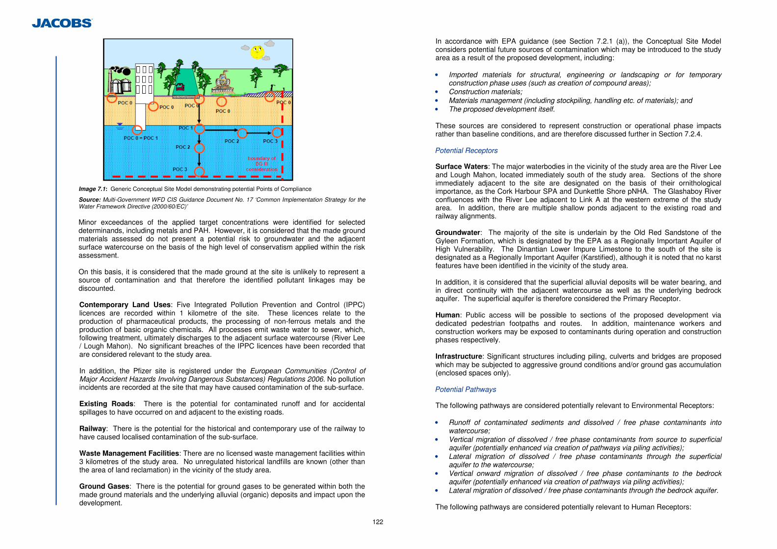
122
Image 7.1: Generic Conceptual Site Model demonstrating potential Points of Compliance
Source: Multi-Government WFD CIS Guidance Document No. 17 ‘Common Implementation Strategy for the Water Framework Directive (2000/60/EC)’ Minor exceedances of the applied target concentrations were identified for selected determinands, including metals and PAH. However, it is considered that the made ground materials assessed do not present a potential risk to groundwater and the adjacent surface watercourse on the basis of the high level of conservatism applied within the risk assessment. On this basis, it is considered that the made ground at the site is unlikely to represent a source of contamination and that therefore the identified pollutant linkages may be discounted.
Contemporary Land Uses: Five Integrated Pollution Prevention and Control (IPPC) licences are recorded within 1 kilometre of the site. These licences relate to the production of pharmaceutical products, the processing of non-ferrous metals and the production of basic organic chemicals. All processes emit waste water to sewer, which, following treatment, ultimately discharges to the adjacent surface watercourse (River Lee / Lough Mahon). No significant breaches of the IPPC licences have been recorded that are considered relevant to the study area. In addition, the Pfizer site is registered under the European Communities (Control of Major Accident Hazards Involving Dangerous Substances) Regulations 2006. No pollution incidents are recorded at the site that may have caused contamination of the sub-surface.
Existing Roads: There is the potential for contaminated runoff and for accidental spillages to have occurred on and adjacent to the existing roads.
Railway: There is the potential for the historical and contemporary use of the railway to have caused localised contamination of the sub-surface.
Waste Management Facilities: There are no licensed waste management facilities within 3 kilometres of the study area. No unregulated historical landfills are known (other than the area of land reclamation) in the vicinity of the study area.
Ground Gases: There is the potential for ground gases to be generated within both the made ground materials and the underlying alluvial (organic) deposits and impact upon the development.
In accordance with EPA guidance (see Section 7.2.1 (a)), the Conceptual Site Model considers potential future sources of contamination which may be introduced to the study area as a result of the proposed development, including: • Imported materials for structural, engineering or landscaping or for temporary
construction phase uses (such as creation of compound areas); • Construction materials; • Materials management (including stockpiling, handling etc. of materials); and • The proposed development itself. These sources are considered to represent construction or operational phase impacts rather than baseline conditions, and are therefore discussed further in Section 7.2.4. Potential Receptors
Surface Waters: The major waterbodies in the vicinity of the study area are the River Lee and Lough Mahon, located immediately south of the study area. Sections of the shore immediately adjacent to the site are designated on the basis of their ornithological importance, as the Cork Harbour SPA and Dunkettle Shore pNHA. The Glashaboy River confluences with the River Lee adjacent to Link A at the western extreme of the study area. In addition, there are multiple shallow ponds adjacent to the existing road and railway alignments. Groundwater: The majority of the site is underlain by the Old Red Sandstone of the Gyleen Formation, which is designated by the EPA as a Regionally Important Aquifer of High Vulnerability. The Dinantian Lower Impure Limestone to the south of the site is designated as a Regionally Important Aquifer (Karstified), although it is noted that no karst features have been identified in the vicinity of the study area.
In addition, it is considered that the superficial alluvial deposits will be water bearing, and in direct continuity with the adjacent watercourse as well as the underlying bedrock aquifer. The superficial aquifer is therefore considered the Primary Receptor. Human: Public access will be possible to sections of the proposed development via dedicated pedestrian footpaths and routes. In addition, maintenance workers and construction workers may be exposed to contaminants during operation and construction phases respectively.
Infrastructure: Significant structures including piling, culverts and bridges are proposed which may be subjected to aggressive ground conditions and/or ground gas accumulation (enclosed spaces only). Potential Pathways
The following pathways are considered potentially relevant to Environmental Receptors: • Runoff of contaminated sediments and dissolved / free phase contaminants into
watercourse; • Vertical migration of dissolved / free phase contaminants from source to superficial
aquifer (potentially enhanced via creation of pathways via piling activities); • Lateral migration of dissolved / free phase contaminants through the superficial
aquifer to the watercourse; • Vertical onward migration of dissolved / free phase contaminants to the bedrock
aquifer (potentially enhanced via creation of pathways via piling activities); • Lateral migration of dissolved / free phase contaminants through the bedrock aquifer. The following pathways are considered potentially relevant to Human Receptors:
123
• Ingestion and inhalation of fugitive contaminated dust; • Dermal absorption of contaminants; • Inhalation of vapours; • Inhalation of toxic or asphyxiant ground gases; • Ignition of accumulated explosive ground gases. The following pathways are considered potentially relevant to Infrastructure Receptors: • Direct contact with aggressive ground conditions causing degradation of concrete
structures; • Contact with soils affected by ground gases, leading to the accumulation of toxic,
asphyxiant or explosive ground gases. 7.2.3 Appraisal Method used for Assessment of Impacts
The importance/sensitivity of the geological interest of the study area was determined using the criteria set out in Table 7.1 below. These criteria have been adapted from the ‘Guidelines on Procedures for Assessment and Treatment of Geology, Hydrology and Hydrogeology for National Road Schemes’ (NRA, 2008).
Importance Criteria
Very High
Attribute has a high quality, significance or value on a regional or national scale. Degree or extent of soil contamination is significant on a national or regional scale. Volume of peat and/or soft organic soil underlying route is significant on a national or regional scale*.
High Attribute has a high quality significance or value on a local scale. Degree or extent of soil contamination is significant on a local scale. Volume of peat and/or soft organic soil underlying route is significant on a local scale*.
Medium Attribute has a medium quality significance or value on a local scale. Degree or extent of soil contamination is moderate on a local scale. Volume of peat and/or soft organic soil underlying is moderate on a local scale*.
Low Attribute has a low quality, significance or value on a local scale. Degree or extent of soil contamination is minor on a local scale. Volume of peat and/or soft organic soil underlying route is small on a local scale*.
Table 7.1: Soil and Geology Criteria for Rating Site Attributes
* Relative to the total volume of inert soil disposed of and/or recovered
The assessment of the magnitude of predicted impacts on solid and drift geology was based on the criteria defined in Table 7.2 and the combination of sensitivity and magnitude are used to derive the impact significance as detailed in Table 7.3. These criteria have been adapted from the ‘Guidelines on Procedures for Assessment and Treatment of Geology, Hydrology and Hydrogeology for National Road Schemes’ (NRA, 2008).
Magnitude of Impact Criteria
Large Adverse Results in loss of attribute
Moderate Adverse Results in impact on integrity of attribute or loss of part of attribute
Small Adverse Results in minor impact on integrity of attribute or loss of small part of attribute
Negligible Results in an impact on attribute but of insufficient magnitude to affect either use or integrity
Minor Beneficial Results in minor improvement of attribute quality
Moderate Beneficial Results in moderate improvement of attribute quality
Major Beneficial Results in major improvement of attribute quality
Table 7.2: Magnitude of Impacts
Magnitude Impact Importance of Attribute Negligible Small Moderate Large
Very High Imperceptible Significant / Moderate
Profound / Significant
Profound
High Imperceptible Moderate / Slight
Significant / Moderate
Severe / Significant
Medium Imperceptible Slight Moderate Significant
Low Imperceptible Imperceptible Slight Slight / Moderate
Table 7.3: Rating of Significant Environmental Impacts
7.2.4 Predicted Impacts of the Proposed Development
(a) Soils and Geology
(i) Construction Phase Impacts
Where soils are excavated and/or stored for re-use during construction, they are prone to erosion by surface water run off and may degrade the aquatic environment. They may be compacted by earthmoving machinery, reducing its ability to store water and support vegetation, leading to increased run off and erosion. The proposed development comprises the construction of embankments and structures with the exception of a small area of cutting which lies in the north west of the study area. As the majority of the site is underlain by made ground underlain by soft and soft to firm compressible soils the settlement of ground bearing embankments will be an issue in relation to total settlement and differential settlement where adjacent or joining existing earthworks or structures and new structures. The magnitude of settlement will be moderate and the time for the substantial completion of the consolidation settlement will also require careful consideration particularly where earthworks are adjacent to existing earthworks and structures and there is the potential for inducing settlement beneath these. Earthwork embankments will likely be surcharged to increase the rate of settlement. Surcharging involves the placement of an additional load, in the form of additional fill material, on the embankment to increase the rate of consolidation. In areas of very soft formation it is possible that embankments will require to be stage constructed to minimise the stress induced within the weak foundation stratum. The phasing of construction will need to consider the potential for inducing negative skin friction on structure piles and as such all surcharging would be carried out in advance of piling works. Where the soils are found to be very soft, organic or the potential for inducing settlement beneath existing earthworks exists, short lengths of structure approach embankments will be piled.
Settlement of soils and the associated surcharging will have an imperceptible impact on the local geology. During the construction phase there is potential for contamination of soils and subsoils from accidental spillages of construction materials or leaks from construction vehicles. Direct Impacts
Structure foundations are likely to be founded on alluvial deposits comprising soft sandy silts and as a result the foundations of all the structures will be piled. Some sections of the embankments for Link Road A and Link C will be piled. The embankments over an
124
approximate 10m length on each approach to structures STR01, 02, 03, 04, 05 and 08 are proposed to be piled in order to mitigate the risk of differential settlement. The foundation for retaining walls are proposed to be piled. Consideration has also been given to the potential negative skin friction developing on the structure foundation piles as a result of embankment loading. The presence of piles within the ground beneath embankments and as structural foundations will have an Imperceptible impact on the geology present. Indirect Impacts
There are no known indirect impacts which may alter the geological properties of soils in the study area. (ii) Operational Phase Impacts
No sites or features of high or medium geological importance will be affected by the proposed development, all are recorded to be of low importance. Where the embankments are ground bearing and either the thickness of soft compressible soils is great or the soils are found to be organic then there may be the potential for ongoing creep or secondary compression. Creep or secondary compression can occur after primary consolidation and cannot be removed by surcharging as they relate to either the decay of organics within the soils and the associated volume loss or the rearrangement of electrical charges on the soil mineral particles. Where high content organic soils are encountered beneath embankments then piling has been specified to remove the potential for ongoing creep. The magnitude of secondary compression is generally negligible and the time period over which it occurs is extensive such that its impact is often not seen as significant and may be generally dealt with through the normal highways maintenance cycles.
The occurrence of creep is due to the natural process of biodegradation and would not be induced by the road construction. Creep or secondary compression will have an imperceptible impact on the soils and geology. (b) Made Ground
(i) Construction Phase Impacts
The potential construction phase impacts to the identified receptors as a result of existing land quality resulting from the proposed development include: • Remobilisation of residual pollutants; • Creation of new pollution pathways; • Alteration of the existing ground gas regime; • Creation of dust and airborne contaminants; • Deterioration of surface water quality via sediment ingress. Potential construction phase impacts (pre-mitigation) to surface/groundwater, human and infrastructure receptors are generally predicted to be Negligible or Moderate/Slight. However, some potential impacts in the absence of mitigation (relating to materials management and sediment ingress into the surface watercourse) are predicted to be Significant / Moderate. In addition, specific impacts relating to accidental contamination (such as spillages during construction) are predicted to be Profound / Significant.
A detailed assessment of predicted construction phase land contamination impacts is provided in Appendix 7.1. (ii) Operational Phase Impacts
The proposed development may potentially introduce the following sources of contamination to the study area which will become part of the proposed development and remain during operation:
• Imported Materials: Where materials are imported to the site for the purposes of
embankment construction, structural construction and/or landscaping, these materials may potentially cause contamination of the sub-surface and present a risk to the identified receptors. This may also include the importation of materials for temporary (construction phase) works such as surfacing materials for access tracks, working areas and compound areas;
• Construction materials: Materials such as concrete (and additives), drilling fluids and
fuels have the potential to cause contamination of the sub-surface and impact on receptors;
• Proposed Road: There is the potential for contaminated runoff and for accidental
spillages to occur in the future on and adjacent to the proposed development. Potential operation phase impacts (pre-mitigation) to surface/groundwater, human and infrastructure receptors are generally predicted to be negligible or moderate/slight. However, some impacts – relating to potential accidental contamination are predicted to be Profound / Significant. A detailed assessment of predicted operational phase land contamination impacts is provided in Appendix 7.1 7.2.5 Proposed Mitigation and Avoidance Measures
(a) Soils and Geology
(i) Construction Phase Mitigation
Surcharging or preloading the soft soil areas will result in reducing the differential settlement between the approach embankments and proposed structures and remove the potential for ongoing settlement. Due to the presence of soft soils the foundation solution for all structures will comprise piling. Given the nature of the underlying soils driven piles are proposed. Phased construction will be adopted for areas of surcharging and piling to avoid inducing negative skin friction on new or existing piles. A survey will be carried out to determine the exact location of existing structure foundations. To avoid disturbing the soil and/or damaging the existing structure, the construction of driven piles should be proposed at a distance where the impact of driving the pile close to existing structures is completely avoided. There are no significant construction phase impacts on the soils and geology which require mitigation, as all will have an Imperceptible impact.
125
(ii) Operational Phase Mitigation
There are no significant operational phase impacts on the soils and geology which require mitigating as all impacts are assessed as being Imperceptible. (b) Made Ground
The intended mitigation measures to address the identified potential construction and operational phase impacts are provided as Appendix 7.2. Following the implementation of appropriate mitigation measures, the impacts of land contamination on the identified receptors during both construction and operational phases are considered to be Imperceptible. 7.2.6 Difficulties Encountered in Compiling Information
In accordance with the requirements of the NRA Project Management Guidelines, additional ground investigation shall be undertaken in advance of the tender process for the Main Construction Contract. The findings of the additional GI will supplement the preliminary ground investigations. 7.2.7 Cumulative Impacts and Impact Interrelations
The status of the geology, soils and made ground in the study area has a direct relationship with both hydrogeology, hydrology, ecology and air quality and has been considered in this EIS. 7.2.8 Assessment Conclusions
(a) Soils and Geology
The impact to the soils affected by the proposed development will be Imperceptible. The impact to the geology affected by the proposed development will also be Imperceptible. (b) Made Ground
When the required mitigation measures are implemented, the land contamination impact of the development (construction and operational phases) will be Imperceptible. 7.3 Hydrogeology
7.3.1 Introduction
This chapter describes the baseline groundwater conditions and considers and assesses the potential impacts of the construction and operational phases of the proposed development on the groundwater environment, including groundwater water supplies and surface water bodies potentially supported by shallow groundwater. (a) Statutory Overview
The Water Framework Directive (WFD); Article 4(1) (b) of the Directive 2000/60/EC and the Groundwater Directive; 2006/118/EC of the European Parliament and of the Council state that Member States shall implement the measures necessary to prevent or limit the input of pollutants in groundwater and to prevent the deterioration of all status of groundwater bodies.
To achieve the environmental objectives of the EC Directives, the Minister for the Environment, Heritage and Local Government of Ireland made the European Communities Environmental Objectives (Groundwater) Regulations, 2010 (S.I. No.9 of 2010). These regulations came into operation on 27th January 2010 and place duties on Public Authorities. Within the context of the proposed development, the local authority is required “to take all reasonable steps to prevent or limit, as appropriate, the input of pollutants into groundwater and prevent the deterioration of the status of all bodies of groundwater”. (b) Sources of Information
The hydrogeological baseline assessment considered the following source of information: • Ordnance Survey of Ireland; • Satellite Images from Google Earth (consulted Feb-May 2012); • N8/N25 Dunkettle Interchange Improvement Scheme Route Selection Report
(Jacobs, December 2011); • Online maps and data of the Geological Survey of Ireland (consulted February-May
2012); • Ground investigation data produced by Irish Drilling Ltd. (April-May 2012); • NRA. Guidelines on Procedures for Assessment and Treatment of Geology,
Hydrology and Hydrogeology for National Road Schemes; and • NRA. Environmental Impact Assessment of National Road Schemes ( November
2008). A site walkover was undertaken in March 2012 along the proposed development and landtake boundary. The walkover identified five suitable areas for the installation of 5 pairs of groundwater monitoring wells, each location comprising one shallow well to monitor the shallow groundwater regime and one deep well to be installed in the bedrock, if any were encountered. 7.3.2 Description of the Existing Environment
(a) Aquifer Classification
The Geological Survey of Ireland (GSI) online maps indicate that the majority of the area is underlain by a Locally Important Aquifer with bedrock which is moderately productive only in local zones. This aquifer includes the Devonian Old Red Sandstones, the Dinantial Mudstones and Sandstones of the Cork Group, and the Dinantial Lower Impure Limestones. To the south of the existing interchange, a Regionally Important Aquifer with diffuse karst, including the Dinantian Pure Unbedded and Bedded Limestones, is present. This is presented in Figure 7.1.1. The GSI National Draft Gravel Aquifer Map does not define any shallow drift aquifers in the area. No karst features have been identified in the area. However, the GSI National Vulnerability Map indicates that the majority of the area is underlain by an aquifer with a high degree of vulnerability, while the area immediately south of Pfizer Intertidal Mudflats (WF5 and WF6) and the area south of Dunkettle House are classified as having an extreme degree of vulnerability. The results of the intrusive ground investigation indicate that the bedrock has a high degree of vulnerability.
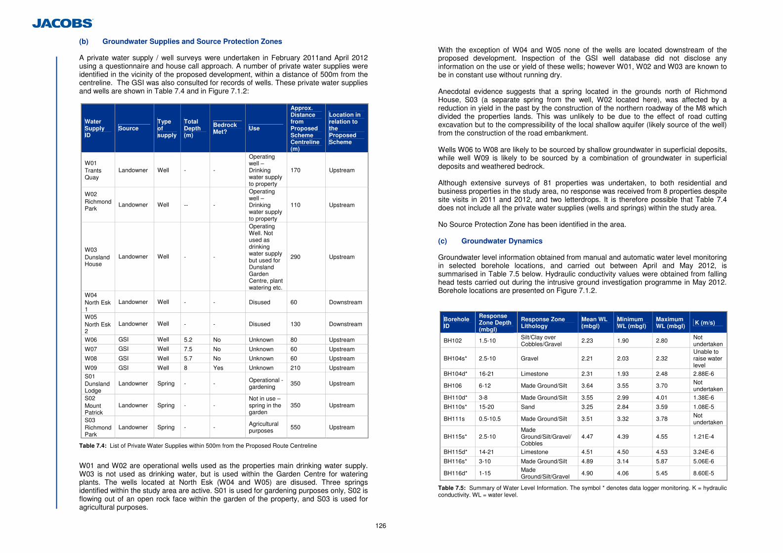
126
(b) Groundwater Supplies and Source Protection Zones
A private water supply / well surveys were undertaken in February 2011and April 2012 using a questionnaire and house call approach. A number of private water supplies were identified in the vicinity of the proposed development, within a distance of 500m from the centreline. The GSI was also consulted for records of wells. These private water supplies and wells are shown in Table 7.4 and in Figure 7.1.2:
Water Supply ID
Source Type of supply
Total Depth (m)
Bedrock Met?
Use
Approx. Distance from Proposed Scheme Centreline (m)
Location in relation to the Proposed Scheme
W01 Trants Quay
Landowner Well - -
Operating well – Drinking water supply to property
170 Upstream
W02 Richmond Park
Landowner Well -- -
Operating well –Drinking water supply to property
110 Upstream
W03 Dunsland House
Landowner Well - -
Operating Well. Not used as drinking water supply but used for Dunsland Garden Centre, plant watering etc.
290 Upstream
W04 North Esk 1
Landowner Well - - Disused 60 Downstream
W05 North Esk 2
Landowner Well - - Disused 130 Downstream
W06 GSI Well 5.2 No Unknown 80 Upstream
W07 GSI Well 7.5 No Unknown 60 Upstream
W08 GSI Well 5.7 No Unknown 60 Upstream
W09 GSI Well 8 Yes Unknown 210 Upstream S01 Dunsland Lodge
Landowner Spring - - Operational - gardening 350 Upstream
S02 Mount Patrick
Landowner Spring - - Not in use – spring in the garden
350 Upstream
S03 Richmond Park
Landowner Spring - - Agricultural purposes 550 Upstream
Table 7.4: List of Private Water Supplies within 500m from the Proposed Route Centreline
W01 and W02 are operational wells used as the properties main drinking water supply. W03 is not used as drinking water, but is used within the Garden Centre for watering plants. The wells located at North Esk (W04 and W05) are disused. Three springs identified within the study area are active. S01 is used for gardening purposes only, S02 is flowing out of an open rock face within the garden of the property, and S03 is used for agricultural purposes.
With the exception of W04 and W05 none of the wells are located downstream of the proposed development. Inspection of the GSI well database did not disclose any information on the use or yield of these wells; however W01, W02 and W03 are known to be in constant use without running dry. Anecdotal evidence suggests that a spring located in the grounds north of Richmond House, S03 (a separate spring from the well, W02 located here), was affected by a reduction in yield in the past by the construction of the northern roadway of the M8 which divided the properties lands. This was unlikely to be due to the effect of road cutting excavation but to the compressibility of the local shallow aquifer (likely source of the well) from the construction of the road embankment. Wells W06 to W08 are likely to be sourced by shallow groundwater in superficial deposits, while well W09 is likely to be sourced by a combination of groundwater in superficial deposits and weathered bedrock. Although extensive surveys of 81 properties was undertaken, to both residential and business properties in the study area, no response was received from 8 properties despite site visits in 2011 and 2012, and two letterdrops. It is therefore possible that Table 7.4 does not include all the private water supplies (wells and springs) within the study area. No Source Protection Zone has been identified in the area. (c) Groundwater Dynamics
Groundwater level information obtained from manual and automatic water level monitoring in selected borehole locations, and carried out between April and May 2012, is summarised in Table 7.5 below. Hydraulic conductivity values were obtained from falling head tests carried out during the intrusive ground investigation programme in May 2012. Borehole locations are presented on Figure 7.1.2.
Borehole ID
Response Zone Depth (mbgl)
Response Zone Lithology
Mean WL (mbgl)
Minimum WL (mbgl)
Maximum WL (mbgl) K (m/s)
BH102 1.5-10 Silt/Clay over Cobbles/Gravel
2.23 1.90 2.80 Not undertaken
BH104s* 2.5-10 Gravel 2.21 2.03 2.32 Unable to raise water level
BH104d* 16-21 Limestone 2.31 1.93 2.48 2.88E-6
BH106 6-12 Made Ground/Silt 3.64 3.55 3.70 Not undertaken
BH110d* 3-8 Made Ground/Silt 3.55 2.99 4.01 1.38E-6
BH110s* 15-20 Sand 3.25 2.84 3.59 1.08E-5
BH111s 0.5-10.5 Made Ground/Silt 3.51 3.32 3.78 Not undertaken
BH115s* 2.5-10 Made Ground/Silt/Gravel/Cobbles
4.47 4.39 4.55 1.21E-4
BH115d* 14-21 Limestone 4.51 4.50 4.53 3.24E-6
BH116s* 3-10 Made Ground/Silt 4.89 3.14 5.87 5.06E-6
BH116d* 1-15 Made Ground/Silt/Gravel 4.90 4.06 5.45 8.60E-5
Table 7.5: Summary of Water Level Information. The symbol * denotes data logger monitoring. K = hydraulic conductivity. WL = water level.
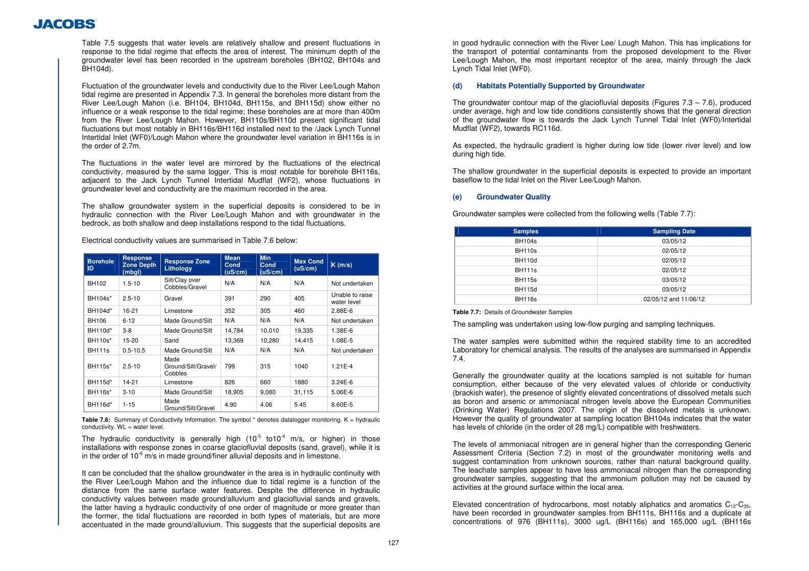
127
Table 7.5 suggests that water levels are relatively shallow and present fluctuations in response to the tidal regime that effects the area of interest. The minimum depth of the groundwater level has been recorded in the upstream boreholes (BH102, BH104s and BH104d). Fluctuation of the groundwater levels and conductivity due to the River Lee/Lough Mahon tidal regime are presented in Appendix 7.3. In general the boreholes more distant from the River Lee/Lough Mahon (i.e. BH104, BH104d, BH115s, and BH115d) show either no influence or a weak response to the tidal regime; these boreholes are at more than 400m from the River Lee/Lough Mahon. However, BH110s/BH110d present significant tidal fluctuations but most notably in BH116s/BH116d installed next to the /Jack Lynch Tunnel Intertidal Inlet (WF0)/Lough Mahon where the groundwater level variation in BH116s is in the order of 2.7m. The fluctuations in the water level are mirrored by the fluctuations of the electrical conductivity, measured by the same logger. This is most notable for borehole BH116s, adjacent to the Jack Lynch Tunnel Intertidal Mudflat (WF2), whose fluctuations in groundwater level and conductivity are the maximum recorded in the area. The shallow groundwater system in the superficial deposits is considered to be in hydraulic connection with the River Lee/Lough Mahon and with groundwater in the bedrock, as both shallow and deep installations respond to the tidal fluctuations. Electrical conductivity values are summarised in Table 7.6 below:
Borehole ID
Response Zone Depth (mbgl)
Response Zone Lithology
Mean Cond (uS/cm)
Min Cond (uS/cm)
Max Cond (uS/cm) K (m/s)
BH102 1.5-10 Silt/Clay over Cobbles/Gravel
N/A N/A N/A Not undertaken
BH104s* 2.5-10 Gravel 391 290 405 Unable to raise water level
BH104d* 16-21 Limestone 352 305 460 2.88E-6
BH106 6-12 Made Ground/Silt N/A N/A N/A Not undertaken
BH110d* 3-8 Made Ground/Silt 14,784 10,010 19,335 1.38E-6
BH110s* 15-20 Sand 13,369 10,280 14,415 1.08E-5
BH111s 0.5-10.5 Made Ground/Silt N/A N/A N/A Not undertaken
BH115s* 2.5-10 Made Ground/Silt/Gravel/Cobbles
799 315 1040 1.21E-4
BH115d* 14-21 Limestone 826 660 1880 3.24E-6
BH116s* 3-10 Made Ground/Silt 18,905 9,080 31,115 5.06E-6
BH116d* 1-15 Made Ground/Silt/Gravel 4.90 4.06 5.45 8.60E-5
Table 7.6: Summary of Conductivity Information. The symbol * denotes datalogger monitoring. K = hydraulic conductivity. WL = water level.
The hydraulic conductivity is generally high (10-5 to10-4 m/s, or higher) in those installations with response zones in coarse glaciofluvial deposits (sand, gravel), while it is in the order of 10-6 m/s in made ground/finer alluvial deposits and in limestone. It can be concluded that the shallow groundwater in the area is in hydraulic continuity with the River Lee/Lough Mahon and the influence due to tidal regime is a function of the distance from the same surface water features. Despite the difference in hydraulic conductivity values between made ground/alluvium and glaciofluvial sands and gravels, the latter having a hydraulic conductivity of one order of magnitude or more greater than the former, the tidal fluctuations are recorded in both types of materials, but are more accentuated in the made ground/alluvium. This suggests that the superficial deposits are
in good hydraulic connection with the River Lee/ Lough Mahon. This has implications for the transport of potential contaminants from the proposed development to the River Lee/Lough Mahon, the most important receptor of the area, mainly through the Jack Lynch Tidal Inlet (WF0). (d) Habitats Potentially Supported by Groundwater
The groundwater contour map of the glaciofluvial deposits (Figures 7.3 – 7.6), produced under average, high and low tide conditions consistently shows that the general direction of the groundwater flow is towards the Jack Lynch Tunnel Tidal Inlet (WF0)/Intertidal Mudflat (WF2), towards RC116d. As expected, the hydraulic gradient is higher during low tide (lower river level) and low during high tide. The shallow groundwater in the superficial deposits is expected to provide an important baseflow to the tidal Inlet on the River Lee/Lough Mahon. (e) Groundwater Quality
Groundwater samples were collected from the following wells (Table 7.7):
Samples Sampling Date
BH104s 03/05/12
BH110s 02/05/12
BH110d 02/05/12
BH111s 02/05/12
BH115s 03/05/12
BH115d 03/05/12
BH116s 02/05/12 and 11/06/12
Table 7.7: Details of Groundwater Samples
The sampling was undertaken using low-flow purging and sampling techniques. The water samples were submitted within the required stability time to an accredited Laboratory for chemical analysis. The results of the analyses are summarised in Appendix 7.4. Generally the groundwater quality at the locations sampled is not suitable for human consumption, either because of the very elevated values of chloride or conductivity (brackish water), the presence of slightly elevated concentrations of dissolved metals such as boron and arsenic or ammoniacal nitrogen levels above the European Communities (Drinking Water) Regulations 2007. The origin of the dissolved metals is unknown. However the quality of groundwater at sampling location BH104s indicates that the water has levels of chloride (in the order of 28 mg/L) compatible with freshwaters. The levels of ammoniacal nitrogen are in general higher than the corresponding Generic Assessment Criteria (Section 7.2) in most of the groundwater monitoring wells and suggest contamination from unknown sources, rather than natural background quality. The leachate samples appear to have less ammoniacal nitrogen than the corresponding groundwater samples, suggesting that the ammonium pollution may not be caused by activities at the ground surface within the local area. Elevated concentration of hydrocarbons, most notably aliphatics and aromatics C12-C35, have been recorded in groundwater samples from BH111s, BH116s and a duplicate at concentrations of 976 (BH111s), 3000 ug/L (BH116s) and 165,000 ug/L (BH116s
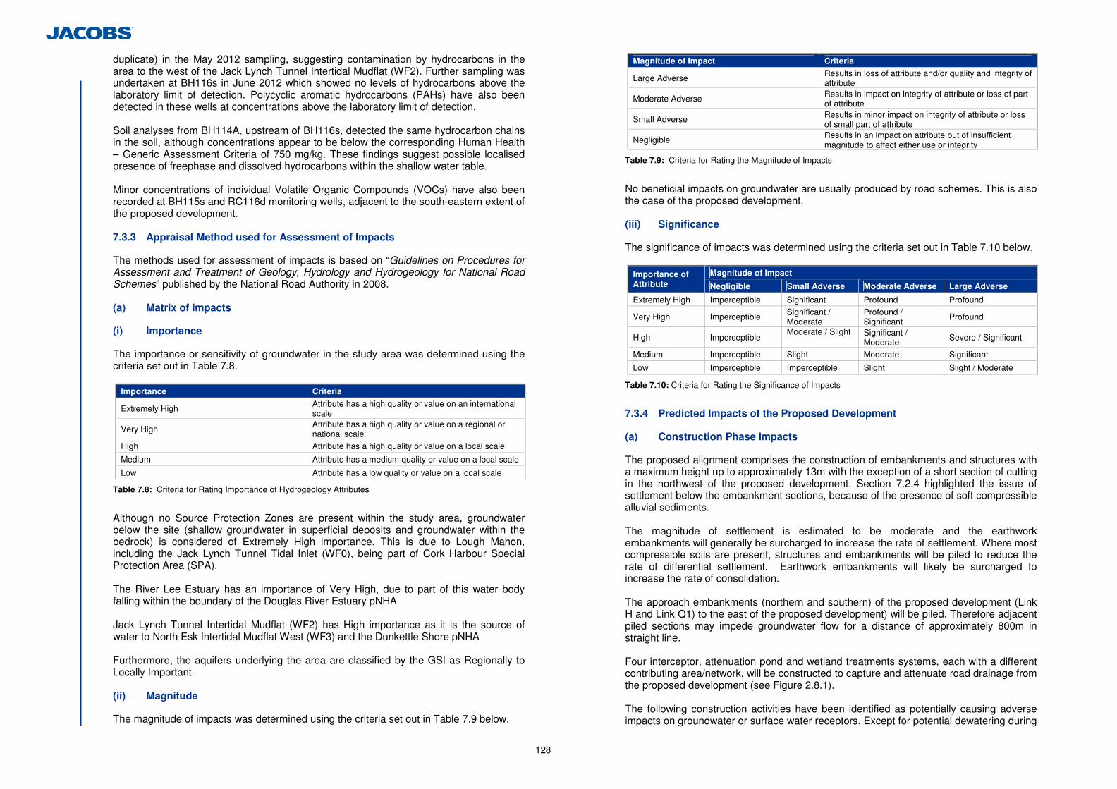
128
duplicate) in the May 2012 sampling, suggesting contamination by hydrocarbons in the area to the west of the Jack Lynch Tunnel Intertidal Mudflat (WF2). Further sampling was undertaken at BH116s in June 2012 which showed no levels of hydrocarbons above the laboratory limit of detection. Polycyclic aromatic hydrocarbons (PAHs) have also been detected in these wells at concentrations above the laboratory limit of detection. Soil analyses from BH114A, upstream of BH116s, detected the same hydrocarbon chains in the soil, although concentrations appear to be below the corresponding Human Health – Generic Assessment Criteria of 750 mg/kg. These findings suggest possible localised presence of freephase and dissolved hydrocarbons within the shallow water table. Minor concentrations of individual Volatile Organic Compounds (VOCs) have also been recorded at BH115s and RC116d monitoring wells, adjacent to the south-eastern extent of the proposed development. 7.3.3 Appraisal Method used for Assessment of Impacts
The methods used for assessment of impacts is based on “Guidelines on Procedures for Assessment and Treatment of Geology, Hydrology and Hydrogeology for National Road Schemes” published by the National Road Authority in 2008. (a) Matrix of Impacts
(i) Importance
The importance or sensitivity of groundwater in the study area was determined using the criteria set out in Table 7.8.
Importance Criteria
Extremely High Attribute has a high quality or value on an international scale
Very High Attribute has a high quality or value on a regional or national scale
High Attribute has a high quality or value on a local scale
Medium Attribute has a medium quality or value on a local scale
Low Attribute has a low quality or value on a local scale
Table 7.8: Criteria for Rating Importance of Hydrogeology Attributes
Although no Source Protection Zones are present within the study area, groundwater below the site (shallow groundwater in superficial deposits and groundwater within the bedrock) is considered of Extremely High importance. This is due to Lough Mahon, including the Jack Lynch Tunnel Tidal Inlet (WF0), being part of Cork Harbour Special Protection Area (SPA). The River Lee Estuary has an importance of Very High, due to part of this water body falling within the boundary of the Douglas River Estuary pNHA Jack Lynch Tunnel Intertidal Mudflat (WF2) has High importance as it is the source of water to North Esk Intertidal Mudflat West (WF3) and the Dunkettle Shore pNHA Furthermore, the aquifers underlying the area are classified by the GSI as Regionally to Locally Important. (ii) Magnitude
The magnitude of impacts was determined using the criteria set out in Table 7.9 below.
Magnitude of Impact Criteria
Large Adverse Results in loss of attribute and/or quality and integrity of attribute
Moderate Adverse Results in impact on integrity of attribute or loss of part of attribute
Small Adverse Results in minor impact on integrity of attribute or loss of small part of attribute
Negligible Results in an impact on attribute but of insufficient magnitude to affect either use or integrity
Table 7.9: Criteria for Rating the Magnitude of Impacts
No beneficial impacts on groundwater are usually produced by road schemes. This is also the case of the proposed development. (iii) Significance
The significance of impacts was determined using the criteria set out in Table 7.10 below.
Magnitude of Impact Importance of Attribute Negligible Small Adverse Moderate Adverse Large Adverse
Extremely High Imperceptible Significant Profound Profound
Very High Imperceptible Significant / Moderate
Profound / Significant Profound
High Imperceptible Moderate / Slight
Significant / Moderate Severe / Significant
Medium Imperceptible Slight Moderate Significant
Low Imperceptible Imperceptible Slight Slight / Moderate
Table 7.10: Criteria for Rating the Significance of Impacts
7.3.4 Predicted Impacts of the Proposed Development
(a) Construction Phase Impacts
The proposed alignment comprises the construction of embankments and structures with a maximum height up to approximately 13m with the exception of a short section of cutting in the northwest of the proposed development. Section 7.2.4 highlighted the issue of settlement below the embankment sections, because of the presence of soft compressible alluvial sediments. The magnitude of settlement is estimated to be moderate and the earthwork embankments will generally be surcharged to increase the rate of settlement. Where most compressible soils are present, structures and embankments will be piled to reduce the rate of differential settlement. Earthwork embankments will likely be surcharged to increase the rate of consolidation. The approach embankments (northern and southern) of the proposed development (Link H and Link Q1) to the east of the proposed development) will be piled. Therefore adjacent piled sections may impede groundwater flow for a distance of approximately 800m in straight line. Four interceptor, attenuation pond and wetland treatments systems, each with a different contributing area/network, will be constructed to capture and attenuate road drainage from the proposed development (see Figure 2.8.1). The following construction activities have been identified as potentially causing adverse impacts on groundwater or surface water receptors. Except for potential dewatering during
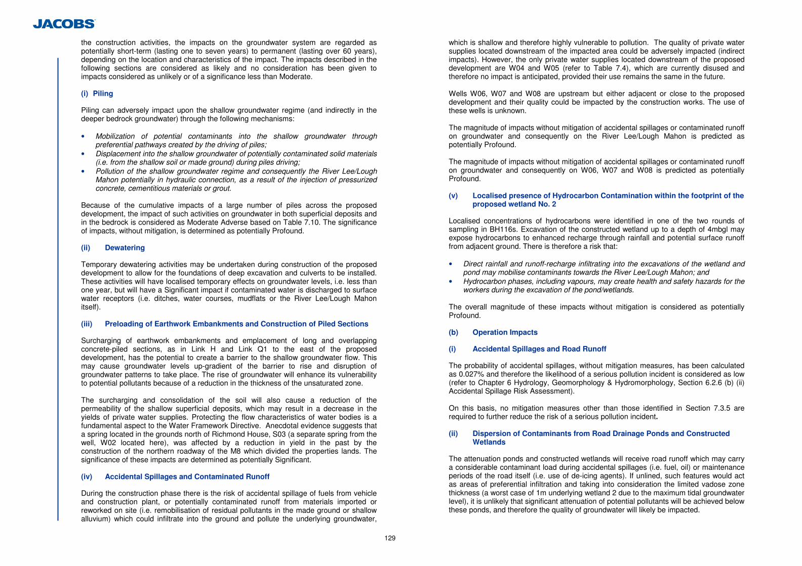
129
the construction activities, the impacts on the groundwater system are regarded as potentially short-term (lasting one to seven years) to permanent (lasting over 60 years), depending on the location and characteristics of the impact. The impacts described in the following sections are considered as likely and no consideration has been given to impacts considered as unlikely or of a significance less than Moderate. (i) Piling
Piling can adversely impact upon the shallow groundwater regime (and indirectly in the deeper bedrock groundwater) through the following mechanisms: • Mobilization of potential contaminants into the shallow groundwater through
preferential pathways created by the driving of piles; • Displacement into the shallow groundwater of potentially contaminated solid materials
(i.e. from the shallow soil or made ground) during piles driving; • Pollution of the shallow groundwater regime and consequently the River Lee/Lough
Mahon potentially in hydraulic connection, as a result of the injection of pressurized concrete, cementitious materials or grout.
Because of the cumulative impacts of a large number of piles across the proposed development, the impact of such activities on groundwater in both superficial deposits and in the bedrock is considered as Moderate Adverse based on Table 7.10. The significance of impacts, without mitigation, is determined as potentially Profound. (ii) Dewatering
Temporary dewatering activities may be undertaken during construction of the proposed development to allow for the foundations of deep excavation and culverts to be installed. These activities will have localised temporary effects on groundwater levels, i.e. less than one year, but will have a Significant impact if contaminated water is discharged to surface water receptors (i.e. ditches, water courses, mudflats or the River Lee/Lough Mahon itself). (iii) Preloading of Earthwork Embankments and Construction of Piled Sections
Surcharging of earthwork embankments and emplacement of long and overlapping concrete-piled sections, as in Link H and Link Q1 to the east of the proposed development, has the potential to create a barrier to the shallow groundwater flow. This may cause groundwater levels up-gradient of the barrier to rise and disruption of groundwater patterns to take place. The rise of groundwater will enhance its vulnerability to potential pollutants because of a reduction in the thickness of the unsaturated zone. The surcharging and consolidation of the soil will also cause a reduction of the permeability of the shallow superficial deposits, which may result in a decrease in the yields of private water supplies. Protecting the flow characteristics of water bodies is a fundamental aspect to the Water Framework Directive. Anecdotal evidence suggests that a spring located in the grounds north of Richmond House, S03 (a separate spring from the well, W02 located here), was affected by a reduction in yield in the past by the construction of the northern roadway of the M8 which divided the properties lands. The significance of these impacts are determined as potentially Significant. (iv) Accidental Spillages and Contaminated Runoff
During the construction phase there is the risk of accidental spillage of fuels from vehicle and construction plant, or potentially contaminated runoff from materials imported or reworked on site (i.e. remobilisation of residual pollutants in the made ground or shallow alluvium) which could infiltrate into the ground and pollute the underlying groundwater,
which is shallow and therefore highly vulnerable to pollution. The quality of private water supplies located downstream of the impacted area could be adversely impacted (indirect impacts). However, the only private water supplies located downstream of the proposed development are W04 and W05 (refer to Table 7.4), which are currently disused and therefore no impact is anticipated, provided their use remains the same in the future. Wells W06, W07 and W08 are upstream but either adjacent or close to the proposed development and their quality could be impacted by the construction works. The use of these wells is unknown. The magnitude of impacts without mitigation of accidental spillages or contaminated runoff on groundwater and consequently on the River Lee/Lough Mahon is predicted as potentially Profound. The magnitude of impacts without mitigation of accidental spillages or contaminated runoff on groundwater and consequently on W06, W07 and W08 is predicted as potentially Profound. (v) Localised presence of Hydrocarbon Contamination within the footprint of the
proposed wetland No. 2
Localised concentrations of hydrocarbons were identified in one of the two rounds of sampling in BH116s. Excavation of the constructed wetland up to a depth of 4mbgl may expose hydrocarbons to enhanced recharge through rainfall and potential surface runoff from adjacent ground. There is therefore a risk that: • Direct rainfall and runoff-recharge infiltrating into the excavations of the wetland and
pond may mobilise contaminants towards the River Lee/Lough Mahon; and • Hydrocarbon phases, including vapours, may create health and safety hazards for the
workers during the excavation of the pond/wetlands. The overall magnitude of these impacts without mitigation is considered as potentially Profound. (b) Operation Impacts
(i) Accidental Spillages and Road Runoff
The probability of accidental spillages, without mitigation measures, has been calculated as 0.027% and therefore the likelihood of a serious pollution incident is considered as low (refer to Chapter 6 Hydrology, Geomorphology & Hydromorphology, Section 6.2.6 (b) (ii) Accidental Spillage Risk Assessment). On this basis, no mitigation measures other than those identified in Section 7.3.5 are required to further reduce the risk of a serious pollution incident. (ii) Dispersion of Contaminants from Road Drainage Ponds and Constructed
Wetlands
The attenuation ponds and constructed wetlands will receive road runoff which may carry a considerable contaminant load during accidental spillages (i.e. fuel, oil) or maintenance periods of the road itself (i.e. use of de-icing agents). If unlined, such features would act as areas of preferential infiltration and taking into consideration the limited vadose zone thickness (a worst case of 1m underlying wetland 2 due to the maximum tidal groundwater level), it is unlikely that significant attenuation of potential pollutants will be achieved below these ponds, and therefore the quality of groundwater will likely be impacted.
130
The significance of these impacts, without mitigation is considered as potentially Profound. (c) Do-Minimum Scenario Impacts
In the event that the proposed development will not be constructed, there will be no impact on the groundwater regime. 7.3.5 Proposed Mitigation and Avoidance Measures
(a) Construction
(i) Piling
Piling will be completed in accordance with Environment Agency (England and Wales) (2001) Piling and Penetrative Ground Improvement Methods on Land Affected by Contamination: Guidance on Pollution Prevention. Although no contamination has been identified in the areas to be piled based on the ground investigation and desk study undertaken, the below mitigation measures includes for the possibility of encountering potential contamination not identified during the ground investigation works; • In the event of potential contamination being found, remediate shallow groundwater
prior to piling; • Temporarily lower shallow groundwater prior to piling (to remove positive hydraulic
gradient); • Immobilise or remediate potential contaminants in soil through which piles pass; • Isolate potential contamination around piles from groundwater flow and infiltration
(e.g. surface cover, in ground barriers); • Use of bentonite during boring or driving; • Grout pile or stone column after installation. When this mitigation is implemented, it will reduce the significance of impact of this aspect to Imperceptible.
(ii) Dewatering
Contaminated groundwater cannot be discharged on site and will need to be tankered off site to an appropriate facility. When this mitigation is implemented, it will reduce the significance of impact of this aspect to Imperceptible. (iii) Preloading of Earthwork Embankments and Construction of Piled Sections
Shallow groundwater may become backed up as a consequence of the combined effect of preloading and piling, as around the proposed Grade Separated Junction (Links H and Link Q1) to the east of the proposed development. The contractor will monitor the operational water supply yield in the areas prior to and during any surcharging activities. If the yield is found to decrease, an equivalent water supply or connection to the mains water supply will be provided, subject to agreement with the affected landowner. When this mitigation is implemented, it will reduce the significance of impact of this aspect to Imperceptible. (iv) Accidental Spillages and Contaminated Runoff
Works will comply with the following guidelines; • CIRIA (2002). Control of Water Pollution from Construction Sites - Guide to good
Practice; and • Working at Construction and Demolition Sites: PPG6 – Pollution Prevention
Guidelines (available at http://www.environment-agency.gov.uk ) Temporary construction surface drainage and sediment control measures will be in place before earthworks commence. Pouring of cementitious materials for the works will be carried out in the dry and allowed to cure for 48 hours before re-flooding. Pumped concrete will be monitored to ensure no accidental discharge. Mixer washings and excess concrete will not be discharged to surface water. No storage of hydrocarbons or any toxic chemicals will occur within 50 m of a watercourse. Fuel storage tanks will be bunded to a capacity at least 110% of the volume of the storage tank. Re-fuelling of plant will not occur within 50 m of any watercourse and only in bunded refuelling areas. Emergency procedures and spillage kits will be available and construction staff will be familiar with emergency procedures. Measures will be taken to minimise waste and ensure correct handling, storage and disposal of waste (most notably wet concrete, pile arisings and asphalt), as detailed further in Chapter 12 – Waste Management. The water quality of wells W01, W02, W03, W06, W07, W08 and W09 will be analysed prior to the commencement of and during the construction works. Any operational well whose quality has been adversely impacted by the construction activities will be replaced or connection to the mains water supply provided, subject to agreement with the landowner. When this mitigation is implemented, it will reduce the significance of impact of this aspect to Imperceptible.
131
(v) Localised presence of Hydrocarbon Contamination within the Footprint of
the Proposed Constructed Wetland No. 2
Remediation of any free phase hydrocarbon contamination in shallow groundwater will be undertaken in the area of constructed wetland No. 2 in advance of any construction works. Remediation measures to be used include: (i) Pump and Treat (P&T).
It can be used to remove free mobile product (assuming Light Non-Aqueous Phase Liquid) and contaminated groundwater in the area of the pond/constructed wetland and surroundings through abstraction wells, prior to the excavation. Contaminated groundwater will potentially be treated on site with an activated carbon treatment unit and disposed in line with the existing regulations; free-product separated by the groundwater would need off-site disposal in suitable landfills. (ii) In situ Chemical Treatment (i.e. Desorption and/or Chemical Oxidation)
Proven technology, advanced chemical products will target accelerated desorption and rapid oxidation/destruction of contaminants. Treatment will consists of injecting chemical products in the soil/groundwater through injection wells, to enhance the desorption, oxidation and rapid destruction of contaminants. This will remove the requirement to excavate/remove soil. However, success depends on the permeability and uniform characteristics of the impacted soil. May be successfully coupled with groundwater extraction through Pump & Treat (P&T) systems to remove the desorbed/partially oxidised components. Excavation and ex-situ treatment (biopiling) or off-site disposal is not suitable as contamination will be exposed during the construction, potentially remobilising the contaminant further downstream. The soil excavated for the construction of the pond/wetland will need to be disposed off-site to a suitable landfill. When this mitigation is implemented, it will reduce the significance of impact of this aspect to Imperceptible. (b) Operation
(i) Accidental Spillages and Road Runoff
The road drainage system of oil/petrol interceptor, attenuation pond and constructed wetland will be lined its entire length. A penstock valve will be installed between the attenuation pond and the constructed wetland to allow isolation of the system in the event of an accidental spill. The oil/petrol interceptors will be installed before the construction of the attenuation ponds on all four drainage networks. A contaminant spill emergency plan will be put in place to contain, remove or remediate any catastrophic spill before it reaches any groundwater or surface water receptor. Emergency equipment/spill kits to facilitate the implementation of such plan will be made available in secured locations within the area.
Monitoring wells will be installed in strategic locations notably downstream of the proposed development, and their water quality regularly monitored (i.e. annually for 3 subsequent years, following the opening of the proposed development). The water quality of wells W01, W02, W03, W06, W07, W08 and W09 will be analysed during the 1st year of the proposed developments operation.
When this mitigation is implemented, it will reduce the significance of impact of this aspect to Imperceptible. (ii) Dispersion of Contaminants from Road Drainage Ponds and Constructed
Wetlands
The ponds and constructed wetlands in all four networks will be lined. Monitoring wells will be installed immediately downstream of the constructed wetlands and their water quality regularly monitored (i.e. annually for 3 years, following the opening of the proposed development). When this mitigation is implemented, it will reduce the significance of impact of this aspect to Imperceptible. (c) Residual Impacts
The residual impacts associated with the proposed development after adherence to the mitigation measures during construction phase are summarised in Table 7.11.
Impact Significance Pre Mitigation Significance Post Mitigation
Construction
Piling Profound Imperceptible
Dewatering Significant Imperceptible Preloading of Earthwork Embankments/Construction of Piled Sections
Significant Imperceptible
Accidental Spillage/Contaminated Runoff
Profound Imperceptible Presence of Hydrocarbon Contamination (Constructed Wetland 2)
Profound Imperceptible
Operational Accidental Spillage and Road Runoff
Profound Imperceptible
Dispersion of Contaminants from Ponds/Constructed Wetlands Profound Imperceptible
Table 7.11: Residual Impact after Mitigation Measures
7.3.6 Difficulties Encountered in Compiling Information
No difficulties were encountered during the undertaking of this assessment. 7.3.7 Cumulative Impacts and Impact Interrelations
The hydrogeology of the area interrelates to other aspects such as local area Hydrology, Ecology and Land Contamination. Deterioration of groundwater quality in the study area as a result of the proposed development can impact on surface water receptors in hydraulic connection with groundwater and their associated habitats. In turn, deterioration of the surface water quality in the study area from contaminated soils, perhaps imported for embankment construction, could impact on the groundwater quality. These interrelations have been included in the overall impact assessment for each aspect.
132
8 Air Quality & Climate
8.1 Introduction
This chapter was undertaken by AWN Consulting and considers and assesses the impacts on air quality and climate associated with both the construction and operational phases of the proposed development. 8.1.1 Ambient Air Quality Standards
In order to reduce the risk to health from poor air quality, national and European statutory bodies have set limit values in ambient air for a range of air pollutants. These limit values or “Air Quality Standards” are health or environmental-based levels for which additional factors may be considered. For example, natural background levels, environmental conditions and socio-economic factors may all play a part in the limit value which is set (see Tables 8.1, 8.2 and Appendix 8.1). Air quality significance criteria are assessed on the basis of compliance with the appropriate standards or limit values. The applicable standards in Ireland include the Air Quality Standards Regulations 2011, which incorporate EU Directive 2008/50/EC, which has set limit values for SO2, NO2, PM10, PM2.5, benzene and CO (see Table 8.1). Although the EU Air Quality Limit Values are the basis of legislation, other thresholds outlined by the EU Directives are used which are triggers for particular actions (see Appendix 8.1). 8.1.2 Climate Agreements
Ireland ratified the United Nations Framework Convention on Climate Change (UNFCCC) in April 1994 and the Kyoto Protocol in principle in 1997 and formally in May 2002 (Framework Convention on Climate Change, 1999 and Framework Convention on Climate Change, 1997). For the purposes of the European Union burden sharing agreement under Article 4 of the Kyoto Protocol, in June 1998, Ireland agreed to limit the net growth of the six Greenhouse Gases (GHGs) under the Kyoto Protocol to 13% above the 1990 level over the period 2008 to 2012 (ERM, 1998). The UNFCCC is continuing detailed negotiations in relation to GHGs reductions and in relation to technical issues such as emissions trading and burden sharing. 8.1.3 Gothenburg Protocol
In 1999, Ireland signed the Gothenburg Protocol to the 1979 UN Convention on Long Range Transboundary Air Pollution. The objective of the Protocol is to control and reduce emissions of Sulphur Dioxide (SO2), Nitrogen Oxides (NOX), Volatile Organic Compounds (VOCs) and Ammonia (NH3). To achieve the targets Ireland had to meet national emission ceilings of 42kt for SO2 (67% below 2001 levels), 65kt for NOX (52% reduction), 55kt for VOCs (37% reduction) and 116kt for NH3 (6% reduction). European Commission Directive 2001/81/EC, the National Emissions Ceiling Directive, prescribes the same emission limits. Emissions of SO2 and NH3 from the road traffic sector are insignificant accounting for less than 1.5% of total emissions in Ireland in 2001. Road traffic emissions of Nitrogen Oxides (NOX) and Volatile Organic Compounds (VOCs) are important accounting for 37% and 38% respectively of total emissions of these pollutants in Ireland in 2001 (DEHLG, 2003). A National Programme for the progressive reduction of emissions of the four transboundary pollutants is in place since April 2005 (DEHLG, 2004). A review of the National Programme in 2007 (DEHLG 2007a) showed that Ireland was on target to comply with the emissions ceilings for SO2, VOCs and NH3 by 2010, but that the ceiling for NOx presents a difficulty even with the implementation of additional measures. The
most recent data available from the EU in 2009 indicates that Ireland will comply with the emissions ceilings for SO2, VOCs and NH3 but will fail to comply with the ceiling for NOX (EEA 2010).
Pollutant Regulation Note1 Limit Type Margin of Tolerance Value
Hourly limit for protection of human health - not to be exceeded more than 18 times/year
40% until 2003 reducing linearly to 0% by 2010
200 µg/m3 NO2
Annual limit for protection of human health
40% until 2003 reducing linearly to 0% by 2010
40 µg/m3 NO2
Nitrogen Dioxide 2008/50/EC
Annual limit for protection of vegetation
None
30 µg/m3 NO + NO2
Lead 2008/50/EC Annual limit for protection of human health
100% 0.5 µg/m3
Hourly limit for protection of human health - not to be exceeded more than 24 times/year
150 µg/m3 350 µg/m3
Daily limit for protection of human health - not to be exceeded more than 3 times/year
None 125 µg/m3 Sulphur dioxide 2008/50/EC
Annual & Winter limit for the protection of ecosystems
None 20 µg/m3
24-hour limit for protection of human health - not to be exceeded more than 35 times/year
50% 50 µg/m3 PM10 Particulate Matter (as PM10)
2008/50/EC
Annual limit for protection of human health 20% 40 µg/m3 PM10
PM2.5
(Stage 1) 2008/50/EC Annual limit for protection of human health
20% from June 2008. Decreasing linearly to 0% by 2015
25 µg/m3 PM2.5
PM2.5
(Stage 2) Note 2 - Annual limit for protection of human health None 20 µg/m3 PM2.5
Benzene 2008/50/EC Annual limit for protection of human health
100% until 2006 reducing linearly to 0% by 2010
5 µg/m3
Carbon Monoxide 2008/50/EC
8-hour limit (on a rolling basis) for protection of human health
60% 10 mg/m3 (8.6 ppm)
Nitrogen Dioxide 2008/50/EC
Hourly limit for protection of human health - not to be exceeded more than 18 times/year
40% until 2003 reducing linearly to 0% by 2010
200 µg/m3 NO2
Note 1 EU 2008/50/EC – Clean Air For Europe (CAFÉ) Directive replaces the previous Air Framework Directive (1996/30/EC) and daughter directives 1999/30/EC and 2000/69/EC
Note 2 EU 2008/50/EC states - ‘Stage 2 — indicative limit value to be reviewed by the Commission in 2013 in the light of further information on health and environmental effects, technical feasibility and experience of the target value in Member States’.
Table 8.1: Air Quality Standards Regulations 2011 (based on European Commission Directive 2008/50/EC)
133
Pollutant Regulation Type Period Value
Nitrogen Dioxide 85/203/EEC Limit Value
200 µg/m3
Guide Value
98th percentile of yearly mean hourly concentrations 135 µg/m3
Guide Value
50th percentile of yearly mean hourly concentrations
50 µg/m3
Lead 82/884/EEC Limit Value
Annual mean
2 µg/m3
Sulphur dioxide 80/779/EEC Limit Value
98th percentile of yearly mean hourly concentrations
250-350Note 1 µg/m3
Limit Value
Winter (medium of daily values)
130 or 180Note 1 µg/m3
Limit Value
One year (medium of daily values)
80 or 120Note 1 µg/m3
Guide Value
98th percentile of yearly mean hourly concentrations
135 µg/m3
Guide Value
50th percentile of 1-hour means
50 µg/m3
Smoke 80/779/EEC Limit Value
One year (medium of daily values)
80 µg/m3
Limit Value
Winter (medium of daily values)
130 µg/m3
Limit Value
98th percentile of daily values
250 µg/m3 Note 1 The lower daily values refer to the situation with corresponding high levels of black smoke.
Table 8.2: Previous European Union Air Standards
8.1.4 Local Air Quality Assessment
The air quality assessment has been carried out following procedures described in the publications by the NRA, (2011), EPA (EPA 2002, 2003) and using the methodology outlined in the guidance documents published by the UK DEFRA (UK DEFRA 2001, 2007, 2009a, 2009b; UK DETR 1998). The assessment of air quality was carried out using a phased approach as recommended by the UK DEFRA (UK DEFRA 2009a). The phased approach recommends that the complexity of an air quality assessment be consistent with the risk of failing to achieve the air quality standards. In the current assessment, an initial scoping of possible key pollutants was carried out and the likely location of air pollution “hot-spots” identified. An examination of recent EPA and Local Authority data in Ireland (EPA 2011, 2012), has indicated that SO2, smoke and CO are unlikely to be exceeded at locations such as Dunkettle and thus these pollutants do not require detailed monitoring or assessment to be carried out. However, the analysis did indicate potential problems in regards to nitrogen dioxide (NO2) and PM10 at busy junctions in urban centres (EPA 2011, 2012). Benzene, although previously reported at quite high levels in urban centres (EPA 2011), has recently been measured at several city centre locations to be well below the EU limit value (EPA 2011, 2012). Historically, CO levels in urban areas were a cause for concern. However, CO concentrations have decreased significantly over the past number of years and are now measured to be well below the limits even in urban centres (EPA 2011, 2012). The current assessment thus focused firstly on identifying the existing baseline levels of NO2, PM10, PM2.5, benzene and CO in the region of the proposed development, both currently (by carrying out a baseline survey and by analysis of suitable EPA monitoring data), and when the proposed development is opened (through modelling). Thereafter,
the impact of the proposed development on air quality at the neighbouring sensitive receptors was determined relative to “Do Minimum” levels for the Opening and Design Years (2016 and 2031 respectively). The assessment methodology involved air dispersion modelling using the UK DMRB Screening Model (UK DEFRA 2007) (Version 1.03c, July 2007), the NOx to NO2 Conversion Spreadsheet (UK DEFRA, 2010) (Version 2.1 (Released January 2010)) and following guidance issued by the NRA (NRA 2011), UK DEFRA (UK DEFRA 2007, 2009a) and the EPA (EPA 2002, 2003). The inputs to the air dispersion model consist of information on road layouts, receptor locations, annual average daily traffic movements (AADT), annual average traffic speeds and background concentrations. Using this input data the model predicts ambient ground level concentrations at the worst-case sensitive receptors using generic meteorological data. This worst-case concentration is then added to the existing background concentration to give the worst-case predicted ambient concentration. The worst-case predicted ambient concentration is then compared with the relevant ambient air quality standard to assess the compliance of the proposed development with these ambient air quality standards. 8.1.5 Regional Impact Assessment Including Climate
The impact of the proposed development at a national / international level has been determined using the procedures given by the NRA (NRA 2011) and the methodology provided in Annex 2 in the UK DMRB (UK DEFRA 2007). The assessment focused on determining the resulting change in emissions of CO, particulates (PM10), volatile organic compounds (VOCs), nitrogen oxides (NOx) and carbon dioxide (CO2). The Annex provides a method for the prediction of the regional impact of emissions of these pollutants from road schemes. The inputs to the air dispersion model consist of information on road link lengths, AADT movements and annual average traffic speeds.
8.2 Description of the Existing Environment
8.2.1 Meteorological Data
A key factor in assessing temporal and spatial variations in air quality is the prevailing meteorological conditions. Depending on wind speed and direction, individual receptors may experience very significant variations in pollutant levels under the same source strength (i.e. traffic levels) (WHO 2006). Wind is of key importance in dispersing air pollutants and for ground level sources, such as traffic emissions, pollutant concentrations are generally inversely related to wind speed. Thus, concentrations of pollutants derived from traffic sources will generally be greatest under very calm conditions and low wind speeds when the movement of air is restricted. In relation to PM10, the situation is more complex due to the range of sources of this pollutant. Smaller particles (less than PM2.5) from traffic sources will be dispersed more rapidly at higher wind speeds. However, fugitive emissions of coarse particles (PM2.5 - PM10) will actually increase at higher wind speeds. Thus, measured levels of PM10 will be a non-linear function of wind speed. The nearest representative weather station collating detailed weather records is Cork Airport meteorological station, which is located approximately 9 km southwest of the proposed development. Long-term hourly observations at Cork Airport meteorological station provide an indication of the prevailing wind conditions for the region. Results indicate the predominant wind is southwesterly in direction with an average wind speed of approximately 3-5 m/s (see in Appendix 8.2). 8.2.2 Trends in Air Quality
Air quality is variable and subject to both significant spatial and temporal variation. In relation to spatial variations in air quality, concentrations generally fall significantly with distance from major road sources (UK DEFRA 2007). Thus, residential exposure is determined by the location of sensitive receptors relative to major roads sources in the
134
area. Temporally, air quality can vary significantly by orders of magnitude due to changes in traffic volumes, meteorological conditions and wind direction. 8.2.3 Baseline Air Quality
A baseline monitoring study was carried out close to the alignment of the proposed development. The results of the survey allow an indicative comparison with the annual limit values for NO2, PM10 and PM2.5, and the 24-hour limit value for PM10. The results also provide information on the influence of road sources relative to the prevailing background level of these pollutants in the area. The monitoring methodology and results are described below. (a) NO2
NO2 was monitored, using nitrogen dioxide passive diffusion tubes, over a three month period at four locations. The monitoring locations were sited close to the route of the proposed development (see Table 8.3 and Figure 8.1.1). Passive sampling of NO2 involves the molecular diffusion of NO2 molecules through a polycarbonate tube and their subsequent adsorption onto a stainless steel gauze coated with triethanolamine. Following sampling, the tubes were analysed using Gas Chromatography, at a UKAS accredited laboratory (ESG Laboratories, Oxfordshire). The locations were chosen in order to assess roadside and background levels of NO2. The results allow an indicative comparison with the annual average limit value and an assessment of the spatial variation of NO2 away from existing road sources. The spatial variation is particularly important for NO2, as a complex relationship exists between NO, NO2 and O3 leading to a non-linear variation of NO2 concentrations with distance. Studies in the UK have shown that diffusion tube monitoring results generally have a positive or negative bias when compared to continuous analysers. This bias is laboratory specific and is dependent on the specific analysis procedures at each laboratory. A diffusion tube bias of 0.75 was obtained for the ESG laboratory (which analysed the diffusion tubes) from the UK DEFRA website (UK DEFRA, 2012). This bias was applied to the diffusion tube monitoring results. The passive diffusion tube survey was designed to assess background and roadside levels along the route of the proposed development (see Table 8.3 and Figure 8.1.1). The average monitoring results for the three months of monitoring indicate that background concentrations along the proposed route ranged from 12.8 – 14.8 µg/m3. Roadside levels ranged from 15.9 – 25.8 µg/m3. All average NO2 concentrations measured over the three month period were well below the European Union (EU) annual limit value of 40 µg/m3 with worst-case levels reaching only 65% of the limit value.
NO2 (µg/m3)Note 1 Location Type Location 04/10/11 –
04/11/11 04/11/11 – 06/12/11
06/12/11 – 04/01/12
Average
Roadside M1 – N8 Dunkettle 31.0 40.5 5.9 25.8
Roadside M2 – Wood Lane 18.5 22.2 7.1 15.9
Background M3 – Tower Hill 10.7 13.9 13.8 12.8
Background M4 – Kilcoolishal 0.5 38.0 5.9 14.8 Limit Value 40Note 2
Note 1 Diffusion tube bias of 0.75 applied to results Note 2 EU Council Directive 2008/50/EC and S.I. 180 of 2011 - annual limit value
Table 8.3: Results Of NO2 Diffusion Tube Monitoring Carried Out Near The Proposed development Scheme (October 2011 – January 2012)
(b) PM10
The PM10 & PM2.5 monitoring program was carried out by means of Turnkey Instruments® Osiris Environmental Dust Monitors at one location (see Figure 8.1.1 for PM10 monitoring location). The location was positioned to allow an assessment of background levels in the region of the proposed development. The Osiris instrument is a light scattering device capable of continuous measurement of TSP, PM10, PM2.5 and PM1. The air sample was continuously drawn into the instrument by a pump through a heated inlet at a flow rate of 600 ml/min. The incoming air passed through a laser beam in a photometer. The light scattered by the individual particles of dust was measured by the photometer and this information used to measure the size and concentration of the dust particles. Daily concentrations of PM10 and PM2.5 measured at the background location in North Esk are shown in Tables 8.4 and 8.5. The average PM10 concentration measured over the one-month period was 22.5 µg/m3, which is 56% of the EU annual limit value of 40 µg/m3. The results also show that the 24-hour average levels of PM10 exceeded the 24-hour EU limit value of 50 µg/m3 once over the monitoring period. The 24-hour limit value is expressed as a 90.4th%ile, which means 35 exceedances are permitted per year. The 90.4th%ile of 24-hour average PM10 levels measured was 31.8 µg/m3, which is 64% of the limit value. There was one peak in PM10 concentrations on the evening of the 25th of December through to the morning of the 26th of December. As the period of elevated particulate levels occurred over Christmas evening and the early morning of St. Stephen’s Day, it is unlikely that traffic from the existing Dunkettle Interchange or other local roads was the source of such levels. Daily levels of PM2.5 measured over the one-month period averaged 9.7 µg/m3, reaching only 39% of the annual limit value of 25 µg/m3, which will come into force in 2015.
Date PM10 Conc. (µg/m3)
PM2.5 Conc. (µg/m3) Date PM10 Conc.
(µg/m3) PM2.5 Conc.
(µg/m3) 06/12/2011 26.6 13.5 21/12/2011 21.9 10.5
07/12/2011 23.7 12.4 22/12/2011 23.0 9.7
08/12/2011 31.7 13.7 23/12/2011 21.2 9.3
09/12/2011 21.8 10.3 24/12/2011 21.5 9.6
10/12/2011 15.2 7.1 25/12/2011 25.5 10.1
11/12/2011 15.8 7.3 26/12/2011 63.8 20.8
12/12/2011 29.4 9.8 27/12/2011 31.9 11.7
13/12/2011 18.6 7.8 28/12/2011 22.7 9.3
14/12/2011 16.1 5.5 29/12/2011 22.0 11.1
15/12/2011 20.7 9.1 30/12/2011 12.3 6.0
16/12/2011 11.0 4.8 31/12/2011 10.3 5.3
17/12/2011 15.1 6.6 01/01/2012 37.1 16.5
18/12/2011 13.2 7.3 02/01/2012 18.3 6.8
19/12/2011 14.8 7.8 03/01/2012 23.6 11.8
20/12/2011 24.1 10.5 04/01/2012 27.4 10.9
Limit Values 50Note 1, 40Note 2 25Note 2 Limit Values 50Note 1, 40Note 2 25Note 2 Note 1 EU Council Directive 2008/50/EC and S.I. 180 of 2011 - 24-hour limit value not to be exceeded >35 times per year. Note 2 EU Council Directive 2008/50/EC and S.I. 180 of 2011 - annual limit value.
Table 8.4: Results of PM10 and PM2.5 Monitoring Carried Out at a Background Location in North Esk (December 2011 – January 2012)
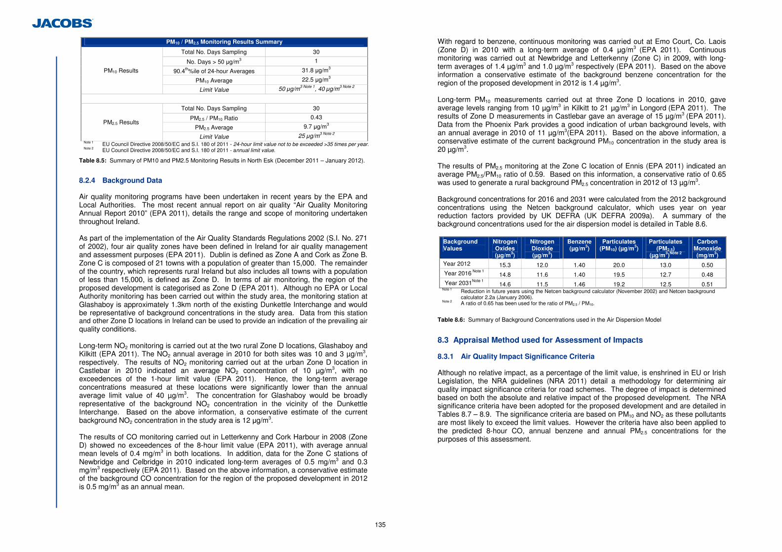
135
PM10 / PM2.5 Monitoring Results Summary
Total No. Days Sampling 30
No. Days > 50 µg/m3 1
90.4th%ile of 24-hour Averages 31.8 µg/m3
PM10 Average 22.5 µg/m3
PM10 Results
Limit Value 50 µg/m3 Note 1, 40 µg/m3 Note 2
Total No. Days Sampling 30
PM2.5 / PM10 Ratio 0.43
PM2.5 Average 9.7 µg/m3 PM2.5 Results
Limit Value 25 µg/m3 Note 2 Note 1 EU Council Directive 2008/50/EC and S.I. 180 of 2011 - 24-hour limit value not to be exceeded >35 times per year. Note 2 EU Council Directive 2008/50/EC and S.I. 180 of 2011 - annual limit value.
Table 8.5: Summary of PM10 and PM2.5 Monitoring Results in North Esk (December 2011 – January 2012).
8.2.4 Background Data
Air quality monitoring programs have been undertaken in recent years by the EPA and Local Authorities. The most recent annual report on air quality “Air Quality Monitoring Annual Report 2010” (EPA 2011), details the range and scope of monitoring undertaken throughout Ireland. As part of the implementation of the Air Quality Standards Regulations 2002 (S.I. No. 271 of 2002), four air quality zones have been defined in Ireland for air quality management and assessment purposes (EPA 2011). Dublin is defined as Zone A and Cork as Zone B. Zone C is composed of 21 towns with a population of greater than 15,000. The remainder of the country, which represents rural Ireland but also includes all towns with a population of less than 15,000, is defined as Zone D. In terms of air monitoring, the region of the proposed development is categorised as Zone D (EPA 2011). Although no EPA or Local Authority monitoring has been carried out within the study area, the monitoring station at Glashaboy is approximately 1.3km north of the existing Dunkettle Interchange and would be representative of background concentrations in the study area. Data from this station and other Zone D locations in Ireland can be used to provide an indication of the prevailing air quality conditions. Long-term NO2 monitoring is carried out at the two rural Zone D locations, Glashaboy and Kilkitt (EPA 2011). The NO2 annual average in 2010 for both sites was 10 and 3 µg/m3, respectively. The results of NO2 monitoring carried out at the urban Zone D location in Castlebar in 2010 indicated an average NO2 concentration of 10 µg/m3, with no exceedences of the 1-hour limit value (EPA 2011). Hence, the long-term average concentrations measured at these locations were significantly lower than the annual average limit value of 40 µg/m3. The concentration for Glashaboy would be broadly representative of the background NO2 concentration in the vicinity of the Dunkettle Interchange. Based on the above information, a conservative estimate of the current background NO2 concentration in the study area is 12 µg/m3. The results of CO monitoring carried out in Letterkenny and Cork Harbour in 2008 (Zone D) showed no exceedences of the 8-hour limit value (EPA 2011), with average annual mean levels of 0.4 mg/m3 in both locations. In addition, data for the Zone C stations of Newbridge and Celbridge in 2010 indicated long-term averages of 0.5 mg/m3 and 0.3 mg/m3 respectively (EPA 2011). Based on the above information, a conservative estimate of the background CO concentration for the region of the proposed development in 2012 is 0.5 mg/m3 as an annual mean.
With regard to benzene, continuous monitoring was carried out at Emo Court, Co. Laois (Zone D) in 2010 with a long-term average of 0.4 µg/m3 (EPA 2011). Continuous monitoring was carried out at Newbridge and Letterkenny (Zone C) in 2009, with long-term averages of 1.4 µg/m3 and 1.0 µg/m3 respectively (EPA 2011). Based on the above information a conservative estimate of the background benzene concentration for the region of the proposed development in 2012 is 1.4 µg/m3. Long-term PM10 measurements carried out at three Zone D locations in 2010, gave average levels ranging from 10 µg/m3 in Kilkitt to 21 µg/m3 in Longord (EPA 2011). The results of Zone D measurements in Castlebar gave an average of 15 µg/m3 (EPA 2011). Data from the Phoenix Park provides a good indication of urban background levels, with an annual average in 2010 of 11 µg/m3(EPA 2011). Based on the above information, a conservative estimate of the current background PM10 concentration in the study area is 20 µg/m3. The results of PM2.5 monitoring at the Zone C location of Ennis (EPA 2011) indicated an average PM2.5/PM10 ratio of 0.59. Based on this information, a conservative ratio of 0.65 was used to generate a rural background PM2.5 concentration in 2012 of 13 µg/m3. Background concentrations for 2016 and 2031 were calculated from the 2012 background concentrations using the Netcen background calculator, which uses year on year reduction factors provided by UK DEFRA (UK DEFRA 2009a). A summary of the background concentrations used for the air dispersion model is detailed in Table 8.6.
Background Values
Nitrogen Oxides (µg/m3)
Nitrogen Dioxide (µg/m3)
Benzene (µg/m3)
Particulates (PM10) (µg/m3)
Particulates (PM2.5)
(µg/m3)Note 2
Carbon Monoxide (mg/m3)
Year 2012 15.3 12.0 1.40 20.0 13.0 0.50 Year 2016 Note 1 14.8 11.6 1.40 19.5 12.7 0.48 Year 2031Note 1 14.6 11.5 1.46 19.2 12.5 0.51
Note 1 Reduction in future years using the Netcen background calculator (November 2002) and Netcen background calculator 2.2a (January 2006).
Note 2 A ratio of 0.65 has been used for the ratio of PM2.5 / PM10.
Table 8.6: Summary of Background Concentrations used in the Air Dispersion Model
8.3 Appraisal Method used for Assessment of Impacts
8.3.1 Air Quality Impact Significance Criteria
Although no relative impact, as a percentage of the limit value, is enshrined in EU or Irish Legislation, the NRA guidelines (NRA 2011) detail a methodology for determining air quality impact significance criteria for road schemes. The degree of impact is determined based on both the absolute and relative impact of the proposed development. The NRA significance criteria have been adopted for the proposed development and are detailed in Tables 8.7 – 8.9. The significance criteria are based on PM10 and NO2 as these pollutants are most likely to exceed the limit values. However the criteria have also been applied to the predicted 8-hour CO, annual benzene and annual PM2.5 concentrations for the purposes of this assessment.
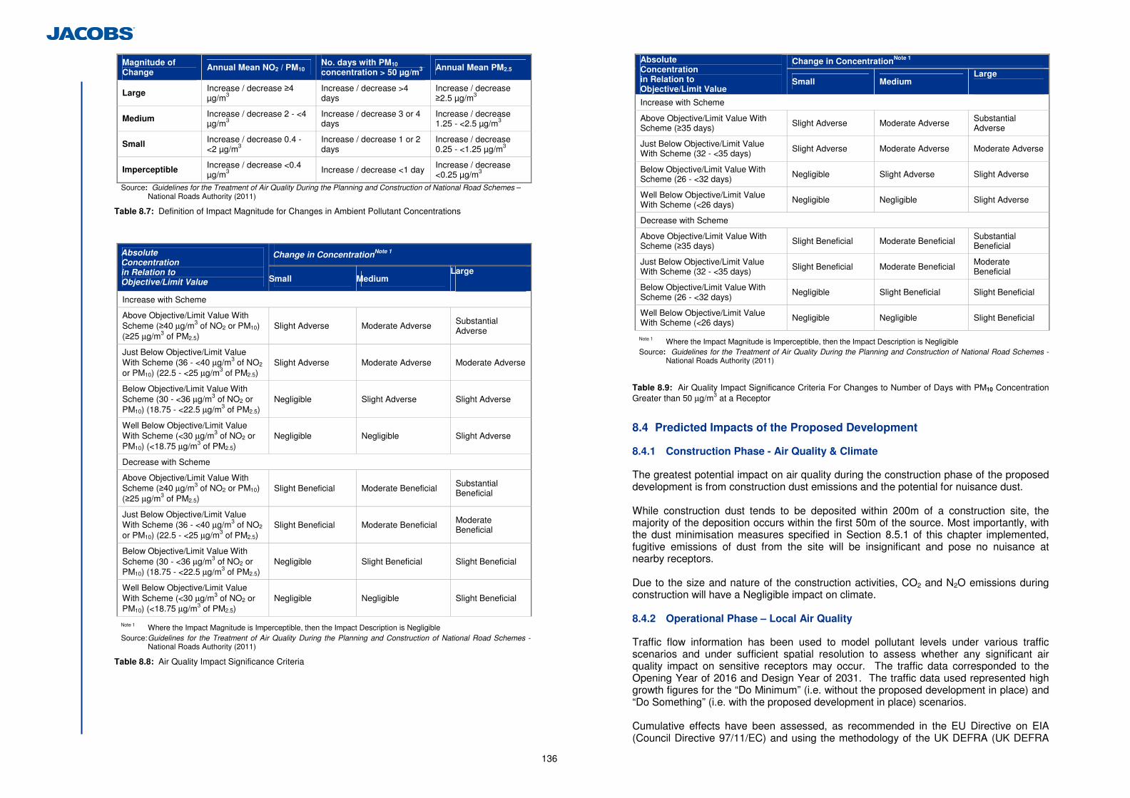
136
Magnitude of Change Annual Mean NO2 / PM10
No. days with PM10 concentration > 50 µg/m3 Annual Mean PM2.5
Large Increase / decrease ≥4 µg/m3
Increase / decrease >4 days
Increase / decrease ≥2.5 µg/m3
Medium Increase / decrease 2 - <4 µg/m3
Increase / decrease 3 or 4 days
Increase / decrease 1.25 - <2.5 µg/m3
Small Increase / decrease 0.4 - <2 µg/m3
Increase / decrease 1 or 2 days
Increase / decrease 0.25 - <1.25 µg/m3
Imperceptible Increase / decrease <0.4 µg/m3 Increase / decrease <1 day Increase / decrease
<0.25 µg/m3
Source: Guidelines for the Treatment of Air Quality During the Planning and Construction of National Road Schemes – National Roads Authority (2011)
Table 8.7: Definition of Impact Magnitude for Changes in Ambient Pollutant Concentrations
Change in ConcentrationNote 1 Absolute
Concentration in Relation to Objective/Limit Value
Small Medium Large
Increase with Scheme
Above Objective/Limit Value With Scheme (≥40 µg/m3 of NO2 or PM10) (≥25 µg/m3 of PM2.5)
Slight Adverse Moderate Adverse Substantial Adverse
Just Below Objective/Limit Value With Scheme (36 - <40 µg/m3 of NO2 or PM10) (22.5 - <25 µg/m3 of PM2.5)
Slight Adverse Moderate Adverse Moderate Adverse
Below Objective/Limit Value With Scheme (30 - <36 µg/m3 of NO2 or PM10) (18.75 - <22.5 µg/m3 of PM2.5)
Negligible Slight Adverse Slight Adverse
Well Below Objective/Limit Value With Scheme (<30 µg/m3 of NO2 or PM10) (<18.75 µg/m3 of PM2.5)
Negligible Negligible Slight Adverse
Decrease with Scheme
Above Objective/Limit Value With Scheme (≥40 µg/m3 of NO2 or PM10) (≥25 µg/m3 of PM2.5)
Slight Beneficial Moderate Beneficial Substantial Beneficial
Just Below Objective/Limit Value With Scheme (36 - <40 µg/m3 of NO2 or PM10) (22.5 - <25 µg/m3 of PM2.5)
Slight Beneficial Moderate Beneficial Moderate Beneficial
Below Objective/Limit Value With Scheme (30 - <36 µg/m3 of NO2 or PM10) (18.75 - <22.5 µg/m3 of PM2.5)
Negligible Slight Beneficial Slight Beneficial
Well Below Objective/Limit Value With Scheme (<30 µg/m3 of NO2 or PM10) (<18.75 µg/m3 of PM2.5)
Negligible Negligible Slight Beneficial
Note 1 Where the Impact Magnitude is Imperceptible, then the Impact Description is Negligible Source: Guidelines for the Treatment of Air Quality During the Planning and Construction of National Road Schemes -
National Roads Authority (2011)
Table 8.8: Air Quality Impact Significance Criteria
Change in ConcentrationNote 1 Absolute Concentration in Relation to Objective/Limit Value Small Medium
Large
Increase with Scheme
Above Objective/Limit Value With Scheme (≥35 days) Slight Adverse Moderate Adverse Substantial
Adverse
Just Below Objective/Limit Value With Scheme (32 - <35 days) Slight Adverse Moderate Adverse Moderate Adverse
Below Objective/Limit Value With Scheme (26 - <32 days) Negligible Slight Adverse Slight Adverse
Well Below Objective/Limit Value With Scheme (<26 days)
Negligible Negligible Slight Adverse
Decrease with Scheme
Above Objective/Limit Value With Scheme (≥35 days) Slight Beneficial Moderate Beneficial Substantial
Beneficial
Just Below Objective/Limit Value With Scheme (32 - <35 days) Slight Beneficial Moderate Beneficial Moderate
Beneficial
Below Objective/Limit Value With Scheme (26 - <32 days)
Negligible Slight Beneficial Slight Beneficial
Well Below Objective/Limit Value With Scheme (<26 days) Negligible Negligible Slight Beneficial
Note 1 Where the Impact Magnitude is Imperceptible, then the Impact Description is Negligible Source: Guidelines for the Treatment of Air Quality During the Planning and Construction of National Road Schemes -
National Roads Authority (2011)
Table 8.9: Air Quality Impact Significance Criteria For Changes to Number of Days with PM10 Concentration Greater than 50 µg/m3 at a Receptor
8.4 Predicted Impacts of the Proposed Development
8.4.1 Construction Phase - Air Quality & Climate
The greatest potential impact on air quality during the construction phase of the proposed development is from construction dust emissions and the potential for nuisance dust. While construction dust tends to be deposited within 200m of a construction site, the majority of the deposition occurs within the first 50m of the source. Most importantly, with the dust minimisation measures specified in Section 8.5.1 of this chapter implemented, fugitive emissions of dust from the site will be insignificant and pose no nuisance at nearby receptors. Due to the size and nature of the construction activities, CO2 and N2O emissions during construction will have a Negligible impact on climate. 8.4.2 Operational Phase – Local Air Quality
Traffic flow information has been used to model pollutant levels under various traffic scenarios and under sufficient spatial resolution to assess whether any significant air quality impact on sensitive receptors may occur. The traffic data corresponded to the Opening Year of 2016 and Design Year of 2031. The traffic data used represented high growth figures for the “Do Minimum” (i.e. without the proposed development in place) and “Do Something” (i.e. with the proposed development in place) scenarios. Cumulative effects have been assessed, as recommended in the EU Directive on EIA (Council Directive 97/11/EC) and using the methodology of the UK DEFRA (UK DEFRA
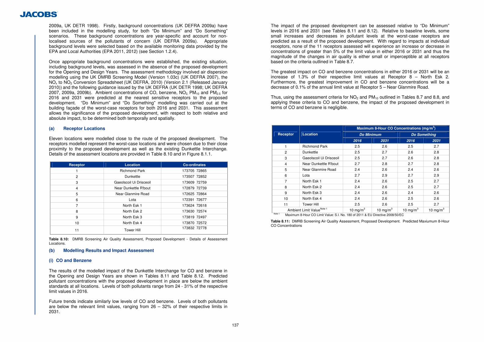
137
2009a, UK DETR 1998). Firstly, background concentrations (UK DEFRA 2009a) have been included in the modelling study, for both “Do Minimum” and “Do Something” scenarios. These background concentrations are year-specific and account for non-localised sources of the pollutants of concern (UK DEFRA 2009a). Appropriate background levels were selected based on the available monitoring data provided by the EPA and Local Authorities (EPA 2011, 2012) (see Section 1.2.4). Once appropriate background concentrations were established, the existing situation, including background levels, was assessed in the absence of the proposed development for the Opening and Design Years. The assessment methodology involved air dispersion modelling using the UK DMRB Screening Model (Version 1.03c) (UK DEFRA 2007), the NOx to NO2 Conversion Spreadsheet (UK DEFRA, 2010) (Version 2.1 (Released January 2010)) and the following guidance issued by the UK DEFRA (UK DETR 1998; UK DEFRA 2007, 2009a, 2009b). Ambient concentrations of CO, benzene, NO2, PM10 and PM2.5 for 2016 and 2031 were predicted at the nearest sensitive receptors to the proposed development. “Do Minimum” and “Do Something” modelling was carried out at the building façade of the worst-case receptors for both 2016 and 2031. This assessment allows the significance of the proposed development, with respect to both relative and absolute impact, to be determined both temporally and spatially. (a) Receptor Locations
Eleven locations were modelled close to the route of the proposed development. The receptors modelled represent the worst-case locations and were chosen due to their close proximity to the proposed development as well as the existing Dunkettle Interchange. Details of the assessment locations are provided in Table 8.10 and in Figure 8.1.1.
Receptor Location Co-ordinates
1 Richmond Park 173705 72865
2 Dunkettle 173507 72852
3 Gaeolscoil Ui Drisceoil 173609 72759
4 Near Dunkettle R'bout 172879 72739
5 Near Glanmire Road 172625 72864
6 Lota 172391 72677
7 North Esk 1 173624 72618
8 North Esk 2 173630 72574
9 North Esk 3 173819 72497
10 North Esk 4 173870 72572
11 Tower Hill 173832 72778
Table 8.10: DMRB Screening Air Quality Assessment, Proposed Development - Details of Assessment Locations.
(b) Modelling Results and Impact Assessment
(i) CO and Benzene The results of the modelled impact of the Dunkettle Interchange for CO and benzene in the Opening and Design Years are shown in Tables 8.11 and Table 8.12. Predicted pollutant concentrations with the proposed development in place are below the ambient standards at all locations. Levels of both pollutants range from 24 - 31% of the respective limit values in 2016.
Future trends indicate similarly low levels of CO and benzene. Levels of both pollutants are below the relevant limit values, ranging from 26 – 32% of their respective limits in 2031.
The impact of the proposed development can be assessed relative to “Do Minimum” levels in 2016 and 2031 (see Tables 8.11 and 8.12). Relative to baseline levels, some small increases and decreases in pollutant levels at the worst-case receptors are predicted as a result of the proposed development. With regard to impacts at individual receptors, none of the 11 receptors assessed will experience an increase or decrease in concentrations of greater than 5% of the limit value in either 2016 or 2031 and thus the magnitude of the changes in air quality is either small or imperceptible at all receptors based on the criteria outlined in Table 8.7.
The greatest impact on CO and benzene concentrations in either 2016 or 2031 will be an increase of 1.3% of their respective limit values at Receptor 8 – North Esk 2. Furthermore, the greatest improvement in CO and benzene concentrations will be a decrease of 0.1% of the annual limit value at Receptor 5 – Near Glanmire Road.
Thus, using the assessment criteria for NO2 and PM10 outlined in Tables 8.7 and 8.8, and applying these criteria to CO and benzene, the impact of the proposed development in terms of CO and benzene is negligible.
Maximum 8-Hour CO Concentrations (mg/m3)
Do Minimum Do Something Receptor Location
2016 2031 2016 2031
1 Richmond Park 2.5 2.6 2.5 2.7
2 Dunkettle 2.5 2.7 2.6 2.8
3 Gaeolscoil Ui Drisceoil 2.5 2.7 2.6 2.8
4 Near Dunkettle R'bout 2.7 2.8 2.7 2.8
5 Near Glanmire Road 2.4 2.6 2.4 2.6
6 Lota 2.7 2.9 2.7 2.9
7 North Esk 1 2.4 2.6 2.5 2.7
8 North Esk 2 2.4 2.6 2.5 2.7
9 North Esk 3 2.4 2.6 2.4 2.6
10 North Esk 4 2.4 2.6 2.5 2.6
11 Tower Hill 2.5 2.6 2.5 2.7
Ambient Limit ValueNote 1 10 mg/m3 10 mg/m3 10 mg/m3 10 mg/m3 Note 1 Maximum 8-Hour CO Limit Value: S.I. No. 180 of 2011 & EU Directive 2008/50/EC
Table 8.11: DMRB Screening Air Quality Assessment, Proposed Development. Predicted Maxiumum 8-Hour CO Concentrations
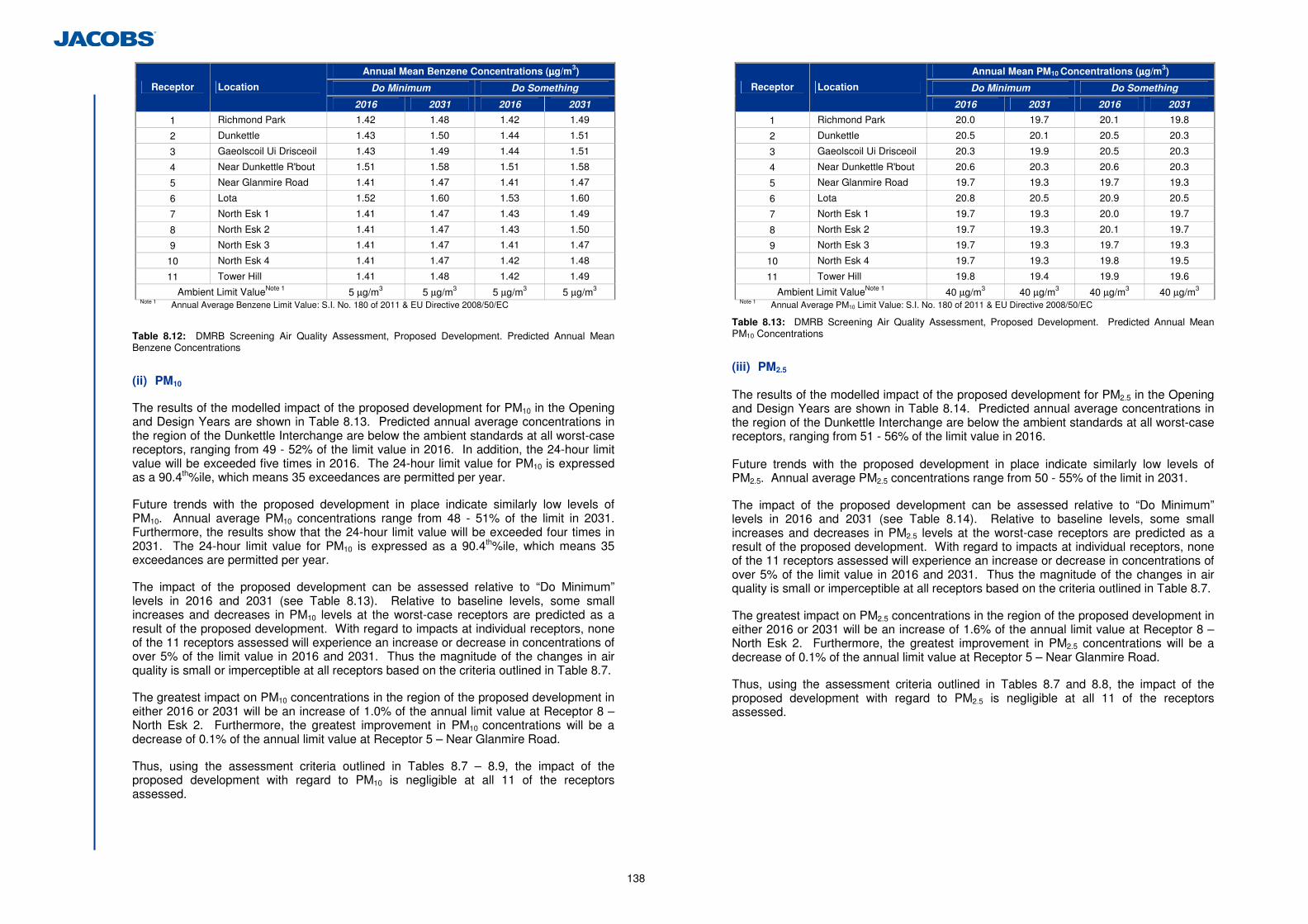
138
Annual Mean Benzene Concentrations (µµµµg/m3)
Do Minimum Do Something Receptor Location
2016 2031 2016 2031
1 Richmond Park 1.42 1.48 1.42 1.49
2 Dunkettle 1.43 1.50 1.44 1.51
3 Gaeolscoil Ui Drisceoil 1.43 1.49 1.44 1.51
4 Near Dunkettle R'bout 1.51 1.58 1.51 1.58
5 Near Glanmire Road 1.41 1.47 1.41 1.47
6 Lota 1.52 1.60 1.53 1.60
7 North Esk 1 1.41 1.47 1.43 1.49
8 North Esk 2 1.41 1.47 1.43 1.50
9 North Esk 3 1.41 1.47 1.41 1.47
10 North Esk 4 1.41 1.47 1.42 1.48
11 Tower Hill 1.41 1.48 1.42 1.49
Ambient Limit ValueNote 1 5 µg/m3 5 µg/m3 5 µg/m3 5 µg/m3 Note 1 Annual Average Benzene Limit Value: S.I. No. 180 of 2011 & EU Directive 2008/50/EC
Table 8.12: DMRB Screening Air Quality Assessment, Proposed Development. Predicted Annual Mean Benzene Concentrations
(ii) PM10
The results of the modelled impact of the proposed development for PM10 in the Opening and Design Years are shown in Table 8.13. Predicted annual average concentrations in the region of the Dunkettle Interchange are below the ambient standards at all worst-case receptors, ranging from 49 - 52% of the limit value in 2016. In addition, the 24-hour limit value will be exceeded five times in 2016. The 24-hour limit value for PM10 is expressed as a 90.4th%ile, which means 35 exceedances are permitted per year.
Future trends with the proposed development in place indicate similarly low levels of PM10. Annual average PM10 concentrations range from 48 - 51% of the limit in 2031. Furthermore, the results show that the 24-hour limit value will be exceeded four times in 2031. The 24-hour limit value for PM10 is expressed as a 90.4th%ile, which means 35 exceedances are permitted per year.
The impact of the proposed development can be assessed relative to “Do Minimum” levels in 2016 and 2031 (see Table 8.13). Relative to baseline levels, some small increases and decreases in PM10 levels at the worst-case receptors are predicted as a result of the proposed development. With regard to impacts at individual receptors, none of the 11 receptors assessed will experience an increase or decrease in concentrations of over 5% of the limit value in 2016 and 2031. Thus the magnitude of the changes in air quality is small or imperceptible at all receptors based on the criteria outlined in Table 8.7.
The greatest impact on PM10 concentrations in the region of the proposed development in either 2016 or 2031 will be an increase of 1.0% of the annual limit value at Receptor 8 – North Esk 2. Furthermore, the greatest improvement in PM10 concentrations will be a decrease of 0.1% of the annual limit value at Receptor 5 – Near Glanmire Road.
Thus, using the assessment criteria outlined in Tables 8.7 – 8.9, the impact of the proposed development with regard to PM10 is negligible at all 11 of the receptors assessed.
Annual Mean PM10 Concentrations (µµµµg/m3)
Do Minimum Do Something Receptor Location
2016 2031 2016 2031
1 Richmond Park 20.0 19.7 20.1 19.8
2 Dunkettle 20.5 20.1 20.5 20.3
3 Gaeolscoil Ui Drisceoil 20.3 19.9 20.5 20.3
4 Near Dunkettle R'bout 20.6 20.3 20.6 20.3
5 Near Glanmire Road 19.7 19.3 19.7 19.3
6 Lota 20.8 20.5 20.9 20.5
7 North Esk 1 19.7 19.3 20.0 19.7
8 North Esk 2 19.7 19.3 20.1 19.7
9 North Esk 3 19.7 19.3 19.7 19.3
10 North Esk 4 19.7 19.3 19.8 19.5
11 Tower Hill 19.8 19.4 19.9 19.6
Ambient Limit ValueNote 1 40 µg/m3 40 µg/m3 40 µg/m3 40 µg/m3 Note 1 Annual Average PM10 Limit Value: S.I. No. 180 of 2011 & EU Directive 2008/50/EC
Table 8.13: DMRB Screening Air Quality Assessment, Proposed Development. Predicted Annual Mean PM10 Concentrations
(iii) PM2.5
The results of the modelled impact of the proposed development for PM2.5 in the Opening and Design Years are shown in Table 8.14. Predicted annual average concentrations in the region of the Dunkettle Interchange are below the ambient standards at all worst-case receptors, ranging from 51 - 56% of the limit value in 2016. Future trends with the proposed development in place indicate similarly low levels of PM2.5. Annual average PM2.5 concentrations range from 50 - 55% of the limit in 2031.
The impact of the proposed development can be assessed relative to “Do Minimum” levels in 2016 and 2031 (see Table 8.14). Relative to baseline levels, some small increases and decreases in PM2.5 levels at the worst-case receptors are predicted as a result of the proposed development. With regard to impacts at individual receptors, none of the 11 receptors assessed will experience an increase or decrease in concentrations of over 5% of the limit value in 2016 and 2031. Thus the magnitude of the changes in air quality is small or imperceptible at all receptors based on the criteria outlined in Table 8.7.
The greatest impact on PM2.5 concentrations in the region of the proposed development in either 2016 or 2031 will be an increase of 1.6% of the annual limit value at Receptor 8 – North Esk 2. Furthermore, the greatest improvement in PM2.5 concentrations will be a decrease of 0.1% of the annual limit value at Receptor 5 – Near Glanmire Road.
Thus, using the assessment criteria outlined in Tables 8.7 and 8.8, the impact of the proposed development with regard to PM2.5 is negligible at all 11 of the receptors assessed.
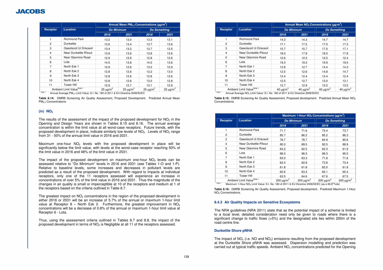
139
Annual Mean PM2.5 Concentrations (µµµµg/m3)
Do Minimum Do Something Receptor Location
2016 2031 2016 2031
1 Richmond Park 13.2 13.0 13.3 13.1 2 Dunkettle 13.6 13.4 13.7 13.6 3 Gaeolscoil Ui Drisceoil 13.4 13.2 13.7 13.5 4 Near Dunkettle R'bout 13.8 13.6 13.8 13.6 5 Near Glanmire Road 12.9 12.6 12.8 12.6 6 Lota 14.0 13.8 14.0 13.8 7 North Esk 1 12.9 12.6 13.2 12.9 8 North Esk 2 12.8 12.6 13.2 13.0 9 North Esk 3 12.8 12.6 12.8 12.6
10 North Esk 4 12.8 12.6 13.0 12.8 11 Tower Hill 12.9 12.7 13.1 12.9
Ambient Limit ValueNote 1 25 µg/m3 25 µg/m3 25 µg/m3 25 µg/m3 Note 1 Annual Average PM2.5 Limit Value: S.I. No. 180 of 2011 & EU Directive 2008/50/EC
Table 8.14: DMRB Screening Air Quality Assessment, Proposed Development. Predicted Annual Mean PM2.5 Concentrations
(iv) NO2 The results of the assessment of the impact of the proposed development for NO2 in the Opening and Design Years are shown in Tables 8.15 and 8.16. The annual average concentration is within the limit value at all worst-case receptors. Future trends, with the proposed development in place, indicate similarly low levels of NO2. Levels of NO2 range from 31 - 50% of the annual limit value in 2016 and 2031. Maximum one-hour NO2 levels with the proposed development in place will be significantly below the limit value, with levels at the worst-case receptor reaching 50% of the limit value in 2016 and 48% of the limit value in 2031.
The impact of the proposed development on maximum one-hour NO2 levels can be assessed relative to “Do Minimum” levels in 2016 and 2031 (see Tables 1-O and 1-P). Relative to baseline levels, some increases and decreases in pollutant levels are predicted as a result of the proposed development. With regard to impacts at individual receptors, only one of the 11 receptors assessed will experience an increase in concentrations of over 5% of the limit value in 2016 and 2031. Thus the magnitude of the changes in air quality is small or imperceptible at 10 of the receptors and medium at 1 of the receptors based on the criteria outlined in Table 8.7.
The greatest impact on NO2 concentrations in the region of the proposed development in either 2016 or 2031 will be an increase of 5.7% of the annual or maximum 1-hour limit value at Receptor 8 – North Esk 2. Furthermore, the greatest improvement in NO2 concentrations will be a decrease of 0.8% of the annual or maximum 1-hour limit value at Receptor 6 - Lota.
Thus, using the assessment criteria outlined in Tables 8.7 and 8.8, the impact of the proposed development in terms of NO2 is Negligible at all 11 of the receptors assessed.
Annual Mean NO2 Concentrations (µµµµg/m3)
Do Minimum Do Something Receptor Location
2016 2031 2016 2031
1 Richmond Park 14.3 14.3 14.7 14.7 2 Dunkettle 17.1 17.2 17.0 17.3 3 Gaeolscoil Ui Drisceoil 15.7 15.7 17.0 17.1 4 Near Dunkettle R'bout 18.0 17.9 18.5 17.8 5 Near Glanmire Road 12.6 12.5 12.5 12.4 6 Lota 19.3 19.3 19.9 19.0 7 North Esk 1 12.6 12.7 14.4 14.3 8 North Esk 2 12.5 12.6 14.8 14.7 9 North Esk 3 12.4 12.4 12.4 12.4
10 North Esk 4 12.5 12.7 13.0 13.1 11 Tower Hill 12.7 12.9 13.5 13.5
Ambient Limit ValueNote 1 40 µg/m3 40 µg/m3 40 µg/m3 40 µg/m3 Note 1 Annual Average NO2 Limit Value: S.I. No. 180 of 2011 & EU Directive 2008/50/EC
Table 8.15: DMRB Screening Air Quality Assessment, Proposed development. Predicted Annual Mean NO2 Concentrations
Maximum 1-Hour NO2 Concentrations (µµµµg/m3)
Do Minimum Do Something Receptor Location
2016 2031 2016 2031
1 Richmond Park 71.7 71.6 73.4 73.7 2 Dunkettle 85.7 86.2 85.2 86.3 3 Gaeolscoil Ui Drisceoil 78.7 78.7 84.9 85.6 4 Near Dunkettle R'bout 90.0 89.5 92.5 88.9 5 Near Glanmire Road 63.2 62.5 62.3 61.9 6 Lota 96.5 96.5 99.3 95.0 7 North Esk 1 63.0 63.3 71.8 71.6 8 North Esk 2 62.4 62.8 73.8 73.4 9 North Esk 3 61.8 61.8 62.0 61.8
10 North Esk 4 62.6 63.3 65.1 65.4 11 Tower Hill 63.5 64.6 67.6 67.5
Ambient Limit ValueNote 1 200 µg/m3 200 µg/m3 200 µg/m3 200 µg/m3 Note 1 Maximum 1-Hour NO2 Limit Value: S.I. No. 180 of 2011 & EU Directive 2008/50/EC (as a 99.8th%ile)
Table 8.16: DMRB Screening Air Quality Assessment, Proposed development. Predicted Maximum 1-Hour NO2 Concentrations.
8.4.3 Air Quality Impacts on Sensitive Ecosystems The NRA guidelines (NRA 2011) state that as the potential impact of a scheme is limited to a local level, detailed consideration need only be given to roads where there is a significant change to traffic flows (>5%) and the designated site lies within 200m of the road centre line. Dunkettle Shore pNHA The impact of NOx (i.e. NO and NO2) emissions resulting from the proposed development at the Dunkettle Shore pNHA was assessed. Dispersion modelling and prediction was carried out at typical traffic speeds. Ambient NOx concentrations predicted for the Opening
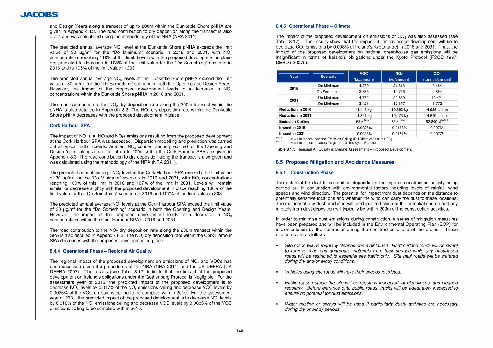
140
and Design Years along a transect of up to 200m within the Dunkettle Shore pNHA are given in Appendix 8.3. The road contribution to dry deposition along the transect is also given and was calculated using the methodology of the NRA (NRA 2011). The predicted annual average NOx level at the Dunkettle Shore pNHA exceeds the limit value of 30 µg/m3 for the “Do Minimum” scenario in 2016 and 2031, with NOx concentrations reaching 118% of this limit. Levels with the proposed development in place are predicted to decrease to 108% of the limit value for the “Do Something” scenario in 2016 and to 105% of the limit value in 2031. The predicted annual average NOx levels at the Dunkettle Shore pNHA exceed the limit value of 30 µg/m3 for the “Do Something” scenario in both the Opening and Design Years. However, the impact of the proposed development leads to a decrease in NOx concentrations within the Dunkettle Shore pNHA in 2016 and 2031. The road contribution to the NO2 dry deposition rate along the 200m transect within the pNHA is also detailed in Appendix 8.3. The NO2 dry deposition rate within the Dunkettle Shore pNHA decreases with the proposed development in place. Cork Harbour SPA The impact of NOx (i.e. NO and NO2) emissions resulting from the proposed development at the Cork Harbour SPA was assessed. Dispersion modelling and prediction was carried out at typical traffic speeds. Ambient NOx concentrations predicted for the Opening and Design Years along a transect of up to 200m within the Cork Harbour SPA are given in Appendix 8.3. The road contribution to dry deposition along the transect is also given and was calculated using the methodology of the NRA (NRA 2011). The predicted annual average NOx level at the Cork Harbour SPA exceeds the limit value of 30 µg/m3 for the “Do Minimum” scenario in 2016 and 2031, with NOx concentrations reaching 109% of this limit in 2016 and 107% of the limit in 2031. Levels will remain similar or decrease slightly with the proposed development in place reaching 108% of the limit value for the “Do Something” scenario in 2016 and 107% of the limit value in 2031. The predicted annual average NOx levels at the Cork Harbour SPA exceed the limit value of 30 µg/m3 for the “Do Something” scenario in both the Opening and Design Years. However, the impact of the proposed development leads to a decrease in NOx concentrations within the Cork Harbour SPA in 2016 and 2031. The road contribution to the NO2 dry deposition rate along the 200m transect within the SPA is also detailed in Appendix 8.3. The NO2 dry deposition rate within the Cork Harbour SPA decreases with the proposed development in place.
8.4.4 Operational Phase – Regional Air Quality
The regional impact of the proposed development on emissions of NOx and VOCs has been assessed using the procedures of the NRA (NRA 2011) and the UK DEFRA (UK DEFRA 2007). The results (see Table 8.17) indicate that the impact of the proposed development on Ireland's obligations under the Gothenburg Protocol is Negligible. For the assessment year of 2016, the predicted impact of the proposed development is to decrease NOx levels by 0.017% of the NOx emissions ceiling and decrease VOC levels by 0.0026% of the VOC emissions ceiling to be complied with in 2010. For the assessment year of 2031, the predicted impact of the proposed development is to decrease NOx levels by 0.016% of the NOx emissions ceiling and decrease VOC levels by 0.0025% of the VOC emissions ceiling to be complied with in 2010.
8.4.5 Operational Phase – Climate
The impact of the proposed development on emissions of CO2 was also assessed (see Table 8.17). The results show that the impact of the proposed development will be to decrease CO2 emissions by 0.008% of Ireland's Kyoto target in 2016 and 2031. Thus, the impact of the proposed development on national greenhouse gas emissions will be insignificant in terms of Ireland’s obligations under the Kyoto Protocol (FCCC 1997, DEHLG 2007b).
Year Scenario VOC
(kg/annum)
NOX
(kg/annum)
CO2
(tonnes/annum)
Do Minimum 4,279 21,618 9,484 2016
Do Something 2,836 10,726 4,854
Do Minimum 4,772 22,850 10,421 2031
Do Minimum 3,421 12,377 5,772
Reduction in 2016 -1,443 kg -10,892 kg -4,629 tonnes
Reduction in 2031 -1,351 kg -10,473 kg -4,649 tonnes
Emission Ceiling 55 ktNote 1 65 ktNote 1 62,800 ktNote 2
Impact in 2016 -0.0026% -0.0168% -0.0076%
Impact in 2031 -0.0025% -0.0161% -0.0077% Note 1 kt = kilo tonnes. National Emission Ceiling (EU Directive 2001/81/EC) Note 2 kt = kilo tonnes. Ireland's Target Under The Kyoto Protocol
Table 8.17: Regional Air Quality & Climate Assessment – Proposed Development
8.5 Proposed Mitigation and Avoidance Measures
8.5.1 Construction Phase
The potential for dust to be emitted depends on the type of construction activity being carried out in conjunction with environmental factors including levels of rainfall, wind speeds and wind direction. The potential for impact from dust depends on the distance to potentially sensitive locations and whether the wind can carry the dust to these locations. The majority of any dust produced will be deposited close to the potential source and any impacts from dust deposition will typically be within 200m of the construction activities.
In order to minimise dust emissions during construction, a series of mitigation measures have been prepared and will be included in the Environmental Operating Plan (EOP) for implementation by the contractor during the construction phase of the project. These measures are as follows:
• Site roads will be regularly cleaned and maintained. Hard surface roads will be swept
to remove mud and aggregate materials from their surface while any unsurfaced roads will be restricted to essential site traffic only. Site haul roads will be watered during dry and/or windy conditions.
• Vehicles using site roads will have their speeds restricted. • Public roads outside the site will be regularly inspected for cleanliness, and cleaned
regularly. Before entrance onto public roads, trucks will be adequately inspected to ensure no potential for dust emissions.
• Water misting or sprays will be used if particularly dusty activities are necessary
during dry or windy periods.
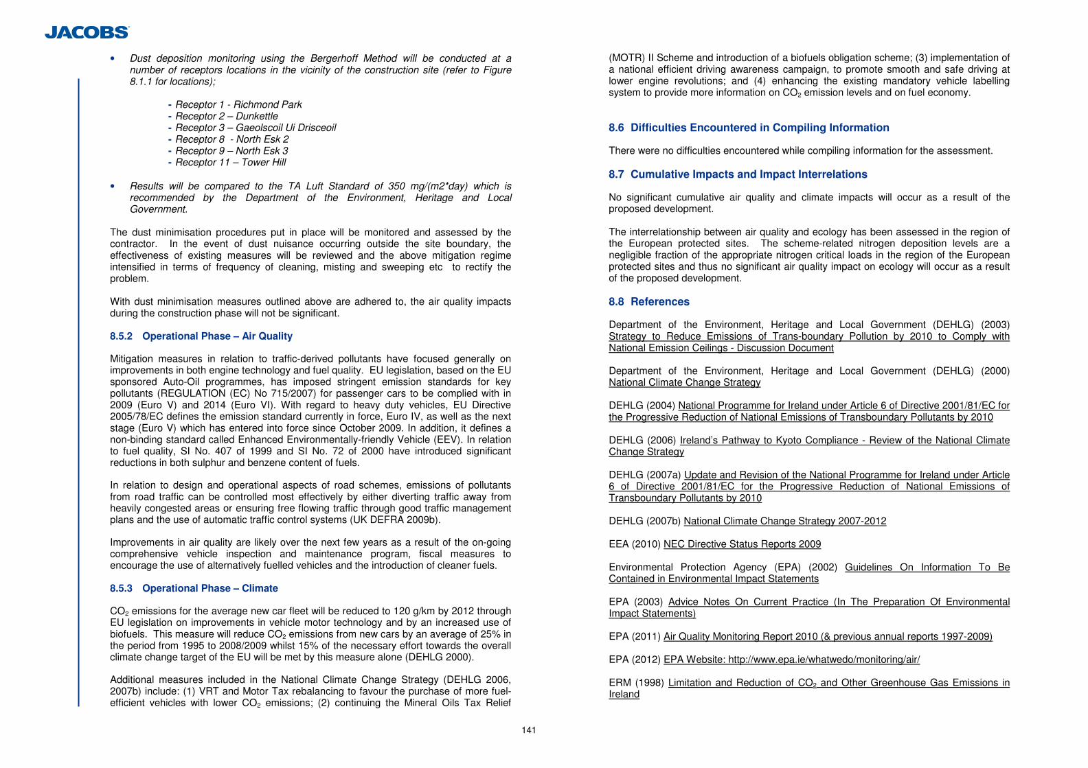
141
• Dust deposition monitoring using the Bergerhoff Method will be conducted at a number of receptors locations in the vicinity of the construction site (refer to Figure 8.1.1 for locations);
- Receptor 1 - Richmond Park - Receptor 2 – Dunkettle - Receptor 3 – Gaeolscoil Ui Drisceoil - Receptor 8 - North Esk 2 - Receptor 9 – North Esk 3 - Receptor 11 – Tower Hill
• Results will be compared to the TA Luft Standard of 350 mg/(m2*day) which is
recommended by the Department of the Environment, Heritage and Local Government.
The dust minimisation procedures put in place will be monitored and assessed by the contractor. In the event of dust nuisance occurring outside the site boundary, the effectiveness of existing measures will be reviewed and the above mitigation regime intensified in terms of frequency of cleaning, misting and sweeping etc to rectify the problem. With dust minimisation measures outlined above are adhered to, the air quality impacts during the construction phase will not be significant. 8.5.2 Operational Phase – Air Quality
Mitigation measures in relation to traffic-derived pollutants have focused generally on improvements in both engine technology and fuel quality. EU legislation, based on the EU sponsored Auto-Oil programmes, has imposed stringent emission standards for key pollutants (REGULATION (EC) No 715/2007) for passenger cars to be complied with in 2009 (Euro V) and 2014 (Euro VI). With regard to heavy duty vehicles, EU Directive 2005/78/EC defines the emission standard currently in force, Euro IV, as well as the next stage (Euro V) which has entered into force since October 2009. In addition, it defines a non-binding standard called Enhanced Environmentally-friendly Vehicle (EEV). In relation to fuel quality, SI No. 407 of 1999 and SI No. 72 of 2000 have introduced significant reductions in both sulphur and benzene content of fuels.
In relation to design and operational aspects of road schemes, emissions of pollutants from road traffic can be controlled most effectively by either diverting traffic away from heavily congested areas or ensuring free flowing traffic through good traffic management plans and the use of automatic traffic control systems (UK DEFRA 2009b).
Improvements in air quality are likely over the next few years as a result of the on-going comprehensive vehicle inspection and maintenance program, fiscal measures to encourage the use of alternatively fuelled vehicles and the introduction of cleaner fuels. 8.5.3 Operational Phase – Climate
CO2 emissions for the average new car fleet will be reduced to 120 g/km by 2012 through EU legislation on improvements in vehicle motor technology and by an increased use of biofuels. This measure will reduce CO2 emissions from new cars by an average of 25% in the period from 1995 to 2008/2009 whilst 15% of the necessary effort towards the overall climate change target of the EU will be met by this measure alone (DEHLG 2000).
Additional measures included in the National Climate Change Strategy (DEHLG 2006, 2007b) include: (1) VRT and Motor Tax rebalancing to favour the purchase of more fuel-efficient vehicles with lower CO2 emissions; (2) continuing the Mineral Oils Tax Relief
(MOTR) II Scheme and introduction of a biofuels obligation scheme; (3) implementation of a national efficient driving awareness campaign, to promote smooth and safe driving at lower engine revolutions; and (4) enhancing the existing mandatory vehicle labelling system to provide more information on CO2 emission levels and on fuel economy. 8.6 Difficulties Encountered in Compiling Information
There were no difficulties encountered while compiling information for the assessment. 8.7 Cumulative Impacts and Impact Interrelations
No significant cumulative air quality and climate impacts will occur as a result of the proposed development. The interrelationship between air quality and ecology has been assessed in the region of the European protected sites. The scheme-related nitrogen deposition levels are a negligible fraction of the appropriate nitrogen critical loads in the region of the European protected sites and thus no significant air quality impact on ecology will occur as a result of the proposed development. 8.8 References
Department of the Environment, Heritage and Local Government (DEHLG) (2003) Strategy to Reduce Emissions of Trans-boundary Pollution by 2010 to Comply with National Emission Ceilings - Discussion Document Department of the Environment, Heritage and Local Government (DEHLG) (2000) National Climate Change Strategy DEHLG (2004) National Programme for Ireland under Article 6 of Directive 2001/81/EC for the Progressive Reduction of National Emissions of Transboundary Pollutants by 2010 DEHLG (2006) Ireland’s Pathway to Kyoto Compliance - Review of the National Climate Change Strategy DEHLG (2007a) Update and Revision of the National Programme for Ireland under Article 6 of Directive 2001/81/EC for the Progressive Reduction of National Emissions of Transboundary Pollutants by 2010 DEHLG (2007b) National Climate Change Strategy 2007-2012 EEA (2010) NEC Directive Status Reports 2009 Environmental Protection Agency (EPA) (2002) Guidelines On Information To Be Contained in Environmental Impact Statements EPA (2003) Advice Notes On Current Practice (In The Preparation Of Environmental Impact Statements) EPA (2011) Air Quality Monitoring Report 2010 (& previous annual reports 1997-2009) EPA (2012) EPA Website: http://www.epa.ie/whatwedo/monitoring/air/ ERM (1998) Limitation and Reduction of CO2 and Other Greenhouse Gas Emissions in Ireland
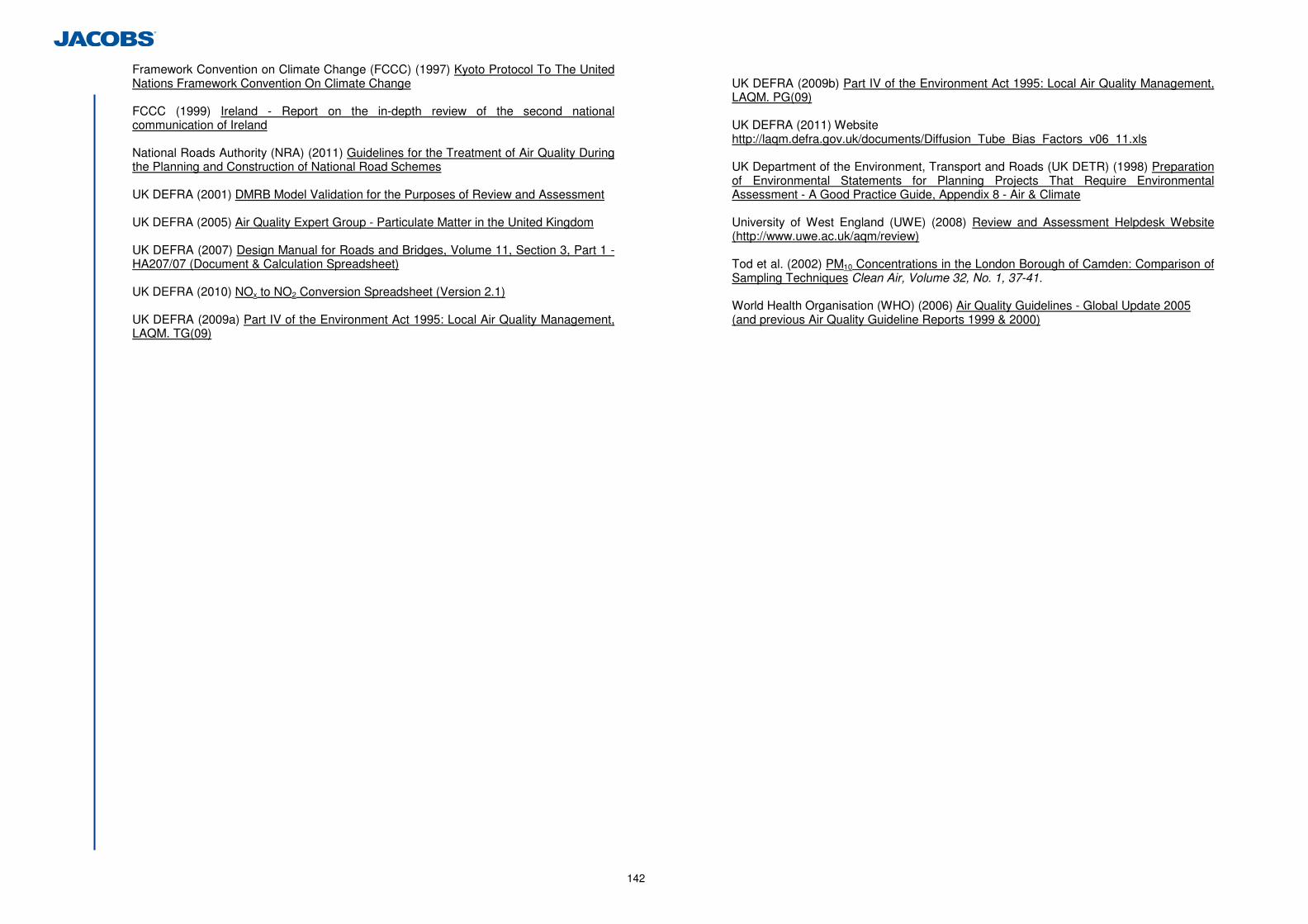
142
Framework Convention on Climate Change (FCCC) (1997) Kyoto Protocol To The United Nations Framework Convention On Climate Change FCCC (1999) Ireland - Report on the in-depth review of the second national communication of Ireland National Roads Authority (NRA) (2011) Guidelines for the Treatment of Air Quality During the Planning and Construction of National Road Schemes UK DEFRA (2001) DMRB Model Validation for the Purposes of Review and Assessment UK DEFRA (2005) Air Quality Expert Group - Particulate Matter in the United Kingdom UK DEFRA (2007) Design Manual for Roads and Bridges, Volume 11, Section 3, Part 1 - HA207/07 (Document & Calculation Spreadsheet) UK DEFRA (2010) NOx to NO2 Conversion Spreadsheet (Version 2.1) UK DEFRA (2009a) Part IV of the Environment Act 1995: Local Air Quality Management, LAQM. TG(09)
UK DEFRA (2009b) Part IV of the Environment Act 1995: Local Air Quality Management, LAQM. PG(09) UK DEFRA (2011) Website http://laqm.defra.gov.uk/documents/Diffusion_Tube_Bias_Factors_v06_11.xls UK Department of the Environment, Transport and Roads (UK DETR) (1998) Preparation of Environmental Statements for Planning Projects That Require Environmental Assessment - A Good Practice Guide, Appendix 8 - Air & Climate University of West England (UWE) (2008) Review and Assessment Helpdesk Website (http://www.uwe.ac.uk/aqm/review) Tod et al. (2002) PM10 Concentrations in the London Borough of Camden: Comparison of Sampling Techniques Clean Air, Volume 32, No. 1, 37-41. World Health Organisation (WHO) (2006) Air Quality Guidelines - Global Update 2005 (and previous Air Quality Guideline Reports 1999 & 2000)
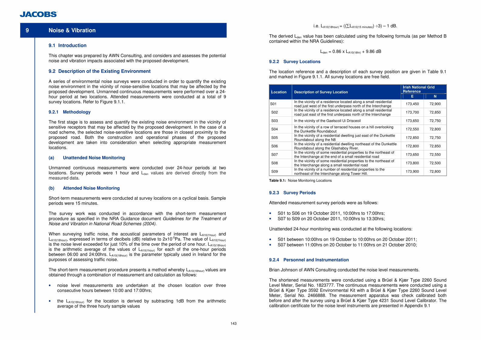
143
9 Noise & Vibration
9.1 Introduction
This chapter was prepared by AWN Consulting, and considers and assesses the potential noise and vibration impacts associated with the proposed development. 9.2 Description of the Existing Environment
A series of environmental noise surveys were conducted in order to quantify the existing noise environment in the vicinity of noise-sensitive locations that may be affected by the proposed development. Unmanned continuous measurements were performed over a 24-hour period at two locations. Attended measurements were conducted at a total of 9 survey locations. Refer to Figure 9.1.1. 9.2.1 Methodology
The first stage is to assess and quantify the existing noise environment in the vicinity of sensitive receptors that may be affected by the proposed development. In the case of a road scheme, the selected noise-sensitive locations are those in closest proximity to the proposed road. Both the construction and operational phases of the proposed development are taken into consideration when selecting appropriate measurement locations. (a) Unattended Noise Monitoring
Unmanned continuous measurements were conducted over 24-hour periods at two locations. Survey periods were 1 hour and Lden values are derived directly from the measured data.
(b) Attended Noise Monitoring
Short-term measurements were conducted at survey locations on a cyclical basis. Sample periods were 15 minutes. The survey work was conducted in accordance with the short-term measurement procedure as specified in the NRA Guidance document Guidelines for the Treatment of Noise and Vibration in National Road Schemes (2004). When surveying traffic noise, the acoustical parameters of interest are LA10(1hour) and LA10(18hour), expressed in terms of decibels (dB) relative to 2x10⁻⁵Pa. The value of LA10(1hour) is the noise level exceeded for just 10% of the time over the period of one hour. LA10(18hour) is the arithmetic average of the values of LA10(1hour) for each of the one-hour periods between 06:00 and 24:00hrs. LA10(18hour) is the parameter typically used in Ireland for the purposes of assessing traffic noise. The short-term measurement procedure presents a method whereby LA10(18hour) values are obtained through a combination of measurement and calculation as follows: • noise level measurements are undertaken at the chosen location over three
consecutive hours between 10:00 and 17:00hrs; • the LA10(18hour) for the location is derived by subtracting 1dB from the arithmetic
average of the three hourly sample values
i.e. LA10(18hour) = ((∑LA10(15 minutes)) ÷3) – 1 dB.
The derived Lden value has been calculated using the following formula (as per Method B contained within the NRA Guidelines):
Lden = 0.86 x LA10(18hr) + 9.86 dB
9.2.2 Survey Locations
The location reference and a description of each survey position are given in Table 9.1 and marked in Figure 9.1.1. All survey locations are free field.
Irish National Grid Reference Location Description of Survey Location
E N
S01 In the vicinity of a residence located along a small residential road just west of the first underpass north of the Interchange 173,450 72,900
S02 In the vicinity of a residence located along a small residential road just east of the first underpass north of the Interchange
173,700 72,850
S03 In the vicinity of the Gaelscoil Ui Drisceoil 173,650 72,750
S04 In the vicinity of a row of terraced houses on a hill overlooking the Dunkettle Roundabout
172,550 72,800
S05 In the vicinity of a residential dwelling just east of the Dunkettle Roundabout along the N8 172,850 72,750
S06 In the vicinity of a residential dwelling northeast of the Dunkettle Roundabout along the Glashaboy River. 172,800 72,850
S07 In the vicinity of some residential properties to the northeast of the Interchange at the end of a small residential road 173,650 72,550
S08 In the vicinity of some residential properties to the northeast of the Interchange along a small residential road 173,800 72,500
S09 In the vicinity of a number of residential properties to the northeast of the Interchange along Tower Hill.
173,900 72,800
Table 9.1: Noise Monitoring Locations
9.2.3 Survey Periods
Attended measurement survey periods were as follows: • S01 to S06 on 19 October 2011, 10:00hrs to 17:00hrs; • S07 to S09 on 20 October 2011, 10:00hrs to 13:30hrs; Unattended 24-hour monitoring was conducted at the following locations: • S01 between 10:00hrs on 19 October to 10:00hrs on 20 October 2011; • S07 between 11:00hrs on 20 October to 11:00hrs on 21 October 2010;
9.2.4 Personnel and Instrumentation
Brian Johnson of AWN Consulting conducted the noise level measurements.
The shortened measurements were conducted using a Brüel & Kjær Type 2260 Sound Level Meter, Serial No. 1823777. The continuous measurements were conducted using a Brüel & Kjær Type 3592 Environmental Kit with a Brüel & Kjær Type 2260 Sound Level Meter, Serial No. 2466888. The measurement apparatus was check calibrated both before and after the survey using a Brüel & Kjær Type 4231 Sound Level Calibrator. The calibration certificate for the noise level instruments are presented in Appendix 9.1
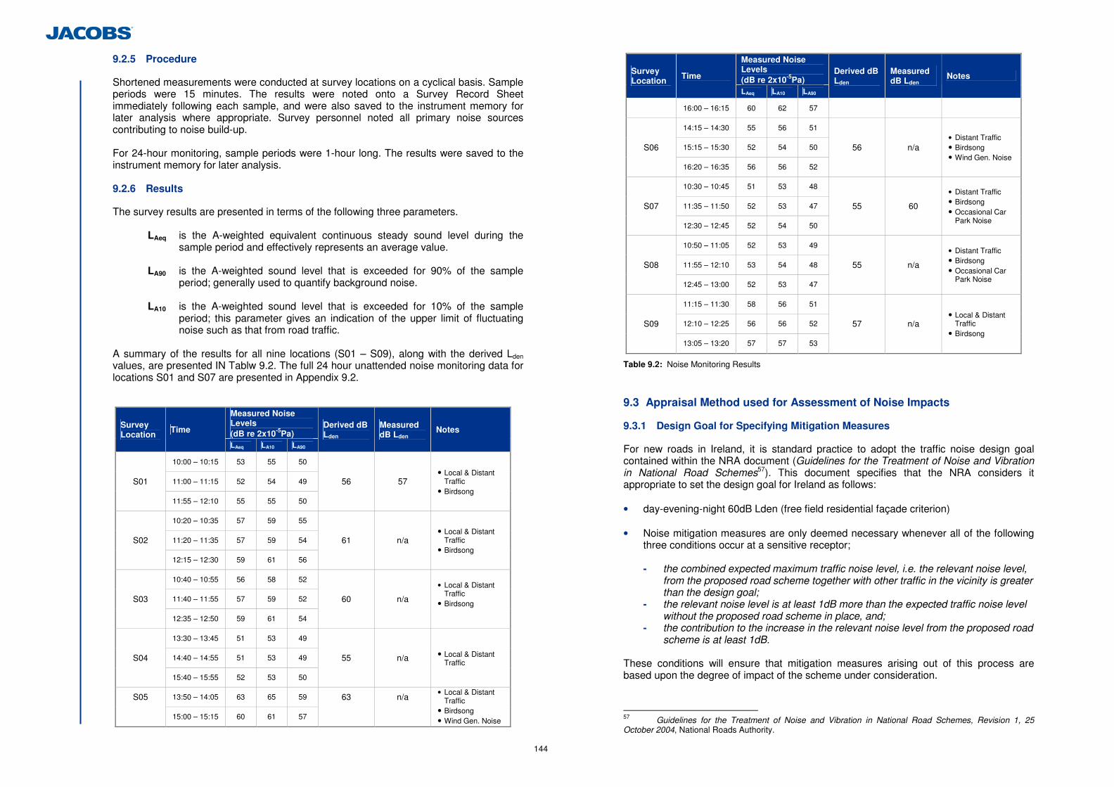
144
9.2.5 Procedure
Shortened measurements were conducted at survey locations on a cyclical basis. Sample periods were 15 minutes. The results were noted onto a Survey Record Sheet immediately following each sample, and were also saved to the instrument memory for later analysis where appropriate. Survey personnel noted all primary noise sources contributing to noise build-up. For 24-hour monitoring, sample periods were 1-hour long. The results were saved to the instrument memory for later analysis. 9.2.6 Results
The survey results are presented in terms of the following three parameters.
LAeq is the A-weighted equivalent continuous steady sound level during the sample period and effectively represents an average value.
LA90 is the A-weighted sound level that is exceeded for 90% of the sample
period; generally used to quantify background noise. LA10 is the A-weighted sound level that is exceeded for 10% of the sample
period; this parameter gives an indication of the upper limit of fluctuating noise such as that from road traffic.
A summary of the results for all nine locations (S01 – S09), along with the derived Lden values, are presented IN Tablw 9.2. The full 24 hour unattended noise monitoring data for locations S01 and S07 are presented in Appendix 9.2.
Measured Noise Levels (dB re 2x10⁻⁵Pa)
Survey Location
Time
LAeq LA10 LA90
Derived dB Lden
Measured dB Lden
Notes
10:00 – 10:15 53 55 50
11:00 – 11:15 52 54 49 S01
11:55 – 12:10 55 55 50
56 57 • Local & Distant
Traffic • Birdsong
10:20 – 10:35 57 59 55
11:20 – 11:35 57 59 54 S02
12:15 – 12:30 59 61 56
61 n/a • Local & Distant
Traffic • Birdsong
10:40 – 10:55 56 58 52
11:40 – 11:55 57 59 52 S03
12:35 – 12:50 59 61 54
60 n/a
• Local & Distant Traffic
• Birdsong
13:30 – 13:45 51 53 49
14:40 – 14:55 51 53 49 S04
15:40 – 15:55 52 53 50
55 n/a • Local & Distant Traffic
13:50 – 14:05 63 65 59 S05
15:00 – 15:15 60 61 57
63 n/a • Local & Distant
Traffic • Birdsong • Wind Gen. Noise
Measured Noise Levels (dB re 2x10⁻⁵Pa)
Survey Location Time
LAeq LA10 LA90
Derived dB Lden
Measured dB Lden Notes
16:00 – 16:15 60 62 57
14:15 – 14:30 55 56 51
15:15 – 15:30 52 54 50 S06
16:20 – 16:35 56 56 52
56 n/a • Distant Traffic • Birdsong • Wind Gen. Noise
10:30 – 10:45 51 53 48
11:35 – 11:50 52 53 47 S07
12:30 – 12:45 52 54 50
55 60
• Distant Traffic • Birdsong • Occasional Car
Park Noise
10:50 – 11:05 52 53 49
11:55 – 12:10 53 54 48 S08
12:45 – 13:00 52 53 47
55 n/a
• Distant Traffic • Birdsong • Occasional Car
Park Noise
11:15 – 11:30 58 56 51
12:10 – 12:25 56 56 52 S09
13:05 – 13:20 57 57 53
57 n/a • Local & Distant
Traffic • Birdsong
Table 9.2: Noise Monitoring Results
9.3 Appraisal Method used for Assessment of Noise Impacts
9.3.1 Design Goal for Specifying Mitigation Measures
For new roads in Ireland, it is standard practice to adopt the traffic noise design goal contained within the NRA document (Guidelines for the Treatment of Noise and Vibration in National Road Schemes57). This document specifies that the NRA considers it appropriate to set the design goal for Ireland as follows:
• day-evening-night 60dB Lden (free field residential façade criterion)
• Noise mitigation measures are only deemed necessary whenever all of the following
three conditions occur at a sensitive receptor;
- the combined expected maximum traffic noise level, i.e. the relevant noise level, from the proposed road scheme together with other traffic in the vicinity is greater than the design goal;
- the relevant noise level is at least 1dB more than the expected traffic noise level without the proposed road scheme in place, and;
- the contribution to the increase in the relevant noise level from the proposed road scheme is at least 1dB.
These conditions will ensure that mitigation measures arising out of this process are based upon the degree of impact of the scheme under consideration.
57 Guidelines for the Treatment of Noise and Vibration in National Road Schemes, Revision 1, 25 October 2004, National Roads Authority.
145
It should be noted that the purpose of the NRA design goal for noise from new road schemes is to determine whether or not mitigation measures are required. Typically this design goal applies to residential facades, however, in this instance there is also a school (Gaelscoil Ui Drisceoil) building located near to the proposed development. In this instance it is considered appropriate to treat the school as a noise sensitive receptor and apply the NRA design goal to determine if mitigation is required. The design goal is applicable to new road schemes only. For the purposes of the EIS the design goal is applied to existing receptors in respect of both the year of opening and the design year. In this case, an Opening Year of 2016 and a Design Year of 2031 have been assessed in accordance with NRA Guidance. Where mitigation is required it will be achieved through design measures incorporated into the proposed development such as environmental barriers or low noise road surfaces. It should be noted that the extent of such measures discussed in this document are based on the scheme design as presented in order that other environmental assessments, such as landscape and visual impacts, can be assessed. The mitigation measures, however, are not prescriptive and alternative measures may be proposed in the scheme as constructed to ensure compliance with the NRA design goal. Furthermore, it is stated in the NRA Guidelines that “the Authority acknowledges that it may not always be sustainable to achieve this design goal. Therefore, a structured approach should be taken in order to ameliorate as far as practicable road traffic noise through the consideration of measures such as alignment changes, barrier type (e.g. earth mounds) and low noise road surfaces etc”.
9.3.2 Noise Model
A computer-based prediction model has been prepared in order to quantify the traffic noise level associated with the operational phase of the proposed development. This section discusses the methodology behind the noise modelling process and presents the results of the modelling exercise. Proprietary noise calculation software was used for the purposes of this impact assessment. The selected software, Brüel & Kjær Type 7810 Predictor, calculates traffic noise levels in accordance with CRTN58 and NRA Guidance. The calculation module of Predictor allows the calculation of Lden by converting the predicted LA10 values using the “end corrections” derived by the UK Transport Research Laboratory (TRL) and subsequently verified and adopted by the NRA. Brüel & Kjær Type 7810 Predictor is a proprietary noise calculation package for computing noise levels in the vicinity of noise sources. Predictor predicts noise levels in different ways depending on the selected prediction standard. In general, however, the resultant noise level is calculated taking into account a range of factors affecting the propagation of sound, including:
• The magnitude of the noise source in terms of sound power or traffic flow and
average velocity; • The distance between the source and receiver; • The presence of obstacles such as screens or barriers in the propagation path; • The presence of reflecting surfaces, and; • The hardness of the ground between the source and receiver.
58 Calculation of Road Traffic Noise (CRTN), 1988, Department of Transport UK
(a) CRTN Prediction Method
Noise emissions during the operational phase of the project have been modelled using Predictor in accordance with CRTN and with the application of the relevant conversion factors as detailed in the NRA Guidance. The CRTN method of predicting noise from a road scheme consists of the following five elements:
• Divide the road scheme into segments so that the variation of noise within this
segment is small; • Calculate the basic noise level at a reference distance of 10 metres from the nearside
carriageway edge for each segment; • Assess for each segment the noise level at the reception point taking into account
distance attenuation, gradient and screening of the source line; • Correct the noise level at the reception point to take account of site layout features
including reflections from buildings and facades, and the size of source segment, and; • Combine the contributions from all segments to give the predicted noise level at the
receiver location for the whole road scheme.
Note that all calculations are performed to one decimal place. For the purposes of comparison with the design goals of 60dB Lden, the relevant noise level is to be rounded to the nearest whole number in accordance with guidance given in the NRA Guidance. (b) Input to the Noise Model
The noise model was prepared using the following data:
• Road alignments, topographical data and Ordnance Survey mapping supplied, and • Do Minimum and Do Something traffic flow and speed data listed in Appendix 9.3 Hourly noise predictions were conducted based on these traffic figures in accordance with Method A of the NRA guidelines which is the NRA’s preferred approach for the calculation of road traffic noise. The hourly predictions were carried out using the diurnal traffic profiles provided in Appendix 1 of the NRA Guidelines. (c) Output of the Noise Model
Predictor calculates noise levels for a set of receiver locations specified by the user. The results include an overall level in dB Lden.
(d) Calibration of the Noise Model
The purpose of noise model validation is to ensure that the software is correctly interpreting the input data and providing results that are valid for the scenario under consideration. It should be noted that the purpose of the model validation is not to validate the prediction methodology in use, as the CRTN prediction methodology has itself been previously validated. Given the nature of the scale of the proposed development, it was decided that the most appropriate mechanism for calibration would be to compare the output of a Predictor model scenario, using the AADT traffic flows for the existing road network in the base year of 2010, with the measured Lden values at the survey locations. It is noted that the difference in traffic volumes between the base year of 2010 and the survey year of 2011 would be negligible in terms of the noise levels generated. Where the comparison between the predicted noise level and the measured noise level is no greater than ±3dB(A) at any of the assessment locations the model is deemed to be validated.

146
The results of the calibration are presented in Table 9.3. The differences between the measured and predicted results is in the range of ±3dB(A) at all locations, which confirms that the model is correctly interpreting the input data.
Location Reference Measured Lden (dB) Predicted Lden (dB) Variation (dB)
S01 57 60 +3
S02 61 63 +2
S03 60 60 0
S04 55 58 +3
S05 63 66 +3
S06 56 58 +2
S07 60 62 +2
S08 55 53 -2
S09 57 60 +3
Table 9.3: Noise Model Calibration Results
(e) Choice of Receiver Locations
Free-field traffic noise levels have been predicted at 23 sensitive receptors in the vicinity of proposed and existing roads. In total 43 receivers have been considered at these properties. The greater number of receivers compared with properties is due some properties having more than one associated receiver, as different sides of the properties face different links of the proposed development. The coordinates of all receiver locations are provided in Appendix 9.4. These receiver locations are shown in Figure 9.1.2 9.4 Predicted Operational Noise Impacts of the Proposed Development
Four scenarios have been considered in the prediction of noise impacts of the proposed development;
• Opening Year 2016 – Do Minimum (i.e. proposed development does not take place); • Opening 2016 – Do Something (i.e. incorporates proposed development); • Design Year 2031 – Do Minimum; • Design Year 2031 – Do Something.
The results of the traffic noise predictions for each of these scenarios are presented in Table 9.4. Making reference to Section 9.3.1 of this document, the noise mitigation measures are only required whenever all three of the conditions specified by the NRA are satisfied. Standard Hot Rolled Asphalt (HRA) road surface has been assumed for all roads. This road surface does not offer any noise reduction benefits.
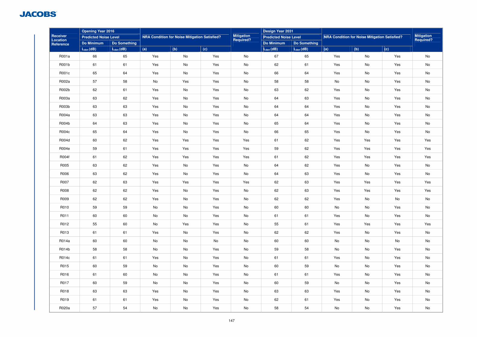
147
Opening Year 2016 Design Year 2031
Predicted Noise Level Predicted Noise Level
Do Minimum Do Something
NRA Condition for Noise Mitigation Satisfied?
Do Minimum Do Something
NRA Condition for Noise Mitigation Satisfied? Receiver Location Reference
Lden (dB) Lden (dB) (a) (b) (c)
Mitigation Required?
Lden (dB) Lden (dB) (a) (b) (c)
Mitigation Required?
R001a 66 65 Yes No Yes No 67 65 Yes No Yes No
R001b 61 61 Yes No Yes No 62 61 Yes No Yes No
R001c 65 64 Yes No Yes No 66 64 Yes No Yes No
R002a 57 58 No Yes Yes No 58 58 No No Yes No
R002b 62 61 Yes No Yes No 63 62 Yes No Yes No
R003a 63 62 Yes No Yes No 64 63 Yes No Yes No
R003b 63 63 Yes No Yes No 64 64 Yes No Yes No
R004a 63 63 Yes No Yes No 64 64 Yes No Yes No
R004b 64 63 Yes No Yes No 65 64 Yes No Yes No
R004c 65 64 Yes No Yes No 66 65 Yes No Yes No
R004d 60 62 Yes Yes Yes Yes 61 62 Yes Yes Yes Yes
R004e 59 61 Yes Yes Yes Yes 59 62 Yes Yes Yes Yes
R004f 61 62 Yes Yes Yes Yes 61 62 Yes Yes Yes Yes
R005 63 62 Yes No Yes No 64 62 Yes No Yes No
R006 63 62 Yes No Yes No 64 63 Yes No Yes No
R007 62 63 Yes Yes Yes Yes 62 63 Yes Yes Yes Yes
R008 62 62 Yes No Yes No 62 63 Yes Yes Yes Yes
R009 62 62 Yes No Yes No 62 62 Yes No No No
R010 59 59 No No Yes No 60 60 No No Yes No
R011 60 60 No No Yes No 61 61 Yes No Yes No
R012 55 60 No Yes Yes No 55 61 Yes Yes Yes Yes
R013 61 61 Yes No Yes No 62 62 Yes No Yes No
R014a 60 60 No No No No 60 60 No No No No
R014b 58 58 No No Yes No 59 58 No No Yes No
R014c 61 61 Yes No Yes No 61 61 Yes No Yes No
R015 60 59 No No Yes No 60 59 No No Yes No
R016 61 60 No No Yes No 61 61 Yes No Yes No
R017 60 59 No No Yes No 60 59 No No Yes No
R018 63 63 Yes No Yes No 63 63 Yes No Yes No
R019 61 61 Yes No Yes No 62 61 Yes No Yes No
R020a 57 54 No No Yes No 58 54 No No Yes No
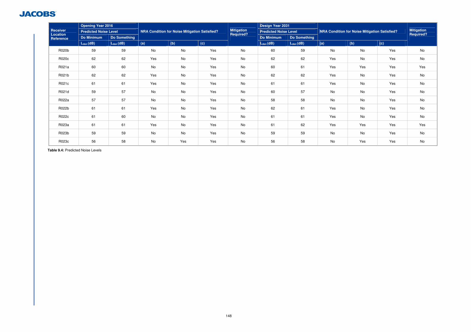
148
Opening Year 2016 Design Year 2031
Predicted Noise Level Predicted Noise Level
Do Minimum Do Something
NRA Condition for Noise Mitigation Satisfied?
Do Minimum Do Something
NRA Condition for Noise Mitigation Satisfied? Receiver Location Reference
Lden (dB) Lden (dB) (a) (b) (c)
Mitigation Required?
Lden (dB) Lden (dB) (a) (b) (c)
Mitigation Required?
R020b 59 59 No No Yes No 60 59 No No Yes No
R020c 62 62 Yes No Yes No 62 62 Yes No Yes No
R021a 60 60 No No Yes No 60 61 Yes Yes Yes Yes
R021b 62 62 Yes No Yes No 62 62 Yes No Yes No
R021c 61 61 Yes No Yes No 61 61 Yes No Yes No
R021d 59 57 No No Yes No 60 57 No No Yes No
R022a 57 57 No No Yes No 58 58 No No Yes No
R022b 61 61 Yes No Yes No 62 61 Yes No Yes No
R022c 61 60 No No Yes No 61 61 Yes No Yes No
R023a 61 61 Yes No Yes No 61 62 Yes Yes Yes Yes
R023b 59 59 No No Yes No 59 59 No No Yes No
R023c 56 58 No Yes Yes No 56 58 No Yes Yes No
Table 9.4: Predicted Noise Levels
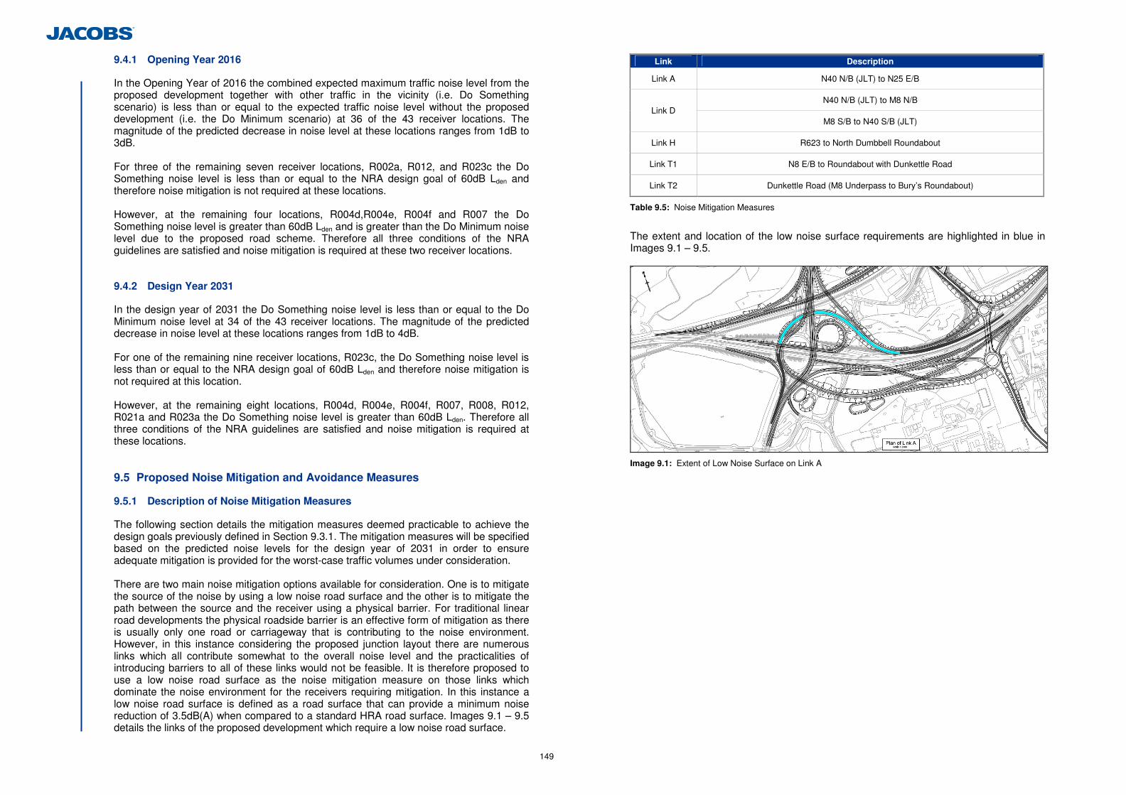
149
9.4.1 Opening Year 2016
In the Opening Year of 2016 the combined expected maximum traffic noise level from the proposed development together with other traffic in the vicinity (i.e. Do Something scenario) is less than or equal to the expected traffic noise level without the proposed development (i.e. the Do Minimum scenario) at 36 of the 43 receiver locations. The magnitude of the predicted decrease in noise level at these locations ranges from 1dB to 3dB. For three of the remaining seven receiver locations, R002a, R012, and R023c the Do Something noise level is less than or equal to the NRA design goal of 60dB Lden and therefore noise mitigation is not required at these locations. However, at the remaining four locations, R004d,R004e, R004f and R007 the Do Something noise level is greater than 60dB Lden and is greater than the Do Minimum noise level due to the proposed road scheme. Therefore all three conditions of the NRA guidelines are satisfied and noise mitigation is required at these two receiver locations.
9.4.2 Design Year 2031
In the design year of 2031 the Do Something noise level is less than or equal to the Do Minimum noise level at 34 of the 43 receiver locations. The magnitude of the predicted decrease in noise level at these locations ranges from 1dB to 4dB. For one of the remaining nine receiver locations, R023c, the Do Something noise level is less than or equal to the NRA design goal of 60dB Lden and therefore noise mitigation is not required at this location. However, at the remaining eight locations, R004d, R004e, R004f, R007, R008, R012, R021a and R023a the Do Something noise level is greater than 60dB Lden. Therefore all three conditions of the NRA guidelines are satisfied and noise mitigation is required at these locations.
9.5 Proposed Noise Mitigation and Avoidance Measures
9.5.1 Description of Noise Mitigation Measures
The following section details the mitigation measures deemed practicable to achieve the design goals previously defined in Section 9.3.1. The mitigation measures will be specified based on the predicted noise levels for the design year of 2031 in order to ensure adequate mitigation is provided for the worst-case traffic volumes under consideration. There are two main noise mitigation options available for consideration. One is to mitigate the source of the noise by using a low noise road surface and the other is to mitigate the path between the source and the receiver using a physical barrier. For traditional linear road developments the physical roadside barrier is an effective form of mitigation as there is usually only one road or carriageway that is contributing to the noise environment. However, in this instance considering the proposed junction layout there are numerous links which all contribute somewhat to the overall noise level and the practicalities of introducing barriers to all of these links would not be feasible. It is therefore proposed to use a low noise road surface as the noise mitigation measure on those links which dominate the noise environment for the receivers requiring mitigation. In this instance a low noise road surface is defined as a road surface that can provide a minimum noise reduction of 3.5dB(A) when compared to a standard HRA road surface. Images 9.1 – 9.5 details the links of the proposed development which require a low noise road surface.
Link Description
Link A N40 N/B (JLT) to N25 E/B
N40 N/B (JLT) to M8 N/B Link D
M8 S/B to N40 S/B (JLT)
Link H R623 to North Dumbbell Roundabout
Link T1 N8 E/B to Roundabout with Dunkettle Road
Link T2 Dunkettle Road (M8 Underpass to Bury’s Roundabout)
Table 9.5: Noise Mitigation Measures
The extent and location of the low noise surface requirements are highlighted in blue in Images 9.1 – 9.5.
Image 9.1: Extent of Low Noise Surface on Link A
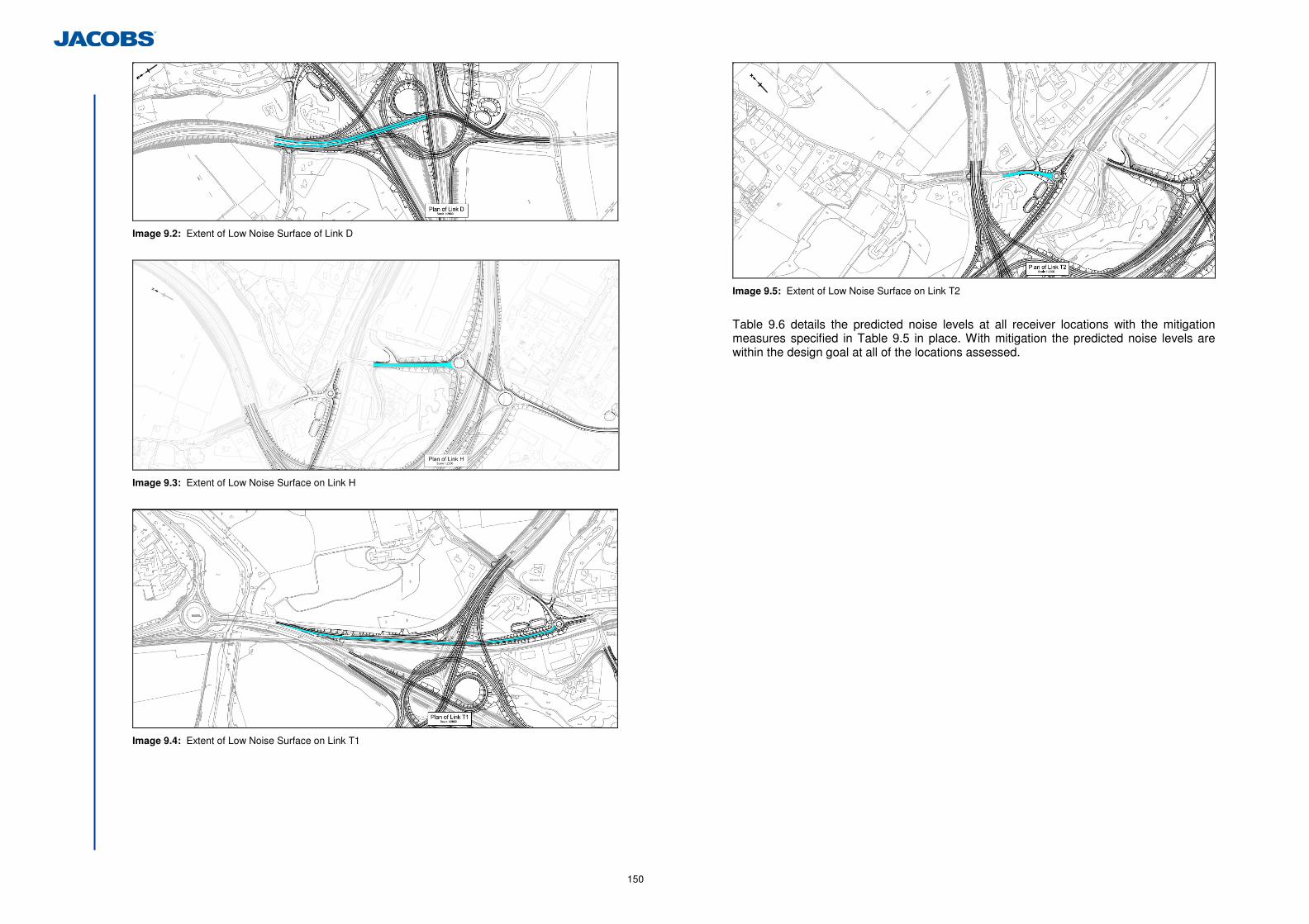
150
Image 9.2: Extent of Low Noise Surface of Link D
Image 9.3: Extent of Low Noise Surface on Link H
Image 9.4: Extent of Low Noise Surface on Link T1
Image 9.5: Extent of Low Noise Surface on Link T2
Table 9.6 details the predicted noise levels at all receiver locations with the mitigation measures specified in Table 9.5 in place. With mitigation the predicted noise levels are within the design goal at all of the locations assessed.
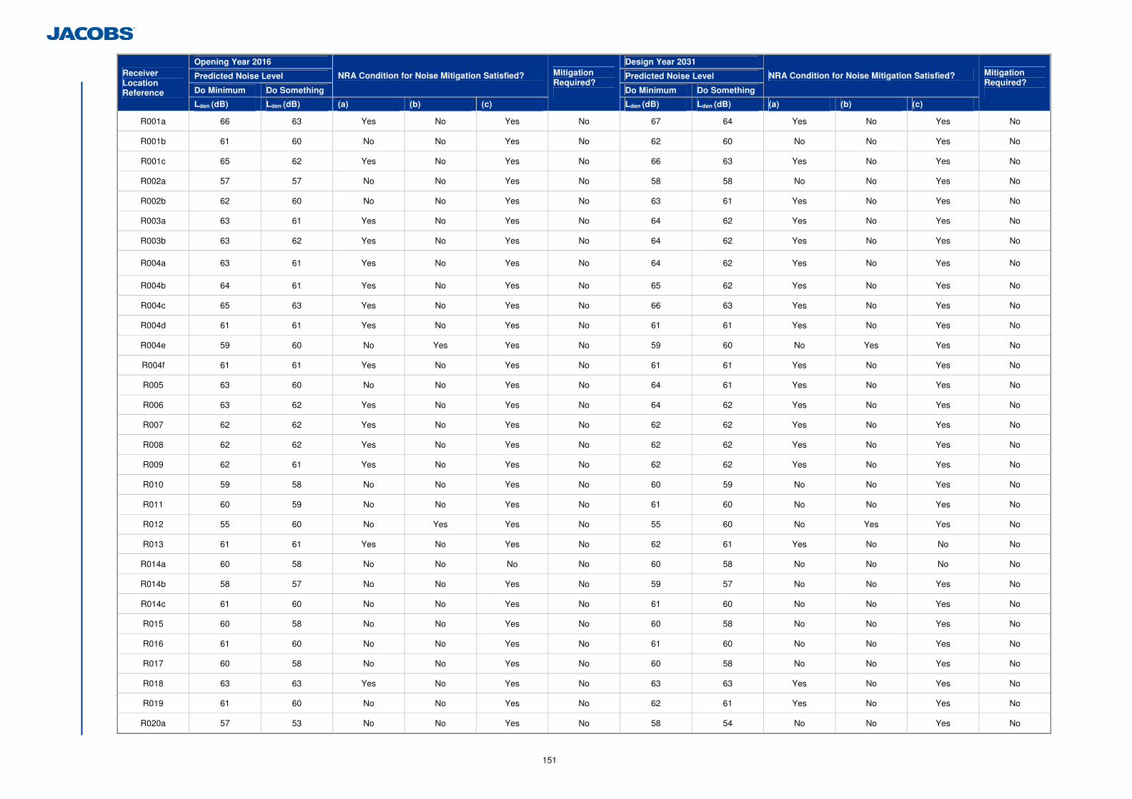
151
Opening Year 2016 Design Year 2031
Predicted Noise Level Predicted Noise Level
Do Minimum Do Something
NRA Condition for Noise Mitigation Satisfied?
Do Minimum Do Something
NRA Condition for Noise Mitigation Satisfied? Receiver Location Reference
Lden (dB) Lden (dB) (a) (b) (c)
Mitigation Required?
Lden (dB) Lden (dB) (a) (b) (c)
Mitigation Required?
R001a 66 63 Yes No Yes No 67 64 Yes No Yes No
R001b 61 60 No No Yes No 62 60 No No Yes No
R001c 65 62 Yes No Yes No 66 63 Yes No Yes No
R002a 57 57 No No Yes No 58 58 No No Yes No
R002b 62 60 No No Yes No 63 61 Yes No Yes No
R003a 63 61 Yes No Yes No 64 62 Yes No Yes No
R003b 63 62 Yes No Yes No 64 62 Yes No Yes No
R004a 63 61 Yes No Yes No 64 62 Yes No Yes No
R004b 64 61 Yes No Yes No 65 62 Yes No Yes No
R004c 65 63 Yes No Yes No 66 63 Yes No Yes No
R004d 61 61 Yes No Yes No 61 61 Yes No Yes No
R004e 59 60 No Yes Yes No 59 60 No Yes Yes No
R004f 61 61 Yes No Yes No 61 61 Yes No Yes No
R005 63 60 No No Yes No 64 61 Yes No Yes No
R006 63 62 Yes No Yes No 64 62 Yes No Yes No
R007 62 62 Yes No Yes No 62 62 Yes No Yes No
R008 62 62 Yes No Yes No 62 62 Yes No Yes No
R009 62 61 Yes No Yes No 62 62 Yes No Yes No
R010 59 58 No No Yes No 60 59 No No Yes No
R011 60 59 No No Yes No 61 60 No No Yes No
R012 55 60 No Yes Yes No 55 60 No Yes Yes No
R013 61 61 Yes No Yes No 62 61 Yes No No No
R014a 60 58 No No No No 60 58 No No No No
R014b 58 57 No No Yes No 59 57 No No Yes No
R014c 61 60 No No Yes No 61 60 No No Yes No
R015 60 58 No No Yes No 60 58 No No Yes No
R016 61 60 No No Yes No 61 60 No No Yes No
R017 60 58 No No Yes No 60 58 No No Yes No
R018 63 63 Yes No Yes No 63 63 Yes No Yes No
R019 61 60 No No Yes No 62 61 Yes No Yes No
R020a 57 53 No No Yes No 58 54 No No Yes No
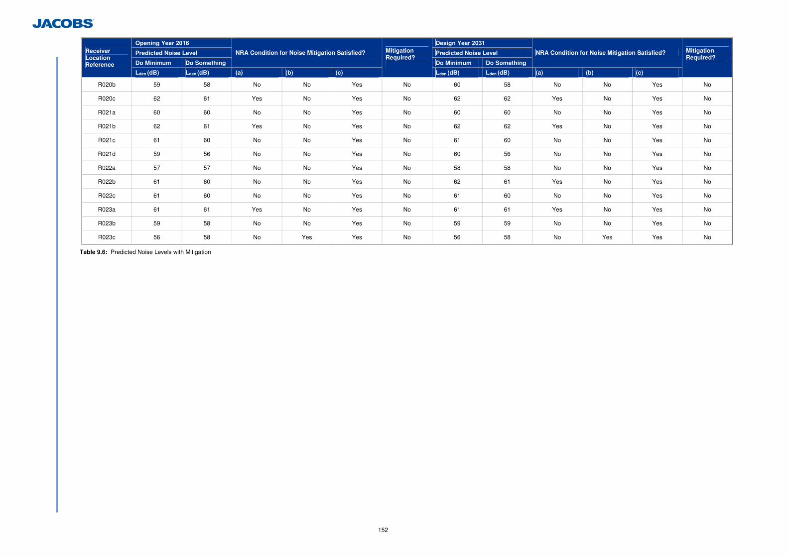
152
Opening Year 2016 Design Year 2031
Predicted Noise Level Predicted Noise Level
Do Minimum Do Something
NRA Condition for Noise Mitigation Satisfied?
Do Minimum Do Something
NRA Condition for Noise Mitigation Satisfied? Receiver Location Reference
Lden (dB) Lden (dB) (a) (b) (c)
Mitigation Required?
Lden (dB) Lden (dB) (a) (b) (c)
Mitigation Required?
R020b 59 58 No No Yes No 60 58 No No Yes No
R020c 62 61 Yes No Yes No 62 62 Yes No Yes No
R021a 60 60 No No Yes No 60 60 No No Yes No
R021b 62 61 Yes No Yes No 62 62 Yes No Yes No
R021c 61 60 No No Yes No 61 60 No No Yes No
R021d 59 56 No No Yes No 60 56 No No Yes No
R022a 57 57 No No Yes No 58 58 No No Yes No
R022b 61 60 No No Yes No 62 61 Yes No Yes No
R022c 61 60 No No Yes No 61 60 No No Yes No
R023a 61 61 Yes No Yes No 61 61 Yes No Yes No
R023b 59 58 No No Yes No 59 59 No No Yes No
R023c 56 58 No Yes Yes No 56 58 No Yes Yes No
Table 9.6: Predicted Noise Levels with Mitigation
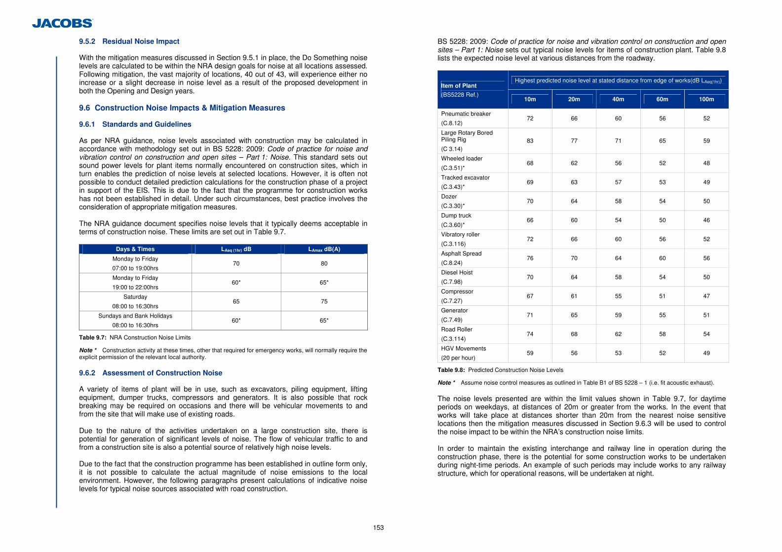
153
9.5.2 Residual Noise Impact
With the mitigation measures discussed in Section 9.5.1 in place, the Do Something noise levels are calculated to be within the NRA design goals for noise at all locations assessed. Following mitigation, the vast majority of locations, 40 out of 43, will experience either no increase or a slight decrease in noise level as a result of the proposed development in both the Opening and Design years.
9.6 Construction Noise Impacts & Mitigation Measures
9.6.1 Standards and Guidelines
As per NRA guidance, noise levels associated with construction may be calculated in accordance with methodology set out in BS 5228: 2009: Code of practice for noise and vibration control on construction and open sites – Part 1: Noise. This standard sets out sound power levels for plant items normally encountered on construction sites, which in turn enables the prediction of noise levels at selected locations. However, it is often not possible to conduct detailed prediction calculations for the construction phase of a project in support of the EIS. This is due to the fact that the programme for construction works has not been established in detail. Under such circumstances, best practice involves the consideration of appropriate mitigation measures. The NRA guidance document specifies noise levels that it typically deems acceptable in terms of construction noise. These limits are set out in Table 9.7.
Days & Times LAeq (1hr) dB LAmax dB(A)
Monday to Friday
07:00 to 19:00hrs 70 80
Monday to Friday
19:00 to 22:00hrs 60* 65*
Saturday
08:00 to 16:30hrs 65 75
Sundays and Bank Holidays
08:00 to 16:30hrs 60* 65*
Table 9.7: NRA Construction Noise Limits
Note * Construction activity at these times, other that required for emergency works, will normally require the explicit permission of the relevant local authority. 9.6.2 Assessment of Construction Noise
A variety of items of plant will be in use, such as excavators, piling equipment, lifting equipment, dumper trucks, compressors and generators. It is also possible that rock breaking may be required on occasions and there will be vehicular movements to and from the site that will make use of existing roads. Due to the nature of the activities undertaken on a large construction site, there is potential for generation of significant levels of noise. The flow of vehicular traffic to and from a construction site is also a potential source of relatively high noise levels. Due to the fact that the construction programme has been established in outline form only, it is not possible to calculate the actual magnitude of noise emissions to the local environment. However, the following paragraphs present calculations of indicative noise levels for typical noise sources associated with road construction.
BS 5228: 2009: Code of practice for noise and vibration control on construction and open sites – Part 1: Noise sets out typical noise levels for items of construction plant. Table 9.8 lists the expected noise level at various distances from the roadway.
Highest predicted noise level at stated distance from edge of works(dB LAeq(1hr)) Item of Plant
(BS5228 Ref.) 10m 20m 40m 60m 100m
Pneumatic breaker
(C.8.12) 72 66 60 56 52
Large Rotary Bored Piling Rig
(C 3.14) 83 77 71 65 59
Wheeled loader
(C.3.51)* 68 62 56 52 48
Tracked excavator
(C.3.43)* 69 63 57 53 49
Dozer
(C.3.30)* 70 64 58 54 50
Dump truck
(C.3.60)* 66 60 54 50 46
Vibratory roller
(C.3.116) 72 66 60 56 52
Asphalt Spread
(C.8.24) 76 70 64 60 56
Diesel Hoist
(C.7.98) 70 64 58 54 50
Compressor
(C.7.27) 67 61 55 51 47
Generator
(C.7.49) 71 65 59 55 51
Road Roller
(C.3.114) 74 68 62 58 54
HGV Movements
(20 per hour) 59 56 53 52 49
Table 9.8: Predicted Construction Noise Levels
Note * Assume noise control measures as outlined in Table B1 of BS 5228 – 1 (i.e. fit acoustic exhaust). The noise levels presented are within the limit values shown in Table 9.7, for daytime periods on weekdays, at distances of 20m or greater from the works. In the event that works will take place at distances shorter than 20m from the nearest noise sensitive locations then the mitigation measures discussed in Section 9.6.3 will be used to control the noise impact to be within the NRA’s construction noise limits. In order to maintain the existing interchange and railway line in operation during the construction phase, there is the potential for some construction works to be undertaken during night-time periods. An example of such periods may include works to any railway structure, which for operational reasons, will be undertaken at night.
154
9.6.3 Mitigation Measures for Construction Noise
The construction contractor will take specific noise abatement measures and comply with the recommendations of BS 5228: Part 1 and the European Communities (Noise Emission by Equipment for Use Outdoors) Regulations, 2001. Specific measures include:
• No plant used on site will be permitted to cause an ongoing public nuisance due to
noise; • The best means practicable, including proper maintenance of plant, will be employed
to minimise the noise produced by on site operations; • All vehicles and mechanical plant will be fitted with effective exhaust silencers and
maintained in good working order for the duration of the contract; • Compressors will be attenuated models fitted with properly lined and sealed acoustic
covers which will be kept closed whenever the machines are in use and all ancillary pneumatic tools shall be fitted with suitable silencers;
• Machinery that is used intermittently will be shut down or throttled back to a minimum during periods when not in use;
Any plant, such as generators or pumps, which is required to operate before 07:00hrs or after 19:00hrs will be surrounded by an acoustic enclosure or portable screen. Prior to any construction works being undertaken at night, the contractor will be required to conduct a noise and vibration impact assessment for specific phases of works and will be required to prepare a construction noise and vibration management plan to minimise the potential for noise disturbance as a result of the works. This will involve liaison with the local authority and any affected residents during the works.
9.6.4 Residual Construction Noise Impact
During the normal construction phase of the project there will be temporary impacts on nearby residential properties due to noise emissions from site traffic and other activities. The application of binding noise limits and appropriate noise control measures will ensure that noise impact is kept to a minimum. Where night-works are proposed, these will be subject to an individual impact assessment and noise and vibration management plan. Liaison with the Contracting Authority and any affected residents will be undertaken prior to any works proceeding to ensure works during these periods are minimised. 9.7 Vibration
This section if the EIS considers and assesses the potential for vibration during both construction and operational phases of the proposed development. The NRA Guidelines provide guidance in relation to vibration from the construction and operational phases of road schemes and this is referenced in this section. 9.7.1 Description of the Existing Environment
A survey of vibration along the proposed route corridor was not undertaken, as levels associated with existing roads would not be expected to be of a magnitude sufficient to cause disturbance to people or structural damage to property. Furthermore, vibration was not perceptible at any of the noise survey locations. 9.7.2 Potential Impacts During the Operational Phase
As a vehicle travels along a road, vibration can be generated in the road and subsequently propagate towards nearby buildings. Such vibration is generated by the interaction of a vehicle’s wheels and the road surface and by direct transmission through the air/ground of energy waves. Some of these waves arise as a function of the size,
shape and speed of the vehicle, and others from pressure fluctuations due to engine, exhaust and other noises generated by the vehicle. Section 2.3.3 of the NRA Guidelines discuss the fact that vibration from road traffic are unlikely to cause and perceptible impact in properties near the road as long as the road surface is well maintained and smooth. Problems attributable to road traffic vibration can therefore be largely avoided by maintenance of the road surface. 9.7.3 Potential Impacts During the Construction Phase
The NRA Guidelines recommend that in order to ensure that there is no potential for vibration damage during construction, vibration from construction activities should be limited to the values set out in Table 9.9.
Allowable vibration velocity (Peak Particle Velocity) at the closest part of any sensitive property to
the source of vibration, at a frequency of
Less than 10Hz 10 to 50Hz 50 to 100Hz (and above)
8 mm/s 12.5 mm/s 20 mm/s
Table 9.9: Allowable Vibration Levels during Construction Phase
The potential for vibration at neighbouring sensitive locations during construction is typically limited to piling, demolition, excavation works, rock-breaking operations and lorry movements on uneven road surfaces. The more significant of these is the vibration from piling. Precast and bored piles will be used for the proposed development. The bored pile method minimises the vibration levels generated as it is a non-percussive piling technique. For the purposes of this assessment the expected vibration levels during piling have been determined through reference to published empirical data. The British Standard BS5228-2009: Code of Practice for Noise and Vibration Control on Construction and Open Sites – Part 2: Vibration, publishes the measured magnitude of vibration of rotary bored piling using a 600mm pile diameter during two aspects of the operation, (Table D.6, Ref. No. 105): • 230µm/s at a distance of 3.5m, for boring; • 2,400µm/s at a distance of 3.5m, for auger hitting base of hole; • 40 µm/s at a distance of 8m, for boring, and; • 1,700µm/s at a distance of 8m, for auger hitting base of hole.
Considering the distance of the piling works from the nearby buildings the expected vibration levels may be perceptible, but are expected to be well below the level at which structural or even cosmetic damage would occur at any nearby buildings. Additionally, measures shall be taken to minimise vibration due to plant and machinery on the site and no machine which uses the dropping of heavy weights for the purpose of demolition shall be permitted. Ground vibration from additional traffic due to the proposed development under consideration would be expected to be orders of magnitude less than that required to cause cosmetic or structural damage to buildings or lead to disturbance of occupiers, hence mitigation measures are not required in respect of the operational phase. It may be concluded that the proposed development is not expected to give rise to vibration that is either significantly intrusive or capable of giving rise to structural or even cosmetic damage.

155
9.8 Difficulties Encountered in Compiling Information
No significant difficulties were encountered in compiling the noise and vibration impact assessment. 9.9 Cumulative Impacts and Impact Interrelations
During the preparation of the noise and vibration impact assessment interaction and consultations have taken place with the several other disciplines in order to ensure that the cumulative impacts of the proposed development have been considered. The following interactions were noted: • The scheme engineers provided the vertical and horizontal road alignment for import
in the traffic noise model; • The traffic engineers provided the Do Minimum and Do Something AADT traffic
volumes and traffic speeds for import into the traffic noise model; • Consultation with the Soils & Geology assessment has provided information on the
requirement for piling along the scheme which has been used in the construction noise impact assessment, and;
• Noise levels have been predicted at several locations of ecological sensitivity and provided to the project Ecologist for assessment.
156
10 Landscape and Visual
10.1 Introduction
This chapter of the EIS considers and assesses the effects of the proposed development on the existing visual environment and landscape character of the surrounding area. Brady Shipman Martin was commissioned to carry out this assessment. 10.2 Description of the Existing Environment
10.2.1 Landscape Context
Lying at the edge of the city, close to the River Lee and with steep topography to the north, the landscape and visual environment around the Dunkettle Interchange is complex. The Dunkettle Interchange is an important entrance to the City from the north and east. The existing interchange at the centre of the study area has a number of varying landscape components (See Figure 10.1.1) including; • To the north, the topography rises steeply with areas of steep wooded slopes,
agricultural parkland landscape associated with Dunkettle House and wooded slopes with local roads with access to residential areas, Gaelscoil Ui Drisceoil and Glanmire Village;
• To the south lies the River Lee which begins to widen at this point into Lough Mahon. Across the mudflats, lagoons and river channel lies the Mahon/Blackrock peninsula which comprises a mixture of uses including residential, amenity and commercial uses;
• To the south and east lies Little Island which has a mixture of uses including industry, amenity and recreational. Most of the land on Little Island within the study area is industrial in nature with a number of pharmaceutical plants, manufacturing plants and Eastgate Business Park. There are a number of tidal mudflats and lagoons between the existing interchange and Little Island; and
• To the west lies the Glashaboy river/estuary which cuts through the steep topography. On the western side of the Glashaboy, lies the level Tivoli Docks industrial area, with steeply sloped wooded topography to the north of the N8 within which Lota More school is located. The R639 road links the Dunkettle roundabout to Glanmire village and hinterland.
The landform of the area is consistent with the east west grain of the south Cork region. The northern horizon is defined by a ridgeline running east west above Glanmire and Glounthaune through to Midleton. The southern horizon is defined by the east west Rochestown to Monkstown to the south of Cork. The valley floor between the ridges serves as a major transport corridor for the N25 Cork to Rosslare road, which follows the low lying land from Cork to Youghal. Views north are contained by the topography and wooded slopes. In contrast views south are more open, extending over Lough Mahon and Blackrock/Mahon Peninsula towards the Rochestown ridgeline 4km to the south which defines the visual horizon. Prominent visual features within the landscape include; • Dunkettle House and Parkland landscape immediately north of the existing
interchange. Despite its close proximity, there are limited views from the house and parkland landscape of the existing interchange, due to the nature of the
topography and intervening vegetation/woodland. The house and parkland are more prominent from the southern side of the River Lee from Blackrock Castle, the amenity walk along the foreshore and as the N40 enters the Jack Lynch tunnel from the south;
• The steeply wooded slopes of Lota More, Dunkettle and Kilcoolishal to the north which contain a number of other prominent historic buildings including Lota House (north west of Dunkettle roundabout), Dunkettle House (north of Dunkettle interchange) and Father Mathew Tower (north east of Dunkettle interchange);
• The pharmaceutical facilities on Little Island. Portions of these structures are visible above or are filtered through intervening mature vegetation. A mature copse of demesne beech woodland at Inchera is prominent and very effective in providing screening to the industrial areas to the south;
• The road infrastructure at Dunkettle including the N8, N25, N40 Dunkettle interchange, Jack Lynch tunnel and Dunkettle roundabout; and
• The River Lee and Blackrock Castle on the Mahon peninsula. The interchange is illuminated at night with high mast lighting. Gantry signage is also used to assist driver navigation. Although outside the study area the amenity walkway and Blackrock Castle observatory on the southern side of the River Lee have distant views of the N8 overpass bridge at the Dunkettle interchange. 10.2.2 Landscape Character
The study area is located within the City Harbour and Estuary landscape character area as defined in the Cork County Development Plan (CCoDP) 2009 and Blarney Electoral Area Local Area Plan (BEALAP) 2011. This as an area of very high landscape value and sensitivity. The Cork County Draft Landscape Strategy has suggested that this area is of national landscape importance. On the edge of the city, the area is defined by the busy Dunkettle interchange on low-lying land, with steep wooded slopes to the north and River Lee to the south. The area has undergone significant change in the past with the industrialisation of Little Island and development of the roads infrastructure in the area. The expansive River Lee, Lough Mahon Estuary and protected structures set in woodland to the north are sensitive elements within the landscape. 10.2.3 Landscape Significance
The only national assessment of landscape quality published for Ireland is the Inventory of Outstanding Landscapes in Ireland prepared by An Foras Forbartha in 1977. Many of the areas highlighted in the Inventory were subsequently given protection within the statutory County Development Plans and these plans in many instances designate additional areas. It is noted that the proposed development does not pass through or is not within close proximity to any such listed Outstanding Landscape. Cork harbour is of crucial importance to the economic, leisure, amenity, marine transport and heritage of Cork and its environs. Cork harbour is designated as an area of ‘National Tourism Significance’ by Failte Ireland in their publication Determination of Waters of National Tourism Significance and Associated Water Quality Status (2009). It is an important recreational resource for the region with water based activities such as sailing, fishing etc. At a county level the statutory Development Plan for Cork is referenced with regard to landscape and visual aspects.
157
(a) Landscape Planning Context
The site falls within the Cork County Development Plan (CCoDP), 2009 and the Blarney Electoral Area Local Area Plan (BEALAP) 2011. It adjoins the Cork City Development Plan (CCDP) 2009. Within the CCoDP, Cork County Council outline a national roads priority list in objective INF 3-3 which states; ‘It is an objective to seek the support of the National Roads Authority in the implementation of the following major projects:….Dunkettle Interchange Upgrade’. (b) Designated Scenic Landscape
There are large areas within the study area which are designated as scenic landscape. The policy reads: (routes illustrated on Map 9 in the CCoDP);
‘ENV 2-7 Scenic Landscape. It is a particular objective to preserve the visual and scenic amenities of those areas of natural beauty identified as ‘scenic landscape’ and shown in the scenic amenity maps in Volume 3 of this plan’.
There are a number of designated scenic landscape areas to the northwest of the study area at the higher elevations in Dunkettle and along the steep, wooded slopes to the Glashaboy River. See Figure 10.1.1, Topographical Features and Landscape Constraints. (i) Designated Scenic Routes
Certain roads around the county, including a number within the study area have been designated as scenic routes in the CCDP. The policy reads: (routes illustrated on Map 9 in the CCoDP).
ENV 2-11 Scenic Routes ‘It is a particular objective to preserve the character of those views and prospects obtainable from scenic routes identified in this plan. Those routes are shown on the scenic amenity maps in Volume 3 and listed in Volume 2 of this plan. A profile of each route and the views to be protected are listed in Volume 2 of this plan’.
The designated scenic routes within the study area as listed in Table 10.1 below;
Scenic Route Name Approximate
Distance Comment
S41
R639 and local road from Dunkettle to Glanmire and Glounthaune
1.5km north
Very high landscape value. Elevated, intermittent views of Cork harbour. Generally no views of the Dunkettle Interchange due to intervening topography, vegetation and built development. There is a view south towards the interchange from the N8 overbridge however it is screened by existing vegetation and topography.
S42 Local road from Glounthaune to Caherlag
2.0km north
Very high landscape value. Elevated, intermittent views of Cork harbour. Just outside the study area to the north east and joins the S41 designated scenic route at Ballyhennick. No views of Dunkettle Interchange due to intervening topography, vegetation and built development.
Table 10.1: Designated Scenic Routes
Within the Cork City Development Plan (CCDP) 2009, views to Blackrock Castle from the Jack Lynch tunnel slip road are protected in the CCDP, 2009, reference BC2. Policy 10.8, Volume 1, page 126 states;
Views and Prospects Proposals that would cause unacceptable harm to the visual impact of landmark buildings, historic buildings, key views and prospects will not be permitted. Cork City Council will have a presumption against development that threatens to obstruct or compromise the quality or setting of views and prospects of special amenity value including strategic linear views, panoramic views, rivers prospects, townscape and landscape views and approach road views. Cork City Council will seek:
- To protect the intrinsic character and scale of the city and the city skyline; - To protect key views and vistas and the visual prominence of important
city landscape and townscape features such as areas of woodland, important tree groupings and areas of special architectural or heritage value;…
- To promote enhancement of key views and vistas through improved landscaping, lighting and encourage improvement of unsightly and obstructive building design;…’
There are some additional policies in the CCoDP which will pertain to the views from routes into the City including:
ENV 2-10 Development on Approach roads to towns and villages It is an objective to ensure that the approach roads to towns and villages are protected from inappropriate development, which would detract from the setting and historic character of these settlements.
Whilst this is primarily to approach roads into towns and villages, this important entrance to Cork City could be considered under this objective. The landscape study associated with the Cork City Development Plan (CCDP) recognises the Dunkettle interchange as a ‘gateway’ to the City from east. Page 46 refers;
The visual experience of arrival in the city begins around the Dunkettle (N25) interchange, which is elevated over Little Island. As one moves west, there are panoramic views south to Cork Harbour, the estuary, Blackrock Castle and the south of the city. The high visual amenity of the Glashaboy River and Glanmire Woods leading to the tree-lined ridges of Montenotte and Tivoli, are dominant to the north. Closer to the city and travelling west along the N8 on the northern edge of the River Lee, the high visual amenity of the Marina is apparent to the south, and the dramatic escarpments of Montenotte and Tivoli are located to the north. The Tivoli cranes and south docklands then begin to come into view as one moves west.
(ii) Trees and Woodland
The CCoDP seeks to protect trees and groups of trees;
ENV 1-10 Tree Preservation (a) It is an objective to preserve and enhance the general level of tree cover in both town and country, to ensure that development proposals do not compromise important trees and include an appropriate level of new tree planting and where appropriate to make use of tree preservation orders to protect important trees or groups of trees which may be at risk.
158
(b) It is also an objective, where appropriate, to protect mature trees/groups of mature trees and mature hedgerows that are not formally protected under Tree Preservation Orders.
Within the study area there are a number of groups of trees and woodland which significantly contribute to the character of the area. They include the steep wooded slopes of the Glashaboy River, the parkland trees and perimeter woodland around Dunkettle House, the remnant demesne Beech woodland at Inchera (Little Island), the wooded slopes along Tower Hill (Kilcoolishal) and more recent screen woodland planting associated with the Dunkettle interchange and surrounding roads. There are no tree preservation orders in the area. (iii) Visually prominent Recorded Monuments and Protected Structures
There are a number of protected structures and recorded monuments within the study area which are outlined in detail within Chapter 11 Archaeological, Cultural and Architectural Heritage. A number of these structures are visually prominent within the landscape and significantly contribute to the visual character of the area. Table 10.2 details these structures.
Title/Location Reference Document Reference
Location/Reference Description
Dunkettle House
RPS 00493 CCoDP, 2009
500m north west of existing Dunkettle interchange
Prominent house on elevated site overlooking
River Lee with parkland setting and demesne woodland. Focal point in
views from N40 entering Jack Lynch tunnel and from foreshore along
Blackrock/Mahon peninsula.
Father
Mathew Tower
RPS 00492 CCoDP,
2009
1km north east of existing
Dunkettle interchange
Ornamental tower set in
woodland prominent in views from the south and south west.
Dunsland House
RPS 00491 CCoDP, 2009
1km north east of Dunkettle interchange
Period house overlooking Lough Mahon close to Father Mathew Tower, set
in amongst mature woodland.
Lota House RPS 00477 CCoDP,
2009
600m to the west of existing
Dunkettle interchange
Prominent period house
overlooking Glashaboy River, River Lee and Dunkettle. Currently in
institutional use with a complex of special needs school buildings and
facilities.
Blackrock Castle
PS528 CCDP, 2009
1km south west of Dunkettle interchange
Prominent landmark tower on the edge of the River
Lee. Important focal point for views entering the City from the north and east.
Table 10.2: Visually Important Recorded Monuments and Protected Structures
10.3 Appraisal Method used for Assessment of Impacts
10.3.1 Introduction
In order to assess the significance and magnitude of potential impacts it is important to fully understand the existing landscape context. Section 10.2 of this study provides an appraisal of the existing landscape condition. Section 10.4 provides a description of the proposed development in terms of its landscape and visual context and outlines the various impacts and effects of the proposed development. These impacts and effects are made with regard to the vulnerability of the landscape to change and to the location of visual receptors relative to the proposed development. In this way the impact of the proposed development on this existing context is appraised and significant impacts to either the landscape character or visual amenity identified wherever they occur. Section 10.5 provides a description of the mitigation measures to avoid, reduce or remediate any potential negative impacts that have been identified.
(a) Landscape
Landscape has two separate but closely related aspects. The first is visual impact, i.e. the extent to which a new structure in the landscape can be seen. The second is landscape character impact, i.e. responses that are felt towards the landscape, and draws on the appearance of the land, including shape, form and colour and their interaction to create specific patterns that are distinctive to particular localities. Landscape Character is derived from the appearance of the land, and takes account of natural and man made features such as topography, landform, vegetation, land use and built environment and their interaction to create specific patterns that are distinctive to particular localities. The landscape impact assessment predicts impacts and describes the likely nature and scale of changes to individual landscape elements and characteristics, together with the significance of such affects. Landscape planning designations, including National and County designations or listings are considered and assessed for impacts, where appropriate. In addition, potential impacts on designated sites of cultural heritage value and ecological value are also considered. For example, historic demesne landscapes as defined by the National Inventory of Architectural Heritage (NIAH) are considered as are other informal demesnes identified during site visits and in consultation with the Architectural Heritage consultant. The impact on trees, hedgerows and woodlands is considered in Chapter 5 Flora and Fauna. Any impacts on these elements are set out within this chapter where they are considered to have particular landscape significance. Areas of Outstanding Landscape, together with Landscape Planning Designations, including National and County designations or listings and historic estate or demesne landscapes as defined by the National Inventory of Architectural Heritage (NIAH) have also been evaluated and assessed for impacts where appropriate.
(b) Visual Impact
Visual impacts are categorised under ‘Visual Intrusion’ and ‘Visual Obstruction’ where; • Visual Intrusion is an impact on a view without blocking, and • Visual Obstruction is an impact on a view involving blocking thereof.
159
In reporting on visual impact, three basic assessments are used: • Construction Stage: considers the period including the active construction of the
road up to completion of the works and opening of the road development; • Pre-establishment Stage: considers the period including the initial operation of the
road where new landscaping is unlikely to provide effective mitigation. The impact is assessed in the year the road would open to traffic;
• Post Establishment Stage: considers the impact as assessed in the fifteenth year after opening before which stage proposed landscaping will have developed as effective mitigation, as designed. The development of planting to effective visual screening usually requires a period of five to seven years after planting.
Visual impact has been assessed for nearby properties impacted by the proposed development. The visual assessments are tabulated in a Visual Impact Schedule (VIS) contained in Table 10.4 and illustrated on the Landscape and Visual Impact Drawing (VID) Figure 10.1.2. Some properties have been grouped into clusters where they experience a similar type and level of effect. The extent to which significant additional illumination will be visible in the night landscape is also taken into account. The introduction of road lighting may affect individual views and also the character of the landscape.
10.3.2 Standards and Guidelines
The landscape and visual assessment has been undertaken with reference to the following main standards and guidelines;
• EPA: Guidelines on the Information to be contained in Environmental Impact Statements, 2002;
• EPA: Advice Notes on Current Practice (in the preparation of Environmental Impact Statements) 2003;
• LI and IEMA: Guidelines for Landscape and Visual Impact Assessment, 2nd Edition, 2002;
• NRA: Environmental Impact Assessment of National Road Schemes- A Practical Guide, 2008;
• NRA: A Guide to Landscape Treatments for National Road Schemes in Ireland, 2006;
• NRA: Draft Guidelines on the Implementation of Landscape Treatment on National Road Schemes in Ireland, 2011;
• NRA: Guidelines for Protection and Preservation of Trees, Hedgerows and Scrub Prior to, during and Post Construction of National Road Schemes, 2006;
• DOE (UK): Design Manual for Roads and Bridges.
10.3.3 Significance Assessment Criteria
The significance criteria as set out in the EPA guidelines have been used for the purpose of this assessment, and are presented in Table 10.3 below;
Significance Level Criteria Profound An impact which obliterates sensitive characteristics
Significant An impact which, by its character, magnitude, duration or intensity alters a sensitive aspect of the environment.
Moderate An impact that alters the character of the environment in a manner that is consistent with existing and emerging trends.
Significance Level Criteria
Slight An impact which causes noticeable changes in the character of the environment without affecting its sensitivities.
Imperceptible An impact capable of measurement but without noticeable consequences.
Table 10.3: Landscape and Visual Impact Assessment Criteria
As per the EPA Guidelines, impacts can be considered to be negative, neutral or positive in effect. Impact duration is considered as being Temporary (for up to one year), Short term (from 1 to 7 years), Medium term (7 to 15 years), Long Term (from 15 to 60 years) or Permanent (in excess of 60 years). 10.4 Predicted Impacts of the Proposed Development
10.4.1 Scope of the Impacts
The proposed development will create grade separated routes connecting the M8, N25, Jack Lynch Tunnel, N40, Little Island and surrounding areas. This will entail the construction of a number of new flyover bridge and slip roads within the area. The proposed development for the most part is close to the existing interchange and as such the existing road already impacts on many of the affected properties to some degree. The potential visual impact will be an increased level of visual impact on receptors. The following main elements have the potential for landscape and visual impact: • Removal of existing vegetation; • General construction disturbance; • Significant, elevated structures such as earthen embankments, earth retaining
walls and bridges; • Illumination; • Gantry signage; • Moving traffic during operation.
These elements will impact upon; • Adjoining residential properties and protected structures; • Adjoining areas of woodland and tidal mudflats; • Adjoining areas of commercial and industrial development; • Road users.
Other elements such as lower level signage, barriers, culverts, fencing etc. are an integral part of most roads and will have little or no landscape impact due to their low elevation, limited off-scheme visibility and the presence of similar elements along the existing carriageway. 10.4.2 Visual Impact
Landscape and visual impact will be most pronounced during the construction stage and in the short term thereafter, when disturbance at close proximity to properties is at its greatest and mitigation either not in place or least effective. In general, adverse visual impact will arise upon residential and other properties close to or adjoining the construction boundary. Visual impact will primarily arise through, visual disturbance, visual intrusion from the loss of the existing screen vegetation, alteration to ground levels and construction traffic.
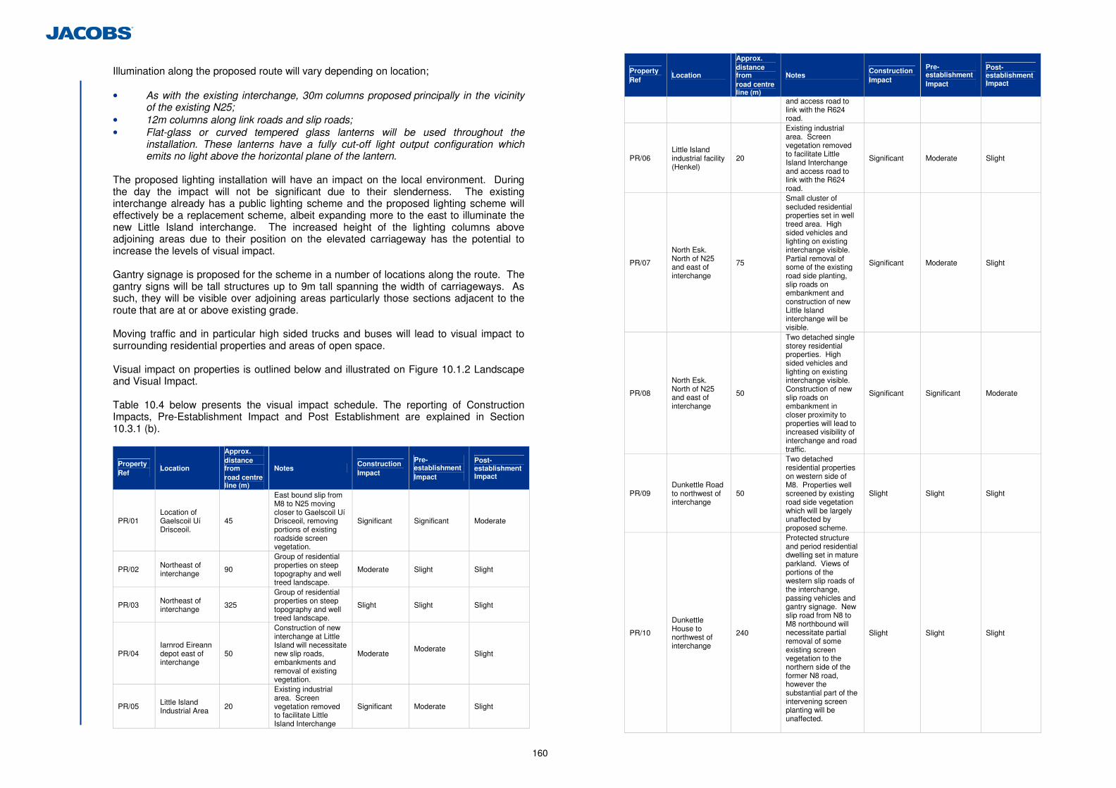
160
Illumination along the proposed route will vary depending on location; • As with the existing interchange, 30m columns proposed principally in the vicinity
of the existing N25; • 12m columns along link roads and slip roads; • Flat-glass or curved tempered glass lanterns will be used throughout the
installation. These lanterns have a fully cut-off light output configuration which emits no light above the horizontal plane of the lantern.
The proposed lighting installation will have an impact on the local environment. During the day the impact will not be significant due to their slenderness. The existing interchange already has a public lighting scheme and the proposed lighting scheme will effectively be a replacement scheme, albeit expanding more to the east to illuminate the new Little Island interchange. The increased height of the lighting columns above adjoining areas due to their position on the elevated carriageway has the potential to increase the levels of visual impact. Gantry signage is proposed for the scheme in a number of locations along the route. The gantry signs will be tall structures up to 9m tall spanning the width of carriageways. As such, they will be visible over adjoining areas particularly those sections adjacent to the route that are at or above existing grade. Moving traffic and in particular high sided trucks and buses will lead to visual impact to surrounding residential properties and areas of open space. Visual impact on properties is outlined below and illustrated on Figure 10.1.2 Landscape and Visual Impact. Table 10.4 below presents the visual impact schedule. The reporting of Construction Impacts, Pre-Establishment Impact and Post Establishment are explained in Section 10.3.1 (b).
Property Ref
Location
Approx. distance from road centre line (m)
Notes Construction Impact
Pre-establishment Impact
Post-establishment Impact
PR/01 Location of Gaelscoil Uí Drisceoil.
45
East bound slip from M8 to N25 moving closer to Gaelscoil Uí Drisceoil, removing portions of existing roadside screen vegetation.
Significant Significant Moderate
PR/02 Northeast of interchange 90
Group of residential properties on steep topography and well treed landscape.
Moderate Slight Slight
PR/03 Northeast of interchange 325
Group of residential properties on steep topography and well treed landscape.
Slight Slight Slight
PR/04 Iarnrod Eireann depot east of interchange
50
Construction of new interchange at Little Island will necessitate new slip roads, embankments and removal of existing vegetation.
Moderate Moderate
Slight
PR/05 Little Island Industrial Area
20
Existing industrial area. Screen vegetation removed to facilitate Little Island Interchange
Significant Moderate Slight
Property Ref
Location
Approx. distance from road centre line (m)
Notes Construction Impact
Pre-establishment Impact
Post-establishment Impact
and access road to link with the R624 road.
PR/06 Little Island industrial facility (Henkel)
20
Existing industrial area. Screen vegetation removed to facilitate Little Island Interchange and access road to link with the R624 road.
Significant Moderate Slight
PR/07
North Esk. North of N25 and east of interchange
75
Small cluster of secluded residential properties set in well treed area. High sided vehicles and lighting on existing interchange visible. Partial removal of some of the existing road side planting, slip roads on embankment and construction of new Little Island interchange will be visible.
Significant Moderate Slight
PR/08
North Esk. North of N25 and east of interchange
50
Two detached single storey residential properties. High sided vehicles and lighting on existing interchange visible. Construction of new slip roads on embankment in closer proximity to properties will lead to increased visibility of interchange and road traffic.
Significant Significant Moderate
PR/09 Dunkettle Road to northwest of interchange
50
Two detached residential properties on western side of M8. Properties well screened by existing road side vegetation which will be largely unaffected by proposed scheme.
Slight Slight Slight
PR/10
Dunkettle House to northwest of interchange
240
Protected structure and period residential dwelling set in mature parkland. Views of portions of the western slip roads of the interchange, passing vehicles and gantry signage. New slip road from N8 to M8 northbound will necessitate partial removal of some existing screen vegetation to the northern side of the former N8 road, however the substantial part of the intervening screen planting will be unaffected.
Slight Slight Slight
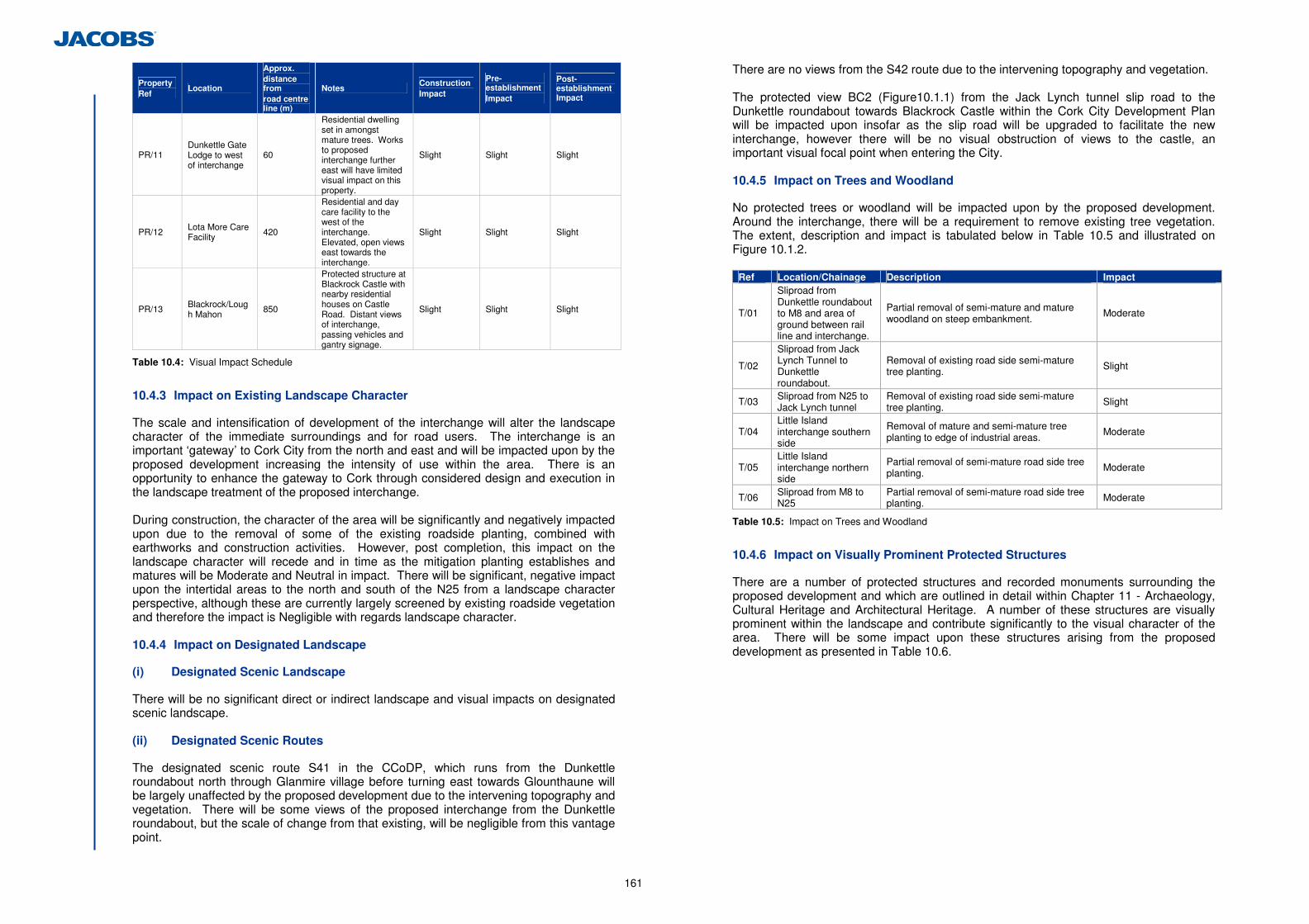
161
Property Ref
Location
Approx. distance from road centre line (m)
Notes Construction Impact
Pre-establishment Impact
Post-establishment Impact
PR/11 Dunkettle Gate Lodge to west of interchange
60
Residential dwelling set in amongst mature trees. Works to proposed interchange further east will have limited visual impact on this property.
Slight Slight Slight
PR/12 Lota More Care Facility 420
Residential and day care facility to the west of the interchange. Elevated, open views east towards the interchange.
Slight Slight Slight
PR/13 Blackrock/Lough Mahon
850
Protected structure at Blackrock Castle with nearby residential houses on Castle Road. Distant views of interchange, passing vehicles and gantry signage.
Slight Slight Slight
Table 10.4: Visual Impact Schedule
10.4.3 Impact on Existing Landscape Character
The scale and intensification of development of the interchange will alter the landscape character of the immediate surroundings and for road users. The interchange is an important ‘gateway’ to Cork City from the north and east and will be impacted upon by the proposed development increasing the intensity of use within the area. There is an opportunity to enhance the gateway to Cork through considered design and execution in the landscape treatment of the proposed interchange. During construction, the character of the area will be significantly and negatively impacted upon due to the removal of some of the existing roadside planting, combined with earthworks and construction activities. However, post completion, this impact on the landscape character will recede and in time as the mitigation planting establishes and matures will be Moderate and Neutral in impact. There will be significant, negative impact upon the intertidal areas to the north and south of the N25 from a landscape character perspective, although these are currently largely screened by existing roadside vegetation and therefore the impact is Negligible with regards landscape character. 10.4.4 Impact on Designated Landscape
(i) Designated Scenic Landscape
There will be no significant direct or indirect landscape and visual impacts on designated scenic landscape. (ii) Designated Scenic Routes
The designated scenic route S41 in the CCoDP, which runs from the Dunkettle roundabout north through Glanmire village before turning east towards Glounthaune will be largely unaffected by the proposed development due to the intervening topography and vegetation. There will be some views of the proposed interchange from the Dunkettle roundabout, but the scale of change from that existing, will be negligible from this vantage point.
There are no views from the S42 route due to the intervening topography and vegetation. The protected view BC2 (Figure10.1.1) from the Jack Lynch tunnel slip road to the Dunkettle roundabout towards Blackrock Castle within the Cork City Development Plan will be impacted upon insofar as the slip road will be upgraded to facilitate the new interchange, however there will be no visual obstruction of views to the castle, an important visual focal point when entering the City. 10.4.5 Impact on Trees and Woodland
No protected trees or woodland will be impacted upon by the proposed development. Around the interchange, there will be a requirement to remove existing tree vegetation. The extent, description and impact is tabulated below in Table 10.5 and illustrated on Figure 10.1.2.
Ref Location/Chainage Description Impact
T/01
Sliproad from Dunkettle roundabout to M8 and area of ground between rail line and interchange.
Partial removal of semi-mature and mature woodland on steep embankment.
Moderate
T/02
Sliproad from Jack Lynch Tunnel to Dunkettle roundabout.
Removal of existing road side semi-mature tree planting. Slight
T/03 Sliproad from N25 to Jack Lynch tunnel
Removal of existing road side semi-mature tree planting.
Slight
T/04 Little Island interchange southern side
Removal of mature and semi-mature tree planting to edge of industrial areas.
Moderate
T/05 Little Island interchange northern side
Partial removal of semi-mature road side tree planting.
Moderate
T/06 Sliproad from M8 to N25
Partial removal of semi-mature road side tree planting. Moderate
Table 10.5: Impact on Trees and Woodland
10.4.6 Impact on Visually Prominent Protected Structures
There are a number of protected structures and recorded monuments surrounding the proposed development and which are outlined in detail within Chapter 11 - Archaeology, Cultural Heritage and Architectural Heritage. A number of these structures are visually prominent within the landscape and contribute significantly to the visual character of the area. There will be some impact upon these structures arising from the proposed development as presented in Table 10.6.
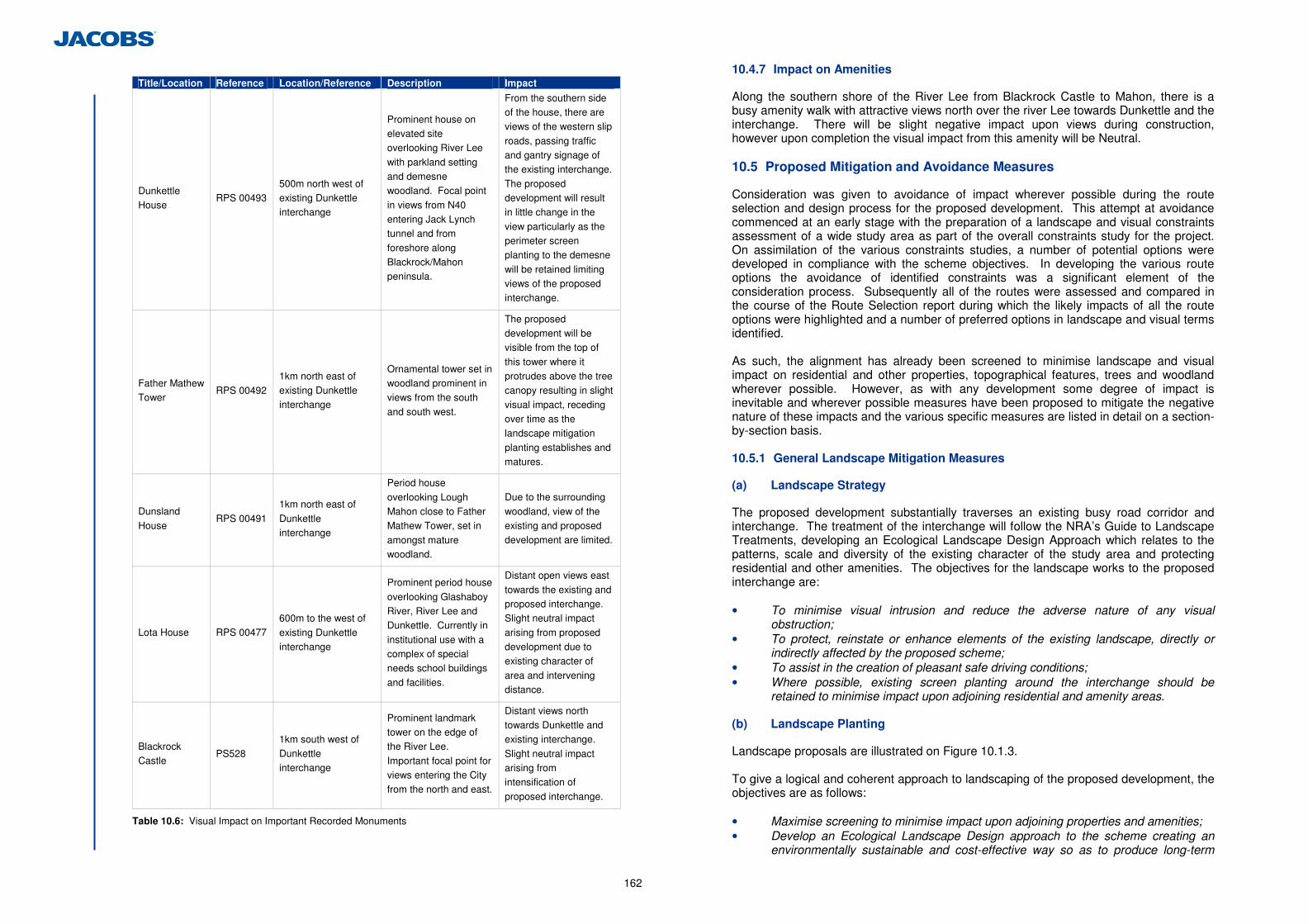
162
Title/Location Reference Location/Reference Description Impact
Dunkettle House
RPS 00493 500m north west of existing Dunkettle interchange
Prominent house on elevated site overlooking River Lee
with parkland setting and demesne woodland. Focal point
in views from N40 entering Jack Lynch tunnel and from
foreshore along Blackrock/Mahon peninsula.
From the southern side of the house, there are views of the western slip
roads, passing traffic and gantry signage of the existing interchange.
The proposed development will result in little change in the
view particularly as the perimeter screen planting to the demesne
will be retained limiting views of the proposed interchange.
Father Mathew Tower
RPS 00492
1km north east of existing Dunkettle interchange
Ornamental tower set in woodland prominent in views from the south
and south west.
The proposed development will be visible from the top of
this tower where it protrudes above the tree canopy resulting in slight
visual impact, receding over time as the landscape mitigation
planting establishes and matures.
Dunsland
House RPS 00491
1km north east of
Dunkettle interchange
Period house
overlooking Lough Mahon close to Father Mathew Tower, set in
amongst mature woodland.
Due to the surrounding
woodland, view of the existing and proposed development are limited.
Lota House RPS 00477 600m to the west of
existing Dunkettle interchange
Prominent period house
overlooking Glashaboy River, River Lee and Dunkettle. Currently in
institutional use with a complex of special needs school buildings
and facilities.
Distant open views east
towards the existing and proposed interchange. Slight neutral impact
arising from proposed development due to existing character of
area and intervening distance.
Blackrock Castle
PS528
1km south west of Dunkettle interchange
Prominent landmark tower on the edge of the River Lee.
Important focal point for views entering the City from the north and east.
Distant views north towards Dunkettle and existing interchange.
Slight neutral impact arising from intensification of
proposed interchange.
Table 10.6: Visual Impact on Important Recorded Monuments
10.4.7 Impact on Amenities
Along the southern shore of the River Lee from Blackrock Castle to Mahon, there is a busy amenity walk with attractive views north over the river Lee towards Dunkettle and the interchange. There will be slight negative impact upon views during construction, however upon completion the visual impact from this amenity will be Neutral. 10.5 Proposed Mitigation and Avoidance Measures
Consideration was given to avoidance of impact wherever possible during the route selection and design process for the proposed development. This attempt at avoidance commenced at an early stage with the preparation of a landscape and visual constraints assessment of a wide study area as part of the overall constraints study for the project. On assimilation of the various constraints studies, a number of potential options were developed in compliance with the scheme objectives. In developing the various route options the avoidance of identified constraints was a significant element of the consideration process. Subsequently all of the routes were assessed and compared in the course of the Route Selection report during which the likely impacts of all the route options were highlighted and a number of preferred options in landscape and visual terms identified. As such, the alignment has already been screened to minimise landscape and visual impact on residential and other properties, topographical features, trees and woodland wherever possible. However, as with any development some degree of impact is inevitable and wherever possible measures have been proposed to mitigate the negative nature of these impacts and the various specific measures are listed in detail on a section-by-section basis. 10.5.1 General Landscape Mitigation Measures
(a) Landscape Strategy
The proposed development substantially traverses an existing busy road corridor and interchange. The treatment of the interchange will follow the NRA’s Guide to Landscape Treatments, developing an Ecological Landscape Design Approach which relates to the patterns, scale and diversity of the existing character of the study area and protecting residential and other amenities. The objectives for the landscape works to the proposed interchange are: • To minimise visual intrusion and reduce the adverse nature of any visual
obstruction; • To protect, reinstate or enhance elements of the existing landscape, directly or
indirectly affected by the proposed scheme; • To assist in the creation of pleasant safe driving conditions; • Where possible, existing screen planting around the interchange should be
retained to minimise impact upon adjoining residential and amenity areas. (b) Landscape Planting
Landscape proposals are illustrated on Figure 10.1.3. To give a logical and coherent approach to landscaping of the proposed development, the objectives are as follows:
• Maximise screening to minimise impact upon adjoining properties and amenities; • Develop an Ecological Landscape Design approach to the scheme creating an
environmentally sustainable and cost-effective way so as to produce long-term
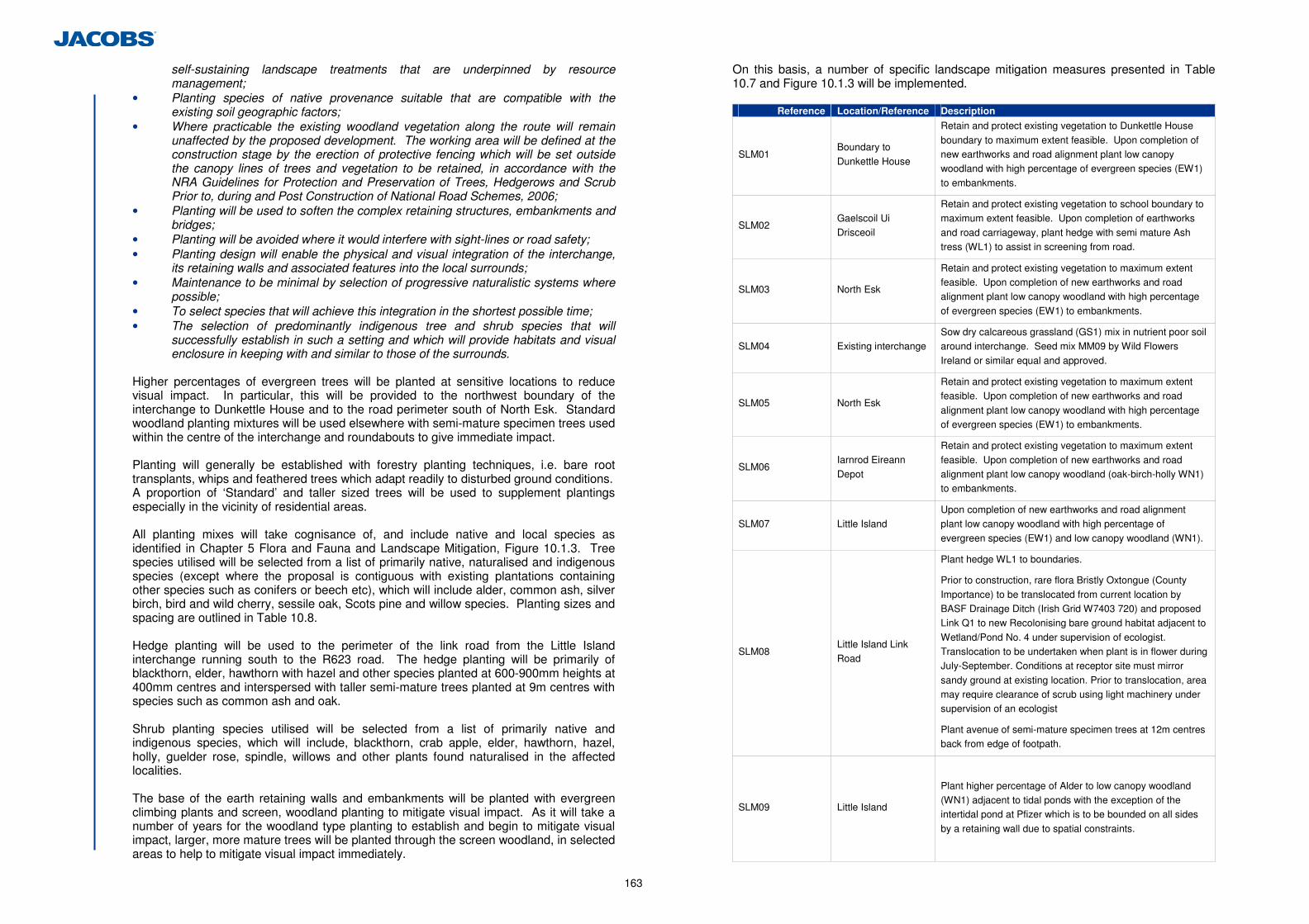
163
self-sustaining landscape treatments that are underpinned by resource management;
• Planting species of native provenance suitable that are compatible with the existing soil geographic factors;
• Where practicable the existing woodland vegetation along the route will remain unaffected by the proposed development. The working area will be defined at the construction stage by the erection of protective fencing which will be set outside the canopy lines of trees and vegetation to be retained, in accordance with the NRA Guidelines for Protection and Preservation of Trees, Hedgerows and Scrub Prior to, during and Post Construction of National Road Schemes, 2006;
• Planting will be used to soften the complex retaining structures, embankments and bridges;
• Planting will be avoided where it would interfere with sight-lines or road safety; • Planting design will enable the physical and visual integration of the interchange,
its retaining walls and associated features into the local surrounds; • Maintenance to be minimal by selection of progressive naturalistic systems where
possible; • To select species that will achieve this integration in the shortest possible time; • The selection of predominantly indigenous tree and shrub species that will
successfully establish in such a setting and which will provide habitats and visual enclosure in keeping with and similar to those of the surrounds.
Higher percentages of evergreen trees will be planted at sensitive locations to reduce visual impact. In particular, this will be provided to the northwest boundary of the interchange to Dunkettle House and to the road perimeter south of North Esk. Standard woodland planting mixtures will be used elsewhere with semi-mature specimen trees used within the centre of the interchange and roundabouts to give immediate impact. Planting will generally be established with forestry planting techniques, i.e. bare root transplants, whips and feathered trees which adapt readily to disturbed ground conditions. A proportion of ‘Standard’ and taller sized trees will be used to supplement plantings especially in the vicinity of residential areas. All planting mixes will take cognisance of, and include native and local species as identified in Chapter 5 Flora and Fauna and Landscape Mitigation, Figure 10.1.3. Tree species utilised will be selected from a list of primarily native, naturalised and indigenous species (except where the proposal is contiguous with existing plantations containing other species such as conifers or beech etc), which will include alder, common ash, silver birch, bird and wild cherry, sessile oak, Scots pine and willow species. Planting sizes and spacing are outlined in Table 10.8. Hedge planting will be used to the perimeter of the link road from the Little Island interchange running south to the R623 road. The hedge planting will be primarily of blackthorn, elder, hawthorn with hazel and other species planted at 600-900mm heights at 400mm centres and interspersed with taller semi-mature trees planted at 9m centres with species such as common ash and oak. Shrub planting species utilised will be selected from a list of primarily native and indigenous species, which will include, blackthorn, crab apple, elder, hawthorn, hazel, holly, guelder rose, spindle, willows and other plants found naturalised in the affected localities. The base of the earth retaining walls and embankments will be planted with evergreen climbing plants and screen, woodland planting to mitigate visual impact. As it will take a number of years for the woodland type planting to establish and begin to mitigate visual impact, larger, more mature trees will be planted through the screen woodland, in selected areas to help to mitigate visual impact immediately.
On this basis, a number of specific landscape mitigation measures presented in Table 10.7 and Figure 10.1.3 will be implemented.
Reference Location/Reference Description
SLM01 Boundary to
Dunkettle House
Retain and protect existing vegetation to Dunkettle House
boundary to maximum extent feasible. Upon completion of new earthworks and road alignment plant low canopy woodland with high percentage of evergreen species (EW1)
to embankments.
SLM02 Gaelscoil Ui Drisceoil
Retain and protect existing vegetation to school boundary to maximum extent feasible. Upon completion of earthworks
and road carriageway, plant hedge with semi mature Ash tress (WL1) to assist in screening from road.
SLM03 North Esk
Retain and protect existing vegetation to maximum extent feasible. Upon completion of new earthworks and road alignment plant low canopy woodland with high percentage
of evergreen species (EW1) to embankments.
SLM04 Existing interchange Sow dry calcareous grassland (GS1) mix in nutrient poor soil around interchange. Seed mix MM09 by Wild Flowers
Ireland or similar equal and approved.
SLM05 North Esk
Retain and protect existing vegetation to maximum extent feasible. Upon completion of new earthworks and road
alignment plant low canopy woodland with high percentage of evergreen species (EW1) to embankments.
SLM06 Iarnrod Eireann
Depot
Retain and protect existing vegetation to maximum extent
feasible. Upon completion of new earthworks and road alignment plant low canopy woodland (oak-birch-holly WN1) to embankments.
SLM07 Little Island Upon completion of new earthworks and road alignment plant low canopy woodland with high percentage of
evergreen species (EW1) and low canopy woodland (WN1).
SLM08 Little Island Link Road
Plant hedge WL1 to boundaries.
Prior to construction, rare flora Bristly Oxtongue (County
Importance) to be translocated from current location by BASF Drainage Ditch (Irish Grid W7403 720) and proposed Link Q1 to new Recolonising bare ground habitat adjacent to
Wetland/Pond No. 4 under supervision of ecologist. Translocation to be undertaken when plant is in flower during July-September. Conditions at receptor site must mirror
sandy ground at existing location. Prior to translocation, area may require clearance of scrub using light machinery under supervision of an ecologist
Plant avenue of semi-mature specimen trees at 12m centres back from edge of footpath.
SLM09 Little Island
Plant higher percentage of Alder to low canopy woodland (WN1) adjacent to tidal ponds with the exception of the intertidal pond at Pfizer which is to be bounded on all sides
by a retaining wall due to spatial constraints.
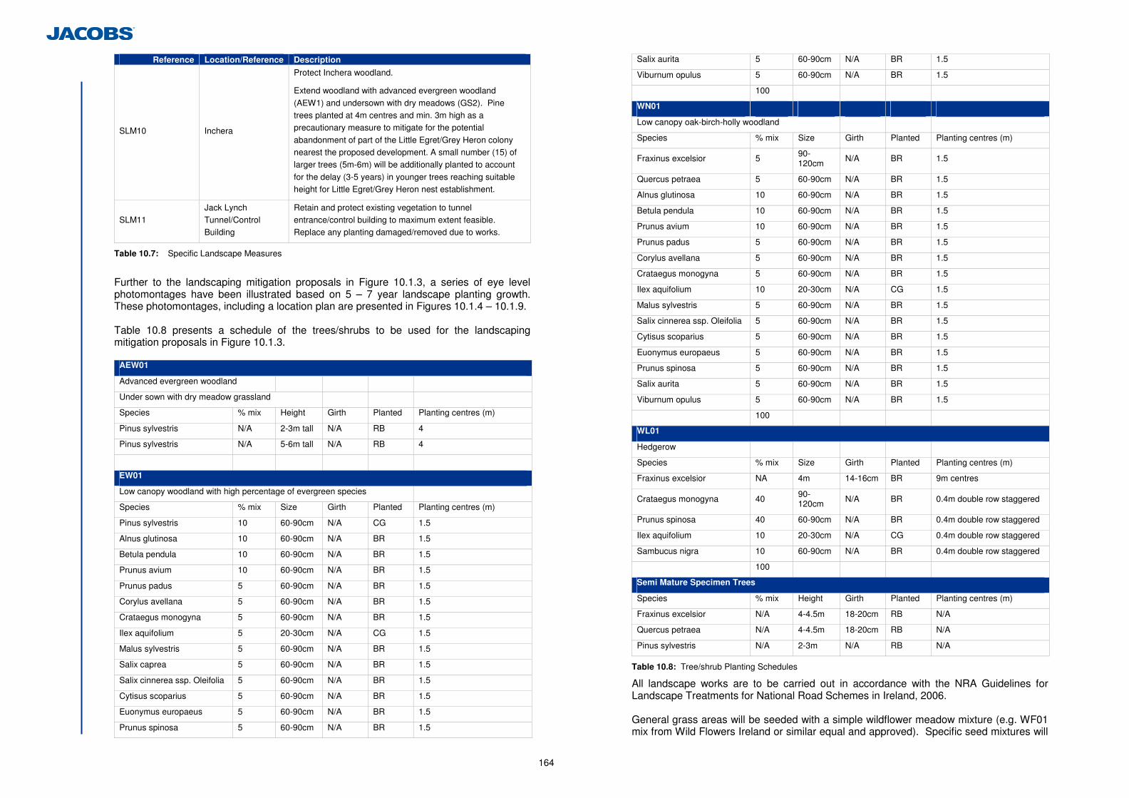
164
Reference Location/Reference Description
SLM10 Inchera
Protect Inchera woodland.
Extend woodland with advanced evergreen woodland
(AEW1) and undersown with dry meadows (GS2). Pine trees planted at 4m centres and min. 3m high as a precautionary measure to mitigate for the potential
abandonment of part of the Little Egret/Grey Heron colony nearest the proposed development. A small number (15) of larger trees (5m-6m) will be additionally planted to account
for the delay (3-5 years) in younger trees reaching suitable height for Little Egret/Grey Heron nest establishment.
SLM11 Jack Lynch Tunnel/Control Building
Retain and protect existing vegetation to tunnel entrance/control building to maximum extent feasible. Replace any planting damaged/removed due to works.
Table 10.7: Specific Landscape Measures
Further to the landscaping mitigation proposals in Figure 10.1.3, a series of eye level photomontages have been illustrated based on 5 – 7 year landscape planting growth. These photomontages, including a location plan are presented in Figures 10.1.4 – 10.1.9. Table 10.8 presents a schedule of the trees/shrubs to be used for the landscaping mitigation proposals in Figure 10.1.3.
AEW01
Advanced evergreen woodland
Under sown with dry meadow grassland
Species % mix Height Girth Planted Planting centres (m)
Pinus sylvestris N/A 2-3m tall N/A RB 4
Pinus sylvestris N/A 5-6m tall N/A RB 4
EW01
Low canopy woodland with high percentage of evergreen species
Species % mix Size Girth Planted Planting centres (m)
Pinus sylvestris 10 60-90cm N/A CG 1.5
Alnus glutinosa 10 60-90cm N/A BR 1.5
Betula pendula 10 60-90cm N/A BR 1.5
Prunus avium 10 60-90cm N/A BR 1.5
Prunus padus 5 60-90cm N/A BR 1.5
Corylus avellana 5 60-90cm N/A BR 1.5
Crataegus monogyna 5 60-90cm N/A BR 1.5
Ilex aquifolium 5 20-30cm N/A CG 1.5
Malus sylvestris 5 60-90cm N/A BR 1.5
Salix caprea 5 60-90cm N/A BR 1.5
Salix cinnerea ssp. Oleifolia 5 60-90cm N/A BR 1.5
Cytisus scoparius 5 60-90cm N/A BR 1.5
Euonymus europaeus 5 60-90cm N/A BR 1.5
Prunus spinosa 5 60-90cm N/A BR 1.5
Salix aurita 5 60-90cm N/A BR 1.5
Viburnum opulus 5 60-90cm N/A BR 1.5
100
WN01
Low canopy oak-birch-holly woodland
Species % mix Size Girth Planted Planting centres (m)
Fraxinus excelsior 5 90-120cm
N/A BR 1.5
Quercus petraea 5 60-90cm N/A BR 1.5
Alnus glutinosa 10 60-90cm N/A BR 1.5
Betula pendula 10 60-90cm N/A BR 1.5
Prunus avium 10 60-90cm N/A BR 1.5
Prunus padus 5 60-90cm N/A BR 1.5
Corylus avellana 5 60-90cm N/A BR 1.5
Crataegus monogyna 5 60-90cm N/A BR 1.5
Ilex aquifolium 10 20-30cm N/A CG 1.5
Malus sylvestris 5 60-90cm N/A BR 1.5
Salix cinnerea ssp. Oleifolia 5 60-90cm N/A BR 1.5
Cytisus scoparius 5 60-90cm N/A BR 1.5
Euonymus europaeus 5 60-90cm N/A BR 1.5
Prunus spinosa 5 60-90cm N/A BR 1.5
Salix aurita 5 60-90cm N/A BR 1.5
Viburnum opulus 5 60-90cm N/A BR 1.5
100
WL01
Hedgerow
Species % mix Size Girth Planted Planting centres (m)
Fraxinus excelsior NA 4m 14-16cm BR 9m centres
Crataegus monogyna 40 90-120cm N/A BR 0.4m double row staggered
Prunus spinosa 40 60-90cm N/A BR 0.4m double row staggered
Ilex aquifolium 10 20-30cm N/A CG 0.4m double row staggered
Sambucus nigra 10 60-90cm N/A BR 0.4m double row staggered
100
Semi Mature Specimen Trees
Species % mix Height Girth Planted Planting centres (m)
Fraxinus excelsior N/A 4-4.5m 18-20cm RB N/A
Quercus petraea N/A 4-4.5m 18-20cm RB N/A
Pinus sylvestris N/A 2-3m N/A RB N/A
Table 10.8: Tree/shrub Planting Schedules
All landscape works are to be carried out in accordance with the NRA Guidelines for Landscape Treatments for National Road Schemes in Ireland, 2006. General grass areas will be seeded with a simple wildflower meadow mixture (e.g. WF01 mix from Wild Flowers Ireland or similar equal and approved). Specific seed mixtures will

165
be used at the existing interchange (SLM04) using a dry calcareous seed mixture (e.g. MM09 mix from Wild Flowers Ireland or similar equal and approved). Treatment wetlands will be seeded with a wetland wild flora mix (e.g. EC05 mix from Wild Flowers Ireland or similar equal and approved). These will be augmented with Reed (Phalaris arundinaceae and Phragmites australis) rhizomes at 0.5m centres. (c) Construction Aspects
The construction contractor will adhere to the NRA’s Draft Guidelines on the Implementation of Landscape Treatment on National Road Schemes in Ireland, 2011. Storage areas will be so located to avoid impacting on existing residential properties, trees, hedgerows, drainage patterns etc. and such areas will be fully re-instated prior to or at the end of the construction contract. (d) Lighting
As much of the proposed development passes through urban or urban fringe areas, lighting fixtures which minimise light emission spillage beyond the road boundary will be utilised without affecting the required levels of lighting on the route.
10.6 Difficulties Encountered in Compiling Information
There were no difficulties encountered in compiling information or in the assessment process of the landscape and visual impacts. 10.7 Cumulative Impacts and Impact Interrelations
There will be no cumulative landscape and visual impacts.
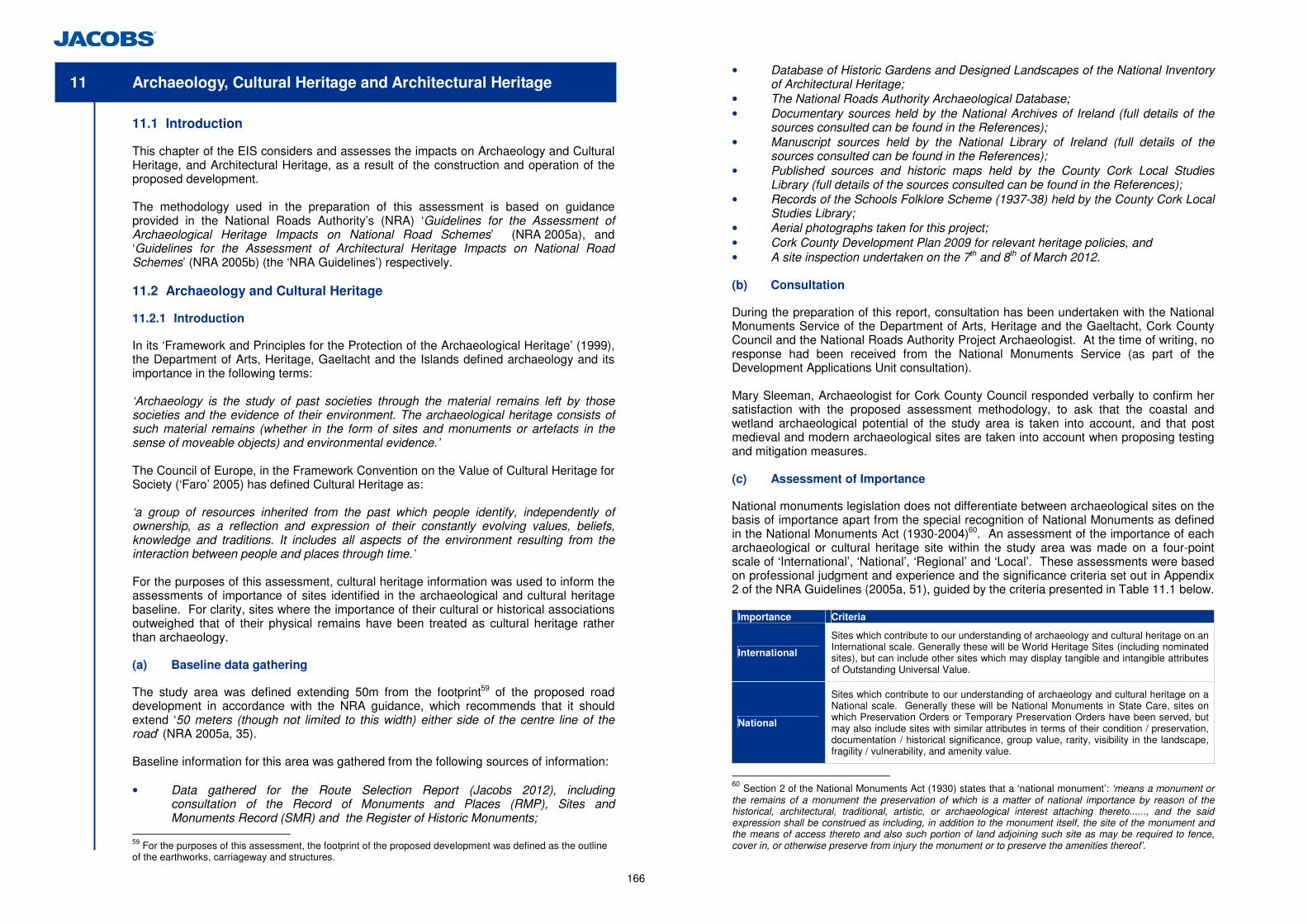
166
11 Archaeology, Cultural Heritage and Architectural Heritage
11.1 Introduction
This chapter of the EIS considers and assesses the impacts on Archaeology and Cultural Heritage, and Architectural Heritage, as a result of the construction and operation of the proposed development. The methodology used in the preparation of this assessment is based on guidance provided in the National Roads Authority’s (NRA) ‘Guidelines for the Assessment of Archaeological Heritage Impacts on National Road Schemes’ (NRA 2005a), and ‘Guidelines for the Assessment of Architectural Heritage Impacts on National Road Schemes’ (NRA 2005b) (the ‘NRA Guidelines’) respectively. 11.2 Archaeology and Cultural Heritage
11.2.1 Introduction
In its ‘Framework and Principles for the Protection of the Archaeological Heritage’ (1999), the Department of Arts, Heritage, Gaeltacht and the Islands defined archaeology and its importance in the following terms: ‘Archaeology is the study of past societies through the material remains left by those societies and the evidence of their environment. The archaeological heritage consists of such material remains (whether in the form of sites and monuments or artefacts in the sense of moveable objects) and environmental evidence.’ The Council of Europe, in the Framework Convention on the Value of Cultural Heritage for Society (‘Faro’ 2005) has defined Cultural Heritage as: ‘a group of resources inherited from the past which people identify, independently of ownership, as a reflection and expression of their constantly evolving values, beliefs, knowledge and traditions. It includes all aspects of the environment resulting from the interaction between people and places through time.’ For the purposes of this assessment, cultural heritage information was used to inform the assessments of importance of sites identified in the archaeological and cultural heritage baseline. For clarity, sites where the importance of their cultural or historical associations outweighed that of their physical remains have been treated as cultural heritage rather than archaeology. (a) Baseline data gathering
The study area was defined extending 50m from the footprint59 of the proposed road development in accordance with the NRA guidance, which recommends that it should extend ‘50 meters (though not limited to this width) either side of the centre line of the road’ (NRA 2005a, 35). Baseline information for this area was gathered from the following sources of information: • Data gathered for the Route Selection Report (Jacobs 2012), including
consultation of the Record of Monuments and Places (RMP), Sites and Monuments Record (SMR) and the Register of Historic Monuments;
59 For the purposes of this assessment, the footprint of the proposed development was defined as the outline of the earthworks, carriageway and structures.
• Database of Historic Gardens and Designed Landscapes of the National Inventory of Architectural Heritage;
• The National Roads Authority Archaeological Database; • Documentary sources held by the National Archives of Ireland (full details of the
sources consulted can be found in the References); • Manuscript sources held by the National Library of Ireland (full details of the
sources consulted can be found in the References); • Published sources and historic maps held by the County Cork Local Studies
Library (full details of the sources consulted can be found in the References); • Records of the Schools Folklore Scheme (1937-38) held by the County Cork Local
Studies Library; • Aerial photographs taken for this project; • Cork County Development Plan 2009 for relevant heritage policies, and • A site inspection undertaken on the 7th and 8th of March 2012. (b) Consultation
During the preparation of this report, consultation has been undertaken with the National Monuments Service of the Department of Arts, Heritage and the Gaeltacht, Cork County Council and the National Roads Authority Project Archaeologist. At the time of writing, no response had been received from the National Monuments Service (as part of the Development Applications Unit consultation). Mary Sleeman, Archaeologist for Cork County Council responded verbally to confirm her satisfaction with the proposed assessment methodology, to ask that the coastal and wetland archaeological potential of the study area is taken into account, and that post medieval and modern archaeological sites are taken into account when proposing testing and mitigation measures. (c) Assessment of Importance
National monuments legislation does not differentiate between archaeological sites on the basis of importance apart from the special recognition of National Monuments as defined in the National Monuments Act (1930-2004)60. An assessment of the importance of each archaeological or cultural heritage site within the study area was made on a four-point scale of ‘International’, ‘National’, ‘Regional’ and ‘Local’. These assessments were based on professional judgment and experience and the significance criteria set out in Appendix 2 of the NRA Guidelines (2005a, 51), guided by the criteria presented in Table 11.1 below.
Importance Criteria
International
Sites which contribute to our understanding of archaeology and cultural heritage on an International scale. Generally these will be World Heritage Sites (including nominated sites), but can include other sites which may display tangible and intangible attributes of Outstanding Universal Value.
National
Sites which contribute to our understanding of archaeology and cultural heritage on a National scale. Generally these will be National Monuments in State Care, sites on which Preservation Orders or Temporary Preservation Orders have been served, but may also include sites with similar attributes in terms of their condition / preservation, documentation / historical significance, group value, rarity, visibility in the landscape, fragility / vulnerability, and amenity value.
60 Section 2 of the National Monuments Act (1930) states that a ‘national monument’: ‘means a monument or the remains of a monument the preservation of which is a matter of national importance by reason of the historical, architectural, traditional, artistic, or archaeological interest attaching thereto......, and the said expression shall be construed as including, in addition to the monument itself, the site of the monument and the means of access thereto and also such portion of land adjoining such site as may be required to fence, cover in, or otherwise preserve from injury the monument or to preserve the amenities thereof’.
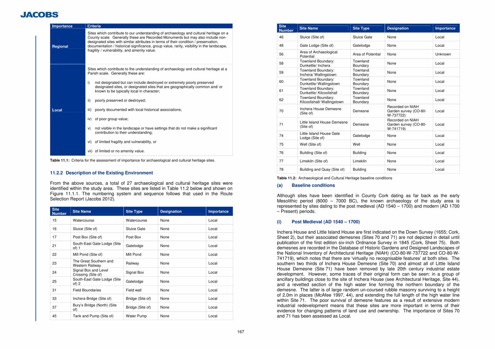
167
Importance Criteria
Regional
Sites which contribute to our understanding of archaeology and cultural heritage on a County scale. Generally these are Recorded Monuments but may also include non-designated sites with similar attributes in terms of their condition / preservation, documentation / historical significance, group value, rarity, visibility in the landscape, fragility / vulnerability, and amenity value.
Local
Sites which contribute to the understanding of archaeology and cultural heritage at a Parish scale. Generally these are:
i) not designated but can include destroyed or extremely poorly preserved designated sites, or designated sites that are geographically common and/ or known to be typically local in character;
ii) poorly preserved or destroyed;
iii) poorly documented with local historical associations;
iv) of poor group value;
v) not visible in the landscape or have settings that do not make a significant contribution to their understanding;
vi) of limited fragility and vulnerability, or
vii) of limited or no amenity value.
Table 11.1: Criteria for the assessment of importance for archaeological and cultural heritage sites.
11.2.2 Description of the Existing Environment
From the above sources, a total of 27 archaeological and cultural heritage sites were identified within the study area. These sites are listed in Table 11.2 below and shown on Figure 11.1.1. The numbering system and sequence follows that used in the Route Selection Report (Jacobs 2012).
Site Number Site Name Site Type Designation Importance
15 Watercourse Watercourse None Local
16 Sluice (Site of) Sluice Gate None Local
17 Post Box (Site of) Post Box None Local
21 South-East Gate Lodge (Site of) 1
Gatelodge None Local
22 Mill Pond (Site of) Mill Pond None Local
23 The Great Southern and Western Railway Railway None Local
24 Signal Box and Level Crossing (Site of) Signal Box None Local
25 South-East Gate Lodge (Site of) 2
Gatelodge None Local
31 Field Boundaries Field wall None Local
33 Inchera Bridge (Site of) Bridge (Site of) None Local
37 Bury’s Bridge (North) (Site of)
Bridge (Site of) None Local
45 Tank and Pump (Site of) Water Pump None Local
Site Number
Site Name Site Type Designation Importance
46 Sluice (Site of) Sluice Gate None Local
48 Gate Lodge (Site of) Gatelodge None Local
56 Area of Archaeological Potential
Area of Potential None Unknown
58 Townland Boundary: Dunkettle/ Inchera
Townland Boundary
None Local
59 Townland Boundary: Inchera/ Wallingstown
Townland Boundary
None Local
60 Townland Boundary: Dunkettle/ Wallingstown
Townland Boundary
None Local
61 Townland Boundary: Dunkettle/ Kilcoolishall
Townland Boundary None Local
62 Townland Boundary: Kilcoolishall/ Wallingstown
Townland Boundary None Local
70 Inchera House Demesne (Site of) Demesne
Recorded on NIAH Garden survey (CO-80-W-737722)
Local
71 Little Island House Demesne (Site of) Demesne
Recorded on NIAH Garden survey (CO-80-W-741719)
Local
74 Little Island House Gate Lodge (Site of)
Gatelodge None Local
75 Well (Site of) Well None Local
76 Building (Site of) Building None Local
77 Limekiln (Site of) Limekiln None Local
78 Building and Quay (Site of) Building None Local
Table 11.2: Archaeological and Cultural Heritage baseline conditions
(a) Baseline conditions
Although sites have been identified in County Cork dating as far back as the early Mesolithic period (8000 – 7000 BC), the known archaeology of the study area is represented by sites dating to the post medieval (AD 1540 – 1700) and modern (AD 1700 – Present) periods. (i) Post Medieval (AD 1540 – 1700)
Inchera House and Little Island House are first indicated on the Down Survey (1655; Cork, Sheet 2), but their associated demesnes (Sites 70 and 71) are not depicted in detail until publication of the first edition six-inch Ordnance Survey in 1845 (Cork, Sheet 75). Both demesnes are recorded in the Database of Historic Gardens and Designed Landscapes of the National Inventory of Architectural Heritage (NIAH) (CO-80-W-737722 and CO-80-W-741719), which notes that there are ‘virtually no recognisable features’ at both sites. The southern two thirds of Inchera House Demesne (Site 70) and almost all of Little Island House Demesne (Site 71) have been removed by late 20th century industrial estate development. However, some traces of their original form can be seen: in a group of ancillary buildings close to the site of Inchera House (see Architectural Heritage, Site 44), and a revetted section of the high water line forming the northern boundary of the demesne. The latter is of large random un-coursed rubble masonry surviving to a height of 2.0m in places (McAfee 1997, 44), and extending the full length of the high water line within Site 71. The poor survival of demesne features as a result of extensive modern industrial redevelopment means that these sites are more important in terms of their evidence for changing patterns of land use and ownership. The importance of Sites 70 and 71 has been assessed as Local.
168
(ii) Modern (AD 1700 – Present)
Two gate lodges (Sites 21 and 25) are depicted on the first edition six-inch Ordnance Survey (1845; Cork, Sheet 75). They were located south-east of Dunkettle House (see Architectural Heritage, Site 1), where they controlled access from the public highway to driveways leading into Dunkettle House Demesne (see Architectural Heritage, Site 27). Neither site is depicted on the first edition 25-inch Ordnance Survey map of 1898 (Cork, Sheet LXXV.5), by which time Site 21 seems to have been removed as part of changes to the access drives south-east of Dunkettle House Demesne, and Site 25 demolished to make way for a level crossing (Site 24) on the Great Southern and Western Railway (Site 23). Two further gate lodges (Sites 48 and 74) related to Little Island House and Inchera House respectively were also depicted on the first edition six-inch Ordnance Survey (1845; Cork, Sheet 75). The former was situated at the north end of the original Bury’s Bridge and controlled access to Little Island and the house; the latter was located at the south-eastern corner of Inchera House Demesne (Site 70) and appears to have been intended to control access from little Island to the east and traffic using a quay (Site 78) to the south-east. No trace of any of these sites was visible during the site inspection conducted for this report and the location of Site 21 appears to have been subject to disturbance during construction of the M8 northern approach to the existing Dunkettle Interchange. The importance of these sites has been assessed as Local. Site 31 is a linear earthwork located in mature plantation woodland south of Dunkettle house and immediately north of the existing road linking the M8 with Dunkettle roundabout east of the study area. The earthwork consists of a shallow ditch with a low bank and a stone retaining wall on its south side. It follows a sinuous course through the woodland becoming indistinct at both ends. Although the woodland that contains it is depicted on the first edition six-inch Ordnance Survey (1845; Cork, Sheet 75), Site 31 itself is not shown on any of the maps examined for this report. Although given its location within Dunkettle House Demesne it may be the remains of an ornamental landscape feature, it is most likely to be the remains of a traditional field wall and ditch belonging to an earlier field pattern that has been preserved within the plantation. The importance of this site has been assessed as Local. Inchera Bridge (Site 33) linked Little Island and Inchera House Demesne (Site 70) to the mainland. No bridge is shown here on the Down Survey of 1655, but one is depicted on the first edition six-inch Ordnance Survey (1845; Cork, Sheet 75). The existing bridge appears to be of entirely modern construction, with arches formed from reinforced concrete culverts and the structure and approaches of stone ‘rip-rap’. However, it is possible that foundations of the original structure may survive in this area. The importance of Site 33 has been assessed as Local. The Great Southern and Western Railway (GSWR) (Site 23) was begun in 1846 and reached Cork in 1849 (www.irishrailwayana.com). The section of line passing through Dunkettle was originally built as the Cork and Youghal Railway in 1854, and was bought by the GSWR in 1866. Regular passenger services ceased in the 1980s although summer excursions from Cork to the coast continued for a short time alongside freight traffic. The line was fully reopened as far as Midleton in 1999 (ibid.). The site of a Signal Box and Level Crossing (Site 24), and the site of Bury’s Bridge (North) (Site 37) are associated with Site 23. The former has been completely removed and there are no traces of either the crossing or signal box surviving. Although there is still a bridge at the same location as Site 37, this is a modern concrete road bridge and no trace of the original structure survives. The importance of all three sites has been assessed as Local. Site 17 is the location of a Post Box marked on the first edition 25-inch Ordnance Survey of 1898 (Cork, Sheet LXXV.5). It is depicted on the west side of the junction between Dunkettle Road and the main road to Cork, close to the location of a modern roundabout. There is no trace of the original box, although a post 1921 box (see Architectural Heritage,
Site 72) is located on the north side of Dunkettle Road c. 40m north-east of Site 17. The site of the post box is more important as an indicator of how the movement of people through this area has changed over the last century than as an archaeological site in its own right. The importance of this site has been assessed as Local. A watercourse (Site 15) and possible mill pond (Site 22) are depicted on the first edition six-inch Ordnance Survey (1845; Cork, Sheet 75). The watercourse fed the mill pond at its north-east corner and was controlled by a sluice gate (Site 16) at its own north end. The pond is depicted as being much shrunken in size by the publication of the third edition Ordnance Survey 25 inch maps in 1930 (Cork, Sheet LXXV.5). The watercourse in visible as a shallow stream c. 0.6m wide and 0.5m deep, but no trace of the mill pond survives today. These sites are more important as evidence for the historic presence of mills using both the River Lee and water collected from high ground to the north as a power source, than for any archaeological remains that may survive. The importance of all three sites has been assessed as Local. Sites 45 and 46 were the sites of a tank and pump, and a sluice gate respectively. They are depicted on a first edition 25-inch Ordnance Survey of 1898 (Cork, Sheet LXXV.5). Both sites were located a short distance inland of the high water mark on the south side of the channel separating Little Island from the mainland. A further well (Site 75), a limekiln (Site 76) and an unidentified building (Site 77) were recorded on the same map, and formed part of a group of structures associated with Inchera House Outbuildings (see Architectural Heritage Site 44, below).The location of all five sites is now overgrown scrubland at the perimeter of an extensive industrial estate and no trace of any was observed during the site inspection conducted for this report. These sites are more important in terms of their evidence for changes in domestic and agricultural practice than for their physical remains, which are likely to be ephemeral. The importance of all five sites has been assessed as Local. At the southern edge of Little Island, a small unidentified building and a quay are indicated at the north-east corner of a small bay. They are immediately west of the townland boundary (Site 59) separating Inchera House Demesne (Site 70) and Little Island Demesne (Site 71), and are therefore believed to be estate buildings belonging to the former. No trace of either site was observed during the site inspection conducted for this report. The quay in particular is more important in terms of its indication of the maritime location of the demesne and the study area in general. The importance of both sites has been assessed as Local. Five townland boundaries (Sites 58, 59, 60, 61 and 62) are located within the study area. The boundary between Inchera and Wallingstown (Site 59) was originally defined by a meandering north-west to south-east aligned hedge (Ordnance Survey first edition six-inch, 1845; Cork, Sheet 75), but construction of a modern industrial estate has removed all physical traces. The boundaries between Dunkettle and Wallingstown (Site 60) and between Dunkettle and Kilcoolishall (Site 61) are partly defined by the high water marks of the shallow creek that divides the western part of Little Island from the mainland. Further east much of this watercourse has been reclaimed and the land is now used for extensive industrial estates; the watercourse survives as a culvert. On the mainland, the northern part of Site 61 is defined by the eastern boundary wall of the grounds to North Esk House (see Architectural Heritage, Site 42), a watercourse and the north side of Dunkettle Road. The boundary between Inchera and Wallingstown (Site 58) is also largely defined by the tidal limit of the River Lee, although much of this particular site has been removed by construction of the existing Dunkettle Interchange. The boundary between Kilcoolishall and Wallingstown townlands (Site 62) is partially defined by what was until the late 19th century the high water mark on the north bank of the tidal creek, which was subsequently reclaimed. The importance of the townland boundaries is more in terms of their historical and cultural significance than their physical remains, which reflect the prevailing land divisions and natural features in their immediate surroundings. This is compounded in the
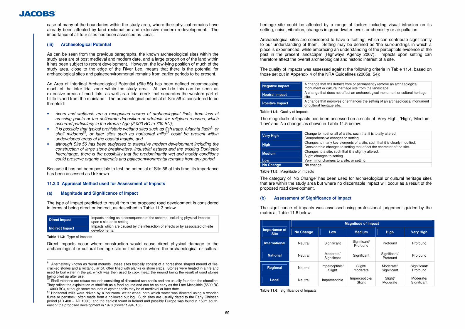
169
case of many of the boundaries within the study area, where their physical remains have already been affected by land reclamation and extensive modern redevelopment. The importance of all four sites has been assessed as Local. (iii) Archaeological Potential
As can be seen from the previous paragraphs, the known archaeological sites within the study area are of post medieval and modern date, and a large proportion of the land within it has been subject to recent development. However, the low-lying position of much of the study area, close to the edge of the River Lee, means that there is the potential for archaeological sites and palaeoenvironmental remains from earlier periods to be present. An Area of Intertidal Archaeological Potential (Site 56) has been defined encompassing much of the inter-tidal zone within the study area. At low tide this can be seen as extensive areas of mud flats, as well as a tidal creek that separates the western part of Little Island from the mainland. The archaeological potential of Site 56 is considered to be threefold: • rivers and wetlands are a recognised source of archaeological finds, from loss at
crossing points or the deliberate deposition of artefacts for religious reasons, which occurred particularly in the Bronze Age (2,000 BC to 700 BC);
• it is possible that typical prehistoric wetland sites such as fish traps, fulachta fiadh61 or shell middens62, or later sites such as horizontal mills63 could be present within undeveloped areas of the coastal margin, and
• although Site 56 has been subjected to extensive modern development including the construction of large stone breakwaters, industrial estates and the existing Dunkettle Interchange, there is the possibility that the predominantly wet and muddy conditions could preserve organic materials and palaeoenvironmental remains from any period.
Because it has not been possible to test the potential of Site 56 at this time, its importance has been assessed as Unknown. 11.2.3 Appraisal Method used for Assessment of Impacts
(a) Magnitude and Significance of Impact
The type of impact predicted to result from the proposed road development is considered in terms of being direct or indirect, as described in Table 11.3 below.
Direct Impact Impacts arising as a consequence of the scheme, including physical impacts upon a site or its setting.
Indirect Impact Impacts which are caused by the interaction of effects or by associated off-site developments.
Table 11.3: Type of Impacts
Direct impacts occur where construction would cause direct physical damage to the archaeological or cultural heritage site or feature or where the archaeological or cultural
61 Alternatively known as ‘burnt mounds’, these sites typically consist of a horseshoe shaped mound of fire-cracked stones and a rectangular pit, often lined with planks or stone slabs. Stones were heated in a fire and used to boil water in the pit, which was then used to cook meat, the mound being the result of used stones being piled up after use. 62 Shell middens are refuse mounds consisting of discarded sea-shells and are usually found on the shoreline. They reflect the exploitation of shellfish as a food source and can be as early as the Late Mesolithic (5500 BC – 4000 BC), although some mounds of oyster shells may be of medieval or later date. 63 Horizontal mills were driven by a horizontal water wheel onto which water was directed using a wooden flume or penstock, often made from a hollowed out log. Such sites are usually dated to the Early Christian period (AD 400 – AD 1000), and the earliest found in Ireland and possibly Europe was found c. 150m south-east of the proposed development in 1978 (Power 1994, 165).
heritage site could be affected by a range of factors including visual intrusion on its setting, noise, vibration, changes in groundwater levels or chemistry or air pollution. Archaeological sites are considered to have a ‘setting’, which can contribute significantly to our understanding of them. Setting may be defined as ‘the surroundings in which a place is experienced, while embracing an understanding of the perceptible evidence of the past in the present landscape’ (Highways Agency 2007). Impacts upon setting can therefore affect the overall archaeological and historic interest of a site. The quality of impacts was assessed against the following criteria in Table 11.4, based on those set out in Appendix 4 of the NRA Guidelines (2005a, 54):
Negative Impact A change that will detract from or permanently remove an archaeological monument or cultural heritage site from the landscape.
Neutral Impact A change that does not affect an archaeological monument or cultural heritage site.
Positive Impact A change that improves or enhances the setting of an archaeological monument or cultural heritage site.
Table 11.4: Quality of Impacts
The magnitude of impacts has been assessed on a scale of ‘Very High’, ’High‘, ’Medium‘, ’Low‘ and ‘No change’ as shown in Table 11.5 below:
Very High Change to most or all of a site, such that it is totally altered. Comprehensive changes to setting.
High Changes to many key elements of a site, such that it is clearly modified. Considerable changes to setting that affect the character of the site.
Medium Changes to a site, such that it is slightly altered. Slight changes to setting.
Low Very minor changes to a site, or setting. No Change No change.
Table 11.5: Magnitude of Impacts
The category of ‘No Change’ has been used for archaeological or cultural heritage sites that are within the study area but where no discernable impact will occur as a result of the proposed road development. (b) Assessment of Significance of Impact
The significance of impacts was assessed using professional judgement guided by the matrix at Table 11.6 below.
Magnitude of Impact
Importance of Site No Change Low Medium High Very High
International Neutral Significant Significant/ Profound
Profound Profound
National Neutral Moderate/ Significant
Significant Significant/ Profound
Profound
Regional Neutral Imperceptible/ Slight
Slight/ moderate
Moderate/ Significant
Significant/ Profound
Local Neutral Imperceptible Imperceptible/ Slight
Slight/ Moderate
Moderate/ Significant
Table 11.6: Significance of Impacts
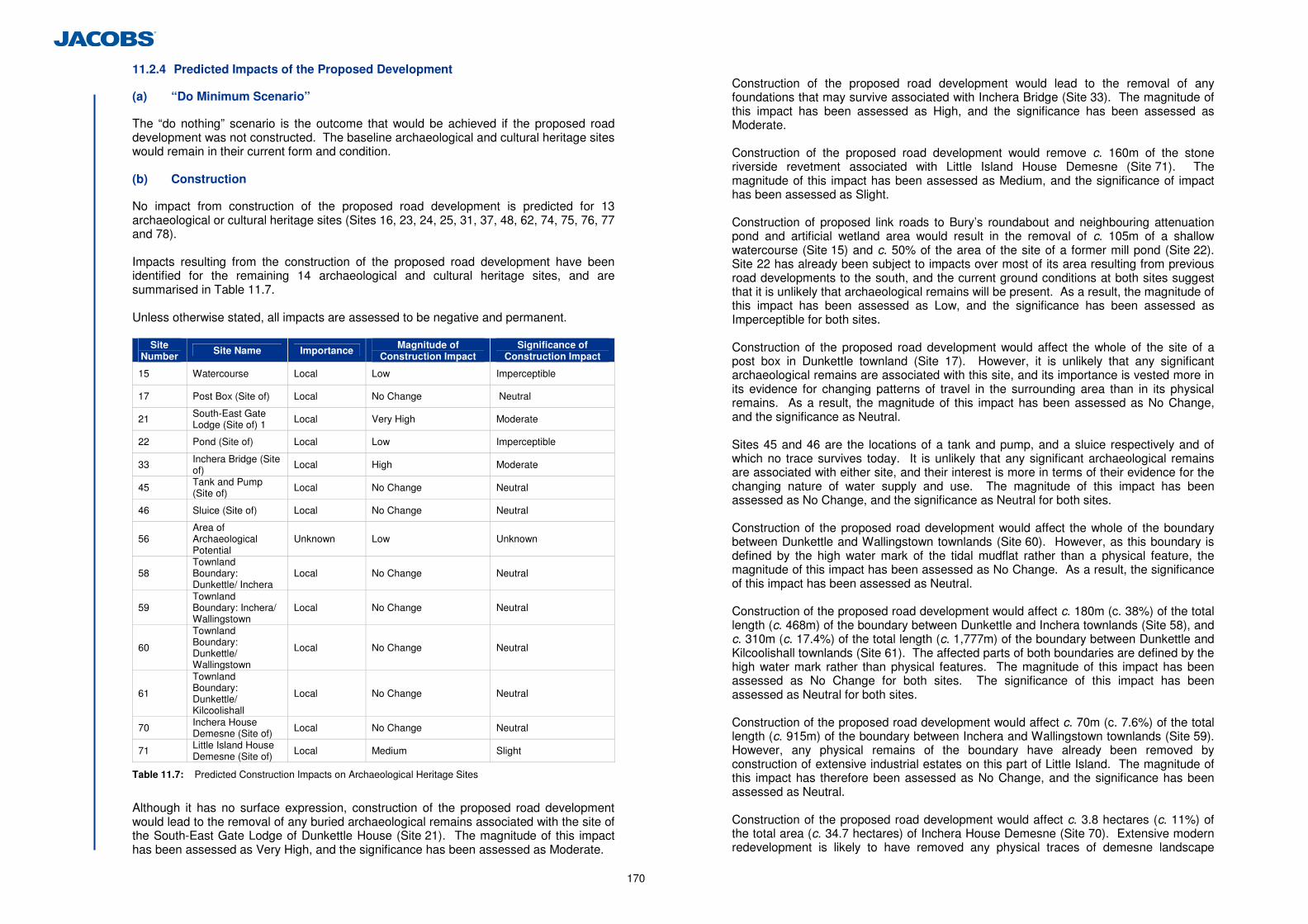
170
11.2.4 Predicted Impacts of the Proposed Development
(a) “Do Minimum Scenario”
The “do nothing” scenario is the outcome that would be achieved if the proposed road development was not constructed. The baseline archaeological and cultural heritage sites would remain in their current form and condition. (b) Construction
No impact from construction of the proposed road development is predicted for 13 archaeological or cultural heritage sites (Sites 16, 23, 24, 25, 31, 37, 48, 62, 74, 75, 76, 77 and 78). Impacts resulting from the construction of the proposed road development have been identified for the remaining 14 archaeological and cultural heritage sites, and are summarised in Table 11.7. Unless otherwise stated, all impacts are assessed to be negative and permanent.
Site Number
Site Name Importance Magnitude of Construction Impact
Significance of Construction Impact
15 Watercourse Local Low Imperceptible
17 Post Box (Site of) Local No Change Neutral
21 South-East Gate Lodge (Site of) 1 Local Very High Moderate
22 Pond (Site of) Local Low Imperceptible
33 Inchera Bridge (Site of) Local High Moderate
45 Tank and Pump (Site of) Local No Change Neutral
46 Sluice (Site of) Local No Change Neutral
56 Area of Archaeological Potential
Unknown Low Unknown
58 Townland Boundary: Dunkettle/ Inchera
Local No Change Neutral
59 Townland Boundary: Inchera/ Wallingstown
Local No Change Neutral
60
Townland Boundary: Dunkettle/ Wallingstown
Local No Change Neutral
61
Townland Boundary: Dunkettle/ Kilcoolishall
Local No Change Neutral
70 Inchera House Demesne (Site of) Local No Change Neutral
71 Little Island House Demesne (Site of) Local Medium Slight
Table 11.7: Predicted Construction Impacts on Archaeological Heritage Sites
Although it has no surface expression, construction of the proposed road development would lead to the removal of any buried archaeological remains associated with the site of the South-East Gate Lodge of Dunkettle House (Site 21). The magnitude of this impact has been assessed as Very High, and the significance has been assessed as Moderate.
Construction of the proposed road development would lead to the removal of any foundations that may survive associated with Inchera Bridge (Site 33). The magnitude of this impact has been assessed as High, and the significance has been assessed as Moderate. Construction of the proposed road development would remove c. 160m of the stone riverside revetment associated with Little Island House Demesne (Site 71). The magnitude of this impact has been assessed as Medium, and the significance of impact has been assessed as Slight. Construction of proposed link roads to Bury’s roundabout and neighbouring attenuation pond and artificial wetland area would result in the removal of c. 105m of a shallow watercourse (Site 15) and c. 50% of the area of the site of a former mill pond (Site 22). Site 22 has already been subject to impacts over most of its area resulting from previous road developments to the south, and the current ground conditions at both sites suggest that it is unlikely that archaeological remains will be present. As a result, the magnitude of this impact has been assessed as Low, and the significance has been assessed as Imperceptible for both sites. Construction of the proposed road development would affect the whole of the site of a post box in Dunkettle townland (Site 17). However, it is unlikely that any significant archaeological remains are associated with this site, and its importance is vested more in its evidence for changing patterns of travel in the surrounding area than in its physical remains. As a result, the magnitude of this impact has been assessed as No Change, and the significance as Neutral. Sites 45 and 46 are the locations of a tank and pump, and a sluice respectively and of which no trace survives today. It is unlikely that any significant archaeological remains are associated with either site, and their interest is more in terms of their evidence for the changing nature of water supply and use. The magnitude of this impact has been assessed as No Change, and the significance as Neutral for both sites. Construction of the proposed road development would affect the whole of the boundary between Dunkettle and Wallingstown townlands (Site 60). However, as this boundary is defined by the high water mark of the tidal mudflat rather than a physical feature, the magnitude of this impact has been assessed as No Change. As a result, the significance of this impact has been assessed as Neutral. Construction of the proposed road development would affect c. 180m (c. 38%) of the total length (c. 468m) of the boundary between Dunkettle and Inchera townlands (Site 58), and c. 310m (c. 17.4%) of the total length (c. 1,777m) of the boundary between Dunkettle and Kilcoolishall townlands (Site 61). The affected parts of both boundaries are defined by the high water mark rather than physical features. The magnitude of this impact has been assessed as No Change for both sites. The significance of this impact has been assessed as Neutral for both sites. Construction of the proposed road development would affect c. 70m (c. 7.6%) of the total length (c. 915m) of the boundary between Inchera and Wallingstown townlands (Site 59). However, any physical remains of the boundary have already been removed by construction of extensive industrial estates on this part of Little Island. The magnitude of this impact has therefore been assessed as No Change, and the significance has been assessed as Neutral. Construction of the proposed road development would affect c. 3.8 hectares (c. 11%) of the total area (c. 34.7 hectares) of Inchera House Demesne (Site 70). Extensive modern redevelopment is likely to have removed any physical traces of demesne landscape
171
features. The magnitude of this impact has been assessed as No Change, and the significance of impact has been assessed as Neutral. Construction of the proposed road development including attenuation ponds, artificial wetlands and compensatory flood areas within the Area of Intertidal Archaeological Potential (Site 56) would have an effect on c. 3.44 hectares of the total area of the site as defined. This could result in the removal of palaeoenvironmental evidence or other archaeological remains within the footprint of the proposed road development. Given the relatively small area that would be affected, the magnitude of this impact has been assessed as Low. The significance of this impact has been assessed as Unknown. (c) Operation
The removal of archaeological remains has been assessed to be a construction phase impact and none of the sites identified within the study area have settings that contribute to their importance. As a result, no additional impacts during the operation of the proposed road development are predicted. (d) Proposed Mitigation and Avoidance Measures
Where preservation in situ is not feasible, preservation by record will be used to mitigate identified impacts. This methodology is in accordance with the principles and recommendations outlined in the ‘Framework and Principles for the Protection of the Archaeological Heritage’ (DAHGI 1999, 25). Preservation by record consists of fully recorded investigations in the field, followed by analyses, reporting and publication. The information gained will be widely disseminated by a series of printed and internet publications for the benefit of scholars and the general public. Measures to avoid or reduce potential impacts on archaeological sites have been considered throughout the route selection process and incorporated into the design of the proposed road development. Archaeological testing through a combination of geophysical survey and trial trenching will be undertaken ahead of construction. The aim of this is to confirm the presence or absence, nature and importance of any archaeological remains that may be present. The results of testing would allow the design of appropriate works to resolve identified impacts, possibly including resolution excavation.
Due to the location and nature of the proposed road development, ‘undisturbed’ areas where geophysical surveys and test excavation can be carried out are small and restricted in location. The location and extent of geophysical survey areas and the layout and sample size of the trial trench array will be subject to approval of the NRA Project Archaeologist in consultation with the National Monuments Service and the Director of the National Museum of Ireland. Testing will be carried out well in advance of road construction to allow sufficient time for ameliorative action to be taken in the event of archaeological remains being identified. A scheme of historic building recording, comprising the preparation of a written and photographic record is proposed to mitigate the impact on the section of riverside revetment at the north edge of Little Island House Demesne (Site 71). This will provide a permanent record of the revetment and is adequate mitigation for its removal. Where sites have been assessed to be important for their cultural or historical significance rather than their physical remains, no specific testing or mitigation measures are proposed, and their identification in this assessment is considered sufficient mitigation. However, where possible their locations will be subject to archaeological testing and appropriate mitigation measures applied where necessary.
To address the archaeological potential of Site 56, a programme of palaeoenvironmental assessment is proposed, in line with the NRA’s ‘Guidelines for the Testing and Mitigation of the Wetland Archaeological Heritage’ (NRA 2005c). This will be achieved through the retrieval of cores from deposits of palaeoenvironmental potential, followed by analysis and reporting. Any further archaeological resolution measures arising from these assessments will be implemented, subject to the approval of the NRA Project Archaeologist and the National Monuments Service, in consultation with the Museum of Ireland. In addition, the banks and bed of the tidal creek separating the western part of Little Island from the mainland will be examined by metal detector survey. The findspots of any archaeological objects recovered will be recorded and the finds conserved. At all locations within the footprint of the proposed road development, the potential for the presence of archaeological deposits or finds adjacent to the tidal creek will be addressed during test excavation. All of the pre-construction testing and mitigation measures proposed will be subject to approval from the appointed NRA Project Archaeologist in consultation with the National Monuments Service and the Director of the National Museum of Ireland as appropriate. Proposed mitigation measures will also comply with the National Monuments Acts (1930 – 2004) and the Code of Practice (2000) agreed between the National Roads Authority and the then Minister for Arts, Heritage, Gaeltacht and the Islands.
Following approval of the proposed road development, any mitigation measures will be carried out under Ministerial Direction, as defined in Section 14A(1) of the National Monuments (Amendment) Act 2004.
All archaeological works require a stage of post fieldwork assessment, analysis and reporting. All archaeological reporting shall have regard to the ‘Guidelines for Authors of Reports on Archaeological Excavations’ published by the National Monuments Service of the Department of Arts, Heritage and Local Government in 2006. (e) Residual Impacts
Residual impacts predicted as a result of construction of the proposed road development are summarised in Table 11.8 below.
Site No. Site Name Importance
Unmitigated Significance
of Construction
Impact
Mitigation Measure
Residual Magnitude of Construction
Impact
Residual Significance
of Construction
Impact
15 Watercourse Local Imperceptible
• Test excavation
• Resolution excavation as required
Low Neutral
17 Post Box (Site of)
Local Neutral • None proposed
No Change Neutral
21 South-East Gate Lodge (Site of) 1
Local Moderate
• Test excavation
• Resolution excavation as required
High Slight
22 Pond (Site of) Local Imperceptible
• Test excavation
• Resolution excavation as required
Low Neutral
172
Site No.
Site Name Importance
Unmitigated Significance
of Construction
Impact
Mitigation Measure
Residual Magnitude of Construction
Impact
Residual Significance
of Construction
Impact
33 Inchera Bridge (Site of) Local Moderate
• Test Excavation
• Resolution excavation as required
Medium Imperceptible
45 Tank and Pump (Site of) Local Neutral • None
proposed No Change Neutral
46 Sluice (Site of) Local Neutral • None proposed
No Change Neutral
56 Area of Archaeological Potential
Unknown Unknown
• Geophysical survey;
• Palaeoenvironmental assessment
• Metal detecting survey
• Test excavation
• Resolution excavation as required
Low Unknown
58
Townland Boundary: Dunkettle/ Inchera
Local Neutral • None proposed
No Change Neutral
59
Townland Boundary: Inchera/ Wallingstown
Local Neutral • None proposed
No Change Neutral
60
Townland Boundary: Dunkettle/ Wallingstown
Local Neutral • None proposed
No Change Neutral
61
Townland Boundary: Dunkettle/ Kilcoolishall
Local Neutral • None proposed
No Change Neutral
70 Inchera House Demesne (Site of)
Local Neutral • None proposed
No Change Neutral
71
Little Island House Demesne (Site of)
Local Slight • Historic
building recording
Low Imperceptible
Table 11.8: Residual Construction Impacts on Archaeological and Cultural Heritage Sites
11.2.5 Cumulative Impacts and Impact Interrelations
The NRA publication ‘Environmental Impact Assessment of National Road Schemes – A Practical Guide’ (2008, 52) defines cumulative effects as impacts that result from incremental changes caused by other past, present or reasonably foreseeable actions, together with the proposed road development. A review of the online planning systems for County Cork and Cork City has not identified any pending or granted planning applications for major developments which have the potential to increase the cumulative impact of the proposed road development. The cumulative impact of the proposed road development on archaeology and cultural heritage is therefore assessed to be Neutral.
11.2.6 Assessment Conclusions
A total of 27 archaeological and cultural heritage sites were identified within the study area. After mitigation the following impacts are predicted during construction: • Slight negative impacts on one site (Site 21); • Imperceptible negative impacts on two sites (Sites 33 and 71); • An Unknown impact on one area of intertidal archaeological potential (Site 56), and • Neutral impacts on 23 sites (Sites 15, 16, 17, 22, 23, 24, 25, 31, 37, 45, 46, 48, 58,
59, 60, 61, 62, 70, 74, 75, 76, 77 and 78). After mitigation, no additional impacts are predicted during operation. 11.3 Architectural Heritage
11.3.1 Introduction
This section presents the results of the architectural heritage assessment for the proposed development. The methodology used in the preparation of this assessment is based on guidance provided in the National Roads Authority’s (NRA) ‘Guidelines for the Assessment of Architectural Heritage Impacts on National Road Schemes’ (NRA 2005). 11.3.2 Consultation
During the preparation of this report, consultation has been undertaken with Mona Hallinan, Conservation Officer for Cork County Council on April 2nd 2012 and Ronnie McDowell, Senior Planner for Cork City Council on April 4th 2012. Ms Hallinan confirmed the extent of the attendant grounds to Dunkettle House (Site 1; Figure 11.1.2). The most significant concern in relation to architectural heritage was confirmed to be the potential for further impact or degradation of the historic demesne associated with Dunkettle House. The avoidance of this area by the proposed road development was acknowledged by Ms Hallinan. Ronnie McDowell provided comments in relation to potential impacts on Blackrock Castle (Site 49). The distance of the proposed development from the castle was acknowledged to offset the potential for a significant impact on the castle. Assessment of the protected views to Blackrock Castle identified in the Cork City Development Plan (2009) was recommended, as was the undesignated view from the amenity walk extending along the foreshore to the east of Blackrock Castle. Please refer to the Landscape and Visual Assessment (Chapter 10) for assessment of these views. (a) Baseline Data Gathering
For the purposes of the Environmental Impact Statement, a study area was defined extending 50m from the footprint of the proposed road development. Baseline information for this area was gathered from the following sources of information: • Technical reports prepared during earlier assessments of the proposed road
development comprising the Dunkettle House Impact Study (Jacobs 2011) and the N8/N25 Dunkettle Interchange Route Selection Report (Jacobs 2012);
173
• Data gathered for the Scoping and Route Selection Report, including consultation of the Record of Monuments and Places (RMP), Sites and Monuments Record (SMR) and the Register of Historic Monuments;
• Documentary sources held by the National Archives of Ireland; • Manuscript sources held by the National Library of Ireland; • Published and archival sources held by the Irish Architectural Archive; • Published sources and historic maps held by the County Cork Local Studies Library; • Aerial photographs taken for this project; • The National Inventory of Architectural Heritage (NIAH) for East Cork; • National Inventory of Architectural Heritage (NIAH) Survey of Historic Gardens and
Designed Landscapes; • Cork County Development Plan 2009 for the Record of Protected Structures,
Architectural Conservation Areas and relevant heritage policies, and • A site inspection undertaken on the 7th and 8th of March 2012.
A full list of the sources consulted is provided in the References at the end of this chapter. Due to the potential for impacts on the setting of architectural heritage sites outside the study area to arise as a result of the proposed development, data gathered for the Scoping and Route Selection Report was reviewed. During the site inspection, assessment was undertaken to identify those sites outside the study area which may be impacted by the proposed development. Potential for impact was identified at ten sites comprising: • Dunkettle House (Site 1); • Dunsland House Lodge (Site 35); • Dunsland House (Site 36); • Building east of North Esk (Site 43) • Blackrock Castle (Site 49); • Lota House (Site 50); • Father Matthew Tower (Site 53); • North Esk East Gate Lodge (Site 55); • Lota House Demesne (Site 65); and • Factory Hill Demesne (Site 67). These sites have been included in the baseline and are discussed in further detail below. (b) Assessment of Importance
In accordance with the requirements of the NRA guidelines, an assessment of the importance of architectural heritage sites was undertaken on a four point scale of International, National, Regional, and Local (NRA 2005b, 14). Assessment was informed by the criteria outlined in the Planning and Development Act 2000 for the designation of Protected Structures: • Architectural; • Historical; • Archaeological; • Artistic; • Cultural; • Scientific; • Technical; and • Social interest. The NIAH Handbook (DAHG 2011a) provides further information on the definition of National, Regional and Local importance, as summarised in Table 11.9 below.
Importance Criteria
International Structures or sites of sufficient architectural heritage importance to be considered in an international context. These are exceptional structures that can be compared to and contrasted with the finest architectural heritage in other countries.
National Structures or sites that make a significant contribution to the architectural heritage of Ireland. These are structures and sites that are considered to be of great architectural heritage significance in an Irish context.
Regional
Structures or sites that make a significant contribution to the architectural heritage within their region or area. They also stand in comparison with similar structures or sites in other regions or areas within Ireland. Increasingly, structures that need to be protected include structures or sites that make a significant contribution to the architectural heritage within their own locality. Examples of these would include modest terraces and timber shopfronts.
Local Structures or sites of some vintage that make a contribution to the architectural heritage but may not merit being placed in the RPS separately. Such structures may have lost much of their original fabric.
Table 11.9: Criteria for the Assessment of Importance for Architectural Heritage Sites (based on DAHG 2011a, 22).
11.3.3 Description of the Existing Environment
From the above sources, a total of nine Architectural Heritage sites were identified within the study area. As described above, an additional ten sites were included due to the potential for impacts on their setting. These sites are listed in Table 11.10 below and shown on Figure 11.1.2.
Site No.
Site Name Site Type Designation Importance
1 Dunkettle House Country house Protected Structure; Recorded Monument; Recorded by NIAH
National
19 South-West Gate Lodge Gate lodge None Local
20 South-West Gateway Gateway None Local
27 Dunkettle House Demesne
Demesne Recorded on NIAH Garden Survey Regional
29 Richmond Demesne & House
Demesne; country house
Recorded on NIAH Garden Survey Local
35 Dunsland House Lodge Gate lodge Recorded by NIAH Regional
36 Dunsland House Country house Protected Structure Regional
42 North Esk Country house Protected Structure Regional
43 Buildings east of North Esk Building None Local
44 Inchera House Outbuildings Outbuilding None Local
49 Blackrock Castle Tower house Recorded Monument National
50 Lota House Country house Recorded Monument; Protected Structure
National
51 North Esk West Gate Lodge
Gatelodge None Local
53 Father Mathew Tower Belvedere Recorded Monument; Protected Structure
Regional
55 North Esk East Gate Lodge
Gatelodge None Local
65 Lota House demesne Demesne Recorded on NIAH garden survey Local
67 Factory Hill Demesne Demesne Recorded on NIAH gardens inventory Regional
72 Post box Post box None Local
73 Level crossing cottage Cottage None Local
Table 11.10: Architectural Heritage Baseline Conditions
174
(a) Baseline Conditions
Located on the banks of the River Lee, the earliest building identified by this study is Blackrock Castle (Site 49). A fortification was constructed on this site in the late 16th century by the citizens of Cork ‘with artillery to resist pirates and other invaders’ (Power 1994, 229). This building was renovated to make it more defensible by Lord Mountjoy in 1604, and was destroyed by fire twice before being rebuilt in its current form in 1827, to the designs of James & G.R Pain. The castle comprises a large circular tower with crenellated parapet, abutted by taller slender circular tower which originally held a light to aid shipping (Healy 1988, 72). An enclosed courtyard is located to the west of the tower, flanked by a number of single-storey buildings including a large banqueting room overlooking the river. Blackrock Castle is a distinctive local landmark that is visible from many points along the banks of the Lough. Designated as a Recorded Monument and Protected Structure, the site has been assessed to be of National importance. The architectural heritage within and around the study area is characterised principally by the presence of country houses and demesnes. During the 18th and 19th centuries, the rolling hillsides overlooking Lough Mahon were considered by the gentry and wealthy Cork merchants to provide a picturesque setting with excellent views suitable for country houses. Visitors to the area in the late 18th and early 19th centuries made frequent reference to the fine houses lining the banks of Lough Mahon and the Glashaboy River. Writing in 1814, Alexander described the Lower Road (now Lower Glanmire Road) as the newly discovered respectable address for the ‘merchant princes’ making money in Cork (Gilroy, 2003, 12). The high number of country houses and demesnes constructed in this area can be seen on the first edition Ordnance Survey map of 1841 which shows the banks of the Lee and Glashaboy rivers to have been lined by large estates and grand houses. Erected in the late 18th century for Abraham Morris, a Cork merchant and MP, Dunkettle House (Site 1) is an elegant Palladian house. The Palladian movement took its inspiration from Palladio, a 16th century Italian architect whose work was highly influential in the revival of classical architecture in the 18th century. Dunkettle House comprises a detached nine-bay two-storey country house with three bay breakfront, flanked by three-bay single-storey corridors which link to a pair of L-plan two-bay, two-storey wings. This plan form of central block with long wings to either side is a characteristic element of Palladian design and an important development in Irish architecture during the 18th century (Bence-Jones 1988, XIV). The house retains a fine 19th century interior and is particularly noted for its elegant bifurcating staircase. Set within a demesne originally established in the mid-18th century (Site 27), the house is sited to enjoy views across Lough Mahon and the surrounding landscape, employing the concept of borrowed landscape, laying out the grounds to utilise the views of the landscape surrounding the demesne to create the impression of a larger, more expansive landscape setting for the house. Indeed, Dunkettle was noted by several 19th century writers to enjoy a particularly beautiful situation. Views from the house and demesne now include significant modern elements including the container port on the River Lee and the modern road network, although views towards the existing Dunkettle Interchange are screened by a band of tree planting. The demesne has been truncated to the south by rail and road development in the 19th and 20th centuries, however, the core of the demesne around the house remains intact and continues to provide a fitting setting for the house. Surviving historic structures within the demesne include gatelodges and gateways (Sites 19 and 20), service buildings, and a walled garden. The attendant grounds to Dunkettle House have been defined by the Conservation Officer for County Cork and are shown on Figure 11.1.2. This area comprises:
• The parkland to the south and west of Dunkettle House; • Ancillary buildings including the walled garden and stables to the northeast of the
house;
• The former orchard to the east of Wood Lane; and • Agricultural fields to the south of the Woodville Demesne.
This area is largely the same as Dunkettle House Demesne (Site 27), however it excludes the former southeast part of the demesne which was severed by the construction of the railway, the N25 and the N8. Following extensive development with highways and rail infrastructure, commercial and light industrial buildings, this area no longer enjoys any physical association with the demesne and does not contribute to the appreciation of Dunkettle House, or the understanding of its function or setting. Together, the house, landscape and associated buildings survive as a coherent complex, evidencing the development of the house and associated designed landscape in the late 18th century. Designated as a Protected Structure and Recorded Monument, Dunkettle House has been assessed to be of National importance. Dunkettle Demesne has been recorded by the NIAH Survey of Historic Gardens and Designed Landscapes and is assessed to be of Regional importance. Lota House (Site 50), located to the west of the Glashaboy River, was constructed c.1765 to the designs of Davis Duckart. The building comprises an imposing three-storey Palladian house flanked by lower pavilions and located within a generous demesne (Site 65). The house was sited to enjoy excellent views to the south across Lough Mahon. Considerable modern development has occurred within the demesne, however, elements of its formal planning are retained to the south of the house with terraced gardens and geometrical planting intended to frame views to and from the building. Similarly to Dunkettle, modern development is now apparent in the setting of the house, including modern road and rail infrastructure, the container port on the River Lee and the entrance to the Jack Lynch Tunnel. Designated as a Protected Structure and Recorded Monument, Lota House has been assessed to be of National importance. Lota House Demesne has been recorded by the NIAH Survey of Historic Gardens and Designed Landscapes and is assessed to be of Local importance due to later development across much of the demesne altering its character and appearance.
North Esk (Site 42) was erected in the early 19th century, probably as the home of James Carnegie, the agent for Abraham Mannix, then owner of Dunkettle House. North Esk comprises a small, idiosyncratic country house, now divided into three separate properties and may incorporate elements of an earlier structure. The house is designed in a castellated style, with the long principal (south) elevation flanked by decoratively treated embattled circular towers, with embattled parapets and rendered decoration along the east and west gables. The building retains a complex of associated service buildings including a coach house, outbuildings and three residential buildings to its east (Site 43), as well as a pair of gatelodges (Sites 51 and 55) and elements of a castellated boundary wall. Located on the north bank of a lagoon, the house was sited to enjoy views across the water. Together, the complex enjoys group value as an example of an early 19th century villa and associated service buildings. Although modern road development has significantly altered the surrounding landscape, the setting of the building retains a secluded character, due to the presence of the lagoon in front of the house, the effective screening of surrounding roads by tree and shrub planting, and the location of the complex on a quiet back road, away from through traffic. Traffic noise is audible from the building, although not overly intrusive. North Esk is designated as a Protected Structure and has been assessed to be of Regional importance. The gate lodges and associated residential buildings have been assessed to be of Local importance in recognition of their more modest architectural interest and contribution to the understanding and setting of North Esk. Dunsland House (Site 36) dates from the 1920s / 1930s and results from the remodelling of the earlier building of Factory Hill following a fire. The single-storey building now comprises an east-west range, with flat-roofed entrance bay to the west, all well detailed
175
with finely moulded pilasters, cornices and console brackets. Dunsland House is sited within the demesne laid out for Factory Hill (Site 67), which retains mature woodlands along the driveway, decorative planting and manicured lawn around the house, as well as a gatelodge and imposing gateway (Site 35). Dunsland House enjoys a hilltop setting with long views across Lough Mahon and the upper harbour from the lawned area to the southwest of the house. These views include the existing road network and traffic noise is clearly audible in the area around the house. Dunsland House is designated as a Protected Structure and has been assessed to be of Regional importance. Dunsland House Gate Lodge has also been assessed to be of Regional value. Factory Hill Demesne is assessed to be of Regional importance. Despite later development along the periphery of the demesne, the core of the demesne around the house retains much of its historic character as a designed landscape, whilst other features such as the gatelodge (Site 35) and the walled garden remain extant. The erosion of the demesnes which formerly characterised this area is demonstrated by two sites within the study area. Richmond House and Demesne (Site 29) dates from the 18th century, however has been much altered by modern development. Whilst the house and an area of varied tree planting survives, the demesne has been severed into two parts by the construction of the M8 motorway. A waterworks is now located in the northwest corner of the estate and there has been extensive loss of field boundaries, further altering the character of the demesne. Site 44 is a range of outbuildings formerly associated with Inchera House. Of probable early 19th century date, the structures comprise a U-plan range of two-storey, rendered brick-built buildings, including a coach entrance to the east of the complex. The main house is now demolished and much of the demesne has been redeveloped with light industrial buildings, transforming the building’s setting. Sites 29 and 44 have both been assessed to be of Local importance. Another site which takes advantage of its landscape setting is Father Matthew’s Tower (Site 53). Constructed in 1853 by William O’Brien, a merchant taylor, this ornamental tower was erected in memory of Theobald Matthew (1790-1856), a temperance reformer who was popularly known as Father Matthew. The tower was designed by George Pain, and is a notable example of the Gothic Revival style (NIAH 2009, 98). It is sited on a hilltop in Kilcoolishall townland and forms a local landmark, visible across much of the surrounding area. The tower is a Protected Structure and is assessed to be of Regional importance. Architectural heritage of more modest character within the study area include a 20th century post box (Site 72) erected by the department for Posts and Telegraphs, now reset in a masonry column, and a compact single-storey red brick cottage (Site 73) dating from the early 20th century, erected to provide accommodation for the level crossing keeper. These sites have both been assessed to be of Local importance. 11.3.4 Appraisal Method used for Assessment of Impacts
(a) Description of Potential Impacts
Potential impacts of the proposed road development on architectural heritage were considered in terms of their: • Quality; • Duration, and • Type. The quality of impact was assessed based on the definitions given provided in the EPA guidelines: (EPA 2002, 33), as listed in Table 11.11.
Negative Impact A change which reduces the quality of the environment. Neutral Impact A change which does not affect the quality of the environment. Positive Impact A change which improves the quality of the environment.
Table 11.11: Quality of Impacts
The requirement to define the duration of an impact is defined in the published EPA Guidelines (2002, 25). These criteria are laid out in Table 11.12 (EPA 2002, 33) below.
Temporary Impact lasting for one year or less Short-Term Impact lasting one to seven years Medium-Term Impact lasting seven to fifteen years Long-Term Impact lasting fifteen to sixty years Permanent Impact lasting over sixty years
Table 11.12: Duration of Impacts
The type of impact predicted to result from the proposed road development is considered in terms of being direct or indirect, as described in Table 11.13 (NRA 2005b, 21).
Direct Impacts Where a feature or site of architectural heritage merit is physically located in whole or in part within the footprint of the road alignment
Indirect Impacts Where a feature or site of architectural heritage merit or its setting is located in close proximity to the footprint of the proposed road.
Table 11.13: Type of Impacts
All distances described in the text below and in the gazetteer are measured from the edge of the footprint of the proposed road development. (b) Magnitude and Significance of Impacts
The magnitude of impact was assessed on a five point scale of Very High, High, Medium, Low and Neutral. Assessment was based on consideration of the nature of the impact (e.g. demolition, visual intrusion, enhancement of amenity etc) as well as quality, duration and type of impact. The significance of impact was then assessed using professional judgement, guided by the matrix presented in Table 11.14. Five levels of significance were defined which apply equally to positive and negative impacts (NRA 2005b, 32):
Magnitude Importance
Very High High Medium Low Neutral
International Profound Profound Significant Significant No Impact
National Profound Significant Significant Moderate No Impact
Regional Significant Significant Moderate Slight No Impact
Local Significant Moderate Slight Imperceptible No Impact
Table 11.14: Significance of Impact Matrix
Definitions of the levels of significance for architectural heritage impacts are described in Table 11.15 (NRA 2005b, 33).
176
Profound An impact that obliterates the architectural heritage of a structure or feature of national or international importance. These effects arise where an architectural structure or feature is completely and irreversibly destroyed by the proposed road development. Mitigation is unlikely to remove negative effects. Significant An impact that, by its, magnitude, duration or intensity alters the character and /or setting of the architectural heritage. These effects arise where an aspect or aspects of the architectural heritage is/are permanently impacted upon leading to a loss of character and integrity in the architectural structure or feature. Appropriate mitigation is likely to reduce the impact. Moderate An impact that results in a change to the architectural heritage which, although noticeable, is not such that alters the integrity of the heritage. The change is likely to be consistent with existing and emerging trends. Impacts are probably reversible and may be of relatively short duration. Appropriate mitigation is very likely to reduce the impact. Slight An impact that causes some minor change in the character of architectural heritage of local or regional importance without affecting its integrity or sensitivities. Although noticeable, the effects do not directly impact on the architectural structure or feature. Impacts are reversible and of relatively short duration. Appropriate mitigation will reduce the impact.
Imp
acts
of
Neg
ativ
e Q
ual
ity
Imperceptible An impact on architectural heritage of local importance that is capable of measurement but without noticeable consequences. Significant A beneficial effect that permanently enhances or restores the character and /or setting of the architectural heritage in a clearly noticeable manner. Moderate A beneficial effect that results in partial or temporary enhancement of the character and /or setting of the architectural heritage and which is noticeable and consistent with existing and emerging trends. Slight A beneficial effect that causes some minor or temporary enhancement of the character of architectural heritage of local or regional importance which, although positive, is unlikely to be readily noticeable.
Imp
acts
of
Po
siti
ve Q
ual
ity
Imperceptible A beneficial effect on architectural heritage of local importance that is capable of measurement but without noticeable consequences.
Table 11.15: Definition of Levels of Significance of Impact for Architectural Heritage sites
11.3.5 Predicted Impacts of the Proposed Road Development
(a) “Do Minimum Scenario”
The “Do Minimum” scenario is the outcome that would be achieved if the proposed road development was not constructed. The baseline architectural heritage sites would remain in their current form and condition. (b) Construction
Impacts resulting from the construction of the proposed development have been identified for nine architectural heritage sites. Predicted impacts during the construction phase are summarised in Table 11.16. Unless otherwise stated, all impacts are assessed to be negative and permanent.
Site Number Site Name Importance Magnitude of
construction impact Significance of construction impact
1 Dunkettle House National Low Moderate
27 Dunkettle House Demesne
Regional Low Slight
Site Number
Site Name Importance Magnitude of construction impact
Significance of construction impact
35 Dunsland House Lodge
Regional Low Slight
42 North Esk Regional Medium Moderate
43 Buildings east of North Esk Local Low Imperceptible
44 Inchera House Outbuildings Local Low Imperceptible
51 North Esk West Gate Lodge
Local High Moderate
55 North Esk East Gate Lodge
Local Low Imperceptible
73 Level crossing cottage
Local High Moderate
Table 11.16: Predicted Construction Impacts on Architectural Heritage Sites
Construction of the proposed road development will introduce a new road on embankment and in cutting along a disused road cutting to the south of Dunkettle House (Site 1), directly to the south of attendant grounds of Dunkettle House. There will be no physical impact on the attendant grounds and views towards the new junction infrastructure from the house will be largely screened by existing planting; however, the extension of the road network around the southern edge of the attendant grounds will reinforce the existing character of the building’s setting. In long views towards Dunkettle House from the south of Lough Mahon, the proposed road development would be seen in the context of existing road infrastructure and would not detract from the understanding of the building. The magnitude of this impact has been assessed to be Low and the significance of impact has been assessed to be Moderate. Construction of the proposed road development will introduce a new embanked road across the lagoon to the southwest of North Esk (Site 42), the construction of the north roundabout c.220m to the southeast of the house, rising to c.8m in height, and the realignment of the road to the north of this. This will increase intrusion from modern infrastructure on the setting of North Esk and detract from the secluded and well screened character of its surroundings. During construction temporary noise and visual intrusion will also result from the excavation of a new flood alleviation area to the south of the lagoon in front of North Esk. The magnitude of this impact has been assessed to be Medium and the significance of impact has been assessed to be Moderate. The proposed road development comprises an embanked road c.34m to the west of North Esk West Gate Lodge (Site 51). Whilst the relationship of the lodge to North Esk (Site 42) will be maintained, the presence of a major element of infrastructure, located close to the Lodge and rising to c.4m in height, will be prominent and intrusive within the building’s setting. The setting of the Level Crossing Cottage (Site 73) will also be impacted by the construction of the proposed road development, with the new embanked slip road linking the M8 and N25 located c.47m to the west of the building and a new local access road located c.25m to the north. The magnitude of impact has been assessed to be High and the significance of impact has been assessed to be Moderate for both sites. The proposed road developed will run through the former southeast corner of Dunkettle House Demesne (Site 27). This part of the demesne has been severed from the core around the house by the construction of the Great Southern and Western Railway (Site 23) in the mid-19th century, and by the existing N8 and N25 in the later 20th century. Although some small areas of green space survive within the severed area, the construction of roads, industrial and commercial buildings across this area has removed its understanding as a former part of the demesne. The proposed road development will be constructed along an existing disused road cutting, located to the south of the attendant grounds to Dunkettle House, with a new slip road constructed to the east of the
177
M8. The proposed road development will reinforce the existing landscape character in this area, increasing impacts from modern road and rail infrastructure and compounding the severance of the former southeast corner of the demesne. There will be no physical impact on the intact core of the demesne which now forms the attendant grounds to Dunkettle House (Site 1), and views from this area towards the proposed road development will be largely screened by existing planting. The proposed road development will, however, reinforce the existing character of the demesne’s setting. The magnitude of this impact has been assessed to be Low and the significance of impact has been assessed to be Slight. Temporary noise and visual intrusion will affect the setting of Dunsland House Lodge (Site 35) as a result of construction activities associated with the realignment of Dunkettle Road and the creation of a new link to Tower Road directly to the south of the Lodge. Impacts will cease at the end of the construction period. The magnitude of this impact has been assessed to be Low and the significance of impact has been assessed to be Slight. Construction of the proposed road development will result in land-take from the area of wetland to the east of the buildings northeast of North Esk (Site 43) and the East Gate Lodge to North Esk (Site 55), and the loss of existing planting in this area. This will further diminish the historic landscape in this area and increase the impact of modern roads infrastructure on the setting of these buildings. The magnitude of this impact has been assessed to be Low and the significance of impact has been assessed to be Imperceptible for both sites. Impacts on the setting of Inchera House Outbuildings (Site 44) will result from the construction of the embanked road c.38m to the north of the building, through the former demesne associated with Inchera House (Archaeology Site 70). Whilst the demesne has been subject to large-scale redevelopment, the proposed road development will introduce impacts from road infrastructure on the setting of the outbuildings. The magnitude of this impact has been assessed to be Low and the significance of impact has been assessed to be imperceptible. No impact is predicted on the remaining ten architectural heritage sites (Sites 19, 20, 29, 36, 49, 50, 53, 65, 67 and 72). Whilst construction of the proposed road development will result in works to the M8 within the boundaries of Richmond Demesne (Site 29), the works will be contained within the existing motorway cutting and will not result in the loss of any demesne structures or alter the character of the site. No impact is therefore predicted. Whilst the proposed road development may be visible in some long views from the demesne associated with Dunsland House (Sites 36 and 67), Lota House and Demesne (Sites 50 and 65), Blackrock Castle (Site 49) and Father Matthew Tower (Site 53), it will be viewed within the context of existing roads and rail infrastructure and will not form an intrusive or prominent element within the setting of these sites, or detract from their understanding or appreciation. The group value of the Dunkettle House, Demesne and associated sites (Sites 1, 19, 20 and 27), and the North Esk complex (Sites 42, 43, 51 and 55) has been considered as part of this assessment. The proposed road development will not affect the integrity of either complex. (c) Operation
Impacts during operation of the proposed road development have been identified for eight architectural heritage sites. Predicted impacts from operation are summarised in Table 11.17.
Unless otherwise stated, all impacts are assessed to be negative and permanent.
Site Number Site Name Importance Magnitude of
operation impact Significance of operation impact
1 Dunkettle House National Low Moderate
27 Dunkettle House Demesne
Regional Low Slight
42 North Esk Regional Medium Moderate
43 Buildings east of North Esk Local Low Imperceptible
44 Inchera House Outbuildings
Local Low Imperceptible
51 North Esk West Gate Lodge
Local High Moderate
55 North Esk East Gate Lodge
Local Low Imperceptible
73 Level crossing cottage
Local High Moderate
Table 11.17: Predicted Operation Impacts on Architectural Heritage Sites
Impacts on the setting of Dunkettle House resulting from the presence of the redesigned junction will continue during operation, reinforcing the existing character of the building’s setting. Views of the junction infrastructure and vehicles moving through the junction will be largely screened by existing planting. The magnitude of this impact has been assessed to be Low, and the significance of impact has been assessed to be Moderate. During operation, impacts on the setting of Northeask (Site 42) will continue due to the presence of the embanked road to the southwest and the new roundabout to the southeast of the building. The movement of vehicles and introduction of lighting along the new roads will increase visual and noise intrusion on the setting of the building. The magnitude of this impact has been assessed to be Medium and the significance of impact has been assessed to be Moderate. Impacts on the setting of North Esk West Gate Lodge and the Level Crossing Cottage (Sites 51 and 73) will continue during operation. Noise and visual intrusion will also result from the movement of vehicles along the scheme. The magnitude of impact has been assessed to be High and the significance of impact has been assessed to be Moderate for both sites. During operation, the presence of the proposed development will continue to reinforce the existing landscape character in the setting of Dunkettle House Demesne (Site 27). Vehicles moving along the new link road between the Dunkettle Roundabout and the M8 will increase visual intrusion within the intact part of Dunkettle Demesne (Site 27) which now forms the attendant grounds to Dunkettle House (Site 1).The magnitude of impact on Dunkettle Demesne has been assessed to be Low and the significance of this impact has been assessed to be Slight. Impacts on the setting of the buildings located to the east of North Esk and the North Esk West Gate Lodge (Sites 43 and 55) will continue during operation. Intrusion on their setting will also result from increased visibility of moving vehicles and lighting on the north roundabout and the link road to Bury’s roundabout. Impacts on the setting of the Inchera House Outbuildings (Site 44) resulting from the continued presence of the embanked road will also continue during operation due to the presence of the proposed road development within the former demesne. The magnitude of impact has been assessed to be Low and the significance of impact has been assessed to be Imperceptible for all three sites.
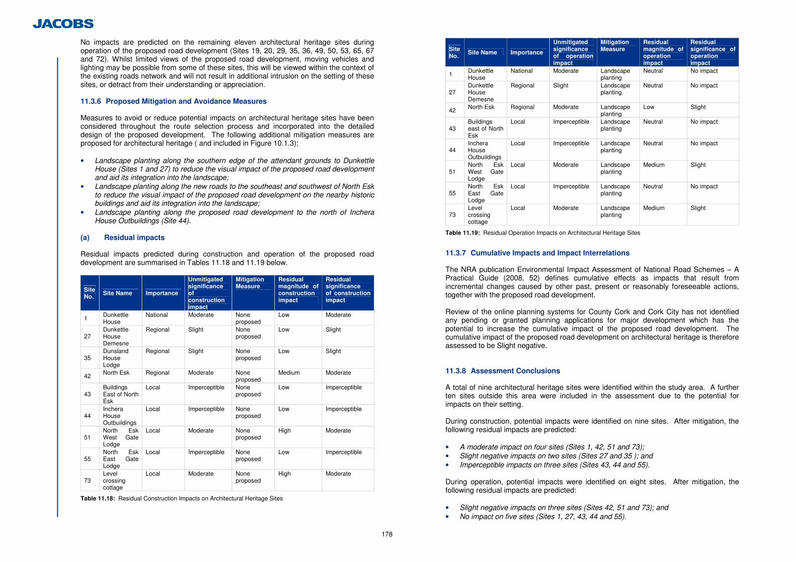
178
No impacts are predicted on the remaining eleven architectural heritage sites during operation of the proposed road development (Sites 19, 20, 29, 35, 36, 49, 50, 53, 65, 67 and 72). Whilst limited views of the proposed road development, moving vehicles and lighting may be possible from some of these sites, this will be viewed within the context of the existing roads network and will not result in additional intrusion on the setting of these sites, or detract from their understanding or appreciation. 11.3.6 Proposed Mitigation and Avoidance Measures
Measures to avoid or reduce potential impacts on architectural heritage sites have been considered throughout the route selection process and incorporated into the detailed design of the proposed development. The following additional mitigation measures are proposed for architectural heritage ( and included in Figure 10.1.3); • Landscape planting along the southern edge of the attendant grounds to Dunkettle
House (Sites 1 and 27) to reduce the visual impact of the proposed road development and aid its integration into the landscape;
• Landscape planting along the new roads to the southeast and southwest of North Esk to reduce the visual impact of the proposed road development on the nearby historic buildings and aid its integration into the landscape;
• Landscape planting along the proposed road development to the north of Inchera House Outbuildings (Site 44).
(a) Residual impacts
Residual impacts predicted during construction and operation of the proposed road development are summarised in Tables 11.18 and 11.19 below.
Site No. Site Name Importance
Unmitigated significance of construction impact
Mitigation Measure
Residual magnitude of construction impact
Residual significance of construction impact
1 Dunkettle House
National Moderate None proposed
Low Moderate
27 Dunkettle House Demesne
Regional Slight None proposed
Low Slight
35 Dunsland House Lodge
Regional Slight None proposed
Low Slight
42 North Esk Regional Moderate None proposed
Medium Moderate
43 Buildings East of North Esk
Local Imperceptible None proposed
Low Imperceptible
44 Inchera House Outbuildings
Local Imperceptible None proposed
Low Imperceptible
51 North Esk West Gate Lodge
Local Moderate None proposed
High Moderate
55 North Esk East Gate Lodge
Local Imperceptible None proposed
Low Imperceptible
73 Level crossing cottage
Local Moderate None proposed
High Moderate
Table 11.18: Residual Construction Impacts on Architectural Heritage Sites
Site No.
Site Name Importance
Unmitigated significance of operation impact
Mitigation Measure
Residual magnitude of operation impact
Residual significance of operation impact
1 Dunkettle House
National Moderate Landscape planting
Neutral No impact
27 Dunkettle House Demesne
Regional Slight Landscape planting
Neutral No impact
42 North Esk Regional Moderate Landscape planting
Low Slight
43 Buildings east of North Esk
Local Imperceptible Landscape planting
Neutral No impact
44 Inchera House Outbuildings
Local Imperceptible Landscape planting
Neutral No impact
51 North Esk West Gate Lodge
Local Moderate Landscape planting
Medium Slight
55 North Esk East Gate Lodge
Local Imperceptible Landscape planting
Neutral No impact
73 Level crossing cottage
Local Moderate Landscape planting
Medium Slight
Table 11.19: Residual Operation Impacts on Architectural Heritage Sites
11.3.7 Cumulative Impacts and Impact Interrelations
The NRA publication Environmental Impact Assessment of National Road Schemes – A Practical Guide (2008, 52) defines cumulative effects as impacts that result from incremental changes caused by other past, present or reasonably foreseeable actions, together with the proposed road development. Review of the online planning systems for County Cork and Cork City has not identified any pending or granted planning applications for major development which has the potential to increase the cumulative impact of the proposed road development. The cumulative impact of the proposed road development on architectural heritage is therefore assessed to be Slight negative. 11.3.8 Assessment Conclusions
A total of nine architectural heritage sites were identified within the study area. A further ten sites outside this area were included in the assessment due to the potential for impacts on their setting. During construction, potential impacts were identified on nine sites. After mitigation, the following residual impacts are predicted: • A moderate impact on four sites (Sites 1, 42, 51 and 73); • Slight negative impacts on two sites (Sites 27 and 35 ); and • Imperceptible impacts on three sites (Sites 43, 44 and 55). During operation, potential impacts were identified on eight sites. After mitigation, the following residual impacts are predicted: • Slight negative impacts on three sites (Sites 42, 51 and 73); and • No impact on five sites (Sites 1, 27, 43, 44 and 55).
179
11.4 References
11.4.1 Cartographic sources
Ordnance Survey. 1845. County Cork. Sheet 75. 6” map. Ordnance Survey. 1898. County Cork. Sheet LXXV-5. 25” map Ordnance Survey. 1930. County Cork. Sheet LXXV-5. 25” map 11.4.2 Irish Architectural Archive
20/47P1 Hamilton, W. 1772. Lota: Entrance front and demesne viewed across estuary of River
20/47P2,3 Lota House, views of house from old engravings. 11.4.3 National Archives of Ireland
OS88 063 Ordnance Survey Name Book: Caherlag. OS88 297 Ordnance Survey Name Book: Little Island. OS88 329 Ordnance Survey Name Book: Rathcooney. QRO Down Survey Cork 2 and 6 11.4.4 National Library of Ireland, Manuscript library
Ms. 2656 (21) Map of Corke City and the harbour to the sea. c. 1625. Ms 2742 Plan de la Baye de Korke. 1690-95 Ms. 3137 (12) Thomas Phillips, 1685. Generall mapp of Corke harbour. Ms. 3137 (14) Thomas Phillips, 1685. County of Cork. Ms. 3137 (15) Thomas Phillips. 1685. Corke harbour at large. 15 B. 14 (33) After 1794. Plan of Cork Harbour. 16 B. 24 (20) Lewis Marcell. Mid 18th c. The Harbour of Corke, 15 B. 14 (34) Col. C. Tarrant 18th century. A plan of the entrance and part of
Cork Harbour. 15B.14(28) Plan of the mail coach road from Cork to Waterford surveyed by
order of the GP Office in May 1825. 15 B. 14 (38) Map showing portion of Cork County south east and south west of
Cork City. c.1803. 15B.14(46) Plan of Cork Harbour. No date. 16B.24(17) Cork Harbour. 1843. 16B.24(22) Rade et Port de Cork en Ireland. Mid 17th century P7382/713 Parish maps of the Down Survey for County Cork. 11.4.5 Documentary Sources
Aalen, F. H. A, Whelan, K, and Stout, M. 2002. Atlas of the Irish Rural Landscape. Cork University Press, Cork (4th edition). Bence-Jones. 1963. ‘People and houses: Dunkettle.’ The Irish Times, Tuesday April 30th, 1963. Bence-Jones. 1988. A guide to Irish Country Houses. Constable, London. Cork County Council. 2009. Cork County Development Plan Department of Arts, Heritage, Gaeltacht and the Islands (DAHGI). 1999. Framework and Principles for the Protection of Architectural Heritage. Dublin. Department of Arts, Heritage, Gaeltacht and the Islands, 1999. Framework and Principles for the Protection of the Archaeological Heritage. Dublin. Department of Arts, Heritage and the Gaeltacht, 2011a. The Architectural Heritage Protection Guidelines for Planning Authorities. Dublin.
Department of Arts, Heritage and the Gaeltacht, 2011b. NIAH Handbook EPA, 2002. Guidelines on the information to be contained in Environmental Impact Statements, Environmental Protection Agency, Dublin. EPA, 2003. Advice Notes on Current Practice on the Preparation of Environmental Impact Statements. Environmental Protection Agency, Dublin. Flanagan, D and Flanagan, L, 1994. Irish Place Names. Gilroy, J. 2003. Alexander’s Glanmire. Litho Press, Midleton. Glanmire Heritage Society. 2011. Historic houses of Glanmire and vicinity. Heritage Society of Glanmire Area Community Association Limited. Healy, N.J. 1988. The Castles of County Cork. The Mercier Press, Cork & Dublin. Heritage Society of Glanmire Area Community Association Ltd. 2004. Glanmire and Environs: people, places, pastimes. Highways Agency, 2007. Design Manual for Roads and Bridges, HA 208/07 Volume 11, Section 3, Part 2. Jacobs. 2011. N8/N25 Dunkettle Interchange Improvement Scheme: Dunkettle House Impact Study Jacobs, 2012. N8/N25 Dunkettle Interchange Improvement Scheme: Route Selection Report John Cronin and Associates. 2004. Dunkettle House, County Cork, Conservation Plan. Joyce, P.W, 1984. Irish Place Names Lankford, E. 2008. Logainmneacha Ố Chontae Chorcat, a collection of placenames from County Cork. Barony of Barrymore, Vol. 2. Cork Placenames Authority. Lewis Heritage Trails. 2004. Around Glanmire. Lewis, L. 2003. Glanmire and surroundings in county Cork. McCarthy, M. 2004. ‘Excavations at Castleview, Little Island, Co. Cork.’ Journal of the Cork Historical and Archaeological Society Vol. 4. p.51-66 Logan. J. 2007. “‘Dropped into this kingdom, from the clouds.’ The Irish career of Davis Duckart, architect and engineer, 1761-81.” Irish Architectural and Decorative Studies, Vol. 10, p.34-89. McAfee, P. 1997. Irish Stone walls: History, Building, Conservation. O’Brien, Dublin. Mitchell, F. and Ryan, M. 1998. Reading the Irish landscape. Town House, Dublin. National Inventory of Architectural Heritage. 2009. An Introduction to the architectural heritage of East Cork. National Monuments (Amendment) Act (1994), Dublin, Office of the Attorney General. National Monuments (Amendment) Act (2004), Dublin, Office of the Attorney General. NRA and the Department of Arts, Heritage, Gaeltacht and the Islands, 1999. Code of Practice NRA, 2005a. Guidelines for the Assessment of Archaeological Heritage Impacts of National Road Schemes, Dublin. NRA, 2005b, Guidelines for the Assessment of Architectural Heritage Impacts of National Road Schemes, Dublin. NRA, 2005c. Guidelines for the Testing and Mitigation of the Wetland Archaeological Heritage for National Road Schemes. Pike, W.T. 1911. Cork and County Cork in the 20th century. Pike, Brighton. Power, D., (Ed.). 1994. Archaeological Inventory of County Cork, Volume 2: East and South Cork Rynne, C. 1993. The Archaeology of Cork City and Harbour, from earliest times to Industrialisation. The Collins Press, Cork. Schools Manuscripts Folklore Collection for County Cork. Smith, C. 1893. The Antient and Present state of the County of Cork. Vol. 2. Cork Symes, M. 2006. A Glossary of Garden History. Shire, Princes Risborough. Historical and Archaeological Society. 2nd edition. Townsend, H. 1810. Statistical Survey of the County of Cork. Graisberry and Campbell, Dublin. Waddell, J. 1998. The Prehistoric Archaeology of Ireland. GUP, Galway.

180
11.4.6 Web-based Sources
www.irishrailwayana.com/pa104.htm/ Accessed 25/03/2012 http://landedestates.nuigalway.ie:8080/ Accessed 01/03/12 – 23/03/12 http://maps.osi.ie/publicviewer/ Accessed 12/08/2011 http://archaeology.nra.ie/Home/Search/ Accessed 01/02/2012 http://www.buildingsofireland.ie/ Accessed 16/03/12 11.4.7 Aerial Photographs
Scheme Orthophotographs, Undated, 06197-A Scheme Orthophotographs, Undated, 06338-A – C
181
12 Waste Management
12.1 Introduction
This section of the EIS considers and assesses the anticipated types of waste and the impacts of same associated with both the construction and operation of the proposed development. 12.2 Description of the Existing Environment
The existing Dunkettle Interchange is located approximately 6km to the east of Cork City with full details provided in Chapter 1 of this EIS. The Cork County Development Plan 2009 (2nd Edition, 2012) acknowledges that a significant amount of waste generated in Cork County is as a result of construction activity. The existing Dunkettle interchange does not generate significant volumes of waste. Waste associated with the existing road is primarily associated with litter and the maintenance of drainage waste. 12.3 Appraisal Method used for Assessment of Impacts
The assessment of the potential impact of the proposed development on the waste management environment has been undertaken in accordance with the general requirements of the “Guidelines on the Information to be contained in Environmental Impact Statement”, (EPA, 2002) and the criteria contained in the “NRA Environmental Impact Assessment of National Road Schemes – A Practical Guide”, (NRA, 2008). The characteristics of an impact which will be defined are the quality, significance and duration of the impact. The definition of these impacts are provided below: (a) Quality of impacts
• Positive Impact: A change which improves the quality of the environment (for example by increasing species diversity; or improving the reproductive capacity of an ecosystem; or removing nuisances; or improving amenities).
• Neutral Impact: A change which does not affect the quality of the environment. • Negative Impact: A change which reduces the quality of the environment (for
example, lessening species diversity or diminishing the reproductive capacity of an ecosystem, or damaging health or property or by causing nuisance).
(b) Significance of impacts
• Imperceptible Impact: An impact capable of measurement but without noticeable consequences.
• Slight Impact: An impact which causes noticeable changes in the character of the environment without affecting its sensitivities.
• Moderate Impact: An impact that alters the character of the environment that is consistent with existing and emerging trends.
• Significant impact: An impact which, by its character, magnitude, duration or intensity alters a sensitive aspect of the environment.
• Profound impact: An impact which obliterates sensitive characteristics. (c) Duration of impacts
• Temporary Impact: Impact lasting for one year or less. • Short-term Impact: Impact lasting one to seven years.
• Medium-term Impact: Impact lasting seven to fifteen years. • Long-term Impact: Impact lasting fifteen to sixty years. • Permanent Impact: Impact lasting over sixty years. 12.4 Predicted Impacts of the Proposed Development
12.4.1 Do Minimum Scenario
In the event that the proposed development is not progressed, the existing interchange will continue to operate. The predicted impact of the Do Minimum scenario is therefore assessed as Neutral with an Imperceptible significance. 12.4.2 Do Something Scenario
In terms of the Do Something scenario, i.e. the proposed development, wastes will arise during the construction phase and to a lesser extent during the operation of the proposed development. 12.4.3 Construction Phase Impacts
In the absence of mitigation, all potential construction phase impacts are considered Negative and Short Term. (a) Excavated Materials / Demolished Structures
The proposed development will result in a net import of material due to the construction of the required road embankments. Excavation of the ground level under structures and intersecting link roads will be required. It is anticipated that approximately 50,000m3 of material will be excavated during construction of the proposed development. It is likely that this material will be unacceptable for reuse in road embankments in fill areas, but is likely to be acceptable for reuse as landscaping material. On this basis it is estimated that approximately 25% of this excavated material will be reused. It is anticipated that the material arising from excavations will generally comprise of soft sandy silts. In areas where Alluvium is shallow, arisings may comprise sands and gravels. A number of existing structures/bridges will be demolished as part of the development. It is anticipated that this will generate approximately 2,000 m3 of waste. Where the waste generated is not reusable, this will be sent to a licensed/permitted waste facility. A number of existing roads will become redundant as a result of the proposed development. The surface material of such roads will be removed resulting in approximately 20,000m3 of waste which will require disposal to a licensed/permitted facility. Due to the removal of this natural resource material from quarries and mines for use within the proposed development, and the HGV movements within the local area as a result, the impact significance of excavated material is assessed as Slight. (b) Wetland Excavations/Marine Sediments
Marine mudflat sediment will be excavated as part of the proposed development from existing intertidal wetlands. It is expected that this material will be excavated from 6 water features areas as follows (refer to Figure 5.1.1 for water feature locations): • 2,000m3 from the Jack Lynch Tunnel Intertidal Mudflat (WF2)
182
• 10,000m3 from the Pfizer Intertidal Mudflat East (WF6) • 5,000m3 from the Pfizer Intertidal Mudflat West (WF5) • 2,500m3 from the Iarnród Éireann Intertidal Mudflat Small (WF7) • 1,000m3 from the North Esk Intertidal Mudflat East (WF4) • 2,500m3 from the North Esk Intertidal Mudflat West (WF3) This marine sediment will however be reused in the Intertidal Flood Compensatory Areas and not disposed of. Truck movements of this sediment will be localised. The impact significance of marine sediment excavated material is therefore assessed as Imperceptible. (c) Pile Arisings
Soil arisings will be generated from pile bores to be used for bridges structures. The majority of the excavated material will be soils, but the pile arisings will also contain sands, gravels and cementitious materials. It is expected that bored pile arisings will total approximately 4000m3. The pile arisings will be contaminated with cementitious materials and without management of this waste stream on site, the impact significance of pile arisings is therefore assessed as Moderate due to the potential to cause pollution of the surrounding environment. (d) Surplus Materials
Surplus material and waste may occur where material supply exceeds material demand. Some surplus materials may be considered as waste and fall under relevant regulatory controls. Surplus materials and wastes could arise from existing site materials such as concrete from demolition or excavations of materials from earthworks which can not be re-used in the proposed development. Materials brought to site but not fully utilised for their original purpose can result in waste such as damages, off cuts and surplus products. For surplus materials and waste, the potential environmental effects would be primarily associated with the production, movement and transport, processing and disposal of the materials on and off site and, if required, the disposal of the wastes at licenced/permitted facilities. On this basis, the impact significance of surplus material is assessed as Slight. (e) Waste Management
Where waste materials are not stored, handled, transported or disposed of correctly, there is the potential for the pollution of air, soil, groundwater and/or surface waters to occur. Such effects could occur by, for example, locating unmanaged stockpiles of wastes close to watercourses or drainage networks. On this basis, without waste management plans on site, the impact significance of waste management is assessed as Moderate due to the potential to cause pollution of the surrounding environment. (f) Made Ground
The disturbance or storage of made ground during construction can lead to the release of chemical pollutants into the air, ground or water through remobilisation of contaminants. No significant land contamination has been identified within the study area following desk based and site investigation. Some evidence of localised elevated levels of chloride has been identified in groundwater in Little Island. (Refer to Chapter 7 Geology, Soils and Hydrogeology).
Should previously unidentified contamination be found during the construction works, the proposed management/mitigation measures in Section 12.5.1 (f) will be applied. Due to the potential of remobilised unidentified contaminants to pollute the environment, the impact significance of made ground is therefore assessed as Moderate. 12.4.4 Operational Phase Impacts
The main potential impacts from the operational phase of the proposed development will arise from road and constructed wetland/attenuation pond maintenance, verge cleaning, green waste from landscape maintenance and wastes generated through littering. The predicted characteristics of the impacts resulting from the operation of the road are Imperceptible due to the low volume of maintenance wastes and the high proportion of such being green, biodegradable wastes. 12.5 Proposed Mitigation and Avoidance Measures
The following mitigation measures will be implemented for the proposed development during the construction and operational phases.
12.5.1 Construction Phase
(a) Excavated Materials / Demolished Structures
Approximately 75% of excavated material will be unacceptable for reuse in road embankments and landscaping. Where waste generated is not reusable, samples will be taken and waste acceptance critera laboratory testing will be undertaken on the excavated material. The results of the labatory testing will be used to classify the waste as Inert, Non-Hadazdous or Hazardous. Licenced waste facilities will be contacted for their acceptance criteria requirements, and the excavated waste from the proposed development compared with these, and sent to the waste facilities which will accept it. Where practical the closest suitable facilities to the proposed develoment will be selected to reduce impacts associated with vehicle movements such as air emissions. (b) Wetland Excavations/Marine Sediments
All excavated wetland/marine sediment material will be reused in the 5 ‘Flood Compensatory Intertidal Areas’ (see Figure 2.8.2), therefore removing the requirement for disposal of the marine sediments at sea. (c) Pile Arisings
The contractor will store, handle, and transport pile arisings in accordance with best practice guidelines. As per 12.5.1 (a) above, arisings will be sampled, tested and disposed of, to a licensed waste management facility. (d) Surplus Materials
Any surplus material generated by excavation of cuttings, which cannot be used for landscaping or as fill for road embankments, as per 12.5.1 (a) above, will be sampled, tested and disposed of, to a licensed waste management facility.
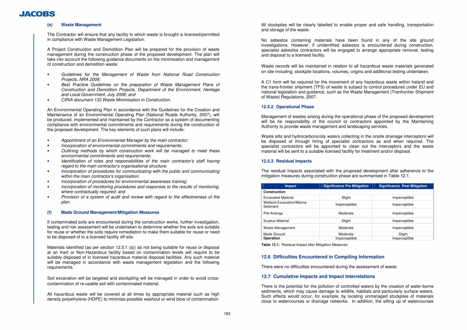
183
(e) Waste Management
The Contractor will ensure that any facility to which waste is brought is licensed/permitted in compliance with Waste Management Legislation. A Project Construction and Demolition Plan will be prepared for the provision of waste management during the construction phase of the proposed development. The plan will take into account the following guidance documents on the minimisation and management of construction and demolition waste: • Guidelines for the Management of Waste from National Road Construction
Projects, NRA 2008; • Best Practice Guidelines on the preparation of Waste Management Plans of
Construction and Demolition Projects, Department of the Environment, Heritage and Local Government, July 2006; and
• CIRIA document 133 Waste Minimisation in Construction. An Environmental Operating Plan in accordance with the Guidelines for the Creation and Maintenance of an Environmental Operating Plan (National Roads Authority, 2007), will be produced, implemented and maintained by the Contractor as a system of documenting compliance with environmental commitments and requirements during the construction of the proposed development. The key elements of such plans will include: • Appointment of an Environmental Manager by the main contractor; • Incorporation of environmental commitments and requirements; • Outlining methods by which construction work will be managed to meet these
environmental commitments and requirements; • Identification of roles and responsibilities of the main contractor’s staff having
regard to the main contractor’s organisational structure; • Incorporation of procedures for communicating with the public and communicating
within the main contractor’s organisation; • Incorporation of procedures for environmental awareness training; • Incorporation of monitoring procedures and responses to the results of monitoring,
where contractually required; and • Provision of a system of audit and review with regard to the effectiveness of the
plan. (f) Made Ground Management/Mitigation Measures
If contaminated soils are encountered during the construction works, further investigation, testing and risk assessment will be undertaken to determine whether the soils are suitable for reuse or whether the soils require remediation to make them suitable for reuse or need to be disposed of to a licensed facility off-site.
Materials identified (as per section 12.5.1 (a)) as not being suitable for reuse or disposal at an Inert or Non-Hazardous facility based on contamination levels will require to be suitably disposed of in licensed hazardous material disposal facilities. Any such material will be managed in accordance with waste management legislation and the following requirements. Soil excavation will be targeted and stockpiling will be managed in order to avoid cross-contamination of re-usable soil with contaminated material. All hazardous waste will be covered at all times by appropriate material such as high density polyethylene (HDPE) to minimise possible washout or wind blow of contamination.
All stockpiles will be clearly labelled to enable proper and safe handling, transportation and storage of the waste. No asbestos containing materials have been found in any of the site ground investigations. However, if unidentified asbestos is encountered during construction, specialist asbestos contractors will be engaged to arrange appropriate removal, testing and disposal to a licensed facility. Waste records will be maintained in relation to all hazardous waste materials generated on site including; stockpile locations, volumes, origins and additional testing undertaken. A C1 form will be required for the movement of any hazardous waste within Ireland and the trans-frontier shipment (TFS) of waste is subject to control procedures under EU and national legislation and guidance, such as the Waste Management (Tranfrontier Shipment of Waste) Regulations, 2007. 12.5.2 Operational Phase
Management of wastes arising during the operational phase of the proposed development will be he responsibility of the council or contractors appointed by the Maintaining Authority to provide waste management and landscaping services.
Waste silts and hydrocarbons/oily waters collecting in the onsite drainage interceptors will be disposed of through hiring of specialist contractors as and when required. The specialist contractors will be appointed to clean out the interceptors and the waste material will be sent to a suitable licensed facility for treatment and/or disposal. 12.5.3 Residual Impacts
The residual impacts associated with the proposed development after adherence to the mitigation measures during construction phase are summarised in Table 12.1.
Impact Significance Pre Mitigation Significance Post Mitigation
Construction
Excavated Material Slight Imperceptible Wetland Excavation/Marine Sediment Imperceptible Imperceptible
Pile Arisings Moderate Imperceptible
Surplus Material Slight Imperceptible
Waste Management Moderate Imperceptible
Made Ground Moderate Slight Operation Imperceptible Imperceptible
Table 12.1: Residual Impact after Mitigation Measures
12.6 Difficulties Encountered in Compiling Information
There were no difficulties encountered during the assessment of waste. 12.7 Cumulative Impacts and Impact Interrelations
There is the potential for the pollution of controlled waters by the creation of water-borne sediments, which may cause damage to wildlife, habitats and particularly surface waters. Such effects would occur, for example, by locating unmanaged stockpiles of materials close to watercourses or drainage networks. In addition, the silting up of watercourses

184
and the blockage of culverts and/or drainage networks can occur if construction activities, for example, the dewatering of excavations are not managed in accordance with the mitigation measures outlined in this and other chapters of this EIS.
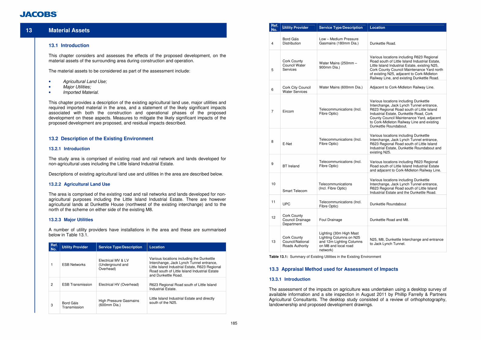
185
13 Material Assets
13.1 Introduction
This chapter considers and assesses the effects of the proposed development, on the material assets of the surrounding area during construction and operation. The material assets to be considered as part of the assessment include: • Agricultural Land Use; • Major Utilities; • Imported Material. This chapter provides a description of the existing agricultural land use, major utilities and required imported material in the area, and a statement of the likely significant impacts associated with both the construction and operational phases of the proposed development on these aspects. Measures to mitigate the likely significant impacts of the proposed development are proposed, and residual impacts described. 13.2 Description of the Existing Environment
13.2.1 Introduction
The study area is comprised of existing road and rail network and lands developed for non-agricultural uses including the Little Island Industrial Estate. Descriptions of existing agricultural land use and utilities in the area are described below. 13.2.2 Agricultural Land Use
The area is comprised of the existing road and rail networks and lands developed for non-agricultural purposes including the Little Island Industrial Estate. There are however agricultural lands at Dunkettle House (northwest of the existing interchange) and to the north of the scheme on either side of the existing M8. 13.2.3 Major Utilities
A number of utility providers have installations in the area and these are summarised below in Table 13.1.
Ref. No.
Utility Provider Service Type/Description Location
1 ESB Networks
Electrical MV & LV (Underground and Overhead)
Various locations including the Dunkettle Interchange, Jack Lynch Tunnel entrance, Little Island Industrial Estate, R623 Regional Road south of Little Island Industrial Estate and Dunkettle Road.
2
ESB Transmission Electrical HV (Overhead) R623 Regional Road south of Little Island Industrial Estate.
3
Bord Gáis Transmission
High Pressure Gasmains (600mm Dia.)
Little Island Industrial Estate and directly south of the N25.
Ref. No.
Utility Provider Service Type/Description Location
4
Bord Gáis Distribution
Low – Medium Pressure Gasmains (180mm Dia.)
Dunkettle Road.
5
Cork County Council Water Services
Water Mains (250mm – 900mm Dia.)
Various locations including R623 Regional Road south of Little Island Industrial Estate, Little Island Industrial Estate, existing N25, Cork County Council Maintenance Yard north of existing N25, adjacent to Cork-Midleton Railway Line, and existing Dunkettle Road.
6
Cork City Council Water Services
Water Mains (600mm Dia.) Adjacent to Cork-Midleton Railway Line.
7 Eircom
Telecommunications (Incl. Fibre Optic)
Various locations including Dunkettle Interchange, Jack Lynch Tunnel entrance, R623 Regional Road south of Little Island Industrial Estate, Dunkettle Road, Cork County Council Maintenance Yard, adjacent to Cork-Midleton Railway Line and existing Dunkettle Roundabout.
8
E-Net
Telecommunications (Incl. Fibre Optic)
Various locations including Dunkettle Interchange, Jack Lynch Tunnel entrance, R623 Regional Road south of Little Island Industrial Estate, Dunkettle Roundabout and existing N25.
9
BT Ireland
Telecommunications (Incl. Fibre Optic)
Various locations including R623 Regional Road south of Little Island Industrial Estate and adjacent to Cork-Midleton Railway Line.
10
Smart Telecom
Telecommunications (Incl. Fibre Optic)
Various locations including Dunkettle Interchange, Jack Lynch Tunnel entrance, R623 Regional Road south of Little Island Industrial Estate and the Dunkettle Road.
11
UPC
Telecommunications (Incl. Fibre Optic)
Dunkettle Roundabout
12
Cork County Council Drainage Department
Foul Drainage
Dunkettle Road and M8.
13
Cork County Council/National Roads Authority
Lighting (30m High Mast Lighting Columns on N25 and 12m Lighting Columns on M8 and local road network)
N25, M8, Dunkettle Interchange and entrance to Jack Lynch Tunnel.
Table 13.1: Summary of Existing Utilities in the Existing Environment
13.3 Appraisal Method used for Assessment of Impacts
13.3.1 Introduction
The assessment of the impacts on agriculture was undertaken using a desktop survey of available information and a site inspection in August 2011 by Phillip Farrelly & Partners Agricultural Consultants. The desktop study consisted of a review of orthophotography, landownership and proposed development drawings.
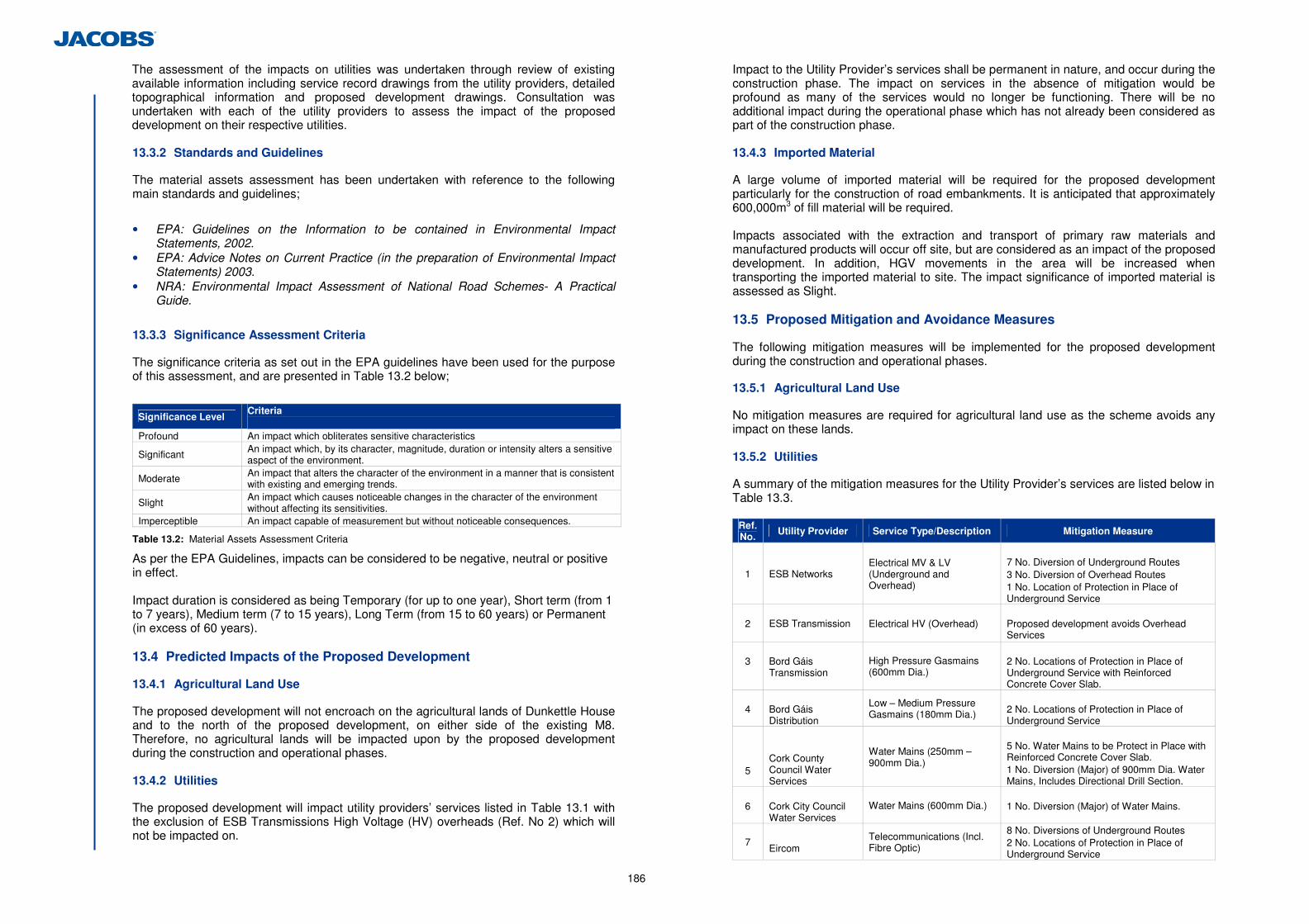
186
The assessment of the impacts on utilities was undertaken through review of existing available information including service record drawings from the utility providers, detailed topographical information and proposed development drawings. Consultation was undertaken with each of the utility providers to assess the impact of the proposed development on their respective utilities. 13.3.2 Standards and Guidelines
The material assets assessment has been undertaken with reference to the following main standards and guidelines;
• EPA: Guidelines on the Information to be contained in Environmental Impact Statements, 2002.
• EPA: Advice Notes on Current Practice (in the preparation of Environmental Impact Statements) 2003.
• NRA: Environmental Impact Assessment of National Road Schemes- A Practical Guide.
13.3.3 Significance Assessment Criteria
The significance criteria as set out in the EPA guidelines have been used for the purpose of this assessment, and are presented in Table 13.2 below;
Significance Level Criteria
Profound An impact which obliterates sensitive characteristics
Significant An impact which, by its character, magnitude, duration or intensity alters a sensitive aspect of the environment.
Moderate An impact that alters the character of the environment in a manner that is consistent with existing and emerging trends.
Slight An impact which causes noticeable changes in the character of the environment without affecting its sensitivities.
Imperceptible An impact capable of measurement but without noticeable consequences.
Table 13.2: Material Assets Assessment Criteria
As per the EPA Guidelines, impacts can be considered to be negative, neutral or positive in effect. Impact duration is considered as being Temporary (for up to one year), Short term (from 1 to 7 years), Medium term (7 to 15 years), Long Term (from 15 to 60 years) or Permanent (in excess of 60 years). 13.4 Predicted Impacts of the Proposed Development
13.4.1 Agricultural Land Use
The proposed development will not encroach on the agricultural lands of Dunkettle House and to the north of the proposed development, on either side of the existing M8. Therefore, no agricultural lands will be impacted upon by the proposed development during the construction and operational phases. 13.4.2 Utilities
The proposed development will impact utility providers’ services listed in Table 13.1 with the exclusion of ESB Transmissions High Voltage (HV) overheads (Ref. No 2) which will not be impacted on.
Impact to the Utility Provider’s services shall be permanent in nature, and occur during the construction phase. The impact on services in the absence of mitigation would be profound as many of the services would no longer be functioning. There will be no additional impact during the operational phase which has not already been considered as part of the construction phase. 13.4.3 Imported Material
A large volume of imported material will be required for the proposed development particularly for the construction of road embankments. It is anticipated that approximately 600,000m3 of fill material will be required. Impacts associated with the extraction and transport of primary raw materials and manufactured products will occur off site, but are considered as an impact of the proposed development. In addition, HGV movements in the area will be increased when transporting the imported material to site. The impact significance of imported material is assessed as Slight. 13.5 Proposed Mitigation and Avoidance Measures
The following mitigation measures will be implemented for the proposed development during the construction and operational phases.
13.5.1 Agricultural Land Use
No mitigation measures are required for agricultural land use as the scheme avoids any impact on these lands. 13.5.2 Utilities
A summary of the mitigation measures for the Utility Provider’s services are listed below in Table 13.3.
Ref. No. Utility Provider Service Type/Description Mitigation Measure
1 ESB Networks
Electrical MV & LV (Underground and Overhead)
7 No. Diversion of Underground Routes 3 No. Diversion of Overhead Routes 1 No. Location of Protection in Place of Underground Service
2 ESB Transmission
Electrical HV (Overhead)
Proposed development avoids Overhead Services
3
Bord Gáis Transmission
High Pressure Gasmains (600mm Dia.)
2 No. Locations of Protection in Place of Underground Service with Reinforced Concrete Cover Slab.
4
Bord Gáis Distribution
Low – Medium Pressure Gasmains (180mm Dia.)
2 No. Locations of Protection in Place of Underground Service
5
Cork County Council Water Services
Water Mains (250mm – 900mm Dia.)
5 No. Water Mains to be Protect in Place with Reinforced Concrete Cover Slab. 1 No. Diversion (Major) of 900mm Dia. Water Mains, Includes Directional Drill Section.
6
Cork City Council Water Services
Water Mains (600mm Dia.) 1 No. Diversion (Major) of Water Mains.
7 Eircom
Telecommunications (Incl. Fibre Optic)
8 No. Diversions of Underground Routes 2 No. Locations of Protection in Place of Underground Service
187
Ref. No.
Utility Provider Service Type/Description Mitigation Measure
8
E-Net
Telecommunications (Incl. Fibre Optic)
3 No. Diversions of Underground Routes 2 No. Locations of Protection in Place of Underground Service
9
BT Ireland
Telecommunications (Incl. Fibre Optic)
1 No. Diversion of Underground Route
10
Smart Telecom Telecommunications
(Incl. Fibre Optic)
2 No. Diversion of Underground Routes
11
UPC
Telecommunications (Incl. Fibre Optic)
1 No. Protection in Place of Underground Service.
12
Cork County Council Drainage Department
Foul Drainage
1 No. Diversion of 600mm Dia, pipe. 2 No. Locations of Protection in Place of Underground Service
13
Cork County Council/National Roads Authority
Lighting
Remove Existing Lighting in the Affected Areas and Replace With New Lighting
Table 13.3: Utility Mitigation Measures When the above mitigation is implemented, the magnitude of impact is reduced to Imperceptible as the services will continue to operate in their current form. 13.5.3 Imported Material
The source(s) of the imported fill materials will be selected from local suppliers where feasible. A number of key issues will be considered as part of the selection process. These include but are not limited to the following: • Source; • Material specification; • Production and transport costs; and • The availability of materials. Where granular fill is required for the proposed development local or regional virgin sources, or recycled materials held at waste management/transfer facilities that meet the required specification will be sourced. 13.5.4 Operational Phase
As there are no operational phase impacts on agricultural lands, utilities or imported material considered as part of proposed development, no mitigation measures are required. 13.5.5 Residual Impacts
There will be no residual impacts associated with agricultural lands, and an Imperceptible impact on utilities. Residual impacts on imported material will be Imperceptible.
13.6 Difficulties Encountered in Compiling Information
There were no difficulties encountered in compiling information.
13.7 Cumulative Impacts and Impact Interrelations
No cumulative material assets impacts will occur as a result of the proposed development.
.

188
14 Inter-relationships between Environmental Factors
14.1 Introduction
The interaction of environmental aspects was clearly identified at an early stage in the project to be an important factor to be considered in the full evaluation of the environmental impacts associated with the proposed development. While all environmental factors are inter-related to some extent, the significant interactions and inter-dependencies were taken into consideration by the specialist environmental consultants when preparing their assessments. Consequently these interactions were integrated into the individual sub-sections from Chapters 4 to 13 of this EIS. In addition, a summary of the general interactions is presented in Tables 14.1 and the detail of the interactions in Table 14.2.
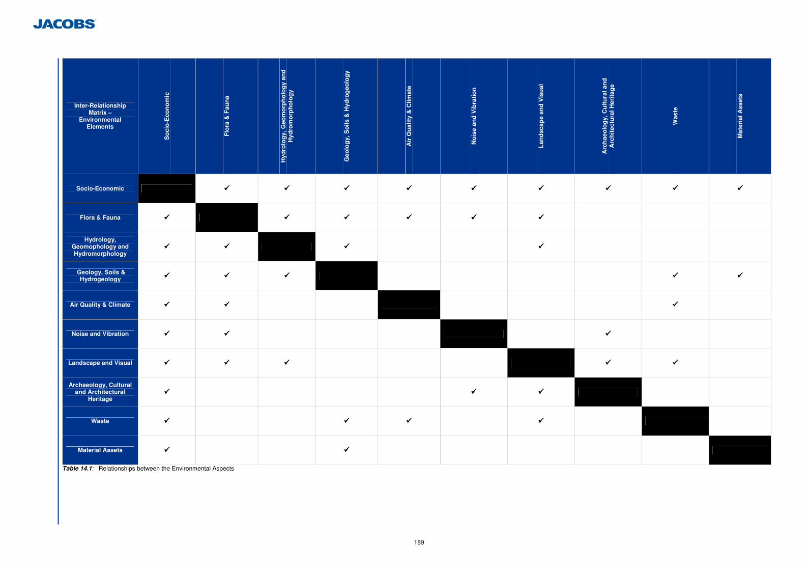
189
Table 14Table 14.1: Relationships between the Environmental Aspects
Inter-Relationship Matrix –
Environmental Elements
So
cio
-Eco
no
mic
Flo
ra &
Fau
na
Hyd
rolo
gy,
Geo
mo
rph
olo
gy
and
H
ydro
mo
rph
olo
gy
Geo
log
y, S
oils
& H
ydro
geo
log
y
Air
Qu
alit
y &
Clim
ate
No
ise
and
Vib
rati
on
Lan
dsc
ape
and
Vis
ual
Arc
hae
olo
gy,
Cu
ltu
ral a
nd
A
rch
itec
tura
l Her
itag
e
Was
te
Mat
eria
l Ass
ets
Socio-Economic ���� ���� ���� ���� ���� ���� ���� ���� ����
Flora & Fauna ���� ���� ���� ���� ���� ����
Hydrology, Geomophology and Hydromorphology
���� ���� ���� ����
Geology, Soils & Hydrogeology ���� ���� ���� ���� ����
Air Quality & Climate ���� ���� ����
Noise and Vibration ���� ���� ����
Landscape and Visual ���� ���� ���� ���� ����
Archaeology, Cultural and Architectural
Heritage ���� ���� ����
Waste ���� ���� ���� ����
Material Assets ���� ����
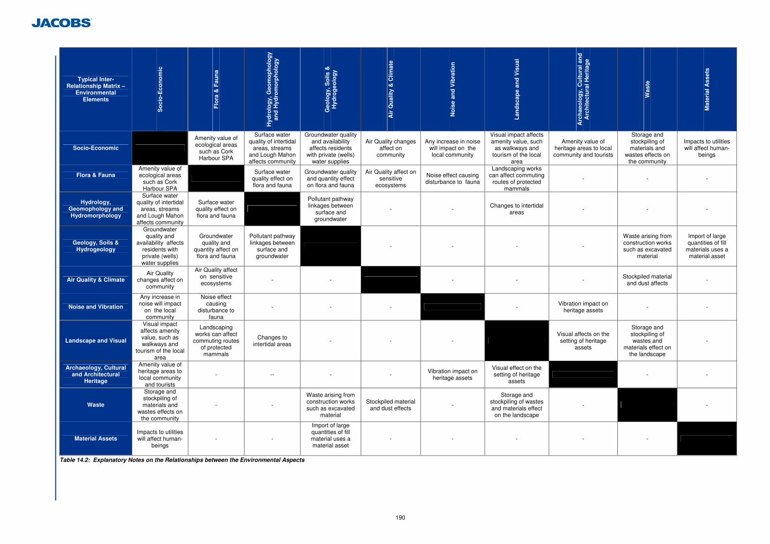
190
TablTTable 14.2: Explanatory Notes on the Relationships between the Environmental Aspects
Typical Inter-Relationship Matrix –
Environmental Elements
So
cio
-Eco
no
mic
Flo
ra &
Fau
na
Hyd
rolo
gy,
Geo
mo
ph
olo
gy
and
Hyd
rom
orp
ho
log
y
Geo
log
y, S
oils
&
Hyd
rog
eolo
gy
Air
Qu
alit
y &
Clim
ate
No
ise
and
Vib
rati
on
Lan
dsc
ape
and
Vis
ual
Arc
hae
olo
gy,
Cu
ltu
ral a
nd
A
rch
itec
tura
l Her
itag
e
Was
te
Mat
eria
l Ass
ets
Socio-Economic
Amenity value of ecological areas
such as Cork Harbour SPA
Surface water quality of intertidal
areas, streams and Lough Mahon affects community
Groundwater quality and availability
affects residents with private (wells)
water supplies
Air Quality changes affect on
community
Any increase in noise will impact on the local community
Visual impact affects amenity value, such
as walkways and tourism of the local
area
Amenity value of heritage areas to local community and tourists
Storage and stockpiling of materials and
wastes effects on the community
Impacts to utilities will affect human-
beings
Flora & Fauna
Amenity value of ecological areas
such as Cork Harbour SPA
Surface water
quality effect on flora and fauna
Groundwater quality and quantity effect on flora and fauna
Air Quality affect on sensitive
ecosystems
Noise effect causing disturbance to fauna
Landscaping works can affect commuting
routes of protected mammals
- - -
Hydrology, Geomophology and Hydromorphology
Surface water quality of intertidal
areas, streams and Lough Mahon affects community
Surface water quality effect on flora and fauna
Pollutant pathway linkages between
surface and groundwater
- - Changes to intertidal areas - - -
Geology, Soils & Hydrogeology
Groundwater quality and
availability affects residents with private (wells) water supplies
Groundwater quality and
quantity affect on flora and fauna
Pollutant pathway linkages between
surface and groundwater
- - - -
Waste arising from construction works such as excavated
material
Import of large quantities of fill
materials uses a material asset
Air Quality & Climate Air Quality
changes affect on community
Air Quality affect on sensitive ecosystems
- - - - - Stockpiled material and dust affects -
Noise and Vibration
Any increase in noise will impact
on the local community
Noise effect causing
disturbance to fauna
- - - - Vibration impact on heritage assets - -
Landscape and Visual
Visual impact affects amenity value, such as walkways and
tourism of the local area
Landscaping works can affect
commuting routes of protected mammals
Changes to intertidal areas
- - - Visual affects on the setting of heritage
assets
Storage and stockpiling of wastes and
materials effect on the landscape
-
Archaeology, Cultural and Architectural
Heritage
Amenity value of heritage areas to local community
and tourists
- -- - - Vibration impact on heritage assets
Visual effect on the setting of heritage
assets - -
Waste
Storage and stockpiling of materials and
wastes effects on the community
- -
Waste arising from construction works such as excavated
material
Stockpiled material and dust effects -
Storage and stockpiling of wastes and materials effect on the landscape
- -
Material Assets Impacts to utilities will affect human-
beings - -
Import of large quantities of fill material uses a material asset
- - - - -

191
15 Schedule of Environmental Commitments
15.1 Introduction
This chapter summarises the mitigation measures (environmental commitments) in the Environmental Impact Statement for the proposed development. The purpose of these environmental commitments is to mitigate or ameliorate potentially significant adverse impacts that have been identified in the EIS.
192
15.2 Socio-Economic
Mitigation No.
EIS Section Reference Description of Mitigation Measure / Environmental Commitments Specific Adverse Impact Mitigated Against
Stage of Impact i.e. Construction or Operational
Socio-Economic
1 4.5 No significant impacts have been identified therefore no mitigation measures are required.
- -
15.3 Flora and Fauna
Mitigation No.
EIS Section Reference Description of Mitigation Measure / Environmental Commitments Specific Adverse Impact Mitigated Against
Stage of Impact i.e. Construction or Operation
Flora and Fauna
2 5.6.1(a)(i)
Prior to commencement of construction, 3m high solid hoarding will be erected along the southwestern boundary along the length of proposed Link B (Ch. 0-300). The hoarding will remain in place for the duration of construction. No movement of construction staff or vehicles will be permitted south of the hoarding on the existing track that forms the perimeter of WF1.
Disturbance to Qualifying Interests of Cork Harbours SPA Construction
3 5.6.1(a)(ii)
A construction phasing of the proposed development (in terms of work locations, creation of new storage/intertidal areas, temporary and permanent culverts) will be established to maintain connectivity through the intertidal areas during construction, and requires that compensatory flood areas are created prior to any existing areas being lost.
Release of Suspended Solids and contaminants through surface water runoff, to Designated Sites (Dunkettle Shore pNHA and Cork Harbour SPA)
Construction
4 5.6.1(a)(iii)
Prior to commencement of construction, the contractor will implement the following measures through a Construction Method Statement (CMS).
These measures are based on the following best practice guidelines to ensure that water bodies are adequately protected during construction work:
• Construction Industry Research and Information Association CIRIA C648: Control of
water pollution from linear construction projects: Technical guidance (Murnane et al. 2006)
• CIRIA C648: Control of water pollution from linear construction projects: Site guide (Murnane et al. 2006)
• DMRB HD33/06: Surface and sub-surface drainage systems for highways. Design Manual for Roads and Bridges. Volume 4: 2, (2006).
• NRA (2005a). Guidelines for the crossing of watercourses during the construction of National Road Schemes.
• SRFB (2007). Maintenance and Protection of the Inland Fisheries Resource during Road Construction and Improvement Works. Requirements of the Southern Regional Fisheries Board.
The construction contractor will implement the following mitigation measures, via the CMS, for release of sediment/silt control:
Release of suspended solids and contaminants through surface water runoff, to Designated Sites (Dunkettle Shore pNHA and Cork Harbour SPA)
Construction
193
Mitigation No.
EIS Section Reference Description of Mitigation Measure / Environmental Commitments Specific Adverse Impact Mitigated Against
Stage of Impact i.e. Construction or Operation
• Provision of measures to prevent the release of sediment over baseline conditions64 to
Lough Mahon during the construction work. Baseline conditions will be established in accordance with details provided in Section 6.2.9 (a)(i). These measures will include but not be limited to silt fences, silt curtains, settlement lagoons, filter materials, and stockpile seeding;
• Provision of measures to minimise the release of sediment from the newly excavated flood compensation areas to Lough Mahon and the North Esk Intertidal Mudflat (WF4) These measures will include but not be limited to silt fences, silt curtains, settlement lagoons, filter materials, and stockpile seeding;
• Provision of measures to minimise the displacement and subsequent erosion and release of soft sediment, particularly from WF6, WF5, WF7 and WF4. These measures will include but not be limited to silt fences, silt curtains, settlement lagoons, filter materials, and stockpile seeding;
• Provision of measures to handle, store and re-use where feasible material removed from the intertidal mudflats;
• Provision of measures to minimise any run-off into the Jack Lynch Tidal Polder (WF1), by diverting drainage into WF2 instead;
• Provision of exclusion zones and barriers (sediment fences) between earthworks, stockpiles and temporary surfaces and watercourses to prevent sediment washing into the watercourses;
• Excavated sediment/materials from Pfizer Intertidal Mudflat West (WF5) and East (WF6) will be retained and re-used within flood compensation intertidal areas;
• Temporary construction surface drainage and sediment control measures will be in place before earthworks commence;
• Pouring of cementitious materials for the works will be carried out in the dry and allowed to cure for 48 hours before re-flooding. Pumped concrete will be monitored to ensure no accidental discharge. Mixer washings and excess concrete will not be discharged to surface water;
• No storage of hydrocarbons or any polluting chemicals will occur within 50 m of a watercourse. Fuel storage tanks will be bunded to a capacity at least 110% of the volume of the storage tank. Re-fuelling of plant will not occur within 50 m of any watercourse and only in bunded refuelling areas;
• Emergency procedures and spillage kits will be available and construction staff will be familiar with emergency procedures;
• Implementation of measures to minimise waste and ensure correct handling, storage and disposal of waste (most notably wet concrete, pile arisings and asphalt);
• Response measures to potential pollution incidents; • Methods to stabilise watercourse banks that have been cleared of vegetation; • Maintenance of machinery to be used in-stream; • Removal and replacement of stream bed material in diverted watercourses; • Any contaminated land will be managed in accordance with Made Ground
Management/Mitigation Measures in Section 12.5.1.
Prior to construction, areas of intertidal areas proposed for removal for the development footprint will be dredged (and stored in sealed and bunded stockpiles until required) prior to use as substrates for the flood compensation areas required for the proposed development.
5 5.6.1(b)(ii)
Intertidal flood compensatory areas are included within the design of the proposed development for flood water storage. This allows the opportunity for mitigation of habitat loss
Loss of Mudflat and Saltmarsh Habitat in Designated Sites (Dunkettle Shore pNHA) Construction
64
Baseline suspended sediment levels in Lough Mahon will be established as outlined in Chapter 6 Hydrology, Hydromorphology and Geomorphology.
194
Mitigation No.
EIS Section Reference Description of Mitigation Measure / Environmental Commitments Specific Adverse Impact Mitigated Against
Stage of Impact i.e. Construction or Operation
through habitat creation, through grading of the flood compensation areas to encourage establishment of saltmarsh habitat. Saltmarsh generally develops in temperate waters between Mean High Water of Spring tides (MHWS) and Mean Low Water of Neap tides (MLWN) where net accumulation of sediment occurs. Natural colonisation will be allowed to take place for saltmarsh creation in compensatory flood areas as it is a preferred conservation approach for establishing saltmarsh habitat. Guidance on the levels Above Ordnance Datum (AOD) at which saltmarsh is likely to form was drawn from the Saltmarsh Creation Handbook (Nottage & Roberston, 2005), which provides tidal levels for anticipated development of intertidal habitats set out below:
• Mudflat (Zone between Mean Low Water Spring Tides and Mean Low Water Neap
Tides or -1m to 0m AOD); • Lower Saltmarsh (Zone between Mean Low Water Neap Tides and Mean High Water
Neap Tides or -0.9 to +0.8m AOD); • Upper Saltmarsh (Mean high water Neap to Mean High Water Spring Tides or +0.8 to
+1.3m AOD).
The use of gentle gradients will promote natural establishment of saltmarsh habitat. Saltmarsh also requires some degree of shelter from wave action, and this is naturally provided in the inland sites where the Intertidal flood compensatory areas are proposed. The establishment of suitable substrate in the compensation areas for mudflat and saltmarsh establishment will be ensured by re-using existing muds excavated from areas where mudflats will be removed by the footprint of the development (e.g. in WF3, WF5 and WF6) primarily. These muds shall be excavated and stored in a sealed area (to prevent water runoff) for re-use in the establishment of the compensatory flood/wetland areas.
6 5.6.1(b)(iii)
This mitigation has been based on the NRA guideline document ‘The Management of Noxious Weeds and Non-Native Invasive Plant Species on National Roads 2010’. The dual objective for all species is to both prevent the spread of established invasive species during construction (a legal requirement for four of the species), and permanently remove all invasive populations from the working area.
An Invasive Species Management Plan will be implemented prior to commencement of construction to allow time to adequately control all invasive populations within the ZoI of the proposed development before works commencing. The timings/seasonality of control measures are detailed in the NRA Guidelines 2010. The Invasive Species Management Plan will assist the construction contractor to implement mitigation required for invasive species by including the specific mitigation measures outlined below, under each species. As species may have spread or changed distribution between habitat surveys for this EIS and commencement of construction. The implementation of the Invasive Species Management Plan will include re-survey (pre-construction) of the zone of influence. Appendix 1 of the NRA 2010 guidelines provides an assessment and management plan template. In accordance with the NRA guidance this survey will include accurate 1:5,000 scale mapping for the precise location of invasive species. The pre-construction surveys will be undertaken by suitable experts with competence in identifying these species and ability to separate them from other species appearing similar to a non professional. Bluebells. The pre-construction survey will cover the woodlands within the working areas of Link T1 and U to identify and dig up invasive Hybrid and Spanish Bluebells, while where possible avoiding
Invasive Species in Designated Sites (Dunkettle Shore pNHA and Cork Harbour SPA)
Construction
195
Mitigation No.
EIS Section Reference Description of Mitigation Measure / Environmental Commitments Specific Adverse Impact Mitigated Against
Stage of Impact i.e. Construction or Operation
damage to native bluebells. Separation of native from invasive bluebells (Hybrid and Spanish) will not be reliable outside of the flowering season. Therefore separation will be undertaken within the flowering period, April-May inclusive. Japanese Knotweed. A prime objective of control within the pNHA will be to remove the risk of Japanese Knotweed establishing near the recorded Bee Orchid colony on the Pfizer woodland edge. The pre-construction survey will cover all known Japanese Knotweed colonies within the working areas of Link P, and Link E, (See Figure 5.1.8) and will also identify any new colonies established since the original habitat surveys ending in July 2011. Specialist invasive contractors will be required in order to accurately identify the species (and distinguish non-flowering canes from similar species such as Giant Hogweed Heracleum mantegazzianum). The specialist contractor will use suitable control and treatment measures, which may include combined physical (digging) and chemical control using glyphosate. Treatment, control and removal procedures will be followed including disposal of excavated/waste; including soils containing rhizome fragments will be undertaken using NRA guidelines. Rhododendron The pre-construction survey will cover the known Rhododendron colonies in woodland/scrub below the Dunkettle Estate mapped in Figure 5.1.8. Removal of this species may use combined physical removal (uprooting of plants) and chemical control during March, April or October (cut stump injection). Treatment, control and removal procedures are clearly set out in the NRA (2010) guideline documents. The contractor must appropriately dispose of excavated/waste (see Disposal of Invasive Species below), including soils containing Rhododentron fragments, specialist invasive contractors will be required in order to accurately identify the species (and distinguish Rhododendron from possible garden ornamental confusion species with similar, glossy whorled leaves). Cord Grass Species The pre-construction survey will cover all intertidal areas. There are no NRA guidelines for Cord Grass species. Following identification, all plants will be dug out at low tide (Minchin, 2008), and disposed of as detailed below in ‘Disposal of Invasive Species’. Sea Buckthorn The landscape proposals include for removal of the hedge at the Jack Lynch Tunnel (Link L), where the species is currently established. A specialist contractor will mechanically dig up all roots and disposal of all material as detailed in ‘Disposal of Invasive Species’ below. Sycamore No Sycamore has been included in landscape plantings. Snowberry Any shrubs within the working area at Dunkettle Estate woodland and hedging east of Gaelscoil Ui Drisceoil will be sprayed with a strong glyphosate-based herbicide, which must be applied when the plant is in full leaf. Several applications may be required and care will be taken to avoid non-target species (Cowslips, Violets and other woodland flora occur nearby). Disposal of Invasive Species In accordance with the NRA 2010 guidelines, where cut, pulled or mown noxious weed or non-native invasive plant material arises, its disposal will not lead to a risk of further spread of the plants. Care will be taken near watercourses as water is a fast medium for the dispersal of plant fragments and seeds. Material that contains flower heads or seeds will be disposed of either by composting or burial at a depth of no less than 0.5m in the case of noxious
196
Mitigation No.
EIS Section Reference Description of Mitigation Measure / Environmental Commitments Specific Adverse Impact Mitigated Against
Stage of Impact i.e. Construction or Operation
weeds, or by incineration (having regard to relevant legislation, including: Section 32 of the Waste Management Act, 1996 to 2008; Section 4 of the Air Pollution Act, 1987; and relevant local authority byelaws) or disposal to licensed landfill in the case of non-native invasive species. The taproots of docks and roots of creeping thistle are not suitable for composting or shallow burial, requiring disposal to landfill, incineration or burying at a depth of no less than 1.5m (practical only during the construction phase). Where burial is being used to dispose of Japanese knotweed, the material will be buried to a depth of 5m and overlain with a suitable geotextile membrane. All disposals will be carried out in accordance with the Waste Management Acts.
7 5.6.1(b)(iv)
As outlined in the subsequent Breeding Bird section on Non-Designated Sites (Section 5.6.1 (c) (iii)), mitigation for breeding birds other than Little Egret/Grey Heron will follow best practice by where possible avoiding removal of vegetation within the Bird Breeding Season (March-August inclusive). The restriction on vegetation removal within an exclusion zone around the Egret/Heron colony will be strictly enforced between February and July inclusive (peak breeding season).
The exclusion zone will be setup around the breeding colony at the Pfizer woodland which will be fenced in advance of construction and remain in place during the peak breeding season (February to July). No movement of construction staff, or vehicles, or any other works (including ground preparation works) will be permitted from February-July inclusive within this exclusion zone until such time as this section of the proposed development (Link P, and Link C) is operational (operational in this instance includes any point during the construction works where these links are used to facilitate any traffic through the works). The exclusion zone is shown in Figure 5.1.9, sections of the following links and attenuation ponds will be affected.
• Link P; • Link C; • Wetland No. 3; • Pond No. 3.
As a precautionary measure to mitigate for the potential abandonment of part of the woodland nearest the proposed development, semi-mature and mature woodland planting will be established to the west of the existing woodland in an area currently dominated by Dry Meadow grassland habitat. Analysis of favoured nesting trees by Grey Heron and Little Egret in south-eastern Ireland (Ronayne, 2010) indicates that Scot’s Pine Pinus sylvetris is an optimal choice. An area of additional woodland will be planted with mature Scot’s Pine standards (at least 3m high). These are likely to remain at their planted height for 3-5 years before growth spurts commence, with possible annual growth rates of 50-100cm. On this basis, the trees may be used within 5-10 years of planting. This ecological mitigation is detailed as Advanced Evergreen Woodland (AEW1) on Figure 10.1.3.
Disturbance to Little Egret/Grey Heron Colony (Dunkettle Shore pNHA)
Construction
8 5.6.1(b)(v)
An exclusion zone around the Pfizer woodland edge which will be established as a measure to protect the Little Egret/Grey Heron colony will simultaneously protect any Bee Orchid plants on the Pfizer woodland edge during the breeding season. Refer to Figure 5.1.9 for exclusion zone location. A smaller fenced exclusion zone will be erected within the Egret/Heron exclusion zone to ensure protection of the Bee Orchid woodland edge habitat at all other times of the year. This area is detailed in Figure 5.1.9. Prior to construction, Sweet Briar will be fenced off under supervision of ecologist. Location of Sweet Briar is shown in Figure 5.1.7.
Destruction of Rare & Notable Flora (Non-Designated Sites)
Construction
197
Mitigation No.
EIS Section Reference Description of Mitigation Measure / Environmental Commitments Specific Adverse Impact Mitigated Against
Stage of Impact i.e. Construction or Operation
9 5.6.1(c)(i)
Similarly to the mitigation described for loss of these habitats from the pNHA designated sites, loss of mudflat, lower saltmarsh and upper saltmarsh outside the pNHA will be compensated for by the grading of integrated design features – Intertidal Flood attenuation areas. These may in time develop the mud substrates and invertebrate communities characteristic of the habitat. Grassland, scrub and mixed woodland habitats will be cleared and flooded to create these new intertidal habitats. Saltmarsh establishment on the margins of the flood attenuation areas will be encouraged by establishing the gradients and tidal levels set out in the literature that are generally likely to result in plant colonization (see construction phase mitigation for Designated Sites).
Mudflat and Saltmarsh habitat loss (Non Designated Sites)
Construction
10 5.6.1(c)(i)
Dry Meadows (GS1), Dry Neutral and Calcareous (GS2), and Wet Grassland (GS4) will all be lost as a result of the proposed development, therefore species-rich native seed mixes will be incorporated into roadside verge landscaping to mitigate loss of these habitats (as illustrated in Figure 10.1.3 Landscaping Mitigation). All mixes will be Irish wild-sourced. The Biodiversity Wildflower Meadow Mixture (WF03) will be the primary mix used. However grassed areas beside the Jack Lynch Tunnel Intertidal Mudflat (Link C) will use the Wild Flora for Dry Limy Soil mixture (MM09). A nutrient-poor soil will be required for the MM09 seed mixture, and will be sourced from turves from the Jack Lynch Tunnel Roundabout Grassland. Losses of wet grassland will be partially mitigated by use of the Wetland Wild Flora mixture (EC05) on the banks of all proposed attenuation pond and constructed wetland features. All species mixes are detailed in Appendix 5.12.
Grassland Habitat Loss (Non-Designated Sites)
Construction
11 5.6.1(c)(i)
Woodland landscaping along roadsides of the proposed development will include only native species. None of the species on the Invasive Species Ireland National Invasive Species database will be included (see Appendix 5.13). Cherry Laurel and Sycamore are commonly planted but are invasive species on the ISI database and will be excluded from all landscaping.
Woodland/Hedgerow Habitat Loss (Non-Designated Sites)
Construction
12 5.6.1(c)(i)
Instream works will be undertaken in accordance with the NRA guidelines for crossing of watercourses during construction of the proposed development in relation to culvert design and installation suitable for fish passage, namely:
• Culvert slope (and hence flow levels through culvert); • Level of the culvert bottom (invert) below the level of the natural stream bed; • Design of pools at entrance and exit to culvert for fish passage; and • Maintenance of minimum water level within culvert.
WF10 contains some potential for lamprey nurseries in mud substrates. Prior to undertaking culverting works, a qualified ecologist will monitor disturbed areas of the bank during culverting, collect any displaced lampreys to a fresh water bucket (King et al., 2008), and return these to the nearest section of water upstream of the works.
Culverting of Freshwater Stream (WF10) Construction
13 5.6.1(c)(i)
Re-alignment of the BASF drainage ditch (WF15) westwards will be undertaken in accordance with the NRA guidelines for crossing of watercourses during construction of the proposed development and existing brackish plant communities within this feature will be retained. The feature will be revegetated using the EC05 Wetland seed mix previously described for Wet Grassland Habitat Loss mitigation.
Habitat Loss of Drainage Ditch (WF15) Construction
198
Mitigation No.
EIS Section Reference Description of Mitigation Measure / Environmental Commitments Specific Adverse Impact Mitigated Against
Stage of Impact i.e. Construction or Operation
14 5.6.1(c)(iii)
Vegetation (e.g. hedgerows, woodland, trees, scrub and grassland) will not be removed where practicable between March and August inclusive, to avoid impacts on nesting birds and breeding small mammals. Although the Wildlife Acts provide an exemption from this seasonal restriction for road construction, there is no exemption provided for the nest destruction. Where the construction programme does not allow this seasonal restriction to be observed, then these areas will be inspected by a suitably qualified ecologist for the presence of breeding birds prior to clearance. Where nests are found, the appointed ecologist will need to make a recommendation as to whether a licence is required for vegetation removal. Areas found not to contain nests must be cleared within 3 days of the survey, or further surveys will be required. Planting of woodland, hedgerow and grassland habitats along the proposed development as detailed in 10.1.3 Landscaping Proposals will provide compensatory habitat for some bird species, but many species may not nest within the vicinity of a large road due to drowning out of bird song by traffic noise. A total of 20 nest boxes will be erected by an ecologist in suitable locations away from the busy junctions/roadways in the locations indicated in Figure 5.1.9. Boxes will be erected on tree trunks at heights above 2.5m, facing in a north to easterly direction away from the prevailing southwesterly wind. 10 no. open-fronted boxes, and 10 no. hole nest boxes will be used to accommodate a wider range of bird species. Open-fronted boxes will be erected under deep cover of ivy or scrub. Hole nest boxes may be erected in more open situations.
Loss of habitat for Breeding Birds (Non-Designated Sites)
Construction
15 5.6.1(c)(v)
Badger and otter mitigation measures implemented will comply with the following national, and UK guidelines:
• Guidelines for the Treatment of Badgers Prior to the Construction of National Road
Schemes (National Roads Authority, 2009) – contains specification for mammal ledges which will be applied to the dry underpasses used to accommodate badgers and otters;
• Guidelines for the Treatment of Otters Prior to the Construction of National Road Schemes (National Roads Authority, 2009); and
• Design Manual for Roads and Bridges: Nature Conservation Advice in Relation to Otters (Highways Agency, 1999).
Protected Mammals - Badger & Otter Construction
16 5.6.1(c)(v)
There is a potential Otter holt at North Esk within 40m of proposed Link H (Chainage 330). In order to prevent disturbance or potential injury to Otters during construction, the holt will be temporarily excluded under License from the NPWS. Otter is listed on Annex IV of the EU Habitats Directive. Therefore, in accordance with NPWS Guidance on compliance with protection of Annex IV species (NPWS Circular 2/07), a derogation licence application has been included with this EIS (Appendix 5.14) and was submitted to the NPWS in July 2012.
Disturbance to Potential Otter Holt Construction
17 5.6.1(c)(vi)
Implementation of mitigation for breeding birds will avoid vegetation removal during March-August inclusive where practicable. This existing mitigation will simultaneously avoid the majority of the main breeding season for both Pigmy Shrew and Hedgehog species which run from April-October (Hayden & Harrington, 2001). Four hedgehog nest boxes65 will also be installed in woodland and scrub areas at Dunkettle North Esk, and Pfizer as illustrated in
Protected Mammals - Pigmy Shrew & Hedgehog
Construction
65 Available from http://www.nestbox.co.uk/Hedgehog-Nest-Box.html.
199
Mitigation No.
EIS Section Reference Description of Mitigation Measure / Environmental Commitments Specific Adverse Impact Mitigated Against
Stage of Impact i.e. Construction or Operation
Figure 5.1.9. Boxes will be placed in deep scrub or wooded areas away from obvious paths of disturbance by humans or dogs.
18 5.6.1(c)(vii)
During construction, a number of shallow pools (2m wide and 0.5m deep) will be created outside the working areas, but in the vicinity of WF7 to act as refuges for Octhebius marinus during the works. These shallow pools will be kept wet throughout construction and topped up with brackish water as required.
Invertebrates (Water Beetles) Construction
19 5.6.1(c)(viii)
Newly developed intertidal areas, in areas of flood compensation will become colonised by all the characteristic soft sediment infaunal invertebrates recorded during the field survey provided the substrate which develops is comparable to that which currently exists in the various intertidal areas within the development, i.e. predominantly mud and sandy mud.
Invertebrates (Benthos & Mysids)
Construction
20 5.6.1(c)(ix)
Mudflat habitat and associated channels within mudflats directly affected by road construction will be lost. Although the resident fish communities are valued as low value, the creation of intertidal flood compensation areas as an integrated design feature will be beneficial to maintaining these existing communities. Designated work areas will be identified and cordoned off prior to construction to limit disturbance to mudflats. Adjacent areas will be disturbed as little as possible to reduce the impact of the remaining mudflats. The contractor must have regard to the NRA Guidelines: ‘Guidelines for the Crossing of Watercourses during the Construction of National Road Schemes’ in relation to culvert design and installation suitable for fish passage, namely;
• Culvert slope (and hence flow levels through culvert); • Level of the culvert bottom (invert) below the level of the natural stream bed; • Design of pools at entrance and exit to culvert for fish passage; and • Maintenance of minimum water level within culvert.
Removal of fish communities habitat Construction
21 5.6.2(a)(i)
Potential views of the proposed Link P from the elevated perspective of nesting birds at the colony was assessed, concluding that 5.5m high planting would serve the purpose of screening the colony from views of the adjacent roadway. The extent of the mature 5.5m planting is indicated in Landscaping Mitigation, Figure 10.1.3.
Disturbance to Breeding Little Egret & Grey Heron (Dunkettle Shore pNHA)
Operation
22 5.6.2(a)(i)
Potential light spill to the colony from proposed Link P and Link C (Chainage 0 – 1050) will be minimised by fitting louvres to the luminaries on the southern side of the link roads to reduce backwards light spill behond the road boundary. This will be tested by an ecologist prior to operation to ensure lighting is close to existing levels.
Disturbance to Breeding Little Egret & Grey Heron (Dunkettle Shore pNHA)
Operation
23 5.6.2(b)(ii)
A list of landscaping proposals to encourage bats at known/likely foraging locations to cross in safe locations is shown in Table A below. This planting aims to raise bat flight heights at road crossing locations so that bat crossings are not made at vehicle height. A precautionary approach has been used and tall planting chosen with a maximum height of a Heavy Goods Vehicle (c. 5.5m). These landscaping proposals are included in the Landscaping Proposals (Figure 10.1.3 - Landscaping Proposals).
Habitat Severance of protected mammals - Bats
Operation
200
Mitigation No.
EIS Section Reference Description of Mitigation Measure / Environmental Commitments Specific Adverse Impact Mitigated Against
Stage of Impact i.e. Construction or Operation
Chainage Habitat Connectivity Potentially Lost
Landscaping Proposal
Link T2, Ch. 650-690
Woodland & freshwater stream below Gaelscoil Ui Drisceoil potentially disconnected from North Esk wooded/grassland areas to south.
Native woodland planting. Minimum tree height to reach maximum height of Heavy Goods Vehicle (c. 5.5m).
Link P, Ch. 990-1050
Hedge/grassland at Jack Lynch Intertidal Mudflat cut in two.
Native woodland planting. Minimum tree height to reach average height of Heavy Goods Vehicle (c. 5.5m).
Link H , Ch. 0- 40 & Ch. 160-210
North Esk Intertidal Mudflats potentially disconnected from Iarnrod Eireann Intertidal Mudflat (E)
Native woodland planting. Minimum tree height to reach average height of Heavy Goods Vehicle (c. 5.5m).
Table 5.36: Summary of Landscaping Mitigation for Bat Road Crossings
24 5.6.2(b)(iii)
Mammal Fencing will be inserted at relevant areas of the proposed development as per the technical specification in Guidelines for the Treatment of Badgers Prior to the Construction of National Road Schemes’ (NRA, 2009c) and at the locations presented in Figure 5.1.9. This will prevent Badgers and Otters from crossing the proposed development at unsafe locations and help guide them to mammal underpass locations where they can cross under the road safely. Mammal fencing location is specified on Figure 5.1.9.
Protected Mammals-Badger & Otter -Road Collisions
Operation
25 5.6.2(b)(iii)
Dry mammal underpasses will be included within the proposed development to maintain both north-south and east-west movement of mammals underneath the proposed development. These are shown in Figure 5.1.9. One dry mammal underpass has been included to allow east-west access to North Esk (WF4) from - WF7/ WF8 to account for potential otter movement to the potential holt at this location. No grate or sluice will be fitted to either dry mammal underpass. At both ends of the dry mammal underpass, access from adjacent habitat will be provided by the provision of a contoured embankment or ramp. Lead-in planting on approach to these will comprise scrub or hedgerow planting, ensuring that this does not obscure the entrance (as outlined in the above guidelines). The underpass will be constructed in accordance with NRA guidelines (2006a) as follows:
• At least 600mm wide; • At least 600mm headroom; • At least 150mm above the 1 in 5 year flood event.
These dimensions comply with NRA (2006b) guidelines. The dry mammal underpass will be located above the high water mark, and adequately drained. Mammal fencing (see below) will be constructed to guide animals toward the dry underpass, and be constructed without gaps through which animals may access the road.
Protected Mammals-Badger & Otter -Obstruction to Mammal Passage.
Operation
26 5.6.2(b)(iii)
Light spill onto the potential holt in North Esk will be minimised through use of louvres fitted to Luminaires along the westen extent of Link H, to reduce backward lightspill beyond the road boundary.
Light Spill onto Potential Otter Holt
Operation
201
Mitigation No.
EIS Section Reference Description of Mitigation Measure / Environmental Commitments Specific Adverse Impact Mitigated Against
Stage of Impact i.e. Construction or Operation
27 5.6.2(b)(iv)
Restoration and enhancement of aquatic and riparian habitats within the construction area will be undertaken following completion of construction works, where existing aquatic and riparian habitats are removed or damaged during construction. These works will aid rapid recovery of disturbed areas. Free and unhindered movement of fish between the intertidal areas (mudflats and channels) in areas currently accessible to fish will be maintained during reinstatement works.
Destruction of Fish Habitat Operation
28 5.6.2(b)(v)
A waterbeetle specialist will resurvey WF7 and WF14 after construction to check if O.m arinus has naturally repopulated these intertidal areas. If they are not found to be present, populations will be translocated from WF4.
Loss of Waterbeetle Populations Operation
15.4 Hydrology, Geomorphology and Hydromorphology
Mitigation No.
EIS Section Reference Description of Mitigation Measure / Environmental Commitments Specific Adverse Impact Mitigated Against
Stage of Impact i.e. Construction or Operational
Hydrology, Geomorphology and Hydrogeomorphology
29 6.2.9 (a)
All construction works will be completed in line with the recommendations of the Construction Industry Research and Information Association (CIRIA) and NRA guidelines identified below:
• ‘Guidelines for the Crossing of Watercourses during the Construction of National
Road Schemes’ (NRA, 2005); • CIRIA C649 Control of Water Pollution from Linear Construction Projects: Site
Guide (Murnane et al. 2006); and • ‘Control of Water Pollution from Construction Sites, Guidance for Consultants and
Contractors’ (CIRIA, 2001).
Pollution of Watercourses Construction
30 6.2.9 (a)
The construction contractor will prepare an erosion and sediment/silt control plan prior to commencing the construction works. To prevent or reduce the amount of sediment released into watercourses, the sediment/silt control plan will include the following measures to be implemented by the contractor:
• Provision of measures to prevent the release of sediment concentrations over
baseline conditions66 to Lough Mahon during the construction works will include but not be limited to silt fences, silt curtains, settlement lagoons, filter materials, and stockpile seeding;
• Provision of measures to minimise the release of sediment from the newly excavated flood compensation areas to Lough Mahon and the North Esk Intertidal Mudflat (WF4). These measures will include but not be limited to silt curtains, settlement lagoons, filter materials and stockpile seeding.
• Provision of measures to minimise the displacement and subsequent erosion and release of soft sediment, particularly from WF6, WF5, WF7 and WF4. These measures will include but not be limited to silt curtains, settlement lagoons, filter materials and stockpile seeding.
Pollution of watercourses due to sediment/silt release. Construction
66 The contractor will establish baseline suspended sediment in Lough Mahon as outlined in Section 6.2.9(a)(i) - Proposed Monitoring
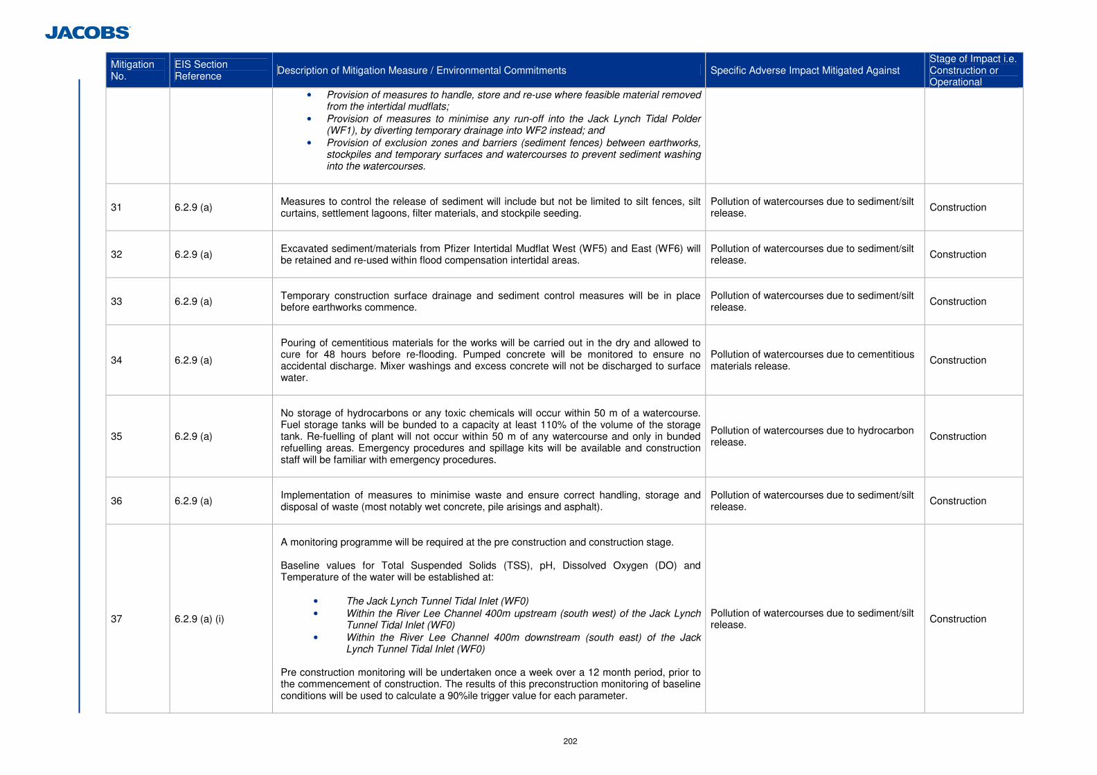
202
Mitigation No.
EIS Section Reference Description of Mitigation Measure / Environmental Commitments Specific Adverse Impact Mitigated Against
Stage of Impact i.e. Construction or Operational
• Provision of measures to handle, store and re-use where feasible material removed from the intertidal mudflats;
• Provision of measures to minimise any run-off into the Jack Lynch Tidal Polder (WF1), by diverting temporary drainage into WF2 instead; and
• Provision of exclusion zones and barriers (sediment fences) between earthworks, stockpiles and temporary surfaces and watercourses to prevent sediment washing into the watercourses.
31 6.2.9 (a)
Measures to control the release of sediment will include but not be limited to silt fences, silt curtains, settlement lagoons, filter materials, and stockpile seeding.
Pollution of watercourses due to sediment/silt release. Construction
32 6.2.9 (a)
Excavated sediment/materials from Pfizer Intertidal Mudflat West (WF5) and East (WF6) will be retained and re-used within flood compensation intertidal areas.
Pollution of watercourses due to sediment/silt release. Construction
33 6.2.9 (a)
Temporary construction surface drainage and sediment control measures will be in place before earthworks commence.
Pollution of watercourses due to sediment/silt release. Construction
34 6.2.9 (a)
Pouring of cementitious materials for the works will be carried out in the dry and allowed to cure for 48 hours before re-flooding. Pumped concrete will be monitored to ensure no accidental discharge. Mixer washings and excess concrete will not be discharged to surface water.
Pollution of watercourses due to cementitious materials release. Construction
35 6.2.9 (a)
No storage of hydrocarbons or any toxic chemicals will occur within 50 m of a watercourse. Fuel storage tanks will be bunded to a capacity at least 110% of the volume of the storage tank. Re-fuelling of plant will not occur within 50 m of any watercourse and only in bunded refuelling areas. Emergency procedures and spillage kits will be available and construction staff will be familiar with emergency procedures.
Pollution of watercourses due to hydrocarbon release. Construction
36 6.2.9 (a)
Implementation of measures to minimise waste and ensure correct handling, storage and disposal of waste (most notably wet concrete, pile arisings and asphalt).
Pollution of watercourses due to sediment/silt release. Construction
37 6.2.9 (a) (i)
A monitoring programme will be required at the pre construction and construction stage. Baseline values for Total Suspended Solids (TSS), pH, Dissolved Oxygen (DO) and Temperature of the water will be established at:
• The Jack Lynch Tunnel Tidal Inlet (WF0) • Within the River Lee Channel 400m upstream (south west) of the Jack Lynch
Tunnel Tidal Inlet (WF0) • Within the River Lee Channel 400m downstream (south east) of the Jack
Lynch Tunnel Tidal Inlet (WF0) Pre construction monitoring will be undertaken once a week over a 12 month period, prior to the commencement of construction. The results of this preconstruction monitoring of baseline conditions will be used to calculate a 90%ile trigger value for each parameter.
Pollution of watercourses due to sediment/silt release. Construction
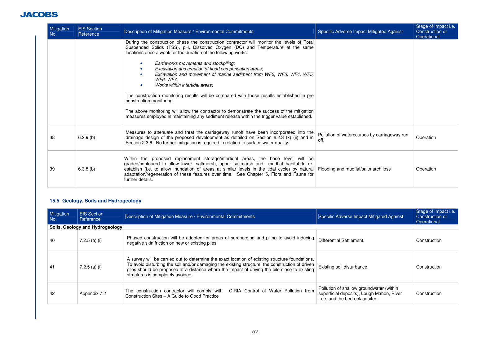
203
Mitigation No.
EIS Section Reference Description of Mitigation Measure / Environmental Commitments Specific Adverse Impact Mitigated Against
Stage of Impact i.e. Construction or Operational
During the construction phase the construction contractor will monitor the levels of Total Suspended Solids (TSS), pH, Dissolved Oxygen (DO) and Temperature at the same locations once a week for the duration of the following works:
• Earthworks movements and stockpiling; • Excavation and creation of flood compensation areas; • Excavation and movement of marine sediment from WF2, WF3, WF4, WF5,
WF6, WF7; • Works within intertidal areas;
The construction monitoring results will be compared with those results established in pre construction monitoring. The above monitoring will allow the contractor to demonstrate the success of the mitigation measures employed in maintaining any sediment release within the trigger value established.
38 6.2.9 (b)
Measures to attenuate and treat the carriageway runoff have been incorporated into the drainage design of the proposed development as detailed on Section 6.2.3 (k) (ii) and in Section 2.3.6. No further mitigation is required in relation to surface water quality.
Pollution of watercourses by carriageway run off. Operation
39 6.3.5 (b)
Within the proposed replacement storage/intertidal areas, the base level will be graded/contoured to allow lower, saltmarsh, upper saltmarsh and mudflat habitat to re-establish (i.e. to allow inundation of areas at similar levels in the tidal cycle) by natural adaptation/regeneration of these features over time. See Chapter 5, Flora and Fauna for further details.
Flooding and mudflat/saltmarch loss Operation
15.5 Geology, Soils and Hydrogeology
Mitigation No.
EIS Section Reference Description of Mitigation Measure / Environmental Commitments Specific Adverse Impact Mitigated Against
Stage of Impact i.e. Construction or Operational
Soils, Geology and Hydrogeology
40 7.2.5 (a) (i)
Phased construction will be adopted for areas of surcharging and piling to avoid inducing negative skin friction on new or existing piles.
Differential Settlement. Construction
41 7.2.5 (a) (i)
A survey will be carried out to determine the exact location of existing structure foundations. To avoid disturbing the soil and/or damaging the existing structure, the construction of driven piles should be proposed at a distance where the impact of driving the pile close to existing structures is completely avoided.
Existing soil disturbance. Construction
42 Appendix 7.2
The construction contractor will comply with CIRIA Control of Water Pollution from Construction Sites – A Guide to Good Practice
Pollution of shallow groundwater (within superficial deposits), Lough Mahon, River Lee, and the bedrock aquifer.
Construction
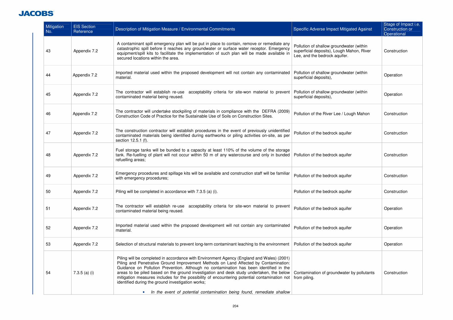
204
Mitigation No.
EIS Section Reference Description of Mitigation Measure / Environmental Commitments Specific Adverse Impact Mitigated Against
Stage of Impact i.e. Construction or Operational
43 Appendix 7.2
A contaminant spill emergency plan will be put in place to contain, remove or remediate any catastrophic spill before it reaches any groundwater or surface water receptor. Emergency equipment/spill kits to facilitate the implementation of such plan will be made available in secured locations within the area.
Pollution of shallow groundwater (within superficial deposits), Lough Mahon, River Lee, and the bedrock aquifer.
Construction
44 Appendix 7.2
Imported material used within the proposed development will not contain any contaminated material.
Pollution of shallow groundwater (within superficial deposits), Operation
45 Appendix 7.2
The contractor will establish re-use acceptability criteria for site-won material to prevent contaminated material being reused.
Pollution of shallow groundwater (within superficial deposits), Operation
46 Appendix 7.2
The contractor will undertake stockpiling of materials in compliance with the DEFRA (2009) Construction Code of Practice for the Sustainable Use of Soils on Construction Sites.
Pollution of the River Lee / Lough Mahon Construction
47 Appendix 7.2
The construction contractor will establish procedures in the event of previously unidentified contaminated materials being identified during earthworks or piling activities on-site, as per section 12.5.1 (f).
Pollution of the bedrock aquifer Construction
48 Appendix 7.2
Fuel storage tanks will be bunded to a capacity at least 110% of the volume of the storage tank. Re-fuelling of plant will not occur within 50 m of any watercourse and only in bunded refuelling areas;
Pollution of the bedrock aquifer Construction
49 Appendix 7.2 Emergency procedures and spillage kits will be available and construction staff will be familiar with emergency procedures; Pollution of the bedrock aquifer Construction
50 Appendix 7.2 Piling will be completed in accordance with 7.3.5 (a) (i).
Pollution of the bedrock aquifer Construction
51 Appendix 7.2
The contractor will establish re-use acceptability criteria for site-won material to prevent contaminated material being reused.
Pollution of the bedrock aquifer Operation
52 Appendix 7.2
Imported material used within the proposed development will not contain any contaminated material.
Pollution of the bedrock aquifer Operation
53 Appendix 7.2 Selection of structural materials to prevent long-term contaminant leaching to the environment Pollution of the bedrock aquifer Operation
54 7.3.5 (a) (i)
Piling will be completed in accordance with Environment Agency (England and Wales) (2001) Piling and Penetrative Ground Improvement Methods on Land Affected by Contamination: Guidance on Pollution Prevention. Although no contamination has been identified in the areas to be piled based on the ground investigation and desk study undertaken, the below mitigation measures includes for the possibility of encountering potential contamination not identified during the ground investigation works;
• In the event of potential contamination being found, remediate shallow
Contamination of groundwater by pollutants from piling.
Construction
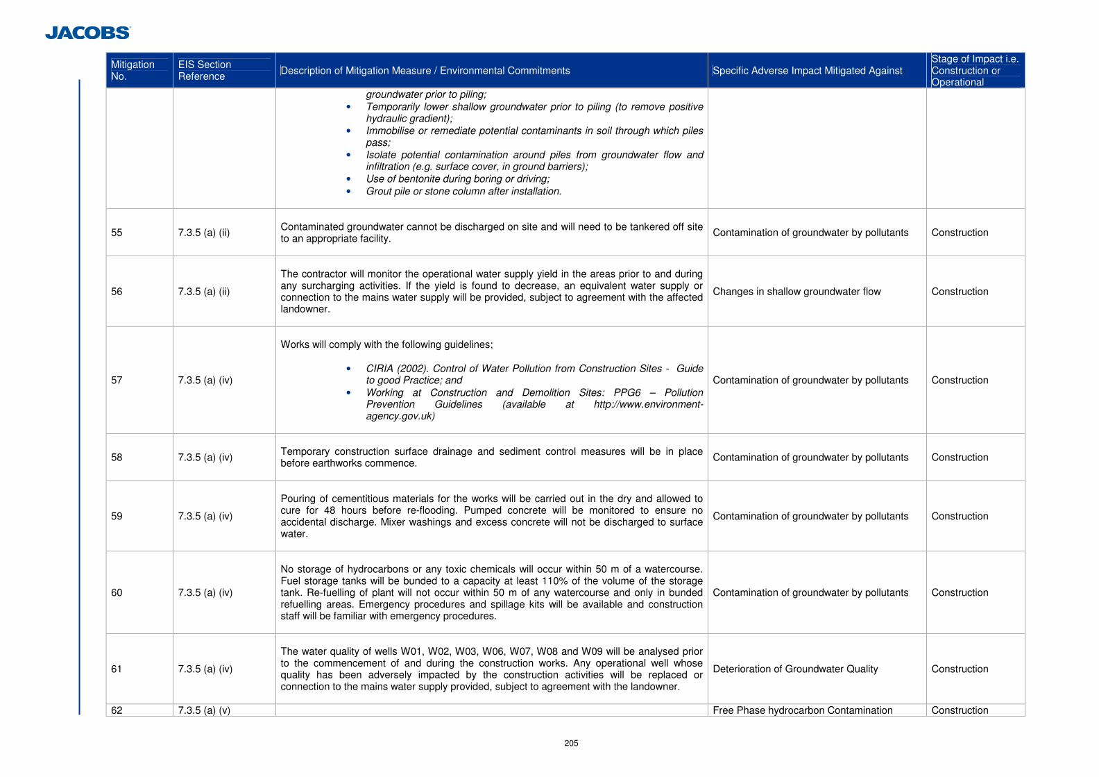
205
Mitigation No.
EIS Section Reference Description of Mitigation Measure / Environmental Commitments Specific Adverse Impact Mitigated Against
Stage of Impact i.e. Construction or Operational
groundwater prior to piling; • Temporarily lower shallow groundwater prior to piling (to remove positive
hydraulic gradient); • Immobilise or remediate potential contaminants in soil through which piles
pass; • Isolate potential contamination around piles from groundwater flow and
infiltration (e.g. surface cover, in ground barriers); • Use of bentonite during boring or driving; • Grout pile or stone column after installation.
55 7.3.5 (a) (ii)
Contaminated groundwater cannot be discharged on site and will need to be tankered off site to an appropriate facility.
Contamination of groundwater by pollutants Construction
56 7.3.5 (a) (ii)
The contractor will monitor the operational water supply yield in the areas prior to and during any surcharging activities. If the yield is found to decrease, an equivalent water supply or connection to the mains water supply will be provided, subject to agreement with the affected landowner.
Changes in shallow groundwater flow Construction
57 7.3.5 (a) (iv)
Works will comply with the following guidelines;
• CIRIA (2002). Control of Water Pollution from Construction Sites - Guide
to good Practice; and • Working at Construction and Demolition Sites: PPG6 – Pollution
Prevention Guidelines (available at http://www.environment-agency.gov.uk)
Contamination of groundwater by pollutants Construction
58 7.3.5 (a) (iv)
Temporary construction surface drainage and sediment control measures will be in place before earthworks commence.
Contamination of groundwater by pollutants Construction
59 7.3.5 (a) (iv)
Pouring of cementitious materials for the works will be carried out in the dry and allowed to cure for 48 hours before re-flooding. Pumped concrete will be monitored to ensure no accidental discharge. Mixer washings and excess concrete will not be discharged to surface water.
Contamination of groundwater by pollutants Construction
60 7.3.5 (a) (iv)
No storage of hydrocarbons or any toxic chemicals will occur within 50 m of a watercourse. Fuel storage tanks will be bunded to a capacity at least 110% of the volume of the storage tank. Re-fuelling of plant will not occur within 50 m of any watercourse and only in bunded refuelling areas. Emergency procedures and spillage kits will be available and construction staff will be familiar with emergency procedures.
Contamination of groundwater by pollutants Construction
61 7.3.5 (a) (iv)
The water quality of wells W01, W02, W03, W06, W07, W08 and W09 will be analysed prior to the commencement of and during the construction works. Any operational well whose quality has been adversely impacted by the construction activities will be replaced or connection to the mains water supply provided, subject to agreement with the landowner.
Deterioration of Groundwater Quality Construction
62 7.3.5 (a) (v) Free Phase hydrocarbon Contamination Construction
206
Mitigation No.
EIS Section Reference Description of Mitigation Measure / Environmental Commitments Specific Adverse Impact Mitigated Against
Stage of Impact i.e. Construction or Operational
Remediation of any free phase hydrocarbon contamination in shallow groundwater will be undertaken in the area of constructed wetland No. 2 in advance of any construction works. Remediation measures to be used include:
Pump and Treat (P&T).
It can be used to remove free mobile product (assuming Light Non-Aqueous Phase Liquid) and contaminated groundwater in the area of the pond/constructed wetland and surroundings through abstraction wells, prior to the excavation. Contaminated groundwater will potentially be treated on site with an activated carbon treatment unit and disposed in line with the existing regulations; free-product separated by the groundwater would need off-site disposal in suitable landfills.
In Situ Chemical Treatment (i.e. Desorption and/or Chemical Oxidation)
Proven technology, advanced chemical products will target accelerated desorption and rapid oxidation/destruction of contaminants. Treatment will consists of injecting chemical products in the soil/groundwater through injection wells, to enhance the desorption, oxidation and rapid destruction of contaminants. This will remove the requirement to excavate/remove soil. However, success depends on the permeability and uniform characteristics of the impacted soil. May be successfully coupled with groundwater extraction through Pump & Treat (P&T) systems to remove the desorbed/partially oxidised components.
Excavation and ex-situ treatment (biopiling) or off-site disposal is not suitable as contamination will be exposed during the construction, potentially remobilising the contaminant further downstream. The soil excavated for the construction of the pond/wetland will need to be disposed off-site to a suitable landfill.
63 7.3.5 (b) (i)
The road drainage system of oil/petrol interceptor, attenuation pond and constructed wetland will be lined its entire length.
Accidental Spillages and Road Runoff
Operation
64 7.3.5 (b) (i)
A penstock valve will be installed between the attenuation pond and the constructed wetland to allow isolation of the system in the event of an accidental spill. The oil/petrol interceptors will be installed before the construction of the attenuation ponds on all four drainage networks.
Accidental Spillages and Road Runoff
Operation
65 7.3.5 (b) (i)
A contaminant spill emergency plan will be put in place to contain, remove or remediate any catastrophic spill before it reaches any groundwater or surface water receptor. Emergency equipment/spill kits to facilitate the implementation of such plan will be made available in secured locations within the area.
Accidental Spillages and Road Runoff
Operation
66 7.3.5 (b) (i)
Monitoring wells will be installed in strategic locations notably downstream of the proposed development, and their water quality regularly monitored (i.e. annually for 3 subsequent years, following the opening of the proposed development).
Accidental Spillages and Road Runoff
Operation
67 7.3.5 (b) (i)
The water quality of wells W01, W02, W03, W06, W07, W08 and W09 will be analysed during the 1st year of the proposed developments operation.
Accidental Spillages and Road Runoff
Operation
207
Mitigation No.
EIS Section Reference Description of Mitigation Measure / Environmental Commitments Specific Adverse Impact Mitigated Against
Stage of Impact i.e. Construction or Operational
68 7.3.5 (b) (ii) Monitoring wells will be installed immediately downstream of the constructed wetlands and their water quality regularly monitored (i.e. annually for 3 years, following the opening of the proposed development).
Dispersion of Contaminants from Road Drainage Ponds and Constructed Wetlands into groundwater.
Operation
69 7.3.5 (b) (ii) The ponds and constructed wetlands in all four networks will be lined.
Dispersion of Contaminants from Road Drainage Ponds and Constructed Wetlands into groundwater.
Operation
15.6 Air Quality and Climate
Mitigation No.
EIS Section Reference Description of Mitigation Measure / Environmental Commitments Specific Adverse Impact Mitigated Against
Stage of Impact i.e. Construction or Operational
Air Quality and Climate
70 8.5.1
In order to minimise dust emissions during construction, a series of mitigation measures have been prepared and will be included in the Environmental Operating Plan (EOP) for implementation by the contractor during the construction phase of the project. These measures are as follows: Site roads will be regularly cleaned and maintained. Hard surface roads will be swept to remove mud and aggregate materials from their surface while any unsurfaced roads will be restricted to essential site traffic only. Site haul roads will be watered during dry and/or windy conditions. Vehicles using site roads will have their speeds restricted. Public roads outside the site will be regularly inspected for cleanliness, and cleaned regularly. Before entrance onto public roads, trucks will be adequately inspected to ensure no potential for dust emissions. Water misting or sprays will be used if particularly dusty activities are necessary during dry or windy periods. Dust deposition monitoring using the Bergerhoff Method will be conducted at a number of receptors locations in the vicinity of the construction site (refer to Figure 8.1.1 for locations);
- Receptor 1 - Richmond Park - Receptor 2 – Dunkettle - Receptor 3 – Gaeolscoil Ui Drisceoil - Receptor 8 - North Esk 2 - Receptor 9 – North Esk 3 - Receptor 11 – Tower Hill
Results will be compared to the TA Luft Standard of 350 mg/(m2*day) which is recommended by the Department of the Environment, Heritage and Local Government.
The dust minimisation procedures put in place will be monitored and assessed by the contractor. In the event of dust nuisance occurring outside the site boundary, the effectiveness of existing measures will be reviewed and the above mitigation regime intensified in terms of frequency of cleaning, misting and sweeping etc to rectify the problem.
Nuisance Dust Construction
208
15.7 Noise and Vibration
Mitigation No.
EIS Section Reference Description of Mitigation Measure / Environmental Commitments Specific Adverse Impact Mitigated Against
Stage of Impact i.e. Construction or Operational
Noise and Vibration
71 9.5.1
Low noise road surfacing will be used on the following Links, and to the extent as depicted in Image 9.1 – 9.5;
• Link A • Link D • Link H • Link T1 • Link T2
In this instance a low noise road surface is defined as a road surface that can provide a minimum noise reduction of 3.5dB(A) when compared to a standard Hot Rolled Asphalt road surface.
Operational noise levels from traffic Operation
72 9.6.3
The construction contractor will take specific noise abatement measures and comply with the recommendations of BS 5228: Part 1 and the European Communities (Noise Emission by Equipment for Use Outdoors) Regulations, 2001. Specific measures include:
• No plant used on site will be permitted to cause an ongoing public nuisance due to
noise; • The best means practicable, including proper maintenance of plant, will be employed
to minimise the noise produced by on site operations; • All vehicles and mechanical plant will be fitted with effective exhaust silencers and
maintained in good working order for the duration of the contract; • Compressors will be attenuated models fitted with properly lined and sealed acoustic
covers which will be kept closed whenever the machines are in use and all ancillary pneumatic tools shall be fitted with suitable silencers;
• Machinery that is used intermittently will be shut down or throttled back to a minimum during periods when not in use;
• Any plant, such as generators or pumps, which is required to operate before 07:00hrs or after 19:00hrs will be surrounded by an acoustic enclosure or portable screen.
Noise disturbance from Construction Construction
73 9.6.3
Prior to any construction works being undertaken at night, the contractor will be required to conduct a noise and vibration impact assessment for specific phases of works and will be required to prepare a construction noise and vibration management plan to minimise the potential for noise disturbance as a result of the works. This will involve liaison with the local authority and any affected residents during the works.
Night time noise disturbance from Construction Construction
209
15.8 Landscape and Visual
Mitigation No.
EIS Section Reference Description of Mitigation Measure / Environmental Commitments Specific Adverse Impact Mitigated Against
Stage of Impact i.e. Construction or Operational
Landscape and Visual
74 10.5.1 (c)
The construction contractor will adhere to the NRA’s Draft Guidelines on the Implementation of Landscape Treatment on National Road Schemes in Ireland, 2011. Storage areas will be so located to avoid impacting on existing residential properties, trees, hedgerows, drainage patterns etc. and such areas will be fully re-instated prior to or at the end of the construction contract.
Disruption to residential properties, trees, hedgerows, drainage patterns Construction
75 10.5.1 (b)
Landscape Planting Landscape mitigation planting/proposals as illustrated on Figure 10.1.3 and Table 10.7 will be implemented. The schedule of trees and shrubs as presented in Table 10. 8 will be adhered to.
Visual Intrusion Operation
76 10.5.1 (b)
Where practicable the existing woodland vegetation along the route will remain unaffected by
the scheme. The working area will be defined at the construction stage by the erection of protective fencing which will be set outside the canopy lines of trees and vegetation to be retained, in accordance with the NRA Guidelines for Protection and Preservation of Trees, Hedgerows and Scrub Prior to, during and Post Construction of National Road Schemes, 2006.
Visual Intrusion Operation
77 10.5.1 (b) Planting will be avoided where it would interfere with sight-lines or road safety. Visual Intrusion Operation
78 10.5.1 (b)
Planting will generally be established with forestry planting techniques, i.e. bare root
transplants, whips and feathered trees which adapt readily to disturbed ground conditions
Visual Intrusion Operation
79 10.5.1 (b)
A proportion of ‘Standard’ and taller sized trees will be used to supplement plantings
especially in the vicinity of residential areas.
Tree species utilised will be selected from a list of primarily native, naturalised and indigenous species (except where the proposal is contiguous with existing plantations containing other species such as conifers or beech etc), which will include alder, common ash, silver birch, bird and wild cherry, sessile oak, Scots pine and willow species. Planting sizes and spacing are outlined in Table 10.8.
Visual Intrusion Operation
80 10.5.1 (b)
Shrub planting species utilised will be selected from a list of primarily native and indigenous
species, which will include, blackthorn, crab apple, elder, hawthorn, hazel, holly, guelder rose, spindle, willows and other plants found naturalised in the affected localities.
Visual Intrusion Operation
210
Mitigation No.
EIS Section Reference Description of Mitigation Measure / Environmental Commitments Specific Adverse Impact Mitigated Against
Stage of Impact i.e. Construction or Operational
81 10.5.1 (b)
The base of the earth retaining walls and embankments will be planted with evergreen
climbing plants and screen, woodland planting to mitigate visual impact. As it will take a number of years for the woodland type planting to establish and begin to mitigate visual impact, larger, more mature trees will be planted through the screen woodland, in selected areas to help to mitigate visual impact immediately.
Visual Intrusion Operation
82 10.5.1 (b)
All landscape works are to be carried out in accordance with the NRA Guidelines for
Landscape Treatments for National Road Schemes in Ireland, 2006.
Visual Intrusion Operation
83 10.5.1 (b)
General grass areas will be seeded with a simple wildflower meadow mixture (e.g. WF01 mix
from Wild Flowers Ireland or similar equal and approved). Specific seed mixtures will be used at the existing interchange (SLM04) using a dry calcareous seed mixture (e.g. MM09 mix from Wild Flowers Ireland or similar equal and approved). Treatment wetlands will be seeded with a wetland wild flora mix (e.g. EC05 mix from Wild Flowers Ireland or similar equal and approved). These will be augmented with Reed (Phalaris arundinaceae and Phragmites australis) rhizomes at 0.5m centres.
Visual Intrusion Operation
84 10.5.1 (d)
As much of the proposed development passes through urban or urban fringe areas, lighting fixtures which minimise light emission spillage beyond the road boundary will be utilised without affecting the required levels of lighting on the route.
Light emission spillage beyond the road boundary. Operation
15.9 Archaeology, Cultural Heritage and Architectural Heritage
Mitigation No.
EIS Section Reference Description of Mitigation Measure / Environmental Commitments Specific Adverse Impact Mitigated Against
Stage of Impact i.e. Construction or Operational
Archaeology, Cultural Heritage and Architectural Heritage
85 11.2.4 (d)
Where preservation in situ is not feasible, preservation by record will be used to mitigate identified impacts. This methodology is in accordance with the principles and recommendations outlined in the ‘Framework and Principles for the Protection of the Archaeological Heritage’ (DAHGI 1999, 25). Preservation by record consists of fully recorded investigations in the field, followed by analyses, reporting and publication. The information gained will be widely disseminated by a series of printed and internet publications for the benefit of scholars and the general public.
Loss of archeaologcal/cultural heritage Construction
211
Mitigation No.
EIS Section Reference Description of Mitigation Measure / Environmental Commitments Specific Adverse Impact Mitigated Against
Stage of Impact i.e. Construction or Operational
86 11.2.4 (d)
Archaeological testing through a combination of geophysical survey and trial trenching will be undertaken ahead of construction. The aim of this is to confirm the presence or absence, nature and importance of any archaeological remains that may be present. The results of testing would allow the design of appropriate works to resolve identified impacts, possibly including resolution excavation. Due to the location and nature of the proposed road development, ‘undisturbed’ areas where geophysical surveys and test excavation can be carried out are small and restricted in location. The location and extent of geophysical survey areas and the layout and sample size of the trial trench array will be subject to approval of the NRA Project Archaeologist in consultation with the National Monuments Service and the Director of the National Museum of Ireland. Testing will be carried out well in advance of road construction to allow sufficient time for ameliorative action to be taken in the event of archaeological remains being identified.
Loss of archeaologcal/cultural heritage Pre Construction
87 11.2.4 (d)
A scheme of historic building recording, comprising the preparation of a written and photographic record is proposed to mitigate the impact on the section of riverside revetment at the north edge of Little Island House Demesne (Site 71). This will provide a permanent record of the revetment and is adequate mitigation for its removal.
Loss of archeaologcal/cultural heritage Pre Construction
88 11.2.4 (d)
To address the archaeological potential of Site 56, a programme of palaeoenvironmental assessment is proposed, in line with the NRA’s ‘Guidelines for the Testing and Mitigation of the Wetland Archaeological Heritage’ (NRA 2005c). This will be achieved through the retrieval of cores from deposits of palaeoenvironmental potential, followed by analysis and reporting. Any further archaeological resolution measures arising from these assessments will be implemented, subject to the approval of the NRA Project Archaeologist and the National Monuments Service, in consultation with the Museum of Ireland. In addition, the banks and bed of the tidal creek separating the western part of Little Island from the mainland will be examined by metal detector survey. The findspots of any archaeological objects recovered will be recorded and the finds conserved. At all locations within the footprint of the proposed road development, the potential for the presence of archaeological deposits or finds adjacent to the tidal creek will be addressed during test excavation.
Loss of archeaologcal/cultural heritage Pre Construction
89 11.2.4 (d)
All of the pre-construction testing and mitigation measures proposed will be subject to approval from the appointed NRA Project Archaeologist in consultation with the National Monuments Service and the Director of the National Museum of Ireland as appropriate. Proposed mitigation measures will also comply with the National Monuments Acts (1930 – 2004) and the Code of Practice (2000) agreed between the National Roads Authority and the then Minister for Arts, Heritage, Gaeltacht and the Islands. Following approval of the proposed road development, any mitigation measures will be carried out under Ministerial Direction, as defined in Section 14A(1) of the National Monuments (Amendment) Act 2004.
Loss of archeaologcal/cultural heritage Pre Construction
212
Mitigation No.
EIS Section Reference Description of Mitigation Measure / Environmental Commitments Specific Adverse Impact Mitigated Against
Stage of Impact i.e. Construction or Operational
90 11.2.4 (d)
All archaeological works require a stage of post fieldwork assessment, analysis and reporting. All archaeological reporting shall have regard to the ‘Guidelines for Authors of Reports on Archaeological Excavations’ published by the National Monuments Service of the Department of Arts, Heritage and Local Government in 2006.
Loss of archeaologcal/cultural heritage Construction
91 11.3.6
Landscape Planting as detailed in Figure 10.1.3 includes the following mitigation specific to architectural heritage;
• Landscape planting along the southern edge of the attendant grounds to Dunkettle
House (Sites 1 and 27) to reduce the visual impact of the proposed road development and aid its integration into the landscape;
• Landscape planting along the new roads to the southeast and southwest of North Esk to reduce the visual impact of the proposed road development on the nearby historic buildings and aid its integration into the landscape;
• Landscape planting along the proposed road development to the north of Inchera House Outbuildings (Site 44).
Impact on the setting architectural heritage sites Operation
15.10 Waste
Mitigation No.
EIS Section Reference Description of Mitigation Measure / Environmental Commitments Specific Adverse Impact Mitigated Against
Stage of Impact i.e. Construction or Operational
Waste
92 12.5.1 (a)
Excavated materials / Demolished Structures Where waste generated is not reusable, samples will be taken and waste acceptance critera laboratory testing will be undertaken on the excavated material. The results of the labatory testing will be used to classify the waste as Inert, Non-Hadazdous or Hazardous. Licenced waste facilities will be contacted for their acceptance criteria requirements, and the excavated waste from the proposed development compared with these, and sent to the waste facilities which will accept it. Where practical the closest suitable facilities to the proposed develoment will be selected to reduce impacts associated with vechicle movements such as air emissions.
Disposal of material at an inappropriate facility / pollution of the environment with waste materials.
Construction
93 12.5.1 (b)
Wetland Excavations/Marine Sediments All excavated wetland/marine sediment material will be reused in the 5 ‘Flood Compensatory Intertidal Areas’ (see Figure 2.8.2), therefore removing the requirement for disposal of the marine sediments at sea.
Disposal of marine sediments at sea. Construction
94 12.5.1 (c)
Pile Arisings The contractor will store, handle, and transport pile arisings in accordance with best practice guidelines. As per 12.5.1 (a) above, arisings will be sampled, tested and disposed of, to a licensed waste management facility.
Contamination of surface water, groundwater and soils with concrete / cementitious materials from bored piles.
Construction
213
Mitigation No.
EIS Section Reference Description of Mitigation Measure / Environmental Commitments Specific Adverse Impact Mitigated Against
Stage of Impact i.e. Construction or Operational
95 12.5.1 (d)
Surplus Materials Any surplus material generated by excavation of cuttings, which cannot be used for landscaping or as fill for road embankments, as per 12.5.1 (a) above, will be sampled, tested and disposed of, to a licensed waste management facility.
Disposal of surplus materials at an inappropriate facility / pollution of the environment with waste materials.
Construction
96 12.5.1 (e)
Waste Management The Contractor will ensure that any facility to which waste is brought is licensed/permitted in compliance with Waste Management Legislation.
Disposal of material at an inappropriate facility / pollution of the environment with waste materials.
Construction
97 12.5.1 (e)
A Project Construction and Demolition Plan will be prepared for the provision of waste management during the construction phase of the proposed development. The plan will take into account the following guidance documents on the minimisation and management of construction and demolition waste:
• Guidelines for the Management of Waste from National Road Construction Projects,
NRA 2008; • Best Practice Guidelines on the preparation of Waste Management Plans of
Construction and Demolition Projects, Department of the Environment, Heritage and Local Government, July 2006; and
• CIRIA document 133 Waste Minimisation in Construction.
Disposal of material at an inappropriate facility / pollution of the environment with waste materials.
Construction
98 12.5.1 (e)
An Environmental Operating Plan in accordance with the Guidelines for the Creation and Maintenance of an Environmental Operating Plan (National Roads Authority, 2007), will be produced, implemented and maintained by the Contractor as a system of documenting compliance with environmental commitments and requirements during the construction of the proposed development. The key elements of such plans will include:
• Appointment of an Environmental Manager by the main contractor; • Incorporation of environmental commitments and requirements; • Outlining methods by which construction work will be managed to meet these
environmental commitments and requirements; • Identification of roles and responsibilities of the main contractor’s staff having regard
to the main contractor’s organisational structure; • Incorporation of procedures for communicating with the public and communicating
within the main contractor’s organisation; • Incorporation of procedures for environmental awareness training; • Incorporation of monitoring procedures and responses to the results of monitoring,
where contractually required; and • Provision of a system of audit and review with regard to the effectiveness of the plan.
Disposal of material at an inappropriate facility / pollution of the environment with waste materials.
Construction
99 12.5.1 (f)
Made Ground Management/Mitigation Measures If contaminated soils are encountered during the construction works, further investigation, testing and risk assessment will be undertaken to determine whether the soils are suitable for reuse or whether the soils require remediation to make them suitable for reuse or need to be disposed of to a licensed facility off-site.
Further contamination of soils / groundwater / surface water with contaminated soils. Cross contamination of stockpiled materials.
Construction
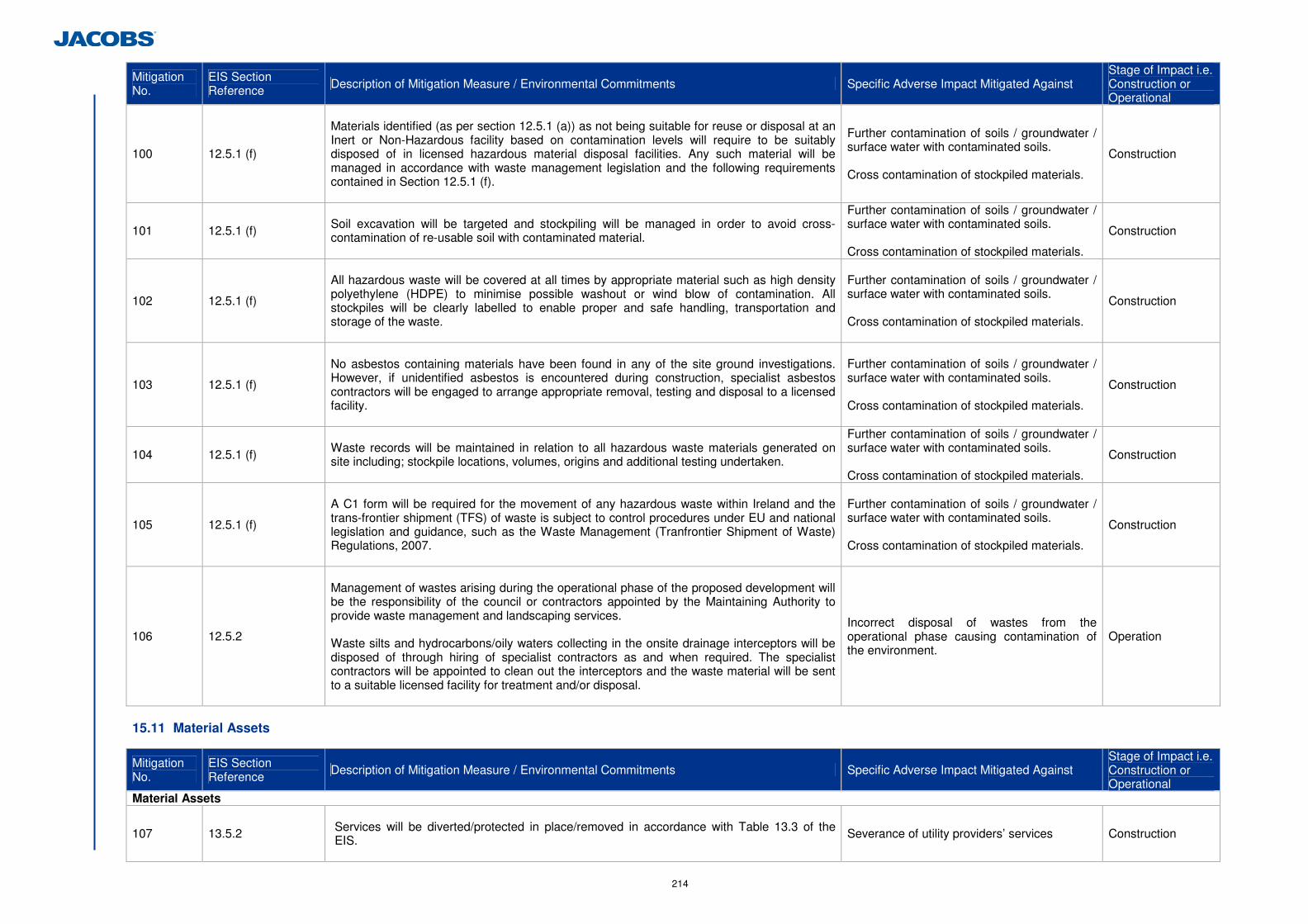
214
Mitigation No.
EIS Section Reference Description of Mitigation Measure / Environmental Commitments Specific Adverse Impact Mitigated Against
Stage of Impact i.e. Construction or Operational
100 12.5.1 (f)
Materials identified (as per section 12.5.1 (a)) as not being suitable for reuse or disposal at an Inert or Non-Hazardous facility based on contamination levels will require to be suitably disposed of in licensed hazardous material disposal facilities. Any such material will be managed in accordance with waste management legislation and the following requirements contained in Section 12.5.1 (f).
Further contamination of soils / groundwater / surface water with contaminated soils. Cross contamination of stockpiled materials.
Construction
101 12.5.1 (f) Soil excavation will be targeted and stockpiling will be managed in order to avoid cross-contamination of re-usable soil with contaminated material.
Further contamination of soils / groundwater / surface water with contaminated soils. Cross contamination of stockpiled materials.
Construction
102 12.5.1 (f)
All hazardous waste will be covered at all times by appropriate material such as high density polyethylene (HDPE) to minimise possible washout or wind blow of contamination. All stockpiles will be clearly labelled to enable proper and safe handling, transportation and storage of the waste.
Further contamination of soils / groundwater / surface water with contaminated soils. Cross contamination of stockpiled materials.
Construction
103 12.5.1 (f)
No asbestos containing materials have been found in any of the site ground investigations. However, if unidentified asbestos is encountered during construction, specialist asbestos contractors will be engaged to arrange appropriate removal, testing and disposal to a licensed facility.
Further contamination of soils / groundwater / surface water with contaminated soils. Cross contamination of stockpiled materials.
Construction
104 12.5.1 (f) Waste records will be maintained in relation to all hazardous waste materials generated on site including; stockpile locations, volumes, origins and additional testing undertaken.
Further contamination of soils / groundwater / surface water with contaminated soils. Cross contamination of stockpiled materials.
Construction
105 12.5.1 (f)
A C1 form will be required for the movement of any hazardous waste within Ireland and the trans-frontier shipment (TFS) of waste is subject to control procedures under EU and national legislation and guidance, such as the Waste Management (Tranfrontier Shipment of Waste) Regulations, 2007.
Further contamination of soils / groundwater / surface water with contaminated soils. Cross contamination of stockpiled materials.
Construction
106 12.5.2
Management of wastes arising during the operational phase of the proposed development will be the responsibility of the council or contractors appointed by the Maintaining Authority to provide waste management and landscaping services. Waste silts and hydrocarbons/oily waters collecting in the onsite drainage interceptors will be disposed of through hiring of specialist contractors as and when required. The specialist contractors will be appointed to clean out the interceptors and the waste material will be sent to a suitable licensed facility for treatment and/or disposal.
Incorrect disposal of wastes from the operational phase causing contamination of the environment.
Operation
15.11 Material Assets
Mitigation No.
EIS Section Reference Description of Mitigation Measure / Environmental Commitments Specific Adverse Impact Mitigated Against
Stage of Impact i.e. Construction or Operational
Material Assets
107 13.5.2
Services will be diverted/protected in place/removed in accordance with Table 13.3 of the EIS.
Severance of utility providers’ services Construction