Rydalmere Wharf Interchange Upgrade
387
Rydalmere Wharf Interchange Upgrade Review of Environmental Factors Roads and Maritime Services | April 2018
-
Upload
khangminh22 -
Category
Documents
-
view
0 -
download
0
Transcript of Rydalmere Wharf Interchange Upgrade

Rydalmere Wharf Interchange Upgrade Review of Environmental Factors Roads and Maritime Services | April 2018

Blank page
Prepared by WSP Australia Pty Ltd and Roads and Maritime Services
RMS.18.809
ISBN: 978-1-925797-21-3
Copyright: The concepts and information contained in this document are the property of NSW Roads and Maritime Services. Use or copying of this document in whole or in part without the written permission of NSW Roads and Maritime Services constitutes an infringement of copyright.
Rydalmere Wharf Interchange Upgrade Review of Environmental Factors Roads and Maritime Services | April 2018
Rydalmere Wharf Interchange Upgrade i Review of Environmental Factors
Executive summary
The proposal Roads and Maritime Services (Roads and Maritime) proposes to upgrade the existing wharf interchange at Rydalmere (the proposal). The proposal includes both water based and land based upgrades of the wharf interchange.
The water based features of the proposal would include:
• Removal of the existing gangway, pontoon and associated wharf structures (including existing piles) • Installation of a new three-metre wide by 18-metre long uncovered gangway, held in place by one new
pile • Installation of a nine-metre wide by 18-metre long floating covered and glazed pontoon, held in position
by four new piles • Installation of a debris deflector to the west of the new pontoon, held in place by two new piles • Installation of two new pivot piles to assist with berthing.
The land based features of the proposal would include:
• Lowering the path at the entrance to the gangway, including minor modification to the existing seawall • Installation of new stairs from the wharf landing to an existing paved area adjacent to the wharf • Upgrading the pathway from the wharf to the existing bus stop to comply with the Disability
Discrimination Act 1992 (DDA) and Building Code of Australia (BCA) requirements, installing new accessible ramps and compliant balustrades
• Realignment of part of the existing pavement within the interchange, including removal of existing bollards and a section of pathway to improve alignment and enabling two replacement buses to parallel park close to the wharf entrance during periods where ferries are unable to operate up-river
• Installation of kerb, gutter and a new section of pathway from the bus stop to the existing commuter car park to comply with DDA and BCA requirements
• Upgrading two existing accessible parking spaces to comply with DDA and BCA requirements • Installation of a new kiss-and-ride zone within the interchange and removal of existing bollards for
access • Installation of ten new bike racks • Installation of new bicycle calming measures with texture path changes installed at the connection of the
wharf entrance pathway to an existing shared pedestrian and cycle path • Removal of existing communications equipment and signage from the existing shelter for relocation to
the new pontoon • Installation of new wayfinding signage around the interchange
An overview of the proposal is shown in Figure ES-1.
Construction of the proposal is anticipated to start in mid-2018 and would take about five months. Construction work would not be continuous as it would rely on delivery schedules. Prefabricated wharf components, equipment and materials would be delivered to site on barges. The construction program would also be coordinated with the upgrade of Parramatta Wharf, which would be constructed simultaneously due to access constraints within the Parramatta River.

Rydalmere Wharf Interchange Upgrade ii Review of Environmental Factors
Source: Roads and Maritime Figure ES-1: Overview of the proposal
Rydalmere Wharf Interchange Upgrade iii Review of Environmental Factors
Need for the proposal The need for the proposal was identified in response to Transport for NSW’s Transport Access Program; an initiative to deliver accessible, modern, secure and integrated transport infrastructure.
The Disability Standards for Accessible Public Transport 2002 (DSAPT) and Disability (Access to Premises – Buildings) Standards (2010) (Disability Standards 2010) made under the DDA, require all public transport infrastructure, including wharves, to have fully compliant disabled access by 2022.
It was concluded that the Rydalmere Wharf Interchange needed upgrading due to its lack of an accessible pathway for less mobile passengers.
Proposal objectives and development criteria Objectives were developed to respond to the proposal need. They included improving access and passenger amenity, maintaining customer safety, reducing maintenance frequency and cost, and preventing unnecessary environmental and social impacts.
Options considered Two options to upgrade the wharf interchange were considered in addition to the strategic option of ‘do-nothing’. The do-nothing option was discounted as it would not meet the objectives of the proposal to improve accessibility, passenger safety and comfort for future patronage. The preferred option was to replace the wharf in its existing location. This option was considered to have the least social and environmental impacts and best met the objectives and development criteria.
Statutory and planning framework State Environmental Planning Policy (Infrastructure) 2007 permits development on any land for the purpose of a wharf or boating facilities to be carried out by or on behalf of a public authority without consent.
As the proposal is for a wharf and boating facility and is to be carried out by Roads and Maritime, it can be assessed under Division 5.1 of the Environmental Planning and Assessment Act 1979 (EP&A Act). As such, development consent from City of Parramatta Council is not required. The proposal is not located on land reserved under the National Parks and Wildlife Act 1974.
Community and stakeholder consultation Roads and Maritime first announced the proposed upgrade of Rydalmere Wharf Interchange in April 2015, providing information and inviting the community to an information session that was held on 10 May 2015 at the Rydalmere Wharf. Roads and Maritime have also been consulting with key stakeholders, including the City of Parramatta Council, since 2015 to develop a design which is acceptable to Council as owners and operators of the land based elements of the proposal. Consultation with City of Parramatta Council on the preferred concept design was carried out in early 2018. This resulted in refinements to the design, which is detailed in section 2.7 of this REF.
Stakeholder consultation would continue during the public display of this document, with a community information session planned during the REF public display period to capture feedback. Should the proposal proceed to construction, consultation with the community and stakeholders would continue throughout the work.
Rydalmere Wharf Interchange Upgrade iv Review of Environmental Factors
Benefits The proposal is expected to deliver the following benefits:
• Provision of a modernised accessible wharf that is consistent in its design with the recent upgrade of the wharves on the network
• Enhanced access to the wharf, with the installation of new bike racks, accessible car spaces and a kiss and ride zone
• Improved passenger comfort and security through weather protection, ample seating, customer information, CCTV and lighting
• A resilient wharf design that includes tolerances to allow for future sea level rise and more extreme weather events, including flooding
• A covered pontoon, enabling passengers to wait close to ferries in an area with weather protection, ample seating and customer information
• Improved alternative transport arrangements during periods where ferries are unable to travel upriver through provision of an area where two shuttle buses could pick up and drop off passengers within the wharf interchange
• Improved cyclist and pedestrian access to the wharf, with shared texture paths installed to ensure cyclists slow down at the wharf entry, reducing the risk of collision with users entering and exiting the wharf.
Environmental impacts The main environmental impacts of the proposal and the safeguards and management measures to address the impacts are summarised below.
Land surface, hydrology and water quality River sediments within the proposal footprint are known to contain elevated concentrations of contaminants. Acid sulfate soils may also be encountered. However, only minor disturbance of river sediments is proposed.
Water quality within the Parramatta River is known to be generally poor, due to impacts from stormwater discharge and altered flow regimes further upstream, and any residual impacts are not considered to be significant. The proposal may result in minor impacts to water quality from the disturbance of sediments during the removal of piles and the installation of the prefabricated substructure elements, including piles.
Safeguards have been proposed to minimise potential sediment dispersion including installing a silt boom and curtain around the construction area for the duration of the work. Additional safeguards would be developed by the contractor to prevent sediment and sediment laden water entering any water course, drainage line or drain inlet.
The proposal would not require significant earthwork. Earthworks would be limited to shallow excavations to realign existing pavements and footpaths and minor modifications to the seawall. As such, the potential for causing soil erosion or sediment laden runoff would be minor, and controlled through standard safeguards. Asbestos has been previously identified in soils within the proposal footprint, and would potentially be encountered whilst the proposal is built. An Asbestos Management Plan (AMP) would be implemented for the proposal, which would include procedures to manage any asbestos encountered.
The construction compound would be located on flood prone land. Weather forecasts and warnings would be monitored during construction, with an Emergency Response Plan prepared to detail specific actions to be undertaken to prevent potential impacts in the event of a flood.
Rydalmere Wharf Interchange Upgrade v Review of Environmental Factors
During operation, there would be negligible impacts to the land surface or hydrology as the operation of the proposal would be consistent with current ferry wharf operations. No further disturbance of the terrestrial environment would occur during operation of the proposal.
Biodiversity The proposal is not likely to significantly impact threatened terrestrial or aquatic species, populations or ecological communities or their habitats within the meaning of the Fisheries Management Act 1994 (FM Act) and Biodiversity Conservation 2016 (BC Act).
There are unlikely to be any threatened species, populations or communities within the proposal listed under the BC Act, therefore, no impact is expected and an assessment of significance has not been triggered.
Mangroves (protected under the FM Act) were identified about three metres either side of the existing gangway. This area would be established as a no-go zone.
There would be direct impacts to about 120 square-metres of Type 3 (minimally sensitive) Key Fish Habitat from the removal of the existing pontoon and piles and installation of new piles. Habitat would re-establish over time on the upgraded wharf. An additional 115 square-metres of Type 3 Key Fish Habitat would be shaded beneath the new pontoon due to its increased size, however this is not considered to be significant as no significant habitat was observed in or around this area.
The main safeguards to minimise the impact of construction on aquatic biodiversity include:
• Reducing vessel speeds in the construction area to minimise wash and disturbance to aquatic vegetation
• No anchoring or mooring of construction vessels in shallow habitat areas.
There is no tree removal required for the proposal, with only minor pruning required for construction. As such, there is expected to be negligible terrestrial habitat loss or impact under the proposal. A tree protection plan would be prepared to prevent impacts to trees.
Noise and vibration A Noise and Vibration Impact Assessment report concluded there would be exceedances of the noise criteria during certain construction activities. These exceedances and the mitigation proposed include:
• Up to 17 dB(A) for 13 private residential buildings in Rydalmere, north of the Parramatta River and east of the wharf, during the installation of land based infrastructure. This work would be undertaken during standard hours between 7am and 6pm with the noisiest activity of jackhammering to be undertaken intermittently
• Up to 4 dB(A) for thirteen private residential buildings in Rydalmere, north of the Parramatta River and east of the wharf, during pile installation (drilling) and hammering of the drilled piles which would be undertaken during standard hours, between 7am and 6pm
• Nine piles would be installed over a period of about two weeks, and work would occur intermittently during this period, with short periods of high noise followed by longer periods where no activity would occur. During pile hammering, it is anticipated that each pile would be hammered for one minute (about 10 hits with the hammer within one minute). For each pile this activity is likely to occur about five times over a period of one hour
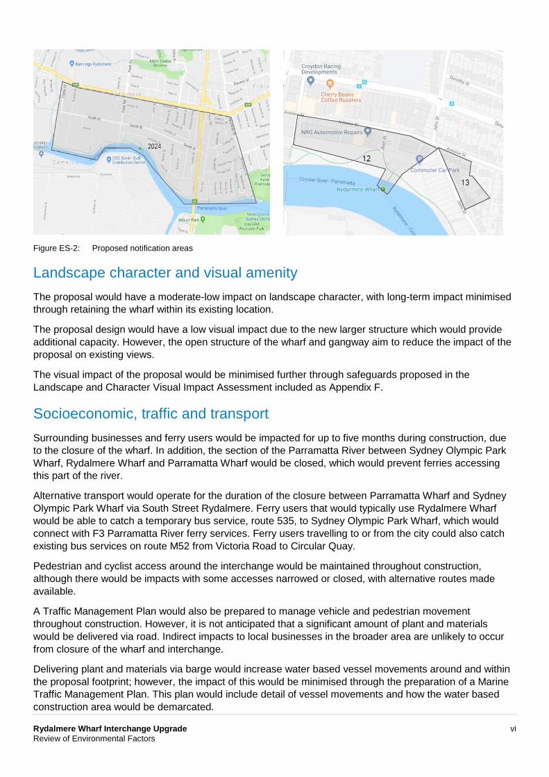
• The community would be kept informed of construction activities at least five days before they are undertaken, with a community information email and phone line provided to take enquiries and follow up on complaints. About 2,000 residences would be individually informed of construction activities via a letter drop (refer to Figure ES-2). Thirteen residences, and twelve businesses would be contacted directly prior to noisy activities, such as piling, commencing.
Rydalmere Wharf Interchange Upgrade vi Review of Environmental Factors
Figure ES-2: Proposed notification areas
Landscape character and visual amenity The proposal would have a moderate-low impact on landscape character, with long-term impact minimised through retaining the wharf within its existing location.
The proposal design would have a low visual impact due to the new larger structure which would provide additional capacity. However, the open structure of the wharf and gangway aim to reduce the impact of the proposal on existing views.
The visual impact of the proposal would be minimised further through safeguards proposed in the Landscape and Character Visual Impact Assessment included as Appendix F.
Socioeconomic, traffic and transport Surrounding businesses and ferry users would be impacted for up to five months during construction, due to the closure of the wharf. In addition, the section of the Parramatta River between Sydney Olympic Park Wharf, Rydalmere Wharf and Parramatta Wharf would be closed, which would prevent ferries accessing this part of the river.
Alternative transport would operate for the duration of the closure between Parramatta Wharf and Sydney Olympic Park Wharf via South Street Rydalmere. Ferry users that would typically use Rydalmere Wharf would be able to catch a temporary bus service, route 535, to Sydney Olympic Park Wharf, which would connect with F3 Parramatta River ferry services. Ferry users travelling to or from the city could also catch existing bus services on route M52 from Victoria Road to Circular Quay.
Pedestrian and cyclist access around the interchange would be maintained throughout construction, although there would be impacts with some accesses narrowed or closed, with alternative routes made available.
A Traffic Management Plan would also be prepared to manage vehicle and pedestrian movement throughout construction. However, it is not anticipated that a significant amount of plant and materials would be delivered via road. Indirect impacts to local businesses in the broader area are unlikely to occur from closure of the wharf and interchange.
Delivering plant and materials via barge would increase water based vessel movements around and within the proposal footprint; however, the impact of this would be minimised through the preparation of a Marine Traffic Management Plan. This plan would include detail of vessel movements and how the water based construction area would be demarcated.
Rydalmere Wharf Interchange Upgrade vii Review of Environmental Factors
Cumulative impacts Cumulative impacts relate to any combined impact resulting from multiple individual sources. The proposal is part of a broader program of work to upgrade the commuter ferry wharves in Sydney, referred to as the Ferry Wharf Upgrade Program. The upgrade of Rydalmere Wharf Interchange would be coordinated with the upgrade of Parramatta Wharf Interchange, as it would be constructed simultaneously due to access constraints within the Parramatta River. Coordinating the wharf upgrades would reduce the duration of river closure, compared to construction occurring at different times.
The proposed Parramatta River Escarpment Boardwalk and the Sydney Metro – Clyde Barging Facility were identified as external projects with potential cumulative impacts. This would include a minor increase in construction related traffic, noise and socioeconomic impacts to patrons of the F3 Parramatta River ferry service due to closure of Parramatta and Rydalmere ferry wharves concurrently. Roads and Maritime would consult with the relevant proponents, including City of Parramatta Council and Sydney Metro, prior to the commencement of construction to minimise cumulative impacts.
Further consideration of potential cumulative impacts and safeguards associated with the proposal is provided in section 6.12 of this REF.
Justification and conclusion The need for the proposal was justified under the Transport Access Program due to the lack of an accessible pathway for passengers on and around the wharf. The assessment of the environmental and social impacts has determined the proposal is not likely to have a significant impact and therefore assessment under Division 5.2 of EP&A Act is not required.
Rydalmere Wharf Interchange Upgrade viii Review of Environmental Factors
Contents Executive summary i 1 Introduction 1
1.1 Proposal identification 1 1.2 Purpose of the report 5
2 Need and options considered 6
2.1 Strategic need for the proposal 6 2.2 Existing infrastructure 8 2.3 Future patronage 9 2.4 Proposal objectives and development criteria 9 2.5 Alternatives and options considered 11 2.6 Analysis of options 12 2.7 Preferred wharf option 13 2.8 Preferred land based options 13 2.9 Design refinements 14
3 Description of the proposal 16 3.1 The proposal 16 3.2 Design 19 3.3 Construction activities 24 3.4 Ancillary facilities 28 3.5 Public utility adjustment 29 3.6 Property acquisition 29
4 Statutory and planning framework 30
4.1 Environmental Planning and Assessment Act 1979 30 4.2 Other relevant NSW legislation 40 4.3 Commonwealth legislation 42 4.4 Confirmation of statutory position 42
5 Consultation 43
5.1 Consultation strategy 43 5.2 Community involvement 43 5.3 Aboriginal community involvement 45 5.4 ISEPP consultation 45 5.5 Sydney Regional Environmental Plan (Sydney Harbour Catchment) 2005 notification 46 5.6 Government agency and stakeholder involvement 46 5.7 Ongoing or future consultation 46
Rydalmere Wharf Interchange Upgrade ix Review of Environmental Factors
Contents (continued)
6 Environmental assessment 48 6.1 Land surface, hydrology and water quality 48 6.2 Biodiversity 63 6.3 Noise and vibration 76 6.4 Landscape character and visual impact 88 6.5 Socioeconomic 98 6.6 Transport, traffic and access 105 6.7 Non-Aboriginal heritage 110 6.8 Aboriginal heritage 114 6.9 Waste management and resource use 117 6.10 Hazards and risks 120 6.11 Other impacts 122 6.12 Cumulative impacts 124
7 Environmental management 130
7.1 Environmental management plans 130 7.2 Summary of safeguards and management measures 131 7.3 Licensing and approvals 142
8 Justification and conclusion 143 8.1 Justification 143 8.2 Objects of the EP&A Act 144 8.3 Conclusion 146
9 Certification 147 10 References 148
Tables Table 2-1: Supporting NSW strategies and policies 7 Table 2-2: Existing wharf infrastructure 8 Table 2-3: Development criteria for this proposal 10 Table 3-1: Engineering and development constraints 22 Table 3-2 Construction activities 25 Table 3-3: Indicative plant and equipment 27 Table 3-4: Construction traffic (daily average) 29 Table 4-1: Aims of the Sydney Harbour SREP 31 Table 4-2: Zone W1 Maritime Waters objectives 32 Table 4-3: Clause 21 to clause 27 matters 33 Table 4-4: Heritage objectives 34
Rydalmere Wharf Interchange Upgrade x Review of Environmental Factors
Tables (continued)
Table 4-5: Wetland objectives 35 Table 4-6: Clause 63 matters 36 Table 4-7: Relevant City of Parramatta LEP land use zoning policies 39 Table 4-8: Other relevant NSW legislation 40 Table 5-1: Summary of issues raised by the community: identification of issues 43 Table 5-2: Summary of Roads and Maritime PACHCI stages 45 Table 6-1: Aquatic and terrestrial environment safeguards and management measures 58 Table 6-2: Direct habitat loss 69 Table 6-3: Biodiversity safeguards and management measures 73 Table 6-4: Ambient noise levels 76 Table 6-5: Noise catchment areas and receivers 77 Table 6-6: Construction noise assessment criteria 79 Table 6-7: Noise management levels at residential receivers 79 Table 6-8: Construction vibration assessment criteria 80 Table 6-9: Construction equipment and sound power levels 80 Table 6-10: Construction activities and periods 81 Table 6-11: Noise impact summary 82 Table 6-12: Additional noise mitigation measures 84 Table 6-13: Noise and vibration safeguards and management measures 86 Table 6-14: Landscape character assessment 95 Table 6-15: Visual impact assessment 96 Table 6-16: Landscape character and visual amenity safeguards and management measures 97 Table 6-17: Statistical data for Rydalmere State Suburb 100 Table 6-18: Socioeconomic safeguards and management measures 104 Table 6-19: Traffic, transport and access safeguards and management measures 108 Table 6-20: Non-Aboriginal heritage safeguards and management measures 113 Table 6-21: Aboriginal heritage safeguards and management measures 116 Table 6-22: Waste and resource safeguards and management measures 119 Table 6-23: Hazard and risk safeguards and management measures 121 Table 6-24: Other impacts 122 Table 6-25: Other safeguards and management measures 123 Table 6-26 Past, present and future projects 125 Table 6-27: Potential cumulative impacts 128 Table 6-28: Cumulative impact safeguards and management measures 129 Table 7-1: Summary of site specific environmental safeguards 131 Table 7-2: Summary of licensing and approvals required 142 Table 8-1: Objects of the EP&A Act 144
Rydalmere Wharf Interchange Upgrade xi Review of Environmental Factors
Figures Figure 1-1: Regional setting 2 Figure 1-2: Local setting 3 Figure 1-3: Key features of the proposal 4 Figure 2-1: Existing infrastructure of the Rydalmere Wharf 9 Figure 2-2: Preferred concept design 14 Figure 2-3: Final concept design 15 Figure 3-1 The proposal 17 Figure 3-2: Construction footprint 18 Figure 3-3: 3D representation of the proposal 20 Figure 3-4 Artist impression (western side view) 21 Figure 3-5: Artist’s impression (eastern side view) 22 Figure 6-1: Sydney Regional Environmental Plan (Sydney Harbour Catchment) 2005: Wetlands
protection area 64 Figure 6-2: Mapping of estuarine macrophytes at the proposal footprint 65 Figure 6-3: Aquatic habitat map and key fish habitat types within the proposal footprint 67 Figure 6-4: Noise Catchment areas (NCAs) 78 Figure 6-5: Proposed notification area 85 Figure 6-6: Landscape character and visual impact grading matrix 88 Figure 6-7: Landscape character zones 89 Figure 6-8: Zone of visual influence and key view points 90 Figure 6-9: Viewpoint 1 – Eric Primrose Reserve – view east 91 Figure 6-10: Viewpoint 2 – Wharf access road – view south 91 Figure 6-11: Viewpoint 3 – Parramatta Valley Cycleway – view south east 92 Figure 6-12: Viewpoint 4 – Thackeray Street Bridge – view east 92 Figure 6-13: Viewpoint 5 - Shepherd Wharf Park – view east 93 Figure 6-14: Viewpoint 6 – Camellia/Thackeray Street Bridge – view east 93 Figure 6-15: Viewpoint 7 – Parramatta River – view west 94 Figure 6-16: Rydalmere State Suburb statistical area 99 Figure 6-17: Non-Aboriginal heritage items 111
Rydalmere Wharf Interchange Upgrade xii Review of Environmental Factors
Appendices Appendix A Proposal drawings Appendix B Consideration of clause 228(2) factors Consideration of matters of national environmental significance Appendix C Statutory consultation checklists and published community updates Appendix D Aquatic ecology assessment Appendix E Noise and vibration assessment Appendix F Landscape character and visual impact assessment Appendix G Statement of heritage impact Appendix H Stage 1 PACHCI clearance letter
Rydalmere Wharf Interchange Upgrade 1 Review of Environmental Factors
1 Introduction This chapter introduces the proposal and provides the context of the environmental assessment. The proposal objectives and development history are outlined and the purpose of the report provided.
1.1 Proposal identification Roads and Maritime Services (Roads and Maritime) proposes to upgrade the existing wharf interchange at Rydalmere (the proposal) as part of the NSW Government’s Transport Access Program (TAP, https://www.transport.nsw.gov.au/projects/tap, refer to section 2.1).
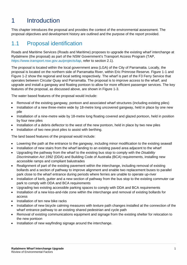
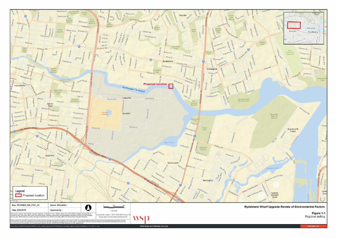
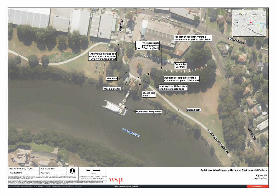
The proposal is located within the local government area (LGA) of the City of Parramatta. Locally, the proposal is located on the northern side of Parramatta River, within Eric Primrose Reserve. Figure 1-1 and Figure 1-2 show the regional and local setting respectively. The wharf is part of the F3 Ferry Service that operates between Circular Quay and Parramatta. The proposal is to improve access to the wharf, and upgrade and install a gangway and floating pontoon to allow for more efficient passenger services. The key features of the proposal, as discussed above, are shown in Figure 1-3.
The water based features of the proposal would include:
• Removal of the existing gangway, pontoon and associated wharf structures (including existing piles) • Installation of a new three-metre wide by 18-metre long uncovered gangway, held in place by one new
pile • Installation of a nine-metre wide by 18-metre long floating covered and glazed pontoon, held in position
by four new piles • Installation of a debris deflector to the west of the new pontoon, held in place by two new piles • Installation of two new pivot piles to assist with berthing.
The land based features of the proposal would include:
• Lowering the path at the entrance to the gangway, including minor modification to the existing seawall • Installation of new stairs from the wharf landing to an existing paved area adjacent to the wharf • Upgrading the pathway from the wharf to the existing bus stop to comply with the Disability
Discrimination Act 1992 (DDA) and Building Code of Australia (BCA) requirements, installing new accessible ramps and compliant balustrades
• Realignment of part of the existing pavement within the interchange, including removal of existing bollards and a section of pathway to improve alignment and enable two replacement buses to parallel park close to the wharf entrance during periods where ferries are unable to operate up-river
• Installation of kerb, gutter and a new section of pathway from the bus stop to the existing commuter car park to comply with DDA and BCA requirements
• Upgrading two existing accessible parking spaces to comply with DDA and BCA requirements • Installation of a new kiss-and-ride zone within the interchange and removal of existing bollards for
access • Installation of ten new bike racks • Installation of new bicycle calming measures with texture path changes installed at the connection of the
wharf entrance pathway to an existing shared pedestrian and cycle path • Removal of existing communications equipment and signage from the existing shelter for relocation to
the new pontoon • Installation of new wayfinding signage around the interchange.
Rydalmere Wharf Interchange Upgrade 2 Review of Environmental Factors
Figure 1-1: Regional setting
Rydalmere Wharf Interchange Upgrade 3 Review of Environmental Factors
Figure 1-2: Local setting
Rydalmere Wharf Interchange Upgrade 4 Review of Environmental Factors
Source: Roads and Maritime Figure 1-3: Key features of the proposal
Rydalmere Wharf Interchange Upgrade 5 Review of Environmental Factors
1.2 Purpose of the report This review of environmental factors (REF) has been prepared by WSP Australia Pty Ltd on behalf of Roads and Maritime. For the purposes of these works, Roads and Maritime is the proponent and the determining authority under Division 5.1 of the Environmental Planning and Assessment Act 1979 (EP&A Act).
The purpose of the REF is to describe the proposal, to document the likely impacts of the proposal on the environment, and to detail mitigation and management measures to be implemented.
The description of the proposed work and assessment of associated environmental impacts has been undertaken in the context of clause 228 of the Environmental Planning and Assessment Regulation 2000, the factors in Is an EIS Required? Best Practice Guidelines for Part 5 of the Environmental Planning and Assessment Act 1979 (Is an EIS required? guidelines (DUAP, 1995/1996), and the Marinas and Related Facilities EIS Guideline (DUAP, 1996), the Biodiversity Conservation Act 2016 (BC Act), the Fisheries Management Act 1994 (FM Act), and the Australian Government’s Environment Protection and Biodiversity Conservation Act 1999 (EPBC Act).
In doing so, the REF helps to fulfil the requirements of Section 5.5 of the EP&A Act that Roads and Maritime examine and take into account to the fullest extent possible, all matters affecting or likely to affect the environment by reason of the activity.
The findings of the REF would be considered when assessing:
• Whether the proposal is likely to have a significant impact on the environment and therefore the necessity for an environmental impact statement to be prepared and approval to be sought from the Minister for Planning under Division 5.2 of the EP&A Act
• The significance of any impact on threatened species as defined by the BC Act and/or FM Act, in section 1.7 of the EP&A Act and therefore the requirement for a Species Impact Statement or a Biodiversity Development Assessment Report
• The potential for the proposal to significantly impact any matter of national environmental significance or Commonwealth land and the need to make a referral to the Australian Government Department of the Environment and Energy for a decision by the Commonwealth Minister for the Environment on whether assessment and approval is required under the EPBC Act.

Rydalmere Wharf Interchange Upgrade 6 Review of Environmental Factors
2 Need and options considered This chapter describes the need for the proposal in terms of its strategic setting and operational need. It identifies the various options considered and the selection of the preferred option for the proposal.
2.1 Strategic need for the proposal The TAP is an ongoing ‘initiative to deliver modern, safe and accessible transport infrastructure’ in NSW (Transport for NSW, 2015). The focus of the program is improving access to the transport network for less mobile passengers. Thus, Roads and Maritime assessed the condition of all ferry wharves across the transport network in 2009 in terms of:
• Safety and structural integrity • Access for less mobile and disabled passengers • Existing and predicted future patronage and use.
The Disability Standards for Accessible Public Transport 2002 (DSAPT) and Disability (Access to Premises – Buildings) Standards (2010) (Disability Standards 2010) made under the DDA, require all public transport infrastructure, including wharves, to have fully compliant disabled access by 2022.
It was concluded that the Rydalmere Wharf Interchange needed upgrading or relocating due to its:
• Poor, and potentially unsafe, condition • Lack of an accessible pathway for users throughout the interchange and non-DDA compliant wharf.
The proposal was also developed to respond to the objectives of various Government policies as described below.
2.1.1 Transport Access Program (TAP) The aims behind the above objective of the TAP are to:
• Improve the accessibility for passengers who use wheelchairs and prams by removing stairs and suppling ramps
• Build facilities for all transport modes to meet the needs of a growing population • Provide an effective and seamless interchange that supports an integrated transport network • Deliver safety and signage improvements to help with the customer user experience • Provide other aesthetic improvements.
Ferry Wharf Upgrade Program
The Ferry Wharf Upgrade Program forms part of the TAP. Its objectives are to:
• Improve access for less mobile people • Improve passenger amenity • Improve passenger embarking/disembarking times • Develop an iconic design across the commuting wharf network • Cater for current and future passenger numbers • Minimise customer and wharf operator impacts during any refurbishment and upgrade work • Minimise ownership and maintenance costs • Ensure the design complies with current safety laws • Discourage inappropriate activities on public wharves • Aim to comply with the DDA by 2022.
Rydalmere Wharf Interchange Upgrade 7 Review of Environmental Factors
This proposal has been developed to respond to, and comply with, these objectives.
2.1.2 Future Transport Strategy 2056 The Future Transport Strategy 2056 (Transport for NSW, 2018) is an update of the Long Term Transport Master Plan for NSW (Transport for NSW, 2012). It is a 40-year strategy, supported by plans for Greater Sydney and Regional NSW, which sets the vision, directions and outcomes for customer mobility. The Future Transport Strategy sets six state-wide outcomes to guide investment, policy and reform and service provision, which includes:
• A customer focus • Successful places • Growing the economy • Safety and performance • Accessible services • Financial and environmental sustainability.
The upgrading and expanding the ferry wharf network, as part of the Ferry Wharf Upgrade Program, would support meeting the above objectives of this Strategy.
2.1.3 Supporting NSW strategies and policies The proposal is also supported under the policies, goals, objectives and targets of several other strategic planning documents as summarised in Table 2-1.
Table 2-1: Supporting NSW strategies and policies
State Infrastructure Strategy 2018-2038
The strategy identifies the NSW Government’s infrastructure vision for the state over the next 20 years, across all sectors. It is supported by the Future Transport Strategy 2056. As passenger numbers are expected to notably increase in the future, this proposal responds to the above by improving the wharf infrastructure and access provisions at Parramatta.
Disability Inclusion Action Plan 2018–2022
The Disability Inclusion Action Plan 2018–2022 is Transport for NSW’s plan for delivering high quality services to all customers including those with disability, including compliance with the disability standards outlined below.
Disability standards
The Disability Standards for Accessible Public Transport (DSAPT, 2002) and Disability (Access to Premises – Buildings) Standards (2010) form part of the DDA. Each prescribe the minimum accessibility standards for disabled access to public transport services and infrastructure, including a timetable for implementation. The proposal meets the above requirements within the timeframes specified in both standards by providing suitable access for people with a disability.
State Priorities: Making it Happen 2015
The proposal would: • Improve the existing transport infrastructure, consistent with the building infrastructure priority • Be built and would operate under environmental safeguards and management measures to avoid and
minimise environmental impacts consistent with the keeping our environment clean priority.
Rydalmere Wharf Interchange Upgrade 8 Review of Environmental Factors
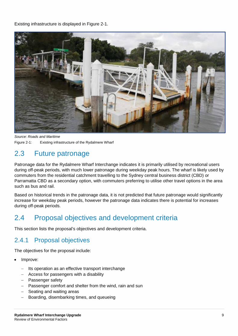
2.2 Existing infrastructure The existing infrastructure at Rydalmere includes the wharf and land based interchange infrastructure, including a commuter car park.
The existing Rydalmere Wharf Interchange does not currently meet the DSAPT or DDA requirements, as it does not allow for equitable access to the wharf or boarding the ferry. The wharf currently enables Harbour City Ferries to operate a ferry service for passengers between Circular Quay and Parramatta.
Table 2-2 summarises the existing wharf elements and descriptions of current infrastructure.
Table 2-2: Existing wharf infrastructure
Element Description
Existing infrastructure
Existing wharf, comprising: • A partially covered timber jetty structure about two-metres wide by 16-metres long • A gangway about two metres wide by 11 metres long • A pontoon about four metres wide by nine metres long. Land based infrastructure including: • Access via John Street, through a commuter car park area which provides 71 parking
spaces and two accessible parking spaces • A roundabout separated by timber bollards, with an informal shuttle bus zone • A covered shelter with seating, communication boards and other equipment • A 1.2-metre wide pedestrian path leading from the wharf to the commuter car park,
north-east of the wharf • A three-metre wide bike path along the foreshore, intersecting the interchange • Six secure bicycle lockers.
Operation • Rydalmere Wharf Interchange operates as part of the F3 Ferry Service between Sydney and Parramatta
• Ferry services typically operate every 30 minutes during the morning peak period towards the city and 60 minutes towards Parramatta, and every 60 minutes at other times. Supplementary ferry services also operate on Sundays to support higher customer demand on this day
• Shuttle buses replace ferry services between Rydalmere and Parramatta wharves during low tide due to the shallow depth of the Parramatta River
• Used by up to 500 passengers per day on average.
Ancillary services
• An informal bus stop, which does not meet DDA requirements, from which shuttle buses operate between Rydalmere and Parramatta during low tides.
Land Ownership
Land owned by Roads and Maritime: • Water based elements of the wharf, including jetty, gangway and pontoon • Land owned by the City of Parramatta Council • Foreshore area and mangroves, including part of the existing wharf (Lot 970
deposited plan (DP) 752028) • Land based ancillary services, including the commuter car park, existing shelter and
roundabout (Lot 1 DP 23579).
Rydalmere Wharf Interchange Upgrade 9 Review of Environmental Factors
Existing infrastructure is displayed in Figure 2-1.
Source: Roads and Maritime Figure 2-1: Existing infrastructure of the Rydalmere Wharf
2.3 Future patronage Patronage data for the Rydalmere Wharf Interchange indicates it is primarily utilised by recreational users during off-peak periods, with much lower patronage during weekday peak hours. The wharf is likely used by commuters from the residential catchment travelling to the Sydney central business district (CBD) or Parramatta CBD as a secondary option, with commuters preferring to utilise other travel options in the area such as bus and rail.
Based on historical trends in the patronage data, it is not predicted that future patronage would significantly increase for weekday peak periods, however the patronage data indicates there is potential for increases during off-peak periods.
2.4 Proposal objectives and development criteria This section lists the proposal’s objectives and development criteria.
2.4.1 Proposal objectives The objectives for the proposal include:
• Improve:
− Its operation as an effective transport interchange − Access for passengers with a disability − Passenger safety − Passenger comfort and shelter from the wind, rain and sun − Seating and waiting areas − Boarding, disembarking times, and queueing

Rydalmere Wharf Interchange Upgrade 10 Review of Environmental Factors
• Maintain:
− Passenger amenity, enjoyment, and river views − Pedestrian and cycleways
• Reduce:
− Maintenance frequency and cost through materials selection that allows for easy cleaning and limited repair
− Vandalism through the appropriate use of materials, surfaces and designs
• Prevent:
− Unnecessary environmental and social impacts.
2.4.2 Development criteria The development criteria for the proposal include:
Table 2-3 outlines the relevant development criteria used to help design the proposed wharf and select a preferred option.
Table 2-3: Development criteria for this proposal
Theme Relevant principles
Meet customer needs and improve the transport experience
Provide: • Safe, efficient and convenient passenger access • A comfortable, enjoyable and positive customer experience.
Optimise public transport access Provide: • Access to employment, services, recreation and education • Seamless interchange • Connection into existing and future transport networks.
Integrate with interchange investment and land use plans
Embrace heritage and cultural values.
Anticipate growth and changes in demand
Safeguard future extension and property development opportunities based on predicted growth.
Ensure sustainability and future public transport network performance
Deliver sustainable solutions that minimise environmental and community impacts that are adaptable to climate change and include new technologies.
The proposal has also been developed against the following priorities (Ferry Wharf Upgrade Program: Business Requirements Specification, TAP, 2014):
• Pedestrian access • Bicycle access and storage • Bus access • Taxi access • Private car
− Drop off and pick-up − Park and ride, with accessibility priority.
Rydalmere Wharf Interchange Upgrade 11 Review of Environmental Factors
2.4.3 Urban design objectives The urban design objectives for the proposal include:
• Minimising:
− Clutter and visual impacts through careful material selection that responds to the local setting − Interruption to views and impacts on the public domain and realm
• Retaining and enhancing:
− Pedestrian infrastructure and access − Connectivity with active (walking and cycling) and public transport modes and provisions − Setting and relationship to Eric Primrose Reserve in terms of the public domain and the integration
into landscape and parkscape, retaining and protecting existing vegetation.
2.5 Alternatives and options considered This section describes the alternatives and options considered to deliver the proposal.
2.5.1 Methodology for selection of preferred option The method by which Roads and Maritime developed options for replacing the wharf considered:
• Existing and future:
− Passenger use − Service demand
• Existing:
− Engineering design requirements and current structural integrity − Passenger safety − Environmental and social constraints − Build cost − Stakeholder feedback.
2.5.2 Identified options Potential options to upgrade the Rydalmere Wharf Interchange were identified through consideration of:
• ‘Do nothing’, which involves no upgrade. However, regular maintenance of the existing wharf infrastructure would continue’
• Demolishing the existing wharf and building a new wharf in an alternate location (relocation) • Demolishing the existing wharf and building a new wharf in its existing location (replacement).
The suitability of these options was determined through an analysis of existing wharf infrastructure, potential constraints and performance against the proposal objectives against the proposal objectives outlined in section 2.4.
A key constraint for the proposal is the shallow depth (bathymetry) of the Parramatta River between Parramatta and Rydalmere, ferries are currently restricted to operating within a narrow channel to the wharf, with the surrounding area too shallow to allow ferries to operate. Due to the shallow depths of the Parramatta River, it was identified that alteration of the current ferry route would require dredging.
Rydalmere Wharf Interchange Upgrade 12 Review of Environmental Factors
2.6 Analysis of options Analysis of the identified options is provided in the sections below.
2.6.1 Do nothing The option of ‘do nothing’ would be to limit the scope of work to carrying out activities consistent with those required to maintain operation of the existing wharf, including undertaking regular maintenance. The wharf currently operates with a jetty, gangway and pontoon. The structure is currently in poor condition, and is not DDA compliant. Undertaking regular maintenance would not correct these issues, and the wharf is not currently suitable for long-term operation.
Although it would present the lowest initial capital cost and environmental impact, the ‘do nothing option’ was discounted as it would not meet the objectives of the proposal to improve accessibility, passenger safety and comfort for future patronage.
2.6.2 Relocation of the wharf Consideration of relocating the wharf included potential impacts to the operation of ferries. Due to the shallow depth (bathymetry) of the Parramatta River at Rydalmere, ferries are currently restricted to operating within a narrow channel to the wharf, with the surrounding area too shallow to allow ferries to operate. Due to the shallow depths of the Parramatta River, relocation of the wharf would require dredging of sediments to create a navigable channel to and from the relocated wharf. Sediments within the Parramatta River are known to be contaminated; with a contamination assessment (Coffey, 2016) identifying elevated concentrations of contaminants within sediments at the existing wharf. The section of river around Rydalmere is also highly constrained by environmentally sensitive areas such as mangroves, which would be impacted by the installation of new infrastructure.
Access to surrounding services and infrastructure was identified to be limited in most areas. Rydalmere Wharf Interchange is currently located within walking distance to other public transport, including a bus stop located approximately 320 metres from the wharf. As such, the current location of the wharf was considered to be suitable for continued operation.
Due to the potential impacts identified, the option to relocate the wharf was subsequently discounted.
2.6.3 Replacement of the wharf Replacement of the wharf would include demolishing the existing wharf, and construction of a new DDA compliant wharf to match the existing berthing face.
As discussed above, the existing wharf location is considered suitable for continued operation as it provides an effective interchange. Whilst a number of deficiencies were identified within the existing interchange (refer to section 2.2), including the absence of a DDA compliant pathway to the wharf, it was identified that these deficiencies could be rectified within the scope of the proposal.
Replacement of the wharf in its existing location would avoid any unnecessary environmental impacts, such as impacts to the environmentally sensitive areas identified and dredging of potentially contaminated sediments to create a navigable channel, as the wharf would be replaced to match the existing berthing face and not result in a change to the current operation of ferries.
Replacement of the wharf in its existing location was identified as the preferred option.
Rydalmere Wharf Interchange Upgrade 13 Review of Environmental Factors
2.7 Preferred wharf option The option to replace the wharf in its existing location was identified as the preferred option as it would avoid any unnecessary environmental impacts and enable continued operation as a ferry wharf, whilst also being located in proximity to other public transport options. This option was compared against the objectives outlined in section 2.3, where it was confirmed it would:
• Improve; operation as an effective transport interchange, access for passengers with a disability, passenger safety and comfort, seating, and boarding and disembarking times
• Maintain; passenger amenity, and pedestrian and cycle paths through Rydalmere Wharf Interchange • Reduce maintenance frequency and cost • Prevent unnecessary environmental and social impacts.
2.8 Preferred land based options The investigation of options for the land based work has been limited due to the selection of the preferred wharf option and preference to avoid unnecessary environmental, property and land use impacts. As such, the land based design was developed to address the identified deficiencies and non-compliances with DDA requirements, as well as meeting the proposal objectives outlined in Section 2.4.
The preferred land based design includes:
• Upgrading the pathway from the wharf to existing accessible spaces in the carpark to comply with DDA and BCA requirements through installation of accessible ramps and installation of new compliant balustrades
• Realignment of part of the existing pavement within the interchange, including removal of existing bollards and a section of pathway, to correct for inadequacies in the existing alignment, and enabling two replacement buses to parallel park close to the wharf entrance during periods where ferries are unable to operate up-river
• Upgrading two existing accessible parking spaces to comply with DDA and BCA requirements • Installation of a new kiss-and-ride zone within the interchange and removal of existing bollards for
access • Installation of ten new bike racks • Installation of new bicycle calming measures with texture path changes installed at the connection of the
wharf entrance pathway to an existing shared path pedestrian and cycle route • Removal of existing Roads and Maritime communications equipment and signage within the existing
shelter for relocation to the new pontoon • Installation of new wayfinding signage around the interchange.
Figure 2-2 shows the preferred concept design and demolition plan (shown in red in Figure 2-2).
Rydalmere Wharf Interchange Upgrade 14 Review of Environmental Factors
Source: Hansen Yuncken Figure 2-2: Preferred concept design
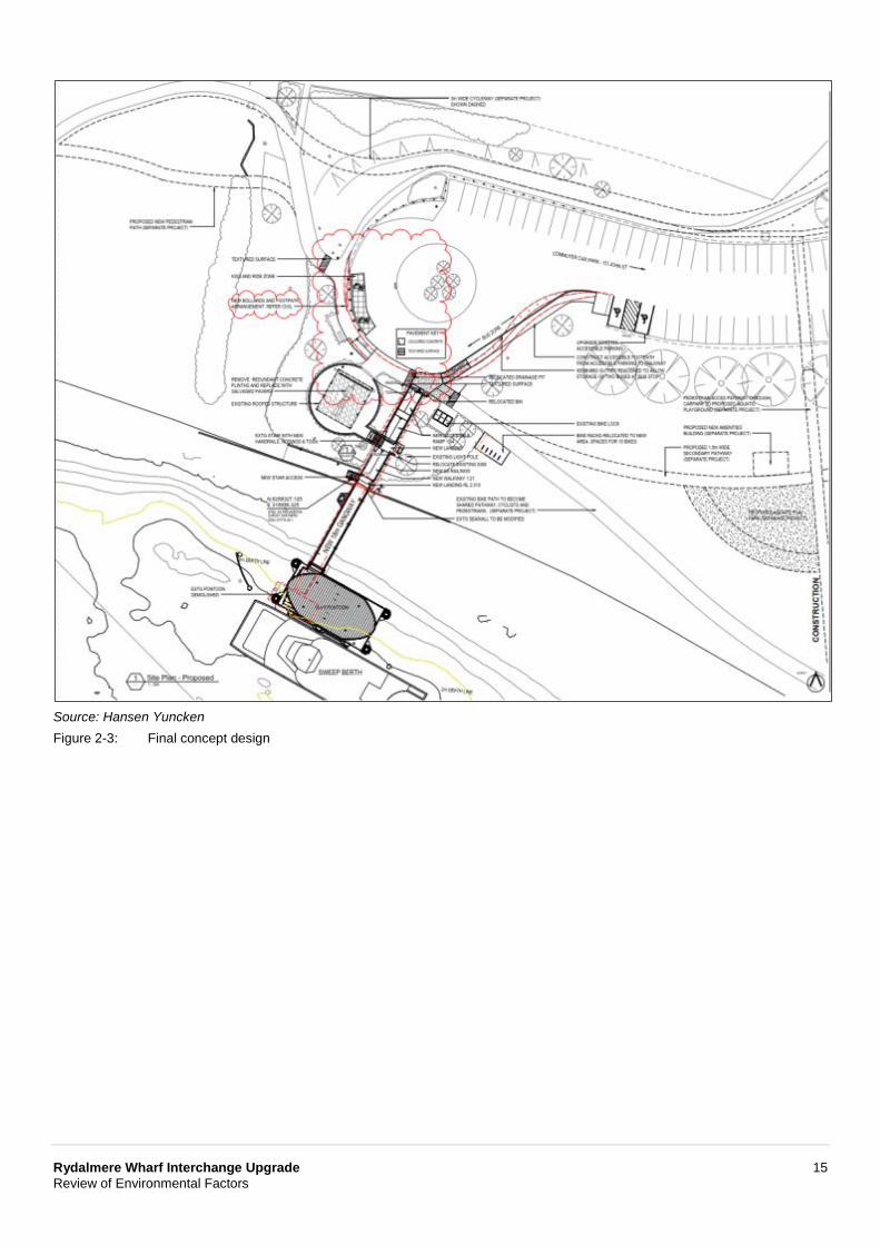
2.9 Design refinements Once the preferred option was selected, the concept design was presented to key stakeholders for feedback in early 2018. In response to feedback from City of Parramatta Council regarding the width of the existing shared path through the interchange, the design was refined to widen the path to three metres throughout to provide improved access for pedestrians and cyclists.
A kiss and ride was relocated closer to the wharf and texture changes added to existing pedestrian and cycle paths to ensure cyclist speeds are reduced close to the wharf entrance.
Figure 2-3 shows the revised wharf concept design.
Rydalmere Wharf Interchange Upgrade 15 Review of Environmental Factors
Source: Hansen Yuncken Figure 2-3: Final concept design

Rydalmere Wharf Interchange Upgrade 16 Review of Environmental Factors
3 Description of the proposal This Chapter describes the proposal and provides descriptions of existing conditions, the design parameters including major design features, the construction method and associated infrastructure and activities.
3.1 The proposal The proposal is to upgrade the Rydalmere Wharf Interchange as part of the TAP.
The water based features of the proposal would include:
• Removal of the existing gangway, pontoon and associated wharf structures (including existing piles) • Installation of a new three-metre wide by 18-metre long uncovered gangway, held in place by one new
pile • Installation of a nine-metre wide by 18-metre long floating covered and glazed pontoon, held in position
by four new piles • Installation of a debris deflector to the west of the new pontoon, held in place by two new piles • Installation of two new pivot piles to assist with berthing.
The land based features of the proposal would include:
• Lowering the path at the entrance to the gangway, including minor modification to the existing seawall • Installation of new stairs from the wharf landing to an existing paved area adjacent to the wharf • Upgrading the pathway from the wharf to the existing bus stop to comply with the Disability
Discrimination Act 1992 (DDA) and Building Code of Australia (BCA) requirements, installing new accessible ramps and compliant balustrades
• Realignment of part of the existing pavement within the interchange, including removal of existing bollards and a section of pathway to improve alignment and enable two replacement buses to parallel park close to the wharf entrance during periods where ferries are unable to operate up-river.
• Installation of kerb, gutter and a new section of pathway from the bus stop to the existing commuter car park to comply with DDA and BCA requirements
• Upgrading two existing accessible parking spaces to comply with DDA and BCA requirements • Installation of a new kiss-and-ride zone within the interchange and removal of existing bollards for
access • Installation of ten new bike racks • Installation of new bicycle calming measures with texture path changes installed at the connection of the
wharf entrance pathway to an existing shared pedestrian and cycle path • Removal of existing communications equipment and signage from the existing shelter for relocation to
the new pontoon • Installation of new wayfinding signage around the interchange.
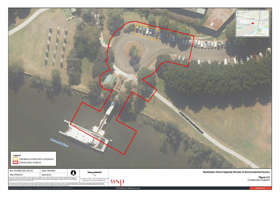
Figure 3-1 shows the proposals water based and land based elements respectively.
Figure 3-2 shows the proposal’s construction footprint, and the location of the supporting ancillary facilities (ie site compounds, refer to section 3.4), which comprises the indicative assessment area.

Rydalmere Wharf Interchange Upgrade 17 Review of Environmental Factors
Source: Roads and Maritime Figure 3-1 The proposal
Rydalmere Wharf Interchange Upgrade 18 Review of Environmental Factors
Figure 3-2: Construction footprint
Rydalmere Wharf Interchange Upgrade 19 Review of Environmental Factors
3.2 Design This section describes the proposal’s concept design.
3.2.1 Design criteria The proposal has been designed to NSW and Australian maritime engineering and safety standards, including:
• Roads and Maritime: Guidelines for the Assessment of Public Ferry Wharf Safety 2016 • BCA: land based and superstructure • Australian Maritime Safety Authority (ASMA): navigation and safety • Standards Australia: AS4997: 2005 Guidelines for the Design of Maritime Structures • DDA.
These standards describe a summary of the key standards that should be adopted when building specific maritime structures by providing detail on:
• Overall height of the wharf above the water to allow for operation during extreme low and high tide, while additionally allowing for climate change adaptation in the future
• Access and safety requirements • Operation and stability during extreme storms, accounting for wind, wave and current conditions • Sufficient water depths at extreme low tide to allow ferries to safely berth without the risk of either
grounding or causing notable sediment disturbance and scour from propeller wash • Appropriate materials selection and durability to support the operational design life of the wharf • Additional safety and security measures consistent with the provisions of Crime Prevention through
Environmental Design (DP&E, 2001).
Overall, the wharf has been designed:
• With a 50-year design life • To cater for low mobility passengers and expected passenger growth in the future • To operate in different tidal conditions over its design life • To be regarded as an attractive, safe and secure piece of public transport infrastructure.
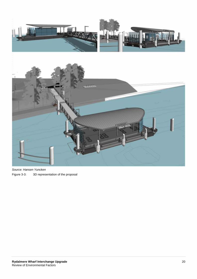
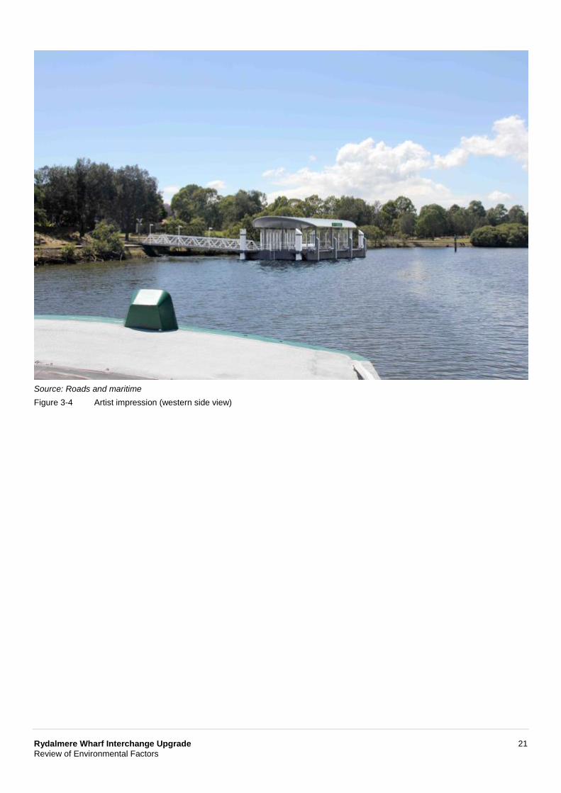
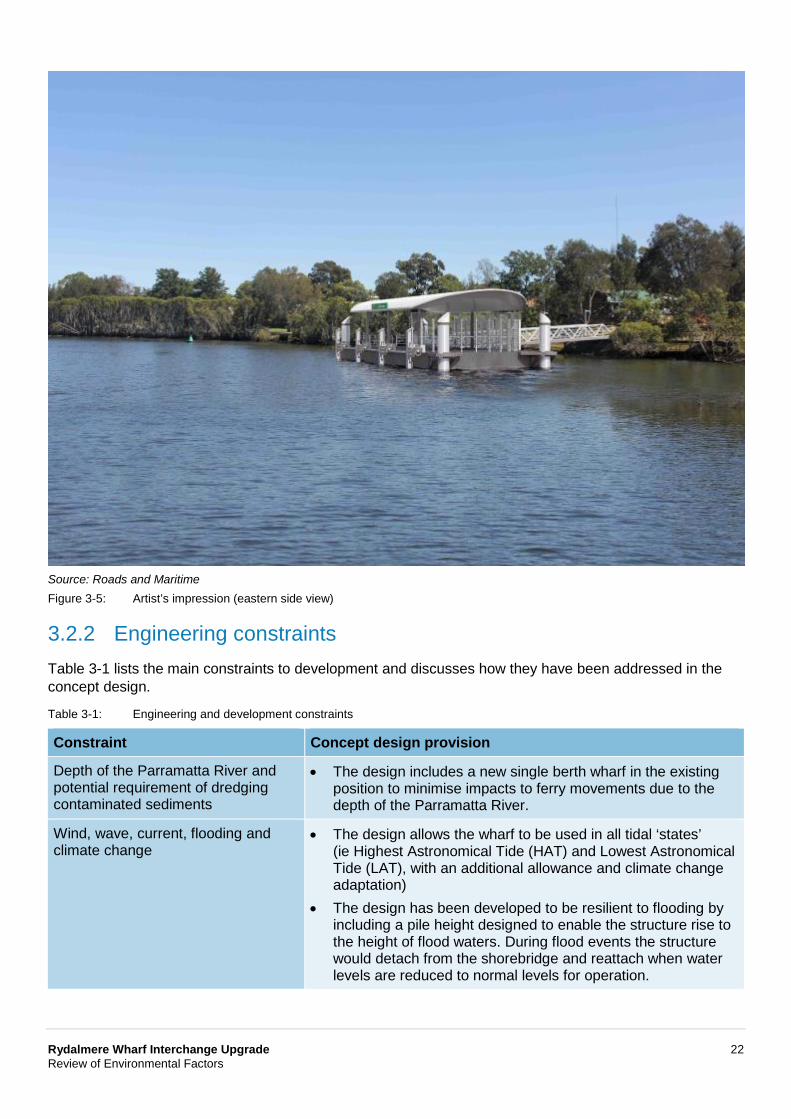
Figure 3-3 shows a three-dimensional montage of the proposal. Figure 3-4 and Figure 3-5 shows an artist’s impression of the proposal.
Rydalmere Wharf Interchange Upgrade 20 Review of Environmental Factors
Source: Hansen Yuncken Figure 3-3: 3D representation of the proposal
Rydalmere Wharf Interchange Upgrade 21 Review of Environmental Factors
Source: Roads and maritime Figure 3-4 Artist impression (western side view)
Rydalmere Wharf Interchange Upgrade 22 Review of Environmental Factors
Source: Roads and Maritime Figure 3-5: Artist’s impression (eastern side view)
3.2.2 Engineering constraints Table 3-1 lists the main constraints to development and discusses how they have been addressed in the concept design.
Table 3-1: Engineering and development constraints
Constraint Concept design provision
Depth of the Parramatta River and potential requirement of dredging contaminated sediments
• The design includes a new single berth wharf in the existing position to minimise impacts to ferry movements due to the depth of the Parramatta River.
Wind, wave, current, flooding and climate change
• The design allows the wharf to be used in all tidal ‘states’ (ie Highest Astronomical Tide (HAT) and Lowest Astronomical Tide (LAT), with an additional allowance and climate change adaptation)
• The design has been developed to be resilient to flooding by including a pile height designed to enable the structure rise to the height of flood waters. During flood events the structure would detach from the shorebridge and reattach when water levels are reduced to normal levels for operation.
Rydalmere Wharf Interchange Upgrade 23 Review of Environmental Factors
3.2.3 Major design features This section describes the proposals main design features.
Major water based features
Pontoon
The pontoon would be built in the same location as the existing wharf. It would comprise an 18-metre long and nine-metre wide steel floating structure with canopy shelter and include a waiting area, seating and information kiosk. The wharf would have one berthing face on the southern (river) side.
The pontoon would be built from pre-fabricated units delivered to site. A curved zinc canopy roof would be built over the pontoon and supported on steel columns. The pontoon would be surrounded by a mixture of glass and stainless-steel balustrades.
The pontoon would be held in place by four steel piles, drilled and subsequently hammered to refusal in the underlying sandstone bedrock. The pontoon height would vary relative to the landfall depending on the state of the tide, with pile heights installed to enable the pontoon to float up and down during flood conditions.
A debris deflector would be installed adjacent to the pontoon to direct debris around the structure, reducing the risk of damaging or impacting the operation of the wharf.
Gangway
The pontoon would be accessed by an 18-metre long and three-metre wide uncovered gangway. The gangway would connect to a new landing on the foreshore at one end and the floating pontoon at the other. The gradient of the gangway will vary according to tides. It would allow for disabled and low mobility wharf users for most of the time except during extreme high and low tide, consistent with the Transport for NSW Guideline for the Assessment of Public Ferry Wharf Safety (Transport for NSW, 2016). The gangway would be built off site and delivered as one unit to site.
The gangway would be held in position by one pile, with the height of the pile enabling the gangway to float up and down, disconnecting from the landside during flood conditions.
Major land based features
Modifications to the existing car park and interchange would include:
• Upgrade the two existing accessible parking spaces in the car park to comply with DDA and BCA requirements, including kerb ramps, line markings, wheel stops and bollards
• Realignment of part of the existing pavement and kerb within the interchange, including removal of existing bollards, to correct for inadequacies in the existing alignment, and enable two replacement buses to parallel park close to the wharf entrance during periods where ferries are unable to operate up-river
• Realignment of the existing pathway from the wharf to the accessible parking spaces to match the realigned kerb and comply with DDA and BCA requirements through widening, installation of accessible ramps, and installation of new compliant balustrades
• Relocation of wharf equipment from existing shelter to a Services Pod on the pontoon
• Installation of a new kiss-and-ride zone within the interchange and removal of existing bollards for access
Rydalmere Wharf Interchange Upgrade 24 Review of Environmental Factors
• Lowering the path at the entrance to the gangway, including minor modification to the existing seawall
• Installation of new stairs from the wharf landing to an existing paved area adjacent to the wharf
• Interchange upgrades, including:
− Installation of 10 new bicycle racks, adjacent to the cycleway and existing bicycle lockers − A marked pedestrian crossing across the cycleway and other minor line-marking, pavement
treatments and signage to reduce potential cyclist/pedestrian conflicts − Installation of new wayfinding signage, guided by the Transport for NSW Kit of Parts.
Supporting infrastructure
While the details of the supporting infrastructure, lighting, signage, and furniture would be confirmed during the detailed design, they would be consistent with the provisions included on the other wharves on the network. It would therefore include:
• Safety and security lighting on the approaches and throughout the wharf • Additional seating in the existing shelter • Bicycle calming zones • Opal self-service machine (SSM) to be relocated close to the entrance to the wharf at the top of the
gangway • Opal Fixed Location Readers (tap on/off machines) to be relocated at the entrance to the wharf • Safety ladders around the walkway and wharf pontoon • Life ring on the pontoon • Closed circuit television (CCTV) • Glass weather screen • Tactile flooring.
The above would be developed in accordance with relevant Roads and Maritime design specifications.
3.3 Construction activities The appointed contractor would confirm the final construction activities in discussion with Roads and Maritime. As such, this section only indicates a likely method and work plan as it may vary due to the identification of additional constraints before work starts, detailed design refinements, community and stakeholder consultation feedback, and contractor requirements/limitations. Should the work method differ from what is proposed in this REF, the contractor would consult Roads and Maritime to determine if additional assessment is needed. Some additional land would be needed temporarily to support construction, as described in section 3.4.
3.3.1 Work methodology The proposal would be built under Roads and Maritime specifications as managed by a contractor under a construction environmental management plan (CEMP). These specifications cover environmental performance and management supplemented by aspects such as materials storage and management, and erosion and sediment control. The proposal would likely comprise a sequence of work activities like that summarised in Table 3-2.
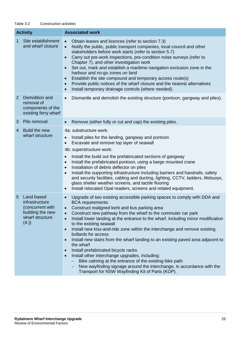
Rydalmere Wharf Interchange Upgrade 25 Review of Environmental Factors
Table 3-2 Construction activities
Activity Associated work
1 Site establishment and wharf closure
• Obtain leases and licences (refer to section 7.3) • Notify the public, public transport companies, local council and other
stakeholders before work starts (refer to section 5.7) • Carry out pre-work inspections, pre-condition noise surveys (refer to
Chapter 7), and other investigation work • Set out, mark and establish a maritime navigation exclusion zone in the
harbour and no-go zones on land • Establish the site compound and temporary access route(s) • Provide public notices of the wharf closure and the nearest alternatives • Install temporary drainage controls (where needed).
2 Demolition and removal of components of the existing ferry wharf
• Dismantle and demolish the existing structure (pontoon, gangway and piles).
3 Pile removal • Remove (either fully or cut and cap) the existing piles.
4 Build the new wharf structure
4a: substructure work: • Install piles for the landing, gangway and pontoon • Excavate and remove top layer of seawall 4b: superstructure work: • Install the build out the prefabricated sections of gangway • Install the prefabricated pontoon, using a barge mounted crane • Installation of debris deflector on piles • Install the supporting infrastructure including barriers and handrails, safety
and security facilities, cabling and ducting, lighting, CCTV, ladders, lifebuoys, glass shelter weather screens, and tactile flooring
• Install relocated Opal readers, screens and related equipment.
5 Land based infrastructure (concurrent with building the new wharf structure (4.))
• Upgrade of two existing accessible parking spaces to comply with DDA and BCA requirements.
• Construct realigned kerb and bus parking area • Construct new pathway from the wharf to the commuter car park • Install lower landing at the entrance to the wharf, including minor modification
to the existing seawall • Install new kiss-and-ride zone within the interchange and remove existing
bollards for access • Install new stairs from the wharf landing to an existing paved area adjacent to
the wharf • Install prefabricated bicycle racks • Install other interchange upgrades, including:
− Bike calming at the entrance of the existing bike path − New wayfinding signage around the interchange, in accordance with the
Transport for NSW Wayfinding Kit of Parts (KOP).
Rydalmere Wharf Interchange Upgrade 26 Review of Environmental Factors
Activity Associated work
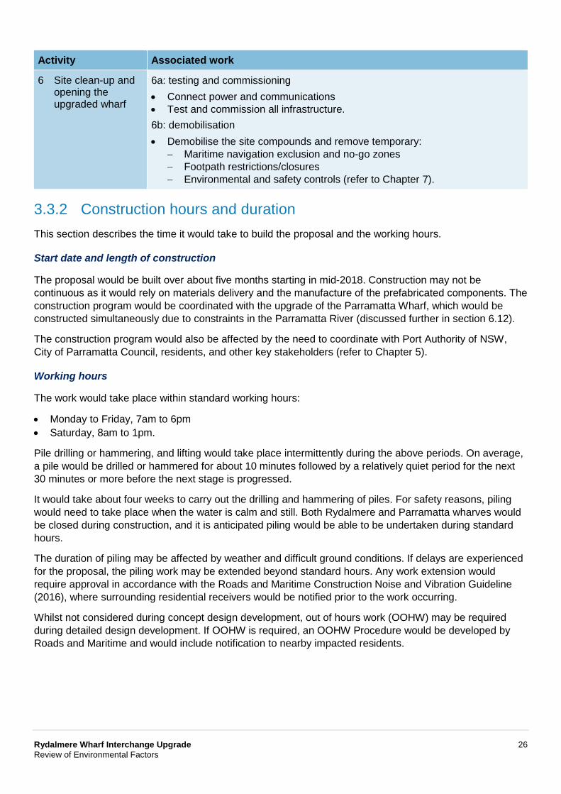
6 Site clean-up and opening the upgraded wharf
6a: testing and commissioning • Connect power and communications • Test and commission all infrastructure. 6b: demobilisation • Demobilise the site compounds and remove temporary:
− Maritime navigation exclusion and no-go zones − Footpath restrictions/closures − Environmental and safety controls (refer to Chapter 7).
3.3.2 Construction hours and duration This section describes the time it would take to build the proposal and the working hours.
Start date and length of construction
The proposal would be built over about five months starting in mid-2018. Construction may not be continuous as it would rely on materials delivery and the manufacture of the prefabricated components. The construction program would be coordinated with the upgrade of the Parramatta Wharf, which would be constructed simultaneously due to constraints in the Parramatta River (discussed further in section 6.12).
The construction program would also be affected by the need to coordinate with Port Authority of NSW, City of Parramatta Council, residents, and other key stakeholders (refer to Chapter 5).
Working hours
The work would take place within standard working hours:
• Monday to Friday, 7am to 6pm • Saturday, 8am to 1pm.
Pile drilling or hammering, and lifting would take place intermittently during the above periods. On average, a pile would be drilled or hammered for about 10 minutes followed by a relatively quiet period for the next 30 minutes or more before the next stage is progressed.
It would take about four weeks to carry out the drilling and hammering of piles. For safety reasons, piling would need to take place when the water is calm and still. Both Rydalmere and Parramatta wharves would be closed during construction, and it is anticipated piling would be able to be undertaken during standard hours.
The duration of piling may be affected by weather and difficult ground conditions. If delays are experienced for the proposal, the piling work may be extended beyond standard hours. Any work extension would require approval in accordance with the Roads and Maritime Construction Noise and Vibration Guideline (2016), where surrounding residential receivers would be notified prior to the work occurring.
Whilst not considered during concept design development, out of hours work (OOHW) may be required during detailed design development. If OOHW is required, an OOHW Procedure would be developed by Roads and Maritime and would include notification to nearby impacted residents.
Rydalmere Wharf Interchange Upgrade 27 Review of Environmental Factors
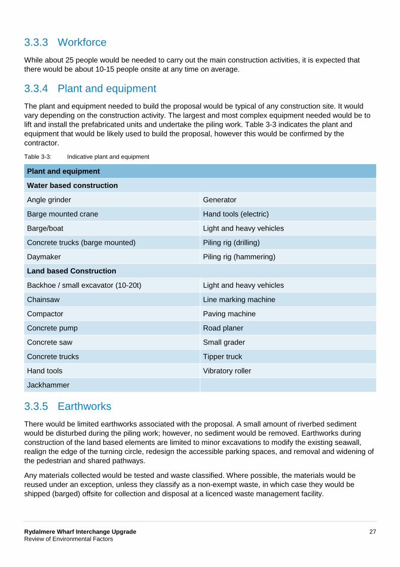
3.3.3 Workforce While about 25 people would be needed to carry out the main construction activities, it is expected that there would be about 10-15 people onsite at any time on average.
3.3.4 Plant and equipment The plant and equipment needed to build the proposal would be typical of any construction site. It would vary depending on the construction activity. The largest and most complex equipment needed would be to lift and install the prefabricated units and undertake the piling work. Table 3-3 indicates the plant and equipment that would be likely used to build the proposal, however this would be confirmed by the contractor.
Table 3-3: Indicative plant and equipment
Plant and equipment
Water based construction
Angle grinder Generator
Barge mounted crane Hand tools (electric)
Barge/boat Light and heavy vehicles
Concrete trucks (barge mounted) Piling rig (drilling)
Daymaker Piling rig (hammering)
Land based Construction
Backhoe / small excavator (10-20t) Light and heavy vehicles
Chainsaw Line marking machine
Compactor Paving machine
Concrete pump Road planer
Concrete saw Small grader
Concrete trucks Tipper truck
Hand tools Vibratory roller
Jackhammer
3.3.5 Earthworks There would be limited earthworks associated with the proposal. A small amount of riverbed sediment would be disturbed during the piling work; however, no sediment would be removed. Earthworks during construction of the land based elements are limited to minor excavations to modify the existing seawall, realign the edge of the turning circle, redesign the accessible parking spaces, and removal and widening of the pedestrian and shared pathways.
Any materials collected would be tested and waste classified. Where possible, the materials would be reused under an exception, unless they classify as a non-exempt waste, in which case they would be shipped (barged) offsite for collection and disposal at a licenced waste management facility.
Rydalmere Wharf Interchange Upgrade 28 Review of Environmental Factors
3.3.6 Source and quantity of materials Various standard construction materials that are readily available across the Sydney Metropolitan region would be needed to build the proposal. They would be either transported or shipped (barged) to site as prefabricated units ready for installation, or delivered in small quantities for use as needed (refer to section 3.4.1). The main materials needed to build the proposal would comprise:
• Marine-grade steel, aluminium and zinc for the superstructure (floating pontoon and wharf, barriers and roof), substructure (piles) and land side work (stairs)
• Precast concrete • Prefabricated signage, light fittings, barriers and fencing • Prefabricated glazing units • Electrical cabling and other electronic infrastructure • Additional materials such as relatively small quantities of paint, oils, fuels and other materials.
3.4 Ancillary facilities For construction of the wharf, the preference would be to ship any major machinery, equipment and prefabricated units to site, potentially making use of an offshore storage barge. However, it is also likely that a small 75 square-metre site compound (to be confirmed by the contractor) would be needed within the proposal footprint to store equipment, machinery and some limited materials. An additional site compound of similar size would also be required for construction of the land based elements of the proposal.
While the specific requirements for this site would be confirmed by the contractor(s), it would most likely comprise a shipping container with a supporting site office and toilet. Small amounts of material would also be required to be stored on site, as discussed in section 3.3.6 above.
An indicative site compound location is shown in Figure 3-2. Additional or revised site compounds may be needed following completion of detailed design and construction scheduling. Any additional or revised compound and/or stockpile sites proposed by the contractor would be discussed with Roads and Maritime’s Environment Manager, Greater Sydney Project Office, to determine if any additional environmental assessment or safeguards are required. Any additional or revised compound and/or stockpile sites would ideally meet the following criteria:
• On previously disturbed areas • Away from biodiversity including outside the drip line of trees • On relatively level ground and up-slope of sediment control barriers • Outside of flood prone land • Have ready access to the road network or direct access to the construction area • At least five metres clear of all areas of possible concentrated water flow or as far as practicable with
additional controls, such as primary and secondary erosion and sediment controls, in place • More than 100 metres from any residential property or as far as practicable with additional controls,
such as additional consultation and hoarding, in place.
It is noted that the potential locations identified are located on flood prone land, and additional environmental safeguards have been identified in Chapter 7 to mitigate potential impacts
Site compounds would be securely fenced with temporary fencing and hoarding. Signage would be erected advising the public of access restrictions. Upon completion of work, the contractor would remove the site compound, including any waste materials. Sites would be rehabilitated in consultation with the relevant property owner.
Rydalmere Wharf Interchange Upgrade 29 Review of Environmental Factors
3.4.1 Traffic management and access Maritime and road traffic management would be required while certain elements of the proposal are being built and installed. This may involve:
• Pedestrian and cyclist access around the wharf and park during construction • Temporary traffic lights or stop-go provisions on John Street while major deliveries take place.
No private property access would be impacted during construction.
A replacement bus service would be provided during construction. The service would operate between Parramatta Ferry Wharf via Rydalmere to Sydney Olympic Park Wharf. Further details are provided in section 6.6.
Construction traffic
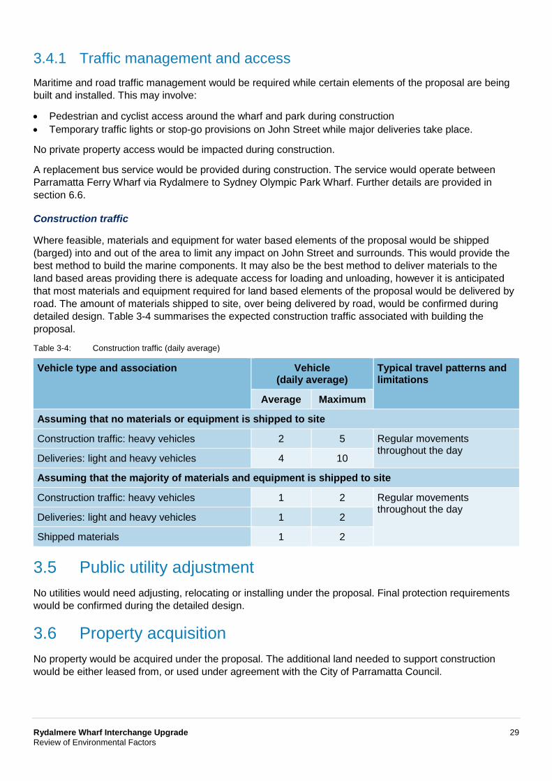
Where feasible, materials and equipment for water based elements of the proposal would be shipped (barged) into and out of the area to limit any impact on John Street and surrounds. This would provide the best method to build the marine components. It may also be the best method to deliver materials to the land based areas providing there is adequate access for loading and unloading, however it is anticipated that most materials and equipment required for land based elements of the proposal would be delivered by road. The amount of materials shipped to site, over being delivered by road, would be confirmed during detailed design. Table 3-4 summarises the expected construction traffic associated with building the proposal.
Table 3-4: Construction traffic (daily average)
Vehicle type and association Vehicle (daily average)
Typical travel patterns and limitations
Average Maximum
Assuming that no materials or equipment is shipped to site
Construction traffic: heavy vehicles 2 5 Regular movements throughout the day
Deliveries: light and heavy vehicles 4 10
Assuming that the majority of materials and equipment is shipped to site
Construction traffic: heavy vehicles 1 2 Regular movements throughout the day
Deliveries: light and heavy vehicles 1 2
Shipped materials 1 2
3.5 Public utility adjustment No utilities would need adjusting, relocating or installing under the proposal. Final protection requirements would be confirmed during the detailed design.
3.6 Property acquisition No property would be acquired under the proposal. The additional land needed to support construction would be either leased from, or used under agreement with the City of Parramatta Council.
Rydalmere Wharf Interchange Upgrade 30 Review of Environmental Factors
4 Statutory and planning framework This Chapter provides the statutory and planning framework for the proposal and considers the provisions of relevant environmental planning instruments.
4.1 Environmental Planning and Assessment Act 1979 This chapter provides the statutory and planning framework for the proposal and considers the provisions of relevant state environmental planning policies, local environmental plans and other legislation.
4.1.1 State environmental planning policies
State Environmental Planning Policy (Infrastructure) 2007
State Environmental Planning Policy (Infrastructure) 2007 (ISEPP) aims to facilitate the effective delivery of infrastructure across the State.
Clause 68(4) of ISEPP permits development for the purpose of wharf or boating facilities to be carried out on any land by or on behalf of a public authority without consent. However, such development may only be carried out on land reserved under the National Parks and Wildlife Act 1974 if the development is authorised by or under that Act.
As the proposal is for the purpose of wharf or boating facilities and is to be carried out by Roads and Maritime, it can be assessed under Division 5.1 of the Environmental Planning and Assessment Act 1979. Development consent from council is not required. The proposal is not located on land reserved under the National Parks and Wildlife Act 1974.
The proposal does not affect land or development affected by the State Environmental Planning Policy (Major Development) 2005.
State Environmental Planning Policy (State and Regional Development) 2011
State Environmental Planning Policy (State and Regional Development) 2011 (SRD SEPP) identifies State significant infrastructure and critical State significant infrastructure.
Clause 14(1) of the SRD SEPP declares a development to be State significant infrastructure if the development is, by the operation of a State environmental planning policy, permissible without development consent and the development is specified in schedule 3 of the SEPP.
Schedule 3 specifies that development for the purpose of port and wharf facilities or boating facilities (not including marinas) delivered by or on behalf of a public authority that has a capital investment value of more than $30 million is State significant infrastructure.
The proposal has a capital investment value of less than $30 million so does not become State significant infrastructure as declared by the SRD SEPP.
State Environmental Planning Policy (Coastal Management) 2018
The Coastal Management SEPP aims to update and consolidate into one integrated policy, a series of previous SEPPs including State Environmental Planning Policy 14 (Coastal Wetlands), State Environmental Planning Policy 26 (Littoral Rainforests) and State Environmental Planning Policy 71 (Coastal Protection). The Coastal Management SEPP gives effect to the objectives of the new Coastal Management Act 2016 from a land use planning perspective, specifying how development proposals are to be assessed if they fall within the coastal zone.
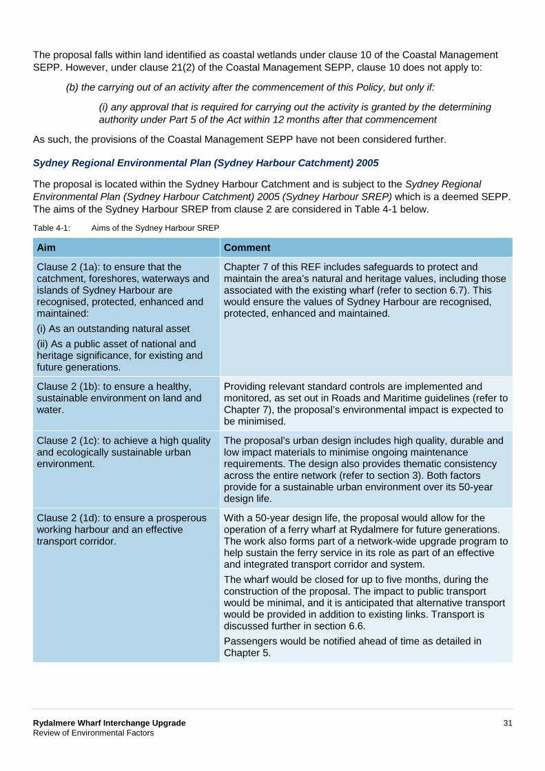
Rydalmere Wharf Interchange Upgrade 31 Review of Environmental Factors
The proposal falls within land identified as coastal wetlands under clause 10 of the Coastal Management SEPP. However, under clause 21(2) of the Coastal Management SEPP, clause 10 does not apply to:
(b) the carrying out of an activity after the commencement of this Policy, but only if:
(i) any approval that is required for carrying out the activity is granted by the determining authority under Part 5 of the Act within 12 months after that commencement
As such, the provisions of the Coastal Management SEPP have not been considered further.
Sydney Regional Environmental Plan (Sydney Harbour Catchment) 2005
The proposal is located within the Sydney Harbour Catchment and is subject to the Sydney Regional Environmental Plan (Sydney Harbour Catchment) 2005 (Sydney Harbour SREP) which is a deemed SEPP. The aims of the Sydney Harbour SREP from clause 2 are considered in Table 4-1 below.
Table 4-1: Aims of the Sydney Harbour SREP
Aim Comment
Clause 2 (1a): to ensure that the catchment, foreshores, waterways and islands of Sydney Harbour are recognised, protected, enhanced and maintained: (i) As an outstanding natural asset (ii) As a public asset of national and heritage significance, for existing and future generations.
Chapter 7 of this REF includes safeguards to protect and maintain the area’s natural and heritage values, including those associated with the existing wharf (refer to section 6.7). This would ensure the values of Sydney Harbour are recognised, protected, enhanced and maintained.
Clause 2 (1b): to ensure a healthy, sustainable environment on land and water.
Providing relevant standard controls are implemented and monitored, as set out in Roads and Maritime guidelines (refer to Chapter 7), the proposal’s environmental impact is expected to be minimised.
Clause 2 (1c): to achieve a high quality and ecologically sustainable urban environment.
The proposal’s urban design includes high quality, durable and low impact materials to minimise ongoing maintenance requirements. The design also provides thematic consistency across the entire network (refer to section 3). Both factors provide for a sustainable urban environment over its 50-year design life.
Clause 2 (1d): to ensure a prosperous working harbour and an effective transport corridor.
With a 50-year design life, the proposal would allow for the operation of a ferry wharf at Rydalmere for future generations. The work also forms part of a network-wide upgrade program to help sustain the ferry service in its role as part of an effective and integrated transport corridor and system. The wharf would be closed for up to five months, during the construction of the proposal. The impact to public transport would be minimal, and it is anticipated that alternative transport would be provided in addition to existing links. Transport is discussed further in section 6.6. Passengers would be notified ahead of time as detailed in Chapter 5.
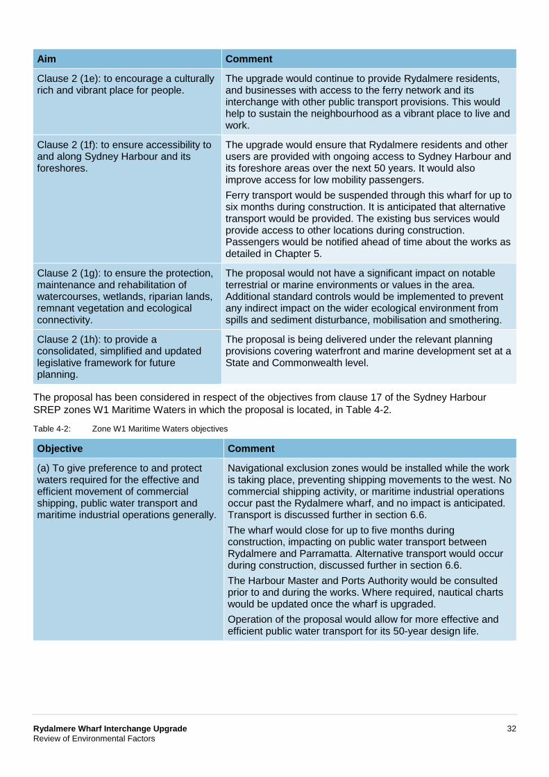
Rydalmere Wharf Interchange Upgrade 32 Review of Environmental Factors
Aim Comment
Clause 2 (1e): to encourage a culturally rich and vibrant place for people.
The upgrade would continue to provide Rydalmere residents, and businesses with access to the ferry network and its interchange with other public transport provisions. This would help to sustain the neighbourhood as a vibrant place to live and work.
Clause 2 (1f): to ensure accessibility to and along Sydney Harbour and its foreshores.
The upgrade would ensure that Rydalmere residents and other users are provided with ongoing access to Sydney Harbour and its foreshore areas over the next 50 years. It would also improve access for low mobility passengers. Ferry transport would be suspended through this wharf for up to six months during construction. It is anticipated that alternative transport would be provided. The existing bus services would provide access to other locations during construction. Passengers would be notified ahead of time about the works as detailed in Chapter 5.
Clause 2 (1g): to ensure the protection, maintenance and rehabilitation of watercourses, wetlands, riparian lands, remnant vegetation and ecological connectivity.
The proposal would not have a significant impact on notable terrestrial or marine environments or values in the area. Additional standard controls would be implemented to prevent any indirect impact on the wider ecological environment from spills and sediment disturbance, mobilisation and smothering.
Clause 2 (1h): to provide a consolidated, simplified and updated legislative framework for future planning.
The proposal is being delivered under the relevant planning provisions covering waterfront and marine development set at a State and Commonwealth level.
The proposal has been considered in respect of the objectives from clause 17 of the Sydney Harbour SREP zones W1 Maritime Waters in which the proposal is located, in Table 4-2.
Table 4-2: Zone W1 Maritime Waters objectives
Objective Comment
(a) To give preference to and protect waters required for the effective and efficient movement of commercial shipping, public water transport and maritime industrial operations generally.
Navigational exclusion zones would be installed while the work is taking place, preventing shipping movements to the west. No commercial shipping activity, or maritime industrial operations occur past the Rydalmere wharf, and no impact is anticipated. Transport is discussed further in section 6.6. The wharf would close for up to five months during construction, impacting on public water transport between Rydalmere and Parramatta. Alternative transport would occur during construction, discussed further in section 6.6. The Harbour Master and Ports Authority would be consulted prior to and during the works. Where required, nautical charts would be updated once the wharf is upgraded. Operation of the proposal would allow for more effective and efficient public water transport for its 50-year design life.
Rydalmere Wharf Interchange Upgrade 33 Review of Environmental Factors
Objective Comment
(b) To allow development only where it is demonstrated that it is compatible with, and will not adversely affect the effective and efficient movement of, commercial shipping, public water transport and maritime industry operations,
Navigational exclusion zones would be installed while the work is taking place, preventing shipping movements to the west. No commercial shipping activity, or maritime industrial operations occur past the Rydalmere wharf, and no impact is anticipated. Transport is discussed further in section 6.6. The wharf would close for up to five months during construction, impacting on public water transport between Rydalmere and Parramatta. Alternative transport would occur during construction, discussed further in section 6.6. The Harbour Master and Ports Authority would be consulted prior to and during the works. Where required, nautical charts would be updated once the wharf is upgraded. Operation of the proposal would allow for more effective and efficient public water transport for its 50-year design life.
(c) To promote the equitable use of the waterway, including use by passive recreation craft.
Access to the Parramatta River, between Rydalmere and Parramatta would be prevented during construction. No recreational activity is known to occur in this area, and impacts are anticipated to be minor. The work would be communicated to potential water users before starting work. The proposal would upgrade the existing wharf at Rydalmere allowing for more effective and efficient public water transport for its 50-year design life.
Under clause 18 of the Sydney Harbour SREP, the proposal is permissible as a public water transport facility, with consent in the W1 zone. In any case, the development is permissible without development consent pursuant to the provisions of the ISEPP which override the zoning provisions of the Sydney Harbour SREP (see clause 7(5) of the Sydney Harbour SREP).
The matters for consideration listed in Division 2 at clauses 21-27 of the Sydney Harbour SREP are provided in Table 4-3.
Table 4-3: Clause 21 to clause 27 matters
Division 2 matter Comment
Clause 21: biodiversity, ecology and environment protection
Chapter 6 describes the terrestrial and marine environmental impacts associated with the proposal. With the implementation of the environmental management measures, impacts would be minimised and/or managed.
Clause 22: public access to, and use of, foreshores and waterways
The wharf would close for up to five months during the construction period, during which access to the waterway between Rydalmere and Parramatta would be prevented. Additionally, access to the foreshore would be slightly impeded by the alterations to the existing footpaths and carpark over this period (refer to section 3.4). The local community, park users and ferry passengers would be notified ahead of work starting that would affect the above areas.
Clause 23: maintenance of a working harbour
The upgrade would ensure that Rydalmere residents and other users would be provided with access to a ferry service (and public transport) over the next 50 years.
Rydalmere Wharf Interchange Upgrade 34 Review of Environmental Factors
Division 2 matter Comment
Clause 24: interrelationship of waterway and foreshore uses
The upgrade would allow the social and cultural association of there being a wharf in this location to be retained, including the relationship it provides for people between the harbour and foreshore.
Clause 25: foreshores and waterways scenic quality
Upgrading the wharf in its existing position would prevent the visual impact of introducing infrastructure in a new location, including any impact on areas zoned as ‘scenic waters’. However, there would be an adverse visual impact from increasing the mass, scale, form, composition, design and structure of the wharf.
Clause 26: maintenance, protection and enhancement of views
Section 6.4 describes the landscape character and visual impacts associated with the proposal. As described above, views within the immediate landside foreground zone, where the proposed wharf would exist as a much larger scale structure in an otherwise intimate setting, would obscure some views across the river. However, the overall impact is likely to be less compared to building a new structure in a different location as people accept there being a wharf in its current location.
Clause 27: boat storage facilities There is no boat storage work associated with, or impacted by, the proposal.
Clause 31 of the Sydney Harbour SREP requires consultation for certain development proposals not requiring development consent. Consultation, including under the Sydney Harbour SREP (if applicable) is discussed in Chapter 5 of this REF.
Part 5 of the Sydney Harbour SREP contains heritage provisions that are to be taken into account in respect of Division 5.1 activities. There is one heritage item within the vicinity of the proposal footprint. Heritage items are discussed further in section 6.7. The heritage objectives from the Sydney Harbour SREP in clauses 53(1) and (2) are considered in Table 4-4 below.
Table 4-4: Heritage objectives
Objective Comment
Clause 53 (1a): to conserve the environmental heritage of the land to which this Part applies.
The proposal has been designed to be sympathetic to the area’s heritage values. This includes building a wharf of similar scale and character in the location of the existing wharf. A statement of heritage impact (SOHI) prepared to support this REF concludes that the proposal would have neutral or lesser impact on heritage items (refer to section 6.7).
Clause 53 (1b): to conserve the heritage significance of existing significant fabric, relics, settings and views associated with the heritage significance of heritage items.
As above, the proposal has been designed so as to preserve the heritage and conservation values of surrounding heritage items. In addition, there are no expected direct or indirect impacts to historical heritage items in the vicinity of the proposal. Although the proposed works would occur directly adjacent to a local heritage listed item ‘wetlands’ (I1), they would have no direct impact.
Clause 53 (1c): to ensure that that archaeological sites and places of Aboriginal heritage significance are conserved.
As described in section 6.8, the proposal would avoid impact on known archaeological sites or places of Aboriginal heritage.
Rydalmere Wharf Interchange Upgrade 35 Review of Environmental Factors
Objective Comment
Clause 53 (1d): to allow for the protection of places which have the potential to have heritage significance but are not identified as heritage items.
The proposal includes minimal land side excavation work. It therefore limits any potential archaeological impacts. The safeguards in Chapter 7 include provisions to protect potential heritage values within the proposal footprint, while the marine work is not taking place in an area of heritage (or shipwreck) potential.
2(a) To establish a buffer zone around the Sydney Opera House so as to give added protection to its world heritage value
The proposal is not located within the Sydney Opera House buffer zone.
2(b) To recognise that views and vistas between the Sydney Opera House and other public places within that zone contribute to its world heritage value.
The proposal would not impact on the views and vistas from the Sydney Opera House.
Clause 54 to clause 60 of the Sydney Harbour SREP provide for the protection of heritage items and places. The Stage 1 Procedure for Aboriginal Cultural Heritage Consultation and Investigation (PACHCI) for the proposal was prepared in accordance with clause 54 to clause 60 of the Sydney Harbour SREP. As noted above, the proposal would not impact on known archaeological sites or places of Aboriginal heritage. As such, there is no need to either seek permission or secure development consent for the work on heritage-related grounds.
Part 6 of the Sydney Harbour SREP relates to wetlands protection. The site is identified as being located within a Wetland Protection Area under the SREP. The wetlands objectives from the Sydney Harbour SREP in clause 61 are considered in Table 4-5.
Table 4-5: Wetland objectives
Objective Comment
Clause 61 (a): to preserve, protect and encourage the restoration and rehabilitation of wetlands.
The scale and nature of the work is not proposed to have any impact on water or the aquatic environment (refer to section 6.1) including its associated wetland values. Sediment disturbance would be localised to the work area, limiting any potential for smothering or prolonged light preclusion. The condition of the wetlands is also unlikely to be impacted, notwithstanding the potential to encounter and mobilise residual contaminants (refer to section 6.1). As such, safeguards have been proposed to include a silt boom and curtain around the work area when undertaking the piling work and include pollution prevention controls when working in the marine environment. The piles and substructure have been designed to reduce any long-term scour and erosion risks in the wider marine environment, while the floating pontoon has been located offshore to ensure there are no associated propeller wash or scour impacts. Refer to section 6.1 for more information.
Rydalmere Wharf Interchange Upgrade 36 Review of Environmental Factors
Objective Comment
Clause 61 (b): to maintain and restore the health and viability of wetlands.
As described above, the design of the wharf and the safeguards proposed in Chapter 7 would allow the wetland values and health to be maintained. Also, providing relevant standard controls are implemented and monitored as set out in Roads and Maritime guidelines and quality assurance specifications (refer to section 7.2), the proposal’s environmental impacts during construction are expected to be safeguarded and minimised thus affording protection of the wetlands in the local area.
Clause 61 (c): to prevent the fragmentation of wetlands.
The proposal would not fragment any wetlands.
Clause 61 (d): to preserve the scenic qualities of wetlands.
The location and construction of the wharf have been selected to avoid impact upon wetlands, and the overall visual impact of the proposal is low (discussed further in section 6.4). As such, this would maintain the current scenic qualities of wetlands, which provide a vegetative screening for the pontoon and gangway.
Clause 61 (e): to ensure that wetlands continue to perform their natural ecological functions (such as the provision of wetland habitat, the preservation of water quality, the control of flooding and erosion).
As described above, the proposal’s design in combination with the proposed safeguards described in Chapter 7 are aimed at protecting the ecological marine environment to ensure the wetland’s ecological function is preserved. Many of these safeguards are being implemented as a matter of precaution to minimise impact risk as described further in section 7.2.
The matters to be considered for work within a wetland protection area from Clause 63(2) of the SREP are considered in Table 4-6.
Table 4-6: Clause 63 matters
Clause 63 matter Comment
Clause 63 (2a): the development should have a neutral or beneficial effect on the quality of water entering the waterways.
The proposal would have a neutral effect if relevant standard safeguards in Roads and Maritime guidelines, and quality assurance specifications are implemented and monitored. The proposal is expected to have minimal environmental impact and protect the marine environment and water quality (refer to Chapter 7).
Clause 63 (2b): the environmental effects of the development, including effects on:
Clause 63 (2b) (i) the growth of native plant communities. Clause 63 (2b) (ii) the survival of native wildlife populations Clause 63 (2b) (iii) the provision and quality of habitats for both indigenous and migratory species
The aquatic ecology assessment carried out to support the REF concluded that any potential impacts would not significantly affect aquatic ecology. The maximum impact to aquatic habitat (mostly indirect shading) would be 234 square-metres of Type 3 Key Fish Habitats (KFH) which would be offset by 268 square-metres of hard surfaces and newly exposed subtidal substrate, meeting the NSW Fisheries Policy of ‘no net loss’ of KFH and Roads and Maritime’s offset guideline. No impacts to terrestrial flora or fauna would occur because of the proposal. Refer to section 6.2 for further detail.
Rydalmere Wharf Interchange Upgrade 37 Review of Environmental Factors
Clause 63 matter Comment
Clause 63 (2b) (iv) the surface and groundwater characteristics of the site on which the development is proposed to be carried out and of the surrounding areas, including salinity and water quality and whether the wetland ecosystems are groundwater dependent
Providing the relevant safeguards described in Chapter 7 are implemented and monitored, the proposal’s environmental impacts on the area’s surface and groundwater quality are expected to be safeguarded and minimised.
Clause 63 (2c): whether adequate safeguards and rehabilitation measures have been, or will be, made to protect the environment.
Chapter 7 sets out the safeguards and monitoring requirements to protect the local environment. The chapter also includes post-construction measures, and corrective actions needed during an accident and emergency to manage any impacts.
Clause 63 (2d): whether carrying out the development would be consistent with the principles set out in The NSW Wetlands Management Policy
The Policy lists five principles for wetland protection (clauses 61 a-e). The proposed pontoon is located at the same distance offshore as the existing. As there is no change in location, ferry wash impacts to near-shore habitat would not change. A CEMP would be implemented during construction to minimise impact to shallow habitat (eg use of floating mooring lines). As such, the proposal aims meets the Policy’s principles by: • Protecting adjacent wetland habitat during construction and
operation • Promoting wetland recovery by moving impact further away
by establishing no-go zones during construction which would prevent impact to mangroves
• Providing hard pile surfaces to maintain habitat connectivity • Retaining scenic values by retaining underwater habitat
connectivity • Avoiding unnecessary impact to habitat to allow ecosystem
functions to be maintained.
Clause 63 (2e): whether the development adequately preserves and enhances local native vegetation.
The proposal would not affect aquatic vegetation. Submerged structures, such as piles and pontoon, would provide habitat availability for aquatic vegetation to establish. The proposal has also been designed to avoid any vegetation clearing. Refer to section 6.2 for further detail.
Clause 63 (2f): whether the development adequately demonstrates:
(i): how the direct and indirect impacts of the development will preserve and enhance wetlands
Section 6.2 and Table 4-5 describe how the proposal has been designed and environmental safeguards have been proposed to protect the area in which the proposal would be built.
(ii): how the development will preserve and enhance the continuity and integrity of the wetlands
Refer to Table 4-5.
(iii): how soil erosion and siltation will be minimised both while the development is being carried out and after completed,
The proposed piles and substructure components described in Chapter 3 have been designed to minimise scour, erosion or any sediment transport, hydrodynamic and/or physical impact on the marine environment. During construction work, a silt boom and curtain would be used to prevent any sediment dispersion and siltation, while additional erosion management controls have been identified in the safeguards in Chapter 7.
Rydalmere Wharf Interchange Upgrade 38 Review of Environmental Factors
Clause 63 matter Comment
(iv): how appropriate onsite measures are to be implemented to ensure that the intertidal zone is kept free from pollutants arising from the development
Chapter 7 includes a range of standard pollution management controls that would be implemented and monitored during construction as set out in Roads and Maritime guidelines and quality assurance specifications (refer to Chapter 7). If implemented, then the proposal’s environmental impact on the intertidal zone are expected to be safeguarded and minimised. As such, safeguards identified in section 6.1.4 would be implemented to prevent contamination of the waterway as a result of the excavation required for the seawall modification.
(v): that the nutrient levels in the wetlands do not increase as a consequence of the development
The proposed standard pollutant management and sediment disturbance controls included in Chapter 7 help prevent any nutrient loading into the marine environment.
(vi): that stands of vegetation (both terrestrial and aquatic) are protected or rehabilitated
Refer to Clause 63 (2b).
(vii): that the development minimises physical damage to aquatic ecological communities
The proposal’s direct impact to aquatic ecological communities would be limited to the installation of piles, as described in section 6.2. This would be insufficient to have any material physical impact on marine ecological communities and their supporting habitat. Also, as described in section 6.2, the operational wharf would not alter the hydrodynamic or physical environment, to the extent to indirectly impact on aquatic ecological values.
(viii): that the development does not cause physical damage to aquatic ecological communities.
As above.
Clause 63 (2g): whether conditions should be imposed on the carrying out of the development requiring the carrying out of works to preserve or enhance the value of any surrounding wetlands.
Chapter 7 includes safeguards that Roads and Maritime, and its contractor(s), would commit to implementing and monitoring during construction to prevent any impact on the surrounding wetland values. Table 4-5 describes this in more detail.
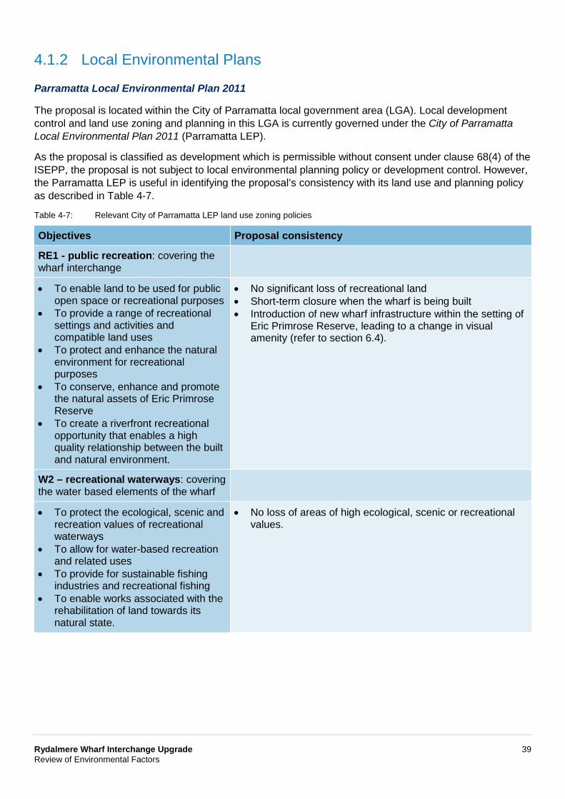
Rydalmere Wharf Interchange Upgrade 39 Review of Environmental Factors
4.1.2 Local Environmental Plans
Parramatta Local Environmental Plan 2011
The proposal is located within the City of Parramatta local government area (LGA). Local development control and land use zoning and planning in this LGA is currently governed under the City of Parramatta Local Environmental Plan 2011 (Parramatta LEP).
As the proposal is classified as development which is permissible without consent under clause 68(4) of the ISEPP, the proposal is not subject to local environmental planning policy or development control. However, the Parramatta LEP is useful in identifying the proposal’s consistency with its land use and planning policy as described in Table 4-7.
Table 4-7: Relevant City of Parramatta LEP land use zoning policies
Objectives Proposal consistency
RE1 - public recreation: covering the wharf interchange
• To enable land to be used for public open space or recreational purposes
• To provide a range of recreational settings and activities and compatible land uses
• To protect and enhance the natural environment for recreational purposes
• To conserve, enhance and promote the natural assets of Eric Primrose Reserve
• To create a riverfront recreational opportunity that enables a high quality relationship between the built and natural environment.
• No significant loss of recreational land • Short-term closure when the wharf is being built • Introduction of new wharf infrastructure within the setting of
Eric Primrose Reserve, leading to a change in visual amenity (refer to section 6.4).
W2 – recreational waterways: covering the water based elements of the wharf
• To protect the ecological, scenic and recreation values of recreational waterways
• To allow for water-based recreation and related uses
• To provide for sustainable fishing industries and recreational fishing
• To enable works associated with the rehabilitation of land towards its natural state.
• No loss of areas of high ecological, scenic or recreational values.
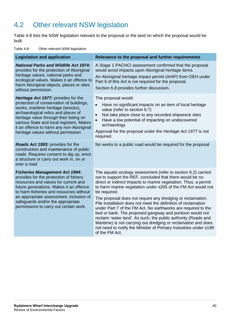
Rydalmere Wharf Interchange Upgrade 40 Review of Environmental Factors
4.2 Other relevant NSW legislation Table 4-8 lists the NSW legislation relevant to the proposal or the land on which the proposal would be built.
Table 4-8: Other relevant NSW legislation
Legislation and application Relevance to the proposal and further requirements
National Parks and Wildlife Act 1974: provides for the protection of Aboriginal heritage values, national parks and ecological values. Makes it an offence to harm Aboriginal objects, places or sites without permission.
A Stage 1 PACHCI assessment confirmed that the proposal would avoid impacts upon Aboriginal heritage items. An Aboriginal heritage impact permit (AHIP) from OEH under Part 6 of this Act is not required for the proposal. Section 6.8 provides further discussion.
Heritage Act 1977: provides for the protection of conservation of buildings, works, maritime heritage (wrecks), archaeological relics and places of heritage value through their listing on various State and local registers. Makes it an offence to harm any non-Aboriginal heritage values without permission
The proposal would: • Have no significant impacts on an item of local heritage
value (refer to section 6.7) • Not take place close to any recorded shipwreck sites • Have a low potential of impacting on undiscovered
archaeology. Approval for the proposal under the Heritage Act 1977 is not required.
Roads Act 1993: provides for the construction and maintenance of public roads. Requires consent to dig up, erect a structure or carry out work in, on or over a road
No works to a public road would be required for the proposal
Fisheries Management Act 1994: provides for the protection of fishery resources and values for current and future generations. Makes it an offence to harm fisheries and resources without an appropriate assessment, inclusion of safeguards and/or the appropriate permissions to carry out certain work.
The aquatic ecology assessment (refer to section 6.2) carried out to support the REF, concluded that there would be no direct or indirect impacts to marine vegetation. Thus, a permit to harm marine vegetation under s205 of the FM Act would not be required. The proposal does not require any dredging or reclamation. Pile installation does not meet the definition of reclamation under Part 7 of the FM Act. No earthworks are required to the bed or bank. The proposed gangway and pontoon would not reclaim ‘water land’. As such, the public authority (Roads and Maritime) is not carrying out dredging or reclamation and does not need to notify the Minister of Primary Industries under s199 of the FM Act.
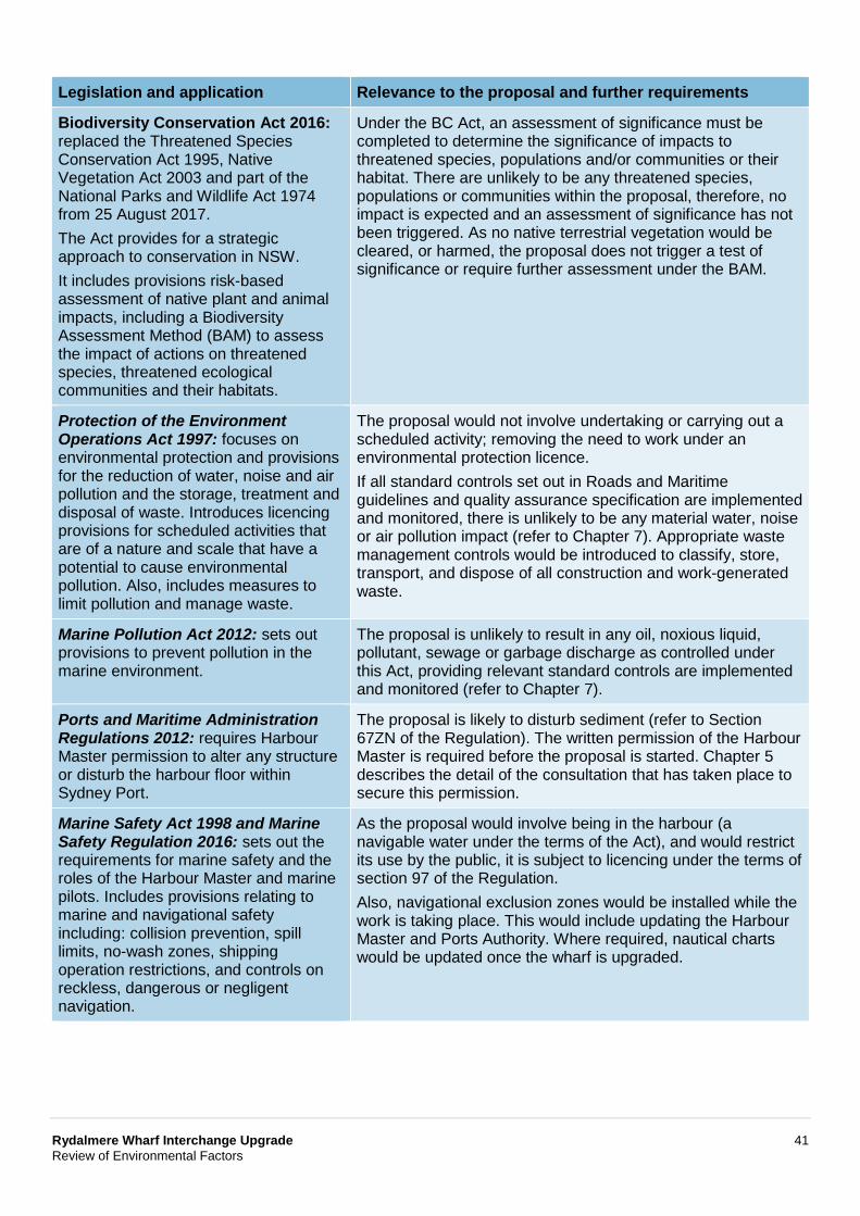
Rydalmere Wharf Interchange Upgrade 41 Review of Environmental Factors
Legislation and application Relevance to the proposal and further requirements
Biodiversity Conservation Act 2016: replaced the Threatened Species Conservation Act 1995, Native Vegetation Act 2003 and part of the National Parks and Wildlife Act 1974 from 25 August 2017. The Act provides for a strategic approach to conservation in NSW. It includes provisions risk-based assessment of native plant and animal impacts, including a Biodiversity Assessment Method (BAM) to assess the impact of actions on threatened species, threatened ecological communities and their habitats.
Under the BC Act, an assessment of significance must be completed to determine the significance of impacts to threatened species, populations and/or communities or their habitat. There are unlikely to be any threatened species, populations or communities within the proposal, therefore, no impact is expected and an assessment of significance has not been triggered. As no native terrestrial vegetation would be cleared, or harmed, the proposal does not trigger a test of significance or require further assessment under the BAM.
Protection of the Environment Operations Act 1997: focuses on environmental protection and provisions for the reduction of water, noise and air pollution and the storage, treatment and disposal of waste. Introduces licencing provisions for scheduled activities that are of a nature and scale that have a potential to cause environmental pollution. Also, includes measures to limit pollution and manage waste.
The proposal would not involve undertaking or carrying out a scheduled activity; removing the need to work under an environmental protection licence. If all standard controls set out in Roads and Maritime guidelines and quality assurance specification are implemented and monitored, there is unlikely to be any material water, noise or air pollution impact (refer to Chapter 7). Appropriate waste management controls would be introduced to classify, store, transport, and dispose of all construction and work-generated waste.
Marine Pollution Act 2012: sets out provisions to prevent pollution in the marine environment.
The proposal is unlikely to result in any oil, noxious liquid, pollutant, sewage or garbage discharge as controlled under this Act, providing relevant standard controls are implemented and monitored (refer to Chapter 7).
Ports and Maritime Administration Regulations 2012: requires Harbour Master permission to alter any structure or disturb the harbour floor within Sydney Port.
The proposal is likely to disturb sediment (refer to Section 67ZN of the Regulation). The written permission of the Harbour Master is required before the proposal is started. Chapter 5 describes the detail of the consultation that has taken place to secure this permission.
Marine Safety Act 1998 and Marine Safety Regulation 2016: sets out the requirements for marine safety and the roles of the Harbour Master and marine pilots. Includes provisions relating to marine and navigational safety including: collision prevention, spill limits, no-wash zones, shipping operation restrictions, and controls on reckless, dangerous or negligent navigation.
As the proposal would involve being in the harbour (a navigable water under the terms of the Act), and would restrict its use by the public, it is subject to licencing under the terms of section 97 of the Regulation. Also, navigational exclusion zones would be installed while the work is taking place. This would include updating the Harbour Master and Ports Authority. Where required, nautical charts would be updated once the wharf is upgraded.
Rydalmere Wharf Interchange Upgrade 42 Review of Environmental Factors
4.3 Commonwealth legislation The following Commonwealth legislation is relevant to this proposal.
4.3.1 Disability Discrimination Act 1992 The above Act includes provisions to prevent discrimination based on ability, while also providing equal rights and access for all people. This was supplemented in 2002 by the DSAPT, which were introduced to allow public transport operators and providers to ‘remove discrimination from public transport services’. The standards provide detailed information on how transport infrastructure should be designed and built to provide disabled access. In NSW, this has been adopted by the TAP, with the proposal being designed to comply with the provisions of the above Act.
The proposal includes upgrading of the wharf and interchange to be DDA compliant.
4.3.2 Environment Protection and Biodiversity Conservation Act 1999 Under the Environment Protection and Biodiversity Conservation Act 1999 (EPBC Act) a referral is required to the Australian Government for proposed ‘actions that have the potential to significantly impact on matters of national environmental significance or the environment of Commonwealth land’. These are considered in Appendix B and Chapter 6 of the REF.
The assessment of the proposal’s impact on matters of national environmental significance and the environment of Commonwealth land found that there is unlikely to be a significant impact on relevant matters of national environmental significance or on Commonwealth land. Accordingly, the proposal has not been referred to the Australian Government Department of the Environment and Energy under the EPBC Act.
4.4 Confirmation of statutory position The proposal is categorised as development for the purpose of a wharf and is being carried out by or on behalf of a public authority. Under clause 68(4A) of the ISEPP, the proposal is permissible without consent. The proposal is not State significant infrastructure and is subject to environmental impact assessment under Division 5.1 of the EP&A Act.
Accordingly, Roads and Maritime is the determining authority for the proposal, with this REF fulfilling the obligation under Section 5.5 of the EP&A Act ‘to examine and take into account to the fullest extent possible all matters affecting or likely to affect the environment by reason of the activity’.
Rydalmere Wharf Interchange Upgrade 43 Review of Environmental Factors
5 Consultation This chapter discusses the consultation undertaken to date for the proposal and the consultation proposed for the future.
5.1 Consultation strategy Roads and Maritime has prepared a community consultation and stakeholder engagement plan for the proposal in accordance with the International Association for Public Participation Spectrum (IAP2, 2007) and the Stakeholder Engagement Toolkit (Roads and Maritime, 2015). The plan’s objectives are to:
• Advise directly-affected stakeholders and the community about the proposal, its potential impacts, and how they can obtain further information
• Brief parties (passengers, pedestrians, cyclists, road users, businesses, residents and other key user groups) affected by any temporary traffic management controls, navigation restrictions, and ferry service disruption
• Ensure issues relating to the proposal are identified and effectively managed • Identify local issues to ensure the proposal aligns with community needs • Inform and consult impacted and interested stakeholder groups • Involve key Government agencies and stakeholders • Receive comments from affected parties • Record and respond to enquiries and concerns in an open, transparent and timely manner • Seek community ideas for inclusion in the development of the detailed design.
5.2 Community involvement In April 2015, Roads and Maritime first announced the proposed upgrade of the Rydalmere Wharf Interchange, providing a community update and inviting the community to an information session that was held on 10 May 2015 at the Rydalmere Wharf waiting area.
The purpose of the information session was to gain community feedback to help Roads and Maritime understand views about the existing facilities and priorities for improvement. It also allowed Roads and Maritime to explain the possible options for upgrading the existing facilities at Rydalmere. This process helped Roads and Maritime develop options, select a preferred option, and progress with the concept design. A total of 10 submissions/feedback forms were received. A summary of issues raised by the community is provided in Table 5-1 below.
Table 5-1: Summary of issues raised by the community: identification of issues
Issue raised Response and where addressed in the REF/concept design
Wharf structure is run-down and needs an upgrade
• The proposal would result in the upgrade of Rydalmere Wharf including the pontoon and associated wharf infrastructure
• The design features of the proposal are addressed in Chapter 3 of the REF.
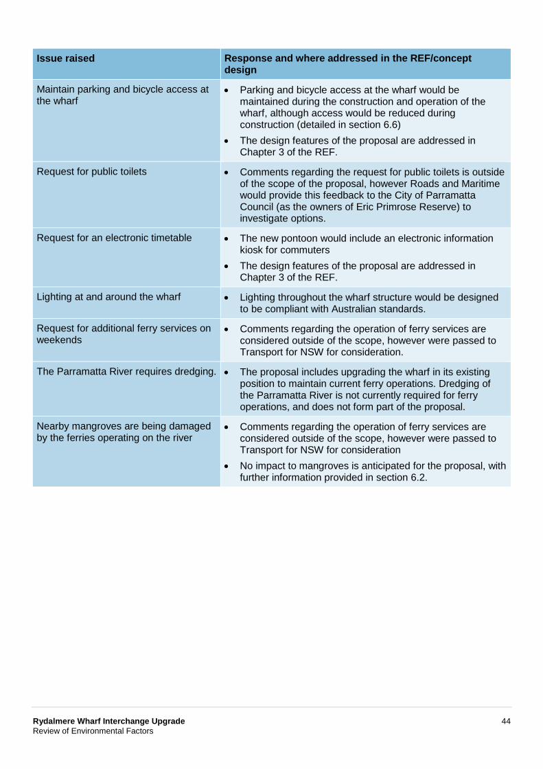
Rydalmere Wharf Interchange Upgrade 44 Review of Environmental Factors
Issue raised Response and where addressed in the REF/concept design
Maintain parking and bicycle access at the wharf
• Parking and bicycle access at the wharf would be maintained during the construction and operation of the wharf, although access would be reduced during construction (detailed in section 6.6)
• The design features of the proposal are addressed in Chapter 3 of the REF.
Request for public toilets • Comments regarding the request for public toilets is outside of the scope of the proposal, however Roads and Maritime would provide this feedback to the City of Parramatta Council (as the owners of Eric Primrose Reserve) to investigate options.
Request for an electronic timetable • The new pontoon would include an electronic information kiosk for commuters
• The design features of the proposal are addressed in Chapter 3 of the REF.
Lighting at and around the wharf • Lighting throughout the wharf structure would be designed to be compliant with Australian standards.
Request for additional ferry services on weekends
• Comments regarding the operation of ferry services are considered outside of the scope, however were passed to Transport for NSW for consideration.
The Parramatta River requires dredging. • The proposal includes upgrading the wharf in its existing position to maintain current ferry operations. Dredging of the Parramatta River is not currently required for ferry operations, and does not form part of the proposal.
Nearby mangroves are being damaged by the ferries operating on the river
• Comments regarding the operation of ferry services are considered outside of the scope, however were passed to Transport for NSW for consideration
• No impact to mangroves is anticipated for the proposal, with further information provided in section 6.2.
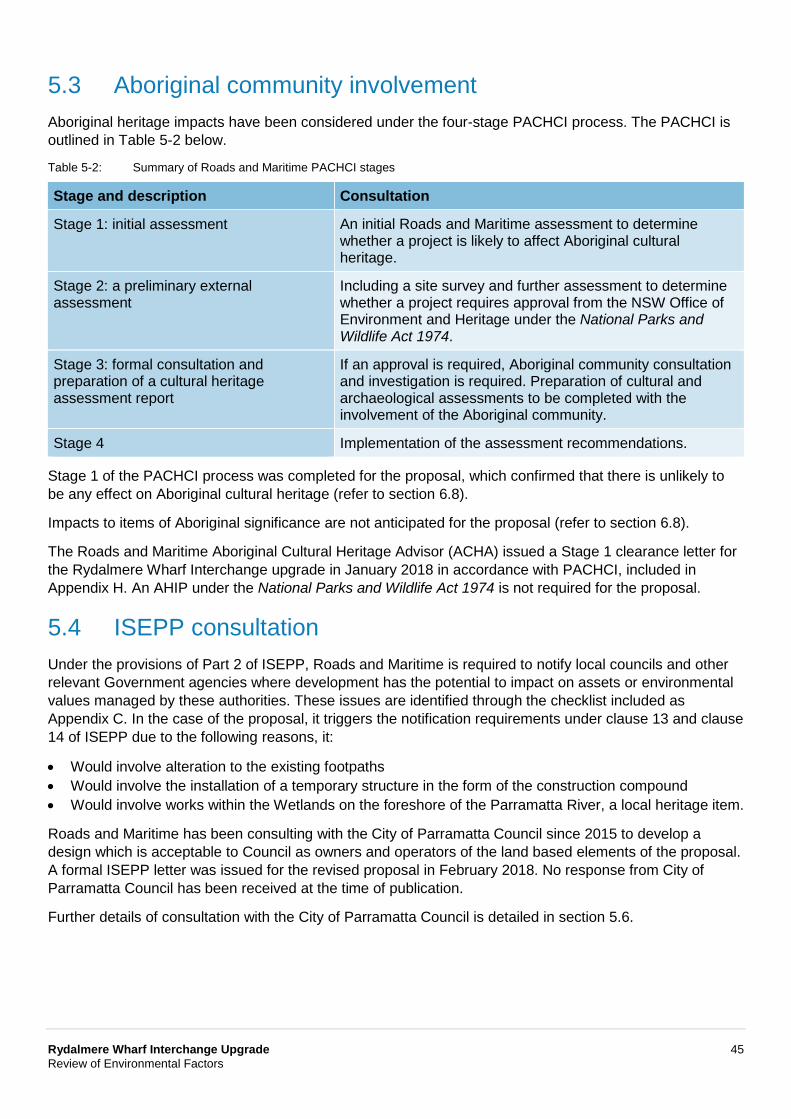
Rydalmere Wharf Interchange Upgrade 45 Review of Environmental Factors
5.3 Aboriginal community involvement Aboriginal heritage impacts have been considered under the four-stage PACHCI process. The PACHCI is outlined in Table 5-2 below.
Table 5-2: Summary of Roads and Maritime PACHCI stages
Stage and description Consultation
Stage 1: initial assessment An initial Roads and Maritime assessment to determine whether a project is likely to affect Aboriginal cultural heritage.
Stage 2: a preliminary external assessment
Including a site survey and further assessment to determine whether a project requires approval from the NSW Office of Environment and Heritage under the National Parks and Wildlife Act 1974.
Stage 3: formal consultation and preparation of a cultural heritage assessment report
If an approval is required, Aboriginal community consultation and investigation is required. Preparation of cultural and archaeological assessments to be completed with the involvement of the Aboriginal community.
Stage 4 Implementation of the assessment recommendations.
Stage 1 of the PACHCI process was completed for the proposal, which confirmed that there is unlikely to be any effect on Aboriginal cultural heritage (refer to section 6.8).
Impacts to items of Aboriginal significance are not anticipated for the proposal (refer to section 6.8).
The Roads and Maritime Aboriginal Cultural Heritage Advisor (ACHA) issued a Stage 1 clearance letter for the Rydalmere Wharf Interchange upgrade in January 2018 in accordance with PACHCI, included in Appendix H. An AHIP under the National Parks and Wildlife Act 1974 is not required for the proposal.
5.4 ISEPP consultation Under the provisions of Part 2 of ISEPP, Roads and Maritime is required to notify local councils and other relevant Government agencies where development has the potential to impact on assets or environmental values managed by these authorities. These issues are identified through the checklist included as Appendix C. In the case of the proposal, it triggers the notification requirements under clause 13 and clause 14 of ISEPP due to the following reasons, it:
• Would involve alteration to the existing footpaths • Would involve the installation of a temporary structure in the form of the construction compound • Would involve works within the Wetlands on the foreshore of the Parramatta River, a local heritage item.
Roads and Maritime has been consulting with the City of Parramatta Council since 2015 to develop a design which is acceptable to Council as owners and operators of the land based elements of the proposal. A formal ISEPP letter was issued for the revised proposal in February 2018. No response from City of Parramatta Council has been received at the time of publication.
Further details of consultation with the City of Parramatta Council is detailed in section 5.6.
Rydalmere Wharf Interchange Upgrade 46 Review of Environmental Factors
5.5 Sydney Regional Environmental Plan (Sydney Harbour Catchment) 2005 notification
The Foreshores and Waterways Planning and Development Advisory Committee and Ausgrid have been consulted about the proposal as per the requirements of clause 31 of the Sydney Regional Environmental Plan (Sydney Harbour Catchment) 2005. Appendix C contains a SREP (Sydney Harbour Catchment) consultation checklist that documents how the SREP consultation requirements have been considered.
In the case of the proposal, it triggers the consultation provisions of Part 3: Division 3, clause 31 of the above Plan due to the following reasons, it:
• Involves the development of pubic water transport facilities (Schedule 2) within the Sydney Harbour Foreshore Area
• Would require the provision of services in the form of electricity, as required by the existing wharf.
Accordingly, the Foreshores and Waterways Planning and Development Advisory Committee and Ausgrid were consulted in regards to the proposal. Roads and Maritime notified the respective authorities in February 2018 in regards to the proposal, with no responses received at the time of publication.
5.6 Government agency and stakeholder involvement Various government agencies and stakeholders have been consulted about the proposal, including:
• Transport for NSW • Harbour City Ferries • City of Parramatta Council • Emergency services (including police, ambulance, fire and rescue, Volunteer Marine Rescue Council of
NSW and Marine Rescue NSW) • Port Authority of NSW.
5.7 Ongoing or future consultation
5.7.1 Response to submissions This REF would be placed on public display for comment by Government agencies, stakeholders and the community. Following the public display period, Roads and Maritime would collate and consider the submissions received then determine whether the proposal should proceed as described or whether any changes are needed are required. It would also decide if any additional environmental assessment, safeguards or management measures are needed.
A submissions report would be published, which would respond to the comments received. Roads and Maritime would notify those who made submissions and distribute a community update. The update would summarise the submissions report process and the actions Roads and Maritime took to address these comments. Roads and Maritime would also meet with affected residents, businesses and other stakeholders.
Rydalmere Wharf Interchange Upgrade 47 Review of Environmental Factors
5.7.2 Detailed design and pre-construction consultation If the proposal is built, the community consultation and stakeholder engagement plan would be updated to support the detailed design and pre-construction stages to ensure:
• There would be provision for emergency vehicle access while the proposal is being built • Any necessary traffic management and maritime navigation controls would be developed reduce
impacts • Suitable and appropriate environmental safeguards and management measures are made to account
for design changes and refinements • The work is scheduled to avoid conflicts with other projects that are being developed in the area at the
same time (refer to section 6.12).
5.7.3 Construction consultation The appointed work contractor(s) would also be required to consult with the local community before and while the proposal is being built. This process would be managed through the construction environmental management plan (CEMP), refer to section 3.3.1 and section 7.1). It would include:
• Issuing notices before starting work and relaying information on traffic management and maritime navigation controls, night work, temporary access restrictions, and planned noisy activities
• Undertaking door-knocking with affected residents and business owners • Undertaking ongoing consultation with affected parties comprising meetings, letter-drops, posters and
notifications.
In addition, Roads and Maritime would:
• Provide regular website updates • Make a 24-hour project information line available while implementing its complaints handling and
management process (refer to Chapter 7).
Rydalmere Wharf Interchange Upgrade 48 Review of Environmental Factors
6 Environmental assessment This section of the REF provides a detailed description of the potential environmental impacts associated with the construction and operation of the proposal. All aspects of the environment potentially impacted upon by the proposal are considered. This includes consideration of the factors specified in the guidelines Is an EIS required? (DUAP, 1995/1996) as required under clause 228(1) of the Environmental Planning and Assessment Regulation 2000 and the Marinas and Related Facilities EIS Guideline (DUAP, 1996). The factors specified in clause 228(2) of the Environmental Planning and Assessment Regulation 2000 are also considered in Appendix B.
Site-specific safeguards and management measures are provided to mitigate the identified potential impacts.
6.1 Land surface, hydrology and water quality This section describes the hydrodynamic and physical environmental impacts on the aquatic and terrestrial environment associated with the proposal.
6.1.1 Methodology
Water based
Published mapping and data were used to define the hydrodynamic and physical characteristics of the aquatic environment. This included:
• Hydrographic and bathymetric mapping and data, including navigational charts • Bottom, middle and surface water current data (hydrodynamic modelling, Sydney Harbour
Hydrodynamic Model) • Water and surface temperate data (University of Sydney, 2013) • Water salinity and chemistry (University of Sydney, 2013) • Parramatta River Estuary Data Compilation and Review Study (Cardno, 2008) • Parramatta River Estuary Coastal Zone Management Plan (Cardno, 2012) • Sydney Harbour Catchment Water Quality Improvement Plan: Data Compilation and Review. (Water
Research Laboratory (WRL), 2011) • Lower Parramatta River Floodplain Risk Management Study and Plan (SKM, 2005).
Land based
Published mapping and data were used to define physical characteristics of the terrestrial environment. This included review of:
• Sydney 1:100,000 Geological Series Sheet 9130 (NSW Department of Mineral Resources, 1983) • City of Parramatta LEP acid sulfate soils mapping • NSW EPA online contaminated land register • Environmental Protection Licences (EPL) under the Protection of the Environment Operations Act 1997.
Construction assessment
The assessment considered how the proposed construction activities, work methods, and required management controls (refer to section 3.3) would temporarily affect the physical characteristics of the aquatic environment including localised sediment and pollutant disturbance and dispersion, and any secondary aquatic ecology impacts.
Rydalmere Wharf Interchange Upgrade 49 Review of Environmental Factors
Operational assessment
The operational assessment considered how the final aquatic infrastructure would potentially result in hydrodynamic changes in terms of erosion and scour, water quality changes, and associated aquatic ecology impacts.
6.1.2 Existing environment
Water based
Tides
The proposal is located within the Parramatta River which is tidally influenced at the proposal footprint. Tidal cycles are semi-diurnal, meaning there is 12.5 hours between high tides. The closest location to the proposal footprint where the tidal heights are measured is at Fort Denison where the conditions are as follows:
• Mean spring tide is 1.23 metres above Australian Height Datum (AHD, which represents the measured average sea level between 1966 and 1968)
• Mean neap tide is 0.75 metres above AHD • Mean high water is about 0.5 metres above AHD • Mean low tide can be about one metre below AHD • The highest-high tide that would occur once every 50 years is about 1.6 metres above AHD.
While there is likely to be variation between the tidal conditions at Fort Denison and the proposal footprint due to masking from river discharge, the above conditions are considered to be indicative and suitable for this assessment. The tidal range would be typically less than one metre over each cycle because of the riverine/tidal interface at the proposal. The tidal range affects how quickly the waters flow into and out of the area including around the proposal footprint. Given the small tidal range, it is likely that the water flow in the area is typically low.
Flooding
The Rydalmere Wharf Interchange is located within are flood prone. The Lower Parramatta River Floodplain Risk Management Study and Plan (SKM, 2005) identifies the proposal footprint is within a high-risk flood risk precinct, and potentially subject to significant erosion risk to foundations of buildings and potential collapse of building structures.
The pontoon at the existing wharf was designed with raised piles to float up and down with the water level; however, the jetty is a fixed structure. The wharf has previously been closed during periods of high water due to flood conditions and debris along the Parramatta River making it unsafe for ferries to access the wharf. The wharf is routinely assessed for damage after flood events to ensure it is operating safely.
Water depth (bathymetry)
The natural riverbed has been heavily modified in locations through historical dredging of navigation channels, and regular vessel movements. The area close to shore is about equal to ground level and exposed at low tide and periods when there is reduced river inflow (zero metres AHD). It gradually increases to about three metres below AHD at the limit of the wharf (as shown on the contours on Figure 6-2).
Rydalmere Wharf Interchange Upgrade 50 Review of Environmental Factors
Water quality
The Parramatta River catchment extends from Blacktown Creek in the west to about 22 kilometres east to Sydney Harbour. Much of the catchment has been developed for urban and agricultural purposes, with the existing water quality impacted by stormwater discharge and altered flow regimes. Pollutants commonly associated with stormwater discharge include:
• Sediment from erosion and stormwater inflows, impacting turbidity • Pathogens such as faecal coliforms • Litter and other wastes • Pesticides from agricultural land uses • Nutrients and pathogens from fertilizers and sewage overflows • Heavy metals (in river sediments) • Other contaminants such as hydrocarbons from oil and fuel leaks.
The proposal is located within the upper estuary, and is influenced by a mix of freshwater and saline waters from rainfall and freshwater inflows.
A review of the available information on water quality in the Parramatta River was undertaken by Cardno (2008) and WRL (2011). This data indicates water quality parameters often exceed aquatic ecosystem health guidelines. Based on this information, water quality within the proposal footprint is inferred to be of poor quality.
Sedimentation
Sedimentation of the river occurs through natural processes of weathering and erosion, which deposit sediments in the river through alluvial processes. The rate of sedimentation is variable, and often highly influenced by storm events and flooding. During such events, the rate of sedimentation would typically increase.
The Parramatta River Estuary Data Compilation and Review Study (Cardno, 2008) provides an overview of the main findings of previous studies for the Parramatta River estuary which extends from Charles Street Weir to Yurulbin Point, Birchgrove. The study included details on the catchment characteristics, hydrodynamics, water quality, bathymetry and estuary sediments.
As identified in the above study, marine sediments can enter coastal estuaries and embankments due to oceanographic processes such as tidal currents or wave action. Sources of sediment within the Parramatta River include bank or bed erosion within tributaries, or catchment erosion, whereby sediments are mobilised via overland flow across sparsely vegetated lands.
Estimates of infilling or sedimentation along the Parramatta River vary greatly due to the various records from eyewitness accounts and documented analysis. Overall, there appears to be conflicting and inadequate information on the existing and potential rate of sedimentation within the estuary and its tributaries. Where data is available, it is complicated by dredging and reclamation works undertaken over the years. In addition, the turbulence and wake generated by the ferry service would likely limit this accumulation of sediment and it is inferred that the ferry movements contribute to the maintenance of the existing channel, particularly in the shallower parts of the Parramatta River between Rydalmere and Parramatta. This section of the Parramatta River was last known to be dredged in circa 1993 during construction of the existing Parramatta Wharf, and ferries have operated continuously since that time.
Rydalmere Wharf Interchange Upgrade 51 Review of Environmental Factors
Currents and circulation
Two separate processes influence most water movement at the proposal footprint.
Tidally influenced water movement occurs in the main channel. Closer to the edge of the river, tidal generated current speeds reduce due to the shallower waters, and this gives way to greater influence from river inflow. As such, the water circulation and currents around the proposal footprint are very low (ie the waters are typically calm).
The second influence on water movement locally is the mixing of the freshwaters from the Parramatta River and the saline waters from Sydney Harbour. This can create localised water movement and disturbance at the surface. This is distinct from the regional tidal current patterns and river inflows described above.
The above conditions offer a degree of surface mixing in the local environment. However, the exchange of water due to tidal movement is limited. The result is that the river waters are likely to be locally mixed however, unlikely to be regularly replaced.
Wind conditions
Three dominant wind patterns affect the Sydney Harbour region. While the strongest winds come from the south, the proposal footprint is relatively sheltered from these. The most common wind direction is from the north east. These winds occur for about 22 per cent of the time and are responsible for generating waves in the local area, which may be as high as one metre (Sydney Institute of Marine Science, 2016). The next most common wind direction is from the west, which occurs for about 17 per cent of the time mainly during the winter. These too affect the proposal footprint however to a lesser extent and they arrive side-on to the existing wharf.
Geology and soils
A review of the Sydney 1:100,000 Geological Series Sheet 9130 (NSW Department of Mineral Resources, 1983) indicates the proposal footprint is underlain by the Hawkesbury Sandstone Formation, comprising medium to coarse grained sandstone with very minor shale and laminate lenses.
Soils at the proposal footprint are likely to comprise alluvial deposits (comprising sands, sandy clays and clayey sands) of variable depths overlying weathered sandstone.
A Stage 2 Geotechnical Assessment (Coffey, 2015), including completion of two boreholes near the wharf, confirmed the sub-surface profile at the proposal footprint comprises fill material / deposited sediments (from two to six metres thick and likely to consist of sandy clay, silty sand and clay)) overlying alluvial sediments and weathered sandstone.
Acid sulfate soils
Acid sulfate soil (ASS) is widespread in estuarine environments such as mangroves tidal flats and low-lying swamp areas in NSW (Naylor et al., 1998). The mapping in the City of Parramatta LEP identifies there being a medium-high risk of encountering ASS (Class 1,3 or 5).
Sediment samples were collected as part of a contamination assessment (Coffey, 2015). Analytical results for the samples collected indicates that actual ASS is not present at the proposal footprint. However, for the purpose of adopting precaution, this assessment has assumed an ASS risk across aquatic areas of the proposal footprint.
Rydalmere Wharf Interchange Upgrade 52 Review of Environmental Factors
Contaminated land
There are no notices issued by the NSW EPA under the Contaminated Land Management Act 1997 for the proposal footprint or immediate surrounds. The search revealed that there are seven registered contaminated sites located within a one kilometre radius of the site:
• Bitumen Manufacturer – 12 Grand Avenue, Camellia • Former Asciano Properties (Chemical industry) – 39 Grand Avenue, Camellia • Former Shell Clyde Refinery – Durham Street, Camellia • Hymix Concrete (Metal industry) – 14 Grand Avenue, Camellia • Sydney Water (Chemical industry) – 41 Grand Avenue, Camellia • Veolia (Chemical industry) – 37 Grand Avenue, Camellia • Rheem Australia – 1 Alan Street, Rydalmere.
A search of licenses held under the Protection of the Environment (Operations) Act 1997 revealed that there are 13 sites located within a one-kilometre radius of the site that are currently operating under a POEO license. A majority of these sites are located within the Camellia peninsula on the southern side of the Parramatta River.
Limited sediment sampling was undertaken as part of the Stage 2 Contamination Assessment completed at the wharf (Coffey, 2015), which indicated sediments in the vicinity of the proposal footprint may contain elevated concentrations of selected heavy metals and pesticides. Previous studies of sediment quality in Sydney Harbour (McCready et al., 2006) have identified similar concentrations in sediments throughout the harbour, and these results are considered to be indicative of the industrial use and history of the area.
Land based
Geology and soils
As above, a review of the Sydney 1:100,000 Geological Series Sheet 9130 (NSW Department of Mineral Resources, 1983) indicates the proposal footprint is underlain by the Hawkesbury Sandstone Formation, comprising medium to coarse grained sandstone with very minor shale and laminate lenses. Soils at the site are anticipated to comprise soils derived from weathered sandstone.
The topography of the site is predominantly flat and low lying and therefore subject to flooding.
Contaminated land
Asbestos has previously been identified in soils beneath the waiting shelter by the City of Parramatta Council. The limit or extent of the asbestos is not known, however it may potentially be encountered whilst the proposal is built.
6.1.3 Potential impacts
Construction – water based
Hydrodynamic effects
The proposal involves activities that would cause physical disturbance to the aquatic environment. These include removal of the existing wharf structure, piling and the installation of the prefabricated superstructure elements using a barge mounted crane. If it is not possible to pull out piles they would be cut-off at the riverbed. The scale of the disturbance would be minimal and insufficient to cause any dynamic changes in current speed, wave characteristics, saline/freshwater mixing or flushing.
Rydalmere Wharf Interchange Upgrade 53 Review of Environmental Factors
Flooding
Should flooding occur during construction, there would be increased risk of plant, equipment and materials used during construction entering the river and be swept downstream, potentially resulting in pollution from diesel or other potentially hazardous materials.
Flooding, and severe weather warnings from Bureau of Meteorology, would be monitored during construction, with appropriate measures implemented in the event of a flood warning, including the safeguards detailed in section 6.1.4.
Localised sediment disturbance and smothering
The proposal construction footprint is within an area of deposited sediments overlying weathered sandstone. As such, the proposed pile removal, pile installation and use of temporary jack-ups/anchor moorings would cause limited sediment disturbance over a small area and this would only occur where work takes place over the sediments.
Locally, the distributed coarser sediments would settle out of suspension almost immediately while the finer sediments could mobilise over a greater area as they would remain buoyant in the water column.
As most of the sediment is expected to settle out of suspension within a few minutes there is expected to be no significant risk of turbidity. Also, the small amount of sediment generated under the proposal would mean there is no predicted or expected smothering impacts (refer to section 6.2.3). Any impacts would be further limited by the proposal to undertake the piling work during calm conditions, when there would be the least water movement in the river (refer to section 3.3.2). A silt boom and curtain would also be utilised during construction.
Accidental spills
The materials required to upgrade the wharf would be generally inert and harmless except for the small quantities of welding materials, lubricants, solvents, fuels and oils. As such, there would be some potential for:
• Accidental spills, including:
− Accidents during loading, unloading and installation work − Leaks and drips from poorly maintained machinery and equipment − The mismanaged storage of waste materials, including potential for debris to enter the water
• These risks would be greater when undertaking work over, or in, the harbour namely:
− Removing the existing structure − Drilling / hammering the piles − Transferring equipment and machinery − Installing the substructures and superstructures.
The principal impact from any spills would be pollution and water quality impacts on the aquatic environment. The impact would depend on the quantity and type of material spilt. However, providing relevant standard controls are implemented the impacts are expected to be minimised.
Accidental material spill within the ancillary facility may occur from storing, handing and/or transferring the required small volumes of welding materials, lubricants, solvents, fuels, oils and diesels. Potential impacts would be mitigated through the appropriate management of the storage of such materials, and inclusion of spill kits as noted in Table 6-1.
Rydalmere Wharf Interchange Upgrade 54 Review of Environmental Factors
Erosion and scour
Any work taking place in the aquatic environment has the potential to cause erosion and scour impacts. This is caused from introducing new structures typically on, or close to, the river floor, as this may alter sediment transport patterns.
Under construction of the proposal, the temporary use of jack-ups/anchors during lifting and piling work would be the only equipment that would impact on the riverbed. However, the associated equipment would typically only be in place for a few weeks. Some localised impacts are expected within a few metres of where jack and/or anchor point would be temporarily installed, however this would be an insufficient amount of time to cause any material scour or erosional impacts. The number of jack-ups/anchors would be reduced to the minimum required, with the placement of these locations selected to avoid any areas of sensitive habitat. With the introduction of this safeguard and the other standard safeguards described in section 6.1.4, it is concluded that any impacts and be avoided and/or minimised.
Sedimentation
During construction, the section of Parramatta River between Sydney Olympic Park Wharf, Rydalmere Wharf and Parramatta Wharf, would not be navigated by ferry services for up to six months. This would allow for the accumulation of sediment within the designated ferry channel due to the lack of turbulence and wake associated with ferry movements. The accumulation of sediment, if significant enough, could potentially result in the ferries not being able to navigate the channel due to the raised river bed.
However, a barge(s) and other boats (for the transport of plant and equipment) would operate along this section of the river during the closure. While this could potentially limit sediment accumulation, it may generate turbulence and wake at a much lower frequency compared to the current ferry service. As discussed in section 6.1.2, there is inadequate information on the existing and potential rate of sedimentation. However, it is not anticipated that a significant amount of sediment would accumulate within the channel over the six-month closure period.
It should be noted that sedimentation rates have also been modified by human activities along the Parramatta River and the potential for a flood event to mobilise a significant amount of sediment cannot be discounted. However, previous flooding of the Parramatta River is not known to have resulted in the disruption of ferry operations due to sedimentation of the channel.
Mitigation measures for sedimentation have been included in section 6.1.4, with no significant impacts anticipated.
Acid sulfate soils
While there is the risk of acid sulfate soil there are no plans to remove any sediments, or bring them to the surface. Any sediment attached to the extracted piles would be removed in the water. As such, there is no possibility for these sediments to dry and oxidise.
Localised pollutant disturbance
Sediments containing elevated concentrations of selected heavy metals and pesticides have been identified within the proposal footprint (Coffey, 2015). This is likely due to current and former industrial use (including nearby registered contaminated sites) and runoff from the surrounding land. Other pollutants which may be encountered include:
• Surfactants, oils, fuels, diesels and metals due to stormwater runoff • Pesticides and heavy metals from stormwater runoff from the surrounding areas • Residual tributyltin (as described below).
Rydalmere Wharf Interchange Upgrade 55 Review of Environmental Factors
Tributyltin forms a group of tin-derivatives that were used extensively in antifouling paint in the shipping industry until an international ban in 2003 prevented their application on vessels less than 25 metres in length. However, tributyltin has an exceptionally long residence time in the aquatic environment, and if disturbed, can still have water quality and ecotoxicology effects over many years.
Notwithstanding the presence of contaminated sediments at the proposal footprint, potential impact would be minimal due to the limited disturbance of the riverbed sediments, the distance from these sites, and the limited sediment depth on the riverbed across the proposal footprint.
As such, despite there being known elevated concentrations of contaminants locally, the scale of disturbance would mean that any additional impacts would be negligible with the implementation of safeguards in section 6.1.4.
Water quality within the Parramatta River is known to be generally poor within highly urbanised areas such as that surrounding the proposal, and the residual impacts are not considered significant in the context of the receiving waters.
Construction – land based
Erosion and sedimentation
There are no significant earthworks proposed, with the extent of excavation limited to the realignment of part of the existing pavement and footpaths within the interchange, installation of new car parking spaces and minor modifications to the seawall. As such, the potential for causing soil erosion or sediment laden runoff would be minor with the implementation of safeguards in section 6.1.4.
Accidental spills within the site compound may occur from storing, handing and/or transferring the required small volumes of welding materials, lubricants, solvents, fuels, oils and diesels. However, potential impacts would be mitigated through the appropriate management of the storage of such materials, and inclusion of spill kits as noted in Table 6-1.
Acid sulfate soils
Excavations undertaken as part of the modification of the seawall may encounter ASS.
The disturbance of potential ASS should be kept to a minimum to lower the risk of exposing these sediments to oxygen. If ASS are to be exposed to oxidation or spoil is to be generated during construction activities requiring disposal, further assessment for ASS and waste classification should be undertaken.
ASS would be managed in accordance with the safeguards detailed in section 6.1.4 to mitigate potential impacts.
Contamination
As discussed in section 6.1.2, non-friable ACM has previously been identified in proximity to the construction works. As such an asbestos management plan (refer to section 6.1.4) would be prepared to ensure asbestos is appropriately managed if encountered during the work.
Flooding
Flooding in the area may result in additional impacts such as increased risk of erosion and sedimentation from the land work. As discussed above, any plant, equipment and materials used during construction may enter the river and be swept downstream, potentially resulting in pollution from diesel or other potentially hazardous materials. Equipment and material stored within the construction compound may also enter the river. Modification of the seawall would also require open excavations that could result in increased erosion and sedimentation, potentially including contaminated sediments, during a flood event. However, flooding
Rydalmere Wharf Interchange Upgrade 56 Review of Environmental Factors
risks would be managed with the implementation of safeguards in section 6.1.4, including implementing appropriate actions in the event of a flood warning, to prevent any additional impacts.
Operation – water based
Erosion and scour
Under the proposal, up to 11 piles would be installed. As water flows around these structures there is the potential to create local scour and erosion. In this location, the only expected impacts would be limited to within a few metres of each pile given that:
• There is an existing wharf at the proposal footprint • The low dynamic character close to the river floor around the piles located within the sub-benthic
sediments • The limited amount of sediment substrate locally.
Any potential impact would be temporary, with local sediment conditions adjusting over time.
Sedimentation
Ferry services would resume during operation, with no change in ferry movements required to service the new wharf. As such, no significant impacts from sedimentation are anticipated.
Ferry services would not be able to operate past Rydalmere wharf during periods of low tide due to the shallow depths of the Parramatta River at this location, which is consistent with the current operation.
Water quality
No significant impacts to water quality are anticipated for operation of the proposal, as ferries would operate consistently with the current movements, and no additional sediment disturbance is anticipated.
The existing stormwater drainage regime would be maintained and no impact to water quality is anticipated.
Flooding
The proposal has been designed to withstand a 1:100 year ARI flood event, and ensure the safe closure of the wharf in higher flood conditions. The height of piles enables the pontoon to rise and fall with flood levels, and safely disconnect from the shore.
A debris deflector has been incorporated into the design to prevent damage to the wharf during flood events.
Roads and Maritime inspect wharves after flooding events, and this practice would continue for the proposal. No significant impacts from flooding are anticipated during operation of the proposal.
Due to the proposal replacing the existing wharf in its existing location, no impacts to the existing flooding behaviour are anticipated. The Rydalmere Wharf Interchange is routinely inspected after flooding, or sever weather events, which would continue during operation of the proposal.
Accidental spills
There is always the potential for an accidental spill or discharge during operation. This would be most likely during berthing at the wharf. While this is the case, the same potential exists from the current operational wharf and would be managed under the standard controls already in place across the ferry network. As such, the impacts are expected to be safeguarded against and therefore minimised.

Rydalmere Wharf Interchange Upgrade 57 Review of Environmental Factors
Tides
Currently, shuttle buses replace ferry services between Rydalmere and Parramatta wharves during low tide due to the shallow depth of the Parramatta River. This would continue during the operation of the proposal.
Operation – land based
No change to the existing land based infrastructure, and no significant impacts to the terrestrial land surface are anticipated during operation of the proposal.
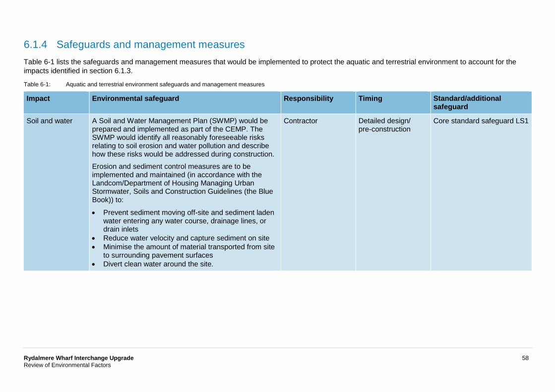
Rydalmere Wharf Interchange Upgrade 58 Review of Environmental Factors
6.1.4 Safeguards and management measures Table 6-1 lists the safeguards and management measures that would be implemented to protect the aquatic and terrestrial environment to account for the impacts identified in section 6.1.3.
Table 6-1: Aquatic and terrestrial environment safeguards and management measures
Impact Environmental safeguard Responsibility Timing Standard/additional safeguard
Soil and water A Soil and Water Management Plan (SWMP) would be prepared and implemented as part of the CEMP. The SWMP would identify all reasonably foreseeable risks relating to soil erosion and water pollution and describe how these risks would be addressed during construction. Erosion and sediment control measures are to be implemented and maintained (in accordance with the Landcom/Department of Housing Managing Urban Stormwater, Soils and Construction Guidelines (the Blue Book)) to:
• Prevent sediment moving off-site and sediment laden water entering any water course, drainage lines, or drain inlets
• Reduce water velocity and capture sediment on site • Minimise the amount of material transported from site
to surrounding pavement surfaces • Divert clean water around the site.
Contractor Detailed design/ pre-construction
Core standard safeguard LS1
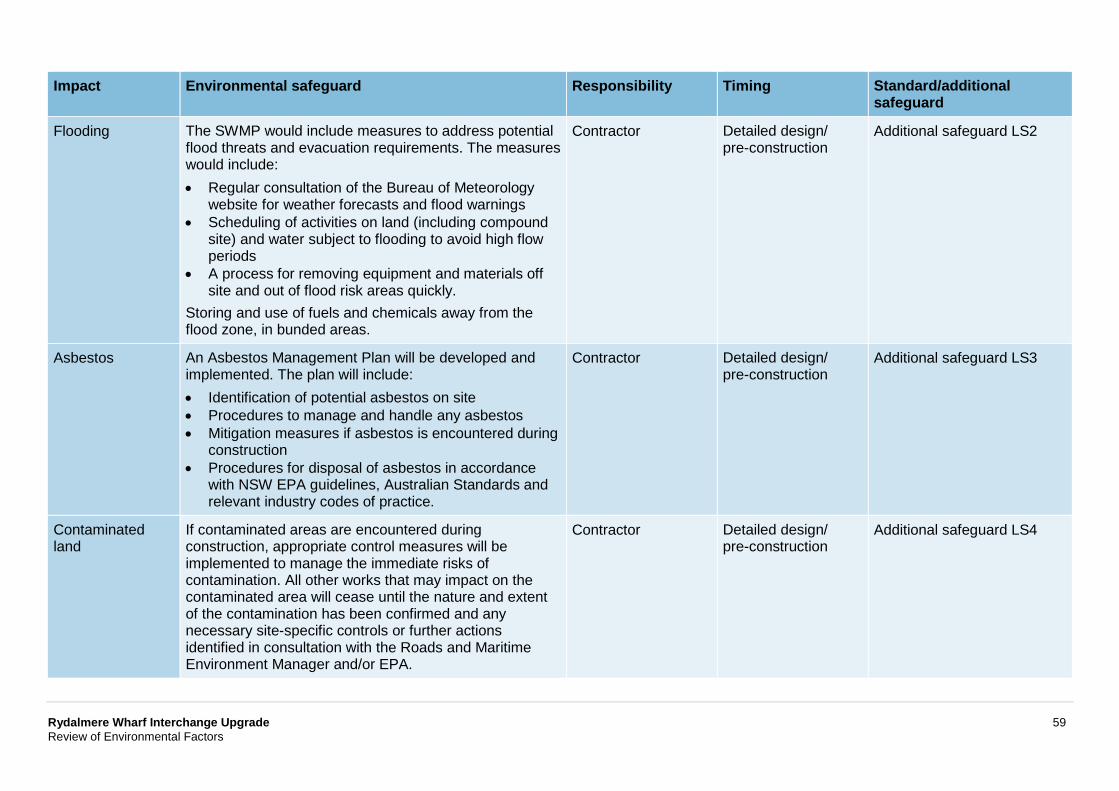
Rydalmere Wharf Interchange Upgrade 59 Review of Environmental Factors
Impact Environmental safeguard Responsibility Timing Standard/additional safeguard
Flooding The SWMP would include measures to address potential flood threats and evacuation requirements. The measures would include: • Regular consultation of the Bureau of Meteorology
website for weather forecasts and flood warnings • Scheduling of activities on land (including compound
site) and water subject to flooding to avoid high flow periods
• A process for removing equipment and materials off site and out of flood risk areas quickly.
Storing and use of fuels and chemicals away from the flood zone, in bunded areas.
Contractor Detailed design/ pre-construction
Additional safeguard LS2
Asbestos An Asbestos Management Plan will be developed and implemented. The plan will include: • Identification of potential asbestos on site • Procedures to manage and handle any asbestos • Mitigation measures if asbestos is encountered during
construction • Procedures for disposal of asbestos in accordance
with NSW EPA guidelines, Australian Standards and relevant industry codes of practice.
Contractor Detailed design/ pre-construction
Additional safeguard LS3
Contaminated land
If contaminated areas are encountered during construction, appropriate control measures will be implemented to manage the immediate risks of contamination. All other works that may impact on the contaminated area will cease until the nature and extent of the contamination has been confirmed and any necessary site-specific controls or further actions identified in consultation with the Roads and Maritime Environment Manager and/or EPA.
Contractor Detailed design/ pre-construction
Additional safeguard LS4
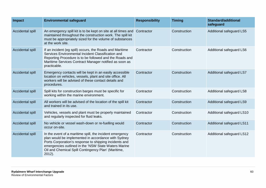
Rydalmere Wharf Interchange Upgrade 60 Review of Environmental Factors
Impact Environmental safeguard Responsibility Timing Standard/additional safeguard
Accidental spill An emergency spill kit is to be kept on site at all times and maintained throughout the construction work. The spill kit must be appropriately sized for the volume of substances at the work site.
Contractor Construction Additional safeguard LS5
Accidental spill If an incident (eg spill) occurs, the Roads and Maritime Services Environmental Incident Classification and Reporting Procedure is to be followed and the Roads and Maritime Services Contract Manager notified as soon as practicable.
Contractor Construction Additional safeguard LS6
Accidental spill Emergency contacts will be kept in an easily accessible location on vehicles, vessels, plant and site office. All workers will be advised of these contact details and procedures.
Contractor Construction Additional safeguard LS7
Accidental spill Spill kits for construction barges must be specific for working within the marine environment.
Contractor Construction Additional safeguard LS8
Accidental spill All workers will be advised of the location of the spill kit and trained in its use.
Contractor Construction Additional safeguard LS9
Accidental spill Vehicles, vessels and plant must be properly maintained and regularly inspected for fluid leaks.
Contractor Construction Additional safeguard LS10
Accidental spill No vehicle or vessel wash-down or re-fuelling would occur on-site.
Contractor Construction Additional safeguard LS11
Accidental spill In the event of a maritime spill, the incident emergency plan would be implemented in accordance with Sydney Ports Corporation’s response to shipping incidents and emergencies outlined in the ‘NSW State Waters Marine Oil and Chemical Spill Contingency Plan’ (Maritime, 2012).
Contractor Construction Additional safeguard LS12
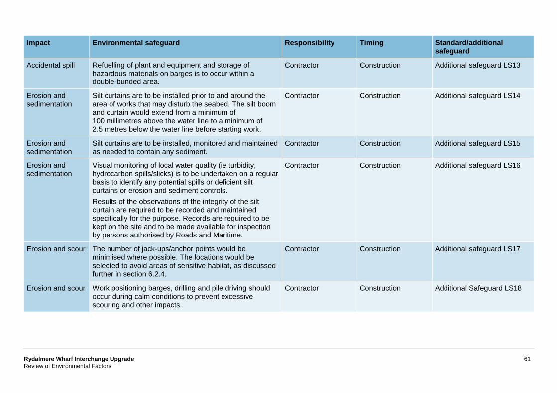
Rydalmere Wharf Interchange Upgrade 61 Review of Environmental Factors
Impact Environmental safeguard Responsibility Timing Standard/additional safeguard
Accidental spill Refuelling of plant and equipment and storage of hazardous materials on barges is to occur within a double-bunded area.
Contractor Construction Additional safeguard LS13
Erosion and sedimentation
Silt curtains are to be installed prior to and around the area of works that may disturb the seabed. The silt boom and curtain would extend from a minimum of 100 millimetres above the water line to a minimum of 2.5 metres below the water line before starting work.
Contractor Construction Additional safeguard LS14
Erosion and sedimentation
Silt curtains are to be installed, monitored and maintained as needed to contain any sediment.
Contractor Construction Additional safeguard LS15
Erosion and sedimentation
Visual monitoring of local water quality (ie turbidity, hydrocarbon spills/slicks) is to be undertaken on a regular basis to identify any potential spills or deficient silt curtains or erosion and sediment controls. Results of the observations of the integrity of the silt curtain are required to be recorded and maintained specifically for the purpose. Records are required to be kept on the site and to be made available for inspection by persons authorised by Roads and Maritime.
Contractor Construction Additional safeguard LS16
Erosion and scour The number of jack-ups/anchor points would be minimised where possible. The locations would be selected to avoid areas of sensitive habitat, as discussed further in section 6.2.4.
Contractor Construction Additional safeguard LS17
Erosion and scour Work positioning barges, drilling and pile driving should occur during calm conditions to prevent excessive scouring and other impacts.
Contractor Construction Additional Safeguard LS18
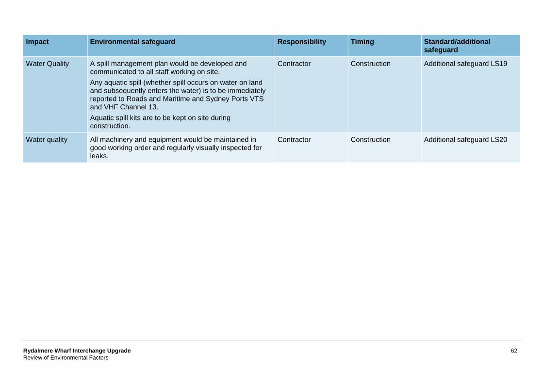
Rydalmere Wharf Interchange Upgrade 62 Review of Environmental Factors
Impact Environmental safeguard Responsibility Timing Standard/additional safeguard
Water Quality A spill management plan would be developed and communicated to all staff working on site. Any aquatic spill (whether spill occurs on water on land and subsequently enters the water) is to be immediately reported to Roads and Maritime and Sydney Ports VTS and VHF Channel 13. Aquatic spill kits are to be kept on site during construction.
Contractor Construction Additional safeguard LS19
Water quality All machinery and equipment would be maintained in good working order and regularly visually inspected for leaks.
Contractor Construction Additional safeguard LS20
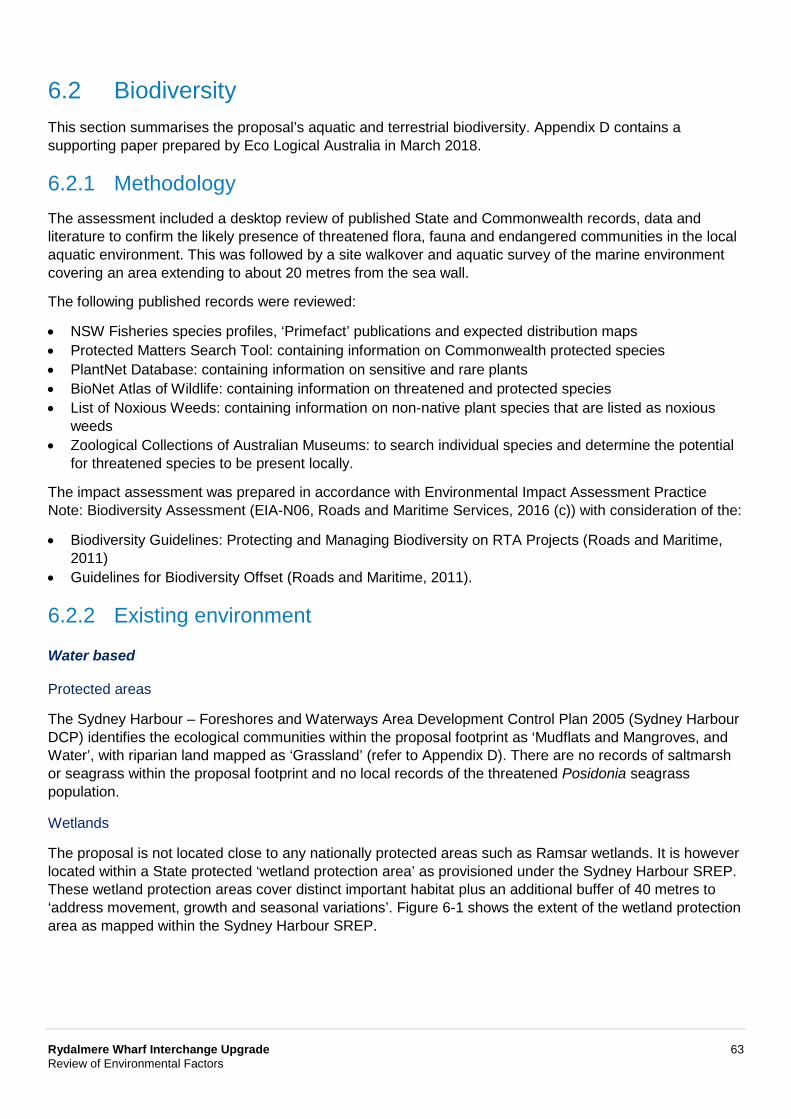
Rydalmere Wharf Interchange Upgrade 63 Review of Environmental Factors
6.2 Biodiversity This section summarises the proposal’s aquatic and terrestrial biodiversity. Appendix D contains a supporting paper prepared by Eco Logical Australia in March 2018.
6.2.1 Methodology The assessment included a desktop review of published State and Commonwealth records, data and literature to confirm the likely presence of threatened flora, fauna and endangered communities in the local aquatic environment. This was followed by a site walkover and aquatic survey of the marine environment covering an area extending to about 20 metres from the sea wall.
The following published records were reviewed:
• NSW Fisheries species profiles, ‘Primefact’ publications and expected distribution maps • Protected Matters Search Tool: containing information on Commonwealth protected species • PlantNet Database: containing information on sensitive and rare plants • BioNet Atlas of Wildlife: containing information on threatened and protected species • List of Noxious Weeds: containing information on non-native plant species that are listed as noxious
weeds • Zoological Collections of Australian Museums: to search individual species and determine the potential
for threatened species to be present locally.
The impact assessment was prepared in accordance with Environmental Impact Assessment Practice Note: Biodiversity Assessment (EIA-N06, Roads and Maritime Services, 2016 (c)) with consideration of the:
• Biodiversity Guidelines: Protecting and Managing Biodiversity on RTA Projects (Roads and Maritime, 2011)
• Guidelines for Biodiversity Offset (Roads and Maritime, 2011).
6.2.2 Existing environment
Water based
Protected areas
The Sydney Harbour – Foreshores and Waterways Area Development Control Plan 2005 (Sydney Harbour DCP) identifies the ecological communities within the proposal footprint as ‘Mudflats and Mangroves, and Water’, with riparian land mapped as ‘Grassland’ (refer to Appendix D). There are no records of saltmarsh or seagrass within the proposal footprint and no local records of the threatened Posidonia seagrass population.
Wetlands
The proposal is not located close to any nationally protected areas such as Ramsar wetlands. It is however located within a State protected ‘wetland protection area’ as provisioned under the Sydney Harbour SREP. These wetland protection areas cover distinct important habitat plus an additional buffer of 40 metres to ‘address movement, growth and seasonal variations’. Figure 6-1 shows the extent of the wetland protection area as mapped within the Sydney Harbour SREP.
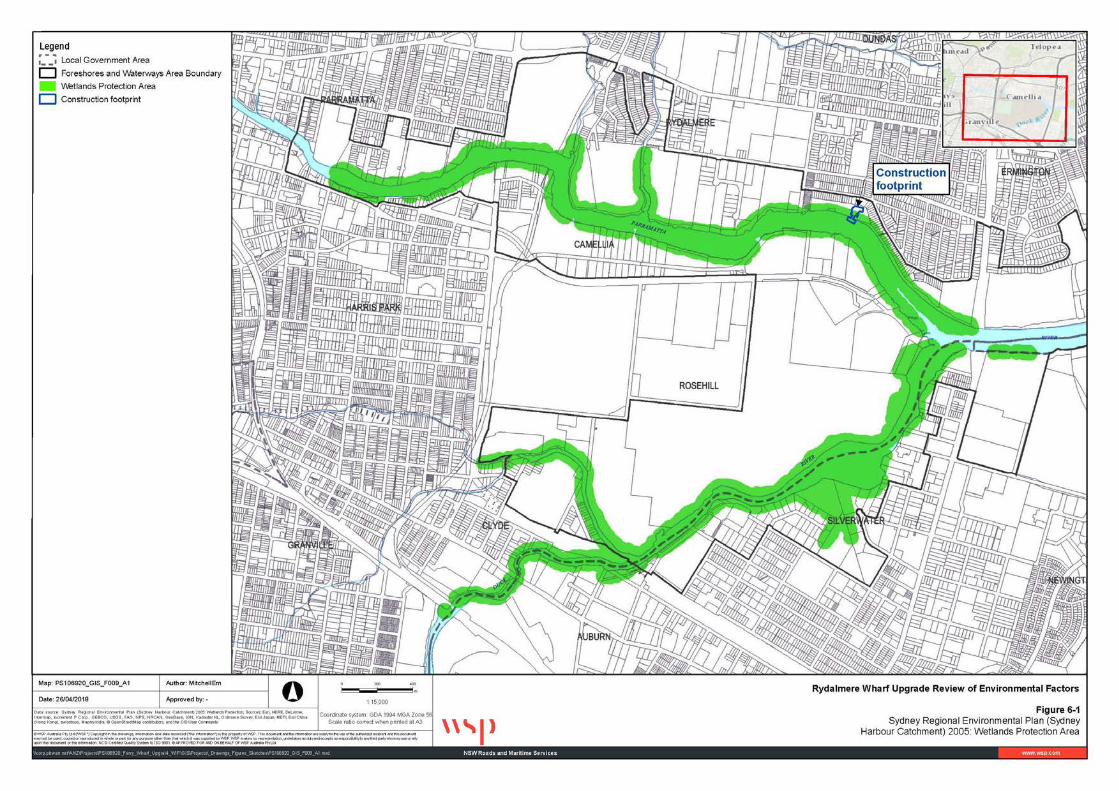
Rydalmere Wharf Interchange Upgrade 64 Review of Environmental Factors
Figure 6-1: Sydney Regional Environmental Plan (Sydney Harbour Catchment) 2005: Wetlands protection area
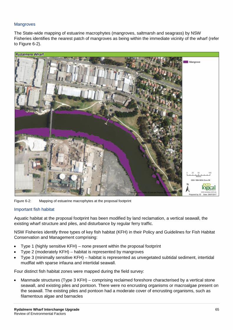
Rydalmere Wharf Interchange Upgrade 65 Review of Environmental Factors
Mangroves
The State-wide mapping of estuarine macrophytes (mangroves, saltmarsh and seagrass) by NSW Fisheries identifies the nearest patch of mangroves as being within the immediate vicinity of the wharf (refer to Figure 6-2).
Figure 6-2: Mapping of estuarine macrophytes at the proposal footprint
Important fish habitat
Aquatic habitat at the proposal footprint has been modified by land reclamation, a vertical seawall, the existing wharf structure and piles, and disturbance by regular ferry traffic.
NSW Fisheries identify three types of key fish habitat (KFH) in their Policy and Guidelines for Fish Habitat Conservation and Management comprising:
• Type 1 (highly sensitive KFH) – none present within the proposal footprint • Type 2 (moderately KFH) – habitat is represented by mangroves • Type 3 (minimally sensitive KFH) – habitat is represented as unvegetated subtidal sediment, intertidal
mudflat with sparse infauna and intertidal seawall.
Four distinct fish habitat zones were mapped during the field survey:
• Manmade structures (Type 3 KFH) – comprising reclaimed foreshore characterised by a vertical stone seawall, and existing piles and pontoon. There were no encrusting organisms or macroalgae present on the seawall. The existing piles and pontoon had a moderate cover of encrusting organisms, such as filamentous algae and barnacles
Rydalmere Wharf Interchange Upgrade 66 Review of Environmental Factors
• Mangroves (Type 2 KFH) – Avicennia marina (Grey Mangrove) occurred from approximately three meters either side of the gangway, which form part of a larger community that line both banks of the river
• Intertidal mudflat with sparse infauna (Type 3 KFH) – Benthic habitat surrounding the current gangway structure, with sparse bioturbation from infauna burrows. No hard substrate such as rock rubble or exposed bedrock occurred
• Subtidal silty sediment with woody debris (Type 3 KFH) – Characterised by fine sediment with leaf litter and scattered woody debris, with sparse bioturbation from infauna. No seagrass or macroalgae were observed.
Aquatic habitat within the proposal footprint is shown in Figure 6-3.
Threatened biota
From database records, there are 106 aquatic-related threatened species within Sydney Harbour, including tidal areas of Parramatta River and Lane Cove River.
No threatened species, populations or communities were observed in the proposal footprint. Consideration of suitable habitat is provided below, and in Appendix D.
Flora
Whilst no threatened species were identified within the proposal footprint, mangroves (protected under the FM Act) were identified about three metres either side of the existing gangway. Several small trees appeared unhealthy and struggling to establish. The proposal includes replacement of the wharf in the existing position and, with the implementation of safeguards and management measures detailed in section 6.2.4, no significant impacts are anticipated.
The threatened seagrass population, Posidonia australis, is known to occur on subtidal sand up to 10 metres deep, however there are no records of this species upstream of Darling Point (less than 20 kilometres downstream of the proposal).
Coastal saltmarsh, which occurs in the high intertidal zone, is not considered likely to occur within the proposal footprint due to the presence of steep areas and artificial structures, which would prevent plants establishing.
Other threatened plant species recorded in the harbour were not recorded within the proposal footprint and are not considered likely to occur locally due to the lack of supporting habitat as described in section 4.3 of Appendix D.
Fauna
A number of threatened fauna species have been recorded in the harbour, with a full list provided in Appendix D.
Syngnathiformes (seahorses and their relatives) were not observed and are unlikely to reside in the proposal footprint due to increased freshwater influence from the Parramatta River and minimal suitable habitat.
Certain species of fish and other fauna may pass through the proposal footprint on occasion. Nonetheless, it can be concluded that these species do not rely on the area for primary habitat purposes, spawning, use as nursery grounds, and/or predatory/foraging purposes (ie providing a source of food).
No suitable habitat for any recorded threatened fauna species was identified within the proposal footprint, and are considered unlikely to occur.
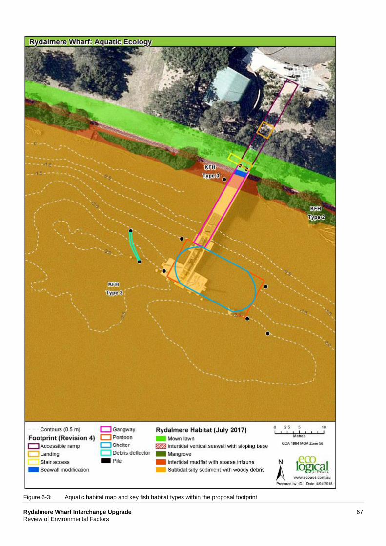
Rydalmere Wharf Interchange Upgrade 67 Review of Environmental Factors
Figure 6-3: Aquatic habitat map and key fish habitat types within the proposal footprint
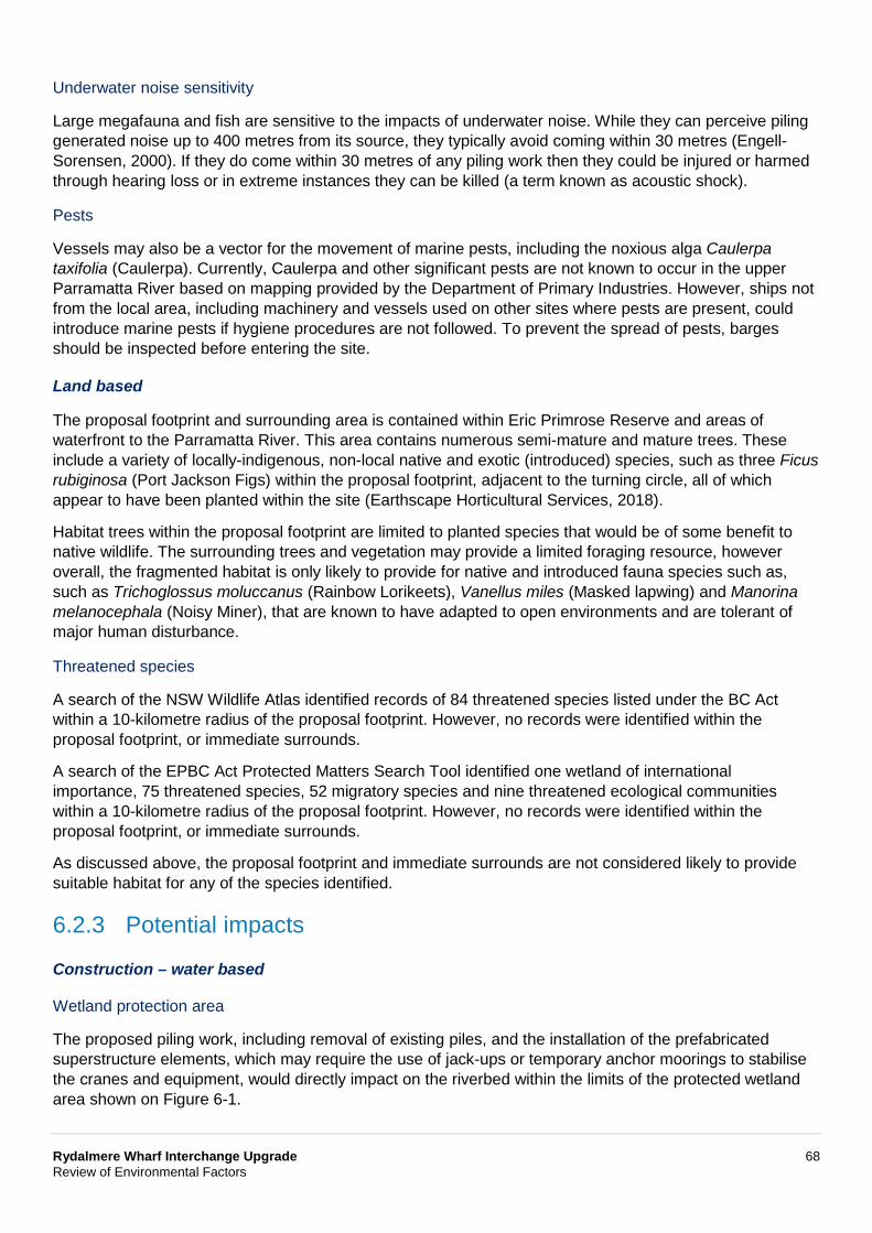
Rydalmere Wharf Interchange Upgrade 68 Review of Environmental Factors
Underwater noise sensitivity
Large megafauna and fish are sensitive to the impacts of underwater noise. While they can perceive piling generated noise up to 400 metres from its source, they typically avoid coming within 30 metres (Engell-Sorensen, 2000). If they do come within 30 metres of any piling work then they could be injured or harmed through hearing loss or in extreme instances they can be killed (a term known as acoustic shock).
Pests
Vessels may also be a vector for the movement of marine pests, including the noxious alga Caulerpa taxifolia (Caulerpa). Currently, Caulerpa and other significant pests are not known to occur in the upper Parramatta River based on mapping provided by the Department of Primary Industries. However, ships not from the local area, including machinery and vessels used on other sites where pests are present, could introduce marine pests if hygiene procedures are not followed. To prevent the spread of pests, barges should be inspected before entering the site.
Land based
The proposal footprint and surrounding area is contained within Eric Primrose Reserve and areas of waterfront to the Parramatta River. This area contains numerous semi-mature and mature trees. These include a variety of locally-indigenous, non-local native and exotic (introduced) species, such as three Ficus rubiginosa (Port Jackson Figs) within the proposal footprint, adjacent to the turning circle, all of which appear to have been planted within the site (Earthscape Horticultural Services, 2018).
Habitat trees within the proposal footprint are limited to planted species that would be of some benefit to native wildlife. The surrounding trees and vegetation may provide a limited foraging resource, however overall, the fragmented habitat is only likely to provide for native and introduced fauna species such as, such as Trichoglossus moluccanus (Rainbow Lorikeets), Vanellus miles (Masked lapwing) and Manorina melanocephala (Noisy Miner), that are known to have adapted to open environments and are tolerant of major human disturbance.
Threatened species
A search of the NSW Wildlife Atlas identified records of 84 threatened species listed under the BC Act within a 10-kilometre radius of the proposal footprint. However, no records were identified within the proposal footprint, or immediate surrounds.
A search of the EPBC Act Protected Matters Search Tool identified one wetland of international importance, 75 threatened species, 52 migratory species and nine threatened ecological communities within a 10-kilometre radius of the proposal footprint. However, no records were identified within the proposal footprint, or immediate surrounds.
As discussed above, the proposal footprint and immediate surrounds are not considered likely to provide suitable habitat for any of the species identified.
6.2.3 Potential impacts
Construction – water based
Wetland protection area
The proposed piling work, including removal of existing piles, and the installation of the prefabricated superstructure elements, which may require the use of jack-ups or temporary anchor moorings to stabilise the cranes and equipment, would directly impact on the riverbed within the limits of the protected wetland area shown on Figure 6-1.
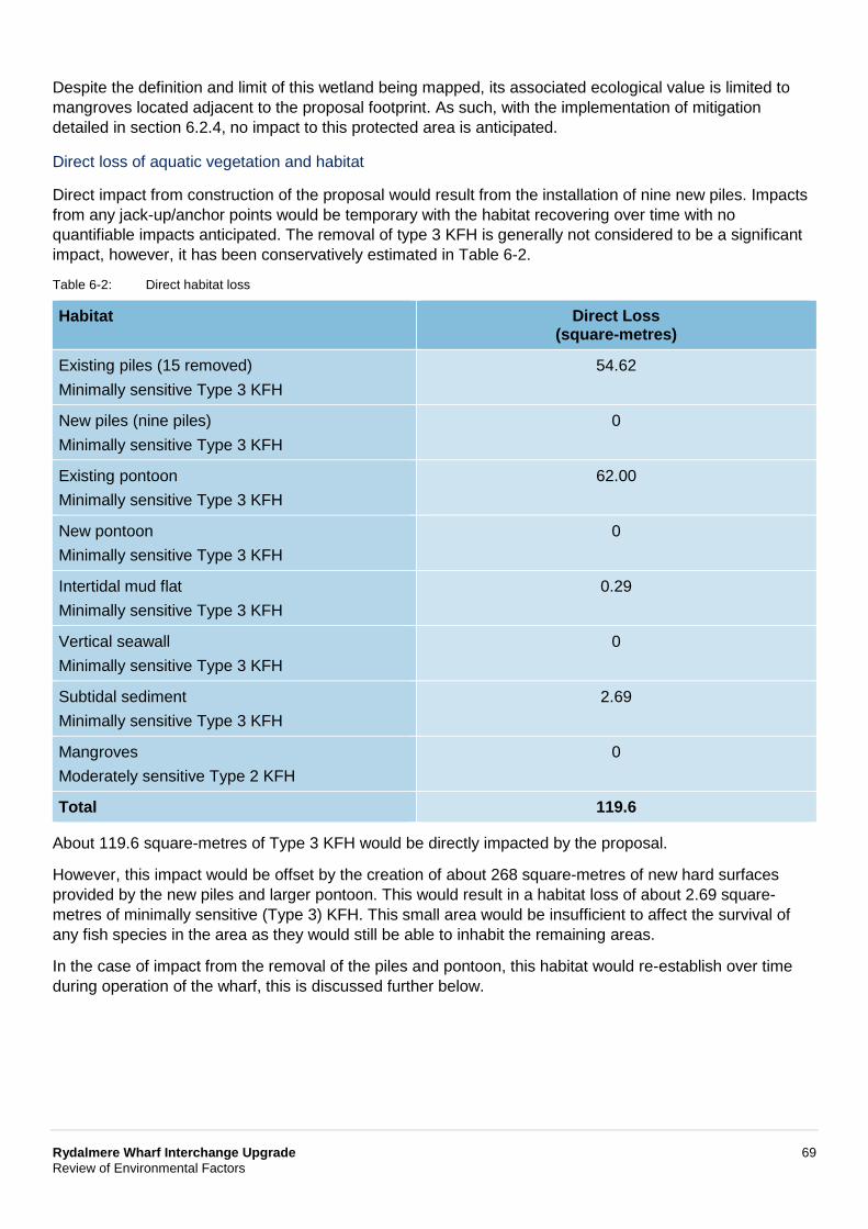
Rydalmere Wharf Interchange Upgrade 69 Review of Environmental Factors
Despite the definition and limit of this wetland being mapped, its associated ecological value is limited to mangroves located adjacent to the proposal footprint. As such, with the implementation of mitigation detailed in section 6.2.4, no impact to this protected area is anticipated.
Direct loss of aquatic vegetation and habitat
Direct impact from construction of the proposal would result from the installation of nine new piles. Impacts from any jack-up/anchor points would be temporary with the habitat recovering over time with no quantifiable impacts anticipated. The removal of type 3 KFH is generally not considered to be a significant impact, however, it has been conservatively estimated in Table 6-2.
Table 6-2: Direct habitat loss
Habitat Direct Loss (square-metres)
Existing piles (15 removed) Minimally sensitive Type 3 KFH
54.62
New piles (nine piles) Minimally sensitive Type 3 KFH
0
Existing pontoon Minimally sensitive Type 3 KFH
62.00
New pontoon Minimally sensitive Type 3 KFH
0
Intertidal mud flat Minimally sensitive Type 3 KFH
0.29
Vertical seawall Minimally sensitive Type 3 KFH
0
Subtidal sediment Minimally sensitive Type 3 KFH
2.69
Mangroves Moderately sensitive Type 2 KFH
0
Total 119.6
About 119.6 square-metres of Type 3 KFH would be directly impacted by the proposal.
However, this impact would be offset by the creation of about 268 square-metres of new hard surfaces provided by the new piles and larger pontoon. This would result in a habitat loss of about 2.69 square-metres of minimally sensitive (Type 3) KFH. This small area would be insufficient to affect the survival of any fish species in the area as they would still be able to inhabit the remaining areas.
In the case of impact from the removal of the piles and pontoon, this habitat would re-establish over time during operation of the wharf, this is discussed further below.
Rydalmere Wharf Interchange Upgrade 70 Review of Environmental Factors
Injury and mortality
The absence of any threatened flora or fauna local to the proposal footprint reduces the potential for associated impacts on ecologically significant species. However, as the potential for certain larger types of fauna to occasionally pass through the local area cannot be fully discounted, there is still the potential for injury risks from propeller or ship strikes. Providing standard measures are introduced while the wharf is being upgraded, any impacts are expected to be safeguarded and minimised.
There is also the potential for any immobile or semi-mobile species that occur locally to be killed as a result of the piling work and/or use of jack-ups and anchors. However, the potential for injury and mortality during construction would be minimal, and would be managed through safeguards and management detailed in section 6.2.4. Providing these safeguards and the other standard measures are implemented and remain effective, then any associated impacts would be avoided or minimised.
Entrapment and impingement
A silt curtain would be used to prevent sediment dispersion. As such, there is the potential for aquatic/marine mammals and fish to become entrapped in the curtain. However, fish species would be able to pass beneath the silt curtain. Further safeguards, including regularly inspecting the silt curtain, would minimise the potential impacts.
Underwater noise
Underwater noise from hammering piles has the potential to cause disturbance or physical impact to marine fauna in the area. Fish in the vicinity would be affected by excessive underwater noise, ranging from mortality to interruption of communication, depending on species anatomy (eg fish with swim bladders closer to the ear are more sensitive to acoustic impact than species with swim bladders further from the ear). If water depth allows, fish would be able to escape under the silt curtain as hammering starts, otherwise some impact is expected. However, any excessive underwater noise like the removal and installation of piling, including hammering would occur intermittently, with gentle start-up to works further reducing underwater noise impacts as identified in section 6.2.4.
Indirect and secondary impacts
As described in section 6.1.3 there is the potential for sediment discharge, accidental spills and/or localised scour and erosion to occur while the proposal is being built. However, by including standard safeguards it is concluded that such impacts could be minimised to the point of having no material indirect impact on aquatic or inter-tidal habitat.
Sediment movement could also smother infauna burrows. Again, it is unlikely that large volumes of sediment would be moved, and that the thin layer of silt or sand that does settle on infauna burrows would not cause significant damage.
Pest species
The introduction of pest species could occur through vessel movements into and out of the local area. However, providing relevant standard controls are implemented and monitored, the impacts are expected to be minimised.
Rydalmere Wharf Interchange Upgrade 71 Review of Environmental Factors
Construction – land based
Loss of vegetation and habitat
There is no proposal to remove any trees, with only minor pruning required for construction of the proposal. As such, there is expected to be negligible terrestrial habitat loss or impact under the proposal.
The Ficus rubiginosa (Port Jackson Figs) within the proposal footprint, adjacent to the turning circle, all of which appear to have been planted within the site.
An arborist assessment completed for the proposal (Earthscape Horticultural Services, 2018), identified that excavation associated with the realignment of the existing kerb and footpath, would occur within the tree protection zones (TPZ) identified for the three Port Jackson Figs within the proposal footprint. Excavations for the pavement sub-grade may result in some severance and damage of underling roots, which may result in an adverse impact on this tree. However, all excavations for the pavement sub-grade within the TPZ would be undertaken in accordance with the mitigation detailed within section 6.2.4 to avoid any potential impacts.
Injury and mortality
The avoidance of any vegetation or habitat removal would avoid any significant risk of direct injury or mortality impacts. This extends to the loss of any foraging habitat in the area.
Noise, vibration and lighting
Adverse noise and temporary vibration would be introduced while the proposal is being built (refer to section 6.3). However, this is unlikely to affect any native species due to the highly disturbed nature of the existing environment and the fact the area is already lit. Standard safeguards and management measures would be implemented to reduce impacts from noise and vibration. Providing these are implemented and remain effective then impacts would be avoided and/or minimised.
The proposal would be constructed during standard hours, with no significant impacts from lighting anticipated.
Threatened biota
As there is no proposed vegetation loss or tree removal then there are not any expected impacts on threatened species listed under the BC Act and/or EPBC Act.
Weed invasion
There is minimal potential for the proposal to introduce weeds into the area, as there are no significant land based earthworks planned and/or vegetation clearance work.
Operation – water based
The following impacts may occur once the proposal is operational:
• Habitat loss, loss of habitat quality, and/or impacts on community and species health from accidental spills, litter and/or engine leaks
• Localised sediment disturbance from propeller wash affecting the subtidal shallow rocky reef and coarse bare sediment habitat and its supporting values and species.
The current wharf operates with the potential for the above impacts to occur. Once the wharf is upgraded, these potential impacts could still occur. No significant change to operations is proposed with standard operational controls to remain in place.
Rydalmere Wharf Interchange Upgrade 72 Review of Environmental Factors
As described above, the replacement piles would allow an artificial habitat to re-establish that would be likely characteristic of the existing habitat described in section 6.2.2.
The only potential impacts expected from the proposal would be a change in shadowing impacts on the riverbed from the new wharf structure.
The proposal would result in about 115 square-metres of shading impact on subtidal habitat beneath the pontoon. However, as no significant habitat was observed in or around this area, the impacts from shading on vegetation growth would not occur.
In consultation with NSW Fisheries, this type of impact (partial shading of unvegetated substrate) for community infrastructure is very minor and does not warrant the need for further offsets or compensation. Furthermore, in accordance with the Roads and Maritime’s Biodiversity Offset Guideline which refers to the NSW Fisheries’ policy, the proposed indirect shading impact to Type 3 KFH would not need to be offset.
Operation – land based
As there is not expected to be any change to passenger numbers or operational activities around the wharf there is limited potential for any operational terrestrial ecology impacts.
Conclusion on significance of impacts
The proposal is not likely to significantly impact threatened terrestrial or aquatic species, populations or ecological communities or their habitats, within the meaning of the BC Act or the FM Act and therefore a species impact statement (SIS) is not needed.
The proposal is not likely to significantly impact threatened terrestrial or aquatic species, populations, ecological communities or migratory species, within the meaning of the EPBC Act or FM Act and therefore a Species Impact Statement or Biodiversity Development Assessment Report is not required.
The proposal is not likely to significantly impact threatened species, populations, ecological communities or migratory species, within the meaning of the EPBC Act. A referral to the Australian Department of the Environment and Energy is therefore not required for biodiversity matters.
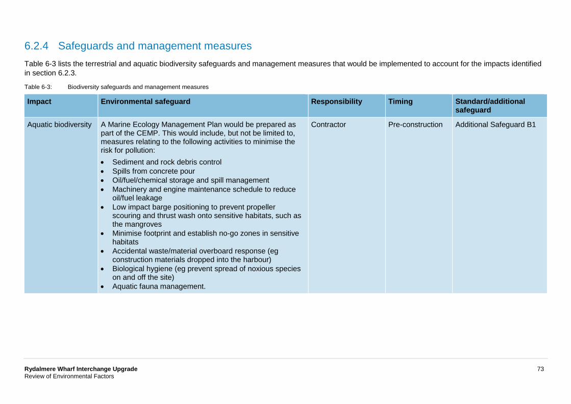
Rydalmere Wharf Interchange Upgrade 73 Review of Environmental Factors
6.2.4 Safeguards and management measures Table 6-3 lists the terrestrial and aquatic biodiversity safeguards and management measures that would be implemented to account for the impacts identified in section 6.2.3.
Table 6-3: Biodiversity safeguards and management measures
Impact Environmental safeguard Responsibility Timing Standard/additional safeguard
Aquatic biodiversity A Marine Ecology Management Plan would be prepared as part of the CEMP. This would include, but not be limited to, measures relating to the following activities to minimise the risk for pollution: • Sediment and rock debris control • Spills from concrete pour • Oil/fuel/chemical storage and spill management • Machinery and engine maintenance schedule to reduce
oil/fuel leakage • Low impact barge positioning to prevent propeller
scouring and thrust wash onto sensitive habitats, such as the mangroves
• Minimise footprint and establish no-go zones in sensitive habitats
• Accidental waste/material overboard response (eg construction materials dropped into the harbour)
• Biological hygiene (eg prevent spread of noxious species on and off the site)
• Aquatic fauna management.
Contractor Pre-construction Additional Safeguard B1
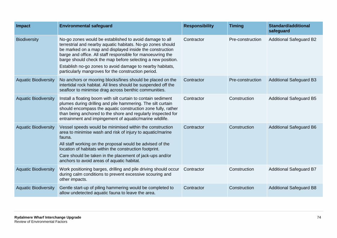
Rydalmere Wharf Interchange Upgrade 74 Review of Environmental Factors
Impact Environmental safeguard Responsibility Timing Standard/additional safeguard
Biodiversity No-go zones would be established to avoid damage to all terrestrial and nearby aquatic habitats. No-go zones should be marked on a map and displayed inside the construction barge and office. All staff responsible for manoeuvring the barge should check the map before selecting a new position. Establish no-go zones to avoid damage to nearby habitats, particularly mangroves for the construction period.
Contractor Pre-construction Additional Safeguard B2
Aquatic Biodiversity No anchors or mooring blocks/lines should be placed on the intertidal rock habitat. All lines should be suspended off the seafloor to minimise drag across benthic communities.
Contractor Pre-construction Additional Safeguard B3
Aquatic Biodiversity Install a floating boom with silt curtain to contain sediment plumes during drilling and pile hammering. The silt curtain should encompass the aquatic construction zone fully, rather than being anchored to the shore and regularly inspected for entrainment and impingement of aquatic/marine wildlife.
Contractor Construction Additional Safeguard B5
Aquatic Biodiversity Vessel speeds would be minimised within the construction area to minimise wash and risk of injury to aquatic/marine fauna. All staff working on the proposal would be advised of the location of habitats within the construction footprint. Care should be taken in the placement of jack-ups and/or anchors to avoid areas of aquatic habitat.
Contractor Construction Additional Safeguard B6
Aquatic Biodiversity Work positioning barges, drilling and pile driving should occur during calm conditions to prevent excessive scouring and other impacts.
Contractor Construction Additional Safeguard B7
Aquatic Biodiversity Gentle start-up of piling hammering would be completed to allow undetected aquatic fauna to leave the area.
Contractor Construction Additional Safeguard B8
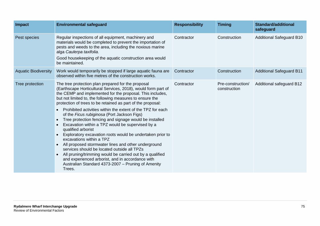
Rydalmere Wharf Interchange Upgrade 75 Review of Environmental Factors
Impact Environmental safeguard Responsibility Timing Standard/additional safeguard
Pest species Regular inspections of all equipment, machinery and materials would be completed to prevent the importation of pests and weeds to the area, including the noxious marine alga Caulerpa taxifolia. Good housekeeping of the aquatic construction area would be maintained.
Contractor Construction Additional Safeguard B10
Aquatic Biodiversity Work would temporarily be stopped if large aquatic fauna are observed within five metres of the construction works.
Contractor Construction Additional Safeguard B11
Tree protection The tree protection plan prepared for the proposal (Earthscape Horticultural Services, 2018), would form part of the CEMP and implemented for the proposal. This includes, but not limited to, the following measures to ensure the protection of trees to be retained as part of the proposal: • Prohibited activities within the extent of the TPZ for each
of the Ficus rubiginosa (Port Jackson Figs) • Tree protection fencing and signage would be installed • Excavation within a TPZ would be supervised by a
qualified arborist • Exploratory excavation roots would be undertaken prior to
excavations within a TPZ • All proposed stormwater lines and other underground
services should be located outside all TPZs • All pruning/trimming would be carried out by a qualified
and experienced arborist, and in accordance with Australian Standard 4373-2007 – Pruning of Amenity Trees.
Contractor Pre-construction/ construction
Additional safeguard B12
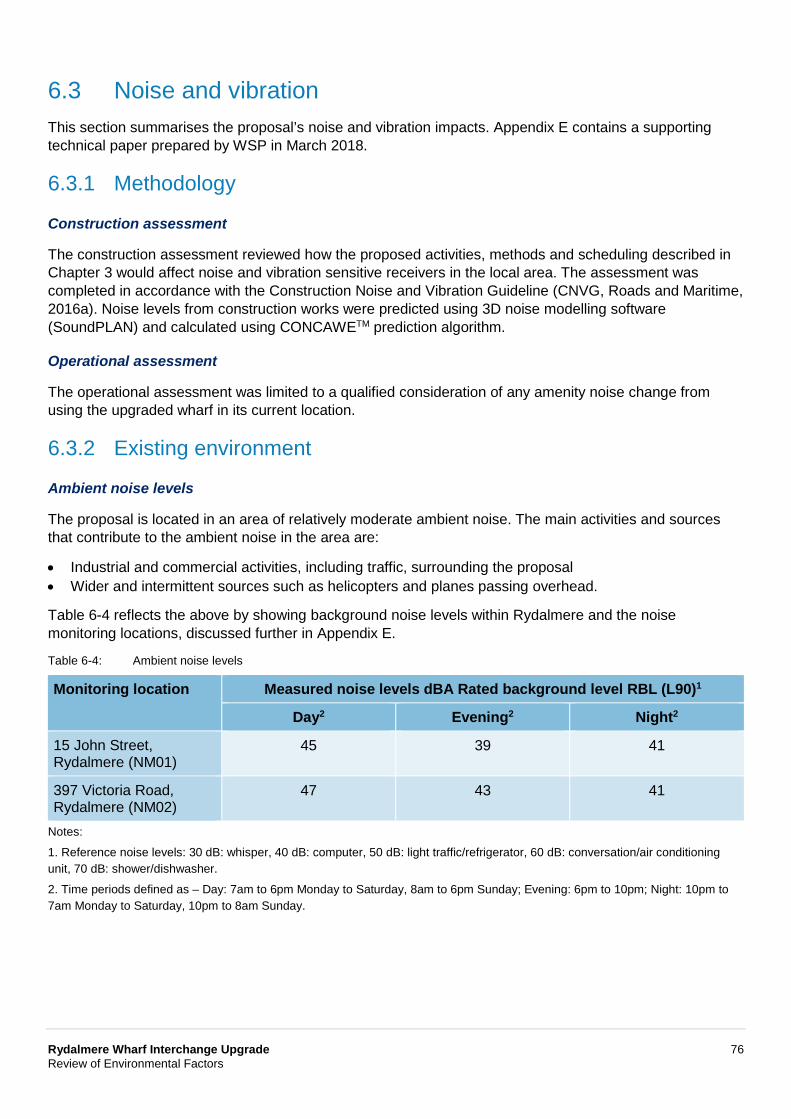
Rydalmere Wharf Interchange Upgrade 76 Review of Environmental Factors
6.3 Noise and vibration This section summarises the proposal’s noise and vibration impacts. Appendix E contains a supporting technical paper prepared by WSP in March 2018.
6.3.1 Methodology
Construction assessment
The construction assessment reviewed how the proposed activities, methods and scheduling described in Chapter 3 would affect noise and vibration sensitive receivers in the local area. The assessment was completed in accordance with the Construction Noise and Vibration Guideline (CNVG, Roads and Maritime, 2016a). Noise levels from construction works were predicted using 3D noise modelling software (SoundPLAN) and calculated using CONCAWETM prediction algorithm.
Operational assessment
The operational assessment was limited to a qualified consideration of any amenity noise change from using the upgraded wharf in its current location.
6.3.2 Existing environment
Ambient noise levels
The proposal is located in an area of relatively moderate ambient noise. The main activities and sources that contribute to the ambient noise in the area are:
• Industrial and commercial activities, including traffic, surrounding the proposal • Wider and intermittent sources such as helicopters and planes passing overhead.
Table 6-4 reflects the above by showing background noise levels within Rydalmere and the noise monitoring locations, discussed further in Appendix E.
Table 6-4: Ambient noise levels
Monitoring location Measured noise levels dBA Rated background level RBL (L90)1
Day2 Evening2 Night2
15 John Street, Rydalmere (NM01)
45 39 41
397 Victoria Road, Rydalmere (NM02)
47 43 41
Notes:
1. Reference noise levels: 30 dB: whisper, 40 dB: computer, 50 dB: light traffic/refrigerator, 60 dB: conversation/air conditioning unit, 70 dB: shower/dishwasher.
2. Time periods defined as – Day: 7am to 6pm Monday to Saturday, 8am to 6pm Sunday; Evening: 6pm to 10pm; Night: 10pm to 7am Monday to Saturday, 10pm to 8am Sunday.
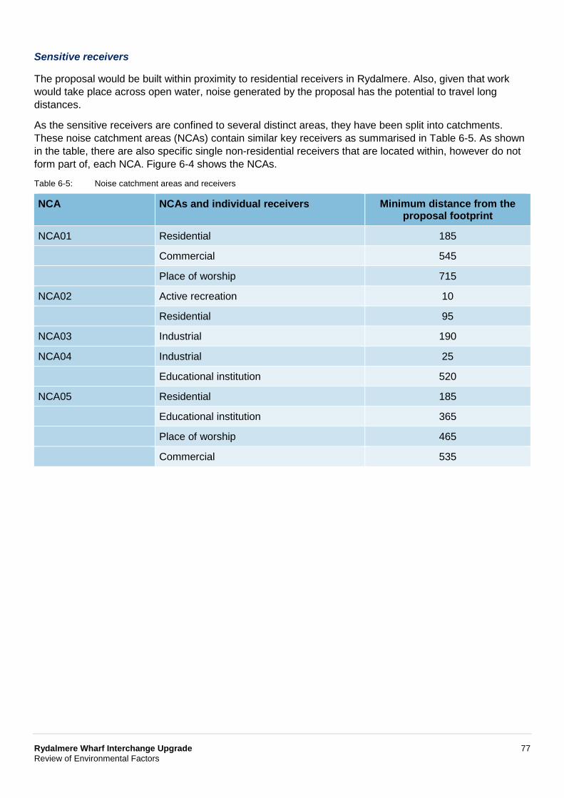
Rydalmere Wharf Interchange Upgrade 77 Review of Environmental Factors
Sensitive receivers
The proposal would be built within proximity to residential receivers in Rydalmere. Also, given that work would take place across open water, noise generated by the proposal has the potential to travel long distances.
As the sensitive receivers are confined to several distinct areas, they have been split into catchments. These noise catchment areas (NCAs) contain similar key receivers as summarised in Table 6-5. As shown in the table, there are also specific single non-residential receivers that are located within, however do not form part of, each NCA. Figure 6-4 shows the NCAs.
Table 6-5: Noise catchment areas and receivers
NCA NCAs and individual receivers Minimum distance from the proposal footprint
NCA01 Residential 185
Commercial 545
Place of worship 715
NCA02 Active recreation 10
Residential 95
NCA03 Industrial 190
NCA04 Industrial 25
Educational institution 520
NCA05 Residential 185
Educational institution 365
Place of worship 465
Commercial 535
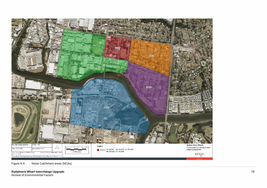
Rydalmere Wharf Interchange Upgrade 78 Review of Environmental Factors
Figure 6-4: Noise Catchment areas (NCAs)
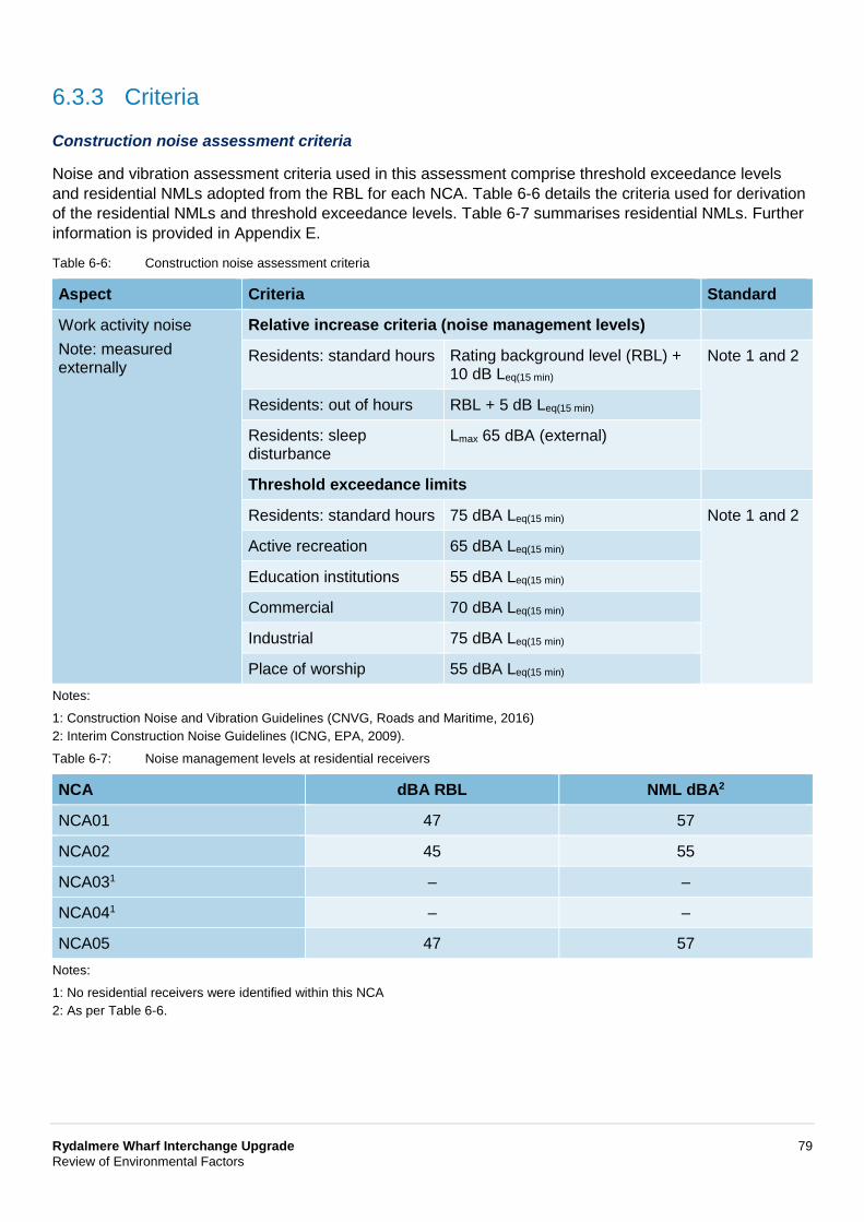
Rydalmere Wharf Interchange Upgrade 79 Review of Environmental Factors
6.3.3 Criteria
Construction noise assessment criteria
Noise and vibration assessment criteria used in this assessment comprise threshold exceedance levels and residential NMLs adopted from the RBL for each NCA. Table 6-6 details the criteria used for derivation of the residential NMLs and threshold exceedance levels. Table 6-7 summarises residential NMLs. Further information is provided in Appendix E.
Table 6-6: Construction noise assessment criteria
Aspect Criteria Standard
Work activity noise Note: measured externally
Relative increase criteria (noise management levels)
Residents: standard hours Rating background level (RBL) + 10 dB Leq(15 min)
Note 1 and 2
Residents: out of hours RBL + 5 dB Leq(15 min)
Residents: sleep disturbance
Lmax 65 dBA (external)
Threshold exceedance limits
Residents: standard hours 75 dBA Leq(15 min) Note 1 and 2
Active recreation 65 dBA Leq(15 min)
Education institutions 55 dBA Leq(15 min)
Commercial 70 dBA Leq(15 min)
Industrial 75 dBA Leq(15 min)
Place of worship 55 dBA Leq(15 min) Notes:
1: Construction Noise and Vibration Guidelines (CNVG, Roads and Maritime, 2016) 2: Interim Construction Noise Guidelines (ICNG, EPA, 2009).
Table 6-7: Noise management levels at residential receivers
NCA dBA RBL NML dBA2
NCA01 47 57
NCA02 45 55
NCA031 – –
NCA041 – –
NCA05 47 57 Notes:
1: No residential receivers were identified within this NCA 2: As per Table 6-6.

Rydalmere Wharf Interchange Upgrade 80 Review of Environmental Factors
Construction vibration assessment criteria
The construction vibration assessment criteria comprise minimum safe working distances determined from an assessment of peak vibration velocities in Appendix E. Table 6-8 outlines the construction vibration assessment criteria.
Table 6-8: Construction vibration assessment criteria
Aspect Criteria (metres) Standard
Cosmetic building damage Vibration velocities translated into safe working distances (see below)
Note 1
Amenity (human comfort) Vibration dose values translated into safe working distances (see below)
Note 2
Safe working distances (metres)
Equipment Cosmetic damage1,3
Amenity impacts2
Heritage structures
Note: more stringent Pile drilling 2 4 10
conditions may apply to heritage and sensitive structures (as defined under reference 2)
Pile hammering4
20 30 - 50 25
Notes:
1: BS 7385-2: 1993: Evaluation and Measurement of Vibration in Buildings (British Standard, 1993) 2: Assessing Vibration: A Technical Guideline (NSW DEC, 2006) 3: Referred to 15 mm/s vibration limit 4: Reference driven piling taken from FTA Noise and vibration manual.
6.3.4 Potential impacts
Construction
Activity based noise
While the construction staging would be confirmed during detailed design, each of the main design features would involve the use of different types of equipment in each area at various times of the day. Table 6-9 lists the types of equipment and relevant sound power levels that would be used during construction.
Table 6-9: Construction equipment and sound power levels
Equipment Sound Power Level dB(A)
Angle grinders1,2 114
Barge3 95
Boat3 100
Compressor4 109
Crane4 104
Generator3 103
Hand tools (electric)4 110
Piling rig (drilling)4 112
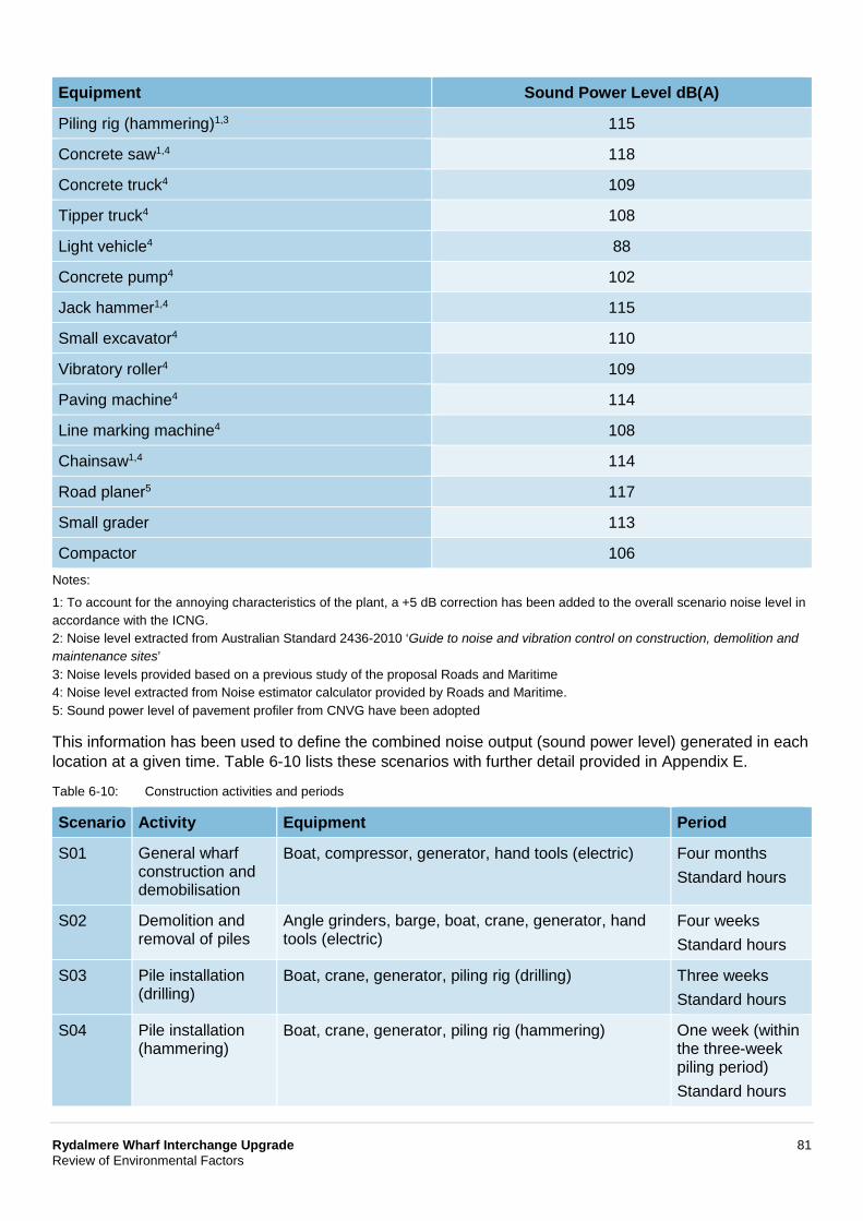
Rydalmere Wharf Interchange Upgrade 81 Review of Environmental Factors
Equipment Sound Power Level dB(A)
Piling rig (hammering)1,3 115
Concrete saw1,4 118
Concrete truck4 109
Tipper truck4 108
Light vehicle4 88
Concrete pump4 102
Jack hammer1,4 115
Small excavator4 110
Vibratory roller4 109
Paving machine4 114
Line marking machine4 108
Chainsaw1,4 114
Road planer5 117
Small grader 113
Compactor 106 Notes:
1: To account for the annoying characteristics of the plant, a +5 dB correction has been added to the overall scenario noise level in accordance with the ICNG. 2: Noise level extracted from Australian Standard 2436-2010 ‘Guide to noise and vibration control on construction, demolition and maintenance sites’ 3: Noise levels provided based on a previous study of the proposal Roads and Maritime 4: Noise level extracted from Noise estimator calculator provided by Roads and Maritime. 5: Sound power level of pavement profiler from CNVG have been adopted
This information has been used to define the combined noise output (sound power level) generated in each location at a given time. Table 6-10 lists these scenarios with further detail provided in Appendix E.
Table 6-10: Construction activities and periods
Scenario Activity Equipment Period
S01 General wharf construction and demobilisation
Boat, compressor, generator, hand tools (electric) Four months Standard hours
S02 Demolition and removal of piles
Angle grinders, barge, boat, crane, generator, hand tools (electric)
Four weeks Standard hours
S03 Pile installation (drilling)
Boat, crane, generator, piling rig (drilling) Three weeks Standard hours
S04 Pile installation (hammering)
Boat, crane, generator, piling rig (hammering) One week (within the three-week piling period) Standard hours
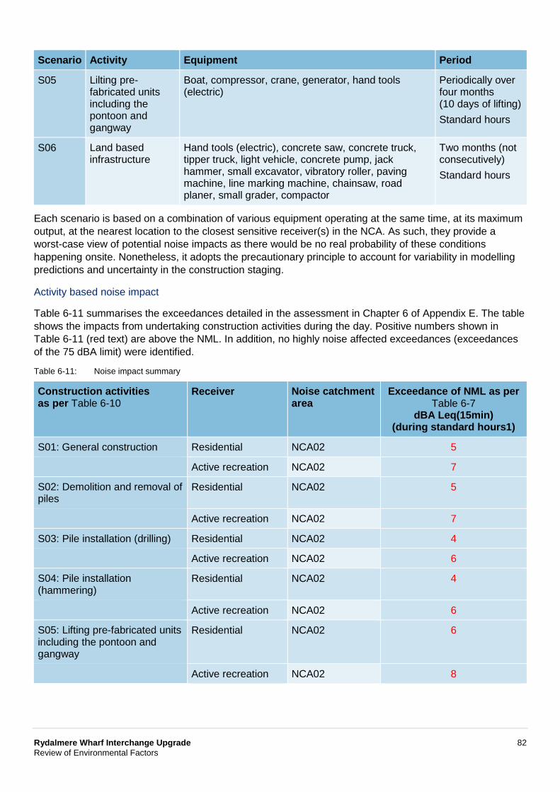
Rydalmere Wharf Interchange Upgrade 82 Review of Environmental Factors
Scenario Activity Equipment Period
S05 Lilting pre-fabricated units including the pontoon and gangway
Boat, compressor, crane, generator, hand tools (electric)
Periodically over four months (10 days of lifting) Standard hours
S06 Land based infrastructure
Hand tools (electric), concrete saw, concrete truck, tipper truck, light vehicle, concrete pump, jack hammer, small excavator, vibratory roller, paving machine, line marking machine, chainsaw, road planer, small grader, compactor
Two months (not consecutively) Standard hours
Each scenario is based on a combination of various equipment operating at the same time, at its maximum output, at the nearest location to the closest sensitive receiver(s) in the NCA. As such, they provide a worst-case view of potential noise impacts as there would be no real probability of these conditions happening onsite. Nonetheless, it adopts the precautionary principle to account for variability in modelling predictions and uncertainty in the construction staging.
Activity based noise impact
Table 6-11 summarises the exceedances detailed in the assessment in Chapter 6 of Appendix E. The table shows the impacts from undertaking construction activities during the day. Positive numbers shown in Table 6-11 (red text) are above the NML. In addition, no highly noise affected exceedances (exceedances of the 75 dBA limit) were identified.
Table 6-11: Noise impact summary
Construction activities as per Table 6-10
Receiver Noise catchment area
Exceedance of NML as per Table 6-7
dBA Leq(15min) (during standard hours1)
S01: General construction Residential NCA02 5
Active recreation NCA02 7
S02: Demolition and removal of piles
Residential NCA02 5
Active recreation NCA02 7
S03: Pile installation (drilling) Residential NCA02 4
Active recreation NCA02 6
S04: Pile installation (hammering)
Residential NCA02 4
Active recreation NCA02 6
S05: Lifting pre-fabricated units including the pontoon and gangway
Residential NCA02 6
Active recreation NCA02 8
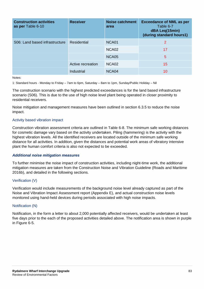
Rydalmere Wharf Interchange Upgrade 83 Review of Environmental Factors
Construction activities as per Table 6-10
Receiver Noise catchment area
Exceedance of NML as per Table 6-7
dBA Leq(15min) (during standard hours1)
S06: Land based infrastructure Residential NCA01 2
NCA02 17
NCA05 5
Active recreation NCA02 15
Industrial NCA04 10 Notes:
1: Standard hours - Monday to Friday – 7am to 6pm, Saturday – 8am to 1pm, Sunday/Public Holiday – Nil
The construction scenario with the highest predicted exceedances is for the land based infrastructure scenario (S06). This is due to the use of high noise level plant being operated in closer proximity to residential receivers.
Noise mitigation and management measures have been outlined in section 6.3.5 to reduce the noise impact.
Activity based vibration impact
Construction vibration assessment criteria are outlined in Table 6-8. The minimum safe working distances for cosmetic damage vary based on the activity undertaken. Piling (hammering) is the activity with the highest vibration levels. All the identified receivers are located outside of the minimum safe working distance for all activities. In addition, given the distances and potential work areas of vibratory intensive plant the human comfort criteria is also not expected to be exceeded.
Additional noise mitigation measures
To further minimise the noise impact of construction activities, including night-time work, the additional mitigation measures are taken from the Construction Noise and Vibration Guideline (Roads and Maritime 2016b), and detailed in the following sections.
Verification (V)
Verification would include measurements of the background noise level already captured as part of the Noise and Vibration Impact Assessment report (Appendix E), and actual construction noise levels monitored using hand-held devices during periods associated with high noise impacts.
Notification (N)
Notification, in the form a letter to about 2,000 potentially affected receivers, would be undertaken at least five days prior to the each of the proposed activities detailed above. The notification area is shown in purple in Figure 6-5.
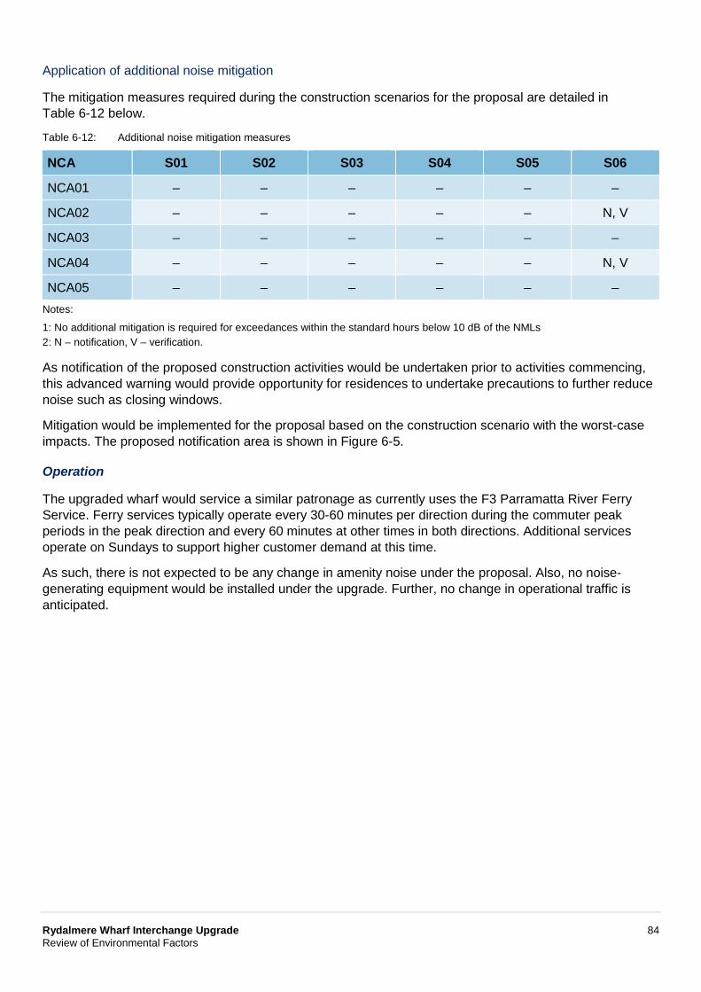
Rydalmere Wharf Interchange Upgrade 84 Review of Environmental Factors
Application of additional noise mitigation
The mitigation measures required during the construction scenarios for the proposal are detailed in Table 6-12 below.
Table 6-12: Additional noise mitigation measures
NCA S01 S02 S03 S04 S05 S06
NCA01 – – – – – –
NCA02 – – – – – N, V
NCA03 – – – – – –
NCA04 – – – – – N, V
NCA05 – – – – – – Notes:
1: No additional mitigation is required for exceedances within the standard hours below 10 dB of the NMLs 2: N – notification, V – verification.
As notification of the proposed construction activities would be undertaken prior to activities commencing, this advanced warning would provide opportunity for residences to undertake precautions to further reduce noise such as closing windows.
Mitigation would be implemented for the proposal based on the construction scenario with the worst-case impacts. The proposed notification area is shown in Figure 6-5.
Operation
The upgraded wharf would service a similar patronage as currently uses the F3 Parramatta River Ferry Service. Ferry services typically operate every 30-60 minutes per direction during the commuter peak periods in the peak direction and every 60 minutes at other times in both directions. Additional services operate on Sundays to support higher customer demand at this time.
As such, there is not expected to be any change in amenity noise under the proposal. Also, no noise-generating equipment would be installed under the upgrade. Further, no change in operational traffic is anticipated.
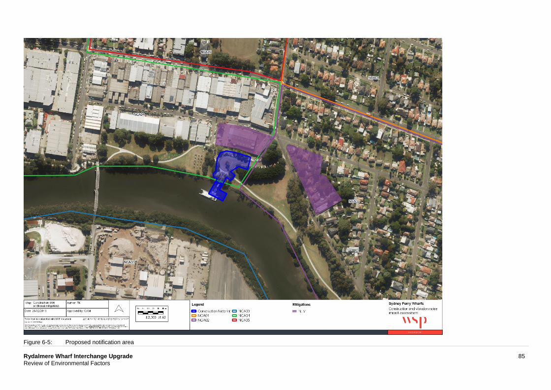
Rydalmere Wharf Interchange Upgrade 85 Review of Environmental Factors
Figure 6-5: Proposed notification area
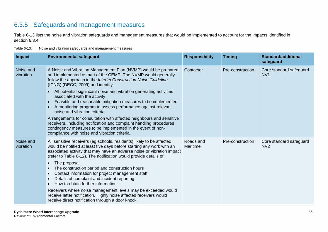
Rydalmere Wharf Interchange Upgrade 86 Review of Environmental Factors
6.3.5 Safeguards and management measures Table 6-13 lists the noise and vibration safeguards and management measures that would be implemented to account for the impacts identified in section 6.3.4.
Table 6-13: Noise and vibration safeguards and management measures
Impact Environmental safeguard Responsibility Timing Standard/additional safeguard
Noise and vibration
A Noise and Vibration Management Plan (NVMP) would be prepared and implemented as part of the CEMP. The NVMP would generally follow the approach in the Interim Construction Noise Guideline (ICNG) (DECC, 2009) and identify: • All potential significant noise and vibration generating activities
associated with the activity • Feasible and reasonable mitigation measures to be implemented • A monitoring program to assess performance against relevant
noise and vibration criteria. Arrangements for consultation with affected neighbours and sensitive receivers, including notification and complaint handling procedures contingency measures to be implemented in the event of non-compliance with noise and vibration criteria.
Contactor Pre-construction Core standard safeguard NV1
Noise and vibration
All sensitive receivers (eg schools, residents) likely to be affected would be notified at least five days before starting any work with an associated activity that may have an adverse noise or vibration impact (refer to Table 6-12). The notification would provide details of: • The proposal • The construction period and construction hours • Contact information for project management staff • Details of complaint and incident reporting • How to obtain further information. Receivers where noise management levels may be exceeded would receive letter notification. Highly noise affected receivers would receive direct notification through a door knock.
Roads and Maritime
Pre-construction Core standard safeguard NV2
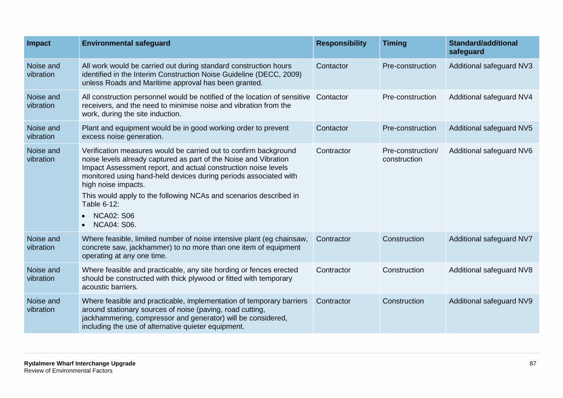
Rydalmere Wharf Interchange Upgrade 87 Review of Environmental Factors
Impact Environmental safeguard Responsibility Timing Standard/additional safeguard
Noise and vibration
All work would be carried out during standard construction hours identified in the Interim Construction Noise Guideline (DECC, 2009) unless Roads and Maritime approval has been granted.
Contactor Pre-construction Additional safeguard NV3
Noise and vibration
All construction personnel would be notified of the location of sensitive receivers, and the need to minimise noise and vibration from the work, during the site induction.
Contactor Pre-construction Additional safeguard NV4
Noise and vibration
Plant and equipment would be in good working order to prevent excess noise generation.
Contactor Pre-construction Additional safeguard NV5
Noise and vibration
Verification measures would be carried out to confirm background noise levels already captured as part of the Noise and Vibration Impact Assessment report, and actual construction noise levels monitored using hand-held devices during periods associated with high noise impacts. This would apply to the following NCAs and scenarios described in Table 6-12: • NCA02: S06 • NCA04: S06.
Contractor Pre-construction/ construction
Additional safeguard NV6
Noise and vibration
Where feasible, limited number of noise intensive plant (eg chainsaw, concrete saw, jackhammer) to no more than one item of equipment operating at any one time.
Contractor Construction Additional safeguard NV7
Noise and vibration
Where feasible and practicable, any site hording or fences erected should be constructed with thick plywood or fitted with temporary acoustic barriers.
Contractor Construction Additional safeguard NV8
Noise and vibration
Where feasible and practicable, implementation of temporary barriers around stationary sources of noise (paving, road cutting, jackhammering, compressor and generator) will be considered, including the use of alternative quieter equipment.
Contractor Construction Additional safeguard NV9
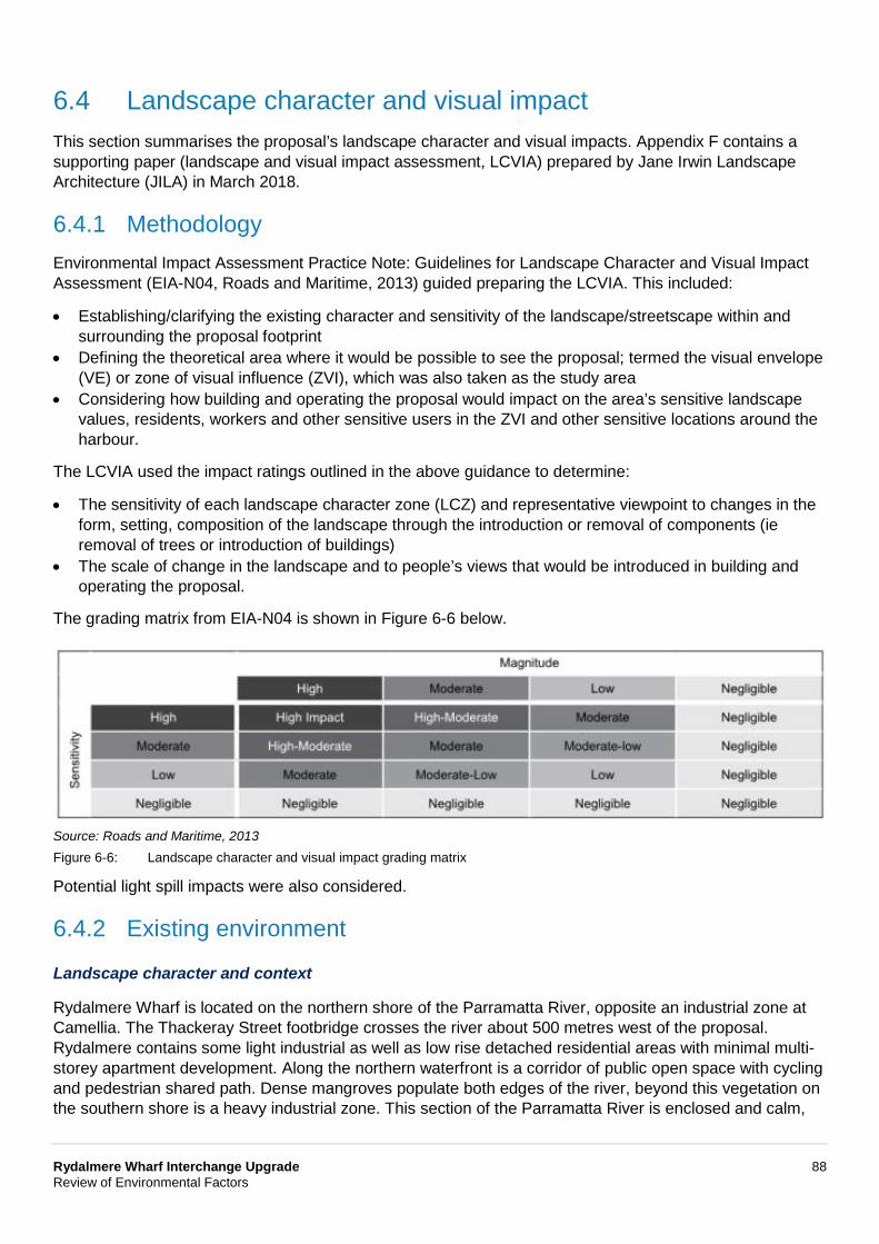
Rydalmere Wharf Interchange Upgrade 88 Review of Environmental Factors
6.4 Landscape character and visual impact This section summarises the proposal’s landscape character and visual impacts. Appendix F contains a supporting paper (landscape and visual impact assessment, LCVIA) prepared by Jane Irwin Landscape Architecture (JILA) in March 2018.
6.4.1 Methodology Environmental Impact Assessment Practice Note: Guidelines for Landscape Character and Visual Impact Assessment (EIA-N04, Roads and Maritime, 2013) guided preparing the LCVIA. This included:
• Establishing/clarifying the existing character and sensitivity of the landscape/streetscape within and surrounding the proposal footprint
• Defining the theoretical area where it would be possible to see the proposal; termed the visual envelope (VE) or zone of visual influence (ZVI), which was also taken as the study area
• Considering how building and operating the proposal would impact on the area’s sensitive landscape values, residents, workers and other sensitive users in the ZVI and other sensitive locations around the harbour.
The LCVIA used the impact ratings outlined in the above guidance to determine:
• The sensitivity of each landscape character zone (LCZ) and representative viewpoint to changes in the form, setting, composition of the landscape through the introduction or removal of components (ie removal of trees or introduction of buildings)
• The scale of change in the landscape and to people’s views that would be introduced in building and operating the proposal.
The grading matrix from EIA-N04 is shown in Figure 6-6 below.
Source: Roads and Maritime, 2013 Figure 6-6: Landscape character and visual impact grading matrix
Potential light spill impacts were also considered.
6.4.2 Existing environment
Landscape character and context
Rydalmere Wharf is located on the northern shore of the Parramatta River, opposite an industrial zone at Camellia. The Thackeray Street footbridge crosses the river about 500 metres west of the proposal. Rydalmere contains some light industrial as well as low rise detached residential areas with minimal multi-storey apartment development. Along the northern waterfront is a corridor of public open space with cycling and pedestrian shared path. Dense mangroves populate both edges of the river, beyond this vegetation on the southern shore is a heavy industrial zone. This section of the Parramatta River is enclosed and calm,
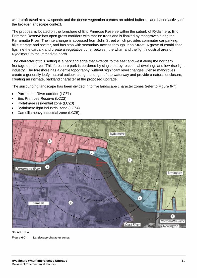
Rydalmere Wharf Interchange Upgrade 89 Review of Environmental Factors
watercraft travel at slow speeds and the dense vegetation creates an added buffer to land based activity of the broader landscape context.
The proposal is located on the foreshore of Eric Primrose Reserve within the suburb of Rydalmere. Eric Primrose Reserve has open grass corridors with mature trees and is flanked by mangroves along the Parramatta River. The interchange is accessed from John Street which provides commuter car parking, bike storage and shelter, and bus stop with secondary access through Jean Street. A grove of established figs line the carpark and create a vegetative buffer between the wharf and the light industrial area of Rydalmere to the immediate north.
The character of this setting is a parkland edge that extends to the east and west along the northern frontage of the river. This foreshore park is bordered by single storey residential dwellings and low-rise light industry. The foreshore has a gentle topography, without significant level changes. Dense mangroves create a generally leafy, natural outlook along the length of the waterway and provide a natural enclosure, creating an intimate, parkland character at the proposed upgrade.
The surrounding landscape has been divided in to five landscape character zones (refer to Figure 6-7).
• Parramatta River corridor (LCZ1) • Eric Primrose Reserve (LCZ2) • Rydalmere residential zone (LCZ3) • Rydalmere light industrial zone (LCZ4) • Camellia heavy industrial zone (LCZ5).
Source: JILA
Figure 6-7: Landscape character zones
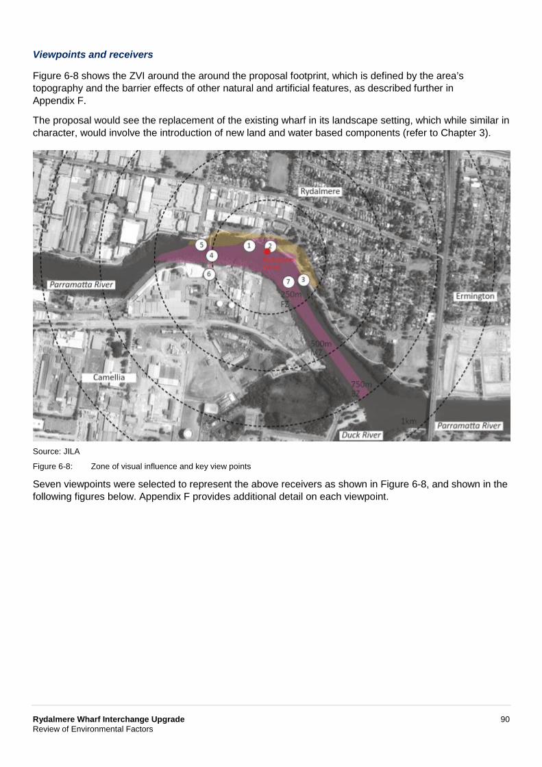
Rydalmere Wharf Interchange Upgrade 90 Review of Environmental Factors
Viewpoints and receivers
Figure 6-8 shows the ZVI around the around the proposal footprint, which is defined by the area’s topography and the barrier effects of other natural and artificial features, as described further in Appendix F.
The proposal would see the replacement of the existing wharf in its landscape setting, which while similar in character, would involve the introduction of new land and water based components (refer to Chapter 3).
Source: JILA
Figure 6-8: Zone of visual influence and key view points
Seven viewpoints were selected to represent the above receivers as shown in Figure 6-8, and shown in the following figures below. Appendix F provides additional detail on each viewpoint.
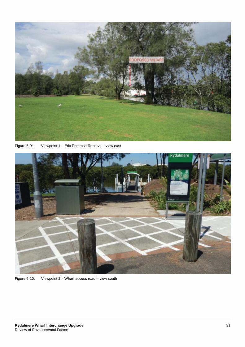
Rydalmere Wharf Interchange Upgrade 91 Review of Environmental Factors
Figure 6-9: Viewpoint 1 – Eric Primrose Reserve – view east
Figure 6-10: Viewpoint 2 – Wharf access road – view south
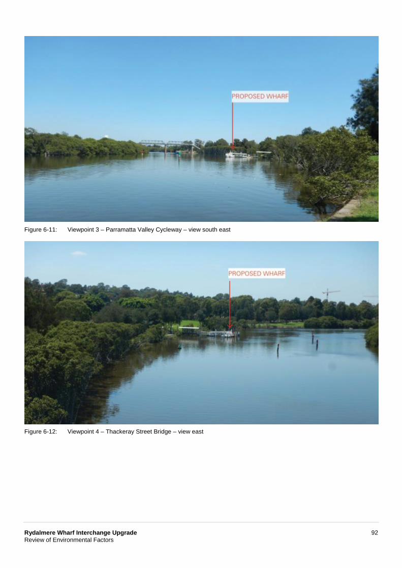
Rydalmere Wharf Interchange Upgrade 92 Review of Environmental Factors
Figure 6-11: Viewpoint 3 – Parramatta Valley Cycleway – view south east
Figure 6-12: Viewpoint 4 – Thackeray Street Bridge – view east
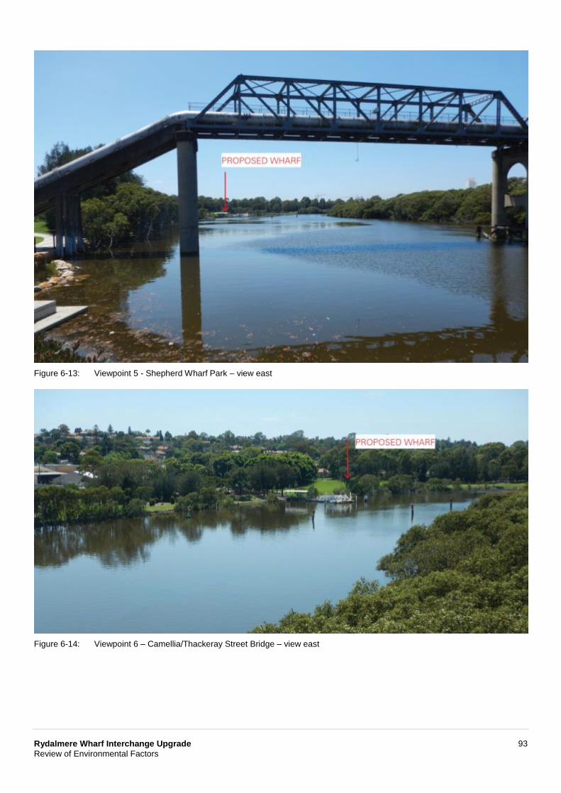
Rydalmere Wharf Interchange Upgrade 93 Review of Environmental Factors
Figure 6-13: Viewpoint 5 - Shepherd Wharf Park – view east
Figure 6-14: Viewpoint 6 – Camellia/Thackeray Street Bridge – view east
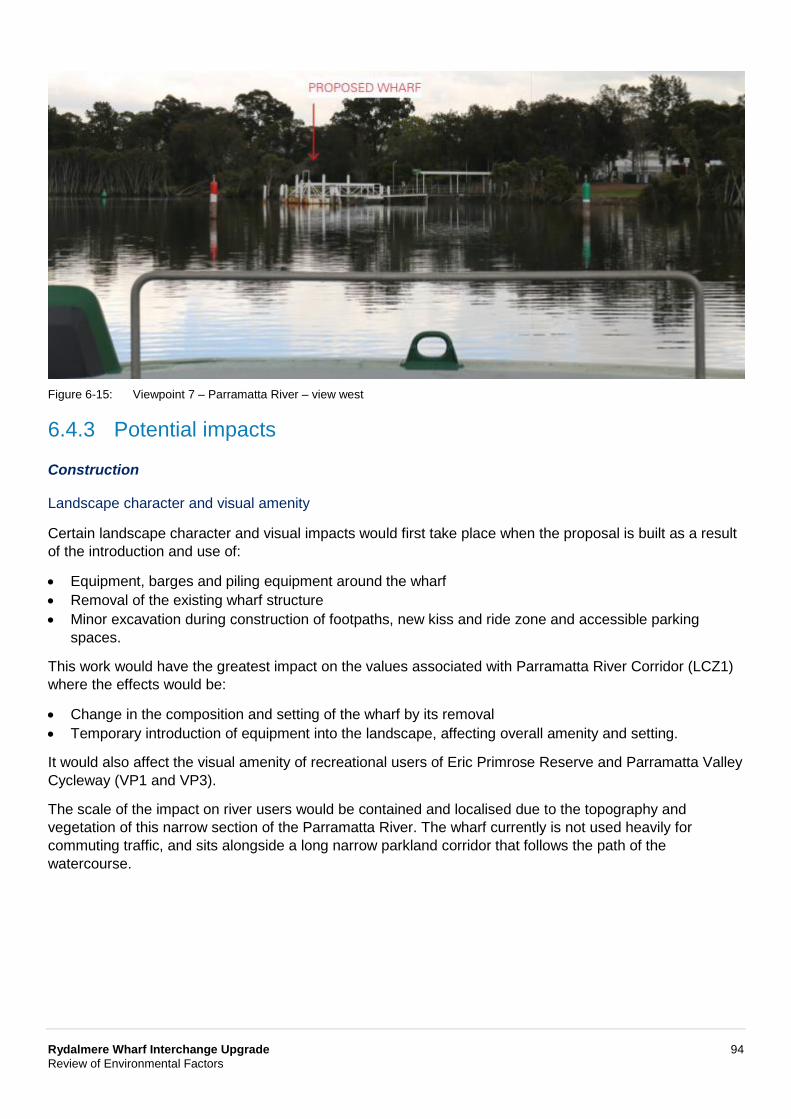
Rydalmere Wharf Interchange Upgrade 94 Review of Environmental Factors
Figure 6-15: Viewpoint 7 – Parramatta River – view west
6.4.3 Potential impacts
Construction
Landscape character and visual amenity
Certain landscape character and visual impacts would first take place when the proposal is built as a result of the introduction and use of:
• Equipment, barges and piling equipment around the wharf • Removal of the existing wharf structure • Minor excavation during construction of footpaths, new kiss and ride zone and accessible parking
spaces.
This work would have the greatest impact on the values associated with Parramatta River Corridor (LCZ1) where the effects would be:
• Change in the composition and setting of the wharf by its removal • Temporary introduction of equipment into the landscape, affecting overall amenity and setting.
It would also affect the visual amenity of recreational users of Eric Primrose Reserve and Parramatta Valley Cycleway (VP1 and VP3).
The scale of the impact on river users would be contained and localised due to the topography and vegetation of this narrow section of the Parramatta River. The wharf currently is not used heavily for commuting traffic, and sits alongside a long narrow parkland corridor that follows the path of the watercourse.
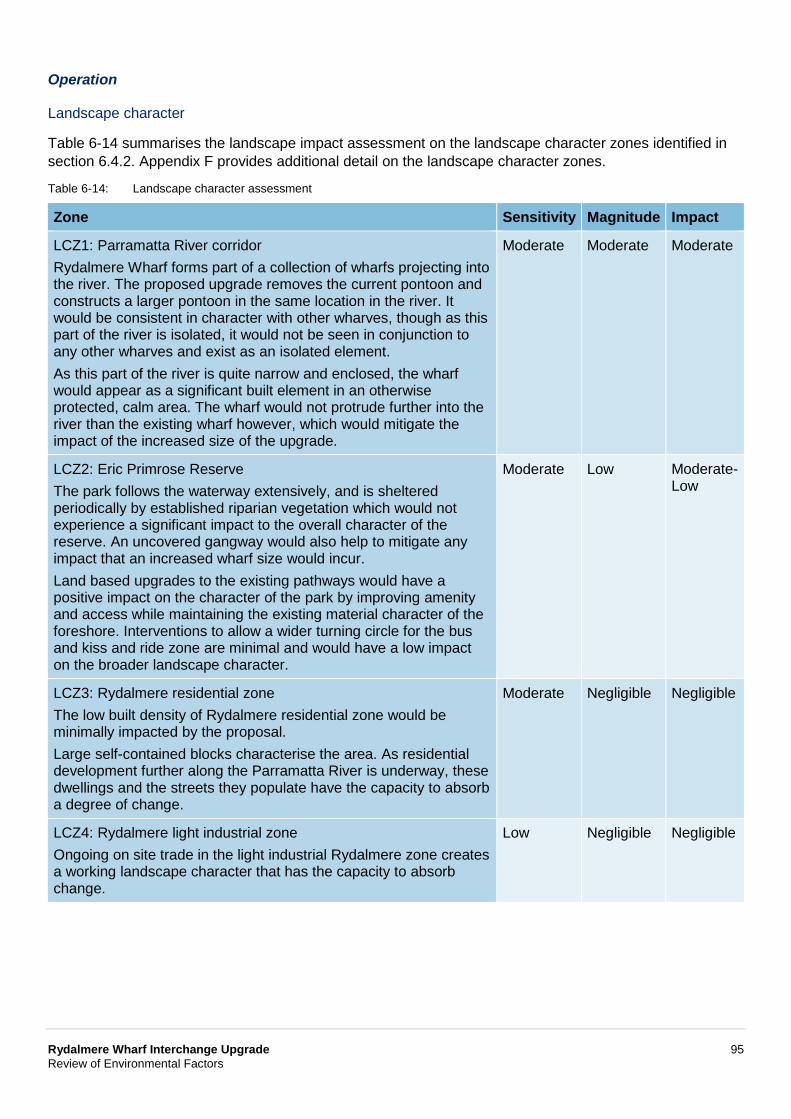
Rydalmere Wharf Interchange Upgrade 95 Review of Environmental Factors
Operation
Landscape character
Table 6-14 summarises the landscape impact assessment on the landscape character zones identified in section 6.4.2. Appendix F provides additional detail on the landscape character zones.
Table 6-14: Landscape character assessment
Zone Sensitivity Magnitude Impact
LCZ1: Parramatta River corridor Rydalmere Wharf forms part of a collection of wharfs projecting into the river. The proposed upgrade removes the current pontoon and constructs a larger pontoon in the same location in the river. It would be consistent in character with other wharves, though as this part of the river is isolated, it would not be seen in conjunction to any other wharves and exist as an isolated element. As this part of the river is quite narrow and enclosed, the wharf would appear as a significant built element in an otherwise protected, calm area. The wharf would not protrude further into the river than the existing wharf however, which would mitigate the impact of the increased size of the upgrade.
Moderate Moderate Moderate
LCZ2: Eric Primrose Reserve The park follows the waterway extensively, and is sheltered periodically by established riparian vegetation which would not experience a significant impact to the overall character of the reserve. An uncovered gangway would also help to mitigate any impact that an increased wharf size would incur. Land based upgrades to the existing pathways would have a positive impact on the character of the park by improving amenity and access while maintaining the existing material character of the foreshore. Interventions to allow a wider turning circle for the bus and kiss and ride zone are minimal and would have a low impact on the broader landscape character.
Moderate Low Moderate-Low
LCZ3: Rydalmere residential zone The low built density of Rydalmere residential zone would be minimally impacted by the proposal. Large self-contained blocks characterise the area. As residential development further along the Parramatta River is underway, these dwellings and the streets they populate have the capacity to absorb a degree of change.
Moderate Negligible Negligible
LCZ4: Rydalmere light industrial zone Ongoing on site trade in the light industrial Rydalmere zone creates a working landscape character that has the capacity to absorb change.
Low Negligible Negligible
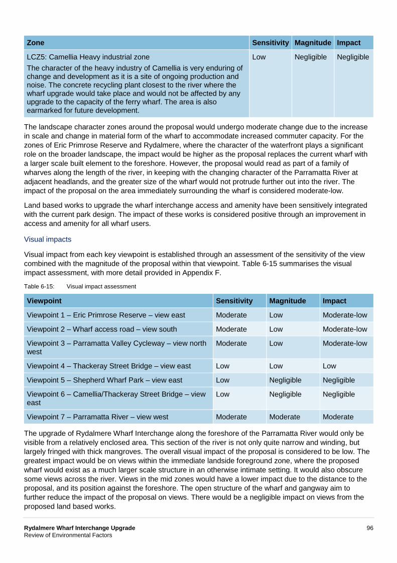
Rydalmere Wharf Interchange Upgrade 96 Review of Environmental Factors
Zone Sensitivity Magnitude Impact
LCZ5: Camellia Heavy industrial zone The character of the heavy industry of Camellia is very enduring of change and development as it is a site of ongoing production and noise. The concrete recycling plant closest to the river where the wharf upgrade would take place and would not be affected by any upgrade to the capacity of the ferry wharf. The area is also earmarked for future development.
Low Negligible Negligible
The landscape character zones around the proposal would undergo moderate change due to the increase in scale and change in material form of the wharf to accommodate increased commuter capacity. For the zones of Eric Primrose Reserve and Rydalmere, where the character of the waterfront plays a significant role on the broader landscape, the impact would be higher as the proposal replaces the current wharf with a larger scale built element to the foreshore. However, the proposal would read as part of a family of wharves along the length of the river, in keeping with the changing character of the Parramatta River at adjacent headlands, and the greater size of the wharf would not protrude further out into the river. The impact of the proposal on the area immediately surrounding the wharf is considered moderate-low.
Land based works to upgrade the wharf interchange access and amenity have been sensitively integrated with the current park design. The impact of these works is considered positive through an improvement in access and amenity for all wharf users.
Visual impacts
Visual impact from each key viewpoint is established through an assessment of the sensitivity of the view combined with the magnitude of the proposal within that viewpoint. Table 6-15 summarises the visual impact assessment, with more detail provided in Appendix F.
Table 6-15: Visual impact assessment
Viewpoint Sensitivity Magnitude Impact
Viewpoint 1 – Eric Primrose Reserve – view east Moderate Low Moderate-low
Viewpoint 2 – Wharf access road – view south Moderate Low Moderate-low
Viewpoint 3 – Parramatta Valley Cycleway – view north west
Moderate Low Moderate-low
Viewpoint 4 – Thackeray Street Bridge – view east Low Low Low
Viewpoint 5 – Shepherd Wharf Park – view east Low Negligible Negligible
Viewpoint 6 – Camellia/Thackeray Street Bridge – view east
Low Negligible Negligible
Viewpoint 7 – Parramatta River – view west Moderate Moderate Moderate
The upgrade of Rydalmere Wharf Interchange along the foreshore of the Parramatta River would only be visible from a relatively enclosed area. This section of the river is not only quite narrow and winding, but largely fringed with thick mangroves. The overall visual impact of the proposal is considered to be low. The greatest impact would be on views within the immediate landside foreground zone, where the proposed wharf would exist as a much larger scale structure in an otherwise intimate setting. It would also obscure some views across the river. Views in the mid zones would have a lower impact due to the distance to the proposal, and its position against the foreshore. The open structure of the wharf and gangway aim to further reduce the impact of the proposal on views. There would be a negligible impact on views from the proposed land based works.
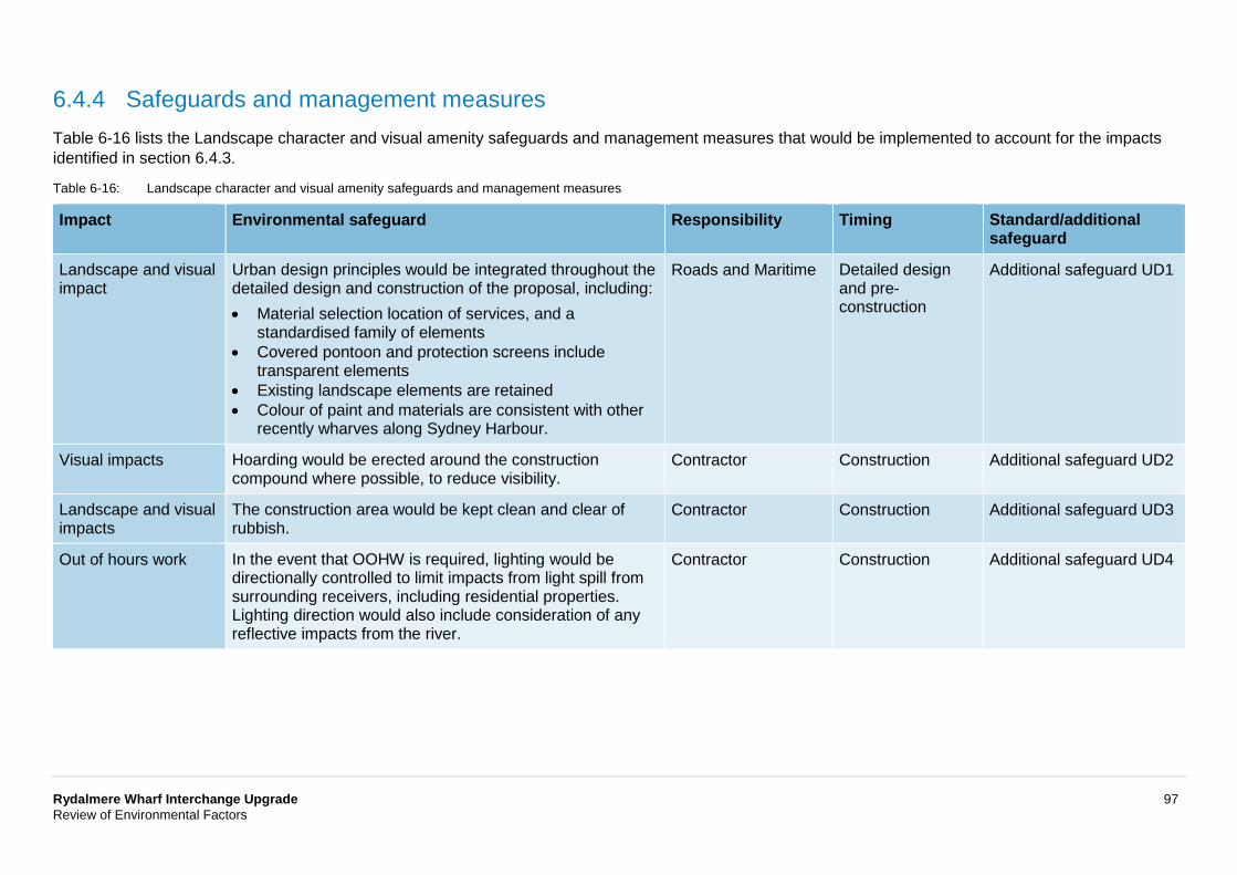
Rydalmere Wharf Interchange Upgrade 97 Review of Environmental Factors
6.4.4 Safeguards and management measures Table 6-16 lists the Landscape character and visual amenity safeguards and management measures that would be implemented to account for the impacts identified in section 6.4.3.
Table 6-16: Landscape character and visual amenity safeguards and management measures
Impact Environmental safeguard Responsibility Timing Standard/additional safeguard
Landscape and visual impact
Urban design principles would be integrated throughout the detailed design and construction of the proposal, including: • Material selection location of services, and a
standardised family of elements • Covered pontoon and protection screens include
transparent elements • Existing landscape elements are retained • Colour of paint and materials are consistent with other
recently wharves along Sydney Harbour.
Roads and Maritime Detailed design and pre-construction
Additional safeguard UD1
Visual impacts Hoarding would be erected around the construction compound where possible, to reduce visibility.
Contractor Construction Additional safeguard UD2
Landscape and visual impacts
The construction area would be kept clean and clear of rubbish.
Contractor Construction Additional safeguard UD3
Out of hours work In the event that OOHW is required, lighting would be directionally controlled to limit impacts from light spill from surrounding receivers, including residential properties. Lighting direction would also include consideration of any reflective impacts from the river.
Contractor Construction Additional safeguard UD4
Rydalmere Wharf Interchange Upgrade 98 Review of Environmental Factors
6.5 Socioeconomic This section describes the proposal’s socioeconomic impacts.
6.5.1 Methodology The assessment considered the community, business and industry impacts and benefits from building and operating the proposal. Specifically, it considered impacts on:
• The local community in terms of its adoption or opposition to the proposal based on its characteristics and profile
• Social amenity and infrastructure in the area • The community’s values such as amenity, character, health and safety, cohesion, environment, sense
of place, fears and aspirations • Local and regional business, including the aquatic based companies that use the harbour and ferry
passenger services.
This involved reviewing published Census data, council information and records, literature, as well as community and stakeholder feedback received for the proposal (refer to Chapter 5). The output from other assessments included in the REF containing relevant socioeconomic themes was also reviewed, namely:
• Noise and vibration • Non-Aboriginal heritage • Landscape character and visual impacts.
A basic level of assessment was carried out in accordance with Environmental Impact Assessment Practice Note: Socio-Economic Assessment (EIA-N05, Roads and Maritime, 2014). Unless otherwise stated, the referenced Census data covered is based on the Rydalmere State Suburb, as shown in Figure 6-16.
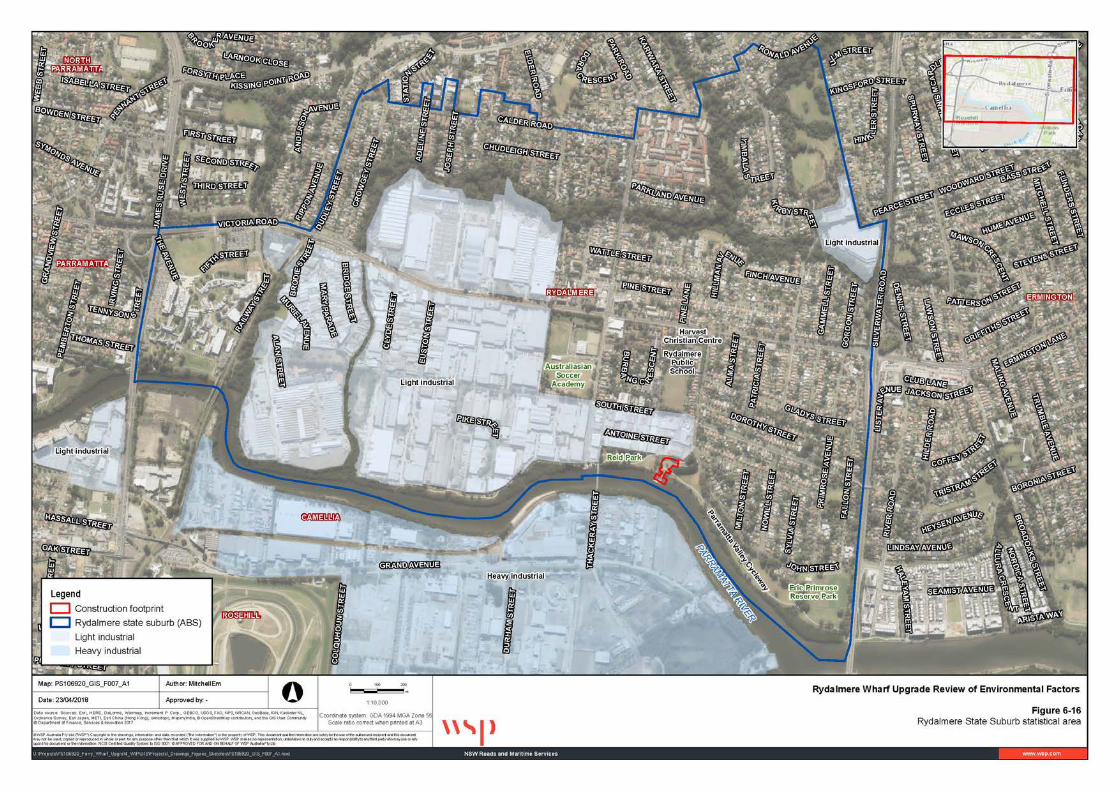
Rydalmere Wharf Interchange Upgrade 99 Review of Environmental Factors
Figure 6-16: Rydalmere State Suburb statistical area
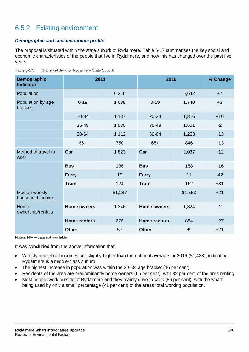
Rydalmere Wharf Interchange Upgrade 100 Review of Environmental Factors
6.5.2 Existing environment
Demographic and socioeconomic profile
The proposal is situated within the state suburb of Rydalmere. Table 6-17 summarises the key social and economic characteristics of the people that live in Rydalmere, and how this has changed over the past five years.
Table 6-17: Statistical data for Rydalmere State Suburb
Demographic Indicator
2011 2016 % Change
Population 6,216 6,642 +7
Population by age bracket
0-19 1,688 0-19 1,740 +3
20-34 1,137 20-34 1,316 +16
35-49 1,530 35-49 1,501 -2
50-64 1,112 50-64 1,253 +13
65+ 750 65+ 846 +13
Method of travel to work
Car 1,823 Car 2,037 +12
Bus 136 Bus 158 +16
Ferry 19 Ferry 11 -42
Train 124 Train 162 +31
Median weekly household income
$1,287 $1,553 +21
Home ownership/rentals
Home owners 1,346 Home owners 1,324 -2
Home renters 675 Home renters 854 +27
Other 57 Other 69 +21 Notes: N/A – data not available
It was concluded from the above information that:
• Weekly household incomes are slightly higher than the national average for 2016 ($1,438), indicating Rydalmere is a middle-class suburb
• The highest increase in population was within the 20–34 age bracket (16 per cent) • Residents of the area are predominantly home owners (65 per cent), with 32 per cent of the area renting • Most people work outside of Rydalmere and they mainly drive to work (86 per cent), with the wharf
being used by only a small percentage (<1 per cent) of the areas total working population.
Rydalmere Wharf Interchange Upgrade 101 Review of Environmental Factors
Community values
Community values are those socioeconomic aspects that people hold important to their quality of life and wellbeing. They include physical assets, such as parks and recreational areas, as well as social factors such as a sense of safety and wellbeing, belonging and community diversity.
Accordingly, there is considered to be a high level of community value associated with the existing wharf, Eric Primrose Reserve and the Parramatta Valley Cycleway. These values relate to the area’s landscape values, and setting within the reserve.
Community values are likely dominated by people who live in the area. These values likely include:
• Retained local character defined by the ease of access to facilities • Local amenity and a sense of place, as provided by Eric Primrose Reserve and setting within the
Parramatta River • Liveability due to river and harbour access and waterfront living.
Social infrastructure
Social infrastructure refers to the community facilities, services and networks that help individuals, families, groups and communities meet their social needs, maximise their potential for development, and enhance their community well-being. It includes such things as: educational facilities; health, emergency and aged-care services; sports, recreational and cultural facilities; community support services; and transport facilities.
The social infrastructure associated with the proposal includes (refer to Figure 6-16):
• Eric Primrose Reserve, Reid Park and Australasian Soccer Academy, due to its recreational and amenity use. These parks also support several recreational activities, including: playground; seating areas; open grass areas for recreation and barbeque areas
• The existing ferry wharf, which provides a means for passengers to travel between key locations in Sydney Harbour and along the Parramatta River
• The Parramatta Valley Cycleway, which provides a shared use path for cyclists and pedestrians which is generally aligned along the foreshore of the Parramatta River
• Place of worship (Harvest Christian Centre) located on Victoria Road • Educational institution and outdoor passive recreation associated with Rydalmere Public School.
Local businesses
Local businesses and services adjacent to the proposal are primarily light and heavy industrial zones. Local businesses within 500 metres of the wharf include (refer to Figure 6-16):
• Heavy industrial businesses south of the proposal across the river at Camellia, including concrete recycling facilities and distribution centres
• Light industrial businesses north west of the proposal at Rydalmere, including a variety of automotive services and repairers.
Rydalmere Wharf Interchange Upgrade 102 Review of Environmental Factors
6.5.3 Potential impacts
Construction
Rydalmere Wharf would be closed throughout the construction period in conjunction with Parramatta Wharf as described in Chapter 3.
Alternative transport would operate for the duration of the closure between Parramatta Wharf and Sydney Olympic Park Wharf via South Street Rydalmere. Ferry users that would typically use Rydalmere Wharf would be able to catch a temporary bus service, route 535, to Sydney Olympic Park Wharf, which would connect with F3 Parramatta River ferry services. Ferry users travelling to or from the city could also catch existing bus services on route M52 from Victoria Road to Circular Quay.
The closure of the wharf would cause disruption to passengers due to the requirement to switch transport modes. Disruptions would likely involve increased travel times and a short-term amenity loss for bus travel compared to travelling by ferry.
Patronage data for the wharf indicates it is primarily used for recreational purposes, and closure of the wharf would not significantly disrupt commuters. Ferry passengers would be notified ahead of construction and updated whilst the proposal is built to allow journeys to be better planned. In addition, the short-term impacts during construction described above would be offset by the benefits of the upgraded wharf and interchange during operation (see below).
Pedestrian and cyclist access would be maintained during construction. However, access would be temporarily disrupted with footpath routes changed and narrowed throughout the construction period. All Sydney Ferry services would cease operating in the upper Parramatta River. Access is discussed further in section 6.6.
The proposal would also prevent vehicles accessing the interchange and part of the commuter carpark. It is anticipated that construction vehicles would also park within the existing commuter car park, limiting the amount of available car park spaces. However, a minimum of 40 car spaces in the commuter car park would remain available throughout construction for members of the public to access Eric primrose Reserve, as discussed in section 6.6.
Indirect impacts to local businesses in the broader area are unlikely to occur as there are no businesses, including customers or employees, which rely directly on the operation of the wharf or Eric Primrose Reserve. Given the industrial nature of the area, the neighbouring properties would already generate and contribute to the background noise and air quality within proximity to Rydalmere Wharf. As such, these businesses would not be as sensitive to impacts such as noise and air quality which would be associated with the construction of the proposal.
Some local businesses may informally use the parking within Rydalmere Wharf Interchange. This would be impacted during construction with the temporary loss in parking due to the proposal. Parking is discussed further in section 6.6.
There would be temporary loss of amenity in the area surrounding the wharf due to presence of barge mounted cranes, heavy vehicles, footpath and car park alterations and other plant and equipment. Land based construction would also occur, resulting in temporary loss of amenity within the interchange and Eric Primrose Reserve. The temporary loss of amenity may discourage use of these areas in the vicinity of the wharf during construction.
Noise from construction activities would also disrupt the amenity of the area, as discussed in section 6.3. This would impact residents and visitors accessing the foreshore, river and Eric Primrose Reserve.
Rydalmere Wharf Interchange Upgrade 103 Review of Environmental Factors
Operation
Benefits to passenger experience would be provided through the design of the proposal which includes:
• Improved amenity at the wharf • Quicker and more effective embarking and disembarking • Improved access to the ferry network for passengers, including low mobility passengers through a wharf
design that provides disabled and low-mobility access • A covered pontoon, enabling passengers to wait close to ferries in an area with weather protection,
ample seating and customer information • Improved access to the wharf with the installation of new bike racks and upgraded accessible car
spaces • Improved access to the wharf by providing a kiss and ride zone close to the wharf entry • Improved alternative transport arrangements during periods where ferries are unable to travel upriver
through provision of an area where two shuttle buses could pick up and drop off passengers close to the wharf entry
• Improved cyclist and pedestrian access to the wharf, with shared texture paths installed to ensure cyclists slow down at the wharf entry, reducing the risk of collision with users entering and exiting the wharf.
The above benefits would be in context of the limited loss in character and sense of place at the wharf from introducing new infrastructure. Visual impacts during operation of the proposal are considered to be low, as discussed in section 6.4, and moderate to low impact on the landscape character. The design of the wharf is also consistent with other recently upgraded wharves across the network. The minor visual impact is not anticipated to result in any socioeconomic impacts.
During operation, the extra lighting and security cameras at the Rydalmere Wharf Interchange would deter antisocial behaviour from occurring, providing a safer night-time environment.
Rydalmere Wharf Interchange Upgrade 104 Review of Environmental Factors
6.5.4 Safeguards and management measures Table 6-18 lists the socioeconomic safeguards and management measures that would be implemented to account for the impacts identified in section 6.5.3.
Table 6-18: Socioeconomic safeguards and management measures
Impact Environmental safeguard Responsibility Timing Standard/additional safeguard
General socio-economic impacts
A Communication Plan (CP) would be prepared and implemented as part of the CEMP to help provide timely and accurate information to stakeholders during construction. The CP would include (as a minimum): • Mechanisms to provide details and timing of proposed
activities to affected residents and local businesses, including changed traffic and access conditions
• Contact name and number for complaints. The CP would be prepared in accordance with the Community Involvement and Communications Resource Manual (RTA, 2008).
Contractor Pre-construction Core standard safeguard SE1
General socio-economic impacts
An internet site and free-call number would be established for enquiries regarding the proposal for the entirety of construction. Contact details would be clearly displayed at the entrance to the site. All enquiries and complaints would be tracked through a tracking system, and acknowledged within 24 hours of being received.
Roads and Maritime Pre-construction Additional safeguard SE2
Social impacts The construction area would be secured at all times. If required, lighting would be positioned to minimise light spill into neighbouring residences.
Contractor Construction Additional safeguard SE3
Rydalmere Wharf Interchange Upgrade 105 Review of Environmental Factors
6.6 Transport, traffic and access This section describes the land and maritime based traffic, transport and access impacts associated with the proposal.
6.6.1 Existing environment
Maritime transport
Ferry service and frequency
Rydalmere Wharf is serviced by the F3 Parramatta River route, which operates between Circular Quay and Parramatta. The ferry route also services wharves at Parramatta, Sydney Olympic Park, Meadowbank, Kissing Point, Cabarita, Abbotsford Point, Chiswick, Huntleys Point, Drummoyne, Barangaroo, Cockatoo Island, Balmain, McMahons Point, Milsons Point, Barangaroo and Circular Quay.
The F3 Parramatta River service operates at Rydalmere between about 6am and 8pm daily. Ferry services typically operate every 30 minutes during the commuter peak periods towards the city and every 60 minutes towards Parramatta. At other times, the ferry service operates every 60 minutes in both directions. Supplementary ferry services also operate on Sundays to support higher customer demand on this day. in both directions. A review of wharf statistics completed during the concept design stage indicated the average weekday patronage for Rydalmere is about 475 passengers. Patronage data indicates that the use of the wharf is highest during weekday off-peak and weekend patronage periods.
A review of wharf statistics completed during the concept design stage indicated the average weekday patronage for Rydalmere is about 475 passengers. Patronage data indicates that the use of the wharf is highest during weekday off-peak and weekend patronage periods.
Commercial and recreational activity
Private water taxi services, commercial recreational vessels and other recreational activities are not permitted within the upper Parramatta River (west of Silverwater Bridge) and therefore do not utilise Rydalmere Wharf, which is exclusively operated by the Harbour City Ferries.
Land transport and parking
The proposal is located within Rydalmere, which can be accessed from John Street near the intersection of Antoine Street. Secondary access is also provided from a laneway to Jean Street. John Street is a local road that travels through residential and industrial areas, which generally runs parallel to the Parramatta River foreshore before crossing the intersection of Antoine Street, where it continues north to Victoria Road. Vehicles accessing the road at the proposal footprint comprise ferry users accessing the wharf and visitors to Eric Primrose Reserve. Commuter parking is provided at Rydalmere Wharf, with a total of 71 parking spaces and two non-DDA compliant accessible parking spaces. Additional parking is also provided on Jean Street which offers pedestrian access to the wharf through Eric Primrose Reserve.
The road network within the vicinity of the wharf is characterised by residential streets with on-street and off-street parking. Speed limits in the area are generally 50 kilometres per hour in the vicinity of the proposal.
The nearest bus stop is 320 metres away from Rydalmere Wharf and is not part of the interchange. The hourly bus service profile for Rydalmere Wharf indicates that there are 30 minute services in the morning and afternoon peak period, which corresponds to the ferry frequency; however, given that the nearest bus stop is 320 metres from the wharf, it is anticipated that transfers between regularly scheduled bus services and the ferry are uncommon. Similarly, Rydalmere train station is approximately 2.3 kilometres (28-minute
Rydalmere Wharf Interchange Upgrade 106 Review of Environmental Factors
walk) from Rydalmere Wharf. As such there is little integration between the ferry and other public transport at Rydalmere Wharf.
Shuttle buses replace ferry services between Rydalmere and Parramatta wharves during low tide due to the shallow depth of the Parramatta River. However, due to access constraints within the Rydalmere Wharf Interchange, buses currently stop on John Street as they are unable to use the current turning circle.
Pedestrians can access the wharf via a footpath connection to John Street to the east and to the end of Jean Street north west of the wharf interchange. The footpath to John Street is narrow (1.2 metres wide) and encircles the cul-de-sac before travelling along the northern boundary of the interchange car park out to John Street. There is also a section of footpath along the southern boundary of the car park that connects to the existing disabled parking spaces.
Cyclists can access the wharf facility using the adjacent 3-metre shared path known as the Parramatta Valley Cycleway. The Parramatta Valley Cycleway is a regional bicycle route which generally runs along the Parramatta River, providing a connection between Parramatta Park to Morrison Bay Park in Putney. There are also on-road cyclist line markings on John Street to the east of the site and Antoine Street to the north.
6.6.2 Potential impacts
Construction
Maritime transport
Rydalmere Wharf would be closed for up to five months throughout the construction period. As the wharf is exclusively used by the Harbour City Ferries it would not impact any recreational or commercial users. However, the closure of Rydalmere Wharf would prevent also Harbour City Ferries from accessing Parramatta Wharf during construction. To mitigate this impact, the Parramatta Wharf Interchange upgrade would be constructed concurrently with the proposal. Cumulative impacts are discussed further in section 6.12.
Based on patronage statistics for the Rydalmere Wharf Interchange, there would be disruption to up to 475 passengers per day due to closure of the wharf. Alternative transport would operate for the duration of the closure between Parramatta Wharf and Sydney Olympic Park Wharf via South Street Rydalmere. Ferry users that would typically use Rydalmere Wharf would be able to catch a temporary bus service, route 535, to Sydney Olympic Park Wharf, which would connect with F3 Parramatta River ferry services. Ferry users travelling to or from the city could also catch existing bus services on route M52 from Victoria Road to Circular Quay.
Construction of the proposal would result in up to four vessels travelling between an off-site facility and the wharf each day. The minor increase in vessel movements is not considered to be significant in the context of the harbour and Parramatta River.
Land transport
Access would be confirmed by the construction contractor. It is anticipated that construction vehicles would access the proposal footprint via John Street from Victoria Road and would park within the existing commuter car park. A minimum of 40 car spaces in the commuter car park would remain available throughout construction for members of the public to access Eric primrose Reserve.
As detailed in section 3.4.1, up to 20 light and heavy vehicles would access the site each day, under a worst-case scenario, which assumes that no materials or equipment are shipped to site. The additional light and heavy vehicles required throughout construction would also not place any additional strain on the surrounding road network due to the minor amount of traffic movements.
Rydalmere Wharf Interchange Upgrade 107 Review of Environmental Factors
The proposal would also prevent vehicles accessing the interchange and part of the commuter carpark. Whilst temporary disruption is anticipated, a traffic control plan would be implemented to control vehicle movements through various stages of the works.
Closure of Rydalmere Wharf Interchange may result in additional commuter traffic as ferry passengers would utilise a replacement bus service, discussed further below, or private vehicles for five months during construction. Based on patronage data for the wharf, this could include up to 475 vehicles over an average weekday. This traffic would be spaced over the day, and from different locations within the wharf catchment, and is not likely to result in congestion related impacts to the existing road network.
Pedestrian and cyclist access surrounding the wharf would be restricted. However, this would be maintained by providing an alternate route around the construction area.
Operation
No impacts to traffic and transport are anticipated for operation of the proposal. The potential benefits of the proposal are outlined in the sections below.
Maritime transport
Ferry operations to Rydalmere would resume after the proposal is built, and no change in the movement of ferries would be required to access the new wharf.
The proposal would enable the continuation of a ferry service for the period of its 50-year operation life, and would also improve the efficiency and user experience of the wharf.
Land transport
Ferry services would recommence once the new wharf is operational. The proposal would result in the improvement of efficiency and user experience of ferry services from the wharf. This may result in the increased patronage of the wharf and ferry service, and additional commuter traffic travelling to the wharf. However, this is not considered to be significant based on the existing patronage of the wharf, and would reduce traffic in other areas of the network.
The proposal includes realignment of the existing kerb and roundabout, which would provide space for two shuttle buses, and improve traffic flow separating the movement of buses and other vehicles through the interchange. This would also enable buses that operate as a replacement ferry service to park within the interchange when ferry services do not operate between Rydalmere and Parramatta, which is an improvement over the current operation of this service, where buses park on John Street.
The footpaths around the wharf would also be widened to meet DDA and BCA standards, improving accessibility to the wharf from the commuter carpark and would allow for greater separation of cyclists and pedestrians. Texture changes on footpaths would also improve safety for cyclists and pedestrians in the wharf interchange.
Access for cyclists to the wharf would also be improved from the provision of 10 new bike racks.
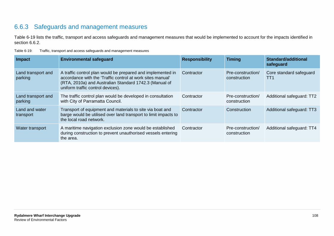
Rydalmere Wharf Interchange Upgrade 108 Review of Environmental Factors
6.6.3 Safeguards and management measures Table 6-19 lists the traffic, transport and access safeguards and management measures that would be implemented to account for the impacts identified in section 6.6.2.
Table 6-19: Traffic, transport and access safeguards and management measures
Impact Environmental safeguard Responsibility Timing Standard/additional safeguard
Land transport and parking
A traffic control plan would be prepared and implemented in accordance with the ‘Traffic control at work sites manual’ (RTA, 2010a) and Australian Standard 1742.3 (Manual of uniform traffic control devices).
Contractor Pre-construction/ construction
Core standard safeguard TT1
Land transport and parking
The traffic control plan would be developed in consultation with City of Parramatta Council.
Contractor Pre-construction/ construction
Additional safeguard: TT2
Land and water transport
Transport of equipment and materials to site via boat and barge would be utilised over land transport to limit impacts to the local road network.
Contractor Construction Additional safeguard: TT3
Water transport A maritime navigation exclusion zone would be established during construction to prevent unauthorised vessels entering the area.
Contractor Pre-construction/ construction
Additional safeguard: TT4
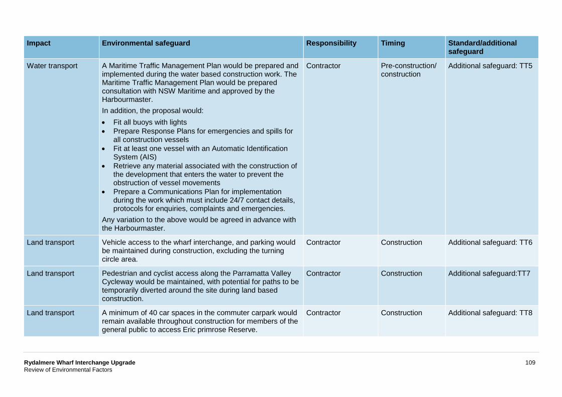
Rydalmere Wharf Interchange Upgrade 109 Review of Environmental Factors
Impact Environmental safeguard Responsibility Timing Standard/additional safeguard
Water transport A Maritime Traffic Management Plan would be prepared and implemented during the water based construction work. The Maritime Traffic Management Plan would be prepared consultation with NSW Maritime and approved by the Harbourmaster. In addition, the proposal would: • Fit all buoys with lights • Prepare Response Plans for emergencies and spills for
all construction vessels • Fit at least one vessel with an Automatic Identification
System (AIS) • Retrieve any material associated with the construction of
the development that enters the water to prevent the obstruction of vessel movements
• Prepare a Communications Plan for implementation during the work which must include 24/7 contact details, protocols for enquiries, complaints and emergencies.
Any variation to the above would be agreed in advance with the Harbourmaster.
Contractor Pre-construction/ construction
Additional safeguard: TT5
Land transport Vehicle access to the wharf interchange, and parking would be maintained during construction, excluding the turning circle area.
Contractor Construction Additional safeguard: TT6
Land transport Pedestrian and cyclist access along the Parramatta Valley Cycleway would be maintained, with potential for paths to be temporarily diverted around the site during land based construction.
Contractor Construction Additional safeguard:TT7
Land transport A minimum of 40 car spaces in the commuter carpark would remain available throughout construction for members of the general public to access Eric primrose Reserve.
Contractor Construction Additional safeguard: TT8
Rydalmere Wharf Interchange Upgrade 110 Review of Environmental Factors
6.7 Non-Aboriginal heritage This section summarises the proposal’s non-Aboriginal heritage impacts. Appendix G contains a supporting technical paper (statement of heritage impact, SOHI) prepared by City Plan Services in March 2018.
6.7.1 Methodology The assessment included a desktop review of published records, data and literature, in the form of local, State, national and world heritage registers, to confirm the likely presence of non-Aboriginal heritage values in the local area.
The assessment also referred to: Assessing Heritage Significance (NSW Heritage Office, 2001), Statements of Heritage Impact (NSW Heritage Office and DUAP, 2002), Assessing Significance for Historical Archaeological Sites and Relics (NSW Heritage Division, 2009) and the NSW Heritage Manual (Heritage Office and DUAP, 1996).
6.7.2 Existing environment The Rydalmere Wharf structure was constructed in 1993 for the ferry service, resuming ferry operation between Meadowbank and Parramatta after a hiatus of 85 years. Rydalmere Wharf is not listed as a heritage item.
A heritage item of local significance identified in the Parramatta LEP as ‘Wetlands’ (Parramatta LEP item no. I1), is mapped to extend through the construction footprint, as shown on Figure 6-17. The wetlands along Parramatta River are of significance for the wider area, and relate to remnant areas of mangroves and salt marshes which once extensively lined the foreshores and tidal water flats of the region.
A number of other heritage items are located in the vicinity of the wharf, including Pumping Station (Parramatta LEP item no. I5), Tram Alignment (Parramatta LEP item no. I6), Truganini House and grounds (Parramatta LEP item no. I591). Heritage items listed on the Sydney Harbour SREP in the vicinity of the wharf include Industrial Wharfs (Sydney Harbour SREP #36).
Analysis of historical and documentary evidence has identified that a wharf was present within the ‘Vineyard Estate’, now the southernmost point of Park Road, from the late 20th century. It appears that this wharf was interchangeably referred to as ‘Shepherd’s Wharf’ or ‘Rydalmere Wharf’; owing to the fact that it had been leased to ‘Shepherd & Co.’ in circa 1890. It has also indicated that by 1910 the ‘Shepherd’s Wharf’ (or ‘Rydalmere Wharf’) was no longer depicted in maps, though it is referred to in historical sources, suggesting that it had fallen into a state of disrepair at this time.
A wharf was not established in the location of the proposal at Rydalmere until 1993 when the present wharf structure was built, to the east of the historical ‘Shepherd’s Wharf’ (or ‘Rydalmere Wharf’) site. The existing wharf has remained largely unchanged since its construction in 1993, with the exception of a canopy to the timber gangway.
A search of the maritime heritage register (NSW OEH, 2018) did not reveal any previous shipwrecks, wharves or other maritime heritage features within proximity to the proposal.
Archaeology
The archaeological potential of the current Rydalmere Wharf structure and land based component is assessed as low on the basis that the above assessment has not indicated the presence of any earlier wharves or structures at the proposal footprint. The present wharf is of modern construction and can yield very little information about historical wharf construction techniques. Likewise, the land based component of the wharf site is a modern installation and does not appear to have been built over any earlier structures.
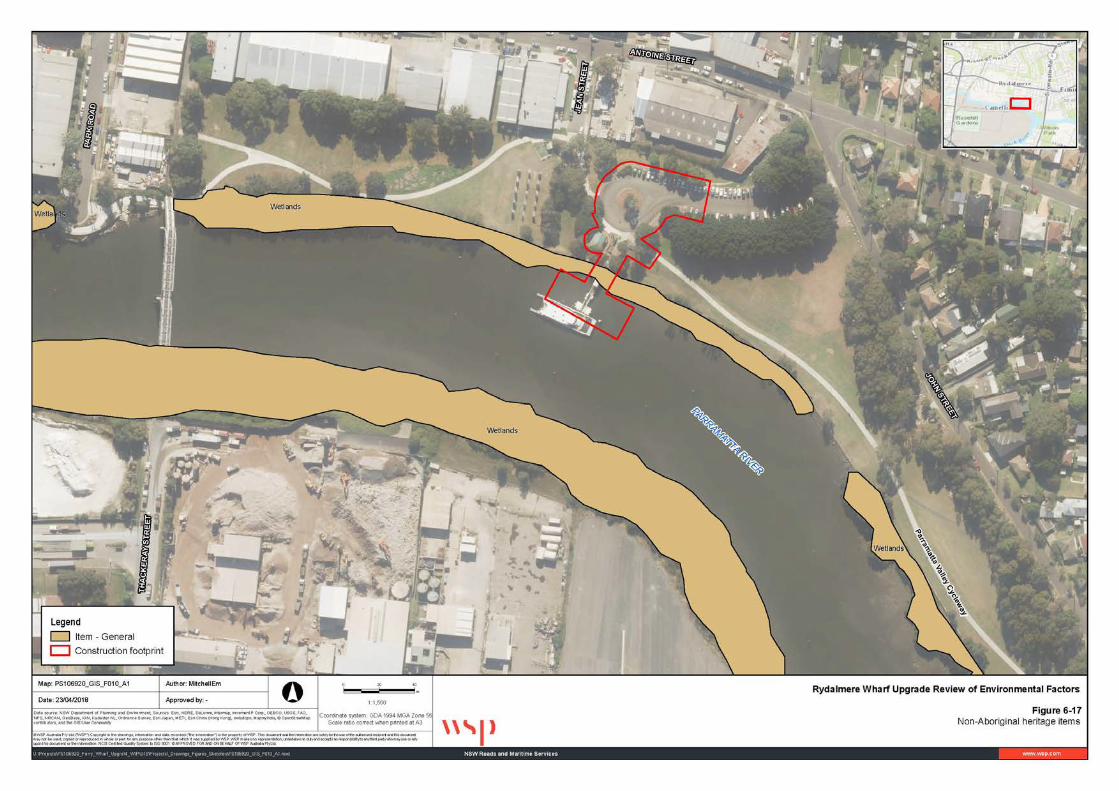
Rydalmere Wharf Interchange Upgrade 111 Review of Environmental Factors
Figure 6-17: Non-Aboriginal heritage items
Rydalmere Wharf Interchange Upgrade 112 Review of Environmental Factors
6.7.3 Potential impacts
Construction
There are no expected direct or indirect impacts to historical heritage items in the vicinity of the proposal. Although the proposed works would occur within the mapped area of heritage item ‘wetlands’ (I1), they would have no direct impact.
The proposed new Rydalmere Wharf would replace the current wharf structure and would not impact the historical ‘Shepherds Wharf’ (or ‘Rydalmere Wharf’) site to the west. The new Rydalmere Wharf would replace the 1993 structure functionally and would involve the removal and demolition of all components and their replacement with a new gangway and pontoon structure, which would match the existing berthing face location.
Archaeology
Due to prior disturbance, the archaeological potential of the Rydalmere Wharf structure and land based component is assessed as low and is therefore considered unlikely to be encountered during construction works. The minor impact upon the sandstone seawall would be minimised with the potential to be reused in the construction of the proposal (refer to section 6.7.4). The safeguards detailed in section 6.7.4 would be implemented in the case of unexpected finds.
Operation
No impacts to non-Aboriginal heritage items are anticipated during operation of the proposal.
Rydalmere Wharf Interchange Upgrade 113 Review of Environmental Factors
6.7.4 Safeguards and management measures Table 6-20 lists the non-Aboriginal heritage safeguards and management measures that would be implemented to account for the impacts identified in section 6.7.3.
Table 6-20: Non-Aboriginal heritage safeguards and management measures
Impact Environmental safeguard Responsibility Timing Standard/additional safeguard
Non-Aboriginal heritage The Standard Management Procedure - Unexpected Heritage Items (Roads and Maritime, 2015) would be followed in the event that any unexpected heritage items, archaeological remains or potential relics of Non-Aboriginal origin are encountered. Work would only re-commence once the requirements of that Procedure have been satisfied.
Contractor Detailed design/ pre-construction
Core standard safeguard H1
Non-Aboriginal heritage Heritage items in the vicinity of the wharf, including the ‘Wetlands’ (Parramatta LEP item no. I1), would be communicated as a ‘no-go zone’ during construction to avoid any potential impacts.
Contractor Construction Additional safeguard H2
Non-Aboriginal heritage Sandstone blocks to be removed as part of modification to the seawall would be salvaged and reused in the new development where possible.
Contractor Construction Additional safeguard H3
Rydalmere Wharf Interchange Upgrade 114 Review of Environmental Factors
6.8 Aboriginal heritage This section summarises the proposal’s Aboriginal heritage impacts. Appendix G contains a preliminary assessment report (as reported under the statement of heritage impact, SOHI) prepared under stage one of the PACHCI by City Plan in March 2018. The Roads and Maritime Aboriginal Cultural Heritage Advisor (ACHA) has issued a Stage 1 clearance letter for the proposal in accordance with PACHCI, included with Appendix H.
6.8.1 Methodology The assessment included a desk review of published records, data and literature, including a records search of the Aboriginal heritage information management system (AHIMS) to confirm the unlikely presence of values in the local area.
The PACHCI assessment also referred to the Guide to Investigating, Assessing and Reporting on Aboriginal Cultural Heritage in NSW (OEH, 2011), the Code of Practice for the Protection of Aboriginal Objects (DECCW, 2010), and the Code of Practice of Archaeological Investigation of Aboriginal Objects in NSW (DECCW, 2010).
6.8.2 Existing environment
Aboriginal history
Aboriginal peoples have been active in the local area for the past 30,000 years as evidenced through radiocarbon dating (refer to Appendix G). The peoples that lived on the Cumberland Plain (the landform of Sydney Harbour) spoke the Darug dialect and used the land for its resources. There were 29 clan groups in total across the metropolitan area, collectively known as the Eora Nation. The Eora was the name given to the coastal Aboriginal peoples around Sydney. More specifically, the Wallumedegal clan inhabited the Rydalmere area at the time of initial European contact. Their territory on the northern bank of the Parramatta River extended from Lane Cove in the east to Ryde in the west.
Recorded items and artefacts
A search of the AHIMS database was undertaken for sites recorded within a 200-metre buffer of the landfall portion of Rydalmere Wharf. The search did not identify any recorded sites within a 200-metre buffer.
Whilst not recorded as a heritage item, the concrete surface adjacent to the wharf is decorated with a number of Aboriginal artworks, commissioned by the City of Parramatta Council; as acknowledged on a heritage-interpretation sign.
6.8.3 Potential impacts The proposed works are unlikely to result in harm to Aboriginal objects and sites, as the works are limited to the existing wharf structure, sea wall and minor public domain works; all of which are within heavily disturbed land. Stage 1 of the Roads and Maritime Procedure for Aboriginal Cultural Heritage Consultation and Investigation (PACHCI) was completed for the proposal, which concluded the proposal was unlikely to have an impact on Aboriginal cultural heritage and did not require further investigations or assessment.
The Standard Management Procedure – Unexpected Heritage Items (Roads and Maritime, 2015) would be followed in the event that unrecorded Aboriginal object(s) are identified during construction.
In addition, the potential for Aboriginal objects to be located within the vicinity of the water’s edge is unlikely, due to infilling and land reclamation undertaken at the time the seawall was constructed.
Rydalmere Wharf Interchange Upgrade 115 Review of Environmental Factors
The Rydalmere Wharf Interchange would continue to operate as a wharf, served by the same vessels, so it is not expected that there would be any change in the nature or severity of impact to unknown Aboriginal objects or sites.
An AHIP under the National Parks and Wildlife Act 1974 is not required for the proposal.
Impacts to the Aboriginal artwork adjacent to the proposal would be avoided, as discussed in section 6.8.4.
Rydalmere Wharf Interchange Upgrade 116 Review of Environmental Factors
6.8.4 Safeguards and management measures Table 6-21 lists the Aboriginal heritage safeguards and management measures that would be implemented to account for the impacts identified in section 6.8.3.
Table 6-21: Aboriginal heritage safeguards and management measures
Impact Environmental safeguard Responsibility Timing Standard/additional safeguard
Unexpected heritage finds
The Standard Management Procedure – Unexpected Heritage Items (Roads and Maritime, 2015) would be followed in the event that (an) unknown or potential Aboriginal object(s), including skeletal remains, is/are found during construction. This applies where Roads and Maritime does not have approval to disturb the object(s) or where a specific safeguard for managing the disturbance (apart from the procedure) is not in place. Work would only restart once the requirements of that procedure have been satisfied.
Contractor Construction Core standard safeguard AH1
Aboriginal art installation
The existing Aboriginal art installation adjacent to the wharf would be communicated as a ‘no-go zone’ and avoided.
Contractor Construction Additional safeguard AH2
Rydalmere Wharf Interchange Upgrade 117 Review of Environmental Factors
6.9 Waste management and resource use This section describes the proposal’s waste management and resource use impacts.
6.9.1 Methodology The assessment considered the impacts associated with:
• Resource use and materials management during construction • Waste generation, management and disposal during construction • The proposal’s ability to respond to waste management and resource conservation plans, policies and
guidelines.
The basis of assessment was to consider the hierarchy of avoiding waste generation and primary resource use in favour of reduction, reuse and recycling, consistent with the NSW Waste Avoidance and Resource Recovery Act 2001.
6.9.2 Existing environment Existing waste management measures in the local area include:
• Rubbish is collected from the wharf by Roads and Maritime as part of the maintenance and operation of the existing structure
• Cleaning of the wharf is undertaken by Roads and Maritime on a weekly basis.
No other waste generating activities are associated with the wharf or ferry service.
As identified in section 6.1.2, asbestos has previously been identified in proximity to the construction works at the wharf.
In terms of resource use, the wharf has required ongoing maintenance, repair and upgrade over time. This has required the use of small quantities of replacement materials such as timber and metal.
6.9.3 Potential impacts
Construction
Resource use
Roads and Maritime adopts a resource reduction strategy based on using:
• Alternative low-energy, high recycled content materials where they are cost and performance competitive and comparable in environmental performance
• Locally sourced materials, noting that most of the materials needed to build the proposal are widely available and typically in abundant supply in the local market
• Alternative forms of material sourcing to reduce the distances or methods travelled to supply materials.
Waste generation and management
The proposal would generate low waste volumes across few waste streams. The main waste would come from decommissioning and dismantling the existing wharf, which would include:
• Concrete and scrap metal that could be reused depending on its condition • Excavated materials from construction works to replace existing footpaths and seawall modification
Rydalmere Wharf Interchange Upgrade 118 Review of Environmental Factors
• Ancillary equipment such as signs, lighting, notice boards, and electronic display boards, some of which may be reusable either on the upgraded wharf or elsewhere depending on its age and condition.
As discussed in section 6.1.3, asbestos has the potential to be present in proximity to the construction works. Any asbestos waste encountered during construction would be removed from the site and disposed of to an appropriately licenced facility and in accordance with the Asbestos Management Plan (refer to section 6.1.4) to be developed for the proposal.
The other wastes generated in building the proposal would be typical to any construction site. They would include:
• Material offcuts (eg glass, wood and metal) that could be reused or recycled • Inert unrestricted packaging waste (eg plastic, paper, wood) that could be recycled • Potential restricted wastes (eg oily rags, empty paint tins, used lubricant tube) that would need
collecting and transferring offsite to a licenced facility • Food waste, which would be collected.
Land based ancillary facilities would be contained within the site compound(s), and include a portable toilet and small shipping container/shed. Minimal storage of materials is anticipated, but may include precast materials and some plant and equipment. Where feasible, materials would be barged to the proposal footprint, including fuels, oils and other required liquids which would be stored in bunded containers. All waste removed from the proposal footprint would be transferred by a licenced contractor to a licenced receiving facility.
Any excavated material would be reused where suitable or classified before being disposed to an appropriately licenced facility in accordance with Waste Classification Guidelines: Part 1 Classifying Waste (EPA 2014). Where necessary, this would include sampling and analysis.
Operation
The waste generation and resource use associated with the operational wharf would be broadly consistent with the current wharf including small amounts of passenger litter and maintenance materials. However, general waste and recycling bins would be installed at the wharf as part of the proposal, with recycling bins currently not provided. The inclusion of recycling bins is considered an improvement over the existing operation of the wharf and supports the Waste Avoidance and Resource Recovery Act 2001.
As noted in the previous section, the expectation is that the amount of ongoing resources needed to maintain the wharf would reduce due to its more durable design.
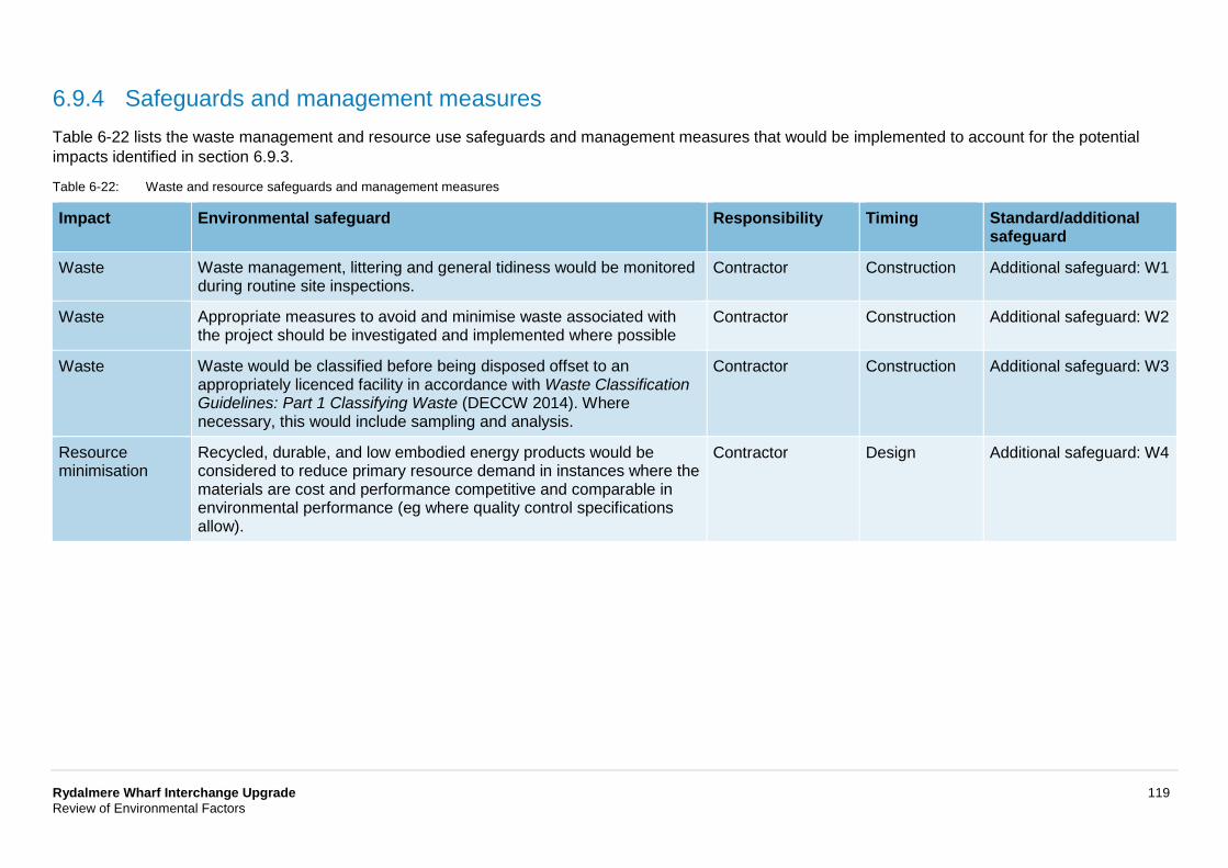
Rydalmere Wharf Interchange Upgrade 119 Review of Environmental Factors
6.9.4 Safeguards and management measures Table 6-22 lists the waste management and resource use safeguards and management measures that would be implemented to account for the potential impacts identified in section 6.9.3.
Table 6-22: Waste and resource safeguards and management measures
Impact Environmental safeguard Responsibility Timing Standard/additional safeguard
Waste Waste management, littering and general tidiness would be monitored during routine site inspections.
Contractor Construction Additional safeguard: W1
Waste Appropriate measures to avoid and minimise waste associated with the project should be investigated and implemented where possible
Contractor Construction Additional safeguard: W2
Waste Waste would be classified before being disposed offset to an appropriately licenced facility in accordance with Waste Classification Guidelines: Part 1 Classifying Waste (DECCW 2014). Where necessary, this would include sampling and analysis.
Contractor Construction Additional safeguard: W3
Resource minimisation
Recycled, durable, and low embodied energy products would be considered to reduce primary resource demand in instances where the materials are cost and performance competitive and comparable in environmental performance (eg where quality control specifications allow).
Contractor Design Additional safeguard: W4
Rydalmere Wharf Interchange Upgrade 120 Review of Environmental Factors
6.10 Hazards and risks This section describes the proposal’s impacts to hazards and risks.
6.10.1 Methodology The assessment considered the impacts associated with potential hazards and risks during construction and operation of the proposal.
6.10.2 Existing environment The existing wharf may pose a safety risk for ferry users in high and low tides due to the gradient of the gangway.
There are 13 potentially hazardous and contaminated sites (as identified on the NSW EPA contaminated sites register) located within one kilometre of the site (refer to section 6.1.2).
The area surrounding the proposal is known to flood, as discussed in section 6.1.2.
6.10.3 Potential impacts
Construction
The following hazards and risks would be associated with the proposal during construction:
• Construction materials, wastes and/or other objects have the potential to fall from the land based construction area into the Parramatta River causing water pollution and risk to human health
• Construction materials, waste and/or objects have the potential to fall from the construction barge or other construction vessels into the Parramatta River causing water pollution and risk to human health
• Physical injury to construction workers due to various hazards and risks associated with the construction activities
• Physical injury to public due to various hazards and risks associated with the construction activities • Risk to human health or the environment from spillage of materials and/or wastes into the water • Risk to human health or the environment from the dispersion of potentially contaminated sediments,
discussed further in section 6.1 • Risk to human health or the environment from air quality related impacts from dust generated during
construction activities • Risk to human health or the environment from asbestos containing material encountered during
construction • Risk to human health or the environment during flooding, discussed further in section 6.1.
Operation
The new wharf has been designed to comply with relevant standards, minimising risks to passenger welfare during operation of the wharf, and improving accessibility.
The installation of two pivot piles, and a debris deflector adjacent to the wharf, would assist ferries berthing and disembarking at the wharf.
Vessel movements to the wharf would continue to be managed through standard maritime procedures.
The wharf has been designed to accommodate a 1:100-year average recurrence interval flood event, Roads and Maritime inspect wharves after flood events prior to recommencing ferry operations, and this would continue for operation of the proposal.
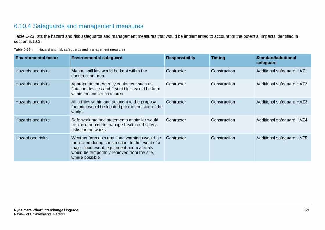
Rydalmere Wharf Interchange Upgrade 121 Review of Environmental Factors
6.10.4 Safeguards and management measures Table 6-23 lists the hazard and risk safeguards and management measures that would be implemented to account for the potential impacts identified in section 6.10.3.
Table 6-23: Hazard and risk safeguards and management measures
Environmental factor Environmental safeguard Responsibility Timing Standard/additional safeguard
Hazards and risks Marine spill kits would be kept within the construction area.
Contractor Construction Additional safeguard HAZ1
Hazards and risks Appropriate emergency equipment such as flotation devices and first aid kits would be kept within the construction area.
Contractor Construction Additional safeguard HAZ2
Hazards and risks All utilities within and adjacent to the proposal footprint would be located prior to the start of the works.
Contractor Construction Additional safeguard HAZ3
Hazards and risks Safe work method statements or similar would be implemented to manage health and safety risks for the works.
Contractor Construction Additional safeguard HAZ4
Hazard and risks Weather forecasts and flood warnings would be monitored during construction. In the event of a major flood event, equipment and materials would be temporarily removed from the site, where possible.
Contractor Construction Additional safeguard HAZ5
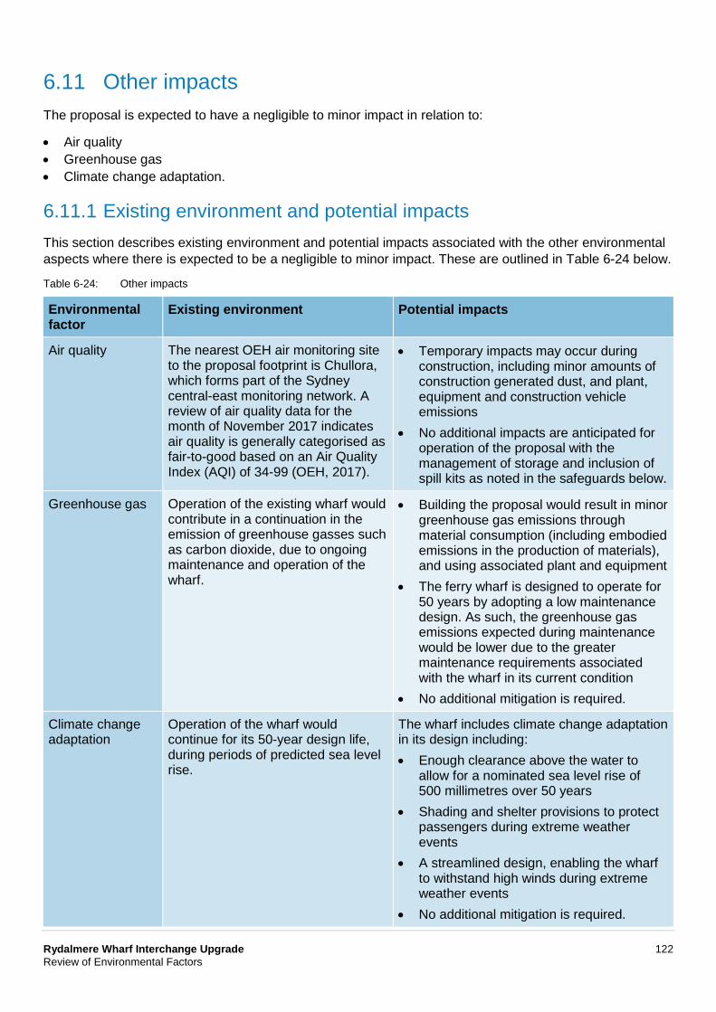
Rydalmere Wharf Interchange Upgrade 122 Review of Environmental Factors
6.11 Other impacts The proposal is expected to have a negligible to minor impact in relation to:
• Air quality • Greenhouse gas • Climate change adaptation.
6.11.1 Existing environment and potential impacts This section describes existing environment and potential impacts associated with the other environmental aspects where there is expected to be a negligible to minor impact. These are outlined in Table 6-24 below.
Table 6-24: Other impacts
Environmental factor
Existing environment Potential impacts
Air quality The nearest OEH air monitoring site to the proposal footprint is Chullora, which forms part of the Sydney central-east monitoring network. A review of air quality data for the month of November 2017 indicates air quality is generally categorised as fair-to-good based on an Air Quality Index (AQI) of 34-99 (OEH, 2017).
• Temporary impacts may occur during construction, including minor amounts of construction generated dust, and plant, equipment and construction vehicle emissions
• No additional impacts are anticipated for operation of the proposal with the management of storage and inclusion of spill kits as noted in the safeguards below.
Greenhouse gas Operation of the existing wharf would contribute in a continuation in the emission of greenhouse gasses such as carbon dioxide, due to ongoing maintenance and operation of the wharf.
• Building the proposal would result in minor greenhouse gas emissions through material consumption (including embodied emissions in the production of materials), and using associated plant and equipment
• The ferry wharf is designed to operate for 50 years by adopting a low maintenance design. As such, the greenhouse gas emissions expected during maintenance would be lower due to the greater maintenance requirements associated with the wharf in its current condition
• No additional mitigation is required.
Climate change adaptation
Operation of the wharf would continue for its 50-year design life, during periods of predicted sea level rise.
The wharf includes climate change adaptation in its design including: • Enough clearance above the water to
allow for a nominated sea level rise of 500 millimetres over 50 years
• Shading and shelter provisions to protect passengers during extreme weather events
• A streamlined design, enabling the wharf to withstand high winds during extreme weather events
• No additional mitigation is required.
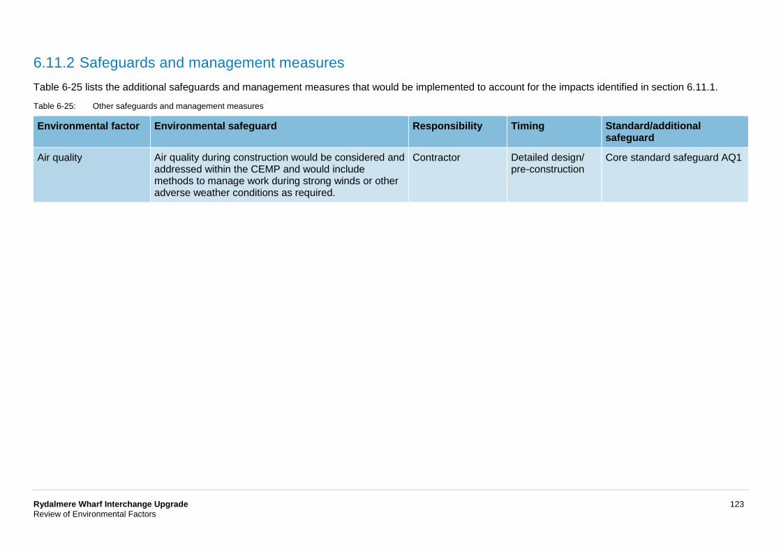
Rydalmere Wharf Interchange Upgrade 123 Review of Environmental Factors
6.11.2 Safeguards and management measures Table 6-25 lists the additional safeguards and management measures that would be implemented to account for the impacts identified in section 6.11.1.
Table 6-25: Other safeguards and management measures
Environmental factor Environmental safeguard Responsibility Timing Standard/additional safeguard
Air quality Air quality during construction would be considered and addressed within the CEMP and would include methods to manage work during strong winds or other adverse weather conditions as required.
Contractor Detailed design/ pre-construction
Core standard safeguard AQ1
Rydalmere Wharf Interchange Upgrade 124 Review of Environmental Factors
6.12 Cumulative impacts Cumulative impact relates to any combined impact resulting from multiple individual sources. These sources can occur in the past, present or future in comparison to the construction and operation of the proposal. The consideration of cumulative impacts is required to assess this combined impact in the context of the region.
The proposal is part of a broader program of work to upgrade the commuter ferry wharves in Sydney, referred to as the Ferry Wharf Upgrade Program. Further consideration of potential cumulative impacts associated with the proposal and upgrade of other wharves as part of the Ferry Wharf Upgrade Program is provided in Table 6-26.
6.12.1 Study area The study area is in the (East) Rydalmere Precinct of the Parramatta Development Control Plan 2011. This area is expected to see a mix of residential, retail and business development. New residential development would be concentrated close to existing transport services, which includes around the ferry wharf. One objective of this development is to ensure that new development adjacent to existing creeks and waterways retains and enhances the indigenous vegetation corridor.
Rydalmere is seeing the Western Sydney University’s steady expansion and the growth of light industrial land uses. Council will favour new industrial developments that improve water quality, the environment around the Parramatta River and the foreshore, with an effort to create pedestrian links.
6.12.2 Past, present and future projects A search of the following databases was completed to identify any projects which might result in a cumulative impact with the proposal:
• Department of Planning and Environment – major project register • Sydney West Central Planning Panel Development and Planning Register • City of Parramatta Council Development Application Register.
No projects have been identified on the Department of Planning and Environment – major project register, Sydney West Central Regional Planning Panel Development and Planning Register, or the City of Parramatta Council Development Application Register that would impact this proposal. However, other minor residential alterations and development applications have been identified. No significant construction related traffic would be generated for these projects outside of light vehicles travelling to the site and minor deliveries of equipment and materials.
Potential impacts from the construction and operation of identified past, present and future projects are summarised in Table 6-26.
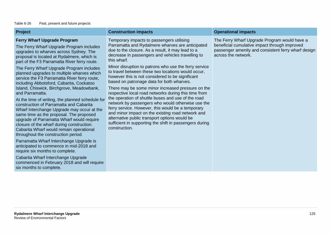
Rydalmere Wharf Interchange Upgrade 125 Review of Environmental Factors
Table 6-26 Past, present and future projects
Project Construction impacts Operational impacts
Ferry Wharf Upgrade Program The Ferry Wharf Upgrade Program includes upgrades to wharves across Sydney. The proposal is located at Rydalmere, which is part of the F3 Parramatta River ferry route. The Ferry Wharf Upgrade Program includes planned upgrades to multiple wharves which service the F3 Parramatta River ferry route, including Abbotsford, Cabarita, Cockatoo Island, Chiswick, Birchgrove, Meadowbank, and Parramatta. At the time of writing, the planned schedule for construction of Parramatta and Cabarita Wharf Interchange Upgrade may occur at the same time as the proposal. The proposed upgrade of Parramatta Wharf would require closure of the wharf during construction. Cabarita Wharf would remain operational throughout the construction period. Parramatta Wharf Interchange Upgrade is anticipated to commence in mid-2018 and require six months to complete. Cabarita Wharf Interchange Upgrade commenced in February 2018 and will require six months to complete.
Temporary impacts to passengers utilising Parramatta and Rydalmere wharves are anticipated due to the closure. As a result, it may lead to a decrease in passengers and vehicles travelling to this wharf. Minor disruption to patrons who use the ferry service to travel between these two locations would occur, however this is not considered to be significant based on patronage data for both wharves. There may be some minor increased pressure on the respective local road networks during this time from the operation of shuttle buses and use of the road network by passengers who would otherwise use the ferry service. However, this would be a temporary and minor impact on the existing road network and alternative public transport options would be sufficient in supporting the shift in passengers during construction.
The Ferry Wharf Upgrade Program would have a beneficial cumulative impact through improved passenger amenity and consistent ferry wharf design across the network.
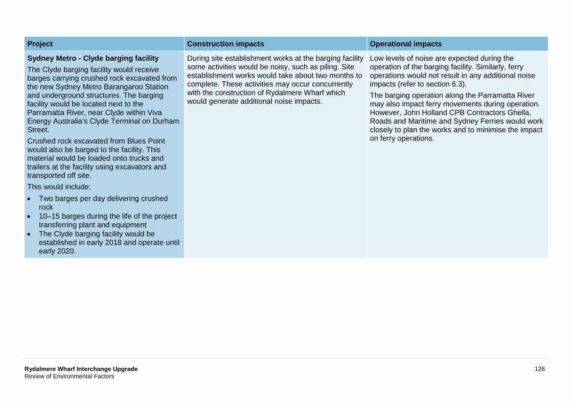
Rydalmere Wharf Interchange Upgrade 126 Review of Environmental Factors
Project Construction impacts Operational impacts
Sydney Metro - Clyde barging facility The Clyde barging facility would receive barges carrying crushed rock excavated from the new Sydney Metro Barangaroo Station and underground structures. The barging facility would be located next to the Parramatta River, near Clyde within Viva Energy Australia’s Clyde Terminal on Durham Street. Crushed rock excavated from Blues Point would also be barged to the facility. This material would be loaded onto trucks and trailers at the facility using excavators and transported off site. This would include: • Two barges per day delivering crushed
rock • 10–15 barges during the life of the project
transferring plant and equipment • The Clyde barging facility would be
established in early 2018 and operate until early 2020.
During site establishment works at the barging facility some activities would be noisy, such as piling. Site establishment works would take about two months to complete. These activities may occur concurrently with the construction of Rydalmere Wharf which would generate additional noise impacts.
Low levels of noise are expected during the operation of the barging facility. Similarly, ferry operations would not result in any additional noise impacts (refer to section 6.3). The barging operation along the Parramatta River may also impact ferry movements during operation. However, John Holland CPB Contractors Ghella, Roads and Maritime and Sydney Ferries would work closely to plan the works and to minimise the impact on ferry operations.
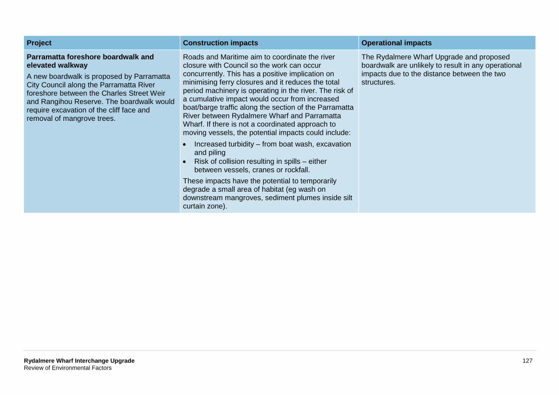
Rydalmere Wharf Interchange Upgrade 127 Review of Environmental Factors
Project Construction impacts Operational impacts
Parramatta foreshore boardwalk and elevated walkway A new boardwalk is proposed by Parramatta City Council along the Parramatta River foreshore between the Charles Street Weir and Rangihou Reserve. The boardwalk would require excavation of the cliff face and removal of mangrove trees.
Roads and Maritime aim to coordinate the river closure with Council so the work can occur concurrently. This has a positive implication on minimising ferry closures and it reduces the total period machinery is operating in the river. The risk of a cumulative impact would occur from increased boat/barge traffic along the section of the Parramatta River between Rydalmere Wharf and Parramatta Wharf. If there is not a coordinated approach to moving vessels, the potential impacts could include: • Increased turbidity – from boat wash, excavation
and piling • Risk of collision resulting in spills – either
between vessels, cranes or rockfall. These impacts have the potential to temporarily degrade a small area of habitat (eg wash on downstream mangroves, sediment plumes inside silt curtain zone).
The Rydalmere Wharf Upgrade and proposed boardwalk are unlikely to result in any operational impacts due to the distance between the two structures.
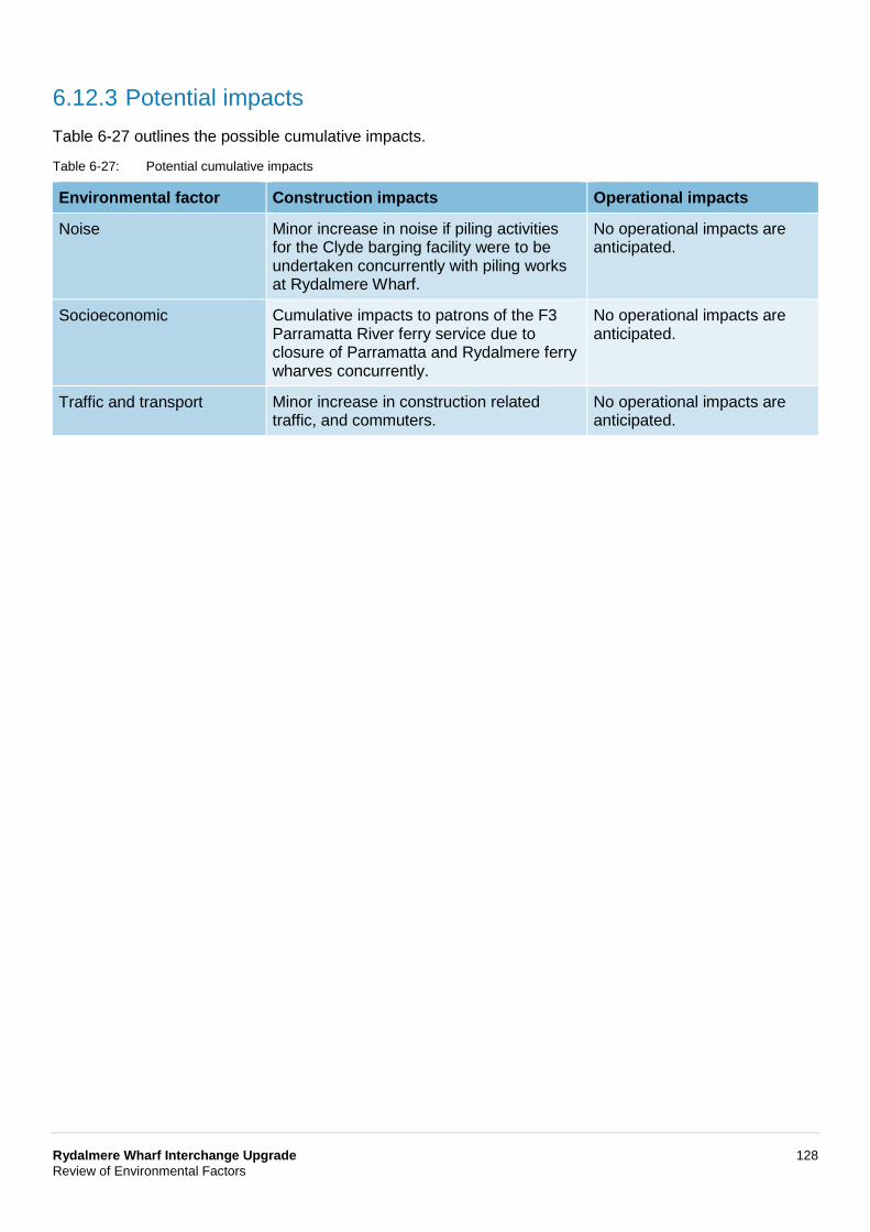
Rydalmere Wharf Interchange Upgrade 128 Review of Environmental Factors
6.12.3 Potential impacts Table 6-27 outlines the possible cumulative impacts.
Table 6-27: Potential cumulative impacts
Environmental factor Construction impacts Operational impacts
Noise Minor increase in noise if piling activities for the Clyde barging facility were to be undertaken concurrently with piling works at Rydalmere Wharf.
No operational impacts are anticipated.
Socioeconomic Cumulative impacts to patrons of the F3 Parramatta River ferry service due to closure of Parramatta and Rydalmere ferry wharves concurrently.
No operational impacts are anticipated.
Traffic and transport Minor increase in construction related traffic, and commuters.
No operational impacts are anticipated.
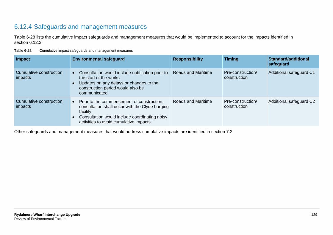
Rydalmere Wharf Interchange Upgrade 129 Review of Environmental Factors
6.12.4 Safeguards and management measures Table 6-28 lists the cumulative impact safeguards and management measures that would be implemented to account for the impacts identified in section 6.12.3.
Table 6-28: Cumulative impact safeguards and management measures
Impact Environmental safeguard Responsibility Timing Standard/additional safeguard
Cumulative construction impacts
• Consultation would include notification prior to the start of the works
• Updates on any delays or changes to the construction period would also be communicated.
Roads and Maritime Pre-construction/ construction
Additional safeguard C1
Cumulative construction impacts
• Prior to the commencement of construction, consultation shall occur with the Clyde barging facility
• Consultation would include coordinating noisy activities to avoid cumulative impacts.
Roads and Maritime Pre-construction/ construction
Additional safeguard C2
Other safeguards and management measures that would address cumulative impacts are identified in section 7.2.
Rydalmere Wharf Interchange Upgrade 130 Review of Environmental Factors
7 Environmental management This chapter describes how the proposal would be managed to reduce potential environmental impacts throughout detailed design, construction and operation. A framework for managing the potential impacts is provided. A summary of site-specific environmental safeguards is provided and the licence and/or approval requirements required prior to construction are also listed.
7.1 Environmental management plans A number of safeguards and management measures have been identified in the REF in order to minimise adverse environmental impacts, including social impacts, which could potentially arise as a result of the proposal. Should the proposal proceed, these safeguards and management measures would be incorporated into the detailed design and applied during the construction and operation of the proposal.
A Construction Environmental Management Plan (CEMP) will be prepared to describe the safeguards and management measures identified. The CEMP will provide a framework for establishing how these measures will be implemented and who would be responsible for their implementation.
The CEMP will be prepared prior to construction of the proposal and must be reviewed and certified by the Roads and Maritime Environment Officer, Greater Sydney Program Office prior to the commencement of any on-site work. The CEMP will be a working document, subject to ongoing change and updated as necessary to respond to specific requirements.
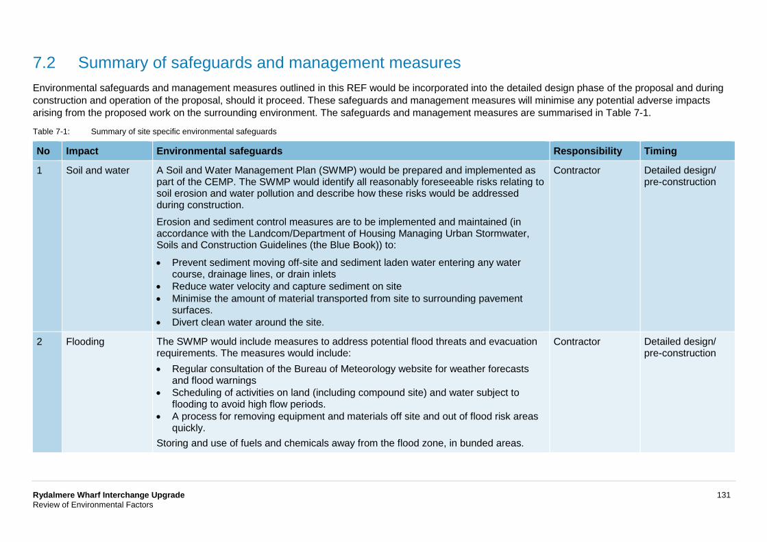
Rydalmere Wharf Interchange Upgrade 131 Review of Environmental Factors
7.2 Summary of safeguards and management measures Environmental safeguards and management measures outlined in this REF would be incorporated into the detailed design phase of the proposal and during construction and operation of the proposal, should it proceed. These safeguards and management measures will minimise any potential adverse impacts arising from the proposed work on the surrounding environment. The safeguards and management measures are summarised in Table 7-1.
Table 7-1: Summary of site specific environmental safeguards
No Impact Environmental safeguards Responsibility Timing
1 Soil and water A Soil and Water Management Plan (SWMP) would be prepared and implemented as part of the CEMP. The SWMP would identify all reasonably foreseeable risks relating to soil erosion and water pollution and describe how these risks would be addressed during construction. Erosion and sediment control measures are to be implemented and maintained (in accordance with the Landcom/Department of Housing Managing Urban Stormwater, Soils and Construction Guidelines (the Blue Book)) to:
• Prevent sediment moving off-site and sediment laden water entering any water course, drainage lines, or drain inlets
• Reduce water velocity and capture sediment on site • Minimise the amount of material transported from site to surrounding pavement
surfaces. • Divert clean water around the site.
Contractor Detailed design/ pre-construction
2 Flooding The SWMP would include measures to address potential flood threats and evacuation requirements. The measures would include: • Regular consultation of the Bureau of Meteorology website for weather forecasts
and flood warnings • Scheduling of activities on land (including compound site) and water subject to
flooding to avoid high flow periods. • A process for removing equipment and materials off site and out of flood risk areas
quickly. Storing and use of fuels and chemicals away from the flood zone, in bunded areas.
Contractor Detailed design/ pre-construction
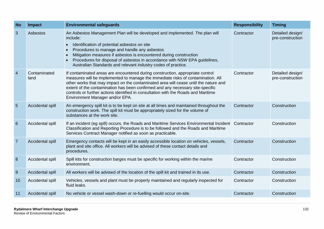
Rydalmere Wharf Interchange Upgrade 132 Review of Environmental Factors
No Impact Environmental safeguards Responsibility Timing
3 Asbestos An Asbestos Management Plan will be developed and implemented. The plan will include: • Identification of potential asbestos on site • Procedures to manage and handle any asbestos • Mitigation measures if asbestos is encountered during construction • Procedures for disposal of asbestos in accordance with NSW EPA guidelines,
Australian Standards and relevant industry codes of practice.
Contractor Detailed design/ pre-construction
4 Contaminated land
If contaminated areas are encountered during construction, appropriate control measures will be implemented to manage the immediate risks of contamination. All other works that may impact on the contaminated area will cease until the nature and extent of the contamination has been confirmed and any necessary site-specific controls or further actions identified in consultation with the Roads and Maritime Environment Manager and/or EPA.
Contractor Detailed design/ pre-construction
5 Accidental spill An emergency spill kit is to be kept on site at all times and maintained throughout the construction work. The spill kit must be appropriately sized for the volume of substances at the work site.
Contractor Construction
6 Accidental spill If an incident (eg spill) occurs, the Roads and Maritime Services Environmental Incident Classification and Reporting Procedure is to be followed and the Roads and Maritime Services Contract Manager notified as soon as practicable.
Contractor Construction
7 Accidental spill Emergency contacts will be kept in an easily accessible location on vehicles, vessels, plant and site office. All workers will be advised of these contact details and procedures.
Contractor Construction
8 Accidental spill Spill kits for construction barges must be specific for working within the marine environment.
Contractor Construction
9 Accidental spill All workers will be advised of the location of the spill kit and trained in its use. Contractor Construction
10 Accidental spill Vehicles, vessels and plant must be properly maintained and regularly inspected for fluid leaks.
Contractor Construction
11 Accidental spill No vehicle or vessel wash-down or re-fuelling would occur on-site. Contractor Construction
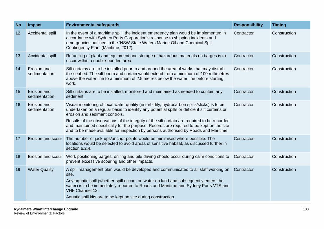
Rydalmere Wharf Interchange Upgrade 133 Review of Environmental Factors
No Impact Environmental safeguards Responsibility Timing
12 Accidental spill In the event of a maritime spill, the incident emergency plan would be implemented in accordance with Sydney Ports Corporation’s response to shipping incidents and emergencies outlined in the ‘NSW State Waters Marine Oil and Chemical Spill Contingency Plan’ (Maritime, 2012).
Contractor Construction
13 Accidental spill Refuelling of plant and equipment and storage of hazardous materials on barges is to occur within a double-bunded area.
Contractor Construction
14 Erosion and sedimentation
Silt curtains are to be installed prior to and around the area of works that may disturb the seabed. The silt boom and curtain would extend from a minimum of 100 millimetres above the water line to a minimum of 2.5 metres below the water line before starting work.
Contractor Construction
15 Erosion and sedimentation
Silt curtains are to be installed, monitored and maintained as needed to contain any sediment.
Contractor Construction
16 Erosion and sedimentation
Visual monitoring of local water quality (ie turbidity, hydrocarbon spills/slicks) is to be undertaken on a regular basis to identify any potential spills or deficient silt curtains or erosion and sediment controls. Results of the observations of the integrity of the silt curtain are required to be recorded and maintained specifically for the purpose. Records are required to be kept on the site and to be made available for inspection by persons authorised by Roads and Maritime.
Contractor Construction
17 Erosion and scour The number of jack-ups/anchor points would be minimised where possible. The locations would be selected to avoid areas of sensitive habitat, as discussed further in section 6.2.4.
Contractor Construction
18 Erosion and scour Work positioning barges, drilling and pile driving should occur during calm conditions to prevent excessive scouring and other impacts.
Contractor Construction
19 Water Quality A spill management plan would be developed and communicated to all staff working on site. Any aquatic spill (whether spill occurs on water on land and subsequently enters the water) is to be immediately reported to Roads and Maritime and Sydney Ports VTS and VHF Channel 13. Aquatic spill kits are to be kept on site during construction.
Contractor Construction
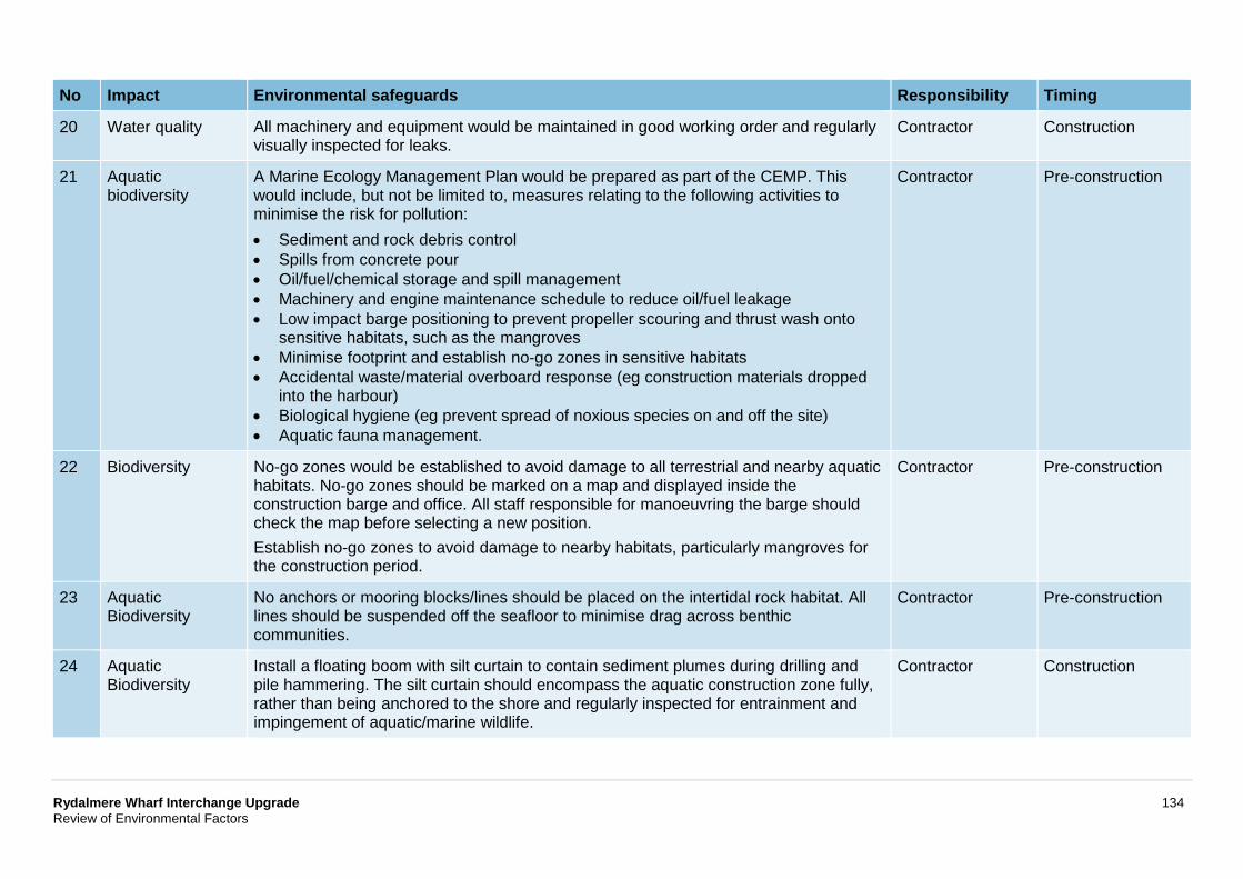
Rydalmere Wharf Interchange Upgrade 134 Review of Environmental Factors
No Impact Environmental safeguards Responsibility Timing
20 Water quality All machinery and equipment would be maintained in good working order and regularly visually inspected for leaks.
Contractor Construction
21 Aquatic biodiversity
A Marine Ecology Management Plan would be prepared as part of the CEMP. This would include, but not be limited to, measures relating to the following activities to minimise the risk for pollution: • Sediment and rock debris control • Spills from concrete pour • Oil/fuel/chemical storage and spill management • Machinery and engine maintenance schedule to reduce oil/fuel leakage • Low impact barge positioning to prevent propeller scouring and thrust wash onto
sensitive habitats, such as the mangroves • Minimise footprint and establish no-go zones in sensitive habitats • Accidental waste/material overboard response (eg construction materials dropped
into the harbour) • Biological hygiene (eg prevent spread of noxious species on and off the site) • Aquatic fauna management.
Contractor Pre-construction
22 Biodiversity No-go zones would be established to avoid damage to all terrestrial and nearby aquatic habitats. No-go zones should be marked on a map and displayed inside the construction barge and office. All staff responsible for manoeuvring the barge should check the map before selecting a new position. Establish no-go zones to avoid damage to nearby habitats, particularly mangroves for the construction period.
Contractor Pre-construction
23 Aquatic Biodiversity
No anchors or mooring blocks/lines should be placed on the intertidal rock habitat. All lines should be suspended off the seafloor to minimise drag across benthic communities.
Contractor Pre-construction
24 Aquatic Biodiversity
Install a floating boom with silt curtain to contain sediment plumes during drilling and pile hammering. The silt curtain should encompass the aquatic construction zone fully, rather than being anchored to the shore and regularly inspected for entrainment and impingement of aquatic/marine wildlife.
Contractor Construction
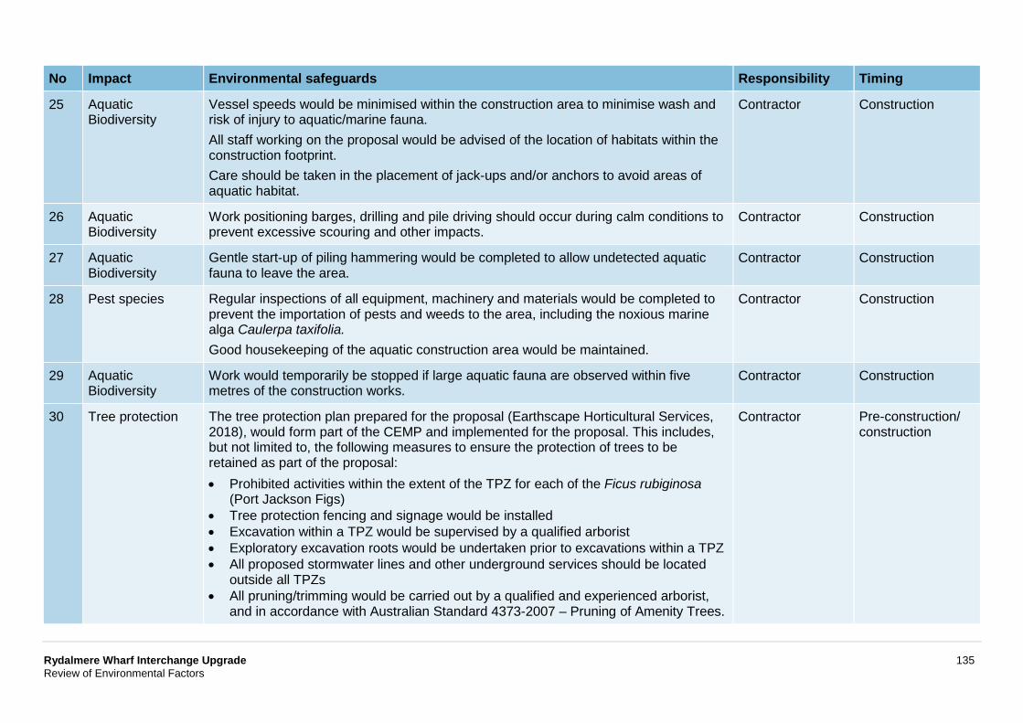
Rydalmere Wharf Interchange Upgrade 135 Review of Environmental Factors
No Impact Environmental safeguards Responsibility Timing
25 Aquatic Biodiversity
Vessel speeds would be minimised within the construction area to minimise wash and risk of injury to aquatic/marine fauna. All staff working on the proposal would be advised of the location of habitats within the construction footprint. Care should be taken in the placement of jack-ups and/or anchors to avoid areas of aquatic habitat.
Contractor Construction
26 Aquatic Biodiversity
Work positioning barges, drilling and pile driving should occur during calm conditions to prevent excessive scouring and other impacts.
Contractor Construction
27 Aquatic Biodiversity
Gentle start-up of piling hammering would be completed to allow undetected aquatic fauna to leave the area.
Contractor Construction
28 Pest species Regular inspections of all equipment, machinery and materials would be completed to prevent the importation of pests and weeds to the area, including the noxious marine alga Caulerpa taxifolia. Good housekeeping of the aquatic construction area would be maintained.
Contractor Construction
29 Aquatic Biodiversity
Work would temporarily be stopped if large aquatic fauna are observed within five metres of the construction works.
Contractor Construction
30 Tree protection The tree protection plan prepared for the proposal (Earthscape Horticultural Services, 2018), would form part of the CEMP and implemented for the proposal. This includes, but not limited to, the following measures to ensure the protection of trees to be retained as part of the proposal: • Prohibited activities within the extent of the TPZ for each of the Ficus rubiginosa
(Port Jackson Figs) • Tree protection fencing and signage would be installed • Excavation within a TPZ would be supervised by a qualified arborist • Exploratory excavation roots would be undertaken prior to excavations within a TPZ • All proposed stormwater lines and other underground services should be located
outside all TPZs • All pruning/trimming would be carried out by a qualified and experienced arborist,
and in accordance with Australian Standard 4373-2007 – Pruning of Amenity Trees.
Contractor Pre-construction/ construction
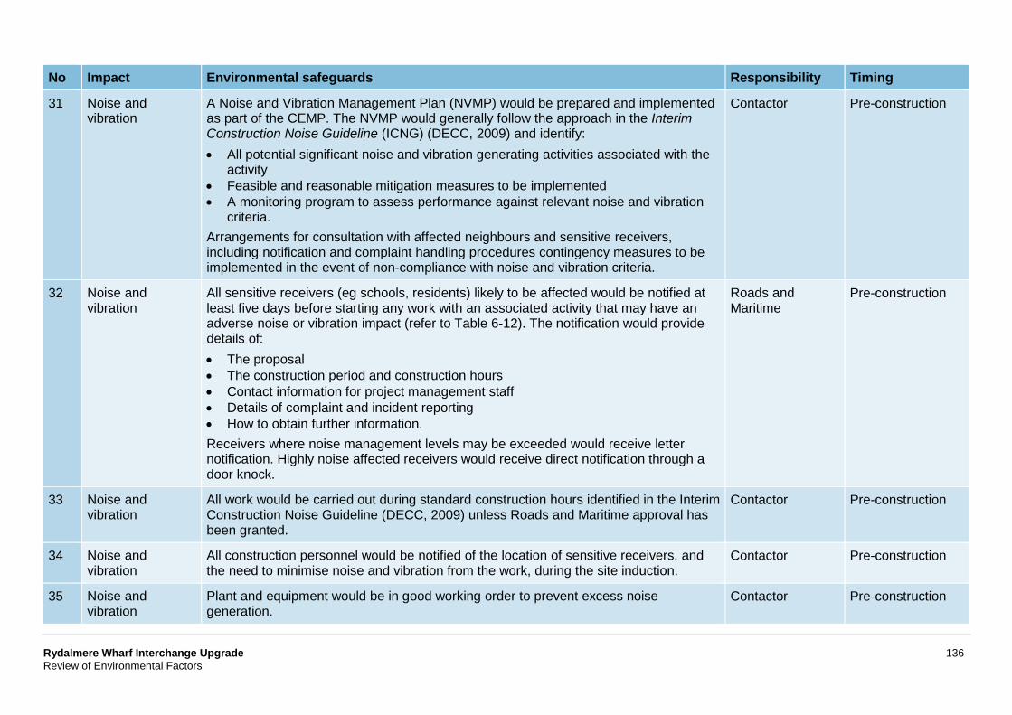
Rydalmere Wharf Interchange Upgrade 136 Review of Environmental Factors
No Impact Environmental safeguards Responsibility Timing
31 Noise and vibration
A Noise and Vibration Management Plan (NVMP) would be prepared and implemented as part of the CEMP. The NVMP would generally follow the approach in the Interim Construction Noise Guideline (ICNG) (DECC, 2009) and identify: • All potential significant noise and vibration generating activities associated with the
activity • Feasible and reasonable mitigation measures to be implemented • A monitoring program to assess performance against relevant noise and vibration
criteria. Arrangements for consultation with affected neighbours and sensitive receivers, including notification and complaint handling procedures contingency measures to be implemented in the event of non-compliance with noise and vibration criteria.
Contactor Pre-construction
32 Noise and vibration
All sensitive receivers (eg schools, residents) likely to be affected would be notified at least five days before starting any work with an associated activity that may have an adverse noise or vibration impact (refer to Table 6-12). The notification would provide details of: • The proposal • The construction period and construction hours • Contact information for project management staff • Details of complaint and incident reporting • How to obtain further information. Receivers where noise management levels may be exceeded would receive letter notification. Highly noise affected receivers would receive direct notification through a door knock.
Roads and Maritime
Pre-construction
33 Noise and vibration
All work would be carried out during standard construction hours identified in the Interim Construction Noise Guideline (DECC, 2009) unless Roads and Maritime approval has been granted.
Contactor Pre-construction
34 Noise and vibration
All construction personnel would be notified of the location of sensitive receivers, and the need to minimise noise and vibration from the work, during the site induction.
Contactor Pre-construction
35 Noise and vibration
Plant and equipment would be in good working order to prevent excess noise generation.
Contactor Pre-construction
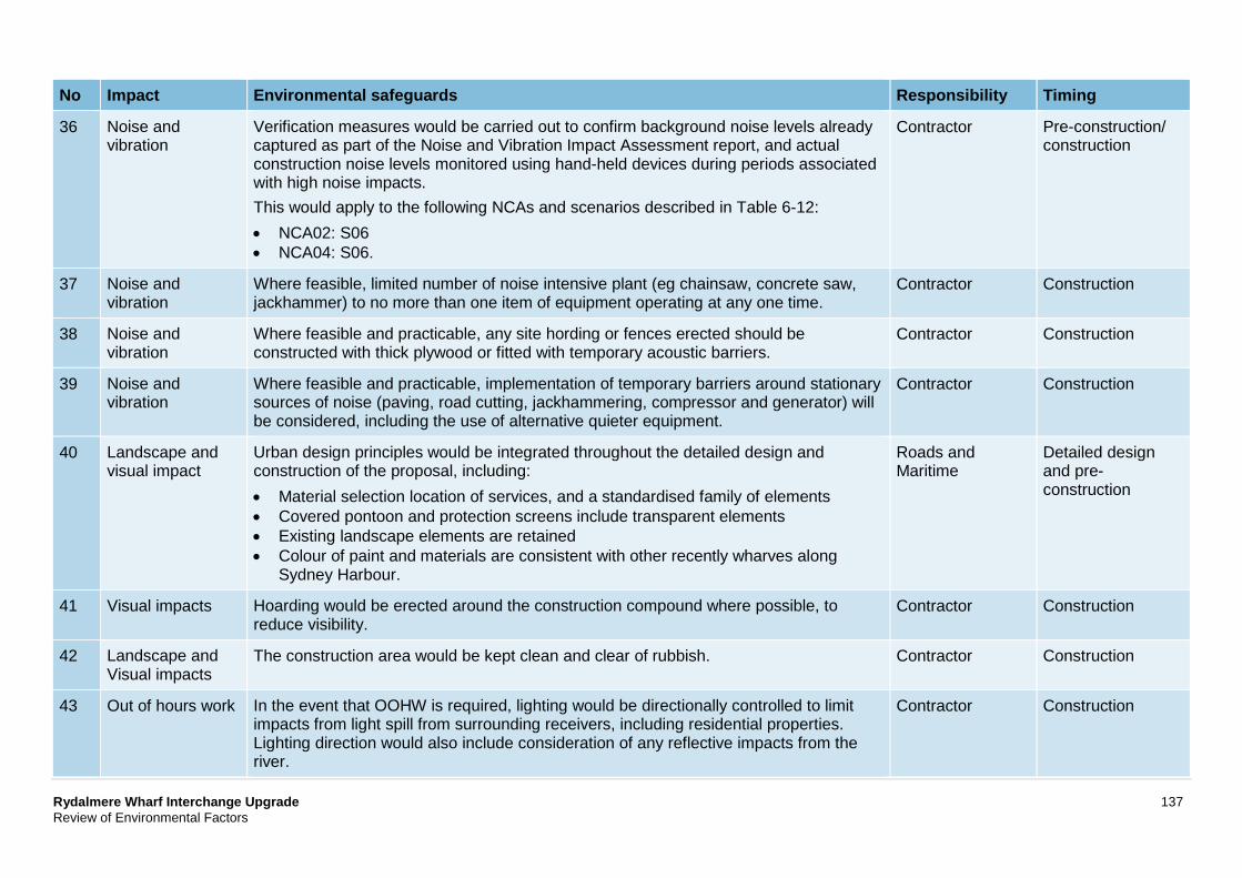
Rydalmere Wharf Interchange Upgrade 137 Review of Environmental Factors
No Impact Environmental safeguards Responsibility Timing
36 Noise and vibration
Verification measures would be carried out to confirm background noise levels already captured as part of the Noise and Vibration Impact Assessment report, and actual construction noise levels monitored using hand-held devices during periods associated with high noise impacts. This would apply to the following NCAs and scenarios described in Table 6-12: • NCA02: S06 • NCA04: S06.
Contractor Pre-construction/ construction
37 Noise and vibration
Where feasible, limited number of noise intensive plant (eg chainsaw, concrete saw, jackhammer) to no more than one item of equipment operating at any one time.
Contractor Construction
38 Noise and vibration
Where feasible and practicable, any site hording or fences erected should be constructed with thick plywood or fitted with temporary acoustic barriers.
Contractor Construction
39 Noise and vibration
Where feasible and practicable, implementation of temporary barriers around stationary sources of noise (paving, road cutting, jackhammering, compressor and generator) will be considered, including the use of alternative quieter equipment.
Contractor Construction
40 Landscape and visual impact
Urban design principles would be integrated throughout the detailed design and construction of the proposal, including: • Material selection location of services, and a standardised family of elements • Covered pontoon and protection screens include transparent elements • Existing landscape elements are retained • Colour of paint and materials are consistent with other recently wharves along
Sydney Harbour.
Roads and Maritime
Detailed design and pre-construction
41 Visual impacts Hoarding would be erected around the construction compound where possible, to reduce visibility.
Contractor Construction
42 Landscape and Visual impacts
The construction area would be kept clean and clear of rubbish. Contractor Construction
43 Out of hours work In the event that OOHW is required, lighting would be directionally controlled to limit impacts from light spill from surrounding receivers, including residential properties. Lighting direction would also include consideration of any reflective impacts from the river.
Contractor Construction
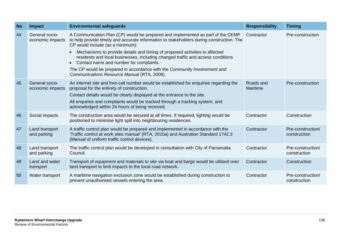
Rydalmere Wharf Interchange Upgrade 138 Review of Environmental Factors
No Impact Environmental safeguards Responsibility Timing
44 General socio-economic impacts
A Communication Plan (CP) would be prepared and implemented as part of the CEMP to help provide timely and accurate information to stakeholders during construction. The CP would include (as a minimum): • Mechanisms to provide details and timing of proposed activities to affected
residents and local businesses, including changed traffic and access conditions • Contact name and number for complaints. The CP would be prepared in accordance with the Community Involvement and Communications Resource Manual (RTA, 2008).
Contractor Pre-construction
45 General socio-economic impacts
An internet site and free-call number would be established for enquiries regarding the proposal for the entirety of construction. Contact details would be clearly displayed at the entrance to the site. All enquiries and complaints would be tracked through a tracking system, and acknowledged within 24 hours of being received.
Roads and Maritime
Pre-construction
46 Social impacts The construction area would be secured at all times. If required, lighting would be positioned to minimise light spill into neighbouring residences.
Contractor Construction
47 Land transport and parking
A traffic control plan would be prepared and implemented in accordance with the ‘Traffic control at work sites manual’ (RTA, 2010a) and Australian Standard 1742.3 (Manual of uniform traffic control devices).
Contractor Pre-construction/ construction
48 Land transport and parking
The traffic control plan would be developed in consultation with City of Parramatta Council.
Contractor Pre-construction/ construction
49 Land and water transport
Transport of equipment and materials to site via boat and barge would be utilised over land transport to limit impacts to the local road network.
Contractor Construction
50 Water transport A maritime navigation exclusion zone would be established during construction to prevent unauthorised vessels entering the area.
Contractor Pre-construction/ construction
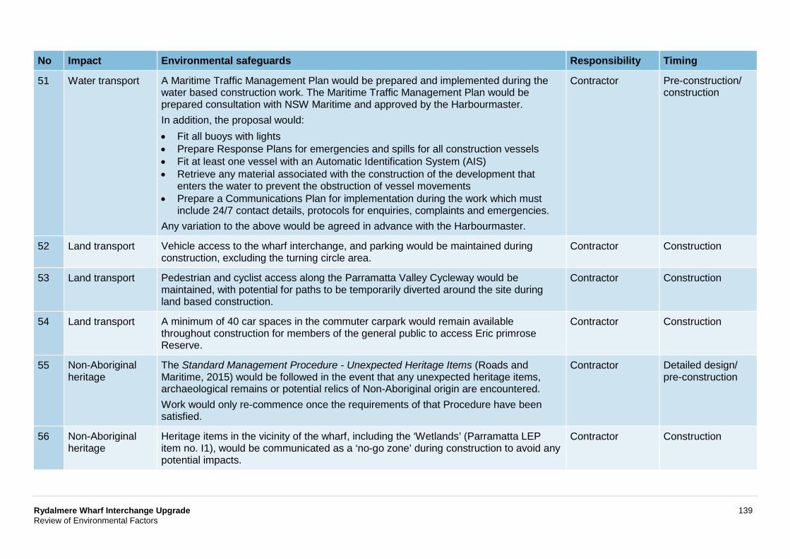
Rydalmere Wharf Interchange Upgrade 139 Review of Environmental Factors
No Impact Environmental safeguards Responsibility Timing
51 Water transport A Maritime Traffic Management Plan would be prepared and implemented during the water based construction work. The Maritime Traffic Management Plan would be prepared consultation with NSW Maritime and approved by the Harbourmaster. In addition, the proposal would: • Fit all buoys with lights • Prepare Response Plans for emergencies and spills for all construction vessels • Fit at least one vessel with an Automatic Identification System (AIS) • Retrieve any material associated with the construction of the development that
enters the water to prevent the obstruction of vessel movements • Prepare a Communications Plan for implementation during the work which must
include 24/7 contact details, protocols for enquiries, complaints and emergencies. Any variation to the above would be agreed in advance with the Harbourmaster.
Contractor Pre-construction/ construction
52 Land transport Vehicle access to the wharf interchange, and parking would be maintained during construction, excluding the turning circle area.
Contractor Construction
53 Land transport Pedestrian and cyclist access along the Parramatta Valley Cycleway would be maintained, with potential for paths to be temporarily diverted around the site during land based construction.
Contractor Construction
54 Land transport A minimum of 40 car spaces in the commuter carpark would remain available throughout construction for members of the general public to access Eric primrose Reserve.
Contractor Construction
55 Non-Aboriginal heritage
The Standard Management Procedure - Unexpected Heritage Items (Roads and Maritime, 2015) would be followed in the event that any unexpected heritage items, archaeological remains or potential relics of Non-Aboriginal origin are encountered. Work would only re-commence once the requirements of that Procedure have been satisfied.
Contractor Detailed design/ pre-construction
56 Non-Aboriginal heritage
Heritage items in the vicinity of the wharf, including the ‘Wetlands’ (Parramatta LEP item no. I1), would be communicated as a ‘no-go zone’ during construction to avoid any potential impacts.
Contractor Construction
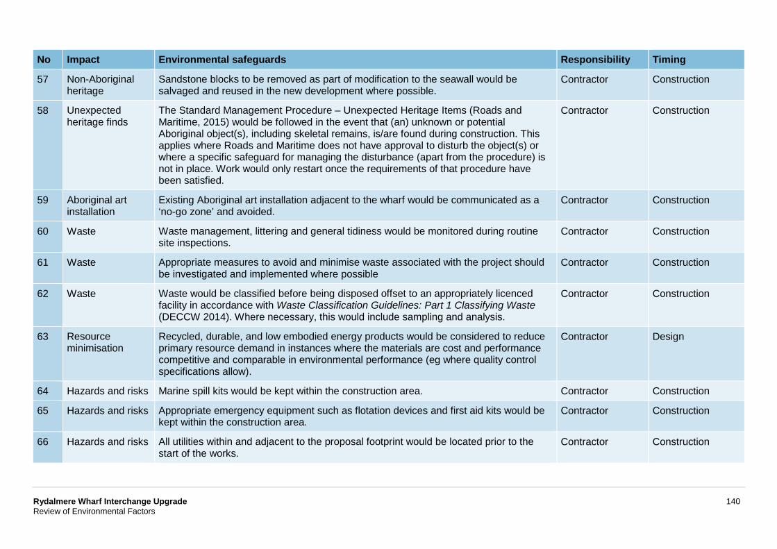
Rydalmere Wharf Interchange Upgrade 140 Review of Environmental Factors
No Impact Environmental safeguards Responsibility Timing
57 Non-Aboriginal heritage
Sandstone blocks to be removed as part of modification to the seawall would be salvaged and reused in the new development where possible.
Contractor Construction
58 Unexpected heritage finds
The Standard Management Procedure – Unexpected Heritage Items (Roads and Maritime, 2015) would be followed in the event that (an) unknown or potential Aboriginal object(s), including skeletal remains, is/are found during construction. This applies where Roads and Maritime does not have approval to disturb the object(s) or where a specific safeguard for managing the disturbance (apart from the procedure) is not in place. Work would only restart once the requirements of that procedure have been satisfied.
Contractor Construction
59 Aboriginal art installation
Existing Aboriginal art installation adjacent to the wharf would be communicated as a ‘no-go zone’ and avoided.
Contractor Construction
60 Waste Waste management, littering and general tidiness would be monitored during routine site inspections.
Contractor Construction
61 Waste Appropriate measures to avoid and minimise waste associated with the project should be investigated and implemented where possible
Contractor Construction
62 Waste Waste would be classified before being disposed offset to an appropriately licenced facility in accordance with Waste Classification Guidelines: Part 1 Classifying Waste (DECCW 2014). Where necessary, this would include sampling and analysis.
Contractor Construction
63 Resource minimisation
Recycled, durable, and low embodied energy products would be considered to reduce primary resource demand in instances where the materials are cost and performance competitive and comparable in environmental performance (eg where quality control specifications allow).
Contractor Design
64 Hazards and risks Marine spill kits would be kept within the construction area. Contractor Construction
65 Hazards and risks Appropriate emergency equipment such as flotation devices and first aid kits would be kept within the construction area.
Contractor Construction
66 Hazards and risks All utilities within and adjacent to the proposal footprint would be located prior to the start of the works.
Contractor Construction
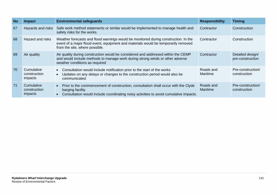
Rydalmere Wharf Interchange Upgrade 141 Review of Environmental Factors
No Impact Environmental safeguards Responsibility Timing
67 Hazards and risks Safe work method statements or similar would be implemented to manage health and safety risks for the works.
Contractor Construction
68 Hazard and risks Weather forecasts and flood warnings would be monitored during construction. In the event of a major flood event, equipment and materials would be temporarily removed from the site, where possible.
Contractor Construction
69 Air quality Air quality during construction would be considered and addressed within the CEMP and would include methods to manage work during strong winds or other adverse weather conditions as required
Contractor Detailed design/ pre-construction
70 Cumulative construction impacts
• Consultation would include notification prior to the start of the works • Updates on any delays or changes to the construction period would also be
communicated.
Roads and Maritime
Pre-construction/ construction
71 Cumulative construction impacts
• Prior to the commencement of construction, consultation shall occur with the Clyde barging facility
• Consultation would include coordinating noisy activities to avoid cumulative impacts.
Roads and Maritime
Pre-construction/ construction
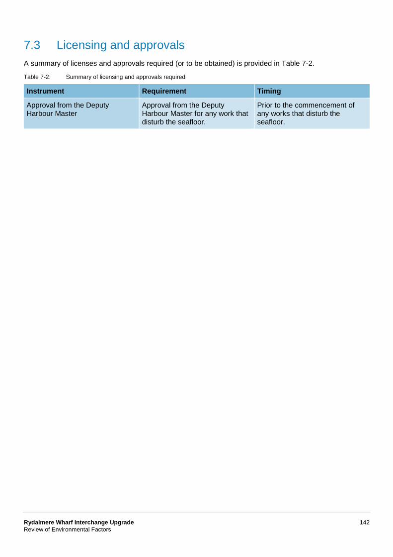
Rydalmere Wharf Interchange Upgrade 142 Review of Environmental Factors
7.3 Licensing and approvals A summary of licenses and approvals required (or to be obtained) is provided in Table 7-2.
Table 7-2: Summary of licensing and approvals required
Instrument Requirement Timing
Approval from the Deputy Harbour Master
Approval from the Deputy Harbour Master for any work that disturb the seafloor.
Prior to the commencement of any works that disturb the seafloor.
Rydalmere Wharf Interchange Upgrade 143 Review of Environmental Factors
8 Justification and conclusion This chapter provides the justification for the proposal taking into account its biophysical, social and economic impacts, the suitability of the site and whether or not the proposal is in the public interest. The proposal is also considered in the context of the objectives of the EP&A Act, including the principles of ecologically sustainable development as defined in Schedule 2 of the Environmental Planning and Assessment Regulation 2000.
8.1 Justification The proposal forms part of the TAP, which is an ongoing “initiative to deliver modern, safe and accessible transport infrastructure” in New South Wales (NSW, Transport for NSW, 2015). As part of the TAP, Roads and Maritime assessed the condition of all ferry wharves across the transport network in 2009 in terms of:
• Safety and structural integrity • Access for less mobile and disabled passengers • Existing and predicted future patronage and use.
Initial justification for the proposal was provided through an assessment of the existing wharf, which was identified as needing upgrading due to its lack of accessible pathway throughout the interchange and non-DDA compliant wharf.
Consideration of alternatives and options was then carried out. The preferred design of the proposal selected to best achieve the objectives outlined in section 2.7, which included providing improvements in access, user experience including passenger comfort and amenity, and safety through meeting the objectives. This was compared to the option of doing nothing and other options to relocate the wharf.
Potential environmental and social impacts resulting from construction and operation of the proposal have been minimised through the safeguards and management measures outlined in Chapter 7.
The following sub-headings provide justification through considering the impacts and benefits of the proposal.
8.1.1 Social factors The proposal would result in temporary social impacts whilst being built such as noise and visual impacts, including the amenity of Eric Primrose Reserve. However, all construction related impacts would be appropriately managed prior to and during construction.
Operation of the proposal provides justification over the above temporary impacts, as it would benefit the community through improving passenger amenity, safety and overall user experience. It is anticipated that the proposal would also have indirect wider community benefits, through ensuring continuation of the wharf for its expected lifespan (50 years). This extends to the cultural and amenity benefit of continuing to operate a wharf in this location.
8.1.2 Biophysical factors As discussed in Chapter 6, no significant impacts have been identified. Minor impacts would be managed through the safeguards and management measures outlined in these sections.
The design of the proposal includes tolerances to allow for sea level rise and extreme weather events, which would ensure the wharf continues to be operational throughout its 50-year design life.

Rydalmere Wharf Interchange Upgrade 144 Review of Environmental Factors
8.1.3 Economic factors Upgrade of the wharf would generate economic benefits over the next 50 years, with the wharf being an attractor for people to live in the area due to the recreational value of the ferry service and ability to access the city centre.
Design of the wharf has also incorporated measures to decrease the maintenance required for operation which are standardised across all newly constructed wharves. The implementation of these measures would result in cost savings for the ongoing operation of the ferry network.
8.2 Objects of the EP&A Act Table 8-1: Objects of the EP&A Act
Object Comment
1.3(a) To promote the social and economic welfare of the community and a better environment by the proper management, development and conservation of the State’s natural and other resources.
Through the assessment in Chapter 6, it has been identified that the proposal would not significantly impact on any natural or artificial resources. The proposal would result in community benefits through facilitation of a safe and reliable ferry service to Rydalmere for the next 50 years.
1.3(b) To facilitate ecologically sustainable development by integrating relevant economic, environmental and social considerations in decision-making about environmental planning and assessment.
Ecologically sustainable development is considered in sections 8.2.1 to 8.2.4 below.
1.3(c) To promote the orderly and economic use and development of land.
The proposal includes continuation of the use of the proposal location as a ferry wharf.
1.3(d) To promote the delivery and maintenance of affordable housing.
Not relevant to the project.
1.3(e) To protect the environment, including the conservation of threatened and other species of native animals and plants, ecological communities and their habitats.
An aquatic ecology assessment has been prepared for the project, which is summarised in section 6.2. The assessment concluded that no significant impact to aquatic ecology would be caused by the proposal. In addition, tree removal would not be required for the proposal.
1.3(f) To promote the sustainable management of built and cultural heritage (including Aboriginal cultural heritage).
The proposal would have minimal impact upon Aboriginal and non-Aboriginal heritage items.
1.3(g) To promote good design and amenity of the built environment.
The proposal has been designed to be consistent with the urban design objectives identified in section 2.4.3.
1.3(h) To promote the proper construction and maintenance of buildings, including the protection of the health and safety of their occupants.
The proposal would benefit the community through improving passenger amenity, safety and overall user experience. It is anticipated that the proposal would also have indirect wider community benefits, through ensuring continuation of the wharf for its expected lifespan (50 years).
Rydalmere Wharf Interchange Upgrade 145 Review of Environmental Factors
Object Comment
1.3(i) To promote the sharing of the responsibility for environmental planning and assessment between the different levels of government in the State.
Not relevant to the project.
1.3(j) To provide increased opportunity for community participation in environmental planning and assessment.
Stakeholder consultation would continue during the public display of this document, with a community information session planned for 11 May 2018 during the public display period to capture feedback. Should the proposal proceed to construction, consultation with the community and stakeholders would continue throughout the work. Additionally, a community information session was held on 10 May 2015 to inform the concept design, which is described further in section 5.2.
8.2.1 The precautionary principle The precautionary principle includes the premise that full scientific certainty should not be used as a reason for postponing a measure to prevent degradation of the environment where there are threats of serious or irreversible environmental damage.
Through the assessment of the potential impacts of the proposal in Chapter 6, it has been demonstrated that threats of serious or irreversible environmental damage do not exist for the proposal.
Notwithstanding, to account for the subjectivity of professional judgement applied in environmental assessment and modelling uncertainty, worst-case assumptions have been incorporated into the assessment, including the following:
• Specialist assessments of noise and vibration, aquatic ecology, landscape character and visual impact have been completed
• The worst-case assumption of all noise generating construction equipment operating at the same time, at its maximum output, at a location closest to the nearest of the sensitive receivers.
• Assessing impacts and including safeguards for impacts which are exceptionally unlikely to happen such as major spills
• Undertaking verification monitoring to validate results and allow modification of safeguards and mitigation controls accordingly.
8.2.2 Intergenerational equity To achieve intergenerational equity, the present generation should ensure that the health, diversity and productivity of the environment are maintained or enhanced for the benefit of future generations.
The proposal would result in benefit to the community through improvements to passenger amenity, safety and overall user experience of the ferry wharf for the next 50 years.
No potential impacts to future generations would be generated by the proposal.
8.2.3 Conservation of biological diversity and ecological integrity Conservation of biological diversity and ecological integrity has been considered through the assessment of aquatic ecology provided in section 6.2, and Appendix D.
Rydalmere Wharf Interchange Upgrade 146 Review of Environmental Factors
Providing the safeguard measures are implemented, the proposal would not have a material or significant impact on biological diversity and ecological integrity within the proposal footprint or surrounds.
8.2.4 Improved valuation, pricing and incentive mechanisms This principle includes integrating long-term and short-term economic, environmental, social and fairness considerations into decision-making. This principle requires that environmental resources should be appropriately valued.
Environmental, economic and social issues were considered in the rationale for the proposal and design options. Construction planning for the proposal would also be progressed in the most cost-effective way.
Safeguards and management measures detailed in Chapter 6, including avoiding, reusing, recycling, managing waste during construction and operation, would be implemented.
8.3 Conclusion The proposed Rydalmere Wharf Interchange Upgrade is subject to assessment under Division 5.1 of the EP&A Act. The REF has examined and taken into account to the fullest extent possible all matters affecting or likely to affect the environment by reason of the proposed activity.
This has included consideration (where relevant) of conservation agreements and plans of management under the NPW Act, stewardship sites under the BC Act, wilderness areas, areas of outstanding value, impacts on threatened species, populations and ecological communities and their habitats and other protected fauna and native plants. It has also considered potential impacts to matters of national environmental significance listed under the Federal EPBC Act.
A number of potential environmental impacts from the proposal have been avoided or reduced during the concept design development and options assessment. The proposal as described in the REF best meets the project objectives but would still result in some impacts on noise, water quality, aquatic ecology, traffic and transport and landscape character and visual impact. Safeguards and management measures as detailed in this REF would ameliorate or minimise these expected impacts. The proposal would provide better commuter experience through improvements to passenger amenity, safety, access for people with a disability and overall user experience of the ferry wharf for the next 50 years, as well as contributing to unifying and standardising wharves in Sydney Harbour and Parramatta River. On balance the proposal is considered justified and the following conclusions are made.
8.3.1 Significance of impact under NSW legislation The proposal would be unlikely to cause a significant impact on the environment. Therefore it is not necessary for an environmental impact statement to be prepared and approval to be sought from the Minister for Planning under Division 5.2 of the EP&A Act. A Biodiversity Development Assessment Report or Species Impact Statement is not required. The proposal is subject to assessment under Division 5.1 of the EP&A Act. Consent from Council is not required.
8.3.2 Significance of impact under Australian legislation The proposal is not likely to have a significant impact on matters of national environmental significance or the environment of Commonwealth land within the meaning of the Environment Protection and Biodiversity Conservation Act 1999. A referral to the Australian Department of the Environment and Energy is not required.
Rydalmere Wharf Interchange Upgrade 148 Review of Environmental Factors
10 References Australian Standard series 1428, Design for access and mobility Set.
Australian Standards 4997-2005, Guidelines for the Design of Maritime Structures.
Australian Bureau of statistics, http://www.abs.gov.au.
Building Code of Australia, 2011.
Cardno, 2008, Parramatta River Estuary Data Compilation and Review Study, Sydney, New South Wales.
Cardno, 2012, Parramatta River Estuary Coastal Zone Management Plan
City of Parramatta Council, 2011, City of Parramatta Local Environmental Plan.
Coffey Geotechnics (Coffey), 2015a, Stage 1 Contamination Assessment – Rydalmere Ferry Wharf.
Coffey Geotechnics (Coffey), 2015b, Stage 2 Contamination Assessment – Rydalmere Ferry Wharf.
Cole, J., 1983, Parramatta River Notebook, Kenthurst, Kangaroo Press.
Commonwealth Department of Environment and Energy, 2013, Significant Impact Guidelines 1.1: Matters of National Environmental Significance.
Department of Environment and Energy, Protected Matters Search Tool.
Department of Environment Climate Change and Water (DECCW), 2007, Threatened Species Assessment Guidelines: The Assessment of Significance.
Department of Environment Climate Change and Water (DECCW), 2009, Interim Construction Noise Guideline.
Department of Environment Climate Change and Water (DECCW), 2014, Waste classification guidelines, Part 1: Classifying waste.
Department of Environment Climate Change and Water (DECCW), 2010(a), Due Diligence Code of Practice for the Protection of Aboriginal Objects in New South Wales.
Department of Environment Climate Change and Water (DECCW), 2010(b), Code of Practice of Archaeological Investigation of Aboriginal Objects in NSW (DECCW, 2010).
Department of Infrastructure, Planning and Natural Resources NSW (DIPNR) 2004, Guideline for the Preparation of Environmental Management Plans, Sydney.
Department of Planning and Environment, major projects register, http://majorprojects.planning.nsw.gov.au/.
Department of Primary Industries, WeedWise database, http://weeds.dpi.nsw.gov.au/.
Department of Urban Affairs and Planning (DUAP) 1996, Marinas and Related Facilities – EIS Guidelines.
Department of Urban Affairs and Planning (DUAP) 1999, Is an EIS required?
Disability Standards for Accessible Public Transport. 2002.
Earthscape Horticultural Services, 2018, Arboricultural Impact Assessment Report Rydalmere Ferry Wharf.
Engell-Sorensen, K, et al, 2000, Evaluation of the effect of noise from offshore pile-driving on marine fish, bioconsultant, John, Ewaldsvej 42-44, DK-8230, Abyhoj, Tech Rep. 1980-1-03-1rev 2. To SEARS, Slagterivej, 25, DK-4690, Haslev.
Rydalmere Wharf Interchange Upgrade 149 Review of Environmental Factors
Fairfull, S. and Witheridge, G. (2003) Why do Fish Need to Cross the Road? Fish Passage Requirements for Waterway Crossings. NSW Fisheries, Cronulla, International Association for Public Participation Spectrum, 2007.
Irvine, I. and G. F. Birch, 1998, Distribution of heavy metals in surficial sediments of Port Jackson, Sydney, New South Wales, Australian Journal of Earth Sciences 45 (2): pp. 297-304.
Office of Environment and Heritage (OEH), 2011, Guide to Investigating, Assessing and Reporting on Aboriginal Cultural Heritage in NSW.
Office of Environment and Heritage, 2015, Atlas of NSW Wildlife, https://bionet.nsw.gov.au.
Office of Environment and Heritage, 2017, Daily air quality data, http://www.environment.nsw.gov.au/aqms/aqimonthlygraph.htm.
Office of Environment and Heritage, 2018, Maritime heritage register, http://www.environment.nsw.gov.au/maritimeheritageapp/WebsiteSearch.aspx (viewed 20 April 2018).
NSW Government, 2014, A Plan for Growing Sydney, Sydney.
NSW Government, 2012, NSW Long Term Transport Master Plan, Sydney.
NSW Government, Development and Planning Register, http://www.planningpanels.nsw.gov.au/DevelopmentandPlanningRegister/tabid/62/language/en-AU/Default.aspx.
NSW Heritage Office and Department of Urban Affairs and Planning (DUAP), 1996, NSW Heritage Manual.
NSW Heritage Office, 2001, Assessing Heritage Significance.
NSW Heritage Office and Department of Urban Affairs and Planning (DUAP), 2002, Statements of Heritage Impact.
NSW Heritage Division, 2009, Assessing Significance for Historical Archaeological Sites and Relics.
McCready, S et al., 2006, Metallic and organic contaminants in sediments of Sydney Harbour, Australia and vicinity—a chemical dataset for evaluating sediment quality guidelines. Environment International.
McLoughlin, L. C, 2000, Shaping Sydney Harbour: sedimentation, dredging and reclamation 1788-1990s, Australian Geographer 31 (2): pp. 183 - 208.
Roads and Maritime Services (Roads and Maritime), 2011 (a), Unexpected Archaeological Finds Procedure.
Roads and Maritime Services (Roads and Maritime), 2011 (b), Biodiversity Guidelines: Protecting and Managing Biodiversity on RTA Projects.
Roads and Maritime Services (Roads and Maritime), 2013, Guidelines for Landscape Character and Visual Impact Assessment (EIA-N04).
Roads and Maritime Services (Roads and Maritime), 2014, Environmental Impact Assessment Practice Note: Socio-Economic Assessment (EIA-N05).
Roads and Maritime Services (Roads and Maritime) 2015, Stakeholder Engagement Toolkit.
Roads and Maritime Services (Roads and Maritime) 2016 (a), Guidelines for the Assessment of Public Ferry Wharf Safety.
Roads and Maritime Services (Roads and Maritime) 2016 (b), Construction Noise and Vibration Guideline.
Rydalmere Wharf Interchange Upgrade 150 Review of Environmental Factors
Roads and Maritime Services (Roads and Maritime) 2016 (c), Environmental Impact Assessment Practice Note: Biodiversity Assessment (EIA-N06).
Roads and Maritime (Roads and Maritime) 2016 (d), Construction Noise Estimator.
Sydney Regional Environmental Plan (Sydney Harbour Catchment), 2005.
University of Sydney, 2013, https://researchdata.ands.org.au/sydney-harbour-environmental-model-11046/189582.
University of Sydney, 2016, Sydney Harbour Hydrodynamic Model: https://researchdata.ands.org.au/sydney-harbour-hydrodynamic-model-data/124810.
Water Research Laboratory, 2011, Sydney Harbour Catchment Water Quality Improvement Plan: Data Compilation and Review.
Rydalmere Wharf Interchange Upgrade 151 Review of Environmental Factors
Terms and acronyms Term/Acronym Description
ABS Australian Bureau of Statistics
AHD Australian Height Datum
AHIMS Aboriginal heritage information management service
AS Australian Standard
ASS Acid sulfate soil
ASMA Australian Maritime Safety Authority
BCA Building Code of Australia
Berthing A place for a vessel to dock
CCTV Close circuit television
CEMP Construction environmental management plan
DDA Disability Discrimination Act 1992
DPE NSW Department of Planning and Environment
DSAPT Disability Standards for Accessible Public Transport 2002
EIS Environmental impact statement
EP&A Act Environmental Planning and Assessment Act 1979 (NSW). Provides the legislative framework for land use planning and development assessment in NSW
EPBC Act Environment Protection and Biodiversity Conservation Act 1999 (Commonwealth). Provides for the protection of the environment, especially matters of national environmental significance, and provides a national assessment and approvals process
ESD Ecologically sustainable development. Development that uses, conserves and enhances the resources of the community so that ecological processes on which life depends, are maintained and the total quality of life, now and in the future, can be increased
Fetch An area where ocean waves are being generated by the wind
FM Act Fisheries Management Act 1994 (NSW)
Gangway A landing used by passengers to board or exit ships/vessels
Heritage Act Heritage Act 1977 (NSW)
ISEPP State Environmental Planning Policy (Infrastructure) 2007
Jetty A structure extending into the harbour as part of a wharf
KFH Key Fish Habitat types as defined by NSW Fisheries
LALC Local Aboriginal Land Council
LCVIA Landscape Character and Visual Impact Assessment
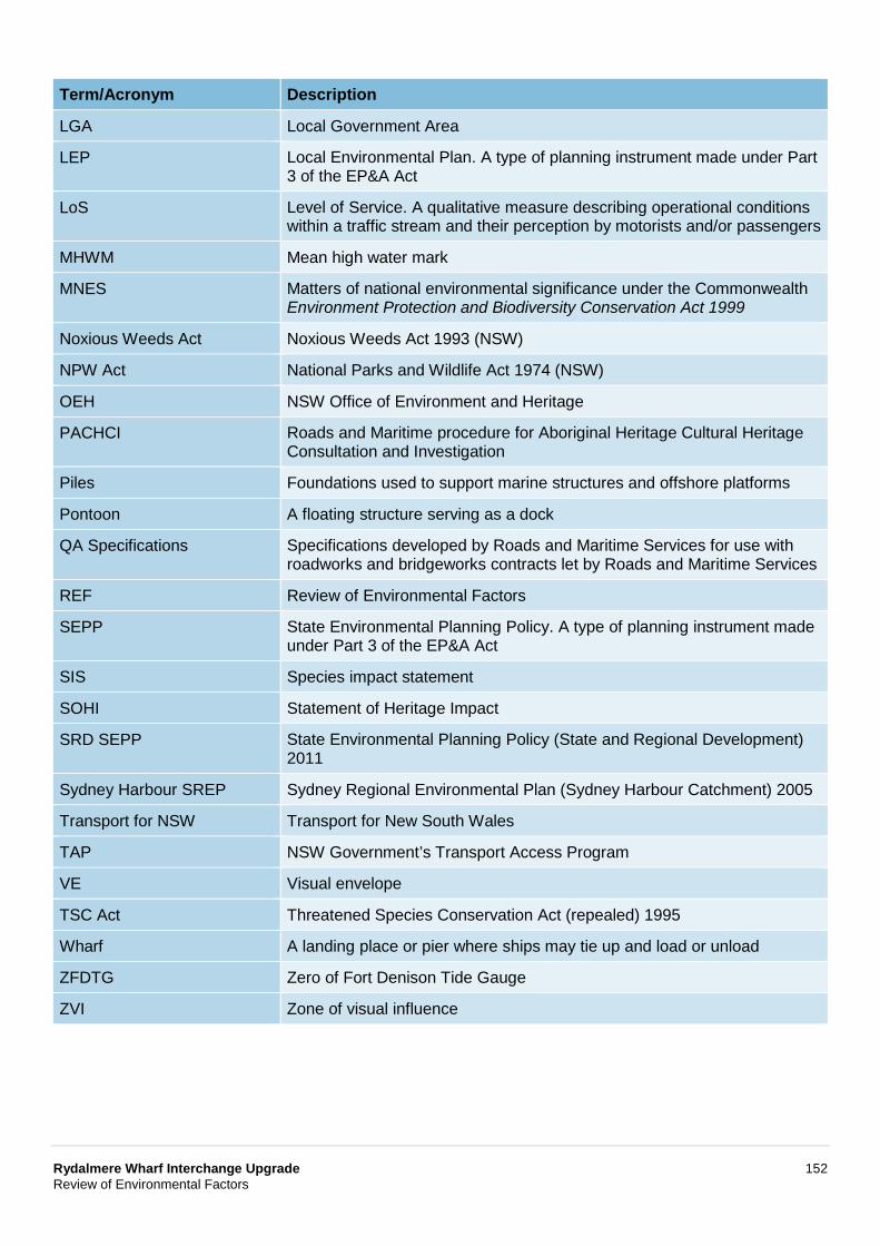
Rydalmere Wharf Interchange Upgrade 152 Review of Environmental Factors
Term/Acronym Description
LGA Local Government Area
LEP Local Environmental Plan. A type of planning instrument made under Part 3 of the EP&A Act
LoS Level of Service. A qualitative measure describing operational conditions within a traffic stream and their perception by motorists and/or passengers
MHWM Mean high water mark
MNES Matters of national environmental significance under the Commonwealth Environment Protection and Biodiversity Conservation Act 1999
Noxious Weeds Act Noxious Weeds Act 1993 (NSW)
NPW Act National Parks and Wildlife Act 1974 (NSW)
OEH NSW Office of Environment and Heritage
PACHCI Roads and Maritime procedure for Aboriginal Heritage Cultural Heritage Consultation and Investigation
Piles Foundations used to support marine structures and offshore platforms
Pontoon A floating structure serving as a dock
QA Specifications Specifications developed by Roads and Maritime Services for use with roadworks and bridgeworks contracts let by Roads and Maritime Services
REF Review of Environmental Factors
SEPP State Environmental Planning Policy. A type of planning instrument made under Part 3 of the EP&A Act
SIS Species impact statement
SOHI Statement of Heritage Impact
SRD SEPP State Environmental Planning Policy (State and Regional Development) 2011
Sydney Harbour SREP Sydney Regional Environmental Plan (Sydney Harbour Catchment) 2005
Transport for NSW Transport for New South Wales
TAP NSW Government’s Transport Access Program
VE Visual envelope
TSC Act Threatened Species Conservation Act (repealed) 1995
Wharf A landing place or pier where ships may tie up and load or unload
ZFDTG Zero of Fort Denison Tide Gauge
ZVI Zone of visual influence

Appendix A Proposal drawings
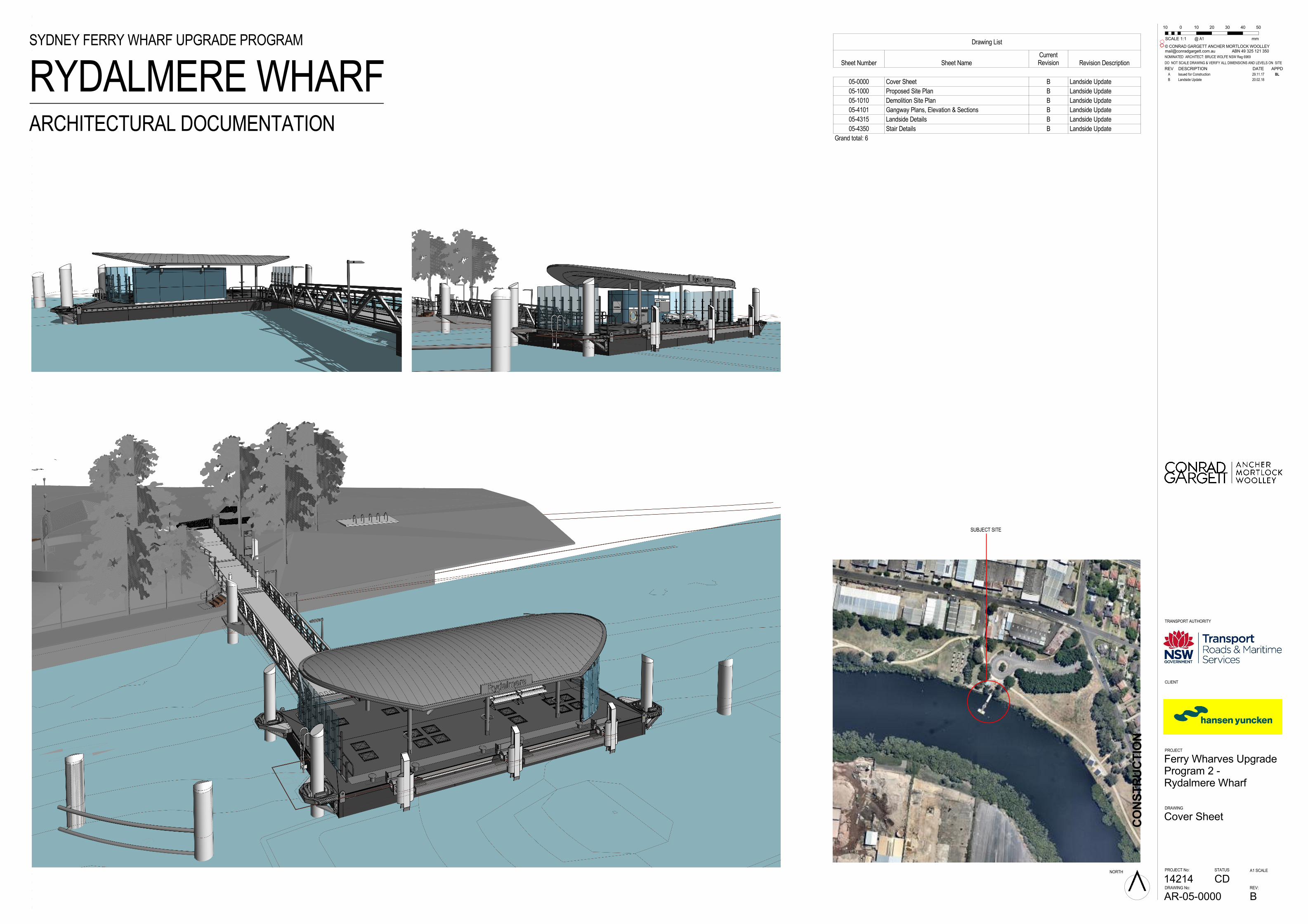
CONSTRUCTION
DRAWING No: REV:
A1 SCALE
DO NOT SCALE DRAWING & VERIFY ALL DIMENSIONS AND LEVELS ON SITE
CLIENT
PROJECT
DRAWING
NORTH
© CONRAD GARGETT ANCHER MORTLOCK [email protected] ABN 49 325 121 350
STATUSPROJECT No:
@ A1
TRANSPORT AUTHORITY
NOMINATED ARCHITECT: BRUCE WOLFE NSW Reg 6969
B
Ferry Wharves UpgradeProgram 2 -Rydalmere Wharf
AR-05-0000
Cover Sheet
CD14214
0
SCALE 1:
50
1
4030201010
mmDrawing List
Sheet Number Sheet NameCurrentRevision Revision Description
05-0000 Cover Sheet B Landside Update
05-1000 Proposed Site Plan B Landside Update
05-1010 Demolition Site Plan B Landside Update
05-4101 Gangway Plans, Elevation & Sections B Landside Update
05-4315 Landside Details B Landside Update
05-4350 Stair Details B Landside Update
Grand total: 6
RYDALMERE WHARFSYDNEY FERRY WHARF UPGRADE PROGRAM
ARCHITECTURAL DOCUMENTATION
SUBJECT SITE
REV DESCRIPTION DATE APPD
A Issued for Construction 29.11.17 BL
B Landside Update 20.02.18
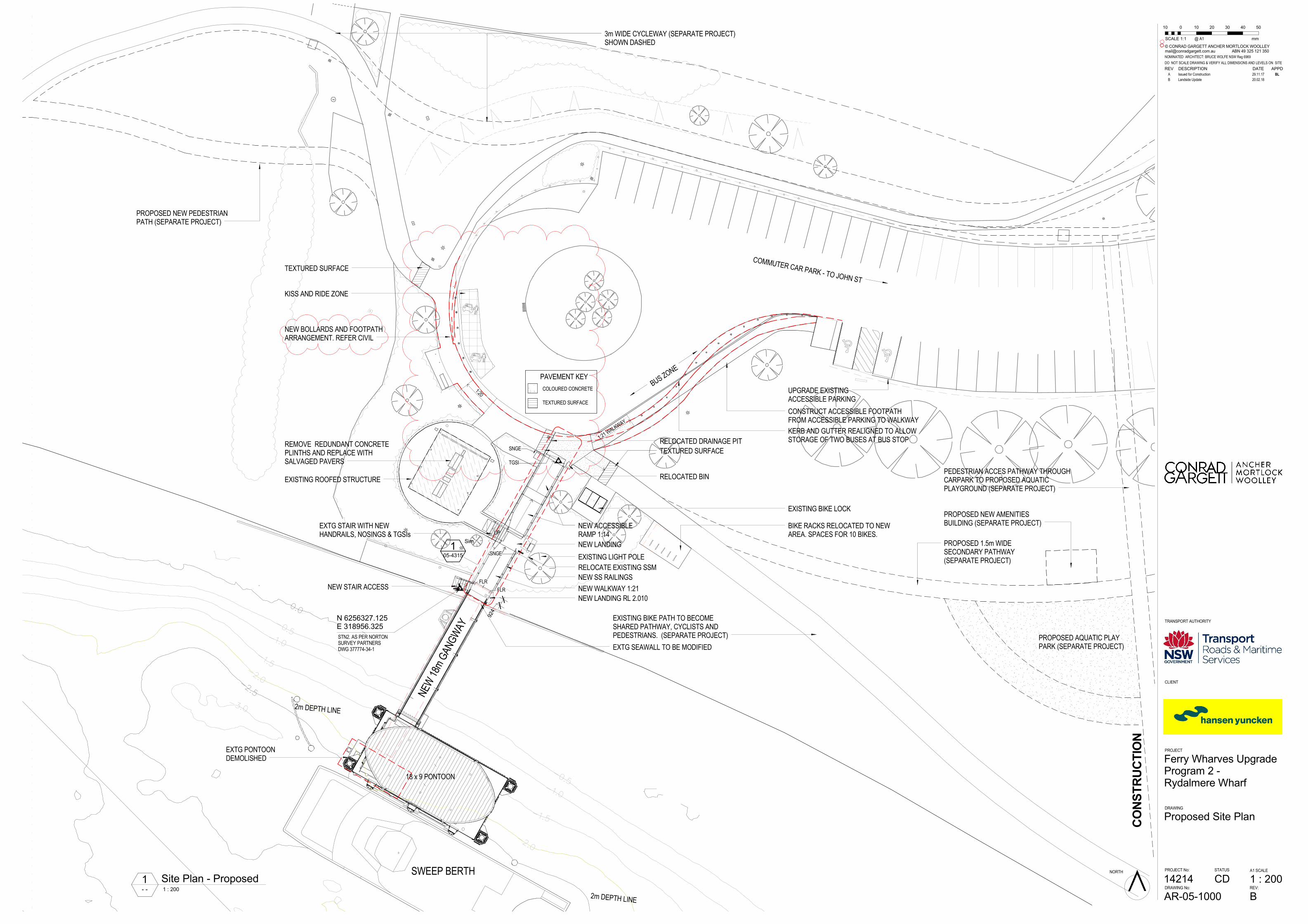
-2.0
-1.5
-1.0
-0.5
-3.0
-2.0
-1.5
-1.0
-0.5
-2.5
-2.5
0.0
UP
EXISTING ROOFED STRUCTURE
NEW
18m
GAN
GWAY
2m DEPTH LINE
2m DEPTH LINE
NEW WALKWAY 1:21
EXTG SEAWALL TO BE MODIFIED
NEW STAIR ACCESS
NEW LANDING RL 2.010
SWEEP BERTH
EXTG PONTOONDEMOLISHED
COMMUTER CAR PARK - TO JOHN ST
EXISTING BIKE PATH TO BECOMESHARED PATHWAY, CYCLISTS ANDPEDESTRIANS. (SEPARATE PROJECT)
KISS AND RIDE ZONE
BIKE RACKS RELOCATED TO NEWAREA. SPACES FOR 10 BIKES.
KERB AND GUTTER REALIGNED TO ALLOWSTORAGE OF TWO BUSES AT BUS STOP
UPGRADE EXISTINGACCESSIBLE PARKING
CONSTRUCT ACCESSIBLE FOOTPATHFROM ACCESSIBLE PARKING TO WALKWAY
EXISTING BIKE LOCK
STN2. AS PER NORTONSURVEY PARTNERSDWG 377774-34-1
N 6256327.125E 318956.325
3m WIDE CYCLEWAY (SEPARATE PROJECT)SHOWN DASHED
PROPOSED AQUATIC PLAYPARK (SEPARATE PROJECT)
PROPOSED NEW AMENITIESBUILDING (SEPARATE PROJECT)
PEDESTRIAN ACCES PATHWAY THROUGHCARPARK TO PROPOSED AQUATICPLAYGROUND (SEPARATE PROJECT)
PROPOSED 1.5m WIDESECONDARY PATHWAY(SEPARATE PROJECT)
924
NEW LANDING
NEW ACCESSIBLERAMP 1:14
RELOCATE EXISTING SSM
18 x 9 PONTOON
PROPOSED NEW PEDESTRIANPATH (SEPARATE PROJECT)
FLR
FLR
1:21 W
ALKW
AY
PAVEMENT KEY
COLOURED CONCRETE
TEXTURED SURFACE
RELOCATED BIN
TEXTURED SURFACE
SNGE
SNGE
NEW SS RAILINGS
TEXTURED SURFACE
RELOCATED DRAINAGE PIT
TGSI
BUS Z
ONE
REMOVE REDUNDANT CONCRETEPLINTHS AND REPLACE WITHSALVAGED PAVERS
EXTG STAIR WITH NEWHANDRAILS, NOSINGS & TGSIs
105-4315
Sim
1:20
NEW BOLLARDS AND FOOTPATHARRANGEMENT. REFER CIVIL
EXISTING LIGHT POLE
CONSTRUCTION
DRAWING No: REV:
A1 SCALE
DO NOT SCALE DRAWING & VERIFY ALL DIMENSIONS AND LEVELS ON SITE
CLIENT
PROJECT
DRAWING
NORTH
© CONRAD GARGETT ANCHER MORTLOCK [email protected] ABN 49 325 121 350
STATUSPROJECT No:
@ A1
TRANSPORT AUTHORITY
NOMINATED ARCHITECT: BRUCE WOLFE NSW Reg 6969
B
1 : 200
Ferry Wharves UpgradeProgram 2 -Rydalmere Wharf
AR-05-1000
Proposed Site Plan
CD14214
0
SCALE 1:
50
1
4030201010
mm
- - 1 : 200
1 Site Plan - Proposed
REV DESCRIPTION DATE APPD
A Issued for Construction 29.11.17 BL
B Landside Update 20.02.18
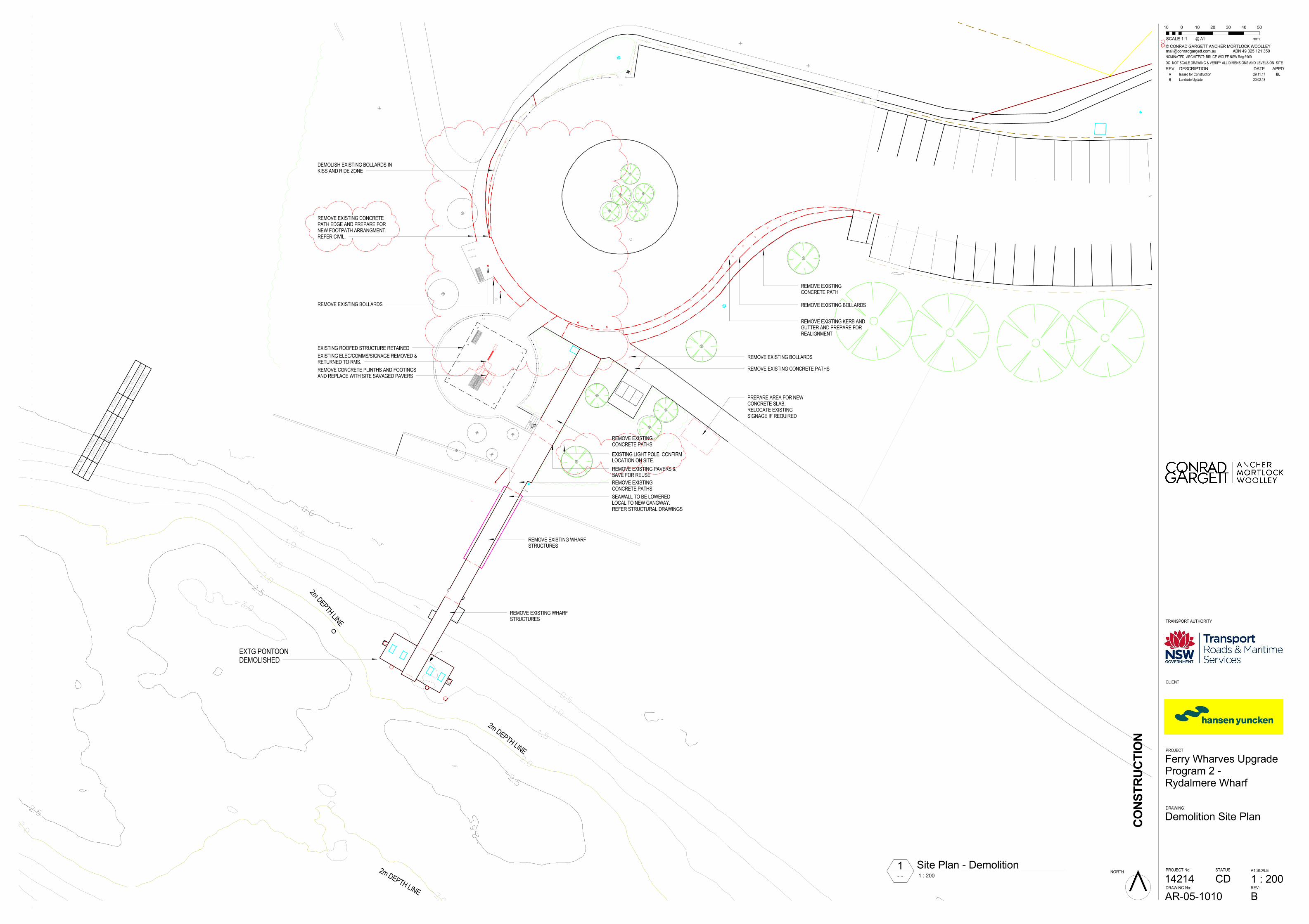
-2.0
-2.0
-1.5
-1.0
-0.5
-3.0
-2.0
-1.5
-1.0
-0.5
-2.0
-1.5
-2.5
-2.5
-2.5
0.0
-2.5
318956.248
STN No.
EASTING
NORTHING
RL(AHD)
MARK
6256327.095
1.43
1
318969.480
6256343.179
3.05
2
NAIL IN CONCRETE
NAIL IN PAVING
UP
EXISTING ROOFED STRUCTURE RETAINED
2m DEPTH LINE
2m DEPTH LINE
2m DEPTH LINE
EXTG PONTOONDEMOLISHED
EXISTING ELEC/COMMS/SIGNAGE REMOVED &RETURNED TO RMS.
REMOVE CONCRETE PLINTHS AND FOOTINGSAND REPLACE WITH SITE SAVAGED PAVERS
REMOVE EXISTINGCONCRETE PATHS
REMOVE EXISTING PAVERS &SAVE FOR REUSE
REMOVE EXISTINGCONCRETE PATHS
REMOVE EXISTING WHARFSTRUCTURES
REMOVE EXISTING WHARFSTRUCTURES
PREPARE AREA FOR NEWCONCRETE SLAB,RELOCATE EXISTINGSIGNAGE IF REQUIRED
SEAWALL TO BE LOWEREDLOCAL TO NEW GANGWAY.REFER STRUCTURAL DRAWINGS
REMOVE EXISTINGCONCRETE PATH
REMOVE EXISTING BOLLARDS
REMOVE EXISTING KERB ANDGUTTER AND PREPARE FORREALIGNMENT
REMOVE EXISTING BOLLARDS
REMOVE EXISTING BOLLARDS
DEMOLISH EXISTING BOLLARDS INKISS AND RIDE ZONE
REMOVE EXISTING CONCRETE PATHS
EXISTING LIGHT POLE. CONFIRMLOCATION ON SITE.
REMOVE EXISTING CONCRETEPATH EDGE AND PREPARE FORNEW FOOTPATH ARRANGMENT.REFER CIVIL.
CONSTRUCTION
DRAWING No: REV:
A1 SCALE
DO NOT SCALE DRAWING & VERIFY ALL DIMENSIONS AND LEVELS ON SITE
CLIENT
PROJECT
DRAWING
NORTH
© CONRAD GARGETT ANCHER MORTLOCK [email protected] ABN 49 325 121 350
STATUSPROJECT No:
@ A1
TRANSPORT AUTHORITY
NOMINATED ARCHITECT: BRUCE WOLFE NSW Reg 6969
B
1 : 200
Ferry Wharves UpgradeProgram 2 -Rydalmere Wharf
AR-05-1010
Demolition Site Plan
CD14214
0
SCALE 1:
50
1
4030201010
mm
- - 1 : 200
1 Site Plan - Demolition
REV DESCRIPTION DATE APPD
A Issued for Construction 29.11.17 BL
B Landside Update 20.02.18
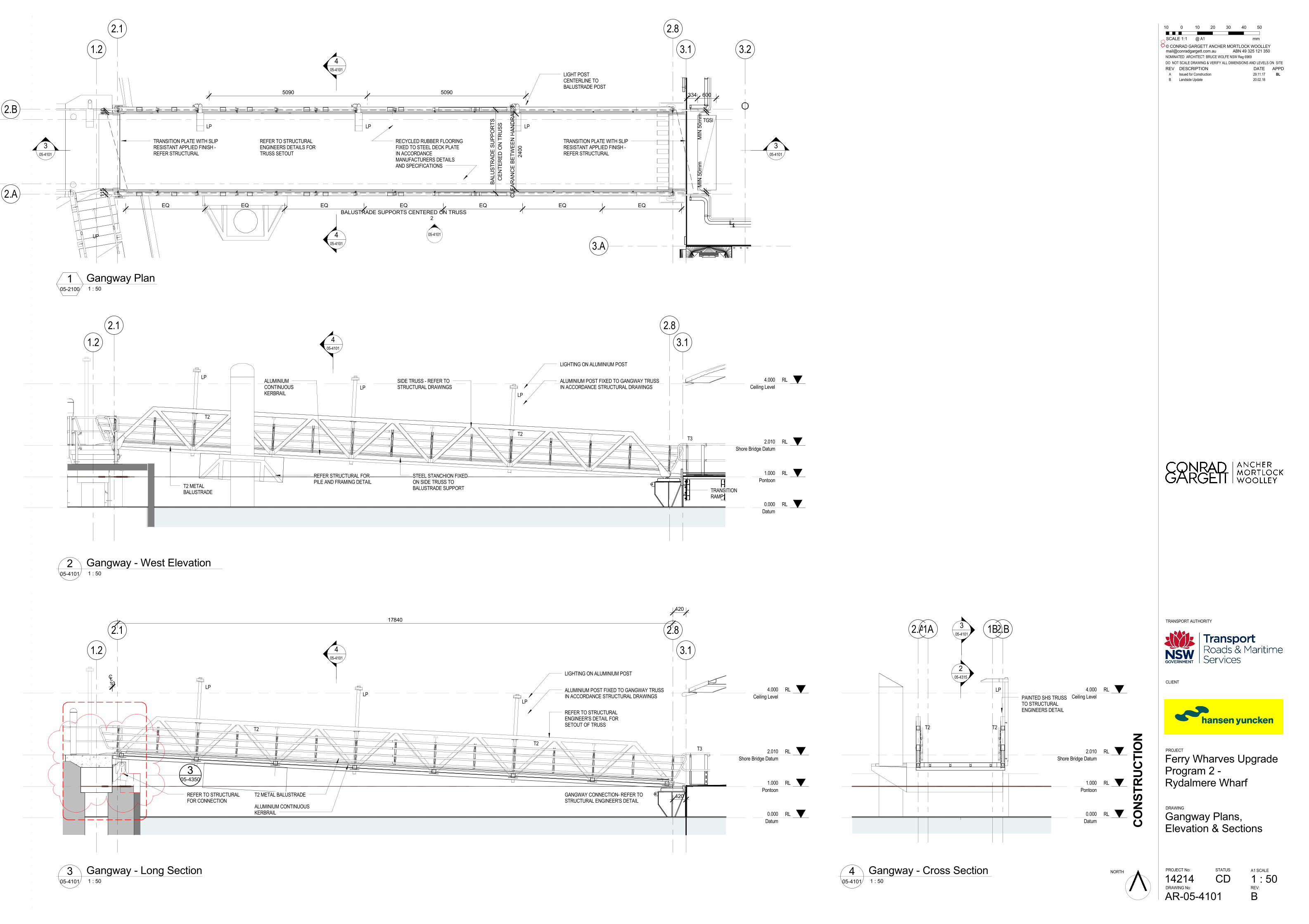
UP
3.1 3.2
3.A
2.82.1
1.2
TRANSITION PLATE WITH SLIPRESISTANT APPLIED FINISH -REFER STRUCTURAL
TRANSITION PLATE WITH SLIPRESISTANT APPLIED FINISH -REFER STRUCTURAL
RECYCLED RUBBER FLOORINGFIXED TO STEEL DECK PLATEIN ACCORDANCEMANUFACTURERS DETAILSAND SPECIFICATIONS
REFER TO STRUCTURALENGINEERS DETAILS FORTRUSS SETOUT
LIGHT POSTCENTERLINE TOBALUSTRADE POST
EQ EQ EQ
BALUSTRADE SUPPORTS CENTERED ON TRUSS
EQ EQ EQ EQ
CENTERED ON TRUSS
BALUSTRADE SUPPORTS
2400
CLEARANCE BETWEEN HANDRAILS
5090 5090
MIN 50mm
MIN 50mm
305-4101
305-4101
05-4101
2
405-4101
405-4101
LP LP LPTGSI
600334
2.A
2.B 60
115
RL1.000
Pontoon
RL0.000
Datum
RL2.010
Shore Bridge Datum
RL4.000
Ceiling Level
3.1
2.82.1
1.2
T2 METALBALUSTRADE
LIGHTING ON ALUMINIUM POST
ALUMINIUMCONTINUOUSKERBRAIL
ALUMINIUM POST FIXED TO GANGWAY TRUSSIN ACCORDANCE STRUCTURAL DRAWINGS
SIDE TRUSS - REFER TOSTRUCTURAL DRAWINGS
STEEL STANCHION FIXEDON SIDE TRUSS TOBALUSTRADE SUPPORT TRANSITION
RAMP
405-4101
LP
LP
LP
T2
T2T3
REFER STRUCTURAL FORPILE AND FRAMING DETAIL
RL1.000
Pontoon
RL0.000
Datum
RL2.010
Shore Bridge Datum
RL4.000
Ceiling Level
3.1
2.82.1
1.2
REFER TO STRUCTURALFOR CONNECTION
T2 METAL BALUSTRADE GANGWAY CONNECTION- REFER TOSTRUCTURAL ENGINEER'S DETAIL
REFER TO STRUCTURALENGINEER'S DETAIL FORSETOUT OF TRUSS
ALUMINIUM CONTINUOUSKERBRAIL
LIGHTING ON ALUMINIUM POST
ALUMINIUM POST FIXED TO GANGWAY TRUSSIN ACCORDANCE STRUCTURAL DRAWINGS
420
405-4101
LP
LP
LP
T3T2
T2
305-4350
CL13
17840
420
RL1.000
Pontoon
RL0.000
Datum
RL2.010
Shore Bridge Datum
RL4.000
Ceiling Level
305-4101
LP
T2 T2
PAINTED SHS TRUSSTO STRUCTURALENGINEERS DETAIL
2.A 2.B
205-4315
1A 1B
CONSTRUCTION
DRAWING No: REV:
A1 SCALE
DO NOT SCALE DRAWING & VERIFY ALL DIMENSIONS AND LEVELS ON SITE
CLIENT
PROJECT
DRAWING
NORTH
© CONRAD GARGETT ANCHER MORTLOCK [email protected] ABN 49 325 121 350
STATUSPROJECT No:
@ A1
TRANSPORT AUTHORITY
NOMINATED ARCHITECT: BRUCE WOLFE NSW Reg 6969
B
1 : 50
Ferry Wharves UpgradeProgram 2 -Rydalmere Wharf
AR-05-4101
Gangway Plans,Elevation & Sections
CD14214
0
SCALE 1:
50
1
4030201010
mm
05-2100 1 : 50
1 Gangway Plan
05-4101 1 : 50
2 Gangway - West Elevation
05-4101 1 : 50
3 Gangway - Long Section05-4101 1 : 50
4 Gangway - Cross Section
REV DESCRIPTION DATE APPD
A Issued for Construction 29.11.17 BL
B Landside Update 20.02.18
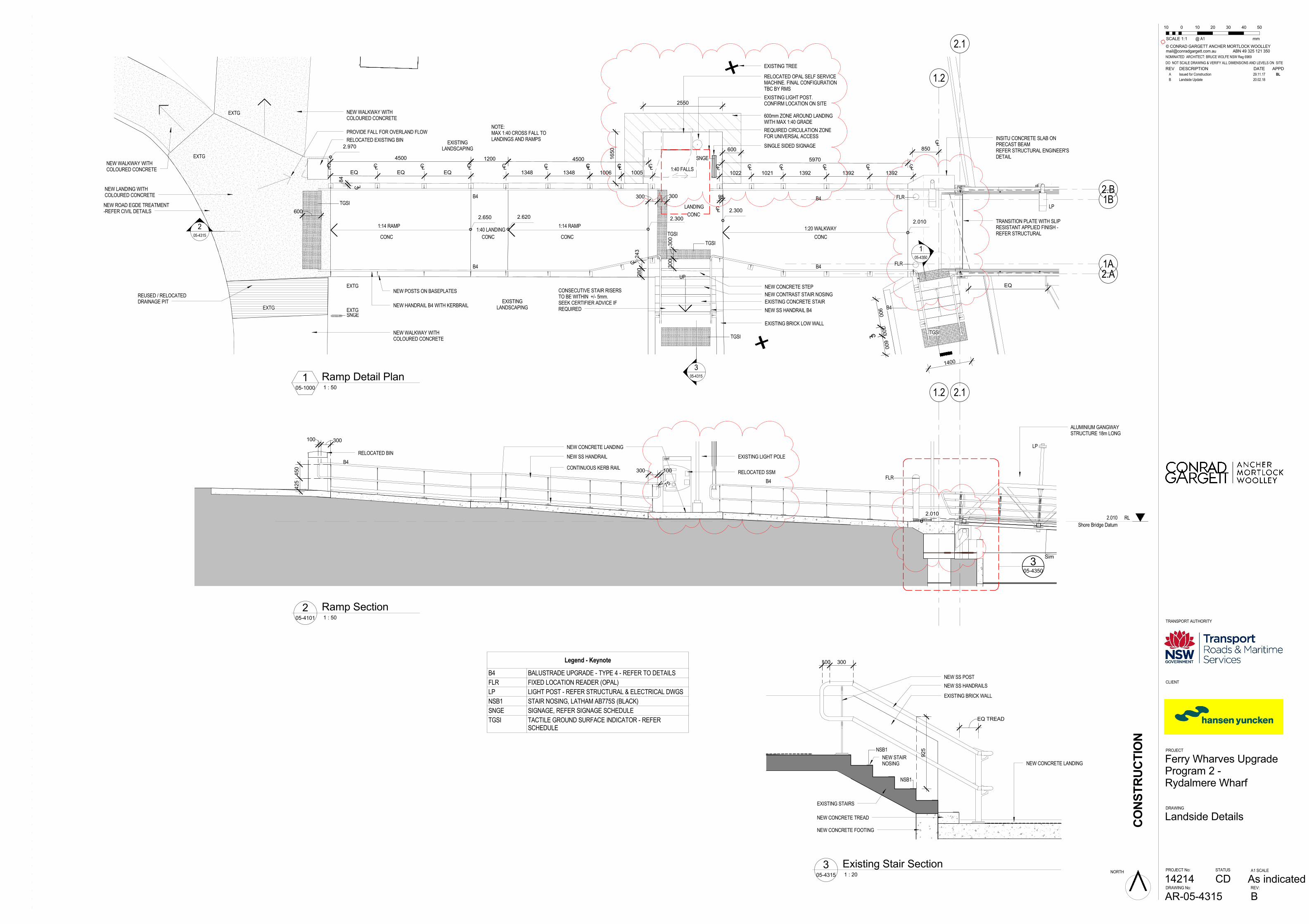
UP
2.1
1.2
2.A
2.B
TRANSITION PLATE WITH SLIPRESISTANT APPLIED FINISH -REFER STRUCTURAL
EQ
LP
205-4315
TGSI
EXISTING CONCRETE STAIRNEW HANDRAIL B4 WITH KERBRAIL
B4
B4 B4
B4
B4
105-4350
RELOCATED OPAL SELF SERVICEMACHINE. FINAL CONFIGURATIONTBC BY RMS
900
CL
300CL
600
1400
TGSI
305-4315
NEW CONCRETE STEP
1:14 RAMP 1:14 RAMP 1:20 WALKWAY
FLR
FLR
RELOCATED EXISTING BIN
1200 45004500
NEW POSTS ON BASEPLATES
SNGE
SNGEEXTG
EXTG
2.650
300 300
280
NEW SS HANDRAIL B4
5970
EXISTING BRICK LOW WALL
NOTE:MAX 1:40 CROSS FALL TOLANDINGS AND RAMPS
300
300
2.010
600mm ZONE AROUND LANDINGWITH MAX 1:40 GRADE
CONC
REUSED / RELOCATEDDRAINAGE PIT
CONC CONC
CONC
LANDING
1:40 LANDING
CONC
TGSI
600
2.970
NEW LANDING WITHCOLOURED CONCRETE
PROVIDE FALL FOR OVERLAND FLOW
EXISTINGLANDSCAPING
EXISTINGLANDSCAPING
NEW WALKWAY WITHCOLOURED CONCRETE
NEW WALKWAY WITHCOLOURED CONCRETE
NEW WALKWAY WITHCOLOURED CONCRETE
CL CL CL CLEQEQEQ
CL CL CL13481348
CL CL1006
CL CL1005
CL
95
CL CL CL CL CL CL13921392139210211022
C L243
C L
84
NEW CONTRAST STAIR NOSING
2.300
2.620 2.300
EXTG
EXTG
EXTG
1:40 FALLS
TGSI
TGSI
NEW ROAD EGDE TREATMENT-REFER CIVIL DETAILS
CONSECUTIVE STAIR RISERSTO BE WITHIN +/- 5mm.SEEK CERTIFIER ADVICE IFREQUIRED
1A
1B
CL850
INSITU CONCRETE SLAB ONPRECAST BEAMREFER STRUCTURAL ENGINEER'SDETAIL
EXISTING LIGHT POST.CONFIRM LOCATION ON SITE
EXISTING TREE
1650
REQUIRED CIRCULATION ZONEFOR UNIVERSAL ACCESS
2550
600SINGLE SIDED SIGNAGE
RL2.010
Shore Bridge Datum
2.11.2
ALUMINIUM GANGWAYSTRUCTURE 18m LONG
NEW SS HANDRAIL
CONTINUOUS KERB RAILB4
B4
LPNEW CONCRETE LANDING
305-4350
Sim
425
450 300 100
75
2.010
RELOCATED BIN
100 300
FLR
EXISTING LIGHT POLE
RELOCATED SSM
EXISTING STAIRS
NEW CONCRETE FOOTING
NEW CONCRETE LANDING
NEW CONCRETE TREAD
NEW STAIRNOSING
EQ TREAD
300100
EXISTING BRICK WALL
NEW SS HANDRAILS
NEW SS POST
925NSB1
NSB1
CONSTRUCTION
DRAWING No: REV:
A1 SCALE
DO NOT SCALE DRAWING & VERIFY ALL DIMENSIONS AND LEVELS ON SITE
CLIENT
PROJECT
DRAWING
NORTH
© CONRAD GARGETT ANCHER MORTLOCK [email protected] ABN 49 325 121 350
STATUSPROJECT No:
@ A1
TRANSPORT AUTHORITY
NOMINATED ARCHITECT: BRUCE WOLFE NSW Reg 6969
B
As indicated
Ferry Wharves UpgradeProgram 2 -Rydalmere Wharf
AR-05-4315
Landside Details
CD14214
0
SCALE 1:
50
1
4030201010
mm
05-1000 1 : 50
1 Ramp Detail Plan
05-4101 1 : 50
2 Ramp Section
05-4315 1 : 20
3 Existing Stair Section
REV DESCRIPTION DATE APPD
A Issued for Construction 29.11.17 BL
B Landside Update 20.02.18
Legend - Keynote
B4 BALUSTRADE UPGRADE - TYPE 4 - REFER TO DETAILS
FLR FIXED LOCATION READER (OPAL)
LP LIGHT POST - REFER STRUCTURAL & ELECTRICAL DWGS
NSB1 STAIR NOSING, LATHAM AB775S (BLACK)
SNGE SIGNAGE, REFER SIGNAGE SCHEDULE
TGSI TACTILE GROUND SURFACE INDICATOR - REFERSCHEDULE
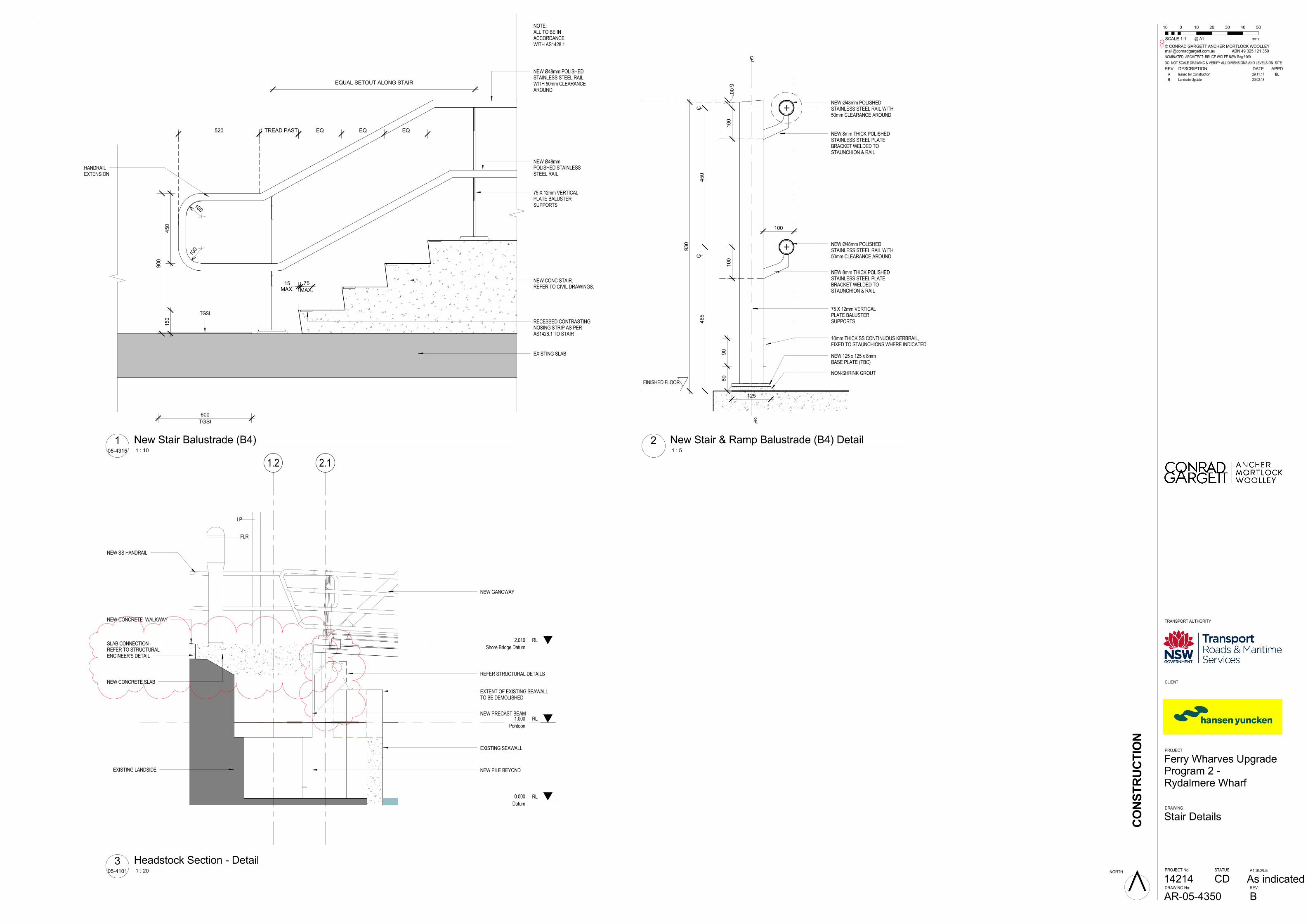
TGSI
NEW CONC STAIR.REFER TO CIVIL DRAWINGS.
EXISTING SLAB
NEW Ø48mmPOLISHED STAINLESSSTEEL RAIL
HANDRAILEXTENSION
NEW Ø48mm POLISHEDSTAINLESS STEEL RAILWITH 50mm CLEARANCEAROUND
TGSI
600
1 TREAD PAST
MAX.15
MAX.
75
RECESSED CONTRASTINGNOSING STRIP AS PERAS1428.1 TO STAIR
NOTE:ALL TO BE INACCORDANCEWITH AS1428.1
900
520
450
100
100
75 X 12mm VERTICALPLATE BALUSTERSUPPORTS
EQUAL SETOUT ALONG STAIR
150
EQ EQ EQ
75 X 12mm VERTICALPLATE BALUSTERSUPPORTS
NEW Ø48mm POLISHEDSTAINLESS STEEL RAIL WITH50mm CLEARANCE AROUND
NEW 125 x 125 x 8mmBASE PLATE (TBC)
NEW 8mm THICK POLISHEDSTAINLESS STEEL PLATEBRACKET WELDED TOSTAUNCHION & RAIL
C L
CL
CL
FINISHED FLOOR
100
C L465
450
NEW Ø48mm POLISHEDSTAINLESS STEEL RAIL WITH50mm CLEARANCE AROUND
125
930
NEW 8mm THICK POLISHEDSTAINLESS STEEL PLATEBRACKET WELDED TOSTAUNCHION & RAIL
10mm THICK SS CONTINUOUS KERBRAIL,FIXED TO STAUNCHIONS WHERE INDICATED
90
80
100
100
5.00°
NON-SHRINK GROUT
RL1.000
Pontoon
RL0.000
Datum
RL2.010
Shore Bridge Datum
2.11.2
NEW GANGWAY
REFER STRUCTURAL DETAILS
EXISTING SEAWALL
NEW PRECAST BEAM
NEW PILE BEYONDEXISTING LANDSIDE
NEW CONCRETE SLAB
NEW CONCRETE WALKWAY
NEW SS HANDRAIL
EXTENT OF EXISTING SEAWALLTO BE DEMOLISHED
FLR
LP
SLAB CONNECTION -REFER TO STRUCTURALENGINEER'S DETAIL
CONSTRUCTION
DRAWING No: REV:
A1 SCALE
DO NOT SCALE DRAWING & VERIFY ALL DIMENSIONS AND LEVELS ON SITE
CLIENT
PROJECT
DRAWING
NORTH
© CONRAD GARGETT ANCHER MORTLOCK [email protected] ABN 49 325 121 350
STATUSPROJECT No:
@ A1
TRANSPORT AUTHORITY
NOMINATED ARCHITECT: BRUCE WOLFE NSW Reg 6969
B
As indicated
Ferry Wharves UpgradeProgram 2 -Rydalmere Wharf
AR-05-4350
Stair Details
CD14214
0
SCALE 1:
50
1
4030201010
mm
05-4315 1 : 10
1 New Stair Balustrade (B4) 1 : 5
2 New Stair & Ramp Balustrade (B4) Detail
05-4101 1 : 20
3 Headstock Section - Detail
REV DESCRIPTION DATE APPD
A Issued for Construction 29.11.17 BL
B Landside Update 20.02.18

Appendix B Consideration of clause 228(2) factors Consideration of matters of national environmental significance

Rydalmere Wharf Interchange Upgrade B-1 Review of Environmental Factors
Clause 228(2) checklist In addition to the requirements of the Is an EIS required? (DUAP 1995/1996) guideline and the Marinas and Related Facilities EIS Guideline (DUAP 1996) as detailed in the REF, the following factors, listed in clause 228(2) of the Environmental Planning and Assessment Regulation 2000, have also been considered to assess the likely impacts of the proposal on the natural and built environment.
a. Any environmental impact on a community?
Impact Level of impact
During construction of the proposal, the following impacts are anticipated: • Impact from construction related noise to
surrounding receivers. • Impacts to traffic and transport due to temporary
closure of the wharf. Operation of the wharf would have improved public transport facilities at Rydalmere. Impacts would be minimised through implementing the safeguards and management measures identified in section 7.1 of the REF
High, short-term negative impact. Moderate, short-term negative impact. Long-term, positive impact.
b. Any transformation of a locality?
Impact Level of impact
The proposal would have a low to moderate impact to visual and landscape character. Impacts have been reduced through design of the wharf, including retention of the wharf in its location.
Minor to moderate, long-term negative impact.
c. Any environmental impact on the ecosystems of the locality?
Impact Level of impact
The assessment of aquatic ecology indicates there would be a minor impact to marine biodiversity during construction. This would be offset by hard-substratum habitat generated by the installation of piles. Further impact to aquatic ecology would be mitigated through implementing the safeguards and management measures identified in section 7.1 of the REF.
Moderate, short-term negative impact.
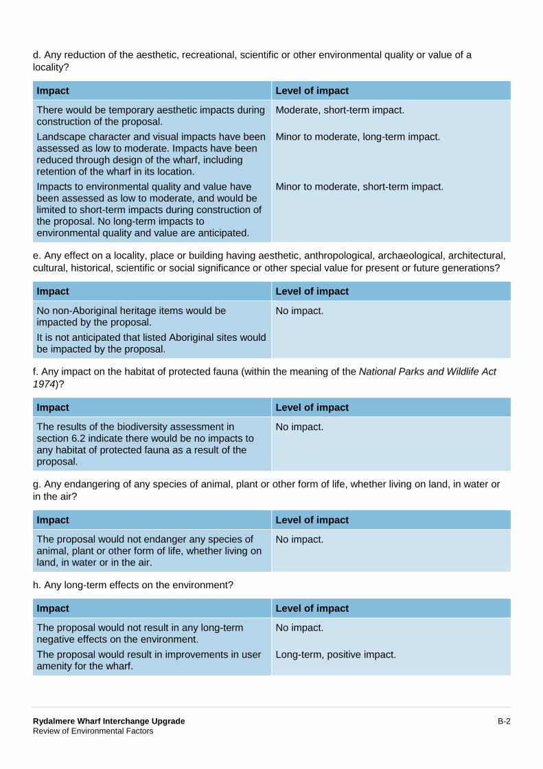
Rydalmere Wharf Interchange Upgrade B-2 Review of Environmental Factors
d. Any reduction of the aesthetic, recreational, scientific or other environmental quality or value of a locality?
Impact Level of impact
There would be temporary aesthetic impacts during construction of the proposal. Landscape character and visual impacts have been assessed as low to moderate. Impacts have been reduced through design of the wharf, including retention of the wharf in its location. Impacts to environmental quality and value have been assessed as low to moderate, and would be limited to short-term impacts during construction of the proposal. No long-term impacts to environmental quality and value are anticipated.
Moderate, short-term impact. Minor to moderate, long-term impact. Minor to moderate, short-term impact.
e. Any effect on a locality, place or building having aesthetic, anthropological, archaeological, architectural, cultural, historical, scientific or social significance or other special value for present or future generations?
Impact Level of impact
No non-Aboriginal heritage items would be impacted by the proposal. It is not anticipated that listed Aboriginal sites would be impacted by the proposal.
No impact.
f. Any impact on the habitat of protected fauna (within the meaning of the National Parks and Wildlife Act 1974)?
Impact Level of impact
The results of the biodiversity assessment in section 6.2 indicate there would be no impacts to any habitat of protected fauna as a result of the proposal.
No impact.
g. Any endangering of any species of animal, plant or other form of life, whether living on land, in water or in the air?
Impact Level of impact
The proposal would not endanger any species of animal, plant or other form of life, whether living on land, in water or in the air.
No impact.
h. Any long-term effects on the environment?
Impact Level of impact
The proposal would not result in any long-term negative effects on the environment. The proposal would result in improvements in user amenity for the wharf.
No impact. Long-term, positive impact.
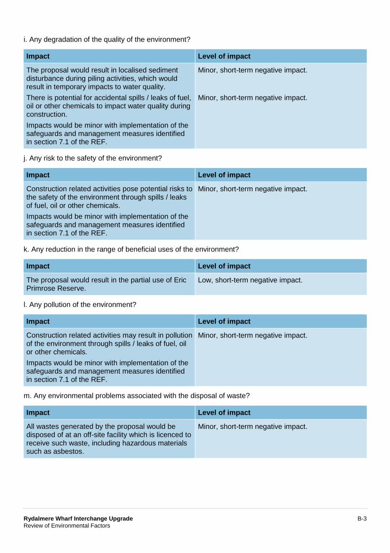
Rydalmere Wharf Interchange Upgrade B-3 Review of Environmental Factors
i. Any degradation of the quality of the environment?
Impact Level of impact
The proposal would result in localised sediment disturbance during piling activities, which would result in temporary impacts to water quality. There is potential for accidental spills / leaks of fuel, oil or other chemicals to impact water quality during construction. Impacts would be minor with implementation of the safeguards and management measures identified in section 7.1 of the REF.
Minor, short-term negative impact. Minor, short-term negative impact.
j. Any risk to the safety of the environment?
Impact Level of impact
Construction related activities pose potential risks to the safety of the environment through spills / leaks of fuel, oil or other chemicals. Impacts would be minor with implementation of the safeguards and management measures identified in section 7.1 of the REF.
Minor, short-term negative impact.
k. Any reduction in the range of beneficial uses of the environment?
Impact Level of impact
The proposal would result in the partial use of Eric Primrose Reserve.
Low, short-term negative impact.
l. Any pollution of the environment?
Impact Level of impact
Construction related activities may result in pollution of the environment through spills / leaks of fuel, oil or other chemicals. Impacts would be minor with implementation of the safeguards and management measures identified in section 7.1 of the REF.
Minor, short-term negative impact.
m. Any environmental problems associated with the disposal of waste?
Impact Level of impact
All wastes generated by the proposal would be disposed of at an off-site facility which is licenced to receive such waste, including hazardous materials such as asbestos.
Minor, short-term negative impact.
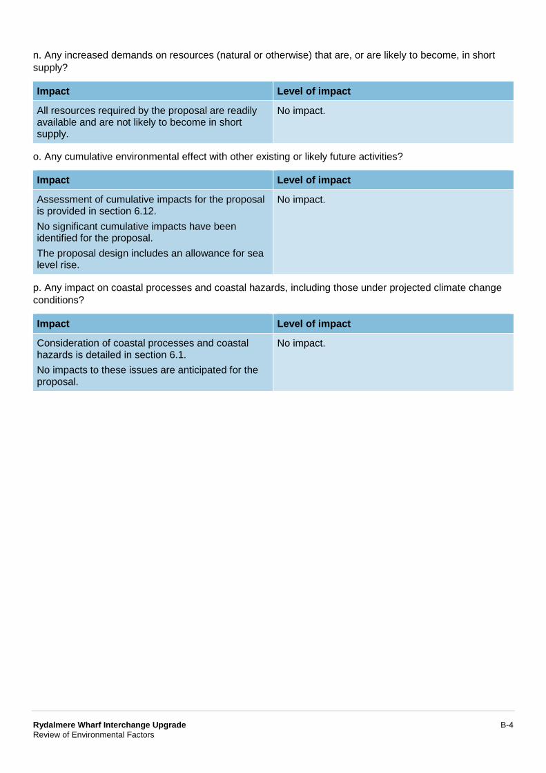
Rydalmere Wharf Interchange Upgrade B-4 Review of Environmental Factors
n. Any increased demands on resources (natural or otherwise) that are, or are likely to become, in short supply?
Impact Level of impact
All resources required by the proposal are readily available and are not likely to become in short supply.
No impact.
o. Any cumulative environmental effect with other existing or likely future activities?
Impact Level of impact
Assessment of cumulative impacts for the proposal is provided in section 6.12. No significant cumulative impacts have been identified for the proposal. The proposal design includes an allowance for sea level rise.
No impact.
p. Any impact on coastal processes and coastal hazards, including those under projected climate change conditions?
Impact Level of impact
Consideration of coastal processes and coastal hazards is detailed in section 6.1. No impacts to these issues are anticipated for the proposal.
No impact.
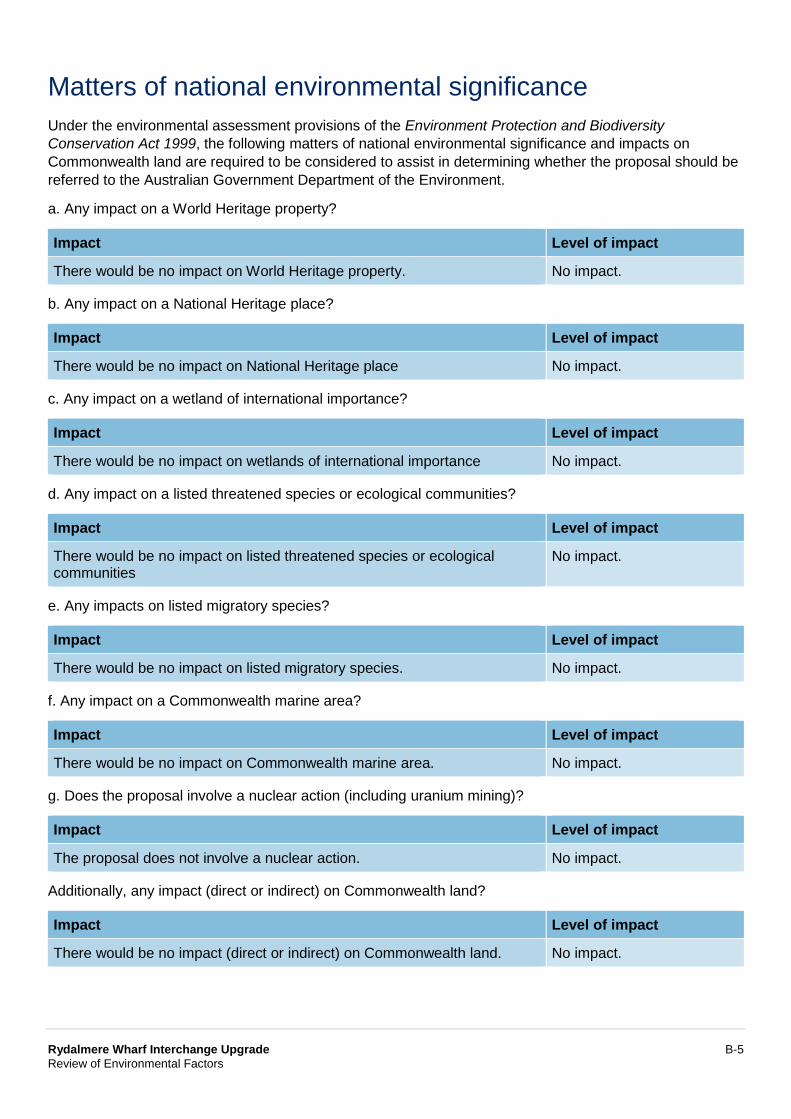
Rydalmere Wharf Interchange Upgrade B-5 Review of Environmental Factors
Matters of national environmental significance Under the environmental assessment provisions of the Environment Protection and Biodiversity Conservation Act 1999, the following matters of national environmental significance and impacts on Commonwealth land are required to be considered to assist in determining whether the proposal should be referred to the Australian Government Department of the Environment.
a. Any impact on a World Heritage property?
Impact Level of impact
There would be no impact on World Heritage property. No impact.
b. Any impact on a National Heritage place?
Impact Level of impact
There would be no impact on National Heritage place No impact.
c. Any impact on a wetland of international importance?
Impact Level of impact
There would be no impact on wetlands of international importance No impact.
d. Any impact on a listed threatened species or ecological communities?
Impact Level of impact
There would be no impact on listed threatened species or ecological communities
No impact.
e. Any impacts on listed migratory species?
Impact Level of impact
There would be no impact on listed migratory species. No impact.
f. Any impact on a Commonwealth marine area?
Impact Level of impact
There would be no impact on Commonwealth marine area. No impact.
g. Does the proposal involve a nuclear action (including uranium mining)?
Impact Level of impact
The proposal does not involve a nuclear action. No impact.
Additionally, any impact (direct or indirect) on Commonwealth land?
Impact Level of impact
There would be no impact (direct or indirect) on Commonwealth land. No impact.

Appendix C Statutory consultation checklists and published community updates
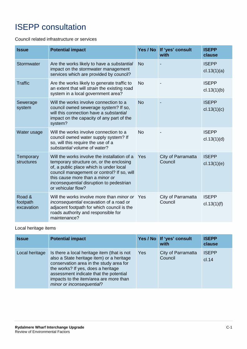
Rydalmere Wharf Interchange Upgrade C-1 Review of Environmental Factors
ISEPP consultation Council related infrastructure or services
Issue Potential impact Yes / No If ‘yes’ consult with
ISEPP clause
Stormwater Are the works likely to have a substantial impact on the stormwater management services which are provided by council?
No - ISEPP cl.13(1)(a)
Traffic Are the works likely to generate traffic to an extent that will strain the existing road system in a local government area?
No - ISEPP cl.13(1)(b)
Sewerage system
Will the works involve connection to a council owned sewerage system? If so, will this connection have a substantial impact on the capacity of any part of the system?
No - ISEPP cl.13(1)(c)
Water usage Will the works involve connection to a council owned water supply system? If so, will this require the use of a substantial volume of water?
No - ISEPP cl.13(1)(d)
Temporary structures
Will the works involve the installation of a temporary structure on, or the enclosing of, a public place which is under local council management or control? If so, will this cause more than a minor or inconsequential disruption to pedestrian or vehicular flow?
Yes City of Parramatta Council
ISEPP cl.13(1)(e)
Road & footpath excavation
Will the works involve more than minor or inconsequential excavation of a road or adjacent footpath for which council is the roads authority and responsible for maintenance?
Yes City of Parramatta Council
ISEPP cl.13(1)(f)
Local heritage items
Issue Potential impact Yes / No If ‘yes’ consult with
ISEPP clause
Local heritage Is there a local heritage item (that is not also a State heritage item) or a heritage conservation area in the study area for the works? If yes, does a heritage assessment indicate that the potential impacts to the item/area are more than minor or inconsequential?
Yes City of Parramatta Council
ISEPP cl.14
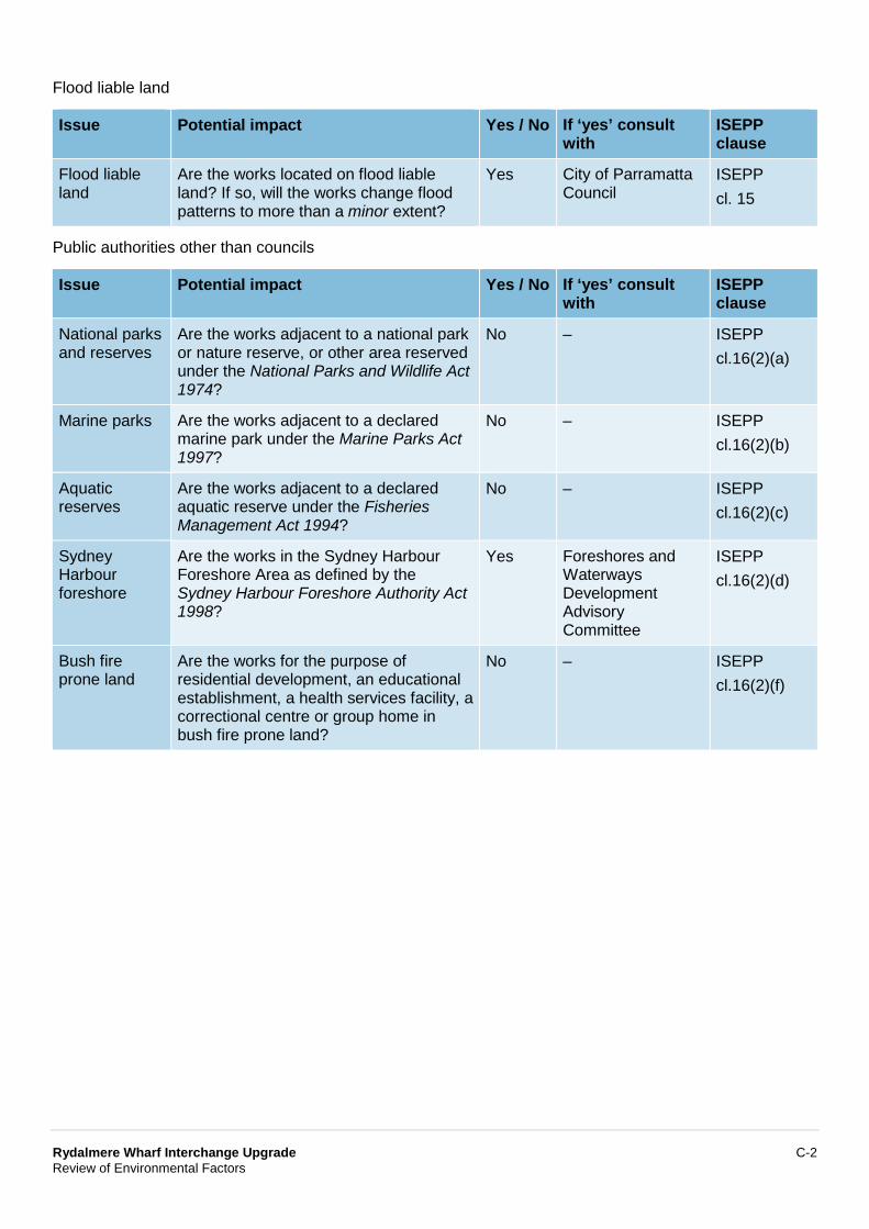
Rydalmere Wharf Interchange Upgrade C-2 Review of Environmental Factors
Flood liable land
Issue Potential impact Yes / No If ‘yes’ consult with
ISEPP clause
Flood liable land
Are the works located on flood liable land? If so, will the works change flood patterns to more than a minor extent?
Yes City of Parramatta Council
ISEPP cl. 15
Public authorities other than councils
Issue Potential impact Yes / No If ‘yes’ consult with
ISEPP clause
National parks and reserves
Are the works adjacent to a national park or nature reserve, or other area reserved under the National Parks and Wildlife Act 1974?
No – ISEPP cl.16(2)(a)
Marine parks Are the works adjacent to a declared marine park under the Marine Parks Act 1997?
No – ISEPP cl.16(2)(b)
Aquatic reserves
Are the works adjacent to a declared aquatic reserve under the Fisheries Management Act 1994?
No – ISEPP cl.16(2)(c)
Sydney Harbour foreshore
Are the works in the Sydney Harbour Foreshore Area as defined by the Sydney Harbour Foreshore Authority Act 1998?
Yes Foreshores and Waterways Development Advisory Committee
ISEPP cl.16(2)(d)
Bush fire prone land
Are the works for the purpose of residential development, an educational establishment, a health services facility, a correctional centre or group home in bush fire prone land?
No – ISEPP cl.16(2)(f)
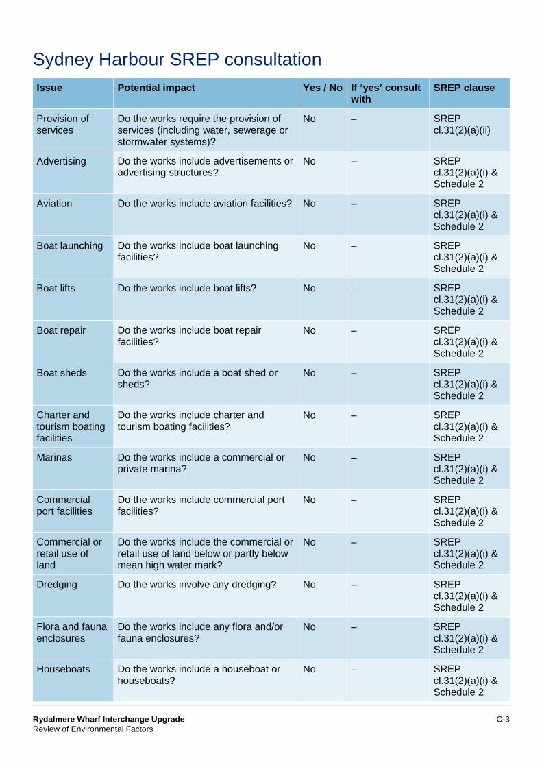
Rydalmere Wharf Interchange Upgrade C-3 Review of Environmental Factors
Sydney Harbour SREP consultation Issue Potential impact Yes / No If ‘yes’ consult
with SREP clause
Provision of services
Do the works require the provision of services (including water, sewerage or stormwater systems)?
No – SREP cl.31(2)(a)(ii)
Advertising Do the works include advertisements or advertising structures?
No – SREP cl.31(2)(a)(i) & Schedule 2
Aviation Do the works include aviation facilities? No – SREP cl.31(2)(a)(i) & Schedule 2
Boat launching Do the works include boat launching facilities?
No – SREP cl.31(2)(a)(i) & Schedule 2
Boat lifts Do the works include boat lifts? No – SREP cl.31(2)(a)(i) & Schedule 2
Boat repair Do the works include boat repair facilities?
No – SREP cl.31(2)(a)(i) & Schedule 2
Boat sheds Do the works include a boat shed or sheds?
No – SREP cl.31(2)(a)(i) & Schedule 2
Charter and tourism boating facilities
Do the works include charter and tourism boating facilities?
No – SREP cl.31(2)(a)(i) & Schedule 2
Marinas Do the works include a commercial or private marina?
No – SREP cl.31(2)(a)(i) & Schedule 2
Commercial port facilities
Do the works include commercial port facilities?
No – SREP cl.31(2)(a)(i) & Schedule 2
Commercial or retail use of land
Do the works include the commercial or retail use of land below or partly below mean high water mark?
No – SREP cl.31(2)(a)(i) & Schedule 2
Dredging Do the works involve any dredging? No – SREP cl.31(2)(a)(i) & Schedule 2
Flora and fauna enclosures
Do the works include any flora and/or fauna enclosures?
No – SREP cl.31(2)(a)(i) & Schedule 2
Houseboats Do the works include a houseboat or houseboats?
No – SREP cl.31(2)(a)(i) & Schedule 2
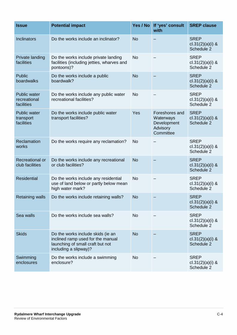
Rydalmere Wharf Interchange Upgrade C-4 Review of Environmental Factors
Issue Potential impact Yes / No If ‘yes’ consult with
SREP clause
Inclinators Do the works include an inclinator? No – SREP cl.31(2)(a)(i) & Schedule 2
Private landing facilities
Do the works include private landing facilities (including jetties, wharves and pontoons)?
No – SREP cl.31(2)(a)(i) & Schedule 2
Public boardwalks
Do the works include a public boardwalk?
No – SREP cl.31(2)(a)(i) & Schedule 2
Public water recreational facilities
Do the works include any public water recreational facilities?
No – SREP cl.31(2)(a)(i) & Schedule 2
Public water transport facilities
Do the works include public water transport facilities?
Yes Foreshores and Waterways Development Advisory Committee
SREP cl.31(2)(a)(i) & Schedule 2
Reclamation works
Do the works require any reclamation? No – SREP cl.31(2)(a)(i) & Schedule 2
Recreational or club facilities
Do the works include any recreational or club facilities?
No – SREP cl.31(2)(a)(i) & Schedule 2
Residential Do the works include any residential use of land below or partly below mean high water mark?
No – SREP cl.31(2)(a)(i) & Schedule 2
Retaining walls Do the works include retaining walls? No – SREP cl.31(2)(a)(i) & Schedule 2
Sea walls Do the works include sea walls? No – SREP cl.31(2)(a)(i) & Schedule 2
Skids Do the works include skids (ie an inclined ramp used for the manual launching of small craft but not including a slipway)?
No – SREP cl.31(2)(a)(i) & Schedule 2
Swimming enclosures
Do the works include a swimming enclosure?
No – SREP cl.31(2)(a)(i) & Schedule 2
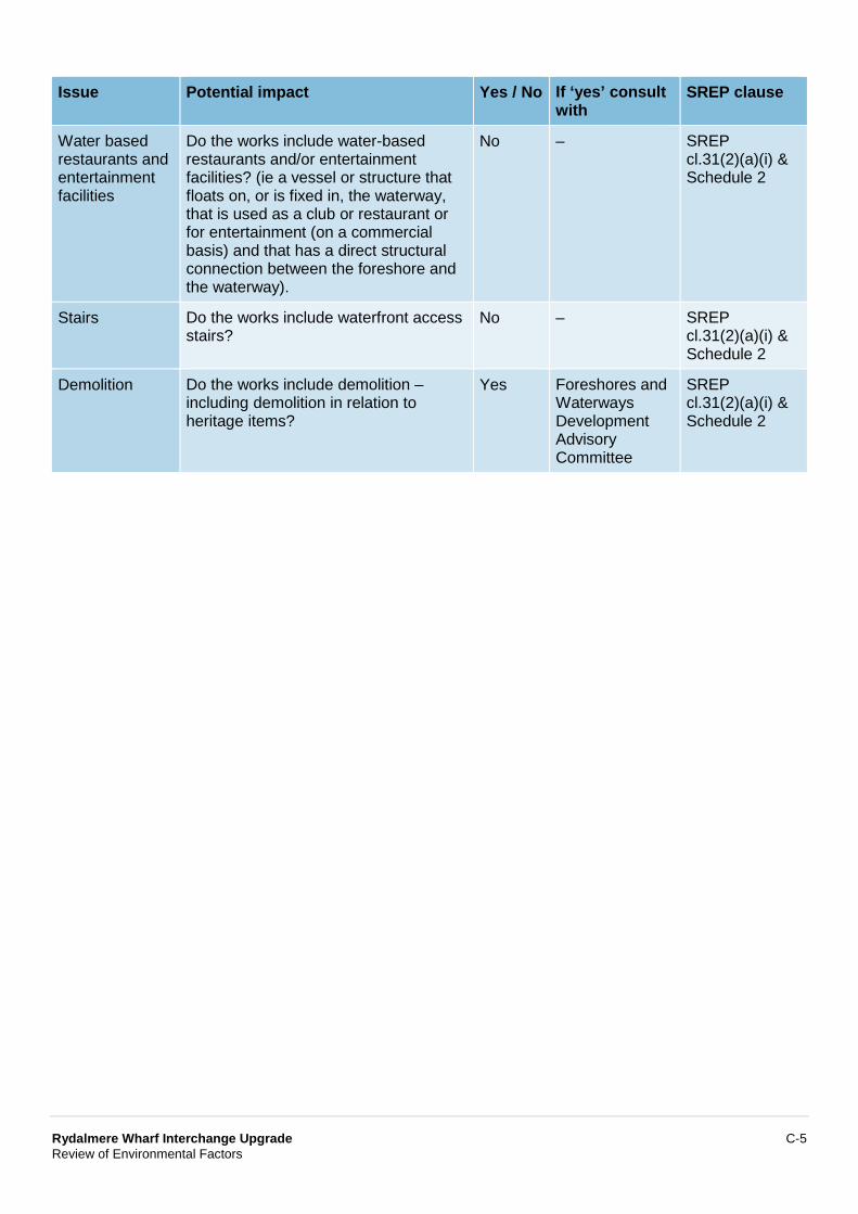
Rydalmere Wharf Interchange Upgrade C-5 Review of Environmental Factors
Issue Potential impact Yes / No If ‘yes’ consult with
SREP clause
Water based restaurants and entertainment facilities
Do the works include water-based restaurants and/or entertainment facilities? (ie a vessel or structure that floats on, or is fixed in, the waterway, that is used as a club or restaurant or for entertainment (on a commercial basis) and that has a direct structural connection between the foreshore and the waterway).
No – SREP cl.31(2)(a)(i) & Schedule 2
Stairs Do the works include waterfront access stairs?
No – SREP cl.31(2)(a)(i) & Schedule 2
Demolition Do the works include demolition – including demolition in relation to heritage items?
Yes Foreshores and Waterways Development Advisory Committee
SREP cl.31(2)(a)(i) & Schedule 2

Appendix D Aquatic ecology assessment
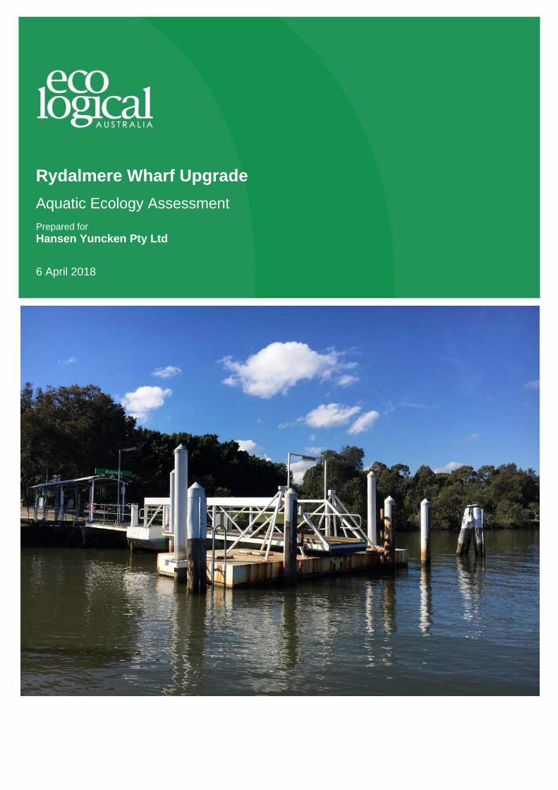
Rydalmere Wharf Upgrade Aquatic Ecology Assessment Prepared for Hansen Yuncken Pty Ltd
6 April 2018
R yd a l m er e W ha r f U p gr a de - Aq u a t i c E co l og y As s e s s me nt
© E C O L OGI CA L AUS T RA L IA PTY L TD 2
DOCUMENT TRACKING
Item Detail
Project Name Rydalmere Wharf Upgrade - Aquatic Ecology Assessment
Project Number 15WOL-1718
Project Manager Ian Dixon 02 4201 2208 Suite 204, Level 2, 62 Moore Street, Austinmer NSW 2515
Prepared by Emily Messer
Reviewed by Ian Dixon
Approved by Ian Dixon
Status FINAL
Version Control 1 – Draft, 2 March 2018 2 – Addresses RMS comments, 4 April 2018 3 – Addresses Coastal Management SEPP, 6 April 2018
Last saved on 6 April 2018
Cover photo Rydalmere Wharf. Photo Ian Dixon, July 2017
This report should be cited as ‘Eco Logical Australia 2018 Rydalmere Wharf Upgrade - Aquatic Ecology
Assessment. Prepared for Hansen Yuncken.’
ACKNOWLEDGEMENTS This document has been prepared by Eco Logical Australia Pty Ltd with support from Hansen Yuncken and WSP.
Disclaimer This document may only be used for the purpose for which it was commissioned and in accordance with the contract between Eco Logical Australia Pty Ltd and Hansen Yuncken. The scope of services was defined in consultation with Hansen Yuncken, by time and budgetary constraints imposed by the client, and the availability of reports and other data on the subject area. Changes to available information, legislation and schedules are made on an ongoing basis and readers should obtain up to date information.
Eco Logical Australia Pty Ltd accepts no liability or responsibility whatsoever for or in respect of any use of or reliance upon this report and its supporting material by any third party. Information provided is not intended to be a substitute for site specific assessment or legal advice in relation to any matter. Unauthorised use of this report in any form is prohibited.
Template 29/9/2015
R yd a l m er e W ha r f U p gr a de - Aq u a t i c E co l og y As s e s s me nt
© E C O L OGI CA L AUS T RA L IA PTY L TD 3
Contents Executive summary ................................................................................................................................. 6
1 Introduction ................................................................................................................................. 7
1.1 The Rydalmere Wharf proposal.................................................................................................... 7
2 Legislative context ................................................................................................................... 10
2.1 Commonwealth Environment Protection and Biodiversity Conservation Act 1999 (EPBC Act) 10
2.2 NSW Environmental Planning and Assessment Act 1979 (EP&A Act) ...................................... 10
2.3 NSW Biodiversity Conservation Act 2016 (BC Act).................................................................... 10
2.4 NSW Fisheries Management Act 1994 (FM Act) ....................................................................... 10
2.5 NSW Water Management Act 2000 (WM Act) ........................................................................... 11
2.6 Sydney Regional Environmental Plan (SREP, Sydney Harbour Catchment) 2005 ................... 11
2.7 NSW Coastal Management Act 2016 (CM Act) and State Environmental Planning Policy (Coastal Management) 2018 (Coastal Management SEPP) ..................................................... 11
3 Methods ..................................................................................................................................... 13
3.1 Desktop assessment .................................................................................................................. 13
3.2 Field survey ................................................................................................................................ 13
4 Aquatic habitats and ecology .................................................................................................. 14
4.1 Previous aquatic habitat mapping .............................................................................................. 14
4.2 Aquatic habitats at Rydalmere Wharf ......................................................................................... 16
4.3 Presence or likelihood of threatened and protected species, populations and communities .... 19
4.3.1 Fish, sharks and marine vegetation ........................................................................................... 19 4.3.2 Other listed or protected species ................................................................................................ 20
5 Impact assessment and mitigation ......................................................................................... 22
5.1 Assessment of construction impact ............................................................................................ 22
5.2 Assessment of operational impact ............................................................................................. 24
5.3 Fisheries Management Act habitat protection and permit requirements .................................... 25
5.4 Sydney Regional Environmental Plan (SREP, Sydney Harbour Catchment) 2005 ................... 27
5.5 Recommended mitigation measures .......................................................................................... 31
6 Conclusions .............................................................................................................................. 33
7 References ................................................................................................................................ 34
Appendix A: Threatened species likelihood of occurrence and impact .......................................... 35
Appendix B: Key fish habitat types ..................................................................................................... 40
R yd a l m er e W ha r f U p gr a de - Aq u a t i c E co l og y As s e s s me nt
© E C O L OGI CA L AUS T RA L IA PTY L TD 4
List of figures Figure 1: Proposed Rydalmere Wharf design (Drawing AR-05-1000, Revision 4) .................................... 8
Figure 2: 3D representation for Rydalmere Wharf (Drawing AR-05-1000, Revision 4) ............................. 9
Figure 3: Sydney Harbour - Foreshores and Waterways Area Development Control Plan: Ecological Communities and Landscape Characters (map sheet 1) ......................................................................... 14
Figure 4: Sydney Regional Environmental Plan (Sydney Harbour Catchment) 2005: Wetlands Protection Area (map sheet 1) ................................................................................................................. 15
Figure 5: DPI Fisheries mapping of estuarine macrophytes (Creese et al 2009) .................................... 15
Figure 6: Field validated habitat (July 2017) ............................................................................................ 17
Figure 7: Man-made structures ................................................................................................................ 18
Figure 8: Mangroves surrounding Rydalmere Wharf ............................................................................... 19
Figure 9: Subtidal soft sediment with debris ............................................................................................ 19
R yd a l m er e W ha r f U p gr a de - Aq u a t i c E co l og y As s e s s me nt
© E C O L OGI CA L AUS T RA L IA PTY L TD 5
List of tables Table 1: Impact to key fish habitat ............................................................................................................ 27
Abbreviations Abbreviation Description
BC Act NSW Biodiversity Conservation Act 2016
CM Act NSW Coastal Management Act 2016
DDA Disability Discrimination Act
DPI NSW Department of Primary Industries
ELA Eco Logical Australia Pty Ltd
EPBC Act Commonwealth Environment Protection and Biodiversity Conservation Act 1999
FM Act NSW Fisheries Management Act 1994
KFH Key fish habitat
WM Act NSW Water Management Act 2000
R yd a l m er e W ha r f U p gr a de - Aq u a t i c E co l og y As s e s s me nt
© E C O L OGI CA L AUS T RA L IA PTY L TD 6
Executive summary The New South Wales Government has proposed to upgrade the Rydalmere Wharf to improve passenger access and amenity, and accommodate expected increases in demand. NSW Roads and Maritime Services has engaged Hansen Yuncken Pty Ltd to prepare detailed construction design and an associated Review of Environmental Factors (REF). Eco Logical Australia Pty Ltd has prepared this Aquatic Ecology Assessment as a technical appendix to the REF.
The aim of this aquatic assessment is to understand the biota and habitat occurring near the proposed work. With this understanding, we assessed the significance of impacts to threatened species, communities and populations as a result of the proposed wharf upgrade, as defined in Section 5A of the NSW Environmental Planning and Assessment Act 1979. We also reviewed development plans to determine if a permit to Harm Marine Vegetation is required under s.205 of the NSW Fisheries
Management Act 1994.
The proposed wharf upgrade (the proposal) includes:
Installation of a new accessible ramp, leading from carpark to the gangway Installation of new stairs from the existing paved area adjacent to the wharf to the accessible
ramp Installation of a 18 m long by 3 m wide uncovered gangway, held in place by three new piles
(two of which would be on land) Installation of a 9 m wide by 18 m long floating and glazed pontoon with a canopy shelter, held
in position by four steel piles Installation of a debris deflector to the west of the new pontoon, held in place by two piles Two new pivot piles to help with berthing (one of these piles would also support the debris
deflector).
A desktop search using online databases was conducted prior to the field survey to compile a list of likely threatened species, communities and populations present in Sydney Harbour, and Parramatta River, plus a 10 km buffer from shore. These were further assessed for the immediate area surrounding the Rydalmere Wharf. An underwater survey using a boat-mounted video camera was completed within 20 m of the proposed works and determined if those species would likely occur and be impacted.
The proposal would directly and indirectly impact a small area of unvegetated subtidal sediment, and intertidal mudflat, classed as type 3 key fish habitat (KFH) in DPI Fisheries Policy and Guidelines for Fish Habitat Conservation and Management (2013 update). Direct impact would result from the installation of piles, and indirect impact would result from partial shading from the wharf structure. As no marine vegetation would be harmed, both direct and indirect impacts would be minor.
The proposal does not trigger any permits or consultation under Part 7 of the FM Act. There would be a maximum impact to 234 m2 of type 3 KFH, which would be compensated by the creation of 268 m2 of hard substrate and newly exposed subtidal sediment (type 3 KFH). There would be ‘no net loss’ of KFH, and no habitat compensation or offsets are required. There would be NO significant impacts to threatened species, populations or ecological communities or their habitat, as no threatened species or communities depend on or are likely to use the site.
Recommendations to mitigate impact to broader habitats have been outlined in this report, including suggestions to mitigate pollution, contamination and unnecessary disturbance during construction. Other measures include establishing no-go zones around nearby mangroves.

R yd a l m er e W ha r f U p gr a de - Aq u a t i c E co l og y As s e s s me nt
© E C O L OGI CA L AUS T RA L IA PTY L TD 7
1 Introduction The New South Wales (NSW) Government is progressively upgrading ferry wharves across Sydney to improve ferry services for customers. The wharf upgrades are being delivered as part of the NSW Governments’ Transport Access Program - an initiative to deliver modern, safe and accessible transport infrastructure. The proposed upgrade of Rydalmere Wharf aims to improve passenger access for less mobile and disabled passengers and allow ferry services to meet expected future demand.
NSW Roads and Maritime Services (Roads and Maritime) has engaged Hansen Yuncken Pty Ltd to prepare detailed construction design and an associated review of environmental factors (REF, prepared by WSP). Eco Logical Australia (ELA) Pty Ltd has prepared this Aquatic Ecology Assessment as a technical appendix to the REF.
The aim of the Aquatic Ecology Assessment is to increase knowledge of the biota and habitats occurring near the proposed work. With this understanding, we determine if any significant impact would occur to threatened species, communities or populations from the proposed development as defined in Section 5A of the NSW Environmental Planning and Assessment Act 1979; and if a permit to Harm
Marine Vegetation is required under s.205 of the NSW Fisheries Management Act 1994 (FM Act). The following tasks were undertaken to address these aims:
A desktop review of existing literature and site data to confirm the presence of known and likely species and habitats in a given study area
Aquatic survey during optimum conditions (calm seas with high water clarity) Mapping, photography and the identification of aquatic flora and key fish habitat (eg
seagrasses, mangroves, saltmarsh, macroalgae beds) Assessment of the density and condition of aquatic flora and key fish habitat, including
verification of any threatened or protected species, populations or ecological communities, pest species or presence of ‘critical habitat’ that may occur locally in the marine environment
Provide recommendations to mitigate impact and assist management of construction and operational outcomes.
This assessment acts as a standalone report for review by the NSW Department of Primary Industries (DPI) Fisheries. Consideration has been given to their Policy and Guidelines for Fish Habitat Conservation and Management (2013 update, Fairfull 2013).
1.1 The Rydalmere Wharf proposal
The upgrade of Rydalmere Wharf (the proposal) would replace the existing wharf structure with the following features (Figure 1 and Figure 2):
Installation of a new accessible ramp, leading from carpark to the gangway Installation of new stairs from the existing paved area adjacent to the wharf to the accessible
ramp Installation of a 18 m long by 3 m wide uncovered gangway, held in place by three new piles
(two of which would be on land) Installation of a 9 m wide by 18 m long floating and glazed pontoon with a canopy shelter, held
in position by four steel piles Installation of a debris deflector to the west of the new pontoon, held in place by two piles
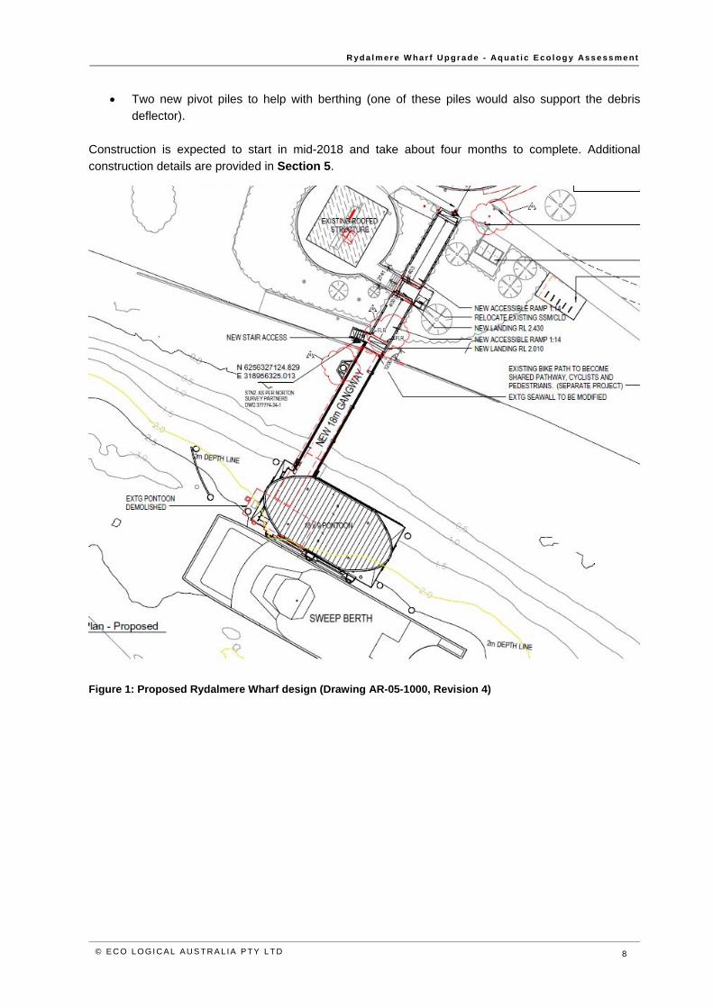
R yd a l m er e W ha r f U p gr a de - Aq u a t i c E co l og y As s e s s me nt
© E C O L OGI CA L AUS T RA L IA PTY L TD 8
Two new pivot piles to help with berthing (one of these piles would also support the debris deflector).
Construction is expected to start in mid-2018 and take about four months to complete. Additional construction details are provided in Section 5.
Figure 1: Proposed Rydalmere Wharf design (Drawing AR-05-1000, Revision 4)
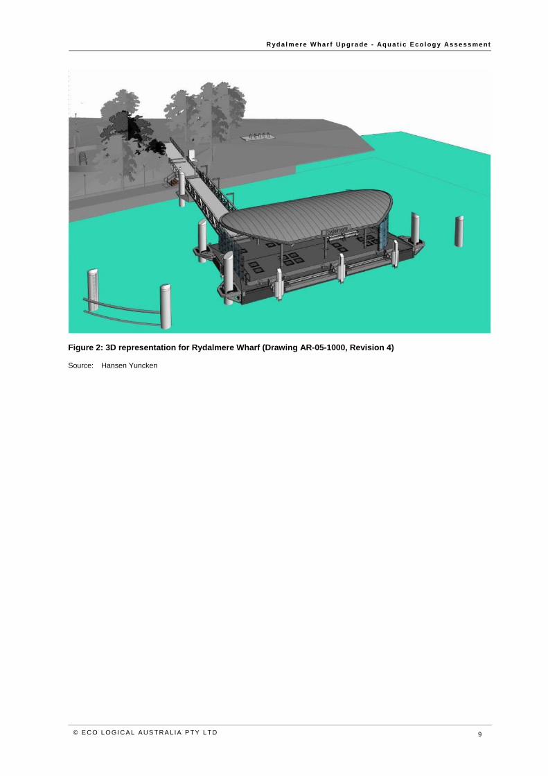
R yd a l m er e W ha r f U p gr a de - Aq u a t i c E co l og y As s e s s me nt
© E C O L OGI CA L AUS T RA L IA PTY L TD 9
Figure 2: 3D representation for Rydalmere Wharf (Drawing AR-05-1000, Revision 4)
Source: Hansen Yuncken
R yd a l m er e W ha r f U p gr a de - Aq u a t i c E co l og y As s e s s me nt
© E C O L OGI CA L AUS T RA L IA PTY L TD 10
2 Legislative context 2.1 Commonwealth Environment Protection and Biodiversity Conservation Act
1999 (EPBC Act)
Under the EPBC Act, the Commonwealth Environment Minister needs to approve any development that is likely to have a significant impact on Matters of National Environmental Significance (MNES). Should such an impact, as defined in the EPBC Act Policy Statement 1.1 – Significant Impact Guidelines (DEWHA 2009), be likely, the preparation and submission of a Referral is required. MNES relevant to this study includes threatened ecological communities, flora and fauna species and migratory species that are listed under the Act. The proposed work would not cause a significant impact, and therefore a Referral would not be required.
2.2 NSW Environmental Planning and Assessment Act 1979 (EP&A Act)
All developments in NSW are assessed in accordance with the provisions of the EP&A Act and the EP&A Regulation. The EP&A Act provides a system for environmental planning and assessment, including approvals and environmental impact assessment requirements for proposed developments. Implementation of the EP&A Act is the responsibility of the Minister for Planning, statutory authorities and local councils.
2.3 NSW Biodiversity Conservation Act 2016 (BC Act)
Under the BC Act, an assessment of significance must be completed to determine the significance of impacts to threatened species, populations and/or communities or their habitat. There are unlikely to be any threatened species, populations or communities within the study area, therefore, no impact is expected and an assessment of significance has not been triggered. As no native terrestrial vegetation would be cleared or harmed, and the site is not located within the ‘Biodiversity Value Map’, the proposal does not trigger a test of significance or require further assessment under The Biodiversity Assessment Method.
2.4 NSW Fisheries Management Act 1994 (FM Act)
The FM Act is the principal piece of legislation protecting aquatic habitat in NSW. The act aims to conserve fish stocks, key fish habitat, aquatic vegetation, and threatened species, populations and communities. Threatened aquatic species, populations and communities are listed under Schedules 4, 4A and 5 of the FM Act, while key threatening processes are listed under Schedule 6. As a public authority, Roads and Maritime must give the Minister written notice of the proposed work under Section 199 if they occur in areas mapped as key fish habitat (KFH) and have:
a direct or indirect impact to marine vegetation require dredging or excavation of the bed or bank block fish passage involve land reclamation.
The area around Rydalmere Wharf is mapped as KFH, but the development would not require dredging, block fish passage, or involve land reclamation. There would be no impact to marine vegetation, so a permit to Harm Marine Vegetation under Part 7 of the FM Act is not required.
R yd a l m er e W ha r f U p gr a de - Aq u a t i c E co l og y As s e s s me nt
© E C O L OGI CA L AUS T RA L IA PTY L TD 11
There are unlikely to be any threatened species, populations or communities listed under the FM Act that use the site, or depend on it for habitat. Therefore, no impact is expected as a result of the proposal and an assessment of significance is not required.
2.5 NSW Water Management Act 2000 (WM Act)
The WM Act aims to provide for the sustainable and integrated management of water sources for NSW. The Act requires developments on waterfront land to be ecologically sustainable, and recognises the benefits of aquatic ecosystems to agriculture, fisheries, and recreation.
Approvals under Section 91 are required for controlled activities on waterfront land. Under the WM Act, a controlled activity means:
(a) the erection of a building or the carrying out of a work (within the meaning of the
Environmental Planning and Assessment Act 1979),
(b) the removal of material (whether or not extractive material) or vegetation from land, whether
by way of excavation or otherwise,
(c) the deposition of material (whether or not extractive material) on land, whether by way of
landfill operations or otherwise, or
(d) the carrying out of any other activity that affects the quantity or flow of water in a water
source.
Section 91E(1) of the WM Act identifies that it is an offence to carry out a controlled activity in, on or under waterfront land without gaining a controlled activity approval. However, under Clause 38 of the Water Management (General) Regulation 2011 (WM Reg) public authorities are exempt from Section 91E(1) of the WM Act, and therefore do not require any approvals for controlled activities on waterfront land.
2.6 Sydney Regional Environmental Plan (SREP, Sydney Harbour Catchment) 2005
The proposal is located within the Sydney Harbour Catchment and is subject to the SREP (Sydney Harbour Catchment) 2005. The SREP lists matters that Roads and Maritime is to consider before carrying out any activity determined under Part 5 of the EP&A Act. Relevant Clauses to this aquatic ecology assessment are:
Clause 21: biodiversity, ecology and environment protection Clauses 61–63: wetland protection.
2.7 NSW Coastal Management Act 2016 (CM Act) and State Environmental Planning Policy (Coastal Management) 2018 (Coastal Management SEPP)
The CM Act came into effect 3 April 2018, replacing the Coastal Protection Act 1979. The objects of this Act are to manage the coastal environment of NSW in a manner consistent with the principles of ecologically sustainable development for the social, cultural and economic well-being of the people of the State. Part 2 of the CM Act identifies objectives related to four coastal management areas of the ‘coastal zone’:
Coastal wetlands and littoral rainforests area Coastal vulnerability area Coastal environment area
R yd a l m er e W ha r f U p gr a de - Aq u a t i c E co l og y As s e s s me nt
© E C O L OGI CA L AUS T RA L IA PTY L TD 12
Coastal use area.
The new Coastal Management SEPP consolidates and updates SEPP14 (Coastal Wetland), SEPP 26 (Littoral Rainforests) and SEPP 71 (Coastal Protection), which are now repealed. Under the Coastal Management SEPP, the ‘Coastal Wetlands and Littoral Rainforests Area Map’ identifies the area surrounding Rydalmere Wharf as ‘coastal wetland’.
However, under s.21(2b) of the Coastal Management SEPP, development under Part 5 of the EP&A Act will continue to be assessed under the former provisions if the environmental impact assessment commenced prior to the commencement of the Policy (3 April 2018) and approval for the development will be granted within 12 months after that commencement. Provided the project is undertaken within the timeframes stated in the Transitional clause (21.2b), the Coastal Management SEPP is not applicable to the project. Previous SEPPs (14, 26 and 71) do not apply to the study area.
R yd a l m er e W ha r f U p gr a de - Aq u a t i c E co l og y As s e s s me nt
© E C O L OGI CA L AUS T RA L IA PTY L TD 13
3 Methods 3.1 Desktop assessment
Online database searches were used to confirm the presence of recorded species in the region prior to the field survey. This was then used to infer what was likely to be present in the study area. The desktop search covered Port Jackson (Sydney Harbour including tidal areas of Parramatta River and Lane Cove River) plus a 10 km buffer. The desktop search grid is about 50 x 30 km using the coordinates:
Latitude: -33.6974792526866, Longitude: 150.915584274089 Latitude: -33.6974792526866, Longitude: 151.474105513707 Latitude: -33.9762150862402, Longitude: 151.474105513707 Latitude: -33.9762150862402, Longitude: 150.915584274089
Only species known to use estuarine/marine water or intertidal foreshores were considered in this aquatic assessment. Databases accessed include:
EPBC Act – Protected Matters Search Tool BC Act – Threatened Species Search Tool (BioNet) FM Act – Listed protected and threatened species and populations, including species profiles,
‘Primefact’ publications and expected distribution maps (Riches et al 2016) Online Zoological Collections of Australian Museums (OZCAM) – individual species searches to
determine likelihood of occurrence of threatened species.
3.2 Field survey
The site was visited between 9 am and 3 pm on 13 July 2017 by three ELA ecologists, including one senior aquatic ecologist. The survey area covered at least twenty meters from the edge of proposed work, plus farther areas where necessary to validate habitat extent. Weather conditions were calm and there was minimal swell. Underwater visibility was less than one meter. The maximum depth was approximately three meters.
The survey was undertaken by lowering a boat-mounted video camera to the seafloor and around piles. A triple camera setup (Sea-View, Go-Pro and Kaiser Baas brands) angled down, front and left, allowed for live streaming of habitat features to an on-board monitor (colour/infrared). Video was recorded to allow post-field examination of high definition footage. GPS mapping of transects ensured all habitat types were adequately surveyed. Habitat types were mapped in the field using a Getac Windows tablet running ArcPad. Georeferenced high definition footage was later reviewed to check habitat extent and condition. Aquatic flora and key fish habitat mapped in the field were merged into a final map using ArcMap Version 10.2.
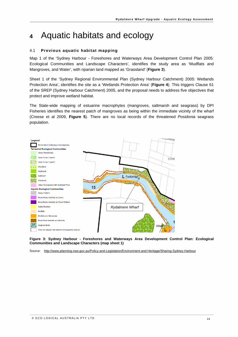
R yd a l m er e W ha r f U p gr a de - Aq u a t i c E co l og y As s e s s me nt
© E C O L OGI CA L AUS T RA L IA PTY L TD 14
4 Aquatic habitats and ecology 4.1 Previous aquatic habitat mapping
Map 1 of the ‘Sydney Harbour - Foreshores and Waterways Area Development Control Plan 2005: Ecological Communities and Landscape Characters’, identifies the study area as ‘Mudflats and Mangroves, and Water’, with riparian land mapped as ‘Grassland’ (Figure 3).
Sheet 1 of the ‘Sydney Regional Environmental Plan (Sydney Harbour Catchment) 2005: Wetlands Protection Area’, identifies the site as a ‘Wetlands Protection Area’ (Figure 4). This triggers Clause 61 of the SREP (Sydney Harbour Catchment) 2005, and the proposal needs to address five objectives that protect and improve wetland habitat.
The State-wide mapping of estuarine macrophytes (mangroves, saltmarsh and seagrass) by DPI Fisheries identifies the nearest patch of mangroves as being within the immediate vicinity of the wharf (Creese et al 2009, Figure 5). There are no local records of the threatened Posidonia seagrass population.
Figure 3: Sydney Harbour - Foreshores and Waterways Area Development Control Plan: Ecological Communities and Landscape Characters (map sheet 1)
Source: http://www.planning.nsw.gov.au/Policy-and-Legislation/Environment-and-Heritage/Sharing-Sydney-Harbour
Rydalmere Wharf
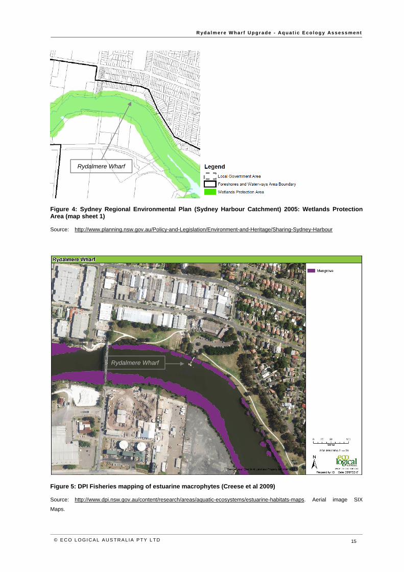
R yd a l m er e W ha r f U p gr a de - Aq u a t i c E co l og y As s e s s me nt
© E C O L OGI CA L AUS T RA L IA PTY L TD 15
Figure 4: Sydney Regional Environmental Plan (Sydney Harbour Catchment) 2005: Wetlands Protection Area (map sheet 1)
Source: http://www.planning.nsw.gov.au/Policy-and-Legislation/Environment-and-Heritage/Sharing-Sydney-Harbour
Figure 5: DPI Fisheries mapping of estuarine macrophytes (Creese et al 2009)
Source: http://www.dpi.nsw.gov.au/content/research/areas/aquatic-ecosystems/estuarine-habitats-maps. Aerial image SIX
Maps.
Rydalmere Wharf
Rydalmere Wharf
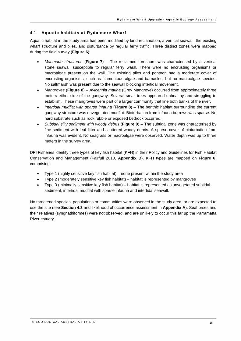
R yd a l m er e W ha r f U p gr a de - Aq u a t i c E co l og y As s e s s me nt
© E C O L OGI CA L AUS T RA L IA PTY L TD 16
4.2 Aquatic habitats at Rydalmere Wharf
Aquatic habitat in the study area has been modified by land reclamation, a vertical seawall, the existing wharf structure and piles, and disturbance by regular ferry traffic. Three distinct zones were mapped during the field survey (Figure 6):
Manmade structures (Figure 7) – The reclaimed foreshore was characterised by a vertical stone seawall susceptible to regular ferry wash. There were no encrusting organisms or macroalgae present on the wall. The existing piles and pontoon had a moderate cover of encrusting organisms, such as filamentous algae and barnacles, but no macroalgae species. No saltmarsh was present due to the seawall blocking intertidal movement.
Mangroves (Figure 8) – Avicennia marina (Grey Mangrove) occurred from approximately three meters either side of the gangway. Several small trees appeared unhealthy and struggling to establish. These mangroves were part of a larger community that line both banks of the river.
Intertidal mudflat with sparse infauna (Figure 8) – The benthic habitat surrounding the current gangway structure was unvegetated mudflat. Bioturbation from infauna burrows was sparse. No hard substrate such as rock rubble or exposed bedrock occurred.
Subtidal silty sediment with woody debris (Figure 9) – The subtidal zone was characterised by fine sediment with leaf litter and scattered woody debris. A sparse cover of bioturbation from infauna was evident. No seagrass or macroalgae were observed. Water depth was up to three meters in the survey area.
DPI Fisheries identify three types of key fish habitat (KFH) in their Policy and Guidelines for Fish Habitat Conservation and Management (Fairfull 2013, Appendix B). KFH types are mapped on Figure 6, comprising:
Type 1 (highly sensitive key fish habitat) – none present within the study area Type 2 (moderately sensitive key fish habitat) – habitat is represented by mangroves Type 3 (minimally sensitive key fish habitat) – habitat is represented as unvegetated subtidal
sediment, intertidal mudflat with sparse infauna and intertidal seawall.
No threatened species, populations or communities were observed in the study area, or are expected to use the site (see Section 4.3 and likelihood of occurrence assessment in Appendix A). Seahorses and their relatives (syngnathiformes) were not observed, and are unlikely to occur this far up the Parramatta River estuary.
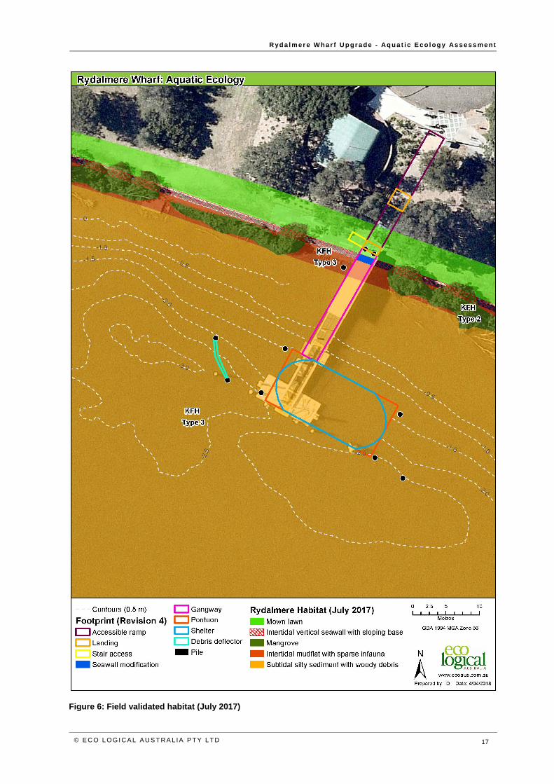
R yd a l m er e W ha r f U p gr a de - Aq u a t i c E co l og y As s e s s me nt
© E C O L OGI CA L AUS T RA L IA PTY L TD 17
Figure 6: Field validated habitat (July 2017)
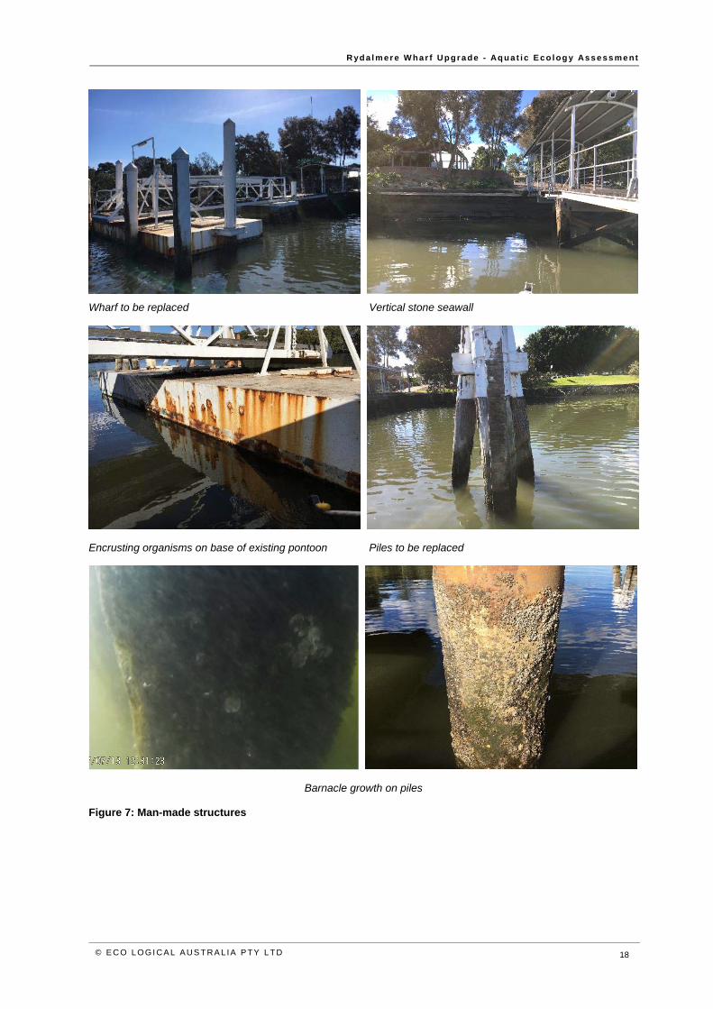
R yd a l m er e W ha r f U p gr a de - Aq u a t i c E co l og y As s e s s me nt
© E C O L OGI CA L AUS T RA L IA PTY L TD 18
Wharf to be replaced Vertical stone seawall
Encrusting organisms on base of existing pontoon Piles to be replaced
Barnacle growth on piles
Figure 7: Man-made structures
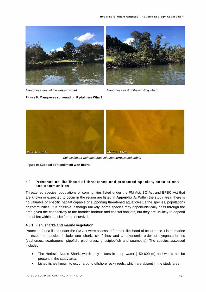
R yd a l m er e W ha r f U p gr a de - Aq u a t i c E co l og y As s e s s me nt
© E C O L OGI CA L AUS T RA L IA PTY L TD 19
Mangroves west of the existing wharf Mangroves east of the existing wharf
Figure 8: Mangroves surrounding Rydalmere Wharf
Soft sediment with moderate infauna burrows and debris
Figure 9: Subtidal soft sediment with debris
4.3 Presence or l ikel ihood of threatened and protected species, populat ions and communit ies
Threatened species, populations or communities listed under the FM Act, BC Act and EPBC Act that are known or expected to occur in the region are listed in Appendix A. Within the study area, there is no valuable or specific habitat capable of supporting threatened aquatic/estuarine species, populations or communities. It is possible, although unlikely, some species may opportunistically pass through the area given the connectivity to the broader harbour and coastal habitats, but they are unlikely to depend on habitat within the site for their survival.
4.3.1 Fish, sharks and marine vegetation Protected fauna listed under the FM Act were assessed for their likelihood of occurrence. Listed marine or estuarine species include one shark, six fishes and a taxonomic order of syngnathiformes (seahorses, seadragons, pipefish, pipehorses, ghostpipefish and seamoths). The species assessed included:
The Herbst’s Nurse Shark, which only occurs in deep water (150-600 m) and would not be present in the study area.
Listed fishes known to occur around offshore rocky reefs, which are absent in the study area.
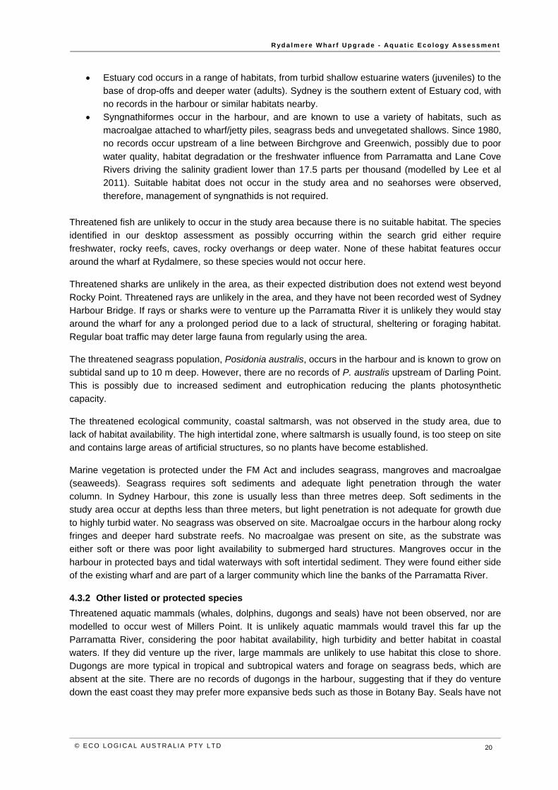
R yd a l m er e W ha r f U p gr a de - Aq u a t i c E co l og y As s e s s me nt
© E C O L OGI CA L AUS T RA L IA PTY L TD 20
Estuary cod occurs in a range of habitats, from turbid shallow estuarine waters (juveniles) to the base of drop-offs and deeper water (adults). Sydney is the southern extent of Estuary cod, with no records in the harbour or similar habitats nearby.
Syngnathiformes occur in the harbour, and are known to use a variety of habitats, such as macroalgae attached to wharf/jetty piles, seagrass beds and unvegetated shallows. Since 1980, no records occur upstream of a line between Birchgrove and Greenwich, possibly due to poor water quality, habitat degradation or the freshwater influence from Parramatta and Lane Cove Rivers driving the salinity gradient lower than 17.5 parts per thousand (modelled by Lee et al 2011). Suitable habitat does not occur in the study area and no seahorses were observed, therefore, management of syngnathids is not required.
Threatened fish are unlikely to occur in the study area because there is no suitable habitat. The species identified in our desktop assessment as possibly occurring within the search grid either require freshwater, rocky reefs, caves, rocky overhangs or deep water. None of these habitat features occur around the wharf at Rydalmere, so these species would not occur here.
Threatened sharks are unlikely in the area, as their expected distribution does not extend west beyond Rocky Point. Threatened rays are unlikely in the area, and they have not been recorded west of Sydney Harbour Bridge. If rays or sharks were to venture up the Parramatta River it is unlikely they would stay around the wharf for any a prolonged period due to a lack of structural, sheltering or foraging habitat. Regular boat traffic may deter large fauna from regularly using the area.
The threatened seagrass population, Posidonia australis, occurs in the harbour and is known to grow on subtidal sand up to 10 m deep. However, there are no records of P. australis upstream of Darling Point. This is possibly due to increased sediment and eutrophication reducing the plants photosynthetic capacity.
The threatened ecological community, coastal saltmarsh, was not observed in the study area, due to lack of habitat availability. The high intertidal zone, where saltmarsh is usually found, is too steep on site and contains large areas of artificial structures, so no plants have become established.
Marine vegetation is protected under the FM Act and includes seagrass, mangroves and macroalgae (seaweeds). Seagrass requires soft sediments and adequate light penetration through the water column. In Sydney Harbour, this zone is usually less than three metres deep. Soft sediments in the study area occur at depths less than three meters, but light penetration is not adequate for growth due to highly turbid water. No seagrass was observed on site. Macroalgae occurs in the harbour along rocky fringes and deeper hard substrate reefs. No macroalgae was present on site, as the substrate was either soft or there was poor light availability to submerged hard structures. Mangroves occur in the harbour in protected bays and tidal waterways with soft intertidal sediment. They were found either side of the existing wharf and are part of a larger community which line the banks of the Parramatta River.
4.3.2 Other listed or protected species Threatened aquatic mammals (whales, dolphins, dugongs and seals) have not been observed, nor are modelled to occur west of Millers Point. It is unlikely aquatic mammals would travel this far up the Parramatta River, considering the poor habitat availability, high turbidity and better habitat in coastal waters. If they did venture up the river, large mammals are unlikely to use habitat this close to shore. Dugongs are more typical in tropical and subtropical waters and forage on seagrass beds, which are absent at the site. There are no records of dugongs in the harbour, suggesting that if they do venture down the east coast they may prefer more expansive beds such as those in Botany Bay. Seals have not
R yd a l m er e W ha r f U p gr a de - Aq u a t i c E co l og y As s e s s me nt
© E C O L OGI CA L AUS T RA L IA PTY L TD 21
been sighted west of Birchgrove Point and are unlikely to visit the area. It is likely that most aquatic mammals avoid human activities, and would be deterred by vessels which frequently berth at the wharf.
Threatened aquatic reptiles (turtles) are more common along coastal waters than in the harbour or its estuaries. It is possible they explore the greater area, but would not depend on the site for feeding habitat or nesting.
Threatened shore, wetland, migratory and pelagic birds may use intertidal zones to forage but are unlikely to occur in the study area, as they avoid areas with concentrated human activities. Aerial foragers may follow a coastal route, fly over open water or hunt over decomposing wrack. Given the enormous scale of better habitat nearby, the proposal would have a negligible effect on food resources or obstacles to flight.
R yd a l m er e W ha r f U p gr a de - Aq u a t i c E co l og y As s e s s me nt
© E C O L OGI CA L AUS T RA L IA PTY L TD 22
5 Impact assessment and mitigation This section considers the impact from building and operating the new Rydalmere Wharf based on the work described in Section 1.1.
Demolition of existing piles, pontoon and gangway
The pontoon and gangway would be dismantled and removed using a barge or land-mounted crane and transported to land.
The existing piles would be removed, either fully pulled or cut and capped.
Installation of steel piles within the waterway
Marine-grade steel piles would be installed into the bedrock. These piles would be transported to site by barge or road. The installation of the piles would take place when the water is calm.
Constructing pile foundation systems in bedrock consists of three components: o Phase 1 – drilling piles into rock in calm water
Drilling would take three to four hours per pile plus setup time and pack up time. Each pile would be lifted from the barge and put into place using a barge-mounted crane. A drill rig mounted onto a barge would attach to the pile using a helmet fitting. The drill rig would screw the pile into the bedrock.
o Phase 2 – hammering piles to refusal in calm water The piles hammered (using a weight of about 30 tonnes) to the stage where five or more blows will not budge the pile. Hammering of piles would take place at least one day after drilling of piles. It is anticipated that each pile would be hammered for one minute (about 10 hits with the hammer within one minute). For each pile, this activity is likely to occur five times over a period of one hour.
o Phase 3 – cutting, welding and plugging of piles with concrete The steel piles would then be cut, welded and plugged with concrete.
Piling is expected to take four weeks to complete. This would allow for respite from noise and a contingency for unfavourable weather.
Construction of new gangway and pontoon
Minor earthworks are required to modify a small area of seawall. The pontoon would be constructed from marine-grade steel and a zinc shelter. The pontoon would be constructed offsite, towed to site and lifted into position using the barge-
mounted crane. Install the pivot point and then attach and build out the prefabricate sections of gangway. This
would likely be via barge crane. Install the supporting infrastructure including barriers and handrails, safety and security
facilities, cabling and ducting, lighting, CCTV, ladders, lifebuoys, glass shelter weather screens and tactile flooring.
5.1 Assessment of construction impact
Two impact types are likely to occur during wharf installation:
Noise generation and disturbance from piling
R yd a l m er e W ha r f U p gr a de - Aq u a t i c E co l og y As s e s s me nt
© E C O L OGI CA L AUS T RA L IA PTY L TD 23
Disturbance from construction vessels, such as boat/propeller wash, temporary mooring and accidental spills.
Cumulative impact due to joint closure of Parramatta Wharf during construction.
Pile impact
A total of 10 new piles would be drilled and hammered to refusal into the bedrock. Two of these piles would be on land, and therefore have not been included in this assessment. Of the remaining eight piles, four would be 0.61 m in diameter and four would be 0.76 m in diameter. Creating a total impact area less than 3 m2. This impact would be in type 3 KFH, mostly on subtidal sediment. One pile would impact intertidal mudflat.
Any potential sediment pluming that occurs during pile removal and installation would be contained by a silt curtain. As the piling would be performed during calm conditions, drill cuttings and suspended sediments are likely to settle locally in a similar habitat type. Finer sediments could disperse further, depending on tidal dynamics, but would be contained within a silt curtain surrounding the work site. Hammering of piles is unlikely to create significant sediment plumes, with sediment being pushed downwards and outwards.
Underwater noise from hammering piles has the potential to cause disturbance or physical impact to marine fauna in the area. Fish in the vicinity would be affected by excessive underwater noise, ranging from mortality to interruption of communication, depending on species anatomy (eg fish with swim bladders closer to the ear are more sensitive to acoustic impact than species with swim bladders further from the ear). If water depth allows, fish would be able to escape under the silt curtain as hammering starts, otherwise some impact is expected. Estimates on number or species of fish potentially impacted is not part of this assessment.
Construction vessel impact
There would be little direct or indirect impact caused by construction vessels if best practice environmental management procedures are in place and effective. However, potential impact may include chemical/material spills from machinery, propeller scouring in shallow water, and anchor/mooring impact from barges. Such risks would increase with unfavourable swell and weather conditions.
Scouring of benthic sediments, either from propeller operation, dragging anchor or mooring chain, or water movement from shallow barge operation, could cause bed sediment particles to become entrained in the water, increasing turbidity. The increased sediment load would reduce light penetration through the water column, and sediment particles may settle on aquatic plants. However, any reduction in photosynthesis would be minor, as the amount of sediment that is moved would be small.
Sediment movement could also smother infauna burrows. Again, it is unlikely that large volumes of sediment would be moved, and that the thin layer of silt or sand that does settle on infauna burrows would not cause significant damage.
Chemical spills are unlikely, but may occur during refuelling or if there is a hydraulic fluid leak. Spilt petrochemicals have the potential to wash up on shore or disperse in the water. This could kill or impair fish and infauna.
Vessels may also be a vector for movement of marine pests, especially if ships are not from the local area. For example, machinery and vessels used on other sites where the noxious alga Caulerpa

R yd a l m er e W ha r f U p gr a de - Aq u a t i c E co l og y As s e s s me nt
© E C O L OGI CA L AUS T RA L IA PTY L TD 24
taxifolia was present could introduce the weed if hygiene procedures aren’t followed. To prevent the spread of this weed, barges moving from areas where Caulerpa is present should be inspected before travelling the river and entering the site. If Caulerpa becomes established around the new wharf, then ferries using the wharf in the future would potentially become vectors for the further spread of this weed.
Cumulative impacts
There may be a cumulative impact due to other foreshore developments occurring on the river. Roads and Maritime aim to coordinate a river closure with Parramatta Council so work can occur concurrently at Rydalmere Wharf, Parramatta Wharf and a boardwalk at the base of the escarpment (opposite Parramatta Wharf). This single closure has a positive implication on minimising ferry closures and it reduces the total period machinery is operating in the river. Near Rydalmere, the risk of a cumulative impact would occur from increased construction boat/barge traffic. If there is not a coordinated approach to moving vessels, the potential impacts include:
Increased boat wash onto mangroves when vessels pass each other (unlike single passage ferries), resulting in degradation of small areas of habitat
Risk of collision resulting in spills when vessels pass each other, resulting in localised pollution and dispersal through the tidal area.
Overall, without correct timing and coordination, this impact could be moderate in severity.
5.2 Assessment of operational impact
Three impact types are likely to occur during wharf operation:
Ferry traffic using the facility Shading impact on benthic habitat from the pontoon and gangway Creation of new aquatic habitat.
Ferry traffic impact
The impacts which could occur in marine habitats during operation are typically those associated with ferry wash, disturbance of sediments, and an increase in pollutants and litter. Given the location and existing use the following impacts are considered minor:
Ferry wash would not impact the foreshore, which is stabilised by a large stone seawall Propeller/thrust disturbance to sediments is unlikely to increase given the frequent use by
ferries currently Pollutants expelled from ferries would be the same as existing conditions throughout the river Litter from visitors to the wharf would be reduced through increased bins, signage, fencing and
glazed screens.
Shading impact
Partial shading from the new pontoon and gangway would have an indirect impact on subtidal unvegetated sediment (type 3 KFH). The pontoon would shade 115 m2 of subtidal habitat in addition to what is currently shaded. The gangway is the same shape and size of the existing gangway, and would not shade additional habitat. No marine vegetation would be shaded, and benthic organisms (ie infauna) would not be significantly impacted, as they are not light dependant and already exist in
R yd a l m er e W ha r f U p gr a de - Aq u a t i c E co l og y As s e s s me nt
© E C O L OGI CA L AUS T RA L IA PTY L TD 25
shaded areas onsite. New areas of subtidal sediment would also be exposed to sunlight with the upgrade, which would provide a positive impact to those areas.
Creation of hard substrates
Once installed, the piles would create 34 m2 of new vertical hard substrate, which would provide areas for the attachment of sessile marine organisms and structural habitat for small fish (type 3 KFH). The number of new piles is less than the number of existing piles, so there would be a loss of pile habitat. The new pontoon would create 216 m2 of new hard substrate (type 3 KFH). The new pontoon is larger than the existing pontoon and would provide additional habitat. In total the new pontoon and piles would create more type 3 habitat than is being removed (see Table 1 for a breakdown).
5.3 Fisheries Management Act habitat protection and permit requirements
DPI Fisheries’ Policy and Guidelines for Fish Habitat Conservation and Management (Fairfull 2013) outline requirements for assessing impact of waterfront development to ensure the sustainable management, and ‘no net loss’, of key fish habitats in NSW. Part 7 of the FM Act addresses the protection of aquatic habitats and works that requires a permit.
Threatened species, populations or communities
No threatened species, populations or communities listed under the FM Act are likely to occur in the study area, or be directly or indirectly harmed by the proposed work (see Section 4.3 and Appendix A). As such, an assessment of significance is not required.
Protected vegetation
The proposed works would not harm marine vegetation (saltmarsh, seagrass or macroalgae) as they do not occur onsite. The works are unlikely to have harm mangroves or have any significant ecological impact if mitigation measures (no-go zones) are effectively implemented.
Protected fauna
As discussed in Section 4.3.1 protected fauna is unlikely to occur in the study area. Syngnathiformes (seahorses and their relatives) were not observed and are unlikely to reside in the study area due to freshwater influence from the Parramatta River and poor habitat. This was also confirmed by a lack of records west of Cockatoo Island.
Critical habitat
The study area does not have habitat that is critical to any threatened species, and is not within or near the critical habitats for Grey Nurse Shark (Part 7A of the FM Act), so would have no impact on the species.
Commercial Fisheries
No aquaculture (oyster) leases are located in Port Jackson. Commercial fishing is not permitted in Port Jackson. As such, the proposal would not impact commercial fisheries.
Key threatening processes
Key threatening processes have the potential to adversely affect threatened species, populations or ecological communities, or could cause species, populations or ecological communities that are not
R yd a l m er e W ha r f U p gr a de - Aq u a t i c E co l og y As s e s s me nt
© E C O L OGI CA L AUS T RA L IA PTY L TD 26
threatened to become threatened. The following processes listed under Part 7A of the FM Act are relevant to an aquatic impact assessment, but the wharf upgrade would not trigger these processes:
current shark meshing program in NSW waters hook and line fishing in areas important for the survival of threatened fish species human-caused climate change instream structures and other mechanisms that alter natural flow introduction of non-indigenous fish and marine vegetation to the coastal waters of NSW the introduction of fish to fresh waters within a river catchment outside their natural range the removal of large woody debris from NSW rivers and streams the degradation of native riparian vegetation along NSW water courses.
Part 7 permits or consultation
The proposal would not directly or indirectly harm marine vegetation (such as mangroves adjacent to the gangway) if mitigation measures are implemented (eg no -go zones). Therefore, a permit to Harm
Marine Vegetation would not be required. No other protected marine vegetation (saltmarsh, seagrass or macroalgae) occurs onsite.
The proposal would not require dredging, therefore, consultation between the proponent and the Minister for Primary Industries under s.199 of the FM Act would not be required. The minor earthworks and modification to the existing seawall are already on reclaimed land, so there would be no increase in dredging or reclamation.
During construction, a small number of fish may be temporarily trapped by the silt curtain within the works area, especially as the area is very shallow. However, DPI Fisheries advise that an s.219 permit to Obstruct Fish Passage would not be required for this type of situation (pers comm Carla Ganassin, Fisheries Manager, 9 June 2017). The silt curtain would not block the entire channel.
No seahorses are expected to occur, therefore, no handling, relocation or s.37 permit is required.
No net loss of key fish habitat
Significant environmental impacts (direct and indirect) are to be offset by environmental compensation. Compensation to offset fisheries resource or habitat losses is considered only after it is demonstrated that the proposed loss is unavoidable, in the best interests of the community in general and is in accordance with the FM Act, Regulations and Fisheries policies and guidelines. Habitat replacement (as a compensation measure) needs to account for indirect as well as direct impact of development to ensure that there is ‘no net loss’ of KFH.
In accordance with the Roads and Maritime’s Biodiversity Offset Guideline, offsetting is only required where a proposal causes a net loss of type 1 or type 2 KFH (as defined by DPI Fisheries).
The proposal would result in a total impact to 234 m2 of type 3 KFH (see breakdown in Table 1). This impact includes direct damage from pile installation, partial to absolute shading beneath the pontoon, and removal of existing habitat (pontoon and piles).
This habitat impact would be compensated by the creation of 268 m2 of type 3 KFH. This would come from the addition of hard surfaces. Using wetted pile heights ranging between 0.5-2.5 m, the habitat created by piles is calculated to be 34 m2. The wetted sides of the new pontoon (approximately 1 m in height) and shaded underside would create 216 m2 of habitat (although upside-down pontoon habitat in
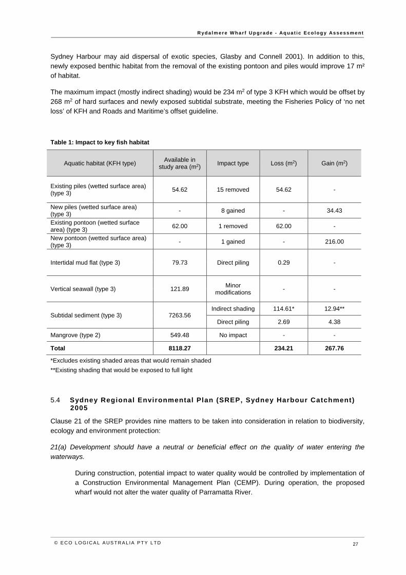
R yd a l m er e W ha r f U p gr a de - Aq u a t i c E co l og y As s e s s me nt
© E C O L OGI CA L AUS T RA L IA PTY L TD 27
Sydney Harbour may aid dispersal of exotic species, Glasby and Connell 2001). In addition to this, newly exposed benthic habitat from the removal of the existing pontoon and piles would improve 17 m² of habitat.
The maximum impact (mostly indirect shading) would be 234 m2 of type 3 KFH which would be offset by 268 m2 of hard surfaces and newly exposed subtidal substrate, meeting the Fisheries Policy of ‘no net loss’ of KFH and Roads and Maritime’s offset guideline.
Table 1: Impact to key fish habitat
Aquatic habitat (KFH type) Available in study area (m2) Impact type Loss (m2) Gain (m2)
Existing piles (wetted surface area) (type 3) 54.62 15 removed 54.62 -
New piles (wetted surface area) (type 3) - 8 gained - 34.43
Existing pontoon (wetted surface area) (type 3) 62.00 1 removed 62.00 -
New pontoon (wetted surface area) (type 3) - 1 gained - 216.00
Intertidal mud flat (type 3) 79.73 Direct piling 0.29 -
Vertical seawall (type 3) 121.89 Minor modifications - -
Subtidal sediment (type 3) 7263.56 Indirect shading 114.61* 12.94**
Direct piling 2.69 4.38
Mangrove (type 2) 549.48 No impact - -
Total 8118.27 234.21 267.76
*Excludes existing shaded areas that would remain shaded **Existing shading that would be exposed to full light
5.4 Sydney Regional Environmental Plan (SREP, Sydney Harbour Catchment) 2005
Clause 21 of the SREP provides nine matters to be taken into consideration in relation to biodiversity, ecology and environment protection:
21(a) Development should have a neutral or beneficial effect on the quality of water entering the
waterways.
During construction, potential impact to water quality would be controlled by implementation of a Construction Environmental Management Plan (CEMP). During operation, the proposed wharf would not alter the water quality of Parramatta River.
R yd a l m er e W ha r f U p gr a de - Aq u a t i c E co l og y As s e s s me nt
© E C O L OGI CA L AUS T RA L IA PTY L TD 28
21(b) Development should protect and enhance terrestrial and aquatic species, populations and
ecological communities and, in particular, should avoid physical damage and shading of aquatic
vegetation (such as seagrass, saltmarsh and algal and mangrove communities).
No seagrass, saltmarsh or macroalgae communities occur on site. Mangroves occur either side of the gangway, but if no-go zones are established and followed during construction there would be no impact to these plants, or the wider community.
21(c) Development should promote ecological connectivity between neighbouring areas of aquatic
vegetation (such as seagrass, saltmarsh and algal and mangrove communities).
No seagrass, saltmarsh or macroalgae communities occur on site, or are likely to establish here. Harm to mangroves would be avoided through establishing no-go zones during construction. The proposal would not severe the connectivity of the mangrove forest any more than the existing conditions.
21(d) Development should avoid indirect impacts on aquatic vegetation (such as changes to flow,
current and wave action and changes to water quality) as a result of increased access.
The proposed piles and ferry activity would influence localised hydrology by creating back-eddies, wash and turbulence. As the area is already subject to tidal movement, high energy boat wash and wave reflection from the seawall, it is unlikely the proposed works would alter the local hydrology to the extent that would impact the survival of mangroves on or surrounding site.
21(e) Development should protect and reinstate natural intertidal foreshore areas, natural landforms
and native vegetation.
An existing seawall prevents establishment of any natural intertidal foreshore, landforms or vegetation beyond the existing mangroves. The proposal cannot alter this situation due to nearby onshore land use.
21(f) Development should retain, rehabilitate and restore riparian land.
Riparian land is heavily landscaped with a garden bed, mown lawn and planted trees. The proposal does not interfere with this vegetation.
21(g) Development on land adjoining wetlands should maintain and enhance the ecological integrity of
the wetlands and, where possible, should provide a vegetative buffer to protect the wetlands.
The proposal adjoins and is within a designated wetland identified on the Sydney Regional Environmental Plan (Sydney Harbour Catchment) 2005 – Wetlands Protection Map. The proposal does not alter the net amount of habitat in the wetland. There would be no impact to marine vegetation.
21(h) The cumulative environmental impact of development.
The foreshore and aquatic habitat is highly modified due to a seawall and commuter wharf. The proposal would replace the existing wharf, which would result in similar impact as the existing wharf. The proposal would increase shading of unvegetated sediment, but the cumulative environmental impact is low given the existing conditions and small area of additional impact on minimally sensitive key fish habitat. The new structure and layout would provide new habitat to offset the impact.
R yd a l m er e W ha r f U p gr a de - Aq u a t i c E co l og y As s e s s me nt
© E C O L OGI CA L AUS T RA L IA PTY L TD 29
21(i) Whether sediments in the waterway adjacent to the development are contaminated, and what
means will minimise their disturbance.
Sediment contamination occurs on site, typical of the highly disturbed catchment and land use of the Parramatta River. A Stage 2 Contamination Assessment of the top 20 cm of sediment was undertaken by Coffey Geotechnics (18 May 2016). Based on the analytical results, the sediments reported elevated contamination, with three chemicals of potential concern slightly above low trigger values. Potential acid sulfate soils were also detected in the shallow sediment samples. Coffey conclude that contamination risk arising from proposed ferry wharf construction works is considered to be low.
During construction, disturbance would arise from drilling rock prior to pile screwing and driving. These coarse, deeper sediments are unlikely to contain contaminates, which are usually associated with finer particles deposited or chemically altered under anoxic conditions. Fine-scale sediment plumes potentially carrying pollutants would be confined near the site during construction using a floating boom and silt curtain. As Coffey’s sampling was confined to the upper 20 cm sediment layer, they recommend that further testing is required if spoil is generated from deeper pile drilling.
The design maintains the existing berthing face, so during ferry operation, craft would dock in the same location, resulting in repeated upwelling of sediments deposited in this area.
Clause 63 of the SREP provides seven matters to be taken into consideration in relation to wetland protection:
63 (2a) The development should have a neutral or beneficial effect on the quality of water entering the
waterways.
See Clause 21(a) above
63 (2b) The environmental effects of the development, including effects on:
(i) the growth of native plant communities.
The proposal would not affect native plant communities. Also see Clause 21 (b) above.
(ii) the survival of native wildlife populations
The proposal would not alter habitat to an extent that risks the survival of native wildlife. Submerged structures would provide habitat for aquatic fauna.
(iii) the provision and quality of habitats for both indigenous and migratory species
The foreshore is highly modified by a seawall and minimal habitat exists for wetland fauna (eg wader birds). The work would not markedly change the current habitat status.
(iv) the surface and groundwater characteristics of the site on which the development is proposed to be carried out and of the surrounding areas, including salinity and water quality and whether the wetland ecosystems are groundwater dependent
R yd a l m er e W ha r f U p gr a de - Aq u a t i c E co l og y As s e s s me nt
© E C O L OGI CA L AUS T RA L IA PTY L TD 30
The proposal would have no effect on the existing surface and groundwater characteristics. The structure would not alter tidal dynamics to a point that influences wetland habitat.
63 (2c) Whether adequate safeguards and rehabilitation measures have been, or will be, made to
protect the environment.
A CEMP would be implemented during construction to minimise environmental impact from sedimentation and pollution.
63 (2d) Whether carrying out the development would be consistent with the principles set out in The
NSW Wetlands Management Policy
The Policy lists five principles for wetland protection (Clauses 61 a-e). The proposed pontoon is located at the same distance offshore as the existing. As there is no change in location, ferry wash impacts to near-shore habitat would not change. A CEMP would be implemented during construction to minimise impact to shallow habitat (eg use of floating mooring lines). As such, the proposal aims meets the Policy’s principles by:
(a) protecting adjacent wetland habitat during construction and operation,
(b) promoting wetland recovery by moving impact away (note, the proposed ferry berth would be in the same location but no-go zones during construction would prevent impact to mangroves),
(c) providing hard pile surfaces to maintain habitat connectivity,
(d) retaining scenic values by retaining underwater habitat connectivity and
(e) avoiding unnecessary impact to habitat to allow ecosystem functions to be maintained.
63 (2e) Whether the development adequately preserves and enhances local native vegetation.
The proposal would not affect marine vegetation. Submerged structures would provide habitat availability for aquatic vegetation to establish, if water clarity improves.
63 (2f) Whether the development adequately demonstrates:
(i) how the direct and indirect impacts of the development will preserve and enhance wetlands
Impact would be similar to the existing wharf structure and operation and would not risk the preservation or enhancement of the nearby wetland.
(ii) how the development will preserve and enhance the continuity and integrity of the wetlands
The proposed wharf would not disconnect or harm the value of any wetland habitat.
(iii) how soil erosion and siltation will be minimised both while the development is being carried out and after completed
A CEMP would be implemented during construction. A floating boom suspending a silt curtain would be used to minimise the spread of sediment during pile drilling. During
R yd a l m er e W ha r f U p gr a de - Aq u a t i c E co l og y As s e s s me nt
© E C O L OGI CA L AUS T RA L IA PTY L TD 31
operation, ferries would berth in water the same depth as the current wharf, creating no change in the disturbance to substrate.
(iv) how appropriate onsite measures are to be implemented to ensure that the intertidal zone is kept free from pollutants arising from the development
A CEMP would be implemented during construction to minimise the risk of pollution. Pollutants expelled from ferry activity would be the same as current conditions.
(v) that the nutrient levels in the wetlands do not increase as a consequence of the development
The proposal does not include activities that alter nutrient concentrations in the water or sediment.
(vi) that stands of vegetation (both terrestrial and aquatic) are protected or rehabilitated
The work would not interfere with stands of vegetation, which would be classed as no-go zones during construction.
(vii) that the development minimises physical damage to aquatic ecological communities
Only a very small area of physical damage would occur from piling, which constitutes negligible impact to the vast amount of available habitat. The CEMP would identify no-go zones to prevent damage to mangroves during construction.
(viii) that the development does not cause physical damage to aquatic ecological communities.
A small area of subtidal soft sediment and benthic organisms would be physically harmed by new piles. This impact would be offset by creation of hard substrate suitable to a variety or organisms.
63 (2g) Whether conditions should be imposed on the carrying out of the development requiring the
carrying out of works to preserve or enhance the value of any surrounding wetlands.
The surrounding habitat is highly modified by a seawall. The proposal would not markedly alter the existing habitat in the long term. The CEMP should aim to protect nearby habitat during construction.
5.5 Recommended mit igation measures
The following mitigation measures are recommended to minimise the risk of impact during construction and operation at the Rydalmere Wharf. These are adapted from DPI Fisheries document ‘Policy and Guidelines for Fish Habitat Conservation and Management’. At a minimum, the construction contractor or representative should:
Develop a Construction Environmental Management Plan (CEMP) to address pollution, contamination and unnecessary disturbance which could arise during construction, such as:
o sediment and rock debris control o spill from concrete pour o oil/fuel/chemical storage and spill management
R yd a l m er e W ha r f U p gr a de - Aq u a t i c E co l og y As s e s s me nt
© E C O L OGI CA L AUS T RA L IA PTY L TD 32
o machinery and engine maintenance schedule to reduce oil/fuel leakage o low impact barge positioning to prevent propeller scouring and thrust wash onto benthic
habitats o minimise footprint and establish no-go zones in sensitive habitats (eg mangroves) o accidental waste/material overboard response (eg construction materials dropped into the
river) o biological hygiene (eg prevent spread of noxious species on and off the site) o aquatic fauna management (see below) o other measure listed below.
Establish no-go zones to avoid damage to nearby habitats (particularly mangroves). No-go
zones should be marked on a map and displayed inside the construction barge and office. All staff responsible for manoeuvring the barge should check the map before selecting a new position. The no-go zone should include all mangrove trees at all times during construction to avoid damage to branches and surrounding pneumatophores (see Figure 6).
Work positioning barges, drilling and pile driving should occur during calm conditions.
All lines should be suspended off the seafloor to minimise drag across benthic habitat.
Use a floating boom with silt curtain to contain sediment plumes during drilling and pile hammering. This should be wrapped from shore to shore, containing all site activity and should not be removed until the risk of sedimentation is negligible.
Minor earthworks required at the top of the stone seawall should be constructed and stabilised without debris falling into the waterway.
All waste material should be disposed of on land and not reused in the construction.
Care should be taken not to introduce Caulerpa taxifolia to the area by using contaminated vessels and machinery. For example, a drill head or anchor used at another site with Caulerpa
should be thoroughly cleaned of plant propagules and sediment before being used at another location. Fragments of Caulerpa can remain viable for up to three days out of the water. Best hygiene practices are outlined in the NSW Control Plan for the Noxious Marine Alga Caulerpa
taxifolia (NSW I&I 2009).
Gentle start-up hammering is recommended to allow undetected aquatic fauna to leave the area and avoid hearing damage. Work should be stopped if large fauna is observed nearby.
R yd a l m er e W ha r f U p gr a de - Aq u a t i c E co l og y As s e s s me nt
© E C O L OGI CA L AUS T RA L IA PTY L TD 33
6 Conclusions No clearing of native vegetation is required and there is not likely to be a significant impact on threatened species, populations, ecological communities or their habitats. Therefore, the proposal does NOT trigger the need for a Species Impact Statement (SIS), nor further appraisal using the Biodiversity Assessment Method (BAM), nor referral to a Commonwealth body. The assessment in this report demonstrates that there would be no direct or indirect impacts to marine vegetation, so a permit under Part 7 of the FM Act to Harm Marine Vegetation is NOT required.
Syngnathids (seahorses and their relatives) are unlikely to occur and do not need specific management.
In regard to the DPI Fisheries Policy and Guidelines for Fish Habitat Conservation and Management (2013 update) the maximum impact (mostly partial shading) of 234 m2 of type 3 KFH would be compensated by 268 m2 of hard substrate habitat and newly exposed sediment. No further offsets or environmental compensation is required for the proposal.
In regard to the wetlands protection, biodiversity, ecology and environmental protection requirements of the Sydney Regional Environmental Plan (Sydney Harbour Catchment) 2005, the proposal would not alter marine vegetation or wetland habitat in the long-term, due to replacement of similar habitat structures. The proposed wharf would be a similar position to the existing wharf, and therefore would not increase impacts to the wetland habitat.
R yd a l m er e W ha r f U p gr a de - Aq u a t i c E co l og y As s e s s me nt
© E C O L OGI CA L AUS T RA L IA PTY L TD 34
7 References Coffey Geotechnics Pty Ltd 2016. Stage 2 Contamination Assessment - Rydalmere Ferry Wharf, 18 May 2016
Creese, R.G., Glasby, T.M., West, G. and Galen, C. 2009. Mapping the habitats of NSW estuaries.
Industry & Investment NSW Fisheries Final Report Series 113. Port Stephens, NSW, Australia.
Fairfull, S. 2013. Fisheries NSW Policy and Guidelines for Fish Habitat Conservation and Management
(2013 update). NSW Department of Primary Industries.
Glasby, T.M. and Connell, S.D. 2001. Orientation and position of substrata have large effects on epibiotic assemblages. In Marine Ecology Progress Series. Volume 214: 127-135.
Lee, S.B., Birch, G.F. and Lemckert, C.J. 2011. Field and modelling investigations of fresh-water plume behaviour in response to infrequent high-precipitation events, Sydney Estuary, Australia. In Estuarine,
Coastal and Shelf Science. Volume 92, Issue 3.
NSW I&I 2009. NSW Control Plan for the Noxious Marine Alga Caulerpa taxifolia. NSW Industry and Investment.

R yd a l m er e W ha r f U p gr a de - Aq u a t i c E co l og y As s e s s me nt
© E C O L OGI CA L AUS T RA L IA PTY L TD 35
Appendix A: Threatened species likelihood of occurrence and impact If a species has suitable habitat present on site AND is likely to use this habitat AND the species or its habitat would be directly or indirect impacted, THEN an Assessment of Significance is required. Such species, if any, are highlighted in the table below. This list excludes terrestrial species that do not use estuarine/marine water or tidal foreshores.
Type Species name Common name BC/FM
Act Status
EPBC Status Use of site
Is an impact assessment required?
Fish Epinephelus daemelii Black Rockcod V V No suitable habitat present, eg rock
overhangs, crevices or caves No
Macquaria australasica Macquarie Perch E1 E No records in catchment
No Prototroctes maraena Australian Grayling E V No
Shark
Carcharias taurus Grey Nurse Shark E4A CE
No records in river, no suitable habitat
No Carcharodon carcharias Great White Shark V V No Lamna nasus Porbeagle, Mackerel Shark Bonn No Rhincodon typus Whale Shark V,Bonn No
Ray Manta alfredi Reef Manta Ray Bonn
No records in river, no suitable habitat No
Manta birostris Giant Manta Ray Bonn No Pristis zijsron Green Sawfish E4 V Presumed extinct in NSW No
Turtle
Caretta caretta Loggerhead Turtle E1 E
No records in river, no suitable habitat
No Chelonia mydas Green Turtle V V No Dermochelys coriacea Leatherback Turtle E1 E No Eretmochelys imbricata Hawksbill Turtle V,Bonn No Natator depressus Flatback Turtle V,Bonn No
Whale
Balaenoptera bonaerensis Antarctic Minke Whale Bonn
No records in river, no suitable habitat
No Balaenoptera edeni Bryde's Whale Bonn No Balaenoptera musculus Blue Whale E1 E No Caperea marginata Pygmy Right Whale Bonn No Eubalaena australis Southern Right Whale E1 E No Megaptera novaeangliae Humpback Whale V V No
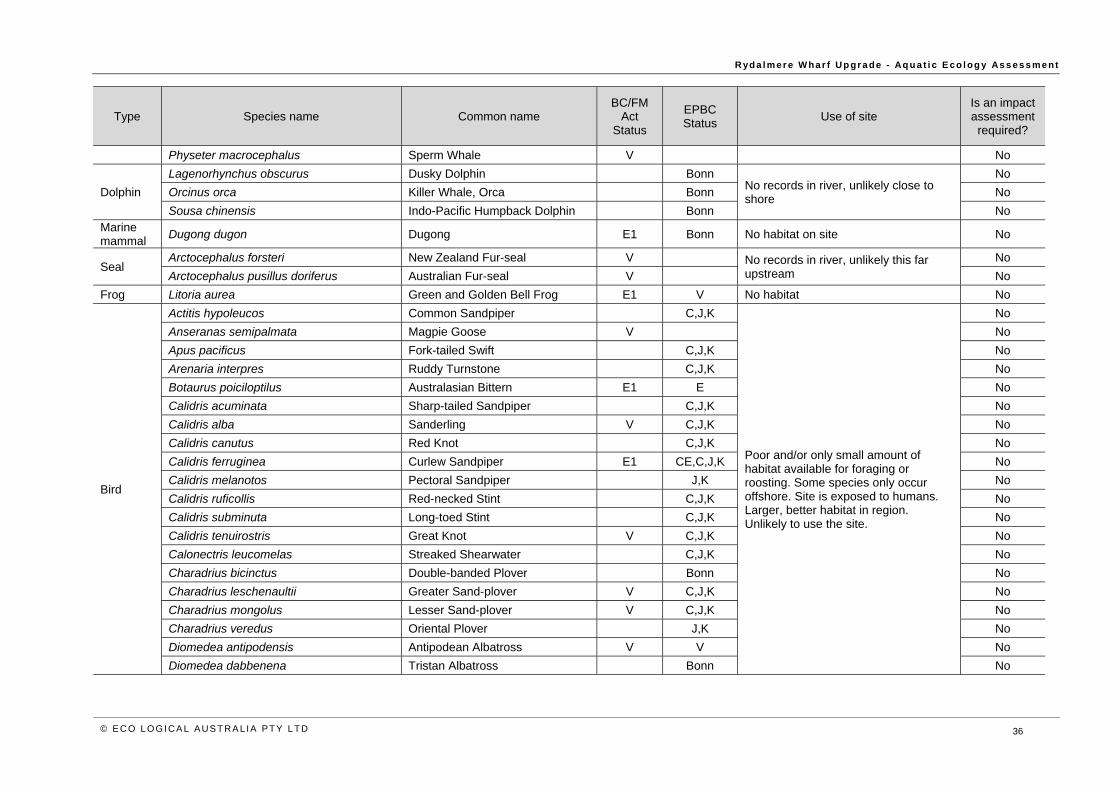
R yd a l m er e W ha r f U p gr a de - Aq u a t i c E co l og y As s e s s me nt
© E C O L OGI CA L AUS T RA L IA PTY L TD 36
Type Species name Common name BC/FM
Act Status
EPBC Status Use of site
Is an impact assessment required?
Physeter macrocephalus Sperm Whale V No
Dolphin Lagenorhynchus obscurus Dusky Dolphin Bonn
No records in river, unlikely close to shore
No Orcinus orca Killer Whale, Orca Bonn No Sousa chinensis Indo-Pacific Humpback Dolphin Bonn No
Marine mammal Dugong dugon Dugong E1 Bonn No habitat on site No
Seal Arctocephalus forsteri New Zealand Fur-seal V No records in river, unlikely this far
upstream No
Arctocephalus pusillus doriferus Australian Fur-seal V No Frog Litoria aurea Green and Golden Bell Frog E1 V No habitat No
Bird
Actitis hypoleucos Common Sandpiper C,J,K
Poor and/or only small amount of habitat available for foraging or roosting. Some species only occur offshore. Site is exposed to humans. Larger, better habitat in region. Unlikely to use the site.
No Anseranas semipalmata Magpie Goose V No Apus pacificus Fork-tailed Swift C,J,K No Arenaria interpres Ruddy Turnstone C,J,K No Botaurus poiciloptilus Australasian Bittern E1 E No Calidris acuminata Sharp-tailed Sandpiper C,J,K No Calidris alba Sanderling V C,J,K No Calidris canutus Red Knot C,J,K No Calidris ferruginea Curlew Sandpiper E1 CE,C,J,K No Calidris melanotos Pectoral Sandpiper J,K No Calidris ruficollis Red-necked Stint C,J,K No Calidris subminuta Long-toed Stint C,J,K No Calidris tenuirostris Great Knot V C,J,K No Calonectris leucomelas Streaked Shearwater C,J,K No Charadrius bicinctus Double-banded Plover Bonn No Charadrius leschenaultii Greater Sand-plover V C,J,K No Charadrius mongolus Lesser Sand-plover V C,J,K No Charadrius veredus Oriental Plover J,K No Diomedea antipodensis Antipodean Albatross V V No Diomedea dabbenena Tristan Albatross Bonn No

R yd a l m er e W ha r f U p gr a de - Aq u a t i c E co l og y As s e s s me nt
© E C O L OGI CA L AUS T RA L IA PTY L TD 37
Type Species name Common name BC/FM
Act Status
EPBC Status Use of site
Is an impact assessment required?
Diomedea exulans Wandering Albatross E1 V,J No Diomedea gibsoni Gibson's Albatross V V No Diomedea sanfordi Northern Royal Albatross E,Bonn No Ephippiorhynchus asiaticus Black-necked Stork E1 No Epthianura albifrons White-fronted Chat E2,V No Esacus magnirostris Beach Stone-curlew E4A No
Eudyptula minor Little Penguin in the Manly Point Area E2 No
Fregetta grallaria grallaria White-bellied Storm-Petrel V No Gallinago hardwickii Latham's Snipe C,J,K No Gallinago megala Swinhoe's Snipe Bonn,C No Gallinago stenura Pin-tailed Snipe Bonn,C No Gygis alba White Tern V No Haematopus fuliginosus Sooty Oystercatcher V No Haematopus longirostris Pied Oystercatcher E1 No Heteroscelus brevipes Grey-tailed Tattler J No Heteroscelus incanus Wandering Tattler J No Hirundapus caudacutus White-throated Needletail C,J,K No Ixobrychus flavicollis Black Bittern V No Limicola falcinellus Broad-billed Sandpiper V C,J,K No Limosa lapponica Bar-tailed Godwit C,J,K No Limosa limosa Black-tailed Godwit V C,J,K No Macronectes giganteus Southern Giant Petrel E1 E No Macronectes halli Northern Giant-Petrel V V No Monarcha melanopsis Black-faced Monarch Bonn No Monarcha trivirgatus Spectacled Monarch Bonn No Numenius madagascariensis Eastern Curlew CE,C,J,K No Numenius minutus Little Curlew C,J,K No Numenius phaeopus Whimbrel C,J,K No
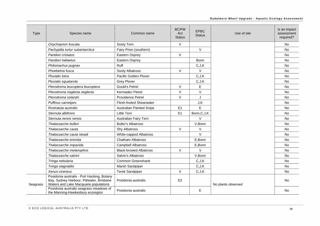
R yd a l m er e W ha r f U p gr a de - Aq u a t i c E co l og y As s e s s me nt
© E C O L OGI CA L AUS T RA L IA PTY L TD 38
Type Species name Common name BC/FM
Act Status
EPBC Status Use of site
Is an impact assessment required?
Onychoprion fuscata Sooty Tern V No Pachyptila turtur subantarctica Fairy Prion (southern) V No Pandion cristatus Eastern Osprey V No Pandion haliaetus Eastern Osprey Bonn No Philomachus pugnax Ruff C,J,K No Phoebetria fusca Sooty Albatross V V No Pluvialis fulva Pacific Golden Plover C,J,K No Pluvialis squatarola Grey Plover C,J,K No Pterodroma leucoptera leucoptera Gould's Petrel V E No Pterodroma neglecta neglecta Kermadec Petrel V V No Pterodroma solandri Providence Petrel V J No Puffinus carneipes Flesh-footed Shearwater J,K No Rostratula australis Australian Painted Snipe E1 E No Sternula albifrons Little Tern E1 Bonn,C,J,K No Sternula nereis nereis Australian Fairy Tern V No Thalassarche bulleri Buller's Albatross V,Bonn No Thalassarche cauta Shy Albatross V V No Thalassarche cauta steadi White-capped Albatross V No Thalassarche eremita Chatham Albatross E,Bonn No Thalassarche impavida Campbell Albatross E,Bonn No Thalassarche melanophris Black-browed Albatross V V No Thalassarche salvini Salvin's Albatross V,Bonn No Tringa nebularia Common Greenshank C,J,K No Tringa stagnatilis Marsh Sandpiper C,J,K No Xenus cinereus Terek Sandpiper V C,J,K No
Seagrass
Posidonia australis - Port Hacking, Botany Bay, Sydney Harbour, Pittwater, Brisbane Waters and Lake Macquarie populations
Posidonia australis E2 No plants observed No
Posidonia australis seagrass meadows of the Manning-Hawkesbury ecoregion Posidonia australis E No
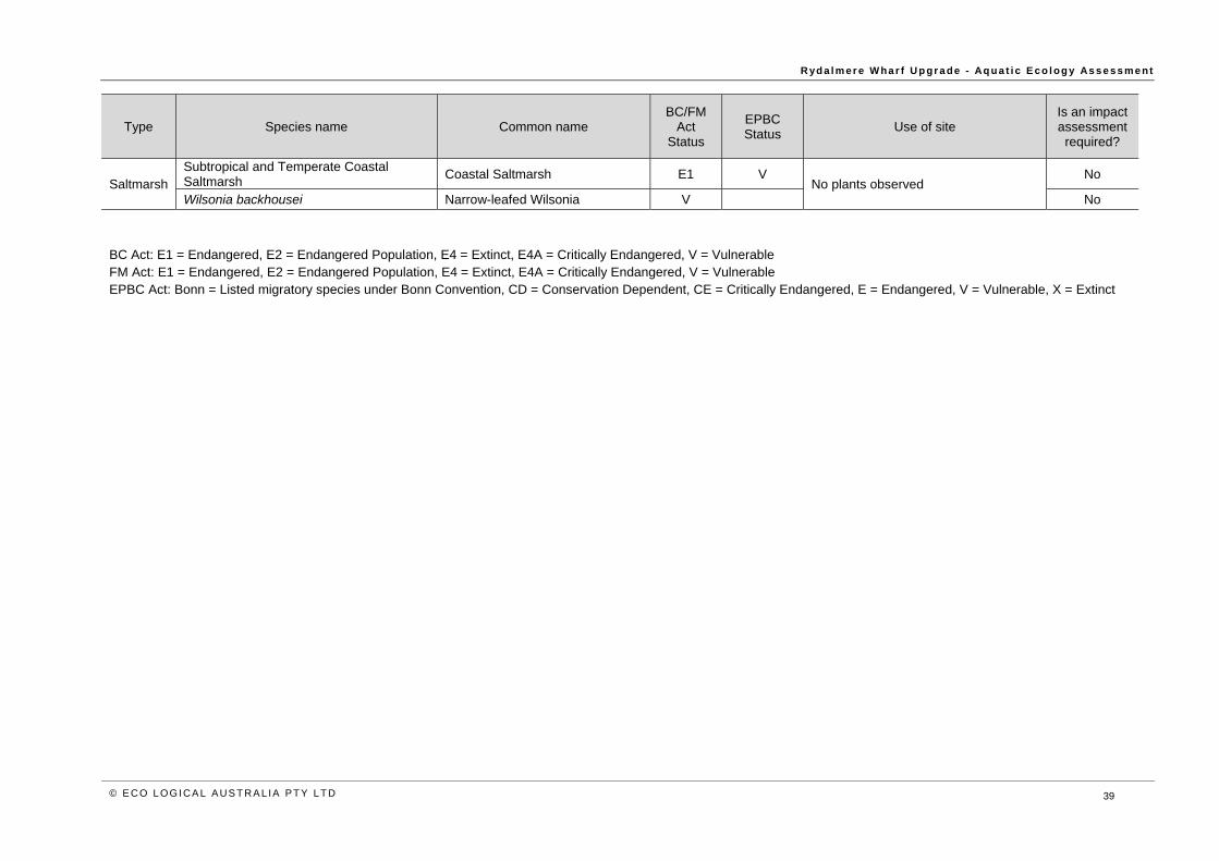
R yd a l m er e W ha r f U p gr a de - Aq u a t i c E co l og y As s e s s me nt
© E C O L OGI CA L AUS T RA L IA PTY L TD 39
Type Species name Common name BC/FM
Act Status
EPBC Status Use of site
Is an impact assessment required?
Saltmarsh Subtropical and Temperate Coastal Saltmarsh Coastal Saltmarsh E1 V
No plants observed No
Wilsonia backhousei Narrow-leafed Wilsonia V No
BC Act: E1 = Endangered, E2 = Endangered Population, E4 = Extinct, E4A = Critically Endangered, V = Vulnerable FM Act: E1 = Endangered, E2 = Endangered Population, E4 = Extinct, E4A = Critically Endangered, V = Vulnerable EPBC Act: Bonn = Listed migratory species under Bonn Convention, CD = Conservation Dependent, CE = Critically Endangered, E = Endangered, V = Vulnerable, X = Extinct
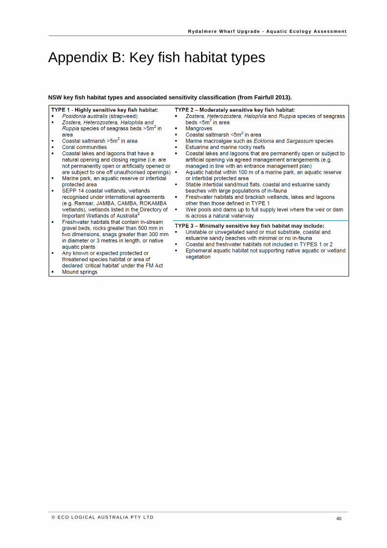
R yd a l m er e W ha r f U p gr a de - Aq u a t i c E co l og y As s e s s me nt
© E C O L OGI CA L AUS T RA L IA PTY L TD 40
Appendix B: Key fish habitat types
NSW key fish habitat types and associated sensitivity classification (from Fairfull 2013).
© E C O L OGI CA L AUS T RA L IA PTY L TD 41
HEAD OFFICE Suite 2, Level 3 668-672 Old Princes Highway Sutherland NSW 2232 T 02 8536 8600 F 02 9542 5622
SYDNEY Suite 1, Level 1 101 Sussex Street Sydney NSW 2000 T 02 8536 8650 F 02 9542 5622
HUSKISSON Unit 1, 51 Owen Street Huskisson NSW 2540 T 02 4201 2264 F 02 9542 5622
CANBERRA Level 2 11 London Circuit Canberra ACT 2601 T 02 6103 0145 F 02 9542 5622
NEWCASTLE Suites 28 & 29, Level 7 19 Bolton Street Newcastle NSW 2300 T 02 4910 0125 F 02 9542 5622
NAROOMA 5/20 Canty Street Narooma NSW 2546 T 02 4302 1266 F 02 9542 5622
COFFS HARBOUR 35 Orlando Street Coffs Harbour Jetty NSW 2450 T 02 6651 5484 F 02 6651 6890
ARMIDALE 92 Taylor Street Armidale NSW 2350 T 02 8081 2685 F 02 9542 5622
MUDGEE Unit 1, Level 1 79 Market Street Mudgee NSW 2850 T 02 4302 1234 F 02 6372 9230
PERTH Suite 1 & 2 49 Ord Street West Perth WA 6005 T 08 9227 1070 F 02 9542 5622
WOLLONGONG Suite 204, Level 2 62 Moore Street Austinmer NSW 2515 T 02 4201 2200 F 02 9542 5622
GOSFORD Suite 5, Baker One 1-5 Baker Street Gosford NSW 2250 T 02 4302 1221 F 02 9542 5622
DARWIN 16/56 Marina Boulevard Cullen Bay NT 0820 T 08 8989 5601 F 08 8941 1220
BRISBANE Suite 1, Level 3 471 Adelaide Street Brisbane QLD 4000 T 07 3503 7192 F 07 3854 0310
1300 646 131 www.ecoaus.com.au

Appendix E Noise and vibration assessment
HANSEN YUNCKEN
SYDNEY WHARF UPGRADE RYDALMERE CONSTRUCTION NOISE AND VIBRATION IMPACT STATEMENT
MARCH 2018
This document may contain confidential and legally privileged information, neither of which are intended to be waived,
and must be used only for its intended purpose. Any unauthorised copying, dissemination or use in any form or by any
means other than by the addressee, is strictly prohibited. If you have received this document in error or by any means
other than as authorised addressee, please notify us immediately and we will arrange for its return to us.
2271407A-20180328-TK-
RYDALMERE FERRY WHARF.docx
March 2018
Sydney Wharf Upgrade Rydalmere Construction noise and vibration impact statement Hansen Yuncken
WSP
Level 27, 680 George Street
Sydney NSW 2000
GPO Box 5394
Sydney NSW 2001
Tel: +61 2 9272 5100
Fax: +61 2 9272 5101
wsp.com
REV DATE DETAILS
Draft 02/03/2018 Construction noise and vibration impact statement
Final 28/03/2018 Revised construction noise and vibration impact statement
NAME DATE SIGNATURE
Prepared by: T Krikke & T Nguyen 28/03/2018
Reviewed by: S Moore 28/03/2018
Approved by: S Moore 28/03/2018
EXECUTIVE SUMMARY .................................................................. II
1 INTRODUCTION ................................................................... 1
1.1 PROJECT DESCRIPTION .......................................................... 1
1.2 PROJECT LOCATION ................................................................ 2
2 SENSITIVE RECEIVERS ..................................................... 3
3 NOISE MONITORING .......................................................... 5
3.1 NOISE MONITORING LOCATIONS ........................................... 5
3.2 INSTRUMENTATION AND QUALITY CONTROL ..................... 5
3.3 UNATTENDED NOISE SURVEY ................................................ 5
3.4 OPERATOR ATTENDED NOISE SURVEY ............................... 6
4 CONSTRUCTION NOISE AND VIBRATION ASSESSMENT CRITERIA ................................................... 7
4.1 CONSTRUCTION NOISE ASSESSMENT PERIODS ................ 7
4.2 CONSTRUCTION NOISE MANAGEMENT LEVELS ................. 7
4.3 CONSTRUCTION VIBRATION CRITERIA ................................. 8
5 PROPOSED CONSTRUCTION METHOD ...................... 10
5.1 CONSTRUCTION STAGES AND DURATION ......................... 10
5.2 CONSTRUCTION WORK SCENARIOS AND EQUIPMENT ............................................................................. 10
6 ASSESSMENT OF CONSTRUCTION IMPACTS .......... 12
6.1 METHODOLOGY ...................................................................... 12
6.2 MODELLED CONSTRUCTION NOISE LEVELS ..................... 12
7 ASSESSMENT OF CONSTRUCTION VIBRATION IMPACTS ....................................................... 15
7.1 SAFE WORKING DISTANCES FOR VIBRATION INTENSIVE PLANT ................................................................... 15
7.2 MODELLED CONSTRUCTION VIBRATION LEVELS ............ 16
8 CONSTRUCTION SAFEGUARDS AND MANAGEMENT MEASURES ........................................... 17
8.1 MITIGATION MEASURES ........................................................ 17
8.2 VIBRATION MITIGATION MEASURES ................................... 18
8.3 ADDITIONAL MITIGATION MEASURES ................................. 18
9 CONCLUSION ..................................................................... 20
TABLE OF CONTENTS
Project No 2271407A Sydney Wharf Upgrade Rydalmere Construction noise and vibration impact statement Hansen Yuncken
WSP March 2018
Page ii
EXECUTIVE SUMMARY WSP Australia Pty Ltd (WSP) has been engaged by Hansen Yuncken Pty Ltd (Hansen Yuncken) to undertake a
construction noise and vibration impact assessment for the proposed Rydalmere Wharf Interchange upgrade.
The assessment was based on modelling the construction noise and vibration impacts at sensitive receivers as a result of
the construction of the proposed wharf upgrade. Potentially sensitive receivers for both noise and vibration have been
categorised as residential, commercial, industrial, educational, places of worship and active/passive recreational areas. No
potentially sensitive heritage structures have been identified close to the proposal. The receivers surrounding the proposal
have been categorised into five Noise Catchment Areas (NCAs) based on a similar noise environment within these areas.
A total of six construction scenarios have been proposed (scenarios S01 to S06), with all works to be undertaken during
standard construction working hours as defined in the NSW Roads and Maritime’s Construction Noise and Vibration
Guideline (CNVG). Construction work is expected to take about four months to complete.
The report outlines the noise and vibration impacts that may occur as a result of construction of the proposal. There
would be no significant noise impacts from construction traffic due to the proposal and therefore these aspects have not
been assessed.
3D computer noise modelling indicates that the Noise Management Levels are exceeded for:
— Landside infrastructure scenario (S06) at all catchment areas north (and east) of the proposal (NCA01, NCA02,
NCA04 and NCA05)
— All scenarios for the residential receivers North/East of the site (NCA02)
Site specific mitigation measures have been provided to reduce potential noise impacts in addition to the standard
mitigation measures contained within the Construction Noise and Vibration Guideline. With these noise management
measures implemented, additional mitigation measures are required for Scenario S06 at NCA02 and NCA04 (catchment
areas immediately adjacent to the site).
To address any residual impacts after the implementation of the standard and specific mitigation measures, the CNVG
additional mitigation measures have been identified. Additional mitigation measures include:
— N: Notification (letterbox drop or equivalent)
— V: Verification
Potential impulsive vibration impacts for driven piles have been calculated based on the methodology outlined in the
FTA Noise and vibration manual to determine vibration levels. The predicted vibration levels are then compared against
the limits outlined in the NSW Assessing Vibration: A Technical Guideline and British Standard BS 7358-2: Evaluation
and measurement for vibration in buildings. Guide to damage levels from groundborne vibration as per the CNVG
guidance. No potential vibration impacts are anticipated from the proposal.
Project No 2271407A Sydney Wharf Upgrade Rydalmere Construction noise and vibration impact statement Hansen Yuncken
WSP March 2018
Page 1
1 INTRODUCTION WSP Australia Pty Ltd (WSP) has been engaged by Hansen Yuncken Pty Ltd (Hansen Yuncken) on behalf of Roads and
Maritime Services (Roads and Maritime) to carry out a construction noise and vibration impact assessment for the
proposed Rydalmere Interchange upgrade.
This document assesses noise and vibration impacts associated with the upgrade construction work with reference to the
Construction Noise and Vibration Guideline (CNVG, Roads and Maritime, 2016). It is noted that operational noise
associated with the proposed works is not part of the scope and as such has not been assessed in this report.
1.1 PROJECT DESCRIPTION The proposal will involve improving access to Rydalmere ferry wharf by replacing the existing structure with a gangway
and pontoon. The proposal is needed to allow for more efficient passenger services.
Key waterside features of the proposal include:
— Removal of the existing gangway, pontoon and associated wharf structures (including existing piles)
— Installation of a new three-metre wide by 18-metre long uncovered gangway, held in place by one new pile
— Installation of a nine-metre wide by 18-metre long floating covered and glazed pontoon, held in position by four new
piles
— Installation of a debris deflector to the west of the new pontoon, held in place by two new piles
— Installation of two new pivot piles to assist with berthing.
Key landside features of the proposal include:
— Installation of a raised landing at the entrance to the wharf, including minor modification to the existing seawall
— Installation of new stairs from the wharf landing to an existing paved area adjacent to the wharf
— Upgrading the pathway from the wharf to the existing bus stop
— Realignment of part of the existing pavement within the interchange
— Upgrading two existing accessible parking spaces
— Installation of a new kiss-and-ride zone within the interchange and removal of existing bollards for access
— Installation of ten new bike racks and new bicycle calming measures with texture path changes installed at the
connection of the wharf entrance pathway to an existing shared pedestrian and cycle path
— Upgrading lighting around the interchange
— Removal of existing Roads and Maritime communications equipment and signage within the existing shelter for
relocation to the new pontoon
— Installation of new wayfinding signage around the interchange
Construction work is expected to commence in mid-2018 and take about four months to complete.
Roads and Maritime propose to carry out all other work associated with the proposal during the standard construction
working hours of:
— Monday to Friday, 7am to 6pm
— Saturday, 8am to 1pm.
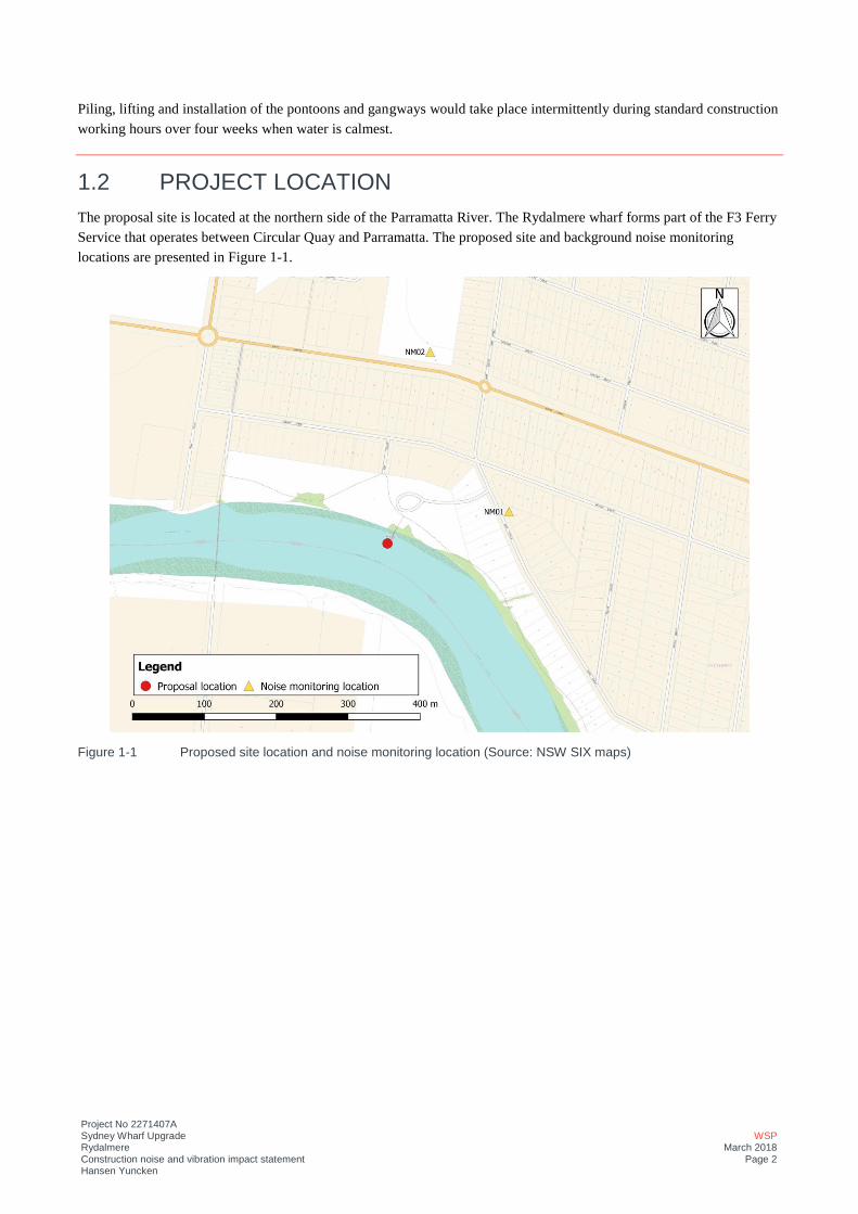
Project No 2271407A Sydney Wharf Upgrade Rydalmere Construction noise and vibration impact statement Hansen Yuncken
WSP March 2018
Page 2
Piling, lifting and installation of the pontoons and gangways would take place intermittently during standard construction
working hours over four weeks when water is calmest.
1.2 PROJECT LOCATION The proposal site is located at the northern side of the Parramatta River. The Rydalmere wharf forms part of the F3 Ferry
Service that operates between Circular Quay and Parramatta. The proposed site and background noise monitoring
locations are presented in Figure 1-1.
Figure 1-1 Proposed site location and noise monitoring location (Source: NSW SIX maps)
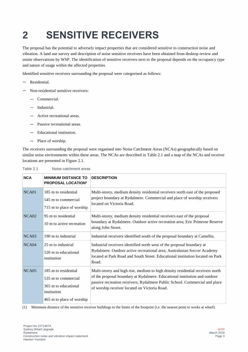
Project No 2271407A Sydney Wharf Upgrade Rydalmere Construction noise and vibration impact statement Hansen Yuncken
WSP March 2018
Page 3
2 SENSITIVE RECEIVERS The proposal has the potential to adversely impact properties that are considered sensitive to construction noise and
vibration. A land use survey and description of noise sensitive receivers have been obtained from desktop review and
onsite observations by WSP. The identification of sensitive receivers next to the proposal depends on the occupancy type
and nature of usage within the affected properties.
Identified sensitive receivers surrounding the proposal were categorised as follows:
— Residential.
— Non-residential sensitive receivers:
— Commercial.
— Industrial.
— Active recreational areas.
— Passive recreational areas.
— Educational institution.
— Place of worship.
The receivers surrounding the proposal were organised into Noise Catchment Areas (NCAs) geographically based on
similar noise environments within these areas. The NCAs are described in Table 2.1 and a map of the NCAs and receiver
locations are presented in Figure 2.1.
Table 2.1 Noise catchment areas
NCA MINIMUM DISTANCE TO PROPOSAL LOCATION1
DESCRIPTION
NCA01 185 m to residential
545 m to commercial
715 m to place of worship
Multi-storey, medium density residential receivers north east of the proposed
project boundary at Rydalmere. Commercial and place of worship receivers
located on Victoria Road.
NCA02 95 m to residential
10 m to active recreation
Multi-storey, medium density residential receivers east of the proposal
boundary at Rydalmere. Outdoor active recreation area; Eric Primrose Reserve
along John Street.
NCA03 190 m to industrial Industrial receivers identified south of the proposal boundary at Camellia.
NCA04 25 m to industrial
520 m to educational
institution
Industrial receivers identified north west of the proposal boundary at
Rydalmere. Outdoor active recreational area; Australasian Soccer Academy
located at Park Road and South Street. Educational institution located on Park
Road.
NCA05 185 m to residential
535 m to commercial
365 m to educational
institution
465 m to place of worship
Multi-storey and high rise, medium to high density residential receivers north
of the proposal boundary at Rydalmere. Educational institution and outdoor
passive recreation receivers; Rydalmere Public School. Commercial and place
of worship receiver located on Victoria Road.
(1) Minimum distance of the sensitive receiver buildings to the limits of the footprint (i.e. the nearest point to works at wharf).
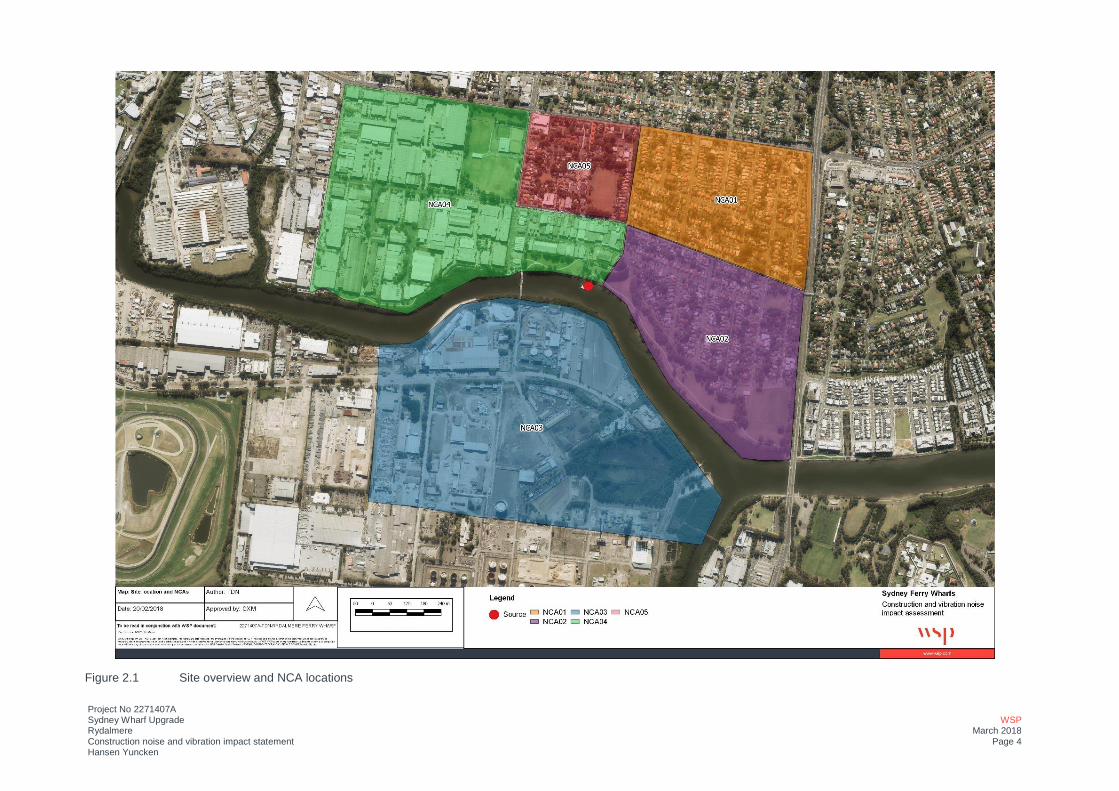
Project No 2271407A Sydney Wharf Upgrade Rydalmere Construction noise and vibration impact statement Hansen Yuncken
WSP March 2018
Page 4
Figure 2.1 Site overview and NCA locations

Project No 2271407A Sydney Wharf Upgrade Rydalmere Construction noise and vibration impact statement Hansen Yuncken
WSP March 2018
Page 5
3 NOISE MONITORING This section provides an overview of the existing noise environment surrounding the site. The prevailing background and
ambient noise levels surrounding the proposed site were determined through a combination of unattended and operator
attended noise surveys in accordance with the Australian Standard 1055-1997- Acoustics-Description and Measurement
of Environmental Noise (AS 1055) and NSW Noise Policy for Industry (NPfI, EPA 2017).
WSP have carried out attended noise surveys during the daytime, and unattended noise surveys during the daytime,
evening and night-time periods.
3.1 NOISE MONITORING LOCATIONS The noise monitoring locations relevant to this assessment are detailed in Table 3.1 and are shown in Figure 1-1.
Table 3.1 Noise monitoring locations
NOISE MONITORING LOCATION SURVEY METHOD ADDRESS
NM01 Unattended measurement and
Attended measurement
15 John Street, Rydalmere
NM02 Unattended measurement and
Attended measurement
397 Victoria Road, Rydalmere
3.2 INSTRUMENTATION AND QUALITY CONTROL The monitoring equipment was fitted with windshields and were field calibrated before and after monitoring. No
significant drifts in calibration (± 1.0 dB) were noted. The weather conditions at the time of monitoring were recorded at
Sydney Olympic Park (Bureau of Meteorology station number 066212), which is located approximately three kilometres
east of the proposal.
Monitoring data were excluded during periods of weather that may have adversely affected the monitoring data; where
wind speeds were greater than 5 metres per second and during significant rainfall (>5mm),.
All the monitoring equipment has a current certified calibration certificate (National Association of Testing Authorities,
NATA) at the time of use. Details of all equipment used to conduct the noise survey are presented in Table 3.2. Copies of
the calibration certificates can be provided upon request.
Table 3.2 Noise monitoring equipment
LOCATION SURVEY METHOD MANUFACTURER AND MODEL NO.
SERIAL NO.
NM01 Unattended measurement Svan 959 11225
NM02 Unattended measurement Svan 958 36659
NM01and NM02 Attended measurement Norsonic 140 1404791
3.3 UNATTENDED NOISE SURVEY Unattended noise monitoring for background noise levels in the vicinity of the Rydalmere wharf site were carried out by
WSP between 2nd and 8th February 2018 for NM01 and 2nd and 13th February 2018 for NM02.
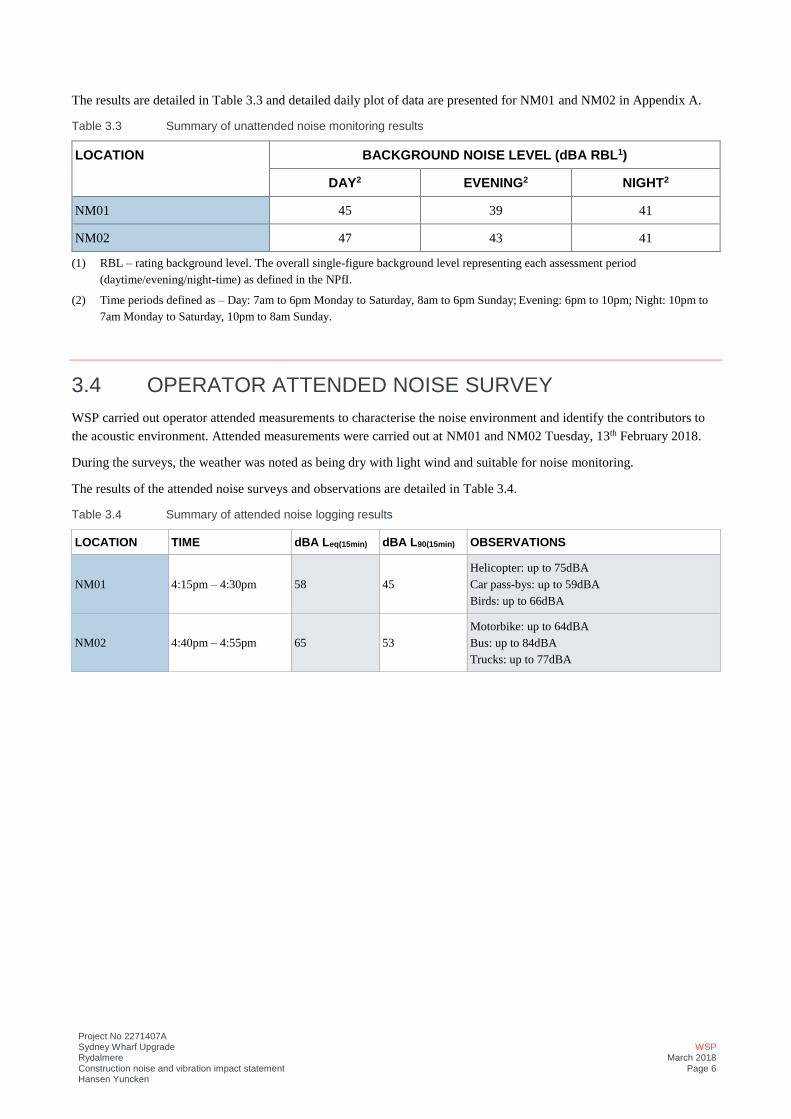
Project No 2271407A Sydney Wharf Upgrade Rydalmere Construction noise and vibration impact statement Hansen Yuncken
WSP March 2018
Page 6
The results are detailed in Table 3.3 and detailed daily plot of data are presented for NM01 and NM02 in Appendix A.
Table 3.3 Summary of unattended noise monitoring results
LOCATION BACKGROUND NOISE LEVEL (dBA RBL1)
DAY2 EVENING2 NIGHT2
NM01 45 39 41
NM02 47 43 41
(1) RBL – rating background level. The overall single-figure background level representing each assessment period
(daytime/evening/night-time) as defined in the NPfI.
(2) Time periods defined as – Day: 7am to 6pm Monday to Saturday, 8am to 6pm Sunday; Evening: 6pm to 10pm; Night: 10pm to
7am Monday to Saturday, 10pm to 8am Sunday.
3.4 OPERATOR ATTENDED NOISE SURVEY WSP carried out operator attended measurements to characterise the noise environment and identify the contributors to
the acoustic environment. Attended measurements were carried out at NM01 and NM02 Tuesday, 13th February 2018.
During the surveys, the weather was noted as being dry with light wind and suitable for noise monitoring.
The results of the attended noise surveys and observations are detailed in Table 3.4.
Table 3.4 Summary of attended noise logging results
LOCATION TIME dBA Leq(15min) dBA L90(15min) OBSERVATIONS
NM01 4:15pm – 4:30pm 58 45
Helicopter: up to 75dBA
Car pass-bys: up to 59dBA
Birds: up to 66dBA
NM02 4:40pm – 4:55pm 65 53
Motorbike: up to 64dBA
Bus: up to 84dBA
Trucks: up to 77dBA
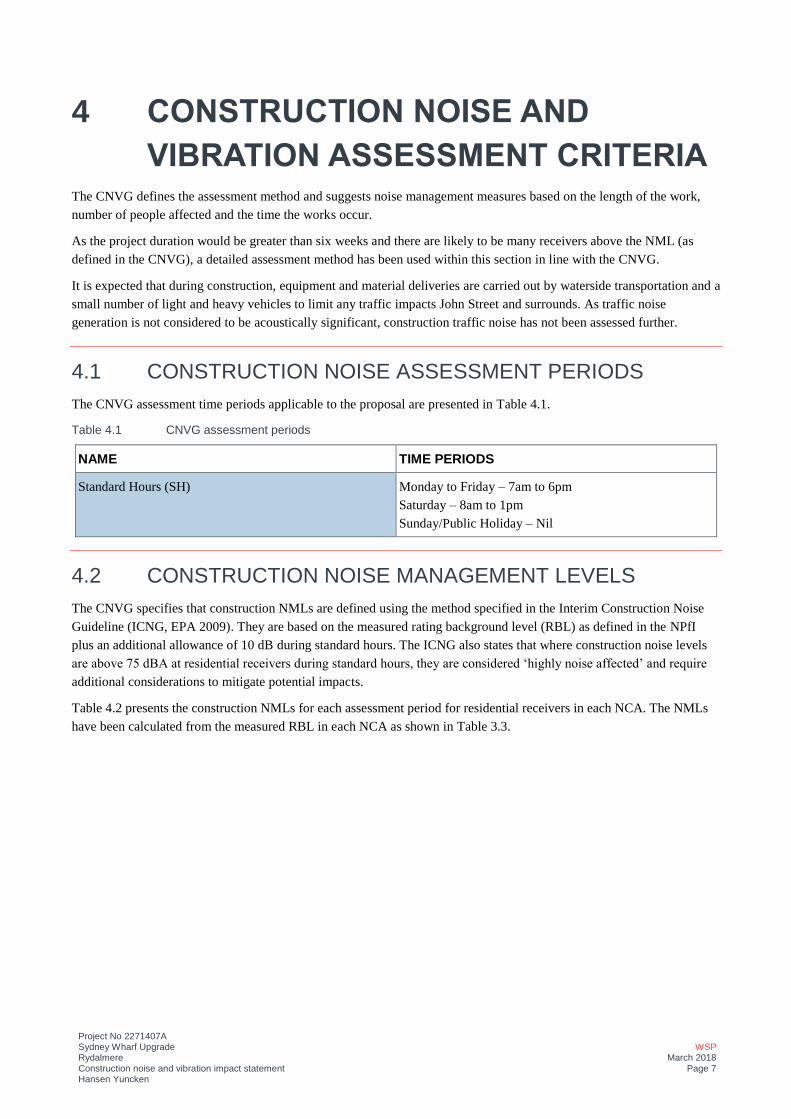
Project No 2271407A Sydney Wharf Upgrade Rydalmere Construction noise and vibration impact statement Hansen Yuncken
WSP March 2018
Page 7
4 CONSTRUCTION NOISE AND
VIBRATION ASSESSMENT CRITERIA The CNVG defines the assessment method and suggests noise management measures based on the length of the work,
number of people affected and the time the works occur.
As the project duration would be greater than six weeks and there are likely to be many receivers above the NML (as
defined in the CNVG), a detailed assessment method has been used within this section in line with the CNVG.
It is expected that during construction, equipment and material deliveries are carried out by waterside transportation and a
small number of light and heavy vehicles to limit any traffic impacts John Street and surrounds. As traffic noise
generation is not considered to be acoustically significant, construction traffic noise has not been assessed further.
4.1 CONSTRUCTION NOISE ASSESSMENT PERIODS The CNVG assessment time periods applicable to the proposal are presented in Table 4.1.
Table 4.1 CNVG assessment periods
NAME TIME PERIODS
Standard Hours (SH) Monday to Friday – 7am to 6pm
Saturday – 8am to 1pm
Sunday/Public Holiday – Nil
4.2 CONSTRUCTION NOISE MANAGEMENT LEVELS The CNVG specifies that construction NMLs are defined using the method specified in the Interim Construction Noise
Guideline (ICNG, EPA 2009). They are based on the measured rating background level (RBL) as defined in the NPfI
plus an additional allowance of 10 dB during standard hours. The ICNG also states that where construction noise levels
are above 75 dBA at residential receivers during standard hours, they are considered ‘highly noise affected’ and require
additional considerations to mitigate potential impacts.
Table 4.2 presents the construction NMLs for each assessment period for residential receivers in each NCA. The NMLs
have been calculated from the measured RBL in each NCA as shown in Table 3.3.
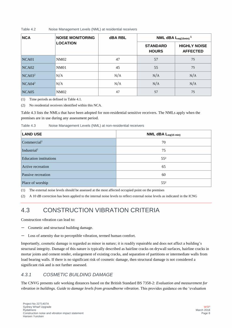
Project No 2271407A Sydney Wharf Upgrade Rydalmere Construction noise and vibration impact statement Hansen Yuncken
WSP March 2018
Page 8
Table 4.2 Noise Management Levels (NML) at residential receivers
NCA NOISE MONITORING LOCATION
dBA RBL NML dBA Leq(15min) 1
STANDARD HOURS
HIGHLY NOISE AFFECTED
NCA01 NM02 47 57 75
NCA02 NM01 45 55 75
NCA032 N/A N/A N/A N/A
NCA042 N/A N/A N/A N/A
NCA05 NM02 47 57 75
(1) Time periods as defined in Table 4.1.
(2) No residential receivers identified within this NCA.
Table 4.3 lists the NMLs that have been adopted for non-residential sensitive receivers. The NMLs apply when the
premises are in use during any assessment period.
Table 4.3 Noise Management Levels (NML) at non-residential receivers
LAND USE NML dBA Leq(15 min)
Commercial1 70
Industrial1 75
Education institutions 55²
Active recreation 65
Passive recreation 60
Place of worship 55²
(1) The external noise levels should be assessed at the most affected occupied point on the premises
(2) A 10 dB correction has been applied to the internal noise levels to reflect external noise levels as indicated in the ICNG
4.3 CONSTRUCTION VIBRATION CRITERIA Construction vibration can lead to:
— Cosmetic and structural building damage.
— Loss of amenity due to perceptible vibration, termed human comfort.
Importantly, cosmetic damage is regarded as minor in nature; it is readily repairable and does not affect a building’s
structural integrity. Damage of this nature is typically described as hairline cracks on drywall surfaces, hairline cracks in
mortar joints and cement render, enlargement of existing cracks, and separation of partitions or intermediate walls from
load bearing walls. If there is no significant risk of cosmetic damage, then structural damage is not considered a
significant risk and is not further assessed.
4.3.1 COSMETIC BUILDING DAMAGE
The CNVG presents safe working distances based on the British Standard BS 7358-2: Evaluation and measurement for
vibration in buildings. Guide to damage levels from groundborne vibration. This provides guidance on the ‘evaluation
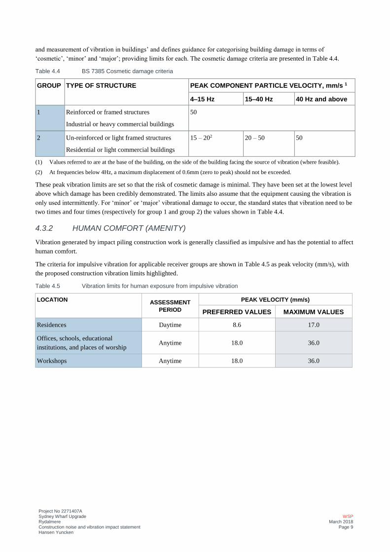
Project No 2271407A Sydney Wharf Upgrade Rydalmere Construction noise and vibration impact statement Hansen Yuncken
WSP March 2018
Page 9
and measurement of vibration in buildings’ and defines guidance for categorising building damage in terms of
‘cosmetic’, ‘minor’ and ‘major’; providing limits for each. The cosmetic damage criteria are presented in Table 4.4.
Table 4.4 BS 7385 Cosmetic damage criteria
GROUP TYPE OF STRUCTURE PEAK COMPONENT PARTICLE VELOCITY, mm/s 1
4–15 Hz 15–40 Hz 40 Hz and above
1 Reinforced or framed structures
Industrial or heavy commercial buildings
50
2 Un-reinforced or light framed structures
Residential or light commercial buildings
15 – 202 20 – 50 50
(1) Values referred to are at the base of the building, on the side of the building facing the source of vibration (where feasible).
(2) At frequencies below 4Hz, a maximum displacement of 0.6mm (zero to peak) should not be exceeded.
These peak vibration limits are set so that the risk of cosmetic damage is minimal. They have been set at the lowest level
above which damage has been credibly demonstrated. The limits also assume that the equipment causing the vibration is
only used intermittently. For ‘minor’ or ‘major’ vibrational damage to occur, the standard states that vibration need to be
two times and four times (respectively for group 1 and group 2) the values shown in Table 4.4.
4.3.2 HUMAN COMFORT (AMENITY)
Vibration generated by impact piling construction work is generally classified as impulsive and has the potential to affect
human comfort.
The criteria for impulsive vibration for applicable receiver groups are shown in Table 4.5 as peak velocity (mm/s), with
the proposed construction vibration limits highlighted.
Table 4.5 Vibration limits for human exposure from impulsive vibration
LOCATION ASSESSMENT PERIOD
PEAK VELOCITY (mm/s)
PREFERRED VALUES MAXIMUM VALUES
Residences Daytime 8.6 17.0
Offices, schools, educational
institutions, and places of worship Anytime 18.0 36.0
Workshops Anytime 18.0 36.0
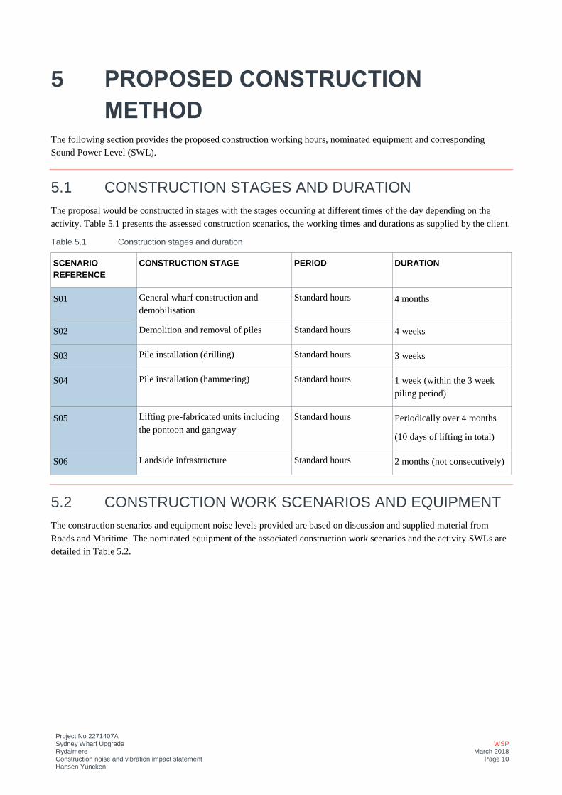
Project No 2271407A Sydney Wharf Upgrade Rydalmere Construction noise and vibration impact statement Hansen Yuncken
WSP March 2018
Page 10
5 PROPOSED CONSTRUCTION
METHOD The following section provides the proposed construction working hours, nominated equipment and corresponding
Sound Power Level (SWL).
5.1 CONSTRUCTION STAGES AND DURATION The proposal would be constructed in stages with the stages occurring at different times of the day depending on the
activity. Table 5.1 presents the assessed construction scenarios, the working times and durations as supplied by the client.
Table 5.1 Construction stages and duration
SCENARIO REFERENCE
CONSTRUCTION STAGE PERIOD DURATION
S01 General wharf construction and
demobilisation
Standard hours 4 months
S02 Demolition and removal of piles Standard hours 4 weeks
S03 Pile installation (drilling) Standard hours 3 weeks
S04 Pile installation (hammering) Standard hours 1 week (within the 3 week
piling period)
S05 Lifting pre-fabricated units including
the pontoon and gangway
Standard hours Periodically over 4 months
(10 days of lifting in total)
S06 Landside infrastructure Standard hours 2 months (not consecutively)
5.2 CONSTRUCTION WORK SCENARIOS AND EQUIPMENT The construction scenarios and equipment noise levels provided are based on discussion and supplied material from
Roads and Maritime. The nominated equipment of the associated construction work scenarios and the activity SWLs are
detailed in Table 5.2.
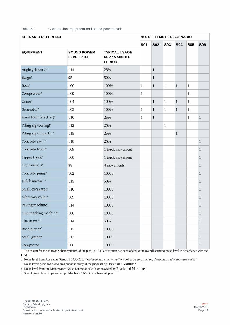
Project No 2271407A Sydney Wharf Upgrade Rydalmere Construction noise and vibration impact statement Hansen Yuncken
WSP March 2018
Page 11
Table 5.2 Construction equipment and sound power levels
SCENARIO REFERENCE NO. OF ITEMS PER SCENARIO
S01 S02 S03 S04 S05 S06
EQUIPMENT SOUND POWER LEVEL, dBA
TYPICAL USAGE PER 15 MINUTE PERIOD
Angle grinders1, 4 114 25%
1
Barge3 95 50%
1
Boat3 100 100% 1 1 1 1 1
Compressor4 109 100% 1 1
Crane4 104 100% 1 1 1 1
Generator3 103 100% 1 1 1 1 1
Hand tools (electric)4 110 25% 1 1 1 1
Piling rig (boring)4 112 25% 1
Piling rig (impact)1, 3 115 25% 1
Concrete saw 1,4 118 25% 1
Concrete truck4 109 1 truck movement 1
Tipper truck4 108 1 truck movement 1
Light vehicle4 88 4 movements 1
Concrete pump4 102 100% 1
Jack hammer 1,4 115 50% 1
Small excavator4 110 100% 1
Vibratory roller4 109 100% 1
Paving machine4 114 100% 1
Line marking machine4 108 100% 1
Chainsaw 1,4 114 50% 1
Road planer5 117 100% 1
Small grader 113 100% 1
Compactor 106 100% 1
1: To account for the annoying characteristics of the plant, a +5 dB correction has been added to the overall scenario noise level in accordance with the
ICNG.
2: Noise level from Australian Standard 2436-2010 “Guide to noise and vibration control on construction, demolition and maintenance sites”
3: Noise levels provided based on a previous study of the proposal by Roads and Maritime
4: Noise level from the Maintenance Noise Estimator calculator provided by Roads and Maritime
5: Sound power level of pavement profiler from CNVG have been adopted
Project No 2271407A Sydney Wharf Upgrade Rydalmere Construction noise and vibration impact statement Hansen Yuncken
WSP March 2018
Page 12
6 ASSESSMENT OF CONSTRUCTION
NOISE IMPACTS
6.1 METHODOLOGY A noise model was prepared using the SoundPLAN 7.4 Industrial Module. The software allows the use of various
internationally recognised noise modelling algorithms. Following discussions between Roads and Maritime and WSP it
was determined that the CONCAWE modelling method was most suitable for this assessment (Aconex NSWM-CA-
002403, dated 23 February 2018)
A three dimensional representation of the physical environment within the project area was simulated. Modelling inputs
for each scenario included ground contours, locations of sensitive receivers, noise-generating equipment as well as any
other inputs which have an effect on the noise environment, such as the buildings surrounding the proposed site.
The following assumptions were used in the modelling:
— All noise sources in each scenario operating simultaneously unless otherwise stated.
— The sound levels in this report represent the LAeq(15 min) emission level.
— Topography for the area provided by Geosciences Australia.
— Receiver heights 1.5 m above ground level.
6.2 MODELLED CONSTRUCTION NOISE LEVELS The modelled noise levels for each scenario are presented in Table 6.1 outlining the noise level within each NCA and
receiver types. The modelled noise levels have been assessed at the closest affected receiver within each NCA. The
calculations are conservative as they include all equipment operating simultaneously at a typical distance to the receiver.
Actual noise levels from the construction site would be expected to be lower. It should also be noted that the SC06 will
be undertaken intermittently over the 2-month period.
The formatting within the table indicates the following:
— The orange shaded cells show exceedances of the daytime period.
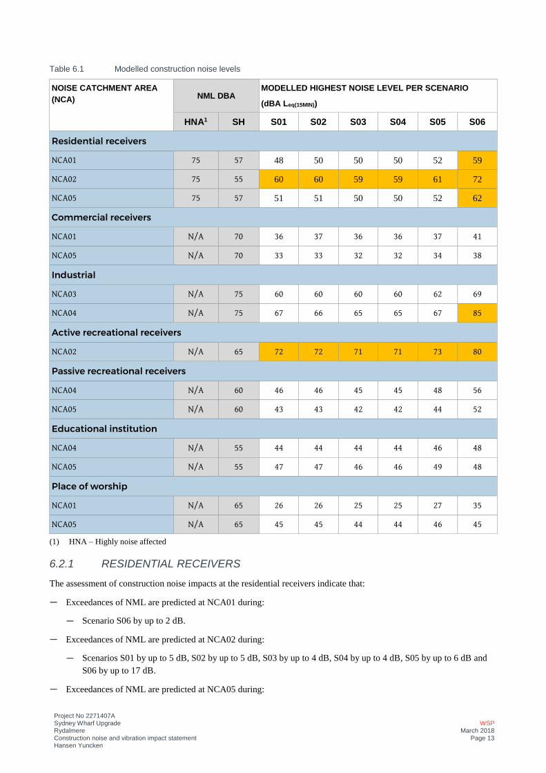
Project No 2271407A Sydney Wharf Upgrade Rydalmere Construction noise and vibration impact statement Hansen Yuncken
WSP March 2018
Page 13
Table 6.1 Modelled construction noise levels
NOISE CATCHMENT AREA (NCA) NML DBA
MODELLED HIGHEST NOISE LEVEL PER SCENARIO
(dBA Leq(15MIN))
HNA1 SH S01 S02 S03 S04 S05 S06
Residential receivers
NCA01 75 57 48 50 50 50 52 59
NCA02 75 55 60 60 59 59 61 72
NCA05 75 57 51 51 50 50 52 62
Commercial receivers
NCA01 N/A 70 36 37 36 36 37 41
NCA05 N/A 70 33 33 32 32 34 38
Industrial
NCA03 N/A 75 60 60 60 60 62 69
NCA04 N/A 75 67 66 65 65 67 85
Active recreational receivers
NCA02 N/A 65 72 72 71 71 73 80
Passive recreational receivers
NCA04 N/A 60 46 46 45 45 48 56
NCA05 N/A 60 43 43 42 42 44 52
Educational institution
NCA04 N/A 55 44 44 44 44 46 48
NCA05 N/A 55 47 47 46 46 49 48
Place of worship
NCA01 N/A 65 26 26 25 25 27 35
NCA05 N/A 65 45 45 44 44 46 45
(1) HNA – Highly noise affected
6.2.1 RESIDENTIAL RECEIVERS
The assessment of construction noise impacts at the residential receivers indicate that:
— Exceedances of NML are predicted at NCA01 during:
— Scenario S06 by up to 2 dB.
— Exceedances of NML are predicted at NCA02 during:
— Scenarios S01 by up to 5 dB, S02 by up to 5 dB, S03 by up to 4 dB, S04 by up to 4 dB, S05 by up to 6 dB and
S06 by up to 17 dB.
— Exceedances of NML are predicted at NCA05 during:

Project No 2271407A Sydney Wharf Upgrade Rydalmere Construction noise and vibration impact statement Hansen Yuncken
WSP March 2018
Page 14
— Scenario S06 by up to 5 dB.
— No exceedances of the HNA criteria were identified.
The construction scenario with the highest predicted exceedances is for the Landside infrastructure scenario (S06).
As a result of the predicted exceedances, noise mitigation and management measures have been outlined in Section 8 to
reduce the potential noise impacts.
6.2.2 NON-RESIDENTIAL RECEIVERS
The assessment of construction noise impacts at the non-residential receivers indicate that:
— No exceedances of NML are predicted at NCA01.
— Exceedances of NML are predicted at NCA02:
— For active receivers during scenarios S01 by up to 7 dB, S02 by up to 7 dB, S03 by up to 6 dB, S04 by up to 6
dB, S05 by up to 8 dB and S06 by up to 15 dB.
— No exceedances of NML are predicted at NCA03
— Exceedances of NML are predicted at NCA04:
— For Industrial receivers for scenario S06 by up to 10 dB.
— No exceedances of NML are predicted at NCA05.
As a result of the predicted exceedances, noise mitigation and management measures have been outlined in Section 8 to
reduce the potential noise impact.
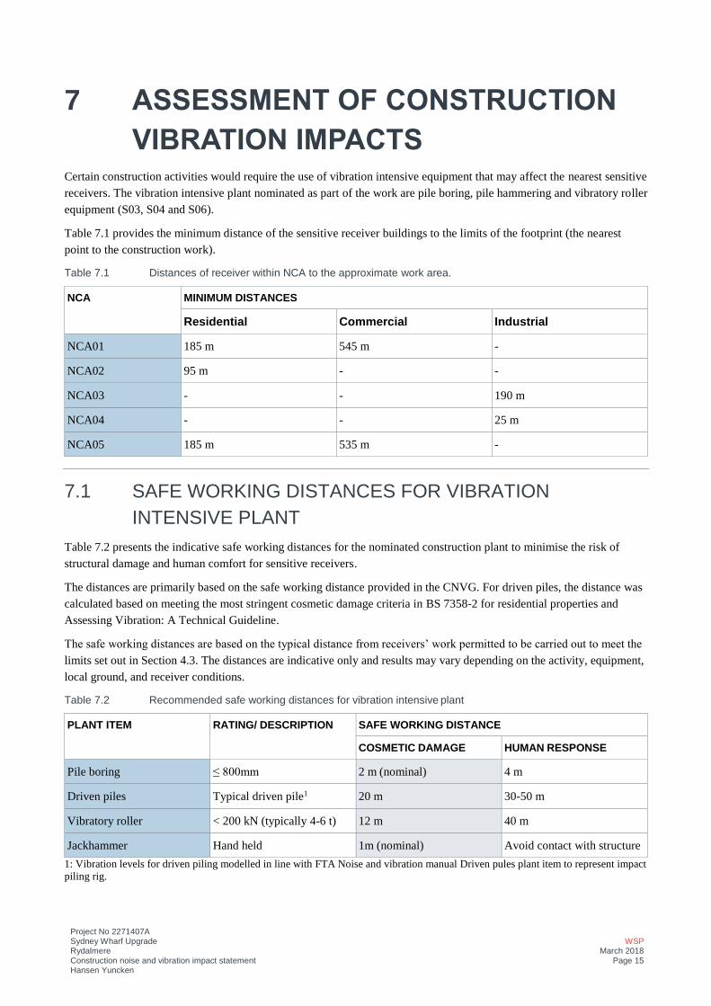
Project No 2271407A Sydney Wharf Upgrade Rydalmere Construction noise and vibration impact statement Hansen Yuncken
WSP March 2018
Page 15
7 ASSESSMENT OF CONSTRUCTION
VIBRATION IMPACTS Certain construction activities would require the use of vibration intensive equipment that may affect the nearest sensitive
receivers. The vibration intensive plant nominated as part of the work are pile boring, pile hammering and vibratory roller
equipment (S03, S04 and S06).
Table 7.1 provides the minimum distance of the sensitive receiver buildings to the limits of the footprint (the nearest
point to the construction work).
Table 7.1 Distances of receiver within NCA to the approximate work area.
NCA MINIMUM DISTANCES
Residential Commercial Industrial
NCA01 185 m 545 m -
NCA02 95 m - -
NCA03 - - 190 m
NCA04 - - 25 m
NCA05 185 m 535 m -
7.1 SAFE WORKING DISTANCES FOR VIBRATION INTENSIVE PLANT
Table 7.2 presents the indicative safe working distances for the nominated construction plant to minimise the risk of
structural damage and human comfort for sensitive receivers.
The distances are primarily based on the safe working distance provided in the CNVG. For driven piles, the distance was
calculated based on meeting the most stringent cosmetic damage criteria in BS 7358-2 for residential properties and
Assessing Vibration: A Technical Guideline.
The safe working distances are based on the typical distance from receivers’ work permitted to be carried out to meet the
limits set out in Section 4.3. The distances are indicative only and results may vary depending on the activity, equipment,
local ground, and receiver conditions.
Table 7.2 Recommended safe working distances for vibration intensive plant
PLANT ITEM RATING/ DESCRIPTION SAFE WORKING DISTANCE
COSMETIC DAMAGE HUMAN RESPONSE
Pile boring ≤ 800mm 2 m (nominal) 4 m
Driven piles Typical driven pile1 20 m 30-50 m
Vibratory roller < 200 kN (typically 4-6 t) 12 m 40 m
Jackhammer Hand held 1m (nominal) Avoid contact with structure
1: Vibration levels for driven piling modelled in line with FTA Noise and vibration manual Driven pules plant item to represent impact
piling rig.
Project No 2271407A Sydney Wharf Upgrade Rydalmere Construction noise and vibration impact statement Hansen Yuncken
WSP March 2018
Page 16
A prediction of vibration levels has been undertaken to provide an indication of the vibration levels due to hammer piling
at the nearest receivers from the footprints.
7.2 MODELLED CONSTRUCTION VIBRATION LEVELS Given the distances and potential work areas of vibratory intensive plant, identified receivers within Table 7.1 are
anticipated to be located outside the safe working distances.
All receivers have been identified to meet the safe working distance criteria for cosmetic damage.
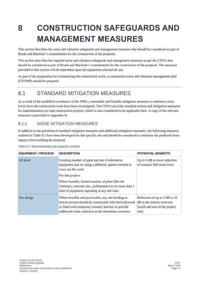
Project No 2271407A Sydney Wharf Upgrade Rydalmere Construction noise and vibration impact statement Hansen Yuncken
WSP March 2018
Page 17
8 CONSTRUCTION SAFEGUARDS AND
MANAGEMENT MEASURES This section describes the noise and vibration safeguards and management measures that should be considered as part of
Roads and Maritime’s commitments for the construction of the proposal.
This section describes the required noise and vibration safeguards and management measures as per the CNVG that
should be considered as part of Roads and Maritime’s commitments for the construction of the proposal. The measures
provided in this section will be dependent upon the equipment selected for use.
As part of the preparation for commencing the construction work, a construction noise and vibration management plan
(CNVMP) should be prepared.
8.1 STANDARD MITIGATION MEASURES As a result of the modelled exceedance of the NMLs, reasonable and feasible mitigation measures to minimise noise
levels from the construction work have been investigated. The CNVG provides standard actions and mitigation measures
for implementation on road construction projects, which is also considered to be applicable here. A copy of the relevant
measures is provided in Appendix B.
8.1.1 NOISE MITIGATION MEASURES
In addition to the provision of standard mitigation measures and additional mitigation measures, the following measures
outlined in Table 8.1 have been developed for this specific site and should be considered to minimise the predicted noise
impacts from building the proposal.
Table 8.1 Recommended site specific controls
EQUIPMENT / PROCESS DESCRIPTION POTENTIAL BENEFITS
All plant Limiting number of plant and use of alternative
equipment and /or using a different, quieter method to
carry out the work.
For this project:
Where feasible, limited number of plant (like the
chainsaw, concrete saw, jackhammer) to no more than 1
item of equipment operating at any one time.
Up to 3 dB or more reduction
of scenario S06 noise level.
Site design Where feasible and practicable, any site hording or
fences erected should be constructed with thick plywood
or fitted with temporary acoustic barriers to provide
additional noise reduction at the immediate receivers.
Reduction of up to 5 dB to 10
dB at the nearest receivers
(north and east of the project
site).
Project No 2271407A Sydney Wharf Upgrade Rydalmere Construction noise and vibration impact statement Hansen Yuncken
WSP March 2018
Page 18
EQUIPMENT / PROCESS DESCRIPTION POTENTIAL BENEFITS
Stationary plant, equipment
and activities
i.e.
Concrete saw,
Jack hammer,
Paving machine,
Concrete pump,
Compressor,
Generator,
Hand tools
Considered implementation of temporary barriers around
the stationary sources or use of alternative quieter
equipment. Where temporary noise barriers are used to
block line of sight between stationary works and
equipment (paving, road cutting, jackhammering,
compressor and generator) and the receivers, a reduction
of around 5 dB to 10 dB could be expected.
Reduction of up to 5 dB to 10
dB at the nearest receivers in
the north, east and west.
Material pre-fabrication Potential noise impacts have been minimised through the
design of the proposal which involves undertaking as
much construction work as possible at a contractor’s off-
site facility rather than at site, including assemblage of
pre-fabricated components.
Lower likelihood of
construction noise to be higher
than modelled levels.
As required by the CNVG, after feasible and reasonable mitigation measures have been implemented, additional
mitigation measures as outlined in Section 8.2 should be considered.
8.1.2 VIBRATION MITIGATION MEASURES
Although adverse impacts from vibration due to construction works are not predicted, to further reduce the potential for
impacts on the surrounding sensitive receivers, the following steps are recommended:
— On site specific vibration measurements should be carried out to confirm vibration levels and safe working distance
for the vibration intensive plant and equipment.
— Where work is required within the identified safe working distances of the receiver structures, implementation of
additional vibration mitigation measures may need to be considered.
8.2 ADDITIONAL MITIGATION MEASURES Additional mitigation measures should be considered after the application of reasonable and feasible noise mitigation
measures. Definitions of the abbreviations of the additional mitigation measures are provided in Table 8.2.
Project No 2271407A Sydney Wharf Upgrade Rydalmere Construction noise and vibration impact statement Hansen Yuncken
WSP March 2018
Page 19
Table 8.2 Applicable CNVG Abbreviation measures
ABBREVIATION MEASURES
N Notification (letterbox drop or equivalent)
Advanced warning of works and potential disruptions can assist in reducing the impact on the
community. The notification may consist of a letterbox drop (or equivalent) detailing work
activities, time periods over which these will occur, impacts and mitigation measures.
Notification should be a minimum of 5 working days prior to the start of works. The approval
conditions for projects may also specify requirements for notification to the community about
works that may impact on them.
V Verification
Refer to Appendix F of the Roads and Maritime CNVG for more details about verification of
Noise and Vibration levels as part of routine checks of noise levels or following reasonable
complaints. This verification should include measurement of the background noise level and
construction noise. Note this is not required for projects less than three weeks unless to assist
in managing complaints.
8.2.1 ADDITIONAL NOISE MITIGATION MEASURES
The following additional mitigation measures (as detailed in Appendix C of CNVG) should be considered where an
exceedance of construction noise levels would be present after implementation of the standard measures outlined in
Appendix B and to be included as part of the above noise management plan.
The most onerous additional mitigation measures that apply for each NCA and construction scenario are presented in
Table 8.3.
Appendix C provides a map of NCAs with the area that require additional mitigation measures due to worst case
exceedances of the proposed construction activities. The presented maps of affected areas and associated additional
mitigation measures are calculated based on modelled exceedances of the nominated NMLs.
Table 8.3 Additional mitigation measures - Airborne
NCA ADDITIONAL MITIGATION MEASURES (AIRBORNE)
S01 S02 S03 S04 S05 S06
NCA01 - - - - - None, see note 1
NCA02 None
See note 1
None
See note 1
None
See note 1
None
See note 1
None
See note 1
— N: Notification (letterbox drop or
equivalent)
— V: Verification
NCA03 - - - - - -
NCA04 - - - - - — N: Notification (letterbox drop or
equivalent)
— V: Verification
NCA05 - - - - - None, see note 1
(1) No additional mitigation is required for exceedances within the standard hours below 10 dB of the NMLs.
Project No 2271407A Sydney Wharf Upgrade Rydalmere Construction noise and vibration impact statement Hansen Yuncken
WSP March 2018
Page 20
9 CONCLUSION WSP has undertaken a construction noise and vibration assessment for the proposed Rydalmere Wharf Interchange
upgrade.
Six construction scenarios have been assessed for five noise catchment areas surrounding the proposal site. The key
findings of this assessment include:
— NMLs were derived for residential and non-residential sensitive land uses using the ICNG in accordance with the
CNVG based on background noise monitoring.
— NML exceedances predicted at residential receivers for:
— Scenario S06 at NCA01, NCA02, NCA04 and NCA05.
— Scenarios S01, S02, S03, S04, S05 (and S06) for NCA02
— The standard CNVG construction noise management measures and additional mitigation measures are recommended
for the receivers within NCAs with predicted exceedances.
— Additional mitigation measureas are required for Scenario S06 at NCA02 and NCA04
— No potential vibration impacts were predicted.

NOISE MONITORING RESULTS
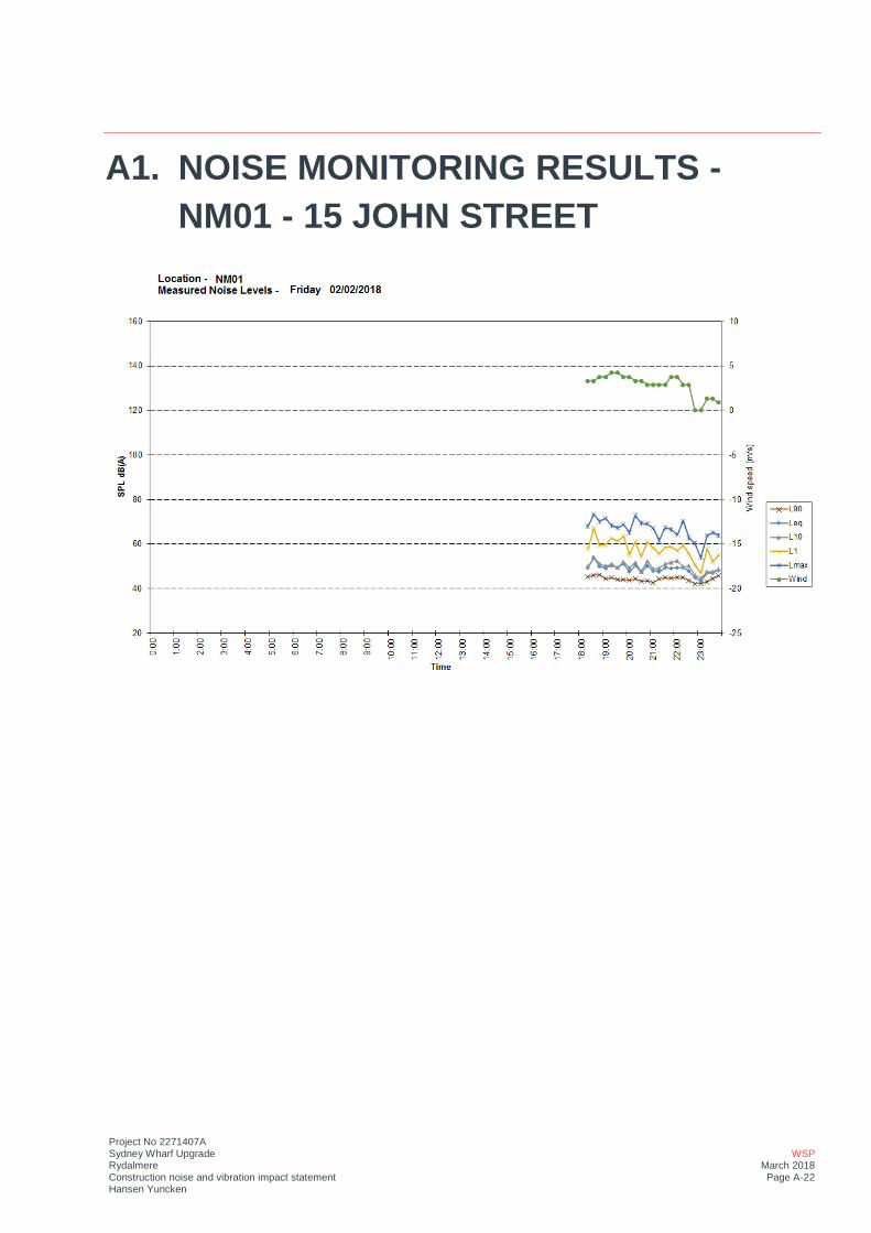
Project No 2271407A Sydney Wharf Upgrade Rydalmere Construction noise and vibration impact statement Hansen Yuncken
WSP March 2018 Page A-22
A1. NOISE MONITORING RESULTS - NM01 - 15 JOHN STREET
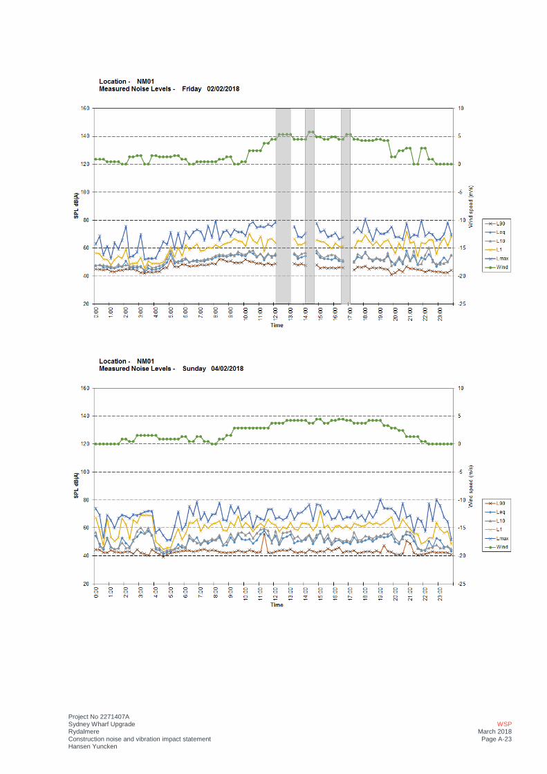
Project No 2271407A Sydney Wharf Upgrade Rydalmere Construction noise and vibration impact statement Hansen Yuncken
WSP March 2018 Page A-23
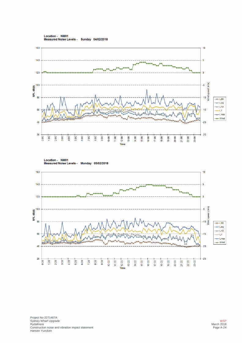
Project No 2271407A Sydney Wharf Upgrade Rydalmere Construction noise and vibration impact statement Hansen Yuncken
WSP March 2018 Page A-24
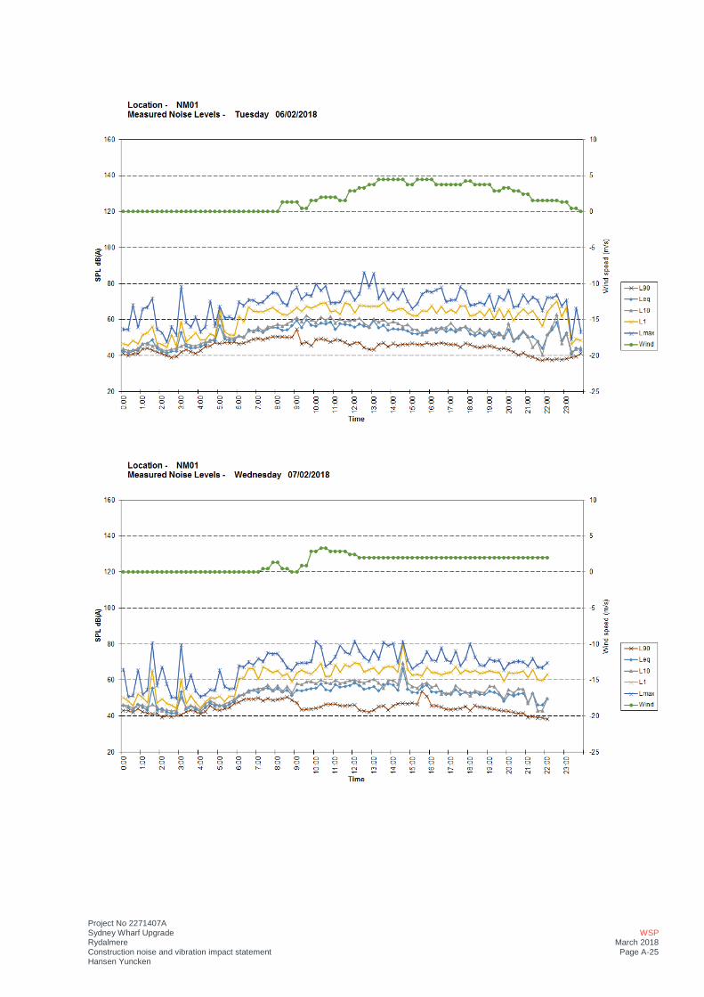
Project No 2271407A Sydney Wharf Upgrade Rydalmere Construction noise and vibration impact statement Hansen Yuncken
WSP March 2018 Page A-25
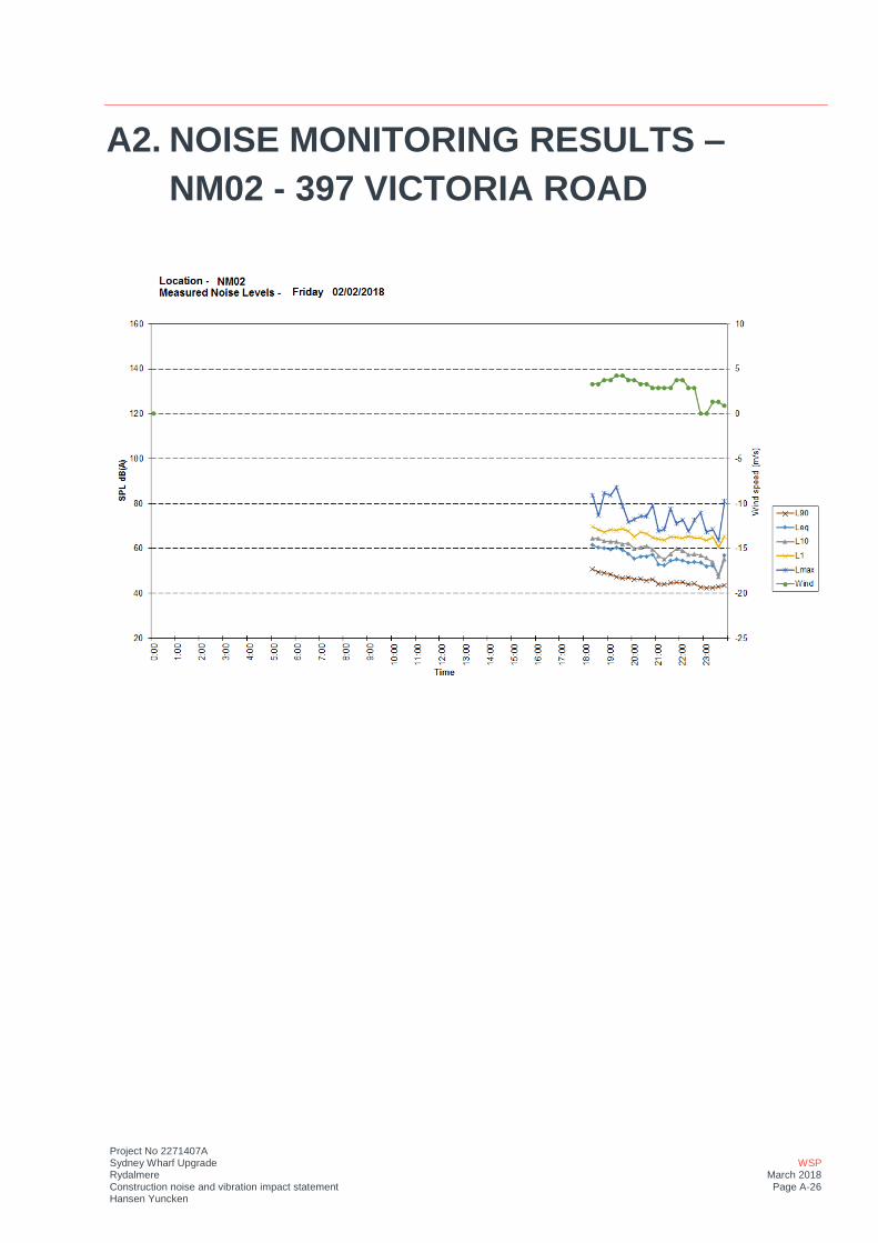
Project No 2271407A Sydney Wharf Upgrade Rydalmere Construction noise and vibration impact statement Hansen Yuncken
WSP March 2018 Page A-26
A2. NOISE MONITORING RESULTS – NM02 - 397 VICTORIA ROAD
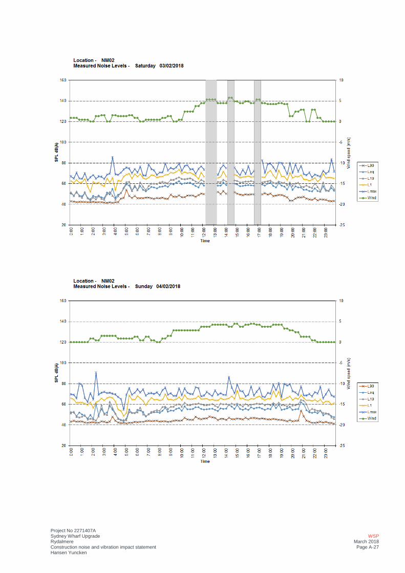
Project No 2271407A Sydney Wharf Upgrade Rydalmere Construction noise and vibration impact statement Hansen Yuncken
WSP March 2018 Page A-27
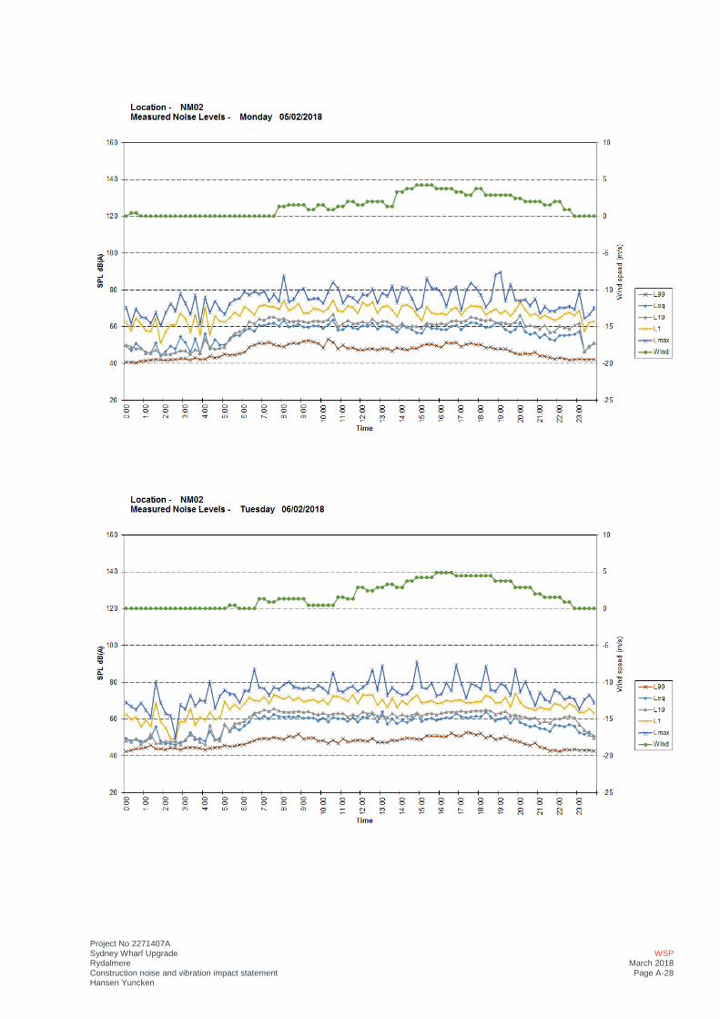
Project No 2271407A Sydney Wharf Upgrade Rydalmere Construction noise and vibration impact statement Hansen Yuncken
WSP March 2018 Page A-28

Project No 2271407A Sydney Wharf Upgrade Rydalmere Construction noise and vibration impact statement Hansen Yuncken
WSP March 2018 Page A-29
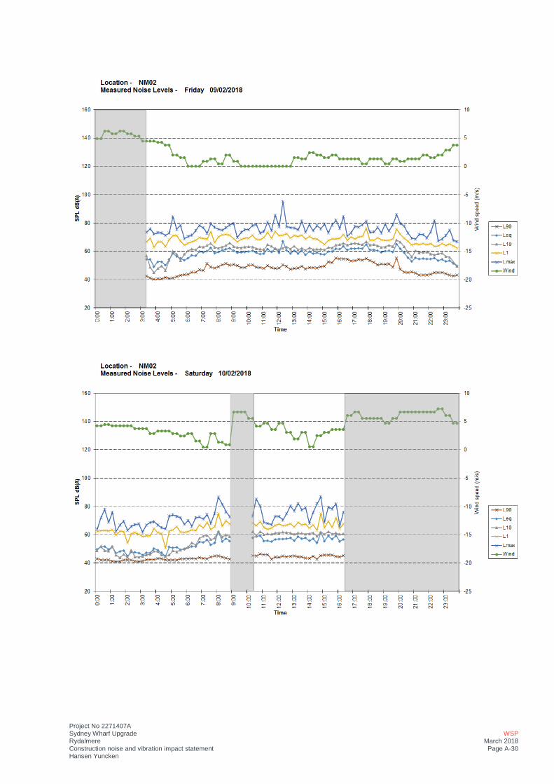
Project No 2271407A Sydney Wharf Upgrade Rydalmere Construction noise and vibration impact statement Hansen Yuncken
WSP March 2018 Page A-30
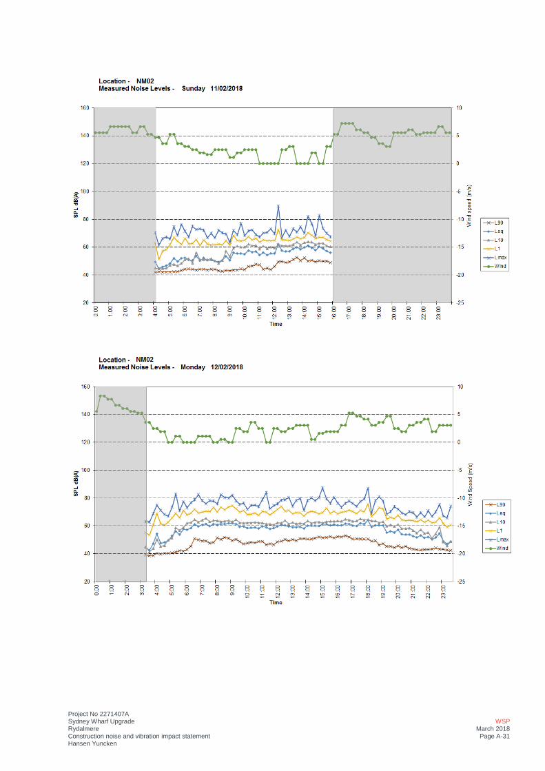
Project No 2271407A Sydney Wharf Upgrade Rydalmere Construction noise and vibration impact statement Hansen Yuncken
WSP March 2018 Page A-31
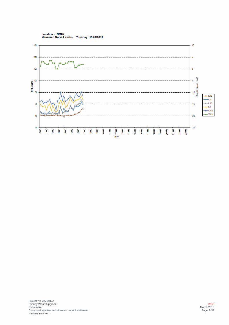
Project No 2271407A Sydney Wharf Upgrade Rydalmere Construction noise and vibration impact statement Hansen Yuncken
WSP March 2018 Page A-32
CNVG STANDARD MITIGATION MEASURES
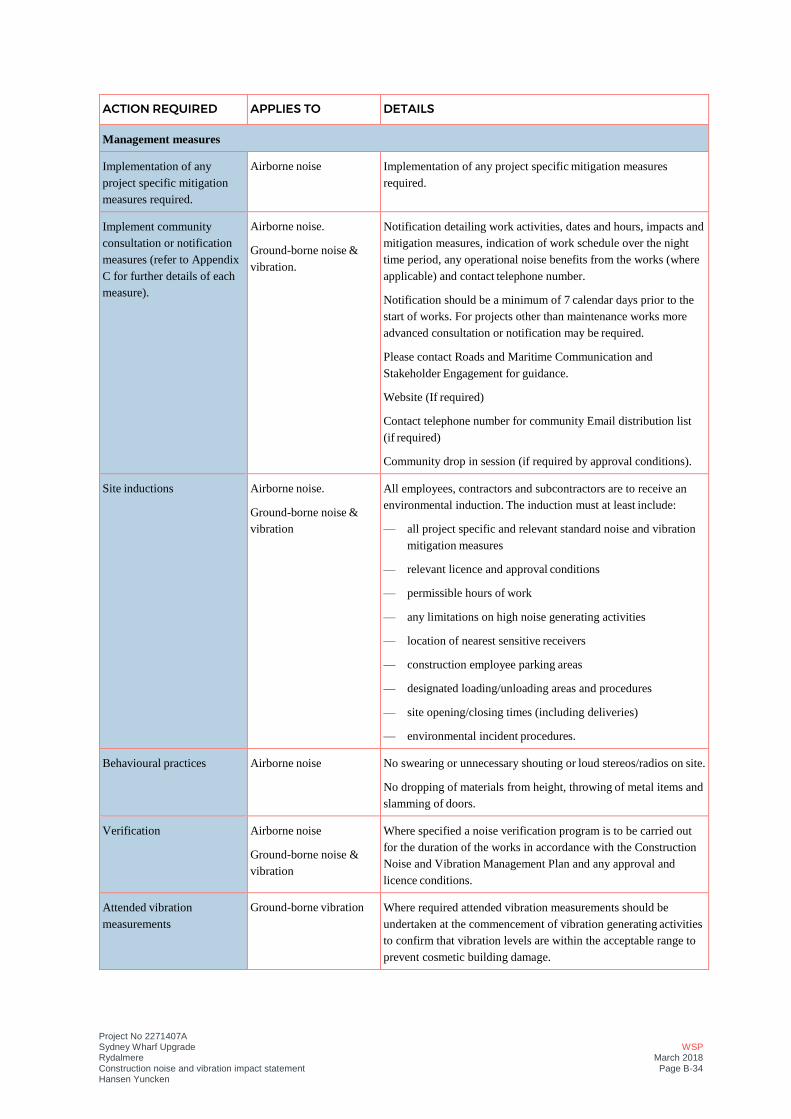
Project No 2271407A Sydney Wharf Upgrade Rydalmere Construction noise and vibration impact statement Hansen Yuncken
WSP March 2018 Page B-34
ACTION REQUIRED APPLIES TO DETAILS
Management measures
Implementation of any
project specific mitigation
measures required.
Airborne noise Implementation of any project specific mitigation measures
required.
Implement community
consultation or notification
measures (refer to Appendix
C for further details of each
measure).
Airborne noise.
Ground-borne noise &
vibration.
Notification detailing work activities, dates and hours, impacts and
mitigation measures, indication of work schedule over the night
time period, any operational noise benefits from the works (where
applicable) and contact telephone number.
Notification should be a minimum of 7 calendar days prior to the
start of works. For projects other than maintenance works more
advanced consultation or notification may be required.
Please contact Roads and Maritime Communication and
Stakeholder Engagement for guidance.
Website (If required)
Contact telephone number for community Email distribution list
(if required)
Community drop in session (if required by approval conditions).
Site inductions Airborne noise.
Ground-borne noise &
vibration
All employees, contractors and subcontractors are to receive an
environmental induction. The induction must at least include:
— all project specific and relevant standard noise and vibration
mitigation measures
— relevant licence and approval conditions
— permissible hours of work
— any limitations on high noise generating activities
— location of nearest sensitive receivers
— construction employee parking areas
— designated loading/unloading areas and procedures
— site opening/closing times (including deliveries)
— environmental incident procedures.
Behavioural practices Airborne noise No swearing or unnecessary shouting or loud stereos/radios on site.
No dropping of materials from height, throwing of metal items and
slamming of doors.
Verification Airborne noise
Ground-borne noise &
vibration
Where specified a noise verification program is to be carried out
for the duration of the works in accordance with the Construction
Noise and Vibration Management Plan and any approval and
licence conditions.
Attended vibration
measurements
Ground-borne vibration Where required attended vibration measurements should be
undertaken at the commencement of vibration generating activities
to confirm that vibration levels are within the acceptable range to
prevent cosmetic building damage.
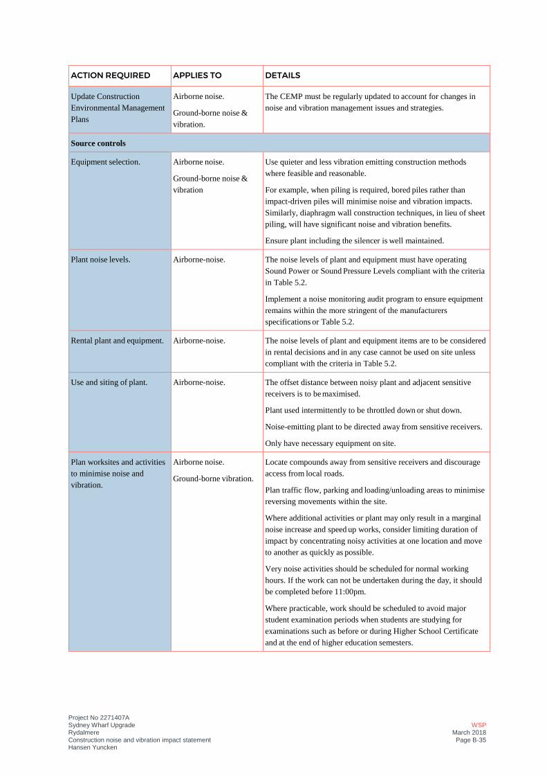
Project No 2271407A Sydney Wharf Upgrade Rydalmere Construction noise and vibration impact statement Hansen Yuncken
WSP March 2018 Page B-35
ACTION REQUIRED APPLIES TO DETAILS
Update Construction
Environmental Management
Plans
Airborne noise.
Ground-borne noise &
vibration.
The CEMP must be regularly updated to account for changes in
noise and vibration management issues and strategies.
Source controls
Equipment selection. Airborne noise.
Ground-borne noise &
vibration
Use quieter and less vibration emitting construction methods
where feasible and reasonable.
For example, when piling is required, bored piles rather than
impact-driven piles will minimise noise and vibration impacts.
Similarly, diaphragm wall construction techniques, in lieu of sheet
piling, will have significant noise and vibration benefits.
Ensure plant including the silencer is well maintained.
Plant noise levels. Airborne-noise. The noise levels of plant and equipment must have operating
Sound Power or Sound Pressure Levels compliant with the criteria
in Table 5.2.
Implement a noise monitoring audit program to ensure equipment
remains within the more stringent of the manufacturers
specifications or Table 5.2.
Rental plant and equipment. Airborne-noise. The noise levels of plant and equipment items are to be considered
in rental decisions and in any case cannot be used on site unless
compliant with the criteria in Table 5.2.
Use and siting of plant. Airborne-noise. The offset distance between noisy plant and adjacent sensitive
receivers is to be maximised.
Plant used intermittently to be throttled down or shut down.
Noise-emitting plant to be directed away from sensitive receivers.
Only have necessary equipment on site.
Plan worksites and activities
to minimise noise and
vibration.
Airborne noise.
Ground-borne vibration.
Locate compounds away from sensitive receivers and discourage
access from local roads.
Plan traffic flow, parking and loading/unloading areas to minimise
reversing movements within the site.
Where additional activities or plant may only result in a marginal
noise increase and speed up works, consider limiting duration of
impact by concentrating noisy activities at one location and move
to another as quickly as possible.
Very noise activities should be scheduled for normal working
hours. If the work can not be undertaken during the day, it should
be completed before 11:00pm.
Where practicable, work should be scheduled to avoid major
student examination periods when students are studying for
examinations such as before or during Higher School Certificate
and at the end of higher education semesters.

Project No 2271407A Sydney Wharf Upgrade Rydalmere Construction noise and vibration impact statement Hansen Yuncken
WSP March 2018 Page B-36
ACTION REQUIRED APPLIES TO DETAILS
If programmed night work is postponed the work should be re-
programmed and the approaches in this guideline apply again.
Reduced equipment power Airborne noise.
Ground-borne vibration.
Use only the necessary size and power
Non-tonal and ambient
sensitive reversing alarms
Airborne noise. Non-tonal reversing beepers (or an equivalent mechanism) must be
fitted and used on all construction vehicles and mobile plant
regularly used on site and for any out of hours work.
Consider the use of ambient sensitive alarms that adjust output
relative to the ambient noise level.
Minimise disturbance arising
from delivery of goods to
construction sites.
Airborne noise. Loading and unloading of materials/deliveries is to occur as far as
possible from sensitive receivers.
Select site access points and roads as far as possible away from
sensitive receivers.
Dedicated loading/unloading areas to be shielded if close to
sensitive receivers.
Delivery vehicles to be fitted with straps rather than chains for
unloading, wherever possible.
Avoid or minimise these out of hours movements where possible.
Engine compression brakes Construction vehicles Limit the use of engine compression brakes at night and in
residential areas.
Ensure vehicles are fitted with a maintained Original Equipment
Manufacturer exhaust silencer or a silencer that complies with the
National Transport Commission’s ‘In-service test procedure’ and
standard.
Path controls
Shield stationary noise
sources such as pumps,
compressors, fans etc.
Airborne noise. Stationary noise sources should be enclosed or shielded where
feasible and reasonable whilst ensuring that the occupational
health and safety of workers is maintained. Appendix D of AS
2436:2010 lists materials suitable for shielding.
Shield sensitive receivers
from noisy activities.
Airborne noise. Use structures to shield residential receivers from noise such as
site shed placement; earth bunds; fencing; erection of operational
stage noise barriers (where practicable) and consideration of site
topography when situating plant.
Receptor controls
See Appendix C for
additional measures
Airborne noise.
Ground-borne vibration.
In some instances additional mitigation measures may be required.

ADDITIONAL MITIGATION MEASURE LOCATIONS
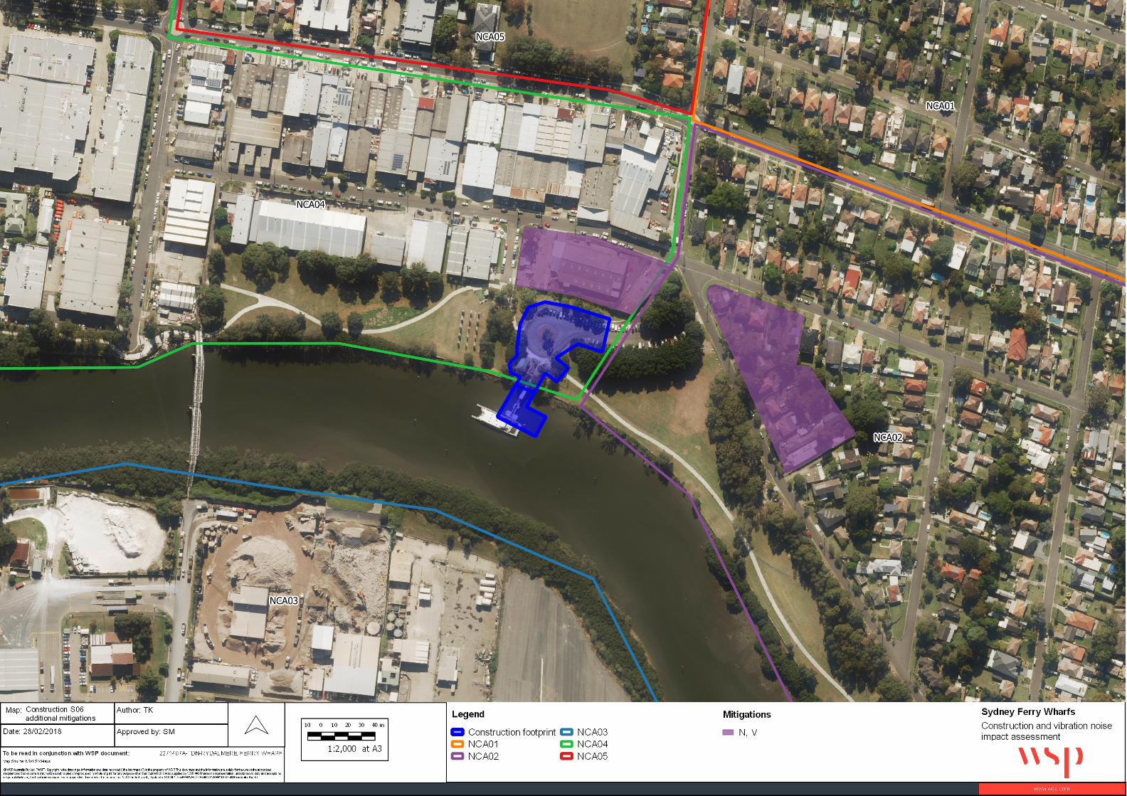
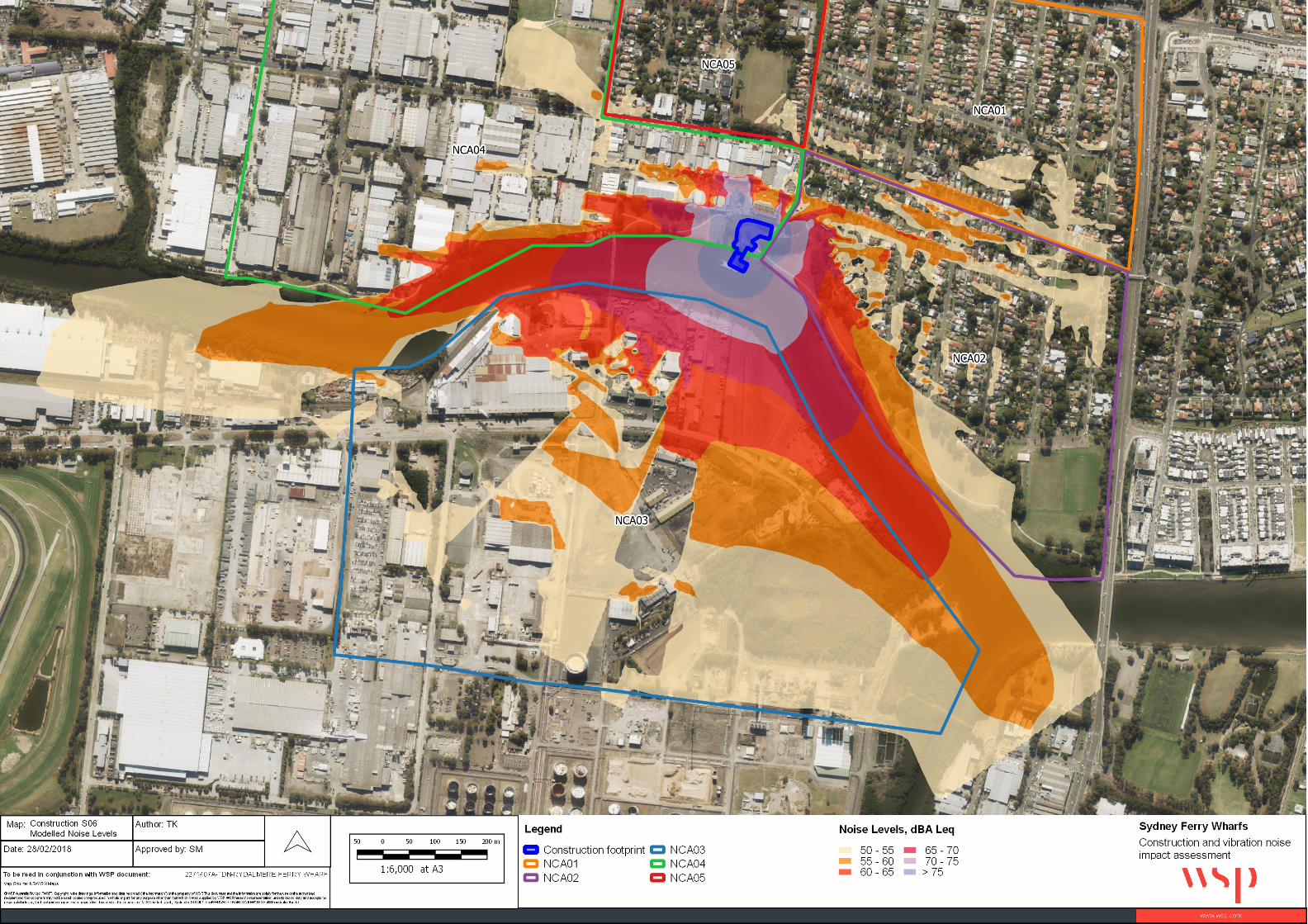

Appendix F Landscape character and visual impact assessment
I
RYDALMERE WHARF INTERCHANGE
LANDSCAPE CHARACTER AND VISUAL IMPACT ASSESSMENT
Prepared for NSW Roads and Maritime ServicesApril 2018By Jane Irwin Landscape Architecture
II
Document Control
Issue Date Submission Author Review
1 28.02.18 Draft for Review HL LC
2 07.03.18 Draft for Review HL LC
3 28.03.18 Final Issue HL LC
4 03.04.18 Final Issue HL LC
5 24.04.18 Final Issue HL LC
Contact
Linden CraneRegistered Landscape ArchitectAILA
Jane Irwin Landscape Architecture
Tel (02) 9212 6957Level 568 - 72 Wentworth AvenueSurry HillsNSW 2010
III
TABLE OF CONTENTS
1.0 INTRODUCTION 1
1.1 The project 1.2 Assessment envelope1.3 Purpose and scope of this report1.4 Report structure 1.5 Urban Design policy and guidelines 1.6 Assessment methodology
2.0 CONTEXTUAL ANALYSIS 3
2.1 Location2.2 Landscape Context2.3 Character of the proposed wharf interchange in its setting2.4 Heritage Context2.5 Sydney Harbour Foreshores and Waterways DCP Context2.6 Planning Context3.1 Vision3.2 Objectives and principles3.3 Preferred concept - waterside3.4 Preferred concept - landside
4.0 LANDSCAPE CHARACTER IMPACT ASSESSMENT 15
4.1 Surrounding Landscape Character4.2 Overall Landscape Character Impact
5.0 VISUAL IMPACT ASSESSMENT 19
5.1 Visual Envelope Mapping - Methodology of Visual Assessment5.2 Key Viewpoints5.3 Visual Impact Assessment Summary
6.0 SUMMARY OF URBAN DESIGN CONCEPT AND MITIGATION STRATEGY 28
6.1 Summary of urban design recommendations and mitigation measures6.2 Conclusion
IV
LIST OF FIGURES
Figure 1. Context map (image courtesy of Google Maps) 3
Figure 2. Context with proposal location (image courtesy of Google Maps) 4
Figure 3. Existing foreshore with proposed wharf entry location (image courtesy of Google Maps) 4
Figure 4. Assessment Envelope 5
Figure 5. Proposed wharf photomontage (image courtesy of Hansen Yuncken) 7
Figure 6. Proposed wharf plan (image courtesy of Conrad Gargett Ancher Mortlock Woolley) 7
Figure 7. Architectural sections and elevations of proposed wharf structure 8
Figure 8. Material palette of wharf 9
Figure 9. Proposal and foreshore context 11
Figure 10. Proposal and foreshore context 12
Figure 11. Ramp sections and elevations (Conrad Gargett Ancher Mortlock Woolley) Not to scale 13
Figure 12. Material palette of landside works 14
Figure 13. Land Uses and character zones 15
Figure 14. Visibility of project and key viewpoints 19
Figure 15. Eric Primrose Reserve - view east 20
Figure 16. Wharf Access Road - view south 20
Figure 17. Parramatta Valley Cycleway - view north west 21
Figure 18. Thackeray Street Bridge - view east 21
Figure 19. Shepherd Wharf Park - view east 22
Figure 20. Camellia/ Thackeray Street Bridge - view east 22
Figure 21. Approach by water - view west 23
1
RYDALMERE WHARF INTERCHANGE - LANDSCAPE CHARACTER & VISUAL IMPACT ASSESSMENT
1.0 INTRODUCTION 1.1 The project
Jane Irwin Landscape Architecture (JILA) has been engaged by Hansen Yuncken for Roads and Maritime Services NSW (Roads and Maritime) to assess the proposal for the upgrade of the wharf interchange at Rydalmere (the proposal). JILA’s scope is to provide urban design and landscape architectural services from concept to documentation, with the landscape character and visual impact assessment (LCVIA) forming part of a process that informs the design outcome of the wharf and landside upgrades.
1.2 Assessment envelope
For the purposes of this assessment, and to provide some flexibility should elements need to be adjusted due to any site or navigational constraints, an envelope has been used to assess the potential landscape character and visual impacts of the proposal. The area shown in red outline at Figure 4, combined with the fluctuating height of the pontoon roof structure, forms the envelope that has been used to undertake this assessment.
1.3 Purpose and scope of this report
The landscape character and visual impact assessment (LCVIA) has been prepared for RMS as part of the Review of Environmental Factors (REF) for the proposal.
Under clause 68 (4) of the State Environment Planning Policy (SEPP Infrastructure) 2007, development for the purposes of a wharf may be carried out by or on behalf of a public authority on any land without consent, subject to the requirements of Part 5 of the Environmental Planning and Assessment Act 1979 (the Act). Under the Act, “land” includes the sea.
Part 5 of the Act defines development involving (among other things) the use of land, carrying out of work and demolition and construction of buildings as an activity. When considering an activity RMS as the determining authority must examine and take into account to the fullest extent possible all matters affecting or likely to affect the environment by reason of that activity. This is done through the preparation of a REF.
The requirements of an REF are specified in Environmental Planning and Assessment Regulation 2000 (the Regulations) clause 228 (Under the regulations, guidelines have been developed for the likely impacts of marinas and related facilities such as wharves). The guidelines therefore apply to the commuter wharf projects. LCVIA forms one of the environmental factors which requires consideration as part of the REF process. The Department of Urban Affairs and Planning - EIS Guideline - Marinas and Related Facilities - September 1996, sets out the following issues to consider if a proposal is likely to have a visual impact.
a) Visual impact from adjoining properties and from surrounding land and water — consider potential impacts such as changed or obstructed views due to:
• The facility form, bulk, colour or reflectivity. • Lighting from security requirements or night operations.• Boat mooring and movements.• The clearing of vegetation.
b) Proposed methods of reducing visual impact such as landscaping, materials selection and design and orientation of structures.
1.4 Report structure
The structure of this report is as follows:
1.0 Introduction - outlines the purpose of the report including the assessment methodology2.0 Contextual analysis 3.0 Urban and landscape design concept4.0 Landscape character impact assessment5.0 Visual impact assessment6.0 Summary and Mitigation Strategy
1.5 Urban Design policy and guidelines
This report has been prepared based on the structure outlined in the RMS Environmental Impact Assessment Practice Note EIA-N04 - Guideline for landscape character and visual impact assessment. (EIA- No4 Guideline) March 2013.
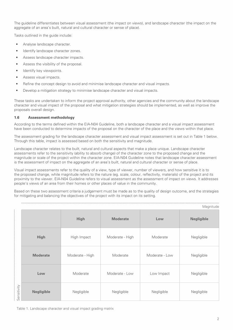
2
The guideline differentiates between visual assessment (the impact on views), and landscape character (the impact on the aggregate of an area’s built, natural and cultural character or sense of place).
Tasks outlined in the guide include:
• Analyse landscape character.
• Identify landscape character zones.
• Assess landscape character impacts.
• Assess the visibility of the proposal.
• Identify key viewpoints.
• Assess visual impacts.
• Refine the concept design to avoid and minimise landscape character and visual impacts.
• Develop a mitigation strategy to minimise landscape character and visual impacts.
These tasks are undertaken to inform the project approval authority, other agencies and the community about the landscape character and visual impact of the proposal and what mitigation strategies should be implemented, as well as improve the proposals overall design.
1.6 Assessment methodology
According to the terms defined within the EIA-N04 Guideline, both a landscape character and a visual impact assessment have been conducted to determine impacts of the proposal on the character of the place and the views within that place.
The assessment grading for the landscape character assessment and visual impact assessment is set out in Table 1 below. Through this table, impact is assessed based on both the sensitivity and magnitude.
Landscape character relates to the built, natural and cultural aspects that make a place unique. Landscape character assessments refer to the sensitivity (ability to absorb change) of the character zone to the proposed change and the magnitude or scale of the project within the character zone. EIA-N04 Guideline notes that landscape character assessment is the assessment of impact on the aggregate of an area’s built, natural and cultural character or sense of place.
Visual impact assessments refer to the quality of a view, type of viewer, number of viewers, and how sensitive it is to the proposed change, while magnitude refers to the nature (eg. scale, colour, reflectivity, materials) of the project and its proximity to the viewer. EIA-N04 Guideline refers to visual assessment as the assessment of impact on views. It addresses people’s views of an area from their homes or other places of value in the community.
Based on these two assessment criteria a judgement must be made as to the quality of design outcome, and the strategies for mitigating and balancing the objectives of the project with its impact on its setting.
Table 1. Landscape character and visual impact grading matrix
High Moderate Low Negligible
High High Impact Moderate - High Moderate Negligible
Moderate Moderate - High Moderate Moderate - Low Negligible
Low Moderate Moderate - Low Low Impact Negligible
Negligible Negligible Negligible Negligible Negligible
Magnitude
Sen
sitiv
ity
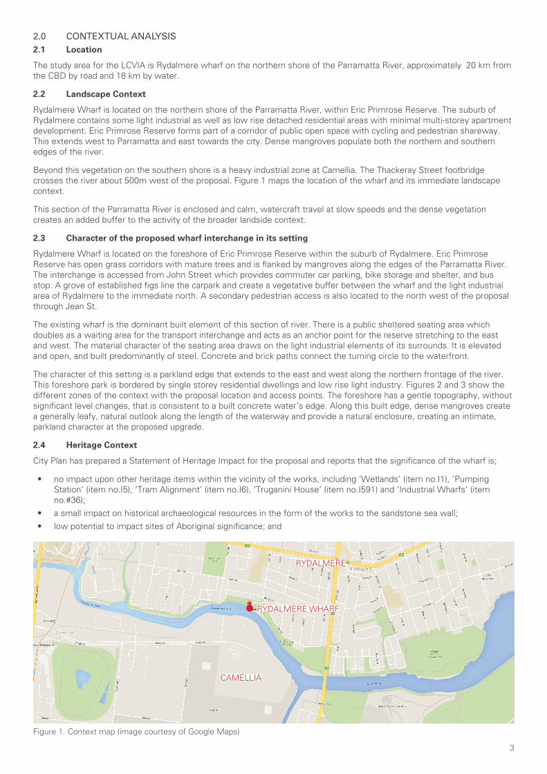
3
2.0 CONTEXTUAL ANALYSIS2.1 Location
The study area for the LCVIA is Rydalmere wharf on the northern shore of the Parramatta River, approximately 20 km from the CBD by road and 18 km by water.
2.2 Landscape Context
Rydalmere Wharf is located on the northern shore of the Parramatta River, within Eric Primrose Reserve. The suburb of Rydalmere contains some light industrial as well as low rise detached residential areas with minimal multi-storey apartment development. Eric Primrose Reserve forms part of a corridor of public open space with cycling and pedestrian shareway. This extends west to Parramatta and east towards the city. Dense mangroves populate both the northern and southern edges of the river.
Beyond this vegetation on the southern shore is a heavy industrial zone at Camellia. The Thackeray Street footbridge crosses the river about 500m west of the proposal. Figure 1 maps the location of the wharf and its immediate landscape context.
This section of the Parramatta River is enclosed and calm, watercraft travel at slow speeds and the dense vegetation creates an added buffer to the activity of the broader landside context.
2.3 Character of the proposed wharf interchange in its setting
Rydalmere Wharf is located on the foreshore of Eric Primrose Reserve within the suburb of Rydalmere. Eric Primrose Reserve has open grass corridors with mature trees and is flanked by mangroves along the edges of the Parramatta River. The interchange is accessed from John Street which provides commuter car parking, bike storage and shelter, and bus stop. A grove of established figs line the carpark and create a vegetative buffer between the wharf and the light industrial area of Rydalmere to the immediate north. A secondary pedestrian access is also located to the north west of the proposal through Jean St.
The existing wharf is the dominant built element of this section of river. There is a public sheltered seating area which doubles as a waiting area for the transport interchange and acts as an anchor point for the reserve stretching to the east and west. The material character of the seating area draws on the light industrial elements of its surrounds. It is elevated and open, and built predominantly of steel. Concrete and brick paths connect the turning circle to the waterfront.
The character of this setting is a parkland edge that extends to the east and west along the northern frontage of the river. This foreshore park is bordered by single storey residential dwellings and low rise light industry. Figures 2 and 3 show the different zones of the context with the proposal location and access points. The foreshore has a gentle topography, without significant level changes, that is consistent to a built concrete water’s edge. Along this built edge, dense mangroves create a generally leafy, natural outlook along the length of the waterway and provide a natural enclosure, creating an intimate, parkland character at the proposed upgrade.
2.4 Heritage Context
City Plan has prepared a Statement of Heritage Impact for the proposal and reports that the significance of the wharf is;
• no impact upon other heritage items within the vicinity of the works, including ‘Wetlands’ (item no.I1), ‘Pumping Station’ (item no.I5), ‘Tram Alignment’ (item no.I6), ‘Truganini House’ (item no.I591) and ‘Industrial Wharfs’ (item no.#36);
• a small impact on historical archaeological resources in the form of the works to the sandstone sea wall;• low potential to impact sites of Aboriginal significance; and
Figure 1. Context map (image courtesy of Google Maps)
RYDALMERE WHARF
CAMELLIA
RYDALMERE
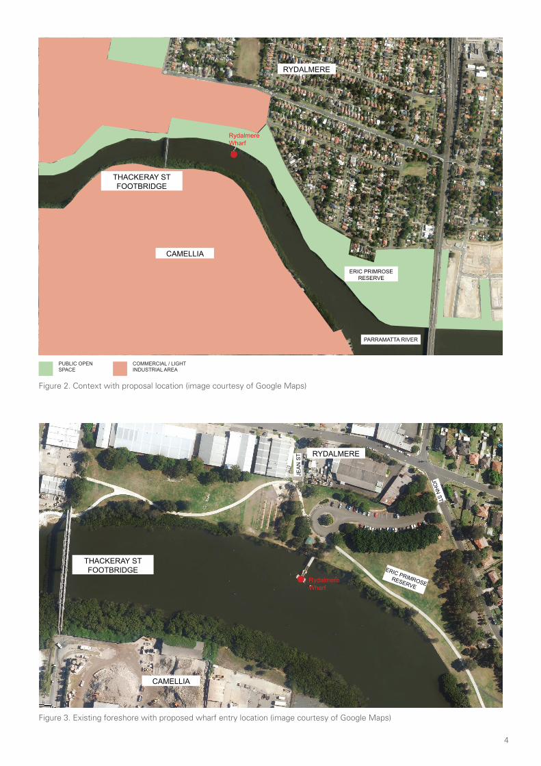
4
Figure 2. Context with proposal location (image courtesy of Google Maps)
PUBLIC OPEN SPACE
COMMERCIAL / LIGHT INDUSTRIAL AREA
RydalmereWharf
RydalmereWharf
CAMELLIA
THACKERAY ST FOOTBRIDGE
THACKERAY ST FOOTBRIDGE
CAMELLIA
RYDALMERE
RYDALMERE
PARRAMATTA RIVER
ERIC PRIMROSE RESERVE
ERIC PRIMROSE RESERVE
JOH
N ST
JEA
N S
T
Figure 3. Existing foreshore with proposed wharf entry location (image courtesy of Google Maps)
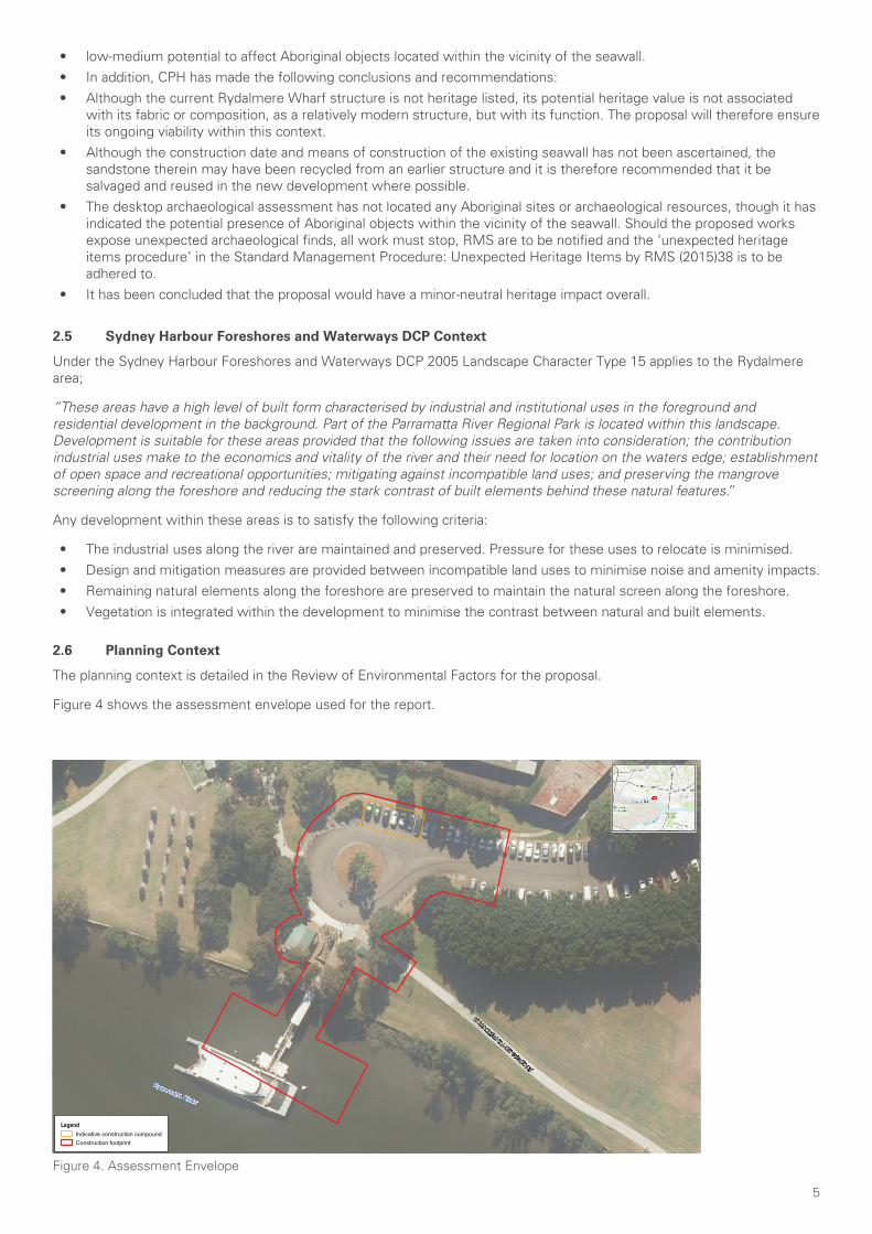
5
• low-medium potential to affect Aboriginal objects located within the vicinity of the seawall. • In addition, CPH has made the following conclusions and recommendations:• Although the current Rydalmere Wharf structure is not heritage listed, its potential heritage value is not associated
with its fabric or composition, as a relatively modern structure, but with its function. The proposal will therefore ensure its ongoing viability within this context.
• Although the construction date and means of construction of the existing seawall has not been ascertained, the sandstone therein may have been recycled from an earlier structure and it is therefore recommended that it be salvaged and reused in the new development where possible.
• The desktop archaeological assessment has not located any Aboriginal sites or archaeological resources, though it has indicated the potential presence of Aboriginal objects within the vicinity of the seawall. Should the proposed works expose unexpected archaeological finds, all work must stop, RMS are to be notified and the ‘unexpected heritage items procedure’ in the Standard Management Procedure: Unexpected Heritage Items by RMS (2015)38 is to be adhered to.
• It has been concluded that the proposal would have a minor-neutral heritage impact overall.
2.5 Sydney Harbour Foreshores and Waterways DCP Context
Under the Sydney Harbour Foreshores and Waterways DCP 2005 Landscape Character Type 15 applies to the Rydalmere area;
“These areas have a high level of built form characterised by industrial and institutional uses in the foreground and residential development in the background. Part of the Parramatta River Regional Park is located within this landscape. Development is suitable for these areas provided that the following issues are taken into consideration; the contribution industrial uses make to the economics and vitality of the river and their need for location on the waters edge; establishment of open space and recreational opportunities; mitigating against incompatible land uses; and preserving the mangrove screening along the foreshore and reducing the stark contrast of built elements behind these natural features.”
Any development within these areas is to satisfy the following criteria:
• The industrial uses along the river are maintained and preserved. Pressure for these uses to relocate is minimised.• Design and mitigation measures are provided between incompatible land uses to minimise noise and amenity impacts.• Remaining natural elements along the foreshore are preserved to maintain the natural screen along the foreshore. • Vegetation is integrated within the development to minimise the contrast between natural and built elements.
2.6 Planning Context
The planning context is detailed in the Review of Environmental Factors for the proposal.
Figure 4 shows the assessment envelope used for the report.
Figure 4. Assessment Envelope
www.wsp.comU:\Projects\PS106920_Ferry_Wharf_Upgra\4_WIP\GIS\Projects\_Drawings_Figures_Sketches\PS106920_GIS_F003_A2.mxd
© WSP Australia Pty Ltd ("WSP") Copyright in the drawings, information and data recorded ("the information") is the property of WSP. This document and the information are solely for the use of the authorised recipient and this documentmay not be used, copied or reproduced in whole or part for any purpose other than that which it was supplied by WSP. WSP makes no representation, undertakes no duty and accepts no responsibility to any third party who may use or relyupon this document or the information. NCSI Certified Quality System to ISO 9001. © APPROVED FOR AND ON BEHALF OF WSP Australia Pty Ltd.
Parramatta River
PARRAMATTA VALLEY CYCLEWAY
Coordinate system: GDA 1994 MGA Zone 56
1:500
0 5 10
m°Approved by: -Date: 23/04/2018
Map: PS106920_GIS_F003_A2 Author: MitchellEm
Scale ratio correct when printed at A3
Rydalmere Wharf Upgrade Review of Environmental Factors
Figure 3.1Construction footprint
NSW Roads and Martime Services
Data source: Sources: Esri, HERE, DeLorme, Intermap, increment P Corp., GEBCO, USGS, FAO, NPS, NRCAN, GeoBase, IGN, Kadaster NL,Ordnance Survey, Esri Japan, METI, Esri China (Hong Kong), swisstopo, MapmyIndia, © OpenStreetMap contributors, and the GIS User Community© Department of Finance, Services & Innovation 2017
LegendIndicative construction compoundConstruction footprint
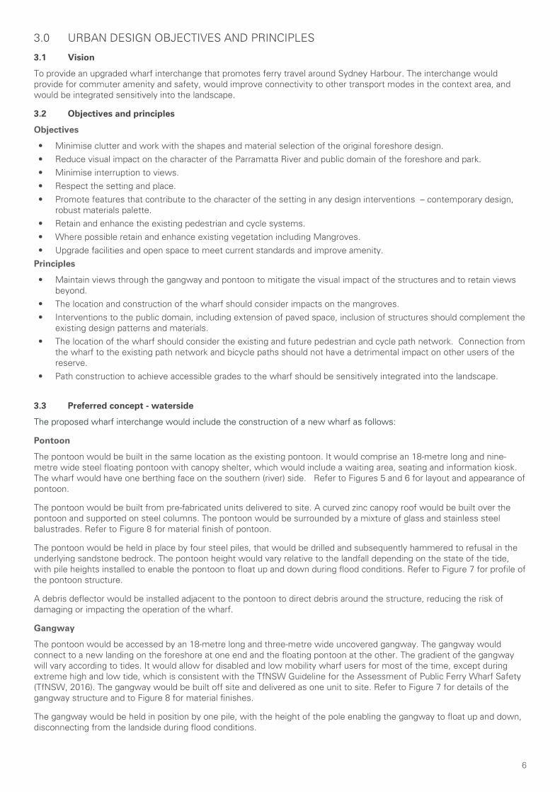
6
3.0 URBAN DESIGN OBJECTIVES AND PRINCIPLES
3.1 Vision
To provide an upgraded wharf interchange that promotes ferry travel around Sydney Harbour. The interchange would provide for commuter amenity and safety, would improve connectivity to other transport modes in the context area, and would be integrated sensitively into the landscape.
3.2 Objectives and principles
Objectives
• Minimise clutter and work with the shapes and material selection of the original foreshore design.• Reduce visual impact on the character of the Parramatta River and public domain of the foreshore and park.• Minimise interruption to views.• Respect the setting and place.• Promote features that contribute to the character of the setting in any design interventions – contemporary design,
robust materials palette.• Retain and enhance the existing pedestrian and cycle systems.• Where possible retain and enhance existing vegetation including Mangroves.• Upgrade facilities and open space to meet current standards and improve amenity.
Principles
• Maintain views through the gangway and pontoon to mitigate the visual impact of the structures and to retain views beyond.
• The location and construction of the wharf should consider impacts on the mangroves.• Interventions to the public domain, including extension of paved space, inclusion of structures should complement the
existing design patterns and materials.• The location of the wharf should consider the existing and future pedestrian and cycle path network. Connection from
the wharf to the existing path network and bicycle paths should not have a detrimental impact on other users of the reserve.
• Path construction to achieve accessible grades to the wharf should be sensitively integrated into the landscape.
3.3 Preferred concept - waterside
The proposed wharf interchange would include the construction of a new wharf as follows:
Pontoon
The pontoon would be built in the same location as the existing pontoon. It would comprise an 18-metre long and nine-metre wide steel floating pontoon with canopy shelter, which would include a waiting area, seating and information kiosk. The wharf would have one berthing face on the southern (river) side. Refer to Figures 5 and 6 for layout and appearance of pontoon.
The pontoon would be built from pre-fabricated units delivered to site. A curved zinc canopy roof would be built over the pontoon and supported on steel columns. The pontoon would be surrounded by a mixture of glass and stainless steel balustrades. Refer to Figure 8 for material finish of pontoon.
The pontoon would be held in place by four steel piles, that would be drilled and subsequently hammered to refusal in the underlying sandstone bedrock. The pontoon height would vary relative to the landfall depending on the state of the tide, with pile heights installed to enable the pontoon to float up and down during flood conditions. Refer to Figure 7 for profile of the pontoon structure.
A debris deflector would be installed adjacent to the pontoon to direct debris around the structure, reducing the risk of damaging or impacting the operation of the wharf.
Gangway
The pontoon would be accessed by an 18-metre long and three-metre wide uncovered gangway. The gangway would connect to a new landing on the foreshore at one end and the floating pontoon at the other. The gradient of the gangway will vary according to tides. It would allow for disabled and low mobility wharf users for most of the time, except during extreme high and low tide, which is consistent with the TfNSW Guideline for the Assessment of Public Ferry Wharf Safety (TfNSW, 2016). The gangway would be built off site and delivered as one unit to site. Refer to Figure 7 for details of the gangway structure and to Figure 8 for material finishes.
The gangway would be held in position by one pile, with the height of the pole enabling the gangway to float up and down, disconnecting from the landside during flood conditions.
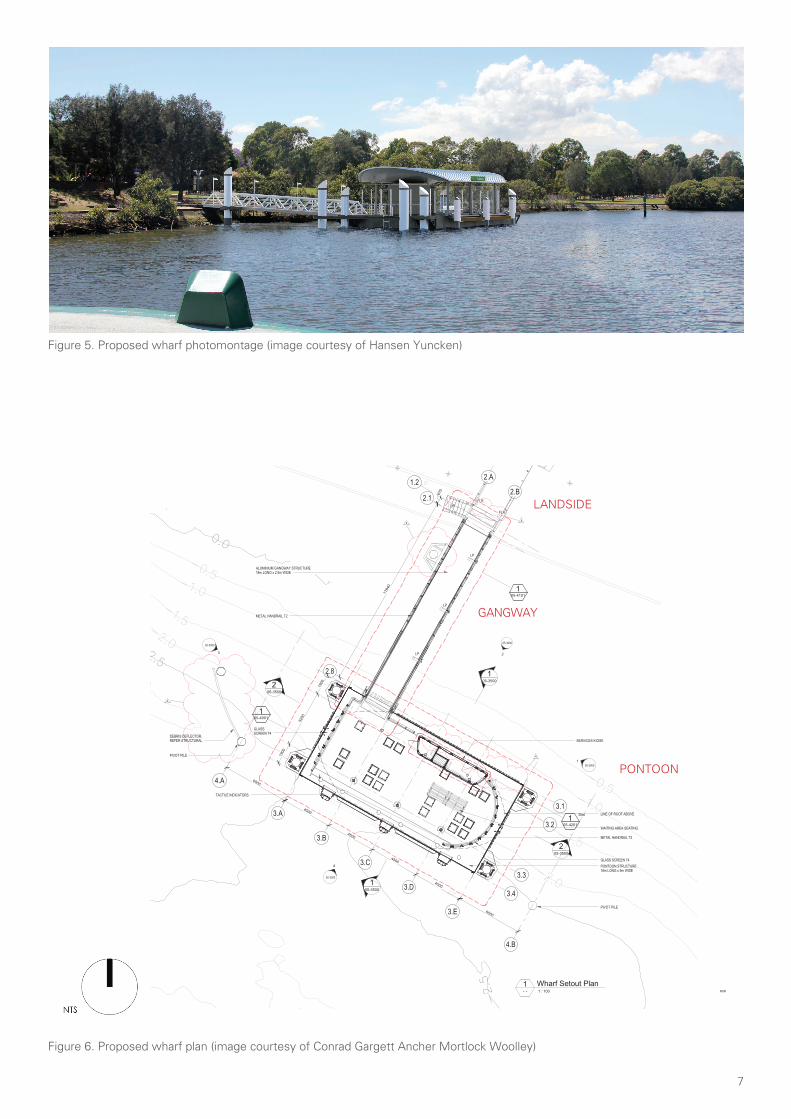
7
Figure 5. Proposed wharf photomontage (image courtesy of Hansen Yuncken)
Figure 6. Proposed wharf plan (image courtesy of Conrad Gargett Ancher Mortlock Woolley)
-2.0
-1.5
-1.0
-0.5
-3.0
-2.0
-1.5
-1.0
-0.5
-2.5
-2.5
0.0
UP
PONTOON STRUCTURE18m LONG x 9m WIDE
ALUMINIUM GANGWAY STRUCTURE18m LONG x 2.5m WIDE
SERVICES KIOSK
WAITING AREA SEATING
GLASS SCREEN T4
METAL HANDRAIL T3
LINE OF ROOF ABOVE
GLASSSCREEN T4
TACTILE INDICATORS
METAL HANDRAIL T2
105-4001
3.1
3.2
3.3
3.4
3.A
3.B
3.C
3.D
3.E
2.8
2.1
1.2
205-3500
205-3500
105-3500
105-3500
105-4101
05-3000
2
05-3000
1
05-3000
4
05-3000
3
LP
LP
LP
670
1784
0
105-4201
Sim
2.A
2.B
4500
4500
4500
4500
1900
5200
1900
4.A
4.B
6000
6000
PIVOT PILE
PIVOT PILE
DEBRIS DEFLECTOR,REFER STRUCTURAL
FLR
FLR
44
4
4
PRELIMINARY
DRAWING No: REV:
A1 SCALE
DO NOT SCALE DRAWING & VERIFY ALL DIMENSIONS AND LEVELS ON SITE
CLIENT
PROJECT
DRAWING
NORTH
© CONRAD GARGETT ANCHER MORTLOCK [email protected] ABN 49 325 121 350
STATUSPROJECT No:
@ A1
TRANSPORT AUTHORITY
NOMINATED ARCHITECT: BRUCE WOLFE NSW Reg 6969
4
1 : 100
Ferry Wharves UpgradeProgram 2 -Rydalmere Wharf
AR-05-2100
Proposed Wharf SetoutPlan
SD14214- - 1 : 100
1 Wharf Setout Plan
0
SCALE 1:
50
1
4030201010
mm
REV DESCRIPTION DATE APPD
1 25% Coordination Issue 22.09.17
2 Client Issue 12.10.17
3 75% Coordination Issue 16.10.17
4 Final Coordination Issue 02.11.17
GANGWAY
PONTOON
LANDSIDE
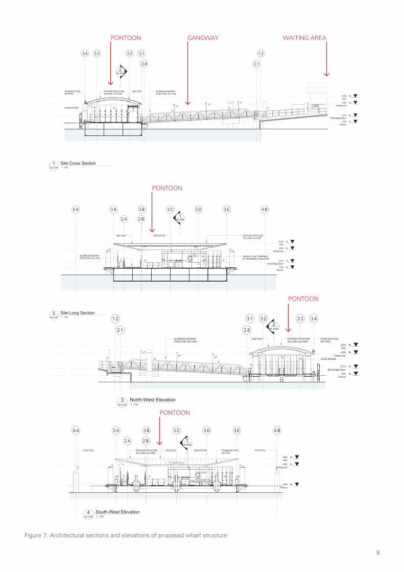
8
RL1.000
Pontoon
RL5.050
Roof
RL2.010
Shore Bridge Datum
RL4.000
Ceiling Level
3.A 3.B 3.C 3.D 3.E
105-3500
T3T3 T4
SIGNAGE TO BE CONFIRMEDBY WAYFINDING CONSULTANT
PONTOON STRUCTURE18m LONG x 9m WIDE
ALUMINIUM GANGWAYSTRUCTURE 18m LONG
ZINC ROOF SERVICE POD
2.A 2.B
4.A 4.B
RL1.000
Pontoon
RL5.050
Roof
RL2.010
Shore Bridge Datum
RL4.000
Ceiling Level
3.13.23.33.4
2.8 2.1
1.2
205-3500
PONTOON STRUCTURE18m WIDE x 9m LONG
ALUMINIUM GANGWAYSTRUCTURE 18m LONG
LPLP
LP
T2
T2
T3
T4
T3
ZINC ROOFSTAINLESS STEELSPITTERS
GLASS SCREEN
NOTE: SIGNAGE INDICATIVE.TO BE CONFIRMED BYWAYFINDING CONSULTANT
PRELIMINARY
DRAWING No: REV:
A1 SCALE
DO NOT SCALE DRAWING & VERIFY ALL DIMENSIONS AND LEVELS ON SITE
CLIENT
PROJECT
DRAWING
© CONRAD GARGETT ANCHER MORTLOCK [email protected] ABN 49 325 121 350
STATUSPROJECT No:
@ A1
TRANSPORT AUTHORITY
NOMINATED ARCHITECT: BRUCE WOLFE NSW Reg 6969
4
1 : 100
Ferry Wharves UpgradeProgram 2 -Rydalmere Wharf
AR-05-3500
Sections
SD14214
0
SCALE 1:
50
1
4030201010
mm
REV DESCRIPTION DATE APPD
1 25% Coordination Issue 22.09.17
2 Client Issue 12.10.17
3 75% Coordination Issue 16.10.17
4 Final Coordination Issue 02.11.17
05-2100 1 : 100
2 Site Long Section
05-2100 1 : 100
1 Site Cross Section
CODE DESCRIPTION
LP LIGHT POST - REFER STRUCTURAL &ELECTRICAL DWGS
T2 BALUSTRADE TYPE 2 - REFER DETAILS
T3 BALUSTRADE TYPE 3 - REFER DETAILS
T4 BALUSTRADE TYPE 4 - REFER DETAILS
NOTE: SIGNAGE INDICATIVE.TO BE CONFIRMED BYWAYFINDING CONSULTANT
RL1.000
Pontoon
RL5.050
Roof
RL4.000
Ceiling Level
3.A3.B3.C3.D3.E1
05-3500
T4
T3T3
ZINC GUTTER ZINC ROOFSERVICE POD PONTOON STRUCTURE18m LONG x 9m WIDE
LAD LAD
ALUMINIUM GANGWAYSTRUCTURE 18m LONG
2.A2.B
4.A4.B
PIVOT PILEPIVOT PILE
4
RL1.000
Pontoon
RL5.050
Roof
RL2.010
Shore Bridge Datum
RL4.000
Ceiling Level
3.13.23.33.4
2.8 2.1
1.2
205-3500
ALUMINIUM GANGWAYSTRUCTURE 18m LONG
ZINC ROOF PONTOON STRUCTURE18m LONG x 9m WIDE
STAINLESS STEEL SPITTERS
GLASS SCREENT4
T3
LPLP
LP
T2T2
LAD
RL1.000
Pontoon
RL5.050
Roof
RL4.000
Ceiling Level
3.A 3.B 3.C 3.D 3.E
105-3500
T3 T3 T4
PONTOON STRUCTURE18m LONG x 9m WIDE
ZINC ROOF SERVICE POD STAINLESS STEELGUTTER
LADLAD
CHW CHW
2.A 2.B
4.A 4.B
PIVOT PILE PIVOT PILE
RL1.000
Pontoon
RL5.050
Roof
RL2.010
Shore Bridge Datum
RL4.000
Ceiling Level
3.1 3.2 3.3 3.4
2.82.1
1.22
05-3500
T4
T3T2
T2
LP
LPLP
ALUMINIUM GANGWAYSTRUCTURE 18m LONG
STAINLESS STEELSPITTERS
PONTOON STRUCTURE18m LONG x 9m WIDE
ZINC ROOF
GLASS SCREEN
PRELIMINARY
DRAWING No: REV:
A1 SCALE
DO NOT SCALE DRAWING & VERIFY ALL DIMENSIONS AND LEVELS ON SITE
CLIENT
PROJECT
DRAWING
© CONRAD GARGETT ANCHER MORTLOCK [email protected] ABN 49 325 121 350
STATUSPROJECT No:
@ A1
TRANSPORT AUTHORITY
NOMINATED ARCHITECT: BRUCE WOLFE NSW Reg 6969
4
1 : 100
Ferry Wharves UpgradeProgram 2 -Rydalmere Wharf
AR-05-3000
Elevations
SD14214
0
SCALE 1:
50
1
4030201010
mm
REV DESCRIPTION DATE APPD
1 25% Coordination Issue 22.09.17
2 Client Issue 12.10.17
3 75% Coordination Issue 16.10.17
4 Final Coordination Issue 02.11.17
CODE DESCRIPTION
CHW CHAIR, WAITING - REFER SCHEDULE
LP LIGHT POST - REFER STRUCTURAL &ELECTRICAL DWGS
T2 BALUSTRADE TYPE 2 - REFER DETAILS
T3 BALUSTRADE TYPE 3 - REFER DETAILS
T4 BALUSTRADE TYPE 4 - REFER DETAILS
05-2100 1 : 100
2 North-East Elevation
05-2100 1 : 100
1 South-East Elevation
05-2100 1 : 100
4 South-West Elevation
05-2100 1 : 100
3 North-West Elevation
Figure 7. Architectural sections and elevations of proposed wharf structure
GANGWAY WAITING AREA
PONTOON
PONTOON
PONTOON
PONTOON

9Figure 8. Material palette of wharf
Stainless steel handrails
Zinc roof
Pontoon with service pod
Lighting within wharf
Non-slip floor surface
Open light steel truss system - gangway Service Pod
Bridge and gangway
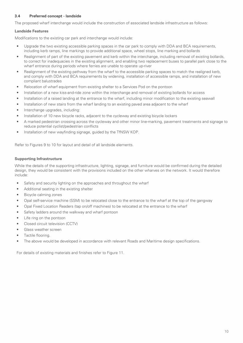
10
3.4 Preferred concept - landside
The proposed wharf interchange would include the construction of associated landside infrastructure as follows:
Landside Features
Modifications to the existing car park and interchange would include:
• Upgrade the two existing accessible parking spaces in the car park to comply with DDA and BCA requirements, including kerb ramps, line markings to provide additional space, wheel stops, line marking and bollards
• Realignment of part of the existing pavement and kerb within the interchange, including removal of existing bollards, to correct for inadequacies in the existing alignment, and enabling two replacement buses to parallel park close to the wharf entrance during periods where ferries are unable to operate up-river
• Realignment of the existing pathway from the wharf to the accessible parking spaces to match the realigned kerb, and comply with DDA and BCA requirements by widening, installation of accessible ramps, and installation of new compliant balustrades
• Relocation of wharf equipment from existing shelter to a Services Pod on the pontoon• Installation of a new kiss-and-ride zone within the interchange and removal of existing bollards for access• Installation of a raised landing at the entrance to the wharf, including minor modification to the existing seawall • Installation of new stairs from the wharf landing to an existing paved area adjacent to the wharf• Interchange upgrades, including:• Installation of 10 new bicycle racks, adjacent to the cycleway and existing bicycle lockers • A marked pedestrian crossing across the cycleway and other minor line-marking, pavement treatments and signage to
reduce potential cyclist/pedestrian conflicts • Installation of new wayfinding signage, guided by the TfNSW KOP.
Refer to Figures 9 to 10 for layout and detail of all landside elements.
Supporting Infrastructure
While the details of the supporting infrastructure, lighting, signage, and furniture would be confirmed during the detailed design, they would be consistent with the provisions included on the other wharves on the network. It would therefore include:
• Safety and security lighting on the approaches and throughout the wharf• Additional seating in the existing shelter• Bicycle calming zones• Opal self-service machine (SSM) to be relocated close to the entrance to the wharf at the top of the gangway• Opal Fixed Location Readers (tap on/off machines) to be relocated at the entrance to the wharf• Safety ladders around the walkway and wharf pontoon• Life ring on the pontoon• Closed circuit television (CCTV)• Glass weather screen• Tactile flooring.• The above would be developed in accordance with relevant Roads and Maritime design specifications.
For details of existing materials and finishes refer to Figure 11.

11
Figure 9. Proposal and foreshore context
BUS ZONE
1:20
Rydalmere Wharf Upgrade - LandscapeScale: 1:5001
LEGEND
extent of demolition
existing buildings
turf
concrete paving
asphalt paving
bike racks
sandstone retaining wall
timber retaining wall
concrete retaining wall
proposed pathways
proposed pathways
existing pathway to remove
existing wharfto be removed
Mangroves
Mangroves
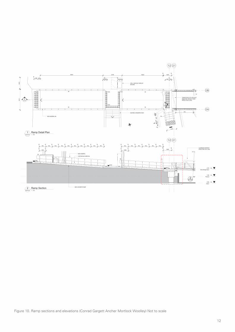
12
Figure 10. Ramp sections and elevations (Conrad Gargett Ancher Mortlock Woolley) Not to scale
2.11.2
2.A
2.B
TRANSITION PLATE WITH SLIPRESISTANT APPLIED FINISH -REFER STRUCTURAL
EQ
LPTGSI
CL600 300
205-4315
TGSI
TGSI TGSI
CLCL12009000 2740 5925
CL300300
EXISTING CONCRETE STAIR
3011
NEW HANDRAIL B4
B4
B4 B4
B4
B4
105-4350
1670
OPAL CARD SELF SERVICEMACHINE
900
CL
300CL
600
1400
215
CL300600
TGSI
TGSI
CL300300
RL1.000
Pontoon
RL0.000
Datum
RL2.010
Shore Bridge Datum
2.11.2
ALUMINIUM GANGWAYSTRUCTURE 18m LONG
CLCLCLCLCLCLCLCLCLCLCLEQ EQ EQ EQ EQ EQ EQ EQ EQ EQ
CLCL930
CLCLCLCLCLCLCLEQ EQ EQ EQ EQ EQ
CLCL1000
CLCL1200
NEW HANDRAIL
CONTINUOUS KERB RAIL
B4
B4
LP
3040
2400
2010
NEW CONCRETE RAMP
305-4350
Sim
PRELIMINARY
DRAWING No: REV:
A1 SCALE
DO NOT SCALE DRAWING & VERIFY ALL DIMENSIONS AND LEVELS ON SITE
CLIENT
PROJECT
DRAWING
NORTH
© CONRAD GARGETT ANCHER MORTLOCK [email protected] ABN 49 325 121 350
STATUSPROJECT No:
@ A1
TRANSPORT AUTHORITY
2
1 : 50
Ferry Wharves UpgradeProgram 2 -Rydalmere Wharf
AR-05-4315
Landside Details
SD14214
0
SCALE 1:
50
1
4030201010
mm
REV DESCRIPTION DATE APPD
1 75% Coordination Issue 16.10.17
2 Final Coordination Issue 02.11.17
05-4101 1 : 50
1 Ramp Detail Plan
05-4101 1 : 50
2 Ramp Section
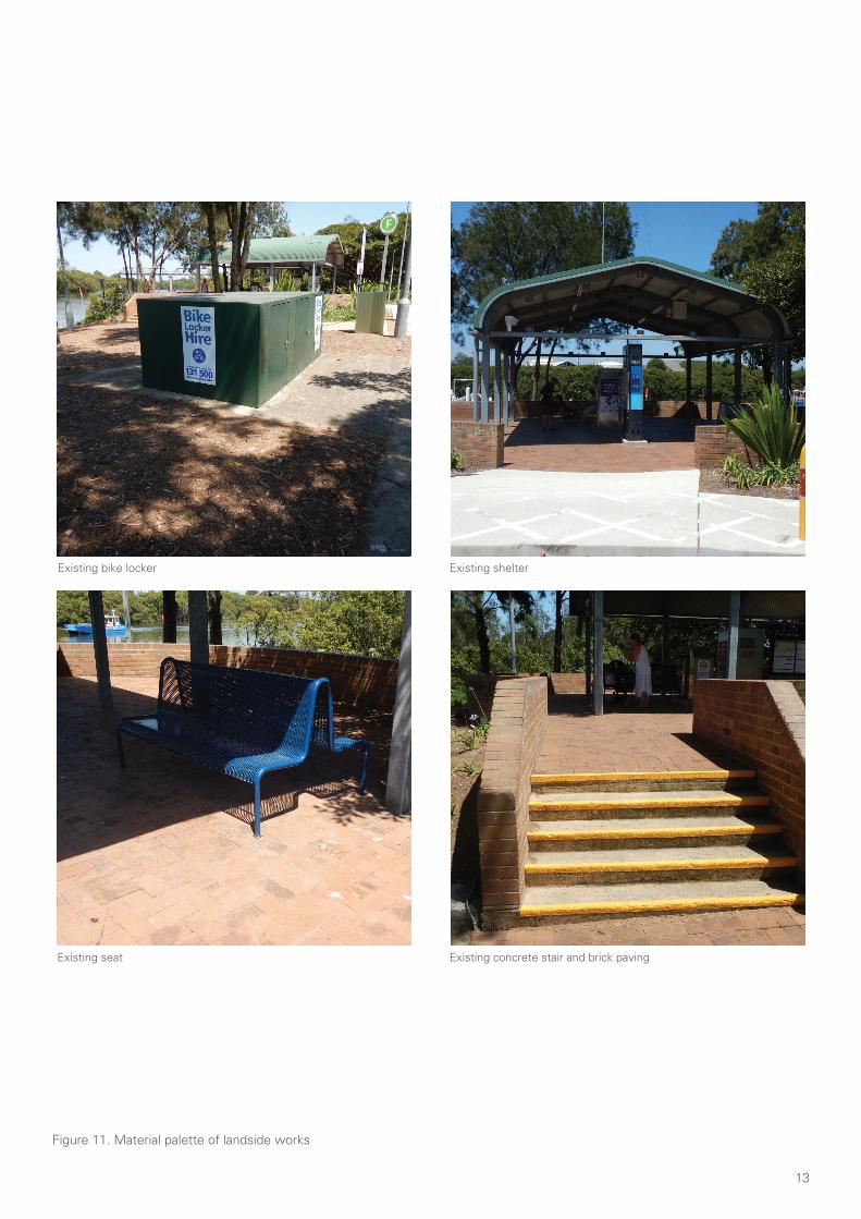
13
Figure 11. Material palette of landside works
Existing bike locker
Existing seat
Existing shelter
Existing concrete stair and brick paving
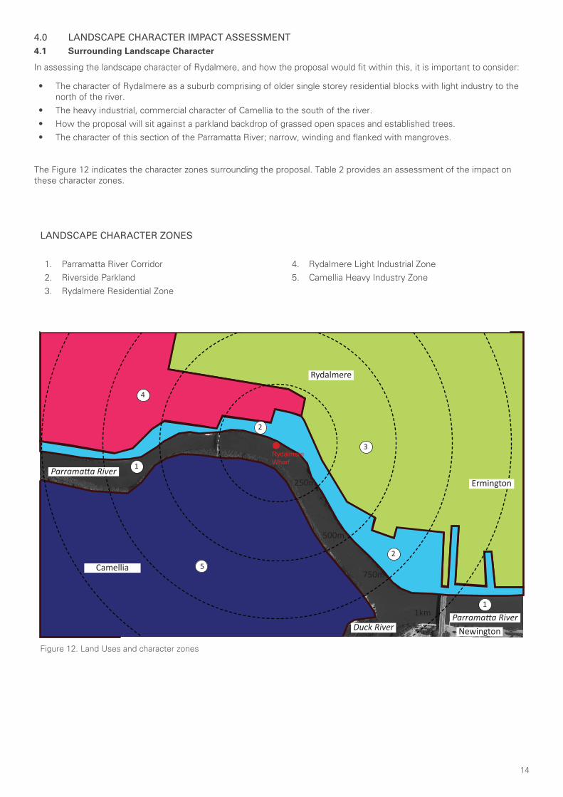
14
4.0 LANDSCAPE CHARACTER IMPACT ASSESSMENT4.1 Surrounding Landscape Character
In assessing the landscape character of Rydalmere, and how the proposal would fit within this, it is important to consider:
• The character of Rydalmere as a suburb comprising of older single storey residential blocks with light industry to the north of the river.
• The heavy industrial, commercial character of Camellia to the south of the river. • How the proposal will sit against a parkland backdrop of grassed open spaces and established trees.• The character of this section of the Parramatta River; narrow, winding and flanked with mangroves.
The Figure 12 indicates the character zones surrounding the proposal. Table 2 provides an assessment of the impact on these character zones.
1. Parramatta River Corridor2. Riverside Parkland3. Rydalmere Residential Zone
4. Rydalmere Light Industrial Zone5. Camellia Heavy Industry Zone
Figure 12. Land Uses and character zones
Parramatta River
Parramatta River
Rydalmere
Ermington
Duck River
Camellia
Newington
4
5
1
1
3
2
2
RydalmereWharf
250m
1km
750m
500m
LANDSCAPE CHARACTER ZONES
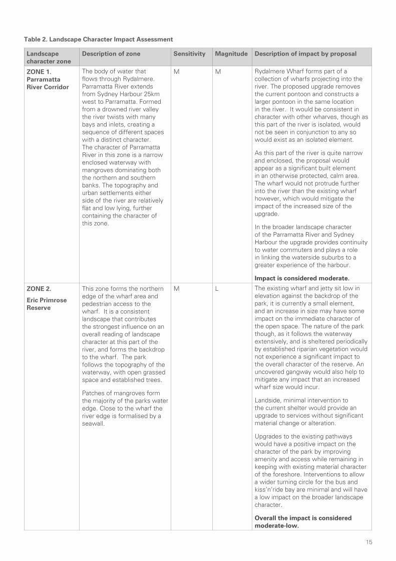
15
Table 2. Landscape Character Impact Assessment
Landscape character zone
Description of zone Sensitivity Magnitude Description of impact by proposal
ZONE 1. Parramatta River Corridor
The body of water that flows through Rydalmere. Parramatta River extends from Sydney Harbour 25km west to Parramatta. Formed from a drowned river valley the river twists with many bays and inlets, creating a sequence of different spaces with a distinct character. The character of Parramatta River in this zone is a narrow enclosed waterway with mangroves dominating both the northern and southern banks. The topography and urban settlements either side of the river are relatively flat and low lying, further containing the character of this zone.
M M Rydalmere Wharf forms part of a collection of wharfs projecting into the river. The proposed upgrade removes the current pontoon and constructs a larger pontoon in the same location in the river. It would be consistent in character with other wharves, though as this part of the river is isolated, would not be seen in conjunction to any so would exist as an isolated element.
As this part of the river is quite narrow and enclosed, the proposal would appear as a significant built element in an otherwise protected, calm area. The wharf would not protrude further into the river than the existing wharf however, which would mitigate the impact of the increased size of the upgrade.
In the broader landscape character of the Parramatta River and Sydney Harbour the upgrade provides continuity to water commuters and plays a role in linking the waterside suburbs to a greater experience of the harbour.
Impact is considered moderate.
ZONE 2.
Eric Primrose Reserve
This zone forms the northern edge of the wharf area and pedestrian access to the wharf. It is a consistent landscape that contributes the strongest influence on an overall reading of landscape character at this part of the river, and forms the backdrop to the wharf. The park follows the topography of the waterway, with open grassed space and established trees.
Patches of mangroves form the majority of the parks water edge. Close to the wharf the river edge is formalised by a seawall.
M L The existing wharf and jetty sit low in elevation against the backdrop of the park, it is currently a small element, and an increase in size may have some impact on the immediate character of the open space. The nature of the park though, as it follows the waterway extensively, and is sheltered periodically by established riparian vegetation would not experience a significant impact to the overall character of the reserve. An uncovered gangway would also help to mitigate any impact that an increased wharf size would incur.
Landside, minimal intervention to the current shelter would provide an upgrade to services without significant material change or alteration.
Upgrades to the existing pathways would have a positive impact on the character of the park by improving amenity and access while remaining in keeping with existing material character of the foreshore. Interventions to allow a wider turning circle for the bus and kiss’n’ride bay are minimal and will have a low impact on the broader landscape character.
Overall the impact is considered moderate-low.
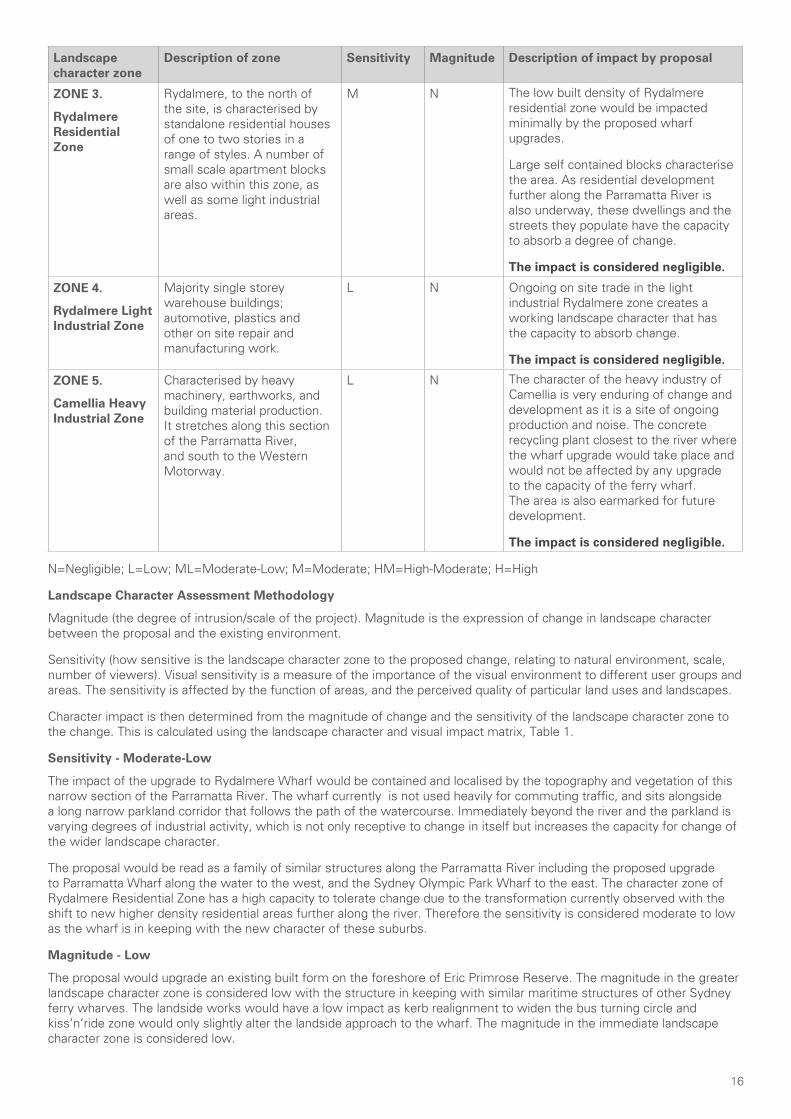
16
Landscape character zone
Description of zone Sensitivity Magnitude Description of impact by proposal
ZONE 3.
Rydalmere Residential Zone
Rydalmere, to the north of the site, is characterised by standalone residential houses of one to two stories in a range of styles. A number of small scale apartment blocks are also within this zone, as well as some light industrial areas.
M N The low built density of Rydalmere residential zone would be impacted minimally by the proposed wharf upgrades.
Large self contained blocks characterise the area. As residential development further along the Parramatta River is also underway, these dwellings and the streets they populate have the capacity to absorb a degree of change.
The impact is considered negligible.
ZONE 4.
Rydalmere Light Industrial Zone
Majority single storey warehouse buildings; automotive, plastics and other on site repair and manufacturing work.
L N Ongoing on site trade in the light industrial Rydalmere zone creates a working landscape character that has the capacity to absorb change.
The impact is considered negligible.
ZONE 5.
Camellia Heavy Industrial Zone
Characterised by heavy machinery, earthworks, and building material production. It stretches along this section of the Parramatta River, and south to the Western Motorway.
L N The character of the heavy industry of Camellia is very enduring of change and development as it is a site of ongoing production and noise. The concrete recycling plant closest to the river where the wharf upgrade would take place and would not be affected by any upgrade to the capacity of the ferry wharf. The area is also earmarked for future development.
The impact is considered negligible.
N=Negligible; L=Low; ML=Moderate-Low; M=Moderate; HM=High-Moderate; H=High
Landscape Character Assessment Methodology
Magnitude (the degree of intrusion/scale of the project). Magnitude is the expression of change in landscape character between the proposal and the existing environment.
Sensitivity (how sensitive is the landscape character zone to the proposed change, relating to natural environment, scale, number of viewers). Visual sensitivity is a measure of the importance of the visual environment to different user groups and areas. The sensitivity is affected by the function of areas, and the perceived quality of particular land uses and landscapes.
Character impact is then determined from the magnitude of change and the sensitivity of the landscape character zone to the change. This is calculated using the landscape character and visual impact matrix, Table 1.
Sensitivity - Moderate-Low
The impact of the upgrade to Rydalmere Wharf would be contained and localised by the topography and vegetation of this narrow section of the Parramatta River. The wharf currently is not used heavily for commuting traffic, and sits alongside a long narrow parkland corridor that follows the path of the watercourse. Immediately beyond the river and the parkland is varying degrees of industrial activity, which is not only receptive to change in itself but increases the capacity for change of the wider landscape character.
The proposal would be read as a family of similar structures along the Parramatta River including the proposed upgrade to Parramatta Wharf along the water to the west, and the Sydney Olympic Park Wharf to the east. The character zone of Rydalmere Residential Zone has a high capacity to tolerate change due to the transformation currently observed with the shift to new higher density residential areas further along the river. Therefore the sensitivity is considered moderate to low as the wharf is in keeping with the new character of these suburbs.
Magnitude - Low
The proposal would upgrade an existing built form on the foreshore of Eric Primrose Reserve. The magnitude in the greater landscape character zone is considered low with the structure in keeping with similar maritime structures of other Sydney ferry wharves. The landside works would have a low impact as kerb realignment to widen the bus turning circle and kiss’n’ride zone would only slightly alter the landside approach to the wharf. The magnitude in the immediate landscape character zone is considered low.
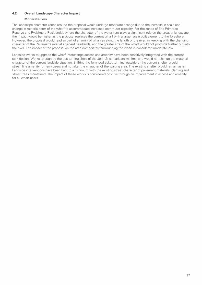
17
4.2 Overall Landscape Character Impact
Moderate-Low
The landscape character zones around the proposal would undergo moderate change due to the increase in scale and change in material form of the wharf to accommodate increased commuter capacity. For the zones of Eric Primrose Reserve and Rydalmere Residential, where the character of the waterfront plays a significant role on the broader landscape, the impact would be higher as the proposal replaces the current wharf with a larger scale built element to the foreshore. However, the proposal would read as part of a family of wharves along the length of the river, in keeping with the changing character of the Parramatta river at adjacent headlands, and the greater size of the wharf would not protrude further out into the river. The impact of the proposal on the area immediately surrounding the wharf is considered moderate-low.
Landside works to upgrade the wharf interchange access and amenity have been sensitively integrated with the current park design. Works to upgrade the bus turning circle of the John St carpark are minimal and would not change the material character of the current landside situation. Shifting the ferry pod ticket terminal outside of the current shelter would streamline amenity for ferry users and not alter the character of the waiting area. The existing shelter would remain as is. Landside interventions have been kept to a minimum with the existing street character of pavement materials, planting and street trees maintained. The impact of these works is considered positive through an improvement in access and amenity for all wharf users.
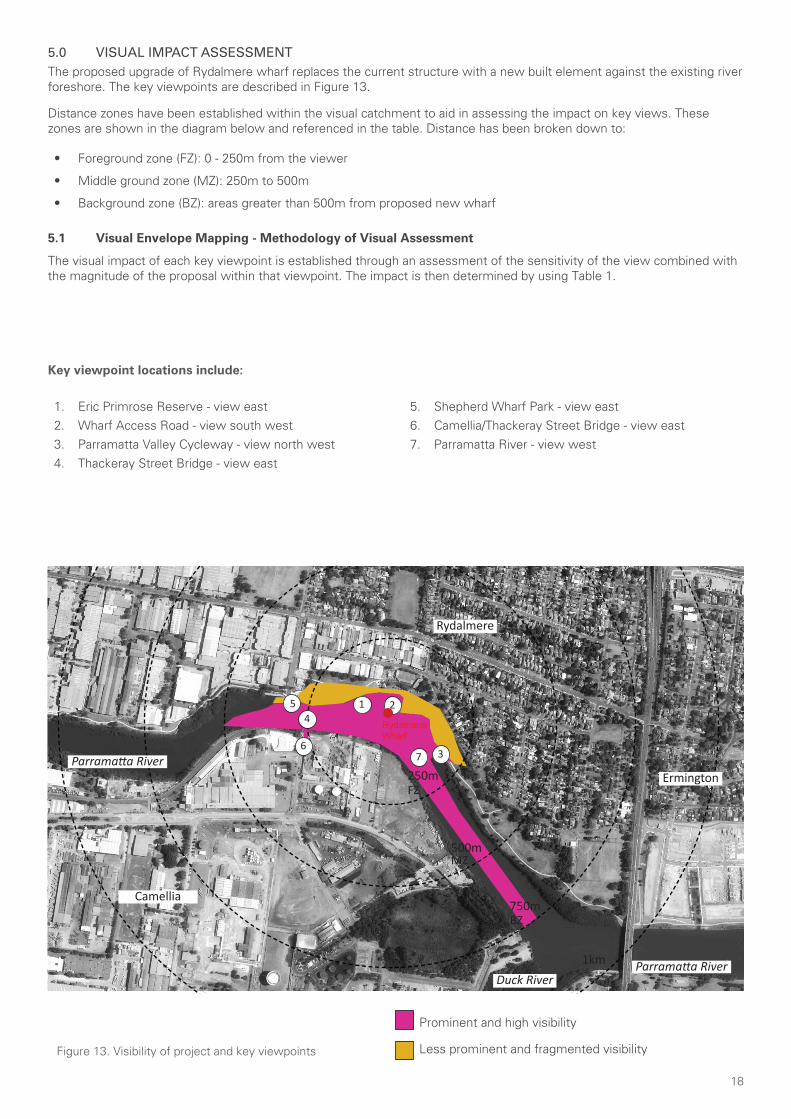
18
Parramatta River
Parramatta River
Rydalmere
Ermington
Duck River
Camellia
45 1
3
2
67
RydalmereWharf
250m
1km
750m
500m
Figure 13. Visibility of project and key viewpoints
5.0 VISUAL IMPACT ASSESSMENTThe proposed upgrade of Rydalmere wharf replaces the current structure with a new built element against the existing river foreshore. The key viewpoints are described in Figure 13.
Distance zones have been established within the visual catchment to aid in assessing the impact on key views. These zones are shown in the diagram below and referenced in the table. Distance has been broken down to:
• Foreground zone (FZ): 0 - 250m from the viewer
• Middle ground zone (MZ): 250m to 500m
• Background zone (BZ): areas greater than 500m from proposed new wharf
5.1 Visual Envelope Mapping - Methodology of Visual Assessment
The visual impact of each key viewpoint is established through an assessment of the sensitivity of the view combined with the magnitude of the proposal within that viewpoint. The impact is then determined by using Table 1.
Prominent and high visibility
Less prominent and fragmented visibility
FZ
MZ
BZ
1. Eric Primrose Reserve - view east2. Wharf Access Road - view south west3. Parramatta Valley Cycleway - view north west4. Thackeray Street Bridge - view east
5. Shepherd Wharf Park - view east6. Camellia/Thackeray Street Bridge - view east7. Parramatta River - view west
Key viewpoint locations include:
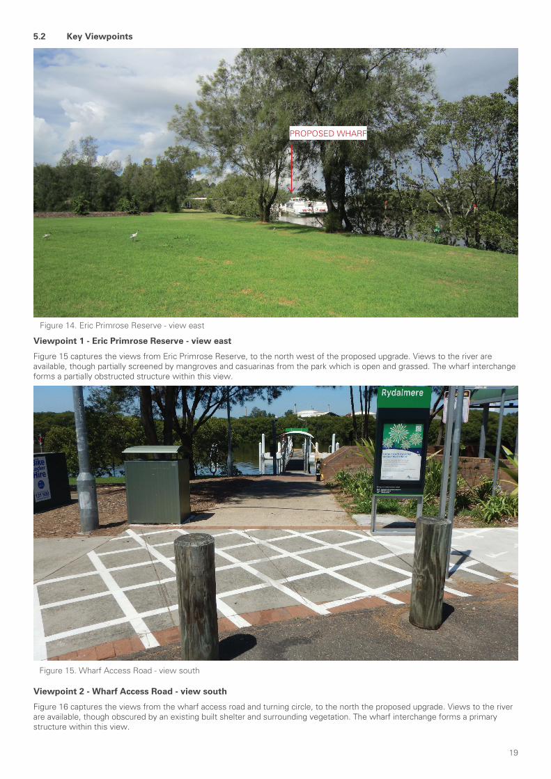
19
Viewpoint 1 - Eric Primrose Reserve - view east
Figure 15 captures the views from Eric Primrose Reserve, to the north west of the proposed upgrade. Views to the river are available, though partially screened by mangroves and casuarinas from the park which is open and grassed. The wharf interchange forms a partially obstructed structure within this view.
Figure 14. Eric Primrose Reserve - view east
PROPOSED WHARF
Figure 15. Wharf Access Road - view south
Viewpoint 2 - Wharf Access Road - view south
Figure 16 captures the views from the wharf access road and turning circle, to the north the proposed upgrade. Views to the river are available, though obscured by an existing built shelter and surrounding vegetation. The wharf interchange forms a primary structure within this view.
5.2 Key Viewpoints
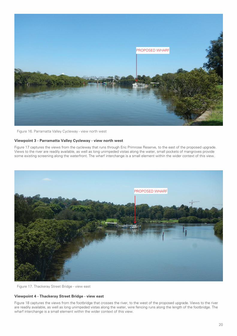
20
Viewpoint 3 - Parramatta Valley Cycleway - view north west
Figure 17 captures the views from the cycleway that runs through Eric Primrose Reserve, to the east of the proposed upgrade. Views to the river are readily available, as well as long unimpeded vistas along the water, small pockets of mangroves provide some existing screening along the waterfront. The wharf interchange is a small element within the wider context of this view.
Figure 16. Parramatta Valley Cycleway - view north west
Figure 17. Thackeray Street Bridge - view east
Viewpoint 4 - Thackeray Street Bridge - view east
Figure 18 captures the views from the footbridge that crosses the river, to the west of the proposed upgrade. Views to the river are readily available, as well as long unimpeded vistas along the water, wire fencing runs along the length of the footbridge. The wharf interchange is a small element within the wider context of this view.
PROPOSED WHARF
PROPOSED WHARF
PROPOSED WHARF
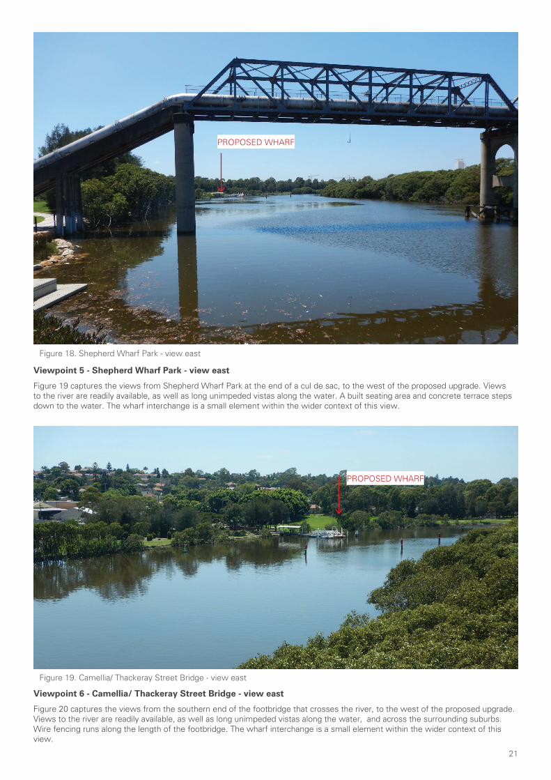
21
Figure 18. Shepherd Wharf Park - view east
Viewpoint 5 - Shepherd Wharf Park - view east
Figure 19 captures the views from Shepherd Wharf Park at the end of a cul de sac, to the west of the proposed upgrade. Views to the river are readily available, as well as long unimpeded vistas along the water. A built seating area and concrete terrace steps down to the water. The wharf interchange is a small element within the wider context of this view.
Viewpoint 6 - Camellia/ Thackeray Street Bridge - view east
Figure 20 captures the views from the southern end of the footbridge that crosses the river, to the west of the proposed upgrade. Views to the river are readily available, as well as long unimpeded vistas along the water, and across the surrounding suburbs. Wire fencing runs along the length of the footbridge. The wharf interchange is a small element within the wider context of this view.
Figure 19. Camellia/ Thackeray Street Bridge - view east
PROPOSED WHARF
PROPOSED WHARF
PROPOSED WHARF
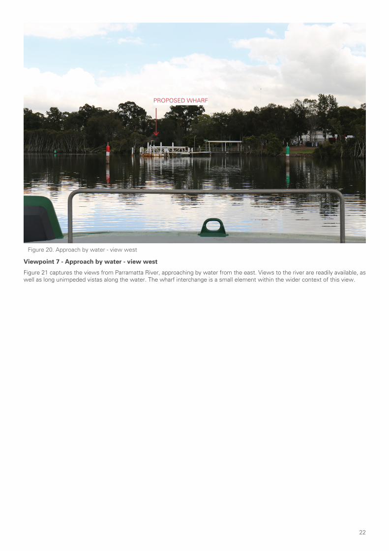
22
Figure 20. Approach by water - view west
Viewpoint 7 - Approach by water - view west
Figure 21 captures the views from Parramatta River, approaching by water from the east. Views to the river are readily available, as well as long unimpeded vistas along the water. The wharf interchange is a small element within the wider context of this view.
PROPOSED WHARF
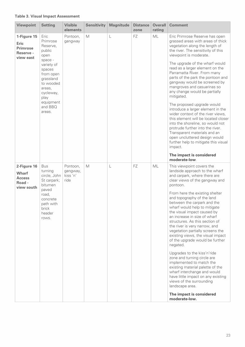
23
Table 3. Visual Impact Assessment
Viewpoint Setting Visible elements
Sensitivity Magnitude Distance zone
Overall rating
Comment
1-Figure 15
Eric Primrose Reserve - view east
Eric Primrose Reserve, public open space - variety of spaces from open grassland to wooded areas, cycleway, play equipment and BBQ areas.
Pontoon, gangway
M L FZ ML Eric Primrose Reserve has open grassed areas with areas of thick vegetation along the length of the river. The sensitivity of this viewpoint is moderate.
The upgrade of the wharf would read as a larger element on the Parramatta River. From many parts of the park the pontoon and gangway would be screened by mangroves and casuarinas so any change would be partially mitigated.
The proposed upgrade would introduce a larger element in the wider context of the river views, this element will be located closer into the shoreline, so would not protrude further into the river. Transparent materials and an open uncluttered design would further help to mitigate this visual impact.
The impact is considered moderate-low.
2-Figure 16
Wharf Access Road - view south
Bus turning circle, John St carpark; bitumen paved road, concrete path with brick header rows.
Pontoon, gangway, kiss ‘n’ ride
M L FZ ML This viewpoint covers the landside approach to the wharf and carpark, where there are clear views of the gangway and pontoon.
From here the existing shelter and topography of the land between the carpark and the wharf would help to mitigate the visual impact caused by an increase in size of wharf structures. As this section of the river is very narrow, and vegetation partially screens the existing views, the visual impact of the upgrade would be further negated.
Upgrades to the kiss’n’ride zone and turning circle are implemented to match the existing material palette of the wharf interchange and would have little impact on any existing views of the surrounding landscape area.
The impact is considered moderate-low.
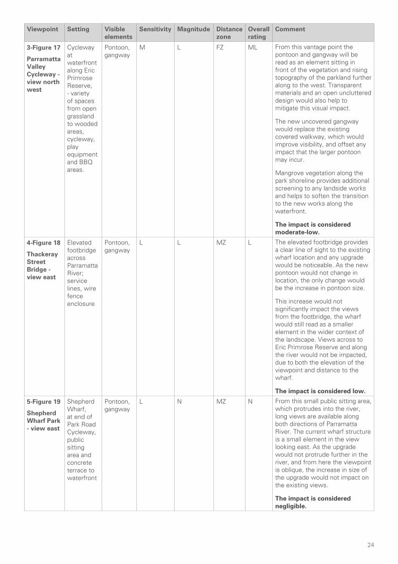
24
Viewpoint Setting Visible elements
Sensitivity Magnitude Distance zone
Overall rating
Comment
3-Figure 17
Parramatta Valley Cycleway - view north west
Cycleway at waterfront along Eric Primrose Reserve, - variety of spaces from open grassland to wooded areas, cycleway, play equipment and BBQ areas.
Pontoon, gangway
M L FZ ML From this vantage point the pontoon and gangway will be read as an element sitting in front of the vegetation and rising topography of the parkland further along to the west. Transparent materials and an open uncluttered design would also help to mitigate this visual impact.
The new uncovered gangway would replace the existing covered walkway, which would improve visibility, and offset any impact that the larger pontoon may incur.
Mangrove vegetation along the park shoreline provides additional screening to any landside works and helps to soften the transition to the new works along the waterfront.
The impact is considered moderate-low.
4-Figure 18
Thackeray Street Bridge - view east
Elevated footbridge across Parramatta River; service lines, wire fence enclosure
Pontoon, gangway
L L MZ L The elevated footbridge provides a clear line of sight to the existing wharf location and any upgrade would be noticeable. As the new pontoon would not change in location, the only change would be the increase in pontoon size.
This increase would not significantly impact the views from the footbridge, the wharf would still read as a smaller element in the wider context of the landscape. Views across to Eric Primrose Reserve and along the river would not be impacted, due to both the elevation of the viewpoint and distance to the wharf.
The impact is considered low.
5-Figure 19
Shepherd Wharf Park - view east
Shepherd Wharf, at end of Park Road Cycleway, public sitting area and concrete terrace to waterfront
Pontoon, gangway
L N MZ N From this small public sitting area, which protrudes into the river, long views are available along both directions of Parramatta River. The current wharf structure is a small element in the view looking east. As the upgrade would not protrude further in the river, and from here the viewpoint is oblique, the increase in size of the upgrade would not impact on the existing views.
The impact is considered negligible.
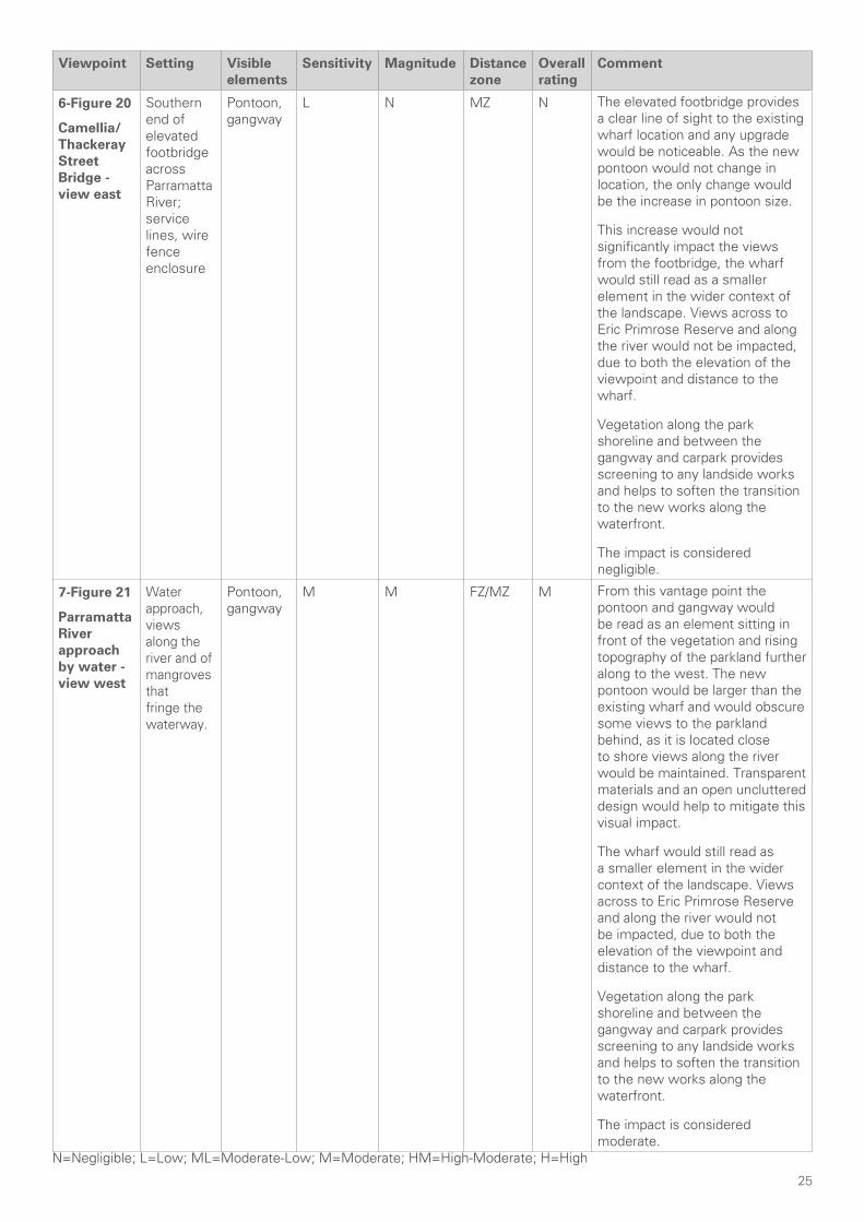
25
Viewpoint Setting Visible elements
Sensitivity Magnitude Distance zone
Overall rating
Comment
6-Figure 20
Camellia/ Thackeray Street Bridge - view east
Southern end of elevated footbridge across Parramatta River; service lines, wire fence enclosure
Pontoon, gangway
L N MZ N The elevated footbridge provides a clear line of sight to the existing wharf location and any upgrade would be noticeable. As the new pontoon would not change in location, the only change would be the increase in pontoon size.
This increase would not significantly impact the views from the footbridge, the wharf would still read as a smaller element in the wider context of the landscape. Views across to Eric Primrose Reserve and along the river would not be impacted, due to both the elevation of the viewpoint and distance to the wharf.
Vegetation along the park shoreline and between the gangway and carpark provides screening to any landside works and helps to soften the transition to the new works along the waterfront.
The impact is considered negligible.
7-Figure 21
Parramatta River approach by water - view west
Water approach, views along the river and of mangroves that fringe the waterway.
Pontoon, gangway
M M FZ/MZ M From this vantage point the pontoon and gangway would be read as an element sitting in front of the vegetation and rising topography of the parkland further along to the west. The new pontoon would be larger than the existing wharf and would obscure some views to the parkland behind, as it is located close to shore views along the river would be maintained. Transparent materials and an open uncluttered design would help to mitigate this visual impact.
The wharf would still read as a smaller element in the wider context of the landscape. Views across to Eric Primrose Reserve and along the river would not be impacted, due to both the elevation of the viewpoint and distance to the wharf.
Vegetation along the park shoreline and between the gangway and carpark provides screening to any landside works and helps to soften the transition to the new works along the waterfront.
The impact is considered moderate.
N=Negligible; L=Low; ML=Moderate-Low; M=Moderate; HM=High-Moderate; H=High
26
5.3 Visual Impact Assessment Summary
Overall visual impact - Low
The upgrade of an existing fixed element along the foreshore of the Parramatta River at Rydalmere would only be visible from a relatively enclosed area. This section of the river is not only quite narrow and winding, but largely fringed with thick mangroves.
The proposal would be viewed from areas of Eric Primrose Park, the Parramatta Valley Cycleway and the Thackeray Street Footbridge that crosses the river. Longer distance views are generally unimpeded by the upgrade. The wharf would be viewed against the backdrop of the topography of the park, mangrove vegetation, and always at an oblique angle, reducing the potential impact of the wharf seen as a single element within the view. The proposal is anticipated to have a low impact on wider range views.
Views from the foreshore would be slightly more vulnerable to change. The foreshore cycleway and seating area have an established relationship with the river, and the wharf would be a large scale structure at this level, with the potential to impose on views. However, as the wharf needs to be located close to shore to achieve adequate river width for ferry access, which results in a short gangway from the shoreline to the wharf, the impact on views up and down the river is reduced. As a result, This is considered a low impact on the public areas directly associated with the site.
The proposed landside upgrade works would have a low impact from the foreshore due to existing vegetation and minimal degree of change.
The overall visual impact of the proposal at Rydalmere is considered low. The greatest impact would be on views within the immediate landside foreground zone where the proposed wharf would exist as a much larger scale structure in an otherwise intimate setting, it would obscure some views across the river. Views in the mid zones would have a lower impact due to the distance to the proposal, and its position against the foreshore. The open structure of the wharf and gangway aim to further reduce the impact of the proposal on views. There would be a negligible impact on views from the proposed landside works.
27
6.0 SUMMARY OF URBAN DESIGN CONCEPT AND MITIGATION STRATEGY6.1 Summary of urban design recommendations and mitigation measures
The concept for the proposed wharf and interchange upgrade works at Rydalmere has been based on an investigation of the following:
• potential visual impact;• access;• safety and security;• buildability;• material palette and character;• architectural form and design;• vegetation impacts; and• maintenance.
The concept design responds to the following elements:
Scale
The proposal, in catering to the future commuter demand and user amenity, would upgrade an existing built element to the foreshore. This change requires sensitivity to the surrounding landscape character.
Design
Material selection, location of services, and a standardised family of elements form the key design strategies for mitigating the impact of the proposal. Attention has been made to ramps and walkways within the proposed wharf to meet access standards. The proposed wharf has been designed for amenity through covered pontoon and protection screens to minimise impacts of weather on ferry users.
Colour
Colour plays an important role in mitigating the impact on views and landscape character. Selection of materials and paint colour respond to the surrounding palette, are low in reflectivity, and complement the surrounding elements of the wharf precinct and the river landscape through neutral tones. Overall the proposal would promote a unified palette of materials which, while responding to the maritime heritage of the river generally and surrounding character, also separates the structure as a piece of architectural design.
Mitigation Measures include:
• A unified palette of materials which respond to the maritime heritage of the river and surrounding character zones;• A standardised family of elements;• Selection of neutral and transparent materials;• Minimising impact on the foreshore through a single point entry;• A reduction of fixed solid elements on the pontoon to maintain views through the structure; and• Analysis for wharf location which assessed key views, access, and landside connections.
6.2 Conclusion
The overall impact of the proposal is considered to be low. The proposal upgrades an existing fixed structure along the parkland edge of Rydalmere. As areas along the river are also undergoing transformation, and there is a large industrial presence, the landscape character of the zones surrounding the proposal has a high tolerance of change. The proposal also forms part of a series of new structures and upgrades to existing structures along this section of the Parramatta River.
The proposal would have a minor impact on views in and around the structure. Long range views from surrounding points along the Parramatta River are maintained with the wharf viewed against the topography of the park. There is a moderate-low impact on views immediately surrounding the wharf. The roofing elements of the large pontoon would reduce views from the Eric Primrose Reserve foreshore along the river, however the impact would be limited as pockets of vegetation already partially screen the wharf and the river from sections of the park.
For landside works, options were investigated to upgrade amenity for commuters and road transport services. Impacts from landside works are considered low for both visual impact and landscape character.

Appendix G Statement of heritage impact
Statement of Heritage Impact
Rydalmere Wharf
BLANK PAGE
Rydalmere Wharf Statement of Heritage Impact April 2018

Rydalmere Wharf Statement of Heritage Impact
i
Contents
Executive Summary ...................................................................................................................... 2
1 Introduction ............................................................................................................................. 5
1.1 Purpose ............................................................................................................................ 5
1.2 Project description ............................................................................................................ 5
1.3 Background ...................................................................................................................... 7
1.4 Methodology ................................................................................................................... 11
1.5 Author Identification ........................................................................................................ 12
1.6 Limitations ...................................................................................................................... 12
2 Existing Environment ........................................................................................................... 13
2.1 Site Context .................................................................................................................... 13
2.1 Site Description............................................................................................................... 15
3 Aboriginal Heritage ............................................................................................................... 19
3.1 Legislative Framework .................................................................................................... 19
3.2 Desktop Assessment ...................................................................................................... 19
4 Non-Aboriginal Heritage ....................................................................................................... 23
4.1 Legislative Framework .................................................................................................... 23
4.2 European History of Rydalmere ...................................................................................... 24
4.3 Historical Archaeological Potential .................................................................................. 32
4.4 Heritage Significance ...................................................................................................... 39
5 Heritage Impact Assessment ............................................................................................... 42
5.1 Statutory Controls ........................................................................................................... 42
5.2 ‘Statements of Heritage Impact’ (OEH) ........................................................................... 42
5.3 Summary of Impacts ....................................................................................................... 43
6 Conclusions and Recommendations ................................................................................... 44
Appendix A: State Heritage Inventory Forms ........................................................................... 45
Appendix B: Site Inspection Form ............................................................................................. 46
Appendix C: AHIMS Search Results .......................................................................................... 47
Rydalmere Wharf 2 Statement of Heritage Impact
Executive Summary
This Statement of Heritage Impact, (SoHI) incorporating an Aboriginal heritage due diligence assessment and a historical archaeological assessment, has been commissioned by Roads and Maritime Services NSW (Roads and Maritime). Roads and Maritime proposes to upgrade Rydalmere Wharf to improve facilities and amenities for ferry passengers. The subject site is defined as the wharf itself, land-side abutment, waiting shelter, ‘Kiss-n-Ride’ zone, and Parramatta Valley Cycleway. Rydalmere Wharf is located on the northern bank of the Parramatta River. The wharf consists of a gangway and pontoon which project south-west from the landside abutment. The proposed works include replacement of the existing wharf with a new wharf in the same location, including a new 18 metre aluminium gangway and 9 X 18 metre waiting shelter and pontoon structure. The proposal also includes accessibility upgrades to the wharf and carpark, and the installation of a new ‘Kiss-n-Ride’ zone and bicycle calming pavement treatment. Rydalmere Wharf is not itself listed as a heritage item on any register, but it is located within the vicinity of local heritage items listed under Part 1 of Schedule 5 of the Parramatta Local Environmental Plan (LEP) 2011 as ‘Wetlands’ (item no. I1), ‘Pumping Station’ (item no. I5), ‘Tram Alignment’ (item no. I6) and ‘Truganini House and grounds’ (item no. I591). It is also located within the vicinity of a local heritage item listed on the Sydney Regional Environmental Plan (Sydney Harbour Catchment) (SREP) 2005 as ‘Industrial Wharfs’ (item #36). This SoHI incorporating an Aboriginal heritage due diligence assessment and a historical archaeological assessment has been prepared in accordance with the heritage management guidelines outlined in the Roads and Maritime Services (Roads and Maritime) Procedure for Aboriginal Cultural Heritage Consultation and Investigation (PACHCI), Australia ICOMOS Burra Charter, 2013; and relevant publications by the Heritage Division of the NSW Office of Environment & Heritage. The first stage of assessment involved on-site liaison between City Plan Heritage (CPH) and the representatives of Roads and Maritime. A detailed inspection of the site and its surrounding context was undertaken by Brittany Freelander (Senior Heritage Consultant) and Alexandra Ribeny (Heritage Consultant/Archaeologist) on 22 November 2017. Aboriginal Heritage Assessent A basic search of the AHIMS database did not locate any Aboriginal sites within a 200 metre buffer of the subject site. Roads and Maritime undertook a Stage 1 PACHCI assessment and determined that the proposed works would be unlikely to impact Aboriginal cultural heritage. The assessment indicated that while the surrounding area contains landscape features that indicate the presence of Aboriginal objects, the cultural heritage potential appears to be reduced due to past disturbances in the form of the construction of the existing wharf. The assessment concluded that no further Aboriginal heritage assessment is required and the Roads and Maritime’s Unexpected Heritage Items (2015) procedure should be strictly adhered to during construction. Non-Aboriginal Heritage Assessment Desktop historical research established that the present Rydalmere Wharf was constructed in 1993 for the RiverCat ferry service and has consistently been used as a wharf for the past 25 years. Historical sources indicate the presence of an earlier wharf structure at Rydalmere, although these likely refer to the historical ‘Shepherd’s Wharf’ to the west of the current Rydalmere wharf site.
Rydalmere Wharf 3 Statement of Heritage Impact
Consideration of the proposal and its potential impacts determined that the likelihood that any historical wharf sites could be directly or indirectly harmed by the proposed works is low. Roads and Maritime’s concept design was assessed according to the statutory controls on the relevant planning instruments and also the recommended management guidelines as presented in the subject site’s State Heritage Inventory (SHI) form. CPH has concluded that although the proposed works would be adjacent to heritage item ‘Wetlands’ (I1), the item is designated as a ‘no go area’, as per the Aquatic Ecology Report, and would not therefore be impacted. CPH has also concluded that the proposal would have no impact on other heritage items within the vicinity of the subject site, including ‘Pumping Station’ (item no. I5), ‘Tram Alignment’ (item no. I6), ‘Truganini House and grounds’ (item no. I591) and ‘Industrial Wharfs’ (#36), as these are at a significant distance from the works and would not therefore be directly or indirectly impacted. While the heritage impact of the proposal would be minimal, it could be made positive through the provision of signage and interpretation of the former ‘Shepherd’s Wharf’ structure, to the east of the subject site, and incorporation of the subject site within the historical ‘Vineyard Estate’. Indication of the historical development of the Rydalmere wharf precinct would contribute to a heightened awareness of Rydalmere’s lengthy maritime history. The overall heritage outcome would be further improved through the reappropriation of sandstone, removed as part of the seawall modification, within the new wharf development where possible. This report includes Appendices A, B and C, where ‘A’ is a copy of the SHI forms for Rydalmere Wharf, ‘B’ is the Site Inspection Recording Form for the existing wharf, and ‘C’ comprises copies of the search results from searches of the Aboriginal Heritage Information Management System (AHIMS) database.

Rydalmere Wharf 4 Statement of Heritage Impact
Rydalmere Wharf 5 Statement of Heritage Impact
1 Introduction
1.1 Purpose Roads and Maritime proposes to upgrade Rydalmere Wharf as part of the Transport Access Program (TAP), which aims to improve Sydney’s ferry services for customers. This SoHI has been prepared to assess the impact of the proposal on items of heritage significance within and near the footprint of the proposed work.
1.2 Project description The proposed works include (Figure 1 & Figure 2):
▪ replacement of concrete plinths and footings to waiting shelter with site salvaged pavers;
▪ removal of existing concrete paths between carpark and wharf;
▪ removal of existing concrete path, kerb and gutter on eastern side of turning circle in preparation for realignment;
▪ demolition of existing wharf and replacement with a new accessible pontoon and gangway;
▪ lowering and removal of a section of sea wall on either side of at wharf-landside interface;
▪ removal of existing bollards in Kiss and Ride zone and from perimeter of turning circle;
▪ installation of new accessible ramp, landing and stairway access to waiting shelter and wharf/land interface;
▪ installation of new bicycle calming pavement treatment and relocation of existing bicycle racks;
▪ installation of new Kiss and Ride Zone and realignment of kerb and gutter to allow parking of two buses whilst maintaining a compliant turning circle; and
▪ upgrade of existing accessible carpark spaces and construction of accessible footpath between accessible parking and walkway.
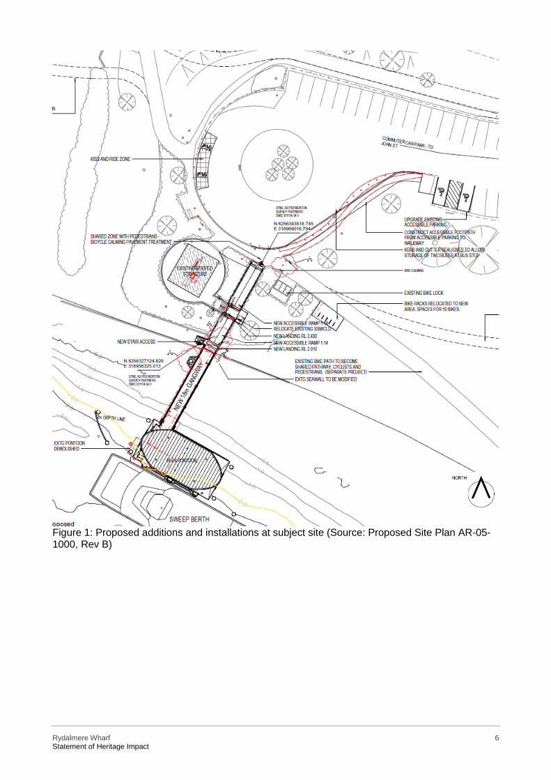
Rydalmere Wharf 6 Statement of Heritage Impact
Figure 1: Proposed additions and installations at subject site (Source: Proposed Site Plan AR-05-1000, Rev B)
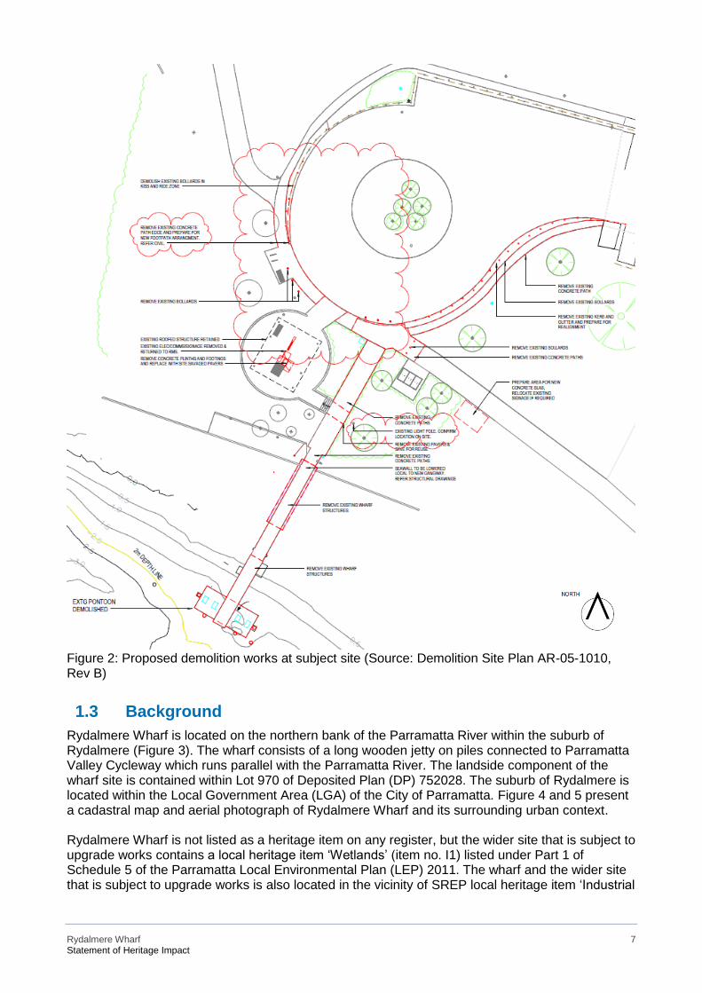
Rydalmere Wharf 7 Statement of Heritage Impact
Figure 2: Proposed demolition works at subject site (Source: Demolition Site Plan AR-05-1010, Rev B)
1.3 Background Rydalmere Wharf is located on the northern bank of the Parramatta River within the suburb of Rydalmere (Figure 3). The wharf consists of a long wooden jetty on piles connected to Parramatta Valley Cycleway which runs parallel with the Parramatta River. The landside component of the wharf site is contained within Lot 970 of Deposited Plan (DP) 752028. The suburb of Rydalmere is located within the Local Government Area (LGA) of the City of Parramatta. Figure 4 and 5 present a cadastral map and aerial photograph of Rydalmere Wharf and its surrounding urban context. Rydalmere Wharf is not listed as a heritage item on any register, but the wider site that is subject to upgrade works contains a local heritage item ‘Wetlands’ (item no. I1) listed under Part 1 of Schedule 5 of the Parramatta Local Environmental Plan (LEP) 2011. The wharf and the wider site that is subject to upgrade works is also located in the vicinity of SREP local heritage item ‘Industrial
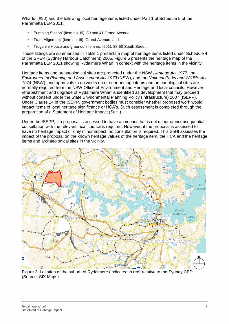
Rydalmere Wharf 8 Statement of Heritage Impact
Wharfs’ (#36) and the following local heritage items listed under Part 1 of Schedule 5 of the Parramatta LEP 2011:
▪ ‘Pumping Station’ (item no. I5), 39 and 41 Grand Avenue;
▪ ‘Tram Alignment’ (item no. I6), Grand Avenue; and
▪ ‘Truganini House and grounds’ (item no. I591), 38-50 South Street.
These listings are summarised in Table 1 presents a map of heritage items listed under Schedule 4 of the SREP (Sydney Harbour Catchment) 2005. Figure 6 presents the heritage map of the Parramatta LEP 2011 showing Rydalmere Wharf in context with the heritage items in the vicinity. Heritage items and archaeological sites are protected under the NSW Heritage Act 1977, the Environmental Planning and Assessment Act 1979 (NSW), and the National Parks and Wildlife Act 1974 (NSW), and approvals to do works on or near heritage items and archaeological sites are normally required from the NSW Office of Environment and Heritage and local councils. However, refurbishment and upgrade of Rydalmere Wharf is identified as development that may proceed without consent under the State Environmental Planning Policy (Infrastructure) 2007 (ISEPP). Under Clause 14 of the ISEPP, government bodies must consider whether proposed work would impact items of local heritage significance or HCA’s. Such assessment is completed through the preparation of a Statement of Heritage Impact (SoHI). Under the ISEPP, if a proposal is assessed to have an impact that is not minor or inconsequential, consultation with the relevant local council is required. However, if the proposal is assessed to have no heritage impact or only minor impact, no consultation is required. This SoHI assesses the impact of the proposal on the known heritage values of the heritage item, the HCA and the heritage items and archaeological sites in the vicinity.
Figure 3: Location of the suburb of Rydalmere (indicated in red) relative to the Sydney CBD (Source: SIX Maps)
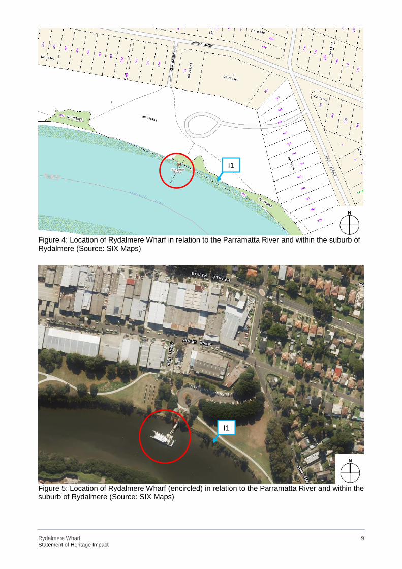
Rydalmere Wharf 9 Statement of Heritage Impact
Figure 4: Location of Rydalmere Wharf in relation to the Parramatta River and within the suburb of Rydalmere (Source: SIX Maps)
Figure 5: Location of Rydalmere Wharf (encircled) in relation to the Parramatta River and within the suburb of Rydalmere (Source: SIX Maps)
I1
I1
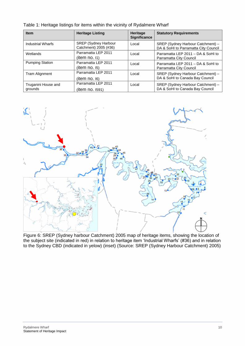
Rydalmere Wharf 10 Statement of Heritage Impact
Table 1: Heritage listings for items within the vicinity of Rydalmere Wharf
Item Heritage Listing Heritage Significance
Statutory Requirements
Industrial Wharfs SREP (Sydney Harbour Catchment) 2005 (#36)
Local SREP (Sydney Harbour Catchment) – DA & SoHI to Parramatta City Council
Wetlands Parramatta LEP 2011 (item no. I1)
Local Parramatta LEP 2011 – DA & SoHI to Parramatta City Council
Pumping Station Parramatta LEP 2011 (item no. I5)
Local Parramatta LEP 2011 – DA & SoHI to Parramatta City Council
Tram Alignment Parramatta LEP 2011 (item no. I6)
Local SREP (Sydney Harbour Catchment) – DA & SoHI to Canada Bay Council
Truganini House and grounds
Parramatta LEP 2011
(item no. I591) Local SREP (Sydney Harbour Catchment) –
DA & SoHI to Canada Bay Council
Figure 6: SREP (Sydney harbour Catchment) 2005 map of heritage items, showing the location of the subject site (indicated in red) in relation to heritage item ‘Industrial Wharfs’ (#36) and in relation to the Sydney CBD (indicated in yelow) (inset) (Source: SREP (Sydney Harbour Catchment) 2005)
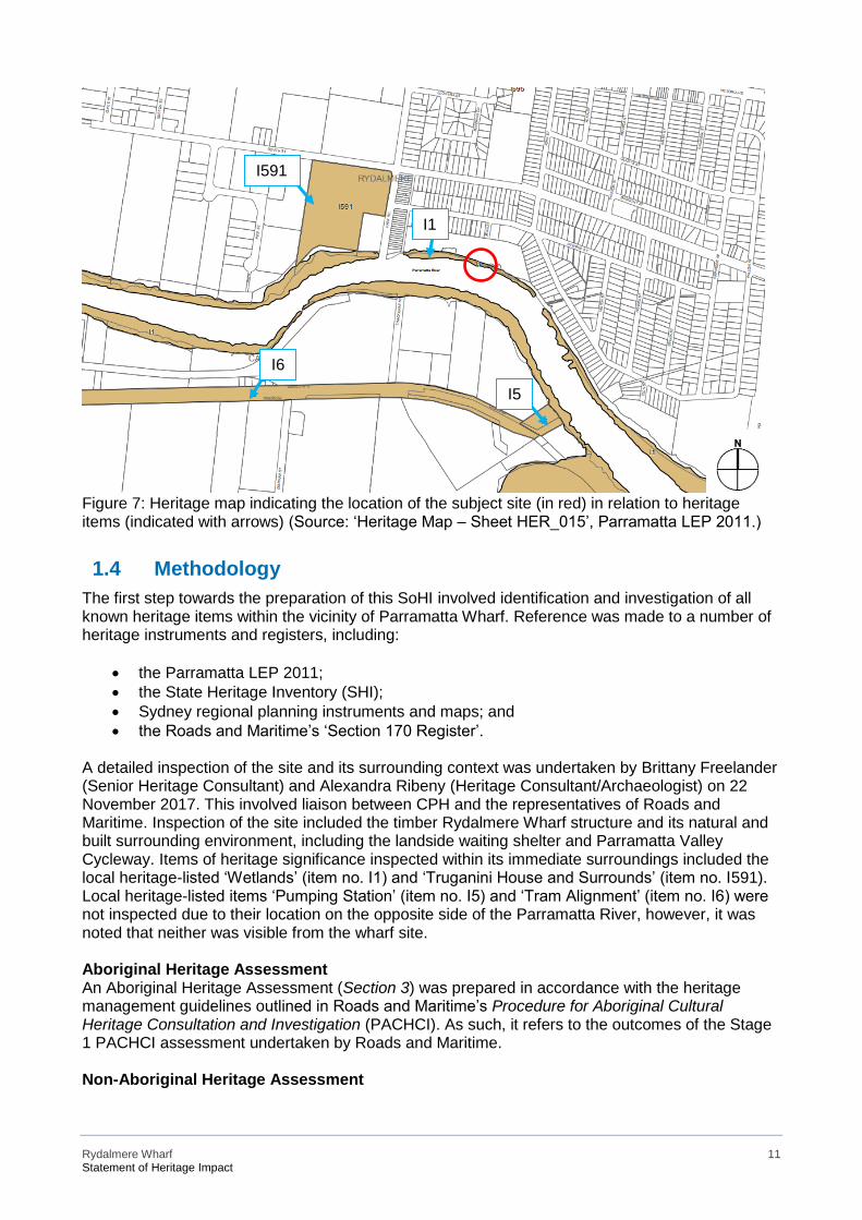
Rydalmere Wharf 11 Statement of Heritage Impact
Figure 7: Heritage map indicating the location of the subject site (in red) in relation to heritage items (indicated with arrows) (Source: ‘Heritage Map – Sheet HER_015’, Parramatta LEP 2011.)
1.4 Methodology The first step towards the preparation of this SoHI involved identification and investigation of all known heritage items within the vicinity of Parramatta Wharf. Reference was made to a number of heritage instruments and registers, including:
• the Parramatta LEP 2011; • the State Heritage Inventory (SHI); • Sydney regional planning instruments and maps; and • the Roads and Maritime’s ‘Section 170 Register’.
A detailed inspection of the site and its surrounding context was undertaken by Brittany Freelander (Senior Heritage Consultant) and Alexandra Ribeny (Heritage Consultant/Archaeologist) on 22 November 2017. This involved liaison between CPH and the representatives of Roads and Maritime. Inspection of the site included the timber Rydalmere Wharf structure and its natural and built surrounding environment, including the landside waiting shelter and Parramatta Valley Cycleway. Items of heritage significance inspected within its immediate surroundings included the local heritage-listed ‘Wetlands’ (item no. I1) and ‘Truganini House and Surrounds’ (item no. I591). Local heritage-listed items ‘Pumping Station’ (item no. I5) and ‘Tram Alignment’ (item no. I6) were not inspected due to their location on the opposite side of the Parramatta River, however, it was noted that neither was visible from the wharf site. Aboriginal Heritage Assessment An Aboriginal Heritage Assessment (Section 3) was prepared in accordance with the heritage management guidelines outlined in Roads and Maritime’s Procedure for Aboriginal Cultural Heritage Consultation and Investigation (PACHCI). As such, it refers to the outcomes of the Stage 1 PACHCI assessment undertaken by Roads and Maritime. Non-Aboriginal Heritage Assessment
I6
I5
I1
I591
Rydalmere Wharf 12 Statement of Heritage Impact
A non-Aboriginal heritage assessment (Section 4) was prepared in accordance with the OEH Heritage Division publication Assessing Heritage Significance. Historical research was undertaken using resources from Parramatta City Local Studies, ‘Parramatta Heritage Centre’, the State Library of NSW and National Library of Australia’s Trove database. Historical documentary evidence, including historical photographs and aerial photographs, were analysed to determine the likelihood that historical archaeological resources are present on the site. A statement of heritage significance was prepared for the existing wharf structure and subject site. A heritage impact assessment (Section 5) for the subject site and proximal heritage items was undertaken in accordance with the OEH Heritage Division publication Statements of Heritage Impact. This report includes Appendices A, B and C, where ‘A’ is a printout of the SHI forms for Rydalmere Wharf, ‘B’ is the Site Inspection Recording Form for the existing wharf, and ‘C’ comprises copies of the search results from searches of the AHIMS database.
1.5 Author Identification This SoHI, incorporating an Aboriginal Heritage Due Diligence Assessment and Historical Archaeological Assessment, has been prepared by CPH. Its principal author is Alexandra Ribeny (Heritage Consultant / Archaeologist). It has been reviewed by Carole-Lynne Kerrigan (Associate Director), who has also endorsed its contents.
1.6 Limitations This report constitutes a desktop assessment only, and no community consultation (from a heritage perspective) or fieldwork beyond one visual inspection has been performed.
Rydalmere Wharf 13 Statement of Heritage Impact
2 Existing Environment
2.1 Site Context The suburb of Rydalmere is located on the Parramatta River approximately 21 kilometres north-west of the Sydney Central Business District (CBD) and within the Local Government Area (LGA) of the City of Parramatta (Figure 3). Rydalmere today consists of commercial and industrial activities in the west and residential development in the east. It is serviced by train, bus and ferry services. The subject site is located roughly at the transitional point between manufacturing and residential development and within a stretch of parkland which stretches along the northern bank of the Parramatta River. An industrial precinct is located to the north of the subject site and its immediate surrounds include open lawns, vegetation and heritage-protected wetlands. The subject site is accessed via a commuter carpark and turning circle (Figure 8), which branches off from John Street, a thoroughfare which runs roughly parallel with the river. The commuter carpark consists of approximately 70-80 parking spaces and terminates on its western side with a turning circle, which includes a vegetated roundabout in the centre. Parramatta Valley Cycleway runs along the northern bank of the river and connects the commuter carpark to the wharf site (Figure 9). The subject site is surrounded by local heritage item ‘Wetlands’ (item no.I1) on both sides (Figure 10), which is situated along the northern and southern banks of the river. The following description for heritage item no.I1 is extracted from the State Heritage Inventory (SHI) form:
This item consists of remnant wetland vegetation, characterised by mangrove and saltmarsh complex,
located along the foreshores of Parramatta and Duck rivers and their tributaries, Vineyard and
Subiaco creeks.1
To the west of the subject site and also fronting the Parramatta River is local heritage item ‘Truganini House and Grounds’ (item no.I591) at 38-50 South Street. The following description for heritage item no.I591 is extracted from the State Heritage Inventory (SHI) form:
Truganini House is a single storey brick and stucco Victorian residence with a hipped roof and a
verandah on three sides, sited to face Parramatta River. The facade features ashlar courses. Roof
has exposed decorative brackets supporting narrow eaves and four tall, rendered brick chimneys
with stepped cornice. The verandah has Ogee corrugated iron roof with hip corners, Corinthian cast
iron posts with ivy decoration winding around posts, cast iron brackets, with cast iron valance and
frieze, and concrete floor. From the verandah, French doors with transom lights are leading into the
house. The French doors have upper glazed panels, a lock rail and bolection moulded panels below.
Four rendered pedestals are flanking the stairs leading to the main entrance. Front door has a
segmented arch in transom, with side lights and dentils in transom flanking a four-panel door with
coloured glazed upper panels above lock rail. Windows are four paned, timber double-hung sash
across front with paired double-hung alongside east side; rendered section of the house has double-
hung with curved rendered brick arches. Additions to the property include a sandstone building
attached at the rear. Other features include sandstone paving under house. The house was
renovated in period style in 1980s by then owners, ICAL Industries, and subsequently used for board
meetings and entertaining.2
On the opposite side of the Parramatta River, to the south of the subject site, are two local heritage items ‘Pumping Station’ (item no.I5) (Figure 10) at 39 and 41 Grand Avenue and ‘Tram Alignment’ (item no.I6) also on Grand Avenue. Neither are visible from the subject site, however, they would
1 SHI Form, accessed 02 February 2018. Available from http://www.environment.nsw.gov.au/heritageapp/ViewHeritageItemDetails.aspx?ID=2240429. 2 SHI Form, accessed 02 February 2018. Available from http://www.environment.nsw.gov.au/heritageapp/ViewHeritageItemDetails.aspx?ID=2240522.
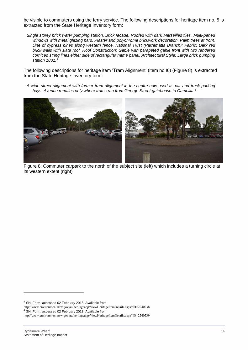
Rydalmere Wharf 14 Statement of Heritage Impact
be visible to commuters using the ferry service. The following descriptions for heritage item no.I5 is extracted from the State Heritage Inventory form:
Single storey brick water pumping station. Brick facade. Roofed with dark Marseilles tiles. Multi-paned
windows with metal glazing bars. Plaster and polychrome brickwork decoration. Palm trees at front.
Line of cypress pines along western fence. National Trust (Parramatta Branch): Fabric: Dark red
brick walls with slate roof. Roof Construction: Gable with parapeted gable front with two rendered
corniced string lines either side of rectangular name panel. Architectural Style: Large brick pumping
station 1831.3
The following descriptions for heritage item ‘Tram Alignment’ (item no.I6) (Figure 8) is extracted from the State Heritage Inventory form:
A wide street alignment with former tram alignment in the centre now used as car and truck parking
bays. Avenue remains only where trams ran from George Street gatehouse to Camellia.4
Figure 8: Commuter carpark to the north of the subject site (left) which includes a turning circle at its western extent (right)
3 SHI Form, accessed 02 February 2018. Available from http://www.environment.nsw.gov.au/heritageapp/ViewHeritageItemDetails.aspx?ID=2240238. 4 SHI Form, accessed 02 February 2018. Available from http://www.environment.nsw.gov.au/heritageapp/ViewHeritageItemDetails.aspx?ID=2240239.
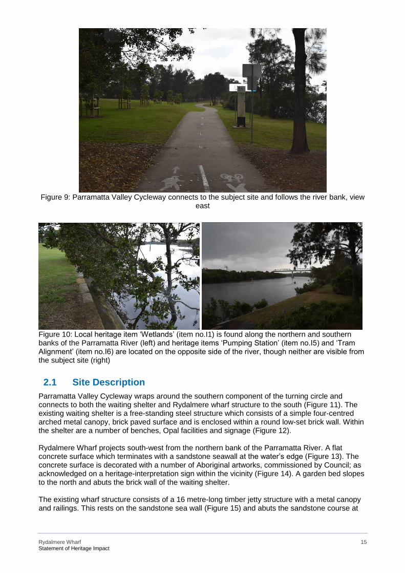
Rydalmere Wharf 15 Statement of Heritage Impact
Figure 9: Parramatta Valley Cycleway connects to the subject site and follows the river bank, view
east
Figure 10: Local heritage item ‘Wetlands’ (item no.I1) is found along the northern and southern banks of the Parramatta River (left) and heritage items ‘Pumping Station’ (item no.I5) and ‘Tram Alignment’ (item no.I6) are located on the opposite side of the river, though neither are visible from the subject site (right)
2.1 Site Description Parramatta Valley Cycleway wraps around the southern component of the turning circle and connects to both the waiting shelter and Rydalmere wharf structure to the south (Figure 11). The existing waiting shelter is a free-standing steel structure which consists of a simple four-centred arched metal canopy, brick paved surface and is enclosed within a round low-set brick wall. Within the shelter are a number of benches, Opal facilities and signage (Figure 12). Rydalmere Wharf projects south-west from the northern bank of the Parramatta River. A flat concrete surface which terminates with a sandstone seawall at the water’s edge (Figure 13). The concrete surface is decorated with a number of Aboriginal artworks, commissioned by Council; as acknowledged on a heritage-interpretation sign within the vicinity (Figure 14). A garden bed slopes to the north and abuts the brick wall of the waiting shelter. The existing wharf structure consists of a 16 metre-long timber jetty structure with a metal canopy and railings. This rests on the sandstone sea wall (Figure 15) and abuts the sandstone course at
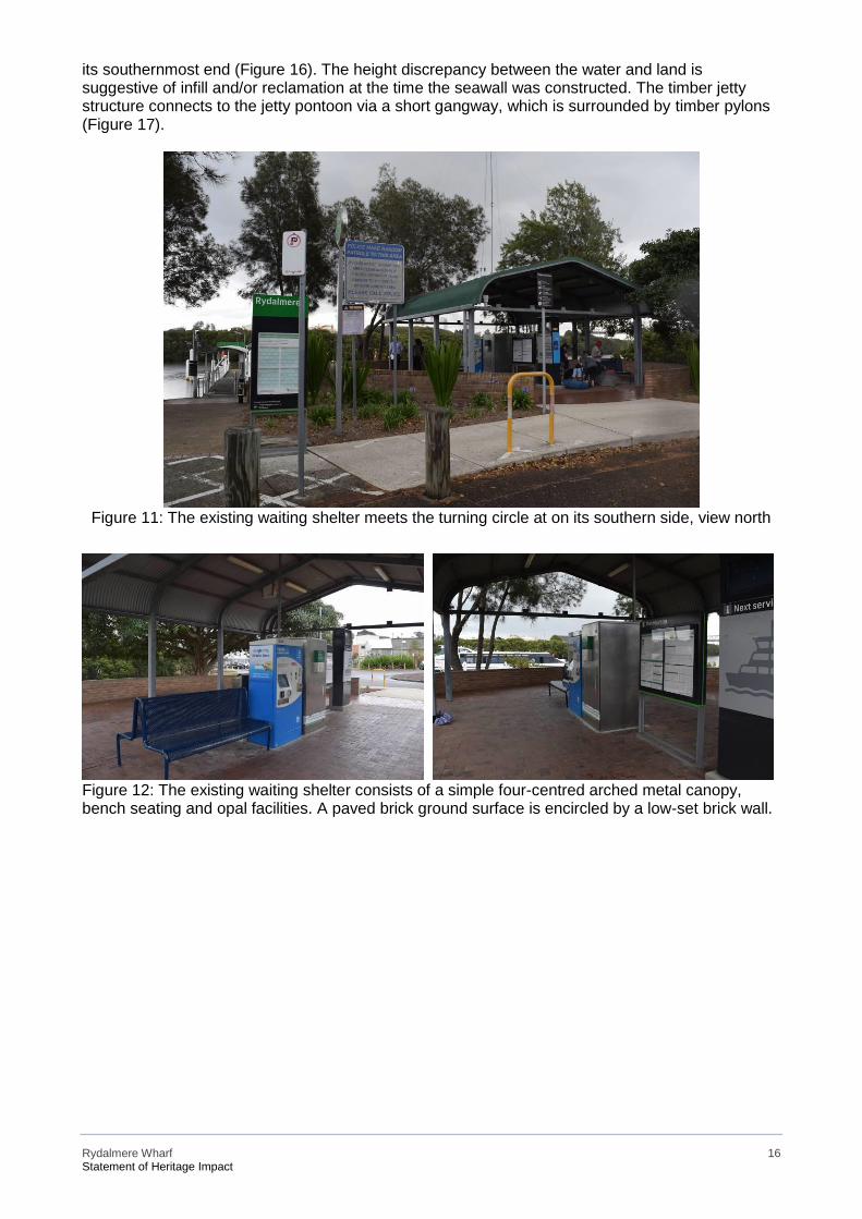
Rydalmere Wharf 16 Statement of Heritage Impact
its southernmost end (Figure 16). The height discrepancy between the water and land is suggestive of infill and/or reclamation at the time the seawall was constructed. The timber jetty structure connects to the jetty pontoon via a short gangway, which is surrounded by timber pylons (Figure 17).
Figure 11: The existing waiting shelter meets the turning circle at on its southern side, view north
Figure 12: The existing waiting shelter consists of a simple four-centred arched metal canopy, bench seating and opal facilities. A paved brick ground surface is encircled by a low-set brick wall.
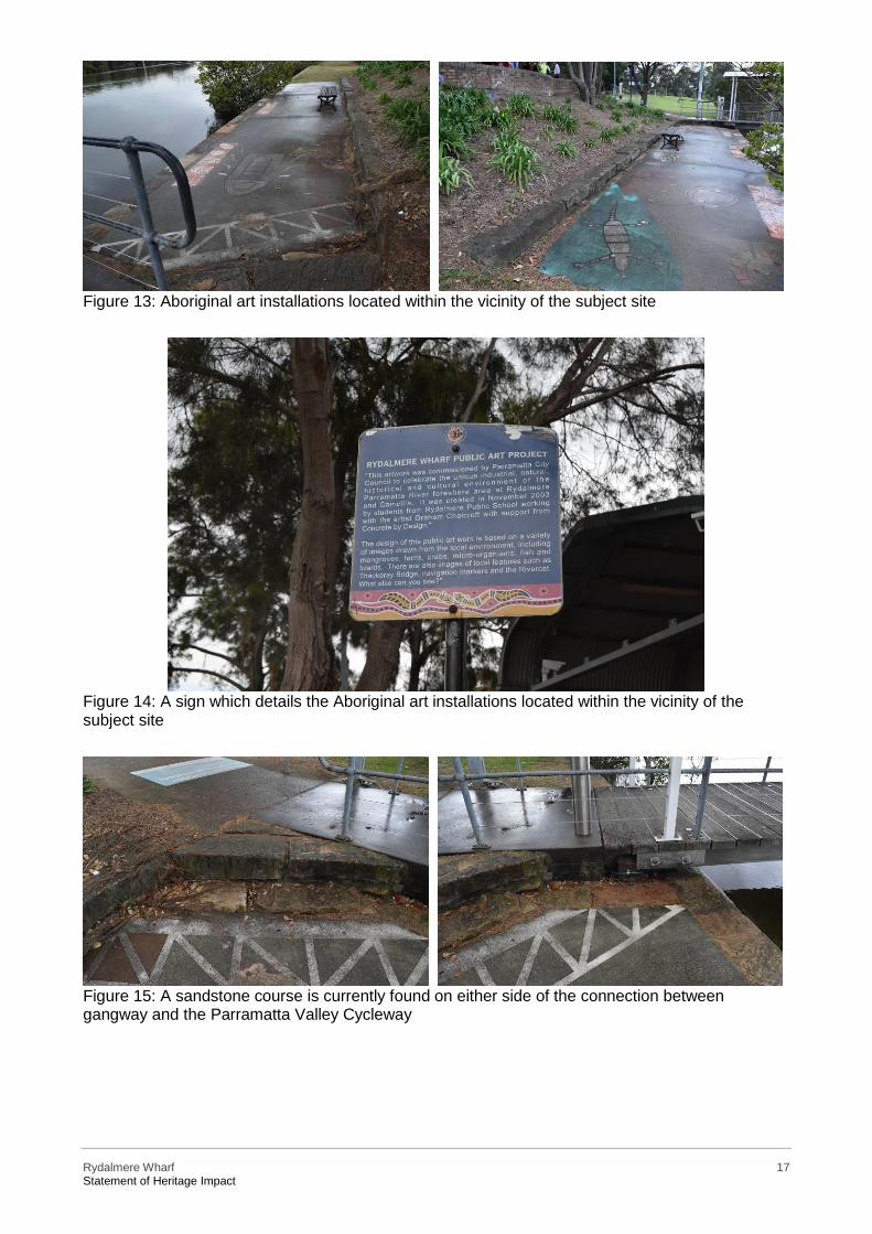
Rydalmere Wharf 17 Statement of Heritage Impact
Figure 13: Aboriginal art installations located within the vicinity of the subject site
Figure 14: A sign which details the Aboriginal art installations located within the vicinity of the subject site
Figure 15: A sandstone course is currently found on either side of the connection between gangway and the Parramatta Valley Cycleway
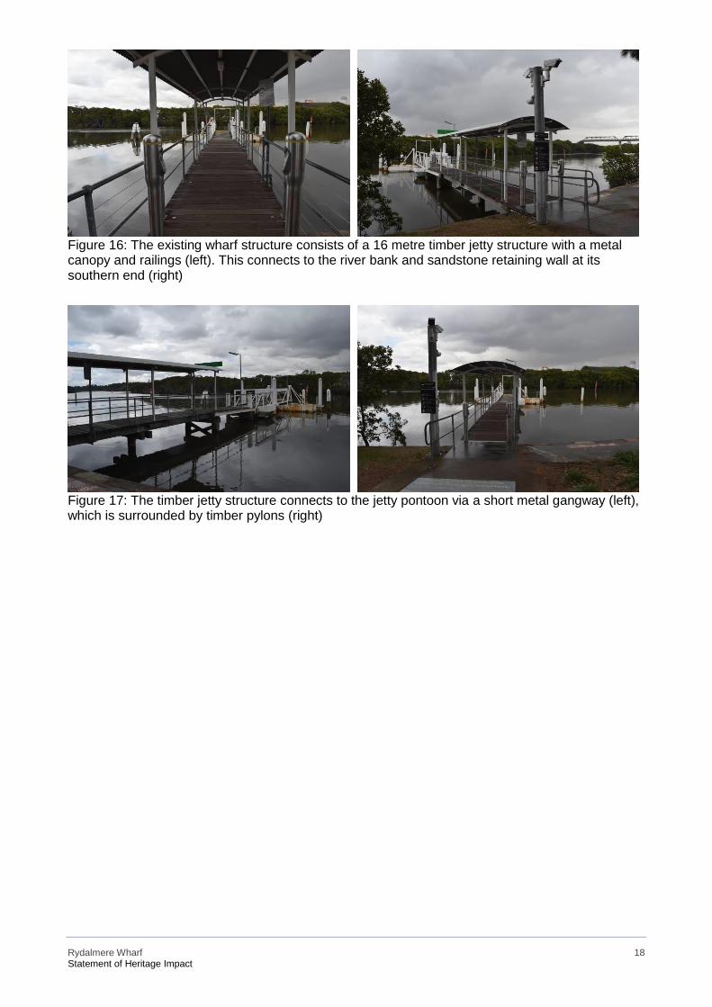
Rydalmere Wharf 18 Statement of Heritage Impact
Figure 16: The existing wharf structure consists of a 16 metre timber jetty structure with a metal canopy and railings (left). This connects to the river bank and sandstone retaining wall at its southern end (right)
Figure 17: The timber jetty structure connects to the jetty pontoon via a short metal gangway (left), which is surrounded by timber pylons (right)
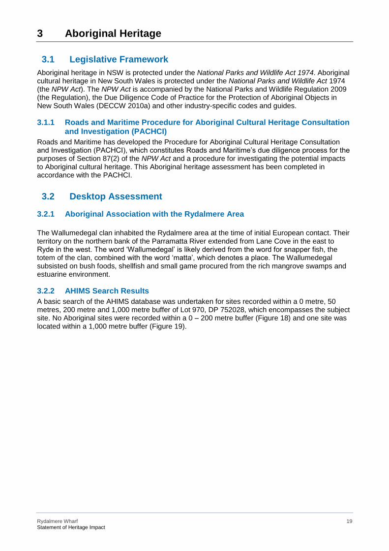
Rydalmere Wharf 19 Statement of Heritage Impact
3 Aboriginal Heritage
3.1 Legislative Framework Aboriginal heritage in NSW is protected under the National Parks and Wildlife Act 1974. Aboriginal cultural heritage in New South Wales is protected under the National Parks and Wildlife Act 1974 (the NPW Act). The NPW Act is accompanied by the National Parks and Wildlife Regulation 2009 (the Regulation), the Due Diligence Code of Practice for the Protection of Aboriginal Objects in New South Wales (DECCW 2010a) and other industry-specific codes and guides.
3.1.1 Roads and Maritime Procedure for Aboriginal Cultural Heritage Consultation and Investigation (PACHCI)
Roads and Maritime has developed the Procedure for Aboriginal Cultural Heritage Consultation and Investigation (PACHCI), which constitutes Roads and Maritime’s due diligence process for the purposes of Section 87(2) of the NPW Act and a procedure for investigating the potential impacts to Aboriginal cultural heritage. This Aboriginal heritage assessment has been completed in accordance with the PACHCI.
3.2 Desktop Assessment
3.2.1 Aboriginal Association with the Rydalmere Area The Wallumedegal clan inhabited the Rydalmere area at the time of initial European contact. Their territory on the northern bank of the Parramatta River extended from Lane Cove in the east to Ryde in the west. The word ‘Wallumedegal’ is likely derived from the word for snapper fish, the totem of the clan, combined with the word ‘matta’, which denotes a place. The Wallumedegal subsisted on bush foods, shellfish and small game procured from the rich mangrove swamps and estuarine environment.
3.2.2 AHIMS Search Results A basic search of the AHIMS database was undertaken for sites recorded within a 0 metre, 50 metres, 200 metre and 1,000 metre buffer of Lot 970, DP 752028, which encompasses the subject site. No Aboriginal sites were recorded within a 0 – 200 metre buffer (Figure 18) and one site was located within a 1,000 metre buffer (Figure 19).
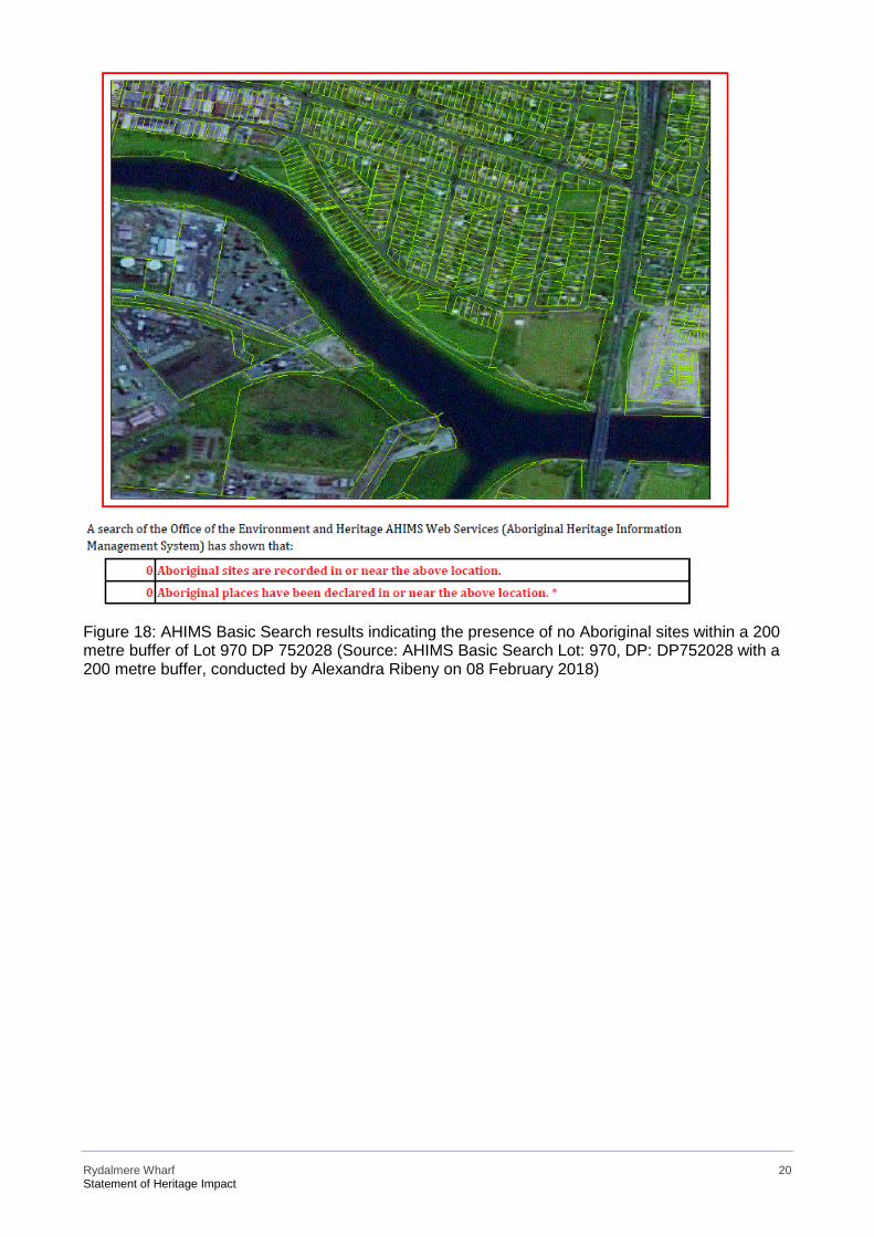
Rydalmere Wharf 20 Statement of Heritage Impact
Figure 18: AHIMS Basic Search results indicating the presence of no Aboriginal sites within a 200 metre buffer of Lot 970 DP 752028 (Source: AHIMS Basic Search Lot: 970, DP: DP752028 with a 200 metre buffer, conducted by Alexandra Ribeny on 08 February 2018)

Rydalmere Wharf 21 Statement of Heritage Impact
Figure 19: AHIMS Basic Search results indicating the presence of one Aboriginal site within a 1,000 metre buffer of Lot 970 DP 752028 (Source: AHIMS Basic Search Lot: 970, DP: DP752028 with a Buffer of 1000 metres, conducted by Alexandra Ribeny on 08 February 2018) The AHIMS search results indicate no Aboriginal sites are located within a 200 metre buffer of Lot 970 DP 752028, which encompasses the subject site. 1 Aboriginal site is located within a 1,000 metres buffer.
3.2.3 PACHCI State 1 Assessment Results Roads and Maritime undertook a Stage 1 PACHCI Assessment on 23 January 2018. The proposed work was assessed as being unlikely to have an impact on Aboriginal cultural heritage and was based on the following due diligence considerations:
• The project works are within the existing wharf and associated road and access areas
(disturbed zone).
• The project is unlikely to harm known Aboriginal objects or places (AHIMS sites).
• The AHIMS search did not indicate moderate to high concentrations of Aboriginal objects
or places in the study area.
• The study area does contain landscape features that indicate the presence of Aboriginal
objects, based on the Office of Environment and Heritage’s Due diligence Code of Practice
for the Protection of Aboriginal objects in NSW and the Roads and Maritime Services’
procedure, however, the cultural heritage potential of the study area appears to be reduced
due to past disturbances in the form of the construction of Rydalmere wharf, surrounding
landscaping and road and access points.
Rydalmere Wharf 22 Statement of Heritage Impact
• There is an absence of sandstone rock outcrops likely to contain Aboriginal art.
The assessment concluded that no further Aboriginal heritage assessment is required and the proposal may proceed in accordance with the environmental impact assessment process, as relevant, and all other relevant approvals. However, should the scope of the proposed work change, further consultation with Roads and Maritime’s Aboriginal Cultural Heritage Officer and regional environmental staff should be undertaken to reassess any potential impacts on Aboriginal cultural heritage.
3.2.4 Desktop Assessment Summary This desktop Aboriginal heritage assessment has established that Aboriginal people have a long and enduring connection with the Rydalmere area. A basic search of the AHIMS database indicated that no Aboriginal sites are located within a 200 metre buffer of Lot 970 DP 752028, which encompasses the subject site, whereas one is located within a 1,000 metre buffer. As this site is located at a substantial distance from the project footprint, it will not be directly impacted. The Roads and Maritime’s PACHCI Stage 1 Assessment has determined that it is unlikely that the proposed works would impact Aboriginal cultural heritage. Should any Aboriginal objects be encountered during the works, all work must immediately cease, Roads and Maritime are to be notified and the ‘unexpected heritage items procedure’ in the Standard Management Procedure: Unexpected Heritage Items (2015)5 is to be adhered to.
5 ‘Unexpected Heritage Items Procedure’ (2015). Accessed on 01 September, 2017. Available from http://www.rms.nsw.gov.au/documents/about/environment/protecting-heritage/managingdevelopment/unexpectedheritageitems- procedure.pdf
Rydalmere Wharf 23 Statement of Heritage Impact
4 Non-Aboriginal Heritage
4.1 Legislative Framework Historical heritage in NSW is protected by the New South Wales Heritage Act 1977 and the Environmental Planning and Assessment Act 1979 (EP&A Act) and its sub-instruments. These are discussed below.
4.1.1 NSW Heritage Act 1977 Architectural Works In NSW, the legal protection for items of state heritage significance is afforded by the Heritage Act 1977. Those items of state significance are listed on the State Heritage Register and their inclusion on the register identifies them as possessing values that are important to the NSW community. The research undertaken did not identify any heritage item that is included on the State Heritage Register, therefore the provisions of the Heritage Act, 1977 for State level items do not apply; This means that neither a section 60 Application under section 57(1) of the Act or notification for Standard Exemptions under section 57 (2) of the Act are required for any work to the heritage items located within the study area. All of the heritage items are of local significance. Archaeological Management The archaeological resources ('relics') of New South Wales are recognised through the protection offered under the Heritage Act in which a 'relic’ is defined as: …any deposit, artefact, object or material evidence that:
(a) relates to the settlement of the area that comprises New South Wales, not being Aboriginal settlement; and (b) is of State or local heritage significance.
Under the terms of the Act, automatic statutory protection is provided for 'relics'. Section 139 (1) of the Heritage Act provides that:
A person must not disturb or excavate any land knowing or having reasonable cause to suspect that
the disturbance or excavation will or is likely to result in a relic being discovered, exposed, moved,
damaged or destroyed unless the disturbance or excavation is carried out in accordance with an
excavation permit.
No specific archaeological resources have been identified within the footprint of the proposed upgrade to Rydalmere Wharf (see Section 4).
4.1.2 State Environmental Planning Policy (Infrastructure) 2007 (ISEPP) The ISEPP governs development that involves infrastructure. Under clause 68 (4a) of the ISEPP:
…development for the purposes of associated public transport facilities for a public ferry wharf may be
carried out by or on behalf of a public authority without consent on any land.
Where development may be carried out without consent, under Clause 14 of the ISEPP government bodies are required to consult the respective local council for any work proposed to a heritage item of local significance if its impact is assessed to be more than minor or inconsequential. Clause 14 of the State Environmental Planning Policy (Infrastructure) 2007 (ISEPP) sets the requirements for such activity. The subject clause is provided below:
14 Consultation with councils – development with impacts on local heritage:
Rydalmere Wharf 24 Statement of Heritage Impact
(1) This clause applies to development carried out by or on behalf of a public authority if the
development:
(a) is likely to have an impact that is not minor or inconsequential on a local heritage item (other than
a local heritage item that is also a State heritage item) or a heritage conservation area, and
(b) is development that this Policy provides may be carried out without consent.
(2) A public authority, or a person acting on behalf of a public authority, must not carry out development
to which this clause applies unless the authority or the person has:
(a) had an assessment of the impact prepared, and
(b) given written notice of the intention to carry out the development, with a copy of the assessment,
to the council for the area in which the heritage item or heritage conservation area (or the relevant
part of such an area) is located, and
(c) taken into consideration any response to the notice that is received from the council within 21
days after the notice is given.
Rydalmere Wharf is located within the City of Parramatta LGA. Rydalmere Wharf is not listed as a heritage item, but it is situated within the vicinity of a number of items of local heritage including ‘Wetlands’ (item no.I1), ‘Pumping Station’ (item no.I5), ‘Tram Alignment’ (item no.I6) and ‘Truganini House and grounds’ (item no.I591), which could be impacted by the proposal to refurbish and upgrade the wharf and landside component. If the impact is assessed to be more than minor or inconsequential, Council would need to be consulted in accordance with Clause 14 of the ISEPP. This SoHI fulfils the requirement under Clause 14 (2)(a) for an impact assessment.
4.2 European History of Rydalmere The first European settler in the now Rydalmere area was a German man by the name of Phillip Schaffer, who arrived aboard the ‘Lady Juliania’ in 1790. Schaffer was originally employed as a superintendent of convicts, however, his English was poor and he thus gave up his position in favour of farming shortly after his arrival.6 Schaffer was granted 140 acres in 1791 by Governor Phillip on the northern bank of the Parramatta River. This land bounded Vineyard Creek to the west and Schaffers Creek (later renamed Subiaco Creek) to the east. A track to the north of this land became known as ‘The High Road’ and is today’s ‘Kissing Point’.7 Schaffer named this land ‘The Vineyard’ (Figure 20). He married a First Fleet convict in 1811 named Margaret Mackinnon. In 1797 ‘The Vineyard’ was sold to Captain Henry Waterhouse for 140 pounds. Waterhouse had worked as a midshipman on the First Fleet and was later captain of HMS Reliance. Waterhouse had purchased a flock of Spanish merino sheep in the Cape of Good Hope, which became the colony’s first merinos. Today local heritage item ‘Truganini House and grounds’ (item no.I591) is located on the original land grant, for which the following history is provided in the SHI form:
Sited on the grant known as "Waterhouse's Farm". Although the site may have been occupied for most
of the nineteenth century, the visible fabric of this building is from the later part of the nineteenth
century. The door to the main hall opening into a large room on the eastern side has inscribed above
it three letters -TMW or TAW, which could be one of the owners Mr TA or TM Williamson'. The
property was forfeited to the City Bank of Sydney and from 1906 it was owned by a variety of people.
6 ‘The History of the Vineyard and Subiaco Estate – Rydalmere’, Parramatta Heritage Centre (2013). Accessed 27 February, available
from http://arc.parracity.nsw.gov.au/blog/2013/11/09/the-history-of-the-vineyard-and-subiaco-estate-rydalmere/. 7 Ibid.
Rydalmere Wharf 25 Statement of Heritage Impact
Immediately before acquisition by ICAL it was owned by Arthur Robert Marks, dentist, from 1930 -
46. The building is of interest as little physical evidence remains from this period of rural settlement
along the Parramatta River. National Trust (Parramatta Branch): Sited on the early grant as
"Waterhouse's Farm". Although this site may have been occupied for most of the nineteenth century,
this visible fabric of this building may be from the later part of that century. The door of the main hall
opening into a large room on the eastern side has inscribed above it three letters - TMW or TAW,
which could be one of the owners TA or TW Williamson. The property was forfeited to the City Bank
of Sydney and from 1906 it was owned by a variety of people.8
In 1800 Waterhouse left the colony and sold the flock to William Cox, who lived on the property with Gregory Blaxland. In 1813 Hannibal Hawkins Macarthur (Figure 23), nephew of John Macarthur, bought ‘The Vineyard’. Macarthur was married to Anna Maria, the eldest daughter of the colony’s third governor (Figure 22). They had 11 children between them and Macarthur built a large mansion on the property to accommodate them. In this same year Kissing Point Road (earlier High Road) was created as the main means of travelling from Parramatta to Ryde. This remained the primary thoroughfare until 1887 when Victoria Road was laid. In 1843 the Bank of Australia collapsed and Macarthur suffered significant financial losses. He sold the property to Thomas Icely, who shortly thereafter sold it to Catholic Bishop Polding, who renamed the property ‘Subiaco’ (after the Italian town where St Benedict lived) and opened a convent and school.9 At the time, the British government was espousing the advantages of greater religious representation as a means of improving social orderliness. Representatives from denominations outside of the Church of England were thus increasingly encouraged to emigrate; lured by an enhancement of their status within the church. In 1834 Bishop Polding (Figure 23) was appointed ‘vicar-apostolic of New Holland, Van Diemen’s Land and the adjoining islands’. His immigration and settlement in Australia was funded by government money and it was with this money that he purchased ‘The Vineyard’ in 1849. He renamed the property ‘Subiaco’ after the site near Rome where St Benedictine retired to meditate and established a convent, which was converted into a school for girls in 1851.10 In 1861 Bishop Polding sold the property and the house was demolished. The location of the house is today indicated by ‘Vineyard Street’ and ‘Vineyard Creek’. The land remained rural in nature until 1866 when Thomas O’Neill, who partially owned the Vineyard estate, subdivided the land. He named the estate after Rydal in the Lake district of England, where he was born and added ‘mere’, which means ‘lake’ in that part of England; thus creating ‘Rydalmere’. Rydalmere’s location on the Parramatta River has historically placed it as an important transportation centre. In 1881 an Act was passed to allow for the development of a private tramway so as to provide a direct transportation link between Sydney and Parramatta. Local heritage item ‘Tram Alignment’ (item no.I6) testifies to this former use of the Parramatta River at Rydalmere. The following history for heritage item I6 is extracted from the SHI form:
In 1881 a special Act was passed to allow the development of a privately-owned tramway between the
Duck River Wharf and Parramatta. The tramway was built by Charles Jeanneret, owner of the
Parramatta River Steamers and Tramway Company to provide a direct link between Sydney and
Parramatta via the waterway. The line was opened in 1884 and by the following year the company
was advertising 8 daily services to Parramatta. By 1895 this had been reduced to 6 services and in
1928 regular passenger ferries ceased to operate on upper reaches of the river. National Trust
8 SHI form, accessed 05 March 2018, available from http://www.environment.nsw.gov.au/heritageapp/ViewHeritageItemDetails.aspx?ID=2240522. 9 Pollon, F. 1988. The Book of Sydney Suburbs. Angus and Robertson. p.233 10 ‘The History of the Vineyard and Subiaco Estate – Rydalmere’, Parramatta Heritage Centre (2013). Accessed 27 February, available
from http://arc.parracity.nsw.gov.au/blog/2013/11/09/the-history-of-the-vineyard-and-subiaco-estate-rydalmere/.
Rydalmere Wharf 26 Statement of Heritage Impact
(Parramatta Branch): A wide street alignment with former tram alignment in the centre, now used as
car and truck bay.11
In 1888 the Rydalmere Psychiatric and Rehabilitation Hospital was built, which accommodated 120 male patients (Figure 24). Such facilities were established throughout New South Wales at the time as a means of segregating ‘lunatics’ from the general population and thus preventing its inheritance by future generations. By the 1920’s the site was surrounded by residential development and was increasingly seen by Rydalmere Council to negatively affect perceptions and investment in the area. Concerns were also raised throughout the early-mid 20th century about the conditions, treatment of patients and rehabilitation outcomes. The New South Wales government eventually responded by closing the facility in response to the findings of the 1982 Richmond Report, which recommended the closure of large mental asylums in favour of small group homes.12 Rydalmere was included within the municipality of Dundas when it was established in 1889 (Figure 26), but in 1891 it broke away and formed the municipality of Rydalmere and Ermington. On 20 April 1896 a train station was built at Rydalmere after the railway line between Clyde and Carlingford was opened. Until the 1900s Rydalmere remained a predominantly rural and agricultural area, with a large number of orchards and poultry farms. Local heritage item ‘Pumping Station’ (item no.I5) was constructed in 1931 and is testament to a period of industrial and residential growth in Rydalmere at the turn of the century. The following history is extracted from the SHI form for the item:
1931 on front facade. Shown on Water Board survey of September 1930. Commenced operation in
September 1931 as low level pumping station No. 67. It was the key pumping station in the
Parramatta sewerage system and when completed was the largest sewerage pumping station then
built. National Trust (Parramatta Branch): Heritage Office list says 41 Grand Avenue.13
After WWII, a large component of Rydalmere was zoned for industrial activity and thereafter a large number of factories were established in the area, producing steel, concrete piping, hot water systems and earth-moving equipment.14 Many ex-servicemen from WWII bought land in Rydalmere throughout the 1950’s. In 1948 Rydalmere was included within the City of Parramatta. The suburb of Rydalmere today has a population of 6,64215 and is serviced by Sydney Trains, RiverCat ferries and a number of bus routes.
11 SHI form, accessed 05 March 2018, available from http://www.environment.nsw.gov.au/heritageapp/ViewHeritageItemDetails.aspx?ID=2240239. 12 ‘Rydalmere Psychiatric Hospital: 1888 to 1980s’, WSU (2004-2018). Accessed on 27 February, available from https://www.westernsydney.edu.au/femaleorphanschool/home/rydalmere_psychiatric_hospital_1888_to_1989. 13 SHI form, accessed 05 March 2018, available from http://www.environment.nsw.gov.au/heritageapp/ViewHeritageItemDetails.aspx?ID=2240238. 14 ‘Rydalmere’, The Dictionary of Sydney (2008). Accessed 05 March 2018, available from
https://dictionaryofsydney.org/entry/rydalmere. 15 Australian Bureau of Statistics (27 June 2017). "Rydalmere(NSW)". 2016 Census QuickStats. Retrieved 8 August 2017.
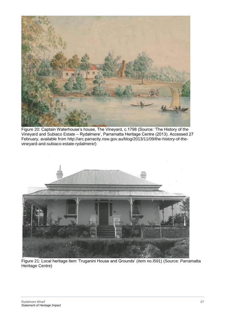
Rydalmere Wharf 27 Statement of Heritage Impact
Figure 20: Captain Waterhouse’s house, The Vineyard, c.1798 (Source: ‘The History of the Vineyard and Subiaco Estate – Rydalmere’, Parramatta Heritage Centre (2013). Accessed 27 February, available from http://arc.parracity.nsw.gov.au/blog/2013/11/09/the-history-of-the-vineyard-and-subiaco-estate-rydalmere/)
Figure 21: Local heritage item ‘Truganini House and Grounds’ (item no.I591) (Source: Parramatta Heritage Centre)
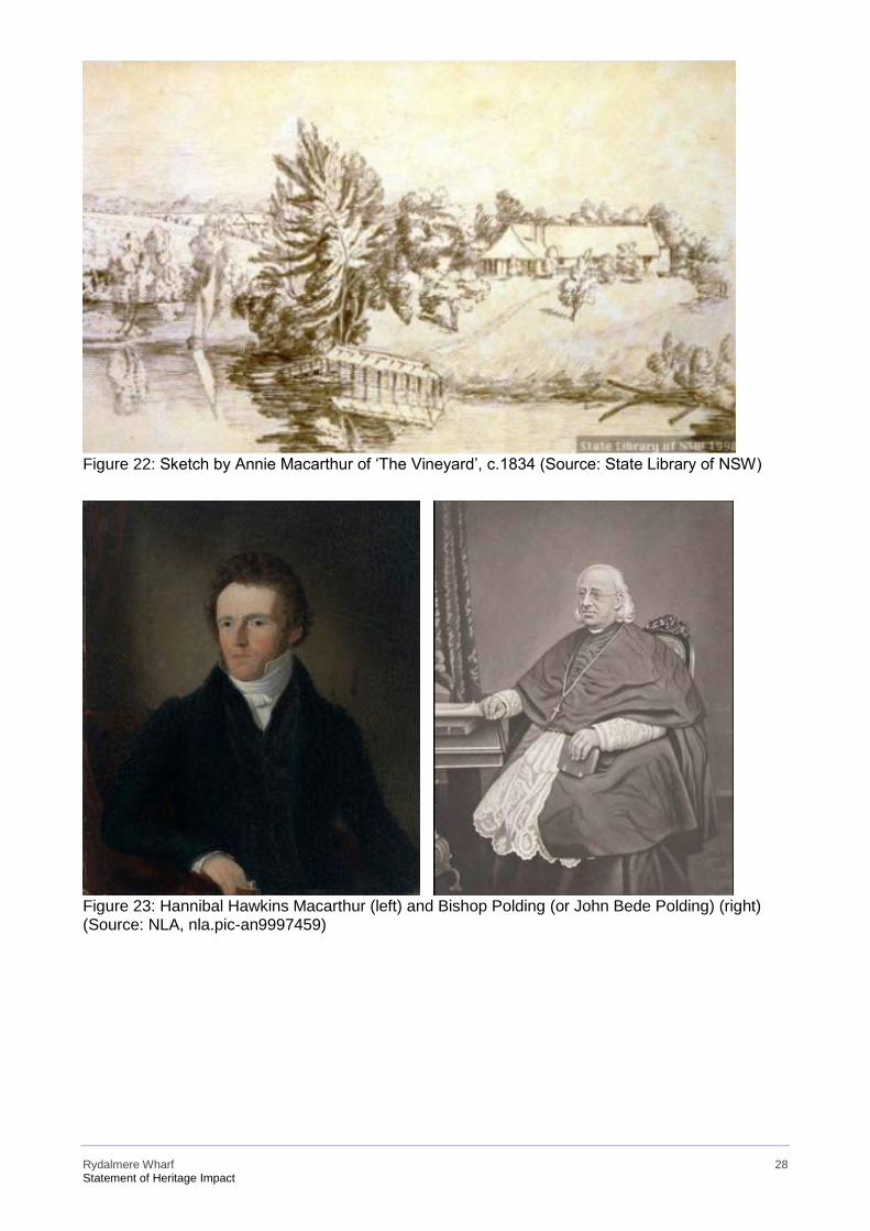
Rydalmere Wharf 28 Statement of Heritage Impact
Figure 22: Sketch by Annie Macarthur of ‘The Vineyard’, c.1834 (Source: State Library of NSW)
Figure 23: Hannibal Hawkins Macarthur (left) and Bishop Polding (or John Bede Polding) (right) (Source: NLA, nla.pic-an9997459)
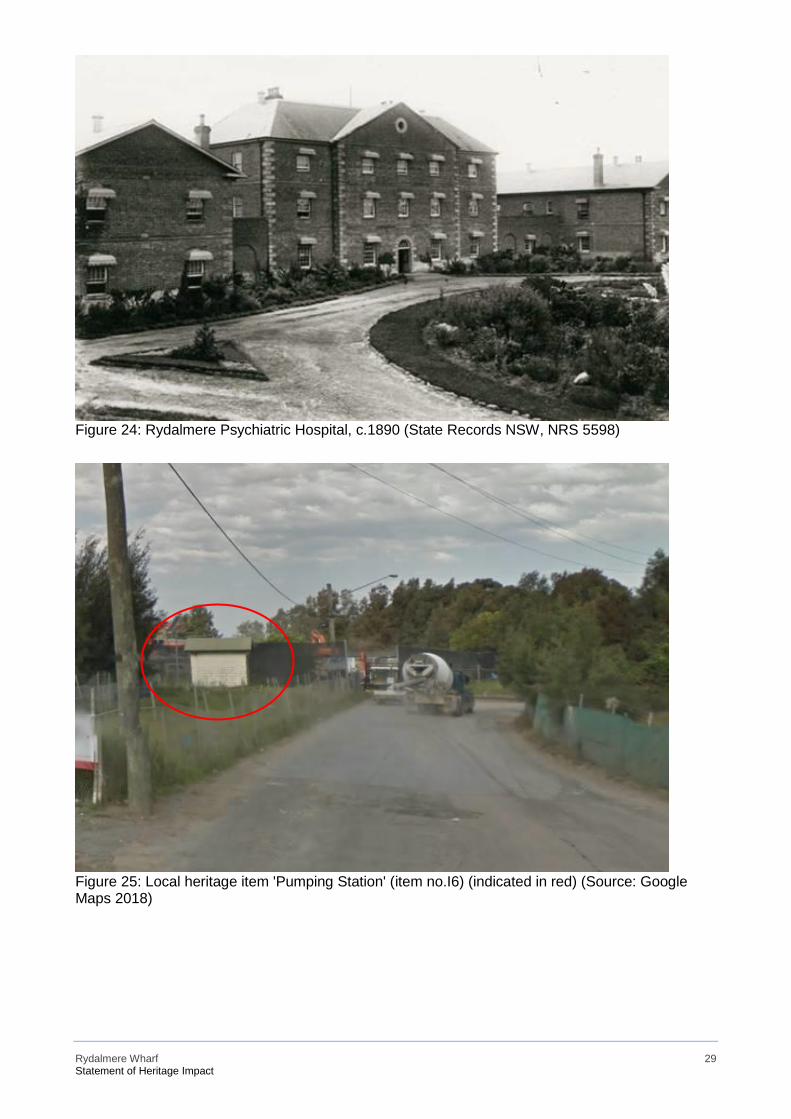
Rydalmere Wharf 29 Statement of Heritage Impact
Figure 24: Rydalmere Psychiatric Hospital, c.1890 (State Records NSW, NRS 5598)
Figure 25: Local heritage item 'Pumping Station' (item no.I6) (indicated in red) (Source: Google Maps 2018)
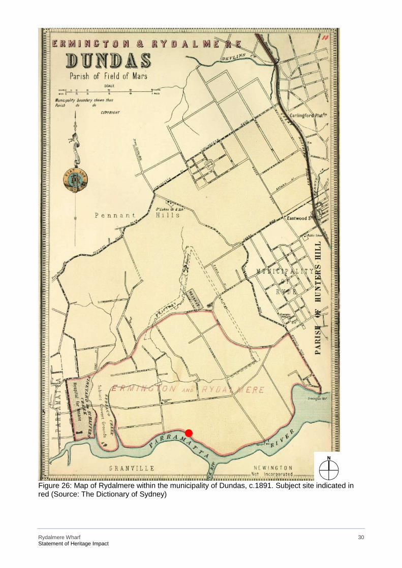
Rydalmere Wharf 30 Statement of Heritage Impact
Figure 26: Map of Rydalmere within the municipality of Dundas, c.1891. Subject site indicated in red (Source: The Dictionary of Sydney)
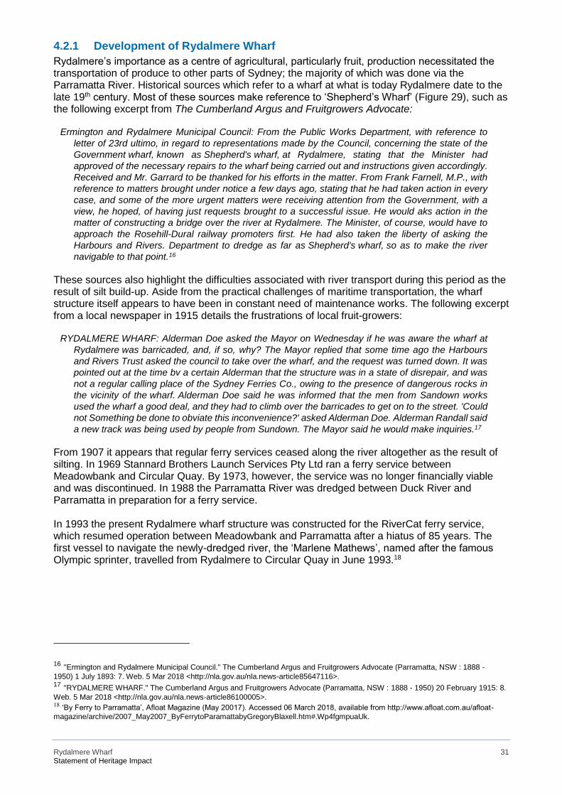
Rydalmere Wharf 31 Statement of Heritage Impact
4.2.1 Development of Rydalmere Wharf Rydalmere’s importance as a centre of agricultural, particularly fruit, production necessitated the transportation of produce to other parts of Sydney; the majority of which was done via the Parramatta River. Historical sources which refer to a wharf at what is today Rydalmere date to the late 19th century. Most of these sources make reference to ‘Shepherd’s Wharf’ (Figure 29), such as the following excerpt from The Cumberland Argus and Fruitgrowers Advocate:
Ermington and Rydalmere Municipal Council: From the Public Works Department, with reference to
letter of 23rd ultimo, in regard to representations made by the Council, concerning the state of the
Government wharf, known as Shepherd's wharf, at Rydalmere, stating that the Minister had
approved of the necessary repairs to the wharf being carried out and instructions given accordingly.
Received and Mr. Garrard to be thanked for his efforts in the matter. From Frank Farnell, M.P., with
reference to matters brought under notice a few days ago, stating that he had taken action in every
case, and some of the more urgent matters were receiving attention from the Government, with a
view, he hoped, of having just requests brought to a successful issue. He would aks action in the
matter of constructing a bridge over the river at Rydalmere. The Minister, of course, would have to
approach the Rosehill-Dural railway promoters first. He had also taken the liberty of asking the
Harbours and Rivers. Department to dredge as far as Shepherd's wharf, so as to make the river
navigable to that point.16
These sources also highlight the difficulties associated with river transport during this period as the result of silt build-up. Aside from the practical challenges of maritime transportation, the wharf structure itself appears to have been in constant need of maintenance works. The following excerpt from a local newspaper in 1915 details the frustrations of local fruit-growers:
RYDALMERE WHARF: Alderman Doe asked the Mayor on Wednesday if he was aware the wharf at
Rydalmere was barricaded, and, if so, why? The Mayor replied that some time ago the Harbours
and Rivers Trust asked the council to take over the wharf, and the request was turned down. It was
pointed out at the time bv a certain Alderman that the structure was in a state of disrepair, and was
not a regular calling place of the Sydney Ferries Co., owing to the presence of dangerous rocks in
the vicinity of the wharf. Alderman Doe said he was informed that the men from Sandown works
used the wharf a good deal, and they had to climb over the barricades to get on to the street. 'Could
not Something be done to obviate this inconvenience?' asked Alderman Doe. Alderman Randall said
a new track was being used by people from Sundown. The Mayor said he would make inquiries.17
From 1907 it appears that regular ferry services ceased along the river altogether as the result of silting. In 1969 Stannard Brothers Launch Services Pty Ltd ran a ferry service between Meadowbank and Circular Quay. By 1973, however, the service was no longer financially viable and was discontinued. In 1988 the Parramatta River was dredged between Duck River and Parramatta in preparation for a ferry service. In 1993 the present Rydalmere wharf structure was constructed for the RiverCat ferry service, which resumed operation between Meadowbank and Parramatta after a hiatus of 85 years. The first vessel to navigate the newly-dredged river, the ‘Marlene Mathews’, named after the famous Olympic sprinter, travelled from Rydalmere to Circular Quay in June 1993.18
16 "Ermington and Rydalmere Municipal Council." The Cumberland Argus and Fruitgrowers Advocate (Parramatta, NSW : 1888 - 1950) 1 July 1893: 7. Web. 5 Mar 2018 <http://nla.gov.au/nla.news-article85647116>. 17 "RYDALMERE WHARF." The Cumberland Argus and Fruitgrowers Advocate (Parramatta, NSW : 1888 - 1950) 20 February 1915: 8. Web. 5 Mar 2018 <http://nla.gov.au/nla.news-article86100005>. 18 ‘By Ferry to Parramatta’, Afloat Magazine (May 20017). Accessed 06 March 2018, available from http://www.afloat.com.au/afloat-magazine/archive/2007_May2007_ByFerrytoParamattabyGregoryBlaxell.htm#.Wp4fgmpuaUk.
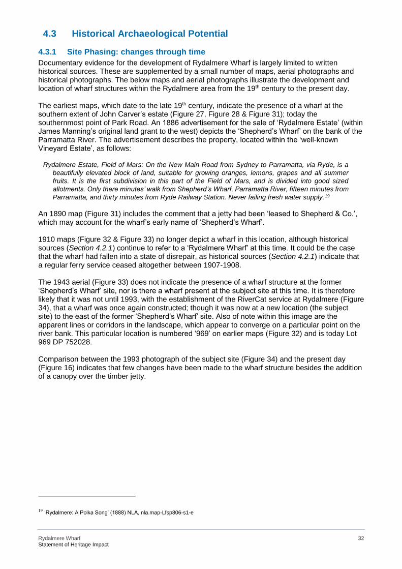
Rydalmere Wharf 32 Statement of Heritage Impact
4.3 Historical Archaeological Potential
4.3.1 Site Phasing: changes through time Documentary evidence for the development of Rydalmere Wharf is largely limited to written historical sources. These are supplemented by a small number of maps, aerial photographs and historical photographs. The below maps and aerial photographs illustrate the development and location of wharf structures within the Rydalmere area from the 19th century to the present day. The earliest maps, which date to the late 19th century, indicate the presence of a wharf at the southern extent of John Carver’s estate (Figure 27, Figure 28 & Figure 31); today the southernmost point of Park Road. An 1886 advertisement for the sale of ‘Rydalmere Estate’ (within James Manning’s original land grant to the west) depicts the ‘Shepherd’s Wharf’ on the bank of the Parramatta River. The advertisement describes the property, located within the ‘well-known Vineyard Estate’, as follows:
Rydalmere Estate, Field of Mars: On the New Main Road from Sydney to Parramatta, via Ryde, is a
beautifully elevated block of land, suitable for growing oranges, lemons, grapes and all summer
fruits. It is the first subdivision in this part of the Field of Mars, and is divided into good sized
allotments. Only there minutes’ walk from Shepherd’s Wharf, Parramatta River, fifteen minutes from
Parramatta, and thirty minutes from Ryde Railway Station. Never failing fresh water supply.19
An 1890 map (Figure 31) includes the comment that a jetty had been ‘leased to Shepherd & Co.’, which may account for the wharf’s early name of ‘Shepherd’s Wharf’. 1910 maps (Figure 32 & Figure 33) no longer depict a wharf in this location, although historical sources (Section 4.2.1) continue to refer to a ‘Rydalmere Wharf’ at this time. It could be the case that the wharf had fallen into a state of disrepair, as historical sources (Section 4.2.1) indicate that a regular ferry service ceased altogether between 1907-1908. The 1943 aerial (Figure 33) does not indicate the presence of a wharf structure at the former ‘Shepherd’s Wharf’ site, nor is there a wharf present at the subject site at this time. It is therefore likely that it was not until 1993, with the establishment of the RiverCat service at Rydalmere (Figure 34), that a wharf was once again constructed; though it was now at a new location (the subject site) to the east of the former ‘Shepherd’s Wharf’ site. Also of note within this image are the apparent lines or corridors in the landscape, which appear to converge on a particular point on the river bank. This particular location is numbered ‘969’ on earlier maps (Figure 32) and is today Lot 969 DP 752028. Comparison between the 1993 photograph of the subject site (Figure 34) and the present day (Figure 16) indicates that few changes have been made to the wharf structure besides the addition of a canopy over the timber jetty.
19 ‘Rydalmere: A Polka Song’ (1888) NLA, nla.map-Lfsp806-s1-e
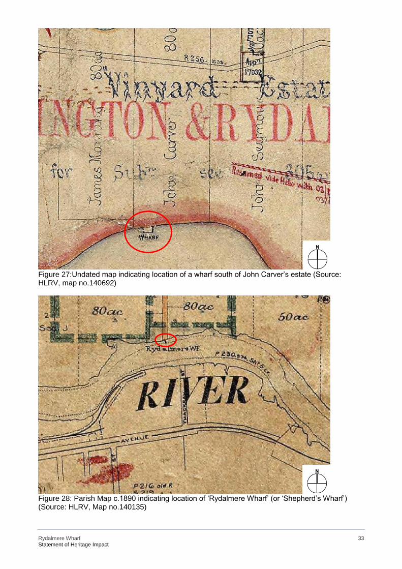
Rydalmere Wharf 33 Statement of Heritage Impact
Figure 27:Undated map indicating location of a wharf south of John Carver’s estate (Source: HLRV, map no.140692)
Figure 28: Parish Map c.1890 indicating location of ‘Rydalmere Wharf’ (or ‘Shepherd’s Wharf’) (Source: HLRV, Map no.140135)
Rydalmere Wharf 34 Statement of Heritage Impact
Figure 29: Depiction of the Shepherd’s Wharf (former Rydalmere Wharf) on the northern bank of the Parramatta River, 1888 (Source: NLA, nla.map-Lfsp806-s1-e)
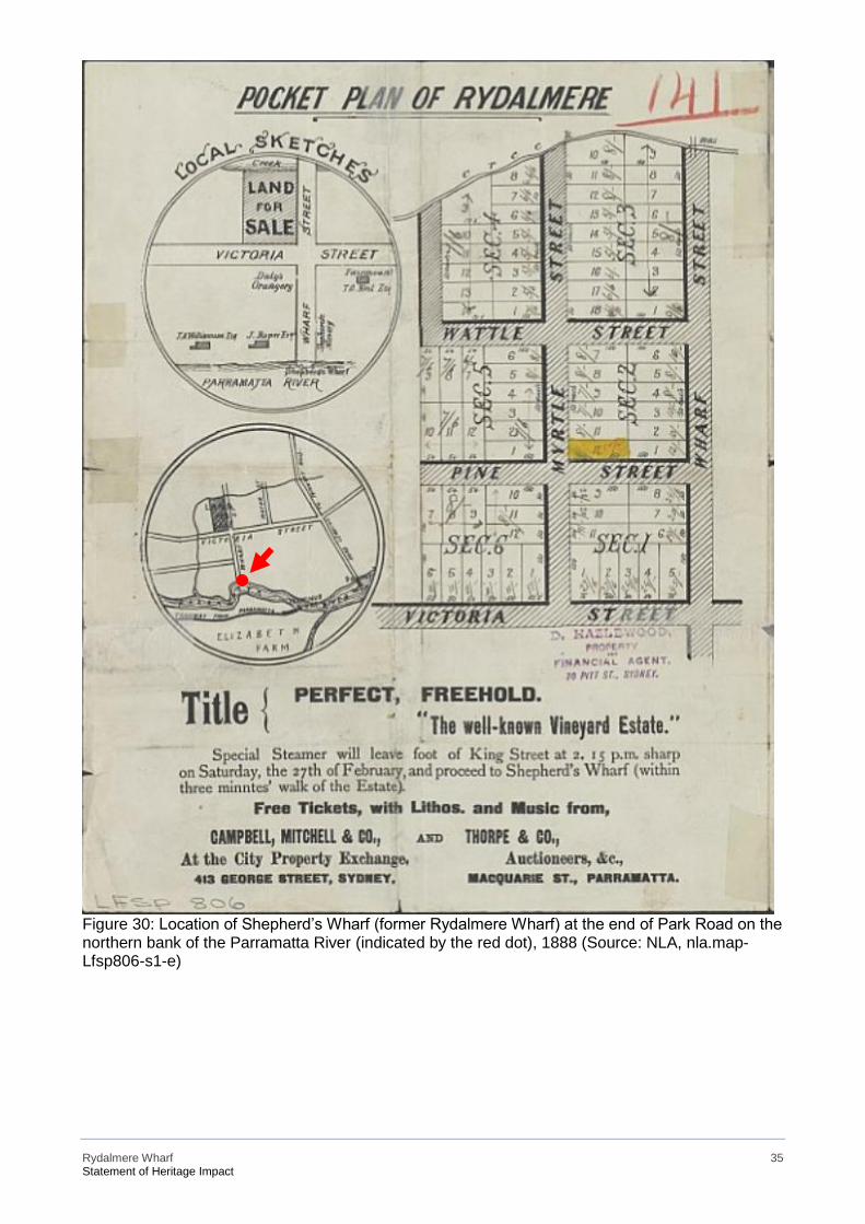
Rydalmere Wharf 35 Statement of Heritage Impact
Figure 30: Location of Shepherd’s Wharf (former Rydalmere Wharf) at the end of Park Road on the northern bank of the Parramatta River (indicated by the red dot), 1888 (Source: NLA, nla.map-Lfsp806-s1-e)
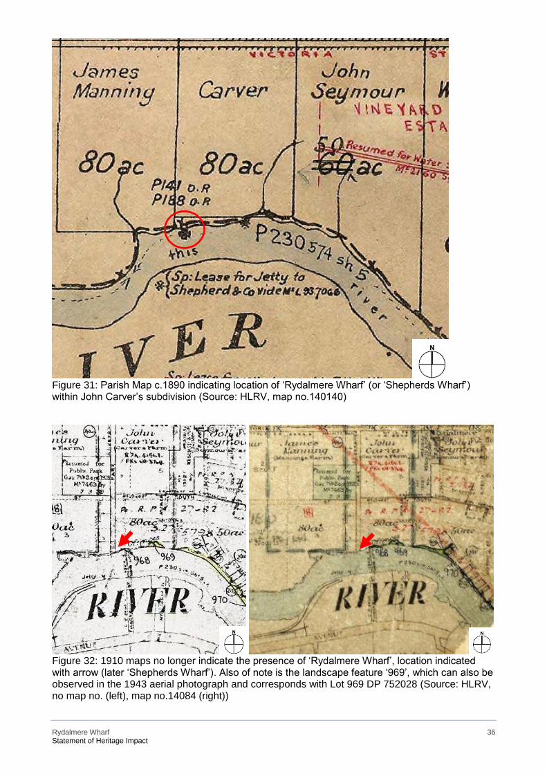
Rydalmere Wharf 36 Statement of Heritage Impact
Figure 31: Parish Map c.1890 indicating location of ‘Rydalmere Wharf’ (or ‘Shepherds Wharf’) within John Carver’s subdivision (Source: HLRV, map no.140140)
Figure 32: 1910 maps no longer indicate the presence of ‘Rydalmere Wharf’, location indicated with arrow (later ‘Shepherds Wharf’). Also of note is the landscape feature ‘969’, which can also be observed in the 1943 aerial photograph and corresponds with Lot 969 DP 752028 (Source: HLRV, no map no. (left), map no.14084 (right))
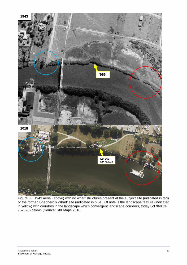
Rydalmere Wharf 37 Statement of Heritage Impact
Figure 33: 1943 aerial (above) with no wharf structures present at the subject site (indicated in red) or the former ‘Shepherd’s Wharf’ site (indicated in blue). Of note is the landscape feature (indicated in yellow) with corridors in the landscape which convergent landscape corridors, today Lot 969 DP 752028 (below) (Source: SIX Maps 2018)
1943
2018
1943
‘969’
Lot 969 DP 752028
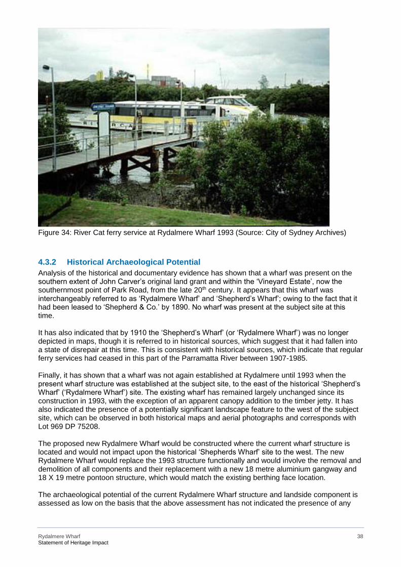
Rydalmere Wharf 38 Statement of Heritage Impact
Figure 34: River Cat ferry service at Rydalmere Wharf 1993 (Source: City of Sydney Archives)
4.3.2 Historical Archaeological Potential Analysis of the historical and documentary evidence has shown that a wharf was present on the southern extent of John Carver’s original land grant and within the ‘Vineyard Estate’, now the southernmost point of Park Road, from the late 20th century. It appears that this wharf was interchangeably referred to as ‘Rydalmere Wharf’ and ‘Shepherd’s Wharf’; owing to the fact that it had been leased to ‘Shepherd & Co.’ by 1890. No wharf was present at the subject site at this time. It has also indicated that by 1910 the ‘Shepherd’s Wharf’ (or ‘Rydalmere Wharf’) was no longer depicted in maps, though it is referred to in historical sources, which suggest that it had fallen into a state of disrepair at this time. This is consistent with historical sources, which indicate that regular ferry services had ceased in this part of the Parramatta River between 1907-1985. Finally, it has shown that a wharf was not again established at Rydalmere until 1993 when the present wharf structure was established at the subject site, to the east of the historical ‘Shepherd’s Wharf’ (‘Rydalmere Wharf’) site. The existing wharf has remained largely unchanged since its construction in 1993, with the exception of an apparent canopy addition to the timber jetty. It has also indicated the presence of a potentially significant landscape feature to the west of the subject site, which can be observed in both historical maps and aerial photographs and corresponds with Lot 969 DP 75208. The proposed new Rydalmere Wharf would be constructed where the current wharf structure is located and would not impact upon the historical ‘Shepherds Wharf’ site to the west. The new Rydalmere Wharf would replace the 1993 structure functionally and would involve the removal and demolition of all components and their replacement with a new 18 metre aluminium gangway and 18 X 19 metre pontoon structure, which would match the existing berthing face location. The archaeological potential of the current Rydalmere Wharf structure and landside component is assessed as low on the basis that the above assessment has not indicated the presence of any
Rydalmere Wharf 39 Statement of Heritage Impact
earlier wharves or structures at the subject site. The present wharf is of modern construction and can yield very little information about historical wharf construction techniques. Likewise, the landside component of the wharf site is a modern installation and does not appear to have been built over any earlier structures. Analysis of historical images, to establish the phased development of the site, have indicated the historical presence of landscape features ‘Shepherd’s Wharf’, to the west of the subject site, and within Lot 969 DP 752028, which may warrant further investigation.
4.4 Heritage Significance
4.4.1 Assessment of Significance Criteria As the existing Rydalmere Wharf is not a heritage-listed item, the following assessment of significance considers the general heritage values of the subject site in accordance with the ‘Assessing Heritage Significance’ guidelines from the NSW Heritage Manual.
a) an item is important in the course, or pattern, of the local area’s cultural or natural history
The existing Rydalmere Wharf structure is important in the course of Rydalmere’s cultural history as it reflects the continued use of this section of the Parramatta River for maritime transportation purposes since the late 19th century. It also reflects changing community needs and requirements to Sydney’s ferry services at the turn of the 20th century and the evolving functions of Parramatta River wharves.
b) an item has strong or special associations with the life or works of a person, or group of
persons, of importance in the local area’s cultural or natural history
The existing Rydalmere wharf structure does not have any significant associations with any persons of note. Historical research (Section Error! Reference source not found.) has indicated that the subject site, once part of ‘The Vineyard’ estate, is associated with a number of historical figures including Hannibal Hawkins Macarthur, Bishop Polding and Captain Henry Waterhouse.
c) an item is important in demonstrating aesthetic characteristics and/or a high degree of creative
or technical achievement in the local area
The current Rydalmere Wharf structure is a typical late 20th century wharf structure and is therefore representative of the technical skill which characterised that period. Its composition, including a timber jetty on timber piles, gangway and pontoon, though not creatively remarkable does contribute toward the maritime aesthetic of the Rydalmere area.
d) an item has strong or special association with a particular community or cultural group in the
local area for social, cultural or spiritual reasons
Although this criterion has not been addressed through community consultation, it is assumed that Rydalmere Wharf, at both its former and present location, has social and cultural associations for those who use the ferry services. The above history (Section 4.2) has demonstrated that Rydalmere, so too its inhabitants and economy, have been defined by their proximity to the Parramatta River. Rydalmere was inhabited by the Wallumedegal clan prior to European settlement and is therefore of significance to the local Aboriginal community.
e) an item has potential to yield information that will contribute to an understanding of the local
area’s cultural or natural history
The above assessment of archaeological potential (Sections Error! Reference source not found. & 4.3) has demonstrated that there are no recorded Aboriginal sites or historical archaeological

Rydalmere Wharf 40 Statement of Heritage Impact
resources within the vicinity of the subject site. Historical records do not indicate the presence of an earlier wharf structure at the subject site.
f) an item possesses uncommon, rare or endangered aspects of the local area’s cultural or
natural history
The present Rydalmere Wharf only possesses rare or endangered aspects of local history and culture insofar that it reflects the establishment of the RiverCat service at Rydalmere in 1993 after an 85 year hiatus.
g) an item is important in demonstrating the principal characteristics of a class of the local area’s
▪ cultural or natural places; or
▪ cultural or natural environments
The present Rydalmere Wharf demonstrates the principal characteristics of a modern wharf that services the Paramatta River. It therefore has the potential to demonstrate the evolution of wharf construction and location and changing community requirements. The existing wharf structure, which abuts an historical sea wall, is one of a number of examples throughout Sydney’s waterways which demonstrate the adaptation of modern maritime infrastructure to accommodate historical land features.
4.4.2 Statement of Significance for the subject site The existing Rydalmere Wharf reflects the continued and evolving use of Rydalmere for maritime transportation since the early 19th century. It has social and cultural associations for those who have used and continue to use the ferry service at Rydalmere and participated in maritime activities within the area. The existing Rydalmere wharf structure demonstrates the principal characteristics of a modern wharf that services the Paramatta River and therefore has the potential to demonstrate the evolution of wharf construction and location in the service of evolving community requirements. The subject site is of associative significance to the Wallumedegal clan, as it lies within their traditional territory on the northern bank of the Parramatta River. The subject site is also associated with the historical ‘The Vineyard’ estate, which was owned and managed by a number of prominent individuals, including Hannibal Hawkins Macarthur, Bishop Polding and Captain Henry Waterhouse. The present Rydalmere Wharf has the potential to yield information about evolving wharf construction techniques and community requirements in relation to Sydney’s maritime transportation services. The construction of the existing wharf structure in relation to the historical sea wall also exemplifies how these services have incorporated elements of Sydney’s maritime heritage.
4.4.3 Statements of Significance for proximal heritage items The following statement of significance is extracted from the SHI form for heritage ‘Pumping Station’ (I5):
Amenities & services - regional or local. This site also makes a notable contribution to the townscape.20
The following statement of significance is extracted from the SHI form for heritage ‘Tram Alignment’ (I6):
20 SHI form, accessed 08 February 2018. Available from http://www.environment.nsw.gov.au/heritageapp/ViewHeritageItemDetails.aspx?ID=2240238.
Rydalmere Wharf 41 Statement of Heritage Impact
The wide street alignment (tram alignment) is demonstrative of the former tramway line, an important
private development associated with the river's use as a corridor and physical evidence remains in
the alignment of Grand Avenue and in the remaining tracks along the eastern end of this road.21
The following statement of significance is extracted from the SHI form for heritage ‘Truganini House’ (I522):
Truganini house, at 38 South Street is of significance for the local area for historical and aesthetic
reasons, and as a representative example of quality houses of the Victorian period in the area. The
house retains a great degree of integrity when viewed from the publicly accessible areas, and makes
an important contribution to the area character.22
The following statement of significance is extracted from the SHI form for heritage ‘Wetlands’ (I1):
The wetlands along Parramatta River are of significance for Parramatta area as remnant representative
areas of mangroves and salt marshes which once extensively lined the foreshores and tidal water
flats of the region.23
21 SHI form, accessed 08 February 2018. Available from http://www.environment.nsw.gov.au/heritageapp/ViewHeritageItemDetails.aspx?ID=2240239. 22 SHI form, accessed 08 February 2018. Available from http://www.environment.nsw.gov.au/heritageapp/ViewHeritageItemDetails.aspx?ID=2240522. 23 SHI form, accessed 08 February 2018. Available from http://www.environment.nsw.gov.au/heritageapp/ViewHeritageItemDetails.aspx?ID=2240429.

Rydalmere Wharf 42 Statement of Heritage Impact
5 Heritage Impact Assessment
5.1 Statutory Controls Under the ISEPP 2007, development related to public ferry wharfs may be carried out without consent. However, if the works are proposed to be carried out to any local heritage item or within an HCA, government bodies must consider the impact of the proposed work. As outlined above, Rydalmere Wharf is within and proximal to numerous heritage listings. Therefore, impact of the proposal upon these items must be assessed, and if the impact is assessed to be more than minor or inconsequential, Roads and Maritime must notify the relevant local council (here, City of Canada Bay Council).
5.2 ‘Statements of Heritage Impact’ (OEH) The document Statements of Heritage Impact24 encourages consideration of the following themes in assessment of heritage impact: The following aspects of the proposal respect or enhance the heritage significance of the item or conservation area for the following reasons. • The potential heritage significance of the current Rydalmere Wharf is not associated with its
fabric or composition, as a relatively modern structure, but with its ongoing use by the community as a means of accessing Rydalmere and its various sites of interest. The proposal would ensure its ongoing viability within this context.
• There are no expected direct or indirect impacts to local heritage items ‘Pumping Station’ I5, ‘Tram Alignment’ (I6), ‘Truganini House and Grounds’ (I591) and ‘Industrial Wharfs’ (#36). While within the vicinity, the works are at a distance and would not change the physical fabric of these heritage items. In addition, the works would not visually impact on these items due to the distance and vegetated landscape which surrounds the present wharf site.
• Historical and documentary sources have not indicated the presence of any earlier wharves or structures within the vicinity of the subject site. The potential for the proposed works to impact on any archaeological resources is therefore assessed as low.
The following aspects of the proposal could detrimentally impact on heritage significance. The reasons are explained as well as measures to be taken to minimise impacts.
• Although the proposed works are directly adjacent to heritage item ‘wetlands’ (I1), these are designated as ‘no-go zones’, as per the Aquatic Ecology Assessment25, and would not be directly impacted.
• A section of sandstone seawall would be removed from the wharf/landside interface. Although it is recognised that this is necessary so as to improve the amenity of the new wharf, it is recommended that the sandstone be incorporated into the new design where possible. It has also been noted that the Aboriginal art installations within the vicinity of the works would not be impacted.
The following sympathetic solutions have been considered and discounted for the following reasons:
24 ‘Statements of Heritage Impact’ OEH. Available from
http://www.environment.nsw.gov.au/resources/heritagebranch/heritage/hmstatementsofhi.pdf. 25 ‘Rydalmere Wharf Upgrade: Aquatic Ecology Assessment’ (2 March 2018) Hansen Yuncken Pty Ltd. p.26
Rydalmere Wharf 43 Statement of Heritage Impact
The proposed works are considered sympathetic to the heritage context of the site and would not impact on heritage fabric. No other sympathetic solutions have been considered and discounted for the proposed works.
5.3 Summary of Impacts The following table summarises the expected impacts to heritage items in the vicinity and known places of Aboriginal heritage significance. CPH makes the following recommendations and actions.
Item #
Name Heritage Listing/ Protection
Heritage significance
Potential or known impact to fabric?
Potential or known impact to curtilage?
Recommendation
Action
1 Wetlands Parramatta LEP 2011 (I1)
Local No No Although the proposed works are directly adjacent to heritage item ‘wetlands’ (I1), these are designated as ‘no-go zones’ and would not be directly impacted. Continue with proposal as is; impacts on the physical fabric not considered significant.
SoHI; no consultation required under ISEPP
2 Pumping Station
Parramatta LEP 2011 (I5)
Local No No Continue with proposal as is; impacts on the physical fabric not considered significant
SoHI; no consultation required under ISEPP
3 Tram Alignment
Parramatta LEP 2011 (I6)
Local No No Continue with proposal as is; impacts on the physical fabric not considered significant
SoHI; no consultation required under ISEPP
4 Truganini House and Grounds
Parramatta LEP 2011 (I591)
Local No No Continue with proposal as is; impacts on the physical fabric not considered significant
SoHI; no consultation required under ISEPP
5 ‘Industrial Wharfs’
SREP (#36)
Local No No Continue with proposal as is; impacts on the physical fabric not considered significant
SoHI; no consultation required under ISEPP
Rydalmere Wharf 44 Statement of Heritage Impact
6 Conclusions and Recommendations
This SoHI has concluded that the proposed works would have:
• no impact upon other heritage items within the vicinity of the works, including ‘Wetlands’ (item no.I1), ‘Pumping Station’ (item no.I5), ‘Tram Alignment’ (item no.I6), ‘Truganini House’ (item no.I591) and ‘Industrial Wharfs’ (item no.#36);
• a small impact on historical archaeological resources in the form of the works to the sandstone sea wall; and
• low potential to impact object or sites of Aboriginal significance. In addition, CPH has made the following conclusions and recommendations:
• Although the current Rydalmere Wharf structure is not heritage listed, its potential heritage value is not associated with its fabric or composition, as a relatively modern structure, but with its function. The proposal would therefore ensure its ongoing viability within this context.
• Although the construction date and means of construction of the existing seawall has not been ascertained, the sandstone therein may have been recycled from an earlier structure and it is therefore recommended that it be salvaged and reused in the new development where possible.
• The desktop archaeological assessment has not located any historical archaeological sites or
Aboriginal sites within the immediate vicinity of the works. It has determined that the works would take place within heavily disturbed land. If work results in unexpected archaeological finds, all work must stop, RMS are to be notified and the ‘unexpected heritage items procedure’ in the Standard Management Procedure: Unexpected Heritage Items by RMS (2015)26 is to be followed.
• It has been concluded that the proposal would have a minor-neutral heritage impact overall.
ISEPP notification, as detailed in Table 2, has been undertaken and no further consultation is required with Parramatta Council prior to proceeding.
• Although it is not required, the following measures would result in an improved heritage outcome overall:
• interpretation, in the form of signage, to indicate the location and context of the existing
wharf structure and historical ‘Shepherd’s Wharf’ to the west of the subject site, as well as the subject site’s historical inclusion within Wallumedegal territory and, later, ‘The Vineyard’ estate; and
• incorporation of the sandstone removed through the lowering of the sea wall into the new design where possible.
CITY PLAN HERITAGE for Roads and Maritime Services April 2018
26 ‘Unexpected Heritage Items Procedure’ (2015). Accessed on 01 September, 2017. Available from http://www.rms.nsw.gov.au/documents/about/environment/protecting-heritage/managing-development/unexpectedheritage- items-procedure.pdf
Rydalmere Wharf 45 Statement of Heritage Impact
Appendix A: State Heritage Inventory Forms

19/03/2018 Charles Street Weir | NSW Environment & Heritage
http://www.environment.nsw.gov.au/heritageapp/ViewHeritageItemDetails.aspx?ID=5063021 1/3
Home Topics Heritage places and items Search for heritage
Charles Street WeirItem details
Name of item: Charles Street Weir
Type of item: Built
Group/Collection:
Utilities - Drainage
Category: Other - Utilities - Drainage
Primary address: Charles Street, Parramatta, NSW 2150
Local govt. area: Parramatta
All addresses
Street Address Suburb/town LGA Parish County Type
Charles Street Parramatta Parramatta Primary Address
Statement of signi�cance:
Charles Street Weir has historical, aesthetic, social and scientific significance. The heritage significance of the Charles Street Weir is enhanced by its place within a recreational reserve. For the local community, it holds an important sense of place.
Date significance updated: 08 May 15
Note: There are incomplete details for a number of items listed in NSW. The Heritage Division intends to develop or upgrade statements of significance and other information for these items as resources become available.
Description
Physical description:
Charles Street Weir forms the first downstream tidal barrier in Parramatta. It was built across the river at Charles Street and Queens Avenue, immediately west of the Parramatta Wharf. This wharf is the last turning point for ferries approaching from Sydney. A narrow foreshore reserve extends westwards from the weir along both sides of the river. This open space with its pathways, lawns, gardens and scattered trees is used for recreational purposes. The Charles Street Weir is a concrete structure measuring 22.1 metres in length by 1.5metres in width. Its height over the weir to the west is 2 metres. Today, the water contained in the dam lies 0.85 metres below the surface of the weir. On the east side, the water lies 1.45 metres below the weir surface, a level difference of 0.6 metres. Given that the eastern side of the weir is used as a turning circle for ferries, the weir wall is likely to extend several metres below the water level to the riverbed. The weir itself is a straight structure located between curved symmetrical concrete embankment walls. Generally the concrete is relatively smooth and shows the imprints of timber formwork used at the time
19/03/2018 Charles Street Weir | NSW Environment & Heritage
http://www.environment.nsw.gov.au/heritageapp/ViewHeritageItemDetails.aspx?ID=5063021 2/3
of construction. Trolley tracks,
now mostly covered with concrete, extending across the top of the Charles Street Weir are regarded as
integral part of the heritage listed item and should be protected. (The Parramatta Weirs, Stedlinger
Associates, 2004).
History
Historical notes: Charles Street Weir marks the junction of the tidal and non-tidal sections of Parramatta River and separates downstream saline water from the upstream fresh water. The Weir was initially located at the end of the river’s deep water, allowing larger vessels to turn back downstream and avoid its shallow, rocky upper end. Although designed in 1941, construction works began in 1950 and the Weir was completed by the 12th of January 1951. In 1921, prior to the Charles Street Weir, a weir with floodgates had been built just east of the present-day Charles Street Weir adjacent to the modern ferry wharf, providing access across the river. The now Charles street Weir superseded the c.1921 weir as part of ‘improvements’ to the Parramatta River by the Department of Public Works. This existing weir is now a reinforced structure, set into the rock of the riverbed.
Listings
Heritage Listing Listing Title ListingNumber
GazetteDate
GazetteNumber
GazettePage
Local Environmental Plan
Charles Street Weir
I63
Study details
Title Year Number Author Inspectedby
Guidelinesused
Parramatta City Comprehensive Heritage Review
2011 Parramatta City Council and Zoran Popovic
Yes
A Heritage Study of Four Weirs along the Parramatta River
2003 Stedinger Associates Yes
References, internet links & imagesNone
Note: internet links may be to web pages, documents or images.
19/03/2018 Charles Street Weir | NSW Environment & Heritage
http://www.environment.nsw.gov.au/heritageapp/ViewHeritageItemDetails.aspx?ID=5063021 3/3
(Click on thumbnail for full size image and image details)
Data source
The information for this entry comes from the following source:
Name: Local Government
Database number:
5063021
Return to previous page
Every effort has been made to ensure that information contained in the State Heritage Inventory is correct. If you find any errors or omissions please sendyour comments to the Database Manager.
All information and pictures on this page are the copyright of the Heritage Division or respective copyright owners.
23/01/2018 Harrisford | NSW Environment & Heritage
http://www.environment.nsw.gov.au/heritageapp/ViewHeritageItemDetails.aspx?id=5051407 1/10
Home Topics Heritage places and items Search for heritage
HarrisfordItem details
Name of item: Harrisford
Type of item: Built
Group/Collection:
Residential buildings (private)
Category: House
Location: Lat: -33.8148138945 Long: 151.0104875960
Primary address: 182 George Street, Parramatta, NSW 2150
Parish: St John
County: Cumberland
Local govt. area: Parramatta
Local Aboriginal Land Council:
Deerubbin
Property description
Lot/Volume Code Lot/Volume Number Section Number Plan/Folio Code Plan/Folio Number
LOT 40 DP 1115363
LOT 41 DP 1115363
All addresses
Street Address Suburb/town LGA Parish County Type
182 George Street Parramatta Parramatta St John Cumberland Primary Address
Owner/s
Organisation Name Owner Category Date Ownership Updated
The Kings School Old Boys Union Community Group
Statement of signi�cance:
Harrisford, which is located between George Street and the river, is one of the oldest houses remaining in the township of Parramatta. It is an important element at the head of
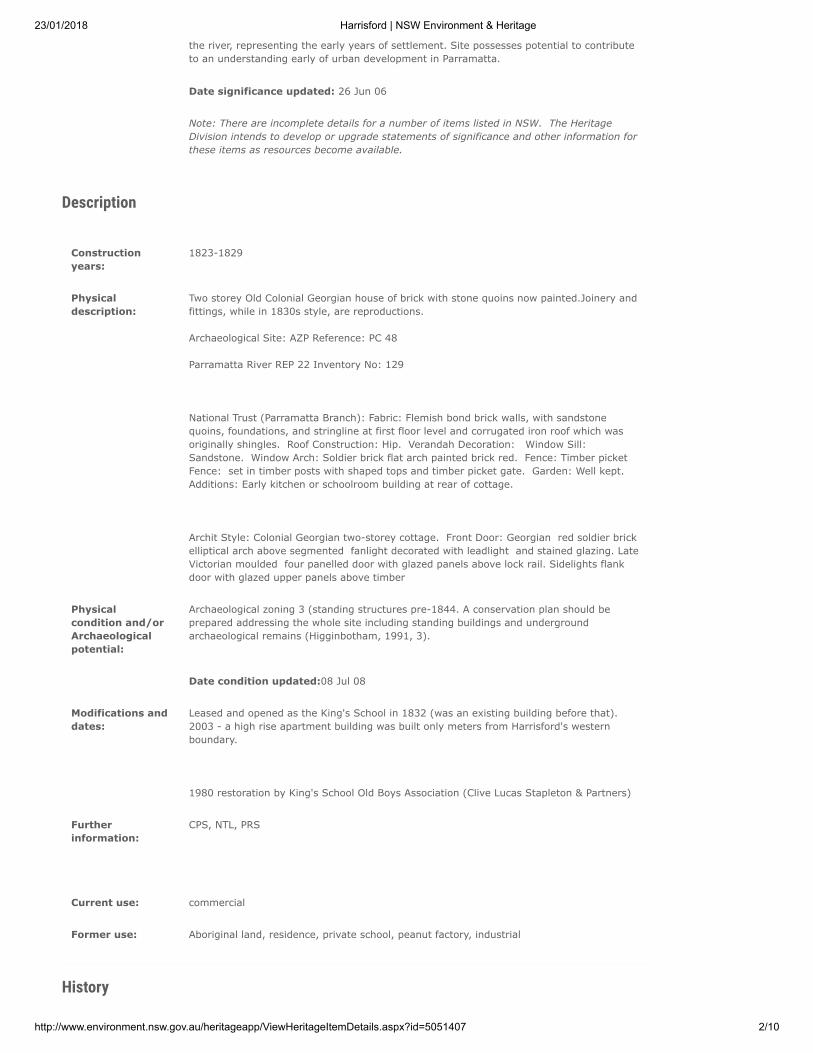
23/01/2018 Harrisford | NSW Environment & Heritage
http://www.environment.nsw.gov.au/heritageapp/ViewHeritageItemDetails.aspx?id=5051407 2/10
the river, representing the early years of settlement. Site possesses potential to contribute to an understanding early of urban development in Parramatta.
Date significance updated: 26 Jun 06
Note: There are incomplete details for a number of items listed in NSW. The Heritage Division intends to develop or upgrade statements of significance and other information for these items as resources become available.
Description
Construction years:
1823-1829
Physical description:
Two storey Old Colonial Georgian house of brick with stone quoins now painted.Joinery and fittings, while in 1830s style, are reproductions.
Archaeological Site: AZP Reference: PC 48
Parramatta River REP 22 Inventory No: 129
National Trust (Parramatta Branch): Fabric: Flemish bond brick walls, with sandstone quoins, foundations, and stringline at first floor level and corrugated iron roof which was originally shingles. Roof Construction: Hip. Verandah Decoration: Window Sill: Sandstone. Window Arch: Soldier brick flat arch painted brick red. Fence: Timber picket Fence: set in timber posts with shaped tops and timber picket gate. Garden: Well kept. Additions: Early kitchen or schoolroom building at rear of cottage.
Archit Style: Colonial Georgian two-storey cottage. Front Door: Georgian red soldier brick elliptical arch above segmented fanlight decorated with leadlight and stained glazing. Late Victorian moulded four panelled door with glazed panels above lock rail. Sidelights flank door with glazed upper panels above timber
Physical condition and/or
Archaeological potential:
Archaeological zoning 3 (standing structures pre-1844. A conservation plan should be prepared addressing the whole site including standing buildings and underground archaeological remains (Higginbotham, 1991, 3).
Date condition updated:08 Jul 08
Modifications and dates:
Leased and opened as the King's School in 1832 (was an existing building before that). 2003 - a high rise apartment building was built only meters from Harrisford's western boundary.
1980 restoration by King's School Old Boys Association (Clive Lucas Stapleton & Partners)
Further information:
CPS, NTL, PRS
Current use: commercial
Former use: Aboriginal land, residence, private school, peanut factory, industrial
History
23/01/2018 Harrisford | NSW Environment & Heritage
http://www.environment.nsw.gov.au/heritageapp/ViewHeritageItemDetails.aspx?id=5051407 3/10
Historical notes: Archaeological Site Data Appn. 9495. George St. - item 48.
Pre 1823 lease to Young, 9/6/1809 (LTO. Book 4D, no.41).
Elizabeth Young, 1/1/1810 (LTO Book 3, no.55).
1823 return: William Carter. 1823 Lease: William Carter (LTO Book 25, no.39). Grant: Reverend William Walker; section 23, allotment 68.
The 1823 map has a building on it. The 1844 (Brownrigg) map has the same building on it - masonry (Higginbotham, 1991, 72).
Archaeological Site Data Appn. 9495. George St. Pre 1823 Lease: Young, 9 June 1809 (LTO Book 4D No 41) Elizabeth Young, 1 Jan 1810 (LTO Book 3 No 55) 1823 Return: William Carter, 1823 Lease: William Carter (LTO Book 25, No 39). Grant: Rev. William Walker. Sec 23, Allt 68. Sites of Buildings: 1823 map: building, 1844 map: same building of masonry.
SD 1932: John Wall
SD 1930: Hnry Harris No. at this time was 106
SD 1929: Hnry Harris No. at this time was 106
SD 1925: Percy Harris,
SD 1915: Percy Harris, "Harrisford"
PCC RO 1914: N0.40, Sec 23, lots 68 pt.67. Permanent Trustee of NSW. Tre's will of Sarah Emma White (Estate of Mary Ann Connor).
SD 1912: John Harris, "Harrisford" John Harris bought the house and named it Harrisford.
SD 1910: Miss M.A. Connor
NSW PO 1904: Miss M.A. Connor
SD 1895: Miss M.A. Connor
SD 1889: Miss Ann Evans
PCC RB 1879: N0.172: Eury, Michael owner and occupier.
PCC RB 1872: N0.126: Eury, Michael owner. Griffiths, Mrs (William crossed out in rate book.) occupiers. Brick house, 50 pounds. Wm. Griffith and his wife Susan established a school here named Linden. William died here in 1870 and in 1872, his wife moved the school to larger premises in Macquarie St.
The building in 1870 was painted and had a Georgian fanlight and six panelled door and glazed half sidelights with lattice style decoration. Pickets on fence had round tops with unusual turned spindle gate. | Wm. Eury, Michael Owner.
PCC Assess of Land owners & Occupiers 1865: N0.111: Eury, Michael Owner. Woolls, William brick house ,10 rooms, 65 pounds. 1865. Wm. Griffith and his wife Susan established a school here shortly after called Linden before moving to larger premises in Macquarie St. John Harris bought the house and named it Harrisford. The building in 1870 is painted and has a Georgian fanlight and six panelled door with glass shale sidelights with lattice style decoration. Pickets on fence are round topped with unusual turned spindle gate.
The house Harrisford was built between 1823 and 1829 for the Rev. William Walker when he married Rowland Hassall's daughter.
23/01/2018 Harrisford | NSW Environment & Heritage
http://www.environment.nsw.gov.au/heritageapp/ViewHeritageItemDetails.aspx?id=5051407 4/10
In 1832, Walker leased it to the Kings School who occupied the building until 1836.
The Kings School was one of four early schools in the colony. January 1830 saw the Sydney College's foundation stone laid. The same month the Commissioners of the Church and School Corporation made public their intentions to establish two schools, one at Sydney and the other at Parramatta, to be known as the King's School and to be modelled on the King's School at Canterbury, England, where (Sydney Anglican) Archdeacon Broughton had been a pupil. Whereas the Sydney College offered no religious instruction, the King's School was unashamedly Anglican. The Sydney College commenced in 1835 and the Parramatta King's School opened its doors at the beginning of 1832. In December 1831 the Australian College admitted its first students. Formed under the guidance of the fiery Presbyterian, Rev. John Dunmore Lang, it came to rival the Sydney College, the foremost school in the colony. The fourth institution was called The Normal Institution, established in 1834, an achievement of the Rev. Henry Carmichael, a Presbyterian school-master who disagreed with Lang's educational ideas. The Normal Institution, like the Sydney College, was to provide a secular education. All four schools offered a higher, and classical, education for the sons of the well-to-do families of the colony (Thompson, 1986, 24-25).
William Woolls was engaged, aged 18, by the headmaster of the King's School, the Rev. Robert Forrest, on the recommendation of his Archdeacon, W.G. Broughton. The school commenced on 13 February 1832, and Woolls was to act as class usher and a master of one of the two houses occupied by boarders. Opening with about a dozen boys, the school by the end of that year had a respectable enrolment of 41 boarders and 12 day boys. Two nearby cottages housed the boarders (Thompson, 1986, 25).
After a short time, Woolls was offered a position as classics master by William Timothy Cape, headmaster of the reinaugurated Sydney College, which had opened at a new premises in College Street, Sydney in 1835. Woolls joined its staff in January 1838, remaining there until October 1839 when he resigned, owing to 'some misunderstanding with the committee' over the 'inadequate amount of his salary'. It was when Woolls opened and conducted his own institution that he really made a name for himself in colonial educational circles. He apparently returned to Parramatta in 1841 and opened his own private academy in 'Harrisford', which the Kings School had vacated some five years earlier (Gilbert, 1985, 31-32). 'Mr Woolls Academy' at Harrisford between 1841 and 1865 was remarkably successful (ibid, 32).
It was here he recorded particulars for the colony's 1841 census that beneath his roof resided 31 persons. This would have included his family, his staff and his boarding pupils. It was also at this address that he was to earn a rare commendation from the colony's governor,. In his annual report for the year ended 30 September 1842, Sir George Gipps that '...of the private schools many serve to be mentioned with commendation, particularly that of the Rev'd. Mr Forrest at Campbelltown, that of Mr Cape in Sydney, and of Mr Woolls in Parramatta.' (Thomson, 1986, 45-46). Gipps especially commended only three of the colony's many private schools (Gilbert, 1985, 32).
A brief description of the activities of a school boy at Woolls' school is the reminiscences of one pupil, Walter Campbell. For two years in the mid-1850s, he was a boarder at Harrisford. In his mature years he was to become involved in agriculture and botany. He would become the NSW Director of Agriculture. Campbell wrote his reminiscences in 1932, painting an idyllic picture of his days at Harrisford. He says of Woolls: 'He was remarkably kind and sympathetic in imparting instruction, ..... The boys, who were nearly all boarders, had their quarters in Harrisford, with a detached one-roomed building between it and the river serving as the school room. This was much the same arrangement that had existed twenty years earlier when Harrisford was used by The Kings School. The Parramatta River, not unexpectedly, provided the pleasures of fishing and swimming, but in 1841 a master had drowned who had gone to the rescue of a boy in difficulties. For the 25 or so pupils, there were rambles and picnics in General Macarthur's Bush, and walks to Baulkham Hills and Beyond. Campbell also provides a glimpse of Woolls' domestic life ,his daughters and Mrs Woolls playing he piano, and Woolls himself playing 'a large old-fashioned amber coloured flute with six finger holes and one key'. The household exhibited some degree of
23/01/2018 Harrisford | NSW Environment & Heritage
http://www.environment.nsw.gov.au/heritageapp/ViewHeritageItemDetails.aspx?id=5051407 5/10
prosperity for there were two housemaids, a cook and a handyman. At one time the cook had been an Aboriginal woman. There was an assistant master to instruct in arithmetic, writing and spelling, leaving Woolls to attend to Latin and other subjects. Some of the pupils from The King's School enrolled at Woolls' school, including George Fairfowl Macarthur. In the early 1840s Woolls also had as pupils Henry and Robert Radford, step-sons of wealthy Sydney wool-merchant A.B. Spark. Spark lived in affluence in his mansion, 'Tempe' on the banks of the Cooks River, about 16km from Sydney (ibid, 1986, 62-63).
In all probability it was in 1840 that William Woolls commenced his own school, after he resigned from the staff of the Sydney College in August or September 1839. In 1840 he was able to lease the building in George Street, Parramatta which had been used as The King's School, an dwhich later became known as 'Harrisford'. It was here he recorded particulars for the colony's 1841 census that beneath his roof resided 31 persons. This would have included his family, his staff and his boarding pupils. It was also at this address that he was to earn a rare commendation from the colony's governor,. In his annual report for the year ended 30 Septmeber 1842, Sir George Gipps that '...of the private schools many serve to be mentioned with commendation, particularly that of the Rev'd Mr Forrest at Campbelltown, that of Mr Cape in Sydney, and of Mr Woolls in Parramatta.' (Thomson, 1986, 45-46).
One of the most popular schools in Parramatta was 'Mr Woolls' Academy': Gilbert, 32) at Harrisford.
A brief description of the activities of a school boy at Woolls' school is the reminiscences of one pupil, Walter Campbell. For two years in the mid-1850s, he was a boarder at Harrisford. In his mature years he was to become involved in agriculture and botany. He would become the NSW Director of Agriculture. Campbell wrote his reminiscences in 1932, painting an idyllic picture of his days at Harrisford. He says of Woolls: 'He was remarkably kind and sympathetic in imparting instruction, ..... The boys, who were nearly all boarders, had their quarters in Harrisford, with a detached one-roomed building between it and the river serving as the school room. This was much the same arrangement that had existed twenty years earlier when Harrisford was used by The Kings School. The Parramatta River, not unexpectedly, provided the pleasures of fishing and swimming, but in 1841 a master had drowned who had gone to the rescue of a boy in difficulties. For the 25 or so pupils, there were rambles and picnics in General Macarthur's Bush, and walks to Baulkham Hills and Beyond. Campbell also provides a glimpse of Woolls' domestic life ,his daughters and Mrs Woolls playing he piano, and Woolls himself playing 'a large old-fashioned amber coloured flute with six finger holes and one key'. The household exhibited some degree of prosperity for there were two housemaids, a cook and a handyman. At one time the cook had been an Aboriginal woman. There was an assistant master to instruct in arithmetic, writing and spelling, leaving Woolls to attend to Latin and other subjects. Some of the pupils from The King's School enrolled at Woolls' school, including George Fairfowl Macarthur. In the early 1840s Woolls also had as pupils Henry and Robert Radford, step-sons of wealthy Sydney wool-merchant A.B. Spark. Spark lived in affluence in his mansion, 'Tempe' on the banks of the Cooks River, about 16km from Sydney (ibid, 1986, 62-63).
Woolls moved to the larger premises of Newlands in 1864 (Gilbert says 'in or about 1865'. Never large, catering for about 30 boys at a time it seems to have been a happy, enlightened and enlightening institution which the boys remembered with gratitude and affection (ibid, 32). Gilbert adds that Woolls remained at Newlands for the last seven years or so of his teaching career (ibid, 36). The school was for local boys as wells as boarders. During Woolls' stay at Newlands, he continued his extensive botanical studies including botany in the school curriculum, taking the boys regularly on field trips around the hills of Parramatta collecting samples of unknown specimens. Woolls was an important early schoolmaster and botanist. He lectured frequently on the botanical landscape and was recognised by the greatest of the British and European botanists and on whose recommendation Woolls was admitted in 1865, as a Fellow of the Linnean Society in London, one of the most respected scientific organisations in Britain. In August 1872 Woolls retired from teaching and was admitted to the Holy Order in 1873, becoming the Rev. William Woolls (ibid).
From 1836 to 1854, it was used by several other schools. In 1840 William Woolls leased the house for a school, operating it here until 1865. Walker sold the property in 1854.
23/01/2018 Harrisford | NSW Environment & Heritage
http://www.environment.nsw.gov.au/heritageapp/ViewHeritageItemDetails.aspx?id=5051407 6/10
During the 1860s William Woolls' Academy is little recorded. A small fragment of school life is preserved in the records of a cricket match in which Woolls' school participated. It was played on 15/11/1862 between teams from The King's School and one provided by Woolls' pupils and was won by the latter by 13 runs. Shortly after the match the King's School was to close for about six years, resuming in 1869 with the Rev. George Fairfowl Macarthur as its headmasters. Woolls' school continued to survive. Sometime in 1865 he moved his school to a large house called 'Newlands' built on property which had once belonged to the Rev. Samuel Marsden on the northern bank of the Parramatta River (Thomson, 1986, 87).
Later residents included John Harris, nephew of Surgeon Dr John Harris of Harris Park.
A 1932 photograph shows Harrisford with Victorian cast iron balustrading and valances on ground and first-floor verandahs (Gilbert, 1985, 27, based on a photograph c/o Mr Peter Yeend, The Kings School).
The building was later used a peanut butter factory, stationery shop and car workshop.
A November 1979 photograph shows Harrisford bereft of its Victorian verandahs, with signs advertising office supplies (Gilbert, 1985, 27).
Harrisford was restored by King's School Old Boys Union in 1980 to its 1830s configuration, using Clive Lucas, Stapleton & Partners heritage architects.
A 1982 photograph shows the completed Harrisford with Georgian windows, paint removed from its bricks, quoins picked out, on its reopening day, Saturday 3rd February, 1982 (Gilbert, 1985, 27).
Historic themes
Australiantheme(abbrev)
New South Wales theme Local theme
4. Settlement-Building settlements, towns and cities
Accommodation-Activities associated with the provision of accommodation, and particular types of accommodation – does not include architectural styles – use the theme of Creative Endeavour for such activities.
Housing townsfolk - terraces and cottages-
4. Settlement-Building settlements, towns and cities
Accommodation-Activities associated with the provision of accommodation, and particular types of accommodation – does not include architectural styles – use the theme of Creative Endeavour for such activities.
Adapted heritage building or structure-
4. Settlement-Building settlements,
Towns, suburbs and villages-Activities associated with creating, planning and managing urban functions, landscapes and lifestyles in towns, suburbs and villages
Planned towns serving a specific industry-
23/01/2018 Harrisford | NSW Environment & Heritage
http://www.environment.nsw.gov.au/heritageapp/ViewHeritageItemDetails.aspx?id=5051407 7/10
towns and cities
4. Settlement-Building settlements, towns and cities
Towns, suburbs and villages-Activities associated with creating, planning and managing urban functions, landscapes and lifestyles in towns, suburbs and villages
Indicators of early town planning and the disposition of people within the emerging settlement-
4. Settlement-Building settlements, towns and cities
Towns, suburbs and villages-Activities associated with creating, planning and managing urban functions, landscapes and lifestyles in towns, suburbs and villages
Developing towns in response to topography-
6. Educating-Educating
Education-Activities associated with teaching and learning by children and adults, formally and informally.
Private (independent) schooling-
9. Phases of Life-Marking the phases of life
Persons-Activities of, and associations with, identifiable individuals, families and communal groups
Associations with Rev. William Woolls, teacher, botanist and priest-
9. Phases of Life-Marking the phases of life
Persons-Activities of, and associations with, identifiable individuals, families and communal groups
Associations with Rev. William Walker, priest-
9. Phases of Life-Marking the phases of life
Persons-Activities of, and associations with, identifiable individuals, families and communal groups
Associations with John Harris, nephew of Dr John Harris, surgeon-
9. Phases of Life-Marking the phases of life
Persons-Activities of, and associations with, identifiable individuals, families and communal groups
Associations with Michael Eury, owner-
Assessment of signi�cance
SHR Criteria a) [Historical
significance]
This item historically significant.
SHR Criteria d) [Social significance]
This item is socially significant.
SHR Criteria g) [Representativeness]
This item is representative.
23/01/2018 Harrisford | NSW Environment & Heritage
http://www.environment.nsw.gov.au/heritageapp/ViewHeritageItemDetails.aspx?id=5051407 8/10
Assessment criteria:
Items are assessed against the State Heritage Register (SHR) Criteria to determine the level of significance. Refer to the Listings below for the level of statutory protection.
Recommended management:
Conservation works undertaken by Clive Lucas in 1980s for Kings School Old Boys Union
Procedures /Exemptions
Sectionof act
Description Title Comments Actiondate
57(2) Exemption to allow work
Standard Exemptions
SCHEDULE OF STANDARD EXEMPTIONS
HERITAGE ACT 1977
Notice of Order Under Section 57 (2) of the Heritage Act 1977
I, the Minister for Planning, pursuant to subsection 57(2) of the Heritage Act 1977, on the recommendation of the Heritage Council of New South Wales, do by this Order:
1. revoke the Schedule of Exemptions to subsection 57(1) of the Heritage Act made under subsection 57(2) and published in the Government Gazette on 22 February 2008; and
2. grant standard exemptions from subsection 57(1) of the Heritage Act 1977, described in the Schedule attached.
FRANK SARTOR
Minister for Planning
Sydney, 11 July 2008
To view the schedule click on the Standard Exemptions for Works Requiring Heritage Council Approval link below.
Sep 5 2008
Standard exemptions for works requiring Heritage Council approval
Listings
Heritage Listing ListingTitle
ListingNumber
GazetteDate
GazetteNumber
GazettePage
Heritage Act - State Heritage Register 00248 02 Apr 99 27 1546
Heritage Act - Permanent Conservation Order - former
00248 06 May 83
68 2048
23/01/2018 Harrisford | NSW Environment & Heritage
http://www.environment.nsw.gov.au/heritageapp/ViewHeritageItemDetails.aspx?id=5051407 9/10
Regional Environmental Plan 05 Jun 90
Local Environmental Plan 21 Jul 89 84 4633
Local Environmental Plan 27 Feb 97 20
National Trust of Australia register 7868
Study details
Title Year Number Author Inspectedby
Guidelines used
City of Parramatta Heritage Study
1993 218 Meredith Walker
Yes
References, internet links & images
Type Author Year Title InternetLinks
Written
Gilbert, Lionel 1985 William Woolls, 1814-1893: 'a most useful colonist'
Written
Higginbotham, Edward
1991 The Future of Parramatta's Past - an archaeological zoning plan 1788-1844
Written
Thomson, M.H.H. 1986 William Woolls – a man of Parramatta
Note: internet links may be to web pages, documents or images.
(Click on thumbnail for full size image and image details)
Data source
The information for this entry comes from the following source:
23/01/2018 Harrisford | NSW Environment & Heritage
http://www.environment.nsw.gov.au/heritageapp/ViewHeritageItemDetails.aspx?id=5051407 10/10
Name: Heritage Office
Database number:
5051407
File number: S90/06019 & HC 32277
Return to previous page
Every effort has been made to ensure that information contained in the State Heritage Inventory is correct. If you find any errors or omissions please sendyour comments to the Database Manager.
All information and pictures on this page are the copyright of the Heritage Division or respective copyright owners.
23/01/2018 Newlands Gates, Trees and Archaeological Site | NSW Environment & Heritage
http://www.environment.nsw.gov.au/heritageapp/ViewHeritageItemDetails.aspx?ID=2240354 1/3
Home Topics Heritage places and items Search for heritage
Newlands Gates, Trees and Archaeological SiteItem details
Name of item: Newlands Gates, Trees and Archaeological Site
Other name/s: Macarthur Girls High
Type of item: Built
Group/Collection:
Education
Category: School - Private
Primary address: 1 Macarthur Street, Parramatta, NSW 2150
Local govt. area: Parramatta
Property description
Lot/Volume Code Lot/Volume Number Section Number Plan/Folio Code Plan/Folio Number
LOT 1 DP 797543
All addresses
Street Address Suburb/town LGA Parish County Type
1 Macarthur Street Parramatta Parramatta Primary Address
9 Thomas Street Parramatta Parramatta Alternate Address
Statement of signi�cance:
Newlands House site and Gates are of significance for the local area for historical and aesthetic reasons and as a representative example of a Colonial Georgian gate, a rare example of this age and quality in the local area. The remnant fabric continues to make a major contribution to the Parramatta townscape. The site possesses potential to further contribute to an understanding of early urban development in Parramatta.
Date significance updated: 05 Mar 02
Note: There are incomplete details for a number of items listed in NSW. The Heritage Division intends to develop or upgrade statements of significance and other information for these items as resources become available.
Description
23/01/2018 Newlands Gates, Trees and Archaeological Site | NSW Environment & Heritage
http://www.environment.nsw.gov.au/heritageapp/ViewHeritageItemDetails.aspx?ID=2240354 2/3
Physical description:
The significant elemetns on the site include archaeological site, plantings and the remanant gates. Large sandstone gateposts and a row of Bunya pines along Macarthur Street are remnants of the occupation prior to the school. The site is bounded by Thomas Street, Parramatta River, Stewart Street and Macarthur Street. The site of Newlands House (demolished in 1932, gates only remain) has archaeological potential. Surviving fence comprises four tall sandstone gateposts topped with segmented pediments on steps. Below are incised stem and leaf pattern in pedestals with picked background. Cast iron Fleur-de-lis palisade pedestrian and driveway gates.
Further information:
J. Jervis, Cradle City, 32, 91.
History
Historical notes: The gateway is associated with the residence of Henry Harvey, a prominent landowner in the Parramatta district. The original house was known as "Newlands" and was built c.1835 for the Marsden Family. Macarthur Girls High School was built on the site in the early 1930s. National Trust (Parramatta Branch): The gateway is associated with the residence of tHenry Harvey, a prominent landowner in the Parramatta ditrict. The original house was known as "Newlands" and built for the Marsden family in 1835. Macarthur Girls High School was built on the site in 1932. | |
Assessment of signi�cance
SHR Criteria a) [Historical
significance]
This item historically significant.
SHR Criteria c) [Aesthetic
significance]
This item is aesthetically significant
SHR Criteria e) [Research potential]
This item is technically or scientifically significant.
SHR Criteria f) [Rarity]
This item is rare.
Assessment criteria:
Items are assessed against the State Heritage Register (SHR) Criteria to determine the level of significance. Refer to the Listings below for the level of statutory protection.
Listings
Heritage Listing ListingTitle
ListingNumber
GazetteDate
GazetteNumber
GazettePage
Local Environmental Plan
354 21 Feb 97 20 873
Study details
Title Year Number Author Inspectedby
Guidelinesused
City of Parramatta Heritage 1993 354 Meredith Walker
23/01/2018 Newlands Gates, Trees and Archaeological Site | NSW Environment & Heritage
http://www.environment.nsw.gov.au/heritageapp/ViewHeritageItemDetails.aspx?ID=2240354 3/3
Study
Yes
Parramatta Heritage Review 2004 National Trust (Parramatta Branch)
No
References, internet links & imagesNone
Note: internet links may be to web pages, documents or images.
Data source
The information for this entry comes from the following source:
Name: Local Government
Database number:
2240354
Return to previous page
Every effort has been made to ensure that information contained in the State Heritage Inventory is correct. If you find any errors or omissions please sendyour comments to the Database Manager.
All information and pictures on this page are the copyright of the Heritage Division or respective copyright owners.
23/01/2018 Wetlands | NSW Environment & Heritage
http://www.environment.nsw.gov.au/heritageapp/ViewHeritageItemDetails.aspx?ID=2240429 1/3
Home Topics Heritage places and items Search for heritage
WetlandsItem details
Name of item: Wetlands
Type of item: Landscape
Group/Collection:
Landscape - Natural
Category: Wetland or river
Primary address: Parramatta River, Camelia, Clyde, Rydalmere, Ermington, NSW
Local govt. area: Parramatta
All addresses
StreetAddress
Suburb/town LGA Parish County Type
Parramatta River
Camelia, Clyde, Rydalmere, Ermington
Parramatta
Primary Address
System Camelia, Clyde, Rydalmere, Ermington
Parramatta
Alternate Address
Statement of signi�cance:
The wetlands along Parramatta River are of significance for Parramatta area as remnant representative areas of mangroves and salt marshes which once extensively lined the foreshores and tidal water flats of the region.
Note: There are incomplete details for a number of items listed in NSW. The Heritage Division intends to develop or upgrade statements of significance and other information for these items as resources become available.
Description
Physical description:
This item consists of remnant wetland vegetation, characterised by mangrove and saltmarsh complex, located along the foreshores of Parramatta and Duck rivers and their tributaries, Vineyard and Subiaco creeks.
Further information:
Parramatta Regional Enviromental Study. Open Space and Recreation Heritage Study. Department of Enviroment and Planning Sydney. 1986
23/01/2018 Wetlands | NSW Environment & Heritage
http://www.environment.nsw.gov.au/heritageapp/ViewHeritageItemDetails.aspx?ID=2240429 2/3
Assessment of signi�cance
SHR Criteria g) [Representativeness]
This item is representative.
Assessment criteria:
Items are assessed against the State Heritage Register (SHR) Criteria to determine the level of significance. Refer to the Listings below for the level of statutory protection.
Listings
Heritage Listing ListingTitle
ListingNumber
GazetteDate
GazetteNumber
GazettePage
Local Environmental Plan
429 21 Feb 97 20 873
Study details
Title Year Number Author Inspectedby
Guidelinesused
City of Parramatta Heritage Study
1993 429 Meredith Walker
Yes
Parramatta Heritage Review 2004 National Trust (Parramatta Branch)
No
References, internet links & imagesNone
Note: internet links may be to web pages, documents or images.
(Click on thumbnail for full size image and image details)
Data source
The information for this entry comes from the following source:
23/01/2018 Wetlands | NSW Environment & Heritage
http://www.environment.nsw.gov.au/heritageapp/ViewHeritageItemDetails.aspx?ID=2240429 3/3
Name: Local Government
Database number:
2240429
Return to previous page
Every effort has been made to ensure that information contained in the State Heritage Inventory is correct. If you find any errors or omissions please sendyour comments to the Database Manager.
All information and pictures on this page are the copyright of the Heritage Division or respective copyright owners.
Rydalmere Wharf 46 Statement of Heritage Impact
Appendix B: Site Inspection Form
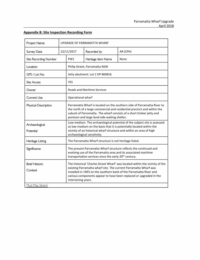
Parramatta Wharf Upgrade April 2018
Appendix B: Site Inspection Recording Form
Project Name: UPGRADE OF PARRAMATTA WHARF
Survey Date 22/11/2017 Recorded by AR (CPH)
Site Recording Number PW1 Heritage Item Name None
Location Philip Street, Parramatta NSW
GPS / Lot No. Jetty abutment: Lot 2 DP 869816
Site Access YES
Owner Roads and Maritime Services
Current Use Operational wharf
Physical Description Parramatta Wharf is located on the southern side of Parramatta River to the north of a large commercial and residential precinct and within the suburb of Parramatta. The wharf consists of a short timber jetty and pontoon and large land-side waiting shelter.
Archaeological
Potential
Low-medium. The archaeological potential of the subject site is assessed as low-medium on the basis that it is potentially located within the vicinity of an historical wharf structure and within an area of high archaeological sensitivity.
Heritage Listing The Parramatta Wharf structure is not heritage listed.
Significance The present Parramatta Wharf structure reflects the continued and evolving use of the Parramatta area and its associated maritime transportation services since the early 20th century.
Brief Historic
Context
The historical ‘Charles Street Wharf’ was located within the vicinity of the existing Parramatta wharf site. The current Parramatta Wharf was installed in 1993 on the southern bank of the Parramatta River and various components appear to have been replaced or upgraded in the intervening years.
Mud Map Sketch
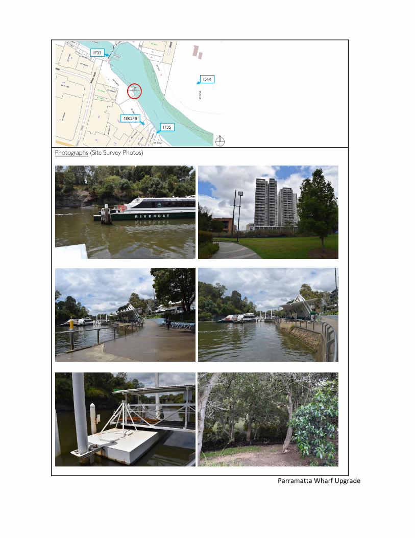
Photographs (Site Survey Photos)
Parramatta Wharf Upgrade

April 2018
Rydalmere Wharf 47 Statement of Heritage Impact
Appendix C: AHIMS Search Results
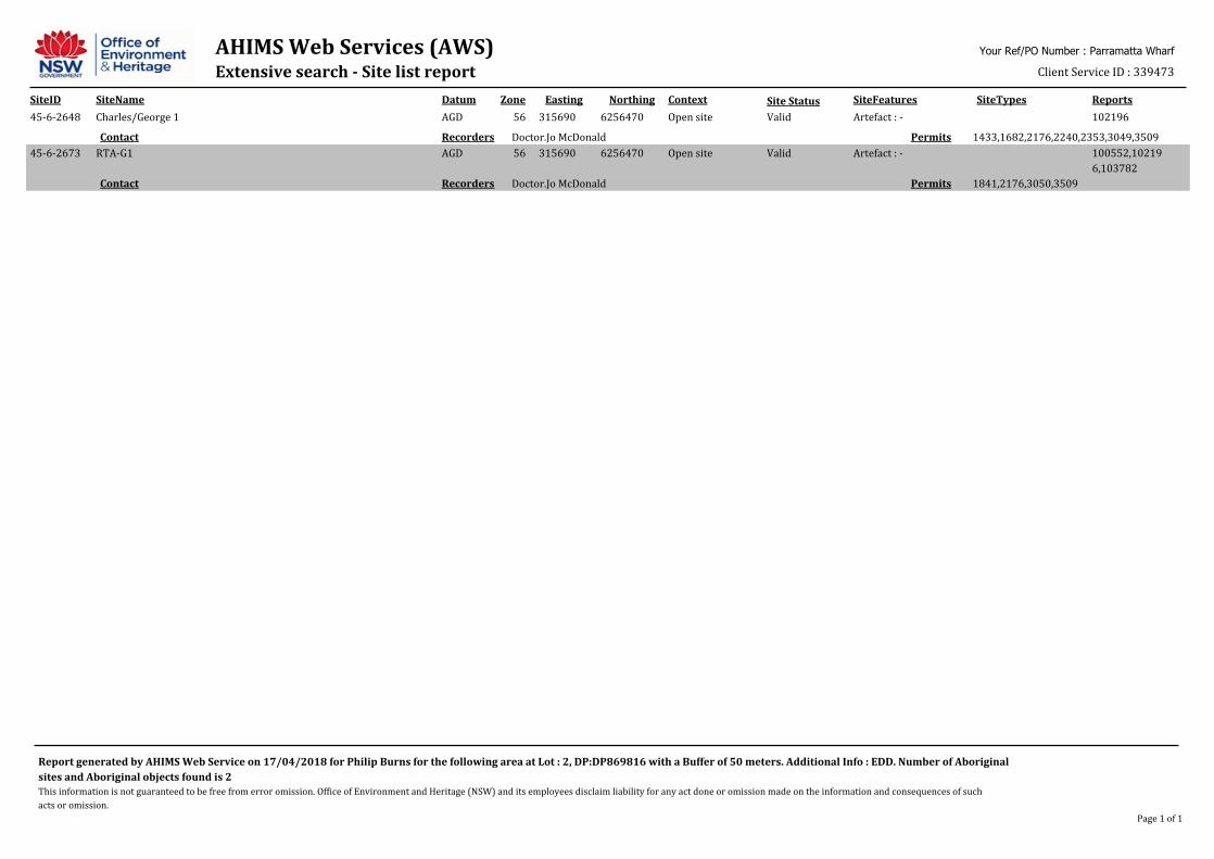
AHIMS Web Services (AWS)Extensive search - Site list report
SiteID SiteName Datum Zone Easting Northing Context SiteFeatures SiteTypes Reports
Your Ref/PO Number : Parramatta Wharf
Client Service ID : 339473
Site Status
45-6-2648 Charles/George 1 AGD 56 315690 6256470 Open site Valid Artefact : - 102196
1433,1682,2176,2240,2353,3049,3509PermitsDoctor.Jo McDonaldRecordersContact
45-6-2673 RTA-G1 AGD 56 315690 6256470 Open site Valid Artefact : - 100552,10219
6,103782
1841,2176,3050,3509PermitsDoctor.Jo McDonaldRecordersContact
Report generated by AHIMS Web Service on 17/04/2018 for Philip Burns for the following area at Lot : 2, DP:DP869816 with a Buffer of 50 meters. Additional Info : EDD. Number of Aboriginal
sites and Aboriginal objects found is 2
This information is not guaranteed to be free from error omission. Office of Environment and Heritage (NSW) and its employees disclaim liability for any act done or omission made on the information and consequences of such
acts or omission.
Page 1 of 1

AHIMS Web Services (AWS)Search Result Purchase Order/Reference : Parramatta wharf 1
Client Service ID : 326902
Date: 08 February 2018Alexandra Ribeny
Coombs Building
ACTON Australian Capital Territory 2601
Dear Sir or Madam:
AHIMS Web Service search for the following area at Lot : 1, DP:DP869816 with a Buffer of 0 meters,
conducted by Alexandra Ribeny on 08 February 2018.
Email: [email protected]
Attention: Alexandra Ribeny
The context area of your search is shown in the map below. Please note that the map does not accurately
display the exact boundaries of the search as defined in the paragraph above. The map is to be used for
general reference purposes only.
A search of the Office of the Environment and Heritage AHIMS Web Services (Aboriginal Heritage Information
Management System) has shown that:
0
0
Aboriginal sites are recorded in or near the above location.
Aboriginal places have been declared in or near the above location. *

If your search shows Aboriginal sites or places what should you do?
Important information about your AHIMS search
You can get further information about Aboriginal places by looking at the gazettal notice that declared it.
Aboriginal places gazetted after 2001 are available on the NSW Government Gazette
(http://www.nsw.gov.au/gazette) website. Gazettal notices published prior to 2001 can be obtained from
Office of Environment and Heritage's Aboriginal Heritage Information Unit upon request
Aboriginal objects are protected under the National Parks and Wildlife Act 1974 even if they are not recorded
as a site on AHIMS.
You must do an extensive search if AHIMS has shown that there are Aboriginal sites or places recorded in the
search area.
If you are checking AHIMS as a part of your due diligence, refer to the next steps of the Due Diligence Code of
practice.
AHIMS records information about Aboriginal sites that have been provided to Office of Environment and
Heritage and Aboriginal places that have been declared by the Minister;
Information recorded on AHIMS may vary in its accuracy and may not be up to date .Location details are
recorded as grid references and it is important to note that there may be errors or omissions in these
recordings,
Some parts of New South Wales have not been investigated in detail and there may be fewer records of
Aboriginal sites in those areas. These areas may contain Aboriginal sites which are not recorded on AHIMS.
This search can form part of your due diligence and remains valid for 12 months.
The information derived from the AHIMS search is only to be used for the purpose for which it was requested.
It is not be made available to the public.
3 Marist Place, Parramatta NSW 2150
Locked Bag 5020 Parramatta NSW 2220
Tel: (02) 9585 6380 Fax: (02) 9873 8599
ABN 30 841 387 271
Email: [email protected]
Web: www.environment.nsw.gov.au
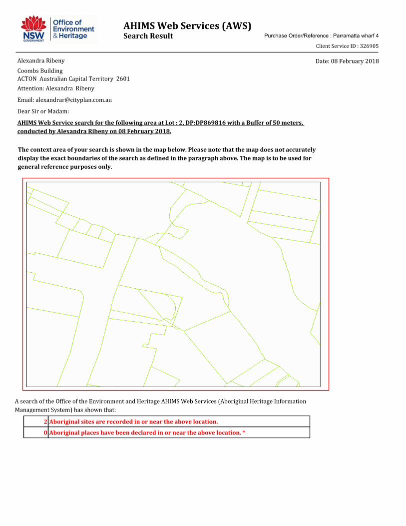
AHIMS Web Services (AWS)Search Result Purchase Order/Reference : Parramatta wharf 4
Client Service ID : 326905
Date: 08 February 2018Alexandra Ribeny
Coombs Building
ACTON Australian Capital Territory 2601
Dear Sir or Madam:
AHIMS Web Service search for the following area at Lot : 2, DP:DP869816 with a Buffer of 50 meters,
conducted by Alexandra Ribeny on 08 February 2018.
Email: [email protected]
Attention: Alexandra Ribeny
The context area of your search is shown in the map below. Please note that the map does not accurately
display the exact boundaries of the search as defined in the paragraph above. The map is to be used for
general reference purposes only.
A search of the Office of the Environment and Heritage AHIMS Web Services (Aboriginal Heritage Information
Management System) has shown that:
2
0
Aboriginal sites are recorded in or near the above location.
Aboriginal places have been declared in or near the above location. *
If your search shows Aboriginal sites or places what should you do?
Important information about your AHIMS search
You can get further information about Aboriginal places by looking at the gazettal notice that declared it.
Aboriginal places gazetted after 2001 are available on the NSW Government Gazette
(http://www.nsw.gov.au/gazette) website. Gazettal notices published prior to 2001 can be obtained from
Office of Environment and Heritage's Aboriginal Heritage Information Unit upon request
Aboriginal objects are protected under the National Parks and Wildlife Act 1974 even if they are not recorded
as a site on AHIMS.
You must do an extensive search if AHIMS has shown that there are Aboriginal sites or places recorded in the
search area.
If you are checking AHIMS as a part of your due diligence, refer to the next steps of the Due Diligence Code of
practice.
AHIMS records information about Aboriginal sites that have been provided to Office of Environment and
Heritage and Aboriginal places that have been declared by the Minister;
Information recorded on AHIMS may vary in its accuracy and may not be up to date .Location details are
recorded as grid references and it is important to note that there may be errors or omissions in these
recordings,
Some parts of New South Wales have not been investigated in detail and there may be fewer records of
Aboriginal sites in those areas. These areas may contain Aboriginal sites which are not recorded on AHIMS.
This search can form part of your due diligence and remains valid for 12 months.
The information derived from the AHIMS search is only to be used for the purpose for which it was requested.
It is not be made available to the public.
3 Marist Place, Parramatta NSW 2150
Locked Bag 5020 Parramatta NSW 2220
Tel: (02) 9585 6380 Fax: (02) 9873 8599
ABN 30 841 387 271
Email: [email protected]
Web: www.environment.nsw.gov.au

Rydalmere Wharf 48 Statement of Heritage Impact
rms.nsw.gov.au
Customer feedback Roads and Maritime Locked Bag 928, North Sydney NSW 2059

Rydalmere Wharf 49 Statement of Heritage Impact

Appendix H Stage 1 PACHCI clearance letter
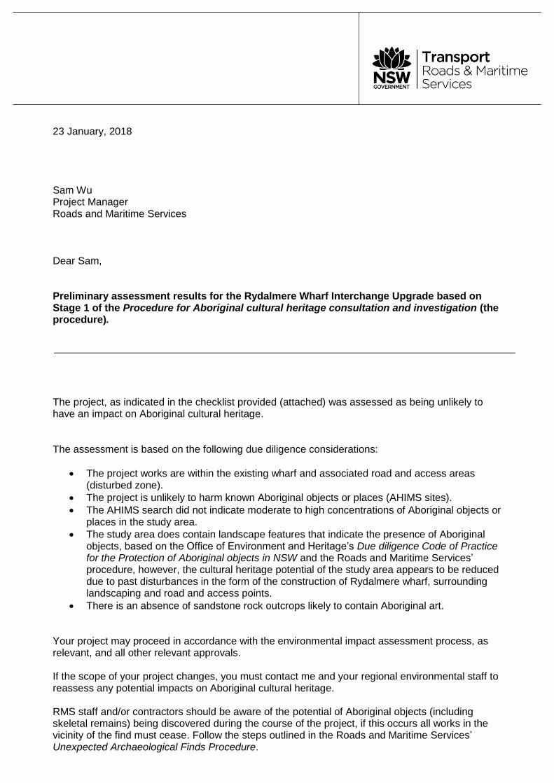
23 January, 2018 Sam Wu Project Manager Roads and Maritime Services Dear Sam, Preliminary assessment results for the Rydalmere Wharf Interchange Upgrade based on Stage 1 of the Procedure for Aboriginal cultural heritage consultation and investigation (the procedure). The project, as indicated in the checklist provided (attached) was assessed as being unlikely to have an impact on Aboriginal cultural heritage. The assessment is based on the following due diligence considerations:
The project works are within the existing wharf and associated road and access areas (disturbed zone).
The project is unlikely to harm known Aboriginal objects or places (AHIMS sites).
The AHIMS search did not indicate moderate to high concentrations of Aboriginal objects or places in the study area.
The study area does contain landscape features that indicate the presence of Aboriginal objects, based on the Office of Environment and Heritage’s Due diligence Code of Practice for the Protection of Aboriginal objects in NSW and the Roads and Maritime Services’ procedure, however, the cultural heritage potential of the study area appears to be reduced due to past disturbances in the form of the construction of Rydalmere wharf, surrounding landscaping and road and access points.
There is an absence of sandstone rock outcrops likely to contain Aboriginal art.
Your project may proceed in accordance with the environmental impact assessment process, as relevant, and all other relevant approvals. If the scope of your project changes, you must contact me and your regional environmental staff to reassess any potential impacts on Aboriginal cultural heritage. RMS staff and/or contractors should be aware of the potential of Aboriginal objects (including skeletal remains) being discovered during the course of the project, if this occurs all works in the vicinity of the find must cease. Follow the steps outlined in the Roads and Maritime Services’ Unexpected Archaeological Finds Procedure.
Roads and Maritime Services
Level 6, 90 Crown Street, Wollongong NSW 2500 T 0428 683 845 | E [email protected] 13 22 13
For further assistance in this matter and do not hesitate to contact me. Yours sincerely
Lee Davison Aboriginal Cultural Heritage Officer Sydney Region