5 L L L L LEGORRETA EGORRETA EGORRETA EGORRETA EGORRETA-H -H -H -H -HERRERA ERRERA ERRERA
P O L I S H P O L A R R E S E A R C H 11 3 - 4 365—387 1990
Leszek L I N D N E R and Leszek M A R K S
Institute of Geo logy Warsaw University Żwirki i Wigury 93 02-089 Warszawa, P O L A N D
Geodynamic aspects of studies of Quaternary inland sediments
in South Spitsbergen (attempt to synthesis)
ABSTRACT: Studies of Quaternary sediments of South Spitsbergen (Hornsund, Bellsund and northern Billefjorden regions) focus on their occurrence, origin and chronostratigraphy. Methods and results of geological mapping are described. Glacial, glaciofluvial, glaciolacustrine and aeolian sedimentary environments, rock glaciers, taluses and raised marine beaches are presented. Mutual relations of these sediments as well as their radiocarbon and thermolumines-cence datings made chronostratigraphy of Late Quaternary glacial episodes possible. Results of preliminary neotectonic studies are also presented, the same as works o n periglacial phenomena, chemical weathering and tundra vegetation. Key significance of the studies for the Quaternary evolut ion of the Arctic and for better recognition of geodynamic phenomena of Pleistocene glaciations in Po land (Tatra and Sudeten Mts included) is underlined.
K e y w o r d s : Arctic, Spitsbergen, Quaternary geology.
Introduction
The paper summarizes results of research since 1986 within the Central Program of Basal Research 03.03. Studies of life, lithosphere and environments of polar regions, the project B.7.Studies of the Quaternary inland sediments in South Spitsbergen. This work was coordinated by Professor Leszek Lindner and realized by five teams supervised by: Professor Leszek Lindner (Institute of Geology of Warsaw University), Professor Zdzisław Czeppe (Institute of Geography of Jagiellonian University, Cracow), Professor Kazimierz Pękala (Institute of Earth Sciences of M. Curie-Skłodowska University, Lublin), Professor Andrzej Karczewski (Quaternary Research Institute of A. Mickiewicz University, Poznań) — only in 1986 and Dr. Andrzej Musiał (Institute of Physico-geographical Sciences of Warsaw University) — since 1987.
366 Leszek Lindner and Leszek Marks
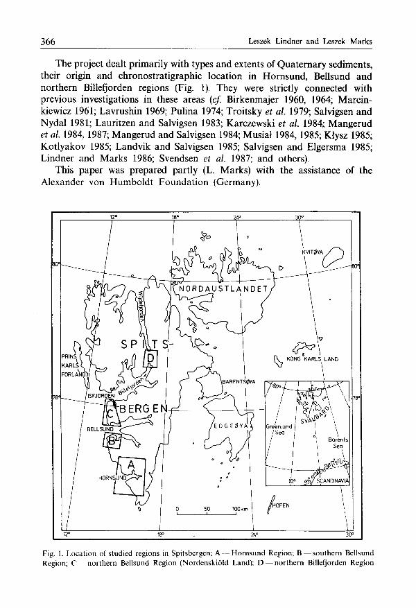
The project dealt primarily with types and extents of Quaternary sediments, their origin and chronostratigraphic location in Hornsund, Bellsund and northern Billefjorden regions (Fig. 1). They were strictly connected with previous investigations in these areas (cf. Birkenmajer 1960, 1964; Marcinkiewicz 1961; Lavrushin 1969; Pulina 1974; Troitsky et al. 1979; Salvigsen and Nydal 1981; Lauritzen and Salvigsen 1983; Karczewski et al. 1984; Mangerud et al. 1984, 1987; Mangerud and Salvigsen 1984; Musiał 1984, 1985; Kłysz 1985; Kotlyakov 1985; Landvik and Salvigsen 1985; Salvigsen and Elgersma 1985; Lindner and Marks 1986; Svendsen et al. 1987; and others).
This paper was prepared partly (L. Marks) with the assistance of the Alexander von Humboldt Foundation (Germany).
Fig. 1. Location of studied regions in Spitsbergen; A — Hornsund Region; B — southern Bellsund Region; C -nor thern Bellsund Region (Nordenskióld Land); D — northern Billefjorden Region
Geodynamic studies of Quaternary sediments 367
Occurrence of Quaternary sediments
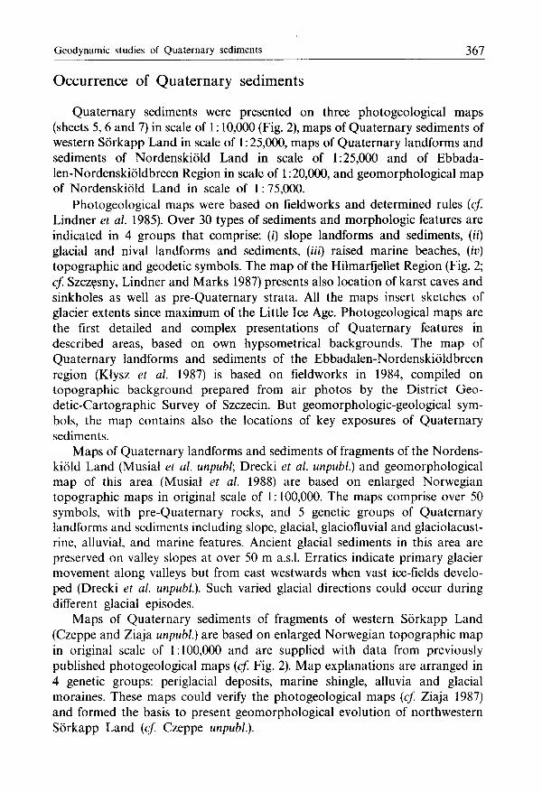
Quaternary sediments were presented on three photogeological maps (sheets 5, 6 and 7) in scale of 1:10,000 (Fig. 2), maps of Quaternary sediments of western Sórkapp Land in scale of 1:25,000, maps of Quaternary landforms and sediments of Nordenskióld Land in scale of 1:25,000 and of Ebbada-len-Nordenskióldbreen Region in scale of 1:20,000, and geomorphological map of Nordenskióld Land in scale of 1:75,000.
Photogeological maps were based on fieldworks and determined rules (cf. Lindner et al. 1985). Over 30 types of sediments and morphologic features are indicated in 4 groups that comprise: (i) slope landforms and sediments, (ii) glacial and nival landforms and sediments, (iii) raised marine beaches, (iv) topographic and geodetic symbols. The map of the Hilmarfjellet Region (Fig. 2; cf. Szczęsny, Lindner and Marks 1987) presents also location of karst caves and sinkholes as well as pre-Quaternary strata. All the maps insert sketches of glacier extents since maximum of the Little Ice Age. Photogeological maps are the first detailed and complex presentations of Quaternary features in described areas, based on own hypsometrical backgrounds. The map of Quaternary landforms and sediments of the Ebbadalen-Nordenskióldbreen region (Klysz et al. 1987) is based on fieldworks in 1984, compiled on topographic background prepared from air photos by the District Geodetic-Cartographic Survey of Szczecin. But geomorphologic-geological symbols, the map contains also the locations of key exposures of Quaternary sediments.
Maps of Quaternary landforms and sediments of fragments of the Nordenskióld Land (Musiał et al. unpubl; Drecki et al. unpubl.) and geomorphological map of this area (Musiał et al. 1988) are based on enlarged Norwegian topographic maps in original scale of 1:100,000. The maps comprise over 50 symbols, with pre-Quaternary rocks, and 5 genetic groups of Quaternary landforms and sediments including slope, glacial, glaciofluvial and glaciolacust-rine, alluvial, and marine features. Ancient glacial sediments in this area are preserved on valley slopes at over 50 m a.s.l. Erratics indicate primary glacier movement along valleys but from east westwards when vast ice-fields developed (Drecki et al. unpubl). Such varied glacial directions could occur during different glacial episodes.
Maps of Quaternary sediments of fragments of western Sórkapp Land (Czeppe and Ziaja unpubl.) are based on enlarged Norwegian topographic map in original scale of 1:100,000 and are supplied with data from previously published photogeological maps (cf. Fig. 2). Map explanations are arranged in 4 genetic groups: periglacial deposits, marine shingle, alluvia and glacial moraines. These maps could verify the photogeological maps (cf Ziaja 1987) and formed the basis to present geomorphological evolution of northwestern Sórkapp Land (cf. Czeppe unpubl).
368 Leszek Lindner and Leszek Marks
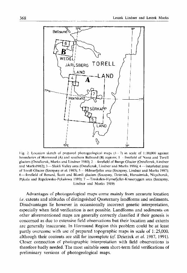
Fig. 2. Location sketch of prepared photogeological maps (1 7) in scale of 1:10,000 against boundaries of Hornsund (A) and southern Bellsund (B) regions; 1 forefield of N a n n and Torell glaciers (Ostaficzuk, Marks and Lindner 1980); 2 - - forefield of Bunge Glacier (Ostaficzuk, Lindner and Marks l982) ; 3 — Slakli Valley area (Ostaficzuk, Lindner and Marks 1986); 4 — interlobal zone of Torell Glacier (Szczęsny et al. 1985); 5 - - Hilmarfjellet area (Szczęsny, Lindner and Marks 1987); 6 — forefield of Renard, Scott and Blomli glaciers (Szczęsny, Dzierżek, Harasimiuk, Nitychoruk, Pękala and Repelewska-Pękalowa 1989); 7 — Treskelen-Hyrnefjellet-Kruseryggen area (Szczęsny,
Lindner and Marks 1989)
Advantages of photogeological maps come mainly from accurate location i.e. extents and altitudes of distinguished Quaternary landforms and sediments. Disadvantages lie however in occassional^ incorrect genetic interpretation, especially when field verification is not possible. Landforms and sediments on other aforementioned maps are generally correctly classified if their genesis is concerned as due to extensive field observations but their location and extents are generally inaccurate. In Hornsund Region this problem could be at least partly overcome with use of prepared topographic maps in scale of 1:25,000, although their contents are still far incomplete (cf. Dzierżek et al. 1987, 1991). Closer connection of photographic interpretation with field observations is therefore badly needed. The most suitable seem short-term field verifications of preliminary versions of photogeological maps.
Geodynamic studies of Quaternary sediments 369
Origin of Quaternary sediments and landforms
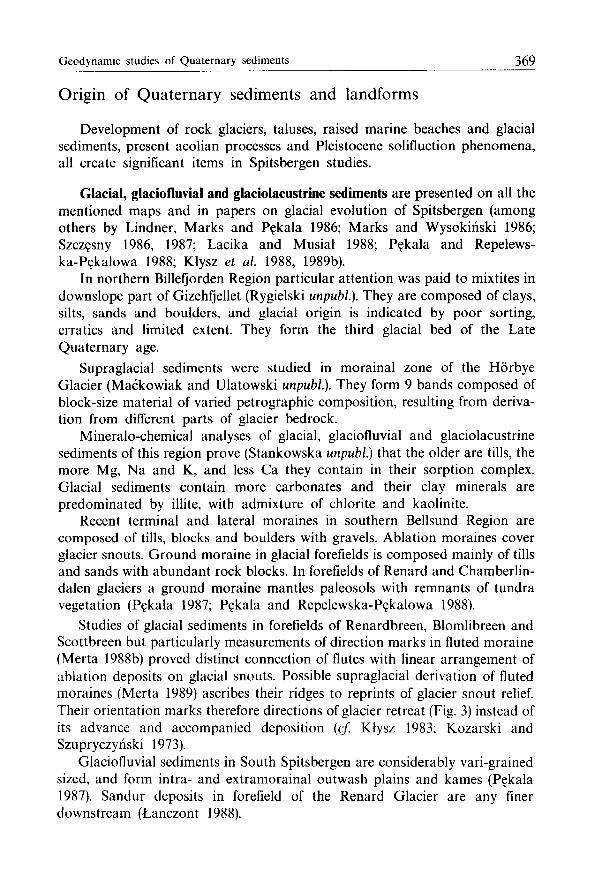
Development of rock glaciers, taluses, raised marine beaches and glacial sediments, present aeolian processes and Pleistocene solifluction phenomena, all create significant items in Spitsbergen studies.
Glacial, glaciofluvial and glaciolacustrine sediments are presented on all the mentioned maps and in papers on glacial evolution of Spitsbergen (among others by Lindner, Marks and Pękala 1986; Marks and Wysokiński 1986; Szczęsny 1986, 1987; Lacika and Musiał 1988; Pękala and Repelews-ka-Pękalowa 1988; Kłysz et al. 1988, 1989b).
In northern Billefjorden Region particular attention was paid to mixtites in downslope part of Gizehfjellet (Rygielski unpubl). They are composed of clays, silts, sands and boulders, and glacial origin is indicated by poor sorting, erratics and limited extent. They form the third glacial bed of the Late Quaternary age.
Supraglacial sediments were studied in morainal zone of the Horbye Glacier (Maćkowiak and Ulatowski unpubl). They form 9 bands composed of block-size material of varied petrographic composition, resulting from derivation from different parts of glacier bedrock.
Mineralo-chemical analyses of glacial, glaciofluvial and glaciolacustrine sediments of this region prove (Stankowska unpubl) that the older are tills, the more Mg, Na and K, and less Ca they contain in their sorption complex. Glacial sediments contain more carbonates and their clay minerals are predominated by illite, with admixture of chlorite and kaolinite.
Recent terminal and lateral moraines in southern Bellsund Region are composed of tills, blocks and boulders with gravels. Ablation moraines cover glacier snouts. Ground moraine in glacial forefields is composed mainly of tills and sands with abundant rock blocks. In forefields of Renard and Chamberlin-dalen glaciers a ground moraine mantles paleosols with remnants of tundra vegetation (Pękala 1987; Pękala and Repelewska-Pękalowa 1988).
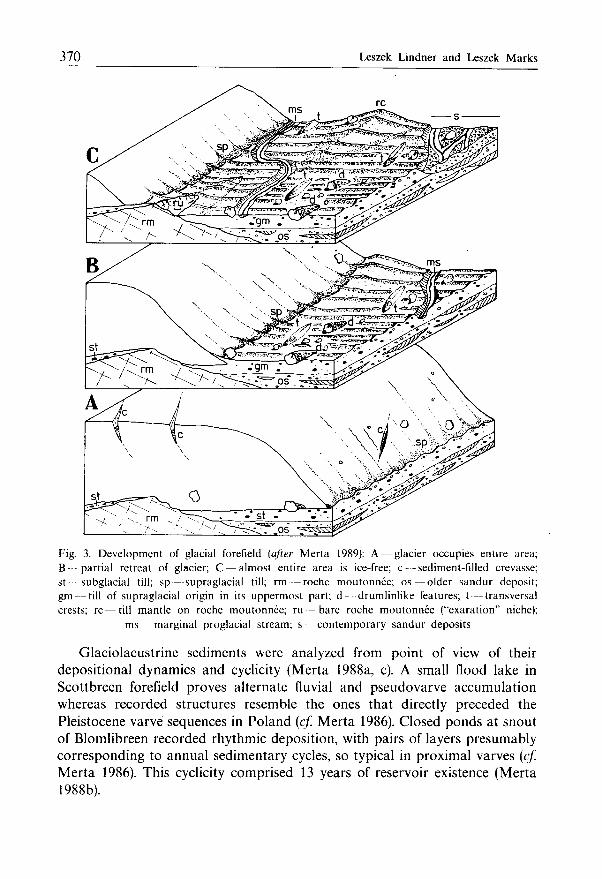
Studies of glacial sediments in forefields of Renardbreen, Blomlibreen and Scottbreen but particularly measurements of direction marks in fluted moraine (Merta 1988b) proved distinct connection of flutes with linear arrangement of ablation deposits on glacial snouts. Possible supraglacial derivation of fluted moraines (Merta 1989) ascribes their ridges to reprints of glacier snout relief. Their orientation marks therefore directions of glacier retreat (Fig. 3) instead of its advance and accompanied deposition {cf. Kłysz 1983; Kozarski and Szupryczyński 1973).
Glaciofluvial sediments in South Spitsbergen are considerably vari-grained sized, and form intra- and extramorainal outwash plains and kames (Pękala 1987). Sandur deposits in forefield of the Renard Glacier are any finer downstream (Lanczont 1988).
370 Leszek Lindner and Leszek Marks
Fig. 3. Deve lopment of glacial forefield (after Merta 1989): A — glacier occupies entire area; B — partial retreat of glacier; C — almost entire area is ice-free; c — sediment-filled crevasse; st subglacial till; sp—suprag lac ia l till; rm — roche moutonnee; os — older sandur deposit; gm — till of supraglacial origin in its uppermost part; d drumlinlike features; t — transversal crests; r c—t i l l mantle on roche moutonnee; ru — bare roche moutonnee ("exaration" niche);
ms — marginal proglacial stream; s — contemporary sandur deposits
Glaciolacustrine sediments were analyzed from point of view of their depositional dynamics and cyclicity (Merta 1988a, c). A small flood lake in Scottbreen forefield proves alternate fluvial and pseudovarve accumulation whereas recorded structures resemble the ones that directly preceded the Pleistocene varve sequences in Poland (cf. Merta 1986). Closed ponds at snout of Blomlibreen recorded rhythmic deposition, with pairs of layers presumably corresponding to annual sedimentary cycles, so typical in proximal varves (cf. Merta 1986). This cyclicity comprised 13 years of reservoir existence (Merta 1988b).
Geodynamic studies of Quaternary sediments 371
Raised marine beaches and their shingle are widespread and significant Quaternary features in Spitsbergen. They form several raised steps that indicate glacioisostatic uplifting of Spitsbergen during the Quaternary. Enclosed mollusc shells, driftwood and marine plants stimulate studies of Late Quaternary sea-level variation and glacial episodes (cf Lavrushin 1969; Birkenmajer and Olsson 1970; Boulton 1979; Troitsky et al. 1979; Salvigsen 1981, 1984; Salvigsen and Nydal 1981; Lindner, Marks and Pękala 1983, 1984, 1986, 1987; Mangerud et al. 1984, 1987; Chmal 1987; Kłysz et al. 1988, 1989a).
There are two main points in studies of raised marine beaches of Spitsbergen i.e. their altitudes and genetic features. The latter enable to distinguish beaches from any other morphologic steps that result from flat-exposed pre-Quaternary rock strata. Measurement tests of raised marine beaches in Bellsund Region proved that all commonly applied methods (including precise but time-consuming geodetic works) are more or less inaccurate; however the values read directly on air photos seem to be the most correct (Nitychoruk, Ozimkowski and Szczęsny 1988, 1989). Common misinterpretation of structural flattenings of pre-Quaternary rock strata as systems of raised marine beaches (cf. Stankowski 1981; Ziaja 1989) is to be avoided if sufficient knowledge of bedrock lithology and tectonics is accessible. Occasional marine pebbles (cf. Stankowski 1981) high on mountain slopes and elevations (to 546 m a.s.l.) in northwestern Sórkapp Land come from conglomerates of pre-Quaternary marine transgressive sequences. Similar origin can be also ascribed to marine pebbles in northeastern Petuniabukta area where they occur to 540 m a.s.l. whereas Stankowski (unpubl.) ascribes them to such high sea level during the Quaternary. Some "rock shelves" of Stankowski (1981) and Ziaja (1989) are the trimlines, eroded by Pleistocene glaciers on mountain slopes of South Spitsbergen.
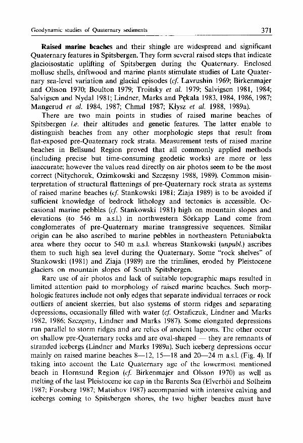
Rare use of air photos and lack of suitable topographic maps resulted in limited attention paid to morphology of raised marine beaches. Such morphologic features include not only edges that separate individual terraces or rock outliers of ancient skerries, but also systems of storm ridges and separating depressions, occasionally filled with water (cf. Ostaficzuk, Lindner and Marks 1982, 1986; Szczęsny, Lindner and Marks 1987). Some elongated depressions run parallel to storm ridges and are relics of ancient lagoons. The other occur on shallow pre-Quaternary rocks and are oval-shaped — they are remnants of stranded icebergs (Lindner and Marks 1989a). Such iceberg depressions occur mainly on raised marine beaches 8—12, 15—18 and 20—24 m a.s.l. (Fig. 4). If taking into account the Late Quaternary age of the lowermost mentioned beach in Hornsund Region (cf. Birkenmajer and Olsson 1970) as well as melting of the last Pleistocene ice cap in the Barents Sea (Elverhoi and Solheim 1987; Forsberg 1987; Matishov 1987) accompanied with intensive calving and icebergs coming to Spitsbergen shores, the two higher beaches must have
372 Leszek Lindner and Leszek Marks
a b
Fig. 4. Deve lopment of marine beaches in Spitsbergen {after Lindner and Marks 1989b): a — section, b — plan; 1 bedrock; 2 — sediments of raised marine beaches; 3 — sea level; 4 — stranded icebergs; 5 - lake level; 6 — raised marine beaches with pattern of beach ridges and
cliffs; 7 — coastline; 8 - depression with pond
developed during the Late Pleistocene deglaciation (Lindner and Marks 1989b).
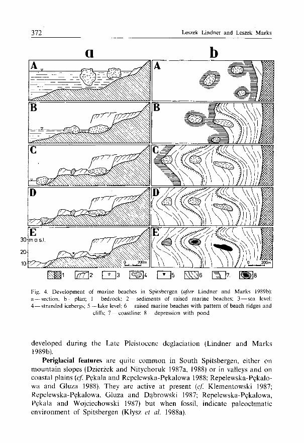
Periglacial features are quite common in South Spitsbergen, either on mountain slopes (Dzierżek and Nitychoruk 1987a, 1988) or in valleys and on coastal plains (cf. Pękala and Repelewska-Pękalowa 1988; Repelewska-Pękalo-wa and Gluza 1988). They are active at present (cf. Klementowski 1987; Repelewska-Pękalowa, Gluza and Dąbrowski 1987; Repelewska-Pękalowa, Pękala and Wojciechowski 1987) but when fossil, indicate paleoclimatic environment of Spitsbergen (Klysz et al. 1988a).
G e o d y n a m i c studies of Quaternary sediments 373
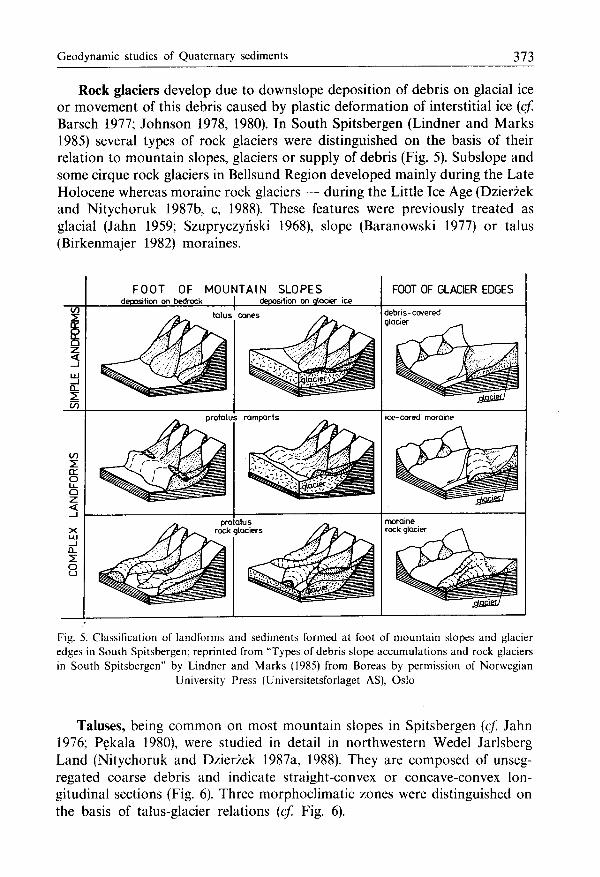
Rock glaciers develop due to downslope deposition of debris on glacial ice or movement of this debris caused by plastic deformation of interstitial ice (cf. Barsch 1977; Johnson 1978, 1980). In South Spitsbergen (Lindner and Marks 1985) several types of rock glaciers were distinguished on the basis of their relation to mountain slopes, glaciers or supply of debris (Fig. 5). Subslope and some cirque rock glaciers in Bellsund Region developed mainly during the Late Holocene whereas moraine rock glaciers — during the Little Ice Age (Dzierżek and Nitychoruk 1987b, c, 1988). These features were previously treated as glacial (Jahn 1959; Szupryczyński 1968), slope (Baranowski 1977) or talus (Birkenmajer 1982) moraines.
F O O T OF MOUNTAIN S L O P E S deposition on bedrock | deposition on qlocier ice
FOOT OF GLACIER EDGES
talus cones debris-covered glacier
o
CL
O
protalus ramparts ice-cored moraine
pro alus rock glaciers
Fig. 5. Classification of landforms and sediments formed at foot of mountain slopes and glacier edges in South Spitsbergen; reprinted from "Types of debris slope accumulat ions and rock glaciers in South Spitsbergen" by Lindner and Marks (1985) from Boreas by permission of Norwegian
University Press (Universitetsforlaget AS), Oslo
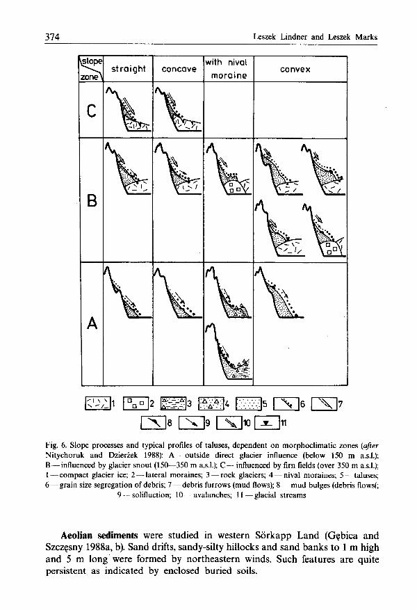
Taluses, being common on most mountain slopes in Spitsbergen (cf. Jahn 1976; Pękala 1980), were studied in detail in northwestern Wedel Jarlsberg Land (Nitychoruk and Dzierżek 1987a, 1988). They are composed of unseg-regated coarse debris and indicate straight-convex or concave-convex longitudinal sections (Fig. 6). Three morphoclimatic zones were distinguished on the basis of talus-glacier relations (cf. Fig. 6).
374 Leszek Lindner and Leszek Marks
slope
zone
B
straight concave with nival
moraine convex
- 1 \ 1 2 cm 3 A . A ^ ESU5 LXI 6 CS r\ is PNTIQ fxiio r^iii
Fig. 6. Slope processes and typical profiles of taluses, dependent o n morphocl imat ic zones (after Nitychoruk and Dzierżek 1988): A — outside direct glacier influence (below 150 m a.s.l.); B — influenced by glacier snout (150—350 m a.s.l); C — influenced by firn fields (over 350 m a.s.l.); 1 — compact glacier ice; 2 — lateral moraines; 3 — rock glaciers; 4 — nival moraines; 5 — taluses: 6 — g r a i n size segregation of debris; 7 — d e b r i s furrows (mud flows); 8 — m ud bulges (debris flows(:
9 — solifluction; 10 — avalanches; 1 1 — g l a c i a l streams
Aeolian sediments were studied in western Sórkapp Land (Gębica and Szczęsny 1988a, b). Sand drifts, sandy-silty hillocks and sand banks to 1 m high and 5 m long were formed by northeastern winds. Such features are quite persistent as indicated by enclosed buried soils.
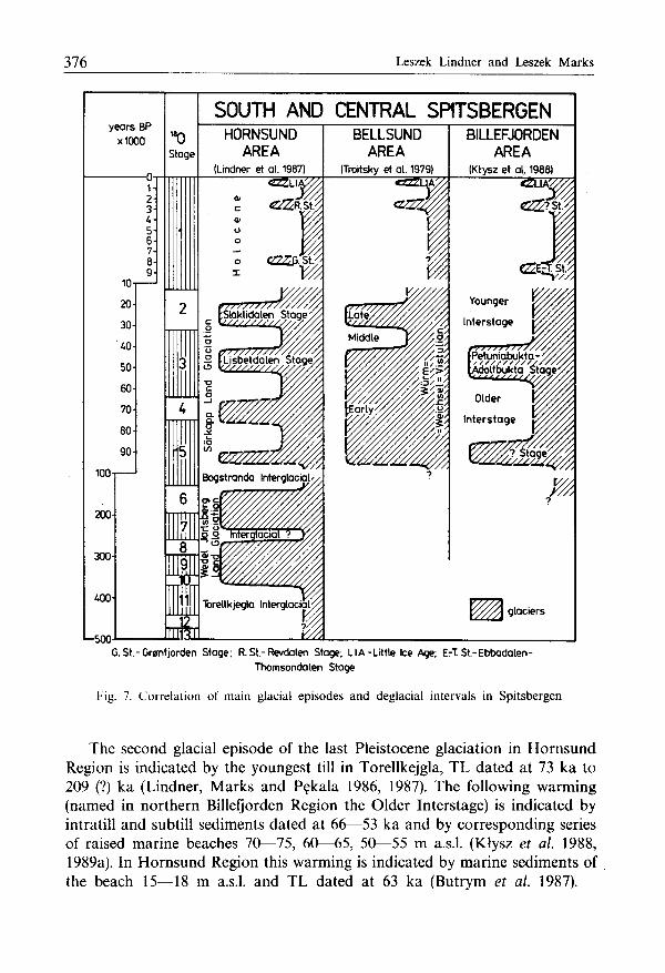
G e o d y n a m i c studies of Quaternary sediments 375
Outline of Quaternary chronostratigraphy
Analysis of Quaternary sediments in key geological sections (cf. Klysz and Lindner 1981; Lindner, Marks and Ostaficzuk 1982, 1984, 1986; Lindner, Marks and Pękala 1983, 1986; Marks 1983; Klysz et al. 1988, 1988b, 1989b), radiocarbon and thermoluminescence dated (Lavrushin 1969; Birkenmajer and Olsson 1970; Boulton 1979; Troitsky et al. 1979; Salvigsen 1981; Salvigsen and Nydal 1981; Lindner, Marks and Pękala 1984, 1987; Mangerud et al. 1984; Mangerud and Salvigsen 1984; Marks and Pękala 1986; Marks and Wysokiński 1986; Butrym et al. 1987; Klysz et al. 1988, 1988a), enabled to present detailed chronostratigraphic scheme of Quaternary sediments in Hornsund (Lindner, Marks and Pękala 1987) and Billefjorden (Klysz et al. 1988, 1989a) regions.
In South Spitsbergen the oldest Quaternary sediments are known from Torellkjegla (Lindner, Marks and Pękala 1983, 1984, 1987). They are marine silts, TL dated at 413 ka and 383 ka and represent the Torellkjegla Interglacial = Holstein sensu lato (Fig. 7). These sediments are glaciodislocated together with overlying tills (the older one of which is TL dated at 313 ka and 284 ka, and the younger at 189 ka), separated with glaciofluvial sands and gravels TL dated at 222 ka, 220 ka and 190 ka (Lindner, Marks and Pękala 1986). These glacial and glaciofluvial sediments were ascribed to the bipartite Wedel Jarlsberg Land Glaciation = Riss (Fig. 7). A younger part of this glaciation is also indicated by glacial sediments in western Sórkapp Land on slopes of Stupryggen and Gavrilovfjellet where they are TL dated at 217 ka and 141 ka respectively (Butrym et al. 1987), and by glaciofluvial sediments on Fannytoppen, TL dated at 161 ka and 143 ka (Marks and Pękala 1986).
The sediments on Fannytoppen are overlapped with paleosol, TL dated at 143 ka and referred to warming of the Bogstranda Interglacial (Fig. 7), correlated with the Eemian Interglacial (Lindner, Marks and Pękala 1986; Marks and Pękala 1986). In Billefjorden Region thin lacustrine sands and silts, TL dated at 119 ka and presumably corresponding with this interglacial, were found on pre-Quaternary bedrock and overlain with younger glacial and marine sediments (Klysz et al. 1988, 1988a, 1989a).
The last Pleistocene glaciation in South Spitsbergen is named the Sórkapp Land Glaciation ( = Wiirm, Vistulian) and indicated by several glacial episodes (Fig. 7). In separating warmer intervals marine sediments (Troitsky et al. 1979) and highermost raised marine beaches were formed (Lindner, Marks and Pękala 1983, 1984, 1986, 1987; Klysz et al. 1988, 1989a).
In northern Billefjorden Region a till high on southern slope of De Geerfjellet and TL dated at 87 ka is the oldest sediment of this glaciation (Klysz et al. 1988,1989a). In Hornsund Region the Early Wiirm glacial episode is indicated by a till in substrate of raised marine beaches 30—38 and 42—56 m a.s.l. in southern Breinesflya, and TL dated at 88 ka and 87 ka respectively (Butrym et al. 1987).
376 Leszek Lindner and Leszek Marks
SOUTH AND CENTRAL SPITSBERGEN
G.St.-Gronfjorden Stage; R. St.-Revdalen Stage; LI A-Little Ice Age; ErT St.-Ebbadalen-Thomsondalen Stage
Fig. 7. Correlation of main glacial episodes and deglacial intervals in Spitsbergen
The second glacial episode of the last Pleistocene glaciation in Hornsund Region is indicated by the youngest till in Torellkejgla, TL dated at 73 ka to 209 (?) ka (Lindner, Marks and Pękala 1986, 1987). The following warming (named in northern Billefjorden Region the Older Interstage) is indicated by intratill and subtill sediments dated at 66—53 ka and by corresponding series of raised marine beaches 70—75, 60—65, 50—55 m a.s.l. (Klysz et al. 1988, 1989a). In Hornsund Region this warming is indicated by marine sediments of the beach 15—18 m a.s.l. and TL dated at 63 ka (Butrym et al. 1987).
G e o d y n a m i c studies of Quaternary sediments 377
Glaciers of the third glacial episode (Fig. 7) are supposed to delimit maximum extent of the last Pleistocene glaciation in Spitsbergen (cf. Boulton 1979; Troitsky et al. 1979; Lindner, Marks and Pękala 1983, 1987; Kłysz et al. 1988, 1989a). In Hornsund Region this episode is named the Lisbetdalen Stage and its sediments are TL dated at 50—41 ka (Butrym et al. 1987; Lindner, Marks and Pękala 1987). In Bellsund Region it is represented by a till older than 30 ka (cf. Troitsky et al. 1979). In northern Billefjorden Region this episode is named the Petuniabukta-Adolfbukta Stage and recorded by glacial sediments, TL dated at 45—55 ka (Kłysz et al. 1988, 1989a). They are correlated with the Billefjorden Stage in the section Kapp Ekholm where a till is TL dated at 70—47 ka, and enclosed mollusc shells are radiocarbon dated at 41.7+12 ka to 33 ka or more than 46.3 + 2.1/1.7 ka (Lavrushin 1969; Troitsky et al. 1979; Mangerud and Salvigsen 1984).
Middle Wiirm warming in Bellsund Region is recorded by marine sediments with mollusc shells, radiocarbon dated at 31.91+0.5 ka and 30.75 + 0.8 ka (Fig. 7; Troitsky et al. 1979). In northern Billefjorden Region this warming is represented by sediments of the Younger Interstage that form the raised marine beach 40—45 m a.s.l. (Kłysz et al. 1988, 1989a). In the section Kapp Ekholm marine sediments contain mollusc shells, radiocarbon dated at more than 33 ka (Lavrushin 1969; Troitsky et al. 1979) and at 46.3 + 2 .1/ -1 .7 ka (Mangerud and Salvigsen 1984).
The fourth, youngest glacial episode of the last Pleistocene glaciation in Hornsund Region (Fig. 7) is named the Slaklidalen Stage and indicated by glacial sediments, TL dated at 29—22 ka (Butrym et al. 1987; Lindner, Marks and Pękala 1987). In Bellsund Region this episode is recorded by till, TL dated at 26 ka and overlying the aforementioned marine sediments (cf. Troitsky et al. 1979).
During the Holocene three successive glacial advances occurred in South Spitsbergen (Fig. 7). In Hornsund Region the first, Early Holocene glacial advance occurred about 8 ka (Lindner, Marks and Pękala 1986, 1987) and is correlated with the Grónfjorden Stage of Punning et al. (1982). In northern Billefjorden a considerable glacier advance of the Ebbadalen-Thomsondalen Stage is radiocarbon dated at 9.74 + 0.08 ka and 8.92 + 0.05 ka to 7.63 + 0.15 ka (Kłysz et al. 1988).
The Middle Holocene warming is recorded by raised marine beaches 8—12 and 3—8 m a.s.l. in Hornsund Region (Lindner and Marks 1989a, b), and 12—15 and 5—8 m a.s.l. in northern Billefjorden Region (Kłysz et al. 1988, 1989a). The Late Holocene cooling of about 3—2.5 ka (Baranowski 1977) is named the Revdalen Stage in Hornsund Region (Karczewski, Kostrzewski and Marks 1981). In this time development of the beach 3—8 m a.s.l. in Hornsund (Lindner and Marks 1989) and 5—8 m a.s.l. in northern Billefjorden (Kłysz et al. 1988, 1989a) has continued.
378 Leszek Lindner and Leszek Marks
The Late Holocene warming about 1.5—0.6 ka favored considerable retreat of glaciers, development of denser vegetation and arrival of people (Pękala 1980; Chochorowski 1987; Krawczyk 1987). In this time the marine beach 3—8 m a.s.l. was finally completed in Hornsund (Lindner and Marks 1989a, b), the same as the beach 3—4 m a.s.l. in Billefjorden (Klysz et al. 1988,1989a). Present subtill organic sediments in forefield of the Renard Glacier come also from this interval (cf. Dzierżek, Nitychoruk and Rzętkowska 1989).
The youngest glacial episode during the Holocene records the Little Ice Age at 0.6—0.1 ka (Fig. 7) when glaciers advanced as far as the present ice-cored moraines in their forefields (cf. Szupryczyński 1968; Baranowski 1977; Pękala 1980; Klysz 1985; and others).
Other methods and research aims
Other subjects were also undertaken during studies of the Quaternary of South Spitsbergen. They comprise postulated contents of topographic maps of polar areas, measurements of altitudes of raised marine beaches, analysis of joint fractures and their significance for neotectonic phenomena in Spitsbergen. A need for description of tundra vegetation has also arisen as the reference system for evaluation of buried floras in this area. Present and ancient symptoms of physical and chemical weathering of rocks in Spitsbergen were analyzed as well as description of molluscs, shells of which were collected in Quaternary sediments of northern Billefjorden Region.
Analysis of contents of topographic maps of polar areas indicated (cf. Dzierżek et al. 1987) that recently published maps (Spitsbergen, Hornsund, Topographic Map in scale of 1:25,000, 1987) are hardly acceptable, especially as they do not contain such outstanding morphologic features as glaciers or moraines (demarcated however on much older Norwegian topographic maps in scale of 1:100,000) and wetlands. Such serious disadvantages make it difficult or even impossible to use these maps for field purposes. Basing on collected experience and needs, a project of postulated symbols to use on topographic maps and example of such map were presented (Dzierżek et al. 1991).
Applied measuring methods of altitudes of raised marine beaches of Spitsbergen have been already aforementioned. Evaluation of these methods could be possible by comparing measurements of beach altitudes along step-altimeter and step-clisimeter sections, directly on air photos and from photogeological maps (Nitychoruk, Ozimkowski and Szczęsny 1988). If accurate but considerably troublesome (among others due to indetermined position of 00 N N in this area) geodetic measurements are neglected, then the most accurate altitudes are to be received directly from air photos. The latter recorded also synchronous pictures of larger areas (Nitychoruk, Ozimkowski and Szczęsny 1989).
Geodynamic studies of Quaternary sediments 379
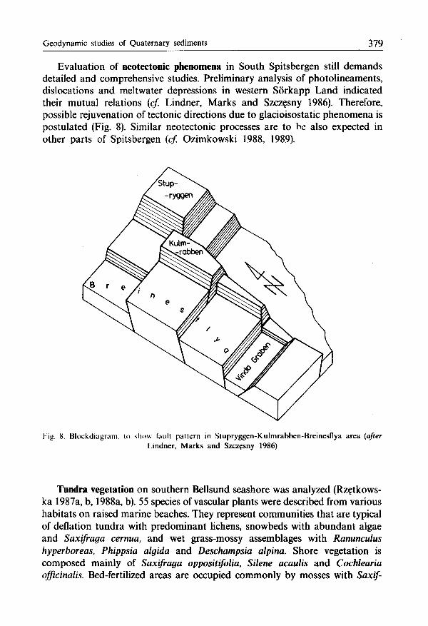
Evaluation of neotectonic phenomena in South Spitsbergen still demands detailed and comprehensive studies. Preliminary analysis of photolineaments, dislocations and meltwater depressions in western Sórkapp Land indicated their mutual relations (cf. Lindner, Marks and Szczęsny 1986). Therefore, possible rejuvenation of tectonic directions due to glacioisostatic phenomena is postulated (Fig. 8). Similar neotectonic processes are to be also expected in other parts of Spitsbergen (cf Ozimkowski 1988, 1989).
Kig. 8. Blockdiagram, u> shim fault pattern in Stupryggen-Kulmrabben-Breinesflya area {after Lindner, Marks and Szczęsny 1986)
Tundra vegetation on southern Bellsund seashore was analyzed (Rzctkows-ka 1987a, b, 1988a, b). 55 species of vascular plants were described from various habitats on raised marine beaches. They represent communities that are typical of deflation tundra with predominant lichens, snowbeds with abundant algae and Saxifraga cernua, and wet grass-mossy assemblages with Ranunculus hyperboreas, Phippsia algida and Deschampsia alpina. Shore vegetation is composed mainly of Saxifraga oppositifolia, Silene acaulis and Cochlearia officinalis. Bed-fertilized areas are occupied commonly by mosses with Saxif-
380 Leszek Lindner and Leszek Marks
raga cernua. Recently exposed glacial forefields are predominantly covered with Saxifraga oppositifolia and viviparous grass species (Poa alpina var. vivipara, Poa arctica var. vivipara). Plant communities of intramorainal zones depend highly upon varying substrate lithology and particularly, clayey-silty material in subsoil as it considerably facilitates vegetative conditions (Rzętkowska 1987b).
Studies of weathering processes in polar areas dealt primarily with polymic-tic carbonate rocks of Hecla Hoek Formation on southern shore of Bellsund (Chlebowski 1989). Due to chemical denudation, a dissolution acts firstly on calcite and then on dolomite. Finally, only quartz-micaceous skeleton as weathering cortex is preserved. Its occurrence on buried rock fragments and surfaces indicates similar weathering processes during the Pleistocene (cf. Lindner and Kłysz 1989).
Species of molluscs, shells of which were collected from Quaternary sediments in northern Billefjorden (Kłysz et al. 1988), enabled reference to their present occurrence in Svalbard (cf. Różycki 1988). Iittorina littorea and Mytilus edulis indicate milder conditions whereas May truncata, Hiatella arctica and Macoma calcarea lived in more severe environment. These species enabled climatic evaluation of Quaternary sedimentary environments in northern Billefjorden area (cf. Kłysz et al. 1988, 1989a).
Final remarks
Presented studies supply with new data on extents, origin and chronostratigraphy of Quaternary sediments in South Spitsbergen and they form in many cases a first information in the subject. They are the effect of several years complex and team investigations, carried through in Polish universities and supported with grants of CPBP 03.03.B7. If continued in the next few years, these studies should result in monograph on evolution of Hornsund, Bellsund and Billefjorden regions during the Quaternary and then in synthesis of the Quaternary of South Spitsbergen. Such aim still demands however many preceding works, geological mapping and sampling of sediments inclusive. First geological maps of Quaternary sediments are to be prepared for Hornsund, Bellsund and northern Billefjorden regions, in scales of either 1:75,000 or 1:50,000. They should be supplemented with lithogenetic explanations and age of terrestrial sediments, but also of sediments in fiords or at least in their littoral zones. Such work would clarify present opinions on extents of Late Quaternary glaciers, neotectonic movements and persistence of permafrost at sea bottom. But the maps and text, the monograph should present geology of key sites, key geological sections and paleogeomorp-hological sketches showing gradual development of Spitsbergen during the Quaternary.
G e o d y n a m i c studies of Quaternary sediments 381
Presented studies constitute already remarkable element in Polish works on the Late Quaternary history of South Spitsbergen and particularly, its glacial episodes and accompanied glacioisostatic phenomena. Reconstruction of number and age of these episodes and separating warmer intervals results in turn in knowing a paleoclimatic evolution of the Arctic but also, the mechanism and age of Pleistocene glaciations in the northern hemisphere.
Results of these works bring much to better understanding of geological structure and the Quaternary of Poland, so remarkably determined by several Pleistocene advances of Scandinavian ice sheets. They determine depositional conditions of glacial and glaciofluvial sediments which occupy over a half of the Polish territory and are therefore of great economic significance. Experience gained during studies in Spitsbergen facilitates investigations of Pleistocene sediments in the Polish Lowland and the Middle Polish Uplands, evaluation of engineering properties of these areas, search of water-bearing beds and building materials, and last but not least — it is useful for needs of farming and forestry.
References
Baranowski S. 1977. Subpolar glaciers of Spitsbergen against a climate of this region. — Acta Univ. Wratisl., 393: 1—157.
Barsch D . 1977. Nature and importance of mass-wasting by rock glaciers in Alpine permafrost environments. — Earth Surf. P r o c , 2: 231—245.
Birkenmajer K. 1960. Raised marine features of the Hornsund area, Vestspitsbergen. — Studia Geol . Polon. , 5: 3—95.
Birkenmajer K. 1964. Quaternary geology of Treskelen, Hornsund, Vestspitsbergen. — Studia Geol . Polon. , 11: 185—196.
Birkenmajer K. 1982. Talus moraines in South Spitsbergen and comparison with East Greenland. — Acta Univ. Wratisl., 525: 29—38.
Birkenmajer K. and Olsson I. U. 1970. Radiocarbon dating of raised marine terraces at Hornsund, Spitsbergen, and the problem of land uplift. — Norsk Polarinst. Arb., 6: 14—43.
Boulton G. S. 1979. Glacial history of the Spitsbergen archipelago and the problem of a Barents Shelf ice sheet. — Boreas, 8: 31—57.
Butrym J., Lindner L., Marks L. and Szczęsny R. 1987. First thermoluminescence datings of Pleistocene sediments from Sorkapp Land, Spitsbergen. — Pol. Polar Res., 8: 217—229.
Chlebowski R. 1989. Wietrzenie chemiczne skal węglanowych formacji Hecla Hoek w warunkach klimatu polarnego, rejon Bellsundu, zachodni Spitsbergen. — Mat. 16 Symp. Polarnego, Toruń.
Chmal H. 1987. Pleistocene sea level changes and glacial history of the Hornsund area, Svalbard. — Polar Res., 5 n.s.: 269—270.
Chochorowski J. 1987. The archeological investigations in the northwestern part of Sórkapp Land, West Spitsbergen. — Mat. 14 Symp. Polarnego, Lublin: 229—235.
Dzierżek J., Lindner L., Marks L., Nitychoruk J. and Szczęsny R. 1987. O n essence and need of preparation of topographic maps of the Hornsund Region with a use of air photo analysis. — Rozpr. Uniw. M. Kopernika, Mat. Ogólnopol . Sem. „Fotointerpretacja w badaniach polarnych": 150—157.
Dzierżek J., Lindner L., Marks L., Nitychoruk J. and Szczęsny R. 1991. Application of remote sensing to preparation of topographic maps of polar areas. — Pol. Polar Res., 12.
382 Leszek Lindner and Leszek Marks
Dzierżek J. and Nitychoruk J. 1987a. Talus fans in Bellsund region, West Spitsbergen. — Mat. 14 Symp. Polarnego, Lublin: 92—94.
Dzierżek J. and Nitychoruk J. 1987b. Rock glaciers in Bellsund region, West Spitsbergen. — Mat. 14 Symp. Polarnego, Lublin: 95—98.
Dzierżek J. and Nitychoruk J. 1987c. Types of rock glaciers in northwestern Wedel Jarlsberg Land, Spitsbergen. — Pol. Polar Res., 8: 231—241 .
Dzierżek J. and Nitychoruk J. 1988. Morphogenet ic features of talus cones in northwestern Wedel Jarlsberg Land, Spitsbergen. — Pol. Polar Res., 9: 73—79.
Dzierżek J., Nitychoruk J. and Rzętkowska A. 1989. Profil p o d m o r e n o w y c h o s a d ó w organogenicz-nych na przedpolu lodowca Renarda, Wedel Jarlsberg Land, Spitsbergen. — Mat. 16 Symp. Polarnego, Toruń.
Elverhoi A. and Solheim A. 1987. Late Weichselian glaciation on the northern Barents Sea, a discussion. — Polar Res., 5 n.s.: 285—287.
Forsberg C. F. 1987. The Late Weichse l ian—Holocene transition in the Barents Sea: sedimen-tological and early diagenetic studies. — Polar Res., 5 n.s.: 289—290.
Gębica P. and Szczęsny R. 1988a. Aeolian forms in western Sórkapp Land, Spitsbergen. Mat . 15 Symp. Polarnego, Wrocław: 53—56.
Gębica P. and Szczęsny R. 1988b. Symptoms of aeolian accumulat ion in western Sórkapp Land, Spitsbergen. — Pol. Polar Res., 9: 4 4 7 ^ 1 6 0 .
Jahn A. 1959. The raised shorelines and beaches in Hornsund and the problem of postglacial vertical movements of Spitsbergen. — Przegl. Geogr. , 31 (Suppl.): 143—178.
Jahn A. 1976. Geomorpholog ica l model l ing and nature protection in Arctic and Subarctic environments. — Geoforum, 7: 121—137.
Johnson P. G. 1978. Rock glacier types and their drainage systems, Grizzly Creak, Y u k o n territory. — Can. J. Earth Sci., 15: 1 4 9 6 - 1 5 0 7 .
Johnson P. G. 1980. Glacier — rock glacier transition in the southwest Y u k o n Territory, Canada. — Arctic and Alpine Res., 12: 195—204.
Karczewski A., Andrzejewski L., Chmal H., Jania J., Kłysz P., Kostrzewski A., Lindner L., Marks L., Pękala K., Pulina M., Rudowski S., Stankowski W., Szczypek T. and Wiśniewski E. 1984. Hornsund, Spitsbergen, geomorphology , scale 1:75,000.-Si lesian Univ. , Katowice .
Karczewski A., Kostrzewski A. and Marks L. 1981. Late Ho locene glacier advances in Revdalen, Spitsbergen. — Pol. Polar Res., 2: 51—61 .
Klementowski J. 1987. The origin and destructive processes of hydrolaccoliths in Hornsund region. — Mat. 14 Symp. Polarnego, Lublin: 116—118.
Kłysz P. 1983. O n the necessity of genetic classification of fluted moraine. — Spraw. Pozn. Tow. Przyj. Nauk , Wydz. Mat.—Przyr. , 97—99: 169—172.
Kłysz P. 1985. Glacial forms and deposits of Ebba Glacier and its foreland, Petuniabukta region, Spitsbergen. — Pol. Polar Res., 6: 283—299.
Kłysz P. and Lindner L. 1981. Deve lopment of glaciers o n the southern coast of Hornsund in Spitsbergen during the Wiirm (Vistulian) Glaciation. — Acta Geol . Polon. , 31: 139—146.
Kłysz P., Lindner L., M a k o w s k a A., Marks L. and Wysokiński L. 1988. Late Quaternary glacial episodes and sea level changes in the northheastern Billefjorden region, Central Spitsbergen. — Acta Geol . Polon. , 38: 107—123.
Kłysz P., Lindner L., Marks L. and Wysokiński L. 1987. M a p of Quaternary landforms and sediments of the Ebbadalen—Nordenskió ldbreen Region (Olav V Land, Spitsbergen), scale 1:20,000. — Wyd. Geol. , Warszawa.
Kłysz P., Lindner L., Marks L. and Wysokiński L. 1988a. Late Quaternary solifluction in Central Spitsbergen. — Permafrost 5th Intern. Conf., Trondheim, P r o c , 1: 84—88.
Kłysz P., Lindner L., Marks L. and Wysokiński L. 1988b. Quaternary landforms and sediments of the eastern Petuniabukta seaside, Olav V Land, Spitsbergen. — Mat. 15 Symp. Polarnego, Wrocław: 45—52 .
Geodynamic studies of Quaternary sediments 383
Kłysz P., Lindner L., Marks L. and Wysokiński L. 1989a. An outline of Late Quaternary chronostratigraphy in northern part of the Billefjorden seaside, Olav V Land, Spitsbergen. — Mat. 2 Sesji Polarnej Uniw. M. Curie-Sklodowskiej , Lublin: 171—177.
Klysz P., Lindner L., Marks L. and Wysokiński L. 1989b. Late Pleistocene and Holocene relief remodelling in the Ebbadalen-Nordenskióldbreen region in Olav V Land, Spitsbergen.
Pol. Polar Res., 10: 277—301. Kot lyakov V. M. 1985. Glacio logy of Spitsbergen. — Nauka , M o s c o w . Kozarski S. and Szupryczyński J. 1973. Glacial forms and deposits in the Sidujókull deglaciation
area. — Geogr. Polon. , 26: 255—311. Krawczyk A. 1987. Problem of the N o r m a n Svalbard. — Mat. 14 Symp. Polarnego, Lublin:
223—228. Lacika J. and Musial A. 1988. Relief-forming processes in the polar zone exampled from
Nordenskióld Land, West Spitsbergen. — Miscell. Geogr. , 3: 69—77. Landvik J. Y. and Salvigsen O. 1985. Glaciation development and interstadial sea-level on central
Spitsbergen, Svalbard. — Polar Res., 3 n.s.: 1—10. Lauritzen Ó. and Salvigsen O. 1983. Holocene sedimentary rocks in Mathiesondalen, Central
Spitsbergen, Svalbard. — Polar Res., 1 n.s.: 151—155. Lavrushin J. A. 1969. Le Quaternaire de Spitsberg, les questions de la dynamique de la
sedimentation de le depots glaciaire, glacio-littoreux, la stratigraphie et la paleogeographie du pleistocene. — Nauka , M o s c o u , 181 pp.
Lindner L. and Klysz P. 1989. Surface karst features at a southern slope of Stupryggen, Sórkapp Land, Spitsbergen. — Kras i Speleologia, 6: 58—65.
Lindner L. and Marks L. 1985. Types of debris slope accumulations and rock glaciers in South Spitsbergen. — Boreas, 14: 139—153.
Lindner L. and Marks L. 1986. Quaternary of the Hornsund Region (Spitsbergen) in research of the Institute of Geology , Warsaw Uniwersity, in 1981—85. — Pol. Polar Res., 7: 417—425.
Lindner L. and Marks L. 1989a. Depressions from icebergs as a climatostratigraphic indicator of development of marine terraces in southern Spitsbergen. — Mat. 2 Sesji Polarnej Uniw. M. Curie-Sklodowskiej , Lublin: 179—183.
Lindner L. and Marks L. 1989b. Impact of icebergs on relief development of marine beaches in Spitsbergen. — Quaest. Geogr., Spec. Issue, 2: 111—119.
Lindner L., Marks L. and Ostaficzuk S. 1982. Evolution of the marginal zone and the forefield of the Torell, N a n n and Tone glaciers in Spitsbergen. — Acta Geol . Polon. , 32: 267—278.
Lindner L., Marks L. and Ostaficzuk S. 1984. Photogeological analysis of the forefield of the Bunge Glacier (Sórkapp Land, Spitsbergen). — Quatern. Studies in Poland, 5: 81—97.
Lindner L., Marks L. and Ostaficzuk S. 1986. Quaternary landforms and sediments and morphologic evolut ion of the Slaklidalen region (Sórkapp Land, Spitsbergen). — Studia Geol. Polon. , 89: 51—62.
Lindner L., Marks L., Ostaficzuk S., Pękala K. and Szczęsny R. 1985. Application of photogeologi cal mapping to studies of glacial history of South Spitsbergen. — Earth Surf. P r o c , Landf, 10: 387—399.
Lindner L., Marks L. and Pękala K. 1983. Quaternary glaciations of South Spitsbergen and their correlation with Scandinavian glaciations of Poland. — Acta Geol . Polon. , 33: 169—182.
Lindner L., Marks L. and Pękala K. 1984. Late Quaternary glacial episodes in the Hornsund Region of Spitsbergen. — Boreas, 13: 35—47.
Lindner L., Marks L. and Pękala K. 1986. Outl ine of Quaternary chronostratigraphy of the northern Hornsund area, southern Spitsbergen. — Bull. Pol. A c : Earth Sc., 34: 427—436.
Lindner L., Marks L. and Pękala K. 1987. Quaternary chronostratigraphy of South Spitsbergen. — Polar Res., 5 n.s.: 273—274.
Lindner L., Marks L. and Szczęsny R. 1986. Late Quaternary tectonics in western Sórkapp Land, Spitsbergen. — Acta Geol . Polon. , 36: 281—288.
384 Leszek Lindner and Leszek Marks
Łanczont M. 1988. Sandur deposits succession of Renard Glacier, West Spitsbergen. — Mat. 15 Symp. Polarnego, Wroclaw: 82—87.
Mangerud J., Bolstad M., Elgersma A., Helliksen D. , Landvik J. Y., Lycke A. K., Lónne I., Salvigsen O., Sandhal T. and Sejrup H. P. 1987. The Late Weichselian glacial max imum in western Svalbard. — Polar Res., 5 n.s.: 275—278.
Mangerud J., Elgersma A., Helliksen D. , Landvik J. and Salvigsen O. 1984. The Late Weichselian Glaciat ion in Isfjorden and Van Mijenfjorden, Svalbard. — Sediments and climate in the Arctic, Voksenasendagene, Rapp., Oslo: 16—17.
Mangerud J. and Salvigsen O. 1984. The K a p p Ekho lm section, Billefjorden, Spitsbergen: a discussion. — Boreas, 13: 155—158.
Marcinkiewicz A. 1961. Elevated coastal terraces in the southern shore area of Bellsund and Van Keulen Fjord between the Recherche Glacier and Hess Glacier. — Biul. Geol . Uniw. Warsz., 1: 93—103 .
Marks L., 1983. Late Holocene evolut ion of the Treskelen Peninsula, Hornsund, Spitsbergen. - Acta Geol . Polon. , 33: 159—168.
Marks L. and Pękala K. 1986. N e w datings of Quaternary sediments from Bogstranda and . Treskelodden, southern Spitsbergen. — Bull. Pol. A c : Earth Sc., 34: 419—425 .
Marks L. and Wysokiński L. 1986. Early Holocene glacier advance in the Austfjorden Region, northern Spitsbergen. — Bull. Pol. A c : Earth Sc., 34: 4 3 7 ^ 1 4 6 .
Mat ishov G. 1987. Problems of Quaternary geology and palaeoecology of North European seas. — Polar Res., 5 n.s.: 291—292.
Merta T. 1986. Varve sedimentation in extraglacial ice-dammed lakes. — Acta Geol . Polon. , 36: 325—336.
Merta T. 1988a. Cyclic sedimentation irl the flood water basin close by front of the Blomli Glacier. Mat. 1 Sesji Polarnej Uniw. M. Curie-Sklodowskiej , Lublin: 191—196.
Merta T. 1988b. Directional elements of the fluted ground moraine within the marginal zone of the Renard Glacier, Spitsbergen. — Mat. 15 Symp. Polarnego, Wroclaw: 7 6 — 8 1 .
Merta T. 1988c. Dynamics of sedimentation in the proglacial flood water basin in the forefield of the Scott Glacier, Spitsbergen. - Mat. 1 Sesji Polarnej Uniw. M. Curie-Sklodowskiej , Lublin: 183—187.
Merta T. 1989. Sedimentation of fluted moraine in forefields of glaciers in Wedel Jarlsberg Land, Spitsbergen. — Pol. Polar Res., 10: 3—29.
Musial A. 1984. Ancient glaciations in the northwestern part of Nordenskió ld Land and their extent in the light of characteristic occurrence of erratics. — Miscell. Geogr. , 1: 57—65.
Musial A. 1985. Traces of the glaciation in the northwestern part of Nordenskió ld Land, West Spitsbergen. — Pol. Polar Res., 6: 497—513 .
Musial A., Drecki J., Horodyski B., Kossobudzki K. and Lacika J. 1988. Geomorpholog ica l map of Nordenskió ld Land, West Spitsbergen, scale 1:75,000. — Faculty of Geography and Regional Studies, Warsaw Univ.
Nitychoruk J. and Dzierżek J. 1988. Morphogenet ic features of talus cones in northwestern Wedel Jarlsberg Land, Spitsbergen. - Pol. Polar Res., 9: 73—79.
Nitychoruk J., Oz imkowski W. and Szczęsny R. 1988. The methods of marine beaches profiling exampled from West Spitsbergen. — Mat. 15 Symp. Polarnego, Wroclaw: 71—75.
Nitychoruk J., Oz imkowski W. and Szczęsny R. 1989. Construction of morphological profiles of raised marine beaches in Spitsbergen. — Pol. Polar Res., 10: 73—79.
Ostaficzuk S., Lindner L. and Marks L. 1982. Photogeological m a p of the Bungebreen forefield, West Spitsbergen, scale 1 :10,000. — Państw. Przeds. Wyd. Kartograf., Warszawa.
Ostaficzuk S., Lindner L. and Marks L. 1986. Photogeological m a p of the Slaklidalen Region, Sórkapp Land, Spitsbergen, scale 1:10,000. — Wyd. Geol. , Warszawa.
Ostaficzuk S., Marks L. and Lindner L. 1980. Mapa fotogeologiczna przedpola l o d o w c ó w N a n n i Torella, Spitsbergen Zachodni, w skali 1:10000. — Państw. Przeds. Wyd. Kartograf., Warszawa.

Geodynamic studies of Quaternary sediments 385
Ozimkowski W. 1988. Joint patterns and neotectonic movements at southern shore of Bellsund. — Mat. 15 Symp. Polarnego, Wroclaw: 5.
Ozimkowski W. 1989. Joint patterns of the southern shore of Bellsund, Spitsbergen. — Pol. Polar Res., 10: 8 1 - 8 9 .
Pękala K. 1980. Morphogenet ic processes and cover deposits of nunataks in the Hornsund area, SW Spitsbergen. — Pol. Polar Res., 1: 9—44.
Pękala K. 1987. Relief and Quaternary deposits on the Scott and Renard glaciers forefield, Spitsbergen. — Mat. 14. Symp. Polarnego, Lublin: 84—87.
Pękala K. and Repelewska-Pękalowa J. 1988. Main relief features and Quaternary deposits of the Chamberlin valley, Spitsbergen. — Mat. 1 Sesji Polarnej Uniw. M. Curie-Sklodowskiej , Lublin: 161—172.
Pulina M. 1974. Preliminary studies on denudation in SW Spitsbergen. — Bull. Pol. Ac. Sc., Ser. Sc. Terre, 22: 83—99.
Punning T.-M., Surova T. G., Troitsky L. S. and Salvigsen O. 1982. The Holocene Glaciat ion history in Spitsbergen (Svalbard). — 9th I N Q U A Congress , M o s c o w , Abstracts, 1: 259.
Repelewska-Pękalowa J. and Gluza A. F. 1988. Dynamics of the permafrost active layer on the southern margin of the Bellsund, western Spitsbergen. Mat. 1 Sesji Polarnej Uniw. M. Curie-Sklodowskiej , Lublin: 103—113.
Repelewska-Pękalowa J., Gluza A. F. and Dąbrowski K. 1987. The thermic of the tundra and dynamics of the permafrost active layer in the forefield of Scott and Renard glaciers, Bellsund area, West Spitsbergen. — Mat. 14 Symp. Polarnego, Lublin: 108—115.
Repelewska-Pękalowa J., Pękala K. and Wojciechowski K. 1987. The pingos of Chamberlindalen and in Hornsundneset , Spitsbergen. — Mat. 14 Symp. Polarnego, Lublin: 106—107.
Różycki O. 1988. Biogeography of northern seas, some problems exampled by molluscs from Svalbard waters. — Zesz. Nauk. W S M , Szczecin (m press).
Rzętkowska A. 1987a. Preliminary description of flora in Calypsostranda region, Wedel Jarlsberg Land, Spitsbergen. — Mat. 14 Symp. Polarnego, Lublin: 218^-220,
Rzętkowska A. 1987b. Vegetation of Calypsostranda in Wedel Jarlsberg Land, Spitsbergen. — Pol. Polar Res., 8: 251—260.
Rzętkowska A. 1988a. Contribution to the moss flora of Calypsostranda in Wedel Jarlsberg Land, Spitsbergen. — Pol. Polar Res., 9: 4 8 5 - 4 9 5 .
Rzętkowska A. 1988b. Occurrence of some mosses in Calypsostranda, Wedel Jarlsberg Land, Spitsbergen. — Mat. 15 Symp. Polarnego, Wroclaw: 305—309.
Salvigsen O. 1981. Radiocarbon dated raised beaches in K o n g Karls Land, Svalbard, and their consequences for the glacial history of the Barents Sea area. — Geogr. Ann., 63A: 283—291.
Salvigsen O. 1984. Occurrence of pumice on raised beaches and Holocene shoreline displacement in the inner Isfjorden area, Svalbard. — Polar Res., 2 n.s.: 107—113.
Salvigsen O. and Elgersma A. 1985. Large-scale karst features and open taliks at Vardeborgsletta, outer Isfjorden, Svalbard. — Polar Res., 3 n.s.: 145—153.
Salvigsen O. and Nyda l R. 1981. The Weichselian glaciation in Svalbard before 15,000 BP. — Boreas, 10: 4 3 3 ^ 4 4 6 .
Stankowski W. 1981. The marine origin of Lisbetdalen mezorelief, SW Spitsbergen. — Mat. 8 Symp. Polarnego, Sosnowiec, 1: 101—111.
Svendsen J. I., Landvik J. Y., Mangerud J. and Miller G. M. 1987. Postglacial marine and lacustrine sediments in Lake Linnevatnet, Svalbard. — Polar Res., 5 n.s.: 281—283.
Szczęsny R. 1986. Late Quaternary evolution of the Wieder valley, South Spitsbergen. — Bull. Pol. A c : Earth Sc., 34: 447—454.
Szczęsny R. 1987. Late Quaternary evolut ion of the Tjorn valley, Wedel Jarlsberg Land, Spitsbergen. — Pol. Polar Res., 8: 243—250.
Szczęsny R., Dzierżek J., Harasimiuk M., Nitychoruk J., Pękala K. and Repelewska-Pękalowa J. 1989. Photogeological map of the Renardbreen and Blomlibreen forefield, Wedel Jarlsberg Land, Spitsbergen, scale 1:10,000. — Wyd. Geol. , Warszawa.
386 Leszek Lindner and Leszek Marks
Szczęsny R., Lindner L. and Marks L. 1987. Photogeological m a p of the Hilmarfjellet Region, Sórkapp Land, Spitsbergen, scale 1:10,000. — Wyd. Geol. , Warszawa.
Szczęsny R., Lindner L. and Marks L. 1989. Photogeologica l m a p of the Treskelen-Hyrnefjel-let-Kruseryggen area, Wedel Jarlsberg Land, Spitsbergen, scale 1:10,000. — Wyd. Geol. , Warszawa.
Szczęsny R., Lindner L., Marks L. and Pękala K. 1985. Photogeolog ica l m a p of the interlobal zone of Torellbreen, West Spitsbergen, scale 1:10,000. — Wyd. Geol. , Warszawa.
Szupryczyński J. 1968. Some problems of the Quaternary on Spitsbergen. — Prace Geogr. Inst. Geogr. Pol. Akad. Nauk, 71: 2—128.
Troitsky L., Punning J. M., Hiitt G. and Rajamae R. 1979. Pleistocene glaciation chronology of Spitsbergen. — Boreas, 8: 401 -407.
Ziaja W. 1987. S o m e components of environment in the light of different maps of the selected area of Sórkapp Land, Spitsbergen. — Rozpr. Univ. M. Kopernika, Mat. Ogó lnopo l . Sem. „Fotointerpretacja w badaniach polarnych": 12—17.
Ziaja W. 1989. Geomorpholog ica l characteristics of Lisbetdalen and the adjacent mountains , Sórkapp Land, Spitsbergen. Zesz. Nauk. Uniw. Jagiell., Prace Geogr. , 73: 83—95.
Received January 4, 1990 Revised and accepted April 20, 1990
Streszczenie
W pracy przedstawiono g łówne aspekty i wyniki badań geodynamicznych przeprowadzonych na Spitsbergenie w rejonie Hornsundu, Bellsundu oraz pó łnocnego obramowania Billefjorden (fig. 1) w celu określenia warunków występowania, genezy i chronostratygrafii czwartorzędowych osadów lądowych. Opisano metody, zakres i wyniki prac kartograficznych oraz przedstawiono wady i zalety wykonanych opracowań mapowych. Są to z jednej strony mapy wykonane na podstawie kartowania geomorfologiczno-geologicznego i z wykorzystaniem podkładu topograficznego s tanowiącego znaczne powiększenie norweskich map topograficznych w skali 1:100000, a z drugiej strony — mapy fotogeologiczne w skali 1:10 000 powstałe na własnych podkładach topograficznych w wyniku analizy norweskich zdjęć lotniczych i rekonensansów terenowych (fig. 2). W genetycznej charakterystyce osadów czwartorzędowych występujących w wyżej wymienionych rejonach Spitsbergenu przedstawiono w sposób bardziej szczegółowy warunki powstawania niektórych typów o s a d ó w lodowcowych (fig. 3), wyniesionych tarasów morskich (fig. 4), l odowców gruzowych (fig. 5), s tożków usypiskowych (fig. 6), a także o s a d ó w w o d n o l o d o w c o w y c h i eolicznych.
Wzajemna relacja różnych genetycznie i w iekowo osadów, znaczne zróżnicowanie ich sytuacji hipsometrycznej oraz coraz liczniejsze wyniki datowań metodami radiowęgla i termoluminescencji umożliwiły przedstawienie pierwszej próby korelacji chronostratygraficznej wyróżnionych głównych ep izodów glacjalnych i oddzielających je okresów intensywnego zanikania l o d o w c ó w (fig. 7). P o interglacjale Torellkjegla ( = Holstein) wyróżniono dwa epizody glacjalne w obrębie z lodowacenia Wedel Jarlsberg Land ( = Saalian) i następujący po nim interglacjał Bogstrandy ( = Eemian). W obrębie ostatniego z lodowacenia plejstoceńskiego, okreś lonego jako z lodowacenie Sórkapp Land ( = Weichsel, Vistulian) wyróżniono 3—4 epizody glacjalne, zaś w czasie holocenu — 3 epizody glacjalne, z których najmłodszy jest reprezentowany przez Małą E p o k ę Lodową. O m ó w i o n o także problematykę zjawisk neotektonicznych (fig. 8), wietrzenia chemicznego i procesów peryglac-jalnych, a ponadto d o k o n a n o charakterystyki roślinności tundrowej, jako układu odniesienia dla oceny warunków rozwoju plejstoceńskich flor kopalnych.
W zakończeniu podkreś lono kluczowe znaczenie badań czwartorzędowych o s a d ó w lądowych Spitsbergenu dla rozpoznania plejstoceńskiej i holoceńskiej ewolucji obszarów arktycznych oraz konieczność większej intensyfikacji badań czwartorzędowych o s a d ó w morskich na dnie fiordów
Geodynamic studies of Quaternary sediments 387
i w otoczeniu Spitsbergenu. Wykazano , że badania geologiczne i geomorfologiczne czwartorzędu Spitsbergenu służą coraz lepszemu poznawaniu zjawisk geodynamicznych, które towarzyszyły plejstoceńskiej obecności lądo lodów skandynawskich na obszarze naszego kraju oraz rozwojowi lodowców górskich w Tatrach i Karkonoszach. D o b r a znajomość tych zjawisk umożliwia właściwą interpretację l itogenezy i rozprzestrzenienia plejstoceńskich o s a d ó w lodowcowych , a tym samym prawidłową ocenę ich znaczenia gospodarczego.
Praca została wykonana w ramach C P B P 03.03. B7.
Copyright © 2022 FDOKUMEN