Lead, zinc, and antimony contamination of the Rio Chilco-Rio Tupiza drainage system, Southern...
17
Introduction Mine disposals including dumps and tailings piles are a ubiquitous feature of both surface and underground (hard-rock) mining operations. During approximately the past 35 years, 59 major metal-related tailings impoundments have failed worldwide, releasing con- taminated water and sediment into riverine environ- ments (Table 1) (WISE 2003). One such failure occurred at the Abaro´a Antimony Mine located approximately 70 km northwest of Tupiza on the eastern flank of the Andes in southern Bolivia (Fig. 1). At the mine site, li- quid and solid wastes were disposed of in a small trib- utary valley (Fig. 2). During an intense, but localize rainfall-runoff event in February 2003, tailings materials from the tributary were eroded and transported 1.2 km Lionel F. Villarroel Jerry R. Miller Paul J. Lechler Dru Germanoski Lead, zinc, and antimony contamination of the Rio Chilco-Rio Tupiza drainage system, Southern Bolivia Received: 28 October 2005 Accepted: 1 May 2006 Published online: 15 June 2006 Ó Springer-Verlag 2006 Abstract An intense, but localized rainfall event in February 2003, led to the severe erosion and failure of a tailings disposal impoundment at the Abaro´a Antimony Mine in southern Bolivia. The failure released approximately 5,500 m 3 of contam- inated tailings into the Rio Chilco- Rio Tupiza drainage system. The impacts of the event on sediment quality are examined and compared to contamination resulting from historic mining operations in the headwaters of the basin. Of primary concern are contaminated floodplain soils located along downstream reaches of the Rio Tupiza which were found to contain lead (Pb), zinc (Zn), and antimony (Sb) concentra- tions that locally exceed Canadian, German, and Dutch guidelines for agricultural use. Spatial patterns in sediment-borne trace metal concen- trations, combined with Pb isotopic data, indicate that Pb, Zn, and Sb are derived from three tributary ba- sins draining the Abaro´ a, Chilcobija, and Tatasi-Portugalete mining dis- tricts. Downstream of each tribu- tary, geographical patterns in trace metal concentrations reflect local geomorphic changes throughout the drainage system. Trace metal con- centrations within the Rio Chilco decrease rapidly downstream as a result of dilution by uncontaminated sediments and storage of metal en- riched particles (e.g., sulfide miner- als) in the channel bed as a result of ongoing aggradation. Storage in the floodplains is limited. These pro- cesses significantly reduced the dis- persal and, thus, the relative environmental affects of tailings eroded from the Abaro´a Mine dur- ing the 2003 flood. In contrast, storage of Pb, Zn, and Sb in flood- plains along the Rio Tupiza is sig- nificant, the majority of which is derived from historic mining opera- tions, particularly mining within the Tatasi-Portugalete district. Keywords Heavy metals Tailings spill Pb isotopes Geomorphic response Rio Tupiza Bolivia Environ Geol (2006) 51: 283–299 DOI 10.1007/s00254-006-0326-x ORIGINAL ARTICLE L. F. Villarroel J. R. Miller (&) Department of Geosciences and Natural Resources Management, Western Carolina University, Cullowhee, NC 28723, USA E-mail: [email protected] Tel.: +1-828-2277367 Fax: +1-828-2277647 P. J. Lechler Nevada Bureau of Mines and Geology, University of Nevada, Reno, NV 89506, USA D. Germanoski Department of Geology and Environmental Geosciences, Lafayette College, Easton, PA 18042, USA
Transcript of Lead, zinc, and antimony contamination of the Rio Chilco-Rio Tupiza drainage system, Southern...

Introduction
Mine disposals including dumps and tailings piles are aubiquitous feature of both surface and underground(hard-rock) mining operations. During approximatelythe past 35 years, 59 major metal-related tailingsimpoundments have failed worldwide, releasing con-taminated water and sediment into riverine environ-
ments (Table 1) (WISE 2003). One such failure occurredat the Abaroa Antimony Mine located approximately70 km northwest of Tupiza on the eastern flank of theAndes in southern Bolivia (Fig. 1). At the mine site, li-quid and solid wastes were disposed of in a small trib-utary valley (Fig. 2). During an intense, but localizerainfall-runoff event in February 2003, tailings materialsfrom the tributary were eroded and transported 1.2 km
Lionel F. Villarroel
Jerry R. Miller
Paul J. Lechler
Dru Germanoski
Lead, zinc, and antimony contaminationof the Rio Chilco-Rio Tupiza drainage system,Southern Bolivia
Received: 28 October 2005Accepted: 1 May 2006Published online: 15 June 2006� Springer-Verlag 2006
Abstract An intense, but localizedrainfall event in February 2003, ledto the severe erosion and failure of atailings disposal impoundment at theAbaroa Antimony Mine in southernBolivia. The failure releasedapproximately 5,500 m3 of contam-inated tailings into the Rio Chilco-Rio Tupiza drainage system. Theimpacts of the event on sedimentquality are examined and comparedto contamination resulting fromhistoric mining operations in theheadwaters of the basin. Of primaryconcern are contaminated floodplainsoils located along downstreamreaches of the Rio Tupiza whichwere found to contain lead (Pb), zinc(Zn), and antimony (Sb) concentra-tions that locally exceed Canadian,German, and Dutch guidelines foragricultural use. Spatial patterns insediment-borne trace metal concen-trations, combined with Pb isotopicdata, indicate that Pb, Zn, and Sbare derived from three tributary ba-sins draining the Abaroa, Chilcobija,and Tatasi-Portugalete mining dis-
tricts. Downstream of each tribu-tary, geographical patterns in tracemetal concentrations reflect localgeomorphic changes throughout thedrainage system. Trace metal con-centrations within the Rio Chilcodecrease rapidly downstream as aresult of dilution by uncontaminatedsediments and storage of metal en-riched particles (e.g., sulfide miner-als) in the channel bed as a result ofongoing aggradation. Storage in thefloodplains is limited. These pro-cesses significantly reduced the dis-persal and, thus, the relativeenvironmental affects of tailingseroded from the Abaroa Mine dur-ing the 2003 flood. In contrast,storage of Pb, Zn, and Sb in flood-plains along the Rio Tupiza is sig-nificant, the majority of which isderived from historic mining opera-tions, particularly mining within theTatasi-Portugalete district.
Keywords Heavy metals Æ Tailingsspill Æ Pb isotopes Æ Geomorphicresponse Æ Rio Tupiza Æ Bolivia
Environ Geol (2006) 51: 283–299DOI 10.1007/s00254-006-0326-x ORIGINAL ARTICLE
L. F. Villarroel Æ J. R. Miller (&)Department of Geosciences and NaturalResources Management, Western CarolinaUniversity, Cullowhee, NC 28723, USAE-mail: [email protected].: +1-828-2277367Fax: +1-828-2277647
P. J. LechlerNevada Bureau of Mines and Geology,University of Nevada, Reno,NV 89506, USA
D. GermanoskiDepartment of Geology andEnvironmental Geosciences, LafayetteCollege, Easton, PA 18042, USA

downstream through a narrow bedrock channel to theRio Chilco (Fig. 1). In August 2003, officials from theDepartments of Tarija, Chuquisaca, and Potosı declaredthe reach extending from Abaroa to the lower Pilco-mayo a ‘‘zone of hydrologic emergency’’. The declara-tion was put forth on the assumption that the tailingsdam failure, combined with the release sf toxic metalsfrom historic mining operations, had the potential tonegatively affect both ecological and human health overdistances of several hundred kilometers (La Manana2003). However, geochemical data defining the magni-tude of contamination produced by the spill and historicmining operations were minimal. Thus, a geomorpho-logical–geochemical study was initiated by the authorsin November 2003 to assess the extent of lead (Pb), zinc(Zn), and antimony (Sb) contamination of the RioChilco-Rio Tupiza-Rio drainage system, including thearea downstream of the Abaroa Mine (Fig. 1). The ini-tial results of the investigation included (1) an assess-ment of the potential environmental impact of the 2003Abaroa tailings spill, (2) an estimate of the magnitude ofcontamination resulting from historic mining operationsin the headwaters of the Rio Tupiza, (3) the identifica-tion of the primary sources of metal contamination tothe Rio Chilco-Rio Tupiza drainage system, and (4) theprimary mechanisms leading to downstream declines inmetal and Sb concentration.
Inherent in the analysis is the use of Pb isotopic fin-gerprinting methods to identify the source(s) of Pb andother trace metals to specific reaches of the Rio Chilco-Rio Tupiza drainage system. Pb isotopic data have been
widely used to delineate the primary sources of Pb in airand aerosols (Chow and Johnstone 1965; Ault et al.1970; Chow and Earl 1972), ice (Rosman et al. 1993),soils (Gulson et al. 1981; Steinmann and Stille 1997;Hansmann and Koppel 2000), lacustrine sediments(Shirahaa et al. 1980; Petit et al. 1984; Moor et al. 1996),peat bogs (Shotyk et al. 1998; Weiss et al. 1999), and treerings (Marcantonio et al. 1998; Watmough et al. 1999).However, relatively few studies have applied Pb isotopictechniques to the analysis of mining and milling wastes(see Hudson-Edwards et al. 1999; Steding et al. 2000;Miller et al. 2002 for exceptions). The results of thisstudy show that in combination with total elementalconcentration data, Pb isotopes may provide a particu-larly useful means of more accurately determining con-taminant sources.
Geographic and geologic setting
The Rio Chilco heads within the southern segment of theCordillera Oriental of southwestern Bolivia (Fig. 1). Itthen joints the Rio Tupiza, a large ephemeral river thatflows in an easterly to southeasterly direction throughthe town of Tupiza before entering the Rio San Juan delOro. Within and adjacent to the basin, mineralization isassociated with two different types of ore deposits. TheTatasi-Portugalete mining district is centered around apolymetallic vein deposit that is located within theheadwaters of the Rio Tatasi (Fig. 1). This deposit ispart of the Bolivian Tin Belt and is associated with aMiocene (15.6 Ma) dacitic dome complex that intrudesthe sedimentary basement rocks composed of Ordovi-cian shales and slates. The Ordovician sequence is, inturn, unconformably overlain by Cretaceous conglom-erates, limestones, and calcareous sandstones. Ore min-erals include cassiterite, galena, and sphalerite which areaccompanied by gangue minerals like pyrite, chalcopy-rite, marcasite, quartz, and bournonite, among others.Upper levels of the veins are enriched in tin (Sn) andsilver (Ag); with increasing depth the mineralogy of theveins shift to different paragenetic assemblages includingAg, Zn, and Pb sulfides (Gustavson 1991). Several largemine and mill tailings piles occur within the Tatasi-Portugalete district and serve as a source of trace metalsto the Rio Tatasi.
The other major type of ore deposits in the RioTupiza basin are associated with the Bolivian antimonybelt. At Chilcobija, the country’s largest Sb mine, veindeposits are hosted in Ordovician rocks. Three mainsystems of veins have been exploited within the Ordo-vician sequence and the remaining Sb reserves are pri-marily contained with these mineralized structures. Oreminerals include stibnite, galena, and sphalerite, whichare combined with gangue minerals including quartz,pyrite, and arsenopyrite. Gold (Au) was also extracted
Table 1 Selected Tailings Dam Failures (modified from WISE2003)
Mine (location and year) Volume ofMaterialReleased m3
Aznalcollar (Spain 1998) 1,300,000a
Harmony, Merries (South Africa 1994) 600,000b
Buffalo Creek (USA 1972) 500,000b
Sgurigrad (Bulgaria 1996) 220,000b
Aberfan (UK 1966) 162,000b
Mike Horse (USA 1975) 150,000b
Bilbao (Spain 1969) 115,000b
Baia Mare (Romania 2000) 100,000c
Ages (USA 1981) 96,000d
Huelva (Spain 1998) 50,000b
Stancil, Perryville (USA 1989) 39,000b
Dean Mica (USA 1974) 38,000b
Arcturus (Zimbabwe 1978) 30,000b
Maggie Pie (UK 1970) 15,000b
Borsa (Romania 2000) 8,000e
Abaroa (Bolivia 2003) 5,500a
aMetal enriched tailingsbWastecEffluent and tailingsdCoal refuseeCyanide contaminated effluent & tailings
284
as a by-product in the past. During peak productionChilcobija had a capacity of 12,000 tons per year of Sbconcentrate, but during the past decade, annual pro-duction declined to 4,000–5,000 tons. The mine wasclosed in 1997 after Sb prices decreased, making oper-
ation uneconomical (Carlin 1998). However, some smallmines in the area survived the continuous decline inprices, including Abaroa, located approximately 4.5 kmfrom Chilcobija.
The Abaroa Mine is located along a tributary to theRio Chilco, referred to here as the Rio Abaroa. It ispositioned along the western edge of the Altiplano. Thisarea is composed of Paleozoic lithologies that have been
FF- 5-6-7-
Channel bed
Road
RC-3
AM- C1, C2, C6, C5, C4
RC-2
RC -1
RCB -
RTA - HC/LC 1
RC - HC/LC 6RC - HC/LC 7
RTU - HC/LC 1
RTTP - HC/LC 1
-
RTU-HC/LC 4
RC - HC/LC 5
RTU-HC/LC 3RTU - HC/LC 2
RTU - HC/LC 6
RQB - LC 1
RTU - HC/LC 5
RTU - HC/LC 3B
RTU - HC/LC 7
LegendRC-1
FF- 3
N
Abaróa Mine(Sb)
Tatasi- PortugaleteDistrict (Pb-Zn)
Rio Tres
'
6600
'
Rio TresPalas
FF-1FF-2
FF
Mine
`
Tarija
Pacific
Ocean
TupizaPotosí
Cobija
Trinidad
La Paz
BRAZIL
Cochabamba
OruroSucre
Santa Cruz
CHILE
PERU
BOLIVIA
Rio TresPalcas
scale
Palas
FF-1FF-2
FF-4
FF- 5-6-7-
Mine
Rio Chilco
FF- 5-6-7-
RiverTown
Floodplain
RC-3
- C1, C2, C6, C5, C4
HC/LC 1
RTA - HC/LC 1
RC - HC/LC 6RC - HC/LC 7
RTU - HC/LC 1
- HC/LC 1
-
RTU-HC/LC 4
RC - HC/LC 5
RTU-HC/LC 3RTU - HC/LC 2
RTU - HC/LC 6
RQB - LC 1
RTU - HC/LC 5
RTU - TUNNEL C
RTU - HC/LC 3B
RTU - HC/LC 7
RSJO- HC/LC 1
RSJO - HC/LC 2
FF-1
FF- 3
Rio
San
Jua
n de
lOro
ChilcobijaMine(Sb)
Rio Tres
Rio
Mac
hocu
ya
21 15'
65˚1
5'
6600
'
Rio TresPals
Tupiza
FF-1FF-2
Mine
`
Tarija
Pacific
Ocean
TupizaPotosí
Cobija
Trinidad
La Paz
BRAZIL
Cochabamba
OruroSucre
Santa Cruz
ARGENTINA
PARAGUAY
CHILE
PERU
BOLIVIA
Pal
ic
l
RioTatasi
Graph
To Tarija
FF-1FF-2
FF- 5-6-7-
Rio Chilco
Fig. 1 Location map of the study area showing the distribution ofsampling sites along the Rio Chilco-Rio Tupiza drainage system
285

deformed into narrow north–south oriented anticlinesand synclines. The landscape is dominated by a highaltitude, low-relief plateau that is locally dissected bydeep valleys that cut the country rock. The ore deposits atAbaroa were discovered in the 1950’s, but unfortunately,neither the beneficiation methods nor production at themine were recorded. However, at the time of sampling in2003, 40–50 tons/day of ore containing 7% Sb wereprocessed by crushing, milling and froth floatation (J.Arias, personal communication). The mill reportedly hadthe capacity to process 150 tons of ore per day.
In February 2003, an unusually high magnitude, lowduration flood event eroded a dam composed of tailingsthat had been built across a sediment/contaminant filledvalley (Fig. 2; Owens et al. 2001). The waste materialswere subsequently transported downstream through asmall tributary incised into bedrock before reaching theRio Chilco approximately 1.2 km downstream from themine site (Fig. 3). The Rio Chilco, a tributary to the RioTupiza, also receives waste materials from the ChilcobijaMine by way of the Rio Machocuya (Fig. 1).
With the exception of small developments in thevicinity of the mine sites, the population density in theheadwaters is extremely low. Adjacent and downstreamof Tupiza, however, floodplain deposits are extensivelyutilized for farming. Specific crops include fruits (apples,peaches), vegetables (onions, carrots, lettuce, beets), andother products (mainly cereals). Thus, contamination ofagricultural soils and the products grown on them, is amajor concern.
Methods
The investigation was based on a geomorphological–geochemical approach in which geomorphic principles
were used to gain a more in-depth understanding of thetransport and fate of trace metal contaminants in theRio Tupiza basin than could have been obtained byfocusing solely on geochemical processes. The scientificbasis for the geomorphological–geochemical approach isthat trace metal contaminants are predominantlytransported in the particulate form (Gibbs 1977), andtherefore their spatial distribution within the riversystem can be related to the geomorphology and sedi-mentology of the alluvial deposits (Miller 1997; Hudson-Edwards et al. 2003). Thus, geochemical, geomorphic,and sedimentologic data were collected. Specific com-ponents of the utilized approach include (1) a geomor-phic/sedimentologic analysis of the depositional featuresand processes downstream of the Abaroa Mine, (2) thedocumentation of trace metal concentrations and Pbisotopic abundances within modern and historic alluvialdeposits, and (3) an assessment of the primary controlson both depositional patterns and metal concentrations.
The selection of sampling locations within the chan-nel of the investigated rivers requires a brief descriptionof the channel bed morphology. Some reaches (e.g.,along the Rio Abaroa and the upper reaches of the RioChilco) were characterized by a low-relief channel bedwhich could not be easily differentiated into separatemacroscale, depositional units. Further, downstream(such as along the Rio Tupiza and Rio San Juan delOro), the channel bed could be differentiated into high-and low-channel deposits (using the nomenclature ofHudson-Edwards et al. 2001). High-channel deposits areinundated during floods that occur in the wet season; incontrast, the low-channel deposits are more frequentlyinundated, being affected by even minor runoff events.Hudson-Edwards et al. (2001) demonstrated that within
Fig. 2 Abaroa tailings impoundment. Photo was taken in Novem-ber 2003, 8 months after the flood event. The dam (composed ofthe light colored sediments) was constructed after the event as partof the site remediation program. Eroded tailings were primarilyderived from the region immediately behind the dam
Fig. 3 Bedrock channel between the Abaroa Mine and the RioChilco. Dashed white lines correspond to the high-water marksformed by deposition of silt during the 2003 flood. Note the limitedspace available for sediment storage
286

other parts of the Rio Pilcomayo basin, trace metalconcentrations could differ between the two deposittypes. In this investigation both types of deposits weresampled where they occurred. Samples were collectedfrom multiple locations (�10) oriented perpendicular toflow and composited to form a single sample for thatsite.
Samples of agricultural soils were also collected fromthe surface (upper 5 cm) of floodplains positioned alongthe Rio Tupiza and Rio San Juan del Oro. In each case,multiple subsamples were taken along a transect ori-ented parallel to the river and composited. The processwas generally repeated for different distances from thechannel banks to assess changes in elemental concen-trations with distance from the river. In addition, coresup to 1.2 m in depth were obtained using a soil probeand sub-sampled at selected intervals ranging from 10 to15 cm. To determine local background concentrationsof Pb, Zn, and Sb, sediment samples from alluvial fanslocated at the mouth of drainages, and which werethought to be devoid of anthropogenic contaminants,were also collected. Fan materials exhibiting elevatedconcentrations and which appeared as outliers oncumulative frequency plots were removed from thebackground data set. Finally, tailings materials wereobtained upstream of current and historic tailings damsat both the Abaroa and Chilcobija Mines to characterizethe trace metal content of waste materials at the minesites.
All of the sediment samples were placed in polypro-pylene sampling containers and packaged in plastic bagsbefore they were shipped to the Nevada Bureau ofMines and Geology for analysis. The samples wereanalyzed for Pb, Zn, and Sb as well as for 204Pb, 206Pb,207Pb, and 208Pb. Multielemental analyses involved thedigestion of 200 mg of dried and homogeneized sedi-ment, <2 mm in size, in 125 ml polypropylene screw-top bottles containing 4 ml of aqua regia. These weresealed and held in a 100�C oven for 60 min. The leacheswere then transferred to 200 ml volumetric flasks andbrought up to volume with deionized water. Quantifi-cation of analytes was performed with a MicromassPlatform ICP-HEX-MS. The Platform was calibratedwith USGS standard reference materials GXR-1, GXR-2, and GXR-5 and NIST standard reference materials2709 and 2711. A comparison of the measured Pb, Zn,and Sb concentrations with the certified concentrationsfor the five standards yielded an accuracy of ±3–5% ofthe amount present. Pb isotopic ratios were corrected toNIST 981, a common Pb isotope standard. Since theisotopic data are used in a comparative manner, preci-sion is of most importance. Precision determined bycomparing data from individual digestions was typically0.2–0.3 % relative deviation (one sigma). Instrumentalerror was better.
In addition to the geochemical analyses, selectedsamples were analyzed to determine the percentage ofparticles <63 lm in size within the samples. Grain sizedistribution was determined using wet sieving tech-niques.
Results and discussion
The Abaroa tailings dam spill
Mill tailings at the Abaroa Mine are pumped into asmall tributary where they have accumulated to con-siderable depth (>20 m) (Fig. 2). The quantity ofmaterials eroded from the accumulated tailings wasdetermined by surveying the dimensions of gullies andother eroded areas created during the February 2003runoff event. The topographic data indicated thatapproximately 5,500 m3 of contaminated sedimentswere eroded from the site. The estimate is likely to beslightly lower than the amount of tailings that wereactually removed from the site as some gullies were toosmall to be measured and others were filled during theconstruction of a new dam across the mouth of thetributary following the event. Nonetheless, the tailingsspill was relatively small, particularly in comparison tothose listed in Table 1.
Somewhat surprisingly, the concentration of Pb, Zn,and Sb in the channel bed sediments collected betweenthe Abaroa Mine and the Rio Chilco is higher thanthose in tailings from the disposal impoundment(Table 2). These differences in concentration can beattributed in part to an increase in the quantity ofchemically reactive fine-grained sediment within thechannel bed materials (Table 2). The fine-grained sed-iments accumulated, presumably during the waningstages of the event, as thin silt and clay layers drapedwithin shallow depressions and cracks in the bedrockexposed in the channel floor. It is also possible, how-ever, that changes in water chemistry downstream ofthe mine led to the sorption, co-precipitation, and/orcomplexing of metals on particle surfaces, increasingconcentrations in the channel bed sediments within theRio Abaroa.
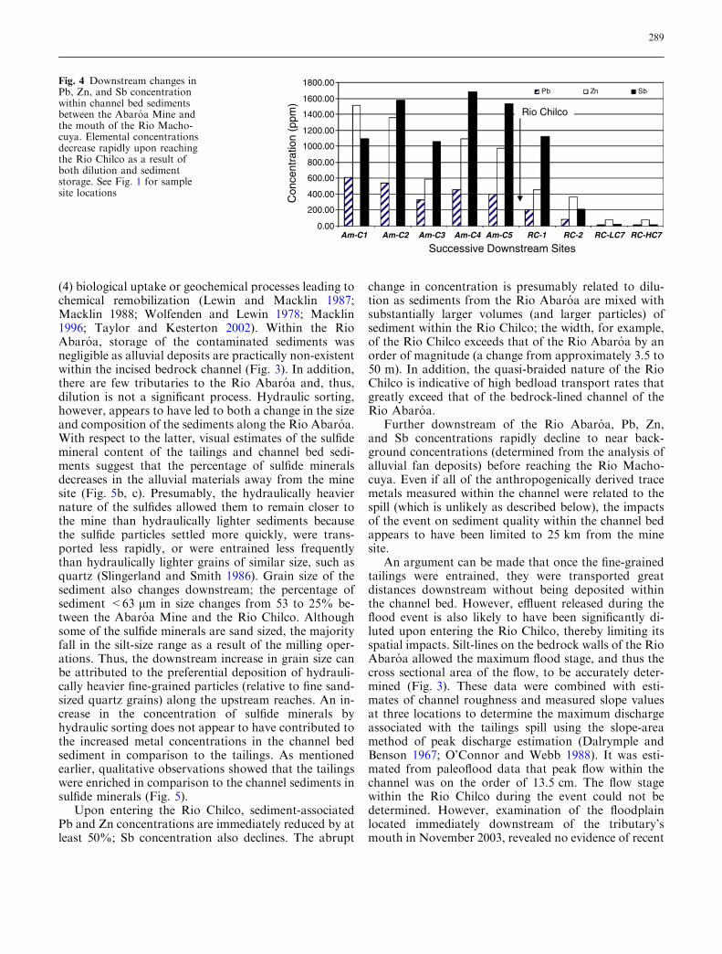
The concentrations of Pb, Zn, and Sb within thechannel bed materials between the Abaroa Mine and theRio Machocuya are shown in Fig. 4. In many investi-gations, spatial trends in trace metal concentrations areinterpreted by analyzing only the fine-grained sediments(e.g., <63 lm size fraction). The intent of analyzing thefine sediment is to remove the effects caused by varyinggrain size distributions on elemental concentrations(Ackermann 1980; Horowitz and Elrick 1988). In thiscase, however, the channel bed materials along RioChilco and Rio Tupiza were generally comprised of less
287
than 15% by weight of silt and clay-sized particles. Inaddition, the size of the sulfide grains shown in Fig. 5demonstrates that a significant dispersal pathway isthrough the physical movement of sand-sized, metalbearing particles (e.g., sphalerite and galena). Thus, thesand-sized sediment fraction can not be ignored as amedia for the downstream transport of Zn, Pb, and Sbfrom the mine site. Similar conclusions have beenreached by other investigators for mine impacted rivers(Moore et al. 1989; Horowitz 1991). The concentrationsreported here, then, are for <2 mm size fraction.
Figure 4 shows that the concentration of Pb and Zndecline semi-systematically downstream of the AbaroaMine until reaching the confluence between the RioChilco and the Rio Machocuya. Such downstream de-creases in contaminant concentrations are common be-low point sources of pollution and have generally beattributed to four factors. They include (1) hydraulicsorting of channel sediments on the basis of particledensity, size and shape, (2) the dilution of contaminantsby ‘‘clean’’ sediments, (3) losses through deposition andstorage in alluvial deposits located along the river, and
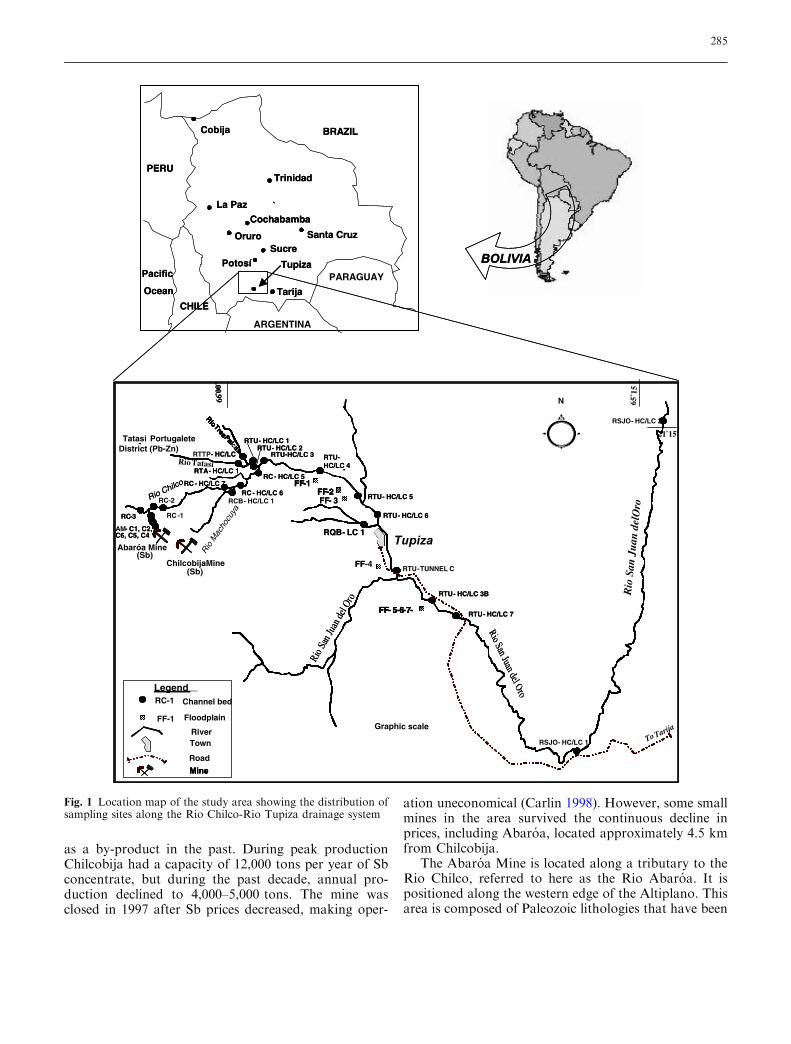
Table 2 Statistical summary ofgeochemical data for selectedmaterials and river reaches;reach locations are shown onFig. 1
Media/Reach Pb (lg/g) Zn (lg/g) Sb (lg/g) 206Pb/207Pb 206Pb/208Pb % <63 lm
Background Materials (n=4)Average 18.17 93.08 3.06 1.1851 0.4840 8Maximum 24.61 139.3 3.77 1.1915 0.4885 10Minimum 11.64 71.90 2.37 1.1777 0.4768 4SD 5.51 31.32 0.57 0.0064 0.0053 2Abaroa Tailings (n=3)Average 85.04 216.7 1123 1.1552 0.4709 48Maximum 114.5 279.3 1115 1.1625 0.4721 95Minimum 63.41 131.5 1093 1.1507 0.4686 17SD 26.26 76.46 28.69 0.0064 0.0019 41Chilcobija Tailings (n=2)Average 163.1 90.31 1846 1.1575 0.4649 85Maximum 179.8 107.6 2503 1.1587 0.4652 95Minimum 146.4 72.98 1189 1.1563 0.4646 74SD 23.63 24.51 929.4 0.0017 0.0004 15Rio Tatasi (mouth of basin) (n=6)Average 77.06 382.4 16.60 1.1939 0.4794 13Maximum 136.0 689.3 29.71 1.2156 0.4863 20Minimum 40.24 188.9 7.45 1.1817 0.4726 6SD 33.20 170.2 8.67 0.0129 0.0049 5Abaroa Mine to Rio Chilco (n=5)Average 466.1 1105 1388 1.1666 0.4731 38Maximum 610.9 1515 1681 1.1718 0.4774 53Minimum 330.5 587.4 1060 1.1619 0.4713 26SD 111.1 360.2 290.7 0.0036 0.0025 13Rio Abaroa to Rio Machocuya (n=4)Average 80.03 245.4 341.9 1.1660 0.4739 14Maximum 206.2 458.5 1118 1.1671 0.4828 43Minimum 12.13 76.20 17.46 1.1638 0.4674 1SD 90.80 197.2 525.7 0.0015 0.0065 19Rio Machocuya to Rio Tatasi (n=3)Average 18.23 91.47 27.42 1.1745 0.4725 7Maximum 23.88 106.7 39.75 1.1856 0.4789 18Minimum 11.69 82.08 16.03 1.1600 0.4671 1SD 6.14 13.28 11.89 0.0131 0.0060 6Rio Tupiza to Rio San Juan del Oro (n=11)Average 41.62 242.3 16.08 1.1906 0.4784 13Maximum 69.17 657.2 31.83 1.2141 0.4897 20Minimum 11.69 51.11 4.06 1.1625 0.4637 7SD 19.91 166.7 7.75 0.0138 0.0067 4Rio San Juan del Oro (n=4)Average 77 49.56 2.77 1.1829 0.4787 17Maximum 17.45 70.88 7.24 1.1960 0.4872 42Minimum 7.45 34.39 0.88 1.1660 0.4689 6SD 4.58 15.32 3.03 0.0137 0.0079 11Floodplain Soils (n=14)Average 94.09 310.7 37.40 1.1880 0.4765 43Maximum 241.2 643.4 111.3 1.2131 0.4908 68Minimum 27.21 103.9 7.15 1.1665 0.4673 17SD 74.07 215.3 35.47 0.0155 0.0073 14
288
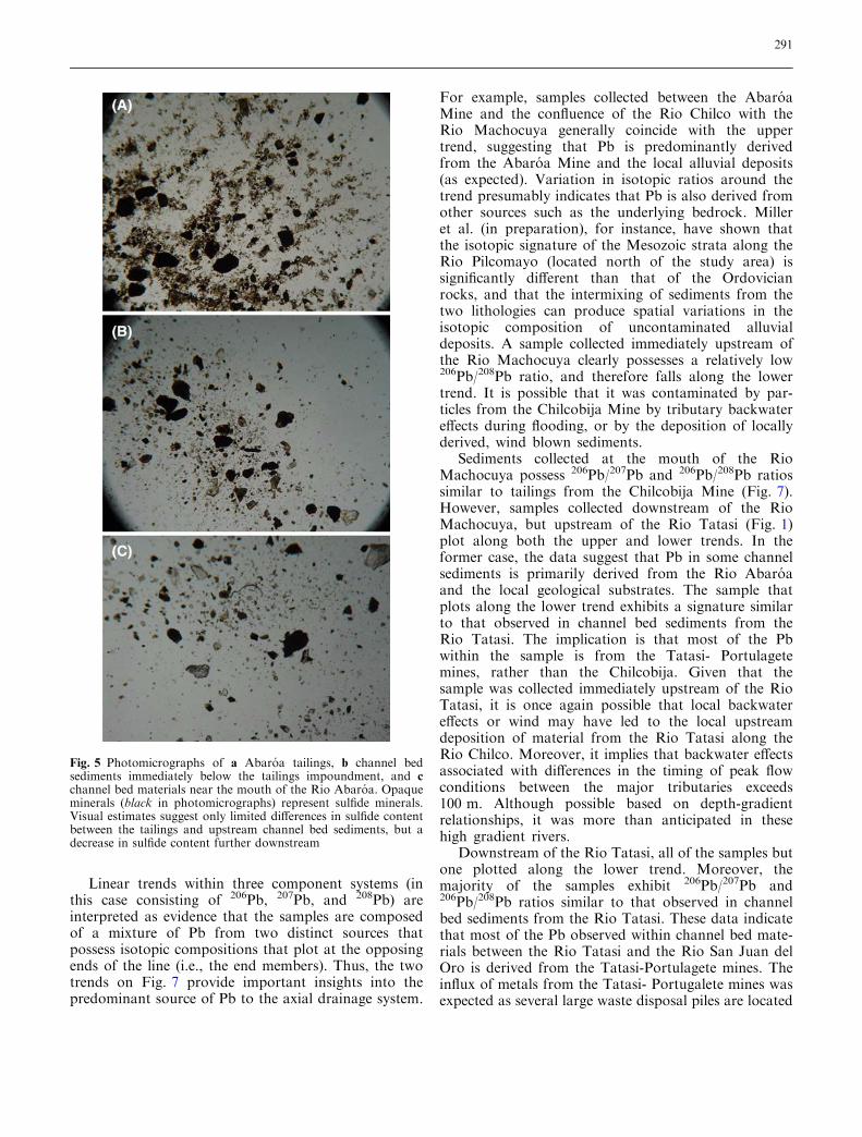
(4) biological uptake or geochemical processes leading tochemical remobilization (Lewin and Macklin 1987;Macklin 1988; Wolfenden and Lewin 1978; Macklin1996; Taylor and Kesterton 2002). Within the RioAbaroa, storage of the contaminated sediments wasnegligible as alluvial deposits are practically non-existentwithin the incised bedrock channel (Fig. 3). In addition,there are few tributaries to the Rio Abaroa and, thus,dilution is not a significant process. Hydraulic sorting,however, appears to have led to both a change in the sizeand composition of the sediments along the Rio Abaroa.With respect to the latter, visual estimates of the sulfidemineral content of the tailings and channel bed sedi-ments suggest that the percentage of sulfide mineralsdecreases in the alluvial materials away from the minesite (Fig. 5b, c). Presumably, the hydraulically heaviernature of the sulfides allowed them to remain closer tothe mine than hydraulically lighter sediments becausethe sulfide particles settled more quickly, were trans-ported less rapidly, or were entrained less frequentlythan hydraulically lighter grains of similar size, such asquartz (Slingerland and Smith 1986). Grain size of thesediment also changes downstream; the percentage ofsediment <63 lm in size changes from 53 to 25% be-tween the Abaroa Mine and the Rio Chilco. Althoughsome of the sulfide minerals are sand sized, the majorityfall in the silt-size range as a result of the milling oper-ations. Thus, the downstream increase in grain size canbe attributed to the preferential deposition of hydrauli-cally heavier fine-grained particles (relative to fine sand-sized quartz grains) along the upstream reaches. An in-crease in the concentration of sulfide minerals byhydraulic sorting does not appear to have contributed tothe increased metal concentrations in the channel bedsediment in comparison to the tailings. As mentionedearlier, qualitative observations showed that the tailingswere enriched in comparison to the channel sediments insulfide minerals (Fig. 5).
Upon entering the Rio Chilco, sediment-associatedPb and Zn concentrations are immediately reduced by atleast 50%; Sb concentration also declines. The abrupt
change in concentration is presumably related to dilu-tion as sediments from the Rio Abaroa are mixed withsubstantially larger volumes (and larger particles) ofsediment within the Rio Chilco; the width, for example,of the Rio Chilco exceeds that of the Rio Abaroa by anorder of magnitude (a change from approximately 3.5 to50 m). In addition, the quasi-braided nature of the RioChilco is indicative of high bedload transport rates thatgreatly exceed that of the bedrock-lined channel of theRio Abaroa.
Further downstream of the Rio Abaroa, Pb, Zn,and Sb concentrations rapidly decline to near back-ground concentrations (determined from the analysis ofalluvial fan deposits) before reaching the Rio Macho-cuya. Even if all of the anthropogenically derived tracemetals measured within the channel were related to thespill (which is unlikely as described below), the impactsof the event on sediment quality within the channel bedappears to have been limited to 25 km from the minesite.
An argument can be made that once the fine-grainedtailings were entrained, they were transported greatdistances downstream without being deposited withinthe channel bed. However, effluent released during theflood event is also likely to have been significantly di-luted upon entering the Rio Chilco, thereby limiting itsspatial impacts. Silt-lines on the bedrock walls of the RioAbaroa allowed the maximum flood stage, and thus thecross sectional area of the flow, to be accurately deter-mined (Fig. 3). These data were combined with esti-mates of channel roughness and measured slope valuesat three locations to determine the maximum dischargeassociated with the tailings spill using the slope-areamethod of peak discharge estimation (Dalrymple andBenson 1967; O’Connor and Webb 1988). It was esti-mated from paleoflood data that peak flow within thechannel was on the order of 13.5 cm. The flow stagewithin the Rio Chilco during the event could not bedetermined. However, examination of the floodplainlocated immediately downstream of the tributary’smouth in November 2003, revealed no evidence of recent
0.00
200.00
400.00
600.00
800.00
1000.00
1200.00
1400.00
1600.00
1800.00Pb Zn Sb
itartnecnoC
opp( nm
)
Am-C1 Am-C2 Am-C3 Am-C4 Am-C5 RC-2 RC-LC7 RC-HC7RC-1
Successive Downstream Sites
Rio Chilco
Fig. 4 Downstream changes inPb, Zn, and Sb concentrationwithin channel bed sedimentsbetween the Abaroa Mine andthe mouth of the Rio Macho-cuya. Elemental concentrationsdecrease rapidly upon reachingthe Rio Chilco as a result ofboth dilution and sedimentstorage. See Fig. 1 for samplesite locations
289

overbank flooding (e.g., flood debris), nor was thereevidence of any recent overbank deposition. Theseobservations suggest that deposition of contaminateddebris from the Abaroa tailings spill were confined to thechannel of the Rio Chilco-Rio Tupiza drainage system,and that the maximum flows within the channel were lessthan, but presumably close to, the bankfull discharge.The bankfull discharge was conservatively determined,again using the slope-area method, to be approximately75 cm, almost six times higher than the discharge fromthe tributary. Thus, the flood flow emanating from theRio Abaroa was presumably small in comparison to theflow within the Rio Chilco at the mouth of the tributary,even if flow within the Rio Chilco was below bankfull.Clearly, the differences in the flow magnitudes wouldhave led to significant dilution of the constituents re-leased from the impoundment.
Confinement of the flood flows to the axial channel,combined with dilution and the rapid downstream de-cline in Pb, Zn, and Sb concentrations in the channel bedsediments, all suggest that the spatial impacts of the2003 event were limited. The potential environmentalconsequences of the event were also reduced by: (1) alow population density and a lack of agriculture alongthis reach, (2) ephemeral stream conditions which limitthe diversity of the aquatic biota, and (3) metal transportin association with metal sulfides which restrict theirbioavailability.
Other sources of contamination
Geographical patterns in elemental concentration
Geographical patterns in trace metal concentrations arecommonly used to identify contaminant sources. In thiscase, ‘‘hotspots’’ are interpreted to represent points oftrace metal influx to the axial drainage system. Figure 6demonstrates that concentrations of Pb, Zn, or Sb in-crease immediately downstream of the mouth of allthree tributaries possessing significant mining opera-tions including the Rio Abaroa, the Rio Machocuya,and the Rio Tatasi. In the case of the Rio Abaroa, thelargest increase in concentration is associated with Sb.In contrast, Zn and, to a lesser degree, Pb concentra-tions increase downstream of the Rio Tatasi, whilechanges in Sb are negligible. Increased concentrationsdownstream of the Rio Machocuya are most pro-nounced for Zn, although minor increases also occurfor Pb and Sb.
The minimal input of Pb, Zn, and Sb from theChilcobija Mine (via the Rio Machocuya) is surprisinggiven the size of the operation and the known, historicalreleases of contaminated tailings to the headwaters ofthe Rio Machocuya. The contrasting impact on sedi-ment quality between the Chilcobija and Abaroa Mines
is presumably related to the increased distance of theformer from the Rio Chilco which allows for a greateropportunity for elemental dilution and storage to occur.Moreover, it once again demonstrates that Pb, Zn, andSb concentrations in channel bed sediments decreaserapidly downstream; in this instance, background valuesof Pb and Sb are approached within approxi-mately15 km of the mine site.
Pb isotopic fingerprinting of tailings materials
The use of Pb isotopes to determine sources of tracemetals in riverine environments is still in its infancy.Nonetheless, results from the few studies that have beenconducted indicate that the technique holds considerablepromise (see, for example, Miller et al.2002). Here, threeisotopes of Pb were used to geochemically fingerprintmining wastes from the Abaroa, Chilcobija and Tatasi-Portugalete mines. They include the radiogenic isotopesof 206Pb, 207Pb, and 208Pb which represent the daughterproducts of 238U, 235U, and 232Th, respectively. Unlikemany of the lighter isotopes, fractionation of the Pbsignature is thought to be negligible during industrialprocessing (milling) or biological uptake (Ault et al.1970; Graney et al. 1995) allowing them to serve asexcellent tracers of anthropogenic and natural Pb in thenear surface environment.
Figure 7 plots the 206Pb/207Pb and 206Pb/208Pb ratiosfor a wide variety of sample types from the Rio Chilco-Rio Tupiza drainage system. Although there is consid-erable scatter in the data, two trends are apparent. Theend members of the upper trend are formed by tailingssamples from the Abaroa Mine and sediments collectedfrom uncontaminated alluvial fan deposits. The fandeposits are assumed to possess the isotopic signaturesof the naturally occurring Pb within the region’s alluvialsediments (i.e., background). The end members of thelower trend are represented by tailings samples from theChilcobija Mine and samples from the mouth of the RioTatasi. The latter materials are assumed to represent thegeneral signature of Pb from the Tatasi-Portulagetemines (although the range of isotopic ratios hasundoubtedly been modified during the downstreamtransport of the tailings materials). The use of the Pbisotopic signature of sediment from the mouth of theRio Tatasi as a general descriptor of Pb from the Tatasi-Portulagete mining district is supported by Pb concen-trations that exceed local background values by a factorof at least 3 (Table 2). Figure 7 demonstrates that the Pbisotopic signature of the tailings materials from theAbaroa and Chilcobija mines differ, in spite of the factthat both are associated with the Bolivian AntimonyBelt. This is not altogether surprising in that the natureand age of the ore deposits vary between the two minesites.
290
Linear trends within three component systems (inthis case consisting of 206Pb, 207Pb, and 208Pb) areinterpreted as evidence that the samples are composedof a mixture of Pb from two distinct sources thatpossess isotopic compositions that plot at the opposingends of the line (i.e., the end members). Thus, the twotrends on Fig. 7 provide important insights into thepredominant source of Pb to the axial drainage system.
For example, samples collected between the AbaroaMine and the confluence of the Rio Chilco with theRio Machocuya generally coincide with the uppertrend, suggesting that Pb is predominantly derivedfrom the Abaroa Mine and the local alluvial deposits(as expected). Variation in isotopic ratios around thetrend presumably indicates that Pb is also derived fromother sources such as the underlying bedrock. Milleret al. (in preparation), for instance, have shown thatthe isotopic signature of the Mesozoic strata along theRio Pilcomayo (located north of the study area) issignificantly different than that of the Ordovicianrocks, and that the intermixing of sediments from thetwo lithologies can produce spatial variations in theisotopic composition of uncontaminated alluvialdeposits. A sample collected immediately upstream ofthe Rio Machocuya clearly possesses a relatively low206Pb/208Pb ratio, and therefore falls along the lowertrend. It is possible that it was contaminated by par-ticles from the Chilcobija Mine by tributary backwatereffects during flooding, or by the deposition of locallyderived, wind blown sediments.
Sediments collected at the mouth of the RioMachocuya possess 206Pb/207Pb and 206Pb/208Pb ratiossimilar to tailings from the Chilcobija Mine (Fig. 7).However, samples collected downstream of the RioMachocuya, but upstream of the Rio Tatasi (Fig. 1)plot along both the upper and lower trends. In theformer case, the data suggest that Pb in some channelsediments is primarily derived from the Rio Abaroaand the local geological substrates. The sample thatplots along the lower trend exhibits a signature similarto that observed in channel bed sediments from theRio Tatasi. The implication is that most of the Pbwithin the sample is from the Tatasi- Portulagetemines, rather than the Chilcobija. Given that thesample was collected immediately upstream of the RioTatasi, it is once again possible that local backwatereffects or wind may have led to the local upstreamdeposition of material from the Rio Tatasi along theRio Chilco. Moreover, it implies that backwater effectsassociated with differences in the timing of peak flowconditions between the major tributaries exceeds100 m. Although possible based on depth-gradientrelationships, it was more than anticipated in thesehigh gradient rivers.
Downstream of the Rio Tatasi, all of the samples butone plotted along the lower trend. Moreover, themajority of the samples exhibit 206Pb/207Pb and206Pb/208Pb ratios similar to that observed in channelbed sediments from the Rio Tatasi. These data indicatethat most of the Pb observed within channel bed mate-rials between the Rio Tatasi and the Rio San Juan delOro is derived from the Tatasi-Portulagete mines. Theinflux of metals from the Tatasi- Portugalete mines wasexpected as several large waste disposal piles are located
Fig. 5 Photomicrographs of a Abaroa tailings, b channel bedsediments immediately below the tailings impoundment, and cchannel bed materials near the mouth of the Rio Abaroa. Opaqueminerals (black in photomicrographs) represent sulfide minerals.Visual estimates suggest only limited differences in sulfide contentbetween the tailings and upstream channel bed sediments, but adecrease in sulfide content further downstream
291

within the mining district in the headwaters of the RioTatasi. Moreover, the erosion and influx of these tail-ings, and their potential impacts on the riverine envi-ronment, have been recognized for some time. In fact,COMIBOL (the former state company which owns themines) is currently attempting to remediate the impactsassociated with the tailings piles. Nonetheless, the degreeto which alluvial sediments along the Rio Tatasi arecontaminated has yet to be quantified. The elevatedconcentrations of Pb, Zn, and Sb observed here inchannel bed sediments near the mouth of the Rio Tatasi(Table 2), clearly demonstrates that metal enrichedsediments have been transported to the Rio Tupiza lo-cated more than 25 km downstream of the mines. It isalso worth noting that in contrast to the rapid down-stream declines in Pb, Zn, and Sb concentration ob-served along the Rio Chilco, the concentrations alongthe Rio Tupiza downstream of RTU-4 remain nearlyconstant at values well above background (Figs. 1,6). Assuggested by the isotopic data, the lack of a significantdownstream decrease in concentration along this reachof the Rio Tupiza could be attributed to the input ofsubstantial quantities of tailings from the Tatasi-Portu-lagete mines which override the effects of dilution causedby the input of sediment from the Rio Chilco and othertributaries to the Rio Tupiza. Other factors, however,could also play a role, including (1) the input of metalenriched sediment from contaminated floodplaindeposits, and/or (2) a change in geomorphic processesaffecting storage above and below the mouth of the RioTatasi.
Channel storage
Previous studies have shown that spatial trends in tracemetal concentrations are closely linked to the depositionand storage of contaminated particles along a river
system (Owens et al. 2001; Walling et al. 2003). In mostcases, the storage of sediment within the channel, asopposed to the floodplain, is minimal. For example, thestorage of fine-grained sediments to which trace metalsare most likely to be attached was found to be less thanabout 10% of total suspended sediment load exportedfrom the rivers Ouse, Wharfe, and Tweed in the UK(Owens et al. 1999; Walling et al. 1998). Similar valueswere found for metals along the Rivers Aire and Swale,where the storage of Pb and Zn was less than about 3%of the total annual sediment load (Walling et al. 2003).These calculations prompted Walling et al. (2003) tosuggest that channel storage is of limited importance inregulating the downstream transport of contaminantsthrough many river systems. In marked contrast tochannel storage, floodplains are perceived as significantstorage sites. Previous studies, for example, have shownthat 10–50% or more of the total annual load may beeither temporarily or semi-permanently stored in flood-plain deposits (Macklin 1996; Marron 1992; Wallinget al. 2003). Moreover, the residence time of the con-taminants also differs substantially between channel andfloodplain deposits. Although poorly constrained, resi-dence times for fine-grained channel sediments is gen-erally less than 5 years as a result for frequent sedimentreworking during flood events (Walling et al. 2003),whereas contaminants may be stored for decades, cen-turies, or even millennia in floodplain environments(Macklin 1996; Miller 1997; Coulthard and Macklin2003).
It should be recognized, however, that the above dataare for relatively stable rivers which are not undergoingsignificant aggradation. Changes in river form andprocess, such as associated with aggradation, can sig-nificantly affect both floodplain and channel storageprocesses (Lewin and Macklin 1987; Macklin 1996;Miller 1997). Field observations made in November2003, indicate that the Rio Chilco and Rio Tupiza are
0.00
200.00
400.00
600.00
800.00
1000.00
1200.00
Pb Concentration Zn Concentration Sb Concentration
Downstream
RC-3RC-1
RC-2RC-7
Con
cent
ratio
n (p
pm)
RTU-3RC-5
RC-6
RTU-4
RTU-5
RTU-6
RTU-T
RTU-7
RSJO-1
RSJO-2
Successive Downstream Sites
RioAbaróa
RioMachocuya
RioTatasi
Rio San Juandel Oro
Fig. 6 Concentrations of Pb,Zn, and Sb along the RioChilco, Rio Tupiza, and RioSan Juan del Oro. Increases inconcentration occur immedi-ately downstream of the RioAbaroa, the Rio Tatasi, and toa much lesser degree, the RioMachocuya. See Fig. 1 forlocation of sample sites
292

undergoing significant changes in channel form whichmay influence both the longitudinal patterns in Pb, Zn,and Sb concentrations and their storage along thedrainage system.
Downstream of the Rio Abaroa, channel bed sedi-ments in the Rio Chilco span the width of the valley andsignificant floodplain deposits are absent. Those thatexist generally occur in protected areas behind pro-grading tributary fan deposits or in bedrock alcoves.Accumulations of sediment along the base of the hills-lopes are rare and where they occur, they are typicallyassociated with mass wasting deposits. Perhaps the mostsignificant accumulations of sediment along the RioChilco are associated with large alluvial fans associatedwith relatively steep tributaries. The distal fan depositsare typically truncated, indicating that at least some ofthe fan deposits have been redistributed within thechannel. The upper reach of the Rio Tupiza is charac-terized by a similar morphology to the Rio Chilco.However, a few kilometers downstream of the RioTupiza’s confluence with the Rio Chilco, floodplaindeposits begin to occur along the channel. The extentand continuity of the floodplain increases downstream.Floodplains by RTU-FF1 are on the order of 10’s to100’s of meters in width and are used for agriculture(Fig. 1).
The observed distribution of landforms is thought tobe primarily related to adjustments in channel gradientcaused by a significant episode of aggradation that ismore pronounced along the Rio Chilco and the up-stream most reaches of the Rio Tupiza. Aggradationhas presumably led to the reworking and burial ofolder alluvial floodplain deposits within the upstreamreaches of the drainage network. This interpretation issupported by the more frequent inundation and dam-age to a railroad that lies adjacent to the Rio Tupiza.In fact, a local resident stated that in the past, largetrucks which utilized the dry, axial stream bed as a
road during the dry season could access many up-stream tributaries by driving under the railroad bridges.Now, however, upstream tributary channels are lessthan 1–2 m below the bridge, or have aggraded to suchan extent that the channel beneath the bridge mustbe maintained by local dredging (Fig. 8). Detailedengineering documents to quantify the degree ofaggradation that has occurred have yet to be found.Nonetheless, these consistent anecdotal reports byseveral local residences suggest that at least 2–3 m ofaggradation has occur along the Rio Chilco and upperRio Tupiza during the past decade.
The primary cause of aggradation is currently underinvestigation. However, it is clear that the sediment isderived in large part from the gullying and erosion ofupland valleys and the influx of large amounts ofsediment by mass wasting processes. Following a masswasting event, sediment which reaches tributary chan-nels is transported to the axial drainage system whereit may be temporarily stored in the large, tributaryfans.
Channel bed aggradation has three important influ-ences on the rate and dispersal of Pb, Zn, and Sbfrom the mine sites. First, larger quantities of trace ele-ments are likely to be stored in the channel bed duringaggradation than would otherwise be the case. Forexample, if it is assumed that 2 m of aggradation oc-curred along the Rio Chilco between the Rio Abaroaand the Rio Machocuya, approximately 237,700 kg ofPb, 728,800 kg of Zn, and 1,015,400 kg of Sb could bestored in the channel bed if concentrations were equal tothe average concentrations currently observed along thereach. Put differently, these rough calculations suggestthat between 1·106 and 3·106 metric tons of tailingscould be stored in the channel bed (depending on themetal used to make the calculation) if it is assumed thatthe tailings exhibited a uniform concentration equivalentto the averages determined herein. This is on par with
0.460
0.465
0.470
0.475
0.480
0.485
0.490
0.495
1.140 1.150 1.160 1.170 1.180 1.190 1.200 1.210 1.220
Abaroa Tailings Background Chilcobija Tailings Rio Tatasi
Rio Machocuya to Rio Tupiza Rio Tatasi to San Juan del Oro Abaroa Mine to Rio Machocuya
206 P
b/20
8 Pb
206Pb/207Pb
Abaroa Mine to
Rio M
achocu
ya
Rio Machocuya to San Juan del Oro
Mouth of Rio Machocuya
Fig. 7 Three-component dia-gram showing differences in Pbisotopic abundances of selectedsediment types within the RioChilco-Rio Tupiza drainagesystem. Trend lines are drawnbetween sample means for endmember media types
293

the total quantity of mill tailings produced at theAbaroa Mine during its history of operation. The secondaffect of channel aggradation is that the excessiveamount of tributary sediment that enters the channelwill enhance the magnitude of dilution that can occur,thereby reducing trace element concentrations associ-ated with contaminated particles. Third, channel bedaggradation has presumably led to the reworking andburial of upstream floodplain deposits, limiting theireffectiveness as both a source and sink for Pb, Zn, andSb.
Floodplain contamination and storage
The potential for contaminated particles to be remobi-lized from floodplain deposits raises the possibility thatwhere they exist, they could serve as an importantsource of Pb, Zn, and Sb to the modern river system(Macklin 1996; Miller et al. 1998). Moreover, down-stream changes in their extent and distribution couldpotentially lead to differences in the geographical pat-terns of elemental concentration observed along thedrainage system. To determine the degree to which Pb,Zn, and Sb are currently stored within the floodplain ofthe Rio Tupiza, and the likelihood that the floodplaindeposits serve as a current source of contaminants,spatial variations in metal concentrations were deter-mined at five sites along the channel (Fig. 1). At eachsite samples were collected at 10, 35, and 50 m from thechannel margins and from cores that extracted sedi-ments to depth of up to 1.2 m.
With the exception of Sb, trace metal concentrationswere higher in the floodplain deposits than in thechannel bed materials (Table 2). For example, the meanconcentration for Pb and Zn within the floodplaindeposits is higher than for any channel bed sample ifsamples from the Rio Abaroa are excluded (based ont-test; P<0.05). Differences in Sb concentration betweenthe channel and the floodplain are not statistically sig-nificant.
It is probable that the elevated levels of Pb and Znwithin the floodplains are a consequence of the prefer-ential deposition of fine-grained sediments within thefloodplains during overbank flooding. For example, thesilt and clay grain size fraction (composed of particles<63 lm in size) ranges from 41 to 62% in floodplainsediments. In contrast, the low- and high-channeldeposits adjacent to the sampled fields contain between12 and 16% silt-clay.
The concentrations of Pb, Zn, and Sb in surfacesediments of the floodplains are shown in Fig. 9. Spatialtrends in elemental concentration as a function of dis-tance from the channel vary between sites and tend to berather minor (<10%). Similarly, systematic down-stream trends in concentration between sampling sitesRTU-FF1 and RTU-FF4 (Fig. 1) are lacking (Fig. 9).However, the elevated concentrations of Pb, Zn, and Sbwithin these floodplain deposits suggest that they couldrepresent a current source of trace metals to the channel.At sites downstream of RTU-FF4, concentrations of Pband Sb are lower than the other upstream floodplainsand are similar to, or slightly above, the range of localbackground values (Fig. 9, Table 2). The observed de-crease in concentration between site RTU-FF4 andRTU-FF5 is presumably related to dilution associatedwith the influx of sediment from the Rio San Juan delOro, one of the largest rivers in the area.
Pb, Zn, and Sb concentrations vary significantly as afunction of depth in the upstream sampling sites (i.e.,RTU-FF1–RTU-FF4). Nonetheless, concentrations aregenerally well above background values. As was the casefor the surface sediments, concentrations are elevatedabove those found in the adjacent channel bed materials.In addition, while the exact contribution from the minescannot be determined, it appears likely that relativelyhigh 206Pb/207Pb ratios, when coupled with high Pbconcentrations, indicate that Pb is primarily derivedfrom the mines within the Rio Tatasi. In contrast, rel-atively low 206Pb/207Pb ratios imply an influx of sedi-ment from the Sb mines within the Rio Chilco basin.Figure 10 demonstrates that sediment-borne trace met-als from the Abaroa and/or Chilcobija mines were beingtransported further downstream in the past than theycurrently are. The cause(s) for the recent reduction intransport from the mines cannot be determined with theexisting data, but most likely depends on both the his-tory of mining activity and variations in contaminated
Fig. 8 Railroad bridge crossing a tributary to the Rio Tupizaimmediately downstream of the Rio Tatasi. A local resident statedthat in the recent past, large trucks could pass beneath the bridge.Currently, maximum depth below the bridge is approximately1.5 m
294

sediment transport rates and dispersal processes. Theonset of aggradation, which is thought to have begunwithin approximately the past decade, could dramati-cally increase the storage of sediment-associated tracemetals within the channel bed, thereby decreasingdownstream transport.
Potential environmental impacts to agriculturalactivities
Floodplains located along the Rio Tupiza are usedextensively for agricultural purposes. The primarycrops include a host of vegetables (e.g., corn andpotatoes) which are consumed locally and sold in smallcommunities within the region. Metal concentrationsmeasured within the soils developed on floodplains atsites RTU-FF2 and RTU-FF3 possess values that ex-ceed international guidelines for agricultural use. Forexample, Pb in the upper layers of the floodplain atRTU-FF2 exceeds the Canadian guideline of 200 ppm,while Zn is above Canadian, German, and Dutchguideline values (Table 3). Sb is three times higher thanthe Canadian guideline value of 20 ppm. Similarly,floodplain deposits at RTU-FF3 exhibited Pb concen-trations of 326 ppm at the ground surface, which ex-ceed the Canadian guideline. Zn concentrations againexceed all three guideline values. In contrast, concen-trations of Pb, Zn, and Sb in the farthest downstreamfloodplain samples (RTU-FF5, 6, 7; Fig. 1) are belowall three guidelines (Table 3).
The locally elevated levels of Pb, Zn, and Sb inagricultural soils indicate that the potential exists for thedegradation of human health through the consumptionof contaminated produce. Metal uptake by plants grownin polluted soils is related to numerous factors in addi-tion to metal concentrations within the soil, including itsspeciation, soil pH, temperature, cation exchangecapacity of the soil, organic matter content, plant spe-cies, and the means through which metals are distributed
to plant parts during growth (Haghiri 1973, 1974; Ab-del-Sabour et al. 1988; Ward and Savage 1994; Voutsaet al. 1996; Albering et al. 1999). Thus, metal concen-trations that exceed guideline values in soils do notnecessarily lead to elevated concentrations in agricul-tural food stocks. For example, Miller et al. (2004)found that concentrations of trace metals in vegetablesgrown on highly contaminated farm fields along the RioPilcomayo contained metal concentrations that weregenerally below existing guidelines for metal content incommercially-sold vegetables. Thus, the consumption ofcontaminated produce did not appear to represent asignificant exposure pathway in the four communitiesthat were studied (although a possible exception existedfor Pb in carrots, lettuce, and beetroots from Sotomayorand Tuero Chico, where 37 and 55% of the samples,respectively exceeded recommended guidelines). Limitedaccumulation of the examined metals may have beenrelated to their bioavailability in the soils, particularlythe occurrence of metals in sulfide minerals. Similar re-sults have been presented for other sites as well. Alberinget al. (1999), for example, found that Zn and Cd con-centrations in the crops of the River Meuse were withinthe range of background values in spite of the fact thatthey were grown on severely polluted floodplain soils.They suggested that the lack of Cd and Zn accumulationin the crops was due to the relatively high pH of thefloodplain soil (6.9±0.6) that reduced the availability ofthe metals for plant uptake. The point to be made, then,is that additional studies are warranted to determine ifcrops grown on severely contaminated soils possess alocal risk to human health, but high concentrations insoils do not necessarily indicate an immediate healthrisk.
Conclusions
Spatial trends in Pb, Zn, and Sb concentrations, com-bined with Pb isotopic data, indicate the sediment-
50 m 50 m 50 m
50 m
50 m 50 m
50 m
35 m 10 m 10 m
10 m
10 m
10 m
10 m
RTU-FF7RTU-FF6RTU-FF5RTU-FF4RTU-FF3RTU-FF2RTU-FF1
Con
cent
ratio
n (p
pm)
Successive Downstream Sites
SbZnPb700.00
600.00
500.00
400.00
300.00
200.00
100.00
0.00
Rio San Juan del Oro
Fig. 9 Pb, Zn, and Sb concen-trations at the surface (upper5 cm) of floodplain soils locatedalong the Rio Tupiza. SeeFig. 1 for sampling locations
295

borne trace metals are entering the Rio Chilco-RioTupiza drainage system from three tributaries, each ofwhich possess significant mining operations. The trib-utaries include the Rio Abaroa, the Rio Machocuyaand the Rio Tatasi. Although production at theAbaroa Mine is limited, it appears to be the primarysource of Sb to the modern channel bed of the RioChilco. Antimony from the Chilcobija Mine is cur-rently limited, in spite of the fact that is was the largestSb mine in Bolivia and tailings materials remain in thebasin. Concentrations of Pb, Zn, and Sb downstreamof both mines decrease rapidly as a result of dilution by
uncontaminated sediments and the storage of metalenriched particles (e.g., sulfide minerals) in the channelbed during aggradation.
In contrast to geographical patterns of Pb observedwithin the modern channel bed, Pb isotopic ratiosmeasured within older floodplain deposits locatedfurther downstream (and adjacent to Tupiza) suggestthat contaminated sediments from the Abaroa and/orChilcobija mines were distributed over a greater dis-tance in historic times. The recent decrease in metaltransport may be related to (1) larger releases of con-taminated sediment during periods of peak production
206Pb/207Pb
Pb
(ppm
)
0.00
20.00
40.00
60.00
80.00
100.00
120.00
140.00
160.00
180.00
200.00
220.00
1.140 1.150 1.160 1.170 1.180 1.190 1.200 1.210 1.220
Abaroa Tailings Chilcobija Tailings
Background Rio Tatasi
0.00 10.00 20.00 30.00 40.00 50.00 60.000
20
40
60
80
100
120
1401.160 1.170 1.180 1.190 1.200 1.210
Pb (ppm)
Dep
th (
cm)
RTU-FF5
0 50 100 150 200 250 3000
20
40
60
80
100
120
1401.170 1.1801.1901.2001.210 1.2201.2301.240
206Pb/207Pb 206Pb/207Pb
Dep
th (
cm)
Pb (ppm)
RTU-FF2
Pb Conc.
Bac
kgro
und
? S
b m
ines
Tatasi D
istrict
Pb Conc.
Sb
min
es
Tatasi D
istrictatasi D
istrict
Fig. 10 a relationship betweentotal Pb concentration and206Pb/207Pb ratio for selectedsediment types; b variations inPb concentration and206Pb/207Pb ratio in floodplaindeposits as a function of depth
296

at the Sb mines, (2) a change in sediment storageprocesses associated, for example, with the onset ofchannel bed aggradation during approximately the pastdecade, and/or (3) a combination of the previous twofactors. The floodplains now serve as an additionalsource of contaminated sediment to the downstreamreaches of the Rio Tupiza.
Tailings eroded and transported downstream duringthe February 2003, flood were confined to the axialchannel of the Rio Chilco and the environmental im-pacts of the event appear to have been minor. Pb, Zn,and Sb concentrations decrease to background valueswithin 25 km of the mine site, and the contaminatedreach is devoid of significant populations and agricul-ture. In addition, the quantity of Pb, Zn, and Sb intro-duced to the drainage system by the event was limited incomparison to releases associated with historic miningoperations in the Rio Tatasi basin. Most of the Pb andZn found within channel and floodplain deposits of theRio Tupiza were derived from Tatasi-Portugalete min-ing district via the Rio Tatasi. Locally, concentrationswithin the surface soils of the floodplains exceed Cana-dian, German, and/or Dutch guidelines for agriculturaluse. The potential uptake of metals and Sb by cropsgrown on the contaminated soils near Tupiza requiresadditional study given its potential to affect humanhealth. However, concentrations measured downstreamof the confluence between the Rio Tupiza and the RioSan Juan del Oro suggests that regional impacts ofmining operations within the upper reaches of the basinare minimal and are unlikely to significantly affect theaquatic systems located along the Rio Pilaya or RioPilcomayo under the current physio-chemical condi-tions.
As legal issues surrounding riverine contaminationbecome more complex, and the levels of contaminationof concern lower, the difficulty of assessing contami-nant sources will increase. This has prompted a callfor more forensic and quantitative approaches tosource determination. The results from this studyclearly demonstrate that Pb isotopes can be used totrack the movement of sediment-borne trace metalsfrom mining operations through river systems. More-over, Pb fingerprinting methods can be applied evenwhen multiple sources of Pb exist and for riverineenvironments where Pb levels are near the concentra-tions observed in natural geologic materials (i.e., closeto background).
Acknowledgments Ms. Aleida Tejerina is thanked for her in-valuable assistance in organizing logistical aspects of our field-work, and for assisting in the collection of field data. Thismaterial is based on support by the National Science Foundationunder grant No. 0207439. The Foundation’s support is greatlyappreciated.
Table 3 Comparison of floodplain soils data with selected guide-lines for agricultural use
Pb Zn Sb
Typical conc. (rocks)a
Granite 17 50 0.2Sandstone 7 16 0.4Shales 20 95 1Rıo Pilcomayo Basin 18 66Regional background (6–34) (17–132)Health guidelinesDutch 530 720 –Action levelsb
Canada guidelines 200 400 20Maximum limitsc
Germany 500 300 –Maximum limitsc
RTUFF 1–35 35 m Adjacentto river
158.7 421.9 30.7
RTUFF 1–50 50 m Adjacentto river
65.9 266.6 22.4
RTU-FF 2–10 10 m Adjacentto river
202.8 643.4 88.5
RTU-FF 2–50 50 m adjacentto river
199.8 602.5 92.2
RTU-FF2-C A 0–15 cm 231.2 750.7 94.3RTU-FF2-C B 15–30 cm 117.6 380.9 46.2RTU-FF2-C C 30–45 cm 83.0 288.0 30.3RTU-FF2-C D 45–60 cm 95.5 264.4 19.2RTU-FF2-C E 60–75 cm 201.1 247.8 20.2RTU-FF2-C F 75–90 cm 260.2 264.1 23.3RTU-FF2-C G 90–105 cm 204.5 193.3 17.3RTU-FF2-C H 105–120 cm 73.5 93.4 7.2RTU-FF3–10 10 m adjacent
to river93.8 532.4 59.1
RTU-FF3–50 50 m adjacentto river
241.1 623.1 111.3
RTU-FF3-C A 0–15 cm 326.2 785.4 103.0RTU-FF3-C B 15–30 cm 122.2 365.7 44.0RTU-FF3-C C 30-45 cm 184.4 466.2 61.4RTU-FF4-C 10 10 m adjacent
to river61.4 309.3 29.5
RTU-FF4-C 50 50 m adjacentto river
61.1 299.4 25.8
RTU-FF5-C 10 10 m adjacentto river
69.7 120.6 13.4
RTU-FF5-C 50 50 m adjacentto river
33.1 105.1 7.2
RTU-FF5-C A 0–10 cm 34.3 99.1 6.3RTU-FF5-C B 10–20 cm 34.3 92.3 8.2RTU-FF5-C C 20–30 cm 41.9 105.3 8.8RTU-FF5-C D 30–50 cm 54.6 109.3 10.4RTU-FF5-C E 50–70 cm 38.8 94.2 11.0RTU-FF5-C F 70–95 cm 20.7 62.2 9.4RTU-FF5-C G 95–124 cm 12.3 52.6 8.0RTU-FF6–10 10 m adjacent
to river32.9 103.9 16.6
RTU-FF6–50 50 m adjacentto river
34.8 108.4 11.1
RTU-FF7–10 10 m adjacentto river
27.2 106.7 8.5
RTU-FF7–50 50 m adjacentto river
34.8 105.8 7.4
aFrom Turekian (1971) and Martinand Meybeck (1979)bKabata-Pedias (1995)cMHSPE (2000)
297

References
Ackermann F (1980) A procedure for cor-recting for grain size effect in heavymetal analyses of estuarine and coastalsediments. Environ Technol Lett 1:518–527
Abdel-Sabour MJ, Mortvedt JJ, Kelso JJ(1988) Cadmium-zinc interactions inplants and extractable cadmium andzinc fraction in soils. Soil Sci 145:424–431
Albering HJ, van Leusen SM, MoonenEJC, Hoogewerff JA, Kleinjans JCS.1999. Human health risk assessment: acase study involving heavy metal soilcontamination after the flooding of theriver Meuse during the winter of 1993–1994. Environ Health Perspect 107:37–43
Ault WA, Senechal RG, Erlebach WE(1970) Isotopic composition as a natu-ral tracer of lead in the environment.Environ Sci Technol 4:305–313
Carlin JF (1998) U.S. Geological SurveyMineral Commodity Summaries. Anti-mony. http://www.minerals.er.usgs.gov/minerals/pubs/commodity/antimony/Mar 2005
Chow TJ, Earl JL (1972) Lead isotopes inNorth American coals. Science176:510–511
Chow TJ, Johnstone MS (1965) Lead iso-topes in gasoline and aerosols of LosAngeles basin, California. Science147:502–503
Coulthard TJ, Macklin MG (2003) Mod-eling long-term contamination in riversystems from historical metal mining.Geology 31:451–454
Dalrymple T, Benson MA (1967) Mea-surement of peak discharge by theslope-area method. Technical water re-sources research vision (US Geol Surv)Book 3, Chapter A-2, pp 1–12
Gibbs JR (1977) Transport phases of tran-sition metals in the Amazon and YukonRivers. Geol Soc Am Bull 88:829–843
Gustavson (1991) Compendium of eco-nomic Geology-Bolivia, GustavsonAssociates, Inc, Baker & Mc Kenzie,Mintec and Servicio Geologico deBolivia
Graney JR, Halliday AN, Keeler GJ, Nra-igu JO, Robbins JA, Norton SA (1995)Isotopic record of lead pollution in lakesediments from the northeastern UnitedStates. Geochim Cosmochim Acta59:1715–1728
Gulson BL, Tiller KG, Mizon KJ, MerryRH (1981) Use of lead isotope ratios insoils to identify the source of lead con-tamination near Adelaide, South Aus-tralia. Environ Sci Technol 15:691–696
Hansmann W, Koppel V (2000) Lead-iso-topes as tracers of pollutants in soils.Chem Geol 171:123–144
Haghiri F (1973) Cadmium uptake byplants. J Environ Qual 2:93–96
Haghiri F (1974) Plant uptake of cadmiumas influenced by cation exchangecapacity, organic matter, zinc and soiltemperature. J Environ Qual 3:180–183
Horowitz AJ (1991) A Primer on sediment-trace element chemistry. 2nd edn, LewisPublishers
Horowitz AJ Elrick KA (1988) Interpreta-tion of bed sediment trace metal data:methods of dealing with the grain sizeeffect. In: Lichtenberg JJ, Winter JA,Weber CC, Fradkin L (eds) Chemicaland biological characterization of slud-ges, sediments, dredge spoils, and dril-ling muds. American society for testingand materials, pp 114–128
Hudson-Edwards KA, Macklin MG, Tay-lor MP (1999) 200 years of sediment-borne heavy metal storage in theYorkshire Ouse basin, NE England,UK. Hydrological Processes 13:1087–1102
Hudson-Edwards KA, Macklin MG, MillerJR, Lechler PJ (2001) Sources, distri-bution and storage of heavy metals inthe Rio Pilcomayo, Bolivia. J GeochemExplor 72:229–250
Hudson-Edwards KA, Macklin MG,Jamieson HE, Brewer PA, CoulthardTJ, Howard AJ, Turner JN (2003) Theimpact of tailings dam spills and clean-up operations on sediment and waterquality in river systems: the Rıos Agrio-Guadiamar, Aznalcollar, Spain. ApplGeochem 18:221–239
Kabata-Pendias A (1995) Agriculturalproblems related to excessive tracemetals content of soil. In: Salomons W,Forstner U, Mader P (eds) Heavy met-als, problems and solutions. Springer,Berlin Heidelberg, New York
La Manana, 2003. Dicen que la contami-nacion de Pilcomayo ‘‘es croica’’ y pi-den plantas monitoreo. La Manana, vozdel centro de la provincial de BuenosAires
Lewin J, Macklin MG (1987) Metal miningand floodplain sedimentation in Britain.In: Gardiner V (ed) International Geo-morphology 1986, Part 1. Wiley,Chichester, pp 1009–1027
Macklin MG (1996) Fluxes and storage ofsediment-associated heavy metals infloodplain systems: assessments andriver basin management issues at a timerapid environmental change. In:Anderson MG, Walling DE, Bates PD(eds) Floodplain processes. Wiley,Chichester, pp 441–460
Marcantonio F, Flowers G, Thien L, Ellg-aard E. (1998) Lead isotopes in treerings: chronology of pollution in BayouTrepangnier, Louisiana. Environ SciTechnol 32:2371–2376
Marron DC (1992) Floodplain storage ofmine tailings in the Belle Fourche riversystem: a sediment budget approach.Earth Surf Process Landform 17:675–685
Martin JM, Meybeck M (1979) Elementalmass balance of material carried bymajor world rivers. Mar Chem 7:173–206
MHSPE (2000) Target values and inter-vention values for soil remediation.DBO/1999226863, Ministry of Housing,Spatial Planning, and EnvironmentDirectorate-General for EnvironmentalProtection, The Netherlands Govern-ment Gazette No. 39
Miller JR (1997) The role of fluvial geo-morphic processes in the dispersal ofheavy metals from mine sites. J Geo-chem Explor 58:101–118
Miller JR, Lechler PJ, Desilets M (1998)The role of geomorphic processing inthe transport and fate of mercury in theCarson River basin, west-central Neva-da. Environ Geol 33:249–262
Miller JR, Lechler PJ, Hudson-EdwardsKA, Macklin MG (2002) Lead isotopicfingerprinting of heavy metal contami-nation, Rio Pilcomayo, Bolivia. In: Al-lan R, Horowitz AJ, and Miller JR (eds)Metal mining in the environment. Spe-cial Issue, Geochem Explor, EnvironAnal 2:225–233
Miller JR, Hudson-Edwards KA, LechlerPJ, Preston D, Macklin MG (2004)Heavy metal contamination of water,soil and produce within riverinecommunities of the Rio Pilcomayobasin, Bolivia. Sci Total Environ260:87–96
Moor HC, Schaller T, Sturm M (1996)Recent changes in stable lead isotoperatios ion sediments of Lake Zug,Switzerland. Environ Sci Technol30:2928–2933
Moore JN, Book EJ, Johns C (1989) Grainsize partitioning of metals in contami-nated, coarse-grained river floodplainsediments: Clark Fork River, Montana,USA. Environ Geol Water Sci 14:107–115
O’Connor JE, Webb RH (1988) Hydraulicmodeling for paleoflood analysis. In:Baker VR, Kochel RC, Patton PC (eds)Flood Geomorphology, John Wiley andSons, New York, pp 393–402
Owens PN, Walling DE, Leeks GJL (1999)Deposition and storage of fine-grainedsediment within the main channel sys-tem of the River Tweed, Scotland.Earth Surf Process Landforms 24:1061–1076
298

Owens PN, Walling DE, Carton J, MehargAA, Wright J, Leeks GJL (2001)Downstream changes in the transportand storage of sediment-associatedcontaminants (P, Cr and PCBs) inagricultural and industrialized drainagebasins. Sci Total Environ 206:177–186
Petit D, Mennesier JP, Lamberts L (1984)Stable Pb isotopes in pond sediments astracer of past and present atmosphericPb pollution in Belgium. Atmos Envi-ron 18:1189–1193
Rossman KJR, Chisholm W, Boutron CF,Candelone JP, Gorlach U (1993) Iso-topic evidence for the source of lead inGreenland snow since the late 1960’s.Nature 362:333–335
Shirahata H, Elias RW, Patterson C (1980)Chronological variations in concentra-tions and isotopic compositions andanthropogenic atmospheric Pb in sedi-ments of a remote subalpine pond.Geochim Cosmochim Acta 44:149–167
Shotyk W, Weiss D, Appleby PG, Che-burkin AK, Frei R, Gloor M, KramersJD, Reese S, Knaap WOVD (1998)History of atmospheric lead depositionsince 12,370 14 C yr BP from a peatbog, Jura Mountains, Switzerland. Sci-ence 281:1635–1640
Steding DJ, Dunlap CE, Flegal AR (2000)New isotopic evidence for chronic leadcontamination in the San Francisco Bayestuary system: Implications for thepersistence of past industrial lead emis-sions in the biosphere. Proc Natl AcadSci 97(21):11181–11186
Slingerland R, Smith ND (1986) Occur-rence and formation of water-laidplacers. Annu Rev of Earth Planet Sci14:113–147
Steinmann M, Stille P (1997) Rare earthelement behavior and Pb, Sr, Nd iso-tope systematics in a heavy metal con-taminated soil. Appl Geochem 12:607–632
Taylor MP, Kesterton RGH (2002) Heavymetal contamination of an arid riverenvironment: Gruben River, Namibia.Geomorphol 42:311–327
Turekian KK (1971) Rivers, tributaries andestuaries. In: Hood DW (eds) Impinge-ment of man on the oceans. AmericanGeological Institute, Alexandria, Vir-ginia, pp 9–73
Vousta D, Grimanis A, Samar C (1996)Trace elements in vegetables grown inan industrial area in relation to soil andair particulate matter. Environ Pollut94:325–335
Walling DE, Owens PN, Leeks GJL (1998)The role of channel and floodplainstorage in the suspended sedimentbudget of the River Ouse, Yorkshire,U.K. Geomorphol 22:225–242
Walling DE, Owens PN, Carter J, LeeksGJL, Lewis S, Meharg AA, Wright J(2003) Storage of sediment-associatednutrients and contaminants in riverchannel and floodplain systems. ApplGeochem 18:195–220
Ward NI, Savage JM (1994) Metal disper-sion and transportational activitiesusing food crops as biomonitors. SciTotal Environ 146–147:309–319
Watmough SA, Hughes RJ, HutchinsonTC (1999) 206Pb/207Pb rations in treerings as monitors of environmentalchange. Environ Sci Technol 33:670–673
Weiss D, Shotyk W, Appleby PG, KramersJD, Cheburkin AK (1999) Atmosphericlead deposition since the industrial rev-olution recorded by five Swiss peatprofiles: enrichment factors, fluxes, iso-topic composition, and sources. Envi-ron Sci Technol 33:1340–1352
World Information Service on Energy(WISE), 2003. Chronology of majortailings dam failures, WISE UraniumProject. Available at http://www.anten-na.nl/wise/uranium/mdaf.html
Wolfenden PJ, Lewin J (1978) Distributionof metal pollutants in active streamsediments. Catena 4:309–317
299