DSP hardware design for fingerprint binarization and thinning on FPGA
Upload
independentCategory
view
1download
0
Late Permian–Middle Jurassic lithospheric thinning in Peru and
Bolivia, and its bearing on Andean-age tectonics
Thierry Sempere a,*, Gabriel Carlier b, Pierre Soler c, Michel Fornari d, Vıctor Carlotto e,Javier Jacay f, Oscar Arispe g, Didier Neraudeau h, Jose Cardenas e, Silvia Rosas i,
Nestor Jimenez j
aIRD, Apartado Postal 18-1209, Lima 18, PerubIRD and Laboratoire de Mineralogie, Museum National d’Histoire Naturelle, 61 rue Buffon, 75005 Paris, France
cIRD and LODYC-UMR 7617 CNRS-IRD-UPMC, Institut Pierre-Simon Laplace, Universite Pierre-et-Marie-Curie, Boıte 100, 4 Place Jussieu,
75252 Paris cedex 05, FrancedIRD and Laboratoire de Geochronologie, UMR 6526 Geosciences Azur, Universite de Nice-Sophia Antipolis, 06108 Nice cedex 02, France
eDepartamento de Geologıa, Universidad Nacional de San Antonio Abad del Cusco, Cusco, PerufUniversidad Nacional Mayor de San Marcos, Apartado Postal 3973, Lima 100, Peru
gCasilla 4836, La Paz, BoliviahLaboratoire de Paleontologie, Geosciences, Universite de Rennes I, Campus de Beaulieu, Avenue du General Leclerc,
35042 Rennes cedex, FranceiSociedad Geologica del Peru, Arnaldo Marquez 2277, Lima 11, Peru
jUniversidad Mayor de San Andres, Casilla 6568, La Paz, Bolivia
Received 30 March 2000; received in revised form 10 December 2000; accepted 15 December 2000
Abstract
Integrated studies and revisions of sedimentary basins and associated magmatism in Peru and Bolivia (8–22�S) show that
this part of western Gondwana underwent rifting during the Late Permian–Middle Jurassic interval. Rifting started in central
Peru in the Late Permian and propagated southwards into Bolivia until the Liassic/Dogger, along an axis that coincides with the
present Eastern Cordillera. Southwest of this region, lithospheric thinning developed in the Early Jurassic and culminated in the
Middle Jurassic, producing considerable subsidence in the Arequipa basin of southern Peru. This � 110-Ma-long interval of
lithospheric thinning ended � 160 Ma with the onset of Malm–earliest Cretaceous partial rift inversion in the Eastern
Cordillera area. The lithospheric heterogeneities inherited from these processes are likely to have largely influenced the
distribution and features of younger compressional and/or transpressional deformations. In particular, the Altiplano plateau
corresponds to a paleotectonic domain of ‘‘normal’’ lithospheric thickness that was bounded by two elongated areas underlain
by thinned lithosphere. The high Eastern Cordillera of Peru and Bolivia results from Late Oligocene–Neogene intense inversion
of the easternmost thinned area. D 2002 Elsevier Science B.V. All rights reserved.
Keywords: Lithospheric thinning; Andean orogeny; Mesozoic; Cenozoic; Peru; Bolivia
0040-1951/02/$ - see front matter D 2002 Elsevier Science B.V. All rights reserved.
PII: S0040-1951 (01 )00211 -6
* Corresponding author.
E-mail addresses: [email protected] (T. Sempere), [email protected] (G. Carlier), [email protected] (P. Soler),
[email protected] (M. Fornari), [email protected] (V. Carlotto), [email protected] (O. Arispe),
[email protected] (D. Neraudeau), [email protected] (J. Cardenas).
www.elsevier.com/locate/tecto
Tectonophysics 345 (2002) 153–181
1. Introduction
The Andes Cordillera is classically considered as a
prime example of a mountain belt built along a
continental margin by tectonic processes related to
subduction of an oceanic plate, in an apparently non-
collisional setting. This outstanding orogenic belt
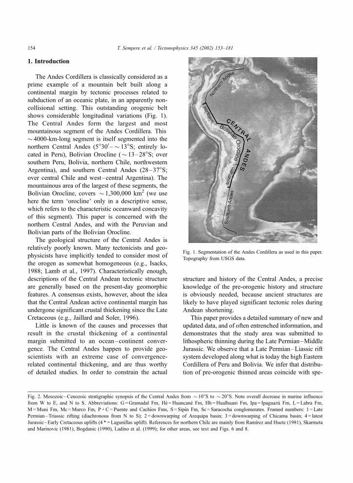
shows considerable longitudinal variations (Fig. 1).
The Central Andes form the largest and most
mountainous segment of the Andes Cordillera. This
� 4000-km-long segment is itself segmented into the
northern Central Andes (5�300– � 13�S; entirely lo-
cated in Peru), Bolivian Orocline (� 13–28�S; oversouthern Peru, Bolivia, northern Chile, northwestern
Argentina), and southern Central Andes (28–37�S;over central Chile and west–central Argentina). The
mountainous area of the largest of these segments, the
Bolivian Orocline, covers � 1,300,000 km2 (we use
here the term ‘orocline’ only in a descriptive sense,
which refers to the characteristic oceanward concavity
of this segment). This paper is concerned with the
northern Central Andes, and with the Peruvian and
Bolivian parts of the Bolivian Orocline.
The geological structure of the Central Andes is
relatively poorly known. Many tectonicists and geo-
physicists have implicitly tended to consider most of
the orogen as somewhat homogeneous (e.g., Isacks,
1988; Lamb et al., 1997). Characteristically enough,
descriptions of the Central Andean tectonic structure
are generally based on the present-day geomorphic
features. A consensus exists, however, about the idea
that the Central Andean active continental margin has
undergone significant crustal thickening since the Late
Cretaceous (e.g., Jaillard and Soler, 1996).
Little is known of the causes and processes that
result in the crustal thickening of a continental
margin submitted to an ocean–continent conver-
gence. The Central Andes happen to provide geo-
scientists with an extreme case of convergence-
related continental thickening, and are thus worthy
of detailed studies. In order to constrain the actual
structure and history of the Central Andes, a precise
knowledge of the pre-orogenic history and structure
is obviously needed, because ancient structures are
likely to have played significant tectonic roles during
Andean shortening.
This paper provides a detailed summary of new and
updated data, and of often entrenched information, and
demonstrates that the study area was submitted to
lithospheric thinning during the Late Permian–Middle
Jurassic. We observe that a Late Permian–Liassic rift
system developed along what is today the high Eastern
Cordillera of Peru and Bolivia. We infer that distribu-
tion of pre-orogenic thinned areas coincide with spe-
Fig. 1. Segmentation of the Andes Cordillera as used in this paper.
Topography from USGS data.
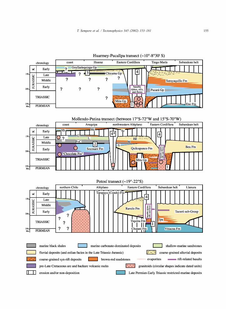
Fig. 2. Mesozoic–Cenozoic stratigraphic synopsis of the Central Andes from � 10�S to � 20�S. Note overall decrease in marine influence
from W to E, and N to S. Abbreviations: G =Gramadal Fm, He =Huancane Fm, Hh =Hualhuani Fm, Ipa = Ipaguazu Fm, L=Labra Fm,
M=Muni Fm, Mc=Murco Fm, P +C=Puente and Cachıos Fms, S = Sipın Fm, Sc = Saracocha conglomerates. Framed numbers: 1 = Late
Permian–Triassic rifting (diachronous from N to S); 2 = downwarping of Arequipa basin; 3 = downwarping of Chicama basin; 4 = latest
Jurassic–Early Cretaceous uplifts (4 * = Lagunillas uplift). References for northern Chile are mainly from Ramırez and Huete (1981), Skarmeta
and Marinovic (1981), Bogdanic (1990), Ladino et al. (1999); for other areas, see text and Figs. 6 and 8.
T. Sempere et al. / Tectonophysics 345 (2002) 153–181154
T. Sempere et al. / Tectonophysics 345 (2002) 153–181 155
cific Andean structural traits, and we explore the idea
that pre-existent extensional and/or transtensional
structures determined many actual characteristics of
the northern Central Andes and Bolivian Orocline.
The Mesozoic–Cenozoic stratigraphic evolution
concerning the study area is summarized in three
stratigraphic transects (Fig. 2). For correspondence
between chronostratigraphic stages and absolute ages,
we use Hardenbol et al.’s (1998) chart. Our use of the
term ‘Andean’ refers to the Andes (or proto-Andes) as
a mountain belt, and to the related period of mountain
building.
2. Late Permian–Middle Jurassic rifting in the
Eastern Cordillera of Peru and Bolivia
2.1. Introduction
Late Permian–Triassic rifting diachroneously de-
veloped in the Eastern Cordillera of Peru (Megard,
1978; Laubacher, 1978; Noble et al., 1978; Dalmayrac
et al., 1980; Kontak et al., 1985; Rosas and Fontbote,
1995; Rosas et al., 1997; Jacay et al., 1999) and
extended into Bolivia in the Late Triassic–Middle
Jurassic (McBride et al., 1983; Sempere, 1995; Sem-
pere et al., 1998, 1999). The main axis of the rift
system appears to coincide with the axis of the Eastern
Cordillera in both countries (Fig. 3). In this paper we
dedicate special attention to data from the still little
known Bolivian continuation of this rift system.
Current research in southern Peru and Bolivia shows
that Mesozoic Bolivian basins were mostly connected
to Peruvian basins, and not to southern, Argentine–
Chilean basins.
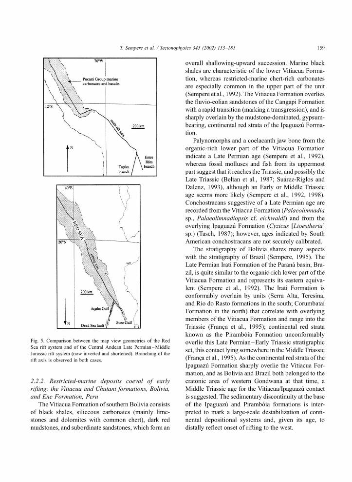
Reconstruction of the rift system in map view shows
that it splits into two branches at about 19�S (Figs. 3
and 4). The southeastern, ‘‘Entre Rıos branch’’ extends
into the Chaco Subandean belt and dies out in the
Bolivia–Argentina border area. The southern, ‘‘Tupiza
branch’’ strikes (presently) N10E and apparently
extends into the Argentine Puna. In map view, this
geometry is reminiscent of the present-day Red Sea rift
system, which to the north splits into the now inactive
Suez Gulf and the active Aqaba Gulf rift and Dead Sea
wrench–fault system (Fig. 5). In the following, we
consider the ‘‘Tupiza branch’’ as the southern contin-
uation of the main rift axis.
In Peru, strata of Permian through Jurassic age are
divided into the Mitu and Pucara groups, which were
respectively deposited in continental and marine set-
tings (McLaughlin, 1924; Steinmann, 1929; Harrison,
1943, 1951; Jenks, 1951; Newell et al., 1953). The
clastic and volcanic Mitu Group is mostly known
from the Eastern Cordillera of central and southern
Peru and accumulated in subsident grabens, reflecting
Late Permian–Triassic rifting (e.g., Megard, 1978;
Dalmayrac et al., 1980; Kontak et al., 1985). North-
west of Cusco, the carbonate-dominated Late Trias-
sic–Liassic Pucara Group has a wider distribution
(Fig. 3) and was deposited during the thermal sag that
followed rifting in this region; more to the southeast,
thick fluvio-eolian sandstones were deposited during
this thermal sag period (Sempere et al., 1998, 1999,
2000a).
In the grabens produced by rifting, conformable or
deformed Late Paleozoic strata were generally pre-
served below the Mitu Group, whereas they were
eroded out from the neighbouring rift shoulders.
Intense magmatism commonly occurred at depth
beneath the floor of the grabens, and predominantly
alkaline volcanic rocks were erupted. Consistent iso-
topic ages obtained on volcanic and plutonic rocks
point to a Late Permian–Middle Jurassic age for the
rifting (see Kontak et al., 1985, 1990; Soler, 1991;
Jacay et al., 1999, for summaries).
2.2. Pre-rift strata and deformation
2.2.1. Pre-rift stratigraphic units and relationships
The commonly >500-m-thick Pennsylvanian–
Early Permian (Tarma-)Copacabana Group was
deposited prior to rifting, and forms a guide unit as
it was frequently preserved in the Mitu grabens. It is
of shallow-marine origin and consists of fossiliferous
limestones and subordinate sandstones, black shales,
and cherty limestones. To the southeast, in the Chaco
Subandean belt and lowlands of Bolivia, the Copaca-
bana carbonate platform grades into sandstones of
eolian and fluvial origin (Cangapi Formation; Sem-
pere, 1995). In some areas of the Eastern Cordillera
where the Copacabana Group was preserved in Mitu
grabens, a rapid transition with overlying black shales
is observed. In other localities of the Eastern Cordil-
lera, strata of the Copacabana Group are folded
(locally intensely, and metamorphized) and either
T. Sempere et al. / Tectonophysics 345 (2002) 153–181156

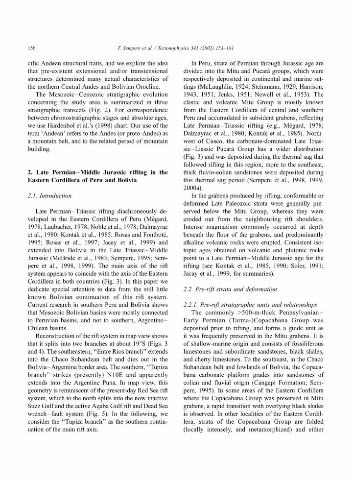
Fig. 3. Synopsis of the main Mesozoic geologic elements of Peru and Bolivia. The axis of the Late Permian–Middle Jurassic rift system is
defined by occurrences of the Mitu Group, coeval granitoids, and basic dyke swarms, and approximately coincides with the axis of the Eastern
Cordillera of Peru and Bolivia. Localities: A: Arequipa, C: Cochabamba, Cu: Cusco, L: Lima, P: Potosı, SC: Santa Cruz, Tu: Tupiza.
T. Sempere et al. / Tectonophysics 345 (2002) 153–181 157

intruded by Mitu granitoids (e.g., Soler and Bon-
homme, 1987) or unconformably overlain by the Mitu
Group (e.g., Laubacher, 1978; Megard et al., 1983).
This contrasted variety of stratigraphic relationships
(Fig. 6) provides information on the tectonic frame-
work of early rifting (see below).
Fig. 4. Location map of relevant data concerning the northern part of the Bolivian orocline.
T. Sempere et al. / Tectonophysics 345 (2002) 153–181158
2.2.2. Restricted-marine deposits coeval of early
rifting: the Vitiacua and Chutani formations, Bolivia,
and Ene Formation, Peru
The Vitiacua Formation of southern Bolivia consists
of black shales, siliceous carbonates (mainly lime-
stones and dolomites with common chert), dark red
mudstones, and subordinate sandstones, which form an
overall shallowing-upward succession. Marine black
shales are characteristic of the lower Vitiacua Forma-
tion, whereas restricted-marine chert-rich carbonates
are especially common in the upper part of the unit
(Sempere et al., 1992). TheVitiacua Formation overlies
the fluvio-eolian sandstones of the Cangapi Formation
with a rapid transition (marking a transgression), and is
sharply overlain by the mudstone-dominated, gypsum-
bearing, continental red strata of the Ipaguazu Forma-
tion.
Palynomorphs and a coelacanth jaw bone from the
organic-rich lower part of the Vitiacua Formation
indicate a Late Permian age (Sempere et al., 1992),
whereas fossil molluscs and fish from its uppermost
part suggest that it reaches the Triassic, and possibly the
Late Triassic (Beltan et al., 1987; Suarez-Riglos and
Dalenz, 1993), although an Early or Middle Triassic
age seems more likely (Sempere et al., 1992, 1998).
Conchostracans suggestive of a Late Permian age are
recorded from the Vitiacua Formation (Palaeolimnadia
sp., Palaeolimnadiopsis cf. eichwaldi) and from the
overlying Ipaguazu Formation (Cyzicus [Lioestheria]
sp.) (Tasch, 1987); however, ages indicated by South
American conchostracans are not securely calibrated.
The stratigraphy of Bolivia shares many aspects
with the stratigraphy of Brazil (Sempere, 1995). The
Late Permian Irati Formation of the Parana basin, Bra-
zil, is quite similar to the organic-rich lower part of the
Vitiacua Formation and represents its eastern equiva-
lent (Sempere et al., 1992). The Irati Formation is
conformably overlain by units (Serra Alta, Teresina,
and Rio do Rasto formations in the south; Corumbataı
Formation in the north) that correlate with overlying
members of the Vitiacua Formation and range into the
Triassic (Franc�a et al., 1995); continental red strata
known as the Piramboia Formation unconformably
overlie this Late Permian–Early Triassic stratigraphic
set, this contact lying somewhere in theMiddle Triassic
(Franc�a et al., 1995). As the continental red strata of theIpaguazu Formation sharply overlie the Vitiacua For-
mation, and as Bolivia and Brazil both belonged to the
cratonic area of western Gondwana at that time, a
Middle Triassic age for the Vitiacua/Ipaguazu contact
is suggested. The sedimentary discontinuity at the base
of the Ipaguazu and Piramboia formations is inter-
preted to mark a large-scale destabilization of conti-
nental depositional systems and, given its age, to
distally reflect onset of rifting to the west.
Fig. 5. Comparison between the map view geometries of the Red
Sea rift system and of the Central Andean Late Permian–Middle
Jurassic rift system (now inverted and shortened). Branching of the
rift axis is observed in both cases.
T. Sempere et al. / Tectonophysics 345 (2002) 153–181 159
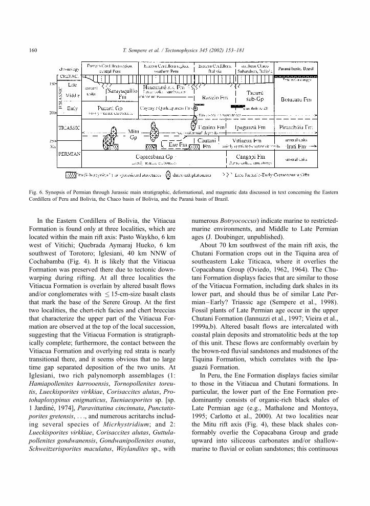
In the Eastern Cordillera of Bolivia, the Vitiacua
Formation is found only at three localities, which are
located within the main rift axis: Pasto Waykho, 6 km
west of Vitichi; Quebrada Aymaraj Hueko, 6 km
southwest of Torotoro; Iglesiani, 40 km NNW of
Cochabamba (Fig. 4). It is likely that the Vitiacua
Formation was preserved there due to tectonic down-
warping during rifting. At all three localities the
Vitiacua Formation is overlain by altered basalt flows
and/or conglomerates with � 15-cm-size basalt clasts
that mark the base of the Serere Group. At the first
two localities, the chert-rich facies and chert breccias
that characterize the upper part of the Vitiacua For-
mation are observed at the top of the local succession,
suggesting that the Vitiacua Formation is stratigraph-
ically complete; furthermore, the contact between the
Vitiacua Formation and overlying red strata is nearly
transitional there, and it seems obvious that no large
time gap separated deposition of the two units. At
Iglesiani, two rich palynomorph assemblages (1:
Hamiapollenites karrooensis, Tornopollenites toreu-
tis, Lueckisporites virkkiae, Corisaccites alutas, Pro-
tohaploxypinus enigmaticus, Taeniaesporites sp. [sp.
1 Jardine, 1974], Paravittatina cincinnata, Punctatis-
porites gretensis, . . ., and numerous acritarchs includ-
ing several species of Micrhystridium; and 2:
Lueckisporites virkkiae, Corisaccites alutas, Guttula-
pollenites gondwanensis, Gondwanipollenites ovatus,
Schweitzerisporites maculatus, Weylandites sp., with
numerous Botryococcus) indicate marine to restricted-
marine environments, and Middle to Late Permian
ages (J. Doubinger, unpublished).
About 70 km southwest of the main rift axis, the
Chutani Formation crops out in the Tiquina area of
southeastern Lake Titicaca, where it overlies the
Copacabana Group (Oviedo, 1962, 1964). The Chu-
tani Formation displays facies that are similar to those
of the Vitiacua Formation, including dark shales in its
lower part, and should thus be of similar Late Per-
mian–Early? Triassic age (Sempere et al., 1998).
Fossil plants of Late Permian age occur in the upper
Chutani Formation (Iannuzzi et al., 1997; Vieira et al.,
1999a,b). Altered basalt flows are intercalated with
coastal plain deposits and stromatolitic beds at the top
of this unit. These flows are conformably overlain by
the brown-red fluvial sandstones and mudstones of the
Tiquina Formation, which correlates with the Ipa-
guazu Formation.
In Peru, the Ene Formation displays facies similar
to those in the Vitiacua and Chutani formations. In
particular, the lower part of the Ene Formation pre-
dominantly consists of organic-rich black shales of
Late Permian age (e.g., Mathalone and Montoya,
1995; Carlotto et al., 2000). At two localities near
the Mitu rift axis (Fig. 4), these black shales con-
formably overlie the Copacabana Group and grade
upward into siliceous carbonates and/or shallow-
marine to fluvial or eolian sandstones; this continuous
Fig. 6. Synopsis of Permian through Jurassic main stratigraphic, deformational, and magmatic data discussed in text concerning the Eastern
Cordillera of Peru and Bolivia, the Chaco basin of Bolivia, and the Parana basin of Brazil.
T. Sempere et al. / Tectonophysics 345 (2002) 153–181160
succession is in turn conformably overlain by altered
volcanic rocks and red strata (including mudstones,
sandstones and gypsum) that represent the local facies
of the Mitu Group (Carlotto et al., 2000). The Ene
Formation is widespread in the Subandean belt and
lowlands of Peru, i.e. east of the Mitu rift system
(Mathalone and Montoya, 1995).
The black shales that characterize the lower parts
of the Vitiacua, Chutani and Ene formations represent
a marine transgression of Late Permian age, which is
also represented by units in the Parana basin, Brazil,
and the Karoo basin, South Africa (Sempere et al.,
1992; Tankard et al., 1995). This widespread trans-
gression is likely to have extended over a very broad
region of western Gondwana, but was also coeval
with the early stage of the rift-related Mitu magma-
tism (Fig. 6). In southern Peru, limestones bearing
Late Permian fusulinids are locally intercalated within
red strata of the Mitu Group (Laubacher, 1978), de-
monstrating that marine ingressions occurred within
some Mitu grabens.
The Vitiacua, Chutani and Ene formations con-
formably overlie the Copacabana Group, and, given
their age, appear as restricted-marine time-equivalents
of the older Mitu syn-rift deposits, whereas they pre-
date younger Mitu syn-rift deposits as they are over-
lain by Mitu or Mitu-equivalent red strata (Fig. 6).
Given the approximate Middle Triassic age of the top
of these restricted-marine units, the Mitu rifting ap-
pears to have been twofold, with a first stage spanning
the Late Permian–Early? Triassic interval, and a
second stage beginning in the Middle Triassic. This
analysis agrees with the idea of a twofold Mitu Group
set forth by Soler (1991) on independent bases (see
below).
2.2.3. Deformation and rifting
As stressed above, the sedimentary continuity
commonly observed in Bolivia and southern Peru
between the Pennsylvanian–Early Permian Copaca-
bana Group and overlying Late Permian–Early? Tri-
assic units markedly contrasts with the pre-Mitu,
locally intense deformation observed in the Copaca-
bana Group in some areas of the Eastern Cordillera
between � 11�S and � 17�300S. This deformation,
traditionally explained by Late Permian ‘‘tardi-hercy-
nian tectonics’’ (e.g., Dalmayrac et al., 1980), is in
fact restricted to a narrow belt within the Eastern
Cordillera (Sempere, 1995); given the contemporane-
ity of Late Permian deformation and deposition, this
belt was probably discontinuous, deformation occur-
ring in specific areas while shale-dominated sedimen-
tation was quietly going on in other areas of the same
Eastern Cordillera domain.
Such relationships are strongly suggestive of a
transcurrent rift system in which transtensional seg-
ments would have been separated by transpressional
‘‘nodes’’. We favor the idea that local transpression
caused deformation of pre-Mitu strata at the onset of
continental dislocation, before general graben forma-
tion and intense magmatism developed. Coeval trans-
tension produced slow downwarping of elongated
areas, where the Copacabana Group was preserved
and deeper marine shales conformably deposited over
it, before accelerating rifting processes enhanced mag-
matism and formed true grabens.
A similar scenario, albeit later in time, could also
explain the occurrence of Late Triassic plutons show-
ing deformation that was contemporaneous with their
emplacement. In the Cordillera Real of western Boli-
via, the Zongo–Yani pluton yielded Late Triassic U–
Pb ages (Table 1); emplacement of this foliated,
peraluminous, two-mica granite was contemporane-
ous with schistosity and low-pressure metamorphism,
reflecting a high heat flow (Bard et al., 1974). In
nearby Peru, the similar, foliated and peraluminous,
two-mica Limacpampa pluton is dated to near the
Triassic–Jurassic boundary (Table 1). South of Aban-
cay, a cataclastic ‘‘quartz-diorite’’ yielded a Late Tri-
assicU–Pb age (Table 1).We suggest that emplacement
and early deformation of these intrusions might have
occurred in local transpressional settings at a later, Late
Triassic, stage of rifting.
Triassic uplift of plutons is recorded by clasts of
Mitu-age granitoids that are commonly found in
conglomerates and pyroclastites of the Mitu Group
in central Peru (Megard, 1978), suggesting a twofold
development of rifting (Soler, 1991). Such uplifts are
likely to have been caused by lithospheric deforma-
tion related to rifting.
2.3. Rift-related magmatism
2.3.1. Southern Peru
Intense magmatism was associated with the Mitu
rifting in southern Peru (Egeler and De Booy, 1961;
T. Sempere et al. / Tectonophysics 345 (2002) 153–181 161
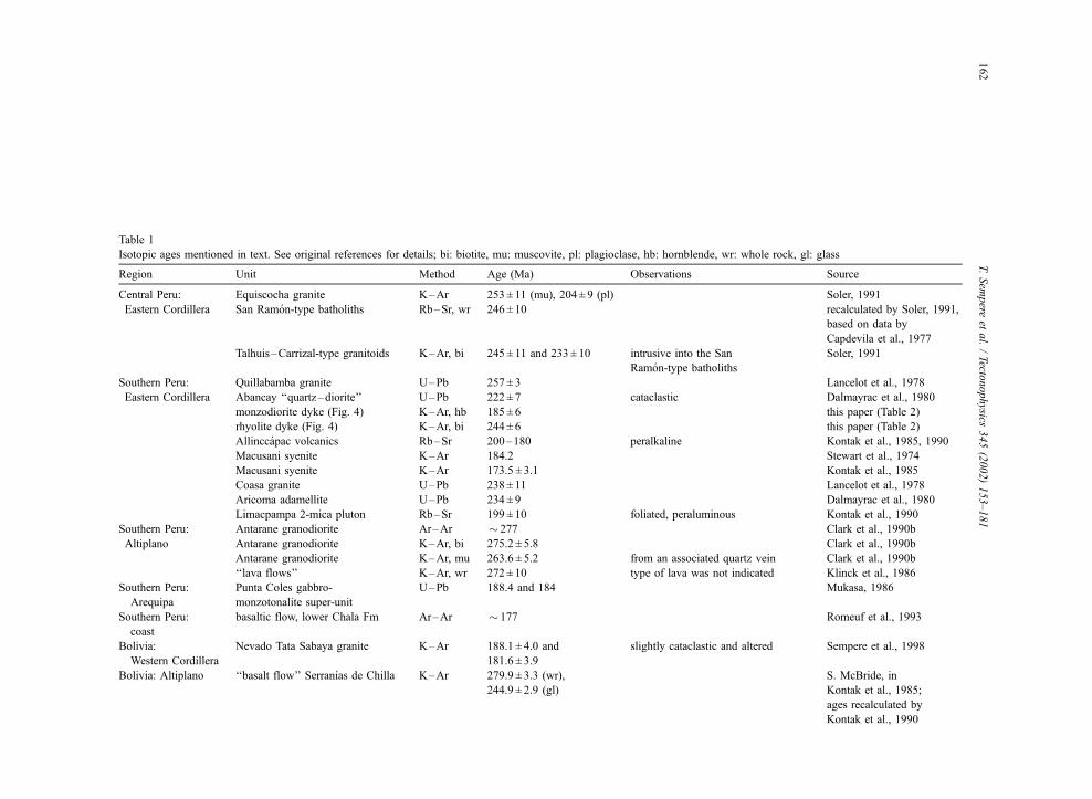
Table 1
Isotopic ages mentioned in text. See original references for details; bi: biotite, mu: muscovite, pl: plagioclase, hb: hornblende, wr: whole rock, gl: glass
Region Unit Method Age (Ma) Observations Source
Central Peru: Equiscocha granite K–Ar 253 ± 11 (mu), 204 ± 9 (pl) Soler, 1991
Eastern Cordillera San Ramon-type batholiths Rb–Sr, wr 246 ± 10 recalculated by Soler, 1991,
based on data by
Capdevila et al., 1977
Talhuis–Carrizal-type granitoids K–Ar, bi 245 ± 11 and 233 ± 10 intrusive into the San
Ramon-type batholiths
Soler, 1991
Southern Peru: Quillabamba granite U–Pb 257 ± 3 Lancelot et al., 1978
Eastern Cordillera Abancay ‘‘quartz–diorite’’ U–Pb 222 ± 7 cataclastic Dalmayrac et al., 1980
monzodiorite dyke (Fig. 4) K–Ar, hb 185 ± 6 this paper (Table 2)
rhyolite dyke (Fig. 4) K–Ar, bi 244 ± 6 this paper (Table 2)
Allinccapac volcanics Rb–Sr 200–180 peralkaline Kontak et al., 1985, 1990
Macusani syenite K–Ar 184.2 Stewart et al., 1974
Macusani syenite K–Ar 173.5 ± 3.1 Kontak et al., 1985
Coasa granite U–Pb 238 ± 11 Lancelot et al., 1978
Aricoma adamellite U–Pb 234 ± 9 Dalmayrac et al., 1980
Limacpampa 2-mica pluton Rb–Sr 199 ± 10 foliated, peraluminous Kontak et al., 1990
Southern Peru: Antarane granodiorite Ar–Ar � 277 Clark et al., 1990b
Altiplano Antarane granodiorite K–Ar, bi 275.2 ± 5.8 Clark et al., 1990b
Antarane granodiorite K–Ar, mu 263.6 ± 5.2 from an associated quartz vein Clark et al., 1990b
‘‘lava flows’’ K–Ar, wr 272 ± 10 type of lava was not indicated Klinck et al., 1986
Southern Peru:
Arequipa
Punta Coles gabbro-
monzotonalite super-unit
U–Pb 188.4 and 184 Mukasa, 1986
Southern Peru:
coast
basaltic flow, lower Chala Fm Ar–Ar � 177 Romeuf et al., 1993
Bolivia:
Western Cordillera
Nevado Tata Sabaya granite K–Ar 188.1 ± 4.0 and
181.6 ± 3.9
slightly cataclastic and altered Sempere et al., 1998
Bolivia: Altiplano ‘‘basalt flow’’ Serranıas de Chilla K–Ar 279.9 ± 3.3 (wr),
244.9 ± 2.9 (gl)
S. McBride, in
Kontak et al., 1985;
ages recalculated by
Kontak et al., 1990
T.Sem
pere
etal./Tecto
nophysics
345(2002)153–181
162
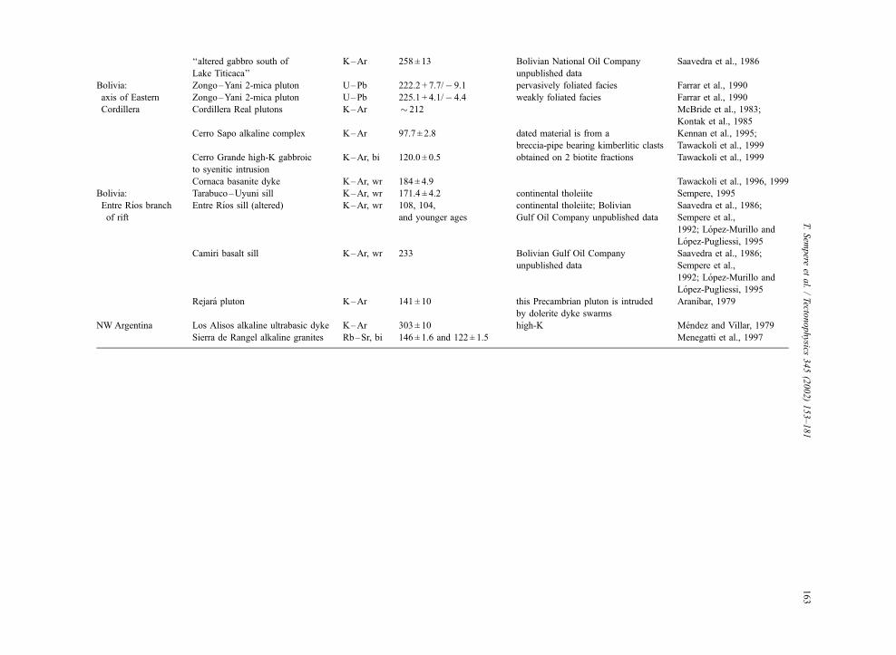
‘‘altered gabbro south of
Lake Titicaca’’
K–Ar 258 ± 13 Bolivian National Oil Company
unpublished data
Saavedra et al., 1986
Bolivia: Zongo–Yani 2-mica pluton U–Pb 222.2 + 7.7/� 9.1 pervasively foliated facies Farrar et al., 1990
axis of Eastern Zongo–Yani 2-mica pluton U–Pb 225.1 + 4.1/� 4.4 weakly foliated facies Farrar et al., 1990
Cordillera Cordillera Real plutons K–Ar � 212 McBride et al., 1983;
Kontak et al., 1985
Cerro Sapo alkaline complex K–Ar 97.7 ± 2.8 dated material is from a
breccia-pipe bearing kimberlitic clasts
Kennan et al., 1995;
Tawackoli et al., 1999
Cerro Grande high-K gabbroic
to syenitic intrusion
K–Ar, bi 120.0 ± 0.5 obtained on 2 biotite fractions Tawackoli et al., 1999
Cornaca basanite dyke K–Ar, wr 184 ± 4.9 Tawackoli et al., 1996, 1999
Bolivia: Tarabuco–Uyuni sill K–Ar, wr 171.4 ± 4.2 continental tholeiite Sempere, 1995
Entre Rıos branch
of rift
Entre Rıos sill (altered) K–Ar, wr 108, 104,
and younger ages
continental tholeiite; Bolivian
Gulf Oil Company unpublished data
Saavedra et al., 1986;
Sempere et al.,
1992; Lopez-Murillo and
Lopez-Pugliessi, 1995
Camiri basalt sill K–Ar, wr 233 Bolivian Gulf Oil Company
unpublished data
Saavedra et al., 1986;
Sempere et al.,
1992; Lopez-Murillo and
Lopez-Pugliessi, 1995
Rejara pluton K–Ar 141 ± 10 this Precambrian pluton is intruded
by dolerite dyke swarms
Aranıbar, 1979
NW Argentina Los Alisos alkaline ultrabasic dyke K–Ar 303 ± 10 high-K Mendez and Villar, 1979
Sierra de Rangel alkaline granites Rb–Sr, bi 146 ± 1.6 and 122 ± 1.5 Menegatti et al., 1997
T.Sem
pere
etal./Tecto
nophysics
345(2002)153–181
163

Vivier et al., 1976; Noble et al., 1978; Dalmayrac et
al., 1980; Carlier et al., 1982; Kontak, 1984; Bon-
homme et al., 1985; Kontak et al., 1985, 1990; Clark
et al., 1990a; Cenki, 1998). In a major contribution,
Kontak et al. (1985) clearly identified that the entire
Mitu-age magmatism in southern Peru was rift-
related, and recognized that ‘‘the predominantly basic
Mitu Group volcanics and the batholithic granodior-
ites and monzogranites (. . .) are most probably repre-
sentative of a continuum with a cause and effect
relationship’’. In particular, these authors underlined
that this magmatism was very similar to the one known
from the Early Permian Oslo aborted rift in Norway
(Kontak, 1984; Kontak et al., 1985).
Several types of apparently unrelated mantle-
derived magmas, including alkaline basalts and
locally thick peralkaline facies, occur among the Mitu
volcanic rocks (Kontak et al., 1985). Basic volcanics
can form up to 20% of the total Mitu volcanism and
consist of tholeiitic or alkaline spilitized basalt flows
that are generally intercalated with the Mitu Group
sedimentary rocks (Vivier et al., 1976; Kontak, 1984).
Swarms of basic dykes and sills intruding Paleozoic
and Mesozoic strata are known from the Altiplano,
Eastern Cordillera, and Subandean belt of southern
Peru (Newell, 1949; Laubacher, 1978), and are likely
to have been produced by the Triassic–Jurassic litho-
spheric thinning as in nearby Bolivia.
A Permian, early stage of magmatism is docu-
mented in the Peruvian Altiplano by dated ‘‘lava
flows’’ from 21 km northwest of Juliaca, and by the
Antarane granodiorite � 30 km WSW of the same
city (Table 1; Fig. 4).
In the Eastern Cordillera, the 2000-m-thick Early
Jurassic, Allinccapac peralkaline volcanic rocks sur-
round and overlie a large peralkaline syenite complex
that yielded Early to Middle Jurassic apparent ages
(Table 1). The syenite complex and surrounding vol-
canic rocks are probably cogenetic (Kontak et al.,
1985), suggesting that the related peralkaline magma-
tism developed during the Liassic and, possibly, early
Dogger. A predominantly mantle-derived magmatism
thus developed in this segment of the Eastern Cordil-
lera during the first half of the Jurassic (Kontak et al.,
1985).
In contrast with the mantle-derived Mitu volcanic
rocks, the Carabaya batholith plutons derive from
crustal melts, and are also similar to plutons known
in the Oslo rift (Kontak, 1984; Kontak et al., 1985,
1990). Intrusion of the main plutons occurred in the
Late Permian and Triassic (Table 1). The Carabaya
batholith is commonly cut by coeval and younger
alkaline, Ti-rich, basic dykes that display character-
istics similar to the basalts known in the Mitu Group
(Kontak et al., 1985, 1990).
In addition to the published ages on the Mitu
magmatism in southern Peru, we have obtained new
K–Ar ages of 244 ± 6 and 185 ± 6 Ma, from a rhyolite
dyke and a monzodiorite dyke, respectively (Tables 1
and 2; Fig. 4).
All these data agree with the idea that Late Per-
mian–Middle Jurassic lithospheric thinning in the
Eastern Cordillera and Altiplano of southern Peru
generated a variety of mantle-derived magmas, along
with a high heat flow that produced significant
amounts of crustal melting in the Late Permian–
Triassic (Kontak et al., 1985). In this area, lithospheric
thinning lasted over nearly 100 Ma.
2.3.2. Bolivia
Rift-related magmatism in Bolivia was dominated
by basic magmas. Plutons derived from crustal melts
are only known northwest of 17�S, i.e. in the prolon-
gation of the Eastern Cordillera of southern Peru, and
have yielded Late Triassic U–Pb and K–Ar ages
(Table 1). The basic magmatism related to the main
Table 2
Analytical data concerning the new ages presented in this paper
Sample # (lab. #) Nature Location Method and
material dated
% K Rad. Ar
(nl/g)
Atm. Ar
(%)
Age (Ma) ± 2 s
98-08-18-01 (H475.98) rhyolite dyke � 14�420S–70�430W K–Ar, bi 6.815 69.218 6 244 ± 6
M-371 (H289.CP) monzodiorite dyke � 13�320S–72�330W K–Ar, hb 0.859 6.493 21 185 ± 6
Samples were dated at the Laboratorio de Geocronologıa of SERNAGEOMIN, Santiago, Chile; see Fig. 4 for location; bi: biotite, hb:
hornblende.
T. Sempere et al. / Tectonophysics 345 (2002) 153–181164
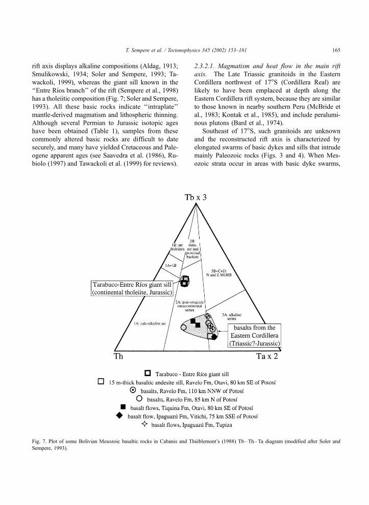
rift axis displays alkaline compositions (Aldag, 1913;
Smulikowski, 1934; Soler and Sempere, 1993; Ta-
wackoli, 1999), whereas the giant sill known in the
‘‘Entre Rıos branch’’ of the rift (Sempere et al., 1998)
has a tholeiitic composition (Fig. 7; Soler and Sempere,
1993). All these basic rocks indicate ‘‘intraplate’’
mantle-derived magmatism and lithospheric thinning.
Although several Permian to Jurassic isotopic ages
have been obtained (Table 1), samples from these
commonly altered basic rocks are difficult to date
securely, and many have yielded Cretaceous and Pale-
ogene apparent ages (see Saavedra et al. (1986), Ru-
biolo (1997) and Tawackoli et al. (1999) for reviews).
2.3.2.1. Magmatism and heat flow in the main rift
axis. The Late Triassic granitoids in the Eastern
Cordillera northwest of 17�S (Cordillera Real) are
likely to have been emplaced at depth along the
Eastern Cordillera rift system, because they are similar
to those known in nearby southern Peru (McBride et
al., 1983; Kontak et al., 1985), and include peralumi-
nous plutons (Bard et al., 1974).
Southeast of 17�S, such granitoids are unknown
and the reconstructed rift axis is characterized by
elongated swarms of basic dykes and sills that intrude
mainly Paleozoic rocks (Figs. 3 and 4). When Mes-
ozoic strata occur in areas with basic dyke swarms,
Fig. 7. Plot of some Bolivian Mesozoic basaltic rocks in Cabanis and Thieblemont’s (1988) Tb–Th–Ta diagram (modified after Soler and
Sempere, 1993).
T. Sempere et al. / Tectonophysics 345 (2002) 153–181 165
basaltic flows, sills and/or dykes are generally also
observed in the Mesozoic, strongly suggesting that the
dykes in the Paleozoic are of Mesozoic age (Stein-
mann, 1906, 1923; Kozlowski, 1934; Sempere et al.,
1998). This strip rich in basic dykes, sills and flows
coincides with the axis of the present-day Eastern
Cordillera, which was recognized by Kozlowski
(1934) in luminous words: ‘‘Tous les gisements des
roches eruptives mesozoıques que je connais se trou-
vent exclusivement dans la Cordillera Oriental et
surtout dans sa partie centrale, ou ils sont disposes
le long d’une zone parallele a la direction de la
chaıne (. . .)’’ (‘‘All the occurrences of Mesozoic
eruptive rocks that I know are exclusively found in
the Eastern Cordillera and especially in its central
part, where they are distributed along a strip parallel to
the mountain belt’’). Kozlowski (1934), after Stein-
mann (1923), correctly conjectured that the alkaline
basic rocks they collected and studied from the East-
ern Cordillera of Bolivia were probably of Triassic–
Jurassic age. An unaltered basanite dyke that intrudes
Ordovician rocks northeast of Tupiza yielded a Toar-
cian age (Table 1).
2.3.2.2. Magmatism in the ‘‘Entre Rıos Branch’’ of the
rift system. The ‘‘Tarabuco basalt’’ (from the area
located from � 30 km north to � 20 km southeast of
Tarabuco) and the ‘‘Uyuni–Incapampa basalt’’ (from
the area located � 30 to � 50 km south of Tarabuco)
intrude pre-Maastrichtian Mesozoic strata and belong
to the same � 100–150-m-thick basaltic sill, here-
after called the Tarabuco–Uyuni sill. In the Uyuni–
Incapampa syncline, this noteworthy sill clearly
intrudes a red, � 400-m-thick, fining-upward succes-
sion that has yielded trackways of primitive tetrapods
(currently under study, but suggesting a Triassic age)
and should be ascribed to the Ipaguazu ( = Sayari)
Formation (Sempere et al., 1998); the sill displays
gabbro facies in its middle part, and branches into
three to four large sills in the west. Near Uyuni del
Pilcomayo, 0.3–3-m-thick basic dykes are known
from below and above the sill. The Tarabuco–Uyuni
sill was sampled 5 km north of Tarabuco, where it
intrudes eolian sandstones, and yielded an early Mid-
dle Jurassic apparent age (Table 1).
The relationships and characteristics of the sedi-
mentary and igneous rocks in the Tarabuco–Incapa-
mpa area are nearly identical to the set formed by the
Ipaguazu Formation, ‘‘Entre Rıos basalt’’, and Tacuru
sub-Group in the southern Chaco Subandean belt. The
Entre Rıos Basalt is a � 130-m-thick sill (Padula and
Reyes, 1958; Sempere et al., 1998); it is altered in all
known outcrops and has yielded 108 Ma, 104 Ma, and
younger apparent ages (Table 1).
Samples from the Tarabuco–Uyuni and Entre Rıos
sills have a continental tholeiite composition so close
that they cannot be geochemically distinguished (Soler
and Sempere, 1993). Both intrude Mesozoic strata and
reach similar thicknesses (130–150 m). Their respec-
tive outcrop areas are presently only � 50 km apart,
and are separated by the narrow Interandean structural
belt where no rock unit younger than Permian is
known (Fig. 4). All this strongly suggests that, prior
to Andean deformation, the two basalt sills formed
one same giant sill (Sempere et al., 1998), which we
propose to name ‘‘Tarabuco–Entre Rıos sill’’. Given
the alteration of the Entre Rıos basalt, the early Dog-
ger age obtained on the Tarabuco basalt should be
considered as a better estimate of the time of emplace-
ment of this sill. Because Bolivia was part of the
Gondwana craton prior to the Cretaceous (Sempere,
1995), it is interesting that latest Liassic–earliest
Dogger giant tholeiitic sills are known in South Africa
and Antarctica (Encarnacion et al., 1996; Fleming et
al., 1997), as these regions were also located along the
southwestern edge of Gondwana and underwent co-
eval lithospheric thinning.
A feeding dyke of the Entre Rıos sill can be
observed at Abra Castellon, 8 km northwest of Entre
Rıos, and it is possible that the dykes knownwest of the
Chaco Subandean belt (see below, and Fig. 4) served as
feeding dykes of the giant sill. Present known differ-
ences in rock composition does not preclude this
hypothesis, as alkaline and tholeiitic magmatisms can
coexist during rifting. Furthermore, the early Dogger
apparent age of the giant sill agrees with the Toarcian
apparent age obtained on a dyke from the Tupiza area.
This suggests that magmatic activity, including alkaline
and tholeiitic magmas, was significant in southern
Bolivia in the late Liassic–early Dogger (190–170
Ma).
Our recent field study of the Camiri basalt (sensu
Sempere et al., 1998) has showed that it is a � 30-m-
thick sill that intrudes the Pennsylvanian–Early Per-
mian Cangapi Formation in a small area southeast of
Camiri (Fig. 4). This also altered rock yielded a
T. Sempere et al. / Tectonophysics 345 (2002) 153–181166
Middle Triassic apparent age (Table 1), suggesting
that basic magmatism may have been active in the
area as early as the Triassic; this age, however, needs
confirmation. No geochemical data are available on
the Camiri sill yet, but its overall aspect and relation-
ships are similar to the Tarabuco–Entre Rıos sill.
2.3.2.3. Other areas of magmatism and heat flow in
Bolivia. Apart from the giant tholeiitic sill present in
the ‘‘Entre Rıos branch’’, the Mesozoic magmatism
known in Bolivia has proved so far to be of alkaline
and/or intraplate type, inclusively in some areas that
were apparently located outside the rift system (Fig. 4;
Soler and Sempere, 1993; Tawackoli et al., 1999).
Close to the Bolivian border in northwestern Argen-
tina and west of the Chaco Subandean belt, a potassic
alkaline ultrabasic sheet intrusion (Meyer and Villar,
1984) is derived from a deep lithospheric mantle
source (Barbieri et al., 1997) and might represent
one of these manifestations (Rubiolo, 1997), in spite
of an apparent age of 303 ± 10 Ma (Table 1). North of
the border, � 55 km SSWof Tarija, the Rejara pluton,
a Neoproterozoic or Cambrian monzonite to grano-
diorite that underwent some cataclastic metamor-
phism, is intruded by dolerite dykes that also cut
overlying Ordovician strata; the K–Ar apparent age
of 141 ± 10 Ma obtained on this pluton (Table 1)
possibly reflects a Jurassic emplacement of the doler-
ite dykes and related heat flow (Rubiolo, 1997;
Sempere et al., 1998).
A basalt ‘‘flow’’ from the Serranıas de Chilla south
of Lake Titicaca yielded apparent Permian and Early
Triassic ages (Table 1). In the same region, a Permian
apparent age was obtained on an altered ‘‘gabbro’’
from an unprecised area south of Lake Titicaca (Table
1); given its apparent age, the sampled basic rock is
probably related to the Serranıas de Chilla basalt.
Permian magmatism is also known west of Juliaca
in nearby Peru (Fig. 4).
In the northwestern Beni Subandean belt, in the
Rıo Yanamanu (Serranıa de Uchupiamonas), a 8-m-
thick lava flow or sill, of ‘‘andesitic’’ aspect, occurs in
the Jurassic Beu Formation, 400 m above its base
(Ponce de Leon et al., 1972). In the same area,
numerous basic dykes and sills intrude Early Devon-
ian strata, whereas grains of basic volcanic rocks are
common in the Beu Formation sandstones (Ponce de
Leon et al., 1972).
At the northern foot of Nevado Tata Sabaya in the
Western Cordillera of Bolivia, a slightly cataclastic
and altered granite crops out below the Cenozoic
cover and possibly belongs to the Precambrian ‘‘Are-
quipa massif’’ (Rivas, 1989). This granite yielded two
Toarcian apparent ages (Table 1). Plausible hypoth-
eses are that these ages reflect a significant thermal
reset in the Toarcian, or emplacement of the pluton at
that time; both hypotheses agree with coeval exten-
sion-related magmatism and/or heat flow in the
nearby southern extension of the Arequipa basin (see
below).
Lead–zinc(–silver) ore deposits are commonly
associated with ancient rifts, and the stratabound
deposits known in the Late Triassic–Liassic Pucara
Group of central Peru are no exception (Rosas and
Fontbote, 1995). Although they occur in the Paleo-
zoic, the lead–zinc(–silver) ore deposits known in the
Eastern Cordillera of Bolivia are distributed along
both sides of the main rift axis and thus possibly
formed at depth in relation with the rift system
(Sempere et al., 1998).
2.3.3. Central Peru
Intense magmatism also occurred in central Peru
during the Mitu rifting (Megard, 1978; Dalmayrac et
al., 1980; Carlier et al., 1982; Soler, 1991). Numerous
plutons intrude the metamorphic basement exposed in
the Eastern Cordillera and were probably emplaced in
the rift ‘roots’. They consist of a variety of granites,
granodiorites and alkaline granitoids, which appa-
rently display two clusters of ages: a set of mainly
northern plutons was emplaced during the Mississip-
pian, and a larger one during the Late Permian and
Triassic (Jacay et al., 1999). This suggests that Late
Permian–Triassic rifting developed along an area
where magmatism had already been significantly
active in the Mississippian.
Soler (1991) recognized the following chronology
of pluton emplacement in the Eastern Cordillera of
central Peru (Table 1): (1) the Equiscocha granite; (2)
the San Ramon-type batholiths, which are intruded by
(3) the Talhuis–Carrizal-type granitoids; and (4) basic
dykes (including microgabbros and microdiorites) that
cut through the latter. This chronology is based in part
on the observation that theMitu Group syn-rift deposits
contain clasts derived from the erosion of San Ramon-
type granitoids, but so far no clasts derived from
T. Sempere et al. / Tectonophysics 345 (2002) 153–181 167
Talhuis–Carrizal-type granitoids. These relationships
support the idea that rifting developed in two stages.
The early, small Equiscocha pluton is a fine-
grained hololeucocratic granite that contains abundant
muscovite and scarce small-size garnets, and is
derived from crustal melting. The large San Ramon-
type granitoids are metaluminous to slightly peralu-
minous, calc-alkaline granites that closely resemble
the Mitu granitoids from southern Peru (Soler, 1991)
and thus were probably mainly derived from crustal
melts; Sr isotopic ratios (Capdevila et al., 1977) from
the San Ramon batholith suggest that these crustal
melts partly mixed with mantle-derived magmas
(Soler, 1991). In contrast, the Talhuis–Carrizal-type
granitoids have a marked alkaline affinity and show
many characteristics of granitoids emplaced in litho-
spheric thinning settings; the late basic dykes have
alkaline compositions similar to the alkaline basalts
from southern Peru, and were comagmatic with the
Talhuis–Carrizal-type granitoids (Soler, 1991).
As in southern Peru, volcanic rocks associated with
the Mitu rift system in central Peru are predominantly
acid, and are mainly represented by dacitic to rhyolitic
pyroclastic rocks. Most of the Mitu volcanics of
central Peru have alkaline compositions and are prob-
ably comagmatic of the Talhuis–Carrizal granitoids
(Soler, 1991).
Present knowledge of the rift-related magmatic
evolution in central Peru suggests that lithospheric
thinning initially produced crustal melts (e.g., the
Equiscocha granite) that were partly contaminated at
a later stage by mantle-derived melts (San Ramon-
type batholiths), and that these mantle-derived alka-
line magmas finally dominated (Talhuis–Carrizal-
type granitoids and comagmatic basic dykes, and Mitu
volcanics).
2.4. Syn-rift deposits
2.4.1. Syn-rift basins in Peru: the Mitu Group
The Mitu Group consists of a red to purple, locally
>2000-m-thick succession of conglomerates, sand-
stones and mudstones, with local carbonates and
evaporites, that accumulated in subsident grabens
(Megard, 1978; Dalmayrac et al., 1980; Carlotto,
1998). These sedimentary rocks are commonly inter-
bedded with locally dominant volcanic and volcani-
clastic rocks, and/or intruded by subvolcanic to
plutonic rocks that do not intrude overlying units (this
is particularly clear in the Nunoa area of southern
Peru; Fig. 4). Paleoenvironments identified in the
Mitu Group include alluvial fans, fluvial depositional
systems and (playa-)lakes.
A thick coarsening-upward unit of reddish sand-
stones and conglomerates known in the Ocona–
Camana area of coastal southern Peru is traditionally
assigned to the Mitu Group, but this attribution needs
confirmation (see Soler, 1991 for a summary).
2.4.2. Syn-rift basins in Bolivia: the lower Serere
Group
The lower part of the Serere Group of Bolivia
(Sempere et al., 1998) comprises the red-coloured
Ipaguazu and Tiquina formations (because correla-
tions seem now secured, the more recent denomina-
tion ‘‘Sayari Formation’’ should be abandoned in
order to simplify the stratigraphic nomenclature).
The Ipaguazu Formation consists of red mudstones
with subordinate sandstones and local evaporites
(gypsum, rarely halite) of dominantly lacustrine ori-
gin, and crops out in the Chaco Subandean belt
(mostly in the ‘‘Entre Rıos branch’’ of the rift axis)
and in the main rift axis of the Eastern Cordillera. The
Tiquina Formation predominantly consists of interca-
lations of red sandstones and mudstones, and of
locally thick conglomeratic sandstones or basalt-clasts
conglomerates, and is of alluvial origin; it crops out in
some localities of the Eastern Cordillera (including the
main rift axis) and in the Tiquina area. The Ipaguazu
and Tiquina formations respectively represent fine-
grained and coarse-grained end-members of the Boli-
vian equivalent of the Mitu Group. Both units are
generally � 500 m thick and conformably overlain by
the thick fluvio-eolian sandstones of the Ravelo For-
mation (Andean domain) or Tacuru sub-Group (Chaco
Subandean belt). The Ipaguazu and Tiquina forma-
tions generally occur at specific localities or in restricted
areas, suggesting they were deposited in paleograbens,
whereas the overlying fluvio-eolian sandstones are
present over much broader regions.
In the rift axis, the Ipaguazu or Tiquina formations
include basalt flows in their lower part; at four Andean
localities, these flows overlie the Late Permian–Early?
Triassic Vitiacua or Chutani formations (see above).
The Ipaguazu Formation unconformably overlies the
Vitiacua Formation in the ‘‘Entre Rıos branch’’ of the
T. Sempere et al. / Tectonophysics 345 (2002) 153–181168

rift axis. The observed successions characteristically
include an unconformable basal unit, generally no
more than several tens of meters thick, that consists
of pale alluvial or eolian sandstones, reddish conglom-
erates and/or basalts; this basal unit rapidly grades into
a thick, brown-red to brown-purple, mudstone-domi-
nated unit of alluvial to lacustrine origin.
At Quebrada Aymaraj Hueko, 6 km southwest of
Torotoro (Fig. 4), a previously unknown >300-m-
thick clastic unit overlies the Vitiacua Formation
with a very rapid transition, and represents a local,
coarse facies of the Tiquina Formation that strongly
resembles some deposits in the Mitu Group of Peru.
The 2–6-m-thick basal conglomerate of this unit
contains abundant basaltic clasts up to 15 cm in
size. The overlying strata dominantly consists of
basalt-clasts conglomerates and red conglomeratic
sandstones, in which at least one basalt flow is
intercalated, and is intruded by a � 100-m-thick
basalt sill. Furthermore, this Tiquina Formation and
underlying strata are folded and overlain by the
Cretaceous Torotoro Formation with a clear angular
unconformity.
2.5. Post-rift deposits
2.5.1. Post-rift deposits northwest of the Bolivian
Orocline, Peru: the Pucara Group
The Mitu rifting generated a thermal sag that
progressively expanded the basin. The Pucara Group
carbonates were deposited over the Mitu Group dur-
ing the Norian–Liassic interval (Megard, 1978; Stan-
ley, 1994) and onlapped across the rift shoulders.
They reflect a transgression that initiated in the Norian
and progressed from north to south following the Mitu
rift axis (Megard, 1978; Loughman and Hallam, 1982;
Rosas et al., 1997; Sempere et al., 1998). Maximum
inundation is marked by the organic-rich shales and
marls of the < 50-m-thick, late Rhaetian–early Sine-
murian Aramachay Formation. To the east, in the
Peruvian Oriente, red alluvial and eolian strata (lower
Sarayaquillo Formation) grade westwards into the
Pucara carbonates (Megard, 1978). Basalts with an
intraplate signature commonly occur in the Pucara
Group, which hosts a number of lead–zinc(–silver)
stratabound ore deposits (Rosas and Fontbote, 1995;
Rosas et al., 1997). The Pucara Group is unknown in
the Cordillera Oriental southeast of Cusco.
2.5.2. Post-rift deposits in the Bolivian Orocline, Peru
and Bolivia: the upper Serere Group
In the Cusco–Sicuani area in southern Peru, the
Mitu Group is post-dated by fluvio-eolian sandstones
(Caycay Formation; Carlotto, 1998) that are locally
intercalated with basalt flows. Northwest of Lake
Titicaca, the fluvio-eolian sandstones of the Quilca-
punco Formation conformably overlie the Mitu Group
(where present) or the Paleozoic (outside the Mitu
grabens) (Sempere et al., 2000a). The Quilcapunco
Formation is overlain by the Sipın Formation carbo-
nates, which yielded Rhaetian–early Bajocian echinids
(see below). The red mudstones of the Muni Formation
unconformably overlie the latter, and are transitionally
overlain by the fluvio-eolian Huancane s.s. Formation
(Fig. 2; Sempere et al., 2000a). The Muni Formation
was deposited in an alluvial to coastal plain environ-
ment and contains thin marine intercalations with
fossils suggestive of a late Dogger–early Malm age
(Newell, 1949). The Sipın and Muni formations thin
out to the north and east, and the fluvio-eolian Quilca-
punco and Huancane s.s. formations become coales-
cent in these directions (Sempere et al., 2000a).
These Jurassic fluvio-eolian units from southern
Peru correlate in Bolivia with the Beu Formation of
the Beni Subandean belt, the Ravelo Formation of
Andean Bolivia, and the Tacuru sub-Group of the
Chaco Subandean belt, which all are of similar facies
and origin (Oller and Sempere, 1990; Lopez-
Pugliessi, 1995; Lopez-Murillo and Lopez-Pugliessi,
1995; Sempere, 1995; Sempere et al., 1998). These
unfossiliferous sandstones can be over 1000 m thick
and locally include basaltic flows and sills, and
conglomerates with basalt clasts. Their distribution
shows they onlapped laterally from the initial rift axis
(Sempere, 1995). Their top is an erosional surface that
is onlapped by Cretaceous strata (Puca Group).
The Tacuru sub-Group includes, in stratigraphic
order, the (San Diego-)Tapecua (fluvio-eolian sand-
stones), Castellon (fluvial sandstones and subordinate
red and green mudstones), Ichoa (eolian sandstones)
and Yantata (fluvial sandstones partly equivalent to
the Ichoa) formations (see discussion in Sempere et
al., 1998). Semionotiformes fish occur in the Castel-
lon Formation (det. M. Gayet, Universite de Lyon,
France), and are also common in the Late Triassic/
Early Jurassic lower Tacuarembo Formation of the
Parana basin in Uruguay (Sprechmann et al., 1981).
T. Sempere et al. / Tectonophysics 345 (2002) 153–181 169

Four new species of ostracods (Bisulcocypris laci-
niata boliviana, B. truncata, B. castellonensis, B.
lubimovae) from the Castellon Formation are similar
to Jurassic taxa of the Parana basin in Brazil but were
tentatively assigned to the lowermost Cretaceous
(Wealdian) due to a traditional attribution of the unit
to the Cretaceous (Damiani-Pinto and Sanguinetti,
1987). In spite of apparent discrepancies, all paleon-
tologic ages published on the Vitiacua through Cas-
tellon stratigraphic set in the Chaco Subandean belt
belong to the Late Permian–lowermost Cretaceous
interval (Sempere et al., 1998).
Abundant eolian sandstones in Bolivia and south-
east Peru complement to the west the large Jurassic
desertic domain defined by coeval eolian units in the
Parana and Karoo basin (e.g., Franc�a et al., 1995).
Global paleoclimatic models place Bolivia and south-
east Peru within a broad desertic domain in the
Jurassic (Chandler et al., 1992).
3. Early and Middle Jurassic lithospheric thinning
in southwestern Peru
3.1. Introduction
The Arequipa basin (Fig. 4) originated by litho-
spheric thinning during the Liassic and Dogger. The
Jurassic infill of this basin is formed by a 4500–6000-
m-thick succession that provides a prime sedimentary
record of the regional geologic evolution (Jenks,
1948; Benavides, 1962; Vicente, 1981, 1989; Vicente
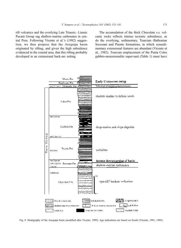
et al., 1982). We refer to this succession as the ‘‘Yura
Group’’, in a modified sense. As used here, the Yura
Group comprises, from bottom to top, the Chocolate
s.s., Socosani, Puente, Cachıos, and Labra formations,
because we think that this name should reflect the
entire activity of the basin in which it accumulated.
3.2. Igneous rocks
The dominantly volcanic and volcaniclastic Choc-
olate s.s. Formation (i.e., sensu Jenks, 1948) is >900–
1500 m thick (its base rarely crops out). Near its top, it
includes limestone beds that yielded Sinemurian
ammonites, and is disconformably overlain by the
late Liassic carbonates of the Socosani Formation
(Vicente, 1981).
In the coastal area, volcanic and volcaniclastic rock
units traditionally correlated with the Chocolate For-
mation (Bellido and Guevara, 1963) were paleonto-
logically and isotopically dated (Roperch and Carlier,
1992; Romeuf et al., 1993, 1995). In the Chala area, a
basaltic flow from the lower part of the Chala For-
mation yielded an early Dogger age (Table 1), dem-
onstrating that this >3000-m-thick unit represents the
southern extension of the Dogger Rıo Grande For-
mation (Ruegg, 1956; Caldas, 1978); both formations
unconformably overlie Precambrian and Late Paleo-
zoic rocks. In the Tacna area, the ‘coastal’ Chocolate
Formation is overlain by the volcano-sedimentary,
>3000-m-thick Guaneros Formation, the base of
which has yielded late Bajocian–Bathonian ammon-
ites (Romeuf et al., 1993, 1995) and apparently
records a sea level maximum. This ‘coastal’ Choco-
late formation is constituted by a >3000-m-thick
volcano-sedimentary succession intruded by Hettan-
gian to Toarcian granodiorites (Clark et al., 1990a;
Romeuf et al., 1993) and is thus likely to include
Triassic deposits.
The Rıo Grande, Chala, and Guaneros formations
show geochemical characteristics which suggest that
they accumulated in a subduction-related volcanic
arc setting (Romeuf et al., 1993, 1995). The consid-
erable thickness of these units points to high sub-
sidence rates, and rather suggests that these volcanic
and volcano-sedimentary rocks accumulated in an
extensional back-arc setting, close to the arc proper.
As the coastal formations attributed to the Choc-
olate Formation are neither chronologic nor genetic
equivalents, we suggest that these homonymous vol-
canic units should now be prudently distinguished.
Therefore, the arc setting reconstructed for the Middle
Jurassic coastal volcanic rocks should not be gener-
alized to the Late Triassic–early Liassic Chocolate s.s.
Formation of the interior Arequipa basin.
3.3. Late Triassic–early Bajocian record of incipient
lithospheric thinning
Although the Chocolate s.s. volcanic rocks remain
virtually unstudied, the association of this Late Tri-
assic–early Liassic thick volcanic unit with the over-
lying late Liassic–Bajocian Socosani shallow-marine
carbonates is strongly reminiscent of the genetic link
between the Late Permian–Triassic Mitu Group syn-
T. Sempere et al. / Tectonophysics 345 (2002) 153–181170
rift volcanics and the overlying Late Triassic–Liassic
Pucara Group sag shallow-marine carbonates in cen-
tral Peru. Following Vicente et al.’s (1982) sugges-
tion, we thus propose that the Arequipa basin
originated by rifting, and given the high subsidence
evidenced in the coastal area, that this rifting probably
developed in an extensional back-arc setting.
The accumulation of the thick Chocolate s.s. vol-
canic rocks reflects intense tectonic subsidence, as
do the overlying, sedimentary, Toarcian–Bathonian
Socosani and Puente formations, in which synsedi-
mentary extensional features are abundant (Vicente et
al., 1982). Toarcian emplacement of the Punta Coles
gabbro-monzotonalite super-unit (Table 1) must have
Fig. 8. Stratigraphy of the Arequipa basin (modified after Vicente, 1989). Age indications are based on fossils (Vicente, 1981, 1989).
T. Sempere et al. / Tectonophysics 345 (2002) 153–181 171
occurred in the same framework; the area of emplace-
ment of these plutons probably underwent more in-
tense lithospheric thinning and is located southwest of
the classical outcrop area of the Yura Group, where no
synsedimentary magmatic manifestations are known.
In the northeastern extension of the Arequipa
basin, we found Diademopsis sp., an echinid genus
indicative of the Rhaetian–early Bajocian interval
(Thierry et al., 1997), in marine limestones of the
Sipın Formation (Newell, 1949). This 0–40-m-thick
unit is thus correlative of the Socosani Formation and
reflects the same regional subsidence-related trans-
gression (Fig. 2).
3.4. Downwarping of the Arequipa basin in the middle
Dogger
Lithospheric thinning culminated in the late Bajo-
cian–early Callovian (� 162–167 Ma) with consid-
erable deepening and tectonic downwarping of the
Arequipa basin. Early Bajocian shallow-marine lime-
stones are abruptly overlain by late Bajocian ‘starved
basin’ facies (Upper Socosani Formation) that are in
turn overlain by a 700-m-thick Bathonian and early
Callovian turbidite succession (Puente Formation)
(Vicente et al., 1982; Vicente, 1989; Fig. 8). The
turbidites were deposited in an elongated trough
parallel to the present Andean trend, and show
NW! SE paleocurrents.
The overlying, � 500-m-thick, Cachıos Formation
predominantly consists of organic-rich shales. Subor-
dinate sandstones are distributed in channels and in
coarsening-upward slumps and olistolites. Facies
overall indicate a submarine slope paleoenvironment
(Vicente, 1981; Vicente et al., 1982). The Cachıos
Formation has yielded early and late Callovian
ammonites (Vicente, 1989).
Callovian ammonite-bearing shales and minor
coarser sediments are widespread southwest of Lake
Titicaca (Douglas, 1920; Jenks, 1948; Newell, 1949;
Benavides, 1962; Bellido and Guevara, 1963; Portu-
gal, 1974; Vicente, 1981), which probably indicates
that the Jurassic regional maximum inundation oc-
curred during this stage. In the northeastern extension
of the Arequipa basin, fossiliferous marine beds
intercalated in the Muni Formation (Newell, 1949)
are correlative of this late Dogger highstand (Fig. 2;
Sempere et al., 2000a).
3.5. Filling-up of the Arequipa basin in the Oxfor-
dian–Kimmeridgian
The upper part of the Cachıos Formation shows
shallowing-upward facies and grades into the 300–
1500-m-thick sandstone-dominated Labra Formation
(Vicente, 1981), which was deposited in a siliciclastic
shelf to shoreface setting (Vicente et al., 1982). The
overall thickening- and coarsening-upward trend indi-
cates deltaic-like progradation. Sandstones are com-
monly interbedded with shallow-marine limestones
(Vicente, 1981). The age of the Labra Formation is
bracketed by late Callovian ammonites in the under-
lying Cachıos Formation and early Tithonian ammon-
ites in the overlying Gramadal Formation (Vicente,
1989); the Labra thus appears mostly of Oxfordian–
Kimmeridgian age (� 159–151 Ma).
Progradation of the thick Labra shallow-marine
sandstones onto relatively deep-marine shales implies
that the basin shallowed markedly in the Oxfordian–
Kimmeridgian, while remaining very subsident. Paleo-
currents and cumulative sandstone thicknesses indi-
cate that sands were being derived from the north and
northeast. This invasion by sands perceptibly de-
creased during the early Tithonian (Gramadal Forma-
tion), when transgressive shallow-marine carbonates
were commonly deposited southwest of the present-
day Western Cordillera.
4. Late Jurassic–earliest Cretaceous tectonism in
the Eastern Cordillera
The Eastern Cordillera of central Peru is tradition-
ally believed to have behaved as a structural high
(‘‘Maranon geanticline’’ or ‘‘Axial Swell’’) since the
Late Triassic (Megard, 1978, 1987; Dalmayrac et al.,
1980; Jaillard, 1994), mainly because in this area Early
Cretaceous strata onlap Precambrian and Paleozoic
rocks and are much thinner than to the west and east.
Our reconstruction of a Late Permian–Liassic rift
system along the same area implies instead that syn-
rift, and probably thermal sag, deposition must have
occurred in the Eastern Cordillera domain during this
time span—as is indeed observed at a few localities
(Rosas and Fontbote, 1995). The absence of Late
Triassic–Jurassic deposits and the Early Cretaceous
onlap must thus reflect that this area underwent uplift
T. Sempere et al. / Tectonophysics 345 (2002) 153–181172
and erosion before the Early Cretaceous. Uplift of this
previously rifted area suggests that some kind of gentle
rift inversion occurred in the Late Jurassic and/or ear-
liest Cretaceous.
Latest Jurassic–earliest Cretaceous erosion in the
Eastern Cordillera of central Peru is documented by
the Copuma (J. Jacay, unpublished) and Upper Sar-
ayaquillo conglomerates, which overlie Lower to
Middle Jurassic strata respectively west and east of
the ‘‘Maranon geanticline’’. The Copuma conglomer-
ates underlie the Valanginian–Aptian Goyllarisquizga
Group with an angular unconformity, and, to the west,
grade into red mudstones and sandstones. More to the
west, their lateral equivalent is likely to be the con-
glomerate-bearing Tinajones Formation, which is of
probable Berriasian age (Jaillard, 1994) and forms the
upper unit of the Chicama Group of western central
Peru (Fig. 3); older units of this group record a
considerable and abrupt downwarping of the local
basin floor during the Tithonian, as well as neighbour-
ing uplifts (Jaillard and Jacay, 1989; Enay et al.,
1996). The Goyllarisquizga Group disconformably
overlies the Chicama Group in the west, and uncon-
formably onlaps older rocks to the east (Jaillard et al.,
1997), including the Precambrian in the Eastern
Cordillera. The erosional surface at the base of the
Goyllarisquizga Group has a regional importance
(Fig. 2).
In coastal southern Peru, the post-Dogger, pre-
Tithonian, unconformity identified by Ruegg (1961)
reflects at least local tectonic motions. Invasion of the
Arequipa basin by the northeast-derived, Oxfordian–
Kimmeridgian, Labra sands suggests that they were
produced by coeval uplifts in the northeast, possibly by
gentle inversion of the Eastern Cordillera rift system.
The early Tithonian Gramadal Formation, up to 300 m
thick in the south, rapidly thins to the northeast and
grades into red silty mudstones of coastal plain origin,
as observed by us at Chivay; near this locality, this unit
abruptly overlies the Labra Formation and locally dis-
plays coarse conglomerates at its base.
In the Lagunillas area (Fig. 4), 150-m-thick, very
coarse conglomerates overlie folded Sinemurian–
Kimmeridgian strata with a marked angular uncon-
formity, and are transitionally overlain by an overall
fining-upward succession consisting of conglomeratic
sandstones, sandstones and red mudstones, overlain in
turn by the late Middle Cretaceous Ayabacas Forma-
tion (as correctly described by Newell (1949); these
observations are at odds with Portugal (1974) and
Jaillard and Santander (1992)). This demonstrates that
the Jurassic marine strata near Lagunillas were
deformed in the latest Jurassic and/or Early Creta-
ceous, and that reliefs were tectonically created in the
area at that time. Lower temperature portions of39Ar–40Ar spectra ‘‘strongly suggest’’ that the region
� 35 km north of the Lagunillas area underwent
thermal overprinting at � 130–120 Ma (Clark et al.,
1990b).
In Bolivia, east-derived conglomerates are domi-
nant in the uppermost unit of the Serere Group � 25
km west of the Jurassic rift axis, suggesting that
erosion affected an uplifted structure derived from
inversion of the rift system prior to the Early/Middle
Cretaceous onlap. The angular unconformity observed
near Torotoro between Cretaceous strata and folded,
Mitu-equivalent, volcaniclastic deposits (see above)
reflects this deformation.
Small igneous bodies emplaced after cessation of
rifting show that magmatic activity did not disappear
completely from the lithospheric heterogeneity cre-
ated by rifting (Fig. 4): the Cerro Sapo alkaline
complex includes a nepheline syenite locally enriched
in sodalite, carbonatites, and a breccia-pipe (bearing
kimberlitic clasts) of Middle Cretaceous age (Table 1);
the undated Carpacayma phonolite overlies the Copa-
cabana Group � 25 km southwest of Torotoro
(Kozlowski, 1934); farther south, a high-K, gabbroic
to syenitic, Early Cretaceous intrusion occurs at Cerro
Grande (Table 1); in the Argentine Puna, along the
same lineament, alkaline rocks are known (Rubiolo,
1997) and include Early Cretaceous alkaline granites
(Table 1).
Available data thus suggest that a number of uplifts
(and downwarps) occurred in Peru and Bolivia in the
Late Jurassic–Early Cretaceous, and especially in the
Tithonian–Berriasian interval (Jaillard, 1994; Sem-
pere et al., 1999); new data concerning uplifts of this
age in southern Peru and Bolivia will be presented in
detail elsewhere. Uplifts in Peru are post-dated by
easterly or northeasterly onlap of Valanginian to
Middle Cretaceous strata, and an erosional surface is
found at its base (Megard, 1978; Laurent, 1985;
Jaillard, 1994). In Bolivia, this erosional surface is
represented by the unconformity that separates the
Serere Group from the overlying Puca Group; depo-
T. Sempere et al. / Tectonophysics 345 (2002) 153–181 173
sition on this surface started in the Middle Cretaceous
(Sempere, 1995).
5. Consequences of Late Permian–Jurassic
lithospheric thinning for Andean shortening
5.1. Andean inversion of the Eastern Cordillera rift
system
As underlined above, the axis of the well docu-
mented Late Permian–Jurassic rift system closely
coincides with the axis of the present-day Eastern
Cordillera of Peru and Bolivia. This coincidence
strongly suggests that the Eastern Cordillera results
from tectonic inversion of this rift system. It is logical
that many thrusts in the Eastern Cordillera originated
by compressional to transpressional reactivation of
earlier extensional or transtensional faults (Sempere,
2000). The dip and overall geometry of the Late
Permian–Jurassic rift faults determined the vergence
of many Andean-age thrusts, as west (resp. east)-
vergent thrusts are predominant west (resp. east) of
the paleo-rift axis. In the N-trending segment of the
Eastern Cordillera, south of 19�S, Andean-age tec-
tonic displacements are likely to have been initially
more transpressional (Herail et al., 1996; Tawackoli,
1999) due to the obliqueness of pre-existent structures
relative to stress (although more recent, pure compres-
sional slips have obliterated striations produced by
older motions on these faults).
Tectonic inversion and wrenching were more
intense near the axis of the main rift system, as
suggested by exposures of structurally deeper regions
of the rift. For example, in the Eastern Cordillera
northwest of 16�300S, the granitoids that had been
emplaced in the rift ‘roots’ are now exposed at the
highest altitudes. Outcrops of these ‘roots’ are gen-
erally composed of Precambrian to Early Paleozoic
metamorphic rocks (Sempere et al., 1999); along this
axis, granitoids and metamorphic rocks northwest of
16�300S are commonly intruded by basic dykes, as are
non-metamorphic Paleozoic strata southeast of
16�300S.In central Peru, poorly studied peridotite bodies
occur within Precambrian metamorphic rocks, Mis-
sissippian plutons and strata, and at the Mitu/Pucara
contact (Aumaıtre et al., 1977; Grandin and Zegarra-
Navarro, 1979; Jacay, 1996; Megard et al., 1996;
Quispesivana, 1996; Jacay et al., 1999). Given these
geologic relationships, it is possible that these peri-
dotite bodies were tectonically emplaced in the Juras-
sic in relation with major stretching and/or wrenching
of the crust, if, due to its earlier onset, rifting in this
segment reached a state significantly more advanced
than in southern areas. It is also possible, however,
that these peridotite bodies are fragments of Precam-
brian or Paleozoic mantle lithosphere that were tec-
tonically emplaced into younger rock units during rift
inversion due to particularly intense upward expulsion
of deep material. In any case, the occurrence of
peridotite bodies in this context indicates that in
central Peru rift inversion partly reworked structural
levels as deep as the mantle lithosphere.
Because rift inversions can affect different struc-
tural depths, the amount of inversion-derived uplift
can also be perceived from the distribution of Late
Paleozoic–Jurassic granitoids. Although the rift sys-
tem continues into Ecuador (Rivadeneira and Baby,
1999), the abundance of exposed granitoids typically
decreases north of 6�S, where they nearly disappear.
This suggests that in Peru shortening in the Eastern
Cordillera considerably decreases north of 6�S.Shortening and/or depth of rift inversion in the
Eastern Cordillera apparently also decrease southeast
of 17–18�S, where exposed granitoids disappear and
only basic dyke swarms crop out southwards on (Fig.
3). Lower shortening in this region is also reflected by
the fact that this segment of the Eastern Cordillera,
although of tectonic origin, is not a true, high and
narrow, cordillera but a broad highland region affected
by large-scale erosional surfaces.
5.2. Paleotectonic status of the Altiplano
The Bolivian Orocline is the second most prom-
inent mountain range on earth. Crustal thickness
locally reaches 75 km (Beck et al., 1996), a figure
comparable to the maximum crustal thickness in the
Himalayas, which contrastingly result from conti-
nental collision. In this region is found the Alti-
plano, which in size is the second high plateau on
earth after Tibet. Under a geomorphic point of view,
the Altiplano is a large endorrheic basin largely
covered (and filled) by Cenozoic sedimentary and
volcanic deposits. It is bounded by the Western
T. Sempere et al. / Tectonophysics 345 (2002) 153–181174
Cordillera, a high elongated area formed by clusters
of Neogene volcanoes, and by the Eastern Cordil-
lera. In contrast with Tibet, the origin of the
Altiplano remains largely obscure and is currently
a matter of vigorous debate.
Although outcrops of pre-Cenozoic rocks are rare
on the Altiplano s.s. (i.e., excluding its northern
region), it appears that this domain includes Precam-
brian rocks, a poorly known Paleozoic cover, and, in
its easternmost part, thin remnants of the Jurassic
Ravelo Formation (which thickens to the east, i.e.
toward the Triassic–Jurassic rift axis); the Altiplano
domain was only later onlapped by Late Cretaceous or
younger strata (Sempere, 1995). Because there is no
evidence for pre-Late Cretaceous erosion of would-be
Mesozoic accumulations from the Altiplano, these
relationships indicate that the Altiplano domain was
submitted to little or no subsidence during the Trias-
sic–Jurassic interval.
The Eastern Cordillera bounds the present-day
Altiplano to the east and, because it results from the
inversion of the Triassic–Jurassic rift system, the
latter must have bounded the Altiplano domain prior
to the Andean orogeny. To the west, the Altiplano
domain was bounded by the Arequipa basin, which
apparently continued southwards into northern Chile
(Munoz et al., 1988; Munoz and Charrier, 1993;
Vicente, 1989). Although more studies remain neces-
sary, Dogger rifting is recognized in the north-Chilean
Precordillera (22�S; Gunther et al., 1997), whereas
Triassic–Liassic rifting is documented in the Domey-
ko Cordillera (25–26�S; Mpodozis and Cornejo,
1997); and Early to Middle Triassic rapid uplift and
exhumation of the Limon Verde block (Franz and
Lucassen, 1997) probably reflect coeval rifting west
of this area. Triassic–Jurassic lithospheric thinning is
thus very likely to have developed west of the entire
present-day Altiplano (Figs. 3 and 4).
A major consequence of this analysis is that, before
the Andean orogeny, the non-subsident lithospheric
domain that today corresponds to the Altiplano was
bounded on both its east and west sides by areas
where the lithosphere had been thinned. The litho-
sphere below the Altiplano must thus have had
‘‘normal’’ thickness characteristics before the Andean
orogeny. We find worthy of mention that, according to
recent seismic tomography studies, the Altiplano crust
is indeed still underlain by a 65–80-km-thick mantle
lithosphere (Myers et al., 1998; Schmitz et al., 1999).
However, the current crustal thickness below the
Altiplano varies from � 55–60 km at � 16�S to
70–74 km at 20�S (Beck et al., 1996) and, because
these values considerably exceed ‘‘normal’’ crustal
thickness, the crust below the Altiplano must have
been thickened during the Andean orogeny.
However, the fact that the Altiplano underwent
little surface shortening in the Cenozoic (� 15 km,
i.e. < 10%; Rochat et al., 1999) indicates that its upper
crust behaved relatively rigidly during the orogeny.
Consistently, propagation of upper crustal shortening
apparently ‘‘jumped’’ across the Altiplano in the late
Oligocene, from an area west of the Altiplano to an
area that at least partly coincides with the Eastern
Cordillera (Sempere et al., 1990). This implies that the
Eastern Cordillera resulted from the compressional
failure of the homonymous rift system, and not from
progressive eastward propagation of deformation in
the upper crust (Sempere, 2000).
Because thicknening of the Altiplano upper crust
was weak, crustal thickening mostly affected its lower
crust. This decoupling between the evolutions of the
Altiplano upper and lower crusts (see also Yuan et al.,
2000) can have been caused by ductile flow into the
Altiplano lower crust from overthickened lower crust
beneath the Western and Eastern cordilleras (Sempere
et al., 2000b). This important issue, however, remains
a matter of debate.
5.3. Andean-age inversion of other basins
In central Peru, the main Andean thrusts appear to
coincide with paleogeographic boundaries (Janjou et
al., 1981; Mourier, 1988), suggesting that they derive
from inversion of Mesozoic structures produced by
lithospheric thinning (Jaillard, 1990). In southern
Peru, the compressional tectonics that affects the
Arequipa basin is interpreted to be of Late Creta-
ceous–Early Paleogene age (Vicente, 1989) and pos-
sibly resulted from inversion of this thinned area.
Jaillard (1990) stated that ‘‘in northern Peru, the
inversion of the crustal extensional structures and
the related shortening of the superimposed sedimen-
tary wedge can explain the whole observed crustal
thickness, whereas in southern Peru, it acted as a
minor but not negligible parameter.’’ In these areas,
however, more detailed studies seem necessary to
T. Sempere et al. / Tectonophysics 345 (2002) 153–181 175
assess the influence of pre-existent structures on
Andean shortening.
Farther east, in the central and northern Oriente
region of Subandean Peru, Cenozoic structures appa-
rently derive from reactivation of pre-existent faults
(Laurent, 1985).
6. Conclusions
Recognition of pre-orogenic lithospheric thinning
in the Andes of Peru and Bolivia sheds light on the
structure and building history of the Andes at these
latitudes. Although the information used to recon-
struct subsident basins and regions of thinned litho-
sphere does not necessarily come from the areas that
underwent the most intense lithospheric thinning, we
underline that it shows that such processes developed
in the Central Andes during the Late Permian–Middle
Jurassic interval.
The available evidence consistently demonstrates
that the present-day Eastern Cordillera of Peru and
Bolivia underwent significant lithospheric thinning
during the Late Permian–Middle Jurassic interval.
Development of this rift system is no extraordinary
phenomenon, as coeval similar processes were com-
mon in western Gondwana (e.g., Tankard et al., 1995)
due to the contemporaneous dislocation of Pangea.
Onset of rifting seems to have been diachronous,
propagating from north to south. Isotopic ages for the
Mitu magmatism clearly tend to be older, Late Per-
mian, in the north, although Permian (280–260 Ma)
ages are known west and south of Lake Titicaca (Fig.
6; Table 1). Mitu syn-rift strata were apparently
deposited earlier in the north than in the south, where
they overlie a Late Permian–Early? Triassic partly
marine unit that was not deposited in a rift setting.
Carbonate deposition linked to thermal sag along the
Mitu rift axis (Pucara Group) progressed from north to
south, but did not penetrate southeast of Cusco
(Dalmayrac et al., 1980). Lithospheric thinning devel-
oped more to the southwest, in the Arequipa basin,
during the Liassic and Dogger. End of rifting in the
Eastern Cordillera proceeded from onset of gentle
inversion of the rift system in the Late Jurassic.
The Late Permian–Middle Jurassic episode of
lithospheric thinning developed to the east and south-
east of coastal central Peru, where further considerable
lithospheric thinning occurred in the Middle Creta-
ceous (Atherton and Webb, 1989; Atherton, 1990;
Soler, 1991). These two episodes of lithospheric
thinning are likely to have derived from evolving
asthenospheric flow patterns related to large-scale
mantle convection. The major change recorded
at� 89 Ma from stretching-dominated to shortening-
dominated conditions in the Andean lithosphere
(Sempere, 1995) must therefore reflect a major change
in the regional mantle flow pattern around that time.
This conclusion is supported by increasing evidence
that a major change in Pacific mantle dynamics
occurred at � 84 Ma (Sager and Koppers, 2000).
In the areas that had undergone lithospheric thin-
ning, it is obvious that the pre-orogenic crust re-
mained thin until the Andean orogeny developed,
which resulted in its thickening. On the other hand,
it remains unclear whether the mantle lithosphere was
partly reconstituted at the expense of cooling astheno-
sphere while heat flow waned. In any case, however,
Andean-age shortening of the mantle lithosphere must
have triggered delamination processes when its in-
creasing thickness reached a stability threshold (e.g.,
Kay et al., 1994; Carlotto et al., 1999).
We suggest that regional-scale pre-existence of a
thinned crust or lithosphere was a necessary condition
for subsequent non-collisional development of con-
siderable shortening and crustal thickening during the
Central Andean orogeny. It is a trivial principle that
thickening of a continental area is less difficult when
its crust has been previously thinned, as is illustrated
by many ancient passive continental margins that
have been considerably shortened (e.g., in the Teth-
yan belt). It is another trivial principle that the stress
required for sliding on a pre-existent fault is less
than the stress required for a new fault to form. A
consequence of this principle is that pre-existent
faults and other tectonic heterogeneities generally
influence, and may even control, the propagation of
deformation in areas submitted to shortening. In
particular, knowledge of the pre-Andean lithospheric
heterogeneities is crucial to understand why and how
the Bolivian Orocline formed. In this respect, the fact
that the Eastern Cordillera corresponds to a paleo-rift
system and the Altiplano to an unthinned paleotec-
tonic domain suggests that the regional pre-orogenic
structure was a key factor in the formation of the O-
rocline.
T. Sempere et al. / Tectonophysics 345 (2002) 153–181176
Acknowledgements
This study was funded by the Institut de Recherche
pour le Developpement (IRD, previously Orstom) and
conducted under an agreement with the Universidad
Nacional San Antonio Abad del Cusco (UNSAAC),
Cusco, Peru. We thank J. Doubinger, R. Iannuzzi, E.
Robert, and J.-C. Vicente for providing us with
important information. We thank G. Herail for in-
formation regarding northern Chile, and E. Jaillard for
fruitful discussions.
References
Aldag, A., 1913. Petrographische Untersuchung bolivianischer An-
desit-und Diabasgesteine samt ihrer Einschlussen. Inaug.-Dis-
sertation, Bonn, Germany.
Aranıbar, O., 1979. Geologıa regional de la parte sur de la hoja geo-
logica Padcaya (no. 6628), Dpto. de Tarija. Informe interno
GEOBOL, La Paz, 27 pp.
Atherton, M.P., 1990. The coastal batholith of Peru: the product of
rapid recycling of ‘‘new’’ crust formed within rifted continental
margin. Geological Journal 25, 337–349.
Atherton, M.P., Webb, S., 1989. Volcanic facies, structure, and geo-
chemistry of the marginal basin rocks of central Peru. Journal of
South American Earth Sciences 2, 241–261.
Aumaıtre, R., Grandin, G., Guillon, J.H., 1977. Donnees lithologi-
ques et structurales relatives a un bloc precambrien sureleve de
la Cordillere andine orientale (Perou central). Les corps de
roches ultrabasiques qui y sont presents. Bulletin de la Societe
Geologique de France 19, 983–989.
Barbieri, M., Ghiara, M.R., Stanzione, D., Villar, L.M., Pezzutti,
N.E., Segal, S.J., 1997. Trace-element and isotope constraints on
the origin of ultramafic lamprophyres from Los Alisos (Sierras
Subandinas, northern Argentina). Journal of South American
Earth Sciences 10, 39–47.
Bard, J.-P., Botello, R., Martinez, C., Subieta, T., 1974. Relations
entre tectonique, metamorphisme et mise en place d’un granite
eohercynien a deux micas dans la Cordillere Real de Bolivie
(massif de Zongo-Yani). Cahiers ORSTOM, Serie Geologie 6,
3–18.
Beck, S., Zandt, G., Myers, S.C., Wallace, T.C., Silver, P.G., Drake,
L., 1996. Crustal-thickness variations in the central Andes.
Geology 24, 407–410.
Bellido, E., Guevara, C., 1963. Geologıa de los Cuadrangulos de
PuntaBombonyClemesi.CartaGeologicaNacional,Lima, 92pp.
Beltan, L., Freneix, S., Janvier, P., Lopez-Paulsen, O., 1987. La
faune triasique de la formation de Vitiacua dans la region de
Villamontes (Departement de Chuquisaca, Bolivie). Neues Jahr-
buch fuer Geologie und Palaeontologie, Monatshefte, 99–115.
Benavides, V., 1962. Estratigrafıa pre-terciaria de la region de Are-
quipa. Boletın de la Sociedad Geologica del Peru 38, 5–63.
Bogdanic, T., 1990. Kontinentale Sedimentation der Kreide und des
Alttertiars im Umfeld des subduktionsbedingten Magmatismus
in der chilenischen Prakordillere (21�–23�S). Berliner Geowis-senschaftliche Abhandlungen, Reihe A, Band 123, 117 pp.,
Berlin.
Bonhomme, M.G., Audebaud, E., Vivier, G., 1985. K–Ar ages of
Hercynian and Neogene rocks along an east –west cross sec-
tion in southern Peru. Comunicaciones, Santiago de Chile 18,
27–30.
Cabanis, B., Thieblemont, D., 1988. La discrimination des tholeiites
continentales et des basaltes d’arriere-arc: proposition d’un nou-
veau diagramme: le triangle Th-3xTb-2xTa. Bulletin de la So-
ciete Geologique de France (8) 4, 927–935.
Caldas, J., 1978. Geologıa de los cuadrangulos de San Juan, Acari y
Yauca, Lima, Boletın del Instituto de Geologıa Minerıa y Meta-
lurgıa (A).
Capdevila, R., Megard, F., Paredes, J., Vidal, P., 1977. Le batholite
de San Ramon, Cordillere Orientale du Perou central. Geologi-
sche Rundschau 66, 434–446.
Carlier, G., Grandin, G., Laubacher, G., Marocco, R., Megard, F.,
1982. Present knowledge of the magmatic evolution of the East-
ern Cordillera of Peru. Earth Science Reviews 18, 253–283.
Carlotto, V., 1998. Evolution andine et raccourcissement au niveau
de Cusco (13�–16�S, Perou). These de doctorat, Universite de
Grenoble, France, 159 pp.
Carlotto, V., Carlier, G., Jaillard, E., Sempere, T., Mascle, G., 1999.
Sedimentary and structural evolution of the Eocene–Oligocene
Capas Rojas basin: evidence for a late Eocene lithospheric
delamination event in the southern Peruvian Altiplano. IV In-
ternational Symposium on Andean Geodynamics, Gottingen,
pp. 141–146.
Carlotto, V., Cardenas, J., Dıaz-Martınez, E., Sempere, T., Hermoza,
W., Cerpa, L., Acosta, H., 2000. La Formacion Ene de la region
de Cusco y su importancia en la exploracion de yacimientos de
hidrocarburos. X Congreso Peruano de Geologıa, Lima, CD-
ROM file GH1.
Cenki, B., 1998. Le volcanisme permo-triasique et/ou mesozoıque
de la region de Cusco-Sicuani: contexte geologique, caracteris-
tiques petrographiques, mineralogiques et geochimiques, inter-
pretation geodynamique. Memoire de maıtrise, Universite de
Grenoble, Francia, 33 pp.
Chandler, M.A., Rind, D., Ruedy, R., 1992. Pangean climate during
the Early Jurassic: GCM simulations and the sedimentary record
of paleoclimate. Geological Society of America Bulletin 104,
543–569.
Clark, A.H., Farrar, E., Kontak, D.J., Langridge, R.J., Arenas, M.J.,
France, L.J., McBride, S.L., Woodman, P.L., Wasteneys, H.A.,
Sandeman, H.A., Douglas, D.A., 1990a. Geologic and geochro-
nologic constraints on the metallogenic evolution of the Andes
of southeastern Peru. Economic Geology 85, 1520–1583.
Clark, A.H., Kontak, D.J., Farrar, E., 1990b. The San Judas Tadeo
W (–Mo, Au) deposit: Permian lithophile mineralization in
southeastern Peru. Economic Geology 85, 1651–1668.
Dalmayrac, B., Laubacher, G., Marocco, R., 1980. Caracteres gen-
eraux de l’evolution geologique des Andes peruviennes. Trav-
aux et Documents de l’ORSTOM, Paris 122, 501 pp.
Damiani-Pinto, I., Sanguinetti, Y.T., 1987. Lower Cretaceous ostrac-
odes from Bolivia. Anais do X Congresso Brasileiro de Paleon-
tologia 2, 761–781.
T. Sempere et al. / Tectonophysics 345 (2002) 153–181 177

Douglas, J.A., 1920. Geological sections through the Andes of Peru
and Bolivia: 2. From the port of Mollendo to the Inambari River.
Geological Society of London Quarterly Journal 76, 58 pp.
Egeler, C.G., De Booy, T., 1961. Preliminary note on the geology of
the Cordillera Vilcabamba (SE Peru), with emphasis on the
essentially pre-Andean origin of the structure. Geologie en
Mijnbouw 40, 319–325.
Enay, R., Barale, G., Jacay, J., Jaillard, E., 1996. Upper Tithonian
ammonites and floras from the Chicama basin, northern Peru-
vian Andes. GeoResearch Forum, Transtec, Switzerland 1–2,
221–234.
Encarnacion, J., Fleming, T.H., Elliot, D.H., Eales, H.V., 1996.
Synchronous emplacement of Ferrar and Karoo dolerites and
the early breakup of Gondwana. Geology 24, 535–538.
Farrar, E., Clark, A.H., Heinrich, S.M., 1990. The age of the Zongo
pluton and the tectonothermal evolution of the Zongo–San Ga-
ban Zone in the Cordillera Real, Bolivia. I International Sym-
posium on Andean Geodynamics, Grenoble, 171–174.
Fleming, T.H., Heimann, A., Foland, K.A., Elliot, D.H., 1997. Ar–
Ar geochronology of Ferrar Dolerite sills from the Transantarc-
tic Mountains, Antarctica: implications for the age and origin of
the Ferrar magmatic province. Geological Society of America
Bulletin 5, 533–546.
Franc�a, A.B., et al., 1995. Phanerozoic correlation in southern SouthAmerica. In: Tankard, A.J., Suarez, R., Welsink, H.J. (Eds.),
Petroleum Basins of South America. AAPG Memoirs, vol. 62,
pp. 129–161.
Franz, G., Lucassen, F., 1997. Upper Paleozoic crustal thickening:
the basement of the Sierra de Limon Verde in N-Chile (Region
Antofagasta). Actas del VIII Congreso Geologico Chileno 2,
1271–1274.
Grandin, G., Zegarra-Navarro, J., 1979. Las rocas ultrabasicas en el
Peru: las intrusiones lenticulares y los silles de la region de
Huanuco-Monzon. Boletın de la Sociedad Geologica del Peru
63, 99–115.
Gunther, A., Haschke, M., Reutter, K.-J., Scheuber, E., 1997. Re-
peated reactivation of an ancient fault zone under changing
kinematic conditions: the Sierra-de-Moreno fault system
(SMFS) (N-Chilean Precordillera). Actas del VIII Congreso
Geologico Chileno 1, 85–89.
Hardenbol, J., Thierry, J., Farley, M.B., Jacquin, T., de Graciansky,
P.-C., Vail, P.R., 1998. Mesozoic and Cenozoic sequence chro-
nostratigraphic framework of European basins, chart 1. In: de
Graciansky, P.-C., Hardenbol, J., Jacquin, T., Vail, P.R. (Eds.),
Mesozoic and Cenozoic Sequence Stratigraphy of European
Basins SEPM Special Publication 60.
Harrison, J.V., 1943. The geology of the Central Andes in part of the
province of Junın, Peru. Quarterly Journal of the Geological
Society of London 99, 1–36.
Harrison, J.V., 1951. Geologıa de los Andes Orientales del Peru
central. Boletın de la Sociedad Geologica del Peru, vol. 21, 97 pp.
Herail, G., Oller, J., Baby, P., Bonhomme, M., Soler, P., 1996.
Strike-slip faulting, thrusting and related basins in the Cenozoic
evolution of the southern branch of the Bolivian Orocline. Tec-
tonophysics 259, 201–212.
Iannuzzi, R., Guerra-Sommer, M., Dıaz-Martınez, E., Grader, G.W.,
1997. Presence of the Late Permian genus Glossopteris in Bo-
livia. Revista de la Universidade de Guarulhos-Geociencias II
(no. especial), 225.
Isacks, B.L., 1988. Uplift of the central Andean plateau and bending
of the Bolivian orocline. Journal of Geophysical Research, B4
93, 3211–3231.
Jacay, J., 1996. Geologıa del cuadrangulo de Singa. Boletın IN-
GEMMET, Serie A 67, 214 pp.
Jacay, J., Sempere, T., Carlier, G., Carlotto, V., 1999. Late Paleo-
zoic–Early Mesozoic plutonism and related rifting in the East-
ern Cordillera of Peru. IV International Symposium on Andean
Geodynamics, Gottingen, pp. 358–363.
Jaillard, E., 1990. Mesozoic extension and crustal thickening in the
Peruvian Andes. I International Symposium on Andean Geo-
dynamics, Grenoble, pp. 269–272.
Jaillard, E., 1994. Kimmeridgian to Paleocene tectonic and geody-
namic evolution of the Peruvian (and Ecuadorian) margin. In:
Salfity, J.A. (Ed.), Cretaceous Tectonics of the Andes. Vieweg,
pp. 101–167.
Jaillard, E., Jacay, J., 1989. Les ‘‘Couches Chicama‘‘ du nord du
Perou: colmatage d’un bassin ne d’une collision oblique au
Tithonique. Comptes Rendus de l’Academie des Sciences de
Parıs, Serie II 308, 1459–1465.
Jaillard, E., Santander, G., 1992. La tectonica polifasica en escamas
de la zona de Manazo–Lagunillas (Puno, sur del Peru). Bulletin
de l’Institut Franc�ais d’Etudes Andines, Lima 21 (1), 37–58.
Jaillard, E., Soler, P., 1996. Cretaceous to early Paleogene tectonic
evolution of the northern Central Andes (0–18�S) and its rela-
tions to geodynamics. Tectonophysics 259, 41–53.
Jaillard, E., Bulot, L.G., Robert, E., Dhondt, A., Villagomez, R.,
Rivadeneira, M., Paz, M., 1997. La transgresion del Cretacico
inferior en el margen andino (Peru y Ecuador). IX Congreso
Peruano de Geologıa, 331–335.
Janjou, D., Bourgois, J., Megard, F., Sornay, J., 1981. Rapports
paleogeographiques et structuraux entre les cordilleres occiden-
tales et orientales des Andes nord-peruviennes: les ecailles du
Maranon (7�S, departements de Cajamarca et Amazonas, Per-
ou). Bulletin de la Societe Geologique de France (7) 32, 697–
705.
Jardine, S., 1974. Microflores des formations du Gabon attribuees
au Karoo. Revue de Paleobotanique et Palynologie 17, 75–112.
Jenks, W., 1948. Geologıa de la hoja de Arequipa, al 1/200.000.
Boletın del Instituto Geologico del Peru 9, 104 pp.
Jenks, W.F., 1951. Triassic stratigraphy near Cerro de Pasco, Peru.
Geological Society of America Bulletin 62, 203–220.
Kay, S.M., Coira, B., Viramonte, J., 1994. Young mafic back arc
volcanic rocks as indicators of continental lithospheric delami-
nation beneath the Argentine Puna Plateau, central Andes. Jour-
nal of Geophysical Research 99, 24323–24339.
Kennan, L., Lamb, S., Rundle, C., 1995. K–Ar dates from the
Altiplano and Cordillera Oriental of Bolivia: implications for
Cenozoic stratigraphy and tectonics. Journal of South American
Earth Sciences 8, 163–186.
Klinck, B.A., Allison, R.A., Hawkins, M.P., 1986. The geology of
the Cordillera Occidental and Altiplano west of Lake Titicaca,
southern Peru. British Geological Survey, Nottingham, and IN-
GEMMET, Lima, 353 pp.
Kontak, D.J., 1984. The magmatic arc and metallogenetic evolution
T. Sempere et al. / Tectonophysics 345 (2002) 153–181178
of a craton–orogen interface: the Cordillera de Carabaya, Cen-
tral Andes, Southeast Peru. PhD Dissertation, Queen’s Univer-
sity, Kingston, Ontario, 631 pp.
Kontak, D.J., Clark, A.H., Farrar, E., Strong, D.F., 1985. The rift
associated Permo-Triassic magmatism of the Eastern Cordillera:
a precursor to the Andean orogeny. In: Pitcher, W.S., Atherton,
M.P., Cobbing, J., and Beckinsale R.D. (Eds.), Magmatism at a
plate edge: The Peruvian Andes. Blackie, Glasgow, and Halsted
Press, New York, pp. 36–44.
Kontak, D.J., Clark, A.H., Farrar, E., Archibald, D.A., Baadsgaard,
H., 1990. Late Paleozoic–Early Mesozoic magmatism in the
Cordillera de Carabaya, Puno, southeastern Peru: geochronol-
ogy and petrochemistry. Journal of South American Earth Sci-
ences 3, 213–230.
Kozlowski, R., 1934. Esquisse de la repartition des roches eruptives
dans lesAndes deBolivie. ArchiwomMineralogiczneTowarzyst-
wa Naukowego Warszawskiego (Archives de Mineralogie de la
Societe des Sciences et des Lettres de Varsovie) 10, 123–162.
Ladino,M., Tomlinson, A., Blanco, N., 1999. New constraints for the
age of Cretaceous compressional deformation in the Andes of
northern Chile (Sierra de Moreno, 21�–22�100S). IV Internation-
al Symposium on Andean Geodynamics, Gottingen, 407–410.
Lamb, S., Hoke, L., Kennan, L., Dewey, J., 1997. Cenozoic evolu-
tion of the Central Andes in Bolivia and northern Chile. In:
Burg, J.P., Ford, M. (Eds.), Orogeny Through Time. Geological
Society Special Publication, vol. 121, pp. 237–264.
Lancelot, J.R., Laubacher, G., Marocco, R., Renaud, U., 1978. U/Pb
radiochronology of two granitic plutons from the Eastern Cor-
dillera (Peru): extent of Permian magmatic activity and conse-
quences. Geologische Rundschau 67, 236–243.
Laubacher, G., 1978. Geologie de la Cordillere Orientale et de
l’Altiplano au nord et nord-ouest du lac Titicaca (Perou). Trav-
aux et Documents de l’ORSTOM 95, 217 pp.
Laurent, H., 1985. El pre-Cretaceo en el Oriente peruano: su dis-
tribucion y sus rasgos estructurales. Boletın de la Sociedad Geo-
logica del Peru 74, 33–59.
Lopez-Murillo, R.D., Lopez-Pugliessi, J.M., 1995. Estratigrafıa del
Grupo Tacuru de las Sierras Subandinas. Revista Tecnica de
YPFB 16, 27–36.
Lopez-Pugliessi, J.M., 1995. Grupo Tacuru de las Sierras Subandi-
nas de Bolivia: nominacion de las unidades formacionales que
lo integran. Revista Tecnica de YPFB 16, 55–68.
Loughman, D.L., Hallam, A., 1982. A facies analysis of the Pucara
group (Norian to Toarcian carbonates, organic-rich shales and
phosphates) of Central and Northern Peru. Sedimentary Geol-
ogy 32, 161–194.
Mathalone, J.M.P., Montoya, M., 1995. Petroleum geology of the
sub-Andean basins of Peru. In: Tankard, A.J., Suarez, R., Wel-
sink, H.J. (Eds.), Petroleum Basins of South America. American
Association of Petroleum Geologists Memoirs, vol. 62, pp.
423–444.
McBride, S.L., Robertson, R.C.R., Clark, A.M., Farrar, E., 1983.
Magmatic and metallogenetic episodes in the northern tin belt,
Cordillera Real, Bolivia. Geologische Rundschau 72, 685–713.
McLaughlin, D.H., 1924. Geology and physiography of the Peru-
vian Cordillera, departments of Junın and Lima. Geological
Society of America Bulletin 35, 591–632.
Megard, F., 1978. Etude geologique des Andes du Perou central.
Travaux et Documents de l’ORSTOM, Parıs 86, 310 pp.
Megard, F., 1987. Cordilleran and marginal Andes: a review of An-
dean geologynorth of theArica elbow (18�S). In:Monger, J.W.H.,
Francheteau, J. (Eds.), Circum-Pacific belts and evolution of the
Pacific ocean basin. American Geophysical Union, Geodynamic
series 18, 71.
Megard, F., Marocco, R., Vicente, J.-C., Megard-Galli, J., 1983.
Decouverte d’une discordance angulaire tardi-hercynienne (Per-
mien moyen) dans les Andes du Perou central. Comptes Rendus
de l’Academie des Sciences de Paris 296, 1267–1270.
Megard, F., Caldas, J., Paredes, J., De La Cruz, N., 1996. Geologıa
de los cuadrangulos de Tarma, La Oroya y Yauyos. Boletın
INGEMMET, Serie A 69, 279 pp.
Mendez, V., Villar, L.M., 1979. Los filones ultrabasicos del Rıo
Piedras, Sierras Subandinas de Salta y Jujuy. Actas VII Con-
greso Geologico Argentino 6, 119–129.
Menegatti, N., Omarini, R., Del Moro, A., Mazzuoli, R., 1997. El
granito alcalino de la Sierra de Rangel (Cretacico inferior), Pro-
vincia de Salta, Argentina. Actas VIII Congreso Geologico Chi-
leno, Antofagasta 2, 1379–1384.
Meyer, H.A.O., Villar, L.M., 1984. An alnoite in the Sierras Sub-
andinas, northern Argentina. Journal of Geology 92, 741–751.
Mourier, T., 1988. La transition entre Andes marginales et Andes
cordilleraines a ophiolites: evolutions sedimentaire, magmatique
et structurale du relais de Huancabamba (3–8�S, nord-Perou,sud-Equateur). Doctoral thesis, Universite Paris XI, 302 pp.
Mpodozis, C., Cornejo, P., 1997. El rift triasico-sinemuriano de
Sierra Exploradora, Cordillera de Domeyko (25�–26�S): aso-ciaciones de facies y reconstruccion tectonica. Actas del VIII
Congreso Geologico Chileno 1, 550–554.
Mukasa, S.B., 1986. Zircon U–Pb ages of superunits in the Coastal
Batholith of Peru: implications for magmatic and tectonic pro-
cesses. Geological Society of America Bulletin 97, 241–254.
Munoz, N., Charrier, R., 1993. Jurassic–Early Cretaceous facies
distribution in the western Altiplano (18�–21�300S): implica-
tions for hydrocarbon exploration. II International Symposium
on Andean Geodynamics, Oxford, 307–310.
Munoz, N., Elgueta, S., Harambour, S., 1988. El sistema jurasico
(Fm. Livilcar) en el curso superior de la Quebrada de Azapa, I-
Region: implicancias paleogeograficas. Actas V Congreso Geo-
logico Chileno, Santiago, vol. 1, pp. A403–A415.
Myers, S.C., Beck, S., Zandt, G., Wallace, T., 1998. Lithospheric-
scale structure across the Bolivian Andes from tomographic
images of velocity and attenuation por P and S waves. Journal
of Geophysical Research 103 (B9), 21233–21252.
Newell, N.D., 1949. Geology of the Lake Titicaca region, Peru and
Bolivia. Geological Society of America Memoir 36, 111 pp.
Newell, N.D., Chronic, J., Roberts, T., 1953. Upper Paleozoic of
Peru. Geological Society of America Memoir 58, 276 pp.
Noble, D.C., Silberman, M.L., Megard, F., Bowman, H.R., 1978.
Comendite (peralkaline rhyolites) in the Mitu Group, central
Peru: evidence of Permian–Triassic crustal extension in the
Central Andes. U.S. Geological Survey Journal of Research 6,
453–457.
Oller, J., Sempere, T., 1990. A fluvio-eolian sequence of probable
middle Triassic–Jurassic age in both Andean and Subandean
T. Sempere et al. / Tectonophysics 345 (2002) 153–181 179
Bolivia. I International Symposium on Andean Geodynamics,
237–240.
Oviedo, C., 1962. Contribucion al conocimiento estratigrafico de la
penınsula de Copacabana. Tesis de Grado de la Universidad
Mayor de San Andres, La Paz, 49 pp.
Oviedo, C., 1964. Estratigrafıa de la penınsula de Copacabana. In-
forme inedito GXG-YPFB no. 895, Santa Cruz.
Padula, L.E., Reyes, F.C., 1958. Contribucion al lexico estratigrafi-
co de las Sierras Subandinas, Republica de Bolivia. Revista
Tecnica de YPFB 1 (1), 9–70 (and reimpresion 1960, v. 2
(9), pp. 9–70).
Ponce de Leon, V., Mariaca, J., Hochstatter, H., Llanos, R., Vargas,
C., 1972. Informe geologico regional de la Faja Subandina del
Norte (sector noroccidental). Informe interno GXG-YPFB no.
1725, Santa Cruz.
Portugal, J., 1974. Mesozoic and Cenozoic stratigraphy and tectonic
events of Puno–Santa Lucıa area, Department of Puno, Peru.
American Association of Petroleum Geologists Bulletin 58,
982–999.
Quispesivana, L., 1996. Geologıa del cuadrangulo de Huanuco.
Boletın de INGEMMET, Serie A 75, 138 pp.
Ramırez, C.F., Huete, C., 1981. Geologıa de la hoja Ollague, Re-
gion de Antofagasta. Carta Geologica de Chile, no. 40, Instituto
de Investigaciones Geologicas, Santiago.
Rivadeneira, M.V., Baby, P., 1999. La cuenca Oriente: estilo tecto-
nico, etapas de deformacion y caracterısticas geologicas de los
principales campos de petroproduccion Publicacion Petropro-
duccion-IRD, 88 pp.
Rivas, S., 1989. La Cordillera Occidental, ventana para el conoci-
miento geologico continental. VIII Congreso Geologico Boli-
viano, La Paz, 205–225.
Rochat, P., Herail, G., Baby, P., Mascle, G., 1999. Bilan crustal et
controle de la dynamique erosive et sedimentaire sur les meca-
nismes de formation de l’Altiplano. Comptes Rendus de l’Aca-
demie des Sciences de Paris, Serie IIa: Sciences de la Terre et
des Planetes 328, 189–195.
Romeuf, N., Aguirre, L., Carlier, G., Soler, P., Bonhomme, M.,
Elmi, S., Salas, G., 1993. Present knowledge of the Jurassic
volcanogenic formations of southern coastal Peru. II Interna-
tional Symposium on Andean Geodynamics, Oxford, 437–440.
Romeuf, N., Aguirre, L., Soler, P., Feraud, G., Jaillard, E., Ruffet,
G., 1995. Middle Jurassic volcanism in the Northern and Central
Andes. Revista Geologica de Chile 22, 245–259.
Roperch, P., Carlier, G., 1992. Paleomagnetism of Mesozoic rocks
from the Central Andes of southern Peru: importance of rota-
tions in the development of the Bolivian Orocline. Journal of
Geophysical Research 97 (B12), 17233–17249.
Rosas, S., Fontbote, L., 1995. Evolucion sedimentologica del Grupo
Pucara (Triasico superior– Jurasico inferior) en un perfil SW–
NE en el centro del Peru. Sociedad Geologica del Peru, vol.
jubilar A. Benavides, pp. 279–309.
Rosas, S., Fontbote, L., Morche, W., 1997. Vulcanismo de tipo
intraplaca en los carbonatos del Grupo Pucara (Triasico superi-
or–Jurasico inferior, Peru central) y su relacion con el vulcan-
ismo del Grupo Mitu (Permico superior–Triasico). IX Congreso
Peruano de Geologıa, 393–396.
Rubiolo, D., 1997. Alkaline rocks in Central Andes from Argentina
and Bolivia: tectonic implications. Actas VIII Congreso Geo-
logico Chileno, Antofagasta 3, 1719–1723.
Ruegg,W., 1956. Geologie zwischen Canete und San Juan, 13�000S–15�240S, Sud-Peru. Geologische Rundschau 45, 775–858.
Ruegg, W., 1961. Hallazgo y posicion estratigrafico-tectonica del
Titoniano en la costa del sur del Peru. Boletın de la Sociedad
Geologica del Peru 36, 203–208.
Saavedra, A., Santivanez, R., Shimada, N., 1986. Edades radiometr-
icas de Bolivia. Publicacion especial del IGE (UMSA)-JICA, La
Paz.
Sager, W.W., Koppers, A.A.P., 2000. Late Cretaceous polar wander
of the Pacific plate: evidence of a rapid true polar wander event.
Science 287, 455–459.
Schmitz, M., et al., 1999. The crustal structure beneath the Central
Andean forearc and magmatic arc as derived from seismic stud-
ies— the PISCO 94 experiment in northern Chile. Journal of
South American Earth Sciences 12, 237–260.
Sempere, T., 1995. Phanerozoic evolution of Bolivia and adjacent
regions. In: Tankard, A.J., Suarez-Soruco, R., Welsink, H.J.
(Eds.), Petroleum Basins of South America. AAPG Memoir,
vol. 62, pp. 207–230.
Sempere, T., 2000. Discussion of ‘‘Sediment accumulation on top of
the Andean orogenic wedge: Oligocene to late Miocene basins
of the eastern Cordillera, southern Bolivia’’ (Horton, 1998).
Geological Society of America Bulletin, in press.
Sempere, T., Herail, G., Oller, J., Bonhomme, M.G., 1990. Late
Oligocene–early Miocene major tectonic crisis and related ba-
sins in Bolivia. Geology 18, 946–949.
Sempere, T., Aguilera, E., Doubinger, J., Janvier, P., Lobo, J., Oller,
S., Wenz, S., 1992. La Formation de Vitiacua (Permien moyen a
superieur-Trias? inferieur, Bolivie du Sud): stratigraphie, paly-
nologie et paleontologie. Neues Jahrbuch fuer Geologie und
Palaeontologie, Abhandlungen 185, 239–253.
Sempere, T., Carlier, G., Carlotto, V., Jacay, J., 1998. Rifting Per-
mico superior-Jurasico medio en la Cordillera Oriental de Peru y
Bolivia. Memorias XIII Congreso Geologico Boliviano, Potosı
1, 31–38.
Sempere, T., Carlier, G., Carlotto, V., Jacay, J., Jimenez, N., Rosas, S.,
Soler, P., Cardenas, J., Boudesseul, N., 1999. Late Permian–
Early Mesozoic rifts in Peru and Bolivia, and their bearing on
Andean-age tectonics. IV International Symposium on Andean
Geodynamics, Gottingen, pp. 680–685.
Sempere, T., Acosta, H., Carlotto, V., 2000a. Estratigrafia del Mes-
ozoico y Paleogeno en la region del Lago Titicaca: hacia una
solucion? X Congreso Peruano de Geologıa, Lima, CD-ROM
file GR50, 41 pp.
Sempere, T., Carlier, G., Fornari, M., 2000b. The Altiplano plateau,
Bolivia and southern Peru: constraints and insights from the
geology of the Bolivian Orocline. AGU Fall Meeting, San Fram-
cisco, supplement to Eos. Trans. Am. Geo. Un. 81 (48), F1118.
Skarmeta, J., Marinovic, N., 1981. Geologıa de la hoja Quillagua,
Region de Antofagasta. Carta Geologica de Chile, no. 51, In-
stituto de Investigaciones Geologicas, Santiago de Chile.
Smulikowski, K., 1934. Les roches eruptives des Andes de Bolivie.
Archiwom Mineralogiczne Towarzystwa Naukowego Warszaw-
skiego (Archives de Mineralogie de la Societe des Sciences et
des Lettres de Varsovie) 10, 163–234.
T. Sempere et al. / Tectonophysics 345 (2002) 153–181180

Soler, P., 1991. Contribution a l’etude du magmatisme associe aux
zones de subduction. Petrographie, geochimie et geochimie iso-
topique des roches intrusives sur un transect des Andes du Perou
central. Implications geodynamiques et metallogeniques. These
de doctorat d’Etat, Universite Pierre-et-Marie-Curie (Paris VI),
950 pp.
Soler, P., Bonhomme, M., 1987. Donnees radiochronologiques K/
Ar sur les granitoıdes de la Cordillere Orientale des Andes du
Perou Central. Implications tectoniques. Comptes Rendus de
l’Academie des Sciences de Paris, Serie II 304, 841–845.
Soler, P., Sempere, T., 1993. Stratigraphie, geochimie et significa-
tion paleotectonique des roches volcaniques basiques mesozoı-
ques des Andes boliviennes. Comptes Rendus de l’Academie
des Sciences de Parıs, Serie II 316, 777–784.
Sprechmann, P., Bossi, J., da Silva, J., 1981. Cuencas del Jurasico y
Cretacico del Uruguay. In: Volkheimer, W., Musacchio, E.A.
(Eds.), Cuencas Sedimentarias del Jurasico y Cretacico de
America del Sur. Comite Sudamericano del Jurasico y Cretaci-
co, Buenos Aires, vol. 1, pp. 239–270.
Stanley, G.D., 1994. Paleontology and stratigraphy of Triassic to
Jurassic rocks in the Peruvian Andes. Paleontolographica, Abteil
A 233, 208 pp.
Steinmann, G., 1906. Die Entstehung der Kupferlagerstatten von
Corocoro und verwandten Vorkomnisse in Bolivia. Rose-
nbusch-Festschrift, Stuttgart.
Steinmann, G., 1923. Umfang, Beziehungen und Besonderheiten
der Andinen Geosynklinale. Geologische Rundschau 14.
Steinmann, G., 1929. Geologie von Peru. Karl Winter, Heidelberg,
448 pp.
Stewart, J.W., Evernden, J.F., Snelling, N.J., 1974. Age determina-
tions from Andean Peru: a reconnaissance survey. Geological
Society of America Bulletin 85, 1107–1116.
Suarez-Riglos, M., Dalenz, A., 1993. Pteriomorphia (Bivalvia) nor-
iano de la Formacion Vitiacua, del area de Villamontes (Tarija).
In: Suarez-Soruco, R. (Ed.), Fosiles y Facies de Bolivia, vol. II.
Revista Tecnica de YPFB, vol. 13–14, pp. 155–160.
Tankard, A.J., et al., 1995. Structural and tectonic controls of basin
evolution in southwestern Gondwana during the Phanerozoic.
In: Tankard, A.J., Suarez, R., Welsink, H.J. (Eds.), Petroleum
Basins of South America. AAPG Memoirs, vol. 62, pp. 5–52.
Tasch, P., 1987. Fossil Conchostraca of the Southern Hemisphere
and continental drift. Geological Society of America Memoir
165, 290 pp.
Tawackoli, S., 1999. Andine Entwicklung der Ostkordillere in der
region Tupiza (Sudbolivien). Berliner Geowissenschaftliche Ab-
handlungen, Reihe A 203, 116 pp.
Tawackoli, S., Jacobshagen, V., Wemmer, K., Andriessen, P.M.,
1996. The Eastern Cordillera of southern Bolivia: a key region
to the Andean back-arc uplift and deformation history. Extended
Abstracts, III International Symposium on Andean Geodynam-
ics, Saint-Malo, France, pp. 505–508.
Tawackoli, S., Rossling, R., Lehmann, B., Schultz, F., Claure-Za-
pata, M., Balderrama, B., 1999. Mesozoic magmatism in Boli-
via and its significance for the evolution of the Bolivian
Orocline. Extended Abstracts, IV International Symposium on
Andean Geodynamics, Gottingen, Germany, pp. 733–740.
Thierry, J., Clavel, B., Hantzpergue, P., Neraudeau, D., Rigollet, L.,
Vadet, A., 1997. Distribution chronologique et geographique
des echinides jurassiques en France: essai d’utilisation biostrati-
graphique. In: Cariou, E., Hantzpergue, P. (Eds.), Biostratigra-
phie du Jurassique Ouest-Europeen et Mediterraneen. Memoires
Elf-Aquitaine, vol. 17, pp. 253–271.
Vicente, J.-C., 1981. Elementos de la estratigrafıa mesozoica sur-
peruana. In: Volkheimer, W., Musacchio, E.A. (Eds.), Cuencas
Sedimentarias del Jurasico y Cretacico de America del Sur, vol.
1. Comite Sudamericano del Jurasico y Cretacico, Buenos Aires,
pp. 319–351.
Vicente, J.-C., 1989. Early Late Cretaceous overthrusting in the
Western Cordillera of southern Peru. In: Ericksen, G.E., Canas,
M.T., Reinemund, J.A. (Eds.), Geology of the Andes and its
Relation to Hydrocarbon and Mineral Resources, Houston,
vol. 11, pp. 91–117.
Vicente, J.-C., Beaudoin, B., Chavez, A., Leon, I., 1982. La cuenca
de Arequipa (Sur Peru) durante el Jurasico–Cretacico inferior.
V Congreso Latinoamericano de Geologıa 1, 121–153.
Vieira, C.L., Iannuzzi, R., Dıaz-Martınez, E., Grader, G.W., 1999a.
Contribuic�ao ao registro de pecopterıdeas da Formac�ao Chutani
(Grupo Titicaca, Bolivia) e algumas considerac� oes sobre suas
idades e paleoambiente. Abstracts, XVI Congresso Brasileiro de
Paleontologia, Crato, 124.
Vieira, C.L., Iannuzzi, R., Dıaz-Martınez, E., Grader, G.W., 1999b.
Presence of the morphogenus Pecopteris in Late Permian de-
posits from western Bolivia (Chutani Formation, Titicaca
Group). Anais da Academia Brasileira de Ciencias 71 (4-I),
809–810.
Vivier, G., Audebaud, E., Vatin-Perignon, N., 1976. Le magmatisme
tardi-hercynien et andin le long d’une transversale sud-peruvi-
enne: bilan geochimique des elements incompatibles. Reunion
Annuelle des Siences de la Terre, Paris, 396.
Yuan, X., et al., 2000. Subduction and collision processes in the
Central Andes constrained by converted seismic phases. Nature
408, 958–961.
T. Sempere et al. / Tectonophysics 345 (2002) 153–181 181
Copyright © 2022 FDOKUMEN