Late glacial to Holocene sea-level changes in the Sea of Marmara: new evidence from high-resolution...
18
ORIGINAL Late glacial to Holocene sea-level changes in the Sea of Marmara: new evidence from high-resolution seismics and core studies Kürşad Kadir Eriş & M. N. Çağatay & Sena Akçer & Luca Gasperini & Yosi Mart Received: 11 December 2009 / Accepted: 28 April 2010 / Published online: 12 May 2010 # Springer-Verlag 2010 Abstract The late glacial to Holocene sedimentary record of the northern shelf of the Sea of Marmara (SoM) has been documented by detailed seismo-, chrono-, and biostratigraphic analyses using sub-bottom (Chirp) profiles and sediment cores. During MIS 3 and the main part of MIS 2 (60–15 14 C ka B.P.), disconnection from the Mediterranean and Black seas together with a dry climate resulted in a regression in the SoM, when the Sea was transformed into a brackish lake. The river incisions below 105 m water depth along the northern shelf took place during the last glacial maximum, when the lake level was modulated by stillstands at −98 and −93 m. The post- glacial freshwater transgressive stage of the Marmara ‘Lake’ occurred between 15 and 13.5 14 C ka B.P., leading to a rise in water level to −85 m by 13.0 14 C ka B.P., as evidenced by broad wave-cut terraces along the northern shelf. Since 12 14 C ka B.P., high-frequency sea-level fluctua- tions have been identified at the SoM entrance to the Strait of İstanbul (SoI). Thus, wave-cut terraces have been recorded at water depths of −76 and −71 m that, according to an age model for core MD04-2750, have ages of 11.5 and 10.5 14 C ka B.P., respectively. Ancient shoreline at −65 m along the northern shelf presumably formed soon after the Younger Dryas (YD) at ca. 10.1 14 C ka B.P. Moreover, there is compelling evidence of Holocene outflow from the Sea of Marmara to the Black Sea. At the SoM entrance to the SoI, the existence of bioherms on the reflector surface together with abundant Brizalina spathulata and Protoglobulimina pupoides in a core suggests a return to higher salinities due to strong Mediterranean water incursion into the SoM at ∼8.8 14 C ka B.P. This finding is consistent with earlier suggestions that, after the YD, the Black Sea was flooded by outflow from the SoM as a result of global sea-level rise. Introduction The Sea of Marmara (SoM) is connected to the Black Sea and the Aegean Sea through the straits of İstanbul (SoI; −35 m) and Çanakkale (Dardanelles; −70 m), respectively (Fig. 1a). Compared to the southern shelf, the northern shelf is relatively narrow (<20 km), with a shelf break at −90 m. Seeing that the SoM forms the oceanographic gateway between the Black and Aegean seas, the chronology of paleoclimatic and paleoceanographic events associated with the late glacial–interglacial transition is crucial for the understanding of the sea-level history in this region. Although considerable work has been carried out on paleoceanographic aspects of the SoM (e.g., Lane-Serff et al. 1997; Çağatay et al. 1999, 2000, 2003, 2009; Algan et al. 2001; Görür et al. 2001; Aksu et al. 2002a, b; Hiscott et al. 2002; Mudie et al. 2002; Sperling et al. 2003), little has been reported on sea-level changes during the time period extending from the last glacial maximum (LGM) to the Holocene (e.g., Eriş et al. 2007; McHugh et al. 2008; Çağatay et al. 2009; Gökaşan et al. 2010; Vidal et al. 2010). Electronic supplementary material The online version of this article (doi:10.1007/s00367-010-0211-1) contains supplementary material, which is available to authorized users. K. K. Eriş (*) : M. N. Çağatay : S. Akçer Geology Department, Istanbul Technical University, Istanbul 34469, Turkey e-mail: [email protected] L. Gasperini ISMAR-CNR Bologna, Institute of Marine Geology, Bologna 40129, Italy Y. Mart Recanati Institute for Marine Studies, University of Haifa, Haifa 31905, Israel Geo-Mar Lett (2011) 31:1–18 DOI 10.1007/s00367-010-0211-1
-
Upload
independent -
Category
Documents
-
view
3 -
download
0
Transcript of Late glacial to Holocene sea-level changes in the Sea of Marmara: new evidence from high-resolution...
ORIGINAL
Late glacial to Holocene sea-level changes in the Seaof Marmara: new evidence from high-resolution seismicsand core studies
Kürşad Kadir Eriş & M. N. Çağatay & Sena Akçer &
Luca Gasperini & Yosi Mart
Received: 11 December 2009 /Accepted: 28 April 2010 /Published online: 12 May 2010# Springer-Verlag 2010
Abstract The late glacial to Holocene sedimentaryrecord of the northern shelf of the Sea of Marmara(SoM) has been documented by detailed seismo-,chrono-, and biostratigraphic analyses using sub-bottom(Chirp) profiles and sediment cores. During MIS 3 andthe main part of MIS 2 (60–15 14C ka B.P.), disconnectionfrom the Mediterranean and Black seas together with a dryclimate resulted in a regression in the SoM, when the Seawas transformed into a brackish lake. The river incisionsbelow 105 m water depth along the northern shelf tookplace during the last glacial maximum, when the lake levelwas modulated by stillstands at −98 and −93 m. The post-glacial freshwater transgressive stage of the Marmara‘Lake’ occurred between 15 and 13.5 14C ka B.P., leadingto a rise in water level to −85 m by 13.0 14C ka B.P., asevidenced by broad wave-cut terraces along the northernshelf. Since 12 14C ka B.P., high-frequency sea-level fluctua-tions have been identified at the SoM entrance to the Strait ofİstanbul (SoI). Thus, wave-cut terraces have been recorded atwater depths of −76 and −71 m that, according to anage model for core MD04-2750, have ages of 11.5 and
10.5 14C ka B.P., respectively. Ancient shoreline at −65 malong the northern shelf presumably formed soon after theYounger Dryas (YD) at ca. 10.1 14C ka B.P. Moreover, thereis compelling evidence of Holocene outflow from the Sea ofMarmara to the Black Sea. At the SoM entrance to the SoI,the existence of bioherms on the reflector surface togetherwith abundant Brizalina spathulata and Protoglobuliminapupoides in a core suggests a return to higher salinities dueto strong Mediterranean water incursion into the SoM at∼8.8 14C ka B.P. This finding is consistent with earliersuggestions that, after the YD, the Black Sea was flooded byoutflow from the SoM as a result of global sea-level rise.
Introduction
The Sea of Marmara (SoM) is connected to the Black Sea andthe Aegean Sea through the straits of İstanbul (SoI; −35 m)and Çanakkale (Dardanelles; −70 m), respectively (Fig. 1a).Compared to the southern shelf, the northern shelf isrelatively narrow (<20 km), with a shelf break at −90 m.Seeing that the SoM forms the oceanographic gatewaybetween the Black and Aegean seas, the chronology ofpaleoclimatic and paleoceanographic events associated withthe late glacial–interglacial transition is crucial for theunderstanding of the sea-level history in this region.Although considerable work has been carried out onpaleoceanographic aspects of the SoM (e.g., Lane-Serff etal. 1997; Çağatay et al. 1999, 2000, 2003, 2009; Algan et al.2001; Görür et al. 2001; Aksu et al. 2002a, b; Hiscott et al.2002; Mudie et al. 2002; Sperling et al. 2003), little has beenreported on sea-level changes during the time periodextending from the last glacial maximum (LGM) to theHolocene (e.g., Eriş et al. 2007; McHugh et al. 2008;Çağatay et al. 2009; Gökaşan et al. 2010; Vidal et al. 2010).
Electronic supplementary material The online version of this article(doi:10.1007/s00367-010-0211-1) contains supplementary material,which is available to authorized users.
K. K. Eriş (*) :M. N. Çağatay : S. AkçerGeology Department, Istanbul Technical University,Istanbul 34469, Turkeye-mail: [email protected]
L. GasperiniISMAR-CNR Bologna, Institute of Marine Geology,Bologna 40129, Italy
Y. MartRecanati Institute for Marine Studies, University of Haifa,Haifa 31905, Israel
Geo-Mar Lett (2011) 31:1–18DOI 10.1007/s00367-010-0211-1
In a recent study, Çağatay et al. (2009) documentedthat brackish- to freshwater fauna associated with lacus-trine conditions prevailed in the SoM during marineisotope stage (MIS) 3 to MIS 2. During these stages, thetiming of a connection with the Black Sea is still underdebate (Aksu et al. 1999, 2002a, b; Çağatay et al. 2000,2009; Kaminski et al. 2002; Major et al. 2002; Mudie etal. 2002, 2004; Ryan et al. 2003; Bahr et al. 2005).Seismic studies indicate that the lake level in the SoMeither remained at the elevation of the Çanakkale sill, orfell below the sill at times of low eustatic sea level whenevaporation exceeded precipitation (Eriş et al. 2007, 2008;Çağatay et al. 2009). During the LGM, the margins of the
SoM were sub-aerially exposed to below the shelf break(Smith et al. 1995; Aksu et al. 1999, 2002b; Çağatay et al.2000, 2009; Eriş et al. 2007; McHugh et al. 2008). At thelatest by the onset of the last interglacial (i.e., at thebeginning of MIS 1 about 12 14C ka B.P.), which wasassociated with a rapid global sea-level rise, the SoMbecame connected with the Mediterranean Sea (Çağatay etal. 2000, 2003; Hiscott et al. 2002; Sperling et al. 2003;Polonia et al. 2004; Eriş et al. 2007). Recently, the timingof the reconnection has been proposed by Vidal et al.(2010) to have been much earlier (13.5 ka B.P.), on thebasis of oxygen and strontium isotope results from the Seaof Marmara.
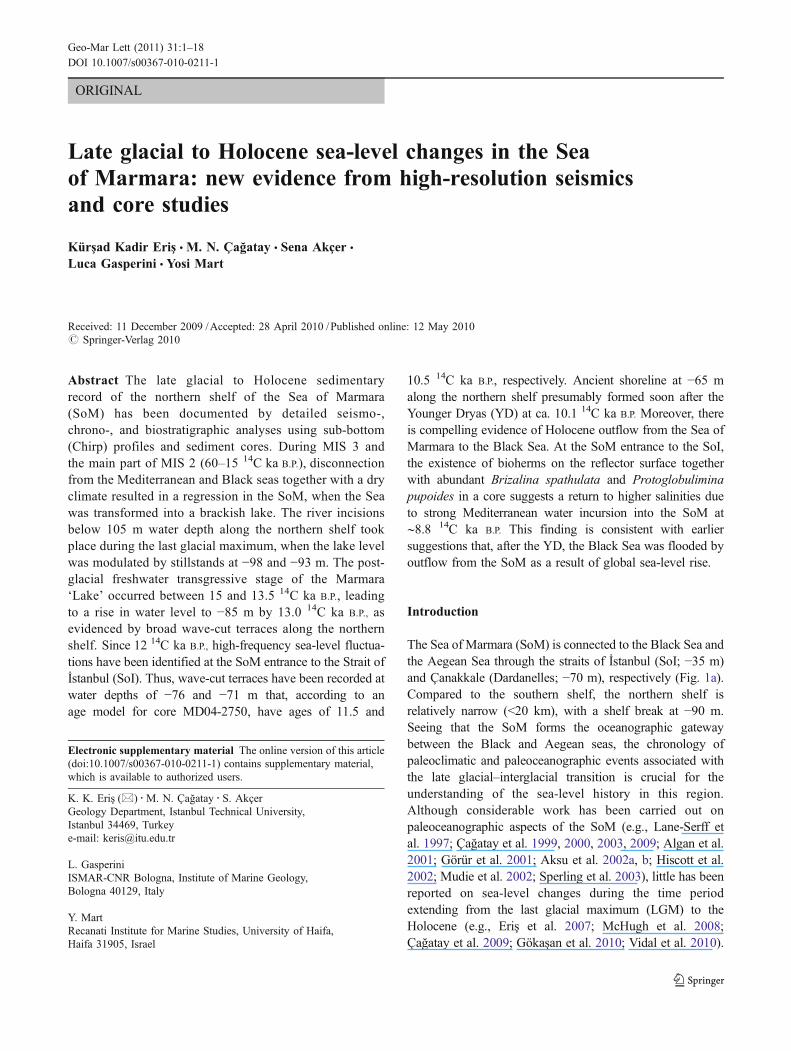
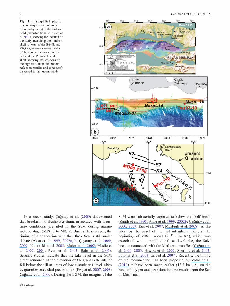
Fig. 1 a Simplified physio-graphic map (based on multi-beam bathymetry) of the easternSoM (extracted from Le Pichon etal. 2001), showing the location ofthe study area along the northernshelf. b Map of the Büyük andKüçük Çekmece shelves, and cof the southern entrance of theSoI and the Princes’ Islandsshelf, showing the locations ofthe high-resolution sub-bottomreflection profiles and cores (red)discussed in the present study
2 Geo-Mar Lett (2011) 31:1–18
The presence of wave-cut terraces at −85 m along thenorthern shelf of the SoM has been attributed to a lake-levelstillstand sometime before the Holocene marine connectionwas established (Çağatay et al. 2003, 2009; Polonia et al.2004; Eriş et al. 2007). On the basis of wide-spread seismicprofiling across the Çanakkale Strait and its extensions ontothe shelves of the Marmara and Aegean seas, Gökaşan et al.(2010) proposed that the Çanakkale Strait was formedmainly during the last transgression, and after overflow ofMediterranean waters from the Aegean Sea into the Sea ofMarmara.
Sea surface salinities and temperatures in the SoMincreased until the beginning of the cool and dry climateof the Younger Dryas (YD; Sperling et al. 2003), when thelevee deposits within the paleo-valley of the SoI at the exitof the SoM were formed by an outflow from the Black Sea(Eriş et al. 2007, 2008). This Black Sea outflow at thebeginning of the Holocene was proposed by Aksu et al.(2002a) to have occurred between 11.4 and 12.8 14C ka B.P.
During this time period, a positive water balance in theBlack Sea resulted in a continuous overflow into the SoM,raising the water level by about 20 m. The subsequent water-level stillstand at −65 m during the YD is documented by aprominent paleo-shoreline and erosional terrace on theMarmara Sea shelves (Çağatay et al. 2003).
In the course of the post-glacial sea-level rise,Mediterranean waters eventually flooded the SoM andoverflowed into the Black Sea through the SoI. Thetiming of this inundation is still a matter of debate,ranging from 9.0 to 7.5 14C ka B.P. (Ryan et al. 1997,2003; Görür et al. 2001; Aksu et al. 2002a; Hiscott et al.2002; Major et al. 2002, 2006; McHugh et al. 2008; Vidalet al. 2010). The present dual-flow regime of the SoM wasestablished between 4.5 and 5.0 14C ka B.P. (Çağatay et al.1999, 2000; Algan et al. 2001).
Within this context, detailed seismo-, chrono-, andbiostratigraphic investigations were carried out on thenorthern shelf of the Sea of Marmara, in an attempt tobetter constrain the relationships between sea-level changesand depositional sequences in the region during the lateglacial to Holocene transition. The two focal areas of studyare (1) the Büyük and Küçük Çekmece shelf sectors,together with the sector south of the Princes’ Islands, and(2) the SoM entrance to the SoI (Fig. 1b, c). The datapresented here complement those of Eriş et al. (2007) andÇağatay et al. (2009).
Materials and methods
High-resolution seismic reflection profiles along theÇekmece shelf (Marm-14 and -15) and SW of thePrinces’ Islands (Tocin-1, Pi-47, and Pi-5) were obtained
during cruises of the R/V Odin Finder (2000) and R/VUrania (2001, 2005; Fig. 1b, c). Bathymetric data wereacquired by means of Simrad EM3000 and SeaBeam-Elac110 multibeam echo-sounders, whereas seismic data werecollected by Datasonics SIS1000 and Datasonics Chirp-IIhigh-resolution sub-bottom profilers. A NAVPRO V5.53positioning system was used with a DGPS satellite link bySkyfix of RACAL-NESA. The data from the tow-fish, thesub-bottom profilers, and the navigation systemwere recordedin XTF format. The MedEx-07 profile from the BüyükÇekmece shelf was obtained during a cruise of the R/VMediterranean Explorer (2005), by means of an EdgetechSB424 Chirp reflection profiler under GPS navigation.The digital field data were sampled at 0.125-ms intervalsacross a 0.2-s window, and recorded in EdgeTech jsfformat.
High-resolution reflection profiles from the SoMentrance to the SoI (K2, K4, and B7) were acquiredduring two surveys conducted by the Department ofNavigation, Hydrography and Oceanography (SHOD) ofTurkish Army aboard the R/V Çubuklu in 1993 and 1997(Fig. 1c), using a 300-J sparker sound source in combi-nation with a trisponder radio range-positioning system(accuracy of 10 m for shotpoint locations). Depths ofreflectors below the sea surface were calculated usingaverage water and sediment velocities of 1,500 and1,700 m s−1, respectively. Seismic units were correlatedwith radiocarbon-dated chronostratigraphic units in coresby matching core depths with sub-bottom depths in theseismic profiles, after applying a correction for expectedcore shortening that commonly occurs during gravitycoring operations (cf. Eriş et al. 2008).
Ten gravity and piston cores collected during cruises of theR/V MTA Sismik-1 (2001 and 2003), R/V Marion Dufresne(2004), and R/V Mediterranean Explorer (2005) wereassessed by means of lithostratigraphic, paleontological,and geochemical analyses carried out at the GeologyDepartment of Istanbul Technical University. The corestations were selected on the basis of stratigraphic informa-tion obtained from the Chirp profiles (Fig. 1b, c). Descriptionof geographic coordinates, water depths, etc. is provided inTable 1 in the online electronic supplementary material forthis article.
Conventional and AMS (accelerator mass spectrometry)14C datings of core material were carried out at the IsotopeGeochemistry Laboratory of the University of Arizona andWoods Hole NOSAMS, on selected mollusk shells that hadbeen carefully cleaned and examined under the microscopeto ensure that they were diagenetically unaltered. Radio-carbon ages (14C ka B.P) are reported without the modern∼415 year reservoir correction (Siani et al. 2000), andwithout dendrochronological calibration (Stuiver andReimer 1993). Together with information on laboratory
Geo-Mar Lett (2011) 31:1–18 3
errors (±1σ), etc., these data are listed in Table 2 in theonline supplementary material for this article.
Gravity cores C-1 and MD04-2750 were sampled at5-cm intervals for the identification and counting ofbenthic foraminifers. In each case, 50 mg of the <63 μmfraction (separated by wet-sieving) was inspected under aNikon SMZ 800 binocular microscope. For each speciesidentified in a given sample, abundance was calculatedas a percentage of the total foraminifer count in the mudfraction.
Results
Seismic stratigraphy
Four seismic units were identified, i.e., S4 to S1 (from thebottom upward). These are bounded by reflectors thatrepresent the regional unconformities Q3 to Q1, the lattercorresponding to erosion surface K of Eriş et al. (2007).The stratigraphic relationships between the individual unitsand their sedimentary characteristics are presented belowfor each of the two main study areas.
Çekmece and Princes’ Islands shelves
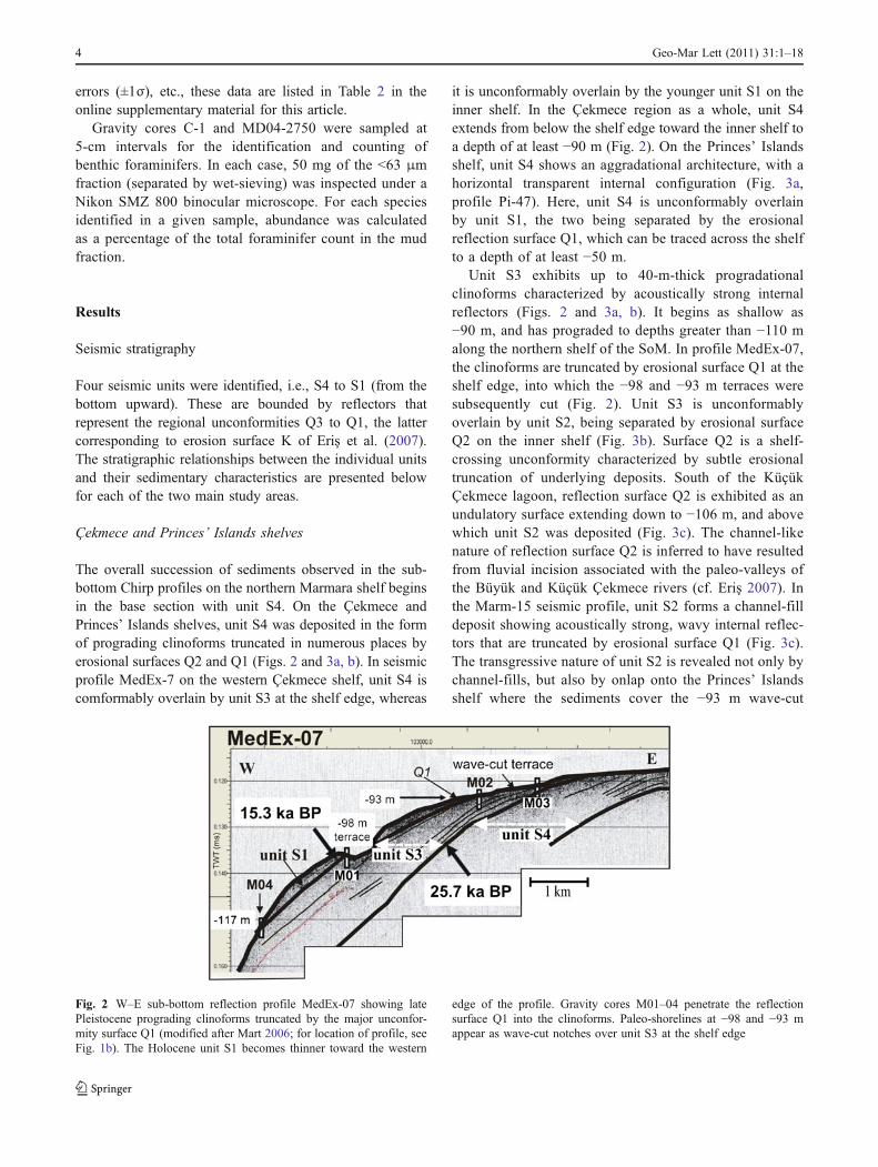
The overall succession of sediments observed in the sub-bottom Chirp profiles on the northern Marmara shelf beginsin the base section with unit S4. On the Çekmece andPrinces’ Islands shelves, unit S4 was deposited in the formof prograding clinoforms truncated in numerous places byerosional surfaces Q2 and Q1 (Figs. 2 and 3a, b). In seismicprofile MedEx-7 on the western Çekmece shelf, unit S4 iscomformably overlain by unit S3 at the shelf edge, whereas
it is unconformably overlain by the younger unit S1 on theinner shelf. In the Çekmece region as a whole, unit S4extends from below the shelf edge toward the inner shelf toa depth of at least −90 m (Fig. 2). On the Princes’ Islandsshelf, unit S4 shows an aggradational architecture, with ahorizontal transparent internal configuration (Fig. 3a,profile Pi-47). Here, unit S4 is unconformably overlainby unit S1, the two being separated by the erosionalreflection surface Q1, which can be traced across the shelfto a depth of at least −50 m.
Unit S3 exhibits up to 40-m-thick progradationalclinoforms characterized by acoustically strong internalreflectors (Figs. 2 and 3a, b). It begins as shallow as−90 m, and has prograded to depths greater than −110 malong the northern shelf of the SoM. In profile MedEx-07,the clinoforms are truncated by erosional surface Q1 at theshelf edge, into which the −98 and −93 m terraces weresubsequently cut (Fig. 2). Unit S3 is unconformablyoverlain by unit S2, being separated by erosional surfaceQ2 on the inner shelf (Fig. 3b). Surface Q2 is a shelf-crossing unconformity characterized by subtle erosionaltruncation of underlying deposits. South of the KüçükÇekmece lagoon, reflection surface Q2 is exhibited as anundulatory surface extending down to −106 m, and abovewhich unit S2 was deposited (Fig. 3c). The channel-likenature of reflection surface Q2 is inferred to have resultedfrom fluvial incision associated with the paleo-valleys ofthe Büyük and Küçük Çekmece rivers (cf. Eriş 2007). Inthe Marm-15 seismic profile, unit S2 forms a channel-filldeposit showing acoustically strong, wavy internal reflec-tors that are truncated by erosional surface Q1 (Fig. 3c).The transgressive nature of unit S2 is revealed not only bychannel-fills, but also by onlap onto the Princes’ Islandsshelf where the sediments cover the −93 m wave-cut
Fig. 2 W–E sub-bottom reflection profile MedEx-07 showing latePleistocene prograding clinoforms truncated by the major unconfor-mity surface Q1 (modified after Mart 2006; for location of profile, seeFig. 1b). The Holocene unit S1 becomes thinner toward the western
edge of the profile. Gravity cores M01–04 penetrate the reflectionsurface Q1 into the clinoforms. Paleo-shorelines at −98 and −93 mappear as wave-cut notches over unit S3 at the shelf edge
4 Geo-Mar Lett (2011) 31:1–18
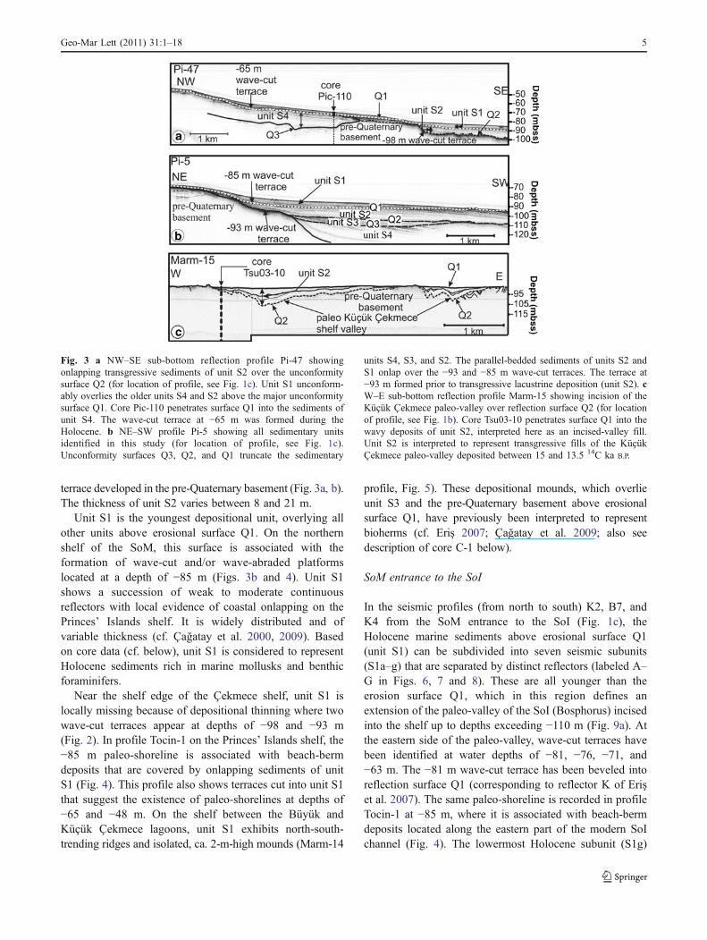
terrace developed in the pre-Quaternary basement (Fig. 3a, b).The thickness of unit S2 varies between 8 and 21 m.
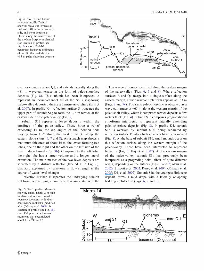
Unit S1 is the youngest depositional unit, overlying allother units above erosional surface Q1. On the northernshelf of the SoM, this surface is associated with theformation of wave-cut and/or wave-abraded platformslocated at a depth of −85 m (Figs. 3b and 4). Unit S1shows a succession of weak to moderate continuousreflectors with local evidence of coastal onlapping on thePrinces’ Islands shelf. It is widely distributed and ofvariable thickness (cf. Çağatay et al. 2000, 2009). Basedon core data (cf. below), unit S1 is considered to representHolocene sediments rich in marine mollusks and benthicforaminifers.
Near the shelf edge of the Çekmece shelf, unit S1 islocally missing because of depositional thinning where twowave-cut terraces appear at depths of −98 and −93 m(Fig. 2). In profile Tocin-1 on the Princes’ Islands shelf, the−85 m paleo-shoreline is associated with beach-bermdeposits that are covered by onlapping sediments of unitS1 (Fig. 4). This profile also shows terraces cut into unit S1that suggest the existence of paleo-shorelines at depths of−65 and −48 m. On the shelf between the Büyük andKüçük Çekmece lagoons, unit S1 exhibits north-south-trending ridges and isolated, ca. 2-m-high mounds (Marm-14
profile, Fig. 5). These depositional mounds, which overlieunit S3 and the pre-Quaternary basement above erosionalsurface Q1, have previously been interpreted to representbioherms (cf. Eriş 2007; Çağatay et al. 2009; also seedescription of core C-1 below).
SoM entrance to the SoI
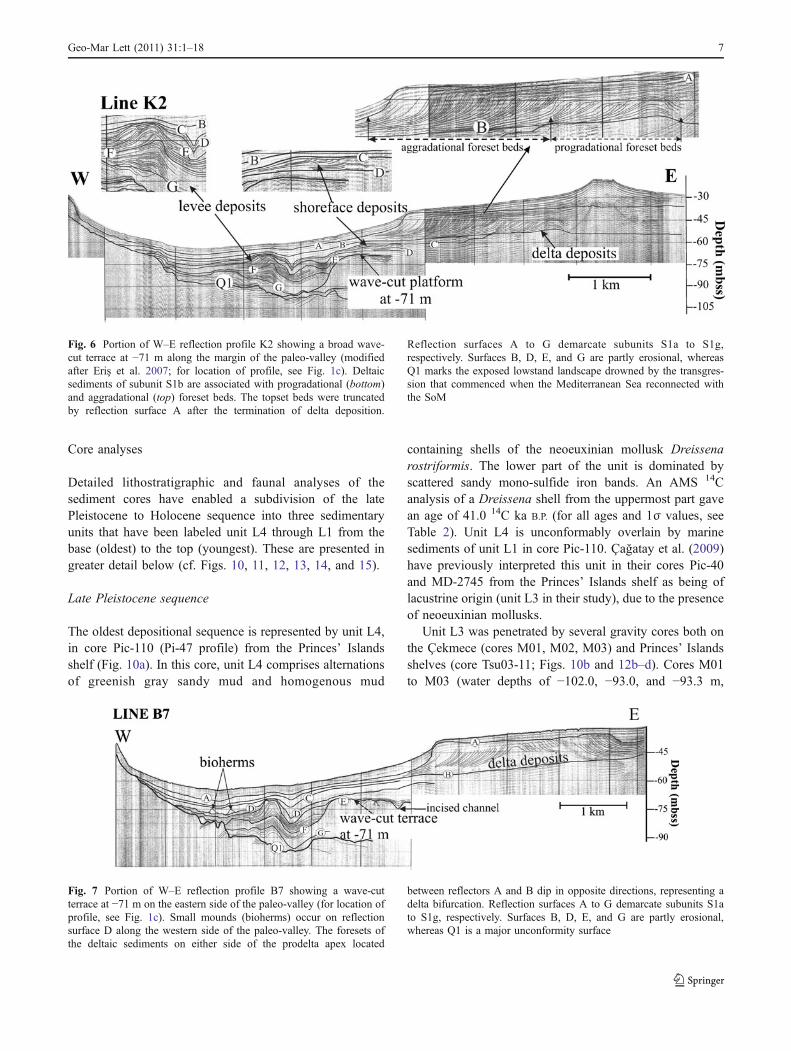
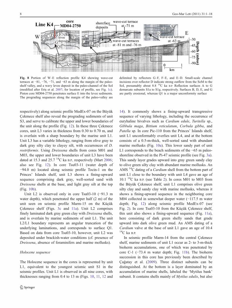
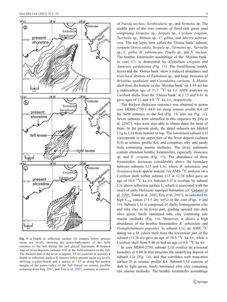
In the seismic profiles (from north to south) K2, B7, andK4 from the SoM entrance to the SoI (Fig. 1c), theHolocene marine sediments above erosional surface Q1(unit S1) can be subdivided into seven seismic subunits(S1a–g) that are separated by distinct reflectors (labeled A–G in Figs. 6, 7 and 8). These are all younger than theerosion surface Q1, which in this region defines anextension of the paleo-valley of the SoI (Bosphorus) incisedinto the shelf up to depths exceeding −110 m (Fig. 9a). Atthe eastern side of the paleo-valley, wave-cut terraces havebeen identified at water depths of −81, −76, −71, and−63 m. The −81 m wave-cut terrace has been beveled intoreflection surface Q1 (corresponding to reflector K of Erişet al. 2007). The same paleo-shoreline is recorded in profileTocin-1 at −85 m, where it is associated with beach-bermdeposits located along the eastern part of the modern SoIchannel (Fig. 4). The lowermost Holocene subunit (S1g)
Fig. 3 a NW–SE sub-bottom reflection profile Pi-47 showingonlapping transgressive sediments of unit S2 over the unconformitysurface Q2 (for location of profile, see Fig. 1c). Unit S1 unconform-ably overlies the older units S4 and S2 above the major unconformitysurface Q1. Core Pic-110 penetrates surface Q1 into the sediments ofunit S4. The wave-cut terrace at −65 m was formed during theHolocene. b NE–SW profile Pi-5 showing all sedimentary unitsidentified in this study (for location of profile, see Fig. 1c).Unconformity surfaces Q3, Q2, and Q1 truncate the sedimentary
units S4, S3, and S2. The parallel-bedded sediments of units S2 andS1 onlap over the −93 and −85 m wave-cut terraces. The terrace at−93 m formed prior to transgressive lacustrine deposition (unit S2). cW–E sub-bottom reflection profile Marm-15 showing incision of theKüçük Çekmece paleo-valley over reflection surface Q2 (for locationof profile, see Fig. 1b). Core Tsu03-10 penetrates surface Q1 into thewavy deposits of unit S2, interpreted here as an incised-valley fill.Unit S2 is interpreted to represent transgressive fills of the KüçükÇekmece paleo-valley deposited between 15 and 13.5 14C ka B.P.
Geo-Mar Lett (2011) 31:1–18 5
overlies erosion surface Q1, and extends laterally along the−81 m wave-cut terrace in the form of paleo-shorefacedeposits (Fig. 8). This subunit has been interpreted torepresent an incised-channel fill of the SoI (Bosphorus)paleo-valley deposited during a transgressive phase (Eriş etal. 2007). In profile K4, reflection surface G truncates theupper part of subunit S1g to form the −76 m terrace at theeastern side of the paleo-valley (Fig. 8).
Subunit S1f represents levee deposits within theconfines of the paleo-valley. These have a reliefexceeding 15 m, the dip angles of the inclined bedsvarying from 1.5° along the western to 3° along theeastern slope (Figs. 6, 7 and 8). An isopach map shows amaximum thickness of about 16 m, the levees forming twolobes, one on the right and the other on the left side of themain paleo-channel (Fig. 9b). Compared to the left lobe,the right lobe has a larger volume and a longer lateralextension. The main masses of the two levee deposits areseparated by a distinct reflector (labeled F in Fig. 6),plausibly explained by variations in flow strength in thecourse of water-level changes.
Reflection surface E separates the underlying subunitS1f from the overlying subunit S1e. It is associated with the
−71 m wave-cut terrace identified along the eastern marginof the paleo-valley (Figs. 6, 7 and 8). Where reflectionsurfaces E and Q1 merge into a single surface along theeastern margin, a wide wave-cut platform appears at −63 m(Figs. 8 and 9c). The same paleo-shoreline is observed as awave-cut terrace at −65 m along the western margin of thepaleo-shelf valley, where it comprises terrace deposits a fewmeters thick (Fig. 4). Subunit S1e comprises progradationalclinoforms interpreted to represent laterally extendingpaleo-shoreface deposits (Fig. 8). In profile K4, subunitS1e is overlain by subunit S1d, being separated byreflection surface D into which channels have been incised(Fig. 8). At the base of subunit S1d, small mounds occur onthis reflection surface along the western margin of thepaleo-valley. These have been interpreted to representbioherms (Fig. 7; Eriş et al. 2007). At the eastern marginof the paleo-valley, subunit S1b has previously beeninterpreted as a prograding delta, albeit of quite differentorigin, depending on the authors (Figs. 6 and 7; Aksu et al.2002a; Hiscott et al. 2002; Kerey et al. 2004; Gökaşan et al.2005; Eriş et al. 2007). Subunit S1a, the youngest Holocenedeposit, forms a mud drape with a laterally onlappingbedding architecture (Figs. 6, 7 and 8).
Fig. 4 NW–SE sub-bottomreflection profile Tocin-1showing wave-cut terraces at−65 and −48 m on the westernside, and berm deposits at−85 m along the eastern side ofthe modern Bosphorus channel(for location of profile, seeFig. 1c). Core Tsu03-11penetrates lacustrine sedimentsof unit S3 that underlie the−85 m paleo-shoreline deposits
Fig. 5 W–E profile Marm-14showing small, nearly 2-m-highhill-like features interpreted torepresent bioherms with abun-dant marine mollusks (modifiedafter Çağatay et al. 2009; forlocation of profile, see Fig. 1b).Core C-1 penetrates biohermsediments that accumulatedabout 11.5 14C ka B.P.
6 Geo-Mar Lett (2011) 31:1–18
Core analyses
Detailed lithostratigraphic and faunal analyses of thesediment cores have enabled a subdivision of the latePleistocene to Holocene sequence into three sedimentaryunits that have been labeled unit L4 through L1 from thebase (oldest) to the top (youngest). These are presented ingreater detail below (cf. Figs. 10, 11, 12, 13, 14, and 15).
Late Pleistocene sequence
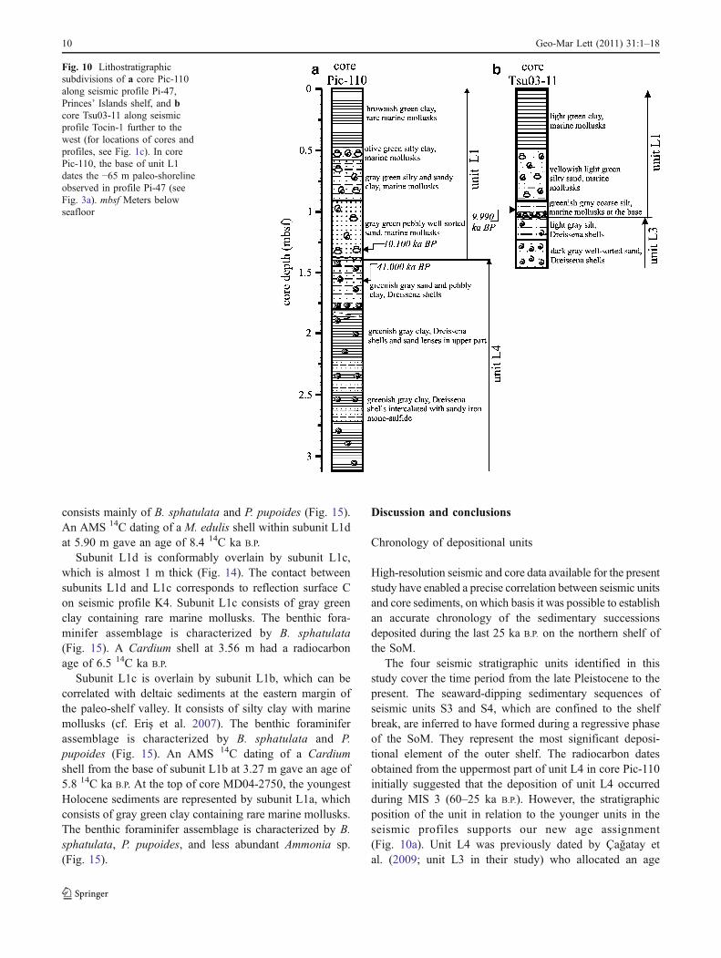
The oldest depositional sequence is represented by unit L4,in core Pic-110 (Pi-47 profile) from the Princes’ Islandsshelf (Fig. 10a). In this core, unit L4 comprises alternationsof greenish gray sandy mud and homogenous mud
containing shells of the neoeuxinian mollusk Dreissenarostriformis. The lower part of the unit is dominated byscattered sandy mono-sulfide iron bands. An AMS 14Canalysis of a Dreissena shell from the uppermost part gavean age of 41.0 14C ka B.P. (for all ages and 1σ values, seeTable 2). Unit L4 is unconformably overlain by marinesediments of unit L1 in core Pic-110. Çağatay et al. (2009)have previously interpreted this unit in their cores Pic-40and MD-2745 from the Princes’ Islands shelf as being oflacustrine origin (unit L3 in their study), due to the presenceof neoeuxinian mollusks.
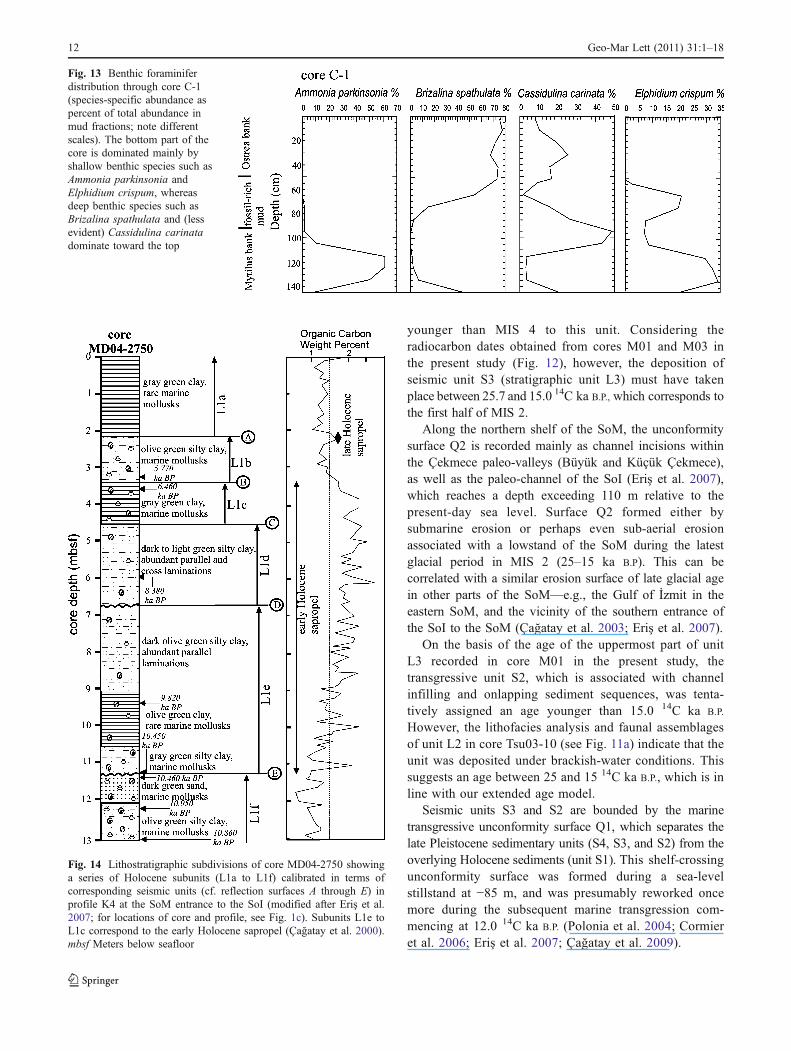
Unit L3 was penetrated by several gravity cores both onthe Çekmece (cores M01, M02, M03) and Princes’ Islandsshelves (core Tsu03-11; Figs. 10b and 12b–d). Cores M01to M03 (water depths of −102.0, −93.0, and −93.3 m,
Fig. 7 Portion of W–E reflection profile B7 showing a wave-cutterrace at −71 m on the eastern side of the paleo-valley (for location ofprofile, see Fig. 1c). Small mounds (bioherms) occur on reflectionsurface D along the western side of the paleo-valley. The foresets ofthe deltaic sediments on either side of the prodelta apex located
between reflectors A and B dip in opposite directions, representing adelta bifurcation. Reflection surfaces A to G demarcate subunits S1ato S1g, respectively. Surfaces B, D, E, and G are partly erosional,whereas Q1 is a major unconformity surface
Fig. 6 Portion of W–E reflection profile K2 showing a broad wave-cut terrace at −71 m along the margin of the paleo-valley (modifiedafter Eriş et al. 2007; for location of profile, see Fig. 1c). Deltaicsediments of subunit S1b are associated with progradational (bottom)and aggradational (top) foreset beds. The topset beds were truncatedby reflection surface A after the termination of delta deposition.
Reflection surfaces A to G demarcate subunits S1a to S1g,respectively. Surfaces B, D, E, and G are partly erosional, whereasQ1 marks the exposed lowstand landscape drowned by the transgres-sion that commenced when the Mediterranean Sea reconnected withthe SoM
Geo-Mar Lett (2011) 31:1–18 7
respectively) along seismic profile MedEx-07 on the BüyükÇekmece shelf also reveal the prograding sediments of unitS3, and serve to calibrate the upper and lower boundaries ofthe unit along the profile (Fig. 12). In these three Çekmececores, unit L3 varies in thickness from 0.30 to 0.70 m, andis overlain with a sharp boundary by the marine unit L1.Unit L3 has a variable lithology, ranging from olive gray todark gray silty clay to clayey silt, with occurrences of D.rostriformis. Using Dreissena shells from cores M01 andM03, the upper and lower boundaries of unit L3 have beendated at 15.3 and 25.7 14C ka B.P., respectively (Mart 2006;also see Fig. 12). In core Tsu03-11 (water depth of−94.0 m) located along seismic profile Tocin-1 on thePrinces’ Islands shelf, unit L3 shows a fining-upwardsequence comprising dark gray, well-sorted sand withDreissena shells at the base, and light gray silt at the top(Fig. 10b).
Unit L2 is observed only in core Tsu03-10 (−91.3 mwater depth), which penetrated the upper half (2 m) of theunit seen on seismic profile Marm-15 on the KüçükÇekmece shelf (Figs. 3c and 11a). Unit L2 comprisesfinely laminated dark gray green clay with Dreissena shells,and is overlain by marine sediments of unit L1. The unitL2/L1 boundary represents an angular truncation of theunderlying laminations, and corresponds to surface Q1.Based on data from core Tsu03-10, however, unit L2 wasdeposited under brackish-water conditions (cf. presence ofDreissena, absence of foraminifers and marine mollusks).
Holocene sequence
The Holocene sequence in the cores is represented by unitL1, equivalent to the youngest seismic unit S1 in theseismic profiles. Unit L1 is observed in all nine cores, withthicknesses ranging from 0.4 to 13 m (Figs. 10, 11, 12 and
14). It commonly shows a fining-upward transgressivesequence of varying lithology, including the occurrence ofeuryhaline bivalves such as Cardium edule, Turitella sp.,Gibbula maga, Bittium reticulatum, Corbula gibba, andPatella sp. In core Pic-110 from the Princes’ Islands shelf,unit L1 unconformably overlies unit L4, and at the bottomconsists of a 0.5-m-thick, well-sorted sand with abundantmarine mollusks (Fig. 10a). This lower sandy part of unitL1 corresponds to the beach sediments of the −65 m paleo-shoreline observed in the Pi-47 seismic profile (see Fig. 3a).This sandy layer grades upward into gray green sandy clayto olive green silty clay with abundant marine mollusks. AnAMS 14C dating of a Cardium shell from the bottom part ofunit L1 close to the boundary with unit L4 gave an age of10.1 14C ka B.P. (see Table 2). In cores M01 to M03 fromthe Büyük Çekmece shelf, unit L1 comprises olive greensilty clay and sandy clay with marine mollusks, whereas itshows a fining-upward sequence in the neighboring coreM04 collected in somewhat deeper water (−117.5 m waterdepth; Fig. 12) along seismic profile MedEx-07 (seeFig. 2). In core Tsu03-10 from the Küçük Çekmece shelf,this unit also shows a fining-upward sequence (Fig. 11a),here consisting of dark green shelly sands that gradeupward into dark olive green mud. An AMS dating of aCardium valve at the base of unit L1 gave an age of 10.414C ka B.P.
In seismic profile Marm-14 from the central Çekmeceshelf, marine sediments of unit L1 occur as 2- to 3-m-thickbioherm accumulations, one of which was penetrated bycore C-1 (−73.4 m water depth; Fig. 11b). The biohermsuccession in this core has previously been described byÇağatay et al. (2009). Three distinct subunits can bedistinguished. At the bottom is a layer dominated by anaccumulation of marine shells, labeled the ‘Mytilus bank’subunit. It contains shells mainly of Mytilus edulis, but also
Fig. 8 Portion of W–E reflection profile K4 showing wave-cutterraces at −81, −76, −71, and −63 m along the margin of the paleo-shelf valley, and a wavy levee deposit in the paleo-channel of the SoI(modified after Eriş et al. 2007; for location of profile, see Fig. 1c).Piston core MD04-2750 penetrates surface E into the levee sediments.The prograding sequences along the margin of the paleo-valley are
delimited by reflectors G–F, F–E, and E–D. Small-scale channelincisions over reflector D indicate strong outflow from the SoM to theSoI, presumably about 8.8 14C ka B.P. Reflection surfaces A to Gdemarcate subunits S1a to S1g, respectively. Surfaces B, D, E, and Gare partly erosional, whereas Q1 is a major unconformity surface
8 Geo-Mar Lett (2011) 31:1–18
of Nucula nucleus, Scrobicularia sp., and Vermetus sp. Themiddle part of the core consists of fossil-rich green mudcomprising Vermetus sp., Serpula sp., Cardium exiquum,Turritella sp., Bittium sp., C. gibba, and Mactra subtrun-cata. The top layer, here called the ‘Ostrea bank’ subunit,contains Ostrea edulis, Serpula sp., Vermetus sp., Turritellasp., C. gibba, M. subtruncata, Patella sp., and N. nucleus.The benthic foraminifer assemblage of the ‘Mytilus bank’in core C1 is dominated by Elphidium crispum andAmmonia parkinsonia (Fig. 13). The fossiliferous muddylayers and the ‘Ostrea bank’ show a reduced abundance andeven local absence of Elphidium sp., and large increases ofBrizalina spathulata and Cassidulina carinata. A Mytilusshell from the bottom of the ‘Mytilus bank’ (at 1.45 m) hasa radiocarbon age of 11.7 14C ka B.P. AMS analyses onCardium shells from the ‘Ostrea bank’ at 1.13 and 0.41 mgave ages of 11 and 4.0 14C ka B.P., respectively.
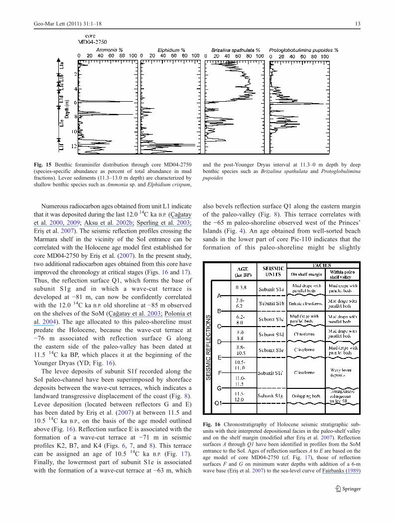
The thickest Holocene sequence was obtained in pistoncore MD04-2750 (−68.0 m) along seismic profile K4 offthe SoM entrance to the SoI (Fig. 14; also see Fig. 1c).Seven subunits were identified in this sequence by Eriş etal. (2007), who were also able to obtain dates for most ofthem. In the present study, the dated subunits are labeledL1g to L1a from bottom to top. The lowermost subunit L1fcorresponds to the upper part of the levee deposit (subunitS1f) in seismic profile K4, and comprises silty and sandybeds containing marine mollusks. The levee sedimentscontain abundant benthic foraminifers, especially Ammoniasp. and E. crispum (Fig. 15). The abundance of theseforaminifers decreases considerably above the boundarybetween subunits L1f and L1e, where B. sphatulata andTextularia bocki appear instead. An AMS 14C analysis on aCardium shell within subunit L1f at 12.36 mbsf gave anage of 10.9 14C ka B.P. Subunit L1f is overlain by subunitL1e above reflection surface E, which is associated with theonset of early Holocene sapropel formation (cf. Çağatay etal. 2000; Tolun et al. 2002; Eriş et al. 2007), as indicated byhigh Corg values (>1.5 dry wt%) in the core (Figs. 8 and14). Subunit L1e is composed of shelly homogeneous clayand silty clay in its lower part, grading upward into darkolive green, finely laminated silty clay containing raremarine mollusks (Fig. 14). Moreover, it shows a highabundance of the benthic foraminifers B. sphatulata andProtoglobulimina pupoides. In subunit L1e, an AMS 14Cdating on a M. edulis shell from the lowermost part of thesubunit (11.26 m) gave an age of 10.5 14C ka B.P., while aCardium shell from 9.40 m had an age of 9.8 14C ka B.P.
In core MD04-2750, subunit L1d overlies an erosionalboundary at 6.80 m that truncates the underlying deposit ofsubunit L1e (Fig. 14), and that correlates with truncationsurface D in seismic profile K4. Subunit L1d consists ofdark to light green, finely laminated silty clay containingrare marine mollusks. The benthic foraminifer assemblage
Fig. 9 a Depth to reflection surface Q1 (meters below presentmean sea level), showing the paleo-bathymetry of the SoMentrance to the SoI during the last glacial maximum. b Isopachmap of levee deposits (subunit S1f) at the SoM entrance to the SoI.The thickest part of the levee is approx. 16 m (contours in meters). cDepth to reflection surface D (meters below present mean sea level),showing a paleo-beach and a terrace at −63 m along the easternmargin of the paleo-valley of the SoI (based on seismic profilesextracted from Eriş 2007, and Eriş et al. 2007; contours in meters)
Geo-Mar Lett (2011) 31:1–18 9
consists mainly of B. sphatulata and P. pupoides (Fig. 15).An AMS 14C dating of a M. edulis shell within subunit L1dat 5.90 m gave an age of 8.4 14C ka B.P.
Subunit L1d is conformably overlain by subunit L1c,which is almost 1 m thick (Fig. 14). The contact betweensubunits L1d and L1c corresponds to reflection surface Con seismic profile K4. Subunit L1c consists of gray greenclay containing rare marine mollusks. The benthic fora-minifer assemblage is characterized by B. sphatulata(Fig. 15). A Cardium shell at 3.56 m had a radiocarbonage of 6.5 14C ka B.P.
Subunit L1c is overlain by subunit L1b, which can becorrelated with deltaic sediments at the eastern margin ofthe paleo-shelf valley. It consists of silty clay with marinemollusks (cf. Eriş et al. 2007). The benthic foraminiferassemblage is characterized by B. sphatulata and P.pupoides (Fig. 15). An AMS 14C dating of a Cardiumshell from the base of subunit L1b at 3.27 m gave an age of5.8 14C ka B.P. At the top of core MD04-2750, the youngestHolocene sediments are represented by subunit L1a, whichconsists of gray green clay containing rare marine mollusks.The benthic foraminifer assemblage is characterized by B.sphatulata, P. pupoides, and less abundant Ammonia sp.(Fig. 15).
Discussion and conclusions
Chronology of depositional units
High-resolution seismic and core data available for the presentstudy have enabled a precise correlation between seismic unitsand core sediments, on which basis it was possible to establishan accurate chronology of the sedimentary successionsdeposited during the last 25 ka B.P. on the northern shelf ofthe SoM.
The four seismic stratigraphic units identified in thisstudy cover the time period from the late Pleistocene to thepresent. The seaward-dipping sedimentary sequences ofseismic units S3 and S4, which are confined to the shelfbreak, are inferred to have formed during a regressive phaseof the SoM. They represent the most significant deposi-tional element of the outer shelf. The radiocarbon datesobtained from the uppermost part of unit L4 in core Pic-110initially suggested that the deposition of unit L4 occurredduring MIS 3 (60–25 ka B.P.). However, the stratigraphicposition of the unit in relation to the younger units in theseismic profiles supports our new age assignment(Fig. 10a). Unit L4 was previously dated by Çağatay etal. (2009; unit L3 in their study) who allocated an age
Fig. 10 Lithostratigraphicsubdivisions of a core Pic-110along seismic profile Pi-47,Princes’ Islands shelf, and bcore Tsu03-11 along seismicprofile Tocin-1 further to thewest (for locations of cores andprofiles, see Fig. 1c). In corePic-110, the base of unit L1dates the −65 m paleo-shorelineobserved in profile Pi-47 (seeFig. 3a). mbsf Meters belowseafloor
10 Geo-Mar Lett (2011) 31:1–18
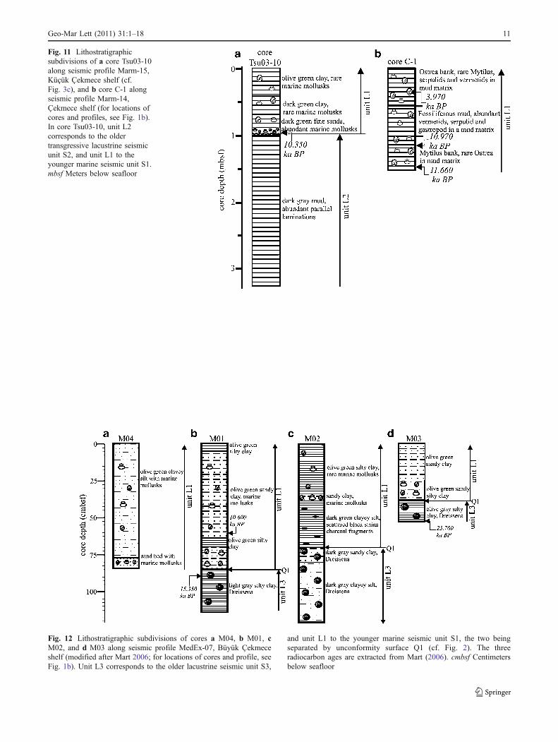
Fig. 12 Lithostratigraphic subdivisions of cores a M04, b M01, cM02, and d M03 along seismic profile MedEx-07, Büyük Çekmeceshelf (modified after Mart 2006; for locations of cores and profile, seeFig. 1b). Unit L3 corresponds to the older lacustrine seismic unit S3,
and unit L1 to the younger marine seismic unit S1, the two beingseparated by unconformity surface Q1 (cf. Fig. 2). The threeradiocarbon ages are extracted from Mart (2006). cmbsf Centimetersbelow seafloor
Fig. 11 Lithostratigraphicsubdivisions of a core Tsu03-10along seismic profile Marm-15,Küçük Çekmece shelf (cf.Fig. 3c), and b core C-1 alongseismic profile Marm-14,Çekmece shelf (for locations ofcores and profiles, see Fig. 1b).In core Tsu03-10, unit L2corresponds to the oldertransgressive lacustrine seismicunit S2, and unit L1 to theyounger marine seismic unit S1.mbsf Meters below seafloor
Geo-Mar Lett (2011) 31:1–18 11
younger than MIS 4 to this unit. Considering theradiocarbon dates obtained from cores M01 and M03 inthe present study (Fig. 12), however, the deposition ofseismic unit S3 (stratigraphic unit L3) must have takenplace between 25.7 and 15.0 14C ka B.P., which corresponds tothe first half of MIS 2.
Along the northern shelf of the SoM, the unconformitysurface Q2 is recorded mainly as channel incisions withinthe Çekmece paleo-valleys (Büyük and Küçük Çekmece),as well as the paleo-channel of the SoI (Eriş et al. 2007),which reaches a depth exceeding 110 m relative to thepresent-day sea level. Surface Q2 formed either bysubmarine erosion or perhaps even sub-aerial erosionassociated with a lowstand of the SoM during the latestglacial period in MIS 2 (25–15 ka B.P). This can becorrelated with a similar erosion surface of late glacial agein other parts of the SoM—e.g., the Gulf of İzmit in theeastern SoM, and the vicinity of the southern entrance ofthe SoI to the SoM (Çağatay et al. 2003; Eriş et al. 2007).
On the basis of the age of the uppermost part of unitL3 recorded in core M01 in the present study, thetransgressive unit S2, which is associated with channelinfilling and onlapping sediment sequences, was tenta-tively assigned an age younger than 15.0 14C ka B.P.
However, the lithofacies analysis and faunal assemblagesof unit L2 in core Tsu03-10 (see Fig. 11a) indicate that theunit was deposited under brackish-water conditions. Thissuggests an age between 25 and 15 14C ka B.P., which is inline with our extended age model.
Seismic units S3 and S2 are bounded by the marinetransgressive unconformity surface Q1, which separates thelate Pleistocene sedimentary units (S4, S3, and S2) from theoverlying Holocene sediments (unit S1). This shelf-crossingunconformity surface was formed during a sea-levelstillstand at −85 m, and was presumably reworked oncemore during the subsequent marine transgression com-mencing at 12.0 14C ka B.P. (Polonia et al. 2004; Cormieret al. 2006; Eriş et al. 2007; Çağatay et al. 2009).
Fig. 13 Benthic foraminiferdistribution through core C-1(species-specific abundance aspercent of total abundance inmud fractions; note differentscales). The bottom part of thecore is dominated mainly byshallow benthic species such asAmmonia parkinsonia andElphidium crispum, whereasdeep benthic species such asBrizalina spathulata and (lessevident) Cassidulina carinatadominate toward the top
Fig. 14 Lithostratigraphic subdivisions of core MD04-2750 showinga series of Holocene subunits (L1a to L1f) calibrated in terms ofcorresponding seismic units (cf. reflection surfaces A through E) inprofile K4 at the SoM entrance to the SoI (modified after Eriş et al.2007; for locations of core and profile, see Fig. 1c). Subunits L1e toL1c correspond to the early Holocene sapropel (Çağatay et al. 2000).mbsf Meters below seafloor
12 Geo-Mar Lett (2011) 31:1–18
Numerous radiocarbon ages obtained from unit L1 indicatethat it was deposited during the last 12.0 14C ka B.P. (Çağatayet al. 2000, 2009; Aksu et al. 2002b; Sperling et al. 2003;Eriş et al. 2007). The seismic reflection profiles crossing theMarmara shelf in the vicinity of the SoI entrance can becorrelated with the Holocene age model first established forcore MD04-2750 by Eriş et al. (2007). In the present study,two additional radiocarbon ages obtained from this core haveimproved the chronology at critical stages (Figs. 16 and 17).Thus, the reflection surface Q1, which forms the base ofsubunit S1g and in which a wave-cut terrace isdeveloped at −81 m, can now be confidently correlatedwith the 12.0 14C ka B.P. old shoreline at −85 m observedon the shelves of the SoM (Çağatay et al. 2003; Polonia etal. 2004). The age allocated to this paleo-shoreline mustpredate the Holocene, because the wave-cut terrace at−76 m associated with reflection surface G alongthe eastern side of the paleo-valley has been dated at11.5 14C ka BP, which places it at the beginning of theYounger Dryas (YD; Fig. 16).
The levee deposits of subunit S1f recorded along theSoI paleo-channel have been superimposed by shorefacedeposits between the wave-cut terraces, which indicates alandward transgressive displacement of the coast (Fig. 8).Levee deposition (located between reflectors G and E)has been dated by Eriş et al. (2007) at between 11.5 and10.5 14C ka B.P., on the basis of the age model outlinedabove (Fig. 16). Reflection surface E is associated with theformation of a wave-cut terrace at −71 m in seismicprofiles K2, B7, and K4 (Figs. 6, 7, and 8). This terracecan be assigned an age of 10.5 14C ka B.P. (Fig. 17).Finally, the lowermost part of subunit S1e is associatedwith the formation of a wave-cut terrace at −63 m, which
also bevels reflection surface Q1 along the eastern marginof the paleo-valley (Fig. 8). This terrace correlates withthe −65 m paleo-shoreline observed west of the Princes’Islands (Fig. 4). An age obtained from well-sorted beachsands in the lower part of core Pic-110 indicates that theformation of this paleo-shoreline might be slightly
Fig. 15 Benthic foraminifer distribution through core MD04-2750(species-specific abundance as percent of total abundance in mudfractions). Levee sediments (11.3–13.0 m depth) are characterized byshallow benthic species such as Ammonia sp. and Elphidium crispum,
and the post-Younger Dryas interval at 11.3–0 m depth by deepbenthic species such as Brizalina spathulata and Protoglobuliminapupoides
Fig. 16 Chronostratigraphy of Holocene seismic stratigraphic sub-units with their interpreted depositional facies in the paleo-shelf valleyand on the shelf margin (modified after Eriş et al. 2007). Reflectionsurfaces A through Q1 have been identified in profiles from the SoMentrance to the SoI. Ages of reflection surfaces A to E are based on theage model of core MD04-2750 (cf. Fig. 17), those of reflectionsurfaces F and G on minimum water depths with addition of a 6-mwave base (Eriş et al. 2007) to the sea-level curve of Fairbanks (1989)
Geo-Mar Lett (2011) 31:1–18 13
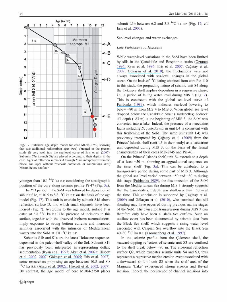
younger than 10.1 14C ka B.P, considering the stratigraphicposition of the core along seismic profile Pi-47 (Fig. 3a).
The YD period in the SoM was followed by deposition ofsubunit S1e, at 10.5 to 8.8 14C ka B.P. on the basis of the agemodel (Fig. 17). This unit is overlain by subunit S1d abovereflection surface D, into which small channels have beenincised (Fig. 7). According to the age model, surface D isdated at 8.8 14C ka B.P. The presence of incisions in thissurface, together with the observed bioherm accumulations,imply exposure to strong bottom currents and increasedsalinities associated with the intrusion of Mediterraneanwaters into the SoM at 8.8 14C ka B.P.
Subunits S1b and S1a are the latest Holocene sequencesdeposited in the paleo-shelf valley of the SoI. Subunit S1bhas previously been interpreted as representing deltaicsedimentation (Ryan et al. 1997; Aksu et al. 2002a; Hiscottet al. 2002, 2007; Gökaşan et al. 2005; Eriş et al. 2007),some researchers proposing an age between 10.5 and 8.814C ka B.P. (Aksu et al. 2002a; Hiscott et al. 2002, 2007).By contrast, the age model of core MD04-2750 places
subunit L1b between 6.2 and 3.8 14C ka B.P. (Fig. 17; cf.Eriş et al. 2007).
Sea-level changes and water exchanges
Late Pleistocene to Holocene
While water-level variations in the SoM have been limitedby sills in the Çanakkale and Bosphorus straits (Özturan1996; Ryan et al. 1996; Eriş et al. 2007; Çağatay et al.2009; Gökaşan et al. 2010), the fluctuations were notalways associated with sea-level changes in the globalocean. On the basis of 14C dating obtained from core Pic-110in this study, the prograding nature of seismic unit S4 alongthe Çekmece shelf implies deposition in a regressive phase,i.e., a period of falling water level during MIS 3 (Fig. 2).This is consistent with the global sea-level curve ofFairbanks (1989), which indicates sea-level lowering tobelow −80 m from MIS 4 to MIS 3. When global sea leveldropped below the Çanakkale Strait (Dardanelles) bedrocksill depth (−83 m) at the beginning of MIS 3, the SoM wasconverted into a lake. Indeed, the presence of a neoeuxinefauna including D. rostriformis in unit L4 is consistent withthis freshening of the SoM. The same unit (unit L4) waspreviously interpreted by Çağatay et al. (2009) from thePrinces’ Islands shelf (unit L3 in their study) as a lacustrineunit deposited during MIS 3, on the basis of the faunalcharacteristics of their cores MD-2745 and Pic-40.
On the Princes’ Islands shelf, unit S4 extends to a depthof at least −50 m, showing an aggradational sequence onthe inner shelf (Fig. 3a). This can be attributed to atransgressive period during some part of MIS 3. Althoughthe global sea level varied between −50 and −80 m duringthis stage (Fairbanks 1989), the disconnection of the SoMfrom the Mediterranean Sea during MIS 3 strongly suggeststhat the Çanakkale sill depth was shallower than −50 m atthe time. This conclusion is supported by Çağatay et al.(2009) and Gökaşan et al. (2010), who surmised that sillshoaling may have occurred during previous marine stagesof the SoM. The cause for transgression during MIS 3 cantherefore only have been a Black Sea outflow. Such anoutflow event has been documented by seismic data fromthe Black Sea shelf, which suggests a rising water levelassociated with Caspian Sea overflow into the Black Sea40–30 14C ka B.P. (Kroonenberg et al. 1997).
In the seismic profile from the Çekmece shelf, theseaward-dipping reflectors of seismic unit S3 are confinedto the shelf break below −80 m. The erosional reflectionsurface Q2, which truncates seismic units S4 and S3, thusrepresents a regressive marine erosion event associated witha downward shift of unit S3 when the shelf area of theMarmara ‘Lake’ experienced strong erosion and fluvialincision. Indeed, the occurrence of channel incisions into
Fig. 17 Extended age–depth model for core MD04-2750, showingthat two additional radiocarbon ages (red) obtained in the presentstudy fit very well into the sea-level curve of Eriş et al. (2007).Subunits S1a through S1f are placed according to their depths in thecore. Ages of reflection surfaces A through E are interpolated from themodel (all ages without reservoir correction or calibration). mbsfMeters below seafloor
14 Geo-Mar Lett (2011) 31:1–18
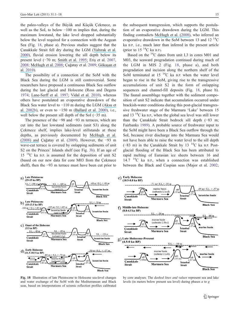
the paleo-valleys of the Büyük and Küçük Çekmece, aswell as the SoI, to below −100 m implies that, during themaximum lowstand, the lake level dropped substantiallybelow the level required for a connection with the AegeanSea (Fig. 18, phase a). Previous studies suggest that theÇanakkale Strait fell dry during the LGM (Yaltırak et al.2000), fluvial erosion lowering the sill depth below itspresent level (−70 m; Smith et al. 1995; Eriş et al. 2007,2008; McHugh et al. 2008; Çağatay et al. 2009; Gökaşan etal. 2010).
The possibility of a connection of the SoM with theBlack Sea during the LGM is still controversial. Someresearchers have proposed a continuous Black Sea outflowduring the last glacial and Holocene (Ross and Degens1974; Lane-Serff et al. 1997; Vidal et al. 2010), whereasothers have postulated an evaporative drawdown of theBlack Sea water level to −110 m during the LGM (Aksu etal. 2002b), or even to −150 m (Ballard et al. 2000), i.e.,well below the present sill depth of the SoI (−35 m).
The presence of the −98 and −93 m terraces, which arecut into the last lowstand sediments (unit S3) along theÇekmece shelf, implies lake-level stillstands at thesedepths, as previously documented by McHugh et al.(2008) and Çağatay et al. (2009). However, the −93 mwave-cut terrace is covered by onlapping sediments of unitS2 on the Princes’ Islands shelf (see Fig. 3b). If an age of15 14C ka B.P. is assumed for the deposition of unit S2(based on our new data for core M03 from the Çekmeceshelf), then the −93 m terrace must have been cut prior to
the subsequent transgression, which supports the postula-tion of an evaporative drawdown during the LGM. Thisfinding contradicts McHugh et al. (2008), who inferred anevaporative drawdown in the SoM between 13 and 12 14Cka B.P., i.e., much later than inferred in the present article(prior to 15 14C ka B.P.).
Based on the 14C dates from unit L3 in cores M01 andM03, the seaward progradation continued during much ofthe LGM in MIS 2 (Fig. 18, phase a), and bothprogradation and incision along the northern shelf of theSoM terminated at 15 14C ka B.P. when the water levelbegan to rise in the SoM, giving rise to the transgressiveaccumulations of unit S2 in the form of onlappingsequences and channel-fill deposits (Fig. 18, phase b).The faunal assemblage together with the sediment compo-sition of unit S2 indicate that accumulation occurred underbrackish-water conditions during this post-glacial transgres-sive freshwater stage of the Marmara ‘Lake’ between 15and 13 14C ka B.P., when the global sea level was still lowerthan the Çanakkale Strait bedrock sill depth (−83 m;Fairbanks 1989). A probable source of freshwater input tothe SoM might have been a Black Sea outflow through theSoI, because river discharge into the Marmara Sea wouldnot have been able to raise the water level to the sill depth(−83 m) in the Çanakkale Strait by 13 14C ka B.P. Post-glacial flooding of the Black Sea has been attributed torapid melting of Eurasian ice sheets between 16 and14.7 14C ka B.P., when a connection was establishedbetween the Black and Caspian seas (Major et al. 2002;
Fig. 18 Illustration of late Pleistocene to Holocene sea-level changesand water exchange of the SoM with the Mediterranean and Blackseas, based on interpretations of seismic reflection profiles calibrated
by core analyses. The dashed lines and values represent sea and lakelevels (in meters below present sea level) during phases a to g
Geo-Mar Lett (2011) 31:1–18 15
Ryan et al. 2003; Bahr et al. 2005, 2006; Tchepalyga 2007).This period is documented in the Black Sea by depositionof a series of reddish-brown clay layers. As a result, thelevel of the Black Sea rose above the SoI sill depth (−35 m)by 15 14C ka B.P. (Ryan et al. 2003). The overflow from theBlack Sea into the Marmara ‘Lake’ 15–13.5 14C ka B.P.
raised the lake level to the −85 m isobath (Fig. 18, phase c).The onset of the Bølling-Allerød interstadial warm
period resulted in evaporative drawdown of the Black Seabelow its SoI outlet (Ryan et al. 2003; Ryan 2007). The firstlowstand in the Black Sea in the post-glacial periodoccurred between 13.5 and 11 14C ka B.P. (Ryan et al.2003; Ryan 2007). Isolation of the SoM from both theAegean and Black seas gave rise to a stillstand of the lakelevel at −85 m until 12 14C ka B.P., as recorded in the broadwave-cut terraces along the northern shelf of the SoM(Çağatay et al. 2003, 2009; Polonia et al. 2004; Cormier etal. 2006; Eriş et al. 2007). According to Vidal et al. (2010),an increase in local evaporation could have led to aprogressive salinification of the Marmara basin prior tomarine reconnection.
Holocene
At about 12 14C ka B.P., the SoM was flooded byMediterranean waters due to global sea-level rise (Çağatayet al. 2000, 2009; Tolun et al. 2002; Sperling et al. 2003;Beck et al. 2007; Eriş et al. 2007). The SoM connectionwith the Mediterranean Sea led to initial drowning of theouter shelf, unit S1 accumulating as a transgressive muddrape containing marine mollusks and foraminifers, asdemonstrated in this study by radiocarbon-dated sedimentcores. During the initial phase of this marine transgression,the shelf area between the Büyük and Küçük Çekmecelagoons was colonized by bioherms (recorded by Aksu etal. 1999, 2002b, and Çağatay et al. 2009), which documentan increase in salinity in response to the incursion ofMediterranean waters.
Rising in tandem with the global sea level, the waterlevel in the SoM rose above the Çanakkale outlet (−83 m)until the onset of the Younger Dryas cold stage (Çağatay etal. 2003; Eriş et al. 2007; Fig. 18, phase d). Manyresearchers concur that, during the early Holocene, theBlack Sea was a giant freshwater lake situated at about−110 m (cf. Ryan et al. 2003; Ryan 2007). The YD period(11.5–10.5 14C ka B.P.) is documented in the SoM by theformation of levee deposits (subunit L1e) within the paleo-valley of the SoI, thereby recording outflow from the BlackSea via the SoI (Eriş et al. 2007; Fig. 18, phase d). Someprevious studies have also proposed such an outflow duringthe YD (Major et al. 2002; Ryan et al. 2003) as a result ofglacial melt water discharge. At that time, the Black Seawaters must have breached the southern sill of the SoI
(−35 m), filling the SoM, and eventually flowing into theMediterranean Sea via the Çanakkale Strait (Fig. 18, phase d).During the YD, the freshening of the SoM is recorded by anincrease in benthic foraminifer species such as Ammonia sp.and E. crispum in the levee sediments.
According to the seismic profiles from the SoM entrance tothe SoI, sea-level rise in the SoMwas interrupted by stillstandsat −76 and −71 m during levee deposition. Landward-prograding clinoforms of paleo-shoreface deposits occupythe space between these wave-cut terraces. The reason forthese sea-level stillstands during the YD is probably theblocking of Mediterranean water inflow by strong opposingBlack Sea outflow, as shown by the modeling study of Lane-Serff et al. (1997). At the end of the YD, the sea level inthe SoM stood above the levee deposits (−70 m), whichis well above the level of the bedrock sill in theÇanakkale Strait (−83 m). On the basis of the 14C agerecorded in the present study in core Pic-110 from thePrinces’ Islands, the broad wave-cut terrace at −65 mwould have formed soon after the YD at ∼10 14C ka B.P.Termination of the YD was followed by the onset of earlyHolocene sapropel deposition (Çağatay et al. 2000; Tolunet al. 2002). The presence of sapropelic sediments,accompanied by reduced abundances of benthic foramini-fers in core MD04-2750, suggests low bottom-wateroxygen contents at depths as shallow as −68 m.
According to previous studies on the Black Sea, therising global sea level eventually breached the sill of theSoI (−35 m), flooding the Black Sea with marine waters8.4 14C ka B.P. (Ryan et al. 2003; Major et al. 2006). Someresearchers have proposed a non-catastrophic and gradualconnection between the Mediterranean and Black seas(e.g., Aksu et al. 2002a, b; Hiscott et al. 2002, 2007),whereas others have postulated an abrupt catastrophicoverflow (e.g., Ryan et al. 1997, 2003; Major et al. 2002,2006; Myers et al. 2003; Siddall et al. 2003). Strong flowfrom the SoM into the Black Sea is documented in thisstudy by the presence of small-scale channel incisionsalong reflection surface D within the paleo-valley of theSoI. On this surface, dated at 8.8 14C ka B.P., the growth ofnumerous bioherms indicates elevated salinities due to theinflow of Mediterranean waters into the SoM (Fig. 18,phase e). This is also supported by the presence offoraminifers such as B. sphatulata, P. pupoides, and T.bocki in core MD04-2750, all implying suboxic deepwaterconditions in the SoM. About 8.8 14C ka B.P., the waterlevel of the SoM breached to the southern sill (−35 m) ofthe SoI (Fig. 18, phase f). At this time the global sea levelstood at about −30 m (Fairbanks 1989), whereas the BlackSea level was around −40 m (Vidal et al. 2010), wellbelow the southern sill (−35 m) of the SoI.
According to Eriş et al. (2007), a deceleration of sea-level rise at ∼6.5 14C ka B.P., together with an increase in
16 Geo-Mar Lett (2011) 31:1–18
sediment supply from the Kurbağalıdere River drainagebasin, gave rise to the formation of a prodelta along theeastern rim of the SoI paleo-valley. Arguing against apersistent Black Sea outflow forming the delta at 10 14C kaB.P. (cf. above), the seismic and core data presented in thisstudy confirm that, from 6.2–3.8 14C ka B.P., deltaicdeposition was associated with Kurbağalıdere River inflow,but not with Black Sea outflow. By 4.5 14C ka B.P. (Fig. 18,phase g), the Black Sea level must have risen well abovethe level of its outlet to the SoM (−35 m) to generate themodern dual-flow regime in the SoI (Çağatay et al. 2000;Algan et al. 2001).
Acknowledgements We thank the officers, crew, and scientificstaff of the R/V Odin Finder, Urania, MTA Sismik-1, MarionDufresne, and Mediterranean Explorer cruises for their help indata collection at sea. The manuscript was thoroughly reviewedby an anonymous referee and Burg W. Flemming. Discussionswith W. Bill Ryan, Sinan Özeren, and Ümmühan Sancar werevery instructive. Support was provided by TÜBİTAK and theİstanbul Technical University EMCOL laboratories of the GeologyDepartment.
References
Aksu AE, Hiscott RN, Yaşar D (1999) Oscillating Quaternary waterlevels of the Marmara Sea and vigorous outflow into the AegeanSea from the Marmara Sea-Black Sea drainage corridor. MarGeol 153:275–302
Aksu AE, Hiscott RN, Kaminski MA, Mudie PJ, Gillespie H, AbrojanoT, Yaşar D (2002a) Last glacial-Holocene paleoceanography of theBlack Sea and Marmara Sea: stable isotopic, foraminiferal andcoccolith evidence. Mar Geol 190:119–149
Aksu AE, Hiscott RN, Mudie PJ, Rochon A, Kaminski MA, AbrojanoT, Yaşar D (2002b) Persistent Holocene outflow from the BlackSea to the Eastern Mediterranean contradicts Noah’s Floodhypothesis. GSA Today 10(6):3–7
Algan O, Çağatay MN, Tchepalyga A, Ongan D, Eastoe C, Gökaşan E(2001) Stratigraphy of the sediment infill in Bosphorus Strait:water exchange between the Black and Mediterranean Seasduring the last glacial-Holocene. Geo-Mar Lett 20(4):209–218.doi:10.1007/s003670000058
Bahr A, Lamy F, Arz H, Kuhlmann H, Wefer G (2005) Late glacial toHolocene climate and sedimentation history in the NW BlackSea. Mar Geol 214:309–322
Bahr A, Arz H, Lamy F, Wefer G (2006) Late glacial to Holocenepaleoenvironmental evolution of the Black Sea, reconstructedwith stable oxygen isotope records obtained on ostracod shells.Earth Planet Sci Lett 241:863–875
Ballard RD, Coleman DF, Rosenberg GD (2000) Further evidence ofabrupt Holocene drowning of the Black Sea shelf. Mar Geol170:253–261
Beck C, Mercier de Lépinay B, Schneider J-L, Cremer M, ÇağatayMN, Wendenbaum E, Boutareaud S, Ménot G, Schmidt S, WeberO, Eris K, Armijo R, Meyer B, Pondard N, Gutscher M-A,Cruise Party MARMACORE, Turon J-L, Labeyrie L, Cortijo E,Gallet Y, Bouquerel H, Görür N, Gervais A, Castera M-H,Londeix L, Rességuier A, Jaouen A (2007) Late Quaternary co-seismic sedimentation in the Sea of Marmara’s deep basins.Sediment Geol 199:65–89
Çağatay MN, Algan O, Sakınç M, Eastoe C, Egesel L, Balkıs N,Ongan D, Caner H (1999) A late Holocene sapropelic sedimentunit from the southern Marmara shelf and its palaeoceanographicsignificance. Quat Geol Rev 18:531–540
Çağatay N, Görür N, Algan O, Eastoe CJ, Tchepalyga A, Ongan D, KuhnT, Kuscu I (2000) Late Glacial–Holocene paleoceanography of theMarmara Sea: timing of connections with theMediterranean and theBlack Seas. Mar Geol 167:191–206
Çağatay MN, Görür N, Polonia A, Demirbağ E, Sakınç M, CormierMH, Capotondi L, McHugh C, Emre Ö, Eriş K (2003) Sea levelchanges and depositional environments in the İzmit Gulf, easternMarmara Sea, during the late glacial-Holocene period. Mar Geol202:159–173
Çağatay MN, Eriş K, Ryan WBF, Sancar Ü, Polonia A, Akçer S,Biltekin D, Gasperini L, Görür N, Lericolais G, Bard E (2009)Late Pleistocene-Holocene evolution of the northern shelf of theSea of Marmara. Mar Geol 265:87–100
Cormier M-H, Seeber L, McHugh CMG, Polonia A, Çağatay MN,Emre Ö, Gasperini L, Görür N, Bertoluzzi G, Bonatti E, RyanWBF, Newman KR (2006) The North Anatolian fault in the Gulfof Izmit (Turkey): rapid vertical motion in response to minorbends of a non-vertical continental transform. J Geophys Res111:B04102. doi:10.1029/2005JB003633
Eriş KK (2007) Middle Pleistocene to recent sea level changes in theSea of Marmara (in Turkish with English abstract). PhD Thesis,Eurasia Institute of Earth Sciences, İstanbul Technical University,İstanbul
Eriş KK, Ryan WBF, Çağatay MN, Sancar U, Lericolais G, Ménot G,Bard E (2007) The timing and evolution of the post-glacialtransgression across the Sea of Marmara shelf south of İstanbul.Mar Geol 243:57–76
Eriş KK, Ryan WBF, Çağatay MN, Sancar U, Lericolais G, Ménot G,Bard E (2008) Reply to comment on “The timing and evolutionof the post-glacial transgression across the Sea of Marmara shelfsouth of İstanbul” by Hiscott et al. Mar Geol 248:228–236
Fairbanks RG (1989) A 17, 000-year glacio-eustatic sealevel record:influence of glacial melting rates on the Younger Dryas event anddeep-ocean circulation. Nature 342:637–642
Gökaşan E, Algan O, Tur H, Meriç E, Türker A, Şimşek M (2005)Delta formation at the southern entrance of Istanbul Strait(Marmara Sea, Turkey): a new interpretation based on high-resolution seismic stratigraphy. Geo-Mar Lett 25(6):370–377.doi:10.1007/s00367-005-0215-4
Gökaşan E, Tur H, Ergin M, Görüm T, Batuk FG, Sağcı N, UstaömerT, Emen O, Alp H (2010) Late quaternary evolution of theÇanakkale Strait region (Dardanelles, NW Turkey): implicationsof a major erosional event for the postglacial Mediterranean-Marmara Sea connection. Geo-Mar Lett 30(2):113–131.doi:10.1007/s00367-009-0166-2
Görür N, Çağatay MN, Emre Ö, Alpar B, Sakınç M, İslamoğlu Y,Algan A, Keçer M, Erkal T, Akkök R (2001) Is the abruptdrowning of the Black Sea shelf at 7150 yr BP a myth? Mar Geol176:65–73
Hiscott RN, Aksu AE, Yaşar D, Kaminski MA, Mudie PJ, KostylevVE, MacDonald JC, Isler FI, Lord AR (2002) Deltas south of theBosphorus Strait record persistent Black Sea outflow to theMarmara Sea since 10 ka. Mar Geol 190:95–118
Hiscott RN, Aksu AE, Mudie PJ, Kaminski MA, Abrajano T, Yaşar D,Rochon A (2007) The Marmara Sea gateway since 16 ky BP:non-catastrophic causes of paleoceanographic events in the BlackSea at 8.4 and 7.15 ky BP. In: Yanko-Hombach V, Gilbert AS,Dolukhanov PM (eds) The Black Sea Flood question. Dordrecht,Springer, pp 89–117
Kaminski MA, Aksu AE, Hiscott RN, Box M, Al-Salameen M,Filipescu S (2002) Late glacial to Holocene benthic foraminiferain the Marmara Sea. Mar Geol 190:165–202
Geo-Mar Lett (2011) 31:1–18 17
Kerey IE, Meriç E, Tunoğolu C, Kelling G, Brenner RK, DoğanAU (2004) Black Sea-Marmara Sea Quaternary connections:new data from the Bosphorus, Istanbul, Turkey. PalaeogeogrPalaeoclimatol Palaeoecol 204:277–295
Kroonenberg SB, Rusakov GV, Svitoch AA (1997) The wandering ofthe Volga delta: a response to rapid Caspian sea-level change.Sediment Geol 107:189–209
Lane-Serff GF, Rohling EL, Bryden HL, Charnock H (1997)Postglacial connection of the Black Sea to the Mediterraneanand its relation to the timing of sapropel formation. Paleo-ceanography 12:169–174
Le Pichon X, Şengör AMC, Demirbağ E, Rangin C, Imren C, ArmijoR, Görür N, Çağatay N, de Lepinay BM, Meyer B, Saatçılar R,Tok B (2001) The active main Marmara fault: comparativeanatomy of a continental transform fault in a marine setting.Earth Planet Sci Lett 192:595–616
Major C, Ryan WBF, Lericolais G, Hajdas I (2002) Constraints onBlack Sea outflow to the Sea of Marmara during the last glacial–interglacial transition. Mar Geol 190:19–34
Major CO, Goldstein SL, Ryan WBF, Lericolais G, Piotrowski AM,Hajdas I (2006) The co-evolution of Black Sea level andcomposition through the last deglaciation and its paleoclimaticsignificance. Quat Sci Rev 25:2031–2047
Mart Y (2006) Variable sea levels and flooding events in the Sea ofMarmara and the Black Sea during the Latest Pleistocene and theEarly Holocene. In: R.I.M.S. News, Leon Recanati Institute forMaritime Studies, Haifa, Rep 32, pp 3–7
McHugh CMG, Gurung D, Giosan L, Ryan WBF, Mart Y, Sancar U,Burckle L, Çağatay N (2008) The last reconnection of theMarmara Sea (Turkey) to the World Ocean; a paleoceanographicand paleoclimatic perspective. Mar Geol 255:64–82
Mudie PJ, Aksu AE, Yaşar D (2002) Late Quaternary dinoflagellatecysts from the Black, Marmara and Aegean seas: variations inassemblages, morphology and paleosalinity. Mar Micropaleontol43:155–178
Mudie PJ, Rochon A, Aksu AE, Gillespie H (2004) Late glacial,Holocene and modern dinoflagellate cyst assemblages in theAegean-Marmara-Black Sea corridor. Rev Palaeobot Palynol256:1–26
Myers PG, Wielki C, Goldstein SB, Rohling J (2003) Hydrauliccalculations of postglacial connections between the Mediterraneanand Black Sea. Mar Geol 201:253–267
Özturan M (1996) Geophysics of the Çanakkale Strait. MSc Thesis,Istanbul University, Institute of Marine Sciences and Management
Polonia A, Gasperini L, Amorosi A, Bonatti E, Bortoluzzi G, ÇağatayN, Capotondi L, Cormier MH, Görür N, McHugh C, Seeber L(2004) Holocene slip rate of the North Anatolian Fault beneaththe Sea of Marmara. Earth Planet Sci Lett 227:411–426
Ross DA, Degens ET (1974) Recent sediments of the Black Sea. In:Degens ET, Ross DA (eds) The Black Sea—Geology, chemistryand biology. Am Assoc Petrol Geol Mem 20:183–199
Ryan WBF (2007) Status of the Black Sea flood hypothesis. In:Yanko-Hombach V, Gilbert AS, Dolukhanov PM (eds) The BlackSea Flood question. Springer, Dordrecht, pp 63–88
Ryan WBF, Pitman WC, Major CO, Shimkus K, Moskalenko KV,Jones GA, Dimitrov P, Görür N, Sakinç M, Yüce H (1996) Anabrupt drowning of the Black Sea shelf at 7.5 kyr BP. Geo-Eco-Marina 2:115–126
Ryan WBF, Pitman WC III, Major CO, Shimkus K, Moskalenko V,Jones JA, Dimitrov P, Görür N, Sakınç M, Yüce H (1997) Anabrupt drowning of Black Sea Shelf. Mar Geol 138:119–126
Ryan WBF, Major C, Lericolais G, Goldstein SL (2003) Catastrophicflooding of the Black Sea. Annu Rev Earth Planet Sci31:525–554
Siani G, PaterneM, ArnoldM, Bard E,Metivier B, Tisnerat N, Bassinot F(2000) Radiocarbon reservoir ages in the Mediterranean Sea andBlack Sea. Radiocarbon 42:271–280
Siddall M, Rohling EJ, Almogi-Labin A, Hemleben Ch, Melschner D,Schmelzer I, Smeed DA (2003) Sea-level fluctuations during thelast glacial cycle. Nature 423:853–858
Smith AD, Taymaz T, Oktay F, Yüce H, Alpar B, Başaran H, JacksonJA, Kara S, Şimşek M (1995) High resolution seismic reflectionprofiling in the Sea of Marmara (northwest Turkey): LateQuaternary sedimentation and sea-level changes. Geol Soc AmBull 107:923–936
Sperling M, Schmiedl G, Hemleben Ch, Emeis KC, Erlenkeuser H,Grootes PM (2003) Black Sea impact on the formation of easternMediterranean sapropel S1? Evidence from the Marmara Sea.Palaeogeogr Palaeoclimatol Palaeoecol 190:9–21
Stuiver M, Reimer PJ (1993) Extended 14C database and revisedCALIB radiocarbon calibration program. Radiocarbon 35:215–230
Tchepalyga A (2007) The late glacial great flood in the Ponto-CaspianBasin. In: Yanko-Hombach V, Gilbert AS, Dolukhanov PM (eds)The Black Sea Flood question. Springer, Dordrecht, pp 119–148
Tolun T, Çağatay MN, Carrigan WJ (2002) Organic geochemistry andorigin of Holocene sapropelic layer and associated sediments inthe Marmara Sea. Mar Geol 190:47–60
Vidal L, Menot G, Joly C, Bruneton H, Rostek F, Çağatay MN,Major C (2010) Hydrology in the Sea of Marmara during thelast 23 ka: implications for timing of Black Sea connectionsand sapropel deposition. Paleoceanography (in press).doi:10.1029/2009PA001735
Yaltırak C, Alpar B, Sakınç M, Yüce H (2000) Origin of the Strait ofÇanakkale (Dardanelles): regional tectonics and the MediterraneanMarmara incursion. Mar Geol 164:139–156
18 Geo-Mar Lett (2011) 31:1–18
All in-text references underlined in blue are linked to publications on ResearchGate, letting you access and read them immediately.