Paratethyan–Mediterranean connectivity in the Sea of Marmara region (NW Turkey) during the...
17
Paratethyan–Mediterranean connectivity in the Sea of Marmara region (NW Turkey) during the Messinian M. Namık Çağatay a, ⁎ , Naci Görür a , Rachel Flecker b , Mehmet Sakınç a , Cemal Tünoğlu c , Robert Ellam d , Wout Krijgsman e , Stephen Vincent f , Aynur Dikbaş a a Istanbul Technical University, School of Mines and Eurasia Institute of Earth Sciences, Turkey b BRIDGE, School of Geographical Sciences, University of Bristol, UK c Hacettepe University, Geological Engineering Department, Ankara, Turkey d Scottish Universities Environmental Research Centre, East Kilbride, UK e Utrecht University, Netherlands f CASP, Department of Earth Sciences, University of Cambridge, UK Abstract The Sea of Marmara region is thought to have been a gateway between Paratethys and the Mediterranean since the Middle Miocene, and is therefore an important control on water mass exchange between the two realms. The Miocene successions in the northeastern Aegean and northwestern Marmara regions indicate that the first Mediterranean marine transgression to affect these areas occurred during the late Serravallian. In the northeastern Aegean region, frequent marine incursions occurred during the Tortonian and Messinian stages. The Messinian stage in this area is represented by a package of brackish- to fresh-water carbonates with some marine sandstone– siltstone interbeds (Alçıtepe Formation), which conformably overlies the Tortonian Kirazlı Formation. The Messinian sequence is overlain with an erosional contact by a shallow marine siliciclastic sequence (Göztepe Formation) of Zanclean age. With its brackish- to fresh-water carbonates and broadly constrained age, the Messinian sequence is interpreted as being coeval with the Upper Evaporite–Lago Mare sequence observed in western Mediterranean basins. In the western Marmara region, the Pontian (Messinian) Alçıtepe Formation consists of bioclastic and oolitic limestones with basal clastic rocks. It conformably overlies the fluvio-lacustrine siliciclastic sediments of the Middle to Upper Miocene Kirazlı Formation and is overlain by fluvio-lacustrine sediments of the Kimmerian (5.5–3.2 Ma) Truva and Tevfikiye formations with an erosional contact. The bioclastic limestones of the Alçıtepe Formation in the western Marmara region contain a molluscan and ostracod fauna that are endemic to Paratethys. These fauna indicate deposition in a shallow, brackish- to fresh-water environment. Faunal and paleomagnetic analyses of a section of the Alçıtepe Formation at Yenimahalle (Çanakkale) confirm that the formation is of Pontian age and represents chron C3r (6.04–5.24 Ma). The ostracod analysis indicates that during deposition of the Alçıtepe Formation, salinity increased from brackish in the lower part to more saline conditions in the upper part. Ostracod valves have low 87 Sr / 86 Sr values relative to coeval Late Miocene ocean water. This indicates that exchange between the Sea of Marmara region and the global ocean was restricted throughout this period. Fossil and Sr-isotope evidence suggests, however, that there was a Paratethyan– Marmara connection during the deposition of the lower part of the Alçıtepe Formation, with Paratethyan influence reaching the north Aegean. Connection via Marmara between Paratethys and the Mediterranean was not re-established until the late Sedimentary Geology 188–189 (2006) 171 – 187 www.elsevier.com/locate/sedgeo ⁎ Corresponding author. E-mail address: [email protected] (M.N. Çağatay). 0037-0738/$ - see front matter © 2006 Elsevier B.V. All rights reserved. doi:10.1016/j.sedgeo.2006.03.004
-
Upload
independent -
Category
Documents
-
view
7 -
download
0
Transcript of Paratethyan–Mediterranean connectivity in the Sea of Marmara region (NW Turkey) during the...
189 (2006) 171–187www.elsevier.com/locate/sedgeo
Sedimentary Geology 188–
Paratethyan–Mediterranean connectivity in the Sea of Marmararegion (NW Turkey) during the Messinian
M. Namık Çağatay a,⁎, Naci Görür a, Rachel Flecker b, Mehmet Sakınç a,Cemal Tünoğlu c, Robert Ellam d, Wout Krijgsman e, Stephen Vincent f, Aynur Dikbaş a
a Istanbul Technical University, School of Mines and Eurasia Institute of Earth Sciences, Turkeyb BRIDGE, School of Geographical Sciences, University of Bristol, UK
c Hacettepe University, Geological Engineering Department, Ankara, Turkeyd Scottish Universities Environmental Research Centre, East Kilbride, UK
e Utrecht University, Netherlandsf CASP, Department of Earth Sciences, University of Cambridge, UK
Abstract
The Sea of Marmara region is thought to have been a gateway between Paratethys and the Mediterranean since the MiddleMiocene, and is therefore an important control on water mass exchange between the two realms. The Miocene successions in thenortheastern Aegean and northwestern Marmara regions indicate that the first Mediterranean marine transgression to affect theseareas occurred during the late Serravallian.
In the northeastern Aegean region, frequent marine incursions occurred during the Tortonian and Messinian stages. TheMessinian stage in this area is represented by a package of brackish- to fresh-water carbonates with some marine sandstone–siltstone interbeds (Alçıtepe Formation), which conformably overlies the Tortonian Kirazlı Formation. The Messinian sequence isoverlain with an erosional contact by a shallow marine siliciclastic sequence (Göztepe Formation) of Zanclean age. With itsbrackish- to fresh-water carbonates and broadly constrained age, the Messinian sequence is interpreted as being coeval with theUpper Evaporite–Lago Mare sequence observed in western Mediterranean basins.
In the western Marmara region, the Pontian (Messinian) Alçıtepe Formation consists of bioclastic and oolitic limestones withbasal clastic rocks. It conformably overlies the fluvio-lacustrine siliciclastic sediments of the Middle to Upper Miocene KirazlıFormation and is overlain by fluvio-lacustrine sediments of the Kimmerian (5.5–3.2 Ma) Truva and Tevfikiye formations with anerosional contact.
The bioclastic limestones of the Alçıtepe Formation in the western Marmara region contain a molluscan and ostracod fauna thatare endemic to Paratethys. These fauna indicate deposition in a shallow, brackish- to fresh-water environment. Faunal andpaleomagnetic analyses of a section of the Alçıtepe Formation at Yenimahalle (Çanakkale) confirm that the formation is of Pontianage and represents chron C3r (6.04–5.24 Ma). The ostracod analysis indicates that during deposition of the Alçıtepe Formation,salinity increased from brackish in the lower part to more saline conditions in the upper part. Ostracod valves have low 87Sr / 86Srvalues relative to coeval Late Miocene ocean water. This indicates that exchange between the Sea of Marmara region and the globalocean was restricted throughout this period. Fossil and Sr-isotope evidence suggests, however, that there was a Paratethyan–Marmara connection during the deposition of the lower part of the Alçıtepe Formation, with Paratethyan influence reaching thenorth Aegean. Connection via Marmara between Paratethys and the Mediterranean was not re-established until the late
⁎ Corresponding author.E-mail address: [email protected] (M.N. Çağatay).
0037-0738/$ - see front matter © 2006 Elsevier B.V. All rights reserved.doi:10.1016/j.sedgeo.2006.03.004
172 M.N. Çağatay et al. / Sedimentary Geology 188–189 (2006) 171–187
Aktchagylian (Late Pliocene). The re-connection was caused by both increased activity on the North Anatolian Fault and global sealevel rise.© 2006 Elsevier B.V. All rights reserved.
Keywords: Paratethys; Aegean Sea; Marmara region; NW Turkey; Mediterranean; Messinian salinity crisis; Water exchange
1. Introduction
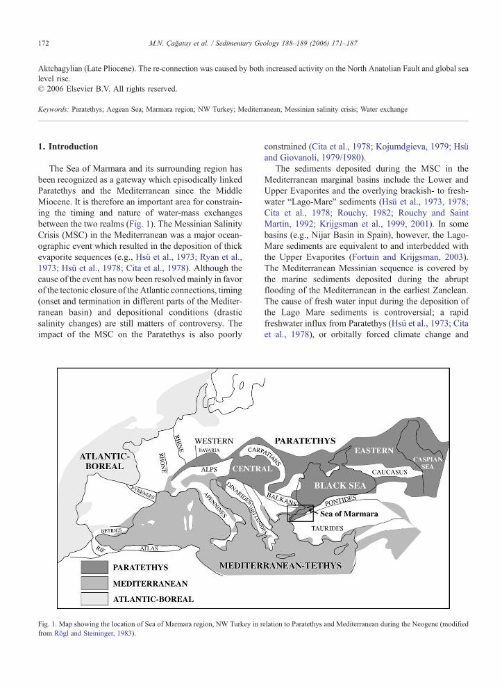
The Sea of Marmara and its surrounding region hasbeen recognized as a gateway which episodically linkedParatethys and the Mediterranean since the MiddleMiocene. It is therefore an important area for constrain-ing the timing and nature of water-mass exchangesbetween the two realms (Fig. 1). The Messinian SalinityCrisis (MSC) in the Mediterranean was a major ocean-ographic event which resulted in the deposition of thickevaporite sequences (e.g., Hsü et al., 1973; Ryan et al.,1973; Hsü et al., 1978; Cita et al., 1978). Although thecause of the event has now been resolved mainly in favorof the tectonic closure of the Atlantic connections, timing(onset and termination in different parts of the Mediter-ranean basin) and depositional conditions (drasticsalinity changes) are still matters of controversy. Theimpact of the MSC on the Paratethys is also poorly
Fig. 1. Map showing the location of Sea of Marmara region, NW Turkey in rfrom Rögl and Steininger, 1983).
constrained (Cita et al., 1978; Kojumdgieva, 1979; Hsüand Giovanoli, 1979/1980).
The sediments deposited during the MSC in theMediterranean marginal basins include the Lower andUpper Evaporites and the overlying brackish- to fresh-water “Lago-Mare” sediments (Hsü et al., 1973, 1978;Cita et al., 1978; Rouchy, 1982; Rouchy and SaintMartin, 1992; Krijgsman et al., 1999, 2001). In somebasins (e.g., Nijar Basin in Spain), however, the Lago-Mare sediments are equivalent to and interbedded withthe Upper Evaporites (Fortuin and Krijgsman, 2003).The Mediterranean Messinian sequence is covered bythe marine sediments deposited during the abruptflooding of the Mediterranean in the earliest Zanclean.The cause of fresh water input during the deposition ofthe Lago Mare sediments is controversial; a rapidfreshwater influx from Paratethys (Hsü et al., 1973; Citaet al., 1978), or orbitally forced climate change and
elation to Paratethys and Mediterranean during the Neogene (modified
173M.N. Çağatay et al. / Sedimentary Geology 188–189 (2006) 171–187
increased river runoff (Krijgsman et al., 2001; Rouchy etal., 2001) are among the proposed hypotheses.
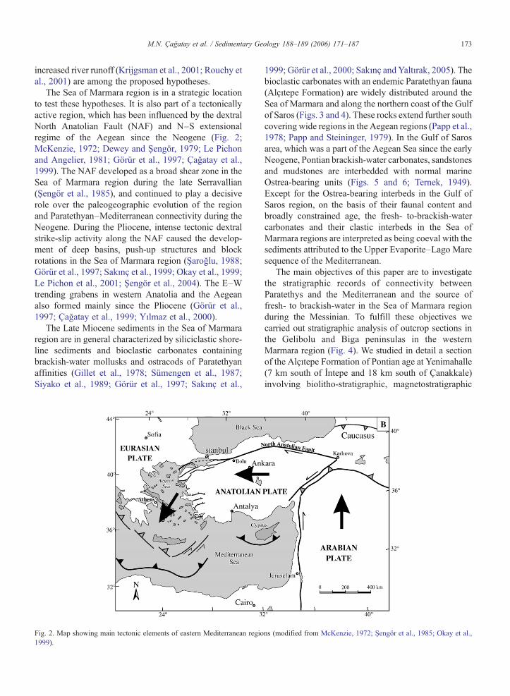
The Sea of Marmara region is in a strategic locationto test these hypotheses. It is also part of a tectonicallyactive region, which has been influenced by the dextralNorth Anatolian Fault (NAF) and N–S extensionalregime of the Aegean since the Neogene (Fig. 2;McKenzie, 1972; Dewey and Şengör, 1979; Le Pichonand Angelier, 1981; Görür et al., 1997; Çağatay et al.,1999). The NAF developed as a broad shear zone in theSea of Marmara region during the late Serravallian(Şengör et al., 1985), and continued to play a decisiverole over the paleogeographic evolution of the regionand Paratethyan–Mediterranean connectivity during theNeogene. During the Pliocene, intense tectonic dextralstrike-slip activity along the NAF caused the develop-ment of deep basins, push-up structures and blockrotations in the Sea of Marmara region (Şaroğlu, 1988;Görür et al., 1997; Sakınç et al., 1999; Okay et al., 1999;Le Pichon et al., 2001; Şengör et al., 2004). The E–Wtrending grabens in western Anatolia and the Aegeanalso formed mainly since the Pliocene (Görür et al.,1997; Çağatay et al., 1999; Yılmaz et al., 2000).
The Late Miocene sediments in the Sea of Marmararegion are in general characterized by siliciclastic shore-line sediments and bioclastic carbonates containingbrackish-water mollusks and ostracods of Paratethyanaffinities (Gillet et al., 1978; Sümengen et al., 1987;Siyako et al., 1989; Görür et al., 1997; Sakınç et al.,
Fig. 2. Map showing main tectonic elements of eastern Mediterranean regio1999).
1999; Görür et al., 2000; Sakınç and Yaltırak, 2005). Thebioclastic carbonates with an endemic Paratethyan fauna(Alçıtepe Formation) are widely distributed around theSea of Marmara and along the northern coast of the Gulfof Saros (Figs. 3 and 4). These rocks extend further southcovering wide regions in the Aegean regions (Papp et al.,1978; Papp and Steininger, 1979). In the Gulf of Sarosarea, which was a part of the Aegean Sea since the earlyNeogene, Pontian brackish-water carbonates, sandstonesand mudstones are interbedded with normal marineOstrea-bearing units (Figs. 5 and 6; Ternek, 1949).Except for the Ostrea-bearing interbeds in the Gulf ofSaros region, on the basis of their faunal content andbroadly constrained age, the fresh- to-brackish-watercarbonates and their clastic interbeds in the Sea ofMarmara regions are interpreted as being coeval with thesediments attributed to the Upper Evaporite–Lago Maresequence of the Mediterranean.
The main objectives of this paper are to investigatethe stratigraphic records of connectivity betweenParatethys and the Mediterranean and the source offresh- to brackish-water in the Sea of Marmara regionduring the Messinian. To fulfill these objectives wecarried out stratigraphic analysis of outcrop sections inthe Gelibolu and Biga peninsulas in the westernMarmara region (Fig. 4). We studied in detail a sectionof the Alçıtepe Formation of Pontian age at Yenimahalle(7 km south of İntepe and 18 km south of Çanakkale)involving biolitho-stratigraphic, magnetostratigraphic
ns (modified from McKenzie, 1972; Şengör et al., 1985; Okay et al.,
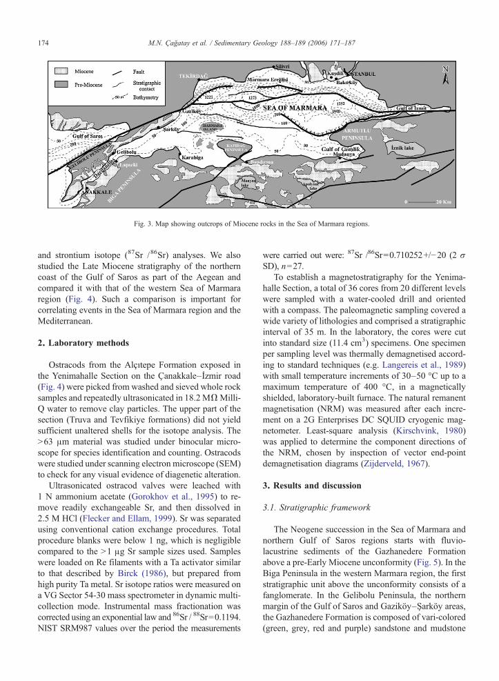
Fig. 3. Map showing outcrops of Miocene rocks in the Sea of Marmara regions.
174 M.N. Çağatay et al. / Sedimentary Geology 188–189 (2006) 171–187
and strontium isotope (87Sr /86Sr) analyses. We alsostudied the Late Miocene stratigraphy of the northerncoast of the Gulf of Saros as part of the Aegean andcompared it with that of the western Sea of Marmararegion (Fig. 4). Such a comparison is important forcorrelating events in the Sea of Marmara region and theMediterranean.
2. Laboratory methods
Ostracods from the Alçıtepe Formation exposed inthe Yenimahalle Section on the Çanakkale–İzmir road(Fig. 4) were picked from washed and sieved whole rocksamples and repeatedly ultrasonicated in 18.2MΩMilli-Q water to remove clay particles. The upper part of thesection (Truva and Tevfikiye formations) did not yieldsufficient unaltered shells for the isotope analysis. TheN63 μm material was studied under binocular micro-scope for species identification and counting. Ostracodswere studied under scanning electron microscope (SEM)to check for any visual evidence of diagenetic alteration.
Ultrasonicated ostracod valves were leached with1 N ammonium acetate (Gorokhov et al., 1995) to re-move readily exchangeable Sr, and then dissolved in2.5 M HCl (Flecker and Ellam, 1999). Sr was separatedusing conventional cation exchange procedures. Totalprocedure blanks were below 1 ng, which is negligiblecompared to the N1 μg Sr sample sizes used. Sampleswere loaded on Re filaments with a Ta activator similarto that described by Birck (1986), but prepared fromhigh purity Ta metal. Sr isotope ratios were measured ona VG Sector 54-30 mass spectrometer in dynamic multi-collection mode. Instrumental mass fractionation wascorrected using an exponential law and 86Sr / 88Sr=0.1194.NIST SRM987 values over the period the measurements
were carried out were: 87Sr /86Sr=0.710252+/−20 (2 σSD), n=27.
To establish a magnetostratigraphy for the Yenima-halle Section, a total of 36 cores from 20 different levelswere sampled with a water-cooled drill and orientedwith a compass. The paleomagnetic sampling covered awide variety of lithologies and comprised a stratigraphicinterval of 35 m. In the laboratory, the cores were cutinto standard size (11.4 cm3) specimens. One specimenper sampling level was thermally demagnetised accord-ing to standard techniques (e.g. Langereis et al., 1989)with small temperature increments of 30–50 °C up to amaximum temperature of 400 °C, in a magneticallyshielded, laboratory-built furnace. The natural remanentmagnetisation (NRM) was measured after each incre-ment on a 2G Enterprises DC SQUID cryogenic mag-netometer. Least-square analysis (Kirschvink, 1980)was applied to determine the component directions ofthe NRM, chosen by inspection of vector end-pointdemagnetisation diagrams (Zijderveld, 1967).
3. Results and discussion
3.1. Stratigraphic framework
The Neogene succession in the Sea of Marmara andnorthern Gulf of Saros regions starts with fluvio-lacustrine sediments of the Gazhanedere Formationabove a pre-Early Miocene unconformity (Fig. 5). In theBiga Peninsula in the western Marmara region, the firststratigraphic unit above the unconformity consists of afanglomerate. In the Gelibolu Peninsula, the northernmargin of the Gulf of Saros and Gaziköy–Şarköy areas,the Gazhanedere Formation is composed of vari-colored(green, grey, red and purple) sandstone and mudstone
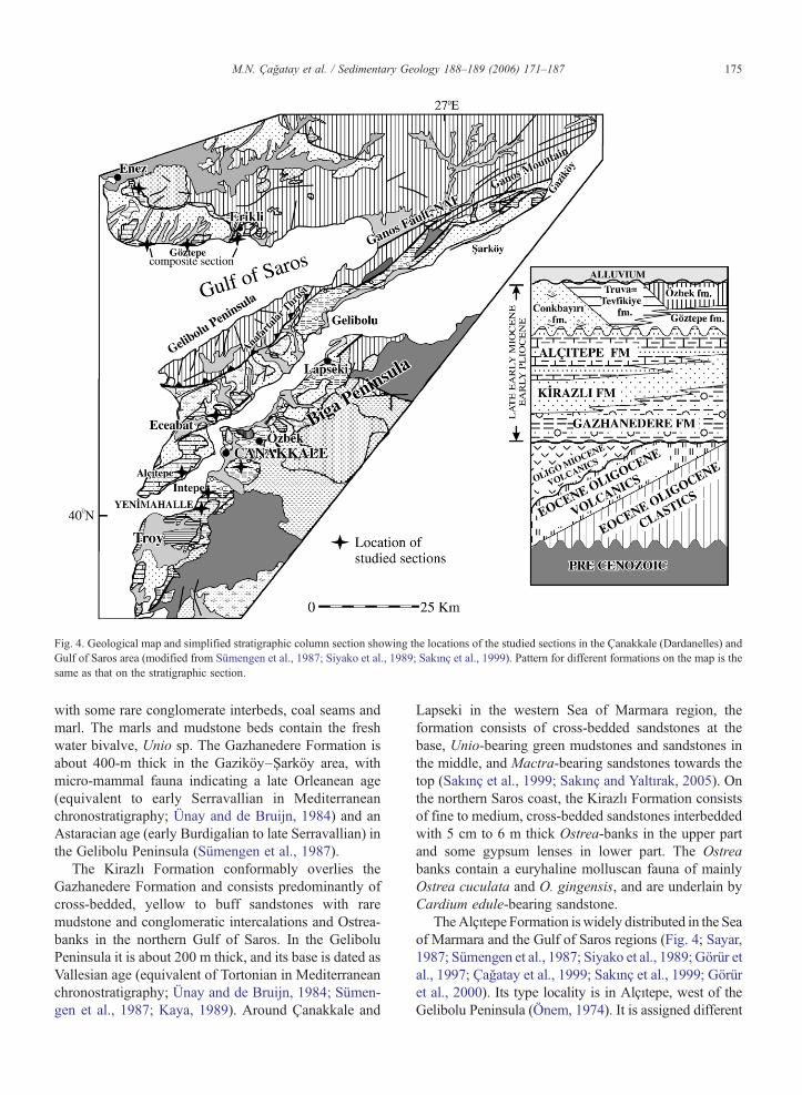
Fig. 4. Geological map and simplified stratigraphic column section showing the locations of the studied sections in the Çanakkale (Dardanelles) andGulf of Saros area (modified from Sümengen et al., 1987; Siyako et al., 1989; Sakınç et al., 1999). Pattern for different formations on the map is thesame as that on the stratigraphic section.
175M.N. Çağatay et al. / Sedimentary Geology 188–189 (2006) 171–187
with some rare conglomerate interbeds, coal seams andmarl. The marls and mudstone beds contain the freshwater bivalve, Unio sp. The Gazhanedere Formation isabout 400-m thick in the Gaziköy–Şarköy area, withmicro-mammal fauna indicating a late Orleanean age(equivalent to early Serravallian in Mediterraneanchronostratigraphy; Ünay and de Bruijn, 1984) and anAstaracian age (early Burdigalian to late Serravallian) inthe Gelibolu Peninsula (Sümengen et al., 1987).
The Kirazlı Formation conformably overlies theGazhanedere Formation and consists predominantly ofcross-bedded, yellow to buff sandstones with raremudstone and conglomeratic intercalations and Ostrea-banks in the northern Gulf of Saros. In the GeliboluPeninsula it is about 200 m thick, and its base is dated asVallesian age (equivalent of Tortonian in Mediterraneanchronostratigraphy; Ünay and de Bruijn, 1984; Sümen-gen et al., 1987; Kaya, 1989). Around Çanakkale and
Lapseki in the western Sea of Marmara region, theformation consists of cross-bedded sandstones at thebase, Unio-bearing green mudstones and sandstones inthe middle, and Mactra-bearing sandstones towards thetop (Sakınç et al., 1999; Sakınç and Yaltırak, 2005). Onthe northern Saros coast, the Kirazlı Formation consistsof fine to medium, cross-bedded sandstones interbeddedwith 5 cm to 6 m thick Ostrea-banks in the upper partand some gypsum lenses in lower part. The Ostreabanks contain a euryhaline molluscan fauna of mainlyOstrea cuculata and O. gingensis, and are underlain byCardium edule-bearing sandstone.
TheAlçıtepe Formation iswidely distributed in the Seaof Marmara and the Gulf of Saros regions (Fig. 4; Sayar,1987; Sümengen et al., 1987; Siyako et al., 1989; Görür etal., 1997; Çağatay et al., 1999; Sakınç et al., 1999; Görüret al., 2000). Its type locality is in Alçıtepe, west of theGelibolu Peninsula (Önem, 1974). It is assigned different
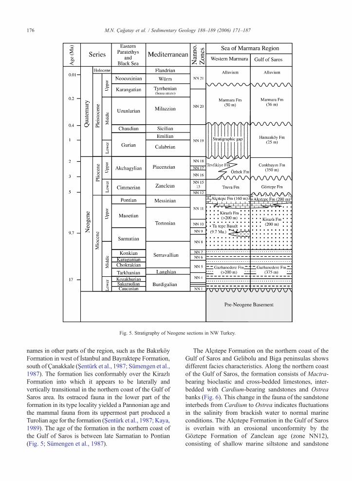
Fig. 5. Stratigraphy of Neogene sections in NW Turkey.
176 M.N. Çağatay et al. / Sedimentary Geology 188–189 (2006) 171–187
names in other parts of the region, such as the BakırköyFormation in west of İstanbul and Bayraktepe Formation,south of Çanakkale (Şentürk et al., 1987; Sümengen et al.,1987). The formation lies conformably over the KirazlıFormation into which it appears to be laterally andvertically transitional in the northern coast of the Gulf ofSaros area. Its ostracod fauna in the lower part of theformation in its type locality yielded a Pannonian age andthe mammal fauna from its uppermost part produced aTurolian age for the formation (Şentürk et al., 1987; Kaya,1989). The age of the formation in the northern coast ofthe Gulf of Saros is between late Sarmatian to Pontian(Fig. 5; Sümengen et al., 1987).
The Alçıtepe Formation on the northern coast of theGulf of Saros and Gelibolu and Biga peninsulas showsdifferent facies characteristics. Along the northern coastof the Gulf of Saros, the formation consists of Mactra-bearing bioclastic and cross-bedded limestones, inter-bedded with Cardium-bearing sandstones and Ostreabanks (Fig. 6). This change in the fauna of the sandstoneinterbeds from Cardium to Ostrea indicates fluctuationsin the salinity from brackish water to normal marineconditions. The Alçıtepe Formation in the Gulf of Sarosis overlain with an erosional unconformity by theGöztepe Formation of Zanclean age (zone NN12),consisting of shallow marine siltstone and sandstone
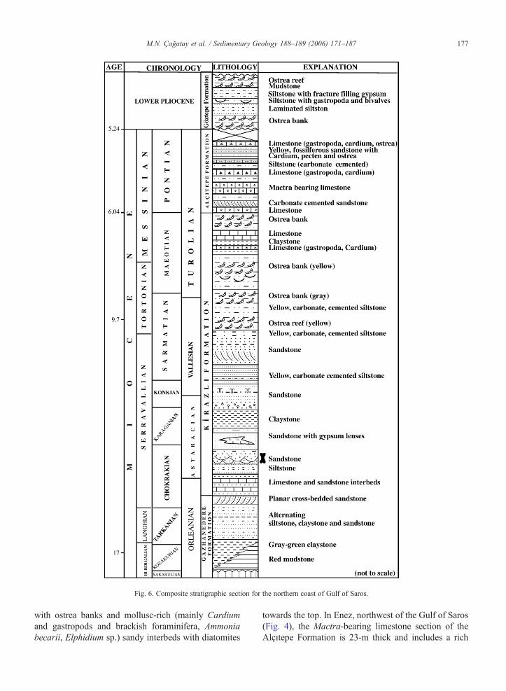
Fig. 6. Composite stratigraphic section for the northern coast of Gulf of Saros.
177M.N. Çağatay et al. / Sedimentary Geology 188–189 (2006) 171–187
with ostrea banks and mollusc-rich (mainly Cardiumand gastropods and brackish foraminifera, Ammoniabecarii, Elphidium sp.) sandy interbeds with diatomites
towards the top. In Enez, northwest of the Gulf of Saros(Fig. 4), the Mactra-bearing limestone section of theAlçıtepe Formation is 23-m thick and includes a rich
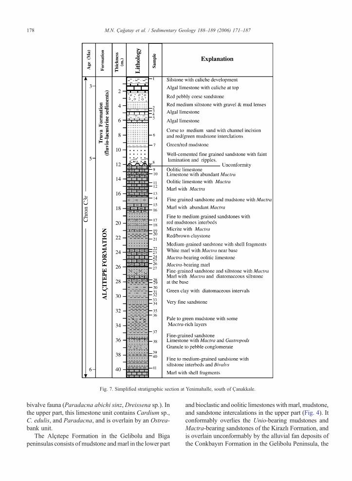
Fig. 7. Simplified stratigraphic section at Yenimahalle, south of Çanakkale.
178 M.N. Çağatay et al. / Sedimentary Geology 188–189 (2006) 171–187
bivalve fauna (Paradacna abichi sinz,Dreissena sp.). Inthe upper part, this limestone unit contains Cardium sp.,C. edulis, and Paradacna, and is overlain by an Ostrea-bank unit.
The Alçıtepe Formation in the Gelibolu and Bigapeninsulas consists ofmudstone andmarl in the lower part
and bioclastic and oolitic limestoneswithmarl, mudstone,and sandstone intercalations in the upper part (Fig. 4). Itconformably overlies the Unio-bearing mudstones andMactra-bearing sandstones of the Kirazlı Formation, andis overlain unconformably by the alluvial fan deposits ofthe Conkbayırı Formation in the Gelibolu Peninsula, the
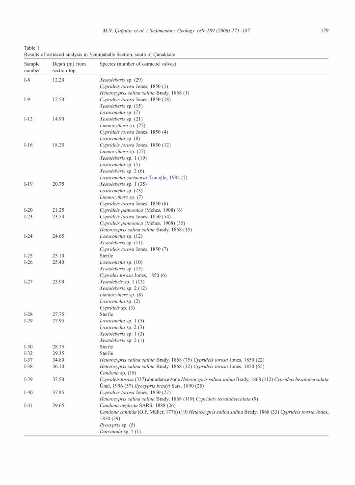
Table 1Results of ostracod analysis in Yenimahalle Section, south of Çanakkale
Samplenumber
Depth (m) fromsection top
Species (number of ostracod valves)
I-8 12.20 Xestoleberis sp. (29)Cyprideis torosa Jones, 1850 (1)Heterocypris salina salina Brady, 1868 (1)
I-9 12.50 Cyprideis torosa Jones, 1850 (18)Xestoleberis sp. (15)Loxoconcha sp. (7)
I-12 14.90 Xestoleberis sp. (21)Limnocythere sp. (75)Cyprideis torosa Jones, 1850 (4)Loxoconcha sp. (8)
I-16 18.25 Cyprideis torosa Jones, 1850 (12)Limnocythere sp. (27)Xestoleberis sp. 1 (19)Loxoconcha sp. (5)Xestoleberis sp. 2 (6)Loxoconcha cartaensis Tunoğlu, 1984 (7)
I-19 20.75 Xestoleberis sp. 1 (35)Loxoconcha sp. (23)Limnocythere sp. (7)Cyprideis torosa Jones, 1850 (6)
I-20 21.25 Cyprideis pannonica (Mehes, 1908) (6)I-23 23.50 Cyprideis torosa Jones, 1850 (54)
Cyprideis pannonica (Mehes, 1908) (35)Heterocypris salina salina Brady, 1868 (15)
I-24 24.65 Loxoconcha sp. (12)Xestoleberis sp. (11)Cyprideis torosa Jones, 1850 (7)
I-25 25.10 SterileI-26 25.40 Loxoconcha sp. (10)
Xestoleberis sp. (13)Cyprides torosa Jones, 1850 (6)
I-27 25.90 Xestolebris sp. 1 (13)Xestoleberis sp. 2 (12)Limnocythere sp. (8)Loxoconcha sp. (2)Cyprideis sp. (3)
I-28 27.75 SterileI-29 27.95 Loxoconcha sp. 1 (5)
Loxoconcha sp. 2 (3)Xestoleberis sp. 1 (3)Xestoleberis sp. 2 (1)
I-30 28.75 SterileI-32 29.35 SterileI-37 34.80 Heterocypris salina salina Brady, 1868 (75) Cyprideis torosa Jones, 1850 (22)I-38 36.10 Heterocypris salina salina Brady, 1868 (32) Cyprideis torosa Jones, 1850 (55)
Candona sp. (18)I-39 37.50 Cyprideis torosa (337) abundance zoneHeterocypris salina salina Brady, 1868 (112) Cyprideis hexatuberculata
Ünal, 1996 (57) Ilyocypris bradyi Sars, 1890 (25)I-40 37.85 Cyprideis torosa Jones, 1850 (27)
Heterocypris salina salina Brady, 1868 (119) Cyprideis tetratuberculata (9)I-41 39.65 Candona neglecta SARS, 1888 (26)
Candona candida (O.F. Müller, 1776) (19) Heterocypris salina salina Brady, 1868 (33) Cyprideis torosa Jones,1850 (29)Ilyocypris sp. (5)Darwinula sp. ? (1)
179M.N. Çağatay et al. / Sedimentary Geology 188–189 (2006) 171–187
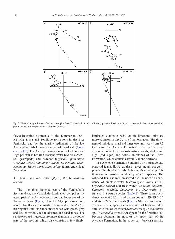
Fig. 8. Thermal magnetization of selected samples from Yenimahalle Section. Closed (open) circles denote the projection on the horizontal (vertical)plane. Values are temperatures in degrees Celsius.
180 M.N. Çağatay et al. / Sedimentary Geology 188–189 (2006) 171–187
fluvio-lacustrine sediments of the Kimmerian (5.5–3.2 Ma) Truva and Tevfikiye formations in the BigaPeninsula, and by the marine sediments of the lateAkchagilian Özbek Formation east of Çanakkale (Görüret al., 2000). The Alçıtepe Formation in the Gelibolu andBiga peninsulas has rich brackish-water bivalve (Mactrasp., gastropods) and ostracod (Cyprideis pannonica,Cyprideis torosa, Candona neglecta, C. candida, Loxo-concha sp.,Heterocypris salina salina) faunas endemic toParatethys.
3.2. Litho- and bio-stratigraphy of the YenimahalleSection
The 41-m thick sampled part of the YenimahalleSection along the Çanakkale–İzmir road comprises theupper part of the Alçıtepe Formation and lower part of theTruva Formation (Fig. 7). Here, the Alçıtepe Formation isabout 30-m thick and consists of beige and whiteMactra-bearing marl and limestone interbedded with green, greyand less commonly red mudstones and sandstones. Thesandstones and mudrocks are more abundant in the lowerpart of the section, which also contains a few finely-
laminated diatomite beds. Oolitic limestone units aremore common in top 2.5 m of the formation. The thick-ness of individual marl and limestone units vary from 0.2to 2.5 m. The Alçıtepe Formation is overlain with anerosional contact by fluvio-lacustrine sands, shales andalgal (red algae) and oolitic limestones of the TruvaFormation, which contains several caliche horizons.
The Alçıtepe Formation contains a rich bivalve andostracod fauna. However, the bivalves are almost com-pletely dissolved with only their moulds remaining. It istherefore impossible to identify Mactra species. Theostracod fauna is well preserved and includes an abun-dance of brackish-water (Heterocypris salina salina,Cyprideis torosa) and fresh-water (Candona neglecta,Candona candida, Ilyocypris sp., Darwinula sp.,Ilyocypris bardyi) species (Table 1). There is an abun-dance zone at 37.7 m and barren zones at 29–29.5, 25and 26.5–27.5 m intervals (Fig. 9). Starting from about28-m upwards, species characteristic of high salinitiessimilar to that of seawater (Xestoleberis sp., Loxoconchasp., Loxoconcha cartaensis) appear for the first time andbecome abundant in most of the upper part of theAlçıtepe Formation. In the upper part, brackish salinity
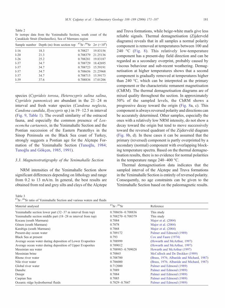
Table 2Sr isotope data from the Yenimahalle Section, south coast of theÇanakkale Strait (Dardanelles), Sea of Marmara region
Sample number Depth (m) from section top 87Sr /86Sr 2σ (×106)
I-16 18.3 0.70827 19.83156I-20 21.3 0.708379 21.25136I-26 25.2 0.708281 19.83187I-37 34.7 0.708729 18.42695I-37 34.7 0.708723 15.59191I-37 34.7 0.708656 21.25968I-37 34.7 0.708715 15.59173I-39 37.6 0.708836 17.01206
181M.N. Çağatay et al. / Sedimentary Geology 188–189 (2006) 171–187
species (Cyprideis torosa, Heterocypris salina salina,Cyprideis pannonica) are abundant in the 21–24 minterval and fresh water species (Candona neglecta,Candona candida, Ilyocypris sp.) in 19–12.5 m interval(Fig. 9, Table 1). The overall similarity of the ostracodfauna, and especially the common presence of Lox-oconcha cartaensis, in the Yenimahalle Section and thePontian succession of the Eastern Paratethys in theSinop Peninsula on the Black Sea coast of Turkey,strongly suggests a Pontian age for the Alçıtepe For-mation of the Yenimahalle Section (Tunoğlu, 1984;Tunoğlu and Gökçen, 1985, 1991).
3.3. Magnetostratigraphy of the Yenimahalle Section
NRM intensities of the Yenimahalle Section showsignificant differences depending on lithology and rangefrom 0.2 to 13 mA/m. In general, the best results areobtained from red and grey silts and clays of the Alçıtepe
Table 387Sr /86Sr ratio of Yenimahalle Section and various waters and fluids
Material analysed 87Sr
Yenimahalle section lower part (32–37 m interval from top) 0.70Yenimahalle section middle part (18–28 m interval from top) 0.70Kocasu (south Marmara) 0.70Gönen (south Marmara) 0.70Karabiga (south Marmara) 0.70Present-day ocean water 0.70Black Sea at present 0.79Average ocean water during deposition of Lower Evaporites 0.70Average ocean water during deposition of Upper Evaporites 0.70Messinian sea water 0.70Messinian brine 0.70Rhone river water 0.70Nile river water 0.70Global river water 0.71Danube 0.70Dniepr 0.70Caspian Sea 0.70Oceanic ridge hydrothermal fluids 0.70
and Truva formations, while beige-white marls give lessreliable signals. Thermal demagnetisation (Zijdervelddiagrams) reveals that in all samples a normal polaritycomponent is removed at temperatures between 100 and240 °C (Fig. 8). This relatively low-temperaturecomponent has a present-day field direction and can beregarded as a secondary overprint, probably caused byviscous behaviour and sub-recent weathering. Demag-netisation at higher temperatures shows that a secondcomponent is gradually removed at temperatures higherthan 240 °C, which can be interpreted as the primarycomponent or the characteristic remanent magnetisation(ChRM). The thermal demagnetisation diagrams are ofmixed quality throughout the section. In approximately50% of the sampled levels, the ChRM shows aprogressive decay toward the origin (Fig. 8a, c). Thiscomponent is always reversed polarity and directions canbe accurately determined. Other samples, especially theones with a relatively low NRM intensity, do not show adecay toward the origin but tend to move successivelytoward the reversed quadrant of the Zijderveld diagram(Fig. 8b, d). In these cases it can be assumed that theprimary (reversed) component is partly overprinted by asecondary (normal) component with overlapping block-ing temperature spectra. Based on the thermal demagne-tisation results, there is no evidence for normal polaritiesin the temperature range 240–400 °C.
Thermal demagnetisation data indicates that thesampled interval of the Alçıtepe and Truva formationsin the Yenimahalle Section is entirely of reversed polarity.Consequently, no age constraints can be given to theYenimahalle Section based on the paleomagnetic results.
/86Sr Reference
8656–0.708836 This study8270–0.708379 This study84 Major et al. (2004)78 Major et al. (2004)68 Major et al. (2004)9172 Palmer and Edmond (1989)3 Cox and Faure (1974)8999 (Howarth and McArthur, 1997)9012 (Howarth and McArthur, 1997)8983–0.709028 Howarth and McArthur (1997)865 McCulloch and De Deckker (1989)8700 (Brass, 1976; Albarède and Michard, 1987)6000 (Brass, 1976; Albarède and Michard, 1987)2000 Palmer and Edmond (1989)89 Palmer and Edmond (1989)84 Palmer and Edmond (1989)85 Palmer and Edmond (1989)29–0.7047 Palmer and Edmond (1989)

182 M.N. Çağatay et al. / Sedimentary Geology 188–189 (2006) 171–187
However, considering the biostratigraphic age for theAlçıtepe Formation in Yenimahalle is Pontian, only onemagnetostratigraphic correlation seems valid. The lowerand upper Pontian boundaries are determined in the BlackSea region in the Taman peninsula of Russia at the top ofchron C3An.1n (∼6.1 Ma) and the top of C3n.4n(∼5.0 Ma), respectively (Trubikhin, 1990; Popov et al.,1996). Magnetostratigraphic results from the Focsanibasin of Romania indicate that the Pontian stage in theCarpathian foredeep extends from the base of chron C3rto the base of C3n.3n (5.9 to 4.9 Ma) (Vasiliev et al.,2004). Consequently, the long reversed polarity intervalof the Yenimahalle Section most likely corresponds tochron C3r, with an age range of 6.04–5.24Ma. This rangeencompasses the entire Messinian salinity crisis (5.96–5.33 Ma).
3.4. Strontium isotopes in the Yenimahalle Section
All the strontium isotope ratios of ostracod valvescollected from the Yenimahalle Section are lower thancoeval Messinian global ocean values (McArthur et al.,2001; Tables 2 and 3; Fig. 9). The samples from themiddle part of the section (i.e., upper part of the AlçıtepeFormation) contain ostracods that require salinities similarto that of seawater. These have Sr isotope ratios lower thanthose at the bottom of the section where brackish waterostracod species predominate and saline forms are absent.
If the increase in salinity inferred from the appearanceof ostracods usually considered to be of marine affinitywas controlled by an influx of water withmarine salinitiesfrom the global ocean, the Sr-isotope ratios of these
Fig. 9. Sr isotope ratio of ostracod shells and abundance of ostracod specie
ostracods should be closer to Messinian global oceanvalues (Table 2) than the brackish and freshwater ostracodsamples.The reverse is true (Fig. 9). If, however, the influxof salty water came from the Mediterranean, thenYenimahalle ostracodSr isotope ratios should be deflectedtowards Mediterranean Sr isotope ratios. Mediterranean87Sr /86Sr during the MSC varies significantly from ratioswithin error of Messinian ocean water (Table 2) to lowerratios (ca. 0.7086, Müller and Mueller, 1991) from UpperEvaporites and Lago Mare samples (Flecker et al., 2002).Even these lowest Sr isotope ratios are significantly higherthan the values measured in the middle part of theYenimahalle Section. An influx from the isolatedMediterranean alone therefore cannot account for the Srisotope values measured at Yenimahalle. Further, thecorrelation between low Sr isotope ratios and highersalinities indicates that the variation in salinity reflected inthe ostracod population was not controlled simply by aninflux of seawater. Independent behaviour of salinity andocean water pulses are documented from Late MioceneMediterranean sequences (Flecker et al., 2002; Fleckerand Ellam, 2006-this volume). Typically, this occurs insystems with only limited connection to the ocean andwhere the evaporation flux exceeds precipitation.
The Sr isotope ratio of Paratethys during the Mioceneis poorly constrained. However, we can assume that itreflected the flux of river water feeding the basin. The87Sr / 86Sr values for the lower part of the AlçıtepeFormation at Yenimahalle are lower than that of Srisotope ratio of the River Danube (Table 2), which todaysupplies about half of the total freshwater runoff to theBlack Sea (Shimkus and Trimonis, 1974). Other large
s in Yenimahalle Section. See Table 3 for sources of Sr isotope data.
183M.N. Çağatay et al. / Sedimentary Geology 188–189 (2006) 171–187
rivers emptying into the Black Sea (Dniepr, Don) and theCaspian Sea have lower values than the River Danube(Table 2; Fig. 9), but without knowing run-off fluxes ofthese rivers for the Messinian stage from global climatesimulations it is not possible to assess the impact theserivers may have had on lowering the Sr isotope ratio ofParatethyan water. Nevertheless, overall range of the Sr-isotope ratio of these waters probably represents Para-tethyan brackish waters and overlaps well with the Sr-isotope values in the lower part of the YenimahalleSection. These Sr-isotope data therefore suggests thatduring the deposition of the lower part of the section, theYenimahalle areawas probably connectedwith theEasternParatethys. This conclusion is corroborated by the faunalcontent of the section, which is endemic to the Paratethys.
The 87Sr /86Sr ratio of the fresh water input into thepresent day Sea of Marmara by the southern riversranges between 0.7068 and 0.7084 (Major et al., 2004).This range overlaps with the low Sr isotope ratios inupper part of the Alçıtepe Formation (Tables 2 and 3;Fig. 9). One interpretation of the Yenimahalle Sr isotoperecord is therefore that at this time, the western Sea ofMarmara region was dominated by local river input.
3.5. Palaeogeographic evolution
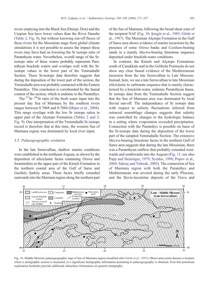
In the late Serravallian, shallow marine conditionswere established in the northeast Aegean, as shown by thedeposition of siliciclastic facies containing Ostrea andforaminifera in the upper part of the Kirazlı Formation inthe northern coastal area of the Gulf of Saros andGaziköy–Şarköy areas. These facies briefly extendedeastwards into theMarmara region along the northern part
Fig. 10. Middle Miocene palaeogeographic map of Sea of Marmara region (mwhere a stratigraphic section is measured, or a significant stratigraphic informexploration boreholes provide additional subsurface information on general
of the Sea of Marmara, following the broad shear zone ofthe incipient NAF (Fig. 10; Şengör et al., 1985; Görür etal., 1997). The Messinian Alçıtepe Formation in the Gulfof Saros area shows evidence of marine incursions by thepresence of some Ostrea banks and Cardium-bearingsands in a mainly Mactra-bearing limestone sequencedeposited under brackish-water conditions.
In contrast, the Kirazlı and Alçıtepe Formationssouth of Çanakkale and in the Gelibolu Peninsula do notshow any clear faunal evidence of the Mediterraneanincursion from the late Serravallian to Late Miocene.Instead, here, we see a late Serravallian to late Messiniansiliciclastic to carbonate sequence that is mainly charac-terised by a brackish-water, endemic Paratethyan fauna.Sr isotope data from the Yenimahalle Section suggestthat the Sea of Marmara area was dominated by localfluvial run-off. The independence of Sr isotope datawith respect to salinity fluctuations inferred fromostracod assemblage changes suggests that salinitywas controlled by changes to the hydrologic balancein a setting where evaporation exceeded precipitation.Connection with the Paratethys is possible on basis ofthe Sr-isotope data during the deposition of the lowerpart of the sampled Yenimahalle Section. The extensiveMactra-bearing limestone facies in the northern Gulf ofSaros area suggests that during the late Messinian, therewas a Paratethyan outflow that probably extended west-wards and southwards into the Aegean (Fig. 11; see alsoPapp and Steininger, 1979; Syrides, 1998; Popov et al.,2004; Sakınç and Yaltırak, 2005). The connection of Seaof Marmara region with both the Paratethys andMediterranean was severed during the early Pliocene,and the fluvio-lacustrine deposits of the Truva and
odified after Görür et al., 1997). Observation point denotes a locationation pertaining to palaeogeography is obtained. Note that petroleum
stratigraphy.
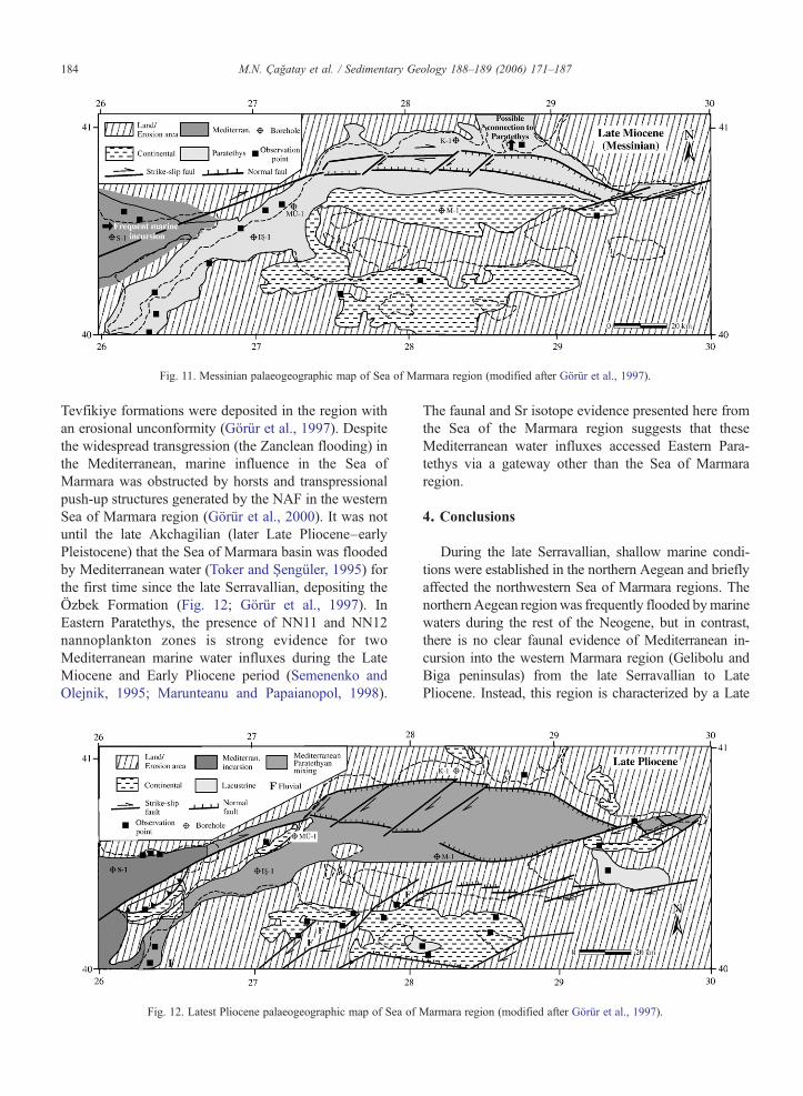
Fig. 11. Messinian palaeogeographic map of Sea of Marmara region (modified after Görür et al., 1997).
184 M.N. Çağatay et al. / Sedimentary Geology 188–189 (2006) 171–187
Tevfikiye formations were deposited in the region withan erosional unconformity (Görür et al., 1997). Despitethe widespread transgression (the Zanclean flooding) inthe Mediterranean, marine influence in the Sea ofMarmara was obstructed by horsts and transpressionalpush-up structures generated by the NAF in the westernSea of Marmara region (Görür et al., 2000). It was notuntil the late Akchagilian (later Late Pliocene–earlyPleistocene) that the Sea of Marmara basin was floodedby Mediterranean water (Toker and Şengüler, 1995) forthe first time since the late Serravallian, depositing theÖzbek Formation (Fig. 12; Görür et al., 1997). InEastern Paratethys, the presence of NN11 and NN12nannoplankton zones is strong evidence for twoMediterranean marine water influxes during the LateMiocene and Early Pliocene period (Semenenko andOlejnik, 1995; Marunteanu and Papaianopol, 1998).
Fig. 12. Latest Pliocene palaeogeographic map of Sea of
The faunal and Sr isotope evidence presented here fromthe Sea of the Marmara region suggests that theseMediterranean water influxes accessed Eastern Para-tethys via a gateway other than the Sea of Marmararegion.
4. Conclusions
During the late Serravallian, shallow marine condi-tions were established in the northern Aegean and brieflyaffected the northwestern Sea of Marmara regions. ThenorthernAegean regionwas frequently flooded bymarinewaters during the rest of the Neogene, but in contrast,there is no clear faunal evidence of Mediterranean in-cursion into the western Marmara region (Gelibolu andBiga peninsulas) from the late Serravallian to LatePliocene. Instead, this region is characterized by a Late
Marmara region (modified after Görür et al., 1997).

185M.N. Çağatay et al. / Sedimentary Geology 188–189 (2006) 171–187
Miocene siliciclastic to carbonate sequence (Kirazlı andAlçıtepe formations) containing predominantly a brack-ish-water fauna typical of Paratethys.
Magnetostratigraphic and Pontian biostratigraphicdata from one key section of the Alçıtepe Formation atYenimahalle, south of Çanakkale, indicate that it wasdeposited during chron C3r (6.04–5.24 Ma). Thiscorresponds to the time of the MSC in the Mediterranean.
The Sr-isotope data from the Yenimahalle Sectionsuggest that (a) during the deposition of the PontianAlçıtepe Formation, exchange with the Mediterraneanwas reduced or terminated and that this area wasdominated by local river water discharge and (b) thesalinity of the Alçıtepe Formation in the Sea of Marmarabasin was controlled by the dominance of the evapora-tion flux, and not by fluctuation in exchange either withthe global ocean or Mediterranean. Connection betweenParatethys and part of the Sea of Marmara region cannotbe excluded on the basis of the Sr isotope data. Thepresence of some ostracod species of marine affinity inthe upper part of the Alçıtepe Formation at Yenimahalleare considered as endemic, probably adopted to highsalinities under continental conditions.
Faunal evidence suggests that during deposition themiddle-upper part of the Alçıtepe Formation, Paratethysextended into the Aegean and caused the deposition of thefresh-to brackish-water facies coeval with the UpperEvaporite–Lago Mare sequence in the Mediterranean.Connection between Marmara and Paratethys with therest of the Mediterranean was not re-established until theLate Pliocene. This connection was the result of increasedactivity on the North Anatolian Fault and global sea levelrise.
Acknowledgements
This work was funded by TUBITAK under projectYDABÇAG 199Y077. Vinny Gallagher and Anne Kellyassisted with the Sr analysis which was carried out inSUERC, East Kilbride. RF acknowledges additionalsupport from a Royal Society Wolfson Dorothy HodgkinFellowship. We thank the editors of this volume and tworeviewers, Fabienne Orszag-Sperber and Fritz Steininger,for useful suggestions that improved the paper.
References
Albarède, F., Michard, A., 1987. Evidence for slowly changing 87Sr/86Srin runoff from freshwater limestones of southern France. Chem.Geol. 64, 55–65.
Birck, J., 1986. Precision K–Rb–Sr isotope analysis: application toRb–Sr chronology. Chem. Geol. 56, 73–83.
Brass, G.W., 1976. The variation of the marine 87Sr/86Sr ratio duringPhanerozoic time: interpretation using a flux model. Geochim.Cosmochim. Acta 40, 721–730.
Çağatay, M.N., Görür, N., Alpar, B., Saatçılar, R., Akkök, R., Sakınç,M., Yüce, H., Yaltırak, C., Kuşçu, İ., 1999. Geological evolution ofthe Gulf of Saros, NE Aegean Sea. Geo Mar. Lett. 18, 1–9.
Cita, M.B., Wright, R.C., Ryan, W.B.F., Longinelli, A., 1978. Messinianpalaeoenvironments. In: Hsu, K.J., Montadert, L. (Eds.), InitialReports of the Deep Sea Drilling Project, vol. 42 part 1. USGovernment Printing Office, Washington, pp. 1003–1035.
Cox, J.M., Faure, G., 1974. Isotope composition of strontium incarbonate phase of two cores from Black Sea. In: Degens, E.T.,Ross, D.A. (Eds.), The Black Sea—Geology, Chemistry andBiology. Amer. Assoc. Petrol. Geologists Memoir, vol. 20, pp.566–569.
Dewey, J.F., Şengör, A.M.C., 1979. Aegean and surrounding regions,complex multiplate and continuum tectonics in a convergent zone.Bull. Geol. Soc. Am. Part 1, 90, 84–92.
Flecker, R., Ellam, R.M., 1999. Distinguishing climatic and tectonicsignals in the sedimentary succession of marginal basins using Srisotopes, an example from the Messinian salinity crisis, easternMediterranean. J. Geol. Soc. (Lond.) 156, 847–854.
Flecker, R., de Villiers, S., Ellam, R.M., 2002. Modelling the effect ofevaporation on the salinity–87Sr/86Sr relationship in modern andancient marginal-marine systems, the Mediterranean MessinianSalinity Crisis. Earth Planet. Sci. Lett. 203, 221–233.
Flecker, R., Ellam, R.M., 2006-this volume. Identifying LateMiocene episodes of connection and isolation in theMediterranean–Paratethyan realm using Sr isotopes. Sediment.Geol. 188-189, 189–203. doi:10.1016/j.sedgeo.2006.03.005.
Fortuin, A.R., Krijgsman, W., 2003. The Messinian of the Nijar Basin(SE Spain): sedimentation, depositional environments and paleo-geographic evolution. Sediment. Geol. 160, 213–242.
Gillet, S., Graman, F., Steffens, P., 1978. Neue biostratigraphischeErgebnisse aus dem brackischen Neogen an Dardanellen undMarmara-Meer (Türkei). Newsl. Stratigr. 7, 53–64.
Görür, L., Çağatay, M.N., Sakınç, M., Tchapalyga, A., Akkök, R.,Natalin, B., 2000. Neogene Paratethyan succession in Turkey andits implications for paleogeographic evolution of the EasternParatethys. In: Bozkurt, E., Winchester, J.A., Piper, J.A.D.(Eds.), Tectonics and Magmatism in Turkey and SurroundingArea Geological Society of London, Special Publication, vol.173, pp. 425–443.
Howarth, R.J., McArthur, J.M., 1997. Statistics for strontium isotopestratigraphy. J. Geol. 105, 441–456.
Hsü, K.J., Giovanoli, F., 1979/1980. Messinian event in the Black Sea.Palaeogeogr. Palaeoclimatol. Palaeoecol. 29, 75–93.
Hsü, K., Ryan, W.B.F., Cita, M.B., 1973. Late Miocene desiccation ofthe Mediterranean. Nature 242, 240–244.
Hsü, K., Montadert, L., Bernouilli, D., Cita, M.B., Erickson, A.,Garrison, R.E., Kidd, R.B., Mélières, F., Müller, C., Wright, R.,1978.HistoryofMediterraneansalinitycrisis.Nature267,399–403.
Kaya, T., 1989. Alçıtepe (Gelibolu Yarımadası) yöresi memeli faunalarıPerissodactyla bulguları. Türkiye Jeoloji KurultayıBülteni 14, 81–84.
Kojumdgieva, E., 1979. Critical notes on the stratigraphy of Black Seaboreholes (Deep Sea Drilling Project Lag 42 B). Geol. Balc. 9,07–110 (Sofia).
Kirschvink, J.L., 1980. The least-squares line and plane and the analysisof palaeomagnetic data. Geophys. J. R. Astron. Soc. 62, 699–718.
Krijgsman, W., Hilgen, F.J., Raffi, I., Sierro, F.J., Wilson, D.S., 1999.Chronology, causes and progression of the Messinian salinitycrisis. Nature 400, 652–655.
186 M.N. Çağatay et al. / Sedimentary Geology 188–189 (2006) 171–187
Krijgsman, W., Fortuin, A.R., Hilgen, F.J., Sierro, F.J., 2001. Astro-chronology for the Messinian Sorbas basin (SE Spain) and orbital(precessional) forcing for evaporite cyclicity. Sediment. Geol. 140,43–60.
Langereis, C.G., Linssen, J.H., Mullender, T.A.T., Zijderveld, J.D.A.,1989. Demagnetization. In: James, D.E. (Ed.), The Encyclopediaof Solid Earth Geophysics. Van Nostrand Reinhold Company, NewYork, pp. 201–211.
Le Pichon, X., Angelier, J., 1981. The Aegean Sea. Philos. Trans. R.Soc. Lond., A 300, 357–372.
Le Pichon, X., Şengör, A.M.C., Demirbağ, E., Rangin, C., Imren, C.,Armijo, R., Görür, N., Çağatay, N., de Lepinay, B.M., Meyer, B.,Saatçılar, R., Tok, B., 2001. The active Main Marmara fault. EarthPlanet. Sci. Lett. 192, 595–616.
Major, C.O., Vidal, L., Çağatay, M.N., Goldstein, S.L., Ryan, W.B.F.,Ménot-Combes, G., Bard, E., Labeyrie, L., 2004. Comparison ofisotopic records from the Marmara and Black Seas: indication ofmarine connection, outflow, and exchange. EGU 1st GeneralAssembly, Nice. Abstract EGU04-A-06050.
Marunteanu, M., Papaianopol, I., 1998. Mediterranean calcareousnannoplankton in the Dacic basin. Rom. J. Stratigr. 78, 115–121.
McArthur, J.M., Howarth, R.J., Bailey, T.R., 2001. Strontium isotopestratigraphy: LOWESS version 3: best fit to the marine Sr-isotopecurve for 0–509 Ma and accompanying look-up table for derivingnumerical age. J. Geol. 109, 155–170.
McKenzie, D.P., 1972. Active tectonics of the Mediterranean region.Geophys. J. R. Astron. Soc. 30, 109–185.
McCulloch, M.T., De Deckker, P., 1989. Sr isotope constraints on theMediterranean environment at the end of the Messinian salinitycrisis. Nature 342, 62–65.
Müller, D.W., Mueller, P.A., 1991. Origin and age of the Mediterra-nean Messinian evaporites: implications from Sr isotopes. EarthPlanet. Sci. Lett. 107, 1–12.
Okay, A.I., Demirbağ, E., Kurt, H., Okay, N., Kuşçu, İ., 1999. Anactive, deep marine strike-slip basin along the North Anatolianfault in Turkey. Tectonics 18, 129–148.
Önem, Y., 1974. Gelibolu Yarımadası ve Çanakkale dolaylarınınjeolojisi. TPAO Rap. 877.
Palmer, M.R., Edmond, J.M., 1989. The strontium isotope budget ofthe modern oceans. Earth Planet. Sci. Lett. 92, 11–26.
Papp, A., Steininger, F., 1979. Paleogeographic implications of theLate Miocene deposits in the Aegean region. Ann. Géol. PaysHell., Tome hors série, facs. II, 955–959.
Papp, A., Steininger, F., Georgiades-Dikeoulia, E., 1978. Biostrati-graphie und Korrelation des Neogens von Trahones südlich vonAthen, (Attika Griechenland). Ann. Géol. Pays Hell. 46,603–629.
Popov, S.V., Goncharova, I.A., Kozyrenko, T.F., Radionova, E.P.,Pevzner,M.A., Sychevskaya, E.K., Trubikhin, V.M., Zhegallo, V.I.,1996. Neogene stratigraphy and palaeontology of the Taman andKerch peninsulas (excursion guidebook). Palaeontological InstituteRAS, Moscow. 32 pp.
Popov, S.V., Rögl, F., Rozanov, A.Y., Steininger, F. F., Shcherba, I.G.,Kovac, M. (eds.), 2004. Lithological–Paleogeographic Maps ofthe Paratethys–Late Eocene–Pliocene, Courier Forschungsinsti-tut, Senckenberg 250, 46 p., 10 maps. Nägele & Obermiller),Stuttgart.
Rögl, F., Steininger, F.F., 1983. Vom Zerfall der Tethys zu Mediterranand Paratethys. Die Neogene Paleogeographie und Palinspastikdes zirkum-Mediterranean Raumes Ann. Naturhist. Muss. Wien 85A, 135–163.
Rouchy, J.M., 1982. La genèse des évaporites messiniennes deMéditerranée. Muséum national d'Histoire naturelle, Mémoires,vol. 50. 267 pp.
Rouchy, J.M., Saint Martin, J.-P., 1992. Late Miocene events in theMediterranean as recorded by carbonate–evaporite relations.Geology 20, 629–632.
Rouchy, J.M., Orszag-Sperber, F., Blanc-Valleron, M.-M., Pierre, C.,Riviére, M., Combourieu-Nebout, N., Panayides, I., 2001.Paleoenvironmental changes at the Messinian–Pliocene boundaryin the eastern Mediterranean (southern Cyprus basins): signifi-cance of the Messinian Lago-Mare. Sediment. Geol. 145, 93–117.
Ryan, W.B.F., et al., 1973. Initial Reports of the DSDP, vol. 13. USGovernment Printing Office, Washington, DC.
Sakınç, M., Yaltırak, C., 2005. Messinian crisis: What happenedaround the northeastern Aegean? Mar. Geol. 221, 423–436.
Sakınç, M., Yaltırak, C., Oktay, F.Y., 1999. Palaeogeographical evolu-tion of the Thrace Neogene Basin and the Tethys–Paratethysrelations at northwestern Turkey (Thrace). Palaeogeogr. Palaeo-climatol. Palaeoecol. 153, 17–40.
Şaroğlu, F., 1988. Age and offset of the North Anatolian Fault. InMelih Tokay Symposium Proceedings. Special Publ. Of theMiddle East Technical University, Ankara, 65–79 pp.
Sayar, C., 1987. İstanbul ve çevresi Neojen çökelleri ve Paratetisiçindeki konumu. Maden fak. 40. yıl Bülteni, pp. 250–266.
Semenenko, V.N., Olejnik, E.S., 1995. Stratigraphic correlation of theEastern Paratethys Kimmerian and Dacian stages by mollusks,dinocyst and nannoplankton data. Rom. J. Stratigr. 76, 113–114.
Şengör, A.M.C., Görür, N., Şaroğlu, F., 1985. Strike-slip faulting andrelated basin formation in zones of tectonic escape; Turkey as acase study. Soc. Econ. Paleontologists Mineralogists, Spec. Pub.37. Research Symposium, Strike–slip Deformation, Basin Forma-tion and Sedimentation. San Antonio, Texas, 227–264 pp.
Şengör, A.M.C., Tüysüz, O., İmren, C., Sakınç,M., Eyidoğan, H., Görür,N., Le Pichon, X., Claude Rangin, C., 2004. The North AnatolianFault. A new look. Annu. Rev. Earth Planet. Sci. 33, 1–75.
Şentürk, K., Karasöse, C., Atalay, Z., Gürbüz, M., Ünay, E., Doruk, N.,Batum, I., 1987. Çanakkale Boğazı ve dolyının jeolojisi. MTARap. 8130.
Shimkus, K.M., Trimonis, E.S., 1974. Modern sedimentation in theBlack Sea. In: Degens, E.T., Ross, D.A. (Eds.), The BlackSea-Geology, Chemistry and BiologyAm. Assoc. Pet. Geol. Mem.,vol. 20, pp. 477–488.
Siyako, M., Bürkan, A.K., Okay, A.I., 1989. Biga ve Geliboluyarımadaları’nın Tersiyer jeolojisi ve hidrokarbon olanakları.TPJD Bülteni, cilt 1 (3), 183–199.
Sümengen, M., Terlemez, I., Şentürk, K., Karasöse, C., Erkan, E.N.,Ünay, E., Gürbüz, M., Atalay, Z., 1987. Gelibolu Yarımadası veGüneybatı Tersiyer havzasının stratigrafisi, sedimentolojisi veTektoniği. MTA Jeoloji Etüdleri Dairesi Raporu 8128 (245 pp.).
Syrides, G.E., 1998. Paratethyan mollusc faunas from the Neogene ofMacedonia and Thrace Northern Greece. Rom. J. Stratigr. 78,171–180.
Ternek, Z., 1949. Geological study of region Keþan-Korudağ, IstanbulUniversity, PhD thesis, 79 pp.
Trubikhin, V.M., 1990. Paleomagnetic data for the Pontian. In:Stevanovic, P.M. et al. (eds.), Pontien-Pl1 (sensu F. Le Play, N.P.Barbot de Marny, N.I. Andrusov). Serie Chronostratigraphie undNeostratotypen. JAZU and SANU, Zagreb-Beograd, 8, p. 76–79.
Tunoğlu, C., 1984. "İncipınarı_Kurtkuyusu (Sinop Batısı) yöresiNeojen'inin Ostrakod Biyostratigrafisi", H.Ü. Fen BilimleriEnstitüsü, Yüksek Mühendislik Tezi, 174 s.
187M.N. Çağatay et al. / Sedimentary Geology 188–189 (2006) 171–187
Tunoğlu, C., Gökçen, N., 1985. İncipınarı-Kurtkuyusu (Sinop batısı)Üst Miyosen istifinin yeni Ostrakoda faunası. Yerbilimleri, H.Ü.YUVAM Yayın Organı 12,19–39, Ankara.
Tunoğlu, C., Gökçen, N., 1991. İncipınarı-Kurtkuyusu (Sinop batısı)yöresi Üst Miyosen istifinin ostrakod biyostratigrafisi. T.J.B. 34/1,37–43 Ankara.
Vasiliev, I., Krijgsman, W., Langereis, C.G., Panaiotu, C.E., Matenco,L., Bertotti, G., 2004. Towards an astrochronological frameworkfor the eastern Paratethys Mio–Pliocene sedimentary sequences ofthe Focşani basin (Romania). Earth Planet. Sci. Lett. 227,231–247.
Ünay, E., de Bruijn, H., 1984. On some Neogene rodent assemblagesfrom both sides of the Dardanelles, Turkey. Newsl. Stratigr. 13,119–132.
Toker, V., Şengüler, İ., 1995. Nannoplankton flora of the Quaternarysequence in the Gulf of İzmit (Hersek Burnu-Kababurun). In:Meriç, E. (Ed.), Quaternary Sequence in the Gulf of Izmit,Istanbul, pp. 173–178 (in Turkish with English abstract).
Yılmaz, Y., Genç, C., Gürer, F., Bozcu, M., Yılmaz, K., Karacık, Z.,Altunkaynak, Ş., Elmas, A., 2000. When did the western Anato-lian grabens begin to develop. In: Bozkurt, E., Winchester, J.A.,Piper, J.A.D. (Eds.), Tectonics and Magmatism in Turkey andSurrounding Area. Geological Society of London, Special Pub-lication, vol. 173, pp. 353–384.
Zijderveld, J.D.A., 1967. A.C. demagnetization of rocks: analysis ofresults. In: Collinson, D.W., Creer, K.M, Runcorn, S.K. (Eds.),Methods in Palaeomagnetism. Elsevier, New York, pp. 254–286.