
Late Agenda of Ordinary Meeting of Council - 16 October 2018
81
- 1 - LATE AGENDA FOR ORDINARY MEETING TO BE HELD IN COUNCIL CHAMBERS, BUNDABERG ON TUESDAY 16 OCTOBER 2018, COMMENCING AT 10.00 AM Page Development Assessment K2 Rowlands Road & Schleger Street, Burnett Heads - Material Change of Use for Relocatable Home Park (RV Village) and Operational Works for Advertising Devices (4 signs) 2
-
Upload
khangminh22 -
Category
Documents
-
view
1 -
download
0
Transcript of Late Agenda of Ordinary Meeting of Council - 16 October 2018
- 1 -
LATE AGENDA FOR ORDINARY MEETING TO BE HELD IN COUNCIL CHAMBERS, BUNDABERG
ON TUESDAY 16 OCTOBER 2018, COMMENCING AT 10.00 AM
Page Development Assessment K2 Rowlands Road & Schleger Street, Burnett Heads - Material
Change of Use for Relocatable Home Park (RV Village) and Operational Works for Advertising Devices (4 signs) 2

Agenda for Ordinary Meeting of Council Page 2
Meeting held: 16 October 2018
Item 16 October 2018
Item Number: K2
File Number: 522.2018.56.1
Part: DEVELOPMENT ASSESSMENT
Portfolio: Planning & Development Services Subject: Rowlands Road & Schleger Street, Burnett Heads - Material Change of Use for Relocatable Home Park (RV Village) and Operational Works for Advertising Devices (4 signs) Report Author: Erin Clark, Senior Planning Officer - Major Projects Authorised by: Michael Ellery, Group Manager Development Link to Corporate Plan: Our Environment - 2.3 Sustainable built and natural environment - 2.3.3 Review and consistently enforce local laws, the planning scheme, and other associated environment and public health legislation to ensure they meet community standards. Summary: APPLICATION NO 522.2018.56.1 PROPOSAL Material Change of Use for Relocatable Home Park (RV
Village) and Operational Works for Advertising Devices (4 signs)
APPLICANT RV Lifestyle Village Oceanside OWNER GJ Whalley & JA Whalley PROPERTY DESCRIPTION Lots 2 & 3 on RP7195 ADDRESS Rowlands Road & Schleger Street, Burnett Heads PLANNING SCHEME Bundaberg Regional Council Planning Scheme 2015 ZONING Emerging Community Zone OVERLAYS Acid sulfate soils, Agricultural land, Coastal protection,
Flood hazard, Infrastructure overlays LEVEL OF ASSESSMENT Impact SITE AREA 34.022 ha total CURRENT USE Vacant, Grazing PROPERLY MADE DATE 4 June 2018 STATUS The 35 business day decision period ended on 1 October
2018 REFERRAL AGENCIES Department of State Development, Manufacturing,
Infrastructure and Planning NO OF SUBMITTERS Forty-three (43) PREVIOUS APPROVALS Nil
Agenda for Ordinary Meeting of Council Page 3
Meeting held: 16 October 2018
SITE INSPECTION CONDUCTED
9 August 2018
LEVEL OF DELEGATION Level 3
1. INTRODUCTION 1.1 Proposal Material Change of Use The proposal seeks approval for a Material Change of Use for a Relocatable home park over Lots 2 and 3 on RP7195. It is described by the applicant as master planned community comprising 487 detached and duplex “RV homes” and significant community facilities. The development will operate under the Manufactured Homes (Residential Parks) Act 2003 with the following principles:
the overall site would be owned and operated by the applicants;
residents purchase and own their dwelling which is constructed/located on a particular site within the development;
the operator is responsible for the provision of services to the resident;
residents pay a site rental to the operator for occupation of the site and provision of services.
All homes are two-bedroom or three-bedroom single storey and are designed to specifically cater for accommodation of large RV vehicles and caravans. Of the total 487 homes, 357 of these will be detached dwellings with a further 130 homes in a duplex arrangement. Detached dwelling sites have a dimension of 17 m wide by 24 m deep and Duplex sites have a total dimension of 22 m wide (11 m per dwelling) by 24 m deep. A concept masterplan submitted by the applicant shows a relative distribution of the sites and how they fit in to the layout. It is requested by the applicant that the relative distribution should not be considered to be fixed but able to be rearranged as necessary to provide desired location outcomes as the project is constructed (excluding the first stage). Occupants can choose from a wide range of floor plan options and to provide the required flexibility, particularly with respect to building certification, approval is sought for building envelopes as shown on the proposal plans. The first stage will comprise sites for 100 home sites and will contain all elements required to effectively service the development including sewer, water, power and telecommunications services. The upgrade of the Burnett Heads Road/Schleger Street intersection, and upgrades of Schleger Street and the Marshall Street entry will also be carried out with this initial stage. Additionally, a small portion of the communal facilities will be constructed as part of Stage 1, namely visitor parking, men’s shed, wash down area and maintenance shed and part of the management and reception building (such as port cochere, staff offices, meeting and multi-purpose rooms). The site will be serviced from the Ergon network with all internal reticulation being underground. Solar power will be used extensively to supplement the Ergon network supply with all homes including 5.5 Kw photovoltaic installations and installations to supply community facilities.

Agenda for Ordinary Meeting of Council Page 4
Meeting held: 16 October 2018
Operational Works In addition, an Operational Works permit is also sought for the proposed advertising devices, made up of one freestanding sign at corner of Burnett Heads and Stan Faulkner Road (measuring 6 m x 3 m) and three ground signs in the indicative locations shown on the proposal plans. 1.2 Site Description Lots 2 and 3 on RP7195 (the site) are bound by Crossett Street to the west and south, Stan Faulkner Road to the south-east, Burnett Heads Road to the east, and Schleger and Marshall Streets and Lot 6 on RP7189 to the north. The total area of the two sites is 34.02 ha and frontages to constructed roads Schleger Street, Burnett Heads Road and Stan Faulkner Road are 225 m, 395 m and 425 m respectively. The site is bound by road apart from to its north in part by Lot 6 on RP7189 (145 Rowlands Road, Burnett Heads), which is currently used for rural residential use. Otherwise, the site is close to residential uses (dwelling houses at low density and rural residential scale) and rural uses (animal husbandry, cropping). The site is fully cleared having been previously cultivated and exhibits gentle slopes from its perimeter to a drain traversing north-south with minimum ground levels of 3.37 m AHD and maximum levels of 5.39 m AHD. The site is not currently serviced by reticulated services, however, these are proposed to be connected as part of this development application. Analysis presented concludes that this can be adequately achieved. Council’s reticulated water supply network locates adjacent to the site and provision of sewer infrastructure is possible, with an internal sewer network proposed. Intended electricity connections are listed above. There is a historical cattle dip identified on the site and registered on the Environmental Management Register (Site: 11259). 2. ASSESSMENT PROVISIONS 2.1. Assessment Benchmarks The following are the benchmarks applying for this development:
Benchmarks applying for the development Benchmark reference Zone Code: Emerging Community Zone Bundaberg Regional Council
Planning Scheme 2015 Overlay Code Acid Sulfate Soils Overlay Code Agricultural Land Overlay Code Coastal Protection Overlay Code Flood Hazard Overlay Code Infrastructure Overlay Code Steep Land (slopes > 15%) Overlay Code
Bundaberg Regional Council Planning Scheme 2015
Use Code Bundaberg Regional Council Planning Scheme 2015

Agenda for Ordinary Meeting of Council Page 5
Meeting held: 16 October 2018
Benchmarks applying for the development Benchmark reference Relocatable Home Park and Tourist Park
Code Other Development Code Advertising Devices Code Landscaping Code Nuisance Code Transport and Parking Code Works, Services and Infrastructure Code
Bundaberg Regional Council Planning Scheme 2015
Planning Scheme Policies Planning Scheme Policy for Development
Works Planning Scheme Policy for Waste
Management
Bundaberg Regional Council Planning Scheme 2015
Interim Development Assessment Requirements
State Planning Policy
2.2. Relevant Matters The following matters were given regard to or assessment carried out against, in undertaking the assessment of this development application.
Other relevant matters to the assessment of the development under section 45(5)(b) 1. Planning need for this type of use and context of available land in a relevant zone
3. ISSUES RELEVANT TO THE APPLICATION The following significant issues have been identified in the assessment of the application: In terms of compliance with the Bundaberg Regional Council Planning Scheme 2015 for this proposed development, it is considered that the proposal generally complies with all of the relevant provisions. As detailed further in the report, the proposed development can be appropriately serviced by reticulated infrastructure, roads and access and is considered to meet the intent for the area. Central coastal urban growth area local plan The proposed material change of use is subject to assessment against the local plan and the relevant codes to ensure that the propose use will achieve the intended character for the locality. An assessment was provided by the applicant, which articulated that the proposal is able to comply the local plan provisions. With reference to Performance Outcome one (PO1) for the pattern of settlement and land use structure, Figure 7.2.1 of the Planning Scheme (‘Structure plan concept’) splits the development site in to a Residential and Rural and Landscape protection

Agenda for Ordinary Meeting of Council Page 6
Meeting held: 16 October 2018
area. The plan concept is designed to cater for a level of peripheral residential growth for Burnett Heads, whilst protecting the rural interface and would not necessarily have contemplated a single development of this proposed nature requiring a significant site area. Also in compliance with the relevant sections of the Strategic Framework, the proposed RV Lifestyle Village area is contained within an urban area and proposed to be used for residential development as identified on Strategic Framework Map SFM-001. It is therefore considered to be within Council’s preferred settlement pattern. The physical extent of the RV Lifestyle Village is wholly contained within a defined urban area and creates its own discrete community whilst still protecting and contributing to the diversity of Burnett Heads. Further, the part of the Rural and Landscape protection area of the ‘structure plan concept’ contained within the development site contains a requirement to consider buffer or interface treatment between the types of development. When considering this proposal as a standalone development with appropriate rural buffers in terms of solid fencing and substantial perimeter plantings (also physically separated by road reserves), it can appropriately protect the rural landscape, minimise conflicts and protect amenity in accordance with PO13 and PO14. This is achieved through measures listed above and by ensuring a definitive edge to the urban development and orderly planning of the Burnett Heads area consistent with the extent of development on the eastern side of Burnett Heads Road. Further, the development site itself functions as an intra-urban break to deal with the interface between the residential and rural areas as identified on the ‘structure plan concept’, with potential impacts confined to residents of the development. Noting this and the requirements of the local plan, the proposed development is described by the applicant as essentially a self-contained community adding to the diversity of housing offering in the growth area, rather than a traditional extension of the Burnett Heads urban neighbourhood. In terms of Performance Outcome two (PO2) relating to the movement network, the proposal is appropriately located adjacent to a state controlled road and will provide intersection and local street upgrades to provide required levels of amenity and safety and support the further establishment of an efficient and integrated network. Within the development itself, the movement of residents has been prioritised with internal pathways and access to communal open spaces and facilities. Although the proposal is not strictly defined as a multi-unit residential development, it is considered appropriate to consider assessment against these provisions of the local plan (PO11). The development is considered to comply as it has high levels of accessibility to the external township by car and footpath due to its siting adjacent to a state controlled road, school and the coastal strip. The net residential density of the development (approximately 14.5 dwellings per hectare) is well below the stipulated 50 equivalent dwellings per hectare. Emerging Communities Zone Code The proposed development is located with the Emerging Community Zone. The purpose of this zone code is to identify land suitable for urban purposes and conserve land that may be suitable for urban purposes in to the future. In addition, it is to manage the timely conversion of non-urban land to urban purposes, ensure land converted to urban purposes is developed in an efficient, coordinated and sustainable manner to facilitate the creation of complete and vibrant communities and prevent development

Agenda for Ordinary Meeting of Council Page 7
Meeting held: 16 October 2018
that is likely to compromise appropriate longer term uses. An assessment has been carried out against the performance outcome provisions of the code and the proposed development is considered to comply, or can be conditioned to comply, however it is also pertinent to note that the proposal is able to comply with these higher order provisions of the code. The proposed use is for urban residential purposes, which does not subdivide or prejudice the use of the lot in longer term given that the proposal provides for a plan of development for the whole of the emerging communities area. The proposal involves the provision of appropriate infrastructure and the residents are provided with the necessary supporting services and facilities. In relation to Performance Outcome one (PO1) of the zone code, the proposed development is to occur in accordance with Council structure planning as above. Moreover, the proposed development provides diversity of housing (PO3) both detached and attached, targeting a discrete demographic (owners of large RVs and caravans) which is currently not offered to any significant degree in the Burnett Heads area. When considering the layout and design of the development (PO4), it is considered that the proposal can provide for a sense of character, inclusion and a high level of amenity. The extensive communal areas and detailed permaculture (landscape) design that is included in the proposal demonstrates that aesthetically and functionally amenity is adequately considered. The applicant states that the development concept (secure gated residential community with significant community facilities) seeks to provide the outcomes sought. The relevant acceptable outcomes of AO5 and AO6 have been met by the proposed development, relating to building height and density, being 8.5 m maximum and a net residential density between 12 and 15 dwellings per hectare respectively. All proposed homes are single storey to a maximum height of 5.2 m with community buildings also single storey to a maximum height of 6.6 m. Additionally, residential density is compliant at approximately 14.5 equivalent dwellings per hectare. Performance Outcome seven (PO7) requires that development responds to scenic values and landscape character elements. The applicant has provided reasoning in response to this requirements stating that the site does not contain any scenic values or important landscape character elements and the development will enhance the landscape character through its low-rise form and significant landscaping including to the site’s perimeter. Relocatable Home Park and Tourist Park Code The purpose of the Relocatable Home Park and Tourist Park Code is to ensure relocatable home parks are appropriately located and are designed in a manner which meets the needs of residents and visitors and protects the amenity of the surrounding premises. An assessment of the proposal against the applicable performance outcomes has demonstrated that the proposal generally complies or can be conditioned to comply with the requirements of the code. Specifically, Performance Outcome one (PO1) relates to the design and layout of the proposal and ensuring the that residents and guests are provided with a high quality living environment. As noted above, the proposal includes a good array of communal facilities and recreational opportunities, inclusion of siting considerations and buffer areas, along with an extensive landscape design including permaculture (agricultural ecosystems intended for that landscape to be sustainable and self-sufficient) will
Agenda for Ordinary Meeting of Council Page 8
Meeting held: 16 October 2018
ensure that the development provides for a high quality environment. It is noted that relevant standard conditions have been recommended to ensure compliance with PO11 with regards to waste management and storage. In terms of broader location, site suitability and siting of the development within the community (PO2 and PO3), the development is located in the Burnett Heads township with access to a State controlled road providing access to nearby commercial, community and recreation facilities. The applicant details that public transport facilities (Duffy’s Buses Route 5) travel within approximately 300 metres of the site frontage. Moreover, the site itself is considered to be of an appropriate size (area of 33.5 hectares and a frontage to constructed roads in excess of one kilometre) to accommodate the proposed scale of development, presenting a products that has a variety of choice and commensurate to this way of living. Performance Outcome four (PO4) requires the consideration of the residential amenity and landscaping, particularly that the development does not impact on the amenity of the adjoining or nearby residential areas. In this regard, it is considered that the proposed use is of a residential nature, consistent with the current amenity of the existing area. Any additional traffic movements have been considered by Council’s engineering officers and relevant upgrades to the road networks conditioned accordingly. The extensive landscaping and appropriate fencing also recommended within the included conditions will further ensure that the interface between the existing area and the proposed development is appropriate. In terms of privacy and separation of the proposed dwelling sites, PO5 requires that provision of a reasonable level of privacy and separation to all residents. Detached dwelling sites are 408 m2 in area with duplex sites being 264 m2 with a minimum frontage of 17 m, meeting the provided acceptable outcome. It is considered that these areas are conducive to an acceptable level of privacy and separation. The applicant has clarified that window outlook is to be addressed by orientation of dwelling windows to adjacent RV garage elevation (with high level windows on these garage structures) on each adjoining lot to ensure there is no overlooking concerns. Each dwelling site also has the ability for the provision of fencing for separation where desired. Further to this, the proposal meets the acceptable outcome for residential density (PO6), being 30 sites per hectare, with a residential density (487 homes on 33.5 hectares) of approximately 14.5 sites per hectare. This ensures ample site area for the appropriate provision of separation and recreational areas and facilities for each dwelling site in excess of the acceptable outcomes related to PO7. Access to the site (PO8) is discussed in detail in further sections, however, is proposed at a single point via a gated entry in the current Marshall Street road reserve. An emergency access/egress will be provided to Stan Faulkner Road. Significant visitor parking (13 standard parallel parks with additional recommended on the access road as part of conditions) is provided in the current Marshall Street road reserve to cater for “first time” visitors to the development. Further to this, internal access (PO9) generally comprises a series of 6 metre wide looped internal roadways designed to provide suitable access for large RV/caravan rigs and heavy rigid vehicles including waste collection and removal trucks. A further 1.5 metres separates the roadways from dwelling sites. Significant pedestrian footpaths between sites and through the landscaped communal areas are provided for the safe and convenient movement and access for pedestrians.

Agenda for Ordinary Meeting of Council Page 9
Meeting held: 16 October 2018
Landscaping Code The purpose of the Landscaping Code is to ensure that landscaping is provided in a manner which is consistent with the desired character and amenity of the Bundaberg Region. An assessment of the proposal, included the submitted permaculture landscape design document against the applicable performance outcomes has demonstrated that the proposal generally complies or can be conditioned to comply with the requirements of the code. Accordingly, it is considered the proposal is consistent with the purpose of the code and therefore complies with this element of the assessment criteria. It is noted that a relevant condition requiring the submission of an overall masterplan in accordance with the submitted document and Council’s standards is recommended. In addition, additional requirements for fencing treatments have been included in the recommended conditions to ensure passive surveillance to rear landscaped areas and public spaces. Nuisance code The purpose of the Nuisance Code is to maintain community wellbeing and protect environmental values by preventing or mitigating nuisance emissions from development adversely impacting on surrounding sensitive land use and the exposure of proposed sensitive land uses to nuisance emissions from surrounding development. An assessment of the proposal against the applicable performance outcomes has demonstrated that the proposal generally complies or can be conditioned to comply with the requirements of the code. Accordingly, it is considered the proposal is consistent with the purpose of the code and therefore complies with this element of the assessment criteria. Specifically relating to the surrounding land uses, Performance Outcome six (PO6) requires the consideration of potential amenity impacts on the proposed sensitive land uses from the surrounding existing uses. In this regard a perimeter solid screen fence is recommended to be established (within conditions) with an associated dense buffer planting (4 m in width) to the front of this fence (within the site) to ensure any potential nuisance impacts from the existing rural activities to the south, west and north are mitigated. In addition, the majority of the agricultural activities to the south and west are further separated by the existence of three road reserves to these boundaries including a further 20 m (minimum) separation. In addition, the State controlled road to the east of the site is to buffer by an acoustic barrier as imposed by the State government as a concurrence agency to the process, further ensuring the amenity of future residents. A further consideration in this regard relates to the interface with the broader balance parcel upon commencement of development of the subject site. This was the included in Council’s information request (dated 19 June 2018), to which in response the applicant invited a condition which required rural uses were not be carried out on the balance parcel upon the commencement of the first use. This relevant condition is included accordingly. In relation to the requirement within the Nuisance Code to consider the impacts of development on turtle sensitive areas, to ensure compliance, the recommended condition relating to the development of an appropriate lighting plan has been included. The impacts of noise, dust, vibration and lighting during construction will be considered in any subsequent Operational Works application.

Agenda for Ordinary Meeting of Council Page 10
Meeting held: 16 October 2018
Sewerage The Applicant submitted a Sewerage Assessment Report with the application. The report proposes to use a number low pressure sewerage pump stations within the development and a private rising main along Rowlands Road. The main would convey effluent to the existing 150 mm PVC main at the corner of Rowlands Road and Hermans Road. Council’s Water Services Branch intends to provide a regional pump station at the corner of Stan Faulkner Road and Burnett Heads Road. This pump station would then convey effluent to the existing main in Rowlands Road via its own main in Stan Faulkner Road/Crossett Street/Rowlands Road. To ensure the development can utilise this trunk infrastructure it will be conditioned to provide a 150 mm trunk pressure main in Rowlands Road and make provision to connect to the Stan Faulkner pump station in a manner that integrates with the construction of that infrastructure. It is noted that for a period of time the development will be connected directly to Council’s trunk infrastructure with a portion of private infrastructure. There is always a chance of failure in this regard and the Applicant will need to indemnify Council of risk should its system fail and cause damage within the development. This requirement will be built into an Infrastructure Agreement which will also contain the conditions for the conversion of the Marshall Street road reserve south of Schleger Street to the main entry. Works Infrastructure and Services Code and Flood Hazard Overlay Code – Stormwater The subject site has significant drainage issues. For clarity, the stormwater inflows are described as entering the subject site from the north-east and south (including south-east, south and south-west). The flows from the north-east could be considered as residential in nature and approach the subject site via the table drains in Marshall Street and Schleger Street, with the Marshall Street flows including overflows from the table drain in Rowlands Road. The flows drain through a section of Marshall Street south of Schleger Street that is proposed to become the main entry to the subject site after the roadway is converted to private property (the private road). Whilst formal consent has not yet been granted, it is anticipated by the applicant that Council will agree to the creation of a private road at the entry to the site, subject to the applicant agreeing to convey the stormwater from the north-east through the subject site via appropriate easements, with such agreement to be legally binding and finalised prior to commencement of use. To ensure that the transfer occurs to Council’s satisfaction, it is also prudent that a condition is recommended that limits the Applicant from fencing that portion Marshall Street until the creation of the private road. The catchment to the south of the subject site consists of a small portion of urban flows and major flows from rural lands. As the applicant intends to deliver the development over two stages then logically the drainage solutions will also be delivered over two stages. The first stage, detailed in drawing ref: 181008 Project: 13285, titled ‘Infrastructure works – Stage 1’ provides a solution that ensures that the development is provided in a manner that complies with the Flood Hazard Overlay Code, meaning no adverse impacts external to the subject site. The relevant features of the second stage drainage solution detailed in RMA engineering plan ‘Infrastructure Works’ dated 24 September 2018 are summarised as follows:
Agenda for Ordinary Meeting of Council Page 11
Meeting held: 16 October 2018
The downstream outlet at Wallace Creek and near Moffatt Street has an overall increase in level of 4 mm. This increase is under adverse conditions of HAT (which is a theoretical maximum predicted flood that does not occur every year), under climate change, assumes the port sediment basin is full, and global warming;
The proposed additional culvert upgrades in Hermans Road will be contained in the road reserve – with this requirement recommended to be controlled by a condition,
The Rowlands Road drain will have a controlled manning’s ‘n’ value of 0.03 (which makes the drain smoother and able to convey more flows that the drain in its current state with a manning’s n value in the vicinity of 0.045) which is also recommended as part of the conditions,
There is an isolated area of increased flood levels near the intersection of Crossett Street and Rowlands Road. This increase is due to an access bridge to 115 Rowlands Road and as such the values could be improved by upgrading that crossing. This requirement too will be recommended as a condition,
Upstream of the subject site to the south shows increased levels of about 30 to 40 mm.
Given the second stage proposal does not meet the performance outcomes of the Flood Hazard Overlay Code, the proposal is required to meet the intent of the purpose and overall outcomes of that code. The theme through the purpose is that the proposal ‘avoids or mitigates the potential adverse impacts of flood and storm tide inundation’. In this regard it is noted the increase at Wallace Creek is at a theoretical high tide (which will then reduce) and at peak flooding. Given this is a flood increase that will immediately subside and is calculated for events that are conservative, it is considered that the increase is not adverse. The increase near Crossett Street is primarily due to an existing crossing which is recommended for improvement as part of the conditions below. The other upstream effects are isolated to the rural areas (noting the residential areas to the south show an improvement). It is noted that the proposed works will allow flood waters to drain away more quickly reducing damage to crops and as such the increase in level is countered by the reduced times of inundation. Accordingly, it is argued the drainage solution is an improvement on the existing conditions and hence an advantage to rural areas. In addition, the proposed solution is demonstrated to lower the existing flood levels experienced by a number of properties to the southern end of Burnett Heads Road (near the intersection with Milton Street). In this regard the proposal, although having higher flood levels in parts (others lower), actually mitigates the potential adverse effects of flooding. Accordingly, the proposed drainage solution detailed in ‘Infrastructure Works’ approved plan meets the intent of the Flood Hazard Overlay Code. Transport and Parking Code The Transport and Parking Code seeks to provide a development that:
does not interfere with the planned function, safety, capacity, efficiency and operation of the transport network;
minimises adverse impacts on the local streetscape character and amenity of the surrounding area; and
Agenda for Ordinary Meeting of Council Page 12
Meeting held: 16 October 2018
connects to and integrates with existing roads and other relevant facilities within and external to the land.
The above purpose is addressed through consideration of key performance areas summarised as follows:
internal - circulation and parking issues internal to the development;
interface – how the vehicle interface works at the Marshall Street and Schleger Street intersection; and
external – how the proposed development affects the local government road network along key routes and at relevant intersections.
Performance Outcome one (PO1) provides guidance with the internal aspects of the development by ensuring that the internal on-site circulation system and parking provide:
on-site parking sufficient to meet the needs of and anticipated demand generated by the development; and
a road layout that limits potential conflict between service vehicles, other vehicles and pedestrians.
The acceptable parking rate given in Table 9.5.3.3.3 is listed as: 1 space (covered) per relocatable home site + 1 visitor space per two relocatable home sites + 1 manager space (covered) + boat and trailer storage area. The planning report states that the Applicant intends to provide as the first stage 100 homes and that ‘construction of community facilities will also be carried out on a progressive basis as the village develops and in response to marked demand’. It should be noted that the plans also show a vehicle parking area west of proposed units 83 to 86. In total 77 parking bays are proposed in the following parking areas:
12 bays adjacent to the main entrance road,
31 bays adjacent to the front of the community area;
22 bays on the eastern side of the community area; and
12 large bays west of proposed lots 84 to 86. Each unit is provided with a garage that is sufficiently long to accommodate a large car and a reasonable sized caravan. In addition, the driveways have an indent that is sufficient to accommodate a vehicle at the front of each unit. Given the Applicant proposes 487 units it would be necessary to provide 244 car parking spaces to meet the acceptable criteria; noting, only 77 car parking spaces are proposed for whole development. Observation of other complexes in the area note that parking rates are much lower than that given in the acceptable criteria. However, in most cases parking spaces surround the community areas, entrances and at the peripherals of each long street. Using this criteria it would be reasonable to condition additional car parking along the entry road and along at least one side of long rectangular blocks containing between 20 and 22 units and then both ends of blocks with greater than 22 units. In addition, it is suggested that there should also be car parking spaces along the entire eastern side of the main entrance. With the aforementioned additional controls the layout will reduce conflicts between pedestrians and on-site traffic and more closely accord with the intent of PO1.
Agenda for Ordinary Meeting of Council Page 13
Meeting held: 16 October 2018
Performance Outcome one (PO1) also provides guidance on vehicle access. It requires the access to the transport network to be provided in a manner that does not interfere with the planned function, safety and efficiency of that network. This requirement is reinforced by Performance Outcome seven (PO7) of the Nuisance Code whereby developments are required to ensure that lighting and glare does not have any significant adverse amenity impacts or create nuisance to surrounding premises. The aforementioned is achieved through providing driveways/accesses that are located and designed to minimise vehicle headlight impacts on any surrounding residential premises: in this case the bedroom windows of 48 Marshall Street are adjacent to the proposed intersection. The development presents to the end of Schleger Street via a stub 125 m section of Marshall Street (stub road). It is the intention of the Applicant to close this stub road and provide a reverse priority T-intersection. This intention was articulated in a Traffic Impact Assessment (TIA) for the site. Further information was also provided in a response to Council’s information request, however, the layout did not address the adequacy of the geometry of the access/intersection at Marshall/Schleger Street nor the effect of headlights on the adjacent dwellings. Accordingly, to make this intersection work adequately and comply with PO1 it will be necessary to amend the geometry of the intersection to accommodate the 50 km/h speed, provide concrete medians for the inclusion of traffic signs (on all legs) and adjust the exit location to ensure that lights do not shine directly into the adjacent residence. Performance Outcome two (PO2) deals with the effect of the development on the external network. The outcome requires the Applicant’s development to be designed in a manner that integrates with the existing external road network. For the purpose of this development there are three roads that would be considered to be the external road network. The first is Marshall Street which is four metres wide and falls generally into the subject land. The second is Schleger Street which also falls into the site (at a very flat slope of less than 0.2 percent). The final possible entry is via Stan Faulkner Road. The Applicant proposes to:
upgrade Schleger Street to a Neighbourhood Collector Standard (constrained); and
provide an emergency access to Stan Faulkner Road; and
leave Marshall Street without any upgrades. Schleger Street is currently a local access road. The Applicant proposes to upgrade the road to the Neighbourhood Collector type. The name for this road type has now changed to a Collector Street – Low Density (drawing R2003 Rev A). This type of road will accommodate up to 300 residential lots or more correctly a mid-block capacity of 3,000 vehicles per day (VPD). The TIA states that the mid-block traffic from the development would be in the vicinity of 1,800 VPD. By way of comparison the Department of Planning Transport and Infrastructure Trip Generation Rates for Assessment of Development Proposals (2014) provides a 95 % trip generation rate of 4.86 VPD for retirement-style developments. This gives a total mid-block of about 2,378 VPD from the development plus a background of less than 100 VPD. Meaning the proposed road is acceptable, however, it would be worthwhile restricting parking on the development site frontage to ensure that the road will have a 5.9 m clear lane with a parked vehicle on the residential site and thus will continue to operate as a two way road.

Agenda for Ordinary Meeting of Council Page 14
Meeting held: 16 October 2018
Marshall Street is currently a four metre wide local access street. The Applicant initially stated that all traffic would exit via and exclusively use Schleger Street. This assertion was challenged via an information request whereby the Applicant suggested that the amount of traffic that would use Marshall Street was negligible and hence no works were required in that area. Given the amenity of the area and the uncertainty with regard to the number of vehicle trips, it is suggested that the traffic from the development should be stopped from using Marshall Street though the use of traffic signs restricting the movement out of the development to right turn only, with the provision of a no right turn in from the Marshall Street/Schleger Street through the roadway. Stan Faulkner Drive is currently four metres wide rural access type road. The Applicant proposes to connect the latter stage of development to this road and provide controls such as removable bollards to ensure that it is used during emergency situations only. Given the infrequent use of this roadway, the current formation is adequate subject to conditions that restrict the traffic use to emergency situations only. Advertising Devices Code The proposed advertising devices (four in total) have been assessed against the relevant requirements of the Advertising devices code within the scheme. It is considered that they generally comply with the benchmarks of the code or can be conditioned to comply. The three ground signs are compliant with the stipulated requirements of Table 9.3.1.4.2 of the code particularly as they are to be mounted as freestanding structures in a landscaped environment, do not exceed a face area of 6 m2, less than 1.8 m above ground level (1.25 m proposed) and not face an adjoining site located within 3 m from the site boundary. These signs could have been considered as ‘Accepted’, subject to requirements. However, the proposed freestanding sign requires further assessment against the remainder of the code as it exceeds the maximum face area. The applicant has provided an assessment which states that the proposed freestanding sign is located at the periphery of the Burnett Heads urban area. It will have a maximum height of 3.8 m with a sign face area of 6 m x 3 m (18 m2) and will be positioned in front of a 2 metre high acoustic fence with adjacent landscaping including trees with a mature height of 6 m. The submitted assessment goes on to state that this will ensure that it is in a location and of a scale that does not dominate the visual landscape. The low height masonry/timber wall will contribute to aesthetics. It is considered that a sign of the nature (not for third party advertising) can be recommended as appropriate in the proposed location in accordance with the conditions included. Public Notification The following matters were raised by submitters:
Agenda for Ordinary Meeting of Council Page 15
Meeting held: 16 October 2018
Matters raised in any submissions
Description of how matters were dealt with in reaching the decision
Traffic impacts will be experienced off site in the streets immediately surrounding the development site. This is also related to a suggestion for the relocation of the entry to the development from Stan Faulkner Road and request for further consideration of Marshall Street. Broader comments are made about the proposed treatments to Burnett Heads Road and the impact on other uses on this road.
Any development of this site (which is zoned for emerging community) is likely to generate additional traffic. The developer will be required though recommended conditions to provide adequate road network upgrades to ensure the safe and efficient functioning of the network, including an amendment to the submitted design of the access point to the site at Schleger Street and minor work to ensure Marshall Street is not the preferred route Council’s engineering officers have thoroughly assessed the proposal and consider that with the imposition of the recommended works, the road network perform within applicable standards. It is also noted that Burnett Heads Road is a State controlled road. All works associated with or affecting this road have been assessed by the Department of Transport and Main Roads as part of a concurrence agency referral. The development will also be subject to the relevant conditions imposed by the State in this regard.
The proposed development will cause flooding impacts.
Council’s engineering officers have extensively assessed the anticipated stormwater impacts and proposed solutions for the development. It is considered that there will be no significant impacts from flooding offsite. Where there is an impact in rural areas, the duration of the flooding is reduced, meaning rural lands can drain quicker therefore meaning less damage to cropping. In the residential areas, the flood impacts have been either rectified in design solutions or are not adverse to properties as that experienced during an extreme event and not sustained for any duration. In addition, the existing flooding impacts experienced by residents at the southern end of Burnett Heads Road is proposed to be improved (decrease in levels) by the drainage solution presented by the applicant .
Agenda for Ordinary Meeting of Council Page 16
Meeting held: 16 October 2018
Matters raised in any submissions
Description of how matters were dealt with in reaching the decision
The development of land in Burnett Heads will have a positive impact on the local economy.
Although not directly related to the development assessment process, these comments are noted.
The capacity of local infrastructure network is insufficient to deal with the demand of the additional development.
The proposed development is appropriate when considering the zoning and structure planning applicable to the land. Council’s engineering officers have thoroughly assessed the proposal and consider that the developer is able to provide all of the required infrastructure to an appropriate standard, including private infrastructure internal to the site. Conditions to this effect have been recommended for inclusion.
Potential impacts of the proposed development on the amenity of area, including noise, visual and safety impacts.
Amenity impacts have been extensively considered as part of the development assessment process. In particular, the development was assessed against the benchmarks of the Nuisance Code in order to determine if the proposal could maintain and protect environmental values by preventing or mitigating nuisance emissions from development adversely impacting on surrounding sensitive land uses.
The proposed development provides for a diversity and range in housing choice for the region.
Council officers concur that the proposed use type is in keeping with the requirements of the Strategic framework and higher order provisions of the Planning Scheme about the provision of the housing diversity.
A historical cattle dip is located on the site.
The applicant provided further information in response to this submission in the form of an Environmental Management Register reference and has provided amended DA Forms accordingly.
4. REFERRALS 4.1 Internal Referrals Advice was received from the following internal departments:

Agenda for Ordinary Meeting of Council Page 17
Meeting held: 16 October 2018
Internal department Referral Comments Received
Development Assessment - Engineering 10 October 2018 Water and Wastewater 12 June 2018
Health and Regulation 14 June 2018 Any significant issues raised in the referrals have been included in section 3 of this report. 4.2 Referral Agency Referral Agency responses were received from the following State agencies:
Agency Concurrence/Advice
Date Received
Conditions Yes/No
Department of State Development, Manufacturing, Infrastructure and Planning
Concurrence 12 August 2018 Yes
Any significant issues raised have been included in section 3 of this report. 5. PUBLIC NOTIFICATION Pursuant to the Planning Act 2016, this application was advertised for 15 business days from 23 July 2018 until 13 August 2018. The Applicant submitted documentation on 14 August 2018 advising that public notification had been carried out in accordance with the Planning Act 2016. Council received 43 submissions in relation to this development application during this period, nine of these were in support of the development and 34 of these submissions were against the development, many of which were pro-forma format. Any significant issues raised have been included in section 3 of this report. 6. DRAFT CONDITIONS Draft conditions were issued to the Applicant on 11 October 2018. The Applicant submitted representations to Council on 12 October 2018 relating to the following draft conditions:
Condition 5 (Air conditioners) Condition 6 (Air conditioners) Condition 10b (Development in Stages) Condition 12 (Easements) Condition 13 (Easements) Condition 14 (Easements) Condition 15 (Fences) Condition 16 (Fences) Condition 21 (Landscaping)

Agenda for Ordinary Meeting of Council Page 18
Meeting held: 16 October 2018
Condition 28(i)(i) (Car parking) Condition 29(a) and (f) (Roadworks and Access) Condition 30 (Roadworks and Access) Condition 31(b),(c),(d),(f)(h) (Roadworks and Access) Condition 34(b) (Sewerage) Condition 35 (Street trees) Condition 36(c) (Stormwater) Condition 37 (Stormwater) Condition 38(d)(ii),(iii) (Stormwater) Advice J (Operational Works) After a review of the submitted representations, the following conditions have been amended: Condition 5 (Air conditioners) – Amended Condition 12 (Easements) – Amended Condition 15 (Fences) – Amended Condition 16 (Fences) – Amended Condition 21 (Landscaping) - Amended in part Condition 29(f) (Roadworks and Access) – Deleted Condition 30 (Roadworks and Access) – Amended Condition 31(f) (Roadworks and Access) – Amended Condition 35 (Street trees) – Amended Condition 36(c) (Stormwater) – Deleted Condition 38(c) (Stormwater) – Amended Condition 38(d)(ii),(iii) (Stormwater) – Amended New Advice K The following conditions have remain unchanged: Condition 6 (Air conditioners) Condition 10b (Development in Stages) Condition 28(i)(i) (Car Parking) Condition 13 (Easements) Condition 14 (Easements) Condition 29(a) (Roadworks and Access) Condition 31(b),(c),(d),(h) (Roadworks and Access) Condition 34(b) (Sewerage)

Agenda for Ordinary Meeting of Council Page 19
Meeting held: 16 October 2018
Condition 37 (Stormwater) Advice J (Operational Works) 7. REASONS FOR DECISION The reasons for this decision are: The proposal is in the Emerging Community Zone. The proposed relocatable home park use is consistent with the intent of this zone. The development complies with, or can be conditioned to comply with, the
relevant applicable assessment benchmarks of the planning scheme. The proposed development, through the inclusion of reasonable and relevant
conditions, can comply with the requirements of the Flood Hazard Overlay Code to ensure that new development does not put people and property at risk of flooding and inundation.
The development can be adequately serviced with all urban infrastructure. The proposed use is contained within an urban area and proposed to be used
for residential development as identified in the Strategic Framework, consistent with the preferred settlement pattern.
Communication Strategy: Communications Team consulted. A Communication Strategy is:
☐ Not required
☒ Required Attachments:
⇩1 Locality Plan ⇩2 Site Plan ⇩3 Approval Plans ⇩4 Referral Agency Response ⇩5 ICN
Recommendation: That the Development Application 522.2018.56.1 detailed below be decided as follows: 1. Location details Street address: Rowlands Road & Schleger Street, Burnett Heads Real property description: Lots 2 & 3 on RP7195 Local government area: Bundaberg Regional Council 2. Details of the proposed development Development Permit for Material Change of Use (Relocatable Home Park) and Operational Works (Advertising Devices)

Agenda for Ordinary Meeting of Council Page 20
Meeting held: 16 October 2018
3. Decision Decision details: Approved in full with conditions. These conditions are set
out in Schedule 1 and are clearly identified to indicate whether the assessment manager or a concurrence agency imposed them.
The following approvals are given:
Planning Regulation 2017 reference
Development Permit
Preliminary Approval
Development assessable under the planning scheme, a temporary local planning instrument, a master plan or a preliminary approval which includes a variation approval
☒ ☐
4. Approved plans and specifications Copies of the following plans, specifications and/or drawings are enclosed.
Drawing/report title Prepared by Date Reference no Version/issue
Aspect of development: Material Change of Use
Concept Master Plan Design Direct Building Designers
03.10.18 SD01 D
Site Staging Plan Design Direct Building Designers
28.9.18 SD02 A
Illustrative Masterplan Shane Thompson Architects
12.10.2018 (As Amended)
56-2A -
Community facilities overall
Shane Thompson Architects
12.10.2018 (As Amended)
56-2A -
Infrastructure Works – Stage 1
RMA Engineers 08.10.18 181008 Project: 13285
A
Infrastructure works RMA Engineers 24.09.18 180924 Project: 13285
-

Agenda for Ordinary Meeting of Council Page 21
Meeting held: 16 October 2018
Excerpt of Overall Concept Plan
Insite SJC 09.10.18 (As Amended)
56-1A -
Stage 1 Communal Facilities
Shane Thompson Architects
09.10.18 (As Amended)
Drawing 0.02 -
Roof plan Shane Thompson Architects
12.10.2018 (As Amended)
0.04 2
Sections Shane Thompson Architects
08.04.2018 0.05 2
Perspectives – Sheet 1 Shane Thompson Architects
08.04.2018 0.06 2
Perspectives – Sheet 2 Shane Thompson Architects
08.04.2018 0.07 2
Dwelling Details Shane Thompson Architects
12.10.2018 (As Amended)
56-AA -
Building Footprint Plans Shane Thompson Architects
06.04.18 1.01 1
Duplex Shane Thompson Architects
06.04.18 1.02 1
Two bedroom house Shane Thompson Architects
06.04.18 1.03 1
Three bedroom house Shane Thompson Architects
06.04.18 1.04 1
Aspect of development: Operational Works
Site Signage – Indicative Elevations and Location Plan
Shane Thompson Architects
06.04.18 0.08 1
5. Conditions This approval is subject to the conditions in Schedule 1. These conditions are clearly identified to indicate whether the assessment manager or concurrence agency imposed them. 6. Further development permits Please be advised that the following development permits are required to be obtained before the development can be carried out: All Building Work All Plumbing and Drainage Work

Agenda for Ordinary Meeting of Council Page 22
Meeting held: 16 October 2018
All Operational Work 7. Properly made submissions Properly made submissions were received from the following principal submitters:
Name of principal submitter
Residential or Business Address
Electronic Address
Maurice and Sheryl English
Unit 2/ 80 Burnett Heads Road, Burnett Heads, QLD, 4670 [email protected]
Sandra & Perry Kent 16 Baldry St, Burnett Heads, QLD, 4670 [email protected]
Ray & Joanne Schimke 82 Burnett Heads Road, Burnett Heads, QLD, 4670
Doug Anderson 86 Burnett Heads Rd, Burnett Heads, QLD, 4670
Michael Haworth 73 Burnett Heads Road, Burnett Heads, QLD, 4670
Maurice English
Unit 2/80 Burnett Heads Road, Burnett Heads, QLD, 4670 [email protected]
Sheryl English
Unit2/80 Burnett Heads Road, Burnett Heads, QLD, 4670 [email protected]
Bruce McLellan 71 Burnett Heads Road, Burnett Heads, QLD, 4670
Ray Isackson 69 Burnett Heads Road, Burnett Heads, QLD, 4670
Jeffrey & Debbie Summers
67 Burnett Heads Road, Burnett Heads, QLD, 4670
Lois Tonks & Gary Judd 66 Burnett Heads Road, Burnett Heads, QLD, 4670
Vern & Barbara Lane 13 Schleger St, Burnett Heads, QLD, 4670
Wayne & Villette Taylor 11 Schleger Road, Burnett Heads, QLD, 4670
Zac Wilk 3 Baldry Street, Burnett Heads, QLD, 4670
Christy Lydiard 7 Baldry Street, Burnett Heads, QLD, 4670
Mat Louden 8 Baldry Street, Burnett Heads, QLD, 4670

Agenda for Ordinary Meeting of Council Page 23
Meeting held: 16 October 2018
Darren Moore 12 Baldry Street, Burnett Heads, QLD, 4670
Sue & Bob Brown 14 Baldry Street, Burnett Heads, QLD, 4670
Levi Kent 16 Baldry Street, Burnett Heads, QLD, 4670
John & Christine Stibbard
7 Schleger Street, Burnett Heads, QLD, 4670
Ken Graham 5 Schleger Street, Burnett Heads, QLD, 4670
Brian Savidge 9 Schleger Street, Burnett Heads, QLD, 4670
Elizabeth Franks 3 Baldry Street, Burnett Heads, QLD, 4670
Ian Lawson 3 Campbell Street, Burnett Heads, QLD, 4670
Charlotte Guenther 3 Campbell Street, Burnett Heads, QLD, 4670
Vicki Selten 1 Campbell Street, Burnett Heads, QLD, 4670
Dale & Cynthia Workman
46 Marshall Street, Burnett Heads, QLD, 4670 [email protected]
Britt M Portelli 151 Rowlands Road, Burnett Heads, QLD, 4670
Glen Leslie 60 Burnett Heads Road, Burnett Heads, QLD, 4670
Neil Phythian 63 Burnett Heads Road, Burnett Heads, QLD, 4670 [email protected]
Alex Stephen Casey C/- Shane Doran
15 Schleger Street, Burnett Heads, QLD, 4670 [email protected]
Gavin Hales 66 Zunker St, Burnett Heads, QLD, 4670 [email protected]
Ben Gilchrist 15 Ocean Street, Burnett Heads, QLD, 4670 [email protected]
Susanne Gilchrist 15 Ocean Street, Burnett Heads, QLD, 4670 [email protected]
Kay Tuck 15 Scott Street, Burnett Heads, QLD, 4670 [email protected]
Sandra Kent 16 Baldry Street, Burnett Heads, QLD, 4670
Kevin J & Katheryn J Robinson
326 Mittelheusers Road, Burnett Heads, QLD, 4670 [email protected]

Agenda for Ordinary Meeting of Council Page 24
Meeting held: 16 October 2018
Val Watkins C/- 9 Cook Street, SCONE, NSW, 2337 [email protected]
Gary Hodson 10 Burns Street, Burnett Heads, QLD, 4670 [email protected]
Tyrone Podberscek PO Box 9175, Burnett Heads, QLD, 4670 [email protected]
John Kemps 3 Jones Street, Burnett Heads, QLD, 4670
8. Referral agencies for the application The referral agencies for this application are:
For an application involving
Name of referral agency
Advice agency or concurrence agency
Address
State-controlled road Schedule 10, Part 9, Division 4, Subdivision 2, Table 4, Item 1 Development application for a material change of use, other than an excluded material change of use, that is assessable development under a local categorising instrument, if all or part of the premises— (a) are within 25m of a
State transport corridor; or
(b) are a future State transport corridor; or
(c) are— (i) adjacent to a road that intersects with a State-controlled road; and (ii) within 100m of the intersection
Department of State Development, Manufacturing, Infrastructure and Planning
Concurrence Agency
State Assessment and Referral Agency (SARA) E: [email protected] P: PO Box 979 Bundaberg Qld 4670
9. Currency period for the approval This development approval will lapse at the end of the period set out in section 85 of Planning Act 2016.

Agenda for Ordinary Meeting of Council Page 25
Meeting held: 16 October 2018
10. Agreements under Section 49(4)(b) or 66(2)(b) or (c) of the Planning Act 2016
There are no agreements about these matters. 11. Conditions about infrastructure The following conditions about infrastructure have been imposed under Chapter 4 of the Planning Act 2016:
Condition/s Provision under which the condition was imposed
28,29,30,31,32,33,36,37(b),38,39,46 Section 145 – Non-trunk Infrastructure
37(a) Section 128 – Trunk Infrastructure
12. Rights of appeal
The rights of applicants to appeal to a tribunal or the Planning and Environment Court against decisions about a development application are set out in Chapter 6, Part 1 of the Planning Act 2016. For particular applications, there may also be a right to make an application for a declaration by a tribunal (see Chapter 6, Part 2 of the Planning Act 2016). Appeal by an applicant An applicant for a development application may appeal to the Planning and Environment Court against the following:
the refusal of all or part of the development application a provision of the development approval the decision to give a preliminary approval when a development permit was
applied for a deemed refusal of the development application.
An applicant may also have a right to appeal to the Development tribunal. For more information, see Schedule 1 of the Planning Act 2016. Appeal by a submitter A submitter for a development application may appeal to the Planning and Environment Court against:
any part of the development application for the development approval that required impact assessment
a variation request. The timeframes for starting an appeal in the Planning and Environment Court are set out in Section 229 of the Planning Act 2016. Schedule 2 is an extract from the Planning Act 2016 that sets down the applicant’s appeal rights and the appeal rights of a submitter.

Agenda for Ordinary Meeting of Council Page 26
Meeting held: 16 October 2018
SCHEDULE 1 CONDITIONS AND ADVICES IMPOSED BY THE ASSESSMENT MANAGER PART 1A – CONDITIONS IMPOSED BY THE ASSESSMENT MANAGER ALL DEVELOPMENT General
1. Meet the full cost of all works and any other requirements associated with this development, unless specified in a particular condition.
2. Where there is any conflict between Conditions of this Decision Notice and details shown on the Approved Plans, the Conditions prevail.
3. Comply with all of the conditions of this Development Permit prior to the commencement of the use, unless otherwise stated within this notice, and maintain compliance whilst the use continues.
Amalgamation 4. Amalgamate Lot 3 on RP7195 and Lot 2 on RP7195 into one allotment.
The Plan of Subdivision providing for the amalgamation must be registered prior to the commencement of the first use under this approval.
MATERIAL CHANGE OF USE Air Conditioners
5. All air conditioning units or other mechanical equipment for each dwelling must be located at ground level, or otherwise fully enclosed or screened such that they are not visible from the street frontages or adjoining properties external to the site.
6. Air conditioning units must be designed, installed, maintained and operated so that noise emissions are within the limits imposed by the Environmental Protection Act, Regulations and Policies.
Construction Management 7. Unless otherwise approved in writing by the Assessment Manager, do
not undertake building work in a way that makes audible noise: a. On a business day or Saturday, before 6.30 am or after 6.30 pm; or b. On any other day, at any time.
8. Contain all litter, building waste and sediments on the building site by the use of a skip and any other reasonable means during construction to prevent release to neighbouring properties or roads.
9. Remove any spills of soil or other material from the road or gutter upon completion of each day’s work, during construction. These material spills and accumulated sediment deposits must be managed in a way that

Agenda for Ordinary Meeting of Council Page 27
Meeting held: 16 October 2018
minimises environmental harm and/or damage to public and private property.
Development in Stages 10. Undertake and provide the following as part of the specified stage(s) of
the development: a. Stage one:
i. 100 dwelling sites generally in accordance with the approved plan ref: SD02 Rev A titled ‘Site Staging Plan’;
ii. Drainage works in accordance with RMA Engineers Drawing ref: 181008 Project: 13285, titled ‘Infrastructure works – Stage 1’.
i. All of the facilities contained within the visitor parking area and utility area being the non-residential part of the development to the right of the main driveway entering the village annotated 1 on Plan ref: 56-1A, titled ‘Excerpt of Overall Concept Plan’. This includes the men’s shed, the visitor bays, the washdown shed and the maintenance shed; and
ii. Management and reception building, porte cochere, associated car park area and the adjoining service vehicle courtyard annotated 2 on Plan ref: 56-1A, titled ‘Excerpt of Overall Concept Plan’ and shown in detail on Plan ref: Drawing 0.02 titled ‘Stage 1 Communal Facilities’. This includes the port cochere, lobby, managers & staff offices, meeting room, staff room, arts & craft room, library, and multi-purpose room.
b. Stage two (balance):
i. Remaining 387 dwelling sites generally in accordance with the approved plan ref: SD01 Rev D titled ‘Concept Master Plan;
ii. Balance of site and community facilities generally in with the approved plan ref: 0.03 Issue 2, dated 06.04.18 by Shane Thompson Architects; and
iii. Drainage works generally in accordance with RMA Engineers Drawing ref: 180924 Project: 13285, titled ‘Infrastructure works’ and dated 24.09.18
11. Unless otherwise agreed to in writing by the Assessment Manager, upon commencement of the first use within the first stage of development, the balance of the subject site must not be used for rural or agricultural purposes.
Easements 12. Lodge for registration at the office of the Land Registry the following
easement(s):

Agenda for Ordinary Meeting of Council Page 28
Meeting held: 16 October 2018
a. a stormwater drainage easement having a minimum width as determined in an application for Operational Works to the benefit of Council that includes:
i. all stormwater overland flow paths traversing the land;
ii. At the first stage of development, future Q100 ARI (including global warming and climate change to 2100) stormwater overland flow paths traversing the site as identified on Approved Plan Infrastructure Works – Stage 1; and
iii. any underground stormwater main existing or proposed to traverse the land located within the easement and a minimum of one (1) metre from the easement boundary.
13. Draft easement documentation must be submitted to the Assessment Manager for endorsement. The content of the schedule attached to the Form 9 and 20 must be generally in accordance with Council’s standard easement document.
Note: a copy of Council’s standard schedule may be obtained by contacting [email protected]
14. All works must be kept clear of any existing or proposed easements on the subject land, unless agreed otherwise in writing by the grantee.
Fences 15. Where an acoustic barrier is not provided, provide a 1.8 metre high solid
no-gap screen fence to the side and rear boundaries of Lots 3 on RP7195 and Lot 2 on RP7195 (or subsequent lot reference once amalgamation has been completed), commencing from the road frontage of the subject property. Fencing is to occur with the adjacent or relevant stage of development or dwelling being undertaken, meaning it can be staged. Fencing must not inhibit overland flow and must not be constructed until necessary stormwater infrastructure is in place.
16. Any fencing to the rear of the dwelling sites is to be a maximum height of 1.2 m, tapered from 1.8 m within 2 m from the rear boundary generally in accordance with Concept Plan Dwg 4A.2 v1 Apr 18 by Dragonfly Evolutions P/L (within permaculture landscape design document). The fencing must have a minimum of 50% transparency.
Nature and Extent of Approved Use 17. The maximum number of dwellings approved for the development is 487,
comprising 357 detached dwellings and 130 attached dwellings (65 duplex sites).
18. All dwellings must be two or three bedrooms, high clearance RV garages and private outdoor living areas, generally in accordance with the design elements of Drawing number 1.02, 1.03, 1.04 by Shane Thompson Architects (indicatively demonstrated examples of duplex, two-bedroom house and three-bedroom house plans and elevations).
19. All dwellings must be single storey with a maximum height of 5.5 metres.

Agenda for Ordinary Meeting of Council Page 29
Meeting held: 16 October 2018
20. Accommodation Buildings (dwellings) must be situated within building envelopes as shown on ‘Building footprint plans’, Drawing number 1.01 by Shane Thompson Architects.
Landscaping 21. An overall landscape masterplan must be submitted to and approved by
the Assessment Manager prior to the commencement of any landscaping works. The plan must be generally in accordance with the Approved Plans and the submitted ‘Permaculture Landscape Design of the RV Lifestyle Village’ by Dragonfly Evolutions Pty Ltd, received 24.05.18, have regard to the conditions of this approval and include, but not be limited to, the following features: a. The area or areas set aside for landscaping; b. Location and name of existing trees; c. A plan and schedule of all proposed trees, shrubs and ground
covers which identifies: I. The location and sizes at planting and at maturity of all plants; II. The utilisation of species indigenous to the area (the Plant
Species List contained within Council’s Landscaping Planning Scheme Policy is a guide to species selection; the botanical and common names of plants must be provided.). No exotic plants are to be specified;
d. The location of all areas to be covered by turf or other surface material including pavement and surface treatment details;
e. Measures to ensure that the planted trees will be retained and managed to allow growth of the trees to mature size;
f. Details of any landscaping structures, including entrance statements;
g. Details of cutting and filling and all retaining structures and fences and associated finishes;
h. Contours or spot levels if appropriate; i. Fence size and materials; j. Inclusion of a controlled underground or drip irrigation system.
Maintenance of any such system will be a requirement of any body corporate or site management;
k. Location of any drainage, sewerage and other underground services and any overhead power lines;
l. Property boundary garden/landscape bed edge walls must be provided with sleeper or equivalent retaining walls to contain the garden material within the site. Such walls must be constructed to a height that is at or above the adjacent kerb or sealed area were appropriate;
m. One tree for each six car parking spaces;
Agenda for Ordinary Meeting of Council Page 30
Meeting held: 16 October 2018
n. Vegetated screening of any electrical transformers, bin storage areas and the like from any external road frontage or communal area (i.e. within Community facility area);
o. A minimum 6.0 metre dense buffer planting to southern, western and northern boundaries;
p. Road plantings as shown on the Approved plans, including the end of dwelling ‘blocks’;
q. A 3.0 metre wide landscaping strip along the frontage of the dwellings (can include lawn);
r. Vegetated screening to the street frontage of any rear boundary fencing on Schleger Street, designed such that 50% of the fence will be screened at maturity. This is to be contained within the subject site;
s. A continuous 1.0 metre wide screening buffer must be planted in front of the acoustic barrier for its entire length. Where located on public land, works must be undertaken in accordance with an Operational Works approval and must incorporate sufficient plant foliage to soften its appearance and break its linear nature, with at least 75% of the barrier concealed from the street at maturity;
22. Complete landscaping shown on the endorsed plans prior to the commencement of the use and maintain all landscape works in accordance with the Approved Plan whilst the use continues.
Lighting 23. External lighting used to illuminate the premises must be designed and
provided in accordance with Australian Standard AS 4282-1997: Control of the obtrusive effects of outdoor lighting so as not to cause nuisance to residents or obstruct or distract pedestrian or vehicular traffic.
24. A Lighting Plan must be submitted to and approved by the Assessment Manager prior to the commencement of the use. The plan must demonstrate how lighting from the development will avoid or minimise impacts on turtle nesting areas. The plan must include, but not be limited to, the following features:
a. The location, purpose, footprint, intensity and spectral composition of each light source;
b. Measures to avoid, mitigate or manage the impacts of each light source, including where possible the most energy efficient, dark sky compliant lighting (which prevents the light from escaping upward and direct light down and away from the beach) and amber lighting available in the National Electricity Market Load Tables for Unmetered Connection Points (AEMO 2015); and
c. Procedures to reduce the use of lighting during turtle season (October to March). There must be no use of decorative lighting during this period.

Agenda for Ordinary Meeting of Council Page 31
Meeting held: 16 October 2018
When approved, the Lighting Plan will form part of the Approved Plans for this development.
25. All lighting for the development must be designed, installed and maintained in accordance with the approved Lighting Plan, to the satisfaction of the Assessment Manager.
External Storage of Materials 26. Where related to the use of the communal facilities ensure goods,
equipment, packaging material or machinery is not stored or left exposed outside the building so as to be visible from any public road or thoroughfare. Any storage on site is required to be screened from view from all roads and adjacent properties.
Pedestrian and Bicycle Facilities 27. Pedestrian and bicycle facilities must be provided at the first stage of the
development. The works must be undertaken in accordance with an Operational Works approval and must include: a. A 1.5 metre (minimum) concrete ribbon pathway and pram ramps
within the road verge for the entire length of the site’s frontage to Schleger Street, generally in accordance with Council’s drawing 13977; and
b. A 1.5 metre (minimum) concrete ribbon pathway and pram ramps within the road verge for the entire length of the Marshall Street to connect to the Rowlands Street pathway generally in accordance with Council’s drawing 13977.
Car Parking 28. Provide off-street visitor car parking and vehicle manoeuvring areas
generally in accordance with the Approved Plans. Such visitor car parking, access and manoeuvring areas must be generally in accordance with the Approved Plans and be:- a. constructed and sealed with bitumen, asphalt, concrete or
approved pavers; b. line-marked into parking bays; c. designed to include a manoeuvring areas to allow all vehicles to
leave the site in a forward gear; d. designed to include the provision of fill and/or boundary retaining
walls to allow for the containment and management of site stormwater drainage as required;
e. sign posted to indicate entry/exit points, in addition to line marking, to indicate the traffic flow through the site;
f. drained to the relevant site discharge point; g. be available free-of-charge to staff and customers during operating
hours; and
Agenda for Ordinary Meeting of Council Page 32
Meeting held: 16 October 2018
h. designed in accordance with AS/NZS2890.1-2004: ‘Parking Facilities Part 1: Off-street Car Parking’;
i. include the provision of further parking spaces described as follows:
i. additional parking spaces along the eastern entry to provide continuous parallel parking between the entry and the community facility, and
ii. parallel parking spaces on at least on end of each rectangular block containing between 20 and 22 units; and
iii. parallel parking spaces on both ends of each rectangular block containing more than 22 units.
Roadworks and Access 29. Upgrade the Marshall Street/Schleger Street/Development intersection
in accordance with Main Roads Road Planning and Design Manual and, where applicable, Austroads Guide to Road Design Part 4A: Unsignalised and Signalised Intersections inclusive of, but not limited to, the following: a. Provide raised medians at all legs; b. Ensure that all regulatory signs are contained in the road reserve; c. Provide a no left turn at the exit lane to the development; d. Provide a no right turn at the Marshall Street leg; e. Position the exit lane from the subject site to ensure that the low
beam illumination pattern is clear of the dwelling on 48 Marshall Street;
f. provide keep left and pavement markings on all legs of the intersection; and
g. taper the constructed width of Marshall Street at not greater than 1 in 10.
30. At all times provide sight lines in accordance in accordance with Main Roads Road Planning and Design Manual and, where applicable, Austroads Guide to Road Design Part 4A: Unsignalised and Signalised Intersections at the site access of Marshall Street and Schleger Street.
31. Provide a completely reconstructed Schleger Street from Burnett Heads Road to the Marshall Street intersection in accordance with, but not limited to; the following requirements: a. Roadway must be sealed with asphaltic concrete; b. Pavement to be designed of sufficient depth to accommodate the
traffic loading in R2003 rev A or as agreed by the Assessment Manager;
c. Concrete kerb and channelling on each side of all roadways to the relevant standard;

Agenda for Ordinary Meeting of Council Page 33
Meeting held: 16 October 2018
d. A Collector Street – Low Density cross section standard in accordance with R2003 Rev A;
e. No parking signage and linemarking on the southern (subject site frontage);
f. Street lighting to new road, pathways (in Schleger Street) and intersection in accordance with Australian Standard 1158:2005 to a P4 using aeroscreens (noting medians will need to be illuminated appropriately) for the length of the roadway;
g. The Street lighting must be the most energy efficient, dark sky compliant (which prevents the light from escaping upward and direct light down and away from the beach) and amber lighting available in the National Electricity Market Load Tables for Unmetered Connection Points (AEMO 2015). Ergon Rate 3 Lighting must only be used with the specific approval of the Assessment Manager; and
h. Provision of new driveways to the existing dwellings of a similar driveway standard to the existing with a minimum of concrete to the first crack control joint (1.2 metres from the kerb invert) refer Council standard drawings R1016.
32. The access to Stan Faulkner Road must be limited to emergency situations only unless otherwise approved by the Assessment Manager and as follows: a. The access must be controlled with removable bollards or
equivalent; and b. Must be provided at the earlier of the 120th unit or the stage of
development that is south of the tennis courts and where its road is in a north south orientation.
33. The Marshall Street portion of the proposed internal roadway is not to be gated or fenced until that road tenure is transferred to the Applicant.
Sewerage 34. Provide a reticulated sewerage service to the subject site generally in
accordance with the Sewer Assessment Report, Report (with internal infrastructure to be maintained at all times by the body corporate), with the exception of the following: a. At the first stage of development, provide a DN150 PVC – O trunk
pressure main in Rowlands Road and connect directly to the Lutz St pressure main at the corner of Rowlands Road and Hermans Road on an alignment and with fittings, valves, storages, etc., provided to the satisfaction of Council;
b. connect the internal sewerage infrastructure, including decommissioning internal pressure mains as applicable, to the Stan Faulkner Road sewerage pump station (or equivalent) upon its completion. Discharge to the pump station is to be via a surge manhole (on site) and gravity main to the collector manhole.
Agenda for Ordinary Meeting of Council Page 34
Meeting held: 16 October 2018
The sewerage specifics must be determined as part of applications for Operational Work.
Street Trees 35. Provide street trees and tree surrounds within the Schleger Street road
reserve at minimum 40 metre centres. Species indigenous to the area must be utilised (the Plant Species List contained within Council’s Landscaping Planning Scheme Policy is a guide to species selection; the botanical and common names of plants must be provided.). No exotic plants are to be utilised. The specific dimensions for the surrounds are to be finalised as part of the Operational Works application.
Stormwater 36. At the first stage of development install a stormwater drainage system in
Schleger Street connecting to a lawful point of discharge. The works must be undertaken in accordance with an Operational Works approval and the Queensland Urban Drainage Manual, and must include in particular: a. Lateral underground drainage provided under the proposed new
Schleger Street/Marshall Street intersection to a minimum standard of Q10 ARI;
b. Stormwater drainage must be designed and constructed in accordance with the requirements of the Queensland Urban Drainage Manual and Bundaberg Regional Council, ie, a piped system with a capacity to cater for Q5 ARI flows, with overland flowpaths to be provided for a capacity of Q100ARI (including global warming and climate change to 2100) less piped flow; and
37. The Schleger Street drainage system for the development must incorporate Stormwater Quality Improvements in accordance with the State Planning Policy July 2017 and Bundaberg Regional Council Stormwater Quality Management Project Definition Study August 2013. A Site Based Stormwater Management Plan and Erosion and Sediment Control Management Plan, inclusive of long term maintenance measures, must be submitted as part of an application for Operational Works outlining how the Stormwater Quality Improvements in both the construction and operational phases of the development will be achieved.
38. At the commencement of works for the second stage of development install a stormwater drainage system connecting to a lawful point of discharge for the subject site as documented in RMA engineering plan ‘Infrastructure Works’ dated 24 September 2018. The works must be undertaken in accordance with an Operational Works approval and Queensland Urban Drainage Manual, and must include in particular: a. the proposed 2/900 RCPs are contained in the road reserve; b. a work method statement that documents how the manning’s n
value of 0.03 will be maintained in the Rowlands Road drain given Council’s the maintenance schedule;
Agenda for Ordinary Meeting of Council Page 35
Meeting held: 16 October 2018
c. upgrade work to the bridge crossing to 115 Rowlands Road to reduce the proposed afflux levels in the areas immediately north of the crossing, to the satisfaction of the Assessment Manager; and
d. Where an overland component of the Q100 ARI flows (including global warming and climate change to 2100) must be conveyed to or via an open drain through the subject site, such open drains must –
i. Have capacity for Q100 flows (including global warming and climate change to 2100) from the existing upstream catchments and this development with a minimum 300 mm to habitable floor height;
ii. Have a maximum batter slopes 1V : 6H; iii. Have a maintainable invert (can be vegetated); iv. Drain invert must meander within the general alignment to
present a natural appearance; and v. Be provided with a work method statement that documents
how the manning’s n values will be maintained during the intended use on the subject site;
39. The drainage system for the development must incorporate Stormwater Quality Improvements in accordance with the State Planning Policy July 2017 and as provided in the Stormwater Management Report by RMA dated 23 May 2018. A Site Based Stormwater Management Plan and Erosion and Sediment Control Management Plan, inclusive of long term maintenance measures, must be submitted as part of an application for Operational Works outlining how the Stormwater Quality Improvements in both the construction and operational phases of the development will be achieved.
Waste Management 40. An on-site Waste Management Plan must be submitted to and approved
by the Assessment Manager. The plan must have regard to the conditions of this approval and include, but not be limited to, the following details: a. the waste management process, including the type and size of
receptacle/s to be utilised (eg 1 m³ bulk bins) for general waste and recycling;
b. the location of waste receptacle storage areas and collection points; c. how waste collection vehicles will be able to safely and effectively
access bins; and d. how any caravan waste dump point is to be managed.
41. Carry out the use in accordance with the approved Waste Management Plan.

Agenda for Ordinary Meeting of Council Page 36
Meeting held: 16 October 2018
42. An impervious bin storage area (bin enclosure) for waste receptacles, must be provided in accordance with the following: a. the bin storage area must be sufficient to accommodate all refuse
containers required by the Assessment Manager for the scale of the development;
b. the bin storage area must be aesthetically screened from the road frontage and adjoining properties by landscaping or constructed screening;
c. a suitable hose cock (with backflow prevention) and hoses must be provided at the refuse container area, and wash down to be drained to sewer and fitted with an approved stormwater diversion valve arrangement.
43. The bin storage enclosure must be maintained in a clean and sanitary manner at all times.
44. Ensure that any potential food / waste sources are covered and collected so that they are not accessible to wildlife.
45. Contain all litter, building waste and sediments on the building site by the use of a skip bin and any other reasonable means during construction to prevent release to neighbouring properties or roads.
Water 46. The Developer is to make provision for a metered service, and internal
infrastructure as required to satisfy the firefighting and water supply demands of the proposed development;
OPERATIONAL WORKS (ADVERTISING DEVICE) ONLY 47. This approval authorises the following signs as defined by the planning
scheme and shown on the Approved Plans: a. One freestanding sign b. Three ground signs.
48. Position the sign wholly within the property boundaries of the subject site.
49. Approved signage must not to be utilised for third party advertising. 50. The positioning of the Approved ground sign at Location 1 must consider
the alignment and requirements of the traffic intersection and any required roadworks for the site access. Where required, the sign is to be relocated to further within the development site.
51. The approved signs must not exceed the dimensions and sign areas as shown on the Approved Plans.
52. The approved signs must be positioned wholly within the property boundaries of the subject site, and must not be located within or across any easements.
Agenda for Ordinary Meeting of Council Page 37
Meeting held: 16 October 2018
53. All construction and maintenance work for the approved sign/s must be carried out completely within the property boundaries.
54. The approved signs must be maintained to a standard satisfactory to the Assessment Manager. Any structural damage must be made safe and repaired as soon as practical.
55. The approved signs must be maintained in a clean and tidy state. 56. The approved signs must not be illuminated in any way. 57. The approved signs must not include any flashing or moving lights. 58. The approved signs must be static and contain no moving elements. 59. All conduits, wiring, switches or other electrical apparatus installed on an
advertising device must be concealed from general view. 60. The approved signs must not:
a. contain colour combinations that could result in it being mistaken for an official traffic sign; or
b. contain flashing red, blue or amber point light sources which, when viewed from a road, could give the appearance of an emergency service or other special purpose vehicles warning light/s.
PART 1B – ADVICE NOTES - ALL DEVELOPMENT Environmental Harm A. The Environmental Protection Act 1994 states that a person must not carry
out any activity that causes, or is likely to cause, environmental harm unless the person takes all reasonable and practicable measures to prevent or minimise the harm. Environmental harm includes environmental nuisance. In this regard persons and entities, involved in the civil, earthworks, construction and operational phases of this development, are to adhere to their ‘general environmental duty’ to minimise the risk of causing environmental harm. Environmental harm is defined by the Act as any adverse effect, or potential adverse effect whether temporary or permanent and of whatever magnitude, duration or frequency on an environmental value and includes environmental nuisance. Therefore, no person should cause any interference with the environment or amenity of the area by reason of the emission of noise, vibration, smell, fumes, smoke, vapour, steam, soot, ash, dust, waste water, waste products, grit, sediment, oil or otherwise, or cause hazards likely in the opinion of the administering authority to cause undue disturbance or annoyance to persons or affect property not connected with the use.
Fencing B. Should any existing fence not comply with the requirements of this approval,
the existing fence must be replaced in accordance with the requirements of this approval.

Agenda for Ordinary Meeting of Council Page 38
Meeting held: 16 October 2018
C. Fencing should be undertaken in accordance with the provisions of the Neighbourhood Disputes (Dividing Fences and Trees) Act 2011. This includes appropriate mediation practices and agreements regarding the type of materials, location and retrieval of any materials for any fence removed.
Wash Down Facility D. All necessary permits to operate the vehicle wash down facility are to be
obtained through the relevant authority prior to the commencement of the use.
Infrastructure Charges Notice E. Please find attached the Infrastructure Charges Notice (Register No:
331.2018.1031.1) applicable to the approved development. Lighting F. When preparing a Lighting Plan for development within or adjacent to a turtle
nesting area, the following measures to reduce light impact are recommended: a. Reduce the amount of lighting to the minimum level necessary to for
human safety and avoidance of turtle disruption; b. To reduce spillover from indoor lighting, move light fixtures away
from windows, apply window tinting that has a transmittance value of 45% or fit curtains or blinds to windows and keep them closed after dark;
c. If lights are needed for safety, fit shrouds and direct light downwards onto the ground. Recessed light fixtures are also preferred to exposed ones;
d. Use down-lights close to the ground. The use of up-lights are also preferred to exposed ones;
e. External lights can be placed on timers so that they automatically switch off when no longer required;
f. Decorative lights should be avoided or, at a minimum, remain off during turtle season (October to March);
g. Use vegetation to screen light sources from the beach; h. On pathways, use low profile lighting or low bollards with 180º
shields on the beach side; i. Where possible, use shielded motion detected lights, set for the
shortest time setting; an j. Use lighting of a wavelength less likely to cause nuisance to sea
turtles or other fauna (e.g. amber lighting). The Environmental Assessment Guideline for Protecting Marine Turtles from Light Impacts, prepared by the Environmental Protection Agency Western Australia, provides more detailed guidelines on how to reduce the impacts of lighting from development on turtles. The guideline can be accessed at the following address:-
Agenda for Ordinary Meeting of Council Page 39
Meeting held: 16 October 2018
http://www.dmp.wa.gov.au/documents/Turtle_Lighting_impacts_EPA_Guideline_5.pdf.
Nature and Extent of Approved Development G. This Decision Notice does not represent an approval to commence Building
Works. Environmental Health H. All operators of the approved use will be required to comply with the Food
Act 2006 and Council’s minimum requirements for food premises. All necessary approvals should be obtained from the Environmental Health Services Section of Council prior to commencement of the approved use. For further information about these requirements please contact Council’s Environmental Health Services Section on 1300 883 699.
I. Should any of the replacement structures or equipment differ from the business’s original approved plans, Council’s Environmental Health Services Section must be notified to amend details concerning the license under the Food Act 2006. This will enable Council to maintain accurate records and ensure compliance. Copies of the original plans for the premises’ food preparation areas can be obtained from Council. Plans detailing any proposed modifications should be provided to Council prior to construction. The operator is required to provide an expected completion date for any proposed work so that a pre-opening inspection can be arranged. For further information about these requirements please contact Council’s Environmental Health Services Section on 1300 883 699.
Operational Works J. This Decision Notice does not represent an approval to commence
Operational Works. Any Operational Works associated with this Material Change of Use or other engineering work proposed on the lot is subject to relevant assessment under the Bundaberg Regional Council Planning Scheme 2015 or the instrument in effect at the time of assessment. This can include works for on-site landscaping, internal vehicle circulation, manoeuvring and car parking areas, on-site stormwater management and access driveways.
Stormwater Easements K. Council would accept modification of its standard documentation to allow the
provision of necessary infrastructure (eg sewer, footpaths) within the drainage easement.
Water L. Water connection to Council infrastructure will not be granted until approval
is issued from Service Provider; An application for water connection for proposed development is to be made to the Service Provider through any one of Council Service Centre’s. Water & Wastewater Support Group Plumbing Section requests the following requirements to be lodged with application:

Agenda for Ordinary Meeting of Council Page 40
Meeting held: 16 October 2018
Site plan; Floor plan; Hydraulic plans showing proposed meter locations and sizes; All plans are to be scaled and at minimum size of A3.
M. Sub-meters shall be installed in accordance with the relevant Acts and Codes.
N. Arrangements for the installation of any metered service and sub-meters, or removal of an existing service, are to be made with Council’s Operations Centre. All works are to be undertaken by Council at the Developer’s expense;
PART 2—CONCURRENCE AGENCY CONDITIONS Department of State Development, Manufacturing, Infrastructure and Planning, by letter dated 12 October 2018 (copy letter attached for information).

Attachment 1 Page 41
Attachment 1 - Locality Plan

Attachment 2 Page 42
Attachment 2 - Site Plan

Attachment 3 Page 43
Attachment 3 - Approval Plans

Attachment 3 Page 44
Attachment 3 - Approval Plans

Attachment 3 Page 45
Attachment 3 - Approval Plans
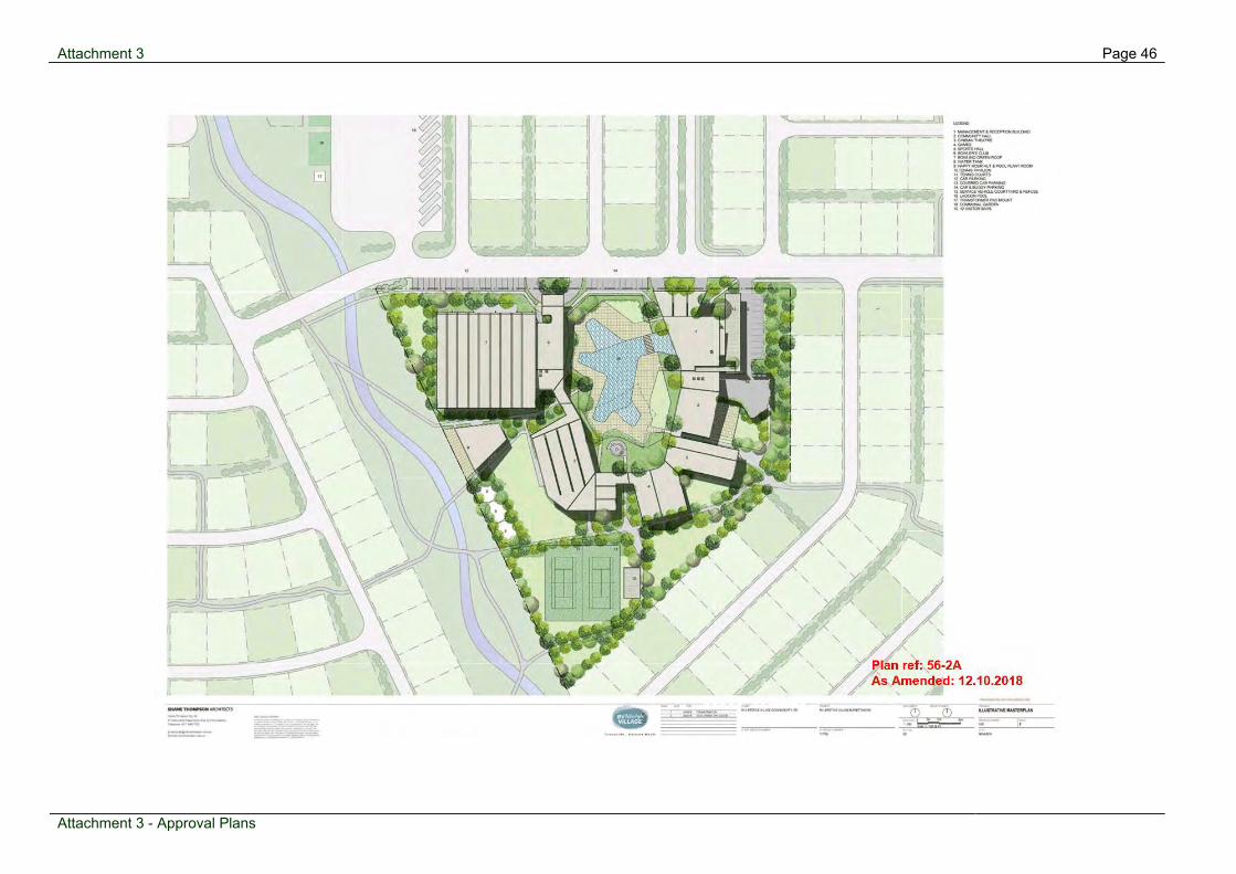
Attachment 3 Page 46
Attachment 3 - Approval Plans
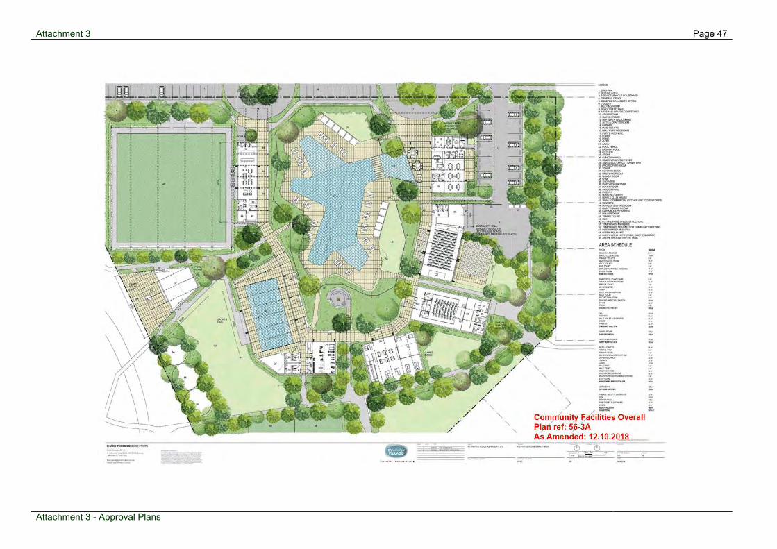
Attachment 3 Page 47
Attachment 3 - Approval Plans

Attachment 3 Page 48
Attachment 3 - Approval Plans

Attachment 3 Page 49
Attachment 3 - Approval Plans
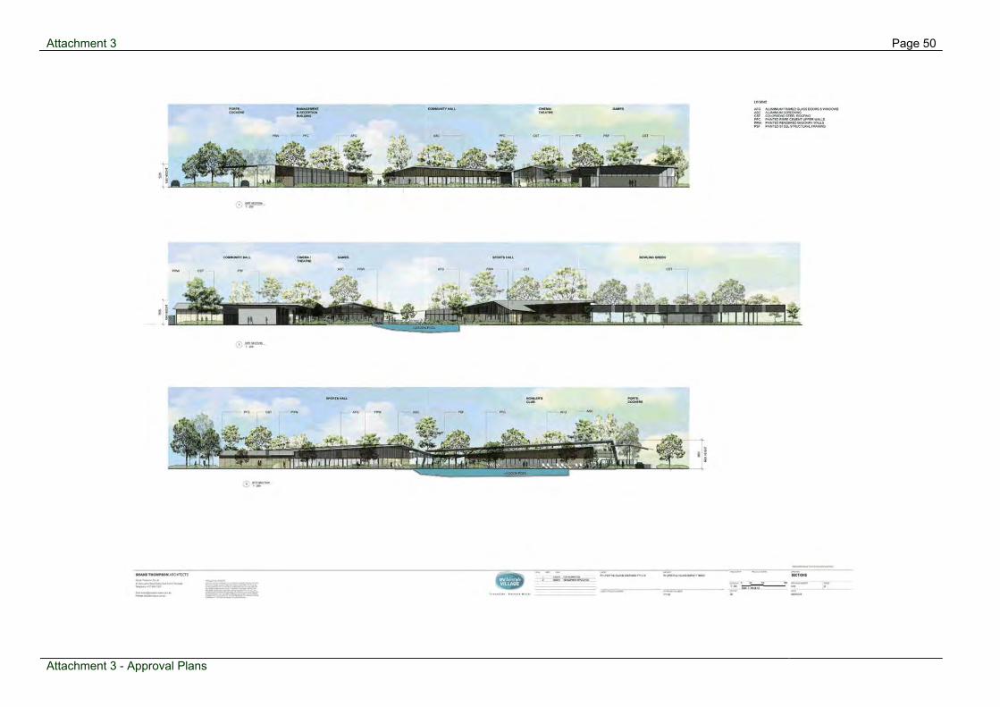
Attachment 3 Page 50
Attachment 3 - Approval Plans

Attachment 3 Page 51
Attachment 3 - Approval Plans

Attachment 3 Page 52
Attachment 3 - Approval Plans

Attachment 3 Page 53
Attachment 3 - Approval Plans

Attachment 3 Page 54
Attachment 3 - Approval Plans

Attachment 3 Page 55
Attachment 3 - Approval Plans

Attachment 3 Page 56
Attachment 3 - Approval Plans
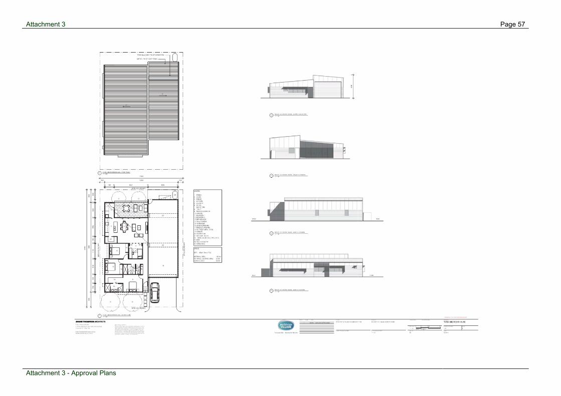
Attachment 3 Page 57
Attachment 3 - Approval Plans

Attachment 3 Page 58
Attachment 3 - Approval Plans

Attachment 3 Page 59
Attachment 3 - Approval Plans

Attachment 3 Page 60
Attachment 3 - Approval Plans

Attachment 4 Page 61
Attachment 4 - Referral Agency Response

Attachment 4 Page 62
Attachment 4 - Referral Agency Response

Attachment 4 Page 63
Attachment 4 - Referral Agency Response

Attachment 4 Page 64
Attachment 4 - Referral Agency Response

Attachment 4 Page 65
Attachment 4 - Referral Agency Response

Attachment 4 Page 66
Attachment 4 - Referral Agency Response
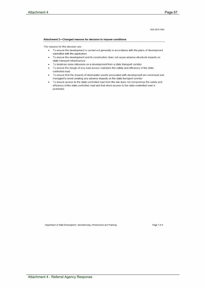
Attachment 4 Page 67
Attachment 4 - Referral Agency Response

Attachment 4 Page 68
Attachment 4 - Referral Agency Response

Attachment 4 Page 69
Attachment 4 - Referral Agency Response

Attachment 4 Page 70
Attachment 4 - Referral Agency Response
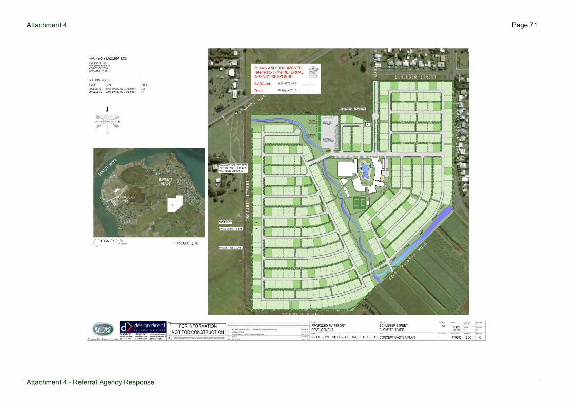
Attachment 4 Page 71
Attachment 4 - Referral Agency Response

Attachment 4 Page 72
Attachment 4 - Referral Agency Response

Attachment 4 Page 73
Attachment 4 - Referral Agency Response

Attachment 4 Page 74
Attachment 4 - Referral Agency Response

Attachment 5 Page 75
Attachment 5 - ICN

Attachment 5 Page 76
Attachment 5 - ICN
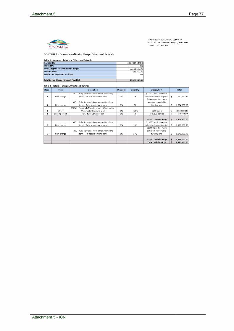
Attachment 5 Page 77
Attachment 5 - ICN
Attachment 5 Page 78
Attachment 5 - ICN

Attachment 5 Page 79
Attachment 5 - ICN

Attachment 5 Page 80
Attachment 5 - ICN

Attachment 5 Page 81
Attachment 5 - ICN