![arXiv:0905.3978v1 [quant-ph] 25 May 2009](https://static.fdokumen.com/doc/165x107/63268c49cedd78c2b50d2403/arxiv09053978v1-quant-ph-25-may-2009.jpg)
ORDINARY COUNCIL MEETING – 25 MAY 2021
415
ORDINARY COUNCIL MEETING – 25 MAY 2021 ATTACHMENTS Agenda Report Page No 4.1 Attachment 1 - Consideration of Representations to Draft Amendment AMD 2021/01 1 4.2 Attachment A – Application Documents 35 Attachment B – Representations 191 4.3 Attachment A – Application Documents 193 Attachment B – Representations 279 Attachment C - Engineering Report 287 8.4 Attachment 1 - Draft Southern Tasmania Regional Cat Management Strategy 2021-2026 299 8.5 Attachment 1 - Strategic Asset Management Plan 332 8.6 Attachment 1 - 2021/2022 Marine Infrastructure fees and charges 414
-
Upload
khangminh22 -
Category
Documents
-
view
0 -
download
0
Transcript of ORDINARY COUNCIL MEETING – 25 MAY 2021

ORDINARY COUNCIL MEETING – 25 MAY 2021
ATTACHMENTS
Agenda Report Page No
4.1 Attachment 1 - Consideration of Representations to Draft Amendment AMD 2021/01
1
4.2 Attachment A – Application Documents 35
Attachment B – Representations 191
4.3 Attachment A – Application Documents 193
Attachment B – Representations 279
Attachment C - Engineering Report 287
8.4 Attachment 1 - Draft Southern Tasmania Regional Cat Management Strategy 2021-2026
299
8.5 Attachment 1 - Strategic Asset Management Plan 332
8.6 Attachment 1 - 2021/2022 Marine Infrastructure fees and charges 414
Attachment 1 - Consideration of Representations to Draft Amendment AMD 2021/01
Issues
Compliance with the Southern Tasmania Regional Land Use Strategy
Many representations raised compliance with the Southern Tasmania Regional Land Use Strategy (RLUS). As noted in the original assessment report, the RLUS was prepared on data from the late 2000’s, in the post global financial crisis period and is an aspirational, strategic document. It was not expected to specifically identify and locate every proposal that would occur over its 25-year life and was expected to be subject to ongoing maintenance over that time. The RLUS does not appear to have identified the economic and cultural impacts of the previous 10 years, nor does it appear to have been maintained in the manner identified within the document. The assessment report identifies that the proposal is considered to be consistent with the
requirements of the RLUS. There are internal contradictions within the RLUS, most notably between
the strategic objectives for making the region and towns more liveable, with the policies providing for
flexible responses for ageing in place and the lack of detailed requirements for aged care options and
identification of where they should be provided within the community.
Many representations argue that the proposal must be located within urban Swansea and must be refused on that basis. This is not consistent with the requirement of SI1.7 for facilities to be close to an activity centre with access to public transport. Tempus complies with these requirements. SI1.7 also requires flexibility for aged care facilities, with Tempus providing a different offering based on a rural lifestyle rather than the traditional urban offerings provided within Tasmania. SI1.8 promotes the ageing population living within their communities, which Tempus will clearly provide. The Assessment Report identified addressed the relevant requirements and determined that the proposal was consistent with the requirements of the RLUS. While the representations raised specific concerns, particularly with the location outside of urban Swansea, no information was presented that alters the original assessment. Compliance with the RLUS is a relevant planning issue that has merit under the current process. The representations raised no information that requires modification of the Amendment. Recommendation a. compliance with the Regional Land Use Strategy is considered to have merit as a relevant
planning issue for the current assessment; b. no alterations are required to the amendment as a result of the representations; and c. Regional Land Use Strategy and Swansea Structure Plan are not expected to impact the
operation of the amendment.
Compliance with the Swansea Structure Plan
Many representations raised compliance with the Swansea Structure Plan (Structure Plan). Specific concerns included linear sprawl and by reference within many representations, the project location outside the Structure Plan area. The Structure Plan was based on the RLUS and is an aspirational, strategic document. As noted in the Assessment report, the application was assessed as compliant with the Structure Plan. Key points include:
1. the provision of further aged care facilities and retiree housing as a consideration for the Structure Plan (p52);
2. the significance of land fronting the Tasman Highway on the southern side of the township to the Residential Land Use Objectives (p59); and
3. the need for a gradual uptake of available land within the township for subdivision and residential developments (p60).
Page 1 of 414
Agenda Item 4.1 - Attachment 1
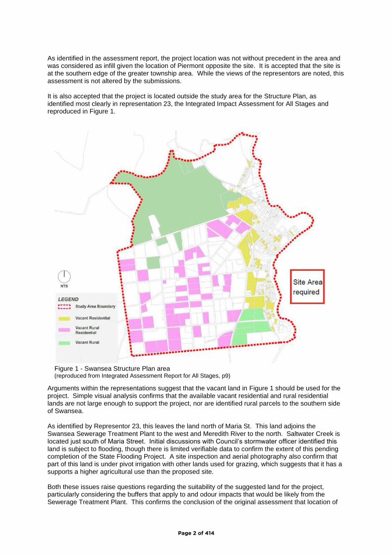
As identified in the assessment report, the project location was not without precedent in the area and was considered as infill given the location of Piermont opposite the site. It is accepted that the site is at the southern edge of the greater township area. While the views of the representors are noted, this assessment is not altered by the submissions. It is also accepted that the project is located outside the study area for the Structure Plan, as identified most clearly in representation 23, the Integrated Impact Assessment for All Stages and reproduced in Figure 1.
Arguments within the representations suggest that the vacant land in Figure 1 should be used for the project. Simple visual analysis confirms that the available vacant residential and rural residential lands are not large enough to support the project, nor are identified rural parcels to the southern side of Swansea. As identified by Representor 23, this leaves the land north of Maria St. This land adjoins the Swansea Sewerage Treatment Plant to the west and Meredith River to the north. Saltwater Creek is located just south of Maria Street. Initial discussions with Council’s stormwater officer identified this land is subject to flooding, though there is limited verifiable data to confirm the extent of this pending completion of the State Flooding Project. A site inspection and aerial photography also confirm that part of this land is under pivot irrigation with other lands used for grazing, which suggests that it has a supports a higher agricultural use than the proposed site. Both these issues raise questions regarding the suitability of the suggested land for the project, particularly considering the buffers that apply to and odour impacts that would be likely from the Sewerage Treatment Plant. This confirms the conclusion of the original assessment that location of
Figure 1 - Swansea Structure Plan area (reproduced from Integrated Assessment Report for All Stages, p9)
Page 2 of 414
the project within the Structure Plan area is not a realistic proposition and would create ongoing supply problems for future residential development. It must also be noted that while the Structure Plan identifies the need for large scale projects, retirement lifestyle and aged care facilities, no guidance is provided on where they might be located. Compliance with the Structure Plan is a relevant planning issue that has merit under the current process. Recommendation a. compliance with the Swansea Structure Plan is considered to have merit as a relevant
planning issue for the current assessment; b. no alterations are required to the amendment as a result of the representations; and c. Swansea Structure Plan is not expected to impact the operation of the amendment.
Scale and associated issues
Multiple representations identified that Tempus would create an isolated residential and aged care complex and contest the gateway concept identified within the Assessment Report. The Neil Shepard Report and the Assessment Report identify that the proposal is considered to be at the southern edge of the area that contains a mix of uses surrounding Swansea Township. The location of the site opposite Piermont supports this position and the gateway description. In terms of the isolated population, the Integrated Impact Assessment for All Stages identifies that the project will provide a similar population to the visitor accommodation sector (page 10), which is scattered throughout the Swansea township and surrounding area. The Piermont site has approval to develop 329 strata sites, which would periodically provide for a population that was equal to or greater than the Tempus project and has a significant impact on the proportion of residents to visitors within Swansea. The project location is not considered to be without precedent in terms of location or scale. The issue is considered to be a relevant planning consideration. No alterations are proposed to the amendment as a result of representations raising this issue.
Recommendation
a. scale and location are considered to have merit as a relevant planning issue for the current assessment;
b. no alterations are required to the amendment as a result of this issue; and c. scale and location are not expected to impact the operation of the amendment.
Suitable medical facilities
Suitability of medical facilities within Swansea was identified in numerous representations. The Integrated Impact Assessment for all stages identifies that the proposal was discussed the existing medical practice, who were supportive and suggested expansion of their services as a result of the project. It is also noted that May Shaw (representation 44) were supportive of the likely impacts Tempus would have on the medical services and resources within Swansea. The proposal documents also identify that a range of medical facilities will be provided on the site to service the local population within the project and surrounding area. The alternative position is to require appropriate medical facilities prior to establishment of retirement lifestyle and aged care facilities within the Swansea area. As noted in response to Representation 17, this is unlikely to be commercially viable for providers and could have the adverse impact where aged care and medical services are effectively stopped from expansion locally. Representation 28 expressed concern over the ability of the proposal to obtain staff, which was countered by the support for the proposal provided within Representation 44 on this issue. In both cases, it is a matter for the operators to resolve how they obtain staff, which is not a planning an issue for consideration within this process.
Page 3 of 414
Delivery of on ground medical resources is not within the control of the land use planning system. While this issue is relevant to the operation of the proposal, it is not relevant to land use planning considerations under the current process. Recommendation a. available medical facilities are not considered to have merit as a relevant planning issue for
the current assessment; b. no alterations are required to the amendment as a result of the representations; and c. this issue is not expected to impact the operation of the amendment.
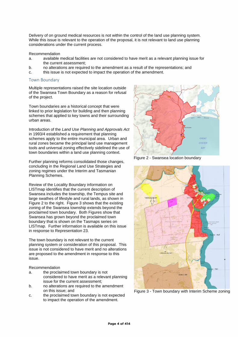
Town Boundary
Multiple representations raised the site location outside of the Swansea Town Boundary as a reason for refusal of the project. Town boundaries are a historical concept that were linked to prior legislation for building and then planning schemes that applied to key towns and their surrounding urban areas. Introduction of the Land Use Planning and Approvals Act in 1993/4 established a requirement that planning schemes apply to the entire municipal area. Urban and rural zones became the principal land use management tools and universal zoning effectively sidelined the use of town boundaries within a land use planning context. Further planning reforms consolidated those changes, concluding in the Regional Land Use Strategies and zoning regimes under the Interim and Tasmanian Planning Schemes. Review of the Locality Boundary information on LISTmap identifies that the current description of Swansea includes the township, the Tempus site and large swathes of lifestyle and rural lands, as shown in Figure 2 to the right. Figure 3 shows that the existing zoning of the Swansea township extends beyond the proclaimed town boundary. Both Figures show that Swansea has grown beyond the proclaimed town boundary that is shown on the Tasmaps series on LISTmap. Further information is available on this issue in response to Representation 23. The town boundary is not relevant to the current planning system or consideration of this proposal. This issue is not considered to have merit and no alterations are proposed to the amendment in response to this issue. Recommendation a. the proclaimed town boundary is not
considered to have merit as a relevant planning issue for the current assessment;
b. no alterations are required to the amendment on this issue; and
c. the proclaimed town boundary is not expected to impact the operation of the amendment.
Figure 2 - Swansea location boundary
Figure 3 - Town boundary with Interim Scheme zoning
Page 4 of 414
Agricultural Land
Many representations raised the loss of valuable agricultural land, compliance with the State Policy for the Protection of Agricultural Land and land use conflict between Tempus and the adjoining Gala Estate vineyard. Some representations provided comments from experienced or qualified parties that both support and contradict the findings of the Agricultural Reports that accompanied the application. Those statements concern:
• the potential for and the ability to manage land use conflicts around spraying, noise,
competing demands and fettering; and
• the nature of the soils on the Tempus site and their ability to sustain viticulture and therefore,
their value as agricultural lands.
There is no simple way to resolve the conflicting expertise and statements within the representations though this process. Additional expert analysis will be required to address these claims and determine the factual outcome of the competing statements. This body of work will then inform the assessment of the application and subsequent decision. Representation 35 identified the lack of setback requirements under the proposed Particular Purpose zone, which fails to recognise the controls at GSB-P7.6.3 A3/P3. Review of that standard concluded that A3(b) should be clarified to recognise existing buildings for sensitive use only under this standard. The issue has merit for consideration of the current application and is supported under the current process. Additional information will be required before the conflicting information and advice can be resolved and it can be determined whether modifications are required to the amendment. Recommendation a. compliance with the State Policy and consideration of potential impacts on agricultural
operations are relevant to the current amendment and the representations are considered to have merit;
b. it is premature to determine whether alterations will be required to the amendment as a result of the conflicting information and advice within the representations, it was identified that the wording of GSB-P7.6.3 A3 should be modified to refer to setbacks for dwellings and habitable buildings; and
c. impacts of this issue on the operation of the amendment cannot be determined at this time.
Tempus creating precedent for Cambria
Many representations raised concern that Tempus would create a precedent for approval of the re-activated Cambria Green Amendment. Planning Scheme amendments are required to be considered by the Planning Authority and then the Commission on their own merits. Decisions on amendments can vary widely depending upon a range of matters including the nature of the proposal, the supporting information provided, nature of representations received and compliance with the relevant strategic and statutory documents. The Commission is the ultimate decision maker and operates as an independent statutory authority to maintain the integrity of its decisions. While this concern is noted, the two applications are substantially different. This concern is not supported from a planning perspective. The precedent of Tempus for Cambria Green is not considered to have merit as a relevant planning issue for the current assessment and no alterations are proposed to the amendment as a result. Recommendation a. precedent of Tempus for Cambria Green is not considered to have merit as a relevant
planning issue for the current assessment; b. no alterations are required to the amendment as a result of the representations; and c. precent is not expected to impact the operation of the amendment.
Page 5 of 414
Lack of Road owner consent
As noted in the Neil Sheppard Report and the Assessment Report, the title described as Crown land within the site is in private ownership. Consent from the Trustees of the Estate of the owner was provided as part of the application documents. The application documents address the requirement for owners’ consent and no further information is required for the application. Recommendation: a. owners’ consent is a relevant consideration to the current process that was addressed in the
application documents; therefore the issue is not considered to have merit to the current process;
b. no alterations are required to the amendment in response to this issue; and c. the issue of owner’s consent is not expected to impact the operation of the Amendment.
Infrastructure
Review of the representations identified significant concern over the provision and funding of infrastructure of the project, availability of reticulated water to the site and impact on the water supply for the rest of Swansea. Infrastructure provision remains the obligation of the proponents for the project. Council may wish to add a condition to the permit clarifying that the proponent is responsible for funding infrastructure required for the project. The Submission to Planning Authority Notice with TWDA 2020/00706-GSB provided consent and requirements for servicing the project and advised that Taswater did not wish to appear at the hearings. It is noted that many representors expressed concern regarding the capacity of the Swansea service to meet the current and future urban and agricultural supply requirements. Concerns over the capacity of the reticulated water network need to be considered by Taswater and should be referred to them for consideration. The provision of potable water supply for the proposal is fundamental to the suitability of the site for the application and as a result, support for the project. It is noted that stormwater infrastructure is addressed at conditions 45 and 46 of the permit, but do not include a requirement that discharge from the site to the public stormwater system is maintained at pre-development levels. The application was referred to State Growth for owners’ consent and comment as part of the preliminary assessment. Both were provided, though neither made specific comment about stormwater issues. A condition limiting stormwater discharges is consistent with the requirements of Section 84(1)(c) of the Local Government (Building and Miscellaneous Provisions) Act 1993 and will limit any long-term liabilities for stormwater discharges. A new condition 47 is recommended on this basis. The provision of infrastructure generally for the project is addressed by the existing assessment process and not considered to require any alteration of the amendment. The capacity for the reticulated water supply service to meet the existing and future demands of the Swansea area and consequential stormwater issues related to the subdivision and development process are considered to have merit and relevance to the current process. Further information will be required from Taswater before a final recommendation can be provided on potential alterations to the amendment resulting from these issues. It is suggested that further information be obtained to demonstrate that the project will not detrimentally impact minimum service levels for existing urban and rural services. Recommendation: a. infrastructure issues for stormwater management and reticulated water system capacity are
relevant to the current consideration and are therefore considered to have merit to the current process;
Page 6 of 414

b. alterations are proposed to: i. includes a new condition 47 is added to the permit that requires stormwater
discharges from the site to be limited to pre-development levels; ii. request Taswater to confirm capacity and impacts for the existing urban and
agricultural services in the area; and c. a response to b.ii. is required before potential impacts to the operation of the Amendment can
be determined.
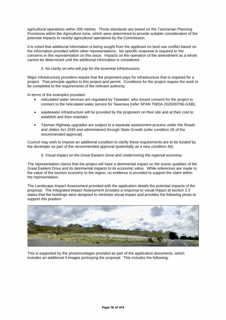
Visual / scenic impacts – rep 8
Many representors expressed concern that the project will have detrimental impacts to the scenic qualities of the area and consequentially, the tourism economy. The application documents identify that the buildings are not expected to have significant impacts within the local landscape, as detailed in the response to Representor 8. The Landscape Impact Assessment provided with the application details the potential impacts of the proposal. The Integrated Impact Assessment provides a response to visual impact at section 2.3 states that the buildings were designed to minimize visual impact and provides the following photo to support this position:
This is supported by the photomontages provided as part of the application documents, which includes an additional 4 images portraying the proposal. This includes the following:
These images suggest that the overall impact of the tallest structure on the site will not be significant, though it is noted that the images provide a cloudy background that downplays the impact of the white capped header tanks/observatory buildings within the landscape. The supporting documents and assessment report identified that most of the buildings were designed and located to minimise visual impacts, however some of the finishes and colours are likely to have a high contrast with the surrounding landscape during the daytime and at night (through direct and indirect lighting). Specific impacts are considered likely for the Observatory and stables/indoor arena buildings, due to their location and white finishes to the observatory components of the structure. It was identified that additional imagery should be provided to confirm the impacts of these buildings and the overall project within the wider landscape so that the colours and finishes could be reviewed and considered. Alternative colours may be required to minimise visual contrast and impacts.
Page 7 of 414

While information was provided on the value of tourism to the Tasmanian and local economies, no evidence was provided on the suggested detrimental economic impacts to tourism resulting from visual impacts. Visual impacts of the project are considered to have merit and further information will be required to determine potential impacts and any response that might be required to address those concerns. The outcome of that information will inform the degree of any issue and whether alterations are required to the amendment as a result of this issue. Recommendation: a. visual impacts of the project are a relevant consideration to the current process and therefore
have merit to the current process; b. additional photomontages are required to determine and resolve the potential contrasts and
visual impacts of the colours and finishes of buildings within the wider day and nighttime landscapes; and
c. pending response to b, visual impacts are not expected to impact the operation of the Amendment.
Light Impacts / Pollution
Representation 8 expressed concern at the impact of the project on the east coast dark sky and was supported by the majority of other representations against the proposal. Dark Sky impacts are not recognised under the Tasmanian Planning System as yet, though it is noted that Glamorgan Spring Bay Council included this issue in its Section 35G Notice to the Commission following exhibition of its Local Provisions Schedule. It is noted that the Piermont complex has approval for 392 strata sites directly opposite Tempus, or below if viewed from across Great Oyster Bay. This will compromise the integrity of the dark sky concept within the immediate area.
Noting this, Council identified that lighting should be baffled to minimse impacts within the project
generally and to require additional information to determine likely lighting impacts of building finishes
at night.
Recommendation: a. lighting impacts from the project are a relevant consideration to the current process and
considered to have merit; b. the amendment should be modified to provide:
i. additional information on potential lighting and visual impacts of the colours and finishes of buildings within the nighttime landscapes; and
ii. a new condition that requires lighting to be baffled to minimise off site and night-time impacts
c. pending response to b, visual impacts are not expected to impact the operation of the Amendment.
Community access to facilities
Concern was expressed at the vague language used in the Assessment report for community access to the facilities provided on the Tempus site. The Integrated Impact Assessment is much clearer in committing that virtually all the social and recreational facilities would be available to the local community (most clearly stated at page 31). The basis of the application was that Tempus will provide social and aged infrastructure for the local community and this commitment supports its compliance with multiple aspects of the Regional Land Use Strategy. As such, a condition should be imposed to reflect this statement. Recommendation: a. community access to facilities within the Tempus proposal are considered have merit;
Page 8 of 414
b. the amendment should be modified to include a condition to ensure community access to the facilities, consistent with the proposal documents; and
c. community access to facilities is not expected to impact the operation of the Amendment.
Use for Visitor Accommodation
Use of the site for visitor accommodation is not possible under the terms of the Particular Purpose zone. Such a use cannot occur and would require a planning scheme amendment to be allowed within the zone. Recommendation: a. use of Tempus for visitor accommodation is not possible under the Particular Purpose zone
and therefore is not considered have merit; b. the amendment does not require any modification as a result of this issue; and c. use of Tempus for visitor accommodation will not impact the operation of the Amendment.
Ability to complete the project
Representor 29 identifies concern at the staged nature of the proposal and risk for a lower quality development to be provided, while other representors suggested similar concerns. Conditions were requested for completion of the project within 5 years, or the site should effectively be reinstated to pre-development conditions. Staging of approvals is a common process within the development process, which can be achieved through successive applications or staging of a single approval. The information provided by proponents as part of consultation outside the statutory exhibition process is not relevant to the current assessment. The Act provides substantive options for commencement of projects within six years of approval but makes no provision for completion of projects or their abandonment. Recommendation: a. submissions regarding staging and completion of Tempus are not considered have merit; b. the amendment does not require any modification as a result of these issues; and c. staging and completion of the project are not impact the operation of the Amendment.
Page 9 of 414
Detailed assessment of representations
1. R&B Dart
The representation provides support for the provision of retirement options within the Swansea area. The representation does not raise any planning issues that require further consideration under this process. In terms of the assessment against the requirements of the Act: a. the representation has merit but raises no planning issues that require consideration; b. the amendment does not need to be modified as a result of the representation; and c. the representation has no impact on the amendment as a whole.
2. Deborah Fleming OAM
The representation expresses support for the project, particularly its progressive nature, high quality offerings and example provided by the Arbour project at Berry, NSW. The representation does not raise any planning issues that require further consideration under this process. In terms of the assessment against the requirements of the Act: a. the representation has merit but raises no planning issues that require consideration; b. the amendment does not need to be modified as a result of the representation; and c. the representation has no impact on the amendment as a whole.
3. David Mitchell
The representation expresses support for the project and its appealing nature. The representation does not raise any planning issues that require further consideration under this process. In terms of the assessment against the requirements of the Act: a. the representation has merit but raises no planning issues that require consideration; b. the amendment does not need to be modified as a result of the representation; and c. the representation has no impact on the amendment as a whole.
4. East Coast Alliance
The representation expresses concern regarding compliance with relevant strategic documents, potential for land use conflict and the loss of agricultural lands. Particular concern is expressed for the precedent that this project may establish for other large-scale projects on the east coast.
The representation expresses concern regarding compliance with the RLUS, particularly the creation of what is argued as a large multiple dwelling estate outside of Swansea, this being outside the growth allocated under the RLUS; and the potential for Tempus to undermine existing facilities provided within Swansea township. While the concerns of the representor are noted, no new information is provided that affects the assessment of compliance with the RLUS in the assessment documents. The issue has merit for consideration under this process but does not require changes to the amendment or impact its operation. The representation submits that the proposal represents leapfrogging, should not be considered on the basis that the RLUS and Structure Plan are outdated and does not comply with the requirements of the Scenic Road Corridor. The proposal was assessed against the requirements of the Act, RLUS and Structure Plan and determined to be consistent with each, despite being outside the concepts that underpin the latter documents. Neither the RLUS nor the Structure Plan present as rigid documents that were prepared to identify every possible project that would arise during their operation. Both support an approach to use
Page 10 of 414
processes within the Act to deal with matters outside their terms, which the current application seeks to do. Planning Scheme amendments provide a process to consider such proposals, while this application includes tightly defined planning provisions to consider the proposal, along with the planning application for the first stage of the overall project. This is considered to be consistent with the nature of the planning system, RLUS and Structure Plan. The proposal was assessed against the requirement of the Scenic Road Corridor and determined to comply. These grounds raise valid planning issues for consideration under this process. No alterations are proposed, and the grounds are not expected to impact the amendment as a whole.
Concerns are expressed at the scale of the project in context of the Swansea settlement and limited availability of/impact upon medical facilities in the area. The scale of the project is noted and was addressed in the original assessment reports and is not unprecedented in the immediate area. Piermont has approval for 325 units, directly opposite the subject site. Availability of health services was considered by the proponents in the Integrated Impact Assessment for All Stages (page 12), who have discussed expansion of medical facilities with local health and aged care providers. The concepts for the Aged Care facility include a helipad for medical evacuations. The statements have merit but have not presented any additional information that requires the original assessment of this issue to be revised. There are no alternations required to the original recommendation and this concern has no impact on the operation of the amendment.
The representation submits that Piermont should not be used as a precedent for the project, given that it was approved many years ago under a different suite of planning documents. The Piermont approval was issued in 1992 and provides for 392 units on site, with other facilities. This approval represents part of the existing land use pattern throughout the area and has an impact on the potential for land use conflict in the area. While the intent of the statement is understandable, it is not supported from a planning perspective. No changes are proposed as a result of this ground and it is not considered to impact operation of the amendment.
The representation submits that the proposal has the potential to fetter adjoining land uses within the Significant Agricultural zone. No evidence is provided to counter the information provided with the application within this representation, however other representations provide statements from adjoining landowners and other people with relevant experience in the area. It goes on to submit that the agricultural assessments appear questionable, given establishment of the adjoining Gala Estate vineyard in recent times. Both Agricultural Assessments provided with the application included site inspections and/or surveys and conclude that the 18-hectare Tempus site has no viable capacity for commercial agricultural operations, providing extensive discussions to support those conclusions. While this representation does not provide any supporting evidence for their claims, other representations provide experience or advice that contradicts a range of conclusions within the applicant’s agronomist reports and from the current landowner. There is sufficient information on this issue to raise questions over the ability of the proposal to create land use conflict and then the ability of the operators of each site to manage potential conflict on an ongoing basis. This concern raises a valid planning issue for consideration under the current process and supports the proponent providing additional detailed information to investigate and determine these concerns.
Page 11 of 414

The representation raises issues that requires additional assessment of the potential for land use conflicts. This information should be provided by the applicant for consideration of the Commission and Council. The need and extent of any changes to the amendment and its operation cannot be determined absent that additional information. In terms of the assessment against the requirements of the Act: a. the representation has merit, with the agricultural issue identified elsewhere are requiring
further evidence to resolve; b. pending resolution of the agricultural issues identified in this and other representations, the
amendment does not otherwise require modification from this representation; and c. pending resolution of the agricultural issues identified in this and other representations, the
representation has no impact on the amendment as a whole.
5. Spring Vale Wines
The representation raises concern with various aspects of the proposal as a wine and spirit producer within the area. The first issue relates to the ability of Taswater to provide reticulated water services for the project and to service irrigation licenses sourced from the same infrastructure. Taswater provided consent for the project through the required regulatory process for the amendment and planning application. It is noted that this and other representations question the ability of the reticulated service to meet the current and future demands of urban and agricultural users. As noted in the opening discussion, Taswater should provide additional information regarding this issue. The Cambria proposal was ‘stalled’ as the Commission determined that owner’s consent was not provided. This decision was then challenged to and overturned by the Supreme Court, following the submission of additional evidence to address the required consent. The Cambria Green amendment was then referred back to the Commission for assessment. Hearings for the proposal re-commenced on 2 March 2021. The Commission is yet to complete that assessment. Spray drift is a recognised factor for land use conflict, which requires assessment through this
process. There is conflicting information about the potential for spray drift impacts from the
agronomist reports provided with the application, the current landowner and other relevant
representations.
This concern provides a relevant perspective that supports questions raised in other representations. Representation 35 provides support to this representation with advice from a viticulturalist that claims the site appears capable of sustaining 5 hectares of grapes, which contradict a range of conclusions within the applicant’s agronomist reports and from the current landowner. There is sufficient information on this issue to raise valid questions over the ability of the proposal to create land use conflict and then the ability of the operators of each site to manage potential conflict on an ongoing basis. This concern raises a valid planning issue for consideration under the current process and supports the proponent providing additional detailed information to address these concerns. As noted in the assessment of representation 4, additional information will be required from the applicant to determine these issues. While the concerns are understood, each planning scheme amendment is assessed on its own merits. In terms of the assessment against the requirements of the Act: a. the representation raises valid issues for consideration in terms of water supply and potential
agricultural impacts resulting from the proposal that have merit; b. further evidence will be required on the water supply and agricultural issues identified in this
and other representations to determine if the amendment requires modification; and
Page 12 of 414

c. it is premature to determine the impacts of the representation on the operation of the amendment pending resolution of the water supply and agricultural issues identified in this and other representations.
6. M Ibbott
The representation expresses support for the project, particularly the range of design features provided by the site, architecture, and layout of the proposal. It does not raise any planning issues that require further consideration under this process. In terms of the assessment against the requirements of the Act: a. no planning issues were raised that require consideration; b. the amendment does not need to be modified as a result of the representation; and c. the representation has no impact on the amendment as a whole.
7. Jack Cotton
The representation was made as the current landowner and provides three sets of points in support of the proposal. 1. The subject 18 ha is not productive agricultural land, and its loss has no significant impact on
the operations of Kelvedon:
• The area has shallow soils and exposed bedrock;
• Historic use for grazing ranges from 1 to 4 sheep/hectare from drought to good years;
• Sale of the land will facilitate irrigation investment in other areas of Kelvedon to improve
grazing and viticulture operations.
2. Tempus site and proximity to Gala Vineyard is of limited impact for the following:
• through provision of a buffer;
• prevailing weather conditions during spraying season (October to late February) being
NW to NE and send spray drift away from the site and the requirement to avoid spraying
during windy conditions;
• improving technology to manage spray drift;
• the limited long-term effectiveness of gas guns and noise deterrents over time;
• bird management being best managed through netting, with new options being developed
such as lasers and drones.
3. Employment potential resulting from Tempus in the Swansea region, including across horticulture / viticulture and including opportunities for grape harvesting and pruning
The comments are noted and are consequential to the issues under consideration as part of this process. The representation expresses support for the project and provides an interesting perspective and experience that counters many of the other representations that claim Tempus will detrimentally impact agricultural activities on the adjoining site. The comments within this representation are consistent with those provided within the agronomist reports as part of the application. They are not consistent with submissions from other representors who either have or provide expert advice on this issue, which is addressed in response to those representations. It is noted that additional information will be required from the applicant on those issues in response to other representations. In terms of the assessment against the requirements of the Act: a. the issue of land use conflict is subject to an information request arising from this and a
number of other representations that requires further consideration;
Page 13 of 414
b. agricultural issues identified in this and other representations will require resolution to determine if the amendment will require modification from this representation; and
c. the impacts of the representation on the amendment as a whole cannot be determined pending review of the additional information identified within this report.
8. Freycinet Action Network / Underwood
The representation opposes the proposal, based on eight main points as follows.
1. Inconsistent with Southern Tasmania Regional Land Use Strategy 2010 – 2035; 2. Linear Sprawl is inconsistent with the Swansea Structure Plan 2016; 3. No Consent Obtained re Public Road making the application invalid; 4. Permanent loss of productive agricultural land and land use Conflict inconsistent with the
State Policy on Protection of Agricultural Land 2009; 5. No clarity on who will pay for the essential infrastructure; 6. Visual impact on the Great Eastern Drive and Undermining the regional economy; 7. Light Pollution – erosion of the east coast’s dark sky; and 8. The erosion of Scenic Landscape Values due to Ribbon Development or Linear Sprawl
down the East Coast. Detailed examination of the issues follows.
1. Inconsistent with Southern Tasmania Regional Land Use Strategy 2010 – 2035;
The representation identifies that the proposal is outside the moderate growth strategy and consolidation scenario identified for Swansea in the RLUS. This issue was examined in the original assessment materials and determined to comply with the RLUS as a project of this type was outside the scope of the development concepts that underpin the document. Further, the applicant’s documentation identifies that the development options identified by the representor were not consistent with the rural lifestyle concept and were not able to accommodate the spatial requirements for the project within the township without creating significant problems by taking most of the available land supply and growth allocation for Swansea under the RLUS. The representation identifies that the project will create an isolated population of 300 people, with no connection to the Swansea township that is dependent upon cars for access. These statements assume that all aged care facilities must be in an urban location and ignore the rural lifestyle basis of the proposal. Unit residents will have access to personal and facility-based transport options and residents of the future home will have access to facility-based transport options, much like facilities located in urban areas. The dispersed nature of Tasmanian settlements suggests that employees are likely to be drawn from a large area, which would rely on private transport to attend shifts regardless of the location of the facility. While this issue raised valid planning matters for consideration, the detailed assessment did not identify any matters that were not considered in the original assessment. As a result, the original assessment does not require modification and is not expected to impact the amendment as a whole.
2. Linear Sprawl is inconsistent with the Swansea Structure Plan 2016;
The representation suggests that the proposal represents linear sprawl, which is inconsistent with the Structure Plan. The original assessment report examined compliance with the Structure Plan at section 6.2. The subject site is outside the scope of the Structure Plan. Assessment of the Amendment identified the following:
While the Structure Plan does not go on to identify where retirees might live, it does recognise the following:
1. the provision of further aged care facilities and retiree housing as a consideration for the structure plan (p.52);
Page 14 of 414

2. the significance of land fronting the Tasman Highway on the southern side of the township to the Residential Land Use Objectives (p59); and
3. the need for a gradual uptake of available land within the township for subdivision and residential developments (p60)
As stated in previous sections, strategic documents cannot be expected to identify and address all future development opportunities that might arise in response to growing trends and changing community expectations.
It was also identified that while the Structure Plan made statements about accommodating large projects, it did not provide any direction on where such projects might be located. The conclusion of the original assessment was that while the Structure Plan was of limited use in assessing the proposal, it was consistent with the residential objectives and actions for residential development and provision of aged care within the area. As noted in the original assessment, the site is adjacent the Piermont Estate and represents the southern extent of the Swansea township. The issue raises a valid issue for consideration with the proposal but did not present any evidence that suggests this aspect of the original assessment should be altered. As a result, no modifications are recommended to the amendment on this issue and the amendment is not expected to be affected as a whole.
3. No Consent Obtained re Public Road making the application invalid;
The representation raises the lack of crown consent for the amendment as it includes a crown reserve
and submits the application is invalid.
As noted in the assessment report on the Amendment, the consent of the landowners was provided for the application. The subject road reservation identifies as crown land on the LISTmap but was researched by the Crown and the applicants and determined to be in the estate of a former owner. The applicant’s documentation addressed this matter and Council took legal advice prior to accepting lodgment of the application. The subject land is not in crown ownership and the consent of the trustees of the estate was provided for the application. This ground is not supported. No changes are required to the amendment as a result of this issue, and it will not impact the operation of the amendment as a whole.
4. Permanent loss of productive agricultural land and land use Conflict inconsistent with the State Policy on Protection of Agricultural Land 2009;
The representation claims the proposal is contrary to the Policy and that condition 3 of the proposed permit recognizes this. The application was supported by a report from Rod Hancl of Roberts and peer reviewed by AK Consulting. No evidence was provided to counter the evidence provided within these reports and support the claims within this representation. Compliance with the Policy was addressed in the applicant’s documents and at section 7 of the Assessment Report for the Amendment. The representation identifies that condition 3 of the permit is potentially unlawful and requires future residents to accept something that may or may not be true. The adjoining land uses to the south and west are evident and based on the facts of the site. The condition does not attempt to remove or curtail third party rights, but simply recognize the location of the proposal and adjoining land uses. The potential for land use conflict is one of the required assessment criteria for the Commission to consider and remains relevant to the proposal. GSB-P8.6.3 of the Particular Purpose zone provides standards at A3 and P3 that specifically require consideration of impacts to adjoining rural and
Page 15 of 414
agricultural operations within 200 metres. Those standards are based on the Tasmanian Planning Provisions within the Agriculture zone, which were determined to provide suitable consideration of the potential impacts to nearby agricultural operations by the Commission. It is noted that additional information is being sought from the applicant on land use conflict based on the information provided within other representations. No specific response is required to the concerns in this representation on this issue. Impacts on the operation of the amendment as a whole cannot be determined until the additional information is considered.
5. No clarity on who will pay for the essential infrastructure;
Major infrastructure providers require that the proponent pays for infrastructure that is required for a project. That principle applies to this project and permit. Conditions for the project require the work to be completed to the requirements of the relevant authority. In terms of the examples provided:
• reticulated water services are regulated by Taswater, who issued consent for the project to
connect to the reticulated water service for Swansea (refer SPAN TWDA 2020/00706-GSB);
• wastewater infrastructure will be provided by the proponent on their site and at their cost to
establish and then maintain;
• Tasman Highway upgrades are subject to a separate assessment process under the Roads
and Jetties Act 1935 and administered through State Growth (refer condition 26 of the
recommended approval).
Council may wish to impose an additional condition to clarify these requirements are to be funded by the developer as part of the recommended approval (potentially as a new condition 34).
6. Visual impact on the Great Eastern Drive and Undermining the regional economy;
The representation claims that the project will have a detrimental impact on the scenic qualities of the Great Eastern Drive and its detrimental impacts to its economic value. While references are made to the value of the tourism economy to the region, no evidence is provided to support the claim within the representation. The Landscape Impact Assessment provided with the application details the potential impacts of the proposal. The Integrated Impact Assessment provides a response to visual impact at section 2.3 states that the buildings were designed to minimize visual impact and provides the following photo to support this position:
This is supported by the photomontages provided as part of the application documents, which includes an additional 4 images portraying the proposal. This includes the following:
Page 16 of 414
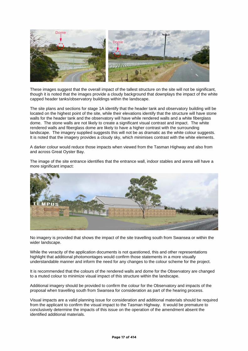
These images suggest that the overall impact of the tallest structure on the site will not be significant, though it is noted that the images provide a cloudy background that downplays the impact of the white capped header tanks/observatory buildings within the landscape. The site plans and sections for stage 1A identify that the header tank and observatory building will be located on the highest point of the site, while their elevations identify that the structure will have stone walls for the header tank and the observatory will have while rendered walls and a white fiberglass dome. The stone walls are not likely to create a significant visual contrast and impact. The white rendered walls and fiberglass dome are likely to have a higher contrast with the surrounding landscape. The imagery supplied suggests this will not be as dramatic as the white colour suggests. It is noted that the imagery provides a cloudy sky, which minimises contrast with the white elements. A darker colour would reduce those impacts when viewed from the Tasman Highway and also from and across Great Oyster Bay. The image of the site entrance identifies that the entrance wall, indoor stables and arena will have a more significant impact:
No imagery is provided that shows the impact of the site travelling south from Swansea or within the wider landscape. While the veracity of the application documents is not questioned, this and other representations highlight that additional photomontages would confirm those statements in a more visually understandable manner and inform the need for any changes to the colour scheme for the project. It is recommended that the colours of the rendered walls and dome for the Observatory are changed to a muted colour to minimize visual impact of this structure within the landscape. Additional imagery should be provided to confirm the colour for the Observatory and impacts of the proposal when travelling south from Swansea for consideration as part of the hearing process. Visual impacts are a valid planning issue for consideration and additional materials should be required from the applicant to confirm the visual impact to the Tasman Highway. It would be premature to conclusively determine the impacts of this issue on the operation of the amendment absent the identified additional materials.
Page 17 of 414

7. Light Pollution – erosion of the east coast’s dark sky; and
The representation identifies the expected impacts of the proposal on the dark sky of the area. The Dark Sky concept is not reflected within the planning assessment and regulation frameworks established under the Act, Interim Scheme, or the Tasmanian Planning Provisions. It is noted that the Council supported review of the Tasmanian Planning Provisions to reflect this concept in its section 35G Notice to the Commission on submissions received to its Local Provisions Schedule. Until the section 35G Notice is addressed, the Dark Skies concept is outside of the assessment criteria for this process. This ground of the representation does not raise any planning issues that can be considered at this time. The amendment should be modified to require additional information on this issue and include an appropriate condition to reflect this. The operation of the amendment will not be affected.
8. The erosion of Scenic Landscape Values due to Ribbon Development or Linear Sprawl
down the East Coast. The issues within this ground of the representation were largely assessed in response to grounds 2 and 6. A set of additional points were provided within this ground but are not part of the Council or regional strategic framework. A planning response to the identified issues follows:
• As noted, neither the RLUS nor Structure Plan provided for this type of project. The rural
lifestyle nature of the concept relies on such a location, which is not available within the urban
settlement of Swansea;
• The subject site forms the southern extend of the greater Swansea area and is adjacent the
Piermont Retreat site. It is acknowledged this is the southern extent of the settlement,
however this location is considered to be consistent with the restrictions for ribbon
development and the associated sprawl within the State Coastal Policy. The proposed site
will maintain an eight-kilometre separation to the south to Hamptons on the Bay. This is
unlikely to compromise the separation of settlements and non-urban use along this section of
the Tasman Highway.
• The proposal was assessed against the Scenic Road Corridor of the Interim Scheme and
determined to comply. Comparisons to the Landscape Conservation zone of the Local
Provisions Code are not appropriate, as neither the subject nor surrounding sites are
proposed for that zone under the Local Provisions Schedule.
• The visual landscape, environmental, agricultural and recreation qualities were examined in
response to previous issues and through the original application and assessment documents
and are not altered by this representation.
• As noted in response to previous issues, the proposal will maintain a significant settlement
between the project and land in other lifestyle land uses to the south.
It is noted that the response to issues within this and other representations will require additional information from the applicant to confirm the visual impacts of the proposal. The potential for land use conflict on a range of grounds was subject to other representations and raised within this submission. In terms of the assessment against the requirements of the Act: a. the representation raised issues that have merit for consideration under this process,
particularly relating to visual impacts, land use conflict and provision of infrastructure; b. it is premature to determine whether the amendment needs to be modified as a result of the
representation absent the additional information; and c. it is premature to determine the impact of the representation on the amendment as a whole.
Page 18 of 414
9. Joan von Bibra
The issues raised within this representation are substantially the same as the previous representation from Freycinet Action Network. The response to that representation applies to these concerns. No additional planning issues are raised for consideration. In terms of the assessment against the requirements of the Act: a. the representation has merit, however no additional planning issues were raised that require
further consideration; b. the amendment will not require modification as a result of the representation; and c. the representation is not expected to impact the amendment as a whole.
10. Sharon Moore
The issues raised within this representation are substantially the same as the previous representation from Freycinet Action Network. The response to that representation applies to these concerns. No additional planning issues are raised for consideration. In terms of the assessment against the requirements of the Act: a. the representation has merit, however no additional planning issues were raised that require
further consideration; b. the amendment will not require modification as a result of the representation; and c. the representation is not expected to impact the amendment as a whole.
11. Susan Eade
The issues raised within this representation are substantially the same as the previous representation from Freycinet Action Network. The response to that representation applies to these concerns. No additional planning issues are raised for consideration. In terms of the assessment against the requirements of the Act: a. the representation has merit, however no additional planning issues were raised that require
further consideration; b. the amendment will not require modification as a result of the representation; and c. the representation is not expected to impact the amendment as a whole.
12. Felicity Hargraves
The issues raised within this representation are substantially the same as the previous representation from Freycinet Action Network. The response to that representation applies to these concerns. No additional planning issues are raised for consideration. In terms of the assessment against the requirements of the Act: a. the representation has merit, however no additional planning issues were raised that require
further consideration; b. the amendment will not require modification as a result of the representation; and c. the representation is not expected to impact the amendment as a whole.
13. Sally Curry
The issues raised within this representation are substantially the same as the previous representation from Freycinet Action Network. The response to that representation applies to these concerns. No additional planning issues are raised for consideration. In terms of the assessment against the requirements of the Act: a. the representation has merit, however no additional planning issues were raised that require
further consideration; b. the amendment will not require modification as a result of the representation; and c. the representation is not expected to impact the amendment as a whole.
Page 19 of 414
14. Joanna de Burgh
The representation expresses concern with the proposal and the issues raised within this representation are substantially the same as the previous representation from Freycinet Action Network. The response to that representation applies to these concerns. No additional planning issues are raised for consideration. In terms of the assessment against the requirements of the Act: a. the representation has merit, however no additional planning issues were raised that require
further consideration; b. the amendment will not require modification as a result of the representation; and c. the representation is not expected to impact the amendment as a whole.
15. Bob Holderness-Roddam
The representation opposes the proposal by reference to Representation 8 from Freycinet Action Network. The response to that representation applies to these concerns. No additional planning issues are raised for consideration. In terms of the assessment against the requirements of the Act: a. the representation has merit, however no additional planning issues were raised that require
further consideration; b. the amendment will not require modification as a result of the representation; and c. the representation is not expected to impact the amendment as a whole.
16 Liz Swain
The representation provides support for the proposal. The representation does not raise any planning issues that require further consideration under this process. In terms of the assessment against the requirements of the Act: a. the representation has merit but no raises no planning issues that require consideration; b. the amendment does not need to be modified as a result of the representation; and c. the representation has no impact on the amendment as a whole.
17. Dr Georgie Stilwell
The representation opposes the proposal. Many of the issues raised within this representation are substantially the same as the previous representations from Freycinet Action Network and others. The response to that representation applies to these concerns. It is noted that the representor provides further opinion on the provision of health services. The RLUS and Structure Plan recognise the need to provide retirement living options in local communities and improvement of medical facilities. The land use planning process and health system are separate and there is little opportunity for coordination between them. This application cannot reconcile that situation. The alternative position is to require appropriate medical facilities prior to establishment of retirement lifestyle and aged care facilities within rural and remote communities. This is unlikely to be commercially viable for providers and could have the adverse impact where aged care and medical services are effectively stopped from expansion locally. Consequentially, there is likely to be little improvement in locally available retirement or health facilities. This approach is not consistent with the intent or requirements of the RLUS or the Structure Plan. No additional planning issues are raised for consideration. In terms of the assessment against the requirements of the Act:
Page 20 of 414
a. the representation has merit, however no additional planning issues were raised that require further consideration;
b. the amendment will not require modification as a result of the representation; and c. the representation is not expected to impact the amendment as a whole.
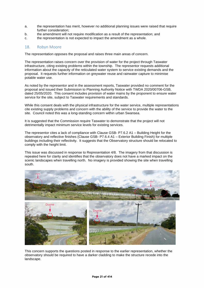
18. Robyn Moore
The representation opposes the proposal and raises three main areas of concern. The representation raises concern over the provision of water for the project through Taswater infrastructure, citing existing problems within the township. The representor requests additional information about the capacity of the reticulated water system to service existing demands and the proposal. It requests further information on greywater reuse and rainwater capture to minimise potable water use. As noted by the representor and in the assessment reports, Taswater provided no comment for the proposal and issued their Submission to Planning Authority Notice with TWDA 2020/00706-GSB, dated 25/05/2020. This consent includes provision of water mains by the proponent to ensure water service for the site, subject to Taswater requirements and standards. While this consent deals with the physical infrastructure for the water service, multiple representations cite existing supply problems and concern with the ability of the service to provide the water to the site. Council noted this was a long-standing concern within urban Swansea. It is suggested that the Commission require Taswater to demonstrate that the project will not detrimentally impact minimum service levels for existing services. The representor cites a lack of compliance with Clause GSB- P7.6.2 A1 – Building Height for the observatory and reflective finishes (Clause GSB- P7.6.4 A1 – Exterior Building Finish) for multiple buildings including their reflectivity. It suggests that the Observatory structure should be relocated to comply with the height limit. This issue was discussed in response to Representation 4/8. The imagery from that discussion is repeated here for clarity and identifies that the observatory does not have a marked impact on the scenic landscapes when travelling north. No imagery is provided showing the site when travelling south.
This concern supports the questions posted in response to the earlier representation, whether the observatory should be required to have a darker cladding to make the structure recede into the landscape.
Page 21 of 414
Colours and visual impact of the structures were discussed in response to representations 4 and 8, including recommended changes to the proposal to minimize the visual impacts of this portion of the project. Elevation below a skyline or ridgeline was also identified by the representor, in response to Clause GSB- P7.6.4 A2 – New Buildings. The site plans and sections for stage 1A identify that the header tank and observatory will be located on the highest point of the site. Relocation of the structure is not considered appropriate, given the operational requirements for the header tank. The very nature of this structure provides the justification required for compliance with clause P2.1 of this standard. Similarly, the Arena and Stables building is located on a flatter section of the site due to operational requirements. It is noted that this area is not located on or within 10 metres of a skyline or ridgeline. Further information is required to determine the visual impacts of the proposal within the wider landscape, impacts resulting from the materials and finishes proposed and impact to the day and nighttime landscapes from the project. The representation raises concern at the equivocal language used within the assessment report when describing aspects of the project to be made available to the local community. Examples such as costs for access to the pool and hall are cited. The basis of the application was that Tempus will provide social and aged infrastructure for the local community and this commitment supports its compliance with multiple aspects of the Regional Land Use Strategy. As such, a condition should be imposed to reflect this statement. Compliance with components of the RLUS is also questioned, particularly around SD8 and AC1.3 of the Activity Centre Network. SD8 was examined in the Neil Sheppard and assessment reports and the proposal was found to comply. AC1.3 seeks to discourage out of centre development by only providing for in-centre development within planning schemes. Use class for the proposal was determined to as Residential by reference to the defined types of residential aged care facility and retirement village. The communal facilities that are subject to this concern are primarily provided for residents of the facility and included as part of definitions of the respective use types. It is considered that these meet the requirements for a subservient use provided at clause 8.2.2 of the Scheme, as follows:
A use or development that is directly associated with and a subservient part of another use on the same site must be categorised into the same use class as that other use.
The assessment report noted that the RLUS does not identify Swansea as part of the Activity Centre Network map at page 83, or as part of the examples provided in Table 1 at pages 76-79. The listing of facilities provided under the residential and community infrastructure sections of this table do not address retirement or aged care components. SI 1.6, 1.7 and 1.8 of the RLUS relate the retirement and aged care services and were determined to comply as part of the assessment report, in addition to a range of other aspects and requirements of the Strategy. The nature of the RLUS requires that a wholistic approach to interpretation is taken. Using the example cited of AC1.3, strict interpretation would prohibit all restaurants and shops on farms outside of activity centres, as they disperse the commercial and retail activity across the area and potentially undermine the operation of activity centres. The modern economic reality is different to this scenario, and arguably has been found to increase the experience, diversity and resilience of the activity centre networks within the region. While the concerns of the representor are noted, no additional response is recommended as a result of this assessment. In terms of the assessment against the requirements of the Act:
Page 22 of 414
a. the representation has merit, planning issues were raised that require further consideration about water supply for the project and a condition to ensure the site facilities are available for the community to use;
b. at this point, the amendment will require modification to include a condition for community access to the proposed facilities as a result of the representation; and
c. pending resolution of the water supply issue, the representation is not expected to have significant impacts the amendment as a whole.
19. Daniel Panek
The issues raised within this representation are substantially the same as Representation 8 from Freycinet Action Network. The response to that representation applies to these concerns. No additional planning issues are raised for consideration. In terms of the assessment against the requirements of the Act: a. the representation has merit, however no additional planning issues were raised that require
further consideration; b. the amendment will not require modification as a result of the representation; and c. the representation is not expected to impact the amendment as a whole.
20. Stephanie Gleeson
The representation opposes the proposal and supports the issues raised within Representation 8 from Freycinet Action Network. The response to that representation applies to these concerns. No additional planning issues are raised for consideration. In terms of the assessment against the requirements of the Act: a. the representation has merit, however no additional planning issues were raised that require
further consideration; b. the amendment will not require modification as a result of the representation; and c. the representation is not expected to impact the amendment as a whole.
21. Angela Nichols
The representation expresses concern at the size of the proposal, impacts to the scenic beauty of the area and availability of information. Concerns over the scale and size of the project and scenic/visual impacts were addressed in response to previous representations. The information that is available for the Council to assess the application is required to be made available to the Community as part of the statutory exhibition process. In addition, the Council determined to exhibit the application for 6 weeks rather than the minimum 4-week period, given the volume and complexity of the supporting information. While the representors concern in this regard is acknowledged, it is not supported. In terms of the assessment against the requirements of the Act: a. no planning issues were raised that require further consideration; b. the amendment does not need to be modified as a result of the representation; and c. the representation has no impact on the amendment as a whole.
22. Dr Lewis Garnham
The issues raised within this representation are substantially the same as representations 8 and 17. The response to those representations applies to these concerns. Additional matters raised include the source of the population for the facility, suitability of the intended activities for residents and availability of medical services. Feasibility of the project and intended activities provided onsite is a matter for the proponents and operators to resolve. Availability of medical facilities was addressed in the Integrated Impact Assessment for the overall project that
Page 23 of 414
accompanied the application. The IIA cites discussions with the local medical practice and planned employment of additional doctors to deal with the additional workload (page 12). Use of the site for visitor accommodation is not possible under the terms of the Particular Purpose zone. Such a use cannot occur and would require a planning scheme amendment to be allowed within the zone. No additional planning issues are raised for consideration. In terms of the assessment against the requirements of the Act: a. the representation has merit, however no additional planning issues were raised that require
further consideration; b. the amendment will not require modification as a result of the representation; and c. the representation is not expected to impact the amendment as a whole.
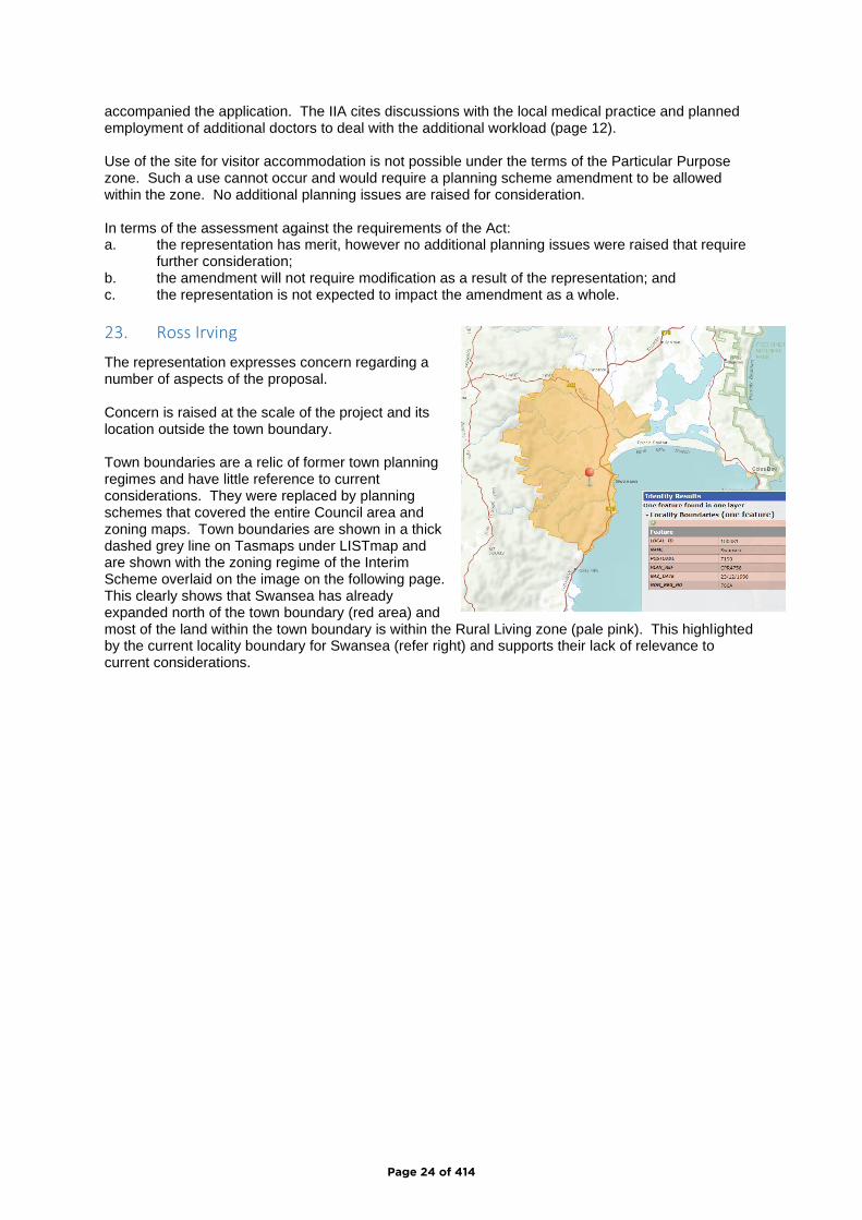
23. Ross Irving
The representation expresses concern regarding a number of aspects of the proposal. Concern is raised at the scale of the project and its location outside the town boundary. Town boundaries are a relic of former town planning regimes and have little reference to current considerations. They were replaced by planning schemes that covered the entire Council area and zoning maps. Town boundaries are shown in a thick dashed grey line on Tasmaps under LISTmap and are shown with the zoning regime of the Interim Scheme overlaid on the image on the following page. This clearly shows that Swansea has already expanded north of the town boundary (red area) and most of the land within the town boundary is within the Rural Living zone (pale pink). This highlighted by the current locality boundary for Swansea (refer right) and supports their lack of relevance to current considerations.
Page 24 of 414
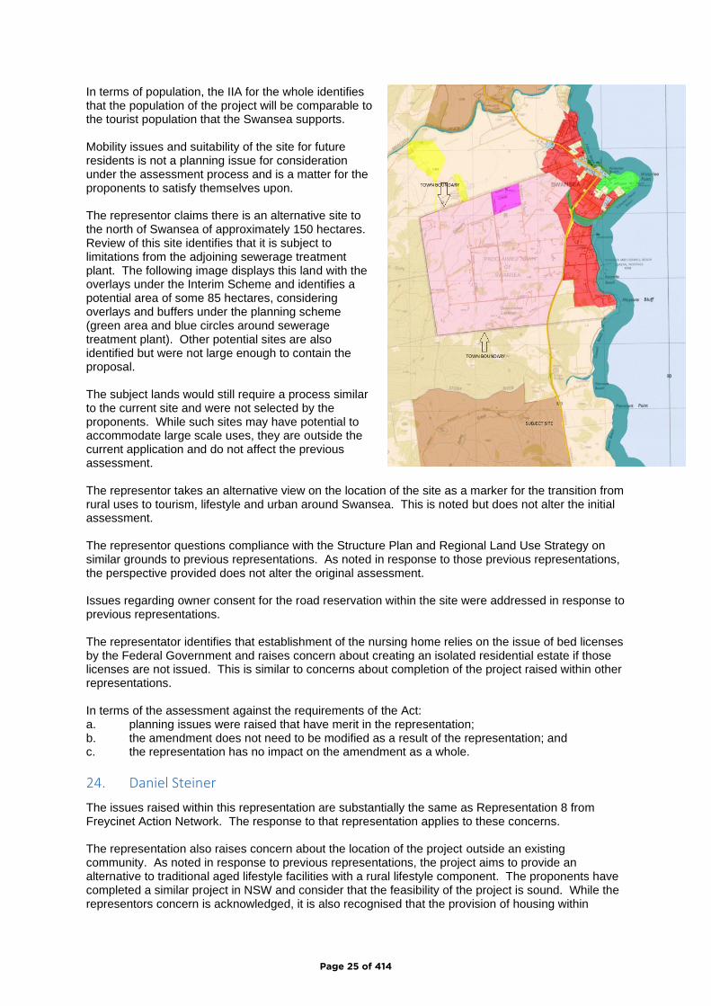
In terms of population, the IIA for the whole identifies that the population of the project will be comparable to the tourist population that the Swansea supports. Mobility issues and suitability of the site for future residents is not a planning issue for consideration under the assessment process and is a matter for the proponents to satisfy themselves upon. The representor claims there is an alternative site to the north of Swansea of approximately 150 hectares. Review of this site identifies that it is subject to limitations from the adjoining sewerage treatment plant. The following image displays this land with the overlays under the Interim Scheme and identifies a potential area of some 85 hectares, considering overlays and buffers under the planning scheme (green area and blue circles around sewerage treatment plant). Other potential sites are also identified but were not large enough to contain the proposal. The subject lands would still require a process similar to the current site and were not selected by the proponents. While such sites may have potential to accommodate large scale uses, they are outside the current application and do not affect the previous assessment. The representor takes an alternative view on the location of the site as a marker for the transition from rural uses to tourism, lifestyle and urban around Swansea. This is noted but does not alter the initial assessment. The representor questions compliance with the Structure Plan and Regional Land Use Strategy on similar grounds to previous representations. As noted in response to those previous representations, the perspective provided does not alter the original assessment. Issues regarding owner consent for the road reservation within the site were addressed in response to previous representations. The representator identifies that establishment of the nursing home relies on the issue of bed licenses by the Federal Government and raises concern about creating an isolated residential estate if those licenses are not issued. This is similar to concerns about completion of the project raised within other representations. In terms of the assessment against the requirements of the Act: a. planning issues were raised that have merit in the representation; b. the amendment does not need to be modified as a result of the representation; and c. the representation has no impact on the amendment as a whole.
24. Daniel Steiner
The issues raised within this representation are substantially the same as Representation 8 from Freycinet Action Network. The response to that representation applies to these concerns. The representation also raises concern about the location of the project outside an existing community. As noted in response to previous representations, the project aims to provide an alternative to traditional aged lifestyle facilities with a rural lifestyle component. The proponents have completed a similar project in NSW and consider that the feasibility of the project is sound. While the representors concern is acknowledged, it is also recognised that the provision of housing within
Page 25 of 414

remote communities with the aged care sector is limited for a wide range of reasons. An offering such as Tempus is different to historical models and suggests that the retirement living sector is responding to demands from the sector. No change to the assessment is proposed as a result of this concern. In terms of the assessment against the requirements of the Act: a. the representation has merit, however no additional planning issues were raised that require
further consideration; b. the amendment will not require modification as a result of the representation; and c. the representation is not expected to impact the amendment as a whole.
25. Michael Travalia
The representation opposes the proposal by reference to the same issues raised within Representation 8 from Freycinet Action Network. The response to that representation applies to these concerns. No additional planning issues are raised for consideration. In terms of the assessment against the requirements of the Act: a. the representation has merit, however no additional planning issues were raised that require
further consideration; b. the amendment will not require modification as a result of the representation; and c. the representation is not expected to impact the amendment as a whole.
26. Ellen France
The representor opposes the project, provides support for strong support for Representation 8 and identifies concern that the project is not consistent with the Land Use Strategy, which was completed with community consultation. It is unclear whether the representor means the Regional Land Use Strategy or the Structure Plan. As noted in the original assessment report and for other representations, the project was not identified in either document as a specific outcome, though both provided extensive recommendations for the provision of retirement living and aged care opportunities within the local communities throughout the Southern Region and the Swansea area. As noted in the initial assessment report, the project is consistent with the policies and outcomes of both documents. While the project may not comply with every specific statement, few things ever would and both documents are required to be interpreted in a wholistic manner. While the representors concern is noted, the original assessment on this issue is not altered. The representors comments regarding light impacts on viewing of the night sky within the region are noted and were addressed in response to this issue under Representation 8. The remaining issues raised within this representation are substantially the same as Representation 8 from Freycinet Action Network. The response to that representation applies to these concerns. No additional planning issues are raised for consideration. In terms of the assessment against the requirements of the Act: a. the representation has merit, however no additional planning issues were raised that require
further consideration; b. the amendment will not require modification as a result of the representation; and c. the representation is not expected to impact the amendment as a whole.
27. E & C Dingemanse
The representation provides support for Representation 8 from Freycinet Action Network. The response to that representation applies to these concerns. No additional planning issues are raised for consideration. In terms of the assessment against the requirements of the Act:
Page 26 of 414
a. the representation has merit, however no additional planning issues were raised that require further consideration;
b. the amendment will not require modification as a result of the representation; and c. the representation is not expected to impact the amendment as a whole.
28. Lynn Carswell
The representor supports the content of Representation 8 from the Freycinet Action Network. The response to that representation applies to these concerns and requires no further discussion. In addition, the representor raises concern regarding the ability to obtain staff across a range of areas for the proposal and the ability of the local area to house those staff and the limited provision on site for housing workers. Securing the range and numbers of employees for the site is an operational requirement for the site manager and not a planning issue for consideration under this process. It is noted that the existing aged care provider within Swansea supported the proposal and likely improvements for sourcing and maintaining staff (refer representation 44). Housing the workers required for the project is likely to occur across a wider area than just Swansea, though it is accepted in both the application and assessment documents that the project is likely to result in increased demand for services and housing within Swansea and the wider area as the project is developed and then maintained. It is likely that review of growth over the last decade will identify that projections within the RLUS were conservative and that many areas within Glamorgan Spring Bay, the southern region and the rest of the State have experienced development that far exceeds the identified projections. Notwithstanding this, the location of the proposal maintains allocations and land in proximity to urban Swansea for a variety of housing developments in response to future pressures. 2016 ABS data within the Glamorgan Spring Bay area identifies that 81.5% of workers went to work in a car (as driver or passenger and up from the State average of 71.1%), which is consistent with the highly dispersed settlement pattern and limited nature of transport options in the area. This reliance on private vehicles suggests a high degree of flexibility for the population in their workplace location, which in turn suggests that workers are likely to be available to work in the proposal. Many industries appear to be experiencing a worker shortfall. These are much larger issues than can be resolved within the Tempus proposal. No changes are proposed to Tempus because of these concerns within the representation. In terms of the assessment against the requirements of the Act: a. the representation has merit, the additional planning issues raised within the representation
are beyond the scope of the Tempus proposal to resolve; b. the amendment will not require modification as a result of the representation; and c. the representation is not expected to impact the amendment as a whole.
29. Rodger Bartlett
The representation raises a number of concerns with the application. The perceptions of ribbon development along the Tasman Highway, the gateway concept identified with support for this project and suggests the basis of planning support is as an exemption from relevant strategic planning documents are all questioned. The first two points are addressed in the original assessment documents and the representor provides a contrasting opinion. It is noted that use of the term exemption is not consistent with the original assessment, which identified that the project was arguably outside the terms of the Regional Land Use Strategy. The nature of the Strategy is aspirational and is not explicit. Such strategic documents cannot explicitly identify and locate every possible project that may occur within their lifespan is contrary to their very nature and suggests that the lack of flexibility that was perceived as supporting the planning system of the 1950’s to the 1990’s. Reforms since that time have sought to introduce flexibility and allow a project to be treated on its merits. The current application uses such a
Page 27 of 414
process. The Structure Plan identified the potential for large projects within the Swansea area but made no provision for them or retirement living within the Structure Plan. This remains an unresolved aspect of the Structure Plan. No alterations are proposed as a result of these views. Concern is expressed that the approval sought is not consistent with the consultations provided by the proponents prior to the formal application process, which is not a planning issue for consideration under the current process. The concern extends to the viability of the project and risk that the gateway is sold off and becomes a lesser standard project under subsequent ownership. The representor suggests conditions that require completion of the project within 5 years of commencement and failure of delivery results in removal of Stage 1A. the approval by Council included a requirement in the PPZ that the project be completed in accordance with the concept and details provided by the applicant within the Integrated Impact Assessment report. The developer is therefore bound to deliver the project that Council considered, assuming the proposal and this provision are approved by the Commission. The lots approved with the application provide for the overall titles for the retirement village and the aged care home. No other lots are approved for sale. The final item in the representation requests that conditions be imposed for the provision and maintenance of all community facilities and village infrastructure. As noted in response to earlier representations, conditions on the permit require the developer to provide all infrastructure and recommends that an additional condition be imposed that makes this requirement explicit. Similarly, the provision and maintenance of all community facilities is also the developer’s obligation. It is not considered necessary to augment this with additional conditions on the permit. While the concerns have some merit, no further alternations are considered necessary to address these concerns. In terms of the assessment against the requirements of the Act: a. no additional planning issues were raised that are considered to have merit under the
planning assessment process; b. the amendment does not need to be modified as a result of the representation; and c. the representation has no impact on the amendment as a whole.
30. Tasmanian Conservation Trust (Peter McGlone)
The representation expresses concern with the proposal and lists the issues raised within Representation 8 from Freycinet Action Network. The response to that representation applies to these concerns. No additional planning issues are raised for consideration. In terms of the assessment against the requirements of the Act: a. the representation has merit, however no additional planning issues were raised that require
further consideration; b. the amendment will not require modification as a result of the representation; and c. the representation is not expected to impact the amendment as a whole.
31. Elizabeth Smith
The representation raises concern with various aspects of the proposal and its potential impacts on the local area. Concerns are expressed over the complexity of the documents and Councillors being provided sufficient time to consider the proposal. Workshops commenced with the Council approximately 12 months ago while technical aspects of the proposal were being addressed by the proponents. This far exceeds the minimum requirements of the act. In addition, Council determined to exhibit the proposal for 42 days rather than the 28 days required under the former provisions of the Act. No alterations to the amendment are required in response to this concern. Compliance with the RLUS is questioned, in its entirety, along with the Swansea Structure Plan. As noted in the assessment report and in response to previous representations, the proposal was assessed as complying with both documents.
Page 28 of 414

Similarly, the assessment report addressed compliance with the State Policy for the Protection of Agricultural Land 2009. It is noted that other representations have provided conflicting information on the potential for land use conflicts from apparent parties that appear to have significant expertise within the viticulture industry and management of the specific lands. The assessment of those representations suggests that the Commission obtain additional expert information to resolve the conflicting information. No additional response is required on this issue. Detrimental impacts on scenic values of the area were also addressed in response to previous representations. The representor raises specific concern with the potential impacts to the scenic qualities of Kelvedon Beach. Kelvedon Beach is located some 4.5 km south of the site and separated by orientation and a range of landscape and topographical features. Similarly, Cressy, Cowrie and Piermont Beaches are all proximate to the site and located on the opposite side of Tasman Highway. Impacts on the scenic values of these beaches are more likely from the approvals issued for Piermont site. No responses to this concern are considered necessary. The provision of infrastructure remains the developer’s obligation and was addressed in response to previous representations. In terms of the assessment against the requirements of the Act: a. the representation has merit, no planning issues were raised that require further alteration of
the amendment or permit; b. the amendment does not need to be modified as a result of the representation; and c. the representation has no impact on the amendment as a whole.
32. J & A Reeve, M & F Boutin-Reeve
The representation expresses grave concerns with the proposal and lists issues raised within Representation 8 from Freycinet Action Network. The response to that representation applies to these concerns. No additional planning issues are raised for consideration. In terms of the assessment against the requirements of the Act: a. the representation has merit, however no additional planning issues were raised that require
further consideration; b. the amendment will not require modification as a result of the representation; and c. the representation is not expected to impact the amendment as a whole.
33. Craig Brown
The representation provides support for the proposal as Senior Project Manager for Tempus. In terms of the assessment against the requirements of the Act: a. the representation has merit but raises no planning issues that require consideration; b. the amendment does not need to be modified as a result of the representation; and c. the representation has no impact on the amendment as a whole.
34. E3 Planning for Piermont Estate
The representation opposes the proposal, for the following reasons:
• Piermont does not wish to have a retirement village establish adjacent its property;
• Piermont considers that tourist accommodation provides a substantially different perspective
for residents to a retirement community;
• The remote location 3.8 km from Swansea;
• The nature of the use, effectively establishing another urban centre outside of Swansea;
• The proposal will dramatically alter the existing landscape, which it cited as part of the appeal
of Piermont to visitors and tourists.
Page 29 of 414
The objection is noted. It is common for tourist accommodation and various types of residential accommodation to be located in close proximity to each other without any real opportunity for land use conflict. This is likely to occur here, with both sites providing a landscaped portion of the site to the Tasman Highway frontage. The remaining concerns were addressed in consideration of previous representations. In terms of the assessment against the requirements of the Act: a. the representation has merit, however no additional planning issues were raised that require
further consideration; b. the amendment will not require modification as a result of the representation; and c. the representation is not expected to impact the amendment as a whole.
35. E3 Planning for Gala Estate Vineyard
The representation provides extensive opposition to the proposal, as follows. The high potential for viticultural use of the subject lands – with significant contributions to produce
and economic outputs for vineyard operations at Gala Estate, including advice from a viticulturalist on the output expected from the site.
Fettering agricultural use from land use conflict - The representor cites condition 3 of the permit as being unlawful. As the representor would be aware, a planning permit or agreement cannot remove the rights of parties to make complaints and seek remedy under legislated process and the condition does not seek to do this. As noted in response to previous representations, condition 3 simply seeks residents to accept the location of the site and existing adjoining land use that exist. No other specific response is required to this issue.
Spray Drift - The representor raises concern at the potential for land use conflict from spray drift and provides detailed data from existing operations on the Gala Vineyard and the use of mandatory 200m + buffers in other areas to address this issue.
Noise - The representor raises concern regarding the impact of noise conflicts from the use of gas guns. The comments of the representor conflict with those provided within the Agronomist Reports that accompany the application and will require further professional advice to investigate and resolve.
Electric Fence - The representor contents that Tempus would require removal of the electric fence which would have significant impacts. Aerial photography suggests that there is sufficient space to allow the fence to be relocated within the boundary of the property, negating this issue.
It is noted that this and other representations provide expert advice and experience that contradicts the agronomist reports provided with the application. Spray drift is one issue that will require further evidence from the parties. Compliance with the State Policy for Agricultural Land, Southern Tasmanian Regional Land Use Strategy and Swansea Structure Plan was addressed in the assessment reports. Noting the response to the previous issues, no additional information was provided that impacts the original assessment. The representor raises concern that introduction of the Local Provisions Schedule under the Tasmanian Planning Scheme will render the application void. This argument presents the inevitable chicken and egg scenario and suggests that all amendments should stop pending approval of a Local Provisions Schedule within Glamorgan Spring Bay. Arrangements are provided within the Act and legislated amendments to address this situation, should it occur. It is also likely that the application could be determined prior to introduction of the Local Provisions Schedule. Comments regarding various statements in the Integrated Impact Assessment will require further expert evidence and assessment to resolve, as identified in response to previous representations – excepting point 3. Point 3 suggests that there is no setback requirement under the Particular Purpose zone, which is untrue. GSB-P7.6.3 A3 requires a 200-metre setback to a rural or agriculture zone, which the Gala
Page 30 of 414
Estate Vineyard would have. P3 for this standard requires consideration of impacts to adjoining agricultural activities and replicates the standard from the Agriculture zone of the Tasmanian Planning Scheme. The assessment process for the Tasmanian Planning Scheme suggests that the subject provision has some degree of technical competence in management of potential land use conflict. It is unclear how this standard cannot be considered to impost a setback to vineyard operations and allow development to the common boundary, as the representation suggests. It is noted that A3 reads as though the setback requirement within this standard is intended to apply to other buildings for sensitive use on the site under criterion (b). This could be argued and should be clarified while the opportunity exists. It is recommended that GSB-P7.6.3 A3 is altered to recognise setbacks of existing buildings for sensitive use under this standard. Section 7 of the representation identifies issues with the agronomist reports that support the application. As noted in response to previous representations, further expert evidence will be required to reconcile the technical contentions between the application and representors. No further response is considered necessary on this issue. Issues raised that require attention and further advice within this submission were identified in the analysis of previous representations and goes further to provide expert viticultural advice suggesting that impacts on the proposal will be more extensive than identified in the application documents and that the land subject to the proposal is suitable for viticultural use and therefore has agricultural value.
It is premature to try to resolve these matters without submission and analysis of further expert
evidence.
In terms of the assessment against the requirements of the Act: a. the representation has merit and raised issued that will require further evidence and
consideration; b. it is recommended that the amendment is modified to alter GSB-P7.6.3 A3 to recognise
setbacks of existing buildings for sensitive use, in addition to further expert assessment of claims within this and other representations; and
c. the impact of the representation on the amendment as a whole cannot be determined without consideration of the further information.
36. Lorna Robertson
The representation opposes the proposal based on scenic/landscape impacts, linear development, sprawl, compliance with the development plan (assumed to be the Swansea Structure Plan) and the conversion of agricultural lands. The representor identifies the proposal as inappropriate and requests that it be rejected. These issues were identified in analysis of many previous representations and provide no new matters for consideration under this process. In terms of the assessment against the requirements of the Act: a. the representation has merit, however no additional planning issues were raised that require
further consideration; b. the amendment will not require modification as a result of the representation; and c. the representation is not expected to impact the amendment as a whole.
37. Leanne Groves
The representor strongly opposes the proposal and attached Representation 8 from Freycinet Action Network. The response to that representation applies to these concerns. The representor asks that the submission not be ignored as just another one. The purpose of this process is to consider the merits of planning issues raised within representations and then then
Page 31 of 414
impacts this may have on the proposal and the amendment. The analysis of previous representations hopefully demonstrates this assessment has been completed on that basis. In terms of the assessment against the requirements of the Act: a. the representation has merit, however no additional planning issues were raised that require
further consideration; b. the amendment does not need to be modified as a result of the representation; and c. the representation has no impact on the amendment as a whole.
38. Christine Valentine
The representor endorses Representation 8 by Freycinet Action Network. The response to that representation applies to these concerns. No additional planning issues are raised for consideration. In terms of the assessment against the requirements of the Act: a. the representation has merit, however no additional planning issues were raised that require
further consideration; b. the amendment does not need to be modified as a result of the representation; and c. the representation has no impact on the amendment as a whole.
39. Andrea J Ross
The representor opposes the proposal and endorses the submission and issues raised within Representation 8 from Freycinet Action Network. The response to that representation applies to these concerns. No additional planning issues are raised for consideration. In terms of the assessment against the requirements of the Act: a. the representation has merit, however no additional planning issues were raised that require
further consideration; b. the amendment does not need to be modified as a result of the representation; and c. the representation has no impact on the amendment as a whole.
40. Donnalee Young
The representation appears to support the concept of Tempus but not the location of the project, citing the benefits of an urban location for such facilities. The representation then lists issues that were raised in Representation 8 from Freycinet Action Network. The issues within this representation are subject to the same response as previous representations. No additional planning issues are raised for consideration. In terms of the assessment against the requirements of the Act: a. the representation has merit, however no additional planning issues were raised that require
further consideration; b. the amendment does not need to be modified as a result of the representation; and c. the representation has no impact on the amendment as a whole.
41. Georgina Davis
The representor provides support to the issues raised within Representation 8 from Freycinet Action Network. The response to that representation applies to these concerns. No additional planning issues are raised for consideration. In terms of the assessment against the requirements of the Act: a. the representation has merit, however no additional planning issues were raised that require
further consideration; b. the amendment does not need to be modified as a result of the representation; and c. the representation has no impact on the amendment as a whole.
Page 32 of 414
42. Marg D
The representation contains no message and includes a copy of the Freycinet Action Network submission (refer Representation 8). The issues raised within this representation are substantially the same as the previous representation from Freycinet Action Network. The response to that representation applies to these concerns. No additional planning issues are raised for consideration. In terms of the assessment against the requirements of the Act: a. the representation has merit, however no additional planning issues were raised that require
further consideration; b. the amendment does not need to be modified as a result of the representation; and c. the representation has no impact on the amendment as a whole.
43. Joanna Baker
The representation opposes the project on the subject site, citing detrimental impacts to the scenic landscape quality of the area and location on rich soils and prime agricultural lands. Both issues were raised and responded to in previous representations. It must be noted that prime agricultural land is a defined term under the Tasmanian Planning system. Glamorgan Spring Bay Council area does not contain any soils that comply with the definition of the term. The issues raised within this representation are substantially the same as Representation 8 from Freycinet Action Network. The response to that representation applies to these concerns. No additional planning issues are raised for consideration. In terms of the assessment against the requirements of the Act: a. the representation has merit, however no additional planning issues were raised that require
further consideration; b. the amendment does not need to be modified as a result of the representation; and c. the representation has no impact on the amendment as a whole.
44. May Shaw
The representation provides support for the proposal, particularly:
• the opportunity to work cooperatively with the developers and operators of the proposed
facility;
• the opportunity to attract permanent residents to the area and potential for improved
employment opportunities in the health care sector to be available; and
• the expected positive impact it will have on medical facilities and other retail services in the
area.
The support provided for the project in the representation is noted. The representation does not raise any issues that will require alteration of the Amendment or permit. In terms of the assessment against the requirements of the Act: a. the representation has merit, however no planning issues were raised that require
consideration; b. the amendment does not need to be modified as a result of the representation; and c. the representation has no impact on the amendment as a whole.
45. David Walker
The issues raised within this representation are substantially the same as the previous representation from Freycinet Action Network. The response to that representation applies to these concerns.
Page 33 of 414

No additional planning issues are raised for consideration. In terms of the assessment against the requirements of the Act: a. the representation has merit, however no additional planning issues were raised that require
further consideration; b. the amendment does not need to be modified as a result of the representation; and c. the representation has no impact on the amendment as a whole.
Page 34 of 414

Page 35 of 414
Agenda Item 4.2 - Attachment A

Page 36 of 414
Page 37 of 414
Page 38 of 414

Page 39 of 414

Page 40 of 414

STAGE 5 QUANTITIESSTAGE 5C
-
TOTAL121866
99802
23064
1173
STAGE 5BSTAGE 5A
483
LOT AREAROAD RESERVE AREALINEAL METRES OF ROAD
--
---
32464 36880 29943
GROSS AREA m²
371 319
5301962m²
5292426m²
5141761m² 513
1793m²
5282043m²
5271885m²526
1862m²5251840m²524
1818m²5231810m²522
1828m²5211837m²520
1876m²5191885m²518
2037m²508
2287m²
5072063m²
5062063m²
5052055m²
5042067m²
5031954m²
5021841m²
5011974m²
5121874m² 511
1753m² 5101883m²
5091814m²
5351937m²
5343654m²
5332262m²
5321959m²
5311959m²
5471926m²
5461770m²
5451834m²
5446536m²543
2607m²542
2315m²
5401777m²
5411759m²539
2376m²
5382301m²
5372354m²
5362163m²
5171740m²
5161669m²
5151613m²
35.809
54.78
6
35.809
54.78
6
28.02
3
38.696
54.78
6
44.519
7.537
22.02
3
56.35122.57
48.5
78
51.321 34.13
0
23.767
29.26
9
34.13
0
17.42614.498
63.77
4
9.33719.315
65.24
9
26.471 11.142
59.04
3
29.066
64.47
6
29.094
65.24
9
29.066
63.70
4
29.094
64.47
6
29.066
62.93
2
29.094
63.70
4
29.066
62.16
0
29.094
62.93
2
29.066
62.58
4
24.395 4.669
62.16
0
29.066
63.23
7
29.059
62.58
4
28.912
63.88
7
28.905
63.23
7
29.221
64.54
4
29.21463
.887
29.06665
.197
29.059
64.54
4
19.0065.894
64.23
6
18.742 19.108
65.19
75.894
22.691
65.74
0
21.00420.585
64.23
6
31.375
65.74
0
31.375
65.74
0
31.375
65.74
0
31.375
65.74
0
31.253
65.74
0
31.253
65.74
0
28.691
65.96
8
34.181
65.74
0
26.168
66.26
1
33.315
65.96
8
28.003
66.26
1
28.003
66.26
1
22.167
8.381
46.76
6
18.07
4
22.608
66.26
1
13.95712.796
63.77
4
32.844
62.58
1
5.02421.729
62.58
1
29.598
61.88
830.610
61.88
8
30.602
61.17
0
22.608
61.17
0
37.025
62.33
1
26.042
62.33
1
11.789 23.296
63.45
4
28.93728.937
63.45
4
51.873
8.485
57.45
4
41.611
48.78
6
8.485 35.611
54.78
6
10.16125.592
54.78
6
35.752
54.78
6
35.752
54.78
6
35.752
54.78
6
63.975
29.36
2
41.61125.592
29.53
9
60.780
27.36
2
63.975
29.53
9
58.243
25.36
2
60.780
7.975
28.81
0
7.943
15.559
15.559
12.900
16.77814.831
18.676
2.7339.220
77.32
7
23.225 8.485
58.243
28.60
9
20.013
19.995
62.66
7
37.225
77.32
7
7.040
25.475
15.889
5.682
19.51
4
55.914
11.643
62.66
7
8.48522.93728.937
61.41
7
28.93728.937
55.41
7
61.41
7
5.454
19.1162.271
65.73
9
22.608 26.042
61.41
7
2.271
30.799
70.82
75.024
30.610
65.73
9
9.94021.475
69.37
8
13.95721.729
70.82
7
29.473
32.00
5
32.02
7
23.76712.796
69.37
8
53.080
9.38114
.552
8.023
56.030
32.00
556.030
9.450
19.12
4
55.452 32.02
7
55.452
28.57
4
56.351 29.26
9
0 8040
SCALE IN METRES - 1:2000
6020 20
L O U I S V I L L E R O A D
N E W
R O
A D
B E R N A C C H I D R I V E
GD1917-P7 2-
-BAYPORT PTY LTDSPRING BAY
LAND DEVELOPMENTSUBDIVISION STAGE 5
LOT PLAN
R. GIBSON R. GIBSON R. GIBSON 11/5/2019
21-6-19 AHD 1 VEGETATION ADDED2 LOTS ADDED
REFERENCE FILES ATTACHED: GD1917-X3; GD1917-X1; GD1917-X2; GD1917-X4
DATE SIGNEDJun. 21, 19 - 19:45:26 Name: GD1917-P7.dwg Updated By: Ross gibson
DRAWING REVISION HISTORY
DATUMS:
REVISION DESCRIPTION
STATUS
REVIEWED DATEDRAWN DESIGNED
SIGNEDDRAWING No.
TITLE
CLIENT
PROJECT
CLIENT No.
REVISION
VERSIONSHEET No.ANDY HAMILTON & ASSOCIATES PTY LTDCONSULTING LAND SURVEYORS
PO Box 223 Bicheno 7215P: 0418 593 300 E: [email protected]
STAGE 5B
STAGE 5C
STAGE 5A LEGENDBIODIVERSITY PROTECTIONAREA OVERLAY PERPLANNING SCHEME
Page 41 of 414

Page | 1
JMG Ref: J192191 Client Ref: SA2019/0017
15th January 2020 The Manager Planning Glamorgan Spring Bay Council Dear Sir/Madam RE: SA 2019/00017 SPRING BAY SUBDIVISION TRAFFIC IMPACT ASSESSMENT I refer to an email to Council dated 5th August from Paul Blackwell - Traffic Engineering Liaison – Network Management Branch, State Roads - Department of State Growth. JMG have provided a response to that EMAIl dated 10/12/2019, however following further discussions with the department this response will become the formal response. The differences relate to advice from the department regarding the DSG roadworks programme and a review of some JMG conclusions. Within that DSG email it was stated that the JMG services report was very brief in relation to the junction with Louisville Road and the Tasman Highway and that they would require a full Traffic Impact Statement. JMG accept that criticism that the concept services report was brief with regard to traffic and the intersection of Louisville Road and the Tasman Highway. This brevity was based on a known decision since the first planning approval for subdivision that the State Growth Road Department had already designed and allocated funds towards an intersection safety improvement project. This should have been referred to in the services report but had been omitted when it should not have been. This level of comfort that the Intersection improvement was already a DSG project was informed by:
1. A letter from the Minister for Infrastructure, The Hon M.T. (Rene) Hidding MP To Glamorgan Spring Bay Council in January 2017 stating that he could confirm that “… the Government has $450,000 allocated for construction in 2017-18 as part of the Government’s 2017-18 safer roads Program….”
2. A letter from the DSG project Manager Kevin Bourne and dated 27th April 2017 Also addressed to Glamorgan Spring Bay Council re-confirming the completion of design and the complete funding allocation. The project was to be released for tender in June 2017, with construction commencing late 2017.
The Council had forwarded these documents to the developer. Copies are appended to this response for clarity. Whilst it is obvious that the June 2017 construction has been delayed, we were unaware that the project had been cancelled, and intersections will remain in its current state.
Page 42 of 414
Page | 2
Since receiving the emailed response described above we have now taken Kevin Bourne’s advice and inspected the web site www.transport.tas.gov.au/road/projects. We were unable to detect any reference to Louisville Road, although The Tasman Highway – Great Eastern Drive from Orford to St Helens is clearly a listed project, but there are no Louisville road sub projects that we could identify. This is a major concern as much planning has been undertaken in reliance of the advice of the Minister and the Project Manager. We understand that the developer will discus this further with department officers. (JMG have since been advised that the project has been reinstated and is scheduled for construction in the next financial year). We shall however expand upon our traffic assessment of the existing intersection of Louisville Road and the Tasman Highway. TRAFFIC GENERATION BY THE DEVELOPMENT As outlined in the services report the proposed development is a residential subdivision with 47 allotments. In considering the traffic activity that the dwellings on the subdivisional lots will generate when occupied, guidance is normally sought from the New South Wales, Road Traffic Authority (RTA) document – Guide to Traffic Generating Developments. The RTA guide is a nationally well accepted document that provides advice on trips generation rates and vehicle parking requirements for new developments. The updated ‘Technical Direction’ to the guide dated August 2013 advises that the trip generation for residential dwellings in regional areas of New South Wales is 7.4 vehicles/dwelling/day. The developers have researched surveys in built up areas of Tasmania over a number of years and has found that typically the traffic generation in non-metropolitan areas that the numbers of vehicle trips for each dwelling is much lower, in the order of 5-6 vehicles/dwelling/day in country towns and even as low as 4 vehicles/dwelling/day in smaller communities and more remote areas. Surveys in similar areas have determined the traffic generation rates to be around 6.8 vehicles/dwelling/day in Snug, 6 vehicles/dwelling/day in Huonville, 5 vehicles/dwelling/day in Opossum Bay and around 4.5 vehicles/dwelling/day in Kooya. The above data would suggest that the traffic generation in a place such as Orford would be no more than 5/6 vehicles/dwelling/day during the summer months and 3 vehicles/dwelling/day during the winter period. Orford is mostly a holiday and retirement town, therefore the traffic distribution along the roads in the town would have peaks during mid-morning and mid-afternoon periods. There would not be a commuter peak hour period. Allowing for the 47 allotments and assuming a traffic generation of 6.0 vehicles/dwelling/day during the summer period, the expected traffic generation by the proposed 47 lot subdivision is up to 280 vehicles/day when fully developed and all dwellings are occupied.
Page 43 of 414

Page | 3
TRAFFIC ASSESSMENT Louisville Peninsula Traffic The existing developments accessing Louisville Road and the Tasman Highway consists of 43 separate tiled lots, 16 stratum lots attached to the East Coaster and the East Coaster motel complex which accounts for 55 units. Table 1 below provide a summary of total vehicles anticipated at the Intersection of Louisville Road and Tasman HWY inclusive of the proposed subdivision. For the East Coaster Resort this assessment has adopted the same rates used by Pitt and Sherry at 3 vehicles/dwelling/day. TABLE 1
Type Units Vpd/unit LOW Vpd/unit HIGH
Existing Houses 43 3 129 6 258
Existing Resort 55+16=71 3 213 4 284
Sub Total 114 342 542
Proposed Houses 47 3 141 6 282
161 483 824
The No of vehicles/day when assessed in detail is lower than assessed in our original services report. The expected total traffic generation from Louisville Point is between 500 and 824 vpd. Peak hour can be expected to be 10% of this value, or between 50 and 80 vph. Tasman Highway Traffic This data set may be gleaned from the DSG web site http://geocounts.com/traffic/au/stategrowth. Station A0113430 is located on the Tasman Highway at Triabunna. It has recorded traffic figures, periodically, since 1987. In 2016 – 2019 it has recorded static volumes of 2700 to 2670 AADT, slightly up from 2003-2007 of 2350 AADT. In May 2019 it recorded an average weekly vehicle load between 10 am and 4 pm of 200 per hour. Peak hour/day was 12 noon Sunday of some 260 vehicles. A peak day of Sunday generally tends to confirm that this is a regional traffic rather than commuting traffic OPERATIONAL IMPACT OF INCREASED TRAFFIC ACTIVITY Louisville Point currently generates some 500 vehicles per day (or 50 vehicle per hour) at the intersection of Tasman Hwy and Louisville Road during peak periods. Accepting a increase of 280 vehicles per day (28 vehicles per hour) for the proposed subdivision and a peak passing traffic volume of some 260 vehicles/hour on Tasman HWY it is not anticipated that the subdivision will create any further operational or efficiency problems at the Intersection of Tasman HWY and Louisville Road. EXISTING INTERSECTION DESIGN AND CURRENT STANDARDS Austroads Guide to Road Design Part 4: Intersections and Crossings provides, in Appendix A.8 provides guidance for warrants for BA, AU and CH Treatments, and in particular recommends Figure A10 for design speeds less than 100 km/hr, reproduced below.
Page 44 of 414
Page | 4
Qm is 200 to 260 Veh/hr Qr is the amount of traffic turning right. Assuming Peak hour is 10% of AADT, with 50% entering the site and 60% to 70% being from the south and making a right turn then QR=82*0.5*0.7= 25-30 vehicles per hour. The warrant graph indicates that the intersection is almost, but not quite, in the transition phase between BAR and CHR(s). A BAR can generally be described as an allowance for a vehicle to pass to the left of a vehicle waiting to Turn Right. According to the above Graph a BAR type arrangement is the minimum standard. The current intersection does not have this BAR feature. The minimum standard BAR should therefore be available to this intersection, now, but at the very least by the completion of this development. The expected development rate for selling all lots extends over 5 years. Full development of all of those properties may take an additional 2 years. The CHR standard proposed by the Department is the next level of service and when constructed in the next financial year will provide a satisfactory level of service,
QR=25-30
QM=200-260
Page 45 of 414
Page | 5
INTERSECTION SIGHT DISTANCE DSG have previously advised that a design speed of 90 km/h is acceptable at this intersection1. This equated to a SISD of between 200 and 225 m.
Sight distance to the North is considerable and estimated to be over 230 metres.
Sight Distance to the south is more restricted and may be as little as 150 m.
1 Pitt & Sherry Traffic Impact Assessment 2007. Page 17
Page 46 of 414

Page | 6
The Pitt and Sherry traffic study referenced a discussion with DIER on the 7th October 2007 and also referred to a concept design to provide for safe SISD for a 100K design speed. This required a vertical alignment adjustment of 3.5m, together with a 5.5 m wide sight bench and land acquisition. The Design prepared by the Department provides for a much more practical and functional solution with no vertical adjustment but does require sight line benching and seemingly no land acquisition. The benching does however require the realignment of some power poles.
If the intersection was not to be upgraded, sight distance would be a problem. A resolution could be to provide the sight distance benching, without necessarily providing the traffic lane upgrades.
Page 47 of 414

Page | 7
CONCLUSION The proposed subdivision will have an impact, but a relatively small one, on the existing operation of the Tasman HWY and Louisville Intersection. The Austroads standard is that every intersection should have a BAR feature, but this intersection is already deficient in that aspect. The intersection ought to be upgraded to at least a BAR, even without this subdivision proposal, but at the very least should be available at the conclusion of this subdivision construction. Sight distance is also a problem to the south that will need to be addressed, now, to provide for a safe intersection. Each of these issues would be resolved once the DSG has upgraded the intersection as currently programmed. Accordingly the Intersection is not a constraint to the approval of the subdivision application. Regards JOHNSTONE McGEE & GANDY PTY LTD Geoff BRAYFORD SENIOR CIVIL ENGINEER
Page 48 of 414
Page | 8
Page 49 of 414
Page | 9
Page 50 of 414
Page | 10
Page 51 of 414
STAGE 5 QUANTITIESSTAGE 5C
-
TOTAL121866
99802
23064
1173
STAGE 5BSTAGE 5A
483
LOT AREAROAD RESERVE AREALINEAL METRES OF ROAD
--
---
32464 36880 29943
GROSS AREA m²
371 319
5301962m²
5292426m²
5141761m² 513
1793m²
5282043m²
5271885m²526
1862m²5251840m²524
1818m²5231810m²522
1828m²5211837m²520
1876m²5191885m²518
2037m²508
2287m²
5072063m²
5062063m²
5052055m²
5042067m²
5031954m²
5021841m²
5011974m²
5121874m² 511
1753m² 5101883m²
5091814m²
5351937m²
5343654m²
5332262m²
5321959m²
5311959m²
5471926m²
5461770m²
5451834m²
5446536m²543
2607m²542
2315m²
5401777m²
5411759m²539
2376m²
5382301m²
5372354m²
5362163m²
5171740m²
5161669m²
5151613m²
35.809
54.78
6
35.809
54.78
6
28.02
3
38.696
54.78
6
44.519
7.537
22.02
3
56.35122.57
48.5
78
51.321 34.13
0
23.767
29.26
9
34.13
0
17.42614.498
63.77
4
9.33719.315
65.24
9
26.471 11.142
59.04
3
29.066
64.47
6
29.094
65.24
9
29.066
63.70
4
29.094
64.47
6
29.066
62.93
2
29.094
63.70
4
29.066
62.16
0
29.094
62.93
2
29.066
62.58
4
24.395 4.669
62.16
0
29.066
63.23
7
29.059
62.58
4
28.912
63.88
7
28.905
63.23
7
29.221
64.54
4
29.21463
.887
29.06665
.197
29.059
64.54
4
19.0065.894
64.23
6
18.742 19.108
65.19
75.894
22.691
65.74
0
21.00420.585
64.23
6
31.375
65.74
0
31.375
65.74
0
31.375
65.74
0
31.375
65.74
0
31.253
65.74
0
31.253
65.74
0
28.691
65.96
8
34.181
65.74
0
26.168
66.26
1
33.315
65.96
8
28.003
66.26
1
28.003
66.26
1
22.167
8.381
46.76
6
18.07
4
22.608
66.26
1
13.95712.796
63.77
4
32.844
62.58
1
5.02421.729
62.58
1
29.598
61.88
830.610
61.88
8
30.602
61.17
0
22.608
61.17
0
37.025
62.33
1
26.042
62.33
1
11.789 23.296
63.45
4
28.93728.937
63.45
4
51.873
8.485
57.45
4
41.611
48.78
6
8.485 35.611
54.78
6
10.16125.592
54.78
6
35.752
54.78
6
35.752
54.78
6
35.752
54.78
6
63.975
29.36
2
41.61125.592
29.53
9
60.780
27.36
2
63.975
29.53
9
58.243
25.36
2
60.780
7.975
28.81
0
7.943
15.559
15.559
12.900
16.77814.831
18.676
2.7339.220
77.32
7
23.225 8.485
58.243
28.60
9
20.013
19.995
62.66
7
37.225
77.32
7
7.040
25.475
15.889
5.682
19.51
4
55.914
11.643
62.66
7
8.48522.93728.937
61.41
7
28.93728.937
55.41
7
61.41
7
5.454
19.1162.271
65.73
9
22.608 26.042
61.41
7
2.271
30.799
70.82
75.024
30.610
65.73
9
9.94021.475
69.37
8
13.95721.729
70.82
7
29.473
32.00
5
32.02
7
23.76712.796
69.37
8
53.080
9.38114
.552
8.023
56.030
32.00
556.030
9.450
19.12
4
55.452 32.02
7
55.452
28.57
4
56.351 29.26
9
0 8040
SCALE IN METRES - 1:2000
6020 20
L O U I S V I L L E R O A D
N E W
R O
A D
B E R N A C C H I D R I V E
GD1917-P7 2-
-BAYPORT PTY LTDSPRING BAY
LAND DEVELOPMENTSUBDIVISION STAGE 5
LOT PLAN
R. GIBSON R. GIBSON R. GIBSON 11/5/2019
21-6-19 AHD 1 VEGETATION ADDED2 LOTS ADDED
REFERENCE FILES ATTACHED: GD1917-X3; GD1917-X1; GD1917-X2; GD1917-X4
DATE SIGNEDJun. 21, 19 - 19:45:26 Name: GD1917-P7.dwg Updated By: Ross gibson
DRAWING REVISION HISTORY
DATUMS:
REVISION DESCRIPTION
STATUS
REVIEWED DATEDRAWN DESIGNED
SIGNEDDRAWING No.
TITLE
CLIENT
PROJECT
CLIENT No.
REVISION
VERSIONSHEET No.ANDY HAMILTON & ASSOCIATES PTY LTDCONSULTING LAND SURVEYORS
PO Box 223 Bicheno 7215P: 0418 593 300 E: [email protected]
STAGE 5B
STAGE 5C
STAGE 5A LEGENDBIODIVERSITY PROTECTIONAREA OVERLAY PERPLANNING SCHEME
Page 52 of 414
SPRING BAY PROPOSED SUBDIVISION STAGE 5 doc
ABSTRACT Proposed Subdivision 47 lots in 3 stages – Louisville Road Residential Precinct
User 1 [Course title]
Page 53 of 414
Spring Bay Stage 5
1
Summary.
This application seeks approval for Stage 5, Spring Bay Estate, in 3 Stages. The application is lodged under the Glamorgan Spring Bay Planning Scheme,
Louisville Road Specific Area Plan. The site is subject in part to a biodiversity protection overlay (BPA)
The south facing site fronts Louisville Road with proposed Road junction from there linking to a junction at Bernacchi Drive to the east. The lots are designed
at a low density with an average lot size around 2000m2. Site development guidelines are proposed to assist with future built form outcomes for the lots and
amenity of the area.
Addendums joining this application include:
Concept Services Plan (JMG)
Site analysis and effluent disposal report (Geosolutions)
Bushfire Report (Geosolutions)
Spring Bay Residential Design Guidelines
The proposed subdivision is consistent with the principles in the approved stage 2 subdivision (planning permit SU07002)
Wording below in italics (black) = planning scheme text. Wording in blue by the author.
F3.0 Louisville Road Specific Area Plan
F3.1 Purpose of Specific Area Plan F3.1.1 The purpose of the Louisville Road Specific Area Plan is to: (a) provide for a sustainable, high quality tourism, recreational and residential estate that is developed consistent with the Desired Future
Character Statements for the five precincts and nine sub-areas that comprise the Specific Area Plan; (b) provide for public access to open space areas and to the foreshore, and formed shared trails for public access and recreational use; (c) create a major visitor attraction that will encourage visitors to stay longer in the area;
Page 54 of 414
Spring Bay Stage 5
2
(d) ensure connections between the site and Orford are established and maintained; (e) minimise visual impact and protect the sites rural landscape, vistas from the Tasman Highway, the scenic values of Meredith Point and
existing ridgelines; (f) provide for re-vegetation of the site with native vegetation in order to increase habitat and screen development; (g) minimise the environmental footprint of development through energy efficiency, water sensitive urban design and reuse of waste and
construction materials; (h) protect and enhance natural and cultural values; (i) encourage best practice sustainable design for the built environment.
Desired Future Character Statements Implementation Strategy
Page 55 of 414

Spring Bay Stage 5
3
Residential Precinct Future development of the Residential Precinct is to: (a) provide a residential coastal community comprised of a variety of dwelling types and sizes designed to respond to the needs
and lifestyle of local people, visitors and residents; (b) develop dwellings, roads and infrastructure within a vegetated setting, with retention of bushland and vegetation; (c) include substantial areas of vegetation planting of local provenance with a mixture of permaculture/edible landscape elements; (d) provide pedestrian links to be formed between various areas to encourage walking and assist with the building of a
neighbourhood community; (e) maximise energy efficiency in the design and construction of buildings; (f) provide for a retirement village. (g) minimise visual impact upon surrounding locations particularly in terms of impacts upon the skyline or tree canopy when viewed
from surrounding land; and (h) provide buildings that lend with the surrounding natural environment.
Use and Development standards
F3.7.1 Lot Design
Page 56 of 414

Spring Bay Stage 5
4
Objective:
To provide for new lots that have appropriate area and dimensions to accommodate development consistent with the Purpose and Desired Future Character
Statements for this Specific Area Plan.
Acceptable Solutions Performance Criteria
A1
Each lot must have an area no less than:
(a) 450m², if in the Residential Precinct; met
(b) 250m², if in the Hub Precinct;n/a
(c) 100ha, if in the Golf Precinct or Eco Cabin Precinct or Open
Space and Reserves Precinct except for a lot for the purposes of
creating precinct boundaries.n/a
P1
No Performance Criteria.
Page 57 of 414
Spring Bay Stage 5
5
A2
The frontage of each lot must be no less than, except if for public open
space, a riparian or littoral reserve or utilities and except if an internal lot:
(a) 12m, if located in the Residential Precinct;
(b) 3.6m, if located in any precinct other than the Residential
Precinct.
P2
The frontage of each lot must satisfy all of the following:
(a) provides opportunity for practical and safe vehicular access;
(b) provides opportunity for passive surveillance between residential
development on the lot and the road;
(c) is not less than 6 metres.
Page 58 of 414
Spring Bay Stage 5
6
A3
No lot is an internal lot.
met
P3
An internal lot must satisfy all of the following:
(a) site constraints make an internal lot configuration the only
reasonable option to efficiently utilise land;
(b) it is not reasonably possible to provide a new road to create a
standard frontage lot;
(c) the lot constitutes the only reasonable way to subdivide the rear of
an existing lot;
(d) the amenity of neighbouring land is unlikely to be unreasonably
affected by subsequent development and use;
(e) the lot has access to a road via an access strip, which is part of
the lot, or a right-of-way, with a width of no less than 4 m;
(f) passing bays are provided at appropriate distances along the
access strip to service the likely future use of the lot;
(g) the access strip is adjacent to or combined with no more than
three other internal lot access strips and it is not appropriate to
provide access via a public road;
Page 59 of 414
Spring Bay Stage 5
7
(h) a sealed driveway is provided on the access strip prior to the
sealing of the final plan;
(i) the lot addresses and provides for passive surveillance of public
open space and public rights of way if it fronts such public spaces.
A4
Each lot must have a long axis that is within the range of 30 degrees west of
north to 30 degrees east of north.
P4
Each lot has a long axis oriented to maximise solar access for future
development having regard to all of the following:
(a) the proportion of lots within the Precinct that have a long axis
oriented between 30 degrees west of north and 30 degrees east
of north and the extent to which this is maximised
(b) the characteristics of the site including slope, vegetation and
views.
Most lots achieve acceptable solution above. A small proportion (seven) of the lots fall into above performance criteria. Given the size of the lots solar access can be maximised through site treatment and future building design
F3.7.2 Ways and Public Open Space
Objective:
To ensure that the arrangement of ways and public open space provides for safe, convenient and efficient connections for accessibility, mobility and recreational opportunities consistent with the Purpose and Desired Future Character Statements for the Specific Area Plan.
Acceptable Solutions Performance Criteria
Page 60 of 414
Spring Bay Stage 5
8
A1 Public shared trails through and between precincts must be provided consistent with the access routes shown on the precinct plan. The Road network provides for pedestrian movement linking Louisville Road and Bernacchi Drive plus a linkage around the northern (top) road loop
P1 No Performance Criteria.
A2 Public shared trails must be designed and constructed in accordance with AS2156.1 2001 Walking Tracks Part 1: Classification and Signage and AS2156.2-2001 Walking Tracks Part 2: Infrastructure Design (or as amended from time to time). No public trails except within road corridors required for this stage including public road walking access to the East Coaster
P2 No Performance Criteria.
A3 Emergency vehicle access must be provided between Barton Avenue and the Residential Precinct. n/a
P3 No Performance Criteria.
A4 Public shared trails must be provided to connect Raspins Beach with Meredith Point and the Eastcoaster Resort. n/a for stage 5
P4 No Performance Criteria.
F3.7.3 Services
Objective:
To ensure that the subdivision of land provides adequate services to meet the projected needs of future development.
Page 61 of 414
Spring Bay Stage 5
9
Acceptable Solutions Performance Criteria
A1 Each lot must be connected to a reticulated potable water supply. To be achieved. Refer engineering concept plan
P1 No Performance Criteria.
A2 Each lot must be connected to a reticulated sewerage system where available. Future system to be provided for (refer eng concept plan) ‘sleeper’ reticutalted system to be installed pending future sewer connection to stage 5.
P2 Where a reticulated sewerage system is not available, each lot must be capable of accommodating an on-site wastewater treatment system adequate for the future use and development of the land. On site wastewater treatment is proposed – see attached report. Proposed the lots be connected to a reticulated system when it becomes available.
A3 Each lot must be connected to a stormwater system able to service the building area by gravity. Achieved – see engineering concept design
P3 Each lot must be capable of accommodating an on-site stormwater management system adequate for the likely future use and development of the land.
A4 Stormwater drainage from development must comply with all of the following: (a) be reused on the golf course and returned to natural watercourses
entering the Prosser River or Spring Bay; refer engineering concept design and report
(b) exit the Specific Area Plan at a equivalent concentration, condition,
volume and velocity as would have occurred in the absence of any development assuming a continuous cover of natural vegetation as would have occurred prior to the clearing of land for agricultural use refer engineering concept design and report..
P4 No Performance Criteria.
Page 62 of 414
Spring Bay Stage 5
10
F3.7.4 Landscaping and lighting
Objective:
To ensure that a safe and attractive landscaping treatment enhances the appearance of the site, minimises visual impact of development and enhances natural values and night glare associated with landscape lighting is minimised.
Acceptable Solutions Performance Criteria
A1 Roads, ways and public open space and associated works must be landscaped. Landscaping plans to be submitted with future civil design build plans for approval.
P1 No Performance Criteria.
A2 No Acceptable Solution.
P2 Street lighting, flood lighting and landscape lighting must minimise the impact of 'night light' and must satisfy all of the following: (a) be baffled to prevent upward projection; (b) minimise light spillage; (c) minimise reflections from paved surfaces; (d) be installed in ground whereever possible.
Agreed. Lighting design plans taking a-d into account to accompany future civil design for approval
Page 63 of 414
Spring Bay Stage 5
11
Code Biodiversity Protection Area
E10.8.1 Subdivision Objective:
To ensure that:
(a) works associated with subdivision resulting in clearance and conversion or disturbance will not have an unnecessary or unacceptable impact on priority biodiversity values; (b) future development likely to be facilitated by subdivision is unlikely to lead to an unnecessary or unacceptable impact on priority biodiversity values.
Acceptable Solutions
A1 Subdivision of a lot, all or part of which is within a Biodiversity Protection Area, must comply with one or more of the following:
(a) be for the purposes of separating existing dwellings; (b) be for the creation of a lot for public open space, public reserve or utility; (c) no works, other than boundary fencing works, are within the Biodiversity Protection Area; (d) the building area, bushfire hazard management area, services and vehicular access driveway are outside the Biodiversity Protection Area. Met
Page 64 of 414
Spring Bay Stage 5
12
Re growth has commenced in recent years over portion of the site – lots fronting Louisville road have been designed to enable retention of this Vegetation on their downhill portions. Other areas of re growth will be subject to removal as required.
A2 Subdivision is not prohibited by the relevant zone standards. met
P2 No performance criteria.
Page 65 of 414

Spring Bay Stage 5
13
Page 66 of 414
Geo-Environmental Solutions - 29 Kirksway Place, Battery point, Tasmania, 7004.Phone: 036223 1839 Email: [email protected] Web: www.geosolutions.net.au
Proposed Subdivision
Stage 5, Lot 1 Tasman Highway, Orford
Bushfire Hazard Report
Applicant: Bay Port Pty. Ltd.
July 2019, GES04539
Page 67 of 414

Bushfire Hazard Report - Stage 5, Lot 1 Tasman Highway, Orford, July 2019, GES04539.
Page 2 o f 1 2
Contents1.0 Introduction ........................................................................................................................3
2.0 Proposal.............................................................................................................................3
3.0 Site Description..................................................................................................................3
4.0 Bushfire Hazard Assessment.............................................................................................5
4.1 Vegetation ......................................................................................................................5
4.2 slopes .............................................................................................................................5
4.3 Bushfire Attack Level......................................................................................................7
5.0 Bushfire Prone Areas Code ...............................................................................................7
5.1 Hazard Management Areas ...........................................................................................7
5.1.1 Building areas ..........................................................................................................7
5.2 Public and firefighting Access ........................................................................................8
5.3 Water supplies for fire fighting........................................................................................9
6.0 Compliance ........................................................................................................................9
6.1 Planning Compliance .....................................................................................................9
6.2 Building Compliance (for future development) .............................................................10
7.0 Summary..........................................................................................................................11
Limitations Statement ............................................................................................................11
8.0 References.......................................................................................................................12
Appendix A - Plan of Subdivision
Appendix B - BAL assessment tables
Appendix C - Bushfire Hazard Management Plan
Appendix D - Planning Certificate
Appendix E - Certificate of Others (form 55)
Page 68 of 414
Bushfire Hazard Report - Stage 5, Lot 1 Tasman Highway, Orford, July 2019, GES04539.
Page 3 o f 1 2
1.0 Introduction
This Bushfire Hazard Report has been completed to form part of supporting documentation
for a planning permit application for a proposed subdivision. The proposed subdivision
occurs in a Bushfire-prone Area defined by the Glamorgan-Spring Bay Interim Planning
Scheme 2015 (the Scheme). This report has been prepared by Mark Van den Berg a
qualified person under Part 4a of the Fire Service Act 1979 of Geo Environmental Solutions
Pty Ltd for Bay Port Pty. Ltd.
The report considers all the relevant standards of Code E1 of the planning scheme,
specifically;
The requirements for appropriate Hazard Management Areas (HMA’s) in relation to
building areas;
The requirements for Public and Private access;
The provision of water supplies for fire fighting purposes;
Compliance with the planning scheme, and
Provides a Bushfire Hazard Management Plan to facilitate appropriate compliant
future development.
2.0 Proposal
It is proposed that a forty-seven lot subdivision be developed on the site described as per
the proposed plan of subdivision in appendix A. The proposed development occurs within
the Rural Resource zone and is adjacent to other areas with the same zoning and an area to
the east zoned as Low density Residential on Bernacchi Drive. Public access will be
provided to all lots with new cross overs from new public roadways. Water supplies for
firefighting will be provided by a new reticulated system managed by TasWater, hydrants will
be installed compliant with Code E1. of the scheme. The development is proposed to be
occur over three stages.
3.0 Site Description
The subject site comprises private land on one title at Lot 1 Tasman Highway, Orford, title
number 139972/1 (figure 1). The site occurs in the municipality of Glamorgan-Spring Bay,
this application is administered through the Glamorgan-Spring Bay Interim planning scheme
2015 and the Louisville Road Specific Area Plan which makes provision for subdivision.
The site is located north-east of the Orford township, approximately 0.8 km north-west of
Louisville Point, (figure 1) is dominated by grasslands with native vegetation remnants. It
Page 69 of 414
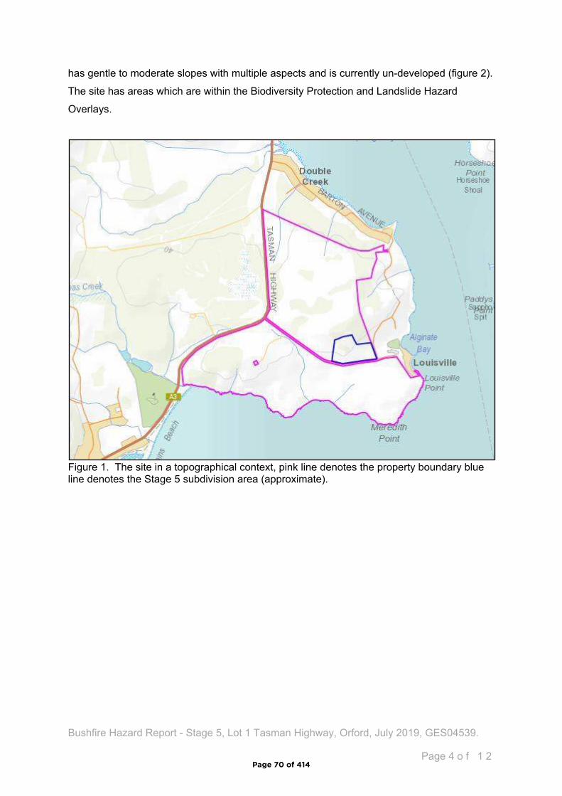
Bushfire Hazard Report - Stage 5, Lot 1 Tasman Highway, Orford, July 2019, GES04539.
Page 4 o f 1 2
has gentle to moderate slopes with multiple aspects and is currently un-developed (figure 2).
The site has areas which are within the Biodiversity Protection and Landslide Hazard
Overlays.
Figure 1. The site in a topographical context, pink line denotes the property boundary blue line denotes the Stage 5 subdivision area (approximate).
Page 70 of 414
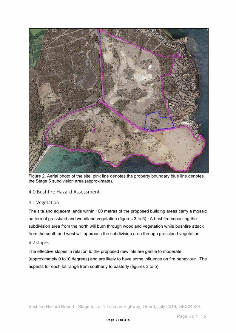
Bushfire Hazard Report - Stage 5, Lot 1 Tasman Highway, Orford, July 2019, GES04539.
Page 5 o f 1 2
Figure 2. Aerial photo of the site, pink line denotes the property boundary blue line denotes the Stage 5 subdivision area (approximate).
4.0 Bushfire Hazard Assessment
4.1 Vegetation
The site and adjacent lands within 100 metres of the proposed building areas carry a mosaic
pattern of grassland and woodland vegetation (figures 3 to 5). A bushfire impacting the
subdivision area from the north will burn through woodland vegetation while bushfire attack
from the south and west will approach the subdivision area through grassland vegetation.
4.2 slopes
The effective slopes in relation to the proposed new lots are gentle to moderate
(approximately 0 to10 degrees) and are likely to have some influence on fire behaviour. The
aspects for each lot range from southerly to easterly (figures 3 to 5).
Page 71 of 414
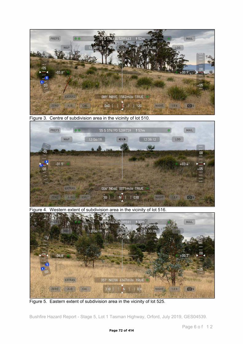
Bushfire Hazard Report - Stage 5, Lot 1 Tasman Highway, Orford, July 2019, GES04539.
Page 6 o f 1 2
Figure 3. Centre of subdivision area in the vicinity of lot 510.
Figure 4. Western extent of subdivision area in the vicinity of lot 516.
Figure 5. Eastern extent of subdivision area in the vicinity of lot 525.
Page 72 of 414
Bushfire Hazard Report - Stage 5, Lot 1 Tasman Highway, Orford, July 2019, GES04539.
Page 7 o f 1 2
4.3 Bushfire Attack Level
An assessment of the bushfire attack level as per AS3959-2009 was undertaken for each
proposed lot to determine the required width of hazard management areas to yield building
areas of not greater than BAL-19. The vegetation present is assessed as ‘Grassland and
woodland or was excluded from the assessment as low threat vegetation. The bushfire
attack level assessment tables are found in appendix B. The assessment has been
completed measuring distances from the proposed building areas. The following lots have
been assessed and are within 100 metres of bushfire-prone vegetation (lots 509 to 517
inclusive, and lots 533 to 541 inclusive). The distance between the building areas for these
lots and the bushfire-prone vegetation exceeds the minimum distance required to achieve
BAL-12.5 and are not represented in appendix B.
5.0 Bushfire Prone Areas Code
Code E1 of the Scheme articulates requirements for the provision of hazard management
areas, standards for access and firefighting water supplies and requirements for hazard
management for staged subdivisions.
5.1 Hazard Management Areas
Hazard management areas (HMA) are required to be established for each lot, they provide
an area around the building within which fuels are managed to reduce or eliminate the
impacts of direct flame contact, radiant heat loads and embers on the site. The Bushfire
hazard Management Plan (BHMP) shows building areas (for habitable buildings) and the
associated HMA for each lot and provides guidance for establishment and maintenance.
Not all vegetation has to be removed from a hazard management area to be effective, trees
and shrubs can provide protection from wind and embers if other fuels are appropriately
managed. Temporary hazard management areas are also required for each stage of this
development. This is to ensure that vegetation within the balance of the subdivision not
have the potential to elevate the bushfire attack on developed lots. The location of the
temporary hazard management areas is shown on the BHMP.
5.1.1 Building areas
Building areas for habitable buildings on each lot are shown on the BHMP. Each lot has
been assessed and a Bushfire Attack Level (BAL) assigned to it. If future buildings are
located within the building area and comply with the minimum setbacks for the lot the
buildings may be constructed to the bushfire attack level assigned to that lot. If associated
structures like sheds or other non-habitable buildings are proposed, they do not need to
conform to the BAL for the lot unless they are within 6 metres of the habitable building.
Page 73 of 414

Bushfire Hazard Report - Stage 5, Lot 1 Tasman Highway, Orford, July 2019, GES04539.
Page 8 o f 1 2
5.2 Public and firefighting Access
New public roads are proposed as part of this subdivision. The new roads are required to
conform with the following specifications consistent with Code E1. Table E1. of the Scheme,
in addition temporary turning heads will be required for stage 5A and 5B and are shown on
the BHMP.
Unless the development standards in the zone require a higher standard, the following
apply:
two-wheel drive, all-weather construction;
load capacity of at least 20t, including for bridges and culverts;
minimum carriageway width is 7m for a through road, or 5.5m for a dead-end or cul-
de-sac road;
minimum vertical clearance of 4m;
minimum horizontal clearance of 2m from the edge of the carriageway;
cross falls of less than 3 degrees (1:20 or 5%);
maximum gradient of 15 degrees (1:3.5 or 28%) for sealed roads, and 10 degrees
(1:5.5 or 18%) for unsealed roads;
curves have a minimum inner radius of 10m;
dead-end or cul-de-sac roads are not more than 200m in length unless the
carriageway is 7 metres in width;
dead-end or cul-de-sac roads have a turning circle with a minimum 12m outer radius;
carriageways less than 7m wide have ‘No Parking’ zones on one side, indicated by a
road sign that complies with Australian Standard AS1743-2001 Road signs-
Specifications;
Stage 5A will require two temporary tuning heads with a minimum inner radius of 12
metres;
Stage 5B will require one temporary tuning head with a minimum inner radius of 12
metres.
As reticulated water supplies for firefighting will be provided as part of the subdivision and
will be complaint with section 5.3 below, there are no specific requirements for property
access for future residential development.
Page 74 of 414
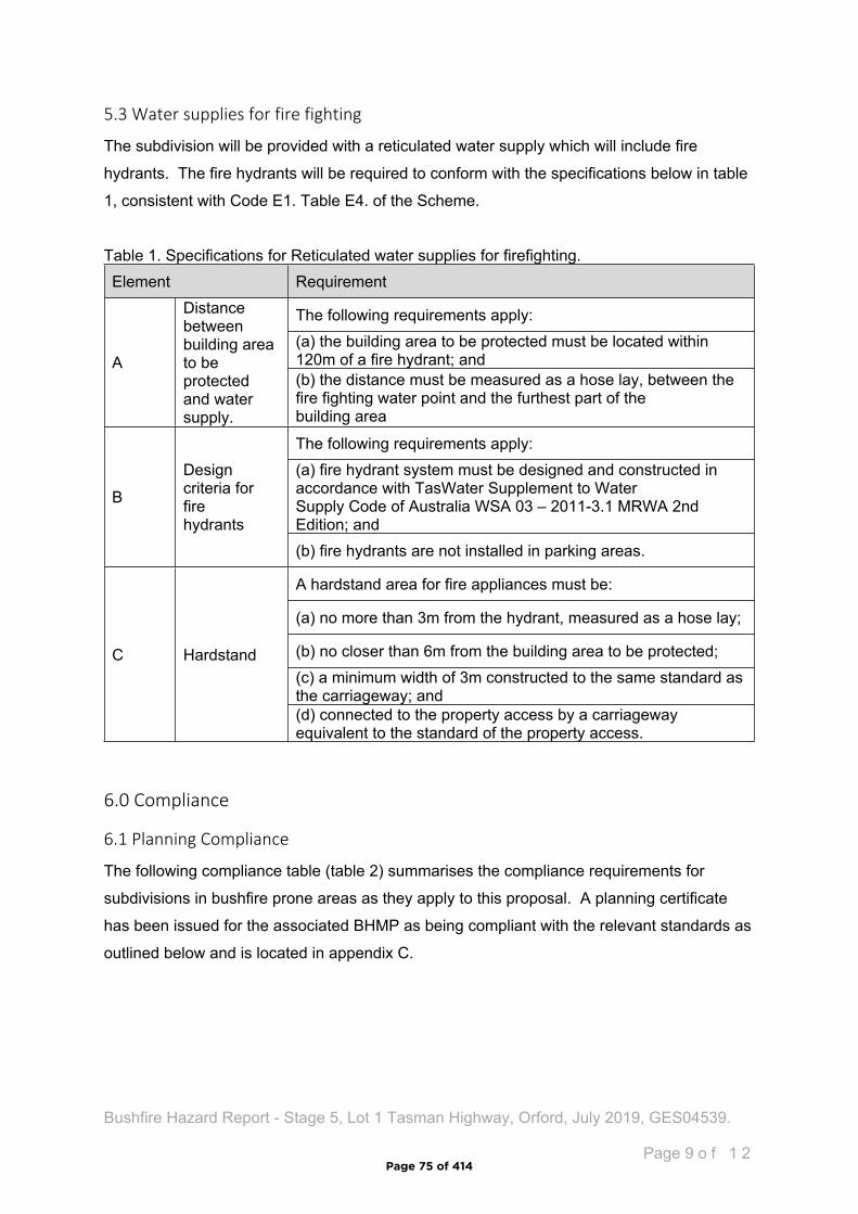
Bushfire Hazard Report - Stage 5, Lot 1 Tasman Highway, Orford, July 2019, GES04539.
Page 9 o f 1 2
5.3 Water supplies for fire fighting
The subdivision will be provided with a reticulated water supply which will include fire
hydrants. The fire hydrants will be required to conform with the specifications below in table
1, consistent with Code E1. Table E4. of the Scheme.
Table 1. Specifications for Reticulated water supplies for firefighting.Element Requirement
The following requirements apply: (a) the building area to be protected must be located within 120m of a fire hydrant; andA
Distance between building area to be protected and water supply.
(b) the distance must be measured as a hose lay, between the fire fighting water point and the furthest part of the building area
The following requirements apply:(a) fire hydrant system must be designed and constructed in accordance with TasWater Supplement to Water Supply Code of Australia WSA 03 – 2011-3.1 MRWA 2nd Edition; and
B
Design criteria for fire hydrants
(b) fire hydrants are not installed in parking areas.
A hardstand area for fire appliances must be:
(a) no more than 3m from the hydrant, measured as a hose lay;
(b) no closer than 6m from the building area to be protected;(c) a minimum width of 3m constructed to the same standard as the carriageway; and
C Hardstand
(d) connected to the property access by a carriageway equivalent to the standard of the property access.
6.0 Compliance
6.1 Planning Compliance
The following compliance table (table 2) summarises the compliance requirements for
subdivisions in bushfire prone areas as they apply to this proposal. A planning certificate
has been issued for the associated BHMP as being compliant with the relevant standards as
outlined below and is located in appendix C.
Page 75 of 414
Bushfire Hazard Report - Stage 5, Lot 1 Tasman Highway, Orford, July 2019, GES04539.
Page 1 0 o f 1 2
Table 2. Compliance with Code E1 of Glamorgan-Spring Bay Interim Planning Scheme 2015.
6.2 Building Compliance (for future development)
Future residential development will not require assessment for bushfire management
requirements at the planning application stage. Subsequent building applications will require
demonstrated compliance with the Directors Determination – Requirements for building in
Item ComplianceE1.6.1 Subdivision: Provision of hazard management areas
A1, (b)The proposed plan of subdivision: (i) shows all lots that are within or partly within a bushfire-prone area, including those developed at each stage of a staged subdivision; (ii) shows the building area for each lot; (iii) shows hazard management areas between bushfire-prone vegetation and each building area that have dimensions equal to, or greater than, the separation distances required for BAL 19 in Table 2.4.4 of Australian Standard AS 3959 – 2009 Construction of buildings in bushfire-prone areas; and (iv) is accompanied by a bushfire hazard management plan that addresses all the individual lots and that is certified by the TFS or accredited person, showing hazard management areas equal to, or greater than, the separation distances required for BAL-19 in Table 2.4.4 of Australian Standard AS 3959 – 2009 Construction of buildings in bushfire-prone areas.(c) If hazard management areas are to be located on land external to the proposed subdivision the application is accompanied by the written consent of the owner of that land to enter into an agreement under section 71 of the Act that will be registered on the title of the neighbouring property providing for the affected land to be managed in accordance with the bushfire hazard management plan.
The Bushfire hazard management shows all bushfire-prone lots with building areas not exceeding BAL-19. All hazard management areas are within the subdivision area.
E1.6.2 Subdivision: Public and firefighting accessA1 (b) A proposed plan of subdivision showing the layout of roads, fire trails and the location of property access to building areas is included in a bushfire hazard management plan that:(i) demonstrates proposed roads will comply with Table E1, proposed private accesses will comply with Table E2 and proposed fire trails will comply with Table E3; and (ii) is certified by the TFS or an accredited person.
The bushfire hazard management plan shows all public roads and provides specifications Consistent with tables E1 and E2.
E1.6.3 Subdivision: Provision of water supply for fire-fighting purposesA1 In areas serviced with reticulated water by the water corporation: (a) TFS or an accredited person certifies that there is an insufficient increase in risk from bushfire to warrant the provision of a water supply for fire fighting purposes; (b) A proposed plan of subdivision showing the layout of fire hydrants, and building areas, is included in a bushfire hazard management plan approved by the TFS or accredited person as being compliant with Table E4; or (c) A bushfire hazard management plan certified by the TFS or an accredited person demonstrates that the provision of water supply for fire fighting purposes is sufficient to manage the risks to property and lives in the event of a bushfire.
Specifications for the provision of firefighting water supplies are provided on the BHMP consistent with table E4.
Page 76 of 414

Bushfire Hazard Report - Stage 5, Lot 1 Tasman Highway, Orford, July 2019, GES04539.
Page 1 1 o f 1 2
Bushfire-prone Areas. If future development is undertaken in compliance with the Bushfire
Hazard Management Plan associated with this report, a building surveyor may rely upon it
for building compliance purposes if it is not more than 6 years old.
7.0 Summary
The proposed development occurs within a bushfire-prone area. The vegetation is classified
as grassland and woodland with the highest risk presented by vegetation to the north and
west of the site.
A bushfire hazard management plan has been developed and shows hazard management
areas, building areas with construction standards, the location of proposed public roads and
standards for their construction and specifications for the provision of firefighting water
supplies.
If future development for an individual lot is proposed and is compliant with all the
specifications of the bushfire hazard management plan, it may be relied upon for building
compliance purposes. If subsequent development does not comply with all the
specifications a new assessment will be required.
Limitations Statement
This Bushfire Hazard Report has been prepared in accordance with the scope of services
between Geo-Environmental Solutions Pty. Ltd. (GES) and the applicant. To the best of
GES's knowledge, the information presented herein represents the Client's requirements at
the time of printing of the Report. However, the passage of time, manifestation of latent
conditions or impacts of future events may result in findings differing from that described in
this Report. In preparing this Report, GES has relied upon data, surveys, analyses, designs,
plans and other information provided by the Client and other individuals and organisations
referenced herein. Except as otherwise stated in this Report, GES has not verified the
accuracy or completeness of such data, surveys, analyses, designs, plans and other
information.
The scope of this study does not allow for the review of every possible bushfire hazard
condition and does not provide a guarantee that no loss of property or life will occur as a
result of bushfire. As stated in AS3959-2009 “It should be borne in mind that the measures
contained in this Standard cannot guarantee that a building will survive a bushfire event on
every occasion. This is substantially due to the degree of vegetation management, the
unpredictable nature and behaviour of fire, and extreme weather conditions”. In addition, no
Page 77 of 414
Bushfire Hazard Report - Stage 5, Lot 1 Tasman Highway, Orford, July 2019, GES04539.
Page 1 2 o f 1 2
responsibility is taken for any loss which is a result of actions contrary to AS3959-2009 or
the Tasmanian Planning Commission Bushfire code.
This report does not purport to provide legal advice. Readers of the report should engage
professional legal practitioners for this purpose as required. No responsibility is accepted for
use of any part of this report in any other context or for any other purpose by third party
8.0 References
Building Amendment (Bushfire-Prone Areas) Regulations 2014
Determination, Director of Building Control – Requirements for Building in Bushfire-Prone
Areas, version 2.1 29th August 2017. Consumer, Building and Occupational Services,
Department of Justice, Tasmania
Standards Australia 2018, Construction of buildings in bushfire prone areas, Standards
Australia, Sydney.
Tasmanian Planning Commission 2017, Planning Directive No.5.1 – Bushfire prone Areas
Code. Tasmanian Planning Commission, Hobart. 1st September 2017.
The Bushfire Planning Group 2005, Guidelines for development in bushfire prone areas of
Tasmania – Living with fire in Tasmania, Tasmania Fire Service, Hobart.
Glamorgan-Spring Bay Interim Planning Scheme 2015.
Page 78 of 414
Bushfire Hazard Report - Stage 5, Lot 1 Tasman Highway, Orford, July 2019, GES04539.
Appendix A - Site Plan
Page 79 of 414

Bushfire Hazard Report - Stage 5, Lot 1 Tasman Highway, Orford, July 2019, GES04539.
Appendix B – Bushfire Attack Level assessment table – Lot 501
Azimuth Vegetation Classification Effective SlopeDistance to
Bushfire-prone vegetation
Hazard management
area widthBushfire
Attack Level
Exclusion 2.2.3.2 (e, f)^ upslope >100 metres
-- -- ---- -- --
North
-- -- --
Tile boundary BAL-LOW
Exclusion 2.2.3.2 (e, f)^ >0 to 5º downslope >100 metres-- -- ---- -- --
East
-- -- --
Tile boundary BAL-LOW
Exclusion 2.2.3.2 (e, f)^ >0 to 5º downslope 0 to 21 metresGrassland^ >0 to 5º downslope 21 to >100 metres
-- -- --South
-- -- --
Title boundary BAL-12.5
Exclusion 2.2.3.2 (e, f)^ flat 0º 0 to 25 metresGrassland^ flat 0º 25 to >100 metres
-- -- --West
-- -- --
Tile boundary BAL-12.5
^ Vegetation classification as per AS3959-2009 amendment 3, Table 2.3 and Figures 2.4(A) to 2.4 (G).^^ Exclusions as per AS3959-2009 amendment 3, section 2.2.3.2, (a) to (f).* Low threat vegetation as per Bushfire Prone Areas Advisory Note (BHAN) No.1-2014, version 3, 8/11/2017.
Appendix B – Bushfire Attack Level assessment table – Lots 502 to 521 inclusive
Page 80 of 414
Bushfire Hazard Report - Stage 5, Lot 1 Tasman Highway, Orford, July 2019, GES04539.
Azimuth Vegetation Classification Effective SlopeDistance to
Bushfire-prone vegetation
Hazard management
area widthBushfire
Attack Level
Exclusion 2.2.3.2 (e, f)^ upslope >100 metres
-- -- ---- -- --
North
-- -- --
Tile boundary BAL-LOW
Exclusion 2.2.3.2 (e, f)^ >0 to 5º downslope >100 metres-- -- ---- -- --
East
-- -- --
Tile boundary BAL-LOW
Woodland^ >0 to 5º downslope 0 to 18 metresExclusion 2.2.3.2 (e, f)^ >0 to 5º downslope 18 to 35 metres
Grassland^ >0 to 5º downslope 35 to >100 metresSouth
-- -- --
18 metres BAL-19
Exclusion 2.2.3.2 (e, f)^ flat 0º 0 to 25 metresGrassland^ flat 0º 25 to >100 metres
-- -- --West
-- -- --
Tile boundary BAL-12.5
^ Vegetation classification as per AS3959-2009 amendment 3, Table 2.3 and Figures 2.4(A) to 2.4 (G).^^ Exclusions as per AS3959-2009 amendment 3, section 2.2.3.2, (a) to (f).* Low threat vegetation as per Bushfire Prone Areas Advisory Note (BHAN) No.1-2014, version 3, 8/11/2017.
Appendix B – Bushfire Attack Level assessment table – Lots 522 to 528 inclusive
Page 81 of 414
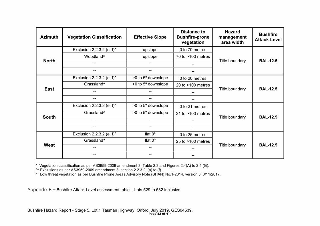
Bushfire Hazard Report - Stage 5, Lot 1 Tasman Highway, Orford, July 2019, GES04539.
Azimuth Vegetation Classification Effective SlopeDistance to
Bushfire-prone vegetation
Hazard management
area widthBushfire
Attack Level
Exclusion 2.2.3.2 (e, f)^ upslope 0 to 70 metresWoodland^ upslope 70 to >100 metres
-- -- --North
-- -- --
Title boundary BAL-12.5
Exclusion 2.2.3.2 (e, f)^ >0 to 5º downslope 0 to 20 metres Grassland^ >0 to 5º downslope 20 to >100 metres
-- -- --East
-- -- --
Title boundary BAL-12.5
Exclusion 2.2.3.2 (e, f)^ >0 to 5º downslope 0 to 21 metresGrassland^ >0 to 5º downslope 21 to >100 metres
-- -- --South
-- -- --
Title boundary BAL-12.5
Exclusion 2.2.3.2 (e, f)^ flat 0º 0 to 25 metresGrassland^ flat 0º 25 to >100 metres
-- -- --West
-- -- --
Title boundary BAL-12.5
^ Vegetation classification as per AS3959-2009 amendment 3, Table 2.3 and Figures 2.4(A) to 2.4 (G).^^ Exclusions as per AS3959-2009 amendment 3, section 2.2.3.2, (a) to (f).* Low threat vegetation as per Bushfire Prone Areas Advisory Note (BHAN) No.1-2014, version 3, 8/11/2017.
Appendix B – Bushfire Attack Level assessment table – Lots 529 to 532 inclusive
Page 82 of 414

Bushfire Hazard Report - Stage 5, Lot 1 Tasman Highway, Orford, July 2019, GES04539.
Azimuth Vegetation Classification Effective SlopeDistance to
Bushfire-prone vegetation
Hazard management
area widthBushfire
Attack Level
Woodland^ upslope 0 to >100 metres-- -- ---- -- --
North
-- -- --
22 metres BAL-12.5
Exclusion 2.2.3.2 (e, f)^ >0 to 5º downslope 0 to 20 metresGrassland^ >0 to 5º downslope 20 to >100 metres
-- -- --East
-- -- --
Title boundary BAL-12.5
Exclusion 2.2.3.2 (e, f)^ >0 to 5º downslope 0 to >100 metres-- -- ---- -- --
South
-- -- --
Title boundary BAL-LOW
Exclusion 2.2.3.2 (e, f)^ flat 0º 0 to >100 metres-- -- ---- -- --
West
-- -- --
Title boundary BAL-LOW
^ Vegetation classification as per AS3959-2009 amendment 3, Table 2.3 and Figures 2.4(A) to 2.4 (G).^^ Exclusions as per AS3959-2009 amendment 3, section 2.2.3.2, (a) to (f).* Low threat vegetation as per Bushfire Prone Areas Advisory Note (BHAN) No.1-2014, version 3, 8/11/2017.
Appendix B – Bushfire Attack Level assessment table – Lots 542 and 543 inclusive
Page 83 of 414
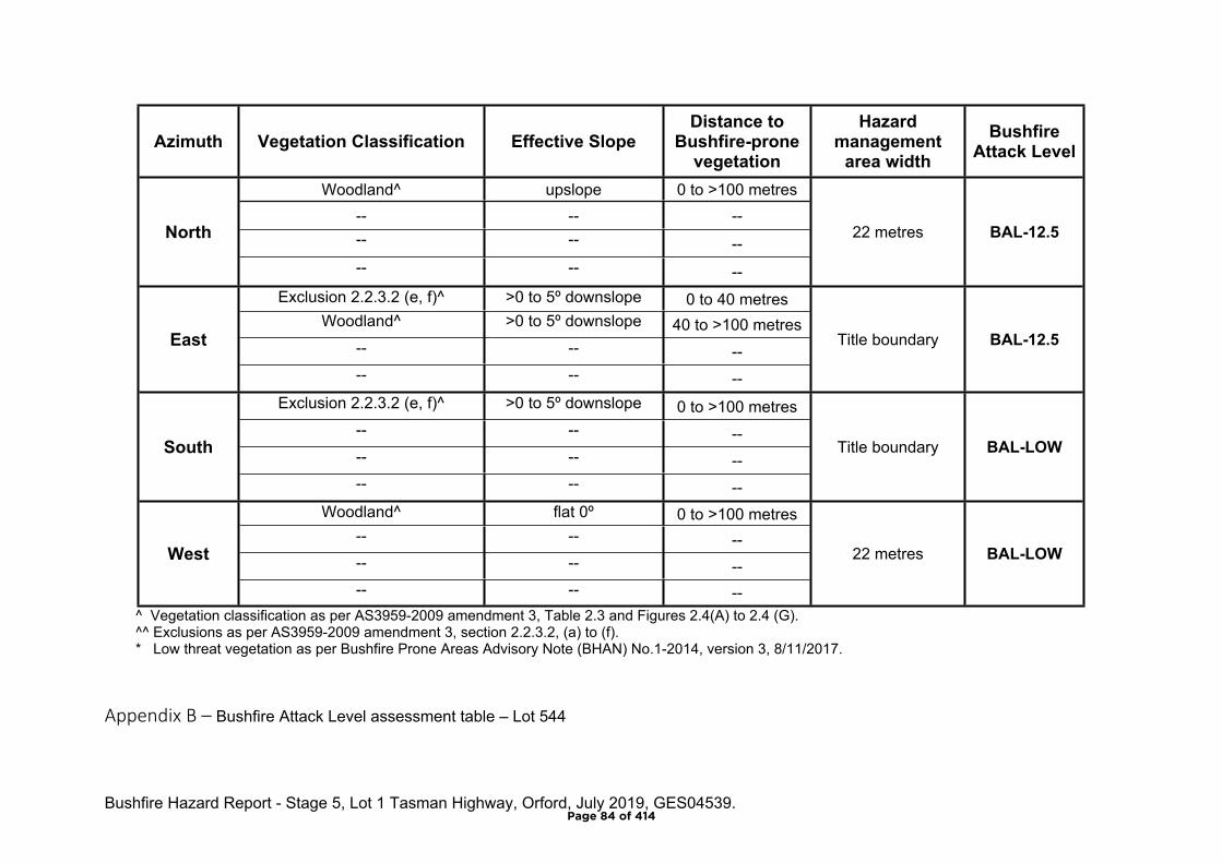
Bushfire Hazard Report - Stage 5, Lot 1 Tasman Highway, Orford, July 2019, GES04539.
Azimuth Vegetation Classification Effective SlopeDistance to
Bushfire-prone vegetation
Hazard management
area widthBushfire
Attack Level
Woodland^ upslope 0 to >100 metres-- -- ---- -- --
North
-- -- --
22 metres BAL-12.5
Exclusion 2.2.3.2 (e, f)^ >0 to 5º downslope 0 to 40 metresWoodland^ >0 to 5º downslope 40 to >100 metres
-- -- --East
-- -- --
Title boundary BAL-12.5
Exclusion 2.2.3.2 (e, f)^ >0 to 5º downslope 0 to >100 metres-- -- ---- -- --
South
-- -- --
Title boundary BAL-LOW
Woodland^ flat 0º 0 to >100 metres-- -- ---- -- --
West
-- -- --
22 metres BAL-LOW
^ Vegetation classification as per AS3959-2009 amendment 3, Table 2.3 and Figures 2.4(A) to 2.4 (G).^^ Exclusions as per AS3959-2009 amendment 3, section 2.2.3.2, (a) to (f).* Low threat vegetation as per Bushfire Prone Areas Advisory Note (BHAN) No.1-2014, version 3, 8/11/2017.
Appendix B – Bushfire Attack Level assessment table – Lot 544
Page 84 of 414
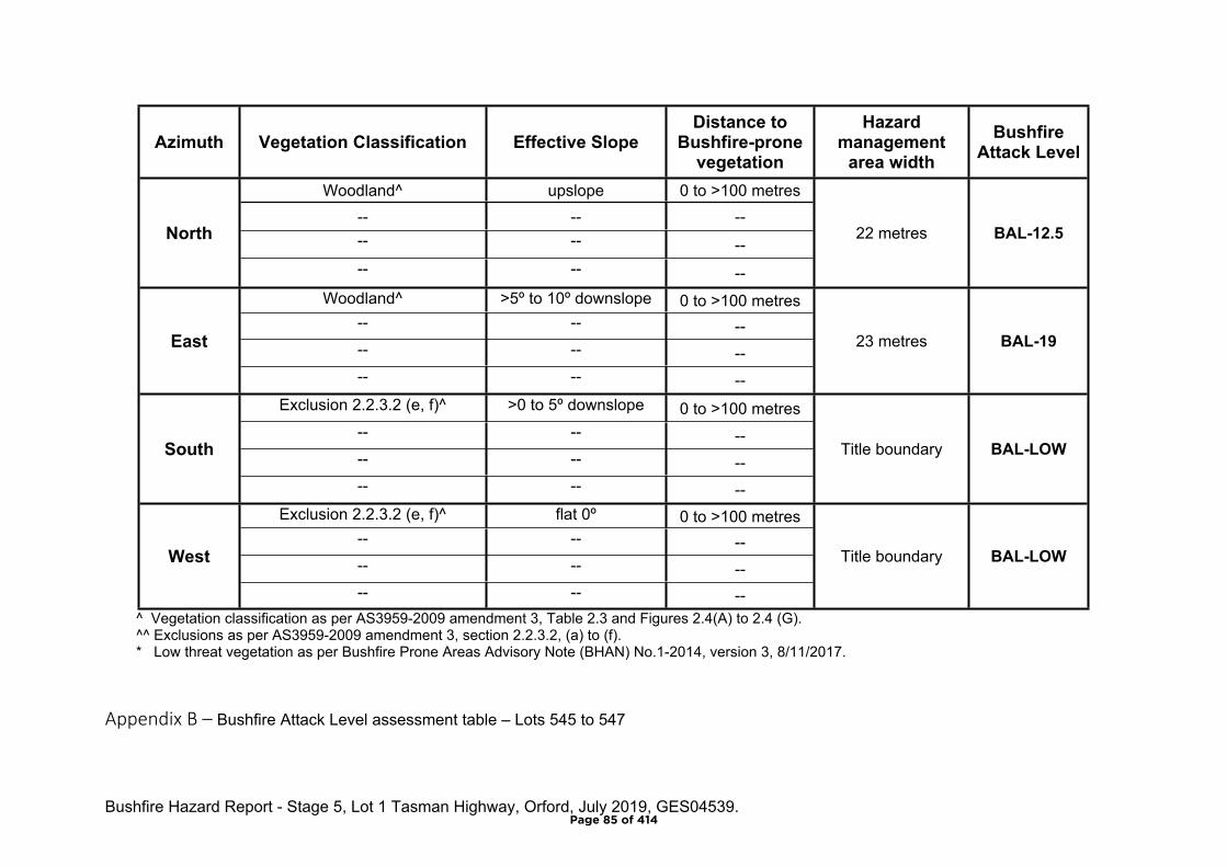
Bushfire Hazard Report - Stage 5, Lot 1 Tasman Highway, Orford, July 2019, GES04539.
Azimuth Vegetation Classification Effective SlopeDistance to
Bushfire-prone vegetation
Hazard management
area widthBushfire
Attack Level
Woodland^ upslope 0 to >100 metres-- -- ---- -- --
North
-- -- --
22 metres BAL-12.5
Woodland^ >5º to 10º downslope 0 to >100 metres-- -- ---- -- --
East
-- -- --
23 metres BAL-19
Exclusion 2.2.3.2 (e, f)^ >0 to 5º downslope 0 to >100 metres-- -- ---- -- --
South
-- -- --
Title boundary BAL-LOW
Exclusion 2.2.3.2 (e, f)^ flat 0º 0 to >100 metres-- -- ---- -- --
West
-- -- --
Title boundary BAL-LOW
^ Vegetation classification as per AS3959-2009 amendment 3, Table 2.3 and Figures 2.4(A) to 2.4 (G).^^ Exclusions as per AS3959-2009 amendment 3, section 2.2.3.2, (a) to (f).* Low threat vegetation as per Bushfire Prone Areas Advisory Note (BHAN) No.1-2014, version 3, 8/11/2017.
Appendix B – Bushfire Attack Level assessment table – Lots 545 to 547
Page 85 of 414
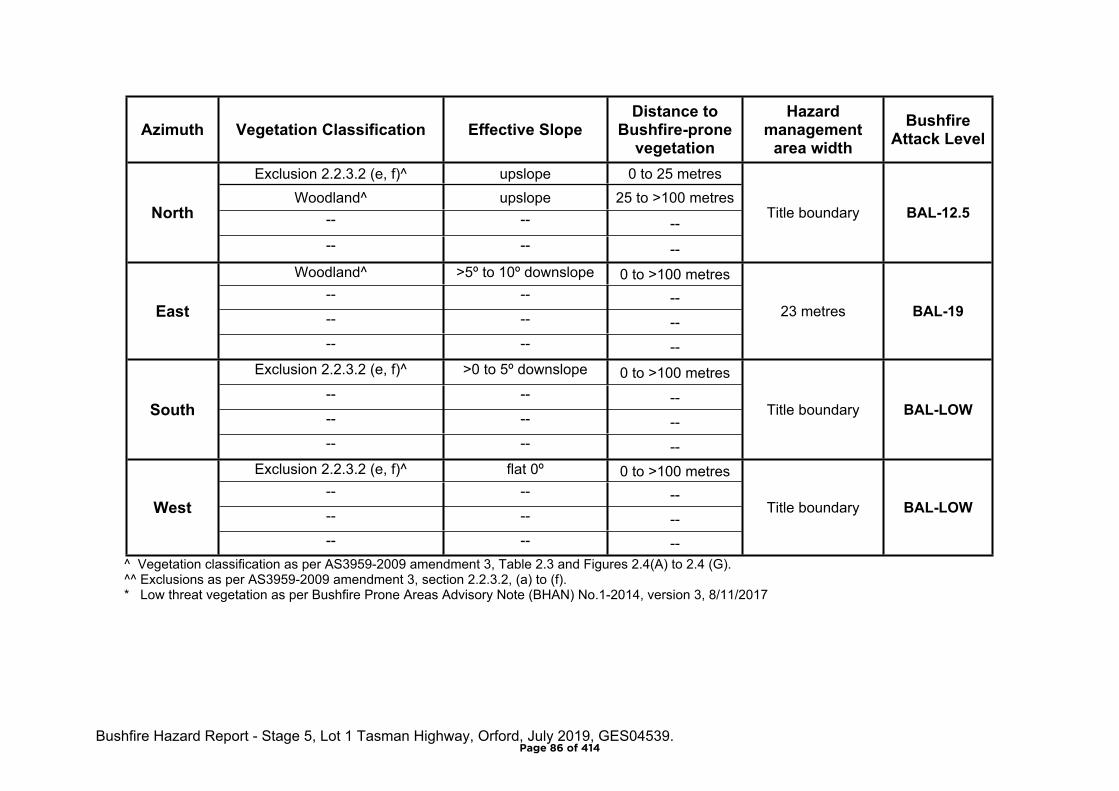
Bushfire Hazard Report - Stage 5, Lot 1 Tasman Highway, Orford, July 2019, GES04539.
Azimuth Vegetation Classification Effective SlopeDistance to
Bushfire-prone vegetation
Hazard management
area widthBushfire
Attack Level
Exclusion 2.2.3.2 (e, f)^ upslope 0 to 25 metresWoodland^ upslope 25 to >100 metres
-- -- --North
-- -- --
Title boundary BAL-12.5
Woodland^ >5º to 10º downslope 0 to >100 metres-- -- ---- -- --
East
-- -- --
23 metres BAL-19
Exclusion 2.2.3.2 (e, f)^ >0 to 5º downslope 0 to >100 metres-- -- ---- -- --
South
-- -- --
Title boundary BAL-LOW
Exclusion 2.2.3.2 (e, f)^ flat 0º 0 to >100 metres-- -- ---- -- --
West
-- -- --
Title boundary BAL-LOW
^ Vegetation classification as per AS3959-2009 amendment 3, Table 2.3 and Figures 2.4(A) to 2.4 (G).^^ Exclusions as per AS3959-2009 amendment 3, section 2.2.3.2, (a) to (f).* Low threat vegetation as per Bushfire Prone Areas Advisory Note (BHAN) No.1-2014, version 3, 8/11/2017
Page 86 of 414

Bushfire Hazard Report - Stage 5, Lot 1 Tasman Highway, Orford, July 2019, GES04539.
Appendix C
Bushfire Hazard Management Plan
Page 87 of 414
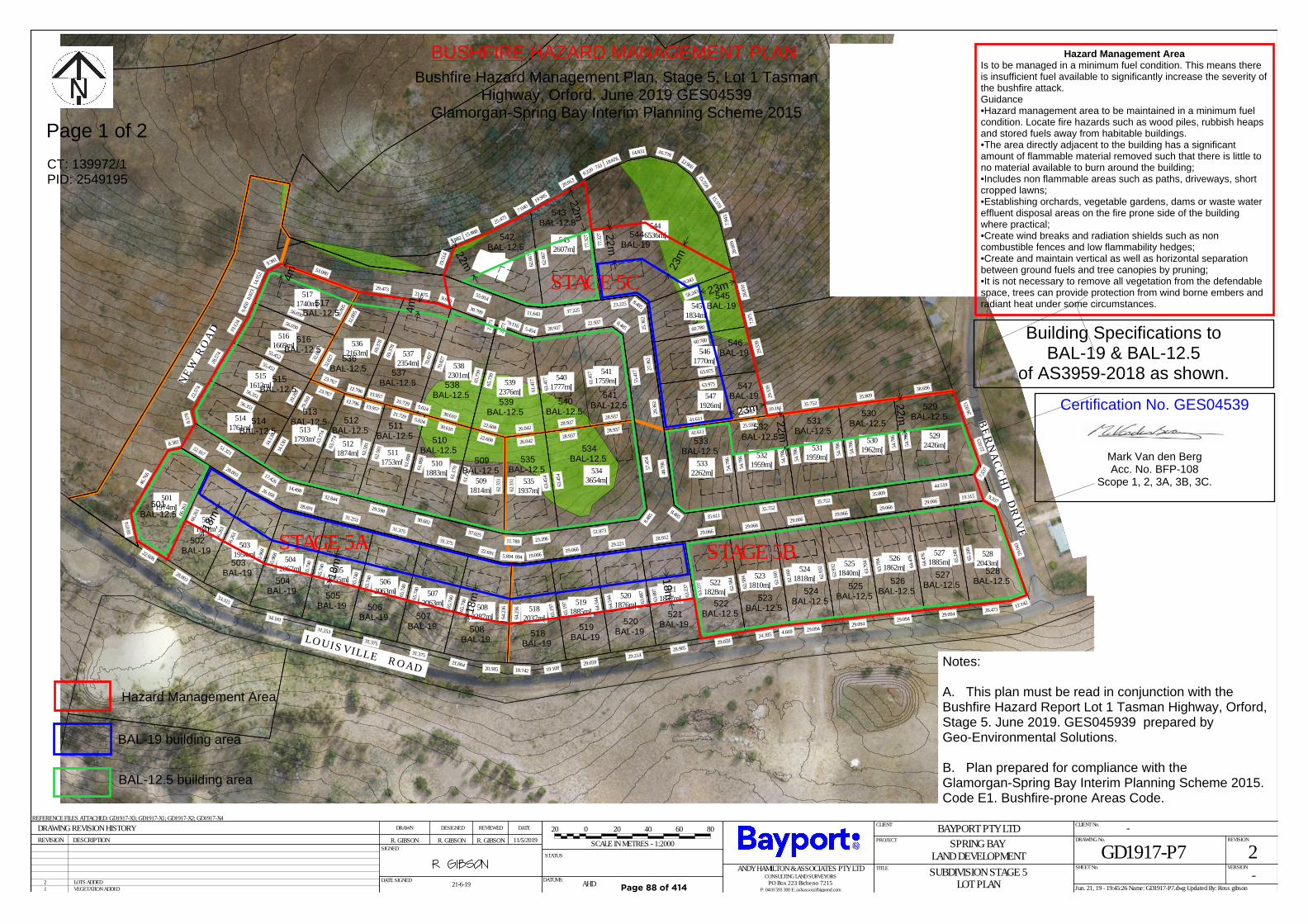
STAGE 5 QUANTITIESSTAGE 5C
-
TOTAL121866
99802
23064
1173
STAGE 5BSTAGE 5A
483
LOT AREAROAD RESERVE AREALINEAL METRES OF ROAD
--
---
32464 36880 29943
GROSS AREA m²
371 319
5301962m²
5292426m²
5141761m² 513
1793m²
5282043m²
5271885m²526
1862m²5251840m²524
1818m²5231810m²522
1828m²5211837m²520
1876m²5191885m²518
2037m²508
2287m²
5072063m²
5062063m²
5052055m²
5042067m²
5031954m²
5021841m²
5011974m²
5121874m² 511
1753m² 5101883m²
5091814m²
5351937m²
5343654m²
5332262m²
5321959m²
5311959m²
5471926m²
5461770m²
5451834m²
5446536m²543
2607m²542
2315m²
5401777m²
5411759m²539
2376m²
5382301m²
5372354m²
5362163m²
5171740m²
5161669m²
5151613m²
35.809
54.78
6
35.809
54.78
6
28.02
3
38.696
54.78
6
44.519
7.537
22.02
3
56.35122.57
48.5
78
51.321 34.13
0
23.767
29.26
9
34.13
0
17.42614.498
63.77
4
9.33719.315
65.24
9
26.471 11.142
59.04
3
29.066
64.47
6
29.094
65.24
9
29.066
63.70
4
29.094
64.47
6
29.066
62.93
2
29.094
63.70
4
29.066
62.16
0
29.094
62.93
2
29.066
62.58
4
24.395 4.669
62.16
0
29.066
63.23
7
29.059
62.58
4
28.912
63.88
7
28.905
63.23
7
29.221
64.54
4
29.21463
.887
29.06665
.197
29.059
64.54
4
19.0065.894
64.23
6
18.742 19.108
65.19
75.894
22.691
65.74
0
21.00420.585
64.23
6
31.375
65.74
0
31.375
65.74
0
31.375
65.74
0
31.375
65.74
0
31.253
65.74
0
31.253
65.74
0
28.691
65.96
8
34.181
65.74
0
26.168
66.26
1
33.315
65.96
8
28.003
66.26
1
28.003
66.26
1
22.167
8.381
46.76
6
18.07
4
22.608
66.26
1
13.95712.796
63.77
4
32.844
62.58
1
5.02421.729
62.58
1
29.598
61.88
830.610
61.88
8
30.602
61.17
0
22.608
61.17
0
37.025
62.33
1
26.042
62.33
1
11.789 23.296
63.45
4
28.93728.937
63.45
4
51.873
8.485
57.45
4
41.611
48.78
6
8.485 35.611
54.78
6
10.16125.592
54.78
6
35.752
54.78
6
35.752
54.78
6
35.752
54.78
6
63.975
29.36
2
41.61125.592
29.53
9
60.780
27.36
2
63.975
29.53
9
58.243
25.36
2
60.780
7.975
28.81
0
7.943
15.559
15.559
12.900
16.77814.831
18.676
2.7339.220
77.32
7
23.225 8.485
58.243
28.60
9
20.013
19.995
62.66
7
37.225
77.32
7
7.040
25.475
15.889
5.682
19.51
4
55.914
11.643
62.66
7
8.48522.93728.937
61.41
7
28.93728.937
55.41
7
61.41
7
5.454
19.1162.271
65.73
9
22.608 26.042
61.41
7
2.271
30.799
70.82
75.024
30.610
65.73
9
9.94021.475
69.37
8
13.95721.729
70.82
7
29.473
32.00
5
32.02
7
23.76712.796
69.37
8
53.080
9.38114
.552
8.023
56.030
32.00
556.030
9.450
19.12
4
55.452 32.02
7
55.452
28.57
4
56.351 29.26
9
0 8040
SCALE IN METRES - 1:2000
6020 20
L O U I S V I L L E R O A D
N E W
R O
A D
B E R N A C C H I D R I V E
GD1917-P7 2-
-BAYPORT PTY LTDSPRING BAY
LAND DEVELOPMENTSUBDIVISION STAGE 5
LOT PLAN
R. GIBSON R. GIBSON R. GIBSON 11/5/2019
21-6-19 AHD 1 VEGETATION ADDED2 LOTS ADDED
REFERENCE FILES ATTACHED: GD1917-X3; GD1917-X1; GD1917-X2; GD1917-X4
DATE SIGNEDJun. 21, 19 - 19:45:26 Name: GD1917-P7.dwg Updated By: Ross gibson
DRAWING REVISION HISTORY
DATUMS:
REVISION DESCRIPTION
STATUS
REVIEWED DATEDRAWN DESIGNED
SIGNEDDRAWING No.
TITLE
CLIENT
PROJECT
CLIENT No.
REVISION
VERSIONSHEET No.ANDY HAMILTON & ASSOCIATES PTY LTDCONSULTING LAND SURVEYORS
PO Box 223 Bicheno 7215P: 0418 593 300 E: [email protected]
STAGE 5B
STAGE 5C
STAGE 5A LEGENDBIODIVERSITY PROTECTIONAREA OVERLAY PERPLANNING SCHEME
501BAL-12.5
502BAL-19
505BAL-19
508BAL-19
507BAL-19
506BAL-19
504BAL-19
503BAL-19
509BAL-12.5
510BAL-12.5
511BAL-12.5
512BAL-12.5
513BAL-12.5 514
BAL-12.5
515BAL-12.5
516BAL-12.5
517BAL-12.5
518BAL-19
520BAL-19 519
BAL-19
521BAL-19
522BAL-12.5
523BAL-12.5
524BAL-12.5
525BAL-12.5
528BAL-12.5
527BAL-12.5 526
BAL-12.5
529BAL-12.5 530
BAL-12.5 531BAL-12.5 532
BAL-12.5 533BAL-12.5 534
BAL-12.5 535BAL-12.5
536BAL-12.5 537
BAL-12.5 538BAL-12.5
539BAL-12.5
540BAL-12.5
541BAL-12.5
542BAL-12.5
543BAL-12.5
544BAL-19
545BAL-19
546BAL-19
547BAL-19
BUSHFIRE HAZARD MANAGEMENT PLANBushfire Hazard Management Plan, Stage 5, Lot 1 Tasman
Highway, Orford. June 2019 GES04539Glamorgan-Spring Bay Interim Planning Scheme 2015
Hazard Management Area
BAL-19 building area
BAL-12.5 building area
Notes:
A. This plan must be read in conjunction with theBushfire Hazard Report Lot 1 Tasman Highway, Orford,Stage 5. June 2019. GES045939 prepared byGeo-Environmental Solutions.
B. Plan prepared for compliance with theGlamorgan-Spring Bay Interim Planning Scheme 2015.Code E1. Bushfire-prone Areas Code.
Hazard Management AreaIs to be managed in a minimum fuel condition. This means thereis insufficient fuel available to significantly increase the severity ofthe bushfire attack.Guidance•Hazard management area to be maintained in a minimum fuelcondition. Locate fire hazards such as wood piles, rubbish heapsand stored fuels away from habitable buildings.•The area directly adjacent to the building has a significantamount of flammable material removed such that there is little tono material available to burn around the building;•Includes non flammable areas such as paths, driveways, shortcropped lawns;•Establishing orchards, vegetable gardens, dams or waste watereffluent disposal areas on the fire prone side of the buildingwhere practical;•Create wind breaks and radiation shields such as noncombustible fences and low flammability hedges;•Create and maintain vertical as well as horizontal separationbetween ground fuels and tree canopies by pruning;•It is not necessary to remove all vegetation from the defendablespace, trees can provide protection from wind borne embers andradiant heat under some circumstances.
Building Specifications toBAL-19 & BAL-12.5
of AS3959-2018 as shown.
Certification No. GES04539
Mark Van den BergAcc. No. BFP-108
Scope 1, 2, 3A, 3B, 3C.
Page 1 of 2
18m
18m
18m
22m22m
23m
23m
23m
22m
22m
4m
4m
18m
m
22m
CT: 139972/1PID: 2549195
Page 88 of 414
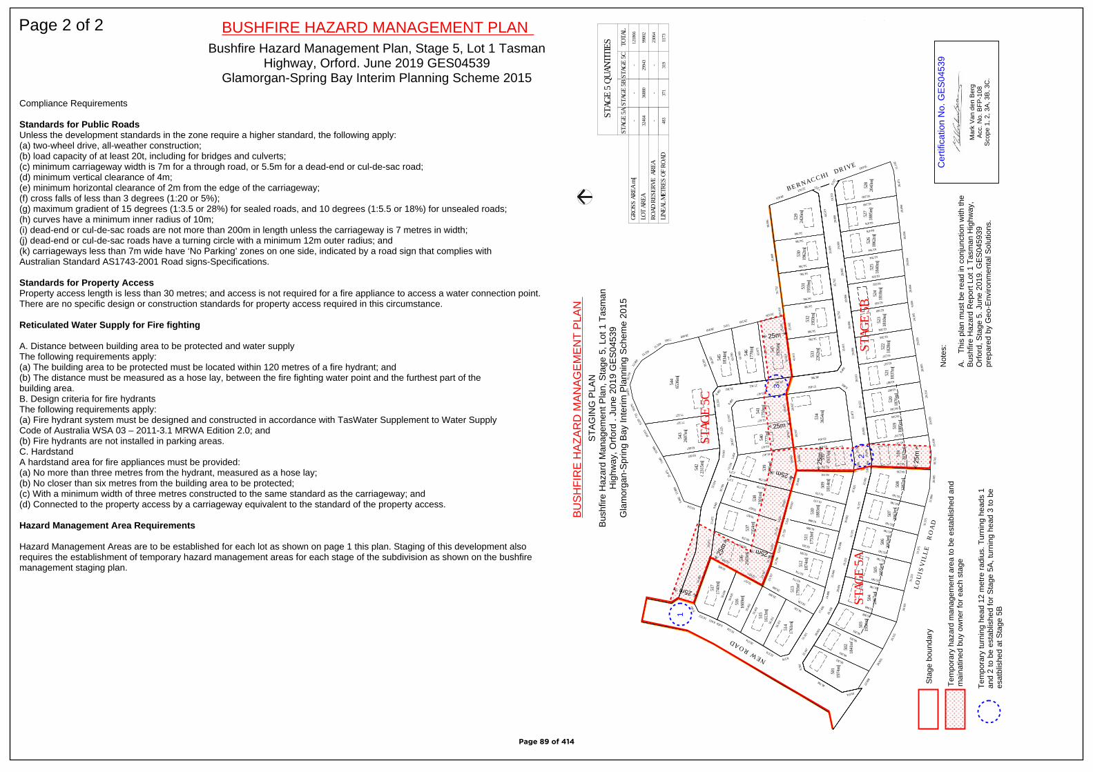
Compliance Requirements
Standards for Public RoadsUnless the development standards in the zone require a higher standard, the following apply: (a) two-wheel drive, all-weather construction; (b) load capacity of at least 20t, including for bridges and culverts; (c) minimum carriageway width is 7m for a through road, or 5.5m for a dead-end or cul-de-sac road; (d) minimum vertical clearance of 4m; (e) minimum horizontal clearance of 2m from the edge of the carriageway; (f) cross falls of less than 3 degrees (1:20 or 5%); (g) maximum gradient of 15 degrees (1:3.5 or 28%) for sealed roads, and 10 degrees (1:5.5 or 18%) for unsealed roads; (h) curves have a minimum inner radius of 10m; (i) dead-end or cul-de-sac roads are not more than 200m in length unless the carriageway is 7 metres in width; (j) dead-end or cul-de-sac roads have a turning circle with a minimum 12m outer radius; and (k) carriageways less than 7m wide have ‘No Parking’ zones on one side, indicated by a road sign that complies with Australian Standard AS1743-2001 Road signs-Specifications.
Standards for Property AccessProperty access length is less than 30 metres; and access is not required for a fire appliance to access a water connection point.There are no specific design or construction standards for property access required in this circumstance.
Reticulated Water Supply for Fire fighting
A. Distance between building area to be protected and water supply The following requirements apply: (a) The building area to be protected must be located within 120 metres of a fire hydrant; and (b) The distance must be measured as a hose lay, between the fire fighting water point and the furthest part of the building area. B. Design criteria for fire hydrants The following requirements apply: (a) Fire hydrant system must be designed and constructed in accordance with TasWater Supplement to Water Supply Code of Australia WSA 03 – 2011-3.1 MRWA Edition 2.0; and (b) Fire hydrants are not installed in parking areas. C. HardstandA hardstand area for fire appliances must be provided: (a) No more than three metres from the hydrant, measured as a hose lay; (b) No closer than six metres from the building area to be protected; (c) With a minimum width of three metres constructed to the same standard as the carriageway; and (d) Connected to the property access by a carriageway equivalent to the standard of the property access.
Hazard Management Area Requirements
Hazard Management Areas are to be established for each lot as shown on page 1 this plan. Staging of this development alsorequires the establishment of temporary hazard management areas for each stage of the subdivision as shown on the bushfiremanagement staging plan.
Page 2 of 2 BUSHFIRE HAZARD MANAGEMENT PLANBushfire Hazard Management Plan, Stage 5, Lot 1 Tasman
Highway, Orford. June 2019 GES04539Glamorgan-Spring Bay Interim Planning Scheme 2015
STAG
E 5 Q
UANT
ITIE
SST
AGE
5C
-
TOTA
L12
1866
9980
2
2306
4
1173
STAG
E 5B
STAG
E 5A
483
LOT
AREA
ROAD
RES
ERVE
ARE
ALIN
EAL M
ETRE
S OF
ROA
D-
-
--
-
3246
436
880
2994
3
GROS
S AR
EA m
²
371
319
530
1962
m²
529
2426
m²
514
1761
m²51
317
93m²
528
2043
m²52
718
85m²
526
1862
m²52
518
40m²
524
1818
m²52
318
10m²
522
1828
m²52
118
37m²
520
1876
m²51
918
85m²
518
2037
m²50
822
87m²
507
2063
m²
506
2063
m²
505
2055
m²
504
2067
m²
503
1954
m²
502
1841
m²
501
1974
m²
512
1874
m²51
117
53m²
510
1883
m²50
918
14m²
535
1937
m²
534
3654
m²
533
2262
m²
532
1959
m²
531
1959
m²
547
1926
m²
546
1770
m²
545
1834
m²
544
6536
m²54
326
07m²
542
2315
m²
540
1777
m²
541
1759
m²53
923
76m²
538
2301
m²
537
2354
m²
536
2163
m²
517
1740
m²
516
1669
m²
515
1613
m²35
.809
54.786
35.80
9
54.786
28.023
38.69
6
54.786
44.51
9
7.53722.023
56.35
1
22.5748.578
51.32
1
34.130
23.76
7
29.269
34.130
17.42
614
.498
63.774
9.337
19.31
5
65.249
26.47
111
.142
59.043
29.06
6
64.476
29.09
4
65.249
29.06
6
63.704
29.09
4
64.476
29.06
6
62.932
29.09
4
63.704
29.06
6
62.160
29.09
4
62.932
29.06
6
62.584
24.39
54.6
69
62.160
29.06
6
63.237
29.05
9
62.584
28.91
2
63.887
28.90
5
63.237
29.22
1
64.544
29.21
4
63.887
29.06
6
65.197
29.05
9
64.544
19.00
65.8
94
64.236
18.74
219
.108
65.197
5.894
22.69
1
65.740 21.00
420
.585
64.236
31.37
5
65.740
31.37
5
65.740
31.37
5
65.740
31.37
5
65.740
31.25
3
65.740
31.25
3
65.740
28.69
1
65.968
34.18
1
65.740
26.16
8
66.261
33.31
5
65.968
28.00
3
66.261
28.00
3
66.261
22.16
7
8.381
46.766
18.074
22.60
8
66.261
13.95
712
.796
63.774 32.84
4
62.581
5.024
21.72
9
62.581 29.59
8
61.888
30.61
0
61.888
30.60
2
61.170
22.60
8
61.170
37.02
5
62.331
26.04
2
62.331
11.78
923
.296
63.454
28.93
728
.937
63.454
51.87
3
8.48557.454
41.61
1
48.786
8.485
35.61
1
54.786
10.16
125
.592
54.786
35.75
2
54.786
35.75
2
54.786
35.75
2
54.786
63.97
5
29.362
41.61
125
.592
29.539
60.78
0
27.362
63.97
5
29.539
58.24
3
25.362
60.78
0
7.97528.810
7.943
15.559
15.559
12.90
0
16.77
814
.831
18.67
6
2.733
9.220 77.327
23.22
58.4
85
58.24
3
28.609
20.01
3
19.99
5
62.667
37.22
5
77.327
7.040
25.47
5
15.88
9
5.682
19.514
55.91
4
11.64
3
62.667
8.485
22.93
728
.937
61.417
28.93
728
.937
55.417
61.417
5.454
19.11
6
2.271
65.739 22.60
826
.042
61.417
2.271
30.79
9
70.827
5.024
30.61
0
65.739
9.940
21.47
5
69.378
13.95
721
.729
70.827
29.47
3
32.005
32.027 23.76
712
.796
69.378
53.08
0
9.381
14.552
8.023
56.03
0
32.005
56.03
0
9.450
19.124
55.45
2
32.027
55.45
2
28.574
56.35
1
29.269 L O U
I S V
I L L
E
R O
A D
N E W R O A D
B E R N A C C H I D R I V E
STAG
E 5B
STAG
E 5C
STAG
E 5A
LEGE
NDBI
ODIV
ERSI
TY P
ROTE
CTIO
NAR
EA O
VERL
AY P
ERPL
ANNI
NG S
CHEM
E
25m
25m
25m
25m
25m
25m
1
2
3
Sta
ge b
ound
ary
25m
25m
Tem
pora
ry h
azar
d m
anag
emen
t are
a to
be
esta
blis
hed
and
mai
natin
ed b
uy o
wne
r fo
r ea
ch s
tage
Tem
pora
ry tu
rnin
g he
ad 1
2 m
etre
rad
ius.
Tur
ning
hea
ds 1
and
2 to
be
esta
blis
hed
for
Sta
ge 5
A, t
urni
ng h
ead
3 to
be
esat
blis
hed
at S
tage
5B
Cer
tific
atio
n N
o. G
ES
0453
9
Mar
k V
an d
en B
erg
Acc
. No.
BFP
-108
Sco
pe 1
, 2, 3
A, 3
B, 3
C.
BU
SH
FIR
E H
AZ
AR
D M
AN
AG
EM
EN
T P
LAN
STA
GIN
G P
LAN
Bus
hfire
Haz
ard
Man
agem
ent P
lan,
Sta
ge 5
, Lot
1 T
asm
anH
ighw
ay, O
rford
. Ju
ne 2
019
GE
S04
539
Gla
mor
gan-
Spr
ing
Bay
Inte
rim P
lann
ing
Sch
eme
2015
Not
es:
A.
Thi
s pl
an m
ust b
e re
ad in
con
junc
tion
with
the
Bus
hfire
Haz
ard
Rep
ort L
ot 1
Tas
man
Hig
hway
,O
rfor
d, S
tage
5. J
une
2019
. GE
S04
5939
pr
epar
ed b
y G
eo-E
nviro
nmen
tal S
olut
ions
.
542
2315
m²
Page 89 of 414

Bushfire Hazard Report - Stage 5, Lot 1 Tasman Highway, Orford, July 2019, GES04539.
Appendix D
Planning Certificate
Page 90 of 414
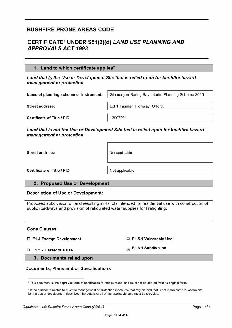
Certificate v4.0: Bushfire-Prone Areas Code (PD5.1) Page 1 of 4
BUSHFIRE-PRONE AREAS CODE
CERTIFICATE1 UNDER S51(2)(d) LAND USE PLANNING AND APPROVALS ACT 1993
1. Land to which certificate applies2
Land that is the Use or Development Site that is relied upon for bushfire hazard management or protection.
Name of planning scheme or instrument: Glamorgan-Spring Bay Interim Planning Scheme 2015
Street address: Lot 1 Tasman Highway, Orford.
Certificate of Title / PID: 139972/1
Land that is not the Use or Development Site that is relied upon for bushfire hazard management or protection.
Street address: Not applicable
Certificate of Title / PID: Not applicable
2. Proposed Use or Development
Description of Use or Development:
Proposed subdivision of land resulting in 47 lots intended for residential use with construction of public roadways and provision of reticulated water supplies for firefighting.
Code Clauses:
E1.4 Exempt Development E1.5.1 Vulnerable Use
E1.5.2 Hazardous Use E1.6.1 Subdivision
3. Documents relied upon
Documents, Plans and/or Specifications
1 This document is the approved form of certification for this purpose, and must not be altered from its original form.
2 If the certificate relates to bushfire management or protection measures that rely on land that is not in the same lot as the site for the use or development described, the details of all of the applicable land must be provided.
Page 91 of 414
Certificate v4.0: Bushfire-Prone Areas Code (PD5.1) Page 2 of 4
Title: Plan of Sub-division. Spring Bay Development
Author: Ross Gibson
Date: 21/06/2019 Version: GD1917-P7
Bushfire Hazard Report
Title: Bushfire Hazard Report Stage 5, Lot 1 Tasman Highway, Orford. June 2019. GES045939
Author: Mark Van den Berg (Geo Environmental Solutions)
Date: June 2019 Version: 1
Bushfire Hazard Management Plan
Title: Bushfire hazard Management Plan , Lot 1 Tasman Highway, Orford. June 2019. GES045939
Author: Mark Van den Berg (Geo Environmental Solutions)
Date: June 2019 Version: 1
Other Documents
Title:
Author:
Date: Version:
Page 92 of 414
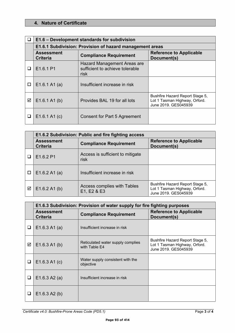
Certificate v4.0: Bushfire-Prone Areas Code (PD5.1) Page 3 of 4
4. Nature of Certificate
E1.6 – Development standards for subdivisionE1.6.1 Subdivision: Provision of hazard management areasAssessment Criteria Compliance Requirement Reference to Applicable
Document(s)
E1.6.1 P1Hazard Management Areas are sufficient to achieve tolerable risk
E1.6.1 A1 (a) Insufficient increase in risk
E1.6.1 A1 (b) Provides BAL 19 for all lotsBushfire Hazard Report Stage 5, Lot 1 Tasman Highway, Orford. June 2019. GES045939
E1.6.1 A1 (c) Consent for Part 5 Agreement
E1.6.2 Subdivision: Public and fire fighting accessAssessment Criteria Compliance Requirement Reference to Applicable
Document(s)
E1.6.2 P1 Access is sufficient to mitigate risk
E1.6.2 A1 (a) Insufficient increase in risk
E1.6.2 A1 (b) Access complies with Tables E1, E2 & E3
Bushfire Hazard Report Stage 5, Lot 1 Tasman Highway, Orford. June 2019. GES045939
E1.6.3 Subdivision: Provision of water supply for fire fighting purposesAssessment Criteria Compliance Requirement Reference to Applicable
Document(s)
E1.6.3 A1 (a) Insufficient increase in risk
E1.6.3 A1 (b) Reticulated water supply complies with Table E4
Bushfire Hazard Report Stage 5, Lot 1 Tasman Highway, Orford. June 2019. GES045939
E1.6.3 A1 (c) Water supply consistent with the objective
E1.6.3 A2 (a) Insufficient increase in risk
E1.6.3 A2 (b)
Page 93 of 414
Certificate v4.0: Bushfire-Prone Areas Code (PD5.1) Page 4 of 4
E1.6.3 A2 (c)
5. Bushfire Hazard Practitioner3
Name: Mark Van den Berg Phone No: 03 62231839
Address: 29 Kirksway Place Fax No: N/A
Battery Point Email Address:
Tasmania 7004
Accreditation No: BFP – 108 Scope: 1, 2, 3a, 3b, 3c.
6. Certification
I, certify that in accordance with the authority given under Part 4A of the Fire Service Act 1979 –
The use or development described in this certificate is exempt from application of Code E1 – Bushfire-Prone Areas in accordance with Clause E1.4 (a) because there is an insufficient increase in risk to the use or development from bushfire to warrant any specific bushfire protection measure in order to be consistent with the objectives for all the applicable standards identified in Section 4 of this Certificate.
or
There is an insufficient increase in risk from bushfire to warrant the provision of specific measures for bushfire hazard management and/or bushfire protection in order for the use or development described to be consistent with the objective for each of the applicable standards identified in Section 4 of this Certificate.
and/or
The Bushfire Hazard Management Plan/s identified in Section 3 of this certificate is/are in accordance with the Chief Officer’s requirements and can deliver an outcome for the use or development described that is consistent with the objective and the relevant compliance test for each of the applicable standards identified in Section 4 of this Certificate.
Signed:certifier
Date: 28/06/2019 Certificate No: GES04539
3 A Bushfire Hazard Practitioner is a person accredited by the Chief Officer of the Tasmania Fire Service under Part IVA of Fire Service Act 1979. The list of practitioners and scope of work is found at www.fire.tas.gov.au.
Page 94 of 414

Bushfire Hazard Report - Stage 5, Lot 1 Tasman Highway, Orford, July 2019, GES04539.
Appendix E
Certificate of Others (form 55)
Page 95 of 414
Director of Building Control – Date Approved 1 July 2017 Building Act 2016 - Approved Form No. 55
CERTIFICATE OF QUALIFIED PERSON – ASSESSABLE ITEM Section 321
To: Bay Port Pty. Ltd. Owner /Agent
55 Colemans Road Address
Carrum Downs Vic. 3201 Suburb/postcode
Qualified person details:
Qualified person: Mark Van den BergAddress: 29 Kirksway Place Phone No: 03 6223 1839
Battery Point 7004 Fax No:
Licence No: Email address: [email protected]
Accredited to report on bushfire hazards under Part IVA of the Fire Service Act. BFP-108 scope 1, 2, 3a, 3b, 3c.Besso PI policy No. 10780170
Qualifications and Insurance details:
(description from Column 3 of the Director's Determination - Certificates by Qualified Persons for Assessable Items
Speciality area of expertise:
Analysis of bushfire hazards in bushfire prone areas
(description from Column 4 of the Director's Determination - Certificates by Qualified Persons for Assessable Items)
Details of work:
Address: Lot 1 Tasman Highway Lot No: 1Orford, Tas. 7190 Certificate of title No: 139972/1
The assessable item related to this certificate:
New building work in a bushfire prone area.
(description of the assessable item being certified) Assessable item includes – - a material;- a design- a form of construction- a document- testing of a component, building
system or plumbing system- an inspection, or assessment,
performed
Certificate details:
Certificate type: Bushfire Hazard (description from Column 1 of Schedule 1 of the Director's Determination - Certificates by Qualified Persons for Assessable Items n)
This certificate is in relation to the above assessable item, at any stage, as part of - (tick one)
building work, plumbing work or plumbing installation or demolition work: Xor
a building, temporary structure or plumbing installation:
Form 55
Page 96 of 414

Director of Building Control – Date Approved 1 July 2017 Building Act 2016 - Approved Form No. 55
In issuing this certificate the following matters are relevant –
Documents: Bushfire Hazard Report Stage 5, Lot 1 Tasman Highway, Orford. June 2019. GES045939 Bushfire Hazard Management Plan Stage 5, Lot 1 Tasman Highway, Orford. June 2019. GES045939 and Form 55.
Relevantcalculations: Not Applicable.
References:Determination, Director of Building Control Requirements for Building in Bushfire-Prone Areas, version 2.1 29th August 2017. Consumer, Building and Occupational Services, Department of Justice, Tasmania. Building Amendment (Bushfire-Prone Areas) Regulations 2014 Standards Australia 2018, Construction of buildings in bushfire prone areas, Standards Australia, Sydney.
Substance of Certificate: (what it is that is being certified)This certificate may be used for building compliance purposes where all the specifications of the report and bushfire hazard management plan can be complied with for lots 501 to 547 inclusive.
Construction to BAL-12.5 and BAL-19 of AS3959-2018 as shown on the bushfire hazard management plan. All specifications of BHMP and report required for compliance.
Scope and/or LimitationsScope: This report was commissioned to identify the Bushfire Attack Level for the existing property. Limitations: The inspection has been undertaken and report provided on the understanding that;-1. The report only deals with the potential bushfire risk all other statutory assessments are outside the scope of this report. 2. The report only identifies the size, volume and status of vegetation at the time the site inspection was undertaken and cannot be relied upon for any future development. 3. Impacts of future development and vegetation growth have not been considered.
I certify the matters described in this certificate.Signed: Certificate No: Date:
Qualified person: GES04539 28/06/2019
Page 97 of 414

SUBDIVISION SITE ASSESSMENT
Lot 1 Tasman Highway, Orford
Geo-Environmental Solutions P/L 29 Kirksway Place, Battery Point.
T | 6223 1839 E | [email protected]
June 2019
Page 98 of 414

GES – Geotechnical Assessment – Lot 1 Tasman Highway Orford
© GES P/L 2019 1
Contents 1. Introduction .................................................................................................................. 2
2. Planning Context ........................................................................................................ 4
3. Site Information ........................................................................................................... 6
3.1 Geology .................................................................................................................... 6 3.1 Soil Distribution ....................................................................................................... 6
4. Site Suitability for Onsite Wastewater Disposal .................................................... 8
5. Conclusions ............................................................................................................... 15 Appendix 1 –Trench summary reports ......................................................................... 16
Appendix 2 – Bore Logs ................................................................................................. 19 Appendix 3 – Test Hole Locations ................................................................................ 25
Appendix 4 – Building Act 2016 Compliance .............................................................. 26
Page 99 of 414
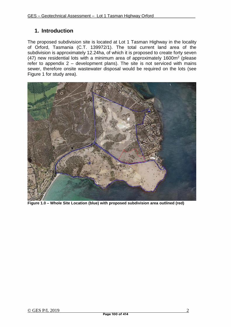
GES – Geotechnical Assessment – Lot 1 Tasman Highway Orford
© GES P/L 2019 2
1. Introduction The proposed subdivision site is located at Lot 1 Tasman Highway in the locality of Orford, Tasmania (C.T. 139972/1). The total current land area of the subdivision is approximately 12.24ha, of which it is proposed to create forty seven (47) new residential lots with a minimum area of approximately 1600m2 (please refer to appendix 2 – development plans). The site is not serviced with mains sewer, therefore onsite wastewater disposal would be required on the lots (see Figure 1 for study area).
Figure 1.0 – Whole Site Location (blue) with proposed subdivision area outlined (red)
Page 100 of 414
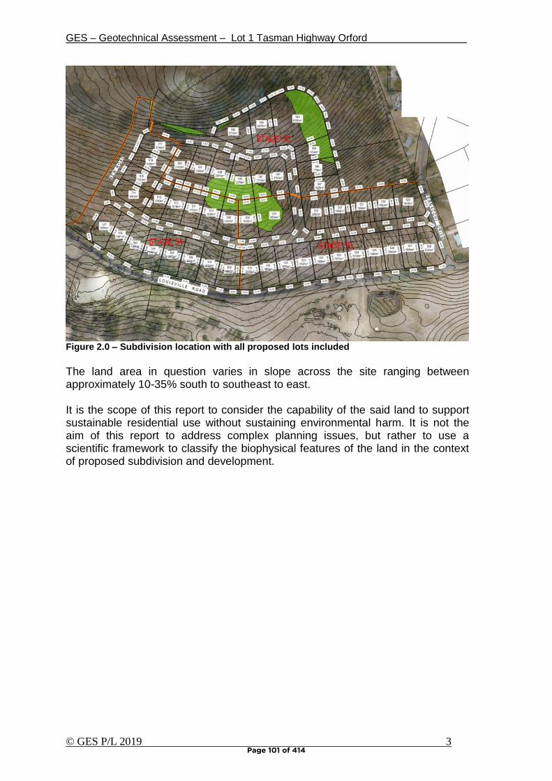
GES – Geotechnical Assessment – Lot 1 Tasman Highway Orford
© GES P/L 2019 3
Figure 2.0 – Subdivision location with all proposed lots included
The land area in question varies in slope across the site ranging between approximately 10-35% south to southeast to east. It is the scope of this report to consider the capability of the said land to support sustainable residential use without sustaining environmental harm. It is not the aim of this report to address complex planning issues, but rather to use a scientific framework to classify the biophysical features of the land in the context of proposed subdivision and development.
Page 101 of 414
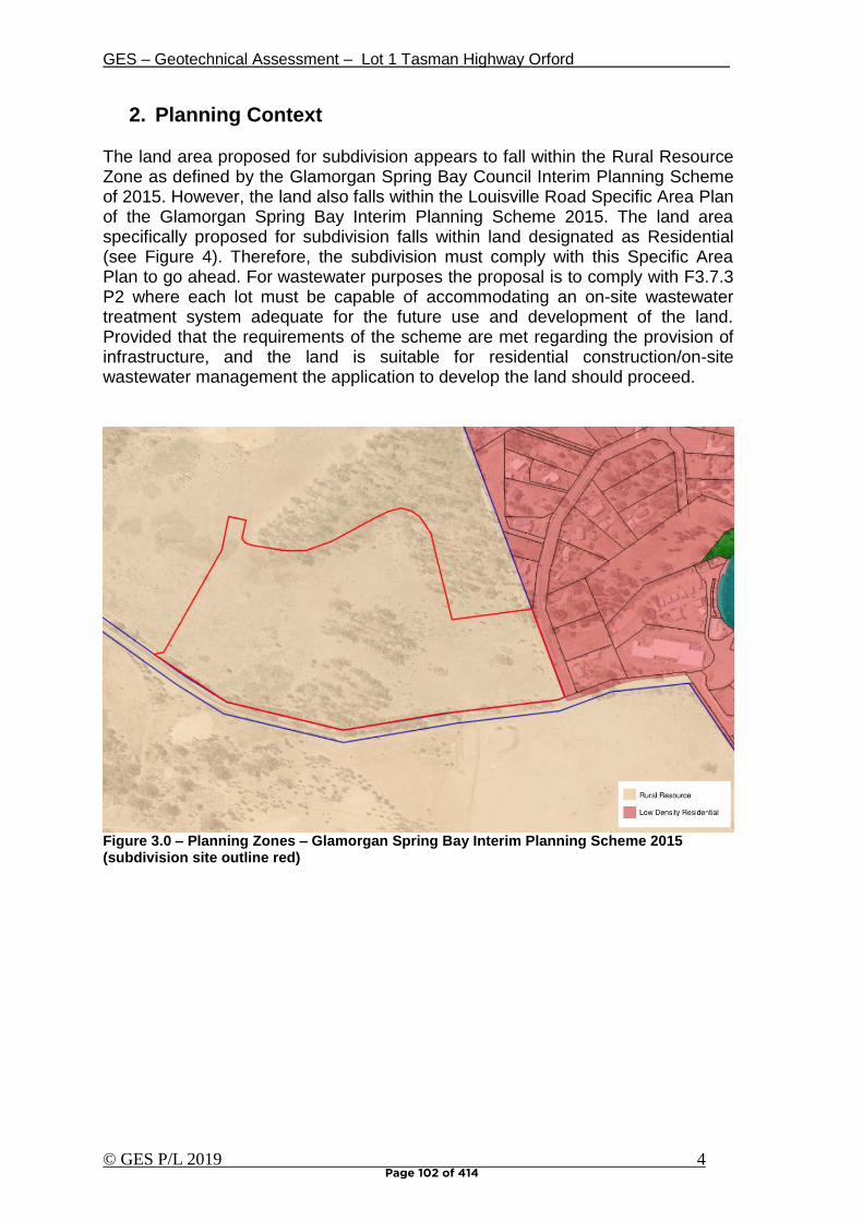
GES – Geotechnical Assessment – Lot 1 Tasman Highway Orford
© GES P/L 2019 4
2. Planning Context
The land area proposed for subdivision appears to fall within the Rural Resource Zone as defined by the Glamorgan Spring Bay Council Interim Planning Scheme of 2015. However, the land also falls within the Louisville Road Specific Area Plan of the Glamorgan Spring Bay Interim Planning Scheme 2015. The land area specifically proposed for subdivision falls within land designated as Residential (see Figure 4). Therefore, the subdivision must comply with this Specific Area Plan to go ahead. For wastewater purposes the proposal is to comply with F3.7.3 P2 where each lot must be capable of accommodating an on-site wastewater treatment system adequate for the future use and development of the land. Provided that the requirements of the scheme are met regarding the provision of infrastructure, and the land is suitable for residential construction/on-site wastewater management the application to develop the land should proceed.
Figure 3.0 – Planning Zones – Glamorgan Spring Bay Interim Planning Scheme 2015 (subdivision site outline red)
Page 102 of 414

GES – Geotechnical Assessment – Lot 1 Tasman Highway Orford
© GES P/L 2019 5
Figure 4.0 – Glamorgan Bay Interim Planning Scheme 2015 Precinct Zoning Plan
Page 103 of 414
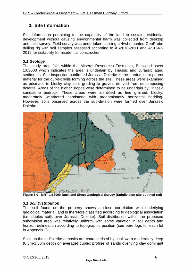
GES – Geotechnical Assessment – Lot 1 Tasman Highway Orford
© GES P/L 2019 6
3. Site Information Site information pertaining to the capability of the land to sustain residential development without causing environmental harm was collected from desktop and field survey. Field survey was undertaken utilising a 4wd mounted GeoProbe drilling rig with soil samples assessed according to AS2870-2011 and AS1547-2012 for suitability for residential construction. 3.1 Geology The study area falls within the Mineral Resources Tasmania, Buckland sheet 1:63000 which indicates the area is underlain by Triassic and Jurassic aged sediments. Site inspection confirmed Jurassic Dolerite is the predominant parent material for the duplex soils forming across the site. These areas were examined as prismatic to blocky clay soils grading to gravels derived from decomposing dolerite. Areas of the higher slopes were determined to be underlain by Triassic sandstone bedrock. These areas were identified as fine grained, blocky, moderately weathered sandstone with predominantly horizontal bedding. However, soils observed across the sub-division were formed over Jurassic Dolerite.
Figure 5.0 - MRT 1:63000 Buckland Sheet Geological Survey (Subdivision site outlined red)
3.1 Soil Distribution The soil found on the property shows a close correlation with underlying geological material, and is therefore classified according to geological association (i.e. duplex soils over Jurassic Dolerite). Soil distribution within the proposed subdivision area was relatively uniform, with some variation in soil depth and horizon delineation according to topographic position (see bore logs for each lot in Appendix 2). Soils on these Dolerite deposits are characterised by shallow to moderately deep (0.5m-1.80m depth on average) duplex profiles of sands overlying clay dominant
Page 104 of 414
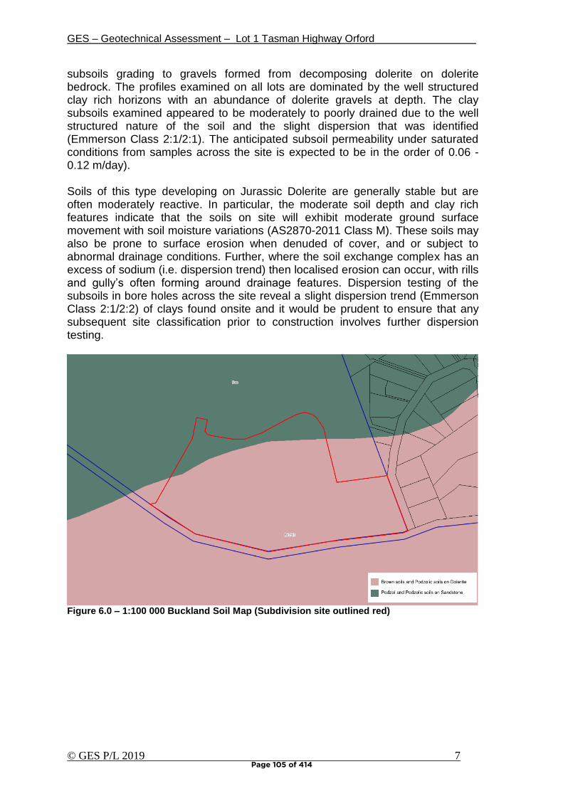
GES – Geotechnical Assessment – Lot 1 Tasman Highway Orford
© GES P/L 2019 7
subsoils grading to gravels formed from decomposing dolerite on dolerite bedrock. The profiles examined on all lots are dominated by the well structured clay rich horizons with an abundance of dolerite gravels at depth. The clay subsoils examined appeared to be moderately to poorly drained due to the well structured nature of the soil and the slight dispersion that was identified (Emmerson Class 2:1/2:1). The anticipated subsoil permeability under saturated conditions from samples across the site is expected to be in the order of 0.06 -0.12 m/day).
Soils of this type developing on Jurassic Dolerite are generally stable but are often moderately reactive. In particular, the moderate soil depth and clay rich features indicate that the soils on site will exhibit moderate ground surface movement with soil moisture variations (AS2870-2011 Class M). These soils may also be prone to surface erosion when denuded of cover, and or subject to abnormal drainage conditions. Further, where the soil exchange complex has an excess of sodium (i.e. dispersion trend) then localised erosion can occur, with rills and gully’s often forming around drainage features. Dispersion testing of the subsoils in bore holes across the site reveal a slight dispersion trend (Emmerson Class 2:1/2:2) of clays found onsite and it would be prudent to ensure that any subsequent site classification prior to construction involves further dispersion testing.
Figure 6.0 – 1:100 000 Buckland Soil Map (Subdivision site outlined red)
Page 105 of 414

GES – Geotechnical Assessment – Lot 1 Tasman Highway Orford
© GES P/L 2019 8
4. Site Suitability for Onsite Wastewater Disposal The soils across the subdivision site were compared and classified according to AS/NZS1547-2012 (on-site wastewater management). Bore logs for each profile based upon onsite geotechnical drilling is presented in Appendix 2 whilst site and soil factors pertinent to wastewater disposal under AS1547-2012 are presented in Table 1 overleaf. The soils across the site area classified according to AS1547-2012 as Category 5 Light Clay with lower Long Term Acceptance Rates (LTAR’s). Due to the variable duplex soils on site it is recommend that appropriate application rates be assigned (refer to Table 1). Modelling utilising the planning scheme typical three bedroom house on mains water with standard plumbing fixtures indicates that a disposal area of up to 500m2 (250m2 installed and 250m2 reserve) should be set aside wastewater disposal on each lot (see trench summary report attached). Based upon allowances for adequate down slope boundary setbacks and sufficient construction, access, and recreational space, then I recommend that a minimum area available for wastewater disposal of flow from any future dwelling to be 1500m2 would be adequate for subdivision design. It should be noted that this area is based upon the installation of an AWTS or similar packaged system on each lot, with irrigation (using a Design Irrigation Rate DIR of 3mm/day). However, some of the areas examined would also be suitable for traditional septic tank and absorption trench systems, with a typical total disposal area of up to 200m2 (100m2 installed and 100m2 reserve) required on each lot for a typical three bedroom home (based upon a Design Loading Rate DLR of 7L/m2/day). Soil depth does vary across the lots ranging from approximately 0.8m to over 2m, and as such wastewater designs on each lot will need to consider soil depth and separation distances to the underlying limiting layer. On the lots where soil depth is less than 1m, if a traditional septic tank system is to be used the design will require incorporation of secondary treatment via a geotextile sand filter similar to achieve the required vertical setback to rock (i.e. 0.5m minimum). The addition of soil and/or terracing may also be required to achieve and appropriate absorption area with compliant setbacks. Nutrient balance and sustainable wastewater application The soils across the entire site are developed from Jurassic Dolerite with moderate to high cation exchange complex in the clay subsoils. The subsoil clays returned slight dispersive results to all Emerson dispersion tests (Trench assigned value of “2”). The soils examined are also moderately to well structured and clay minerals and a moderate to high estimated Cation Exchange Capacity (CEC) at depth. Therefore, the soils have a moderate ability to retain applied nutrients in wastewater and the risk of nutrient attenuation associated with wastewater application is low. Furthermore, it is recommended that adequate dispersion testing and soil classification is undertaken in proposed disposal areas on each lot to ensure the predicted soil behaviour and effluent disposal standards are met.
Page 106 of 414
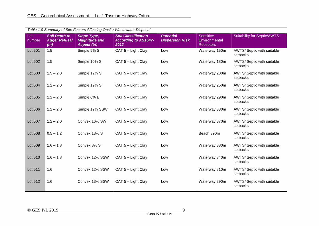
GES – Geotechnical Assessment – Lot 1 Tasman Highway Orford
© GES P/L 2019 9
Table 1.0 Summary of Site Factors Affecting Onsite Wastewater Disposal
Lot number
Soil Depth to Auger Refusal (m)
Slope Type, Magnitude and Aspect (%)
Soil Classification according to AS1547-2012
Potential Dispersion Risk
Sensitive Environmental Receptors
Suitability for Septic/AWTS
Lot 501 1.5 Simple 9% S CAT 5 – Light Clay Low Waterway 150m AWTS/ Septic with suitable setbacks
Lot 502 1.5 Simple 10% S CAT 5 – Light Clay Low Waterway 180m AWTS/ Septic with suitable setbacks
Lot 503 1.5 – 2.0 Simple 12% S CAT 5 – Light Clay Low Waterway 200m AWTS/ Septic with suitable setbacks
Lot 504 1.2 – 2.0 Simple 12% S CAT 5 – Light Clay Low Waterway 250m AWTS/ Septic with suitable setbacks
Lot 505 1.2 – 2.0 Simple 6% E CAT 5 – Light Clay Low Waterway 290m AWTS/ Septic with suitable setbacks
Lot 506 1.2 – 2.0 Simple 12% SSW CAT 5 – Light Clay Low Waterway 330m AWTS/ Septic with suitable setbacks
Lot 507 1.2 – 2.0 Convex 16% SW CAT 5 – Light Clay Low Waterway 370m AWTS/ Septic with suitable setbacks
Lot 508 0.5 – 1.2 Convex 13% S CAT 5 – Light Clay Low Beach 390m AWTS/ Septic with suitable setbacks
Lot 509 1.6 – 1.8 Convex 8% S CAT 5 – Light Clay Low Waterway 380m AWTS/ Septic with suitable setbacks
Lot 510 1.6 – 1.8 Convex 12% SSW CAT 5 – Light Clay Low Waterway 340m AWTS/ Septic with suitable setbacks
Lot 511 1.6 Convex 12% SSW CAT 5 – Light Clay Low Waterway 310m AWTS/ Septic with suitable setbacks
Lot 512 1.6 Convex 13% SSW CAT 5 – Light Clay Low Waterway 290m AWTS/ Septic with suitable setbacks
Page 107 of 414
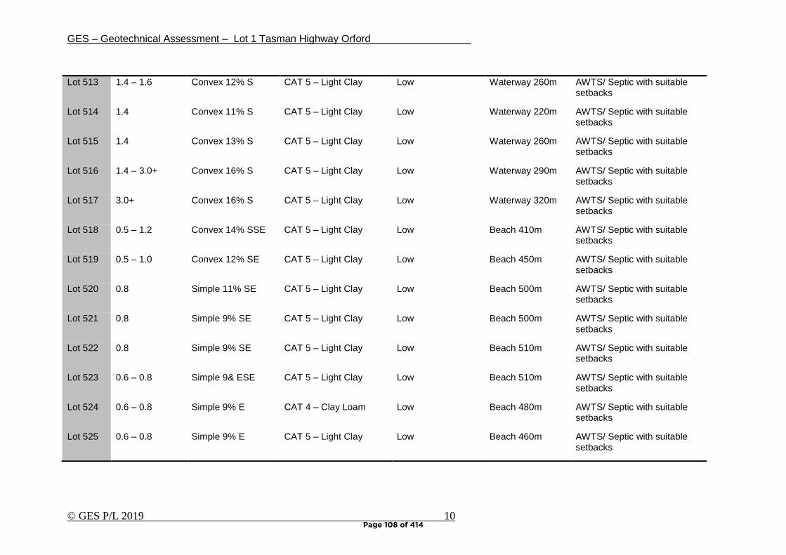
GES – Geotechnical Assessment – Lot 1 Tasman Highway Orford
© GES P/L 2019 10
Lot 513 1.4 – 1.6 Convex 12% S CAT 5 – Light Clay Low Waterway 260m AWTS/ Septic with suitable setbacks
Lot 514 1.4 Convex 11% S CAT 5 – Light Clay Low Waterway 220m AWTS/ Septic with suitable setbacks
Lot 515 1.4 Convex 13% S CAT 5 – Light Clay Low Waterway 260m AWTS/ Septic with suitable setbacks
Lot 516 1.4 – 3.0+ Convex 16% S CAT 5 – Light Clay Low Waterway 290m AWTS/ Septic with suitable setbacks
Lot 517 3.0+ Convex 16% S CAT 5 – Light Clay Low Waterway 320m AWTS/ Septic with suitable setbacks
Lot 518 0.5 – 1.2 Convex 14% SSE CAT 5 – Light Clay Low Beach 410m AWTS/ Septic with suitable setbacks
Lot 519 0.5 – 1.0 Convex 12% SE CAT 5 – Light Clay Low Beach 450m AWTS/ Septic with suitable setbacks
Lot 520 0.8 Simple 11% SE CAT 5 – Light Clay Low Beach 500m AWTS/ Septic with suitable setbacks
Lot 521 0.8 Simple 9% SE CAT 5 – Light Clay Low Beach 500m AWTS/ Septic with suitable setbacks
Lot 522 0.8 Simple 9% SE CAT 5 – Light Clay Low Beach 510m AWTS/ Septic with suitable setbacks
Lot 523 0.6 – 0.8 Simple 9& ESE CAT 5 – Light Clay Low Beach 510m AWTS/ Septic with suitable setbacks
Lot 524 0.6 – 0.8 Simple 9% E CAT 4 – Clay Loam Low Beach 480m AWTS/ Septic with suitable setbacks
Lot 525 0.6 – 0.8 Simple 9% E CAT 5 – Light Clay Low Beach 460m AWTS/ Septic with suitable setbacks
Page 108 of 414
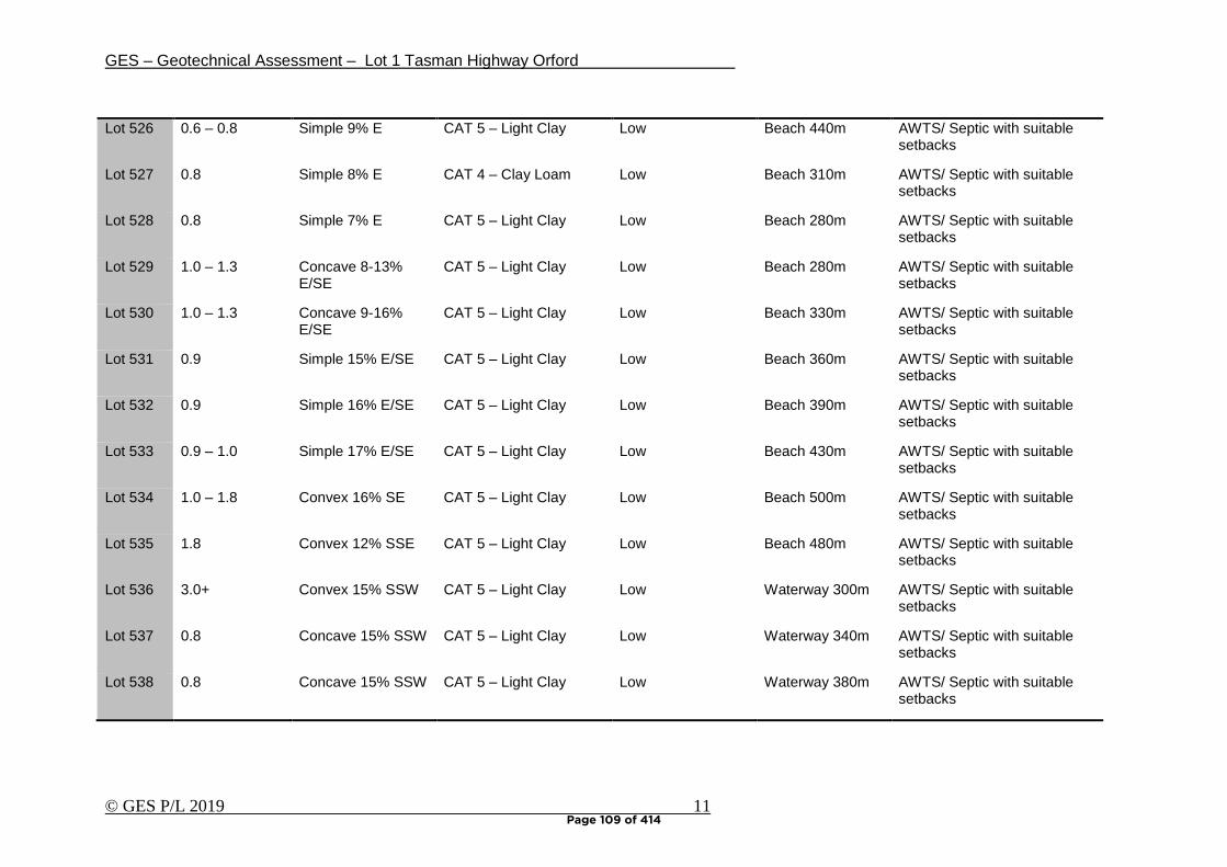
GES – Geotechnical Assessment – Lot 1 Tasman Highway Orford
© GES P/L 2019 11
Lot 526 0.6 – 0.8 Simple 9% E CAT 5 – Light Clay Low Beach 440m AWTS/ Septic with suitable setbacks
Lot 527 0.8 Simple 8% E CAT 4 – Clay Loam Low Beach 310m AWTS/ Septic with suitable setbacks
Lot 528 0.8 Simple 7% E CAT 5 – Light Clay Low Beach 280m AWTS/ Septic with suitable setbacks
Lot 529 1.0 – 1.3 Concave 8-13% E/SE
CAT 5 – Light Clay Low Beach 280m AWTS/ Septic with suitable setbacks
Lot 530 1.0 – 1.3 Concave 9-16% E/SE
CAT 5 – Light Clay Low Beach 330m AWTS/ Septic with suitable setbacks
Lot 531 0.9 Simple 15% E/SE CAT 5 – Light Clay Low Beach 360m AWTS/ Septic with suitable setbacks
Lot 532 0.9 Simple 16% E/SE CAT 5 – Light Clay Low Beach 390m AWTS/ Septic with suitable setbacks
Lot 533 0.9 – 1.0 Simple 17% E/SE CAT 5 – Light Clay Low Beach 430m AWTS/ Septic with suitable setbacks
Lot 534 1.0 – 1.8 Convex 16% SE CAT 5 – Light Clay Low Beach 500m AWTS/ Septic with suitable setbacks
Lot 535 1.8 Convex 12% SSE CAT 5 – Light Clay Low Beach 480m AWTS/ Septic with suitable setbacks
Lot 536 3.0+ Convex 15% SSW CAT 5 – Light Clay Low Waterway 300m AWTS/ Septic with suitable setbacks
Lot 537 0.8 Concave 15% SSW CAT 5 – Light Clay Low Waterway 340m AWTS/ Septic with suitable setbacks
Lot 538 0.8 Concave 15% SSW CAT 5 – Light Clay Low Waterway 380m AWTS/ Septic with suitable setbacks
Page 109 of 414
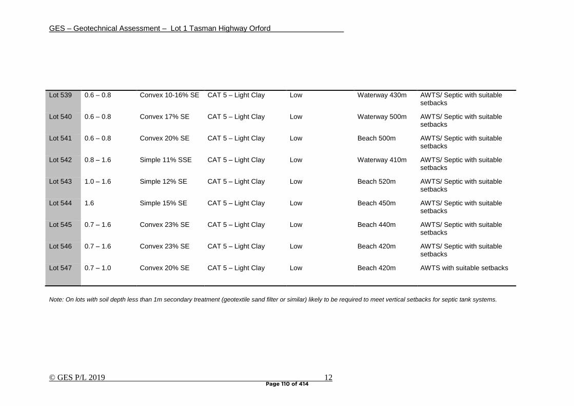
GES – Geotechnical Assessment – Lot 1 Tasman Highway Orford
© GES P/L 2019 12
Lot 539 0.6 – 0.8 Convex 10-16% SE CAT 5 – Light Clay Low Waterway 430m AWTS/ Septic with suitable setbacks
Lot 540 0.6 – 0.8 Convex 17% SE CAT 5 – Light Clay Low Waterway 500m AWTS/ Septic with suitable setbacks
Lot 541 0.6 – 0.8 Convex 20% SE CAT 5 – Light Clay Low Beach 500m AWTS/ Septic with suitable setbacks
Lot 542 0.8 – 1.6 Simple 11% SSE CAT 5 – Light Clay Low Waterway 410m AWTS/ Septic with suitable setbacks
Lot 543 1.0 – 1.6 Simple 12% SE CAT 5 – Light Clay Low Beach 520m AWTS/ Septic with suitable setbacks
Lot 544 1.6 Simple 15% SE CAT 5 – Light Clay Low Beach 450m AWTS/ Septic with suitable setbacks
Lot 545 0.7 – 1.6 Convex 23% SE CAT 5 – Light Clay Low Beach 440m AWTS/ Septic with suitable setbacks
Lot 546 0.7 – 1.6 Convex 23% SE CAT 5 – Light Clay Low Beach 420m AWTS/ Septic with suitable setbacks
Lot 547 0.7 – 1.0 Convex 20% SE CAT 5 – Light Clay Low Beach 420m AWTS with suitable setbacks
Note: On lots with soil depth less than 1m secondary treatment (geotextile sand filter or similar) likely to be required to meet vertical setbacks for septic tank systems.
Page 110 of 414
GES – Geotechnical Assessment – Lot 1 Tasman Highway Orford
© GES P/L 2019 13
Hydrological balance and wastewater disposal Modelling of wastewater application on each lot was undertaken utilising the Trench program, long term weather average for Orford, and estimated flows from an average three bedroom home. This yielded a maximum AWTS application area of approximately 250 square meters, which is further amended to 500 square meters to fulfil the requirements for a 100% reserve area. Based upon the modelling undertaken in trench, the required areas are more than adequate to sustain long term wastewater application on each lot. It should however be noted that the modelling is based upon the installation of packaged treatment systems (eg AWTS) for dwellings on each lot. Given that some of the proposed lots may be suitable for the use of a traditional septic tank and trench system the area required may be much less (e.g. 200m2) dependent upon lot specific site plans. Recommendations can be made about the suitability of one system or another and the final decision of wastewater system approval rests with the permit authority at the time of site specific design to ensure the most compatible environmental and economic outcomes. Setbacks distances to boundaries and sensitive features The proposed lots have highly variable slopes; therefore, three average slopes have been calculated to represent the indicative required setbacks. The minimum discretionary boundary setbacks modelled according to the Building Act 2016 for on site wastewater management for the development are: Table 2.0 – Building Act 2016 downslope setbacks
Slopes (%)
10 (6 degrees) 15 (9 degrees) 20 (11 degrees)
Primary Secondary Primary Secondary Primary Secondary
Upslope/Level Boundary 1.5m 1.5m 1.5m 1.5m 1.5m 1.5m
Downslope Boundary 12m 7.5m 18m 10.5m 22m 12.5m
Upslope/Level Building 3m 3m 3m 3m 3m 3m
Downslope Building 10m 3.5m 13m 4.25m 15m 4.75m
Downslope Surface Water 100m 100m 100m 100m 100m 100m
Groundwater 1.5m 0.6m 1.5m 0.6m 1.5m 0.6m
Limiting Layer 1.5m 0.5m 1.5m 0.5m 1.5m 0.5m
*Note: See Appendix 4 for Building Act compliance. 11 degrees has been the nominal value used to represent the most restricted lots.
A subdivision proposal with lots of a minimum area of approximately 1500m2 should allow for significant space on each lot for wastewater disposal with adequate setbacks in regards boundaries and sensitive features. Therefore the current subdivision plan complies with F3.7.3 P2 of the Glamorgan Spring Bay Interim Planning Scheme 2015.
Page 111 of 414

GES – Geotechnical Assessment – Lot 1 Tasman Highway Orford
© GES P/L 2019 14
The actual down slope boundary setbacks applied will require fine tuning at the special plumbing permit stage as access, parking, and building footprints are finalised in conjunction with wastewater disposal areas. Modelling at this planning stage does however suggest that sufficient room would be available on each lot to accommodate the required setbacks. The subdivision area has no dams/drainage lines or permanent creeks; however a natural drainage line is noted to the southwest of the site approximately 150m from proposed lot 501. Therefore, there is little risk involved with onsite wastewater and downslope surface water.
Page 112 of 414

GES – Geotechnical Assessment – Lot 1 Tasman Highway Orford
© GES P/L 2019 15
5. Conclusions
In conclusion, I feel that the land area examined is capable of supporting residential development provided that the identified landscape constraints are addressed with appropriate site specific management strategies.
• The land surveyed is suitable for on site wastewater disposal utilising either packaged treatment plants and/or septic tank systems depending upon the soil depth, final lot layout and construction type
• A minimum Lot size of 1500 m2 is recommended for subdivision design in the study area
• Based upon the modelling undertaken a minimum lot size of 1500m2 would be adequate to accommodate residential development and on site wastewater disposal
• A range of minimum down slope setbacks from wastewater application areas have been recommended and should be utilised in the site specific building and wastewater design phase.
• The variation in soil depth across lots must be taken into account in system design and secondary treatment of effluent is likely to be required for lots with soil depth less than 1m
• The risk of land instability in the indicative building areas on lots to be created is low, and the risk acceptable provided the recommendation contained in this report are followed.
• I do however recommend careful attention is paid to foundation design and drainage design to further eliminate the potential for foundation movement.
• All earthworks on site must comply with AS3798-2007 and consideration should be given to drainage and sediment control on site during and after construction.
• The final approval for construction and wastewater disposal rests with the permit authority at the building approvals stage, and the recommendations in this report should not be viewed as blanket approval for any scale or type of residential development on each lot. Sites must be revisited for individual onsite wastewater assessments.
• The scale and type of residential development on each lot should therefore be appropriate to the environmental constraints of each lot – therefore I recommend that geotechnical information be provided to prospective purchasers to allow informed decisions.
It is my professional opinion that the land surveyed is suitable to support residential development without sustaining environmental harm or causing undue risk to capital. Dr John Paul Cumming B.Agr.Sc (hons) PhD CPSS GAICD Environmental and Engineering Soil Scientist
Page 113 of 414
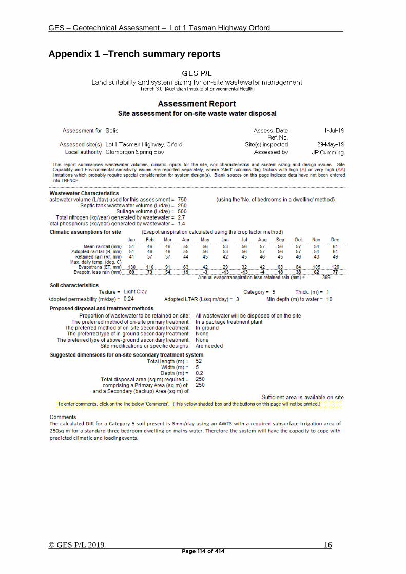
GES – Geotechnical Assessment – Lot 1 Tasman Highway Orford
© GES P/L 2019 16
Appendix 1 –Trench summary reports
Page 114 of 414
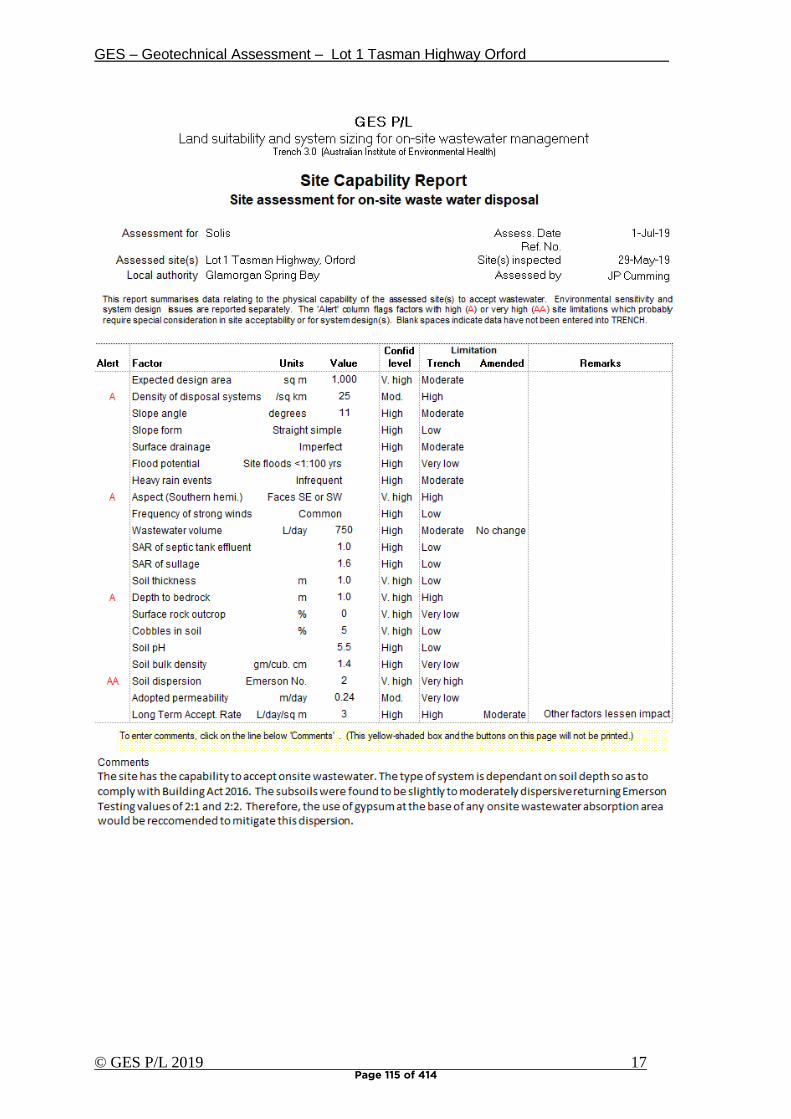
GES – Geotechnical Assessment – Lot 1 Tasman Highway Orford
© GES P/L 2019 17
Page 115 of 414
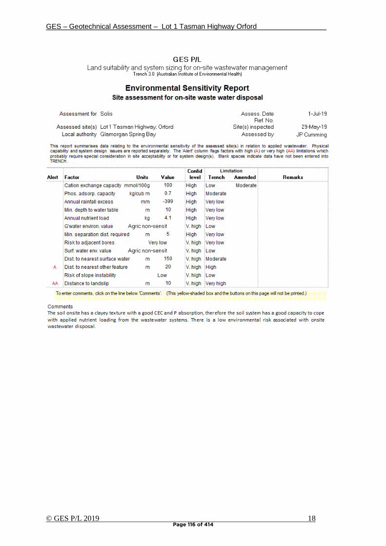
GES – Geotechnical Assessment – Lot 1 Tasman Highway Orford
© GES P/L 2019 18 Page 116 of 414
GES – Geotechnical Assessment – Lot 1 Tasman Highway Orford
© GES P/L 2019 19
Appendix 2 – Bore Logs
Test Hole 1
Depth (m) Horizon Description
0.00 – 0.10 A1 Grey SAND (SW), slightly moist, loose consistency, single grain
structure, trace of clay, loam fabric, clear boundary to
0.10 – 0.90 B2 Brownish Yellow to Grey CLAY (CH), slightly moist, stiff
consistency, high plasticity, moderately developed polyhedral
structure, gradual boundary to
0.90 – 1.50 BC Brownish Yellow to Orange Yellow Clayey GRAVEL (GC),
slightly moist, hard consistency, weakly developed polyhedral
structure, ~10-15% clay, ~30% gravels increasing to refusal
Test Hole 2
Depth (m) Horizon Description
0.00 – 0.10 A1 Grey SAND (SW), slightly moist, loose consistency, single grain
structure, trace of clay, loam fabric, gradual boundary to
0.10 – 0.20 A2 Light Grey SAND (SM), slightly moist, loose consistency, single
grain structure, clear boundary to
0.20 – 0.70 B2 Brownish Yellow to Grey CLAY (CH), slightly moist, stiff
consistency, high plasticity, moderately developed polyhedral
structure, gradual boundary to
0.70 – 1.80 B3 Orange Grey to Pale Brown CLAY (CL), slightly moist, stiff
consistency, medium plasticity, moderately developed polyhedral
structure, medium sized sand grains, gradual boundary to
1.80 – 2.00 BC Brownish Yellow to Orange Yellow Clayey GRAVEL (GC),
slightly moist, hard consistency, weakly developed polyhedral
structure, ~10-15% clay, ~30% gravels increasing to refusal
Test Hole 3
Depth (m) Horizon Description
0.00 – 0.10 A1 Grey SAND (SW), slightly moist, loose consistency, single grain
structure, trace of clay, loam fabric, ~20% stones and gravels, clear
boundary to
0.10 – 0.70 B3 Orange Grey to Pale Brown CLAY (CL), slightly moist, stiff
consistency, medium plasticity, moderately developed polyhedral
structure, medium sized sand grains, gradual boundary to
0.70 – 1.20 BC Brownish Yellow to Orange Yellow Clayey GRAVEL (GC),
slightly moist, hard consistency, weakly developed polyhedral
structure, ~10-15% clay, ~30% gravels increasing, refusal on
assumed boulder
Page 117 of 414
GES – Geotechnical Assessment – Lot 1 Tasman Highway Orford
© GES P/L 2019 20
Test Hole 4
Depth (m) Horizon Description
0.00 – 0.10 A1 Grey SAND (SM), slightly moist, loose consistency, single grain
structure, trace of clay, loam fabric, gradual boundary to
0.10 – 0.50 B3 Orange Grey to Pale Brown CLAY (CL), slightly moist, stiff
consistency, medium plasticity, moderately developed polyhedral
structure, medium sized sand grains, ~20% stones and gravels,
refusal on assumed boulder
Test Hole 5
Depth (m) Horizon Description
0.00 – 0.10 B1 Dark Brown CLAY (CL), slightly moist, stiff consistency,
moderately developed polyhedral structure, medium plasticity,
gradual boundary to
0.10 – 0.70 B2 Dark Orange Brown CLAY (CH), slightly moist, stiff consistency,
moderately developed polyhedral structure, high plasticity, ~20%
fine gravels, gradual boundary to
0.70 – 0.80 BC Light Grey Clayey GRAVELS (GC), slightly moist, hard
consistency, weakly developed polyhedral structure, ~70% stones
and gravels, refusal on rock
Test Hole 6
Depth (m) Horizon Description
0.00 – 0.05 B1 Dark Brown CLAY (CL), slightly moist, stiff consistency,
moderately developed polyhedral structure, medium plasticity,
gradual boundary to
0.05 – 0.60 BC Light Grey Clayey GRAVELS (GC), slightly moist, hard
consistency, weakly developed polyhedral structure, ~80% stones
and gravels, refusal on rock
Page 118 of 414
GES – Geotechnical Assessment – Lot 1 Tasman Highway Orford
© GES P/L 2019 21
Test Hole 7
Depth (m) Horizon Description
0.00 – 0.10 B1 Dark Brown CLAY (CL), slightly moist, stiff consistency,
moderately developed polyhedral structure, medium plasticity,
gradual boundary to
0.10 – 0.70 B2 Dark Orange Brown CLAY (CH), slightly moist, stiff consistency,
moderately developed polyhedral structure, high plasticity, ~20%
fine gravels, gradual boundary to
0.70 – 0.80 BC Light Grey Clayey GRAVELS (GC), slightly moist, hard
consistency, weakly developed polyhedral structure, ~70% stones
and gravels, refusal on rock
Test Hole 8
Depth (m) Horizon Description
0.00 – 0.20 B1 Dark Brown CLAY (CL), slightly moist, stiff consistency,
moderately developed polyhedral structure, medium plasticity,
gradual boundary to
0.20 – 0.30 B2 Dark Orange Brown CLAY (CH), slightly moist, stiff consistency,
moderately developed polyhedral structure, high plasticity, ~20%
fine gravels, gradual boundary to
0.30 – 0.80 BC Light Grey Clayey GRAVELS (GC), slightly moist, hard
consistency, weakly developed polyhedral structure, ~70% stones
and gravels, refusal on rock
Test Hole 9
Depth (m) Horizon Description
0.00 – 0.10 A1 Greyish Brown SAND (SM), slightly moist, loose consistency,
single grain structure, clear boundary to
0.10 – 1.10 B2 Light Orange Brown CLAY (CH), slightly moist, stiff
consistency, moderately developed polyhedral structure, high
plasticity, ~10% gravels, ~20% fine sand, gradual boundary to
1.10 – 1.30 BC Brownish Yellow Clayey GRAVELS (GC), slightly moist, hard
consistency, moderately developed polyhedral structure, ~20%
clay, ~20% fine gravels increasing to refusal on rock
Test Hole 10
Depth (m) Horizon Description
0.00 – 0.10 A1 Greyish Brown SAND (SM), slightly moist, loose consistency,
single grain structure, clear boundary to
0.10 – 0.90 B2 Light Orange Brown CLAY (CH), slightly moist, stiff
consistency, moderately developed polyhedral structure, high
plasticity, refusal on rock
Page 119 of 414

GES – Geotechnical Assessment – Lot 1 Tasman Highway Orford
© GES P/L 2019 22
Test Hole 11
Depth (m) Horizon Description
0.00 – 0.10 A1 Brownish Grey SAND (SW), slightly moist, loose consistency,
single grain structure, gradual boundary to
0.10 – 0.20 A2 Light Grey SAND (SM), slightly moist, loose consistency, single
grain structure, clear boundary to
0.20 – 0.90 B2 Light Orange Brown CLAY (CH), slightly moist, stiff
consistency, moderately developed polyhedral structure, high
plasticity, gradual boundary
0.90 – 1.80 BC Pale Brown to White Clayey GRAVELS (GC), slightly moist,
hard consistency, very weakly developed polyhedral structure,
~15% clay, ~80% carbonate nodules, refusal on gravels
Test Hole 12
Depth (m) Horizon Description
0.00 – 0.10 A1 Grey SAND (SW), slightly moist, loose consistency, single grain
structure, trace of clay, loam fabric, clear boundary to
0.10 – 1.30 B2 Brownish Yellow to Grey CLAY (CH), slightly moist, stiff
consistency, high plasticity, moderately developed polyhedral
structure, gradual boundary to
1.30 – 1.60 BC Brownish Yellow to Orange Yellow Clayey GRAVEL (GC),
slightly moist, hard consistency, weakly developed polyhedral
structure, ~10-15% clay, ~30% gravels increasing to refusal
Test Hole 13
Depth (m) Horizon Description
0.00 – 0.10 A1 Grey SAND (SW), slightly moist, loose consistency, single grain
structure, trace of clay, loam fabric, clear boundary to
0.10 – 0.20 A2 Light Grey SAND (SM), slightly moist, loose consistency, single
grain structure, clear boundary to
0.20 – 0.70 B2 Brownish Yellow to Grey CLAY (CH), slightly moist, stiff
consistency, high plasticity, moderately developed polyhedral
structure, gradual boundary to
0.70 – 1.20 B3 Orange Grey to Pale Brown CLAY (CL), slightly moist, stiff
consistency, medium plasticity, moderately developed polyhedral
structure, medium sized sand grains, gradual boundary to
1.20 – 1.40 BC Brownish Yellow to Orange Yellow Clayey GRAVEL (GC),
slightly moist, hard consistency, weakly developed polyhedral
structure, ~10-15% clay, ~30% gravels increasing to refusal
Page 120 of 414
GES – Geotechnical Assessment – Lot 1 Tasman Highway Orford
© GES P/L 2019 23
Test Hole 14
Depth (m) Horizon Description
0.00 – 0.10 A1 Grey SAND (SM), slightly moist, loose consistency, single grain
structure, gradual boundary to
0.10 – 0.20 A2 Light Grey SAND (SM), slightly moist, loose consistency, single
grain structure, clear boundary to
0.20 – 1.70 B21 Grey with Pale Brown lenses CLAY (CH), slightly moist, stiff
consistency, well developed polyhedral structure, high plasticity,
gradual boundary to
1.70 – 2.10 B22 Grey to Pale Brown CLAY (CH), slightly moist, stiff consistency,
well developed polyhedral structure, high plasticity, gradual
boundary to
2.10 – 3.0+ B3 Orange Grey to Brownish Yellow CLAY (CL), slightly moist,
hard consistency, moderately developed polyhedral structure, ~20-
40% weathered fine gravels, lower boundary undefined
Test Hole 15
Depth (m) Horizon Description
0.00 – 0.10 A1 Grey SAND (SW), slightly moist, loose consistency, single grain
structure, trace of clay, loam fabric, clear boundary to
0.10 – 0.70 B3 Orange Grey to Pale Brown CLAY (CL), slightly moist, stiff
consistency, medium plasticity, moderately developed polyhedral
structure, medium sized sand grains, gradual boundary to
0.70 – 0.80 BC Brownish Yellow to Orange Yellow Clayey GRAVEL (GC),
slightly moist, hard consistency, weakly developed polyhedral
structure, ~10-15% clay, ~30% gravels increasing to refusal
Test Hole 16
Depth (m) Horizon Description
0.00 – 0.10 A1 Grey SAND (SW), slightly moist, loose consistency, single grain
structure, trace of clay, loam fabric, clear boundary to
0.10 – 0.50 B2 Brownish Yellow to Grey CLAY (CH), slightly moist, stiff
consistency, high plasticity, moderately developed polyhedral
structure, gradual boundary to
0.50 – 1.10 B3 Orange Grey to Pale Brown CLAY (CL), slightly moist, stiff
consistency, medium plasticity, moderately developed polyhedral
structure, medium sized sand grains, gradual boundary to
1.10 – 1.40 BC Brownish Yellow to Orange Yellow Clayey GRAVEL (GC),
slightly moist, hard consistency, weakly developed polyhedral
structure, ~10-15% clay, ~30% gravels, gradual boundary to
1.40 – 1.60 B4 Brownish Yellow CLAY (CH), slightly moist, stiff consistency,
high plasticity, moderately developed polyhedral structure,
commons gravels, refusal on rock
Page 121 of 414
GES – Geotechnical Assessment – Lot 1 Tasman Highway Orford
© GES P/L 2019 24
Test Hole 17
Depth (m) Horizon Description
0.00 – 0.10 A1 Grey SAND (SW), slightly moist, loose consistency, single grain
structure, trace of clay, loam fabric, clear boundary to
0.10 – 0.50 B2 Brownish Yellow to Grey CLAY (CH), slightly moist, stiff
consistency, high plasticity, moderately developed polyhedral
structure, gradual boundary to
0.50 – 0.70 BC Brownish Yellow to Orange Yellow Clayey GRAVEL (GC),
slightly moist, hard consistency, weakly developed polyhedral
structure, ~10-15% clay, ~30% gravels, refusal on assumedboulder
Test Hole 18
Depth (m) Horizon Description
0.00 – 0.10 A1 Grey SAND (SW), slightly moist, loose consistency, single grain
structure, trace of clay, loam fabric, clear boundary to
0.10 – 0.20 A2 Light Grey SAND (SM), slightly moist, loose consistency, single
grain structure, clear boundary to
0.20 – 0.60 B2 Brownish Yellow to Grey CLAY (CH), slightly moist, stiff
consistency, high plasticity, moderately developed polyhedral
structure, refusal on rock
Page 122 of 414
GES – Geotechnical Assessment – Lot 1 Tasman Highway Orford
© GES P/L 2019 25
Appendix 3 – Test Hole Locations
Page 123 of 414
GES – Geotechnical Assessment – Lot 1 Tasman Highway Orford
© GES P/L 2019 26
Appendix 4 – Building Act 2016 Compliance
Acceptable Solutions Performance Criteria Compliance
A1
Horizontal separation distance from a building to a land
application area must comply with one of the following:
a) be no less than 6m; or
b) be no less than:
(i) 3m from an upslope building or level building;
(ii) If primary treated effluent to be no less than
4m plus 1m for every degree of average
gradient from a downslope building;
(iii) If secondary treated effluent and subsurface
application, no less than 2m plus 0.25m for every
degree of average gradient from a downslope building.
P1
a) The land application area is located so that
(i) the risk of wastewater reducing the
bearing capacity of a building’s
foundations is acceptably low.; and
(ii) is setback a sufficient distance from a
downslope excavation around or under a
building to prevent inadequately treated
wastewater seeping out of that
excavation
Complies with A1 (b) (i)
Land application area will be located with a minimum
separation distance of 3m from an upslope or level
building.
Complies with A1 (b) (ii)
Land application area will be located with a minimum
separation distance of 15m of downslope building
Complies with A1 (b) (iii)
Land application area will be located with a minimum
separation distance of 4.75m of downslope building
A2 P2
Complies with A2 (a)
Land application area located > 100m from downslope
surface water
Horizontal separation distance from downslope Horizontal separation distance from downslope
surface water to a land application area must comply surface water to a land application area must
with (a) or (b) comply with all of the following:
(a) be no less than 100m; or a) Setbacks must be consistent with AS/NZS
(b) be no less than the following: 1547 Appendix R;
(i) if primary treated effluent 15m plus 7m for every
degree of average gradient to downslope surface
water; or
b) A risk assessment in accordance with
Appendix A of AS/NZS 1547 has been
completed that demonstrates that the risk is
acceptable.
(ii) if secondary treated effluent and subsurface
application, 15m plus 2m for every degree
of average gradient to down slope surface water.
water.
Page 124 of 414
GES – Geotechnical Assessment – Lot 1 Tasman Highway Orford
© GES P/L 2019 27
A3 P3
Complies with A3 (b) (i)
Land application area will be located with a minimum
separation distance of 1.5m from an upslope or level
property boundary
Complies with A3 (b) (ii)
Land application area will be located with a minimum
separation distance of 22m of downslope property
boundary
Complies with A3 (b) (iii)
Land application area will be located with a minimum
separation distance of 12.5m of downslope property
boundary
Horizontal separation distance from a property Horizontal separation distance from a property
boundary to a land application area must comply with boundary to a land application area must comply
either of the following: with all of the following:
(a) be no less than 40m from a property boundary; (a) Setback must be consistent with AS/NZS
or 1547 Appendix R; and
(b) be no less than: (b) A risk assessment in accordance with
(i) 1 .5m from an upslope or level property
boundary; and
(ii) If primary treated effluent 2m for every degree
of average gradient from a downslope property
boundary; or
(iii) If secondary treated effluent and subsurface application, 1.5m plus 1m for every degree of
average gradient from a downslope property
boundary.
Appendix A of AS/NZS 1547 has been
completed that demonstrates that the risk is
acceptable.
A4
Horizontal separation distance from a downslope bore, well
or similar water supply to a land
application area must be no less than 50m and not be within the
zone of influence of the bore whether up or down gradient.
P4
Horizontal separation distance from a downslope
bore, well or similar water supply to a land
application area must comply with all of the
following:
(a) Setback must be consistent with AS/NZS
1547 Appendix R; and
(b) A risk assessment completed in accordance
with Appendix A of AS/NZS 1547
demonstrates that the risk is acceptable
Complies with A4
No bore or well identified within 50m
Page 125 of 414

GES – Geotechnical Assessment – Lot 1 Tasman Highway Orford
© GES P/L 2019 28
A5
Vertical separation distance between groundwater and a land
application area must be no less than:
(a) 1.5m if primary treated effluent; or
(b) 0.6m if secondary treated effluent
P5
Vertical separation distance between
groundwater and a land application area must
comply with the following:
(a) Setback must be consistent with AS/NZS
1547 Appendix R; and
(b) A risk assessment completed in accordance
with Appendix A of AS/NZS 1547 that
demonstrates that the risk is acceptable
1.5m separation is required to comply with A5 (a)
0.6m separation is required to comply with A5 (b)
A6
Vertical separation distance between a limiting layer and a
land application area must be no less than:
(a) 1.5m if primary treated effluent; or
(b) 0.5m if secondary treated effluent
P6
Vertical setback must be consistent with
AS/NZS1547 Appendix R.
1.5m separation is required to comply with A5 (a)
0.5m separation is required to comply with A5 (a)
A7 P7
nil A wastewater treatment unit must be located a
sufficient distance from buildings or neighbouring
properties so that emissions (odour, noise or
aerosols) from the unit do not create an
environmental nuisance to the residents of those
properties
Complies
Page 126 of 414
JMG Ref: J92191CL Client Ref: SA2019/0017
7th January 2020 The Manager Planning GLAMORGAN SPRING BAY COUNCIL Dear Sir/Madam RE: TASWATER RFI – SA 2019/00017 SPRING BAY subdivision STAGE 5A,5B, 5C I refer to a Glamorgan Spring Bay communique dated 6th January 2020, outlining additional information required by Taswater for this application. However, we also advise that we have been in discussion with Jason Taylor of Taswater and during those discussions Taswater have agreed to relax their response requirements. This relaxation can be summarised as:
Taswater now only require that the delivery main to the new reservoir, and the distribution main from the new reservoir must be provided within the proposed subdivision, generally as shown in JMG’s report as figure 1 (reproduced and added to below), with both mains being 250 mm dia, together with a suitable PRV at the proposed junction with the exiting Asbestos Water Main.
Figure 1 Existing Easements and Proposed new Delivery and Distribution mains.
The new Reservoir delivery main is shown as light blue in Figure 1. The new distribution mains that will service the application and other stages in and around Louisville Road will be fed through the new subdivision roads that form part of the Stage 5 current application. These are the deep blue lines in Figure 1. Only the solid lines will be built in the subdivision being applied for.
Mains to and from
proposed new reservoir
New PRV installed at
junction of new delivery
main and existing
Asbestos Main.
Page 127 of 414
2 | P a g e
The developer has agreed that these features will be included in the detailed design of this proposal. We understand that this will now satisfy Taswater’s requirements under this RFI, that the clock can be restarted, and we note that no more modelling is required before the subdivision can be approved. It is important however to include a formal response to the stated RFI so that the record is complete in this regard. A copy of the original letter with inscribed responses in red is attached. ADDITIONALLY Taswater will also be aware that we raised a number of questions in our submission of the 30th July 2019, including whether the main should connect to the Bernacchi Drive pump station through Stage 5C of this subdivision proposal (the red line in the figure below). If it did so there may be no need for a PRV, AND the whole of the main in Louisville road could be abandoned and not replaced at all. The savings of not having to replace the aged Asbestos pipe in Louisville road could be used to enable the upsizing of the main in Stage 5C, and extending that main to the Bernacchi pump station. It is note that this would allow all future flows to be the peninsular to more easily be passed through the future reservoir. We are not sure if that is desirable to Taswater. If this is undertaken SPRING BAY would seek to have tapings directly from that main.
We did not hear back about this alternative. It has not been modelled, but since Taswater has now reconsidered its position on detailed modelling at concept stage, we do seek to remind them of this alternative, for their consideration. This has the potential of better rationalising the regional supply for the peninsular. However if further consideration of this alternative will now delay the processing of this application we would prefer to withdraw this offer. JOHNSTONE McGEE & GANDY PTY LTD
Geoff BRAYFORD
SENIOR CIVIL ENGINEER
Page 128 of 414
Enquiries: Planning Department Planning ref: SA 2019 / 017 Property file: 4-3800-406 06 January 2020 Andy Hamilton & Associates P O Box 223 BICHENO TAS 7215 Dear Sir/Madam
DEVELOPMENT APPLICATION - Tasman Highway, Orford Subdivision of 47 new lots
I refer to the above application received on 17/07/2019 and the information supplied so far.
Please be advised that the information provided so far is still not satisfactory.
Accordingly and pursuant to Section 54 of the Land Use Planning and Approvals Act 1993 the following information is required:
• What is the proposed size of the new reservoir?
The reservoir is not required for this subdivision application. Refer Taswater communique 15/8/2019
• Some of the pipes appear to have internal diameters that are not in accordance with the model notes provided, can a plan showing the proposed pipe sizes be provided?
A plan can be provided at Detailed design.
• What is the maximum height that the tank could be built?
The maximum height is dependent upon the supply pressure that is available from Taswater. JMG have not modelled the system that delivers water to the Peninsula, and are relying on the boundary conditions provided by Taswater. If the Boundary conditions at the Tasman Highway is RL 81 then that is the maximum height of the reservoir TWL, unless boosted.
• What is the ideal height? (i.e. that all lots in Stage 1 would see pressure in accordance with TasWater Standards - it is not in anyone’s interest to have a local boosted area for approx. 10-15 lots)
The ideal height appears to be RL81 - ?.
Unless there is no development above say RL 55 there will likely be a need for a local boosted area scheme – whether to mains pressure or to .an elevated “golf ball reservoir”. It would not be in anyone’s interest to abandon the potential of higher developments, especially given that there appear to be existing connections above RL
Page 129 of 414
60 that must be reconnected in the future, making a local boosted area scheme essential.
• Can the models be provided?
Yes
• TasWater requires that the tank will have capacity to cater for the existing customers in the Bernacchi Drive zone (transferred directly), plus the customers in Barton Avenue, The Eastcoaster Resort and across the other side of Spring Bay (all supplied at the pressure they currently have).
Ok. Taswater to advise what regional demands are. Negotiations can be undertaken with Developer concerning cost sharing for an extended reservoir. We again note that the reservoir is not required for this subdivision.
• The model should show what is required for the Spring Bay Development to fit into the existing network (i.e. flow-through to Barton Avenue and Bernacchi Drive) both now and in the fully developed situation, this includes those areas listed above.
A regional model is required. The Spring Bay model can be added to the regional model. It is not reasonable to require SPRING BAY to build the regional model to cater for sites remote form this proposal. This has been a consistent position for over 9 months.
• Of particular note is that a Pressure Release Valve (PRV) will be required to ensure that excess pressure does not cause mains breaks in the lower areas. The size of the pipe to the PRV is at this stage shown as 114mm. This is not likely to be sufficient to meet the demands of the existing serviced area and should be based on supplying the ultimate connected properties. A PRV will be required initially to reduce the pressure from the main. In the long term the PRV will see inlet pressure from the new tank and the setting. The report notes that the PRV does not benefit Spring Bay, however, TasWater note that without it we won’t allow them to connect as they will cause our network to fail, and by virtue of this the PRV does benefit Spring Bay.
Unsure where the perception that the PRV is only 114mm stems from.
In discussion with the developer a PRV will be installed where the new main on Louisville road connects to the existing Asbestos Main.
• A plan showing what is proposed to be built for both scenarios should be provided rather than a model that does not include key points such as the interface with existing customers.
This is detailed design and is unnecessary, especially the interface with existing customers. This interface will occur downstream of the proposed PRV, on Louisville road, in accordance with the infrastructure plan provided by Taswater on the 15/8/2019.
It should be noted that the statutory period in which Council has to deal with the application does not run between the time that further information is requested and it is received to the satisfaction of Council.
Noted. The developer expects that the clock will restart upon receipt of this update.
Please provide your response in writing to the General Manager, Glamorgan Spring Bay Council at either:
Page 130 of 414

• PO Box 6, Triabunna, 7190
Should you have any queries in this matter please do not hesitate to contact the planning department on 6256 4767.
Yours sincerely
Chris Schroeder GENERAL MANAGER
Page 131 of 414
Spring Bay Stage 5 – Proposed Subdivision
Report for: Bayport Pty Ltd
Property Location: Part Lot 1 Tasman Hwy, Orford
Prepared by: Scott Livingston
Livingston Natural Resource Services 12 Powers Road Underwood, 7268
Date: 5th November 2019
Natural Values Report
Page 132 of 414
Natural Values Report Livingston Natural Resource Services
i
Client:
Bayport Pty Ltd
Property identification
Lot 1 Tasman Hwy, Orford. CT 139972/1, PID 2549195 Current zoning is Rural Resource, Louisville Road Specific Area Plan Glamorgan-Spring Bay Interim Planning Scheme 2015
Proposal:
Stage 5 of Subdivision, lots 501-547 in 3 sub stages
Assessment comments:
Under the Glamorgan-Spring Bay Interim Planning Scheme 2015, consideration of the impact on natural values is required. A field inspection was conducted on the 6th October 2019. This field assessments were used to confirm or otherwise the desktop study findings. This report summarises the findings of the desktop and field assessment.
Assessment by: Scott Livingston, Master Environmental Management, Forest Practices Officer (Planning) Natural Resource Management Consultant.
Page 133 of 414

Natural Values Report Livingston Natural Resource Services
i
Contents SUMMARY ...................................................................................................................... 2
INTRODUCTION............................................................................................................... 3
METHODS ...................................................................................................................... 3
DESCRIPTION ................................................................................................................. 4
NATURAL VALUES ......................................................................................................... 5
PROPOSED DEVELOPMENT- CLEARING OF VEGETATION................................................... 7
CONCLUSIONS ................................................................................................................ 8
REFERENCES .................................................................................................................. 8
APPENDIX 1 – MAPS ..................................................................................................... 10
APPENDIX 2 – PHOTOS .................................................................................................. 17
APPENDIX 3 –FLORA SPECIES LIST ................................................................................ 20
APPENDIX 4 –HABITAT CONTEXT ASSESSMENT............................................................. 21
APPENDIX 5 – THREATENED FLORA WITHIN 5KM ........................................................... 23
APPENDIX 6 – THREATENED FAUNA WITHIN 5KM .......................................................... 28
Figure 1: Location Map ......................................................................................................... 4
Figure 2: vegetation removal and retention ............................................................................ 7 Figure 1: Location Map ....................................................................................................... 10
Figure 2: Aerial Image, Stage 5, Planning Scheme Overlay (Biodiversity Protection) .......... 11 Figure 3: Aerial image, Masterplan area .............................................................................. 12
Figure 4: Master Plan .......................................................................................................... 13 Figure 5: FPP Map AKO00110 (draft) ................................................................................ 14
Figure 8: TasVeg Communities ........................................................................................... 15 Figure 9: Vegetation communities (Tasmanian Herbarium report) ....................................... 16
Figure 10: north along western road .................................................................................... 17 Figure 11: central eucalypt patch ......................................................................................... 17
Figure 12: southern eucalypt patch ...................................................................................... 18 Figure 13: north across eastern section ................................................................................ 18
Figure 14: gorse western section adjacent to Louisville Road .............................................. 19 Figure 15: spanish heath western section ............................................................................. 19
Figure 16: Habitat Context 5 km ......................................................................................... 22 Figure 17: Habitat Context 1 km ......................................................................................... 22
Page 134 of 414
Natural Values Report Livingston Natural Resource Services
2
SUMMARY
The development area contains two small (1.4 & 0.6ha) stands and a portion (0.3ha) of a larger stand of Eucalyptus globulus, a threatened vegetation community that also provides foraging habitat for, swift parrot, a federally and state listed threatened species that will be affected by clearing for development. Portions of the southern and central patches will be retained, giving a clearing requirement of 0.8ha. A 4.3ha patch of the same vegetation community (DGL) immediately north of the development is shown to be retained in the site master plan and an adjoining 0.3ha within the proposed subdivision is also to be retained.
The development area has suitable habitat for threatened flora known within 5km, although no threatened flora was identified on the site visit or previous studies, noting no survey of areas outside proposed development site was not conducted.
The development area has suitable foraging but no nesting/denning habitat for several wide-ranging threatened fauna species. Clearing of the site would have a very minor impact on foraging habitat for wide ranging species such as devils, quolls, eagles and masked owls, retained vegetation on surrounding land will provide alternate habitat and therefore the impact is expected to be minimal. Ghania radula occurs within the site and adjacent areas and is the host plant for threatened species Antipodia chaostola, chaostola skipper butterfly. The species has not been detected on the site and undeveloped areas of the property also contain Ghania radula and no impact on this species is likely. The proposal retains stands of Eucalyptus globulus within and adjacent to the subdivision which will continue to provide foraging habitat for swift parrot. The clearing of 0.8ha will affect around 10% of the foraging habitat in the immediate area and 5% within the property. Impact on this species is likely to be minor provided alternate foraging is available in the vicinity. No potential breeding habitat for the species is affected.
The proposed clearing is within the harvest boundaries of expired FPP (AKO00110) for the area, and the prescriptions for retention and revegetation of native vegetation for the FPP were considered to be sufficient to mitigate any loss of habitat at that time. The extent of retained vegetation on the property is considerable and further offsetting for previously approved clearing does not appear to be necessary.
Page 135 of 414

Natural Values Report Livingston Natural Resource Services
3
INTRODUCTION
The developers propose to develop Stage 5 of the Spring Bay Land Development. This 47 lot in 3 stages covers lots 501-547 and includes public roads and associated infrastructure. The Louisville Road Specific Area Plan makes provision for this subdivision. Portions of the development are mapped as Biodiversity Protection Overlay. Tasmanian Herbarium conducted a botanical survey of the estate and Dr R Rose undertook a fauna survey in 2003. The Tasmanian Herbarium report notes no species listed on State or Federal Schedules. The Fauna report considered that the only likely threatened flora on the site to be swift parrot. The Tasmanian Herbarium (2003) Botanical Report supplied includes Evaluation Sheets for the proposed FPP’s (AKO0110, AKO0111)) for the overall site in 2006. Recommendations from the Biodiversity Section of Forest Practices Authority and FPP process established requirements for habitat protection including reservations and revegetation. The FPP Map (AKO0110) shows harvesting boundaries that include the native forest patches within stage 5 noting portions approved for clearing are now to be retained under the developer’s current proposal. The estate has a mosaic of grassland and native forest and woodland, with substantial areas to remain as native vegetation. Vegetation will be retained within lots along the southern boundary (Louisville Road), and a 5ha forested area north of stage 5 separates the development from stage 6.
METHODS
A Natural Values report was accessed from the DPIWE website on 7/10/2019, This report covers know sightings within 5km and fauna species whose predicted range boundaries overlay the site. Additional desktop information was sourced from Forest Practices Authority Biodiversity Values Database and EPBC Act Protected Matters Report (both accessed 23/10/2019). A site visit on 6/8/2019 was undertaken by Scott Livingston. The area of proposed development was surveyed. No survey of other areas of the property were undertaken in detail. The survey was conducted in October, which is outside the flowering period of some flora species. No survey can guarantee that all flora will be recorded in a single site visit due to limitations on seasonal and annual variation in abundance and the presence of material for identification. While all significant species known to occur in the area were considered, species such as late spring or autumn flowering flora may have been overlooked. A sample of all vegetation communities, aspects and variations in topographic location was achieved. All mapping and Grid References in this report use GDA 94, Zone 55, with eastings and northings expressed as 6 & 7 digits respectively. Flora taxonomy nomenclature used is consistent with Census of Vascular Plants of Tasmania, Tasmanian Herbarium 2015, From Forest to Fjaeldmark, Descriptions of Tasmania's Vegetation
Page 136 of 414
Natural Values Report Livingston Natural Resource Services
4
(Edition 2) Harris & Kitchener, 2005, Little Book of Common Names for Tasmanian Plants, Wapstra et al.
DESCRIPTION
The property is around 270ha and fronts the Tasman Hwy to the west, Prosser Bay to the south and low-density residential areas to the east (Louisville) and north (Barton Avenue). Stage 5 is in the eastern portion of the block north of Louisville Road. See figure 1. Stage 5 slopes to the south and ranges in altitude from 55m-25m ASL. Several watercourses occur within the property, but none are within close proximity to Stage 5. The underlying geology of the site is Triassic Sedimentary sequences in the western and Jurassic Dolerite in the east. The property has been grazed and in the vicinity of Stage 5 trees are essentially regrowth in form with occasional older trees.
Figure 1: Location Map
Page 137 of 414

Natural Values Report Livingston Natural Resource Services
5
NATURAL VALUES
VEGETATION
TASVEG 3.0 mapping shows the native vegetation community on the development area as Eucalyptus globulus dry forest and woodland (DGL) for the central eucalypt patch and Eucalyptus
pulchella forest and woodland (DPU) retained native vegetation to the north (5ha) and FAG
(Agricultural Land) for the balance. Tasmanian Herbarium (2003) in its botanical survey report
classified both the central and northern patch as Eucalyptus globulus dry forest and woodland (DGL)
The site visit confirmed the central and northern patches as DGL with an area of FAG along
Louisville road also considered to be DGL. The central and southern patches have been impacted by
grazing and are more understorey species depauperate than the northern patch. The FAG area
contains occasional trees (E. globulus) but their density does not warrant a woodland classification.
The central DGL patch is approximately 0.8ha and the southern patch 1.4 ha. The northern patch is
around 5 ha. FLORA
The Natural Vales Atlas (Department of Primary Industries, (accessed 7/10/2019) two records of threatened flora within 500m of the site, Acacia ulicifolia, juniper wattle, and Caladenia filamentosa (daddy longlegs). Note, the database records (1993) the location around 600m east of the described location which is near the fence line adjacent to the Tasman Hwy. While the site is potentially suitable for Acacia ulicifolia it was not located I surveys and unlikely to be missed. Caladenia filamentosa may have marginally suitable habitat on the western sandy soils, this is predominately grassland and has extensive grazing history, the species flowers in late November so may have been missed. Twenty-two additional threatened flora species have been recorded within 5 km, of those most have at best marginally suitable habitat on the site and if they occur in the locality are most likely to be found within the retained native vegetation to the north. see Appendix 5 for species list and habitat. An assessment of the proposed clearing and accessed areas was undertaken, and no threatened flora species were identified. An assessment conducted during flowering (late spring/ autumn) may identify further threatened flora species. It is possible that threatened flora species occur in unassessed areas of the property. FAUNA
The Natural Values Atlas has two records of sightings for threatened fauna within 500m of the development site and a further 23 within 5km, a number of these are shore/ marine as the list is influenced by the proximity of Prossers and Spring Bays. The site is within the range of an additional 6 threatened fauna species. Appendix 6 provides habitat descriptions and habitat suitability for threatened fauna species within 5km of the development area (based on range boundaries and observations).
Page 138 of 414

Natural Values Report Livingston Natural Resource Services
6
Potential foraging habitat is present for wide ranging species such as devils and quolls, however the development area contains no suitable denning sites for these species, the site has no suitable nesting sites for species such as eagles or masked owls although they o may forage in the area. Ghania radula occurs within the site and adjacent areas and is the host plant for Antipodia chaostola. The site is within the potential range of this species however the closet known populations occur 22 km to the north and 50km to the south west. This species was not detected during the site visit or in previous fauna monitoring (Rose 2003). There are significant populations of Ghania radula on the east coast of Tasmania that do not support populations of chaostola skipper. The Eucalyptus globulus that occurs within site and adjacent retained native forest is foraging habitat for Swift Parrot a federally and state listed threatened species. Previous planning for the site indicates that 16.7 ha of grassy Eucalyptus globulus forest was to be retained, E. globulus and E. ovata also occur in other communities and as paddock trees across the site. Rose (2003) in his fauna report indicated that he considered only of the potential for threatened species to occur on the property on swift parrot to be present.
RAPTOR NESTS
Nests of wedge-tailed eagle and white-bellied sea-eagle have been recorded within 5km. The closest known nest, a white bellied sea eagle, is located on the coastline 700m to the south west of the development site. Masked owls have been recorded within 5km of the property, but no nest sites are known. The development area and indeed the majority of property is outside the parameters for probability for Eagle Nests (FPA Model), the adjacent retained native forest has a small area rated 5/10 in the model however the potential for a nest in that area of the property without detection is considered low. The development site on north side of Louisville road has a nil mature habitat rating in the Forest Practices Biodiversity Database, the site inspection found no trees with significant hollows were present. No evidence of raptor nests was found in close proximity to the sites. The retained native vegetation to the north has a rating of medium and likely to contain hollows. WATER COURSES
The property contains a number of water courses however none are located near the development
site and are unlikely to be impacted. The site drains to the south and east and land direction is
developed cleared land and low density residential and accommodation facilities.
EPBC PROTECTED MATTERS
An EPBC Protected Matters report for the site (accessed 23/10/2019) includes a number of species not referred to in the Natural Values or Biodiversity Values searches, however the majority of these additional species are marine / aquatic and no suitable habitat is for any additional listed species. No additional matter within the report applies to the development area.
Page 139 of 414
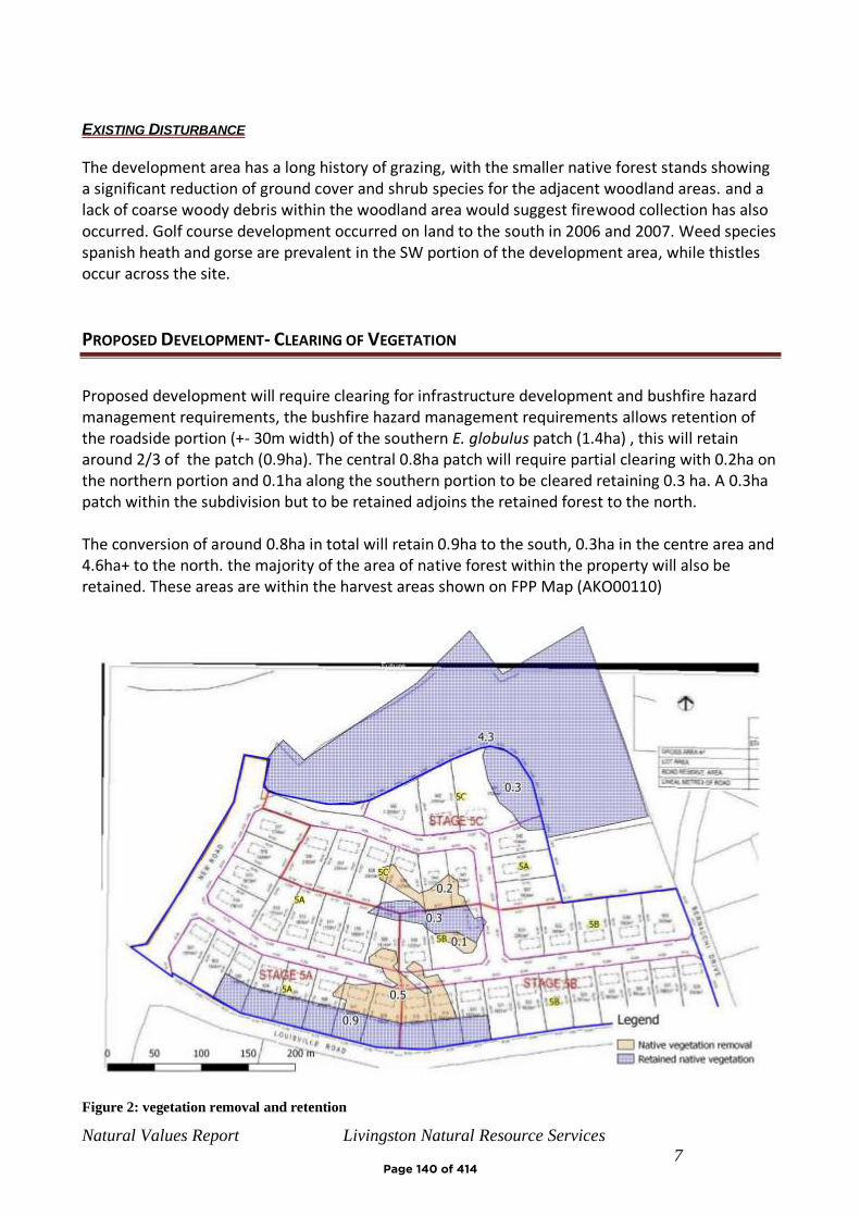
Natural Values Report Livingston Natural Resource Services
7
EXISTING DISTURBANCE
The development area has a long history of grazing, with the smaller native forest stands showing a significant reduction of ground cover and shrub species for the adjacent woodland areas. and a lack of coarse woody debris within the woodland area would suggest firewood collection has also occurred. Golf course development occurred on land to the south in 2006 and 2007. Weed species spanish heath and gorse are prevalent in the SW portion of the development area, while thistles occur across the site.
PROPOSED DEVELOPMENT- CLEARING OF VEGETATION
Proposed development will require clearing for infrastructure development and bushfire hazard management requirements, the bushfire hazard management requirements allows retention of the roadside portion (+- 30m width) of the southern E. globulus patch (1.4ha) , this will retain around 2/3 of the patch (0.9ha). The central 0.8ha patch will require partial clearing with 0.2ha on the northern portion and 0.1ha along the southern portion to be cleared retaining 0.3 ha. A 0.3ha patch within the subdivision but to be retained adjoins the retained forest to the north. The conversion of around 0.8ha in total will retain 0.9ha to the south, 0.3ha in the centre area and 4.6ha+ to the north. the majority of the area of native forest within the property will also be retained. These areas are within the harvest areas shown on FPP Map (AKO00110)
Figure 2: vegetation removal and retention
Page 140 of 414

Natural Values Report Livingston Natural Resource Services
8
CONCLUSIONS
The development area contains two small (1.4 & 0.6ha) stands and a portion (0.3ha) of a larger stand of Eucalyptus globulus, a threatened vegetation community that also provides foraging habitat for, swift parrot, a federally and state listed threatened species that will be affected by clearing for development. Portions of the southern and central patches will be retained, giving a clearing requirement of 0.8ha. A 4.3ha patch of the same vegetation community (DGL) immediately north of the development is shown to be retained in the site master plan and an adjoining 0.3ha within the proposed subdivision is also to be retained.
The development area has suitable habitat for threatened flora known within 5km, although no threatened flora was identified on the site visit or previous studies, noting no survey of areas outside proposed development site was not conducted.
The development area has suitable foraging but no nesting/denning habitat for several wide-ranging threatened fauna species. Clearing of the site would have a very minor impact on foraging habitat for wide ranging species such as devils, quolls, eagles and masked owls, retained vegetation on surrounding land will provide alternate habitat and therefore the impact is expected to be minimal. Ghania radula occurs within the site and adjacent areas and is the host plant for threatened species Antipodia chaostola, chaostola skipper butterfly. The species has not been detected on the site and undeveloped areas of the property also contain Ghania radula and no impact on this species is likely. The proposal retains stands of Eucalyptus globulus within and adjacent to the subdivision which will continue to provide foraging habitat for swift parrot. The clearing of 0.8ha will affect around 10% of the foraging habitat in the immediate area and 5% within the property. Impact on this species is likely to be minor provided alternate foraging is available in the vicinity. No potential breeding habitat for the species is affected.
The proposed clearing is within the harvest boundaries of expired FPP (AKO00110) for the area, and the prescriptions for retention and revegetation of native vegetation for the FPP were considered to be sufficient to mitigate any loss of habitat at that time. The extent of retained vegetation on the property is considerable and further offsetting for previously approved clearing does not appear to be necessary.
REFERENCES
Andy Hamilton & Associates (2019), Subdivision Stage 5 Lot Plan GD1914-P7
Department of the Environment and Energy, Proteced Matters Report. (accessed 23/102019).
Department of Primary Industry Parks Water and Environment (DPIPWE). (accessed 7/10/2019).
Natural Values Report, Derived from the Natural Values Atlas, online database.
Department of Primary Industries, Parks, Water and Environment.DPIPWE. Thelist.tas.gov.au ,
spatial datasets
Page 141 of 414
Natural Values Report Livingston Natural Resource Services
9
Department of Primary Industries, Parks, Water and Environment. DPIPWE. Tasmanian
Vegetation Monitoring and Mapping Program TASVEG 3.0.
Forest Practices Authority (accessed 23/10/2019). Biodiversity Values Database
Forest Practices Authority, (2005)Forest Botany Module 4_Freycinet
Geo-Environmental Solutions (2019), Bushfire Hazard ReportStage 5, Lot 1 Tasman Hwy, Orford,
GES045939
Glamorgan-Spring BayBayCity Council. (2015). Glamorgan-Spring BayBayCouncil Interim
Planning Scheme
Harris & Kitchener, (2005) From Forest to Fjaeldmark, Descriptions of Tasmania's Vegetation
(Edition 2)
JMG ((2018) Solis Louisville Point Concept Master Plan
Tasmanian Herbarium (2003), Botanical Survey of the Property of Mr John Salmon, near
Louisville, Tasmania
Wapstra et al. Little Book of Common Names for Tasmanian Plants,
Page 142 of 414
Natural Values Report Livingston Natural Resource Services 10
APPENDIX 1 – MAPS
Figure 3: Location Map
Page 143 of 414
Natural Values Report Livingston Natural Resource Services 11
Figure 4: Aerial Image, Stage 5, Planning Scheme Overlay (Biodiversity Protection)
Page 144 of 414
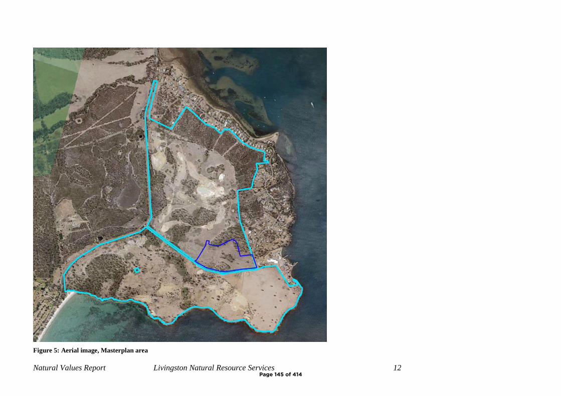
Natural Values Report Livingston Natural Resource Services 12
Figure 5: Aerial image, Masterplan area
Page 145 of 414
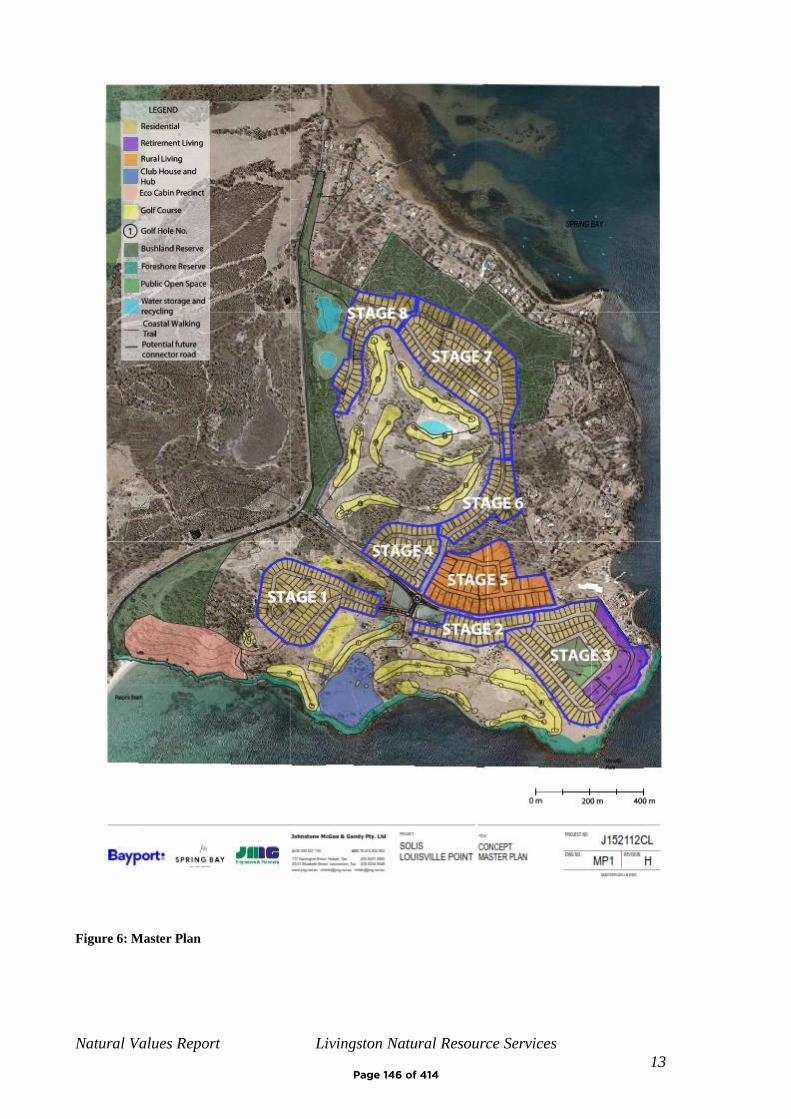
Natural Values Report Livingston Natural Resource Services
13
Figure 6: Master Plan
Page 146 of 414
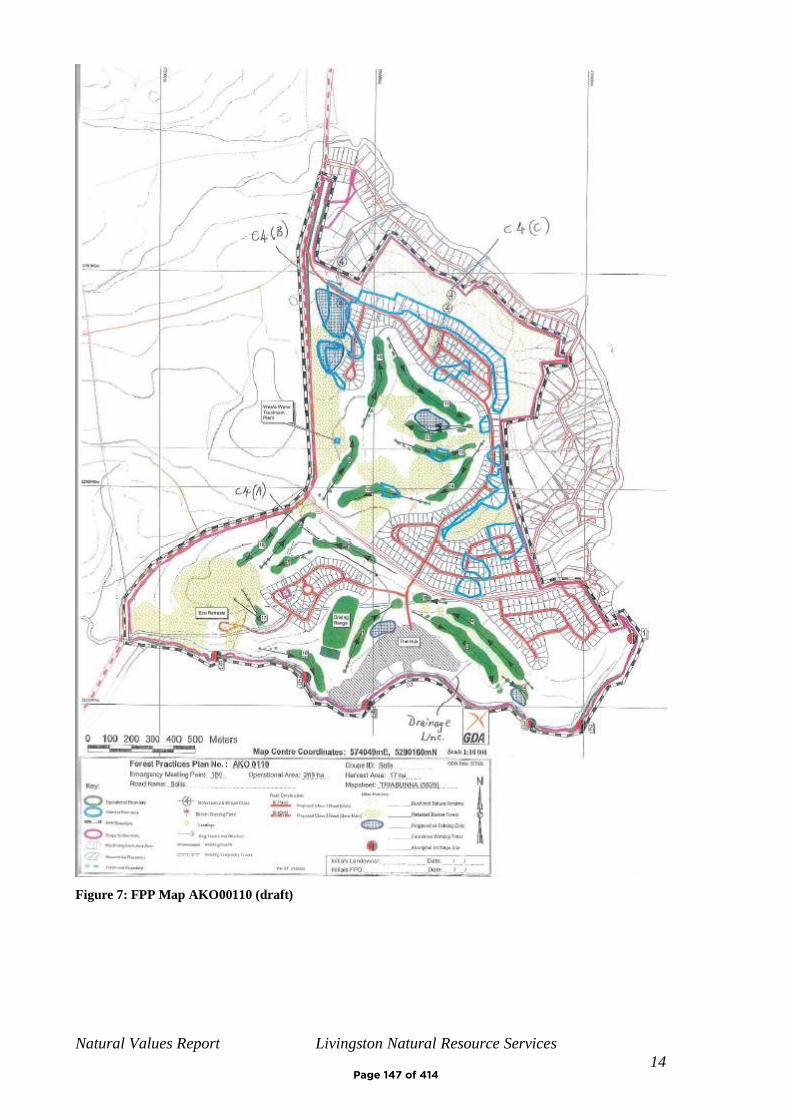
Natural Values Report Livingston Natural Resource Services
14
Figure 7: FPP Map AKO00110 (draft)
Page 147 of 414
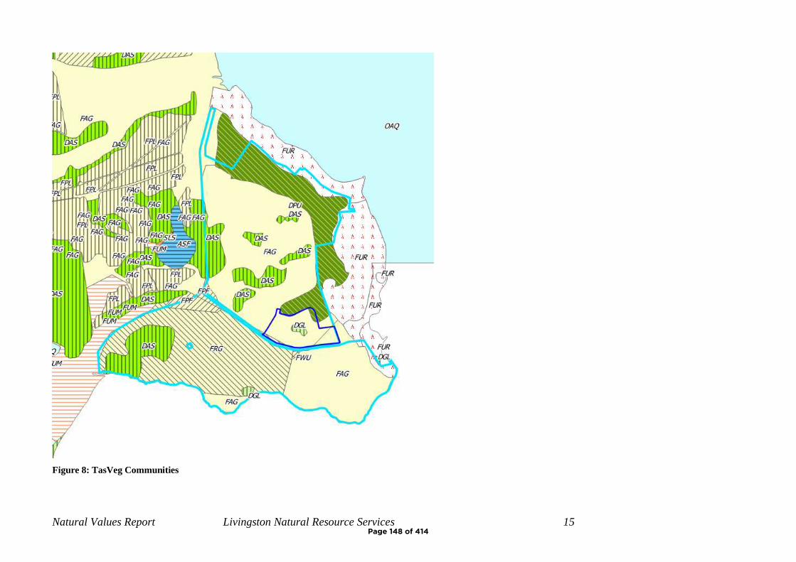
Natural Values Report Livingston Natural Resource Services 15
Figure 8: TasVeg Communities
Page 148 of 414
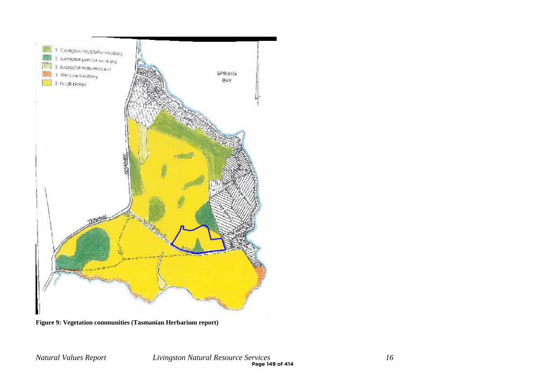
Natural Values Report Livingston Natural Resource Services 16
Figure 9: Vegetation communities (Tasmanian Herbarium report)
Page 149 of 414
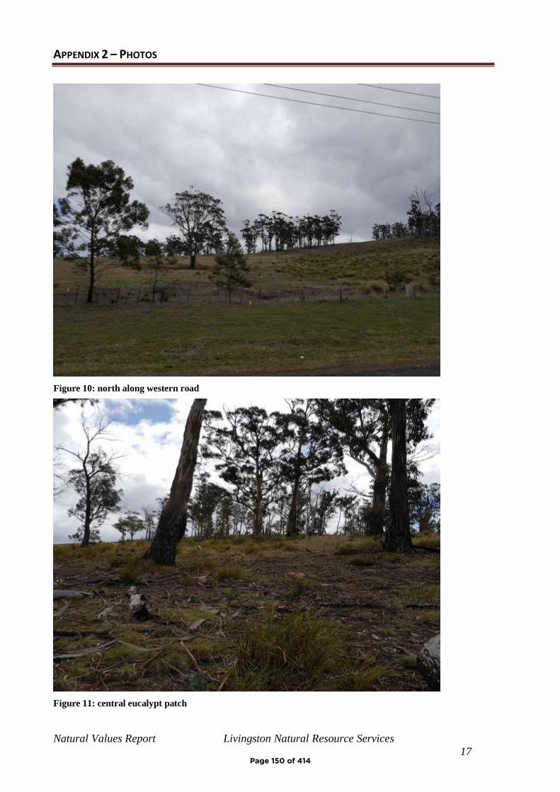
Natural Values Report Livingston Natural Resource Services
17
APPENDIX 2 – PHOTOS
Figure 10: north along western road
Figure 11: central eucalypt patch
Page 150 of 414
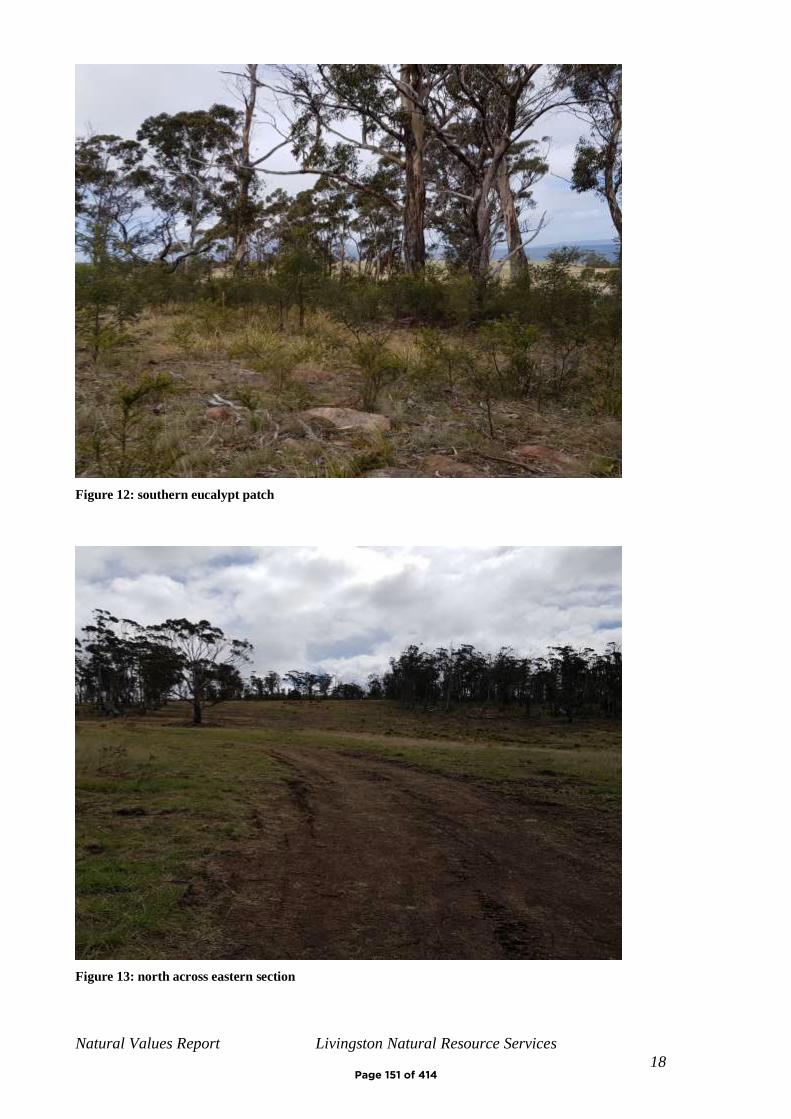
Natural Values Report Livingston Natural Resource Services
18
Figure 12: southern eucalypt patch
Figure 13: north across eastern section
Page 151 of 414
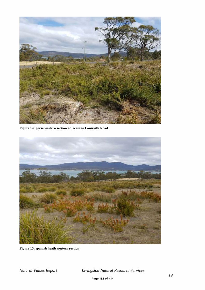
Natural Values Report Livingston Natural Resource Services
19
Figure 14: gorse western section adjacent to Louisville Road
Figure 15: spanish heath western section
Page 152 of 414
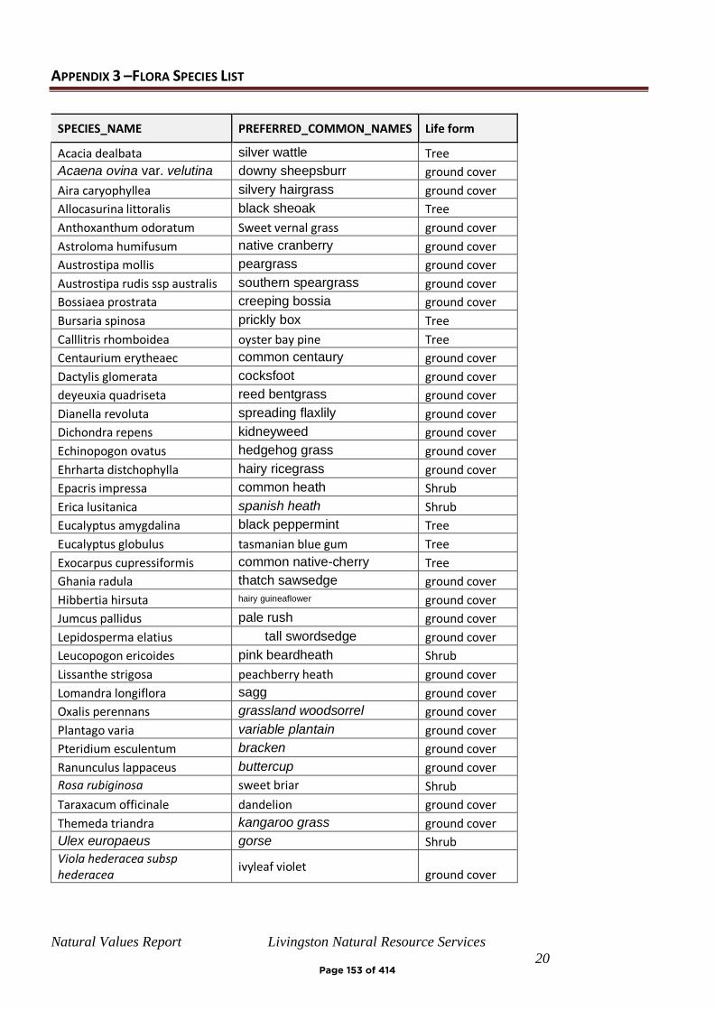
Natural Values Report Livingston Natural Resource Services
20
APPENDIX 3 –FLORA SPECIES LIST
SPECIES_NAME PREFERRED_COMMON_NAMES Life form
Acacia dealbata silver wattle Tree
Acaena ovina var. velutina downy sheepsburr ground cover
Aira caryophyllea silvery hairgrass ground cover
Allocasurina littoralis black sheoak Tree
Anthoxanthum odoratum Sweet vernal grass ground cover
Astroloma humifusum native cranberry ground cover
Austrostipa mollis peargrass ground cover
Austrostipa rudis ssp australis southern speargrass ground cover
Bossiaea prostrata creeping bossia ground cover
Bursaria spinosa prickly box Tree
Calllitris rhomboidea oyster bay pine Tree
Centaurium erytheaec common centaury ground cover
Dactylis glomerata cocksfoot ground cover
deyeuxia quadriseta reed bentgrass ground cover
Dianella revoluta spreading flaxlily ground cover
Dichondra repens kidneyweed ground cover
Echinopogon ovatus hedgehog grass ground cover
Ehrharta distchophylla hairy ricegrass ground cover
Epacris impressa common heath Shrub
Erica lusitanica spanish heath Shrub
Eucalyptus amygdalina black peppermint Tree
Eucalyptus globulus tasmanian blue gum Tree
Exocarpus cupressiformis common native-cherry Tree
Ghania radula thatch sawsedge ground cover
Hibbertia hirsuta hairy guineaflower ground cover
Jumcus pallidus pale rush ground cover
Lepidosperma elatius tall swordsedge ground cover
Leucopogon ericoides pink beardheath Shrub
Lissanthe strigosa peachberry heath ground cover
Lomandra longiflora sagg ground cover
Oxalis perennans grassland woodsorrel ground cover
Plantago varia variable plantain ground cover
Pteridium esculentum bracken ground cover
Ranunculus lappaceus buttercup ground cover
Rosa rubiginosa sweet briar Shrub
Taraxacum officinale dandelion ground cover
Themeda triandra kangaroo grass ground cover
Ulex europaeus gorse Shrub
Viola hederacea subsp hederacea
ivyleaf violet ground cover
Page 153 of 414

Natural Values Report Livingston Natural Resource Services
21
APPENDIX 4 –HABITAT CONTEXT ASSESSMENT
GDA Easting (6 digits) 574447
GDA Northing (7digits) 5289754
Search radius in km (max 10) 5
(this may take some time for large search areas)
Land cover composition within the specified area
Area of high mature habitat availability 489.64 Ha
Area of medium mature habitat availability 813.96 Ha
Area of low mature habitat availability 574.3 Ha
Area of negligible mature habitat availability 3207.99 Ha
Area of non-forest vegetation 475.48 Ha
Total search area 7853.98 Ha
Total applicable area 5085.88 Ha
Percentage of the applicable land area classified as high or medium mature habitat availability =
25.6 %
Mature habitat availability map version: March 2016
GDA Easting (6 digits) 574447
GDA Northing (7digits) 5289754
Search radius in km (max 10) 1
Land cover composition within the specified area
Area of high mature habitat availability 0 Ha
Area of medium mature habitat availability 37.23 Ha
Area of low mature habitat availability 1.34 Ha
Area of negligible mature habitat availability 220.32 Ha
Area of non-forest vegetation 3.79 Ha
Total search area 314.16 Ha
Total applicable area 258.88 Ha
Percentage of the applicable land area classified as high or medium mature habitat availability =
14.4 %
Mature habitat availability map version: March 2016
Page 154 of 414

Natural Values Report Livingston Natural Resource Services
22
Figure 16: Habitat Context 5 km
Figure 17: Habitat Context 1 km
Page 155 of 414
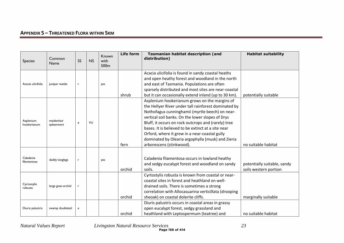
Natural Values Report Livingston Natural Resource Services 23
APPENDIX 5 – THREATENED FLORA WITHIN 5KM
Species Common Name
SS NS Known with
500m
Life form Tasmanian habitat description (and distribution)
Habitat suitability
Acacia ulicifolia juniper wattle r yes
shrub
Acacia ulicifolia is found in sandy coastal heaths and open heathy forest and woodland in the north and east of Tasmania. Populations are often sparsely distributed and most sites are near-coastal but it can occasionally extend inland (up to 30 km). potentially suitable
Asplenium
hookerianum
maidenhair
spleenwort e VU
fern
Asplenium hookerianum grows on the margins of the Hellyer River under tall rainforest dominated by Nothofagus cunninghamii (myrtle beech) on near-vertical soil banks. On the lower slopes of Drys Bluff, it occurs on rock outcrops and (rarely) tree bases. It is believed to be extinct at a site near Orford, where it grew in a near-coastal gully dominated by Olearia argophylla (musk) and Zieria arborescens (stinkwood). no suitable habitat
Caladenia
filamentosa daddy longlegs r yes
orchid
Caladenia filamentosa occurs in lowland heathy and sedgy eucalypt forest and woodland on sandy soils.
potentially suitable, sandy soils western portion
Cyrtostylis
robusta large gnat-orchid r
orchid
Cyrtostylis robusta is known from coastal or near-coastal sites in forest and heathland on well-drained soils. There is sometimes a strong correlation with Allocasuarina verticillata (drooping sheoak) on coastal dolerite cliffs. marginally suitable
Diuris palustris swamp doubletail e orchid
Diuris palustris occurs in coastal areas in grassy open eucalypt forest, sedgy grassland and heathland with Leptospermum (teatree) and no suitable habitat
Page 156 of 414
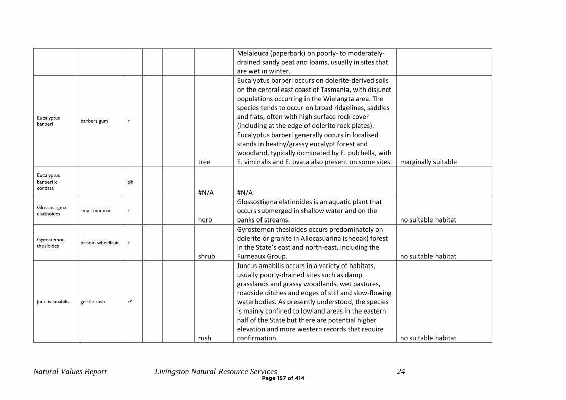
Natural Values Report Livingston Natural Resource Services 24
Melaleuca (paperbark) on poorly- to moderately-drained sandy peat and loams, usually in sites that are wet in winter.
Eucalyptus
barberi barbers gum r
tree
Eucalyptus barberi occurs on dolerite-derived soils on the central east coast of Tasmania, with disjunct populations occurring in the Wielangta area. The species tends to occur on broad ridgelines, saddles and flats, often with high surface rock cover (including at the edge of dolerite rock plates). Eucalyptus barberi generally occurs in localised stands in heathy/grassy eucalypt forest and woodland, typically dominated by E. pulchella, with E. viminalis and E. ovata also present on some sites. marginally suitable
Eucalyptus
barberi x
cordata ph
#N/A #N/A
Glossostigma
elatinoides small mudmat r
herb
Glossostigma elatinoides is an aquatic plant that occurs submerged in shallow water and on the banks of streams. no suitable habitat
Gyrostemon
thesioides broom wheelfruit r
shrub
Gyrostemon thesioides occurs predominately on dolerite or granite in Allocasuarina (sheoak) forest in the State’s east and north-east, including the Furneaux Group. no suitable habitat
Juncus amabilis gentle rush r?
rush
Juncus amabilis occurs in a variety of habitats, usually poorly-drained sites such as damp grasslands and grassy woodlands, wet pastures, roadside ditches and edges of still and slow-flowing waterbodies. As presently understood, the species is mainly confined to lowland areas in the eastern half of the State but there are potential higher elevation and more western records that require confirmation. no suitable habitat
Page 157 of 414
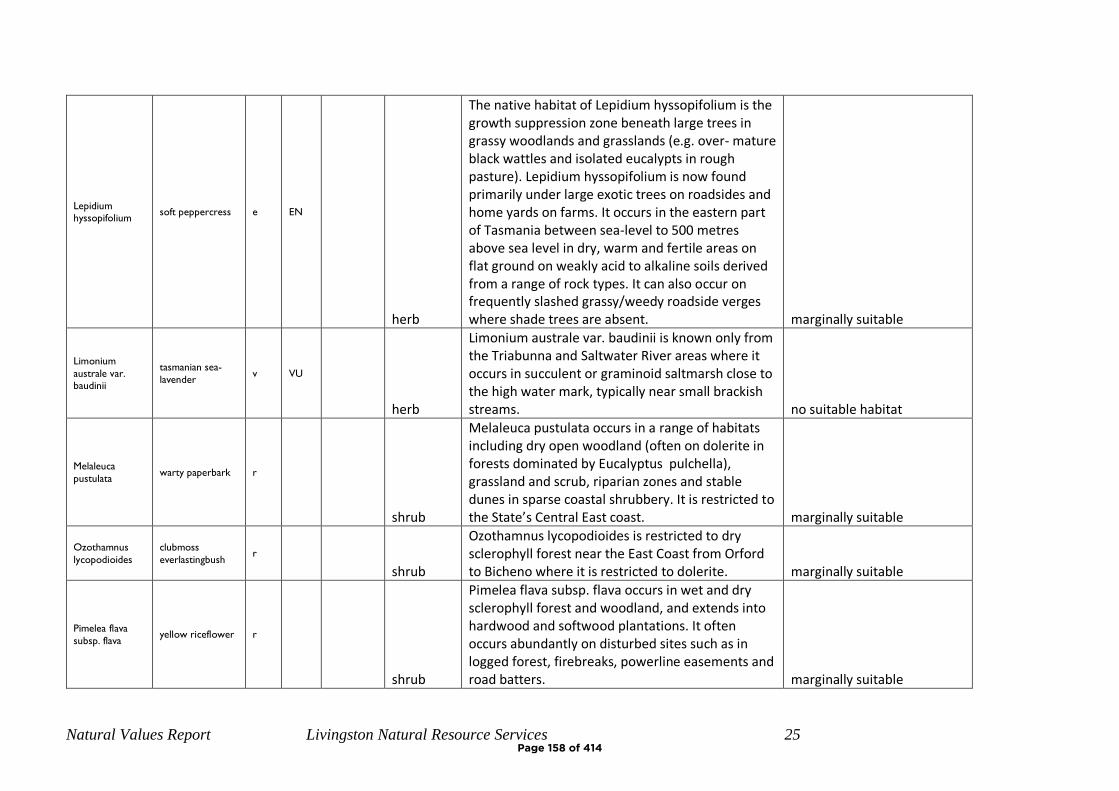
Natural Values Report Livingston Natural Resource Services 25
Lepidium
hyssopifolium soft peppercress e EN
herb
The native habitat of Lepidium hyssopifolium is the growth suppression zone beneath large trees in grassy woodlands and grasslands (e.g. over- mature black wattles and isolated eucalypts in rough pasture). Lepidium hyssopifolium is now found primarily under large exotic trees on roadsides and home yards on farms. It occurs in the eastern part of Tasmania between sea-level to 500 metres above sea level in dry, warm and fertile areas on flat ground on weakly acid to alkaline soils derived from a range of rock types. It can also occur on frequently slashed grassy/weedy roadside verges where shade trees are absent. marginally suitable
Limonium
australe var.
baudinii
tasmanian sea-
lavender v VU
herb
Limonium australe var. baudinii is known only from the Triabunna and Saltwater River areas where it occurs in succulent or graminoid saltmarsh close to the high water mark, typically near small brackish streams. no suitable habitat
Melaleuca
pustulata warty paperbark r
shrub
Melaleuca pustulata occurs in a range of habitats including dry open woodland (often on dolerite in forests dominated by Eucalyptus pulchella), grassland and scrub, riparian zones and stable dunes in sparse coastal shrubbery. It is restricted to the State’s Central East coast. marginally suitable
Ozothamnus
lycopodioides
clubmoss
everlastingbush r
shrub
Ozothamnus lycopodioides is restricted to dry sclerophyll forest near the East Coast from Orford to Bicheno where it is restricted to dolerite. marginally suitable
Pimelea flava
subsp. flava yellow riceflower r
shrub
Pimelea flava subsp. flava occurs in wet and dry sclerophyll forest and woodland, and extends into hardwood and softwood plantations. It often occurs abundantly on disturbed sites such as in logged forest, firebreaks, powerline easements and road batters. marginally suitable
Page 158 of 414
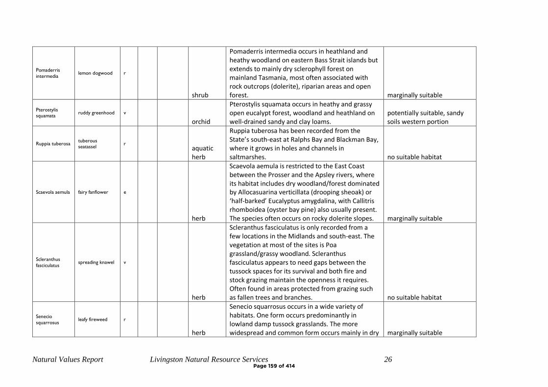
Natural Values Report Livingston Natural Resource Services 26
Pomaderris
intermedia lemon dogwood r
shrub
Pomaderris intermedia occurs in heathland and heathy woodland on eastern Bass Strait islands but extends to mainly dry sclerophyll forest on mainland Tasmania, most often associated with rock outcrops (dolerite), riparian areas and open forest. marginally suitable
Pterostylis
squamata ruddy greenhood v
orchid
Pterostylis squamata occurs in heathy and grassy open eucalypt forest, woodland and heathland on well-drained sandy and clay loams.
potentially suitable, sandy soils western portion
Ruppia tuberosa tuberous
seatassel r
aquatic herb
Ruppia tuberosa has been recorded from the State’s south-east at Ralphs Bay and Blackman Bay, where it grows in holes and channels in saltmarshes. no suitable habitat
Scaevola aemula fairy fanflower e
herb
Scaevola aemula is restricted to the East Coast between the Prosser and the Apsley rivers, where its habitat includes dry woodland/forest dominated by Allocasuarina verticillata (drooping sheoak) or ‘half-barked’ Eucalyptus amygdalina, with Callitris rhomboidea (oyster bay pine) also usually present. The species often occurs on rocky dolerite slopes. marginally suitable
Scleranthus
fasciculatus spreading knawel v
herb
Scleranthus fasciculatus is only recorded from a few locations in the Midlands and south-east. The vegetation at most of the sites is Poa grassland/grassy woodland. Scleranthus fasciculatus appears to need gaps between the tussock spaces for its survival and both fire and stock grazing maintain the openness it requires. Often found in areas protected from grazing such as fallen trees and branches. no suitable habitat
Senecio
squarrosus leafy fireweed r
herb
Senecio squarrosus occurs in a wide variety of habitats. One form occurs predominantly in lowland damp tussock grasslands. The more widespread and common form occurs mainly in dry marginally suitable
Page 159 of 414
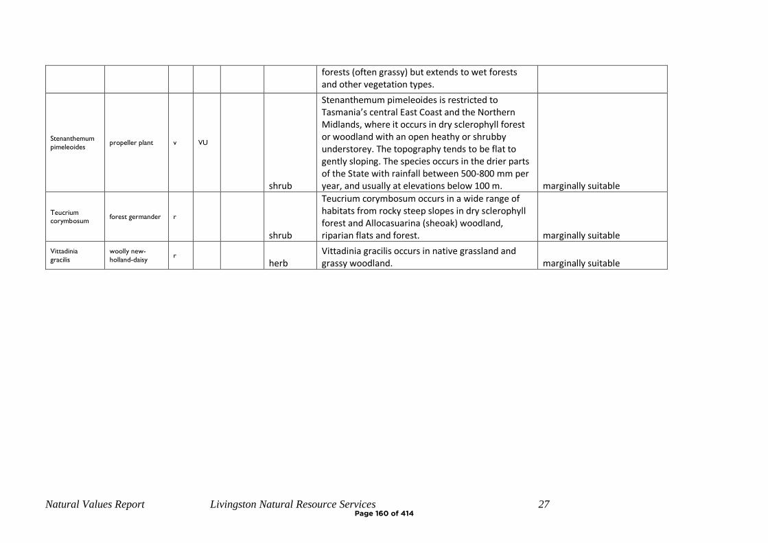
Natural Values Report Livingston Natural Resource Services 27
forests (often grassy) but extends to wet forests and other vegetation types.
Stenanthemum
pimeleoides propeller plant v VU
shrub
Stenanthemum pimeleoides is restricted to Tasmania’s central East Coast and the Northern Midlands, where it occurs in dry sclerophyll forest or woodland with an open heathy or shrubby understorey. The topography tends to be flat to gently sloping. The species occurs in the drier parts of the State with rainfall between 500-800 mm per year, and usually at elevations below 100 m. marginally suitable
Teucrium
corymbosum forest germander r
shrub
Teucrium corymbosum occurs in a wide range of habitats from rocky steep slopes in dry sclerophyll forest and Allocasuarina (sheoak) woodland, riparian flats and forest. marginally suitable
Vittadinia
gracilis
woolly new-
holland-daisy r
herb Vittadinia gracilis occurs in native grassland and grassy woodland. marginally suitable
Page 160 of 414
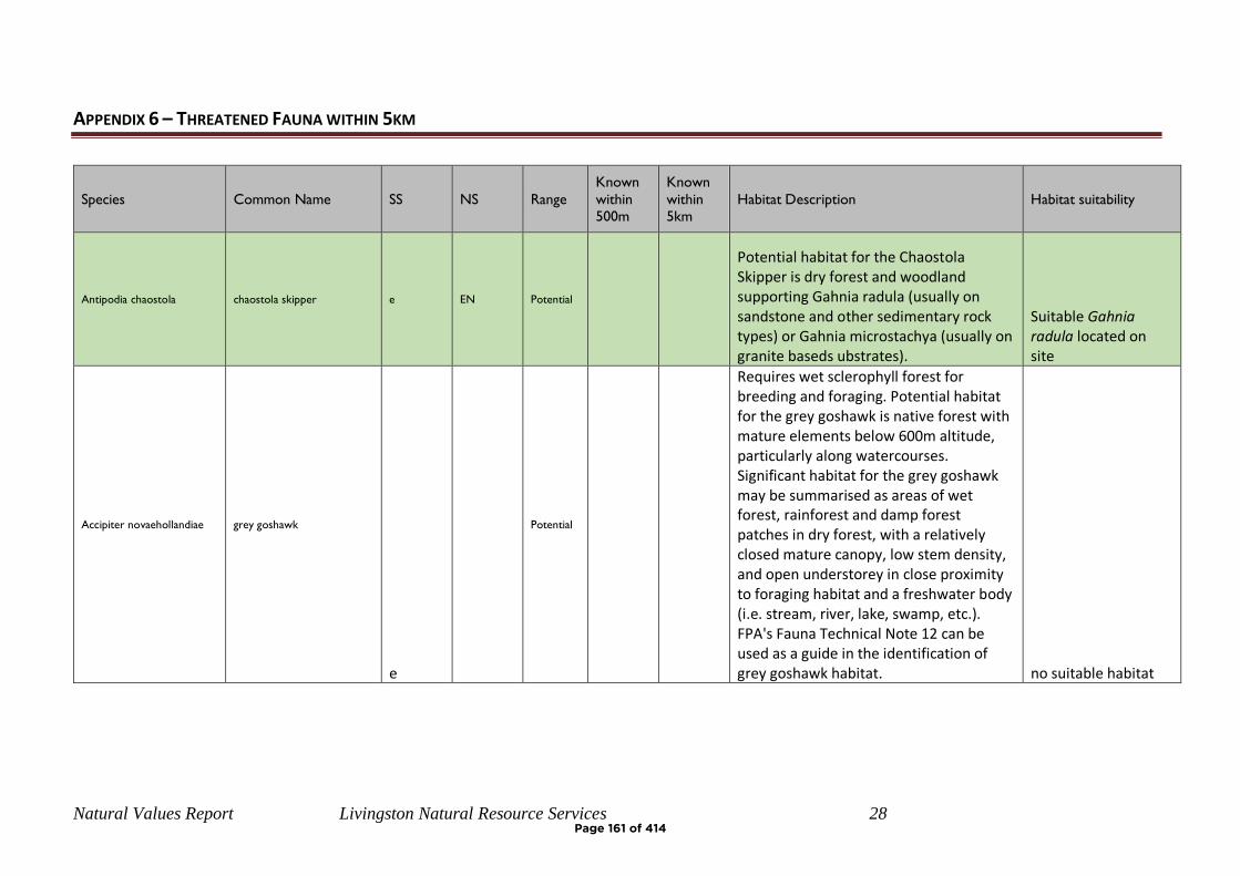
Natural Values Report Livingston Natural Resource Services 28
APPENDIX 6 – THREATENED FAUNA WITHIN 5KM
Species Common Name SS NS Range
Known
within 500m
Known
within 5km
Habitat Description Habitat suitability
Antipodia chaostola chaostola skipper e EN Potential
Potential habitat for the Chaostola Skipper is dry forest and woodland supporting Gahnia radula (usually on sandstone and other sedimentary rock types) or Gahnia microstachya (usually on granite baseds ubstrates).
Suitable Gahnia radula located on site
Accipiter novaehollandiae grey goshawk
e
Potential
Requires wet sclerophyll forest for breeding and foraging. Potential habitat for the grey goshawk is native forest with mature elements below 600m altitude, particularly along watercourses. Significant habitat for the grey goshawk may be summarised as areas of wet forest, rainforest and damp forest patches in dry forest, with a relatively closed mature canopy, low stem density, and open understorey in close proximity to foraging habitat and a freshwater body (i.e. stream, river, lake, swamp, etc.). FPA's Fauna Technical Note 12 can be used as a guide in the identification of grey goshawk habitat. no suitable habitat
Page 161 of 414
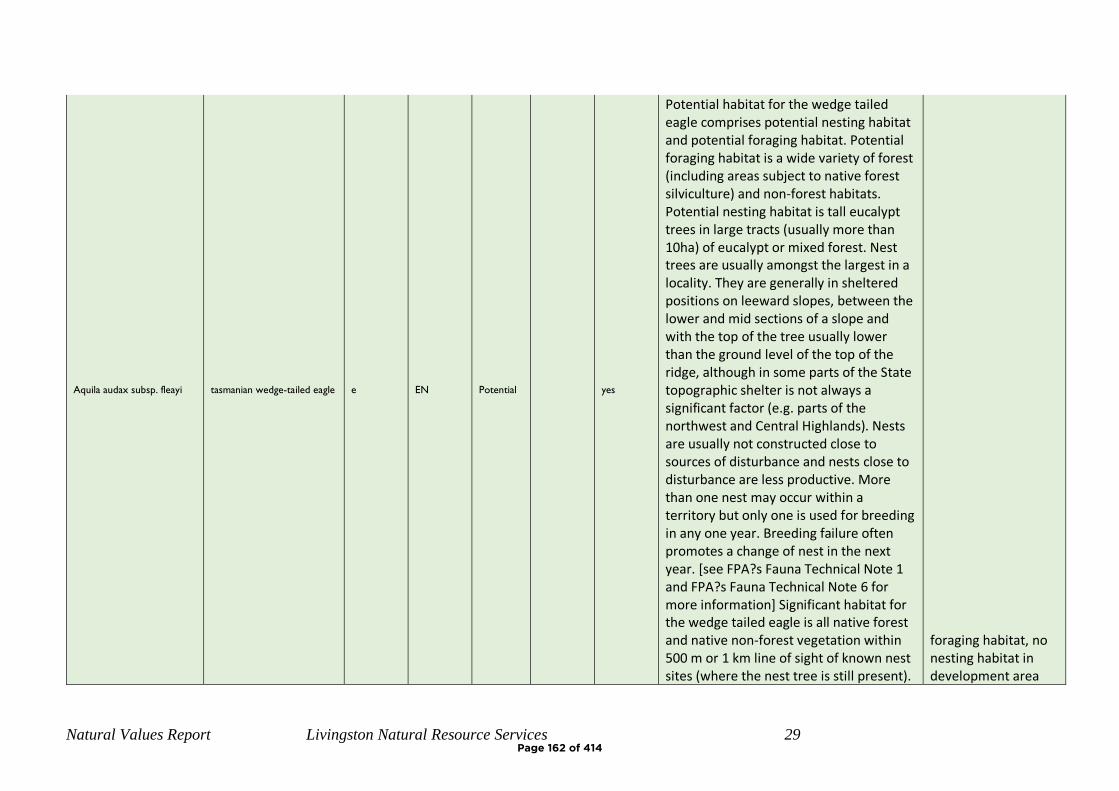
Natural Values Report Livingston Natural Resource Services 29
Aquila audax subsp. fleayi tasmanian wedge-tailed eagle e EN Potential
yes
Potential habitat for the wedge tailed eagle comprises potential nesting habitat and potential foraging habitat. Potential foraging habitat is a wide variety of forest (including areas subject to native forest silviculture) and non-forest habitats. Potential nesting habitat is tall eucalypt trees in large tracts (usually more than 10ha) of eucalypt or mixed forest. Nest trees are usually amongst the largest in a locality. They are generally in sheltered positions on leeward slopes, between the lower and mid sections of a slope and with the top of the tree usually lower than the ground level of the top of the ridge, although in some parts of the State topographic shelter is not always a significant factor (e.g. parts of the northwest and Central Highlands). Nests are usually not constructed close to sources of disturbance and nests close to disturbance are less productive. More than one nest may occur within a territory but only one is used for breeding in any one year. Breeding failure often promotes a change of nest in the next year. [see FPA?s Fauna Technical Note 1 and FPA?s Fauna Technical Note 6 for more information] Significant habitat for the wedge tailed eagle is all native forest and native non-forest vegetation within 500 m or 1 km line of sight of known nest sites (where the nest tree is still present).
foraging habitat, no nesting habitat in development area
Page 162 of 414
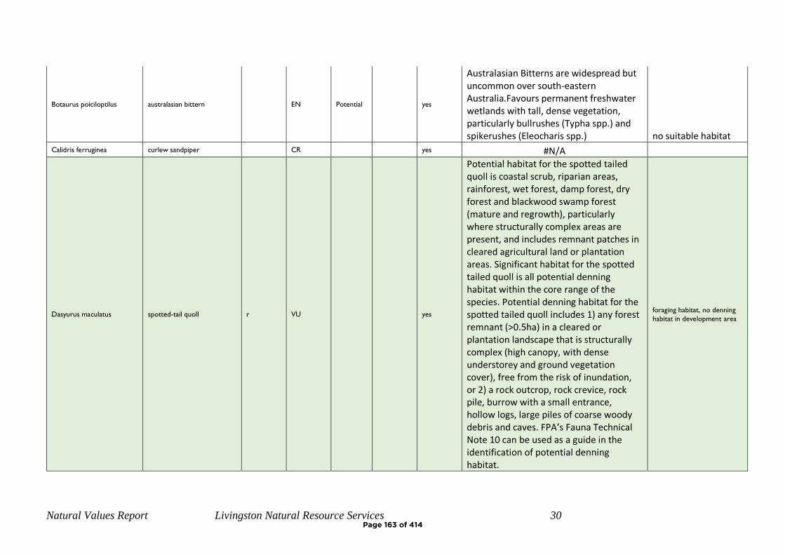
Natural Values Report Livingston Natural Resource Services 30
Botaurus poiciloptilus australasian bittern EN Potential
yes
Australasian Bitterns are widespread but uncommon over south-eastern Australia.Favours permanent freshwater wetlands with tall, dense vegetation, particularly bullrushes (Typha spp.) and spikerushes (Eleocharis spp.) no suitable habitat
Calidris ferruginea curlew sandpiper CR yes #N/A
Dasyurus maculatus spotted-tail quoll r VU
yes
Potential habitat for the spotted tailed quoll is coastal scrub, riparian areas, rainforest, wet forest, damp forest, dry forest and blackwood swamp forest (mature and regrowth), particularly where structurally complex areas are present, and includes remnant patches in cleared agricultural land or plantation areas. Significant habitat for the spotted tailed quoll is all potential denning habitat within the core range of the species. Potential denning habitat for the spotted tailed quoll includes 1) any forest remnant (>0.5ha) in a cleared or plantation landscape that is structurally complex (high canopy, with dense understorey and ground vegetation cover), free from the risk of inundation, or 2) a rock outcrop, rock crevice, rock pile, burrow with a small entrance, hollow logs, large piles of coarse woody debris and caves. FPA’s Fauna Technical Note 10 can be used as a guide in the identification of potential denning habitat.
foraging habitat, no denning
habitat in development area
Page 163 of 414
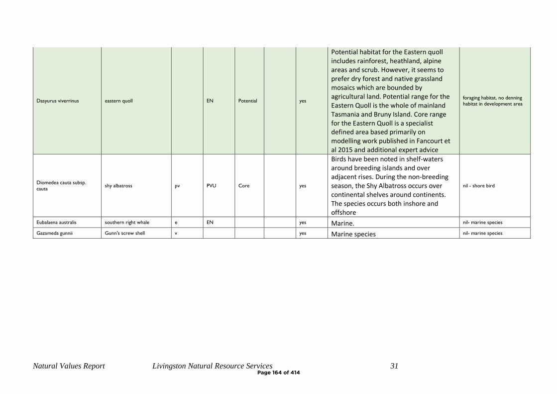
Natural Values Report Livingston Natural Resource Services 31
Dasyurus viverrinus eastern quoll EN Potential
yes
Potential habitat for the Eastern quoll includes rainforest, heathland, alpine areas and scrub. However, it seems to prefer dry forest and native grassland mosaics which are bounded by agricultural land. Potential range for the Eastern Quoll is the whole of mainland Tasmania and Bruny Island. Core range for the Eastern Quoll is a specialist defined area based primarily on modelling work published in Fancourt et al 2015 and additional expert advice
foraging habitat, no denning
habitat in development area
Diomedea cauta subsp.
cauta shy albatross pv PVU Core
yes
Birds have been noted in shelf-waters around breeding islands and over adjacent rises. During the non-breeding season, the Shy Albatross occurs over continental shelves around continents. The species occurs both inshore and offshore
nil - shore bird
Eubalaena australis southern right whale e EN yes Marine. nil- marine species
Gazameda gunnii Gunn's screw shell v yes Marine species nil- marine species
Page 164 of 414
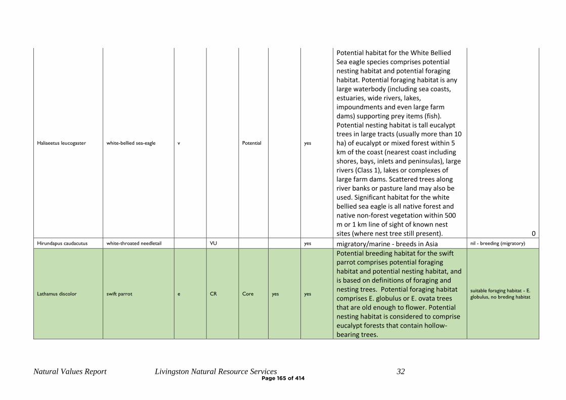
Natural Values Report Livingston Natural Resource Services 32
Haliaeetus leucogaster white-bellied sea-eagle v Potential
yes
Potential habitat for the White Bellied Sea eagle species comprises potential nesting habitat and potential foraging habitat. Potential foraging habitat is any large waterbody (including sea coasts, estuaries, wide rivers, lakes, impoundments and even large farm dams) supporting prey items (fish). Potential nesting habitat is tall eucalypt trees in large tracts (usually more than 10 ha) of eucalypt or mixed forest within 5 km of the coast (nearest coast including shores, bays, inlets and peninsulas), large rivers (Class 1), lakes or complexes of large farm dams. Scattered trees along river banks or pasture land may also be used. Significant habitat for the white bellied sea eagle is all native forest and native non-forest vegetation within 500 m or 1 km line of sight of known nest sites (where nest tree still present). 0
Hirundapus caudacutus white-throated needletail VU yes migratory/marine - breeds in Asia nil - breeding (migratory)
Lathamus discolor swift parrot e CR Core yes yes
Potential breeding habitat for the swift parrot comprises potential foraging habitat and potential nesting habitat, and is based on definitions of foraging and nesting trees. Potential foraging habitat comprises E. globulus or E. ovata trees that are old enough to flower. Potential nesting habitat is considered to comprise eucalypt forests that contain hollow-bearing trees.
suitable foraging habitat - E.
globulus, no breding habitat
Page 165 of 414
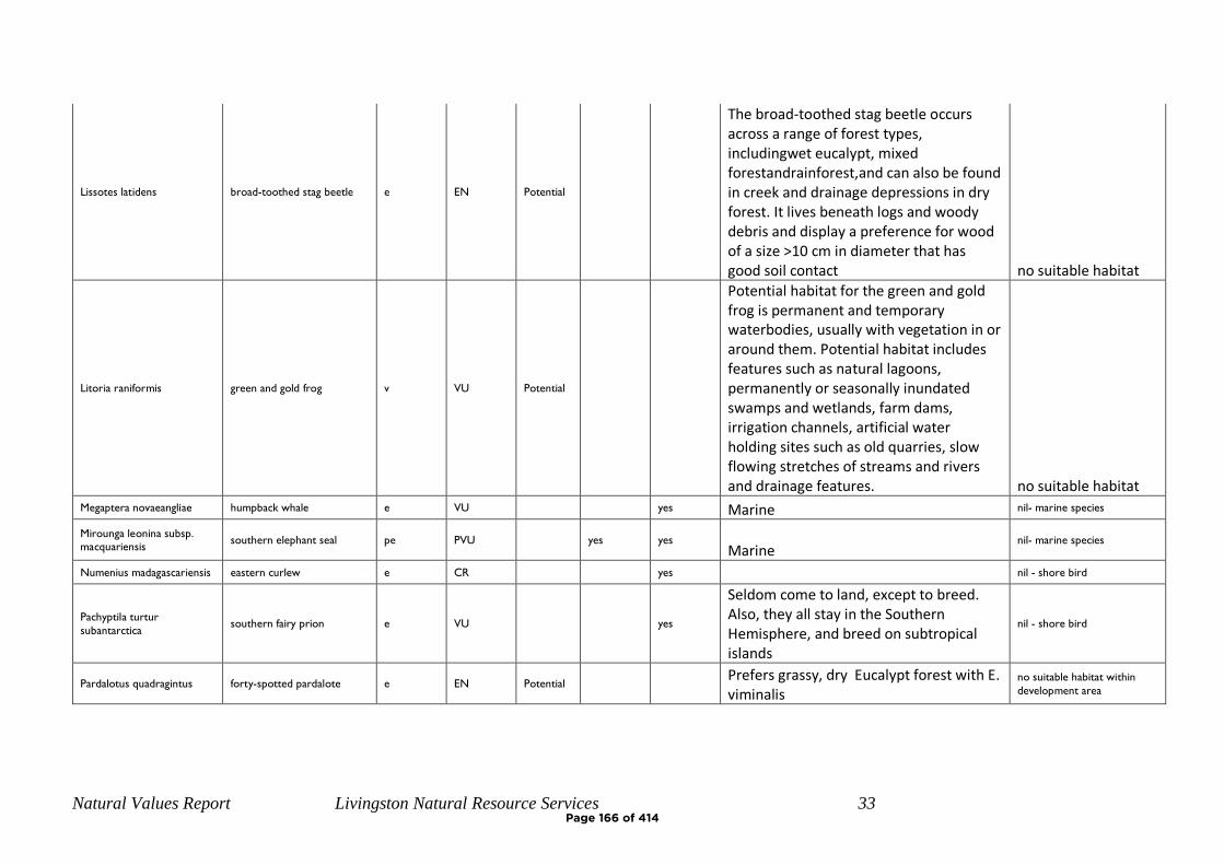
Natural Values Report Livingston Natural Resource Services 33
Lissotes latidens broad-toothed stag beetle e EN Potential
The broad-toothed stag beetle occurs across a range of forest types, includingwet eucalypt, mixed forestandrainforest,and can also be found in creek and drainage depressions in dry forest. It lives beneath logs and woody debris and display a preference for wood of a size >10 cm in diameter that has good soil contact no suitable habitat
Litoria raniformis green and gold frog v VU Potential
Potential habitat for the green and gold frog is permanent and temporary waterbodies, usually with vegetation in or around them. Potential habitat includes features such as natural lagoons, permanently or seasonally inundated swamps and wetlands, farm dams, irrigation channels, artificial water holding sites such as old quarries, slow flowing stretches of streams and rivers and drainage features. no suitable habitat
Megaptera novaeangliae humpback whale e VU yes Marine nil- marine species
Mirounga leonina subsp.
macquariensis southern elephant seal pe PVU yes yes
Marine nil- marine species
Numenius madagascariensis eastern curlew e CR yes nil - shore bird
Pachyptila turtur
subantarctica southern fairy prion e VU
yes
Seldom come to land, except to breed. Also, they all stay in the Southern Hemisphere, and breed on subtropical islands
nil - shore bird
Pardalotus quadragintus forty-spotted pardalote e EN Potential
Prefers grassy, dry Eucalypt forest with E. viminalis
no suitable habitat within
development area
Page 166 of 414
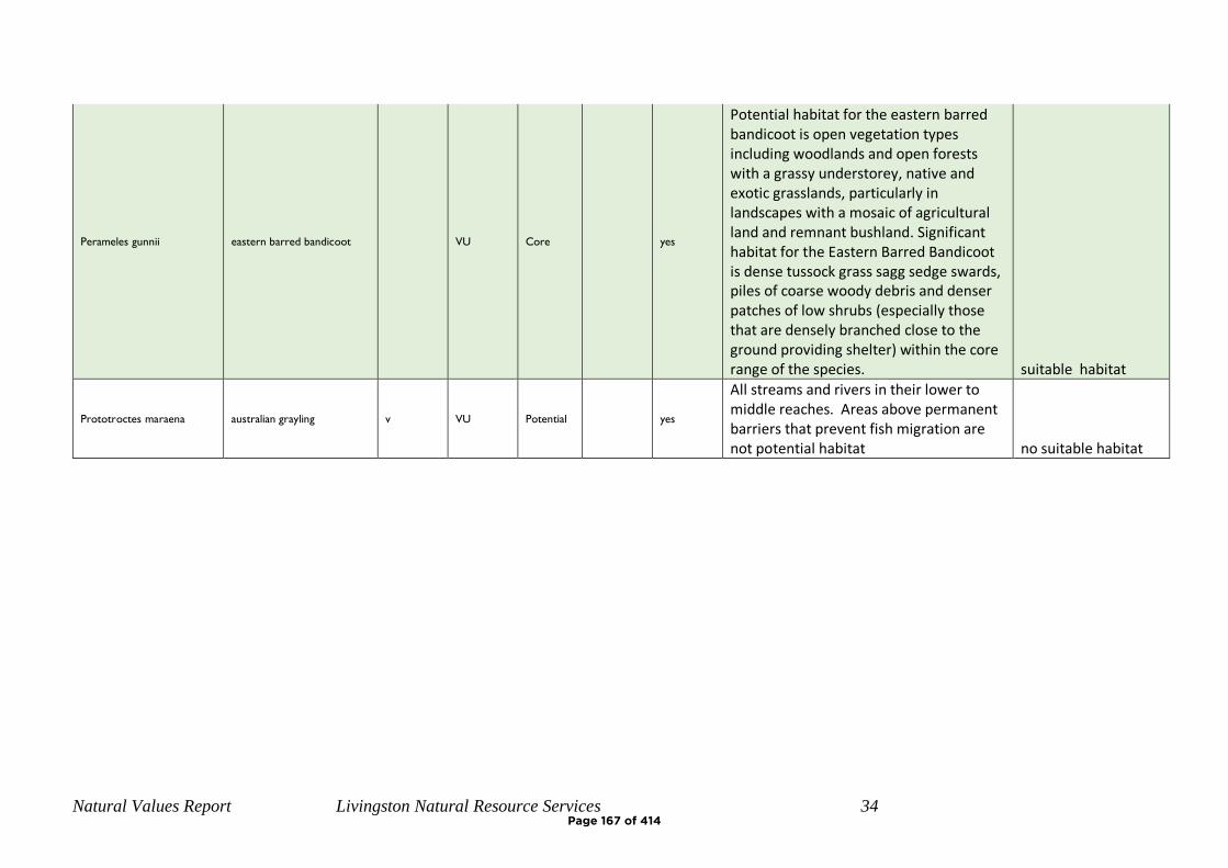
Natural Values Report Livingston Natural Resource Services 34
Perameles gunnii eastern barred bandicoot VU Core
yes
Potential habitat for the eastern barred bandicoot is open vegetation types including woodlands and open forests with a grassy understorey, native and exotic grasslands, particularly in landscapes with a mosaic of agricultural land and remnant bushland. Significant habitat for the Eastern Barred Bandicoot is dense tussock grass sagg sedge swards, piles of coarse woody debris and denser patches of low shrubs (especially those that are densely branched close to the ground providing shelter) within the core range of the species. suitable habitat
Prototroctes maraena australian grayling v VU Potential
yes
All streams and rivers in their lower to middle reaches. Areas above permanent barriers that prevent fish migration are not potential habitat no suitable habitat
Page 167 of 414
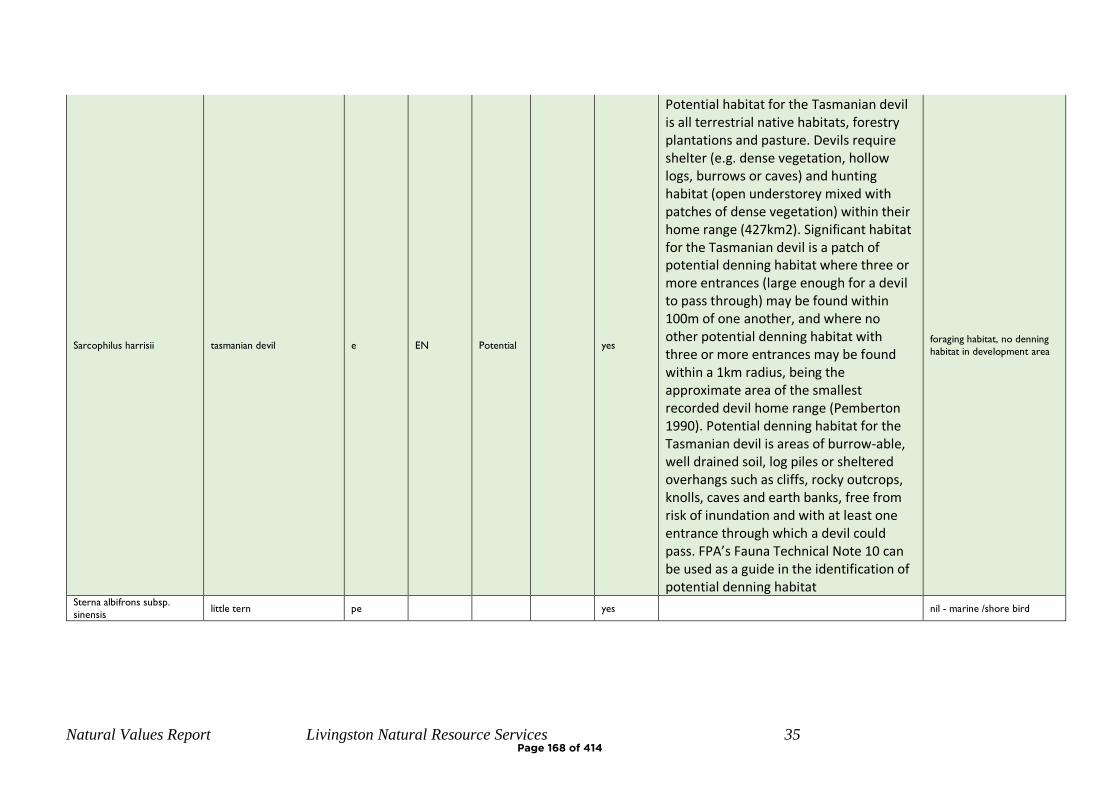
Natural Values Report Livingston Natural Resource Services 35
Sarcophilus harrisii tasmanian devil e EN Potential
yes
Potential habitat for the Tasmanian devil is all terrestrial native habitats, forestry plantations and pasture. Devils require shelter (e.g. dense vegetation, hollow logs, burrows or caves) and hunting habitat (open understorey mixed with patches of dense vegetation) within their home range (427km2). Significant habitat for the Tasmanian devil is a patch of potential denning habitat where three or more entrances (large enough for a devil to pass through) may be found within 100m of one another, and where no other potential denning habitat with three or more entrances may be found within a 1km radius, being the approximate area of the smallest recorded devil home range (Pemberton 1990). Potential denning habitat for the Tasmanian devil is areas of burrow-able, well drained soil, log piles or sheltered overhangs such as cliffs, rocky outcrops, knolls, caves and earth banks, free from risk of inundation and with at least one entrance through which a devil could pass. FPA’s Fauna Technical Note 10 can be used as a guide in the identification of potential denning habitat
foraging habitat, no denning
habitat in development area
Sterna albifrons subsp.
sinensis little tern pe yes nil - marine /shore bird
Page 168 of 414

Natural Values Report Livingston Natural Resource Services 36
Sterna nereis subsp. nereis fairy tern pv PVU
yes
It seldom goes far out to sea but is often to be seen where predatory fish are feeding on shoals of small fish. Breeding takes place in the spring in colonies on sheltered beaches on the mainland or on offshore islands. The nest is just above high-water mark and is a scrape in the sand
nil - marine /shore bird
Sternula nereis subsp.
nereis fairy tern v VU yes nil - shore bird
Theclinesthes serpentata
subsp. lavara Chequered Blue r
yes
nil - shore bird
Thinornis rubricollis hooded plover VU yes nil - shore bird
Thylacinus cynocephalus thylacine x EX yes presumed extinct
Page 169 of 414
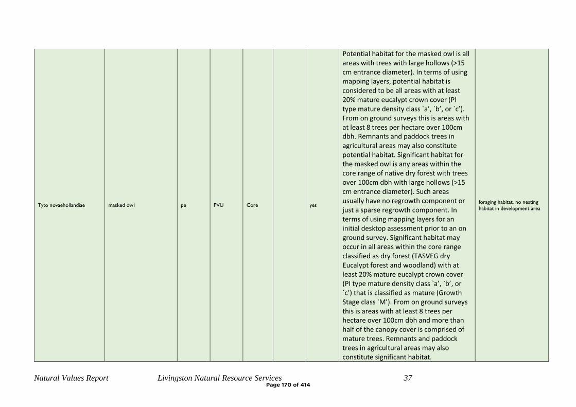
Natural Values Report Livingston Natural Resource Services 37
Tyto novaehollandiae masked owl pe PVU Core
yes
Potential habitat for the masked owl is all areas with trees with large hollows (>15 cm entrance diameter). In terms of using mapping layers, potential habitat is considered to be all areas with at least 20% mature eucalypt crown cover (PI type mature density class `a’, `b’, or `c’). From on ground surveys this is areas with at least 8 trees per hectare over 100cm dbh. Remnants and paddock trees in agricultural areas may also constitute potential habitat. Significant habitat for the masked owl is any areas within the core range of native dry forest with trees over 100cm dbh with large hollows (>15 cm entrance diameter). Such areas usually have no regrowth component or just a sparse regrowth component. In terms of using mapping layers for an initial desktop assessment prior to an on ground survey. Significant habitat may occur in all areas within the core range classified as dry forest (TASVEG dry Eucalypt forest and woodland) with at least 20% mature eucalypt crown cover (PI type mature density class `a’, `b’, or `c’) that is classified as mature (Growth Stage class `M’). From on ground surveys this is areas with at least 8 trees per hectare over 100cm dbh and more than half of the canopy cover is comprised of mature trees. Remnants and paddock trees in agricultural areas may also constitute significant habitat.
foraging habitat, no nesting
habitat in development area
Page 170 of 414
Natural Values Report Livingston Natural Resource Services 38
Page 171 of 414
Spring Bay Stage 5 – Proposed Subdivision
Report for: Bayport Pty Ltd
Property Location: Part Lot 1 Tasman Hwy, Orford
Prepared by: Scott Livingston
Livingston Natural Resource Services 12 Powers Road Underwood, 7268
Date: 30th January 2020
Natural Values Offsetting Report
Page 172 of 414

Natural Values Offset Report Livingston Natural Resource Services
i
Client:
Bayport Pty Ltd
Property identification
Lot 1 Tasman Hwy, Orford. CT 139972/1, PID 2549195 Current zoning is Rural Resource, Louisville Road Specific Area Plan Glamorgan-Spring Bay Interim Planning Scheme 2015
Proposal:
Development as part of Stage 5 of Subdivision, lots 501-547 will include removal of 0.8ha of Eucalyptus globulus dry forest and woodland (DGL). This is a threatened vegetation community that also provides foraging habitat for swift parrot, a federally and state listed threatened species.
Under the Glamorgan-Spring Bay Interim Planning Scheme 2015, the proposal requires assessment against E10.8.P1.
Assessment comments:
A field inspection was conducted on the 22nd January 2020. This field assessments to undertake Vegetation Condition Assessments on the proposed clearing and offset areas. This report summarises the findings of that assessment.
Assessment by: Scott Livingston, Master Environmental Management, Forest Practices Officer (Planning) Natural Resource Management Consultant.
Page 173 of 414
Natural Values Offset Report Livingston Natural Resource Services
i
Contents INTRODUCTION ................................................................................................................... 2
BIODIVERSITY OFFSETS ...................................................................................................... 2
PROPOSED OFFSET .............................................................................................................. 2
VEGETATION AREAS ........................................................................................................... 3
VEGETATION CONDITION ASSESSMENT .............................................................................. 3
BIODIVERSITY CODE ........................................................................................................... 6
CONCLUSIONS ..................................................................................................................... 7
REFERENCES ....................................................................................................................... 7
APPENDIX 1 – MAPS............................................................................................................ 8
APPENDIX 2 – PHOTOS ...................................................................................................... 11
Figure 1: Location Map Stage 5................................................................................................. 8
Figure 2: Aerial Image, Stage 5, Planning Scheme Overlay (Biodiversity Protection) ............ 9 Figure 3: Proposed clearing, retained vegetation and offset area ............................................ 10
Figure 4: north along western road .......................................................................................... 11 Figure 5: central eucalypt patch, portions to be cleared .......................................................... 11 Figure 6: southern eucalypt patch, to be retained .................................................................... 12
Figure 7: proposed offset area, northern section ...................................................................... 12 Figure 8: proposed offset area, fire felled large tree ................................................................ 13
Figure 9: offset area southern section ...................................................................................... 13 Figure 11: Spanish Heath on proposed POS ............................................................................ 14
Page 174 of 414
Natural Values Offset Report Livingston Natural Resource Services
2
INTRODUCTION
The developers propose to develop Stage 5 of the Spring Bay Land Development. This 47 lot in 3 stages covers lots 501-547 and includes public roads and associated infrastructure. Portions of the development are mapped as Biodiversity Protection Overlay. The subdivision is within the Louisville Road Specific Area Plan Glamorgan-Spring Bay Interim Planning Scheme 2015, and residential development on the site has been in the planning process for a considerable period. Clearing of the vegetation within the subdivision was approved under now expired Forest Practices Plan AKO00110, which accounted for loss of vegetation and reserved area across the site. A Natural Values Report, Livingston Natural Resource Services, 5/11/2019, identified of 0.8ha of Eucalyptus globulus dry forest and woodland (DGL) that would require clearing and conversion as part of the proposed development. Eucalyptus globulus dry forest and woodland is a threatened vegetation community that also provides foraging habitat for swift parrot, a federally and state listed threatened species. The retention (avoidance of clearing) of these patches within the proposed subdivision stage would impact on lot yield and Bushfire ratings of future residences.
BIODIVERSITY OFFSETS
Biodiversity Offsets are actions that a proponent undertakes in order to compensate for the residual impact of a use or development on a biodiversity value(s). Under the Guidelines for the Use of Biodiversity Offsets in the Local Planning Approval Process, Southern Tasmanian Councils Authority 2013, offsetting of clearing can be a combination of some or all of the following: protection in situ, protection off site, restoration, rehabilitation, research, monitoring and financial contributions. For threatened vegetation communities, to deliver a net benefit by offsetting requires 3:1-5:1 ration of similar vegetation community.
PROPOSED OFFSET
The proponents for the development propose offsite protection via a Part 5 Agreement of a 4ha of a 6ha patch immediately to the north of the proposed subdivision stage. The northern boundary of the proposed offset is within the existing patch and is offset from the planned Stage 6 subdivision by 23m, this area has been excluded as it may be required for future bushfire hazard management noting this will also be subject to future offset requirements. There is a minor discrepancy (<8m) between the western portion of the southern Offset area and existing vegetation boundary. The offset has been extended to the proposed cadastral boundaries for ease of interpretation and management. An area of 0.3 ha currently grassland that is south of the proposed offset and identified as Public Open Space on the Master Plan, is not included the 4ha offset but with weed control (Spanish Heath) and exclusion of grazing is likely to naturally
Page 175 of 414
Natural Values Offset Report Livingston Natural Resource Services
3
regenerate to E. globulus forest over time and therefore may be considered for inclusion in a Part 5 Agreement. Management of the offset area should include cessation of firewood harvesting. The existing low level of grazing does not appear to be significantly impacting the site, however stock removal may be considered. Weed removal including a small infestation of Spanish Heath on the grassland portion and isolated gorse plants in the western portion.
VEGETATION AREAS
Proposed stage 5 and offset area have 6.4ha of existing E. globulus forest, this does not include the 2ha north of the offset area that may be subject to future development. The table below summarises the areas to be cleared and retained.
Ha % Total
retained within subdivision 1.6 25%
Offset Area 4 63%
cleared vegetation 0.8 13%
TOTAL 6.4 100%
VEGETATION CONDITION ASSESSMENT
The proposed clearing and offset area were assessed using the methodology in Michaels. K (2006), A Manual for Assessing Vegetation Condition in Tasmania, DPIWE and the TasVeg Benchmarks for DGL Eucalyptus globulus dry forest and woodland coastal facies – forest V2. A single plot was
established to represent each of the impacted area and proposed offset.
The proposed clearing area has a generally grassy understorey while the proposed offset area has a shrubbier understorey. All assessed areas have some impact for past grazing, fire and firewood harvesting. Both sites have small infestation of weeds. The offset area contains a lower number of large (>80cm DBH) trees due to recent fires and death/collapse of a number of lager trees within the patch. Both sites have good species diversity and recruitment with multiple age classes of tree species. The patches of vegetation to be removed (0.3, 0.1 % 0.2 ha) is limited in extent in proportion to the total area remaining of that vegetation community on the overall site and the neighbourhood in the > 100m ranges are high at 70% for 1km and 85% for 5km zones.
Page 176 of 414

Natural Values Offset Report Livingston Natural Resource Services
4
Vegetation Condition Scoring
Plot 1 Clearing
Plot 2 Offset
Large Trees
benchmark DBH (cm) 80
benchmark #/ha 20
observed (#/ha) 8 2
canopy health 30-70% 30-70%
score 3 2
Tree Canopy Cover
benchmark 30%
observed 20% 25%
score 4 4
Lack of Weeds
observed weed cover <1% <1%
high threat weeds <50% <50%
score 13 13
Understorey Summary
benchmark life form present >90% 50-90%
score 25 15
Recruitment
evidence of at least 1 recruitment cohort yes yes
portion native species that have adequate recruitment >70% >70%
score 10 10
Organic Litter
benchmark % 80%
observed <50% 30%
dominated by native organic material yes yes
score 3 3
Logs
benchmark log length (m) 40
benchmark large log (cm) 40
observed length 15 23
large logs present yes yes
score 3 3
Landscape Context
Patch Size (ha) <2ha 5-10ha
score 1 4
Page 177 of 414

Natural Values Offset Report Livingston Natural Resource Services
5
Neighbourhood
100m 20% 80%
1 km 70% 70%
1-5km 85% 85%
score 4
6
Distance to Core Area
<1km <1km
score 3 3
Condition Summary
Large Tre
es
Tree C
ano
py
Co
ver
Lack of W
eed
s
Un
de
rstore
y Su
mm
ary
Re
cruitm
en
t
Organ
ic Litter
Logs
Patch
Size
Neigh
bo
ur h
oo
d
Distan
ce to
Co
re A
rea
Total
10 5 15 25 10 5 5 10 10 5 100
Plot 1 Clearing 3 4 13 25 10 3 5 1 4 3 71
Plot 2 Offset 2 4 13 25 10 3 3 4 6 3 73
While differing slightly in individual categories the two sites are similar in overall scores and considered “like for like” in condition and habitat values.
Page 178 of 414

Natural Values Offset Report Livingston Natural Resource Services
6
BIODIVERSITY CODE
High priority biodiversity values are proposed to be impacted by the development and must meet the requirements of E10.8.1 P1 of the Glamorgan Spring Bay Planning Scheme, 2015.
E10.8.1 P1 Performance Criteria Comment
(c) High priority biodiversity values:
i
subdivision works are designed and located to minimise impacts, having regard to constraints such as topography or land hazard and the particular requirements of the subdivision;
Subdivision works retain patches of native vegetation on the southern and northern boundaries, and a small patch in the centre. This design minimises the clearing requirement while still allowing residential development.
ii
impacts resulting from future bushfire hazard management measures are minimised as far as reasonably practicable through appropriate siting of any building area;
The Bushfire Hazard Management Plan for the subdivision has considered the retained native vegetation, and utilised Bal 19 rating where appropriate to minimise HMA's.
iii
high priority biodiversity values outside the area impacted by subdivision works, the building area and the area likely impacted by future bushfire hazard management measures are retained and protected by appropriate mechanisms on the land title;
The Bushfire Hazard Management Plan for the subdivision has considered the retained native vegetation an no additional clearing is required for Hazard Management.
iv
special circumstances exist; The subdivision is within the Louisville Road Specific Area Plan Glamorgan-Spring Bay Interim Planning Scheme 2015, and residential development on the site has been in the planning process for a considerable period. Clearing of the vegetation within the subdivision was approved under now expired Forest Practices Plan AKO00110, which accounted for loss of vegetation and reserved area across the site.
v
residual adverse impacts on high priority biodiversity values not able to be avoided or satisfactorily mitigated are offset in accordance with the Guidelines for the Use of Biodiversity Offsets in the Local Planning Approval Process, Southern Tasmanian Councils Authority 2013 and any relevant Council policy.
The proposed offset area adjacent to the development site is in in accordance with the Guidelines for the Use of Biodiversity Offsets in the Local Planning Approval Process, Southern Tasmanian Councils Authority 2013. The cleared 0.8 ha and offset of 4 ha are at a ratio of 5:1.
Page 179 of 414
Natural Values Offset Report Livingston Natural Resource Services
7
CONCLUSIONS
Stage 5 of the Spring Bay Land Development is for 47 lots, public roads and associated infrastructure in 3 stages. 0.8ha of Eucalyptus globulus dry forest and woodland (DGL) would require clearing and conversion as part of the proposed development. Eucalyptus globulus dry forest and woodland is a threatened vegetation community that also provides foraging habitat for swift parrot, a federally and state listed threatened species. The subdivision is within the Louisville Road Specific Area Plan of the Glamorgan-Spring Bay Interim Planning Scheme 2015, and residential development on the site has been in the planning process for a considerable period. Clearing in the area was approved under now expired Forest Practices Plan AKO00110.
The proponents propose to meet Biodiversity Code Performance Criteria E10.8.1 P1, by entering into a Part 5 Agreement with Glamorgan Spring Bay Council to protect 4 ha of similar forest and habitat values to the immediate north of the proposed residential development. TasVeg Condition Assessments within the proposed clearing and offset while variable in specific scores overall have almost identical scores and are considered “like for like”. 1.6 ha of E. globulus forest will be retained within Stage 5 and its presence has been accounted for in Bushfire Hazard Management Areas. Protection of the retained southern (0.9ha), central (0.3 ha) and northern (0.3ha) patches of E. globulus forest that are within proposed lots and not considered part of the offset area may require additional measures for ongoing protection. If formally protected they would lift the offset ration to clearing to7:1. The retained patches and offset proposal retain 87% of the E. globulus forest in the immediate vicinity of Stage 5.
Management of the offset area should include cessation of firewood harvesting and weed removal on this and surrounding areas, it is suggested that this improved management be extended to the balance 2ha of E. globulus forest of the patch to the north until the planning for stage 6 is undertaken.
REFERENCES
Andy Hamilton & Associates (2019), Subdivision Stage 5 Lot Plan GD1914-P7
Glamorgan-Spring BayBayCity Council. (2015). Glamorgan-Spring Bay Council Interim Planning
Scheme.
Harris & Kitchener, (2005) From Forest to Fjaeldmark, Descriptions of Tasmania's Vegetation
(Edition 2)
JMG ((2019) Solis Louisville Point Concept Master Plan V8
Michaels. K (2006), A Manual for Assessing Vegetation Condition in Tasmania, DPIWE
TasVeg Benchmarks for DGL Eucalyptus globulus dry forest and woodland coastal facies –forest
V2
Page 180 of 414
Natural Values Offset Report Livingston Natural Resource Services 8
APPENDIX 1 – MAPS
Figure 1: Location Map Stage 5
Page 181 of 414
Natural Values Offset Report Livingston Natural Resource Services 9
Figure 2: Aerial Image, Stage 5, Planning Scheme Overlay (Biodiversity Protection)
Page 182 of 414
Natural Values Offset Report Livingston Natural Resource Services 10
Figure 3: Proposed clearing, retained vegetation and offset area
Page 183 of 414
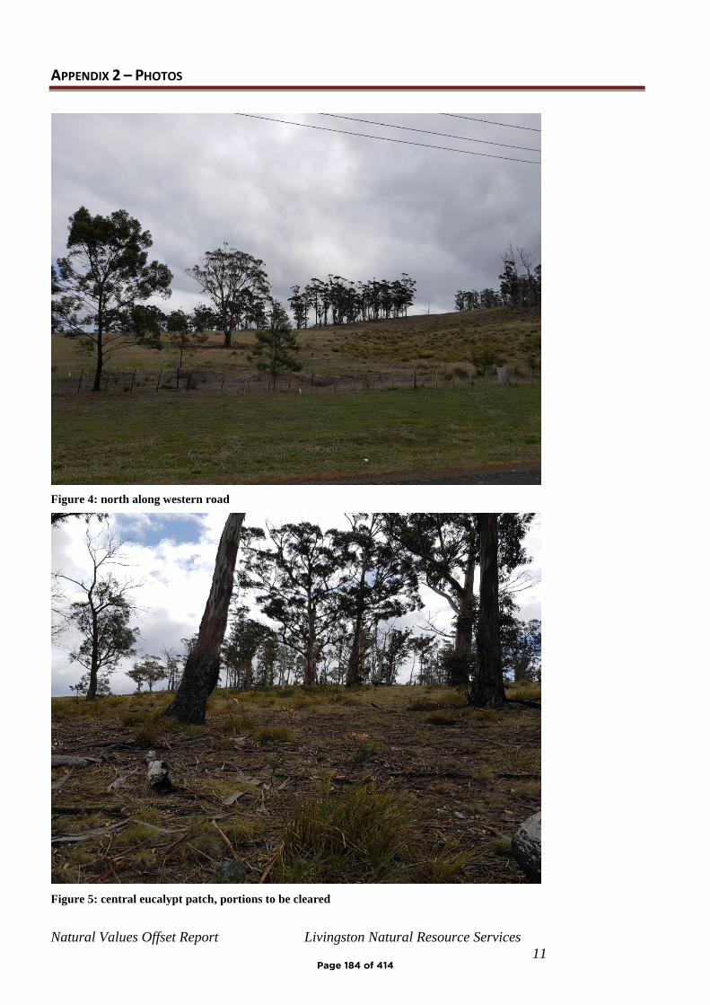
Natural Values Offset Report Livingston Natural Resource Services
11
APPENDIX 2 – PHOTOS
Figure 4: north along western road
Figure 5: central eucalypt patch, portions to be cleared
Page 184 of 414
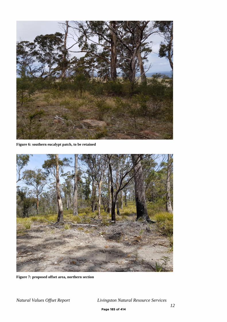
Natural Values Offset Report Livingston Natural Resource Services
12
Figure 6: southern eucalypt patch, to be retained
Figure 7: proposed offset area, northern section
Page 185 of 414
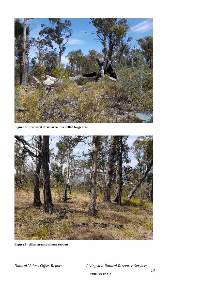
Natural Values Offset Report Livingston Natural Resource Services
13
Figure 8: proposed offset area, fire felled large tree
Figure 9: offset area southern section
Page 186 of 414
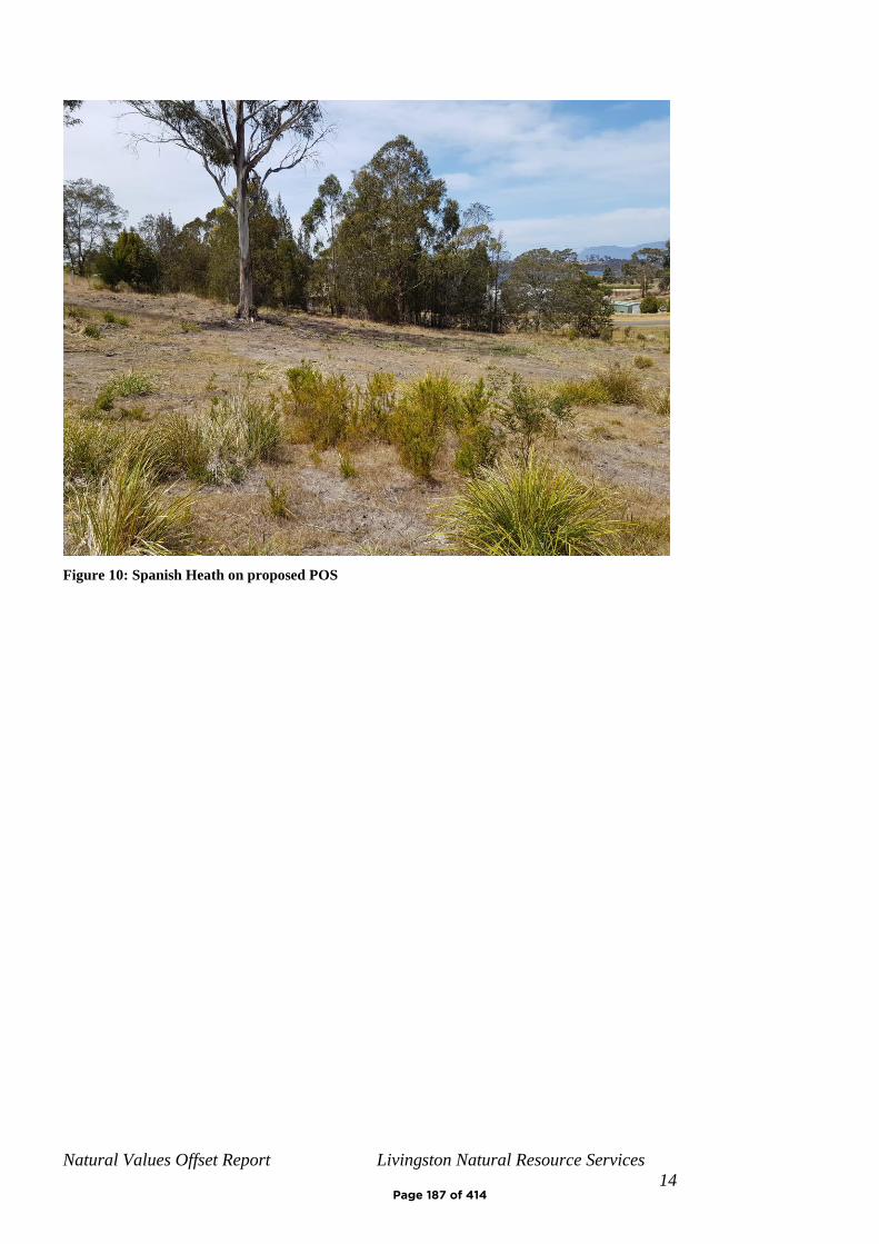
Natural Values Offset Report Livingston Natural Resource Services
14
Figure 10: Spanish Heath on proposed POS
Page 187 of 414
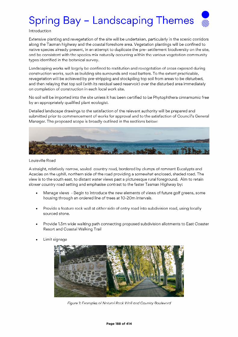
•
•
•
•
Page 188 of 414
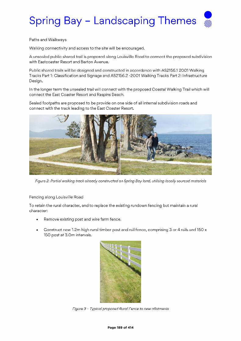
•
•
Page 189 of 414

•
•
Page 190 of 414
1
Maree Tyrrell
From:Sent: Friday, 18 September 2020 10:23 PMTo: PlanningSubject: Representation RE: SA 2019/17
The General Manager Glamorgan Spring Bay Council By email: [email protected] Dear Sir, I refer to the Subdivision Application SA 2019/17 and the documentation in support thereof. My attention was drawn to this Application thanks to an article in the Mercury Newspaper which gushed: “ An application has now been submitted to the Glamorgan Spring Bay Council for the fifth stage of multimillion-dollar golf course and residential project”. True of course in its own way but nothing to do with the long promised and equally long awaited but still mythical multi-million dollar golf course. And hardly the fifth stage, more like a first tentative step. I note the following: The Solis Development Specific Area Plan is meant to promote a high quality tourism, recreational and residential Estate that will create a major visitor attraction that will encourage visitors to stay longer in the area. SA 2019/17 is an application only for a residential subdivision ( the first one for 47 Lots in three stages with many more SAs undoubtedly to follow to get to the 609 Lots envisaged) and promises to add nothing to the tourism or recreation experience. Council’s own “Major Projects” pages on its website explains where the Solis Development is today (18/09/2020). Solis covers 272 hectares of premium waterfront land, only a 45-minute drive from Hobart airport. It offers the perfect base to explore the National Parks and World Heritage Areas found on the east coast of Tasmania. Solis can be broken down into three specific components, which will be constructed and developed simultaneously. These include: Development of an 18-hole golf course on land donated to council at Louisville Point Road, Orford. The Glamorgan Spring Bay Council will lease the “Golf Course Land” to a private lessee on commercial terms, and the lessee will construct and operate the golf course. The development of around 609 residential lots through the sub-division of land surrounding the golf course development, over three stages. This includes the development of a 60 unit eco-cabin holiday (sic) The re-development of the Eastcoaster Resort. This would involve completing an approved 10 lot subdivision and a new street at the end of Louisville Rd to replace the existing 20 strata titles. Other work involves an upgrade to the existing resort, construction of a new waterfront café/marina complex including an upgrade to the existing outdoor pool and jetty, and redesign of the existing caravan and cabin park for the construction of 24 holiday units purposefully designed with a golfing theme. In order to link these facilities between Orford and Triabunna, a coastal walking track will also be established. It is clear that SA 2019/17 is the first part of the development of said 609 Lots. There appears to be no progress on the simultaneously to be developed long promised world class 18 hole golf course, the land on which this would occur has NOT been donated to Council, and Council is so much trying to get its inherited disastrous financial affairs in order it should not be simultaneously be shouldered with the task of taking responsibility for a golf course development that has already cost it considerable time and money. This fabled Solis golf course also already
Page 191 of 414
Agenda Item 4.2 - Attachment B

2
played its shameful part in the Council owned pipeline financial disaster as the decision to own the pipeline was taken in part to assist in providing water for the golf course. There is no clarity as to which water customer would get priority in years of drought and the low price per megaliter apparently negotiated with Solis for an annual 300 megaliters might well put them behind Tassal and Taswater. This might mean such uncertainty that the golf course will never be built. When all uncertainty about the Solis Golf Course has been resolved then Council will have no reason to not support the subdivision aspects of the proposed Development. If it allows residential subdivision now it will set a clear precedent that the much vaunted “tourism and recreational” parts of the Development SAP are indeed subordinate to the residential part. That I believe was never the intention. In order that the whole of the proposed development will take its place as a sustainable and visually more pleasing jewel in the crown of the promised East Coast tourism icon rather than just become another massive subdivision I object to, and strongly argue against, the clearly premature approval of SA 2019/17 in the continued absence of clear commitment to, and approvals for, the more pleasing aspects of the Solis SAP. Yours sincerely,
Page 192 of 414

G L AM O RG AN/ S P RI NG B AY CO UNCI L
NO TI CE O F PRO PO S E D DE V E LO PM E NT
Notice is hereby given that an application has been made for planning approval for the following development;
SITE: 46 Charles Street Orford and 5 Prosser St Orford
PROPOSAL: Subdivision: 12 lots plus balance (lot 7)
Any person may make representation on the application(s) by letter (PO Box 6, Triabunna) or
electronic mail ([email protected]) addressed to the General Manager.
Representations must be received before midnight on 05 February 2021.
APPLICANT: Andrew Hamilton & Associates
DATE: 21 March 2018
APPLICATION NO: SA 2018 / 06
Page 193 of 414
Agenda Item 4.3 - Attachment A
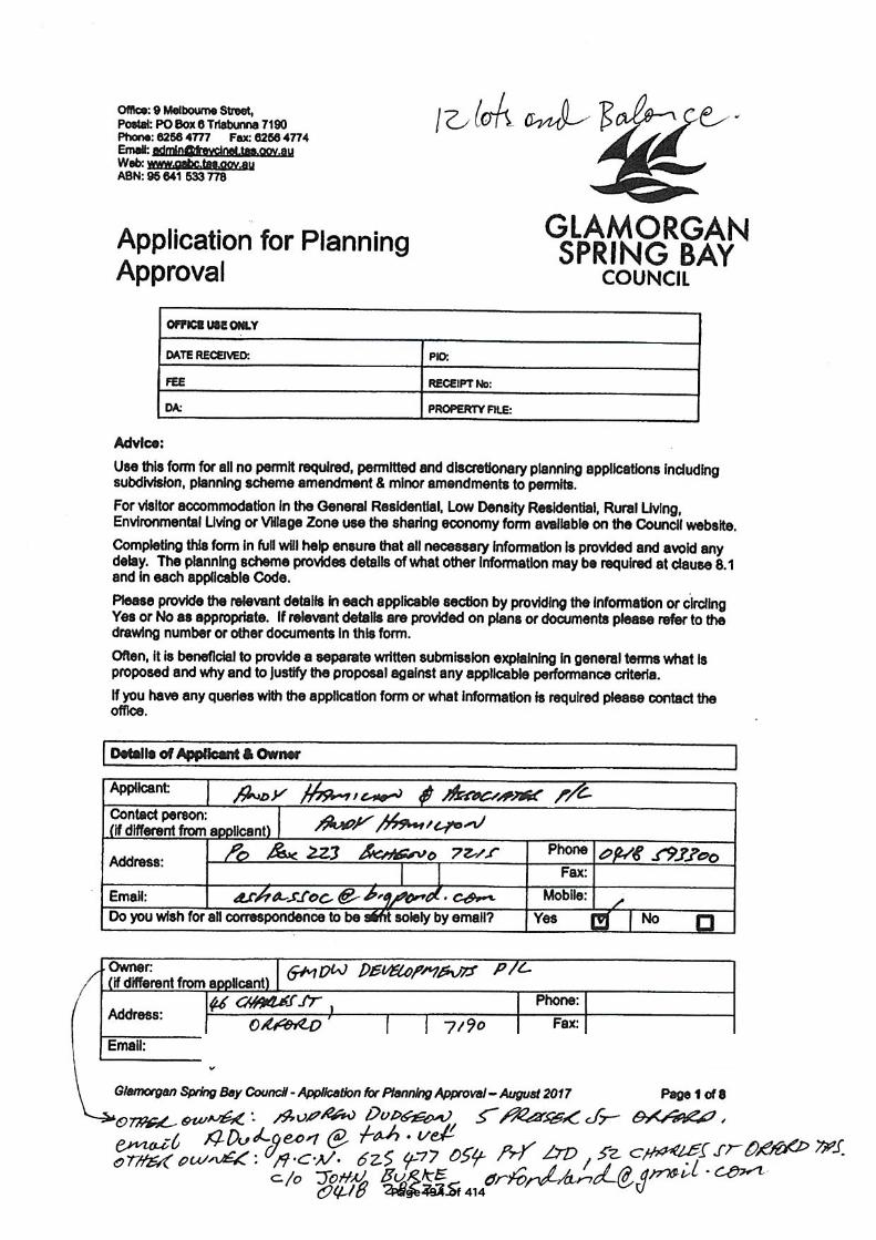
Page 194 of 414

Page 195 of 414
Page 196 of 414
Page 197 of 414

Page 198 of 414
Page 199 of 414
Page 200 of 414
Page 201 of 414

Page 202 of 414
Page 203 of 414
Page 204 of 414
Page 205 of 414
Page 206 of 414
Page 207 of 414
Geo-Environmental Solutions - 29 Kirksway Place, Battery point, Tasmania, 7004.Phone: 036223 1839 Email: [email protected] Web: www.geosolutions.net.au
Proposed Subdivision
46 Charles Street, Orford
Bushfire Hazard Report
Applicant: Andy Hamilton & Associates
August 2020, GES01772 v3
Page 208 of 414
Bushfire Hazard Report - 46 Charles Street, Orford, August 2020, GES01772 v3.Page 2 of 11
Contents1.0 Introduction ..................................................................................................................................32.0 Proposal.......................................................................................................................................33.0 Site Description............................................................................................................................34.0 Bushfire Hazard Assessment.......................................................................................................5
4.1 Vegetation ................................................................................................................................54.2 slopes .......................................................................................................................................54.3 Bushfire Attack Level................................................................................................................5
5.0 Bushfire Prone Areas Code .........................................................................................................55.1 Hazard Management Areas .....................................................................................................5
5.1.1 Stage Hazard Management...............................................................................................55.1.2 Building areas ....................................................................................................................65.1.3 Hazard Management Area requirements...........................................................................6
5.2 Public and fire-fighting Access .................................................................................................75.2.1 Standards for public roadways ..........................................................................................75.2.2 Property access (for building compliance).........................................................................7
5.3 Water supplies for fire fighting..................................................................................................76.0 Compliance ..................................................................................................................................8
6.1 Planning Compliance ...............................................................................................................86.2 Building Compliance.................................................................................................................9
7.0 Summary......................................................................................................................................98.0 Limitations Statement ................................................................................................................109.0 References.................................................................................................................................11
Appendix A: Site Plan
Appendix B: Bushfire Attack Level Assessment Tables
Appendix C: Site Photos
Appendix D: Bushfire Hazard Management Plan
Appendix E: Planning Certificate
Disclaimer
The measures contained in Australian Standard 3959-2018 cannot guarantee that a building will survive a bushfire event on every
occasion. This is substantially due to the unpredictable nature and behaviour of fire and extreme weather conditions.
Reasonable steps have been taken to ensure that the information contained within this report is accurate and reflects the conditions on and around the lot at the time of assessment. The assessment has been based on the information provided by you or your designer.
Authorship
This report was prepared by Mark Van den Berg BSc. (Hons.) FPO (planning) of Geo Environmental Solutions. Base data for mapping: TasMap, Digital and aerial photography: Mark Van den Berg, GoogleEarth.
Page 209 of 414
Bushfire Hazard Report - 46 Charles Street, Orford, August 2020, GES01772 v3.Page 3 of 11
1.0 Introduction
This Bushfire Hazard Report has been completed to form part of supporting documentation
for a planning permit application for a proposed subdivision. The proposed subdivision
occurs in a Bushfire-prone Area defined by the Glamorgan-Spring Bay Interim Planning
Scheme 2015 (the Scheme). This report has been prepared by Mark Van den Berg a
qualified person under Part 4a of the Fire Service Act 1979 of Geo Environmental Solutions
Pty Ltd for Andy Hamilton & Associates
The report considers all the relevant standards of Code E1 of the planning scheme,
specifically;
The requirements for appropriate Hazard Management Areas (HMA’s) in relation to
building areas;
The requirements for Public and Private access;
The provision of water supplies for fire-fighting purposes;
Compliance with the planning scheme, and
Provides a Bushfire Hazard Management Plan to facilitate appropriate compliant
future development.
2.0 Proposal
It is proposed that a 13-lot subdivision be developed on the site described as per the
proposed plan of subdivision in appendix A. The proposed development occurs within the
General Residential zone and is adjacent to an area zoned Low density residential (opposite
Mary Street). New public access is proposed for lots 1 to 6 and lots 8 to 13 from Mary
Street. Lot 7 will maintain its existing access arrangements from Charles Street. A new
reticulated water supply will be established and will provide hydrants for fire-fighting
purposes to lots 1 to 2 and lots 10 to 13.
3.0 Site Description
The subject site comprises private land on one title at 46 Charles Street, Orford, title number
252719/5 (figure 1). The site occurs in the municipality of Glamorgan-Spring Bay, this
application is administered through the Glamorgan-Spring Bay Interim planning scheme
2015 which makes provision for subdivision.
The site is located approximately 0.8 km north east of Shed Hill (figure 1) and is dominated
by grassland with retained native trees. It has gentle to moderate slopes with a north-
westerly aspect. Lot 12 has an existing residential building with property access from
Charles Street, this lot has been assessed as BAL-LOW.
Page 210 of 414
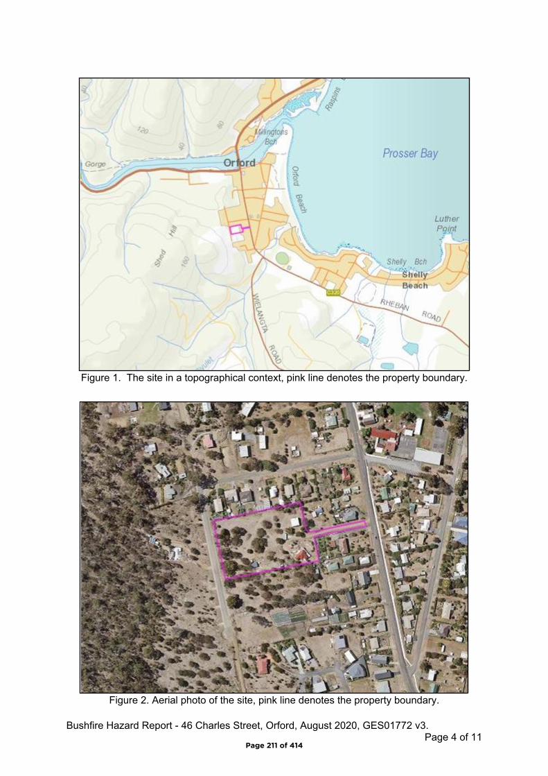
Bushfire Hazard Report - 46 Charles Street, Orford, August 2020, GES01772 v3.Page 4 of 11
Figure 1. The site in a topographical context, pink line denotes the property boundary.
Figure 2. Aerial photo of the site, pink line denotes the property boundary.
Page 211 of 414

Bushfire Hazard Report - 46 Charles Street, Orford, August 2020, GES01772 v3.Page 5 of 11
4.0 Bushfire Hazard Assessment
4.1 Vegetation
The site and adjacent lands within 100 metres of the proposed building areas carry a mosaic
pattern of grassland and woodland vegetation (as per AS3959-2009). A bushfire impacting
the subdivision area from the west will burn through woodland vegetation. Lands to the
north, east, and south are not considered bushfire-prone and are unlikely to generate
significant bushfire attack.
4.2 slopes
The effective slopes in relation to the proposed new lots are gentle to moderate
(approximately 0 to 6 degrees) and are unlikely to significantly influence fire behaviour.
4.3 Bushfire Attack Level
An assessment of the bushfire attack level as per AS3959-2018 was undertaken for each
proposed lot to determine the required width of hazard management areas to yield building
areas of not greater than BAL-19. The vegetation present is assessed as ‘grassland and
woodland’. The bushfire attack level assessment tables are found in appendix B. The
assessment has been completed measuring distances from the proposed building areas.
5.0 Bushfire Prone Areas Code
Code E1 of the Panning Scheme details the requirements for the provision of hazard
management areas, standards for access, firefighting water supplies and requirements for
hazard management areas for subdivisions which occur within or partly within a bushfire-
prone area. Lots 3 to 9 have been assessed as BAL-LOW and are considered to not occur
within a bushfire-prone area.
5.1 Hazard Management Areas
Hazard management areas are required to be established for each lot, they provide an area
around the building within which fuels are managed to reduce the impacts of direct flame
contact, radiant heat and ember attack on the site. The Bushfire Hazard Management Plan
(BHMP) shows building areas (for habitable buildings) and the associated HMA’s for each
lot, guidance for establishment and maintenance of HMA’s is provided below.
5.1.1 Stage Hazard Management
The proposed subdivision is to occur as a single stage. As the development site carries
bushfire-prone vegetation it will be necessary to establish the hazard management areas for
each lot (as shown on the BHMP) as part of subdivision works and should be completed
prior to sealing of titles, this is the responsibility of the developer. Ongoing maintenance of
HMA’s for all lots will be the responsibility of each lot owner.
Page 212 of 414
Bushfire Hazard Report - 46 Charles Street, Orford, August 2020, GES01772 v3.Page 6 of 11
5.1.2 Building areas
Building areas for habitable buildings on each lot are shown on the BHMP. Each lot has
been assessed and a Bushfire Attack Level (BAL) assigned to it. If future buildings are
located within the building area and comply with the minimum setbacks for the lot the
buildings may be constructed to the bushfire attack level assigned to that lot. If associated
structures like sheds or other non-habitable buildings are proposed, they do not need to
conform to the BAL for the lot unless they are within 6 metres of the habitable building.
5.1.3 Hazard Management Area requirements
A hazard management area is the area, between a habitable building or building area and
the bushfire prone vegetation, which provides access to a fire front for firefighting, which is
maintained in a minimal fuel condition and in which there are no other hazards present which
will significantly contribute to the spread of a bushfire. This can be achieved through, but is
not limited to the following strategies;
• Remove fallen limbs, sticks, leaf and bark litter;
• Maintaining grass at less than a 100mm height;
• Avoid or minimise the use of flammable mulches (especially against buildings);
• Thin out under-story vegetation to provide horizontal separation between fuels;
• Prune low-hanging tree branches (<2m from the ground) to provide vertical
separation between fuel layers;
• Remove or prune larger trees to establish and maintain horizontal separation
between tree canopies;
• Minimise the storage of flammable materials such as firewood;
• Maintaining vegetation clearance around vehicular access and water supply points;
• Use low-flammability plant species for landscaping purposes where possible;
• Clear out any accumulated leaf and other debris from roof gutters and other debris
accumulation points.
It is not necessary to remove all vegetation from the hazard management area, up to 20% of
the tree canopy may be retained1, trees and shrubs may provide protection from wind borne
embers and radiant heat under some circumstances, if other fuels are appropriately
managed.
1 20% of the canopy prior to development of the site may be retained within a hazard management area.
Page 213 of 414
Bushfire Hazard Report - 46 Charles Street, Orford, August 2020, GES01772 v3.Page 7 of 11
5.2 Public and fire-fighting Access
New public access is required to access lots 1 to 6 and lots 8 to 13. The new roads are
required to conform with the following specifications consistent with Code E1. Table E1. of
the Scheme.
5.2.1 Standards for public roadways
Unless the development standards in the zone require a higher standard, the following will
apply:
two-wheel drive, all-weather construction;
load capacity of at least 20t, including for bridges and culverts;
minimum carriageway width is 7m for a through road, or 5.5m for a dead-end or cul-
de-sac road;
minimum vertical clearance of 4m;
minimum horizontal clearance of 2m from the edge of the carriageway;
cross falls of less than 3 degrees (1:20 or 5%);
maximum gradient of 15 degrees (1:3.5 or 28%) for sealed roads, and 10 degrees
(1:5.5 or 18%) for unsealed roads;
curves have a minimum inner radius of 10m;
dead-end or cul-de-sac roads are not more than 200m in length unless the
carriageway is 7 metres in width;
dead-end or cul-de-sac roads have a turning circle with a minimum 12m outer radius;
carriageways less than 7m wide have ‘No Parking’ zones on one side, indicated by a
road sign that complies with Australian Standard AS1743-2001 Road signs-
Specifications;
Cul-de-sac to have roll top kerb and trafficable footpath to achieve 12m outer radius
turning circle.
Cul-de-sac to be have ‘No Parking’ zones, indicated by a road sign that complies with
Australian Standard AS1743-2001 Road signs-Specifications;
5.2.2 Property access (for building compliance)
Specific property access standards are not required for subsequent building approval, lots 3
to 9 do not occur within a bushfire-prone area. Lots 1 to 2 and lots 10 to 13 do not require
property access to connect to a water connection point.
5.3 Water supplies for fire fighting
Water supplies for firefighting are required for lots 1 to 2 and lots 10 to 13 and will be
provided by a reticulated water supply system established at the time of subdivision.
Page 214 of 414
Bushfire Hazard Report - 46 Charles Street, Orford, August 2020, GES01772 v3.Page 8 of 11
Hydrants will be installed in accordance with the specifications of table 1. Lots 3 to 9 are
considered not to occur within a bushfire-prone area, as such there are no specific water
supply requirements for these lots.
Table 1. Specifications for Reticulated water supplies for firefighting (table E4)Element Requirement
A Distance between building area to be protected and water supply.
The following requirements apply: (a) the building area to be protected must be located within 120m of a fire hydrant; and (b) the distance must be measured as a hose lay, between the firefighting water point and the furthest part of the building area.
B Design criteria for fire hydrants
The following requirements apply: (a) fire hydrant system must be designed and constructed in accordance with TasWater Supplement to Water Supply Code of Australia WSA 03 – 2011-3.1 MRWA 2nd Edition; and (b) fire hydrants are not installed in parking areas.
C Hardstand A hardstand area for fire appliances must be: (a) no more than 3m from the hydrant, measured as a hose lay; (b) no closer than 6m from the building area to be protected; (c) a minimum width of 3m constructed to the same standard as the carriageway; and (d) connected to the property access by a carriageway equivalent to the standard of the property access.
6.0 Compliance
6.1 Planning Compliance
The following compliance table (table 2) summarises the compliance requirements for
subdivisions in bushfire prone areas against Code E1 as they apply to this proposal. A
planning certificate has been issued for the associated BHMP as being compliant with the
relevant standards as outlined below and is located in appendix E.
Table 2. Compliance with Code E1 of Glamorgan-Spring Bay Interim Planning Scheme 2015.
Item ComplianceE1.6.1 Subdivision: Provision of hazard management areas
A1, (b)The proposed plan of subdivision: (i) shows all lots that are within or partly within a bushfire-prone area, including those developed at each stage of a staged subdivision; (ii) shows the building area for each lot; (iii) shows hazard management areas between bushfire-prone vegetation and each building area that have dimensions equal to, or greater than, the separation distances required for BAL 19 in Table 2.4.4 of Australian Standard AS 3959 – 2018 Construction of buildings in bushfire-prone areas; and (iv) is accompanied by a bushfire hazard management plan that addresses all the individual lots and that is certified by the TFS or accredited person, showing hazard management areas equal to, or greater than, the separation distances required for BAL-19 in Table 2.4.4 of Australian Standard AS 3959 – 2018 Construction of buildings in bushfire-prone areas.
The Bushfire hazard management shows all bushfire-prone lots with building areas not exceeding BAL-19 and is certified.
Page 215 of 414
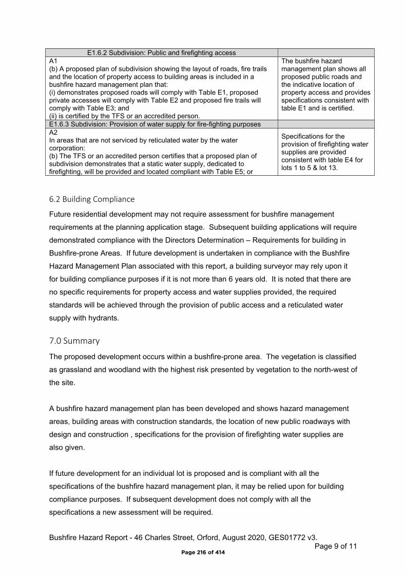
Bushfire Hazard Report - 46 Charles Street, Orford, August 2020, GES01772 v3.Page 9 of 11
6.2 Building Compliance
Future residential development may not require assessment for bushfire management
requirements at the planning application stage. Subsequent building applications will require
demonstrated compliance with the Directors Determination – Requirements for building in
Bushfire-prone Areas. If future development is undertaken in compliance with the Bushfire
Hazard Management Plan associated with this report, a building surveyor may rely upon it
for building compliance purposes if it is not more than 6 years old. It is noted that there are
no specific requirements for property access and water supplies provided, the required
standards will be achieved through the provision of public access and a reticulated water
supply with hydrants.
7.0 Summary
The proposed development occurs within a bushfire-prone area. The vegetation is classified
as grassland and woodland with the highest risk presented by vegetation to the north-west of
the site.
A bushfire hazard management plan has been developed and shows hazard management
areas, building areas with construction standards, the location of new public roadways with
design and construction , specifications for the provision of firefighting water supplies are
also given.
If future development for an individual lot is proposed and is compliant with all the
specifications of the bushfire hazard management plan, it may be relied upon for building
compliance purposes. If subsequent development does not comply with all the
specifications a new assessment will be required.
E1.6.2 Subdivision: Public and firefighting accessA1 (b) A proposed plan of subdivision showing the layout of roads, fire trails and the location of property access to building areas is included in a bushfire hazard management plan that:(i) demonstrates proposed roads will comply with Table E1, proposed private accesses will comply with Table E2 and proposed fire trails will comply with Table E3; and (ii) is certified by the TFS or an accredited person.
The bushfire hazard management plan shows all proposed public roads and the indicative location of property access and provides specifications consistent with table E1 and is certified.
E1.6.3 Subdivision: Provision of water supply for fire-fighting purposesA2 In areas that are not serviced by reticulated water by the water corporation:(b) The TFS or an accredited person certifies that a proposed plan of subdivision demonstrates that a static water supply, dedicated to firefighting, will be provided and located compliant with Table E5; or
Specifications for the provision of firefighting water supplies are provided consistent with table E4 for lots 1 to 5 & lot 13.
Page 216 of 414
Bushfire Hazard Report - 46 Charles Street, Orford, August 2020, GES01772 v3.Page 10 of 11
8.0 Limitations Statement
This Bushfire Hazard Report has been prepared in accordance with the scope of services
between Geo-Environmental Solutions Pty. Ltd. (GES) and the applicant named in section 2.
To the best of GES's knowledge, the information presented herein represents the Client's
requirements at the time of printing of the Report. However, the passage of time,
manifestation of latent conditions or impacts of future events may result in findings differing
from that described in this Report. In preparing this Report, GES has relied upon data,
surveys, analyses, designs, plans and other information provided by the Client and other
individuals and organisations referenced herein. Except as otherwise stated in this Report,
GES has not verified the accuracy or completeness of such data, surveys, analyses,
designs, plans and other information.
The scope of this study does not allow for the review of every possible bushfire hazard
condition and does not provide a guarantee that no loss of property or life will occur as a
result of bushfire. As stated in AS3959-2009 “It should be borne in mind that the measures
contained in this Standard cannot guarantee that a building will survive a bushfire event on
every occasion. This is substantially due to the degree of vegetation management, the
unpredictable nature and behaviour of fire, and extreme weather conditions”. In addition, no
responsibility is taken for any loss which is a result of actions contrary to AS3959-2009 or
the Tasmanian Planning Commission Bushfire code.
This report does not purport to provide legal advice. Readers of the report should engage
professional legal practitioners for this purpose as required. No responsibility is accepted for
use of any part of this report in any other context or for any other purpose by third party.
Page 217 of 414
Bushfire Hazard Report - 46 Charles Street, Orford, August 2020, GES01772 v3.Page 11 of 11
9.0 References
Australian Building Codes Board, National Construction Code, Building Code of Australia,
Australian Building Codes Board, Canberra.
Building Amendment (Bushfire-Prone Areas) Regulations 2014
Determination, Director of Building Control – Requirements for Building in Bushfire-Prone
Areas, version 2.2 6th February 2020. Consumer, Building and Occupational Services,
Department of Justice, Tasmania
Standards Australia 2018, Construction of buildings in bushfire prone areas, Standards
Australia, Sydney.
Tasmanian Planning Commission 2017, Planning Directive No.5.1 – Bushfire prone Areas
Code. Tasmanian Planning Commission, Hobart. 1st September 2017.
The Bushfire Planning Group 2005, Guidelines for development in bushfire prone areas of
Tasmania – Living with fire in Tasmania, Tasmania Fire Service, Hobart.
Glamorgan – Spring Bay Interim Planning Scheme 2015. Tasmanian Planning Commission
2015, Tasmanian Planning Commission, Hobart.
Page 218 of 414

Bushfire Hazard Report - 46 Charles Street, Orford, August 2020, GES01772 v3.
Appendix A - Site Plan
Page 219 of 414
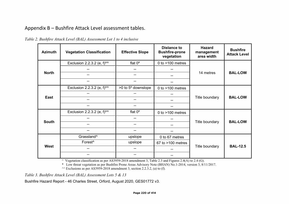
Bushfire Hazard Report - 46 Charles Street, Orford, August 2020, GES01772 v3.
Appendix B – Bushfire Attack Level assessment tables.
Table 2. Bushfire Attack Level (BAL) Assessment Lot 1 to 4 inclusive
Azimuth Vegetation Classification Effective SlopeDistance to
Bushfire-prone vegetation
Hazard management
area widthBushfire
Attack Level
Exclusion 2.2.3.2 (e, f)^^ flat 0º 0 to >100 metres-- -- ---- -- --
North
-- -- --
14 metres BAL-LOW
Exclusion 2.2.3.2 (e, f)^^ >0 to 5º downslope 0 to >100 metres-- -- ---- -- --
East
-- -- --
Title boundary BAL-LOW
Exclusion 2.2.3.2 (e, f)^^ flat 0º 0 to >100 metres-- -- ---- -- --
South
-- -- --
Title boundary BAL-LOW
Grassland^ upslope 0 to 67 metresForest^ upslope 67 to >100 metres
-- -- --West
-- -- --
Title boundary BAL-12.5
^ Vegetation classification as per AS3959-2018 amendment 3, Table 2.3 and Figures 2.4(A) to 2.4 (G).* Low threat vegetation as per Bushfire Prone Areas Advisory Note (BHAN) No.1-2014, version 3, 8/11/2017.^^ Exclusions as per AS3959-2018 amendment 3, section 2.2.3.2, (a) to (f).
Table 3. Bushfire Attack Level (BAL) Assessment Lots 5 & 13
Page 220 of 414
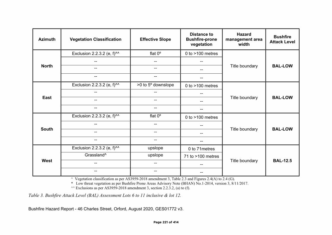
Bushfire Hazard Report - 46 Charles Street, Orford, August 2020, GES01772 v3.
Azimuth Vegetation Classification Effective SlopeDistance to
Bushfire-prone vegetation
Hazard management area
widthBushfire
Attack Level
Exclusion 2.2.3.2 (e, f)^^ flat 0º 0 to >100 metres
-- -- ---- -- --
North
-- -- --
Title boundary BAL-LOW
Exclusion 2.2.3.2 (e, f)^^ >0 to 5º downslope 0 to >100 metres-- -- ---- -- --
East
-- -- --
Title boundary BAL-LOW
Exclusion 2.2.3.2 (e, f)^^ flat 0º 0 to >100 metres-- -- ---- -- --
South
-- -- --
Title boundary BAL-LOW
Exclusion 2.2.3.2 (e, f)^^ upslope 0 to 71metresGrassland^ upslope 71 to >100 metres
-- -- --West
-- -- --
Title boundary BAL-12.5
^ Vegetation classification as per AS3959-2018 amendment 3, Table 2.3 and Figures 2.4(A) to 2.4 (G).* Low threat vegetation as per Bushfire Prone Areas Advisory Note (BHAN) No.1-2014, version 3, 8/11/2017.^^ Exclusions as per AS3959-2018 amendment 3, section 2.2.3.2, (a) to (f).
Table 3. Bushfire Attack Level (BAL) Assessment Lots 6 to 11 inclusive & lot 12.
Page 221 of 414
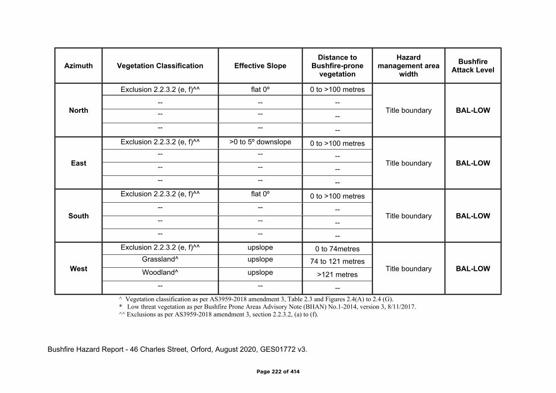
Bushfire Hazard Report - 46 Charles Street, Orford, August 2020, GES01772 v3.
Azimuth Vegetation Classification Effective SlopeDistance to
Bushfire-prone vegetation
Hazard management area
widthBushfire
Attack Level
Exclusion 2.2.3.2 (e, f)^^ flat 0º 0 to >100 metres
-- -- ---- -- --
North
-- -- --
Title boundary BAL-LOW
Exclusion 2.2.3.2 (e, f)^^ >0 to 5º downslope 0 to >100 metres-- -- ---- -- --
East
-- -- --
Title boundary BAL-LOW
Exclusion 2.2.3.2 (e, f)^^ flat 0º 0 to >100 metres-- -- ---- -- --
South
-- -- --
Title boundary BAL-LOW
Exclusion 2.2.3.2 (e, f)^^ upslope 0 to 74metresGrassland^ upslope 74 to 121 metresWoodland^ upslope >121 metres
West
-- -- --
Title boundary BAL-LOW
^ Vegetation classification as per AS3959-2018 amendment 3, Table 2.3 and Figures 2.4(A) to 2.4 (G).* Low threat vegetation as per Bushfire Prone Areas Advisory Note (BHAN) No.1-2014, version 3, 8/11/2017.^^ Exclusions as per AS3959-2018 amendment 3, section 2.2.3.2, (a) to (f).
Page 222 of 414
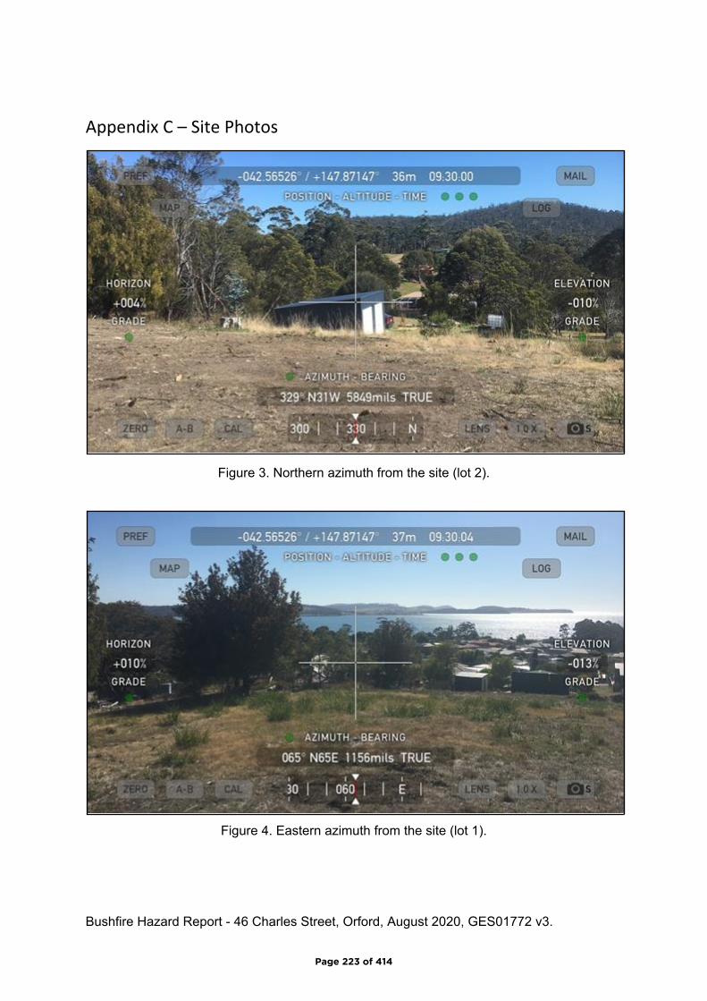
Bushfire Hazard Report - 46 Charles Street, Orford, August 2020, GES01772 v3.
Appendix C – Site Photos
Figure 3. Northern azimuth from the site (lot 2).
Figure 4. Eastern azimuth from the site (lot 1).
Page 223 of 414
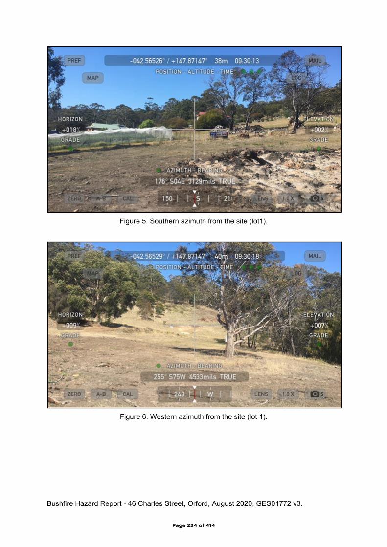
Bushfire Hazard Report - 46 Charles Street, Orford, August 2020, GES01772 v3.
Figure 5. Southern azimuth from the site (lot1).
Figure 6. Western azimuth from the site (lot 1).
Page 224 of 414

Do not scale from these drawings.Dimensions to take precedenceover scale.
Date: 25/08/2020 Sheet 1 of 1Prepared by:MvdB
Drawing Number:A01
29 Kirksway Place, Battery Point.T| 62231839 E| [email protected]
Bushfire Hazard Management Plan, 46 Charles Street, Orford August2020. GES01772 v3.
Glamorgan-Spring Bay Interim Planning Scheme 2015
BUSHFIRE HAZARD MANAGEMENT PLAN
Hazard Management AreaA hazard management area is the area, between a habitablebuilding or building area and the bushfire prone vegetation,which provides access to a fire front for firefighting, which ismaintained in a minimal fuel condition and in which there are noother hazards present which will significantly contribute to thespread of a bushfire. This can be achieved through, but is notlimited to the following actions;
• Remove fallen limbs, sticks, leaf and bark litter;• Maintain grass at less than a 100mm height;• Avoid pine bark and other flammable mulch (especially from against buildings);• Thin out under-story vegetation to provide horizontal separation between fuels;• Prune low-hanging tree branches (<2m from the ground) to provide (vertical separation between fuel layers;• Prune and or remove larger trees to maintain horizontal separation between canopies;• Minimise the storage of flammable materials such as firewood;• Maintain vegetation clearance around vehicular access and water supply points;• Use low-flammability species for landscaping purposes where appropriate;• Clear out any accumulated leaf and other debris from roof gutters and other accumulation points.
It is not necessary to remove all vegetation from the hazardmanagement area, trees may provide protection from wind borneembers and radiant heat under some circumstances.
Certification No. GES01772
Mark Van den BergAcc. No. BFP-108
Scope 1, 2, 3A, 3B, 3C.
GMDW Developments Pty Ltd10 Bayview Street, AltonaVictoria 3018
C.T.: 252719/5PID: 5976854
Bushfire Hazard Management Plan 46 CharlesStreet, Orford August 2020. GES01772 v3.Bushfire Management Report 46 Charles Street,Orford August 2020. GES01772 v3
Lot 1BAL-12.5
Lot 2BAL-12.5
Lot 13BAL-12.5
Lot 12BAL-12.5
Lot 11BAL-12.5
Lot 10BAL-12.5
Lot 3BAL-LOW
Lot 4BAL-LOW
Lot 5BAL-LOW
Lot 6BAL-LOW
Lot 7BAL-LOW
Lot 8BAL-LOW
Lot 9BAL-LOW
New public Road
Hazard Management Area
BAL-12.5 Building Area
Indicative property access location
BAL-LOW Building Area
Indicative Hydrant locationCul-de-sac to have roll top kerbwith trafficable footpath to provide12m outer radius turning circle.Cul-de-sac to be a no parking zonewith appropriate signs.
lot 7 access to Charles St.
Mary Street
Notes:
1) This plan must be read in conjunction withGeo-Environmental Solutions BushfireHazard Report, 46 Charles Street, OrfordAugust 2020. GES01772 v3
2) Hazard management areas to beestablished as per section 5.1.3 of reportand as shown.
3) New public roadways to be constructed tothe minimum standards detailed in section5.2.1 of report.
4) Reticulated water supplies dedicated forfirefighting to be provided consistent withsection 5.3 of report.
Page 225 of 414

Planning Certificate from a Bushfire Hazard Practitioner v5.0 Page 1 of 4
BUSHFIRE-PRONE AREAS CODE
CERTIFICATE1 UNDER S51(2)(d) LAND USE PLANNING AND APPROVALS ACT 1993
1. Land to which certificate applies
The subject site includes property that is proposed for use and development and includes all properties upon which works are proposed for bushfire protection purposes.
Street address: 46 Charles Street, Orford
Certificate of Title / PID: CT: 252719/5 PID: 5976854
2. Proposed Use or Development
Description of proposed Use and Development:
13 Lot Subdivision
Applicable Planning Scheme: Glamorgan – Spring Bay IPS 2015
3. Documents relied upon
This certificate relates to the following documents:
Title Author Date Version
Bushfire Hazard Report 46 Charles Street, Orford August 2020. GES01772 v3
Mark Van den Berg 25/08/2020 3
Bushfire Hazard Management Plan 46 Charles Street, Orford August 2020. GES01772 v3
Mark Van den Berg 25/08/2020 3
Plan of Proposed Subdivision – 46 Charles Street, Orford,
R. Gibson 31/7/2020 1718-T1
1 This document is the approved form of certification for this purpose and must not be altered from its original form.
Page 226 of 414

Planning Certificate from a Bushfire Hazard Practitioner v5.0 Page 2 of 4
4. Nature of Certificate
The following requirements are applicable to the proposed use and development:
☐ E1.4 / C13.4 – Use or development exempt from this CodeCompliance test Compliance Requirement
☐ E1.4(a) / C13.4.1(a) Insufficient increase in risk
☐ E1.5.1 / C13.5.1 – Vulnerable UsesAcceptable Solution Compliance Requirement
☐ E1.5.1 P1 / C13.5.1 P1Planning authority discretion required. A proposal cannot be certified as compliant with P1.
☐ E1.5.1 A2 / C13.5.1 A2 Emergency management strategy
☐ E1.5.1 A3 / C13.5.1 A2 Bushfire hazard management plan
☐ E1.5.2 / C13.5.2 – Hazardous UsesAcceptable Solution Compliance Requirement
☐ E1.5.2 P1 / C13.5.2 P1Planning authority discretion required. A proposal cannot be certified as compliant with P1.
☐ E1.5.2 A2 / C13.5.2 A2 Emergency management strategy
☐ E1.5.2 A3 / C13.5.2 A3 Bushfire hazard management plan
☒ E1.6.1 / C13.6.1 Subdivision: Provision of hazard management areasAcceptable Solution Compliance Requirement
☐ E1.6.1 P1 / C13.6.1 P1Planning authority discretion required. A proposal cannot be certified as compliant with P1.
☐ E1.6.1 A1 (a) / C13.6.1 A1(a) Insufficient increase in risk
☒ E1.6.1 A1 (b) / C13.6.1 A1(b) Provides BAL-19 for all lots (including any lot designated as ‘balance’)
☐ E1.6.1 A1(c) / C13.6.1 A1(c) Consent for Part 5 Agreement
Page 227 of 414
Planning Certificate from a Bushfire Hazard Practitioner v5.0 Page 3 of 4
☐ E1.6.2 / C13.6.2 Subdivision: Public and fire fighting accessAcceptable Solution Compliance Requirement
☐ E1.6.2 P1 / C13.6.2 P1Planning authority discretion required. A proposal cannot be certified as compliant with P1.
☐ E1.6.2 A1 (a) / C13.6.2 A1 (a) Insufficient increase in risk
☒ E1.6.2 A1 (b) / C13.6.2 A1 (b) Access complies with relevant Tables
☒E1.6.3 / C13.1.6.3 Subdivision: Provision of water supply for fire fighting purposesAcceptable Solution Compliance Requirement
☐ E1.6.3 A1 (a) / C13.6.3 A1 (a) Insufficient increase in risk
☒ E1.6.3 A1 (b) / C13.6.3 A1 (b) Reticulated water supply complies with relevant Table
☐ E1.6.3 A1 (c) / C13.6.3 A1 (c) Water supply consistent with the objective
☐ E1.6.3 A2 (a) / C13.6.3 A2 (a) Insufficient increase in risk
☐ E1.6.3 A2 (b) / C13.6.3 A2 (b) Static water supply complies with relevant Table
☐ E1.6.3 A2 (c) / C13.6.3 A2 (c) Static water supply consistent with the objective
Page 228 of 414
Planning Certificate from a Bushfire Hazard Practitioner v5.0 Page 4 of 4
5. Bushfire Hazard Practitioner
Name: Mark Van den Berg Phone No: 03 6223 1839
Postal Address:
29 Kirksway Place,Battery Point, Tas. 7004 Email
Address: [email protected]
Accreditation No: BFP – 108 Scope: 1, 2, 3a,3b, 3c
6. Certification
I certify that in accordance with the authority given under Part 4A of the Fire Service Act 1979 that the proposed use and development:
☐
Is exempt from the requirement Bushfire-Prone Areas Code because, having regard to the objective of all applicable standards in the Code, there is considered to be an insufficient increase in risk to the use or development from bushfire to warrant any specific bushfire protection measures, or
☒The Bushfire Hazard Management Plan/s identified in Section 3 of this certificate is/are in accordance with the Chief Officer’s requirements and compliant with the relevant Acceptable Solutions identified in Section 4 of this Certificate.
Signed:certifier
Name: Mark Van den Berg Date: 24/8/2020
Certificate Number: GES01772v3
(for Practitioner Use only)
Page 229 of 414
Director of Building Control – Date Approved 1 July 2017 Building Act 2016 - Approved Form No. 55
CERTIFICATE OF QUALIFIED PERSON – ASSESSABLE ITEM Section 321
To: GMDW Owner /Agent
10 Bayview Street Address
Altona, Vic 3018 Suburb/postcode
Qualified person details:
Qualified person: Mark Van den BergAddress: 29 Kirksway Place Phone No: 03 6223 1839
Battery Point TAS 7004 Fax No:
Licence No: BFP-108 Email address: [email protected]
Accredited to report on bushfire hazards under Part IVA of the Fire Service Act. BFP-108 scope 1, 2, 3a, 3b, 3c.Sterling Insurance PI policy No. 17080170
Qualifications and Insurance details:
(description from Column 3 of the Director's Determination - Certificates by Qualified Persons for Assessable Items
Speciality area of expertise:
Analysis of bushfire hazards in bushfire prone areas
(description from Column 4 of the Director's Determination - Certificates by Qualified Persons for Assessable Items)
Details of work:
Address: 46 Charles Street Lot No: 1 - 13
Orford, Tas. 7190 Certificate of title No: TBAThe assessable item related to this certificate:
New building work in a bushfire prone area.
(description of the assessable item being certified) Assessable item includes – - a material;- a design- a form of construction- a document- testing of a component, building
system or plumbing system- an inspection, or assessment,
performed
Certificate details:
Certificate type: Bushfire Hazard (description from Column 1 of Schedule 1 of the Director's Determination - Certificates by Qualified Persons for Assessable Items n)
This certificate is in relation to the above assessable item, at any stage, as part of - (tick one)
building work, plumbing work or plumbing installation or demolition work: Xor
Form 55
Page 230 of 414
Director of Building Control – Date Approved 1 July 2017 Building Act 2016 - Approved Form No. 55
a building, temporary structure or plumbing installation:
In issuing this certificate the following matters are relevant –
Documents: Bushfire Hazard Report 46 Charles Street, Orford August 2020. GES01772 v3Bushfire Hazard Management Plan 46 Charles Street, Orford August 2020. GES01772 v3and Form 55.
Relevantcalculations: Not Applicable.
References:Determination, Director of Building Control Requirements for Building in Bushfire-Prone Areas, version 2.2 6th February 2020. Consumer, Building and Occupational Services, Department of Justice, Tasmania. Building Amendment (Bushfire-Prone Areas) Regulations 2014. Standards Australia 2018, Construction of buildings in bushfire prone areas, Standards Australia, Sydney.
Substance of Certificate: (what it is that is being certified)
Bushfire attack levels as marked on the Bushfire Hazard management plan. All specifications of report and plan required for compliance.
Scope and/or LimitationsScope: This report was commissioned to identify the Bushfire Attack Level for the existing property. Limitations: The inspection has been undertaken and report provided on the understanding that;-1. The report only deals with the potential bushfire risk all other statutory assessments are outside the scope of this report. 2. The report only identifies the size, volume and status of vegetation at the time the site inspection was undertaken. 3. Impacts of future development and vegetation growth have not been considered.
I certify the matters described in this certificate.Signed: Certificate No: Date:
Qualified person: GES01772 24/08/2020
Page 231 of 414
PROPOSED SUBDIVISION
52 CHARLES STREET,
ORFORD, 7190,
TASMANIA
INDEX
C00 INDEX & COVER SHEET
N01 CIVIL & HYDRAULIC NOTES
N02 SYMBOLS & LINE LEGENDS
C01 EXISTING SITE PLAN
C02 EXISTING SITE PLAN CALLOUT - 1
C03 EXISTING SITE PLAN CALLOUT - 2
C03A EXISTING SITE PLAN CALLOUT - 3
C04 DEMOLITION PLAN CALLOUT - 1
C04A DEMOLITION PLAN CALLOUT - 2
C05 PROPOSED SITE PLAN
H01 STORMWATER HYDRAULIC PLAN
H02 STORMWATER LONG SECTION SH.01
H03 STORMWATER LONG SECTION SH.02
H04 SEWER & WATER HYDRAULIC PLAN
H05 SEWER LONG SECTION SH.01
H06 SEWER LONG SECTION SH.02
N
SCALE:N.T.S.
LOCALITY PLAN
CHKBYREV DATEDESCRIPTION CHKBYREV DATEDESCRIPTION
STATUS
PROJECTCHECKED
M. HORSHAM CC5865 I
SCALE SIZE
A1
PROJECT NO DWG NO REV
DRAWING TITLE
Ellerslie House, Level 1, 119 Sandy Bay Road, Sandy Bay TAS 7005
Phone (03) 6224 5625 www.jsaengineers.com.au
REV DATE:
CIVIL ENGINEER
NOT FOR
CONSTRUCTION
HYDRAULIC ENGINEER
IMPORTANT
DRAWINGS MUST BE
PRINTED & READ IN COLOUR
R. HORNERE. TONG
30/10/18
INDEX & COVER SHEET
ORFORD, 7190
52 CHARLES STREET,
PROPOSED SUBDIVISION
20
/0
9/2
01
8 9
:1
4:2
6 A
M
C00 D18E99-126
AS SHOWN
PLANNING APPROVAL
MHETFOR PLANNING APPROVAL - CLIENT AMENDMENT 06/03/20D
MHETFOR PLANNING APPROVAL - DA3 20/02/20C
MHBAFOR PLANNING APPROVAL - DA2 10/09/19B
MHAKFOR PLANNING APPROVAL 21/12/18A
IMPORTANT
DRAWINGS MUST BE
PRINTED & READ IN COLOUR
Page 232 of 414
CHKBYREV DATEDESCRIPTION CHKBYREV DATEDESCRIPTION
STATUS
PROJECTCHECKED
M. HORSHAM CC5865 I
SCALE SIZE
A1
PROJECT NO DWG NO REV
DRAWING TITLE
Ellerslie House, Level 1, 119 Sandy Bay Road, Sandy Bay TAS 7005
Phone (03) 6224 5625 www.jsaengineers.com.au
REV DATE:
CIVIL ENGINEER
NOT FOR
CONSTRUCTION
HYDRAULIC ENGINEER
IMPORTANT
DRAWINGS MUST BE
PRINTED & READ IN COLOUR
R. HORNERE. TONG
30/10/18
CIVIL & HYDRAULIC NOTES
ORFORD, 7190
52 CHARLES STREET,
PROPOSED SUBDIVISION
9/2
0/2
01
8 9
:4
3:1
9 A
M
N01 D18E99-126
AS SHOWN
PLANNING APPROVAL
MHETFOR PLANNING APPROVAL - CLIENT AMENDMENT 06/03/20D
MHETFOR PLANNING APPROVAL - DA3 20/02/20C
MHBAFOR PLANNING APPROVAL - DA2 10/09/19B
MHAKFOR PLANNING APPROVAL 21/12/18A
DISCLAIMER
ENGINEERING NOTES ARE INTENDED FOR USE AS A GUIDE TO RELEVANT CODES, REGULATIONS AND STANDARDS FOR THE BUILDER OR CONTRACTOR DURING THE CONSTRUCTION PROCESS, THEY SHALL NOT REPLACE THEM IN ANY WAY. THESE NOTES ARE NOT SITE SPECIFIC AND SHALL NOT BE USED TO
CONTRAVENE APPROVED PLANS OR TO SPECIFY ANY UNAPPROVED WORKS.
CIVIL AND HYDRAULIC NOTES
STORMWATER NOTES:
1. ALL WORKS TO BE CARRIED OUT IN ACCORDANCE WITH COUNCIL MUNICIPAL STANDARDS, AS3500 AND IPWEA (TAS) MUNICIPAL STANDARD
DRAWINGS AND SPECIFICATIONS WHERE APPLICABLE AND TO THE SATISFACTION OF COUNCIL'S MUNICIPAL ENGINEER
2. ALL EXISTING SERVICES TO BE LOCATED ON SITE PRIOR TO THE COMMENCEMENT OF WORKS. ALL CONNECTIONS TO EXISTING MAINS TO BE
CARRIED OUT BY COUNCIL AT DEVELOPERS COST UNLESS APPROVED OTHERWISE.
3. GENERAL MATERIALS, INSTALLATION & TESTING SHALL COMPLY WITH TASMANIAN MUNICIPAL STANDARDS PART 4. PROVIDE 600mm MIN COVER TO
ALL SERVICES.
4. ALL PIPE WORK UNDER TRAFFICABLE AREAS INCLUDING DRIVEWAYS IS TO BE FILLED WITH FCR.
5. LOT CONNECTIONS SHALL BE DN150 UPVC UNO MINIMUM PIPE CLASS TO BE CLASS SN4, PIPE UNDER ROADS TO BE CLASS SN8.
6. ALL MAINTENANCE HOLES DEEPER THAN 1m FROM FINISHED SURFACE LEVEL TO MAINTENANCE HOLE BASE TO BE FITTED WITH APPROVED STEP
IRONS.
7. IPWEA STANDARD DRAWINGS REFERENCED ARE THE MOST RECENT DRAWING SET UNO.
GENERAL NOTES
1. THE MAIN CONTRACTOR AND ALL SUB CONTRACTORS SHALL COMPLY WITH THE STATE WORK HEALTH AND SAFETY ACT AND ALL RELEVANT
CODES OF PRACTICE.
2. ALL HYDRAULICS WORKS TO BE CARRIED OUT IN ACCORDANCE WITH IPWEA STANDARD DRAWINGS AND SPECIFICATIONS, (WSAA SEWERAGE
CODE OF AUSTRALIA & WATER SUPPLY CODE OF AUSTRALIA) AND TO THE SATISFACTION OF COUNCIL'S DEVELOPMENT ENGINEER.
3. THE ELECTRICAL CONTRACTOR IS RESPONSIBLE FOR CONTACTING TASNETWORKS TO APPLY FOR NEW CONNECTIONS AND/OR ADDITIONAL
SUPPLY. SUFFICIENT TIME FOR TASNETWORKS DESIGN AND REVIEW PROCESSES SHOULD BE ALLOWED FOR.
4. NO TOP SOIL SHALL BE REMOVED FROM THE SITE WITHOUT THE CONSENT OF COUNCIL. TOP SOIL DISTURBED OR REMOVED AS A RESULT OF
WORKS SHALL BE STOCK-PILED ON SITE AND LATER USED FOR REDRESSING ANY DISTURBED SURFACES.
5. ALL DISTURBED SURFACES ON SITE, EXCEPT THOSE SET ASIDE FOR ROADWAYS AND FOOTPATHS SHALL BE DRESSED WITH IMPORTED FILL AND
REVEGETATED TO THE SATISFACTION OF THE COUNCIL'S DEVELOPMENT ENGINEER.
6. ALL EXISTING SERVICES TO BE LOCATED ON SITE PRIOR TO THE COMMENCEMENT OF WORKS.
7. ALL LEVELS TO BE CONFIRMED ON SITE PRIOR TO COMMENCEMENT OF WORKS.
8. ALL CONNECTIONS TO EXISTING STORMWATER MAINS TO BE CARRIED OUT BY COUNCIL AT DEVELOPERS COST UNLESS APPROVED OTHERWISE,
ALL CONNECTIONS TO SEWER/WATER MAINS TO BE CARRIED OUT BY TASWATER AT DEVELOPERS COST UNLESS APPROVED OTHERWISE
9. GENERAL MATERIALS, INSTALLATION AND TESTING SHALL COMPLY WITH TASMANIAN MUNICIPAL STANDARDS PART 4.
10. EXCAVATED AND IMPORTED MATERIAL USED AS FILL TO BE APPROVED BY ENGINEER PRIOR TO INSTALLATION.
11. ANY DEPARTURES FROM THE DESIGN DRAWINGS ARE TO BE AT THE WRITTEN APPROVAL OF THE ENGINEER AND APPROVAL FROM THE
AUTHORITY. CHANGES INCLUDES CONFLICTS WITH EXISTING SERVICES.
12. UNLESS NOTED OTHERWISE, THESE NOTES SHALL APPLY TO ALL DRAWINGS IN THE SET
13. BATTERS:
MAX EMBANKMENT SLOPE 1:3.0
MAX CUTTING SLOPE 1:2.0 (LOOSE ROCK)
1:3.0 (SOIL)
SEWER NOTES:
1. ALL WORKS TO BE CARRIED OUT IN ACCORDANCE WITH WSAA SEWERAGE CODE OF AUSTRALIA WSA 02-2014-3.1 MRWA EDITION V2.0, TASWATERS
SUPPLEMENT TO THIS CODE, AS3500.2:2018 AND TO THE SATISFACTION OF TASWATER'S DEVELOPMENT ENGINEER.
2. ALL EXISTING SERVICES TO BE LOCATED ON SITE PRIOR TO THE COMMENCEMENT OF WORKS.
3. ALL CONNECTIONS TO EXISTING MAINS TO BE CARRIED OUT BY TASWATER'S APPROVED CONTRACTOR AT DEVELOPERS COST UNLESS
APPROVED OTHERWISE.
4. GENERAL MATERIALS, INSTALLATION & TESTING SHALL COMPLY WITH WSAA SEWERAGE CODE OF AUSTRALIA WSA 02-2014-3.1 MRWA EDITION
V2.0, TASWATERS SUPPLEMENT TO THIS CODE, AS3500.2:2018 AND TO THE SATISFACTION OF TASWATER'S DEVELOPMENT ENGINEER.
5. ALL DROPS MUST BE INTERNAL AND IN ACCORDANCE WITH MRWA S-311.
6. ALL PIPE WORK UNDER TRAFFICABLE AREAS, INCLUDING DRIVEWAYS, IS TO BE BACKFILLED WITH FCR.
7. LOT CONNECTIONS SHALL BE DN100 UPVC U.N.O. AS PER MRWA S-302 AND BRING INSPECTION OPENING TO SURFACE INSIDE LOT BOUNDARY.
8. ALL SEWER MAINS TO BE PIPE CLASS SN8.
9. PIPEWORK SHALL BE PRESSURE TESTED PROGRESSIVELY DURING INSTALLATION TO ENSURE ABSENCE OF LEAKS.
10. ALL PIPEWORK SHALL BE INSTALLED AS CLOSE AS PRACTICABLE TO THE UNDERSIDE OF FLOORS.
APPROVALS:
1. THE CONTRACTOR IS RESPONSIBLE FOR ENSURING THAT A VALID BUILDING AND PLUMBING PERMIT IS IN PLACE FOR THE WORK AND THAT THE
BUILDING SURVEYOR IS NOTIFIED OF ALL SITE INSPECTION REQUESTS.
2. THE APPLICANT SHALL NOT COMMENCE CIVIL CONSTRUCTION WORKS WITHIN A ROAD RESERVE UNTIL THE FOLLOWING REQUIREMENTS ARE MET:
3. A 'PERMIT TO CARRY OUT WORKS WITHIN A COUNCIL ROAD RESERVATION' HAS BEEN ISSUED BY THE COUNCIL AND THE ASSOCIATED FEE
PAYMENT MADE
4. TRAFFIC MANAGEMENT AND PEDESTRIAN PLAN HAS BEEN PRODUCED AND FOLLOWED IN ACCORDANCE WITH DEPARTMENT OF
INFRASTRUCTURE, ENERGY AND RESOURCES 'TRAFFIC CONTROL AT WORK SITES' CODE OF PRACTICE.
GENERAL HYDRAULICS NOTES:
1. DURING CONSTRUCTION ANY OPEN PIPES TO BE SEALED TEMPORARILY DURING WORKS TO PREVENT ENTRY OF FOREIGN MATTER
2. CONCEAL ALL PIPEWORK IN DUCTS, CEILING SPACES, WALL CAVITIES UNLESS OTHERWISE NOTED
3. CONFIRM ALL INVERT LEVELS PRIOR TO EXCAVATION.
4. THE LOCATION OF EXISTING SERVICES SHOULD BE CONFIRMED ONSITE INCLUDING: MAINS WATER, GAS, TELECOMMUNICATIONS, POWER, SEWER
STORMWATER.
5. ALL PIPEWORK UNDER TRAFFICABLE AREAS TO BE BACKFILLED TO FULL DEPTH WITH DIER CLASS A 19MM FCR COMPACTED TO AS3798.
6. FOR CLASS H AND E SITES, JOINTS IN PLUMBING SHALL BE ARTICULATED WITHIN 3M OF THE BUILDING UNDER CONSTRUCTION TO ACCOMMODATE
GROUND MOVEMENT WITHOUT LEAKAGE.
7. ALL PIPEWORK SHALL BE ADEQUATELY SUPPORTED. SUPPORT SHALL ALLOW FOR EXPANSION AND BE FITTED AT THE TIME OF PIPE INSTALLATION
8. WHERE PIPEWORK PENETRATES FIRE RATED WALL OR FLOORS A FIRE STOP COLLAR SHALL BE INSTALLED
CONCRETE:
1. CONCRETE SHALL BE NOT LESS THAN N25 GRADE, WITH 20mm NOMINAL MAXIMUM AGGREGATE SIZE, SLUMP SHALL BE SELECTED TO SUIT THE
CONSTRUCTION CONDITIONS. UNLESS NOTED OTHERWISE THE MINIMUM APPROPRIATE SPECIFICATIONS FROM AS3600 AND AS2870 SHALL BE
ADOPTED.
2. SAWN CONTROL JOINTS SHALL BE CONSTRUCTED AS SOON AS POSSIBLE WITHOUT RAVELING THE JOINT, GENERALLY THIS SHALL BE WITHIN 24
HOURS.
3. CONCRETE SHALL BE CURED FOR A MINIMUM OF 7 DAYS USING CURRENT BEST PRACTICE METHODS. SPRAY APPLIED CURING COMPOUNDS ARE
GENERALLY NOT DEEMED SATISFACTORY AS SOLE CURING METHOD.
4. CONCRETE SHALL BE MECHANICALLY VIBRATED U.N.O.
5. ADDITIONAL WATER SHALL NOT BE ADDED TO THE CONCRETE ON SITE UNLESS SIGNED BY THE DRIVER AND APPROVED BY THE SUPPLIER.
CONTROLLED FILL:
1. CONTROLLED FILL SHALL BE LAID IN STRICT ACCORDANCE WITH AS2870 AND AS3798 REQUIREMENTS. THE FOLLOWING METHOD IS APPROVED:
2. FILL MATERIAL SHALL BE WELL GRADED FCR OR SITE ROCK REVIEWED DURING EXCAVATION.
3. THE SUB GRADE SHALL BE CHECKED FOR BEARING CAPACITY WHICH IS A MINIMUM OF 50kPa FOR SLABS AND A MINIMUM OF 100kPa FOR
FOOTINGS.
4. THE FILL SHALL BE COMPACTED IN HORIZONTAL LAYERS OF NOT MORE THAN 150mm
5. THE FILL SHALL BE COMPACTED TO A MINIMUM DENSITY RATIO OF 95% FOR RESIDENTIAL APPLICATIONS. IT IS THE BUILDERS RESPONSIBILITY TO
ENSURE THAT THIS LEVEL OF COMPACTION IS ACHIEVED. IMPORTED MATERIAL, CONTRARY TO THE ABOVE SPECIFICATION, INTENDED FOR USE
AS STRUCTURAL FILL SHALL BE APPROVED IN WRITING BY THE ENGINEER PRIOR TO USE.
ROAD NOTES:
1. MINIMUM SUB BASE THICKNESS TO BE 200mm.
2. PRIOR TO PLACEMENT OF SUB BASE COURSE, PAVEMENT CUT IS TO BE ROLLED AND TESTED FOR CBR VALUES BY METHOD APPROVED BY THE
SUPERINTENDENT. WHERE THE CBR VALUES ARE LESS THAN 5 WITHIN THE FIRST 200mm THEN ADDITIONAL TESTS WILL BE REQUIRED TO ALLOW
SUFFICIENT DESIGN ALTERATIONS TO THE SUB BASE.
3. PAVEMENT DESIGN BASED ON A CBR VALUE OF 3-4%.
4. ROAD MARKINGS AND SIGNS AS PER AS1742
5. IF THE CBR VALUE IS LESS THAN 2 AT ANY DEPTH GREATER THAN 200mm THEN THE SUB BASE IS TO BE INCREASED GENERALLY ACCORDING TO
THE FOLLOWING TABLE & CONSULT ENGINEER:
CBR VALUES: DESIGN:
3-4 AS PER PAVEMENT DETAIL
~2 ADVISE & CONSULT ENGINEER. TYPICALLY INCREASE SUB BASE TO 400mm THICK (SUBGRADE REPLACEMENT)
<1 ADVISE & CONSULT ENGINEER. SPECIAL PAVEMENT DESIGN TO BE SPECIFIED.
DRIVEWAY NOTES:
1. EXCAVATED AND IMPORTED MATERIAL USED AS FILL IS TO BE APPROVED BY ENGINEER PRIOR TO INSTALLATION.
2. FILL MATERIAL SHALL BE WELL GRADED AND FREE OF BOULDERS OR COBBLES EXCEEDING 150mm IN DIAMETER UNLESS APPROVED OTHERWISE.
3. FILL REQUIRED TO SUPPORT DRIVEWAYS INCLUDING FILL IN EMBANKMENTS THAT SUPPORT DRIVEWAYS SHALL BE INSTALLED IN ACCORDANCE
WITH THE FOLLOWING REQUIREMENTS:
4. TOP SOIL AND ORGANIC MATTER SHALL BE STRIPPED TO A MINIMUM OF 100mm.
5. THE SUB GRADE SHALL BE CHECKED FOR A MINIMUM BEARING CAPACITY OF 50 kPa.
6. FILL IN EMBANKMENTS SHALL BE KEYED 150mm INTO NATURAL GROUND.
7. THE FILL SHALL BE COMPACTED IN HORIZONTAL LAYERS OF NOT MORE THAN 200mm.
8. EACH LAYER SHALL BE COMPACTED TO A MINIMUM DENSITY RATIO OF 95%, IT IS THE BUILDERS RESPONSIBILITY TO ENSURE THAT THIS IS
ACHIEVED.
9. WHERE THE ABOVE REQUIREMENTS CANNOT BE ACHIEVED THE ENGINEER SHALL BE CONSULTED AND THE FORMATION SHALL BE PROOF ROLLED
(UNDER SUPERVISION OF THE ENGINEER) TO DEMONSTRATE COMPACTION PRIOR TO THE PLACEMENT OF BASE OR SUB-BASE COURSES.
10. UNREINFORCED CONCRETE KERBS AND CHANNELS SHALL HAVE TROWELLED JOINTS AT NOT MORE THAN 3.0m CRS
WATER NOTES:
1. ALL WORKS TO BE CARRIED OUT IN ACCORDANCE WITH WSAA WATER SUPPLY CODE OF AUSTRALIA WSA 03-2011-3.1 MRWA EDITION V2.0, TASWATERS
SUPPLEMENT TO THIS CODE AND TO THE SATISFACTION OF TASWATERS DEVELOPMENT ENGINEER.
2. ALL EXISTING SERVICES TO BE LOCATED ON SITE PRIOR TO THE COMMENCEMENT OF WORK.
3. ALL CONNECTIONS TO EXISTING MAINS TO BE CARRIED OUT BY TASWATER AT DEVELOPERS COST UNLESS APPROVED OTHERWISE.
4. GENERAL MATERIALS INSTALLATION AND TESTING SHALL COMPLY WITH WSA 03-2011-3.1 AND TASWATER APPROVED PRODUCTS CATALOGUE.
5. WATER MAIN TO BE oPVC SERIES 2 CLASS 16 OR APPROVED EQUIVALENT, WITH RODS AND CONNECTIONS BEING POLY PN16 PE100.
6. THRUST BLOCKS SHALL BE INSTALLED AT ALL TEES, BLANK ENDS, VALVES, FIRE HYDRANTS, REDUCERS AND BENDS GREATER THAN 5°.
7. INDIVIDUAL LOT CONNECTIONS TO BE MIN DN25 ID20 PN16 POLY UNO.
8. DEVELOPER TO MAKE APPLICATION TO TASWATER FOR THE SUPPLY OF 20mm WATER METER AND BOX, PRIOR TO COMMENCEMENT OF WORKS
ONSITE. METER TO BE INSTALLED BY PLUMBING CONTRACTOR.
9. ALL ISOLATION VALVES SHALL BE INSTALLED IN ACCESSIBLE LOCATIONS. VALVES LOCATED IN WALLS OR DUCTS SHALL BE FITTED WITH APPROVED
ACCESS COVERS.
10. INTERNAL PLUMBING SHALL BE CONSTRUCTED IN ACCORDANCE WITH AS3500 PARTS 1, 2 & 3 AND THE TASMANIAN PLUMBING CODE
11. THE PLUMBER SHALL ARRANGE FOR ALL INSPECTIONS AND PRESSURE TESTING REQUIRED BY TASWATER OR THE LOCAL AUTHORITY PRIOR TO
CONCEALMENT.
12. ALL STOP VALVES TO BE CLOCKWISE CLOSING.
13. PROVIDE C.I. VALVE BOX COVERS TO ALL VALVES AND FIRE PLUG.
14. STOP VALVES AND FIRE PLUGS SHALL BE MARKED IN ACCORDANCE WITH THE IPWEA FIRE HYDRANT GUIDELINES: TASMANIA DIVISION.
15. FIRE PLUGS AND VALVE POSITIONS TO BE MARKED ON KERB BACKS WITH HIMARK CONCRETE PAINT.
16. PROVIDE ELECTROMAGNETIC, METAL IMPREGNATED TAPE IN ALL NON METALLIC PIPE TRENCHES. ENSURE TAPE TERMINATIONS ARE ACCESSIBLE.
17. ALL PROPERTY CONNECTIONS SHALL BE CONSTRUCTED IN ACCORDANCE WITH MRWA-W-110 AND MRWA-W-111 AND TASWATER STANDARD DRAWING
TW-SD-W-20 SERIES. THEY SHALL BE DN25 (ID20) HDPE PE100 SDR11 PN16 PIPE
18. ALL FITTINGS TO BE F.B.E.
19. FIRE PLUGS TO HAVE 100mm RISERS WITH SPRING TYPE PLUGS.
20. TASWATER TO WITNESS PRESSURE TEST TO 1200kPA PRIOR TO BACKFILL AT JOINTS.
21. MAIN TO BE DISINFECTED PRIOR TO CONNECTION TO THE RETICULATION NETWORK. REFER TO WSA CODE FOR DETAILS.
22. PLACEMENT OF WATER MAINS IN FILL REQUIRES THE CONTRACTOR TO PROVIDE DOCUMENTARY EVIDENCE INCLUDING; THE COMPOSITION OF FILL
MATERIAL, VERIFYING THAT IT CONTAINS NO ORGANIC OR OTHER MATERIALS THAT DECOMPOSE OR OTHERWISE LEAD TO LONG TERM SETTLEMENT.
Page 233 of 414
CHKBYREV DATEDESCRIPTION CHKBYREV DATEDESCRIPTION
STATUS
PROJECTCHECKED
M. HORSHAM CC5865 I
SCALE SIZE
A1
PROJECT NO DWG NO REV
DRAWING TITLE
Ellerslie House, Level 1, 119 Sandy Bay Road, Sandy Bay TAS 7005
Phone (03) 6224 5625 www.jsaengineers.com.au
REV DATE:
CIVIL ENGINEER
NOT FOR
CONSTRUCTION
HYDRAULIC ENGINEER
IMPORTANT
DRAWINGS MUST BE
PRINTED & READ IN COLOUR
R. HORNERE. TONG
30/10/18
SYMBOLS & LINE LEGENDS
ORFORD, 7190
52 CHARLES STREET,
PROPOSED SUBDIVISION
9/2
0/2
01
8 9
:4
4:1
2 A
M
N02 D18E99-126
AS SHOWN
PLANNING APPROVAL
MHETFOR PLANNING APPROVAL - CLIENT AMENDMENT 06/03/20D
MHETFOR PLANNING APPROVAL - DA3 20/02/20C
MHBAFOR PLANNING APPROVAL - DA2 10/09/19B
MHAKFOR PLANNING APPROVAL 21/12/18A
PIPE LEGEND
DESCRIPTION
DN25 ID 20 WATER CONNECTION + METER
AS PER TW-SD-W-20 SERIES
SYMBOL LEGEND
DESCRIPTIONMARK
STORMWATER MANHOLE
AS PER LGAT STANDARD DRAWING TSD-SW02-v1
DN150 STORMWATER LOT CONNECTION
AS PER LGAT STANDARD DRAWINGS TSD-SW25-v1
450 x 450 x 600 DEEP PIT
WITH GRATED LID
FIRE HYDRANT
AS PER MRWA-W-302
MARK
SLOTTED HDPE SN8 DRAINAGE PIPE
AG
ISOLATING VALVE
AS PER MRWA-W-302
DN100 SEWER LOT CONNECTION
AS PER MRWA-S300 SERIES
H
CONCRETE HEADWALL
SIDE ENTRY PIT TYPE 5
AS PER TSD-SW12-v1
FH
SEWER MAINTENANCE HOLE TYPE P2
AS PER MRWA-S300 SERIES
sw
S
THRUST BLOCK (CONCRETE)
AS PER MRWA-W-205A
M
SIDE ENTRY PIT TYPE 3
AS PER TSD-SW09-v1
PS-1
POWER SUBSTATION
HATCH LEGEND
DESCRIPTIONMARK
POWER TURRET
NBN PIT
P5
STREETLIGHT
PROPOSED FINISHED SURFACE LEVEL
SURFACE LEGEND
DESCRIPTIONMARK
HEIGHT OF PROPOSED SURFACE
RELATIVE TO NATURAL SURFACE (CUT REQUIRED)
HEIGHT OF PROPOSED SURFACE
RELATIVE TO NATURAL SURFACE (FILL REQUIRED)
FSL XX.XX
Δ XX.XX
Δ -XX.XX
LINE LEGEND
DESCRIPTIONMARK
SURROUNDING PROPERTY BOUNDARY
EXISTING EASEMENT
PROPOSED EASEMENT
PROPOSED ROAD CENTRELINE
PROPOSED ROAD
EXISTING ROAD
PROPERTY BOUNDARY
NATURAL SURFACE CONTOUR (MAJOR)
PROPOSED BUILDING OUTLINE
EXISTING BUILDING OUTLINE
EXISTING KERB
NATURAL SURFACE CONTOUR (MINOR)
BANK BOTTOM
BANK TOP
PROPOSED PROPERTY BOUNDARY
'ACO' K300 CHANNEL DRAIN & INCLINE PIT
WITH CLASS 'B' TRAFFICABLE GRATE
PROPOSED BARRIER FENCE
\ \ \
EASEMENT
EXISTING CONCRETE SLABS, DRIVEWAY ETC
PROPOSED PE PN16 WATER SUPPLY
W
PROPOSED SEWER PIPE
PROPOSED STORMWATER PIPE
S
SW
EXISTING SEWER PIPE
EXISTING STORMWATER
EX S
EX SW
EXISTING WATER SUPPLY
EX W
EXISTING SLOTTED AG DRAINAGE PIPE.
EX AG
DEMOLISHED MAIN WATER
MW
EXISTING POWER
EX P
POWER CIRCUIT
DN100 PVC-M PN16 PVC
P
FS
COMMUNICATIONS
T
SWALE DRAIN
> >
EXISTING RISING SEWER MAIN
EX RSM
PROPOSED RISING SEWER MAIN
RSM
DEMOLISHED STORMWATER
SW
DEMOLISHED SEWER
S
DEMOLISHED WATER
W
EXISTING PUBLIC STORMWATER MAIN
EXISTING PUBLIC WATER MAIN
EXISTING PUBLIC SEWER MAIN
PROPOSED PUBLIC STORMWATER MAIN
PROPOSED PUBLIC WATER MAIN
PROPOSED PUBLIC SEWER MAIN
EX WATER
-Ø -
EX SEWER
-Ø -
EX SW
-Ø -
RIGHT OF WAY
IMPORTANT
DRAWINGS MUST BE
PRINTED & READ IN COLOUR
Page 234 of 414
88888
10.000
SWMH
CO
MM
S
CO
MM
S
CO
MM
S
CO
MM
S
CO
MM
S
CO
MM
S
2
3
.
0
2
4
.0
2
5
.0
2
6
.0
27.0
2
8
.
0
2
9
.
0
30.0
31.0
32.0
33.0
34.0
35.0
36.0
37.0
3
8
.0
3
9
.0
40.0
41.0
4
2
.0
4
3
.
0
4
4
.0
4
5
.
0
4
6
.
0
M
M
M
M
CO
MM
SC
OM
MS
CO
MM
SC
OM
MS
CO
MM
S
CO
MM
SC
OM
MS
CO
MM
S
CO
MM
S
CO
MM
S
CO
MM
S
CO
MM
S
CO
MM
S
CO
MM
SC
OM
MS
CO
MM
SC
OM
MS
CO
MM
SC
OM
MS
CO
MM
SC
OM
MS
CO
MM
S
COMMS COMMS COMMS COMMS
EX
P
EX
P
EX
P
EX
P
EX
P
EX
P
EX
P
EX
P
EX
P
EX
P
C
O
M
M
S
CO
MM
SC
OM
MS
CO
MM
SC
OM
MS
CO
MM
SC
OM
MS
CO
MM
SC
OM
MS
CO
MM
SC
OM
MS
CO
MM
SC
OM
MS
CO
MM
SC
OM
MS
P5
P5
P5
P5
P5
P5
P5
M
H
S S S S S S S
P(OH)
P(OH)
P(OH)
P(OH)
P(OH)
P(OH)
P(OH)
P(OH)
P(OH)
P(OH)
P(OH)
P(OH)
P(OH)
P(OH)
P(OH)
P5
P5
s
w
s
w
s
w
s
w
s
w
s
w
P5
FH
F
H
FH
S
S
S
S
S
S
S
S
S
S
S
S
S
H
S
SH
S
1
6
.
0
1
7
.0
1
8
.
0
1
9
.
0
1
1
.
2
11.5
11.8
NOTE
1. SURVEY DATA COMPLETED AND PROVIDED BY
ROGERSON & BIRCH, DATED 31/10/2018,
REFERENCE No BURJO01 11131 - 02.
2. HORIZONTAL DATUM GDA, VERTICAL DATUM
AHD, CONTOUR INTERVALS AT 0.25m.
3. EXISTING SERVICES LOCATIONS CONFIRMED ON
SITE BY ENGINEER ON SITE DATED 6/09/2019 &
25/02/2020.
CHKBYREV DATEDESCRIPTION CHKBYREV DATEDESCRIPTION
STATUS
PROJECTCHECKED
M. HORSHAM CC5865 I
SCALE SIZE
A1
PROJECT NO DWG NO REV
DRAWING TITLE
Ellerslie House, Level 1, 119 Sandy Bay Road, Sandy Bay TAS 7005
Phone (03) 6224 5625 www.jsaengineers.com.au
REV DATE:
CIVIL ENGINEER
NOT FOR
CONSTRUCTION
HYDRAULIC ENGINEER
IMPORTANT
DRAWINGS MUST BE
PRINTED & READ IN COLOUR
R. HORNERE. TONG
30/10/18
EXISTING SITE PLAN
ORFORD, 7190
52 CHARLES STREET,
PROPOSED SUBDIVISION
9/2
0/2
01
8 9
:4
4:4
6 A
M
C01 D18E99-126
AS SHOWN
PLANNING APPROVAL
MHETFOR PLANNING APPROVAL - CLIENT AMENDMENT 06/03/20D
MHETFOR PLANNING APPROVAL - DA3 20/02/20C
MHBAFOR PLANNING APPROVAL - DA2 10/09/19B
MHAKFOR PLANNING APPROVAL 21/12/18A
N
IMPORTANT
DRAWINGS MUST BE
PRINTED & READ IN COLOUR
SCALE:1:500
EXISTING SITE PLAN
EX. STOP VALVE
EX. SEWER MAINTENANCE HOLE
EX. SIDE ENTRY PIT
EX. SIDE ENTRY PIT
EX. WATER METER
EX. STOP VALVE
EX. NBN PIT
EX. LIGHT POLE
EX. POWER
TURRET
EX. SEWER
MAINTENANCE
HOLE
EX. SIDE ENTRY PIT
EX. TREES
EX. DRIVEWAY
EX. WATER METER
SERVICING 52 CHARLES ST.
LOCATION OF WATER
CONNECTION SHOWN
INDICATIVELY, NOT LOCATED
BEYOND THIS POINT.
EX. WATER METER
EX. NBN PIT
EX. S MH
LID: 18.33
INV: 17.28
EX. SHED
52 CHARLES ST
C.T. : 135657/2
AREA: 6837m
2
54B CHARLES ST
C.T. :156566/301
54A CHARLES ST
C.T. :156566/300
UNIT 2 50 CHARLES ST
C.T. :170488/2
46 CHARLES ST
C.T.: 252719/5
48 CHARLES ST
C.T.: 65615/4
43-45 CHARLES ST
C.T.: 71826/7
43-45 CHARLES ST
C.T.: 71826/6
47 CHARLES ST
C.T.: 71826/5
36 WALPOLE ST
C.T.: 77715/4
51 CHARLES ST
C.T.: 77715/3
UNIT 3 50 CHARLES ST
C.T. :170488/3
UNIT 1 50 CHARLES ST
C.T. :170488/1
EX. RIGHT OF WAY (PRIVATE)
OVER 52 CHARLES STREET
BENEFITING 54A & 54B
CHARLES STREET
EX. NBN PIT
CH
AR
LE
S S
T
MA
RY
S
T
WARNING:
IT IS THE RESPONSIBILITY OF
THE CONTRACTOR TO
COMPLETE DBYD AND WORK
WITH TASNETWORKS TO
LOCATE ALL UNDERGROUND
POWER SERVICES.
WARNING:
IT IS THE RESPONSIBILITY OF
THE CONTRACTOR TO
COMPLETE DBYD AND WORK
WITH TASNETWORKS TO
LOCATE ALL UNDERGROUND
POWER SERVICES.
EX
W
AT
ER
100Ø
AC
EX
S
EW
ER
150Ø
PV
C
EX
S
W
-Ø
-
EX
W
AT
ER
100Ø
AC
EX
W
AT
ER
63Ø
HD
PE
EX
W
AT
ER
63Ø
HD
PE
EX
W
AT
ER
63Ø
HD
PE
EX
W
AT
ER
100Ø
CIC
L
EX
W
AT
ER
100Ø
CIC
L
EX
S
EW
ER
150Ø
PV
C
EX
S
EW
ER
150Ø
VC
EX. NBN PIT
EX WATER
20Ø HDPE
LOCATION OF WATER CONNECTION
SHOWN INDICATIVELY, NOT
LOCATED BEYOND THIS POINT.
56-58 CHARLES ST
C.T. :150480/2
60 CHARLES ST
C.T. :103643/4
11 MARY ST
C.T. :154406/3
9 MARY ST
C.T. :154406/4
7 MARY ST
C.T. :154406/5
5 MARY ST
C.T. :154406/6
LOCATION OF
EXISTING POWER
LINE SHOWN
INDICATIVELY - TO
BE CONFIRMED
ON SITE
EX. SERVICES
EASEMENT
OVER 54A
CHARLES ST
BENEFITING
54B CHARLES
ST - 0.8M WIDE
44 CHARLES ST
C.T.: 65615/3
42 CHARLES ST
C.T.: 65615/2
40 CHARLES ST
C.T.: 65615/1
38 CHARLES ST
C.T.: 130454/13 PROSSER ST
C.T.: 64271/3
5 PROSSER ST
C.T.: 8012/4
7 PROSSER ST
C.T.: 8012/5
11 PROSSER ST
C.T.: 8012/10
13 PROSSER ST
C.T.: 8012/8
15 PROSSER ST
C.T.: 8012/9
EX. GRATED PIT
EX. SEWER I.O.
EX. SEWER I.O.
EX. SEWER MAINTENANCE HOLE
EX. WATER METER
EX. NBN PIT
EX. SEWER MAINTENANCE HOLE
EX. KERB DISCHARGE
EX. STOP VALVE
EX. POWER TURRET
PROSSER ST
48.12m
132.66m
18.00m
21.98m
70.00m
70.00m
7.2
0m
E
X
S
W
3
0
0
Ø
R
C
P
EX SEP
EX SEP
EX. SWMH
LID: 18.42
INV.I: 17.42
INV.I: 17.42
INV.O: 17.37
EX. SW MH
EX SEWER MH
EX. FIRE PLUG
E
X
S
E
W
E
R
1
5
0
Ø
P
V
C
EX. SMH
LID: 18.27
INV.I: 17.25
INV.I: 17.25
INV.O: 17.20
EX. TELSTRA PIT
LID: 16.79m
INV: 16.51m
EX. SEWER MH
LID: 15.12
INV: 13.74
EX. SWMH
LID: 13.56
INV.I: 12.53
INV.I: 12.53
INV.O: 12.49
EX SW
450Ø CONC
EX SW
450Ø CONC
EX SEWER
150Ø PVC
EX SEWER
150Ø PVC
E
X
S
W
4
5
0
Ø
C
O
N
C
EX. SEP
LID: 11.36
INV.O: 10.11
EX. SWMH
LID: 10.00
INV.I: 9.26
INV.I: 9.26
INV.O: 9.21
EX. SEWER MH
LID: 11.43m
INV.I: 10.38m
INV.I: 10.33m
INV.O: 10.33m
EX
S
EW
ER
150Ø
PV
C
EX
S
EW
ER
150Ø
PV
C
EX WATER
100Ø AC
EX
W
AT
ER
100Ø
CIC
L
E
X
W
A
T
E
R
4
0
Ø
C
IC
L
E
X
W
A
T
E
R
1
0
0
Ø
A
C
EX SWMH COVERED
IN TREE ROOTS.
REFER TO
SHEET C02
REFER TO
SHEET C03 &
SHEET C04
REFER TO
SHEET C04A
REFER TO
SHEET C03A
Page 235 of 414

2
8
.
0
2
9
.
0
30.0
31.0
32.0
33.0
34.0
35.0
36.0
37.0
3
8
.0
3
9
.0
40.0
41.0
4
2
.0
4
3
.
0
4
4
.0
4
5
.
0
4
6
.
0
M
EX
P
EX
P
EX
P
EX
P
EX
P
EX
P
EX
P
EX
P
EX
P
EX
P
EX
P
EX
P
EX
P
EX
P
C
O
M
M
S
C
O
M
M
S
C
O
M
M
S
CO
MM
SC
OM
MS
CO
MM
SC
OM
MS
CO
MM
SC
OM
MS
CO
MM
SC
OM
MS
CO
MM
SC
OM
MS
CO
MM
SC
OM
MS
CO
MM
SC
OM
MS
CO
MM
SC
OM
MS
CO
MM
SC
OM
MS
CO
MM
SC
OM
MS
CO
MM
SC
OM
MS
P5
P5
M
S
S
SCALE:
01
C01
1:200
EXISTING SITE PLAN CALLOUT - 1
CHKBYREV DATEDESCRIPTION CHKBYREV DATEDESCRIPTION
STATUS
PROJECTCHECKED
M. HORSHAM CC5865 I
SCALE SIZE
A1
PROJECT NO DWG NO REV
DRAWING TITLE
Ellerslie House, Level 1, 119 Sandy Bay Road, Sandy Bay TAS 7005
Phone (03) 6224 5625 www.jsaengineers.com.au
REV DATE:
CIVIL ENGINEER
NOT FOR
CONSTRUCTION
HYDRAULIC ENGINEER
IMPORTANT
DRAWINGS MUST BE
PRINTED & READ IN COLOUR
R. HORNERE. TONG
30/10/18
EXISTING SITE PLAN CALLOUT - 1
ORFORD, 7190
52 CHARLES STREET,
PROPOSED SUBDIVISION
9/2
0/2
01
8 9
:4
4:4
6 A
M
C02 D18E99-126
AS SHOWN
PLANNING APPROVAL
MHETFOR PLANNING APPROVAL - CLIENT AMENDMENT 06/03/20D
MHETFOR PLANNING APPROVAL - DA3 20/02/20C
MHBAFOR PLANNING APPROVAL - DA2 10/09/19B
MHAKFOR PLANNING APPROVAL 21/12/18A
N
EX. TREES
EX. SHED
EX. SHED
EX. WATER METER
52 CHARLES ST
C.T. : 135657/2
AREA: 6837m
2
46 CHARLES ST
C.T.: 252719/5
EX. RIGHT OF WAY (PRIVATE)
OVER 52 CHARLES STREET
BENEFITING 54A & 54B
CHARLES STREET
MA
RY
S
T
EX
W
AT
ER
100Ø
AC
EX
S
EW
ER
150
ØP
VC
EX
S
W
-Ø
-
EX
W
AT
ER
10
0Ø
AC
EX
S
EW
ER
150Ø
PV
C
E
X
S
W
-Ø
-
EX. STOP VALVE
EX. SEWER MAINTENANCE HOLE
EX. SIDE ENTRY PIT
EX. SIDE ENTRY PIT
EX. WATER METER
EX. STOP VALVE
EX. NBN PIT
EX. LIGHT POLE
EX. POWER TURRET
EX. SEWER
MAINTENANCE
HOLE
EX. SIDE ENTRY PIT
EX. NBN PIT
WARNING:
IT IS THE RESPONSIBILITY OF
THE CONTRACTOR TO
COMPLETE DBYD AND WORK
WITH TASNETWORKS TO
LOCATE ALL UNDERGROUND
POWER SERVICES.
NOTE
1. SURVEY DATA COMPLETED AND PROVIDED BY
ROGERSON & BIRCH, DATED 31/10/2018,
REFERENCE No BURJO01 11131 - 02.
2. HORIZONTAL DATUM GDA, VERTICAL DATUM
AHD, CONTOUR INTERVALS AT 0.25m.
3. EXISTING SERVICES LOCATIONS CONFIRMED ON
SITE BY ENGINEER ON SITE DATED 6/09/2019 &
25/02/2020.
IMPORTANT
DRAWINGS MUST BE
PRINTED & READ IN COLOUR
SCALE 1:200 AT A1 SHEET
0 10 20 30 40 50m
60 CHARLES ST
C.T. :103643/4
11 MARY ST
C.T. :154406/3
9 MARY ST
C.T. :154406/4
7 MARY ST
C.T. :154406/5
5 MARY ST
C.T. :154406/6
Page 236 of 414

CO
MM
S
CO
MM
S
CO
MM
S
CO
MM
S
CO
MM
S
CO
MM
S
CO
MM
S
CO
MM
S
CO
MM
S
CO
MM
S
2
3
.
0
2
4
.0
2
5
.0
2
6
.0
27.0
2
8
.
0
2
9
.
0
30.0
31.0
32.0
M
M
M
CO
MM
SC
OM
MS
CO
MM
SC
OM
MS
CO
MM
SC
OM
MS
CO
MM
SC
OM
MS
CO
MM
SC
OM
MS
CO
MM
SC
OM
MS
CO
MM
SC
OM
MS
CO
MM
SC
OM
MS
CO
MM
S
CO
MM
S
CO
MM
S
CO
MM
S
CO
MM
S
CO
MM
S
CO
MM
S
CO
MM
S
CO
MM
S
CO
MM
S
CO
MM
SC
OM
MS
CO
MM
SC
OM
MS
CO
MM
SC
OM
MS
CO
MM
SC
OM
MS
CO
MM
SC
OM
MS
CO
MM
SC
OM
MS
CO
MM
SC
OM
MS
CO
MM
SC
OM
MS
COMMS COMMS COMMS COMMS COMMS COMMS COMMS COMMSCOMMS COMMS COMMS
EX
P
EX
P
EX
P
EX
P
EX
P
EX
P
P5
P5
P5
M
H
S
H
S
SCALE:
02
C01
1:200
EXISTING SITE PLAN CALLOUT - 2
CHKBYREV DATEDESCRIPTION CHKBYREV DATEDESCRIPTION
STATUS
PROJECTCHECKED
M. HORSHAM CC5865 I
SCALE SIZE
A1
PROJECT NO DWG NO REV
DRAWING TITLE
Ellerslie House, Level 1, 119 Sandy Bay Road, Sandy Bay TAS 7005
Phone (03) 6224 5625 www.jsaengineers.com.au
REV DATE:
CIVIL ENGINEER
NOT FOR
CONSTRUCTION
HYDRAULIC ENGINEER
IMPORTANT
DRAWINGS MUST BE
PRINTED & READ IN COLOUR
R. HORNERE. TONG
30/10/18
EXISTING SITE PLAN CALLOUT - 2
ORFORD, 7190
52 CHARLES STREET,
PROPOSED SUBDIVISION
9/2
0/2
01
8 9
:4
4:4
6 A
M
C03 D18E99-126
AS SHOWN
PLANNING APPROVAL
MHETFOR PLANNING APPROVAL - CLIENT AMENDMENT 06/03/20D
MHETFOR PLANNING APPROVAL - DA3 20/02/20C
MHBAFOR PLANNING APPROVAL - DA2 10/09/19B
MHAKFOR PLANNING APPROVAL 21/12/18A
N
52 CHARLES ST
C.T. : 135657/2
AREA: 6837m
2
54B CHARLES ST
C.T. :156566/301
54A CHARLES ST
C.T. :156566/300
46 CHARLES ST
C.T.: 252719/5
48 CHARLES ST
C.T.: 65615/4
UNIT 2 50 CHARLES ST
C.T. :170488/2
UNIT 3 50 CHARLES ST
C.T. :170488/3
UNIT 1 50 CHARLES ST
C.T. :170488/1
43-45 CHARLES ST
C.T.: 71826/6
47 CHARLES ST
C.T.: 71826/5
36 WALPOLE ST
C.T.: 77715/4
51 CHARLES ST
C.T.: 77715/3
43-45 CHARLES ST
C.T.: 71826/7
EX. DRIVEWAY
EX. WATER METER
SERVICING 52 CHARLES ST
EX. WATER METER
EX. GRATED PIT
EX. GRATED PIT
EX. SEWER I.O.
EX. SEWER I.O.
EX. SEWER MAINTENANCE HOLE
EX. WATER METER
EX. NBN PIT
EX. SEWER MAINTENANCE HOLE
EX. SHED
EX. SHED
EX. KERB DISCHARGE
EX. STOP VALVE
EX. RIGHT OF WAY (PRIVATE) OVER 52 CHARLES
STREET BENEFITING 54A & 54B CHARLES STREET
EX. POWER TURRET
EX. NBN PIT
EX
W
AT
ER
63Ø
HD
PE
EX
W
AT
ER
63Ø
HD
PE
EX
W
AT
ER
63Ø
HD
PE
EX
W
AT
ER
100Ø
CIC
L
EX
W
AT
ER
100Ø
CIC
L
EX
W
AT
ER
100Ø
CIC
L
EX
W
AT
ER
100Ø
CIC
L
EX
S
EW
ER
150Ø
VC
EX
S
EW
ER
150Ø
VC
WARNING:
IT IS THE RESPONSIBILITY OF
THE CONTRACTOR TO
COMPLETE DBYD AND WORK
WITH TASNETWORKS TO
LOCATE ALL UNDERGROUND
POWER SERVICES.
NOTE
1. SURVEY DATA COMPLETED AND PROVIDED BY
ROGERSON & BIRCH, DATED 31/10/2018,
REFERENCE No BURJO01 11131 - 02.
2. HORIZONTAL DATUM GDA, VERTICAL DATUM
AHD, CONTOUR INTERVALS AT 0.25m.
3. EXISTING SERVICES LOCATIONS CONFIRMED ON
SITE BY ENGINEER ON SITE DATED 6/09/2019 &
25/02/2020.
IMPORTANT
DRAWINGS MUST BE
PRINTED & READ IN COLOUR
21.98m
18.00m
14.00m
14.00m
1.4
4m
EX WATER
20Ø HDPE
SCALE 1:200 AT A1 SHEET
0 10 20 30 40 50m
LOCATION OF WATER CONNECTION SHOWN
INDICATIVELY, NOT LOCATED BEYOND THIS POINT.
LOCATION OF WATER CONNECTION SHOWN
INDICATIVELY, NOT LOCATED BEYOND THIS POINT.
56-58 CHARLES ST
C.T. :150480/1
56-58 CHARLES ST
C.T. :150480/2
60 CHARLES ST
C.T. :103643/4
LOCATION OF EXISTING
POWER LINE SHOWN
INDICATIVELY - TO BE
CONFIRMED ON SITE
CH
AR
LE
S S
T
EX. SERVICES
EASEMENT
OVER 54A
CHARLES ST
BENEFITING
54B CHARLES
ST - 0.8M WIDE
Page 237 of 414
P(OH)
P(OH)
P(OH)
P(OH)
P(OH)
P(OH)
P(OH)
P(OH)
P(OH)
P(OH)
P(OH)
P(OH)
P(OH)
P(OH)
P(OH)
P(OH)
P(OH)
P(OH)
P(OH)
P(OH)
P(OH)
P(OH)
P(OH)
P(OH)
P(OH)
P(OH)
P(OH)
P(OH)
P(OH)
P(OH)
P(OH)
P(OH)
P(OH)
P(OH)
P(OH)
P(OH)
P(OH)
P(OH)
P5
P5
s
w
s
w
s
w
s
w
P5
FH
FH
S
S
S
S
S
1
6
.
0
1
7
.0
1
8
.
0
1
9
.
0
11.5
11.8
NOTE
1. SURVEY DATA COMPLETED AND PROVIDED BY
ROGERSON & BIRCH, DATED 31/10/2018,
REFERENCE No BURJO01 11131 - 02.
2. HORIZONTAL DATUM GDA, VERTICAL DATUM
AHD, CONTOUR INTERVALS AT 0.25m.
3. EXISTING SERVICES LOCATIONS CONFIRMED ON
SITE BY ENGINEER ON SITE DATED 6/09/2019 &
25/02/2020.
CHKBYREV DATEDESCRIPTION CHKBYREV DATEDESCRIPTION
STATUS
PROJECTCHECKED
M. HORSHAM CC5865 I
SCALE SIZE
A1
PROJECT NO DWG NO REV
DRAWING TITLE
Ellerslie House, Level 1, 119 Sandy Bay Road, Sandy Bay TAS 7005
Phone (03) 6224 5625 www.jsaengineers.com.au
REV DATE:
CIVIL ENGINEER
NOT FOR
CONSTRUCTION
HYDRAULIC ENGINEER
IMPORTANT
DRAWINGS MUST BE
PRINTED & READ IN COLOUR
R. HORNERE. TONG
30/10/18
EXISTING SITE PLAN CALLOUT - 3
ORFORD, 7190
52 CHARLES STREET,
PROPOSED SUBDIVISION
9/2
0/2
01
8 9
:4
4:4
6 A
M
C03A D18E99-126
AS SHOWN
PLANNING APPROVAL
MHETFOR PLANNING APPROVAL - CLIENT AMENDMENT 06/03/20D
MHETFOR PLANNING APPROVAL - DA3 20/02/20C
MHBAFOR PLANNING APPROVAL - DA2 10/09/19B
MHAKFOR PLANNING APPROVAL 21/12/18A
N
IMPORTANT
DRAWINGS MUST BE
PRINTED & READ IN COLOUR
SCALE:
03A
C01
1:200
EXISTING SITE PLAN CALLOUT - 3
40 CHARLES ST
C.T.: 65615/1
38 CHARLES ST
C.T.: 130454/1
3 PROSSER ST
C.T.: 64271/3
5 PROSSER ST
C.T.: 8012/4
7 PROSSER ST
C.T.: 8012/5
PROSSER ST
E
X
S
W
3
0
0
Ø
R
C
P
EX SEP
EX SEP
EX. SWMH
LID: 18.42
INV.I: 17.42
INV.I: 17.42
INV.O: 17.37
EX. SW MH
EX SEWER MH
EX. FIRE PLUG
E
X
S
E
W
E
R
1
5
0
Ø
P
V
C
EX. SMH
LID: 18.27
INV.I: 17.25
INV.I: 17.25
INV.O: 17.20
EX. TELSTRA PIT
LID: 16.79m
INV: 16.51m
EX. SEWER MH
LID: 15.12
INV: 13.74
EX. SWMH
LID: 13.56
INV.I: 12.53
INV.I: 12.53
INV.O: 12.49
EX SW
450Ø CONC
EX SW
450Ø CONC
EX SEWER
150Ø PVC
EX SEWER
150Ø PVC
E
X
S
W
4
5
0
Ø
C
O
N
C
EX. SEP
LID: 11.36
INV.O: 10.11
EX. SEWER MH
LID: 11.43m
INV.I: 10.38m
INV.I: 10.33m
INV.O: 10.33m
EX
S
EW
ER
150Ø
PV
C
EX
S
EW
ER
150Ø
PV
C
EX WATER
100Ø AC
EX
W
AT
ER
100Ø
CIC
L
E
X
W
A
T
E
R
4
0
Ø
C
IC
L
E
X
W
A
T
E
R
1
0
0
Ø
A
C
SCALE 1:200 AT A1 SHEET
0 10 20 30 40 50m
Page 238 of 414
CO
MM
S
CO
MM
S
CO
MM
S
CO
MM
S
CO
MM
S
CO
MM
S
CO
MM
S
CO
MM
S
CO
MM
S
CO
MM
S
2
3
.
0
2
4
.0
2
5
.0
2
6
.0
27.0
2
8
.
0
2
9
.
0
30.0
31.0
32.0
M
M
M
CO
MM
SC
OM
MS
CO
MM
SC
OM
MS
CO
MM
SC
OM
MS
CO
MM
SC
OM
MS
CO
MM
SC
OM
MS
CO
MM
SC
OM
MS
CO
MM
SC
OM
MS
CO
MM
SC
OM
MS
CO
MM
S
CO
MM
S
CO
MM
S
CO
MM
S
CO
MM
S
CO
MM
S
CO
MM
S
CO
MM
S
CO
MM
S
CO
MM
S
CO
MM
SC
OM
MS
CO
MM
SC
OM
MS
CO
MM
SC
OM
MS
CO
MM
SC
OM
MS
CO
MM
SC
OM
MS
CO
MM
SC
OM
MS
CO
MM
SC
OM
MS
CO
MM
SC
OM
MS
COMMS COMMS COMMS COMMS COMMS COMMS COMMS COMMSCOMMS COMMS COMMS
EX
P
EX
P
EX
P
EX
P
EX
P
EX
P
P5
P5
P5
M
H
S
H
S
SCALE:
03
C01
1:200
DEMOLITION PLAN CALLOUT - 1
CHKBYREV DATEDESCRIPTION CHKBYREV DATEDESCRIPTION
STATUS
PROJECTCHECKED
M. HORSHAM CC5865 I
SCALE SIZE
A1
PROJECT NO DWG NO REV
DRAWING TITLE
Ellerslie House, Level 1, 119 Sandy Bay Road, Sandy Bay TAS 7005
Phone (03) 6224 5625 www.jsaengineers.com.au
REV DATE:
CIVIL ENGINEER
NOT FOR
CONSTRUCTION
HYDRAULIC ENGINEER
IMPORTANT
DRAWINGS MUST BE
PRINTED & READ IN COLOUR
R. HORNERE. TONG
30/10/18
DEMOLITION PLAN CALLOUT - 1
ORFORD, 7190
52 CHARLES STREET,
PROPOSED SUBDIVISION
9/2
0/2
01
8 9
:4
4:4
6 A
M
C04 D18E99-126
AS SHOWN
PLANNING APPROVAL
MHETFOR PLANNING APPROVAL - CLIENT AMENDMENT 06/03/20D
MHETFOR PLANNING APPROVAL - DA3 20/02/20C
MHBAFOR PLANNING APPROVAL - DA2 10/09/19B
MHAKFOR PLANNING APPROVAL 21/12/18A
N
52 CHARLES ST
C.T. : 135657/2
AREA: 6837m
2
54B CHARLES ST
C.T. :156566/301
54A CHARLES ST
C.T. :156566/300
46 CHARLES ST
C.T.: 252719/5
48 CHARLES ST
C.T.: 65615/4
UNIT 2 50 CHARLES ST
C.T. :170488/2
UNIT 3 50 CHARLES ST
C.T. :170488/3
UNIT 1 50 CHARLES ST
C.T. :170488/1
43-45 CHARLES ST
C.T.: 71826/6
47 CHARLES ST
C.T.: 71826/5
36 WALPOLE ST
C.T.: 77715/4
51 CHARLES ST
C.T.: 77715/3
43-45 CHARLES ST
C.T.: 71826/7
EX. WATER METER SERVICING 52 CHARLES ST TO
BE REMOVED AND WATER CONNECTION TO BE
CUT & SEALED BY TASWATER AT DEVELOPERS
COST.
NO CHANGES TO EX. SEWER CONNECTION.
EX. SEWER CONNECTION TO BE CUT, SEALED & MADE REDUNDANT BY
APPROVED CONTRACTOR AT DEVELOPERS COST.
WARNING:
IT IS THE RESPONSIBILITY OF
THE CONTRACTOR TO
COMPLETE DBYD AND WORK
WITH TASNETWORKS TO
LOCATE ALL UNDERGROUND
POWER SERVICES.
NOTE
1. SURVEY DATA COMPLETED AND PROVIDED BY
ROGERSON & BIRCH, DATED 31/10/2018,
REFERENCE No BURJO01 11131 - 02.
2. HORIZONTAL DATUM GDA, VERTICAL DATUM
AHD, CONTOUR INTERVALS AT 0.25m.
3. EXISTING SERVICES LOCATIONS CONFIRMED ON
SITE BY ENGINEER ON SITE DATED 6/09/2019 &
25/02/2020.
IMPORTANT
DRAWINGS MUST BE
PRINTED & READ IN COLOUR
21.98m
18.00m
14.00m
14.00m
1.4
4m
SCALE 1:200 AT A1 SHEET
0 10 20 30 40 50m
56-58 CHARLES ST
C.T. :150480/1
56-58 CHARLES ST
C.T. :150480/2
60 CHARLES ST
C.T. :103643/4
CH
AR
LE
S S
T
EX. SHED TO BE DEMOLISHED BY
DEVELOPERS CONTRACTOR AT
DEVELOPERS COST.
Page 239 of 414
CO
MM
S
CO
MM
SC
OM
MS
CO
MM
S
CO
MM
S
CO
MM
S
CO
MM
S
CO
MM
SC
OM
MS
CO
MM
S
CO
MM
S
CO
MM
S
CO
MM
S
P5
P5
S S S S S S S S S S S S S S S S S
S
S
SH
NOTE
1. SURVEY DATA COMPLETED AND PROVIDED BY
ROGERSON & BIRCH, DATED 31/10/2018,
REFERENCE No BURJO01 11131 - 02.
2. HORIZONTAL DATUM GDA, VERTICAL DATUM
AHD, CONTOUR INTERVALS AT 0.25m.
3. EXISTING SERVICES LOCATIONS CONFIRMED ON
SITE BY ENGINEER ON SITE DATED 6/09/2019 &
25/02/2020.
CHKBYREV DATEDESCRIPTION CHKBYREV DATEDESCRIPTION
STATUS
PROJECTCHECKED
M. HORSHAM CC5865 I
SCALE SIZE
A1
PROJECT NO DWG NO REV
DRAWING TITLE
Ellerslie House, Level 1, 119 Sandy Bay Road, Sandy Bay TAS 7005
Phone (03) 6224 5625 www.jsaengineers.com.au
REV DATE:
CIVIL ENGINEER
NOT FOR
CONSTRUCTION
HYDRAULIC ENGINEER
IMPORTANT
DRAWINGS MUST BE
PRINTED & READ IN COLOUR
R. HORNERE. TONG
30/10/18
DEMOLITION PLAN CALLOUT - 2
ORFORD, 7190
52 CHARLES STREET,
PROPOSED SUBDIVISION
9/2
0/2
01
8 9
:4
4:4
6 A
M
C04A D18E99-126
AS SHOWN
PLANNING APPROVAL
MHETFOR PLANNING APPROVAL - CLIENT AMENDMENT 06/03/20D
MHETFOR PLANNING APPROVAL - DA3 20/02/20C
MHBAFOR PLANNING APPROVAL - DA2 10/09/19B
MHAKFOR PLANNING APPROVAL 21/12/18A
N
IMPORTANT
DRAWINGS MUST BE
PRINTED & READ IN COLOUR
SCALE:
04A
C01
1:200
DEMOLITION PLAN CALLOUT - 2
EX. NBN PIT
44 CHARLES ST
C.T.: 65615/3
42 CHARLES ST
C.T.: 65615/2
40 CHARLES ST
C.T.: 65615/1
EX. SEWER LOT CONNECTION TO BE CUT,
SEALED AND MADE REDUNDANT BY
TASWATER.
COST OF WORKS BY OTHERS.
46 CHARLES ST
C.T.: 252719/5
SCALE 1:200 AT A1 SHEET
0 10 20 30 40 50m
Page 240 of 414

88888
10.000
SWMH
CO
MM
S
CO
MM
S
CO
MM
S
CO
MM
S
CO
MM
S
CO
MM
S
2
3
.
0
2
4
.0
2
5
.0
2
6
.0
27.0
2
8
.
0
2
9
.
0
30.0
31.0
32.0
33.0
34.0
35.0
36.0
37.0
3
8
.0
3
9
.0
40.0
41.0
4
2
.0
4
3
.
0
4
4
.0
4
5
.
0
4
6
.
0
M
M
M
M
M
M
M
M
CO
MM
SC
OM
MS
CO
MM
SC
OM
MS
CO
MM
S
CO
MM
SC
OM
MS
CO
MM
S
CO
MM
S
CO
MM
S
CO
MM
S
CO
MM
S
CO
MM
S
CO
MM
SC
OM
MS
CO
MM
SC
OM
MS
CO
MM
SC
OM
MS
CO
MM
SC
OM
MS
CO
MM
S
W W W W W
M
W W
W W W W W
M
WWM
M
COMMS COMMS COMMS COMMS
EX
P
EX
P
EX
P
EX
P
EX
P
EX
P
EX
P
EX
P
EX
P
EX
P
C
O
M
M
S
CO
MM
SC
OM
MS
CO
MM
SC
OM
MS
CO
MM
SC
OM
MS
CO
MM
SC
OM
MS
CO
MM
SC
OM
MS
CO
MM
SC
OM
MS
CO
MM
SC
OM
MS
P5
P5
P5
P5
P5
P5
P5
s
w
s
w
s
w
s
w
s
w
s
w
S
S
S
S
S
H
H
H
H
H
H
H
H
H
S
S
S
S
s
w
s
w
s
w
P(OH)
P(OH)
P(OH)
P(OH)
P(OH)
P(OH)
P(OH)
P(OH)
P(OH)
P(OH)
P(OH)
P(OH)
P(OH)
P(OH)
P(OH)
P5
P5
s
w
s
w
s
w
s
w
s
w
P5
FH
F
H
FH
S
S
S
S
S
S
S
S
S
S
S
S
S
H
S
S
S
1
6
.
0
1
7
.0
1
8
.
0
1
9
.
0
1
1
.
2
11.5
11.8
s
w
s
w
H
SCALE:1:500
PROPOSED SITE PLAN
CHKBYREV DATEDESCRIPTION CHKBYREV DATEDESCRIPTION
STATUS
PROJECTCHECKED
M. HORSHAM CC5865 I
SCALE SIZE
A1
PROJECT NO DWG NO REV
DRAWING TITLE
Ellerslie House, Level 1, 119 Sandy Bay Road, Sandy Bay TAS 7005
Phone (03) 6224 5625 www.jsaengineers.com.au
REV DATE:
CIVIL ENGINEER
NOT FOR
CONSTRUCTION
HYDRAULIC ENGINEER
IMPORTANT
DRAWINGS MUST BE
PRINTED & READ IN COLOUR
R. HORNERE. TONG
30/10/18
PROPOSED SITE PLAN
ORFORD, 7190
52 CHARLES STREET,
PROPOSED SUBDIVISION
9/2
0/2
01
8 9
:4
4:4
6 A
M
C05 D18E99-126
AS SHOWN
PLANNING APPROVAL
MHETFOR PLANNING APPROVAL - CLIENT AMENDMENT 06/03/20D
MHETFOR PLANNING APPROVAL - DA3 20/02/20C
MHBAFOR PLANNING APPROVAL - DA2 10/09/19B
MHAKFOR PLANNING APPROVAL 21/12/18A
N
NOTE
1. SURVEY DATA COMPLETED AND PROVIDED BY
ROGERSON & BIRCH, DATED 31/10/2018,
REFERENCE No BURJO01 11131 - 02.
2. HORIZONTAL DATUM GDA, VERTICAL DATUM
AHD, CONTOUR INTERVALS AT 0.25m.
3. EXISTING SERVICES LOCATIONS CONFIRMED ON
SITE BY ENGINEER ON SITE DATED 6/09/2019 &
25/02/2020.
PROPOSED DRAINAGE
EASEMENT BENEFITING
COUNCIL & TASWATER
- 3M WIDE
EX. S MH
LID: 18.33
INV: 17.28
52 CHARLES ST
C.T. : 135657/2
AREA: 6837m
2
54B CHARLES ST
C.T. :156566/301
54A CHARLES ST
C.T. :156566/300
UNIT 2 50 CHARLES ST
C.T. :170488/2
46 CHARLES ST
C.T.: 252719/5
48 CHARLES ST
C.T.: 65615/4
43-45 CHARLES ST
C.T.: 71826/7
43-45 CHARLES ST
C.T.: 71826/6
47 CHARLES ST
C.T.: 71826/5
36 WALPOLE ST
C.T.: 77715/4
51 CHARLES ST
C.T.: 77715/3
56-58 CHARLES ST
C.T. :150480/1
UNIT 3 50 CHARLES ST
C.T. :170488/3
UNIT 1 50 CHARLES ST
C.T. :170488/1LOT 8
AREA: 730m
2
LOT 3
AREA: 731m
2
LOT 4
AREA: 725m
2
LOT 7
AREA: 667m
2
LOT 6
AREA: 1050m
2
LOT 5
AREA: 1018m
2
LOT 2
AREA: 942m
2
LOT 1
AREA: 975m
2
PROPOSED RIGHT OF
WAY OVER LOT 5
BENEFITING LOT 4
PROPOSED PIPELINE AND
SERVICES & DRAINAGE
EASEMENT BENEFITING COUNCIL
& TASWATER - 3M WIDE
EX. RIGHT OF WAY (PRIVATE)
OVER 52 CHARLES STREET
BENEFITING 54A & 54B
CHARLES STREET
PROPOSED PIPELINE AND
SERVICES & DRAINAGE
EASEMENT BENEFITING COUNCIL
& TASWATER - 3M WIDE
PROPOSED PRIVATE PIPELINE &
SERVICES EASEMENT OVER LOT
6 BENEFITING LOT 7 - 0.6M WIDE
PROPOSED RIGHT OF
WAY OVER LOT 6
BENEFITING LOT 7
PROPOSED PRIVATE PIPELINE &
SERVICES EASEMENT OVER LOTS 5 & 6
BENEFITING LOT 4 - 0.6M WIDE
WARNING:
IT IS THE RESPONSIBILITY OF
THE CONTRACTOR TO
COMPLETE DBYD AND WORK
WITH TASNETWORKS TO
LOCATE ALL UNDERGROUND
POWER SERVICES.
56-58 CHARLES ST
C.T. :150480/2
60 CHARLES ST
C.T. :103643/4
11 MARY ST
C.T. :154406/3
9 MARY ST
C.T. :154406/4
7 MARY ST
C.T. :154406/5
MA
RY
S
T
CH
AR
LE
S S
T
EX. SERVICES EASEMENT
OVER 54A CHARLES ST
BENEFITING 54B CHARLES
ST - 0.8M WIDE
WARNING:
IT IS THE RESPONSIBILITY OF
THE CONTRACTOR TO
COMPLETE DBYD AND WORK
WITH TASNETWORKS TO
LOCATE ALL UNDERGROUND
POWER SERVICES.
44 CHARLES ST
C.T.: 65615/3
42 CHARLES ST
C.T.: 65615/2
40 CHARLES ST
C.T.: 65615/1
38 CHARLES ST
C.T.: 130454/1
3 PROSSER ST
C.T.: 64271/3
5 PROSSER ST
C.T.: 8012/4
7 PROSSER ST
C.T.: 8012/5
11 PROSSER ST
C.T.: 8012/1013 PROSSER ST
C.T.: 8012/8
15 PROSSER ST
C.T.: 8012/9
48.12m
132.66m
94.10m
37.63m
21.98m
18.00m
70.00m
70.00m
7.20m
PROPOSED DRAINAGE
EASEMENT BENEFITING
COUNCIL & TASWATER
- 3M WIDE
PROPOSED DRAINAGE
EASEMENT BENEFITING
COUNCIL & TASWATER
- 3M WIDE
Page 241 of 414
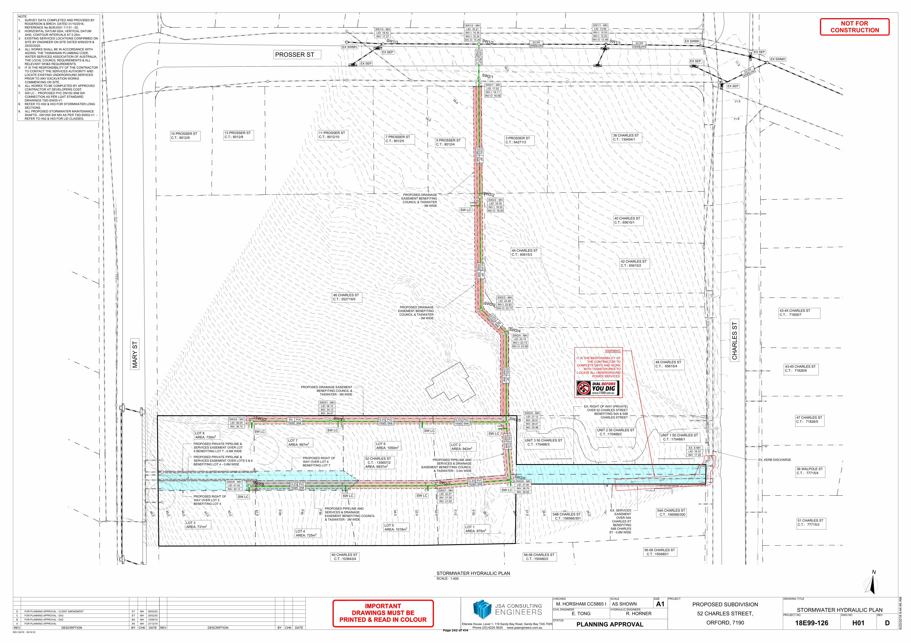
88888
10.000
SWMH
CO
MM
S
CO
MM
S
CO
MM
S
CO
MM
S
CO
MM
S
CO
MM
S
CO
MM
S
2
3
.
0
2
4
.0
2
5
.0
2
6
.0
27.0
2
8
.
0
2
9
.
0
30.0
31.0
32.0
33.0
34.0
35.0
36.0
37.0
3
8
.0
3
9
.0
40.0
41.0
4
2
.0
4
3
.
0
4
4
.0
4
5
.
0
4
6
.
0
M
M
M
M
M
M
M
M
CO
MM
SC
OM
MS
CO
MM
SC
OM
MS
CO
MM
SC
OM
MS
CO
MM
S
CO
MM
S
CO
MM
S
CO
MM
S
CO
MM
S
CO
MM
S
CO
MM
S
CO
MM
S
CO
MM
SC
OM
MS
CO
MM
SC
OM
MS
CO
MM
SC
OM
MS
CO
MM
SC
OM
MS
CO
MM
S
W W W W W W W
M
W W W
W W W W W W W
M
WWWM
M
COMMS COMMS COMMS COMMS COMMS
EX
P
EX
P
EX
P
EX
P
EX
P
EX
P
EX
P
EX
P
EX
P
EX
P
EX
P
EX
P
EX
P
EX
P
C
O
M
M
S
CO
MM
SC
OM
MS
CO
MM
SC
OM
MS
CO
MM
SC
OM
MS
CO
MM
SC
OM
MS
CO
MM
SC
OM
MS
CO
MM
SC
OM
MS
CO
MM
SC
OM
MS
CO
MM
SC
OM
MS
CO
MM
SC
OM
MS
P5
P5
P5
P5
P5
P5
P5
s
w
s
w
s
w
s
w
s
w
s
w
S
S
S
S
S
H
H
H
H
H
H
H
H
H
S
S
S
S
s
w
s
w
s
w
P(OH)
P(OH)
P(OH)
P(OH)
P(OH)
P(OH)
P(OH)
P(OH)
P(OH)
P(OH)
P(OH)
P(OH)
P(OH)
P(OH)
P(OH)
P(OH)
P(OH)
P(OH)
P5
P5
s
w
s
w
s
w
s
w
s
w
P5
FH
F
H
FH
S
S
S
S
S
S
S
S
S
S
S
S
S
H
S
S
S
1
6
.
0
1
7
.0
1
8
.
0
1
9
.
0
1
1
.
2
11.5
11.8
S
W
1
/1
S
W
2
/2
S
W
2
/3
S
W
2
/4
S
W
2
/5
S
W
3
/1
S
W
2
/6
S
W
3
/2
S
W
2
/7
S
W
2
/8
s
w
S
W
1
/2
S
W
1
/3
s
w
S
W
2
/1
H
SCALE:1:400
STORMWATER HYDRAULIC PLAN
CHKBYREV DATEDESCRIPTION CHKBYREV DATEDESCRIPTION
STATUS
PROJECTCHECKED
M. HORSHAM CC5865 I
SCALE SIZE
A1
PROJECT NO DWG NO REV
DRAWING TITLE
Ellerslie House, Level 1, 119 Sandy Bay Road, Sandy Bay TAS 7005
Phone (03) 6224 5625 www.jsaengineers.com.au
REV DATE:
CIVIL ENGINEER
NOT FOR
CONSTRUCTION
HYDRAULIC ENGINEER
IMPORTANT
DRAWINGS MUST BE
PRINTED & READ IN COLOUR
R. HORNERE. TONG
30/10/18
STORMWATER HYDRAULIC PLAN
ORFORD, 7190
52 CHARLES STREET,
PROPOSED SUBDIVISION
9/2
0/2
01
8 9
:4
4:4
6 A
M
H01 D18E99-126
AS SHOWN
PLANNING APPROVAL
MHETFOR PLANNING APPROVAL - CLIENT AMENDMENT 06/03/20D
MHETFOR PLANNING APPROVAL - DA3 20/02/20C
MHBAFOR PLANNING APPROVAL - DA2 10/09/19B
MHAKFOR PLANNING APPROVAL 21/12/18A
PROPOSED DRAINAGE EASEMENT
BENEFITING COUNCIL &
TASWATER - 3M WIDE
N
EX. S MH
LID: 18.33
INV: 17.28
52 CHARLES ST
C.T. : 135657/2
AREA: 6837m
2
54B CHARLES ST
C.T. :156566/301
54A CHARLES ST
C.T. :156566/300
UNIT 2 50 CHARLES ST
C.T. :170488/2
46 CHARLES ST
C.T.: 252719/5
48 CHARLES ST
C.T.: 65615/4
43-45 CHARLES ST
C.T.: 71826/7
43-45 CHARLES ST
C.T.: 71826/6
47 CHARLES ST
C.T.: 71826/5
36 WALPOLE ST
C.T.: 77715/4
51 CHARLES ST
C.T.: 77715/3
56-58 CHARLES ST
C.T. :150480/1
UNIT 3 50 CHARLES ST
C.T. :170488/3
UNIT 1 50 CHARLES ST
C.T. :170488/1
LOT 8
AREA: 730m
2
LOT 3
AREA: 731m
2
LOT 4
AREA: 725m
2
LOT 7
AREA: 667m
2
PROPOSED RIGHT OF
WAY OVER LOT 5
BENEFITING LOT 4
PROPOSED PIPELINE AND
SERVICES & DRAINAGE
EASEMENT BENEFITING COUNCIL
& TASWATER - 3M WIDE
EX. RIGHT OF WAY (PRIVATE)
OVER 52 CHARLES STREET
BENEFITING 54A & 54B
CHARLES STREET
PROPOSED PIPELINE AND
SERVICES & DRAINAGE
EASEMENT BENEFITING COUNCIL
& TASWATER - 3.0m WIDE
PROPOSED PRIVATE PIPELINE &
SERVICES EASEMENT OVER LOT
6 BENEFITING LOT 7 - 0.6M WIDE
PROPOSED RIGHT OF
WAY OVER LOT 6
BENEFITING LOT 7
PROPOSED PRIVATE PIPELINE &
SERVICES EASEMENT OVER LOTS 5 & 6
BENEFITING LOT 4 - 0.6M WIDE
IMPORTANT
DRAWINGS MUST BE
PRINTED & READ IN COLOUR
NOTE
1. SURVEY DATA COMPLETED AND PROVIDED BY
ROGERSON & BIRCH, DATED 31/10/2018,
REFERENCE No BURJO01 11131 - 02.
2. HORIZONTAL DATUM GDA, VERTICAL DATUM
AHD, CONTOUR INTERVALS AT 0.25m.
3. EXISTING SERVICES LOCATIONS CONFIRMED ON
SITE BY ENGINEER ON SITE DATED 6/09/2019 &
25/02/2020.
4. ALL WORKS SHALL BE IN ACCORDANCE WITH
AS3500, THE TASMANIAN PLUMBING CODE,
WATER SERVICES ASSOCIATION OF AUSTRALIA,
THE LOCAL COUNCIL REQUIREMENTS & ALL
RELEVANT WH&S REQUIREMENTS.
5. IT IS THE RESPONSIBILITY OF THE CONTRACTOR
TO CONTACT THE SERVICES AUTHORITY AND
LOCATE EXISTING UNDERGROUND SERVICES
PRIOR TO ANY EXCAVATION WORKS
COMMENCING ON SITE.
6. ALL WORKS TO BE COMPLETED BY APPROVED
CONTRACTOR AT DEVELOPERS COST.
7. SW LC - PROPOSED PVC DN150 SN8 SW
CONNECTION AS PER LGAT STANDARD
DRAWINGS TSD-SW25-V1.
8. REFER TO H02 & H03 FOR STORMWATER LONG
SECTIONS.
9. ALL PROPOSED STORMWATER MAINTENANCE
SHAFTS - DN1050 SW MH AS PER TSD-SW02-V1 -
REFER TO H02 & H03 FOR LID CLASSES.
56-58 CHARLES ST
C.T. :150480/2
60 CHARLES ST
C.T. :103643/4
SW LC
SW LCSW LC
SW LC
SW LC
SW LC
SW LC
SW LC
EX. KERB DISCHARGE
CH
AR
LE
S S
T
EX. SERVICES
EASEMENT
OVER 54A
CHARLES ST
BENEFITING
54B CHARLES
ST - 0.8M WIDE
LOT 6
AREA: 1050m
2
LOT 5
AREA: 1018m
2
LOT 2
AREA: 942m
2
LOT 1
AREA: 975m
2
15.4
%
150Ø
PV
C
SN
8
13.2%
150Ø
PVC
SN8
9%
150Ø
PVC
SN8
12.4%
150Ø
PVC
SN8
3.0%
150Ø
PV
C
SN
8
SW2/6 - MH
LID: 27.90
INV: 26.70
INV: 26.65
SW2/7 - MH
LID: 32.07
INV: 31.05
INV: 31.00
SW2/5 - MH
LID: 27.12
INV: 26.01
INV: 26.01
INV: 25.96
SW3/1 - MH
LID: 36.10
INV: 34.12
INV: 34.07
SW3/2 - MH
LID: 38.05
INV: 36.72
SW2/8 - MH
LID: 41.02
INV: 40.13
12.4%
150Ø
PVC
SN8
WARNING:
IT IS THE RESPONSIBILITY OF
THE CONTRACTOR TO
COMPLETE DBYD AND WORK
WITH TASNETWORKS TO
LOCATE ALL UNDERGROUND
POWER SERVICES.
44 CHARLES ST
C.T.: 65615/3
42 CHARLES ST
C.T.: 65615/2
40 CHARLES ST
C.T.: 65615/1
38 CHARLES ST
C.T.: 130454/1
3 PROSSER ST
C.T.: 64271/3
5 PROSSER ST
C.T.: 8012/4
7 PROSSER ST
C.T.: 8012/5
11 PROSSER ST
C.T.: 8012/10
13 PROSSER ST
C.T.: 8012/8
15 PROSSER ST
C.T.: 8012/9
MA
RY
S
T
PROSSER ST
SW1/1 - MH
LID: 13.56
INV.I: 12.53
INV.I: 12.53
INV.O: 12.48
SW1/2 - MH
LID: 16.21
INV.I: 15.34
INV.I: 15.34
INV.O: 15.29
SW1/3 - MH
LID: 18.42
INV: 17.37
SW2/4 - MH
LID: 24.15
INV.I: 23.13
INV.O: 23.08
SW2/3 - MH
LID: 24.48
INV.I: 22.82
INV.O: 22.77
SW2/2 - MH
LID: 19.78
INV.I: 18.55
INV.O: 18.50
SW2/1 - MH
LID: 17.02
INV.I: 16.11
INV.O: 16.06
8.6
%
22
5Ø
SP
SN
8
2
.
0
%
2
2
5
Ø
S
P
S
N
8
10
.4
%
30
0Ø
SP
SN
8
5.5
%
37
5Ø
SP
SN
8
5.6
%
37
5Ø
RC
P
CL
.4
SW LC
PROPOSED DRAINAGE
EASEMENT BENEFITING
COUNCIL & TASWATER
- 3M WIDE
PROPOSED DRAINAGE
EASEMENT BENEFITING
COUNCIL & TASWATER
- 3M WIDE
EX SW
450Ø CONC
EX SW
450Ø CONC
E
X
S
W
4
5
0
Ø
C
O
N
C
EX SEP
EX SEP
EX SWMH
EX SWMH
EX SEP
EX SWMH
EX SEP
EX SEP
Page 242 of 414
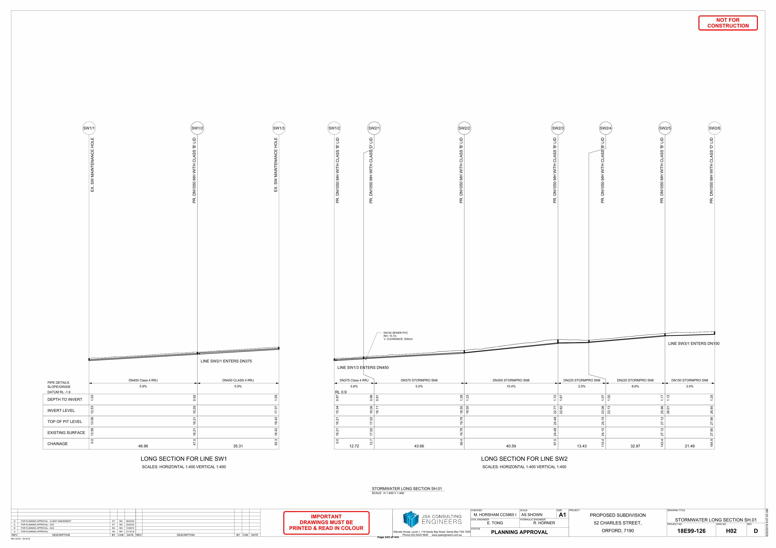
CHKBYREV DATEDESCRIPTION CHKBYREV DATEDESCRIPTION
STATUS
PROJECTCHECKED
M. HORSHAM CC5865 I
SCALE SIZE
A1
PROJECT NO DWG NO REV
DRAWING TITLE
Ellerslie House, Level 1, 119 Sandy Bay Road, Sandy Bay TAS 7005
Phone (03) 6224 5625 www.jsaengineers.com.au
REV DATE:
CIVIL ENGINEER
NOT FOR
CONSTRUCTION
HYDRAULIC ENGINEER
IMPORTANT
DRAWINGS MUST BE
PRINTED & READ IN COLOUR
R. HORNERE. TONG
30/10/18
STORMWATER LONG SECTION SH.01
ORFORD, 7190
52 CHARLES STREET,
PROPOSED SUBDIVISION
9/2
0/2
01
8 9
:4
7:4
3 A
M
H02 D18E99-126
AS SHOWN
PLANNING APPROVAL
MHETFOR PLANNING APPROVAL - CLIENT AMENDMENT 06/03/20D
MHETFOR PLANNING APPROVAL - DA3 20/02/20C
MHBAFOR PLANNING APPROVAL - DA2 10/09/19B
MHAKFOR PLANNING APPROVAL 21/12/18A
SCALE:H 1:400 V 1:400
STORMWATER LONG SECTION SH.01
0.0
47
.0
46.96
13
.5
6
16
.2
1
13
.5
6
16
.2
1
12
.5
3
15
.2
9
1.0
3
0.9
2
5.9%
DN450 Class 4 RRJ
EX
. S
W M
AIN
TE
NA
NC
E H
OL
E
PR
. D
N1
05
0 M
H W
IT
H C
LA
SS
'B
' L
ID
SW1/1 SW1/2
LONG SECTION FOR LINE SW1
SCALES: HORIZONTAL 1:400 VERTICAL 1:400
CHAINAGE
EXISTING SURFACE
TOP OF PIT LEVEL
INVERT LEVEL
DEPTH TO INVERT
DATUM RL -1.9
SLOPE/GRADE
PIPE DETAILS
82
.3
35.31
18
.4
21
8.4
21
7.3
71
.0
5
5.9%
DN450 CLASS 4 RRJ
EX
. S
W M
AIN
TE
NA
NC
E H
OL
E
SW1/3
LINE SW2/1 ENTERS DN375
0.0
12
.7
12.72
16
.2
1
17
.0
2
16
.2
1
17
.0
2
15
.3
4
16
.0
6
0.8
7
0.9
6
5.6%
DN375 Class 4 RRJ
PR
. D
N1
05
0 M
H W
IT
H C
LA
SS
'B
' L
ID
PR
. D
N1
05
0 M
H W
IT
H C
LA
SS
'D
' L
ID
SW1/2 SW2/1
LONG SECTION FOR LINE SW2
SCALES: HORIZONTAL 1:400 VERTICAL 1:400
RL 0.9
LINE SW1/3 ENTERS DN450
56
.4
43.66
19
.7
81
9.7
8
16
.1
1
18
.5
0
0.9
1
1.2
8
5.5%
DN375 STORMPRO SN8
PR
. D
N1
05
0 M
H W
IT
H C
LA
SS
'B
' L
ID
SW2/2
97
.0
40.59
24
.4
82
4.4
8
18
.5
5
22
.7
7
1.2
3
1.7
2
10.4%
DN300 STORMPRO SN8
PR
. D
N1
05
0 M
H W
IT
H C
LA
SS
'B
' L
ID
SW2/3
11
0.4
13.43
24
.1
52
4.1
5
22
.8
2
23
.0
8
1.6
7
1.0
7
2.0%
DN225 STORMPRO SN8
PR
. D
N1
05
0 M
H W
IT
H C
LA
SS
'B
' L
ID
SW2/4
14
3.4
32.97
27
.1
22
7.1
2
23
.1
3
25
.9
6
1.0
2
1.1
7
8.6%
DN225 STORMPRO SN8
PR
. D
N1
05
0 M
H W
IT
H C
LA
SS
'B
' L
ID
SW2/5
16
4.9
21.49
27
.9
02
7.9
0
26
.0
1
26
.6
5
1.1
2
1.2
5
3.0%
DN150 STORMPRO SN8
PR
. D
N1
05
0 M
H W
IT
H C
LA
SS
'D
' L
ID
SW2/6
LINE SW3/1 ENTERS DN150
DN150 SEWER PVC
INV: 15.7m
V. CLEARANCE: 300mm
Page 243 of 414

CHKBYREV DATEDESCRIPTION CHKBYREV DATEDESCRIPTION
STATUS
PROJECTCHECKED
M. HORSHAM CC5865 I
SCALE SIZE
A1
PROJECT NO DWG NO REV
DRAWING TITLE
Ellerslie House, Level 1, 119 Sandy Bay Road, Sandy Bay TAS 7005
Phone (03) 6224 5625 www.jsaengineers.com.au
REV DATE:
CIVIL ENGINEER
NOT FOR
CONSTRUCTION
HYDRAULIC ENGINEER
IMPORTANT
DRAWINGS MUST BE
PRINTED & READ IN COLOUR
R. HORNERE. TONG
30/10/18
STORMWATER LONG SECTION SH.02
ORFORD, 7190
52 CHARLES STREET,
PROPOSED SUBDIVISION
9/2
0/2
01
8 9
:4
7:4
3 A
M
H03 D18E99-126
AS SHOWN
PLANNING APPROVAL
MHETFOR PLANNING APPROVAL - CLIENT AMENDMENT 06/03/20D
MHETFOR PLANNING APPROVAL - DA3 20/02/20C
MHBAFOR PLANNING APPROVAL - DA2 10/09/19B
MHAKFOR PLANNING APPROVAL 21/12/18A
SCALE:H 1:400 V 1:400
STORMWATER LONG SECTION SH.02
16
4.9
19
2.7
27.85
27
.9
0
32
.0
7
27
.9
0
32
.0
7
26
.7
0
31
.0
0
1.2
0
1.0
7
15.4%
DN150 STORMPRO SN8
PR
. D
N1
05
0 M
H W
IT
H C
LA
SS
'D
' L
ID
PR
. D
N1
05
0 M
H W
IT
H C
LA
SS
'D
' L
ID
SW2/6 SW2/7
LONG SECTION FOR LINE SW2
SCALES: HORIZONTAL 1:400 VERTICAL 1:400
CHAINAGE
EXISTING SURFACE
TOP OF PIT LEVEL
INVERT LEVEL
DEPTH TO INVERT
DATUM RL 12.2
SLOPE/GRADE
PIPE DETAILS
26
1.5
68.79
41
.0
24
1.0
2
31
.0
5
40
.1
3
1.0
2
0.8
9
13.2%
DN150 STORMPRO SN8
PR
. D
N1
05
0 M
H W
IT
H C
LA
SS
'D
' L
ID
SW2/8
0.0
65
.0
64.96
27
.1
2
36
.1
0
27
.1
2
36
.1
0
26
.0
1
34
.0
7
1.1
2
2.0
4
12.4%
DN150 STORMPRO SN8
PR
. D
N1
05
0 M
H W
IT
H C
LA
SS
'B
' L
ID
PR
. D
N1
05
0 M
H W
IT
H C
LA
SS
'B
' L
ID
SW2/5 SW3/1
LONG SECTION FOR LINE SW3
SCALES: HORIZONTAL 1:400 VERTICAL 1:400
RL 11.6
94
.0
29.00
38
.0
53
8.0
5
34
.1
2
36
.7
2
1.9
9
1.3
3
9.0%
DN150 STORMPRO SN8
PR
. D
N1
05
0 M
H W
IT
H C
LA
SS
'B
' L
ID
SW3/2
PR. DN150 SN8 UPVC
SEWER
INV: 25.5m
V.CLEARANCE: 0.500mm
Page 244 of 414
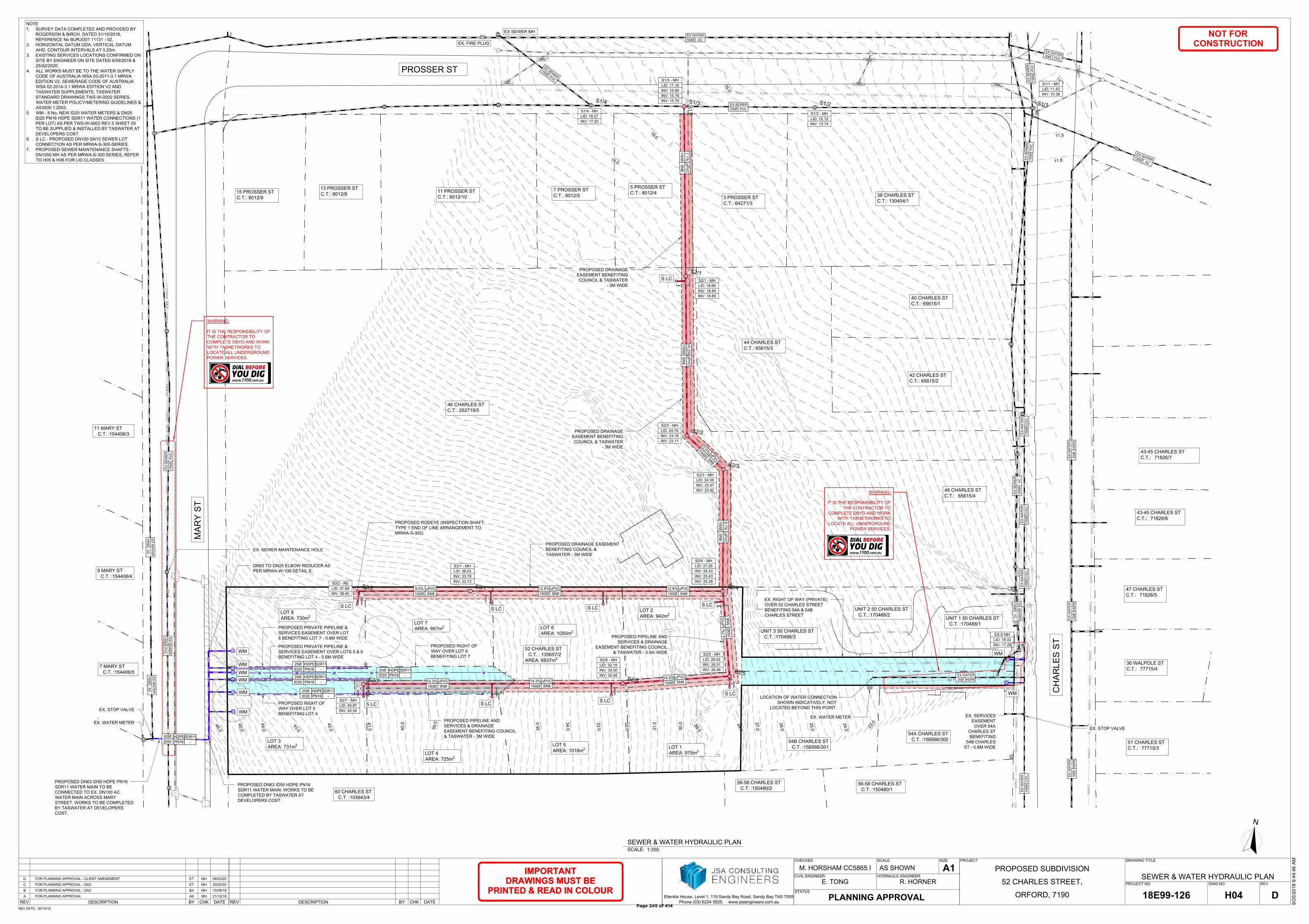
88888
10.000
SWMH
CO
MM
S
CO
MM
S
CO
MM
S
CO
MM
S
CO
MM
S
CO
MM
S
CO
MM
S
2
3
.
0
2
4
.0
2
5
.0
2
6
.0
27.0
2
8
.
0
2
9
.
0
30.0
31.0
32.0
33.0
34.0
35.0
36.0
37.0
3
8
.0
3
9
.0
40.0
41.0
4
2
.0
4
3
.
0
4
4
.0
4
5
.
0
4
6
.
0
M
M
M
M
M
M
M
M
CO
MM
SC
OM
MS
CO
MM
SC
OM
MS
CO
MM
SC
OM
MS
CO
MM
S
CO
MM
SC
OM
MS
CO
MM
S
CO
MM
S
CO
MM
S
CO
MM
S
CO
MM
S
CO
MM
S
CO
MM
SC
OM
MS
CO
MM
SC
OM
MS
CO
MM
SC
OM
MS
CO
MM
SC
OM
MS
CO
MM
S
W W W W W W W
M
W W W
W W W W W W W
M
WWWM
M
COMMS COMMS COMMS COMMS COMMS
EX
P
EX
P
EX
P
EX
P
EX
P
EX
P
EX
P
EX
P
EX
P
EX
P
EX
P
EX
P
EX
P
EX
P
C
O
M
M
S
CO
MM
SC
OM
MS
CO
MM
SC
OM
MS
CO
MM
SC
OM
MS
CO
MM
SC
OM
MS
CO
MM
SC
OM
MS
CO
MM
SC
OM
MS
CO
MM
SC
OM
MS
CO
MM
SC
OM
MS
CO
MM
SC
OM
MS
P5
P5
P5
P5
P5
P5
P5
s
w
s
w
s
w
s
w
s
w
s
w
S
S
S
S
S
H
H
H
H
H
H
H
H
H
S
S
S
S
s
w
s
w
s
w
P(OH)
P(OH)
P(OH)
P(OH)
P(OH)
P(OH)
P(OH)
P(OH)
P(OH)
P(OH)
P(OH)
P(OH)
P(OH)
P(OH)
P(OH)
P(OH)
P(OH)
P(OH)
P5
P5
s
w
s
w
s
w
s
w
s
w
P5
F
H
FH
S
S
S
S
S
S
S
S
S
S
S
S
S
H
S
S
S
1
6
.
0
1
7
.0
1
8
.
0
1
9
.
0
1
1
.
2
11.5
11.8
S
1
/1
S
1
/2
S
1
/3
S
2
/1
S
1
/4
S
2
/2
S
2
/3
S
2
/4
S
3
/1
S
2
/5
S
3
/2
S
2
/6
S
2
/7
s
w
s
w
H
SCALE:1:350
SEWER & WATER HYDRAULIC PLAN
CHKBYREV DATEDESCRIPTION CHKBYREV DATEDESCRIPTION
STATUS
PROJECTCHECKED
M. HORSHAM CC5865 I
SCALE SIZE
A1
PROJECT NO DWG NO REV
DRAWING TITLE
Ellerslie House, Level 1, 119 Sandy Bay Road, Sandy Bay TAS 7005
Phone (03) 6224 5625 www.jsaengineers.com.au
REV DATE:
CIVIL ENGINEER
NOT FOR
CONSTRUCTION
HYDRAULIC ENGINEER
IMPORTANT
DRAWINGS MUST BE
PRINTED & READ IN COLOUR
R. HORNERE. TONG
30/10/18
SEWER & WATER HYDRAULIC PLAN
ORFORD, 7190
52 CHARLES STREET,
PROPOSED SUBDIVISION
9/2
0/2
01
8 9
:4
4:4
6 A
M
H04 D18E99-126
AS SHOWN
PLANNING APPROVAL
MHETFOR PLANNING APPROVAL - CLIENT AMENDMENT 06/03/20D
MHETFOR PLANNING APPROVAL - DA3 20/02/20C
MHBAFOR PLANNING APPROVAL - DA2 10/09/19B
MHAKFOR PLANNING APPROVAL 21/12/18A
PROPOSED DRAINAGE EASEMENT
BENEFITING COUNCIL &
TASWATER - 3M WIDE
N
EX.S MH
LID: 18.33
INV: 17.28
54B CHARLES ST
C.T. :156566/301
54A CHARLES ST
C.T. :156566/300
UNIT 2 50 CHARLES ST
C.T. :170488/2
46 CHARLES ST
C.T.: 252719/5
48 CHARLES ST
C.T.: 65615/4
43-45 CHARLES ST
C.T.: 71826/7
43-45 CHARLES ST
C.T.: 71826/6
47 CHARLES ST
C.T.: 71826/5
36 WALPOLE ST
C.T.: 77715/4
51 CHARLES ST
C.T.: 77715/3
56-58 CHARLES ST
C.T. :150480/1
UNIT 3 50 CHARLES ST
C.T. :170488/3
UNIT 1 50 CHARLES ST
C.T. :170488/1
EX. RIGHT OF WAY (PRIVATE)
OVER 52 CHARLES STREET
BENEFITING 54A & 54B
CHARLES STREET
PROPOSED RIGHT OF
WAY OVER LOT 6
BENEFITING LOT 7
WARNING:
IT IS THE RESPONSIBILITY OF
THE CONTRACTOR TO
COMPLETE DBYD AND WORK
WITH TASNETWORKS TO
LOCATE ALL UNDERGROUND
POWER SERVICES.
IMPORTANT
DRAWINGS MUST BE
PRINTED & READ IN COLOUR
NOTE
1. SURVEY DATA COMPLETED AND PROVIDED BY
ROGERSON & BIRCH, DATED 31/10/2018,
REFERENCE No BURJO01 11131 - 02.
2. HORIZONTAL DATUM GDA, VERTICAL DATUM
AHD, CONTOUR INTERVALS AT 0.25m.
3. EXISTING SERVICES LOCATIONS CONFIRMED ON
SITE BY ENGINEER ON SITE DATED 6/09/2019 &
25/02/2020.
4. ALL WORKS MUST BE TO THE WATER SUPPLY
CODE OF AUSTRALIA WSA 03-2011-3.1 MRWA
EDITION V2, SEWERAGE CODE OF AUSTRALIA
WSA 02-2014-3.1 MRWA EDITION V2 AND
TASWATER SUPPLEMENTS, TASWATER
STANDARD DRAWINGS TWS-W-0002 SERIES,
WATER METER POLICY/METERING GUIDELINES &
AS3500.1:2003.
5. WM - 8 No. NEW ID20 WATER METERS & DN25
ID20 PN16 HDPE SDR11 WATER CONNECTIONS (1
PER LOT) AS PER TWS-W-0002 REV.5 SHEET 05
TO BE SUPPLIED & INSTALLED BY TASWATER AT
DEVELOPERS COST.
6. S LC - PROPOSED DN100 SN10 SEWER LOT
CONNECTION AS PER MRWA-S-300-SERIES.
7. PROPOSED SEWER MAINTENANCE SHAFTS -
DN1050 MH AS PER MRWA-S-300 SERIES, REFER
TO H05 & H06 FOR LID CLASSES .
56-58 CHARLES ST
C.T. :150480/2
60 CHARLES ST
C.T. :103643/4
11 MARY ST
C.T. :154406/3
9 MARY ST
C.T. :154406/4
7 MARY ST
C.T. :154406/5
EX. SEWER MAINTENANCE HOLE
EX. WATER METER
EX. STOP VALVE
EX. WATER METER
EX. STOP VALVE
EX
W
AT
ER
100Ø
AC
EX
S
EW
ER
150Ø
PV
C
EX
W
AT
ER
100Ø
AC
EX
W
AT
ER
63Ø
HD
PE
EX
W
AT
ER
63Ø
HD
PE
EX
W
AT
ER
63Ø
HD
PE
EX
W
AT
ER
100Ø
CIC
L
EX
W
AT
ER
100Ø
CIC
L
EX
W
AT
ER
100Ø
CIC
L
EX
W
AT
ER
100Ø
CIC
L
EX
S
EW
ER
150Ø
VC
EX
S
EW
ER
150Ø
PV
C
EX
S
EW
ER
150Ø
VC
LOCATION OF WATER CONNECTION
SHOWN INDICATIVELY, NOT
LOCATED BEYOND THIS POINT.
S2/5 - MH
LID: 28.02
INV: 26.51
INV: 26.46
S2/4 - MH
LID: 27.26
INV: 25.43
INV: 25.43
INV: 25.38
S3/1 - MH
LID: 36.03
INV: 33.78
INV: 33.73
S3/2 - RE
LID: 37.69
INV: 36.40
S2/7 - MH
LID: 40.87
INV: 40.04
S2/6 - MH
LID: 32.19
INV: 30.50
INV: 30.45
S LC
S LC
S LC
S LC
S LC
S LC
S LC
S LC
WM
WM
WM
PROPOSED DN63 ID50 HDPE PN16
SDR11 WATER MAIN TO BE
CONNECTED TO EX. DN100 AC
WATER MAIN ACROSS MARY
STREET. WORKS TO BE COMPLETED
BY TASWATER AT DEVELOPERS
COST.
PROPOSED DN63 ID50 HDPE PN16
SDR11 WATER MAIN. WORKS TO BE
COMPLETED BY TASWATER AT
DEVELOPERS COST.
DN63 TO DN25 ELBOW REDUCER AS
PER MRWA-W-109 DETAIL E.
PROPOSED RODEYE (INSPECTION SHAFT,
TYPE 1 END OF LINE ARRANGEMENT TO
MRWA-S-302)
12.8%
150Ø
uPVC
SN8
9.0%
150Ø
uPVC
SN8
14.3%
150Ø
uPVC
SN8
14.3%
150Ø
uPVC
SN8
12.8%
150Ø
uPVC
SN8
14.3
%
150Ø
uP
VC
SN
8
4.7%
150Ø
uP
VC
SN
8
EX WATER
20Ø HDPE
63Ø
ID50
HDPE
PN16
SDR11
-
25Ø
ID20
HDPE
PN16
SDR11
-
25Ø
ID20
HDPE
PN16
SDR11
-
25Ø
ID20
HDPE
PN16
SDR11
-
25Ø
ID20
HDPE
PN16
SDR11
-
MA
RY
S
T
CH
AR
LE
S S
T
EX. SERVICES
EASEMENT
OVER 54A
CHARLES ST
BENEFITING
54B CHARLES
ST - 0.8M WIDE
WARNING:
IT IS THE RESPONSIBILITY OF
THE CONTRACTOR TO
COMPLETE DBYD AND WORK
WITH TASNETWORKS TO
LOCATE ALL UNDERGROUND
POWER SERVICES.
44 CHARLES ST
C.T.: 65615/3
42 CHARLES ST
C.T.: 65615/2
40 CHARLES ST
C.T.: 65615/1
38 CHARLES ST
C.T.: 130454/1
3 PROSSER ST
C.T.: 64271/3
5 PROSSER ST
C.T.: 8012/4
7 PROSSER ST
C.T.: 8012/5
11 PROSSER ST
C.T.: 8012/10
13 PROSSER ST
C.T.: 8012/8
15 PROSSER ST
C.T.: 8012/9
WM
WM
WM
WM
WM
52 CHARLES ST
C.T. : 135657/2
AREA: 6837m
2
LOT 8
AREA: 730m
2
LOT 3
AREA: 731m
2
LOT 4
AREA: 725m
2
LOT 7
AREA: 667m
2
PROPOSED RIGHT OF
WAY OVER LOT 5
BENEFITING LOT 4
PROPOSED PIPELINE AND
SERVICES & DRAINAGE
EASEMENT BENEFITING COUNCIL
& TASWATER - 3M WIDE
PROPOSED PIPELINE AND
SERVICES & DRAINAGE
EASEMENT BENEFITING COUNCIL
& TASWATER - 3.0m WIDE
PROPOSED PRIVATE PIPELINE &
SERVICES EASEMENT OVER LOT
6 BENEFITING LOT 7 - 0.6M WIDE
PROPOSED PRIVATE PIPELINE &
SERVICES EASEMENT OVER LOTS 5 & 6
BENEFITING LOT 4 - 0.6M WIDE
LOT 6
AREA: 1050m
2
LOT 5
AREA: 1018m
2
LOT 2
AREA: 942m
2
LOT 1
AREA: 975m
2
S2/3 - MH
LID: 24.39
INV: 23.47
INV: 23.42
S2/2 - MH
LID: 24.76
INV: 23.16
INV: 23.11
S2/1 - MH
LID: 19.99
INV: 18.94
INV: 18.89
S1/3 - MH
LID: 17.16
INV: 15.80
INV: 15.76
INV: 15.75
S1/4 - MH
LID: 18.27
INV: 17.20
S1/2 - MH
LID: 15.12
INV: 13.74
S1/1 - MH
LID: 11.43
INV: 10.38
6.1
%
15
0Ø
uP
VC
SN
8
2
.
0
%1
5
0
Ø
u
P
V
CS
N
8
10
.2
%
15
0Ø
uP
VC
SN
8
7.1
%
15
0Ø
uP
VC
SN
8
S LC
PROSSER ST
EX SEWER MH
EX. FIRE PLUG
E
X
S
E
W
E
R
1
5
0
Ø
P
V
C
EX SEWER
150Ø PVC
EX
S
EW
ER
150Ø
PV
C
EX
S
EW
ER
150Ø
PV
C
EX WATER
100Ø AC
E
X
W
A
T
E
R
4
0
Ø
C
IC
L
E
X
W
A
T
E
R
1
0
0
Ø
A
C
PROPOSED DRAINAGE
EASEMENT BENEFITING
COUNCIL & TASWATER
- 3M WIDE
PROPOSED DRAINAGE
EASEMENT BENEFITING
COUNCIL & TASWATER
- 3M WIDE
Page 245 of 414
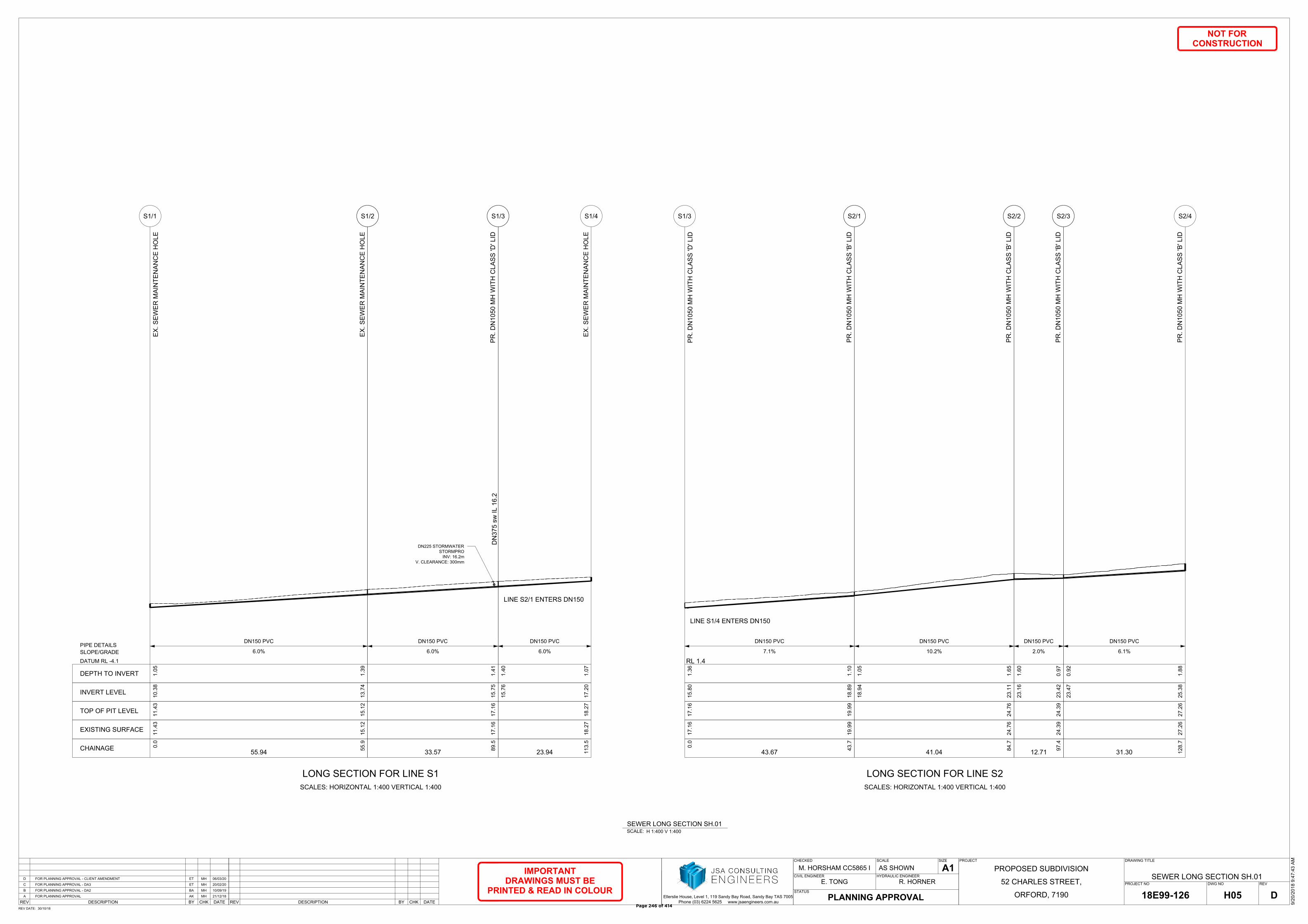
CHKBYREV DATEDESCRIPTION CHKBYREV DATEDESCRIPTION
STATUS
PROJECTCHECKED
M. HORSHAM CC5865 I
SCALE SIZE
A1
PROJECT NO DWG NO REV
DRAWING TITLE
Ellerslie House, Level 1, 119 Sandy Bay Road, Sandy Bay TAS 7005
Phone (03) 6224 5625 www.jsaengineers.com.au
REV DATE:
CIVIL ENGINEER
NOT FOR
CONSTRUCTION
HYDRAULIC ENGINEER
IMPORTANT
DRAWINGS MUST BE
PRINTED & READ IN COLOUR
R. HORNERE. TONG
30/10/18
SEWER LONG SECTION SH.01
ORFORD, 7190
52 CHARLES STREET,
PROPOSED SUBDIVISION
9/2
0/2
01
8 9
:4
7:4
3 A
M
H05 D18E99-126
AS SHOWN
PLANNING APPROVAL
MHETFOR PLANNING APPROVAL - CLIENT AMENDMENT 06/03/20D
MHETFOR PLANNING APPROVAL - DA3 20/02/20C
MHBAFOR PLANNING APPROVAL - DA2 10/09/19B
MHAKFOR PLANNING APPROVAL 21/12/18A
SCALE:H 1:400 V 1:400
SEWER LONG SECTION SH.01
DN225 STORMWATER
STORMPRO
INV: 16.2m
V. CLEARANCE: 300mm
0.0
55
.9
55.94
11
.4
3
15
.1
2
11
.4
3
15
.1
2
10
.3
8
13
.7
4
1.0
5
1.3
9
6.0%
DN150 PVC
EX
. S
EW
ER
M
AIN
TE
NA
NC
E H
OL
E
EX
. S
EW
ER
M
AIN
TE
NA
NC
E H
OL
E
S1/1 S1/2
LONG SECTION FOR LINE S1
SCALES: HORIZONTAL 1:400 VERTICAL 1:400
CHAINAGE
EXISTING SURFACE
TOP OF PIT LEVEL
INVERT LEVEL
DEPTH TO INVERT
DATUM RL -4.1
SLOPE/GRADE
PIPE DETAILS
89
.5
33.57
17
.1
61
7.1
61
5.7
51
.4
1
6.0%
DN150 PVC
PR
. D
N1
05
0 M
H W
IT
H C
LA
SS
'D
' L
ID
S1/3
DN
37
5 sw
IL
1
6.2
11
3.5
23.94
18
.2
71
8.2
7
15
.7
6
17
.2
0
1.4
0
1.0
7
6.0%
DN150 PVC
EX
. S
EW
ER
M
AIN
TE
NA
NC
E H
OL
E
S1/4
LINE S2/1 ENTERS DN150
0.0
43
.7
43.67
17
.1
6
19
.9
9
17
.1
6
19
.9
9
15
.8
0
18
.8
9
1.3
6
1.1
0
7.1%
DN150 PVC
PR
. D
N1
05
0 M
H W
IT
H C
LA
SS
'D
' L
ID
PR
. D
N1
05
0 M
H W
IT
H C
LA
SS
'B
' L
ID
S1/3 S2/1
LONG SECTION FOR LINE S2
SCALES: HORIZONTAL 1:400 VERTICAL 1:400
RL 1.4
LINE S1/4 ENTERS DN150
84
.7
41.04
24
.7
62
4.7
6
18
.9
4
23
.1
1
1.0
5
1.6
5
10.2%
DN150 PVC
PR
. D
N1
05
0 M
H W
IT
H C
LA
SS
'B
' L
ID
S2/2
97
.4
12.71
24
.3
92
4.3
9
23
.1
6
23
.4
2
1.6
0
0.9
7
2.0%
DN150 PVC
PR
. D
N1
05
0 M
H W
IT
H C
LA
SS
'B
' L
ID
S2/3
12
8.7
31.30
27
.2
62
7.2
6
23
.4
7
25
.3
8
0.9
2
1.8
8
6.1%
DN150 PVC
PR
. D
N1
05
0 M
H W
IT
H C
LA
SS
'B
' L
ID
S2/4
Page 246 of 414
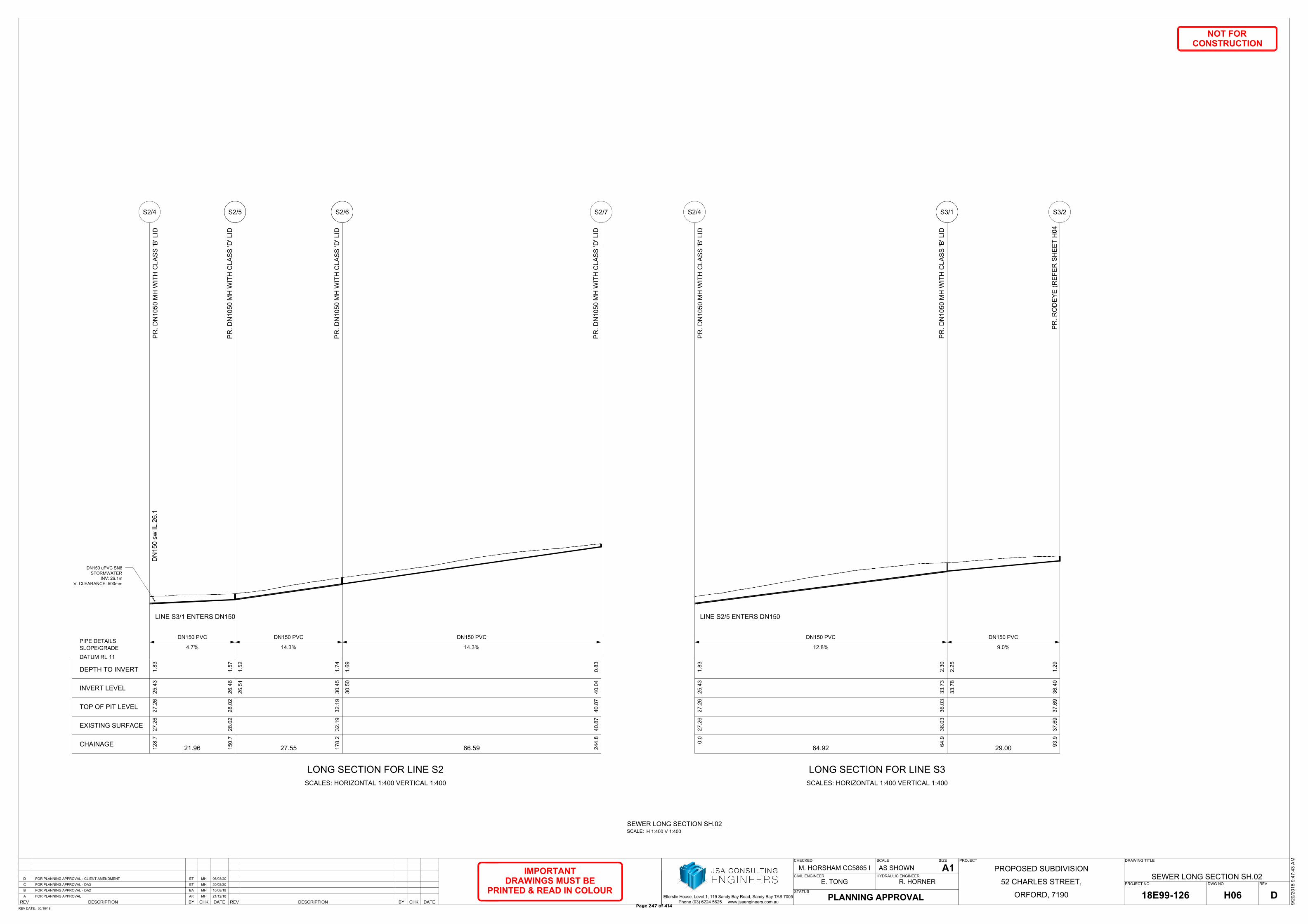
CHKBYREV DATEDESCRIPTION CHKBYREV DATEDESCRIPTION
STATUS
PROJECTCHECKED
M. HORSHAM CC5865 I
SCALE SIZE
A1
PROJECT NO DWG NO REV
DRAWING TITLE
Ellerslie House, Level 1, 119 Sandy Bay Road, Sandy Bay TAS 7005
Phone (03) 6224 5625 www.jsaengineers.com.au
REV DATE:
CIVIL ENGINEER
NOT FOR
CONSTRUCTION
HYDRAULIC ENGINEER
IMPORTANT
DRAWINGS MUST BE
PRINTED & READ IN COLOUR
R. HORNERE. TONG
30/10/18
SEWER LONG SECTION SH.02
ORFORD, 7190
52 CHARLES STREET,
PROPOSED SUBDIVISION
9/2
0/2
01
8 9
:4
7:4
3 A
M
H06 D18E99-126
AS SHOWN
PLANNING APPROVAL
MHETFOR PLANNING APPROVAL - CLIENT AMENDMENT 06/03/20D
MHETFOR PLANNING APPROVAL - DA3 20/02/20C
MHBAFOR PLANNING APPROVAL - DA2 10/09/19B
MHAKFOR PLANNING APPROVAL 21/12/18A
SCALE:H 1:400 V 1:400
SEWER LONG SECTION SH.02
12
8.7
15
0.7
21.96
27
.2
6
28
.0
2
27
.2
6
28
.0
2
25
.4
3
26
.4
6
1.8
3
1.5
7
4.7%
DN150 PVC
PR
. D
N1
05
0 M
H W
IT
H C
LA
SS
'B
' L
ID
PR
. D
N1
05
0 M
H W
IT
H C
LA
SS
'D
' L
ID
S2/4 S2/5
LONG SECTION FOR LINE S2
SCALES: HORIZONTAL 1:400 VERTICAL 1:400
CHAINAGE
EXISTING SURFACE
TOP OF PIT LEVEL
INVERT LEVEL
DEPTH TO INVERT
DATUM RL 11
SLOPE/GRADE
PIPE DETAILS
LINE S3/1 ENTERS DN150
DN
15
0 sw
IL
2
6.1
17
8.2
27.55
32
.1
93
2.1
9
26
.5
1
30
.4
5
1.5
2
1.7
4
14.3%
DN150 PVC
PR
. D
N1
05
0 M
H W
IT
H C
LA
SS
'D
' L
ID
S2/6
24
4.8
66.59
40
.8
74
0.8
7
30
.5
0
40
.0
4
1.6
9
0.8
3
14.3%
DN150 PVC
PR
. D
N1
05
0 M
H W
IT
H C
LA
SS
'D
' L
ID
S2/7
0.0
64
.9
64.92
27
.2
6
36
.0
3
27
.2
6
36
.0
3
25
.4
3
33
.7
3
1.8
3
2.3
0
12.8%
DN150 PVC
PR
. D
N1
05
0 M
H W
IT
H C
LA
SS
'B
' L
ID
PR
. D
N1
05
0 M
H W
IT
H C
LA
SS
'B
' L
ID
S2/4 S3/1
LONG SECTION FOR LINE S3
SCALES: HORIZONTAL 1:400 VERTICAL 1:400
LINE S2/5 ENTERS DN150
93
.9
29.00
37
.6
93
7.6
9
33
.7
8
36
.4
0
2.2
5
1.2
9
9.0%
DN150 PVC
PR
. R
OD
EY
E (R
EF
ER
S
HE
ET
H
04
S3/2
DN150 uPVC SN8
STORMWATER
INV: 26.1m
V. CLEARANCE: 500mm
Page 247 of 414
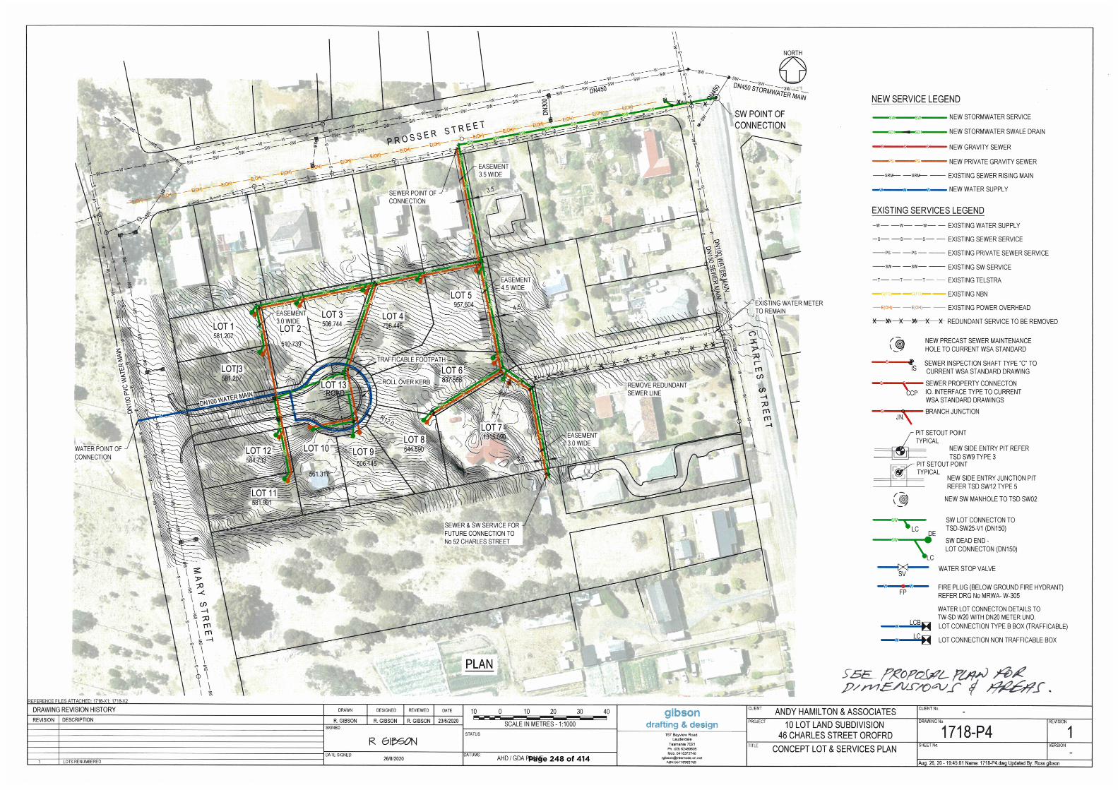
Page 248 of 414
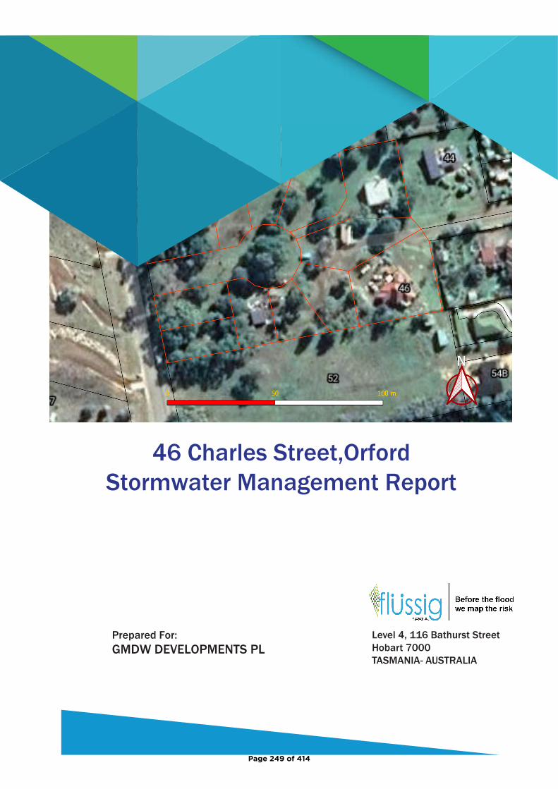
46 Charles Street,OrfordStormwater Management Report
Level 4, 116 Bathurst StreetHobart 7000TASMANIA- AUSTRALIA
GMDW DEVELOPMENTS PL
Page 249 of 414
FS_HOB_2046_46 Charles Street, Orford, SWMP Report/ REV03 14 January 2021
Document Information
Title Client Document
Number Project Manager
46 Charles Street, Orford.
Stormwater Management Plan
GMDW DEVELOPMENTS PL
FS-HOB-2046 Max W. Möller
BEng,FIEAust,EngExec,CPEng,NER,APEC Engineer, IntPE(Aus)
Managing Director / Principal Hydraulic Engineer
Prepared by: ……………………………………………… Date: 19th October 2020
Max W. Möller
Reviewed by: ……………………………………………… Date: 19th October 2020 John Holmes
Authorised by: ……………………………………………… Date: 19th October 2020 Max W. Möller
Revision History
Rev No.
Description Prepared by Reviewed by Authorised by Date
00 46 Charles Street, Orford.
Stormwater Management Plan
Max W. Möller John Holmes Max W. Möller 19/10/2020
01 Stormwater Line 01 Amended Max W. Möller John Holmes Max W. Möller 25/10/2020
02 5.3 & 5.5 Revised Max W. Möller John Holmes Max W. Möller 28/12/2020
03 5.0 to 5.7 Revised Max W. Möller John Holmes Max W. Möller 14/01/2021
© 2020 Flüssig Spatial This document is and shall remain the property of Flüssig Spatial. The document may only be used for the purposes for which it was commissioned and in accordance with the Terms of Engagement for the commission. Unauthorised use of this document in any form is prohibited
Page 250 of 414
FS_HOB_2046_46 Charles Street, Orford, SWMP Report/ REV03 14 January 2021
i
Table of Contents
1. Introduction .............................................................................................................................................. 1 1.1 Scope .............................................................................................................................................. 1
2. Site Characteristics .................................................................................................................................... 1 2.1 Site Location ................................................................................................................................... 1 2.2 Topography .................................................................................................................................... 1
3. Proposed Development............................................................................................................................. 2 4. Survey Data ............................................................................................................................................... 3 5. Stormwater Quantity ................................................................................................................................ 3
5.1 Catchment Analysis ........................................................................................................................ 3 5.2 Catchment Conditions ................................................................................................................... 3 5.2.1 Design Intensity Storms ............................................................................................................. 3
5.2.2 Land use ..................................................................................................................................... 4
5.2.3 Manning’s n and losses .............................................................................................................. 4
5.3 Development Runoff ...................................................................................................................... 5 5.4 Model Results ................................................................................................................................ 5 5.4.1 House Detention ........................................................................................................................ 6
5.5 On-Site Detention Sizing and Configuration .................................................................................. 7 5.6 Maintenance .................................................................................................................................. 7 5.7 1% AEP Overland Flow Path ........................................................................................................... 8 5.8 Quantity Summary ......................................................................................................................... 9
6. Water Quality ............................................................................................................................................ 9 6.1 Stormwater Quality Treatment (Construction phase) ................................................................... 9 6.2 Stormwater Quality Modelling .................................................................................................... 10 6.2.1 Council Planning Quality Removal Standards .......................................................................... 10
6.3 Treatment Train ........................................................................................................................... 11 6.4 Quality Results ............................................................................................................................. 11 6.5 SQID Maintenance ....................................................................................................................... 14 6.6 Quality Summary.......................................................................................................................... 14
7. Conclusion ............................................................................................................................................... 14 8. Limitations ............................................................................................................................................... 15 9. References ............................................................................................................................................... 16
List of Figures
Figure 1. 46 Charles Street, Glamorgan Spring Bay Council development location .......................................... 1 Figure 2. Site Catchment Boundary (approximate boundary only) .................................................................... 2 Figure 3. Proposed Road and Services Design (3rd party provided) ................................................................... 2 Figure 4. 5% Temporal Storms Box and Whisker Plot ........................................................................................ 3 Figure 5. Discharge 5% AEP rate Pre-development ............................................................................................ 6 Figure 6. Discharge 5% AEP rate Post-development .......................................................................................... 6 Figure 7. Proposed Detention Tanks Schematic Layout ..................................................................................... 7 Figure 8. 1% AEP OFP Pre-Development ............................................................................................................ 8 Figure 9. Possible 1% AEP Flow Paths ................................................................................................................ 9 Figure 10. MUSIC Treatment Train Effectiveness Result .................................................................................. 13
Page 251 of 414
FS_HOB_2046_46 Charles Street, Orford, SWMP Report/ REV03 14 January 2021
ii
List of Tables
Table 1. Land Use Area ....................................................................................................................................... 4 Table 2. Runoff Coefficients ............................................................................................................................... 4 Table 3. Manning's N coefficients ...................................................................................................................... 4 Table 4. Site Characteristics ................................................................................................................................ 5 Table 5. Discharge rates pre- and post-development ........................................................................................ 5 Table 7. Adopted Fraction Impervious ............................................................................................................. 10 Table 8. State Stormwater Strategy Pollutant Removal Targets ...................................................................... 11 Table 9. SPEL Hydrosystem 400 Properties ...................................................................................................... 11 Table 10. Pollutant Removal Achieved vs Targets ............................................................................................ 12 Table 11. Required SQIDS ................................................................................................................................. 12 Table 12. Concept Maintenance Plan ............................................................................................................... 14
Page 252 of 414
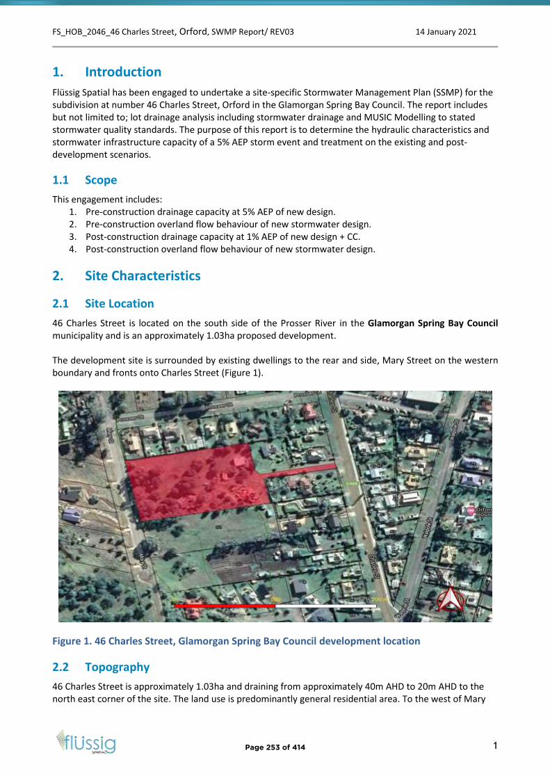
FS_HOB_2046_46 Charles Street, Orford, SWMP Report/ REV03 14 January 2021
1
1. Introduction
Flüssig Spatial has been engaged to undertake a site-specific Stormwater Management Plan (SSMP) for the subdivision at number 46 Charles Street, Orford in the Glamorgan Spring Bay Council. The report includes but not limited to; lot drainage analysis including stormwater drainage and MUSIC Modelling to stated stormwater quality standards. The purpose of this report is to determine the hydraulic characteristics and stormwater infrastructure capacity of a 5% AEP storm event and treatment on the existing and post-development scenarios.
1.1 Scope
This engagement includes: 1. Pre-construction drainage capacity at 5% AEP of new design.2. Pre-construction overland flow behaviour of new stormwater design.3. Post-construction drainage capacity at 1% AEP of new design + CC.4. Post-construction overland flow behaviour of new stormwater design.
2. Site Characteristics
2.1 Site Location
46 Charles Street is located on the south side of the Prosser River in the Glamorgan Spring Bay Council municipality and is an approximately 1.03ha proposed development.
The development site is surrounded by existing dwellings to the rear and side, Mary Street on the western boundary and fronts onto Charles Street (Figure 1).
Figure 1. 46 Charles Street, Glamorgan Spring Bay Council development location
2.2 Topography
46 Charles Street is approximately 1.03ha and draining from approximately 40m AHD to 20m AHD to the north east corner of the site. The land use is predominantly general residential area. To the west of Mary
Page 253 of 414
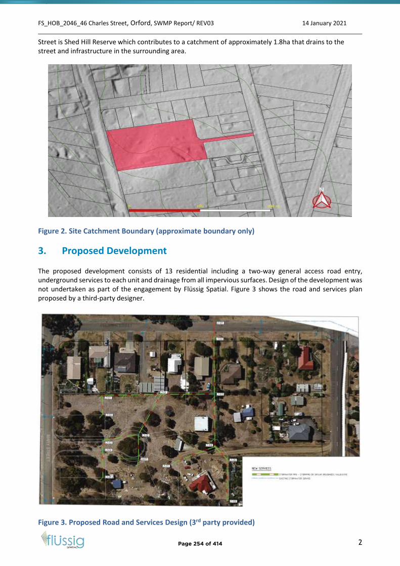
FS_HOB_2046_46 Charles Street, Orford, SWMP Report/ REV03 14 January 2021
2
Street is Shed Hill Reserve which contributes to a catchment of approximately 1.8ha that drains to the street and infrastructure in the surrounding area.
Figure 2. Site Catchment Boundary (approximate boundary only)
3. Proposed Development
The proposed development consists of 13 residential including a two-way general access road entry, underground services to each unit and drainage from all impervious surfaces. Design of the development was not undertaken as part of the engagement by Flüssig Spatial. Figure 3 shows the road and services plan proposed by a third-party designer.
Figure 3. Proposed Road and Services Design (3rd party provided)
Page 254 of 414

FS_HOB_2046_46 Charles Street, Orford, SWMP Report/ REV03 14 January 2021
3
4. Survey Data
All survey data was supplied by the client as a processed AutoCAD DEM. The provided data has been incorporated into various software to undertake the analysis.
5. Stormwater Quantity
5.1 Catchment Analysis
The catchment was modelled using Rafts Hydrology software within Infoworks ICM. RAFTS software uses the Laurenson runoff-routing method to calculate runoff using the catchment properties including size, slope and % impervious. This method is accepted within ARR2019 for areas larger than single dwelling lot.
5.2 Catchment Conditions
The development site at 46 Charles Street lies within a catchment area that extends from the Tasmanian highway to. The soil onsite is predominately weathered dolerite <500mm deep overlain on dolerite bedrock. This allows for drainage directly to a stream or piped infrastructure.
5.2.1 Design Intensity Storms
Design storm durations and temporal pattern were calculated using Australian Rainfall and Runoff 2019 (ARR19) guidelines, running ten temporal pattern events through each duration to determine the worst-case duration using the median temporal pattern. Figure 4 below shows the 5% AEP rainfall event as the 20min storm event.
Figure 4. 5% Temporal Storms Box and Whisker Plot
Page 255 of 414

FS_HOB_2046_46 Charles Street, Orford, SWMP Report/ REV03 14 January 2021
4
5.2.2 Land use
Land use for the development both pre- and post-development were derived from plans and aerial imagery. Land use values are as follows in Table 1.
Table 1. Land Use Area
Pre-Development Post-Development
Land Use Area (ha) % of total land Area (ha) % Impervious
Total Impervious 0.985 95.63 0.045 4.37
Total Pervious 0.580 56.31 0.450 43.69
As this is a subdivision, house lots were assumed based on surrounding infrastructure and planning scheme allowance. Houses are assumed to be 200m2 with an accompanying 60m2 driveway.
5.2.3 Manning’s n and losses
Losses for this catchment were derived from ARR19 data hub. As per ARR19, losses were taken at 60% of prescribed value to account for effective impervious area. See Table 2 for loss values. Manning’s n values were taken directly from best practice manuals as shown in Table 3.
Table 2. Runoff Coefficients
Surface Initial losses (IL) mm
Continuing Losses (CL) mm/ hr
Pervious 17 2.2
Impervious 1 0
Table 3. Manning's N coefficients
Land Use Manning’s n
Swale Channel 0.025
Road 0.018
Gravel 0.025
Urban Yards 0.045
Buildings 0.3
Page 256 of 414
FS_HOB_2046_46 Charles Street, Orford, SWMP Report/ REV03 14 January 2021
5
5.3 Development Runoff
Stormwater runoff from the development site has been assessed under pre- and post-development models to determine the potential impact the development at 46 Charles Street has on the immediate local flows. As per planning guidelines it is a requirement that this does not worsen from pre to post development.
Using the above parameters, the site was calculated using Infoworks ICM software and ARR19 best practice manuals. Site characteristics for the pre- and post-development model are summarised in Table 4
Table 4. Site Characteristics
Catchment Area (ha) Average Slope (%)
Total Land use pervious/ impervious (ha)
Storm duration and pattern
Pre-Development
1.03 13 0.985/ 0.045 5% 20-minute
storm pattern 8
Post-Development
1.03 13 0.58/ 0.45 5% 20-minute
storm pattern 8
5.4 Model Results
The pre- and post-development scenarios were calculated using Infoworks ICM software against the 5%. The storm durations were derived from the worst case median temporal pattern for these two events which were both 20 minutes duration.
The pre and post conditions can be seen in Table 5 below showing the peak discharge and increase in peak discharge from pre to post development.
Table 5. Discharge rates pre- and post-development
Peak Discharge (m3/s)
Design Event
(AEP) Pre-Development
Post-
Development
Difference
(m3/s)
5% 0.152 0.175 0.023
As per the Glamorgan Spring Bay Council Interim Planning Scheme 2015, E7.0 (Stormwater Management) the post-development allowable site discharge must not exceed the pre-development site discharge. As can be seen from Error! Reference source not found., this is exceeded in the 5% AEP by a peak discharge of 0.175m3/s, 0.023m3/s more than the allowable site discharge of 0.152m3/s. Therefore, the site must detain the difference using an onsite stormwater detention (OSD) system.
Page 257 of 414
FS_HOB_2046_46 Charles Street, Orford, SWMP Report/ REV03 14 January 2021
6
Figure 5. Discharge 5% AEP rate Pre-development
Figure 6. Discharge 5% AEP rate Post-development
5.4.1 House Detention
As this is a subdivision, individual residential properties are not part of the planning application and therefore the size of each property’s impervious area is based on an allowance of 200m2 house and 50m2 surface impervious area.
Given the allowance of 250m2 per lot each house would be required to detain approximately 27.6m3, this would require each property to detain runoff using a 2.5 kl detention tank with a 20mm orifice.
This allowance was derived using the average house sizes immediately surrounding the development area. It would be a requirement of future landowners of each individual lot to undertake detention storage calculations appropriate to each respective property design.
Page 258 of 414

FS_HOB_2046_46 Charles Street, Orford, SWMP Report/ REV03 14 January 2021
7
5.5 On-Site Detention Sizing and Configuration
As per ARR2019, Book 9, Section 5.5.1 “An Integrated Approach” – Figure 5.6. We are proposed individual 2500 Litres Detention Tanks at each lot to be discharged via 20mm outlet pipe into new stormwater network. Refer to Figure 7 below.
Figure 7. Proposed Detention Tanks Schematic Layout
5.6 Maintenance
To ensure ongoing operation of the tanks, each new lot owners would be required to perform regular maintenance on all tanks to ensure they remain in good working order. This would include but not be limited to the tasks described in Table .
Table 6. Concept Maintenance Plan
Task Action Frequency
General Cleaning – gutters, downpipe, filters etc.
Clear all debris from gutters and tank filters, ensure operational
Approximately every 3 months
Specialised cleaning and inspection
Inspect all gutters downpipes, inflow and outflow – flush if required. Inspect all filters replace if required. Inspect main tank for defects
Yearly
Maintenance Perform detailed inspection and maintenance of tank and associated infrastructure by a qualified person.
Every 5 years.
Page 259 of 414
FS_HOB_2046_46 Charles Street, Orford, SWMP Report/ REV03 14 January 2021
8
The above maintenance plan is generic and based on best practise advice. Specific maintenance plans should be created for each specific device upon purchasing or confirmation of design.
5.7 1% AEP Overland Flow Path
The existing overland flow path runoff for the 1% AEP is not required to be captured by infrastructure nor detained onsite in an OSD. However, the 1% AEP storm must be able to drain through the site and not cause additional impedance on the neighbours or the unit residents. Figure 8 below shows the pre-development overland flow path for the site in the event of a 1% AEP storm.
Figure 8. 1% AEP OFP Pre-Development
Also shown in Error! Reference source not found. are shallow flow paths from the Shed Hill Reserve area and are forming over the property at <40mm depths. These paths will need to be intercepted and diverted via grassed bunds/channels at the back boundaries of lots 1 to 4. This should be considered and checked in the design phase. Possible flow paths can be seen in Figure 9 This should include but not limit to:
• Cut-off drains
• Swales along boundary fences
• Easement to be created to accommodate overland flow path through he proposed development intothe new outlet
Page 260 of 414

FS_HOB_2046_46 Charles Street, Orford, SWMP Report/ REV03 14 January 2021
9
Figure 9. Possible 1% AEP Flow Paths
5.8 Quantity Summary
This concept quantity report is based off limited available information and guidelines from the Glamorgan Spring Bay Council in line with the Tasmanian Interim Planning Scheme. The following is a summary of the concept requirements for stormwater management for the development at 46 Charles Street, Orford:
1. Site exceeds allowable discharge by 0.023m3/s2. Recommended onsite storage detention of 32,000 litres for the 20 min storm duration.3. Each unit roofed area to have 2.5kL rainwater tank as OSD for site.4. Provide overland flow path to direct 1% runoff around development site.
6. Water Quality
Water quality modelling for the site has been undertaken with the urban stormwater improvement. conceptualisation software MUSIC. The modelling conducted in MUSIC has been done in accordance with MUSIC Modelling Guidelines (BMT WBM, August 2019) and the Tasmanian State Stormwater Strategy. This document provides a guide to water quality modelling methodology and outlines the assumptions that should be made when selecting input parameters.
Recommendation for the improvement of the water quality on site would include the diversion of stormwater flows from the subdivision to a primary and secondary treatment (treatment train). This would reduce the pollutants in the receiving waters further downstream and be a safe design option if future usage of this sub catchment provides higher pollutant storm water runoff.
6.1 Stormwater Quality Treatment (Construction phase)
During construction, many pollutants are generated from various sources. These pollutants can easily be captured in stormwater runoff and introduced into the downstream receiving environment, polluting the waterways. Some of the main construction phase pollutants are described below:
Proposed 1% Flow Path
Page 261 of 414
FS_HOB_2046_46 Charles Street, Orford, SWMP Report/ REV03 14 January 2021
10
• Litter from construction – Material packaging, paper, plastic, food packaging, off cuts etc.
• Sediment erosion and transports from excavated material and fresh surfaces.
• Hydrocarbons – equipment and machinery
• Toxic material – cement, solvents, paints, cleaning agents etc.
• pH altering substances – cement, cleaning agents etc.
Construction phase pollutants should be planned and mitigated for by a designed site-specific SWMP as part of the drawing set. This should detail controls including, but not limited to:
• Diversion of upslope water (where applicable)
• Stabilised exit/entry points
• Minimise site disturbance where possible
• Implement sediment control along downslope boundaries
• Appropriate location and protection for stockpiles
• Capture on-site runoff that may contain pollutants
• Maintain control measures
• Stabilise site after disturbance (revegetate etc)
6.2 Stormwater Quality Modelling
Stormwater pollutant modelling for 46 Charles Street development was undertaken using Model for Urban Stormwater Improvement Conceptualisation (MUSIC) software, version 6.3.0 under the guidelines of the State Stormwater Strategy and Interim Planning Scheme.
This model splits the catchment into the following typical areas:
• Roof Catchment
• Road Catchment
• Driveways
• Revegetated land
The following fraction impervious and land areas where adopted in the modelling as per the concept design measurements. Revegetated land was left to freely drain to the node as there is no mechanism to drain this area to a treatment device. See Table 6 below for fraction imperviousness (fi).
Table 6. Adopted Fraction Impervious
Catchment Area (ha)
Roof Road Driveways Revegetated
Area (ha)
fi Area (ha)
fi Area (ha)
fi Area (ha) fi
1.3 0.165 1 0.154 0.44 0.120 0.33 0.461 0
6.2.1 Council Planning Quality Removal Standards
The Glamorgan Spring Bay Council Interim Planning Scheme 2015 has adopted the pollutant removal targets and best practice from the State Stormwater Strategy 2010. See Table 7 for target removal rates.
Page 262 of 414
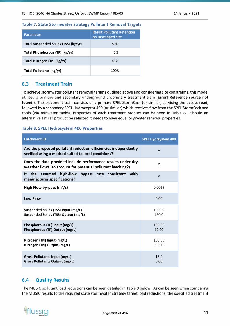
FS_HOB_2046_46 Charles Street, Orford, SWMP Report/ REV03 14 January 2021
11
Table 7. State Stormwater Strategy Pollutant Removal Targets
Parameter Result Pollutant Retention on Developed Site
Total Suspended Solids (TSS) (kg/yr) 80%
Total Phosphorous (TP) (kg/yr) 45%
Total Nitrogen (Tn) (kg/yr) 45%
Total Pollutants (kg/yr) 100%
6.3 Treatment Train
To achieve stormwater pollutant removal targets outlined above and considering site constraints, this model utilised a primary and secondary underground proprietary treatment train (Error! Reference source not found.). The treatment train consists of a primary SPEL StormSack (or similar) servicing the access road, followed by a secondary SPEL Hydroceptor 400 (or similar) which receives flow from the SPEL StormSack and roofs (via rainwater tanks). Properties of each treatment product can be seen in Table 8. Should an alternative similar product be selected it needs to have equal or greater removal properties.
Table 8. SPEL Hydrosystem 400 Properties
Catchment ID SPEL Hydrsystem 400
Are the proposed pollutant reduction efficiencies independently verified using a method suited to local conditions?
Y
Does the data provided include performance results under dry weather flows (to account for potential pollutant leeching?)
Y
It the assumed high-flow bypass rate consistent with manufacturer specifications?
Y
High Flow by-pass (m³/s) 0.0025
Low Flow 0.00
Suspended Solids (TSS) Input (mg/L) Suspended Solids (TSS) Output (mg/L)
1000.0 160.0
Phosphorous (TP) Input (mg/L) Phosphorous (TP) Output (mg/L)
100.00 19.00
Nitrogen (TN) Input (mg/L) Nitrogen (TN) Output (mg/L)
100.00 53.00
Gross Pollutants Input (mg/L) Gross Pollutants Output (mg/L)
15.0 0.00
6.4 Quality Results
The MUSIC pollutant load reductions can be seen detailed in Table 9 below. As can be seen when comparing the MUSIC results to the required state stormwater strategy target load reductions, the specified treatment
Page 263 of 414
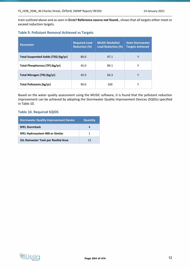
FS_HOB_2046_46 Charles Street, Orford, SWMP Report/ REV03 14 January 2021
12
train outlined above and as seen in Error! Reference source not found., shows that all targets either meet or exceed reduction targets.
Table 9. Pollutant Removal Achieved vs Targets
Parameter Required Load Reduction (%)
MUSIC Modelled Load Reduction (%)
State Stormwater Targets Achieved
Total Suspended Solids (TSS) (kg/yr) 80.0 97.1 Y
Total Phosphorous (TP) (kg/yr) 45.0 89.1 Y
Total Nitrogen (TN) (kg/yr) 45.0 66.3 Y
Total Pollutants (kg/yr) 90.0 100 Y
Based on the water quality assessment using the MUSIC software, it is found that the pollutant reduction improvement can be achieved by adopting the Stormwater Quality Improvement Devices (SQIDs) specified in Table 10.
Table 10. Required SQIDS
Stormwater Quality Improvement Device Quantity
SPEL StormSack 4
SPEL Hydrosystem 400 or Similar 1
1kL Rainwater Tank per Roofed Area 13
Page 264 of 414
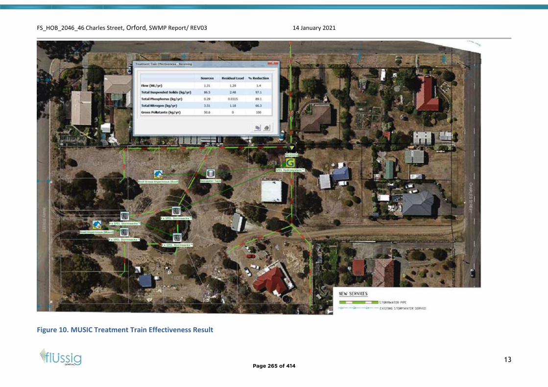
FS_HOB_2046_46 Charles Street, Orford, SWMP Report/ REV03 14 January 2021
13
Figure 10. MUSIC Treatment Train Effectiveness Result
Page 265 of 414

FS_HOB_2046_46 Charles Street, Orford, SWMP Report/ REV03 14 January 2021
14
6.5 SQID Maintenance
To ensure ongoing operation of all treatment systems the strata management group would be required to perform regular maintenance on all treatment devises to ensure they remain in good working order. This would include, but not be limited to, information described in Table 11.
Table 11. Concept Maintenance Plan
Task Action Frequency
General Cleaning Clear all pollutants from storage and device filters, ensure operational
Approximately every 6 months
Specialised cleaning and inspection
Inspect all storage, inflow and outflow – clean and flush if required. Inspect all filters replace if required. Visually inspect main device for defects
Yearly
Maintenance Perform detailed inspection and maintenance of tank and associated infrastructure by a qualified person.
Every 5 years.
The above maintenance plan is generic and based on removal rates and best practise advise. Specific maintenance plans should be created for each specific device upon purchasing or confirmation of design.
6.6 Quality Summary
Flüssig Spatial recommends the following be undertaken to ensure the ongoing stormwater quality from the developed site:
1. Construction quality control should be implemented to prevent pollution during construction.2. Installation of primary and secondary treatment devices in the order specified in this document.3. Maintenance plans need to be created and adhered to ensure the ongoing operation of the
systems.
Flüssig Spatial notes that the specified treatment products are a SPEL proprietary product and although suitable in this instance does not limit the developer to this product. However, any product selected by the developer should met removal properties of these products for the MUSIC model to be valid.
7. Conclusion
The Concept Stormwater Management Plan for 46 Charles Street, Orford development site has reviewed the post development quantity and quality scenarios. Post-development quantity and quality has been assessed against the State Stormwater Strategy to ensure the post-development flows meet specified standards.
The following conclusions were derived in this report:
1. A comparison of the post-development peak flows for the 5% AEP storm event were undertakenagainst the SRMP allowable discharge and found to meet the allowable discharge using OSD measurewhich include 2.5Kl detention tank per roofed area (carports include as part of unit roof)
2. The total OSD volume of 32.5m3 is stored from the roofed areas and as such all carparks, drivewaysand other ground level surface water drains freely to the outlet.
3. 1% OFP is considered through the site and directed away from neighbouring properties and criticalinfrastructure on site. A verge shaping along Mary St would be recommended.
Page 266 of 414
FS_HOB_2046_46 Charles Street, Orford, SWMP Report/ REV03 14 January 2021
15
4. SQIDs designed and sized using MUSIC can achieve required pollutant removal through theinstallation of said primary and secondary treatment devices.
Under the Stormwater Management Plan, the development site will meet current specified standards for both quantity and quality control.
8. Limitations
Flüssig Spatial were engaged by the developer of 46 Charles Street, Orford for the purpose of a site-specific stormwater management plan as per E7.0 of the Glamorgan Spring Bay Council Interim Planning Scheme 2015. This study is deemed suitable for purpose at the time of undertaking the study. If the conditions of the subdivision should change, the plan will need to be reviewed against all changes.
This report is to be used in full and may not be used in part to support any other objective other than what has been outlined within, unless specific written approval to do otherwise is granted by Flüssig Spatial.
Flüssig Spatial accepts no responsibility for the accuracy of third-party documents supplied for the purpose of this stormwater management plan.
Page 267 of 414

FS_HOB_2046_46 Charles Street, Orford, SWMP Report/ REV03 14 January 2021
16
9. References
• Australian Disaster Resilience Guideline 7-3: Technical flood risk management guideline: Floodhazard, 2014, Australian Institute for Disaster Resilience CC BY-NC
• Ball J, Babister M, Nathan R, Weeks W, Weinmann E, Retallick M, Testoni I, (Editors), 2019,Australian Rainfall and Runoff: A Guide to Flood Estimation, Commonwealth of Australia
• Grose, M. R., Barnes-Keoghan, I., Corney, S. P., White, C. J., Holz, G. K., Bennett, J., & Bindoff, N. L.(2010). Climate Futures for Tasmania: General Climate Impacts Technical Report.
Page 268 of 414

FS_HOB_2046_46 Charles Street, Orford, SWMP Report/ REV03 14 January 2021
17
Appendices Appendix A: FS_HBO_2046-C201 Pervious and Impervious Site Areas
Page 269 of 414

LOT 1IMPERVIOUSAREA 250m²
LOT 2IMPERVIOUSAREA260m²
LOT 3IMPERVIOUSAREA 225m²
LOT 4IMPERVIOUSAREA249m²
LOT 5IMPERVIOUSAREA389m²
LOT 7IMPERVIOUS AREA 358m²
LOT 9IMPERVIOUS AREA 228m²LOT 10
IMPERVIOUS AREA 257m²
LOT 12IMPERVIOUS AREA247m²
LOT 11IMPERVIOUS AREA 252m²
LOT 13IMPERVIOUS AREA581m²
LOT 6IMPERVIOUS AREA 243m²
PERVIOUSAREA331m²
PERVIOUSAREA250m²PERVIOUS
AREA326m²
PERVIOUSAREA337m²
PERVIOUSAREA328m²
PERVIOUSAREA303m²
PERVIOUSAREA227m²
PERVIOUSAREA339m²
LOT 9IMPERVIOUS AREA 224m²
PERVIOUSAREA955m²
PERVIOUSAREA595m²
PERVIOUSAREA565m²
PERVIOUSAREA551m²
PERVIOUSAREA275m²
PUBLICIMPERVIOUS AREA 961m²
PUBLICTOTAL PERVIOUS AREA 355m²
MARY STREET
46 CHARLES STREET
APPENDIX A
FS_HOB_2046
-
15.10.2020 DH MM1 : 500
GMDW DEVELOPMENTS PL
PRELIMINARY
1. THE COPYRIGHT OF THIS DRAWING IS VESTED IN FLUSSIG SPATIAL ANDIT MAY NOT BE REPRODUCED IN WHOLE OR PART OR USED FOR THEMANUFACTURE OF ANY ARTICLE WITHOUT THE EXPRESS PERMISSION OFTHE COPYRIGHT HOLDERS.
2. WORK TO FIGURED DIMENSIONS ONLY.3. THIS DRAWING IS TO BE READ IN CONJUNCTION WITH ALL RELEVANT
ARCHITECT'S, SERVICE ENGINEER'S AND FLUSSIG SPATIAL DRAWINGSAND SPECIFICATIONS.
NOTES :
C-201
46 CHARLES STREET ORFORD,
NEW STORMWATER MANAGEMENT PLAN
flüssig Spatial:116 Bathurst St, Level 4Hobart, 7000, TASMANIA
e: [email protected]: 0431 080 279w: www.flussig.com.au
E
NW
W
SW S
SE
N NE
PROPOSED PERVIOUS AND IMPERVIOUS AREAS PLANSCALE 1:500
NOTE:NEW ASSUMED IMPERVIOUS AREAS:· 200m² ROOFED AREAS· 5m WIDE DRIVEWAY AREAS
Page 270 of 414

FS_HOB_2046_46 Charles Street, Orford, SWMP Report/ REV03 14 January 2021
18
Appendices Appendix B: FS_HBO_2046-C301 1% AEP Overland Flow Path
Page 271 of 414

CHARLES STREET
1% AEP OVERLAND FLOW PATH
FS_HOB_2046
-
28.12.2020
DH MM
NTS
PRELIMINARY
1. THE COPYRIGHT OF THIS DRAWING IS VESTED IN FLUSSIG SPATIAL ANDIT MAY NOT BE REPRODUCED IN WHOLE OR PART OR USED FOR THEMANUFACTURE OF ANY ARTICLE WITHOUT THE EXPRESS PERMISSION OFTHE COPYRIGHT HOLDERS.
2. WORK TO FIGURED DIMENSIONS ONLY.3. THIS DRAWING IS TO BE READ IN CONJUNCTION WITH ALL RELEVANT
ARCHITECT'S, SERVICE ENGINEER'S AND FLUSSIG SPATIAL DRAWINGSAND SPECIFICATIONS.
NOTES :
301
CHARLES STREET ORFORD, NEW
STORM MANAGMENT PLAN
flüssig Spatial:116 Bathurst St, Level 4Hobart, 7000, TASMANIA
e: [email protected]: 0431 080 279w: www.flussig.com.au
E
NW
W
SW S
SE
N NE
GMDW DEVELOPMENTS PL
Page 272 of 414

Level 4,116 Bathurst Street Hobart, Tasmania 7000 Level 3, 51 Queen Street Melbourne, Victoria 3000
M: +61 431 080 279 | E: [email protected] | W: www.flussig.com.au Proudly Member of:
Page 273 of 414
Page 274 of 414
Page 275 of 414

Page 276 of 414
Page 277 of 414
Page 278 of 414
1
Maree Tyrrell
From:Sent: Tuesday, 26 January 2021 2:58 PMTo: PlanningSubject: Concerns regarding Storm Water Management in Prosser St. Orford
Categories: Robyn
Response to Storm Water Management Report Application for Planning Approval 46 Charles St. / 5 Prosser St Proposed Subdivision On April 2 2020 I witnessed, and videoed, the spectacular failure of the Prosser St. Orford, Storm Water system and the subsequent flooding of blocks 2 and 4 Prosser St and, as a consequence, the flow of knee-deep water around and through the Orford Library and nearby blocks on Charles St. GSBC Planning acknowledged the receipt of the video footage and still images showing the force and extent of the torrent. Subsequent conversations regarding properties damaged by the weather event of April 2, 2020 showed that GSBC were aware of the emergence of “a spring” at Prosser St. The SWMR for the Proposed Development of 13 Blocks at 46 Charles St Orford shows a plan to lead ALL of the Storm Water gathered from the 13 lot development –( each block with an assumed impervious surface allowance of 260 square metres in addition to the sealed access road ) and feed it into the existing Storm Water system opposite 5 Prosser St. As recent Storm Water events have proven to the Council, the current SW system is inadequate to meet the intensity and volume of SW. I note that the SWMR has not had any regard for the events of 2020 nor the capacity of the existing SW system. Without requiring the subdivider to contribute to the upgrading of the existing system, the approval of the subdivision in its current form would merely transfer costs to GSBC and the ratepayers. I am aware that since mid 2020 GSBC have employed a Hydrologist to prepare a SW Management Plan. Has this been completed and does the GSBC have sufficient information at its disposal to properly consider the Subdivision Plan before it? My best regards
Page 279 of 414
REP 1 Agenda Item 4.3 - Attachment B
1
Maree Tyrrell
From:Sent: Friday, 29 January 2021 11:48 AMTo: PlanningCc:Subject: Fwd: Concerns regarding application
---------- Forwarded message ----------
Date: Fri, 29 Jan 2021 11:40:22 +1100 Subject: Concerns regarding application To: [email protected]
Regarding SA 2018 – 06 – 46 Charles St, Orford Exhibited Documents, I write to outline some concerns I have with the proposed development in Mary St, Orford. 1. Residents on the top side of Mary Street, already experience low water pressure. The addition of 13 more dwellings (and more proposed further up the road I gather) could well have an effect on this. Our backyards front land that is wooded, so we have to make fire plans in case of an emergency. It is extremely difficult to develop a fire plan when the option of staying and defending our property is removed because of water pressure. Can the council guarantee that our water pressure will not be diminished by the addition of these several residences? In addition can the council guarantee that it has the water resources/supply to satisfy the needs of such a large increase of house hold use now and in the future. 2. Since we have lived permanently in Orford we have experienced at least 3 major weather events; each one caused flooding in our back yard and in two cases water damage to our lower floor bedroom. I have build a spoon drain running through my property in an attempt to mitigate the flow of water from the hill behind, but it is not the answer. On the occasion one of these weather events, drains in Mary Street became quickly inadequate to deal with the amount of water and Mary Street and Prosser Street flowed like a river. The council took several days, maybe weeks, to remove the debris and clear the drains. 13 small residences in Mary Street will create a good deal more non-porous surfaces that water will simply flow over and create further problems for residence down the street and across into Charles Street residences. Can the council guarantee that the water problems already being experienced for residences along Mary Street will be resolved and the addition of the 13 new residences will not add to the problems already being experienced in this area? Would the council consider placing more drains along the hill above Mary Street to help with the source of the problem? 3. There are a good number of eucalypts on the land proposed to be developed. I would think that the council or developer will be removing these. Does the council have any plans to replace any of these, and in any case is the council happy with the removal of well established trees in the area, especially given the importance of trees to the environment and indeed as a mitigating factor against flood? 4. Mary Street is a small street with a number of elderly people living in it. I am concerned that the addition of 13 residences will equate to the addition of potentially another 26 cars plus visitors' cars and will considerably add to the risks of walking along the street (given there is little provision for sidewalks). The area is also populated by wallabies - these will also be put at additional risk. Does the council have any plans to add further sidewalks and paving to make the area safer? Will there be any traffic calming infrastructure to slow or reduce the number of cars in the street? Will there be sufficient off-street parking for the proposed residences? Can parking in Mary Street be limited given its fairly narrow nature? 5. Has the council made provision for the sewerage requirements/usage of the additional 13 households? Can the existing infrastructure cope with such added usage? Thank you for the opportunity to raise these concerns. I look forward to your response, Andrew Gibson
Page 280 of 414
REP 2
Glamorgan Spring Bay Council 4th February 2021
PO Box 6
Triabunna Tas 7190
Subject: Concerns over Proposed Subdivision 46 Charles Street, Orford
Reference: Planning SA 2018/06
I wish to express my concerns over the above proposed subdivision SA 2018/06 detailed by
Andy Hamilton and Associates.
.
There are two main areas of concern which involve stormwater runoff and water pressure
both of which affects properties in Mary Street and Prosser Street.
1. Stormwater
The stormwater report by Andy Hamilton and Associates for the proposed subdivision
details a 5% AEP and it appears to assume that the current residential area above the
proposal has no excess run off relating to stormwater.
I don’t believe this is to be accurate. Since occupying my residence at 11 Mary Street, there
have been 4 major flood events in the past 5 years. These have been 100+mm, 200+mm,
130mm and 75mm of rainfall each measured on site over a 24-hour period.
A 5% AEP expect a major flood event of 1 in 20 years. It is more likely with changing weather
patterns and with the resulting east coast lows, these flood events are becoming much
more frequent.
The hill to the west and behind Mary Street “Shed Hill” has significant issues relating to
water runoff. The steep terrain and black shallow clay soils means that any heavy rains run
directly off site. This is exacerbated by the Council approved Telstra and Optus towers sites
located in the saddle behind Shed Hill. The main fibre optic underground communication
cable runs from the tower site downhill through the properties of 7, 9 and 11 Mary Street to
the junction of Prosser Street. This underground line has formed a depression in the ground
which channels water into and through the three properties. A cross drain required by the
council as part of the original subdivision is meant to stop the flow of water across the
properties but with limited capacity it overflows after significant rain. A major flood in April
2020 saw flooding occur with flow rates of 3-5m3/sec in the top drain and water flowing
down Mary Street at a rate of 1m3/sec.
Page 281 of 414
REP 3
In addition, an access road from the end of Mary Street traverses around the south side of
Shed Hill to the tower site. There are four 400mm culverts in the road which drains water
into Wielangta Creek below. The road is not maintained by either the landowner, the tower
operators or council and results in the culverts being regularly blocked. I have personally
unblocked 3 of the culverts following the last heavy rains of 2020. All water that runs down
this road enters that top of Mary Street and impacts on properties in both Mary Street,
Prosser Street and properties below on Seacrest Crescent.
2. Water Pressure
At the time of purchase, all blocks in the south end of Mary Street had a Council stipulation
that residences had to be no more that 40 metres from the road. This was to provide for
adequate water pressure. The current water pressure at 11 Mary Street is just adequate and
is dependent on the height up the hill. When the supply is flushed and fire hydrants tested
along Mary Street by TasWater the pressure at the residences drops to almost zero. This is
also the case when TasWater are working on the supply reservoir.
Current water pressure on my house at 11 Mary Street is 1 litre per 4 sec (250 ml /sec) on
the bottom level and 1 litre per 6 sec (175ml /sec) on the top level. The residence at 13
Mary Street has a much-reduced water pressure due to their higher elevation and as such
require a pressure pump running from a tank supply.
There is a great deal of concern that when the subdivision goes ahead that water pressure
will be significantly impacted.
3. Recommendations
Storm Water
That the storm water issues be addressed in Mary Street by the following:-
The access road to the towers is adequately maintained with all culvert pipes
cleaned out before heavy rains.
That water from the access road at the top of Mary Street be channelled into the
existing storm water sump preventing any runoff down Mary Street.
That the catch-drain above the existing residences have an overflow spill drain from
the top stormwater sump connecting to the existing stormwater sump at the top of
Mary Street preventing flooding of properties and any outflow onto Mary Street.
That additional small cross drains/mounds/grips be constructed (as per Forest
Practices Code requirements) across the Telstra line depression to reduce the
amount of water flowing downhill towards the properties below.
That the access road into the proposed subdivision have a rolled gutter as its
entrance preventing water from Mary Street entering the subdivision.
Page 282 of 414
Water Pressure
That If the subdivision which involves an addition 13 dwellings reduces the water pressure
from the current supply pressure which would then in turn requires a pressure pump, then
the council should pay for the installation.
The costs associated with the proposed recommendations is only very small which in turn
would significantly reduce the flooding that will occur with the next substantial rain event.
Works associated with these recommendations would be at most 2 days with a small
excavator plus crew (ie +/- $3000) providing a significant saving on the last flood clean-up
of Prosser and Mary Streets estimated to be in excess of $20,000.
I look forward to a constructive and favourable reply.
Yours truly,
Key to map below
Access Road Culverts
Stormwater Runoff
Council Required Catch Drain
Underground Stormwater Pipe
Proposed Additional Catch Drains
Council Stormwater Sump
Page 283 of 414
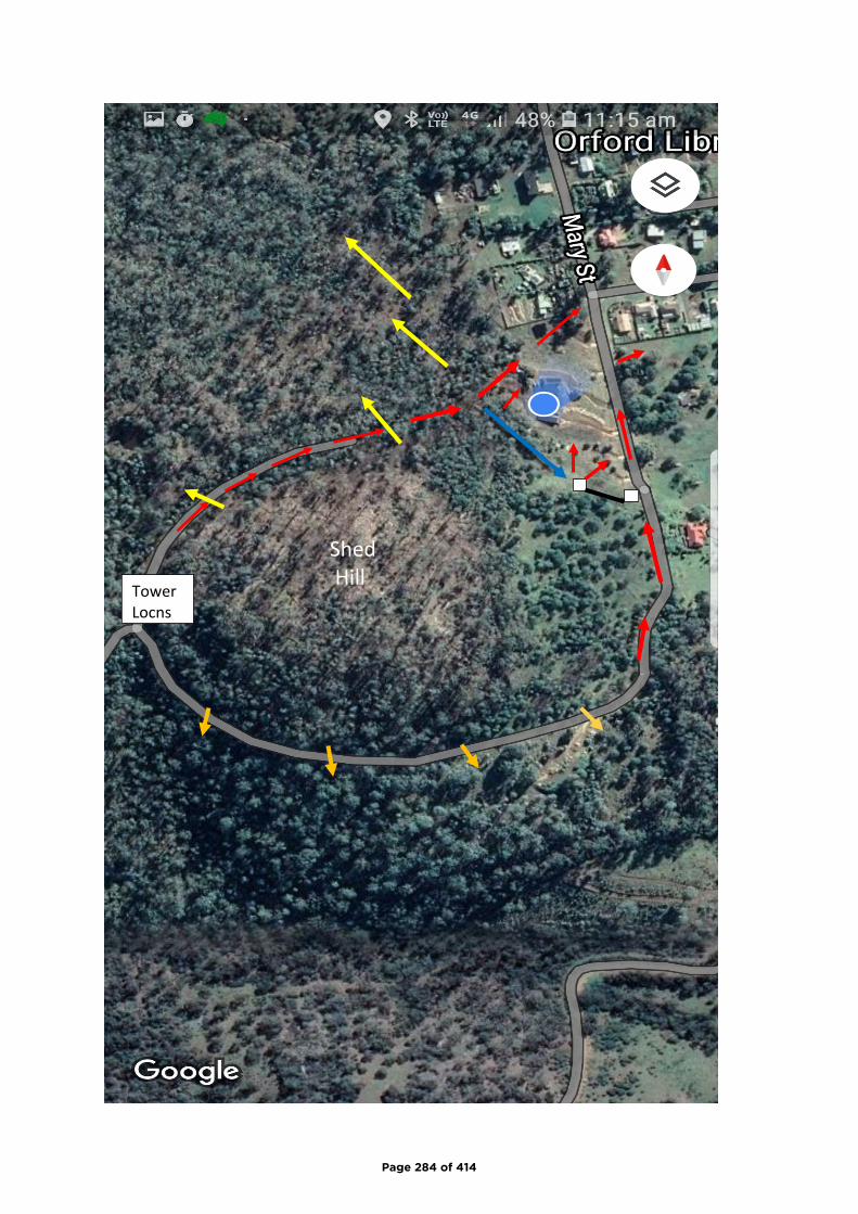
Tower
Locns
Shed
Hill
Page 284 of 414
1
Maree Tyrrell
From:Sent: Friday, 5 February 2021 2:45 PMTo: PlanningSubject: SA 2018 / 06
Categories:
Dear Mr Ingham With regard to the above Development Application, we are concerned about the implications to our property from stormwater run off, which has caused significant damage to our lower level, outbuilding and gardens in the last twelve months. Our main concern is whether stormwater will be directed efficiently. We note that the scheduled "easements" at the rear of lot 13 and 1 flow directly toward the lower quarter of our property, and connect with "easements" at the rear of lots 2, 3, 4 and 5. Will these "easements" be able to cope with the amount of run off we have seen in recent years? We would suggest from the last significant weather event, and the amount of mud, rocks and debris in ours, and neighbouring properties, no. How regularly will these "easements" be maintained? Having owned a property containing "easements", it is our observation that maintenance is largely forgotten by council. The state of the property now, and in recent years is a clear indication of the complete disregard to neighbouring property owners as we have had to contact council several times with regard to rubbish, grass height and noise. This Development Application is another, and is not in keeping with the property proportions in the area and will no doubt affect surrounding property values. Regards
Page 285 of 414
REP 4
1
Maree Tyrrell
From:Sent: Friday, 5 February 2021 3:01 PMTo: PlanningSubject: Fwd: SA 2018/6
Categories: Robyn
Please see details of my representation below. Regards Chris ---------- Forwarded message --------- From: CDate: Fri, 5 Feb 2021 at 8:34 am Subject: SA 2018/6 To: C com>
I am writing re the Application for Planning Approval SA 2018/6, 46 Charles Street Orford. I wish to make a representation to the proposed size of the blocks which I do not believe to be appropriate for the area. The current average size of blocks along Charles Street (a good representative sample being along Charles Street from Prosser Street to Cnr Mount Street) is approx 1,000 m2 (Source, the List). The proposed average size of the subdivision blocks is approx 600 m2. In effect the proposal is seeking to impose high density city living in a regional Tasmanian Country Town. Approval will open the flood gates for other developers to follow, proposing small blocks in order to maximise profits at the expense of residents and the environment. Other issues include that such small blocks will not allow room for sufficient greenery and will negatively affect the surrounding neighbourhood microclimate which will be exacerbated by the removal of current vegetation.
The recently approved 52 Charles Street with its small blocks and potential drainage issues will compound future problems for the area. I note that as an adjacent occupier to 52 Charles Street and despite lodging an objection to the initial application, I was not notified of the amended application for 52 Charles Street which was subsequently approved by Councillors.
Page 286 of 414
REP 5
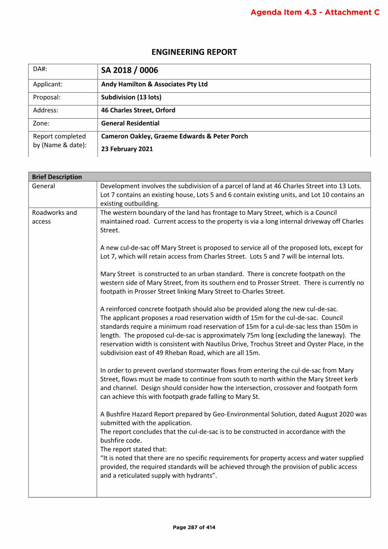
ENGINEERING REPORT
Brief Description
General Development involves the subdivision of a parcel of land at 46 Charles Street into 13 Lots. Lot 7 contains an existing house, Lots 5 and 6 contain existing units, and Lot 10 contains an existing outbuilding.
Roadworks and access
The western boundary of the land has frontage to Mary Street, which is a Council maintained road. Current access to the property is via a long internal driveway off Charles Street. A new cul-de-sac off Mary Street is proposed to service all of the proposed lots, except for Lot 7, which will retain access from Charles Street. Lots 5 and 7 will be internal lots. Mary Street is constructed to an urban standard. There is concrete footpath on the western side of Mary Street, from its southern end to Prosser Street. There is currently no footpath in Prosser Street linking Mary Street to Charles Street. A reinforced concrete footpath should also be provided along the new cul-de-sac. The applicant proposes a road reservation width of 15m for the cul-de-sac. Council standards require a minimum road reservation of 15m for a cul-de-sac less than 150m in length. The proposed cul-de-sac is approximately 75m long (excluding the laneway). The reservation width is consistent with Nautilus Drive, Trochus Street and Oyster Place, in the subdivision east of 49 Rheban Road, which are all 15m. In order to prevent overland stormwater flows from entering the cul-de-sac from Mary Street, flows must be made to continue from south to north within the Mary Street kerb and channel. Design should consider how the intersection, crossover and footpath form can achieve this with footpath grade falling to Mary St. A Bushfire Hazard Report prepared by Geo-Environmental Solution, dated August 2020 was submitted with the application. The report concludes that the cul-de-sac is to be constructed in accordance with the bushfire code. The report stated that: “It is noted that there are no specific requirements for property access and water supplied provided, the required standards will be achieved through the provision of public access and a reticulated supply with hydrants”.
DA#: SA 2018 / 0006
Applicant: Andy Hamilton & Associates Pty Ltd
Proposal: Subdivision (13 lots)
Address: 46 Charles Street, Orford
Zone: General Residential
Report completed by (Name & date):
Cameron Oakley, Graeme Edwards & Peter Porch
23 February 2021
Page 287 of 414
Agenda Item 4.3 - Attachment C
A Traffic Impact Assessment (TIA) was not submitted with the application. It is not expected that the increase in traffic generated by the subdivision will result in any safety issues and is well within the capacity of Mary Street.
Stormwater The proposed subdivision is located within a 37 hectare catchment which includes part of Shed Hill. It passes through south Orford before discharging to Orford Rivulet. This catchment has been historically impacted by flooding, both as a result of flooding originating from Shed Hill and the urban area, as well as from the rivulet. As a result of proposed and potential development within the catchment, and a history of inundation, Council commissioned an investigation into this the stormwater system and the potential effects of development at No. 46 Charles Street on it (ref. 46 Charles St Stormwater Investigation & Review of Drainage Infrastructure, 2018). The investigation confirmed that the existing drainage infrastructure is unable to convey runoff generated in all events equivalent or greater than the 20% AEP (1 in 5 year ARI). There is no spare capacity for increased runoff as a result of new development within the catchment. It was noted that predicted climate change will exacerbate these capacity issues. Therefore, the developer will be required to limit and maintain stormwater runoff from the developed subdivision to pre-existing levels. Linkage from the stormwater pipe and pit network needs to be made to either to Prosser Street or to Charles Street. Linkage to Prosser Street requires an easement through No. 5 Prosser Street. Without proper consideration, the installation of a new cul-de-sac downslope from Mary Street introduces the risk of inundation of the new lots from flooding off Shed Hill. It is noted that adjacent property Nos. 7 and 13 Prosser Street have reported flooding coming off the proposed subdivision site. Mary Street has a one-way cross-fall to the western side of the road. Anecdotally it doesn’t seem that the existing kerb and channel prevents flooding into the proposed site or to downstream properties. Proposal A Stormwater Management Report (Revision 3) prepared by Flussig (14/01/2021). The report proposes to provide property-based detention in the form of rainwater tanks, in order to prevent an increase in stormwater discharge from the site, and to ensure the subdivision does not adversely affect downstream properties. The report was peer reviewed by a consultant engaged by Council. A minimum 2,500 Litre detention tank with a 20mm outlet is prescribed for every lot. As these detention tanks will be on private property a Part 5 agreement will need to be registered on the titles to control their management and operation. The applicant proposes to provide a new stormwater system within the subdivision which will pass through No. 5 Prosser Street , with whom an easement has been negotiated, and then the installation of a new stormwater main in Prosser Street, connecting to the system at the intersection of Prosser Street and Charles Street. The applicant’s stormwater management report recommends the provision of a 1% AEP overland flow path through the installation of grassed bunds/channels at the back boundaries of Lots 1 to 4. This is unacceptable. In order to protect the proposed subdivision, the entrance to the cul-de-sac must be constructed such that flows within Mary Street continue to be channelled down Prosser Street via the existing kerb and channel.
Page 288 of 414
The page 8 of the Stormwater Management Report (Flussig, 2021) indicates the 1% (1 in 100 year) overland flow from Shed Hill is not contained in Mary Street and passes through the top half of the proposed subdivision as well as through Nos. 5 to 15 Prosser Street. While the proposed subdivision won’t exacerbate this issue, it does not solve it, and it will potentially add the potential for an additional 4-5 dwellings within this flow path. Water Sensitive Urban Design The application involves more than 5 lots. As such, Water Sensitive Urban Design (WSUD) principles are required for the treatment and disposal of stormwater. The applicant proposes the use of swale drains and a detention/infiltration pond to provide treatment. A MUSIC model was provided with the applicant’s stormwater report demonstrating that using a combination of SPEL StormSacks (road drainage pit baskets) and a SPEL Hydrosystem filter will meet treatment targets stipulated in the planning scheme. The practicality of implementing WSUD principles within this subdivision is limited given there it creates no open space and the proposed road reservation as quite steep. The location of the Hydrosystem at the rear of Lot 5 is impractical. Being located at the rear of the lot, access for maintenance by Council staff would be problematic. Therefore, a condition requiring the payment of a contribution so that treatment can be implemented downstream is recommended. Summary Three representations objecting to the approval of the subdivision, primarily based on stormwater issues, have been received. It is clear from previous stormwater investigations, from anecdotal evidence and observations, and from the representations that there are substantial issues within the catchment relating to both adequacy of the existing stormwater system and inundation. Council is actively progressing assessment of the south Orford catchment. Firstly, modelling of the Orford Rivulet is nearly complete. This work will provide Council with an understanding of the flood inundation zone and identification of all the properties affected as a result of flooding from the rivulet during the 1% AEP and 1% AEP climate change events. Secondly, we are currently undertaking survey in order to update records of all Council’s stormwater infrastructure in the area. This will enable us to undertake a stormwater modelling, and then to develop proposals for stormwater system upgrades for inclusion in the Storm System Management Plan. There is a strong commitment from the Works and Infrastructure Department to plan and undertake works within this catchment to address existing flooding issues and to provide the capacity needed for the future. The applicant, through the Stormwater Management Report, has demonstrated a methodology for stormwater disposal that is able to meet the acceptable solutions in E7.7.1 Stormwater Drainage and Disposal of the Planning Scheme.
Sewer and Water Sewer and water services are available to the land. The application was referred to TasWater who have imposed conditions.
Power, Telco, etc Power should be provided underground. NBN is available in the area.
Codes Road and Railway Assets Code Parking & Access Stormwater
Page 289 of 414
Representations
Rep 1 Alison Walsh Representation raises concerns due to stormwater and flooding issues:
• “On April 2 2020 I witnessed …knee-deep water through the Orford Library and nearby blocks on Charles Street”
• “Emergence of a spring at Prosser St”
• “The SWMR… shows a plan to lead ALL of the stormwater gathered from the 13 lot development… and feed it into the existing stormwater system opposite 5 Prosser St… The current SW system is inadequate to meet the intensity and volume of SW”
• “I note the SWMR has not any regard for the events of 2020 nor the capacity of the existing SW system”
• “I am aware…GSBC have employed a hydrologist to prepare a SW Management Plan. Has this been completed and does GSBC have sufficient information at its disposal to consider the subdivision plan before it?”
Anecdotally the April 2020 flood event recorded approximately 115mm over 5.75 hours. The 1 in 1000 year rainfall depth for that timeframe is 110mm. The 1 in 2000 year rainfall depth for that timeframe is 120mm. The event was therefore somewhere between the 1 in 1000 and 1 in 2000 year event. Public stormwater systems are unable to cope with such extreme events. The applicant has demonstrated that the proposal is capable of meeting the acceptable solutions within code E7.7.1 Stormwater Drainage and Disposal of the Planning Scheme. Essentially the subdivision itself, through the use of stormwater detention, will result in no increase in pre-existing runoff. The recommended conditions ensure compliance with E7.7.1 Stormwater Drainage and Disposal of the Planning Scheme. Council is currently undertaking survey of the stormwater system in the area. This will enable modelling to be undertaken which will then inform the Stormwater System Management Plan. The detention detailed in the Stormwater Management Report was assessed independently and will ensure no net increase in demands on the downstream system.
Rep 2 Andrew Gibson 1. “Can the Council guarantee that our water pressure
will not be diminished”
2. Raises concerns due to stormwater and flooding issues.
3. Concerns about the removal of native trees during
the subdivision
4. “Mary Street is a small street with a number of elderly people living in it”. Concerns that 13 additional residences will equate to the addition of 26 cars plus visitors. “And will considerably add to the risks of walking along the street (given that there is little provision for sidewalks”. “Will there be any traffic calming infrastructure?”
TasWater issue See above Landscaping of naturestrip will be required The existing road infrastructure has sufficient capacity to cater for the additional vehicle movements from this development without causing traffic congestion or safety issues. A footpath will be required linking the new cul-de-sac with the existing footpath Mary Street. There is
Page 290 of 414
5. Sewerage infrastructure concerns
currently no footpath linking Mary Street to Charles Street via Prosser St. TasWater issue
Rep 3 Steve and Rosemary Davis “The stormwater report by Andy Hamilton and Associates for the proposed subdivision details a 5% AEP and it appears to assume that the current residential area above the proposal has no excess run off relating to stormwater. I don’t believe this is to be accurate.” “A 5% AEP expect a major flood event of 1 in 20 years. It is more likely with changing weather patterns and with the resulting east coast lows, these flood events are becoming much more frequent.” “The hill to the west and behind Mary Street “Shed Hill” has significant issues relating to water runoff. The steep terrain and black shallow clay soils means that any heavy rains run directly off site.” “This is exacerbated by the Council approved Telstra and Optus towers sites located in the saddle behind Shed Hill. The main fibre optic underground communication cable runs from the tower site downhill through the properties of 7, 9 and 11 Mary Street to the junction of Prosser Street. This underground line has formed a depression in the ground which channels water into and through the three properties.” “A cross drain required by the council as part of the original subdivision is meant to stop the flow of water across the properties but with limited capacity it overflows after significant rain. A major flood in April 2020 saw flooding occur with flow rates of 3-5m3/sec in the top drain and water flowing down Mary Street at a rate of 1m3/sec.”
As above, the proponent’s stormwater report shows no net increase resulting from the 5% AEP (1 in 20) and 1% AEP events. This is a common misconception. There is a 5% chance in any one year of experiencing a rainfall intensity equal to or greater than the 20 year ARI value for a number of different durations for which the rainfalls are independent, or nearly so. For example, durations of: 5 minutes, 1 hour, 6 hours, and 3 days may display a considerable degree of independence. However, in theory, there is a single 5% flood event (i.e., flow) for Mary Street which is specific to that site, which is influenced by rainfall intensity, the catchment size, and catchment topography. This is correct. The topography hydrology of the hill means that significant natural runoff can be generated This issue should be referred to Telstra/Optus This is a separate issue which should be investigated by the Works and Infrastructure Department As per above the April event exceeded a 1 in 1000 year rainfall event. It is unclear how these suggested flow rates were determined. These flows have the potential to enter the proposed cul-de-sac. Treatment of the cul-de-sac’s entry from Mary Street must ensure flows are contained in Mary Street and do not pass to the cul-de-sac head
Page 291 of 414
“In addition, an access road from the end of Mary Street traverses around the south side of Shed Hill to the tower site. There are four 400mm culverts in the road which drains water into Wielangta Creek below. The road is not maintained by either the landowner, the tower operators or council and results in the culverts being regularly blocked. I have personally unblocked 3 of the culverts following the last heavy rains of 2020. All water that runs down this road enters that top of Mary Street and impacts on properties in both Mary Street, Prosser Street and properties below on Seacrest Crescent.” Water Pressure
This is a private access/nuisance issue and not necessarily Council responsibility. Works and Infrastructure could investigate and potentially issue a notice for correction under the Urban Drainage Act. This issue does not affect the proposed subdivision. TasWater issue
Rep 4 Janice Evans 1. Concerns about stormwater flooding of their
property “which has caused significant damage to our lower level, outbuilding and gardens in the last twelve months” “Our main concern is whether stormwater will be directed efficiently. We note that the scheduled "easements" at the rear of lot 13 and 1 flow directly toward the lower quarter of our property, and connect with "easements" at the rear of lots 2, 3, 4 and 5. Will these "easements" be able to cope with the amount of run off we have seen in recent years?”
2. We would suggest from the last significant weather event, and the amount of mud, rocks and debris in ours, and neighbouring properties, no. How regularly will these "easements" be maintained? Having owned a property containing "easements", it is our observation that maintenance is largely forgotten by council.
These are stormwater and sewer pipeline easements. The stormwater pipeline will carry stormwater generated within the subdivision and will be required to accommodate the 1 in 20 year (5% AEP) storm. As mentioned in the stormwater section of this report the Mary Street road profile and kerb and channel appears unable to contain flooding from Shed Hill during the 1% AEP. Without addressing these upper catchment flows and/or the design of Mary Street the flooding incidence reported are likely to continue. As per the above, the easements are for pipes only and not designed to carry overland flooding and therefore will not be maintained by Council.
Rep 5 Chris Peterson “The recently approved 52 Charles Street with its small blocks and potential drainage issues will compound future problems for the area.”
See above
Page 292 of 414
Recommended Conditions:
General
1. The subdivision layout or development must be carried out substantially in accordance with the application for planning approval, the endorsed drawings and with the conditions of this permit and must not be altered or extended without the further written approval of Council.
2. Prior to Council sealing the final plan of survey, security for an amount clearly in excess of the value of all outstanding works and maintenance required by this permit must be lodged with the Glamorgan Spring Bay Council. The security must be in accordance with section 86(3) of the Local Government (Building & Miscellaneous Provisions) Council 1993. The amount of the security shall be determined by the Council’s General Manager in accordance with Council Policy following approval of any engineering design drawings.
Advice: The minimum bond amount required during the maintenance and defects liability period is to be no less than 5% of the agreed value of the works. The developer is to enter into a formal Maintenance Bond Deed of Agreement with Council.
3. In accordance with the provisions of Section 117 of the Local Government (Building and Miscellaneous Provisions) Act 1993, payment of a cash contribution for Public Open Space must be made to the Council prior to sealing the Final Plan of Survey. The cash contribution amount is to be 5% of the value of the total land area described in the plan of the subdivision at the date of lodgement of the Final Plan of Survey. The value is to be determined by a Land Valuer within the meaning of the Land Values Act 2001 at the developer’s expense.
4. The cash-in-lieu of public open space must be in the form of a direct payment made before sealing of the final plan of survey or, alternatively, in the form of a Bond or Bank guarantee to cover payment within ninety (90) days after demand, made after the final plan of survey has taken effect.
5. All conditions of this permit, including either the completion of all works and maintenance or payment of security in accordance with this permit, must be satisfied before the Council seals the final plan of survey for each stage. It is the subdivider’s responsibility to notify Council in writing that the conditions of the permit have been satisfied and to arrange any required inspections.
6. The development must be in accordance with the Bushfire Hazard Report (v3) prepared by Geo-Environmental Solutions, dated August 2020, and submitted with the application, or as otherwise required by this permit, whichever standard is greater.
7. Prior to sealing the final plan of survey an accredited bushfire practitioner must provide certification that the completed subdivision works are in accordance with the endorsed Bushfire Hazard Report.
8. All land noted as roadway, footway, open space or similar must be transferred to Council. Complete transfer documents that have been assessed for stamp duty, must be submitted with the final plan of survey.
9. The final plan of survey must include easements over all drains, pipelines, wayleaves and services to the satisfaction of Council’s General Manager.
Page 293 of 414

10. The corners of the property boundaries at the road intersection with Mary Street (Lots 12 and 13 on the Lot Plan) must be splayed or rounded by chords of a circle with a radius of not less than 6.00 metres in accordance with Sections 85(d)(viii) and 108 of the Local Government (Building & Miscellaneous Provisions) Act 1993 and the requirements of Council's General Manager.
Part 5 Agreements
11. An agreement pursuant to Part 5 of the Land Use Planning and Approvals Act 1993 must be entered into prior to the sealing of the final plan of survey to the effect that in order to manage the installation and maintenance of on-site stormwater detention and disposal to the effect that:
a. “owners of each lot must agree to install and maintain rainwater detention tanks with diversion devices to collect all stormwater runoff from roofed areas, of a size and type to be determined and shown in the engineering drawings”
b. the design details for (a) are included in the agreement in a clear, readily-understandable manner
12. Agreement(s) made pursuant to Part 5 of the Land Use Planning and Approvals Act 1993 must
bind the current owner and his/her successors in title and must be prepared on a blank
instrument form and registered with the Recorder of Titles in accordance with Section 78 of
the Land Use Planning and Approvals Act 1993 by the applicant at no cost to Council.
Landscaping
13. The road reserves must be landscaped by trees or plants in accordance with a landscape plan prepared by a landscape architect or other person approved by Council, and submitted to Council for endorsement with the engineering drawings. The landscape plan must show the areas to be landscaped, the form of landscaping, and the species of plants and estimates of the cost of the works.
Drainage
14. The developer is to provide a piped stormwater property connection to each lot capable of servicing the entirety of each lot by gravity in accordance with Council standards and to the satisfaction of Council’s General Manager.
15. Stormwater runoff will be no greater than pre-existing runoff or any increase can be accommodated within existing or upgraded public stormwater infrastructure.
16. The minor stormwater drainage system must be designed
(a) to accommodate a storm with an ARI of 20 years, when the land serviced by the system is fully developed;
17. New stormwater pipework within the subject property and extending to the existing public stormwater system in Prosser Street must be designed to accommodate a storm with an ARI of 20 years, when the land serviced by the system is fully developed, irrespective of whether private stormwater detention is to be provided on individual lots.
18. The developer is to provide a major stormwater drainage system designed to accommodate a storm with an ARI of 100 years.
19. Prior to the approval of Engineering Design Drawings, the developer must submit a Flood Hazard Report, prepared in accordance with Australian Rainfall and Runoff 2019 (ARR2019),
Page 294 of 414
in in particular, with reference to Book 6, Chapter 7: Safety in Design Criteria and Book 9, Chapter 6: Modelling Approaches’. The report must be prepared and certified by an experienced and practicing Civil Engineer. Once approved the amended report will form part of the endorsed documents. It must demonstrate the following:
a. that overland flows intercepted by Mary Street are contained within the existing road easement, and will not pass down the proposed cul-de-sac.
b. that there is no increase in overland flooding and flood hazard within and external to the subdivision as a consequence of the development
20. The stormwater system for the development must be designed in accordance with
a. the principles set out in the document “46 Charles Street, Orford Stormwater Management Report, Revision 3” prepared by Flussig Spatial, dated 14 January 2019;
b. the drawing titled ‘Concept Lot and Services Plan’ drawing No. 1718-P4 Revision 1 dated 23/06/2020 and issued 15/01/2021;
c. Australian Rainfall and Runoff 2019 (ARR2019), in in particular, with reference to Book 6, Chapter 7: Safety in Design Criteria and Book 9, Chapter 6: Modelling Approaches’;
d. the Flood Hazard Report;
e. any measures required by the report to ensure that a tolerable risk for the development from flooding is achieved and there is no increase in risk from flood for adjacent land must be included in the engineering design drawings and implemented prior to the sealing of the Plan of Survey for any stage of the subdivision;
f. or as otherwise required by conditions of this permit;
g. and to the satisfaction of Council’s General Manager.
21. The developer is to make a financial contribution to Glamorgan Spring Bay Council for the
provision of stormwater treatment. The value of the contribution must be equal to the cost
of implementing on site treatment to meet the targets specified in Table E7.1 Acceptable
Stormwater Quality and Quantity Targets of the Glamorgan Spring bay Interim Planning
Scheme, or as otherwise agreed by Council’s General Manager. Where partial treatment is
provided on site a proportional contribution may be considered. The contribution must be
paid prior to sealing the Plan of Survey
22. Upon completion of works the engineer must provide certification that the stormwater
system has been constructed in accordance with the approved documents.
Engineering
23. The subdivision must be carried out in accordance with the Tasmanian Subdivision Guidelines October 2013 or as otherwise agreed by Council’s General Manager or required by conditions of this permit.
24. Engineering design drawings to the satisfaction of the Council’s General Manager must be submitted to and approved by the Glamorgan Spring Bay Council before development of the land commences.
Page 295 of 414
25. Engineering design drawings are to be prepared by a qualified and experienced civil engineer, or other person approved by Council’s General Manager, and must show -
(a) all existing and proposed services required by this permit;
(b) all existing and proposed roadwork required by this permit;
(c) measures to be taken to provide sight distance in accordance with the relevant standards of the planning scheme;
(d) measures to be taken to limit or control erosion and sedimentation;
(e) any other work required by this permit.
26. Approved engineering design drawings will remain valid for a period of 2 years from the date of approval of the engineering drawings.
Services
27. Property services must be contained wholly within each lots served or an easement to the satisfaction of the Council’s General Manager or responsible authority.
28. The Subdivider must pay the cost of any alterations and/or reinstatement to existing services, Council infrastructure or private property incurred as a result of the proposed subdivision works. Any work required is to be specified or undertaken by the authority concerned.
29. Property services to internal lots must be extended to the lot proper to the satisfaction of Council’s General Manager.
Tas Water
30. The development must meet all required Conditions of approval specified by Tas Water Submission to Planning Authority Notice, TWDA 2018/00472-GSB, dated 12 November 2019.
Telecommunications and electrical reticulation
31. Electrical and telecommunications services must be provided to each lot in accordance with the requirements of the responsible authority and to the satisfaction of Council’s General Manager.
32. Street Lighting must be provided in accordance with the requirements of the responsible authority and to the satisfaction of Council’s General Manager.
33. New electrical and fixed line telecommunications services must be installed underground to the requirements of the responsible authority unless approved otherwise by Council’s General Manager.
34. Prior to sealing the final plan of survey, the developer must submit to Council: (a) A “Provisioning of Telecommunications Infrastructure – Confirmation of final payment” or
“Certificate of Practical Completion of Developer’s Activities” from NBN Co.
(b) Written advice from TasNetworks confirming that all conditions of the Agreement
between the Owner and authority have been complied with and/or that future lot owners
will not be liable for network extension or upgrade costs, other than individual property
connections at the time each lot is further developed.
Roads and Access
Page 296 of 414
35. Roadworks and drainage must be constructed in accordance with the standard drawings prepared by the IPWE Aust. (Tasmania Division) and to the requirements of Council’s General Manager.
36. Unless approved otherwise by Council’s General Manager roadworks must include – a) Minimum road reserve of 16 metres;
b) Fully paved, sealed and drained carriageway with a minimum carriageway width (face of kerb to face of kerb) of 6.9 metres;
c) Cul-de-sac turning head with a radius of 17.5m to face of kerb
c) Concrete kerb and channel;
d) Concrete footpath 1.50 metres wide;
e) Underground stormwater drainage
37. All carriageway surface courses must be constructed with a 10 mm nominal size hotmix asphalt with a minimum compacted depth of 35 mm in accordance with standard drawings and specifications prepared by the IPWE Aust. (Tasmania Division) and the requirements of Council’s General Manager.
38. Kerb ramps must be provided to accommodate the needs of people with disabilities in accordance with standard drawings prepared by the IPWE Aust. (Tasmania Division) and to the requirements of Council’s General Manager.
Vehicular Access
39. A vehicular access including concrete driveway apron and kerb crossover must be provided to each lot from the road carriageway to the property boundary, in accordance with Council’s Standard Drawings and to the satisfaction of Council’s General Manager.
40. To the satisfaction of Council’s General Manager, shared vehicular accesses must be constructed for the entire length of the access strips to the lot proper. The driveways must be provided in accordance with Standards Australia (2004): Australian Standard AS 2890.1 - 2004 – Parking Facilities Part 1: Off Street Car Parking; Standards Australia, Sydney, Council standards, and must include:
(a) 5.5 metre min. width carriageway to provide 2 way access located at least 0.3m from any side boundary
(b) Constructed with a durable all weather pavement
(c) Sealed Surfaced (The surfacing material must be concrete, asphalt, pavers or other equivalent approved material.)
(d) Stormwater drainage; and
(e) As required by an Approved Bushfire Hazard Management Plan.
Water quality
41. A soil and water management plan (here referred to as a ‘SWMP’) prepared in accordance with the guidelines Soil and Water Management on Building and Construction Sites, by the Derwent Estuary Programme and NRM South, must be approved by Council's General Manager before development of the land commences.
42. Temporary run-off, erosion and sediment controls must be installed in accordance with the approved SWMP and must be maintained at full operational capacity to the satisfaction of
Page 297 of 414
Council’s General Manager until the land is effectively rehabilitated and stabilised after completion of the development.
43. The topsoil on any areas required to be disturbed must be stripped and stockpiled in an approved location shown on the detailed soil and water management plan for reuse in the rehabilitation of the site. Topsoil must not be removed from the site until the completion of all works unless approved otherwise by the Council’s General Manager.
44. All disturbed surfaces on the land, except those set aside for roadways, footways and driveways, must be covered with top soil and, where appropriate, re-vegetated and stabilised to the satisfaction of the Council’s General Manager.
Construction
45. The subdivider must provide not less than forty eight (48) hours written notice to Council’s General Manager before commencing construction works on-site or within a council roadway.
46. The subdivider must provide not less than forty eight (48) hours written notice to Council’s General Manager before reaching any stage of works requiring inspection by Council unless otherwise agreed by the Council’s General Manager.
47. Subdivision works must be carried out under the direct supervision of an approved practising professional civil engineer engaged by the subdivider and approved by the Council’s General Manager.
‘As constructed’ drawings
48. Prior to the works being placed on the maintenance and defects liability period an “as constructed” drawing of all engineering works provided as part of this approval must be provided to Council to the satisfaction of the Council’s General Manager. These drawings and data sheets must be prepared by a qualified and experienced civil engineer or other person approved by the General Manager in accordance with Council’s Guidelines for As Constructed Data.
49.
Maintenance and Defects Liability Period
50. The subdivision must be placed onto a twelve (12) month maintenance and defects liability period in accordance with Council Policy following the completion of the works in accordance with the approved engineering plans and permit conditions.
51. Prior to placing the subdivision onto the maintenance and defects liability period the Supervising Engineer must provide certification that the works comply with the Council’s Standard Drawings, specification and the approved plans.
THE FOLLOWING ADVICE APPLIES TO THIS PERMIT: -
A. The owner is advised that an engineering plan assessment and inspection fee must be paid to Council in accordance with Council’s fee schedule.
B. All approved engineering design drawings will form part of this permit on and from the date
of approval.
Page 298 of 414

DRAFT
Working draft January 2021 V1Not for further distribution
SOUTHERN TASMANIAREGIONAL CAT MANAGEMENT
STRATEGY (2021-2026)
Page 299 of 414
Agenda Item 8.4 - Attachment 1
02
DRAFTPrepared by the Southern Cat Management Coordinator in collaboration with:
▶ Brighton Council,
▶ Central Highlands Council,
▶ Clarence City Council,
▶ Derwent Valley Council,
▶ Glamorgan Spring Bay Council,
▶ Glenorchy City Council,
▶ Hobart City Council,
▶ Huon Valley Council,
▶ Kingborough Council,
▶ Southern Midlands Council,
▶ Sorell Council,
▶ Tasman Council,
▶ Australian Veterinary Association,
▶ RSPCA Tasmania,
▶ Ten Lives Cat Centre,
▶ Biosecurity Tasmania- Department of Primary Industries, Parks, Water and Environment, and
▶ Tasmania Parks and Wildlife Service - Department of Primary Industries, Parks, Water and Environment
SOUTHERN TASMANIAREGIONAL CAT MANAGEMENT STRATEGY (2021-2026)
Working draft January 2021 V1Not for further distribution
Page 300 of 414
03
DRAFT
1. Introduction . . . . . . . . . . . . . . . . . . . . . . . . . . . . . . . . . . . . . . . . . . . . . . . . . . . . . . . . . . . . . . . . . . . . . . . . . . . . . . . . . . . . . . . . . . . . . . . . . . . . 04
How to use this Regional Cat Management Strategy . . . . . . . . . . . . . . . . . . . . . . . . . . . . . . . . . . . . . . . . . . . . . 04
Why do we need to manage cats better? . . . . . . . . . . . . . . . . . . . . . . . . . . . . . . . . . . . . . . . . . . . . . . . . . . . . . . . . . . . . . . 05
Background . . . . . . . . . . . . . . . . . . . . . . . . . . . . . . . . . . . . . . . . . . . . . . . . . . . . . . . . . . . . . . . . . . . . . . . . . . . . . . . . . . . . . . . . . . . . . . . . . . . . . . . . . 05
2. Vision and guiding principles . . . . . . . . . . . . . . . . . . . . . . . . . . . . . . . . . . . . . . . . . . . . . . . . . . . . . . . . . . . . . . . . . . . . . . . 07
Vision . . . . . . . . . . . . . . . . . . . . . . . . . . . . . . . . . . . . . . . . . . . . . . . . . . . . . . . . . . . . . . . . . . . . . . . . . . . . . . . . . . . . . . . . . . . . . . . . . . . . . . . . . . . . . . . . . . 07
Guiding principles . . . . . . . . . . . . . . . . . . . . . . . . . . . . . . . . . . . . . . . . . . . . . . . . . . . . . . . . . . . . . . . . . . . . . . . . . . . . . . . . . . . . . . . . . . . . . . . 07
3. Scope . . . . . . . . . . . . . . . . . . . . . . . . . . . . . . . . . . . . . . . . . . . . . . . . . . . . . . . . . . . . . . . . . . . . . . . . . . . . . . . . . . . . . . . . . . . . . . . . . . . . . . . . . . . . . . . . 08
Categories of cats . . . . . . . . . . . . . . . . . . . . . . . . . . . . . . . . . . . . . . . . . . . . . . . . . . . . . . . . . . . . . . . . . . . . . . . . . . . . . . . . . . . . . . . . . . . . . . . . 08
Legislation . . . . . . . . . . . . . . . . . . . . . . . . . . . . . . . . . . . . . . . . . . . . . . . . . . . . . . . . . . . . . . . . . . . . . . . . . . . . . . . . . . . . . . . . . . . . . . . . . . . . . . . . . . . 08
Tasmanian Cat Management Plan . . . . . . . . . . . . . . . . . . . . . . . . . . . . . . . . . . . . . . . . . . . . . . . . . . . . . . . . . . . . . . . . . . . . . . . . 09
Region . . . . . . . . . . . . . . . . . . . . . . . . . . . . . . . . . . . . . . . . . . . . . . . . . . . . . . . . . . . . . . . . . . . . . . . . . . . . . . . . . . . . . . . . . . . . . . . . . . . . . . . . . . . . . . . . . 09
4. Governance . . . . . . . . . . . . . . . . . . . . . . . . . . . . . . . . . . . . . . . . . . . . . . . . . . . . . . . . . . . . . . . . . . . . . . . . . . . . . . . . . . . . . . . . . . . . . . . . . . . . . 10
5. Areas of focus . . . . . . . . . . . . . . . . . . . . . . . . . . . . . . . . . . . . . . . . . . . . . . . . . . . . . . . . . . . . . . . . . . . . . . . . . . . . . . . . . . . . . . . . . . . . . . . . . . 11
5.1 Increasing education and awareness of responsible cat ownership . . . . . . . . . . . . . . 12
5.2 Protecting significant conservation, commercial and community assets . . . . . . 16
5.3 Reducing the stray cat population . . . . . . . . . . . . . . . . . . . . . . . . . . . . . . . . . . . . . . . . . . . . . . . . . . . . . . . . . . . . . . . 19
5.4 Uncontrolled cat breeding and welfare concerns . . . . . . . . . . . . . . . . . . . . . . . . . . . . . . . . . . . . . . . . . 21
5.5 Increasing cat management capacity and accessibility to cat management services throughout the region . . . . . . . . . . . . . . . . . . . . . . . . . . . . . . . . . . . . . . . . . 23
5.6 Compliance in relation to the Cat Management Act 2009 . . . . . . . . . . . . . . . . . . . . . . . . . . . . . . 26
5.7 Improved knowledge to better inform cat management . . . . . . . . . . . . . . . . . . . . . . . . . . . . . . 28
5.8 Strategic governance and resourcing . . . . . . . . . . . . . . . . . . . . . . . . . . . . . . . . . . . . . . . . . . . . . . . . . . . . . . . . . . . 30
6. Resources and References . . . . . . . . . . . . . . . . . . . . . . . . . . . . . . . . . . . . . . . . . . . . . . . . . . . . . . . . . . . . . . . . . . . . . . . . . . . . 32
TassieCat resources available for Strategy participants . . . . . . . . . . . . . . . . . . . . . . . . . . . . . . . . . . . . . . . . 32
Other resources . . . . . . . . . . . . . . . . . . . . . . . . . . . . . . . . . . . . . . . . . . . . . . . . . . . . . . . . . . . . . . . . . . . . . . . . . . . . . . . . . . . . . . . . . . . . . . . . . . . 32
References . . . . . . . . . . . . . . . . . . . . . . . . . . . . . . . . . . . . . . . . . . . . . . . . . . . . . . . . . . . . . . . . . . . . . . . . . . . . . . . . . . . . . . . . . . . . . . . . . . . . . . . . . . . 33
Page 301 of 414

04
DRAFT
The Southern Tasmanian Cat Management Strategy 2021-2026 (the Strategy) has been developed to provide an aspirational and long-term framework within which partner organisations can voluntarily contribute, collaborate and align cat management efforts within the southern region, towards agreed and shared outcomes.
The Strategy has sought collaboration from a range of partner organisations including the Tasmanian Government (Biosecurity Tasmania and Tasmania Parks and Wildlife Service), Brighton Council, Central Highlands Council, Clarence City Council, Derwent Valley Council, Glamorgan Spring Bay Council, Glenorchy City Council, Hobart City Council, Huon Valley Council, Kingborough Council, Southern Midlands Council, Sorell Council, Tasman Council, the Australian Veterinary Association, RSPCA Tasmania and Ten Lives Cat Centre.
Cats are an integral part of Tasmanian society as beloved pets; they are highly valued companions and studies have shown that owning a cat can be good for the health of the owner. However, cats also pose a threat to Tasmanian native wildlife, agriculture and communities through predation, spread of disease and creation of nuisance. Cats and their impacts will continue to be an issue which require management. Tasmanians are increasingly recognising the negative impacts that cats can have and there is growing community expectation that all levels of Government will participate in cat management.
How to use this Regional Cat Management Strategy
The Strategy recognises that the twelve councils and other key stakeholders of the southern region will have different priorities, capabilities, and resources for cat management. The Strategy adopts an opt-in approach which enables all councils and other stakeholders to participate in cat management to the extent that they require and are able to resource, while keeping them aligned with the actions of the other partners in the region.
The Strategy sets out eight areas of focus for Southern Tasmania, and highlights actions that can be undertaken by individual organisations, as well as collaborative region wide initiatives. Collaboration across the region will improve efficiency, consistency and reduce costs of cat management.
The actions identified in the Strategy largely consist of three approaches: information sharing, information gathering and active cat management. The majority of the actions relate to information sharing and information gathering. This includes key actions such as providing educational information to the public on responsible cat ownership and collecting data so that organisations involved in cat management have access to essential information which will help inform management decisions and approaches.
The three key focuses emerging from the Strategy which relate to active cat management include: identification and use of best practice cat management techniques when undertaking cat management programs, increasing accessibility to cat management facility services across the region and progress on a collaborative and proactive approach to addressing cat hoarding situations. The Strategy is a high-level document which identifies actions which need to be taken, however,
1. Introduction
Page 302 of 414
05
DRAFT
several of the actions are significant projects which will require further scoping and planning outside of this Strategy.
The Strategy is designed to help participants to identify their chosen priority actions, and consideration will need to be given to the resourcing required to deliver those actions.
Support for the Strategy’s implementation exists from the Regional Cat Management Coordinator and many of the actions are already underway in some councils with resources and support available from the Regional Cat Management Coordinator through TassieCat.
Why do we need to manage cats better?
A paper released in 2020 estimates that in Australia 390 million animals are killed by domestic cats annually, of which, 241 million are native. A roaming pet cat kills an average of 186 animals a year, of which, 115 are native, and because of their unnaturally high densities in urban areas, they exert a predation pressure that is 30-50 times higher per square kilometre than that of feral cats (Legge et al. 2020). The result is that millions of native animals are killed in Tasmania each year by pet cats, in addition to the impacts of stray and feral cats.
These numbers do not include the death of native animals through the transmission of toxoplasmosis, a disease for which cats are the primary host. Toxoplasmosis also impacts livestock and can cause miscarriage and still-births, particularly in sheep. The cost of toxoplasmosis to the agricultural industry in Tasmania is estimated to be $1.7 million annually (Department of Primary Industries, Parks, Water and Environment 2015). Toxoplasmosis can also cause miscarriage in pregnant women and severe illness for those with low immunity. It is estimated that around 40% of domestic cats carry toxoplasmosis (Sumner & Ackland 1999). A roaming domestic cat is much more likely to contract and spread the disease, than a contained cat.
Roaming pet cats can cause discord in the community. Many property owners feel frustrated at neighbours’ cats being allowed to visit their property uninvited, harass their pets, defecate in sandpits and vegetable gardens, hunt wildlife, create noise disturbances at night and spray on their doorstep. Domestic cats in Australia have been found to roam significant distances, with an average home-range of 1 hectare, and in some cases up to 31 hectares (Roetman et al. 2017).
However, cats also bring a lot of joy and companionship to their owners, and this role they play in the community is highly valued. For all of these reasons, the topic of cats and cat management can be a difficult and emotive one.
Cat management is complicated further by the ecological characteristics of the cat. Cats are highly adaptable, widespread, can reproduce at an early age and are a cautious species making them difficult to trap and manage. To ensure cat management is successful and sustainable over the long-term many on-ground actions are required to be ongoing and this can become expensive. Despite these challenges, this Strategy provides participants with practical actions they can take to achieve the goals of responsible cat ownership and best practice cat management.
Background
In 2018 the State Government funded three Regional Cat Management Coordinators to help progress cat management in Tasmania; the Southern Regional Cat Management Coordinator works across the twelve southern Tasmanian council areas. The Regional Coordinators developed TassieCat
Page 303 of 414

06
DRAFT
which is a state-wide community focused education initiative, designed to educate cat owners about responsible cat ownership.
The Southern Cat Management Working Group which includes representatives from the majority of southern councils and other key stakeholders such as the Australian Veterinary Association, cat management facilities and the State Government was formed to develop a collective view on better ways to manage cats. The Working Group works to identify shared cat management challenges, possible solutions and priorities across the region. Information and discussions from the Working Group meetings have informed the development of this Strategy. The Working Group has also acted as distribution point for key educational materials produced by TassieCat including the TassieCat website, booklets, social media, and videos which promote responsible cat ownership.
Page 304 of 414

07
DRAFTVision
To see Southern Tasmania collectively and responsibly managing cats for the benefit of native wildlife, cat welfare, cat owners’ wellbeing, community relations, human health, and agriculture.
Guiding principles
▶ The best outcomes result from working in collaboration; everyone has a role to play in responsible cat ownership and management.
▶ Responsible cat ownership is highly valued.
▶ Cat management and education should be proactive.
▶ Animal welfare is a primary management consideration.
▶ Domestic pet cats can contribute to the mental health and wellbeing of their owners.
▶ The needs of cat owners must be balanced against the impacts of cats.
▶ Management actions should be based on best practice.
▶ Significant assets must be protected from the impacts of cats.
▶ Cat management will require continued resourcing and assessment at all levels.
▶ Ongoing research is needed to best inform management.
Managing cats is a shared responsibility across many parts of the community including individual cat owners, breeders and sellers, State and Local Government, businesses, the not-for-profit animal welfare sector and others. Everyone has a role to play and by working together in a planned way, cats can continue to contribute to our quality of life with minimal impact on the environment, commercial enterprises, and others in the community.
2. Vision and guiding principles
Page 305 of 414
08
DRAFT
Categories of cats
All cats in Tasmania are the same species (Felis catus) and are often conveniently categorised as domestic, stray or feral. In this Strategy the definitions from the Tasmanian Cat Management Plan apply:
▶ Domestic cats (or pet cats) are those which are identifiable as owned; most of their needs are supplied by their owners. They may roam beyond their owner’s property, including into bush and park land, but they spend most of their time with a specific person/family/property.
▶ Stray cats are those found in and around cities, towns and rural properties; they may depend on some resources provided by humans but have no identifiable owner.
▶ Feral cats are those that live and reproduce in the wild, largely or entirely removed from humans, and survive by hunting or scavenging; none of their needs are satisfied intentionally by humans.
This Strategy focuses on domestic and stray cats in and near settled areas which are managed under the Cat Management Act 2009 (the Act). Feral cat management sits outside the scope of the Strategy which is focused primarily on domestic cat management working with councils.
The Strategy recognises the significant role feral cat management plays in broader cat management, including efforts by primary producers and conservation land managers. There is overlap and a strong connection between the different categories of cats (domestic, stray and feral); domestic cats can move in to the stray cat population when they become lost or are abandoned, stray cats can become domestic if they are taken in by people and their needs are provided for, stray cats can become feral cats when a litter of kittens is born away from humans and they are unsocialised. Undoubtedly there is scope for stakeholders to collaborate on projects which cross into feral cat management, however, domestic and stray cats are the primary focus of this Strategy.
There is no reliable data on the number of domestic or stray cats in Southern Tasmania but national data from research by Animal Medicines Australia found that around 27% of households have cats, with an average of 1.4 cats kept per household (Animal Medicines Australia 2019). With an estimated 106,000 households, this equates to approximately 40,000 pet cats living in the southern region.
Legislation
The Cat Management Act 2009, Biosecurity Act 2019, Animal Welfare Act 1993 and the Tasmanian Cat Management Plan 2017-2022 provide the legislative and policy framework to achieve the broad goal of responsible cat ownership and management in Tasmania.
The Cat Management Act 2009 is the principal legislation for managing domestic and stray cats in Tasmania. The Act aims to improve levels of responsible cat ownership and welfare, provide for effective cat management and reduce the potential negative impacts of cats on the community, agriculture and environment in Tasmania.
3. Scope
Page 306 of 414
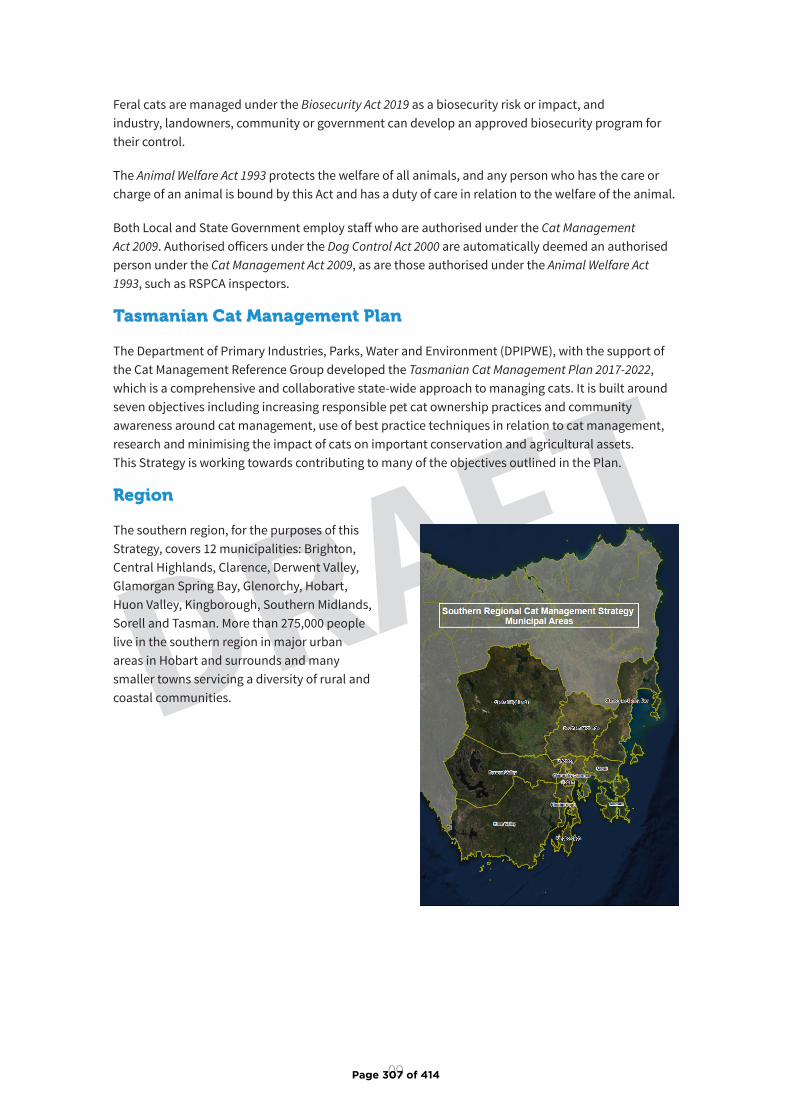
09
DRAFT
Feral cats are managed under the Biosecurity Act 2019 as a biosecurity risk or impact, and industry, landowners, community or government can develop an approved biosecurity program for their control.
The Animal Welfare Act 1993 protects the welfare of all animals, and any person who has the care or charge of an animal is bound by this Act and has a duty of care in relation to the welfare of the animal.
Both Local and State Government employ staff who are authorised under the Cat Management Act 2009. Authorised officers under the Dog Control Act 2000 are automatically deemed an authorised person under the Cat Management Act 2009, as are those authorised under the Animal Welfare Act 1993, such as RSPCA inspectors.
Tasmanian Cat Management Plan
The Department of Primary Industries, Parks, Water and Environment (DPIPWE), with the support of the Cat Management Reference Group developed the Tasmanian Cat Management Plan 2017-2022, which is a comprehensive and collaborative state-wide approach to managing cats. It is built around seven objectives including increasing responsible pet cat ownership practices and community awareness around cat management, use of best practice techniques in relation to cat management, research and minimising the impact of cats on important conservation and agricultural assets. This Strategy is working towards contributing to many of the objectives outlined in the Plan.
Region
The southern region, for the purposes of this Strategy, covers 12 municipalities: Brighton, Central Highlands, Clarence, Derwent Valley, Glamorgan Spring Bay, Glenorchy, Hobart, Huon Valley, Kingborough, Southern Midlands, Sorell and Tasman. More than 275,000 people live in the southern region in major urban areas in Hobart and surrounds and many smaller towns servicing a diversity of rural and coastal communities.
Page 307 of 414

10
DRAFT
This Strategy has been developed in the recognition that each participating organisation has different skills, knowledge, resources, priorities and responsibilities and that implementation roles need to be voluntary and flexible at the local level, while still achieving the vision and desired outcomes of the Strategy.
Ideally the Southern Regional Cat Management Coordinator will work with the Southern Cat Management Working Group to deliver the Strategy. The Cat Management Working Group meets several times a year and can act as a key mechanism in the delivery of the Strategy, including allowing for further detailed planning and implementation. However, if the Coordinator or Working Group are not operating, the Strategy provides direction for each stakeholder to be able to focus their cat management actions.
The Strategy is divided up into region-wide initiatives, and initiatives which individual organisations can implement. The individual initiatives allow participants to prioritise and plan for their own organisations and municipalities, while the region wide initiatives will require collaboration and resource sharing to deliver.
Progress of the Strategy should be reviewed jointly by Strategy participants annually and the Strategy updated every five years or if the Cat Management Act 2009 is amended.
4. Governance
Page 308 of 414
11
DRAFT
The primary cat management issues for Southern Tasmania to be addressed by this Strategy include:
1) Increasing education and awareness of responsible cat ownership
2) Protecting significant conservation, commercial and community assets
3) Reducing the stray cat population
4) Uncontrolled cat breeding and welfare concerns
5) Increasing cat management capacity and accessibility to cat management services throughout the region
6) Compliance in relation to the Cat Management Act 2009
7) Improved knowledge to better inform cat management
8) Strategic governance and resourcing
For each of the primary cat management areas of focus the Strategy identifies:
▶ essential background information (where are we now?)
▶ long-term desired outcome (where do we want to be?)
▶ an action plan to work towards achieving the desired outcome including:
proposed timeframe— short term [first year], medium term [2-3 years] and long term [4-5 years]
priority - including high, medium and low
and which of the key participant/s can deliver the action.
The Action Plan is divided into two sections, one for initiatives which individual organisations can implement, and one for region wide initiatives (how are we going to get there?), and
▶ performance indicators including targets and performance measures where possible (how will we know we are on track?)
There is little Tasmanian baseline data in relation to cat ownership practices, cat numbers and management, consequently, a focus of this Strategy is on gathering data before significant goals can be set. A report will need to be developed compiling the baseline data this Strategy will use to measure its performance indicators.
5. Areas of focus
Page 309 of 414

12
DRAFT
Background
A vital part of successfully managing cats relies on responsible cat ownership. More education needs to be undertaken to promote the benefits of desexing and microchipping to the general public. Desexing is essential to reduce the number of unexpected and unwanted kittens which often overwhelm cat management facilities and shelters during summer. In 2019 over 6,250 cats passed through cat management facilities and shelters in Tasmania. Promoting microchipping is also key as it significantly increases the chances of a lost pet cat being reunited with their owner.
Containment of pet cats to the owner’s property prevents cats from roaming and improves their wellbeing, whilst preventing them from killing Tasmania’s native wildlife or becoming a nuisance to their neighbours. One of the most regular complaints that Local and State Government receive in relation to cats is about nuisance caused by roaming cats.
The types of nuisance reported:
▶ Trespassing on property
▶ Defecating and urinating on property
▶ Attacking other pets including cats, rabbits, birds, dogs, chickens, and ducks
▶ Killing native wildlife
▶ Fighting at night and the noise affecting sleep of household members
▶ A dog defending its property against a visiting cat, resulting in the cat being injured or killed
▶ Dog barking as a result of visiting cat’s presence
▶ Risk of spreading toxoplasmosis through cat faeces in vegetable gardens and sandpits
Complaints about nuisance caused by pet cats can be complicated and very difficult to resolve. Containment to private property is expected for other domestic pets and is considered best practice when keeping cats, however it is not required under the Cat Management Act 2009. The Act does however provide for the protection of private property from stray and roaming cats. The Act permits landholders to trap a cat found on their private property providing the cat is either returned to its owner or taken to a cat management facility.
The most common reasons that cat owners cite for not practicing containment centre around ideas that cats need to wander to be happy and healthy; that there is a low risk of harm to cats when they roam; and that it is difficult to contain cats. However, vets and cat behaviourists agree that roaming increases the risk of injuries and disease transmission, and that cats can live happily at home if their needs are provided for. Education is needed to assist people in setting up containment solutions, transitioning roaming pet cats to staying safe at home, as well as how to best provide for their cat’s needs, enrichment and how to address behavioural issues.
Key components of responsible cat ownership include:
▶ Desexing cats by four months of age. ‘Early-age desexing’, which is the desexing of kittens between two to three months of age, should be encouraged because cats can become pregnant as early as
5.1 Increasing education and awareness of responsible cat ownership
Page 310 of 414
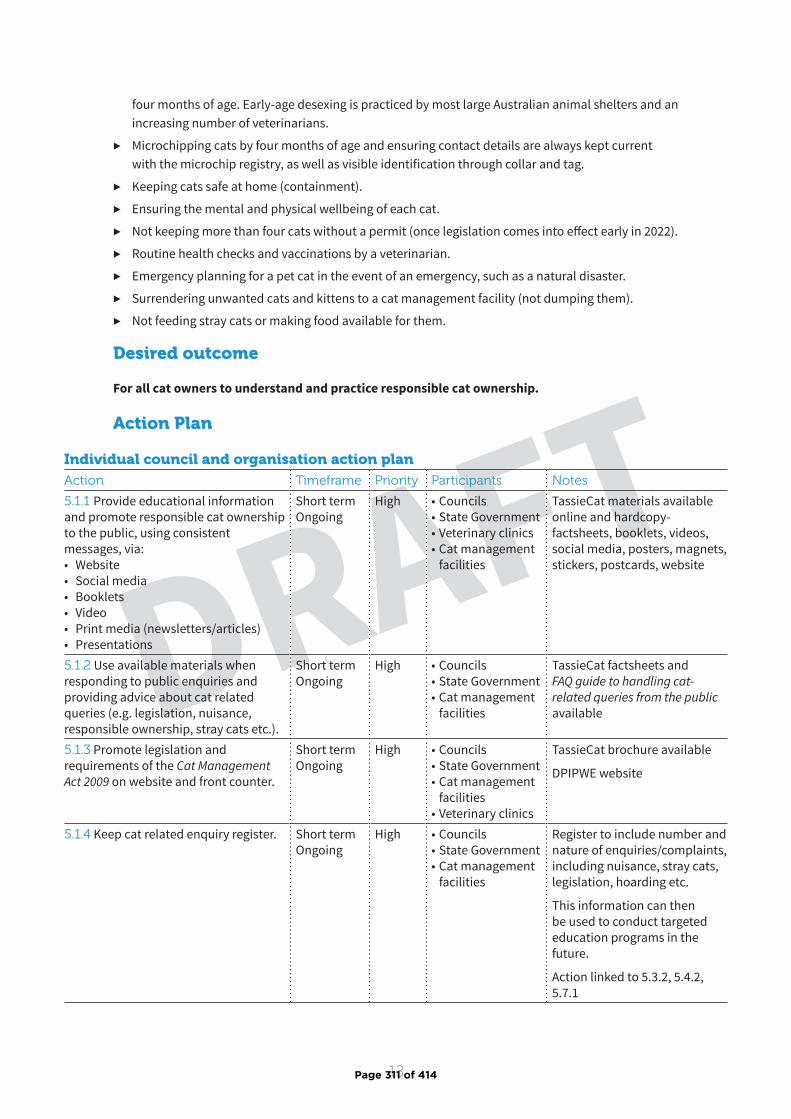
13
DRAFT
four months of age. Early-age desexing is practiced by most large Australian animal shelters and an increasing number of veterinarians.
▶ Microchipping cats by four months of age and ensuring contact details are always kept current with the microchip registry, as well as visible identification through collar and tag.
▶ Keeping cats safe at home (containment).
▶ Ensuring the mental and physical wellbeing of each cat.
▶ Not keeping more than four cats without a permit (once legislation comes into effect early in 2022).
▶ Routine health checks and vaccinations by a veterinarian.
▶ Emergency planning for a pet cat in the event of an emergency, such as a natural disaster.
▶ Surrendering unwanted cats and kittens to a cat management facility (not dumping them).
▶ Not feeding stray cats or making food available for them.
Desired outcome
For all cat owners to understand and practice responsible cat ownership.
Action Plan
Individual council and organisation action planAction Timeframe Priority Participants Notes
5.1.1 Provide educational information and promote responsible cat ownership to the public, using consistent messages, via: • Website• Social media• Booklets • Video• Print media (newsletters/articles)• Presentations
Short term Ongoing
High • Councils• State Government• Veterinary clinics• Cat management
facilities
TassieCat materials available online and hardcopy- factsheets, booklets, videos, social media, posters, magnets, stickers, postcards, website
5.1.2 Use available materials when responding to public enquiries and providing advice about cat related queries (e.g. legislation, nuisance, responsible ownership, stray cats etc.).
Short term Ongoing
High • Councils• State Government• Cat management
facilities
TassieCat factsheets and FAQ guide to handling cat-related queries from the public available
5.1.3 Promote legislation and requirements of the Cat Management Act 2009 on website and front counter.
Short term Ongoing
High • Councils• State Government• Cat management
facilities• Veterinary clinics
TassieCat brochure available
DPIPWE website
5.1.4 Keep cat related enquiry register. Short term Ongoing
High • Councils• State Government• Cat management
facilities
Register to include number and nature of enquiries/complaints, including nuisance, stray cats, legislation, hoarding etc.
This information can then be used to conduct targeted education programs in the future.
Action linked to 5.3.2, 5.4.2, 5.7.1
Page 311 of 414
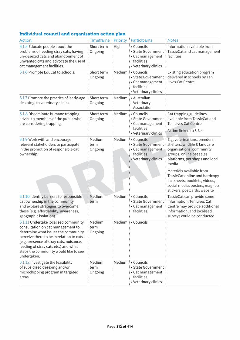
14
DRAFT
Individual council and organisation action planAction Timeframe Priority Participants Notes
5.1.5 Educate people about the problems of feeding stray cats, having un-desexed cats and abandonment of unwanted cats and advocate the use of cat management facilities.
Short term Ongoing
High • Councils• State Government• Cat management
facilities• Veterinary clinics
Information available from TassieCat and cat management facilities
5.1.6 Promote EduCat to schools. Short term Ongoing
Medium • Councils• State Government• Cat management
facilities• Veterinary clinics
Existing education program delivered in schools by Ten Lives Cat Centre
5.1.7 Promote the practice of ‘early-age desexing’ to veterinary clinics.
Short term Ongoing
Medium • Australian Veterinary Association
5.1.8 Disseminate humane trapping advice to members of the public who are considering trapping.
Short term Ongoing
Medium • Councils• State Government• Cat management
facilities• Veterinary clinics
Cat trapping guidelines available from TassieCat and Ten Lives Cat Centre
Action linked to 5.6.4
5.1.9 Work with and encourage relevant stakeholders to participate in the promotion of responsible cat ownership.
Medium term Ongoing
Medium • Councils• State Government• Cat management
facilities• Veterinary clinics
E.g. veterinarians, breeders, shelters, wildlife & landcare organisations, community groups, online pet sales platforms, pet shops and local media.
Materials available from TassieCat online and hardcopy- factsheets, booklets, videos, social media, posters, magnets, stickers, postcards, website
5.1.10 Identify barriers to responsible cat ownership in the community and explore strategies to overcome these (e.g. affordability, awareness, geographic isolation).
Medium term
Medium • Councils• State Government• Cat management
facilities
TassieCat can provide some information, Ten Lives Cat Centre may provide additional information, and localised surveys could be conducted
5.1.11 Undertake localised community consultation on cat management to determine what issues the community perceive there to be in relation to cats (e.g. presence of stray cats, nuisance, feeding of stray cats etc.) and what steps the community would like to see undertaken.
Medium term Ongoing
Medium • Councils
5.1.12 Investigate the feasibility of subsidised desexing and/or microchipping program in targeted areas.
Medium term Ongoing
Medium • Councils• State Government• Cat management
facilities • Veterinary clinics
Page 312 of 414
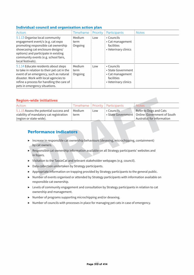
15
DRAFT
Individual council and organisation action planAction Timeframe Priority Participants Notes
5.1.13 Organise local community engagement event/s (e.g. cat expo promoting responsible cat ownership showcasing cat enclosure designs/options) and participate in existing community events (e.g. school fairs, local festivals).
Medium term Ongoing
Low • Councils• Cat management
facilities• Veterinary clinics
5.1.14 Educate residents about steps to take in relation to their pet cat in the event of an emergency, such as natural disaster. Work with local agencies to refine a process for handling the care of pets in emergency situations.
Medium term Ongoing
Low • Councils• State Government• Cat management
facilities• Veterinary clinics
Region-wide initiativesAction Timeframe Priority Participants Notes
5.1.15 Assess the potential success and viability of mandatory cat registration (region or state-wide).
Medium term
Low • Councils• State Government
Refer to Dogs and Cats Online (Government of South Australia) for information
Performance indicators
▶ Increase in responsible cat ownership behaviours (desexing, microchipping, containment) by cat owners.
▶ Responsible cat ownership information available on all Strategy participants’ websites and in foyers.
▶ Visitation to the TassieCat and relevant stakeholder webpages (e.g. council).
▶ Data collection undertaken by Strategy participants.
▶ Appropriate information on trapping provided by Strategy participants to the general public.
▶ Number of events organised or attended by Strategy participants with information available on responsible cat ownership.
▶ Levels of community engagement and consultation by Strategy participants in relation to cat ownership and management.
▶ Number of programs supporting microchipping and/or desexing.
▶ Number of councils with processes in place for managing pet cats in case of emergency.
Page 313 of 414
16
DRAFT
Background
Southern Tasmania contains many significant conservation, commercial and community assets that are impacted by domestic and stray roaming cats and may require specific cat management attention. These assets include:
▶ Areas of high environmental significance such as national parks, conservation reserves and other natural wildlife habitat areas that are home to native animals which are at risk from predation by cats and the spread of toxoplasmosis from cats.
▶ Valuable commercial assets such as agricultural areas with livestock, and aquaculture and abattoir operations. Livestock (particularly sheep) are susceptible to cat-borne disease, and operations such as aquaculture and abattoirs can be impacted by hygiene issues when cats congregate in an area.
▶ Community assets such as entertainment precincts (playgrounds, parks, BBQ areas), shops and built up areas, waste management facilities, and primary tourist attractions, which are at risk of nuisance and hygiene impacts from cats.
The Cat Management Act 2009 permits a person to trap a cat on their private property provided any cat trapped is returned to its owner; or taken to a cat management facility.
A cat found on private land that is more than 1 km from a place of residence; or on land used for primary production or a production premises such as an abattoir or aquaculture business, may be returned to its owner; taken to a cat management facility; or humanely destroyed.
The Act allows for cat management action (includes trap; seize, detain) to be undertaken by an authorised officer in a prohibited area which includes:
▶ any area of land that is managed by a public authority, or Agency within the meaning of the State Service Act 2000, and is reserved land1 ; and
▶ private land that is reserved land.
A cat trapped in a prohibited area by an authorised person may be returned to its owner; or taken to a cat management facility; or humanely destroyed.
The Act provides for Local Government, after consulting with its local community, to declare an area of council-controlled land as a prohibited area; or land within the municipal area of the council to be a cat management area. Cat management action and other measures may be undertaken by persons authorised to act in these areas.
Identifying which areas are a priority for protection from cats in municipalities is a key first step, which can then be followed by cat management activities in these priority areas. Activities could include
5.2 Protectingsignificantconservation,commercial and community assets
1 Reserved land includes reserved land under the Nature Conservation Act 2002; land subject to a conservation covenant under part 5 of the Nature Conservation Act 2002; public reserves under the Crown Lands Act 1976; permanent timber production zone land under the Forest Management Act 2013; and private timber reserves under the Forestry Practices Act 1985 .
Page 314 of 414
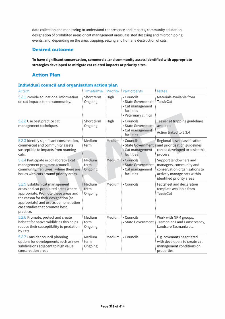
17
DRAFT
data collection and monitoring to understand cat presence and impacts, community education, designation of prohibited areas or cat management areas, assisted desexing and microchipping events, and, depending on the area, trapping, seizing and humane destruction of cats.
Desired outcome
To have significant conservation, commercial and community assets identified with appropriate strategies developed to mitigate cat related impacts at priority sites.
Action Plan
Individual council and organisation action planAction Timeframe Priority Participants Notes
5.2.1 Provide educational information on cat impacts to the community.
Short term Ongoing
High • Councils• State Government• Cat management
facilities• Veterinary clinics
Materials available from TassieCat
5.2.2 Use best practice cat management techniques.
Short term Ongoing
High • Councils• State Government• Cat management
facilities
TassieCat trapping guidelines available
Action linked to 5.3.4
5.2.3 Identify significant conservation, commercial and community assets susceptible to impacts from roaming cats.
Medium term
Medium • Councils• State Government• Cat management
facilities
Regional asset classification and prioritisation guidelines can be developed to assist this process
5.2.4 Participate in collaborative cat management programs (council, community, Ten Lives), where there are issues with cats around priority areas.
Medium term Ongoing
Medium • Councils• State Government• Cat management
facilities
Support landowners and managers, community and conservation organisations to actively manage cats within identified priority areas
5.2.5 Establish cat management areas and cat prohibited areas where appropriate. Promote these areas and the reason for their designation (as appropriate) and use as demonstration case studies that promote best practice.
Medium term Ongoing
Medium • Councils Factsheet and declaration template available from TassieCat
5.2.6 Promote, protect and create habitat for native wildlife as this helps reduce their susceptibility to predation by cats.
Medium term Ongoing
Medium • Councils• State Government
Work with NRM groups, Tasmanian Land Conservancy, Landcare Tasmania etc.
5.2.7 Consider council planning options for developments such as new subdivisions adjacent to high value conservation areas
Medium term Ongoing
Medium • Councils E.g. covenants negotiated with developers to create cat management conditions on properties
Page 315 of 414

18
DRAFTPerformance indicators
▶ Regional guidelines for the classification and prioritisation of priority assets created.
▶ Asset protection planning undertaken by Strategy participants and maps of priority assets created for municipalities.
▶ Number of partnerships between Strategy participants and other stakeholders working on cat management programs in priority areas.
▶ Number of programs underway by Strategy participants to manage cats in relation to priority assets.
Region-wide initiativesAction Timeframe Priority Participants Notes
5.2.8 Develop regional guidelines for the classification of conservation, commercial and community assets that are susceptible to impacts from roaming cats.
Short term High • Councils• State Government• Cat management
facilities
Consider development of guidelines at a state-wide level to ensure consistency
Page 316 of 414
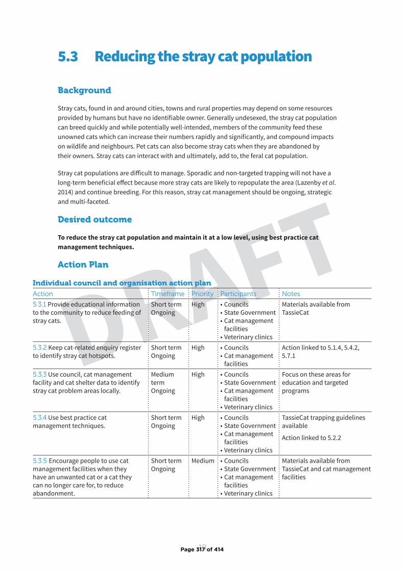
19
DRAFT
Background
Stray cats, found in and around cities, towns and rural properties may depend on some resources provided by humans but have no identifiable owner. Generally undesexed, the stray cat population can breed quickly and while potentially well-intended, members of the community feed these unowned cats which can increase their numbers rapidly and significantly, and compound impacts on wildlife and neighbours. Pet cats can also become stray cats when they are abandoned by their owners. Stray cats can interact with and ultimately, add to, the feral cat population.
Stray cat populations are difficult to manage. Sporadic and non-targeted trapping will not have a long-term beneficial effect because more stray cats are likely to repopulate the area (Lazenby et al . 2014) and continue breeding. For this reason, stray cat management should be ongoing, strategic and multi-faceted.
Desired outcome
To reduce the stray cat population and maintain it at a low level, using best practice cat management techniques.
5.3 Reducing the stray cat population
Action Plan
Individual council and organisation action planAction Timeframe Priority Participants Notes
5.3.1 Provide educational information to the community to reduce feeding of stray cats.
Short term Ongoing
High • Councils• State Government• Cat management
facilities• Veterinary clinics
Materials available from TassieCat
5.3.2 Keep cat-related enquiry register to identify stray cat hotspots.
Short term Ongoing
High • Councils• Cat management
facilities
Action linked to 5.1.4, 5.4.2, 5.7.1
5.3.3 Use council, cat management facility and cat shelter data to identify stray cat problem areas locally.
Medium term Ongoing
High • Councils• State Government• Cat management
facilities• Veterinary clinics
Focus on these areas for education and targeted programs
5.3.4 Use best practice cat management techniques.
Short term Ongoing
High • Councils• State Government• Cat management
facilities• Veterinary clinics
TassieCat trapping guidelines available
Action linked to 5.2.2
5.3.5 Encourage people to use cat management facilities when they have an unwanted cat or a cat they can no longer care for, to reduce abandonment.
Short term Ongoing
Medium • Councils• State Government• Cat management
facilities• Veterinary clinics
Materials available from TassieCat and cat management facilities
Page 317 of 414

20
DRAFTRegion-wide initiativesAction Timeframe Priority Participants Notes
5.3.9 Work collaboratively to identify potential partners, locations and arrangements for increased access to cat management services across the region to facilitate cat management programs.
Medium term Ongoing
High • Councils• State Government• Cat management
facilities• Veterinary clinics
Linked to action 5.5.5
5.3.10 Develop best practice stray cat management guidelines.
Medium term Ongoing
Medium • Councils• State Government• Cat management
facilities• Veterinary clinics
In consultation with experts, investigate options to address the stray cat population and identify when trapping or other management techniques could be used effectively and sustainably
Individual council and organisation action planAction Timeframe Priority Participants Notes
5.3.6 Provide advice on dealing with cat behavioural issues to reduce the need for surrender of cats.
Short term Ongoing
Medium • Cat management facilities
• Veterinary clinics
Materials available from TassieCat
5.3.7 Inform the public about the requirements of the Cat Management Act 2009 and Animal Welfare Act 1993; it is illegal to abandon cats.
Short term Ongoing
Medium • Councils• State Government• Cat management
facilities
Materials available from TassieCat
5.3.8 Participate in collaborative cat management programs (council, community, Ten Lives Cat Centre), where there are issues with stray cats.
Medium term Ongoing
Medium • Councils• State Government• Cat management
facilities• Veterinary clinics
Performance indicators
▶ Data collection undertaken by Strategy participants in relation to stray cat complaints and feeding of stray cats.
▶ Identify stray cat hotspot areas in the southern region.
▶ Number of cat management programs undertaken by Strategy participants in stray cat hotspot areas.
▶ A reduction in stray cat issues in hot spot areas where cat management programs have been undertaken.
Page 318 of 414
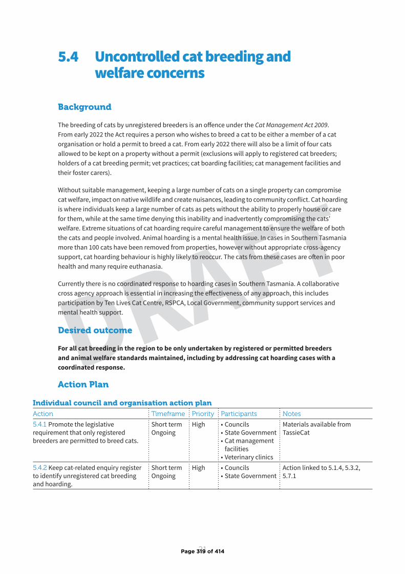
21
DRAFT
Background
The breeding of cats by unregistered breeders is an offence under the Cat Management Act 2009 . From early 2022 the Act requires a person who wishes to breed a cat to be either a member of a cat organisation or hold a permit to breed a cat. From early 2022 there will also be a limit of four cats allowed to be kept on a property without a permit (exclusions will apply to registered cat breeders; holders of a cat breeding permit; vet practices; cat boarding facilities; cat management facilities and their foster carers).
Without suitable management, keeping a large number of cats on a single property can compromise cat welfare, impact on native wildlife and create nuisances, leading to community conflict. Cat hoarding is where individuals keep a large number of cats as pets without the ability to properly house or care for them, while at the same time denying this inability and inadvertently compromising the cats’ welfare. Extreme situations of cat hoarding require careful management to ensure the welfare of both the cats and people involved. Animal hoarding is a mental health issue. In cases in Southern Tasmania more than 100 cats have been removed from properties, however without appropriate cross-agency support, cat hoarding behaviour is highly likely to reoccur. The cats from these cases are often in poor health and many require euthanasia.
Currently there is no coordinated response to hoarding cases in Southern Tasmania. A collaborative cross agency approach is essential in increasing the effectiveness of any approach, this includes participation by Ten Lives Cat Centre, RSPCA, Local Government, community support services and mental health support.
Desired outcome
For all cat breeding in the region to be only undertaken by registered or permitted breeders and animal welfare standards maintained, including by addressing cat hoarding cases with a coordinated response.
5.4 Uncontrolled cat breeding and welfare concerns
Action Plan
Individual council and organisation action planAction Timeframe Priority Participants Notes
5.4.1 Promote the legislative requirement that only registered breeders are permitted to breed cats.
Short term Ongoing
High • Councils• State Government• Cat management
facilities• Veterinary clinics
Materials available from TassieCat
5.4.2 Keep cat-related enquiry register to identify unregistered cat breeding and hoarding.
Short term Ongoing
High • Councils• State Government
Action linked to 5.1.4, 5.3.2, 5.7.1
Page 319 of 414
22
DRAFT
Individual council and organisation action planAction Timeframe Priority Participants Notes
5.4.3 Liaise with RSPCA on suspected animal cruelty cases where necessary.
Short term Ongoing
High • Councils• State Government• Cat management
facilities• RSPCA• Veterinary clinics
5.4.4 Work collaboratively with other key stakeholders in identified cat hoarding situations (RSPCA, Ten Lives, council, community services and mental health services).
Medium term Ongoing
Medium • Councils• State Government• Cat management
facilities• RSPCA
Region-wide initiativesAction Timeframe Priority Participants Notes
5.4.5 Establish a Hoarding and Squalor Working Group. Develop a process for managing cat hoarding and feeding situations involving key stakeholders that is proactive and integrated.
Medium term
Medium • Councils• State Government• Cat management
facilities• RSPCA
Performance indicators
▶ Data collection undertaken by Strategy participants in relation to unregistered cat breeding and hoarding complaints.
▶ Establish a Hoarding and Squalor Working Group with participation from key stakeholders.
▶ Regional process established by Strategy participants in relation to cat hoarding cases.
▶ Documented case studies of successful approaches to cat hoarding situations.
▶ An increase in a collaborative approach undertaken by Strategy participants and other stakeholders for cat hoarding cases.
Page 320 of 414
23
DRAFTBackground
Responsibility for cat management in Southern Tasmania is shared across many organisations and is often undertaken as part of a broader range of responsibilities. Currently, resources for cat management in each individual organisation and State and Local Government area can be limited and a collaborative approach that makes best use of existing resources and expertise is considered essential. Staff working in animal management, such as council Animal Management Officers, will need additional training over time in relation to cat management.
Currently there is only one cat management facility in Southern Tasmania, Ten Lives Cat Centre, located in Hobart’s northern suburbs. Several of the southern council areas are over one hours’ drive to Ten Lives Cat Centre, which makes movement of unowned or unwanted cats and kittens challenging for the public, veterinary clinics, and councils.
Cat management facilities can be established to receive stray, lost and surrendered cats. Cat management facilities are approved by the State Government and must meet certain requirements. The Cat Management Act 2009 provides for cat management facilities to nominate a person, business, or organisation to hold and care for cats on their behalf.
Currently there are also several cat shelters in Southern Tasmania who take in unwanted or unowned cats, however they often reach capacity during kitten season. Southern shelters need to be supported to ensure they are reaching acceptable standards of care for the cats they take in, which will make partnerships between councils and shelters low risk and more appealing.
There are several models which may be used to increase accessibility to cat management services through the region. These options need to be further explored but could utilise short-term cat holding facilities, voluntary carers and transporters, local veterinary clinics or a mobile cat facility which could enable rural and remote communities to access cat management facility services more easily. Potential collaborative cost-sharing arrangements across the region could make such an approach sustainable.
Many veterinary practices currently receive healthy lost or stray cats from the community which they temporarily house and attempt to find the owners. The preferred practice is for these animals to be presented directly to a cat management facility as soon as practicable, as veterinarian clinics are not set up to adopt out or foster cats.
Desired outcome
To increase cat management capacity and access to cat management services across the region, ensuring rural and remote communities have access to services.
5.5 Increasing cat management capacity and accessibility to cat management services throughout the region
Page 321 of 414
24
DRAFT
Action Plan
Individual council and organisation action planAction Timeframe Priority Participants Notes
5.5.1 Promote the use of cat management facilities (and their nominees) to the community.
Short term Ongoing
High • Councils• State Government• Cat management
facilities• Veterinary clinics
Materials available from TassieCat and cat management facilities
5.5.2 Relevant staff (animal management officers etc.) participate in training to support implementation of the Cat Management Act 2009 .
Short term Ongoing
High • Councils• State Government• Cat management
facilities
Training provided by DPIPWE
Action linked to 5.6.2
5.5.3 Prior to any trapping activities occurring, establish an agreed and planned approached for trapping and dealing with cats, using best practice trapping & cat management techniques.
Short term Ongoing
High • Councils• State Government• Cat management
facilities
TassieCat trapping guidelines available
5.5.4 Establish a Memorandum of Understanding that delivers an agreed and clear process for managing stray, lost or surrendered cats.
Medium Medium • Councils• Cat management
facilities
Region-wide initiativesAction Timeframe Priority Participants Notes
5.5.5 Identify potential partners, locations and arrangements for increased access to cat management services for municipalities that aren’t located near a cat management facility.
Short term Ongoing
High • Councils• State Government• Cat management
facilities• Veterinary clinics
Options to explore include a temporary cat holding facility, cat drop off points, volunteer provided cat transportation services and a mobile cat facility
5.5.6 Where appropriate promote the Standards of Care required for cat management facilities.
Medium term
Medium • State Government• Cat management
facilities• Councils
Standards of Care developed by cat management facilities and DPIPWE
This document could be used by shelters as a cat welfare guide
5.5.7 Support progress towards an accreditation process for cat shelters to meet the Standards of Care.
Medium term
Medium • State Government• Cat management
facilities• Councils
5.5.8 Consider employing a Cat Management Officer shared between several councils, sharing vehicles and equipment as appropriate.
Medium term Ongoing
Medium • Councils• State Government• Cat management
facilities
Use a collaborative approach across the region to make best use of available resources and expertise
Page 322 of 414

25
DRAFT
Performance indicators
▶ Feasibility assessed of proposed options to increase accessibility of cat management services in regional areas.
▶ Preferred option to increase access to cat management services for regional areas identified and commenced.
▶ Number of partnerships between Strategy participants and other stakeholders working on cat management in the region.
▶ Participation by Strategy participants at Cat Management Act 2009 training sessions.
Page 323 of 414
26
DRAFT
Background
The purpose of the Cat Management Act 2009 is to provide for the control and management of cats in Tasmania. Councils may establish additional requirements for their municipality in relation to cat management through by-laws or the creation of cat prohibited areas or cat management areas.
Key aspects of the Act include:
▶ Compulsory de-sexing of cats from four months of age from early 2022.
▶ Compulsory microchipping from four months of age from early 2022.
▶ Limiting to four, the maximum number of cats to be kept at a property without a permit from early 2022.
▶ Cats cannot be sold or given away unless they are at least eight weeks of age, desexed, microchipped, wormed and vaccinated.
▶ Only registered or permitted breeders may breed cats.
▶ It is an offence to abandon a cat.
Enforcement may be performed by persons authorised under the Act. This includes persons authorised under the Dog Control Act 2000; officers appointed under the Animal Welfare Act 1993; DPIPWE officers authorised by the Secretary; non-State Service officers authorised by the Secretary of DPIPWE; and police officers.
Each council determines how much compliance they will undertake within their municipality in relation to the Cat Management Act 2009; this will depend on what each municipality can resource and sustain.
Desired outcome
For all cat owners and community members to comply with their legal obligations for responsible cat ownership and management.
5.6 Compliance in relation to the Cat Management Act 2009
Action Plan
Individual council and organisation action planAction Timeframe Priority Participants Notes
5.6.1 Inform the public about the requirements of the Cat Management Act 2009 .
Short term Ongoing
High • State Government• Councils• Cat management
facilities• Veterinary clinics
Use clear and consistent communications across multiple channels to promote cat ownership responsibilities.
Materials available from TassieCat
Page 324 of 414
27
DRAFT
Individual council and organisation action planAction Timeframe Priority Participants Notes
5.6.2 Participate in relevant training to support implementation of the Cat Management Act 2009 including for animal management officers and other relevant staff.
Short term Ongoing
High • State Government• Councils• Cat management
facilities
DPIPWE to provide training sessions.
Broader compliance training is an important component of this action.
Action linked to 5.5.25.6.3 Undertake standardised data collection in relation to compliance actions under the Cat Management Act 2009 .
Short term Ongoing
High • Councils• State Government• Cat management
facilities5.6.4 Disseminate humane trapping advice to members of the public who are considering trapping.
Short term Ongoing
High • Councils• State Government• Cat management
facilities• Veterinary clinics
Cat trapping guidelines available from TassieCat and Ten Lives Cat Centre
Action linked to 5.1.8
5.6.5 Consider the development of a Cat Management Policy, compliance program, and by-laws as appropriate.
Medium term Ongoing
Medium • Councils Materials available from TassieCat
Action linked to 5.6.6 and 5.8.5
Region-wide initiativesAction Timeframe Priority Participants Notes
5.6.6 Work on region wide consistency where possible in compliance approaches, policies and bylaws.
Medium term Ongoing
Medium • Councils• State Government
Action linked to 5.6.5 and 5.8.5
Performance indicators
▶ Data collection undertaken by Strategy participants in relation to compliance undertaken under the Cat Management Act 2009 .
▶ Cat Management Act 2009 information available on all Strategy participants’ websites and in foyers.
▶ Participation by Strategy participants at Cat Management Act 2009 training sessions.
▶ Number of Strategy participants undertaking cat compliance activities.
▶ Number of councils that have introduced cat management policies or by-laws.
Page 325 of 414
28
DRAFT
Background
Improved knowledge about the number, distribution and behaviour of cats and the success of different management approaches is essential to designing effective programs to manage and minimise their impact on highly valued conservation, commercial and community assets in the region and generally achieve responsible cat ownership and management.
Existing research about cats and cat ownership in Tasmania is limited. Filling these gaps in knowledge will be a continuing challenge to ensure that available resources are directed towards the highest priorities using the most cost-effective management actions. Consistent approaches to collecting basic information across all parts of the region will be an important first step to better understand the scale of existing problems and to identify practical long-term solutions.
Desired outcome
To have cat management in the region guided by best available science and regionally-relevant data to support evidence-based decision making.
5.7 Improved knowledge to better inform cat management
Action Plan
Individual council and organisation action planAction Timeframe Priority Participants Notes
5.7.1 Keep cat-related enquiry register to track number and nature of enquiries and complaints.
Short term Ongoing
High • Councils• State Government• Cat management
facilities
Register to include number and nature of enquiries/complaints, including nuisance, stray cats, legislation, hoarding, breeding etc.
Action linked to 5.1.4, 5.3.2, 5.4.2
5.7.2 Where possible identify and implement monitoring strategies before, during and after interventions (e.g. subsidised desexing/microchipping & education) to measure impact and effectiveness.
Medium term Ongoing
Medium • Councils• State Government• Cat management
facilities
5.7.3 Participate in research projects (including citizen science projects such as cat tracker projects) concerning cat ecology, behaviour and management where possible.
Medium term Ongoing
Medium • Councils• State Government• Cat management
facilities
5.7.4 Better understand community views and expectations relating to cat management via local community survey and events.
Medium term Ongoing
Medium • Councils• State Government• Cat management
facilities
Page 326 of 414
29
DRAFT
Region-wide initiativesAction Timeframe Priority Participants Notes
5.7.5 Work towards standard data collection and reporting systems so that organisations involved in cat management have access to essential information. Create baseline data to inform and integrate into future Strategy revisions.
Short term Ongoing
High • Councils• State Government• Cat management
facilities • Veterinary clinics
E.g. intake numbers in cat management facilities & shelters, stray cat hotspots areas, number and nature of cat complaints/queries
5.7.6 Keep abreast of state-wide and national developments and continually improve evidence-based decision making for cat management.
Short term Ongoing
Medium • Councils• State Government• Cat management
facilities5.7.7 Identify priority knowledge gaps and pragmatic options to fill these gaps with research and monitoring (e.g. facilitating university projects).
Medium term Ongoing
Medium • Councils• State Government• Cat management
facilities
E.g. presence and impact of stray and pet cats in region and cases of cat hoarding
5.7.8 Disseminate information and case studies about cat management activities that have been undertaken, to share effective approaches and learnings.
Medium term Ongoing
Medium • Councils• State Government• Cat management
facilities
Performance indicators
▶ Strategy participants undertaking data collection and reporting in relation to number and nature of cat related enquiries, complaints and interactions to help create baseline cat management data.
▶ Participation in monitoring and research projects by Strategy participants in relation to cat management.
▶ Levels of community consultation/survey by Strategy participants in relation to community views on cat ownership and management.
Page 327 of 414
30
DRAFT
Background
This Strategy recognises that the twelve councils of the southern region and other key stakeholders will have different priorities, capabilities, and resources for cat management. This Strategy adopts an opt-in approach which enables all councils and other stakeholders to participate in cat management to the extent that they require and are able to resource, while keeping them aligned with the actions of the others in the region.
The Strategy identifies initiatives which individual councils and other stakeholders can implement for their own area or organisation, as well as region-wide initiatives which will require collaboration. Cat management will be most successful in the southern region if there is regional collaboration on the issue.
Desired outcome
For the Southern Cat Management Strategy to be successfully delivered across the region by Strategy participants.
5.8 Strategic governance and resourcing
Action Plan
Individual council and organisation action planAction Timeframe Priority Participants Notes
5.8.1 Seek ongoing funding for the Regional Cat Management Coordinator.
Short term (currently funded until 30 June 2021)
High • Councils• State Government• Cat management
facilities
5.8.2 Consider and prioritise resourcing for cat management.
Short term Ongoing
High • Councils• State Government
Resourcing will be required to deliver this Strategy
5.8.3 Ongoing commitment to regional collaboration in relation to cat management.
Short term Ongoing
High • Councils• State Government• Cat management
facilities• Veterinary clinics
5.8.4 Continue providing a representative for the Southern Cat Management Working Group.
Short term Ongoing
High • Councils• State Government• Cat management
facilities• Veterinary clinics
5.8.5 Consider development and adoption of a council Cat Management Policy.
Short term Ongoing
Medium • Councils Policy template available from TassieCat
Action linked to 5.6.5 and 5.6.6
Page 328 of 414

31
DRAFT
Region-wide initiativesAction Timeframe Priority Participants Notes
5.8.6 Review and report on the implementation of this Cat Management Strategy to the southern councils’ General Managers.
Medium term Ongoing
Medium • Councils• State Government• Cat management
facilities
General Manager review should occur in the third and fifth years of the Strategy
Performance indicators
▶ Southern Cat Management Working Group continued with active participation by Strategy participants.
▶ Number of councils that have introduced cat management policies.
▶ Increased commitment to resourcing by Strategy participants for cat management in the region.
Page 329 of 414
32
DRAFTTassieCat resources available for Strategy participants
▶ TassieCat website www.tassiecat.com
▶ FAQ guide to handling cat-related queries from the public
▶ Cat Management Policy template
▶ Cat Prohibited Areas and Cat Management Areas factsheet and declaration template
▶ TassieCat social media content (Facebook and Instagram)
▶ Posters and postcards
▶ Stickers and magnets
▶ That’s Cats adverts and videos
▶ Tassiecat booklets, factsheets and fliers
▶ Keeping your cat healthy and happy at home
▶ Desexing and microchipping your cat
▶ Nuisance Cats
▶ Roaming Cats: common questions and misbeliefs
▶ Legislation for Cat Owners in Tasmania
▶ Guidelines for cat trapping
▶ Home, Sweet Home: How to keep your cat happy at home
▶ For the love of cats: important information you need to know as a cat owner in Tasmania
▶ 5 Common Cat Behavioural Issues and how to solve them
▶ Keeping your cat healthy: vaccinating your cat and information on feline immunodeficiency virus and feline leukemia virus
▶ Cat-Borne Disease: the impacts of toxoplasmosis on wildlife and human heath
▶ Cat-Borne Diseases and Agriculture
▶ Surrendering a pet cat
▶ Stray cats
▶ Introducing a new cat into the household: tips and tricks
▶ How to train your cat to walk on a leash and harness
▶ Enrichment: Make staying at home fun for your cat
Other resources
▶ Department of Primary Industries, Parks, Water and Environment
▶ Ten Lives - website and Educat school program
▶ RSPCA Tasmania and RSCPA Australia
▶ Kingborough Council - Inside with Cats and At Home with Cats educational videos
▶ Safe and Happy Cats
▶ Safe Cat, Safe Wildlife
6. Resources and References
Page 330 of 414

33
DRAFT
References
Legge S., Woinarski J., Dickman C., Murphy B., Woolley L. & Calver M. 2020. We need to worry about Bella and Charlie: the impacts of pet cats on Australian wildlife. Wildlife Research 47, 523-539.
Department of Primary Industries, Parks, Water and Environment. 2015. Unpublished assessment.
Sumner B. & Ackland M. 1999. Toxoplasma gondii antibody in domestic cats in Melbourne. Australian Veterinary Journal 77, 447-449.
Roetman P., Tindle H., Litchfield C., Chiera B., Quinton G., Kikillus H., Bruce D. & Kays R. 2017. Cat Tracker South Australia: Understanding pet cats through citizen science. Discovery Circle initiative, University of South Australia, Adelaide.
Animal Medicines Australia. 2019. Pets in Australia: A national survey of pets and people. Animal Medicines Australia: Canberra, ACT, Australia.
Lazenby B., Mooney N., & Dickman C. 2014. Effects of low-level culling of feral cats in open populations: a case study from the forests of southern Tasmania. Wildlife Research 41,407-420.
Page 331 of 414
Adopted: ***** 2021
GLAMORGAN SPRING BAY COUNCIL
STRATEGIC ASSET MANAGEMENT PLAN
DRAFT
Page 332 of 414
Agenda Item 8.5 - Attachment 1
Strategic Asset Management Plan
2
Document Control Strategic Asset Management Plan
Document ID :
Rev No Date Revision Details Author Reviewer Approver
1 May 2021 Draft VB PP/GI GI
This Strategic Asset Management Plan is an overarching asset management plan largely informed by Council’s
individual Asset Management Plans for the five major asset classes (Road Infrastructure, Buildings, Hydraulic
Infrastructure, Coastal Infrastructure and Parks & Recreation) and Council’s Long Term Financial Plan.
© Copyright 2019 – All rights reserved
The Institute of Public Works Engineering Australasia
Page 333 of 414
Strategic Asset Management Plan
3
Contents
1.0 EXECUTIVE SUMMARY ...................................................................................................................... 5
2.0 ASSET MANAGEMENT STRATEGY ..................................................................................................... 9
2.1 Asset management system ..................................................................................................................... 9
2.2 What assets do we have? ..................................................................................................................... 12
2.3 Our assets and their management ....................................................................................................... 14
2.4 Where do we want to be? .................................................................................................................... 24
2.5 Asset management vision ..................................................................................................................... 27
2.6. How will we get there? ......................................................................................................................... 28
2.7 Asset management improvement plan ................................................................................................ 29
2.8. Consequences if improvement actions are not completed .................................................................. 29
3.0 LEVELS OF SERVICE ......................................................................................................................... 30
3.1 Level of service ..................................................................................................................................... 30
3.2 Community research and expectations ................................................................................................ 30
3.3 Legislative requirements ...................................................................................................................... 31
3.4 Customer values ................................................................................................................................... 31
4.0 FUTURE DEMAND ........................................................................................................................... 33
4.1 Demand drivers .................................................................................................................................... 33
4.2 Demand forecast .................................................................................................................................. 33
4.3 Demand impact on assets and demand management plan ................................................................. 33
4.4 Asset programs to meet demand ......................................................................................................... 34
4.5 Climate change adaptation ................................................................................................................... 35
5.0 LIFECYCLE MANAGEMENT PLAN ..................................................................................................... 37
5.1 Background data ................................................................................................................................... 37
5.2 Routine operation and maintenance plan ............................................................................................ 37
5.3 Renewal plan ........................................................................................................................................ 39
5.4 Acquisition plan .................................................................................................................................... 40
5.5 Disposal plan ......................................................................................................................................... 43
6.0 RISK MANAGEMENT PLANNING ..................................................................................................... 45
6.1 Critical assets ........................................................................................................................................ 45
Page 334 of 414
Strategic Asset Management Plan
4
6.2 Risk assessment .................................................................................................................................... 46
6.4 Service and risk trade-offs .................................................................................................................... 47
7.0 FINANCIAL SUMMARY .................................................................................................................... 49
7.1 Financial indicators and projections ..................................................................................................... 49
7.2 Funding strategy ................................................................................................................................... 49
7.3 Valuation forecasts ............................................................................................................................... 50
7.4 Key forecast assumptions ..................................................................................................................... 51
7.5 Forecast reliability and confidence ....................................................................................................... 52
8.0 IMPROVEMENT PLAN ..................................................................................................................... 54
8.1 Status of asset management practices ................................................................................................. 54
8.2 Improvement plan ................................................................................................................................ 54
8.3 Monitoring and review procedures ...................................................................................................... 56
8.4 Performance measures ......................................................................................................................... 57
9.0 REFERENCES ................................................................................................................................... 58
10.0 APPENDICES ................................................................................................................................... 59
Appendix A Summary Technical Levels of Service ............................................................................................ 60
Appendix B Operation and Maintenance Forecast Summary ........................................................................... 70
Appendix C Renewal Forecast Summary ........................................................................................................... 71
Appendix D Acquisition Forecast Summary ...................................................................................................... 75
Appendix E Deferred Works Summary .............................................................................................................. 78
Appendix F Risk and Treatment Plans ............................................................................................................... 79
Page 335 of 414
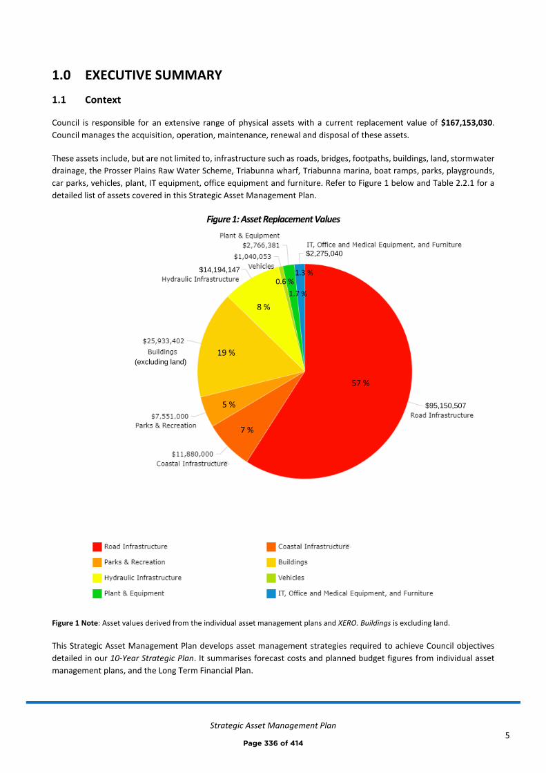
Strategic Asset Management Plan
5
1.0 EXECUTIVE SUMMARY
1.1 Context
Council is responsible for an extensive range of physical assets with a current replacement value of $167,153,030.
Council manages the acquisition, operation, maintenance, renewal and disposal of these assets.
These assets include, but are not limited to, infrastructure such as roads, bridges, footpaths, buildings, land, stormwater
drainage, the Prosser Plains Raw Water Scheme, Triabunna wharf, Triabunna marina, boat ramps, parks, playgrounds,
car parks, vehicles, plant, IT equipment, office equipment and furniture. Refer to Figure 1 below and Table 2.2.1 for a
detailed list of assets covered in this Strategic Asset Management Plan.
Figure 1: Asset Replacement Values
Figure 1 Note: Asset values derived from the individual asset management plans and XERO. Buildings is excluding land.
This Strategic Asset Management Plan develops asset management strategies required to achieve Council objectives
detailed in our 10-Year Strategic Plan. It summarises forecast costs and planned budget figures from individual asset
management plans, and the Long Term Financial Plan.
5 %
7 %
57 %
19 %
8 %
1.3 %
1.7 %
0.6 %
$2,275,040
(excluding land)
$14,194,147
$95,150,507
Page 336 of 414
Strategic Asset Management Plan
6
1.2 Current situation
Council is in the early stages of the journey towards achieving best practice asset management. Significant progress has
been made over the past year with the development and adoption of the following key asset management documents:
• Asset Management Policy
• Strategic Asset Management Plan (this plan)
• Long Term Financial Plan
• Asset Management Plans for our five major asset classes (96 % of Council’s total asset value):
o Road Infrastructure
o Buildings
o Hydraulic Infrastructure
o Coastal Infrastructure
o Parks & Recreation
Our aim is to achieve ‘core’ maturity for asset management activities by 2025, and then continue maturity improvement
where benefits exceed cost. Improvement tasks and target dates have been identified and documented in Table 8.2.
1.3 Forecast costs vs planned budget
Operation and Maintenance
The forecast operation and maintenance cost (for the five major asset classes) is $4,090,076 on average per year over
the planning period, whilst the planned budget for operation and maintenance is $3,829,489 on average per year.
This results in a shortfall of $260,590 on average per year, and a funding ratio of 93 %.
Renewal and Acquisition
The forecast renewal and acquisition cost (for the five major asset classes) is $2,885,021 on average per year over the
planning period, whilst the planned budget for renewals and acquisitions is $2,528,014 on average per year.
This results in a shortfall of $357,007 on average per year, and a funding ratio of 88 %.
Total Lifecycle (Acquisition, Operation, Maintenance, Renewal, Disposal)
The forecast total lifecycle cost (for the five major asset classes) is $6,725,127 on average per year over the planning
period, whilst the total lifecycle planned budget is $6,027,362 on average per year.
This results in a total shortfall of $697,765 on average per year, and a funding ratio of 90 %. Refer Figure 1.1 below.
We have balanced the forecast costs in the Strategic Asset Management Plan with the planned budget from the Long
Term Financial Plan, this has involved:
• providing desirable and affordable levels of service
• balancing service performance, risk and cost in a trade-off of with desired asset lifecycle activities (acquisitions,
operations, maintenance, renewal, disposal)
• considering the impact of trade-offs and accepting the service and risk consequences
Page 337 of 414
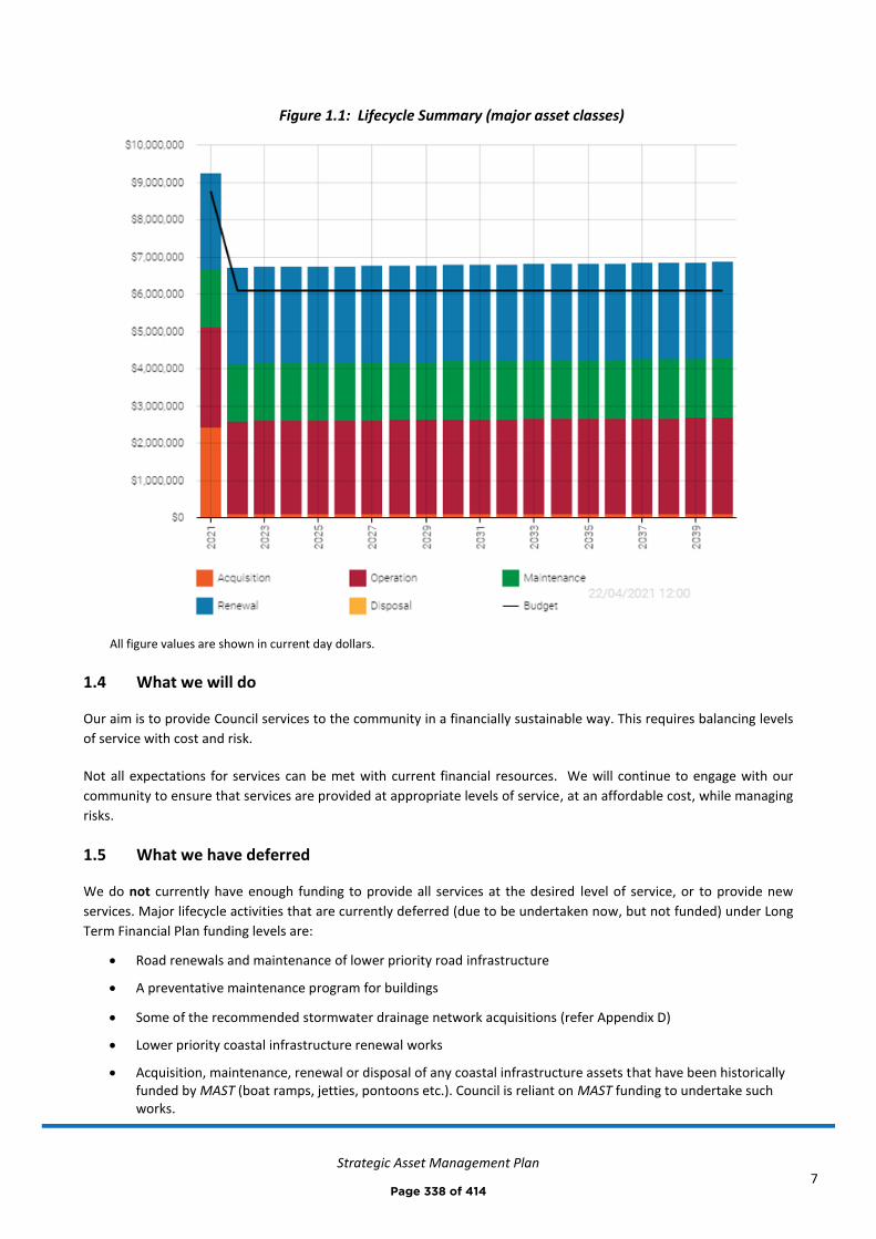
Strategic Asset Management Plan
7
Figure 1.1: Lifecycle Summary (major asset classes)
All figure values are shown in current day dollars.
1.4 What we will do
Our aim is to provide Council services to the community in a financially sustainable way. This requires balancing levels
of service with cost and risk.
Not all expectations for services can be met with current financial resources. We will continue to engage with our
community to ensure that services are provided at appropriate levels of service, at an affordable cost, while managing
risks.
1.5 What we have deferred
We do not currently have enough funding to provide all services at the desired level of service, or to provide new
services. Major lifecycle activities that are currently deferred (due to be undertaken now, but not funded) under Long
Term Financial Plan funding levels are:
• Road renewals and maintenance of lower priority road infrastructure
• A preventative maintenance program for buildings
• Some of the recommended stormwater drainage network acquisitions (refer Appendix D)
• Lower priority coastal infrastructure renewal works
• Acquisition, maintenance, renewal or disposal of any coastal infrastructure assets that have been historically funded by MAST (boat ramps, jetties, pontoons etc.). Council is reliant on MAST funding to undertake such works.
Page 338 of 414
Strategic Asset Management Plan
8
• The previously proposed Spring Bay Harbour Expansion project (Triabunna wharf and marina expansion)
• Lower priority renewals for parks and recreation assets
1.6 Managing the risks
Major risks associated with the provision of assets and services included in this plan are detailed in Appendix F, however
the most critical risks are detailed below:
• Lack of proper asset management
• Loss of key staff and knowledge
• Acquisitions where no lifecycle costs have been accounted for in the Long Term Financial Plan
• Lack of acquisition, maintenance and renewal plans for all asset classes
• Financial risks associated with the Prosser Plains Raw Water Scheme
• Potential upgrade requirements to Swanwick Sewerage System
• Risks associated with climate change
• Unknown condition ratings for some assets – potentially hiding additional renewal costs.
We will endeavour to manage these risks within available funding by:
• Formation of an Asset Management Team to enable proper asset management
• Improved record keeping and asset data transparency
• Minimise asset acquisitions
• Develop yearly acquisition, maintenance and renewal plans
• Either improve value to community from, or divest, the Prosser Plains Raw Water Scheme
• Progress Swanwick Sewerage System asset transfer to TasWater
• Climate change adaptation, refer Section 4.5
• Improve asset data and condition ratings
1.7 Confidence levels
Considering all data sources, the estimated confidence level for and reliability of data used in developing this Strategic
Asset Management Plan is considered to be Low to Medium. Refer section 7.5.
1.8 The next steps
The actions resulting from this plan are:
• implement the improvement plan in Section 8.0, this is critical in Council providing sustainable services to the
community
• improve consultation methods to increase awareness of service performance, risk and cost pressures we are
facing
• investigate actions to extend the life of assets without affecting performance and risk
• review asset renewal options to reduce service delivery lifecycle costs
Page 339 of 414
Strategic Asset Management Plan
9
2.0 ASSET MANAGEMENT STRATEGY
2.1 Asset management system
Asset management enables an organisation to realise value from assets in the achievement of organisational
objectives, while balancing financial, environmental and social costs, risk, quality of service and performance related
to assets.1
An asset management system is a set of interacting elements of an organisation to establish the asset management
policy and asset management objectives, and the processes, needed to achieve those objectives. An asset
management system is more than ‘management information system’ software. The asset management system
provides a means for:
• Coordinating contributions from and interactions between functional units within an organisation,2 and
• Consistent application of the asset management processes to achieve uniform outcomes and objectives.
The asset management system includes:
• The asset management policy
• The asset management objectives
• The Strategic Asset Management Plan
• The asset management plans, which are implemented in
o operational planning and control
o supporting activities
o control activities
o other relevant processes.3
The asset management system fits within Council’s strategic planning and delivery process as shown in Figure 2.
1 ISO, 2014, ISO 55000, Sec 2.2, p 2
2 ISO, 2014, ISO 55000, Sec 2.5.1, p 5
3 ISO, 2014, ISO 55002, Sec 4.1.1, p 2.
Page 340 of 414

Strategic Asset Management Plan
10
Figure 2: Strategic Asset Management Plan fit in Planning Process
2.1.1 Asset management policy
The Asset Management Policy sets out the principles by which Council intends applying asset management to achieve
its organisational objectives.4 Organisational objectives are documented in Council’s 10-Year Strategic Plan document
and are considered to be those noted as Guiding Principles and Key Foundations. Council’s Asset Management Policy is
available at: https://gsbc.tas.gov.au/council/council-policies/
4 ISO, 2014, ISO 55002, Sec 5.2, p 7.
Legal and Stakeholder Requirements
and Expectations
Organisational Strategic PlanVision, Mission, Goals & Objectives,
Levels of Service, Business Policies, Risk
ASSET MANAGEMENT POLICY
STRATEGIC ASSET MANAGEMENT
PLAN Objectives, level of service target and plans
Summarises content of AM Plans
Asset
Management
Philosophy &
Framework
Service
DeliveryOPERATIONAL PLANS
Service delivery in accordance with asset
management plans
Asset solutions – operate, maintain, renew,
enhance, retire
Non-asset solutions – partnerships, demand
management, insurance, failure management
KNOWLEDGE MANAGEMENTAsset data and information systems
Knowledge
AS
SE
T M
AN
AG
EM
EN
T P
LA
NN
ING
Op
era
tio
na
l T
actica
l S
tra
teg
ic
Pla
nn
ing
P
lan
nin
g
Pla
nn
ing
ASSET MANAGEMENT PLANS Services & service levels to be provided,
funds required to provide services
Page 341 of 414
Strategic Asset Management Plan
11
2.1.2 Asset management objectives
The asset management goals and objectives developed in Section 2.4 provide the essential link between Council
objectives and the individual Asset Management Plans that describe how those objectives are going to be achieved.
The asset management objectives transform the required outcomes (product or service) to be provided by the assets,
into activities typically described in the asset management plans. Asset management objectives should be specific,
measureable, achievable, realistic and time bound (i.e. SMART objectives).5
2.1.3 Strategic Asset Management Plan
This Strategic Asset Management Plan is to document the relationship between Council objectives set out in the 10-
Year Strategic Plan and the asset management (or service) objectives and define the strategic framework required to
achieve the asset management objectives.6
The asset management objectives must be aligned with Council’s strategic objectives set out in its strategic plan.
This Strategic Asset Management Plan encompasses the following asset classes, which enables the provision of
services to the community:
• Road Infrastructure
• Buildings
• Hydraulic Infrastructure
• Coastal Infrastructure
• Parks and Recreation
• IT, Office and Medical Equipment, and Furniture
• Plant and Equipment
• Vehicles
The strategic asset management framework incorporates strategies to achieve the asset management objectives. The
strategies are developed in 4 steps:
• What assets do we have?
• Our assets and their management
• Where do we want to be?
• How will we get there?7
5 ISO, 2014, ISO 55002, Sec 6.2.1, p 9.
6 ISO, 2014, ISO 55002, Sec 4.1.1, p 2.
7 LGPMC, 2009, Framework 2, Sec 4.2, p 4.
Page 342 of 414
Strategic Asset Management Plan
12
2.1.4 Asset Management Plans
Supporting the Strategic Asset Management Plan are asset management plans for major asset classes. The asset
management plans document the activities to be implemented and resources to be applied to meet the asset
management objectives. The asset management plans are public documents and they are available on Council’s
website: https://gsbc.tas.gov.au/council/strategic-plans/
The Strategic Asset Management Plan summarises the following asset management plans:
• Road Infrastructure
• Buildings
• Hydraulic Infrastructure
• Coastal Infrastructure
• Parks & Recreation
This Strategic Asset Management Plan is part of Council’s strategic and annual planning and reporting cycle as shown
in Table 2.1.
Table 2.1 - Strategic Asset Management Plan within the Planning and Reporting Cycle Plan Planning Cycle Performance
Reporting
Reporting Method
Co
mm
un
ity
Pla
nn
ing
20 year Community Plan
4 – 10 years Community
Objectives Indicators
Annual Report
Stra
tegi
c
Pla
nn
ing
10 year Strategic Plan 4 years Organisational
Objectives
Annual Report
10 year Long Term Financial Plan Financial Indicators
Strategic Asset Management Plan
Asset Management Plans
Asset Management
Objectives
Op
era
tio
nal
Pla
nn
ing
4 year Operational Plan 4 years Operational
Objectives
incorporated into
Annual Plan
Annual Report
An
nu
al P
lan
nin
g
& B
ud
get
Annual Plan &
Budget
Annual Annual Objectives
Budget Objectives
Annual Report Monthly
Reports to Council
Departmental Work Plans Work Plan Objectives Monthly Reports to
Council
Individual Work Plans Work Plan Objectives Performance Reviews
2.2 What assets do we have?
We manage many assets to provide services to our community (refer Table 2.2. below). These assets provide the
foundation for the community to carry out its everyday activities, while contributing to overall quality of life.
Page 343 of 414
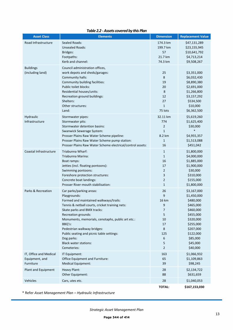
Strategic Asset Management Plan
13
Table 2.2 - Assets covered by this Plan
Asset Class Elements Dimension Replacement Value
Road Infrastructure Sealed Roads:
Unsealed Roads:
Bridges:
Footpaths:
Kerb and channel:
174.3 km
199.7 km
57
21.7 km
74.3 km
$47,131,289
$23,155,945
$10,641,792
$4,713,214
$9,508,267
Buildings
(including land)
Council administration offices,
work depots and sheds/garages:
Community halls:
Community building facilities:
Public toilet blocks:
Residential houses/units:
Recreation ground buildings:
Shelters:
Other structures:
Land:
25
8
19
20
8
12
27
1
75 lots
$3,351,000
$6,032,430
$8,890,380
$2,691,000
$1,266,800
$3,157,292
$534,500
$10,000
$6,362,500
Hydraulic
Infrastructure
Stormwater pipes:
Stormwater pits:
Stormwater detention basins:
Swanwick Sewerage System:
Prosser Plains Raw Water Scheme pipeline:
Prosser Plains Raw Water Scheme pump station:
Prosser Plains Raw Water Scheme electrical/control assets:
32.11 km
774
2
1
8.2 km
1
16
$5,619,260
$1,625,400
$30,000
*
$4,955,357
$1,513,088
$451,042
Coastal Infrastructure Triabunna Wharf:
Triabunna Marina:
Boat ramps:
Jetties (incl. floating pontoons):
Swimming pontoons:
Foreshore protection structures:
Concrete boat landings:
Prosser River-mouth stabilisation:
1
1
16
17
2
3
2
1
$1,800,000
$4,000,000
$1,885,000
$1,900,000
$30,000
$310,000
$155,000
$1,800,000
Parks & Recreation Car parks/parking areas:
Playgrounds:
Formed and maintained walkways/trails:
Tennis & netball courts, cricket training nets:
Skate parks and BMX tracks:
Recreation grounds:
Monuments, memorials, cenotaphs, public art etc.:
BBQ’s:
Pedestrian walkway bridges:
Public seating and picnic table settings:
Dog parks:
Black water stations:
Cemeteries:
26
9
16 km
9
7
5
10
17
8
125
6
5
2
$3,167,000
$1,450,000
$480,000
$465,000
$460,000
$455,000
$320,000
$255,000
$207,000
$122,000
$85,000
$45,000
$40,000
IT, Office and Medical
Equipment, and
Furniture
IT Equipment:
Office Equipment and Furniture:
Medical Equipment:
163
65
39
$1,066,932
$1,109,863
$98,245
Plant and Equipment Heavy Plant:
Other Equipment:
28
88
$2,134,722
$631,659
Vehicles Cars, utes etc. 28 $1,040,053
TOTAL: $167,153,030
* Refer Asset Management Plan – Hydraulic Infrastructure
Page 344 of 414

Strategic Asset Management Plan
14
2.3 Our assets and their management
2.3.1 Asset values
The infrastructure assets covered by this Strategic Asset Management Plan are shown in Table 2.3.1 alongside their
replacement value, depreciated replacement cost and annual depreciation. These assets are used to provide services
to the community.
Table 2.3.1: Assets value summary
Asset Class Asset replacement value Depreciated Replacement
Cost (written down value)
Annual Depreciation
Road Infrastructure $95,150,507 $33,000,000 $1,438,578
Buildings (incl. land) $32,295,902 $19,329,226 $468,455
Hydraulic
Infrastructure
$14,194,147 $3,547,927 $72,698
Coastal Infrastructure $11,880,000 $9,911,287 $299,812
Parks & Recreation $7,551,000 $4,160,400 $354,508
IT, Office and Medical
Equipment, and
Furniture
$2,275,040 $173,866 $90,000
Plant & Equipment $2,766,381 $675,042 $99,000
Vehicles $1,040,053 $409,176 $102,000
TOTAL $167,153,030 $71,206,924 $2,925,051
Page 345 of 414
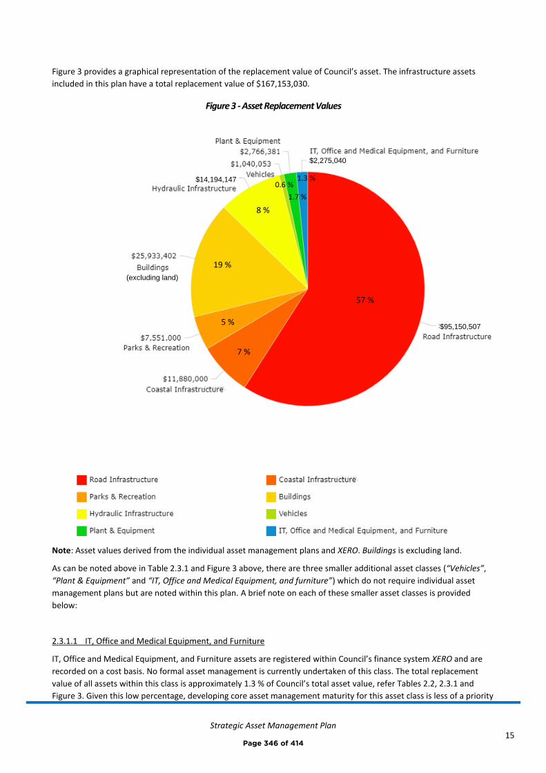
Strategic Asset Management Plan
15
Figure 3 provides a graphical representation of the replacement value of Council’s asset. The infrastructure assets
included in this plan have a total replacement value of $167,153,030.
Figure 3 - Asset Replacement Values
Note: Asset values derived from the individual asset management plans and XERO. Buildings is excluding land.
As can be noted above in Table 2.3.1 and Figure 3 above, there are three smaller additional asset classes (“Vehicles”,
“Plant & Equipment” and “IT, Office and Medical Equipment, and furniture”) which do not require individual asset
management plans but are noted within this plan. A brief note on each of these smaller asset classes is provided
below:
2.3.1.1 IT, Office and Medical Equipment, and Furniture
IT, Office and Medical Equipment, and Furniture assets are registered within Council’s finance system XERO and are
recorded on a cost basis. No formal asset management is currently undertaken of this class. The total replacement
value of all assets within this class is approximately 1.3 % of Council’s total asset value, refer Tables 2.2, 2.3.1 and
Figure 3. Given this low percentage, developing core asset management maturity for this asset class is less of a priority
5 %
7 %
57 %
19 %
8 %
1.3 %
1.7 %
0.6 %
$2,275,040
(excluding land)
$14,194,147
$95,150,507
Page 346 of 414

Strategic Asset Management Plan
16
than the major five asset classes. Resources should be initially concentrated on improving the major asset class
maturity, where much greater value is to be obtained from this work.
2.3.1.2 Plant & Equipment
Plant & Equipment assets are registered within Council’s finance system XERO and are recorded on a cost basis. No
formal asset management has traditionally been undertaken for this class, however recent efforts have seen
improvements with asset registers and a 10 year renewal plan being developed.
Examples of ‘Plant’ – Excavators, graders, rollers, trucks
Examples of ‘Equipment’ – Chainsaws, brush cutters, generators, trailers, tools
The total replacement value of all assets within this class is approximately 1.7% of Council’s total asset value, refer
Tables 2.2, 2.3.1 and Figure 3. Given this low percentage, developing core asset management maturity for this asset
class is less of a priority than the major five asset classes. Resources should be initially concentrated on improving the
major asset class maturity, where much greater value is to be obtained from this work.
2.3.1.3 Vehicles
Vehicles are registered within Council’s finance system XERO and are recorded on a cost basis. No formal asset
management has traditionally been undertaken for this class, however recent efforts have seen improvements with
asset registers and a 10 year renewal plan being developed.
The total replacement value of all assets within this category is approximately 0.6 % of Council’s total asset value,
refer Tables 2.2, 2.3.1 and Figure 3. Given this low percentage, developing core asset management maturity for this
asset class is less of a priority than the major five asset classes. Resources should be initially concentrated on
improving the major asset class maturity, where much greater value is to be obtained from this work.
2.3.2 State of the assets
Our State of the Assets report monitors the performance of the assets under three community service indicators:
Condition How good is the service? What is the condition or quality of the service?
Function Is it suitable for its intended purpose? Is it the right service?
Capacity/Use Is the service over or under used? Do we need more or less of these assets?
Figure 2.3.2 (a) below shows the state of the assets (their condition, function, capacity) as a percentage of their
replacement value. Only the five major asset classes feature (those with individual asset management plans). These
five major classes make up approximately 96 % of Council’s total asset value.
Interpretation of Figure 2.3.2 (a) - For example, Buildings is considered to have 89 % of its asset value at good
capacity/use, 66 % in good condition, 25 % in fair condition, 9 % in poor condition and in relation to function, 93% of
its value is considered good. Grey represents ‘no data’ and this is noted for improvement.
Page 347 of 414
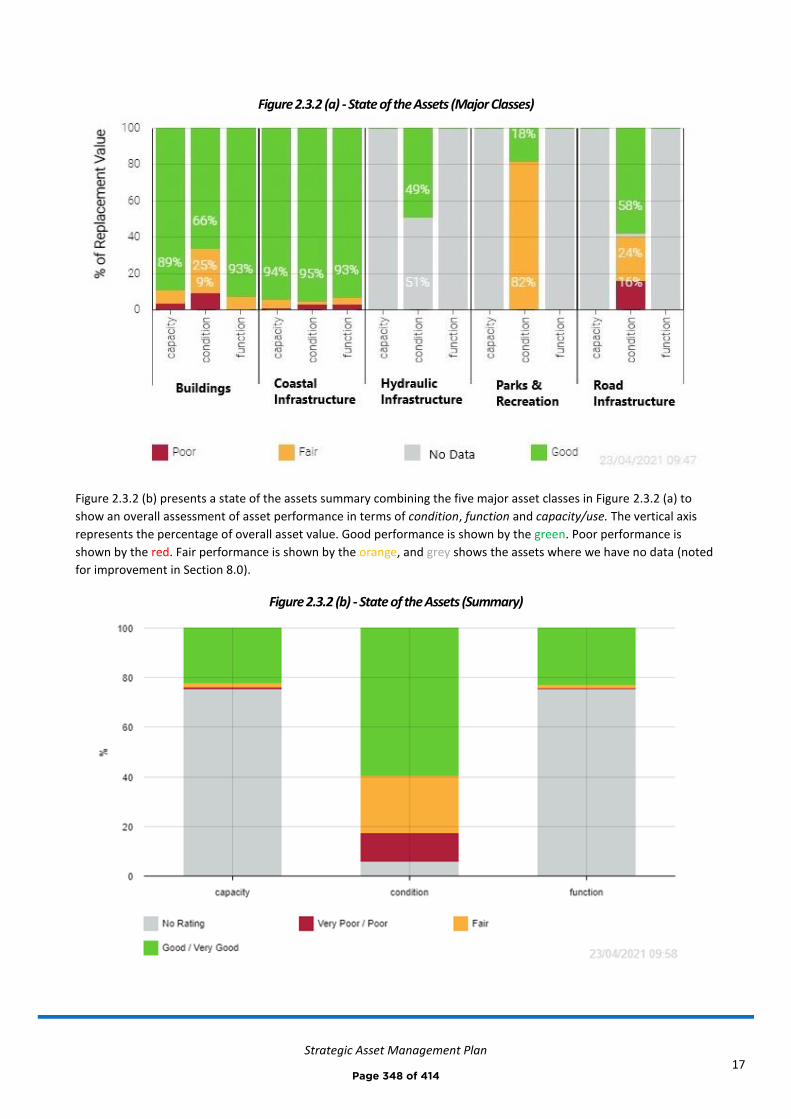
Strategic Asset Management Plan
17
Figure 2.3.2 (a) - State of the Assets (Major Classes)
Figure 2.3.2 (b) presents a state of the assets summary combining the five major asset classes in Figure 2.3.2 (a) to
show an overall assessment of asset performance in terms of condition, function and capacity/use. The vertical axis
represents the percentage of overall asset value. Good performance is shown by the green. Poor performance is
shown by the red. Fair performance is shown by the orange, and grey shows the assets where we have no data (noted
for improvement in Section 8.0).
Figure 2.3.2 (b) - State of the Assets (Summary)
Page 348 of 414
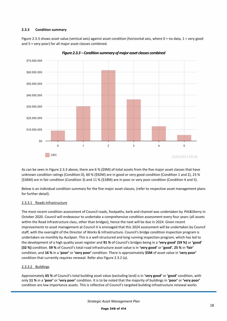
Strategic Asset Management Plan
18
2.3.3 Condition summary
Figure 2.3.3 shows asset value (vertical axis) against asset condition (horizontal axis, where 0 = no data, 1 = very good
and 5 = very poor) for all major asset classes combined.
Figure 2.3.3 – Condition summary of major asset classes combined
As can be seen in Figure 2.3.3 above, there are 6 % ($9M) of total assets from the five major asset classes that have
unknown condition ratings (Condition 0), 60 % ($92M) are in good or very good condition (Condition 1 and 2), 23 %
($36M) are in fair condition (Condition 3) and 11 % ($18M) are in poor or very poor condition (Condition 4 and 5).
Below is an individual condition summary for the five major asset classes, (refer to respective asset management plans
for further detail).
2.3.3.1 Roads Infrastructure
The most recent condition assessment of Council roads, footpaths, kerb and channel was undertaken by Pitt&Sherry in
October 2020. Council will endeavour to undertake a comprehensive condition assessment every four years (all assets
within the Road Infrastructure class, other than bridges), hence the next will be due in 2024. Given recent
improvements to asset management at Council it is envisaged that this 2024 assessment will be undertaken by Council
staff, with the oversight of the Director of Works & Infrastructure. Council’s bridge condition inspection program is
undertaken six monthly by AusSpan. This is a well-structured and long running inspection program, which has led to
the development of a high quality asset register and 91 % of Council’s bridges being in a ‘very good’ (59 %) or ‘good’
(32 %) condition. 59 % of Council’s total road infrastructure asset value is in ‘very good’ or ‘good’, 25 % in ‘fair’
condition, and 16 % in a ‘poor’ or ‘very poor’ condition. There is approximately $5M of asset value in ‘very poor’
condition that currently requires renewal. Refer also Figure 2.3.2 (a).
2.3.3.2 Buildings
Approximately 65 % of Council’s total building asset value (excluding land) is in ‘very good’ or ‘good’ condition, with only 11 % in a ‘poor’ or ‘very poor’ condition. It is to be noted that the majority of buildings in ‘poor’ or ‘very poor’ condition are low importance assets. This is reflective of Council’s targeted building infrastructure renewal works
Page 349 of 414
Strategic Asset Management Plan
19
completed over the past decade. The development of the Asset Management Plan – Buildings in 2020 captured assets with an estimated total replacement value of approximately $26 M, compared with the previously recorded $12 M (approx.) as at the end of 2019-20 financial year. Refer also Figure 2.3.2 (a).
2.3.3.3 Hydraulic Infrastructure
Condition is not currently monitored in any formal way. All stormwater assets have been assigned unknown
conditions (i.e. 0), these assets have a combined asset replacement value estimated at $7.24 M. For accounting
purposes, these stormwater drainage assets have been depreciated by approximately half of their replacement value
(noting a 100 year average design life, meaning their estimated remaining useful life is approximately 50 years). The
Prosser Plains Raw Water Scheme assets are in ‘very good’ condition and have a replacement value of $6.9 M. Refer
also Figure 2.3.2 (a).
2.3.3.4 Coastal Infrastructure
Condition is currently monitored by the Manager – Coastal Infrastructure. ASD Diving Contractors have historically
been engaged to undertaken annual inspection of some coastal assets, however this has not been a complete
inspection of all coastal infrastructure assets, and has mainly included boat ramps, jetties and swimming pontoons,
including underwater inspection where required. It is recommended that the inspections cover all assets in the future.
Approximately 95 % of Council’s total coastal infrastructure asset value is in ‘very good’ or ‘good’ condition, with only
3 % in a ‘poor’ or ‘very poor’ condition. It is to be noted that generally the coastal infrastructure in ‘poor’ or ‘very
poor’ condition are lower importance assets. This is reflective of Council’s targeted coastal infrastructure renewal
works completed over the past 15 years. Refer also Figure 2.3.2 (a).
2.3.3.5 Parks & Recreation
All parks and recreation assets currently have no condition ratings applied. For accounting purposes, the assets that
were included in Council’s XERO fixed asset register at the end of the 2019-20 financial year ($3,639,881) have been
depreciated by approximately 20 % of their replacement value, meaning that on average those assets are assumed to
have approximately 80 % of their service life remaining. This is in the absence of condition assessment data which
would help calibrate these assumptions – this has been noted for improvement. The development of the Asset
Management Plan – Parks & Recreation in 2021 captured assets with an estimated total replacement value of
approximately $7.5 M, compared with the previously recorded $3.6 M as at the end of 2019-20 financial year. Refer
also Figure 2.3.2 (a).
2.3.4 Forecast lifecycle costs
Forecast lifecycle costs (or whole of life costs) are the average annual costs that are required to sustain the service
levels over the longest asset life. Forecast lifecycle costs include operation and maintenance plus asset consumption
(depreciation).
Lifecycle planned budget includes operation and maintenance (excluding depreciation) plus forecast renewals and
acquisitions where relevant. The renewal component of the planned budget can vary depending on the timing of asset
renewals.
The lifecycle forecast and planned budget averaged over the planning period are shown in Table 2.3.4.
Page 350 of 414
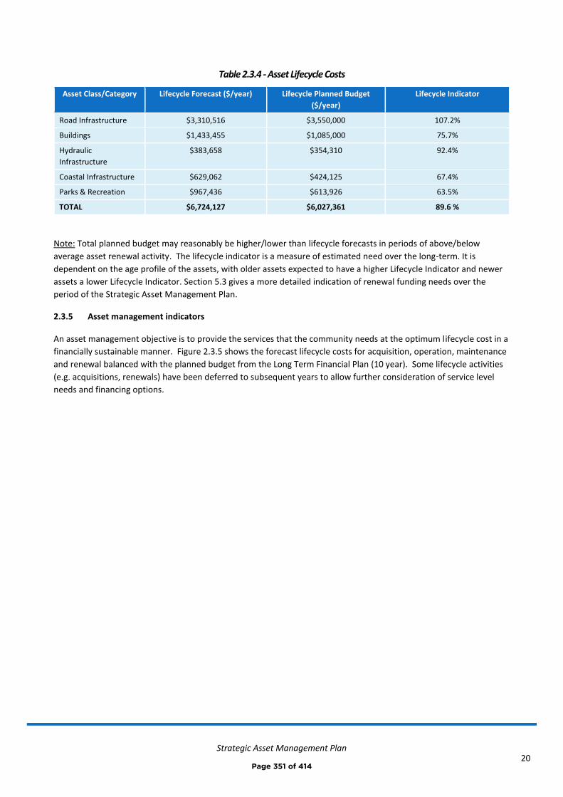
Strategic Asset Management Plan
20
Table 2.3.4 - Asset Lifecycle Costs
Asset Class/Category Lifecycle Forecast ($/year) Lifecycle Planned Budget
($/year)
Lifecycle Indicator
Road Infrastructure $3,310,516 $3,550,000 107.2%
Buildings $1,433,455 $1,085,000 75.7%
Hydraulic
Infrastructure
$383,658 $354,310 92.4%
Coastal Infrastructure $629,062 $424,125 67.4%
Parks & Recreation $967,436 $613,926 63.5%
TOTAL $6,724,127 $6,027,361 89.6 %
Note: Total planned budget may reasonably be higher/lower than lifecycle forecasts in periods of above/below
average asset renewal activity. The lifecycle indicator is a measure of estimated need over the long-term. It is
dependent on the age profile of the assets, with older assets expected to have a higher Lifecycle Indicator and newer
assets a lower Lifecycle Indicator. Section 5.3 gives a more detailed indication of renewal funding needs over the
period of the Strategic Asset Management Plan.
2.3.5 Asset management indicators
An asset management objective is to provide the services that the community needs at the optimum lifecycle cost in a
financially sustainable manner. Figure 2.3.5 shows the forecast lifecycle costs for acquisition, operation, maintenance
and renewal balanced with the planned budget from the Long Term Financial Plan (10 year). Some lifecycle activities
(e.g. acquisitions, renewals) have been deferred to subsequent years to allow further consideration of service level
needs and financing options.
Page 351 of 414

Strategic Asset Management Plan
21
Figure 2.3.5 – Forecast Lifecycle Costs (major asset classes)
The purpose of this Strategic Asset Management Plan is to develop the strategies to achieve the asset management
objectives through balancing of asset service performance, cost and risk.
Figure 2.3.5 shows the results of balancing service performance, risk and cost in the asset management plans and
Long Term Financial Plan to achieve an agreed and affordable position on service level and costs. This includes deferral
of some lower priority lifecycle activities (in some cases by 5+ years) and identification and acceptance of the risks
associated with the deferrals.
Risk assessments and associated management plans for these and other relevant risks are summarised in Appendix F.
Refer also Section 6.0.
2.3.7 Asset and financial management maturity
We have taken steps to improve our asset and financial management performance including assessing our asset
management maturity against the 3 Frameworks of the Local Government Financial Sustainability Nationally
Consistent Frameworks. Our target is to achieve ‘core’ maturity with the Frameworks. Figure 2.3.7 (a) shows the
current, ‘core’ and ‘target’ maturity scores for the eleven elements of the National Assessments Frameworks (NAF) for
asset and financial management. The assessment result is shown in two forms (spider and bar chart) for ease of
interpretation by various readers.
Page 352 of 414
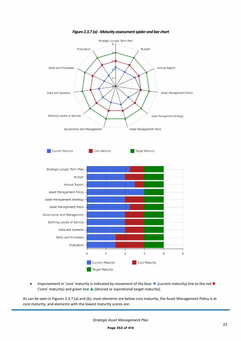
Strategic Asset Management Plan
22
Figure 2.3.7 (a) - Maturity assessment spider and bar chart
• Improvement in ‘core’ maturity is indicated by movement of the blue ◆ (current maturity) line to the red ◼
(‘core’ maturity) and green line (desired or aspirational target maturity).
As can be seen in Figures 2.3.7 (a) and (b), most elements are below core maturity, the Asset Management Policy is at
core maturity, and elements with the lowest maturity scores are:
Page 353 of 414

Strategic Asset Management Plan
23
• Skills and Processes
• Evaluation
The risk to Council from the current maturity is shown in Figure 2.3.7 (b).
Figure 2.3.7 (b) - Maturity risk assessment
Reduction in risk from current National Assessment Framework maturity is indicated by movement of the blue line ◼
(current risk) to the red line ◼ (desired/target risk) in Figure 2.3.7 (b) above. Elements with high maturity risk to
Council are:
• Skills and Processes
• Evaluation
• Strategic Longer Term Plan
• Budget
• Annual Report
Tasks to improve asset and financial management maturity are prioritised and included within the Improvement Plan
shown in Section 8.2.
2.3.8 Strategic outlook
1. We cannot maintain current levels of service for the next ten years for all major asset classes. This is based on
current knowledge and projections in individual Asset Management Plans and the Long Term Financial Plan.
However, saying this, the Long Term Financial Plan sets out a strategy over the next ten years to put Council
in a position where they can maintain, or return to, current levels of service and provide these in a
sustainable fashion into the future.
Page 354 of 414
Strategic Asset Management Plan
24
2. The planned budget is currently less than the forecast lifecycle costs over the planning period, refer Figure
2.3.5. However, saying this, financial strategies outlined in the Long Term Financial Plan, if successfully
undertaken, are designed to reduce this gap between planned budget and forecast lifecycle costs thereafter.
Review of services, service levels and costs will need to be carried out over the next 10 years to identify and
monitor changes in demand for services and affordability over the longer-term.
3. Our current asset and financial management maturity are below ‘core’ level and investment is needed to
improve information management, lifecycle management, service management, accountability and strategic
direction.
2.4 Where do we want to be?
2.4.1 Vision, Mission, Goals and Objectives
This Strategic Asset Management Plan is prepared under the direction of Council’s vision, mission, goals and
objectives.
Our vision is:
Glamorgan Spring Bay, a welcoming community which delivers sustainable development, appreciates and protects
its natural environment and facilitates a quality lifestyle.
Our mission is:
• Represent and promote the interests of the communities in our municipality.
• Provide sound community governance, practices and processes.
• Plan, implement and monitor services according to our agreed priorities and available resources.
• Seek and secure additional funds, and grants to augment our finances.
• Manage the finances and administer the Council.
• Establish and maintain mutually beneficial strategic partnerships with State and Federal
Government and private businesses and industry.
Strategic goals have been set by the Council. The relevant goals and objectives and how these are addressed in this
plan are summarised in Table 2.4.1. These goals and objectives are reflective of those included in the Asset
Management Plan for each individual asset class.
Page 355 of 414
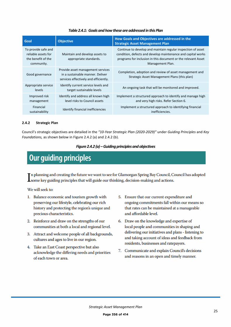
Strategic Asset Management Plan
25
Table 2.4.1: Goals and how these are addressed in this Plan
Goal Objective How Goals and Objectives are addressed in the Strategic Asset Management Plan
To provide safe and
reliable assets for
the benefit of the
community.
Maintain and develop assets to
appropriate standards.
Continue to develop and maintain regular inspection of asset
condition, defects and develop maintenance and capital works
programs for inclusion in this document or the relevant Asset
Management Plan.
Good governance
Provide asset management services
in a sustainable manner. Deliver
services effectively and efficiently.
Completion, adoption and review of asset management and
Strategic Asset Management Plans (this plan)
Appropriate service
levels
Identify current service levels and
target sustainable levels An ongoing task that will be monitored and improved.
Improved risk
management
Identify and address all known high
level risks to Council assets
Implement a structured approach to identify and manage high
and very high risks. Refer Section 6.
Financial
sustainability Identify financial inefficiencies
Implement a structured approach to identifying financial
inefficiencies.
2.4.2 Strategic Plan
Council’s strategic objectives are detailed in the “10-Year Strategic Plan (2020-2029)” under Guiding Principles and Key
Foundations, as shown below in Figure 2.4.2 (a) and 2.4.2 (b).
Figure 2.4.2 (a) – Guiding principles and objectives
Page 356 of 414
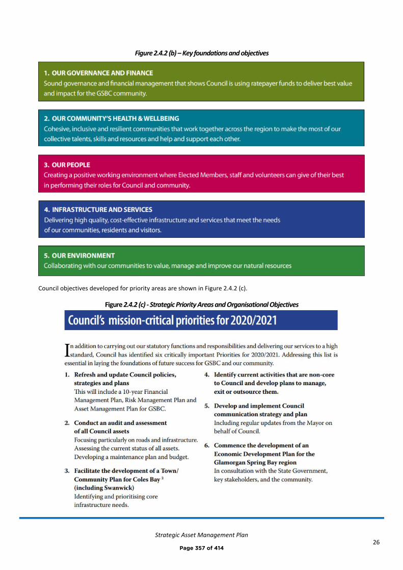
Strategic Asset Management Plan
26
Figure 2.4.2 (b) – Key foundations and objectives
Council objectives developed for priority areas are shown in Figure 2.4.2 (c).
Figure 2.4.2 (c) - Strategic Priority Areas and Organisational Objectives
Page 357 of 414
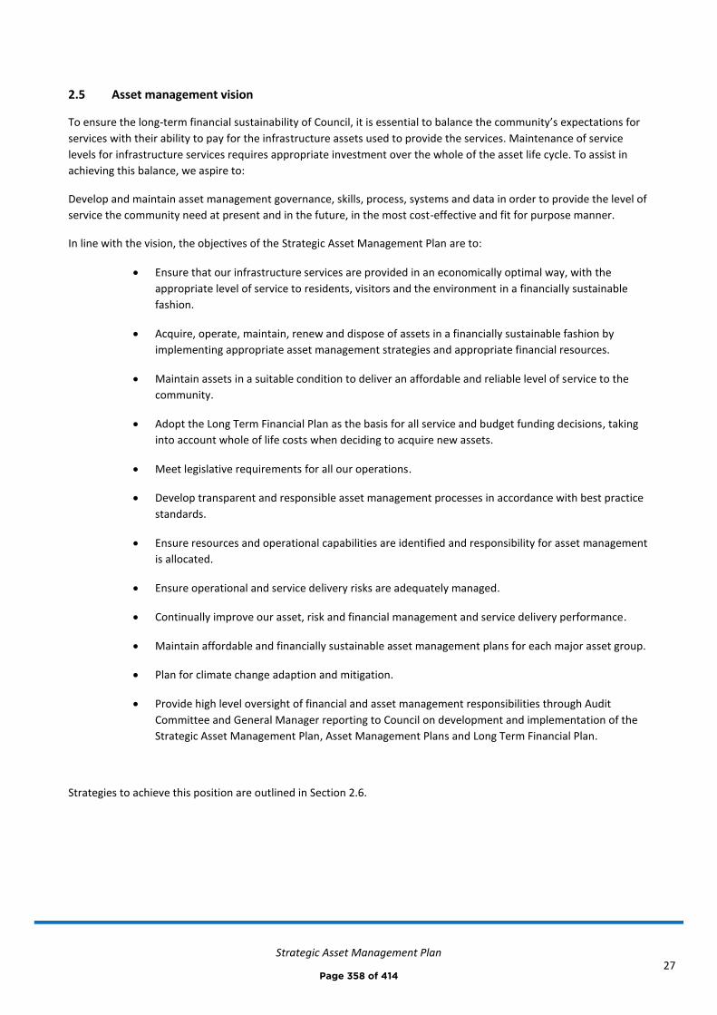
Strategic Asset Management Plan
27
2.5 Asset management vision
To ensure the long-term financial sustainability of Council, it is essential to balance the community’s expectations for
services with their ability to pay for the infrastructure assets used to provide the services. Maintenance of service
levels for infrastructure services requires appropriate investment over the whole of the asset life cycle. To assist in
achieving this balance, we aspire to:
Develop and maintain asset management governance, skills, process, systems and data in order to provide the level of
service the community need at present and in the future, in the most cost-effective and fit for purpose manner.
In line with the vision, the objectives of the Strategic Asset Management Plan are to:
• Ensure that our infrastructure services are provided in an economically optimal way, with the
appropriate level of service to residents, visitors and the environment in a financially sustainable
fashion.
• Acquire, operate, maintain, renew and dispose of assets in a financially sustainable fashion by
implementing appropriate asset management strategies and appropriate financial resources.
• Maintain assets in a suitable condition to deliver an affordable and reliable level of service to the
community.
• Adopt the Long Term Financial Plan as the basis for all service and budget funding decisions, taking
into account whole of life costs when deciding to acquire new assets.
• Meet legislative requirements for all our operations.
• Develop transparent and responsible asset management processes in accordance with best practice
standards.
• Ensure resources and operational capabilities are identified and responsibility for asset management
is allocated.
• Ensure operational and service delivery risks are adequately managed.
• Continually improve our asset, risk and financial management and service delivery performance.
• Maintain affordable and financially sustainable asset management plans for each major asset group.
• Plan for climate change adaption and mitigation.
• Provide high level oversight of financial and asset management responsibilities through Audit
Committee and General Manager reporting to Council on development and implementation of the
Strategic Asset Management Plan, Asset Management Plans and Long Term Financial Plan.
Strategies to achieve this position are outlined in Section 2.6.
Page 358 of 414
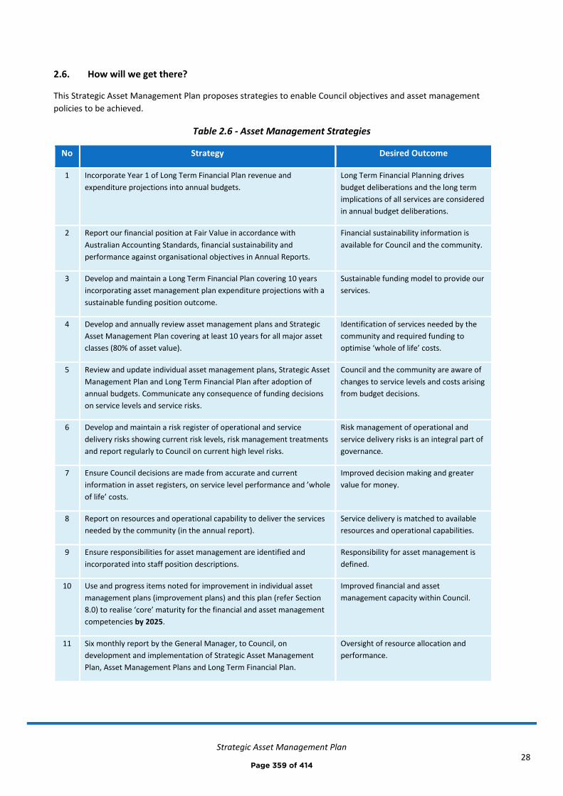
Strategic Asset Management Plan
28
2.6. How will we get there?
This Strategic Asset Management Plan proposes strategies to enable Council objectives and asset management
policies to be achieved.
Table 2.6 - Asset Management Strategies
No Strategy Desired Outcome
1 Incorporate Year 1 of Long Term Financial Plan revenue and
expenditure projections into annual budgets.
Long Term Financial Planning drives
budget deliberations and the long term
implications of all services are considered
in annual budget deliberations.
2 Report our financial position at Fair Value in accordance with
Australian Accounting Standards, financial sustainability and
performance against organisational objectives in Annual Reports.
Financial sustainability information is
available for Council and the community.
3 Develop and maintain a Long Term Financial Plan covering 10 years
incorporating asset management plan expenditure projections with a
sustainable funding position outcome.
Sustainable funding model to provide our
services.
4 Develop and annually review asset management plans and Strategic
Asset Management Plan covering at least 10 years for all major asset
classes (80% of asset value).
Identification of services needed by the
community and required funding to
optimise ‘whole of life’ costs.
5 Review and update individual asset management plans, Strategic Asset
Management Plan and Long Term Financial Plan after adoption of
annual budgets. Communicate any consequence of funding decisions
on service levels and service risks.
Council and the community are aware of
changes to service levels and costs arising
from budget decisions.
6 Develop and maintain a risk register of operational and service
delivery risks showing current risk levels, risk management treatments
and report regularly to Council on current high level risks.
Risk management of operational and
service delivery risks is an integral part of
governance.
7 Ensure Council decisions are made from accurate and current
information in asset registers, on service level performance and ’whole
of life’ costs.
Improved decision making and greater
value for money.
8 Report on resources and operational capability to deliver the services
needed by the community (in the annual report).
Service delivery is matched to available
resources and operational capabilities.
9 Ensure responsibilities for asset management are identified and
incorporated into staff position descriptions.
Responsibility for asset management is
defined.
10 Use and progress items noted for improvement in individual asset
management plans (improvement plans) and this plan (refer Section
8.0) to realise ‘core’ maturity for the financial and asset management
competencies by 2025.
Improved financial and asset
management capacity within Council.
11 Six monthly report by the General Manager, to Council, on
development and implementation of Strategic Asset Management
Plan, Asset Management Plans and Long Term Financial Plan.
Oversight of resource allocation and
performance.
Page 359 of 414
Strategic Asset Management Plan
29
2.7 Asset management improvement plan
The tasks required for achieving a ‘core’ financial and asset management maturity are shown in priority order in the
asset management improvement plan in Section 8.2
2.8. Consequences if improvement actions are not completed
There are consequences for the Council if the improvement actions are not completed. These include:
• Inability to achieve strategic and organisational objectives
• Inability to achieve financial sustainability for Council’s operations
• Current risks to infrastructure service delivery are likely to eventuate and response actions may not be
appropriately managed
• We may not be able to provide the appropriate levels of service
Page 360 of 414
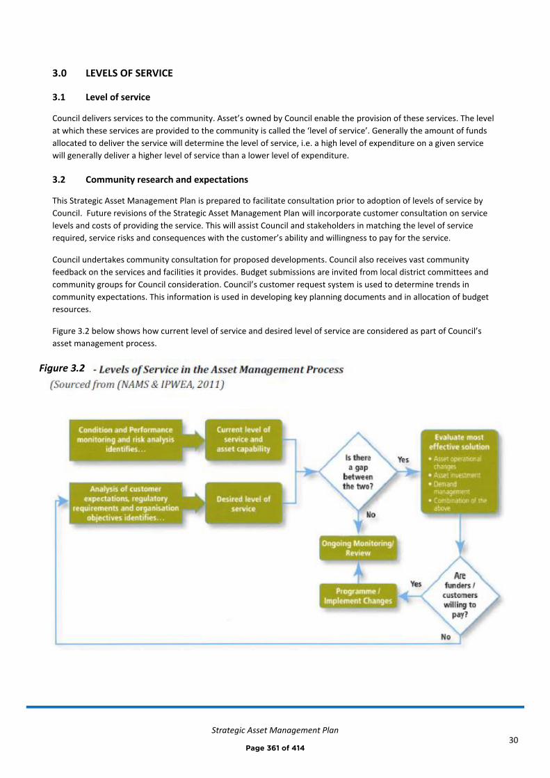
Strategic Asset Management Plan
30
3.0 LEVELS OF SERVICE
3.1 Level of service
Council delivers services to the community. Asset’s owned by Council enable the provision of these services. The level
at which these services are provided to the community is called the ‘level of service’. Generally the amount of funds
allocated to deliver the service will determine the level of service, i.e. a high level of expenditure on a given service
will generally deliver a higher level of service than a lower level of expenditure.
3.2 Community research and expectations
This Strategic Asset Management Plan is prepared to facilitate consultation prior to adoption of levels of service by
Council. Future revisions of the Strategic Asset Management Plan will incorporate customer consultation on service
levels and costs of providing the service. This will assist Council and stakeholders in matching the level of service
required, service risks and consequences with the customer’s ability and willingness to pay for the service.
Council undertakes community consultation for proposed developments. Council also receives vast community
feedback on the services and facilities it provides. Budget submissions are invited from local district committees and
community groups for Council consideration. Council’s customer request system is used to determine trends in
community expectations. This information is used in developing key planning documents and in allocation of budget
resources.
Figure 3.2 below shows how current level of service and desired level of service are considered as part of Council’s
asset management process.
Figure 3.2
Page 361 of 414
Strategic Asset Management Plan
31
3.3 Legislative requirements
We have to meet many legislative requirements including Australian and State legislation and State regulations.
These are detailed in Council’s five Asset Management Plans summarised in this Strategic Asset Management Plan.
3.4 Customer values
Levels of service are defined in three ways; customer values, customer levels of service, and technical levels of service.
Customer values indicate:
◼ what aspects of the service is important to the customer,
◼ whether they see value in what is currently provided and
◼ the likely trend over time based on the current budget provision
Customer values for specific asset classes are detailed in the individual Asset Management Plans summarised in this
Strategic Asset Management Plan.
3.5 Customer levels of service
The Customer Levels of Service is a measure as to how the customer receives the service and whether Council is providing value. This is considered in terms of:
Condition How good is the service? What is the condition or quality of the service?
Function Is it suitable for its intended purpose? Is it the right service?
Capacity/Use Is the service over or under used? Do we need more or less of these assets?
Customer levels of service for specific asset classes are detailed in the individual Asset Management Plans summarised
in this Strategic Asset Management Plan.
3.6 Technical levels of service
Supporting the customer service levels are operational or technical measures of performance. These technical
measures relate to the allocation of resources to service activities that Council undertakes to best achieve the desired
community outcomes and demonstrate effective organisational performance.
Technical service measures are linked to annual budgets covering:
• Acquisition – the activities to provide a higher level of service (e.g. widening a road, sealing an unsealed road,
replacing a pipeline with a larger size) or a new service that did not exist previously (e.g. a new library).
• Operation – the regular activities to provide services such as availability, cleansing, mowing, etc.
• Maintenance – the activities necessary to retain an asset as near as practicable to an appropriate service
condition (e.g. road patching, unsealed road grading, building and structure repairs),
• Renewal – the activities that return the service capability of an asset similar to that which it had originally
(e.g. road resurfacing and pavement reconstruction, pipeline replacement and building component
replacement) or to a lower service level,
Service and asset managers plan, implement and control technical service levels to influence the service outcomes.8
8 IPWEA, 2015, IIMM, p 2|28.
Page 362 of 414

Strategic Asset Management Plan
32
Together the customer and technical levels of service provide detail on service performance, cost and whether service
levels are likely to stay the same, get better or worse.
It is important to monitor the service levels regularly as circumstances can and do change. Current performance is
based on existing resource provision and work efficiencies. It is acknowledged changing circumstances such as
technology and customer priorities will change over time.
Current technical levels of service for specific asset classes are detailed in the individual Asset Management Plans,
they are also summarised in Appendix A of this document.
Page 363 of 414
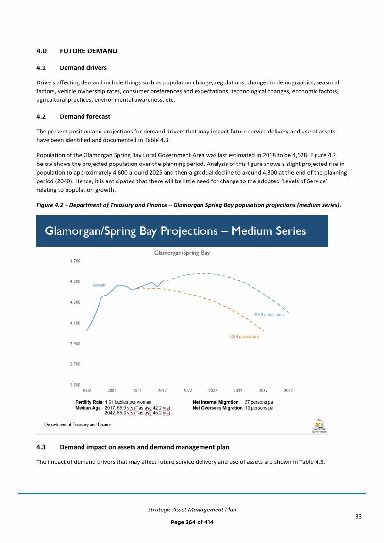
Strategic Asset Management Plan
33
4.0 FUTURE DEMAND
4.1 Demand drivers
Drivers affecting demand include things such as population change, regulations, changes in demographics, seasonal
factors, vehicle ownership rates, consumer preferences and expectations, technological changes, economic factors,
agricultural practices, environmental awareness, etc.
4.2 Demand forecast
The present position and projections for demand drivers that may impact future service delivery and use of assets
have been identified and documented in Table 4.3.
Population of the Glamorgan Spring Bay Local Government Area was last estimated in 2018 to be 4,528. Figure 4.2
below shows the projected population over the planning period. Analysis of this figure shows a slight projected rise in
population to approximately 4,600 around 2025 and then a gradual decline to around 4,300 at the end of the planning
period (2040). Hence, it is anticipated that there will be little need for change to the adopted ‘Levels of Service’
relating to population growth.
Figure 4.2 – Department of Treasury and Finance – Glamorgan Spring Bay population projections (medium series).
4.3 Demand impact on assets and demand management plan
The impact of demand drivers that may affect future service delivery and use of assets are shown in Table 4.3.
Page 364 of 414
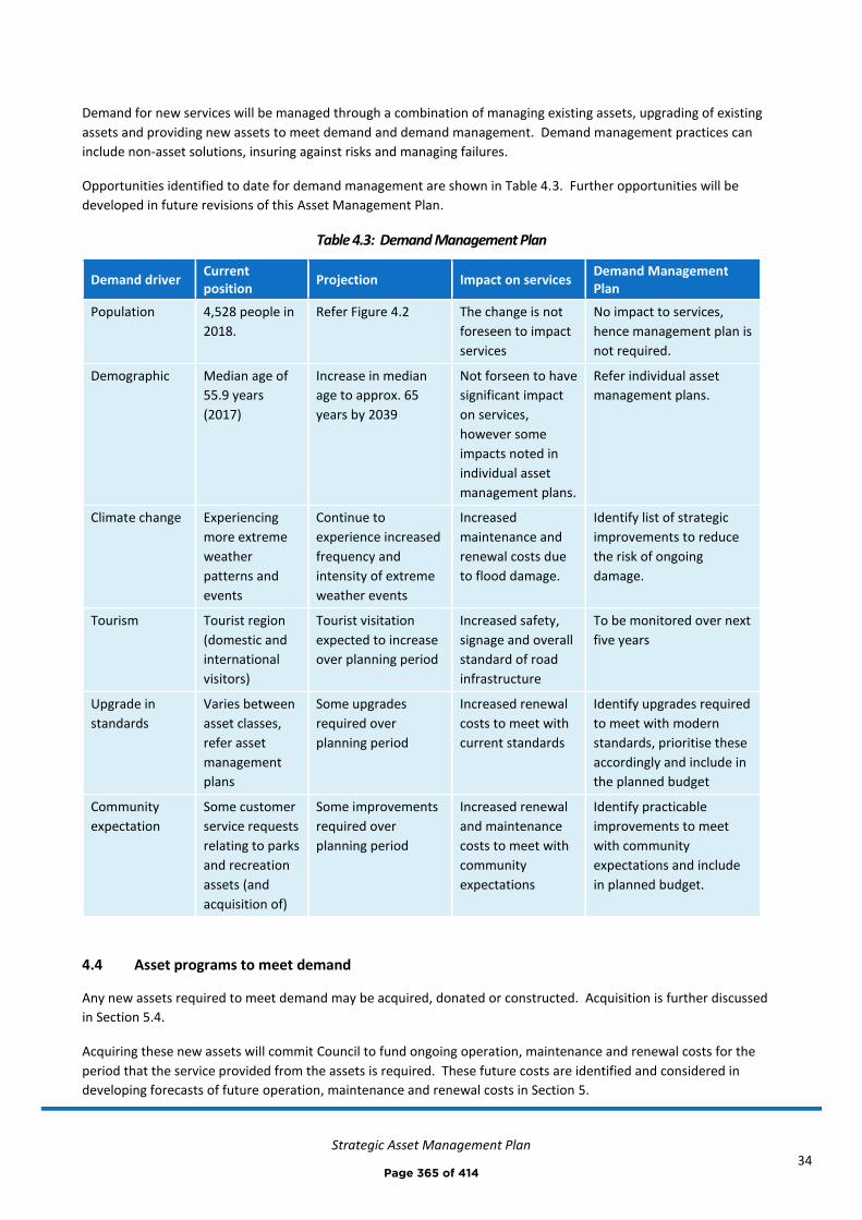
Strategic Asset Management Plan
34
Demand for new services will be managed through a combination of managing existing assets, upgrading of existing
assets and providing new assets to meet demand and demand management. Demand management practices can
include non-asset solutions, insuring against risks and managing failures.
Opportunities identified to date for demand management are shown in Table 4.3. Further opportunities will be
developed in future revisions of this Asset Management Plan.
Table 4.3: Demand Management Plan
Demand driver Current position
Projection Impact on services Demand Management Plan
Population 4,528 people in
2018.
Refer Figure 4.2 The change is not
foreseen to impact
services
No impact to services,
hence management plan is
not required.
Demographic Median age of
55.9 years
(2017)
Increase in median
age to approx. 65
years by 2039
Not forseen to have
significant impact
on services,
however some
impacts noted in
individual asset
management plans.
Refer individual asset
management plans.
Climate change Experiencing
more extreme
weather
patterns and
events
Continue to
experience increased
frequency and
intensity of extreme
weather events
Increased
maintenance and
renewal costs due
to flood damage.
Identify list of strategic
improvements to reduce
the risk of ongoing
damage.
Tourism Tourist region
(domestic and
international
visitors)
Tourist visitation
expected to increase
over planning period
Increased safety,
signage and overall
standard of road
infrastructure
To be monitored over next
five years
Upgrade in
standards
Varies between
asset classes,
refer asset
management
plans
Some upgrades
required over
planning period
Increased renewal
costs to meet with
current standards
Identify upgrades required
to meet with modern
standards, prioritise these
accordingly and include in
the planned budget
Community
expectation
Some customer
service requests
relating to parks
and recreation
assets (and
acquisition of)
Some improvements
required over
planning period
Increased renewal
and maintenance
costs to meet with
community
expectations
Identify practicable
improvements to meet
with community
expectations and include
in planned budget.
4.4 Asset programs to meet demand
Any new assets required to meet demand may be acquired, donated or constructed. Acquisition is further discussed
in Section 5.4.
Acquiring these new assets will commit Council to fund ongoing operation, maintenance and renewal costs for the
period that the service provided from the assets is required. These future costs are identified and considered in
developing forecasts of future operation, maintenance and renewal costs in Section 5.
Page 365 of 414
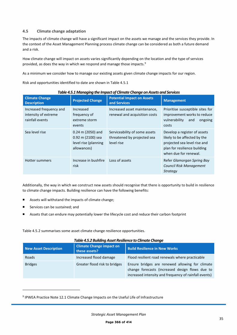
Strategic Asset Management Plan
35
4.5 Climate change adaptation
The impacts of climate change will have a significant impact on the assets we manage and the services they provide. In
the context of the Asset Management Planning process climate change can be considered as both a future demand
and a risk.
How climate change will impact on assets varies significantly depending on the location and the type of services
provided, as does the way in which we respond and manage those impacts.9
As a minimum we consider how to manage our existing assets given climate change impacts for our region.
Risk and opportunities identified to date are shown in Table 4.5.1
Table 4.5.1 Managing the Impact of Climate Change on Assets and Services
Climate Change Description
Projected Change Potential Impact on Assets and Services
Management
Increased frequency and
intensity of extreme
rainfall events
Increased
frequency of
extreme storm
events
Increased asset maintenance,
renewal and acquisition costs
Prioritise susceptible sites for
improvement works to reduce
vulnerability and ongoing
costs
Sea level rise 0.24 m (2050) and
0.92 m (2100) sea
level rise (planning
allowances)
Serviceability of some assets
threatened by projected sea
level rise
Develop a register of assets
likely to be affected by the
projected sea level rise and
plan for resilience building
when due for renewal.
Hotter summers Increase in bushfire
risk
Loss of assets Refer Glamorgan Spring Bay
Council Risk Management
Strategy
Additionally, the way in which we construct new assets should recognise that there is opportunity to build in resilience
to climate change impacts. Building resilience can have the following benefits:
◼ Assets will withstand the impacts of climate change;
◼ Services can be sustained; and
◼ Assets that can endure may potentially lower the lifecycle cost and reduce their carbon footprint
Table 4.5.2 summarises some asset climate change resilience opportunities.
Table 4.5.2 Building Asset Resilience to Climate Change
New Asset Description Climate Change impact on these assets?
Build Resilience in New Works
Roads Increased flood damage Flood resilient road renewals where practicable
Bridges Greater flood risk to bridges Ensure bridges are renewed allowing for climate
change forecasts (increased design flows due to
increased intensity and frequency of rainfall events)
9 IPWEA Practice Note 12.1 Climate Change Impacts on the Useful Life of Infrastructure
Page 366 of 414

Strategic Asset Management Plan
36
Council buildings Sea level rise and increased
frequency and intensity of
storm events
Floor levels to satisfy flood modelling and
projected sea level rise.
Stormwater drainage
infrastructure
Greater capacity required Only renew with, or acquire, assets that have been
designed to allow for climate change flows in
accordance with the Draft Urban Stormwater
Management Plan
Coastal infrastructure Sea level rise and increased
frequency and intensity of
storm events (wave action)
New assets to consider these impacts during design
and construction to ensure assets remain
serviceable into the future.
Parks & Recreation assets Increased risk of loss, or
damage to assets
Consider climate change impacts when acquiring,
renewing and maintaining assets.
The impact of climate change on assets is a new and complex discussion and further opportunities will be developed
in future revisions of this Strategic Asset Management Plan.
Page 367 of 414
Strategic Asset Management Plan
37
5.0 LIFECYCLE MANAGEMENT PLAN
The lifecycle management plan details how Council plans to manage and operate the assets at the agreed levels of
service (defined in Section 3) while optimising lifecycle costs and managing risks.
5.1 Background data
5.1.1 Physical parameters
The assets covered by this Strategic Asset Management Plan are shown in Tables 2.2 and 2.3.1.
5.1.2 Asset capacity and performance
Council’s assets and services are generally provided to meet design standards where these are available.
Asset capacity and performance is monitored for three community service measures at the end of the reporting
period for condition (quality), function and capacity/utilisation in a State of the Assets report. The state of the assets is
discussed in Section 2.3.2.
5.2 Routine operation and maintenance plan
Operation includes regular activities to provide services such as public health, safety and amenity, e.g. cleansing,
utility services, street sweeping, grass mowing and street lighting.
Routine maintenance is the regular on-going work that is necessary to keep assets operating, including instances
where portions of the asset fail and need immediate repair to make the asset operational again.
5.2.1 Operation and maintenance plan
Operation activities affect service levels including quality and function, such as cleanliness, appearance, etc., through
street sweeping and grass mowing frequency, intensity and spacing of street lights and cleaning frequency and
opening hours of building and other facilities.
Maintenance includes all actions necessary for retaining an asset as near as practicable to an appropriate service
condition including regular ongoing day-to-day work necessary to keep assets operating, e.g. road patching but
excluding rehabilitation or renewal.
Maintenance expenditure is not currently considered adequate to meet with all current levels of service. A reduction
in level of service for some asset classes may result until equilibrium of planned budget and maintenance forecasts is
met. Where maintenance expenditure levels result in a lesser level of service, the service consequences and risks
have been identified in the respective Asset Management Plan, refer also Section 6.0 and Appendix F.
5.2.2 Operation and maintenance strategies
We will operate and maintain assets to provide the defined level of service to approved budgets in the most cost-
efficient manner. The operation and maintenance activities include:
• Scheduling operations activities to deliver the defined level of service in the most efficient manner
• Undertaking maintenance activities through a planned maintenance system to reduce maintenance costs and
improve maintenance outcomes. Undertake cost-benefit analysis to determine the most cost-effective split
between planned and unplanned maintenance activities (50 – 70% planned desirable as measured by cost)
• Maintain a current infrastructure risk register for assets and present service risks associated with providing
services from infrastructure assets and reporting Very High and High risks and residual risks after treatment
to management and Council
Page 368 of 414

Strategic Asset Management Plan
38
• Review current and required skills base and implement workforce training and development to meet
required operation and maintenance needs
• Review asset utilisation to identify underutilised assets and appropriate remedies, and over utilised assets
and customer demand management options
• Maintain a current hierarchy of critical assets and required operation and maintenance activities
• Develop and regularly review appropriate emergency response capability
• Review management of operation and maintenance activities to ensure we are obtaining best value for
resources used
5.2.3 Forecast operation and maintenance summary
Operation and maintenance costs (for the five major asset classes) are forecast to trend in line with slight increases in
total asset value over the planning period (due to acquisitions), this is shown in Figure 5.2.3. The majority of forecast
costs (shown in Appendix B) have been accommodated in Council’s Long Term Financial Plan, however Figure 5.2.3
highlights that Council does not currently have sufficient planned budget to undertake all of the forecast operation
and maintenance throughout the planning period.
Figure 5.2.3: Forecast Operation and Maintenance Summary (major asset classes)
Note that all costs are shown in current dollar values (i.e. real values).
The consequences of deferred maintenance, i.e. works that are identified for maintenance and unable to be funded,
are to be included in the risk assessment and analysis section of the appropriate asset management plan, refer also
Appendix F.
Page 369 of 414

Strategic Asset Management Plan
39
5.3 Renewal plan
Renewal expenditure is major work which does not increase the asset’s design capacity but restores, rehabilitates,
replaces or renews an existing asset to its original or lesser required service potential. Work over and above restoring
an asset to original service potential is considered as asset acquisition.
5.3.1 Renewal strategies
We will plan capital renewal projects to meet level of service objectives and minimise infrastructure service risks by:
• Planning and scheduling renewal projects to deliver the defined level of service in the most efficient manner
• Undertaking project scoping for all capital renewal projects to identify
o the service delivery ‘deficiency’, present risk and optimum time for renewal
o the project objectives to rectify the deficiency
o the range of options, estimated capital and life cycle costs for each options that could address the
service deficiency
o and evaluate the options against evaluation criteria adopted by Council, and
o select the best option to be included in capital renewal programs,
• Using optimal renewal methods (cost of renewal is less than replacement) wherever possible
• Maintain a current infrastructure risk register for assets and service risks associated with providing services
from infrastructure assets and report Very High and High risks and Residual risks after treatment to
management, Audit Committee and Council
• Review current and required skills base and implement workforce training and development to meet
required construction and renewal needs
• Maintain a current hierarchy of critical assets and capital renewal treatments and timings required
• Review management of capital renewal activities to ensure we are obtaining best value for resources used.
5.3.2 Renewal ranking criteria
Asset renewal is typically undertaken to either:
• Ensure the reliability of the existing infrastructure to deliver the service it was constructed to facilitate (e.g.
replace a bridge that has a 5 t load limit), or
• To ensure the infrastructure is of sufficient quality to meet the service requirements (e.g. roughness of a
road).
Asset renewal priorities are indicated by identifying assets or asset groups that:
• Have a high consequence of failure
• Have a high utilisation and loss of service would have a significant impact on users
• Have the highest average age relative to their expected lives
• Are identified in the Asset Management Plan as key cost factors
• Have high operational or maintenance costs, and
• Where replacement with modern equivalent assets would yield material savings.
Page 370 of 414
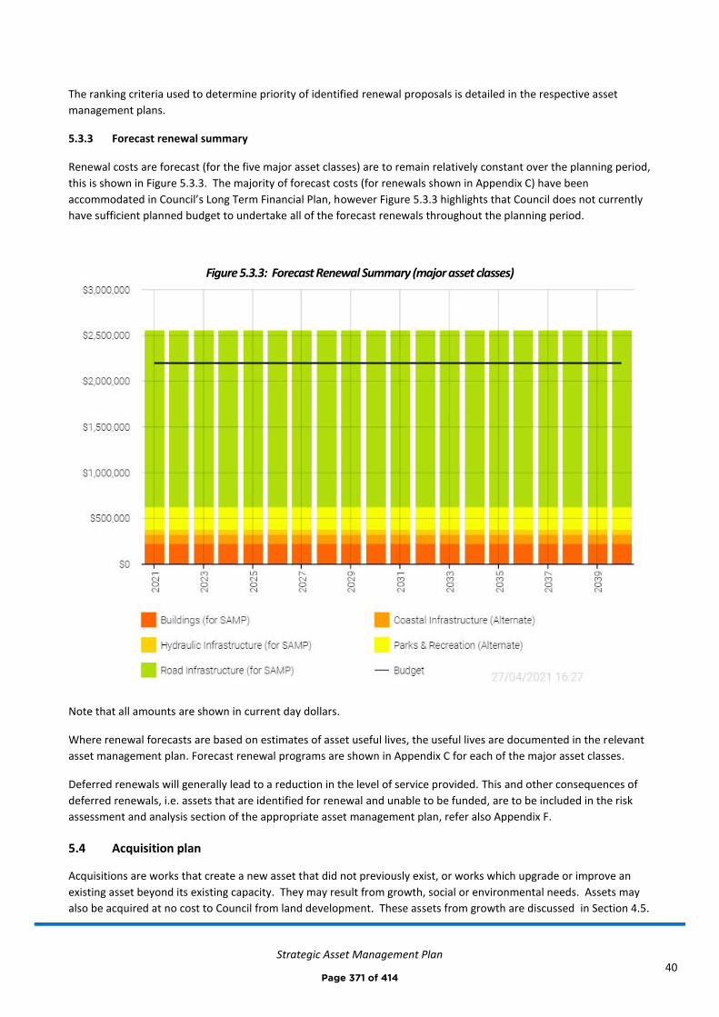
Strategic Asset Management Plan
40
The ranking criteria used to determine priority of identified renewal proposals is detailed in the respective asset
management plans.
5.3.3 Forecast renewal summary
Renewal costs are forecast (for the five major asset classes) are to remain relatively constant over the planning period,
this is shown in Figure 5.3.3. The majority of forecast costs (for renewals shown in Appendix C) have been
accommodated in Council’s Long Term Financial Plan, however Figure 5.3.3 highlights that Council does not currently
have sufficient planned budget to undertake all of the forecast renewals throughout the planning period.
Figure 5.3.3: Forecast Renewal Summary (major asset classes)
Note that all amounts are shown in current day dollars.
Where renewal forecasts are based on estimates of asset useful lives, the useful lives are documented in the relevant
asset management plan. Forecast renewal programs are shown in Appendix C for each of the major asset classes.
Deferred renewals will generally lead to a reduction in the level of service provided. This and other consequences of
deferred renewals, i.e. assets that are identified for renewal and unable to be funded, are to be included in the risk
assessment and analysis section of the appropriate asset management plan, refer also Appendix F.
5.4 Acquisition plan
Acquisitions are works that create a new asset that did not previously exist, or works which upgrade or improve an
existing asset beyond its existing capacity. They may result from growth, social or environmental needs. Assets may
also be acquired at no cost to Council from land development. These assets from growth are discussed in Section 4.5.
Page 371 of 414

Strategic Asset Management Plan
41
5.4.1 Selection criteria
Asset acquisitions are identified from various sources such as Councillor or community requests, proposals identified
by strategic plans or partnerships with other organisations. Proposals are inspected to verify need and to develop a
preliminary renewal estimate. Verified proposals are ranked by priority and available funds and then scheduled in
future works programmes. The priority ranking criteria is detailed in the respective Asset Management Plans.
5.4.2 Capital investment strategies
We will plan capital upgrade and new projects to meet level of service objectives by:
• Planning and scheduling capital upgrade and new projects to deliver the defined level of service in the most
efficient manner
• Undertake project scoping for all Renewal projects to identify
o the service delivery ‘deficiency’, present risk and required timeline for delivery of the upgrade/new
asset
o the project objectives to rectify the deficiency including value management for major projects
o the range of options, estimated capital and life cycle costs for each option that could address the
service deficiency
o management of risks associated with alternative options
o and evaluate the options against evaluation criteria adopted by Council, and
o select the best option to be included in renewal programs
• Review current and required skills base and implement training and development to meet required
construction and project management needs
• Review management of capital project management activities to ensure we are obtaining best value for
resources used.
Standards and specifications for maintenance of existing assets and asset acquisitions are detailed in relevant asset
management plans.
5.4.3 Forecast acquisition summary
Forecast acquisition and planned budget over the planning period (for the five major asset classes) are detailed in
Figure 5.4.3. As can be seen, forecast acquisitions and planned budget are in balance, which is good. The forecast
acquisitions have been accommodated in Council’s Long Term Financial Plan. The projected acquisition program is
shown in Appendix C. All amounts are shown in current day dollars.
Page 372 of 414
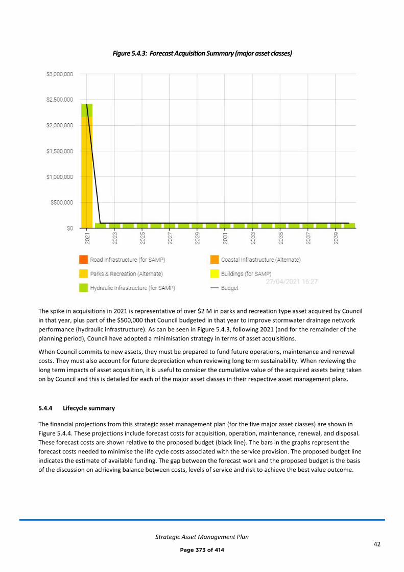
Strategic Asset Management Plan
42
Figure 5.4.3: Forecast Acquisition Summary (major asset classes)
The spike in acquisitions in 2021 is representative of over $2 M in parks and recreation type asset acquired by Council
in that year, plus part of the $500,000 that Council budgeted in that year to improve stormwater drainage network
performance (hydraulic infrastructure). As can be seen in Figure 5.4.3, following 2021 (and for the remainder of the
planning period), Council have adopted a minimisation strategy in terms of asset acquisitions.
When Council commits to new assets, they must be prepared to fund future operations, maintenance and renewal
costs. They must also account for future depreciation when reviewing long term sustainability. When reviewing the
long term impacts of asset acquisition, it is useful to consider the cumulative value of the acquired assets being taken
on by Council and this is detailed for each of the major asset classes in their respective asset management plans.
5.4.4 Lifecycle summary
The financial projections from this strategic asset management plan (for the five major asset classes) are shown in
Figure 5.4.4. These projections include forecast costs for acquisition, operation, maintenance, renewal, and disposal.
These forecast costs are shown relative to the proposed budget (black line). The bars in the graphs represent the
forecast costs needed to minimise the life cycle costs associated with the service provision. The proposed budget line
indicates the estimate of available funding. The gap between the forecast work and the proposed budget is the basis
of the discussion on achieving balance between costs, levels of service and risk to achieve the best value outcome.
Page 373 of 414
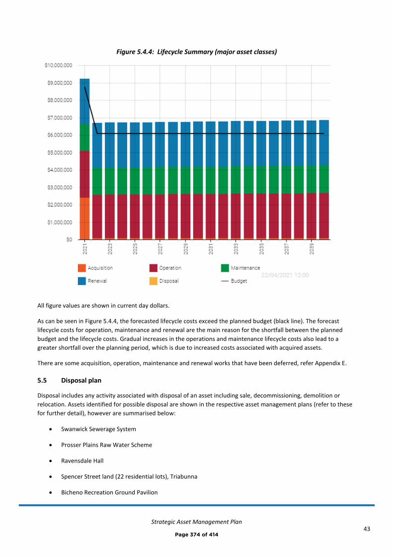
Strategic Asset Management Plan
43
Figure 5.4.4: Lifecycle Summary (major asset classes)
All figure values are shown in current day dollars.
As can be seen in Figure 5.4.4, the forecasted lifecycle costs exceed the planned budget (black line). The forecast
lifecycle costs for operation, maintenance and renewal are the main reason for the shortfall between the planned
budget and the lifecycle costs. Gradual increases in the operations and maintenance lifecycle costs also lead to a
greater shortfall over the planning period, which is due to increased costs associated with acquired assets.
There are some acquisition, operation, maintenance and renewal works that have been deferred, refer Appendix E.
5.5 Disposal plan
Disposal includes any activity associated with disposal of an asset including sale, decommissioning, demolition or
relocation. Assets identified for possible disposal are shown in the respective asset management plans (refer to these
for further detail), however are summarised below:
• Swanwick Sewerage System
• Prosser Plains Raw Water Scheme
• Ravensdale Hall
• Spencer Street land (22 residential lots), Triabunna
• Bicheno Recreation Ground Pavilion
Page 374 of 414
Strategic Asset Management Plan
44
• 6 Rectory Street, Swansea
• 8 Noyes Street, Swansea
• Little Friends Childcare Centre, Spring Bay Childcare Centre, and Prosser House
• Stormwater drainage assets that are under capacity and will be replaced prior to the end of their useful life
(as part of any works recommended from the Draft Urban Stormwater Management Plan
• 5 x land assets used to house TasWater infrastructure
Page 375 of 414
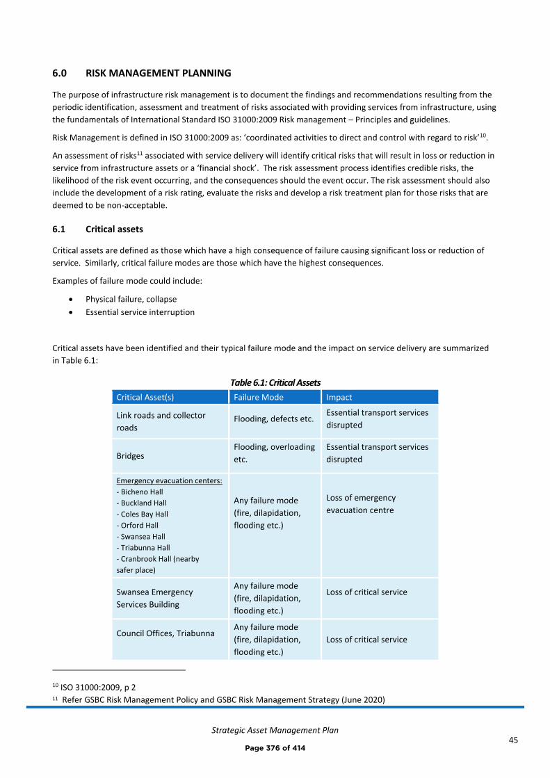
Strategic Asset Management Plan
45
6.0 RISK MANAGEMENT PLANNING
The purpose of infrastructure risk management is to document the findings and recommendations resulting from the
periodic identification, assessment and treatment of risks associated with providing services from infrastructure, using
the fundamentals of International Standard ISO 31000:2009 Risk management – Principles and guidelines.
Risk Management is defined in ISO 31000:2009 as: ‘coordinated activities to direct and control with regard to risk’10.
An assessment of risks11 associated with service delivery will identify critical risks that will result in loss or reduction in
service from infrastructure assets or a ‘financial shock’. The risk assessment process identifies credible risks, the
likelihood of the risk event occurring, and the consequences should the event occur. The risk assessment should also
include the development of a risk rating, evaluate the risks and develop a risk treatment plan for those risks that are
deemed to be non-acceptable.
6.1 Critical assets
Critical assets are defined as those which have a high consequence of failure causing significant loss or reduction of
service. Similarly, critical failure modes are those which have the highest consequences.
Examples of failure mode could include:
• Physical failure, collapse
• Essential service interruption
Critical assets have been identified and their typical failure mode and the impact on service delivery are summarized
in Table 6.1:
Table 6.1: Critical Assets
Critical Asset(s) Failure Mode Impact
Link roads and collector
roads Flooding, defects etc.
Essential transport services
disrupted
Bridges Flooding, overloading
etc.
Essential transport services
disrupted
Emergency evacuation centers:
- Bicheno Hall
- Buckland Hall
- Coles Bay Hall
- Orford Hall
- Swansea Hall
- Triabunna Hall
- Cranbrook Hall (nearby
safer place)
Any failure mode
(fire, dilapidation,
flooding etc.)
Loss of emergency
evacuation centre
Swansea Emergency
Services Building
Any failure mode
(fire, dilapidation,
flooding etc.)
Loss of critical service
Council Offices, Triabunna
Any failure mode
(fire, dilapidation,
flooding etc.)
Loss of critical service
10 ISO 31000:2009, p 2 11 Refer GSBC Risk Management Policy and GSBC Risk Management Strategy (June 2020)
Page 376 of 414

Strategic Asset Management Plan
46
Critical Asset(s) Failure Mode Impact
All stormwater drainage
assets (notably stormwater
detention basins, culverts,
pipelines, open drains,
overland flow paths etc.)
Flooding/blockage Damage to buildings, roads
and other infrastructure.
Prosser Plains Raw Water
Scheme Component failure
Loss of income and
exposure to unbudgeted
financial costs
Swanwick sewerage system Component failure or
overflow Environmental nuisance
Triabunna wharf, Triabunna
marina and key boat ramps
throughout municipality.
Structural,
operational (sand
deposits affecting
serviceability) or any
other failure mode.
Service disruption to all
users and loss of critical
water access points.
By identifying critical assets and failure modes an organization can ensure that investigative activities, condition
inspection programs, maintenance and capital expenditure plans are targeted at critical assets.
6.2 Risk assessment
The risk management process used in this project is shown in Figure 6.2 below.
It is an analysis and problem solving technique designed to provide a logical process for the selection of treatment
plans and management actions to protect the community against unacceptable risks.
The process is based on the fundamentals of the ISO risk assessment standard ISO 31000:2009.
Figure 6.2: Risk Management Process – Abridged
The risk assessment process identifies credible risks, the likelihood of the risk event occurring, the consequences
should the event occur, develops a risk rating, evaluates the risk and develops a risk treatment plan for non-
acceptable risks.
TREAT RISKS
- Identify options
- Assess options
- Treatment plans
ANALYSE &
EVALUATE RISKS
- Consequences
- Likelihood
- Level of Risk
- Evaluate
IDENTIFY RISKS
- What can happen ?
- When and why ?
- How and why ?
Page 377 of 414
Strategic Asset Management Plan
47
An assessment of risks12 associated with service delivery from infrastructure assets will identify the critical risks that
will result in significant loss, ‘financial shock‘ or a reduction in service.
Critical risks are those assessed with ‘Very High’ (requiring immediate corrective action) and ‘High’ (requiring
corrective action) risk ratings identified in the Infrastructure Risk Management Plan. The residual risk and treatment
costs of implementing the selected treatment plan is shown for all major asset classes in Appendix F. It is essential
that these critical risks and costs are reported to management and Council.
6.4 Service and risk trade-offs
Council has prioritised decisions made in adopting the asset management plans summarised in this Strategic Asset
Management Plan to obtain the optimum benefits from its available resources.
The asset management plans are based on balancing service performance, cost and risk to provide an agreed level of
service from available resources as detailed in our Long Term Financial Plan.
6.4.1 What we cannot do
We do not currently have enough funding to provide all services at the desired level of service, or to provide new
services over the planning period. Major lifecycle activities that are currently deferred (due to be undertaken now, but
not funded) under Long Term Financial Plan funding levels are:
• Road renewals and maintenance of lower priority road infrastructure. We cannot undertake road renewals and
maintenance at the rate required to maintain the current level of service.
• A preventative maintenance program for buildings.
• The planned budget does not allow all capital works (acquisitions and renewals) recommended in the Draft Urban
Stormwater Management Plan to be undertaken immediately, however, Council will endeavour to complete
these works on a priority basis over the next 5-10 years. Refer Appendix D.
• Council do not currently budget to undertake specific operation, maintenance or renewal of coastal assets. Hence
Council is unable to currently commit to maintaining and renewing existing assets within the next 10 years and is
solely reliant on funding provided by MAST to undertake such works.
• The previously proposed Spring Bay Harbour Expansion project (Triabunna wharf and marina expansion)
• Lower priority renewals for parks and recreation assets. We cannot undertake all parks and recreation asset
renewals at the rate required to maintain the current level of service. Council will endeavour to complete
renewals on a priority basis.
We cannot acquire assets where there is no planned budget assigned to service the full lifecycle costs (acquisition,
operation, maintenance, renewal and disposal) over the planning period. A recent example of this is the acquisition of
Wielangta Road. This also includes externally funded capital works, for example – the significant parks and recreation
grants ($2.1M asset acquisition) in 2020-21.
12 Refer GSBC Risk Management Policy and GSBC Risk Management Strategy (June 2020) i IPWEA, 20015, IIMM, Sec 3, p9.
Page 378 of 414
Strategic Asset Management Plan
48
6.4.2 Service trade-off
If there is forecast work (operations, maintenance, renewal, acquisition or disposal) that cannot be undertaken due to
available resources, then this will result in service consequences for users. The service consequences will generally be
a reduction in level of service provided.
6.4.3 Risk trade-off
The operations and maintenance activities and capital projects that cannot be undertaken may sustain or create risk
consequences. These risk consequences include:
◼ A reduction to the level of service provided
◼ Reputational consequences
These actions and expenditures are considered and included in the forecast costs, and where developed, the Risk
Management Plan.
Page 379 of 414

Strategic Asset Management Plan
49
7.0 FINANCIAL SUMMARY
This section contains the financial requirements resulting from all the information presented in the previous sections
of this Strategic Asset Management Plan. The financial projections will be improved as further information becomes
available on desired levels of service and current and projected future asset performance.
7.1 Financial indicators and projections
Funding ratios
The Asset Renewal Funding Ratio is a key indicator which shows whether forecast renewal costs are able to be
financed in the Long Term Financial Plan. It is calculated by dividing the forecast renewal costs (refer Asset
Management Plans) by the estimated planned renewal budget (refer Long Term Financial Plan). Over the planning
period, we are forecasting that we will have approximately 86 % (asset renewal funding ratio) of the funds required
for the optimal renewal of assets.
Other relevant funding ratios are shown below:
Acquisition and Renew (combined) funding ratio: 88 %
Operation and Maintenance funding ratio: 93 %
Total Lifecycle (Acquisition, Operation, Maintenance, Renewal, Disposal) funding ratio: 90 %
7.2 Funding strategy
The funding strategy to provide the services covered by this Strategic Asset Management Plan and supporting asset
management plans is contained within Council’s Long Term Financial Plan (10 year).
The funding strategy was developed in conjunction with the individual Asset Management Plans and Long Term
Financial Plan. We recognise that we are unable to currently meet all service demand and have agreed on a
compromise of lifecycle activities in order to balance level of service, risk and cost. The funding strategy does not
currently require additional borrowings to finance any critical or high priority renewals or acquisitions.
Page 380 of 414
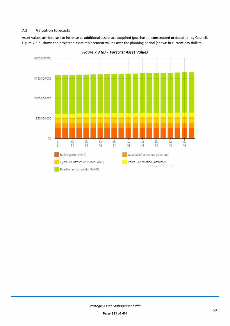
Strategic Asset Management Plan
50
7.3 Valuation forecasts
Asset values are forecast to increase as additional assets are acquired (purchased, constructed or donated) by Council.
Figure 7.3(a) shows the projected asset replacement values over the planning period (shown in current day dollars).
Figure 7.3 (a) - Forecast Asset Values
Page 381 of 414
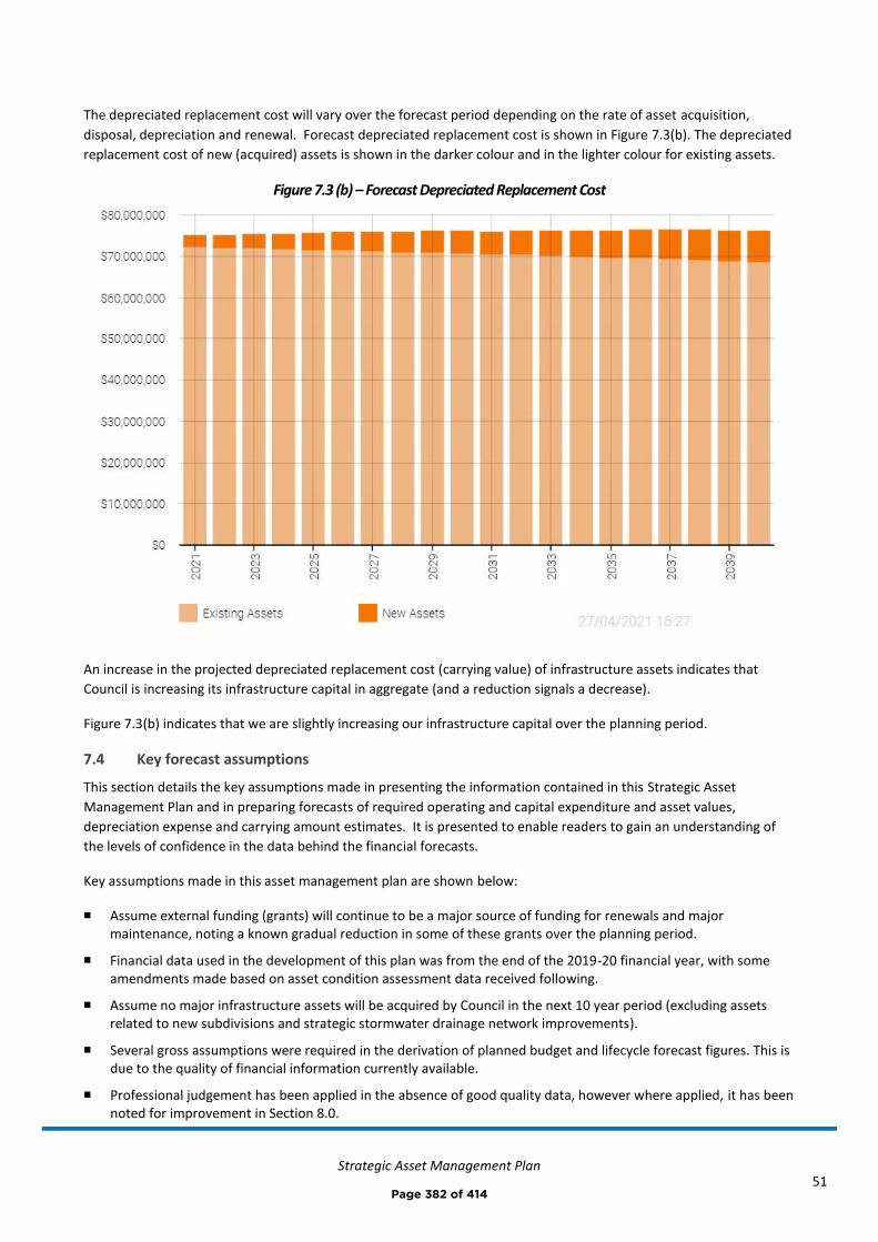
Strategic Asset Management Plan
51
The depreciated replacement cost will vary over the forecast period depending on the rate of asset acquisition,
disposal, depreciation and renewal. Forecast depreciated replacement cost is shown in Figure 7.3(b). The depreciated
replacement cost of new (acquired) assets is shown in the darker colour and in the lighter colour for existing assets.
Figure 7.3 (b) – Forecast Depreciated Replacement Cost
An increase in the projected depreciated replacement cost (carrying value) of infrastructure assets indicates that
Council is increasing its infrastructure capital in aggregate (and a reduction signals a decrease).
Figure 7.3(b) indicates that we are slightly increasing our infrastructure capital over the planning period.
7.4 Key forecast assumptions
This section details the key assumptions made in presenting the information contained in this Strategic Asset
Management Plan and in preparing forecasts of required operating and capital expenditure and asset values,
depreciation expense and carrying amount estimates. It is presented to enable readers to gain an understanding of
the levels of confidence in the data behind the financial forecasts.
Key assumptions made in this asset management plan are shown below:
◼ Assume external funding (grants) will continue to be a major source of funding for renewals and major maintenance, noting a known gradual reduction in some of these grants over the planning period.
◼ Financial data used in the development of this plan was from the end of the 2019-20 financial year, with some amendments made based on asset condition assessment data received following.
◼ Assume no major infrastructure assets will be acquired by Council in the next 10 year period (excluding assets related to new subdivisions and strategic stormwater drainage network improvements).
◼ Several gross assumptions were required in the derivation of planned budget and lifecycle forecast figures. This is due to the quality of financial information currently available.
◼ Professional judgement has been applied in the absence of good quality data, however where applied, it has been noted for improvement in Section 8.0.
Page 382 of 414
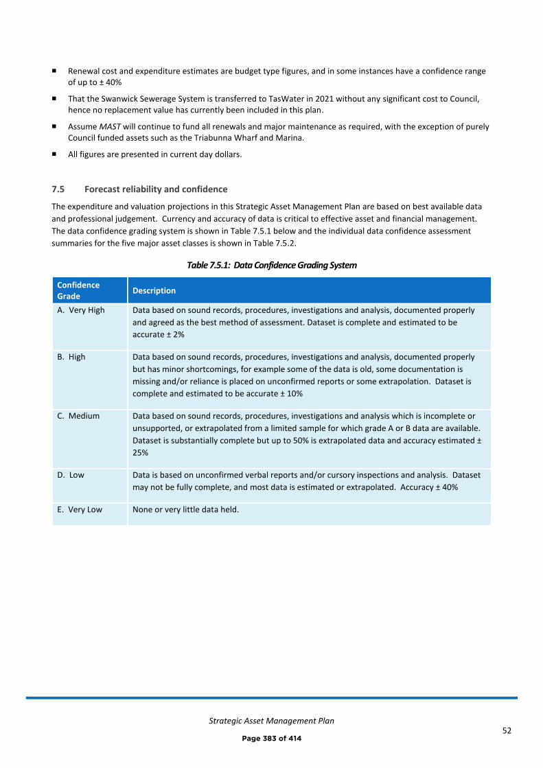
Strategic Asset Management Plan
52
◼ Renewal cost and expenditure estimates are budget type figures, and in some instances have a confidence range of up to ± 40%
◼ That the Swanwick Sewerage System is transferred to TasWater in 2021 without any significant cost to Council, hence no replacement value has currently been included in this plan.
◼ Assume MAST will continue to fund all renewals and major maintenance as required, with the exception of purely Council funded assets such as the Triabunna Wharf and Marina.
◼ All figures are presented in current day dollars.
7.5 Forecast reliability and confidence
The expenditure and valuation projections in this Strategic Asset Management Plan are based on best available data
and professional judgement. Currency and accuracy of data is critical to effective asset and financial management.
The data confidence grading system is shown in Table 7.5.1 below and the individual data confidence assessment
summaries for the five major asset classes is shown in Table 7.5.2.
Table 7.5.1: Data Confidence Grading System
Confidence Grade
Description
A. Very High Data based on sound records, procedures, investigations and analysis, documented properly
and agreed as the best method of assessment. Dataset is complete and estimated to be
accurate ± 2%
B. High Data based on sound records, procedures, investigations and analysis, documented properly
but has minor shortcomings, for example some of the data is old, some documentation is
missing and/or reliance is placed on unconfirmed reports or some extrapolation. Dataset is
complete and estimated to be accurate ± 10%
C. Medium Data based on sound records, procedures, investigations and analysis which is incomplete or
unsupported, or extrapolated from a limited sample for which grade A or B data are available.
Dataset is substantially complete but up to 50% is extrapolated data and accuracy estimated ±
25%
D. Low Data is based on unconfirmed verbal reports and/or cursory inspections and analysis. Dataset
may not be fully complete, and most data is estimated or extrapolated. Accuracy ± 40%
E. Very Low None or very little data held.
Page 383 of 414
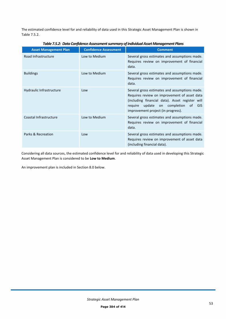
Strategic Asset Management Plan
53
The estimated confidence level for and reliability of data used in this Strategic Asset Management Plan is shown in
Table 7.5.2.
Table 7.5.2: Data Confidence Assessment summary of individual Asset Management Plans
Asset Management Plan Confidence Assessment Comment
Road Infrastructure Low to Medium Several gross estimates and assumptions made.
Requires review on improvement of financial
data.
Buildings Low to Medium Several gross estimates and assumptions made.
Requires review on improvement of financial
data.
Hydraulic Infrastructure Low Several gross estimates and assumptions made.
Requires review on improvement of asset data
(including financial data). Asset register will
require update on completion of GIS
improvement project (in progress).
Coastal Infrastructure Low to Medium Several gross estimates and assumptions made.
Requires review on improvement of financial
data.
Parks & Recreation Low Several gross estimates and assumptions made.
Requires review on improvement of asset data
(including financial data).
Considering all data sources, the estimated confidence level for and reliability of data used in developing this Strategic
Asset Management Plan is considered to be Low to Medium.
An improvement plan is included in Section 8.0 below.
Page 384 of 414
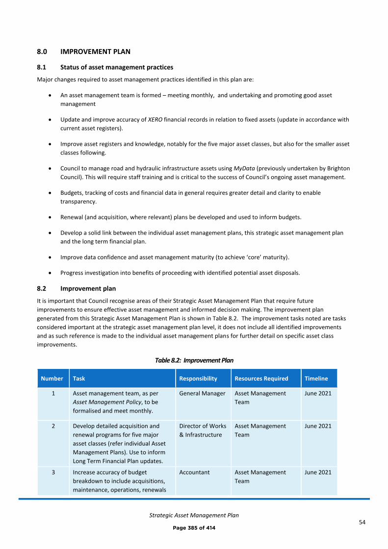
Strategic Asset Management Plan
54
8.0 IMPROVEMENT PLAN
8.1 Status of asset management practices
Major changes required to asset management practices identified in this plan are:
• An asset management team is formed – meeting monthly, and undertaking and promoting good asset
management
• Update and improve accuracy of XERO financial records in relation to fixed assets (update in accordance with
current asset registers).
• Improve asset registers and knowledge, notably for the five major asset classes, but also for the smaller asset
classes following.
• Council to manage road and hydraulic infrastructure assets using MyData (previously undertaken by Brighton
Council). This will require staff training and is critical to the success of Council’s ongoing asset management.
• Budgets, tracking of costs and financial data in general requires greater detail and clarity to enable
transparency.
• Renewal (and acquisition, where relevant) plans be developed and used to inform budgets.
• Develop a solid link between the individual asset management plans, this strategic asset management plan
and the long term financial plan.
• Improve data confidence and asset management maturity (to achieve ‘core’ maturity).
• Progress investigation into benefits of proceeding with identified potential asset disposals.
8.2 Improvement plan
It is important that Council recognise areas of their Strategic Asset Management Plan that require future
improvements to ensure effective asset management and informed decision making. The improvement plan
generated from this Strategic Asset Management Plan is shown in Table 8.2. The improvement tasks noted are tasks
considered important at the strategic asset management plan level, it does not include all identified improvements
and as such reference is made to the individual asset management plans for further detail on specific asset class
improvements.
Table 8.2: Improvement Plan
Number Task Responsibility Resources Required Timeline
1 Asset management team, as per
Asset Management Policy, to be
formalised and meet monthly.
General Manager Asset Management
Team
June 2021
2 Develop detailed acquisition and
renewal programs for five major
asset classes (refer individual Asset
Management Plans). Use to inform
Long Term Financial Plan updates.
Director of Works
& Infrastructure
Asset Management
Team
June 2021
3 Increase accuracy of budget
breakdown to include acquisitions,
maintenance, operations, renewals
Accountant Asset Management
Team
June 2021
Page 385 of 414

Strategic Asset Management Plan
55
and disposals. Aim for better
transparency.
4 Progress potential asset disposals
(those with limited value or that do
not fit with Council’s strategy). Refer
individual asset management plans
and Section 5.5.
General Manager Asset Management
Team
December
2021
5 Improvements required in XERO
(accounting software):
- XERO register to match
actual asset registers –
values are currently out by
estimated $20M.
- Remove fully depreciated,
disposed, and otherwise
irrelevant assets where
appropriate
- Improve recording of assets
into correct asset classes
- Staff training on $1000
‘asset’ threshold (i.e. if less,
not to be recorded on XERO
fixed asset register)
- Standard tracking categories
to be used by all staff
Accountant Asset Management
Team
2022
6 Council to manage road and
hydraulic infrastructure assets in
MyData (previously by Brighton
Council). Refer individual asset
management plans for specific
improvement activities.
General Manager
& Director of
Works &
Infrastructure
Asset Management
Team
2022
7 Improve confidence in financial data
used in Long Term Financial Plan and
Strategic Asset Management Plan
Accountant Asset Management
Team
2022
8 Assess yearly performance
(budgeted vs. actual costs) and
update Asset Management Plan and
Long Term Financial Plan accordingly.
General Manager Asset Management
Team
2022
9 Completion and adoption of the
Draft Urban Stormwater
Management Plan once complete,
including all associated
recommendations. This includes
completion of catchment modelling
Director of Works
& Infrastructure
Hydraulic Engineer 2022
Page 386 of 414
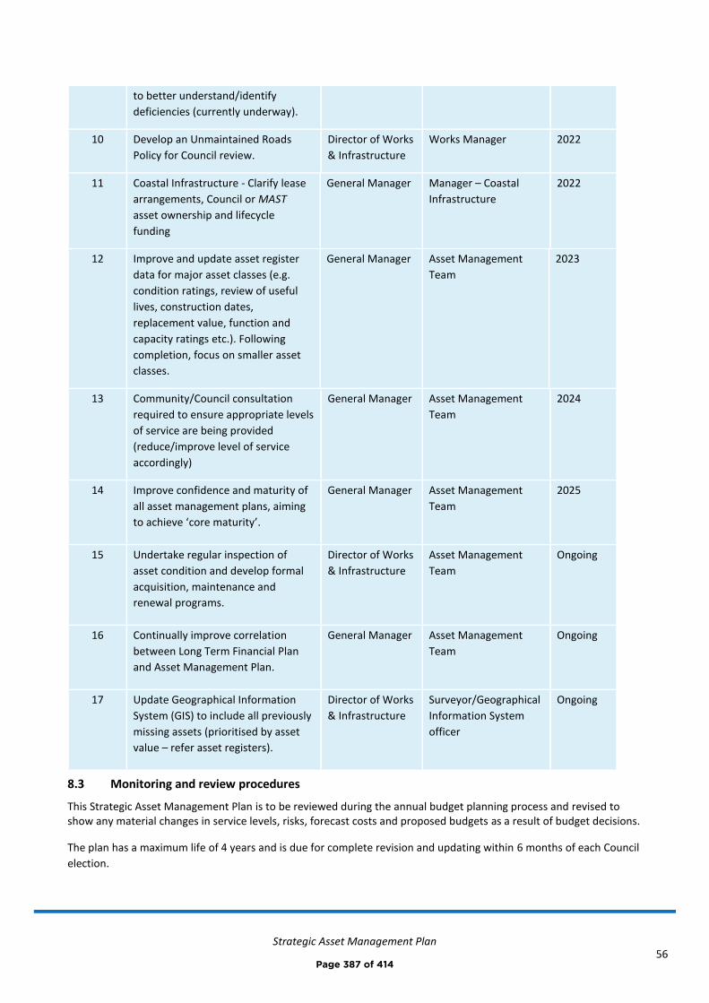
Strategic Asset Management Plan
56
to better understand/identify
deficiencies (currently underway).
10 Develop an Unmaintained Roads
Policy for Council review.
Director of Works
& Infrastructure
Works Manager 2022
11 Coastal Infrastructure - Clarify lease
arrangements, Council or MAST
asset ownership and lifecycle
funding
General Manager Manager – Coastal
Infrastructure
2022
12 Improve and update asset register
data for major asset classes (e.g.
condition ratings, review of useful
lives, construction dates,
replacement value, function and
capacity ratings etc.). Following
completion, focus on smaller asset
classes.
General Manager Asset Management
Team
2023
13 Community/Council consultation
required to ensure appropriate levels
of service are being provided
(reduce/improve level of service
accordingly)
General Manager Asset Management
Team
2024
14 Improve confidence and maturity of
all asset management plans, aiming
to achieve ‘core maturity’.
General Manager Asset Management
Team
2025
15 Undertake regular inspection of
asset condition and develop formal
acquisition, maintenance and
renewal programs.
Director of Works
& Infrastructure
Asset Management
Team
Ongoing
16 Continually improve correlation
between Long Term Financial Plan
and Asset Management Plan.
General Manager Asset Management
Team
Ongoing
17 Update Geographical Information
System (GIS) to include all previously
missing assets (prioritised by asset
value – refer asset registers).
Director of Works
& Infrastructure
Surveyor/Geographical
Information System
officer
Ongoing
8.3 Monitoring and review procedures
This Strategic Asset Management Plan is to be reviewed during the annual budget planning process and revised to show any material changes in service levels, risks, forecast costs and proposed budgets as a result of budget decisions.
The plan has a maximum life of 4 years and is due for complete revision and updating within 6 months of each Council
election.
Page 387 of 414
Strategic Asset Management Plan
57
8.4 Performance measures
The effectiveness of the Strategic Asset Management Plan can be measured in the following ways:
• The degree to which the required projected expenditures identified in this Strategic Asset Management Plan
are incorporated into Council’s Long Term Financial Plan
• The degree to which 1-5 year detailed works programs, budgets, business plans and organisational structures
take into account the ‘global’ works program trends provided by the summarised asset management plans
• The degree to which the existing and projected service levels and service consequences (what we cannot do),
risks and residual risks are incorporated into Council’s 10-Year Strategic Plan and associated plans
• The Asset Renewal Funding Ratio achieving the target of 90 – 100 % (currently 86 %)
Page 388 of 414
Strategic Asset Management Plan
58
9.0 REFERENCES
▪ ISO, 2014, ISO 55000, Asset management – Overview, principles and terminology, International Organization
for Standardization, Geneva.
▪ ISO, 2014, ISO 55001, Asset management – Management systems - Requirements, International Organization
for Standardization, Geneva.
▪ ISO, 2014, ISO 55002, Asset management – Management systems – Guidelines for the application of ISO
55001, International Organization for Standardization, Geneva.
▪ IPWEA, 2014, ‘NAMS.PLUS3 Asset Management’, Institute of Public Works Engineering Australia, Sydney,
www.ipwea.org/namsplus.
▪ IPWEA, 2015, ‘Australian Infrastructure Financial Management Manual, Institute of Public Works Engineering
Australasia, Sydney, www.ipwea.org/AIFMM.
▪ IPWEA, 2011, 2015, ‘International Infrastructure Management Manual’, Institute of Public Works Engineering
Australasia, Sydney, www.ipwea.org/IIMM
▪ ‘10-year Strategic Plan 2020-2029’
▪ ‘2020-2021 Annual Plan’ (incl. budget)
▪ Asset Management Plans
o Road Infrastructure 2020
o Buildings 2020
o Hydraulic Infrastructure 2021
o Coastal Infrastructure 2021
o Parks & Recreation 2021
▪ Asset Management - Maturity Assessment Plan 2021
▪ Long Term Financial Plan 2021
Page 389 of 414

Strategic Asset Management Plan
59
10.0 APPENDICES
Appendix A Summary Technical Levels of Service
Appendix B Operation and Maintenance Forecast Summary
Appendix C Renewal Forecast Summary
Appendix D Acquisition Forecast Summary
Appendix E Deferred Works Summary
Appendix F Risk and Treatment Plans
Page 390 of 414
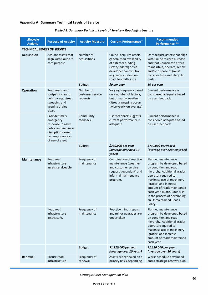
Strategic Asset Management Plan
60
Appendix A Summary Technical Levels of Service
Table A1: Summary Technical Levels of Service – Road Infrastructure
Lifecycle Activity
Purpose of Activity Activity Measure Current Performance* Recommended Performance **
TECHNICAL LEVELS OF SERVICE
Acquisition Acquire assets that align with Council’s core purpose
Number of acquisitions
Council acquires assets generally on availability of external funding (state/federal) or via developer contribution (e.g. new subdivision road, footpath etc.)
Only acquire assets that align with Council’s core purpose and that Council can afford to maintain, operate, renew and/or dispose of (must consider full asset lifecycle costs)
Budget $0 per year $0 per year
Operation Keep roads and footpaths clear of debris – e.g. street sweeping and keeping drains clear.
Number of customer service requests
Varying frequency based on a number of factors, but primarily weather. (Street sweeping occurs twice yearly on average)
Current performance is considered adequate based on user feedback
Provide timely emergency response to assist public and minimise disruption caused by temporary loss of use of asset
Community feedback
User feedback suggests current performance is adequate
Current performance is considered adequate based on user feedback
Budget $730,000 per year (average over next 10 years)
$730,000 per year 8 (average over next 10 years)
Maintenance Keep road infrastructure assets serviceable
Frequency of maintenance
Combination of reactive maintenance (weather and customer service request dependent) and informal maintenance program.
Planned maintenance program be developed based on condition and road hierarchy. Additional grader operator required to maximise use of machinery (grader) and increase amount of roads maintained each year. (Note, Council is in the process of developing an Unmaintained Roads Policy)
Keep road infrastructure assets safe.
Frequency of maintenance
Reactive minor repairs and minor upgrades are undertaken
Planned maintenance program be developed based on condition and road hierarchy. Additional grader operator required to maximise use of machinery (grader) and increase amount of roads maintained each year.
Budget $1,120,000 per year (average over 10 years)
$1,120,000 per year (average over 10 years)
Renewal Ensure road infrastructure
Frequency of renewal
Assets are renewed on a priority basis depending
Works schedule developed and a strategic renewal plan
Page 391 of 414
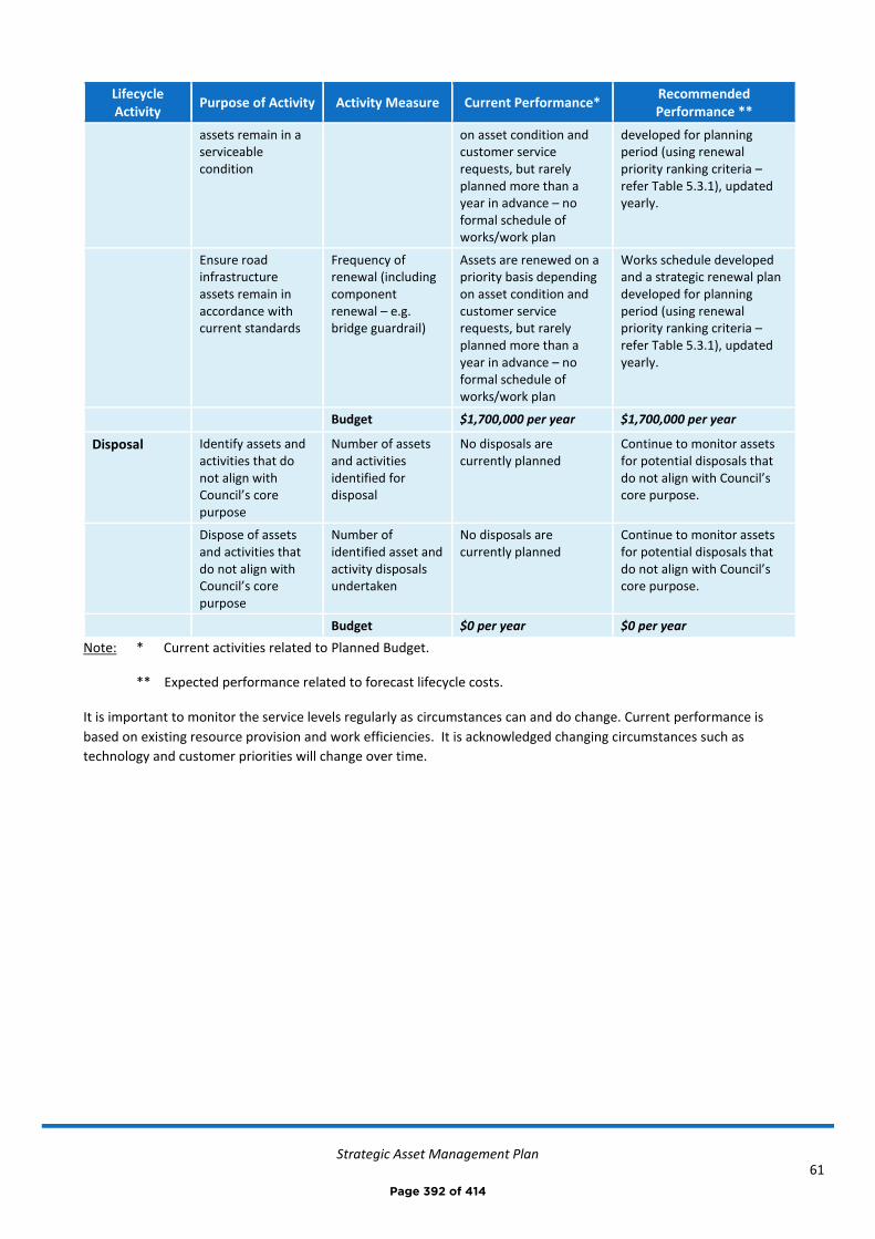
Strategic Asset Management Plan
61
Lifecycle Activity
Purpose of Activity Activity Measure Current Performance* Recommended Performance **
assets remain in a serviceable condition
on asset condition and customer service requests, but rarely planned more than a year in advance – no formal schedule of works/work plan
developed for planning period (using renewal priority ranking criteria – refer Table 5.3.1), updated yearly.
Ensure road infrastructure assets remain in accordance with current standards
Frequency of renewal (including component renewal – e.g. bridge guardrail)
Assets are renewed on a priority basis depending on asset condition and customer service requests, but rarely planned more than a year in advance – no formal schedule of works/work plan
Works schedule developed and a strategic renewal plan developed for planning period (using renewal priority ranking criteria – refer Table 5.3.1), updated yearly.
Budget $1,700,000 per year $1,700,000 per year
Disposal Identify assets and activities that do not align with Council’s core purpose
Number of assets and activities identified for disposal
No disposals are currently planned
Continue to monitor assets for potential disposals that do not align with Council’s core purpose.
Dispose of assets and activities that do not align with Council’s core purpose
Number of identified asset and activity disposals undertaken
No disposals are currently planned
Continue to monitor assets for potential disposals that do not align with Council’s core purpose.
Budget $0 per year $0 per year
Note: * Current activities related to Planned Budget.
** Expected performance related to forecast lifecycle costs.
It is important to monitor the service levels regularly as circumstances can and do change. Current performance is
based on existing resource provision and work efficiencies. It is acknowledged changing circumstances such as
technology and customer priorities will change over time.
Page 392 of 414
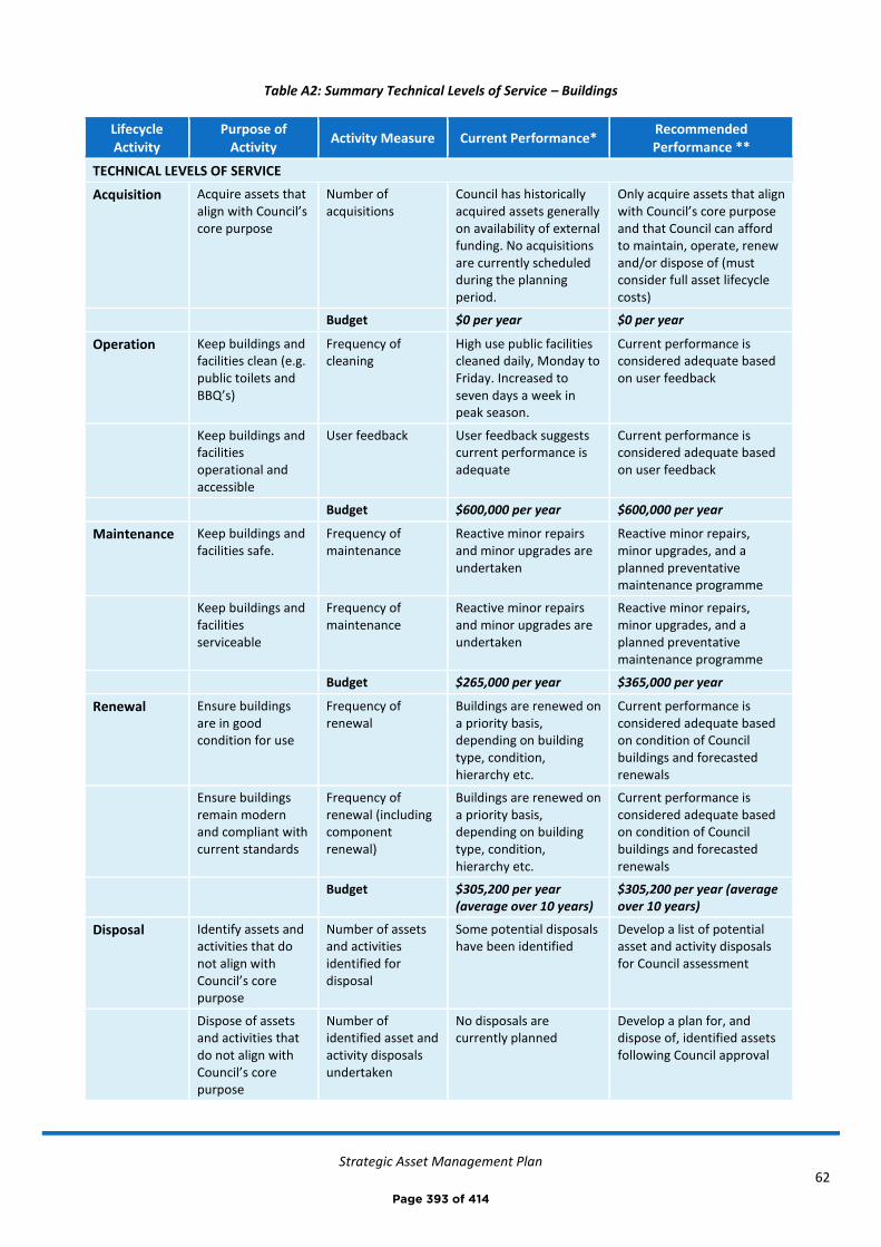
Strategic Asset Management Plan
62
Table A2: Summary Technical Levels of Service – Buildings
Lifecycle Activity
Purpose of Activity
Activity Measure Current Performance* Recommended Performance **
TECHNICAL LEVELS OF SERVICE
Acquisition Acquire assets that align with Council’s core purpose
Number of acquisitions
Council has historically acquired assets generally on availability of external funding. No acquisitions are currently scheduled during the planning period.
Only acquire assets that align with Council’s core purpose and that Council can afford to maintain, operate, renew and/or dispose of (must consider full asset lifecycle costs)
Budget $0 per year $0 per year
Operation Keep buildings and facilities clean (e.g. public toilets and BBQ’s)
Frequency of cleaning
High use public facilities cleaned daily, Monday to Friday. Increased to seven days a week in peak season.
Current performance is considered adequate based on user feedback
Keep buildings and facilities operational and accessible
User feedback User feedback suggests current performance is adequate
Current performance is considered adequate based on user feedback
Budget $600,000 per year $600,000 per year
Maintenance Keep buildings and facilities safe.
Frequency of maintenance
Reactive minor repairs and minor upgrades are undertaken
Reactive minor repairs, minor upgrades, and a planned preventative maintenance programme
Keep buildings and facilities serviceable
Frequency of maintenance
Reactive minor repairs and minor upgrades are undertaken
Reactive minor repairs, minor upgrades, and a planned preventative maintenance programme
Budget $265,000 per year $365,000 per year
Renewal Ensure buildings are in good condition for use
Frequency of renewal
Buildings are renewed on a priority basis, depending on building type, condition, hierarchy etc.
Current performance is considered adequate based on condition of Council buildings and forecasted renewals
Ensure buildings remain modern and compliant with current standards
Frequency of renewal (including component renewal)
Buildings are renewed on a priority basis, depending on building type, condition, hierarchy etc.
Current performance is considered adequate based on condition of Council buildings and forecasted renewals
Budget $305,200 per year (average over 10 years)
$305,200 per year (average over 10 years)
Disposal Identify assets and activities that do not align with Council’s core purpose
Number of assets and activities identified for disposal
Some potential disposals have been identified
Develop a list of potential asset and activity disposals for Council assessment
Dispose of assets and activities that do not align with Council’s core purpose
Number of identified asset and activity disposals undertaken
No disposals are currently planned
Develop a plan for, and dispose of, identified assets following Council approval
Page 393 of 414
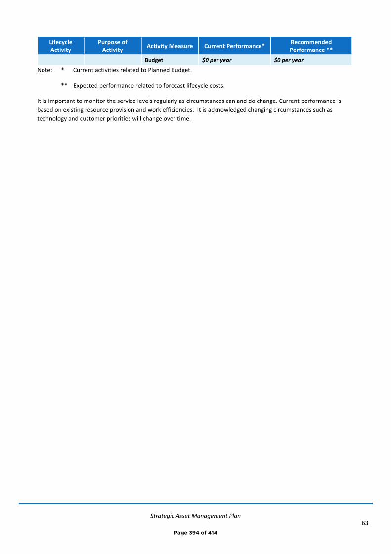
Strategic Asset Management Plan
63
Lifecycle Activity
Purpose of Activity
Activity Measure Current Performance* Recommended Performance **
Budget $0 per year $0 per year
Note: * Current activities related to Planned Budget.
** Expected performance related to forecast lifecycle costs.
It is important to monitor the service levels regularly as circumstances can and do change. Current performance is
based on existing resource provision and work efficiencies. It is acknowledged changing circumstances such as
technology and customer priorities will change over time.
Page 394 of 414
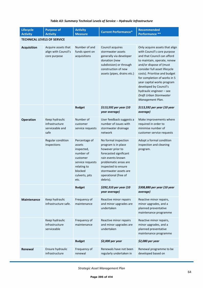
Strategic Asset Management Plan
64
Table A3: Summary Technical Levels of Service – Hydraulic Infrastructure
Lifecycle Activity
Purpose of Activity
Activity Measure
Current Performance* Recommended Performance **
TECHNICAL LEVELS OF SERVICE
Acquisition Acquire assets that
align with Council’s
core purpose
Number of and
funds spent on
acquisitions
Council acquires
stormwater assets
generally via developer
donation (new
subdivision) or through
construction of new
assets (pipes, drains etc.)
Only acquire assets that align
with Council’s core purpose
and that Council can afford
to maintain, operate, renew
and/or dispose of (must
consider full asset lifecycle
costs). Prioritise and budget
for completion of works in 5
year capital works program
developed by Council’s
hydraulic engineer – see
Draft Urban Stormwater
Management Plan.
Budget $113,592 per year (10
year average)
$113,592 per year (10 year
average)
Operation Keep hydraulic
infrastructure
serviceable and
safe
Number of
customer
service requests
User feedback suggests a
number of issues with
stormwater drainage
network
Make improvements where
required in order to
minimise number of
customer service requests
Regular condition
inspections
Percentage of
assets
inspected,
number of
customer
service requests
relating to
blocked
culverts, pits
etc.
No formal inspection
program is in place
however prior to
forecasted significant
rain events known
problematic areas are
inspected to ensure
stormwater assets are
operational (free of
debris).
Adopt a formal condition
inspection and cleaning
program.
Budget $292,310 per year (10
year average)
$308,880 per year (10 year
average)
Maintenance Keep hydraulic
infrastructure safe.
Frequency of
maintenance
Reactive minor repairs
and minor upgrades are
undertaken
Reactive minor repairs,
minor upgrades, and a
planned preventative
maintenance programme
Keep hydraulic
infrastructure
serviceable
Frequency of
maintenance
Reactive minor repairs
and minor upgrades are
undertaken
Reactive minor repairs,
minor upgrades, and a
planned preventative
maintenance programme
Budget $2,000 per year $2,080 per year
Renewal Ensure hydraulic
infrastructure
Frequency of
renewal
Renewals have not been
regularly undertaken in
Renewal programme to be
developed based on
Page 395 of 414
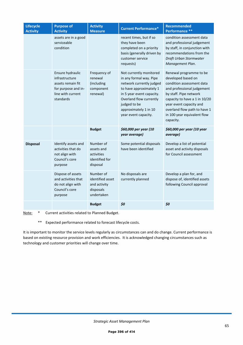
Strategic Asset Management Plan
65
Lifecycle Activity
Purpose of Activity
Activity Measure
Current Performance* Recommended Performance **
assets are in a good
serviceable
condition
recent times, but if so
they have been
completed on a priority
basis (generally driven by
customer service
requests)
condition assessment data
and professional judgement
by staff, in conjunction with
recommendations from the
Draft Urban Stormwater
Management Plan.
Ensure hydraulic
infrastructure
assets remain fit
for purpose and in-
line with current
standards
Frequency of
renewal
(including
component
renewal)
Not currently monitored
in any formal way. Pipe
network currently judged
to have approximately 1
in 5 year event capacity.
Overland flow currently
judged to be
approximately 1 in 10
year event capacity.
Renewal programme to be
developed based on
condition assessment data
and professional judgement
by staff. Pipe network
capacity to have a 1 in 10/20
year event capacity and
overland flow path to have 1
in 100 year equivalent flow
capacity.
Budget $60,000 per year (10
year average)
$60,000 per year (10 year
average)
Disposal Identify assets and
activities that do
not align with
Council’s core
purpose
Number of
assets and
activities
identified for
disposal
Some potential disposals
have been identified
Develop a list of potential
asset and activity disposals
for Council assessment
Dispose of assets
and activities that
do not align with
Council’s core
purpose
Number of
identified asset
and activity
disposals
undertaken
No disposals are
currently planned
Develop a plan for, and
dispose of, identified assets
following Council approval
Budget $0 $0
Note: * Current activities related to Planned Budget.
** Expected performance related to forecast lifecycle costs.
It is important to monitor the service levels regularly as circumstances can and do change. Current performance is
based on existing resource provision and work efficiencies. It is acknowledged changing circumstances such as
technology and customer priorities will change over time.
Page 396 of 414
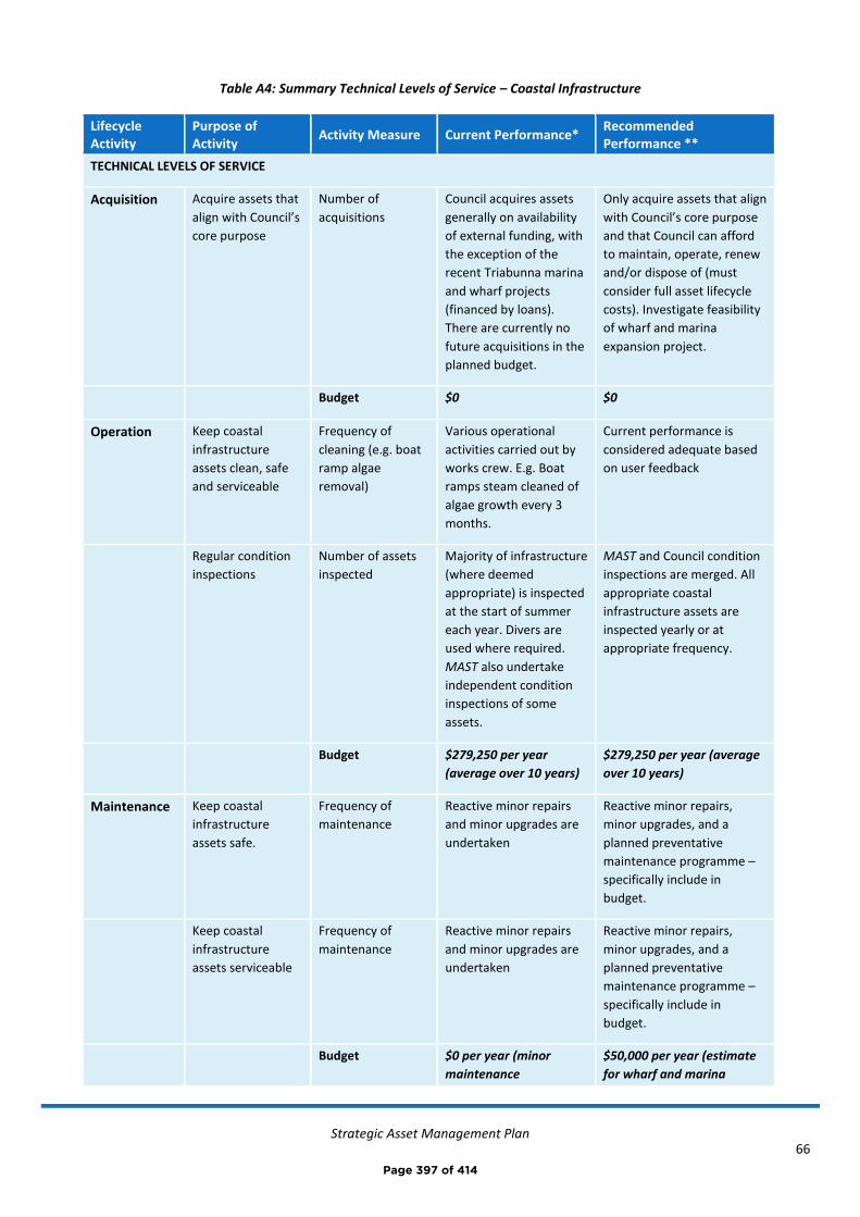
Strategic Asset Management Plan
66
Table A4: Summary Technical Levels of Service – Coastal Infrastructure
Lifecycle Activity
Purpose of Activity
Activity Measure Current Performance* Recommended Performance **
TECHNICAL LEVELS OF SERVICE
Acquisition Acquire assets that
align with Council’s
core purpose
Number of
acquisitions
Council acquires assets
generally on availability
of external funding, with
the exception of the
recent Triabunna marina
and wharf projects
(financed by loans).
There are currently no
future acquisitions in the
planned budget.
Only acquire assets that align
with Council’s core purpose
and that Council can afford
to maintain, operate, renew
and/or dispose of (must
consider full asset lifecycle
costs). Investigate feasibility
of wharf and marina
expansion project.
Budget $0 $0
Operation Keep coastal
infrastructure
assets clean, safe
and serviceable
Frequency of
cleaning (e.g. boat
ramp algae
removal)
Various operational
activities carried out by
works crew. E.g. Boat
ramps steam cleaned of
algae growth every 3
months.
Current performance is
considered adequate based
on user feedback
Regular condition
inspections
Number of assets
inspected
Majority of infrastructure
(where deemed
appropriate) is inspected
at the start of summer
each year. Divers are
used where required.
MAST also undertake
independent condition
inspections of some
assets.
MAST and Council condition
inspections are merged. All
appropriate coastal
infrastructure assets are
inspected yearly or at
appropriate frequency.
Budget $279,250 per year
(average over 10 years)
$279,250 per year (average
over 10 years)
Maintenance Keep coastal
infrastructure
assets safe.
Frequency of
maintenance
Reactive minor repairs
and minor upgrades are
undertaken
Reactive minor repairs,
minor upgrades, and a
planned preventative
maintenance programme –
specifically include in
budget.
Keep coastal
infrastructure
assets serviceable
Frequency of
maintenance
Reactive minor repairs
and minor upgrades are
undertaken
Reactive minor repairs,
minor upgrades, and a
planned preventative
maintenance programme –
specifically include in
budget.
Budget $0 per year (minor
maintenance
$50,000 per year (estimate
for wharf and marina
Page 397 of 414
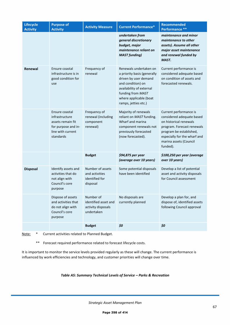
Strategic Asset Management Plan
67
Lifecycle Activity
Purpose of Activity
Activity Measure Current Performance* Recommended Performance **
undertaken from
general discretionary
budget, major
maintenance reliant on
MAST funding)
maintenance and minor
maintenance to other
assets). Assume all other
major asset maintenance
and renewal funded by
MAST.
Renewal Ensure coastal
infrastructure is in
good condition for
use
Frequency of
renewal
Renewals undertaken on
a priority basis (generally
driven by user demand
and condition) on
availability of external
funding from MAST
where applicable (boat
ramps, jetties etc.)
Current performance is
considered adequate based
on condition of assets and
forecasted renewals.
Ensure coastal
infrastructure
assets remain fit
for purpose and in-
line with current
standards
Frequency of
renewal (including
component
renewal)
Majority of renewals
reliant on MAST funding.
Wharf and marina
component renewals not
previously forecasted
(now forecasted).
Current performance is
considered adequate based
on historical renewals
program. Forecast renewals
program be established,
especially for the wharf and
marina assets (Council
funded).
Budget $94,875 per year
(average over 10 years)
$100,250 per year (average
over 10 years)
Disposal Identify assets and
activities that do
not align with
Council’s core
purpose
Number of assets
and activities
identified for
disposal
Some potential disposals
have been identified
Develop a list of potential
asset and activity disposals
for Council assessment
Dispose of assets
and activities that
do not align with
Council’s core
purpose
Number of
identified asset and
activity disposals
undertaken
No disposals are
currently planned
Develop a plan for, and
dispose of, identified assets
following Council approval
Budget $0 $0
Note: * Current activities related to Planned Budget.
** Forecast required performance related to forecast lifecycle costs.
It is important to monitor the service levels provided regularly as these will change. The current performance is
influenced by work efficiencies and technology, and customer priorities will change over time.
Table A5: Summary Technical Levels of Service – Parks & Recreation
Page 398 of 414
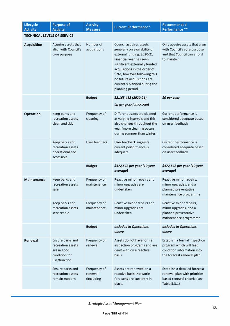
Strategic Asset Management Plan
68
Lifecycle Activity
Purpose of Activity
Activity Measure
Current Performance* Recommended Performance **
TECHNICAL LEVELS OF SERVICE
Acquisition Acquire assets that
align with Council’s
core purpose
Number of
acquisitions
Council acquires assets
generally on availability of
external funding. 2020-21
Financial year has seen
significant externally funded
acquisitions in the order of
$2M, however following this
no future acquisitions are
currently planned during the
planning period.
Only acquire assets that align
with Council’s core purpose
and that Council can afford
to maintain
Budget $2,165,462 (2020-21)
$0 per year (2022-240)
$0 per year
Operation Keep parks and
recreation assets
clean and tidy
Frequency of
cleaning
Different assets are cleaned
at varying intervals and this
also changes throughout the
year (more cleaning occurs
during summer than winter,)
Current performance is
considered adequate based
on user feedback
Keep parks and
recreation assets
operational and
accessible
User feedback User feedback suggests
current performance is
adequate
Current performance is
considered adequate based
on user feedback
Budget $472,572 per year (10 year
average)
$472,572 per year (10 year
average)
Maintenance Keep parks and
recreation assets
safe.
Frequency of
maintenance
Reactive minor repairs and
minor upgrades are
undertaken
Reactive minor repairs,
minor upgrades, and a
planned preventative
maintenance programme
Keep parks and
recreation assets
serviceable
Frequency of
maintenance
Reactive minor repairs and
minor upgrades are
undertaken
Reactive minor repairs,
minor upgrades, and a
planned preventative
maintenance programme
Budget Included in Operations
above
Included in Operations
above
Renewal Ensure parks and
recreation assets
are in good
condition for
use/function
Frequency of
renewal
Assets do not have formal
inspection programs and are
dealt with on a reactive
basis.
Establish a formal inspection
program which will feed
condition information into
the forecast renewal plan
Ensure parks and
recreation assets
remain modern
Frequency of
renewal
(including
Assets are renewed on a
reactive basis. No works
forecasts are currently in
place.
Establish a detailed forecast
renewal plan with priorities
based renewal criteria (see
Table 5.3.1)
Page 399 of 414

Strategic Asset Management Plan
69
Lifecycle Activity
Purpose of Activity
Activity Measure
Current Performance* Recommended Performance **
and compliant with
current standards
component
renewal)
Budget $123,000 per year (10 year
average)
$160,604 per year (10 year
average)
Disposal Identify assets and
activities that do
not align with
Council’s core
purpose
Number of
assets and
activities
identified for
disposal
No potential disposals have
currently been identified
Develop a list of potential
asset and activity disposals
for Council assessment
Dispose of assets
and activities that
do not align with
Council’s core
purpose
Number of
identified asset
and activity
disposals
undertaken
No disposals are currently
planned
Develop a plan for, and
dispose of, identified assets
following Council approval
Budget $0 per year $0 per year
Note: * Current activities related to Planned Budget.
** Forecast required performance related to forecast lifecycle costs.
It is important to monitor the service levels provided regularly as these will change. The current performance is
influenced by work efficiencies and technology, and customer priorities will change over time.
Page 400 of 414
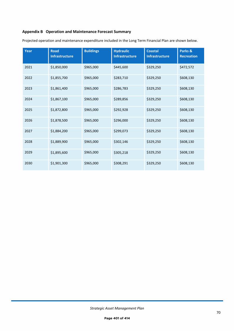
Strategic Asset Management Plan
70
Appendix B Operation and Maintenance Forecast Summary
Projected operation and maintenance expenditure included in the Long Term Financial Plan are shown below.
Year Road
Infrastructure
Buildings Hydraulic
Infrastructure
Coastal
Infrastructure
Parks &
Recreation
2021 $1,850,000 $965,000 $445,600 $329,250 $472,572
2022 $1,855,700 $965,000 $283,710 $329,250 $608,130
2023 $1,861,400 $965,000 $286,783 $329,250 $608,130
2024 $1,867,100 $965,000 $289,856 $329,250 $608,130
2025 $1,872,800 $965,000 $292,928 $329,250 $608,130
2026 $1,878,500 $965,000 $296,000 $329,250 $608,130
2027 $1,884,200 $965,000 $299,073 $329,250 $608,130
2028 $1,889,900 $965,000 $302,146 $329,250 $608,130
2029 $1,895,600 $965,000 $305,218 $329,250 $608,130
2030 $1,901,300 $965,000 $308,291 $329,250 $608,130
Page 401 of 414
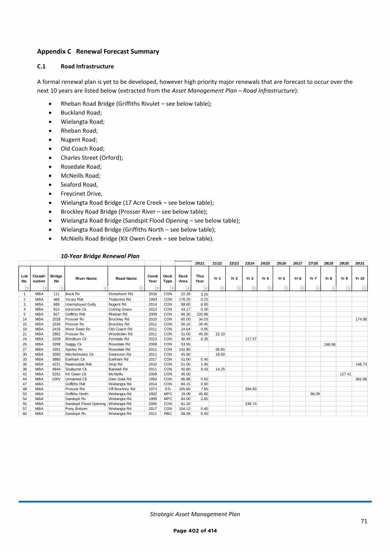
Strategic Asset Management Plan
71
Appendix C Renewal Forecast Summary
C.1 Road Infrastructure
A formal renewal plan is yet to be developed, however high priority major renewals that are forecast to occur over the
next 10 years are listed below (extracted from the Asset Management Plan – Road Infrastructure):
• Rheban Road Bridge (Griffiths Rivulet – see below table);
• Buckland Road;
• Wielangta Road;
• Rheban Road;
• Nugent Road;
• Old Coach Road;
• Charles Street (Orford);
• Rosedale Road;
• McNeills Road;
• Seaford Road,
• Freycinet Drive,
• Wielangta Road Bridge (17 Acre Creek – see below table);
• Brockley Road Bridge (Prosser River – see below table);
• Wielangta Road Bridge (Sandspit Flood Opening – see below table);
• Wielangta Road Bridge (Griffiths North – see below table);
• McNiells Road Bridge (Kit Owen Creek – see below table).
10-Year Bridge Renewal Plan
20\21 21\22 22\23 23\24 24\25 25\26 26\27 27\28 28\29 29\30 30\31
List
No.
Classif-
ication
Bridge
NoRiver Name Road Name
Const
Year
Deck
Type
Deck
Area
This
YearYr 1 Yr 2 Yr 3 Yr 4 Yr 5 Yr 6 Yr 7 Yr 8 Yr 9 Yr 10
1 MBA 111 Back Rv Stonehurst Rd 2016 CON 22.28 3.25
2 MBA 466 Vicary Rvlt Triabunna Rd 1993 CON 178.20 0.20
3 MBA 689 Unemployed Gully Nugent Rd 2014 CON 58.65 6.65
4 MBA 814 Ironstone Ck Cutting Grass 2013 CON 43.17 0.30
5 MBA 827 Griffiths Rvlt Rheban Rd 2009 CON 66.30 220.98
14 MBA 2028 Prosser Rv Brockley Rd 2010 CON 60.00 34.03 174.98
15 MBA 2034 Prosser Rv Brockley Rd 2011 CON 56.10 34.45
18 MBA 2416 West Swan Rv Old Coach Rd 2011 CON 24.64 0.95
21 MBA 2902 Prosser Rv Woodsden Rd 2011 CON 51.00 45.00 22.10
24 MBA 3209 Blindburn Ck Ferndale Rd 2013 CON 30.49 6.35 117.57
26 MBA 3299 Saggy Ck Rosedale Rd 2008 CON 53.55 248.96
27 MBA 3301 Apsley Rv Rosedale Rd 2011 CON 142.80 56.65
30 MBA 3590 Mitchelmores Ck Swanston Rd 2011 CON 45.90 19.00
33 MBA 3860 Earlham Ck Earlham Rd 2017 CON 51.00 0.40
35 MBA 4221 Ravensdale Rvlt Strip Rd 2010 CON 51.00 1.45 148.73
38 MBA 4844 Seabyrne Ck Banwell Rd 2011 CON 40.80 9.43 14.25
42 MBA 5251 Kit Owen Ck McNeills 2009 CON 45.00 127.41
44 MBA 100V Unnamed Ck Glen Gala Rd 1950 CON 66.88 5.65 362.68
47 MBA Griffiths Rvlt Wielangta Rd 2014 CON 84.15 0.30
48 MBA Prosser Rvr Off Brockley Rd 1973 STL 105.60 7.65 294.83
53 MBA Griffiths North Wielangta Rd 2002 MPC 19.08 45.80 86.09
54 MBA Sandspit Rv Wielangta Rd 1999 MPC 84.00 2.65
55 MBA Sandspit Flood Opening Wielangta Rd 2005 CON 61.20 238.74
57 MBA Pony Bottom Wielangta Rd 2017 CON 104.12 0.40
60 MBA Sandspit Rv Wielangta Rd 2011 RBC 56.28 0.40
Page 402 of 414

Strategic Asset Management Plan
72
C.2 Buildings
The below table is an extract from the Asset Management Plan - Buildings and shows assets forecast for renewal
within the planning period (up to 2039). It is to be noted that the ‘Forecast Renewal Year’ is calculated as the last
major renewal/build year, plus the ‘remaining useful life’ of the asset. The ‘remaining useful life’ figures (included in
the complete asset register) have been defined taking into account current condition of assets. Further professional
judgement will be required in prioritising the below renewals, with the ‘forecast renewal year’ being a guide only.
Asset Register Forecast Renewals
C.3 Hydraulic Infrastructure
Asset Cost to renew at
end of life
Forecast
Renewal Year
Swansea, Vet Clinic Building $15,000 2021
Bicheno, Lions Park, Picnic Shelter 1 $35,000 2021
Spring Beach, Toilet Block $65,000 2021
Coles Bay, Library and Medical Room $180,000 2021
Coles Bay, Community Hall, Picnic Shelter 2 $5,000 2021
Swansea, Jubilee Beach Park, BBQ Shelter 1 $6,500 2022
Swansea, Old Courthouse and Council Chambers $450,000 2022
Swansea, Old Courthouse and Council Chambers, GM's Office $50,000 2022
Triabunna, Council Works Depot $450,000 2023
Orford, Esplanade, Toilet Block $95,000 2023
Swansea, Recreation Ground, Clubrooms $825,000 2024
Bicheno, Recreation Ground, Toilet Block $185,000 2025
Swansea, Saltwater Creek, Public Toilet $226,000 2025
Swansea, Recreation Ground, Visitors Changerooms $25,000 2025
Swansea, Recreation Ground, Public Toilet Block $145,000 2026
Bicheno, Council Works Depot, Shed 2 (machinery shed) $9,000 2026
Bicheno, Lions Park, Picnic Shelter 2 $35,000 2026
Triabunna, Recreation Ground, Store Shed & Ticket Box $5,000 2026
Bicheno, Picnic Shelter $10,000 2027
Swansea, Old Courthouse and Council Chambers, Shed $10,000 2027
Triabunna, Recreation Ground, Public Toilet Block $85,000 2027
Swansea, Jubilee Beach, Public Toilet $95,000 2028
Triabunna, Recreation Ground, Old BBQ Shed $25,000 2030
Triabunna, Marina, BBQ Shelter 1 $6,000 2030
Swansea, Council Works Depot, Shed 4 $15,000 2031
Coles Bay, Community Hall, Toilet Block $135,000 2032
Orford, Waste Management Centre $210,000 2033
Swansea, House, 6 Rectory Street $251,220 2033
Bicheno, Council Works Depot, Shed 3 (chemical storage) $9,000 2033
Bicheno, Recreation Ground, Pavill ion $205,000 2035
Coles Bay, Esplanade E/Garnet Av, Public Toilet $125,000 2035
Coles Bay, Works Depot Shed $30,000 2035
Swansea, Council Works Depot, Shed 2 $25,000 2035
Swansea, Saltwater Creek, BBQ Shelter $6,500 2035
Coles Bay, Community Hall, BBQ Shelter $5,000 2035
Buckland, Reserve, Toilets $110,000 2036
Bicheno, Jetty Road Public Toilet $135,000 2036
Coles Bay, Lookout Structure $10,000 2037
Orford, Raspins Beach, Toilet Block $165,000 2039
Page 403 of 414

Strategic Asset Management Plan
73
Reference is made to the acquisition forecast summary plan in Appendix D for Hydraulic Infrastructure, refer D.3. It is
to be noted that generally stormwater assets are upgraded rather than renewed, given their generally long useful
service lives and an increase in modern design flows.
C.4 Coastal Infrastructure
The below table shows assets forecast for renewal within the planning period (up to 2039). It is to be noted that the
‘Forecast Renewal Year’ is calculated as the last major renewal/build year, plus the ‘remaining useful life’ of the asset.
The ‘remaining useful life’ figures (included in the complete asset register) have been defined taking into account
current condition of assets. Further professional judgement will be required in prioritising the below renewals, with
the ‘forecast renewal year’ being a guide only.
All figures shown are in current day dollars.
Forecast Renewal Works Summary
Asset_Name Renewal CostForecast
Renewal Year
Dolphin Sands, Yellow Sandbanks Road, Jetty 25,000$ 2021
Little Swanport, Saltworks Road, Timber Jetty 90,000$ 2021
Dolphin Sands, Yellow Sandbanks Road, Boat Ramp 25,000$ 2021
Coles Bay, Muirs Beach, Boatramp 120,000$ 2022
Coles Bay, Muirs Beach, Jetty 80,000$ 2022
Orford, Prosser River Road, Boat Ramp 25,000$ 2023
Swansea, Swimming Pontoon 15,000$ 2026
Triabunna, Barton Avenue (One Tree Point), Boat Ramp 15,000$ 2029
Orford, Raspins Beach Foreshore Rock 65,000$ 2035
Swansea, Jetty Road, Lower Boat Ramp Jetty 120,000$ 2038
Orford, West Shelly Beach, Boat Ramp 15,000$ 2039
Swanwick, Foreshore Protection (sandbags) 150,000$ 2039
Little Swanport, Saltworks Road, Floating Jetty 70,000$ 2039
Orford, Prosser River, Swimming Pontoon 15,000$ 2039
Triabunna, wharf and marina - component renewals (see below) 587,500$ 2021-2031
Specific wharf and marina component renewals:
Boat access platforms $100,000 2021-2022
Fixed wharf and marina ladders $2,500 2021-2023
Renewal of founding material to base of fixed birth marina wall $50,000 2021-2026
Electrical and plumbing services $10,000 2021-2031
Marina birth walkway trims, rollers and other minor items $2,500 2021-2031
Timber wharf kerbs $2,500 2021-2031
Fender/birth piles (generally timber) $100,000 2021-2031
Fixed marina wall panel renewal works $320,000 2021-2031
Page 404 of 414
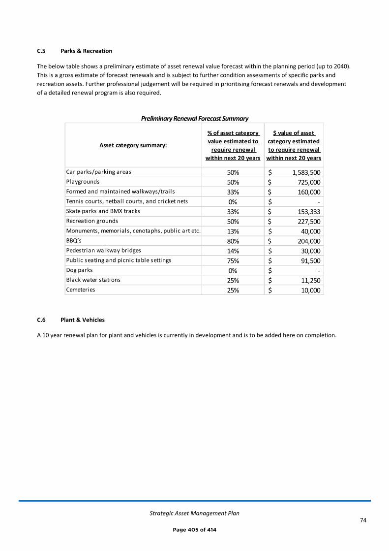
Strategic Asset Management Plan
74
C.5 Parks & Recreation
The below table shows a preliminary estimate of asset renewal value forecast within the planning period (up to 2040).
This is a gross estimate of forecast renewals and is subject to further condition assessments of specific parks and
recreation assets. Further professional judgement will be required in prioritising forecast renewals and development
of a detailed renewal program is also required.
Preliminary Renewal Forecast Summary
C.6 Plant & Vehicles
A 10 year renewal plan for plant and vehicles is currently in development and is to be added here on completion.
Asset category summary:
% of asset category
value estimated to
require renewal
within next 20 years
$ value of asset
category estimated
to require renewal
within next 20 years
Car parks/parking areas 50% 1,583,500$ Playgrounds 50% 725,000$ Formed and maintained walkways/trails 33% 160,000$ Tennis courts, netball courts, and cricket nets 0% -$ Skate parks and BMX tracks 33% 153,333$ Recreation grounds 50% 227,500$ Monuments, memorials, cenotaphs, public art etc. 13% 40,000$ BBQ’s 80% 204,000$ Pedestrian walkway bridges 14% 30,000$ Public seating and picnic table settings 75% 91,500$ Dog parks 0% -$ Black water stations 25% 11,250$ Cemeteries 25% 10,000$
Page 405 of 414
Strategic Asset Management Plan
75
Appendix D Acquisition Forecast Summary
D.1 Road Infrastructure
A key assumption in the writing of the Asset Management Plan – Road Infrastructure is that no major standalone
acquisitions are forecast to be undertaken during the planning period. Given future demand, Council’s current
financial position, available budget and discussion with key staff, a strategy of minimising acquisitions (for road
infrastructure assets) over the planning period is recommended.
D.2 Buildings
A key assumption in the writing of the Asset Management Plan - Buildings is that no acquisitions are forecast to be
undertaken during the planning period. Given future demand, Council’s current financial position, available budget
and discussion with key staff, a strategy of no acquisition (for building assets) over the planning period is
recommended.
D.3 Hydraulic Infrastructure
The table below (extract from Asset Management Plan – Hydraulic Infrastructure) is a draft 5-year works plan for the
stormwater drainage network, created by Council’s hydraulic engineer, stemming from the recommendations of the
Draft Urban Stormwater Management Plan. This table shows budget type cost forecasts and priorities for design and
construction works (mostly acquisition related). It is to be noted that further works to the value of $100-200k above
that shown below are expected to come from design projects listed and these additional funds have been considered
in the Long Term Financial Plan and Planned Budget.
Page 406 of 414
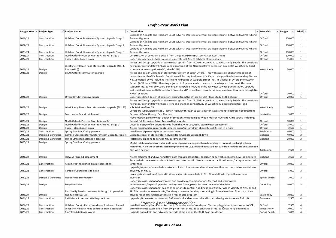
Strategic Asset Management Plan
76
Budget Year Project Type Project Name Description Township Budget Priority
2021/22 Construction Holkham Court Stormwater System Upgrade Stage 1
Upgrade of Alma Rd and Holkham Court culverts. Upgrade of central drainage channel between 66 Alma Rd and
Tasman Highway Orford 100,000 1
2022/23 Construction Holkham Court Stormwater System Upgrade Stage 2
Upgrade of Alma Rd and Holkham Court culverts. Upgrade of central drainage channel between 66 Alma Rd and
Tasman Highway Orford 100,000 1
2023/24 Construction Holkham Court Stormwater System Upgrade Stage 3
Upgrade of Alma Rd and Holkham Court culverts. Upgrade of central drainage channel between 66 Alma Rd and
Tasman Highway Orford 100,000 1
2023/24 Construction North Orford (Prosser River to Alma Rd) Stage 1 Construction of solutions derived from the joint DSG/GSBC stormwater assessment Orford 100,000 1
2022/23 Construction Russell Street open drain Undertake upgrades, stabilisation of upper Russell Street catchment open drain Orford 15,000 1
2021/22 Design
West Shelly Beach Road stormwater upgrade (No. 49
Rheban Rd))
Assess and design upgrade of stormwater system from No.49 Rheban Road to West Shelly Beach. This considers
new pipe/overland flow linkages and expansion of the Nautilus Drove detention basin. Ref West Shelly Road
stormwater investigation (ADD, March 2018) West Shelly 20,000 1
2021/22 Design South Orford stormwater upgrade Assess and design upgrade of stormwater system of south Orford. This will assess solutions to flooding of
properties south of Esplanade. Solutions will be required to rectify: Capacity in pipeline between Mary Stet and
No. 18 Walters Drive including inefficient hydraulics at Walpole Street (Ref. 46 Charles St Orford Stormwater
Report (ADD, June 2018) , flooding adjacent to Esplanade which seems to be a trapped low point, the pump
station in No. 11 Murphy Court, ponding in Walpole Street, near the Taswater sewage pump station, upgrade
and stabilisation of outfalls to Orford Rivulet and Prosser River, consideration of overland flow path through No.
7 Prosser Street Orford 20,000 1
2021/22 Design Orford Rivulet improvements Undertake detail design of solutions arising from the Orford Rivulet Flood Study (Pitt & Sherry) Orford 20,000 1
2021/22 Design West Shelly Beach Road stormwater upgrade (No. 39)
Assess and design upgrade of stormwater system from No.39 Rheban Road to West Shelly Beach. This considers
new pipe/overland flow linkages, kerb and channel, connectivity of West Shelly Beach properties, and
subdivision of No. 39) West Shelly 20,000 1
2021/22 Design Eastcoaster Resort catchment
Considers subdivision of Lot 1 Tasman Highway through to East Coaster. Assessment to address flooding from
Bernacchi Drive through East Coaster Louisville 5,000 1
2020/21 Design North Orford (Prosser River to Alma Rd)
Flood mapping and concept design of solutions to flooding between Prosser River and Alma Street, including
Convict Rd, Riverside Drive, Tasman Highway etc. Orford 50,000 1
2021/22 Design North Orford (Prosser River to Alma Rd) Stage 1 Detailed design of solutions derived from the joint DSG/GSBC stormwater assessment Orford 25,000 1
2021/22 Design Russell Street open drain Assess repair and requirements for large open/cut-off drain above Russell Street in Orford Orford 2,500 1
2020/21 Construction Spring Bay Boat Club pipework Install new pipework/pits as per assessment Triabunna 40,000 2
2020/21 Design & Construct Gamble Crescent stormwater system upgrade/repairs Upgrade/repair of stormwater network from Gamble Crescent down Bicheno 40,000 2
2020/21 Design & Construct James Street to Esplanade pipeline Install new pipeline to service No. 16 James Street Bicheno 20,000 2
2020/21 Design Spring Bay Boat Club pipework Model catchment and consider additional pipework along northern boundary to prevent surcharging from
manholes. Also check other system improvements (E.g. replace back-to-back culvert inlet/outlets on Esplanade
East with new pit Triabunna 2,500 2
2021/22 Design Harveys Farm Rd assessment Assess catchment and overland flow path through properties, considering culvert sizes, new development etc Bicheno 2,500 2
2020/21 Construction Alice Street rock lined drain stabilisation
Rock in drain on western side of Alice Street is too small. Needs concrete stabilisation and/or replacement with
larger rock Orford 10,000 3
2020/21 Construction Paradise Court roadside drain
Upgrade/repairs of open drain upstream of No. 11 to prevent direction of overflows across roadway and down
driveway of No. 10 Orford 5,000 3
2020/21 Design & Construct Hoods Road stormwater
Investigate diversion of Hoods Rd stormwater into open drain in No. 6 Hoods Road. If possible remove
diversion. Spring Beach 2,000 3
2021/22 Design Freycinet Drive
Undertake assessment of catchment and provide recommendations for road and stormwater
improvements/repairs/upgrades in Freycinet Drive, particular near the end of the drive Coles Bay 40,000 3
2021/22 Design
East Shelly Road assessment & design of open drain
and culvert (No. 38)
Undertake assessment and design of solutions to control flooding at East Shelly Road in vicinity of Nos. 38 and
39. This may include roadworks/floodway to ensure flooding is retaining in formal overland flow path. Also
consider road safety/rails as there is a reasonable drop-off. East Shelly 10,000 3
2024/25 Construction CNR Maria Street and Wellington Street Upgrade pit on eastern corner to LGAT standard and remove lid and install raised grate to create field pit Swansea 2,500 4
2024/25 Construction Holkham Court - End of cul-de-sac kerb and channel Installation of approx. 45m of kerb and channel at end of cul-de-sac. To control and direct stormwater to SEP Orford 7,500 4
2025/26 Construction West Shelly Beach Road concrete drain extension Extend concrete swale drain from SW pit at front of No. 16 to driveway of No. 12 West Shelly Beach Road West Shelly 10,000 4
2025/26 Construction Bluff Road drainage works Upgrade open drain and driveway culverts at the end of the Bluff Road cul-de-sac Spring Beach 5,000 4
Draft 5-Year Works Plan
Page 407 of 414
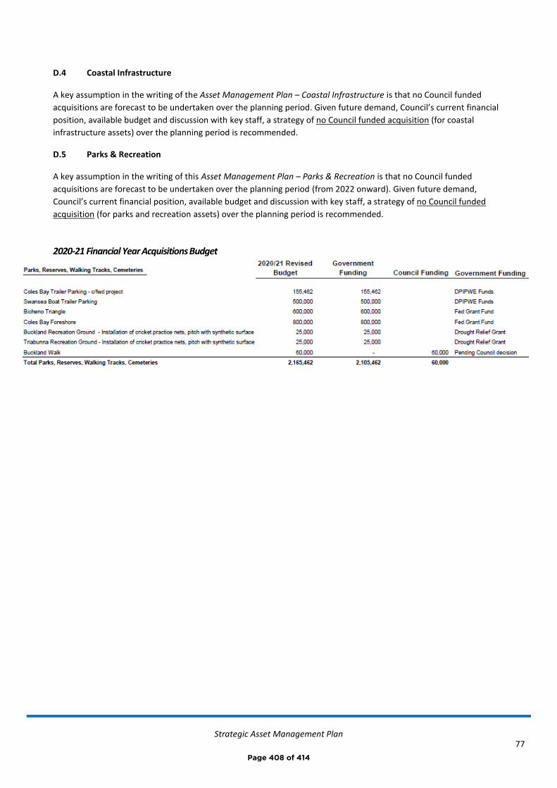
Strategic Asset Management Plan
77
D.4 Coastal Infrastructure
A key assumption in the writing of the Asset Management Plan – Coastal Infrastructure is that no Council funded
acquisitions are forecast to be undertaken over the planning period. Given future demand, Council’s current financial
position, available budget and discussion with key staff, a strategy of no Council funded acquisition (for coastal
infrastructure assets) over the planning period is recommended.
D.5 Parks & Recreation
A key assumption in the writing of this Asset Management Plan – Parks & Recreation is that no Council funded
acquisitions are forecast to be undertaken over the planning period (from 2022 onward). Given future demand,
Council’s current financial position, available budget and discussion with key staff, a strategy of no Council funded
acquisition (for parks and recreation assets) over the planning period is recommended.
2020-21 Financial Year Acquisitions Budget
Page 408 of 414
Strategic Asset Management Plan
78
Appendix E Deferred Works Summary
E.1 Road Infrastructure
We cannot currently undertake road renewals and maintenance at the rate required to maintain the current level of service, refer C.1. Council will endeavour to complete renewals on a priority basis. Refer also to Asset Management Plan – Road Infrastructure.
E.2 Buildings
We cannot currently undertake a preventative maintenance program. Refer also Asset Management Plan - Buildings
E.3 Hydraulic Infrastructure
We cannot currently undertake all recommended acquisition works, relating to stormwater drainage assets, within the next five years, refer D.3, however averaged over the next 10 years there has been adequate budget allocation to complete these works. Refer also Asset Management Plan - Hydraulic Infrastructure
E.4 Coastal Infrastructure
We cannot currently undertake all proposed renewal works by their recommended date, refer C4. Council will endeavour to complete renewals on a priority basis.
Council cannot fund any major maintenance, acquisition, renewal or disposal of assets that have historically been funded by MAST (boat ramps, jetties, pontoons etc.) and Council is reliant on this funding to undertake such works.
The completion of the previously proposed Triabunna harbour marina and port extension has not been included in the planned budget or the Long Term Financial Plan (it would be reliant on external funding if the project was to proceed). Refer also Asset Management Plan – Coastal Infrastructure.
E.5 Parks & Recreation
We cannot currently undertake all parks and recreation asset renewals at the rate required to maintain the current level of service, refer C.5. Council will endeavour to complete renewals on a priority basis. Refer also Asset Management Plan – Parks & Recreation.
Page 409 of 414
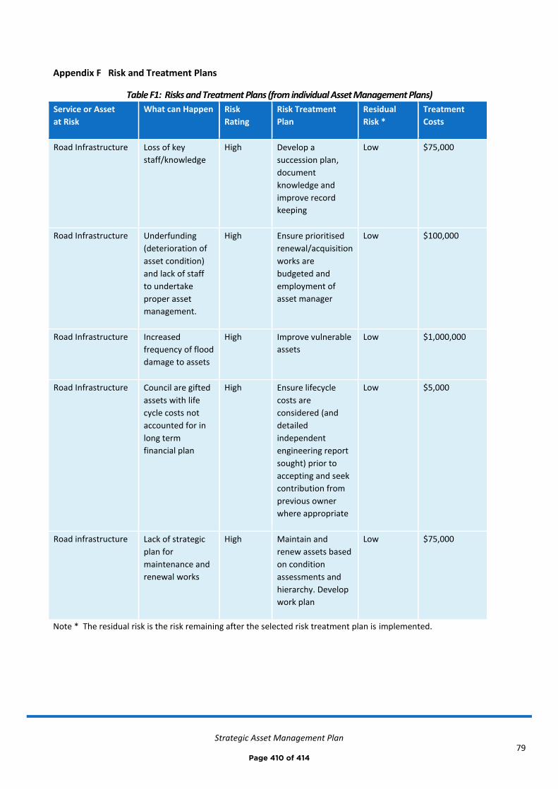
Strategic Asset Management Plan
79
Appendix F Risk and Treatment Plans
Table F1: Risks and Treatment Plans (from individual Asset Management Plans)
Service or Asset
at Risk
What can Happen Risk
Rating
Risk Treatment
Plan
Residual
Risk *
Treatment
Costs
Road Infrastructure Loss of key
staff/knowledge
High Develop a
succession plan,
document
knowledge and
improve record
keeping
Low $75,000
Road Infrastructure Underfunding
(deterioration of
asset condition)
and lack of staff
to undertake
proper asset
management.
High Ensure prioritised
renewal/acquisition
works are
budgeted and
employment of
asset manager
Low $100,000
Road Infrastructure Increased
frequency of flood
damage to assets
High Improve vulnerable
assets
Low $1,000,000
Road Infrastructure Council are gifted
assets with life
cycle costs not
accounted for in
long term
financial plan
High Ensure lifecycle
costs are
considered (and
detailed
independent
engineering report
sought) prior to
accepting and seek
contribution from
previous owner
where appropriate
Low $5,000
Road infrastructure Lack of strategic
plan for
maintenance and
renewal works
High Maintain and
renew assets based
on condition
assessments and
hierarchy. Develop
work plan
Low $75,000
Note * The residual risk is the risk remaining after the selected risk treatment plan is implemented.
Page 410 of 414

Strategic Asset Management Plan
80
Service or Asset
at Risk
What can Happen Risk Rating Risk Treatment
Plan
Residual Risk
*
Treatment
Costs
Council Buildings Loss of key
staff/knowledge
High Develop a
succession plan
and improve
record keeping
Low $75,000
Council Buildings Asbestos
exposure
High Develop
asbestos
register
Low $25,000
Council Buildings Reduction in
preventative
maintenance due
to reduction in
works staff
High Develop a
preventative
maintenance
program and
engage
maintenance
personnel to
undertake
Low $100,000
Prosser Plains Raw
Water Scheme
Loss of customer
or reduction in
water use income.
High Divest the
Prosser Plains
Raw Water
Scheme
Low Currently
unknown.
Hydraulic
Infrastructure
Loss of knowledge High Develop a
succession plan
and improve
record keeping
Low $75,000
Hydraulic
Infrastructure
Underfunding High Ensure
prioritised
renewal and
acquisition
works are
budgeted
Low $5,000
Swanwick Sewerage
System
Upgrade required High Asset transfer to
TasWater
Low $10,000
Hydraulic
Infrastructure
Flooding to
dwellings/network
requires increased
capacity
High Upgrade
stormwater
network
adjacent to
affected
properties
Low $975,000 over
the next 5-10
years
Note * The residual risk is the risk remaining after the selected risk treatment plan is implemented.
Page 411 of 414
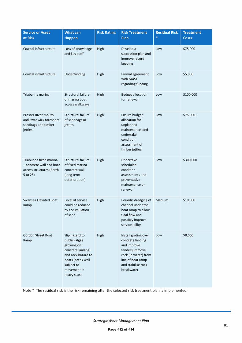
Strategic Asset Management Plan
81
Service or Asset
at Risk
What can
Happen
Risk Rating Risk Treatment
Plan
Residual Risk
*
Treatment
Costs
Coastal infrastructure Loss of knowledge
and key staff
High Develop a
succession plan and
improve record
keeping
Low $75,000
Coastal infrastructure Underfunding High Formal agreement
with MAST
regarding funding
Low $5,000
Triabunna marina Structural failure
of marina boat
access walkways
High Budget allocation
for renewal
Low $100,000
Prosser River-mouth
and Swanwick foreshore
sandbags and timber
jetties
Structural failure
of sandbags or
jetties
High Ensure budget
allocation for
unplanned
maintenance, and
undertake
condition
assessment of
timber jetties.
Low $75,000+
Triabunna fixed marina
– concrete wall and boat
access structures (Berth
5 to 25)
Structural failure
of fixed marina
concrete wall
(long term
deterioration)
High Undertake
scheduled
condition
assessments and
preventative
maintenance or
renewal
Low $300,000
Swansea Elevated Boat
Ramp
Level of service
could be reduced
by accumulation
of sand.
High Periodic dredging of
channel under the
boat ramp to allow
tidal flow and
possibly improve
serviceability
Medium $10,000
Gordon Street Boat
Ramp
Slip hazard to
public (algae
growing on
concrete landing)
and rock hazard to
boats (break wall
subject to
movement in
heavy seas)
High Install grating over
concrete landing
and improve
fenders, remove
rock (in water) from
line of boat ramp
and stabilise rock
breakwater.
Low $8,000
Note * The residual risk is the risk remaining after the selected risk treatment plan is implemented.
Page 412 of 414
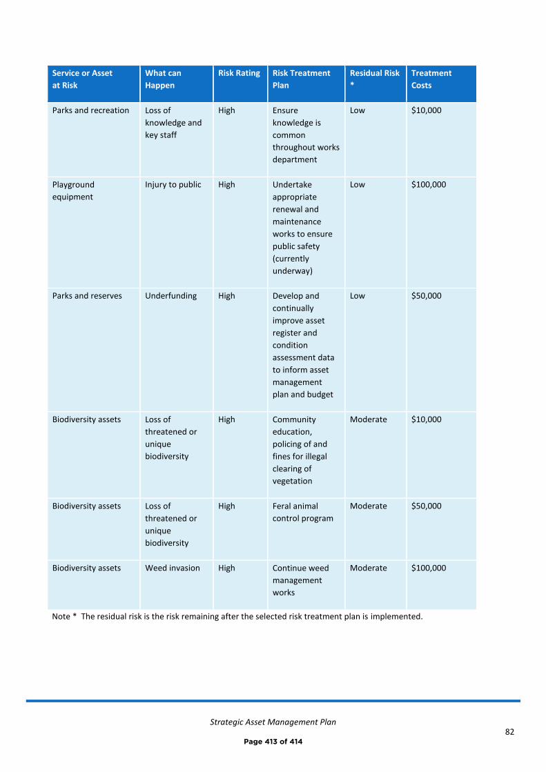
Strategic Asset Management Plan
82
Service or Asset
at Risk
What can
Happen
Risk Rating Risk Treatment
Plan
Residual Risk
*
Treatment
Costs
Parks and recreation Loss of
knowledge and
key staff
High Ensure
knowledge is
common
throughout works
department
Low $10,000
Playground
equipment
Injury to public High Undertake
appropriate
renewal and
maintenance
works to ensure
public safety
(currently
underway)
Low $100,000
Parks and reserves Underfunding High Develop and
continually
improve asset
register and
condition
assessment data
to inform asset
management
plan and budget
Low $50,000
Biodiversity assets Loss of
threatened or
unique
biodiversity
High Community
education,
policing of and
fines for illegal
clearing of
vegetation
Moderate $10,000
Biodiversity assets Loss of
threatened or
unique
biodiversity
High Feral animal
control program
Moderate $50,000
Biodiversity assets Weed invasion High Continue weed
management
works
Moderate $100,000
Note * The residual risk is the risk remaining after the selected risk treatment plan is implemented.
Page 413 of 414
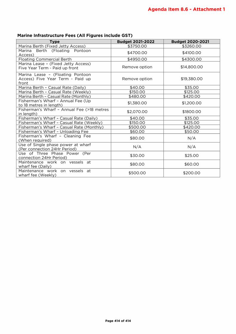
Marine Infrastructure Fees (All Figures include GST)
Type Budget 2021-2022 Budget 2020-2021
Marina Berth (Fixed Jetty Access) $3750.00 $3260.00
Marina Berth (Floating Pontoon Access)
$4700.00 $4100.00
Floating Commercial Berth $4950.00 $4300.00
Marina Lease – (Fixed Jetty Access) Five Year Term - Paid up front Remove option $14,800.00
Marina Lease – (Floating Pontoon Access) Five Year Term - Paid up front
Remove option $19,380.00
Marina Berth – Casual Rate (Daily) $40.00 $35.00
Marina Berth – Casual Rate (Weekly) $150.00 $125.00
Marina Berth – Casual Rate (Monthly) $480.00 $420.00
Fisherman’s Wharf – Annual Fee (Up to 18 metres in length)
$1,380.00 $1,200.00
Fisherman’s Wharf – Annual Fee (>18 metres in length)
$2,070.00 $1800.00
Fisherman’s Wharf – Casual Rate (Daily) $40.00 $35.00
Fisherman’s Wharf – Casual Rate (Weekly) $150.00 $125.00
Fisherman’s Wharf – Casual Rate (Monthly) $500.00 $420.00
Fisherman’s Wharf – Unloading Fee $60.00 $50.00
Fisherman’s Wharf – Cleaning Fee (When required)
$80.00 N/A
Use of Single phase power at wharf (Per connection 24Hr Period)
N/A N/A
Use of Three Phase Power (Per connection 24Hr Period)
$30.00 $25.00
Maintenance work on vessels at wharf fee (Daily)
$80.00 $60.00
Maintenance work on vessels at wharf fee (Weekly)
$500.00 $200.00
Page 414 of 414
Agenda Item 8.6 - Attachment 1


![arXiv:1805.10062v1 [cond-mat.mes-hall] 25 May 2018](https://static.fdokumen.com/doc/165x107/633e0265351be8c8fe010f7e/arxiv180510062v1-cond-matmes-hall-25-may-2018.jpg)


![arXiv:2205.13031v1 [math.SG] 25 May 2022](https://static.fdokumen.com/doc/165x107/633cdd5b9537e9bcf10c811f/arxiv220513031v1-mathsg-25-may-2022.jpg)