Landscape on television
69
1 Making landscape public / Landschap publiek maken Making Public Landscape / Publiek landschap maken 3 Making Landscapes Public / Making Public Landscapes Editorial Making Landscape Public / Landschap publiek maken 13 Bruno Notteboom Landscape on Television 27 Claudia Faraone en Michiel Dehaene Landscapes Larger Than Life Notes on Two Films about Territorial 41 Marc Treib Exhibiting Landscapes 53 David Peleman Gazing at the Landscape from Within: The Atlas as a Genre 65 Noël van Dooren A Landscape of Drawings The Role of Representation in the Public Discourse on Landscape and Design Making Public Landscape / Publiek landschap maken 83 Han Meyer (The End of) The State of the Delta (and What Might Follow) 99 Michiel Dehaene Landscapes at the Tipping Point The Landscape of the In-Between City 117 Hans Teerds Public Practices Designing the World as Landscape 2 Making Landscapes Public / Making Public Landscapes Redactioneel 12 Bruno Notteboom Landschap op de televisie 26 Claudia Faraone en Michiel Dehaene Uitvergrote landschappen Films over territoriale transformaties in Europa 40 Marc Treib Over de tentoonstelling van landschappen 52 David Peleman Kijkend naar het landschap van binnenuit: deatlas als genre 64 Noël van Dooren Een landschap van tekeningen De rol van representatie in het publieke debat over landschap en ontwerp 82 Han Meyer (Het einde van) De Staat van de Delta (en wat daarna nog kan komen) 98 Michiel Dehaene Kantelendelandschappen De landschappelijke verbeelding van de tussenstad 116 Hans Teerds Publieke praktijken Ontwerpen aan de wereld als landschap
Transcript of Landscape on television

1
Mak
ing
land
scap
e pu
blic
/ L
ands
chap
pub
liek
mak
en
M
akin
g Pub
lic L
ands
cape
/ P
ublie
k la
ndsc
hap
mak
en
3 Making Landscapes Public / Making Public Landscapes
Editorial
Making Landscape Public / Landschap publiek maken
13 Bruno Notteboom Landscape on Television
27 Claudia Faraone en Michiel Dehaene Landscapes Larger Than Life Notes on Two Films about Territorial
41 Marc Treib Exhibiting Landscapes
53 David Peleman Gazing at the Landscape from
Within: The Atlas as a Genre
65 Noël van Dooren A Landscape of Drawings
The Role of Represen tation in the Public Discourse on Landscape and Design
Making Public Landscape / Publiek landschap maken
83 Han Meyer (The End of) The State of the Delta
(and What Might Follow)
99 Michiel Dehaene Landscapes at the Tipping Point The Landscape of the
In-Between City
117 Hans Teerds Public Practices Designing the World as Landscape
2 Making Landscapes Public / Making Public Landscapes
Redactioneel
12 Bruno Notteboom Landschap op de televisie
26 Claudia Faraone en Michiel Dehaene Uitvergrote landschappen Films over territoriale transformaties
in Europa
40 Marc Treib Over de tentoonstelling van
landschappen
52 David Peleman Kijkend naar het landschap van
binnenuit: deatlas als genre
64 Noël van Dooren Een landschap van tekeningen De rol van representatie in
het publieke debat over landschap en ontwerp
82 Han Meyer (Het einde van) De Staat van de Delta
(en wat daarna nog kan komen)
98 Michiel Dehaene Kantelendeland schappen De landschappelijke verbeelding van
de tus senstad
116 Hans Teerds Publieke praktijken Ontwerpen aan de wereld als
landschap

32
Mak
ing
land
scap
e pu
blic
/ L
ands
chap
pub
liek
mak
en
M
akin
g Pub
lic L
ands
cape
/ P
ublie
k la
ndsc
hap
mak
en
1 Angelo Sampieri, Nel paesaggio. Il progetto per la città negli ultimi venti anni (Rome: Donzelli Editore, 2008).
Michiel Dehaene, Bruno Notteboom, Hans Teerds
Making Landscapes Public / Making Public Landscapes
Redactioneel
In de wereld van de stedenbouw en ruimtelijke planning was de afgelo-pen 20 jaar opmerkelijk veel aandacht voor het thema landschap. De notie landschap bleek over een bijzonder vermogen te beschikken om voortdurend nieuwe thema’s aan te kaarten. Eerst ging het in hoofdzaak over ecologische vraagstukken zoals de wateropgave, maar naderhand werd bijna de hele ruimtelijke discussie ‘verlandschappelijkt’. Het begrip landschap wordt allang niet meer exclusief gebruikt voor natuurlijke of rurale landschappen. Zo is de term stedelijk landschap inmiddels een gemeenplaats geworden. En vandaag de dag spreken we ook over nieu-we recreatielandschappen, residentiële landschappen, energieland-schappen, zorglandschappen, etc. Met de verlandschappelijking van het ruimtelijk debat ging ook een opmerkelijke emancipatie van het land-schapsontwerp gepaard. Landschapsarchitecten slaagden erin het veld van integraal regionaal ontwerp te bezetten, daar waar stedenbouwers en planners het geruime tijd links lieten liggen. Ze gingen zich tegelijker-tijd nadrukkelijker óók met architectuur en productdesign bezighouden.
Ook OASE mengde zich met verschillende themanummers in de land-schappelijke discussie. In 2002 was er #60 Land in de stad over de ne-velstad en de nadrukkelijke doordringing van stad en land, in 2004 #63 Platteland over de veranderingen in het buitengebied en in 2009 #80 On Territories over regionaal ontwerp.
In dit nummer willen we de blik tegelijk verbreden en vernauwen. Vernauwen in de zin dat we het op een heel specifieke manier over de notie landschap willen hebben, namelijk als drager van maatschappe-lijke beeldvorming en publiek debat. Breder in de zin dat we de discus-sie verleggen naar de rol van professionelen in het publieke debat. Dit nummer is opgebouwd rond de stelling dat er geen ruimtelijke ordening mogelijk is zonder debat. Juist in de discussie over het landschap – van stadslandschap tot zorglandschap – overleeft dit debat, of beter, bouwt het zich opnieuw op. In het slechtste geval verhult de verlandschappelij-king van het debat over de ruimtelijke orde zich in een uiterst wollige metaforiek.1 Maar in het beste geval blijkt dit juist de publieke discussie over nieuwe urgente kwesties te verhelderen en aan te scherpen: de metropolitane verstedelijking, de gevolgen van klimaatverandering, voedselplanning, regionaal-stedelijk ‘metabolisme’, etc. De afgelopen Rotterdamse biënnale lijkt hier meer dan ooit van overtuigd. Onder de titel ‘Urban by Nature’ plaatst Dirk Sijmons het landschap in het cen-trum van het mondiaal debat over klimaat en stad. Landschapsontwerp is als discipline het best gesitueerd om de hybride ruimtelijke condities van het ‘antropoceen’, waarin natuur en stad elkaar ruimtelijk en functi-oneel doordringen, te organiseren tot een veerkrachtig stedelijk metabolisme.
Michiel Dehaene, Bruno Notteboom, Hans Teerds
Making Landscapes Public / Making Public Landscapes
Editorial
In the field of urban development and spatial planning, a remarkable amount of attention has been given to the theme of ‘landscape’ over the past 20 years. The notion of landscape turns out to have an ex-tremely great capacity to keep generating new matters of interest. At first, the focus was mainly on ecological questions, such as the water issue, but after that, almost the entire spatial discussion became ‘land-scapified’. The days when the idea of landscape simply referred to natu-ral or rural settings are long gone. The term ‘urban landscape’, for in-stance, has become commonplace. And nowadays we also speak of ‘leisure landscapes’, ‘residential landscapes’, ‘energy landscapes’, ‘health care landscapes’ and so forth. The ‘landscapification’ of the spatial discourse was also accompanied by a striking emancipation of landscape design. Landscape architects succeeded in taking over as-pects of integral regional design that urban developers and planners had ignored for a considerable while. At the same time, they also be-came more directly involved with architecture and product design.
OASE also joined in the discussion on landscape, by publishing a number of themed issues. In 2002, #60 Urbanism Out of Town dis-cussed the diffuse city and the intense interpenetration of city and county; in 2004, #63 Countryside examined changes in the environs; and in 2009, #80 On Territories featured regional design.
In this issue, we want to make the focus both broader and sharper. Sharper, in the sense that we talk about the idea of landscape in a very specific manner, namely as a reflection of public debate and social im-agination. Broader, in that we are shifting the discussion to the role of professionals in the public debate. This issue of OASE is based on the premise that spatial planning is not possible without debate. The dis-cussion on landscape – from the urban landscape to the health care landscape – is precisely where this debate stays alive, or rather, renews itself. In the worst case, the landscapification of the spatial planning debate is clothed in extremely woolly metaphors.1 But at its best, it clar-ifies and sharpens the public discourse on new and urgent issues: met-ropolitan urbanisation, the consequences of climate change, food plan-ning, the regional/urban ‘metabolism’ and so forth. The latest International Architecture Biennial Rotterdam seems convinced of this more than ever. Under the title Urban by Nature, curator Dirk Sijmons sets landscape at the centre of the global debate on climate and city. As a discipline, landscape design is best positioned to organise the hy-brid spatial conditions of the Anthropocene era, in which nature and the city are spatially and functionally merging into a resilient urban metabolism.
But why public landscape? Our use of a poly-semantic concept like ‘pub-
1Angelo Sampieri, Nel paesaggio. Il progetto per la città negli ultimi venti anni (Rome: Donzelli Editore, 2008).

54
Mak
ing
land
scap
e pu
blic
/ L
ands
chap
pub
liek
mak
en
M
akin
g Pub
lic L
ands
cape
/ P
ublie
k la
ndsc
hap
mak
en
2Jürgen Habermas, The Structural Transformation of the Public Sphere. An inquiry into a Category of Bourgeois Society (Cambridge, MA: MIT Press, 1989), 55. 3Charles Taylor, Moderniteit in meervoud. Cultuur, samenleving en sociale verbeelding (Kampen: Uitgeverij Klement, 2005), 97. 4Kees Schuyt, De stuifzandsamenleving. Een selectie uit de columns 1997-2004 (Amsterdam: J.M. Meulenhoff en de Volkskrant, 2005). 5Taylor, Moderniteit in meervoud , op. cit. (noot 3), 92. 6Benedict Anderson, Imagined Communities (Londen: Verso, 1983).
lic’ here requires a bit of explanation. In this issue, we concentrate on the deep link between landscape as a medium for public imagination and the modern notion of the ‘public sphere’. The public sphere is an invention of bourgeois enlightenment and stands for the virtual space in which the new bourgeoisie, which gradually wrested itself free from a feudal system, projected its collective pursuit. It is the space for the ex-change of ideas and convictions, the space for social discourse. In the highly idealised vision of German philosopher Jürgen Habermas, the public sphere is independently positioned between the spheres of the (feudal) state and the market, and is neither dominated by government intervention nor susceptible to market processes.2 The modern state derives its legitimacy from this sphere, namely from the extent to which the political project serves the collective pursuit, which is made known through the public sphere.3
In many respects, the notion of ‘public sphere’ has been worn threadbare. The role of public space in forming the public sphere – that is, as the place where civilians come together and where their behav-iour is visible to one another – cannot simply be thought of as analo-gous to a nineteenth-century Parisian boulevard. And the public sphere in today’s ‘shifting sands’ society, with its fast, virtualised media, is very different from the one described in the context of the rise of writ-ten media.4 Precisely for these reasons, it is important to keep in mind that the public sphere first of all is a virtual, non-localised concept.5
The public sphere exists only to the extent that there is a question of a collective imagination in which a shared body of ideas can flourish. The image of the landscape, as an expression of spatial planning, forms a substantial part of this collective imagination. The imagining of landscape can be seen as an indication of a society’s capacity to make the reflection of culture into the context in which it is given spatial form. Through this reflection of culture and through this imagination, a soci-ety’s spatial form acquires meaning and is shared and mediated, as a study by American anthropologist Benedict Anderson on the role of col-lective imagination in the development of nationalism makes clear.6 Geographer Denis Cosgrove makes a similar analysis of the role of land-scape in producing the symbolic order with which a society spatially or-ganises itself.7
Such an analysis would seem obvious when applied to the colonisation of the Venetian hinterland, but the modern city can also be interpreted in such terms. Nowadays, however, there is no question of a similar symmetry between spatial planning and social imagination. Not even in the Netherlands anymore, where until recently the landscape project was firmly anchored in Dutch social policy. After successive spatial plan-ning memorandums focusing on the distribution or concentration of de-velopment, the Plan Ooievaar presented a vision for the future of the Netherlands’ river region in the mid-1980s.
Drawn up by Dirk Sijmons, Frans Vera and Lodewijck van Nieuwenhuizen, among others, this plan tackled the substantial theme of water and initiated a way of designing landscape on a scale that combined planning, ecological, agricultural and economic issues in a single project.8 In retrospect this approach, in which landscape is pre-sented in terms of different levels of involvement and responsibilities,
Maar waarom publiek landschap? De manier waarop we een polyseman-tisch begrip als publiek willen hanteren, behoeft enige toelichting. In dit nummer is het ons te doen om de diepe link tussen landschap als me-dium van publieke verbeelding en de moderne notie van de publieke sfeer.
De publieke sfeer is een uitvinding van de burgerlijke verlichting en staat voor de virtuele ruimte waarin de nieuwe burgerlijke klasse, die zich geleidelijk ontworstelde aan een feodaal bestel, haar collectief stre-ven projecteert. Het is de ruimte van de uitwisseling van ideeën en overtuigingen, ruimte voor het maatschappelijk gesprek. Volgens de sterk geïdealiseerde visie van de Duitse filosoof Jürgen Habermas is het publieke een eigen sfeer in de maatschappij, tussen de (feodale) staat en de markt in, niet gedomineerd door overheidsbemoeienis, noch vatbaar voor marktwerking.2 Aan deze sfeer ontleent de moderne overheid haar legitimiteit, namelijk aan de mate waarin het politiek pro-ject het collectief streven, dat zich via de publieke sfeer kenbaar maakt, weet te bedienen.3
In menig opzicht is de notie ‘publieke sfeer’ tot op de draad versle-ten. De rol van de publieke ruimte in de vorming van de publieke sfeer, namelijk als de plek waar burgers samenkomen en hun gedrag voor el-kaar wederzijds zichtbaar is, kan niet zomaar naar analogie met de ne-gentiende-eeuwse Parijse boulevard worden gedacht. En in de heden-daagse ‘stuifzandsamenleving’ met haar snelle en gevirtualiseerde media verschilt de publieke sfeer sterk van degene die in de context van de opkomst van de schrijvende media is beschreven.4 Juist om die reden is het belangrijk onszelf eraan te herinneren dat de publieke sfeer vooreerst een virtueel en plaatsoverstijgend begrip betreft.5
De publieke sfeer bestaat slechts in de mate dat er sprake is van een collectieve verbeelding waarin een gedeeld gedachtengoed kan ge-dijen. De verbeelding van het landschap, als uiting van de ruimtelijke or-dening, vormt een substantieel deel van deze collectieve verbeelding. De landschappelijke verbeelding kan gezien worden als een graadmeter van het vermogen waarmee een samenleving in staat is de context, waarin diezelfde samenleving ruimtelijk vorm krijgt, voorwerp te maken van haar culturele reflectie. Door die culturele reflectie en door die ver-beelding krijgt de ruimtelijke vorm betekenis, wordt ze gedeeld en geme-dieerd, zo maakte de Amerikaanse antropoloog Benedict Anderson dui-delijk met een studie naar de rol van collectieve verbeelding in de ontwikkeling van het nationalisme.6 Geograaf Denis Cosgrove maakte een vergelijkbare analyse van de rol van landschap in de productie van een symbolische orde waarmee een samenleving zichzelf ruimtelijk ordent.7
Een dergelijke analyse lijkt vanzelfsprekend voor de kolonisatie van het Venetiaanse achterland, maar ook de moderne stadsuitleg laat zich in dergelijke termen lezen. Vandaag de dag is er echter geen sprake van een dergelijke symmetrie tussen de ruimtelijke ordening en de maat-schappelijke beeldvorming. Zelfs niet meer in Nederland, waar tot voor kort het landschappelijk project stevig in het Nederlandse ruimtelijk be-leid verankerd was. Na opeenvolgende Nota’s Ruimtelijke Ordening waarin gefocust werd op de spreiding of concentratie van bebouwing, toonde het Plan Ooievaar halverwege de jaren 1980 een toekomstvisie
2Jürgen Habermas, The Structural Transformation of the Public Sphere: An inquiry into a Category of Bourgeois Society (Cambridge, MA: MIT Press, 1989), 55. 3Charles Taylor, Moderniteit in meervoud. Cultuur, samenleving en sociale verbeelding (Kampen: Uitgeverij Klement, 2005), 97. 4Kees Schuyt, De stuifzandsa-menleving. Een selectie uit de columns 1997-2004 (Amsterdam: J.M. Meulenhoff and De Volkskrant, 2005). 5Taylor, Moderniteit in meervoud, op. cit. (note 3), 92. 6Benedict Anderson, Imagined Communities (London: Verso, 1983). 7Denis Cosgrove, Social Formation and Symbolic Landscape (Madison: University of Wisconsin Press, 1984). 8Dick De Bruijn et al, Ooievaar. De toekomst van het rivierengebied (Arnhem: Stichting Gelderse mili-eufederatie, 1987).

76
Mak
ing
land
scap
e pu
blic
/ L
ands
chap
pub
liek
mak
en
M
akin
g Pub
lic L
ands
cape
/ P
ublie
k la
ndsc
hap
mak
en
7Denis Cosgrove, Social Formation and Symbolic Landscape (Madison: University of Wisconsin Press, 1984). 8Dick de Bruijn et al., Ooievaar. De toekomst van het rivierengebied (Arnhem: Stichting Gelderse Milieufederatie, 1987). 9Dirk Sijmons, Landkaartmos en andere beschouwingen over landschap (Rotterdam: Uitgeverij 010, 2002), 118. 10Hans Leinfelder en Bruno Notteboom, ‘Landschapsbeleid in Vlaanderen: het lelijke eendje?’, in: Jaarboek stedenbouw en ruimtelijke planning 2002-2005 (Brussel: Vlaamse Vereniging voor Ruimte en Planning, 2006), 34-36.
was based on three optimistic assumptions: (1) the presence of a gov-ernment that has the authority and means to ‘classify the multiplicity of special plans and projects and make rational choices’,9 (2) the pres-ence of a public that is prepared to consider and support landscape as a public project, and (3) the central position of the designer in the net-work of stakeholders. What’s more, the Belvedere programme in the late 1990s also brought heritage questions into landscape and the ap-pointment of a National Landscape Advisor in the mid-2000s further embedded landscape in national government policy.
This increasing governmental interest, however, did not stop the nation-al administration’s involvement in landscape planning from quickly being put on the back burner during the rapid political developments at the beginning of the 2010s. Responsibilities for landscape were relegated to lower echelons of government at the provincial and municipal level, while at the same time budgets were drastically cut, so that even an or-ganisation like Staatsbosbeheer, which is commissioned by the Dutch government and manages a sizable amount of the nature reserves in the Netherlands, making it the nation’s largest landowner, is now selling parcels of land. The landscape project prematurely came to an end, with the government leaving it up to the provinces, pressure groups and the market. In recent years, it is increasingly clear that the Netherlands has become more like its neighbours. In Flanders, too, a cautious reviv-al of the government’s landscape policy could not prevent the fact that landscape primarily remains the outcome of a combination of private interests.10
The decline of the landscape project means that the public sphere, in which landscape and its future are discussed, is shifting, and also that new expectations are emerging and playing a role in the debate. The new political situation has opened the door for countless (semi) -public and private (interest) groups, each with their own definitions and ap-proaches, possibilities and objectives, which contribute to alternative views on the shared use of space. These groups have mastered the newspeak of ‘landscapified’ spatial planning and are introducing ideas for the ‘re-naturalisation’ of watercourses, for energy landscapes, pro-ductive landscapes, and so forth. At the same time, new types of com-mons are being developed; for example, through initiatives for urban farming or the collective production of residential buildings. These initia-tives are attempting to break away from the artless consumption of space and are promoting landscape and urban ideas that illustrate the added social value that these new commons can provide. Meanwhile, seen as a whole, these (semi) -public organisations and private initia-tives are a big landowner – without the necessary concerted action, however, to turn landscape into a powerful and coherent project.
Nonetheless, the public sphere is tremendously enriched by all these movements. This is about not only the public imagining of social themes but also the imagination of a new public, the assembling of new groups around specific spatial projects. A great confusion as to what spatial course to follow, a strong feeling of loss of control and the de-cline of the idea of manipulability seem to lie at the root of the fact that the ‘landscapified’ debate is one of the last areas where reflection still
op het Nederlandse rivierengebied. Dit plan, opgesteld door onder andere Dirk Sijmons, Frans Vera en
Lodewijk van Nieuwenhuijze, greep de kracht van het thema water aan en initieerde een manier van ontwerpen op landschappelijke schaal waarin planologische, ecologische, landbouwkundige en economische vraagstukken bijeen gebracht werden in een enkelvoudig project.8 Terugkijkend stoelde deze benadering, waarin het landschap uiteenge-legd wordt in verschillende lagen van betrokkenheid en verantwoordelijk-heid, op drie optimistische aannames: (1) de aanwezigheid van een overheid die de macht en de middelen heeft om ‘de veelheid van ruim-telijke plannen en projecten te rangschikken en beredeneerde keuzen te maken’,9 (2) de aanwezigheid van een publiek dat bereid is om het land-schap als een publiek project te begrijpen en te ondersteunen en (3) de centrale positie van de ontwerper in het netwerk van belanghebbenden. Met het Belvedere-programma eind jaren 1990 werden bovendien ook erfgoedvraagstukken betrokken op het landschap, en de installatie van een Rijksadviseur voor het Landschap halverwege de jaren 2000 veran-kerde het landschap verder in het beleid van de landelijke overheid.
De groeiende aandacht van de overheid voor het landschap heeft echter niet voorkomen dat tijdens de snelle politieke ontwikkelingen aan het begin van de jaren 2010 de betrokkenheid van het landsbestuur bij de inrichting van het landschap snel op een laag pitje is komen te staan. Verantwoordelijkheden voor het landschap zijn doorgesluisd naar lagere overheden van provincie en gemeente, terwijl tegelijkertijd de budgetten drastisch werden verlaagd, zodanig dat ook een organisatie als Staatsbosbeheer, de grootste grootgrondbezitter van Nederland, inmid-dels stukken grond aan het verkopen is. Het landschappelijk project is vroegtijdig ten einde gekomen. De overheid laat het aan de provincie, de belangenverenigingen en de markt over. Steeds meer wordt duidelijk dat Nederland in de afgelopen jaren meer op zijn buren is gaan lijken. Ook in Vlaanderen heeft een voorzichtige opleving van het landschaps-beleid niet kunnen voorkomen dat het landschap er in de eerste plaats de resultante van een optelsom van private belangen blijft.10
De neergang van het landschappelijk project houdt in dat de publieke sfeer, waarbinnen over (de toekomst van) het landschap wordt gedis-cussieerd, verschuift, alsook dat nieuwe verwachtingen opkomen en in het debat een rol gaan spelen. De nieuwe politieke situatie opent de deur voor tal van (semi) publieke en private (belangen)groepen, met elk hun eigen definities en benaderingen, mogelijkheden en doelstellingen, die bijdragen aan alternatieve visies op het gedeeld gebruik van de ruimte. Ze hebben zich de nieuwspraak van de ‘verlandschappelijkte’ ruimtelijke ordening eigen gemaakt en komen met visies voor ‘hernatu-ralisering’ van waterlopen, voor energielandschappen, productieve land-schappen, etc. Tegelijkertijd worden ook vormen van nieuwe commons ontwikkeld, bijvoorbeeld via initiatieven voor stadslandbouw of collec-tieve woningbouwproductie. Deze initiatieven proberen te breken met de argeloze consumptie van de ruimte en schuiven landschappelijke en stedelijke visies naar voren ter verbeelding van de maatschappelijke meerwaarde die deze nieuwe commons kunnen leveren. Inmiddels zijn deze (semi) publieke organisaties en particuliere initiatieven samen een
9Dirk Sijmons, Landkaartmos en andere beschouwingen over landschap(Rotterdam: 010 Uitgeverij, 2002), 118. 10Hans Leinfelder and Bruno Notteboom, ‘Landschapsbeleid in Vlaanderen: het lelijke eend-je?’, Jaarboek stedenbouw en ruimtelijke planning 2002-2005 (Brussels: Vlaamse Vereniging voor Ruimte en Planning, 2006), 34-36.

98
Mak
ing
land
scap
e pu
blic
/ L
ands
chap
pub
liek
mak
en
M
akin
g Pub
lic L
ands
cape
/ P
ublie
k la
ndsc
hap
mak
en
takes place about a territory that has already been overly divided up and in demand. Landscape makes social developments tangible, has the capacity to appeal to and make demands on the public. As such, the image of the landscape remains the litmus test through which spa-tial planning derives its public legitimacy. The degree to which we can or cannot understand the world as landscape is an indicator for the social debate on spatial planning.
A movement such as this brings us to the public matter of landscape: it is a subject that divides people and brings them together, people from different backgrounds, with different convictions. Or in the words of French philosopher Bruno Latour, landscape is a ‘thing’. It is a subject that binds people (or separates them). The latter possibility, claims Latour, is often forgotten in the discourse on the public sphere, but it is essentially important in terms of public relevance. ‘To assemble is one thing,’ he writes, ‘to represent to the eyes and ears of those assembled what is at stake is another.’11 That is also the case within the context of landscape. Landscape is a political object – that is the central proposi-tion of this OASE: a public landscape. There cannot be a social spatial project without the imagining of landscape. There cannot be an imagin-ing of landscape without there being discussion about it. While this dis-cussion no longer proceeds in terms of beautiful or ugly, legible or illeg-ible, it nonetheless is a reflection of the degree to which spatial planning also stands for a moral order, structured by considerations on what does and does not belong in a space, what does and does not go together. Designers, as analysts of the present and interpreters of pos-sible futures, play a crucial role here, visually bringing this into the pub-lic sphere with their skills and tools.
In short, in this issue we are searching for impetuses for today’s landscape discourse beyond the historical social consensus and be-yond landscape as a project, and are putting that on the table of (land-scape) designers and bringing it to their attention.
Although in the previous paragraphs we outlined the issues of land-scape and the public against a more or less Dutch background, throughout the articles in this OASE the social debate on landscape and its conceptualisation are placed in a broader, international context.
This issue of OASE has two sections. The first section introduces the topoi in which canonised and new landscapes are conceived and made public: publications, exhibitions, documentaries, television pro-grammes, atlases, public debates, drawings. It shows how landscape is ‘framed’, how governments and professionals give meaning to land-scape and also (attempt to) involve the public in that. The issue opens with a contribution by Bruno Notteboom, who describes how landscape was depicted on British, Flemish and Dutch television in the 1970s and how it is shown today. This analysis makes it clear that the way in which the public identifies with landscape has become increasingly complex. Next, Claudia Faraone and Michiel Dehaene discuss two documentaries in which the complexity of landscape in today’s urban context is the starting point for imagination as a contribution to the public discourse. Marc Treib describes a number of European and American exhibitions of landscape architecture whose focus – and the public debate to which
grootgrondbezitter, echter zonder de samenwerking om van het land-schap een krachtig en coherent project te kunnen maken.
Intussen wordt de publieke sfeer door al deze bewegingen enorm ver-rijkt: het gaat niet louter over de publieke verbeelding van maatschap-pelijke thema’s, maar letterlijk om de verbeelding van een nieuw pu-bliek, de verzameling van nieuwe groepen rondom concrete ruimtelijke projecten. De grote verwarring met betrekking tot de te volgen ruimte-lijke koers, het sterke gevoel van controleverlies en het tanend maak-baarheidsdenken lijkt daarmee aan de basis te liggen van het ‘verland-schappelijkt’ debat als één van de laatste plekken waar de reflectie over een uitverkaveld en overbevraagd territorium nog plaats vindt. Het landschap maakt de maatschappelijke ontwikkelingen voelbaar, heeft het vermogen het publiek aan te spreken en te bevragen. De landschap-pelijke verbeelding blijft daarmee de lakmoesproef waaraan de ruimte-lijke orde haar publieke legitimiteit ontleent. De mate waarin we de we-reld al dan niet als landschap kunnen begrijpen, is een graadmeter voor het ruimtelijk maatschappelijk debat.
Het is in een dergelijke beweging dat we de publieke zaak van het land-schap op het spoor komen: het is een onderwerp dat mensen verdeelt en samenbrengt, mensen van verschillende achtergronden, verschillen-de overtuigingen. Of in de woorden van de Franse filosoof Bruno Latour: het landschap is een ‘ding’. Het is een onderwerp dat mensen bindt (of scheidt). Dat laatste, zo stelt Latour, wordt vaak vergeten in het debat over het politieke domein, maar is voor de publieke relevantie van es-sentieel belang. ‘Samenkomen is één ding,’ schrijft hij, ‘het voor de ogen en oren van de aanwezigen representeren van wat er op het spel staat, is iets anders.’11 Dat is ook in het kader van het landschap het geval. Landschap is een van die politieke objecten; dat is de centrale stelling van deze OASE: publiek landschap. Geen maatschappelijk ruim-telijk project zonder landschappelijke verbeelding. Geen landschappe-lijke verbeelding zonder gesprek erover. Dit gesprek verloopt allang niet meer in termen van mooi of lelijk, lees- of onleesbaar, maar is desal-niettemin een afspiegeling van de mate waarin de ruimtelijke ordening ook een morele orde voorstaat, gestructureerd door afwegingen van wat wel en niet in de ruimte hoort, wel en niet bij elkaar past. Ontwerpers spelen daarin een cruciale rol, als analisten van het heden en vertolkers van mogelijke toekomsten, en met hun vermogen en instrumenten dit ook beeldend het publieke domein binnen te brengen.
Kortom, in dit nummer zijn we op op zoek naar aanzetten voor het hedendaagse landschappelijke debat, voorbij de historische maatschap-pelijke consensus, en voorbij het landschap als project, en brengen dat naar de tafel van – en onder de aandacht van – (landschaps)ontwerpers.
Hoewel we in bovenstaande paragrafen de discussie over landschap en de publieke sfeer hebben uitgewerkt tegen de achtergrond van met name de Nederlandse context, situeren de artikelen die in deze OASE zijn samengebracht het maatschappelijk debat en de beeldvorming in een bredere, internationale context.
Dit OASE-nummer is een tweeluik. Het eerste luik ontsluit de topoi waarbinnen gecanoniseerde en nieuwe landschappen worden verbeeld
11Bruno Latour, ‘Van Realpolitik naar Dingpolitik. Over publieke dingen en de respublica’, in: Krisis, jrg. 6 (2005) nr. 2, 44; www.krisis.eu/content/2005-2/2005-2-09-latour.pdf.
11Bruno Latour, ‘From Realpolitik to Dingpolitik or: How to Make Things Public’, in: Bruno Latour and Peter Wibel, Making Things Public, Atmospheres of Democracy (Cambridge, MA: MIT Press, 2005), 8.

1110
Mak
ing
land
scap
e pu
blic
/ L
ands
chap
pub
liek
mak
en
M
akin
g Pub
lic L
ands
cape
/ P
ublie
k la
ndsc
hap
mak
en
they contribute – has recently shifted to ecology and sustainability, of-ten at the expense of the aesthetic dimension. The mediums par excel-lence for communicating about landscape are of course the atlas and the drawing. David Peleman explains how atlases contribute to the im-agining of landscape in his essay. Noël van Dooren examines how time and place, crucial aspects of landscape, can be ‘made public’ through something static like a drawing.
The second section investigates how the landscape perspective is used to give the production of landscape legitimacy and public significance. Here we thus start with the object itself. What aspects of landscape provoke public involvement? What sorts of people take interest in the work of designers and other professionals? Han Meyer takes as an ex-ample the case of water, which to use Latour’s expression is one of the ‘matters of concern’, not only in the Low Lands but also for instance in the USA and Bangladesh. Michiel Dehaene shows how landscape plays an essential role in the debate on the development of metropolitan ar-eas and urban regions. The manner in which design firms operationalise the theme of ‘landscape and the public’ in their everyday practice, as well as the necessity of doing so, is central to the last two contribu-tions: Hans Teerds formulates a perspective on the responsibility that designers have to make landscape ‘discussable’ for the general public, while also shedding light on a number of current design practices and their contribution to the public debate. The issue closes with an exten-sive interview with landscape architect and curator of the International Architecture Biennale Rotterdam 2014 Dirk Sijmons; urban planner Frits Palmboom; and architect and curator Joachim Declerck, in which the participants analyse public discourses of the past and present and the contribution designers have made to them.
en publiek gemaakt: publicaties, tentoonstellingen, documentaires, tele-visieprogramma’s, atlassen, publieke debatten, tekeningen. Het laat zien hoe het landschap is en wordt ‘geframed’, hoe overheid en profes-sionals betekenis toekennen aan het landschap en daarin ook het pu-bliek (proberen te) betrekken.
Het nummer opent met de bijdrage van Bruno Notteboom, die laat zien hoe in het Verenigd Koninkrijk, Vlaanderen en Nederland het land-schap getoond wordt op de televisie in de jaren 1970 en vandaag. De manier waarop het publiek zich identificeert met het landschap wordt steeds complexer, zo blijkt duidelijk uit deze analyse. Claudia Faraone en Michiel Dehaene behandelen vervolgens twee verschillende docu-mentaires, waarin juist deze complexiteit van het landschap in de he-dendaagse stedelijke context de inzet van de verbeelding is als bijdrage aan het publieke discours. Marc Treib beschrijft een aantal Europese en Amerikaanse tentoonstellingen van landschapsarchitectuur, waarbij re-centelijk de aandacht van de tentoonstellingen – en het publiek debat waaraan ze bijdragen – verschuift naar ecologie en duurzaamheid, vaak ten koste van de esthetische dimensie. Hét medium van de communica-tie over het landschap zijn natuurlijk de atlas en de tekening. Hoe atlas-sen bijdragen aan de beeldvorming over het landschap belicht David Peleman in zijn bijdrage. Hoe plaats en tijd, cruciale aspecten van het landschap, ‘publiek te maken’ zijn via iets statisch als een tekening, on-derzoekt Noël van Dooren.
Het tweede deel onderzoekt hoe het landschappelijk perspectief wordt ingezet om aan de productie van het landschap legitimiteit en publieke betekenis te geven. Hier starten we dus bij het object zelf. Welke aspec-ten van het landschap dagen de publieke betrokkenheid uit? Welke ty-pen publiek worden verzameld rondom het werk van ontwerpers en an-dere professionals? Han Meyer neemt als voorbeeld de casus van het water, dat niet alleen in de Lage Landen, maar ook in bijvoorbeeld de Verenigde Staten en Bangladesh een van de matters of concern is, om het met Latour te zeggen. Michiel Dehaene laat zien hoe in het debat over de ontwikkeling van de stadsregio, de metropoolvorming, het land-schap een essentiële rol speelt. Hoe ook ontwerpbureaus in de alle-daagse praktijk het thema van het landschap en het publiek weten te operationaliseren in hun werk, als ook de noodzaak daartoe, staat cen-traal in de laatste twee bijdragen: Hans Teerds formuleert een perspec-tief op de verantwoordelijkheid van ontwerpers het landschap ‘be-spreekbaar’ te maken voor het brede publiek, en belicht daarbij een aantal actuele ontwerppraktijken en hun bijdrage aan het publieke de-bat. Het nummer sluit af met een uitgebreid interview met land-schapsarchitect en curator van de Rotterdamse Architectuur Biënnale 2014 Dirk Sijmons, stedenbouwkundige Frits Palmboom en architect en curator Joachim Declerck waarin heden en verleden van het publieke debat en de bijdrage van ontwerpers wordt geanalyseerd.

Mak
ing
Land
scap
e P
ublic
/ L
ands
chap
pub
liek
mak
en
1312
Bru
no N
otte
boom
Land
scap
e on
Tel
evis
ion
/ La
ndsc
hap
op d
e te
levi
sie
both the land and with other human groups, and this discourse is closely related epistemically and technically to ways of seeing.’3 His observation is based on Italian landscape painting during the Renaissance, but it applies equally well to contem-porary television documentaries. Both the filmmak-er and the viewer enter a constellation that does not simply show the landscape but gauges and re-assesses our relation to the land and each other.
Great Britain The documentary The Making of the English Landscape was broadcast as part of the BBC’s Horizon series in the 1970s, but its seeds were planted two dec-ades earlier.4 The programme is based on the epon-ymous book published in 1955 by William Hoskins, who at that moment was a professor of economic history at Oxford.5 Although this book initially re-mained relatively unnoticed, it was tremendously successful with its republication in 1970, at a time when landscape history was developing into a fully-fledged academic discipline that moreover could count on the interest of the general public. The first broadcasting of The Making of the English Landscape was watched by an estimated 1 million British view-ers, prompting the producers to make a series of similar documentaries about specific regions, a se-ries that ran until 1978. All of this attention increased the book’s sales figures astronomically, and Hoskins accordingly published a second, large-for-mat book through the BBC as an accompaniment to the television programme, which could be hired by schools and groups.6
kader hebben voorzien, en dit discours is epistemo-logisch en technisch nauw verbonden met manieren van kijken.’3 Hij baseert zich in deze observatie op de Italiaanse landschapsschilderkunst tijdens de Renaissance, maar dit geldt net zo goed voor de he-dendaagse televisiedocumentaire. Zowel de maker als de kijker begeeft zich in een constellatie waarbij niet eenvoudigweg het landschap wordt getoond, maar waarbij onze relatie tot het land en tot elkaar wordt geijkt en herijkt.
Groot-BrittanniëDe documentaire The Making of the English Landscape werd uitgezonden binnen de serie Horizon op de BBC in de jaren 1970, maar de kie-men ervoor waren al twee decennia eerder gelegd.4 Het programma is gebaseerd op het gelijknamige boek van William Hoskins uit 1955, die op dat mo-ment professor economische geschiedenis in Oxford was.5 Hoewel dit boek oorspronkelijk relatief onopgemerkt bleef, kende het een groot succes bij de heruitgave in 1970, toen landschapsgeschiede-nis uitgroeide tot een volwaardige academische dis-cipline die bovendien kon rekenen op de belangstel-ling van het grote publiek. De eerste uitzending van The Making of the English Landscape werd dan ook bekeken door naar schatting een miljoen Britten, wat de producers ertoe aanzette een reeks gelijk-soortige documentaires over specifieke regio’s te maken, een serie die liep tot 1978. Al deze aan-dacht joeg de verkoopcijfers van het boek de hoog-te in en Hoskins publiceerde bij de BBC dan ook een tweede boek op groot formaat als begeleiding
Bruno Notteboom
Landschap op de televisie
In 2007 werd Wastwater in het Lake District verko-zen tot Britain’s favourite view in het gelijknamige Britse televisieprogramma op ITV1. In dit program-ma kon de kijker kiezen uit 16 plaatsen in Groot-Brittannië, aangeprezen door evenzoveel celebrities. In dezelfde periode liepen op de Britse televisie maar liefst tien programma’s, die raakten aan het landschap of die grotendeels uit landschapsbeel-den bestonden.1 Televisie, zo lijkt het, is in de een-entwintigste eeuw het medium bij uitstek om land-schap in de publieke arena te brengen. Waarover gaan die programma’s? En wat voegt de televisie, als massamedium, inhoudelijk toe?
In de afgelopen decennia veranderde zowel het publieke discours over landschap als het medium televisie sterk. De jaren 1970 lijken in beide evolu-ties een omslagpunt te markeren. Na het befaamde Grenzen aan de Groei-rapport van de Club van Rome uit 1972 en de oliecrisis van 1973 werd mili-eubewustzijn en het daarmee gepaard gaande ge-voel van teloorgang van het landschap gemeen-goed. Tegelijk waren de jaren 1970 de periode waarin het massamedium televisie begon te veran-deren. De oprichting van nieuwe netten leverde een diversificatie die zowel popularisering als het ont-staan van nichemarkten mogelijk maakte. Een der-gelijke evolutie, die het concept van een homogeen ‘nationaal publiek’ aan het wankelen bracht, voltrok zich wereldwijd.2
In wat volgt focus ik op drie televisieprogram-ma’s over landschap uit twee tijdperken en drie lan-den: The Making of the English Landscape, voor het eerst uitgezonden op de BBC in 1973, Vlaanderen in vogelvlucht, voor het eerst te zien op de toenma-lige BRT (de Nederlandstalige Belgische publieke omroep, vandaag VRT) in 1976 en Nederland van boven, een twee seizoenen durende serie die de af-gelopen jaren liep op de Nederlandse zender VPRO. Ik zal beschrijven hoe het landschap in beeld wordt gebracht, maar ook de vraag stellen welke bood-schap nu eigenlijk aan wie gericht is. Hoewel het steeds duidelijk om documentaires en dus non-fic-tie gaat, speelt de verteller in de drie programma’s een verschillende rol. Ook het publiek gaat telkens een andere verhouding aan met het gemedieerde landschap. In Social Formation and Symbolic Landscape stelt Denis Cosgrove: ‘landschap vormt een discours waardoor specifieke sociale groepen zich doorheen de geschiedenis zichzelf en hun rela-tie met het land en andere sociale groepen van een
Bruno Notteboom
Landscape onTelevision
In 2007, Wastwater in the Lake District was selec-ted as ‘Britain’s Favourite View’ on the similarly named British television programme broadcast on ITV 1. On this show, viewers could vote for one of 16 places in Great Britain recommended by an equal number of celebrities. During the same pe-riod, as many as ten programmes that were either about or largely consisted of landscape images were aired on British television.1 Television seems to be the perfect medium for bringing the subject of landscape into the public arena in the twenty-first century. What are these programmes about? And what does television contribute as a mass medium in terms of content?
Over the past few decades, both the public dis-course on landscape and the medium of television have changed considerably. The 1970s marked a turning point in both evolutions. After the famous Limits to Growth study published by the Club of Rome in 1972 and the oil crisis of 1973, environmental awareness became generally accepted, along with a feeling of loss in terms of the landscape. At the same time, the 1970s were the period in which the mass medium of television began to change. The es-tablishment of new networks provided diversification that enabled both a popularisation of content and the emergence of niche markets. A similar evolution, which undermined the concept of a homogenous ‘na-tional audience’, occurred all over the world.2
In the following article, I focus on three televi-sion programmes about landscape from two sepa-rate eras and three different countries: The Making of the English Landscape, broadcast on the BBC for the first time in 1973, Vlaanderen in vogelvlucht, first seen on Belgium’s Dutch-language radio and television network BRT (today the VRT) in 1976, and the Dutch programme Nederland van boven, a two-season series recently presented by the Dutch broadcaster VPRO. I will describe how the land-scape is portrayed, but also examine the question of what message is actually directed to whom. Although all three programmes are clearly docu-mentaries, and thus nonfiction, the narrators play a different role in each of them. The audience also assumes a different relation with the mediated landscape in each programme. In his book Social Formation and Symbolic Landscape, Denis Cosgrove asserts: ‘Landscape constitutes a discourse through which identifiable social groups historically have framed themselves and their relations with
1 Patrick Keiller, Doreen Massey en Patrick Wright, ’28 june 2008’, http://thefutureoflandscape.wordpress.com, geraadpleegd 11 augustus 2014. 2 Zo werd in België het tweede net van de BRT in 1977 opgericht. Zie: Cas Goossens, Radio en televisie in Vlaanderen. Een geschiedenis (Leuven: Davidsfonds, 1998); Adriaan Verhulst, ‘Radio en televisie in evolutie’, in: Adriaan Verhulst (red.), Massacommunicatie (Gent: Willemsfonds, 1973). Voor de internationale situatie, zie: Michael Curtin, ‘From Network to neo-Network Audiences’, in: Michele Hilmes (red.), The Television History Book (Londen: British Film Institute, 2003). 3 Denis E. Cosgrove, Social Formation and Symbolic Landscape (Madison, WI.: University of Wisconsin Press, 1998 [1980]), xiv.
4 Horizon is een nog steeds bestaand televisieprogramma van de BBC dat wetenschap en geschiedenis populariseert. 5 William G. Hoskins, The Making of the English Landscape (Lower Dairy: Little Toller Books, 2012); Heruitgave van het origineel met de inleiding van 1955 en die van de heruitgave van 1976). Voor een bespreking van Hoskins’ werk, in vergelijking met de Amerikaanse auteur J.B. Jackson, zie: D.W. Meinig, ‘Reading the Landscape. An Appreciation of W.G. Hoskins and J.B. Jackson’, in: D.W. Meinig (red.), The Interpretation of Ordinary Landscapes. Geographical Essays (Oxford: Oxford University Press, 1973), 195-244. 6 Meinig, ‘Reading the Landscape’, op. cit. (noot 5), 200-201.
1 Patrick Keiller, Doreen Massey and Patrick Wright, ‘28 June 2008’, http://thefutureoflands-cape.wordpress.com, consulted on 11 August 2014. 2 In Belgium, for instance, the BRT set up a second network in 1977. See: Cas Goossens, Radio en televisie in Vlaanderen. Een geschiedenis (Leuven: Davidsfonds, 1998); Adriaan Verhulst, ‘Radio en televisie in evolutie’, in: Adriaan Verhulst (ed.), Massacommunicatie (Ghent: Willemsfonds, 1973). For the international situation, see: Michael Curtin, ‘From Network to Neo-Network Audiences’, in: Michele Hilmes (ed.), The Television History Book (London: British Film Institute, 2003). 3 Denis E. Cosgrove, Social Formation and Symbolic Landscape (Madison, WI: University of Wisconsin Press, 1998 [1980]), xiv.
4 Horizon is a BBC television pro-gramme that popularises sci-ence and history, which still exists. 5 William G. Hoskins, The Making of the English Landscape (Lower Dairy: Little Toller Books, 2012), republication of the original with the introduction from 1955 and the introduction from the 1976 edition. For a discussion of Hoskins’ work in comparison with that of American author J.B. Jackson, see: D.W. Meinig, ‘Reading the Landscape: An Appreciation of W.G. Hoskins and J.B. Jackson’, in: D.W. Meinig (ed.), The Interpretation of Ordinary Landscapes. Geographical Essays (Oxford: Oxford University Press, 1973), 195-244. 6 Meinig, ‘Reading the Landscape’, op. cit. (note 5), 200-201.

Mak
ing
Land
scap
e P
ublic
/ L
ands
chap
pub
liek
mak
enau
teur
1514
Within the scope of this article, however, I will only discuss the television pilot from 1973 and the original book that preceded it. Hoskins chose a chronological development for the book because, as he states in the introduction, the logic behind the changing face of the English landscape could only be clarified in that manner. The book starts out with an evocation of a virgin landscape, then makes its way through the pre-Roman and Roman eras, the Anglo-Saxon settlements, the Medieval period, the flourishing of rural England in the Tudor and Georgian periods and the time of the parliamentary enclosures to finally arrive at the Industrial Revolution, the construction of roads, canals and railroads and the rapid development of cities. Each of these periods is illustrated by numerous local ex-amples, clarified with (aerial) photographs and maps. The chapter on the present-day landscape, by contrast, is very short and comprises only a few pages of lamentations about the loss of the landscape:
Since that time (the latter part of the 19th cen-tury – BN), every single change in the English landscape has either uglified it or destroyed its meaning, or both. Of all the changes in the last two generations, only the great reservoirs of wa-ter for the industrial cities of the North and Midlands have added anything to the scene that one can contemplate without pain.7
In the film version of the book, the contemporary landscape does not even come up for discussion. The programme opens with several images of land-scapes in which ‘we almost can imagine the arrival of the first people’. An estuary and a heathland sug-gest this emergence from the sea to the land. What follows is a visual history of the landscape that ex-plains each element in the images, such as the pattern of hedgerows defining the boundaries of lots, the rise and decline of villages, and so forth. Aerial reconnaissance alternates with footage at ground level and material from maps. As narrator, Hoskins himself is regularly seen walking through fields in rubber boots, leaning against a fence or drinking a pint on the village square. His appear-ance is unmistakably that of a university professor, but one who speaks from his own experience. The very last time he appears in view is in Mid Devon, where he recalls memories from his school days: ‘As a school boy I used to come here; I had the feeling the landscape had something to say, written in code as it were.’ Hoskins takes the viewer by the hand in deciphering that code in order to discover the ‘hidden layers’. He describes his interpretation of the landscape as ‘a new kind of history which it is hoped will appeal to all those who like to travel intelligently, to get away from the guidebook show-
de ‘verborgen lagen’ te ontdekken. Zijn lezing van het landschap omschrijft hij als: ‘een nieuw soort geschiedenis, waarvan ik hoop dat ze in de smaak valt bij allen die graag intelligent reizen, af en toe ontsnappen aan de hoogtepunten uit de reisgidsen, en de achtergrond blootleggen van wat ze bekijken.’8
De aanpak van Hoskins sluit naadloos aan bij de traditie van volksopvoeding die David Matless be-schrijft in Landscape and Englishness.9 Cartografische geletterdheid en educatieve excur-sies vormden een belangrijk instrument in de op-voeding van de Engelsen tot goede burgers, niet al-leen door het bijbrengen van de noodzakelijke kennis om het landschap te kunnen lezen, maar ook door het verspreiden van gepast gedrag, een waardige attitude ten opzichte van het landschap. De geschiedenisprofessor die doceert, maar tege-lijk deel uitmaakt van het landschap is hiervoor een uitermate geschikte figuur. In zijn analyse van het werk van Hoskins stelt cultureel-geograaf D.W. Meinig echter dat de combinatie van geschiedenis en emotie zowel de aantrekkingskracht als de zwak-te van zijn werk uitmaakt: ‘Weinigen zijn meer con-sequent uitgesproken antimodern geweest dan Hoskins.’10 Het boek werd dan ook bij elke heruit-gave sinds 1955 nauwelijks gewijzigd. Hoskins on-derwijst de kijker niet alleen over het landschap, maar biedt hem meteen ook een identiteit aan: het landschap, maar ook de Britten zelf zijn gevormd door een lange geschiedenis, waarna elke heden-daagse ontwikkeling een aantasting betekent.
VlaanderenVlaanderen in vogelvlucht, drie jaar later vertoond op de BRT, is gestoeld op een heel andere verhou-ding met de geschiedenis.11 De film opent met een aantal grootschalige industrie- en infrastructuur-landschappen, cirkelend rond mijnterrils en glijdend langs haveninfrastructuur. In de voice-over – een
bij het televisieprogramma, dat te huur was voor scholen en groepen.6
In het kader van deze tekst bespreek ik enkel de pilot uit 1973 en het oorspronkelijke boek dat er aan vooraf ging. Hoskins koos in het boek een chro-nologische opbouw omdat, zo stelt hij in de inlei-ding, de logica achter het veranderende gezicht van het Engelse landschap enkel op die manier kan ver-duidelijkt worden. Het boek zet aan met een evoca-tie van een maagdelijk landschap, om dan via de pre-Romeinse en Romeinse tijd, de Anglo-Saksische nederzettingen, de middeleeuwse peri-ode, de bloeitijd van ruraal Engeland in de Tudor en Georgian periode en de tijd van de parliamentary enclosures aan te komen bij de Industriële Revolutie, de aanleg van wegen, kanalen en spoor-wegen en de snelle ontwikkeling van steden. Elke periode wordt geïllustreerd met talrijke lokale voor-beelden, verduidelijkt door (lucht)foto’s en kaarten. Het hoofdstuk over het huidige landschap daarente-gen is zeer kort en beslaat slechts enkele pagina’s jammerklachten over de teloorgang van het landschap:
Sinds die tijd [de latere jaren van de negentien-de eeuw, BN], heeft elke verandering het Engelse landschap of lelijker gemaakt, of zijn be-tekenis tenietgedaan, of beide. Van alle verande-ringen van de laatste twee generaties hebben alleen de grote waterreservoirs voor de industri-ele steden in het noorden en de Midlands iets toegevoegd aan het landschapsbeeld dat zonder smart kan beschouwd worden.7
In de verfilming van het boek komt het hedendaag-se landschap zelfs niet ter sprake. Het programma opent met een aantal beelden van landschappen waarin ‘we ons bijna de aankomst van de eerste mensen kunnen voorstellen’. Een estuarium en een heidegebied suggereren deze aankomst vanuit de zee naar het land. Wat volgt is een visuele geschie-denis van het landschap, waarbij elk element uit het beeld wordt verklaard, zoals het patroon van perceelsgrenzen en hagen, de opkomst en teloor-gang van dorpen, etc. Travellings vanuit de lucht worden afgewisseld met beelden op het maaiveld en kaartmateriaal. Regelmatig komt Hoskins als verteller zelf in beeld, met rubberlaarzen wandelend door het veld, geleund tegen een hek of met een pint op het dorpsplein. Zijn verschijning is onmis-kenbaar die van de universiteitsprofessor, maar dan een die vertelt vanuit zijn eigen ervaring. De al-lereerste keer dat hij in beeld komt is in Mid-Devon, waar hij herinneringen ophaalt aan zijn schooltijd: ‘Als schooljongen kwam ik hier vaak, ik had het ge-voel dat het landschap iets wou vertellen, geschre-ven in code als het ware.’ Hoskins neemt de kijker bij de hand om samen die code te ontcijferen om
7 Hoskins, The Making of the English Landscape, op. cit. (noot 5), 270. 8 Ibid., 14. 9 David Matless, Landscape and Englishness (Londen: Reaktion Books, 2002). 10 Meinig, ‘Reading the Landscape’, op. cit. (noot 5), 206.
11 Bruno Notteboom, ‘Vlaanderen in vogelvlucht van Jef Cornelis. Cirkelen boven het landschap’, in: Sofie De Caigny en Ellen Van Impe (red.), Bewegende Landschappen. Over stedenbouw en film (Antwerpen: CVAa/VAi, 2013), 92-114; Jeroen Laureyns, Weg van Vlaanderen. Hedendaagse Vlaamse Landschappen in de beeldende kunst 1968-1913 (Veurne: Uitgeverij Hannibal, 2013), 221-272. Het oeuvre van Jef Cornelis werd ook onderzocht door Koen Brams en Dirk Pültau, zie: www.jefcornelis.janvaneyck.nl, www.dewitteraaf.be; Koen Brams en Dirk Pültau, The Clandestine in the Work of Jef Cornelis (Maastricht: Jan van Eyck Academie, 2009).
The Making of the English Landscape. Landscape in Mid Devon / Landschap van Mid Devon William Hoskins in Mid Devon Street of a village in the English countryside / Dorpsstraat op het Engelse platteland
Mak
ing
Land
scap
e P
ublic
/ L
ands
chap
pub
liek
mak
enau
teur
1716
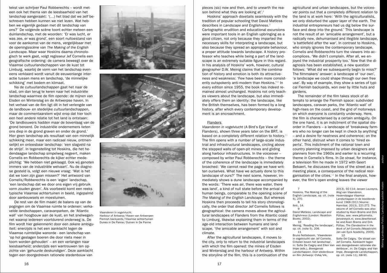
agricultural and urban landscapes, but the voiceo-ver points out that a completely different relation to the land is at work here: ‘With the agriculturalists, we only disturbed the upper layer of the earth. The industrial entrepreneurs had us dig below the sur-face and deep into the ground.’ This landscape is not the result of an ‘amicable arrangement’, but a radically new, dehumanised and illegible landscape, ‘a battlefield after the war’. In contrast to Hoskins, who simply ignores the contemporary landscape, Cornelis and Robberechts turn the viewers into ac-complices. ‘We didn’t complain. After all, we en-joyed the industrial prosperity too.’ Now that the di-agnosis has been established, a new question follows: ‘What did we subsequently begin to miss?’ The filmmakers’ answer: a landscape of ‘our own’, ‘a landscape we could shape through our own free use’. By way of example, they show a series of typi-cal Flemish backyards, won over by little huts and gardens.
The remainder of the film takes stock of at-tempts to arrange the Flemish space: subdivided landscapes, caravan parks, the ‘Atlantic wall’ of high-rises on the coast, and the grid of motorways on which everyone is constantly underway. Here, the film is characterised by a certain ambiguity. On the one hand, it is an indictment of the spatial dis-order in Flanders – a landscape of ‘breakaway farm-ers who no longer can be kept in check by anything’ – and a desire for neatness and coherence; on the other hand, distrust when it comes to ‘hired ex-perts’. This indictment of the rational town and country planning imposed by urban designers and planners from the 1960s and earlier is a recurring theme in Cornelis’s films. In De straat, for instance, a television film he made in 1972 with Geert Bekaert, he discusses the loss of the street as a meeting place, a consequence of the radical reor-ganisation of the cities.12 In the final analysis, how-ever, the film’s open ending leaves the viewer
pieces (sic) now and then, and to unearth the rea-son behind what they are looking at’.8
Hoskins’ approach dovetails seamlessly with the tradition of popular schooling that David Matless describes in Landscape and Englishness.9 Cartographic erudition and educational excursions were important tools in an English upbringing as a good citizen, not only because they imparted the necessary skills for interpreting a landscape, but also because they spread an appropriate behaviour, a proper attitude towards landscape. A history pro-fessor who teaches while being a part of the land-scape is an extremely suitable figure in this regard. In his analysis of Hoskins’ work, however, cultural geographer D.W. Meinig claims that the combina-tion of history and emotion is both its attractive-ness and weakness: ‘Few have been more consist-ently outspokenly anti-modern than Hoskins.’10 In every edition since 1955, the book has indeed re-mained almost unchanged. Hoskins not only teach-es viewers about the landscape, but also immedi-ately offers them an identity: the landscape, like the British themselves, has been formed by a long history, after which every contemporary develop-ment is an encroachment.
Flanders Vlaanderen in vogelvlucht (A Bird’s Eye View of Flanders), shown three years later on the BRT, is based on a completely different relation to history.11 The film opens with a number of large-scale indus-trial and infrastructural landscapes, circling above the stepped walls of open-pit mines and gliding along harbour infrastructures. In the voiceover – composed by writer Paul Robberechts – the theme of the coherence of the landscape is immediately broached: ‘We cannot read the page we have writ-ten ourselves. What have we actually done to this landscape of ours?’ The next scene, however, im-mediately shows a dune landscape accompanied by the words: ‘There was air, there was water, there was land’, a kind of null state before the arrival of human beings, comparable to the opening scene of The Making of the English Landscape. But whereas Hoskins then proceeds to tell his story chronologi-cally, the order that director Jef Cornelis follows is geographical: the camera moves above the agricul-tural landscapes of Flanders from the Atlantic coast to Limburg, likewise explaining them in terms of the age-old interaction between humans and land-scape, ‘the amicable arrangement’ with soil and climate.
After the agricultural landscapes, it moves to the city, only to return to the industrial landscapes with which the film opened: the mines of Eisden and Winterslag and the harbour of Antwerp. Within the storyline of the film, this is a continuation of the
tekst van schrijver Paul Robberechts – wordt met-een ook het thema van de leesbaarheid van het landschap aangeraakt: ‘(…) het blad dat we zelf be-schreven hebben kunnen we niet lezen. Wat heb-ben we eigenlijk gedaan met dit landschap van ons?’ De volgende scène toont echter meteen een duinlandschap, met de woorden: ‘Er was lucht, er was zee, er was grond’, een soort nultoestand van voor de aankomst van de mens, vergelijkbaar met de openingsscène van The Making of the English Landscape. Maar waar Hoskins daarna chronolo-gisch te werk gaat, volgt regisseur Jef Cornelis een geografische ordening: de camera beweegt over de Vlaamse cultuurlandschappen van de kust tot Limburg, waarbij de vorm van het landschap even-eens verklaard wordt vanuit de eeuwenlange inter-actie tussen mens en landschap, ‘de minnelijke schikking’ met bodem en klimaat.
Na de cultuurlandschappen gaat het naar de stad, om dan terug te keren naar het industriële landschap waarmee de film opende: de mijnen van Eisden en Winterslag en de Antwerpse haven. In het verhaal van de film ligt dit in het verlengde van de landbouw- en stedelijke cultuurlandschappen, maar de commentaarstem wijst erop dat hier toch een heel andere relatie tot het land is ontstaan: ‘De landbouwers hadden maar de bovenlaag van de grond beroerd. De industriële ondernemers lieten ons diep in de grond graven en onder de grond.’ Hier geen landschap als resultaat van een minnelijk schikking meer, maar een radicaal nieuw, ontmen-selijkt en onleesbaar landschap: ‘een slagveld na de strijd’. In tegenstelling tot Hoskins, die het he-dendaagse landschap simpelweg negeert, maken Cornelis en Robberechts de kijker echter mede-plichtig: ‘We hebben niet geklaagd. Ook wij genoten immers van de industriële welvaart’. Nu de diagno-se gesteld is, volgt een nieuwe vraag: ‘Wat is het dat we toen zijn gaan missen?’ Het antwoord van Cornelis/Robberechts is een ‘eigen’ landschap, ‘een landschap dat we door ons eigen vrij gebruik vorm zouden geven’. Als voorbeeld komt een reeks typische Vlaamse achtertuinen in beeld, ingepalmd door aanbouwsels en moestuinen.
De rest van de film maakt de balans op van de pogingen om de Vlaamse ruimte te ordenen: verka-velde landschappen, caravanparken, de ‘Atlantic wall’ van hoogbouw aan de kust, en het snelwegen-net waarop iedereen voortdurend onderweg is. De film wordt hier gekenmerkt door een zekere ambigu-iteit: enerzijds is het een aanklacht tegen de Vlaamse ruimtelijke wanorde - een landschap van ‘op hol geslagen boeren die door niets meer in toom worden gehouden’ – en een verlangen naar leesbaarheid; anderzijds een wantrouwen ten op-zichte van ‘gehuurde deskundigen’. Deze aanklacht tegen een doorgedreven rationele stedenbouw van
7 Hoskins, The Making of the English Landscape, op. cit. (note 5), 270. 8 Ibid., 14. 9 David Matless, Landscape and Englishness (London: Reaktion Books, 2002). 10 Meinig, ‘Reading the landscape’, op. cit. (note 5), 206. 11 Bruno Notteboom, ‘Vlaanderen in vogelvlucht van Jef Cornelis. Cirkelen boven het landschap’, in: Sofie De Caigny and Ellen Van Impe (eds.), Bewegende Landschappen. Over stedenbouw en film (Antwerp: CVAa/VAi,
2013), 92-114; Jeroen Laureyns, Weg van Vlaanderen. Hedendaagse Vlaamse Landschappen in de beeldende kunst 1968-1913 (Veurne: Hannibal, 2013), 221-272. The oeuvre of Jef Cornelis was also studied by Koen Brams and Dirk Pültau, see: www.jefcornelis.janvaneyck.nl, www.dewitteraaf.be and Koen Brams and Dirk Pültau, The Clandestine in the Work of Jef Cornelis (Maastricht: Jan van Eyck Academy, 2009). 12 Sofie De Caigny, ‘De straat van Jef Cornelis. Aanklacht tegen een doorgedreven rationele ste-denbouw’, in: De Caigny and Van Impe, Bewegende Landschappen, op. cit. (note 11), 68-91.
Vlaanderen in vogelvlucht. Harbour of Antwerp / Haven van Antwerpen Flemish backyards / Vlaamse achtertuinen Dunes in De Panne / Duinen in De Panne

Mak
ing
Land
scap
e P
ublic
/ L
ands
chap
pub
liek
mak
enau
teur
1918
somewhat confused. The solution to the problem is not spatial planning or simply protecting land-scapes or continuing to exploit the land in the man-ner that we are doing now. In the last scene, the film returns to the dune landscape of the ‘there was air, there was water, there was land’. This time, however, the landscape is not empty. The camera circles a group of people trekking across the dunes like nomads looking for a place to settle down, ac-companied by the words: ‘Starting over again is no longer an option. But it must be possible to make a landscape in which the traces left by our use and coexistence are not signs of defacement but of a social reconciliation with the space.’
The Netherlands Social reconciliation is high on the agenda of Nederland van boven (The Netherlands from Above). The programme, a two-season documentary series broadcast in 2011 and 2013, was produced by the VPRO, a Dutch public broadcaster.13 The first epi-sode is representative of the manner in which the entire series is built up. Titled ‘24 uur Nederland’ (24 Hours in the Netherlands), Dutch life is shown from different perspectives: from the air, with heli-copter footage and data superimposed on aerial photos, but also from the ground, by interviewing Dutch people in their homes, at work or out of doors. The programme starts out with a visualisa-tion of cell phone activity in the early morning, then cuts to an image of a hot air balloon floating above the morning landscape. Presenter Bentz van den Berg poses the question for this episode:
By taking a good long look, Nederland van boven is trying to find an answer to the question of what the pattern of our daily routines, all 16 mil-lion of us, actually looks like. . . . How on earth do we manage not to get bogged down in com-plete chaos every day?
Right away, the first potential problem comes up: the water supply. Circling above a water purification plant, we learn that approximately 400 million litres of water are used every day in the Netherlands be-tween 6 and 9 am. Directly after that, we visit Ronald and Jan from the Vitens water company, whose job is to keep the pressure in the water sys-tem at the proper levels and the water flowing in the right directions. This way, we can have a peek at the private life of the average Dutch person: we learn that water usage spikes way up on Tuesday nights after the television programme Boer zoekt vrouw because the whole country goes to the toilet then. The programme takes us through 24 hours this way, with helicopter footage and graphic infor-mation about the motorways and traffic jams (with commentary by Patrick the traffic specialist), the
moeten leiden. Daardoor kunnen we een blik wer-pen in het privéleven van de gemiddelde Nederlander: zo komen we te weten dat het water-verbruik extreem piekt op dinsdagavond na het tele-visieprogramma Boer zoekt vrouw omdat Nederland dan massaal naar het toilet gaat. Op die manier loodst het programma ons door de 24 uur, met heli-copterbeelden en datavisualisaties van de snelwe-gen en de files (met uitleg van Patrick de verkeers-deskundige), het treinverkeer (met Carla de omroepster op station Utrecht) en het electriciteits-net (met Henrico van netwerkbedrijf Alliander).
De eerste aflevering drukt ons niet alleen met de neus op de vermeende voorspelbaarheid van de Nederlander, maar ze toont ook hoe goed het land in elkaar zit, als je het vanop een afstand bekijkt. In de tweede aflevering, over de rivieren en havens, wordt de delta een ‘precisie-uurwerk’ genoemd. In de derde aflevering, ‘Nederland knutselland’, zien we een tevreden echtpaar in een zelf aangelegd tuintje, maar ook de controleurs van de tuincom-missie van Vreewijk: ‘knutselen is onmogelijk zon-der controle, zowel op de kleine of grotere schaal’. In elke aflevering is de bottom line het standvastige geloof in de maakbaarheid en de onlosmakelijke band tussen landschap en nationale identiteit: ‘Wij hebben dit land gemaakt, maar het land heeft ook ons gemaakt.’ Haperingen in het perfect draaiende systeem worden nauwelijks vermeld. Het gebrek aan kritiek blijkt bijvoorbeeld aflevering zeven met als titel ‘Waarom we wonen waar we wonen’, dat begint met een korte inleiding op de Nederlandse woningbouw, gevolgd door een overzicht van wat er allemaal aan woonmilieus in Nederland bestaat, van het woonblok uit de jaren 1970 tot de historise-rende nieuwbouwwijken van vandaag. Hier klinkt weliswaar lichte kritiek op de veranderlijke woon-wens van de Nederlander – ‘over 30 jaar willen we weer wat anders’ – maar over wat er echt aan de hand is met de woningmarkt, die juist nagenoeg tot stilstand was gekomen, wordt niet gerept: geen woord over de recente kredietcrisis, wat blijft han-gen is een gevoel van welvaart en overschot. Zo wordt ook niet moeilijk gedaan over de algehele ver-rommeling van het landschap, de plannen voor be-drijventerreinen in het Groene Hart of de verkoop van gronden door Staatsbosbeheer.
Nederland van boven is een bijzonder aantrek-kelijk programma. De luchtbeelden en de datavisua-lisaties zijn soms ronduit verbluffend. Het werd dan
de stedenbouwkundigen en planologen uit de jaren 1960 en eerder was een terugkerend thema in de films van Cornelis. Zo belichtte hij in 1972 in De straat, een televisiefilm die hij maakte met Geert Bekaert, de teloorgang van de straat als ontmoe-tingsruimte door de verregaande sanering van de steden.12 Uiteindelijk laat de film de kijker enigszins in verwarring achter met een open einde. De oplos-sing voor het probleem is niet de stedenbouw, noch het louter beschermen van landschappen, noch het land verder ontginnen op de manier waarop we be-zig zijn. In de laatste scène keert de film terug naar het duinlandschap van ‘Er was lucht, er was zee, er was grond’. Dit keer geen leeg landschap echter, maar de camera cikelt rond een groep mensen die door de duinen trekken als nomaden op zoek naar een vestigingsplaats, begeleid door de woorden: ‘Opnieuw beginnen is er niet meer bij. Maar het moet mogelijk zijn, een landschap te maken waar de sporen van ons gebruik en samenleven geen te-kens van beschadiging zijn, maar tekens van een maatschappelijke verzoening met de ruimte.’
NederlandDeze maatschappelijke verzoening staat hoog op de agenda in Nederland van boven. Dit programma, een tweedelige documentaire serie uitgezonden in 2011 en 2013, is een productie van de VPRO, een van de Nederlandse publieke omroepen.13 De eer-ste aflevering is representatief voor de manier waarop de hele serie is opgebouwd. Onder de titel 24 uur Nederland wordt het leven van de Nederlanders in een wisselend perspectief be-schreven: vanuit de lucht, door middel van helicop-terbeelden en datavisualisaties op luchtfoto’s, maar ook op het maaiveld, met interviews met Nederlanders in hun woon- of werksituatie of in het landschap. Het programma begint met een visuali-satie van het mobiele telefoonverkeer in de vroege ochtend, om dan over te schakelen op het beeld van een luchtballon die over het ochtendlijke land-schap glijdt. Presentator Bentz van den Berg stelt de vraag van de aflevering:
Door lang te kijken proberen we in Nederland van boven een antwoord te vinden op de vraag hoe het ritme van ons, 16 miljoen mensen, er eigenlijk uitziet. (…) Hoe is het mogelijk dat we niet iedere dag in een complete chaos verzanden?
Meteen komt het eerste potentiële probleem aan bod: de watervoorziening. Cirkelend boven een wa-terzuiveringsinstallatie krijgen we te horen dat tus-sen 6 en 9 uur ’s ochtends in Nederland zo’n 400 miljoen liter water wordt verbruikt. Aansluitend be-vinden we ons bij Ronald en Jan van waterbedrijf Vitens, die de druk in het waternet in goede banen
12 Sofie De Caigny, ‘De straat van Jef Cornelis. Aanklacht tegen een doorgedreven rationele stedenbouw’, in: De Caigny en Van Impe, Bewegende Landschappen, op. cit. (noot 11), 68-91.
13 Alle afleveringen van Nederland van boven zijn te bekijken op http://www.vpro.nl/nederland-van-boven.
Nederland van boven. Intro with mention of hashtag / Intro met vermelding hashtag Jan Bartens, Vitens water company / Waterbedrijf Vitens Data visualisation / Datavisualisatie

Mak
ing
Land
scap
e P
ublic
/ L
ands
chap
pub
liek
mak
enau
teur
2120
the prospect of a shrinking population – the under-lying message is that Holland is still doing great and that all Dutch people are part of a well-oiled machine that is still run from above. The partners of the programme are the Land Registry, the Society for the Preservation of Nature Monuments, and the Dutch Water Authorities. Not surprisingly, water plays an important role in many episodes, as a friend (the driving force behind economic develop-ment) and as an enemy (the threat of flooding). Just as in past centuries, the identity of the Dutch is largely determined by how they deal with water and the belief that every problem can be solved by good planning. In short, the series confirms the ste-reotypical image of the Netherlands.
Television, the Public Sphere and Civic CultureThe most important criticism of Nederland van boven is that the programme is not very critical, and that it capitalises rather overmuch on a ‘we feeling’. Frank Wiering, chief television editor of the VPRO, refutes this in a newspaper interview with the de Volkskrant:
It’s nice that the programme doesn’t only appeal to those who are looking for critical depth. . . . ‘Proud of Holland’ (the name of a right-wing pop-ulist political party – BN) is a term that has been hijacked by the right; it’s high time it becomes general again. People want to bask in an ‘I love Holland’ feeling, and that’s exactly why the pro-gramme is a success.15
Presenter Bentz van den Berg adds: ‘The aim of the programme is to show how the country functions, and how beautiful the Netherlands is. You ruin that if you start criticising things.’16 Judging from these statements, one could conclude that a television programme will only make an impression on the general public and create a feeling of community if it doesn’t get too difficult. In light of these state-ments, I would therefore like to further reflect on the above three programmes as a whole. How do they use landscape in order to evoke a feeling of identity, collective or otherwise, in the target group? And more generally: How does television bring landscape into the public sphere?
As mentioned earlier, in The Making of the English Landscape Hoskins focused exclusively on the past. Many expositions on landscape and the
railway traffic (with broadcaster Carla at the train station in Utrecht) and the electricity grid (with Henrico from the Alliander energy network company).
The first episode not only makes us examine the supposed predictability of the Dutch, but also shows how well the country is put together when viewed from a distance. The second episode, about the rivers and harbours, refers to the Delta Works in the southwest of the Netherlands as ‘precision clockwork’. In the third episode, ‘Nederland knut-selland’ (Holland the Land of Pottering Around), we not only see a contented couple pottering around in their own garden but also the inspectors from the Vreewijk garden committee: ‘Pottering around, no matter whether it’s small scale or large, is not per-mitted without inspection.’ The bottom line in each episode is the steadfast belief in manipulability and the inseparable bond between landscape and na-tional identity. ‘We have shaped this land, but this land has also shaped us.’ Hitches in the perfectly running system are hardly mentioned. The lack of critique is apparent, for example, in episode seven, titled ‘Why We Live Where We Live’, which begins with a short introduction to Dutch housing followed by an overview of the different residential environ-ments in the Netherlands, ranging from the housing blocks of the 1970s to the historicising new hous-ing developments of today. Here, it is true, there is a slight criticism of the changing living preferences of the Dutch – ‘in 30 years’ time we’ll want some-thing different again’ – but no mention is made of what is really going on in the housing market, which in fact basically had come to a standstill. Not a word about the recent credit crisis; instead, we are left with a feeling of prosperity and surplus. Nor does it worry about the general mess being made of the landscape, the plans for industrial terrains in the Green Heart of the Netherlands or the sale of land by Staatsbosbeheer (commissioned by the Dutch government to manage the country’s nature reserves).
Nederland van boven is an extremely attractive programme. The aerial views and the data visuali-sations are absolutely astounding at times. And it was indeed highly appreciated by Dutch viewers: its average rating of 1.2 million viewers far exceeded expectations.14 The structure of the programme is low threshold: the description of the landscape of-ten starts from everyday life and the private sphere, and with the exception of the experts – who invari-ably jump into the helicopter along with the crew – the interviews take place with ordinary Dutch peo-ple in their homes or at work. The programme also has something reassuring about it: the belief in ma-nipulability remains intact. Even in the second, more nuanced season – the last episode deals with
Zoals hiervoor al gesteld, richt Hoskins in The Making of the English Landscape zijn blik uitsluitend naar het verleden. Veel vertogen over landschap en landschapstransformatie zijn onvermijdelijk een commentaar op de moderniteit, en verankerd in een verhaal van verlies: verlies van traditionele vor-men van gemeenschap en verlies van een directe, ‘natuurlijke’ band met het land.17 Door alle recente veranderingen in het landschap van na de Tweede Wereldoorlog af te doen als een evolutie die de be-tekenis van het landschap vernietigt, legt hij impli-ciet de grondslag voor een opvatting van het Britse volk als een imagined community, verenigd rond een – grotendeels niet meer bestaand – landschap van het verleden.18 De grote populariteit van het pro-gramma en de vlucht die de lokale geschiedenis nam in de jaren 1970, bevestigen alleen maar de bereidheid van de moderne Brit om Hoskins hierin te volgen.
Vlaanderen in vogelvlucht gaat veel subtieler en genuanceerder te werk. Niet alleen maken Robberechts en Cornelis het publiek medeplichtig aan de teloorgang van het landschap, het blijft ook met heel wat vragen zitten na het open einde. Het is onmogelijk om zich als kijker zomaar met het his-torische landschap te identificeren of hoge verwach-tingen te koesteren van de stedenbouw. Goed om weten is dat dit programma werd uitgezonden op de vooravond van 11 juli, de Vlaamse feestdag waarop de overwinning op de Franse overheerser met de Guldensporenslag van 1302 wordt gevierd. Een jaar later werd Vlaanderen 77 uitgezonden, een film van Cornelis die alle namen en afbakeningen uit de Vlaamse geschiedenis opsomde en er vervolgens brandhout van maakte als een al te eenvoudig ge-construeerde, Vlaamse identiteit. Hoewel Cornelis’ films over het leven van l’homme moyen gingen, wa-ren ze eigenlijk niet gemaakt voor de massa.19 Ze werden in de pers dan ook niet altijd goed ont-haald. De BRT was in die jaren dan ook volop bezig een tweede net op te richten zodat dit soort pro-gramma’s in de toekomst naar een nichepubliek kon verschoven worden.20
ook zeer gewaardeerd door de Nederlandse kijker: de gemiddeld 1,2 miljoen kijkers overtroffen ruim-schoots de verwachtingen.14 De structuur van het programma is laagdrempelig: de beschrijving van het landschap vertrekt vaak vanuit het dagelijks le-ven en de private sfeer, en naast de deskundigen – die steevast mee de helikopter in klimmen – zijn de geïnterviewden gewone Nederlanders thuis of op het werk. Het programma heeft ook iets geruststel-lends: het geloof in de maakbaarheid blijft over-eind; de onderliggende boodschap is dat het nog steeds goed gaat met Nederland en dat alle Nederlanders onderdeel zijn van een goed geoliede machine die nog steeds van bovenaf wordt be-stuurd. De samenwerkingspartners zijn dan ook het Kadaster, Natuurmonumenten en de Unie van Waterschappen. Het is geen verrassing dat in veel afleveringen het water een belangrijke rol speelt: als vriend – motor van de economische ontwikke-ling; en als vijand – de dreigende watersnood. Net als in de afgelopen eeuwen wordt de identiteit van de Nederlander grotendeels bepaald door de om-gang met het water en het geloof dat elk probleem opgelost wordt door een goede planning. De serie, kortom, bevestigt het stereotiepe beeld van Nederland.
Televisie, publieke sfeer en civieke cultuurDe belangrijkste kritiek op Nederland van boven luidt dat het programma weinig kritisch is, en wel heel erg inspeelt op een ‘wij-gevoel’. Frank Wiering, hoofdredacteur televisie van de VPRO, weerlegt dit in een interview met de Volkskrant:
Het is prettig dat het programma niet alleen ‘kri-tische verdiepingszoekers’ aanspreekt. (…) Trots op Nederland [de naam van een rechts-po-pulistische politieke partij, BN] is een term die gekaapt is door rechts, het wordt tijd dat het be-grip weer algemeen wordt. Men heeft behoefte aan een ik-hou-van-Holland-gevoel, dat is juist het succes van het programma.15
Presentator Bentz van den Berg voegt daaraan toe: ‘Het doel van het programma is laten zien hoe het land functioneert, en tonen hoe mooi Nederland is. Je verpest het als je daarbij kritisch gaat doen.’16 Uit die uitspraken zou men kunnen afleiden dat een televisieprogramma pas een impact heeft op het grote publiek, en een gevoel van gemeenschappe-lijkheid creëert, als het niet te moeilijk doet. In het licht van deze uitspraken wil ik daarom verder re-flecteren over de drie hierboven besproken pro-gramma’s. Op welke manier wordt landschap in deze programma’s gebruikt om bij de groep van kij-kers een al dan niet collectieve identiteit op te roe-pen? En meer algemeen: op welke manier brengt televisie landschap in de publieke sfeer?
14 Madelon Meester, ‘Trots op Nederland’, de Volkskrant, 10 januari 2012, geraadpleegd op http://www.volkskrant.nl/vk/nl/2844/Archief/archief/article/detail/3112713/2012/01/10/Trots-op-Nederland.dhtml#. 15 Ibid. 16 Ibid. 17 Jean-Luc Nancy, Peter Connor en Christopher Fynsk, The Inoperative Community (Minneapolis: University of Minnesota Press, 1998).
18 Over de notie imagined community, zie: Benedict Anderson, Imagined Communities (Londen: Verso, 1983). 19 Marc Holthof, ‘De ongewenste wasmachine. Over het televisiewerk van Jef Cornelis’, De Witte Raaf, nr. 55 (1995), 17-19. 20 Notteboom, ‘Vlaanderen in vogelvlucht’, op. cit. (noot 11), 111.
13 All episodes of Nederland van boven can be seen on http://www.vpro.nl/nederland-van-boven. 14 Madelon Meester, ‘Trots op Nederland’, de Volkskrant, 10 January 2012, source: www.
volkskrant.nl/vk/nl/2844/Archief/archief/article/de-tail/3112713/2012/01/10/Trots-op-Nederland.dhtml#. 15 Ibid. 16 Ibid.

Mak
ing
Land
scap
e P
ublic
/ L
ands
chap
pub
liek
mak
enau
teur
2322
het publieke karakter van het programma, naar aan-leiding van een stukje in nrc.next over het feit dat de VPRO de landschapsbeelden, die grotendeels zijn betaald met belastinggeld, niet publiek beschik-baar stelt.22
Dahlgren, en hier volgt hij media-onderzoeker John Ellis, ziet televisie als een working through, een medium dat de kijker geen ultiem of definitief gezichtspunt meegeeft, maar eerder een grote hoe-veelheid voorbijgaande glimpen, voorlopige menin-gen, meervoudige kaders, verklaringen en narratie-ve structuren aanbiedt om zich door private en publieke bezorgdheden ‘heen te werken’.23 Dit con-cept van working through ontkent niet het hegemo-nische karakter van televisie, maar erkent dat die hegemonie ‘lek’ is en altijd op losse schroeven staat. Als je goed kijkt naar Nederland van boven, slaan de makers het dominante discours over het Nederlandse landschap als de perfect werkende machine hier en daar zelf lek, bijvoorbeeld door ter-loops te verwijzen naar de verstekeling in de contai-nerhaven van Rotterdam in aflevering twee, of de ironie waarmee de tuincontroleurs in Vreewijk in af-levering drie zijn in beeld gebracht.
wild animals in your neighbourhood, and so forth. By mentioning the programme’s hashtag in the in-troduction to the show, they also stimulated discus-sion about it on Twitter.
In his essay ‘Television, Public Spheres, and Civic Cultures’, Peter Dahlgren examines the ques-tion of how television relates to the public sphere.21 He starts with the observation that in an era when the media are shifting towards entertainment and consumption, the relation between television and the public sphere is in danger of becoming more and more problematic. He wonders how we still can orient ourselves by means of the concept of the public sphere in such a reality. The notion of ‘pub-lic’ in the Habermasian sense, according to Dahlgren, is always related to concepts like reason, rationality, objectivity, argument, information and knowledge. Opposite to that is the private sphere, linked with the personal, the emotional, intimacy, subjectivity and pleasure, all of which are elements of popular culture. The ‘problem’ of today’s media is that the private/public polarity has become destabilised. Whereas The Making of the English Landscape and Vlaanderen in vogelvlucht still oper-ated in the ‘educational’ context of the classic pub-lic networks, the context of Nederland van boven is already much less defined – the programme makes every effort to involve the private sphere. Dahlgren, however, wants to embrace that vagueness as a strength rather than a weakness. For him, televi-sion does not unequivocally coincide with the public sphere but is part of a ‘civic culture’, a cultural sphere that can form an occasion to participate in the public sphere. It could very well be that Nederland van boven is in the first place entertain-ment for most viewers, but perhaps the programme does stir up discussion about the manipulability of the land in some households. For example, there was an extensive discussion on an Internet forum about the public nature of the programme, pro-voked by a piece in nrc.next about the fact that the VPRO did not make available to the public the im-ages it had shown of the Dutch landscape, most of which had been paid for with taxpayers’ money.22
transformation of landscape are inevitably a com-mentary on modernity and rooted in a narrative of loss: the loss of traditional forms of community and the loss of a direct, ‘natural’ tie with the land.17 In his dismissal of all recent changes in the land-scape after the Second World War as an evolution that can only destroy the meaning of the land-scape, he implicitly lays the foundation for a notion of the British people as an ‘imagined community’, united around a landscape of the past that no long-er exists for the most part.18 The programme’s great popularity and the great surge of interest in local history in the 1970s only confirms the readi-ness of the modern Brit to follow Hoskins in this regard.
Vlaanderen in vogelvlucht, by contrast, goes about its business much more subtly. Not only do Robberechts and Cornelis make the audience com-plicit in the loss of the landscape; they are also left with a great many questions because of the film’s open ending. As a viewer, it is impossible to auto-matically identify with the historical landscape or harbour great expectations of urban planning. It is helpful to know that this programme was broadcast on the eve of 11 July, the Flemish holiday celebrat-ing the victory over the French ruler at the Battle of the Golden Spurs in 1302. The next year saw the broadcasting of Vlaanderen 77, a film by Cornelis that made short work of an all too easily construct-ed Flemish identity by summing up all the names and lines of demarcation that Flanders had ever had in its history. Although Cornelis’s films were about the life of the l’homme moyen, they were in fact not made for the masses.19 Consequently, they were not always well received by the press. In those years, the BRT was also working intensively on set-ting up a second network so as to be able to shift programmes like this to a niche audience in the future.20
Forty years later in the Netherlands, Nederland van boven moved in the opposite direction in a cer-tain sense. This was a programme produced by a niche broadcaster (the VPRO) that in terms of audi-ence ratings belonged on the popular market. As already mentioned above, the programme appealed to a wide audience by capitalising on a feeling of community based on old but popular traits – a be-lief in manipulability and a nation of hard workers. But there is more: the makers took advantage of an entirely different way of watching TV: not only did they discuss a ‘public’ subject – the landscape – mostly from the private person’s point of view; at the end of each episode they also made the pro-gramme interactive by referring viewers to an ac-companying website, where you could find all sorts of information on a digital map of the Netherlands: the accessibility of the location of your home, the
Nederland Van boven maakte 40 jaar later in ze-kere zin de omgekeerde beweging. Het is een pro-gramma op een nichezender (de VPRO) dat in ter-men van kijkcijfers in de populaire markt thuis hoorde. Zoals hierboven al gesteld, appelleerde het programma bij een groot publiek door in te spelen op een gemeenschapsgevoel, gebaseerd op oude maar graag geziene karakteristieken – een geloof in de maakbaarheid en een volk van harde werkers. Maar er is meer: de makers speelden hiervoor in op een heel andere manier van televisiekijken: niet al-leen werd een ‘publiek’ onderwerp – het landschap – grotendeels belicht vanuit het private leven, ook werd het programma interactief gemaakt door op het eind van elk programma te verwijzen naar de begeleidende site waar de kijker op een digitale kaart van Nederland allerlei gegevens kon simule-ren: de bereikbaarheid van je woonplek, de wilde dieren die je in de buurt kan zien, etc. Door de ver-melding van de hashtag in de intro wordt discussie over het programma op Twitter gestimuleerd.
In zijn essay ‘Television, public spheres, and ci-vic cultures’ buigt Peter Dahlgren zich over de vraag hoe televisie zich verhoudt ten opzichte van de pu-blieke sfeer.21 Hij start met de vaststelling dat de relatie televisie/publieke sfeer meer en meer pro-blematisch dreigt te worden in een tijdperk waarin de media opschuiven in de richting van entertain-ment en consumptie. Hij vraagt zich af hoe we ons in een dergelijke realiteit nog kunnen orienteren door middel van het concept van de publieke sfeer. De notie van het publieke in de Habermasiaanse zin, aldus Dahlgren, is steeds verbonden met be-grippen als rede, rationaliteit, objectiviteit, argu-ment, informatie en kennis. Daartegenover staat het private, gelinkt met het persoonlijke, emotie, intimiteit, subjectiviteit en plezier, allemaal elemen-ten van de populaire cultuur. Het ‘probleem’ van de hedendaagse media is dat de polariteit privaat/pu-bliek gedestabiliseerd is. Waar The Making of the English Landscape en Vlaanderen in vogelvlucht nog opereren in de ‘onderwijzende’ context van de klas-sieke publieke netwerken, is die context van Nederland van boven al veel minder afgebakend – het programma doet alle moeite om de private sfeer erbij te betrekken. Dahlgren wil die onduide-lijkheid echter aangrijpen als een sterkte in plaats van een zwakte. Voor hem valt televisie niet eendui-dig samen met de publieke sfeer, maar is ze deel van een civic culture, een culturele sfeer die een aanleiding kan vormen om in de publieke sfeer te participeren. Wellicht is Nederland van boven voor de meeste kijkers in de eerste plaats entertain-ment, maar misschien maakt het programma in sommige huiskamers discussie los over de maak-baarheid van het land. Ook vond er bijvoorbeeld op een internetforum een uitgebreid debat plaats over
21 Peter Dahlgren, ‘Television, Public Spheres, and Civic Cultures’, in: Janet Wasko (red.), A Companion to Television (Malden, MA: Blackwell Publishing, 2006), 411-432.
22 http://www.alexanderklopping.nl/post/13868042208/column-nrc-next-nederland-van-boven-is-prachtig. 23 Dahlgren, ‘Television’, op. cit. (noot 21), 417. Voor het concept working through, zie: John Ellis, Seeing Things: Television in the Age of Uncertainty (Londen/New York: I.B. Tauris Publishers, 2000).
17 Jean-Luc Nancy, Peter Connor and Christopher Fynsk, The Inoperative Community (Minneapolis: University of Minnesota Press, 1998). 18 For the notion of ‘imagined com-munity’, see Benedict Anderson, Imagined Communities (London: Verso, 1983). 19 Marc Holthof, ‘De ongewenste wasmachine. Over het televisie-werk van Jef Cornelis’, De Witte Raaf, no. 55 (1995), 17-19.
20 Bruno Notteboom, ‘Vlaanderen in vogelvlucht’, op. cit. (note 11), 111. 21 Peter Dahlgren, ‘Television, Public Spheres, and Civic Cultures’, in: Janet Wasko (ed.), A Companion to Television (Malden, MA: Blackwell Publishing, 2006), 411-432. 22 http://www.alexanderklopping.nl/post/13868042208/column-nrc-next-nederland-van-boven-is-prachtig.

Mak
ing
Land
scap
e P
ublic
/ L
ands
chap
pub
liek
mak
enau
teur
2524
Dahlgren sees television – and here he follows media researcher John Ellis – as a ‘working through’, a medium that does not offer the viewer an ultimate or definitive point of view, but sooner a great quantity of passing glimpses, provisional opinions, multiple frameworks, explanations and narrative structures in order to ‘work through’ pri-vate and public concerns.23 This concept of working through does not deny the hegemonic nature of tel-evision, but recognises that this hegemony is ‘leaky’ and always up in the air. When you look closely at Nederland van boven, you see that the makers themselves puncture a hole here and there in the dominant discourse about the Dutch land-scape as a perfectly working machine, for instance by casually referring in the second episode to a stowaway in the container harbour of Rotterdam, or by the irony with which they depict the Vreewijk gar-den inspectors in the third episode.
23 Dahlgren, ‘Television’, op. cit. (note 21), 417. For the concept of ‘working through’, see: John Ellis, Seeing Things: Television in the Age of Uncertainty (London and New York: I.B. Tauris Publishers, 2000).

Mak
ing
Land
scap
e P
ublic
/ L
ands
chap
pub
liek
mak
en
2726
Cla
udia
Far
aone
and
Mic
hiel
Deh
aene
Land
scap
es L
arge
r Th
an L
ife
/ U
itve
rgro
te l
ands
chap
pen
tography . . . as a critique of the world and to dem-onstrate the possibility of creating a better one’.5 The two films emerge from a transdisciplinary col-laborative practice of artists, urban ethnographers and social geographers who share an interest in narrative techniques to dislodge the objective pre-tence of scientific research techniques. The footage included in the films literally has a hybrid status; it was produced as part of a scientific research pro-ject and subsequently reassembled within a script-ed film with overt narrative and artistic ambitions.
The movies are part of a growing body of work that in the 1990s began to focus on the subject of inhabited territories, portraying the built space as landscape and vice versa. The visual tool of filming and the actual production of a movie are seen as a way of actively participating in the way a space is inhabited and used. Making a film is not only an in-tervention in itself; it also takes part in the con-struction of new imaginaries attached to a particu-lar place. The two films discussed here steer an interesting middle course between a tradition of ac-tivist, environmentalist documentary making and their ethnographic account.6 They acknowledge the dialectic inherent to the depiction of landscapes be-tween practices of objectification and subjectifica-tion,7 between the depiction of a material context out there and the promotion of a particular per-spective, a particular vantage point from where to observe that context and possibly act in it.
Robinson in Ruins van Patrick Keiller. Uit beide films spreekt zowel belangstelling voor visuele etnografie als voor de documentaire, verhalende film. Dit re-sulteert in een hybride derde traditie: een expliciete poging om de landschapsfotografie te gebruiken ‘om de wereld kritisch te bekijken en om te laten zien dat het creëren van een betere tot de mogelijk-heden behoort’.5 De twee films zijn afkomstig uit een transdisciplinair collectief van kunstenaars, stadsetnografen en sociaal-geografen met een ge-meenschappelijke belangstelling voor narratieve technieken, die de objectieve pretenties van de we-tenschappelijke onderzoekstechnieken weten te ontwrichten. De status van de filmbeelden is letter-lijk hybride: ze zijn opgenomen als onderdeel van een wetenschappelijk onderzoek en vervolgens op-nieuw gemonteerd volgens een filmscript met een duidelijk verhaal en artistieke ambities.
De films maken deel uit van een sinds de jaren 1990 groeiend corpus aan films over allerlei woon- en nederzettingsvormen waarin de bebouwde ruim-te als een landschap wordt geportretteerd en vice versa. Het visuele medium film en de feitelijke pro-ductie van de film worden gezien als middel waar-mee actief kan worden bijgedragen aan de manier waarop een ruimte wordt bewoond en gebruikt. Het maken van een film is niet alleen een interventie op zich, maar draagt ook bij aan het ontstaan van nieuwe denkbeelden over een bepaalde plek. De twee films die hieronder worden besproken houden
Claudia Faraone en Michiel Dehaene
Uitvergrotelandschappen
Films over territoriale transformaties in Europa
Een van de richtingen zou kunnen zijn om te werken alsof we niet anders kunnen, op een manier die ik ethisch zou noemen (...). Alsof je iets voor de eer-ste en laatste keer ziet. Dan kijk je intensiever, min-der oppervlakkig, minder anekdotisch, minder es-thetisch en minder gemaakt; niet langer op zoek naar een bevoorrechte positie of de perfecte foto, maar in plaats daarvan verleng en verdiep je de ruimte en tijd van je blik, zodat je waarneming die-per wordt en nieuwe emoties teweeg brengt.
Luigi Ghirri, Paesaggi Italiani, 19891
De voortdurende verandering en verstedelijking van het landschap is een populair onderwerp dat in ver-schillende hedendaagse documentaires aan bod komt. Deze aandacht voor het verstedelijkte land-schap is niet nieuw. Er bestaan talloze voorbeelden van baanbrekend cinematografisch werk waarin de stad en haar landschappen de hoofdrol spelen. Het stedelijk landschap wordt afgeschilderd als een met het leven van haar inwoners samenvallend, al-lesomvattend organisme en is achtereenvolgens ten tonele gevoerd als een symfonisch werk (Berlin: Die Sinfonie der Grosstadt), als een machine (Chelovek ‘s kino-apparatom) en als een plaats van ondergang en openbaring (Koyaanisqatsi).2
Naast deze kunstzinnige films bestaat er een tradi-tie van etnografische visuele verkenningen van de stad. Deze zijn beschrijvend van aard, en veel van deze films zijn onderdeel van een bewuste poging om een beter inzicht te verwerven in de stad als een sociaal geconstrueerd landschap, waarvan de betekenis verandert met de steeds wijzigende pa-tronen in gebruik en bewoning. Sinds de jaren 1970 hebben sociologen, architecten en stedenbouwkun-digen het visuele medium film gebruikt om de ver-andering van de gebouwde omgeving vast te leg-gen.3 Bekende voorbeelden zijn de films en fotoseries die Denise Scott-Brown en Robert Venturi, Kevin Lynch, William H. Whyte ontwikkelden als medium voor onderzoek en ontwerp, vanuit een verlangen om die verandering te begrijpen en om aanknopingspunten te vinden voor verbetering.4
Dit artikel gaat over twee films die beide tradi-ties in zich verenigen: Alpi van Armin Linke en
Claudia Faraone and Michiel Dehaene
Landscapes LargerThan Life
Notes on Two Films about Territorial I believe that one of the directions could be that of working as if we find ourselves in a state of neces-sity, in a way I would call ethic. . . . Seeing as it were for the first and the last time. This approach would bring a deeper gaze, less superficial, short on anecdotes, less aesthetic or crafted, far re-moved from the quest for a privileged status or the perfect shot, but instead lengthening and broaden-ing the space and time of the gaze, giving new depth and new emotions to our perceptions.
Luigi Ghirri, Paesaggi Italiani, 19891
The ever changing and urbanising landscape is a popular subject in contemporary documentary film. As such, this attention to the urbanised landscape is nothing new. There are countless examples of pi-oneering cinematographic work in which the city and its landscapes figure as the main protagonist. The urban landscape is portrayed as an all-encompass-ing organism coinciding with the life of its inhabit-ants that has been alternatively staged as a sym-phonic work (Berlin: Die Sinfonie der Grosstadt), as a machine (The Man with the Movie Camera) or as the place of perdition and apocalypse (Koyaanisqatsi).2
Besides these artistic films there is a tradition of ethnographic visual explorations of the city. While descriptive in nature, many of these movies are part of a deliberate effort to better understand the city as a socially constructed landscape, the mean-ing of which changes with the ever-evolving patterns of use and inhabitation. Starting in the 1970s, the visual tool of filming was used by sociologists, ar-chitects and urban planners to record the process of transformation of the built environment.3 Well-known examples are the films and sequences of pictures developed as tools for research and design by Denise Scott Brown and Robert Venturi, Kevin Lynch, and William H. Whyte that seek to compre-hend what those changes are about and to find in-roads for their improvement.4
This article focuses on two movies that work across these two traditions: Alps by Armin Linke and Robinson in Ruins by Patrick Keiller. They com-bine an interest in visual ethnography with that of documentary, narrative film. The result is a hybrid third, a deliberate attempt to use ‘landscape pho-
1 Francesca Fabiani, Laura Gasparini en Giuliano Sergio (red.), Luigi Ghirri. Pensare per immagini: icone paesaggi architetture (Milaan: Electa, 2013), catalogus van de tentoonstelling in het Museo nazionale delle arti del XXI secolo in Rome. 2 Walter Ruttmann, Berlin: Die Sinfonie der Grosstadt, Duitsland, 1927, 70’, 35 mm; Dziga Vertov, Chelovek s kino-apparatom, Sovjet-Unie, 1929, 68’, 35 mm; Godfrey Reggio, Koyaanisqatsi: Life Out of Balance, VS, 1982, 86’, 35 mm. Deze baanbrekende films en beeldende kunstwerken komen ter sprake in een uitgebreider artikel over de blik op de stad van: Claudia Faraone, ‘Lo sguardo nella città’, in: Caterina Benvegnù en Antonio Cataldo (red.), video. où va la vidèo? (Padua: CLEUP, 2009). 3Over de invloed van kunst en cultuur op het architectonische onderzoek naar de strips van Las Vegas, zie: Martino Stierli, Las Vegas in the Rearview Mirror: the City in Theory, Photography,
and Film (Los Angeles: Getty Research Institute, 2013); over de rol van het veldwerk in de architectuur, zie: Suzanne Ewing, Jérémie Michael McGowan, Chris Speed en Victoria Clare Bernie, Architecture and Field/Work (Londen: Taylor & Francis, 2010). 4Zie ook: Claudia Faraone, ‘Registrare la città. Il video d’osservazione come pratica di ricerca urbanistica tra racconti, tracce e metafore’, ongepubliceerd proefschrift, Università degli Studi Roma Tre en het Laboratoire Architecture Anthropologie – ENSA Paris-La Villette; Claudia Faraone, Etnografie visuali di paesaggi urbani. Note sull’abitare e lo sguardo attivo nel lavoro di campo delle ricerche architettonico-urbanistiche degli anni ‘60-’80 negli U.S.A. (Gorizia: GOtoECO, 2014), nog te verschijnen. 5 Patrick Keiller aangehaald in: Patrick Fisher, ‘English Pastoral’, in: Patrick Keiller, DVD-boekje bij Robinson in Ruins (Londen: BFI-British Film Institute, 2012).
1 Francesca Fabiani, Laura Gasparini and Giuliano Sergio (eds.), Luigi Ghirri. Pensare per immagini: icone paesaggi archi-tetture (Milan: Electa, 2013), catalogue of the exhibition at the Museo nazionale delle arti del XXI secolo in Rome. 2 Walter Ruttmann, Berlin: Die Sinfonie der Grosstadt, Germany, 1927, 70’, 35 mm; Dziga Vertov, Chelovek s kino-apparatom, Soviet Union, 1929, 68’, 35 mm; Godfrey Reggio, Koyaanisqatsi: Life Out of Balance, 1982, USA, 86’, 35 mm. These pioneer films and visual works of art are inser-ted whithin a broader reflection about the gaze into the city in the following article Claudia Faraone, ‘Lo sguardo nella città’, in: Caterina Benvegnù and Antonio Cataldo (eds.), video. où va la vidèo? (Padua: CLEUP, 2009). 3 For recent publications con-cerning art and culture influen-ces on the architectural investi-gation of Las Vegas strips, see: Martino Stierli, Las Vegas in the Rearview Mirror: The City in Theory, Photography, and Film
(Los Angeles: Getty Research Institute, 2013), and for he role of fieldwork in architecture, see: Suzanne Ewing, Jérémie Michael McGowan, Chris Speed and Victoria Clare Bernie, Architecture and Field/Work (Londen: Taylor & Francis, 2010). 4 See also Claudia Faraone ‘Registrare la città. Il video d’osservazione come pratica di ricerca urbanistica tra racconti, tracce e metafore’, unpublished PhD thesis, supervisor Prof. Giorgio Piccinato, co-supervisor Prof. Alessia De Biase at RomaTre School of Architecture and Laboratoire Architecture Anthropologie – ENSA Paris Villette. See also Claudia Faraone, Etnografie visuali di pa-esaggi urbani. Note sull’abitare e lo sguardo attivo nel lavoro di campo delle ricerche architettoni-co-urbanistiche degli anni ’60-’80 negli U.S.A. (Gorizia: GOtoECO, 2014), forthcoming. 5 Patrick Keiller cited in Patrick Fisher, ‘English Pastoral’, in: Patrick Keiller, Robinsons in Ruins booklet (London: BFI-British Film Institute, 2012).

Mak
ing
Land
scap
e P
ublic
/ L
ands
chap
pub
liek
mak
enau
teur
2928
ALPS (2011, 16 mm, 16:9, col, 60’)Alps is based on a research project carried out by Piero Zanini, Renato Rinaldi and Armin Linke, the director of the movie. It describes the current state of the alpine landscape as a space far removed from the bucolic version of the mountain range that both historically and today has been reproduced within the global collective imagination. Proceeding from the observation of Alpine landscapes, the film intercepts multiple micro-stories that are particular and unique, but incongruent with the conventional images of the mountain landscape in which the du-ality natural-artificial is emphasised. The film shows a space that in time has become anthropomor-phised. We are taken to a laboratory for weather simulation, a police academy inside bunkers dating back to the Cold War period, a hydroelectrical dam, the Museum in S. Moritz with the famous triptych of the Alps La vita, La natura e La Morte (1896-1899) by Giovanni Segantini, etcetera.
The research project was first presented in 2004 at the 9th Venice Architecture Biennale with the video-installation Alpi. Note per un film in pro-gress by Armin Linke and Piero Zanini. It was based on the idea of ‘a strong detachment between what we see around us and what we see as representa-tions thereof. . . . the aim was to work on the imagi-
nary producing other images.’8 A large portion of the research project ‘Paysages imaginés et paysag-es construits. En-quête d’un imaginaire contempo-rain des Alpes’ carried out at the Laboratoire Architecture Anthropologie was dedicated to visual ethnographic work.9 The process of visual inquiry
het (interessante) midden tussen de traditie van de activistische milieudocumentaire en het etnografi-sche verslag.6 Zij laten de dialectiek van subjective-ring en objectivering zien die inherent is aan het in beeld brengen van de wereld als landschap;7 een dialectiek tussen enerzijds het tonen van een ex-terne materiële context en anderzijds het uitdragen van een bepaald perspectief, een bepaald stand-punt dat het mogelijk maakt die context te aan-schouwen en er eventueel in te handelen.
ALPI (2011, 16 mm, 16:9, col, 60’)Alpi is gebaseerd op onderzoek uitgevoerd door Piero Zanini, Renato Rinaldi en Armin Linke, de re-gisseur van de film. De documentaire portretteert het alpine landschap in zijn huidige toestand als een ruimte die er heel anders uitziet dan de pasto-rale versie van de bergketen die, zowel van oudsher als tegenwoordig, wereldwijd in de collectieve ver-beelding staat gegrift. Op basis van de observatie van alpine landschappen onderschept de film meer-dere microverhalen die bijzonder en uniek zijn, maar niet stroken met de conventionele beelden van het berglandschap waarin typisch de dualiteit natuur-lijk/kunstmatig wordt benadrukt. De film toont een ruimte die in de loop der tijd is vermenselijkt. We worden meegenomen naar een laboratorium voor weersimulatie, een politieacademie gevestigd in
6 Sommige films zijn gekozen om het patroon van louter catastrofale verbeeldingen van de wereldproblematiek te doorbreken – denk aan de overal vertoonde Qatsi-trilogie van Godfrey Reggio met muziek van Philip Glass (de eerste film uit die trilogie was Godfrey Reggio’s ‘Koyaanisqatsi: Life Out of Balance’, VS, 1982, 86’, 35 mm). In plaats van voor de hyperbool te kiezen en de afstand tussen het valse comfort van ons stedelijk leven en de omvang van toekomstige
problemen te vergroten, combineren deze films kennis over de wereldwijde milieucrisis met afbeeldingen van bepaalde locaties en concrete plaatsen, zie bijv. Jennifer Baichwal’s ‘Manufactured Landscapes’ (2006, Canada, col, 86 ‘) over de verslaglegging van fotograaf Edward Burtynsky. 7 Zie voor een compacte verklaring van deze Foucaultiaanse oppositie de inleiding van David Matless in Landscape and Englishness (Londen: Reaktion Books, 1998).
bunkers uit het tijdperk van de Koude Oorlog, een hydro-elektrische dam, het museum in St. Moritz met de beroemde triptiek van de Alpen La vita, La natura e La Morte van Giovanni Segantini (1896-1899), etcetera.
Het onderzoek werd voor het eerst door Armin Linke en Piero Zanini gepresenteerd tijdens de ne-gende architectuurbiënnale van Venetië in 2004, aan de hand van de video-installatie Alpi. Note per un film In Progress. Deze was gebouwd rond het idee van ‘een sterke onthechting tussen wat we om ons heen zien, en de representaties die we daarvan te zien krijgen. (…) het was de bedoeling te werken aan andere beeldengenererende denkbeelden’.8
6 Several movies have been cho-sen to break away from the me-rely catastrophic portrayal of world problems –for example the widely screened trilogy Qatsi by Godfrey Reggio with soundtrack by Philip Glass (the first of the trilogy being Godfrey Reggio’s Koyaanisqatsi: Life Out of Balance, 1982, USA, 86’, 35 mm). Rather than choosing the hyperbole and exacerbating the distance between the false com-fort of our local lives and the magnitude of the problems to come, these movies seek to bring together knowledge regar-ding the global environmental crisis with depictions of particu-lar sites and concrete places, as, for example, in Jennifer Baichwal’s Manufactured Landscapes (2006, Canada, col, 86’) on the reportage work by photographer Edward Burtynsky.
7 For a compact explanation of this Foucaultian opposition see the introduction of David Matless’s book Landscape and Englishness (London: Reaktion Books, 1998). 8 From a presentation of the re-search project by Piero Zanini, one of the authors of the project, at the PhD seminar ‘L’interpretazione in video per l’urbanistica. Gli approcci e le metodologi’, organised by Claudia Faraone on 30 June 2010 at the Urban Studies Department of the Università degli Studi Roma Tre. 9 The LAA is a Laboratoire at the Ecole Nationale Superieure d’Architecture of Paris-La-Villette. See the full research project description on the Laboratoire website http://www.laa.archi.fr/Paysages-imagines-et-paysages, consulted on 21 July 2014.
Film set of Parijatham, a Bollywood film being shot in the alpine town of Interlaken, Switzerland. / Filmset van Parijatham, een Bollywood-film opgenomen in de alpenstad Interlaken, Zwitserland. Still from / uit Alps, 2011
Film set of Parijatham, a Bollywood film being shot in the alpine town of Interlaken, Switzerland. / Filmset van Parijatham, een Bollywood-film opgenomen in de alpenstad Interlaken, Zwitserland.Still from / uit Alps, 2011
Giovanni Segantini’s Painting La Natura, part of the Alps’ Tryptic La vita, La natura e La Morte (1896-1899) at the S. Moritz Museum / Giovanni Segantini’s schilderij La Natura, deel van het alpentriptiek La Vita, La Natura e La Morte (1896-1899) in het S. Moritz Museum. Still from / uit Alps, 2011
Indoor Ski Resort ‘Ski Dubai’, inside view / Indoor Ski Resort ‘Ski Dubai’, interieur. Still from / uit Alps, 2011

Mak
ing
Land
scap
e P
ublic
/ L
ands
chap
pub
liek
mak
enau
teur
3130
between preconceived images and perceived reali-ties. The character of Mr Arp adds a reflection on the ‘path of discovery’ that leads the researchers in exploring the Alps, thus incorporating the meth-odological questioning of ‘current’ perceptions.
Mr Arp gropes for a form to describe a changing landscape. . . . How can one make present what re-mains stable and what is new in a process of change? Perhaps by replacing it within a story. ‘One of the reasons why the environment has changed so much over the twentieth century is that predomi-nant ecological ideas and policies have changed so little.’ In the end, Mr Arp thinks, we could say the same about the schemes deposited in time that structure our world’s perception. It is quite difficult to overcome these blocks.14
ROBINSON IN RUINS(2010, 35mm to DCP, col, 101’)
The use of a fictional protagonist ‘other’ than the researcher-observer is a practice that links the Alps research project to Patrick Keiller’s trilogy about London, in which ‘clips of reality’ are depicted through the camera, while a voiceover tells a fiction-al tale that mixes historical events, traces found in the field and observations regarding the transfor-mation the landscape is undergoing and what that may mean. After London (1994) looking at London’s lost past as a harbour city, Robinson in Space (1997) studying the disappearance of economic ac-tivity, Robinson in Ruins observes the discrepancy between ‘the cultural and critical attention to the experience of mobility and displacement and a tacit widespread tendency to fall back on formulations of “dwelling” that derive from a more settled, agricul-tural past’.15 The movie registers the impact of the simultaneous ecological and economic crisis on the landscapes of Berkshire and Oxfordshire.
Robinson in Ruins, unlike the first two parts of the trilogy, originates in an interdisciplinary re-search project ‘The Future of Landscape and the
was conceived as an interpretative tool for the ex-ploration of a place and the multiple viewpoints and perceptions that rest on it.
To reinforce the distance between conceived and perceived space, Linke and Zanini chose not to depict any of the micro-stories and situations by means of panoramic views, resisting the historical construction of the Alps ‘as landscape’. The only exception is a panoramic view of the hydroelectric plant that first is shown in a panoramic shot fol-lowed by a shot of a model of the same environ-ment. ‘The point of departure was to only show views from inside,’ Linke explains.
The film is rather scary for people suffering from claustrophobia. Being in the Alps, one is in fact more often confronted with representations of a panorama than with a real panoramic view of the landscape. We no longer realize that we are ca-pable of seeing the landscape because we have seen representations beforehand. The land-scape and the panorama are cultural inventions.10
The opening scenes very forcefully exemplify the whole problematic of the movie through the obser-vational recording and confrontation of two really paradoxical and emblematic landscape situations. First, a scene from the film set of the Bollywood production Parijatham in the middle of the alpine town of Interlaken in Switzerland made up of wood-en houses, pastures and cows. Followed by an arti-ficial skiing facility in Dubai where different alpine and mountain atmospheres are recreated. We are as far as can be from the longing for an authentic landscape. What remains is the synthetic produc-tion of a feeling directly connected to the idea of a globally known landscape, ready to be safely and comfortably consumed in the middle of the desert. In both micro-stories the Alps are displaced to oth-er geographical contexts, India and the Arab Emirates, introducing the subject by de-localising the point of entry, showing the Alps as an exotic place belonging to imaginaries from elsewhere.11 The artificial and the natural come together in the montage, one after the other, of contrasting land-scape references.
Armin Linke tries to heighten the tension be-tween reality and fiction, between what we see and what we imagine when observing concrete (visually and aurally) animated photographic tableaus, with-out taking recourse to the use of narrative tech-niques.12 Here Linke and Zanini seem to part ways. In the essay ‘Rilievi Alpini’,13 Zanini chooses to nar-rate the ‘current story of the Alps’ through the fic-tional character Mr Arp, thereby seeking to explicitly incorporate in the rendering of the research through the voice of an alter-ego the permanent dialogue
landschap en het panorama zijn culturele inven-ties.10
De hele problematiek van de film wordt krachtig ge-illustreerd door de openingsscènes, waarin twee werkelijk paradoxale en emblematische landschaps-situaties op observerende wijze zijn vastgelegd en met elkaar worden geconfronteerd. De eerste is een scene op de filmset van de Bollywood-productie Parijatham, midden in het uit houten hui-zen, weilanden en koeien samengestelde Zwitserse alpenstadje Interlaken. Deze scene wordt gevolgd door beelden van een kunstmatig skicentrum in Dubai, waar verschillende alpine en bergachtige sferen zijn geschapen. Hier bevinden we ons op
Een groot deel van het onderzoek, ‘Paysages imagi-nés et paysages construits. En-quête d’un imagi-naire contemporain des Alpes’, werd verricht aan het Laboratoire Architecture Anthropologie in Parijs en was gewijd aan visueel etnografisch werk.9 Het visuele onderzoek werd begrepen als een interpre-tatieve tool ter verkenning van een plek, en de ver-schillende standpunten en percepties waaraan die plek onderhevig is.
Om de afstand tussen gedachte en waargeno-men ruimte te benadrukken, besloten Linke en Zanini de microvertellingen en situaties, in weerwil van de historische constructie van de Alpen als landschap, niet in beeld te brengen door middel van panoramische beelden. De enige uitzondering hier-op is een panoramisch uitzicht over de waterkracht-centrale die eerst te zien is in een overzichtshot en vervolgens in een shot van een maquette van de-zelfde omgeving. ‘Het uitgangspunt was om het uit-zicht alleen van binnenuit te laten zien,’ legt Linke uit:
De film is een beetje eng voor mensen die aan claustrofobie lijden. Als je in de Alpen bent, heb je in feite vaker te maken met afbeeldingen van panorama’s dan met een werkelijk panoramisch uitzicht over het landschap. Je beseft niet meer dat je het landschap kunt zien, omdat je er van tevoren al zoveel plaatjes van hebt gezien. Het
8 Uit een presentatie van het onderzoeksproject van Piero Zanini, een van de auteurs van het project, tijdens het doctoraal werkcollege ‘L’interpretazione in video per l’urbanistica. Gli approcci e le metodologie’, georganiseerd door Claudia Faraone op 30 juni 2010 aan de faculteit urban studies van de Università degli Studi Roma Tre.
9 Het LAA is een Laboratoire van de ENSA Parijs-La Villette. Zie voor de volledige projectbe-schrijving de website van het Laboratoire, http://www.laa.archi.fr/Paysages-imagines-et-paysages, geraadpleegd op 21 juli 2014. 10 Armin Linke, ‘Getting Back to the Wrong Nature’, interview met Armin Linke, interview en presentatie Émilie Hache en Valérie Pihet in: Tracés Revue de sciences humaines, nr. 22 (2012), 231.
10 Armin Linke, ‘Getting Back to the Wrong Nature’, Interview with Armin Linke. Interview and pre-sentation by Émilie Hache and Valérie Pihet in: Tracés. Revue de Sciences humaines, 22 (2012), 231. 11 Jan Mozetc , ‘L’immaginario al-pino tra Segantini e Dubai: in-contro con Armin Linke.’ Available online at http://www.fimidee.it/article/309/arcticle.aspx, consulted on 20 July 2014. 12 Linke, ‘Getting Back to the Wrong Nature’, op. cit. (note 10), 232.
13 Piero Zanini, Rilievi Alpini (Milan: DoppioZero, 2012). Previously published in Jean-Marc Besse (ed.), Carnets du paysage 22 (Arles/Versailles, 2012), mono-graphic issue ‘La montagne’. 14 Ibid., 13 with a quote from J. McNeill, Qualcosa di nuovo sotto il sole (Turin: Einaudi, 2002), 414. 15 Keiller, ‘Introduction’, in: Keiller, DVD booklet of Robinson in Ruins, op. cit. (note 5).
Indoor Ski Resort ‘Ski Dubai’, inside view / Indoor Ski Resort ‘Ski Dubai’, interieu. Still from / uit Alps, 2011
Indoor Ski Resort ‘Ski Dubai’, part of the ‘Mall of the Emirates’ / Indoor Ski Resort ‘Ski Dubai’, onderdeel van het ‘Winkelcentrum der Emiraten’. Still from Alps, 2011

Mak
ing
Land
scap
e P
ublic
/ L
ands
chap
pub
liek
mak
enau
teur
3332
‘clips van de werkelijkheid’ in beeld brengt, terwijl een voice-over een fictief verhaal vertelt dat histori-sche gebeurtenissen combineert met aangetroffen sporen en observaties over de doorgaande transfor-matie van het landschap, en wat dat betekent. Na London (1994), over het verloren verleden van Londen als havenstad en Robinson in Space (1997) over de teloorgang van economische activiteit, gaat Robinson in Ruins over de discrepantie tussen ‘de culturele en kritische aandacht voor de beleving van mobiliteit en ontheemding en een stilzwijgende wijdverbreide neiging om terug te vallen op opvat-tingen over het wonen die voortkomen uit een duur-zaam agrarisch verleden’.15 De film registreert de gevolgen van de gelijktijdige ecologische en econo-mische crises op het landschap van Berkshire en Oxfordshire.
In tegenstelling tot de eerste twee delen van de trilogie kwam Robinson in Ruins voort uit een inter-disciplinair onderzoeksproject, ‘The Future of Landscape and the Moving Image’, dat werd gefi-nancierd door het Landscape and Environment Programme van de Britse Arts and Humanities Research Council.16 Het programma ging van start in 2005 met medewerking van een team onderzoe-kers, met naast Keiller zelf, emeritus hoogleraar geografie Doreen Massey en hoogleraar moderne cultuurwetenschappen Patrick Wright.17
Robinson in Ruins brengt verschillende lagen aan gegevens en reflecties met betrekking tot een gegeven plek samen. Deze lopen uiteen van waar-nemingen omtrent de fysieke kenmerken en vormen van het landschap tot de politieke en sociaal-eco-
case of Robinson in Ruins it coincided with the banking crisis of 2008.
We are told in the movie that Robinson’s re-search institute had been created some years be-fore ‘with the aim of developing novel definitions of economic wellbeing, based on the transformative potential we attribute to images of the landscape’. To this end Mr Robinson had ‘from a nearby car park, surveyed the centre of the island on which he was shipwrecked’ and wrote about the way he was going to achieve it: ‘The location of a great malady that I shall dispel, in the manner of Turner, by mak-ing picturesque views, on journeys to sites of scien-tific and historic interest.’ In other words, what Robinson and his fictitious team aimed to achieve was nothing less than a political change from two
grote afstand van het verlangen naar het natuurlijke landschap. Er rest nog slechts een synthetisch ge-fabriceerd gevoel dat in direct verband staat met het idee van een wereldwijd bekend landschap, kant-en-klaar beschikbaar om veilig en comfortabel geconsumeerd te worden in het midden van de woestijn. In de beide microverhalen worden de Alpen in nieuwe geografische contexten geplaatst – in India en in de Arabische Emiraten – en wordt het onderwerp geïntroduceerd door het beginpunt te delokaliseren: de Alpen worden getoond als een exotische plek, die aan de verbeelding van ergens anders toebehoort.11 Het kunstmatige en het na-tuurlijke worden samengebracht in de montage, het een na het ander, van deze contrasterende landschappen.
Armin Linke probeert de spanning tussen werke-lijkheid en fictie te verhogen, tussen wat we zien en wat we ons voorstellen als we concrete (visueel en auditief) geanimeerde fotografische tableaus bekij-ken, zonder een beroep te doen op het gebruik van narratieve technieken.12 Hier lijken de wegen van Linke en Zanini zich overigens te scheiden. In het essay ‘Rilievi Alpini’ kiest Zanini er immers wel voor om het ‘huidige verhaal van de Alpen’ te vertellen door middel van een fictief personage, meneer Arp. Die geeft hem de mogelijkheid om de permanente dialoog tussen vooropgezette beelden en de waar-genomen realiteit expliciet een rol te laten spelen, door met behulp van de stem van een alter-ego de onderzoeksresultaten weer te geven.13 Het karakter van meneer Arp voegt een reflectie toe op het on-derzoekstraject dat de onderzoekers volgen bij hun verkenning van de Alpen, en zodoende wordt de methodische bevraging van ‘actuele’ percepties ge-integreerd.
Meneer Arp zoekt naar een vorm waarin hij over het veranderende landschap kan vertellen. (…) Hoe kun je gedurende een veranderingsproces zeggen wat er hetzelfde blijft en wat er verandert? Misschien door ze een nieuwe plaats in een verhaal te geven. ‘Een van de redenen waarom het milieu in de twintigste eeuw zo ingrijpend is veranderd, is dat de toonaangevende ecologische ideeën en gedrags-lijnen zo weinig zijn veranderd.’ Uiteindelijk, denkt meneer Arp, kunnen we hetzelfde zeggen over de ordening die in de loop der tijd onze perceptie van de wereld is gaan structureren. Het is heel moeilijk deze blokkades te overwinnen.14
ROBINSON IN RUINS(2010, 35 mm tot DCP, col, 101’)
Een dergelijk gebruik van een fictieve hoofdpersoon naast de onderzoeker-waarnemer is een praktijk die het Alpi-onderzoeksproject verbindt met de trilogie van Patrick Keiller over Londen, waarin de camera
Moving Image’ that was funded by the UK Arts and Humanities Research Council under its Landscape and Environment Programme.16 The programme started in 2005 and involved as researchers Keiller himself together with Doreen Massey, Emeritus Professor of Geography and Patrick Wright, Professor of Modern Cultural Studies.17
Robinson in Ruins is made of several layers of information and reflections pertaining to a particu-lar place, ranging from the observation of the land-scape in its physical quality and shape to the politi-cal and socioeconomical setting by which it is produced. The multiple places presented in the movie are inserted in a general fictitious frame sto-ry to which we are introduced in the first frames of the movie:
A few years ago, while dismantling a derelict car-avan in the corner of a field, a recycling worker found a box containing 19 film cans and a note-book. Researchers have arranged some of this material as a film, narrated by their institution’s cofounder, with the title – Robinson in Ruins. The wandering it describes began on 22 January 2008.
The movie, like the other two parts of the trilogy, refers to a precise period in time, marking the ac-tual time at which the shooting took place. In the
11 Jan Mozetic , ‘L’immaginario alpino tra Segantini e Dubai: incontro con Armin Linke’, http://www.fimidee.it/article/309/arcticle.aspx, geraadpleegd 20 juli 2014. 12 Linke, ‘Getting Back to the Wrong Nature’, op. cit. (noot 10), 232. 13 Piero Zanini, Rilievi Alpini (Milaan: DoppioZero, 2012). Eerder verschenen in Jean-Marc Besse (red.), Carnets du paysage 22 (Arles/Versailles, 2012), monografisch nummer ‘La montagne’. 14 Ibid., 13, met een citaat van J. McNeill, Qualcosa di nuovo sotto il sole (Turijn: Einaudi, 2002), 414. 15 Keiller, ‘Introduction’, in: Keiller, DVD-boekje bij Robinson in Ruins, op. cit. (noot 5).
16 Onderzoeksproject website http://thefutureoflandscape.wordpress.com, geraadpleegd 21 juli 2014. 17 Stephen Daniels, Patrick Keiller, Doreen Massey en Patrick Wright, ‘To Dispel a Great Malady: Robinson in Ruins, the Future of Landscape and the Moving Image’, in: Tate Papers, nr. 17 (2012); http://www.tate.org.uk/research/publications/tate-papers/issue-17, geraadpleegd 21 juli 2014. Doreen Massey, ‘Landscape/space/politics: an Essay’ [herziene versie] in: Renata Tyszczuk, Joe Smith, Nigel Clark en Melissa Butcher (red.), Atlas: Geography, Architecture and Change in an Interdependent World (Londen: Artifice Inc, 2012). Het project omvatte ook het doctoraal onderzoek ‘Parallel Landscapes: a Spatial and Critical Study of Militarised Sites in the United Kingdom’, uitgevoerd door Matthew Flintham.
16 Research project website http://thefutureoflandscape.wordpress.com, consulted 21 July 2014. 17 Stephen Daniels, Patrick Keiller, Doreen Massey and Patrick Wright, ‘To Dispel a Great Malady: Robinson in Ruins, the Future of Landscape and the Moving Image’, in: Tate Papers, 17 (2012) http://www.tate.org.uk/research/publications/tate-papers/issue-17, consulted 21 July 2014. Doreen Massey,
‘Landscape/space/politics: an essay’ (revised version) in: Renata Tyszczuk, Joe Smith, Nigel Clark and Melissa Butcher (eds.), Atlas: Geography, Architecture and Change in an Interdependent World (London: Artifice Inc, 2012). The project also included the PhD Research project ‘Parallel Landscapes: A Spatial and Critical Study of Militarised Sites in the United Kingdom’, which was carried out by Matthew Flintham.
‘He believed he could communicate with a network of non-human intelligence that had sought refuge in marginal hidden locations. They were determined to preserve the possibility of life’s survival on the planet.’ / ‘Hij geloofde dat hij kon communiceren met een netwerk van buitenaardse wezens die op geheime plekken in de marge hun toevlucht hadden gezocht. Ze waren vastbesloten om de overlevingskansen van het leven op aarde te behouden.’ Road sign on approach to the Kennington Roundabout, Abingdon Road, Oxford, in Robinson in Ruins, 2010 / Verkeersbord in de buurt van de Kennington rotonde, Abingdon Road, Oxford, uit Robinson in Ruins, 2010
‘Rape seed oil was produced in the nineteenth century as a lubricant for steam engines. In 2007, the UK’s production first exceeded two million tonnes,11 per cent more than consumption for domestic uses, which, as well as cooking oil, included margarine, cattle feed, candles, soaps, plastics, polymers and lubricants.’ / ‘Koolzaadolie werd in de negentiende eeuw geproduceerd als smeerolie voor stoommachines. In 2007 produceerde het UK meer dan 2 miljoen ton, 11 procent meer dan de huishoudelijke consumptie, zoals kookolie of margarine, maar ook veevoer, kaarsen, zeep, plastic, polymeren en smeerolie.’ Still from/uit Robinson in Ruins, 2010

Mak
ing
Land
scap
e P
ublic
/ L
ands
chap
pub
liek
mak
enau
teur
3534
reaction to the disasters that were accompanying its imposition’,19 coming full circle with Robinson’s concern with the crisis in 2008. Later on in the movie we are taken to a field where the Oxford Rising of 1596 against field enclosure took place. Likewise, images of former military installations of the Cold War spark picturesque views in which the historical episodes, links to nearby and faraway places are wrapped up in complex arrangements characteristic of the late capitalist geography so blatantly in crises.
The narrative arrangements are rich yet never add up to a master narrative. Robinson in Ruins is the work of a director and a group of researchers well versed in the intellectual gymnastics of late capitalist theory. ‘Robinson was devised,’ Keiller ex-plains, ‘to enable a first-person narrator to explore ideas one might entertain but would not necessarily adopt, at least not wholeheartedly.’20 The intellec-tual tonality of the movie is beautifully wrapped up in a citation of an essay by Frederic Jameson that reflects on the nature and antinomies of the post-modern condition: ‘It seems to be easier for us to-
different practices: the discovery of landscape transformations and the way this is depicted.
Quotations from theoretical and historical sourc-es connected to the places explored during Robinson’s wanderings underline the relationship between landscape and capitalism development. Sometimes these references seem to take Robison to certain places while at other times the place brings up the association. One of the first ‘pictur-esque views’ Robinson discovered on the city’s out-skirts is a road sign at the Kennington Roundabout covered with lichen, which made him decide to set for Newbury, the place indicated at the bottom of the sign. Newbury leads to an association with Karl Polanyi’s writings about Speenhamland:
The system of poor relief devised by the Berkshire magistrates on 6 May 1795 at the Pelican Inn, in Speenhamland, a part of Newbury. . . . It offered landless agricultural workers some protection form the displacement intended by the changes to the Settlement Act.18
Changes that lay at the basis of creating a mobile workforce, able to move where the industry would need it and to abandon the countryside, that would finally be left in ruins. Newbury turns out central to Polanyi’s argument ‘that laissez-faire was planned whereas Speenhamland was society’s spontaneous
geleden, bestudeerd vanaf een nabijgelegen par-keerplaats’. De manier waarop hij zijn doel wilde be-reiken omschreef hij als: ‘het lokaliseren van een groot kwaad dat ik zal verdrijven, in navolging van Turner, door het creëren van schilderachtige verge-zichten, op weg naar locaties die van wetenschap-pelijk of historisch belang zijn’. Wat Robinson en zijn fictieve team met andere woorden probeerden te bereiken, was niets minder dan een politieke ver-andering aan de hand van twee verschillende prak-tijken: de ontdekking van landschapstransforma-ties, en het in beeld brengen ervan.
Citaten uit theoretische en historische bronnen die in verband staan met de plaatsen die Robinson tijdens zijn omzwervingen verkent, onderstrepen de relatie tussen de ontwikkeling van het landschap en het kapitalisme. Soms lijken deze verwijzingen Robinson naar bepaalde plaatsen te brengen, ter-wijl op andere momenten het de plaats is die een associatie oproept. Een van de eerste ‘pittoreske vergezichten’ die Robinson aan de rand van de stad ontdekt, is een met korstmos bedekte wegwijzer op de Kennington rotonde waardoor hij besluit naar Newbury te gaan, de plaats die op het bord staat aangegeven. Newbury levert een associatie op met het werk van auteur Karl Polanyi over Speenhamland:
Het systeem van armenzorg dat op 6 mei 1795
nomische omstandigheden waarin die tot stand zijn gekomen. De verschillende plaatsen die in de film voorkomen, zijn geïntegreerd in een algemene fic-tieve raamvertelling, waarmee we in de eerste beel-den van de film kennismaken:
Enkele jaren geleden ontdekte een werknemer van een recycleringsbedrijf tijdens het uit elkaar halen van een vervallen caravan in een hoek van een veld een doos met 19 filmblikken en een no-titieboekje. Van een deel van dit materiaal heb-ben onderzoekers een film gemaakt onder de ti-tel Robinson in Ruins; het commentaar werd ingesproken door een medeoprichter van het in-stituut waar ze werken. De omzwervingen in de film beginnen op 22 januari 2008.
De film verwijst net als de andere twee delen van de trilogie naar een specifiek tijdvak, rechtstreeks gekoppeld aan een periode waarin de feitelijke op-namen voor de film plaatsvonden. In het geval van Robinson in Ruins vielen die samen met de banken-crisis van 2008. Volgens het verhaal van de film is het onderzoeksinstituut van Robinson enkele jaren eerder opgericht ‘om nieuwe definities van econo-misch welzijn te ontwikkelen op basis van het trans-formatieve potentieel dat we toeschrijven aan land-schapsbeelden’. Meneer Robinson had hiertoe ‘het centrum van het eiland waarop hij schipbreuk had
18 Patrick Keiller, The Possibility of Life’s Survival on the Planet (London: Tate Publishing, 2012), 33-34.
19 Ibid., 33. 20 Ibid., 8.
‘From Harrowdown Hill, it was not far to RAF Brize Norton, the point of departure and arrival for military transports to and from Iraq and Afghanistan.’ / ‘Vanaf Harrowdown Hill was het niet ver meer naar RAF Brize Norton, het punt van vertrek en aankomst van militaire transporten naar en van Irak en Afghanistan.’ Still from / uit Robinson in Ruins, 2010
‘Beside the A40, he encountered what turned out to be a marker indicating the presence of an underground pipeline. Southern Gas Networks was then one of eight regional gas distribution companies in the UK formed after the network in the south of England was acquired from National Grid Transco by a consortium of Scottish and Southern Energy, the Ontario Teachers Pension Plan with assets of around 85 billion Canadian dollars, and Borealis Infrastructure Management which managed around 36 billion Canadian dollars’ worth of assets to provide retirement benefits to 355,000 members on behalf of 900 local government employers across Canada.’ / ‘Naast de A40, kwam hij een paaltje tegen dat aangaf dat hier een ondergrondse leiding lag. Southern Gas Networks was op dat moment een van de acht regionale gasdistributiebedrijven van het UK. Dit was nadat het Zuid-Engelse netwerk door National Grid Transco was verkocht aan een consortium, bestaande uit Scottish and Southern Energy, het Ontario Teachers Pension Plan (met bezittingen ter waarde van rond de 85 miljard Canadese dollars) en Borealis Infrastructure Management (met een waarde van ongeveer 36 miljard Canadese dollars voor de 355.000 leden, werkzaam bij 900 lokale overheden over heel Canada. ’Still from / uit Robinson in Ruins, 2010
‘From Harrowdown Hill, it was not far to RAF Brize Norton, the point of departure and arrival for military transports to and from Iraq and Afghanistan.’ / ‘Vanaf Harrowdown Hill was het niet ver meer naar RAF Brize Norton, het punt van vertrek en aankomst van militaire transporten naar en van Irak en Afghanistan.’ Still from / uit Robinson in Ruins, 2010
‘Beside the A40, he encountered what turned out to be a marker indicating the presence of an underground pipeline. Southern Gas Networks was then one of eight regional gas distribution companies in the UK formed after the network in the south of England was acquired from National Grid Transco by a consortium of Scottish and Southern Energy, the Ontario Teachers Pension Plan with assets of around 85 billion Canadian dollars, and Borealis Infrastructure Management which managed around 36 billion Canadian dollars’ worth of assets to provide retirement benefits to 355,000 members on behalf of 900 local government employers across Canada.’ / ‘Naast de A40, kwam hij een paaltje tegen dat aangaf dat hier een ondergrondse leiding lag. Southern Gas Networks was op dat moment een van de acht regionale gasdistributiebedrijven van het UK. Dit was nadat het Zuid-Engelse netwerk door National Grid Transco was verkocht aan een consortium, bestaande uit Scottish and Southern Energy, het Ontario Teachers Pension Plan (met bezittingen ter waarde van rond de 85 miljard Canadese dollars) en Borealis Infrastructure Management (met een waarde van ongeveer 36 miljard Canadese dollars voor de 355.000 leden, werkzaam bij 900 lokale overheden over heel Canada.’ Still from / uit Robinson in Ruins, 2010

Mak
ing
Land
scap
e P
ublic
/ L
ands
chap
pub
liek
mak
enau
teur
3736
pen zichtbaar te maken, met inbegrip van de land-schappen die door toedoen van de regisseur zelf tot stand komen.23 De twee films scheppen een nieuw verhaal dat zijdelings spreekt over wat er in beeld wordt gebracht, terwijl er tegelijkertijd en openlijk een ander verhaal wordt verteld. Op die manier wordt de impasse van de geconstrueerde kloof tussen de werkelijkheid en haar visuele repre-sentatie overstegen.24
De films willen laten zien welke transformaties het land heeft ondergaan aan de hand van beelden waarin de achtergrond de voorgrond wordt en de constructie van het landschap zelf centraal komt te staan. De films verruimen Lefebvre’s reflecties op de productie van de stedelijke ruimte – inclusief de verwante theorieën van de Situationisten en Antonin Artaud met hun focus op de stad – tot het gehele territorium.25 Ze verkennen de betekenis van het landschap als opgebouwd uit zeer verschillende stemmen, en – misschien in tegenstelling tot de na-oorlogse avant-garde – uit verschillende soorten pu-bliek. Het resultaat is een gezichtspunt dat zich dubbelzinnig positioneert tussen de traditionele ideeën over landschap die worden gedeeld en ver-dedigd door groene partijen en commissies, en de versnippering van het landschap ten gevolge van verschillende opvattingen over het territorium.26
Hoewel beide films het terrein verkennen tussen veldwerk en het vertellen van verhalen, tussen au-ratische en niet-auratische vormen van presentatie, ontlenen zij uiteindelijk een aanzienlijk deel van hun kracht aan hun expliciet artistieke stellingname. De artistieke dimensie van deze projecten zorgt ervoor dat ze voor meer staan dan enkel observatie, en een positie innemen ver voorbij die van het postmo-derne relativisme. Hoewel ze doordrongen zijn van
door de magistraten van Berkshire werd bedacht in de Pelican Inn, in Speenhamland, een deel van Newbury. (...) Het stelsel bood landloze ar-beiders enige bescherming tegen de ontheem-ding die het doel was van de wijzigingen in de Settlement Act.18
Die wijzigingen vormden de basis voor de opkomst van een mobiele beroepsbevolking die kon gaan en staan waar de industrie dat wilde, en zo het plat-teland achter zich liet, dat uiteindelijk volledig in verval zou raken. Newbury blijkt centraal te staan in Polanyi’s bewering dat ‘(…) laissez-faire gepland was, terwijl Speenhamland een spontane reactie van de maatschappij was op de ramp waarmee de oplegging van laissez-faire gepaard ging’.19 Robinson’s zorgen over de crisis van 2008 maakten het kringetje rond. Later in de film bevinden we ons op het veld waar in 1596 de opstand van Oxford te-gen het omheinen en in bezitnemen van gemene grond plaatsvond. Evenzo roepen beelden van voor-malige militaire installaties uit de Koude Oorlog schilderachtige vergezichten op waarin de histori-sche episode, de verbanden met nabije en verre oorden, worden verpakt tot de complexe arrange-menten die zo kenmerkend zijn voor de laatkapita-listische wereld en haar overduidelijke crisis.
De narratieve constructies zijn rijk en gelaagd, maar worden nooit uitgebreid tot een dominant ver-haal. Robinson in Ruins is het werk van een regis-seur en een groep wetenschappers die de intellec-tuele gymnastiek van de laatkapitalistische theorie goed in de vingers hebben. ‘De figuur van Robinson is bedacht,’ legt Keiller uit, ‘om een verteller in de eerste persoon ideeën te laten verkennen waarin men zich zou kunnen vinden, zonder ze daarom vol-ledig te hoeven onderschrijven.’20 De intellectuele toon van de film wordt prachtig samengevat in een citaat uit een essay van Frederic Jameson over de aard en de paradoxen van de postmoderne condi-tie: ‘Het lijkt wel alsof we ons tegenwoordig gemak-kelijker de volledige teloorgang van de aarde en de natuur kunnen voorstellen, dan die van het kapita-lisme. Misschien ontbreekt het ons aan verbeeldingskracht.’21
Robinson had dit citaat in de bibliotheek gekopi-eerd. Het vervulde hem met hoop, en hij verbeeldde zich dat het jaar 2008 een keerpunt zou zijn.
‘Wie kunst maakt, neemt het woord’22
De ervaringen en fenomenen die het onderwerp zijn van deze twee films – en van de twee bijhorende onderzoekstrajecten – gaan systematisch in op zo-wel het studieobject als de manier waarop ‘het he-dendaagse verhaal kan worden verteld’. De films construeren ‘narratieve vormen’ die erin slagen de gelijktijdige aanwezigheid van meerdere landschap-
bought by collectors, and artistically and histori-cally valued through critique and history. . . . What matters is to show something, bring some-thing under discussion. He who makes art choos-es to speak up. . . . When compared to the tel-evision studio and even the lecture hall, art is at this moment, in spite of all its ambiguities, mis-placed pretenses and compromises, in spite of the strong grip of money and the media, one of the rare places where it is still possible to re-flect and experiment freely with the reservoirs of meaning by which this society lives. It is one of the rare places where an individual voice can still have a public character.27
Against the proliferation of images in which the pre-tence of showing reality (reality TV) has become the pinnacle of post-historical fiction, Linke and Keiller use the artistic position to slow down the working of the image. In contrast to the ‘visual pornography’ of strong images that seek instant effects, they seek to activate the many stories that may fill the distance between the image and its reception, be-tween conceived and perceived space. Their slow-moving images return to the visual documentation of landscapes a capacity to show something, to re-veal something, and to demand something from an-ybody looking at them.
Linke and Keiller, like many other contemporary artists, ‘function de facto as the field anthropolo-gists of the modern world [who are exploring] new relations between maker and work, between art and critique, between the public and the work, be-tween what is shown and what can be said.’28 These efforts to narrate the world as a changing landscape is part of an effort to continue to infuse our environment with common imaginaries.29 Both movies combine in these narratives a deep refer-
day to imagine the thoroughgoing deterioration of the earth and of nature than the breakdown of late capitalism. Perhaps that is due to some weakness in our imaginations.’21 Robinson had photocopied this citation in the library. It filled him with hope, im-agining the year 2008 as a turning point.
‘He Who Makes Art Chooses to Speak Up’22
The experiences and practices put forward by these two movies – and the research projects they are re-lated to – systematically consider both the object under investigation and the way in which to ‘tell the contemporary tale’. They construct ‘forms of narra-tion’ that manage to depict the simultaneous pres-ence of multiple landscapes, including the one pro-duced by the agency of the director himself.23 The two movies construct a novel narrative that is talk-ing laterally about what is shown on the screen while simultaneously and openly offering another story, overcoming the impasse of the constructed rift between reality and its visual representation.24
Their aim is to speak about the transformations of the territory, and produce images in which the background becomes foreground and the construc-tion of landscape is the central theme. The movies expand the reflection by Lefebvre on the production of urban space, with its direct exchange with the situationists’ and Antonin Artaud’s theories, to the territory at large.25 They explore the meaning of landscape as made up of very different voices, and – perhaps in contrast with the post-war artistic avant-garde – by different publics. The result is a view ambivalently positioned between the tradition-al ideas of landscape shared and defended by green parties and committees and the fragmentation of the landscape under different receptions of territory.26
While both movies explore the terrain between fieldwork and storytelling, between auratic and non-auratic forms of presentation, at the end of the day a significant part of their force derives from their explicit artistic posture. The artistic dimension of these projects lifts them beyond a point of mere observation, beyond a position of postmodern rela-tivism. While permeated by the disillusioned aware-ness that behind a narrative there is no truth, both works adopt their role as cultural producers and demonstrate that this sense of disillusionment should not keep anyone from producing images, from telling stories, and from making them public.
In an age in which the possibility of making a public proposition – as if there were anyone to lis-ten – can never be taken for granted, artistic prac-tices, Bart Verschaffel argues, take on a new meaning.
Art long ago stopped being a matter of excep-tional and valuable objects, made by exception-ally gifted people, exhibited in museums and
18 Patrick Keiller, The Possibility of Life’s Survival on the Planet (Londen: Tate Publishing, 2012), 33-34. 19 Ibid., 33. 20 Ibid., 8. 21 Fredric Jameson, The Seeds of Time (New York: Columbia University Press, 1996). 22 Bart Verschaffel, De zaak van de kunst (Gent: A&S/books, 2011), 7. 23 Catherine Russell, Experimental Ethnography: The Work of Film in the Age of Video (Durham: Duke University Press, 1999).
24 Zie bijv. Guy Debord’s reflecties op dit onderwerp in: ‘Il cinema è morto’/ DVD1- Contre le cinéma in: Guy Debord, Œuvres cinématographiques complètes, 3 DVD, Gaumont vidéo, en het boek Autour des films (documents) (2005). 25 Henri Lefebvre, La production de l’espace (Parijs: Anthropos, 1974); Antonin Artaud, Le Théâtre et son double (Parijs: Gallimard, 1938). 26 Voor het concept van ruimte als ‘a simultaneity of stories-so-far’ zie: Doreen Massey, For Space (Londen: Sage Publication, 2005); voor het concept van het territorium als een aaneenschakeling van fragmenten zie: Andre Corboz ‘The Land as Palimpsest’, in: Diogenes, nr. 31 (maart 1983), 12-34.
21 Fredric Jameson, The Seeds of Time (New York: Columbia University Press, 1996). 22 Bart Verschaffel, De zaak van de kunst (Ghent: A&S/books, 2011), 7. 23 Catherine Russell, Experimental Ethnography: The Work of Film in the Age of Video (Durham, NC: Duke University Press, 1999). 24 See for example the reflections on the subject by Guy Debord, ‘Il cinema è morto’/ DVD1- Contre le cinéma in: Guy Debord, Œuvres cinématographiques complètes, 3 DVD, Gaumont vi-déo, plus the book Autour des films (documents) (2005).
25 Henri Lefebvre, La production de l’espace (Paris: Anthropos, 1974) and Antonin Artaud, Le Théâtre et son double (Paris: Gallimard, 1938). 26 On the concept of space as ‘a simultaneity of stories-so-far’, see: Doreen Massey, For Space (London: Sage Publication, 2005), on that of territory as an accumulation of fragments, see: Andre Corboz ‘The Land as Palimpsest’, in: Diogenes, no. 31 (March 1983), 12-34. 27 Verschaffel, De Zaak van de Kunst, op. cit. (note 21), 7. 28 Ibid., 46. 29 Cristina Bianchetti, Urbanistica e sfera pubblica (Rome: Donzelli Editore, 2008).

Mak
ing
Land
scap
e P
ublic
/ L
ands
chap
pub
liek
mak
enau
teur
3938
ence to the precarious ecological conditions life on earth is part of, as well as the symbolical, imagi-nary landscapes that simultaneously define both our sense of belonging and identity and our uproot-edness and alienation from the world.
In an essay on cinema and architecture, Keiller explicitly refers to the transformative capacities of movie making:
Since its invention, the cinema has offered glimpses of what Henri Lefebvre described, in another context, as ‘the preconditions of anoth-er life’. As the most extensive way of recon-structing experience of the world, it was also the most extensive way of getting out of it, and into another one. . . . The new, virtual world of cin-ema was typically a world transformed – by eroti-cism, love, solidarity, crime, war or some simi-larly extraordinary experience. It differed from that offered by, say, the novel in that it was vis-ible, and in that usually the spaces of the new world were made by photographing fragments of the old one.30
In that sense, the cultural contributions of the mov-ies of Keiller and Linke to the expanded field of ar-chitecture, urbanism and planning seems to be that of leading us back to imagine ‘the possibility of life’s survival on the planet’. Their albeit disillu-sioned yet highly idiosyncratic – Mr Robinson’s and Mr Arp’s – imaginaries manage to still ‘say some-thing’ about landscapes that seem to have long ago escaped the public imagination.
Transformations in Europe
lijke denkbeelden.29 Beide films combineren in deze vertellingen een diepgaande verwijzing naar de pre-caire ecologische toestand, waarin het leven op aarde verkeert, met de symbolische, imaginaire landschappen die tegelijkertijd zowel ons gevoel van verbondenheid en identiteit als onze ontworte-ling en vervreemding van de wereld definiëren.
In een essay over cinema en architectuur ver-wijst Keiller naar het transformerend vermogen van film:
Sinds de uitvinding van de film zijn er steeds glimpen te zien geweest van wat Henri Lefebvre in een andere context beschreven heeft als ‘de voorwaarden voor een betere wereld’. Het was de meest uitgebreide manier om de ervaring van de wereld te reconstrueren, maar ook de meest uitgebreide manier om eruit weg te vluchten, een andere in. (...) De nieuwe, virtuele wereld van de cinema was typisch een getransformeer-de wereld – door erotiek, liefde, solidariteit, mis-daad, oorlog of een soortgelijke buitengewone ervaring. De wereld van de film was anders dan die van pakweg de roman, omdat het een zicht-bare wereld was en doordat de ruimten van de nieuwe wereld in veel gevallen waren samenge-steld uit foto’s van fragmenten van de oude.30
In die zin lijkt de culturele bijdrage van de films van Keiller en Linke aan het brede veld van de architec-tuur, stedenbouw en planning erin te bestaan, zich opnieuw te richten op de verbeelding van ‘de moge-lijkheid dat het leven op de planeet blijft voortbe-staan’. Hun weliswaar illusieloze, maar tegelijk ei-genzinnige denkbeelden – die van meneer Robinson en meneer Arp – slagen er nog steeds in iets uit te drukken over landschappen, die te lang aan de pu-blieke verbeelding lijken te zijn ontsnapt.
Vertaling: InOtherWords, Maria van Tol
het gedesillusioneerde besef dat er geen waarheid schuilgaat achter het narratief, nemen beide au-teurs/regisseurs hun rol als cultureel producent se-rieus en tonen ze aan dat een dergelijk gevoel van ontgoocheling niemand zou moeten weerhouden om beelden te produceren, verhalen te vertellen en ze te publiceren.
In een tijdperk waarin de mogelijkheid van open-bare stellingname – alsof er iemand luistert – nooit als vanzelfsprekend kan worden beschouwd, krijgt de artistieke praktijk volgens Bart Verschaffel nieu-we betekenis:
Kunst is allang niet meer een zaak van uitzon-derlijk waardevolle objecten, gemaakt door uit-zonderlijk begaafde mensen, die tentoongesteld worden in musea of gekocht worden door verza-melaars, en door de kritiek en de geschiedenis naar hun artistieke en historische betekenis en waarde geschat worden. Het gaat (…) erom iets te tonen of ter sprake te brengen. Wie kunst maakt, neemt het woord. (…) Vergeleken met de televisiestudio en zelfs de collegezaal is de kunst op dit moment, niettegenstaande de dub-belzinnigheden, misplaatste pretenties en com-promissen, en niettegenstaande de houdgreep van het geld en de media, een van de zeldzame plaatsen waar tamelijk vrij gereflecteerd en geëx-perimenteerd kan worden met betekenissen waarvan deze samenleving leeft. Het is een van de weinige plaatsen waar een individuele stem een publiek karakter kan krijgen.27
Tegen de achtergrond van de wildgroei aan beel-den, waar de pretentie om de werkelijkheid te tonen (zie bijvoorbeeld de reality-tv) is uitgegroeid tot het hoogtepunt van posthistorische fictie, gebruiken Keiller en Linke de artistieke positie om de werking van het beeld te vertragen. In tegenstelling tot de ‘visuele pornografie’ van sterke beelden die onmid-dellijk effect dienen te hebben, willen zij de vele verhalen activeren die de afstand tussen het beeld en de ontvangst ervan kunnen vullen, tussen ge-dachte en waargenomen ruimte. Hun traag bewe-gende beelden verlenen aan de visuele documenta-tie van landschappen het vermogen iets te tonen, iets te onthullen, iets te verwachten van degene die ernaar kijkt.
Net als veel andere hedendaagse kunstenaars fungeren Linke and Keiller ‘de facto als veldantropo-logen van de moderne wereldsamenleving (…) die nieuwe verbanden [verkennen] tussen maker en werk, tussen de kunst en de kritiek, tussen het pu-bliek en het werk, tussen wat er getoond wordt en wat er gezegd kan worden’.28 Hun inspanningen om over het veranderende landschap van de wereld te vertellen, maken deel uit van een poging om onze omgeving te blijven bezielen met gemeenschappe-
27 Verschaffel, De Zaak van de Kunst, op. cit. (noot 21), 7. 28 Ibid., 46. 29 Cristina Bianchetti, Urbanistica e sfera pubblica (Rome: Donzelli Editore, 2008).
30 Patrick Keiller, ‘Architectural Cinematography’, in: K. Rattenbury (red.), This Is Not Architecture. Media Constructions (Londen/New York: Routledge, 2002), 37.
30 Patrick Keiller, ‘Architectural Cinematography’, in: K. Rattenbury (ed.), This Is Not Architecture. Media Constructions (London and New York: Routledge, 2002), 37.

Mak
ing
Land
scap
e P
ublic
/ L
ands
chap
pub
liek
mak
en
4140
Mar
c Tr
eib
Exh
ibit
ing
Land
scap
es /
Ove
r de
ten
toon
stel
ling
van
land
scha
ppen
diated representation far removed from actuality.The history of landscape architecture exhibitions
– and even those devoted solely to gardens – is not densely populated. For one, in the public imagina-tion garden shows and their attractive displays of living flowers and plants have trumped the broader concern for larger-scale designed landscapes and those in the public sphere.1 In addition, garden shows proffer more intimate, small-scaled designs presented in genuine materials. Most exhibitions of landscape architecture, in contrast, must necessar-ily rely on representations rather than realities. Above all, the dearth of exhibitions stems from landscape architecture’s basic invisibility both as practice and profession – and its ambiguous status as an art worthy of appreciation in museums of art. At certain times however, in certain places, garden design did acquire prominence and status: for ex-ample in Renaissance Italy, in France during the Grand siècle, in England a century later, and in Japan and China throughout the millennia. Such is not the case today, however.
Modern Living, Modern Garden:San Francisco, 1937
The first exhibition devoted solely to the subject of modern landscape design was the San Francisco Museum of Art’s 1937 ‘Contemporary Landscape Architecture and Its Sources’.2 At that time modern landscape architecture was hardly defined, and the exhibition included a realm of approaches and forms that would influence American landscape de-sign – especially American garden design – in the decades following the end of the Second World War. The instigation behind the exhibition remains unknown, but the museum’s director, Grace Morley, sincerely believed that modern design would enrich the lives of twentieth-century Californians. In re-sponse, she and the museum organised a series of exhibitions that equated modern design with better living. Like later programmes for ‘good design’ mounted by the Walker Art Center in Minneapolis, the Museum of Modern Art in New York, and similar exhibitions in Europe, there was a missionary as-pect to their efforts.3 The materials on display in San Francisco were intended to proselytise and convince, as well as inform. This, the exhibition in-structed, was the design direction to follow; this
Frankrijk van Lodewijk XIV, in Engeland een eeuw later en in Japan en China al eeuwen. Maar dat is nu niet meer het geval.
Modern wonen, moderne tuinen:San Francisco, 1937
De eerste, volledig aan de moderne landschapsar-chitectuur gewijde tentoonstelling was: ‘Contemporary Landscape Architecture and Its Sources’ in het San Francisco Museum of Art (1937).2 Het domein van de moderne landschapsar-chitectuur was indertijd niet scherp omlijnd en de tentoonstelling omvatte een scala aan invalshoeken en vormen dat het Amerikaanse landschapsontwerp – vooral het Amerikaanse tuinontwerp – in de de-cennia na de Tweede Wereldoorlog zou beïnvloe-den. De aanleiding voor de tentoonstelling is onbe-kend, maar museumdirecteur Grace Morley geloofde oprecht dat een moderne ontwerpcultuur het leven van de twintigste-eeuwse Californiërs zou verrijken. Dientengevolge stelde zij samen met het museum een reeks tentoonstellingen samen waarin modern ontwerp gelijkgesteld werd aan een beter leven. Net zoals bij latere programma’s voor good design, geïnitieerd door het Walker Art Center in Minneapolis, het Museum of Modern Art in New York en bij soortgelijke tentoonstellingen in Europa, was een zekere zendingsdrang hen niet vreemd.3 De tentoonstelling in San Francisco moest niet al-leen informeren, maar ook bekeren en overtuigen. Déze kant moest het op met de architectuur, onder-wees de tentoonstelling: zó moest en zou modern Californisch wonen eruit gaan zien.4 De Zuid-Californische architect Richard J. Neutra, architec-tuurhistoricus Henry-Russell Hitchcock en land-schapsarchitect Fletcher Steele schreven essays voor de bijbehorende catalogus. Hitchcock sugge-reerde manieren om architectuur en landschap met elkaar te verenigen; Neutra merkte op dat de mo-derne architectuur ‘welwillend tegenover het buiten-leven stond en zich royaal openstelde voor de ge-zondheidsbevorderende aspecten en de primaire schoonheid die de natuur, straling, zon en lucht te
Marc Treib
Over de tentoonstellingvan landschappen
Zoals bij bijna elk ander aspect van ons bestaan is onze ervaring van landschapsarchitectuur bemid-deld, cultureel bepaald en gekleurd: zo wordt de manier waarop we de openbare ruimte benaderen beïnvloed door onze opleiding en persoonlijke erva-ringen. Tegenwoordig moeten we daar ook de in-vloed van de elektronische snelweg en de sociale media bij optellen, om nog maar te zwijgen van de gerichte aanvallen van adverteerders. Vergeleken met deze massacommunicatiemiddelen is een ten-toonstelling over landschapsarchitectuur een tame-lijk atavistische, bescheiden onderneming. Maar al is de tentoonstelling bescheiden qua tijdsduur, lo-catie en materialen, toch werpt ze vragen op: over bedoelingen, inhoud, doelgroepen en de manier waarop de organisatoren hun programma realise-ren. Door de grootschalige dimensies van de land-schapsarchitectuur is het verre van gemakkelijk die allemaal te belichten – en die taak wordt verder be-moeilijkt doordat representaties en surrogaten moeten worden gebruikt ter vervanging van de ei-genlijke locaties. Maar toch kan een tentoonstelling een museumminnend publiek op een effectieve ma-nier informeren, overtuigen en zelfs plezier bezor-gen. Onderstaand overzicht van een aantal tentoon-stellingen heeft de bedoeling het domein van de landschapsarchitectonische expositie in kaart te brengen: dat strekt zich uit van het eigenlijke land-schap tot representaties die ver afwijken van de werkelijkheid.
De geschiedenis van landschapsarchitectuurten-toonstellingen, zelfs als ze uitsluitend over tuinen gaan, biedt een tamelijk leeg hoofdstuk. Om te be-ginnen heeft het grote publiek meer belangstelling voor tuinshows, met hun aantrekkelijke uitstalling van bloemen en planten, dan voor het grootschali-ger ontwerp van hele landschappen en openbare ruimten.1 Daar komt nog bij dat tuinshows intiemer zijn, met betrekkelijk kleine ontwerpen in echte materialen. In veel landschapsarchitectuurtentoon-stellingen echter moet de werkelijkheid zelf plaats maken voor representaties van die werkelijkheid. Maar het aantal tentoonstellingen is vooral klein vanwege de fundamentele onzichtbaarheid van zo-wel de landschapsarchitectuur als de landschapsar-chitect en de omstreden status van de land-schapsarchitectuur als museumwaardige kunst. Toch ging de landschapsarchitectuur op andere plekken en in andere tijden gepaard met roem en status: in renaissance Italië bijvoorbeeld, in het
Marc Treib
Exhibiting Landscapes
Like virtually every other aspect of contemporary life, our experience of landscape architecture is me-diated, enculturated and biased: we approach pub-lic space already conditioned by education and per-sonal experience. Today, to these forces we must add electronic and social media, and of course the focused attack of advertising. In comparison to these vehicles of mass communication the exhibi-tion of landscape architecture is admittedly a rather atavistic and minor player. However, while limited in time, location and materials, exhibitions raise is-sues of intention, content, audience, and the means by which the organisers enact their pro-gramme. Given the sizable dimensions of land-scape architecture, its display is a task far from easy – a task made doubly challenging by the use of representations and surrogates to stand in for genuine places. Exhibitions, however, can be an ef-fective means by which to inform, persuade and even delight a museum-going public. The following overview of selected exhibitions is intended to map out the territory of the landscape architecture exhi-bition, which ranges from the actual site to its me-
1 In 2012 bezochten 161.000 mensen de Chelsea Flower Show van de Royal Horticultural Society. 2 ‘Contemporary Landscape Architecture and Its Sources’, San Francisco Museum of Art, 12 februari-22 maart 1937. 3 De herkomst van dergelijke programma’s kan worden herleid tot organisaties zoals de Werkbund en de Zweedse beweging voor vackrare vardagsvara (‘mooiere dagelijkse
dingen’), waarvoor Gregor Paulsson zich sterk maakte. Vackrare Vardagsvara (Stockholm: Svenska Slöjdföreningen, 1919). 4 Naar alle waarschijnlijkheid was de afdeling Pacific Coast van de American Society of Landscape Architects de drijvende kracht achter de tentoonstelling, waarvan de nu zeldzame catalogus veel geld waard is. Contemporary Landscape Architecture and Its Sources (San Francisco: San Francisco Museum of Art, 1937).
1 In 2012, the Royal Horticultural Society’s Chelsea Flower Show, for example, drew crowds of 161,000. 2 ‘Contemporary Landscape Architecture and Its Sources’, San Francisco Museum of Art, 12 February-22 March 1937.
3 The origins of these programmes can be traced to organisations such as the Werkbund and the Swedish movement for vackrare vardagsvara (more beautiful eve-ryday things), for which Gregor Paulsson was a notable voice. Vackrare Vardagsvara (Stockholm: Svenska Slöjdföreningen, 1919).
Robert Myers, Cancer Research UK Garden, Royal Horticultural Society Chelsea Flower Show, London (May 2011) / Robert Myers, de Cancer Research UK tuin, Royal Horticultural Society Chelsea Flower Show, Londen (mei 2011)

Mak
ing
Land
scap
e P
ublic
/ L
ands
chap
pub
liek
mak
enau
teur
4342
numerous local newspapers, and helped shape popular taste and landscape design.
Landscape as Ideology:Reichsgartenschau, Stuttgart 1939
Garden shows, like the public park, have long been a part of bourgeois culture, the province of polite interests in horticulture and public decorum and display. When, in 1939, Germany mounted its Federal Garden Exhibition (Reichsgartenschau) in Stuttgart, however, the intentions of its organisers were neither neutral nor aimed at entertaining.6 As a vital part of the National Socialist agenda, the land and its landscape were active elements of its political ideology. The very concept of blut und boden, blood and soil, attached the people to the
was what modern Californian living should and would be like.4 Southern Californian architect Richard J. Neutra, architecture historian Henry-Russell Hitchcock, Jr, and landscape architect Fletcher Steele all contributed essays to the ac-companying catalogue. Hitchcock offered pro-nouncements on how to join architecture and land-scape; Neutra noted that modern architecture promoted a ‘friendliness to the out-of-doors, a gen-erous opening to the health agents and primary es-thetic offerings of nature, radiation, sun and air’.5 As an exhibition the components of the display – models, drawings and photographs arranged in a traditional way – were less innovative than the works they represented, no doubt limited by avail-ability, cost and time.
Four short years thereafter America entered the battlefield and its focus turned from things domes-tic to those martial. But after the war, especially in California, explosive suburban growth propelled in-novative landscape designs widely adopted by the middle class. These modern landscape designs at first appeared in the annual exhibitions of profes-sional societies, or perhaps were admitted as sub-sidiary material in the more frequent exhibitions of modern architecture. Photographs of these gar-dens, however, filled the pages of popular shelter magazines such as House Beautiful and Sunset and
rum en vertoon. Maar toen Duitsland in 1939 de Reichsgartenschau in Stuttgart organiseerde, wa-ren de bedoelingen van de organisatoren noch neu-traal, noch bedoeld om te behagen.6 Het land en het landschap stonden in dienst van de nationaal-socialistische agenda en droegen actief bij aan de politieke ideologie. Het begrip Blut und Boden, bloed en bodem, legt een verband tussen de men-sen en het land waarin en waarop ze wonen: een landschap gevormd door de wil en de occupatie van Het Volk. Om dat punt helder te krijgen, was het park van de Gartenschau bezaaid met opschriften en swastika’s, en sierde een 6 m hoge adelaar één van de boulevards.7
Op tuinshows is te vinden wat landschapsarchi-tectuurtentoonstellingen niet kunnen laten zien: de tastbaarheid van materialen, de werkelijkheid van ruimte, levende organismen en de aanwezigheid van mensen. Onder leiding van landschapsarchitect Hermann Mattern en architect Gerhard Graubner werden de voormalige steengroeven aan de rand van Stuttgart getransformeerd tot een tentoonstel-lingslandschap dat er in de slechts vier maanden, dat de tentoonstelling was opengesteld voor het pu-bliek, in slaagde circa 4.5 miljoen bezoekers te trekken. De Duitse invasie van Polen in september 1939 veranderde het leven in beide landen radicaal en het tentoonstellingsterrein werd ingezet voor an-dere, productievere doeleinden. Na de officiële slui-ting van de tentoonstelling bleef het landschap ach-ter – nóg een positief aspect van de tuinshow dat een tentoonstelling van maquettes, schetsen, fo-to’s en video’s niet kan evenaren. Tijdens de oorlog werden grootse politieke en architectonische pre-tenties aan puin gebombardeerd, maar in 1950 werd een deel van het tentoonstellingslandschap opnieuw onder leiding van Mattern hersteld en dat deel wordt nog steeds gebruikt door de gemeenschap.
Duitsland had voorafgaand aan de editie in Stuttgart al een halve eeuw ervaring met tuin-shows, en ze vinden er ook tegenwoordig nog plaats. Maar omdat de overheid op dit moment wei-nig geld heeft om aan de publieke zaak te beste-den, is hun aantal drastisch afgenomen. Glasgow,
bieden hadden’.5 De tentoonstelling zelf – traditio-neel uitgestalde maquettes, schetsen en foto’s – was minder innovatief dan het werk dat ze repre-senteerde, ongetwijfeld onder druk van beperkte beschikbaarheid, fondsen en tijd.
Vier jaar later betrad Amerika het slagveld en werd het land meer door oorlog dan door het thuisfront in beslag genomen. Maar na de oorlog genereerde de explosieve groei van de voorsteden, vooral in Californië, een innovatief soort land-schapsontwerp dat op grote schaal in de smaak viel bij de middenklasse. In eerste instantie dook het moderne landschapsontwerp vooral op tijdens de jaarlijkse shows van beroepsorganisaties, of werd het als aanvullend materiaal opgenomen in tentoonstellingen van moderne architectuur, die met enige regelmaat werden georganiseerd. Maar foto’s van zulke tuinen prijkten ook op de bladzijden van populaire woonbladen zoals House Beautiful en Sunset en in talrijke lokale kranten, en dat beïn-vloedde de smaak van de massa en het landschapsontwerp.
Het ideologische landschap:Reichsgartenschau, Stuttgart, 1939
Net zoals openbare parken maken tuinshows al heel lang deel uit van de bourgeois cultuur, met zijn beleefde interesses in horticultuur, openbaar deco-
5 Henry-Russell Hitchcock, ‘Gardens in Relation to Modern Architecture’, 15-19; Richard J. Neutra, ‘Landscaping: A New Issue’, 21-22; beiden ibid. 6 Zie ook: Gert Gröning, ‘Teutonic Myth, Rubble, and Recovery: Landscape Architecture in Germany’, in: Marc Treib (red.), The Architecture of Landscape 1940-1960 (Philadelphia: University of Pennsylvania Press, 2002), 134-136.
7 Wikipedia, http://translate.google.com/translate?hl =en&sl=de&u=http://de.wikipedia.org/wiki/Reichsgartenschau_1939& prev=/search%3Fq%3Dreichsgartenschau%2B1939%2Bstuttgart%26safe%3Dactive%26biw%3D1812%26bih%3D1013, bezocht op 28 mei 2014.
4 In all probability, the Pacific Coast Chapter of the American Society of Landscape Architects was the true driving force behind the exhibition, whose catalog, now rare, sells for high prices. Contemporary Landscape Architecture and Its Sources (San Francisco: San Francisco Museum of Art, 1937).
5 Henry-Russell Hitchcock, Jr, ‘Gardens in Relation to Modern Architecture’, 15-19; Richard J. Neutra, ‘Landscaping: A New Issue’, 21-22; both in ibid. 6 See Gert Gröning, ‘Teutonic Myth, Rubble, and Recovery: Landscape Architecture in Germany’, in: Marc Treib (ed.), The Architecture of Landscape 1940-1960 (Philadelphia: University of Pennsylvania Press, 2002), 134-136.
William Wurster and Thomas Church, Holiday. Displayed at ‘Contemporary Landscape Architecture’, San Francisco Museum of Art (1937) / William Wurster en Thomas Church, Holiday. Op de tentoonstelling ‘Contemporary Landscape Architecture’, San Francisco Museum of Art (1937)
Hermann Mattern and Gerhard Graubner, Valley of the Roses, Federal Garden Exhibition, Stuttgart (1939) / Hermann Mattern en Gerhard Graubner, Rozenvallei, Reichsgartenschau, Stuttgart (1939)Latz and Partner, Internationale Bauausstellung, Landschaftspark Duisburg-Nord, (1989+) / Latz+ Partner, Internationale

Mak
ing
Land
scap
e P
ublic
/ L
ands
chap
pub
liek
mak
enau
teur
4544
and garden shows continue today. But in a climate of reduced governmental spending for the public good, their number has declined dramatically. Glasgow, Scotland, in 1988, the various Dutch Floriades, and several expositions in Japan have all left public parks in their wakes. But it is in Germany where the most vital examples of the idea endure. In Reim, outside Munich, for example, the former airport first served as the site of a Bundesgartenschau in 2005 – designed by Rainer Schmidt – but was thereafter converted to parkland by Gilles Vexlard and Latitude Nord.8 Today, the public good rather than political ideology seems to be the driving force behind these exhibitions. In some ways, then, the Gartenschau first suggested those efforts for site remediation that have convert-ed significant hectares of superannuated industrial wastelands to recreational spaces through the aus-pices of the various Bauaustellungen.
Environmental Arguments:IBA Landschaftspark Duisburg-Nord, 1989+
To some degree the recent interest in landscape design can be traced to the increased presence of environmental issues in our contemporary con-sciousness. Our television channels are filled with reports of devastating pollution in China, the deci-mation of the rainforests in South America and Indonesia, and the destruction by war in the Middle East. I would venture that far more than half the landscapes shown in recent exhibitions – even those mounted in art museums – involve sites once occupied, and spoiled, by industry. These, in addi-tion to being exemplars of environmental ameliora-tion, counter the trend of land ownership shifts from public to private, from open or productive to gated and secure.
The Berlin IBA (Internationale Bauausstellung), whose building period extended from 1979 to 1987, commissioned an international array of noted archi-tects – Arata Isozaki, Hans Hollein and Peter Eisenman among them – to design housing intend-ed to regenerate a particularly run-down area of the city. In 1989 another IBA was undertaken in the Ruhr Valley under the general name of Emscher Park. The Ruhr had been the heart of Germany’s ferrous industries from the nineteenth century well into the 1980s, but in response to international competition, principally from Asia, the economy of
land in which, and on which, they dwelled: a land-scape shaped by the will and occupation of the Volk. To make the point lucid the Gartenschau park was peppered with inscriptions, swastikas and a 6-m-tall eagle that culminated one promenade.7
Garden shows present what most landscape ex-hibitions can not: the actuality of materials, reality of space, living organisms and a human presence. Under the direction of landscape architect Hermann Mattern and architect Gerhard Graubner, former quarries on the edge of the city were converted into a display landscape that attracted some 4.5 million visitors during the four short months the exhibition was open. The German invasion of Poland in September 1939 radically changed life in both countries and the Gartenschau terrain was turned to other, more productive purposes. After the exhi-bition officially closed, the landscape remained – another positive aspect of the garden show un-matched by exhibitions of models, drawings, photographs and videos. Heavy bombings during the war reduced grand political and design inten-tions to rubble, but in 1950, once again under Mattern’s direction, a part of the former display landscape was restored and is still used by the public.
The garden show had existed in Germany for over half a century before its iteration in Stuttgart,
wonderenswaardig grote aantal projecten dat werd gerealiseerd vanwege het Kulturlandschaft-initiatief is het terecht geprezen, door Peter Latz+Partner ontworpen Landschaftspark Duisburg-Nord het be-kendste.9 In de traditie van de Reichsgartenschau van 1939 startte het nieuwe ontwerp met herstel van het door de staal- en kolenindustrie vervuilde terrein. Maar terwijl bij de Stuttgartse tentoonstel-ling werd geprobeerd om de meeste sporen van eerder gebruik te verbergen door de voormalige steengroeven te veranderen in een keurig, bour-geois park, absorbeerde het park naar ontwerp van Latz de aftandse structuren als onderdeel van een zorgvuldig ontworpen, postindustriële wildernis. Voor het nieuwe park – de nieuwe ‘tentoonstelling’ – werden delen van sommige installaties getrans-formeerd tot recreatieve of informatieve voorzienin-gen, zodat er al met al een gebied ontstond dat, hoewel het publiek er veilig gebruik van kan maken, een provocerende herinterpretatie is van het indus-triële verleden.
De overkoepelende vraag is: kunnen/moeten we de Gartenschau en de IBA als landschapsarchitec-tuurtentoonstellingen beschouwen? In zekere zin niet. Het is landschapsarchitectuur, het gaat niet om een tentoonstelling die zich moet verlaten op secundaire representaties. Maar in een ander op-zicht zijn het weer wél tentoonstellingen: ze verte-genwoordigen zichzelf. Uit hun namen blijkt dat het van oorsprong tentoonstellingen waren; ze demon-streren evenzeer als ze exposeren; ze zijn ideolo-gisch van aard omdat ze gebruikers en bezoekers stimuleren het landschap als een subject te be-schouwen, wellicht zelfs op een nieuwe manier. De Stuttgartse Gartenschau van 1939 boorde het ge-noegen, dat mensen scheppen in een uit steen-groeven ontstaan landschap, aan om de nationale bloed en bodem-politiek te stimuleren. De IBA van 1989 liet op een modernere manier zien dat een landschap, zelfs een nieuw park, oog moet hebben voor de gelijktijdigheid van constructie en natuur-
Scotland in 1988, de verschillende Nederlandse Floriades en een aantal tentoonstellingen in Japan hebben allemaal geresulteerd in openbare parken, maar juist in Duitsland zijn de krachtigste voorbeel-den van het concept blijven bestaan. In Reim buiten München bijvoorbeeld is het voormalige vliegveld eerst gebruikt als locatie voor de door Rainer Schmidt ontworpen Bundesgartenschau van 2005, om vervolgens door Gilles Vexlard en Latitude Nord tot park te worden getransformeerd.8 Tegenwoordig worden deze tentoonstellingen eerder in het alge-meen belang georganiseerd dan vanwege politieke ideologieën. Je zou dus kunnen stellen dat het idee om grond te saneren, waardoor een substantieel aantal hectaren in onbruik geraakt industriegebied onder auspiciën van de diverse Bauausstellungen in recreatiegebied is veranderd, oorspronkelijk af-komstig is van de Gartenschau.
Het milieudebat:IBA Landschaftspark Duisburg-Nord, 1989+
In zekere zin kan de recente belangstelling voor landschapsontwerp worden herleid tot de toegeno-men aanwezigheid van milieuproblemen in het he-dendaagse bewustzijn. Je kunt de tv niet aanzetten of je ziet een rapportage over schokkende vervuiling in China, de verwoesting van de regenwouden van Zuid-Amerika en Indonesië of de oorlogsravage in het Midden-Oosten. Ik durf te beweren dat ruim de helft van de landschappen die recentelijk in een tentoonstelling te zien waren, inclusief die in mu-sea, zich bevinden in vervuilde voormalige industrie-gebieden. Ze zijn niet alleen voorbeeldig in de zin van milieuverbetering, maar bieden ook verzet aan de groeiende verschuiving van overheidseigendom naar privébezit: van open en productief naar beslo-ten en veilig.
De Berlijnse Internationale Bauausstellung (IBA), die plaatsvond van 1979-1987, nodigde een internationale verzameling belangrijke architecten – onder wie Arata Isozaki, Hans Hollein en Peter Eisenman – uit om woningen te ontwerpen die een ernstig vervallen deel van de stad nieuw leven in moesten blazen. In 1989 vond onder de naam Emscher Park een IBA plaats in de Ruhrvallei. Het Ruhrgebied was van de negentiende eeuw tot ver in de jaren 1980 het hart van de Duitse ijzerindustrie, maar door internationale concurrentie, vooral uit Azië, kromp de staaleconomie er snel, wat tot veel sluitingen leidde. Zodoende kwam een enorm aan-tal staal- en kolenfabrieken leeg te staan en kwam er heel veel verontreinigde grond vrij.
De uitgangspunten van de IBA Emscher Park gin-gen over het herstel van dergelijke vervuilde land-schappen en hun uiteindelijke transformatie tot par-ken en openbare ruimte met educatieve, recreatieve en culturele voorzieningen. Van het be-
8 Zie ook: Lisa Diedrich et al., Rainer Schmidt: Landscape Architecture, Topos Landscape Magazine (München: Callwey, 2005), 12-23; Annette Vigny, Latitude Nord: Nouveaux paysages urbains (Parijs: Actes Sud, 1998), 185. 9 Zie over Landschaftspark Duisburg-Nord ook: Internationale Bauausstellung Emscher Park, Katalog Der Projekte 1999 (Internationale Bauausstellung Emscher Park, 1999); Peter Latz, ‘“Design” by Handling the Existing’, in: Martin Knuijt, Hans Ophuis en Peter van
Saane (red.), Modern Park Design: Recent Trends (Bussum: Thoth Publishers, 1995), 91; Udo Weilacher, The Syntax of Landscape: The Landscape Architecture of Peter Latz and Partners (Basel: Birkhäuser, 2008), 102-133; Peter Latz, ‘Landscape Park Duisburg-Nord: The Metamorphosis of an Industrial Site’, in: Niall Kirkwood (red.), Manufactured Sites: Rethinking the Post-Industrial Landscape (Londen: Spon Press, 2001), 150-161; over het groen: Industrienatur im Landschaftspark Duisburg-Nord (Duisburg: Landschaftspark Duisburg-Nord, 1999).
7 Wikipedia, http://translate.goog-le.com/translate?hl=en&sl =de&u=http://de.wikipedia.org/wiki/Reichsgartenschau_ 1939&prev=/search%3Fq%3Dreichsgartenschau%2B1939%2Bstuttgart%26safe%3Dactive%26biw%3D1812%26bih%3D1013, accessed 28 May 2014.
8 See also: Lisa Diedrich et al., Rainer Schmidt: Landscape Architecture, Topos Landscape Magazine (Munich: Callwey, 2005), 12-23; Annette Vigny, Latitude Nord: Nouveaux paysa-ges urbains (Paris: Actes Sud, 1998), 185.
Bauausstellung, Landschaftspark Duisburg-Nord (1989+) Georges Descombes with Michel and Claire Corajoud, Parc Cour du Maroc, Paris (2007). Displayed at ‘Groundswell’, Museum of Modern Art, New York (2004) / Georges Descombes met Michel en

Mak
ing
Land
scap
e P
ublic
/ L
ands
chap
pub
liek
mak
enau
teur
4746
exhibition included parks on brownfield sites such as Duisburg-Nord, Georges Descombes ADR and Michel Corajoud’s Parc de la Cour du Maroc in Paris, and Hargreaves Associates’ Crissy Field in San Francisco, it also featured more formally con-ceived works such as Peter Walker and Yohji Sasaki’s Keyaki Square in Japan, and Kathryn Gustafson’s Lurie Gardens in Chicago. Virtually eve-ry work in the exhibition occupied land marked and marred by prior use.
‘Stadtgrün, Urban Green: European Landscape Design for the 21st Century’, displayed at the Deutsches Architekturmuseum in Frankfurt in 2010, explored these same subjects in consider-able depth and was rare for focusing on the effec-tive use of vegetation rather than only on the arte-facts themselves. At this point exhibitions acquired an increased ethical, at times moralistic, tone fed by a growing awareness of the extensive residue of industrial and postindustrial life, the cry for recy-cling and sustainable environments. Buildings across the developed world found new lives as cul-tural and recreational centres. Derelict land and for-mer railway viaducts were resurrected as prome-nades, garbage dumps as parks. Exhibitions such as these brought governmental efforts to public at-tention – and in some countries, to public scrutiny and criticism.
Art and Beauty: Roberto Burle Marx 2008Despite any increased public awareness, of late only rarely has landscape architecture been regard-ed as a contribution to the aesthetic investigation of space and form; more often it is praised only for its environmental accomplishments. Historically, at least in higher society, landscape architecture has periodically been regarded as an art. Today, I con-trast, it is regarded more as a science, with practi-tioners called upon to understand techniques for the gathering and purification of water and the use of trees to decontaminate the air and reduce the heat-island effect. Yet, fortunately, the notion of landscape architecture as an art remains, at least
steel rapidly declined and led to extensive closures. The result of these closures was an enormous num-ber of abandoned steel-making and coking struc-tures – and extensive polluted land.
The driving ideas behind the IBA Emscher Park centred on the remediation of tainted landscapes such as these, and their ultimate conversion to parkland and open space, as well as educational, recreational and cultural facilities. Of the admirable number of projects realised as part of the Kulturlandschaft initiative, the Landschaftspark Duisburg-Nord, designed by Peter Latz and Partners, is the best known and justifiably lauded.9 In the tradition of the 1939 Reichsgartenschau, the new design began by rectifying despoiled terrain, in this instance steel and coking plants. But while the Stuttgart exhibition attempted to cover most traces of prior use by reconfiguring the quarries as a ‘po-lite’ park, the Latz design accepted the masses of these deteriorating structures as part of a carefully designed post-industrial wilderness. The new park – the new ‘exhibition’ – converted parts of selected structures to recreational and informative purposes – in all, creating areas safe for public use but pro-vocative in their rereading of industrial history.
The overarching question is: Can/should we re-gard the Gartenschau and the IBA as exhibitions of landscape architecture? In one sense, no. They are landscape architecture rather than displays relying on secondary representations. But in another sense they do qualify as exhibitions: they represent themselves. Their names announce their origins as exhibitions; they demonstrate as much as they ex-hibit; they are ideological by leading their users and visitors to view the landscape as a subject, per-haps in a new way. The 1939 Stuttgart Gartenschau tapped the pleasure experienced on land reclaimed from quarrying to feed nationalistic politics of blood and soil. The 1989 IBA, in an up-dated way, demonstrated that a landscape, even a new park, must today acknowledge the simultaneity of construction and natural processes in the devel-oped world and the damage caused by industrial production.
Urban Landscapes: Groundswell 2004;Stadtgrün, Urban Green, 2010
As ecology and landscape design acquired greater social presence and publicity in the closing dec-ades of the twentieth century, exhibitions of land-scape architecture gained increased momentum. ‘Groundswell’, shown at the Museum of Modern Art in 2004, addressed contemporary issues such as urban design, site remediation and historical pres-ervation by presenting projects that involved brown-field repair, postindustrial landscape conversions, new parks and waterfront promenades.10 While the
en gemazzeld door vroeger gebruik. ‘Stadtgrün, Urban Green: European Landscape
Design for the 21st Century’, een tentoonstelling in het Deutsches Architekturmuseum in Frankfurt (2010), verkende uitgebreid dezelfde vraagstukken en was uitzonderlijk, omdat er vooral werd gekeken naar de meest effectieve manier om gebruik te ma-ken van groen, en niet alleen naar de kunstwerken. Onder invloed van het groeiende bewustzijn van de grote hoeveelheid vervuiling die het (post)industri-ele tijdperk had achtergelaten, de roep om recycle-ring en een duurzame omgang met het milieu werd de toon van de tentoonstellingen indertijd steeds ethischer, soms zelfs moralistisch. Overal in ontwik-kelde landen begonnen gebouwen een nieuw leven als centrum voor cultuur of recreatie. Braakliggende terreinen en voormalige spoorwegviaducten herre-zen als boulevard, vuilnisbelten als park. Zulke ten-toonstellingen brachten de overheidsinspanning on-der de aandacht van het publiek – wat in sommige landen tot publieke controle en kritiek leidde.
Kunst en schoonheid:
lijke processen in de ontwikkelde wereld, en voor de schade die wordt aangericht door industriële productie.
Stadslandschappen: Groundswell, 2004;Stadtgrün, Urban Green, 2010
Doordat ecologie en landschapsontwerp gedurende de laatste decennia van de twintigste eeuw een grotere rol gingen spelen in het publieke bewustzijn en in de media, raakte ook de landschapsarchitec-tuurtentoonstelling in een stroomversnelling. De tentoonstelling ‘Groundswell’, die in 2004 te zien was in het Museum of Modern Art in New York, stel-de – via de expositie van projecten voor de heront-wikkeling van brownfields, transformaties van post-industriële landschappen, nieuwe parken en wandelroutes langs het water – eigentijdse onder-werpen als stadsontwerp, gebiedssanering en mo-numentenzorg aan de orde.10 De tentoonstelling be-stond uit parken op voormalige industrieterreinen zoals Duisburg-Nord, Georges Descombes’ ADR, Michel Corajoud’s Parc de la Cour du Maroc in Parijs en Hargreaves Associates’ Crissy Field in San Francisco. Ook formeler werk zoals Keyaki Square van Peter Walker en Yohji Sasaki in Japan en Lurie Gardens van Kathryn Gustafson in Chicago maakte er deel van uit. Bijna alle bijdragen aan de tentoon-stelling werden gerealiseerd op land dat was gepokt
10 Peter Reed (red.), Groundswell: Constructing the Contemporary Landscape (New York: Museum of Modern Art, 2004).
9 On Landschaftspark Duisburg-Nord, see Internationale Bauaustellung Emscher Park, Katalog Der Projekte 1999 (no city given: Internationale Bauaustellung Emscher Park, 1999); Peter Latz, ‘“Design” by Handling the Existing’, in: Martin Knuijt, Hans Ophuis and Peter van Saane (eds.), Modern Park Design: Recent Trends (Bussum: Thoth Publishers, 1995), 91; Udo Weilacher, The Syntax of Landscape: The Landscape Architecture of Peter Latz and Partners (Basel: Birkhäuser,
2008), 102-133; Peter Latz, ‘Landscape Park Duisburg-Nord: The Metamorphosis of an Industrial Site’, in: Niall Kirkwood (ed.), Manufactured Sites: Rethinking the Post-Industrial Landscape (London: Spon Press, 2001), 150-161; on its vegetation: Industrienatur im Landschaftspark Duisburg-Nord (Duisburg: Landschaftspark Duisburg-Nord, 1999). 10 Peter Reed (ed.), Groundswell: Constructing the Contemporary Landscape (New York: Museum of Modern Art, 2004).
Claire Corajoud, Parc Cour du Maroc, Parijs (2007). Te zien op de tentoonstelling ‘Groundswell’, Museum of Modern Art, New York (2004)

Mak
ing
Land
scap
e P
ublic
/ L
ands
chap
pub
liek
mak
enau
teur
4948
die minstens één stap van de werkelijkheid verwij-derd zijn. Tentoonstellingen zijn duur: het kost tijd om onderzoek te doen, voorbereidingen te treffen en tentoonstellingen in te richten. De ruimtelijkheid van het ontwerp kan zelden concurreren met het al-omtegenwoordige boek, dat tot ver over de lands-grenzen kan worden verspreid.11 In de twintigste eeuw hebben film, vervolgens video en uiteindelijk het internet van de didactische tentoonstelling een anachronisme gemaakt, althans tot op zekere hoogte.
Dus wat heeft een tentoonstelling te bieden en alle andere media niet? Waarom zouden we in het tijdperk van internet, YouTube en de virale video so-wieso nog tentoonstellingen organiseren, met name landschapsarchitectuurtentoonstellingen? Tentoonstellingen van schilder- of beeldhouwkunst verschaffen toegang tot het eigenlijke werk in plaats van de afbeelding. Maar is een land-schapsarchitectuurtentoonstelling opgewassen te-gen bijvoorbeeld het effect van online afbeeldingen met een hoge resolutie waarop je kunt inzoomen, zodat je details ziet die je in het eigenlijke werk niet kunt zien? Toegegeven, enig vertrouwen is hier ge-boden: vertrouwen dat de oorspronkelijke tekening – ondanks het feit dat die dienst doet als plaatsver-vanger voor studie of constructie – toch beschikt over een eigen ‘aura’, zoals Walter Benjamin het ooit formuleerde.12 Alleen op tuinshows zijn authen-tieke materialen uit de landschapsarchitectuur te zien; andere tentoonstellingen vertrouwen op plaatsvervangers. Oorspronkelijke tekeningen ver-kleinen het tijdsverschil en de afstand tussen teke-naar en kijker – en zelfs het verschil in historische periode en plaats – veel sterker dan het meeste di-gitale vertoon. Maar bovenal vertegenwoordigt de tentoonstelling door middel van de dynamische dan wel statische tentoongestelde materialen een cura-toriële visie. En ja, een tentoonstelling heeft ook een sociaal aspect, je ziet andere mensen de ten-toonstellingen bekijken en bespreken en zo ontdek je dingen die je zelf misschien over het hoofd had gezien. Dit alles draagt ook vandaag de dag nog bij aan de waarde van de tentoonstelling.
Evenals boeken zijn tentoonstellingen het effec-tiefste als ze worden opgevat als presentaties en discussies van ideeën, niet als pogingen om een ervaring te repliceren – tenzij we natuurlijk ook de tuinshow categoriseren als een aanvaardbaar type landschapsarchitectuurtentoonstelling. Waarom is
landscape representation and works of art in them-selves. But where and what is the aesthetic dimen-sion in the projects that stress ecology and soil amelioration?
In ClosingWhat can be said of the medium itself? As dis-cussed above, with the notable exception of garden and landscape shows, exhibitions of landscape ar-chitecture must necessarily rely on surrogates at least one step removed from reality. Exhibitions are costly: they take time to research, prepare and pro-duce. While spatial in design, they rarely can com-pete with the ubiquity of the book, whose distribu-tion transcends national geographies.11 In the twentieth century film, later video, and ultimately the Internet have rendered the didactic exhibition anachronistic, at least to some degree.
So then what can an exhibition do that any other vehicle can not? In the age of the Internet, YouTube and the viral video, why should we have any exhibi-tions at all, least of all exhibitions of landscape ar-
within the province of the art museum. No other landscape architect has been exhibited more than the Brazilian Roberto Burle Marx.
In 1991 Burle Marx was honoured with a solo exhibition at the Museum of Modern Art in New York, the first time the museum had devoted a com-plete show to landscape architecture. A larger exhi-bition of his work – which included his paintings – took place in Pistoia, Italy, mounted in 1993 by Giulio Rizzo and his team. And most recently, on the occasion of the Burle Marx centenary in 2008, the Fundação Roberto Marinho in Rio de Janeiro or-ganised an exhibition at the Paço Imperial which travelled to several other venues, including the Cité de l’Architecture et du Patrimoine in Paris. These exhibitions all continued the common pattern of monographic presentations, with the established master treated as almost a historical property.
Why has Burle Marx received such continued at-tention? For one, the work is tropical, and hence ex-otic, with colourful flora that photograph beautifully. The biomorphic curves that frequently structure his gardens resemble those of art, sharing a vocabu-lary common to movements such as surrealism. In addition, Burle Marx’s parallel career as a painter positions him comfortably within the art world itself. Lastly, his plans, executed in gouache or automo-tive paints, straddle the line between vehicles for
Roberto Burle Marx, 2008Ondanks het groeiende publieke bewustzijn wordt de landschapsarchitectuur maar zelden opgevat als een bijdrage aan de esthetische verkenning van ruimte en vorm: ze wordt vaker uitsluitend geprezen om haar milieutechnische prestaties. In het verle-den is de landschapsarchitectuur opgevat als kunst, althans door de hogere klassen, maar tegen-woordig wordt ze meer als een wetenschap be-schouwd, waarbij van landschapsarchitecten wordt verwacht dat ze weten hoe water moet worden ver-zameld en gezuiverd, en hoe er bomen moeten wor-den ingezet om de lucht te zuiveren en hittestress te bestrijden. Toch is de landschapsarchitectuur als kunst gelukkig blijven bestaan, althans in een (kunst)museale context. En over geen enkele land-schapsarchitect zijn meer tentoonstellingen georga-niseerd dan over de Braziliaan Roberto Burle Marx.
In 1991 werd Burle Marx geëerd met een solo-tentoonstelling in het Museum of Modern Art in New York: dit was de eerste keer dat het museum een hele tentoonstelling aan de landschapsarchi-tectuur wijdde. In 1993 vond onder leiding van Giulio Rizzo en diens team een grotere tentoonstel-ling van Burle Marx’ werk plaats in Pistoia, Italië, waarin ook plaats was voor zijn schilderijen. En re-cent nog, in 2008, het jaar dat Burle Marx 100 zou zijn geworden, hield de Fundação Roberto Marinho in Rio de Janeiro een tentoonstelling die begon in het Paço Imperial en daarna ook andere musea aandeed, onder meer het Cité de l’Architecture et du Patrimoine in Parijs. Deze tentoonstellingen volg-den allemaal het gangbare stramien van de mono-grafische presentatie, waarbij de gevestigde kun-stenaar zo’n beetje wordt gezien als een historisch monument.
Vanwaar die ononderbroken aandacht voor Burle Marx? Ten eerste is zijn werk tropisch en daarom exotisch, vol kleurrijke, fotogenieke flora. Hij struc-tureert zijn tuinen vaak door middel van biomorfi-sche rondingen die je ook tegenkomt in de kunst: hij gebruikt een vocabulaire dat gangbaar is in stro-mingen als het surrealisme. Daar komt nog bij dat Burle Marx ook actief was als schilder, wat hem een comfortabele positie in de kunstwereld zelf op-leverde. Ten slotte overbrugden zijn in gouache of autolak uitgevoerde ontwerpen de kloof tussen landschapsrepresentatie en autonome kunst. Maar waar en wat is de esthetische dimensie van projec-ten die ecologie en bodemverbetering benadrukken?
Ten slotteWat valt er over het medium zelf te vertellen? Zoals hierboven al is opgemerkt, moeten landschapsar-chitectuurtentoonstellingen – uitgezonderd tuin- en landschapsshows – zich verlaten op representaties
11 Bedenk ook dat Thomas Church’s Gardens Are for People (New York: Reinhold) uit 1955 al drie edities achter de rug heeft en nog steeds verkrijgbaar is.
12 Walter Benjamin, ‘The Work of Art in the Age of Mechanical Reproduction’ (1936), in: Hannah Arendt (red.), Walter Benjamin: Illuminations (New York: Harper Collins, 1969), 217-252.
11 Consider that Thomas Church’s Gardens Are for People (New York: Reinhold), first published in 1955, has gone through three editions and is still in print.
Roberto Burle Marx, Roof garden and plaza, Ministry of Education and Health, Rio de Janeiro (1954) / Roberto Burle Marx, daktuin en plaza, ministerie van Onderwijs en Gezondheid, Rio de Janeiro (1954)

Mak
ing
Land
scap
e P
ublic
/ L
ands
chap
pub
liek
mak
enau
teur
5150
chitecture? For painting and sculpture, the exhibi-tion provides access to the actual object and not its simulacrum. But can an exhibition of landscape architecture rival, for example, the effect of on-line, high-resolution digital drawings that can be zoomed to reveal at large scale details invisible in the arte-fact itself? Admittedly, some faith is involved here, faith that the original drawing, despite is service as a proxy for study or construction, nonetheless pos-sesses its own ‘aura’, as Walter Benjamin once termed it.12 Only the garden show presents the au-thentic materials of landscape architecture; other exhibitions rely on stand-ins. Original drawings col-lapse the time and distance between delineator and viewer – and even the historical period and place – to a degree rarely matched by digital dis-play. Above all, the exhibition broadcasts a curato-rial vision by conjoining all the materials on display, living and inert. And yes, there is also the social as-pect of seeing other people seeing the exhibition, overhearing their talk, and learning what you may not have discovered for yourself. All of these add validity to the exhibition even today.
Exhibitions, like books, function best as presen-tations and discussions of ideas rather than as at-tempts to replicate experience – unless, of course, we are including the garden show in our acceptable types of landscape exhibitions. Why was the land-scape designed in this way? What was its maker trying to achieve? How does this landscape relate to others from its times or from history, or to the conditions of the broader world? By answering questions such as these an exhibition can surpass the mere display of products to become a project itself of worthy intellectual and ideological, as well as experiential, value. A good exhibition not only presents and instructs, but also engages the visitor and provokes thought. Like a well-designed landscape.
het landschap op die manier ontworpen? Wat pro-beerde de ontwerper te bereiken? Hoe verhoudt dit landschap zich tot andere landschappen uit dezelf-de of andere tijden, of tot de toestand in de wereld in het algemeen? De antwoorden op dergelijke vra-gen laten zien dat de tentoonstelling meer is dan een uitstalling van voorwerpen, dat het een auto-nome onderneming is die intellectueel, ideologisch en empirisch van waarde is. Een goede tentoonstel-ling presenteert en instrueert niet alleen, maar raakt het publiek en stemt tot nadenken. Net als een goed ontworpen landschap.
Vertaling: InOtherWords, Maria van Tol
12 Walter Benjamin, ‘The Work of Art in the Age of Mechanical Reproduction’ (1936), in: Hannah Arendt (ed.), Walter Benjamin: Illuminations (New York: Harper Collins, 1969), 217-252.

Mak
ing
Land
scap
e P
ublic
/ L
ands
chap
pub
liek
mak
en
5352
Dav
id P
elem
an
G
azin
g at
the
Lan
dsca
pe f
rom
Wit
hin:
/ K
ijken
d na
ar h
et l
ands
chap
van
bin
nenu
it:
ceerd werd door de Nederlandse ANWB, had ambi-ties die veel verder reikten dan het louter bijstaan van automobilisten die hun weg zochten over het Europese wegennet.2 (Fig.1) Het was een omvang-rijke reisgids, die toelichting gaf bij lokale architec-tuur, diersoorten, planten en bomen, etc. Als een encyclopedie voor de bestuurder eerder dan als een ordinaire wegenatlas ambieerde dit boek de au-tomobilist te emanciperen tot een gecultiveerde burger en een gedistingeerde reiziger. Het reikte een universeel kader aan voor de lezer, dat hem de kans gaf de bijzonderheden en het unieke karakter van alle bezienswaardigheden tijdens zijn reis te plaatsen. Nu allerlei informatie en referenties inhe-rent onderdeel van onze ‘gegooglede’ blik op de we-reld zijn geworden, heeft een dergelijke atlas zijn relevantie grotendeels verloren.3 En hoewel die ‘ge-googlede’ blik een veel lagere (of andersoortige) drempel heeft in termen van het ‘publiek maken’ van landschap, heeft dit er niet toe geleid dat de atlas verdwenen is uit de boekenkasten. Het lijkt eerder alsof de modus operandi van de atlas gewij-zigd is. Als een dense, en vaak gethematiseerde collectie kennis en informatie, wordt de atlas gele-zen als een remedie tegen een wereld die over-spoeld wordt door informatie. Die remedie bestaat uit een narratief dat een specifiek verhaal naar vo-ren schuift over de realiteit die in de atlas beschre-ven wordt. Dit narratief komt in de plaats van een onwrikbaar universeel kader, omdat dit niet langer het geschikte instrument is om in te spelen op een wereld die in een voortdurende staat van verande-ring verkeert. Volgens Rebecca Solnit ‘verdient elke plek een atlas’, omdat ‘plekken lekkende contai-ners zijn’ die ‘altijd refereren naar ergens anders (…). Wat wij plaatsen of plekken noemen, zijn sta-biele locaties waar onstabiele krachten converge-ren die niet kunnen worden vastgelegd door een omheining op het terrein of door grenzen in onze verbeelding – of door de perimeter van een kaart’.4 Ik geloof dat de hedendaagse atlas de ambitie weerspiegelt om de betekenis van een plek te sta-biliseren, door die onderdeel te maken van een pu-bliek discours, een verhaal. De atlas dompelt de le-zer onder in een gereconstrueerde wereld en reproduceert zo het landschap als onderdeel van een bepaalde doelgerichte, publieke sfeer. In die
David Peleman
Kijkend naar hetlandschap van binnenuit: de atlas als genre
In plaats van het risico te lopen op een arbitraire omschrijving van een stadsgebied volgens histori-sche of juridische grenzen, is het veel nuttiger om te proberen de mate van verstedelijking te taxeren van binnenuit.
Stefano Boeri1
Volgens het Nederlandse woordenboek Van Dale kan het begrip ‘atlas’ op drie manieren gedefinieerd worden: 1. een boek met geografische of andere kaarten, 2. een boek met afbeeldingen die bij de tekst van een werk behoren, 3. een verzameling prenten, portretten, tekeningen die betrekking hebben op (de geschiedenis van) een stad, een streek, een land, een zee, een he-mellichaam of het menselijk lichaam. Drie definities die de atlas karakteriseren als de visuele representatie van een gegeven realiteit, die publiek gemaakt wordt als een boek of een cohe-rente grafische collectie. In die zin kan de atlas be-grepen worden als een medium dat een vocabula-rium aanreikt om het hoofd te bieden aan onze leefwereld, een instrument om zich te oriënteren in die wereld. De dubbelrol van de atlas als zowel de representatie van een gedeelde realiteit als een do-cument dat deze representatie medieert in de pu-blieke sfeer, heeft er vaak toe geleid dat de atlas geïnterpreteerd wordt als een objectief instrument en als wetenschappelijk kader om de realiteit te le-zen en te begrijpen. In dit artikel bekijk ik enkele re-cent gepubliceerde atlassen en daarbij onderzoek ik (met enige zin voor achterdocht) hoe deze atlas-sen het voorwerp waren van een publiek discours over het territorium en het landschap. Wat introdu-ceren deze atlassen in de publieke sfeer: een land-schap of een verhaal óver het landschap?
Elke plaats verdient een atlasEen archetypisch voorbeeld van een twintigste-eeuwse atlas is de wegenatlas zoals die gepubli-ceerd werd vóór de komst van het digitale tijdperk. Als een product van de groeiende toeristische in-dustrie die het reizen per auto sterk promootte, werd deze atlas verondersteld alle noodzakelijke in-formatie te bieden voor degenen die zonder beper-kingen Europa wilden bereizen. Het Beste boek voor de weg bijvoorbeeld, dat in de jaren 1970 gepubli-
David Peleman
Gazing at the Landscape from Within: The Atlas as a Genre
. . . rather than risk the arbitrary circumscription of a city area according to its historical or juridical boundaries, it is much more useful to try to re-as-sess the degree of urbanization from within.
Stefano Boeri1
According to the Dutch Van Dale dictionary, the no-tion of ‘atlas’ can be understood in three ways: 1. a book with geographical and other maps; 2. a book with images that are part of a larger text or a work; 3. a collection of prints, portraits, drawings related to (the history of) a town, a region, a country, a sea, a celestial body or the human body. Three definitions that characterise the atlas as the visual representation of a given reality made public as a book or as a coherent graphic collec-tion. In that sense, the atlas can be understood as a medium that provides a vocabulary to encounter certain parts of the world we inhabit and a tool to orientate ourselves in that world. This double role of the atlas as a representation of a shared reality and as a document that mediates this representa-tion in the public sphere, has often lead to the be-lief that the atlas is an objective tool and a scien-tific framework to read and understand the reality that surrounds us. In this article I will go through a selection of atlases published in recent years, ex-amining how they were the subject of a particular public discourse about the territory and the land-scape, and I do so with a certain sense of suspi-cion. What do these atlases make public: a land-scape or a story about landscape?
Every Place Deserves an Atlas
An archetypal example of a twentieth-century atlas is the road atlas as it was published before the digi-tal era. As a product of the growing tourist industry that promoted travelling by car, this atlas was sup-posed to provide all the necessary information for those who wanted to travel Europe without re-straints. For example The Best Book for the Road,
1 Stefano Boeri, ‘The Italian Landscape: Towards an Eclectic Atlas’, in: Gabriele Basilico en Stefano Boeri, Italy: Cross Sections of a Country (Zürich: Scalo, 1998), 9-24:12. 2 ANWB, Het beste boek voor de weg (Bern: Hallwag AG/Amsterdam: The Reader’s Digest, 1975).
3 Mark Dorrian en Frédéric Pousin (red.), Seeing from Above. The Aerial View in Visual Culture (Londen/New York: I.B. Tauris & Co., 2013). 4 Rebecca Solnit, Infinite City. A San Francisco Atlas (Berkeley/Los Angeles: University of California Press, 2010), vii.
1 Stefano Boeri, ‘The Italian Landscape: Towards an Eclectic Atlas’, in: Gabriele Basilico and Stefano Boeri, Italy: Cross Sections of a Country (Zurich: Scalo, 1998), 9-24:12.
ANWB, Het beste boek voor de weg (Bern: Hallwag AG & Amsterdam: The Reader’s Digest, 1975)

Mak
ing
Land
scap
e P
ublic
/ L
ands
chap
pub
liek
mak
enau
teur
5554
zin zou men kunnen stellen dat een atlas evenveel vertelt over de publieke sfeer, waarin hij tot stand kwam, als over de wereld die erin voorgesteld wordt aan de hand van kaarten en beelden.
Kijkend naar het landschap van binnenuitIn het maken van een atlas is de keuze van een ge-past ‘genre’, om het verhaal te vertellen, een cruci-ale beslissing om de lezer of aanschouwer onder te dompelen in het verhaal dat over het landschap ver-teld dient te worden. In het domein van de steden-bouw waren Stefano Boeri en Gabriele Basilico pio-niers in het exploreren van een nieuw genre stedelijke analyse door middel van de atlas, toen zij in 1996 tijdens de architectuurbiënnale van Venetië hun blik op het Italiaanse territorium presenteer-den.5 Zes ‘stukken’ territorium werden daarbij gedo-cumenteerd aan de hand van 108 zwart-wit foto’s van Basilico en van een kader voorzien door een discursief verhaal van Boeri. Het was een omvang-rijke poging om het proces van urbanisatie te herin-terpreteren. (Fig. 2) Het genre dat ze daarbij han-teerden om het territorium te lezen was, volgens Boeri, ‘een invitatie om de veranderingen in overwe-ging te nemen die gedurende de laatste 20 jaar het Italiaanse landschap hadden gevormd’.6 Hij beweer-de dat ‘atlassen “montages” construeren van re-presentaties op een bepaald terrein, (…) in elkaar gezette representaties die plekken fascinerend ma-ken: in fysiek opzicht zijn ze statisch, maar qua be-tekenis onstabiel, zodat de diverse communicatie-codes ruim baan krijgen’.7
De schijnbaar open invitatie van Boeri en Basilico – heroverwegen wat er precies aan de hand is op het voormalige Italiaanse platteland en dit proces niet zonder meer stigmatiseren als louter urbanisatie – werd al vrij snel door verschillende at-lassen die de nevelstad en haar landschap behan-delden, opgevolgd. Atlassen presenteerden niet lan-ger objectieve feiten, die voor waar moesten worden aangenomen, maar schotelden verhalen voor die poogden één van de lagen van de nevel-stad vast te grijpen. Zodoende hoopten ze de nevel-stad begrijpelijk en aantrekkelijk te maken, terwijl ze haar tegelijkertijd omvormden tot een inherent onderdeel van een breder publiek discours over ver-stedelijking. Het maken van een atlas als een ‘uit-nodiging’ was in die zin een retorische truc die – enigszins misleidend – een soort openheid of open blik veronderstelde die de facto niet aanwezig was. Terwijl het overduidelijk was dat de foto’s van Basilico en Boeri op een veelzijdige manier gelezen
‘portions of territory’ were documented by 108 black-and-white photographs by Basicilo and framed by a discursive story by Boeri, in an attempt to reinterpret the process of urbanisation. (Fig. 2) According to Boeri, the genre they applied to read the territory was ‘an invitation to consider the changes which had taken place in the Italian land-scape over the last twenty years’.6 He claimed that the atlases ‘construct “montages” of representa-tions on a single terrain . . . Montages of represen-tations capable of compelling these sites, which are physically static but unstable in meaning.’7
This seemingly open invitation to reconsider what was happening in the former Italian country-side – and not simply to label or stigmatise this process as mere urbanisation – soon became the ambition of many atlases dealing with the nebular city and its landscape. Atlases no longer merely presented objective facts that had to be taken for granted, but themed stories that tried to grasp one of the layers of this nebular city. By doing so they aimed to make this city comprehensible and more appealing while simultaneously making it an inher-ent part of a broader public discourse on urbanisa-tion. In that sense, making an atlas that is present-ed as an ‘invitation’ is a rhetorical trick that suggests a kind of openness that is de facto not there. While it was true one could read Basilico and Boeri’s photographs in multiple ways, their series of images reflected a particular diagnosis of the ter-ritory’s urban condition and a way to come to terms with this new condition of an urbanised territory.
This particular way of reading the territory and its landscape by way of an atlas with a strong nar-rative became a common practice during the follow-ing decade, even in atlases that did not explicitly claim to be doing so. In Flanders, the Department of Monuments and Landscapes of the Flemish Government published the Landscape Atlas in 2001. This atlas documented the relicts that re-mained of a historical landscape against the back-ground of urbanisation – and not with it. The atlas indicated zones with historically important land-scape elements that were the subject of minute and precise descriptions in a scientific and objec-tive way.8 By doing so, this atlas provided all the
published by the Dutch road association in the 1970s, displayed ambitions that reached far be-yond the simple task of guiding drivers over the European road network.2 (Fig.1) It was a compre-hensive guidebook, discussing local architectural styles, species of birds, trees and plants, etcetera. As an encyclopaedia for the driver rather than a mere road atlas, the book aimed at emancipating drivers and turning them into cultivated citizens and distinguished travellers. It provided a universal framework for the reader, allowing him to ‘place’ the specificity and unique character of whatever he encountered on his journey. Nowadays this road at-las has to a large extent lost its relevance, since all kinds of data and references are an inherent part of our ‘googled’ gaze at the world.3 A gaze with a much lower – or different – threshold in terms of making landscape public but nevertheless the atlas hasn’t disappeared from our bookshelves. It rather seems as if its modus operandi has evolved. As a dense – and often themed – collection of knowl-edge and information, the atlas is considered a remedy against a world that is overwhelmed by in-formation. This remedy consists of a narrative that brings to the fore a particular story about the reality that is being described in the atlas, and it does not present a fixed universal framework since this is no longer considered an appropriate tool to deal with a world that is in a continuous state of transforma-tion. According to Rebecca Solnit, ‘every place de-serves an atlas’ because ‘places are leaky contain-ers’ that ‘always refer beyond themselves’. ‘What we call places are stable locations with unstable converging forces that cannot be delineated either by fences on the ground or by boundaries in the im-agination – or by the perimeter of the map.’4 I be-lieve the contemporary atlas reflects the ambition to stabilise the meaning of a place by making it part of a particular and specific public discourse. It submerges or immerses the reader in a world that is re-created in the book and reproduces the land-scape as part of a specific – goal-oriented – public discourse. In that sense, an atlas is as much a sto-ry about the public sphere of its creation as about the world it represents through its maps and images.
Gazing at the Landscape from WithinIn order to submerge the reader – or beholder – in the story about the landscape that is being told, choosing the appropriate ‘genre’ to tell this story is a crucial decision in the craft of making an atlas. In the field of urbanism, Stefano Boeri and Gabriele Basilico became pioneers in exploring a new genre of urban analysis by way of the atlas when they pre-sented their view of the Italian territory at the 1996 International Venice Architecture Biennale.5 Six
5 Basilico en Boeri, Italy, op. cit. (noot 1).
6 Stefano Boeri, ‘The Italian Landscape’, op. cit. (noot 1), 9. 7 Ibid., 24.
2 ANWB, Het beste boek voor de weg (Bern: Hallwag AG and Amsterdam: The Reader’s Digest, 1975). 3 Mark Dorrian and Frédéric Pousin (eds.), Seeing from Above. The Aerial View in Visual Culture (London and New York: I.B. Tauris & Co. Ltd., 2013).
4 Rebecca Solnit, Infinite City. A San Francisco Atlas (Berkeley and Los Angeles: University of California Press, 2010), vii. 5 Basilico and Boeri, Italy, op. cit. (note 1). 6 Boeri, ‘The Italian Landscape’, op. cit. (note 1), 9. 7 Ibid., 24.
ANWB, Het beste boek voor de weg (Bern: Hallwag AG & Amsterdam: The Reader’s Digest, 1975)

Mak
ing
Land
scap
e P
ublic
/ L
ands
chap
pub
liek
mak
enau
teur
5756
landscape – as a compensation for the doubts that characterised the discipline of urbanism, which was as yet undecided about the situation it was con-fronting. This was also the case in the Netherlands, where doubts and questions were expressed about the changing conditions of the landscape. The un-known outcome of this evolution led to descriptions of the territory as a ‘tussenland’ – an ‘in-between territory’ – documenting the state of affairs of the Dutch nebular city in an international comparative perspective, with the urbanist acting as an explorer of this territory who is surprised and amazed by what he discovers there.10 The Atlas van de verand-ering (Atlas of Change) documented the transforma-
data that were required for a policy regarding land-scape in these historically determined zones. It did not, however, formulate any solutions or answers to questions regarding landscape in the zones that did not display this kind of historical relevance – and that were labelled as ‘white areas’ or ‘new land-scapes’. The latter were – implicitly or explicitly – the subject of atlases made up by research groups in urbanism at different universities who tried to grasp the complexity of the Flemish nebular city.9 These atlases did not isolate the traditional land-scape as a separate discourse – as was the case in the Landscape Atlas – but ascertained the con-temporary condition of the nebular city as the prod-uct of a long historical evolution – and landscape was one of the many topics of that story. Narratives of historical evolution – represented in maps, pho-tographs, drawings – rather than a summary of his-torical facts determined the public discourse about landscape in these atlases. While searching for the sense of the nebular city, they did not present land-scape as the repository of historical facts, but as the product of historical evolution itself: landscape was made public as a process of continuous trans-formation or evolution closely intertwined with the process of urbanisation.
The atlas became a kind of ‘storybook’, aiming to tell a convincing and encompassing story about
– van de nevelstad – waarmee ze zich geconfron-teerd zag en over de positie die ze daartegenover moest innemen. Dat was ook het geval in Nederland, waar twijfels en vragen over de wijzigen-de condities van het landschap aan de oppervlakte kwamen. De ongekende uitkomst van deze evolutie leidde tot beschrijvingen van het territorium als een ‘tussenland’, waarbij de stand van zaken van de Nederlandse nevelstad in een internationaal per-spectief werd geplaatst, met de stedenbouwkun-dige als een ontdekkingsreiziger die verrast en ver-wonderd is door wat hij aantreft tijdens zijn tocht doorheen dit territorium.10 De Atlas van de verande-ring duidde de veranderingen van het Nederlandse landschap ‘van binnenuit’: niet door een kaart van deze transformaties of veranderingen te publiceren, maar aan de hand van interviews met de mensen die deze ruimte bewonen en gebruiken, en aan de hand van foto’s die hun leven documenteren.11
Terwijl de hierboven vermelde atlassen eerder occasionele pogingen waren om de condities van de nevelstad en haar landschap te (be)grijpen, werd er de daaropvolgende jaren in Nederland een aantal atlassen gepubliceerd, die beoogden het landschap op een meer operationele wijze onder-deel te maken van het publiek debat; en deze atlas-sen lijken hun doel niet te hebben gemist. In een recente publicatie over de geschiedenis van de Nederlandse nationale luchthaven Schiphol, be-weerde de architectuurhistoricus Koos Bosma:
Ondanks de ongewone ligging in een polder on-der de zeespiegel, het unieke omliggende land-schap en het hoogst bijzondere ontwerp van de luchthaven zelf, Schiphol toch moet gerekend worden tot de megastructuren die Nederland de nodige allure bezorgen: de kruising van histori-sche assen (tussen de limes, de grens van het Romeinse rijk die van oost naar west loopt, en de Nieuwe Hollandse Waterlinie, die van noord naar zuid reikt), het Zuiderzee project en de Deltawerken.12
konden worden, weerspiegelde de reeks foto’s ook een bijzonder gerichte diagnose van de stedelijke conditie van het territorium, maar bovenal ook een manier om met die nieuwe conditie in het reine te komen.
Deze eigenwijze manier om het territorium en zijn landschap te lezen aan de hand van een atlas met een sterk verhalend discours, werd een gebrui-kelijke praktijk gedurende het volgende decennium, zelfs in atlassen die dit niet expliciet tot doel stel-den. In Vlaanderen publiceerde de Afdeling Monumenten en Landschappen van de Vlaamse overheid in 2001 de Landschapsatlas. Deze atlas documenteerde de overgebleven relicten van een historisch landschap en deed dit tegen de achter-grond van een verstedelijkingsproces – en niet met de dynamiek die dit proces met zich mee bracht. De atlas gaf de zones aan waar historisch belang-rijke landschapselementen aanwezig waren, die op hun beurt het voorwerp waren van nauwgezette en precieze beschrijvingen volgens objectieve en we-tenschappelijke normen.8 Zodoende kon deze atlas alle data aanreiken, die vereist waren voor de ont-wikkeling van een landschapsbeleid binnen deze historisch gedetermineerde zones. Echter, de atlas formuleerde geen oplossingen of antwoorden op vragen over landschap in zones waar dit soort his-torische relevantie afwezig was: de zogenaamde ‘witte gebieden’ of ‘nieuwe landschappen’. Deze laatste waren (impliciet of expliciet) het onderwerp van atlassen, die door verschillende universitaire onderzoeksgroepen uit het vakgebied stedenbouw werden samengesteld, met als doel de complexiteit van de Vlaamse nevelstad te vatten.9 Deze atlas-sen isoleerden het traditionele landschap niet als een afzonderlijk discours of verhaal, zoals het geval was bij de Landschapsatlas, maar onderkenden de hedendaagse conditie van de nevelstad als het pro-duct van een lange historische evolutie – en land-schap was slechts één van de vele onderwerpen in dat verhaal. In plaats van een oplijsting van histori-sche feiten boden deze atlassen narratieven over historische ontwikkelingen, aan de hand van kaar-ten, foto’s en tekeningen, die de toon zetten voor het publieke discours. Zoekend naar de zin en bete-kenis van de nevelstad, presenteerden deze atlas-sen landschap niet als een opslagplaats van histo-rische feiten, maar als een inherent nevenproduct van historische evolutie: landschap werd publiek gemaakt als een proces van voortdurende transfor-matie, dat nauw verweven was met het proces van verstedelijking.
De atlas werd een soort ‘verhalenboek’ dat be-oogde een overtuigend en omvattend verhaal te brengen over landschap, als compensatie voor de twijfels rondom de discipline stedenbouw. Een dis-cipline die nog ongedecideerd was over de situatie
8 Els Hofkens and Inge Roosens (eds.), Nieuwe impulsen voor de landschapszorg: de landschapsat-las, baken voor een verruimd be-leid (Brussels: Ministerie van de Vlaamse Gemeenschap, Afdeling Monumenten en Landschappen, 2001). 9 Bruno De Meulder and Michiel Dehaene (eds.), Atlas: fascikel 1: Zuidelijk-West-Vlaanderen (Kortrijk: Anno ’02, 2002); Françoise Vermeersch and Filip Buyse (eds.) Schelde-Landschapspark: atlas van de
regio (S.l.: Euro Immo Star, 2008); Pieter Uyttenhove and Philippe Van Wesenbeeck, Nieuwe landschappen in Vlaanderen. Landschapsontwikkeling in Vlaanderen (Brussels: Vlaamse Gemeenschap, Afdeling Monumenten en Landschappen, 2004). 10 Eric Frijters, David Hamers and Rainer Johann (eds.), Tussenland (The Hague: Ruimtelijk Planbureau Rotterdam: NAi Publishers, 2004).
8 Els Hofkens en Inge Roosens (red.), Nieuwe impulsen voor de landschapszorg: de landschapsatlas, baken voor een verruimd beleid (Brussel: Ministerie van de Vlaamse Gemeenschap, Afdeling Monumenten en Landschappen, 2001). 9 Bruno De Meulder en Michiel Dehaene (red.), Atlas: fascikel 1: Zuidelijk-West-Vlaanderen (Kortrijk: Anno ‘02, 2002); Françoise Vermeersch en Filip Buyse (red.) Schelde-Landschapspark: atlas van de regio (S.l.: Euro Immo Star, 2008); Pieter Uyttenhove en
Philippe Van Wesenbeeck, Nieuwe landschappen in Vlaanderen. Landschapsontwikkeling in Vlaanderen (Brussel: Vlaamse Gemeenschap, Afdeling Monumenten en Landschappen, 2004). 10 Eric Frijters, David Hamers en Rainer Johann (red.), Tussenland (Den Haag: Ruimtelijk Planbureau/Rotterdam: NAi uitgevers, 2004). 11 Theo Baart (red.), Atlas van de verandering: Nederland herschikt (Rotterdam: NAi uitgevers, 2000).
Gabriele Basilico & Stefano Boeri, Italy: Cross Sections of a Country (Zurich: Scalo, 1998), 8View of the exhibition ‘Italy: Cross Sections of a Country’ at the 1996 Architecture Biennale in Venice / Foto van de tentoonstelling ‘Italy: Cross Sections of a Country’ op de Architectuurbiënnale van Venetië in 1996

Mak
ing
Land
scap
e P
ublic
/ L
ands
chap
pub
liek
mak
enau
teur
5958
landscape dealing with the existing hydrological system, geography, the various calamities forming the landscape – but also how this construction is confronted with the contemporary pattern of urbani-sation.15 (Fig. 3) A wide range of precise and beauti-fully drawn maps, together with a number of essays, serves this goal. According to Bernard Colenbrander ‘the military content of this infrastructure gradually vanishes and the way it dealt – or deals – with water remains as a dominant theme or topic that is relat-ed to contemporary questions about the Dutch land-scape’. He claims that ‘this atlas serves as a sup-port to realise this folly’ – this reintegration of the old infrastructure in the landscape.16
A similar exercise is made in the Limes Atlas, which documents the history of the limes, a de-fence system to protect the northern border of the Roman Empire that was constructed around 200 and gradually vanished from the surface of the terri-tory.17 This process is documented by a series of maps, zooming in on a number of sites in the Netherlands in the years 200, 1200, 1650, 1900 and 2000. The atlas contains short descriptions of the buildings that were part of this strategic sys-tem, while a series of essays provides historical background or suggests design strategies for the future of the limes. In the introduction of the book Janny Rodermond – director of the Creative Industries Fund NL – claims that this atlas, as part of the Belvédère project, is a tool to instrumental-ise a ‘consciousness about history in order to de-sign the future of the nation’. The goal of the atlas is to improve the relation between historical knowl-edge – which in general focusses too much on ob-jects – and the existing spatial context of the Netherlands in order to influence the spatial plan-ning policy.18 (Fig. 4)
A Matter of GenreSince the late nineteenth century, new evolutions in science and technology made it possible to develop a ‘rational eye’ on the territory, as Enrico Chapel
tion of the Dutch landscape ‘from within’: not by publishing maps of the transformations, but by way of interviews with those people who inhabited and used this space and by way of photographs which documented their life.11
While the atlases mentioned above were rather occasional attempts to grasp the condition of the nebular city and its landscape, in the following years a number atlases were published in the Netherlands that aimed at making landscape part of the public debate and the collective memory in a more operative way, and these atlases seem not to have missed their objectives. In a recently pub-lished book about the history of the Dutch ‘national airport’ Schiphol, architecture historian Koos Bosma stated:
In spite of its unusual location in a polder below sea level, unique surrounding landscape and the highly individual design of the airport itself, Schiphol has yet to be counted among the series of megastructures that lend the Netherlands al-lure: the intersection of historical axes (between the limes, the Roman Empire boundary that runs east to west, and the New Dutch Water Line, which runs north to south), the Zuiderzee project and the Delta Works.12
It is probably not a coincidence that Bosma refers to these three projects, since an atlas was pub-lished about each of them, inscribing them in the collective memory of the Dutch landscape while adding ‘allure’ to the nation.
The most evident publication in this context was the Atlas van de Nederlandse waterstad (Atlas of the Dutch Water Cities) published in 2005 as part of the International Architecture Biennale Rotterdam, curated by Adriaan Geuze.13 The book tells the story of the Netherlands as a territory that was engineered in order to push back the sea, with the topic of the great flood as a continuous threat. This story is told in three parts – the coast, rivers and the polders – each of them dealing with a specific Dutch geog-raphy that is in close contact with water. For each geography a number of essays describes what is at stake before concluding with an ‘atlas’, an eclectic selection of maps from different eras documenting this geographical region.
Closely related to this story about the Netherlands as a landscape that was gained from the sea, was the Atlas Nieuwe Hollandse Waterlinie (Atlas of the New Dutch Water Line). It gives a de-tailed account of this historical megastructure reaching from the north to the south of Holland, as a defence system built by engineers during the nine-teenth century to safeguard the capital from inva-sions.14 Thereby the goal is not simply to tell the story of this structure and its relevance to the Dutch
doet gedetailleerd verslag van deze historische, van noord tot zuid lopende structuur die in de negen-tiende eeuw als verdedigingssysteem werd gebouwd door ingenieurs om de hoofdstad te beschermen tegen vijandige invallen.14 Het doel van deze atlas is niet louter om het verhaal van deze structuur te ver-tellen en de relevantie ervan toe te lichten voor het huidige landschap, het hydrologische systeem, de geografie en de diverse calamiteiten die het landschap vormen. De atlas wijst er ook op hoe deze construc-tie geconfronteerd wordt met het hedendaagse pa-troon van urbanisatie.15 (Fig. 3) Een brede waaier aan nauwkeurig en mooi getekende kaarten, samen met een reeks essays, dient dit doel. ‘Met de jaren,’ beweert Bernard Colenbrander, ’vervaagt de militaire inhoud van dit landschappelijke artefact en wordt de beheersing van het water (...) een dominanter thema, beter passend bij de landschappelijke zor-gen van onze eigen tijd.’ Hij stelt dat deze atlas zich daarbij aandient als ‘feitelijk steunpunt om deze fol-
Het is waarschijnlijk geen toeval dat Bosma verwijst naar deze drie projecten, aangezien over elk project een atlas gepubliceerd werd die het betreffende project inbedde in het collectief geheugen over het Nederlandse landschap, terwijl de atlas tegelijker-tijd het landschappelijk project verhief tot een on-derneming die de natie de nodige allure bezorgde.
De meest voor de hand liggende publicatie in deze context was de Atlas van de Nederlandse wa-terstad die in 2005 gepubliceerd werd als onderdeel van de Internationale Architectuurbiënnale Rotterdam, gecureerd door Adriaan Geuze.13 Het boek vertelt het verhaal van Nederland als een territorium dat gecreëerd werd door ingenieurs, verwikkeld in een strijd met de zee, en met het thema van de zond-vloed als een permanente bedreiging. Dat verhaal wordt verteld in drie delen, die elk een geografie be-handelen die met water te maken heeft: de kust, de rivieren en de polders. Voor elke geografie wordt in een aantal essays beschreven wat er op het spel staat; een ‘atlas’ vormt het sluitstuk van elk deel, waarbij een eclectische verzameling kaarten en beelden uit verschillende tijdsperioden de geografi-sche entiteit documenteert.
Nauw verwant aan het verhaal over Nederland als een landschap dat gewonnen werd op de zee, is de Atlas Nieuwe Hollandse Waterlinie. Deze atlas
12 Koos Bosma (red.), Megastructure Schiphol. Design in Spectacular Simplicity (Rotterdam: nai010 uitgevers, 2013), 200. 13 Fransje Hooimeijer, Han Meyer en Arjan Nienhuis (red.), Atlas
van de Nederlandse waterstad (Amsterdam: SUN, 2005). 14 Bernard Colenbrander en Rita Brons (red.), Atlas Nieuwe Hollandse Waterlinie (Rotterdam: 010 Publishers, 2009). 15 Ibid., 86-95.
11 Theo Baart (ed.), Atlas van de verandering: Nederland herschikt (Rotterdam: NAi Publishers, 2000). 12 Koos Bosma (ed.), Megastructure Schiphol. Design in Spectacular Simplicity (Rotterdam: nai010 publishers, 2013), 200. 13 Fransje Hooimeijer, Han Meyer and Arjan Nienhuis (eds.), Atlas van de Nederlandse waterstad (Amsterdam: SUN, 2005). 14 Bernard Colenbrander and Rita Brons (eds.), Atlas Nieuwe
Hollandse Waterlinie (Rotterdam: 010 Publishers, 2009). 15 Ibid., 86-95. 16 Bernard Colenbrander, ‘Inleiding’, in: ibid., 7. 17 Bernard Colenbrander and MUST (eds.), Limes Atlas (Rotterdam: 010 Publishers, 2005). 18 Janny Rodermond, ‘Voorwoord’, in: ibid., 7. 19 Enrico Chapel, L’oeil raisonné: l’invention de l’urbanisme par la carte (Geneva: Métis Presses, 2000).
Bernard Colenbrander & Rita Brons (eds. / red.), Atlas Nieuwe Hollandse Waterlinie (Rotterdam: 010 Publishers, 2009), 86-87Contemporary position of the fortifications on the topographical map / Actuele positie van de Nieuwe Hollandse Waterlinie op de topografische kaart

Mak
ing
Land
scap
e P
ublic
/ L
ands
chap
pub
liek
mak
enau
teur
6160
Basilico and Boeri argue, in a way that is hard to achieve with a collection of maps, since it submerg-es the beholder in the story of the film.
Recent atlases about urbanisation and land-scape use a similar strategy, submerging the read-er or beholder in the landscape by way of a strong narrative that appeals to the imagination, as a rem-edy for the lack of specificity of the contemporary landscape. Hence the growing or continuous fasci-nation for atlases and collections of maps, even outside the discipline of urbanism (or on the edge of it), as tools to explain and make sense of the world. Collections of maps, or atlases, are consid-ered to be appropriate occasions to develop a story about the world – and not merely about the process of urbanisation. Jerry Brotton made an attempt to write down the history of the world in 12 maps.22 Rebecca Solnit’s atlas of San Francisco documents the past and present of the city in thematic maps that are illustrations for short essays that create a
called it.19 This resulted in numerous maps and schemes about the development of the built envi-ronment, as an attempt to grasp this transforma-tion and share it with a wide audience. The atlases mentioned above are still indebted to this tradition. Those atlases and maps were not only the product of a new science that mediated our gaze at the ter-ritory, but also the product of a general conviction that this science could reveal reality in an appropri-ate and precise way.20 But now that this ‘rational eye’ has lost its novelty and its power to activate the public’s fascination, the goal of collections of maps and atlases has moved on to what could be described as a more allegorical level. More than ever before, the atlas mediates between fact and fiction, and provides a story that helps to make the complexity of reality intelligible for a wide audience.
The atlas adds an aesthetic layer to reality – by way of language, graphics, images – in order to make it more appealing and by doing so the atlas becomes a particular genre in its own right. In her text ‘cities without maps’ about the favelas in Rio de Janeiro, Beatriz Jaguaribe remarks that ‘aesthet-ics of realism’ are created by various forms of rep-resentations. In the case of the favelas, film is a crucial instrument that creates a ‘hyperstimulation of urban culture’ resulting in a ‘shock of the real’.21 It allows us to look at the city ‘from within’, as
gemaakt om een ‘rationele blik’ op het territorium te ontwikkelen, zoals Enrico Chapel omschreef.19 Dit resulteerde in talrijke kaarten en schema’s over de ontwikkeling van de bebouwde omgeving, die pro-beerden de transformatie van het territorium te doorgronden en deze te delen met een breed pu-bliek. De atlassen die hierboven besproken worden, zijn deels schatplichtig aan deze traditie. Ze zijn niet enkel het product van een nieuwe wetenschap die onze blik op het territorium herijkte en medieer-de, maar ook het product van een algemeen en-thousiasme over wetenschap als middel om de rea-liteit op een gepaste en precieze wijze te ‘onthullen’.20 Maar nu dit ‘rationele oog’ zijn nieu-wigheid kwijtgeraakt is, en daarmee ook ten dele de kracht om aan de verbeelding van het publiek te appelleren, is het doel van atlassen en kaartenver-zamelingen opgeschoven naar een meer allegorisch niveau. Meer dan ooit medieert de atlas tussen feit
ly’ – de herintegratie van de infrastructuur – ‘bete-kenisvol te maken als nooit tevoren’.16
Een gelijkaardige oefening wordt gemaakt in de Limes Atlas, die de geschiedenis van de limes docu-menteert, een defensiesysteem dat gebouwd werd rond het jaar 200 om de noordelijke grens van het Romeinse rijk te bewaken, maar die geleidelijk uit het territorium verdween.17 Een reeks kaarten docu-menteert dit proces door enkele sites in Nederland in de jaren 200, 1200, 1650, 1900 en 2000 nauw-keurig te bekijken. De atlas bevat korte beschrijvin-gen van de gebouwen die onderdeel waren van dit defensiesysteem, terwijl een reeks essays histori-sche achtergrondinformatie geeft of suggesties aanreikt voor de toekomst van de limes. In de inlei-ding van het boek stelt Janny Rodermond, directeur van het Stimuleringsfonds voor Architectuur, dat deze atlas als onderdeel van het Belvedere-project een instrument is ‘om met bewustzijn van de ge-schiedenis vorm te geven aan de toekomst van ons land. Veel historische kennis heeft betrekking op objecten en is te weinig gerelateerd aan de ruimte-lijke context om impact te kunnen hebben in heden-daagse planvorming’.18 (Fig. 4)
Een kwestie van genreSinds het eind van de negentiende eeuw hebben evoluties in wetenschap en techniek het mogelijk
20 Matthew Norton Wise (ed.), The Values of Precision (Princeton: Princeton University Press, 1995). 21 Beatriz Jaguaribe, ‘Cities without Maps. Favelas and the Aesthetics of Realism’, in: Alev
Cinar and Thomas Bender, Urban Imaginaries. Locating the Modern City (Minneapolis and London: University of Minneapolis Press, 2007), 100-120. 22 Jerry Brotton, A History of the World in Twelve Maps (London: Penguin Books, 2012).
16 Bernard Colenbrander, ‘Inleiding’, in: ibid., 7. 17 Bernard Colenbrander en MUST (red.), Limes Atlas (Rotterdam: 010 Publishers, 2005). 18 Janny Rodermond, ‘Voorwoord’, in: ibid., 7.
19 Enrico Chapel, L’oeil raisonné: l’invention de l’urbanisme par la carte (Genève: Métis Presses, 2000). 20 Matthew Norton Wise (red.), The Values of Precision (Princeton: Princeton University Press, 1995).
Bernard Colenbrander & MUST (eds./red.), Limes Atlas (Rotterdam: 010 Publishers, 2005), 112-113Archeological findings from the Roman Era projected on the ‘New Map of the Netherlands’ (2020) / Archeologische vindplaatsen uit het Romeinse tijd geprojecteerd op de ‘Nieuwe kaart van Nederland’ (2020)
Rebecca Solnit, Infinite City. A San Francisco Atlas (Berkeley & Los Angeles: University of California Press, 2010), 52-53Map of heavily polluted sites in the San Francisco bay area / Kaart met ernstig vervuilde sites in de baai van San Francisco

Mak
ing
Land
scap
e P
ublic
/ L
ands
chap
pub
liek
mak
enau
teur
6362
suggestive reading of San Francisco, trying to grasp the city’s bustling atmosphere.23 (Fig. 5) In Judith Schalansky’s Atlas of Remote Islands, fictional sto-ries are told about real places – a number of is-lands that truly exist.24 The format of the book is adapted to the story in such a way that one page shows the drawing of the Island, while the opposite page – underneath a timeline giving geographical and historical facts about this real place – a short story is told about this island. (Fig. 6) Reading through the book, the reader is indulged in a true world of fictional stories, while travelling from one ocean to the other, hopping between – nearly – un-inhabited islands. ‘Paradise is an island,’ Schalansky claims, and each atlas should be a par-adise, a book that teases out the ability to develop a new gaze at the landscape, going beyond the task of merely representing reality. (Fig. 7)
kaartenverzamelingen, ook buiten de discipline van de stedenbouw (of op de rand ervan), als middel om de wereld uit te leggen en van betekenis te voorzien. Collecties kaarten of atlassen worden be-schouwd als opportuniteiten om een verhaal te ont-wikkelen over de wereld, en niet louter over het pro-ces van verstedelijking. Jerry Brotton ondernam een poging om een geschiedenis van de wereld te schrijven aan de hand van 12 kaarten.22 Rebecca Solnit’s atlas van San Francisco documenteert he-den en verleden van de stad door middel van the-matische kaarten die illustraties vormen bij korte essays welke een meer suggestieve lezing van San Francisco nastreven, in een poging de broeiende atmosfeer van de stad te grijpen.23 (Fig. 5) In Judith Schalansky’s Atlas van afgelegen eilanden worden fictieve verhalen verteld over reële plaatsen: een aantal bestaande eilanden.24 Het concept van het boek is daarbij aangepast aan het verhaal, zodat één bladzijde de tekening of kaart van een eiland toont, terwijl op de tegenovergelegen bladzijde – on-der een tijdslijn die geografische en historische fei-ten weergeeft over deze reële plek – een kort ver-haal verteld wordt over dit eiland. (Fig. 6) Al lezend wordt de lezer meegesleurd in een waarachtige we-reld van fictieve verhalen, reizend van de ene oce-aan naar de andere, heen en weer springend tus-sen (quasi) onbewoonde eilanden. ‘Het paradijs is een eiland,’ zo beweert Schalansky, en elke atlas zou een paradijs moeten zijn, een boek dat de mo-gelijkheid uitlokt om een nieuwe blik te ontwikkelen op het landschap, voorbij de taak van het louter re-presenteren van een realiteit. (Fig. 7)
en fictie, en schotelt de atlas een verhaal voor dat helpt om de complexiteit van de realiteit leesbaar te maken voor een breed publiek.
De atlas voegt een esthetische laag toe aan de realiteit – door middel van taal, grafiek en beelden – om deze realiteit aantrekkelijker te maken, en zo-doende wordt de atlas een genre dat volgens zijn eigen conventies handelt. In haar tekst ‘steden zon-der kaarten’ over de favelas in Rio de Janeiro merkt Beatriz Jaguaribe op hoe de ‘esthetiek van de reali-teit’ gevormd wordt door verschillende vormen van representatie. In het geval van de favelas is film een cruciaal instrument dat een ‘hyperstimulatie van de stedelijke cultuur’ creëert, wat resulteert in een ‘shock van het reële’.21 Het laat toe om ‘van binnenuit’ naar de stad te kijken, zoals Basilico en Boeri bepleitten, op een manier die moeilijk te eve-naren is met een verzameling kaarten, aangezien de kijker ondergedompeld wordt in het verhaal en in de realiteit die door de film gegenereerd worden.
Recente atlassen over verstedelijking en land-schap gebruiken een gelijkaardige strategie, waarbij de lezer of aanschouwer meegenomen wordt in het landschap aan de hand van een verhaal dat sterk tot de verbeelding spreekt, als een soort remedie voor het gebrek aan bepaaldheid van het heden-daagse landschap. Het verklaart ten dele de conti-nue of zelfs groeiende fascinatie voor atlassen en
23 Solnit, Infinite City, op. cit. (note 4).
24 Judith Schalansky, Atlas of Remote Islands (London: Particular Books, 2010).
21 Beatriz Jaguaribe, ‘Cities without Maps. Favelas and the Aesthetics of Realism’, in: Alev Cinar en Thomas Bender, Urban Imaginaries. Locating the Modern City (Minneapolis/Londen: University of Minneapolis Press, 2007), 100-120.
22 Jerry Brotton, A History of the World in Twelve Maps (Londen: Penguin Books, 2012). 23 Solnit, Infinite City, op. cit. (noot 4). 24 Judith Schalansky, Atlas of Remote Islands (Londen: Particular Books, 2010).
Jan Brueghel II, Paradijs, ca. 1620 (Staatliche Museen zu Berlin, Berlin)
Judith Schalansky, De atlas van afgelegen eilanden (Utrecht: Uitgeverij Signatuur, 2014), 26-27Description and map of the uninhabited island ‘Eenzaamheid’ (Loneliness) in the Arctic Ocean / Beschrijving en kaart van het onbewoonde eiland ‘Eenzaamheid’ in de Noordelijke IJsze

Mak
ing
Land
scap
e P
ublic
/ L
ands
chap
pub
liek
mak
enau
teur
6564
public. Sketches often only have significance for the designers themselves. Other drawings are prac-tical documents that illustrate agreements between the designer, client and builder. They are a way of communicating within a small circle and remain part of the design process. But drawings can also break out of this, says Lipstadt: ‘They escape from that process into the world of architectural culture, achieving, either permanently or momentarily, the status of (relatively) independent cultural goods.’2 In that case, they have ‘gone public’ and have be-come a publication, in magazines, exhibitions and competitions. The word ‘public’, incidentally, must not be misconstrued here as meaning ‘everyone’. It sooner refers to a professional community of ‘other architects and amateurs and architects-to-be that value drawings as cultural objects’, states Lipstadt.3
Drawings are crucial to design processes. I distin-guish three roles for them. They are a laboratory, in which designers develop, test and improve an idea. Furthermore, they are a means of communicating with clients, the public, financial backers and other judges. Finally, they are a formula: they prescribe what is to be built and how.4 When we speak of drawings, we use simple words like ‘cross section’ and ‘plan’. Such words refer to the drawing as part of a notational system: the entirety of underlying rules, traditions and conventions that enable us to interpret drawings despite their at times high level of abstraction. We accordingly speak of types of representation. Landscape architecture is closely tied to architecture and employs some of the same representational types: plan, cross section, per-spective, scale model. To my mind, the scale model fits within this series because drawings not only are on a two-dimensional piece of paper but also in-clude digital files and three-dimensional objects, as long as these are meant to function as representa-tions. By its very nature, landscape architecture also requires maps, and thus has a strong link to cartography. None of these types of representation can fully represent a landscape on their own, how-ever. That can only be done by the entirety of draw-ings and descriptions about a project, compiled in a book, poster, or presentation.
In practice, the words ‘drawing’ and ‘representa-
bliek gemaakt te worden. Schetsen hebben vaak alleen voor de ontwerper zelf betekenis. Andere te-keningen zijn praktische documenten die afspraken tussen ontwerper, opdrachtgever en bouwer rege-len. Ze hebben een rol als communicatiemiddel in kleine kring en blijven onderdeel van een ontwerp-proces. Maar tekeningen kunnen daaraan ‘ontsnap-pen’: ‘Ze ontsnappen aan dat proces naar de we-reld van architectuurcultuur, bereiken permanent dan wel tijdelijk de status van (relatief) onafhanke-lijke culturele artefacten.’2 In dat geval zijn ze ‘pu-bliek gegaan’ en zijn ze een publicatie geworden, in tijdschriften, tentoonstellingen en competities. Het woord publiek moet hier overigens niet misverstaan worden als ‘iedereen’. Het gaat eerder om een vak-gemeenschap van ‘andere architecten, amateurs en architecten in opleiding die de tekening als cul-turele artefacten weten te waarderen,’ stelt Lipstadt.3
Tekeningen zijn cruciaal in ontwerpprocessen, waar-bij ik drie rollen onderscheid. Ze zijn het laborato-rium van de ontwerper waarin hij een idee ontwik-kelt, uittest en verbetert. Bovendien zijn het communicatiemiddelen om te spreken met op-drachtgever, publiek, financier en toetser. Ten slotte zijn het recepten: ze schrijven voor wat en hoe er gebouwd moet worden.4 Als we spreken over teke-ningen gebruiken we makkelijk woorden als ‘door-snede’ en ‘plan’. Zulke woorden verwijzen naar de tekening als deel van een notatiesysteem, waar-mee wordt bedoeld het geheel van achterliggende regels, tradities en conventies waardoor wij tekenin-gen ondanks hun soms hoge graad van abstractie kunnen lezen. We spreken dan ook over representa-tietypen. De landschapsarchitectuur onderhoudt een nauwe band met de architectuur en hanteert deels dezelfde representatietypen: plan, doorsne-de, perspectief, model. Een model of maquette past in die serie, omdat tekeningen in mijn ogen niet slechts een tweedimensionaal stuk papier zijn, maar ook digitale bestanden en driedimensionale objecten omvatten, zolang ze bedoeld zijn om als representatie te werken. Uiteraard heeft de land-schapsarchitectuur ook kaarten nodig, en daarmee tevens een sterke link met de cartografie. Geen van deze representatietypen kan afzonderlijk een land-schap ten volle representeren. Dat kan alleen het
Noël van Dooren
Een landschap van tekeningen
De rol van representatie in het publieke debat over landschap en ontwerp
Landschap is in veel gevallen de uitkomst van al-ledaags handelen. Waar het de uitkomst is van ont-werp, gaan tekeningen aan het landschap vooraf. Tekeningen van landschapsarchitecten passen in de traditie van de architectuurtekening, maar zijn complexer, dubbelzinniger. Het heeft te maken met de aard van het landschap, die zich ver uitstrekt in ruimte en tijd. Landschap is er altijd al voordat er ingegrepen wordt en onvermijdelijk zijn vele indivi-duen, groepen en partijen deelgenoot aan die inter-venties. De tekening als landschapsarchitectonisch medium manoeuvreert zich daarom tussen bouwte-kening, kaart, diagram en landschapsschilderij in. In dit artikel beschouw ik de complexiteit van de landschapsarchitectuurtekening, waarbij ik niet al-leen kijk naar de rol van de tekening in het maken van ontworpen landschap – qua betekenis en om-vang per definitie een publieke zaak – maar ook naar de tekening op zich, voor zover die een zelf-standige publieke betekenis krijgt.
Tekeningen kunnen natuurlijk simpelweg worden opgevat als hulpmiddelen in een proces van ontwer-pen, beslissen en uitvoeren. Veel tekeningen zijn echter helemaal niet bedoeld om tot fysiek land-schap te leiden: ze geven louter inzicht in mogelijk-heden, zoals bij prijsvragen. Het is een eerste teken dat de tekening een veel bredere betekenis heeft dan die van hulpmiddel. Want zelfs als een tekening wel voorafgaat aan het fysieke landschap, is haar rol niet uitgespeeld als dat landschap werkelijkheid geworden is. Dat is de fascinerende dubbelzinnig-heid van de tekening: in dienst van het project, en tegelijkertijd autonoom object. Architectuurhistorica Hélène Lipstadt stelt dat het ‘juist de onderschei-dende rol van de tekening’ is dat architectuur zich verzelfstandigde van het bouwen tot een ‘geaccep-teerde metgezel van de andere kunsten – als een autonome en abstracte creatie’.1 Zij is vooral geïn-teresseerd in het moment dat tekeningen voor pu-blicatie gebruikt worden. Lipstadt gebruikt dit woord in de bredere zin van making things public, met als achterliggend doel het mogelijk maken van publiek debat over dat wat wordt voorgesteld.
Lang niet alle tekeningen zijn bedoeld om pu-
Noël van Dooren
A Landscape of DrawingsThe Role of Represen-tation in the Public Discourse on Landscape and Design
In many cases, landscape is the result of ordinary activities. Where it is the result of design, drawings precede the landscape. Drawings made by land-scape architects fall within the basic tradition of the architectural drawing, but they are more com-plex and ambiguous. This has to do with the nature of landscape: it extends over wide expanses of space and time; it already exists before the inter-ventions are made within it, and many individuals, groups and parties are inevitably part of such inter-ventions. The drawing as a medium for landscape architecture accordingly manoeuvers between the characteristics of a floor plan, map, diagram and landscape painting. In this article, I want to discuss the complexity of the landscape architectural draw-ing, looking on the one hand at the drawing’s role in creating a designed landscape that in its signifi-cance and scope is by definition a public affair, and on the other at the drawing in itself, in as far as it gets a public significance of its own.
Drawings can of course simply be seen as aides in the process of designing, making decisions and realising them. Many drawings, however, are not at all intended to lead to a physical landscape. Rather, they provide insight into different possibilities, such as is the case with competitions. This is a first sign that the drawing has a much broader significance than simply being an aide. For even when a drawing does lead to a physical landscape, its role is not over once that landscape becomes a reality. That is the fascinating ambiguity of a drawing: it is in ser-vice to a project and yet at the same time it is an autonomous object. According to architecture histo-rian Hélène Lipstadt, the fact that architecture, in-dependently of construction, is considered an ‘ac-ceptable companion to the other arts – as an autonomous and abstract creation’ is due ‘precise-ly to the preeminent role of drawing’.1 She is espe-cially interested in the moment when drawings are used for publication. She uses the term in its broad-er sense of ‘making things public’, with the underly-ing objective of enabling a public discourse on the plan being proposed.
By no means are all drawings meant to be made
1 Helene Lipstadt, ‘Architectural publications, competitions, and exhibitions’, in: Eve Blau en Edward Kaufman (red.), Architecture and Its Image (Montreal: Centre Canadien d’Architecture, 1989), 109.
2 Ibid., 111. 3 Ibid., 113. 4 De rol van tekeningen wordt door diverse auteurs besproken, bijv.: Ian Fraser en Rod Hemni, Envisioning Architecture. An Analysis of Drawing (New York: Wiley and Sons, 1994).
1 Helene Lipstadt, ‘Architectural Publications, Competitions and Exhibitions’, in: Eve Blau and Edward Kaufman (eds.), Architecture and Its Image (Montreal: Centre Canadien d’Architecture, 1989), 109.
2 Ibid., 111. 3 Ibid., 113. 4 Various authors have discussed the roles of drawings. A good example is: Ian Fraser and Rod Hemni, Envisioning Architecture: An Analysis of Drawing (New York: Wiley and Sons, 1994).

Mak
ing
Land
scap
e P
ublic
/ L
ands
chap
pub
liek
mak
enau
teur
6766
sive model in ceramic, partly finished with gilding. Scale models indeed are often beautifully finished and not cheap, but in this case that is taken to the extreme. Vogel’s explanation is interesting: it is in-herent to the Prix de Rome that the design is not realised – it only exists as an idea. Therefore, the designers, provoked by the competition, purposely aimed at a type of ‘drawing’ that is enduring, strik-ing and challenging in itself, a permanent and inde-pendent representation of the idea behind a land-scape that eventually could be created. Here, the model is no longer a representation but has be-come the goal itself.[ILL 2, Duisburg Nord, Latz]
The Landschaftspark Duisburg-Nord belongs to an illustrious list of landscape designs in which both the realised designs and the drawings have be-come iconic. The fascinating thing about this par-ticular drawing is that the usual types of represen-tation did not offer a solution – this is a landscape with multiple levels.6 The drawing shown here there-fore focuses on the connection points between these levels, and although it uses the language of a
tion’ are often used interchangeably. Here, I mainly use the word ‘drawing’ to indicate a physical object, and the word ‘representation’ when there is a ques-tion of ‘showing something which does not yet ex-ist, so that it can come’.5 As such, landscape makes a number of special demands on represen-tations, demands that the theory of landscape ar-chitecture has not yet entirely met. An example of such a weak point in the representational system is the role of time. Landscape has to grow. It is dy-namic, continually changing. None of the usual types of drawings fully serves this specific charac-teristic of landscape. Partly because of this, much more so than with architectural drawings, the public significance of landscape architectural drawings is complex: the drawing acts as an informer, seducer and instigator of discussion. Using 12 drawings as examples, I will show several aspects of that signifi-cance here. I will begin with several drawings that say something about public significance in a gen-eral sense, and then turn to specific landscape-ar-chitectural interpretations of public significance.[ILL 1, Prix de Rome, Anouk Vogel]
The basic premise of this model is that a represen-tation has an independent existence. Landscape architect Anouk Vogel’s entry for the Prix de Rome consists of a set of drawings and texts and, as part of that, this exceptionally beautiful and also expen-
Prix de Rome-inzending van landschapsarchitect Anouk Vogel, bestaande uit een set van tekeningen en tekst en, als onderdeel daarvan, deze bijzonder mooie en ook dure maquette in keramiek, deels be-handeld met goudverf. Modellen zijn wel vaker mooi afgewerkt en niet goedkoop, maar in dit geval gaat dat erg ver. De uitleg van Vogel is interessant: het is inherent aan de Prix de Rome dat het ontwerp niet uitgevoerd wordt – het bestaat slechts als idee. Er is daarom doelbewust aangestuurd op een ‘tekening’ die op zichzelf duurzaam, opvallend en uitdagend is, een blijvende en op zichzelf staande vertegenwoordiging van het idee achter het eventu-eel te bouwen landschap. De maquette is hier geen representatie meer, maar het doel zelf geworden. [ILL 2, Duisburg-Nord, Latz]
Het Landschaftspark Duisburg-Nord behoort tot een illuster rijtje landschapsontwerpen waarbij zo-wel het gerealiseerde ontwerp als de tekeningen iconisch zijn geworden. Fascinerend aan deze teke-ning is dat de gangbare representatietypen geen oplossing boden – er is hier sprake van een land-schap met meer verdiepingen.6 De getoonde teke-
geheel van tekeningen en tekst, bijeengebracht in een boek, paneel of presentatie.
Overigens worden de woorden ‘tekening’ en ‘re-presentatie’ in de praktijk vaak door elkaar gebruikt. Ik gebruik hier het woord tekening vooral om het fy-sieke object aan te duiden, en het woord representa-tie wanneer het gaat om ‘het tonen van iets dat er nog niet is, opdat het er kan komen’.5 Landschap stelt daarbij enkele bijzondere eisen aan representa-ties, die in de theorie van de landschapsarchitectuur nog niet geheel zijn ingelost. Een voorbeeld van zo’n zwakke plek in het systeem van representaties is de rol van tijd. Landschap moet groeien. Het is dyna-misch, verandert voortdurend. Geen van de gangba-re tekeningen bedient op een uitgerijpte manier deze specifieke karaktertrek van landschap. Mede daar-om zijn landschapsarchitectuurtekeningen, veel meer nog dan architectuurtekeningen, complex in hun publieke betekenis: de tekening als informant, verlei-der, aanjager van debat. Aan de hand van 12 teke-ningen zal ik enkele aspecten van die betekenis aantonen. Ik begin met een aantal tekeningen dat in algemene zin iets zegt over publieke betekenis, om aan de hand van de overige tekeningen in te gaan op een landschapsarchitectonische interpretatie. [ILL 1, Prix de Rome, Anouk Vogel]
Deze maquette neemt het zelfstandig bestaan van een representatie tot uitgangspunt. Het betreft de
5 Deze uitleg ontleen ik bijv. aan: Neil Levine, Modern Architecture: Representation and Reality (New Haven: Yale University Press, 2009)
6 In een interview in het kader van mijn promotie-onderzoek, 27 januari 2012.
5 For example, I have taken this explanation from Neil Levine: Modern Architecture: Represen-tation and Reality (New Haven: Yale University Press, 2009).
6 In an interview related to my PhD research, dated 27 January 2012.
Anouk Vogel and/en Johan Selbing, Prix de Rome entry, model (1:1,000) / inzending Prix de Rome, maquette 1:1.000, 2010 Latz+Partner, Landschaftspark Duisburg-Nord, diagram (original scale / originele schaal 1:5,000), 1992

Mak
ing
Land
scap
e P
ublic
/ L
ands
chap
pub
liek
mak
enau
teur
6968
It informs the client, while also communicating an almost educational message to the public: Templhof will not be ready all at once, but will be transformed into a new landscape step by step. The tragedy of the score as a representational type, of course, is that this kind of drawing is often too complex to get that message across.[Ill 4, Repton, Red Books]
Humphry Repton’s gardens and parks enjoy a rather peculiar status: they are part of the landscape ar-chitectural canon, to be sure, but seemingly of little relevance for today. Those who read Repton’s writ-ten works will come to a different conclusion, how-ever. Repton turns out to be an extremely innova-tive, modern and enterprising designer. One such innovation can be found in his Red Books. Repton frequently sighed that his clients had little interest in the drawings for his designs. The carefully pre-sented Red Books were an attempt to bring atten-tion to a design as the whole of drawings and text. With these books, Repton gave new meaning – in landscape architecture, anyhow – to the concept of ‘presentation’. The Red Books featured ‘slides’, whereby an image of the new situation could ingen-iously be slid over a picture of the current one. Simple as it was, it had never been done before. The idea that it is relevant to show the connection between an existing landscape and the new one is
ground plan, it is in fact a diagram. The significance of Landschaftspark Duisburg Nord is great, be-cause this design took a vilified industrial land-scape and physically transformed it, thereby spark-ing a mental transformation in the public such that it could indeed be accepted as a park. Whether Latz’s drawings contributed to this process cannot be said, but it is clear that they found a response within the profession and have become a symbol of the physical and mental about-face in the Ruhr Region.[ILL 3, GrossMax]
In 2012, GrossMax won the competition for the re-development of the former Tempelhof Airport in Berlin. This redevelopment will take place over the course of decades and therefore serves as a model for how large-scale plans will be developed in the future: as gradual transformations. But how does one represent such a scheme in a drawing so that the public can understand it too? This drawing by GrossMax is one of the possibilities. In a technical sense, it perchance is a new type, which, in anal-ogy to choreography and music, I call a ‘score’: a drawing that concentrates on who should do some-thing and when it should occur. This is an all but paradigmatic shift with respect to a drawing tradi-tion that has always emphasised the what and the where. Such a drawing has an implicitly public goal.
opzichte van een tekentraditie die altijd de aan-dacht vestigde op wat en waar. Zo’n tekening heeft bij uitstek een publiek doel. Hij informeert de op-drachtgever, maar brengt tevens een welhaast op-voedkundige boodschap naar het publiek over: Tempelhof is niet in één keer klaar, maar zal stapje voor stapje een nieuw landschap worden. De tra-giek van zo’n score is natuurlijk dat in deze vorm de tekening te complex is om die boodschap over te brengen.[Ill 4, Repton, Red Books]
Humphry Repton’s tuinen en parken genieten een wat merkwaardige status: weliswaar deel van de canon van de landschapsarchitectuur, maar ogen-schijnlijk weinig relevant voor vandaag. Wie Repton’s geschreven werken leest moet tot een an-dere conclusie komen. Repton blijkt dan een uiterst innovatief, modern en ondernemend ontwerper. Eén van die innovaties is te vinden in zijn zogenaamde Red Books. Repton verzuchtte vaak dat zijn cliënten weinig aandacht hadden voor de ontwerptekenin-gen. De goed verzorgde Red Books waren een po-ging een ontwerp als een geheel van tekening en tekst onder de aandacht te brengen. Daarmee gaf Repton althans in de landschapsarchitectuur het begrip presentatie een nieuwe invulling. In deze Red Books integreerde Repton slides: over een plaatje van de huidige situatie kon op ingenieuze
ning focust daarom op de verbindingspunten tussen deze verdiepingen en is, hoewel getekend in de taal van een plattegrond, in feite een diagram. De bete-kenis van Landschaftspark Duisburg-Nord is groot, omdat een verguisd industrielandschap door dit ontwerp en zijn fysieke transformatie een mentale transformatie op gang bracht bij het publiek, waar-door het inderdaad als park begrepen kon worden. Of de tekeningen van Peter Latz hebben bijgedra-gen aan dat proces valt niet te zeggen, maar duide-lijk is dat ze in het vakgebied weerklank hebben ge-vonden en symbool zijn geworden van de fysieke en mentale omslag ten aanzien van het Ruhrgebied.[ILL 3, Gross.Max]
Gross.Max won in 2012 de prijsvraag voor de her-ontwikkeling van voormalig vliegveld Tempelhof in Berlijn. Die herontwikkeling gaat zich over decennia voltrekken en staat daarmee model voor hoe groot-schalige plannen in de toekomst ontwikkeld wor-den: als langzame transformaties. Maar hoe daar in tekening vorm aan te geven, zodat ook het pu-bliek dat begrijpt? De tekening van Gross.Max biedt één van de mogelijkheden. In technisch opzicht is dit wellicht een nieuw type, dat ik naar analogie met choreografie en muziek de ‘score’ of partituur noem: een tekening die zich concentreert op wie er moet handelen en wanneer dat moet gebeuren. Dat is een welhaast paradigmatische verandering ten
Gross.Max, Tempelhof Park, ‘score’, 2011 Humphrey Repton, Design proposal for the landscape of Brandsbury (‘before and after’), ‘slides’, originally in Red Book for Brandsbury, 1789 / Voorstel voor de inrichting van het landschap van Brandsbury (‘voor en na’), ‘dia’s’, oorspronkelijk in Red Book for Brandsbury, 1789

Mak
ing
Land
scap
e P
ublic
/ L
ands
chap
pub
liek
mak
enau
teur
7170
boeken en tijdschriften, is dit project deel geworden van de canon van landschapsarchitectuur. Als gedo-cumenteerd project is het onverwoestbaar, ook al omdat tekeningen net als een partituur of score al-tijd kans hebben op een nieuwe uitvoering.9 In die zin is de Werdegang van het gerealiseerde project volstrekt onbelangrijk. [ILL 6, Plan Ooievaar, H+N+S]
Dit is de hoofdtekening van de winnende inzending Plan Ooievaar in de eerste Eo Wijers-prijsvraag ‘Nederland Rivierenland’ (1985), een gebeurtenis die tevens de aanleiding vormde voor de oprichting van het bureau H+N+S Landschapsarchitecten. De makers noemden dit een ‘plankaart’, wat duidelijk de lichte typologische verwarring in het vocabulaire van de landschapsarchitectuur illustreert. Aan de omvorming van de uiterwaarden van de grote rivie-
wijze het beeld van de nieuwe situatie gevouwen worden. In al zijn eenvoud was dat nog niet eerder vertoond. Het is een typische vondst van de land-schapsarchitectuur dat het relevant is om het be-staande en het nieuwe landschap in hun samen-hang te tonen. Curieus is een voetnoot van de uitgever die zulke slides een goed idee vindt; voor de uitgever zijn ze een bron van zorgen in techni-sche zin, maar ‘deze slides zijn ongetwijfeld een zeer ingenieuze uitvinding’.7 [ILL 5 Neeltje Jans, West 8]
Architectuurcriticus Frederica Goffi stelt dat de te-kening en het gebouwde object zich tot elkaar ver-houden als een twinned body.8 Ze hebben een ei-gen ontwikkelingsgang, omdat de tekening in tegenstelling tot het gebouwde object niet veran-dert. En aangezien verandering tot de essentie van het landschap behoort, zijn er heel wat paren van tekening en fysiek landschap die op gespannen voet leven. Dit diagram van West 8 is daar een prachtig voorbeeld van. Het plan werd in 1991 aan-gelegd, maar is allang weer van de aardbodem ver-dwenen. Het bestaansrecht van de tekening is ech-ter bepaald niet vervallen: met haar talloze reproducties, digitaal en op papier, is zij opgeno-men in wat we met Lipstadt architectuurcultuur zou-den kunnen noemen. Niet als fysiek landschap, maar door zijn eigenstandig leven op internet, in
totally unimportant. [ILL 6, Plan Ooievaar, H+N+S]
This is the main drawing for Plan Ooievaar, the win-ning entry in the first Eo Wijers Competition Nederland Rivierenland held in 1985, an event that also prompted the establishment of the H+N+S bu-reau. The makers called this a ‘plankaart‘ (which might be translated as ‘plan map’), a term which is illustrative of the slight typological confusion in the vocabulary of landscape architecture. Today, the transformation of the wash lands of the Netherlands’ major rivers is still underway, keeping more or less within the intellectual framework of Plan Ooievaar. But here, too, there is a question of a ‘twinned body’. The drawing has remained un-changed for almost 30 years. Yet even though all of the interventions which have since then been made
typical of landscape architecture. The publisher even mentions in a footnote that such slides are a good idea. Although they are bothersome for pub-lishers in terms of technique, ‘these slides are, doubtless, a very ingenious invention’.7 [ILL 5 Neeltje Jans, West8]
The architecture critic Frederica Goffi asserts that the drawing and the built object relate to each other like a ‘twinned body’.8 Each develops a history of its own, because the drawing, unlike the built ob-ject, does not change. And as change is an essen-tial part of landscape, there are very many pairs of twinned drawings and physical landscapes that are at odds with one another. This diagram by West 8 is a prime example. The plan was realised in 1991, but that physical layout is long gone from the face of the earth. The life of the drawing, on the other hand, has by no means diminished: with its count-less digital and paper reproductions, it has become part of what we could call the ‘architectural culture’, to borrow Lipstadt’s term. This project has become part of the canon of landscape architecture – not as a physical landscape, but through its independ-ent life on the Internet and in books and maga-zines. As a documented project it is indestructible, also because drawings, just like a musical score, always carry the possibility of a new ‘performance’.9 In that sense, the ‘career’ of the realised project is
7 Humphry Repton, The Landscape Gardening and Landscape Architecture of the Late Humphry Repton (Londen: Forgotten Books, 2010 [1840]), 32. 8 Federica Goffi, ‘Architecture’s Twinned Body’, in: Marco Frascari (red.), From Models to Drawings. Imagination and Representation in Architecture (Abingdon: Routledge, 2007), 88.
9 Bijv. beschreven in: Nelson Goodman, Languages of Art. An Approach to a Theory of Symbols (Indianapolis: Hackett Publishing Company, 1976); ook toegepast in: Lawrence Halprin, The RSVP Cycles. Creative Processes in the Human Environment (New York: George Braziller, 1969).
7 Humphry Repton, The Landscape Gardening and Landscape Architecture of the Late Humphry Repton. (London: Forgotten Books, 2010 [1840]), 32. 8 Federica Goffi, ‘Architecture’s Twinned Body’, in: Marco Frascari (ed.), From Models to Drawings: Imagination and Representation in Architecture (Abingdon: Routledge, 2007), 88.
9 As for instance described in: Nelson Goodman, Languages of Art: An Approach to a Theory of Symbols (Indianapolis: Hackett Publishing Company, Inc., 1976); also used in: Lawrence Halprin, The RSVP Cycles: Creative Processes in the Human Environment (New York: George Braziller, Inc., 1969).
West 8, Landscape design / Landschapsontwerp Stormvloedkering Oosterschelde, diagram, 1990 Dick de Bruin, Dick Hamhuis, Lodewijk van Nieuwenhuijze, Dirk Sijmons & Frans Vera, Plan Ooievaar, plan map / plankaart, 1986

Mak
ing
Land
scap
e P
ublic
/ L
ands
chap
pub
liek
mak
enau
teur
7372
tuurtekening heeft het perspectief een ambigue status, omdat letterlijk een standpunt gekozen is in plaats van een neutrale weergave. In de land-schapsarchitectuur is de rol van het perspectief an-ders, minder dubbelzinnig. Gegeven dat landschap te groot is om in één blik te overzien, krijgen per-spectieftekeningen de betekenis van scènes uit een wandeling, en appelleren daarmee vrij direct aan een vermeend publiek. Le Balto kiest overigens vanwege het tijdelijke karakter van zijn tuinen stel-selmatig voor snelle, handgetekende representa-ties; de tekening heeft doelbewust een lage status.[ILL 8, Den Haag, Rein Geurtsen]
Stedenbouwkundige Rein Geurtsen tekende in de jaren 1980 de stad Den Haag in een aantal pen-nenstreken vanuit de ondergrond met duinruggen en veenlagen. Samen met stedenbouwkundigen als Frits Palmboom en Maurits de Hoog entameerde hij een vernieuwing in de stedenbouw, waarvan iro-nisch genoeg vooral de landschapsarchitectuur ge-profiteerd heeft.10 Mede door het werk van dit trio was landschap niet langer een categorie buiten de stad, maar tevens in en onder de stad. In tekenin-
ren wordt nog altijd gewerkt, min of meer binnen het intellectuele kader van Plan Ooievaar. Maar ook hier is sprake van een twinned body. De tekening is al bijna 30 jaar onveranderd. Alle ingrepen in het fysieke landschap zijn de verwerkelijking van het ge-dachtengoed, zonder een letterlijke en verifieerbare relatie met die eerste tekening. Landschap is in dit geval zowel sterk als fragiel. Het is niet eenvoudig uit te gummen, zelfs als we dat zouden willen. Maar het valt tegelijk ten prooi aan permanente verande-ringen en herinterpretaties. Juist daarom beli-chaamt vooral de tekening het landschapsidee van Plan Ooievaar; de tekening bewaakt aldus het idee als een publiek goed.[ILL. 7, Atelier Le Balto]
Deze perspectieftekening over vier seizoenen is in twee opzichten interessant. Atelier Le Balto stelt er de, voor landschapsarchitectuur zo typerende as-pecten van de seizoenen aan de orde. Maar waar het me hier om gaat, is het feit dat het een per-spectieftekening is, van oudsher het representatie-type dat de kloof moest overbruggen tussen ab-stracte notaties als plan en doorsnede, en een realistische voorstelling van het toekomstige land-schap. Vandaag de dag is, met de mogelijkheden van software, de perspectieftekening opgegaan in een grotere groep visualisaties, maar de positie daarvan is dezelfde. In de traditie van de architec-
different and less ambiguous. Since landscape is too big to oversee all at once, perspective drawings take on the semblance of scenes from a walk, and appeal fairly directly to a projected audience. Apart from that, Le Balto consistently favours quick, hand-drawn representations that are in keeping with the temporary nature of her gardens; here, the drawing purposely has a low status.[ILL 8, The Hague, Rein Geurtsen]
Three decades ago, urban designer Rein Geurtsen drew designs for the city of The Hague from the subsoil up, showing the ridges of dunes and layers of peat in a number of pen strokes. Together with urban designers like Frits Palmboom and Maurits de Hoog, he sparked an innovation in urban devel-opment – from which, ironically enough, landscape architecture has profited most of all. 10 Partly be-cause of this trio’s work, landscape was no longer a category that took place outside the city, but also in and under the city. They explored those relations in drawings known in the then-current Delft University of Technology jargon as ‘morphological studies’. In fact, their work is a typical example of
in the physical landscape are actualisations of the plan’s mental legacy, none of them have a literal and verifiable relation to the first drawing. In this case, landscape is both strong and fragile. It can-not easily be eradicated, even if we would want to do so. But at the same time, it falls prey to perma-nent changes and reinterpretations. This is precise-ly why the drawing is especially what embodies the landscape idea of Plan Ooievaar, for it is the draw-ing that preserves the idea as a public good.[ILL. 7, atelier le balto]
This perspective drawing featuring four seasons is interesting in two respects. Le Balto raises the matter of the seasons, which is such a typical as-pect of landscape architecture. But what I want to emphasise here is the fact that this is a perspec-tive drawing, which traditionally has been the type of representation called upon to bridge the gap be-tween abstract notational systems, such as the plan and cross section, and a realistic portrayal of the future landscape. Nowadays the possibilities of software have brought the perspective drawing within a larger group of visualisations, but the posi-tion remains the same. In the tradition of architec-tural drawing, the perspective has an ambiguous status, because it literally choses a point of view instead of offering a neutral portrayal. In landscape architecture, however, the role of the perspective is
10 Zie ook: Frits Palmboom, Rotterdam, verstedelijkt landschap (Rotterdam: Uitgeverij 010, 1990) en Maurits de Hoog
en Rudy Stroink, ‘Amsterdam als stedelijk bouwwerk, een morfologische analyse’, in: OASE, nr. 11 (1985), 5-15.
10 Also see for example: Frits Palmboom, Rotterdam, verstede-lijkt landschap (Rotterdam: Uitgeverij 010, 1990) and:
Maurits De Hoog and Rudy Stroink, ‘Amsterdam als stedelijk bouwwerk, een morfologische analyse’, in: OASE, no.11 (1985), 5-15.
atelier le balto, Berlin / Berlijn: Kunst Werke 04, perspective / perspectieftekening, 2007
Rein Geurtsen, Analytical drawings of The Hague / Analysetekeningen van Den Haag, 1982
140 dpiaan de kleine kantgraag groter

Mak
ing
Land
scap
e P
ublic
/ L
ands
chap
pub
liek
mak
enau
teur
7574
training both at the nursery and from garden de-signers, gaining a great deal of knowledge about planting as a result. Such implicit knowledge can make drawings superfluous. For an inner courtyard in a residential complex in Odense, he sketched a grove of oak trees. The drawing shows 30 circles with circumferences of 10 m, with several dozens of oak saplings planted in each and every one. Each of these circles had to produce one mature oak. It worked; but Sørensen did not live to see the result because the process of selecting and thin-ning out took decades. Curiously enough, he only made a drawing for the beginning situation and nev-er made one for the final phase. Evidently, Sørensen felt that a conversation with the horticul-turist was sufficient. What’s fascinating here is that the public’s interest in the inner courtyard was com-pletely ignored: the residents saw 900 trees disap-pear in order to end up with 30 adult oaks, but the idea was never shared with them by means of a drawing. This is indicative of a typical landscape
publication in Lipstadt’s sense of the term: by liter-ally publishing drawings, they fostered a profession-al discussion on landscape and the city. As such, they prepared the way for landscape architects to take over the city. [ILL 9, Nico de Jonge]
Nico de Jonge played a striking role in Dutch land-scape architecture, also and especially because of his drawings. Using thick pieces of chalk and big gestures, he drew his landscapes on a huge scale. De Jonge had a distinctive manner of expression. Woods, like here in a design near Veere, were col-oured black. Green might have been an obvious choice for many, but that was a ‘colour for forest-ers’, according to De Jonge. What the drawing had to communicate was mass, in the architectonic sense.11 This anecdote points out an important fact. Drawings are notations, in as far as they ad-here to a system of conventions so that the client or the public can understand them. But drawings can also contain many other layers of meaning. Sometimes the designer intentionally inserts them; other times the pubic reads unintentional meanings into a drawing. De Jonge wanted to communicate a specific message here. Whether or not it was un-derstood is another matter, of course.[ILL 10, Sørensen]
C. Th. Sørensen had the advantage of getting his
te brengen. Of die ook zo begrepen werd, is natuur-lijk een tweede.[ILL 10, Sørensen]
C. Th. Sørensen genoot zijn opleiding zowel op de kwekerij als bij tuinontwerpers, en ontleende daar-aan zijn grote kennis van beplanting. Zulke implicie-te kennis kan tekeningen overbodig maken. Voor een binnenterrein van een woningbouwcomplex in Odense schetste hij een eikenbosje. De tekening toont cirkels met een doorsnede van 10 m waarin steeds enkele tientallen jonge eikjes van een paar jaar oud werden geplant. Elke cirkel moest één vol-wassen eik opleveren. Dat is gelukt, maar Sørensen heeft het niet meegemaakt, omdat het proces van selectie en uitdunning decennia duurde. Opmerkelijk genoeg maakte hij alleen een tekening voor de beginsituatie; voor de eindfase is nooit een tekening gemaakt; vermoedelijk liet Sørensen het bij een gesprekje met de hovenier. Fascinerend is daarmee dat het publieke belang van dat binnenter-rein is genegeerd: omwonenden hebben 900 bo-
gen exploreerden zij die relaties, in het Delftse mi-lieu van die tijd aangeduid als morfologische stu-dies. In feite is hun werk een typisch voorbeeld van een publicatie zoals Lipstadt dat bedoelt: met de letterlijke publicatie van tekeningen voedden zij een vakmatig gesprek over landschap en stad. Daarmee bereidden zij de weg voor landschapsarchitecten om de stad te veroveren. [ILL 9, Nico de Jonge]
Nico de Jonge heeft in de Nederlandse land-schapsarchitectuur een markante rol gespeeld, vooral vanwege zijn tekeningen. Met dikke stukken krijt tekende hij in grote gebaren zijn landschap, op een enorme schaal. De Jonge was een uitgespro-ken man. Bossen, zoals hier in een ontwerp bij Veere, kleurde De Jonge zwart. Groen mocht in de ogen van velen voor de hand gelegen hebben, maar dat was een ‘boswachterskleur’, aldus De Jonge. Wat de tekening moest overbrengen was massa, in architectonische zin.11 Die anekdote verwijst naar een belangrijk gegeven. Tekeningen zijn notaties voor zover zij zich houden aan een systeem van conventies, zodat de opdrachtgever of het publiek de tekening kan begrijpen. Maar tekeningen herber-gen ook vele andere betekenislagen. Soms zijn ze er bedoeld door de ontwerper ingestopt, soms wor-den ze er onbedoeld door het publiek in gelezen. De Jonge wenst hier een doelbewuste boodschap over
11 In een interview met Ellen Brandes in het kader van de publicatie over Alle Hosper in 2002: Noël van Dooren en Rob van Leeuwen, Alle Hosper landschapsarchitect 1943-1997
(Rotterdam: Uitgeverij 010, 2003). Brandes was de toenmalige rechterhand van Nico de Jonge; Alle Hosper zou in 1967 een voor hem zeer invloedrijke stage doorlopen bij De Jonge.
11 In an interview with Ellen Brandes for a publication on landscape architect Alle Hosper in 2002: Noël van Dooren and Rob van Leeuwen, Alle Hosper landschapsarchitect 1943-1997
(Rotterdam: Uitgeverij 010, 2003). Brandes was Nico de Jonge’s former assistant, and Hosper did an apprenticeship with De Jonge in 1967 that influ-enced him greatly.
Nico de Jonge, Veerse Bos, plan, ca. 1950 C. Th. Sørensen, Odense: Højstrupparken, plan (layout situation / aanlegsituatie), 1954.

Mak
ing
Land
scap
e P
ublic
/ L
ands
chap
pub
liek
mak
enau
teur
7776
regard to the public perception of landscape. That statement is: Landscape does not have a single, clear-cut final image that we work towards; no, land-scape has different stages of growth which are good in themselves. This implicitly lays the founda-tion for a tradition of landscape architectural draw-ing that stands on its own. Ironically enough, in this case the plan was not carried out in accordance with the drawings, and especially not managed as a whole that develops over time. Thus there now is a real landscape that we can see outdoors, which to Desvigne’s mind is a mediocre realisation of the plan; and there is the ideal plan, as embodied by the drawings. So, rather than traveling to London to see this landscape, we can get a better idea of the plan from the drawings. In fact, a drawing is only a representation in as far as it carries the promise of a better realisation.
Conclusion
problem, which David Leatherbarrow so aptly calls ‘actuality’: landscape does not just have a single, final state, but also several ‘in-between states’ that should stand on their own.12 [ILL. 11, Buro Lubbers]
Some drawings have a decidedly public function be-cause they address a figurative public, even though not explicitly, in order to explain a landscape. In this particular case, the approach is typically Dutch. I would call this drawing a diagram, although we in fact do not have an unequivocal taxonomy which makes that clear. The diagram shows in four steps how the design leads to a new landscape. The first image presents the existing situation, then an inter-vention is drawn in, then we are shown how the cli-mate will affect that, and finally how nature will re-act to the whole. An essential element of the rhetoric of landscape architecture is to couple a de-signed and controllable intervention with a pre-sumed reaction of nature. This drawing gives a pre-sumed public information about how the ‘landscape machine’ works. As such, this drawing fits in the American discourse on landscape urbanism, in which the idea of ‘performance’ plays such an im-portant role.13 The working of landscape is the fo-cus; the form is the result of that.[ILL 12, Michel Desvigne]
This drawing can be considered a statement with
ning op gang bracht. Desalniettemin is de land-schapsarchitectuurtekening een goudmijn om te spreken over de complexiteit van representatie als fenomeen, en de beperkingen of mogelijkheden van specifieke representatietypen. Deze kleine verza-meling overziend valt op dat er twee ‘kringen’ van publieke betekenis zijn. In feite lijkt een vrij smal publiek het meest gangbaar, en dat is het geval wanneer tekeningen een rol gaan spelen in het vak-debat, via tentoonstellingen, tijdschriften en inter-net. Karakteristiek is de tekening van West 8: het diagram dook al in vele vakpublicaties op, maar zegt zelfs een in cultuur geïnteresseerde burger niets. In deze smalle kring kijken ontwerpers naar tekeningen van medeontwerpers, en het zou wel eens zo kunnen zijn dat veel tekeningen speculeren op de veronderstelde normen en waarden van die medeontwerpers. Sommige tekeningen adresseren expliciet een niet-vakmatig publiek van opdrachtge-vers en gebruikers, zoals Repton, en zijn voorbeeld
men zien verdwijnen om 30 volwassen eiken over te houden, maar zij zijn nooit via een tekening deelge-noot gemaakt van het idee. Daarmee is een ken-merkend landschapsprobleem geduid, dat David Leatherbarrow zo mooi met actuality aanduidt: het landschapsontwerp heeft niet zozeer één eindtoe-stand, maar meerdere ‘tussentoestanden’ die op zichzelf moeten kunnen staan.12 [ILL. 11, Buro Lubbers]
Sommige tekeningen hebben bij uitstek een publie-ke functie omdat ze, zelfs als dat niet expliciet ge-beurt, een figuurlijk publiek aanspreken om het landschap aan uit te leggen. In dit geval gaat het om een typerend Nederlandse benadering. Ik zou deze tekening van Buro Lubbers een diagram willen noemen, hoewel we in feite geen eenduidige taxo-nomie hebben waaruit dat blijkt. Het diagram toont in vier stappen hoe het ontwerp tot een nieuw land-schap leidt. Het eerste beeld constateert een be-staande situatie, vervolgens wordt een ingreep ge-tekend, dan wordt getoond hoe het klimaat daarop inwerkt en ten slotte hoe de natuur daarop rea-geert. Essentieel voor de retoriek van de land-schapsarchitectuur is dat een ontworpen en contro-leerbare ingreep wordt gekoppeld aan een veronderstelde reactie van de natuur. Met deze te-kening wordt het figuurlijke publiek deelgenoot ge-maakt van hoe de ‘landschapsmachine’ werkt. Daarmee past deze tekening in het Amerikaanse debat over landscape urbanism waarin het begrip performance zo’n belangrijke rol speelt.13 De wer-king van het landschap staat centraal, de vorm is daarvan de uitkomst.[ILL 12, Michel Desvigne]
Deze tekening van Michel Desvigne Paysagiste is te beschouwen als een statement in de publieke waarneming van landschap. Het statement is: land-schap heeft niet één duidelijk eindbeeld waar we naar toe werken, nee, landschap kent verschillende groeistadia die in zichzelf goed zijn. Impliciet legt dit de basis voor een eigenstandige landschapsar-chitectonische tekentraditie. De ironie wil dat het plan niet is uitgevoerd volgens de tekeningen, en vooral niet is beheerd als een in de tijd groeiend ge-heel. Er is dus een reëel landschap dat we buiten kunnen aantreffen, en dat in de ogen van Desvigne een matige uitvoering van het plan is, en het ideale plan, zoals belichaamd in de tekeningen. Beter dan naar Londen te reizen, kunnen we dit plan dus tot ons nemen via de tekening. In feite is de tekening alleen in zoverre een representatie dat zij de belof-te in zich heeft van een betere uitvoering.
ConclusieLandschapsarchitectonische tekeningen hebben minder dan architectuurtekeningen een zelfstandige status die ook een eigenstandig debat over de teke-
12 David Leatherbarrow, Architecture Oriented Otherwise (New York: Princeton Architectural Press, 2009), 50. 13 Alhoewel het begrip vaak terugkeert in het fameuze The Landscape Urbanism Reader
(2006), onder redactie van Charles Waldheim, verwijs ik hier naar een uitmuntend artikel over landscape urbanism: Ian Hamilton Thompson, ‘Ten Tenets and Six Questions for Landscape Urbanism’, in: Landscape Research, jrg. 37 (2011) nr. 1, 11.
12 David Leatherbarrow, Architecture Oriented Otherwise (New York: Princeton Architectural Press, 2009), 50. 13 Although the concept is used often in the famous The Landscape Urbanism Reader
(2006), edited by Charles Waldheim, I refer here to an ex-cellent article on landscape ur-banism: Ian Hamilton Thompson, ‘Ten Tenets and Six Questions for Landscape Urbanism’, in: Landscape Research, vol. 37 (2011) no.1, 11.
Buro Lubbers, Barendrecht, diagram, 1998 Michel Desvigne paysagiste, Millennium park Greenwich, plan and cross section in four steps / plan en doorsnede in vier tijdstappen, 1997

Mak
ing
Land
scap
e P
ublic
/ L
ands
chap
pub
liek
mak
enau
teur
7978
a good manner. I see two related issues: temporary solutions and gradual transformations. In the com-ing years, we will see patient processes of change in small steps that exchange the idea of a final im-age for a current landscape, an intermediate phase which must be able to function in itself. This poses completely new questions for drawings, because they still are too often seen as the final goal to which we are heading.
Drawings have an independent position in the pub-lic discourse on landscape. Needless to say, going outdoors and experiencing a landscape in person is a good thing to do; but at the same time, drawings on paper or, nowadays, on the screen present an excellent occasion for thinking about landscape, de-sign and representation. The theory of landscape representation is still imperfect, however. In fact, the specific aspects of landscape have still not yet been sufficiently defined in relation to architecture and urban design. The assignment for the land-scape of the future could be an inspiration to make up for this lack. In my view, the future requires us to think about slow transformations that continually remain in relation to what is already there. In par-ticular, uncertainty about the climate requires that we deal intelligently with dynamics, change and un-predictability. The ways in which we live, move about, cultivate food and recreate make every pro-gramme for landscape a temporary arrangement, and at the same time we want to have a visible, permanent identity that connects us with the past. These are all categories that are closely related to landscape design; they must be explored in draw-ings and then discussed in a public debate. Landscape is permanently unfinished, and the drawing is the representational public space for re-flecting on its further development.
Translation: Jane Bemont
In comparison to architectural drawings, landscape architectural drawings have less of an independent status, one that can also initiate a separate dis-course on the drawing as such. Nonetheless, land-scape architectural drawings are a gold mine when it comes to discussing the complexity of represen-tation as a phenomenon and the limitations or pos-sibilities of specific representational types. Reviewing this small sampling, it is noteworthy that there are two ‘circles’ of public significance. A fairly small audience seems most usual, in fact, as is the case when drawings play a role in the professional discourse through exhibitions, magazines and the Internet. The diagram by West 8 is typical: it has been in many professional publications but says nothing to a layperson, even those interested in cul-ture. In this small circle, designers look at the draw-ings of their colleagues, and it could very well be that many drawings speculate on the presumed standards and values of those colleagues. Some designers, such as Repton, explicitly address a nonprofessional public of clients and users with their drawings, and his example makes it clear in an interesting way that other mechanisms then im-mediately play a role. In his brilliant writings on ‘in-formation design’, American professor of political theory and graphic design Edward Tufte attaches great value to the significance of drawings for the general public: ‘And, no matter what, the operating moral premise of information design should be that our readers are alert and caring; they may be busy, eager to get on with it, but they are not stupid.’14 In that sense, visualisations are an exciting category: as a representational type, they are the most direct route to the general public. At the same time, they are the most layered of all architectural drawings when it comes to intended and unintended mean-ings, specifically because of their aim of being ‘real-istic’. As far as I’m concerned, how the general pub-lic ‘reads’ such drawings is high on the research agenda.
In 1985, West 8 and H+N+S ushered in extremely successful years for landscape architecture in the Netherlands, marking the beginning of a coherent period that lasted until roughly 2010. The interpre-tation of the crisis we experienced in the past few years will doubtless require more distance, but it is certain that landscape architecture has entered a new phase – for the better and for the worse. For the worse, because in comparison to the previous decades, there is clearly less room for landscape as being a matter of public interest. For the better, because landscape architecture by its very nature can address a number of contemporary problems in
is. Vooral de onzekerheid over het klimaat eist dat we intelligent omgaan met dynamiek, verandering en onzekerheid. De wijze waarop we wonen, ons verplaatsen, voedsel verbouwen en recreëren, maakt ieder programma voor landschap tot een tij-delijke aangelegenheid, en tegelijk verlangen we naar een zichtbare, permanente identiteit die ons verbindt met het verleden. Dat zijn allemaal catego-rieën die nauw verbonden zijn aan landschapsont-werp, in tekeningen geëxploreerd moeten worden en daarna besproken in een publiek debat. Landschap is permanent onaf, en de tekening is de spiegelbeeldige publieke ruimte om die onafheid verder te denken.
maakt op interessante wijze duidelijk dat dan direct andere mechanismen een rol spelen. In zijn briljan-te geschriften over information design blijkt de Amerikaanse hoogleraar politieke theorie en gra-fisch design Edward Tufte aan de betekenis van te-keningen voor een groot publiek veel waarde te hechten: ‘Hoe dan ook zou de morele modus ope-randi van informatie-ontwerp moeten zijn dat onze lezers waakzaam en betrokken zijn; ze kunnen het druk hebben, graag willen opschieten, maar ze zijn niet dom.’14 In dat opzicht zijn visualisaties een boeiende categorie: als representatietype zijn ze de meest directe weg tot het grote publiek. Tegelijk zijn ze van alle architectuurtekeningen het meest ge-laagd in bedoelde en onbedoelde betekenissen, juist door hun intentie om realistisch te zijn. Hoe het grote publiek dergelijke tekeningen leest, staat wat mij betreft hoog op de onderzoeksagenda.
West 8 en H+N+S luidden in 1985 in Nederland zeer succesvolle jaren voor de landschapsarchitec-tuur in, en markeerden het begin van een samen-hangende periode die duurde tot ruwweg 2010. Het duiden van de crisis die we in deze jaren ervaren zal wellicht wat meer afstand vragen, maar zeker is dat de landschapsarchitectuur aan een nieuwe peri-ode begonnen is, ten goede en ten kwade. Ten kwa-de, omdat er in tegenstelling tot de voorgaande de-cennia evident minder ruimte is voor landschap als publiek belang. Ten goede, omdat de landschapsar-chitectuur uit de aard van de zaak een aantal he-dendaagse problemen goed kan adresseren. Ik sig-naleer twee samenhangende kwesties: tijdelijke oplossingen en langzame transformaties. We zullen de komende jaren geduldige veranderingsproces-sen in kleine stapjes zien, waarin het idee van een eindbeeld ingewisseld is voor een actueel land-schap; een tussenstand die in zichzelf moet kun-nen functioneren. Aan tekeningen stelt dat geheel nieuwe vragen, omdat die nog te vaak begrepen worden als een einddoel waar we naartoe bewegen.
Tekeningen hebben in het publieke gesprek over het landschap een zelfstandige positie. Natuurlijk is het zonder meer aan te bevelen naar buiten te gaan en landschap aan den lijve te ondervinden, maar tegelijk zijn tekeningen op papier of, tegenwoordig, op het scherm een excellente aanleiding om na te denken over landschap, ontwerp en representatie. De theorie van de representatie van landschap is echter nog steeds gebrekkig. In feite is het speci-fieke van het landschap nog niet goed gemarkeerd ten opzichte van architectuur en stedenbouw. De opgave voor het landschap van de toekomst zou kunnen inspireren dit gebrek in te lossen. In mijn optiek vraagt de toekomst na te denken over trage transformaties die zich steeds verhouden tot wat er
14 Edward Tufte, Envisioning Information (Cheshire: Graphics Press, 1990), 34.
14 Edward Tufte, Envisioning Information (Cheshire: Graphics Press, 1990), 34.

8180
Mak
ing
land
scap
e pu
blic
/ L
ands
chap
pub
liek
mak
en
M
akin
g Pub
lic L
ands
cape
/ P
ublie
k la
ndsc
hap
mak
en
Dirk Sijmons: I think there is something structural going on that has to do with the continuing technocratisation of our public administration: its sectors are increasingly inclined to entrench themselves individually. Essentially, what has changed is the belief that one can solve a large number of social problems by spatial interventions. Space is no longer a choice instrument, it is merely a projection screen. Much knowledge has been stripped of its dimensions, as it were. We live in a world of Excel sheets, transparency goals, and so on. The Excel sheets trans-form the public debate about space into a social cost-benefit analysis. They are deadly poisonous. We as designers are just about the last men standing when it comes to considering all these areas synthetical-ly and generalistically.
Frits Palmboom: The tacit legitimacy and the natural authority of the designer – the fact that everyone listens to you and works under your direction – should be examined with a more critical eye. Designers ought to have to prove themselves every time. For us, drawing is the most important means of doing so. In the drawing, we are looking for common ground, for some-thing that every stakeholder can identify with. Ultimately, all urban de-sign is sort of urban design in hindsight. There is always an existing city, there is always an existing landscape. Exposing that fact creates common ground. Exposing that lengthiness and those underlying struc-tures is the crucial point.
Joachim Declercq: I cannot say that the landscape of Flanders is a strong supporting in-strument. Polemising: currently, there are two diverging dynamics. On the one hand, there is the growing recognition that overarching, structu-ral and systemic logics form the landscape. But as yet, what lacks is the political strength or capacity to follow up on that logic. On the other hand, the private land partitioning logic is heading for its limits. This is becoming clear in an increasing number of ways: old detached homes that no longer meet the current energy requirements and are so poorly located that they can no longer be sold to young families: they do not want to be in traffic jams with two cars. The big question Flanders fa-ces today – and to some extent, this goes for the Netherlands as well: how do you link these two dynamics – the dynamics of the predominant plot-by-plot development versus the logic provided by the underlying na-tural landscape. The tension between the two is the problem. The landscape as an aesthetic concept is not the issue: the challenge lies in finding structures and organisations that transcend the scale of the individual plot.
titel?uitleg?
Dirk Sijmons: Ik denk dat er iets structureels aan de hand is, dat te maken heeft met een voortschrijdende technocratisering van ons openbaar bestuur dat de neiging heeft zich steeds meer in afzonderlijke sectoren in te graven. Wat er wezenlijk is veranderd, is het geloof dat je een groot aantal maatschappelijke problemen met ruimtelijke middelen kunt oplossen. Ruimte is geen dominant instrument meer, het is slechts een projectie-scherm. Veel kennis is als het ware ontruimtelijkt. We leven in een we-reld van Excel-sheets, transparantie van doelen, etc. Door die Excel-sheets verhuizen we de maatschappelijke discussie over ruimte naar een maatschappelijke kosten-batenanalyse. Dodelijk gif is dat. Wij zijn als ontwerpers ongeveer de last men standing waar het erom gaat een synthetische en generalistische blik op al deze terreinen te werpen.
Frits Palmboom: De vanzelfsprekende legitimiteit en natuurlijke autoriteit van de ontwer-per – dat iedereen naar je luistert en naar jouw aanwijzingen handelt – daar kunnen grote vraagtekens bij worden gezet. De ontwerper moet zich elke keer bewijzen. Voor ons is daarbij de tekening het belangrijk-ste instrument. Met de tekening zoeken we een gemeenschappelijke grond waarin alle betrokkenen zich kunnen herkennen. Uiteindelijk is alle stedenbouw een soort stedenbouw achteraf. Er is altijd al een stad, er is altijd al een landschap. Dàt blootleggen is die gemeenschap-pelijke grond. Het komt erop aan om die lange duur en die onderliggen-de structuren zichtbaar te maken.
Joachim Declercq: Ik kan niet zeggen dat het landschap van Vlaanderen een draagkrachtig instrument is. Ik polemiseer: op dit moment is sprake van twee diverge-rende dynamieken. Aan de ene kant is er een groeiende erkenning van de overkoepelende, structurele en systemische logica’s die het land-schap vormen. Maar vooralsnog ontbreekt de politieke kracht of capaci-teit om op die logica in te haken. Aan de andere kant is er de private verkavelingslogica die op zijn grenzen afstevent. Dat merk je op steeds meer manieren: oude, vrijstaande woningen die niet langer beantwoor-den aan de huidige energie-prestatienormen en zo slecht gelegen zijn, dat ze niet meer te verkopen zijn aan jonge gezinnen die niet met twee auto’s in de file willen staan. Nu is de grote vraag voor Vlaanderen (en dat geldt ook een beetje voor Nederland): hoe koppel je die twee dyna-mieken, die van de dominante kavel-per-kavel ontwikkeling versus de lo-gica die het natuurlijke landschap dat er onder ligt aanbiedt. De span-ning tussen die twee is de opgave. Het gaat dan niet om landschap als een esthetisch concept, maar om de uitdaging om structuren en organi-saties te vinden die de afzonderlijke kavel overstijgen.

8382
Mak
ing
Land
scap
e P
ublic
/ L
ands
chap
pub
liek
mak
enH
an M
eyer
(The
End
of)
The
Sta
te o
f th
e D
elta
(an
d W
hat
Mig
ht F
ollo
w) /
(Het
ein
de v
an)
De
Sta
at v
an d
e D
elta
(en
wat
daa
rna
nog
kan
kom
en)
what a small country can do when driven by a col-lective sense of nationhood.2 The question, how-ever, is how strong and self-evident the relation be-tween waterworks and ‘our national identity’ actually is.
When we look more closely at the history of the Dutch delta landscape, the development of the pol-ders and the cities, the way in which the polders were drained, the construction of dikes, dams, locks and canals, we see an endless series of con-flicts, contradictory interests and chaotic decision-making processes. Insofar as there is a question of a close relation between the Netherlands’ large wa-terworks and a collective sense of nationhood, that relation existed for no more than a few decades in the second half of the twentieth century.
The complex character of the relation between water management and spatial development can also be seen in the final reports of the Delta Programme. This programme, initiated by the Dutch government to make the Dutch delta ‘fit for the fu-ture’,3 presented its findings in September of 2014. The general purport is that it will continue to be ex-tremely important in the future to keep the risk of flooding and freshwater shortages as small as pos-sible, and that ?1 billion per year will have to be in-vested in maintaining and improving the infrastruc-ture of dams and water management in order to meet that goal. Although many arguments were ad-vanced at the start of the Delta Programme in fa-vour of investigating how new spatial development could be ‘coupled’ with the large annual invest-ments in the public works for water management and flood defence, that is not included in this rec-ommendation. This all has to do with the changing role of the national state and the increasing inter-ests of institutions at lower levels (provinces, urban regions), higher levels (the European Union) and pri-vate parties, notwithstanding the fervent champi-ons of restoring the Dutch sense of nationhood. The mythologisation of the national character of wa-ter design is hindering us more than it is helping us to move forward. At this point, a project like the Delta Programme seems incapable of charting a clear course in this complex new reality; all it can do is sketch a few general contours.
recente discussies onderstreept door tegenstan-ders van Europese eenwording. Zo verwijst de histo-ricus Cees Fasseur, fervent protagonist van een sterkere nationale autonomie tegenover de toene-mende macht van ‘Europa’, graag naar de Afsluitdijk als voorbeeld van wat een klein volk ver-mag, mits het gedreven wordt door een gezamenlijk natiebesef.2 De vraag is echter hoe sterk en van-zelfsprekend de relatie tussen waterbouw en ‘onze nationale identiteit’ is.
Wanneer we nauwkeuriger kijken naar de wor-dingsgeschiedenis van het Nederlandse deltaland-schap, de ontwikkeling van de polders en de ste-den, de wijze waarop de polders bemalen werden, de aanleg van dijken, dammen, sluizen, kanalen, dan zien we een eindeloze reeks conflicten, belan-gentegenstellingen en chaotische besluitvormings-processen. Voor zover er sprake is geweest van een nauwe relatie tussen de grote waterbouwkundige werken en een collectief natiebesef, heeft die rela-tie hoogstens enkele decennia in de tweede helft van de twintigste eeuw bestaan en stand gehouden.
Het complexe karakter van de relatie tussen wa-terhuishouding en ruimtelijke ontwikkeling is ook terug te herkennen in de eindverslagen van het Deltaprogramma. Dit programma, geïnitieerd door de Nederlandse rijksoverheid om de Nederlandse delta ‘toekomstbestendig’ te maken,3 heeft in sep-tember 2014 haar bevindingen gepresenteerd. De globale strekking van de bevindingen van het Deltaprogramma is dat het ook in de toekomst van groot belang blijft het risico op overstromingen en zoetwatertekorten zo klein mogelijk te houden, en dat voor dat doel 1 miljard euro per jaar geïnves-teerd zal moeten worden in het onderhoud en de verbetering van de infrastructuur van waterkeringen en waterhuishouding. Hoewel er tijdens de start van het Deltaprogramma veelvuldig is gepleit om te bekijken op welke wijze nieuwe ruimtelijke ontwik-kelingen ‘mee-gekoppeld’ kunnen worden met de grote jaarlijkse investeringen in de waterstaat, is dat in deze aanbeveling niet terug te vinden. Dat heeft alles te maken met de veranderende rol van de nationale staat en het toenemende belang van instituties op lagere schaalniveaus (provincies, ste-delijke regio’s), hogere schaalniveaus (Europese
Han Meyer
(Het einde van) De Staat van de Delta (en wat daarna nog kan komen)
De staat wordt niet slechts gekenmerkt door de voorschriften die hij geeft, maar ook en vooral door zijn materiële voorzieningen. De staat, dat zijn de dijken!
C.W. van der Pot, Handboek Nederlands Staatsrecht, 2006
InleidingDe belangstelling voor het ontwerp van het Nederlandse deltalandschap en van de steden in dit landschap maakt een ongekende revival mee. Deze revival hangt uiteraard nauw samen met de urgentie van het vraagstuk van klimaatsverandering en zeespiegelstijging en het feit dat de grootste en snelst groeiende metropolen van de wereld zich in deltagebieden bevinden.1 In het ‘topsectoren’-be-leid van het Nederlandse ministerie van Economische Zaken wordt gepoogd de Nederlandse expertise op het gebied van waterbouw breed internationaal uit te venten. Deze actualiteit van klimaatverandering en zeespiegelstijging en de mogelijkheid om het be-drijfsleven daarvan te laten profiteren zijn echter niet de enige redenen dat de Nederlandse traditie van het ontwerp van het deltalandschap en water-steden de laatste tijd zo in de belangstelling staat van ontwerpers, bestuurskundigen en meer in het algemeen van het publieke debat. Er zijn ook nog andere actualiteiten waaraan deze revival appel-leert, namelijk het debat over een noodzakelijk ge-achte vernieuwing van de democratische besluitvor-ming in het Nederlandse politieke bestel, en het debat over de vraag in hoeverre het handhaven van de autonomie en soevereiniteit van de Nederlandse staat noodzakelijk is. Beide debatten zijn nauw ver-want aan elkaar en hebben met elkaar gemeen dat ze voortkomen uit een vrees voor het verlies van een specifieke eigen, Nederlandse, identiteit.
De Nederlandse waterbouwtraditie wordt regel-matig opgevoerd als een typisch exponent van deze Nederlandse nationale identiteit. Nederland en de ‘strijd tegen het water’ zouden onlosmakelijk bij el-kaar horen. Deze strijd zit in het ‘DNA’ van de Nederlanders. En als climax: de wereld is door God geschapen, maar Nederland door de Nederlanders. Dit idee, dat de gezamenlijke strijd tegen het water de kern vormt van de Nederlandse identiteit en van het natiebesef in Nederland, wordt onder andere in
Han Meyer
(The End of) The State of the Delta (and What Might Follow)
The state is characterised not only by the laws it makes, but also and especially by its material facili-ties. The state is the dikes!
C.W. van der Pot, Handboek Nederlands Staatsrecht, 2006
IntroductionRecently there has been a revival of interest in the design of the Netherlands’ delta landscape and of the cities within that landscape. This revival is of course closely connected to the urgency of the problem of climate change and rising sea levels, and the fact that the world’s largest and fastest-growing metropolises are located in delta regions.1 As part of its ‘top sector’ policy, the Dutch Ministry of Economic Affairs is attempting to peddle Dutch hydraulic engineering expertise across the globe. However, this topical matter of climate change and rising sea levels and the possibility of the business world’s profiting from it are not the only reasons that the Dutch tradition of delta landscape and riv-erside city design has been generating so much in-terest lately among designers, policymakers and, more generally, in the public discourse. Other cur-rent affairs also bear upon this revival, namely the debate about a needed revamping of democratic decision-making in the Dutch political order, and the debate about the extent to which it is neces-sary to preserve the autonomy and sovereignty of the Dutch state. Both debates are closely related and have in common that they spring from a fear of losing a uniquely Dutch identity.
The Dutch tradition of hydraulic engineering is regularly presented as a typical exponent of this na-tional identity. The Netherlands and the ‘fight against water’ are inseparably connected. This struggle is part of the Dutch ‘DNA’. And as climax: God created the world, but the Dutch created the Netherlands. This idea, that the collective fight against water forms the core of the Dutch identity and of a sense of nationhood in the Netherlands, has been underscored by opponents of European unity in recent discussions. For instance, historian Cees Fasseur, a fervent proponent of stronger na-tional autonomy versus the increasing power of ‘Europe’, likes to point to the Afsluitdijk [the dam that encloses the Zuider Zee] as an example of
1 UN-Habitat, State of the Worlds Cities 2006/7: The Millennium Development Goals and Urban Sustainability: 30 Years of Shaping the Habitat Agenda (Nairobi: UN-Habitat, 2006). 2 Cees Fasseur, ‘Een volk dat leeft bouwt aan zijn toekomst. Over geschiedschrijving en nationaal bewustzijn.’ Johan de Wit lezing, Dordrecht 3 oktober 2013.
3 Op aanbeveling van ‘De tweede Deltacommissie’, zie: Deltacommissie, Samen werken met water. Een land dat leeft, bouwt aan zijn toekomst. Bevindingen van de Deltacommissie 2008 (Den Haag, 2008).
1 UN-Habitat, State of the Worlds Cities 2006/7: The Millennium Development Goals and Urban Sustainability: 30 Years of Shaping the Habitat Agenda (Nairobi: UN-Habitat, 2006). 2 Cees Fasseur, ‘Een volk dat leeft bouwt aan zijn toekomst. Over geschiedschrijving en nationaal bewustzijn.’ Johan de Wit Lecture, Dordrecht 3 October 2013.
3 At the recommendation of the ‘second Delta committee’, see: Deltacommissie, Samen werken met water. Een land dat leeft, bouwt aan zijn toekomst. Bevindingen van de Deltacommissie 2008 (The Hague, 2008).

8584
Mak
ing
Land
scap
e P
ublic
/ L
ands
chap
pub
liek
mak
enau
teur
draulic constructions such as dams, locks, canals and dikes were used, cherished, cultivated and beautified as important parts of the urban space – after all, the freedom, safety and prosperity of the city and its citizens depended on them.
With the development of the Netherlands as a land of cities,6 this urban citizenship in which citi-zens identified strongly with their city became an important and dominant phenomenon. However, it was precisely this early, high concentration of cities in the Netherlands and a strongly developed sense of city citizenship that simultaneously formed a problem for the development of the Netherlands as a United Republic, and later as a single state. After
Hydraulic Public Works, Spatial Planning andCitizenship in the Delta
Since early in the history of the Netherlands, water management and the defence against high water have been closely related to the formation of cities, spatial planning and the moulding of citizenship. Until the end of the eighteenth century, all of these things mainly played out at the local and regional levels: the construction of dikes, drainage of the land and the creation of polders led to new spatial entities and new conditions for urban development. This urban development took place at crucial spots in the polders, namely near the estuaries of the polders’ most important drainage canals (often for-mer peat-moor rivers). The dam in such an estuary formed a strategic centre for trade and shipping; at the same time, the dam was the central means of regulating the water levels in the polder.4
Until the nineteenth century, citizenship in the urbanising Netherlands was in first instance primar-ily a citizenship of the city. The city was the locus of the development of free citizens, who felt a bond with the city. The term ‘citizen’, from old French cit-oyen meaning ‘inhabitant of a city’ – and that of ‘burgher’, long used as a synonym – refers to the city as a fortified and safe stronghold (‘burg’, as still used in Middelburg) and to the right to live with-in its gates.5 Water, and particularly the central hy-
unie) en private partijen, de fervente protagonisten van herstel van het natiebesef ten spijt. De mythe-vorming over het nationale karakter van het water-ontwerp zit ons meer in de weg dan dat het ons vooruit helpt. Op dit moment blijkt zoiets als een Deltaprogramma niet in staat om in die nieuwe complexe realiteit een heldere nieuwe lijn uit te zet-ten; hoogstens om een paar globale contouren te schetsen.
Waterstaat, ruimtelijke ordening enburgerschap in de delta
Het waterbeheer en de hoogwaterverdediging is in Nederland al vroeg nauw verweven geraakt met stadsvorming, ruimtelijke ordening en met burger-schapsvorming. Tot het eind van de achttiende eeuw speelden al deze zaken vooral op een lokaal en regionaal schaalniveau: dijkaanleg, inpolderin-gen en droogmakerijen leidden tot nieuwe ruimte-lijke entiteiten en tot nieuwe condities voor stede-lijke ontwikkeling. Deze stedelijke ontwikkeling vond met name plaats op de cruciale plekken in de pol-ders, namelijk bij de mondingen van de belangrijk-ste uitwateringskanalen (veelal voormalige veenri-vieren) van de polders. De dam in een dergelijke monding vormde het strategische centrum van han-del en scheepvaart; tegelijk vormde de dam het centrale element waarmee de waterstanden in de polder werden gereguleerd.4
Het burgerschap in het verstedelijkend Nederland tot de negentiende eeuw was in eerste instantie vooral een stedelijk burgerschap. De stad was de plaats van de ontplooiing van vrije burgers, die zich verbonden voelden met de stad. De term ‘burger’ – en het lange tijd als synoniem gebruikte ‘poorter’– verwijst naar de stad als versterkte en veilige vesting (‘burg’ zoals nog in Middelburg) en naar het recht om binnen de poorten te wonen.5 Het water en vooral de centrale waterbouwkundige constructies als dam, sluis, gracht en dijk werden als belangrijke onderdelen van de stedelijke ruimte gebruikt, gekoesterd, gecultiveerd en verfraaid – aan deze elementen dankten de stad en haar bur-gers immers hun vrijheid, veiligheid en welvaart.
Met de ontwikkeling van Nederland als steden-land6 werd dit stedelijk burgerschap, met een ster-ke identificatie van burgers met hun stad, een be-langrijk en dominerend fenomeen. Maar juist die vroege en hoge concentratie van steden in Nederland en het sterk ontwikkelde stedelijk bur-gerschap, vormden tegelijk een probleem voor de ontwikkeling van de Nederlanden als Verenigde Republiek en later als eenheidstaat. Vanaf het ont-staan van de Republiek der Zeven Verenigde Provinciën, eind zestiende eeuw, is sprake van een permanent machtsconflict tussen enerzijds de cen-trale instituties van de Republiek, met de raadspen-
4 Aan de oorsprong van de meeste Nederlandse steden als waterbouwkundige constructies zijn inmiddels al diverse studies gewijd. Zie o.a. Gerald L. Burke, The Making of Dutch Towns. A Study of Urban Development from the Tenth to the Seventeenth Centuries (New York: Simmons/Boardman, 1960); Fransje Hooimeijer, Han Meyer en Arjan Nienhuis, Atlas van de Nederlandse Waterstad (Amsterdam: SUN, 2005); Fransje Hooimeijer, The Tradition of Making: Polder Cities (Amsterdam: Techne Press, 2014). 5 Zie o.a. Joost Kloek en Karin Tilmans (red.), Burger. Een geschiedenis van het begrip ‘burger’ in de Nederlanden van de Middeleeuwen tot de 21e eeuw
(Amsterdam: Amsterdam University Press, 2002). 6 Ed Taverne, Len de Klerk, Bart Ramakers en Sebastian Dembski (red.), Nederland stedenland. Continuïteit en vernieuwing (Rotterdam: NAi010 Uitgevers, 2012). 7 Die machtsstrijd ging er fel aan toe. De raadspensionarissen Johan Van Oldenbarnevelt en de broers Johan en Cornelis de Wit moesten het zelfs, respec-tievelijk in 1619 en 1672 met de dood bekopen. Willem Frijhoff en Marijke Spies, Nederlandse cultuur in Europese context. 1650 – Bevochten eendracht (Den Haag: Sdu Uitgevers, 1999); Ben Knapen, De Man en zijn Staat. Johan van Oldenbarnevelt 1547 – 1619 (Amsterdam: Bert Bakker, 2005).
sionaris als ultieme exponent, en anderzijds de ste-den, waar het grootste deel van de bevolking woonde en de economische groei plaats vond. Daartussenin manoeuvreerden ook nog, in wisse-lende coalities en met wisselend succes, de prin-sen van Oranje.7
De kern van deze machtsstrijd betrof de mate van zelfstandigheid van met name de Hollandse
4 Various studies have been devo-ted to the fact that most Dutch cities trace their origins to hydrau-lic engineering constructions. See for example: Gerald L. Burke, The Making of Dutch Towns. A Study of Urban Development from the Tenth to the Seventeenth Centuries (New York: Simmons/Boardman, 1960); Fransje Hooimeijer, Han Meyer and Arjan Nienhuis, Atlas van de Nederlandse Waterstad (Amsterdam: SUN, 2005); Fransje Hooimeijer, The Tradition of Making: Polder Cities (Amsterdam: Techne Press, 2014).
5 See for example: Joost Kloek and Karin Tilmans (eds.), Burger. Een geschiedenis van het begrip ‘burger’ in de Nederlanden van de Middeleeuwen tot de 21e eeuw (Amsterdam: Amsterdam University Press, 2002). 6 Ed Taverne, Len de Klerk, Bart Ramakers and Sebastian Dembski (eds.), Nederland ste-denland. Continuïteit en vernieu-wing (Rotterdam: NAi010 Uitgevers, 2012).
The dam in the Amstel River, (thirteenth century, left) became the central public area of the city (fourteenth century, right) / De dam in de Amstel (dertiende eeuw, links) wordt de centrale openbare ruimte van de stad (veertiende eeuw, rechts)
The Dam square in Amsterdam, the city commons / De Dam in Amsterdam, ruimte van de stedelijke burgerij. Painted by / Geschilderd door G.A. Berckheyde, 1668

8786
Mak
ing
Land
scap
e P
ublic
/ L
ands
chap
pub
liek
mak
enau
teur
other issues that called for solutions at the level of the Republic as a whole, but for which the financial and organisational means were lacking. Hydraulic public works was one of those issues, and perhaps the most important. This became especially urgent during the eighteenth century. The unwillingness of the cities to contribute to collective hydraulic engi-neering projects was not so much due to frugality, but more because they were trying to keep the cen-tral institutions of the Republic as small as possi-ble, and not provide them with more means and power than was considered absolutely necessary.
The Rise and Consolidation of the Delta StateThe other way around, those who were convinced of the importance of delegating more means and re-sponsibilities to the Republic were driven by the goal of reducing the power of the cities in the
the formation of the Republic of the Seven United Provinces at the end of the sixteenth century, there was a continual power struggle between on the one hand the central institutions of the Republic, with the Grand Pensionary as its ultimate exponent, and on the one hand the cities, where the greater part of the population lived and where most of the eco-nomic growth took place. Also manoeuvring in be-tween them, in varying coalitions and with varying success, were the Princes of Orange.7
At the core of this power struggle was the cities’ measure of independence, particularly the cities in the County of Holland, the leading province in the Republic of the Seven United Provinces. In the com-petition between the cities, a different city was reg-ularly rising to the top as the largest and most pow-erful. From the end of the sixteenth century, Amsterdam incontestably was the largest, richest and most powerful city in the County of Holland and within the Republic, and would not lose its position after that.8 Seeing as the individual cities, including Amsterdam, also realised that a collective front as a federative republic was important for their own international economic and military position, the continual question was how much autonomy the cit-ies would have to sacrifice in order to collectively safeguard that international position.
Simultaneously playing a role were numerous
Opkomst en consolidatie van de deltastaatOmgekeerd werden degenen die overtuigd waren van het belang van meer middelen en verantwoor-delijkheden bij de Republiek, gedreven door het streven de macht van de Hollandse steden, en ze-ker van Amsterdam, terug te dringen. De hele voor-geschiedenis (tot de negentiende eeuw), als de vor-ming (1814) en verdere ontwikkeling (negentiende en twintigste eeuw) van Nederland als natiestaat heeft voor een belangrijk deel in het teken gestaan van het terugdringen van een te sterke positie en macht van de Hollandse steden. Onder de bevol-king diende in plaats van stedelijk burgerschap een staatsburgerschap ontwikkeld te worden.
Voor het terugdringen van de macht van de Hollandse steden was een meer egalitaire spreiding van economische en demografische groei over het gehele nationale territorium een belangrijk middel. Om dat te bereiken was de ontwikkeling van een nationale waterstaatkundige infrastructuur van groot belang. In de loop van de negentiende en vooral van de twintigste eeuw zou die nieuwe water-staatkundige infrastructuur niet alleen een middel worden voor natievorming, maar ook het symbool
steden. In de onderlinge competitie tussen de ste-den kwam geregeld weer een nieuwe stad als groot-ste en machtigste bovendrijven. Vanaf het eind van de zestiende eeuw is Amsterdam onbetwist de grootste, rijkste en machtigste stad in Holland en binnen de Republiek en zou die positie daarna niet meer prijsgeven.8 Omdat de afzonderlijke steden, Amsterdam incluis, ook wel inzagen dat een geza-menlijk optreden als federatieve republiek van be-lang was voor hun eigen internationale economi-sche en militaire positie, was het voortdurend de vraag hoeveel autonomie de steden moesten inle-veren om die internationale positie gezamenlijk te waarborgen.
Tegelijk speelde er tal van andere kwesties die om een oplossing op het schaalniveau van de Republiek als geheel vroegen, maar waarvoor de financiële en organisatorische middelen ontbraken. De waterstaat was één van die kwesties, en wel-licht wel de belangrijkste. Vooral in de loop van de achttiende eeuw werd dit urgent. De onwil van de steden om aan gezamenlijke waterstaatszaken bij te dragen kwam niet zozeer voort uit zuinigheid, maar vooral uit het streven de centrale instituties van de Republiek zo klein mogelijk te houden en van niet meer middelen en macht te voorzien dan absoluut noodzakelijk werd geacht.
8 Nikki Brand, De Wortels van de Randstad. Overheidsinvloed en stedelijke hiërarchie in het
westen van Nederland tussen de 13de en 20ste eeuw (Delft: TUDelft, 2012).
7 That power struggle was fierce. It even cost the Grand Pensioners Johan Van Oldenbarnevelt and the brothers Johan and Cornelis de Wit their lives, respectively in 1619 and 1672. See: Willem Frijhoff and Marijke Spies, Nederlandse cultuur in Europese context. 1650 – Bevochten een-dracht (The Hague: Sdu
Uitgevers, 1999); Ben Knapen, De Man en zijn Staat. Johan van Oldenbarnevelt 1547 – 1619 (Amsterdam: Bert Bakker, 2005). 8 Nikki Brand, De Wortels van de Randstad – Overheidsinvloed en stedelijke hiërarchie in het wes-ten van Nederland tussen de 13de en 20ste eeuw (Delft: TU Delft, 2012).
Design for closing off the Zuiderzee and reclamation of land / Ontwerp tot afsluiting van de Zuiderzee en aanleg van droogmakerijen, C. Lely, 1891
Plan for closing inlets of the sea in Zeeland and South Holland, in accordance with the Delta Act of 1958 / Plan voor afsluiting van de zeearmen in Zeeland en Zuid-Holland, volgens de Deltawet van 1958
Goeree-Overflakkee, north side. From left to right: polder, dike, mud flats, the Haringvliet estuary / Goeree-Overflakkee, noordzijde. Van links naar rechts: polderland, dijk, gorzen, Haringvliet

8988
Mak
ing
Land
scap
e P
ublic
/ L
ands
chap
pub
liek
mak
enau
teur
where economic development had spiralled down-ward in the previous century, further increasing the contrast between this region and central Holland.9 The settlement policy in the IJsselmeer polders in the 1960s and 1970s was based on a ‘centre of urban development’ approach: Almere and Lelystad were chiefly important as urban development cen-tres that had to relieve the pressure on Amsterdam.10 For the southwestern delta, the prov-ince of South Holland also signed on for various versions of a new ‘Delta city’ on the island of Goeree-Overflakkee, in combination with large-scale harbour and industrial development on the islands of Hoeksche Waard and Voorne-Putten.11 The objec-tive of the national government’s spatial policy was to expand the urban and economic growth of the built-up area of Western Holland, known as the Randstad, in a northern, eastern and southern di-rection. This became the guiding principle of Dutch spatial planning policy and was established in the
County of Holland, and certainly that of Amsterdam. The early history of the Netherlands (until the nine-teenth century), as well as its formation (1814) and further development (nineteenth and twentieth cen-turies) as a nation-state, revolved for an important part around reining in the position and power of the cities of Holland. Instead of a city citizenship, a na-tional citizenship had to be developed among the population.
An important means of reducing the power of the cities of Holland was a more egalitarian distri-bution of economic and demographic growth across the entire national territory. In order to achieve this, the development of a national infrastructure of wa-terworks was extremely important. Over the course of the nineteenth century and particularly the twen-tieth century, this new hydraulic engineering infra-structure would not only become a means of form-ing a nation, but also the symbol of that nation-state, with which the inhabitants of the Netherlands could identify as its subjects.
This idea of placing an infrastructure of water-works at the heart of national economic and spatial development was not conceived and carried out im-pulsively: before the plans were accepted and im-plemented, they were preceded by years, often dec-ades of debates and arguments. The making and presenting of designs always played a crucial role in this. That had already been true for the big river improvement projects in the nineteenth century, such as Nieuwe Waterweg, Nieuwe Merwede and Bergsche Maas. More than a century of discussion had preceded the realisation of these projects, in which many different studies had been carried out in this field and countless proposals had been launched, often by private parties. The two major works of the twentieth century, the Zuider Zee Works and the Delta Works, were also preceded by various series of studies, designs, and arguments referring to those designs. In both cases, the pro-ponents had to wait until there was a serious flood to gain the necessary political and social support. A disastrous flood in the Zuider Zee region in 1916 opened the door for the Zuider Zee Works. In 1953, the islands in Zeeland and South Holland were hit by a flood that took the lives of almost 2,000 peo-ple. This calamity provided the direct impetus for the Delta Works.
The realisation of the Zuider Zee Works and Delta Works ultimately resulted in a new relation between economic policy, spatial and hydraulic in-terventions and national unification. The new pol-ders around the Ijsselmeer instigated a large-scale modernisation of farming in the Netherlands. The Delta Works not only aimed at improving the pro-ductivity of agriculture but also at developing indus-try in the southwestern part of the Netherlands,
kostte. Deze ramp was de directe aanleiding voor de Deltawerken.
Met de realisatie van Zuiderzeewerken en Deltawerken werd uiteindelijk een nauwe relatie tot stand gebracht tussen economisch beleid, ruimte-lijke en waterbouwkundige interventies en nationale eenwording. De nieuwe IJsselmeerpolders dienden als aanzet tot een grootschalige modernisering van de landbouw in Nederland. De Deltawerken beoog-den naast de verbetering van de productiviteit van de landbouw ook de industriële ontwikkeling van Zuidwest Nederland, waar de economische ontwik-keling in de voorgaande eeuw in een neerwaartse spiraal was geraakt Het contrast tussen deze regio en centraal Holland was daarmee nog verder toege-nomen.9 Het nederzettingenbeleid in de IJsselmeer-polders kwam in de jaren zestig en zeventig in het teken van het groeikernen-beleid te staan: Almere en Lelystad werden vooral belangrijk als stedelijke kernen die de druk op Amsterdam moesten verlich-ten.10 Ook voor de Zuidwestelijke delta tekenden de Provincie Zuid-Holland diverse varianten voor een
van die natiestaat, waarmee de Nederlandse inwo-ners zich als staatsburgers konden identificeren.
Die waterstaatkundige infrastructuur als kern van een nationale economische en ruimtelijke ont-wikkeling is niet plotseling bedacht en uitgevoerd: voordat plannen aangenomen en uitgevoerd wer-den, waren ze voorafgegaan door jaren, vaak decen-nia lange debatten en pleidooien. Het maken en presenteren van ontwerpen speelde daarin steeds een cruciale rol. Dat gold al in de negentiende eeuw voor de grote rivierverbeteringsprojecten, zoals Nieuwe Waterweg, Nieuwe Merwede en Bergsche Maas. Aan de realisatie van deze projecten was ruim een eeuw voorafgegaan waarin veel verschil-lende studies op dit gebied waren verricht en tal van voorstellen waren gelanceerd, vaak door parti-culieren. Ook de twee grote werken van de twintig-ste eeuw, Zuiderzeewerken en Deltawerken, waren voorafgegaan door reeksen studies, ontwerpen en naar deze ontwerpen verwijzende pleidooien. Uiteindelijk was in beide gevallen een ernstige over-stroming noodzakelijk om het nodige politieke en maatschappelijke draagvlak te verkrijgen: een over-stromingsramp in het Zuiderzeegebied in 1916 opende de deur voor de uitvoering van de Zuiderzeewerken. In 1953 werden de Zeeuwse en Zuid-Hollandse eilanden getroffen door een waters-noodramp, die bijna tweeduizend mensen het leven
9 Coen van der Wal, In Praise of Common Sense. Planning the Ordinary. A Physical Planning History of the New Towns in the IJsselmeerpolders (Rotterdam: 010 Publishers, 1997).
10 Paul Brusse en Willem van den Broeke, Provincie in de periferie. De economisch geschiedenis van Zeeland 1800 – 2000 (Utrecht: Matrijs, 2005).
9 Paul Brusse and Willem van den Broeke, Provincie in de periferie. De economische geschiedenis van Zeeland 1800 – 2000 (Utrecht: Matrijs, 2005). 10 Coen van der Wal, In Praise of Common Sense. Planning the Ordinary. A Physical Planning
History of the New Towns in the IJsselmeerpolders (Rotterdam: 010 Publishers, 1997). 11 Province of Zuid-Holland, Randstad en Delta. Een studie over de ontwikkeling van het Zuid-Hollandse Zeehavengebied (The Hague, 1957).
Direction of urbanization on the north side of the Randstad. IJsselmeer Polders Development Authority, 1976 / Richting van verstedelijking aan de noordzijde van de Randstad. Rijksdienst IJsselmeerpolders, 1976
Direction of urbanization on the south side of the Randstad. Province of South Holland, 1956 / Richting van verstedelijking aan de zuidzijde van de Randstad. Provincie Zuid-Holland, 1956
The Netherlands is Getting Bigger, edited by E. Willems, with photographs by Aart Klein, 1961. One of the many publications about the Zuiderzee Works and Delta Works written for the general public / Nederland wordt groter, onder redactie van E. Willems, met foto’s van Aart Klein, 1961. Een van de vele, op het grote publiek gerichte publicaties over Zuiderzeewerken en Deltawerken

9190
Mak
ing
Land
scap
e P
ublic
/ L
ands
chap
pub
liek
mak
enau
teur
rier in the Oosterschelde, once again made it clear that the Dutch delta is a complex battlefield in which many different parties have different require-ments for water management and flood protection. In short, a close relation between waterworks, spa-tial planning and a collective sense of nationhood lasted not much longer than a few decades.
The Erosion of the Delta StateAt least four different factors can be determined that have led to an undermining of the idea of the ‘Delta State’ and that nowadays call for new con-cepts. First of all, there is the emergence of social and political attention for nature and the environ-ment. The resistance against the damming of the Oosterschelde was the result of a successful coali-tion between the (oyster) fishing industry and a growing environmental movement. Awareness of na-ture and the environment became a new interna-tional area for special attention, with the Club of Rome, among others, stirring up attention for the global dimensions of this issue. In the late twenti-eth and early twenty-first centuries, the internation-al, cross-border nature of the problem led to at-tempts to form a coherent European policy, such as Natura2000, an EU-wide network of nature protec-tion areas, in which the Dutch delta holds a promi-nent position as an international crossroads for mi-grating fish and birds.
And it must be said that the Netherlands ap-proached this creatively in its public works and spa-tial planning policy, namely through the Spatial Planning Key Decision ‘Room for the River’ in 2006. On the one hand this represented a break with the old public works policy that emphasised the strengthening of dikes and the ‘fight against water’, and on the other hand it continued the tradition of seeking a symbiosis of hydraulic engineering policy with other important national policy goals. ‘Room for the River’ attempted to integrate flood protec-tion with an improvement of the ecological and spa-tial qualities of the river area.14 For each project, in consultation with local stakeholders, it investigated what is the best way to realise this combination of safety, ecology and spatial quality.15 In different
First and Second Spatial Planning Memorandums, respectively in 1959 and 1966.
The Zuider Zee Works and the Delta Works were the Grand Projets employed as a means of trans-forming the Netherlands into a modern nation-state with a modern industrial economy and a modern ag-ricultural sector, with economic growth and a popu-lation evenly distributed across the national terri-tory. In both projects, much emphasis was placed on the importance of developing a collective sense of nationhood and a widely shared feeling of nation-al pride.12 The realisation of the Zuider Zee Works and especially the Delta Works was coupled with extensive propaganda in the form of photo books, exhibitions and news journals made by the Dutch newsreel company Polygoon. Both of these large hydraulic engineering projects were far from undis-puted, however, and could only be carried out after hard-won social and political support. What was supposed to have been the highpoint of these works, the construction of a dam in the Oosterschelde, an estuary characterised by com-plex currents, was the beginning of the end for the fragile alliance between waterworks, spatial plan-ning and a collective sense of nationhood. The ‘bat-tle of Oosterschelde’,13 which finally ended with the compromise of constructing of a storm surge bar-
dersteuning. Dat wat het hoogtepunt van deze wer-ken had moeten worden, de aanleg van een dam in de door complexe stromingen gekenmerkte Oosterschelde, betekende het begin van het einde van de broze alliantie tussen waterbouw, ruimtelijke ordening en collectief natiebesef. Met de ‘slag om de Oosterschelde’,13 die uiteindelijk resulteerde in het compromis van de bouw van de stormvloedke-ring in de Oosterschelde, was weer duidelijk gewor-den dat de Nederlandse delta een complex strijd-veld is waarin veel verschillende belangen verschillende eisen stellen aan de waterhuishou-ding en hoogwaterverdediging. Een nauwe relatie tussen waterwerken, ruimtelijke ordening en collec-tief natiebesef heeft kortom niet veel langer dan enkele decennia stand gehouden.
De erosie van de deltastaatEr zijn op zijn minst vier verschillende factoren aan te geven die hebben geleid tot een ondermijning
nieuwe ‘Deltastad’ op Goeree-Overflakkee, in com-binatie met grootschalige industrie- en havenont-wikkeling op de eilanden Hoeksche Waard en Voorne-Putten.11 Het ruimtelijk beleid van het Rijk was erop gericht de stedelijke en economische groei van de Randstad via deze groeikernen uit te spreiden in noordelijke, oostelijke en zuidelijke rich-ting. Dit principe werd leidend in het Nederlandse ruimtelijke ordeningsbeleid en vastgelegd in respec-tievelijk 1959 en 1966 door in de Eerste en Tweede Nota Ruimtelijke Ordening.
De Zuiderzeewerken en de Deltawerken waren de Grand Projets om Nederland om te vormen tot een moderne natiestaat, met een moderne industriële economie en een moderne landbouwsector, en met een evenwichtige spreiding van economische groei en bevolking over het nationaal territorium. In beide projecten werd uitvoerig gewezen op het belang er-van voor de ontwikkeling van een collectief natiebe-sef en een breed gedragen gevoel van nationale trots.12 De uitvoering van de Zuiderzeewerken en vooral van de Deltawerken ging gepaard met uitvoe-rige propaganda in de vorm van fotoboeken, ten-toonstellingen, polygoonfilmjournaals. Beide grote werken waren echter allesbehalve onomstreden en konden pas in uitvoering genomen worden na moei-zaam verkregen maatschappelijke en politieke on-
11 Provincie Zuid-Holland, Randstad en Delta. Een studie over de ontwikkeling van het Zuid-Hollandse Zeehavengebied (Den Haag, 1957). 12 Zie o.a. het advies van J. Tinbergen, directeur van het CPB, aan de regering: J. Tinbergen, Sociaal-economische
aspecten van het Deltaplan, Bijdrage IV aan het Rapport van de Deltacommissie (Den Haag, 1961). 13 Paul de Schipper, De slag om de Oosterschelde. Een reconstructie van de strijd om de open Oosterschelde (Amsterdam/Antwerpen: Atlas, 2008).
12 Among other things, see the ad-vice of J. Tinbergen, director of the CPB (central bureau for eco-nomic planning), to the govern-ment: J. Tinbergen, Sociaal-economische aspecten van het Deltaplan, Bijdrage IV aan het Rapport van de Deltacommissie (The Hague, 1961). 13 Paul de Schipper, De slag om de Oosterschelde. Een reconstructie van de strijd om de open
Oosterschelde (Amsterdam/Antwerp: Atlas, 2008). 14 Kwaliteitsteam Ruimte voor de Rivier, Jaarverslag 2009-2010-2011 (2012). 15 For that matter, the design not only offers a new spatial struc-ture for Nijmegen as a whole, but also embeds the city more strongly in the Arnhem-Nijmegen urban region.
Constructing with natural elements: the ‘sand motor’ for the coast between the Hook of Holland and The Hague, 2012 / Bouwen met de natuur: De ‘zandmotor’ voor de kust tussen Hoek van Holland en Den Haag, 2012
Nijmegen, ‘Waalsprong’. Images of ‘Room for the River’ / Afbeeldingen ‘Ruimte voor de Rivier’

9392
Mak
ing
Land
scap
e P
ublic
/ L
ands
chap
pub
liek
mak
enau
teur
of a ‘Delta Metropolis’ that would cover the entire territory of the Randstad,19 but in the meantime two metropolitan regions seem to be developing in this part of the country: the Amsterdam Metropolitan Region and the Rotterdam–The Hague Metropolitan Region. Amsterdam is leading this development and has the most specifically worked out ideas about the spatial structuring of the region. For a long time, ‘metropolisation’ was a dirty word in Dutch spatial planning, and was chiefly used to indi-cate what should not occur in the Western Netherlands. Since the 1990s, stimulated by the debates about the Delta Metropolis, the negative connotation of ‘metropolis’ has turned into a posi-tive one and the large cities have elevated metropo-lisation to a policy goal and adopted ‘metropolis’ as their moniker.
The focus on metropolisation in the Randstad
places this resulted in remarkable adjustments to what originally were urban expansion plans within the framework of the Vinex policy (massive new housing development in large outer city areas in the period 1990-2010). One of the most spectacular examples was the city of Nijmegen’s ‘Waalsprong’ district, where the realisation of a new subsidiary channel for the river was combined with the con-struction of a new city park on the river and a new extension of the city.
A second factor is economic, social and cultural globalisation and internationalisation. The increas-ing attention that is being placed on the impor-tance of international cohesion not only involves ecological systems, but also economic and urban systems and networks. Interesting exponents are, for example, the development of an ‘ABC’ megalop-olis in Northwestern Europe, ‘Amsterdam–Brussels–Cologne’,16 and the pursuit of a regional cohesion and clustering of large European har-bours.17 Also on a European level, ideas for a European citizenship with a European passport are being developed.18
As an extension of that, a third factor is impor-tant: the formation of interconnected metropolitan regions that are capable of being sufficiently com-petitive at the international level with other strong regions. The initial ideas for this ran along the lines
ken van waterstaatkundig beleid met andere be-langrijke nationale beleidsdoelen. In ‘Ruimte voor de Rivier’ wordt gestreefd naar het samengaan van veiligheid tegen overstromingen met het versterken van de ecologische en ruimtelijke kwaliteiten van het riviergebied.14 Per project wordt, in samen-spraak met lokale betrokkenen, onderzocht wat de optimale oplossing is om deze combinatie van vei-ligheid, ecologie en ruimtelijke kwaliteit te realise-ren.15 Op verschillende plekken heeft dit geresul-teerd in opmerkelijke bijstellingen van aanvankelijke stedelijke uitbreidingsplannen in het kader van het Vinex-beleid. Een van de meest spectaculaire voor-beelden is Nijmegen met de ‘Waalspong’, waar de realisatie van een nieuwe nevengeul voor de rivier gecombineerd wordt met de aanleg van een nieuw stadspark aan de rivier en een nieuwe stadsuitbreiding.
Een tweede factor is de economische, sociale en culturele globalisering en internationalisering. De toenemende aandacht voor het belang van inter-nationale samenhangen betreft niet alleen ecologi-
van het idee van ‘de staat van de delta’ en die van-daag de dag vragen om nieuwe concepten. Allereerst de opkomst van de maatschappelijke en politieke aandacht voor natuur en milieu. Het verzet tegen de afdamming van de Oosterschelde was het resultaat van een succesvolle coalitie tussen de (schelpdier-) visserij en een opkomende milieube-weging. Aandacht voor natuur en milieu was een nieuw internationaal aandachtsveld geworden, met onder andere de Club van Rome als aanjager van de aandacht voor de mondiale dimensies van dit vraagstuk. De internationale, grensoverschrijdende aard van het vraagstuk leidde eind 20e, begin 21e eeuw tot pogingen voor een samenhangend Europees beleid, zoals Natura2000, dat een Europa-dekkende ecologische hoofdstructuur be-treft en waarin de Nederlandse delta een prominen-te positie inneemt als internationaal kruispunt van migrerende vissen en vogels.
En gezegd moet worden dat het Nederlandse wa-terstaat- en ruimtelijke ordeningsbeleid hiermee creatief heeft weten om te gaan, met name via de Planologische Kernbeslissing ‘Ruimte voor de Rivier’ uit 2006. Deze ‘PKB’ vormt enerzijds een breuk met het oude waterstaatsbeleid dat een ac-cent legde op dijkversterking en het ‘gevecht tegen het water’, anderzijds vormt het juist een continue-ring van een traditie om naar een symbiose te zoe-
14 Kwaliteitsteam Ruimte voor de Rivier, Jaarverslag 2009-2010-2011 (2012).
15 Het ontwerp biedt overigens niet alleen een nieuwe ruimtelijke structuur voor Nijmegen als geheel, maar verankert de stad ook sterker in de Stadsregio Arnhem-Nijmegen.
16 Verena Balz, Maurits de Hoog, Atlas ABC Werkboek 2 (Delft/Amsterdam: TUDelft/Vereniging Deltametropool/DRO Amsterdam, 2010). 17 OECD, International Futures Programme: Transcontinental Infrastructure Needs to 2030/2050, North-West Europe Gateway Area, (Paris, 2010).
18 Tom Eijsbouts, ‘Quo Vadis Civis. Neorepubliek, inburgering, Europa,’ in: Kloek and Tilmans, Burger, op. cit. (note 5). 19 Dirk Frieling, Het Metropolitane Debat (Bussum: Thoth, 1998).
The ‘megalopolis’ in the Rijn-Maas-Schelde Delta, with the ABC city ‘Amsterdam-Brussels-Cologne’ / De ‘megalopolis’ in de Rijn-Maas-Schelde delta, met de ABC-stad ‘Amsterdam-Bruxelles-Cologne’
‘Blue Blood’ – Kuiper Compagnons. Second prize, Eo Wijers Competition, 2008 / ‘Blauw Bloed’, ontwerp Kuiper Compagnons. Tweede prijs Eo Wijersprijsvraag, 2008
‘Deltazoom’, design for a new ‘front yard’ for the Rotterdam area by Bosch & Slabbers Landscape Architects, as part of the ‘Rijn-Maas Delta’ design research for the Delta Programme, 2012 / ‘Deltazoom’, ontwerp voor een nieuwe ‘voortuin’ voor de Rotterdamseregio. Ontwerp Bosch & Slabbers Landschaps-architecten, in het kader van het ontwerpend onderzoek ‘Rijn-Maas Delta’ van het Deltaprogramma, 2012
Three possible profiles for the Deltazoom: Above: ‘dune dike’ – the dike is part of substituted sand dunes; Centre: ‘salt marsh dike’ – the dike is wider, with a differentiated profile, the foreland is ‘scraped off’, creating a land-water transition of salt marshes and mud flats; Below: the ‘Biesbosch dike’ – water is let in between the primary and secondary dikes, creating tidal grounds / Drie mogelijke profielen voor de Deltazoom: Boven: ‘Duindijk’, de dijk wordt onderdeel van gesuppleerde zandduinen; Midden: ‘Schordijk’, de dijk wordt breder met een gedifferentieerd profiel, het voorland wordt ‘afgeschraapt’ waardoor een land-water overgang van schorren en slikken ontstaat; Onder: ‘Biesboschdijk’, tussen de primaire en secundaire dijk wordt water ingelaten en ontstaat getijdennatuur

9594
Mak
ing
Land
scap
e P
ublic
/ L
ands
chap
pub
liek
mak
enau
teur
tial development and citizenship in this cocktail at the time. In all honesty, neither could that have been expected of the Delta Programme; after all, other parties are also needed in order to bring this about. So far, it is not yet clear who those other parties are. The dust of the processes of change has by no means settled. To be sure, ‘Room for the River’ and especially an example like the Waalsprong in Nijmegen have shown what a poten-tial new relation between safety, nature and spatial quality can produce. However, ‘Room for the River’ was the national government’s last Spatial Planning Key Decision (SPKD) and the Waalsprong was chief-ly possible thanks to the active dedication and in-volvement of the city of Nijmegen. After that, the phenomenon of the SPKD was abolished as the re-sult of liberalisation and decentralisation of spatial planning policy; and for other large projects, such as the Rotterdam-Drechtsteden region, the IJsselmeer area, or the coast, there is no question of an unequivocal partner at the local level. This considerably increases the complexity of the design assignment.
There are great possibilities, however: the Amsterdam and Rotterdam-The Hague regions have much to gain as ‘metropolitan regions’ from a clev-er combination of new waterworks concepts with new spatial development perspectives. The Eo
area can be considered a break with and an attack on the Dutch government’s two-century-long at-tempt to curb the power and growth of the cities in the Randstad. Rather than being the result of a sei-zure of power by the cities, this break is more of an evaporation of the national government’s ambitions to play a steering role in this regard. And that has everything to do with the fourth factor that is play-ing a role in the process of the erosion of the Delta State: the increasing dominance of a neoliberal body of thought in the social and political debate. In brief, this way of thinking holds that the role of the state should be as small as possible and that ‘the market’ should have as much freedom as pos-sible. In this context, the meaning of the term ‘citi-zen’ gets on a slippery slope, with various govern-ment bodies preferring to work ‘competitively’ and address citizens as ‘clients’.
Towards a New Relation between HydraulicPublic Works and Spatial Development
Taken together, the four factors of environmental awareness, internationalisation, metropolisation and neoliberalism comprise an effervescent cock-tail that has undermined a number of former rela-tionships and supposed certainties. For the Delta Programme, it would have been a bridge too far to develop a new relation between public works, spa-
ring, metropoolvorming en neoliberalisme vormen tezamen een borrelende cocktail die tal van voor-malige verhoudingen en vermeende zekerheden aan het wankelen heeft gebracht. Voor het Deltaprogramma was het vooralsnog een brug te ver om in deze cocktail een nieuwe samenhang tus-sen waterstaat, ruimtelijke ontwikkeling en burger-schap te ontwikkelen. De eerlijkheid gebiedt te zeg-gen dat dat ook nooit van het Deltaprogramma verwacht kon worden, daarvoor zijn immers ook an-dere partijen nodig. Vooralsnog is niet duidelijk wie die andere partijen zijn. Het stof van de verande-ringsprocessen is nog lang niet neergedaald. Weliswaar laat ‘Ruimte voor de Rivier’ en vooral een voorbeeld als de Waalsprong in Nijmegen zien wat een potentiele nieuwe samenhang tussen veilig-heid, natuur en ruimtelijke kwaliteit kan opleveren. Maar ‘Ruimte voor de Rivier’ was de laatste Planologische Kernbeslissing van het Rijk en de Waalsprong was vooral mogelijk dankzij de actieve inzet en betrokkenheid van de stad Nijmegen. Het fenomeen van de PKB is daarna afgeschaft in het kader van de liberalisering en decentralisering van het ruimtelijk ontwikkelingsbeleid, en bij andere gro-te opgaven zoals de regio Rotterdam-Drechtsteden, het IJsselmeergebied of de kust is geen sprake van een eenduidige partner op een lokaal schaalniveau. De complexiteit van de ontwerpopgave is daarmee aanzienlijk toegenomen.
Er liggen wel grote kansen: juist de regio’s Amsterdam en Rotterdam-Den Haag hebben veel te winnen bij een slimme combinatie van nieuwe wa-terbouwkundige concepten met nieuwe ruimtelijke ontwikkelingsperspectieven als ‘metropoolregio’s’. De Eo Wijers Stichting heeft hierop geanticipeerd met het uitschrijven van prijsvragen voor regionale ontwerpen voor het IJmeer (2006) en Deltapoort (2008).20 Diverse ontwerpen die in dit kader ge-maakt zijn, laten zien dat een doordachte en goed ontworpen waterbouwkundige infrastructuur tevens de kern van de nieuwe ruimtelijke structuur van de metropoolregio kan vormen. Hierop voortbouwend hebben in het kader van het Deltaprogramma diver-
sche systemen, maar ook economische en stede-lijke systemen en netwerken. Interessante exponenten zijn bijvoorbeeld de ontwikkeling van een Noordwest-Europese ABC megalopolis ‘Amsterdam-Bruxelles-Cologne’16 en het streven naar regionale samenhang en clustervorming van grote Europese havens.17 Tevens zijn op Europees niveau ideeën ontwikkeld voor een Europees bur-gerschap met een Europees paspoort.18
In het verlengde hiervan is de derde factor van belang, de vorming van samenhangende metropoli-tane regio’s, die in staat zijn op internationaal ni-veau voldoende competitief te zijn met andere ster-ke regio’s. De eerste ideeën op dit gebied gingen in de richting van een ‘Deltametropool’ die het gehele territorium van de Randstad zou beslaan,19 maar inmiddels lijken zich in dit gebied twee ‘Metropoolregio’s’ te ontwikkelen: de Metropoolregio Amsterdam en de Metropoolregio Rotterdam-Den Haag. Amsterdam ligt in deze ont-wikkeling aan kop en heeft de meest concreet uit-gewerkte ideeën over de ruimtelijke structurering van de regio. ‘Metropoolvorming’ was lange tijd een besmet woord in de Nederlandse ruimtelijke orde-ning, en werd vooral gebruikt om aan te geven wat er niet moest gebeuren in het Westen van Nederland. Sinds de jaren 1990, gestimuleerd door de debatten over de Deltametropool, is de negatie-ve betekenis van ‘metropool’ omgeslagen in een positieve betekenis en hebben de grote steden ‘metropoolvorming’ tot beleidsdoel verheven en ‘metropool’ als titel opgenomen.
De focus op metropoolvorming in het Randstadgebied kan beschouwd worden als een breuk met en een aanval op de twee eeuwen du-rende poging van de Rijksoverheid om de macht en groei van de steden in de Randstad juist te beteu-gelen. Deze breuk is niet zozeer het gevolg van een ‘machtsgreep’ van de steden, maar vooral van een verdamping van de ambities van de centrale staat om een sturende rol te spelen op dit gebied. Dat heeft alles te maken met de vierde factor die een rol speelt in het proces van erosie van de Deltastaat: de toenemende dominantie van een neoliberaal gedachtengoed in het maatschappelijk en politiek debat. Kort samengevat dient volgens dit gedachtengoed de rol van de staat zo klein mo-gelijk te zijn en ‘de markt’ zoveel mogelijk vrijheid te krijgen. In deze context is ook de betekenis van de term ‘burger’ op een hellend vlak geraakt en geven diverse overheidsinstanties er de voorkeur aan eveneens ‘marktconform’ te werken en burgers als ‘klanten’ of ‘cliënten’ aan te spreken.
Naar een nieuwe samenhang tussenwaterbouw en ruimtelijke ontwikkeling
De vier factoren milieubewustzijn, internationalise-
Four ‘courses of action’ proposed by the Rijnmond Drechtsteden Delta Programme (April 2014): strong urban dikes, robust sea clay islands, future river dikes, more room for the river / Vier ‘handelingsperspectieven’ volgens het Advies Deltaprogramma Rijnmond Drechtsteden (april 2014): sterke urbane dijken, robuuste zeeklei-eilanden, toekomstbestendige rivierdijken, meer ruimte voor de rivier
16 Verena Balz en Maurits de Hoog, Atlas ABC Werkboek 2 (Delft/Amsterdam: TUDelft/Vereniging Deltametropool/DRO Amsterdam, 2010). 17 OECD, International Futures Programme. Transcontinental Infrastructure Needs to 2030/2050, North-West Europe Gateway Area (Paris, 2010).
18 Tom Eijsbouts, ‘Quo Vadis Civis. Neorepubliek, inburgering, Europa’, in: Kloek en Tilmans, Burger, op. cit. (noot 5). 19 Dirk Frieling, Het Metropolitane Debat (Bussum: Thoth, 1998). 20 M. Ettema (red), Eo Wijers Prijsvraagronde 2006. Tegen de stroom in, met de stroom mee (Den Haag: Eo Wijers Stichting, 2006); M. Ettema (red.), Eo Wijers Prijsvraagronde 2008. Buiten in de Randstad (Den Haag: Eo Wijers Stichting, 2008).

9796
Mak
ing
Land
scap
e P
ublic
/ L
ands
chap
pub
liek
mak
enau
teur
gional urban landscapes within a national and European context. Or is the idea of citizenship on its way out, and will we end up with a super neolib-eral society with only producers and consumers, service providers and customers, nowadays known collectively as ‘stakeholders’?
As was the case in the nineteenth and twentieth centuries, the outcome of this development will not lastly depend upon the degree to which designers are aware of this debate and succeed in convincing others of the added value of presenting certain so-lutions and striking the right chord so that people can feel involved with a place or an area as being part of a city, a metropolitan region, the nation and Europe.
This article is a prepublication and summary of a book that is to be published by VanTilt under the same title in 2015.
Translation: Jane Bemont
Wijers Foundation already anticipated this by hold-ing competitions for regional designs for the IJmeer in 2006 and Deltapoort in 2008.20 A number of de-signs made within this framework show that a care-fully-thought-out and well-designed infrastructure of waterworks can also form the core of a metropoli-tan region’s new spatial structure. Building upon this, various sub programmes within the framework of the Delta Programme have conducted design re-search into the possibilities of new forms of spatial and hydraulic cohesion. The Rijnmond-Drechtsteden Delta Programme, for example, assigned six design bureaus the task of investigating what possibilities there are for spatial development if the current pub-lic works policy is continued.21 The ‘Grote Deltazoom’ design by Bosch & Slabbers Landscape Architects for the north edge of the Haringvliet area is a particularly inventive idea. It foresees the pos-sibility of giving the entire Rotterdam-The Hague metropolitan region a new ‘face’ on its south side, which until now has been forgotten, and creating new possibilities for recreation in the area. The Coastal Delta Programme, in its turn, joined up with Delft University of Technology, several consultancy agencies, the coastal provinces and the City of The Hague to form the Atelier Kustkwaliteit, which inves-tigated the possibilities of a combination of a strengthened coastal defence with improved spatial quality for various sections of the coast.22 Finally, the Southwestern Delta Programme included a ‘workplace’ that served as a ‘laboratory for design research and a platform for discussion on the fu-ture of the Southwestern Delta’.
As of yet, these design studies have not led to a direct coupling of hydraulic engineering infrastruc-ture and spatial structure. In some cases, however, a condition was created in order to eventually real-ise such a coupling when the time comes, or per-haps realise it step by step, in an incremental fash-ion. An example of this is the advice given by the Rijnmond-Drechtsteden Delta Programme. It distin-guishes four types of environments with different sorts of flood protection: strong urban dikes, robust sea-clay islands, adaptive river dikes, and more room for the river. These different sorts of protec-tion make it possible to have different types of spa-tial development. For example, robust sea-clay is-lands allow room for the realisation of the ‘Deltazoom’ concept, yet it is not dependent on them.
The development of a new relation between pub-lic works concepts, spatial development and citizen-ship will depend on how spatial patterns and new forms of citizenship develop. Will the formation of metropolitan regions continue? And what kind of citizenship will be party to this? Perhaps a very hy-brid citizenship, which chiefly will identify with re-
dienstverleners en klanten, die tezamen tegenwoor-dig als ‘stakeholders’ worden aangeduid?
De uitkomst van deze ontwikkeling zal, evenals het geval was in de 19e en 20e eeuw, niet in de laatste plaats afhangen van de mate waarin ontwer-pers zich bewust zijn van dit debat, en erin zullen slagen te overtuigen, de meerwaarde van bepaalde oplossingen te laten zien en een snaar te raken waardoor mensen zich betrokken kunnen voelen bij een plek of streek als deel van een stad, van een metropoolregio, van een natie en van Europa.
Deze tekst is een voorpublicatie en samenvatting van een boek dat onder dezelfde titel in 2015 zal verschijnen bij uitgeverij VanTilt
se deelprogramma’s ontwerpend onderzoek verricht naar de mogelijkheden van nieuwe vormen van ruimtelijke en waterbouwkundige samenhang. Het Deltaprogramma Rijnmond-Drechtsteden heeft bij-voorbeeld zes ontwerpbureaus de opdracht gege-ven om te onderzoeken welke mogelijkheden voor ruimtelijke ontwikkeling er zijn als het huidige water-staatsbeleid wordt gecontinueerd.21 Vooral het ont-werp ‘De Grote Deltazoom’ voor de noordrand van het Haringvliet van Bosch&Slabbers Landschapsarchitecten is een inventief idee dat voorziet in de mogelijkheid om de gehele metropool-regio Rotterdam-Den Haag een nieuw ‘gezicht’ te geven aan de tot dusver vergeten zuidzijde, en nieu-we mogelijkheden voor recreatie voor de regio te bieden. Het Deltaprogramma Kust heeft op haar beurt met TU-Delft, enkele adviesbureaus, de kust-provincies en de Gemeente Den Haag het Atelier Kustkwaliteit gevormd, waarin voor diverse kustvak-ken de mogelijkheden zijn onderzocht van een kop-peling van een versterkte kustverdediging met ver-hoging van de ruimtelijke kwaliteit.22 Binnen het Deltaprogramma Zuidwestelijke heeft tenslotte een ‘Werkplaats’ gefunctioneerd, dat diende als ‘labora-torium voor ontwerpend onderzoek en podium voor gesprek over de toekomst van de Zuidwestelijke Delta’.
Vooralsnog hebben deze ontwerpstudies niet ge-leid tot een directe koppeling van waterstaatkun-dige infrastructuur en ruimtelijke structuur. In som-mige gevallen is er wel een conditie geschapen om een dergelijke koppeling te zijner tijd alsnog te reali-seren of, wellicht stapje voor stapje, op incremen-tele wijze, tot stand te laten komen. Een voorbeeld is het advies van het Deltaprogramma Rijnmond-Drechtsteden. Dit advies onderscheidt vier typen milieus met verschillende hoogwaterkeringen: ster-ke urbane dijken, robuuste zeeklei-eilanden, toe-komstbestendige rivierdijken en meer ruimte voor de rivier. Deze verschillende typen maken verschil-lende typen ruimtelijke ontwikkelingen mogelijk. Zo biedt het type robuuste zeeklei-eilanden ruimte voor de realisatie van het ‘Deltazoom’ concept, maar is daarvan niet afhankelijk.
De totstandkoming van een nieuwe relatie tus-sen waterbouwkundige concepten, ruimtelijke ont-wikkeling en burgerschap zal afhankelijk zijn van de wijze waarop ruimtelijke patronen en nieuwe vormen van burgerschap zich gaan ontwikkelen. Zet de vor-ming van metropoolregio’s door? En wat voor een soort burgerschap zal daarmee gemoeid zijn? Wellicht een zeer hybride burgerschap, dat zich vooral zal identificeren met regionale stedelijke landschappen in een nationale en Europese con-text. Of is het idee van burgerschap een aflopende zaak, en krijgen we een super-neoliberale samenle-ving met alleen producenten en consumenten,
21 Pieter de Greef (red), Rijn-Maas delta: kansen voor de huidige waterveiligheidstrategie in 2100 (Rotterdam: Deltaprgramma Rijnmond-Drechtsteden, 2012).
22 Zie de website van het Atelier Kustkwaliteit: http://www.atelierkustkwaliteit.nl/public/.
20 M. Ettema (ed), Eo Wijers Prijsvraagronde 2006. Tegen de stroom in, met de stroom mee (The Hague: Eo Wijers Foundation, 2006); M. Ettema (ed.), Eo Wijers Prijsvraagronde 2008. Buiten in de Randstad (The Hague: Eo Wijers Foundation, 2008).
21 Pieter de Greef (ed), Rijn-Maas delta: kansen voor de huidige waterveiligheidstrategie in 2100 (Rotterdam: Rijnmond-Drechtsteden Delta Programme, 2012). 22 See the website of Atelier Kustkwaliteit: http://www.ate-lierkustkwaliteit.nl/public/.

9998
Mak
ing
Land
scap
e P
ublic
/ L
ands
chap
pub
liek
mak
enM
ichi
el D
ehae
ne
La
ndsc
apes
at
the
Tipp
ing
Poin
t / K
ante
lend
elan
d sch
appe
n
zich uitstrekt voorbij de grenzen van de stedelijke of metropolitane administratieve eenheid, maar om open netwerken waarin steden meebewegen in een complex proces van territoriale herschaling. Steden treden met elkaar in competitie, nationale territoria worden op Europese schaal opnieuw gebundeld, re-gio’s weken zich los uit de oude natiestaat en vor-men de bouwstenen van een postnationaal staatsbestel.
Bij de planetaire verstedelijking hoort een veral-gemening van het tussenstedelijk landschap dat zich niet langer langs een duidelijke grens aftekent, maar mee-evolueert met de wisselende territoriale geometrieën. Dit veralgemeend tussenstedelijk landschap lijkt visueel op het landschap van het verstedelijkingsfront, maar dan zonder afgetekende richting. Waarheen het hedendaags tussenstedelijk landschap onderweg is, is minder duidelijk dan ooit en verschilt van plek tot plek. Sebastien Marot ka-rakteriseerde het hedendaagse tussenlandschap als suburbaan, onderbepaald en subliminaal.3 Thomas Sieverts heeft het in zijn beschrijving van de verstedelijking in het Duitse Ruhrgebied over de Zwischenstadt, gevormd door polariteiten die niet op eenduidige wijze uitkristalliseren in netjes ge-scheiden en contrasterende territoria: tussen Ort und Welt, Raum und Zeit, Stadt und Land.4 Deze ruimte, zo stelt Sieverts, is in limbo, wordt ver-scheurd en verdeeld door haar tussenstedelijk ka-rakter. Wat ontbreekt is de intellectuele arbeid die deze ruimte als ontwerpopgave (Gestaltungsfeld) oppakt en expliciet tot voorwerp maakt van maat-schappelijke verbeelding. ‘De vaste typologie van het bouwen kan hier maar beperkt aan bijdragen’.5 Deze opgave, aldus Sieverts, is eerst en vooral landschappelijk.
In de afgelopen 20 jaar sinds Sieverts en ande-ren de blik op de tussenstad richtten, hebben ste-denbouwers, landschappers en architecten zich col-lectief in het zweet gewerkt om deze beeldloze wereld te documenteren en te tonen. We zagen een niet aflatende stroom aan fotografische oefeningen, atlassen, films, etcetera.6 Er werd ook druk gewan-deld en verteld, op zoek naar een zinnig standpunt
Michiel Dehaene
Kantelendeland schappenDe landschappelijke verbeelding van de tus senstad
De stadsrand is vanouds de plek waar het verste-delijkingsproces een landschappelijk tastbare vorm aanneemt. Op die stadsrand zit een rijke land-schappelijke traditie vast: niet die van de stoere stadsgezichten of de bucolische landschappen, maar de verbeelding van een tussenlandschap ge-vormd door de wederzijdse doordringing van stad en land. Bij deze traditie hoort een schilderachtige beeldtaal die aan deze derde wereld een geheel ei-gen esthetiek ontleent. Stad en land spelen een analoog spel als in de dialectische uitwisseling tus-sen natuur en cultuur in de pittoreske landschaps-schilderkunst.1 Binnen de dieptewerking van het landschap worden nu eens de stedelijke dan weer landelijke elementen op de voorgrond geplaatst. Maar, of de blik nu stadwaarts of landwaarts kijkt, de beelden uit het historische genre hebben een richting en zijn de projectie van een stedelijke orde op een voorstedelijke ruimte. [FIG. 1&2]
TussenlandschapVandaag laat de verstedelijking zich allang niet meer lezen als een afgetekend front dat in concen-trische ringen over het land rolt en in opeenvolgen-de golven verschillende lagen van stedelijkheid af-zet. De verstedelijking laat zich in een sterk vernetwerkte en gemondialiseerde wereld nauwe-lijks nog vatten in omschreven territoriale eenhe-den. Neil Brenner laat er in zijn laatste boek Implosion Explosion geen twijfel over bestaan.2 Verstedelijking is onderhand een planetair feno-meen. Het is onbegrensd en omspant de wereld als een meerschalige relationele ruimte. De verstedelij-king is niet overal aanwezig, maar ze is binnen de ruimte van space-ship earth onbegrensd, zonder buitenkant.
Brenner beschrijft een verstedelijkingsproces dat zich afspeelt in een ruimte met wisselende ter-ritoriale geometrieën waarin de historische, vaak nationale verknoping van lokale en bovenlokale lo-gica’s loskomen en vervolgens in verschaalde vorm opnieuw worden verbonden. Deze variabele geome-trieën zijn niet langer lokaal of nationaal, niet langer gedomineerd door monocentrische centrum-perife-rie relaties. Het gaat allang niet meer over een me-tropoolregio of een functioneel stedelijk gebied dat
administrative unit, but with open networks in which cities co-evolve in a complex process of res-caling. Cities enter into competition, national ter-ritories are re-bundled at the European level, re-gions break free from the old nation-state and form the new building blocks of a post-national new state-space.
Planetary urbanisation brings with it a generali-sation of the in-between landscape, which no long-er is marked by clear-cut boundaries but evolves as territorial geometries change. This generalised twi-light landscape visually resembles the landscape of the urbanising front, but without a delineated direc-tion. Where today’s in-between landscape is head-ing is less clear than ever, and differs from place to place.
Sebastien Marot characterises the contempo-rary suburban landscape as ‘sub-urban’, under-de-termined and ‘sub-liminal’.3 In his description of the urbanisation in Germany’s Ruhr Region, Thomas Sieverts speaks of the Zwischenstadt, or the ‘in-be-tween city’, formed by polarities that cannot easily be crystallised into neatly separated and contrast-ing territories: local and global, space and time, city and countryside.4 This Zwischenstadt, according to Sieverts, is in limbo, torn and divided by its in-be-tween nature. What is lacking is the intellectual ef-fort of approaching this as a design assignment and explicitly making it the object of social concep-tualisation. ‘The vast building typology can contrib-ute here but to a limited extent.’5 This assignment, claims Sieverts, is first and foremost about landscape.
In the 20 years since Sieverts and others trained their gaze on the in-between city, urban planners, landscapers and architects have collec-tively worked themselves into a sweat in order to document and portray this imageless world. We have seen an endless stream of photographic exer-cises, atlases, films, etcetera.6 There has also been a lot of walking about and talking in the search for a sensible standpoint, and especially for shared imaginaries. Historians and heritage experts also have kept their end up. This faceless part of
Michiel Dehaene
Landscapes at theTipping Point
The Landscape of the In-Between City
The urban-rural fringe is traditionally the place where the urbanisation process assumes a form with a specific landscape character. This urban fringe has a rich landscape tradition: not that of the proud cityscape or the bucolic landscape but of an in-between landscape formed by the mutual inter-penetration of city and countryside. Part of this tra-dition is a scenic visual idiom that gives this third world an aesthetic entirely its own. City and coun-tryside play an analogue game similar to that of the dialectical exchange between nature and culture in picturesque landscape paintings.1 Within the three-dimensional effect of the painting, sometimes ur-ban elements are in the foreground of the land-scape, at other times rural elements are. But no matter whether the viewer’s gaze is directed to-wards the city or the countryside, the images in this historical genre have a clear orientation and are the projection of an urban order on a not yet urban space. [FIG. 1&2]
The In-Between Landscape
Today, urbanisation can no longer be seen as a marked-off front that washes over the countryside in concentric circles and deposits different layers of the city in successive waves. In a highly networked and globalised world, urbanisation can hardly be grasped in terms of circumscribed territorial units anymore. Neil Brenner leaves no doubt about this in his latest book, Implosion Explosion.2 Urbanisation has become a planetary phenomenon. It is boundless, and spans the world like a multi-level relational space. Urbanisation is not happen-ing everywhere, to be sure, but within the area of spaceship Earth it has no limits, no ‘outside’.
Brenner describes a process of urbanisation that occurs in a space with changing territorial ge-ometries, in which the historical, often national, in-terweavings of local and supra-local logistics net-works come undone and subsequently are rewoven on another scale entirely. These variable geome-tries are no longer local or national, no longer domi-nated by monocentric centre/periphery relations. This no longer has anything to do with metropolitan regions or functional urban areas that extend be-yond the boundaries of an urban or metropolitan
1 Steven Jacobs en Frank Maes, ‘Als een Schilderij’, in: Steven Jacobs en Frank Maes (red.), Beyond the Picturesque (Gent: S.M.A.K.-Stedelijk Museum voor Actuele Kunst, 2009), 8-23. 2 Neil Brenner, Implosion/Explosion: Towards a study of planetary urbanization (Berlijn: Jovis, 2014). 3 Sebastien Marot, Suburbanism and the Art of Memory (Londen: AA Publications, 2003).
4 Thomas Sieverts, Zwischenstadt (Braunschweig: Vieweg, 1998). 5 Ibid, 139. 6 Een interessant overzicht van dergelijke mappingsoefeningen werd door Actar en Arc en Rêve getoond in de tentoonstelling ‘Mutations. R. Koolhaas, S. Boeri, S. Kwinter, H.U. Obrist’. Mutations (Bordeaux/Barcelona: Arc en Rêve en Actar, 2000).
1 Steven Jacobs and Frank Maes, ‘Als een Schilderij’, in: Steven Jacobs and Frank Maes (eds.), Beyond the Picturesque (Ghent: S.M.A.K.-Stedelijk Museum voor Actuele Kunst, 2009), 8-23. 2 Neil Brenner, Implosion/Explosion: Towards a Study of Planetary Urbanization (Berlin: Jovis, 2014). 3 Sebastien Marot, Sub-Urbanism and the Art of Memory (London: AA Publications, 2003).
4 Thomas Sieverts, Zwischenstadt (Braunschweig: Vieweg, 1998). 5 Ibid., 139. 6 An interesting overview of such mapping exercises was presen-ted by Actar and Arc en Rêve in the exhibition ‘Mutations. R. Koolhaas, S. Boeri, S. Kwinter, H.U. Obrist’. Mutations (Bordeaux: Actar / Arc en Rêve, 2000).

101100
Mak
ing
Land
scap
e P
ublic
/ L
ands
chap
pub
liek
mak
enau
teur
7 Het Nederlandse Belvedere-programma legde expliciet de zoektocht naar nieuwe landschappen en nieuw erfgoed over elkaar heen. Koos Bosma en Jan Kolen (red.), Geschiedenis en Ontwerp: Handboek voor de omgang met cultureel erfgoed (Nijmegen: Vantilt, 2010). 8 Valeria Fedeli, ‘Idea Competitions: Contemporary Urban Planning in Urban Regions and the Concept of Trading Zones’, in: A. Balducci en
R. Mäntysalo (red.), Urban Planning as a Trading Zone (Dordrecht: Springer, 2013), 37-55. 9 Sebastien Marot, The Landscape as Alternative (Antwerpen: De Singel, 1999), 9-33. 10 Michiel Dehaene, Tuinieren in het stedelijk veld / Gardening in the urban field (Gent: A&S/Books, 2013). 11 Andy Merrifield, The New Urban Question (Londen: Pluto Press, 2014).
staat doordat activiteiten in elkaars nabijheid plaatsvinden en het geheel meer begint te beteke-nen dan de som der delen. De landschappelijke blik registreert dit moment en organiseert het zonder dat dit hoeft uit te kristalliseren in de sterk geïnte-greerde orde en publieke ruimte van de compacte stad.10
Het landschap als alternatief lanceert een los-sere aanpak dan de stedenbouw die zich op de re-gie van de publieke ruimte richt. Het landschappe-lijk alternatief probeert de tussenstad te herverzamelen niet in geconsolideerde ruimten, maar in wisselende verbanden waarin relaties op afstand en logica’s van nabijheid, reële en virtuele ruimten elkaar steeds meer kruisen. Het landschap-pelijk perspectief accepteert dat, buiten de context van de intensieve stedelijkheid van de compacte stad, verstedelijking zich niet laat denken in sterk geïntegreerde projecten, in complexe snedes, infra-structurele hoogstandjes. Het landschap als alter-natief houdt zich ver van de geïntegreerde formats van de stedenbouw, maar heeft tegelijk wel een doortastend project nodig dat de accumulatieland-schappen van de planetaire verstedelijking laat kan-telen tot ruimtelijke milieus die het stedelijk leven kunnen accommoderen en die de argeloze con-sumptie van de ruimte inruilen voor een gedeeld ge-bruik. Het landschap markeert de gedeelde ge-bruikswaarde van de tussenstad en organiseert het stedelijk veld als voorwerp van wat in marxistische termen ‘collectieve consumptie’ heet.11
Ontwerplaboratoria van het tussenstedelijklandschap
De tussenstad is al geruime tijd voorwerp van na-drukkelijke ontwerparbeid. Waar in Europa ontwer-pers in de jaren 1980 nog volledig gefixeerd leken op de ‘reconstructie van de historische stad’, ver-huisde het ontwerplaboratorium sinds de jaren 1990 volop naar het buitengebied. In wat volgt pro-beer ik de nadrukkelijke rol die landschappelijke verbeelding speelt in dit laboratorium te belichten. Ik ga dieper in op vier oefeningen die de nodige
en vooral naar een gemeenschappelijk verbeel-dingsregister. Ook de historici en de erfgoedkundi-gen lieten zich niet onbetuigd. Dit beeldloos stuk wereld, zo bleek, had zijn eigen geschiedenis, zijn historische diepte.7 Echt onzichtbaar was, in die zin, het tussenland de laatste 20 jaar niet. In dit artikel onderzoek ik de betekenis van de nadrukkelijke aandacht voor landschap.
Alles landschapHet beeldloos karakter, het gebrek aan Gestaltung om met Sieverts te spreken, is niet enkel het ge-volg van een aanvankelijk gebrek aan professionele aandacht van ontwerpers en stedenbouwkundigen. Het probleem zit dieper. De tussenstad vormt let-terlijk een wereld die er tussenuit valt.8 Vanuit be-stuurlijk standpunt is dit overduidelijk. Ze behoren noch tot de lokale bestuurlijke orde, noch tot de stad, maar bevinden zich op een elastisch (regio-naal) bestuurlijk niveau waar tegelijk bestuurlijke drukte (lees: druk cross sectoraal overleg) maar te-gelijk de bestuurlijke leegte heerst (zwak geïnstituti-onaliseerd). De tussenstad wordt op haar wenken bediend door de lokale politiek, maar is tegelijk als tussenstad politiek niet gerepresenteerd. De ruimte is daardoor ook letterlijk de optelsom van lokale handelingen, zonder coherente terugkoppeling naar een meer gecoördineerde vorm van bestuur.
De tussenstad produceert een ‘accumulatieland-schap’ dat zich nauwelijks als landschap laat lezen. Tegelijk lijkt net deze ruimte zonder landschap een landschappelijke blik uit te lokken. Deze landschap-pelijke blik stuurt een zoekproces dat uit de ver-spreide slagorde nieuwe gelegenheidsverbanden probeert samen te stellen. Het opent een cultureel pad dat uiterst geschikt is om de leegte te vullen tussen de politiek-bestuurlijke opgave enerzijds en de economische logica’s anderzijds. De verland-schappelijking van de ruimtelijke orde begeleidt de verdere verstedelijking van deze ruimte. Het bereidt de stedelijke vermaatschappelijking voor van een ruimte waar vooralsnog de status quo heerst, ge-vormd door de optelsom van ad hoc claims die his-torisch gezien op de tussenstad vast zitten. Sebastien Marot prees om die reden het landschap aan als alternatief voor een opgave die in de ste-denbouw en architectuur traditioneel verbonden is aan de publieke ruimte.9 Het landschap betrekt net zoals de publieke ruimte de losse onderdelen van de verstedelijkte ruimte op elkaar. De stedelijke tussenruimte vraagt met andere woorden niet om een landschappelijke blik, omdat ze halfom stad – halfom open ruimte zou zijn, maar vooral omdat er vooralsnog geen beeld(en) op vastzit(ten), omdat het beeldend moment in het verstedelijkingsproces nog nauwelijks heeft plaatsgevonden. Verstedelijking begint wanneer meerwaarde ont-
scape is precisely what seems to elicit a landscape approach. That approach steers a search process that attempts to make new, ad hoc connections be-tween the dispersed ranks. It opens a cultural path that is particularly well suited for filling the void be-tween the political-administrative task on the one hand and economic logic on the other. The ‘land-scapification’ of spatial planning accompanies the further urbanisation of this space. It prepares the way for the urban socialisation of a space where, for the time being, the status quo formed by the to-tality of ad hoc claims that historically constitute the in-between city still prevails.
For that reason, Sebastien Marot praised land-scape as an alternative for a task that in the world of urban planning is traditionally connected with public space.9 Like public space, landscape relates the separate parts of an urbanised space to one another. In other words, the urban in-between
the world, it turns out, has its own history, a histori-cal depth of its own.7 In that sense, the in-between land has not truly been invisible these past 20 years. In this article, I will investigate the urban planning significance of the express attention being placed on landscape.
Everything Is LandscapeThat anonymity, that lack of character or gestaltung, to use Sieverts’ term, is not only the result of an initial lack of professional attention from designers and urban planners. The problem lies deeper. The in-between city is a world that literally falls in be-tween things.8 From an administrative standpoint, this is patently obvious. It falls neither under the local administrative rule nor under municipal rule, but is on an elastic (regional) administrative level where administrative overcrowding (intensive cross-sector consultation) simultaneously prevails along with administrative emptiness (weak institutionali-sation). The in-between city is waited on hand and foot by local politicians but at the same time is not politically represented as such. It is therefore also literally the sum of local actions without the frame-work of a more coordinated form of administration.
The in-between city produces an ‘accumulation landscape’ that can hardly be considered a land-scape. At the same time, this space without a land-
7 The Dutch Belvedere programme explicitly superimposed the sear-ches for new landscapes and new heritage. Koos Bosma and Jan Kolen (eds.), Geschiedenis en Ontwerp: Handboek voor de omgang met cultureel erfgoed (Nijmegen: Vantilt, 2010).
8 Valeria Fedeli, ‘Idea Competitions: Contemporary Urban Planning in Urban Regions and the Concept of Trading Zones’, in: A. Balducci and R. Mäntysalo (eds.), Urban Planning as a Trading Zone (Dordrecht: Springer, 2013), 37-55. 9 Sebastien Marot, The Landscape as Alternative (Antwerp: De Singel, 1999), 9-33.
Nicolas Poussin, Paysage avec les funérailles de Phocion, 1648 Pablo Picasso, Paysage (Landscape with Dead and Live Trees), 1919

103102
Mak
ing
Land
scap
e P
ublic
/ L
ands
chap
pub
liek
mak
enau
teur
ban project on the international map. In 1998, join-ing in with the growing interest for the urban periph-ery, AIR shifted its field of action to the Hoeksche Waard, an island in the delta to the south of Rotterdam where the rural landscape still predomi-nated but the bustle of the city was clearly evident. ‘A large industrial terrain to the north, an area with greenhouses to the south and the high-speed rail-way line transecting the east.’12 The route for the A4 motorway had also been drawn straight through the area and was seen as a herald of more disas-ter. ‘The messy look of IJsselmonde [another island in the Rotterdam delta – MD] had to be avoided at all costs.’13 A meaningful relationship with the sur-rounding urban claims on the area could only be de-veloped on the basis of the dynamics of this agrar-ian/open space itself. [FIG.3]
More than ever, AIR concentrated on the social debate. It was time for Rotterdamers to go on an expedition to the polder. The voice of this region had to be heard. The result was a two-part ap-proach. First, artists, photographers, writers and scientists were sent into the field. Their findings were presented at a conference, after which the torch was passed to eight design teams:14 Dirk Sijmons and Yttje Feddes; Peter Calthorpe; Frits Palmboom and Jaap van den Bout; François Roche; Marieke Timmermans; Edzo Bindels teaming up with Ruurd Gietema, Henk Hartzema and Arjan Klok; Jörg Dettmar with Urlike Beuter and Harald Fritz; and Stefano Boeri. The landscape approach was the binding element between the two parts.
At stake in AIR Hoeksche Waard was a new pact between country and city. The city/country contra-distinction was outdated, so said everyone in the 1990s. In retrospect, what is striking about the de-sign proposals for the Hoeksche Waard is how much they still clung to that dichotomy. In the best case, this is because they simply did not agree with the general consensus and modernisation of the countryside was a necessary reaction to that. Marieke Timmermans came up with the New Landscape Map of the Netherlands, a counterpart to the recently published New Map.15 [FIG. 4] This
space does not call for a landscape approach be-cause it is half city, half open space, but primarily because it does not yet have a fixed image, be-cause the expressive moment in the urbanisation process has hardly occurred thus far. Urbanisation starts when surplus value arises because activities take place near people, and the whole begins to mean more than the sum of its parts. The land-scape approach registers this moment and organ-ises it, without having to crystallise it into the highly integrated order and public spaces of the compact city.10
As an alternative, landscape offers a looser ap-proach than that of traditional forms of urban plan-ning, which focus on the control over public space. The landscape alternative attempts to recompile the in-between city, not as an assembly of consoli-dated public spaces but in varying contexts in which distant relations and propinquity, real and vir-tual spaces, increasingly cross one another. The landscape perspective accepts the fact that out-side the context of the intensive urbanism of the compact city, urbanisation cannot be thought of in terms of highly integrated projects, complex sec-tions or infrastructural tours de force. Landscape as an alternative remains far from the integrated for-mats of urban planning, but at the same time, it re-quires a vigorous project that can turn the accumu-lation landscapes of planetary urbanisation into spatial environments that can accommodate urban living and replace the careless consumption of space with shared use. Landscape marks the shared utility value of the in-between city and or-ganises the urban field as an object of what in Marxist terms is called ‘collective consumption’.11
Design Laboratories for the In-BetweenCity Landscape
The in-between city has been the subject of intense design work for some time. Whereas in the 1980s, designers in Europe still seemed to be completely fixated on the ‘reconstruction of the historical city’, since the 1990s design laboratories have turned to the outskirts of the city. In the following, I will at-tempt to describe the emphatic role that the imag-ining of landscape plays in this laboratory. I will more deeply examine four exercises that have at-tracted the requisite attention and use them to demonstrate different orientations in the collective search process.
1 The New Layered Countryside – AIR Zuidwaarts, 1998-1999
With the organisation of the international design competition for the Kop van Zuid in 1982, Architecture International Rotterdam (AIR) built up a firm reputation and put the Dutch version of the ur-
De stem van het gebied zou gehoord worden. Dit resulteerde in een opzet in twee delen. Eerst wer-den kunstenaars, fotografen, schrijvers en weten-schappers het veld in gestuurd. Hun bevindingen werden op een conferentie gepresenteerd waarna de fakkel werd doorgegeven aan acht ontwerp-teams.14 Dirk Sijmons en Yttje Feddes; Peter Calthorpe; Frits Palmboom en Jaap van den Bout; François Roche; Marieke Timmermans; Edzo Bindels met Ruurd Gietema, Henk Hartzema en Arjan Klok; Jörg Dettmar met Urlike Beuter en Harald Fritz, en ten slotte Stefano Boeri. De land-schappelijke blik was het bindmiddel tussen beide.
De inzet van Air Hoeksche Waard was een nieuw pact tussen platteland en stad. De stad land tegen-stelling, zo klonk alom in de jaren 1990, was ach-terhaald. Wat achteraf bekeken opvalt, is hoe hard de ontwerpvoorstellen voor de Hoeksche Waard toch nog op deze tweedeling vastzitten. In het bes-te geval was dat zo, omdat deze stelling gewoon niet aanvaard werd en de vernieuwing van het plat-teland voor de nodige tegendruk moest zorgen. Marieke Timmermans bracht de Nieuwe
aandacht kregen en gebruik ze om verschillende ori-entaties in het collectief zoekproces aan te tonen.
1 Het nieuwe gelaagde platteland – AIR Zuidwaarts, 1998-1999
Met de internationale ontwerpwedstrijd op de Kop van Zuid in Rotterdam (1982) had Architecture International Rotterdam (AIR) een stevige reputatie opgebouwd. AIR heeft daarmee mede de Nederlandse variant van het stadsproject op de in-ternationale kaart gezet. In 1998 meeliftend op de groeiende interesse voor het buitengebied verlegt AIR haar actieterrein naar de Hoeksche Waard, een eiland in de delta ten zuiden van Rotterdam, waar het rurale landschap vooralsnog overheerste, maar de druk van de stad voelbaar was. ‘Een groot bedrij-venterrein in het noorden, een kassengebied in het zuiden en de hogesnelheidslijn door het oosten’.12 Ook het tracé van de A4 was dwars door het gebied getekend en werd gezien als voorbode van meer on-heil. ‘Het rommelige beeld van IJsselmonde [een ander eiland in de Rotterdamse delta, MD] moet kost wat kost worden vermeden’.13 Een zinvolle rela-tie met de stedelijke logica rondom kon enkel wor-den ontwikkeld op basis van de eigen dynamiek van dit agrarisch open-ruimtegebied. [FIG.3]
AIR koos meer dan ooit voor het maatschappe-lijk debat. Rotterdam moest op safari in de polder.
12 AIR, De ontdekking van de Hoeksche Waard (Rotterdam: Stichting AIR, 1998), 2. 13 Ibid.
14 AIR, Waar het landschap begint / New Landscape Frontier. Reader International Conference 29-31 October 1998 (Rotterdam: Stichting AIR, 1998).
10 Michiel Dehaene, Tuinieren in het stedelijk veld / Gardening in the Urban Field (Ghent: A&S/Books, 2013). 11 Andy Merrifield, The New Urban Question (London: Pluto Press, 2014). 12 AIR, De ontdekking van de Hoeksche Waard (Rotterdam: Stichting AIR, 1998), 2. 13 Ibid.
14 AIR, Waar het landschap begint/New Landscape Frontiers. International Conference Reader, October 29-31, 1998 (Rotterdam: Stichting AIR, 1998). 15 In 1997, the urban planners’ as-sociations BNSP, NVTL and NIROV published the New Map of the Netherlands, which took the VINEX spatial planning memo-randa until 2005 as its time hori-zon, http://nirov.platform31.nl/Home/Projecten/De_Nieuwe_Kaart/Website/English_site.aspx.
Covers of the magazine published by the AIR organisation during the AIR Zuidwaarts event / Covers van het tijdschrift dat door stichting AIR tijdens de manifestatie AIR Zuidwaarts werd uitgegeven

105104
Mak
ing
Land
scap
e P
ublic
/ L
ands
chap
pub
liek
mak
enau
teur
grounds, an organising principle, a structural basis that city and countryside could share with one an-other. The old polder landscape had outlived its shelf life and was non-productive as a landscape. The logical answer was a new productive rationale and a new landscape to go with it. Certainly in the Dutch design teams, this functional design ethic prevailed. The separation between city and country might well be past history, but within the logic of the layered approach16 the two were still mainly treated as separate worlds that belonged respec-tively to the occupational layer or the underlying physical substrate. Structure, infrastructure and their translation into an orderly, legible landscape kept everything together.
2 The Burgeoning Landscapes of the Extended City – IBA-Emscher, 1989-1999
The International Building Exhibition (IBA) Emscher project was the result of a productive cross-fertili-sation between a long tradition of architecture exhi-bitions and a new theme, namely the reconversion of the derelict industrial landscape of the Ruhr Region. Here, there was no contrast between rural
map was an argument for clearer choices support-ing a possible differentiation of the landscape. For the Hoeksche Waard, this meant the introduction of new mixed farms, each of which would vouch for 100 hectares of agricultural landscape in an almost autonomous manner.
However, even the design proposals that at-tempted to transcend the city/country relation mainly consisted of exercises in redrawing a more complex boundary or thinking up a new type of over-lap. The urban planners Palmboom and Van den Bout; Boeri; and Bindels/Gietema/Hartzema/Klok came up with alternative patterns of settlement in which ‘green’ and ‘red’ areas were arranged differ-ently on the map, in intensive and extensive pat-terns, with infrastructure and water as the most im-portant means of delineating them. Sijmons and Feddes took their first steps in designing with flows. The knowledge available from the chemical industry in the harbour took pride of place in the development of a new landscape. The historical pol-der landscape was fitted out with a double water system that would make it possible to locally adjust the water level in order to produce the greatest pos-sible variety of wetland cultivation for a new bio-mass and fibre processing industry. [FIG.5]
In its search for landscape references for the ur-ban fringe, AIR Hoeksche Waard looked for deeper
ties voor het tussenland werd in AIR Hoeksche Waard gepeild naar een diepere grond, naar een or-ganiserend principe, een structurele basis die stad en land met elkaar zouden kunnen delen. Het oude polderlandschap heeft zijn houdbaarheid bereikt en ligt er als een landschap zonder productieve basis bij. Het logische antwoord is een nieuwe productie-logica met een bijhorend nieuw landschap. Zeker bij de Nederlandse ontwerpteams domineert dit functi-onele ontwerpethos. De scheiding tussen stad en land mag dan wel achter ons liggen, binnen de lo-gica van de lagenbenadering16 worden ze toch nog vooral als gescheiden werelden behandeld, die res-pectievelijk de occupatielaag of de ondergrond toe-behoren. Structuur, infrastructuur, en de vertaling in een ordelijk en leesbaar landschap houdt alles samen.
2 De ontluikende landschappen van de verspreide stad – IBA Emscher, 1989-1999
Landschapskaart van Nederland, de tegenhanger van de pas uitgebrachte Nieuwe Kaart.15 [FIG. 4] Deze kaart was een pleidooi voor duidelijker keuzes en landschappelijke specialisatie. Voor de Hoeksche Waard betekende dit de introductie van het nieuwe gemengde bedrijf dat op bijna autonome wijze telkens voor 100 ha landbouwlandschap zou instaan.
Maar ook de pogingen om de stad-land relatie te overstijgen bestonden toch vooral in een oefening in het hertekenen van een complexere grens of het bedenken van een vorm van overlap. De stedenbou-wers Palmboom en Van den Bout, Boeri, en Bindels/Gietema/Hartzema/Klok brachten alterna-tieve nederzettingspatronen waarin groen en rood anders op de kaart werden geschikt in intensieve en extensieve patronen, met infrastructuur en water als de belangrijkste sturingsmiddelen. Sijmons en Feddes zetten hun eerste stappen in het ontwerpen met stromen. De kennis bij de chemische industrie in de haven werd centraal geplaatst in de ontwikke-ling van een nieuw landschap. Het historische pol-derlandschap werd uitgerust met een dubbel water-systeem om lokaal het waterpeil in te kunnen stellen en zo een grote diversiteit aan waterrijke teelten te produceren voor een nieuwe biomassa- en vezelverwerkende industrie. [FIG.5]
In de zoektocht naar landschappelijke referen-
16 Jeroen van Schaik and Ina Klaasen, ‘The Dutch Layers Approach to Spatial Planning and
Design: A Fruitful Planning Tool or a Temporary Phenomenon?,’ in: European Planning Studies, vol. 19 (2011) no. 10, 1775-1796.
15 De beroepsverenigingen BNSP, NVTL en NIROV brachten in 1997 de Nieuwe Kaart van Nederland uit die als tijdshorizon de Vinex-planning tot 2005 aanhield, www.nieuwekaart.nl.
16 Jeroen van Schaik en Ina Klaasen, ‘The Dutch Layers Approach to Spatial Planning and Design: A Fruitful Planning Tool or a Temporary Phenomenon?’,’ in: European Planning Studies, jrg. 19 (2011) nr. 10, 10, 1775-1796.
Marieke Timmermans, The New Landscape Map of the Netherlands / De Nieuwe Landschapskaart van Nederland
Dirk Symons and Yttje Feddes Project: 1 New town 2 New margins: double
binding, 3 Willow sprigs and dachas, 4 ‘Hoeksche Waard’ aire, 5 mixed businesses, 6 Extensive livestock industry
and ‘waterfarmers’, 7 agro-lab, 8 agro-refinery in business
zone, 9 greenhouse farm, 10 marketing of geography
Project Dirk Sijmons en Yttje Feddes: 1 nieuw stadje, 2 nieuwe marges: dubbel lint, 3 wilgentenen en datsja’s, 4 Air Hoeksche Waard, 5 gemengd bedrijf, 6 extensieve veehouderij en
waterboeren, 7. agro-lab, 8 agro-raffinaderij op
bedrijventerrein, 9 projectvestiging
glastuinbouw, 10 vermarkten van de geografie

107106
Mak
ing
Land
scap
e P
ublic
/ L
ands
chap
pub
liek
mak
enau
teur
projecten die door een centrale organisatie werden geïnitieerd. De organisatie lanceerde een oproep en gaf projecten die zich in het kader van het Emscherpark inschreven een IBA-label mee.19 Met deze projectmatige aanpak wilde het team van cu-ratoren onder leiding van Karl Ganser nadrukkelijk breken met een traditie van blauwdrukplanning. Maar IBA deed meer dan laten zien dat je projectge-wijs aan de wereld kan bouwen. Perspective Incrementalism was het motto. Wat zoveel beteken-de als aan de hand van concrete projecten gestaag bouwen aan een gedeeld perspectief.20
Dat gedeeld perspectief was nadrukkelijk land-schappelijk. De notie van het landschapspark Emscher verwees naar de regionale gebiedsvisie uit de jaren 1920 waarin bij middel van groenstructu-ren was gekozen voor een geleding van de ruimte-lijke structuur. [FIG 6] Maar de aandacht voor land-schap draaide tegelijk om een nieuwe esthetiek. Het ging om niet minder dan de culturele herbezet-ting van dit gebied en dat kon enkel door ook daad-werkelijk die nieuwe verhouding tot de regio en haar historische erfenis landschappelijk ervaarbaar te maken. [FIG 7]
De nieuwe landschappelijke verbeelding voor het Emscherpark zou niet zomaar volgen uit de geleide-lijke herontwikkeling, maar ging er in belangrijke mate aan vooraf. Het bracht een nieuwe, in aan-vang vaak heel dunne en soms tijdelijke laag aan van nieuwe ruimtelijke installaties die als referentie-punt konden fungeren voor de projectmatige heront-wikkeling en her-toeëigening van een vacant histo-risch landschap. Ook dit perspectief – waarvan Emscherpark maar één van de vele laboratoria is geweest – heeft school gemaakt via de vele initia-tieven die expliciet inzetten op de tussentijd om het tussenstedelijk landschap met feestelijke arrange-menten letterlijk te vullen met een nieuw publiek.
3 Verdicht Metropolitaan Landschap: Bordeaux – 50.000 Logements autour des axes de transports collectifs, 2008-2013
In vergelijking met AIR of IBA Emscher heeft de in-ternationale ontwerpoefening voor de periferie van Bordeaux het voordeel van de duidelijkheid. Een duidelijke opdrachtgever: La Communauté Urbaine de Bordeaux (La CUB), een bestuurlijk orgaan ver-
Het IBA Emscher-project was het resultaat van een vruchtbare kruisbestuiving tussen een lange traditie van Bauausstellungen en een vernieuwde thema-tiek, met name de reconversie van het versleten in-dustriële landschap van het Ruhrgebied. Hier geen tegenstelling tussen landelijke en stedelijke fanta-sieën maar de erfenis van een verstedelijkt netwerk dat ‘nooit duidelijk begrensd was, nooit onder een land of provincie viel, maar werd verenigd door de vaste greep van de steenkoolindustrie, dwars door absurde administratieve grenzen heen’.17
IBA Emscher koos resoluut voor de mobilisa-tie. Een nieuwe visie voor een regio, geassocieerd met oude industrie en teloorgang, is een strijd voor de geesten en harten van zijn inwoners. Sieverts formuleert het achterliggend project als een ‘opti-mistische droom’:
Kan het perspectief van een nieuw Stad-Cultuur-Landschap, onder de druk van ecologische pro-blemen, als instrument in de internationale com-petitie en als langlopende en betekenisvolle maatregel om werk te genereren, niet een thema worden dat door het publiek en de politiek alge-meen ondersteund wordt, net zoals de vorige ge-neratie de zorg voor en de vernieuwing van de historische stadskern omarmde?18
De Emscherpark-manifestatie ging niet, zoals bij eerdere IBA-edities het geval was geweest, uit van
blueprint planning. But IBA did more than just show that you can rebuild the world on a project by pro-ject basis. ‘Prospective Incrementalism’ was the motto – which came down to gradually working on a shared perspective based on concrete projects.20
That shared perspective expressly was land-scape driven. The idea for an Emscher ‘landscape park’ originated in a regional area plan from the 1920s, in which the spatial structure had been ar-ticulated by greenery. [FIG 6] But at the same time, interest in landscape revolved around a new aes-thetic. It was no less than the cultural reoccupation of this area, and that could only be done by actively making it possible to experience a new relation to the region and its historical heritage through land-scape. [FIG 7]
The new landscape look for Emscher Park would not simply be a result of gradual redevelopment but would take place for an important part before that. It introduced a new, initially often very thin and at times temporary, layer of spatial installations that could function as reference points for the step-by-step redevelopment and reclaiming of a vacant his-torical landscape. This perspective – of which the Emscher Park is only one of many laboratories – also gathered a following through the many initia-tives that explicitly focused on the interim period, making festive arrangements in order to literally fill the in-between landscape with a new public.
3 Densified Metropolitan Landscape: Bordeaux – 50,000 Housing Units around the Transport Axes, 2008-2013
In comparison with AIR or IBA-Emscher, the interna-tional design exercise for the periphery of Bordeaux had the advantage of clarity of purpose. An explicit commissioner: La Communaute Urbaine de Bordeaux (La CUBE), an administrative organ re-sponsible for the metropolitan region. And a clear-cut assignment: to develop densification strategies for the areas around the stops for the newly laid tramlines in the outskirts of the city. The interna-tional design consultants, however, were not asked for a simple confirmation of this resolute starting point but for strategies that link the development of
and urban fantasies but the heritage of an urban-ised network that ‘never was clearly delineated, never fell within a country or province, but was unit-ed by the vast grip of the coal industry, cutting right across absurd administrative boundaries.’17
IBA-Emscher resolutely went for mobilisation. Promoting a new vision for a region associated with an old industry and a sense of loss meant waging a battle for the hearts and minds of its inhabitants. Sieverts describes the project as ‘an optimistic dream’:
Can the perspective of a new City-Culture-Landscape, as an instrument in international competition and as a long-running and meaning-ful measure for generating work under the pres-sure of ecological problems, become a theme that is generally supported by the public and po-litical parties, just as the last generation em-braced the care and renovation of the historical city centre?18
Unlike earlier IBA editions, the Emscher Park event was not based on projects initiated by a central or-ganisation. The organisation launched a call and gave an IBA Label to projects signing up for Emscher Park.19 With this project-oriented approach, the team of curators headed up by Karl Ganser ex-pressly wanted to break away from the tradition of
17 Robert Schäfer, ‘Editorial’, in: Topos European Landscape Magazine, nr. 26 (1999), 5. 18 Sieverts, Zwischenstadt, op. cit. (noot 4), 162. 19 Angela Uttke, Lars Niemann, Thorsten Schauz en Peter Empting (red.), International Building Exhibition Emscher Park.
The projects 10 years later (Essen: Klartext Verlag, 2008). 20 Thomas Sieverts en Karl Ganser, ‘Vom Aufbaustab Speer bis zur Internationalen Bauausstellung Emscher Park und darüber hinaus. Planungskulturen in der Bundesrepublik Deutschland’, in: disP – The Planning Review, jrg. 29 (1993) nr. 115, 31-37.
17 Robert Schäfer, ‘Editorial’, in: Topos European Landscape Magazine, no. 26 (1999), 5. 18 Sieverts, Zwischenstadt, op. cit. (note 4), 162. 19 Angela Uttke, Lars Niemann, Thorsten Schauz and Peter Empting (eds.), International Building Exhibition Emscher Park: The Projects 10 Years Later (Essen: Klartext Verlag, 2008).
20 Thomas Sieverts and Karl Ganser, ‘Vom Aufbaustab Speer bis zur Internationalen Bauausstellung Emscher Park und darüber hinaus. Planungskulturen in der Bundesrepublik Deutschland’, in: disP – The Planning Review, vol. 29 (1993), no. 115, 31-37.
Green framework of the Emscher Park. This structure is based on the regional structure drawn by Robert Schmidt for the Ruhr Region in the 1920s / Groen raamwerk van het Emscherpark. Deze indeling is gebaseerd op de regionale structuur die door Robert Schmidt in de jaren 1920 voor het Ruhrgebied werd uitgetekend
Piazza Metallica, Landschaftspark Duisburg-Nord, Büro Latz+Partners

109108
Mak
ing
Land
scap
e P
ublic
/ L
ands
chap
pub
liek
mak
enau
teur
De opvallend lokale oriëntatie van de projec-ten is het logische gevolg van de vraagstelling. De structurele vraagstukken werden in deze oefening immers bij voorbaat opgelost. Maar er is meer. Deze strategie zoekt letterlijk aansluiting bij de ei-genheid van het suburbane landschap. Het team Chemetoff heeft het zelfs over l’art de l’étalement, de kunst van het uitstallen/spreiden. De histori-sche suburbanisatie, zo legt Chemetoff uit, is een historisch reservoir van concrete acties die zich met veel lokale zin voor nuance in het territorium hebben ingeschreven. De verdere ontwikkeling van dit territorium moet uitgaan van de ontegenspreke-lijke kwaliteit van het pavillionaire woonlandschap.
Het ontwerpend onderzoek ‘50.000 Logements’ wil omgevingen die historisch ontwik-keld zijn vanuit een logica van stadsvlucht, die be-dacht werden als alternatief voor de congestie en overlast, aansluiting laten vinden op een metropoli-tane dynamiek die deze antistedelijke logica achter zich laat en koerst op een stedelijk vivre ensemble. Het is in die zin betekenisvol dat het initiatief voor het onderzoek binnen La CUB tot stand kwam on-der voorzitterschap van Vincent Feltesse, burge-
antwoordelijk voor de metropoolregio. En een duide-lijke opgave: het ontwikkelen van verdichtingsstra-tegieën voor de stadsrand rondom de haltes van de nieuw aangelegde tramlijnen. De internationale ont-werpconsultatie vroeg echter niet om de eenvou-dige bevestiging van dit robuuste uitgangspunt, maar om strategieën die infrastructuurontwikkeling, verdichting en stadsvernieuwing aan elkaar koppe-len. Die vraag kan niet beantwoord worden zonder een interpretatie van het bestaande stedelijke pa-troon en een visie op een toekomstig stedelijk landschap.
Vijf internationale ontwerpteams werden gese-lecteerd om te antwoorden op deze duidelijke vraag. Alexandre Chemetoff, L’AUC samen met Bas Smets, 51N4E samen met GRAU, Lacaton & Vassal en OMA. Alle teams verwerpen de introductie van instant stedelijkheid in het suburbaan woonmilieu. Djamel Klouche (L’AUC) verwoordt het mooi: ‘Ook de suburbane wijken met lage dichtheid moeten hun bestaansreden vinden in metropolitaan stede-lijk gebied. We moeten in elk geval vermijden dat de suburbane plekken die overblijven zich afzetten te-gen de metropool.’21 Hoe kan met andere woorden het huidige residentieel landschap door geleidelijke toevoeging zich zo omvormen dat het integraal deel wordt van de metropoolregio?
Alle teams delen de zorg om dichtheid niet zo-maar in te vullen als meer woningen per hectare, maar te vertalen als toegevoegde waarde: meer landschap (OMA), collectieve voorzieningen (l’AUC), meer publieke ruimte (Chemetoff), meer verknoping (51N4E), reconversie van bestaand patrimonium (Lacaton & Vassal). Die intensivering van de ruimte wordt vooreerst lokaal gedacht. De bureaus ver-beelden nieuwe situaties die kunnen ontstaan, door de reconversie van parkeerplaatsen, door het aansnijden van rafelranden, door het inrichten van de ruimte tussen gebouwen als collectieve ruimte, door de introductie van micro-centraliteiten. Verschillende projecten verbeelden nieuwe land-schappelijke interieurs die lokaal voor een nieuwe conditionering en gebruik van de ruimte kunnen zor-gen. Ondanks deze lokale oriëntatie zoeken de pro-jecten op systematische wijze naar logica’s die het kavelniveau overstijgen en toelaten om in een om-geving waar de private logica domineert, een pu-bliek landschap te construeren dat door meerdere activiteiten wordt gebruikt en aan deze stad zonder gezicht het nodige decorum mee te geven. L’AUC en Bas Smets zoeken hoe met relatief bescheiden in-grepen op een min of meer systematische manier aan de reconversie van latente landschappelijke structuren kan worden gebouwd. [FIG 8] Lacaton & Vassal richten zich op de herwaardering van de grands ensembles door zowel toevoeging van nieu-we woningen als nieuw publiek domein. [FIG 9]
could arise by converting parking places, taking ad-vantage of unused edgelands, turning the spaces between buildings into collective areas and intro-ducing micro centralities. Different projects por-trayed new pocket landscapes that could provide a new stipulation and use of space. Despite this local orientation, the projects systematically developed strategies that rose above the level of the plot and allowed the construction of a public landscape that could be used for a variety of activities and, within setting where the private mind-set dominates, could give this nondescript part of the city the nec-essary allure and decorum. L’AUC and Bas Smets investigated how to go about reconverting struc-tures with latent landscape possibilities in a more or less systematic manner through the use of rela-tively modest interventions. [FIG 8] Lacaton & Vassal focused on the re-evaluation of the grand ensemble by both adding new dwellings and new public spaces. [FIG 9]
The noticeably local orientation of the projects is a logical consequence of how the question was pre-sented. In this exercise, after all, the structural problems had already been solved in advance. But
infrastructure, densification and urban renewal with each other. That request could not be answered without an interpretation of the existing urban pat-tern and a vision for a future urban landscape.
Five international design teams were selected to answer this clear-cut question: Alexandre Chemetoff; L’AUC and Bas Smets; 51N4E and GRAU; Lacaton & Vassal; and OMA. All of the teams rejected the idea of introducing instant ur-banisation in a suburban residential environment. Djamel Klouche (l’AUC) put it nicely: ‘Suburban dis-tricts with low density also have to find their raison d’être within a metropolitan urban area. We must in any case avoid a situation where the suburban ar-eas that still exist start reacting against the me-tropolis.’21 In other words, how can the present resi-dential landscape transform itself through gradual additions to the extent that it becomes an integral part of the metropolitan region?
All of the teams took care not to simply translate ‘density’ as ‘more dwellings per hectare’, but rather as added value: more landscape (OMA), collective facilities (l’AUC), more public space (Chemetoff), more interchanges (51N4E), the conversion of ex-isting building stock (Lacaton & Vassal). For the time being, they considered the intensification of space in terms of what was already there locally. The architecture firms depicted new situations that
Bordeaux Métropole Millionnaire Habitante82 Accès Bordeaux Métropole Millionnaire Habitante 83Accès
21 Djamel Klouche in informative video for the project on l’AUC by the design team. Available online
at: http://www.lacub.fr/grands-projets/l-auc.
21 Djamel Klouche in toelichtingsvideo bij het project van het ontwerpteam rondon
L’AUC. Online: http://www.lacub.fr/grands-projets/l-auc
‘50,000 housing units’, subproject by L’AUC and Bas Smets. The construction of a shared metropolitan landscape, 2013 / Deelproject ‘50.000 Logements’ door L’AUC en Bas Smets. De constructie van een gedeeld metropolitaan
‘50,000 housing units’, subproject by Lacaton & Vassal. The reconditioning of the existing housing stock by embedding it within a new enveloping structure that includes both housing and facilities / Deelproject ‘50.000 Logements’ door Lacaton & Vassal. De herconditionering van het bestaande woonpatrimonium door het in te bedden in een nieuwe omhullende structuur met zowel woningen als voorzieningen

111110
Mak
ing
Land
scap
e P
ublic
/ L
ands
chap
pub
liek
mak
enau
teur
Sijmons twee condities samen. Ten eerste is er de klimaatcrisis als paradigmatisch vraagstuk voor het Antropoceen (het nieuwe geologische tijdperk waar-in de menselijke bewoning van de aarde zich mani-festeert als een kracht met planetaire impact, ver-gelijkbaar met andere krachten). Daarnaast komt de vaststelling dat aan het begin van de eenentwin-tigste eeuw de mens aardig onder weg is om een stedelijk dier te worden. Kortom, de menselijke im-pact op de aarde is ingrijpend én ze is stedelijk. Logische conclusie: de oplossing ligt in de combi-natie van beide, in de constructie van een stedelijk metabolisme dat de ecologische impact van de menselijke bewoning van de aarde terug in balans brengt. De natuur is niet langer het tegenbeeld van de stad, maar is er integraal onderdeel van. De uit-daging is het bedenken van een hybride stedelijk landschap, een tweede natuur, waar het onder-scheid tussen wat artificieel en wat natuurlijk is wordt opgeheven, een omvattend tussenlandschap,
meester van Blanquefort (Gironde), een van de randgemeenten van de agglomeratie.22 Niet de bur-gemeester van Bordeaux, voormalig premier van Frankrijk, Alain Juppé, die Bordeaux via stadsver-nieuwing een nieuw elan wist te geven, inclusief de uitbouw van de tramlijnen, maar een burgemeester uit de rand roept zijn collega-burgemeesters en de inwoners van de rand op om uit de loopgraven te komen en zich te emanciperen tot volwaardig lid van de metropoolregio. Vincent Feltesse richtte met hetzelfde doel het intellectueel collectief ‘les Metropolitaines’ op, een organisatie ter promotie van metropolitaan burgerschap, voorbij de oude centrum-periferie logica’s, voorbij de oude hiërar-chie van stad en rand. Deze initiatieven werden ge-flankeerd door een actief cultureel programma, waaronder de nadrukkelijke aandacht van het archi-tectuurcentrum Arc en Rêve uit Bordeaux voor de metropoolregio, inclusief haar landschappelijke ver-kenning.23 [FIG].
4 Metabolische landschappen – IABR 2014 Urban by Nature
In de 2014 editie van de Internationale Architectuur Biënnale Rotterdam is de situatie van het tussen-landschap – hoewel die term niet echt valt – uitver-groot tot planetair sleutelvraagstuk.24 Onder het motto ‘Urban by Nature’ legt hoofdcurator Dirk
the earth is extensive, and it is urban. The logical conclusion is that the solution lies in a combination of both, in the construction of an urban metabolism that brings the ecological impact of humanity’s hab-itation of the earth back into balance. Nature is no longer the antithesis of the city but an integral part of it. The challenge is to conceive of a hybrid urban landscape, a second nature, in which the distinc-tion between what is artificial and what is natural is dropped; a universal in-between landscape, one that is no longer formed by the interpenetration of city and country but is ‘urban by nature’.
Sijmons lets there be no doubt about it. This project for the Anthropocene in which city and na-ture functionally overlap is the ultimate landscape assignment:
‘Landscape’ is by definition an ambiguous con-necting concept, in which ‘natural factors’ and ‘human actions’ come together. A landscape ar-
there is more. This strategy literally sought a con-nection with the characteristic properties of the suburban landscape. The Chemetoff team itself speaks of l’art de l’étalement, the art of displaying, spreading out. Historical suburbanisation, explains Chemetoff, is a historical reservoir of concrete ac-tions that have inscribed themselves in the territory with a lot of local feeling for differentiation. The fur-ther development of this territory ought to start with the incontestable quality of the pavilionaire residen-tial landscape.
The ‘50,000 Housing Units’ design study aimed at enabling neighbourhoods that historically had been developed from the standpoint of fleeing the city and conceived as an alternative for congestion and inconvenience, to hook up with a metropolitan dynamic that left this anti-urban reasoning behind and steered a course for an urban vivre ensemble. In that sense it is significant that the study initiated by the CUBE occurred under the chairship of Vincent Feltesse, Mayor of Blanquefort (Gironde), one of the towns on the periphery of the agglomera-tion.22 It was not the Mayor of Bordeaux, Alain Juppé, the former premier of France, who had be-fore given new élan to Bordeaux through urban re-newal, including the extension of the tram lines, but a mayor from the periphery who called upon his fel-low mayors and the inhabitants of the periphery to come out of the trenches and emancipate them-selves as full-fledged members of the metropolitan area. With that same purpose in mind, Vincent Feltesse founded the intellectual collective ‘les Metropolitaines’, an organisation for the promotion of metropolitan citizenship that went beyond the old centre/periphery mind-set, the old hierarchy of city and hinterland. These initiatives were flanked by an active cultural programme, including the specific at-tention of the Architecture Centre Arc en Rêve from Bordeaux for the greater metropolitan area and the exploration of its landscape.23 [FIG].
4 Metabolic Landscapes – Urban by Nature, IABR 2014
In the 2014 edition of the International Architecture Biennale Rotterdam, the situation of the in-between landscape – although that term is not really used – has been magnified to a key issue of planetary importance.24 Under the motto ‘Urban by Nature’, head curator Dirk Sijmons brings two conditions to-gether. First, there is the climate crisis as a para-digmatic issue for the Anthropocene (the new geo-logical epoch in which human habitation of the earth manifests itself as a force that has planetary impact, comparable to other forces such as geo-logical processes or the solar cycle). Then there is the conclusion that people at the beginning of the twenty-first century are well on their way to becom-ing urban creatures. In short, humanity’s impact on
22 Nathanaëlle Baës-Cantillon, Joachim Declerck, Michiel Dehaene en Sarah Levy (red.), Changing Cultures of Planning (Brussel: Brussels Architecture Workroom, 2012).
23 Zie: Arc en Rêve, Itinérances autour de Bordeaux. Carnet métropolitain (Bordeaux : Éditions Sud Ouest, 2011). 24 George Brugmans en Jolands Strien (red.), IABR–2014–Urban by Nature, tentoonstelling-scatalogus (Rotterdam: IABR, 2014).
22 Nathanaëlle Baës-Cantillon, Joachim Declerck, Michiel Dehaene and Sarah Levy (eds.), Changing Cultures of Planning (Brussels: Architecture Workroom, 2012).
23 See for example: Arc en Rêve, Itinérances autour de Bordeaux. Carnet métropolitain (Bordeaux: Editions Sud Ouest, 2011). 24 George Brugmans and Jolands Strien (eds.), IABR–2014–Urban by Nature, exhibition catalogue (Rotterdam: IABR, 2014).
This installation in the IABR exhibition ‘Urban by Nature’ shows how the varied use of landscape in different seasons can set off a gradual improvement of the landscape. IABR Project Atelier Texel, La4Sale + FARO, 2014 / De installatie binnen de IABR tentoonstelling ‘Urban by Nature’ laat zien hoe het wisselend gebruik van het landschap tijdens de verschillende seizoenen de motor kan zijn van een geleidelijke veredeling van het landschap. Projectatelier Texel, La4Sale + FARO, 2014
Heat Hub, Project Atelier Rotterdam, Field Operations and .Fabric. The Heat Hub connects extracted geothermal energy to the energy grid but also provides an accessible heated public space in the winter / Heat Hub, IABR Projectatelier Rotterdam, James Corner Field Operations en .Fabric. De Heat Hub verbindt de winning van geothermische energie met het warmtenet, maar vormt ook een in de winter verwarmde, toegankelijke publieke ruimte

113112
Mak
ing
Land
scap
e P
ublic
/ L
ands
chap
pub
liek
mak
enau
teur
selijke soort. De commons, eerder dan het publiek domein staan hier centraal: de lucht, de energiere-serves, de biodiversiteit, de bodem, de eindige voorraad drinkwater, de voedselcrisis…
IABR 2014 verzamelde iets meer dan 100 pro-jecten in 4 thematische clusters: 1. A Planet Cultivated, 2. Exploring the Underground, 3. Urban Landscape and Climate Change en 4. The Urban Metabolism, Strategies for the Urban Landscape. De projecten worden gecombineerd met de resultaten van vier projectateliers: drie projectateliers opgezet door IABR en als vierde de Amerikaans-Nederlandse coproductie ‘Rebuild by Design’ in de nasleep van orkaan Sandy. De drie projectateliers van IABR boren verschillende landschappelijke re-gisters aan om de opgaven te verbeelden. Projectatelier Planet Texel (La4Sale + FARO) kiest voor de (re)presentatie van het project voor een vir-tueel landschap waarin de koppeling tussen nieuwe vormen van toerisme en landschappelijke ontwikke-ling worden gecombineerd. In een timelapse krijg je te zien hoe de toeristische activiteiten mee-evolue-ren met de seizoenen en de ontwikkeling van het landschap versterken. [FIG 10] De resultaten van Projectatelier Rotterdam (.FABRIC + JCFO) worden
niet langer gevormd door de doordringing van stad en land, maar ‘urban by nature’.
Sijmons laat er geen twijfel over bestaan. Dit project voor het Antropoceen waarin stad en natuur elkaar functioneel overlappen is bij uitstek een landschappelijke opgave:
‘Landschap’ is per definitie een dubbelzinnig en verbindend begrip, waarin ‘natuurlijke’ factoren en ‘menselijk handelen’ samenkomen. Een land-schapsarchitect is getraind om een gebied niet als natuurlijk óf kunstmatig te zien, maar als bei-de tegelijk, als twee beelden die over elkaar heen schuiven en die samen één verhaal vertel-len. Kijkend door deze lens radicaliseren we het idee van stad, stedelijkheid, samenleving en natuur.25
Het risico dat de landschapsarchitect zich hier ver-tilt – wie kan de hele wereld dragen? – is niet denk-beeldig. En toch is wat Sijmons voorstelt meer dan grootspraak. Landschap wordt op deze biënnale in-gezet om de urgentie van de opgave te dramatise-ren, en het stedelijke en klimaatvraagstuk in zijn ruimere samenhang te onderzoeken. De publieke grond van dit landschap ligt niet in zijn betekenis als publieke ruimte, maar in het publiek belang van het vrijwaren van de elementaire bestaansvoor-waarden voor een duurzaam overleven van de men-
the results of four project ateliers: three set up by IABR and an American-Dutch coproduction organ-ised in the wake of Hurricane Sandy, ‘Rebuild by Design’. The three IABR project ateliers mobilise a variety of landscape modalities in order to present the cases and the challenges involved. Atelier Planet Texel (La4Sale + FARO) chose to rep-resent their project with a virtual landscape show-ing the link between new forms of tourism and land-scape development. In a kind of time lapse, you see how tourist activities on the island of Texel evolve along with the seasons and enhance the de-velopment of the landscape. [FIG 10]
The results of the Rotterdam project atelier (.FABRIC + JCFO) are shown in a presentation com-bined with a study by the Netherlands Environmental Assessment Agency on ten crucial ‘material flows’: logistics, water, food, energy, et-cetera. In Rotterdam, .Fabric and JCFO based their design on these flows. At specific places, the rela-tional space of flows is condensed and transformed into anthropological places in which the rational of the network is made tangible and a new urban land-scape germinates. For instance, they suggest creat-ing areas in the city where the energy grid can be
chitect is trained not to look at an area as natu-ral or artificial, but as both at the same time, as two images that slide on top of one another and together tell a more complete story. Looking through the lens of landscape architecture, we are radicalizing the idea of the city, the urban condition, society and nature.25
The risk that landscape architects will be taking on too much here – who can carry the whole world? – is not unthinkable. And yet what Sijmons is propos-ing is more than bluff. In this biennale, landscape is used to dramatize the urgency of the task and to investigate the urban and climate question in its broader context. The public basis of this landscape does not lie in its significance as public space but in the public interest of safeguarding the elemen-tary conditions of life for the sustainable survival of the human species. The commons, rather than the public sphere, is the central focus here: the air, en-ergy reserves, biodiversity, soil, the finite supply of drinking water, the food crisis . . .
IABR 2014 has gathered some 100 projects and classified them under four themes: 1. A Planet Cultivated, 2. Exploring the Underground, 3. Urban Landscape and Climate Change and 4. The Urban Metabolism, Strategies for the Urban Landscape. The over 100 selected projects are combined with
25 Dirk Sijmons, ‘Waking Up in the Anthropocene’, in: ibid., 15.
Andrea Branzi, Agronica,1994. Master plan for Eindhoven 2000 / Andrea Branzi, Agronica,1994. Masterplan voor Eindhoven 2000Wall tapestry, IABR Project Atelier BrabantStad, AWB, LOLA Landscape Architects, Floris Alkemade, 2014 / Wandtapijt, IABR Projectatelier BrabantStad; AWB, LOLA landscape architects, Floris Alkemade, 2014
25 Dirk Sijmons, ‘Wakker worden in het antropoceen’, in: ibid., 15.
170 dpiaan de kleine kantgraag groter

115114
Mak
ing
Land
scap
e P
ublic
/ L
ands
chap
pub
liek
mak
enau
teur
cumulatie ontstaat.27 De overgang van een orde waarin meervoudige betekenissen elkaar vernieti-gen, naar de minimale ordening of amendering waarin synergie kan ontstaan, waarin verschillende dimensies van de ruimte elkaar versterken, waarin meervoudigheid keuze betekent eerder dan conflict, waarin keuzes ook gemaakt kunnen worden, waarin mensen zich ook vereenzelvigen met die keuzes. Kortom, de overgang van suburbaan (in de zin van nog niet urbaan) naar stedelijk.
Van het concept rasterstad is nooit echt werk gemaakt, maar het beeld van een kantelend land-schap blijft overeind. Het beschrijft een soort ont-werpende arbeid zonder de nostalgie voor een nieuw begin, maar bevestigt tegelijk de overtuiging dat een bestaande ruimtelijke configuratie, ook met relatief bescheiden ingrepen, fundamenteel van be-tekenis kan veranderen, kan kantelen in een nieuw landschap.
Deze kanteling is net zo goed een mentale als ruimtelijke kanteling en veronderstelt een geduldige interpretatie van de huidige en toekomstige beteke-nis van de ruimte. De landschappelijke interpretatie van die kanteling legt de nadruk op een socio-cultu-rele lezing van wat het betekent om stedelijk samen te leven. Alleen dan zal de terugkeer van het syste-misch-ecologisch perspectief meer zijn dan een misplaatst geloof in een technologische fix. De sys-temische analyse mag dan wel de diagnose op scherp stellen, het perspectief van waaruit de ur-genties het scherpst worden gesteld, is daarom nog niet de plek van waaruit ook de actie kan worden georganiseerd. Meer zelfs, de enorme afstand tus-sen de dramatiek van de planetaire diagnose en de bescheiden realiteit van elk project ontzegt aan het landschap zijn mobiliserende werking, ontdoet land-schap van zijn kracht als transformatieve praktijk die net ligt in haar vermogen om een concrete wer-kelijkheid te koppelen aan de verbeelding van ver-andering. Wat deze reis door de laboratoria van het tussenlandschap laat zien is dat deze oefening zo-wel draait om het maken van een geografische se-lectie van plekken die zich tot deze stedelijke kante-ling lenen, maar net zo goed om de mentale toeëigening van een landschap in verandering.
getoond in een gecombineerde opstelling met een studie van het Planbureau voor de Leefomgeving naar 10 cruciale ‘stofstromen’: logistiek, water, voedsel, energie… In Rotterdam wordt door .Fabric en JCFO met deze stromen ontworpen. De relatio-nele metabolische stromenruimte wordt op speci-fieke punten verdicht tot antropologische plaatsen waarin de netwerklogica concreet ervaarbaar wordt en een nieuw stedelijk landschap ontkiemt. Zo wordt bijvoorbeeld voorgesteld om plekken in de stad te voorzien waar het warmtenet verwarmde pu-bliek toegankelijke ruimte zou kunnen opleveren, waarin warmtestromen en voetgangersstromen zich met elkaar verknopen. [FIG 11]
Als laboratorium van het tussenland springt ech-ter Projectatelier BrabantStad (AWB + Floris Alkemade + Lola Landscape Architects) het meest uit. Voor de gelegenheid wordt zelfs de metaforiek van de tapijtmetropool die Willem Jan Neutelings ooit voor de Nederlandse tussenstad bedacht, te-rug van stal gehaald. Hier slaat de metafoor echter op een indrukwekkend wandtapijt, een geweven nieuwe kaart van Brabant, klaar om opgehangen te worden in het palazzo publico van de stadsrepu-bliek Brabant. Het tapijt en het project verbeelden een nieuw regionaal pact gebaseerd op een nieuwe verhouding tussen waterbeheer, huisvesting en eco-nomische ontwikkeling. Het project formuleert zes strategieën waarin actoren uit deze drie velden in nieuwe maakverbanden via lokale acties aan een nieuw metabolisme voor het stedelijk mozaïek van BrabantStad kunnen bouwen.[FIG 12]
In het licht van het Antropoceen overheerst in de projectateliers de Nederlandse nuchterheid. De nieuwe landschappen zijn vooral een bevestiging van een traditie van rationalisering. Een goede sys-teemanalyse kan nieuwe landschappen opleveren, net zoals de droogmakerij ooit voor de polder zorg-de. Het blijft wachten op meer beelden met de poe-tische kracht als Andrea Branzi’s Agronica en een diepere reflectie op de culturele omslag die bij de fusie van het natuurlijke en artificiële zou kunnen horen. [FIG 13]
Kantelende landschappenDe ontwerpende worsteling met het tussenstedelijk accumulatielandschap is een oefening in beschei-denheid. Het is een poging om richting te geven aan een stedelijke wereld die men niet langer kan, maar ook niet wil controleren. In het Witboek Stedenbeleid verbeeldde André Loeckx ruim tien jaar geleden het project voor de Vlaamse Nevelstad als het organiseren van de kanteling van ambigui-teit naar ambivalentie, van koude nevenschikking naar warme meervoudigheid.26 Deze intuitie werd samengevat in de metafoor van de rasterstad als herrastering van het mozaiek dat door loutere ac-
even with relatively modest interventions, an exist-ing spatial configuration can fundamentally change in meaning, can tip over and turn into a new landscape.
This metamorphosis is mental as much as it is spatial, and presupposes a patient interpretation of the present and future meaning of a space. The landscape architectural interpretation of this meta-morphosis places the emphasis on a sociocultural interpretation of what it means to live together in an urban manner. Only then will the return of the systemic ecological perspective be more than a misplaced belief in a technological fix. A systemic analysis might sharpen the diagnosis, but that does not mean that the perspective from which the urgencies can be best understood is the place from which action can also be organised. What’s more, the tremendous distance between the drama of the planetary diagnosis and the modest reality of every project denies landscape its mobilising effect, strips landscape of its power as a transformative practice, which is precisely that it can couple the imagining of change with a concrete reality. What this journey through the laboratories of the in-be-tween landscape shows is that this exercise is not only about the making of a geographical selection of places that lend themselves to this urban meta-morphosis, but also and equally about the mental appropriation of a changing landscape.
Translation: Jane Bemont
used to heat publically accessible spaces, imagin-ing spots where flows of heat and pedestrian traffic conjoin. [FIG 11]
As a laboratory of the in-between land, however, the Brabantstad atelier (AWB + Floris Alkemade + Lola Landscapes) stands out the most. For the oc-casion, they even dug up the metaphor of the car-pet metropolis that Willem-Jan Neutelings had once come up with for the Dutch in-between landscape. Here, however, it refers to an impressive wall tapes-try, a woven new map of Brabant, ready to be hung up in the palazzo publico of the city republic of Brabant. The tapestry and the project represent a new regional pact based on a new relation between water management, housing and economic develop-ment. The project formulates six strategies in which actors from these three fields can work in new com-binations through local operations on a new metab-olism for the urban mosaic of Brabantstad. [FIG 12]
Seen in the light of the Anthropocene, Dutch so-briety prevails in the project ateliers. The new land-scapes are primarily a confirmation of a tradition of rationalism: a good system analysis can result in new landscapes, just as land reclamation once pro-duced the polders. What is missing are more im-ages with the poetic power of Andrea Branzi’s Agronica and a deeper reflection on the cultural switch that could accompany a fusion of the natural and the artificial. [FIG 13]
Landscapes at the Tipping PointThe designer’s struggle with the accumulation land-scape of the in-between city is an exercise in mod-esty. It is an attempt to give direction to an urban world that people can no longer control, but also do not want to control. More than ten years ago in the urban policy paper Witboek Stedenbeleid, Andre Loeckx described the project for the Diffuse Flemish City as the organising of a metamorphosis from ambiguity to ambivalence, from cold coordina-tion to warm plurality.26 This intuition was summed up in the metaphor of the grid city as a re-structur-ing of the mosaic that arises from pure accumula-tion:27 the transition from an order in which multiple meanings destroy each other to a minimal ordering or amending in which synergy can arise, in which the different dimensions of a space strengthen each other, in which multiplicity means the possibil-ity to choose rather than conflict, in which choices can also be made, in which people also identify with those choices. In short, the transition from suburban (in the sense of not yet citified) to urban.
The idea of a grid city has largely remained a dead letter, but the image of a landscape at the tip-ping point holds up. It describes a kind of design process without the nostalgia of a new beginning, but at the same time confirms the conviction that,
26 Linda Boudry et al., De eeuw van de stad. Over stadsrepublieke en rastersteden (Brussels: Ministry of the Flemish Community – National Affairs Administration, 2003).
27 Ruth Soenen, Het kleine ontmoe-ten. Over het sociale karakter van de stad (Antwerp: Garant, 2006).
26 Linda Boudry et al., De eeuw van de stad. Over stadsrepublieken en rastersteden (Brussel: Ministerie van de Vlaamse Gemeenschap - Administratie Binnenlandse Aangelegenheden, 2003).
27 Ruth Soenen, Het kleine ontmoeten. Over het sociale karakter van de stad (Antwerpen: Garant, 2006).

117116
Mak
ing
Land
scap
e P
ublic
/ L
ands
chap
pub
liek
mak
enH
ans
Teer
ds
Pub
lic P
ract
ices
/ P
ublie
ke p
rakt
ijken
ing of space,’ British archaeologist Christopher Tilley claims, ‘always involves a subjective dimen-sion and cannot be understood apart from the sym-bolically constructed lifeworlds of social actors.’5 To that we can add the future: we approach the land-scape with images of its possibilities. The morphol-ogy of the landscape consists thus of spatial struc-tures, built form, historical relics and traditions, social, political, and economical circumstances, ‘top-down’ and ‘bottom-up’ initiatives as well as mental imaginary and future imagination, even influ-enced by literature and the arts – in short material form, social form and symbolic form. Or to turn this around, ‘landscape’ is one of the ways to think about the correspondence between these dimensions.6
Landscape, as the form in which the common world is constructed, is by definition a public issue. It ac-tually is literally one of the most important public issues in most Western countries today, addressing matters of identity and community, of history and the effects of modernity.7 However, its morphology does not reveal itself immediately – that is, without medium – to the public. It is at this point that the spatial design disciplines play an important role. At the heart of these disciplines – whether landscape architecture, urban design or architecture – is a shared responsibility towards the (future) treatment of very tangible and physical aspects of the world: the past, the now and the future of the ways in which we live, work and recreate, the everyday envi-ronment of the human species. Designers play a particular role in the construction and transforma-tion of the way in which man exists in the world. They produce specific descriptions of what it means to be in the world, they are able to conceptualise current and alternative possibilities, and to specu-late about future situations, not yet described, not
Hans Teerds
Publieke praktijkenOntwerpen aan de wereld als landschap
Ruimtelijk denken, stelt de Duits-Amerikaanse filo-sofe Hannah Arendt, is politiek denken. Niet omdat het zich richt op een bepaalde locatie, ruimte of (politiek) programma, maar omdat het gebonden is aan de wereld en haar bewoners.1 Het begrip ‘we-reld’ dat Arendt hier gebruikt, heeft een specifieke betekenis: het duidt op alle interventies waarmee de mens de aarde – dat is de globe, de biologische sfeer, natuur – omvormt tot een voor de mensheid leefbare omgeving.2 Zonder zulke interventies(we zouden kunnen zeggen: cultuur) is menselijk leven op aarde niet mogelijk. De interventies bestaan voornamelijk uit dingen: huizen, steden, infrastruc-tuur, tafels, lepels, kunstwerken, maar ook de insti-tuties die de menselijke gemeenschap mogelijk ma-ken. De wereld verschaft het menselijk leven zijn fundamentele ‘grond’ en de gemeenschap haar noodzakelijke duurzaamheid –ze is er al voordat wij, als individu, op aarde geboren worden en zal er nog steeds zijn, als we haar weer verlaten.3 Volgens Arendt is de wereld daarom altijd een gemeen-schappelijke wereld, een wereld die we delen met anderen, medemensen, óók met onze voorgangers en toekomstige bewoners. Hoe we met die wereld omgaan, beïnvloedt elke mens en is daarom per de-finitie een publieke zaak, onderwerp van het poli-tieke leven.
De transformatie van aarde in wereld gebeurt via het maken van ‘landschappen’. Landschap duidt al-tijd op een cultureel begrip van een deel van het aardoppervlak: de herkenning van een onderschei-dende morfologie waarin natuurlijke en culturele as-pecten samenkomen. Daarom kunnen zowel de wil-dernis, de polder als de stad ‘landschap’ genoemd worden: natuurlijke, culturele of juist stedelijke landschappen. Morphe duidt in het Grieks niet en-kel op de vorm of gestalte waarin iets aan ons ver-schijnt, maar ook op diens eigenschappen. Het is vorm én ‘feit’, zou je kunnen zeggen. De morfologie van het landschap omvat dan ook, naast diens wer-kelijke verschijningsvorm, diens topologie, óókhet-gebruik en depolitieke, economische en historische – in één woord culturele – contexten die van invloed zijn en zijn geweest op dit landschap. De ruimten waarin wij leven en die ons beïnvloeden – maar ook die wij zelf creëren, construeren en beschrijven, waarmee wij op onze beurt de wereld beïnvloeden – bevatten sporen van de hedendaagse én eerdere
culturele overtuigingen en waardesystemen.4 Ruimte is niet onafhankelijken abstract; het is een sociaal ‘product’, ontstaan in een bepaalde context en in relatie tot menselijke bemoeienis, acties en interventies. ‘De betekenis van ruimte,’ stelt de Britse archeoloog Christopher Tilley, ‘bevat altijd een subjectieve dimensie en kan niet los gezien worden van de symbolisch geconstrueerde leefwe-reld van haar sociale actoren.’5 We kunnen daar ook de toekomst aan toevoegen: we benaderen het landschap immers ook met beelden van zijn moge-lijkheden. De morfologie van het landschap bestaat daarom uit ruimtelijke structuren, gebouwde vor-men, historische relicten en tradities, sociale, poli-tieke en economische omstandigheden, top-down en bottom-upinitiatieven, én de mentale verbeel-ding van de toekomst, beïnvloed door de literatuur en de kunsten.Kortweg, de materiële, sociale en symbolische vorm van landschap. Omgekeerd kun-nen we stellen dat landschap één van de manieren is om deze dimensies met elkaar in verband te brengen.6
Landschap, als morfologie van de gemeenschap-pelijke wereld, is per definitie een publieke zaak. Landschap behoort bovendien vandaag de dagin de meeste westerse landen tot de belangrijkste publie-ke discussiepunten, waarin aspecten als identiteit en gemeenschap, historie en de gevolgen van de moderniteit aan de orde komen.7 De morfologie van het landschap geeft zich echter niet ‘onmiddellijk’ bloot, dat wil zeggen: zonder bemiddeling, aan het publiek. Het is op dit punt dat de ruimtelijke ont-werpdisciplines een belangrijke taak te vervullen hebben. De ruimtelijke professies, of het nu de landschapsarchitectuur, de stedenbouwkunde of de architectuur is, delen een verantwoordelijkheid voor de manier waaropwordt omgegaan met de tastbare en fysieke aspecten van de wereld: het verleden,
Hans Teerds
Public PracticesDesigning the World as Landscape
To think spatially, the German-American philoso-pher Hannah Arendt argues, is to think politically. Not because it is connected to a specific site, space, or (political) programme, but because it is bound to the world and the people in it.1 The term world is used here in a specific sense: it means all the interventions that turn the earth – that is: the globe, our biological sphere, nature – into a habitu-al environment for the human being.2 Without such interventions – one might state: culture – life on earth is not possible. These interventions mainly consist of things: houses, cities, infrastructures, tables, spoons, works of art, but also: institutions that regulate the human community. The world gives human life its foundational ground and soci-ety its durability – it was there before we, as peo-ple, appeared on earth, and it will still be there when we leave.3 According to Arendt the world is therefore always a common world, shared with fel-low humans, even with our predecessors and the future inhabitants. The treatment of this world, as we might imagine, affects all human beings, and therefore is by definition of public interest, object of political life.
It is actually through creating ‘landscapes’ that humans transform the earth into a world. Landscape, in other words, always refers to a cul-tural understanding of nature: the recognition of a distinctive morphology in which natural and cultural aspects fuse. It is therefore that the wilderness, the polder and even the city can be called ‘land-scapes’: natural, cultivated, or even urban land-scapes. Morphe, form, in Greek actually does not only refer to the form or fashion in which something appears to us, but immediately emphasises its specific properties. It is form and matter. Thus mor-phology in the case of the landscape, beyond its actual appearance, its topology, also raises the is-sue of its use and its political, economic, historical – in one word cultural – context that have been and still are affecting its appearance. The spaces we live in and that affect us – but also those we cre-ate, construct, narrate, how we in turn affect the world – contain traces of today’s and yesterday’s cultural convictions and value systems.4 Space is not independent and abstract: it is a social prod-uct, produced in a specific context in relation to hu-man agency, action and interventions. ‘The mean-
1 Hannah Arendt, ‘Karl Jaspers, A Laudatio’, in: Hannah Arendt, Men in Dark Times (San Diego/New York/Londen: Harcourt Brace & Company, 1995 [1968]), 79. 2 Hannah Arendt, Vita Activa (Amsterdam: Uitgeverij Boom, 1994 [1958]), 12.3 Ibid., 60. 4 Karl Schlögel, Im Raume lesen wir die Zeit über Zivilisationsgeschichte und Geopolitik (München: Carl Hansen, 2003). 5 Christopher Tilley, A Phenomenology of Landscape: Places, Paths, Monuments (Providence, RI: Berg, 1994), 11.
6 We kunnen stellen dat in het begrip landschap de drie aspecten van ruimte, zoals gedefinieerd door de Franse filosoof Henri Lefebvre, met elkaar corresponderen: de voorgestelde, de ervaren en de beleefde ruimte. Henri Lefebvre, The Production of Space (Londen: Blackwell Publishing, 1991 [1974]). 7 Zie de hoofdstukken 1-3 van Hans Teerds en Johan van der Zwart, Levend Landschap, Manifest voor stad en land (Amsterdam: Uitgeverij SUN, 2012).
1 Hannah Arendt, ‘Karl Jaspers, A Laudatio’, in: Hannah Arendt, Men in Dark Times (San Diego, New York and London: Harcourt Brace & Company, 1995 [1968]), 79. 2 Hannah Arendt, The Human Condition (Chicago: University of Chicago Press, 1999 [1958]), 2. 3 Ibid., 52-53. 4 Karl Schlögel, Im Raume lesen wir die Zeit über Zivilisationsgeschichte und Geopolitik (Munich: Carl Hansen, 2003).
5 Christopher Tilley, A Phenomenology of Landscape: Places, Paths, Monuments (Providence, RI: Berg, 1994), 11. 6 One might argue that in the no-tion of landscape the three as-pects of space, as defined by French philosopher Henri Lefebvre, clearly are in corres-pondence: the conceived, the perceived and the lived. Henri Lefebvre, The Production of Space (London: Blackwell Publishing, 1991 [1974]). 7 see Chapter 1-3 of Hans Teerds and Johan van der Zwart, Levend Landschap, Manifest voor stad en land (Amsterdam: Uitgeverij SUN, 2012).

119118
Mak
ing
Land
scap
e P
ublic
/ L
ands
chap
pub
liek
mak
enau
teur
landscape, in order to be able to (re)read it, and then to reconstruct it in its most legible form. Therefore the postulated connection between leg-ibility and topology is central in the design process: it discovers topological relationships in the land-scape and takes them as the starting point of de-sign and development, emphasising the main ele-ments of the topology. Rendering this topology more legible is part and parcel of the construction of their (potential) public meaning, their public re-appropriation. Quite often projects reveal structures that had slightly vanished because of changes in ownership, use, or otherwise. In their project for Brussels 2040, together with architecture office 51N4E, they re-established the different creeks that stream into the Zenne, the small but central river in Brussels that has now been completely overbuilt. These narrow streams highly affected the development of the west edge of the city in the past. Re-establishing of these creaks clarifies the local topology and is an opportunity to construct a new chain of public parks. In a second step the de-signers suggest to increase the public meaning of these sites by adding other public buildings, like schools and libraries. 93_Teerds_01_SMETS-01a.jpg of 93_Teerds_01_SMETS-01b.jpg]
Type – LOLA landscape architectsIn several atlas projects the designers of Rotterdam-based office LOLA landscape architects also emphasise the ability to read the landscape and its artefacts. In the Stadsranden Atlas, an atlas mapping the existing edges of cities and villages in the province of South Holland, as well as the atlas of dike structures on the island of IJsselmonde, near Rotterdam – which will be followed this fall by a mapping of all dike structures in the Netherlands13 – the designers thoroughly investi-
yet conceptualised.8 Their specific capacity to inter-pret life in its formal and spatial manifestation, as well as their capacity to bring those often un-thought aspects together in concrete, material and tangible proposals of the future, makes the world the subject of human agency.9 Through their draw-ings, models, texts and mappings, they reinvent the landscape or offer (literally) an overview, enable it to be discussed and mediate between the different shareholders acknowledging their interest. Projects offer ‘speech and articulation’ to the spatial issues that will affect the world, and ‘transcend the mere visibility as well as sheer audibility’, make them manifest in the realm of politics.10 By articulating form and future, community and imagination, the landscape is made politically ‘accessible’; ‘made public’.11 Turning this argument around, one might state that it therefore also is the responsibility of spatial designers to offer ‘speech and articulation’ to spatial issues, and bring their investigations, their imagined future possibilities and impossibili-ties into the realm of human affairs.12
In what follows, I will briefly present five different contemporary design practices – quite randomly chosen – that consciously or unconsciously through their projects and with their own emphasises con-tribute to such a ‘mental’ accessibility of land-scape, and thereby make it ‘manifest’ as a public issue.
Method – Bureau Bas SmetsOver time, Brussels-based landscape designer Bureau Bas Smets has developed a particular de-sign method. In the exhibition on the office’s work in Antwerp and Charleroi in 2013 and 2014, this method is explained as a seven-stage process of deconstruction and reconstructing the landscape. Every stage presents a different action: ‘frame’ makes use of aerial photography to broaden the scope of the site, ‘reading’ deconstructs the land-scape into its constituent elements, and ‘exemplary landscape’ redraws the landscape into an ideal form. All the stages slowly condense into an em-blematic image that presents the essential design ideas. The office’s strict method – which is, after all, a post-rationalisation of the design process – is not an attempt to exclude the ‘subjectivity’ of the designer. On the contrary: it is an iterative process, in which every step requires new interpretations of the landscape that is approached, steps that are inherently subjective and suggest the possibility of strengthening the existing landscape by construct-ing new layers or by reassembling existing layers differently. What this strict representation of the method actually offers is the possibility for the pub-lic to follow the design-process step by step.
The aim of the method is to deconstruct the
een emblematisch beeld dat de essentiële ontwer-pideeën presenteert. De strikte methode van het bureau, feitelijk een rationalisering achteraf, is niet bedoeld om de subjectiviteit van de ontwerpers uit het ontwerpproces te bannen. Integendeel, het is een iteratief proces dat juist bij elke stap nieuwe interpretaties van het landschap noodzakelijk maakt, die dus per definitie subjectief zijn. De stap-pen wekken de suggestie dat het landschap ver-sterkt kan worden door nieuwe lagen toe te voegen of de bestaande lagen anders te rangschikken. De strikte methode biedt het publiek in elk geval een kans het ontwerpproces stap voor stap te volgenen genomen beslissingen te begrijpen.
Het doel van de methode is het landschap te de-construeren om het te kunnen herlezen en vervol-gens te reconstrueren in zijn meest leesbare vorm. De vooronderstelde relatie tussen topologie en leesbaarheid van het landschap staat daarbij cen-traal. Het ontwerpproces spoort de topologische relaties in het landschap op en gebruikt ze als startpunt voor ontwerp en ontwikkeling, die op hun beurt de belangrijkste elementen uit de topologie benadrukken. Het herschikken van de topologie in een meer leesbare vorm is deel van de constructie van haar (potentiële) publieke betekenis en publie-ke toeëigening. Vaak onthullen de projecten struc-turen die in de loop van de tijd waren verdwenen door veranderingen in gebruik, eigendom of anders-zins. In zijn project voor Brussel 2040 bijvoorbeeld, ontwikkeld in samenwerking met architectenbureau 51N4E, stelt Bureau Bas Smets voor om de ver-schillende beken die oorspronkelijk uitmondden in de Zenne, de kleine rivier die vandaag de dag hele-maal overbouwd is geraakt, weer te openen. Deze kleine waterlopen hebben in het verleden de aanleg en bouw van de westelijke rand van Brussel sterk
het heden en de toekomst van hoe we leven, wer-ken en recreëren, kortom, de alledaagse omgeving van de mensheid. Ontwerpers, zouden we kunnen stellen, spelen een evidente rol in de constructie en transformatie van de aarde in een gedeelde we-reld, in de manier waarop de mens de wereld be-volkt. Ze ‘produceren’ omschrijvingen van wat het betekent ‘in de wereld’ te zijn, en zijn in staat ver-schillende mogelijkheden te conceptualiseren en te speculeren over toekomstige situaties.8 Ontwerpers hebben het vermogen het leven te interpreteren in zijn formele en ruimtelijke manifestaties, alsook om vaak ongedachte aspecten samen te brengen in concrete, materiële en tastbare voorstellen voor de toekomst. Daardoorkunnen ze de wereld tot onder-werp van menselijke bemoeienis maken.9 Door te-keningen, maquettes, teksten, en kaarten (her)ont-wikkelen ze het landschap, bieden ze letterlijk een overzicht. Met andere woorden: ze maken het mo-gelijk dat er een discussie ontstaat en bemiddelen zo tussen de verschillende belanghebbenden. Projecten geven ‘woord en begrip’ aan de ruimte-lijke zaken die de wereld zullen beïnvloeden, en hel-pen daarmee ‘het louter zichtbare en duidelijk hoor-bare’ te overstijgen, het manifest te maken in het politieke domein.10 Door huidige en toekomstige vorm, gemeenschap en verbeelding te articuleren, wordt het landschap ‘toegankelijk’ gemaakt, ofwel: ‘publiek gemaakt’.11 Dit argument geldt ook anders-om: het is de verantwoordelijkheid van ontwerpers om ruimtelijke kwesties duidelijk te formuleren en te articuleren, en om het onderzoek, de verbeelding van toekomstige (on)mogelijkheden, in te brengen in het domein van de menselijke aangelegenheden.12
In het volgende wil ik kort vijf verschillende, vrij willekeurig gekozen, hedendaagse ontwerppraktij-ken belichten die als voorbeeld kunnen dienen van manieren om (bewust of onbewust) via projecten aspecten van het landschap mentaal toegankelijk te maken. Ofwel, het landschap ‘manifest’ maken in depublieke sfeer.
Methode – Bureau Bas SmetsIn de loop van de tijd hebben de landschapsontwer-pers van het Brusselse Bureau Bas Smets een spe-cifieke ontwerpbenadering ontwikkeld. In de ten-toonstelling over hun werk in Antwerpen (2013) en Charleroi (2014) werd deze uitgelegd als een pro-ces van deconstructie en reconstructie van het landschap in zeven stappen. Elke fase omvat een verschillende actie: ‘kader’, bijvoorbeeld, maakt ge-bruik van luchtfotografie om de blik op een locatie op te rekken. ‘Lezing’ deconstrueert het landschap in constituerende elementen, en ‘voorbeeldig land-schap’ hertekent het landschap in zijn ideale vorm. Door de fasen heen ontwikkelt zich langzamerhand
8 De Italiaanse stedenbouwkundige Paola Vigano onderscheidt in de inleiding van haar boek LesTerritoires de l’Urbanisme drie manieren waarop een ontwerp kennis produceert: door de productie van beschrijvingen (van de locatie), door de productie van concepten en door de productie van (speculatieve) scenario’s. Paola Vigano, Les Territoires de l’Urbanisme, Le Projet comme Producteur de Connaissance (Genève: MētisPresses, 2014). 9 Nigel Cross, Designerly Ways of Knowing (Basel/Boston/Berlijn: Birkhäuser, 2007). 10 Hannah Arendt, Over Revolutie (Amsterdam/Antwerpen: Uitgeverij Atlas, 2004 [1963]), 32.
11 Ik verwijs hier natuurlijk naar de bekende frase van de Franse filosoof Bruno Latour: ‘making things public’. Publiek maken is niet in de eerste plaats het ‘toegankelijk’ maken in de letterlijke zin, maar benadrukt vooral het belang van het ‘mentaal’ toegankelijk maken van de dingen, toegankelijkheid als de gedeelde zorg van brede groepen mensen. In Latour’s begrippen: van ‘matters of fact’ naar ‘matters of concern’. Bruno Latour, ‘Van Realpolitik naar Dingpolitik, Over publieke dingen en de respublica’, Krisis, Tijdschrift voor actuele filosofie, nr. 2 (2005), 45. 12 Arendt, Over Revolutie, op. cit. (noot 10), 32.
8 Italian urban designer Paola Vigano in the introduction of her book Les Territoires de l’Urbanisme distinguishes three different ways in which design produces knowledge: through the production of descriptions (site), the production of con-cepts, and through the produc-tion of speculative scenarios. Paola Vigano, Les Territoires de l’Urbanisme, Le Projet comme Producteur de Connaissance (Geneva: Mētis Presses, 2014). 9 Nigel Cross, Designerly Ways of Knowing (Basel,Boston and Berlin: Birkhäuser, 2007). 10 Hannah Arendt, On Revolution (New York: Penguin Books, 2006 [1963]), 9.
11 I refer here of course to the fa-mous phrase of French philosop-her Bruno Latour, ‘making things public’. ‘Making public’ is not in the first place ‘making it acces-sible’ in the literal sense, it much more evokes the impor-tance of making things ‘acces-sible’ in a mental sense. Making it accessible as the shared con-cern of wide ranges of people. In Latour’s terms: from ‘matters of fact’ to ‘matters of concern’. Bruno Latour, ‘From Realpolitik to Dingpolitik or: How to Make Things public’, in: Bruno Latour and Peter Weibel, Making Things Public, Atmospheres of Democracy (Cambridge, MA: MIT Press, 2005), 9. 12 Arendt, On Revolution, op. cit. (note 10), 9.

121120
Mak
ing
Land
scap
e P
ublic
/ L
ands
chap
pub
liek
mak
enau
teur
gate their object through comparative analysis. By doing this they are able to bring different situations back to certain ‘types’. By presenting these types in clear drawings and mappings of actual sites and showing how these relate to the types, LOLA land-scape architects first offers both the authorities and the public the ability to ‘read’ specific situa-tions, and helps them to formulate programmes and directions for the development of these sites. Secondly, the designers also offer their research object as a subject of political discussion, making them (publicly) manifest in the urban landscape.
The mapping of the different dikes in the Netherlands, as an example, shows the figure of the dike as a strong landscape element that even in very urbanised landscapes links the contempo-rary situation with its history in a tangible way. It is the section that makes the history tangible, but it is the linearity that is actually promising. ‘Linear Landscapes,’ LOLA writes in its book Lost Landscapes, ‘have a bright future as the life lines of the city. . . . They are promising because linearity connects [and therefor differentiates, HT], exchang-es and makes an excellent platform for designing processional experiences.’14 [invoegen keuze uit serie: LoLa-01.jpg /02.jpg /03.jpg / 93_-04.jp
Programming – LINT landscape architectureTurning landscape into a public issue often needs more than drawings, which are not always easy for the public to read. The young Dutch office LINT recog-nises the importance of literal accessibility, which is not in the first place a matter of adding paths and routes that can be crossed by foot or bike. Even ‘literal’ accessibility is often a matter of ‘men-tal’ accessibility. In a project for the Dutch Rijksadviseur voor het landschap, the State advisor concerned with issues of landscape, LINT proposes to establish water basins along the coast of Zeeuws-Vlaanderen. In the past such basins were used once a year to clear the entrance to the har-bours, by opening the spui locks during low tide. A forceful stream then ‘jets’ the channel, and deep-ens it again. In their plan to create new basins, and again use this (former) knowledge, the designers not only return to a system of the past, they also explicitly aim to work with the forces of nature again (and not simply hire a dragline to keep the harbour accessible to shipping traffic). Moreover, the water basins also offer the small villages moments and
bliek in staat specifieke situaties te lezen en te be-grijpen, maar ook programma’s voor toekomstige ontwikkeling te formuleren. De tekeningen en kaar-ten, gespiegeld aan de lezing als type, maken een situatie als onderwerp toegankelijk voor een poli-tieke discussie en maken die daarmee (publiek) manifest in het stedelijke landschap.
Een goed voorbeeld is de Dijkenatlas van Eiland IJsselmonde. Hij toont de dijk als een sterk land-schappelijk element dat zelfs in zeer stedelijke om-gevingen de huidige situatie op zichtbare wijze ver-bindt met zijn geschiedenis. Het is de doorsnede die de geschiedenis tastbaar maakt, maar het is de lineariteit die uiteindelijk veelbelovend is, stellen de ontwerpers in hun boek Lost Landscapes. ‘Lineaire landschappen,’ schrijven ze, ‘hebben een zonnige toekomst als de levenslijnen van de stad. (…) Ze zijn veelbelovend omdat de lineariteit afstanden [en daarmee verschillen, HT] verbindt en uitwisseling mogelijk maakt. Daardoor biedt het bij uitstek mo-gelijkheden voor het ontwerp van gedeelde en sym-
beïnvloed. Het opnieuw aanleggen van de beken verduidelijkt de lokale topologie, en kan meteen be-nut worden als een nieuw openbaar parksysteem. Als een tweede stap suggereren de ontwerpers de publieke betekenis van de ingreep te vergroten,door langs deze openbare ruimte nieuwe publieke pro-gramma’s zoals scholen, bibliotheken, etc. te ontwikkelen. 93_Teerds_01_SMETS-01a.jpg of 93_Teerds_01_SMETS-01b.jpg]
Typen – LOLA landscape architectsIn verschillende atlasprojecten wijzen ook de Rotterdamse landschapsarchitecten van LOLA landscape architects op de mogelijkheid het land-schap en zijn kunstwerken te lezen. In de Stadsrandenatlas, waarin het bureau de huidige ran-den van steden en dorpen in de provincie Zuid-Holland heeft uitgetekend, en de atlas van dijken op het eiland IJsselmonde – die najaar 2014 ver-sterking zal krijgen van een volledige inventarisatie van dijkstructuren in Nederland13 – onderzoeken de ontwerpers hun onderwerp door het haarfijn uit te tekenen en verschillende situaties met elkaar te vergelijken. Daardoor zijn ze in staat de verschillen terug te brengen tot bepaalde ‘typen’. Door deze ty-pen in heldere tekeningen te presenteren en die te projecteren op de werkelijke situatie, laten ze zien hoe een locatie zich verhoudt tot het onderliggende type. LOLA stelt daarmee de autoriteiten en het pu-
13 LOLA landscape architects, Stadsrandenatlas van de Zuidvleugel (Rotterdam/Den Haag: LOLA landscape architects en de Provinciaal adviseur Ruimtelijke Kwaliteit in
Zuid-Holland, 2011); LOLA landscape architects, Dijkenatlas IJsselmonde (www.eilandijsselmonde.nl); LOLA landscape architects, Dijken van Nederland (Rotterdam: nai010 publishers, 2014).
13 LOLA Landscape Architects, Stadsrandenatlas van de Zuidvleugel, (Rotterdam and The Hague: LOLA Landscape Architects and Provinciaal advi-seur ruimtelijke kwaliteit in Zuid Holland, 2011); LOLA Landscape Architects, Dijkenatlas
IJsselmonde, (http://www.eiland-ijsselmonde.nl); LOLA Landscape Architects, Dijken van Nederland, (Rotterdam: nai010 publishers, 2014). 14 LOLA Landscape Architects, Lost Landscapes (Rotterdam: nai010 publishers, 2013), 85.
Bureau Bas Smets, Brussels 2040 (2011): The small tributaries are linked up again. Together they form a system of parks and woods that connects the surrounding agricultural landscape with the greenery in the city by means of streams. On the one hand, the contiguous green areas can hold the water better and thus solve the problem of flooding in the inner city, on the other hand they offer a park structure for the territory as a whole. / Bureau Bas Smets, Brussel 2040 (2011): de kleine toeleidende beken worden opnieuw met elkaar verbonden. Samen vormen zij een systeem van parken en bossen, dat – via de beken – het omliggende landschap van landbouwgebieden en bossen verbindt met de groengebieden in de stad. Het aaneengesloten groengebied kan niet alleen beter water vasthouden, om zo de overstromingsproblematiek in de binnenstad op te lossen, maar biedt ook een parkstructuur op de schaal van het territorium.
LOLA landscape Architects, Atlas of Dikes on the Island of IJsselmonde (2008-2010): Proposal for the development of ‘Zuiverhoeves’. There is large piece of marshland or reed land behind the property on which the new Zuiverhoeves stands. This chain of swamplands and marshlands has a public function for passers-by but can also be integrated with the property. / LOLA landscape architects, Dijkenatlas van eiland IJsselmonde (2008-2010): voorstel voor de ontwikkeling van ‘Zuiverhoeves’. De nieuwe Zuiverhoeves hebben achter hun perceel een flink stuk water- of rietlanden. Deze keten van moeras- en waterlanden heeft een publieke functie voor de passant, maar kan ook geïntegreerd worden met de eigen kavel.

123122
Mak
ing
Land
scap
e P
ublic
/ L
ands
chap
pub
liek
mak
enau
teur
Latz, the landscape architect can only respond to these bad places by being a bad guy as well, that is: resist the nature of the profession of the land-scape architect to make everything ‘nice’. Latz rec-ognised that this was not the strategy to treat these places. ‘Ein Mülberg bleibt ein Mülberg,’ he writes on the assignment to turn Hiya landfill near Tel Aviv into a new landscape park (2004-2014), no matter how nicely you landscape its slopes, and how architecturally distinguished you create a bel-vedere, ‘a mountain of waste is a mountain of waste’.16 New York journalist Arthur Lubow even called him the anti-Olmsted.17 Making wastelands public is not a matter of creating nice environ-ments, but specifically emphasising the existing structures, using these thoroughly, as well as add-ing new (natural and cultural) layers. The non-place can be used again, attain public importance by smart and often experiential interventions, in which
places to ‘celebrate’ and thus new public space, which can be used for skating in the winter, for swimming in the summer, and for sailing or even as a shared fish-production facility in other seasons. Explorative walks and canoeing can be set up in the sediment landscape. Their most important point, however, is that they conclude that the opening of the locks offers a strong moment to collect the in-habitants together around a common experience by turning that moment into a public ‘happening’. Opening of the locks literally shows the forces of nature to the public, both the process of sedimen-tation and the power of water streams. LINT-01.psd,02.psd,.psd, 93_-04.psd]
Unexpected Places – Peter Latz + PartnerThe literal accessibility of the landscape is also at the core of the work of German (landscape) archi-tect Peter Latz. His office is well known because of its proposals for the wastelands of Western soci-ety: former industrial sites, landfill areas and so on. Latz was actually one of the first to recognise the chance that is offered by what he calls Böse Orte, ‘bad places’: ‘Spaces of urban wasteland, of land-fills but also neglected parks or harmful and un-friendly traffic and infrastructure solutions.’15 These spaces cannot easily be demolished or turned into nicely landscaped parks – our wastelands can nei-ther be ‘wiped out’ nor neglected. According to
bolische ervaringen.’14 [invoegen keuze uit serie: LoLa-01.jpg /02.jpg /03.jpg / 93_-04.jp
Programmeren – LINT landscape architectureOm het landschap publiek te maken is meestal meer nodig dan enkel tekeningen. Tekeningen wor-den immers lang niet altijd begrepen door het brede publiek. Het jonge Nederlandse bureau LINT her-kent het belang van letterlijke toegankelijkheid. Deze toegankelijkheid betreft echter meer dan slechts het begaanbaar maken van het landschap door de toevoeging van fietsroutes of wandelpaden. Zelfs ‘letterlijke’ toegankelijkheid is allereerst een zaak van ‘mentale’ toegankelijkheid. In een project in opdracht van de NederlandseRijksadviseur voor-het landschap stelt LINT voor om grote waterbas-sins langs de kust van Zeeuws-Vlaanderen aan te leggen. In het verleden werden zulke bassins, spui-kommen, eens per jaar gebruikt om de vaargeul naar de plaatselijke haven uit te diepen, door de sluizen te openen en het water met grote kracht door de vaargeul te laten stromen. Op zijn weg naar buiten spoelde het water het zand weg dat zich in de loop van de tijd in de vaargeul had opgehoopt. In zijn plan om nieuwe spuikommente graven, keert het bureau niet slechts terug naar een systeem van vroeger tijden, maar kiest het er ook voor de krach-ten van de natuur in te zetten in plaats van simpel-weg eens in de zoveel tijd een kraanschip te huren voor het uitdiepen van de vaargeul. De nieuwe spui-kommen bieden de kleine dorpen een nieuwe pu-blieke ruimte én daaraan gekoppeld ‘momenten’ om de gemeenschap te ‘vieren’. In de winter kan er worden geschaatst, in de zomer gezwommen; op andere momenten kan er gezeild worden of zelfs een gemeenschappelijke visproductie worden opge-zet. In het buitendijkse gebied, dat hier sterk gese-dimenteerd is, kunnen ontdekkingstochten en kano-routes worden uitgezet. Het belangrijkste is echter de jaarlijkse opening van de spuisluizen, die kan uitgroeien tot een gemeenschappelijk feest, een publiek evenement. De opening van de sluizen biedt bewoners en publiek een gemeenschappelijke ervaring: het laat in letterlijke zin de kracht van de natuur zien: het proces van sedimentatie en de kracht van waterstromen. LINT-01.psd,02.psd,.psd, 93_-04.psd]
Onverwachte plaatsen – Peter Latz+PartnerDe letterlijke toegankelijkheid van het landschap staat ook centraal in het werk van de Duitse land-schapsarchitect Peter Latz. Zijn bureau is bekend geworden door voorstellen voor de ‘achterkanten’ van de westerse samenleving, de Böse Orte, zoals hij ze noemt: ‘ruimten van stedelijke woestenij, vuil-
14 LOLA landscape architects, Lost Landscapes (Rotterdam: nai010 publishers, 2013), 85.
15 Latz+Partner, Böse Orte Und Oasen / Bad Places and Oases (Berlijn: AedesLand, 2008), 3.
15 Latz + Partner, Böse Orte Und Oasen/Bad Places and Oases (Berlin: AedesLand, 2008), 3. 16 Latz + Partner, Böse Orte Und Oasen plus/Bad Places and Oases plus (Bermerhaven: t.i.m.e Port II, 2010), 26.
17 Because of Latz’s decision not counter the industrial landscape of Duisburg by an Arcadian landscape, but instead to allow the industrial landscape to speak for itself. Quote via: Udo Weilachter, Syntax of Landscape, The Landscape Architecture of Peter Latz and Partner (Basel, Boston and Berlin: Birkhäuser Verlag AG, 2008), 102.
LINT Landscape Architecture, Drainage Sluice (2011). Opening the drainage sluices revitalizes silted up and sweet-watered nature areas outside the dikes. / LINT landscape architecture, Spuisluis (2011). Het openen van de spuisluizen brengt de dynamiek terug in opgeslibde en verzoete buitendijkse natuurgebieden.
Latz + Partners, Parco Dora, Turin (2004-2012). Transformation of a run-down former industrial complex into a new city park along the Dora River, which is to be reopened. / Latz+Partners, Parco Dora, Turijn (2004-2012). Transformatie tot een nieuw stedelijk park van een vervallen, voormalig industrieel complex langs de opnieuw te openen rivier de Dora.

125124
Mak
ing
Land
scap
e P
ublic
/ L
ands
chap
pub
liek
mak
enau
teur
the participation of the public plays a central role in the process of design and development.[Illustration: 93_Teerds_03_Latz-01.jpg]
Zwischennutzung/Raumunternehmen – UrbanCatalyst Studio
Participation has again become a buzzword today, one might argue: ‘Due to the crisis.’ In temporary projects, citizens, neighbours and professionals of-ten see chances and can act quickly and locally. Projects of urban farming have been established from Detroit to Rotterdam, but as the Berlin-based Urban Catalyst collective argues, the phenomenon might be rooted in Berlin after the fall of the Berlin Wall. ‘A vibrant temporary use scene developed on much of the derelict land and in many of the spac-es between buildings that remained in Berlin after 1990,’ they write in their reflection on over a dec-ade of projects.18 Examples are nomadic bars or clubs, parties in vacant buildings and former indus-trial sites, an emerging variety of migrant econo-mies and new forms of leisure. They admit, howev-er, that it is ‘nothing new’: ‘In the wake of the Great
tergrond ontwikkelde zich een heuse Zwischennutzungsagentur: architect-bemiddelaars voor tijdelijk gebruik in leegstaande ruimten, die be-woners met minder (financiële) mogelijkheden aan zelfstandige ruimte hielpen en nieuwe (zakelijke) ac-tiviteiten initieerden, waardoor tegelijk een nieuwe publieke en levendige openbare ruimte wordt ge-construeerd. Er is echter niets nieuws onder de zon, geven de onderzoekers toe.‘Tijdens de Grote Depressie aan het einde van de jaren 1920 en be-gin 1930 floreerde de kraakbeweging en was er een hausse aan zelfgebouwde structuren.’19 Hetzelfde geldt voor andere crisisperioden, na de Tweede Wereldoorlog, in de jaren 1970 en 1980. Soms ontstonden initiatieven als gevolg van be-hoeften, soms als politieke actie, en soms ook voor de lol – maar meestal werd dit alles veroorzaakt door een crisis in de maatschappij. Met zijn bureau Urban Catalyst brengt Klaus Overmeyer, één van de partners in het onderzoeksproject, de Zwischennutzung een stap verder in wat hij het Raumunternehmen noemt: hoe programma’s, acto-ren en de kunst van het ondernemen elkaar kunnen versterken in het kader van een organische ge-biedsontwikkeling.20 De rol van de ontwerper is in deze dynamische processen volgens Overmeyer vergelijkbaar met die van een tuinier: planten, ver-zorgen en oogsten – of beter: planten, cultiveren en oogsten. De ontwerper voedt het publiek, de acto-ren, de stakeholders met ideeën. Op zijn beurt moet de ontwerper vervolgens om weten te gaan met het ongeplande: het laten gebeuren, maar soms ook (inter)actief interveniëren, reagerend op veranderende omstandigheden, om het te integre-ren in de planvorming, en weer terug te kunnen leg-gen bij de actoren. Ten slotte moet de ontwerper weten wanneer de tijd rijp is om te kunnen oogsten, uit alle lijnen bij elkaar een plan kunnen destilleren, dat niet per se af of perfect is, maar in staat is de actoren bij elkaar te krijgen.UrbanCatalyst-01.jpg en 93_Teerds_05_UrbanCatalyst-02.jpg –
Ik geef onmiddellijk toe dat deze ‘lijst’ eenvoudig uitgebreid kan worden met tal van andere bureaus,
nisbelten, maar ook verwaarloosde parken, beden-kelijke en ongenaakbare verkeersinfrastructuur’.15 Latz was een van de eersten die onderkende dat juist deze lelijke plekken nieuwe kansen bieden. Ze kunnen niet gemakkelijk gesloopt worden, noch ver-werkt worden tot een aangenaam park; ze kunnen niet eenvoudigweg verstopt of genegeerd worden. Volgens Latz kan de landschapsarchitect op derge-lijke plaatsen slechts reageren als een bad guy. Hij bedoelt daarmee dat de landschapsarchitect tegen zijn eigen natuur in moet gaan, tegen de vanzelf-sprekendheid om alles aangenaam en plezierig te maken. Het is de verdienste van Latz dat hij onder-kend heeft dat bij de Böse Orte een andere strate-gie noodzakelijk is. ‘Ein Mülberg bleibt ein Mülberg,’ schrijft hij naar aanleiding van de opdracht om de Hiya-vuilnisbelt bij Tel Aviv (2004-2014) in te rich-ten als landschapspark. Ongeacht hoe mooi en be-haaglijk de hellingen ook worden vormgegeven, en hoe architectonisch onderscheidend debelvedère-ook wordt, ‘een afvalberg blijft een afvalberg’.16 De journalist Arthur Lubow noemde hem daarom de an-ti-Olmsted.17 Het publiek maken van vuilnisbelten en (voormalige) industrieterreinen is niet een kwes-tie van toedekken, maar juist van onthullen. Het moet vertrekken vanuit het bestaande, om deze op-nieuw in te zetten en op basis daarvan betekenis te geven door ook nieuwe (natuurlijke en culturele) la-gen toe te voegen. De niet-plaats kan enkel op-nieuw gebruikt worden en publieke betekenis krij-gen door slimme en vaak experimentele interventies, waarbij, in het vroege werk van Latz, bovendien de participatie van het publiek in het pro-ces van ontwerp en ontwikkeling een centrale rol speelt. [Illustration: 93_Teerds_03_Latz-01.jpg]
Zwischennutzung/Raumunternehmen – UrbanCatalyststudio
Aangewakkerd door de financiële crisis is participa-tie vandaag opnieuw in het centrum van de aan-dacht gekomen. Juist in tijdelijke projecten is de lo-kale inbreng essentieel. Bewoners en professionals zien ergens kansen en kunnen vervolgens snel en ter plekke handelen. Zo komen stadslandbouwpro-jecten tot stand, van Detroit tot Rotterdam. Het Berlijnse onderzoekscollectief Urban Catalyst stelt dat dit fenomeen oorspronkelijk uit het Berlijn van na de val van de muur afkomstig is. ‘Na 1990 ont-wikkelde zich een levendige cultuur van tijdelijk ge-bruik op braakliggende terreinen en in veel leeg-staande ruimten in Berlijn,’ schrijft het collectief in zijn reflectie op een decennium aan projecten.18 Als voorbeelden noemen ze nomadische barretjes en clubs, feesten in leegstaande gebouwen en op voormalige industrieterreinen, de opkomende ver-scheidenheid aan migranteneconomieën en de nieuwe vormen van ontspanning. Tegen deze ach-
18 Philipp Oswalt, Klaus Overmeyer and Philipp Misselwitz, Urban Catalyst, The Power of Temporary Use (Berlin: DOM Publishers, 2013), 7. 19 Ibid., 9.
20 Lisa Buttenberg, Klaus Overmeyer and Guido Spars (eds.), Raumunternehmen. Wie Nutzer selbst Räume entwickeln (Berlin: Jovis Verlag GmbH, 2014).
16 Latz+Partner, Böse Orte Und Oasen plus / Bad Places and Oases plus (Bremerhaven: t.i.m.e Port II, 2010), 26. 17 Vanwege Latz’s besluit het industriële landschap van Duisburg niet te veranderen in een Arcadisch landschap, maar in plaats daarvan het industriële landschap voor zichzelf te laten spreken. Quote via: Udo Weilachter, Syntax of Landscape, The Landscape Architecture of Peter Latz and Partner (Basel/Boston/Berlijn: Birkhäuser, 2008), 102.
18 Philipp Oswalt, Klaus Overmeyer en Philipp Misselwitz, Urban Catalyst, The Power of Temporary Use (Berlijn: DOM Publishers, 2013), 7. 19 Ibid., 9. 20 Lisa Buttenberg, Klaus Overmeyer en Guido Spars (red.), Raumunternehmen. Wie Nutzer selbst Räume entwickeln (Berlijn: Jovis Verlag, 2014)
Urban Catalyst Studio, Labor Schützenmatte, Bern (4-7 September 2014). Four-day laboratory event in which experiments and debates were held at the central parking area and the adjacent ‘autonomous centre’ in order to investigate possible future uses for this location. The combination of discussing ideas and immediately trying them out in reality led to a new way of experiencing the location and new insights into how it could be transformed and used. To take the metaphor of planting, cultivating and harvesting, the participants did the planting by drawing up preconditions and making analyses instead of starting out with a set plan. Cultivation then took place in the test programme phase, transforming possible ideas into models or spatial interventions and collecting the results. Finally, the harvest: evaluating the experiences and turning them into a plan for spatial action. / Urban Catalyst Studio, Labor Schützenmatte, Bern (4-7 september 2014). 4-daags laboratiumevenement, waarin de centrale parkeerplaats en het naastgelegen ‘autonoom centrum’ waren vrijgesteld om via experimenten en debatten de mogelijke toekomst van deze locatie te onderzoeken. De combinatie van debat en het meteen in de werkelijkheid uitproberen leidt tot een nieuwe ervaring van de plek en tot nieuw inzicht in hoe deze kan worden getransformeerd en gebruikt. In de metafoor van planten, cultiveren, oogsten: er werd niet begonnen met een vastgesteld plan, maar met het maken van randvoorwaarden en analyses. Cultiveren betreft de fase van het testprogramma, het omvormen van mogelijkheden in maquettes of ruimtelijke interventies, en het verzamelen van ervaringen. Ten slotte de oogst: de evaluatie van de ervaringen, en het omvormen daarvan tot een ruimtelijk actieprogramma.

127126
Mak
ing
Land
scap
e P
ublic
/ L
ands
chap
pub
liek
mak
enau
teur
Depression in the late 1920s and early 1930s squatter settlements and self-built structures flour-ished.’19 And the same counts for other periods of crisis: after the Second World War, in the 1970s and 1980s – sometimes as a response to needs, sometimes politically motivated, and sometimes just for fun – but often evoked by a crisis in society. The office of Klaus Overmeyer, one of the partners in the Urban Catalyst research, Urban Catalyst Studio, brings the Zwischennutzung one step further in what they call Raumunternehmen: how programme, actors and entrepreneurs join forces within the frame of the organic development of sites.20 According to Overmeyer, the role of the designer within these processes is comparable to a garden-er: to plant, to care for and to harvest – or better said: to plant, to cultivate and to harvest. The de-signer needs to feed the public, the actors and the stakeholder with ideas. In turn the designer needs to know how to deal with the unplanned: let it go, but also to (inter)act at the right time, intervene and integrate in the process of planning, offering suggestions to the actors involved. Finally, the de-signers need to know when the time is ripe for the picking, which means to gather all streams and di-rections, responses and ideas in order to distil a plan that does not have to be perfect of finished, but is able to bind the actors. UrbanCatalyst-01.jpg en 93_Teerds_05_UrbanCatalyst-02.jpg – dit
I admit that this ‘list’ can be extended easily with lots of other practices, projects, theme’s, ideas and perspectives, from the past and the present, from the Western world and elsewhere, both local and global practices. In most designs, traces of public issues can be found – all projects actually, even the smallest ones, address issues that are of public concern. It often is how these aspects are under-stood and ‘made public’ beyond the nice drawings and sublime perspectives that are meant to tempt the client, the politician and the public. Analysis and projects need to be brought into the public do-main in order to be discussed, opposed, negotiated and surely also understood.
projecten, thema’s, ideeën, perspectieven, uit het heden en verleden, uit het Westen of vanuit elders ter wereld, opgeworpen door lokale praktijken of juist door globaal werkende ontwerpers. Eigenlijk bevatten alle projecten sporen van publieke kwes-ties – elk project, zelfs de allerkleinsten, brengt in de kern kwesties aan het licht die van belang zijn voor het brede publiek. Het is vooral de vraag hoe deze aspecten begrepen worden, en daarna ook pu-bliek gemaakt kunnen worden, voorbijgaand aan de mooie tekening en de sublieme perspectieven die vooral bedoeld zijn de opdrachtgever, politici en het publiek te verleiden. Analyses en projecten behoren binnengebracht te worden in het publieke domein om bediscussieerd te worden, weerstand op te roe-pen, er over te onderhandelen – maar toch vooral ook om begrepen te worden.

129
Mak
ing
land
scap
e pu
blic
/ L
ands
chap
pub
liek
mak
en
M
akin
g Pub
lic L
ands
cape
/ P
ublie
k la
ndsc
hap
mak
en
128
Abstracts / Samenvattingen
Bruno Notteboom The Landscape on Television
The text examines the way the landscape is represented through the medium of television on the basis of three television programmes: The Making of the English Landscape (Great Britain, 1973), Vlaanderen in vogelvlucht (Belgium, 1976) and Nederland van boven (the Netherlands, 2011-2013), starting from the premise that both maker and viewer become part of a constellation that is not merely about the depiction of the landscape, but includes the calibration and recalibration of our relationships to the land and to each other. Thus, the mass medium television plays an important part in the construction of national identity. A close reading of the three programmes is followed by a reflection on how television relates to the public sphere, starting from the observation that this relationship is more and more likely to become problematic in an era where the media are shifting towards entertainment and consumption.
Landschap op de televisieAan de hand van drie televisieprogramma’s: The making of the English Landscape (Groot-Brittannië, 1973), Vlaanderen in Vogelvlucht (België, 1976) en Nederland van boven (Nederland, 2011-2013) onderzoekt deze tekst op welke manier landschap via het medium televisie in de openbaarheid werd gebracht. We gaan hierbij uit van de vooronderstelling dat zowel de maker als de kijker zich begeeft in een constellatie waarbij niet enkel het landschap wordt getoond, maar onze relatie tot het land en tot elkaar wordt geijkt/herijkt. Televisie als massamedium speelt hierbij een belangrijke rol in de constructie van een nationale identiteit. Na een close reading van de drie programma’s volgt een reflectie over hoe televisie zich verhoudt tot de publieke sfeer, vanuit de vaststelling dat deze relatie steeds problematischer dreigt te worden in een tijdperk waarin de media opschuiven richting entertainment en consumptie.
Claudia Faraone and Michiel DehaeneLandscapes Larger Than LifeFilms about Territorial Transformations in Europe
This article discusses two recent films that address processes of landscape transformation in Europe: Alps by Armin Linke and Robinson in Ruins by Patrick Keiller. Both films emerge form a transdisciplinary context and work at the intersection of ethnographic and artistic practices. The films combine forms of storytelling with a more neutral documentary gaze, showing the distance between the seeming rationality of the global networks by which these territories are affected and the apparent contradictions within the ensuing landscape transformations. The paper argues that the explicit choice for artistic modes of representation succeed in constructing a common language that makes the often immaterial territorial
transformations tangible, transforming these immaterial process into possible matters of local concern. Alps and Robinson in Ruins find the means in the artistic field to construct an alternative relationship with the ongoing transformation of landscape, one that is simultaneously disillusioned and engaged, and the films open up new landscape imaginaries that are simultaneously past and future oriented, local and global.
Uitvergrote landschappenFilms over territoriale transformaties in Europa
In dit artikel worden twee recente films besproken over de transformatieprocessen van Europese landschappen: Alpi van Armin Linke en Robinson in Ruins van Patrick Keiller. Beide films zijn ontstaan vanuit een multidisciplinaire context en spelen zich af op het snijvlak van de etnografische en de artistieke praktijk. Ze combineren narratieve technieken met een neutralere, documentaire blik die de afstand laat zien tussen de ogenschijnlijke rationaliteit van de mondiale netwerken die deze gebieden beïnvloeden, en de duidelijke contradicties die bestaan binnen de daaruit voortvloeiende landschapstransformaties. Het artikel stelt dat door een expliciete keuze voor artistieke vormen van representatie een gemeenschappelijke taal geconstrueerd kan worden, die de vaak immateriële territoriale transformaties tastbaar maakt, waardoor deze transformaties ook op lokaal niveau de benodigde aandacht krijgen. Alpi en Robinson in Ruins vinden in het artistieke domein de middelen voor de constructie van een alternatieve verhouding tot het voortdurend veranderende landschap, een relatie die zowel gedesillusioneerd is als begaan. De films ontsluiten nieuwe denkbeelden over het landschap die tegelijkertijd op het verleden en op de toekomst gericht zijn, zowel lokaal als mondiaal.
Marc Treib Exhibiting Landscapes
Presentations of landscape architecture in the twentieth century – garden show, demonstration landscape and museum exhibition – informed, persuaded and at times even delighted their public. In 1937 the San Francisco Museum of Art presented the first international survey of modern landscape architecture with exhibits intended to proselytise for a vision of modern Californian living. Two years later, in Stuttgart, the Reichsgartenschau served as a vital part of the National Socialist political agenda. In the late twentieth century, major undertakings like the 1989 Landschaftspark Duisburg-Nord transformed sites from wasteland to parks and cultural facilities. As ecology and landscape design acquired greater social presence, landscape exhibitions became more frequent; for example, the Museum of Modern Art’s 2004 ‘Groundswell’ and the Deutsches Architektur Museum’s 2010 ‘Stadtgrün, Urban Green’, which focused on urban design, site remediation and historical preservation. Only rarely have
exhibitions focused on aesthetic investigations of space and form, however. The tropical and exotic work of Brazilian landscape architect Roberto Burle Marx is the principal exception with several exhibitions internationally.
Over de tentoonstelling van landschappen
In de twintigste eeuw vonden er presentaties van landschapsarchitectuur – tuinshows, showlandschappen en museale tentoonstellingen – plaats die het publiek wisten te informeren, te overtuigen en soms zelf te verrukken. In 1937 presenteerde het San Francisco Museum of Art de eerste internationale overzichtstentoonstelling over moderne landschapsarchitectuur, met een collectie die was bedoeld om zieltjes te winnen voor de moderne Californische manier van leven. Twee jaar later was de Reichsgartenschau in Stuttgart een essentieel onderdeel van de nationaal-socialistische politieke agenda. Aan het einde van de twintigste eeuw veranderden grote projecten, zoals het Landschaftspark Duisburg-Nord van 1989, woestenijen in parken met culturele voorzieningen. Terwijl de maatschappelijke presentie van ecologische vormgeving en landschapsontwerp steeds groter werd, vonden er steeds meer landschapstentoonstellingen plaats: bijvoorbeeld ‘Groundswell’ (2004) in het Museum of Modern Art en ‘Stadtgrün, Urban Green’ (2010) dat met haar focus op stedenbouw, bodemsanering en monumentenzorg plaatsvond in het Deutsches Architektur Museum. Zelden waren zulke tentoonstellingen gericht op esthetisch onderzoek naar ruimte en vorm. Het tropisch-exotische werk van de Braziliaanse landschapsarchitect Roberto Burle Marx die verschillende internationale tentoonstellingen op zijn naam heeft staan, is hierop de belangrijkste uitzondering.
David PelemanGazing at the Landscape from WithinThe Atlas as a Genre
The article explores in a concise way how, during the last decades, a discourse was developed about landscape in a number of atlases – in particular in the Netherlands and in Belgium. Are atlases instruments that aim to give an objective representation of the landscape or is there something else at stake? In an attempt to grasp the growing complexity of the urbanized landscape and make it comprehensible, it seems as if atlases appeal to a different kind of genre. A genre with storytelling characteristics that are crucial for inscribing the landscape in the public sphere of the contemporary nebular city.
Kijkend naar het landschap van binnenuit De atlas als genre
Het artikel exploreert op beknopte wijze hoe de laatste decennia in enkele atlassen een discours over landschap werd ontwikkeld, in het bijzonder in Nederland en België. Zijn atlassen instrumenten die aan de hand van grafische documenten een objectieve representatie van het landschap

131
Mak
ing
land
scap
e pu
blic
/ L
ands
chap
pub
liek
mak
en
M
akin
g Pub
lic L
ands
cape
/ P
ublie
k la
ndsc
hap
mak
en
130
grote invloed op het alledaagse leven van de gebruikers én op de ervaring van het publieke of politieke domein. Ruimtelijk ontwerp is daarom per definitie een publieke zaak. Hans Teerds onderzoekt in deze bijdrage hoe dit ‘politieke’ denken het vakgebied van de ruimtelijk ontwerpers uitdaagt. Aan de hand van het werk van vijf actuele praktijken laat hij zien op welke wijze ontwerpers niet alleen bijdragen aan het ontwerp van de publieke ruimte, maar ook deze ruimte openen voor het publiek en het publieke debat over de toekomst van de gedeelde ruimte.
Biographies / Biografieën
Michiel Dehaene is associate professor in urbanism at Ghent University. He holds a degree in urban design from Harvard University. He obtained his PhD from the KULeuven with a dissertation on the legacy of the ‘survey movement’. His research focuses on the relationship between urba-nisation and urbanism, between autono-mous modes of development and design. With Lieven De Cauter, he published the book Heterotopia and the City. His work has been published in the Journal of Planning Education Research, Town Planning Review, Journal of Architecture, de Architect, Archis, A+U and OASE.
Michiel Dehaene is hoofddocent steden-bouw aan de Universiteit Gent. Hij behaal-de een master in urban design aan Harvard University en promoveerde aan de KU Leuven met een proefschrift over de erfe-nis van de ‘survey-gedachte’. Zijn onder-zoek richt zich op de relatie tussen verste-delijking en stedenbouw, tussen autonome ontwikkeling en ontwerp. Met Lieven De Cauter publiceerde hij het boek Heterotopia and the City. Artikelen van zijn hand ver-schenen in het Journal of Planning Education Research, Town Planning Review, Journal of Architecture, de Architect, Archis, A+U en OASE.
Joachim Declerck studied architecture at Ghent University and at the Berlage Institute. He is co-founder and programme director of Architecture Workroom Brussels, which aims to contribute to the international development and exchange of knowledge and expertise in the field of de-sign through publications, conferences, exhibitions and other public presentations. Declerck was director of the Berlage Institute from 2008 to 2010, and co-cura-ted the International Architecture Biennale Rotterdam in 2007, 2012 and 2014.
Joachim Declerck studeerde architectuur aan de Universiteit Gent en het Berlage Instituut. Hij is medeoprichter en program-madirecteur van Architecture Workroom Brussels, dat wil bijdragen aan de interna-tionale ontwikkeling en uitwisseling van kennis en expertise op het gebied van ont-werp door middel van publicaties, confe-renties, tentoonstellingen en andere pu-blieke presentaties. Declerck was directeur van het Berlage Instituut van 2008 tot 2010, en als (co)curator betrokken bij de Internationale Architectuur Biënnales van Rotterdam in 2007, 2012 en 2014.
Noël van Dooren is a landscape architect, writer and researcher. He has worked at H+N+S Landscape Architects and as the head of the Landscape Architecture de-partment of the Amsterdam Academie van Bouwkunst. He will shortly receive his doc-torate from the University of Amsterdam with a thesis on the representation of time in contemporary landscape architecture, focusing on its application in professional practice and education. Van Dooren is a member of the editorial board of the Journal of Landscape Architecture.
Noël van Dooren is landschapsarchitect, schrijver en onderzoeker. Hij werkte bij H+N+S Landschapsarchitecten en was hoofd van de opleiding landschapsarchitec-tuur aan de Academie van Bouwkunst Amsterdam. Binnenkort promoveert hij aan de UvA op een onderzoek naar de repre-sentatie van tijd in de hedendaagse land-schapsarchitectuur, gericht op de toepas-sing daarvan in zowel de vakpraktijk als het onderwijs. Van Dooren is lid van de redactie van Journal of Landscape Architecture.
Claudia Faraone is an architect (2004, IUAV Venezia), has a PhD in territorial poli-cies and local projects (2011, RomaTre, LAA|Paris Villette), and holds an EMU/European Postgraduate Master in Urbanism (2007, UPC Barcellona, Delft University of Technology and KU Leuven). Since 2004 she has participated in and organised several workshops, research projects, exhibitions and audio-visual pro-ductions, exploring cultures of production and practices of urban space. She was involved in the development of ‘descripti-ons’ and design proposals for urban lands-cape transformations in territories after natural and human disasters (Skopje, L’Aquila, Karst region) and affected by soci-oeconomic transformations (Veneto region and Rome). Since 2005, she has been tea-ching at the IUAV Venice School of Architecture, at the Architecture Department at Roma 3 University, and the Advanced Course of visual arts at the Fondazione Ratti in Como (2006). She is a founding member of the multidisciplinary research group ETICity-Exploring Territories, Imagining the City.
Claudia Faraone is architect (2004, IUAV Venezia), met een doctorstitel in territori-aal beleid en lokale projecten (2011, RomaTre, LAA/Paris Villette) en heeft een EMU/European Postgraduate Master in Urbanism (2007, UPC Barcelona, TU Delft en KU Leuven). Sinds 2004 is ze als deel-nemer en organisator betrokken bij diverse workshops, onderzoeksprojecten, tentoon-stellingen en audiovisuele producties, be-doeld om productieculturen en de praktij-ken van de stedelijke ruimte te verkennen. Ze is betrokken geweest bij de ontwikke-ling van ‘beschrijvingen’ en ontwerpvoor-stellen voor de transformatie van stedelijke landschappen in gebieden waar natuur- en humanitaire rampen (Skopje, L’Aquila, de Karst-regio) of ingrijpende sociaal-econo-mische veranderingen (regio’s Veneto en Rome) hebben plaatsgevonden. Sinds 2005 geeft ze les aan de Università IUAV di Venezia en de afdeling bouwkunde van de Università degli Studi Roma Tre. Voorts doceert ze beeldende kunsten voor gevor-derden aan de Fondazione Ratti in Como (2006). Ze is oprichter en lid van de multi-disciplinaire onderzoeksgroep ETICity-Exploring Territories, Imagining the City.
Han Meyer graduated as an urban designer from Delft University of Technology and subsequently worked at the Department of Physical Planning and Urban Renewal in Rotterdam for ten years. He has been wor-
nastreven, of is er iets anders aan de hand? In een poging om de groeiende complexiteit van het verstedelijkte landschap te kunnen vatten en inzichtelijk te maken, lijken atlassen zich steeds meer te beroepen op een ander genre. Een genre met een verhalend karakter dat cruciaal is voor het inschrijven van het landschap in de publieke sfeer van de hedendaagse nevelstad.
Noël van Dooren A Landscape of DrawingsThe Role of Representation in the Public Discourse on Landscape and Design
The drawing is a crucial tool in the design process. First of all, drawings are relevant to designers themselves, as testing grounds for ideas. Subsequently, however, drawings bring projects to the attention of the public. They familiarise the public with the project; enable communication about the project. At the same time, drawings are what make the implementation of projects possible – workers on construction sites know how to transform drawings into buildings. However, drawings can also break free from a project and ‘go public’, that is: become independent cultural artefacts, with their own public and their own impact. In this article, landscape architect Noël van Dooren examines the relationship between the drawing as a tool in the design process and as an independent cultural entity.
Een landschap van tekeningenDe rol van representatie in het publieke debat over landschap en ontwerp
De tekening is een cruciaal instrument in ontwerpprocessen. In de eerste plaats hebben tekeningen relevantie voor de ontwerper zelf, als testlocatie voor ideeën. Maar vervolgens is het is de tekening waarmee projecten publiek worden gemaakt. Ze maken het publiek bekend met het project, veroorzaken communicatie over het project. Tegelijkertijd maakt de tekening ook de uitvoering van de projecten mogelijk: op de bouwplaats weet men de tekeningen te lezen en om te zetten in gebouwen. Tekeningen kunnen zich echter ook aan de projecten ontworstelen en ‘publiek gaan’, dat wil zeggen: een zelfstandig cultureel artefact worden met een eigen publiek en een eigen impact. Landschapsarchitect Noël van Dooren onderzoekt in dit artikel de relatie tussen de tekening als instrument in een ontwerpproces en als zelfstandige culturele entiteit. Han Meyer
(The End of) The State of the Delta (and What Might Follow)
Especially after hurricanes Katrina and Sandy, Dutch hydraulic engineering and knowledge receive a lot of attention worldwide. Anticipating this, the Netherlands has designated engineering a ‘leading industry’: an industry sector that is invested in by the government in order to economically exploit it. As the Dutch have been living with water for centuries, engineering is in their genes, that is the
idea. God created the world and the Dutch created the Netherlands. This cliché barely scratches the surface of the country’s complex history, as Han Meyer shows in his contribution. Only during the past century, large hydraulic engineering projects such as the Zuiderzee Works and the Delta Plan began to contribute to the formation of Dutch identity – more particularly, to the recognition that a nation-state was necessary for the design and execution of these projects. Ever since, the challenge the country faces is to not reduce the water issue to a technological challenge, but to approach it as a public matter.
(Het einde van) De Staat van de Delta (en wat daarna nog kan komen)
Zeker na de orkanen Katrina en Sandy is er wereldwijd veel aandacht voor de Nederlandse waterbouwkunde en -kennis. Nederland anticipeert daarop door van waterbouw een topsector te maken, een bedrijfstak waarin de overheid investeert, om die in economisch opzicht uit te buiten. Nederlanders leven immers al eeuwen met water, hebben de waterbouw in hun genen, is de gedachte. God schiep de wereld en de Nederlanders Nederland. Het cliché raakt bij lange na niet de complexe geschiedenis van het land, zoals blijkt uit Han Meyer’s bijdrage. Pas in de afgelopen eeuw hebben grote waterbouwprojecten, zoals de Zuiderzeewerken en het Deltaplan bijgedragen aan de vorming van de Nederlandse identiteit, vooral aan de onderkenning dat een natiestaat noodzakelijk was om dergelijke projecten te kunnen opzetten en uitvoeren. Sindsdien is het de uitdaging voor dit land om de waterproblematiek niet te versmallen tot een technologische uitdaging, maar te benaderen als een publieke zaak.
Michiel DehaeneLandscapes at the Tipping Point The Landscape of the In-Between City
If urbanisation has been historically portrayed as a front moving over the country from the city outwards, today the process of urbanisation is unbounded. It spreads through networks in changing relations and geometries over the territory and encompasses the entire planet. Also the transformation of non-urban to urban is no longer attached to a clear line demarcating the boundary between city and countryside. An in-between landscape is spreading with the urbanisation along the rational of the network. The interpretation of urbanisation in terms of landscape fosters the search for strategies that transform urbanisation as an accumulation process into a work of building meaning. Through the documentation of four cultural events, AIR Rotterdam, IBA Emscherpark, 50.000 Logements Bordeaux and IABR Rotterdam 2014, this article shows the various ways in which the landscape perspective has been used to transform the multiple spatial claims and intensified use of the territory into a shared semantic field, creating the circumstances to make the unbounded process of urbanization the subject of public discussion.
Kantelende landschappen De landschappelijke verbeelding van de tussenstad
Waar verstedelijking ooit begrepen kon worden als een front dat staduitwaarts voortschrijdt en het land inpalmt, is vandaag het verstedelijkingsproces ontgrenst. Het verspreidt zich langs netwerken in veranderlijke verbanden en geometrieën over het territorium en houdt in toenemende mate de planeet in zijn greep. Ook de kanteling van een niet-stedelijk naar een stedelijk landschap zit niet langer op een afgetekende grens tussen stad en land vast. Een tussenstedelijk landschap verspreidt zich met de verstedelijking volgens de logica van het netwerk. De interpretatie van verstedelijking in landschappelijke termen voedt de zoektocht naar strategieën die verstedelijking als accumulatieproces omvormen tot een werk van betekenisopbouw. De documentatie van vier culturele manifestaties – AIR Rotterdam, IBA Emscherpark, Bordeaux - 50.000 Logements en IABR Rotterdam 2014 – laat zien hoe de landschappelijke blik wordt ingezet om meervoudige ruimteclaims en de intensivering van het ruimtegebruik te transformeren tot een gemeenschappelijk betekenisveld. De ontgrensde verstedelijking kan zo tot voorwerp van publieke discussie worden gemaakt.
Hans Teerds Public PracticesDesigning the World as Landscape
According to philosopher Hannah Arendt, spatial philosophy is always political philosophy: it relates to the world and to human beings. This idea constitutes a political challenge to the field of spatial design. The world and humans are inseparable. It is the world that brings people together and makes politics possible. Designers work on the long-term ‘establishment’ and ‘design’ of the world. Thus, they have great influence on the everyday life of the users and on their experiences in the public or political domain. Spatial design is therefore by definition a public matter. In this contribution, Hans Teerds examines how this ‘political’ idea challenges the spatial designers’ discipline. Based on the work of five contemporary practices, he shows how designers not only contribute to the design of the public space, but also open it up to the public and to a public debate on the future of the shared space.
Publieke praktijkenOntwerpen aan de wereld als landschap
Ruimtelijk denken is altijd politiek denken, stelt de filosofe Hannah Arendt: het heeft betrekking op de wereld en op de mensen. Die gedachte daagt het veld van het ruimtelijk ontwerp politiek gezien uit. De wereld en de mensen zijn onlosmakelijk met elkaar verbonden. Het is de wereld die mensen bij elkaar brengt en politiek mogelijk maakt. Ontwerpers werken aan het ‘oprichten’ en ‘inrichten’ van de wereld voor de lange termijn. Daarmee hebben ze

133
Mak
ing
land
scap
e pu
blic
/ L
ands
chap
pub
liek
mak
en
M
akin
g Pub
lic L
ands
cape
/ P
ublie
k la
ndsc
hap
mak
en
132
Marc Treib is emeritus hoogleraar architec-tuur aan de Universiteit van Californië, Berkeley, en een bekend landschaps- en architectuurhistoricus en -criticus. Hij heeft een groot aantal publicaties over contemporaine en historische thema’s in Amerika, Japan en Scandinavië op zijn naam staan, waaronder An Everyday Modernism: The Houses of William Wurster (1995); Space Calculated In Seconds: The Philips Pavilion, Le Corbusier, Edgard Varèse (1996); Thomas Church, Landscape Architect (2004); Settings and Stray Paths: Writings on Landscapes and Gardens (2005); Representing Landscape Architecture (2007); Drawing/Thinking (2008); Spatial Recall: Memory in Architecture and Landscape (2009) en Meaning in Landscape Architecture & Gardens (2011).
Credits / Colofon
This publication was made possible by the financial support of / Deze publicatie is mede tot stand gekomen met financiële steun van: Team Vlaams Bouwmeester en Stimuleringsfonds Creatieve Industrie.
Independent Peer-Reviewed Journal for Architecture, published by nai010 publishers for the OASE Foundation / Onafhankelijk Peer-Reviewed architectuurtijdschrift, uitgegeven door nai010 uitgevers voor de stichting OASE
nai010 publishers / uitgeversTel +31 (0)10 2010133Fax +31 (0)10 [email protected]
ISSN 0169-6238ISBN 978-94-6208-152-9
OASEp/a D’Laine CampPrins Frederik Hendrikstraat 1073051 ER Rotterdamthe Netherlands
Editors/RedactieTom Avermaete, Job Floris, Christophe Van Gerrewey, Christoph Grafe, Michiel Dehaene, Klaske Havik, Bruno Notteboom, Véronique Patteeuw, Hans Teerds, Gus Tielens, Hüsnü Yegenoglu
Editors of this issue / KernredactieMichiel Dehaene, Bruno Notteboom, Hans Teerds
Managing editor/RedactiesecretarisD’Laine Camp
Academic editor / Wetenschappelijk redacteurVéronique Patteeuw
Members of the Board / BestuursledenSimon Franke, Klaske Havik, Joks Janssen, Dirk De Meyer, Frits Palmboom, Véronique Patteeuw, Christian Rapp, Bob van Reeth, Bart Reuser, Pieter Uyttenhove, Anna Vos
Associated Universities / Geassocieerde universiteitenTechnische Universiteit DelftTechnische Universiteit EindhovenKatholieke Universiteit LeuvenUniversiteit Gent
Academic Board / Wetenschappelijk comitéUmberto BarbieriChristine BoyerMaristella CasciatoBernard ColenbranderAdrian FortyPhilip GoadAndré LoeckxMichael MüllerBart Verschaffel
Photo credits / FotografieIllustration credits OASE 93
From / uit ‘Alps’, 2011, © Armin LinkeFrom/uit ANWB, Het beste boek voor de weg (Bern: Hallwag AG & Amsterdam: The Reader’s Digest, 1975)From / uit Gabriele Basilico & Stefano Boeri, Italy: cross sections of a country (Zürich: Scalo, 1998), 8.© BBC© Bureau Bas SmetsFrom / uit Bernard Colenbrander & Rita Brons (Eds. / Red.), Atlas Nieuwe Hollandse Waterlinie (Rotterdam: 010 Publishers, 2009), 86-87.From / uit Bernard Colenbrander & MUST (Eds. / Red.), Limes Atlas (Rotterdam: 010 Publishers, 2005), 112-113.From/uit Jan Brueghel II, Paradijs, c. 1620 (Staatliche Museen zu Berlin, Berlin / Berlijn).© Jef Cornelis. Courtesy of the artist and/ Courtesy van de kunstenaar en Argos Centre for Art and MediaDrawing / tekening DE.FAC.TO From / uit Rein Geurtsen (red.), De stad. Object van bewerking (Delft: TU Delft, 1988)Drawing/tekening A. HatzmanFrom/uit Erik de Jong, Landschappen van Verbeelding (Rotterdam: NAi uitgevers, 2008), 72-73.© LINT landscape architecture© LOLA Landscape ArchitectsPhoto/foto H. MeyerPhoto/foto Jeroen MuschFrom/uit Ooievaar. De toekomst van het rivierengebied (Arnhem: Stichting Gelderse Milieufederatie, 1987), 24-25.© Ornella OrlandiniPhoto/foto Rijkswaterstaat/Joop van HoudtFrom/uit ‘Robinson in Ruins’, 2010, © Patrick KeillerFrom/uit Judith Schalansky, De atlas van afgelegen eilanden (Utrecht: Uitgeverij Signatuur, 2014), 26-27.From/uit Erich Schlenke, Das Erlebnis einer Landschaft (1939). With thanks to/ met dank aan Gert Groening.From/uit Rebecca Solnit, Infinite City. A San Francisco atlas (Berkeley & Los Angeles: University of California Press, 2010), 52-53.Source/bron: http://www.wikiart.org/en/nicolas-poussin/landscape-with-the-funeral-of-phocion-1648Source/bron: http://upload.wikimedia.org/wikipedia/en/1/1f/Pablo_Picasso%2C_1919%2C_Paysage_%28Landscape_with_Dead_and_Live_Trees%29%2C_oil_on_canvas%2C_49.4_x_65.4_cm%2C_Bridgestone_Museum_of_Art%2C_Tokio.jpgMarc Treib© TU Delft- S. Nijhuis, M. Pouderoijen© Urban Catalyst Studio© VPROWith thanks to the Danmarks Kunstbibliotek archive/ Met dank aan archief Danmarks Kunstbibliotek
king at Delft University of Technology since 1990, obtaining his doctorate with the the-sis De stad en de haven (City and Port) in 1997. He became professor of urban de-sign - theory & methods in 2001. His re-search has two emphases: the programme Delta Urbanism explores new relationships between engineering and urban design; the programme De kern van de stedenbouw in het perspectief van de 21e eeuw (Essential Urban Design from a 21st-Century Perspective) has yielded a four-volume book series of which the last instalment Het pro-gramma en gebruik van de stad (The pro-gramme and use of the city, SUN/BOOM Publishing) was published in 2014.
Han Meyer is afgestudeerd als steden-bouwkundige aan de TU Delft en werkte daarna tien jaar bij de dienst Ruimtelijke Ordening & Stadsvernieuwing in Rotterdam. Sinds 1990 is hij verbonden aan de TU Delft, waar hij in 1997 promoveerde met het proefschrift De Stad en de Haven. Sinds 2001 is hij hoogleraar stedenbouwkundig ontwerpen – theorie & methoden. Zijn on-derzoek kent twee accenten: in het pro-gramma ‘Delta Urbanism’ worden nieuwe relaties onderzocht tussen waterbouwkun-dige en stedenbouwkundige ontwerpen. In het kader van het programma ‘De kern van de stedenbouw in het perspectief van de 21e eeuw’ is een reeks van vier boeken uitgekomen, waarvan het laatste deel (Het programma en gebruik van de stad, uitgeve-rij SUN/BOOM) in 2014 verscheen.
Bruno Notteboom has a PhD in urban de-sign and spatial planning and conducts re-search on the representation of urban and rural landscapes. He works as an assistant professor in the Department of Architecture and Urban Planning of Ghent University, where he received his doctorate in 2009 with the thesis Ouvrons les yeux. Stedenbouw en beeldvorming van het land-schap in België 1890-1940 (Open Our Eyes. Urbanism and Representation of the Landscape in Belgium 1890-1940). He also lectures at the University of Leuven and in the Department of Architecture at Ghent University, and in 2013 he was a visiting scholar at the University of California, Berkeley. Bruno Notteboom is a member of Ghent University’s Labo S re-search unit and of the Ghent Urban Studies Team (GUST),and a member of the editorial board of OASE journal for architecture.
Bruno Notteboom, doctor in de stedenbouw en ruimtelijke planning, doet onderzoek naar de beeldvorming van stedelijke en ru-rale landschappen. Hij werkt als doctor-assistent bij de vakgroep architectuur en stedenbouw van de Universiteit Gent, waar hij in 2009 zijn doctorstitel behaalde met de verhandeling ‘Ouvrons les yeux’. Stedenbouw en beeldvorming van het land-schap in België 1890-1940. Daarnaast is hij docent aan de KU Leuven en aan de facul-teit architectuur van de Universiteit Gent. In 2013 was hij visiting scholar aan de University of California, Berkeley. Bruno Notteboom is lid van het onderzoeksteam Labo Stedenbouw van de Universiteit Gent, het Ghent Urban Studies Team (GUST) en redactielid van het tijdschrift OASE.
Frits Palmboom studied urban design at Delft University of Technology and subse-quently worked for the urban development department of Rotterdam. In 1994, with Jaap van den Bout, he founded the urban development agency now known as Palmbout. Palmboom was a visiting profes-sor at the KU Leuven in 2001 and since 2013 holds the EFL chair in landscape ar-chitecture at Delft University of Technology. He is the author of the 1987 Rotterdam, verstedelijkt landschap (Rotterdam, Urbanized Landscape) and has recently published Inspiration and Process in Architecture (2014) with Moleskine publishers.
Frits Palmboom studeerde stedenbouw aan de TU Delft en werkte vervolgens bij de Dienst Stadsontwikkeling van Rotterdam. In 1994 richt hij samen met Jaap van den Bout het stedenbouwkundig bureau op dat tegenwoordig Palmbout heet. In 2001 was Palmboom gasthoogleraar aan de Universiteit Leuven; sinds 2013 bezet hij de EFL-leerstoel landschapsarchitectuur aan de TU Delft. Hij publiceerde o.a. Rotterdam, verstedelijkt landschap (1987) en recent – met uitgeverij Moleskine – Inspiration and Process in Architecture (2014).
David Peleman is a post-doctoral resear-cher in the Department of Architecture and Urban Planning of Ghent University. In 2013 he finished his PhD dissertation entit-led Les Hommes de la Route. Engineering the Urban Society of the Modern Road in Belgium, 1889-1962, about road engineers as cultural actors in the making of the twentieth-century city. His postdoctoral research further elaborates and explores the contribution of so-called scientists and technicians in the process of urbanisation in Western Europe during the twentieth century. Since 2003 he has been involved in various research projects and he has published a number of articles about the relation between infrastructure, landscape and urbanism in Landscape Research, Journal of Architecture, A+ and DW B.
David Peleman is als postdoctoraal onder-zoeker verbonden aan de vakgroep archi-tectuur en stedenbouw van de Universiteit Gent. In 2013 voltooide hij zijn proefschrift Les Hommes de la Route. Engineering the Urban Society of the Modern Road in Belgium, 1889-1962, over de rol van wegen-bouwkundig ingenieurs als culturele spe-lers bij het ontstaan van de twintigste-eeuwse stad. Zijn postdoc onderzoek vormt een uitwerking en nadere verkenning van de bijdrage van zogenaamde wetenschap-pers en technici aan het twintigste-eeuwse verstedelijkingsproces in West-Europa. Hij is sinds 2003 betrokken geweest bij di-verse onderzoeksprojecten en heeft ver-schillende artikelen over de relatie tussen infrastructuur, landschap en stedenbouw gepubliceerd in Landscape Research, Journal of Architecture, A+ en DW B.
Dirk Sijmons studied Architecture at Delft University of Technology and is one of the three founders of H+N+S Landschaps-architecten. In 2002, he received the Rotterdam Maaskant award. In 2004, the Minister of Agriculture appointed him Government Advisor on Landscape, a post he held until 2008. Sijmons currently holds the Chair of Landscape Architecture at Delft University of Technology and curated the 2014 International Architecture Biennale Rotterdam, which he provided with the motto Urban by Nature.
Dirk Sijmons studeerde bouwkunde aan de TU Delft en is een van de drie grondleggers van H+N+S Landschapsarchitecten. In 2002 ontving hij de Rotterdam Maaskantprijs. In 2004 werd hij door de minister van LNV benoemd tot Rijksadviseur voor het Landschap, een post die hij bekleedde tot 2008. Sijmons bekleedt momenteel de leerstoel landscape architecture aan de TU Delft, en was curator van de Internationale Architectuur Biënnale Rotterdam 2014, met als thema Urban by Nature.
Hans Teerds is a researcher at the Faculty of Architecture at Delft University of Tech-nology, where he is writing a PhD thesis on architecture and the public domain on the basis of philosopher Hannah Arendt’s written work. He published the anthology Architectural Positions, Architecture, Modernity and the Public Sphere (2009) together with Tom Avermaete and Klaske Havik, and published Levend Landschap, Manifest voor stad en land (Living Landscape, Manifesto for Town and Country) in colla-boration with Johan van der Zwart. Teerds is a member of the editorial boards of architecture journals OASE and DASH.
Hans Teerds is als onderzoeker verbonden aan de faculteit bouwkunde van de TU Delft, waar hij bezig is met een proefschrift over architectuur en het publieke domein, gezien vanuit het geschreven werk van de filosofe Hannah Arendt. Samen met Tom Avermaete en Klaske Havik publiceerde hij de anthologie Architectural Positions, Architecture, Modernity and the Public Sphere (2009), en samen met Johan van der Zwart Levend Landschap, Manifest voor stad en land (2012). Teerds is lid van de redacties van de architectuurtijdschriften OASE en DASH.
Marc Treib is professor of architecture eme-ritus at the University of California, Berkeley and a noted landscape and architecture historian and critic. He has published wide-ly on modern and historical subjects in the USA, Japan and Scandinavia, including An Everyday Modernism: The Houses of William Wurster (1995); Space Calculated In Seconds: The Philips Pavilion, Le Corbusier, Edgard Varèse (1996); Thomas Church, Landscape Architect (2004); Settings and Stray Paths: Writings on Landscapes and Gardens (2005); Representing Landscape Architecture (2007); Drawing/Thinking (2008); Spatial Recall: Memory in Architecture and Landscape (2009); and Meaning in Landscape Architecture & Gardens (2011).

135
Mak
ing
land
scap
e pu
blic
/ L
ands
chap
pub
liek
mak
en
M
akin
g Pub
lic L
ands
cape
/ P
ublie
k la
ndsc
hap
mak
en
134
Design / VormgevingKarel Martens & Aagje Martens
Copy editing / TekstredactieD’Laine Camp, Gerda ten Cate
Printing / DrukDie Keure, Bruges / Brugge
Paper / PapierNOG INVULLEN
Production / ProjectleidingMehgan Bakhuizen & Barbera van Kooij, nai010 publishers / uitgevers
Publisher / Uitgevernai010 publishers/uitgevers
Subscriptions and administration / AbonnementenadministratieAbonnementenlandP.O. Box 201910 AA Uitgeestthe NetherlandsTel +31 (0)900 – ABOLAND(0900-2265263 - e 0,10 p.m)Fax +31 (0)251 310405www.aboland.nl
Subscriptions / Abonnementen
OASE is published twice a year. For subscriptions please contact the administration. You can fill in the card included in this issue or subscribe by email, [email protected]. Subscriptions are renewed automatically. If you wish to cancel, please inform the administration in writing 4 weeks before the end of the subscription period. Prices are subject to change.
OASE verschijnt twee keer per jaar. Recht op reductie hebben: studenten aan universiteiten en academies van bouwkunst, houders van CJP. Abonnementen worden stilzwijgend verlengd. Opzeggingen (uitsluitend schriftelijk) dienen 4 weken voor afloop van de abonnementsperiode in het bezit te zijn van de administratie.Prijswijzigingen voorbehouden.
Subscriptions for three issues in Europe / Abonnementsprijs voor drie nummers in Europaindividuals / particulieren € 65organisations / instellingen € 85students / studenten € 50
Abonnementsprijs voor drie nummers in Nederland en Belgiëparticulieren € 55instellingen € 80studenten € 40
Subscriptions for three issues outside Europe / Abonnementsprijs voor drie nummers buiten EuropaIndividuals / particulieren, organisations / instellingen, students / studenten € 95
© 2014 nai010 publishers, Rotterdam All rights reserved. No part of this publication may be reproduced, stored in a retrieval system, or transmitted in any form or by any means, electronic, mechanical, photocopying, recording or otherwise, without the prior written permission of the publisher.
For works of visual artists affiliated with a CISAC-organization the copyrights have been settled with Pictoright in Amsterdam. © 2014, c/o Pictoright Amsterdam
nai010 publishers is an internationally orientated publisher specialized in developing, producing and distributing books on architecture, visual arts and related disciplines. www.nai010.com
It was not possible to find all the copyright holders of the illustrations used. Interested parties are requested to contact nai010 publishers, Mauritsweg 23, 3012 JR Rotterdam, the Netherlands, [email protected]
nai010 books are available internationally at selected bookstores and from the following distribution partners:
North, South and Central America - Artbook | D.A.P., New York, USA, [email protected]
Germany, Austria, Italy, Spain, Portugal and Greece - Coen Sligting Bookimport, Alkmaar, the Netherlands, [email protected]
Rest of the world - Idea Books, Amsterdam, the Netherlands, [email protected]
For general questions, please contact nai010 publishers directly at [email protected] or visit our website www.nai010.com for further information.
© 2014 nai010 uitgevers, Rotterdam Behoudens de in of krachtens de Auteurswet van 1912 gestelde uitzonderingen mag niets uit deze uitgave worden verveelvoudigd, opgeslagen in een geautomatiseerd gegevensbestand, of openbaar gemaakt, in enige vorm of op enige wijze, hetzij elektronisch, mechanisch, door fotokopieën, opnamen of enige andere manier, zonder voorafgaande schriftelijke toestemming van de uitgever. Voor zover het maken van reprografische verveelvoudigingen uit deze uitgave is toegestaan op grond van artikel 16 h Auteurswet 1912 dient men de daarvoor wettelijk verschuldigde vergoedingen te voldoen aan de Stichting Reprorecht (postbus 3060, 2130 KB Hoofddorp, www.reprorecht.nl). Voor het overnemen van gedeelte(n) uit deze uitgave in bloemlezingen, readers en andere compilatiewerken (artikel 16 Auteurswet 1912) kan men zich wenden tot de
Stichting PRO (Stichting Publicatie- en Reproductierechten Organisatie, postbus 3060, 2130 KB Hoofddorp, www.cedar.nl/pro).
Van werken van beeldend kunstenaars aangesloten bij een CISAC-organisatie is het auteursrecht geregeld met Pictoright te Amsterdam© 2014, c/o Pictoright Amsterdam
Niet alle rechthebbenden van de gebruikte illustraties konden worden achterhaald. Belanghebbenden wordt verzocht contact op te nemen met nai010 uitgevers, Mauritsweg 23, 3012 JR Rotterdam, [email protected]
nai010 uitgevers is een internationaal georiënteerde uitgever, gespecialiseerd in het ontwikkelen, produceren en distribueren van boeken over architectuur, beeldende kunst en verwante disciplines. www.nai010.com
Voor informatie over verkoop en distributie in Nederland en België, stuur een e-mail naar [email protected] of kijk op www.nai010.com.
Printed and bound in the EU
Sponsors / Donateurs
Anna Vos Concept for Urban Change, Amsterdamwww.annavos.nl
Atelier Quadrat, Rotterdam
www.quadrat.nl
AWG Architecten, Antwerpen www.awg.be
Bovenbouw Architectuur, Antwerpen
www.bovenbouw.be
DaF architecten, Rotterdamwww.dafarchitecten.nl
De Smet Vermeulen architecten, Gent
www.hdspv.be
diederendirrix, Eindhovenwww.diederendirrix.nl
FEDDES / OLTHOF landschapsarchitecten, Utrecht
www.feddes-olthof.nl
Geurst & Schulze architecten, Den Haagwww.geurst-schulze.nl
H+N+S Landschapsarchitecten, Utrecht
www.hnsland.nl
Humblé Martens / architectuur & stedelijk ontwerp, Maastrichtwww.humblearchitecten.nl
Mecanoo architecten b.v., Delft
www.mecanoo.nl
MUST Stedebouw bv, Amsterdam - Kölnwww.must.nl
Neutelings Riedijk Architecten, Rotterdam
www.neutelings-riedijk.com
Next Architects, Amsterdam - Chinawww.nextarchitects.com
Office Winhov, Amsterdam
www.winhov.nl
PALMBOUT- Urban Landscapes , Rotterdamwww.palmbout.nl
Powerhouse Company, Rotterdam Kopenhagen
www.powerhouse-company.com
RAPP + RAPP, Amsterdam www.rappenrapp.com
Reijndorp Stedelijk Onderzoek, Rotterdam
Rijnboutt
architectuur-stedenbouw-landschap-strategie, Amsterdamwww.rijnboutt.nl
Wim van den Bergh Architect, Maastricht
www.wimvandenbergh.nl

136
To order your back issues of OASE, please visit our website: www.oasejournal.nlU kunt eerder verschenen nummers van OASE bestellen via onze website: www.oasejournal.nl
Backlist
OASE 92 Codes and Continuities / Codes en continuïteiten OASE 91 Building Atmosphere / Sfeer bouwen, met/with Juhani Pallasmaa & Peter ZumthorOASE 90 What is Good Architecture / Wat is goede architectuur?OASE 89 Medium. The Mid-Size City as a European Urban Condition and Strategy /
De middelgrote stad als Europese stedelijke conditie en strategieOASE 88 Exhibitions. Showing and Producing Architecture / Tentoonstellingen. Architectuur tonen en producerenOASE 87 Alan Colquhoun Architect, Historian, Critic / Architect, Historicus, CriticusOASE 86 Baroque / BarokOASE 85 Productive Uncertainty / Productieve onzekerheidOASE 84 Models/ MaquettesOASE 83 Commissioning Architecture / Opdrachtgevers in de architectuurOASE 82 L’Afrique, c’est chic. Architecture and planning in Africa 1950-1970 / Architectuur en planning in Afrika 1950-1970OASE 81 Constructing Criticism / Kritiek in opbouwOASE 80 On Territories / Over territoriaOASE 79 The Architecture of James Stirling, 1964-1992 / De architectuur van James Sterling, 1964-1992OASE 78 Immersed. Sound and Architecture / Architectuur en geluidOASE 77 Into the Open. Accommodating the Public / Publieke plaatsenOASE 76 Context / SpecificityOASE 75 25 Years of Critical Reflection on ArchitectureOASE 74 Invention / InventieOASE 73 Gentrification. Flows and Counter-Flows / Stromen en tegenstromenOASE 72 Back to School / Terug naar schoolOASE 71 Urban Formation & Collective Spaces/ Stedelijke formatie & collectieve ruimtenOASE 70 Architecture & Literature/ Architectuur & LiteratuurOASE 69 Positions / PositiesOASE 68 Home-Land / Thuis-LandOASE 67 After the Party: Nederlandse architectuur 2005 / Dutch Architecture 2005OASE 66 Virtually Here: Ruimte in cyberfictie / Space in CyberfictionOASE 65 Ornament OASE 64 Landscape and Mass Tourism / Landschap en massatoerisme OASE 63 Countryside / Platteland OASE 62 Autonomous Architecture and the Project of the City / Autonome architectuur en het stedelijk project OASE 61 Suburbia and Social Democracy / Neoliberalisme in de buitenwijkOASE 60 Urbanism Out-of-Town / Het land in de stadOASE 59 Scratching the Surface / Nagel op de huidOASE 58 The Visible and the Invisible / Het Zichtbare en het onzichtbareOASE 57 1970’s Revisited / 1970s RevisitedOASE 56 Domestic Nature / Huiselijke natuurOASE 55 Home and Garden / Huis en tuinOASE 54 Re: Generic City / Re: Generieke stad OASE 53 Network Urbanism / Netwerk stedebouwOASE 52 Consumption and Territory / Consumptie en territoriumOASE 51 Rearrangements, A Smithsons CelebrationOASE 49 / 50 Convention / ConventieOASE 48 Diagrams / DiagrammenOASE 47 Dressing / Bekleding OASE 45 / 46 Essential Architecture / Essentiële architectuur OASE 44 Venetiaanse PerspectievenOASE 43 ZwischenraumgespensterOASE 42 Over stijlOASE 41 Het wereldontwerpOASE 40 Poiésis en architectuurOASE 39 Materialiteit en fysieke ervaringOASE 37 / 38 Massa en woningbouwOASE 36 De architectuurtekeningOASE 35 HavenfrontenOASE 34 Het interieurOASE 33 De transformatie van de metropoolOASE 32 Architectuur en stedebouw in de jaren zestigOASE 31 De tektoniek van de opstand & Het BonnefantenmuseumOASE 30 Sprekende architectuur IIOASE 29 Sprekende architectuur IOASE 28 Snelheid en zwaarte
OASE 28-44 appeared in Dutch onlyOASE 1-27, 31, 33, 37 / 38, 40, 41, 42, 43, 45 / 46, 47, 48, 53, 54, 58, 65, 74, 78, 81, 90 are no longer available / zijn niet langer leverbaar