Lakshmi Puram village, Chimakurthy Mandal ... - APPCB
263
-
Upload
khangminh22 -
Category
Documents
-
view
3 -
download
0
Transcript of Lakshmi Puram village, Chimakurthy Mandal ... - APPCB


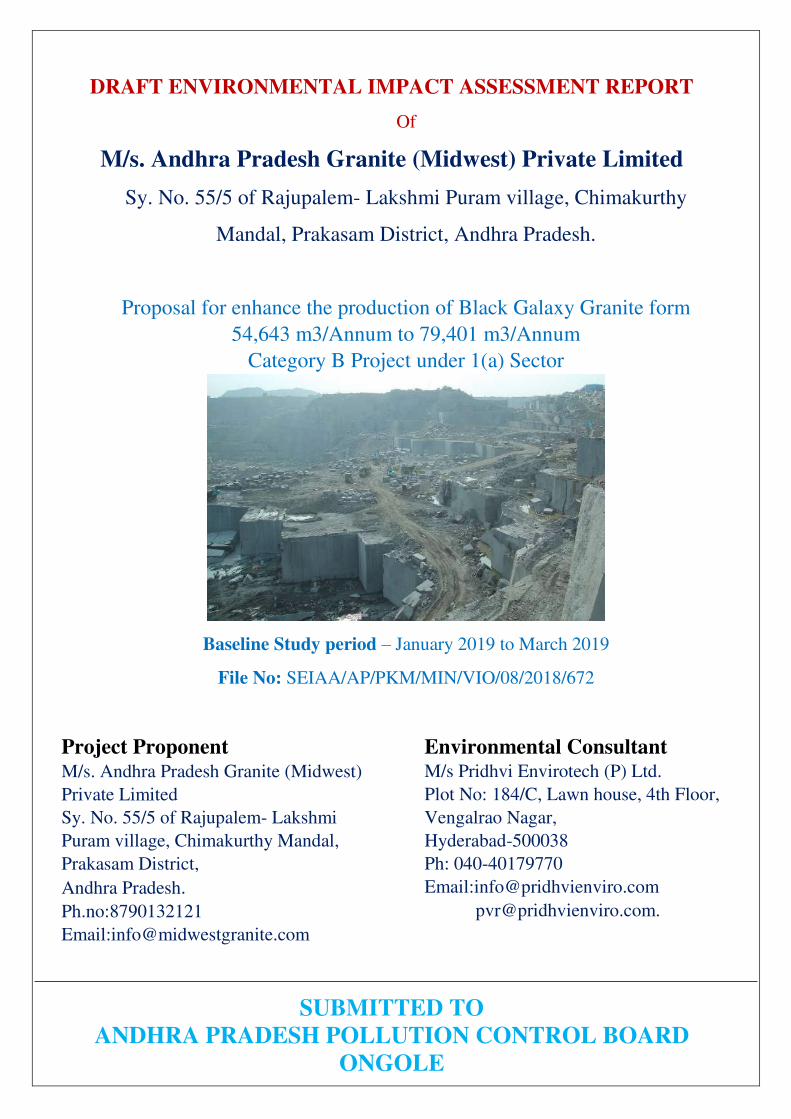
DRAFT ENVIRONMENTAL IMPACT ASSESSMENT REPORT
Of
M/s. Andhra Pradesh Granite (Midwest) Private Limited
Sy. No. 55/5 of Rajupalem- Lakshmi Puram village, Chimakurthy
Mandal, Prakasam District, Andhra Pradesh.
Proposal for enhance the production of Black Galaxy Granite form
54,643 m3/Annum to 79,401 m3/Annum
Category B Project under 1(a) Sector
Baseline Study period – January 2019 to March 2019
File No: SEIAA/AP/PKM/MIN/VIO/08/2018/672
S
Project Proponent M/s. Andhra Pradesh Granite (Midwest)
Private Limited
Sy. No. 55/5 of Rajupalem- Lakshmi
Puram village, Chimakurthy Mandal,
Prakasam District,
Andhra Pradesh.
Ph.no:8790132121
Email:[email protected]
Environmental Consultant M/s Pridhvi Envirotech (P) Ltd.
Plot No: 184/C, Lawn house, 4th Floor,
Vengalrao Nagar,
Hyderabad-500038
Ph: 040-40179770
Email:[email protected]
SUBMITTED TO
ANDHRA PRADESH POLLUTION CONTROL BOARD
ONGOLE
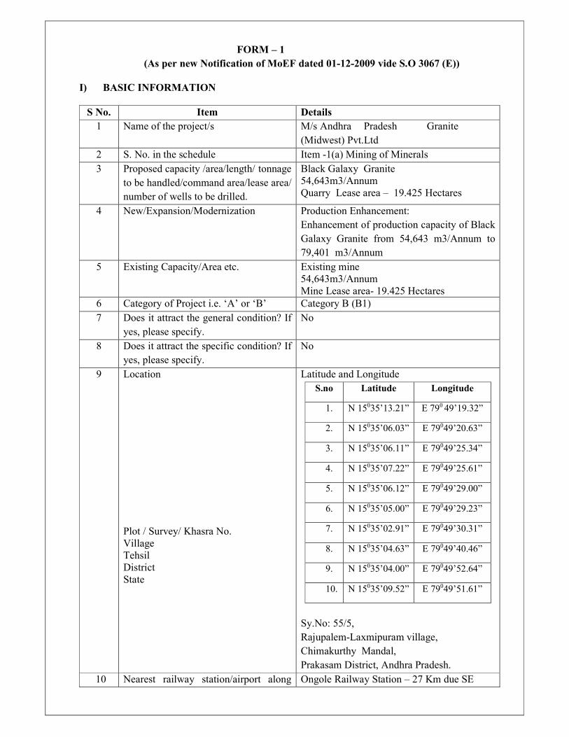
FORM – 1
(As per new Notification of MoEF dated 01-12-2009 vide S.O 3067 (E))
I) BASIC INFORMATION
S No. Item Details
1 Name of the project/s M/s Andhra Pradesh Granite
(Midwest) Pvt.Ltd
2 S. No. in the schedule Item -1(a) Mining of Minerals
3 Proposed capacity /area/length/ tonnage
to be handled/command area/lease area/
number of wells to be drilled.
Black Galaxy Granite
54,643m3/Annum
Quarry Lease area – 19.425 Hectares
4 New/Expansion/Modernization Production Enhancement:
Enhancement of production capacity of Black
Galaxy Granite from 54,643 m3/Annum to
79,401 m3/Annum
5 Existing Capacity/Area etc. Existing mine
54,643m3/Annum
Mine Lease area- 19.425 Hectares
6 Category of Project i.e. ‘A’ or ‘B’ Category B (B1)
7 Does it attract the general condition? If
yes, please specify.
No
8 Does it attract the specific condition? If
yes, please specify.
No
9 Location
Plot / Survey/ Khasra No.
Village
Tehsil
District
State
Latitude and Longitude
S.no Latitude Longitude
1. N 15035’13.21” E 790 49’19.32”
2. N 15035’06.03” E 79049’20.63”
3. N 15035’06.11” E 79049’25.34”
4. N 15035’07.22” E 79049’25.61”
5. N 15035’06.12” E 79049’29.00”
6. N 15035’05.00” E 79049’29.23”
7. N 15035’02.91” E 79049’30.31”
8. N 15035’04.63” E 79049’40.46”
9. N 15035’04.00” E 79049’52.64”
10. N 15035’09.52” E 79049’51.61”
Sy.No: 55/5,
Rajupalem-Laxmipuram village,
Chimakurthy Mandal,
Prakasam District, Andhra Pradesh.
10 Nearest railway station/airport along Ongole Railway Station – 27 Km due SE

with distance in kms. from lease area
Gannavaram Airport – 148 Km due NE from
lease area
11 Nearest Town, city, district Head -
quarters with distance in Km.
Chimakurthy-4.5 Km
12 Village Panchayat, Zilla Parishad,
Municipal Corporation, Local body
(complete postal addresses with
telephone nos. to be given)
Rajupalem Lakshmi Puram village Panchayat
Chimakurthy Mandal
Prakasam District
13 Name of the applicant Mr.K. Rama Chandra
14 Registered Address H. No. :8-2-684/3/25&26, Road No:
12;Banjara Hills, Hyderabad
15 Address for correspondence:
Name Mr.K. Rama Chandra
Designation(Owner/Partner/CEO) Director
Address H. No. :8-2-684/3/25&26, Road No:
12;Banjara Hills, Hyderabad
Pin code 500034
E-mail [email protected]
Telephone No. 8790132121
Fax No ------
16 Details of Alternative Sites examined,
if any. Location of these sites should be
shown on a topo sheet.
Not applicable
17 Interlinked Projects Not Applicable
18 Whether separate application of
interlinked project has been submitted?
Not Applicable
19 If yes, date of submission Not Applicable
20 If no, reason Not Applicable
21 Whether the proposal involves
approval/clearance under: if yes, details
of the same and their status to be given.
i. The Forest (Conservation) Act,
1980?
ii. The Wildlife (Protection) Act,
1972?
iii. The C.R.Z. Notification, 1991?
None
22 Whether there is any Government
Order/Policy relevant /relating to the
site?
Yes,
Director of Mines and Geology, A.P vide
Proceedings.No.545/Q/2005 dated:
03.02.2005.
Mining scheme approval vide Lr. No.
7141/MMS/BGG/OGL/2020 Dated:
22.01.2021
23 Forest land involved (hectares) No Forest Land is involved
24 Whether there is any litigation pending
against the project and/or land in which
the project is propose to be set up?
a) Name of the Court
b) Case No.
c) Orders/directions of the Court, if
No Court cases

any and its relevance with the
proposed project.
II) ACTIVITY
1. Construction, operation or decommissioning of the Project involving actions, which
will cause physical changes in the locality (topography, land use, changes in water
bodies, etc.)
S No. Information/Checklist confirmation Yes/
No
Details thereof (with approximate
quantities/ rates, wherever
possible) with source
of information data
1.1 Permanent or temporary change in land
use, land cover or topography including
increase in intensity of land use (with
respect to local land use plan)
Yes Entire mining lease area of 19.425
Ha is Government land. The quarry
lease area is located on plain with
some worked out pits. There is no
change in land use as the mining
already under
Progress.
1.2 Clearance of existing land, vegetation
and buildings?
No Area is barren with boulders of black
galaxy Granite. There is no buildings
in the lease area. Hence no clearance
of existing vegetation and building is
envisaged.
1.3 Creation of new land uses?
Yes
Mined out area will be utilized for
water harvesting, green belt will be
developed all along the dump.
1.4 Pre-construction investigations e.g. bore
houses, soil testing?
Yes Preliminary investigations have been
carried out at the quarry lease area to
estimate the reserves
1.5 Construction works? No No construction works proposed in
the quarry lease area
1.6 Demolition works? No No demolition works involved.
1.7 Temporary sites used for construction
works or housing of construction
workers?
No There is no need for construction of
housing for workers, as the labor
come from nearby villages and go
back at the end of shift.
1.8 Above ground buildings, structures or
earthworks including linear structures,
cut and fill or excavation.
No Not Applicable
1.9 Underground works including mining or
tunneling?
No No underground mining or tunneling
is involved
1.10 Reclamation works? Yes The quarry pits would be developed
as water reservoirs with proper
fencing. The water can be used for

local farming, developing in to fish
pond and/or as tourist attraction.
1.11 Dredging?
No Not applicable
1.12 Offshore structures? No Not applicable
1.13 Production and manufacturing process Yes Proposed average annual production
of Black Galaxy Granite is 79,401
M3.
Mining will be carried out by
opencast semi mechanized method by
using an excavator, tippers,
compressors and jackhammers.
1.14 Facilities for storage of goods or
materials?
Yes Stock yard facilities are identified for
storage of goods and materials in ML
area.
1.15 Facilities for treatment or disposal of
solid waste or liquid effluents?
Yes The firm proposes to obtain
permission from concerned authority
under Rule 12 (5) (h) (xvi) of
APMMCR 1966 to utilize the waste
rock by supplying to local crusher
units as Crusher Feed. The local
crushers will crush the waste rock
and produce rock aggregate of
different sizes viz: 40mm, 20mm,
12mm, 6mm to use in concrete and
other Road works. The final product
in this process is fine aggregate /
Rock dust which can also be used as
filling material in place of ordinary
sand in cement mix and also as top
layer in black topped roads. The firm
also propose to supply the waste for
agencies to prepare Kerbs and cubes
for pavements. The firm will try to
dispose off the rock waste to the
maximum possible extent for the
purpose of production of road metal
as well as other building materials.
The generated waste will be dumped
in Sy. Nos. 25/3B2 of R.L. Puram
Village, Chimakurthy Mandal &
938/1 to 7 of Chimakurthy Village &
Mandal during the present scheme
period
1.16 Facilities for long term housing of
operational workers?
No Not envisaged
1.17 New road, rail or sea traffic during Yes Additional traffic will be created due
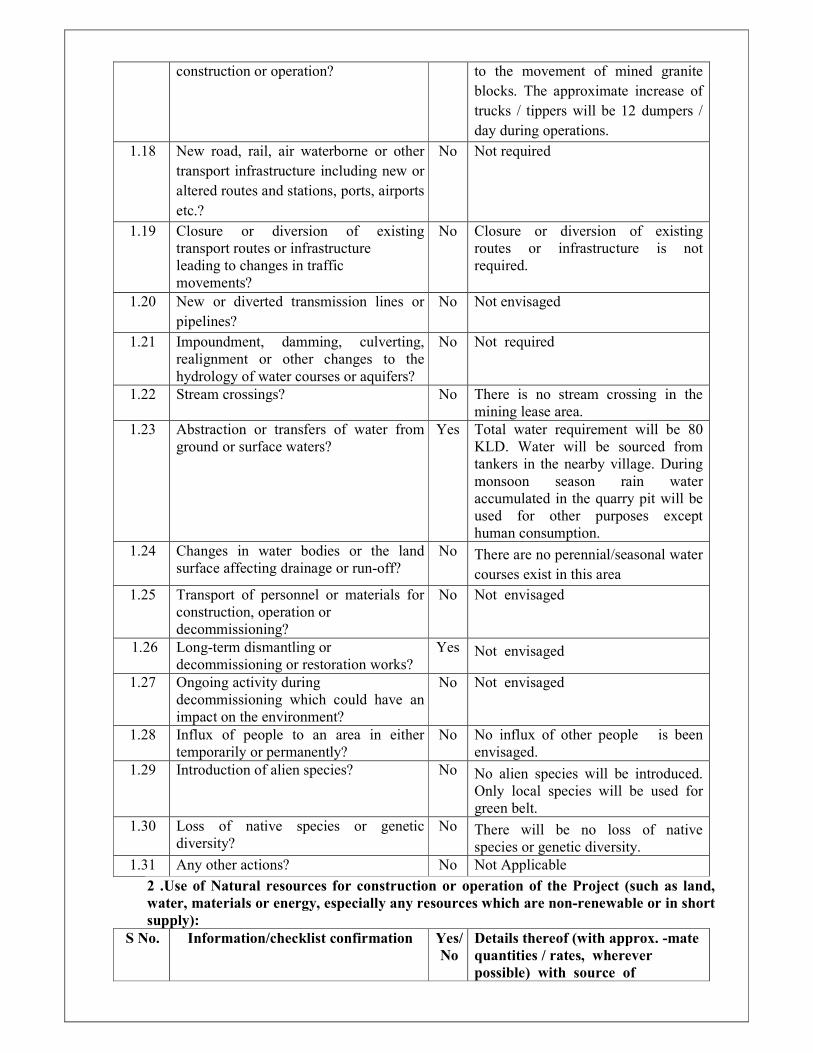
construction or operation? to the movement of mined granite
blocks. The approximate increase of
trucks / tippers will be 12 dumpers /
day during operations.
1.18 New road, rail, air waterborne or other
transport infrastructure including new or
altered routes and stations, ports, airports
etc.?
No Not required
1.19 Closure or diversion of existing
transport routes or infrastructure
leading to changes in traffic
movements?
No Closure or diversion of existing
routes or infrastructure is not
required.
1.20 New or diverted transmission lines or
pipelines?
No Not envisaged
1.21 Impoundment, damming, culverting,
realignment or other changes to the
hydrology of water courses or aquifers?
No Not required
1.22 Stream crossings? No There is no stream crossing in the
mining lease area.
1.23 Abstraction or transfers of water from
ground or surface waters?
Yes Total water requirement will be 80
KLD. Water will be sourced from
tankers in the nearby village. During
monsoon season rain water
accumulated in the quarry pit will be
used for other purposes except
human consumption.
1.24 Changes in water bodies or the land
surface affecting drainage or run-off?
No There are no perennial/seasonal water
courses exist in this area
1.25 Transport of personnel or materials for
construction, operation or
decommissioning?
No Not envisaged
1.26 Long-term dismantling or
decommissioning or restoration works?
Yes Not envisaged
1.27 Ongoing activity during
decommissioning which could have an
impact on the environment?
No Not envisaged
1.28 Influx of people to an area in either
temporarily or permanently?
No No influx of other people is been
envisaged.
1.29 Introduction of alien species? No No alien species will be introduced.
Only local species will be used for
green belt.
1.30 Loss of native species or genetic
diversity?
No There will be no loss of native
species or genetic diversity.
1.31 Any other actions? No Not Applicable
2 .Use of Natural resources for construction or operation of the Project (such as land,
water, materials or energy, especially any resources which are non-renewable or in short
supply):
S No. Information/checklist confirmation Yes/
No
Details thereof (with approx. -mate
quantities / rates, wherever
possible) with source of

information data
2.1 Land especially undeveloped or
agricultural land (Ha)
Yes The quarry lease area is 19.425 Ha.
The area is covered by rocky out
crops and bushy thorny vegetation.
2.2 Water (expected source & competing
users) unit: KLD
Yes Water requirement - 80 KLD
Source – Tankers nearby village
2.3 Minerals (MT) No No minerals are required for
quarrying operations
2.4 Construction material–stone,
aggregates, sand / soil (expected source –
MT)
No As no construction is proposed in
the lease area, construction material
is not used
2.5 Forests and timber (source – MT) No No Forest and timber products are
involved.
2.6 Energy including electricity and fuels
(source, competing users) Unit: fuel
(MT), energy (MW)
Yes About 5000 lit/annum of Diesel will
be used in transportation vehicles,
excavators and D G set.
2.7 Any other natural resources (use
appropriate standard units)
No Not applicable
3. Use, storage, transport, handling or production of substances or materials, which could
be harmful to human health or the environment or raise concerns about actual or perceived
risks to human health.
S No Information/Checklist confirmation Yes/
No
Details thereof (with approximate
quantities / rates, wherever possible)
with source of information data
3.1 Use of substances or materials, which are
hazardous (as per MSIHC rules) to
human health or the environment (flora,
fauna, and
water supplies)
No No Hazardous substance or materials
will be used for quarrying.
3.2 Changes in occurrence of disease or
affect disease vectors (e.g. insect or water
borne diseases)
No Not applicable
3.3 Affect the welfare of people e.g. by
changing living conditions?
Yes
The proposed activity will provided
employment to the nearby village
thereby increasing their economical
status.
3.4 Vulnerable groups of people who could
be affected by the project e.g. hospital
patients, children, the elderly etc.
No No Vulnerable groups of people will be
affected, as no hazardous, toxic or
noxious substances are involved in the
project activity.
3.5 Any other causes No Not applicable
4. Production of solid wastes during construction or operation or Decommissioning (MT/
month)
S No. Information/Checklist confirmation Yes/ Details thereof (with approximate

No quantities/ rates,
wherever possible) with source of
information data
4.1 Spoil, overburden or mine wastes Yes The firm proposes to obtain permission
from concerned authority under Rule 12
(5) (h) (xvi) of APMMCR 1966 to utilize
the waste rock by supplying to local
crusher units as Crusher Feed. The local
crushers will crush the waste rock and
produce rock aggregate of different sizes
viz: 40mm, 20mm, 12mm, 6mm to use
in concrete and other Road works. The
final product in this process is fine
aggregate / Rock dust which can also be
used as filling material in place of
ordinary sand in cement mix and also as
top layer in black topped roads.The firm
also propose to supply the waste for
agencies to prepare Kerbs and cubes for
pavements. The firm will try to dispose
off the rock waste to the maximum
possible extent for the purpose of
production of road metal as well as other
building materials.
The remaining overburden and rock
waste will be dumped in the dump yards
located over an extent of 6.17 acres in
sy.no- 938/1 to 7 in chimakurthy village
and mandal, Sy.No. 941/1 to 4 & 944/1 to
7 over an extent of 11.19 acrs in
Chimakurthy (V&M), Prakasam District,
Sy.No.937/1 of Chimakurthy village &
Mandal, Prakasam District over 4.95 Ac.
and 12.98 Ac. in Sy.No. 25/3B2 of
R.L.Puram (V), Chimakurthy Mandal,
Prakasam District.
4.2 Municipal waste (domestic and or
commercial wastes)
No Insignificant quantity of domestic waste
water generated will be treated in septic
tank followed by soak pit
4.3 Hazardous wastes (as per Hazardous
Waste Management Rules)
No No Hazardous waste is generated.
4.4 Other industrial process wastes No Not applicable
4.5 Surplus product No Not envisaged
4.6 Sewage sludge or other sludge from
effluent treatment
No Not envisaged
4.7 Construction or demolition wastes No Not envisaged

4.8 Redundant machinery or equipment No Not applicable
4.9 Contaminated soils or other materials No No contamination of soils or other
material is involved.
4.10 Agricultural wastes No Not applicable
4.11 Other solid wastes No None
5. Release of pollutants or any hazardous, toxic or noxious substances to air (Kg/hr)
S.No. Information/Checklist
confirmation
Yes/
No
Details thereof (with approximate
quantities/ rates, wherever possible)
with source of information data
5.1 Emissions from combustion of
fossil fuels from stationary or mobile
sources
Yes Emissions will be generated from the
mining machinery, DG set and
transportation vehicles.
5.2 Emissions from production processes Yes Dust will be generated from quarrying
operations , which will be controlled by
water sprinkling.
5.3 Emissions from materials handling
including storage or transport
Yes Emissions will be generated from
transportation of quarried stone and dump
waste Adequate control measures are
proposed
5.4 Emissions from construction
activities including plant and
equipment
No No construction activity is proposed at
the quarry site. Hence no emissions from
any such activities.
5.5 Dust or odour from handling of
materials including construction
materials, sewage and waste
Yes Dust will be generated during mining and
transportation of materials. However,
there is no generation of any odor.
5.6 Emissions from incineration of waste No No such waste will be generated, which
may be incinerated.
5.7 Emissions from burning of waste in
open air (e.g. slash materials ,
construction debris)
No No waste of any kind will be burnt in the
open air.
5.8 Emissions from any other sources No There are no other sources
6. Generation of Noise and Vibration, and Emissions of Light and Heat:
S.No. Information/Checklist confirmation Yes/
No
Details thereof (with approximate
quantities/rates, wherever possible)
with source of information data
with source of information data
6.1 From operation of equipment e.g.
engines, ventilation plant, crushers
Yes Noise up to 100 dB will be generated
from operations of drilling
machinery. Ear plugs are provided to
all workers
6.2 From industrial or similar processes No Not applicable
6.3 From construction or demolition No Not applicable
6.4 From blasting or piling
Yes Noise will be generated during

quarrying operations involving
blasting and will be instantaneous in
nature and minimum. As there is no
habitation nearby, there will be no
impact.
6.5 From construction or operational traffic Yes The noise generated from
operational traffic ie. Tippers will be
about 75-85 dB(A)
6.6 From lighting or cooling systems No No lighting or cooling systems are
involved
6.7 From any other sources No There are no other sources to
generate Noise and Vibrations.
7.Risks of contamination of land or water from releases of pollutants into the ground or
into sewers, surface waters, groundwater, coastal waters or the sea:
S.No. Information/Checklist confirmation Yes/
No
Details thereof (with approximate
quantities/ rates, wherever possible)
with source of information data
7.1 From handling, storage, use or spillage
of hazardous materials
Yes There may be a risk of contamination
of land due to handling, storage, use
or spillage of diesel. Proper handling
and disposal methods will be
followed.
7.2 From discharge of sewage or other
effluents to water or the land (expected
mode and place of discharge)
Yes 8.0 KLD domestic sewage discharged
in to septic tank followed by soak pit.
7.3 By deposition of pollutants emitted to air
into the land or into water
Yes Dust emissions will be limited to the
site itself which will be suppressed by
regular water sprinkling.
7.4 From any other sources No Not applicable
7.5 Is there a risk of long term build up of
pollutants in the environment from these
sources?
No Not applicable
8.Risk of accidents during construction or operation of the Project, which could affect
human health or the environment
S No. Information/Checklist confirmation Yes
/No
Details thereof (with approximate
quantities/ rates, wherever possible)
with source of information data
8.1 From explosions, spillages, fires etc
from storage, handling, use or
production of hazardous substances
No Not applicable
8.2 From any other causes No Not applicable
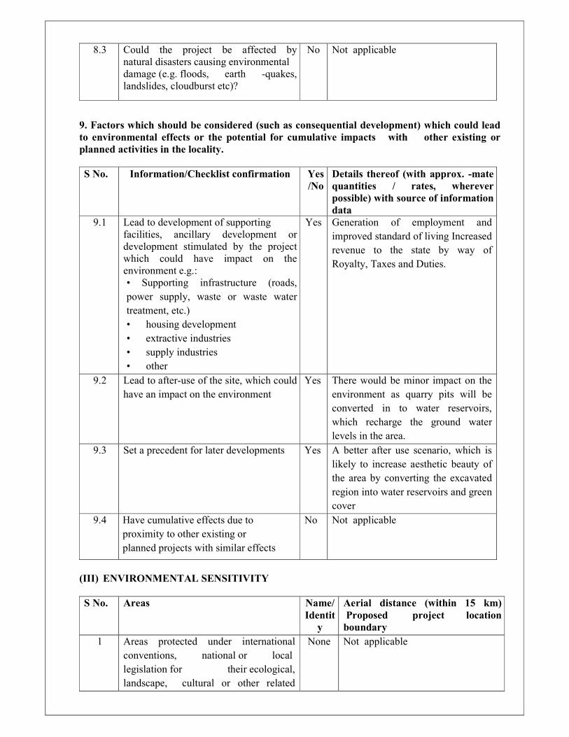
8.3 Could the project be affected by
natural disasters causing environmental
damage (e.g. floods, earth -quakes,
landslides, cloudburst etc)?
No Not applicable
9. Factors which should be considered (such as consequential development) which could lead
to environmental effects or the potential for cumulative impacts with other existing or
planned activities in the locality.
S No. Information/Checklist confirmation Yes
/No
Details thereof (with approx. -mate
quantities / rates, wherever
possible) with source of information
data
9.1 Lead to development of supporting
facilities, ancillary development or
development stimulated by the project
which could have impact on the
environment e.g.:
• Supporting infrastructure (roads,
power supply, waste or waste water
treatment, etc.)
• housing development
• extractive industries
• supply industries
• other
Yes Generation of employment and
improved standard of living Increased
revenue to the state by way of
Royalty, Taxes and Duties.
9.2 Lead to after-use of the site, which could
have an impact on the environment
Yes There would be minor impact on the
environment as quarry pits will be
converted in to water reservoirs,
which recharge the ground water
levels in the area.
9.3 Set a precedent for later developments Yes A better after use scenario, which is
likely to increase aesthetic beauty of
the area by converting the excavated
region into water reservoirs and green
cover
9.4 Have cumulative effects due to
proximity to other existing or
planned projects with similar effects
No Not applicable
(III) ENVIRONMENTAL SENSITIVITY
S No. Areas Name/
Identit
y
Aerial distance (within 15 km)
Proposed project location
boundary
1 Areas protected under international
conventions, national or local
legislation for their ecological,
landscape, cultural or other related
None Not applicable
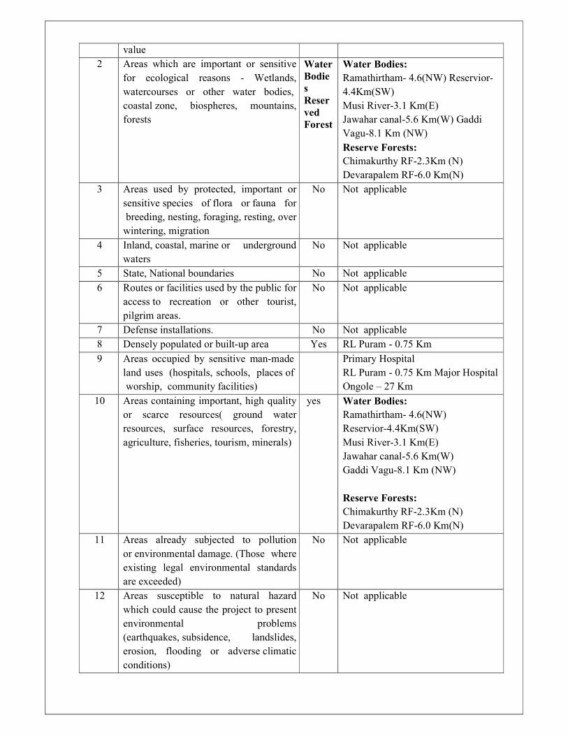
value
2 Areas which are important or sensitive
for ecological reasons - Wetlands,
watercourses or other water bodies,
coastal zone, biospheres, mountains,
forests
Water
Bodie
s
Reser
ved
Forest
Water Bodies:
Ramathirtham- 4.6(NW) Reservior-
4.4Km(SW)
Musi River-3.1 Km(E)
Jawahar canal-5.6 Km(W) Gaddi
Vagu-8.1 Km (NW)
Reserve Forests:
Chimakurthy RF-2.3Km (N)
Devarapalem RF-6.0 Km(N)
3 Areas used by protected, important or
sensitive species of flora or fauna for
breeding, nesting, foraging, resting, over
wintering, migration
No
Not applicable
4 Inland, coastal, marine or underground
waters
No Not applicable
5 State, National boundaries No Not applicable
6 Routes or facilities used by the public for
access to recreation or other tourist,
pilgrim areas.
No Not applicable
7 Defense installations. No Not applicable
8 Densely populated or built-up area Yes RL Puram - 0.75 Km
9 Areas occupied by sensitive man-made
land uses (hospitals, schools, places of
worship, community facilities)
Primary Hospital
RL Puram - 0.75 Km Major Hospital
Ongole – 27 Km
10 Areas containing important, high quality
or scarce resources( ground water
resources, surface resources, forestry,
agriculture, fisheries, tourism, minerals)
yes
Water Bodies:
Ramathirtham- 4.6(NW)
Reservior-4.4Km(SW)
Musi River-3.1 Km(E)
Jawahar canal-5.6 Km(W)
Gaddi Vagu-8.1 Km (NW)
Reserve Forests:
Chimakurthy RF-2.3Km (N)
Devarapalem RF-6.0 Km(N)
11 Areas already subjected to pollution
or environmental damage. (Those where
existing legal environmental standards
are exceeded)
No Not applicable
12 Areas susceptible to natural hazard
which could cause the project to present
environmental problems
(earthquakes, subsidence, landslides,
erosion, flooding or adverse climatic
conditions)
No Not applicable

Andhra Pradesh Granite (Midwest) Pvt Ltd,
Extent: 19.425 Ha, Sy.no:55/5, RL Puram (V), Draft EIA Report Chimakurthy (M), Prakasam (D), A.P
Pridhvi Envirotech Pvt Ltd
LIST OF CONTENTS
S.NO Description Page No.
Executive Summary
CHAPTER-1 INTRODUCTION 1.0 Introduction 1-1
1.1 Purpose of report 1-1
1.2 Background of the project 1-1
1.3 Identification of project & Project Proponent 1-2
1.4 Project Location & Study area Description 1-3
1.5 Project Cost 1-8
1.6 Importance of the Project to the Country, Region 1-8
1.7 Project Justifications 1-8
1.8 Cluster of mines Details 1-8
1.9 Scope of the Study 1-15
1.10 Required Statutory Licenses at A Glance 1-16
1.11 Structure of the EIA Report 1-16
CHAPTER 2 PROJECT DESCRIPTION
2.1 Details of the Mining Lease Area 2-1
2.2 Location of the Project 2-1
2.3 Road Connectivity to the site 2-3
2.4 Physiography of the Site 2-3
2.5 Site Description and Present land use 2-3
2.6 Mine Drainage 2-4
2.7 Geology 2-9
2.7.1 Regional Geology 2-9
2.7.2 Local Geology 2-9
2.8 Present Land Use Pattern 2-13
2.9. Area for Dump 2-13
2.9.1 Area of Green belt 2-13
2.10 Method of Mining 2-14
2.10.1 Description of Existing method for excavation 2-14
2.11 Year wise Production and Development 2-16
2.12 Conceptual Plan 2-16
2.13 Anticipated life of mine 2-18
2.14 Top Soil &Waste Generation and Disposal 2-18
2.15 Requirements for the Project 2-19
2.15.1 Site Services 2-19
2.15.2 Water Requirement 2-19
2.15.3 Power Requirement 2-19
2.15.4 Man power requirements 2-19
CHAPTER-3 BASELINE ENVIRONMENTAL STATUS
3.1 Preamble 3-1
3.1.1 Study Area 3-1
3.1.2 Data Collection Period & Components 3-1
3.2 Methodology of Base line data collection 3-1
3.2.1 Scoping 3-1
3.2.2 Reconnaissance Surveys 3-1
3.2.3 Assembly and Analysis of Data 3-2

Andhra Pradesh Granite (Midwest) Pvt Ltd,
Extent: 19.425 Ha, Sy.no:55/5, RL Puram (V), Draft EIA Report Chimakurthy (M), Prakasam (D), A.P
Pridhvi Envirotech Pvt Ltd
3.2.4 Assessment of Alternatives 3-2
3.2.5 Assessment of Potential Impacts 3-2
3.2.6 Integration of Environmental Impacts in the Design
Process
3-2
3.3 Land Environment 3-2
3.3.1 Physiography 3-2
3.3.2 Topography 3-2
3.4 Drainage 3-3
3.5 Land use Pattern 3-6
3.6 Geology 3-8
3.6.1 Climate and Rain Fall 3-9
3.7 Water Environment 3-10
3.7.1 Ground water conditions 3-11
3.7.2 Water-shed and Neighborhood Areas 3-11
3.7.3 Field study and discussion 3-12
3.7.4 Ground Water Resource Estimation 3-13
3.8 Ground Water Quality 3-14
3.9 Surface Water Quality 3-20
3.10 Soil Environment 3-24
3.11 Air Environment 3-26
3.11.1 Meteorology 3-26
3.11.2 Meteorological Station at Industry Site 3-29
3.11.3 Ambient Air Quality 3-32
3.11.4 Scope of Field Study 3-32
3.11.5 Description of Sampling Locations 3-32
3.11.6 Ambient Air Quality Status 3-33
3.11.7 Noise Environment 3-35
3.11.8 Observations of Noise Levels 3-38
3.12 Traffic Studies 3-39
3.13 Socio Economic Environment 3-42
3.13.1 Objectives of socio-economic study 3-42
3.13.2 Scope 3-42
3.13.3 Methodology 3-43
3.13.4 Project Site 3-44
3.13.5 Geographical Coverage 3-44
3.13.6 Impact Zones 3-46
3.13.7 Sample Households 3-46
3.13.8 Field Surveys 3-48
3.13.9 Data Analysis 3-49
3.13.10 Household Survey Results 3-49
3.13.10.1 Demographics 3-49
3.13.10.2 Occupational Distribution 3-50
3.13.11 Livelihoods 3-50
3.13.11.1 Agriculture 3-50
3.13.11.2 Industry 3-50
3.13.11.3 Mineral-Based Industries 3-51
3.13.11.4 Lifestyles 3-51
3.13.11.5 Assets Owned 3-51
3.13.11.6 Sources of Livelihood 3-52
Andhra Pradesh Granite (Midwest) Pvt Ltd,
Extent: 19.425 Ha, Sy.no:55/5, RL Puram (V), Draft EIA Report Chimakurthy (M), Prakasam (D), A.P
Pridhvi Envirotech Pvt Ltd
3.13.11.7 Family Incomes 3-52
3.13.11.8 Family Expenditures 3-52
3.13.11.9 Educational Facilities 3-52
3.13.12 Health Status 3-53
3.13.12.1 Health and Family Welfare 3-53
3.13.12.2 Health Status of Surveyed Villages 3-54
3.13.13 Physical Infrastructure 3-54
3.13.14 Social Infrastructure 3-55
3.13.15 Archaeological Monuments 3-55
3.14 Aspirations and Apprehensions 3-55
3.15 Flora & Fauna 3-56
3.15.1 Scope of work 3-56
3.15.2 Methodology 3-57
3.15.3 Equipment / Instruments deployed 3-57
3.15.4 Floral analysis 3-57
3.15.5 Faunal analysis 3-58
3.15.6 Mine Lease Area 3-60
3.15.7 Dump 3-60
3.15.8 Reserve forest vegetation 3-60
3.15.9 Quantitative analysis 3-60
3.15.10 Vegetation Analysis 3-61
3.15.11 Terrestrial Fauna 3-62
3.15.12 Terrestrial fauna of the Core area and the Buffer zone 3-62
3.15.13 Flora and fauna of Aquatic ecosystem 3-63
CHAPTER -4 ANTICIPATED ENVIRONMENTAL IMPACTS &
MITIGATIVE MEASURES
4.1 Identification of Environmental Impacts 4-1
4.2.2 Impacts on Air Quality 4-1
4.2.2.1 Micro Meteorological Data 4-3
4.3.3 Air Quality Predictions 4-7
4.3.3.1 Post Project Scenario 4-8
4.3.3.2 Study Period 4-8
4.4 Noise Environment 4-10
4.4.1 Prediction of Impacts Due to Quarry Activity 4-10
4.4.2 Noise Due to vehicular Traffic 4-10
4.5 Mine Wastewater 4-12
4.5.1 Mine Pit Water 4-12
4.6 Land Environment 4-12
4.7 Vibration Levels 4-12
4.7.1 Disasters 4-12
4.7.2 Mitigation Measures 4-12
4.8 Air pollution mitigation measure 4-12
4.8.1 Water pollution mitigation measure 4-13
4.9 Impact on Traffic & Road Network 4-13
4.10 Land Reclamation 4-13
4.11 Predicted Impacts on Socio-Economic Environment 4-14
CHAPTER 5 ANALYSIS OF ALTERNATIVES (TECHNOLOGY & SITE)
5.1 Analysis of Alternative Technology 5-1
5.2 Analysis of Alternative Sites 5-1

Andhra Pradesh Granite (Midwest) Pvt Ltd,
Extent: 19.425 Ha, Sy.no:55/5, RL Puram (V), Draft EIA Report Chimakurthy (M), Prakasam (D), A.P
Pridhvi Envirotech Pvt Ltd
CHAPTER-6 ENVIRONMENTAL MONITORING PROGRAMME
6.1 Environmental Monitoring 6-1
6.2 Environmental Management Cell 6-2
6.3 Environment Policy 6-2
6.4 Responsibility of Monitoring and Reporting System 6-2
6.5 Environmental Monitoring Budget 6-3
CHAPTER – 7 ADDITIONAL STUDIES
7.1 Public Consultation 7-1
7.2 Risk Assessment of Black Galaxy Granite Mining 7-1
7.3 Disaster Management 7-5
7.4 Social Impact Assessment 7-6
CHAPTER – 8 PROJECT BENEFITS
8.1 Employment Potential 8-1
8.2 Social Welfare Measures 8-1
8.3 Corporate Environmental Responsibility 8-1
8.4 Other Intangible benefits 8-1
CHAPETR – 9 ENVIRONMENTAL COST BENEFIT ANALYSIS
CHAPTER – 10 ENVIRONMENAL MANAGEMENT PLAN
10.1 Environnemental Management Plan 10-1
10.2 Air Pollution Control Measures 10-1
10.3 Noise Pollution Control Measures 10-1
10.3.1 Measures to minimise ground vibrations and noise 10[2
10.4 Water Pollution Control Measures 10-2
10.4.1 Water Conservation Measures 10-3
10.5 Socio-Economic Environment 10-3
10.6 Ecological Management 10-4
10.6.1 Greenbelt 10-4
10.6.2 Mitigation Measures proposed 10-6
10.7 Occupational Safety & Health Management 10-6
10.7.1 General Workplace Health and Safety 10-6
10.8 Use of explosives 10-7
10.8.1 Machine and Equipment Safety 10-8
10.9 Environment Management Cell 10-8
10.9.1 Environmental Policy and management reporting
system
10-8
10.9.2 Environmental Policy 10-8
10.9.3 Reporting system to the Board of Directors 10-10
10.9.4 Reporting System 10-10
10.9.5 Records maintenance and reporting to statutory bodies 10-11
10.10 Reclamation 10-11
10.11 Environmental Management Budget 10-11
10.12 Environnemental Social responsibilities 10-12
CHAPTER – 11 SUMMARY & CONCLUSION
11.1 Introduction 11-1
11.2 Project Description 11-1
11.3 Description of the Environment 11-1
11.3.1 Land Use Details 11-2
11.4 Project Cost 11-2
11.5 Anticipated Environmental Impacts & Mitigation 11-3

Andhra Pradesh Granite (Midwest) Pvt Ltd,
Extent: 19.425 Ha, Sy.no:55/5, RL Puram (V), Draft EIA Report Chimakurthy (M), Prakasam (D), A.P
Pridhvi Envirotech Pvt Ltd
Measures
11.5.1 Environment 11-3
11.5.1.1 Air Environment 11-3
11.5.1.2 Noise Environment 11-4
11.5.1.3 Water Environment 11-4
11.5.2 Traffic & Road Network 11-5
11.5.3 Afforestation 11-5
11.6 Socio Economic Environment 11-5
11.7 Occupational Health and Safety Measures 11-6
11.8 Environmental Management Plan 11-6
11.9 Social Impact Assessment 11-6
11.10 Project Benefits 11-6
11.11 Environmental Social Responsibility (ESR) 11-7
11.12 Budget for Environmental Management Plan 11-7
11.13 Conclusion 11-7
CHAPTER-12 DISCLOSURE OF CONSULTANT
LIST OF TABLES
Table Description Page No.
Table 1.0 Salient Features of the mine 1-3
Table 2.1 Details of the Mining Lease Area 2-1
Table 2.2 Land Use Pattern of the Mine 2-13
Table 2.3 Extent of Mechanization 2-15
Table 2.4 Year Wise Production from Initiation of Mine Starting
Period to Till Date
2-16
Table 3.1 Land Use/Land Cover classes in Study area 3-7
Table 3.2 Climate Data of Ongole, District Head Quarters,
Prakasam District, AP
3-10
Table 3.3 Ground Water Resource Estimations 3-14
Table 3.4 Summarized Chemical analysis of Ground Water 3-16
Table 3.5 Summarized Chemical Analysis of Surface Water 3-22
Table 3.6 Analytical data of Soil Samples 3-25
Table 3.7 Soil Test Results – Reference Tables 3-26
Table 3.8 Frequency Distribution of Wind Speeds and Wind
Directions
3-30
Table 3.9 Locations of Ambient Air Quality Monitoring Stations 3-33
Table 3.10 Ambient Air Quality Status 3-33
Table 3.11 Noise Monitoring Locations 3-36
Table 3.12 Effects on Human Beings at Different Noise Levels 3-37
Table 3.13 Equivalent Noise levels in the Study Area 3-38
Table 3.14 Ambient Noise Standards 3-38
Table 3.15 Traffic Data of Ongole –Kurnool state highway 3-40
Table 3.16 The geographical coverage for SEIA of the Study area 3-44
Table 3.17 Sample Villages Selected for Socio-Economic Impact
Assessment
3-47
Table 3.18 Category of Educational Intuitional Details in Mandal
wise
3-52
Table 3.17 The status of health Facilities of Praksam 3-53
Andhra Pradesh Granite (Midwest) Pvt Ltd,
Extent: 19.425 Ha, Sy.no:55/5, RL Puram (V), Draft EIA Report Chimakurthy (M), Prakasam (D), A.P
Pridhvi Envirotech Pvt Ltd
Table 3.18 Total Fertility and Under 5 Mortality rates from 2013
to 2015 of Prakasam
3-54
Table 3.19 Disease patterns observed in sampled villages 3-54
Table 3.20 Phytosociological data of study area 3-61
Table 3.21 Biodiversity indices values of the sampling sites in
project site
3-61
Table 4.1 Frequency Distribution of Wind Speeds and Wind
Directions
4-4
Table 4.2 Emission Details 4-6
Table 4.3 Emission Details 4-8
Table 4.4 Expected Noise from Mining Machinery 4-11
Table 7.1 Identified Risks & Control measures 7-2
Table 7.2 Sample Villages Selected for Socio-Economic Impact
Assessment
7-6
Table 10.1 List of existing plantation 10-4
Table 10.2 List of Trees recommended for plantation under
Greenbelt
10-5
Table 10.3 Proposed financial Budget for the Green belt
development (Rs in Lakhs)
10-5
Table 10.4 Budget for EMP 10-12
Table 11.1 Salient features of the Project 11-1
Table 11.2 Land Use Pattern 11-2
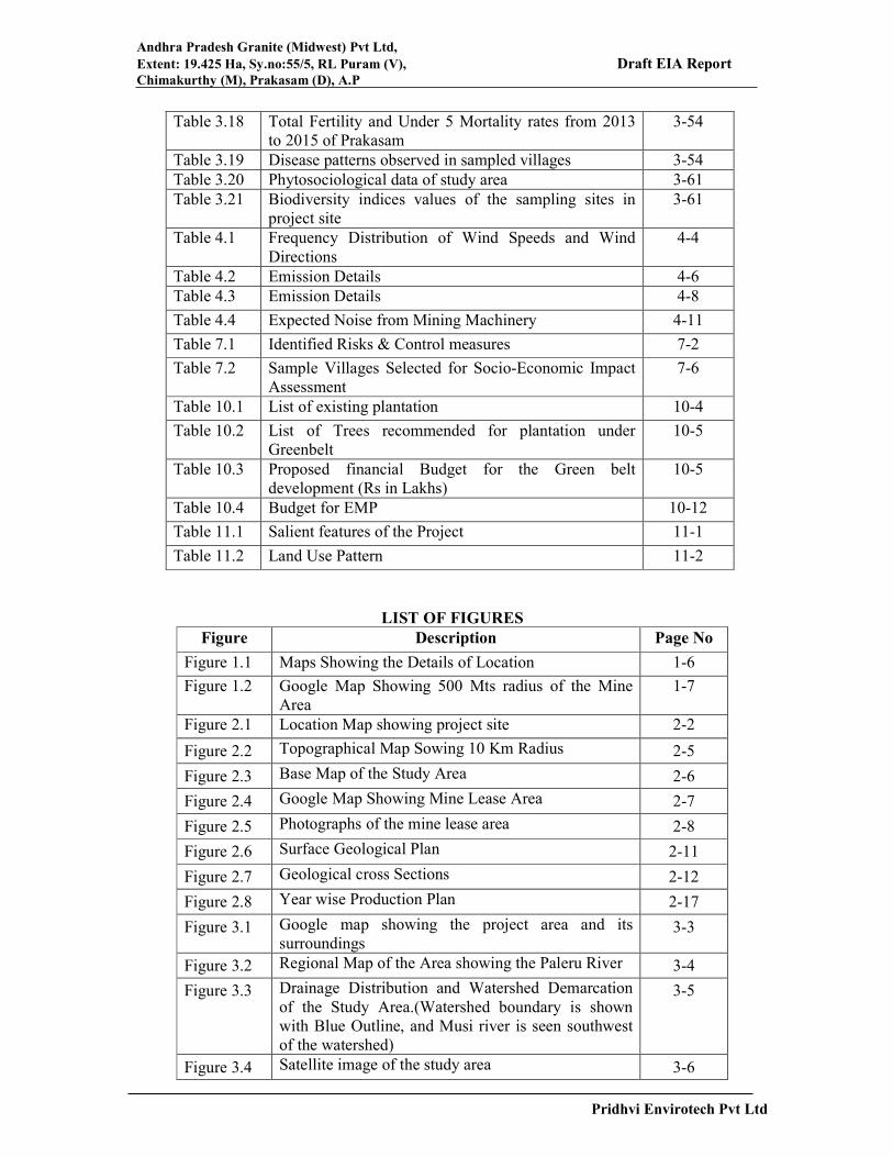
LIST OF FIGURES
Figure Description Page No
Figure 1.1 Maps Showing the Details of Location 1-6
Figure 1.2 Google Map Showing 500 Mts radius of the Mine
Area
1-7
Figure 2.1 Location Map showing project site 2-2
Figure 2.2 Topographical Map Sowing 10 Km Radius 2-5
Figure 2.3 Base Map of the Study Area 2-6
Figure 2.4 Google Map Showing Mine Lease Area 2-7
Figure 2.5 Photographs of the mine lease area 2-8
Figure 2.6 Surface Geological Plan 2-11
Figure 2.7 Geological cross Sections 2-12
Figure 2.8 Year wise Production Plan 2-17
Figure 3.1 Google map showing the project area and its
surroundings 3-3
Figure 3.2 Regional Map of the Area showing the Paleru River 3-4
Figure 3.3 Drainage Distribution and Watershed Demarcation
of the Study Area.(Watershed boundary is shown
with Blue Outline, and Musi river is seen southwest
of the watershed)
3-5
Figure 3.4 Satellite image of the study area 3-6

Andhra Pradesh Granite (Midwest) Pvt Ltd,
Extent: 19.425 Ha, Sy.no:55/5, RL Puram (V), Draft EIA Report Chimakurthy (M), Prakasam (D), A.P
Pridhvi Envirotech Pvt Ltd
LIST OF ANNEXURES
Figure 3.5 Land Use and Land Cover map of the study area 3-7
Figure 3.6 Pie Diagram Showing Land use & Land cover area 3-8
Figure 3.7 Topography and Drainage of the Project Site
Neighborhood 3-12
Figure 3.8 Hydrogeology Map of Prakasam District
(Source: CGWB, 2013) 3-13
Figure 3.9 Ground water sampling locations in Study area 3-15
Figure 3.10 Locations of surface water samples in the study area 3-21
Figure 3.11 Soil Sampling Locations 3-24
Figure 3.12 IMD Data of Meteorological Station ongole 3-27
Figure 3.13 Wind rose Diagram for the study January-2019 to
March 2019 3-31
Figure 3.14 Location Map of Ambient Air Quality Monitoring
Stations 3-35
Figure 3.15 Location Map for Noise Monitoring stations 3-36
Figure 3.16 Google Map of SEIA Sample Villages 3-48
Figure 3.17 Graph showing Important Value Index of dominant
tree species within study area 3-61
Figure 4.1 Wind rose Diagram for the study period January
2019 to March 2019 4-5
Figure 4.2 Predicted 24 hourly of PM10 in g/m3 4-9
Figure 10.1 AP Midwest Granites Pvt Limited Group Companies
Organo Gram 10-10
Annexure Description
Annexure I Copy of Current Environmental Clearance
Annexure II Copy of combined CFE and CFO
Annexure III Copy of certified compliance report
Annexure IV Ambient Air Quality data
Annexure V The list of Flora and Fauna of the study area
Annexure VI Copy of the ToR and ToR Compliance Report

Chapter- 1
Introduction
Andhra Pradesh Granite (Midwest) Pvt Ltd,
Extent: 19.425 Ha, Sy.no:55/5, RL Puram (V), Draft EIA Report Chimakurthy (M), Prakasam (D), A.P
1-1 Pridhvi Envirotech Pvt Ltd
CHAPTER-1
INTRODUCTION
1.0 Introduction
M/s. Andhra Pradesh Granite (Midwest) Private Limited (APGMPL) has been granted a Black
Galaxy Granite mining lease over an area of 19.425 ha. in Sy. No. 55/5 of Rajupalem- Lakshmi
Puram village, Chimakurthy Mandal, Prakasam District, Andhra Pradesh.
1.1 Purpose of the Report
The Ministry of Environment, Forest and Climate Change (MoEF&CC), Government of India
(GOI) issued notifications vide SO 1533, dt. 14.9.2006, its amendments based on the directions
issued by National Green Tribunal (NGT), New Delhi, vide O. A. No. 16 of 2016,
dt.13.09.2018 and vide E.A.NO 55/2018 of O. A. No. 520/2016, dt. 11.12.2018 on MoEF&CC
Notification S.O.2269 (E), dt.01.07.2016 and S.O.3977 (E), Dt.14.08.2018 and Office
Memorandum Dt.12.12.2018 issued in compliance with the Hon’ble NGT orders, New Delhi,
mandate prior environmental clearance for all mining leases across the country. The
notification and its amendments based on NGT directions, and stipulate a three-stage process
of scoping, public consultation, and appraisal by State Environmental Impact Assessment
Authority (SEIAA) to issue prior environmental clearance. Accordingly scoping for
preparation of environmental impact assessment (EIA) was done by the state expert for
enhancement of production capacity of Black Galaxy Granite from 54,643 m3/Annum to
79,401 m3/Annum in an area of 19.425 Ha. The present study follows the prescribed TOR’s to
prepare Draft EIA report for public appraisal committee (SEAC), which issued terms of
reference vide Letter No. SEIAA/AP/PKM/MIN/VIO/08/2018/672 Dt.01.07.2021 for the
enhancement of production capacity consultation to facilitate informed view on the project by
public/stakeholders.
1.2 Background of the Project
Andhra Pradesh Granite (Midwest) Private Limited is a Joint Venture Company
constituted with APMDC and Midwest Granite Private Limited with its consortium
partner under the Agreement dated 04.06.2007.

Andhra Pradesh Granite (Midwest) Pvt Ltd,
Extent: 19.425 Ha, Sy.no:55/5, RL Puram (V), Draft EIA Report Chimakurthy (M), Prakasam (D), A.P
1-2 Pridhvi Envirotech Pvt Ltd
The Environmental Clearance was given for 540 CBM of Primary Blocks and 486 CBM
of Secondary Blocks of Black Galaxy Granite per annum vide order No.
SEIAA/AP/PKM/119/2013-1593 dated 10.06.2013.
Later applied for the Environmental Clearance under violation category in the year 2017
and obtained Environmental Clearance for the expansion from 1,026m3/annum to
54,643m3/annum vide order no. SEIAA/ AP/ PKM/ MIN/ VIO/ 08/ 2018/ 672-1021
Dated: 13.09.2019 with validity up to 02.02.2025. Copy of Current Environmental
Clearance enclosed as Annexure-I.
The unit obtained Combined CFE and CFO for expansion order No
APPCB/VJA/NLR/188/HO/CFO/2017 dated21.10.2019 valid upto 31st July 2022. copy
of combined CFE and CFO enclosed as Annexure-II.
The modified mining plan approved by the Deputy Director of mines and Geology,
Ongole for the period of 2020-2023 vide Lr.no.7141/MMS/BGG/OGL/2020 dated
22.01.2021.
As per the Gazette Notification SO. 3977(E) dated 14th August, 2018 this comes under
category B1 which is which is more than 5 Hectares hence cluster condition is applicable.
The Certified compliance report obtained from MOEF &CC Integrated Regional Office
Vijayawada vide File No. IRO/VIJ/EPA/MISC/111-01/2021. Copy of certified
compliance report enclosed as Annexure -III
SEIAA, Andhra Pradesh has granted terms of Reference (TORs) for enhance the
production of Black Galaxy Granite form 54,643 m3/Annum to 79,401 m3/Annum.
Draft EIA Report prepared based on the terms of Reference issued by SEIAA, Andhra
Pradesh.
1.3 Identification of Project & Project Proponent
Midwest Granite Private Limited., a Midwest Group company, was incorporated in the year
1981 by Mr. K. Ragahava Reddy with the core objective of developing competence and
expertise in the field of natural stone, namely Granite, Marble, Limestone, and Travertine. In
the ensuing years, Midwest has established itself as a very strong player in the domain of
Exploration, Mining, Processing and export of natural Stone products. Midwest is among the
top 3 natural stone players in India. Midwest mines over 3.5 million tons of granite per annum,
which includes saleable product and waste granite.
Mr. K. Raghava Reddy is a visionary entrepreneur with a track record of building diversified
and socially responsible mining enterprises. He is a natural stone specialist covering mineral

Andhra Pradesh Granite (Midwest) Pvt Ltd,
Extent: 19.425 Ha, Sy.no:55/5, RL Puram (V), Draft EIA Report Chimakurthy (M), Prakasam (D), A.P
1-3 Pridhvi Envirotech Pvt Ltd
prospecting, mining and project management. He established the A.P. Granite Association and
served as National Executive Member of All India Granite Stone Association for several years.
Under his leadership, the company is continuously striving to establish a lead over its
competitors by introducing new stone varieties in the market by acquiring new deposits,
modernizing the existing quarries, adopting and deploying latest technology and equipment for
quality and productivity enhancement, adhering to the stringent safety norms of operation and
achieving higher level of efficiency
Midwest has presence in over 30 countries. Midwest has established market linkages with a
number of direct customers in all important markets, through agency and distribution system.
Midwest Company participates in most of the important International Trade Shows. Midwest
manufactures environmental friendly diamond tools for mining industry with facilities in India
and Srilanka. Midwest is a recipient of several awards at National and State level. Midwest is
recognized as “Star Export House” by Government of India. Midwest has joint ventures and
key relations with Central, State Governments and Large Corporations.
Midwest institutionalized its Corporate Social Responsibility (CSR) Program. Since Midwest’s
conscience dictates its CSR program rather than mere Government regulatory compliances,
Midwest’s contribution to communities constantly exceeds Government expectations in all the
countries it operates. Through successful implementation of its CSR programs, Midwest gains
local support and Government approvals faster than its competitors.
1.4 Project Location & study area Description
The Proposed activity is expansion of production from current 54,643 M3/annum to 79,401
M3/annum. The salient features of the project are given below.
Table 1.0: Salient Features of the mine
Name of the Project M/s Andhra Pradesh Granite(Midwest) Private
Limited
Nature Quarrying of Black Galaxy Granite
Quarry Lease area 19.425 Ha
Location Sy.No,55/5 Rajupalem-Lakshmipuram village,
Chimakurthy Mandal, Prakasam District,
Andhra Pradesh
Name of the Proponent &
Address
Sri. K. Rama Chandra, Director
8-2-684/3/25 and 26, Road No: 12, Banjara
Hills, Hyderabad.
Type of Land Government Land

Andhra Pradesh Granite (Midwest) Pvt Ltd,
Extent: 19.425 Ha, Sy.no:55/5, RL Puram (V), Draft EIA Report Chimakurthy (M), Prakasam (D), A.P
1-4 Pridhvi Envirotech Pvt Ltd
Latitude & Longitude S.no Latitude Longitude
1. N 15035’13.21” E 790 49’19.32”
2. N 15035’06.03” E 79049’20.63”
3. N 15035’06.11” E 79049’25.34”
4. N 15035’07.22” E 79049’25.61”
5. N 15035’06.12” E 79049’29.00”
6. N 15035’05.00” E 79049’29.23”
7. N 15035’02.91” E 79049’30.31”
8. N 15035’04.63” E 79049’40.46”
9. N 15035’04.00” E 79049’52.64”
10. N 15035’09.52” E 79049’51.61”
Toposheet No. 57M/14 (1:50,000 Scale)
Surroundings of the Mine North East-M/s.Swathi Granite Mine
South- M/s.Golden Granites
East-Surya Granite Mine
West-Alliance Black Galaxy Granite Mine
Belongs to APMDC.
Southwest-M/s.Midwest Granite Mine
Nearest Habitation R.L.Puram 0.75
Nearest Town Podili-23 Km
Nearest Sea Port Krishna Patnam Port -150 kms
Nearest Railway Station Ongole-27 Km
Nearest Air Port Vijayawada International Airport- 148 Kms
(ESE)
Water Bodies Musi River-3.1 Km E (Tributary of Paleru)
Ramathirtham Reservoir-4.6 (NW)
Jawahar canal (Right canal of Nagarjuna
Sagar)- 5.6 Km (W)
Gaddi Vagu-8.1 km (NW)
Reserve Forests Chimakuthy RF-2.3 Km (N)
Devarapalem RF – 6.0Km (N)
Historical/Important Places None
Inter State Boundary None
Production Capacity Current - 54,643 M3/annum
After expansion– 79,401 M3/ annum
Method of Mining Open cast Semi Mechanized method
Dump Site The lessee is having waste dump in Sy.No 938/1
to 7 of Chimakurthy Village & Mandal over 6.17
Acres, Lease was granted vide DMG proceedings
No 25711/R3-2/2007 dt. 08.11.2007 and
executed vide ADMG proceedings No
5483/Q/2007 dt. 20.11.2007

Andhra Pradesh Granite (Midwest) Pvt Ltd,
Extent: 19.425 Ha, Sy.no:55/5, RL Puram (V), Draft EIA Report Chimakurthy (M), Prakasam (D), A.P
1-5 Pridhvi Envirotech Pvt Ltd
The Lessee also having waste dumps in Sy.No.
941/1 to 4, 944/1 & 944/4 to 7 of Chimakurthy
Village & Mandal over 11.19 Acres and Sy.No
25/3B2 of R.L.Puram (V) over an extent of
11.00Acres, in Sy.No 938/1 to 7, over an extent
of 6.17 acres of Chimakurthy (V) for dumping the
waste.
The Lessee also has entered in to lease agreement
over an extent of 1.98 acres Survey.No.25/3B2 of
R.L.Puram (V) with Midwest Granite Pvt Ltd for
dumping the waste.
The generated waste will be dumped in Sy. Nos.
25/3B2 of R.L. Puram Village, Chimakurthy
Mandal & 938/1 to 7 of Chimakurthy Village &
Mandal during the present scheme period.
Manpower Requirement Current -440
After expansion-40
Water Requirement source of
water
Existing – 60 KLD
Proposed-80 KLD
Trough Tankers
Total Cost Current 30.51 Cr
For expansion -5.0 Cr
Total-35.31Cr
Total Budget for EMP Rs. 56.0 lakhs (capital)
Rs. 39.0lakhs (recurring)
Project location map is given at Figure 1.1
Google map of 500Mts radius of the site are presented at Figure 1.2

Andhra Pradesh Granite (Midwest) Pvt Ltd,
Extent: 19.425 Ha, Sy.no:55/5, RL Puram (V), Draft EIA Report Chimakurthy (M), Prakasam (D), A.P
1-6 Pridhvi Envirotech Pvt Ltd
Figure 1.1: Maps Showing the Details of Location

Andhra Pradesh Granite (Midwest) Pvt Ltd,
Extent: 19.425 Ha, Sy.no:55/5, RL Puram (V), Draft EIA Report Chimakurthy (M), Prakasam (D), A.P
1-7 Pridhvi Envirotech Pvt Ltd
Figure 1.2: Google Map Showing 500 Mts radius of the Mine Area

Andhra Pradesh Granite (Midwest) Pvt Ltd,
Extent: 19.425 Ha, Sy.no:55/5, RL Puram (V), Draft EIA Report Chimakurthy (M), Prakasam (D), A.P
1-8 Pridhvi Envirotech Pvt Ltd
1.5 Project Cost
Total cost of the project is Rs. 3500.51 Lakhs and the proponent proposed to incur about Rs.
56.0 Lakhs towards capital cost and Rs. 39.0 Lakhs as recurring cost for implementing
Environment Management Plan.
1.6 Importance of the Project to the Country, Region
Granite is an important building material used from ages in our country. There is huge export
potential for raw and polished granites. The Black Galaxy is Indian black granite, with a great
market demand. This is a unique type of black granite due to its abundant number of silver
flakes. These are from a specific mineral and give this granite a unique and beautiful look
The Black Galaxy is a black coloured granite, with a deep black colour, thin to medium grain
and clear signs of silver shiny flakes. This is a well-known black granite from India, famous
for its uniform and deep black colour, as well as its silver shiny flakes. Its main variations
depend on the grain thickness and abundance of silver flakes.
Black Galaxy is actively traded as a commodity and owing to the large volume of quarrying,
large blocks in First Choice material are becoming scarcer and much more expensive.
Nowadays Indian Granite Star Galaxy aka Black Galaxy Granite has become most demanding
natural building stone in USA, UK, Poland, Bulgaria, Australia, New Zealand, South Africa,
Italy, Mexico and other countries.
Although granite is a minor mineral, it is a major contributor in foreign exchange earnings.
India is the second largest exporter of raw granite after China and ahead of Brazil and South
Africa.
1.7 Project Justifications
As Andhra Pradesh Granite (Midwest) Private Limited is operating the mine at the site, all
necessary infrastructure is in place. Due to market presence in many countries, it will be able
market the enhanced production quantity with adequate environmental safe guards, the project
is justified.
1.8 Cluster of mines Details
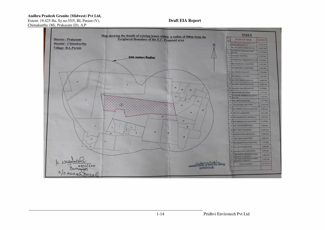
Assistant Director of Mines and Geology, Ongole, provided a cluster certificate vide his letter
545/Q/2005dated 29.10.2021, on our request. A total of 27 quarry leases were existing out of
which 26 quarry leases are having valid E.C and 1 quarry lease was non-working and 1 Quarry
lease area issued LoI surrounded within 500 meters from the peripheral boundary of lease
held by M/s. AP Granite (Midwest) Private Limited with a total extent of 138.78 Hectares. As
Andhra Pradesh Granite (Midwest) Pvt Ltd,
Extent: 19.425 Ha, Sy.no:55/5, RL Puram (V), Draft EIA Report Chimakurthy (M), Prakasam (D), A.P
1-9 Pridhvi Envirotech Pvt Ltd
per the list of leases granted all of the leases were granted prior to 9th September, 2013. As per
the Gazette Notification, SO. 2269 (E) dated 1st July 2016, the cluster mining will be applicable
only for those mines whose mining leases were granted after 9th September, 2013. Thus though
number of mines within 500meters distance are more, cluster rule does not applicable here as
per the MOEF notification. Copy of proceedings from Assistant Director Mines, Ongole is
given along with sketch.

Andhra Pradesh Granite (Midwest) Pvt Ltd,
Extent: 19.425 Ha, Sy.no:55/5, RL Puram (V), Draft EIA Report Chimakurthy (M), Prakasam (D), A.P
1-10 Pridhvi Envirotech Pvt Ltd
Copy of Cluster Letter

Andhra Pradesh Granite (Midwest) Pvt Ltd,
Extent: 19.425 Ha, Sy.no:55/5, RL Puram (V), Draft EIA Report Chimakurthy (M), Prakasam (D), A.P
1-11 Pridhvi Envirotech Pvt Ltd

Andhra Pradesh Granite (Midwest) Pvt Ltd,
Extent: 19.425 Ha, Sy.no:55/5, RL Puram (V), Draft EIA Report Chimakurthy (M), Prakasam (D), A.P
1-12 Pridhvi Envirotech Pvt Ltd

Andhra Pradesh Granite (Midwest) Pvt Ltd,
Extent: 19.425 Ha, Sy.no:55/5, RL Puram (V), Draft EIA Report Chimakurthy (M), Prakasam (D), A.P
1-13 Pridhvi Envirotech Pvt Ltd
Andhra Pradesh Granite (Midwest) Pvt Ltd,
Extent: 19.425 Ha, Sy.no:55/5, RL Puram (V), Draft EIA Report Chimakurthy (M), Prakasam (D), A.P
1-14 Pridhvi Envirotech Pvt Ltd

Andhra Pradesh Granite (Midwest) Pvt Ltd,
Extent: 19.425 Ha, Sy.no:55/5, RL Puram (V), Draft EIA Report Chimakurthy (M), Prakasam (D), A.P
1-15 Pridhvi Envirotech Pvt Ltd
1.9 Scope of the Study
Andhra Pradesh Granite (Midwest) Private Limited has obtained Terms of Reference form
SEIAA, Andhra Pradesh Lr. No. SEIAA/AP/PKM/MIN/VIO/08/2018/672 Dt.01.07.2021.
The subject EIA Report is prepared incorporating prescribed Standard Terms of Reference for
enhancement of Black Galaxy Granite of production from current 54,643 M3/annum to 79,401
M3/annum from mining lease area of 19.425 Ha.
Environmental Impact Assessment study has been carried out within an area of 10 km radius
around the Mine area as per the Terms of Reference issued by SEIAA, Andhra Pradesh. The
various steps involved in Environmental Impact Assessment study of the project site are
divided into the following phases:
Identification of significant environmental parameters and assessing the existing status
within the impact zone with respect to air, water, noise, soil and socioeconomic
components of environment.
Study of various mining activities of the proposed mine to identify the areas leading to
impact/ change in environmental quality.
Quantification/prediction of impact for the identified activities and to study the level of
impact on various environmental components.
Evaluation of impacts after superimposing the predicted/ quantified scenario over the
baseline scenario.
Formulation of Environmental Management Plan for implementation in the project.
Baseline data collected for the project during January 2019 to March 2019, has been used to
assess the existing environmental status of various environmental parameters within the 10 km
radius study area of the project.
The report presents the baseline scenario, prediction of impacts due to enhancement production
of Black Galaxy Granite production from 54,643 M3/annum to 79,401 M3/annum from mining
lease area of 19.425 Ha,
Draft EIA report with the above scope incorporating the TORs issued by SEIAA, Andhra
Pradesh is presented in subsequent chapters for public consultations.

Andhra Pradesh Granite (Midwest) Pvt Ltd,
Extent: 19.425 Ha, Sy.no:55/5, RL Puram (V), Draft EIA Report Chimakurthy (M), Prakasam (D), A.P
1-16 Pridhvi Envirotech Pvt Ltd
1.10 Required Statutory Licenses at A Glance:
The table gives the requirement & status of various applicable clearances for the project and
its current status.
S.NO Nodal Agency License/NOC /Approval
requirements Current Status
1 Ministry of
Environment, forest
and Climate
Change
Environmental Clearance for
proposed expansion
Obtained TOR and Draft
EIA report prepared for
expansion and waiting for
Public Hearing
2 Andhra Pradesh
State Pollution
Control Board
Consent for Establishment
(CFE)
Consent for operation (CFO)
Under Water & Air Acts
hazardous Waste Management
Rules
Obtained CFE and CFO
for the existing
production and Will be
applied after getting
expansion environmental
Clearance
3 Department of
Mines and Geology
Andhra Pradesh
Mining Plan Mining plan is approved
by DDMG, Ongole
District
4 Directorate General
of Mine safety
NOC Mining Safety Obtained NOC form
Mining safety department
5 State Ground water
Board
No Ground water proposed to
be extracted by Proponent
Purchasing water through
water tankers and source
is ground water.
1.11 Structure of the EIA Report
The report is organized in 12 chapters as follows
Chapter 1 is Introduction chapter, which highlights briefly about the project, introduction to
project proponents, nature & size of the project and its importance & Scope of study.
Chapter 2 Outlines project description provides the complete description of the proposed
project of Andhra Pradesh Granite (Midwest) Private Limited. The details are presented from
the environmental perspective along with the salient features such as land use, Process adopted,
Water consumption and Wastewater discharges, Air emissions sources Resource requirement
for the project and current compliance levels of the unit vis-à-vis previous clearances from
MOEF&CC.

Andhra Pradesh Granite (Midwest) Pvt Ltd,
Extent: 19.425 Ha, Sy.no:55/5, RL Puram (V), Draft EIA Report Chimakurthy (M), Prakasam (D), A.P
1-17 Pridhvi Envirotech Pvt Ltd
Chapter 3 Discuss the study area, period, components & Methodology adopted for base line
data established and environmental components
Chapter 4 Discuss the details of investigated environmental impacts due to project at various
stages of development and operations. Also the chapter outlines the measures for minimizing
or off-setting adverse impacts identified and mitigation measures.
Chapter 5 Discuss the details of alternative technologies.
Chapter 6 Discuss the details of environmental monitoring program, frequencies & costs
during implementation and operation.
Chapter 7 Discuss the potential hazards and risks associated with project & risk mitigation
measures proposed.
Chapter 8 Discuss the benefits from the project to various stakeholders.
Chapter 9 Discuss the Environmental Cost Benefit analysis (Not specified in TOR in this
case).
Chapter 10 Discuss Detailed Environmental Management Plan, which addresses the measures
to be adopted for effective environmental conservation measures. It also gives estimated budget
for implementation of EMP, both capital investment and recurring costs.
Chapter 11 gives the Summary & Conclusion of the EIA and justification of implementation
of project.
Chapter 12 Gives the Credentials of M/s. Pridhvi Envirotech (P) Ltd, their accreditation details
and team which conducted the EIA studies.
Chapter - 2
Project Description

Andhra Pradesh Granite (Midwest) Pvt Ltd,
Extent: 19.425 Ha, Sy.no:55/5, RL Puram (V), Draft EIA Report Chimakurthy (M), Prakasam (D), A.P
2-1 Pridhvi Envirotech Pvt Ltd
CHAPTER-2
PROJECT DESCRIPTION
2.1 Details of the Mining Lease Area
The mining lease area of the proposed project is a Government wasteland covered in an area
of 19.425 ha. Entire mining lease area is a hilly area and barren land. The proposed project
activity is mining of Black Galaxy Granite of 79,401 m3/ annum at Prakasam District of Andhra
Pradesh. The details of the mining lease area are as below.
Table 2.1: Details of the Mining Lease Area
State
/District Mandal Village
Survey
No.s
Extent
in Ha. Ownership
Andhra
Pradesh /
Prakasam
Chimakurthy
Rajupalem
Lakshmi
puram
55/5 19.425 Govt. barren
Land
Topo sheet : 57 M/14
Boundaries of the lease area are given as below:
North – East M/s. Swathi Granites
South M/s. Golden Granites
East M/s. Surya Granites
West M/s. Alliance Black galaxy Granites/APMDC
SW M/s. Midwest Granites
2.2 Location of the Project
The mine lease area is made up of plain ground and is falling in Survey of India Topo-sheet no
57 M/14. The area is bounded by Latitude 15°35’03.12” – 15°35’ 13.10” & 790 49’ 19.20” -
790 49’ 53.06” E Longitude. Location Map showing project site location in Prakasam District
is given in Figure – 2.1.

Andhra Pradesh Granite (Midwest) Pvt Ltd,
Extent: 19.425 Ha, Sy.no:55/5, RL Puram (V), Draft EIA Report Chimakurthy (M), Prakasam (D), A.P
2-2 Pridhvi Envirotech Pvt Ltd
Figure 2.1: Location Map showing project site

Andhra Pradesh Granite (Midwest) Pvt Ltd,
Extent: 19.425 Ha, Sy.no:55/5, RL Puram (V), Draft EIA Report Chimakurthy (M), Prakasam (D), A.P
2-3 Pridhvi Envirotech Pvt Ltd
The proposed mine site is situated at 0.75 Km South of RL Puram village. Major town and
District head quarter, Ongole is at 22.2 km in ESE, the Mandal headquarter Chimakurthy is at
2.6 km in East direction from the mine site.
The project site is located at a distance of 0.3 Km from Ongole – Podili Road. National
Highway NH-5 from Visakhapatnam to Chennai is 22.2 km in ENE direction from the mine
site. The nearest railway station is Ongole Railway station at distance of 26.6 km. The nearest
airport is Gannavaram Airport at a distance of 147.3 Km.
Topographical Map Showing 10 km radius around the project site is given as Figure – 2.2.
Base map of the study area giving features in 10 KM radius of study area is given as Figure –
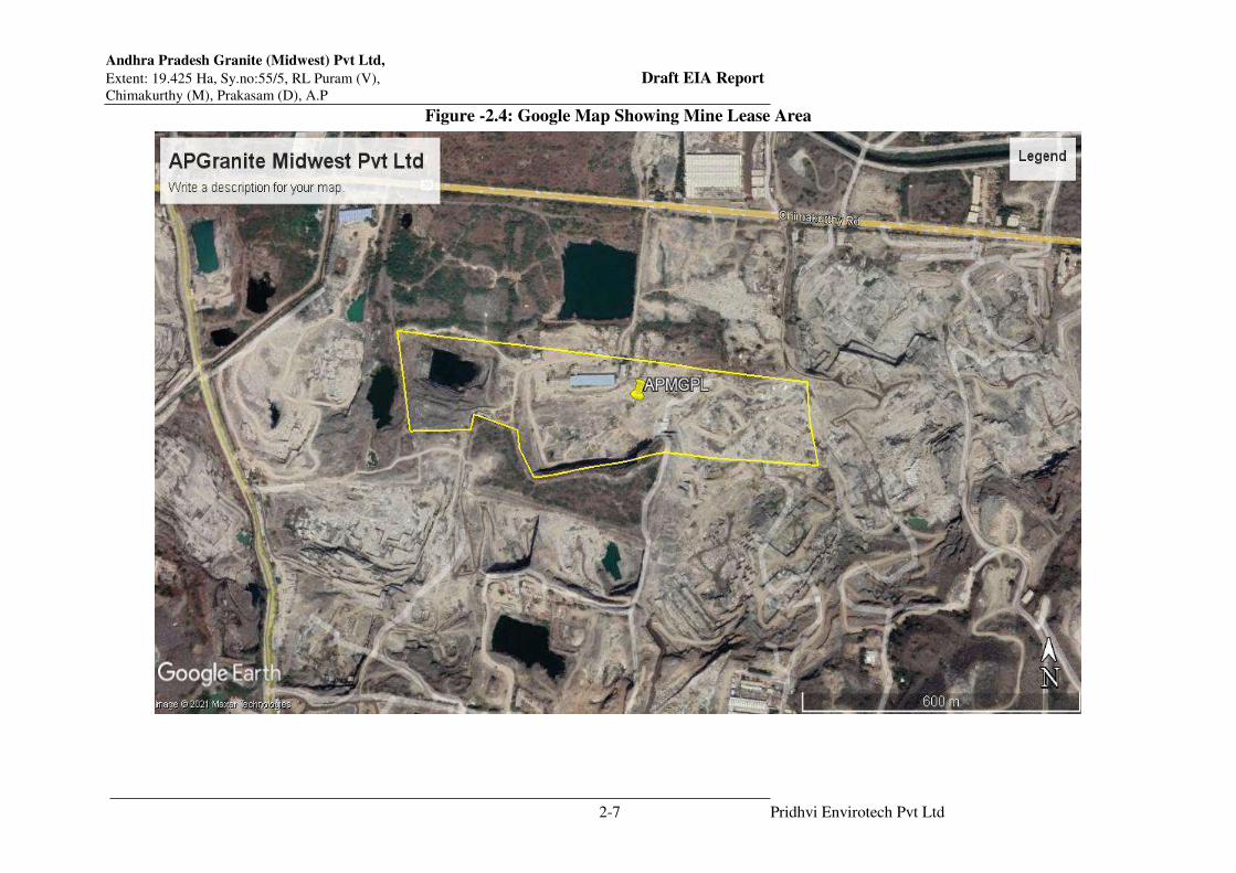
2.3 & Figure – 2.4 shows google image of the mine lease area with co-ordinates and Figure –
2.5 shows the photographs of the mine lease area.
No National Parks, Wild life sanctuaries, critically polluted areas are located within 10 km
radius from the mine lease area.
2.3 Road Connectivity to the site
The project site is located at a distance of 0.3 Km from Ongole – Podili Road. National
Highway NH-5 from Visakhapatnam to Chennai is 22.2 km in ENE direction from the mine
site.
2.4 Physiography of the Site
The quarry lease area is located on plain land with a bench mark with value of 66.398 M. The
quarry lease area with Topo relief in south direction. The entire lease area excepting north
central portion is under exploitation. The deepest pit floor level is with RL 12 .10 M i.e., 80 M
depth in Pit 1 and 2, Pit 3-64 M, Pit 4-55 M Fig – 2.5 shows the surface plan of the mine lease
area.
2.5 Site Description and Present land use
The quarry lease area is plain land with sparse vegetation with small bushes from the vegetal
cover. The quarry area is surrounded by other quarries.
There are two reserve forests with in 10 kms of the mine which are Chimakuthy RF-2.3 Km
(N) Devarapalem RF – 6.0Km (N).
There are no National Parks, Sanctuaries, Bio Sphere Reserves, Bird nesting places, Animal
Crossing corridors, and avian routes of migratory birds within 10 KM radius of the site.

Andhra Pradesh Granite (Midwest) Pvt Ltd,
Extent: 19.425 Ha, Sy.no:55/5, RL Puram (V), Draft EIA Report Chimakurthy (M), Prakasam (D), A.P
2-4 Pridhvi Envirotech Pvt Ltd
There are no historical places, archaeological sites and important piligrim centres within 10
KM radius of the site. No Recreation centres within 10 kms radius of the site.
2.6 Mine Drainage
The area regionally forms part of the Paleru River Catchment System. The Musi river located
5.50 km west of the quarry site forms part of its stream. The Musi River originates in the Darsi
Donakonda hills and upland areas of Prakasam district, and flows 33 km southwardly to reach
the study area, and further flows 23 km southeasterly and joins the Paleru River near Kamepalli
(6 km south of Kondapi), which then flows 30 km eastwards to join the Bay of Bengal.

Andhra Pradesh Granite (Midwest) Pvt Ltd,
Extent: 19.425 Ha, Sy.no:55/5, RL Puram (V), Draft EIA Report Chimakurthy (M), Prakasam (D), A.P
2-5 Pridhvi Envirotech Pvt Ltd
Figure 2.2: Topographical Map Sowing 10 Km Radius

Andhra Pradesh Granite (Midwest) Pvt Ltd,
Extent: 19.425 Ha, Sy.no:55/5, RL Puram (V), Draft EIA Report Chimakurthy (M), Prakasam (D), A.P
2-6 Pridhvi Envirotech Pvt Ltd
Figure-2.3: Base Map of the Study Area
Andhra Pradesh Granite (Midwest) Pvt Ltd,
Extent: 19.425 Ha, Sy.no:55/5, RL Puram (V), Draft EIA Report Chimakurthy (M), Prakasam (D), A.P
2-7 Pridhvi Envirotech Pvt Ltd
Figure -2.4: Google Map Showing Mine Lease Area

Andhra Pradesh Granite (Midwest) Pvt Ltd,
Extent: 19.425 Ha, Sy.no:55/5, RL Puram (V), Draft EIA Report Chimakurthy (M), Prakasam (D), A.P
2-8 Pridhvi Envirotech Pvt Ltd
Figure: 2.5: Photographs of the mine lease area

Andhra Pradesh Granite (Midwest) Pvt Ltd,
Extent: 19.425 Ha, Sy.no:55/5, RL Puram (V), Draft EIA Report Chimakurthy (M), Prakasam (D), A.P
2-9 Pridhvi Envirotech Pvt Ltd
2.7 GEOLOGY
2.7.1 Regional Geology
The Chimakurthy igneous complex is an oval shaped igneous body, comparable to Bushveld
Igneous Complex of South Africa and skeeargard Intrusive of Greenland. Similar to these
occurrences, the Chimakurthy igneous Complex is considered as “Massive Concentric Type”
intrusive magmatic body. As the source of magma is from deeper levels, the depth continuity
of the bronzite gabbro may be few kilometers below the surface.
The geological field investigations indicate that the pre-existing older migmatisebiotite
hornblende schist and quartzo-Felspathic formation is introduces by the emplacement of huge
igneous body formed by in-situ fraction differentiation and crystallization process. Single
mafic igneous body has resulted into the formation of different rock types occurring in the
forms of oval shaped or Elliptical shaped body with 15 km long (NS), 4-7 km wide (EW) and
occupies 75 Km area. Hence it is named as Cheemakurthy Igneous Complex.
Geomorphological expression shows that the outer bronzite gabbro rim and central core of
anorthosite and proximate forms plains, whereas the semicircular, crescentic shaped clino-
pyroxene gabbro occurs as a very high ridge with steep flanks.
The other rim of bronzite gabbro assumes economic importance by virtue of its rare occurrence
of Bronzite bearing Gabbro and demand in international as well as domestic markets. The
deposit is formed by intrusion of a major igneous episode, where the bronzite gabbro is formed
by formed as an outer rim of theigneos body accomplished by in situ fractional crystallization,
manifested by the process of differentiation from single magmatic body. In fact, it is the process
which has contributed to the conversion of enstatite ortho pyroxene (OPX), normally present
in gabbro into bronzite due to excess availability of iron under Oxygen deficient conditions.
Hence the concentration bronzite enriched in the periphery of igneous complex i.e. the
peripheral ‘gabbroic rim’. Even during the process of the fractional crystallization of the
magma with excess presence of iron in the magmatic liquid fail to form magnetite (iron oxide),
and instead contributed to the formation of the brozite under “reducing environment”, resulting
into the formation of then iron-rich enstatite, i.e.bronzite. In the lease area, the concentration
of bronzite gives an aesthetic look for commercial marketing.
2.7.2 Local Geology
The geomorphology plan in this area reflects the presentence of sub-surface bronzite bearing
gabbro (galaxy granite); located at the central swollen portion of bronzite gabbro rim. The
quarry gabbro formation and its exploration in the quarries around the quarry lease area. From

Andhra Pradesh Granite (Midwest) Pvt Ltd,
Extent: 19.425 Ha, Sy.no:55/5, RL Puram (V), Draft EIA Report Chimakurthy (M), Prakasam (D), A.P
2-10 Pridhvi Envirotech Pvt Ltd
the working quarries i.e. towards the northern and southern, south-eastern parts of the quarry
lease area amply tesify the sub-surface continuity of formation in the quarry lease area. All
these evidences undoubtedly confirm the lateral continuity and presence of black galaxy
(bronzite gabbro) at sub-surface levels in this lease area. However the premise for occurrence
of workable deposits at shallower level is positively indicated by the excavation carried in the
quarry lease area.
The detailed geological investigations suggest that the lineation of the gabbro in this area is
generally trending in N 60º E direction, which continues across the boundary. In view of the
preferred orientation of the minerals, it is inferred that the area is subjected to some syn-
emplacement/crystallization deformation.
Geology of the lease area
The black Galaxy Granite also known as bronzite bearing gabbro.norite is being quarried
extensively in the area between RL Puram in south and Ramathirtham in north.30% of the lease
area is under soil cover of 1 m-3m with scanty exposures and rest of the area quarried and there
are four worked out pits in the area. From the geological data from the existing workings in the
quary and adjacent quarries and also the borehole data, oit is observed that the bornzite bearing
gabbrao/norite occurs under an overburden thickness of about 8-12m. The overburden
comprises 1-3 m thick soil on surface followed by weathered bronzite-bearing gabbro/norite.
Gabbro/norite is melanocratic, light dark gery in colour, medium coarse grained, massive with
scattered and randomly oriented coarse, euhedral, sub hedral, anhedral grains of bronzite. It
mainly consists of plagioclase, pyroxene and traces of olivine, biotite and opaques
Soil Cover: The area represented by bouldery zone whose thickness varying between 1 to 3 M
and the weathered zone about 8 M.
Weathered zone: Underlying the bouldery zone of 9M thick, brownish colour weathered
mantle exists in the area; it is mixed with fresh rock boulders; the degree of weathering
decreases with depth.
Gabbro: Black coloured, medium grained, equigranular gabbro with evenly distributed brown
coloured bronzite specks occurring within the pit. It is sheet type exposures. The Massive type
with underlying surface. Hence, the deposit can be classified as solid type.
Petrographically the gabbro essentially consists of plagioclase and pyroxenes, with accessory
mineral of bronzite, ilmenite, Garnet and the specks of bronzite impart galaxy nature for the
gabbro.
Figure – 2.6 shows the geological plan and Figure – 2.7shows geological cross sections of the
mine lease area.

Andhra Pradesh Granite (Midwest) Pvt Ltd,
Extent: 19.425 Ha, Sy.no:55/5, RL Puram (V), Draft EIA Report Chimakurthy (M), Prakasam (D), A.P
2-11 Pridhvi Envirotech Pvt Ltd
Figure 2.6: Surface Geological Plan

Andhra Pradesh Granite (Midwest) Pvt Ltd,
Extent: 19.425 Ha, Sy.no:55/5, RL Puram (V), Draft EIA Report Chimakurthy (M), Prakasam (D), A.P
2-12 Pridhvi Envirotech Pvt Ltd
Figure-2.7: Geological cross Sections
Andhra Pradesh Granite (Midwest) Pvt Ltd,
Extent: 19.425 Ha, Sy.no:55/5, RL Puram (V), Draft EIA Report Chimakurthy (M), Prakasam (D), A.P
2-13 Pridhvi Envirotech Pvt Ltd
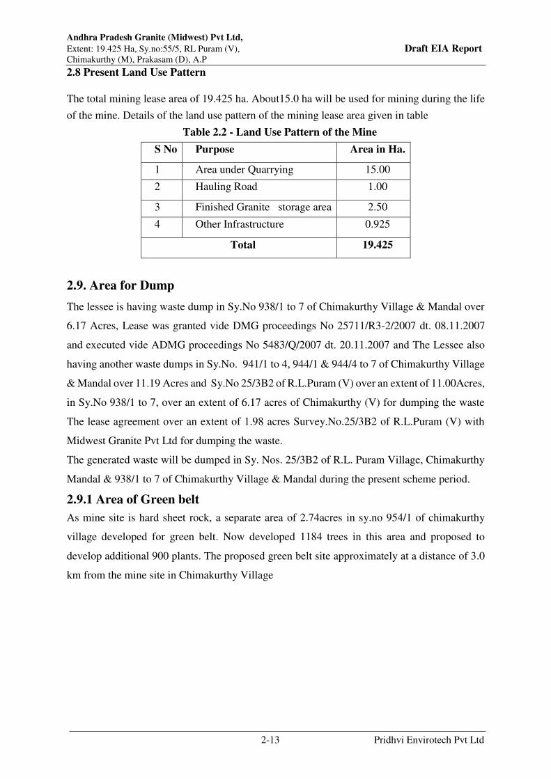
2.8 Present Land Use Pattern
The total mining lease area of 19.425 ha. About15.0 ha will be used for mining during the life
of the mine. Details of the land use pattern of the mining lease area given in table
Table 2.2 - Land Use Pattern of the Mine
S No Purpose Area in Ha.
1 Area under Quarrying 15.00
2 Hauling Road 1.00
3 Finished Granite storage area 2.50
4 Other Infrastructure 0.925
Total 19.425
2.9. Area for Dump
The lessee is having waste dump in Sy.No 938/1 to 7 of Chimakurthy Village & Mandal over
6.17 Acres, Lease was granted vide DMG proceedings No 25711/R3-2/2007 dt. 08.11.2007
and executed vide ADMG proceedings No 5483/Q/2007 dt. 20.11.2007 and The Lessee also
having another waste dumps in Sy.No. 941/1 to 4, 944/1 & 944/4 to 7 of Chimakurthy Village
& Mandal over 11.19 Acres and Sy.No 25/3B2 of R.L.Puram (V) over an extent of 11.00Acres,
in Sy.No 938/1 to 7, over an extent of 6.17 acres of Chimakurthy (V) for dumping the waste
The lease agreement over an extent of 1.98 acres Survey.No.25/3B2 of R.L.Puram (V) with
Midwest Granite Pvt Ltd for dumping the waste.
The generated waste will be dumped in Sy. Nos. 25/3B2 of R.L. Puram Village, Chimakurthy
Mandal & 938/1 to 7 of Chimakurthy Village & Mandal during the present scheme period.
2.9.1 Area of Green belt
As mine site is hard sheet rock, a separate area of 2.74acres in sy.no 954/1 of chimakurthy
village developed for green belt. Now developed 1184 trees in this area and proposed to
develop additional 900 plants. The proposed green belt site approximately at a distance of 3.0
km from the mine site in Chimakurthy Village

Andhra Pradesh Granite (Midwest) Pvt Ltd,
Extent: 19.425 Ha, Sy.no:55/5, RL Puram (V), Draft EIA Report Chimakurthy (M), Prakasam (D), A.P
2-14 Pridhvi Envirotech Pvt Ltd
2.10 Method of Mining
2.10.1 Description of Existing method for excavation
The method of the mining is opencast semi mechanized mining, employing deep drilling and
blasting for breaking the overburden and black galaxy granite using heavy earth moving
machinery viz. hydraulic excavators to excavate the broken material and load the same into
tippers and dumpers. The overburden will be hauled to the dumps and stacking yards
respectively.
Extraction of blocks: The natural joints in the sheet rock is taken for splitting them or a line
of drill holes are drilled and split it with the help of feathers and wedges. The separated pieces
will be examined for defects and lines, then the block or blocks are marked in clear area and
holes are drilled along the line of marking with the help of feathers and wedges and the waste
portions are separated forming a rectangular blocks.
Separation primary blocks from the mother rock: Diamond wire saw use for separation of
primary block from the mother rock. Working faces are developed parallel to the direction of
lineation. For effective use of wire saw, two sides free face is required. The bench height
depends on the reach of the excavator. The main cut can be planned at 8m height x 9m x 8 to
9m lengths.
The Diamond wire is passed through two horizontal holes drilled at 90° and the bottom is cut
first then the wire is passed through the vertical hole and one of the horizontal holes and vertical
face is cut. Thus the entire block of 6m x 9m x 9m size is separated from the mother rock. The
block is divided into number of slices, with each slice 1.8 m to 2m thickness. Slicing can be
done by either with a wire saw or with a line of holes by using lack hammers/ Line Drill or
Tam Rock and wedging.
The slice is brought down with the help of excavator and washed with water to check for defects
and cracks. The blocks are marked and separated by drilling and wedging.
Secondary Splitting
After separation from the mother rock, it is properly checked by washing with water to identify
defects and cracks. Based on this observation the size is decided and the blocks are marked and
separated by drilling and wedging.
The separated pieces are examined for defects and lines, then the block or blocks are marked
in clear area and holes are drilled along the line of marking, with the help of feathers and
wedges and the waste portions are separated forming a rectangular blocks. Any bulges are

Andhra Pradesh Granite (Midwest) Pvt Ltd,
Extent: 19.425 Ha, Sy.no:55/5, RL Puram (V), Draft EIA Report Chimakurthy (M), Prakasam (D), A.P
2-15 Pridhvi Envirotech Pvt Ltd
removed by drilling and wedging making it perfect blocks. A perfect block is that all the sides
shall make with each other 90º.
Dressing
After secondary separation, the rock mass will be carefully examined to avoid hair-line cracks,
mineral segregations and veins etc. The dressing of the rough blocks will be made by chipping
the edges and geometrically equating the edges of the block at the dressing yard. The rough
blocks obtained after secondary cut, it will be dressed for obtaining good geometric shape of
galaxy granite. Adequate care is required to dress the block depending on the surface to be
polished (lineation planes), as golden spots are visible only in one direction in lineation plane.
However, bronzite is softer than other minerals, it is foliaceous and tabular and often flaky,
oriented in the direction of general lineation. The dressing and sawing of the blocks should be
oriented parallel to the direction of foliae / lineation to expose the plane parallel to 001-
Crystallographic plane of the metallic luster, so as to expose more bronzite flakes on polished
surface.
Drilling
Drill holes of 6 M depth will be drilled in a single row with spacing of less than 0.3 M and
burden of 1.6 M or more shall be maintained uniformly. This arrangement will yield rock size
of 3 M x 2 M cross section. A bench height of 6.0 M will be tackled in two steps.
Explosive type
The lessee proposes to use low intensity blasting using light charge of Gelatin (explosive) for
controller blast OB and waste boulders
Loading & Transport
The mined blocks are loaded into trucks by cranes and transported to the processing plant.
Extent of mechanization
The following table describes the machinery used for mining
Table 2.3: Extent of Mechanization
S.no Machinery No’s
1 Hydraulic Excavators 14
2 Dumpers 18
3 Compressors 16
4 Electrical Compressors 02
5 Hydraulic Drills 08

Andhra Pradesh Granite (Midwest) Pvt Ltd,
Extent: 19.425 Ha, Sy.no:55/5, RL Puram (V), Draft EIA Report Chimakurthy (M), Prakasam (D), A.P
2-16 Pridhvi Envirotech Pvt Ltd
6 Wheel Loader 01
7 Slotters 13
8 Jack hammers 40
9 Wire Saw 12
10 Derrick k Crane 03
11 DG Sets( 125,200, 500 KVA) 04
12 Dewatering Pump(60 HP, 20HP) 2+2
13 Escort Cranes and loaders 02
Total 137
2.11 Year wise Production and Development
The year wise production and solid waste details are given Table2.4 as per the modified mining
plan approved by Deputy Director Mines & Geology, Ongole dated 22.01.2021.
Table 2.4: Year Wise Production from Initiation of Mine Starting Period to Till Date
Year Production(M3)
2007-2008 3228.282
2008-2009 7370.467
2009-2010 11289.617
2010-2011 27709.123
2011-2012 35538.639
2012-2013 36095.831
2013-2014 26052.528
2014-2015 28073.993
2015-2016 26988.071
2016-2017 30937.487
2017-2018 23448.769
2018-2019 1506.272
2019-2020 15196.225
2020-2021 54408.740
April-2021 to
September-2021 31834.672
TOTAL 359678.716
2.12 Conceptual Plan
Of the total mining lease area of 19.425 ha, about 15.00 ha.will be used for mining activities
during the life of the mine. The waste generated during the life of the mine is stored in dump

Andhra Pradesh Granite (Midwest) Pvt Ltd,
Extent: 19.425 Ha, Sy.no:55/5, RL Puram (V), Draft EIA Report Chimakurthy (M), Prakasam (D), A.P
2-17 Pridhvi Envirotech Pvt Ltd
site and the matured pits will be back filled by re-handling of waste as a reclamation measure
and balance the pits will be utilized as water harvesting structure
Figure 2.8: Year wise Production Plan
1st Year:
2nd Year:

Andhra Pradesh Granite (Midwest) Pvt Ltd,
Extent: 19.425 Ha, Sy.no:55/5, RL Puram (V), Draft EIA Report Chimakurthy (M), Prakasam (D), A.P
2-18 Pridhvi Envirotech Pvt Ltd
3rd Year:
2.13 Anticipated life of mine
With the available reserves of 12,26,080 m3 and considering average annual production
of 79,401 m3 the life of the mine is estimated as 15 Years.
2.14Top Soil &Waste Generation and Disposal
The granite occurs as surface deposit with soil cover and the weathering is limited to the inter-
spaces of boulders and joint planes. Mining of black galaxy granite results in serious problem
of generation huge quantity of waste rock. The year wise waste production details are given
below.
Year Total tentative
Excavation (M3)
OB/ Waste
rock (M3)
ROM Mineral Rejects
(M3)
Ore @ 8 %
(M3)
Tiles recovery
1.84% (M3)
2020-21 9,67,600.0 82,550.0 77,408.0 17803.84 9,54,938.16
2021-22 10,00,350.0 0 80,028.0 18406.44 9,01,915.56
2022-23 10,09,600.0 0 80,768.0 18576.64 9,10,255.36
Total 29,77,550.0 82,550.0 2,38,204.0 54,786.92 27,67,109.08

Andhra Pradesh Granite (Midwest) Pvt Ltd,
Extent: 19.425 Ha, Sy.no:55/5, RL Puram (V), Draft EIA Report Chimakurthy (M), Prakasam (D), A.P
2-19 Pridhvi Envirotech Pvt Ltd
Dump Handling: The lessee is having waste dump in Sy.No 938/1 to 7 of Chimakurthy Village
& Mandal over 6.17 Acres, Lease was granted vide DMG proceedings No 25711/R3-2/2007
dt. 08.11.2007 and executed vide ADMG proceedings No 5483/Q/2007 dt. 20.11.2007 and The
Lessee also having another waste dumps in Sy.No. 941/1 to 4, 944/1 & 944/4 to 7 of
Chimakurthy Village & Mandal over 11.19 Acres and Sy.No 25/3B2 of R.L.Puram (V) over
an extent of 11.00Acres, in Sy.No 938/1 to 7, over an extent of 6.17 acres of Chimakurthy (V)
for dumping the waste The lease agreement over an extent of 1.98 acres Survey.No.25/3B2 of
R.L.Puram (V) with Midwest Granite Pvt Ltd for dumping the waste.
The generated waste will be dumped in Sy. Nos. 25/3B2 of R.L. Puram Village, Chimakurthy
Mandal & 938/1 to 7 of Chimakurthy Village & Mandal during the present scheme period.
2.15 Requirements for the Project
2.15.1 Site Services
Facilities like rest shed, store room and office room will be provided in 7.5 m barrier zone of
the mining lease area.
2.15.2 Water Requirement
The total water requirement for the project is about 80 KLD. This requirement will be met from
nearby villages by tankers.
2.15.3 Power Requirement
Power is available in the Mine site. Power is used for office and for wire saw machines,
compressors and dewatering pumps. Mining equipments will be operated with both power and
diesel motive power.
2.15.4 Man power requirements
Currently there are 448 people are working in the mine. For expansion activities, additional 40
people will be employed. Preference for local youth will be there in providing the employment.

Chapter - 3
Baseline Environmental Status

Andhra Pradesh Granite (Midwest) Pvt Ltd,
Extent: 19.425 Ha, Sy.no:55/5, RL Puram (V), Draft EIA Report Chimakurthy (M), Prakasam (D), Andhra Pradesh
3-1 Pridhvi Envirotech Pvt Ltd
CHAPTER-3
BASELINE ENVIRONMENTAL STATUS
3.1Preamble
Collection of base line data is an integral aspect of the preparation of environmental impact
assessment report. Baseline data reflects the present status of environment before the initiation
of any activity of the Production Enhancement. The possible effects due to the proposed
Production Enhancement mine site of M/s.Andhra Pradesh Granite Midwest Private Limited
are estimated and superimposed on the compiled baseline data subsequently, to assess
environmental impacts.
3.1.1 Study Area:
Data is collected in a circular area of 10 km radius surrounding the mine site.
3.1.2 Data Collection Period & Components:
Baseline environment assessment was conducted in the impact zone of 10 km surrounding the
site area during the months of January 2019- March 2019. Studies were undertaken to generate
baseline data of micrometeorology, air quality, water quality, noise levels, flora and fauna, land
use, soil quality, Ecology biodiversity and socio-economic status of the community were
collected in a circular area of 10 km radius surrounding the Mine site.
3.2 Methodology of Base line data collection
3.2.1 Scoping
The scope of the assessment for this study was determined by the Terms of Reference, granted
by Ministry of Environment, Forests & climate change, by the State level Expert appraisal
Committee and approved by SEIAA, Andhra Pradesh. An initial discussion with the project
proponents and other stakeholders was conducted in the study area so that the focus would be
on valued ecosystem components (VECs) they considered important.
3.2.2 Reconnaissance Surveys
The study team made initial site visit to ascertain basic information on various aspects like
availability of infrastructure, physiological condition of the project site, surroundings of the
site such as road connectivity, nearby population, nearby water bodies & neighboring industrial
activity etc. The information collected has been used for identifying the valued eco components
to be chosen for specific consideration in the study.
Andhra Pradesh Granite (Midwest) Pvt Ltd,
Extent: 19.425 Ha, Sy.no:55/5, RL Puram (V), Draft EIA Report Chimakurthy (M), Prakasam (D), Andhra Pradesh
3-2 Pridhvi Envirotech Pvt Ltd
3.2.3 Assembly and Analysis of Data
The data from initial surveys was recorded. Various work sheets are used for collection of base
line data by various functional area experts focusing on different components of EIA study.
The Supplementary information was collected from Survey of India topo sheets, census
handbooks, published flora and fauna data etc. Standard statistical techniques were used for
analysis of the socio-economic data, etc. Qualitative analysis was done for more descriptive
data.
3.2.4 Assessment of Alternatives
Alternatives of the project site are not relevant in this case as this project is production
enhancement from existing mine
3.2.5 Assessment of Potential Impacts
Potential significant impacts were identified on the basis of analytical review of baseline data;
review of land uses and environmental factors; analytical review of the socio-economic
conditions within the PIA; biotic environment in study zone.
3.2.6 Integration of Environmental Impacts in the Design Process:
The design and decision – making process integrated environmental and social issues and
prompted the early identification of appropriate actions. Such actions included, for example,
optimizing the layout, use of existing infrastructure with both units, current air pollution control
systems and improvements, measures for water conservation, measures for solid waste
management etc.
As this is brown field project, existing environmental infrastructure is reviewed and gaps are
identified for improvements in the production enhancement project
3.3 Land Environment
The area is located on Topo Sheet No.57M/14. At the junction of the quarry lease area consists
of undulating with gently sloping to East and South. The mine activity is there from year 2007
onwards and current mine reached a depth 20-24 Meters from GL.
3.3.1 Physiography
The quarry lease area is located on plain with worked pits. The general ground level is gently
sloping to south. The area is unfit for agriculture as it is sheet rock of granite.
3.3.2 Topography
The Mine lease area falls in the Survey of India, topographical Map No.57M/14 with
Geographical Co-ordinates Latitude 15º35’09.70” to 15º35’03.66”N and Longitude 79º
49’51.60” to 79º 49’53.06”E.

Andhra Pradesh Granite (Midwest) Pvt Ltd,
Extent: 19.425 Ha, Sy.no:55/5, RL Puram (V), Draft EIA Report Chimakurthy (M), Prakasam (D), Andhra Pradesh
3-3 Pridhvi Envirotech Pvt Ltd
The area located at a distance of about 0.75km due North of RL Puram village and 5.0 Km
West of Chimakurthy on B.T. Road Ongole-Kurnool State Highway No.53. The quarry lease
area can be approached by earthen road from this State Highway.
The mine site is approachable from Ongole – Kurnool state highway no. 53 which is about 0.34
KM from the mine site
The Google map showing the mine site area and its surroundings is as shown in figure 3.1
Figure-3.1: Google map showing the project area and its surroundings
3.4 Drainage
The area regionally forms part of the Paleru River Catchment System. The Musi (Paleru Basin
River) river located 5.50 km west of the quarry site forms part of its stream (Figures 1 to 3).
The Musi River originates in the Darsi -Donakonda hills and upland areas of Prakasam district,
and flows 33 km southwardly to reach the study area, and further flows 23 km southeasterly
and joins the Paleru River near Kamepalli (6 km south of Kondapi), which then flows 30 km
eastwards to join the Bay of Bengal.
Major part of the pediplain in the Paleru catchment area is dissected by ephemeral streams and
streamlets flowing in north and northeasterly directions. Some small and medium size lakes
are situated along the topographic gradients, and most of which are connected by small

Andhra Pradesh Granite (Midwest) Pvt Ltd,
Extent: 19.425 Ha, Sy.no:55/5, RL Puram (V), Draft EIA Report Chimakurthy (M), Prakasam (D), Andhra Pradesh
3-4 Pridhvi Envirotech Pvt Ltd
ephemeral nallahs (streamlets). Other than these many small ponds and lakes are situated
around the study area. These lakes receive seasonal flows, otherwise mostly remain dry.
The AP Granite (Midwest) area lies within a local catchment area referred here as Pulikonda
Watershed. The watershed is about 30 sq. km in areal extent, and forms part of the Musi river
catchment.
Regional Map of the Area showing the Paleru River Catchment is given in Figure 3.2.
Figure 3.2: Regional Map of the Area showing the Paleru River Catchment

Andhra Pradesh Granite (Midwest) Pvt Ltd,
Extent: 19.425 Ha, Sy.no:55/5, RL Puram (V), Draft EIA Report Chimakurthy (M), Prakasam (D), Andhra Pradesh
3-5 Pridhvi Envirotech Pvt Ltd
Figure 3.3 Drainage Distribution and Watershed Demarcation of the Study Area.
(Watershed boundary is shown with Blue Outline, and Musi river is seen southwest of
the watershed)
Out of the small and medium size tanks and water bodies situated around the quarry area, the
notable one is the Ramathirtham Cheruvu, which is about 4 km (geographically) northwest
direction of the site, and about 4 sq.km in areal extent (Figure 2). Other notable tanks and
water bodies in the area are situated near Patimedapalem (Peddacheruvu), southeast of
Bakkireddipalem, west of Gonugunta, west of Muvvavaripalem, south of Pulikonda, and north
of Mailavarm. All these are less than 1.5 km in areal extent, and receive inflows from the
surrounding hills and uplands during monsoon season, and usually get dried up before the onset
of premonsoon (Feb/March). The distributary of Nagarjuna sagar Right Canal partly covers
the areas, and takes route north of Chimakurthi and project site areas.
The overall area is regionally characterised by dendritic pattern of drainage, with a general
slope towards main river and stream courses. The percolation tanks and water bodies in the
area are either dry or gradually getting reduced over the years with the slowing down of
inflows, and erratic rainfall.

Andhra Pradesh Granite (Midwest) Pvt Ltd,
Extent: 19.425 Ha, Sy.no:55/5, RL Puram (V), Draft EIA Report Chimakurthy (M), Prakasam (D), Andhra Pradesh
3-6 Pridhvi Envirotech Pvt Ltd
3.5 Land use Pattern
Land use / Land cover Classification of the Study area
Based on the scale and the satellite resolution the Land Use/Land Cover classification can be
made. The satellite data of IRS LISS IV was used while carrying out the analysis. Digital image
processing was carried out to delineate various land use / land cover categories viz. build up
area, crop areas and forests, waste lands such as land with or without scrub, water bodies and
Transportation. The interpreted map was verified on ground at limited points and final land use
/ land cover map was prepared.
The Satellite image of the study area is given at Figure 3.4 and land use and land cover map
of the study area is given at Figure3.5
Figure 3.4 Satellite image of the study area
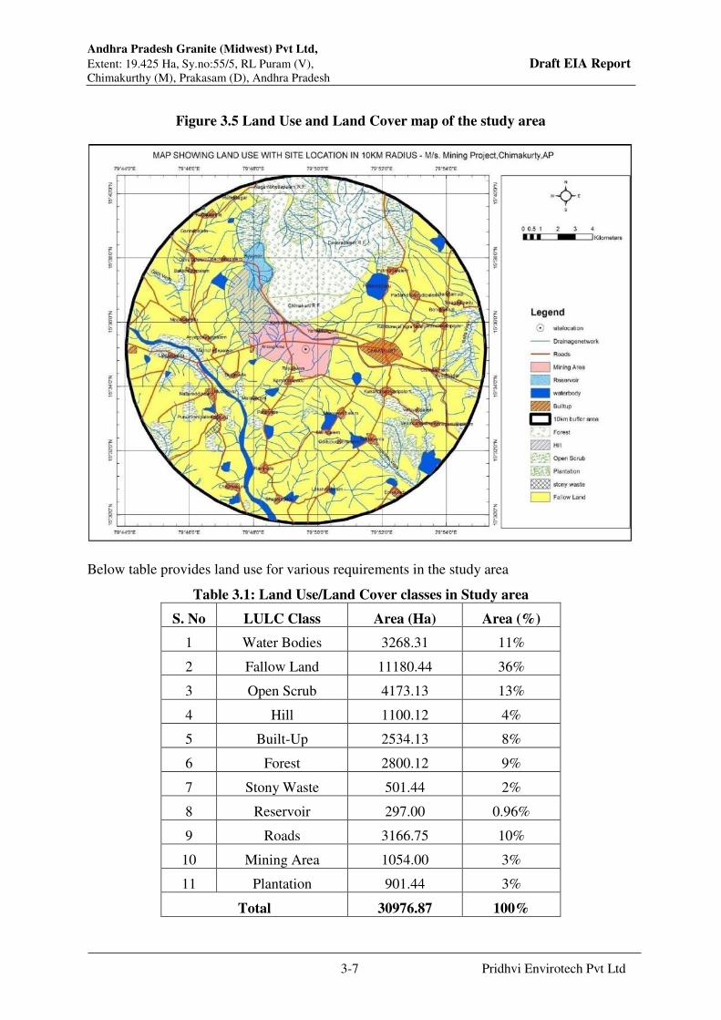
Andhra Pradesh Granite (Midwest) Pvt Ltd,
Extent: 19.425 Ha, Sy.no:55/5, RL Puram (V), Draft EIA Report Chimakurthy (M), Prakasam (D), Andhra Pradesh
3-7 Pridhvi Envirotech Pvt Ltd
Figure 3.5 Land Use and Land Cover map of the study area
Below table provides land use for various requirements in the study area
Table 3.1: Land Use/Land Cover classes in Study area
S. No LULC Class Area (Ha) Area (%)
1 Water Bodies 3268.31 11%
2 Fallow Land 11180.44 36%
3 Open Scrub 4173.13 13%
4 Hill 1100.12 4%
5 Built-Up 2534.13 8%
6 Forest 2800.12 9%
7 Stony Waste 501.44 2%
8 Reservoir 297.00 0.96%
9 Roads 3166.75 10%
10 Mining Area 1054.00 3%
11 Plantation 901.44 3%
Total 30976.87 100%

Andhra Pradesh Granite (Midwest) Pvt Ltd,
Extent: 19.425 Ha, Sy.no:55/5, RL Puram (V), Draft EIA Report Chimakurthy (M), Prakasam (D), Andhra Pradesh
3-8 Pridhvi Envirotech Pvt Ltd
Figure 3.6: Pie Diagram Showing Land use & Land cover area
3.6 Geology
Prakasam district has come into prominence as a granite producing district in the State in recent
years, thanks to the discovery of what is known as “Galaxy Granite” in the Chimakurthy area
of the District; this unique type won international recognition. The main litho units in the area
comprise of granites, gneisses, gabbro and schists of Archaean and Dharwar Super group. The
Proterozoic rocks comprising the Srisailam Quartzites of Cuddapah Super Group occur as the
structural hills near to Markapur – Vinukonda area, which is about 80 km northwest of the
study area. Shallow fluvial alluvium is restricted along the Musi river and its stream courses.
The locally available and worldwide popular Chimakurthy granite is different from other
granitic rocks, because of its unique origin from a ‘massive concentric type’ intrusive magmatic
igneous body.
The granite bearing areas in Prakasam district can be divided geologically into two parts, the
southern part falling in the mica-schist belt and the northern part forming a part of the granite
terrain. Black granite deposits around Chimakurthy basically are anorthosite gabbro
pyroxenites which have intruded into biotite-hornblende schist. The rocks are of black colour,
medium grained and take good polish. Some places near Chimakurthy and R.L.Puram, the
anorthosite gabbro-pyroxenite has developed crystals of bronzite (a pyroxene which is golden
yellow in colour). The golden yellow crystal gives the appearance of ‘star studded galaxy sky’,
Andhra Pradesh Granite (Midwest) Pvt Ltd,
Extent: 19.425 Ha, Sy.no:55/5, RL Puram (V), Draft EIA Report Chimakurthy (M), Prakasam (D), Andhra Pradesh
3-9 Pridhvi Envirotech Pvt Ltd
hence the name ‘Galaxy granite’. This variety is being quarried around Chimakurthy and
R.L.Puram, whereas the black gabbroic-pyroxenite is being quarried near Budavada (AP Mines
and Geology, 2012).
The gabbro rock occurring in the mine area is black coloured, medium grained, and
equigranular with evenly distributed brown coloured bronzite specks. Petrographically the
gabbro essentially consists of plagioclase and pyroxenes with accessory minerals like bronzite,
ilmenite, and garnet. The specks of bronzite impart ‘galaxy’ appearance to the solid gabbro
after right cutting and polishing.
Petrogenesis: The Chimakurthy Igneous complex in the area is an oval shaped igneous body,
comparable to the Bushveld Igneous Complex of South Africa and Skeeargard Intrusive of
Greenland. With the source and solidification of magma from deeper levels in the form of deep
continuity of bronzite gabbro is supposed to be occurring few kilometres below the surface.
The geological field investigations indicate that the pre-existing older migmatised biotite-
hornblende schist and quartzo-feldspathic formation is intruded by the emplacement of huge
igneous body formed by insitu fraction differentiation and crystallisation process.
Geomorphological expression shows that the outer bronzite gabbro rim and central core of
anorthosite and pyroxinite forms plains, where as the semi-circular, crecentric shaped clino-
pyroxene gabbro occur as a very high ridge with steep flanks. The detailed geological evidences
suggest that the lineation of the gabbro in this area is generally trending in N600E direction,
which continues across the boundary in view of the preferred orientation of the minerals
(Mining Plan, 2013).
Structural Features: Structurally three sets of major joints can be delineated in gabbro-gneissic
rocks occurring in the area, especially along N400E – S400W, N300W – S300E, and N200W –
S200E. In addition there is common occurrence of vertical to sub-vertical, horizontal to sub-
horizontal sheet joints of 3 to 4 in number (Mining Plan, 2013).
3.6.1 Climate and Rain Fall:
The climate of the area is moderate and sub-tropical. The summer season is from March to
May. This is followed by monsoon period from June to December, the post monsoon from
October to November and the winter season from December to February. The average annual
rainfall of Prakasam district is 924 mm.

Andhra Pradesh Granite (Midwest) Pvt Ltd,
Extent: 19.425 Ha, Sy.no:55/5, RL Puram (V), Draft EIA Report Chimakurthy (M), Prakasam (D), Andhra Pradesh
3-10 Pridhvi Envirotech Pvt Ltd
Table 3.2. Climate Data of Ongole, District Head Quarters, Prakasam
District, AP.
December is the coldest month with normal mean maximum temperature of about 24.2°c and
mean minimum temperature of 19.9°c. Temperature begins to rise after February. May is the
hottest month with mean daily maximum temperature of about 38.2°C and the mean daily
minimum temperature of about 27.9°C. During May and early June the maximum temperature
rises occasionally to 46°C and with the one set of southwest monsoon by about second week
of June, temperature begins to drop rapidly.
The relative humidity is generally high throughout the year and is of the order of 80% in
the morning and 75% in the evening. During summer season particularly in the month of
May the relative humidity is 71% in the morning and 64% in the evening hours. The wind
speed in the district is generally light to moderate throughout the year. The special weather
phenomenon prevails in the district viz., during post monsoon season wide spread heavy
rain and strong winds occur when depressions in the Bay of Bengal move north-westerly
direction (CGWB, 2013).
The average annual rainfall of the district is 798.6 mm. The mean seasonal rainfall distribution
is 384 mm in southwest monsoon (June-September), 331 mm in northeast monsoon ( Oct-Dec),
17 mm rainfall in Winter (Jan-Feb) and 68 mm in summer (March – May).
3.7 Water Environment
The industrial development of any region is contingent on the availability of sufficient water
resources, as most of the process industries would require water for process or cooling
purposes. The potential for exploitation of ground water resources increases as development of
new projects increases in industrial and agricultural areas. With the increasing industrialization

Andhra Pradesh Granite (Midwest) Pvt Ltd,
Extent: 19.425 Ha, Sy.no:55/5, RL Puram (V), Draft EIA Report Chimakurthy (M), Prakasam (D), Andhra Pradesh
3-11 Pridhvi Envirotech Pvt Ltd
and urbanization the possibilities of contamination of surface water and ground water sources
are rapidly increasing. The water resources in the area broadly fall into following categories:
1. Ground Water resources : Accumulation in deeper strata of ground.
2. Surface Water resources : Streams, ponds, etc.
3.7.1 Ground Water Conditions
General Features:
Geomorphic features, Climate and Rainfall, Topography and Land Slope, Drainage pattern,
Soils and Agricultural activities and ultimately the nature, thickness, distribution and structure
of different geological formations, independently or collectively or in association with each
other play a distinct role in the occurrence, movement, quality and availability of Ground
Water.
Geographical set-up and Geomorphic features control, in a large measure the amount of
precipitation that contributes to run off and ground water recharge. Dry conditions in arid and
semi-arid climatic conditions results in large scale evaporation losses, promotes oxidation
processes and results in the deep ground water level.
High rainfall contributes higher amounts of infiltration and deep percolation to recharge ground
water. Development of landforms mainly depends upon the nature of the rocks, their resistance
to erosion and the geologic structure, climatic conditions and vegetative cover.
Morpho-Metric parameters such as drainage density and slope characteristics provide a basis
for evaluation of run-off and ground water potentials of a drainage basin. Total drainage basin
arial extent determines the total quantity of water available in a basin. A low network of
drainage courses is indicative of the presence of highly resistant or highly permeable rocks on
the surface. High drainage density characterizes hilly terrain and areas underlain by weak or
impermeable rocks result in more run-off than infiltration. Low network drainage density
corresponds to high infiltration rates.
3.7.2 Water-shed and Neighbourhood Areas:
The area regionally forms part of the Paleru River Catchment System. The Musi river located
5.50 km west of the quarry site forms part of its stream. The Musi River originates in the Darsi
-Donakonda hills and upland areas of Prakasam district, and flows 33 km southwardly to reach
the study area, and further flows 23 km southeasterly and joins the Paleru River near
Kamepalli (6 km south of Kondapi), which then flows 30 km eastwards to join the Bay of
Bengal.

Andhra Pradesh Granite (Midwest) Pvt Ltd,
Extent: 19.425 Ha, Sy.no:55/5, RL Puram (V), Draft EIA Report Chimakurthy (M), Prakasam (D), Andhra Pradesh
3-12 Pridhvi Envirotech Pvt Ltd
Major part of the pediplain in the Paleru catchment area is dissected by ephemeral streams and
streamlets flowing in north and northeasterly directions. Some small and medium size lakes
are situated along the topographic gradients, and most of which are connected by small
ephemeral nallahs (streamlets). Other than these many small ponds and lakes are situated
around the study area. These lakes receive seasonal flows, otherwise mostly remain dry.
The AP Granite (Midwest) area lies within a local catchment area referred here Pulikonda
Watershed. The watershed is about 30 sq. km in areal extent, and forms part of the Musi river
catchment.
Figure-3.7: Topography and Drainage of the Project Site Neighborhood
3.7.3 Field study and discussion:
During the field study, depth of water levels and total depth of wells were measured using
embossed steel measuring tape. Quality of ground water in terms of its Specific Electrical
Conductance values was measured by using a sensitive pocket type Electrical Conductivity
Meter. The hydro-geological data of wells inventoried and location of wells is shown in the
Google Map Figure-3.8
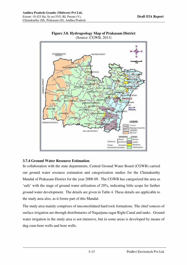
Andhra Pradesh Granite (Midwest) Pvt Ltd,
Extent: 19.425 Ha, Sy.no:55/5, RL Puram (V), Draft EIA Report Chimakurthy (M), Prakasam (D), Andhra Pradesh
3-13 Pridhvi Envirotech Pvt Ltd
Figure 3.8. Hydrogeology Map of Prakasam District
(Source: CGWB, 2013)
3.7.4 Ground Water Resource Estimation
In collaboration with the state departments, Central Ground Water Board (CGWB) carried
out ground water resource estimation and categorization studies for the Chimakurthy
Mandal of Prakasam District for the year 2008-09. The CGWB has categorized the area as
‘safe’ with the stage of ground water utilization of 28%, indicating little scope for further
ground water development. The details are given in Table 4. These details are applicable to
the study area also, as it forms part of this Mandal.
The study area mainly comprises of unconsolidated hard rock formations. The chief sources of
surface irrigation are through distributaries of Nagarjuna sagar Right Canal and tanks. Ground
water irrigation in the study area is not intensive, but in some areas is developed by means of
dug-cum-bore wells and bore wells.
Andhra Pradesh Granite (Midwest) Pvt Ltd,
Extent: 19.425 Ha, Sy.no:55/5, RL Puram (V), Draft EIA Report Chimakurthy (M), Prakasam (D), Andhra Pradesh
3-14 Pridhvi Envirotech Pvt Ltd
Table3.3: Ground Water Resource Estimations
S.
No.
Item Total
(ham)
1. Net Annual Ground Water Availability (1-2) 3302
2. Existing Gross Ground Water Draft for all
uses
919
3. Provision for domestic and industrial
requirement supply to the Yr 2025
187
4. Net Ground Water Availability for future
irrigation development
2266
5. Stage of Ground Water Development % 28
6. Category Safe
3.8 Ground Water Quality
Quality of ground water can be expressed in terms of Specific Electrical Conductance (E.C.)
which is a measure of dissolved salt content. The location of Bore wells and other sources
examined are shown in the figure 3.8. The permissible limits of E. C. for drinking and irrigation
purposes respectively are 1500 and 2000 µ/cm at 25 °C.
The samples were collected from 8 Bore Wells around Mine site in 10 km radius i.e.,
Muvvavaripalem, Mailavarm, RL puram, Mine pit, Pulikonda, Marrichettypalem,
Ramateertham and chimakurthy and got them analyzed for associated parameters. The
sampling location map of the area is given in Figure 3.9. Summarized Results of Chemical
Analysis of Ground Water Samples is shown in the Table-3.4.
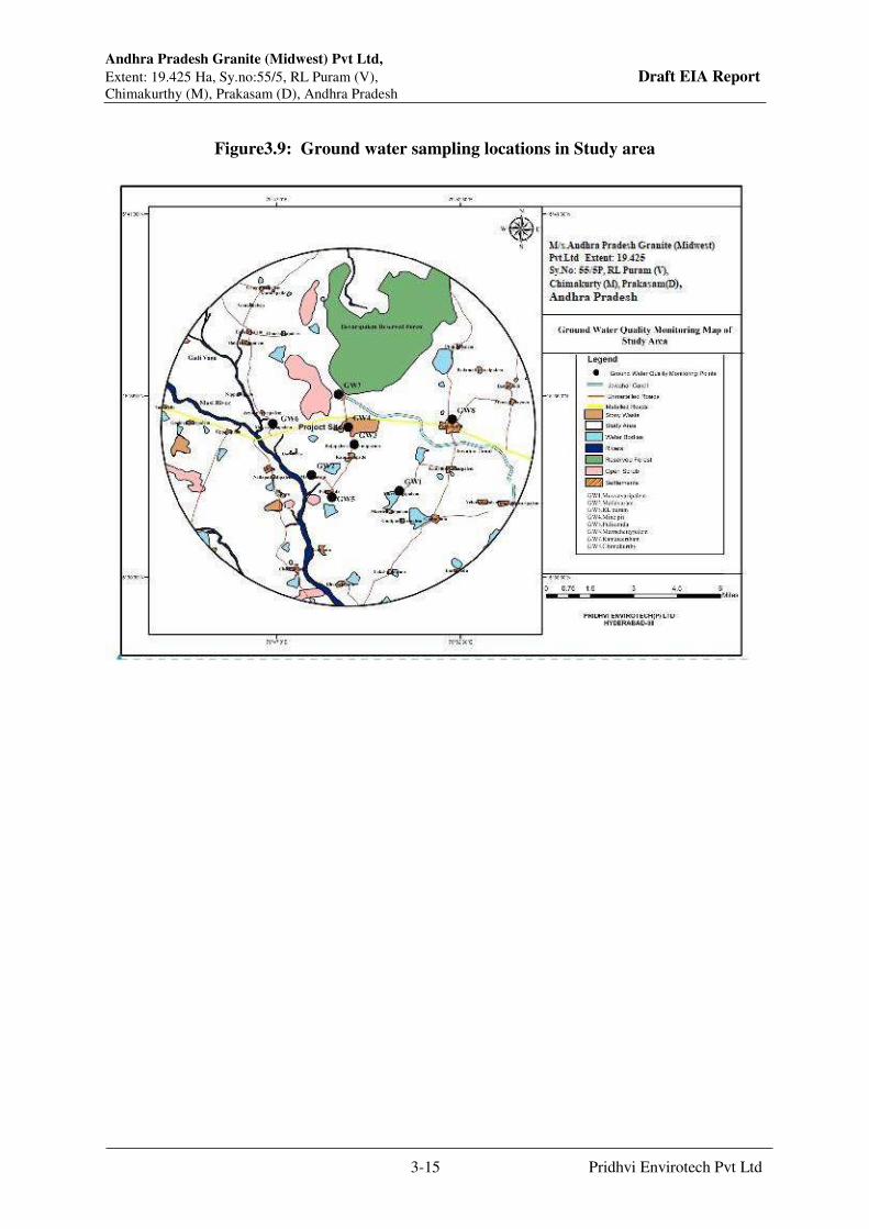
Andhra Pradesh Granite (Midwest) Pvt Ltd,
Extent: 19.425 Ha, Sy.no:55/5, RL Puram (V), Draft EIA Report Chimakurthy (M), Prakasam (D), Andhra Pradesh
3-15 Pridhvi Envirotech Pvt Ltd
Figure3.9: Ground water sampling locations in Study area
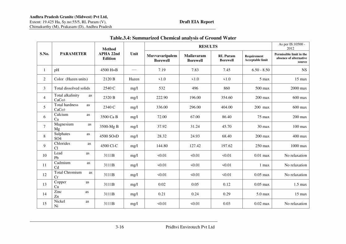
Andhra Pradesh Granite (Midwest) Pvt Ltd,
Extent: 19.425 Ha, Sy.no:55/5, RL Puram (V), Draft EIA Report Chimakurthy (M), Prakasam (D), Andhra Pradesh
3-16 Pridhvi Envirotech Pvt Ltd
Table.3.4: Summarized Chemical analysis of Ground Water
S.No. PARAMETER
Method
APHA 22nd
Edition
Unit
RESULTS As per IS:10500 -
2012
Muvvavaripalem
Borewell
Mailavaram
Borewell
RL Puram
Borewell
Requirement
Acceptable limit
Permissible limit in the
absence of alternative
source
1 pH 4500 H+B −− 7.19 7.83 7.45 6.50 - 8.50 NS
2 Color (Hazen units) 2120 B Hazen <1.0 <1.0 <1.0 5 max 15 max
3 Total dissolved solids 2540 C mg/l 532 496 860 500 max 2000 max
4 Total alkalinity as
CaCo3 2320 B mg/l 222.90 196.00 354.60 200 max 600 max
5 Total hardness as
CaCo3 2340 C mg/l 336.00 296.00 404.00 200 max 600 max
6 Calcium as
Ca 3500 Ca B mg/l 72.00 67.00 86.40 75 max 200 max
7 Magnesium as
Mg 3500-Mg B mg/l 37.92 31.24 45.70 30 max 100 max
8 Sulphates as
SO4 4500 SO4D mg/l 28.32 24.93 68.40 200 max 400 max
9 Chlorides as
Cl 4500 Cl-C mg/l 144.80 127.42 197.62 250 max 1000 max
10 Lead as
Pb 3111B mg/l <0.01 <0.01 <0.01 0.01 max No relaxation
11 Cadmium as
Cd 3111B mg/l <0.01 <0.01 <0.01 1 max No relaxation
12 Total Chromium as
Cr 3111B mg/l <0.01 <0.01 <0.01 0.05 max No relaxation
13 Copper as
Cu 3111B mg/l 0.02 0.05 0.12 0.05 max 1.5 max
14 Zinc as
Zn 3111B mg/l 0.21 0.24 0.29 5.0 max 15 max
15 Nickel as
Ni 3111B mg/l <0.01 <0.01 0.03 0.02 max No relaxation

Andhra Pradesh Granite (Midwest) Pvt Ltd,
Extent: 19.425 Ha, Sy.no:55/5, RL Puram (V), Draft EIA Report Chimakurthy (M), Prakasam (D), Andhra Pradesh
3-17 Pridhvi Envirotech Pvt Ltd
16 Flourides as F 4500 F-D mg/l 0.58 0.63 0.71 1.0 max 1.5 max
17 Aluminium as
Al 3500 Al B mg/l <0.02 <0.02 <0.02 0.03 max 0.2 max
18 Boron as B 4500 B B mg/l <0.10 <0.10 <0.10 0.5 max 1 max
19 Manganese as
Mn 3111 B mg/l <0.01 <0.01 <0.01 0.1 max 0.3 max
20 Iron as Fe 3500 Fe B mg/l 0.16 0.19 0.23 0.3 max No relaxation
21 Nitrates as
NO3 4500 NO3B mg/l 4.84 4.26 13.56 45 max No relaxation
22 Sodium as Na 3500 Na B mg/l 55.74 49.05 132.80 NS NS
23 Potassium as K 3500 K B mg/l 2.60 2.29 17.83 NS NS
24 Odour 2150 C −− Agreeable Agreeable Agreeable Agreeable Agreeable
25 E.C (micromhos/cm) 2510 B µmho/cm 921 810 1,431 NS NS
26 Phosphorus as P 4500 P B mg/l <0.10 <0.10 <0.10 NS NS
27 Carbonates as
CaCo3 2320 B mg/l Nil Nil Nil NS NS
28 Bicarbonates as
Hco3 2320 B mg/l 222.90 239.12 432.61 NS NS

Andhra Pradesh Granite (Midwest) Pvt Ltd,
Extent: 19.425 Ha, Sy.no:55/5, RL Puram (V), Draft EIA Report Chimakurthy (M), Prakasam (D), Andhra Pradesh
3-18 Pridhvi Envirotech Pvt Ltd
Table3.4: Summarized Chemical analysis of Ground Water
S.No. PARAMETER
Method
APHA 22nd
Edition
Unit
RESULTS As per IS:10500 - 2012
Mine
Pitwater
Borewell
Pulikonda
Borewell
Marrichettu
Palem
Borewell
Ramateerta
m Bore Well
Cheemakurthy
Borewell
Permissible limit
in the absence of
alternative
source
1 pH 4500 H+B −− 7.24 7.76 7.93 7.61 7.82 NS
2 Color (Hazen units) 2120 B Hazen <1.0 <1.0 <1.0 <1.0 <1.0 15 max
3 Total dissolved solids 2540 C mg/l 468 504 802 858 1371 2000 max
4 Total alkalinity as
CaCo3 2320 B mg/l 247.52 260.55 376.10 399.00 519.15 600 max
5 Total hardness as
CaCo3 2340 C mg/l 300.00 316.00 352.00 373.00 490.00 600 max
6 Calcium as Ca 3500 Ca B mg/l 68.80 67.20 72.00 76.30 96.00 200 max
7 Magnesium as Mg 3500-Mg B mg/l 31.11 35.97 41.80 44.30 60.76 100 max
8 Sulphates as SO4 4500 SO4D mg/l 55.58 58.50 86.60 91.80 94.51 400 max
9 Chlorides as Cl 4500 Cl-C mg/l 70.54 74.25 131.10 139 347.45 1000 max
10 Lead as Pb 3111B mg/l <0.01 <0.01 <0.01 <0.01 <0.01 No relaxation
11 Cadmium as Cd 3111B mg/l <0.01 <0.01 <0.01 <0.01 <0.01 No relaxation
12 Total Chromium as Cr 3111B mg/l <0.01 <0.01 <0.01 <0.01 <0.01 No relaxation
13 Copper as Cu 3111B mg/l 0.03 0.02 0.04 0.03 0.05 1.5 max
14 Zinc as Zn 3111B mg/l 0.07 0.05 0.08 0.06 0.10 15 max
15 Nickel as Ni 3111B mg/l <0.01 <0.01 <0.01 <0.01 <0.01 No relaxation

Andhra Pradesh Granite (Midwest) Pvt Ltd,
Extent: 19.425 Ha, Sy.no:55/5, RL Puram (V), Draft EIA Report Chimakurthy (M), Prakasam (D), Andhra Pradesh
3-19 Pridhvi Envirotech Pvt Ltd
16 Flourides as F 4500 F-D mg/l 0.71 0.62 0.80 0.83 0.91 1.5 max
17 Aluminium as Al 3500 Al B mg/l <0.01 <0.01 <0.01 <0.01 0.04 0.2 max
18 Boron as B 4500 B B mg/l <0.10 <0.10 <0.10 <0.10 <0.10 1 max
19 Manganese as Mn 3111 B mg/l <0.01 <0.01 <0.01 <0.01 0.05 0.3 max
20 Iron as Fe 3500 Fe B mg/l 0.15 0.13 0.17 0.14 0.21 No relaxation
21 Nitrates as NO3 4500 NO3B mg/l 5.51 5.80 8.60 9.12 18.48 No relaxation
22 Sodium as Na 3500 Na B mg/l 48.36 50.90 136.12 144.29 216.90 NS
23 Potassium as K 3500 K B mg/l 3.23 3.40 7.90 8.38 126.00 NS
24 Odour 2150 C −− Agreeable Agreeable Agreeable Agreeable Agreeable Agreeable
25 E.C (micromhos/cm) 2510 B µmho/cm 819 862 1,316 1,395 2,245 NS
26 Phosphorus as P 4500 P B mg/l <0.10 <0.10 <0.10 <0.10 0.46 NS
27 Carbonates as CaCo3
2320 B mg/l Nil Nil Nil Nil Nil NS
28 Bicarbonates as Hco3
2320 B mg/l 301.98 317.80 458.84 486.78 519.15 NS
Andhra Pradesh Granite (Midwest) Pvt Ltd,
Extent: 19.425 Ha, Sy.no:55/5, RL Puram (V), Draft EIA Report Chimakurthy (M), Prakasam (D), Andhra Pradesh
3-20 Pridhvi Envirotech Pvt Ltd
The results indicate that ground water is of average natural type with pH ranging from 7.19 to
7.93. Against desirable limit of 250 mg/l and permissible limit of 1000 m/l of Chloride, ground
water samples had a minimum of 70.5 mg/l and maximum of 347.4 mg/l indicating that ground
water is within the limits of good taste, its palatability is not affected. Total Hardness of ground
water ranged between 296 mg/l and 490 mg/l and is well within the limits of 300 – 600 mg/l
(permissible and acceptable levels). Total Dissolved Solids ranged from 468 mg/l to 1371 mg/l.
showing low salt content at all places well within the permissible ranges of 500 and 2000 mg/l
respectively. The low values are attributable to the dilution through good recharge from upper
terrain storm water flow. Ground water is found less mineralized with no harmful substances
and all the chemical constituents well within the suitable limits for drinking and all other
purposes.
3.9 Surface Water Quality
The AP Granite (Midwest) area lies within a local catchment area referred here Pulikonda
Watershed. The watershed is about 30 sq. km in areal extent, and forms part of the Musi river
catchment
Surface water samples were collected from 2 minor irrigation tanks i.e. Ramateertham reservoir
and Jawahar canal (Nagarjuna Sagar Canal). The map showing the surface water bodies is as
shown Figure 3.10.
Summarized results of chemical analysis of surface water samples are shown in the Table-3.5.
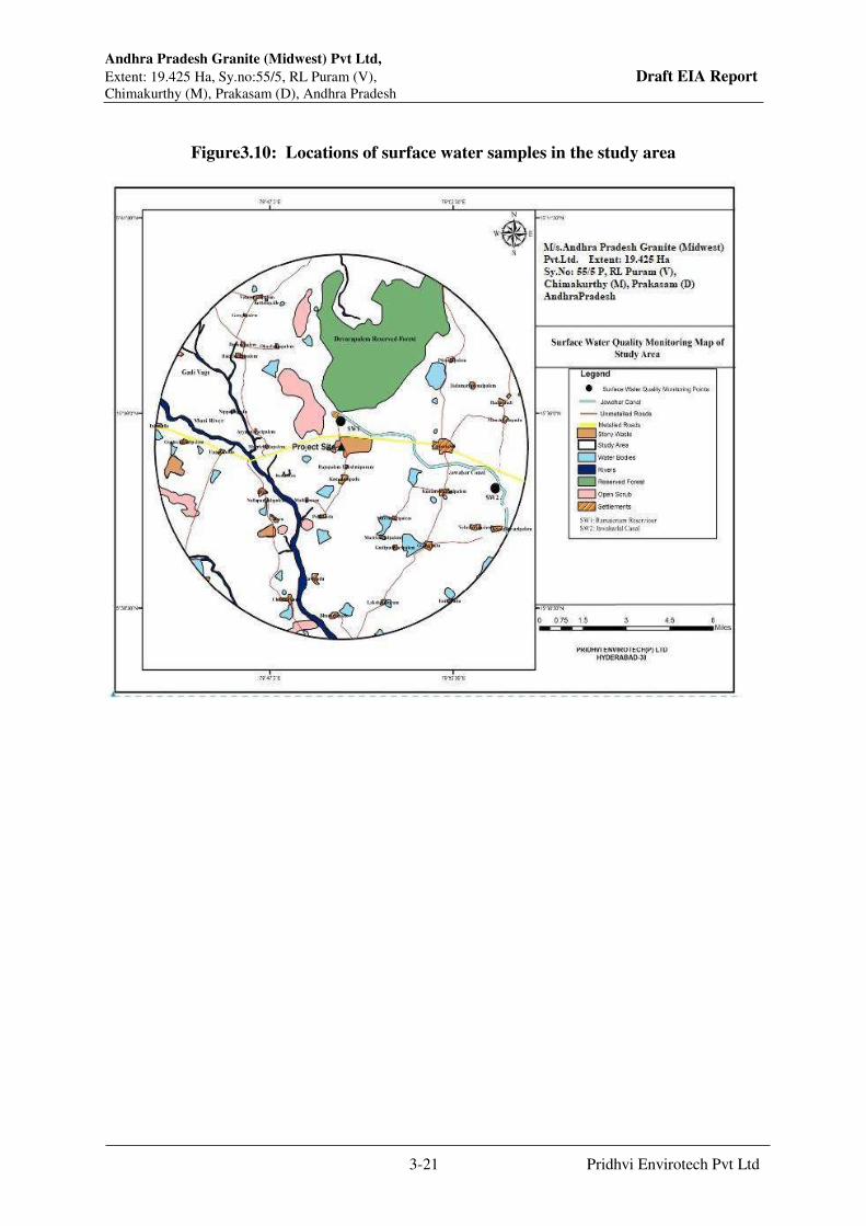
Andhra Pradesh Granite (Midwest) Pvt Ltd,
Extent: 19.425 Ha, Sy.no:55/5, RL Puram (V), Draft EIA Report Chimakurthy (M), Prakasam (D), Andhra Pradesh
3-21 Pridhvi Envirotech Pvt Ltd
Figure3.10: Locations of surface water samples in the study area

Andhra Pradesh Granite (Midwest) Pvt Ltd,
Extent: 19.425 Ha, Sy.no:55/5, RL Puram (V), Draft EIA Report Chimakurthy (M), Prakasam (D), Andhra Pradesh
3-22 Pridhvi Envirotech Pvt Ltd
Table3.5: Summarized Chemical Analysis of Surface Water
S.No. PARAMETER Method APHA
22nd Edition Unit
Ramateertham
Reservoir Jawaharlal Canal
1 pH 4500 H+B −− 8.26 8.39
2 Color (Hazen units) 2120 B Hazen <1.0 <1.0
3 Odour 2150 B −− Agreeable Agreeable
4 E.C (micromhos/cm) 2510 B µmho/cm 431 468.00
5 Dissolved Oxygen 4500-O C mg/l 5.30 4.90
6 Turbidity (NTU) 2130 B NTU <1.0 <1.0
7 Total Suspended Solids 2540 D mg/l <5.0 <5.0
8 Total dissolved solids 2540 C mg/l 242 263
9 Chemical Oxygen Demand 5220 B mg/l 8.0 6.0
10 Biochemical Oxygen Demand IS 3025
(Part-44) 2009 mg/l <1.0 <1.0
11 Total alkalinity as CaCo3 2320 B mg/l 97.70 106.20
12 Total hardness as CaCo3 2340 C mg/l 120 130
13 Calcium as Ca 3500 Ca B mg/l 26 28
14 Magnesium as Mg 3500-Mg B mg/l 13.37 14.59
15 Sulphates as SO4 4500 SO4D mg/l 16.78 18.24
16 Chlorides as Cl 4500 Cl-C mg/l 70.20 76.30
17 Lead as Pb 3111 B mg/l <0.01 <0.01
18 Cadmium as Cd 3111 B mg/l <0.01 <0.01

Andhra Pradesh Granite (Midwest) Pvt Ltd,
Extent: 19.425 Ha, Sy.no:55/5, RL Puram (V), Draft EIA Report Chimakurthy (M), Prakasam (D), Andhra Pradesh
3-23 Pridhvi Envirotech Pvt Ltd
19 Total Chromium as Cr 3111 B mg/l <0.05 <0.05
20 Copper as Cu 3111 B mg/l <0.01 <0.01
21 Zinc as Zn 3111 B mg/l <0.01 <0.01
22 Nickel as Ni 3111 B mg/l <0.01 <0.01
23 Flourides as F 4500 F-D mg/l 0.39 0.36
24 Aluminium as Al 3500 Al B mg/l <0.01 <0.01
25 Boron as B 4500 B B mg/l <0.10 <0.10
26 Manganese as Mn 3111 B mg/l <0.01 <0.01
27 Iron as Fe 3500 Fe B mg/l 0.14 0.11
28 Nitrates as NO3 4500 NO3B mg/l 1.50 1.62
29 Sodium as Na 3500 Na B mg/l 41.80 45.43
30 Potassium as K 3500 K B mg/l 3.78 4.10
31 Phosphorus as P 4500 P B mg/l <0.10 <0.10
32 Oil & Grease 5520 B mg/l <1.0 <1.0
33 Total Coliform IS 1622 MPN/100 ml Absent Absent
34 Feacal Coliform IS 1622 MPN/100 ml Absent Absent
35 Bicarbonates as Hco3 2320 B mg/l 119.20 129.56

Andhra Pradesh Granite (Midwest) Pvt Ltd,
Extent: 19.425 Ha, Sy.no:55/5, RL Puram (V), Draft EIA Report Chimakurthy (M), Prakasam (D), Andhra Pradesh
3-24 Pridhvi Envirotech Pvt Ltd
Surface water is found to be of poor quality in terms of odour (in two samples) and presence
of coliform bacteria (In all samples). The results indicate the water with pH ranging from 8.26
to 8.39 and fall in the average natural type pH range of 6.5 to 8.5. chlorides of the samples
ranges between 70.2mg/l and 76.3 mg/l. Total Hardness of ground water ranged between 120
mg/l and 130 mg/l and is well within the limits of 300 – 600 mg/l and Total Dissolved Solids
ranged from 242mg/l to 263 mg/l. The dissolved oxygen is varying between 4.90 to 5.30 mg/lit.
Overall the surface water quality in the region comes in the category B and C of IS 2296: 1982.
3.10 Soil Environment
The area is mostly covered by brownish red loamy soils. These soils are largely originated by
the granitic parental rock. The thickness of soils usually varies from 0.50 to 0.80 m. along the
river stream courses the alluvial soils are found. The area around the granite quarries is largely
unfit for agriculture as it is strewed with dust, mined out granitic blocks, boulders and rock
waste.
The Soil characteristics include both physical and chemical parameters. M/s. Pridhvi Enviro
tech (P) Limited field team carried out soil survey to assess the soil characteristics of the study
area. The soil sampling was done at representative locations and these locations are shown in
Figure 3.11.
Figure3.11: Soil Sampling Locations

Andhra Pradesh Granite (Midwest) Pvt Ltd,
Extent: 19.425 Ha, Sy.no:55/5, RL Puram (V), Draft EIA Report Chimakurthy (M), Prakasam (D), Andhra Pradesh
3-25 Pridhvi Envirotech Pvt Ltd
Table 3.6: Analytical data of Soil Samples
S.No. Parameters Unit
Chimakurthi
Soil
Project Site
Soil
1 pH (1:5 Soil water extract) 8.01 6.53
2 E.C (1:5 Soil water extract) µmhos/cm 840 890
3 Bulk Density g/cc 1.26 1.24
4 Moisture % 5.90 4.39
5 Nitrates as N kg/ha 90.50 86.20
6 Phosphorous as P kg/ha 28.60 25.40
7 Potassium as K+ kg/ha 73.10 67.60
8 Sodium as Na kg/ha 82.48 75.92
9 Calcium as Ca mg/kg 437.44 349.53
10 Magnesium as Mg2+ mg/kg 248.90 216.26
11 Sulphates as So4 mg/kg 699.40 839.28
12 Organic Carbon % 0.82 0.94
13 Texture
a) Sand % % 19.00 16.00
b) Silt % % 38.20 58.60
c) Clay % % 42.80 25.40
Type of Soil Clayee Sity Loan
14 Copper as Cu mg/kg 0.38 0.49
15 Zinc as Zn mg/kg 0.96 1.02
16 Lead as pb mg/kg 0.27 0.36
17 Cadmium as Cd mg/kg 0.14 0.11
18 Chromium as Cr mg/kg 0.05 0.03
19 Nickel as Ni mg/kg 0.12 0.15
20 Ca/ Mg Ratio 1.75 1.62
21 Cation Exchange Capacity (CEC) meq/kg 81.00 68.00
22 Base Saturation % 4.60 5.30
23 Total Nitrogen as N % 0.023 0.021
The analysis results of soil samples collected in the impact area are interpreted referring to the
book; “Interpreting soil test results”. The reference tables are presented in Table 3.7.
The pH of soil ranges from Neutral to moderately alkaline. The cation exchange capacity of
the soils is very high. The level of extractable potassium is low. The Ca/Mg ratio varies from
balanced to low. The total Nitrogen as N is low in the area. The base saturation of the samples
is predominantly very strongly leached. Bulk density of soil of impact varies from 1.24- 1.26
g/cc. Soil texture is predominantly Clayee and silty Loam.
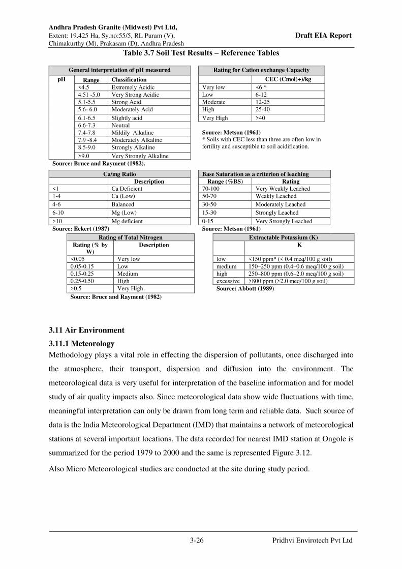
Andhra Pradesh Granite (Midwest) Pvt Ltd,
Extent: 19.425 Ha, Sy.no:55/5, RL Puram (V), Draft EIA Report Chimakurthy (M), Prakasam (D), Andhra Pradesh
3-26 Pridhvi Envirotech Pvt Ltd
Table 3.7 Soil Test Results – Reference Tables
General interpretation of pH measured Rating for Cation exchange Capacity
pH Range Classification CEC (Cmol)+)/kg
<4.5 Extremely Acidic Very low <6 *
4.51 -5.0 Very Strong Acidic Low 6-12
5.1-5.5 Strong Acid Moderate 12-25
5.6- 6.0 Moderately Acid High 25-40
6.1-6.5 Slightly acid Very High >40
6.6-7.3 Neutral
Source: Metson (1961) * Soils with CEC less than three are often low in
fertility and susceptible to soil acidification.
7.4-7.8 Mildily Alkaline
7.9 -8.4 Moderately Alkaline
8.5-9.0 Strongly Alkaline
>9.0 Very Strongly Alkaline
Source: Bruce and Rayment (1982).
Ca/mg Ratio Base Saturation as a criterion of leaching
Description Range (%BS) Rating
<1 Ca Deficient 70-100 Very Weakly Leached
1-4 Ca (Low) 50-70 Weakly Leached
4-6 Balanced 30-50 Moderately Leached
6-10 Mg (Low) 15-30 Strongly Leached
>10 Mg deficient 0-15 Very Strongly Leached
Source: Eckert (1987) Source: Metson (1961)
Rating of Total Nitrogen Extractable Potassium (K)
Rating (% by
W)
Description K
<0.05 Very low low <150 ppm* (< 0.4 meq/100 g soil)
0.05-0.15 Low medium 150–250 ppm (0.4–0.6 meq/100 g soil)
0.15-0.25 Medium high 250–800 ppm (0.6–2.0 meq/100 g soil)
0.25-0.50 High excessive >800 ppm (>2.0 meq/100 g soil)
>0.5 Very High Source: Abbott (1989)
Source: Bruce and Rayment (1982)
3.11 Air Environment
3.11.1 Meteorology
Methodology plays a vital role in effecting the dispersion of pollutants, once discharged into
the atmosphere, their transport, dispersion and diffusion into the environment. The
meteorological data is very useful for interpretation of the baseline information and for model
study of air quality impacts also. Since meteorological data show wide fluctuations with time,
meaningful interpretation can only be drawn from long term and reliable data. Such source of
data is the India Meteorological Department (IMD) that maintains a network of meteorological
stations at several important locations. The data recorded for nearest IMD station at Ongole is
summarized for the period 1979 to 2000 and the same is represented Figure 3.12.
Also Micro Meteorological studies are conducted at the site during study period.
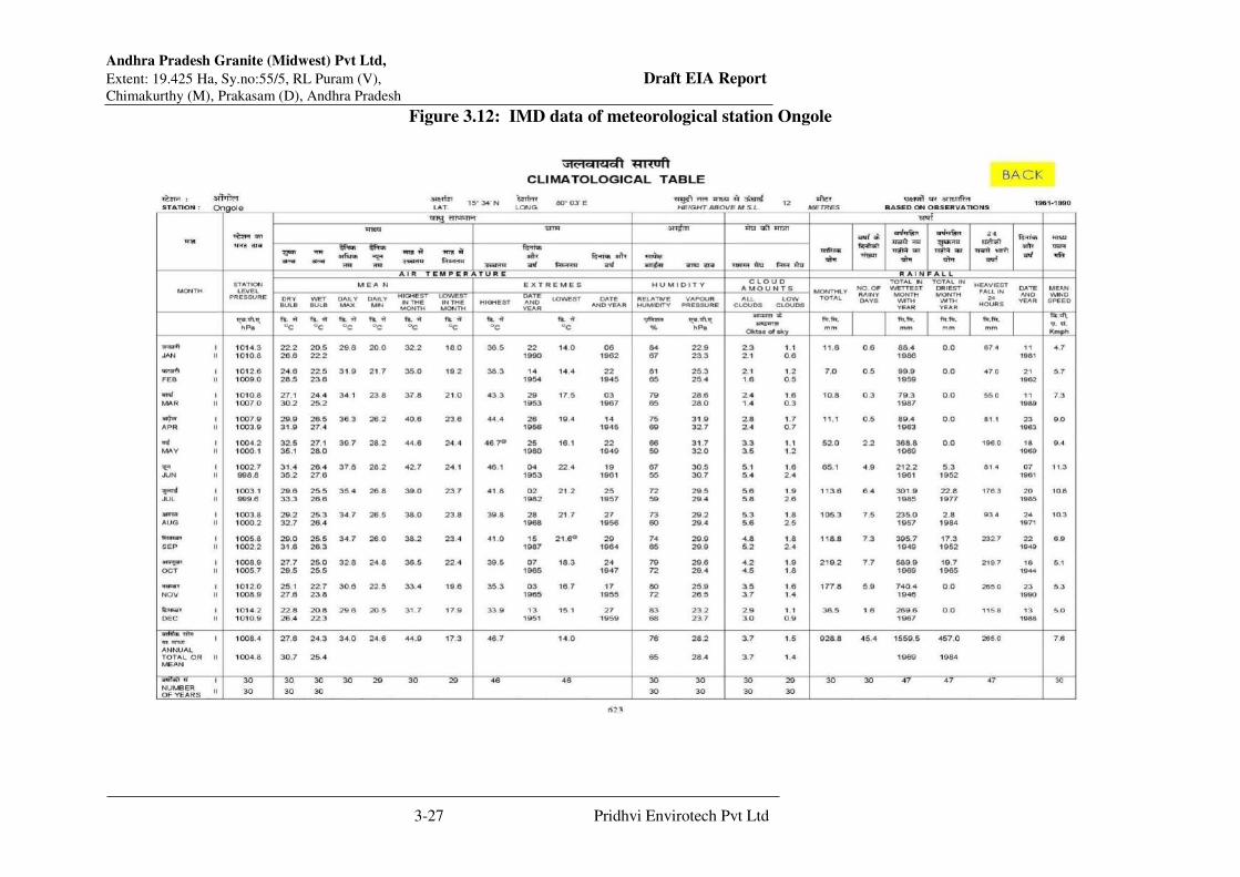
Andhra Pradesh Granite (Midwest) Pvt Ltd,
Extent: 19.425 Ha, Sy.no:55/5, RL Puram (V), Draft EIA Report Chimakurthy (M), Prakasam (D), Andhra Pradesh
3-27 Pridhvi Envirotech Pvt Ltd
Figure 3.12: IMD data of meteorological station Ongole
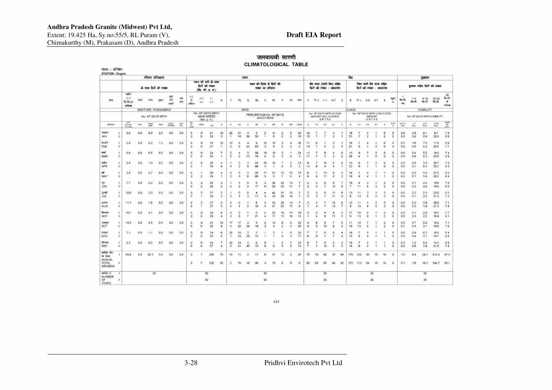
Andhra Pradesh Granite (Midwest) Pvt Ltd,
Extent: 19.425 Ha, Sy.no:55/5, RL Puram (V), Draft EIA Report Chimakurthy (M), Prakasam (D), Andhra Pradesh
3-28 Pridhvi Envirotech Pvt Ltd

Andhra Pradesh Granite (Midwest) Pvt Ltd,
Extent: 19.425 Ha, Sy.no:55/5, RL Puram (V), Draft EIA Report Chimakurthy (M), Prakasam (D), Andhra Pradesh
3-29 Pridhvi Envirotech Pvt Ltd
3.11.2 Meteorological Station at Industry Site The micro meteorological data in the area is collected simultaneously with the ambient air
quality monitoring. The station was installed in such a way that there are no obstructions for
free flow of wind. Wind speed, wind direction, humidity &temperature are recorded on hourly
basis in the study period. Salient features of micro meteorological data collected are as follows:
Wind Direction and Speed
The hourly wind speed and wind direction observations are computed during the seasons of
study period and the same are presented in Table 3.8and the wind rose diagrams are presented
in Figure 3.13. The following observations can be made from the collected data;
The predominant wind direction is SE.
Calm period is observed to be 31.99% during the time of monitoring.
Mostly the wind speeds are observed to be in the range of 0 – 32 m/s.
The maximum and minimum temperature and relative humidity and total seasonal rainfall are
summarized in below table. The salient features are discussed in brief as follows.
Temperature:
(a) Maximum: 43.50C, (b) Minimum: 15.0 0C and (c) Average: 29.3oC during study period
from micro meteorological station
Humidity:
The daily relative humidity values are observed to range between 7.1 – 97.1%. During study
period from micro meteorological station

Andhra Pradesh Granite (Midwest) Pvt Ltd,
Extent: 19.425 Ha, Sy.no:55/5, RL Puram (V), Draft EIA Report Chimakurthy (M), Prakasam (D), Andhra Pradesh
3-30 Pridhvi Envirotech Pvt Ltd
Table 3.8: Frequency Distribution of Wind Speeds and Wind Directions
S.no Directions /
Wind
Classes
(m/s)
0.5 - 2.1 2.1 -
3.6
3.6 -
5.7
5.7 -
8.8
8.8 -
11.1
>= 11.1 Total
(%)
1 N 0.54 0.05 0.18 0.45 0.23 0.45 1.90
2 NNE 0.05 0.18 0.18 0.14 0.18 0.32 1.04
3 NE 0.32 0.14 0.32 0.91 0.82 2.54 5.03
4 ENE 0.82 0.73 0.23 0.45 0.63 0.82 3.67
5 E 0.50 0.54 0.23 0.73 0.27 0.86 3.13
6 ESE 0.95 0.23 0.45 0.82 0.54 1.59 4.58
7 SE 5.76 1.32 0.86 0.91 1.18 2.40 12.42
8 SSE 2.99 0.41 0.63 0.95 0.91 2.72 8.61
9 S 1.00 0.09 0.27 0.23 0.63 1.45 3.67
10 SSW 1.59 0.23 0.09 0.32 0.50 0.54 3.26
11 SW 1.09 0.86 0.05 0.45 0.09 0.45 2.99
12 WSW 2.81 0.36 0.05 0.36 0.18 0.59 4.35
13 W 1.04 0.32 0.18 0.45 0.00 0.86 2.85
14 WNW 0.27 0.09 0.27 0.27 0.50 0.73 2.13
15 NW 2.95 0.45 0.32 0.27 0.50 0.91 5.39
16 NNW 1.59 0.27 0.14 0.32 0.14 0.45 2.90
Sub-Total 24.24 6.25 4.44 8.02 7.29 17.67 67.92
Calms 31.99
Missing/Incomplete 0.09
Total 100
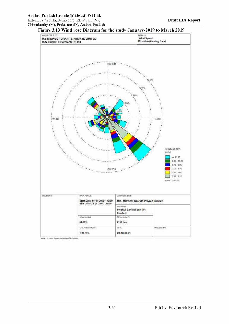
Andhra Pradesh Granite (Midwest) Pvt Ltd,
Extent: 19.425 Ha, Sy.no:55/5, RL Puram (V), Draft EIA Report Chimakurthy (M), Prakasam (D), Andhra Pradesh
3-31 Pridhvi Envirotech Pvt Ltd
Figure 3.13 Wind rose Diagram for the study January-2019 to March 2019
Andhra Pradesh Granite (Midwest) Pvt Ltd,
Extent: 19.425 Ha, Sy.no:55/5, RL Puram (V), Draft EIA Report Chimakurthy (M), Prakasam (D), Andhra Pradesh
3-32 Pridhvi Envirotech Pvt Ltd
3.11.3 Ambient Air Quality
Air pollution means the presence of one or more contaminants or combinations thereof in such
quantities and of such duration as are or may tend to be injurious to human, plant or animal life
or property. Air pollutants include smoke, vapors, soot, fumes, gases, mist, odors, particulate
matter, radioactive material or noxious chemicals. With increasing industrial activity a range
of different pollutants are released into the atmosphere that are dispersed and can have a
significant impact on neighborhood air environment. Thus, collection of base line data of air
environment occupies a predominant role in the impact assessment statement. The ambient air
quality status across the study zone forms basis for prediction of, the impacts due to the
proposed project.
The data required to assess air quality impacts in and around neighborhood is achieved by
designing such a network, which encompasses micro meteorological conditions, quantity and
quality of emissions, locations, duration, resources/monitoring technology and operational
criteria. The optimal scheme for air quality monitoring should consider all the above factors.
3.11.4 Scope of Field Study
The scope of baseline status of the ambient air quality can be accessed through a well-designed
ambient air quality stations network. An intensive ambient air quality monitoring of the study
area consisting of 10 km. radius from the site was carried out during the period from January
2019-March 2019.As AP Midwest Pvt Ltd are going for Production Enhancement activity. The
ambient air quality was monitored at 8locations spread over entire study area. Figure 3.16
presents the locations of ambient air quality-monitoring stations. At each sampling station
monitoring was carried out for 24 hours in a day for 2 days a week, and for three months. The
major air pollutants monitored on 24 hourly basis are, PM10, PM2.5, Carbon Monoxide, Sulfur
dioxide and Oxides of Nitrogen. Sampling and analysis of the above variables is according to
the guidelines of Central Pollution Control Board.
3.11.5 Description of Sampling Locations
The location of ambient air quality stations is contingent on the meteorological status of the
area. Hence, the micro meteorological data was collected before initiating the ambient air
quality monitoring. Table 3.9 presents the ambient air quality locations and their distances and
directions from the plant site.

Andhra Pradesh Granite (Midwest) Pvt Ltd,
Extent: 19.425 Ha, Sy.no:55/5, RL Puram (V), Draft EIA Report Chimakurthy (M), Prakasam (D), Andhra Pradesh
3-33 Pridhvi Envirotech Pvt Ltd
Table 3.9: Locations of Ambient Air Quality Monitoring Stations
S.
No Location Name
Directi
on
Distan
ce
Wind
Frequenc
y
Latitude Longitude
1 Mine Site -- -- -- N 150 35 10.60” E 790 49’37.33”
2 RL Puram SW 1.5 Down N 150 34 32.87” E 790 49’12.52”
3 Puli konda SW 4.3 Down N 150 33 09.46” E 790 48’27.97”
4 Chimakurthy East 3.5 Cross N 150 35 10.82” E 790 51’52.03”
5 Ramathirtham NW 2.0 Down N 150 35 27.07” E 790 49’00.49”
6 Marri chetlapalem NW 4.5 Down N 150 34 52.31” E 790 46’44.98”
7 Ayyapavaripalem NW 5.7 Down N 150 35 30.28” E 790 46’39.37”
8 Muvvavaripalem SE 3.7 UP N 150 33 11.24” E 790 50’39.31”
3.11.6 Ambient Air Quality Status
The existing baseline levels with respect to Particulate Matter (Size Less than 10µm) or PM10
µg/m3, Particulate Matter (Size Less than 2.5µm) or PM2.5, Sulphur dioxide, oxides of
nitrogen, VOC and CO at 8 locations and ambient air quality status are presented in Table 3.10
Table 3.10: Ambient Air Quality Status
(24 hourly)(Unit;µg/m3)(VOC &CO-ppm)
Pollutant Maximum Minimum Mean 98%
1) Location: Mine Site
PM1 0 92.5 83.2 88.2 92.0
PM2 .5 48.8 28.5 36.0 47.1
SO2 18.2 13.3 15.5 17.7
NOx 28.5 15.2 19.0 25.2
VOC 3.6 2.0 2.7 3.4
CO 2.3 1.2 1.8 2.3
2) Location: RL Puram
PM1 0 85.3 60.3 69.7 80.65
PM2 .5 40.5 20.1 24.9 35.44
SO2 15.4 11.2 13.3 15.3
NOx 20.2 13.4 16.6 19.4
VOC 3.1 1.2 2.2 3.0
CO 2.3 1.2 1.7 2.3
3) Location: Puli Konda
PM1 0 72.3 63.2 67.7 71.5
PM2 .5 30.2 20.2 25.8 30.2
SO2 16.4 10.2 12.2 15.9
NOx 19.4 14.3 16.4 19.0
VOC 3.1 1.4 2.3 3.1
CO 2.2 1.2 1.8 2.2
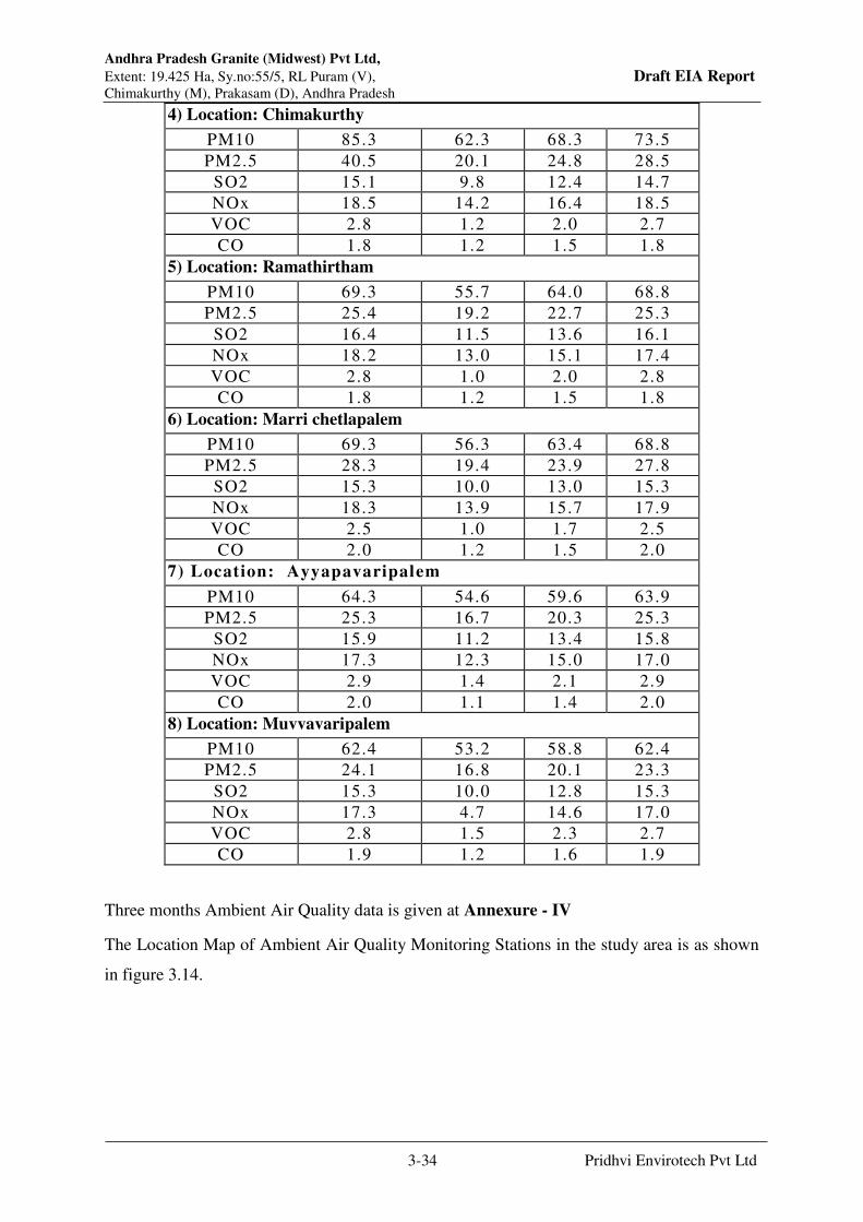
Andhra Pradesh Granite (Midwest) Pvt Ltd,
Extent: 19.425 Ha, Sy.no:55/5, RL Puram (V), Draft EIA Report Chimakurthy (M), Prakasam (D), Andhra Pradesh
3-34 Pridhvi Envirotech Pvt Ltd
4) Location: Chimakurthy
PM10 85.3 62.3 68.3 73.5
PM2.5 40.5 20.1 24.8 28.5
SO2 15.1 9.8 12.4 14.7
NOx 18.5 14.2 16.4 18.5
VOC 2.8 1.2 2.0 2.7
CO 1.8 1.2 1.5 1.8
5) Location: Ramathirtham
PM10 69.3 55.7 64.0 68.8
PM2.5 25.4 19.2 22.7 25.3
SO2 16.4 11.5 13.6 16.1
NOx 18.2 13.0 15.1 17.4
VOC 2.8 1.0 2.0 2.8
CO 1.8 1.2 1.5 1.8
6) Location: Marri chetlapalem
PM10 69.3 56.3 63.4 68.8
PM2.5 28.3 19.4 23.9 27.8
SO2 15.3 10.0 13.0 15.3
NOx 18.3 13.9 15.7 17.9
VOC 2.5 1.0 1.7 2.5
CO 2.0 1.2 1.5 2.0
7) Location: Ayyapavaripalem
PM10 64.3 54.6 59.6 63.9
PM2.5 25.3 16.7 20.3 25.3
SO2 15.9 11.2 13.4 15.8
NOx 17.3 12.3 15.0 17.0
VOC 2.9 1.4 2.1 2.9
CO 2.0 1.1 1.4 2.0
8) Location: Muvvavaripalem
PM10 62.4 53.2 58.8 62.4
PM2.5 24.1 16.8 20.1 23.3
SO2 15.3 10.0 12.8 15.3
NOx 17.3 4.7 14.6 17.0
VOC 2.8 1.5 2.3 2.7
CO 1.9 1.2 1.6 1.9
Three months Ambient Air Quality data is given at Annexure - IV
The Location Map of Ambient Air Quality Monitoring Stations in the study area is as shown
in figure 3.14.

Andhra Pradesh Granite (Midwest) Pvt Ltd,
Extent: 19.425 Ha, Sy.no:55/5, RL Puram (V), Draft EIA Report Chimakurthy (M), Prakasam (D), Andhra Pradesh
3-35 Pridhvi Envirotech Pvt Ltd
Figure 3.14: Location Map of Ambient Air Quality Monitoring Stations
3.11.7 Noise Environment
Noise is an unwanted sound without musical quality.Artificial noise and its impact on
environment, grown apace with advancing human civilization. Noise pollution is equally
hazardous to environment as air, water and other forms of pollution. Various noise
measurement units have been introduced to describe, in a single number, the response of an
average human to a complex sound made up of various frequencies at different loudness levels.
The most common scale is, weighted decibel dB (A), measured as the relative intensity level
of one sound with respect to another sound (reference sound).
The noise monitoring locations and their directions with respect to the project site are given in
Table 3.11. And Location Map for Noise Monitoring stations is presented in Fig 3.14.

Andhra Pradesh Granite (Midwest) Pvt Ltd,
Extent: 19.425 Ha, Sy.no:55/5, RL Puram (V), Draft EIA Report Chimakurthy (M), Prakasam (D), Andhra Pradesh
3-36 Pridhvi Envirotech Pvt Ltd
Table No.3.11: Noise Monitoring Locations
S.
No Location Name
Directi
on
Distan
ce
Wind
Frequenc
y
Latitude Longitude
1 Mine Site -- -- -- N 150 35 10.60” E 790 49’37.33”
2 RL Puram SW 1.5 Down N 150 34 32.87” E 790 49’12.52”
3 Puli konda SW 4.3 Down N 150 33 09.46” E 790 48’27.97”
4 Chimakurthy East 3.5 Cross N 150 35 10.82” E 790 51’52.03”
5 Ramathirtham NW 2.0 Down N 150 35 27.07” E 790 49’00.49”
6 Marri chetlapalem NW 4.5 Down N 150 34 52.31” E 790 46’44.98”
7 Ayyapavaripalem NW 5.7 Down N 150 35 30.28” E 790 46’39.37”
8 Muvavaripalem SE 3.7 UP N 150 33 11.24” E 790 50’39.31”
Figure 3.15 Location Map for Noise Monitoring stations

Andhra Pradesh Granite (Midwest) Pvt Ltd,
Extent: 19.425 Ha, Sy.no:55/5, RL Puram (V), Draft EIA Report Chimakurthy (M), Prakasam (D), Andhra Pradesh
3-37 Pridhvi Envirotech Pvt Ltd
The impact of noise depends on its characteristics (instantaneous, intermittent or continuous in
nature), time of day (day or night) and location of noise source. Table 3.13 shows the effects
of different noise levels on human beings. The environmental impact of noise can have several
effects varying from noise induced hearing loss to annoying depending on noise levels.
The assessment of noise pollution on neighborhood environment due to the proposed industry
was carried out keeping in view, all the considerations mentioned above. The existing status of
noise levels is measured at 8 locations at various villages including the site within the study
area. Figure 3.14 shows noise level measured locations. The measured noise values are shown
in Table 3.13. Noise levels are high at the urban traffic junctions compared to the industrial
and village areas.
Table 3.12: Effects on Human Beings at Different Noise Levels
Source Noise Level
dB(A)
Effects
Large Rocket Engine (Near By) 180 Threshold of Pains
Hydraulic Press (1m) 130
Jet take off (60 m) 120 Maximum vocal effort possible
Automobile Horn (1m) 120
Construction Noise (3m) 110
Shout, Punch, Press, Circular
Saw
100 Very annoying
Heavy Truck (15m), Farm
Machinery
90 Prolonged exposure Endangers
Lathes, Sports Car, Noisy
Machines hearing loss
Automobile (15m) 80 Annoying
Loud Conversations 60
Living Room in Home 50 Quiet
Power Station (15m) 50
Bed Room in Home 40
Tick of Wall clock (1m) 30
Whisper 20
Rattling of Leaves by Breeze 10 Barely audible

Andhra Pradesh Granite (Midwest) Pvt Ltd,
Extent: 19.425 Ha, Sy.no:55/5, RL Puram (V), Draft EIA Report Chimakurthy (M), Prakasam (D), Andhra Pradesh
3-38 Pridhvi Envirotech Pvt Ltd
Table 3.13: Equivalent Noise levels in the Study Area
3.11.8 Observations of Noise Levels
The noise data reveals that the values were well within the standards. In the study area
maximum value 71.2 dB (A) was observed at Mine site and minimum value 33.1 dB (A) was
observed at Ramathirtham village. The higher noise levels in the Mine area is due to the Mining
operation and allied activities. All remaining stations are under rural (Residential) Category
and all the noise levels are well within the CPCB prescribed standards as shown in Table 3.14.
Table 3.14: Ambient Noise Standards
Area Code Category of Area/Zone Limits in dB(A) Leq*
Day Time Night Time
A Industrial Area 75 70
B Commercial Area 65 55
C Residential Area 55 45
D Silence Zone 50 40
Time N1 N2 N3 N2 N5 N6 N7 N8
6:00:00 AM 59.3 50.9 42.9 52.2 37.1 40.9 43.8 44.5
7:00:00 AM 61.4 49.1 44.9 50.5 38.8 42.8 46.3 47.0
8:00:00 AM 64.3 44.2 49.9 45.4 41.4 45.7 51.1 51.8
9:00:00 AM 65.4 52.7 53.1 54.3 44.1 52.8 50.0 50.8
10:00:00 AM 68.7 50.9 55.1 52.4 46.9 51.7 53.1 53.9
11:00:00 AM 65.3 56.0 54.2 57.6 46.5 51.3 53.2 54.0
12:00:00 PM 70.4 56.8 53.1 58.6 48.7 53.7 53.1 53.9
1:00:00 PM 65.5 52.7 52.3 54.6 41.5 49.2 51.1 51.8
2:00:00 PM 63.4 49.7 49.9 51.2 46.1 50.8 50.0 50.8
3:00:00 PM 69.3 48.9 47.9 50.4 36.9 49.8 52.0 52.7
4:00:00 PM 64.5 59.2 54.0 61.0 43.7 51.7 48.9 49.7
5:00:00 PM 69.3 50.7 54.2 52.3 44.5 50.8 45.9 46.6
6:00:00 PM 71.2 50.4 53.4 52.2 39.4 46.7 50.9 51.6
7:00:00 PM 67.3 51.0 51.6 52.6 36.8 43.6 49.9 50.7
8:00:00 PM 64.3 48.9 49.0 50.8 35.0 42.5 45.9 46.6
9:00:00 PM 63.3 44.2 46.4 45.8 33.4 41.1 40.8 41.4
10:00:00 PM 57.3 42.9 43.8 44.4 33.4 41.6 39.8 40.4
11:00:00 PM 56.7 45.2 43.3 46.9 33.1 41.2 42.0 42.7
12:00:00 AM 59.2 43.4 41.8 45.0 35.9 44.7 41.1 41.7
1:00:00 AM 58.3 41.5 43.2 42.9 35.0 43.6 42.1 42.8
2:00:00 AM 60.3 43.0 41.4 44.4 37.3 43.1 41.1 41.7
3:00:00 AM 62.3 43.8 43.9 45.1 38.3 42.2 43.2 43.9
4:00:00 AM 61.4 50.3 42.0 51.9 37.4 40.8 41.4 42.0
5:00:00 AM 62.3 52.9 43.8 55.9 34.9 42.7 40.0 40.6
Min 56.7 41.5 41.4 42.9 33.1 40.8 39.8 40.4
Max 71.2 59.2 55.1 61.0 48.7 53.7 53.2 54.0
Ld 66.9 52.8 51.9 54.5 43.4 49.6 50.2 51.0
Ln 60.2 47.4 43.0 49.6 36.0 42.7 41.5 42.1
Andhra Pradesh Granite (Midwest) Pvt Ltd,
Extent: 19.425 Ha, Sy.no:55/5, RL Puram (V), Draft EIA Report Chimakurthy (M), Prakasam (D), Andhra Pradesh
3-39 Pridhvi Envirotech Pvt Ltd
3.12 Traffic Studies
The major road access to the site is kutcha road which is connecting to the Ongole –Kurnool
state highway which is 0.3 Kms from the mine site. Traffic study is conducted on the ongole –
Kurnool state highway near the mine site on 10th and 11th September, 2021 and data is
presented in the table. The total volume of traffic on both directions on this double-lane road
is 2505 PCUs/Day. As per the IRC code 64-1990 Guidelines for capacity of the double lane
road in plane area is 15000 PCUs/day.Table-3.15 shows traffic data of Ongole –Kurnool state
highway.
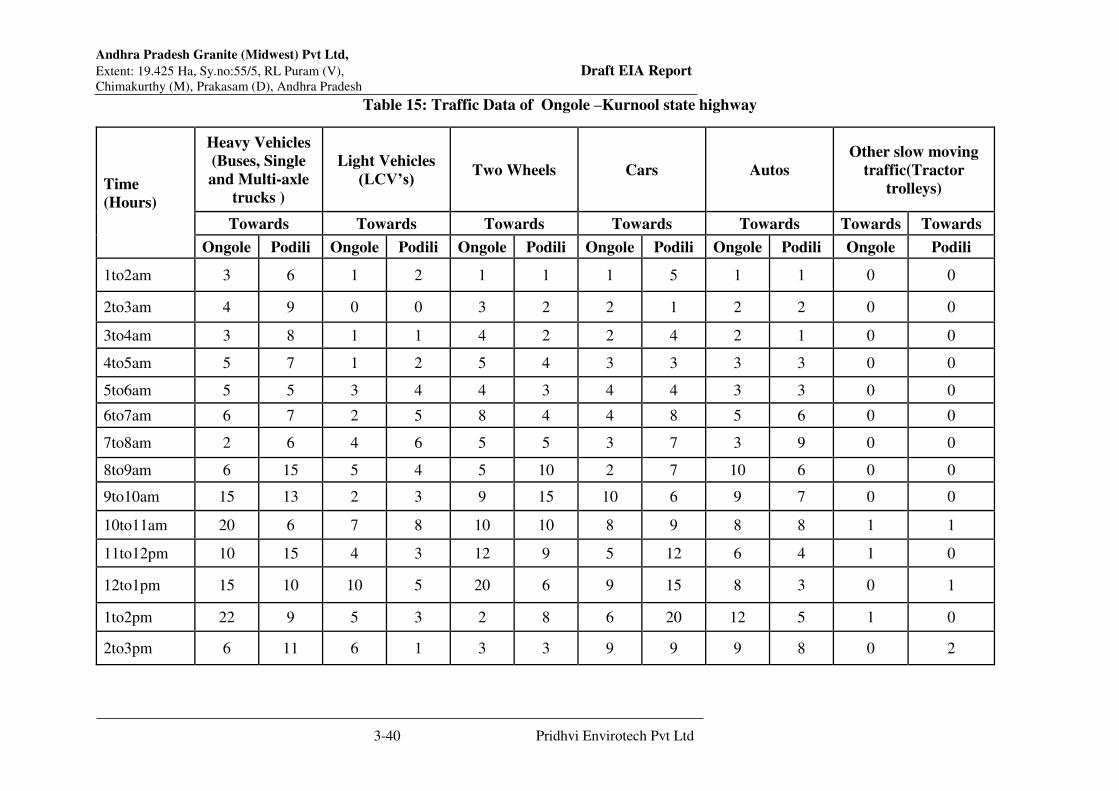
Andhra Pradesh Granite (Midwest) Pvt Ltd,
Extent: 19.425 Ha, Sy.no:55/5, RL Puram (V), Draft EIA Report Chimakurthy (M), Prakasam (D), Andhra Pradesh
3-40 Pridhvi Envirotech Pvt Ltd
Table 15: Traffic Data of Ongole –Kurnool state highway
Time
(Hours)
Heavy Vehicles
(Buses, Single
and Multi-axle
trucks )
Light Vehicles
(LCV’s) Two Wheels Cars Autos
Other slow moving
traffic(Tractor
trolleys)
Towards Towards Towards Towards Towards Towards Towards
Ongole Podili Ongole Podili Ongole Podili Ongole Podili Ongole Podili Ongole Podili
1to2am 3 6 1 2 1 1 1 5 1 1 0 0
2to3am 4 9 0 0 3 2 2 1 2 2 0 0
3to4am 3 8 1 1 4 2 2 4 2 1 0 0
4to5am 5 7 1 2 5 4 3 3 3 3 0 0
5to6am 5 5 3 4 4 3 4 4 3 3 0 0
6to7am 6 7 2 5 8 4 4 8 5 6 0 0
7to8am 2 6 4 6 5 5 3 7 3 9 0 0
8to9am 6 15 5 4 5 10 2 7 10 6 0 0
9to10am 15 13 2 3 9 15 10 6 9 7 0 0
10to11am 20 6 7 8 10 10 8 9 8 8 1 1
11to12pm 10 15 4 3 12 9 5 12 6 4 1 0
12to1pm 15 10 10 5 20 6 9 15 8 3 0 1
1to2pm 22 9 5 3 2 8 6 20 12 5 1 0
2to3pm 6 11 6 1 3 3 9 9 9 8 0 2
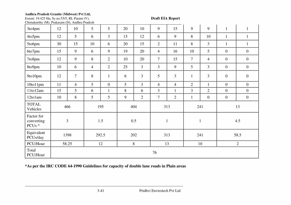
Andhra Pradesh Granite (Midwest) Pvt Ltd,
Extent: 19.425 Ha, Sy.no:55/5, RL Puram (V), Draft EIA Report Chimakurthy (M), Prakasam (D), Andhra Pradesh
3-41 Pridhvi Envirotech Pvt Ltd
3to4pm 12 10 5 5 20 10 9 15 9 9 1 1
4to5pm 12 5 6 3 15 12 6 9 8 10 1 1
5to6pm 30 15 10 6 20 15 2 11 8 3 1 1
6to7pm 15 9 6 9 19 20 4 16 10 5 0 0
7to8pm 12 9 8 2 10 20 7 15 7 4 0 0
8to9pm 10 6 4 2 25 3 3 9 5 3 0 0
9to10pm 12 7 8 1 6 3 5 3 1 3 0 0
10to11pm 11 4 5 0 5 3 4 4 2 1 0 0
11to12am 15 5 6 1 8 6 3 1 3 2 0 0
12to1am 10 8 5 5 9 2 7 2 1 0 0 0
TOTAL
Vehicles 466 195 404 313 241 13
Factor for
converting
PCUs *
3 1.5 0.5 1 1 4.5
Equivalent
PCUs/day 1398 292.5 202 313 241 58.5
PCU/Hour 58.25 12 8 13 10 2
Total
PCU/Hour 76
*As per the IRC CODE 64-1990 Guidelines for capacity of double lane roads in Plain areas
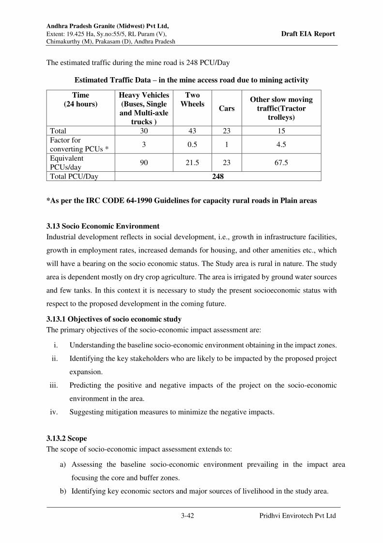
Andhra Pradesh Granite (Midwest) Pvt Ltd,
Extent: 19.425 Ha, Sy.no:55/5, RL Puram (V), Draft EIA Report Chimakurthy (M), Prakasam (D), Andhra Pradesh
3-42 Pridhvi Envirotech Pvt Ltd
The estimated traffic during the mine road is 248 PCU/Day
Estimated Traffic Data – in the mine access road due to mining activity
Time
(24 hours)
Heavy Vehicles
(Buses, Single
and Multi-axle
trucks )
Two
Wheels Cars
Other slow moving
traffic(Tractor
trolleys)
Total 30 43 23 15
Factor for
converting PCUs * 3 0.5 1 4.5
Equivalent
PCUs/day 90 21.5 23 67.5
Total PCU/Day 248
*As per the IRC CODE 64-1990 Guidelines for capacity rural roads in Plain areas
3.13 Socio Economic Environment
Industrial development reflects in social development, i.e., growth in infrastructure facilities,
growth in employment rates, increased demands for housing, and other amenities etc., which
will have a bearing on the socio economic status. The Study area is rural in nature. The study
area is dependent mostly on dry crop agriculture. The area is irrigated by ground water sources
and few tanks. In this context it is necessary to study the present socioeconomic status with
respect to the proposed development in the coming future.
3.13.1 Objectives of socio economic study
The primary objectives of the socio-economic impact assessment are:
i. Understanding the baseline socio-economic environment obtaining in the impact zones.
ii. Identifying the key stakeholders who are likely to be impacted by the proposed project
expansion.
iii. Predicting the positive and negative impacts of the project on the socio-economic
environment in the area.
iv. Suggesting mitigation measures to minimize the negative impacts.
3.13.2 Scope
The scope of socio-economic impact assessment extends to:
a) Assessing the baseline socio-economic environment prevailing in the impact area
focusing the core and buffer zones.
b) Identifying key economic sectors and major sources of livelihood in the study area.

Andhra Pradesh Granite (Midwest) Pvt Ltd,
Extent: 19.425 Ha, Sy.no:55/5, RL Puram (V), Draft EIA Report Chimakurthy (M), Prakasam (D), Andhra Pradesh
3-43 Pridhvi Envirotech Pvt Ltd
c) Understanding social structures and lifestyles of people who are likely to be affected the
most.
d) Assessing physical and social infrastructure facilities accessible to the project affected
people.
e) Identifying heritage precincts and archaeological monuments, if any in the area which
may be affected by the proposed project expansion.
f) Predicting the likely socio-economic impacts as a consequence of the project activity.
g) Suggesting adverse impact mitigation measures in line with the felt needs, aspirations and
expectations of the project affected people.
h) Preparing an appropriate Socio-economic Environment Management Plan.
3.13.3 Methodology
The socio-economic impact assessment of the proposed expansion project expansion of
Chimakurthy Mining Cluster relied on a judicious mix of secondary and primary data collected
from diverse sources. The SEIA was carried out in three different stages – Desk Research, Field
Survey and Data Processing, Analysis and Report Preparation. The methodology adopted at each
stage is explained below.
Desk Research
A fairly comprehensive desk research to understand the socio-economic setting in and around the
project site was the first initiative towards carrying out the SEIA of the project. Accordingly,
published and unpublished information available on the subject was referred, reviewed and
critical information gaps identified by the SEIA team. The major documents and information
sources extensively referred to are:
S.No. Publication/Document Source
1 Handbook of Statistics – Prakasam, Planning department Govt of Andhra
Pradesh
2 Census – 2011 Provisional Population Tables for
Prakasam, District in Andhra Pradesh
Registrar General of India
3 Prakasam District Industrial Profile District Industries Centre, Ongole
4 Brief Industrial Profile of Prakasam MSME Development Institute
5 Brief Educational Institutional Details (Schools
are Colleges)
District DEO Office and MEO office
6 Brief Health Status Commissioner of Health & Family
Welfare, Gollapudi, Vijayawada

Andhra Pradesh Granite (Midwest) Pvt Ltd,
Extent: 19.425 Ha, Sy.no:55/5, RL Puram (V), Draft EIA Report Chimakurthy (M), Prakasam (D), Andhra Pradesh
3-44 Pridhvi Envirotech Pvt Ltd
Besides, unpublished information of the Departments of Industries, Education, Health, Irrigation,
Agriculture and Social Welfare was also referred to gain deeper insights into the socio-economic
setting of Prakasam District in general and the project area in particular.
The desk research has enabled the study team to effectively leverage the macro level socio-
economic information available and identify information gaps at the village and household levels.
It was during this stage, the key stakeholders were identified and study instruments – schedules
and checklists – prepared, tested and finalized. Similarly, the sampling frame and sample size
were also designed and finalized. The sampling frame for the study consisted of villages,
households and District and Mandal level officials as also local opinion leaders.
3.13.4 Project Site
M/s. Andhra Pradesh Granite (Midwest) Pvt. Ltd., was granted Quarry Lease for mining of
Black Galaxy Granite over an extent of 19.425 Hectares in Survey No. 55/5 of Rajupalem
Lakshmi Puram village, Chimakurthy Mandal, Prakasam District, Andhra Pradesh State. The
site is a part of Rajupalem Lakshmipuram and is surrounded all-around by many quarries.
Chimakurthy Mandal, is situated in the North West direction of Prakasam district Head quarter,
is bounded by the mandals of Santhanuthalapadu(South East), Kondapi (south), Marripudi
(South West), Podili (west), Darsi, Tallur (North West) and Addanki (North East).
The project site is easily accessible from Kurnool to Ongole road at a distance of about 0.34
km, North Direction of the project site.
3.13.5 Geographical Coverage
The geographical coverage for SEIA extends over the area falling within the 10 km radius from
Chimakurthy and comprises as many as 50 villages which are administratively distributed
across 1 Districts, 5Mandals as detailed in Table3.16 - below.
SEIA of M/s. Andhra Pradesh Granite (Midwest) Private Limited, Survey No. 55/5 of Rajupalem Lakshmi Puram
Village, Chimakurthy Mandal, Prakasam District, Andhra Pradesh State.
VITAL STATISTICS OF SURVEY VILLAGESAS PER CENSUS – 2011
S.
No.
Category/ Area
Name
Mandal Locati
onal
Direct
ion
from
Proje
ct Site
Distanc
e from
Project
Site
(Km
Aerial)
Total
House
Holders
Total
Populat
ion
Males Females SC ST Averag
e
Literac
y (%)
1 Kambhampadu Chimakurthi SW 1.55 Km 879 3437 1766 1671 1366 96 49.81
Sub Total -I 879 3437 1766 1671 1366 96 49.81
2
Rajupalem
Lakshmipuram Chimakurthi W 2.40 Km Under Rajupalem Lakshmipuram Revenue Population Data is Same
3 Chimakurthy Chimakurthi E 2.50 Km 7577 30279 15213 15066 4058 1640 62.96
4 Muvvavaripalem Chimakurthi SE 3.70 Km Under Chimakurthy Revenue Population Data is Same

Andhra Pradesh Granite (Midwest) Pvt Ltd,
Extent: 19.425 Ha, Sy.no:55/5, RL Puram (V), Draft EIA Report Chimakurthy (M), Prakasam (D), Andhra Pradesh
3-45 Pridhvi Envirotech Pvt Ltd
5 Mayalavaram Chimakurthi SW 3.70 Km 161 678 352 326 274 49 45.43
6 Pulikonda Chimakurthi S 3.90 Km 422 1622 827 795 754 14 57.40
7
KunanneniVariPa
lem Chimakurthi SE 4.40 Km Under Chimakurthy Revenue Population Data is Same
8 Budavada Chimakurthi SW 4.45 Km 827 3442 1684 1758 1034 115 43.93
9 Marrichetlapalem Chimakurthi SW 4.50 Km Under Pulikonda Revenue Population Data is Same
10
Ayyapa Raju
Palem Marripudi W 4.80 Km 317 1196 594 602 261 22 40.30
Sub Total -II 9304 37217 18670 18547 6381 1840 59.9
11 Eluru Podili SW 5.05 Km 682 2669 1398 1271 638 9 37.47
12
Nallapareddipale
m Podili SW 5.20 Km Under Eluru Revenue Population Data is Same
13
Gudipaduvaripale
m Chimakurthi SE 5.20 Km Under Gonugunta Revenue Population Data is Same
14 T Salluru Podili SW 5.40 Km 113 540 278 262 228 0 30.00
15 Harijanawada Marripudi W 5.50 Km Under Ayyapa Raju Palem Revenue Population Data is Same
16 Gonugunta Chimakurthi SE 5.70 Km 1679 6841 3439 3402 2448 180 54.14
17
Kandurivari
Agraharam Chimakurthi NE 5.75 Km 161 689 340 349 363 23 42.38
18 China Ravipadu Chimakurthi SW 5.80 Km 263 1080 537 543 282 0 44.44
19 Punurvaripalem Podili SW 5.90 Km Under Eluru Revenue Population Data is Same
20 Patimedapalem Chimakurthi NE 6.10 Km Under P Naidu Palem Revenue Population Data is Same
21
P Naidu
Palem/Padamatin
aidupalem Chimakurthi NE 6.20 Km 856 3933 1997 1936 2098 25 41.57
22 Nippatlapadu Chimakurthi NW 6.30 Km 645 2798 1440 1358 616 152 35.99
23 Obachettapalem Chimakurthi NW 6.30 Km Under Nippatlapadu Revenue Population Data is Same
24 Raipadu Chimakurthi S 6.65 Km Under China Ravipadu Revenue Population Data is Same
25 Uppalapadu Podili SW 6.70 Km 732 2991 1553 1438 934 161 46.10
26 Elurivaripalem Chimakurthi SE 6.80 Km Under Chimakurthy Revenue Population Data is Same
27 Chimalamari Chimakurthi E 7.10 Km Under Manchikalapadu Revenue Population Data is Same
28 Bakkireddypalem Chimakurthi NW 7.10 Km Under Nippatlapadu Revenue Population Data is Same
29 Manchikalapadu Chimakurthi NE 7.35 Km 543 2165 1110 1055 1158 2 52.66
30 Bamdlamudi Chimakurthi NE 7.40 Km 383 1504 773 731 583 0 43.42
31 Devarapalem Chimakurthi NW 7.40 Km 820 3408 1730 1678 865 164 42.22
32 Reddy Nagar Chimakurthi E 7.50 Km Under Manchikalapadu Revenue Population Data is Same
33 Bodapalem
Santhanuthala
Padu SE 7.80 Km 170 566 285 281 0 32 61.13
34 Lakshmipuram
Santhanuthala
Padu SE 7.80 Km 210 809 408 401 298 32 49.20
35 TorragudiPadu Chimakurthi NE 8.05 Km 329 1311 664 647 594 6 46.00
36 Busarapalli Chimakurthi S 8.30 Km 216 859 434 425 339 2 49.59
37
GunduvariLaksh
mipuram Chimakurthi SE 8.30 Km 198 801 410 391 105 13 55.56
38 Chilamkur Marripudi S 8.50 Km 373 1592 795 797 544 1 42.21
39 Gangapalem Tallur NW 8.65 Km 1812 7028 3590 3438 2055 72 41.63
40
Goginenivaripale
m Podili SW 8.70 Km Under Uppalapadu Revenue Population Data is Same
41 Enikapadu
Santhanuthala
Padu SE 8.90 Km 513 2119 1085 1034 964 57 54.46
42 VeluguvariPalem Tallur NW 9.0 Km
Under BoddikuraPadu Revenue Population Data is Same 43 AyyalePalem Tallur NW 9.20 Km
44
Pandurangapura
m Chimakurthi NE 9.70 Km 781 3436 1736 1700 1187 61 47.79

Andhra Pradesh Granite (Midwest) Pvt Ltd,
Extent: 19.425 Ha, Sy.no:55/5, RL Puram (V), Draft EIA Report Chimakurthy (M), Prakasam (D), Andhra Pradesh
3-46 Pridhvi Envirotech Pvt Ltd
45 Yarragudipadu Chimakurthi NE 9.80 Km 193 898 478 420 405 74 50.22
46 Gudipadu
Santhanuthala
Padu SE 9.80 Km 544 2148 1062 1086 752 14 49.39
47
Ramachandrapur
am Chimakurthi SE 9.90 Km 307 1271 658 613 312 76 47.13
48 Kakarla Marripudi SW 9.95 Km 717 3112 1581 1531 1256 43 44.60
49 Somavarappadu Tallur NW 9.95 Km 345 1388 689 699 355 237 45.97
50
NagambotlaPale
m Tallur N 10.0 Km 2162 8972 4641 4331 1794 123 49.93
Sub Total -III 15747 64928 33111 31817 21173 1559 46.38
Grand Total 25930 105582 53547 52035 28920 3495 51.27
3.13.6 Impact Zones
For a more systematic impact assessment, the study area has been divided into three impact
zones: core, buffer and transition.
It is evident from the data contained in Table -3.16 that of the total 50 villages/towns
comprising the overall project impact zone, only 1 village fall in the core impact zone (up to 2
km in aerial distance from the project site); 10 fall in the buffer zone (>2-5 km) and the
remaining 39 fall in the transition zone (beyond 5 km and up to 10 km).
Thus only 3.4% of the impact area villages accounting for 3.3% of the total population
inhabiting the area fall in the core impact zone while 35.9% of villages housing 35.2% of the
population fall in the buffer zone. A whopping 60.7% of the villages housing 61.5% of the
study area population fall in the transition zone.
The SEIA study lays more emphasis on covering more villages in the core and buffer zones
vis-à-vis the transition zone.
3.13.7 Sampled households:
A stratified random sampling technique was followed to select the sample villages and
households. Accordingly, the sample villages were picked up at random from the three impact
zones considered – core, buffer and minimally affected. The number of households to be
contacted in each sample village was determined on the basis of the size of population of the
respective village. In the absence of household level information, the respondent households
were selected randomly during the course of visit to the respective village. However, while
selecting the respondent households, emphasis was on contacting households, who are
economically poor, susceptible to shifts in livelihood patterns and belonged to vulnerable social
communities. Accordingly, the sample villages selected for the survey together with the
number of households across each village are presented in Table

Andhra Pradesh Granite (Midwest) Pvt Ltd,
Extent: 19.425 Ha, Sy.no:55/5, RL Puram (V), Draft EIA Report Chimakurthy (M), Prakasam (D), Andhra Pradesh
3-47 Pridhvi Envirotech Pvt Ltd
Table: 3.17: Sample Villages Selected for Socio-Economic Impact Assessment
Sample Villages Selected for Socio-Economic Impact Assessment
S.
No Town / Village Name Mandal Name
Location from Project
Site
Population(2011
Census) House Holds (No.)
Directions Distance Total Samples
1
Kambhampadu Chimakurthy SW 1.55 Km
Under Rajupalem Lakshmipuram
Revenue Population Data is
Same
11
2 Rajupalem Lakshmipuram Chimakurthy W 2.40 Km 3437 879 12
3 Chimakurthy Chimakurtyi E 2.50 Km 30279 7577 14
4 Pulikonda Chimakurthy S 3.90 Km 1622 422 9
5 Budavada Chimakurthy SW 4.45 Km 3442 827 10
6 Ayyapa Raju Palem Marripudi W 4.80 Km 1196 317 12
7 Kandurivari Agraharam Chimakurthy NE 5.75 Km 689 161 11
8 P Naidu
Palem/Padamatinaidupalem Chimakurthy NE 6.20 Km 3933 856 12
9 Nippatlapadu Chimakurthy NW 6.30 Km 2798 645 11
10 Gangapalem Tallur NW 8.65 Km 7028 1812 10
Total 54424 13496 112
The sample villages account for 51.54% of the population and 52.04% of the number of
households of the total 50 villages
It needs to be mentioned in this context that an element of purposiveness was induced into
selection of sample villages with a view to focusing more on villages in the core and buffer
zones of impact. Such a selection of the sample villages was well justified as the entire area
beyond the core and buffer impact zones is likely to have only minimal impact of the project
and the same cannot be distinguished.

Andhra Pradesh Granite (Midwest) Pvt Ltd,
Extent: 19.425 Ha, Sy.no:55/5, RL Puram (V), Draft EIA Report Chimakurthy (M), Prakasam (D), Andhra Pradesh
3-48 Pridhvi Envirotech Pvt Ltd
Figure: 3.16 Google Map of SEIA Sample Villages
3.13.8 Field Surveys
On the conclusion of the desk research, a four member study team was constituted. The team
members have had considerable exposure and experience in conducting large size socio-
economic research studies especially in Andhra Pradesh and Telangana. They are well versed
with the socio-economic setting in the project area and understood the local dialect.
Planned and in-depth field surveys for Four days, between 20th to 23thJanuary, 2019
constituted the most important element of the methodology. Field surveys helped collect fairly
reliable primary data with respect to the major livelihood sources, family incomes and
expenditure, education and health status, basic amenities available, lifestyles, standard of living
etc., of residents and small businesses in the project impact zone. They also helped in eliciting
information from the natives about the negative environmental impacts of industrial units
already existing in the area and the measures initiated by them to mitigate the impacts.
Field surveys were carried out in all the 10 sample villages contacting a total of 112 households.
The potential respondents in the sample households were approached personally by the Field
Investigators who explained the purpose of the visit and solicited their participation by sharing
the relevant information unabashedly. The Field Investigators also clarified the doubts and

Andhra Pradesh Granite (Midwest) Pvt Ltd,
Extent: 19.425 Ha, Sy.no:55/5, RL Puram (V), Draft EIA Report Chimakurthy (M), Prakasam (D), Andhra Pradesh
3-49 Pridhvi Envirotech Pvt Ltd
apprehensions expressed by the respondents. Once the respondents were willing and ready to
participate, household level socio-economic information was collected with the help of a
structured questionnaire. A number of questions were open ended to facilitate capturing
perceptions of the respondents objectively.
In addition to household surveys, Participatory Rapid Assessment (PRA) tools comprising
Transect Walks, Focus Group Discussions, and Opinion Leader Interviews were used for
collecting village level qualitative information.
Accordingly, the study team carried out:
Transect walks around all the sample villages along with a few natives.
Carried out 3 Focus Group Discussions, comprising 10 members per group representing
women, youth, household heads and opinion leaders to elicit information pertaining to
their awareness, expectations and apprehensions about the proposed expansion projects.
Detailed discussions with Sarpanch, MPDO and Chairperson-ZPTC, District Planning
Officer, District Agriculture Officer, District Industries Centre Mandal Medical Officer
and Lead Bank Manager to understand the major livelihood sources – existing and
alternative – in the area.
3.13.9 Data Analysis
The data collected during the field survey and desk research phases was processed, tabulated
and analyzed with the help of basic quantitative and qualitative analytical tools. The emerging
results were validated through in-house brainstorming and discussions with district level
officials.
The socio-economic impact of the proposed expansion project was assessed in terms of its
effects on:
Livelihoods and incomes
Life styles and quality of life
Community infrastructure – physical and social – facilities available.
3.13.10 Household Survey Results
3.13.10.1Demographics
The 112 sample households have a total population of 587 persons implying an average 5.2
members per household.51.3% of the household population are males and 48.7% females.
53.1% are adults; 29.6% children and 17.3% aged.
On the 50.0% of the households are BCs followed by SCs (15.0%), STs (8.1%), OCs (20.3%),
and Minorities (6.6%).
Andhra Pradesh Granite (Midwest) Pvt Ltd,
Extent: 19.425 Ha, Sy.no:55/5, RL Puram (V), Draft EIA Report Chimakurthy (M), Prakasam (D), Andhra Pradesh
3-50 Pridhvi Envirotech Pvt Ltd
On an average, 60.9% of the household population is formally educated – 56.0% of males and
44.0% of females.
The education profile points to that 33.5% have completed primary education followed by
secondary education (49.2%), Graduation (11.6%), Post-graduation (4.3%) and vocational
(1.4%).
3.13.10.2 Occupational Distribution
As per Census, 2011 the study area has a total workforce of 51,980 persons – 91.8% Main
Workers and 8.2% Marginal Workers. Male workforce (60.3%) predominates.
The occupational distribution predominantly agriculture. Cultivators (19.3%) Agricultural
Laborers (46.5%) and Household Industry (1.5%)
3.13.11 Livelihoods
3.13.11.1 Agriculture
The Project 10km Radios area more than village’s people depend on s, agricultural activity
mining activity and related services. Some members gone to work purpose in nearest cities.
Subsistence farming is a traditional source of livelihood in the study area. As per Census, 2011
there are 0.09 lakh cultivators and 0.22 lakh agricultural labourers, who depend on the
agricultural and allied activities for livelihood.
Agriculture in the area is primarily monsoon dependent and by and large is limited to a single
crop. This area main cultivation of Cotton, Paddy, Maize and vegetables are the common food
crops cultivated. Occasionally paddy cultivation is noticed in areas where sustainable irrigation
facilities are available. Cultivation of a few horticultural crops.
As agricultural operations are highly seasonal and subject frequent droughts, employment is
provided to rural poor under Mahatma Gandhi National Rural Employment Guarantee Act
(NREGA) up to 150 days.
The younger generations do not evince much interest in pursuing agriculture and allied
activities for a livelihood; they look for alternative employment opportunities based on skills.
3.13.11.2 Industry
Industrial growth in the area is relatively limited and is confined largely to micro and small
enterprises. Majority of these enterprises are engaged in agriculture and other agro processing
activities. All most all the enterprises are survivalist micro enterprises which are essentially as
self-employment ventures. As such, less than 15% of the population depends on the industry
sector for livelihood.
Andhra Pradesh Granite (Midwest) Pvt Ltd,
Extent: 19.425 Ha, Sy.no:55/5, RL Puram (V), Draft EIA Report Chimakurthy (M), Prakasam (D), Andhra Pradesh
3-51 Pridhvi Envirotech Pvt Ltd
3.13.11.3Mineral-Based Industries
There are base in the surrounding area is predominated about 1080 Granite cutting and
polishing units in and around Chimakurthi, Ballikurava, Martur, Gundlapalli,
Santhanuthalapadu, Ongole, Budawada, Veluru where in Black Galaxy Granite and Colour
Granite are being cut and polished. Apart from the above, there are 112 stone crusher units,
15 Silica Sand processing units, 10 Slate Cutting and polishing units, and 04 Quartz stock
points are also available in Prakasam District. There is further scope for establishment of
Granite cutting and polishing units basing on the granite deposits available in the District.
majority of the enterprises comprise growth-oriented and survivalist micro and macro
enterprises exist as self-employment ventures.
The younger population in the area looks more towards industry and services sectors for
sustainable livelihoods. Roughly around 15% of them are keen to explore self-employment
through establishment of micro enterprises in manufacturing and services segments. But they
lack the required skills and need proper capacity building support.
3.13.11.4 Lifestyles
No reliable information/data are available, either at the district or mandal levels, about the
lifestyles of people. As such, it will be very difficult to assess the lifestyles in the area with
reasonable accuracy. However, based on an impressionistic assessment during the field
surveys, it is felt that a majority of the population in the area residence in own accommodation.
People have access to basic amenities such as protected drinking water, electric power,
education and healthcare. A majority of the people in the area also have access to a mobile
phone and a cable TV connection.
Generally, participation and interaction among people in the area is more common at work and
during festivals, functions and cultural events. Participation in marriages and mourning is
reported to be more common among homogenous social groups.
The recreation facilities in the area are reflected in watching TV, playing, cinema going and
partying.
3.13.11.5 Assets Owned
The Surveyed villages various assets owned of household population owning these assets are
Land, House, Tv, Fridge, Toilet, Mobile Phone, Cooking Gas, Two wheeler, Sewing Machine
and other transport facilities available and good facilities available.
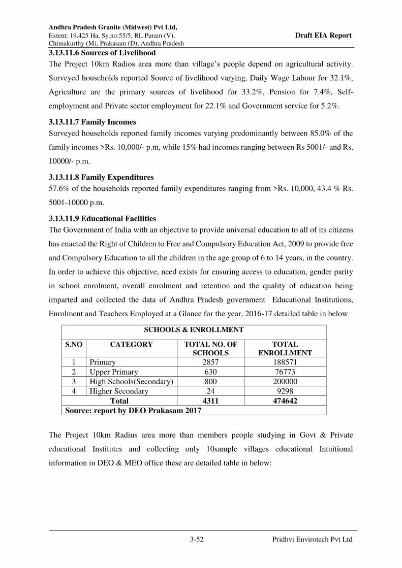
Andhra Pradesh Granite (Midwest) Pvt Ltd,
Extent: 19.425 Ha, Sy.no:55/5, RL Puram (V), Draft EIA Report Chimakurthy (M), Prakasam (D), Andhra Pradesh
3-52 Pridhvi Envirotech Pvt Ltd
3.13.11.6 Sources of Livelihood
The Project 10km Radios area more than village’s people depend on agricultural activity.
Surveyed households reported Source of livelihood varying, Daily Wage Labour for 32.1%,
Agriculture are the primary sources of livelihood for 33.2%, Pension for 7.4%, Self-
employment and Private sector employment for 22.1% and Government service for 5.2%.
3.13.11.7 Family Incomes
Surveyed households reported family incomes varying predominantly between 85.0% of the
family incomes >Rs. 10,000/- p.m, while 15% had incomes ranging between Rs 5001/- and Rs.
10000/- p.m.
3.13.11.8 Family Expenditures
57.6% of the households reported family expenditures ranging from >Rs. 10,000, 43.4 % Rs.
5001-10000 p.m.
3.13.11.9 Educational Facilities
The Government of India with an objective to provide universal education to all of its citizens
has enacted the Right of Children to Free and Compulsory Education Act, 2009 to provide free
and Compulsory Education to all the children in the age group of 6 to 14 years, in the country.
In order to achieve this objective, need exists for ensuring access to education, gender parity
in school enrolment, overall enrolment and retention and the quality of education being
imparted and collected the data of Andhra Pradesh government Educational Institutions,
Enrolment and Teachers Employed at a Glance for the year, 2016-17 detailed table in below
SCHOOLS & ENROLLMENT
S.NO CATEGORY TOTAL NO. OF
SCHOOLS
TOTAL
ENROLLMENT
1 Primary 2857 188571
2 Upper Primary 630 76773
3 High Schools(Secondary) 800 200000
4 Higher Secondary 24 9298
Total 4311 474642
Source: report by DEO Prakasam 2017
The Project 10km Radius area more than members people studying in Govt & Private
educational Institutes and collecting only 10sample villages educational Intuitional
information in DEO & MEO office these are detailed table in below:

Andhra Pradesh Granite (Midwest) Pvt Ltd,
Extent: 19.425 Ha, Sy.no:55/5, RL Puram (V), Draft EIA Report Chimakurthy (M), Prakasam (D), Andhra Pradesh
3-53 Pridhvi Envirotech Pvt Ltd
Table-3.18
Category of Educational Intuitional Details in Mandal wise
Category Chimakurthy Marripudi Tallur
Govt Private Govt Private Govt Private
Anganiwadi 21 0 1 0 1 0
Primary and Upper
Primary Schools
14 3 1 0 1 0
Z.P.H.Schools 2 5 0 0 0 0
Jr. Collges 2 2 0 0 0 0
Senior Colleges 0 4 0 0 0 0
Engg. Colleges 0 1 0 0 0 0
DIET/Bed/ Pharma
Colleges
0 1 0 0 0 0
Model Schools,
KGBV Schools &
Vocational Colleges
1 0 0 0 0 0
Total 40 16 2 0 2 0
Source : MEO Chimakurthi, Tallur, Marripudi
3.13.12 Health Status
3.13.12.1 Health and Family Welfare
Director of Public Health and Family Welfare monitors the Public Health Services, prevention
and control of communicable dieses and implementation of National and State Health
programmes. The DPH&FW is responsible for prevention, control and management of
endemic and epidemic diseases, health promotion, management of all primary health
institutions in rural and urban areas of the state and implementation of Births and Deaths ACT.
The status of health Facilities of Praksam District is detailed Table 3.19 in below:
Table3.19: The status of health Facilities of Praksam District
S.No Health Facility available in
Prakasam district
Prakasam
1 Number of Sub Centers 536
2 Number of PHCs 78
3 CHC (30 beds) 8
4 CHC (50 beds) 3
5 Area Hospital (100 beds) 3
6 District Hospital (200-300 beds) 1
7 District Hospital (300-400 beds) -
Source: Sekhar, P., S. et al., 2008. Facility Survey of Public
Health Institutions – 2008
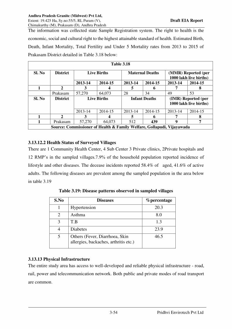
Andhra Pradesh Granite (Midwest) Pvt Ltd,
Extent: 19.425 Ha, Sy.no:55/5, RL Puram (V), Draft EIA Report Chimakurthy (M), Prakasam (D), Andhra Pradesh
3-54 Pridhvi Envirotech Pvt Ltd
The information was collected state Sample Registration system. The right to health is the
economic, social and cultural right to the highest attainable standard of health. Estimated Birth,
Death, Infant Mortality, Total Fertility and Under 5 Mortality rates from 2013 to 2015 of
Prakasam District detailed in Table 3.18 below:
Table 3.18
Sl. No District Live Births Maternal Deaths
(MMR) Reported (per
1000 lakh live births)
2013-14 2014-15 2013-14 2014-15 2013-14 2014-15
1 2 3 4 5 6 7 8
Prakasam 57,270 64,073 28 34 49 53
Sl. No District Live Births Infant Deaths (IMR) Reported (per
1000 lakh live births)
2013-14 2014-15 2013-14 2014-15 2013-14 2014-15
1 2 3 4 5 6 7 8
1 Prakasam 57,270 64,073 512 439 9 7
Source: Commissioner of Health & Family Welfare, Gollapudi, Vijayawada
3.13.12.2 Health Status of Surveyed Villages
There are 1 Community Health Center, 4 Sub Center 3 Private clinics, 2Private hospitals and
12 RMP’s in the sampled villages.7.9% of the household population reported incidence of
lifestyle and other diseases. The decease incidents reported 58.4% of aged, 41.6% of active
adults. The following diseases are prevalent among the sampled population in the area below
in table 3.19
Table 3.19: Disease patterns observed in sampled villages
S.No Diseases %percentage
1 Hypertension 20.3
2 Asthma 8.0
3 T.B 1.3
4 Diabetes 23.9
5 Others (Fever, Diarrhoea, Skin
allergies, backaches, arthritis etc.)
46.5
3.13.13 Physical Infrastructure
The entire study area has access to well-developed and reliable physical infrastructure - road,
rail, power and telecommunication network. Both public and private modes of road transport
are common.
Andhra Pradesh Granite (Midwest) Pvt Ltd,
Extent: 19.425 Ha, Sy.no:55/5, RL Puram (V), Draft EIA Report Chimakurthy (M), Prakasam (D), Andhra Pradesh
3-55 Pridhvi Envirotech Pvt Ltd
3.13.14 Social Infrastructure
Fairly well developed and reliable infrastructure exists in the area for basic education,
healthcare, housing, banking, recreation and marketing of goods and services.
3.13.15 Archaeological Monuments
No archaeological monuments and heritage precincts are observed to be present in the project
impact area.
3.14 Aspirations and Apprehensions
As revealed during focus group discussions, nearly 60% of the respondents are aware of the
proposed project. While they are convinced with the positive impacts of the project, they are
also wary of the negative impacts on the surrounding environment. The perceptions of the
respondents as regards the establishment of mining projects in the area could be summarized
as follows:
82.2% of the households feel it would generate alternative employment opportunities
for some of the locals as unskilled and skilled workers.
83.2% of the respondents feel it would help enhance income levels for some through
the development of secondary and tertiary sector small business opportunities.
75.1% of the respondents feel it would help strengthen physical infrastructure,
especially roads in the area.
76.2% of the respondents feel it would help improve the vocational skill sets of the
people.
42.4% of the respondents feel it would adversely affect the livelihoods of the small
farmers in the vicinity.
44.3% feel that it may impair land productivity due to dust pollution.
47.1% feel dust pollution may also lead to respiratory disorders of the natives.

Andhra Pradesh Granite (Midwest) Pvt Ltd,
Extent: 19.425 Ha, Sy.no:55/5, RL Puram (V), Draft EIA Report Chimakurthy (M), Prakasam (D), Andhra Pradesh
3-56 Pridhvi Envirotech Pvt Ltd
3.15 FLORA & FAUNA
Biological environment includes the study of the relationships of organisms or groups of
organisms to their environment. Ecology in essence is the study of the abiotic (non-living) and
biotic (living) components, interaction of community and the environment and exchange of
material (energy and nutrient) between living and non-living parts. A community includes all
organisms in the given area interacting with the abiotic environment. The main aim of
Conservation of Biodiversity is to ensure “No Net Loss”.
The following approach has been chosen by the IAIA to help achieve ‘no net loss’ of
biodiversity:
Avoidance of irreversible loss of biodiversity.
Seeking alternative solutions to minimize biodiversity losses.
Use of mitigation to restore biodiversity resources.
Compensation for unavoidable loss by providing substitutes of at least similar
biodiversity value.
Looking for opportunities for enhancement.
This approach can be called “positive planning for biodiversity.” It helps achieve no net loss
by ensuring the safety and survival of rare or endangered or endemic or threatened (REET)
species. This approach has been adopted by the proposed project in the study under report.
3.15.1 Scope of work for this study is in line with the ToR that includes
Scope of work is to identify of ecologically sensitive receptors based on literature survey and
field investigations, quantification of impacts on flora and fauna in core and buffer zones and
to suggest appropriate mitigation measures with conservation and management plan.
Biological assessment of the site was done to identify whether there are any rare, endangered,
endemic, threatened (REET) species of flora or fauna in the project site or core area as well its
buffer zone (upto 10 km radius). The study also designed to suggest suitable mitigation
measures and conservation plan if necessary for REET species if any.
The proposed project falls in
6D – Deccan Peninsula Deccan Plateau as per the Biogeography Classification of India.
Hot Semi-arid type as per the India's Köppen climate classification.
The vegetation of the study area falls under
5A: Southern tropical dry deciduous forests C3: Southern dry mixed deciduous forest;
6A: Southern tropical thorn forests DS1: Southern thorn scrub, 2S1: Secondary dry
deciduous forest

Andhra Pradesh Granite (Midwest) Pvt Ltd,
Extent: 19.425 Ha, Sy.no:55/5, RL Puram (V), Draft EIA Report Chimakurthy (M), Prakasam (D), Andhra Pradesh
3-57 Pridhvi Envirotech Pvt Ltd
by revised classification of Indian forest types (Champion and Seth, 1968). These types of
forests are seen throughout the Eastern Ghats and few parts of Western Ghats of the country.
The existing Mine lease area and Dump sites does not encounter with any kind of forest types
like Reserve Forest, Protected forest or un- classed Forest (declared Protected under “ The
Indian Forest Act, 1927”) and “Forest (Conservation) Act, 1980 with Amendments Made in
1988”. (Source: Forest Department). No wetland notified under “The Ramsar Convention –
1971” or listed under “the National wetland Conservation Programme – 2009” is reported
within 10 km from project boundary.
Crops raised in the buffer zone: Out of the total croplands, more than 70% was under Paddy,
Maize, Chilies, Red gram, Black gram, Green gram and Groundnut. Remaining was a current
fallow without any crops but ready for cultivation.
3.15.2 Methodology:
The ToR specific detailed survey has been made during Dec, 2018 to understand the existing
situation at ground level and to suggest the mitigation measures based on impacts quantified.
The core zone means the existing Mine lease area and buffer zone refers to area covered within
10 km radius of Mine lease area. The vegetation present in the existing mine lease area (MLA),
dumpsite (DS) and Green belt (GB) were estimated through quadrate sampling method or belt
transect method. The number and type of trees present were calculated through standard
statistical methods. There are two Reserve forests (Chimakurthy RF and Devarapalem RF) are
present at 2.3 km from mine lease area. Hence the tree density of the RFs also estimated by
quadrate method. The proposed area for greenbelt and type of species to be planted will be also
estimated and suggest the budgetary terms.
3.15.3 Equipment / Instruments deployed
Digital Camera (NIKON 42 X zoom)
GPS (Accurate readings available in Mobile and inbuilt camera )
Binoculars (OLYMPUS 10 X 50 DPSI)
Field observation book, Field guides, Pen, Measuring tape etc
PAST –statistical software for Biodiversity.
MS-Excel for Phyto-sociological calculations and graphs.
3.15.4 Floral analysis:
The vegetation structure of the region was randomly checked at selected habitats and sampling
was done near reserve forests. Most of the buffer zone area is under cultivation and hence
sampling near pond side and roadside are restricted to dense covered regions. To avoid the
biased result, statistical analysis done near two reserve forests. The remaining buffer zone

Andhra Pradesh Granite (Midwest) Pvt Ltd,
Extent: 19.425 Ha, Sy.no:55/5, RL Puram (V), Draft EIA Report Chimakurthy (M), Prakasam (D), Andhra Pradesh
3-58 Pridhvi Envirotech Pvt Ltd
survey was carried out for validating the secondary data collected at regional level. The status
of each identified species was given in terms of four categories such as “Dominant”,
“Common”, “Sporadic”, and “Rare”. This status is mainly based on Density, Frequency and
Abundance estimated during the field visit for Trees, Shrubs and Herbs.
Phyto-sociological aspects of the study were carried out by perambulating and sampling
through quadrat sampling method. Sample plots were selected in such a way to get maximum
representation of different types of vegetation and plots were laid out near reserve forest blocks.
Belt transect method (100m X 10m) was followed during the study. In this method, transect (a
straight line) of 100 m is marked with rope and tape. The trees are sampled 5 m on either side
of the central line of transect, while sampling, recorded the Girth at Breast Height (GBH) for
trees with greater than 30 cm GBH. The shrubs, Herbs, Climbers, Grass species and
Hydrophytes are documented with their status availability in all sampling points along with
tree species. Unidentified species in the field are photographed and given a code for further
investigation. Only photographs were taken during the field survey and no damage is created
to flora and fauna during the sampling. None of the specimens are collected as voucher
specimens for herbarium. The plants were identified using floras by Gamble (1915-36), Saxena
and Brahmam (1994-96), Nair and Henry (1983), Henry et al. (1987), Henry et al. (1989) and
also by using updated checklist from www.theplantlist.org.
Standard phyto-sociological methods of Mishra (1968) for density, frequency, abundance
calculated during the present study. Relative values of these were calculated by following
Philips (1959). Important Value Index (IVI) was calculated by adding up these three values of
relative frequency, relative density and relative dominance (Curtis, 1959). In case of shrubs,
herbs and saplings abundance status was given as per direct field observation. Diversity indices
such as Shannon – Wiener Indices of Diversity index, Evenness, Dominance, A/F ratio are also
calculated through standard methods and by using software tools such as PAST.
3.15.5 Faunal analysis:
A random survey for mammals were conducted by in all major habitats and recorded the
species through direct and indirect evidences. Species were identified using “A pictorial guide
to the Mammals of the India” by Vivek menon (2014), Prater (1997).
For Birds, random based observation followed with point count method was applied near water
bodies and reserve forest s. Birds seen or heard 50 m radius from has been recorded during
survey period. Bird surveys were carried out in dawn and desk of the field visit days. A special
note on migratory status of birds were also recorded through secondary data. Birds sighted at

Andhra Pradesh Granite (Midwest) Pvt Ltd,
Extent: 19.425 Ha, Sy.no:55/5, RL Puram (V), Draft EIA Report Chimakurthy (M), Prakasam (D), Andhra Pradesh
3-59 Pridhvi Envirotech Pvt Ltd
the study area were identified using “A field guide to the birds of the Indian Sub-Continent”
by Ranjit Manakadan et.al (2011).
Reptiles were identified by direct or indirect evidences and literature gathered from the working
plans of the forest department and other publications. The directly observed species are
identified using the field book on Indian Reptiles and Amphibians by J.C. Daniel (2002).
Snakes of India by Whitaker (2016).
Amphibians are surveyed both at aquatic and terrestrial systems searching under the logs and
stones, digging through litter and soil, searching short bushes and tree hollows and under fallen
barks. The books referred are Amphibians of Peninsular India by Ranjit Daniel (2004).
Invertebrates such as Butterflies, Dragonflies and spiders sighted during the survey period were
identified by species-specific field guides. Bugs, Beetles and other insect data were gathered
from publications and forest working plan data.
Vegetation structure and composition: During the present study, around 152 floral species are
recorded from primary and secondary sources. The overall study area consists of agricultural
fallow / Barren / uncultivable / wasteland / Reserve forests. Some part of it has commercial
mango plantation and few parts are currently used as grazing land. The list of plant species
recorded during field survey and literature from the study area are given in Annexure V.The
Wastelands fully covered by Prosopis juliflora and the rest of the area is covered by rocky
uplands with scattered succulents and thorny shrubs.Thus entire buffer area is either a cropland
or current fallow land or a non-forest wasteland. There are good number is social forestry
plantations of Eucalyptus and Casuarina within the buffer zone.

Andhra Pradesh Granite (Midwest) Pvt Ltd,
Extent: 19.425 Ha, Sy.no:55/5, RL Puram (V), Draft EIA Report Chimakurthy (M), Prakasam (D), Andhra Pradesh
3-60 Pridhvi Envirotech Pvt Ltd
3.15.6 Mine Lease Area:
The existing mine lease area is adjoining to other mines under operation. Hence, there is no
particular space for developing any vegetation near the boundary of the mining area. No
vegetation near the approach road to Mining site. None of the community resources present in
and around 500 m radial distance from the mine site boundary.
The vegetation raised near the office premises are recorded. The major tree species raised
within the office premises are:
Botanical Name Common name Family Habit
Albizia lebbeck (L.) Benth. Dirisanam Leguminosae Tree
AzadirachtaindicaA.Juss. Vepa Meliaceae Tree
Dalbergia sissoo DC. Sissoo Leguminosae Tree
Delonix regia (Hook.) Raf. Chittikesaram Leguminosae Tree
Eucalyptus globulus Labill. Neelagirithylam Myrtaceae Tree
Ficusbenghalensis L. Marri Moraceae Tree
Leucaena leucocephala(Lam.) de Jabarichettu Leguminosae Tree
Nerium odoratumLam. Erraganneru Apocynaceae Tree
Peltophorumpterocarpum(DC.) Kondachintha Leguminosae Tree
Senna siamea Lam. Seema thangedu Leguminosae Tree
Phyllanthus reticulatusPoir. Nallapuli Phyllanthaceae Shrub
CissusquadrangularisL. Nalleru Vitaceae Climber
Pergulariadaemia (Forssk.) Dustapu-Teega Apocynaceae Climber
3.15.7 Dump
Few sporadically naturally grown trees such as Eucalyptus and Senna auriculataare observed
along with Prosophis which is a common weed throughout the region. No possibility of
growing grass on dump slopes to stabilise them and to avoid the dust as there is no soil binding
capacity.
3.15.8 Reserve forest vegetation:
Chimakurthy RF contain good number of trees such as Buchananialanzan, Azadirachtaindica,
Balanitesaegyptiaca, Butea monosperma, Phoenix sylvestris, Acacia nilotica, Dalbergia sissoo
etcand shrubs such as Senna auriculata,Calotropis procera, Carallumaumbellata, Euphorbia
antiquorum, Euphorbia tortillis, Dodonaea viscoseJatropha gossypifolia, Carissaspinarum,
Prosopis juliflora, Acacia nilotica, Acacia leucophloea, and Lantana camara and other all
common herbs and climbers.
3.15.9 Quantitative analysis
The study area is mainly focused through secondary data validation from primary observations.
Checklist is prepared and marked the species noticed during rapid assessment. 10 sampling

Andhra Pradesh Granite (Midwest) Pvt Ltd,
Extent: 19.425 Ha, Sy.no:55/5, RL Puram (V), Draft EIA Report Chimakurthy (M), Prakasam (D), Andhra Pradesh
3-61 Pridhvi Envirotech Pvt Ltd
points are through Area-Species graph. And the quantitative analysis done based on the
methodology adopted for various species.
Table3.20: Phytosociological data of study area
S.No Scientific Name Rel
Density
Rel
Frequency
Rel
Abundance IVI
1 Azadirachtaindica 4.69 7.69 5.93 18.31
2 Balanitesaegyptiaca 20.31 12.31 16.05 48.67
3 Acacia leucophloea 2.34 4.62 4.94 11.90
4 Buchananialanzan 16.41 10.77 14.81 41.99
5 Dalbergia sissoo 10.16 10.77 9.17 30.10
6 Ficushispida 3.13 6.15 4.94 14.22
7 Phoenix sylvestris 10.16 7.69 12.84 30.69
8 Butea monosperma 4.69 7.69 5.93 18.31
9 Acacia nilotica 10.94 10.77 9.88 31.58
10 Pongamiapinnata 6.25 10.77 5.64 22.66
11 Prosopis juliflora 10.94 10.77 9.88 31.58
100 100 100 300.00
Figure3.17: Graph showing Important Value Index of dominant tree species within study
area
3.15.10 Vegetation Analysis:
Table3.21: Biodiversity indices values of the sampling sites in project site
a A/F value 0.039
b Shannon H 2.855
Simpson 1-D 0.940
c Dominance D 0.060
Evenness e^H/S 0.946

Andhra Pradesh Granite (Midwest) Pvt Ltd,
Extent: 19.425 Ha, Sy.no:55/5, RL Puram (V), Draft EIA Report Chimakurthy (M), Prakasam (D), Andhra Pradesh
3-62 Pridhvi Envirotech Pvt Ltd
a. Distribution pattern (A/F ratio): The ratio between abundance and frequency was used to
interpret the distribution pattern of species (Whitford, 1949). Abundance to frequency ratio
(A/F) has been calculated to assess the distribution pattern of species and depending upon the
ratios, distribution may be regular (<0.025), random (0.025-0.05) and contagious (>0.05). In
natural conditions, contagious distribution is most common type of distribution due to
significant variation in environmental conditions (Odum, 1971). Distribution pattern of species
in the study area is identified as random distribution as the value of A/F ratio is 0.039. This
distribution of species is random because of several ecosystems randomly distributed in the
study area.
b. The Shannon indices value of study area is 2.855indicates Good diversity (Normal diversity in
ecological studies is 1.5 to 3.5 range (Kerkhoff, 2010). As there are two RFs within the buffer
zone of the study area, diversity is more near undisturbed habitats.
c. Population size and Dominance of the species is 6% and Evenness is around 95% (Indicates
the species are evenly distributed in the study area). This might be due to contiguous patches
of natural species such asBalanitesaegyptiaca, Butea monosperma, Phoenix sylvestris, Acacia
nilotica, Dalbergia sissoo, Prosopis juliflora(near the villages),Peltophorumpterocarpum,
Delonix regia and Subabul (near road side).
d. Frequency indicates A<B<C>D>E as per the Raunkiaer’s law of frequency classification
indicates that species diversity is distributed maximum for 40 to 60%
3.15.11 Terrestrial Fauna
The presence or absence of an animal or plant in a certain region depends on its ecological and
geographical setting. Wild animals can exist in a region only if prevailing set of conditions are
congenial for their survival and perpetuation. Diversity of the species and their abundance is
largely dependent on the availability of required habitats.
3.15.12 Terrestrial fauna of the Core area and the Buffer zone:
As the animals, especially vertebrates move from place to place in search of food, shelter, mate
or other biological needs, separate lists for core and buffer areas are not feasible however, a
separate list of fauna pertaining to core and buffer zone are listed separately. Though there are
two reserved forest blocks near dump and in the buffer zone. As such there are no chances of
occurrence of any rare or endangered or endemic or threatened (REET) species within the core
or buffer area. There are no Sanctuaries, National Parks, Tiger Reserve or Biosphere Reserve
or Elephant Corridor or other protected areas within 10 km radius from core area. It is evident
from the available records, reports and circumstantial evidence that the entire study area
including the core and buffer areas were free from any endangered animals. There were no

Andhra Pradesh Granite (Midwest) Pvt Ltd,
Extent: 19.425 Ha, Sy.no:55/5, RL Puram (V), Draft EIA Report Chimakurthy (M), Prakasam (D), Andhra Pradesh
3-63 Pridhvi Envirotech Pvt Ltd
resident birds other than common bird species such as Paddy egrets, Green bee eaters, Indian
rollers, Parakeets, common babblers, Weaver birds, Mynas, Black dragons, Crows, Sparrows.
The list of Mammalian species directly sighted or recorded during field survey and from
literature reviewed from the study area are given in Annexure V The list of bird species
recorded during field survey and literature from the study area are given in Annexure V. The
list of reptilian species recorded during field survey and literature from the study area are given
in Annexure V. The list of Amphibian species recorded during field survey and literature from
the study area are given in Annexure V. The list of Fish species recorded during field survey
and literature from the study area are given in Annexure V. The list of Butterfly species
recorded during field survey and literature from the study area are given in Annexure V. It is
apparent from the list that none of the species either spotted or reported is included in Schedule
I of the Wildlife Protection Act. Similarly, none of them comes under the REET category.
Some of the birds listed were rare locally but they do not fall under any of the REET categories.
3.15.13 Flora and fauna of Aquatic ecosystem
There is Ramathirtham Reservoir exist at 4.4 km from the Mine area. Lemna minor, Ipomoea
aquatica, Neptunia oleracea, Typha domingensis are most common in the study area. There
were no threatened category species of aquatic and semi aquatic plants in the study area. The
floristic survey of the existing farming site witnesses scattered growth of grasses (mainly
weeds), rooted hydrophytes, emerging hydrophytes, shrubs in undisturbed area where human
movement is absent. Among herbaceous species, weeds are commonly reported such as
Congress grass (Parthenium hysterophorus), Lantana (Lantana Camara), and Datura (Datura
stromonium). Rooted hydrophytes are reported along the banks, where water level is less than
foot or water has recedes after flooding. The commonly reported hydrophytes are Ipomoea
aquatica, Argeratumconyzoides, Typha angustataetc.

Chapter - 4
Anticipated Environmental Impacts
& Mitigative Measures

Andhra Pradesh Granite (Midwest) Pvt Ltd,
Extent: 19.425 Ha, Sy.no:55/5, RL Puram (V), Draft EIA Report Chimakurthy, Prakasam, Andhra Pradesh
4-1 Pridhvi Envirotech Pvt Ltd
CHAPTER -4
ANTICIPATED ENVIRONMENTAL IMPACTS
& MITIGATIVE MEASURES
4.1 Identification of Environmental Impacts
Any developmental activity in its make will bring about some impacts associated with its
origin, which can be broadly classified as reversible, irreversible, long and short-term impacts.
In this chapter, an endeavor has been made to identify various environmental impacts
associated with the mining processes and other related activities wherein, there may be a chance
of pollution.
The major phases in the mining which are likely to impact the environment are:
1. Exploration: Including surveys, field studies, drilling and exploratory excavations;
some land disturbances and waste already occur at this stage
2. Project Development: Includes roads and buildings, access trenches, over burden
stripping and placing, preparation of disposal areas, construction of service
infrastructure, power lines, water supplies and sewerage.
3. Associated transport & Storage of minerals may be a handling risk and can result in
localized site contamination
4. Mine Closure: Rehabilitation is best done progressively rather than at the end of life
of the mine; while mine closure is intended to mitigate environmental impacts, it is
important that it does not itself create secondary effects through excessive fertilizer use,
spread of weeds, silting and incompatible landscape features
4.2.2 Impacts on Air Quality
The primary air pollutant of concern at mining sites is particulate matter. Following are various
activities will be carried out in the mine site due to which Dust emission will be generated.
Removal of top soil will generate dust emissions.
Excavation can be source of fugitive dust. Loading of Rough Stone, Road Metal &
Manufactured Sand generate dust.
Machinery and vehicles travel on access and haul roads are major sources of dust
emission.

Andhra Pradesh Granite (Midwest) Pvt Ltd,
Extent: 19.425 Ha, Sy.no:55/5, RL Puram (V), Draft EIA Report Chimakurthy, Prakasam, Andhra Pradesh
4-2 Pridhvi Envirotech Pvt Ltd
Dust will be generated due to the vehicular movement. Also material fall from transport
vehicles will also contribute to dust emissions.
Predicted Emissions:
Emissions from the production of Rough Stone, Road Metal & Manufactured Sand consist
primarily of particulate matter (PM) and particulate matter less than 10 micrometres (PM10)
in aerodynamic diameter, which are emitted by many operations at Rough Stone, Road Metal
& Manufactured Sand mines, such as excavation and transportation operations. The main air
pollutants respirable dust arises from excavation and transportation operation.
The tippers will move with a speed of 20 to 30 kmph on the unpaved roads constructed for
gravel transportation. The width of all unpaved mine roads within the mine site is around 10
m.
The details of emissions expected from vehicular movement during mining activity are given
in Table 4.1. The line source emission rates for the proposed Rough Stone, Road Metal &
Manufactured Sand mine are derived from the following equation:
Where,
Evt - Emission factor (lb / vehicle / mile travelled)
Sp - Silt content of road surface material
Vv - Mean vehicle velocity (miles / hour)
Mv - Mean vehicle mass (tons)
Wv - Mean number of wheels
Dp - Number of days per year with at least 0.01 inch of precipitation
Simulation Model for Prediction using Industrial Source Complex ISC AERMOD View
The mathematical model used for predictions on air quality impact in the present study is ISC-
AERMOD View-9.9.0. It is the next generation air dispersion model, which incorporates
planetary boundary layer concepts.
The AERMOD is actually a modelling system with three separate components:
Evt = 5.9 Sp Vv Mv 0.7 Wv 0.5 365-Dp
12 30 3 4 365

Andhra Pradesh Granite (Midwest) Pvt Ltd,
Extent: 19.425 Ha, Sy.no:55/5, RL Puram (V), Draft EIA Report Chimakurthy, Prakasam, Andhra Pradesh
4-3 Pridhvi Envirotech Pvt Ltd
AERMOD (AERMIC Dispersion Model), AERMAP (AERMOD Terrain Pre-processor) and
AERMET (AERMOD Meteorological Pre-processor).
Special features of AERMOD include its ability to treat the vertical in homogeneity of the
planetary boundary layer special treatment of surface releases, irregularly shaped area sources,
a plume model for the convective boundary layer, limitation of vertical mixing in the stable
boundary layer, and fixing the reflecting surface at the stack base.
The AERMET is the meteorological pre-processor for the AERMOD. Input data can come
from hourly cloud cover observations, surface meteorological observations and twice-a-day
upper air soundings. Output includes surface meteorological observations and parameters and
vertical profiles of several atmospheric parameters.
The AERMAP is a terrain pre-processor designed to simplify and standardize the input of
terrain data for the AERMOD. Input data include receptor terrain elevation data. Output
includes, for each receptor, location and height scale, which are elevations used for the
computation of airflow around hills.
4.2.2.1 Micro Meteorological Data
Meteorological data was collected during Study Period (January 2019 – March 2019) a
cumulative wind rose diagram of all the 3 months were compiled using mathematical model
WRPLOT. The seasonal wind rose diagram has been presented in Fig: 4.1 which covers all the
three months meteorological data.

Andhra Pradesh Granite (Midwest) Pvt Ltd,
Extent: 19.425 Ha, Sy.no:55/5, RL Puram (V), Draft EIA Report Chimakurthy, Prakasam, Andhra Pradesh
4-4 Pridhvi Envirotech Pvt Ltd
Table 4.1: Frequency Distribution of Wind Speeds and Wind Directions
S.no Directions /
Wind Classes
(m/s)
0.5 - 2.1 2.1 - 3.6 3.6 - 5.7 5.7 - 8.8 8.8 -
11.1
>= 11.1 Total (%)
1 N 0.54 0.05 0.18 0.45 0.23 0.45 1.90
2 NNE 0.05 0.18 0.18 0.14 0.18 0.32 1.04
3 NE 0.32 0.14 0.32 0.91 0.82 2.54 5.03
4 ENE 0.82 0.73 0.23 0.45 0.63 0.82 3.67
5 E 0.50 0.54 0.23 0.73 0.27 0.86 3.13
6 ESE 0.95 0.23 0.45 0.82 0.54 1.59 4.58
7 SE 5.76 1.32 0.86 0.91 1.18 2.40 12.42
8 SSE 2.99 0.41 0.63 0.95 0.91 2.72 8.61
9 S 1.00 0.09 0.27 0.23 0.63 1.45 3.67
10 SSW 1.59 0.23 0.09 0.32 0.50 0.54 3.26
11 SW 1.09 0.86 0.05 0.45 0.09 0.45 2.99
12 WSW 2.81 0.36 0.05 0.36 0.18 0.59 4.35
13 W 1.04 0.32 0.18 0.45 0.00 0.86 2.85
14 WNW 0.27 0.09 0.27 0.27 0.50 0.73 2.13
15 NW 2.95 0.45 0.32 0.27 0.50 0.91 5.39
16 NNW 1.59 0.27 0.14 0.32 0.14 0.45 2.90
Sub-Total 24.24 6.25 4.44 8.02 7.29 17.67 67.92
Calms 31.99
Missing/Incomplete 0.09
Total 100

Andhra Pradesh Granite (Midwest) Pvt Ltd,
Extent: 19.425 Ha, Sy.no:55/5, RL Puram (V), Draft EIA Report Chimakurthy, Prakasam, Andhra Pradesh
4-5 Pridhvi Envirotech Pvt Ltd
Figure 4.1: Wind rose Diagram for the study period January 2019 to March 2019
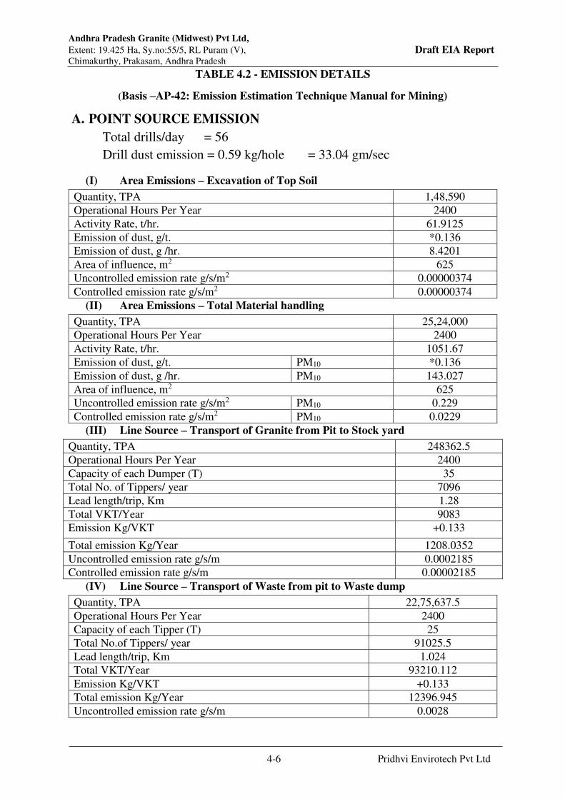
Andhra Pradesh Granite (Midwest) Pvt Ltd,
Extent: 19.425 Ha, Sy.no:55/5, RL Puram (V), Draft EIA Report Chimakurthy, Prakasam, Andhra Pradesh
4-6 Pridhvi Envirotech Pvt Ltd
TABLE 4.2 - EMISSION DETAILS
(Basis –AP-42: Emission Estimation Technique Manual for Mining)
A. POINT SOURCE EMISSION
Total drills/day = 56
Drill dust emission = 0.59 kg/hole = 33.04 gm/sec
(I) Area Emissions – Excavation of Top Soil
Quantity, TPA 1,48,590
Operational Hours Per Year 2400
Activity Rate, t/hr. 61.9125
Emission of dust, g/t. *0.136
Emission of dust, g /hr. 8.4201
Area of influence, m2 625
Uncontrolled emission rate g/s/m2 0.00000374
Controlled emission rate g/s/m2 0.00000374
(II) Area Emissions – Total Material handling
Quantity, TPA 25,24,000
Operational Hours Per Year 2400
Activity Rate, t/hr. 1051.67
Emission of dust, g/t. PM10 *0.136
Emission of dust, g /hr. PM10 143.027
Area of influence, m2 625
Uncontrolled emission rate g/s/m2 PM10 0.229
Controlled emission rate g/s/m2 PM10 0.0229
(III) Line Source – Transport of Granite from Pit to Stock yard
Quantity, TPA 248362.5
Operational Hours Per Year 2400
Capacity of each Dumper (T) 35
Total No. of Tippers/ year 7096
Lead length/trip, Km 1.28
Total VKT/Year 9083
Emission Kg/VKT +0.133
Total emission Kg/Year 1208.0352
Uncontrolled emission rate g/s/m 0.0002185
Controlled emission rate g/s/m 0.00002185
(IV) Line Source – Transport of Waste from pit to Waste dump
Quantity, TPA 22,75,637.5
Operational Hours Per Year 2400
Capacity of each Tipper (T) 25
Total No.of Tippers/ year 91025.5
Lead length/trip, Km 1.024
Total VKT/Year 93210.112
Emission Kg/VKT +0.133
Total emission Kg/Year 12396.945
Uncontrolled emission rate g/s/m 0.0028
Andhra Pradesh Granite (Midwest) Pvt Ltd,
Extent: 19.425 Ha, Sy.no:55/5, RL Puram (V), Draft EIA Report Chimakurthy, Prakasam, Andhra Pradesh
4-7 Pridhvi Envirotech Pvt Ltd
Controlled emission rate g/s/m 0.00028
(V) Line Source – Transport of Overburden from pit to Waste dump
Quantity, TPA 1,48,590
Operational Hours Per Year 2400
Capacity of each Tipper (T) 16
Total No. of Tippers/ year 9287
Lead length/trip, Km 1.024
Total VKT/Year 9509.76
Emission Kg/VKT +0.133
Total emission Kg/Year 1264.8
Uncontrolled emission rate g/s/m 0.000286
Controlled emission rate g/s/m 0.0000286
Note : *Emission factor computed based on wind speed of 2 m/s, and moisture content of 10
%.
+ Emission factor computed based on silt content of 10 % and moisture content of 10 %
4.3.3 Air Quality Predictions
Simulation Model for Prediction using Industrial Source Complex ISC AERMOD View
The pollutants released into the atmosphere will disperse in the down wind direction and
finally reach the ground at farther distance from the source. The concentration of ground level
concentrations mainly depends upon the strength of the emission source and
micrometeorology of the study area.
In order to estimate the ground level concentrations due to the emission from the proposed
project, EPA approved Industrial Source Complex ISC AERMOD View Model has been
employed.
The mathematical model used for predictions on air quality impact in the present study is ISC-
AERMOD View-6.8.6. It is the next generation air dispersion model, which incorporates
planetary boundary layer concepts.
The AERMOD is actually a modeling system with three separate components:
AERMOD (AERMIC Dispersion Model), AERMAP (AERMOD Terrain Preprocessor) and
AERMET (AERMOD Meteorological Preprocessor).
Special features of AERMOD include its ability to treat the vertical in homogeneity of the
planetary boundary layer special treatment of surface releases, irregularly shaped area sources,
a plume model for the convective boundary layer, limitation of vertical mixing in the stable
boundary layer, and fixing the reflecting surface at the stack base.
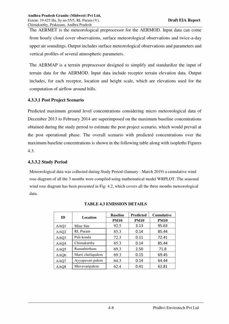
Andhra Pradesh Granite (Midwest) Pvt Ltd,
Extent: 19.425 Ha, Sy.no:55/5, RL Puram (V), Draft EIA Report Chimakurthy, Prakasam, Andhra Pradesh
4-8 Pridhvi Envirotech Pvt Ltd
The AERMET is the meteorological preprocessor for the AERMOD. Input data can come
from hourly cloud cover observations, surface meteorological observations and twice-a-day
upper air soundings. Output includes surface meteorological observations and parameters and
vertical profiles of several atmospheric parameters.
The AERMAP is a terrain preprocessor designed to simplify and standardize the input of
terrain data for the AERMOD. Input data include receptor terrain elevation data. Output
includes, for each receptor, location and height scale, which are elevations used for the
computation of airflow around hills.
4.3.3.1 Post Project Scenario
Predicted maximum ground level concentrations considering micro meteorological data of
December 2013 to February 2014 are superimposed on the maximum baseline concentrations
obtained during the study period to estimate the post project scenario, which would prevail at
the post operational phase. The overall scenario with predicted concentrations over the
maximum baseline concentrations is shown in the following table along with isopleths Figures
4.3.
4.3.3.2 Study Period
Meteorological data was collected during Study Period (January - March 2019) a cumulative wind
rose diagram of all the 3 months were compiled using mathematical model WRPLOT. The seasonal
wind rose diagram has been presented in Fig: 4.2, which covers all the three months meteorological
data.
TABLE 4.3 EMISSION DETAILS
ID Location Baseline Predicted Cumulative
PM10 PM10 PM10
AAQ1 Mine Site 92.5 3.13 95.63
AAQ2 RL Puram 85.3 0.14 85.44
AAQ3 Puli konda 72.3 0.11 72.41
AAQ4 Chimakurthy 85.3 0.14 85.44
AAQ5 Ramathirtham 69.3 2.50 71.8
AAQ6 Marri chetlapalem 69.3 0.15 69.45
AAQ7 Ayyapavari palem 64.3 0.14 64.44
AAQ8 Muvavaripalem 62.4 0.41 62.81
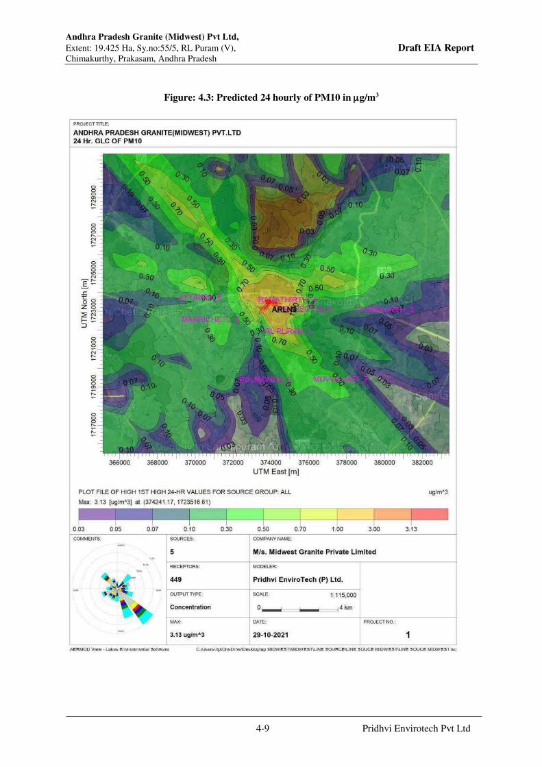
Andhra Pradesh Granite (Midwest) Pvt Ltd,
Extent: 19.425 Ha, Sy.no:55/5, RL Puram (V), Draft EIA Report Chimakurthy, Prakasam, Andhra Pradesh
4-9 Pridhvi Envirotech Pvt Ltd
Figure: 4.3: Predicted 24 hourly of PM10 in g/m3

Andhra Pradesh Granite (Midwest) Pvt Ltd,
Extent: 19.425 Ha, Sy.no:55/5, RL Puram (V), Draft EIA Report Chimakurthy, Prakasam, Andhra Pradesh
4-10 Pridhvi Envirotech Pvt Ltd
4.4 Noise Environment
4.4.1Prediction of Impacts Due To Quarry Activity
If the sound source is directive and is located very near to hard flat surface, then the sound
pressure level at a distance “r” is calculated by,
Lp= Lw + DI - 20 Log(r) - Ae - 8
Where,
Lp = Sound pressure level at a receiver located in a particular direction
Lw = Sound power level of the source
DI = Directivity index of the source in that direction
r = Distance of receiver from the source (meters)
Ae = Excessive attenuation caused by the environmental conditions
For hemispherical wave divergence in a homogeneous loss free atmosphere (Ae = 0), and over
loss free ground, free of barrier the sound pressure drops off by 6 dB for each doubling of
distance.
The noise generated due to mining operations and movement of equipments and vehicles
affects the acoustical environment surrounding the mining area. Cumulative effect at observer
is calculated by the equation
Lp = 10 Log [10Lp1/10 + 10Lp2/10 + 10Lp3/10 + -------]
4.4.2 Noise Due to vehicular Traffic
The traffic density in the adjoining villages surrounding the proposed mine site is low. The
speed of medium and light weight vehicles will be around 40 to 50 kms/hr and for heavy
vehicles it will be in the range of 35 to 40 kms/hr.
To estimate the impact of vehicular activity in the study area, total numbers of vehicles passing
per hour on road were measured. Equivalent noise levels due to traffic, at required locations
was estimated using integrating sound level meter based on the following Federal Highway
Administration (FHWA) noise equation:

Andhra Pradesh Granite (Midwest) Pvt Ltd,
Extent: 19.425 Ha, Sy.no:55/5, RL Puram (V), Draft EIA Report Chimakurthy, Prakasam, Andhra Pradesh
4-11 Pridhvi Envirotech Pvt Ltd
Log(h)i = Loe + 10Log(Ni/SiT) + 10Log(15/d) 1+B + Ds - 13
Where
Loe : Reference mean energy level for ith vehicle type (from published data)
Ni : Number of class ith vehicle passing during time T
Si : Average speed for ith vehicle class in km/hr
T : Duration for which Leq is desired corresponding to Ni
D : Perpendicular distance in meters from the centre line of the traffic lane to
the location of the observer
B : Factor relating to the absorption characteristics of the ground cover
between roadways and observer
Ds : Shielding factor such as provided by a noise barrier
The above equation is the basis on which integrating sound level meter records and integrates
the noise levels generated due to light, medium and heavy vehicles.
The preceding equation is used three times, once for automobiles, once for medium trucks and
once for heavy trucks to obtain three values as Leq(A) for Autos, Leq(M) for medium trucks
and Leq(H) for heavy trucks. The final Leq can be calculated by logarithmically adding the
three Leq values as follows,
Leq (Total) = 10 Log [10 Leq (A) / 10 + 10 Leq (M) / 10 + 10 Leq (H) / 10]
The total impact on observer, standing at a distanced kms from the centre line of the traffic lane
is given by the above equation.
Due to wave divergence and attenuation, the noise level decreases as distance from source
increases. Hence the effect of traffic at 1km distance will be around 45-50 dB(A). The expected
Noise from mining machineries are given in Table: 4.3.
Table: 4.3 -Expected Noise from Mining Machinery
S. No. Type dB(A)
1. Excavators 75-80
2. Trippers/ Dumpers 65-80
3. Water Sprinklers 60-70
4. Maintenance Van 70-75
5. Truck 55-70
6. Jeeps 55-60
7. Ambulance Van 55-60
Andhra Pradesh Granite (Midwest) Pvt Ltd,
Extent: 19.425 Ha, Sy.no:55/5, RL Puram (V), Draft EIA Report Chimakurthy, Prakasam, Andhra Pradesh
4-12 Pridhvi Envirotech Pvt Ltd
4.5 Mine Wastewater
Domestic wastewater will be sent to septic tank followed by soak pit.
4.5.1 Mine Pit Water
The pit water is expected to be good quality except the pollutant like high-suspended solids.
Mine pit water will be pumped into garland drains with sedimentation pits. The silt free water
will be let into the nearby seasonal stream.
4.6 Land Environment
In the long term, the quarry pit is proposed to be secured and biologically reclaimed by
converting it into an aquatic reservoir. The boundaries of the pit will be fully secured and
provision will be made for the people to sit and relax. The water body will help in storage of
water, increase the water level in the vicinity and will also support the fauna in order to avoid
breeding of mosquitoes. Suitable species of fish will be introduced into the pond to feed on
the larva of mosquitoes. Water lilies and other aquatic plants will be planted to improve the
aesthetic and visual impact and landscape of the area. The overall effect is that the mined out
area will render a pleasant view after closer of teh mine benefiting the local communities and
beautifying the landscape apart from helping recharging the ground water apart from meeting
the local requirements of water.
4.7 Vibration Levels
Impact of blasting operations involved in the mining activity with respect to vibration and noise
level will be envisaged.
4.7.1Disasters
The potential disasters in the mining operation are sliding of mine slope, water inundation and
water inrush into the mine pit, fire hazard at mine and stock yard. Detail slope stability study,
on-site and off-site disaster management plan will be prepared before operation of the mine.
4.7.2 Mitigation Measures
Following environmental mitigation measures are recommended to minimize the impacts
caused by project activities:
4.8 Air pollution mitigation measure includes following:
Regular sprinkling of water on hauling roads.

Andhra Pradesh Granite (Midwest) Pvt Ltd,
Extent: 19.425 Ha, Sy.no:55/5, RL Puram (V), Draft EIA Report Chimakurthy, Prakasam, Andhra Pradesh
4-13 Pridhvi Envirotech Pvt Ltd
Water sprinkling on dumps.
Greenbelt would be provided around the lease area.
Regular maintenance of the Diesel operated HEMMs to reduce emission of noxious
gases.
Covering of the trucks carrying granite on public road.
4.8.1 Water pollution mitigation measure includes following:
Provision of Garland drains around the mine pit to check inflow of surface run-off
into mine-pit.
Mine water will be pumped out into the garland drains and silt free water will be let
into the nearby seasonal stream.
Catch drains would be provided around the external dumps & ore stock area.
Surface run-off from external dumps & ore stocks area will be collected & diverted
to garland drains with sedimentation ponds for treatment.
Septic tank would be provided to treat wastewater generated from domestic front.
4.9 Impact on Traffic & Road Network:
The major road access to the site is kutcha road which is connecting to the Ongole –Kurnool
state highway which is 0.3 Kms from the mine site. Traffic study is conducted on the ongole –
Kurnool state highway near the mine site on 10th and 11th September, 2021 and data is
presented in the table. The total volume of traffic on both directions on this double-lane road
is 2505 PCUs/Day. As per the IRC code 64-1990 Guidelines for capacity of the double lane
road in plane area is 15000 PCUs/day
Mitigation measures:
The connecting road to mine will not cross village. Hence traffic on connecting road will not
impact village much. It is suggested to regulate traffic on connecting road in nonpeak hours
i.e., between 11 AM to 5 PM or after 10 PM so that no inconvenience is caused to village. It is
suggested to contribute for road strengthening and repairs if any at regular interval
4.10 Land Reclamation
As discussed earlier land is to be degraded on account of following activities:
Quarrying operation that will create pit.
Dumping of overburden
Land reclamation scheme has been developed that covers the following:
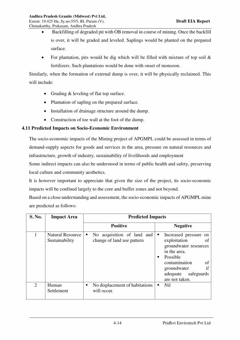
Andhra Pradesh Granite (Midwest) Pvt Ltd,
Extent: 19.425 Ha, Sy.no:55/5, RL Puram (V), Draft EIA Report Chimakurthy, Prakasam, Andhra Pradesh
4-14 Pridhvi Envirotech Pvt Ltd
Backfilling of degraded pit with OB removal in course of mining. Once the backfill
is over, it will be graded and leveled. Saplings would be planted on the prepared
surface.
For plantation, pits would be dig which will be filled with mixture of top soil &
fertilizers. Such plantations would be done with onset of monsoon.
Similarly, when the formation of external dump is over, it will be physically reclaimed. This
will include:
Grading & leveling of flat top surface.
Plantation of sapling on the prepared surface.
Installation of drainage structure around the dump.
Construction of toe wall at the foot of the dump.
4.11 Predicted Impacts on Socio-Economic Environment
The socio-economic impacts of the Mining project of APGMPL could be assessed in terms of
demand-supply aspects for goods and services in the area, pressure on natural resources and
infrastructure, growth of industry, sustainability of livelihoods and employment
Some indirect impacts can also be understood in terms of public health and safety, preserving
local culture and community aesthetics.
It is however important to appreciate that given the size of the project, its socio-economic
impacts will be confined largely to the core and buffer zones and not beyond.
Based on a close understanding and assessment, the socio-economic impacts of APGMPL mine
are predicted as follows:
S. No. Impact Area Predicted Impacts
Positive Negative
1 Natural Resource
Sustainability
No acquisition of land and
change of land use pattern
Increased pressure on
exploitation of
groundwater resources
in the area.
Possible
contamination of
groundwater if
adequate safeguards
are not taken.
2 Human
Settlement
No displacement of habitations
will occur.
Nil
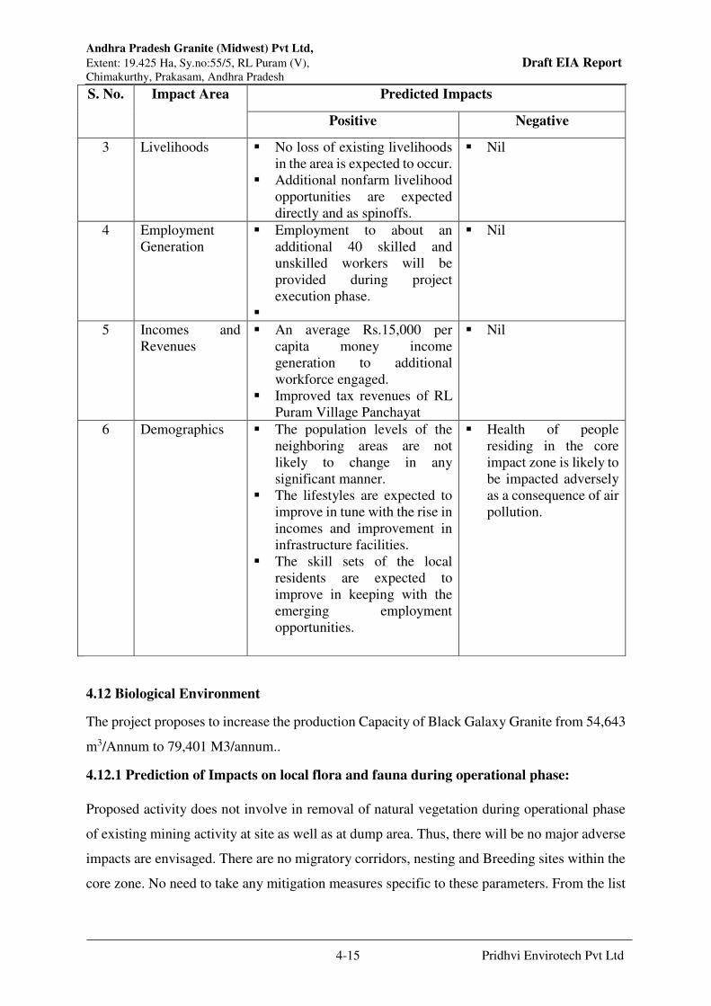
Andhra Pradesh Granite (Midwest) Pvt Ltd,
Extent: 19.425 Ha, Sy.no:55/5, RL Puram (V), Draft EIA Report Chimakurthy, Prakasam, Andhra Pradesh
4-15 Pridhvi Envirotech Pvt Ltd
S. No. Impact Area Predicted Impacts
Positive Negative
3 Livelihoods No loss of existing livelihoods
in the area is expected to occur.
Additional nonfarm livelihood
opportunities are expected
directly and as spinoffs.
Nil
4 Employment
Generation
Employment to about an
additional 40 skilled and
unskilled workers will be
provided during project
execution phase.
Nil
5 Incomes and
Revenues
An average Rs.15,000 per
capita money income
generation to additional
workforce engaged.
Improved tax revenues of RL
Puram Village Panchayat
Nil
6 Demographics The population levels of the
neighboring areas are not
likely to change in any
significant manner.
The lifestyles are expected to
improve in tune with the rise in
incomes and improvement in
infrastructure facilities.
The skill sets of the local
residents are expected to
improve in keeping with the
emerging employment
opportunities.
Health of people
residing in the core
impact zone is likely to
be impacted adversely
as a consequence of air
pollution.
4.12 Biological Environment
The project proposes to increase the production Capacity of Black Galaxy Granite from 54,643
m3/Annum to 79,401 M3/annum..
4.12.1 Prediction of Impacts on local flora and fauna during operational phase:
Proposed activity does not involve in removal of natural vegetation during operational phase
of existing mining activity at site as well as at dump area. Thus, there will be no major adverse
impacts are envisaged. There are no migratory corridors, nesting and Breeding sites within the
core zone. No need to take any mitigation measures specific to these parameters. From the list

Andhra Pradesh Granite (Midwest) Pvt Ltd,
Extent: 19.425 Ha, Sy.no:55/5, RL Puram (V), Draft EIA Report Chimakurthy, Prakasam, Andhra Pradesh
4-16 Pridhvi Envirotech Pvt Ltd
of floral and faunal species, it is very clear that there are no Rare or Endangered or Endemic or
Threatened (REET) species present in core or buffer zones.
4.12.2 Impact on Terrestrial and Aquatic Ecology
Prediction of impacts is based on the direct and indirect; short-term as well as long-term;
reversible and irreversible impacts that are most likely to occur owing to the proposed industrial
activity during operation. The following ecological factors that are considered most significant
as far as the impact on flora and fauna are concerned:
The overall impact of the project on ecological aspects is:
Magnitude: less
Extent: The extent of the impact is on-site as the impacts will be limited to the boundaries of
the Site.
Duration: The duration would be short-term as the natural vegetation of the site would not be
affected during the construction phase.
Intensity or magnitude: The intensity is very less during construction and operation phases.
Reversible or Irreversible: Nil
Ecological factors and their impacts due to proposed activity:
Species diversity No reduction
Habitat loss or fragmentation Nil
Effect on any additional risk or threat to the rare or endangered or
endemic or threatened (REET) species
Nil
Any impairment of ecological functions such as (i) disruption of food
chains, (ii) decline in species population and or (iii) alterations in
predator-prey relationships
Nil
Is it possible to attain the global objectives of “no net loss” of biodiversity
No
From the above table, it is very clear that proposed activity shall not impact on the biodiversity
of the region. Hence, it is recommended to proposed project in the proposed locality by
following certain conservation measures. However, some positive impacts of the proposed unit

Andhra Pradesh Granite (Midwest) Pvt Ltd,
Extent: 19.425 Ha, Sy.no:55/5, RL Puram (V), Draft EIA Report Chimakurthy, Prakasam, Andhra Pradesh
4-17 Pridhvi Envirotech Pvt Ltd
are enriching the habitat and species with greenbelt activities in core and buffer region will
enhance the beauty of the surrounding region.
As there are no REET species in the study area, the proposed project will not pose any threat
to local flora and fauna. No direct or indirect damage is expected to the flora and fauna of the
buffer zone. Hence, the anticipated environmental impacts on the flora and fauna of the study
area are negligible and easily reversible if any. It will not create any kind of environmental
stress to the local flora and fauna.
4.12.3 Impacts Identified:
Major impacts on ecology due to additional traffic near buffer zone, which will be created due
to the movement of mined granite blocks. The approximate increase of trucks/tippers will be 8
dumpers/day during operations. Due to this, dust and vehicular emissions on the natural and
agriculture plants get affected. The crop yield will be reduced and growth rate of trees in the
buffer zone at villages side plants and near reserve forest blocks will get affected.
The direct impacts: Dust and noise pollution are direct impacts due to mining activity. The
noise and vibrations are affecting the reptilian fauna present in the reserve forests. The bird
nesting and breeding grounds will be shifted to adjoining stabilized habitats. Higher mammals
changes their habitats. The dust particles will be directly affecting the aquatic ecosystem near
Ramatheertham Reservoir. The impact will be there on local fishes and amphibians of the
region.
Indirect Impacts: Indirect impacts on small mammals and other fauna on the roads. Road kills
will occur during vehicular movement.
Duration of the Impacts: Long term Negative impacts on the ecosystem because of mining
process, and transportation will occur on ecological environment as secondary impacts due to
environmental contamination caused mainly by gaseous & particulate emissions released. Such
environmental contamination caused by emissions may lead to heavy toxic load on ecological
components (biotic & abiotic) which may have very adverse effects on flora, fauna and
ecological habitat depending up on the toxicity type & level of the contaminant.
Such particulate matter will get settled on leaves of flora of the region specially surround
agricultural ecosystem which may in turn cause long term negative impacts on flora causing
hindrance in photosynthesis and adverse effects on growth & quality due to toxicity. There are
few aquatic bodies nearer to the existing unit. The cumulative impacts of all the surrounding

Andhra Pradesh Granite (Midwest) Pvt Ltd,
Extent: 19.425 Ha, Sy.no:55/5, RL Puram (V), Draft EIA Report Chimakurthy, Prakasam, Andhra Pradesh
4-18 Pridhvi Envirotech Pvt Ltd
mining sites and proposed project activities causes deterioration of the quality of these water
bodies which may intern causes death to many aquatic flora and fauna.
The above said impacts due to the toxicity of contaminants released may also occur in the
distant fauna due to the interaction & migration of the fauna between micro habitats of the
region. The eventual toxic effects of the said impacts may increase as a result of bio‐
magnification in food chain and food web. The heat radiated from site may result in
considerable adverse impacts on ecology. These impacts are controllable by planning &
implementation of efficient & adequate mitigation measures.
Minor Impacts
Minor negative impact in terms on fauna may also occur during transportation route in case of
major road accident. Negative impacts in term of contamination of soil due to mixing of heavy
load of pollutants (Dust and particulate matter), which may alter many soil quality parameters.
Positive impacts on Ecological aspects:
Aesthetics:
Due the present plantation activities within the buffer zone of the site, the aesthetic value of
the region will be enhanced besides reduction of effects of pollutants. The beauty of the region
will be enhanced. More native plants species that are suitable to the region taken into criteria.
Involving local villagers in plantation activities and educating the people on importance of
biodiversity leads to protection and conservation of flora and fauna in long term.
Carbon sink: Within the study area i.e in the buffer zone, the mass avenue plantation
activities, rehabilitating degraded lands contribute to mitigating climate change. These actions
increase the rate and quantity of carbon sequestration in biomass. Introduction of trees on non-
forest or degraded forestlands, industrial plantations, Village plantations, restoration of natural
forest, watershed protection, orchards and perennial cultures, agro-forestry activities enhance
the ecological and economic values.
4.13 Conclusion
Based on the EIA study it is observed that there will be a marginal increase in the dust pollution,
which will be controlled by sprinkling of water and transportation in properly controlled
movement. There will be minimal impact on ambient environment & ecology due to mining
activities, moreover the mining operations will lead to direct and indirect employment
generation and improves the quality of life of the people in the region.
Andhra Pradesh Granite (Midwest) Pvt Ltd,
Extent: 19.425 Ha, Sy.no:55/5, RL Puram (V), Draft EIA Report Chimakurthy, Prakasam, Andhra Pradesh
4-19 Pridhvi Envirotech Pvt Ltd
Hence, it can be summarized that the Black Galaxy Granite Mine of APGMPL will have a
positive impact on the socio-economics of the area and lead to overall sustainable development
of the region, therefore environmental clearance may be granted.

Chapter - 5
Analysis of Alternatives (Technology & Site)

Andhra Pradesh Granite (Midwest) Pvt Ltd,
Extent: 19.425 Ha, Sy.no:55/5, RL Puram (V), Draft EIA Report Chimakurthy (M), Prakasam (D), A.P
5-1 Pridhvi Envirotech Pvt Ltd
CHAPTER 5
ANALYSIS OF ALTERNATIVES
(TECHNOLOGY & SITE)
5.1 Analysis of Alternative Technology
Andhra Pradesh Granite Midwest Private Limited is adopting semi mechanized open - cast
method of mining. Granite is a siliceous rock. During dimensional quarrying of granite blocks
drilling cannot be avoided completely though primary sawing is executed using diamond wire
saw. The process of drilling which is percussive-cum-rotary, invariably releases fine dust
which is injurious when inhaled by the workmen.
The proponents developed an improvised dust collection system in association with Ripamonti,
Italy with enhanced number of filters and incorporating superior quality filters. Adoption of
this dust collection system greatly improves the efficacy of dust collection mechanism and
minimise the release of dust in the work area.
5.2 Analysis of Alternative Sites
Alternative site selection does not arise as this is existing mine going for expansion

Chapter - 6
Environmental Monitoring Programme
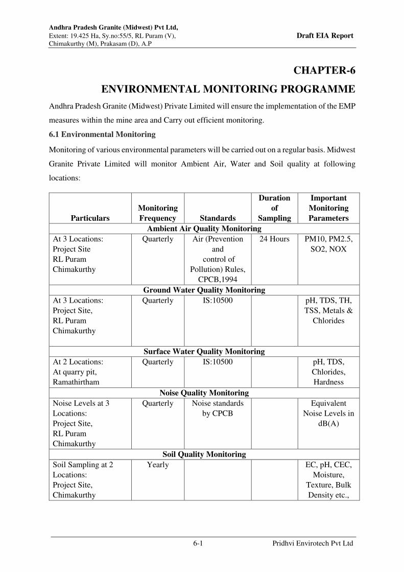
Andhra Pradesh Granite (Midwest) Pvt Ltd,
Extent: 19.425 Ha, Sy.no:55/5, RL Puram (V), Draft EIA Report Chimakurthy (M), Prakasam (D), A.P
6-1 Pridhvi Envirotech Pvt Ltd
CHAPTER-6
ENVIRONMENTAL MONITORING PROGRAMME
Andhra Pradesh Granite (Midwest) Private Limited will ensure the implementation of the EMP
measures within the mine area and Carry out efficient monitoring.
6.1 Environmental Monitoring
Monitoring of various environmental parameters will be carried out on a regular basis. Midwest
Granite Private Limited will monitor Ambient Air, Water and Soil quality at following
locations:
Particulars
Monitoring
Frequency Standards
Duration
of
Sampling
Important
Monitoring
Parameters
Ambient Air Quality Monitoring
At 3 Locations:
Project Site
RL Puram
Chimakurthy
Quarterly Air (Prevention
and
control of
Pollution) Rules,
CPCB,1994
24 Hours PM10, PM2.5,
SO2, NOX
Ground Water Quality Monitoring
At 3 Locations:
Project Site,
RL Puram
Chimakurthy
Quarterly IS:10500
pH, TDS, TH,
TSS, Metals &
Chlorides
Surface Water Quality Monitoring
At 2 Locations:
At quarry pit,
Ramathirtham
Quarterly IS:10500
pH, TDS,
Chlorides,
Hardness
Noise Quality Monitoring
Noise Levels at 3
Locations:
Project Site,
RL Puram
Chimakurthy
Quarterly Noise standards
by CPCB
Equivalent
Noise Levels in
dB(A)
Soil Quality Monitoring
Soil Sampling at 2
Locations:
Project Site,
Chimakurthy
Yearly
EC, pH, CEC,
Moisture,
Texture, Bulk
Density etc.,
Andhra Pradesh Granite (Midwest) Pvt Ltd,
Extent: 19.425 Ha, Sy.no:55/5, RL Puram (V), Draft EIA Report Chimakurthy (M), Prakasam (D), A.P
6-2 Pridhvi Envirotech Pvt Ltd
Monitoring will be carried out as per the CPCB guidelines using Fine dust samplers, and
Respirable Dust samplers.
6.2 Environmental Management Cell
Andhra Pradesh Granite (Midwest) Private Limited hired services of experienced
Environmental Professionals periodically for consulting and implementing the Environmental
Management measures from time to time to comply with environmental norms stipulated for
the project.
6.3 Environment Policy
Environmental Policy has been formulated for implementation. Mines Manager will be
responsible for maintaining ecological balance by adequate environmental protection. He will
monitor the environmental performance and guide the employees for maintaining good
environmental Practices and to adopt newer, safe and cleaner technologies.
6.4 Responsibility of Monitoring and Reporting System
Records will be maintained for the analysis of ambient air quality, noise levels and water
quality. These records are not only required for the perusal of the statutory authorities. The
management will maintain the records as EPA regulations and apply for the annual consents
for air and water. The mine shall obtain the consent for establishment (CFE) and consent for
operation (CFO) from State Pollution Control Board as required under section 25/26 of the
Water act, 1974 and under section 21/22 of Air Act, 1981, before enhancement the production
from the Pollution Control Board as directed by the Hon’ble Supreme Court of India. The CFO
will be renewed every 5 year by the management in consultation with APPCB. The mine
submitting environmental statement every year. The management ensures that it will comply
with all the directions and regulations issued by the Ministry of environment, forests and
climate change, New Delhi, State and Central Pollution Control Boards. The Consent for
Establishment, Consent for Operation displayed in a conspicuous location for the information
of the inspecting authorities of different departments and all stake holders.
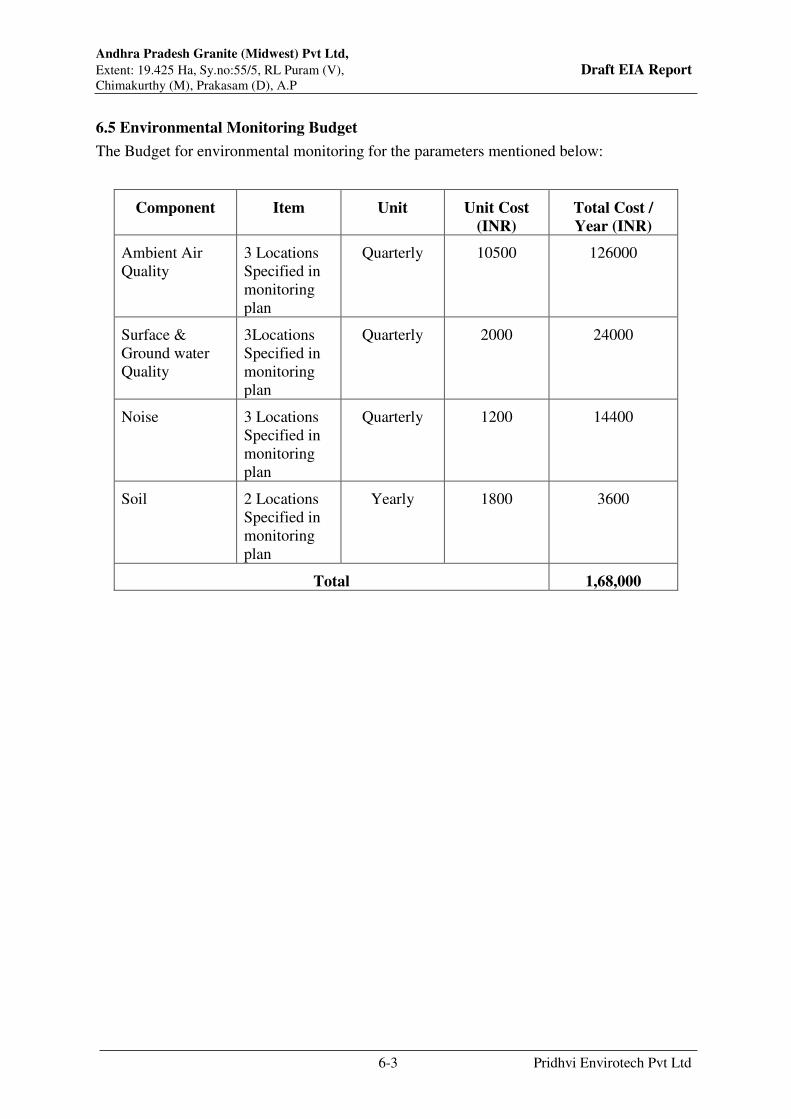
Andhra Pradesh Granite (Midwest) Pvt Ltd,
Extent: 19.425 Ha, Sy.no:55/5, RL Puram (V), Draft EIA Report Chimakurthy (M), Prakasam (D), A.P
6-3 Pridhvi Envirotech Pvt Ltd
6.5 Environmental Monitoring Budget
The Budget for environmental monitoring for the parameters mentioned below:
Component Item Unit Unit Cost
(INR)
Total Cost /
Year (INR)
Ambient Air
Quality
3 Locations
Specified in
monitoring
plan
Quarterly 10500 126000
Surface &
Ground water
Quality
3Locations
Specified in
monitoring
plan
Quarterly 2000 24000
Noise 3 Locations
Specified in
monitoring
plan
Quarterly 1200 14400
Soil 2 Locations
Specified in
monitoring
plan
Yearly 1800 3600
Total 1,68,000

Chapter - 7
Additional Studies

Andhra Pradesh Granite (Midwest) Pvt Ltd,
Extent: 19.425 Ha, Sy.no:55/5, RL Puram (V), Draft EIA Report Chimakurthy (M), Prakasam (D), A.P
7-1 Pridhvi Envirotech Pvt Ltd
CHAPTER – 7
ADDITIONAL STUDIES
ADDITIONAL STUDIES
7.1 Public Consultation
The Draft EIA Report is prepared as per the EIA notification,2006 and being submitted to
APPCB Regional office, Ongole for conducting public hearing for the enhancement of Black
Galaxy Granite mine of Andhra Pradesh Granite (Midwest) Private Limited located in
Sy.No.55/5, of RL Puram Village, Chimakurthy Mandal, Prakasam District, Andhra Pradesh.
After completion of public hearing, inputs received during public hearing process and details
will be submitted in final EIA report.
7.2 Risk Assessment of Black Galaxy Granite Mining
Risk assessment is a process whereby risks are analysed, assessed and risk management
priorities are evaluated. It is defined as the characterization of the potential adverse effect to
human health & environment due to environmental hazards.
Objectives of risk assessment are:
Identifying hazardous activities
Assessment of risk level and severity in different operations
Identification of control measures
Setting monitoring process
Reduce the impact of mishaps of all kinds
Reduce the inherent potential for major accidents.
Methodology of Risk assessment: -
Collection of information & identification of hazard
Classify their severity and probability of occurrence.
Identification of exposed risks
Assess the risk and risk rating based on
Probability

Andhra Pradesh Granite (Midwest) Pvt Ltd,
Extent: 19.425 Ha, Sy.no:55/5, RL Puram (V), Draft EIA Report Chimakurthy (M), Prakasam (D), A.P
7-2 Pridhvi Envirotech Pvt Ltd
Exposure
Consequence
Prioritization of the risks
Implementation of control measures
Monitoring risk assessment
Evaluation and correction
Factors of risks involved due to human induced activities in connection with mining operations
are 1) removal of O.B and side burden 2) drilling 3) blasting 4) excavation of ore and 5)
transportation of ore 6) Safeguarding of explosives.
Other risk factors due to natural activities are 1) water inundation 2) natural calamities such as
earth quakes
For the various risks, likely to arise, as above, detailed analysis of causes and control measures
is given in below Table:
Table 7.1: Identified Risks & Control measures
S.
No Factors Causes of risks Control measures
1 Removal of
O.B, ore &
its dump
a) Sliding of benches due to its
unconsolidated nature.
b) Vibration due to movement
of vehicles in the benches.
- The maximum bench slope and ultimate
pit slope of 70° and 40° will be
maintained.
- There is no overburden in this case as
mine is operational since 2007
- Mine waste is transported to Dump site
which is away from the mine and hence
no possibility of slip of dump into mine
- Adequate slopes are maintained for
dump waste to avoid any slippage
Andhra Pradesh Granite (Midwest) Pvt Ltd,
Extent: 19.425 Ha, Sy.no:55/5, RL Puram (V), Draft EIA Report Chimakurthy (M), Prakasam (D), A.P
7-3 Pridhvi Envirotech Pvt Ltd
2 Drilling a) Due to high pressure of
compressed air hoses may
burst
b) Jack hammer rod may
break due to improper
maintenance of the rod
- Periodical preventive maintenance and
replacement of worn out accessories in
the compressor and drill equipment.
- As per manufacturers recommendation
rod to be replaced and bits will be
changed
3 Blasting a) Fly rock, ground
vibration and noise etc.,
b) Improper charging of
explosives
- Spacing will be kept optimum on trial
basis.
- Delay detonators will be used.
- Maximum charge per delay will be
restricted and by optimum blast hole
pattern, vibrations will be controlled
within the permissible limit and blast
can be conducted safely.
- Blast warning system is in place and
people presence during blasting will be
restricted
4 Excavation
of waste &
granite
blocks
a) Hauling and loading
equipment are used in
mine. Derick lifts are used
for loading granite blocks
b) Failure of Derick lift ropes
c) Falling of Heavy Blocks
during loading using
loaders
- Operator shall not operate the machine
when person & vehicles are in such
proximity.
- Shall not swing the bucket over the cab
and operator leaves the machine after
ensuring the bucket is on ground.
- Shall not allow any unauthorized person
to operate the machines by effective
supervision
- Derick lift ropes are tested periodically
and replaced when required
- Helmets, Safety shoes, ear plugs, Dust
masks shall be used during loading
process

Andhra Pradesh Granite (Midwest) Pvt Ltd,
Extent: 19.425 Ha, Sy.no:55/5, RL Puram (V), Draft EIA Report Chimakurthy (M), Prakasam (D), A.P
7-4 Pridhvi Envirotech Pvt Ltd
5 Storage of
explosives
a) Accidental detonation of
explosives
b) Theft of explosives by
unscrupulous elements
and miss use
- A separate magazine storage area
approved by Mine Safety department is
maintained with all necessary safe
guards
- Security arrangement for 24 hours is
maintained to avoid any theft and mis-
use of explosives
6 Transportatio
n of Waste
and Blocks
a. Operating the
vehicle “nose to tail”
b. Overloading of material
c. While reversal &
overtaking of vehicle
d. Operator of truck leaving
his cabin when it is
loaded.
- It will be ensured that all these causes
will be nullified by giving training to the
operators.
- No overloading is permitted
- Audio visual reverse horn will be
provided for vehicles
- No un-authorised persons will be
allowed during loading operations
7 Fire due to
electricity
and Oil
a) Due to the short circuit of
cables & other electrical
parts
b) Due to the leakage of
inflammable liquid like
diesel, oil etc.,
- Commutator & electrical parts shall be
cleaned frequently with the help of dry
air blower.
- Checking will be done every day for
proper earthing of electrical equipment
- All fastening parts and places will be
tightened.
- Vehicles will be maintained every week
to detect leaks
8 Water inundation
a) Inrush of storm water due
to heavy rain
b) Unusual seepage of water
c) Sudden collapse of
peripheral bund due to
torrential pour
- Ground water levels yet to reach in the
mine
- Mining operations will be suspended
during heavy rain period
- No over burden is stored at the site
9 Natural calamities
Unexpected happenings - The mine management is capable to deal
with the situation

Andhra Pradesh Granite (Midwest) Pvt Ltd,
Extent: 19.425 Ha, Sy.no:55/5, RL Puram (V), Draft EIA Report Chimakurthy (M), Prakasam (D), A.P
7-5 Pridhvi Envirotech Pvt Ltd
7.3 Disaster Management:
The planning for mitigating the emergency involves recognizing the accident or possible,
assessing the consequences of such possible accidents and deciding on emergency planning /
procedures in advance both on site & off site that would be necessary to be implemented in the
event of emergency without any delay and confusion.
Proper bench design in mines and observing safety measures for transportation, storage,
handling of explosives & fuels, etc, good maintenance of vehicles, roads, fire prevention
measures shall go in preventing disaster/accidents.
Mining shall be carried out as per MMR 1961 & Rules and regulations applicable the project
in charge is having a mobile communication for quick Intimation of information if need arises.
As the quarry operation is open cast, possible risk is collapse of mine pit when people are
working. For this proper bench slope will be maintained as per the mining plan. Mining
operations will not be conducted during rainy days to avoid any collapse of the overburden into
mine pit. All precautions would be taken to control fly rock during the blasting operations.
The quarry is located at about 25KM from Ongole town having good transport and
communication systems. The quarry area is provided with good communication facilities like
telephone & mobile phone.
In case of any minor/major accidents within the mine, the same will be communicated to the
local Revenue Officials, Police, Fire Department, DGMS etc for action.
A vehicle is kept all the time at the quarry site for conveyance. The workmen in the project are
periodically trained at group VT center for proper safety training as per the DGMS circulars.
First aid kits are kept at mine site for providing first aid. Management staff at mine are trained
to provide immediate first aid
At quarry level first aid facility is provided and person(s) will be shifted to nearest major
hospital. A key person will be assigned duties and responsibilities for incident response and
emergency response at the quarry.
At mine, level first aid will provided and person(s) shall be shifted to nearby hospital at
Chimakurthy or Ongole, which are having all basic amenities. There is qualified medical
officer in the Government Hospital at Chimakurthy, who is capable of handling normal
accidents. In case of high risk accidents injured will be shifted by department vehicle to well-
equipped Hospitals at Ongole town, which is 25 Km from quarry site, as per the requirement.

Andhra Pradesh Granite (Midwest) Pvt Ltd,
Extent: 19.425 Ha, Sy.no:55/5, RL Puram (V), Draft EIA Report Chimakurthy (M), Prakasam (D), A.P
7-6 Pridhvi Envirotech Pvt Ltd
Quarry Manager is the person responsible of the disaster management and he needs to be
contacted in case of any disaster.
7.4 Social Impact Assessment:
Total 50 Villages are falling in 10.0 km radius of project area. In the study area, the population
is 1,05,582 which males are 56.71% and females are 49.28%. The literate population in the
study area is 51.27% of the total population of the study area.
The working population in the project area are 51,980 which is 49.23% of total population out
of which males are constituted to 60.3% and females account to 39.7%.
Sampled households:
A stratified random sampling technique was followed to select the sample villages and
households. Accordingly, the sample villages were picked up at random from the three impact
zones considered – core, buffer and minimally affected. The number of households to be
contacted in each sample village was determined on the basis of the size of population of the
respective village. In the absence of household level information, the respondent households
were selected randomly during the course of visit to the respective village.
However, while selecting the respondent households, emphasis was on contacting households,
who are economically poor, susceptible to shifts in livelihood patterns and belonged to
vulnerable social communities. Accordingly, the sample villages selected for the survey
together with the number of households across each village are presented in Table.
Table –7.2 Sample Villages Selected for Socio-Economic Impact Assessment
S.
No
Town /
Village Name
Mandal
Name
Location from Project Site Population(2011
Census) House Holds (No.)
Directions Distance Total Samples
1
Kambhampadu Chimakurthy SW 1.55 Km Under Rajupalem
Lakshmipuram Revenue
Population Data is Same
11
2 Rajupalem Lakshmipuram Chimakurthy W 2.40 Km 3437 879 12
3 Chimakurthy Chimakurthy E 2.50 Km 30279 7577 14
4 Pulikonda Chimakurthy S 3.90 Km 1622 422 9
5 Budavada Chimakurthy SW 4.45 Km 3442 827 10
6 Ayyapa Raju Palem Marripudi W 4.80 Km 1196 317 12
7 Kandurivari Agraharam Chimakurthy NE 5.75 Km 689 161 11

Andhra Pradesh Granite (Midwest) Pvt Ltd,
Extent: 19.425 Ha, Sy.no:55/5, RL Puram (V), Draft EIA Report Chimakurthy (M), Prakasam (D), A.P
7-7 Pridhvi Envirotech Pvt Ltd
8 P Naidu
Palem/Padamatinaidupalem Chimakurthy NE 6.20 Km 3933 856 12
9 Nippatlapadu Chimakurthy NW 6.30 Km 2798 645 11
10 Gangapalem Tallur NW 8.65 Km 7028 1812 10
Total 54424 13496 112
The sample villages account for 51.54% of the population and 52.04% of the number of
households of the total 50 villages
It needs to be mentioned in this context that an element of purposiveness was induced into
selection of sample villages with a view to focusing more on villages in the core and buffer
zones of impact. Such a selection of the sample villages was well justified as the entire area
beyond the core and buffer impact zones is likely to have only minimal impact of the project
and the same cannot be distinguished.
Based on a close understanding and assessment, the socio-economic impacts of APGMPL mine
are predicted as follows:
S. No. Impact Area Predicted Impacts
Positive Negative
1 Natural Resource
Sustainability
No acquisition of land
and change of land use
pattern
Increased pressure on
exploitation of
groundwater resources in
the area.
Possible contamination of
groundwater if adequate
safeguards are not taken.
2 Human Settlement No displacement of
habitations will occur.
Nil
3 Livelihoods No loss of existing
livelihoods in the area is
expected to occur.
Additional nonfarm
livelihood opportunities
are expected directly and
as spinoffs.
Nil
4 Employment
Generation
Employment to about an
additional 40 skilled and
unskilled workers will be
provided during project
execution phase.
Nil

Andhra Pradesh Granite (Midwest) Pvt Ltd,
Extent: 19.425 Ha, Sy.no:55/5, RL Puram (V), Draft EIA Report Chimakurthy (M), Prakasam (D), A.P
7-8 Pridhvi Envirotech Pvt Ltd
S. No. Impact Area Predicted Impacts
Positive Negative
5 Incomes and
Revenues
An average Rs.15,000 per
capita money income
generation to additional
workforce engaged.
Improved tax revenues of
RL Puram Village
Panchayat
Nil
6 Demographics The population levels of
the neighboring areas are
not likely to change in
any significant manner.
The lifestyles are
expected to improve in
tune with the rise in
incomes and
improvement in
infrastructure facilities.
The skill sets of the local
residents are expected to
improve in keeping with
the emerging
employment
opportunities.
Health of people residing
in the core impact zone is
likely to be impacted
adversely as a
consequence of air
pollution.

Chapter - 8
Project Benefits

Andhra Pradesh Granite (Midwest) Pvt Ltd,
Extent: 19.425 Ha, Sy.no:55/5, RL Puram (V), Draft EIA Report Chimakurthy (M), Prakasam (D), A.P
8-1 Pridhvi Envirotech Pvt Ltd
CHAPTER – 8
PROJECT BENEFITS
8.1 Employment Potential
APGMPL has employed 448 persons for carrying out the mining operations. In addition there
will be indirect employment to many more people in the form of contractual jobs, business
opportunities, service facilities etc., This will enhance the economic status.
Apart from the jobs, APGMPL will contribute to medical and educational facilities to the
employees.
8.2 Social Welfare Measures
APGMPL has spent Rs.5,85,74,743/- towards Infrastructure Development Fee to APMDC
which in turn spends the amount for development works in the district.
8.3 Corporate Environmental Responsibility
As a part of Corporate Environmental Responsibility APGMPL, During the period of Pandemic
Project proponent spend Rs.21,31,920/- towards providing Covid vaccination for entire
employees, some of their family members, vendors and local villagers.
APGMPL proposed to spend additional funds towards Corporate Environmental
Responsibility as per Office Memorandum F.No. 22-65/2017. 1A.III dated 1st May, 2018, an
amount of Rs. 30.5 lakhs will be earmarked and spent in the nearby villages based on feedback
from the villages
8.4 Other Intangible benefits:
The proposed expansion activities will help to increase trade in the area in terms of maintenance
activities of equipment, spares and transport activity. This will in turn result in economic
benefits to local people. The increased mine production results in royalty to Government and
GST and other taxes which will in turn help the local panchayats
Chapter - 9
Environmental Cost Benefit Analysis

Andhra Pradesh Granite (Midwest) Pvt Ltd,
Extent: 19.425 Ha, Sy.no:55/5, RL Puram (V), Draft EIA Report Chimakurthy (M), Prakasam (D), A.P
9-1 Pridhvi Envirotech Pvt Ltd
CHAPETR – 9
ENVIRONMENTAL COST BENEFIT ANALYSIS
Not Applicable as it is not recommended at the scoping stage.

Chapter - 10
Environmental Management Plan
Andhra Pradesh Granite (Midwest) Pvt Ltd,
Extent: 19.425 Ha, Sy.no:55/5, RL Puram (V), Draft EIA Report Chimakurthy (M), Prakasam (D), A.P
10-1 Pridhvi Envirotech Pvt Ltd
CHAPTER – 10
ENVIRONMENAL MANAGEMENT PLAN
10.1 Environnemental Management Plan
The activities at the QL area shall have both positive and negative impacts. In order to reduce
the negative impacts owing to activities in the QL area under consideration, measures have
been integrated in the process at the planning stage itself. Environmental management approach
includes actions to protect environment by using various means at different stages of the
project. The measures result in reduction of the impacts at the source itself. Some of the
measures result in the change in technology / process thereby reducing and or eliminating some
of the adverse impacts. In a few inevitable cases, the remedial solutions are provided to counter
/ minimize the negative impacts.
10.2 Air Pollution Control Measures
Air pollution from mining activities in the present case is not anticipated to significantly extend
beyond the immediate vicinity of the Quarry Lease area. Following measures shall be taken to
mitigate the effect of mining operations.
The dust rising due to mining activity will be controlled by covering dust extractors will also
be employed.
Wet drilling implemented and dust free drilling machine developed and adopted.
Dust suppression on roads will be done with sprinkling of water.
Regular maintenance of vehicles, machinery and DG set shall be carried out in order to
minimize the emissions.
Development of green belt to minimize dust emission.
10.3 Noise Pollution Control Measures
The major sources of noise in mining are from the operations of drilling and blasting,
trucks, material handling machinery, loading equipment etc.
Mitigation measures that are proposed to be adopted for control of noise levels are:
DG Set will be installed with Acoustic Enclosures and Silencers.

Andhra Pradesh Granite (Midwest) Pvt Ltd,
Extent: 19.425 Ha, Sy.no:55/5, RL Puram (V), Draft EIA Report Chimakurthy (M), Prakasam (D), A.P
10-2 Pridhvi Envirotech Pvt Ltd
The machinery will be maintained properly to reduce the noise.
Proper maintenance of equipment is taken care of by the proponent at the Quarry Lease
Area.
It is proposed to use low strength explosives and in optimum quantity to minimize the
effects so that the vibration generated will be feeble within 8 Hz.
Limiting the speed of vehicles entering and leaving the quarry to 25 kmph.
10.3.1 Measures to minimise ground vibrations and noise
Controlled Blasting will be done with optimum quantity explosives. Compressor is kept far
from working spots to minimize ground vibrations.
Reduction of noise to acceptable occupational exposure levels are as follows:
Ensuring that large equipment (e.g. excavators, dumpers, dozers, drillers and other
automated equipment that requires an operator) are equipped with a soundproof cabin.
Workers working in noisy areas are provided with ear plugs.
Exposure to hand-arm vibration from hand and power tools or whole-body vibration
from surfaces on which the worker stands or sits should be adequately controlled
through the selection and maintenance of equipment which meets occupational
vibration exposure standards.
The operators will be provided with hand gloves or cotton cloth with which they grip
the machine handle. Thus the vibration transmission is reduced.
10.4 Water Pollution Control Measures
Water is used for dust suppression, Green belt development and domestic purpose only.
Domestic waste water be generated from the toilets. Effect of water regime at the surrounding
mines is not observed.
However, following measures shall be taken:
Garland drains around pit and waste dump were constructed.
Retention wall at the foot of the dump is made.
Check dam is constructed against drainage channels to arrest the silt.
Growing vegetation on the slopes of the dumps is made.
The spillages from fuelling of machinery shall be avoided and in case of any spillage
the same shall be handled properly. Likewise the spent lubricating oils etc. shall be
safely collected and properly disposed of.

Andhra Pradesh Granite (Midwest) Pvt Ltd,
Extent: 19.425 Ha, Sy.no:55/5, RL Puram (V), Draft EIA Report Chimakurthy (M), Prakasam (D), A.P
10-3 Pridhvi Envirotech Pvt Ltd
Surface runoff will be collected in the mine pit and will be used for wire saw cutting
and dust suppression operations.
Domestic wastewater will be sent to septic tank followed by soak pit.
No effect on ground water table as work pits have not touched the ground water table.
10.4.1 Water Conservation Measures
In the pre monsoon period the area experiences non-availability of water. Under Environmental
Social Responsibility it is suggested to undertake campaign on water conservation plans by
involving local environmentally conscious citizens and construct Rain Water Harvesting
structures in the private farmer’s agricultural lands. Locally best suited structures in the area
are Farm Ponds, Nala Bunds and Continuous Contour Trenches and Bunds.
Farm Pond: The area is underlain by thick soil cover of 2 to 3 meters. It is possible excavate
and create dug out pits on the elevated region in the individual farm plots and divert the storm
water to store in the pond. Dug out material can be used for developing bunds around the farm
pond as already being practiced in the area.
Nala Bund / Stream Checks: The area is gently sloping terrain having a number of linear
drainage courses. In the upper run-off zones of the drainage courses, land morphology is
changed; grading is done for cultivating the lands. As a result the storm water flow paths have
disappeared and runoff water escapes from the region as a sheet wash along with silt from
higher elevation to lower regions. It is suggested to identify such original / natural flow paths
and to construct Nala Bunds / Stream Checks with local stones and soil excavated in the area
across the nala courses.
Continuous Contour Trenches and Bunds: The hills in the study area are having slope in all
directions. All along the foot hills Continuous Contour Trenches and Bunds will enhance
ground water recharge to increase yield of irrigation wells.
10.5 Socio-Economic Environment
The commencement of mining activity in this area improved the socio-economic status of the
local people by creation of employment and paying taxes to gram Panchayat.
APGMPL would be required to initiate the following measures to minimize the possible
negative impacts, as a consequence of setting up his proposed Granite mining project at RL
Puram village in Prakasam District, on the surrounding socio-economic environment:
Install appropriate dust control equipment to check air pollution and developing Green
belt on road surrounding areas

Andhra Pradesh Granite (Midwest) Pvt Ltd,
Extent: 19.425 Ha, Sy.no:55/5, RL Puram (V), Draft EIA Report Chimakurthy (M), Prakasam (D), A.P
10-4 Pridhvi Envirotech Pvt Ltd
Organize monthly health camps in the area to check the occurrence of any respiratory
and other disorders.
Organizing vocational and soft skills development programmes for the youth.
Conduct Entrepreneurship Development Camps to nurture entrepreneurial talents
among the local youth.
10.6 Ecological Management
All the plantation activities of the expansion project if any will be commenced along with
construction activity, so that it can grow and help in the construction and operation stage of the
expansion project.
10.6.1 Greenbelt :
Green belt developed in a separate area of 2.74acres in sy.no 954/1 of chimakurthy village
near dump site and developed 1100 trees in this area.
Table 10.1: List of existing plantation
S.no Botanical name Common Name No of trees planted
1 Syzygium cumini (L.) Skeels Neredu 300
2 Pongamia pinnata (L.) Pierre Kanuga 150
3 Delonix regia (Hook.) Raf. Chittikesaram 150
4 Buchanania lanzan Spreng. Sara 200
5 Azadirachta indica A.Juss. Neem 300
Total 1100
Proposed Greenbelt species:
Development of a greenbelt reduces the intensity to pollution as well as improves the aesthetics.
Hence species selection is very important. Local species which are also useful to local
communities will be given most priority during the plantation.
Guidelines for Greenbelt Development
Design and development of greenbelt should be in adherence to site‐specific requirements and
prevalent climatic conditions.
Lessee shall ensure healthy & dens greenbelt throughout the life.
Lessee shall follow CPCB guidelines for development & maintenance of greenbelt area.
Lessee shall ensure regular irrigation & fertilization of greenbelt area as required
timely.
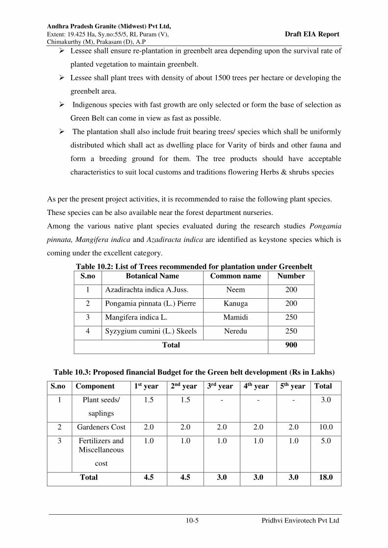
Andhra Pradesh Granite (Midwest) Pvt Ltd,
Extent: 19.425 Ha, Sy.no:55/5, RL Puram (V), Draft EIA Report Chimakurthy (M), Prakasam (D), A.P
10-5 Pridhvi Envirotech Pvt Ltd
Lessee shall ensure re‐plantation in greenbelt area depending upon the survival rate of
planted vegetation to maintain greenbelt.
Lessee shall plant trees with density of about 1500 trees per hectare or developing the
greenbelt area.
Indigenous species with fast growth are only selected or form the base of selection as
Green Belt can come in view as fast as possible.
The plantation shall also include fruit bearing trees/ species which shall be uniformly
distributed which shall act as dwelling place for Varity of birds and other fauna and
form a breeding ground for them. The tree products should have acceptable
characteristics to suit local customs and traditions flowering Herbs & shrubs species
As per the present project activities, it is recommended to raise the following plant species.
These species can be also available near the forest department nurseries.
Among the various native plant species evaluated during the research studies Pongamia
pinnata, Mangifera indica and Azadiracta indica are identified as keystone species which is
coming under the excellent category.
Table 10.2: List of Trees recommended for plantation under Greenbelt
S.no Botanical Name Common name Number
1 Azadirachta indica A.Juss. Neem 200
2 Pongamia pinnata (L.) Pierre Kanuga 200
3 Mangifera indica L. Mamidi 250
4 Syzygium cumini (L.) Skeels Neredu 250
Total 900
Table 10.3: Proposed financial Budget for the Green belt development (Rs in Lakhs)
S.no Component 1st year 2nd year 3rd year 4th year 5th year Total
1 Plant seeds/
saplings
1.5 1.5 - - - 3.0
2 Gardeners Cost 2.0 2.0 2.0 2.0 2.0 10.0
3 Fertilizers and
Miscellaneous
cost
1.0 1.0 1.0 1.0 1.0 5.0
Total 4.5 4.5 3.0 3.0 3.0 18.0
Andhra Pradesh Granite (Midwest) Pvt Ltd,
Extent: 19.425 Ha, Sy.no:55/5, RL Puram (V), Draft EIA Report Chimakurthy (M), Prakasam (D), A.P
10-6 Pridhvi Envirotech Pvt Ltd
10.6.2 Mitigation Measures proposed
Even though the mining process is within the standard levels prescribed by CPCB,
sensitive floral and aquatic ecosystems will get long-term impacts. Hence, all necessary
control & measures for prevention of release of toxic contaminants from mining site as
well as for prevention of pollution due to emissions of the project shall be implemented
as suggested in other relevant sections of this chapter as well as mentioned in EMP.
Environmental education activities to operation and transportation staff are also control
the negative impacts of the operational activities.
Safety measures & action plan for prevention of spreading of dust and particulate
matter shall be ensured.
Proper maintenance of roads in the buffer zone and at the entrance of the core zone
reduces the dust emissions and major accidents on fauna.
Creation & Maintenance of dense greenbelt near the villages and buffer zone reduces
the local temperature and dust pollution.
10.7 Occupational Safety & Health Management
Under Occupational Safety and Health Management, the project proponent will take all the
necessary steps to provide better working environment. Occupational health and safety issues
occur during all phases of the mine cycle. These are classified according to the following
categories:
General workplace health and safety
Use of explosives
Noise and vibration
Hazards during mining (Fires, explosions)
10.7.1 General Workplace Health and Safety
Mining exploration and development activities should manage occupational health and safety
hazards as part of a comprehensive health and safety management plan incorporating the
following aspects:
Preparation of emergency response plans specifically applicable to exploration and
production activities (considering the often geographically isolated nature of mining

Andhra Pradesh Granite (Midwest) Pvt Ltd,
Extent: 19.425 Ha, Sy.no:55/5, RL Puram (V), Draft EIA Report Chimakurthy (M), Prakasam (D), A.P
10-7 Pridhvi Envirotech Pvt Ltd
sites) and including the provision and maintenance of necessary emergency response
and rescue equipment.
First aid trained employees to respond to emergencies.
Implementation of specific personnel training on worksite health and safety
management including a communication program with a clear message about corporate
management’s commitment to health and safety.
Training of employees on the recognition and prevention of occupational hazards,
protection against the elements; thermal stress; acclimatization; disease exposure.
Illumination systems should be adequate and safe for the planned working conditions
in travel paths, mine working areas, and within and around surface facilities and
dumpsites of mines.
Management will provide workers and visitors with the necessary personal protective
equipment (PPE), and provide instruction and monitoring in their appropriate
maintenance and use. Applicable PPE include, at a minimum, safety helmets and
footwear, in addition to ear, eye, and hand protection devices.
Occupational health assessments should be conducted for employees on annual basis,
based on exposure to risk.
10.8 Use of explosives
Blasting activities that may result in safety impacts are typically related to accidental explosion
and poor coordination and communication of blasting activities. The proponent is taking safety
measures by using soundless stone expansive mortar to break the mother rock to avoid
accidents, noise impact on personnel and environment.
Use handling and transporting explosives in accordance with local and/ or national explosives
Safety regulations;
Assigning certified blasters or explosives experts to conduct blasts
Actively managing blasting activities in terms of loading, priming, and firing
explosives, drilling near explosives, misfired shots and disposal
Adoption of consistent blasting schedules, minimizing blast- time changes
Specific warning devices (e.g. horn signals, flashing lights) and procedures should be
implemented before each blasting activity to alert all workers and third parties in the
surrounding areas (e.g. the resident population).

Andhra Pradesh Granite (Midwest) Pvt Ltd,
Extent: 19.425 Ha, Sy.no:55/5, RL Puram (V), Draft EIA Report Chimakurthy (M), Prakasam (D), A.P
10-8 Pridhvi Envirotech Pvt Ltd
Blasting-permit procedures should be implemented for all personnel involved with
explosives (handling, transport, storage, charging, blasting, and destruction of unused
or surplus explosives).
Blasting sites should be checked post-blast by qualified personnel for malfunctions and
unexploded blasting agents, prior to resumption of work.
Qualified security personnel should be used to control transport, storage, and use of
explosives on site.
For any blasting activity, the same shall be outsourced to professional agencies. The agency
shall be responsible for taking care of all the precautions and safety measures. No explosives
shall be stored or kept at the QL area. The blasting material shall be carried to the QL area in
specified quantity as and when required. However, the overall responsibility shall lie with the
lessee.
10.8.1 Machine and Equipment Safety
To prevent and control hazards related to mining equipment use, measures for the enhancement
of visibility should be applied throughout the mine. Specific visibility management practices
may include the following-
Use of contrast colouring on equipment / machinery, including the provision of
reflective markings to enhance visibility.
Use of moving equipment / machinery equipped with improved operator sight lines.
Issuing workers high visibility clothing
Use of reflective markings on structures, traffic junctions, and other areas with a
potential for accidents
10.9 Environment Management Cell
10.9.1 Environmental Policy and management reporting system
Midwest has established itself as a very strong player in the domain of Exploration, Mining,
Processing and export of natural Stone products. Midwest is among the top 3 natural stone
players in India.
10.9.2 Environmental Policy
Environmental policy framed considering conservation and protection of Environment
Andhra Pradesh Granite (Midwest) Pvt Ltd,
Extent: 19.425 Ha, Sy.no:55/5, RL Puram (V), Draft EIA Report Chimakurthy (M), Prakasam (D), A.P
10-9 Pridhvi Envirotech Pvt Ltd
Environmental Policy Statement of the Company:
Midwest Granite Private Limited is committed to promote sustainable mining through
mitigation of pollution & conservation of natural Resources in all its group companies and
process units
It commits to the basic sustainable principles of Reduce & Re-use of waste and dispose all
wastes with adequate environmental Safe guards without harming the nature. It continually
strive to improve the environmental standards of its operations and process through objectively
verifiable targets and environmental management Programs
It is committed to include stake holders in the process and comply all legal and other
requirements to which it subscribes
This environmental policy is available to all stake holders, public and employees through
appropriate communication processes

Andhra Pradesh Granite (Midwest) Pvt Ltd,
Extent: 19.425 Ha, Sy.no:55/5, RL Puram (V), Draft EIA Report Chimakurthy (M), Prakasam (D), A.P
10-10 Pridhvi Envirotech Pvt Ltd
Figure 10.1: AP Midwest Granites Pvt Limited Group Companies Organo Gram
10.9.3 Reporting system to the Board of Directors
Non compliances /Violations on any matter which is material in nature will be apprised to
Board at the Board Meeting. all Non compliances/Violations on Environmental norms if any,
will be reported to this Committee
10.9.4 Reporting System
Reporting system provides the necessary feedback for project management to ensure quality of
the works and that the program is on schedule. The rationale for a reporting system is based on
accountability to ensure the measures proposed as part of the Environment Management Plan
get implemented in the project.
The reporting system will operate by mines manager and implementation system reporting to
the Supervision, who in turn shall report to the top management of Andhra Pradesh Granite

Andhra Pradesh Granite (Midwest) Pvt Ltd,
Extent: 19.425 Ha, Sy.no:55/5, RL Puram (V), Draft EIA Report Chimakurthy (M), Prakasam (D), A.P
10-11 Pridhvi Envirotech Pvt Ltd
Midwest Private Limited Every month, implementation of EMP shall be reviewed by top
management during implementation stage and thereafter during operational stage.
10.9.5 Records maintenance and reporting to statutory bodies
Records shall be maintained for the analysis of ambient air quality data, micro-meteorological
data and noise levels and ground water analysis. These records are not only requires for the
perusal of the pollution control board authorities but also to derive at the efficiencies of the
pollution control equipment as the objective of the project proponent is not only compliance
with statutory regulations, but also a serious commitment towards clean environment.
The industry shall regularly maintain the records as per the hazardous waste regulations & shall
apply for the renewal of consents for air and water and renewal of authorization for the
Hazardous waste.
10.10 Reclamation
The proposal for reclamation of land affected by mining activity will be done at the end of
mining lease. No reclamation is proposed during the three years period because, the mining
will be continued to further depths and reclamation is possible only after completion of mining
up to the proposed depths. In future, once the economically viable depth is reached in a part of
the area, back filling shall be adopted. Alternately, the excavated pit shall be left for water
storage
Based on the mining Plan the life of mine up to 15 years. Quarrying operation will create pit.
Land reclamation scheme will be developed that covers the following:
Creation of water reservoirs with guard fence will be done at the end of mining
Green belt will be developed progressively on closed mine area which will improve
overall environmental conditions.
10.11 Environmental Management Budget
Based on the proposed expansion activity, it is proposed invest a capital amount of Rs. 56.0
lakhs and recurring expenditure of Rs 39.0 lakhs per annum
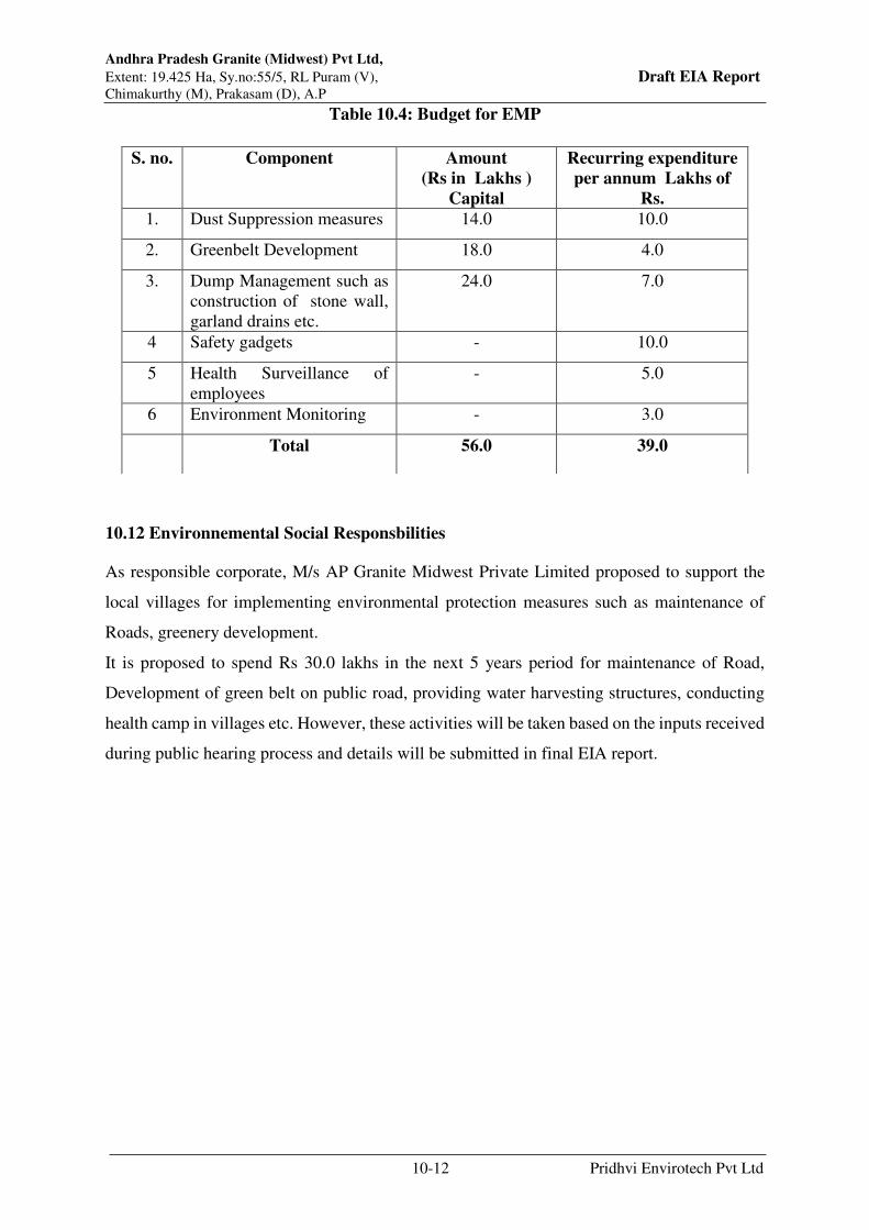
Andhra Pradesh Granite (Midwest) Pvt Ltd,
Extent: 19.425 Ha, Sy.no:55/5, RL Puram (V), Draft EIA Report Chimakurthy (M), Prakasam (D), A.P
10-12 Pridhvi Envirotech Pvt Ltd
Table 10.4: Budget for EMP
10.12 Environnemental Social Responsbilities
As responsible corporate, M/s AP Granite Midwest Private Limited proposed to support the
local villages for implementing environmental protection measures such as maintenance of
Roads, greenery development.
It is proposed to spend Rs 30.0 lakhs in the next 5 years period for maintenance of Road,
Development of green belt on public road, providing water harvesting structures, conducting
health camp in villages etc. However, these activities will be taken based on the inputs received
during public hearing process and details will be submitted in final EIA report.
S. no. Component Amount
(Rs in Lakhs )
Capital
Recurring expenditure
per annum Lakhs of
Rs.
1. Dust Suppression measures 14.0 10.0
2. Greenbelt Development 18.0 4.0
3. Dump Management such as
construction of stone wall,
garland drains etc.
24.0 7.0
4 Safety gadgets - 10.0
5 Health Surveillance of
employees
- 5.0
6 Environment Monitoring - 3.0
Total 56.0 39.0

Chapter - 11
Summary and Conclusion
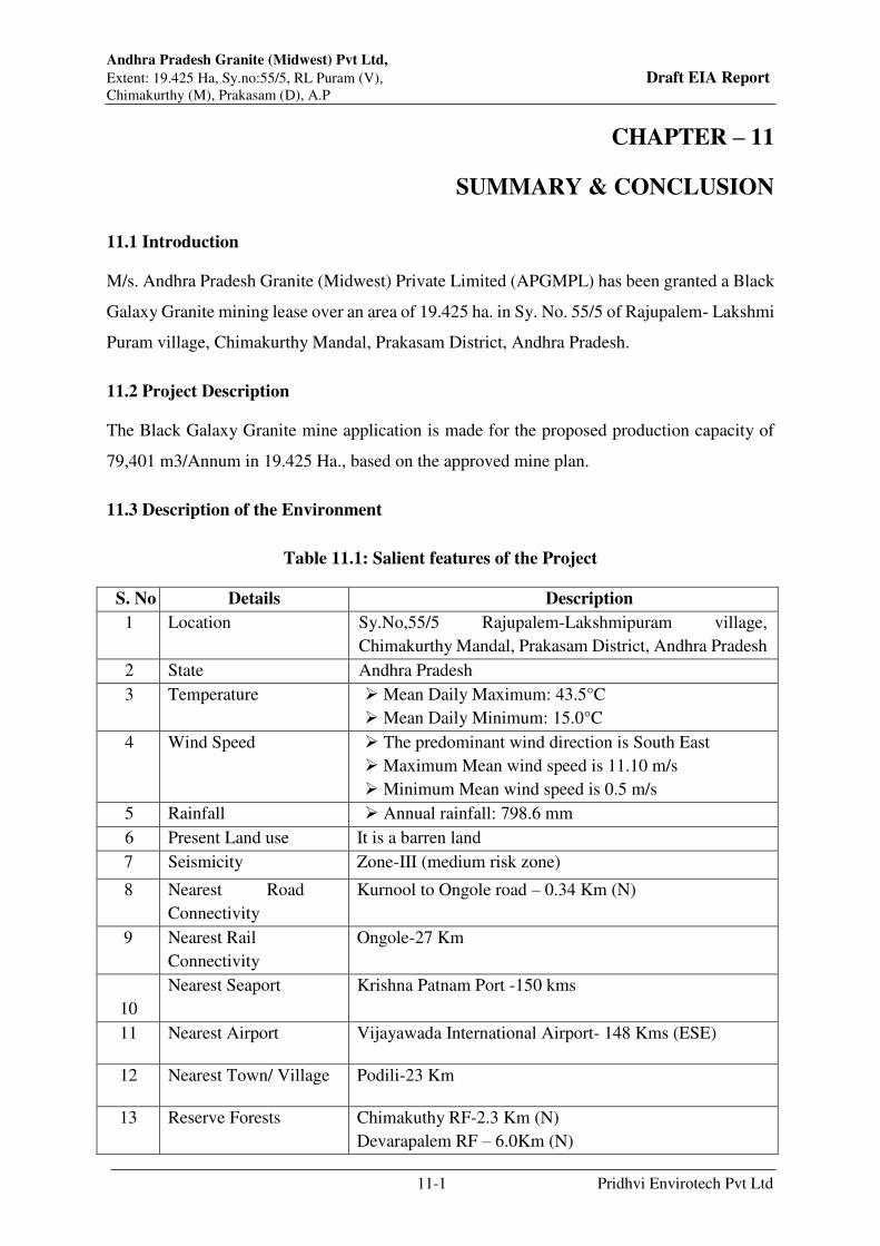
Andhra Pradesh Granite (Midwest) Pvt Ltd,
Extent: 19.425 Ha, Sy.no:55/5, RL Puram (V), Draft EIA Report Chimakurthy (M), Prakasam (D), A.P
11-1 Pridhvi Envirotech Pvt Ltd
CHAPTER – 11
SUMMARY & CONCLUSION
11.1 Introduction
M/s. Andhra Pradesh Granite (Midwest) Private Limited (APGMPL) has been granted a Black
Galaxy Granite mining lease over an area of 19.425 ha. in Sy. No. 55/5 of Rajupalem- Lakshmi
Puram village, Chimakurthy Mandal, Prakasam District, Andhra Pradesh.
11.2 Project Description
The Black Galaxy Granite mine application is made for the proposed production capacity of
79,401 m3/Annum in 19.425 Ha., based on the approved mine plan.
11.3 Description of the Environment
Table 11.1: Salient features of the Project
S. No Details Description
1 Location Sy.No,55/5 Rajupalem-Lakshmipuram village,
Chimakurthy Mandal, Prakasam District, Andhra Pradesh
2 State Andhra Pradesh
3 Temperature Mean Daily Maximum: 43.5°C
Mean Daily Minimum: 15.0°C
4 Wind Speed The predominant wind direction is South East
Maximum Mean wind speed is 11.10 m/s
Minimum Mean wind speed is 0.5 m/s
5 Rainfall Annual rainfall: 798.6 mm
6 Present Land use It is a barren land
7 Seismicity Zone-III (medium risk zone)
8 Nearest Road
Connectivity
Kurnool to Ongole road – 0.34 Km (N)
9 Nearest Rail
Connectivity
Ongole-27 Km
10
Nearest Seaport Krishna Patnam Port -150 kms
11 Nearest Airport Vijayawada International Airport- 148 Kms (ESE)
12 Nearest Town/ Village Podili-23 Km
13 Reserve Forests Chimakuthy RF-2.3 Km (N)
Devarapalem RF – 6.0Km (N)

Andhra Pradesh Granite (Midwest) Pvt Ltd,
Extent: 19.425 Ha, Sy.no:55/5, RL Puram (V), Draft EIA Report Chimakurthy (M), Prakasam (D), A.P
11-2 Pridhvi Envirotech Pvt Ltd
14 Surface water Bodies Musi River-3.1 Km E (Tributary of Paleru)
Ramathirtham Reservoir-4.6 (NW)
Jawahar canal (Right canal of Nagarjuna
Sagar)- 5.6 Km (W)
Gaddi Vagu-8.1 km (NW)
15 Nearest Reserve Forest Chimakuthy RF-2.3 Km (N)
Devarapalem RF – 6.0Km (N)
16 Any ecologically
sensitive areas
There is No ecological sensitive areas within 10 Km
radius
The area regionally forms part of the Paleru River Catchment System. The Musi river located
5.50 km west of the quarry site forms part of its stream. The Musi River originates in the
DarsDonakonda hills and upland areas of Prakasam district, and flows 33 km southwardly to
reach the study area, and further flows 23 km southeasterly and joins the Paleru River near
Kamepalli (6 km south of Kondapi), which then flows 30 km eastwards to join the Bay of
Bengal.
11.3.1 Land Use Details
The total mining lease area of 19.425 ha. About15.0 ha will be used for mining during the life
of the mine. Details of the land use pattern of the mining lease area given in table
Table 11.2: Land Use Pattern
S No Purpose Area in Ha.
1 Area under Quarrying 15.00
2 Hauling Road 1.00
3 Finished Granite storage area 2.50
4 Other Infrastructure 0.925
Total 19.425
11.4 Project Cost
Total cost of the project is Rs. 35.51 crores and the proponent proposed to incur about Rs. 56.0
Lakhs towards capital cost and Rs. 39.0 Lakhs as recurring cost for implementing Environment
Management Plan.

Andhra Pradesh Granite (Midwest) Pvt Ltd,
Extent: 19.425 Ha, Sy.no:55/5, RL Puram (V), Draft EIA Report Chimakurthy (M), Prakasam (D), A.P
11-3 Pridhvi Envirotech Pvt Ltd
11.5 Anticipated Environmental Impacts & Mitigation Measures
Project Influence Area (PIA)/Study Area: An area covering 10 km radius from project site
has been earmarked as study area for baseline environmental surveys.
Study Period: The baseline environmental surveys were carried out during Post Monsoon
season (January 2019-March 2019).
11.5.1 Environment
As site is barren land. No Settlements are there within the site.
Project site falls between Latitude 15°35’03.66”N to 15°35’09.70”N and Longitude
79°49’51.60”E to 79°49’53.06”E.
Proposed project site falls under Seismic Zone III (Low Risk Zone area) as per IS 1893
(Part I):2002.
As per the Project site specific meteorological data, the predominant wind direction is
South East.
11.5.1.1 Air Environment
The primary air pollutant of concern at mining sites is particulate matter. As it is a open cast
semi mechanized mining, various activities are involved during mining operations, which are
removal of top soil, excavation, loading & Vehicle movement due to which dust emissions will
be generated.
Maximum concentrations of all the parameters are well with in the National Ambient Air
Quality Standards(CPCB,NAAQS,2009):
PM10 ranged between 53.2 µg/m3 to 92.5 µg/m3.NAAQ stipulated standard for PM10
for 24 hr. average is 100 µg/m3.
PM2.5 values varied from 16.7 µg/m3 to 48.8 µg/m3. NAAQ stipulated standard for
PM2.5 for 24 hr. average is 60 µg/m3.
SO2 levels varied from 9.8 µg/m3 to 18.2 µg/m3. NAAQ stipulated standard for SO2
for 24 hr. average is 80 µg/m3.
NOX ranged between 15.3 µg/m3 to 28.5 µg/m3. NAAQ stipulated standard for NOX
for 24 hr. average is 80 µg/m3.
CO is ranging from 1.1 mg/ m3 to 2.3 mg/ m3, NAAQ stipulated standard for CO for
one hour is 4.0 mg/ m3.
Andhra Pradesh Granite (Midwest) Pvt Ltd,
Extent: 19.425 Ha, Sy.no:55/5, RL Puram (V), Draft EIA Report Chimakurthy (M), Prakasam (D), A.P
11-4 Pridhvi Envirotech Pvt Ltd
Air Pollution Control Measures
The mine ambient air quality levels in the mine area are well within the limits. The main
activities for air pollution are unloading, transportation and heavy duty mobile equipment.
The environmental control measures to control the fugitive dust will release for the proposed
production are given below:
Regular water sprinkling on haul roads with water tankers.
Regular grading of haul roads and service roads to clear accumulation of loose material.
The vehicles will be kept in well-maintained condition so that emissions will be
minimized.
11.5.1.2 Noise Environment
Noise will be produced due to mining operations & vehicular movement.
Day equivalent noise levels (L(day)) ranged between 43.4 dB(A) to 66.9 dB (A); Night
equivalent noise levels (Ln) ranged between 36.0 dB(A) to 60.2 dB (A) in the study area.
Noise Pollution Control Measures
Mitigation measures that are proposed to be adopted for control of noise levels are:
DG Sets will be installed with Acoustic Enclosures and Silencers.
The machinery will be maintained properly to reduce the noise.
Proper maintenance of equipment is taken care of by the proponent at the Quarry Lease
Area.
Limiting the speed of vehicles entering and leaving the quarry to 20 kmph.
Development of thick greenery in buffer area which will control the noise levels.
11.5.1.3 Water Environment
Water is used for dust suppression, Green belt development and domestic purpose only.
Domestic waste water of 8.0 KLD likely to be generated from the toilets.
There are no streams/canals passing through the site. Silting of water courses and tanks
due to rain water flow from the mine site.
The general ground water level in the area is 20 meters.
Andhra Pradesh Granite (Midwest) Pvt Ltd,
Extent: 19.425 Ha, Sy.no:55/5, RL Puram (V), Draft EIA Report Chimakurthy (M), Prakasam (D), A.P
11-5 Pridhvi Envirotech Pvt Ltd
Control Measures for Water Environment:
Only wastewater generated from mine operations is Domestic wastewater which is
about 8.0 KLD and which will be sent to septic tank followed by soak pit.
In order to avoid siltation of water tank, it is suggested to provide garland canal on the
site of water courses in SW corner of the site with silt trap
It is suggested obtain ground water permission whenever the ground water encountered
in mine site and it is suggested to follow the guidelines given by the central ground
water board for mining material
It is proposed to develop water harvesting structure from where water is drawn.
11.5.2 Traffic & Road Network:
The total estimated traffic due to mining activity is 248 PCU/Day.
Mitigation measures:
The connecting road to mine will not cross village. Hence traffic on connecting road will not
impact village much. It is suggested to regulate traffic on connecting road in nonpeak hours
i.e., between 11 AM to 5 PM or after 10 PM so that no inconvenience is caused to village. It is
suggested to contribute for road strengthening and repairs if any at regular interval
11.5.3 Afforestation
As mine area is hard rock. In order to meet the green belt norms prescribed by the MoEF& CC,
a separate area of 2.74acres in sy.no 954/1 of chimakurthy village developed for green belt.
Now developed 1184 trees in this area and proposed to develop additional 900 plants.
11.6 Socio Economic Environment
Total 50 Villages are falling in 10.0 km radius of project area.
In the study area, the population is 1,05,582 which males are 50.72% and females are
49.28%. The average literacy rate in the study area is 51.27%.
As per Census, 2011 the study area has a total workforce of 51,980 persons – 91.8%
Main Workers and 8.2% Marginal Workers. Male workforce (60.3%) predominates.
The mine area does not cover any habitation. Hence the mining activities do not involve any
displacement of human settlement. No public buildings, places, monuments etc. exist within

Andhra Pradesh Granite (Midwest) Pvt Ltd,
Extent: 19.425 Ha, Sy.no:55/5, RL Puram (V), Draft EIA Report Chimakurthy (M), Prakasam (D), A.P
11-6 Pridhvi Envirotech Pvt Ltd
the lease area or in the vicinity. The mining operations will not disturb/relocate any village or
need resettlement. Hence no R&R plan is involved.
11.7 Occupational Health and Safety Measures
M/s. Andhra Pradesh Granite (Midwest) Private Limited (APGMPL) will provide essential
medicines at the site. The medicines and other test facilities will be provided at free of cost.
The first aid box will be made available at the mine for immediate treatment.
11.8 Environmental Management Plan
Mining operations will be done in compliance with the EC conditions.
As per the requirement, after obtaining EC, CFE and CFO will be obtained and all
conditions as laid by APPCB will be implemented.
EMP as detailed in this report will be implemented.
Plantation programme will be implemented to the green cover in the area.
11.9 Social Impact Assessment
This assessment is specifically addressing the potential impacts which will be generated
as a result of proposed development.
Greenbelt will be developed on road surrounding areas.
Organize health camps in the area to check the occurrence of any respiratory and other
disorders.
Regular water sprinkling on haul roads.
improve the socio-economic status of the local people by creation of employment and
paying taxes to gram Panchayath.
During operational phase generate direct employment of 488 no’s from nearby villages.
11.10 Project Benefits
M/s. Andhra Pradesh Granite (Midwest) Private Limited (APGMPL) will provide
employment of 488 people in mine operations.
Royalty payment to the Government of Andhra Pradesh and District Mineral fund for
the development of infrastructure in the nearby villages.
ESR implementation to improve living standard for the nearby villagers.
Andhra Pradesh Granite (Midwest) Pvt Ltd,
Extent: 19.425 Ha, Sy.no:55/5, RL Puram (V), Draft EIA Report Chimakurthy (M), Prakasam (D), A.P
11-7 Pridhvi Envirotech Pvt Ltd
11.11 Environmental Social Responsibility (ESR)
As responsible corporate, M/s. Andhra Pradesh Granite (Midwest) Private Limited proposed
to support the local villages for implementing environmental protection measures such as
maintenance of Roads, greenery development.
It is proposed to spend Rs. 30.0 lakhs in the next 5 years period for maintenance of Road,
Development of green belt on public road, Provide water harvesting structures, Conducting
health camp in village etc.
11.12 Budget for Environmental Management Plan
It is proposed invest a capital amount of Rs. 56.0 lakhs and recurring expenditure of Rs 39.01
lakhs per annum.
11.13 Conclusion
M/s. Andhra Pradesh Granite (Midwest) Private Limited strongly believes in the concept of
eco-friendly mining. Various socio economic development activities proposed will bring about
overall socio economic development in the area.
The environmental impact study identified various mining activities that may result in change
in baseline status, and accordingly the proposed mitigation measures mentioned in mine plan
and the environment management plan were observed to be sufficient to ensure negligible
impact on the surrounding areas. The residual impact due to mining is mainly loss of habitat
which has to be compensated, loss of biodiversity which can be offset, and worked out mine
pit which has to be reclaimed. The management assures to adopt extensive plantation in
surrounding areas to compensate habitat and biodiversity loss, thereby reducing the impact to
the maximum extent, while taking responsibility for implementing an effective mine closure
plan. The environmental impact study identified various mining activities that may result in
change in baseline status, and accordingly the proposed mitigation measures mentioned in the
environment management plan were observed to be sufficient to ensure negligible impact on
the surrounding areas.
1
Chapter - 12
Disclosure of Consultant

Andhra Pradesh Granite (Midwest) Pvt Ltd,
Extent: 19.425 Ha, Sy.no:55/5, RL Puram (V), Draft EIA Report Chimakurthy (M), Prakasam (D), A.P
12-1 Pridhvi Envirotech Pvt Ltd
CHAPTER-12
DISCLOSURE OF CONSULTANT
Name of the project : M/s Andhra Pradesh Granite (Midwest)
Private Limited
Environmental coordinator : Mrs. T. Srilatha
EIA Consultant Organization : Pridhvi Envirotech (P) Limited
Contact Information : # 184/C, 4th Floor, Lawn house,
Vengalrao Nagar, Hyderabad-500038
Phone : 040-40179770, 9849023662
E-mail : [email protected]
Website : www.pridhvienviro.com
Status of Accreditation with
QCI/NABET
: S.No140, List of Accredited EIA Consultant
Organizations (Alphabetically) / Rev.18, 5th
January 2022, published by QCI/NABET
Laboratory Engaged in EIA
Project
: Lawn Enviro Associates
Status of Laboratory : MoEF Accreditation S.O.857(E), dated 26th
February 2018
Company Profile
Pridhvi Envirotech (P) Limited was established by professionals in the field of environment
with nearly 30 years of experience with clear vision to serve customers in the field of
environment.
Accredited by National Accreditation Board for Education and Training (NABET) under
Quality Council of India as consultant for preparation of Environmental Impact Assessments
for new and existing industries, Pridhvi Envirotech (P) Limited provides the following services:
Provide complete and one stop consultancy to get Environmental clearances from
MOEF and CFE and CFO from state Pollution Control Boards
Provide complete assistance to industry by conducting legal gap analysis and advise
actions to be taken
Conduct EIA and EMP reports
Conduct Due diligence audits for mergers and take overs
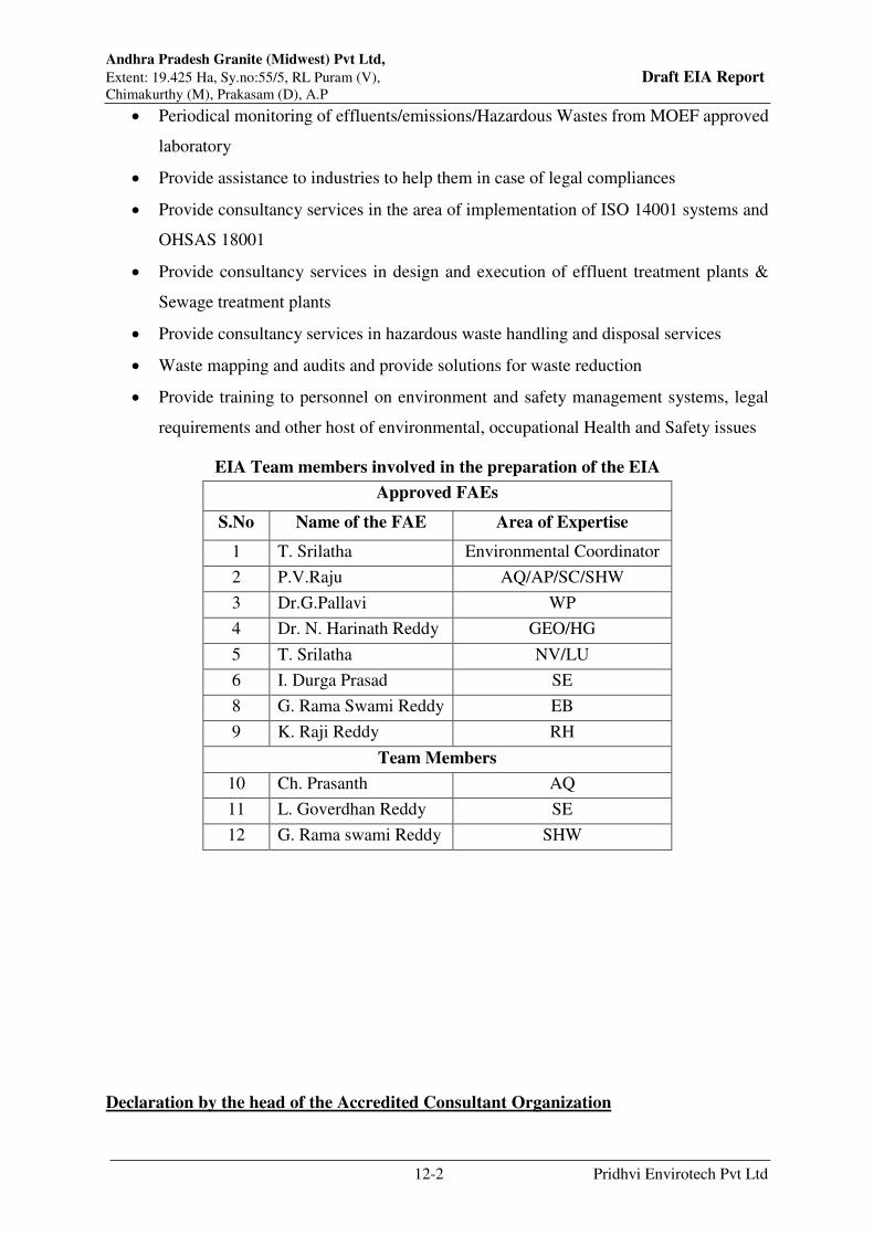
Andhra Pradesh Granite (Midwest) Pvt Ltd,
Extent: 19.425 Ha, Sy.no:55/5, RL Puram (V), Draft EIA Report Chimakurthy (M), Prakasam (D), A.P
12-2 Pridhvi Envirotech Pvt Ltd
Periodical monitoring of effluents/emissions/Hazardous Wastes from MOEF approved
laboratory
Provide assistance to industries to help them in case of legal compliances
Provide consultancy services in the area of implementation of ISO 14001 systems and
OHSAS 18001
Provide consultancy services in design and execution of effluent treatment plants &
Sewage treatment plants
Provide consultancy services in hazardous waste handling and disposal services
Waste mapping and audits and provide solutions for waste reduction
Provide training to personnel on environment and safety management systems, legal
requirements and other host of environmental, occupational Health and Safety issues
EIA Team members involved in the preparation of the EIA
Approved FAEs
S.No Name of the FAE Area of Expertise
1 T. Srilatha Environmental Coordinator
2 P.V.Raju AQ/AP/SC/SHW
3 Dr.G.Pallavi WP
4 Dr. N. Harinath Reddy GEO/HG
5 T. Srilatha NV/LU
6 I. Durga Prasad SE
8 G. Rama Swami Reddy EB
9 K. Raji Reddy RH
Team Members
10 Ch. Prasanth AQ
11 L. Goverdhan Reddy SE
12 G. Rama swami Reddy SHW
Declaration by the head of the Accredited Consultant Organization
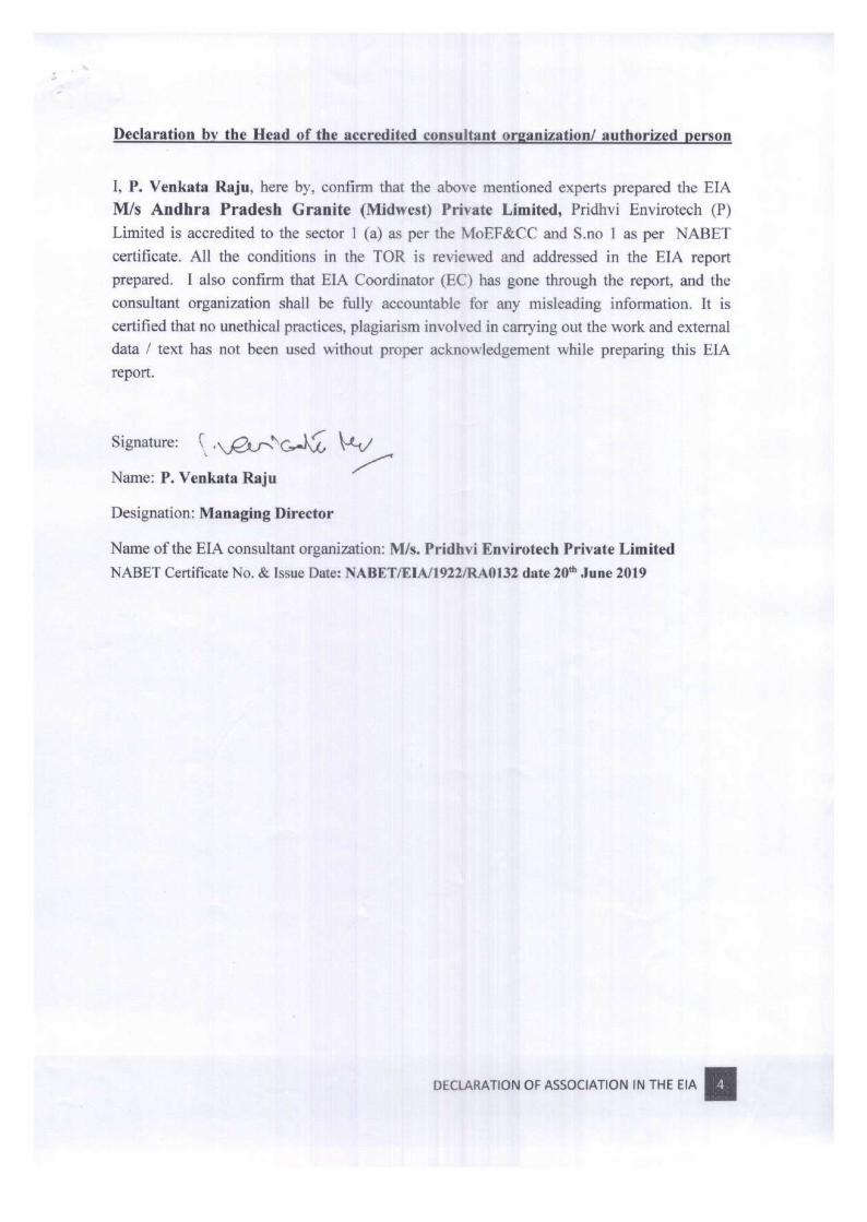
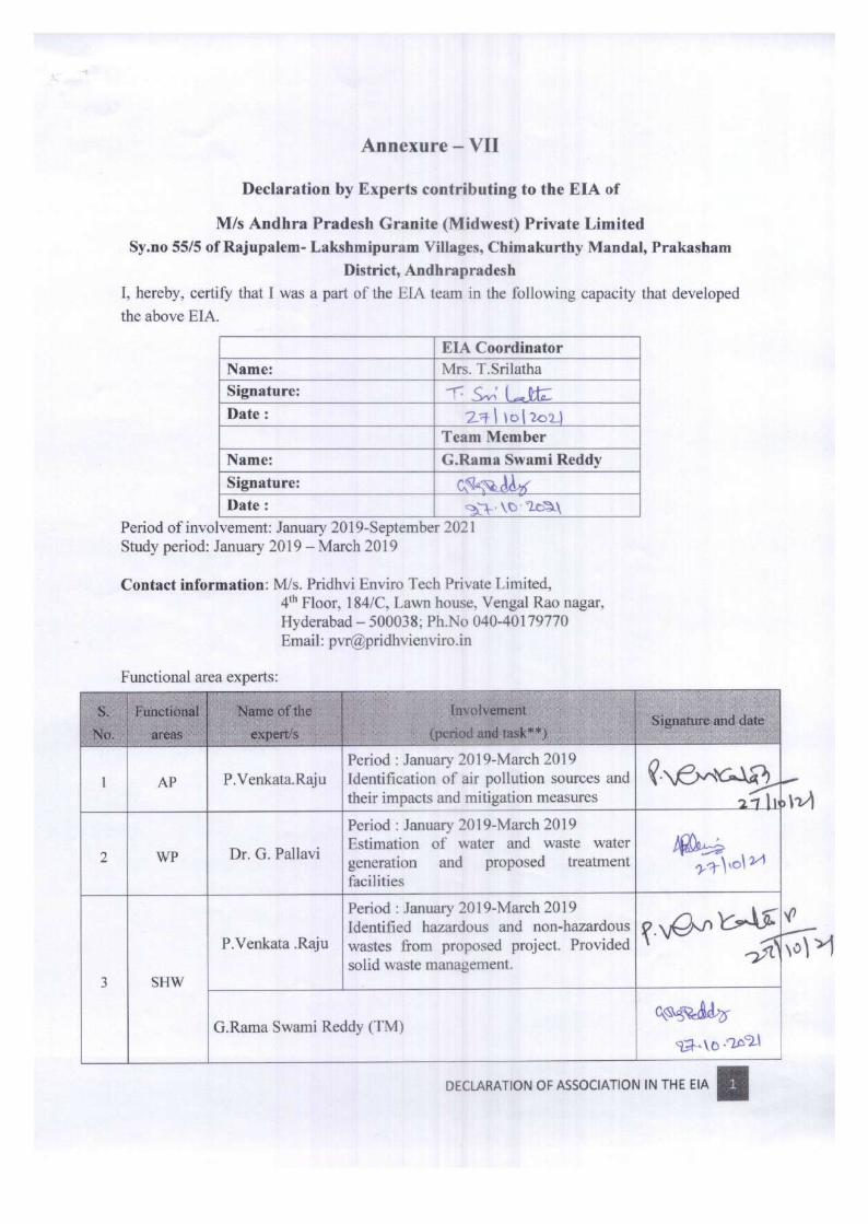


Annexure –I
Copy of Current Environmental Clearance


Annexure –II
Copy of combined CFE and CFO

Page 1 of 6
ANDHRA PRADESH POLLUTION CONTROL BOARD
D.No.33-26-14 D/2, Near Sunrise Hospital, Pushpa Hotel Centre,
Chalamalavari Street, Kasturibaipet, Vijayawada – 520 010.
RED CATEGORY
COMBINED CONSENT FOR ESTABLISHMENT, OPERATION &
HW AUTHORIZATION ORDER (AFTER EXPANSION)
Consent Order No: APPCB/VJA/NLR/188/HO/CFO/2017- Date: 21.10.2019
CONSENT is hereby granted for Operation under section 25/26 of the Water (Prevention &
Control of Pollution) Act, 1974 and under section 21 of Air (Prevention & Control of Pollution)
Act 1981 and amendments thereof and Authorisation under Rule 6 of the Hazardous and Other
Wastes (Management & Transboundary Movement) Rules, 2016 & Amendments thereof and the
rules and orders made there under (hereinafter referred to as 'the Acts’, `the Rules’) to:
M/s. Andhra Pradesh Granite (Mid West) Pvt. Ltd.,
Sy. No. 55/5P, Rajupalem – Lakshmipuram (V),
Chimakurthy (M), Prakasam District – 523 226, A.P
E-mail: [email protected]
The Consent Order No: APPCB/VJA/NLR/188/HO/CFO/2017-469, Dt:02.06.2017 issued to
the industry stands cancelled.
The Board, after careful scrutiny of the application, verification report of Regional Officer and
recommendations of the CFO Committee, hereby issues COMBINED CONSENT FOR
ESTABLISHMENT, OPERATION & HWA ORDER to the activity duly considering the
CFE Expansion application and EC expansion order.
(Hereinafter referred to as 'the Applicant') authorizing to operate the industrial plant to discharge
the effluents from the outlets and the quantity of emissions per hour from the chimneys as
detailed below:
(i) Outlets for discharge of effluents:
Outlet
No.
Outlet Description Max Daily Discharge
After Expansion (KLD)
Point of Disposal
1 Domestic 16.0 Septic tank followed by soak pit
ii) Emissions from chimneys:
Chimney
No.
Description of Chimney Quantity of Emissions at peak
flow (m3/hr) After Expansion
1 Common stack attached to 200 KVA & 125
KVA D.G. sets (Existing)
---
2 Common stack attached to 500 KVA & 125
KVA D.G. sets (Additional)
---
iii) Hazardous Waste Authorisation (Form – II) [See Rule 6 (2)]:
M/s. Andhra Pradesh Granite (Mid West) Pvt. Ltd. (19.425 Ha), Prakasam District is hereby
granted an authorization to operate a facility for collection, reception, storage, treatment,
transport and disposal of Hazardous Wastes namely:
Hazardous Wastes With Disposal Option:
S. No Name of Hazardous
Waste
Stream Quantity After
Expansion
Method of disposal
1. Used oil 5.1 of
Schedule-I
1000 LPA Disposed to authorized
reprocessing agencies.

Page 2 of 6
This consent order is valid for mining the following quantities only:
S. No Product Quantity After
Expansion
1 Mining of Black Galaxy Granite in an extent
of 19.425 Ha.
54,643 m3/annum
This order is subject to the provisions of `the Acts’ and the Rules’ and orders made thereunder and further subject to the terms and conditions incorporated in the schedule A, B & C enclosed to
this order.
This Combined Order of Consent for Establishment, Operation & HWA (After Expansion)
is valid up to 31st July, 2022.
CHAIRMAN
To
M/s. Andhra Pradesh Granite (Mid West) Pvt. Ltd.,
Sy. No. 55/5P, Rajupalem – Lakshmipuram (V),
Chimakurthy (M), Prakasam District – 523 226, A.P
E-mail: [email protected]
Copy to:
The JCEE, Zonal Office, Vijayawada for information and necessary action.
The EE, Regional Office, Ongole for information and necessary action.
SCHEDULE-A
1. Any up-set condition in any industrial plant / activity of the industry, which result in,
increased effluent / emission discharge and/ or violation of standards stipulated in this order
shall be informed to this Board, under intimation to the Collector and District Magistrate
and take immediate action to bring down the discharge / emission below the limits.
2. The industry shall carryout analysis of waste water discharges or emissions through
chimneys for the parameters mentioned in this order on quarterly basis and submit to the
Board.
3. The industry shall put up two sign boards (6x4 ft. each) at publicly visible places at the main
gate indicating the products, effluent discharge standards, air emission standards, hazardous
waste quantities and validity of CFO and exhibit the CFO order at a prominent place in the
factory premises.
4. Notwithstanding anything contained in this consent order, the Board hereby reserves the
right and powers to review / revoke any and/or all the conditions imposed herein above and
to make such variations as deemed fit for the purpose of the Acts by the Board.
5. The industry shall file the water cess returns in Form-I as required under section (5) of
Water (Prevention and Control of Pollution) Cess Act, 1977 on or before the 5th of every
calendar month, showing the quantity of water consumed in the previous month along with
water meter readings. The industry shall remit water cess as per the assessment orders as
and when issued by Board.
6. The applicant shall submit Environment statement in Form V before 30th September every
year as per Rule No.14 of E (P) Rules, 1986 & amendments thereof.
7. The applicant shall make applications through Online for renewal of Consent (under Water
and Air Acts) and Authorization under HWM Rules at least 120 days before the date of
expiry of this order, along with prescribed fee under Water and Air Acts and detailed
compliance of CFO conditions for obtaining Consent & HW Authorization of the Board.
The industry should immediately submit the revised application for consent to this Board in
the event of any change in the raw material used, processes employed, quantity of trade
effluents & quantity of emissions. Any change in the management shall be informed to the
Board. The person authorized shall not let out the premises / lend / sell / transfer their
industrial premises without obtaining prior permission of the State Pollution Control Board.
Bandla Siva
Sankar
Prasad
Digitally signed by Bandla Siva Sankar
Prasad
DN: c=IN, o=APPCB, ou=EFS and T Head
Office, cn=Bandla Siva Sankar Prasad,
postalCode=520010,
2.5.4.20=c040c01bf7f6f398976702e0cd
b9b479454f18c98b21c03bc47f7349d65
55b35, st=Andhra Pradesh
Date: 2019.10.22 12:50:29 +05'30'

Page 3 of 6
8. Any person aggrieved by an order made by the State Board under Section 25, Section 26,
Section 27 of Water Act, 1974 or Section 21 of Air Act, 1981 may within thirty days from
the date on which the order is communicated to him, prefer an appeal as per Andhra Pradesh
Water Rules, 1976 and Air Rules 1982, to Appellate authority constituted under Section 28
of the Water (Prevention and Control of Pollution) Act, 1974 and Section 31 of the Air
(Prevention and Control of Pollution) Act, 1981.
SCHEDULE-B
Water Pollution:
1. The following is the permitted water consumption:
S. No Purpose Quantity After
Expansion (KLD)
1. Dust suppression & Wire saw cutting 36.0
2. Development of Greenbelt 20.0
3. Domestic 4.0
Total 60.0
Separate meters with necessary pipe-line shall be maintained for assessing the quantity of
water used for each of the purposes mentioned above for Cess assessment purpose.
2. The mining unit shall not cause ground water pollution in and around the mining area.
Air Pollution:
3. The emissions shall not contain constituents in excess of the prescribed limits mentioned
below:
Chimney No. Parameter Emission Standards
1 & 2 Particulate matter 115 mg/Nm3
4. The industry shall comply with ambient air quality standards of PM10 (Particulate Matter size
less than 10m) - 100 g/m3; PM2.5 (Particulate Matter size less than 2.5 m) - 60 g/m
3;
SO2 - 80 g/m3; NOx - 80 g/m
3, outside the factory premises at the periphery of the
industry.
Standards for other parameters as mentioned in the National Ambient Air Quality Standards
CPCB Notification No.B-29016/20/90/PCI-I, dated 18.11.2009.
Noise Levels: Day time (6 AM to 10 PM) - 75 dB (A)
Night time (10 PM to 6 AM) - 70 dB (A)
5. The industry shall comply with emission limits for DG sets of capacity upto 800 KW as per
the Notification G.S.R.520 (E), dated 01.07.2003 under the Environment (Protection)
Amendment Rules, 2003 and G.S.R.448(E), dated 12.07.2004 under the Environment
(Protection) Second Amendment Rules, 2004. In case of DG sets of capacity more than 800
KW shall comply with emission limits as per the Notification G.S.R.489 (E), dated
09.07.2002 at serial no.96, under the Environment (Protection) Act, 1986.
6. The industry shall comply with the following for controlling fugitive emissions.
Machineries shall be properly maintained to prevent undesirable noise. Attention shall
be paid towards rigorous maintenance of the silencers of diesel engines
Drills should be water-jacked. Local exhaust ventilation systems should be installed at
dust generation points and the dust is led to a dust collection system
Surface drilling and blasting operations shall not be carried out at night.
The drilling shall be done with sharp drilling bits to reduce the generation of noise
during drilling
Safety equipment shall be given to the mine operators.
Periodical monitoring of noise level of mining machines and at some locations in the
mining site shall be done with the help of noise level meter.

Page 4 of 6
7. The industry shall provide water sprinklers for wetting the roads and at dust generating
sources to control fugitive dust emissions.
8. The industry shall maintain the following records and the same shall be made available to
the inspecting officers of the Board:
a) Daily production details
b) Quantity of effluents generated, treated, recycled / reused and disposed
c) Log Books for pollution control systems.
d) Characteristics of ambient air, effluents and emissions
e) Hazardous / non hazardous Solid waste generated and disposed.
f) Inspection book.
g) Manifest copies of hazardous waste.
9. The industry shall dispose solid waste (NON HAZARDOUS ) as follows :
S. No Name of the Solid Waste Quantity After
Expansion
Disposal
1. Over burden & mine
rejects
1296760
m3/annum
Shall be stored in designated area
as per the approved mine plan.
General :
10. The industry shall handover the Original Consent order dated 02.06.2017 to the RO:
Ongole after receipt of this CFO order.
11. The industry shall not carry out the mining activity till industry obtains Revocation of
Stop Production Order issued on 18.05.2019.
12. The industry shall maintain the setback distance 7.5 meters buffer zone all around the mine
lease area for greenbelt development and other conditions are to be fulfilled.
13. The industry shall allocate sufficient funds for implementation of CSR activities as
committed by the representative along with the EMP.
14. The avenue plantation (tall plants), of at least 1.5m height, for 1 km length of the approach
road on either side of the road is to be developed and maintained.
15. The industry shall comply with the conditions stipulated in the EC Order Dt.13.09.2019.
16. The industry shall construct graded roads connecting the mining area to the nearby roads to
avoid dust nuisance due to vehicular movements.
17. Garland drain and Siltation ponds of appropriate size should be constructed for the working
pit to arrest flow of silt and sediment. The water so collected should be utilized for
watering the mine area, roads, green belt development etc. The drains should be regularly
desilted, particularly after monsoon, and maintained properly.
18. The industry shall construct required no. of garland drains to arrest mineral particles being
carried away as runoff during rainy seasons around the dump yards. Dimensions of the
garland rains shall be based on rainfall data.
19. Soil binding and nitrogen fixing plants shall plant in the mining lease area. Biological
reclamation should be done in two phases, the first phase shall be paint appropriate quick
growing grass and shrubs and the second phase shall grow slower growing native shrubs
and trees.
20. Ground water table level shall be monitored every season. Any lowering of ground water
table in comparison to the previous seasons should be reported to Board immediately.
Discarded pits should be allowed to fill with water.
21. Vehicles should be well maintained and engine idling should be minimized. Vehicle cabs
shall be made dust-proof and to avoid oil spillages within the mining area.
22. The mine rejects shall be stacked in earmarked area as per approved mine plan in a
pyramid form with garland drain around the stacking area and mining shall be carried out
as per approved mine plan.

Page 5 of 6
23. Suitable tree species should be planted on either side of the haul roads.
24. Greenbelt shall be developed along the boundary of the site and shall develop
compensative afforestation at anywhere outside the mining area.
25. A separate environmental management cell with suitable qualified personnel should be set-
up under the control of a Senior Executive, who will report directly to the Head of the
Organization.
26. The funds earmarked for environmental protection measures (Capital cost is Rs.52.37
Lakhs and Recurring cost is Rs.35.5 Lakhs/annum) should be kept in separate account and
should not be diverted for other purpose. Year wise expenditure should be reported to the
Ministry and its Regional Office located at Chennai marking a copy to this office.
27. The industry shall comply with standards and directions issued by CPCB/MoEF & CC as
and when notifications are issued.
28. The industry shall submit six monthly reports on the status of compliance of the stipulated
environmental clearance conditions including results of monitored data (both in hard copies
as well as by e-mail) to the Ministry of Environment & Forests, its Regional Office,
Chennai, SEIAA, A.P., Zonal Office of Central Pollution Control Board, Bangalore,
District Collector and A.P. Pollution Control Board for every 6 months as on 01st January
and 01st July of every year and the same shall be uploaded to the concerned websites.
SCHEDULE – C
[See rule 6 (2)]
[CONDITIONS OF AUTHORISATION FOR OCCUPIER OR OPERATOR HANDLING
HAZARDOUS WASTES]
1. The authorised person shall comply with the provisions of the Environment (Protection) Act,
1986, and the rules made there under.
2. The authorisation or its renewal shall be produced for inspection at the request of an officer
authorised by the State Pollution Control Board.
3. The person authorised shall not rent, lend, sell, transfer or otherwise transport the Hazardous
and other wastes except what is permitted through this authorisation.
4. Any unauthorised change in personnel, equipment or working conditions as mentioned in the
application by the person authorised shall constitute a breach of his authorisation.
5. The person authorised shall implement Emergency Response Procedure (ERP) for which this
authorisation is being granted considering all site specific possible scenarios such as
spillages, leakages, fire etc. and their possible impacts and also carry out mock drill in this
regard at regular interval of time;
6. The person authorised shall comply with the provisions outlined in the Central Pollution
Control Board guidelines on “Implementing Liabilities for Environmental Damages due to Handling and Disposal of Hazardous Waste and Penalty”.
7. It is the duty of the authorised person to take prior permission of the State Pollution Control
Board to close down the facility.
8. An application for the renewal of an authorisation shall be made as laid down under these
Rules.
9. Any other conditions for compliance as per the Guidelines issued by the Ministry of
Environment, Forest and Climate Change or Central Pollution Control Board from time to
time.
10. Annual return shall be filed by June 30th for the period ensuring 31st March of the year.
11. The authorised person shall not store hazardous waste for more than 90 days as per the
Hazardous & Other Wastes (Management and Transboundary Movement) Rules, 2016.
12. The authorised person shall store Used / Waste Oil and Used Lead Acid Batteries in a
secured way in their premises till its disposal to the manufacturers / dealers on buyback basis.
13. The authorised person shall maintain 7 copy manifest system for transportation of waste
generated and a copy shall be submitted to concerned Regional Office of APPCB. The driver
who transports Hazardous Waste should be well acquainted about the procedure to be
followed in case of an emergency during transit. The transporter should carry a Transport
Emergency (TREM) Card.

Page 6 of 6
14. The authorised person shall maintain proper records for Hazardous & other wastes stated in
Authorization in FORM-3 i.e., quantity of Incinerable waste, land disposal waste, recyclable
waste etc., and file annual returns in Form- 4 as per Rule 6 (5) of the Hazardous & Other
Wastes (Management & Transboundary Movement) Rules, 2016 and amendments thereof by
June 30th for the period ensuring 31st March of the year.
15. The authorised person shall submit the condition wise compliance report of the conditions
stipulated in Schedule A, B & C of this Order on half yearly basis to Board Office and
concerned Regional Office.
CHAIRMAN
To
M/s. Andhra Pradesh Granite (Mid West) Pvt. Ltd.,
Sy. No. 55/5P, Rajupalem – Lakshmipuram (V),
Chimakurthy (M), Prakasam District – 523 226, A.P
E-mail: [email protected]
Bandla Siva
Sankar Prasad
Digitally signed by Bandla Siva Sankar Prasad
DN: c=IN, o=APPCB, ou=EFS and T Head Office,
cn=Bandla Siva Sankar Prasad,
postalCode=520010,
2.5.4.20=c040c01bf7f6f398976702e0cdb9b479
454f18c98b21c03bc47f7349d6555b35,
st=Andhra Pradesh
Date: 2019.10.22 12:51:08 +05'30'

Annexure-III
Copy of certified compliance report

प्रमाणि�त अनुपालन रि�पोर्ट� / Certified Compliance Report
SN Item Details
1.परि�योजना का प्रकारType of Project
Non-coal Mining (Galaxy Granite Mine)
2. परि�योजना का नाम Name of Project
19.425 Ha. Black Galaxy GraniteMine of M/s. Andhra PradeshGranite (Midwest) Pvt. Ltd., Sy. No.55/5P, RL Puram (V), Chimakurthy(M), Prakasam District.
3. परि�योजना प्राधि�क�� का पता Address of projectauthorities
The Director, M/s. Midwest GranitePvt. Ltd., D. No. 8-2-684/3/25 &26, Road No. 12, Banjara Hills,Hyderabad – 500034.
4. पया�व��ीय स्वीकृतित पत्र सं0 एवं
तितथीEnv. Clearance Letter No. &Date
SEIAA/AP/PKM/MIN/VIO/08/2018/672-1021 dated 13.09.2019SEIAA/AP/PKM-119/2013-1593 dated 10.06.2013
5. क्षते्रीय काया�लयपत्र सं0Regional Office File No.
IRO/VIJ/EPA/MISC/111-01/2021
6. स्थल दौ�ातितथीDate of Site Visit
30.08.2021
7. परि�योजना की स्थिस्थतितStatus of Project
Operational
8. परि�योजना की वत�मान स्थिस्थतित / Present status of the Project:
The project was monitored by undersigned on 30.08.2021. Duringmonitoring, Shri O. Madhusudhan Reddy, GM (Env), Shri K. DamodarReddy, (Agent cum Manager) and other Officials were present. As per thediscussions held with Project Authorities (PAs), it has been observed thatthe mine is galaxy granite stone mine with the total mine lease area of19.425 ha. It has been observed that the PAs have obtained combinedConsent for Establishment (CFE), Consent for Operation (CFO) andHazardous Waste Authorization (HWA) vide Consent Order No.APPCB/VJA/NLR/188/HO/CFO/2017 dated 21.10.2019 for mining ofblack galaxy granite of 54,643 m3/annum. The CFO is valid till31.01.2022.
It has been observed that the PAs have obtained permission to extendopencast working at common boundary from Directorate General of Mines
SEIAA/AP/PKM/MIN/VIO/08/2018/672-1021 dated 13.09.2019. Page 1 of 18
File No.IRO/VIJ/EPA/MISC/111-01/2021
I/6958/2022
520

Safety (DGMS), GOI vide letter No. Perm-111(3)/11 dated 20.3.2011 andPerm-111(3)/12 dated 30.5.2012. The details of common boundarybetween other mine leases are as follows:
1. M/s Golden Granite Mine, Survey No. 55/6 of R.L. of 19.43 ha.
2. Sri Surya Granite Mine, Survey Nos. 976/5, 977/9(P0, 10(P), 11,978/1,2,3,4,5,6 and 979/1,2,8,9,10 over an extent of 14.38 acre.
3. M/s Midwest Granite Mine, Sy. No. 55/5, 59/P & 103/P over anextent of 10.761 ha
4. M./s Alliance AP Black Galaxy Granites Pvt. Ltd, Sy. No. 52, 55/3C,55/4A over an extent of 54.06 acre.
The photographs of the mine area are as follows:
SEIAA/AP/PKM/MIN/VIO/08/2018/672-1021 dated 13.09.2019. Page 2 of 18
File No.IRO/VIJ/EPA/MISC/111-01/2021
I/6958/2022
521
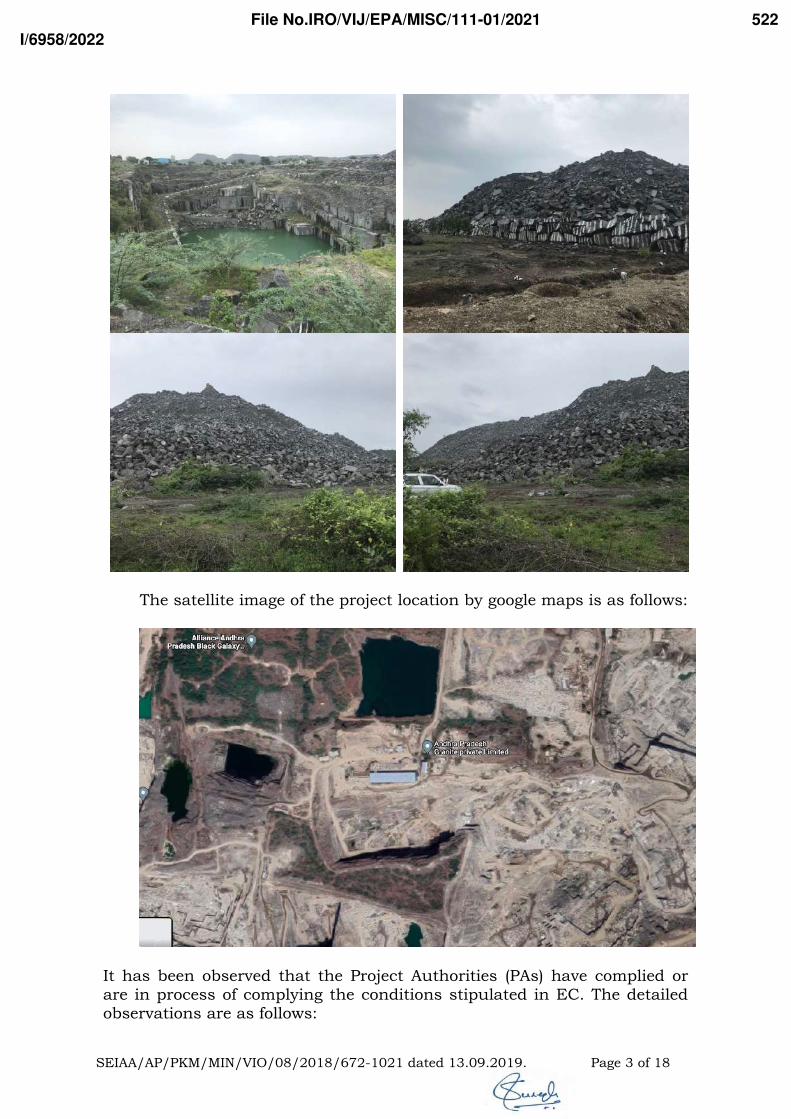
The satellite image of the project location by google maps is as follows:
It has been observed that the Project Authorities (PAs) have complied orare in process of complying the conditions stipulated in EC. The detailedobservations are as follows:
SEIAA/AP/PKM/MIN/VIO/08/2018/672-1021 dated 13.09.2019. Page 3 of 18
File No.IRO/VIJ/EPA/MISC/111-01/2021
I/6958/2022
522

9. Stipulated Conditions:
EC: SEIAA/AP/PKM/MIN/VIO/08/2018/672-1021 dated13.09.2019
A: Specific Conditions:
i. The project proponent shall maintain the setback distance 7.5meters buffer zone all around the mine lease area for greenbeltdevelopment and other conditions are to be fulfilled.
Status: Being complied
It has been observed that the mine lease area is rocky and highlyimpossible to develop green belt in and around the mine lease area.It has been observed that the PAs are in process of developing greenbelt at Sy.No. 954/1 of Chimakurthy village. As per the informationprovided, it has been observed that the PAs have developed greenbelt in an area of 2.74 acres with 800 saplings till date.
Photographs of green belt development status is as follows:
ii. The project proponent shall allocate sufficient funds forimplementation of CSR activities as committed by therepresentative along with the EMP.
SEIAA/AP/PKM/MIN/VIO/08/2018/672-1021 dated 13.09.2019. Page 4 of 18
File No.IRO/VIJ/EPA/MISC/111-01/2021
I/6958/2022
523
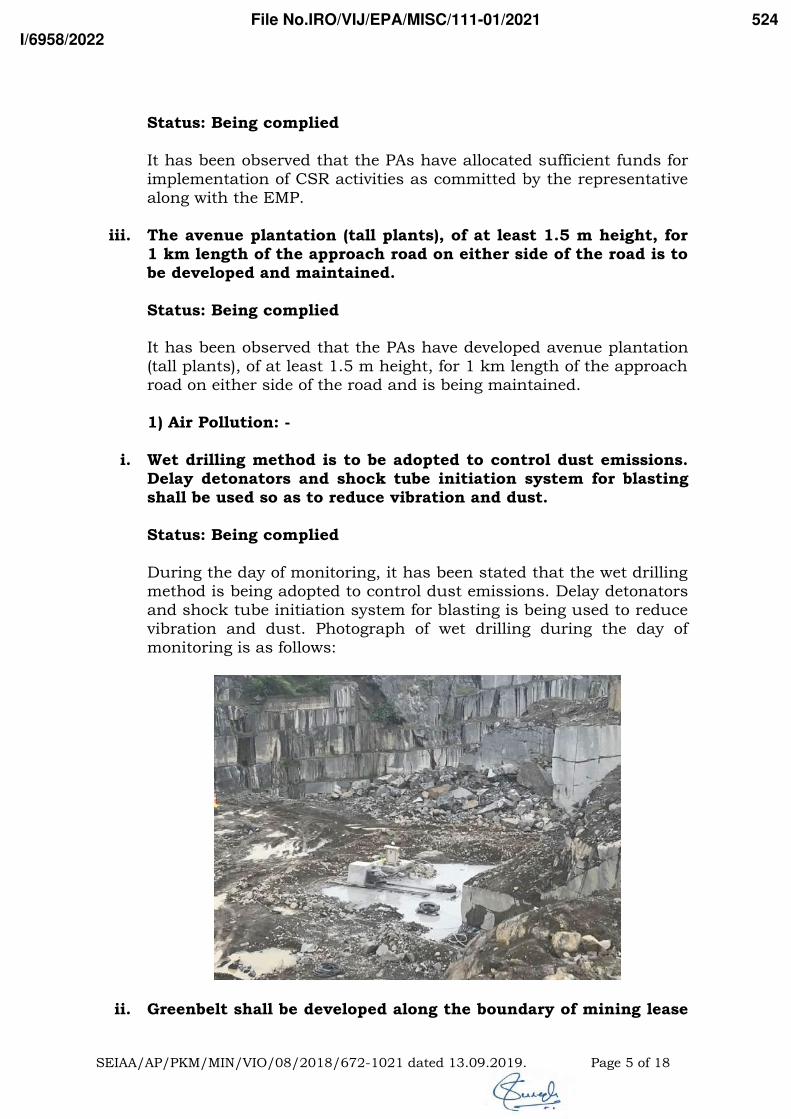
Status: Being complied
It has been observed that the PAs have allocated sufficient funds forimplementation of CSR activities as committed by the representativealong with the EMP.
iii. The avenue plantation (tall plants), of at least 1.5 m height, for1 km length of the approach road on either side of the road is tobe developed and maintained.
Status: Being complied It has been observed that the PAs have developed avenue plantation(tall plants), of at least 1.5 m height, for 1 km length of the approachroad on either side of the road and is being maintained.
1) Air Pollution: -
i. Wet drilling method is to be adopted to control dust emissions.Delay detonators and shock tube initiation system for blastingshall be used so as to reduce vibration and dust.
Status: Being complied
During the day of monitoring, it has been stated that the wet drillingmethod is being adopted to control dust emissions. Delay detonatorsand shock tube initiation system for blasting is being used to reducevibration and dust. Photograph of wet drilling during the day ofmonitoring is as follows:
ii. Greenbelt shall be developed along the boundary of mining lease
SEIAA/AP/PKM/MIN/VIO/08/2018/672-1021 dated 13.09.2019. Page 5 of 18
File No.IRO/VIJ/EPA/MISC/111-01/2021
I/6958/2022
524

area and also in back filled and reclaimed areas with tall growingnative species in consultation with the local DFO/AgricultureDepartment. The proponent of mine shall carry mining are andnearby areas. He shall take immediate measures for planting inthe same area or any other area selected by authorities not lessthan twice the number of trees going to be felled by miningoperations. He shall also take measures for restoration of otherflora/funna if damaged by mining operations.
Status: Being complied
It has been observed that the mine lease area is rocky and highlyimpossible to develop green belt in and around the mine lease area.It has been observed that the PAs are in process of developing greenbelt at Sy.No. 954/1 of Chimakurthy village. As per the informationprovided, it has been observed that the PAs have developed greenbelt in an area of 2.74 acres with 800 saplings till date.
Photographs of green belt development status is as follows:
iii. Effective safe guard measures such as regular water sprinklingshall be carried out in critical areas prone to air pollution andhaving high levels of SPM and RPM such as haul road, loadingand unloading point and transfer points. It shall be ensured that
SEIAA/AP/PKM/MIN/VIO/08/2018/672-1021 dated 13.09.2019. Page 6 of 18
File No.IRO/VIJ/EPA/MISC/111-01/2021
I/6958/2022
525

the ambient air quality parameters confirm to the normsprescribed by the Central Pollution Control Board in this regard.
Status: Being complied
It has been observed that the PAs are in process of taking effectivesafe guard measures of regular water sprinkling on regular basis incritical areas prone to air pollution and having high levels of SPMand RPM such as haul road, loading and unloading point andtransfer points. As per the monitoring reports submitted, it has beenobserved that the AAQ levels are within the prescribed limits.
iv. The proponent of mine shall carry air quality monitoring in thecore zone as well as buffer zone for RSPM (PM10) and Noiselevels. Location of monitoring stations should be decided basedon the metallurgical data topographical features andenvironmentally and ecologically sensitive targets andfrequency of monitoring should be undertaken in consultationwith Andhra Pradesh Pollution Control Board. The data sorecorded should be regularly submitted to the Ministry includingits Regional Office located at Chennai and the Andhra PradeshPollution Control Board/Central Pollution Control Board once insix months.
Status: Being complied
It has been observed that the PAs are conducting ambient air qualityand noise levels monitoring in core as well as buffer zone. As per themonitoring reports submitted, the parameters are within theprescribed limits.
v. The proponent shall construct graded roads connecting themining area to the nearby roads to avoid dust nuisance due tovehicular movements.
Status: Being complied
It has been observed that the PAs have constructed graded roadswhich connecting the mining area to the nearby road to avoid dustnuisance due to vehicular movements.
vi. The proponent shall take precautions against noise arising outof mining operations and shall be abated or controlled at thesource so as to keep it within the permissible limits notifiedunder Environmental (Protection) Act, 1986 / Noise Pollution(Regulations & Control) Rules, 2010 by implementing thefollowing noise control measures:
Proper and regular maintenance of vehicles and other
SEIAA/AP/PKM/MIN/VIO/08/2018/672-1021 dated 13.09.2019. Page 7 of 18
File No.IRO/VIJ/EPA/MISC/111-01/2021
I/6958/2022
526

equipment Limiting time exposure of workers to excessive noise. The workers employed shall be provided with protection
equipment and earmuffs. Etc. Speed of trucks entering or leaving the mine is to be
limited to moderate speed of 25 kmph to prevent unduenoise from empty trucks.
Status: Being complied
It has been observed that the PAs are in process of implementingabove measures to reduce noise pollution during transportation ofmineral.
vii. Whenever any damage to public buildings or monuments inapprehended due to their proximity to the mining lease area,scientific investigations shall be carried out by the holder ofmining lease so as to keep the ground vibrations caused bymining operations within safe limit.
Status: Being complied
It has been observed that the condition is being complied with.
2) Water Pollution: -
i. The source of water is Bore well. Total water requirement is 60KLD which is used for dust suppression; wire saw cutting;development of green belt and for domestic purpose.
Status: Being complied
As per the discussions held, it has been observed that the source ofwater is mine pit water and by water tankers from nearby villages.The total water requirement is under 60 KLD and being used fordust suppression, wire saw cutting, development of green belt andfor domestic purpose.
ii. Garland drain and siltation ponds of appropriate size should beconstructed for the working pit to arrest flow of silt andsediment. The water so collected should be utilized for wateringthe mine area, roads, green belt development etc. The drainsshould be regularly desilted, particularly after monsoon, andmaintained properly.
Status: Partially complied
It has been observed that the PAs have constructed garland drainsand siltation pond of appropriate size for the OB/waste dumps.
SEIAA/AP/PKM/MIN/VIO/08/2018/672-1021 dated 13.09.2019. Page 8 of 18
File No.IRO/VIJ/EPA/MISC/111-01/2021
I/6958/2022
527
However, garland drains and siltation pond are not constructed forthe working pit to arrest flow of silt and sediment.
It is required to construct garland drain and siltation pond ofappropriate size for the working pit to arrest flow of silt andsediment. The water so collected should be utilized for wateringthe mine area, roads, green belt development etc. The drainsshould be regularly desilted, particularly after monsoon, andmaintained properly.
iii. The proponent of the mine shall take all possible precautions toprevent or reduce the discharge of toxic and objectionable liquideffluents from mine, workshop, tailing ponds into surfacebodies, ground water aquifer and useable lands to a minimum.The effluents shall be suitably treated, if required, to conform tothe general standards notified under Environmental (Protection)Act, 1986.
Status: Being complied
It has been observed that the PAs are in process of taking allpossible precautions to prevent or reduce the discharge of toxic andobjectionable liquid effluents from mine, workshop, tailing pondsinto surface bodies, ground water aquifer and useable lands to aminimum.
iv. Monitoring of ground water level and quality should be carriedout quarterly by the project proponent in and around projectarea in consultation with State Ground WaterDepartment/Central Ground Water Authority and data thuscollected shall be submitted regularly to the MOEF&CC and itsRegional office, Chennai, CGWA, and the Regional Director,Central Ground Water Board, Hyderabad. If at any stage, it isobserved that the ground water table is getting depleted due tothe mining activity, necessary correction measures shall becarried out.
Status: Partially complied
As per the discussions held, it has been stated that ground waterlevel and quality is being monitored on regular basis. However, asper records, the monitoring reports are not being submitted alongwith six monthly compliance reports.
It is required to submit the quarterly monitored reports ofground water level and quality in and around project area alongwith six monthly compliance reports on regular basis toMinistry’s Integrated Regional Office, Vijayawada.
SEIAA/AP/PKM/MIN/VIO/08/2018/672-1021 dated 13.09.2019. Page 9 of 18
File No.IRO/VIJ/EPA/MISC/111-01/2021
I/6958/2022
528

v. Suitable conservation measures to augment groundwaterresources in the area shall be planned and implemented inconsultation with Regional Director. CGWB, Southern Region,Hyderabad. Suitable measures should be taken for rainwaterharvesting.
Status: Being complied
It has been observed that the PAs are using mine pit as conservationmeasures to augment groundwater resources in the area.
vi. Permission from the competent authority should be obtained fordrawl of ground water, if any, required for this project.
Status: Being complied
As stated above, it has been observed that the PAs are notwithdrawing ground water. The water source of the project is frommine pit which is being used for wire saw processing, green beltdevelopment and water sprinkling. For drinking and domesticpurpose, the source of water is by water tankers from nearbyvillages.
3) Solid Waste: -
i. Topsoil: Wherever top soil exists and is to be excavated formining operations, it shall be removed and stacked separatelyand top soil so removed shall be utilized for restoration orrehabilitation of the land, which is no longer required for mineoperations or for stabilizing or landscaping the external dumps.Whenever the top soil cannot be utilized concurrently, it shallbe stored separately for future use.
Status: Being complied
It has been observed that currently top soil is not being generated. Ithas been stated that the generated top soil has been used forplantation purpose.
ii. Overburden: The proponent of mine shall take steps so that theoverburden, waste rock, rejects and fines generated duringmining operations shall be stored in separate dumps preferablyon impervious grounds. The waste rock, overburden etc. shall beconcurrently backfilled into the mine excavations so as torestore the land to its original use as far as possible. In the caseof non feasibility of back filling, the waste dump shall besuitable terraced and stabilize through the vegetation. Theproponent shall maintain proper angel of response to ensurestability to the dump.
SEIAA/AP/PKM/MIN/VIO/08/2018/672-1021 dated 13.09.2019. Page 10 of 18
File No.IRO/VIJ/EPA/MISC/111-01/2021
I/6958/2022
529
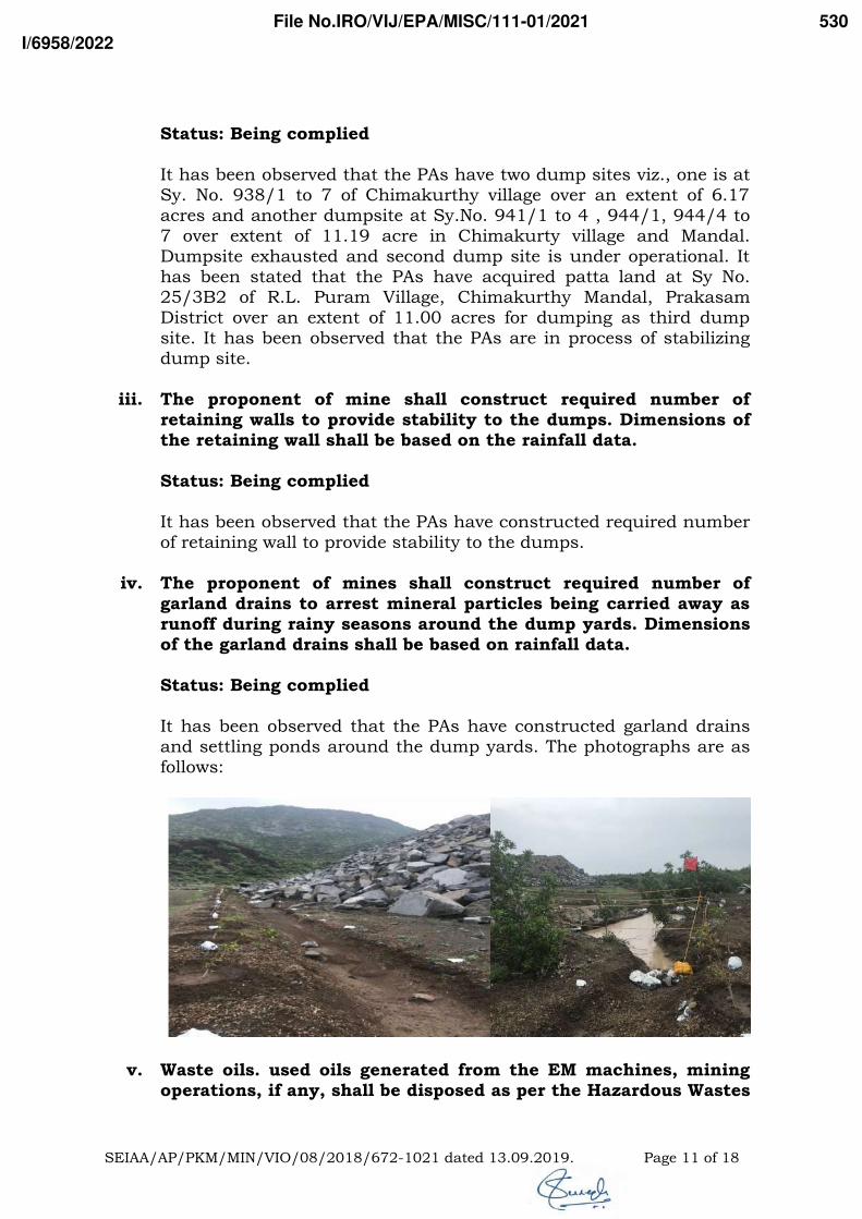
Status: Being complied
It has been observed that the PAs have two dump sites viz., one is atSy. No. 938/1 to 7 of Chimakurthy village over an extent of 6.17acres and another dumpsite at Sy.No. 941/1 to 4 , 944/1, 944/4 to7 over extent of 11.19 acre in Chimakurty village and Mandal.Dumpsite exhausted and second dump site is under operational. Ithas been stated that the PAs have acquired patta land at Sy No.25/3B2 of R.L. Puram Village, Chimakurthy Mandal, PrakasamDistrict over an extent of 11.00 acres for dumping as third dumpsite. It has been observed that the PAs are in process of stabilizingdump site.
iii. The proponent of mine shall construct required number ofretaining walls to provide stability to the dumps. Dimensions ofthe retaining wall shall be based on the rainfall data.
Status: Being complied
It has been observed that the PAs have constructed required numberof retaining wall to provide stability to the dumps.
iv. The proponent of mines shall construct required number ofgarland drains to arrest mineral particles being carried away asrunoff during rainy seasons around the dump yards. Dimensionsof the garland drains shall be based on rainfall data.
Status: Being complied
It has been observed that the PAs have constructed garland drainsand settling ponds around the dump yards. The photographs are asfollows:
v. Waste oils. used oils generated from the EM machines, miningoperations, if any, shall be disposed as per the Hazardous Wastes
SEIAA/AP/PKM/MIN/VIO/08/2018/672-1021 dated 13.09.2019. Page 11 of 18
File No.IRO/VIJ/EPA/MISC/111-01/2021
I/6958/2022
530
(Management, Handling, and transboundary movement) Rules.2008 and its amendments thereof to the recyclers authorized byAPPCB.
Status: Being complied
It has been observed that the waste oils. used oils generated from theEM machines, mining operations, if any, is being disposed as per theHazardous Wastes (Management, Handling, and transboundarymovement) Rules. 2008 and its amendments thereof to the recyclersauthorized by APPCB.
vi. The proponent of the mine shall undertake phased restoration,reclamation and rehabilitation of the lands affected by themining operations and shall complete this work beforeconclusion of such operations and abandonment of the mine.
Status: Being complied
It has been observed that no restoration, reclamation andrehabilitation of the lands affected by the mining operation were notundertaken yet. As per the discussions held, it has been stated thatthe deposit is symptomatic in persistence at depth and there is nohabitation in the lease area. Therefore, no reclamation andrehabilitation proposal were made and the excavated pit shall be leftfor water storage.
B. Specific Conditions:
i. This order is valid for a period of 20 years or the expiry date ofmine lease period issued by the Government of A.P., whicheveris earlier.
Status: Being complied
It has been observed that the condition is being complied with.
ii. “Consent for Establishment” & “Consent for Operation” shall beobtained from Andhra Pradesh Pollution Control Board under Airand Water Act and effectively comply with all the conditionsstipulated thereof.
Status: Being complied
It has been observed that the PAs have obtained combined Consentfor Establishment (CFE), Consent for Operation (CFO) andHazardous Waste Authorization (HWA) vide Consent Order No.
SEIAA/AP/PKM/MIN/VIO/08/2018/672-1021 dated 13.09.2019. Page 12 of 18
File No.IRO/VIJ/EPA/MISC/111-01/2021
I/6958/2022
531
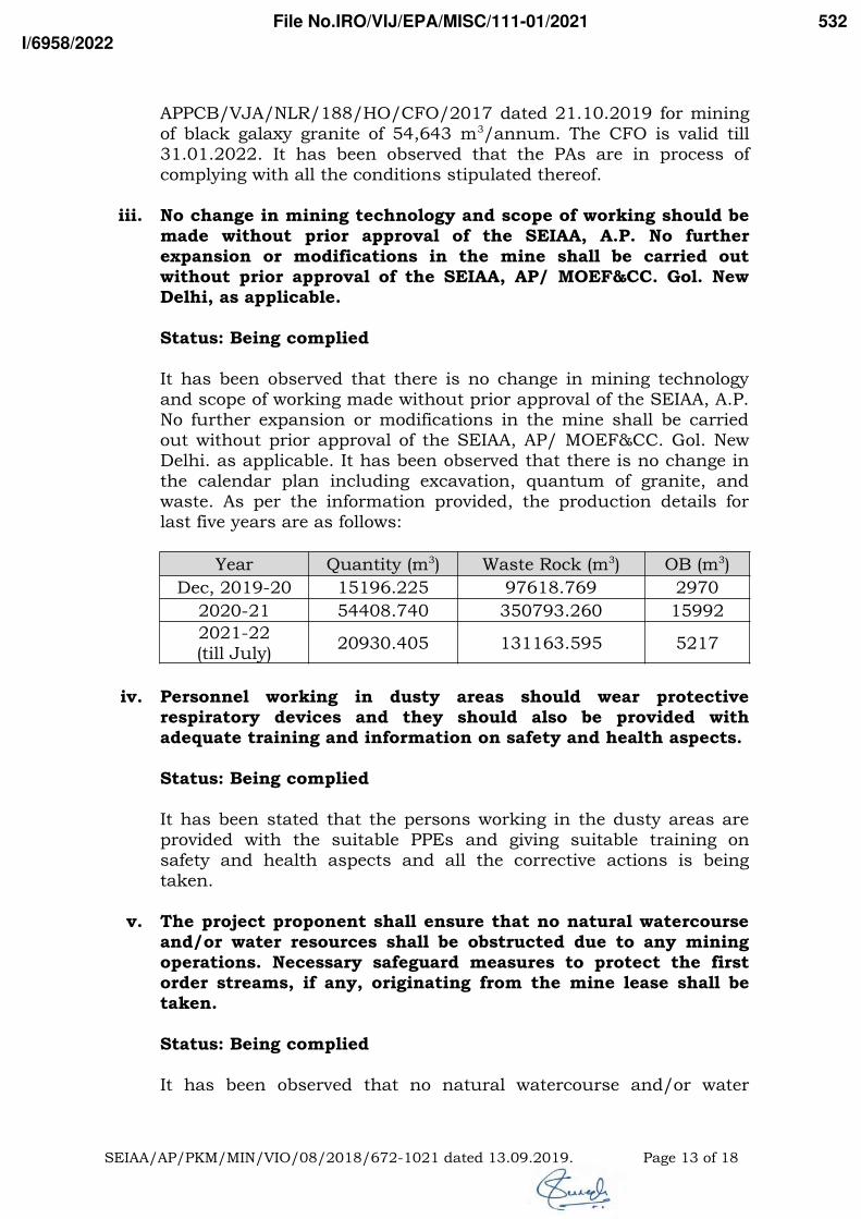
APPCB/VJA/NLR/188/HO/CFO/2017 dated 21.10.2019 for miningof black galaxy granite of 54,643 m3/annum. The CFO is valid till31.01.2022. It has been observed that the PAs are in process ofcomplying with all the conditions stipulated thereof.
iii. No change in mining technology and scope of working should bemade without prior approval of the SEIAA, A.P. No furtherexpansion or modifications in the mine shall be carried outwithout prior approval of the SEIAA, AP/ MOEF&CC. Gol. NewDelhi, as applicable.
Status: Being complied
It has been observed that there is no change in mining technologyand scope of working made without prior approval of the SEIAA, A.P.No further expansion or modifications in the mine shall be carriedout without prior approval of the SEIAA, AP/ MOEF&CC. Gol. NewDelhi. as applicable. It has been observed that there is no change inthe calendar plan including excavation, quantum of granite, andwaste. As per the information provided, the production details forlast five years are as follows:
Year Quantity (m3) Waste Rock (m3) OB (m3)
Dec, 2019-20 15196.225 97618.769 2970
2020-21 54408.740 350793.260 15992
2021-22 (till July)
20930.405 131163.595 5217
iv. Personnel working in dusty areas should wear protectiverespiratory devices and they should also be provided withadequate training and information on safety and health aspects.
Status: Being complied
It has been stated that the persons working in the dusty areas areprovided with the suitable PPEs and giving suitable training onsafety and health aspects and all the corrective actions is beingtaken.
v. The project proponent shall ensure that no natural watercourseand/or water resources shall be obstructed due to any miningoperations. Necessary safeguard measures to protect the firstorder streams, if any, originating from the mine lease shall betaken.
Status: Being complied
It has been observed that no natural watercourse and/or water
SEIAA/AP/PKM/MIN/VIO/08/2018/672-1021 dated 13.09.2019. Page 13 of 18
File No.IRO/VIJ/EPA/MISC/111-01/2021
I/6958/2022
532

resources during mining operations are being obstructed by miningoperations. Measures are being taken to protect the first orderstreams, if originating in mine lease.
vi. Occupational health surveillance program of the workers shouldbe undertaken periodically to observe any contractions due toexposure to dust and take corrective measures. if needed.
Status: Being complied
It has been observed that PAs are conducting occupational healthsurveillance program of the workers periodically and records arebeing maintained.
vii. A separate environmental management cell with suitablequalified personnel should be set-up under the control of aSenior Executive, who will report directly to the Head of theOrganization.
Status: Partially complied
It has been observed that the PAs have a separate environmentmanagement cell with suitable qualified personal under the controlof a Senior Executive, who will report directly to the head of theorganization. However, it has been observed that the environmentalmanagement cell does not have a suitable qualified personal.
It is required to establish a separate Environment ManagementCell with suitable qualified personal under the control of aSenior Executive, who will report directly to the head of theorganization.
viii. The funds earmarked for environmental protection measures(Capital cost is Rs 52.37 Lakhs and Recurring cost is 35.5Lakhs/annum) should be kept in separate account and shouldnot be diverted for other purpose. Year wise expenditure shouldbe reported to the Ministry and its Regional Office located atBangalore.
Status: Partially complied
It has been stated that the funds earmarked for environmentalprotection measures has kept in separate account and not bediverted for other purpose. However, year wise expenditure is notbeing reported to Regional Office.
It is required to submit the detailed report regarding item wiseexpenditure incurred under environmental protection measuresfor last five years.
SEIAA/AP/PKM/MIN/VIO/08/2018/672-1021 dated 13.09.2019. Page 14 of 18
File No.IRO/VIJ/EPA/MISC/111-01/2021
I/6958/2022
533
It is also required to submit the detailed report regarding itemwise expenditure incurred under environmental protectionmeasures along with six monthly compliance reports toMinistry’s Integrated Regional Office, Vijayawada on regularbasis.
ix. The Regional Office of MOEF&CC located at Chennai / TheSEIAA, Andhra Pradesh through the Regional Offices of AndhraPradesh Pollution Control Board, shall monitor compliance ofthe stipulated conditions. The project authorities should extendfull cooperation to the officer (s) of the Regional office byfurnishing the requisite data/information/monitoring reports.
Status: Being complied
The condition is being complied with.
x. The project proponent shall submit six monthly reports on thestatus of compliance of the stipulated environmental clearanceconditions including results of monitored data (both in hardcopies as well as by e-mail) to the Ministry of Environment &Forests, its Regional Office, Chennai, SEIAA, A.P., Zonal Officeof Central Pollution Control Board, Bangalore, District Collectorand A.P. Pollution Control Board. The proponent shall uploadthe status of compliance of the environmental conditionsincluding results of monitored data on their websites and shallupdate the same periodically.
Status: Partially complied
As per the records, it has been observed that the PAs are regularlysubmitting six monthly compliance reports along with all monitoreddata to Ministry’s Regional Office. However, the same is not beinguploaded on company’s website.
It is required to upload the status of compliance of theenvironmental conditions including results of monitored data onthe website of company and shall update the same periodically.It requires immediate action.
xi. The project proponent shall submit the copies of theenvironmental clearance to the Heads of local bodies,Panchayats and Municipal Bodies in addition to the relevantoffices of the Government who in turn has to display the samefor 30 days from the date of receipt.
Status: Being complied
SEIAA/AP/PKM/MIN/VIO/08/2018/672-1021 dated 13.09.2019. Page 15 of 18
File No.IRO/VIJ/EPA/MISC/111-01/2021
I/6958/2022
534
The condition is being complied with.
xii. The environmental statement for each financial year ending 31st
March in Form-V as mandated is to be submitted by the projectproponent to the A.P. Pollution Control Board as prescribedunder the Environment (Protection) Rules, 1986, as amendedsubsequently, shall be put on the website of the company alongwith the status of the compliance of environmental clearanceconditions and shall also be sent to the Regional office of theMinistry of Environment and Forests, Chennai by e-mail.
Status: Partially complied
As per the records, it has been observed that the PAs submittingenvironmental statement for each financial year ending 31st March inForm-V. However, the same is not uploading website of the company.
It is required to upload the copy of Environmental Statement(Form-V) on the website of company and shall update the sameperiodically. It requires immediate action.
xiii. The project authorities should advertise at least in two localnewspapers widely circulated. one of which shall be in thevernacular language of the locality concerned, within 7 days ofthe issue of the clearance letter informing that the project hasbeen accorded environmental clearance and a copy of theclearance letter is available with the State Pollution ControlBoard and SEIAA, A.P.
Status: Complied
It has been observed that the PAs have advertised details of EC intwo local newspapers viz., “Sakshi” (Telugu) dated 27.09.2019 and“The New Indian Express” (English) dated 27.09.2019.
xiv. The proponent shall obtain all other mandatory clearances fromrespective departments.
Status: Being complied
It has been observed that the PAs have obtained statutory clearancesfrom respective departments.
xv. Any appeal against this Environmental Clearance shall lie withthe National Green Tribunal, if preferred, within a period of 30days as prescribed under Section 16 of the National GreenTribunal Act. 2010.
Status: Being complied
SEIAA/AP/PKM/MIN/VIO/08/2018/672-1021 dated 13.09.2019. Page 16 of 18
File No.IRO/VIJ/EPA/MISC/111-01/2021
I/6958/2022
535

The condition is being complied with.
xvi. Concealing the factual data or failure to comply with any of theconditions mentioned above may result in withdrawal of thisclearance and attract action under the provisions ofEnvironment (Protection) Act, 1986.
Status: Being complied
The condition is being complied with.
xvii. The SEIAA may revoke or suspend the order, if implementationof any of the above conditions is not satisfactory. The SEIAAreserves the right to alter/modify the above conditions orstipulate any further condition in the interest of environmentprotection.
Status: Being complied
The condition is being complied with.
xviii. The above conditions will be enforced inter-alia, under theprovisions of the Water (Prevention & Control of Pollution) Act.1974, the Air (Prevention & Control of Pollution) Act, 1981, theEnvironment (Protection) Act., 1986 and the Public LiabilityInsurance Act, 1991 along with their amendments and rules.
Status: Being complied
The condition is being complied with.
10. Observations:
The PAs have complied or are in process of complying the conditionsstipulated by the Ministry. In this context, information/action plans havebeen sought on following points.
1. It is required to construct garland drain and siltation pond ofappropriate size for the working pit to arrest flow of silt andsediment. The water so collected should be utilized for watering themine area, roads, green belt development etc. The drains should beregularly desilted, particularly after monsoon, and maintainedproperly.
2. It is required to submit the quarterly monitored reports of groundwater level and quality in and around project area along with sixmonthly compliance reports on regular basis to Ministry’s IntegratedRegional Office, Vijayawada.
SEIAA/AP/PKM/MIN/VIO/08/2018/672-1021 dated 13.09.2019. Page 17 of 18
File No.IRO/VIJ/EPA/MISC/111-01/2021
I/6958/2022
536
3. It is required to establish a separate Environment Management Cellwith suitable qualified personal under the control of a SeniorExecutive, who will report directly to the head of the organization.
4. It is also required to upload the status of compliance of theenvironmental conditions including results of monitored data on thewebsite of company and shall update the same periodically. Itrequires immediate action.
5. It is required to upload environmental statement for each financialyear ending 31st March in Form-V on website of the company. Itrequires immediate action.
11. Recommendations:
This project can be put up in the following tick-marked category ofcompliance status.
Compliance status could not be judged as the project was shutdown / not in operational during the site visit.
No non-compliances detected. No any further action is required.
Minor non-compliances detected (not of immediate danger tohealth & safety of the people). Letter issued to projectauthorities for taking corrective measures.
Serious non-compliances detected. Recommended to issue a Show-Cause Notice to Project Authorities.
(डॉ। सुरेश बाबु पसुपुलेटी) (Dr. Suresh Babu Pasupuleti)
संयुक्त नि�देशक (एस) / वैज्ञानि�क ‘डी’Joint Director (S) / Scientist ‘D’
Copy to: Project File
SEIAA/AP/PKM/MIN/VIO/08/2018/672-1021 dated 13.09.2019. Page 18 of 18
File No.IRO/VIJ/EPA/MISC/111-01/2021
I/6958/2022
537

Annexure-IV
Ambient Air Quality data

Project site
PM10 Pm2.5 SO2 Nox VOC CO
2.1.2019 91.3 48.8 14.8 16.4 2.8 2.1
3.1.2019 88.3 45.2 15.2 17.5 3.2 2.2
9.1.2019 84.3 39.2 16.6 18.5 2.6 1.8
10.1.2019 89.3 45.2 13.3 19.5 3 2.2
16.1.2019 90.3 42.3 16.4 17.5 2.4 2.3
17.1.2019 91.4 38.5 15.2 16.6 2 2.3
23.1.2019 85.3 37.2 17.2 20.1 2.2 2
24.1.2019 84.3 40.3 18.2 28.5 2.9 1.5
1.2.2019 85.3 39.4 14.2 17.2 2.9 1.6
2.2.2019 90.3 32.5 15.2 20.1 3.2 1.3
6.2.2019 86.7 30.2 17.2 18.2 3.2 1.2
7.2.2019 87.3 30.5 14.8 21.3 2.8 1.6
13.2.2019 90.3 29.5 14.9 20.8 2.5 1.2
14.2.2019 91.5 28.5 14.3 15.2 2.2 1.6
20.2.2019 86.5 31.3 16.5 21.3 2.4 2.1
21.2.2019 90.4 34.2 17.2 17.2 2.9 1.6
1.3.2019 83.2 29.4 15.3 19.2 2.5 2.1
2.3.2019 91.4 29.3 16.2 20.9 2.5 1.6
8.3.2019 90.3 35.7 15.2 17.2 3.6 1.8
9.3.2019 86.4 31.5 13.45 21.2 2.2 2.1
15.3.2019 92.5 34.2 16.6 20.1 2.6 1.7
16.3.2019 86.5 40.2 15.3 17.2 3.1 1.8
22.3.2019 90.4 35.2 14.2 18.7 2.2 1.6
23.3.2019 83.2 36.2 14.9 16.5 2.5 1.9
Max 92.5 48.8 18.2 28.5 3.6 2.3
Min 83.2 28.5 13.3 15.2 2 1.2
mean 88.19583 36.02083 15.51458 19.0375 2.683333 1.8
0.98 92.04 47.144 17.74 25.188 3.416 2.3
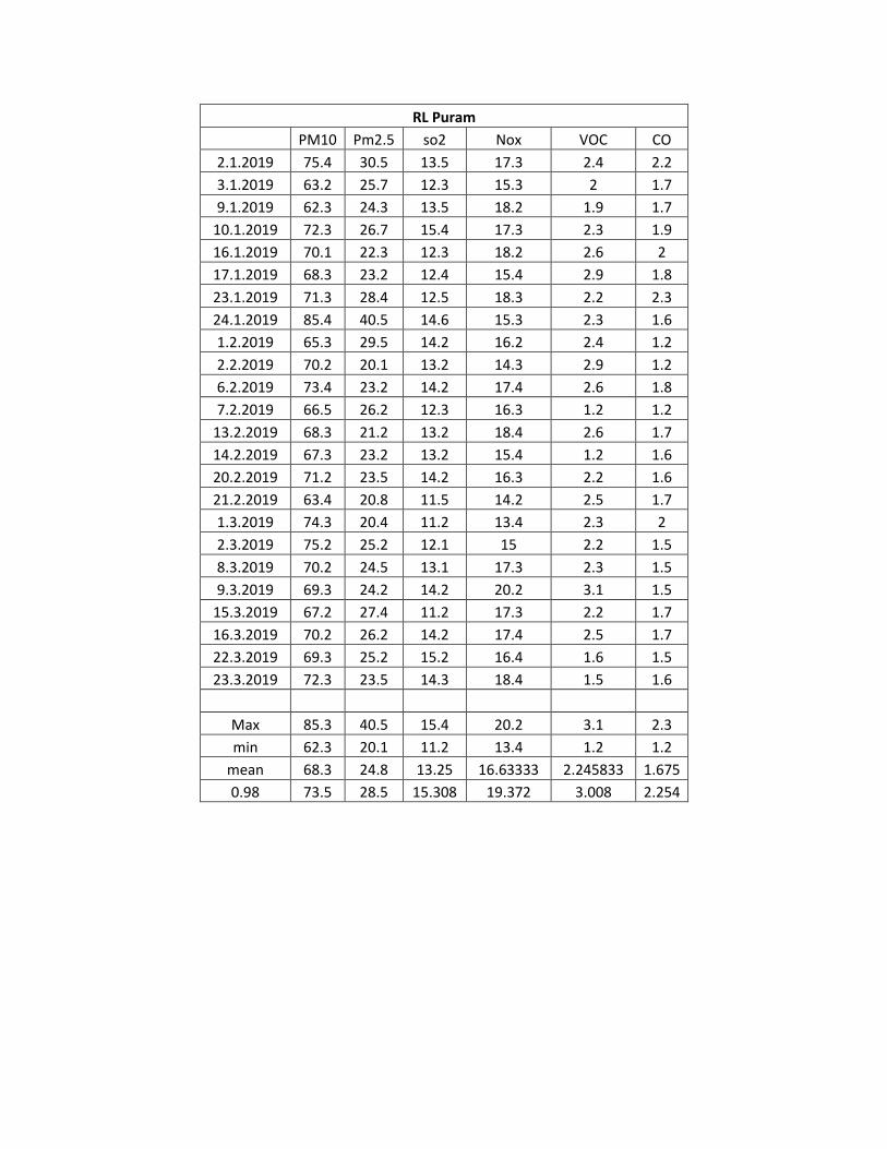
RL Puram
PM10 Pm2.5 so2 Nox VOC CO
2.1.2019 75.4 30.5 13.5 17.3 2.4 2.2
3.1.2019 63.2 25.7 12.3 15.3 2 1.7
9.1.2019 62.3 24.3 13.5 18.2 1.9 1.7
10.1.2019 72.3 26.7 15.4 17.3 2.3 1.9
16.1.2019 70.1 22.3 12.3 18.2 2.6 2
17.1.2019 68.3 23.2 12.4 15.4 2.9 1.8
23.1.2019 71.3 28.4 12.5 18.3 2.2 2.3
24.1.2019 85.4 40.5 14.6 15.3 2.3 1.6
1.2.2019 65.3 29.5 14.2 16.2 2.4 1.2
2.2.2019 70.2 20.1 13.2 14.3 2.9 1.2
6.2.2019 73.4 23.2 14.2 17.4 2.6 1.8
7.2.2019 66.5 26.2 12.3 16.3 1.2 1.2
13.2.2019 68.3 21.2 13.2 18.4 2.6 1.7
14.2.2019 67.3 23.2 13.2 15.4 1.2 1.6
20.2.2019 71.2 23.5 14.2 16.3 2.2 1.6
21.2.2019 63.4 20.8 11.5 14.2 2.5 1.7
1.3.2019 74.3 20.4 11.2 13.4 2.3 2
2.3.2019 75.2 25.2 12.1 15 2.2 1.5
8.3.2019 70.2 24.5 13.1 17.3 2.3 1.5
9.3.2019 69.3 24.2 14.2 20.2 3.1 1.5
15.3.2019 67.2 27.4 11.2 17.3 2.2 1.7
16.3.2019 70.2 26.2 14.2 17.4 2.5 1.7
22.3.2019 69.3 25.2 15.2 16.4 1.6 1.5
23.3.2019 72.3 23.5 14.3 18.4 1.5 1.6
Max 85.3 40.5 15.4 20.2 3.1 2.3
min 62.3 20.1 11.2 13.4 1.2 1.2
mean 68.3 24.8 13.25 16.63333 2.245833 1.675
0.98 73.5 28.5 15.308 19.372 3.008 2.254

Rajupalem
Pm10 Pm2.5 So2 Nox VOC CO
2.1.2019 68.6 28.5 13.5 16.5 2.2 1.8
3.1.2019 70.4 25.2 15.3 18.4 2.6 2
9.1.2019 66.3 24.2 13.2 16.4 1.6 1.8
10.1.2019 67.3 22.3 14.3 16.3 2.1 2.2
16.1.2019 70.2 25.2 16.4 15.3 1.8 2.1
17.1.2019 65.3 30.1 14.2 14.3 2.2 1.5
23.1.2019 69 26.2 15.2 17.4 2.6 1.7
24.1.2019 67.3 29.2 12.3 16.4 1.4 1.2
1.2.2019 70.6 25.5 11.4 18.4 1.7 2.1
2.2.2019 69.3 24.5 10.9 15.3 2.2 2.2
6.2.2019 69.3 26.2 10.4 14.7 3 2.1
7.2.2019 67.6 25.2 12.2 15.8 2.4 1.8
13.2.2019 65.7 27.2 11.2 15.8 2.7 1.2
14.2.2019 67.3 23.1 10.3 15.4 2.3 2.2
20.2.2019 68.3 26.2 10.3 15.3 1.9 1.8
21.2.2019 70.3 30.2 12.1 15.9 2.4 2
1.3.2019 72.3 27.3 10.7 19.4 2.2 1.7
2.3.2019 68.3 24.2 11.4 17.4 3.1 1.2
8.3.2019 65.3 26.3 10.6 16.5 2.4 1.6
9.3.2019 65.2 27.2 12.1 18.5 2.3 1.6
15.3.2019 63.4 24.2 11.2 16.5 2.6 1.7
16.3.2019 63.2 25.2 10.2 15.3 2.7 2
22.3.2019 68.3 26.2 12.1 15.3 1.8 2.1
23.3.2019 66.5 20.2 10.2 16.3 2.4 1.6
Max 72.3 30.2 16.4 19.4 3.1 2.2
min 63.2 20.2 10.2 14.3 1.4 1.2
mean 67.72083 25.825 12.15417 16.36667 2.275 1.8
0.98 71.518 30.154 15.894 18.986 3.054 2.2
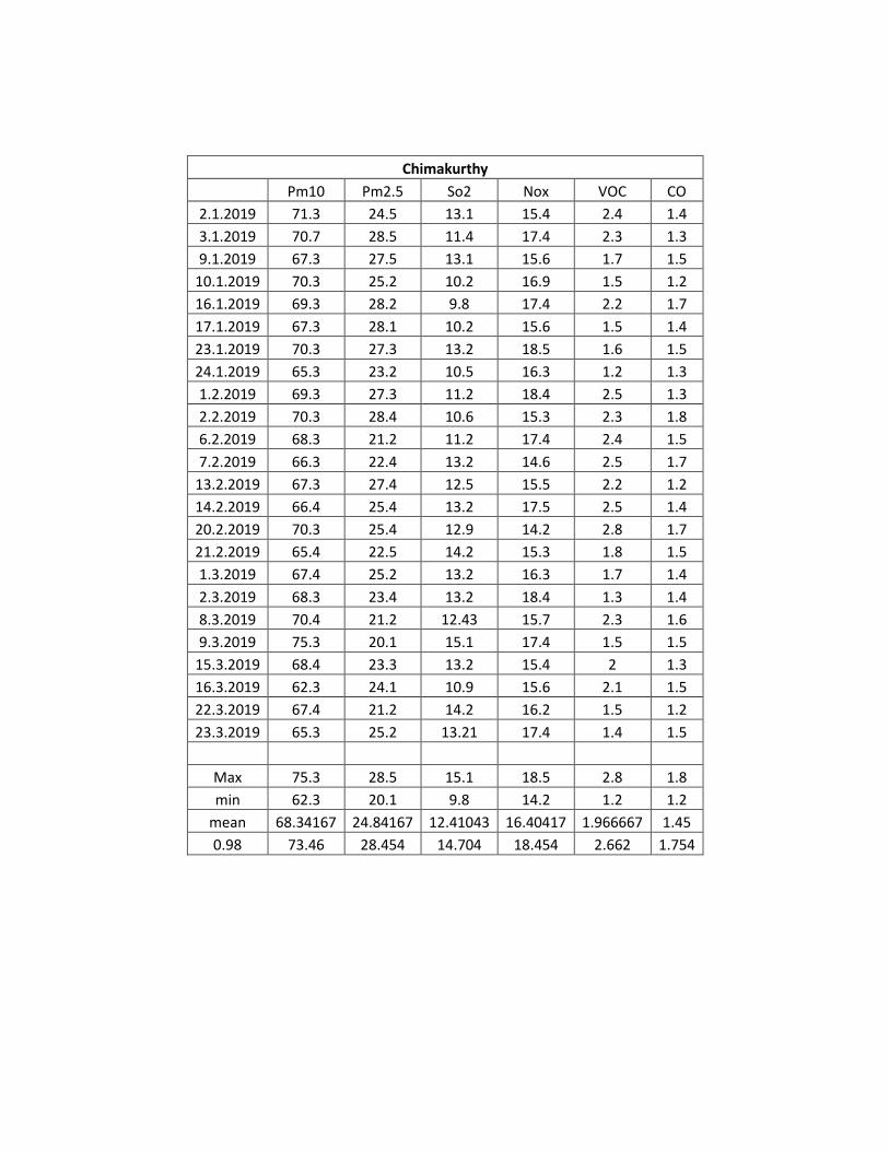
Chimakurthy
Pm10 Pm2.5 So2 Nox VOC CO
2.1.2019 71.3 24.5 13.1 15.4 2.4 1.4
3.1.2019 70.7 28.5 11.4 17.4 2.3 1.3
9.1.2019 67.3 27.5 13.1 15.6 1.7 1.5
10.1.2019 70.3 25.2 10.2 16.9 1.5 1.2
16.1.2019 69.3 28.2 9.8 17.4 2.2 1.7
17.1.2019 67.3 28.1 10.2 15.6 1.5 1.4
23.1.2019 70.3 27.3 13.2 18.5 1.6 1.5
24.1.2019 65.3 23.2 10.5 16.3 1.2 1.3
1.2.2019 69.3 27.3 11.2 18.4 2.5 1.3
2.2.2019 70.3 28.4 10.6 15.3 2.3 1.8
6.2.2019 68.3 21.2 11.2 17.4 2.4 1.5
7.2.2019 66.3 22.4 13.2 14.6 2.5 1.7
13.2.2019 67.3 27.4 12.5 15.5 2.2 1.2
14.2.2019 66.4 25.4 13.2 17.5 2.5 1.4
20.2.2019 70.3 25.4 12.9 14.2 2.8 1.7
21.2.2019 65.4 22.5 14.2 15.3 1.8 1.5
1.3.2019 67.4 25.2 13.2 16.3 1.7 1.4
2.3.2019 68.3 23.4 13.2 18.4 1.3 1.4
8.3.2019 70.4 21.2 12.43 15.7 2.3 1.6
9.3.2019 75.3 20.1 15.1 17.4 1.5 1.5
15.3.2019 68.4 23.3 13.2 15.4 2 1.3
16.3.2019 62.3 24.1 10.9 15.6 2.1 1.5
22.3.2019 67.4 21.2 14.2 16.2 1.5 1.2
23.3.2019 65.3 25.2 13.21 17.4 1.4 1.5
Max 75.3 28.5 15.1 18.5 2.8 1.8
min 62.3 20.1 9.8 14.2 1.2 1.2
mean 68.34167 24.84167 12.41043 16.40417 1.966667 1.45
0.98 73.46 28.454 14.704 18.454 2.662 1.754
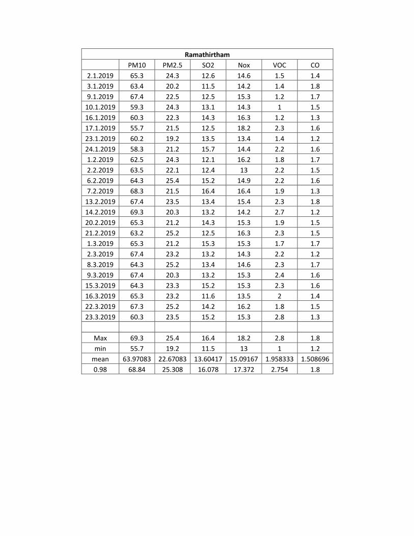
Ramathirtham
PM10 PM2.5 SO2 Nox VOC CO
2.1.2019 65.3 24.3 12.6 14.6 1.5 1.4
3.1.2019 63.4 20.2 11.5 14.2 1.4 1.8
9.1.2019 67.4 22.5 12.5 15.3 1.2 1.7
10.1.2019 59.3 24.3 13.1 14.3 1 1.5
16.1.2019 60.3 22.3 14.3 16.3 1.2 1.3
17.1.2019 55.7 21.5 12.5 18.2 2.3 1.6
23.1.2019 60.2 19.2 13.5 13.4 1.4 1.2
24.1.2019 58.3 21.2 15.7 14.4 2.2 1.6
1.2.2019 62.5 24.3 12.1 16.2 1.8 1.7
2.2.2019 63.5 22.1 12.4 13 2.2 1.5
6.2.2019 64.3 25.4 15.2 14.9 2.2 1.6
7.2.2019 68.3 21.5 16.4 16.4 1.9 1.3
13.2.2019 67.4 23.5 13.4 15.4 2.3 1.8
14.2.2019 69.3 20.3 13.2 14.2 2.7 1.2
20.2.2019 65.3 21.2 14.3 15.3 1.9 1.5
21.2.2019 63.2 25.2 12.5 16.3 2.3 1.5
1.3.2019 65.3 21.2 15.3 15.3 1.7 1.7
2.3.2019 67.4 23.2 13.2 14.3 2.2 1.2
8.3.2019 64.3 25.2 13.4 14.6 2.3 1.7
9.3.2019 67.4 20.3 13.2 15.3 2.4 1.6
15.3.2019 64.3 23.3 15.2 15.3 2.3 1.6
16.3.2019 65.3 23.2 11.6 13.5 2 1.4
22.3.2019 67.3 25.2 14.2 16.2 1.8 1.5
23.3.2019 60.3 23.5 15.2 15.3 2.8 1.3
Max 69.3 25.4 16.4 18.2 2.8 1.8
min 55.7 19.2 11.5 13 1 1.2
mean 63.97083 22.67083 13.60417 15.09167 1.958333 1.508696
0.98 68.84 25.308 16.078 17.372 2.754 1.8

Marrichetla palem
Pm10 PM2.5 SO2 Nox VOC CO
2.1.2019 63.4 25.2 13.5 15.3 1.2 1.7
3.1.2019 59.3 23.4 14.6 14.7 1.2 1.5
9.1.2019 65.4 22.3 12.5 18.3 1.5 1.3
10.1.2019 60.3 24.2 15.3 15.4 1 1.6
16.1.2019 65.3 26.2 14.2 17.5 1.4 1.2
17.1.2019 64 23.4 13.5 14.3 1.3 1.7
23.1.2019 68.3 22.1 15.3 16.3 1.5 1.5
24.1.2019 63.2 24.2 13.4 13.9 2.1 1.3
1.2.2019 69.3 24.2 12.3 15.3 2.3 1.9
2.2.2019 65.3 20.4 14.2 15.4 1.8 1.3
6.2.2019 63.5 22.2 12.8 17.4 1.7 1.3
7.2.2019 67.3 26.23 11.4 15.3 2 1.6
13.2.2019 59.3 26.3 15.3 15.2 1.9 2
14.2.2019 64.3 28.3 11.4 16.5 2.5 1.6
20.2.2019 65.3 23.2 12.8 14.2 2.3 1.3
21.2.2019 63.2 24.2 12.4 15.7 1.7 1.7
1.3.2019 59.3 26.2 13.2 16.4 1.6 1.3
2.3.2019 62.2 27.3 10.5 15.7 1.34 1.2
8.3.2019 64.3 24.2 13.1 15.4 2.3 1.5
9.3.2019 56.3 24.2 12.4 15.4 1.8 1.3
15.3.2019 62.3 21.2 13.6 14.3 2.4 1.3
16.3.2019 65.4 19.4 10 16.4 1.5 1.5
22.3.2019 62.5 20.3 13.2 16.3 1.8 1.3
23.3.2019 62.6 24.2 12.2 15.3 1.6 1.4
Max 69.3 28.3 15.3 18.3 2.5 2
min 56.3 19.4 10 13.9 1 1.2
mean 63.4 23.87625 13.04583 15.6625 1.739167 1.470833
0.98 68.84 27.84 15.3 17.932 2.454 1.954
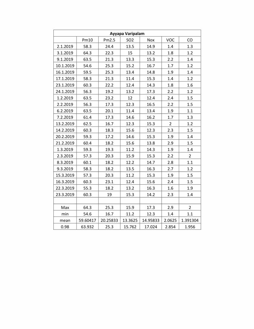
Ayyapa Varipalam
Pm10 Pm2.5 SO2 Nox VOC CO
2.1.2019 58.3 24.4 13.5 14.9 1.4 1.3
3.1.2019 64.3 22.3 15 13.2 1.8 1.2
9.1.2019 63.5 21.3 13.3 15.3 2.2 1.4
10.1.2019 54.6 25.3 15.2 16.7 1.7 1.2
16.1.2019 59.5 25.3 13.4 14.8 1.9 1.4
17.1.2019 58.3 21.3 11.4 15.3 1.4 1.2
23.1.2019 60.3 22.2 12.4 14.3 1.8 1.6
24.1.2019 56.3 19.2 13.2 17.3 2.2 1.2
1.2.2019 63.5 23.2 12 12.4 2.4 1.5
2.2.2019 56.3 17.3 12.3 16.5 2.2 1.5
6.2.2019 63.5 20.1 11.4 13.4 1.9 1.1
7.2.2019 61.4 17.3 14.6 16.2 1.7 1.3
13.2.2019 62.5 16.7 12.3 15.3 2 1.2
14.2.2019 60.3 18.3 15.6 12.3 2.3 1.5
20.2.2019 59.3 17.2 14.6 15.3 1.9 1.4
21.2.2019 60.4 18.2 15.6 13.8 2.9 1.5
1.3.2019 59.3 19.3 11.2 14.3 1.9 1.4
2.3.2019 57.3 20.3 15.9 15.3 2.2 2
8.3.2019 60.1 18.2 12.2 14.7 2.8 1.1
9.3.2019 58.3 18.2 13.5 16.3 2.7 1.2
15.3.2019 57.3 20.3 11.2 15.3 1.9 1.5
16.3.2019 60.3 23.1 12.4 15.6 2.4 1.5
22.3.2019 55.3 18.2 13.2 16.3 1.6 1.9
23.3.2019 60.3 19 15.3 14.2 2.3 1.4
Max 64.3 25.3 15.9 17.3 2.9 2
min 54.6 16.7 11.2 12.3 1.4 1.1
mean 59.60417 20.25833 13.3625 14.95833 2.0625 1.391304
0.98 63.932 25.3 15.762 17.024 2.854 1.956

Muvvavari palem
Pm10 Pm2.5 SO2 Nox VOC CO
2.1.2019 60.3 21.4 15.3 14.9 2.2 1.5
3.1.2019 59.3 20.7 13.2 15.3 2 1.2
9.1.2019 62.4 19.2 12.2 16.6 2.3 1.5
10.1.2019 59.3 18.2 13.5 15.7 2.4 1.3
16.1.2019 57.6 17.2 15.3 13.6 1.5 1.7
17.1.2019 60.3 20.3 12.4 12.4 2.4 1.3
23.1.2019 61.4 22.1 11.2 15.3 2 1.6
24.1.2019 58.3 21.3 14.3 15.4 2.2 1.5
1.2.2019 60.5 19 15.3 17.3 2.3 1.5
2.2.2019 58.3 21.2 15.3 16.4 2.5 1.7
6.2.2019 60.2 18.3 11.3 14.9 2.4 1.3
7.2.2019 58.2 21.4 12.1 15.3 2.3 1.7
13.2.2019 60.2 24.1 13.4 14.3 2.6 1.4
14.2.2019 58.2 18.3 11.2 15.3 2.8 1.6
20.2.2019 59.2 16.8 10 14.2 2.5 1.7
21.2.2019 60.3 20.3 12.3 15.4 2 1.9
1.3.2019 62.4 19.2 11.4 15.2 2.5 1.7
2.3.2019 59.3 19.7 12.4 14.3 1.6 1.9
8.3.2019 55.3 21.2 13.5 15.9 2.2 1.6
9.3.2019 56.2 18.3 12.4 15.5 2.2 1.3
15.3.2019 58.2 20.3 13.3 14.6 2.5 1.5
16.3.2019 54.2 22.1 12.2 13.4 2.2 1.3
22.3.2019 53.2 22.3 11.8 4.7 2.5 1.9
23.3.2019 58.2 18.7 11.4 15.6 2.3 1.6
Max 62.4 24.1 15.3 17.3 2.8 1.9
min 53.2 16.8 10 4.7 1.5 1.2
mean 58.79167 20.06667 12.77917 14.64444 2.266667 1.55
0.98 62.4 23.272 15.3 16.978 2.708 1.9

Annexure-V
The list of Flora and Fauna of the study area

Page 20 of 28
List of Local vegetation observed during the field visit:
S.No. Botanical Name Common name Family Habit
1 Acacia auriculiformis Benth. Australia thumma Leguminosae Tree
2 Acacia chundra Khadiramu Mimosaceae Tree
3 Acacia leucophloea (Roxb.) Tella thumma Leguminosae Tree
4 Aegle marmelos (L.) Corrêa Maredu Rutaceae Tree
5 Albizia lebbeck (L.) Benth. Dirisanam Leguminosae Tree
6 Azadirachta indica A.Juss. Vepa Meliaceae Tree
7 Balanitesa egyptiaca (L.) Delile Gara Zygophyllaceae Tree
8 Bauhinia racemosa Lam. Bidi leaf tree Leguminosae Tree
9 Borassus flabellifer L. Thadi chettu Arecaceae Tree
10 Buchanania lanzan Spreng. Sara Anacaradaceae Tree
11 Butea monosperma (Lam.) Taub. Modhuga Leguminosae Tree
12 Cascabela thevetia (L.) Lippold Pacha ganneru Apocynaceae Tree
13 Cassia fistula L. Rela Leguminosae Tree
14 Chukrasia tabularis A.Juss. Konda vepa Meliaceae Tree
15 Dalbergia sissoo DC. Sisu Leguminosae Tree
16 Delonix regia (Hook.) Raf. Chittikesaram Leguminosae Tree
17 Dendrocalamus strictus (Roxb.) Nees Sanna vedru Graminae Tree
18 Eucalyptus globulus Labill. Neelagiri thylam Myrtaceae Tree
19 Euphorbia tirucalli L. Tirukalli Euphorbiaceae Tree
20 Ficus benghalensis L. Marri Moraceae Tree
21 Ficus hispida L.f. Medipandu Moraceae Tree
22 Ficus racemosa L. Medi Moraceae Tree
23 Ficus religiosa L. Ravi Moraceae Tree
24 Leucaena leucocephala (Lam.) de Wit Jabarichettu Leguminosae Tree
25 Limonia acidissima L. Velaga Rutaceae Tree
26 Mangifera indica L. Mamidi Anacardiaceae Tree
27 Morinda tinctoria Roxb. Maddichettu Rubiaceae Tree
28 Nerium odoratum Lam. Erra ganneru Apocynaceae Tree
29 Peltophorum pterocarpum (DC.) K.Heyne Kondachintha Leguminosae Tree
30 Phoenix sylvestris (L.) Roxb. Eethachettu Arecaceae Tree
31 Phyllanthus emblica L. Usiri Phyllanthaceae Tree
32 Pithecellobium dulce (Roxb.) Benth. Sima chinta Leguminosae Tree
33 Polyalthia longifolia (Sonn.) Thwaites Naramamidi Annonaceae Tree
34 Pongamia pinnata (L.) Pierre Adivi ganuga Leguminosae Tree
35 Prosopis chilensis (Molina) Stuntz Mulla thumma Leguminosae Tree
36 Prosopis juliflora (Sw.) DC. English tumma Mimosaceae Tree
37 Samanea saman (Jacq.) Merr. Nidraganeeru Sapindaceae Tree
38 Senna siamea Lam. Seema thangedu Leguminosae Tree
39 Senna siamea Lam. Seema thangedu Leguminosae Tree
40 Syzygium cumini (L.) Skeels Neredu Myrtaceae Tree
41 Tamarindus indica L. Chintha Leguminosae Tree
42 Tecoma stans (L.) Juss. ex Kunth Pasupu ganneru Bignoniaceae Tree
43 Terminalia bellirica (Gaertn.) Roxb. Tani Combretaceae Tree
44 Terminalia catappa L. Badham Combretaceae Tree
45 Thespecia populnea (L.) Sol Ganga Raavi Malvaceae Tree
46 Vitex negundo L. Vaavili Verbenaceae Tree
47 Abutilon indicum (L.) Sweet Thutturubenda Malvaceae Shrub
48 Agave americana L. Gitta nara Asparagaceae Shrub

Page 21 of 28
49 Caesalpinia bonduc (L.) Roxb. Gacha podha Leguminosae Shrub
50 Caesalpinia pulcherrima (L.) Sw. Rathna gandhi Leguminosae Shrub
51 Calotropis gigantea (L.) Dryand. Tella jilledu Apocynaceae Shrub
52 Calotropis procera (Aiton) Dryand. Erra jilledu Apocynaceae Shrub
53 Capparis zeylanica L. Aarudonda Capparaceae Shrub
54 Carissa carandas L. Vakkaya Apocynaceae Shrub
55 Catunaregam spinosa (Thunb.) Tirveng. Manga Rubiaceae Shrub
56 Clerodendrum phlomidis L.f. Kond-takal Lamiaceae Shrub
57 Datura stramonium L. Ummetha Solanaceae Shrub
58 Dodonaea viscosa Jacq. Bandaru Sapindaceae Shrub
59 Erythroxylum monogynum Roxb. Dedaraaku Erythroxylaceae Shrub
60 Holarrhena antidysenterica (Roth) girimallika Apocynaceae Shrub
61 Ipomoea carnea Jacq. Rubber mokka Convolvulaceae Shrub
62 Ixora coccinea Ramabanam Rubiaceae Shrub
63 Jatropha curcas L. Nepalam Euphorbiaceae Shrub
64 Jatropha glandulifera Roxb. Yerranepalamu Euphorbiaceae Shrub
65 Lantana camara L. Pulikampa Verbenaceae Shrub
66 Morinda pubescens Sm. Maddi Rubiaceae Shrub
67 Opuntia dillenii (Ker Gawl.) Haw. Naga jamudu Cactaceae Shrub
68 Phoenix acaulis Roxb. Chitteetha Palmae Shrub
69 Phyllanthus reticulatus Poir. Nallapuli Phyllanthaceae Shrub
70 Randia dumetorum Rubiaceae Shrub
71 Senna auriculata (L.) Roxb. Tangedu Leguminosae Shrub
72 Solanum pubescens Willd. Uchintha Solanaceae Shrub
73 Xanthium strumarium L. Marula-Mathangi Asteraceae Shrub
74 Ximenia americana L. Nekkera Olacaceae Shrub
75 Ziziphus oenopolia (L.) Mill. Parimi Rhamnaceae Shrub
76 Acalypha indica L. Haritha manjari Euphorbiaceae Herb
77 Achyranthes aspera L Uttareni Amaranthaceae Herb
78 Aerva lanata (L.) Juss Thelaga pindi Amaranthaceae Herb
79 Aeschynomene aspera L. Neeti jeeluga Leguminosae Herb
80 Ageratum conyzoides (L.) L. Vasavi Asteraceae Herb
81 Aloe vera (L.) Burm.f. Kithanara Tiliaceae Herb
82 Alternanthera sessilis (L.) R.Br. ex DC. Ponagantiaku Amaranthaceae Herb
83 Amaranthus spinosus L. Mulla thotakoora Amaranthaceae Herb
84 Amaranthus viridis L. Chilakathotakoora Amaranthaceae Herb
85 Argemone mexicana L. Brahmadandi Papaveraceae Herb
86 Barleria prionitis L. Pachagorinta Acanthaceae Herb
87 Blumea mollis (D. Don) Merr. Kukkapogaku Asteraceae Herb
88 Boerhavia diffusa L. Atikimamidi Nyctaginaceae Herb
89 Caralluma umbellata Kundeti kummulu Apocynaceae Herb
90 Catharanthus roseus (L.) G.Don Billaganneru Apocynaceae Herb
91 Celosia virgata Jacq. Guruga Amaranthaceae Herb
92 Cleome viscosa L. Kukka vomintha Cleomaceae Herb
93 Colocasia esculenta (L.) Schott Atuka tiga Araceae Herb
94 Croton bonplandianus Baill. Vana mokka Euphorbiaceae Herb
95 Euphorbia hirta L. Nanubalu Euphorbiaceae Herb
96 Evolvulus alsinoides (L.) L Vishnukrantha Convolvulaceae Herb
97 Gomphrena serrata L. Tella bendumalli Amaranthaceae Herb
98 Hygrophila auriculata (Schumach.) Heine Mundla gobbi Acanthaceae Herb
99 Justicia procumbens L. Water Willow Acanthaceae Herb
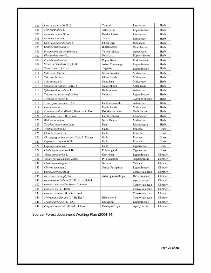
Page 22 of 28
100 Leucas aspera (Willd.) Tummi Lamiaceae Herb
101 Mimosa pudica L. Atthi pathi Leguminosae Herb
102 Ocimum canum Sims Kukka Tulasi Lamiaceae Herb
103 Ocimum sanctum Tulasi Lamiaceae Herb
104 Oldenlandia umbellata L. Chiru veru Rubiaceae Herb
105 Oxalis corniculata L. Indian Sorrel Oxalidaceae Herb
106 Parthenium hysterophorus L. Vayyaribhama Asteraceae Herb
107 Phyllanthus niruri L. Nela Usiri Euphorbiaceae Herb
108 Portulaca oleracea L. Pappu Kura Portulacaceae Herb
109 Senna occidentalis (L.) Link Adavi Chennangi Leguminosae Herb
110 Senna tora (L.) Roxb. Tagarisa Leguminosae Herb
111 Sida acuta Burm.f. Medabirusaku Malvaceae Herb
112 Sida cordifolia L. Chiru Benda Malvaceae Herb
113 Sida spinosa L. Naga bala Malvaceae Herb
114 Solanum surattense Burm. f. Nela vakudu Solanaceae Herb
115 Sphaeranthus indicus L. Bodasaramu Asteraceae Herb
116 Tephrosia purpurea (L.) Pers. Vempali Leguminosae Herb
117 Tribulus terrestris L. Zygophyllaceae Herb
118 Tridax procumbens (L.) L. Gaddichamanthi Asteraceae Herb
119 Urena lobata L. Pedda benda Malvaceae Herb
120 Vanda tessellata (Roxb.) Hook. ex G.Don Kodikalla chettu Orchidaceae Herb
121 Vernonia cinerea (L.) Less. Gariti Kamma Compositae Herb
122 Waltheria indica L. Nalla Benda Malvaceae Herb
123 Ziziphus mauritiana Lam. Reni Rhamnaceae Herb
124 Aristida hystrix L.f. Gaddi Poaceae Grass
125 Chloris virgata Sw. Gaddi Poaceae Grass
126 Chrysopogon lancearius (Hook.f.) Haines Gaddi Poaceae Grass
127 Cyperus castaneus Willd. Gaddi Poaceae Grass
128 Cyperus rotundus L. Gaddi Cyperaceae Grass
129 Fimbristylis cymosa R.Br. Pulupu gaddi Cyperaceae Grass
130 Abrus precatorius L. Gurivinda Leguminosae Climber
131 Asparagus racemosus Willd. Pilli Gaddalu Asparagaceae Climber
132 Cissus quadrangularis L. Nalleru Vitaceae Climber
133 Clitoria ternatea L. Sanku-Pushpamu Leguminosae Climber
134 Cuscuta reflexa Roxb. Convolvulaceae Climber
135 Dioscorea pentaphylla L. Adavi gunusuthega Dioscoreaceae Climber
136 Hemidesmus indicus (L.) R. Br. ex Schult Apocynaceae Climber
137 Ipomoea macrantha Roem. & Schult. Convolvulaceae Climber
138 Ipomoea nil (L.) Roth. Convolvulaceae Climber
139 Ipomoea obscura (L.) Ker Gawl. Convolvulaceae Climber
140 Merremia tridentata (L.) Hallier f. Elaka chevi Convolvulaceae Climber
141 Mucuna pruriens (L.) DC. Dulagondi Leguminosae Climber
142 Pergularia daemia (Forssk.) Chiov. Dustapu-Teega Apocynaceae Climber
Source: Forest department Working Plan (2004-14)

Page 23 of 28
LIST OF FAUNA & THEIR CONSERVATION STATUS Mammals: (* directly sighted animals)
Scientific Name Common Name Family
WPA Status IUCN
Herpestes javanicus Common Indian Mongoose*
Herpestidae Sch II LC
Pipistrellus coromandra Indian Pipistrelle (bat) Chiroptera LC
Pteropus giganteus Indian Flying fox bat Chiroptera
LC
Rhinopoma microphyllum
Grater Mouse-Tailed Bat
Chiroptera LC
Megaderma spasma lesser false vampire bat
Chiroptera
LC
Pteropus giganteus Indian flying fox Chiroptera LC
Lepus nigricollis Black-naped Hare Leporidae Sch IV LC
Bendicota bengalensis Indian mole rat Muridae LC
Bendicota indica Bandicoot rat Muridae LC
Mus booduga Little Indian Field mouse
Muridae Sch V LC
Mus musculus House Mouse* Muridae Sch V LC
Rattus rattus House rat* Muridae LC
Funambulus palmarum Three striped palm squirrel*
Sciuridae LC
Status assigned by the IUCN, where – CR – Critically Endangered; EN – Endangered; LC – Least Concern; NT – Near Threatened; VU – Vulnerable, DA – Data Deficient, NE – Not Evaluated Source :
Andhra Pradesh State Forest Department Working plan data Vivek Menon (2014), Indian Mammals: A Field Guide. Hachette Book
Publishing India Pvt. Ltd., Gurgaon, India, pp 1-522; IUCN (2015). The IUCN Red List of Threatened Species. Version 2015-4; Schedules I to VI:
Indian Wildlife (Protection) Act, 1972. Aves: All the listed birds are Least Concern under IUCN and Schedule - IV under Indian Wildlife Protection Act (1972) (* directly obsereved bird from the study area)
Scientific Name Common Name IUCN IWLP
Apus affinis House Swift LC Sch-IV
Cypsiurus balasiensis Asian Palm Swift LC Sch-IV
Vanellus indicus Red-wattled Lapwing* LC Sch-IV
Columba livia Rock Pigeon LC Sch-IV
Streptopelia chinensis Spotted Dove LC Sch-IV
Streptopelia decaocto Eurasian Collared Dove* LC Sch-IV
Alcedo atthis Common Kingfisher* LC Sch-IV
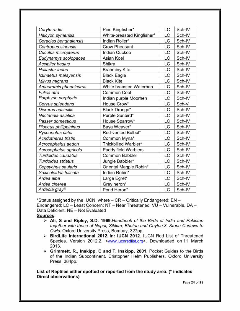
Page 24 of 28
Ceryle rudis Pied Kingfisher* LC Sch-IV
Halcyon symensis White-breasted Kingfisher* LC Sch-IV
Coracias benghalensis Indian Roller* LC Sch-IV
Centropus sinensis Crow Pheasant LC Sch-IV
Cuculus micropterus Indian Cuckoo LC Sch-IV
Eudynamys scolopacea Asian Koel LC Sch-IV
Accipiter badius Shikra LC Sch-IV
Haliastur indus Brahminy Kite LC Sch-IV
Ictinaetus malayensis Black Eagle LC Sch-IV
Milvus migrans Black Kite LC Sch-IV
Amauromis phoenicurus White breasted Waterhen LC Sch-IV
Fulica atra Common Coot LC Sch-IV
Porphyrio porphyrio Indian purple Moorhen LC Sch-IV
Corvus splendens House Crow* LC Sch-V
Dicrurus adsimilis Black Drongo* LC Sch-IV
Nectarinia asiatica Purple Sunbird* LC Sch-IV
Passer domesticus House Sparrow* LC Sch-IV
Ploceus philippininus Baya Weaver* LC Sch-IV
Pycnonotus cafer Red-vented Bulbul* LC Sch-IV
Acridotheres tristis Common Myna* LC Sch-IV
Acrocephalus aedon Thickbilled Warbler* LC Sch-IV
Acrocephalus agricola Paddy field Warblers LC Sch-IV
Turdoides caudatus Common Babbler LC Sch-IV
Turdoides striatus Jungle Babbler* LC Sch-IV
Copsychus saularis Oriental Magpie Robin* LC Sch-IV
Saxicoloides fulicata Indian Robin* LC Sch-IV
Ardea alba Large Egret* LC Sch-IV
Ardea cinerea Grey heron* LC Sch-IV
Ardeola grayii Pond Heron* LC Sch-IV
*Status assigned by the IUCN, where – CR – Critically Endangered; EN – Endangered; LC – Least Concern; NT – Near Threatened; VU – Vulnerable, DA – Data Deficient, NE – Not Evaluated Sources:
Ali, S and Ripley, S.D. 1969.Handbook of the Birds of India and Pakistan together with those of Nepal, Sikkim, Bhutan and Ceylon,3. Stone Curlews to Owls. Oxford University Press, Bombay, 327pp.
BirdLife International 2012. In: IUCN 2012. IUCN Red List of Threatened Species. Version 2012.2. <www.iucnredlist.org>. Downloaded on 11 March 2013.
Grimmett, R., Inskipp, C and T. Inskipp, 2001. Pocket Guides to the Birds of the Indian Subcontinent. Cristopher Helm Publishers, Oxford University Press, 384pp.
List of Reptiles either spotted or reported from the study area. (* indicates Direct observations)
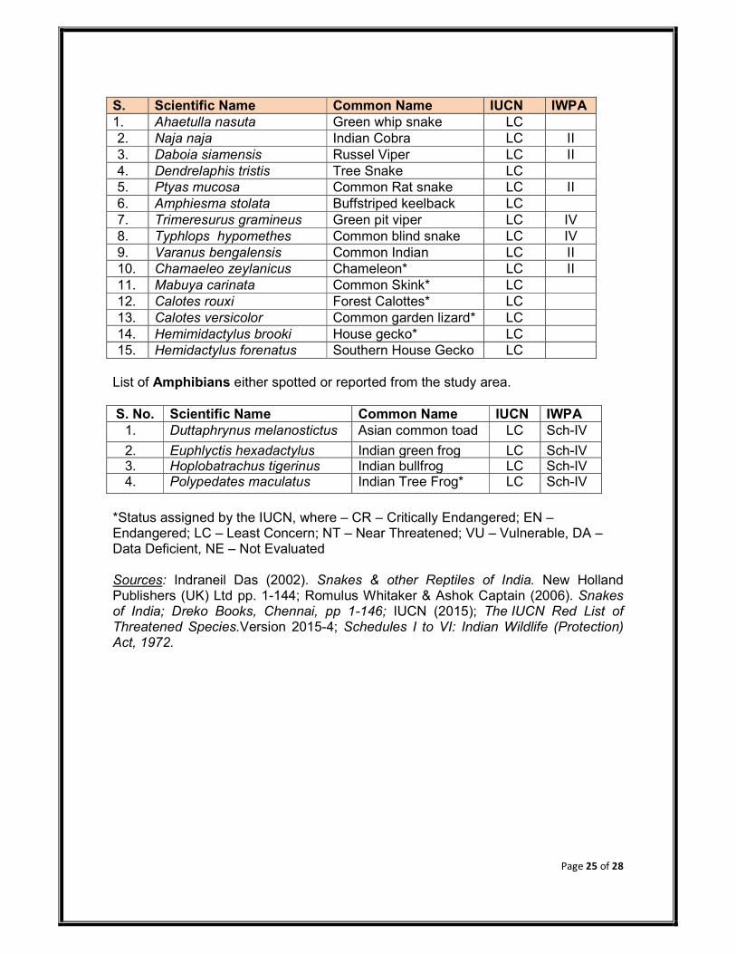
Page 25 of 28
S. NoN
Scientific Name Common Name IUCN IWPA
1. Ahaetulla nasuta Green whip snake LC
2. Naja naja Indian Cobra LC II
3. Daboia siamensis Russel Viper LC II
4. Dendrelaphis tristis Tree Snake LC
5. Ptyas mucosa Common Rat snake LC II
6. Amphiesma stolata Buffstriped keelback LC
7. Trimeresurus gramineus Green pit viper LC IV
8. Typhlops hypomethes Common blind snake LC IV
9. Varanus bengalensis Common Indian LC II
10. Chamaeleo zeylanicus Chameleon* LC II
11. Mabuya carinata Common Skink* LC
12. Calotes rouxi Forest Calottes* LC
13. Calotes versicolor Common garden lizard* LC
14. Hemimidactylus brooki House gecko* LC
15. Hemidactylus forenatus Southern House Gecko LC
List of Amphibians either spotted or reported from the study area.
S. No. Scientific Name Common Name IUCN IWPA
1. Duttaphrynus melanostictus Asian common toad LC Sch-IV
2. Euphlyctis hexadactylus Indian green frog LC Sch-IV 3. Hoplobatrachus tigerinus Indian bullfrog LC Sch-IV 4. Polypedates maculatus Indian Tree Frog* LC Sch-IV
*Status assigned by the IUCN, where – CR – Critically Endangered; EN – Endangered; LC – Least Concern; NT – Near Threatened; VU – Vulnerable, DA – Data Deficient, NE – Not Evaluated Sources: Indraneil Das (2002). Snakes & other Reptiles of India. New Holland Publishers (UK) Ltd pp. 1-144; Romulus Whitaker & Ashok Captain (2006). Snakes of India; Dreko Books, Chennai, pp 1-146; IUCN (2015); The IUCN Red List of Threatened Species.Version 2015-4; Schedules I to VI: Indian Wildlife (Protection) Act, 1972.

Annexure-VI
Copy of TOR and TOR Compliance
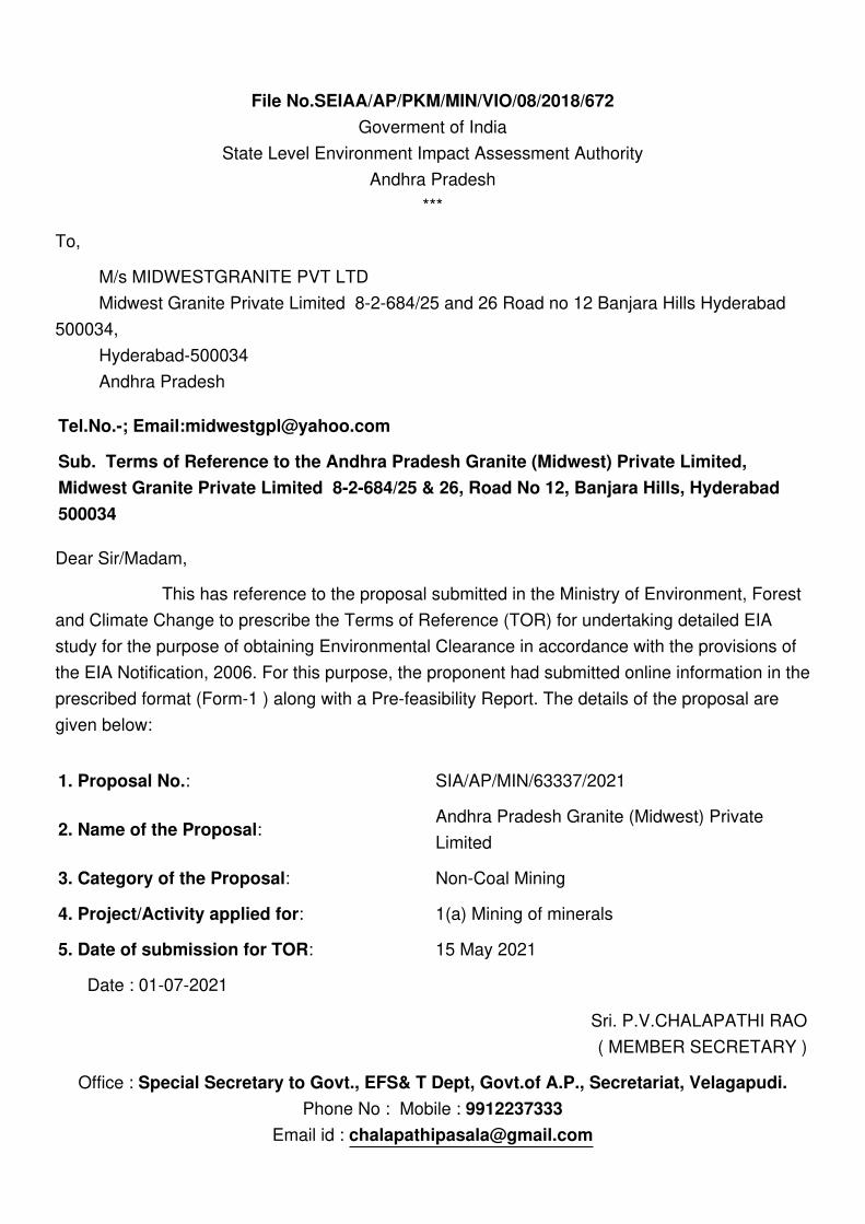
File No.SEIAA/AP/PKM/MIN/VIO/08/2018/672
Goverment of India
State Level Environment Impact Assessment Authority
Andhra Pradesh
***
To,
M/s MIDWESTGRANITE PVT LTD
Midwest Granite Private Limited 8-2-684/25 and 26 Road no 12 Banjara Hills Hyderabad
500034,
Hyderabad-500034
Andhra Pradesh
Tel.No.-; Email:[email protected]
Sub. Terms of Reference to the Andhra Pradesh Granite (Midwest) Private Limited,
Midwest Granite Private Limited 8-2-684/25 & 26, Road No 12, Banjara Hills, Hyderabad
500034
Dear Sir/Madam,
This has reference to the proposal submitted in the Ministry of Environment, Forest
and Climate Change to prescribe the Terms of Reference (TOR) for undertaking detailed EIA
study for the purpose of obtaining Environmental Clearance in accordance with the provisions of
the EIA Notification, 2006. For this purpose, the proponent had submitted online information in the
prescribed format (Form-1 ) along with a Pre-feasibility Report. The details of the proposal are
given below:
1. Proposal No.: SIA/AP/MIN/63337/2021
2. Name of the Proposal: Andhra Pradesh Granite (Midwest) Private
Limited
3. Category of the Proposal: Non-Coal Mining
4. Project/Activity applied for: 1(a) Mining of minerals
5. Date of submission for TOR: 15 May 2021
Date : 01-07-2021
Sri. P.V.CHALAPATHI RAO
( MEMBER SECRETARY )
Office : Special Secretary to Govt., EFS& T Dept, Govt.of A.P., Secretariat, Velagapudi.
Phone No : Mobile : 9912237333
Email id : [email protected]

Note : This is auto tor granted letter.
In this regard, under the provisions of the EIA Notification 2006 as amended, the Standard TOR
for the purpose of preparing environment impact assessment report and environment
management plan for obtaining prior environment clearance is prescribed with public consultation
as follows:

STANDARD TERMS OF REFERENCE (TOR) FOR EIA/EMP REPORT FOR
PROJECTS/ACTIVITIES REQUIRING ENVIRONMENT CLEARANCE
Terms of Reference (TOR) for preparation of Environmental Impact Assessment (EIA) and
Environmental Management Plan (EMP) for "Mining of Minerals" as per the EIA Notification, 2006 has
been devised to improve the quality of the reports and facilitate decision-making transparent and easy.
TOR will help the project proponents to prepare report with relevant project specific data and easily
interpretable information. TOR for mining of minerals is expected to cover all environmental related
features.
Mining of minerals plays a positive role in the process of country's economic development. In
addition to the contribution towards economic growth, mining can also be a major source of degradation
of physical as well as social environment, unless it is properly managed. Environmental impacts can arise
during all activities of the mining process. Minimizing the damage due to mining operations depends on
sound environmental practices in a framework of balanced environmental legislation. The potential adverse
effects of mining activities include air pollution, surface and groundwater pollution, noise and vibration,
damage to local ecology, natural topography and drainage, depletion of water resources etc. All these
environmental components are required to be considered while selecting a proper methodology of mining,
mitigation measures to reduce pollution load, conservation of natural resources etc.
The projects of mining of minerals as stated in the schedule require prior environment clearance
under the EIA notification, 2006. Category 'A' Projects are handled in the MoEF&CC and Category 'B'
projects are being handled by the respective State Environment Impact Assessment Authorities (SEIAAs)
notified by MoEF&CC and following the procedure prescribed under the EIA Notification, 2006. As per
this Notification, as amended, the projects of mining of minor minerals with mining lease area equal to or
greater than 50 hectare are to be handled at the level of the MoEF&CC for grant of EC. Such projects with
mining lease area less than 50 hectare are to be handled by the respective State Environment Impact
Assessment Authority (SEIAA).
1(a):STANDARD TERMS OF REFERENCE FOR CONDUCTING
ENVIRONMENT IMPACT ASSESSMENT STUDY FOR NON-COAL
MINING PROJECTS AND INFORMATION TO BE INCLUDED IN EIA/EMP
REPORT
1) Year-wise production details since 1994 should be given, clearly stating the highest production
achieved in any one year prior to 1994. It may also be categorically informed whether there had
been any increase in production after the EIA Notification 1994 came into force, w.r.t. the highest
production achieved prior to 1994.
2) A copy of the document in support of the fact that the Proponent is the rightful lessee of the mine
should be given.
3) All documents including approved mine plan, EIA and Public Hearing should be compatible with
one another in terms of the mine lease area, production levels, waste generation and its management,
mining technology etc. and should be in the name of the lessee.
4) All corner coordinates of the mine lease area, superimposed on a High Resolution Imagery/ toposheet,
topographic sheet, geomorphology and geology of the areashould be provided. Such an Imagery of

STANDARD TERMS OF REFERENCE (TOR) FOR EIA/EMP REPORT FOR PROJECTS/
ACTIVITIES REQUIRING ENVIRONMENT CLEARANCE
the proposed area should clearly show the land use and other ecological features of the study area
(core and buffer zone).
5) Information should be provided in Survey of India Toposheet in 1:50,000 scale indicating geological
map of the area, geomorphology of land forms of the area, existing minerals and mining history of
the area, important water bodies, streams and rivers and soil characteristics.
6) Details about the land proposed for mining activities should be givenwith information as to whether
mining conforms to the land use policy of the State; land diversion for mining should have approval
from State land use board or the concerned authority.
7) It should be clearly stated whether the proponent Company has a well laid down Environment
Policy approved by its Board of Directors? If so, it may be spelt out in the EIA Report with description
of the prescribed operating process/procedures to bring into focus any infringement/deviation/
violation of the environmental or forest norms/ conditions? The hierarchical system or administrative
order of the Company to deal with the environmental issues and for ensuring compliance with the
EC conditions may also be given. The system of reporting of non-compliances / violations of
environmental norms to the Board of Directors of the Company and/or shareholders or stakeholders
at large,may also be detailed in the EIA Report.
8) Issues relating to Mine Safety, including subsidence study in case of underground mining and slope
study in case of open cast mining, blasting study etc. should be detailed. The proposed safeguard
measures in each case should also be provided.
9) The study rea will comprise of 10 km zone around the mine lease from lease periphery and the data
contained in the EIA such as waste generation etc. should be for the life of the mine / lease period.
10) Land use of the study rea delineating forest area, agricultural land, grazing land, wildlife sanctuary,
national park, migratory routes of fauna, water bodies, human settlements and other ecological
features should be indicated. Land use plan of the mine lease area should be prepared to encompass
preoperational, operational and post operational phases and submitted. Impact, if any, of change of
land use should be given.
11) Details of the land for any Over Burden Dumps outside the mine lease, such as extent of land area,
distance from mine lease, its land use, R&R issues, if any, should be given.
12) A Certificate from the Competent Authority in the State Forest Department should be provided,
confirming the involvement of forest land, if any, in the project area. In the event of any contrary
claim by the Project Proponent regarding the status of forests, the site may be inspected by the State
Forest Department along with the Regional Office of the Ministry to ascertain the status of forests,
based on which, the Certificate in this regard as mentioned above be issued. In all such cases, it
would be desirable for representative of the State Forest Department to assist the Expert Appraisal
Committees.
13) Status of forestry clearance for the broken up area and virgin forestland involved in the Project
including deposition of net present value (NPV) and compensatory afforestation (CA) should be
indicated. A copy of the forestry clearance should also be furnished.
STANDARD TERMS OF REFERENCE (TOR) FOR EIA/EMP REPORT FOR
PROJECTS/ACTIVITIES REQUIRING ENVIRONMENT CLEARANCE
14) Implementation status of recognition of forest rights under the Scheduled Tribes and other Traditional
Forest Dwellers (Recognition of Forest Rights) Act, 2006 should be indicated.
15) The vegetation in the RF / PF areas in the study area, with necessary details, should be given.
16) A study shall be got done to ascertain the impact of the Mining Project on wildlife of the study area
and details furnished. Impact of the project on the wildlife in the surrounding and any other protected
area and accordingly, detailed mitigative measures required, should be worked out with cost
implications and submitted.
17) Location of National Parks, Sanctuaries, Biosphere Reserves, Wildlife Corridors, Ramsar site Tiger/
Elephant Reserves/(existing as well as proposed), if any, within 10 km of the mine lease should be
clearly indicated, supported by a location map duly authenticated by Chief Wildlife Warden.
Necessary clearance, as may be applicable to such projects due to proximity of the ecologically
sensitive areas as mentioned above, should be obtained from the Standing Committee of National
Board of Wildlifeand copy furnished.
18) A detailed biological study of the study area [core zone and buffer zone (10 km radius of the periphery
of the mine lease)] shall be carried out. Details of flora and fauna, endangered, endemic and RET
Species duly authenticated, separately for core and buffer zone should be furnished based on such
primary field survey, clearly indicating the Schedule of the fauna present. In case of any scheduled-
I fauna found in the study area, the necessary plan alongwith budgetary provisions for their
conservation should be prepared in consultation with State Forest and Wildlife Department and
details furnished. Necessary allocation of funds for implementing the same should be made as part
of the project cost.
19) Proximity to Areas declared as 'Critically Polluted' or the Project areas likely to come under the
'Aravali Range', (attracting court restrictions for mining operations), should also be indicated and
where so required, clearance certifications from the prescribed Authorities, such as the SPCB or
State Mining Dept. Should be secured and furnished to the effect that the proposed mining activities
could be considered.
20) Similarly, for coastal Projects, A CRZ map duly authenticated by one of the authorized agencies
demarcating LTL. HTL, CRZ area, location of the mine lease w.r.t CRZ, coastal features such as
mangroves, if any, should be furnished. (Note: The Mining Projects falling under CRZ would also
need to obtain approval of the concerned Coastal Zone Management Authority).
21) R&R Plan/compensation details for the Project Affected People (PAP) should be furnished. While
preparing the R&R Plan, the relevant State/National Rehabilitation & Resettlement Policy should
be kept in view. In respect of SCs /STs and other weaker sections of the society in the study area, a
need based sample survey, family-wise, should be undertaken to assess their requirements, and
action programmes prepared and submitted accordingly, integrating the sectoral programmes of
line departments of the State Government. It may be clearly brought out whether the village(s)
located in the mine lease area will be shifted or not. The issues relating to shifting of village(s)
including their R&R and socio-economic aspects should be discussed in the Report.

STANDARD TERMS OF REFERENCE (TOR) FOR EIA/EMP REPORT FOR PROJECTS/
ACTIVITIES REQUIRING ENVIRONMENT CLEARANCE
22) One season (non-monsoon) [i.e. March-May (Summer Season); October-December (post monsoon
season) ; December-February (winter season)]primary baseline data on ambient air quality as per
CPCB Notification of 2009, water quality, noise level, soil and flora and fauna shall be collected
and the AAQ and other data so compiled presented date-wise in the EIA and EMP Report. Site-
specific meteorological data should also be collected. The location of the monitoring stations should
be such as to represent whole of the study area and justified keeping in view the pre-dominant
downwind direction and location of sensitive receptors. There should be at least one monitoring
station within 500 m of the mine lease in the pre-dominant downwind direction. The mineralogical
composition of PM10, particularly for free silica, should be given.
23) Air quality modeling should be carried out for prediction of impact of the project on the air quality
of the area. It should also take into account the impact of movement of vehicles for transportation of
mineral. The details of the model used and input parameters used for modeling should be provided.
The air quality contours may be shown on a location map clearly indicating the location of the site,
location of sensitive receptors, if any, and the habitation. The wind roses showing pre-dominant
wind direction may also be indicated on the map.
24) The water requirement for the Project, its availability and source should be furnished. A detailed
water balance should also be provided. Fresh water requirement for the Project should be indicated.
25) Necessary clearance from the Competent Authority for drawl of requisite quantity of water for the
Project should be provided.
26) Description of water conservation measures proposed to be adopted in the Project should be given.
Details of rainwater harvesting proposed in the Project, if any, should be provided.
27) Impact of the Project on the water quality, both surface and groundwater, should be assessed and
necessary safeguard measures, if any required, should be provided.
28) Based on actual monitored data, it may clearly be shown whether working will intersect groundwater.
Necessary data and documentation in this regard may be provided. In case the working will intersect
groundwater table, a detailed Hydro Geological Study should be undertaken and Report furnished.
The Report inter-alia, shall include details of the aquifers present and impact of mining activities on
these aquifers. Necessary permission from Central Ground Water Authority for working below
ground water and for pumping of ground water should also be obtained and copy furnished.
29) Details of any stream, seasonal or otherwise, passing through the lease area and modification /
diversion proposed, if any, and the impact of the same on the hydrology should be brought out.
30) Information on site elevation, working depth, groundwater table etc. Should be provided both in
AMSL and bgl. A schematic diagram may also be provided for the same.
31) A time bound Progressive Greenbelt Development Plan shall be prepared in a tabular form (indicating
the linear and quantitative coverage, plant species and time frame) and submitted, keeping in mind,
the same will have to be executed up front on commencement of the Project. Phase-wise plan of
plantation and compensatory afforestation should be charted clearly indicating the area to be covered

STANDARD TERMS OF REFERENCE (TOR) FOR EIA/EMP REPORT FOR
PROJECTS/ACTIVITIES REQUIRING ENVIRONMENT CLEARANCE
under plantation and the species to be planted. The details of plantation already done should be
given.The plant species selected for green belt should have greater ecological value and should be
of good utility value to the local population with emphasis on local and native species and the
species which are tolerant to pollution.
32) Impact on local transport infrastructure due to the Project should be indicated. Projected increase in
truck traffic as a result of the Project in the present road network (including those outside the
Project area) should be worked out, indicating whether it is capable of handling the incremental
load. Arrangement for improving the infrastructure, if contemplated (including action to be taken
by other agencies such as State Government) should be covered. Project Proponent shall conduct
Impact of Transportation study as per Indian Road Congress Guidelines.
33) Details of the onsite shelter and facilities to be provided to the mine workers should be included in
the EIA Report.
34) Conceptual post mining land use and Reclamation and Restoration of mined out areas (with plans
and with adequate number of sections) should be given in the EIA report.
35) Occupational Health impacts of the Project should be anticipated and the proposed preventive
measures spelt out in detail. Details of pre-placement medical examination and periodical medical
examination schedules should be incorporated in the EMP. The project specific occupational health
mitigation measures with required facilities proposed in the mining area may be detailed.
36) Public health implications of the Project and related activities for the population in the impact zone
should be systematically evaluated and the proposed remedial measures should be detailed along
with budgetary allocations.
37) Measures of socio economic significance and influence to the local community proposed to be
provided by the Project Proponent should be indicated. As far as possible, quantitative dimensions
may be given with time frames for implementation.
38) Detailed environmental management plan (EMP) to mitigate the environmental impacts which,
should inter-alia include the impacts of change of land use, loss of agricultural and grazing land, if
any, occupational health impacts besides other impacts specific to the proposed Project.
39) Public Hearing points raised and commitment of the Project Proponent on the same along with time
bound Action Plan with budgetary provisions to implement the same should be provided and also
incorporated in the final EIA/EMP Report of the Project.
40) Details of litigation pending against the project, if any, with direction /order passed by any Court of
Law against the Project should be given.
41) The cost of the Project (capital cost and recurring cost) as well as the cost towards implementation
of EMP should be clearly spelt out.
42) A Disaster management Plan shall be prepared and included in the EIA/EMP Report.

STANDARD TERMS OF REFERENCE (TOR) FOR EIA/EMP REPORT FOR PROJECTS/
ACTIVITIES REQUIRING ENVIRONMENT CLEARANCE
43) Benefits of the Project if the Project is implemented should be spelt out. The benefits of the Project
shall clearly indicate environmental, social, economic, employment potential, etc.
44) Besides the above, the below mentioned general points are also to be followed:-
a) All documents to be properly referenced with index and continuous page numbering.
b) Where data are presented in the Report especially in Tables, the period in which the data
were collected and the sources should be indicated.
c) Project Proponent shall enclose all the analysis/testing reports of water, air, soil, noise etc.
using the MoEF&CC/NABL accredited laboratories. All the original analysis/testing reports
should be available during appraisal of the Project.
d) Where the documents provided are in a language other than English, an English translation
should be provided.
e) The Questionnaire for environmental appraisal of mining projects as devised earlier by the
Ministry shall also be filled and submitted.
f) While preparing the EIA report, the instructions for the Proponents and instructions for the
Consultants issued by MoEF vide O.M. No. J-11013/41/2006-IA.II(I) dated 4th August, 2009,
which are available on the website of this Ministry, should be followed.
g) Changes, if any made in the basic scope and project parameters (as submitted in Form-I and
the PFR for securing the TOR) should be brought to the attention of MoEF&CC with reasons
for such changes and permission should be sought, as the TOR may also have to be altered.
Post Public Hearing changes in structure and content of the draft EIA/EMP (other than
modifications arising out of the P.H. process) will entail conducting the PH again with the
revised documentation.
h) As per the circular no. J-11011/618/2010-IA.II(I) dated 30.5.2012, certified report of the
status of compliance of the conditions stipulated in the environment clearance for the existing
operations of the project, should be obtained from the Regional Office of Ministry of
Environment, Forest and Climate Change, as may be applicable.
i) The EIA report should also include (i) surface plan of the area indicating contours of main
topographic features, drainage and mining area, (ii) geological maps and sections and (iii)
sections of the mine pit and external dumps, if any, clearly showing the land features of the
adjoining area.
****

Standard ToR Compliance report issued by the SEIAA, Andhra Pradesh
To
Andhra Pradesh Granite (Midwest) Private Limited,
Sy. No. 55/5 of Rajupalem- Lakshmi Puram village,
Chimakurthy Mandal, Prakasam District, Andhra Pradesh.
File No: SEIAA/AP/PKM/MIN/VIO/08/2018/672 Dated 01.07.2021.
S.No Standard Terms of Reference Points Status
1 Year-wise production details since 1994
should be given, clearly stating the
highest production achieved in any one
year prior to 1994. It may also be
categorically informed whether there
had been any increase in production
after the EIA Notification 1994 came
into force, w.r.t. the highest production
achieved prior to 1994
Included in Chapter 2 of Draft EIA Report-
Section no-2.11, Table No 2.4 Page no-2-
16
2 A copy of the document in support of the
fact that the Proponent is the rightful
lessee of the mine should be given.
Included in Chapter 1 of Draft EIA Report-
section no 1.2 page no.1-1.
3 All documents including approved mine
plan, EIA and Public Hearing should be
compatible with one another in terms of
the mine lease area, production levels,
waste generation and its management,
mining technology etc. and should be in
the name of the lessee
The modified mining plan approved by the
Deputy Director of mines and Geology,
Ongole for the period of 2020-2023 vide
Lr.no.7141/MMS/BGG/OGL/2020 dated
22.01.2021.Draft EIA report is prepared for
same extent, same method of mining, same
production, Waste generation and its
management. Mining technology,
Production capacity is presented in Chapter
-2.0 of Draft EIA report Section 2.10,Page
No.2-14
4 All corner coordinates of the mine lease
area, superimposed on a High
Resolution Imagery/ topo sheet,
topographic sheet, geomorphology and
geology of the area should be provided.
Such an Imagery of the proposed area
should clearly show the land use and
other ecological features of the study
area (core and buffer zone).
Included in Chapter 2 of Draft EIA Report-
Figure no-2.2, page no-2-5
5 Information should be provided in
Survey of India Topo sheet in 1:50,000
scale indicating geological map of the
area, geomorphology of landforms of
Included in Chapter 2 of Draft EIA Report-
Figure no-2.3, page no-2-6
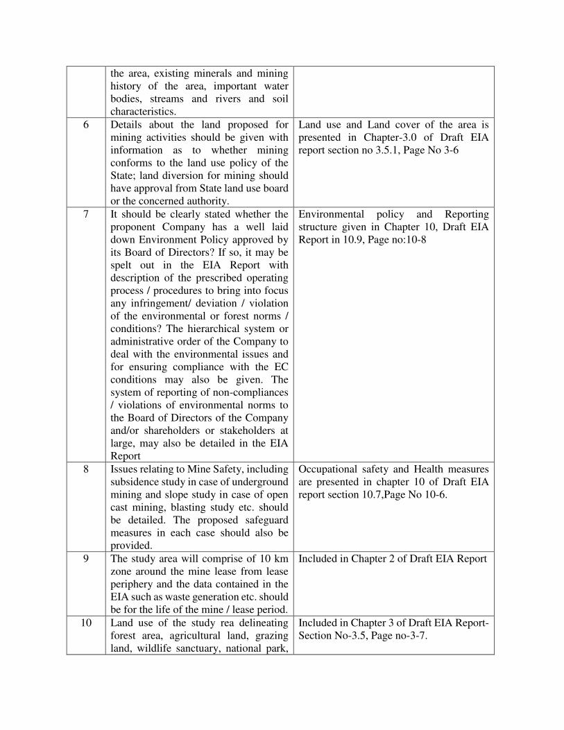
the area, existing minerals and mining
history of the area, important water
bodies, streams and rivers and soil
characteristics.
6 Details about the land proposed for
mining activities should be given with
information as to whether mining
conforms to the land use policy of the
State; land diversion for mining should
have approval from State land use board
or the concerned authority.
Land use and Land cover of the area is
presented in Chapter-3.0 of Draft EIA
report section no 3.5.1, Page No 3-6
7 It should be clearly stated whether the
proponent Company has a well laid
down Environment Policy approved by
its Board of Directors? If so, it may be
spelt out in the EIA Report with
description of the prescribed operating
process / procedures to bring into focus
any infringement/ deviation / violation
of the environmental or forest norms /
conditions? The hierarchical system or
administrative order of the Company to
deal with the environmental issues and
for ensuring compliance with the EC
conditions may also be given. The
system of reporting of non-compliances
/ violations of environmental norms to
the Board of Directors of the Company
and/or shareholders or stakeholders at
large, may also be detailed in the EIA
Report
Environmental policy and Reporting
structure given in Chapter 10, Draft EIA
Report in 10.9, Page no:10-8
8 Issues relating to Mine Safety, including
subsidence study in case of underground
mining and slope study in case of open
cast mining, blasting study etc. should
be detailed. The proposed safeguard
measures in each case should also be
provided.
Occupational safety and Health measures
are presented in chapter 10 of Draft EIA
report section 10.7,Page No 10-6.
9 The study area will comprise of 10 km
zone around the mine lease from lease
periphery and the data contained in the
EIA such as waste generation etc. should
be for the life of the mine / lease period.
Included in Chapter 2 of Draft EIA Report
10 Land use of the study rea delineating
forest area, agricultural land, grazing
land, wildlife sanctuary, national park,
Included in Chapter 3 of Draft EIA Report-
Section No-3.5, Page no-3-7.

migratory routes of fauna, water bodies,
human settlements and other ecological
features should be indicated. Land use
plan of the mine lease area should be
prepared to encompass preoperational,
operational and post operational phases
and submitted. Impact, if any, of change
of land use should be given.
11 Details of the land for any Over Burden
Dumps outside the mine lease, such as
extent of land area, distance from mine
lease, its land use, R&R issues, if any,
should be given.
Dump site Details are Presented in Chapter
2 of Draft EIA Report 2.9 page no 2-13.
Mine lease area is a government land, no
forestland is involved, No R&R issue.
Included in Chapter 2 of Draft EIA Report-
Section no 2.8.1-Page no: 2-15.
12 A Certificate from the Competent
Authority in the State Forest Department
should be provided, confirming the
involvement of forestland, if any, in the
project area. In the event of any contrary
claim by the Project Proponent
regarding the status of forests, the site
may be inspected by the State Forest
Department along with the Regional
Office of the Ministry to ascertain the
status of forests, based on which, the
Certificate in this regard as mentioned
above be issued. In all such cases, it
would be desirable for representative of
the State Forest Department to assist the
Expert Appraisal Committees
The mine lease area is a government land,
no forestland is involved.
13 Status of forestry clearance for the
broken up area and virgin forestland
involved in the Project including
deposition of net present value (NPV)
and compensatory afforestation (CA)
should be indicated. A copy of the
forestry clearance should also be
furnished.
The proposed mine lease area is a Govt.,
Land, no forest land is involved, and no
permission is required from them.
14 Implementation status of recognition of
forest rights under the Scheduled Tribes
and other Traditional Forest Dwellers
(Recognition of Forest Rights) Act,
2006 should be indicated.
The proposed mine lease area is a
government land and the area does not
belong to scheduled tribes and other
traditional forest dwellers.
15 The vegetation in the RF / PF areas in
the study area, with necessary details,
should be given.
Presented in Chapter 3 of Draft EIA report-
Section no-3.15,page no-3-56.

16 A study shall be got done to ascertain the
impact of the Mining Project on wildlife
of the study area and details furnished.
Impact of the project on the wildlife in
the surrounding and any other protected
area and accordingly, detailed mitigative
measures required, should be worked
out with cost implications and submitted
There is no wildlife sanctuary within 10 km
radius of the lease periphery and there is no
wild animal movement in core and buffer
zone. There is no Schedule-I flora and
fauna present in the 10 km radius from the
mine lease periphery.
Presented in Chapter 4 of Draft EIA report-
Section no-4.12 Page no-4-15.
17 Location of National Parks, Sanctuaries,
Biosphere Reserves, Wildlife Corridors,
Ramsar site Tiger/ Elephant
Reserves/(existing as well as proposed),
if any, within 10 km of the mine lease
should be clearly indicated, supported
by a location map duly authenticated by
Chief Wildlife Warden. Necessary
clearance, as may be applicable to such
projects due to proximity of the
ecologically sensitive areas as
mentioned above, should be obtained
from the Standing Committee of
National Board of Wildlife and copy
furnished.
Included in Chapter 1 of Draft EIA report
table No.1.0,Reserve forests, Page no-1-3
18 A detailed biological study of the study
area [core zone and buffer zone (10 km
radius of the periphery of the mine
lease)] shall be carried out. Details of
flora and fauna, endangered, endemic
and RET Species duly authenticated,
separately for core and buffer zone
should be furnished based on such
primary field survey, clearly indicating
the Schedule of the fauna present. In
case of any scheduled I fauna found in
the study area, the necessary plan along
with budgetary provisions for their
conservation should be prepared in
consultation with State Forest and
Wildlife Department and details
furnished. Necessary allocation of funds
for implementing the same should be
made as part of the project cost.
Presented in Chapter 3 of Draft EIA report-
Section no-3.15, page no-3-56.
19 Proximity to Areas declared as
'Critically Polluted' or the Project areas
likely to come under the 'Aravali Range',
Not applicable. There is no critically
polluted area within the 10km radius of the
mine lease periphery.

(attracting court restrictions for mining
operations), should also be indicated and
where so required, clearance
certifications from the prescribed
Authorities, such as the SPCB or State
Mining Department should be secured
and furnished to the effect that the
proposed mining activities could be
considered.
20 Similarly, for coastal Projects, A CRZ
map duly authenticated by one of the
authorized agencies demarcating LTL.
HTL, CRZ area, location of the mine
lease w.r.t CRZ, coastal features such as
mangroves, if any, should be furnished.
(Note: The Mining Projects falling
under CRZ would also need to obtain
approval of the concerned Coastal Zone
Management Authority).
Not applicable, the mine lease area is away
from CRZ.
21 R&R Plan/compensation details for the
Project Affected People (PAP) should
be furnished. While preparing the R&R
Plan, the relevant State/National
Rehabilitation & Resettlement Policy
should be kept in view. In respect of SCs
/STs and other weaker sections of the
society in the study area, a need based
sample survey, family-wise, should be
undertaken to assess their requirements,
and action programmes prepared and
submitted accordingly, integrating the
sectoral programmes of line departments
of the State Government. It may be
clearly brought out whether the
village(s) located in the mine lease area
will be shifted or not. The issues relating
to shifting of village(s) including their
R&R and socio-economic aspects
should be discussed in the Report.
The proposed mine lease area has no
settlements and hence R&R of village does
not arise. The mining lease area does not
belong to any scheduled area and other
weaker sections of the society.
Detailed socio economic study Presented in
Chapter 3 of Draft EIA report-Section 3.13,
Page No.3-42
22 One season (non-monsoon) [i.e. March-
May (Summer Season); October-
December (post monsoon season) ;
December-February (winter
season)]primary baseline data on
ambient air quality as per CPCB
Notification of 2009, water quality,
The baseline study was carried out in the
months of January 2019 – March 2019.
Ambient Air Quality Status of the study
area is presented in Chapter-3.0 of Draft
EIA report. Water quality data, Noise level
data, soil analysis and flora and fauna of the
study area is presented in Chapter -3. in

noise level, soil and flora and fauna shall
be collected and the AAQ and other data
so compiled presented date-wise in the
EIA and EMP Report. Site-specific
meteorological data should also be
collected. The location of the monitoring
stations should be such as to represent
whole of the study area and justified
keeping in view the pre-dominant
downwind direction and location of
sensitive receptors. There should be at
least one monitoring station within 500
m of the mine lease in the pre-dominant
downwind direction. The mineralogical
composition of PM10, particularly for
free silica, should be given.
Draft EIA report. The monitoring locations
are covered all the directions in the study
area.
23 Air quality modeling should be carried
out for prediction of impact of the
project on the air quality of the area. It
should also take into account the impact
of movement of vehicles for
transportation of mineral. The details of
the model used and input parameters
used for modeling should be provided.
The air quality contours may be shown
on a location map clearly indicating the
location of the site, location of sensitive
receptors, if any, and the habitation. The
wind roses showing pre-dominant wind
direction may also be indicated on the
map.
Included in Chapter 4 of Draft EIA Report-
Section no 4.3.3, Page no: 4-7.
24 The water requirement for the Project,
its availability and source should be
furnished. A detailed water balance
should also be provided. Fresh water
requirement for the Project should be
indicated.
Water requirement for the project is 80.0
KLD, which shall be drawn from nearby
village. Included in Chapter 2 of Draft EIA
Report-Section no 2.15.3-Page no: 2-19.
25 Necessary clearance from the
Competent Authority for drawl of
requisite quantity of water for the
Project should be provided.
Not Applicable
26 Description of water conservation
measures proposed to be adopted in the
Project should be given. Details of
rainwater harvesting proposed in the
Project, if any, should be provided.
Included in chapter 10 of Draft EIA Report-
Section no-10.4.1, Page no-10-3

27 Impact of the Project on the water
quality, both surface and groundwater,
should be assessed and necessary
safeguard measures, if any required,
should be provided.
Included in chapter 10 of Draft EIA Report-
Section no-10.4, Page no-10-2
28 Based on actual monitored data, it may
clearly be shown whether working will
intersect groundwater. Necessary data
and documentation in this regard may be
provided. In case the working will
intersect groundwater table, a detailed
Hydro Geological Study should be
undertaken and Report furnished. The
Report inter-alia, shall include details of
the aquifers present and impact of
mining activities on these aquifers.
Necessary permission from Central
Ground Water Authority for working
below ground water and for pumping of
ground water should also be obtained
and copy furnished.
Presented in Chapter 3 of Draft EIA report-
Section no-3-7, page no-3-10.
29 Details of any stream, seasonal or
otherwise, passing through the lease area
and modification / diversion proposed, if
any, and the impact of the same on the
hydrology should be brought out.
No streams/rivers passing through the mine
area. No modification/diversion required.
30 Information on site elevation, working
depth, groundwater table etc. Should be
provided both in AMSL and bgl. A
schematic diagram may also be provided
for the same.
Included in Chapter 3 of Draft EIA Report-
Section no-3-7.4, page no-3-13.
31 A time bound Progressive Greenbelt
Development Plan shall be prepared in a
tabular form (indicating the linear and
quantitative coverage, plant species and
time frame) and submitted, keeping in
mind, the same will have to be executed
up front on commencement of the
Project. Phase-wise plan of plantation
and compensatory afforestation should
be charted clearly indicating the area to
be covered under plantation and the
species to be planted. The details of
plantation already done should be given.
The plant species selected for green belt
should have greater ecological value and
Included in Chapter 10 of Draft EIA
Report-Section no-10.6., Page no-10-4

should be of good utility value to the
local population with emphasis on local
and native species and the species which
are tolerant to pollution.
32 Impact on local transport infrastructure
due to the Project should be indicated.
Projected increase in truck traffic as a
result of the Project in the present road
network (including those outside the
Project area) should be worked out,
indicating whether it is capable of
handling the incremental load.
Arrangement for improving the
infrastructure, if contemplated
(including action to be taken by other
agencies such as State Government)
should be covered. Project Proponent
shall conduct Impact of Transportation
study as per Indian Road Congress
Guidelines.
Included in Chapter 4 of Draft EIA Report-
Section no: 4.9, page no: 4-13.
33 Details of the onsite shelter and facilities
to be provided to the mineworkers
should be included in the EIA Report.
Included in Chapter 2 of Draft EIA Report-
Section no-2.15.1, Page no-2-19.
34 Conceptual post mining land use and
Reclamation and Restoration of mined
out areas (with plans and with adequate
number of sections) should be given in
the EIA report.
Conceptual Plan is presented in chapter-2.0
of Draft EIA report.
35 Occupational Health impacts of the
Project should be anticipated and the
proposed preventive measures spelt out
in detail. Details of pre-placement
medical examination and periodical
medical examination schedules should
be incorporated in the EMP. The project
specific occupational health mitigation
measures with required facilities
proposed in the mining area may be
detailed.
Presented in Chapter 10 of Draft EIA
Report-Section no-10.7, Page no-10-6.
36 Public health implications of the Project
and related activities for the population
in the impact zone should be
systematically evaluated and the
proposed remedial measures should be
detailed along with budgetary
allocations.
The periodical medical examination
conducted to the mineworkers. Healthy
safety Included in Chapter 10 of Draft EIA
Report Section 10.7.1 Page: 10-6
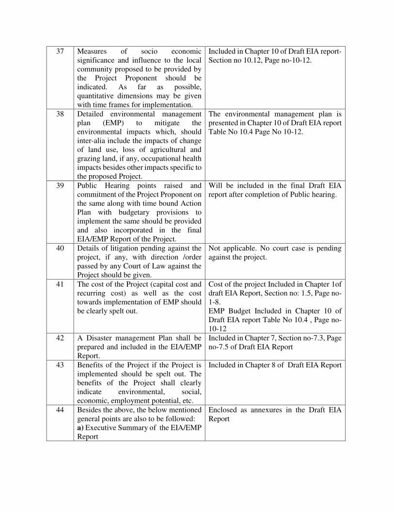
37 Measures of socio economic
significance and influence to the local
community proposed to be provided by
the Project Proponent should be
indicated. As far as possible,
quantitative dimensions may be given
with time frames for implementation.
Included in Chapter 10 of Draft EIA report-
Section no 10.12, Page no-10-12.
38 Detailed environmental management
plan (EMP) to mitigate the
environmental impacts which, should
inter-alia include the impacts of change
of land use, loss of agricultural and
grazing land, if any, occupational health
impacts besides other impacts specific to
the proposed Project.
The environmental management plan is
presented in Chapter 10 of Draft EIA report
Table No 10.4 Page No 10-12.
39 Public Hearing points raised and
commitment of the Project Proponent on
the same along with time bound Action
Plan with budgetary provisions to
implement the same should be provided
and also incorporated in the final
EIA/EMP Report of the Project.
Will be included in the final Draft EIA
report after completion of Public hearing.
40 Details of litigation pending against the
project, if any, with direction /order
passed by any Court of Law against the
Project should be given.
Not applicable. No court case is pending
against the project.
41 The cost of the Project (capital cost and
recurring cost) as well as the cost
towards implementation of EMP should
be clearly spelt out.
Cost of the project Included in Chapter 1of
draft EIA Report, Section no: 1.5, Page no-
1-8.
EMP Budget Included in Chapter 10 of
Draft EIA report Table No 10.4 , Page no-
10-12
42 A Disaster management Plan shall be
prepared and included in the EIA/EMP
Report.
Included in Chapter 7, Section no-7.3, Page
no-7.5 of Draft EIA Report
43 Benefits of the Project if the Project is
implemented should be spelt out. The
benefits of the Project shall clearly
indicate environmental, social,
economic, employment potential, etc.
Included in Chapter 8 of Draft EIA Report
44 Besides the above, the below mentioned
general points are also to be followed:
a) Executive Summary of the EIA/EMP
Report
Enclosed as annexures in the Draft EIA
Report

b) All documents to be properly
referenced with index and continuous
page numbering.
c) Where data are presented in the
Report especially in Tables, the period
in which the data were collected and the
sources should be indicated.
d) Project Proponent shall enclose all the
analysis/testing reports of water, air,
soil, noise etc. using the
MoEF&CC/NABL accredited
laboratories. All the original
analysis/testing reports should be
available during appraisal of the Project.
e) Where the documents provided are in
a language other than English, an
English translation should be provided.
f) The Questionnaire for environmental
appraisal of mining projects as devised
earlier by the Ministry shall also be
filled and submitted.
g) While preparing the EIA report, the
instructions for the Proponents and
instructions for the Consultants issued
by MoEF&CC vide O.M. No. J-
11013/41/2006-IA.II (I) dated 4th
August 2009, which are available on the
website of this Ministry, should be
followed.
h) Changes, if any made in the basic
scope and project parameters (as
submitted in Form-I and the PFR for
securing the TOR) should be brought to
the attention of MoEF&CC with reasons
for such changes and permission should
be sought, as the TOR may also have to
be altered. Post Public Hearing changes
in structure and content of the draft
EIA/EMP (other than modifications
arising out of the P.H. process) will
entail conducting the PH again with the
revised documentation.
i) As per the circular no. J-
11011/618/2010-IA.II (I) dated
30.5.2012, certified report of the status
of compliance of the conditions

stipulated in the environment clearance
for the existing operations of the project,
should be obtained from the Regional
Office of Ministry of Environment,
Forest and Climate Change, as may be
applicable.
j) The EIA report should also include (i)
surface plan of the area indicating
contours of main topographic features,
drainage and mining area,
(ii) Geological maps and sections and
(iii) sections of the mine pit and external
dumps, if any, clearly showing the land
features of the adjoining area.