Draft EIA (1).pdf - APPCB - Government of Andhra Pradesh
408
DRA (M Roa Approve Ph: 08 QCI NA MAR’ 2022 AFT ENVIRONMENTAL ASSESSMENT REPO OF SMT. A. KAMALA Mining of Road Metal & Build Smt. A. Kamala, Proprieto D.No: 12-96, Gandhi Nagar S. Kota Mandal, Vizianagaram, Andhra Pradesh – 535145 Site Address Lease Area: 8.90 Ha. Sy. No. 01 Mallipudi(V), S. Kota (M Vizianagaram District, Andhra Pradesh - 53514 Production Capacity ad Metal& Building Stone–80078.4 m Baseline Data Collected: October’ 2021 to De ed ToRLr. No:SEIAA/AP/MIN/VSP/VIO /11/2021 Sector: 01 – Mining of Minerals, Cat – B 1 PREPARED BY H.O:Block-B, B-1, IDA, Autonagar -12,Vishaka 891-2755528, Fax: 0891-2755529, E-mail: svenviro_ Ph: 9440338628 ABET & NABL Accredited & Recognized by MOE SVEL L IMPACT ORT A ding Stone) or r, 5 M) , 45 m 3 /Annum (max) ecember’ 2021 1/3236-991Dt: 23.12.2021 1 (Violation) apatnam [email protected] EF&CC, New Delhi. LC/AK/DRAFT/EIA
-
Upload
khangminh22 -
Category
Documents
-
view
1 -
download
0
Transcript of Draft EIA (1).pdf - APPCB - Government of Andhra Pradesh

DRAFT
(Mining of
Road Metal
Approved ToRLr. No
Ph: 0891
QCI NABET & NABL Accredited
MAR’ 2022
DRAFT ENVIRONMENTAL IMPACT ASSESSMENT REPORT
OF
SMT. A. KAMALA(Mining of Road Metal & Building Stone
Smt. A. Kamala, ProprietorD.No: 12-96, Gandhi Nagar
S. Kota Mandal, Vizianagaram,
Andhra Pradesh – 535145
Site Address Lease Area: 8.90 Ha.
Sy. No. 01 Mallipudi(V), S. Kota (M)
Vizianagaram District, Andhra Pradesh - 535145
Production Capacity
Road Metal& Building Stone–80078.4 mBaseline Data Collected: October’ 2021 to December
Approved ToRLr. No:SEIAA/AP/MIN/VSP/VIO /11/2021Sector: 01 – Mining of Minerals, Cat – B1
PREPARED BY
H.O:Block-B, B-1, IDA, Autonagar -12,VishakapatnamPh: 0891-2755528, Fax: 0891-2755529, E-mail: [email protected]
Ph: 9440338628 QCI NABET & NABL Accredited & Recognized by MOEF&CC, New Delhi
SVELC/AK
ENVIRONMENTAL IMPACT ASSESSMENT REPORT
SMT. A. KAMALA Building Stone)
Proprietor Gandhi Nagar,
535145
(M) ,
535145
m3/Annum (max) December’ 2021
1/3236-991Dt: 23.12.2021 1 (Violation)
Vishakapatnam mail: [email protected]
& Recognized by MOEF&CC, New Delhi.
SVELC/AK/DRAFT/EIA
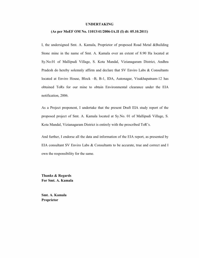
UNDERTAKING
(As per MoEF OM No. 11013/41/2006-IA.II (I) dt: 05.10.2011)
I, the undersigned Smt. A. Kamala, Proprietor of proposed Road Metal &Building
Stone mine in the name of Smt. A. Kamala over an extent of 8.90 Ha located at
Sy.No.01 of Mallipudi Village, S. Kota Mandal, Vizianagaram District, Andhra
Pradesh do hereby solemnly affirm and declare that SV Enviro Labs & Consultants
located at Enviro House, Block –B, B-1, IDA, Autonagar, Visakhapatnam-12 has
obtained ToRs for our mine to obtain Environmental clearance under the EIA
notification, 2006.
As a Project proponent, I undertake that the present Draft EIA study report of the
proposed project of Smt. A. Kamala located at Sy.No. 01 of Mallipudi Village, S.
Kota Mandal, Vizianagaram District is entirely with the prescribed ToR’s.
And further, I endorse all the data and information of the EIA report, as presented by
EIA consultant SV Enviro Labs & Consultants to be accurate, true and correct and I
own the responsibility for the same.
Thanks & Regards For Smt. A. Kamala Smt. A. Kamala
Proprietor

DECLARATION BY EXPERTS CONTRIBUTING TO THE EIA
“Draft Environmental Impact Assessment for the
Stone with maximum production capacity
Hectares located in Sy. No.01,
Andhra Pradesh by Smt. A. Kamala
I hereby certify that I was a part of the EIA team in the following capacity that developed the
above EIA.
EIA Co-ordinator
Name :
Signature :
Functional Area Experts:
S.No Functional Areas
Name of the
Expert
1. EIA
Coordinator
K.Anitha
2. AP * M. Murali Krishna
V. Hemalatha (TM)
K. Anitha (TM)
3. WP * V. Hemalatha
4. SHW * K. Anitha
5. SE * Dr. B. Vijay Bhaskara
Rao
6. EB * Dr. M.
Naidu
7. HG * Dr. G.V.A
Ramakrishna
8. GEO * Dr. G.V.A
Ramakrishna
DECLARATION BY EXPERTS CONTRIBUTING TO THE EIA
Environmental Impact Assessment for the proposed Mining of Road Metal
th maximum production capacity of 80078.4 m3/Annum from the area of
, Mallipudi Village, S. Kota Mandal, Vizianagaram
Smt. A. Kamala.
I hereby certify that I was a part of the EIA team in the following capacity that developed the
K. Anitha
Name of the Category as per NABET
Involvement (Period and task**)
B Mining
M. Murali Krishna
V. Hemalatha (TM)
K. Anitha (TM)
A Air Pollution monitoring, prevention & control
V. Hemalatha A Water Pollution monitoring, prevention & control
A Solid waste management
Dr. B. Vijay Bhaskara A Socioeconomic studies
Dr. M. Tarakeswara A Ecology and Bio-diversity
Dr. G.V.A
Ramakrishna
A Hydrology
Dr. G.V.A
Ramakrishna
A
Geology
DECLARATION BY EXPERTS CONTRIBUTING TO THE EIA
Road Metal & Building
area of extent 8.90
Mandal, Vizianagaram District,
I hereby certify that I was a part of the EIA team in the following capacity that developed the
Signature and Date

9. SC * D. Sunder Rao
M.Tarakeswara Naidu
(TM)
10. AQ * M. Murali Krishna
11. NV * M. Murali Krishna
12. LU * Dr. G.V.A Ramakrishna
13. RH * ShaikKasim
V. Hemalatha (TM)
*One TM against each FAE may be shown
** Please attach additional sheet if required
D. Sunder Rao
M.Tarakeswara Naidu
A Soil conservation
M. Murali Krishna A Air quality
modelling
M. Murali Krishna A Noise and vibration
Dr. G.V.A Ramakrishna
A Land use studies
ShaikKasim
V. Hemalatha (TM)
A Risk and hazard
study
*One TM against each FAE may be shown
sheet if required

Declaration by the Head of the accredited consultant organization/ authorized person
I, M. Murali Krishna, hereby, confirm that the above mentioned experts prepared the Draft
EIA for proposed Road Metal & Building Stone with maximum production capacity of
80078.4m3/Annum from the area of extent 8.90 Hectares located in Sy. No. 01, Mallipudi
Village, S. Kota Mandal, Vizianagaram District, Andhra Pradesh by Smt. A. Kamala.
Signature:
Name: M. Murali Krishna
Designation: Managing Partner
Name of the EIA consultant organization: SV Enviro Labs & Consultants
NABET Certificate No & Issue Date: NABET/EIA/1821/SA 0118 Dt: 28.09.2020.
NABET Extension No & Issue Date: QCI/NABET/ENV/ACO/22/2215 Dt: 17.01.2022 and
valid up to 16.04.2022.

INDEX
S.No TITLE PAGE No. ToR Compliance Executive Summary
Chapter -I:- Introduction
1.0 Introduction 1-1
1.1 Purpose of the project 1-1
1.2 Details of the project & identification of project proponent 1-2
1.3 Legal status of the project 1-3
1.4 Brief description of the project 1-4
1.5 Project nature, size and location 1-4
1.5.1 Nature 1-4
1.5.2 Size 1-4
1.5.3 Location 1-4
1.5.4 Accessibility 1-5
1.6 Regulatory compliances & applicable laws/regulations 1-7
1.7 Objectives of EIA Study 1-7
1.8 Environmental parameters anticipated in the study area 1-7
1.9 Generic structure of EIA document 1-8
1.10 Post Environment clearance monitoring 1-9
Chapter -II :-Project Description 2.0 General 2-1
2.1 Description of the project 2-1
2.2 Location details 2-2
2.3 Geology and exploration 2-7
2.3.1 Physiography 2-7
2.3.2 Regional geology 2-8
2.3.3 Local geology 2-8
2.4 Mineable reserves 2-9
2.5 Method of mining 2-11

2.6 Details of production 2-12
2.7 Wastedump management 2-14
2.8 Conceptual plan 2-14
2.8.1 Mine drainage 2-15
2.8.2 Land use 2-15
2.8.3 Mine Closure plan 2-15
2.8.4 Mining machinery 2-16
2.8.5 Site services 2-16
2.8.6 Water requirement 2-16
2.9 Employment potential 2-17
Chapter -III:-Description Of the Environment 3.0 Introduction 3-1
3.1 Study area 3-1
3.2 Study period 3-1
3.3 Methodology of EIA study 3-1
3.4 Collection of baseline data 3-2
3.4.1 Micro meteorological data 3-2
3.4.2 Winds 3-4
3.5 Air Environment 3-7
3.5.1 Selection of sampling locations 3-7
3.5.2 Methodology of sampling and analysis 3-7
3.5.3 Frequency of Sampling 3-7
3.5.4 Existing ambeint air quality 3-13
3.6 Water environment 3-13
3.6.1 Surface water and ground water quality assessment 3-14
3.6.2 Selection of sampling locations 3-14
3.6.3 Sampling techniques 3-14
3.6.4 Analytical techniques 3-16
3.6.5 Water sampling Stations 3-17
3.6.6 Ground water quality of the study area 3-20
3.6.7 Summary of groundwater quality 3-22
3.6.8 Surface water quality of the study area 3-23

3.6.9 Surface water quality results are summarized 3-24
3.7 Soil quality 3-25
3.7.1 Selection of sampling locations 3-25
3.7.2 Sampling and analytical techniques 3-25
3.7.3 Details of soil sampling locations 3-26
3.7.4 Soil analysis results in the study area 3-29
3.7.5 Summary of soil analysis data 3-29
3.7.6 Standard soil classification 3-30
3.8 Noise environment 3-31
3.8.1 Identification of sampling locations 3-31
3.8.2 Methodology 3-32
3.8.3 Noise monitoring locations 3-32
3.8.4 Description of locations 3-33
3.8.5 Noise levels in the study area 3-35
3.9 Geology and hydrogeology 3-37
3.9.1 Physiography 3-37
3.9.2 Drainage 3-37
3.9.3 Geomorphology 3-38
3.9.4 Geology 3-41
3.9.5 Hydrogeology 3-42
3.10 Land use/ land cover 3-43
3.10.1 Methodology 3-44
3.10.2 Digital Elevation Maps 3-51
3.10.3 Contour map 3-51
3.10.4 Drainage map 3-51
3.11 Biological Environment 3-55
3.12 Socio-economic environment 3-83
Chapter -IV:-Anticipated Environmental Impacts & Mitigation Measures 4.0 Introduction 4-1
4.1 Impacts on air quality 4-10
4.1.1 Quantities estimation of impacts on air environment 4-10
4.1.2 Source of dust emission 4-10

4.1.3 Emission details 4-11
4.1.4 Meteorological data 4-11
4.1.5 Assumption made in the prediction of air pollution impacts 4-11
4.1.6 Summary of predicted ground level concentrations of particular matter
4-11
4.1.7 Air quality mitigation measures 4-12
4.2 Water environment 4-13
4.2.1 Impacts on surface water bodies and control measures 4-13
4.2.2 Rain water harvesting 4-14
4.2.3 Impacts on ground water table 4-14
4.3 Land Environment 4-14
4.3.1 Solid waste generation 4-14
4.3.2 Soil Erosion 4-15
4.3.3 Reclamation of degraded areas 4-15
4.3.4 Program of Afforestation 4-16
4.3.5 Impact on land use and reclamation measures 4-16
4.4 Noise environment and vibrations 4-16
4.4.1 Impact due to noise and vibration 4-16
4.4.2 Noise and vibration control measures 4-17
4.5 Solid waste generation and stacking of wastes 4-18
4.6 Biological environment 4-18
4.6.1 Impacts on biological environment 4-18
4.6.2 Mitigation measures 4-19
4.6.3 Greenbelt development 4-19
4.7 Traffic analysis 4-21
4.7.1 Impact on road network 4-21
4.8 Socio-economic conditions 4-22
4.8.1 Economical impact 4-22
4.8.2 Social & Cultural impacts 4-22
4.8.3 Health & wellbeing impacts 4-23
4.8.4 Public infrastructure & Services 4-23
4.8.5 Personal and psychological Impact 4-23
4.8.6 Impact-Pre and Post Mitigations 4-24

4.9 Impact on occupational health & safety 4-26
Chapter -V:- Analysis of Alternatives 5.0 General 5-1
5.1 Alternate technology 5-1
5.2 Alternative site 5-1
Chapter -VI:-Environmental Monitoring Programme 6.0 Environmental monitoring 6-1
6.1 Environment management 6-1
6.2 Monitoring around the mine site 6-2
6.3 Post project monitoring programme 6-2
6.3.1 Environmental monitoring 6-2
6.4 Monitoring schedule for environmental parameters 6-3
6.5 Implementation schedule 6-3
6.6 Monitoring equipment and consumables 6-4
Chapter -VII:-Additional Studies
7.0 Public consultation 7-1
7.1 Risk assessment 7-1
7.1.1 Drilling & blasting risks 7-1
7.1.2 Failure of slope in the pit 7-2
7.1.3 Filling up the mine pit due to excessive rains 7-3
7.1.4 Accidents of heavy machinery 7-3
7.2 Disaster management plan 7-3
7.3 Implementation of EMP and monitoring system 7-4
7.3.1 General 7-4
7.3.2 Implementation 7-5
7.4 Activites to be monitored/inspected by EMC 7-6
7.4.1 Land erosion 7-6
7.4.2 Drainage 7-6
7.4.3 Re-vegetation and green belt development 7-6
7.4.4 Occupational health 7-6

7.4.5 Operational and Maintenance 7-7
7.5 Compliance for additional Terms of Reference 7-8
7.5.1 Proponent shall submit cluster EIA & EMP 7-8
Chapter -VIII:-Project Benefits
8.0 General 8-1
8.1 Employment 8-1
8.2 Occupational health 8-1
8.3 Improvements in physical and social infrastructure 8-1
8.3.1 Improvement in the physical infrastructure 8-2
8.3.2 Improvement in the social infrastructure 8-2
8.3.3 Prevention of illegal mining & contribution to the exchequer 8-2
8.3.4 Enhancement of green cover 8-3
8.4 Other tangible benefits 8-3
Chapter -IX:-Environmental Management Plan 9.0 Introduction 9-1
9.1 Corporate environment responsibility 9-4
9.2 Objectives of environmental management plan 9-4
9.3 Air quality management 9-4
9.3.1 Air pollution control measures 9-5
9.3.2 Controlling of other emissions 9-6
9.4 Water quality management 9-6
9.5 Noise level monitoring 9-6
9.5.1 Parameters 9-7
9.5.2 Methodology 9-7
9.5.3 Noise quality management 9-7
9.5.4 Noise pollution control 9-7
9.6 Water consumption and waste water generation 9-8
9.7 Biological management 9-9
9.7.1 Tree plantation program 9-9
9.7.2 Mine drainage 9-9
9.8 Soil management 9-10

9.9 Land environment 9-10
9.9.1 Land use 9-10
9.9.2 Mine roads 9-10
9.9.3 Proposed mitigation measures 9-11
9.10 Socio-economic environment & safety 9-11
9.11 Biological management plan 9-12
9.11.1 Greenbelt development/Afforestation plan 9-12
9.11.2 Criteria for selection of species 9-13
9.11.3 Design of green development 9-13
9.12 Occupational health and safety measures 9-14
9.12.1 Public health Implication, Occupational Health survey program and First aid
9-15
9.13 Project cost 9-15
Chapter -X:-Summary & Conclusion 10.0 Summary & conclusion 10-1
10.1 Need of the project 10-1
10.2 Salient features of the project 10-1
10.3 Reserves 10-3
10.4 Mining 10-3
10.5 Description of the Environment 10-4
10.5.1 Land use 10-4
10.5.2 Water quality 10-4
10.5.3 Ambient air quality 10-5
10.5.4 Noise quality 10-6
10.5.5 Biodiversity 10-6
10.5.6 Socio-Economic 10-7
10.6 Anticipated impact and mitigation measures 10-7
10.6.1 Land environment 10-7
10.6.2 Water environment 10-8
10.6.3 Air environment 10-8
10.6.4 Noise environment 10-8
10.6.5 Biological environment 10-8

10.6.6 Socio economic environment 10-8
10.6.7 Mine waste 10-9
10.6.8 Impacts due to transportation 10-9
10.7 Risk assessment & Disaster management plan 10-9
10.8 Project benefits 10-9
10.9 Environmental Management Plan 10-9
10.10 Recommendations 10-10
Chapter -XI:-Remediation plan and the natural & community resource augmentation plan 11.0 Preamble 11-1
11.1 Previous performance record 11-1
11.2 Impact due to mining activity 11-4
11.3 Calculation of bank guarantee for remediation works and resource augmentation works
11-13
11.3.1 Air pollution 11-14
11.3.2 Water environment 11-15
11.3.3 Solid and hazardous waste 11-16
11.3.4 Transportation 11-17
11.3.5 Noise and vibration 11-17
11.3.6 Green belt 11-17
11.3.7 Hydrogeology 11-19
11.3.8 Occupational health & safety 11-19
11.3.9 Corporate environmental responsibility 11-19
Chapter -XII:-Disclosure Of Consultants Engaged
12.0 Disclosure of consultants engaged 12-1
12.1 About SV Enviro Labs & Consultants 12-1
12.2 Services offered by SV Enviro 12-1

LIST OF TABLES
TABLE NO. TITLE PAGE NO. Chapter -I:- Introduction
1.1 Description of project proponent 1-2
Chapter -II :-Project Description 2.1 Boundary Coordinates 2-2
2.2 Details about the project site 2-3
2.3 Details of mineable reserves 2-11
2.4 Year Wise Production 2-12
2.5 Details of the OB during the plan period 2-14
2.6 Land use details 2-15
2.7 List of machinery details 2-16
2.8 Fresh water requirement & wastewater generation 2-16
2.9 Employment details 2-17
Chapter -III:-Description of The Environment 3.1 Micro meteorological data at site 3-4
3.2 Techniques and detectable limits for ambient air quality monitoring
3-8
3.3 Location of ambient air quality monitoring stations 3-8
3.4 Summary of analysis of Ambient Air Quality in the Study area 3-10
3.5 Standard operating procedures (SOP) for water sampling 3-15
3.6 Analytical techniques for water analysis 3-16
3.7 Water sampling stations 3-17
3.8 Ground water quality results 3-20
3.9 Surface water quality of the study area 3-23
3.10 Analytical techniques for soil analysis 3-25
3.11 Soil sampling locations 3-26
3.12 Soil analysis results 3-29
3.13 Noise monitoring locations 3-32
3.14 Noise levels in the study area 3-35
3.15 Details of the forest blocks in the study area 3-56

3.16 List of plant species observed in core area of the project 3-58
3.17 List of plant species observed in buffer area of the project 3-64
3.18 Checklist of fauna recorded in the study area 3-77
3.19 Aquatic flora observed in the study area 3-82
3.20 Demographical details of the study area-Vizianagaram 3-87
Chapter -IV:-Anticipated Environmental Impacts &Mitigation Measures 4.1 Expected nature of impacts 4-1
4.2 Identified/predicted environmental impacts with & without mitigation measures
4-2
4.3 Noise Impact 4-17
4.4 Selected list of plant species for greenbelt development 4-20
4.5 Pre and Post Mitigation of proposed project 4-24
Chapter -VI:- Environmental Monitoring Programme 6.1 Monitoring schedule for environmental parameters 6-3
6.2 Implementation schedule 6-3
Chapter -IX:- Environmental Management Plan
9.1 EMP costing for the project 9-2
9.2 Ambient air quality standards 9-5
9.3 Air pollution control measures 9-5
9.4 Details of year wise tree plantation programme 9-12
Chapter -XI:-Remediation plan and the natural & community resource augmentation plan
11.1 Damage assessment and remediation of environmental components
11-5
11.2 Quantification of emissions due to quarry activities 11-14
11.3 Cost estimation for air emissions 11-15
11.4 Penalty for noise pollution in violation period (2015-2019) 11-17

LIST OF FIGURES
FIGURE No. TITLE PAGE NO. Chapter -I :-Introduction
1.1 Location map of Smt. A. Kamala 1-6
Chapter –II: - Project Description 2.1 Google map of the mine area with 10 km radius buffer
zone 2-5
2.2 Topomap of the mine area with 10 km radius buffer zone 2-6
2.3 Surface & Geological plan of the mine area 2-7
2.4 Production and development plan with sections 2-13
Chapter -III:-Description of The Environment 3.1 Wind rose diagram of October’ 2021- December’ 2021 3-6
3.2 Location of ambient air quality stations 3-9
3.3 Water sampling locations 3-19
3.4 Soil sampling locations 3-28
3.5 Noise monitoring locations 3-34
3.6 Map of the geomorphology – Vizianagaram district 3-40
3.7 Map of the hydrogeology – Vizianagaram district 3-43
3.8 Methodology 3-46
3.9 Satellite image within 10 km radius 3-47
3.10 False colour composite map within 10 km radius 3-48
3.11 Graphical representation of Land use/ land cover 3-49
3.12 Land use/ land cover map 3-50
3.13 Digital Elevation map 3-52
3.14 Contour map 3-53
3.15 Drainage map 3-54
3.16 Demographic details of Vizianagaram district 3-85
3.17 Main and Marginal workers in the study area 3-92
Chapter –VII:-Additional Studies 7.1 Organizational setup of EMC 7-4

Chapter -IX:-Environment Management Plan 9.1 Water balamce flow diagram 9-8
Chapter -XII:-Disclosure Of Consultants Engaged 12.1 NABET Certificate 12-3
12.2 NABET extension of validity certificate 12-4
Annexures Annexure –I ToR copy
Annexure –II Mining plan
Annexure-III Cluster Letter and map
Annexure-IV Cluster EMP
Annexure -V Affidavit
Annexure -VI Hydrogeological Report
Annexure -VII Production details

Draft Environmental Impact Assessment Report for Smt. A. Kamala – 8.90 Ha. TOR COMPLIANCE
APPROVED TERMS OF REFERENCE COMPLIANCE
ToR Lr. No: SEIAA/AP/VSP/VIO/MIN/11/2021/3236-991 Dated: 23.12.2021 Additional TOR
S.No Standard Terms of Reference TOR Compliance/Section No.
1 Proponent shall submit Cluster EIA & EMP As per cluster notification by
MoEF&CC mines which not
executed lease or Environmental
Clearance before 9th September 2013
were considered and were included in
preparation of cluster EMP. As per
records of the Asst. Director of Mines
and Geology, Vizianagaram vide Lr.
No. 2515/Q/2009 Dt: 30.03.2021
there are no areas for which L.O.I is
issued for grant of mine lease, where
as there are 3 working mines present
within 500 m distance which were
granted before 09.09.2013 and those
mines shall not counted for cluster
formation. Thus, the condition of
cluster needs preparation of cluster
EMP for all working mines and
attached as Annexure IV
STANDARD TERMS OF REFERENCES
S.No Standard Terms of Reference TOR Compliance/Section No. 1 Year wise production details since 1994 should
be given, clearly stating the highest production
achieved in any one year prior to 1994. It may
also be categorically informed whether there
Smt. A. Kamala has been granted
Quarry Lease 1st renewal for Road
Metal & Building stone mining
over an extent of 8.90 Ha, located

Draft Environmental Impact Assessment Report for Smt. A. Kamala – 8.90 Ha. TOR COMPLIANCE
had been any increase in production after EIA
Notification 1994 came into force, w.r.t the
highest production achieved prior to 1994.
in Sy. No. 1 of Mallipudi Village,
S. Kota Mandal, Vizianagaram
District for a period of 15 years by
the DDM&G, Visakhapatnam vide
proceedings No. 3322/Q3/2009,
Dated 19.01.2012 and the same
was executed by the ADM&G,
Vizianagaram vide Proceedings
No. 2545/Q2/2009, dated 28.01.2012 for the lease period of
15 years w.e.f. 19.09.2009 to
18.09.2024. Year wise production
details furnished in the Chapter II -
Project description table 2.4.
Earlier dispatch details are given
in Annexure-VII.
2 A copy of the document in support of the fact
that the Proponent is the rightful lessee of the
mine should be given.
The rightful proponent of the mine
is Smt. A. Kamala, as per the
Quarry lease 1st renewal Proc.No.
3322/Q3/2009, Dated 19.01.2012
and the same was executed by the
ADM&G, Vizianagaram vide
Proceedings No. 2545/Q2/2009,
dated 28.01.2012 for the lease
period of 15 years w.e.f.
19.09.2009 to 18.09.2024 and
document is available in the
mining plan (Annexure - II).
3 All documents including approved mine plan,
EIA and Public Hearing should be compatible
with one another in terms of the mine lease
While preparing EIA it has been
ensured that all the documents
including approved mine plan,

Draft Environmental Impact Assessment Report for Smt. A. Kamala – 8.90 Ha. TOR COMPLIANCE
area, production levels, waste generation and its
management, mining technology etc. and
should be in the name of the lessee.
EIA are compatible with one
another in terms of the mine lease
area, production levels and its
management, mining technology
etc and are in the name of Smt. A.
Kamala.
4 All corner coordinates of the mine lease area,
superimposed on a High Resolution Imagery/
Toposheet, topographic sheet, geomorphology
and geology of the area should be provided.
Such an Imagery of the proposed area should
clearly show the land use and other ecological
features of the study area (core and buffer
zone).
All the corner coordinates of mine
lease has been
marked/superimposed on
Toposheet.
10 km radius Topo map of
1:50,000 scale of the project
location with all the corner
coordinates of the mine lease area
is given in Chapter II under Fig.
2.2.
Corner co-ordinates are
superimposed on High resolution
Google earth imagery &
Toposheet is given in Chapter-II
under Fig. 2.1 & 2.2.
5 Information should be provided in Survey of
India Toposheet in 1:50,000 scale indicating
geological map of the area, geomorphology of
land forms of the area, existing minerals and
mining history of the area, important water
bodies, streams and rivers and soil
characteristics.
Required Toposheet is provided at
Fig. 2.2 in Chapter-II.
Important water bodies, streams,
rivers are shown in Toposheet
which is provided by Survey of
India.
6 Details about the land proposed for mining
activities should be given with information as
The mine lease area is
Government land with no

Draft Environmental Impact Assessment Report for Smt. A. Kamala – 8.90 Ha. TOR COMPLIANCE
to whether mining conforms to the land use
policy of the State; land diversion for mining
should have approval from State land use board
or the concerned authority.
agricultural activities within the
mine and presently under mining.
Smt. A. Kamala has been granted
Quarry Lease 1st renewal for Road
Metal & Building stone mining
over an extent of 8.90 Ha, located
in Sy. No. 1 of Mallipudi Village,
S. Kota Mandal, Vizianagaram
District for a period of 15 years by
the DDM&G, Visakhapatnam vide
proceedings No. 3322/Q3/2009,
Dated 19.01.2012 and the same
was executed by the ADM&G,
Vizianagaram vide Proceedings
No. 2545/Q2/2009, dated
28.01.2012 for the lease period of
15 years w.e.f. 19.09.2009 to
18.09.2024.
Land diversion is not applicable.
7 It should be clearly stated whether the
proponent Company has a well laid down
Environment Policy approved by its Board of
Directors? If so, it may be spelt out in the EIA
Report with description of the prescribed
operating process/procedures to bring into
focus any infringement/deviation/ violation of
the environmental or forest norms/ conditions?
The hierarchical system or administrative order
of the Company to deal with the environmental
issues and for ensuring compliance with the EC
conditions may also be given. The system of
The project proponent is
committed to environmental
safeguard and sustainable
development. Environmental
Monitoring Cell shall be
established for reporting
environmental issues. The
Environmental policy is as
follows:
Prevent Environmental
pollution by continual

Draft Environmental Impact Assessment Report for Smt. A. Kamala – 8.90 Ha. TOR COMPLIANCE
reporting of non compliances / violations of
environmental norms to the Board of Directors
of the Company and/or shareholders or
stakeholders at large, may also be detailed in
the EIA Report.
improvement in environmental
performance of the
Environmental Management
Plan.
Comply with all the
environmental legislations,
regulations under the EIA
Notification 2006 &
subsequent amendments.
Promote environmental
awareness amongst employees,
local communities and
interested parties through
proactive communication and
training.
Training to employees in terms of
Safety, Health & Environment
through Mining association &
Authorized Agency.
8. Issues relating to Mine Safety, including
subsidence study in case of underground
mining and slope study in case of open cast
mining, blasting study etc. should be detailed.
The proposed safeguard measures in each case
should also be provided.
The method of mining is open cast
semi mechanised.
Subsidence study is not applicable
as the mine is not underground
mining.
Mining will be done during non-
rainy period. As the mine is Road
Metal & Building Stone the
chance of failure of pit slope does
not exist.
Safety measures:

Draft Environmental Impact Assessment Report for Smt. A. Kamala – 8.90 Ha. TOR COMPLIANCE
The working pits will be under
vigilance during the working
and non working hours.
Detailed occupational health and
safety is mentioned at Chapter -IV
under section: 4.9.
9. The study area will comprise of 10 km zone
around the mine lease from lease periphery and
the data contained in the EIA such as waste
generation etc. should be for the life of the
mine lease period.
Out of the total excavated mineral
about 90% saleable Road Metal &
Building Stone and 10%
overburden is expected to be
generated in this ensuing plan
period of about 40710.88 m3and
the same will be dumped
temporarily in 1.0218 Ha. within
mine lease area as step dumping.
Dump area is in the South corner
of QL covering area. The waste
generated can be used for regular
gradation of approach/haul roads,
maintaining retention wall along
the hill slopes and strengthening
garland drains within the mine
area.
The life of mine is 39 years. The
detailed year wise production is
mentioned in Chapter-II under
section 2.6.
10 Land use of the study area delineating forest
area, agricultural land, grazing land, wildlife
sanctuary, national park, migratory routes of
Land use/Land cover is
exclusively detailed in section 3.10
of Chapter-III.

Draft Environmental Impact Assessment Report for Smt. A. Kamala – 8.90 Ha. TOR COMPLIANCE
fauna, water bodies, human settlements and
other ecological features should be indicated.
Land use plan of the mine lease area should be
prepared to encompass preoperational,
operational and post operational phases and
submitted. Impact, if any, of change of land use
should be given.
Impacts on Land Use are
mentioned in section 4.3 of
Chapter-IV.
11. Details of the land for any Over Burden Dumps
outside the mine lease, such as extent of land
area, distance from mine lease, its land use,
R&R issues, if any, should be given.
Out of the total excavated mineral
about 90% saleable Road Metal &
Building Stone and 10%
overburden is expected to be
generated in this ensuing plan
period of about 40710.88 m3 and
the same will be dumped
temporarily in 1.0218 Ha. within
mine lease area as step dumping.
Dump area is in the South corner
of QL covering area. The waste
generated can be used for regular
gradation of approach/haul roads,
maintaining retention wall along
the hill slopes and strengthening
garland drains within the mine
area.
12 A Certificate from the Competent Authority in
the State Forest Department should be
provided, confirming the involvement of forest
land, if any, in the project area. In the event of
any contrary claim by the Project Proponent
regarding the status of forests, the site may be
inspected by the State Forest Department along
No forest land is present within the
mine lease area.

Draft Environmental Impact Assessment Report for Smt. A. Kamala – 8.90 Ha. TOR COMPLIANCE
with the Regional Office of the Ministry to
ascertain the status of forests, based on which,
the Certificate in this regard as mentioned
above be issued. In all such cases, it would be
desirable for representative of the State Forest
Department to assist the Expert Appraisal
Committees.
13 Status of forestry clearance for the broken up
area and virgin forestland involved in the
Project including deposition of net present
value (NPV) and compensatory Afforestation
(CA) should be indicated. A copy of the
forestry clearance should also be furnished.
Not Applicable.
14 Implementation status of recognition of forest
rights under the Scheduled Tribes and other
Traditional Forest Dwellers (Recognition of
Forest Rights) Act, 2006 should be indicated.
Not Applicable.
15 The vegetation in the RF / PF areas in the study
area, with necessary details, should be given.
Flora studies were conducted in
the core and buffer zones and are
covered in Chapter-III under
section – 3.11.
16 A study shall be got done to ascertain the
impact of the Mining Project on wildlife of the
study area and details furnished. Impact of the
project on the wildlife in the surrounding and
any other protected area and accordingly,
detailed mitigative measures required, should
be worked out with cost implications and
submitted.
Fauna studies conducted in the
core and buffer zone is covered in
Chapter-III under section-3.11.
Impacts on the biological
environment and mitigation
measures are covered in section-
4.6 in Chapter-IV.

Draft Environmental Impact Assessment Report for Smt. A. Kamala – 8.90 Ha. TOR COMPLIANCE
17 Location of National Parks, Sanctuaries,
Biosphere Reserves, Wildlife Corridors,
Ramsar site Tiger/Elephant Reserves/(existing
as well as proposed), if any, within 10 km of
the mine lease should be clearly indicated,
supported by a location map duly authenticated
by Chief Wildlife Warden. Necessary
clearance, as may be applicable to such projects
due to proximity of the ecologically sensitive
areas as mentioned above, should be obtained
from the Standing Committee of National
Board of Wildlife and copy furnished.
No National Parks, Wildlife
Sanctuaries, Tiger/Elephant
reserves are existed in the core or
buffer zone of the lease area.
18 A detailed biological study of the study area
[core zone and buffer zone (10 km radius of the
periphery of the mine lease)] shall be carried
out. Details of flora and fauna, endangered,
endemic and RET Species duly authenticated,
separately for core and buffer zone should be
furnished based on such primary field survey,
clearly indicating the Schedule of the fauna
present. In case of any scheduled-I fauna found
in the study area, the necessary plan along with
budgetary provisions for their conservation
should be prepared in consultation with State
Forest and Wildlife Department and details
furnished. Necessary allocation of funds for
implementing the same should be made as part
of the project cost.
Detailed study on Biological
Environment in core and buffer
zone was carried out. Details of
flora and faunal species are listed
in Chapter-III under section-3.11.
There are no Schedule I species
present in core or buffer zone of
the mine lease area.
19 Proximity to Areas declared as 'Critically
Polluted' or the Project areas likely to come
under the 'Aravali Range', (attracting court
No critically polluted areas come
under the core zone or buffer zone
of the lease area.

Draft Environmental Impact Assessment Report for Smt. A. Kamala – 8.90 Ha. TOR COMPLIANCE
restrictions for mining operations), should also
be indicated and where so required, clearance
certifications from the prescribed Authorities,
such as the SPCB or State Mining Department
should be secured and furnished to the effect
that the proposed mining activities could be
considered.
20 Similarly, for coastal Projects, A CRZ map
duly authenticated by one of the authorized
agencies demarcating LTL. HTL, CRZ area,
location of the mine lease w.r.t CRZ, coastal
features such as mangroves, if any, should be
furnished. (Note: The Mining Projects falling
under CRZ would also need to obtain approval
of the concerned Coastal Zone Management
Authority).
CRZ regulation is not applicable.
21 R&R Plan/compensation details for the Project
Affected People (PAP) should be furnished.
While preparing the R&R Plan, the relevant
State/National Rehabilitation & Resettlement
Policy should be kept in view. In respect of SCs
/STs and other weaker sections of the society in
the study area, a need based sample survey,
family-wise, should be undertaken to assess
their requirements, and action programmes
prepared and submitted accordingly, integrating
the sectoral programmes of line departments of
the State Government. It may be clearly
brought out whether the village(s) located in the
mine lease area will be shifted or not. The
issues relating to shifting of village(s) including
No habitation is observed within
the mine lease area. So R&R plan
is not applicable for this project.

Draft Environmental Impact Assessment Report for Smt. A. Kamala – 8.90 Ha. TOR COMPLIANCE
their R&R and socio-economic aspects should
be discussed in the Report.
22. One season (non-monsoon) [i.e. March-May
(Summer Season); October-December (post
monsoon season) ; December-February (winter
season)]primary baseline data on ambient air
quality as per CPCB Notification of 2009,
water quality, noise level, soil and flora and
fauna shall be collected and the AAQ and other
data so compiled presented date-wise in the
EIA and EMP Report. Site-specific
meteorological data should also be collected.
The location of the monitoring stations should
be such as to represent whole of the study area
and justified keeping in view the pre-dominant
downwind direction and location of sensitive
receptors. There should be at least one
monitoring station within 500 m of the mine
lease in the predominant downwind direction.
The mineralogical composition of PM10,
particularly for free silica, should be given.
Baseline data (Water quality, noise
level, soil, flora and fauna, AAQ,
Meteorological data) for the period
of October 2021 to December
2021 is collected within the study
area and same is elaborated in
chapter -III.
23. Air quality modelling should be carried out for
prediction of impact of the project on the air
quality of the area. It should also take into
account the impact of movement of vehicles for
transportation of mineral. The details of the
model used and input parameters used for
modelling should be provided. The air quality
contours may be shown on a location map
clearly indicating the location of the site,
location of sensitive receptors, if any, and the
Detailed air quality for prediction
of impacts is elaborated in chapter
– IV under section: 4.1.
As the mineral is Road Metal &
Building Stone. Hence fugitive
dust emissions during operations
are very minimal.
Control measures such as water
sprinkling, wet jacket method and

Draft Environmental Impact Assessment Report for Smt. A. Kamala – 8.90 Ha. TOR COMPLIANCE
habitation. The wind roses showing
predominant wind direction may also be
indicated on the map.
restricting vehicular movement in
terms of speed will be practiced,
hence the fugitive emissions will
be localised.
The wind rose is shown in chapter
-III
24 The water requirement for the Project, its
availability and source should be furnished. A
detailed water balance should also be provided.
Fresh water requirement for the project should
be indicated.
The total water requirement is 11.2
KLD and will be met through
water tankers from surrounding
villages. Detailed water balance is
mentioned in Chapter - IX under
Figure: 9.6
25. Necessary clearance from the Competent
Authority for drawl of requisite quantity of
water for the project should be provided.
As we are not drawing any ground
water, hence clearance from
ground water board is not
applicable.
26. Description of water conservation measures
proposed to be adopted in the project should be
given. Details of rainwater harvesting proposed
in the project, if any, should be provided.
Water conservation measures are
mentioned under section-9.4 in
Chapter-IX.
Rain water Harvesting is covered
under section 4.2.2 in Chapter-IV.
27. Impact of the Project on the water quality, both
surface and groundwater, should be assessed
and necessary safeguard measures, if any
required, should be provided.
Impacts on water quality are tabled
in Table-4.2 and safeguard
measures are covered under
Chapter-IV.
28. Based on actual monitored data, it may clearly
be shown whether working will intersect
groundwater. Necessary data and
documentation in this regard may be provided.
There are no ground water bodies
such as open wells or bore wells in
this lease area. The ground water
table is about 48 m depth from the

Draft Environmental Impact Assessment Report for Smt. A. Kamala – 8.90 Ha. TOR COMPLIANCE
In case the working will intersect groundwater
table, a detailed Hydro Geological Study should
be undertaken and Report furnished. The
Report inter-alia, shall include details of the
aquifers present and impact of mining activities
on these aquifers. Necessary permission from
Central Ground Water Authority for working
below ground water and for pumping of ground
water should also be obtained and copy
furnished.
ground level. Maximum depth of
workings is up to RL 70 m and
minimum depth of workings is RL
80 m. The proposed maximum
quarry operations during the plan
period, a depth of 98m from the
top hill which is above the ground
level; thus no chances for
accumulation of ground water in
working pit and no water will be
discharged from the pit.
29 Details of any stream, seasonal or otherwise,
passing through the lease area and modification
/ diversion proposed, if any, and the impact of
the same on the hydrology should be brought
out.
There are no perennial or seasonal
streams present in the mine area
30 Information on site elevation, working depth,
groundwater table etc. Should be provided both
in AMSL and bgl. A schematic diagram may
also be provided for the same.
Site elevation is 196 m AMSL.
The proposed maximum quarry
operations during the plan period,
a depth of 98m from the top hill.
31 A time bound Progressive Greenbelt
Development Plan shall be prepared in a tabular
form (indicating the linear and quantitative
coverage, plant species and time frame) and
submitted, keeping in mind, the same will have
to be executed up front on commencement of
the Project. Phase-wise plan of plantation and
compensatory afforestation should be charted
clearly indicating the area to be covered under
plantation and the species to be planted. The
details of plantation already done should be
Year-wise Green belt development
schedule is depicted in section
4.6.3 in chapter-IV.
Selection of species for plantation
is also tabled in table 4.4under
same section in chapter-IV.

Draft Environmental Impact Assessment Report for Smt. A. Kamala – 8.90 Ha. TOR COMPLIANCE
given. The plant species selected for green belt
should have greater ecological value and should
be of good utility value to the local population
with emphasis on local and native species and
the species which are tolerant to pollution.
32. Impact on local transport infrastructure due to
the Project should be indicated. Projected
increase in truck traffic as a result of the Project
in the present road network (including those
outside the Project area) should be worked out,
indicating whether it is capable of handling the
incremental load. Arrangement for improving
the infrastructure, if contemplated (including
action to be taken by other agencies such as
State Government) should be covered. Project
Proponent shall conduct Impact
ofTransportation study as per Indian Road
Congress Guidelines.
Traffic analysis has been done in
section 4.7 in chapter-IV.
33. Details of the onsite shelter and facilities to be
provided to the mine workers should be
included in the EIA Report.
Temporary rest shelter is provided.
34 Conceptual post mining land use and
Reclamation and Restoration of mined out
areas (with plans and with adequate number of
sections) should be given in the EIA report.
Conceptual plan is explained in
section 2.8 in chapter-II.
35 Occupational Health impacts of the Project
should be anticipated and the proposed
preventive measures spelt out in detail. Details
of pre-placement medical examination and
periodical medical examination schedules
Occupational Health Impacts are
mentioned in chapter-IV under
section 4.9.
Whereas the preventive measures

Draft Environmental Impact Assessment Report for Smt. A. Kamala – 8.90 Ha. TOR COMPLIANCE
should be incorporated in the EMP. The project
specific occupational health mitigation
measures with required facilities proposed in
the mining area may be detailed.
are embedded in Chapter-IX.
36 Public health implications of the Project and
related activities for the population in the
impact zone should be systematically evaluated
and the proposed remedial measures should be
detailed along with budgetary allocations.
Public Health Implications are
discussed in section 9.12.1 in
chapter-IX and the budget
allocations are given in Table -9.1.
37 Measures of socio economic significance and
influence to the local community proposed to
be provided by the Project Proponent should be
indicated. As far as possible, quantitative
dimensions may be given with time frames for
implementation.
Measures on socio-economic
conditions are mentioned in
chapter -IV under section 4.9.
38 Detailed environmental management plan
(EMP) to mitigate the environmental impacts
which, should inter-alia include the impacts of
change of land use, loss of agricultural and
grazing land, if any, occupational health
impacts besides other impacts specific to the
proposed Project.
Detailed Environmental
Management Plan and cost
implication for EMP is mentioned
in Chapter -IX.
39 Public Hearing points raised and commitment
of the Project Proponent on the same along
with time bound Action Plan with budgetary
provisions to implement the same should be
provided and also incorporated in the final
EIA/EMP Report of the Project.
The present Draft EIA is being
submitted for conducting Public
Hearing. The issues raised during
the public hearing, the response of
the proponent along with action
plan and budgetary allocation will
be given in the Final EIA report.

Draft Environmental Impact Assessment Report for Smt. A. Kamala – 8.90 Ha. TOR COMPLIANCE
40 Details of litigation pending against the project,
if any, with direction /order passed by any
Court of Law against the Project should be
given.
Credible action has been initiated
on the violation by invoking
powers under Section 19 of the
Environment (Protection) Act,
1986 for taking necessary legal
action under Section 15 of the Act
for the period or which the
violation has taken place.
41 The cost of the Project (capital cost and
recurring cost) as well as the cost towards
implementation of EMP should be clearly spelt
out.
Total project cost for the mining
projectis Rs. 89.0Lakhs and cost
towards EMP for capital is 5.6
Lakhs and recurring is 4.3
Lakhs/annum and detailed in
Chapter - IX with capital and
recurring cost.
42 A Disaster management Plan shall be prepared
and included in the EIA/EMP Report.
Disaster Management Plan is
explained in chapter – VII.
43 Benefits of the Project if the Project is
implemented should be spelt out. The benefits
of the Project shall clearly indicate
environmental, social, economic, employment
potential, etc.
Project Benefits is covered in
Chapter-VIII.
Specific TORs:
S.No Specific Terms of Reference: TOR Compliance/Section No. 1 The State Government/SPCB to take action
against the project proponent under the
provisions of Section 19 of the Environment
(Protection) Act, 1986 and further no consent to
operate to be issued till the project is granted
Credible action has been initiated
on the violation by invoking
powers under Section 19 of the
Environment (Protection) Act,
1986 for taking necessary legal

Draft Environmental Impact Assessment Report for Smt. A. Kamala – 8.90 Ha. TOR COMPLIANCE
EC (if Credible Action was not initiated). action under Section 15 of the Act
for the period or which the
violation has taken place.
2 The project proponent shall be required
tosubmit a bank guarantee equivalent to
theamount of remediation plan and natural and
community resource augmentation plan with
theSPCB prior to the grant of EC. The quantum
shall be recommended by the S E A C
andfinalized by the regulatory authority. The
bank guarantee shall be released after
successfulimplementation of the EMP, followed
by recommendations of the SEAC and approval
of theregulatory authority.
Remediation plan and natural and
community resource augmentation
plan bank guarantee quantum for
different remediation works is
provided as independent Chapter
XI.
3 Assessment of ecological damage with respect
to air, water, land and otherenvironmental
attributes. The collection and analysis of data
shall be done by anenvironmental laboratory
duly notified under the Environment
(Protection) Act, 1986, or anenvironmental
laboratory accredited by NABL, or a laboratory
of a Council of Scientific and
IndustrialResearch (CSIR) institution working
in the field of environment.
Ecological Damage assessment is
prepared and is enclosed as
independent chapter - XI. Air,
water, land noise, soil data was
collected and analysed by an
accredited laboratory. Detailed in
Chapter III of EIA report.
4 Preparation of EMP comprising remediation
plan and natural and community
resourceaugmentation plan corresponding to
theecological damage assessed and economic
benefitsderived due to violation.
Remediation plan and natural and
community resource augmentation
plan corresponding to the
ecological damage was assessed
which is detailed in independent
chapter - XI.
5 The remediation plan and the natural and
community resource augmentation plan to be
Remediation plan and natural &
community resource augmentation

Draft Environmental Impact Assessment Report for Smt. A. Kamala – 8.90 Ha. TOR COMPLIANCE
prepared as an independent chapter in the EIA
report by the accredited consultants.
plan was prepared along with
damage assessment report is
attached as independent chapter-
XI.
6 Funds allocation for Corporate Environment
Responsibility (CER) shall be made as per
Ministry's O.M. No. 22-65/ 2017-IA.III dated
May, 2018 for various activities therein.
The details of fund allocation and activities for
CER shall be incorporated in EIA/EMP
report.
The details of fund allocation and
activities for CER will be provided
in Final EIA report - Chapter IX
Environmental Management Plan.
7 Detailed hydrological study to be carried out in
core and buffer zone of the project as
per recent GEC guidelines 2015.
A detail of Geology and
Hydrogeology study is enclosed as
Annexure VI.
8 Submission of report in tabular form regarding
issues raised during hearing and commitment
made by the PP.
The present Draft EIA is being
submitted for conducting Public
Hearing. The issues raised during
the public hearing, the response of
the proponent along with action
plan and budgetary allocation will
be given in the Final EIA report.
9 The project proponent shall give an undertaking
by way of affidavit to comply with allthe
statutory requirements and judgment of Hon'ble
Supreme Court dated the 2ndAugust 2017 in
Writ Petition (Civil) No. 114 of 20 14 in the
matter of Common Causeversus Union of India
and Ors. Before grant of ToR/ EC. The
undertaking inter-aliaincludes commitment of
the PP not to repeat any such violation in
future.
Undertaking by the way of
affidavit which includes
commitment not to repeat any such
violation in future is taken and
attached as Annexure V.

Draft Environmental Impact Assessment Report for Smt. A. Kamala – 8.90 Ha. TOR COMPLIANCE
10 In case of violation of above undertaking, the
ToR/Environmental Clearance shall be liable
to be terminated forthwith.
We will obey.
11 The Environmental Clearance will not be
operational till such time the Project
Proponent complies with all the statutory
requirements and judgment of Hon'ble
SupremeCourt dated the 2nd August 2017 in
Writ Petition (Civil) No. 114 of 2014 in the
matterofCommon Cause versus Union of India
and Ors.
Mine will not be operated till all
the statutory requirements and
judgment of Hon'ble Supreme
Court dated the 2nd August 2017 in
Writ Petition (Civil) No. 114 of
2014 is complied.
12 State Government concerned shall ensure that
mining operation shall not commence till
the entire compensation levied, if any, for
illegal mining paid by the Project Proponent
through their respective Department of Mining
& Geology in strict compliance of
judgment of Hon'ble Supreme Court dated the
2ndAugust 2017 in Writ Petition (Civil)
No. 114 of 2014 in the matter of Common Ca
use versus Union of India and Ors.
Noted for compliance.
13 All the statuary Clearances/ Approvals/
Permissions shall be obtained from various
Organizations/departments like CGWA/
SGWA/APPCB etc before starting the project
activity.
Source of fresh water is through
water tankers. So, CGWA
approval is not applicable for the
project.

SMT. A. KAMALA – 8.90 Ha.
(Mining of
Road Metal & Building Stone
Approved ToR Lr. No:SEIAA/AP/MIN/VSP/VIO /11/2021/3236
Ph: 0891
QCI NABET & NABL Accredited
MAR’ 2022
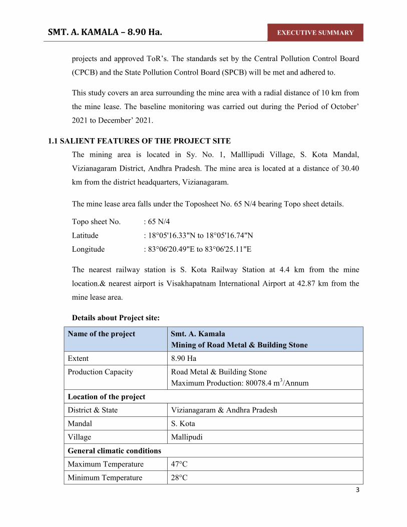
Ha. EXECUTIVE SUMMARY
EXECUTIVE SUMMARYOF
SMT. A. KAMALA
(Mining of Road Metal & Building StoneSmt. A. Kamala, ProprietorD.No: 12-96, Gandhi Nagar,
S. Kota Mandal, Vizianagaram,
Andhra Pradesh – 535145
Site Address Lease Area: 8.90 Ha.
Sy. No. 01 Mallipudi (V), S. Kota (M)
Vizianagaram District, Andhra Pradesh - 535145
Production Capacity
Road Metal & Building Stone – 80078.4 mBaseline Data Collected: October’ 2021 to December’
Approved ToR Lr. No:SEIAA/AP/MIN/VSP/VIO /11/2021/323623.12.2021
Sector: 01 – Mining of Minerals, Cat –B1
PREPARED BY
H.O:Block-B, B-1, IDA, Autonagar -12, Vishakapatnam Ph: 0891-2755528, Fax: 0891-2755529, E-mail: [email protected]
Ph: 9440338628 QCI NABET & NABL Accredited & Recognized by MOEF&CC, New Delhi
EXECUTIVE SUMMARY
1
EXECUTIVE SUMMARY
SMT. A. KAMALA Road Metal & Building Stone)
Smt. A. Kamala, Proprietor 96, Gandhi Nagar,
535145
Mallipudi (V), S. Kota (M) Vizianagaram District,
535145
80078.4 m3/Annum (max)
Baseline Data Collected: October’ 2021 to December’ 2021 Approved ToR Lr. No:SEIAA/AP/MIN/VSP/VIO /11/2021/3236-991 Dt:
(Violation)
Vishakapatnam [email protected]
& Recognized by MOEF&CC, New Delhi.

SMT. A. KAMALA – 8.90 Ha. EXECUTIVE SUMMARY
2
1.0 INTRODUCTION Smt. A. Kamala, Proprietor filed an application for grant a quarry lease 1st renewal for
Road Metal & Building Stone over an extent of 8.90 Ha. in Sy.No.1 of Mallipudi
Village, S.Kota Mandal, Vizianagaram District, Andhra Pradesh.
The DDM&G, Visakhapatnam granted 1st renewal quarry lease for Road Metal &
Building Stone over an extent of 8.90 Ha., in Sy.No.1 of Mallipudi Village, S.Kota
Mandal, Vizianagaram District, Andhra Pradesh for a period of 15 years vide
Proceedings No: 3322/Q3/2009, Dated: 19.01.2012 and the same was executed by the
ADM&G, Vizianagaram vide Proceedings No. 2545/Q2/2009, dated 28.01.2012 for the
lease period of 15 years w.e.f. 19.09.2009 to 18.09.2024.
The Mining Plan was approved by DDM&G, Visakhapatnam vide Letter No. 1784/MP-
VZM/2017, Dated: 11.09.2017.
As per MoEF&CC Notification S.O. 804 (E) 14.03.2017, the project attracts violation as
the proponent has started the work onsite without obtaining prior EC as per EIA
notification – 2006. The proponent has executed the existing mine without EC, and
presently the mine has suspended its operations and will resume Road Metal & Building
Stone production after obtaining all necessary permissions.
Presentation of TOR under violation has been made before the SEAC, Andhra Pradesh
committee on 16.11.2021, 17.11.2021 & 18.11.2021 and the TOR has been issued by
SEIAA, AP vide order no: SEIAA/AP/VSP/VIO/MIN/11/2021/3236-991 Dated:
23.12.2021 for conducting public hearing.
In order to fulfill the further necessary requirements for obtaining the Environmental
Clearance for this mining activity, the proponent has initiated steps to carryout required
Environmental Impact Assessment (EIA) study in and around the mine lease area.
This assessment is performed to identify the likely Environmental Impacts and based on
the findings an effective Environmental Management Plan is in place as per the EIA
Notification 2006 general guidelines and the revised Model TOR outlined for Mining
SMT. A. KAMALA – 8.90 Ha. EXECUTIVE SUMMARY
3
projects and approved ToR’s. The standards set by the Central Pollution Control Board
(CPCB) and the State Pollution Control Board (SPCB) will be met and adhered to.
This study covers an area surrounding the mine area with a radial distance of 10 km from
the mine lease. The baseline monitoring was carried out during the Period of October’
2021 to December’ 2021.
1.1 SALIENT FEATURES OF THE PROJECT SITE
The mining area is located in Sy. No. 1, Malllipudi Village, S. Kota Mandal,
Vizianagaram District, Andhra Pradesh. The mine area is located at a distance of 30.40
km from the district headquarters, Vizianagaram.
The mine lease area falls under the Toposheet No. 65 N/4 bearing Topo sheet details.
Topo sheet No. : 65 N/4
Latitude : 18°05'16.33"N to 18°05'16.74"N
Longitude : 83°06'20.49"E to 83°06'25.11"E
The nearest railway station is S. Kota Railway Station at 4.4 km from the mine
location.& nearest airport is Visakhapatnam International Airport at 42.87 km from the
mine lease area.
Details about Project site:
Name of the project Smt. A. Kamala Mining of Road Metal & Building Stone
Extent 8.90 Ha
Production Capacity Road Metal & Building Stone Maximum Production: 80078.4 m3/Annum
Location of the project District & State Vizianagaram & Andhra Pradesh
Mandal S. Kota
Village Mallipudi
General climatic conditions Maximum Temperature 47°C
Minimum Temperature 28°C

SMT. A. KAMALA – 8.90 Ha. EXECUTIVE SUMMARY
4
Annual average rain fall 1020 mm
General location details Nearest Habitation Gadabavalasa Village at a distance of 0.22 km
Nearest town S. Kota Mandal distance of 3.74 km
District headquarters Vizia nagaram at 30.40 km
Nearest railway station S. Kota Railway station at a distance of 4.4 km
Nearest Airport Visakhapatnam International Airport at 42.87 km
Archaeological/Historically important site
None within 10 km radius
Infrastructure Facilities Hospitals and schools are present in S. Kota Mandal
Sanctuaries/National parks None within 10 km radius
Nearest RF/PF Ananthagiri Reserved Forest-0.57 Km-N & NW Mariki Reserve Forest- 2.0 Km- SW
Nearest Water Bodies Pond -0.12 Km-S Pond – 0.23 Km – E Pond- 0.59 Km - S Pond- 0.71 Km - S Pond- 0.6 Km - S Pond- 0.25 Km - SW Pond- 0.63 Km- SW Pond- 0.84 Km- SW One stream – 1.3 Km - SE Pond- 1.8 Km- E Pond- 1.2 Km- E Pond – 5.76 km SE Stream – 8.90 km SE Kantham Cheruvu – 9.56 km - S

SMT. A. KAMALA – 8.90 Ha. EXECUTIVE SUMMARY
5
TOPO MAP AROUND 10 KM RADIUS

SMT. A. KAMALA – 8.90 Ha. EXECUTIVE SUMMARY
6
1.2 DETAILS OF PRODUCTION The firm intends to extract the Road Metal & Building Stone production for the tune
of 366397.92 m3@90% recovery with an average production of 73279.58 m3/annum
during the next five years scheme period. During the mining period it is proposed to
exploit Road Metal & Building Stone from the existing lease area with an average
bench height 3 - 4 m along the Cross Section A-A’. The workings will advance from
South to North direction.
Year Wise Production for ensuing mining plan
Year of Production
Pit No.
Total tentative excavation
(m3)
OB/SB/IB @10%
(m3)
Clean Ore @90% (m3)
1st year 2017-2018
1 51340.80 5134.08 46206.72
2nd year 2018-2019
1 88960.00 8896.00 80064.00
3rd year 2019-2020
1 88976.00 8897.60 80078.40
4th year 2020-2021
1 88872.00 8887.20 79984.80
5th year 2021-2022
1 88960.00 8896.00 80064.00
TOTAL 407108.80 40710.88 366397.92 AVERAGE 81421.76 8142.17 73279.58
MINEABLE RESERVES The deposit was estimated through cross sectional method. The reserves are estimated
through A-A’ – B-B’ with sectional influences 61 m which are drawn at appropriate
distance to estimate the reserves. The proved reserves were taken up to a depth RL 70
M from surface of the area i.e., from hill peak i.e., 168 M RL point to bottom. The
probable reserves were taken up to 20 m below ground level i.e.70 M to 50 M RL.
Total Geological Proved Reserves : 3677046.40 m3
Blocked Reserves : 542440 m3
Mineable Reserves : 3134606.4 m3
Mineable @ 90% Recovery : 2821145.76 m3

SMT. A. KAMALA – 8.90 Ha. EXECUTIVE SUMMARY
7
Average Production per year : 73279.58m3
Life of Mine : 2821145.76/ 73279.58
= 38.5 say 39 years
1.3 MINING PROCESS
The mining operations were previously carried out by opencast semi mechanized
method. Road metal by nature is medium hard. So blasting is mandatory for
excavation of road metal.
The operations will involve wet jacketed drilling, controlled blasting and excavations
and directly loads into the tippers/ tractors. The excavation will be carried with bench
height 5 to 10 meters and width 6 to 12 meters minimum. Haul roads gradient will be
1:16.
1.4 EXTENT OF MECHANIZATION The project is for mining of Road Metal and Building Stone. For this mine the
following machinery will be installed or purchased by the proponent.
Table 2.8 List of Machinery details
S. No. Machinery No. of Units 1 Excavators(Hire) 2
2 Tippers(Hire) 3
3 Jackhammers 4
4 Tractor Mounted Compressor 1
5 Water tanker 1
TOTAL
1.5 PROPOSED MANPOWER By this existing project many people will be benefited for their livelihood and get
employment in this remote area.
Employment Details
S.No. Category No. of Persons
1. Mines Manager 1
2. Site Supervisor 1
3. Licensed Blaster 1

SMT. A. KAMALA – 8.90 Ha. EXECUTIVE SUMMARY
8
4. Excavator Operators 2
5. Tipper/Tractor Operators 2
6. Compressor operator 2
7. Skilled Workers 5
8. Unskilled Workers 10
9. Drivers 2
10. Watchman 1
TOTAL 27
1.6 WATER SUPPLY
Around 11.2 KLD of water will be required for the project activity. Water
requirement will be met through water tankers from nearest village. Water is required
in the mine for wet drilling, spraying on the roads and working faces to suppress the
dust and for drilling by wet jacket method. Also a small quantity of drinking water is
required.
1.7 BASELINE DATA
The study area covers an area of 10km radius around the mining site. The study
includes detailed characterization of various Environmental components such as Air,
Water, noise, Land and Socio-Economic within the study area.
OBJECTIVES OF STUDY AREA
To assess the existing base line data of Air, Water, Noise, Land and Socio-
economic environment.
To evaluate the beneficial and adverse impacts of the mining activity.
To prepare an Environmental Management Plan (EMP) detailing control
technologies and measures to be adopted for minimizing the impacts and
improving the Environmental Quality.
To predict the incremental levels of pollutants in the study area due to the
mining activity.
To prepare post mining programme for monitoring and regulating
Environmental parameters.

SMT. A. KAMALA – 8.90 Ha. EXECUTIVE SUMMARY
9
1.7.1 ENVIRONMENTAL SETTINGS:
Air Environment:
To know the existing ambient air quality, Eight sampling stations with in Core and
buffer zone were identified and monitored for pollutants like, Particulate Matter – 10
(PM10), Particulate Matter – 2.5 (PM2.5), SO2, NOx and Free Silica. For this sampling
calibrated through samplers of PM2.5 & PM10 dust samplers.
The Ambient air quality measured at mine site and surrounding stations with in the
study zone showed the following maximum and minimum concentrations of the
pollutants-
It may be seen that all the parameters i.e., PM 10, PM 2.5, SO2 and NOx are well within
the range of 24 hr average of National Ambient Air Quality Standards.
1.7.2 Noise Pollution: The Ambient noise levels monitored within the study zone varied from 49.6 - 62.3Leq
dB (A) during day time and 35.7– 48.5Leq dB(A) during night time.
1.7.3 Water Environment: Ground water samples are collected from eight locations and surface water from four
locations. All these samples are free from colour and pollutants.
Summary of Ground water:
During the study period, the pH of the groundwater was found varying between
7.1 and 7.5. The pH values for all the samples collected in the study area during
study period were found to be within the acceptable limits.
The TDS of all the samples were below the permissible limit of 2000 mg/l.
The Chloride levels in the groundwater samples collected in the study area were
ranging from 98-132mg/l
In the groundwater samples collected from the study area, the hardness was
found to be varying from 308 mg/l to 423 mg/l.
In the groundwater samples of study area the fluoride values were found to be
within a range of 0.46mg/l to 0.68mg/l.
All the heavy metals in all samples were found to be below the permissible limits.

SMT. A. KAMALA – 8.90 Ha. EXECUTIVE SUMMARY
10
Summary of surface water:
pH of the surface water collected was neutral with pH ranging from 7.2 -7.4
TDS was found to be 215 mg/l to 267mg/l. The tolerance limit of 1,500 mg/l as per
IS:2296
Total hardness was found to be 101 mg/l to 126 mg/l
Presence of Nitrate was recorded as 0.21 mg/l to 0.28 mg/l
DO was observed as 5.5 mg/l to 6.2 mg/l
Total coliform in water was 300 MPN/100ml to 900 MPN/100ml. The likely source
of bacteriological contamination was due to the proximity to residential area
All the heavy metals were found to be within below detectable limits.
1.7.4 LAND ENVIRONMENT: Soil survey was carried out at 5 locations to assess the soil characteristics which
include both physical and chemical details.
Land Use Pattern: The project covers a total ML area of 8.90 hectares of Govt. waste land. During the
ensuing plan period an area of 2.4942hectares of land will be brought under mining,
whereas a total of 1.23 hectares of buffer land will be undisturbed.
The remaining area shall be put to use in the future basing on the demand for Road
Metal and Building Stone.
1.7.5 FLORA & FAUNA:
No endangered species are found in the study area. No schedule – I species are found
within 10km radius from the mining project site.
1.7.6 SOCIO-ECONOMIC ENVIRONMENT: The operation of the mining activity could result in elevation of living standards of the
people in nearby villages as it will generate work for the unemployed and further will
result in the upliftment of their socio-economic status. The management of Smt. A.
Kamala has proposed to give preference to local people for recruitment of personal
for mining operation. Therefore the impact on socio-economic Environment could be
beneficial.

SMT. A. KAMALA – 8.90 Ha. EXECUTIVE SUMMARY
11
1.8 RECLAMATION & REHABILITATION The total mine lease area is about 8.90 Ha. During the ensuing plan period an area of
2.4942 Ha of land will be mined out during mining and 1.23 Ha of land will be kept
as 7.5 m wide safety zone. Since it is envisaged that the quarry will be operate for at
most for 39 years, no back filling is proposed during the lease period. After removal
of mineral the benches below the surface level the top benches will be applied with
top soil and developed with grass and plantation. The pits created will be used as rain
water harvesting structure. A stretch of 1.0 km is proposed for green belt along the
approach road.
1.9 PROJECT SCHEDULE AND COST ESTIMATES The project cost is about 89.0Lakhsand EMP capital cost Rs. 5.6 Lakhs and recurring
cost as Rs 4.3 Lakhs per annum.
1.10 ENVIRONMENT MANAGEMENT PLAN The Environment Management Plan envisaged for this mining activity is described
hereunder with a strong commitment to follow best environmental practices to reduce
the negative implication to make this project a sustainable development endeavor.
Environment Management Plan (EMP) is required to ensure sustainable development
in the study area of the Mine Lease Area.
Air Environment: Mitigation measures proposed to maintain the air quality are as follows:
Regular water sprinkling to suppress the dust on haul roads, service roads and
mining face by truck mounted water tankers.
Grading of haul roads, service roads time to time, to remove the accumulated dusty
material will be done.
Development of Green belt all around Plant and along mining area boundary.
Periodical monitoring of air quality to take steps to control the pollutants.
Noise Environment There will be intermittent noise levels due to vehicular movement and trucks loading.
However the impact of noise on the surrounding area is likely to be minimal and
appropriate mitigation measures will be adopted accordingly.

SMT. A. KAMALA – 8.90 Ha. EXECUTIVE SUMMARY
12
Control Measures The Management Plan for controlling noise pollution is envisaged as follows.
Selection of suitable machinery and equipment,
Proper mounting of equipment,
Providing noise insulation/padding wherever practicable and
Machinery will be fitted with properly designed noise acoustic silencers.
Proper maintenance and periodic lubrication of noise generating parts of the
machines.
Provision of thick plantation in and around the mine is planned in order to reduce
the noise and prevent it from reaching to surrounding habitation area.
Water Environment There will not be any waste water generation except domestic waste water, therefore
no post waste water monitoring required.
Water Pollution Management There are no perennial or seasonal streams in the core zone. Channels and bunds
would be constructed and maintained to avoid any erosion and contamination.
The mine pit water collected due to rains will be utilized for water spraying on the
haul roads and for watering plantation.
This water will be harvested for utilization in plantation watering, spraying on the
haulage roads and mineral and waste dumps.
1.11 SOCIO-ECONOMIC ENVIRONMENT AND SAFETY The company management shall give preference to local people through both direct
and indirect employment.
It will provide ample opportunity to the locals to up-lift their living standards by
organizing events that propagate mutual benefits to all, such as health camps,
awareness campaigns, donations to poorer sections of society and downtrodden.
Educational needs of the region will be improved by encouraging the workers to
allow their children to attend schools.
Sufficient funds shall be allocated for these and other emergency needs.
Adequate supply of potable water to the workers will be made during the working
hrs.

SMT. A. KAMALA – 8.90 Ha. EXECUTIVE SUMMARY
13
The mines department will supervise the safe working of the contractor and their
employees. The working personnel will be provided with face masks, ear plugs,
safety helmets and goggles in order to reduce health hazards.
The proponent will provide all necessary provisions stipulated under the Mines
Act. In addition a Safety committee will be formed and manned by equal
participants from Management and Workers.
Personnel Protection Equipment (PPE) will be issued to each worker. Other
safety equipments shall be used according to the nature of job involved.
1.12 ENVIRONMENTAL MONITORING Regular monitoring of various Environmental parameters shall be carried out to
ascertain the following points,
Status of air, noise, water, land pollution within the mining activity and in its
vicinity;
Generate data for predictive or corrective purpose in respect of environmental; and
To assess and monitor Environmental impacts periodically.
1.13 SAFETY AND ENVIRONMENT The management firmly believes in the concept of safety and environmentally
sustainable growth. The authorities and staff are very much concern in
Environmental issues.
The management is going to develop scientifically designed green belt around the
premises to mitigate air and noise pollution impacts on the surroundings.
The management proposed to monitor ambient air as per APPCB guidelines.
All the employees will be provided with personnel protective equipment
The management will provide safety training to all employees periodically and
regularly.
1.14 CONCLUSION The management of Smt. A. Kamala is committed to meet all stringent norms and to
safe guard environment.

CHAPTER – I INTRODUCTION

Draft Environmental Impact Assessment Report for Smt. A. Kamala – 8.90 Ha.
CHAPTER-I INTRODUCTION
1 - 1
1.0 INTRODUCTION Road metal and Building stone has huge importance in almost any type of construction
activity. It is also the most important input in road construction activity. Further they are
also required by railway projects for track laying and other construction activities. Thus
in current times, where the focus of the governments is on improvement of basic
infrastructure like roads, railways, dams and other social infrastructure - both in rural and
urban areas, there is a constant need for ensuring regular supply of Road Metal and
Building stone.
Due to heavy construction activity in the area, there is always a constant need of ensuring
a regular supply of this basic input. Hence, an effort for increasing minor mineral
production in the district must be encouraged to ensure smooth supply of aggregates to
match the pace of developmental activities in the area.
1.1 PURPOSE OF THE REPORT Smt. A. Kamala has been granted Quarry Lease 1st renewal for Road Metal & Building
stone mining over an extent of 8.90 Ha, located in Sy. No. 1 of Mallipudi Village, S.
Kota Mandal, Vizianagaram District for a period of 15 years by the DDM&G,
Visakhapatnam vide proceedings No. 3322/Q3/2009, Dated 19.01.2012 and the same was
executed by the ADM&G, Vizianagaram vide Proceedings No. 2545/Q2/2009, dated
28.01.2012 for the lease period of 15 years w.e.f. 19.09.2009 to 18.09.2024.
As per MoEF&CC Notification S.O. 804 (E) 14.03.2017; the project attracts violation as
the proponent has started the work onsite without obtaining prior EC as per EIA
notification – 2006. The proponent has executed the existing mine without prior EC, and
presently the mine has suspended its operations and will resume Road Metal & Building
Stone production after obtaining all necessary permissions.
Environmental Impact Assessment (EIA) is a process, used to identify the environmental,
social and economic impacts of a project prior to decision-making. It is a decision
making tool, which guides the decision makers in taking appropriate decisions for
proposed projects. EIA systematically examines both beneficial and adverse

Draft Environmental Impact Assessment Report for Smt. A. Kamala – 8.90 Ha.
CHAPTER-I INTRODUCTION
1 - 2
consequences of the existing mine and ensure that these impacts are taken into account
during the operation.
The Environmental Impact Assessment report has been prepared in terms of EIA
notification of the MoEF&CC dated 14.09.2006, its subsequent amendments and the EIA
Guideline Manual for Mining of Minerals (Feb, 2010) of ASCI, Hyderabad, for seeking
Environmental Clearance for the existing mine in the name of Smt. A. Kamala measuring
8.90 hectares falling under category “B”.
Baseline survey of environmental attributes are also conducted which helped in
evaluating environmental impacts due to the mined out activities and in formulating a
scientific Environmental Management Plan.
Presentation of TOR under violation has been made before the SEAC, Andhra Pradesh
committee on 16.11.2021, 17.11.2021 & 18.11.2021 and the TOR has been issued by
SEIAA, AP vide order no: SEIAA/AP/VSP/VIO/MIN/11/2021/3236-991 Dated:
23.12.2021 for conducting public hearing. The copies were attached as Annexure -I.
As per the TOR baseline data has been prepared for one season i.e., non-monsoon season.
The study area comprises of the core zone (lease area) and the buffer zone (10 km around
the core zone from the periphery).
1.2 DETAILS OF THE PROJECT & IDENTIFICATION OF PROJECT PROPONENT
Smt. A. Kamala is the applicant for this Road metal and Building stone mining project.
Table: 1.1 Description of Project Proponent
Address of the lessee Address of Mine Smt A. Kamala, Proprietor, D.No. 12-96, Gandhi Nagar, S. Kota Mandal, Vizianagaram District, Andhra Pradesh – 535145
Smt. A. Kamala Sy. No:01, Mallipudi Village, S. Kota Mandal, Vizianagaram District, Andhra Pradesh – 535145

Draft Environmental Impact Assessment Report for Smt. A. Kamala – 8.90 Ha.
CHAPTER-I INTRODUCTION
1 - 3
1.3 LEGAL STATUS OF THE PROJECT Smt. A. Kamala filed an application for grant of quarry lease 1st renewal for Road Metal
& Building Stone over an extent of 8.90 Ha. in Sy.No.1 of Mallipudi Village, S.Kota
Mandal, Vizianagaram District, Andhra Pradesh.
The DDM&G, Visakhapatnam has granted 1st renewal quarry lease for Road Metal &
Building Stone over an extent of 8.90 Ha., in Sy.No.1 of Mallipudi Village, S.Kota
Mandal, Vizianagaram District, Andhra Pradesh for a period of 15 years vide
Proceedings No: 3322/Q3/2009, Dated: 19.01.2012 and the same was executed by the
ADM&G, Vizianagaram vide Proceedings No. 2545/Q2/2009, dated 28.01.2012 for the
lease period of 15 years w.e.f. 19.09.2009 to 18.09.2024.
The Mining Plan was approved by DDM&G, Visakhapatnam vide Letter No. 1784/MP-
VZM/2017, Dated: 11.09.2017.
The proponent Smt. A. Kamala involved in this mining operation without prior EC and
presently the mine operation has been stopped and will resume its production after
obtaining necessary permissions.
In order to fulfil the further necessary requirements for obtaining the Environmental
Clearance for this mining activity, the proponent has initiated steps to carryout required
Draft Environmental Impact Assessment (EIA) study in and around the existing mine
lease area.
This assessment is performed to identify the likely Environmental Impacts and based on
the findings; an effective Environmental Management Plan is in place as per the EIA
Notification 2006 general guidelines and the revised Model TOR outlined for Mining
projects.
The standards set by the Central Pollution Control Board (CPCB) and the State Pollution
Control Board (SPCB) will be met and adhered to.

Draft Environmental Impact Assessment Report for Smt. A. Kamala – 8.90 Ha.
CHAPTER-I INTRODUCTION
1 - 4
This study covers an area surrounding the project site with a radial distance of 10 km
from the existing mine lease area. The baseline monitoring was carried out during the
Period of October’ 2021 to December’ 2021.
1.4 BRIEF DESCRIPTION OF THE PROJECT As per the approved mining plan vide Lr. No: 1784MP-VZM/2017, dated: 11.09.2017;
Smt. A. Kamala had a mining lease for Road Metal and Building Stone over an extent of
8.90 Ha located in Sy. No. 1 of Mallipudi Village, S.Kota Mandal, Vizianagaram District,
Andhra Pradesh. TOR was granted for production capacity of 80078.40 m3/annum.
1.5 PROJECT NATURE, SIZE AND LOCATION 1.5.1 Nature
The project is mining of Road Metal & Building Stone in the lease area of 8.90 Ha. of
government land. The method of mining is conventional method of open cast mining for
the production of 80078.40 m3/Annum of Road Metal & Building Stone.
1.5.2 Size The proposed production of mine for Road Metal & Building Stone is 80078.40
m3/Annum and the estimated project cost is 89.0 Lakhs. The anticipated life of mine will
be 39 years as per targeted production and exploration during this plan period.
1.5.3 Location The mining area is located in Sy. No. 1, Malllipudi Village, S. Kota Mandal,
Viziznagaram District, Andhra Pradesh. The mine area is located at a distance of 30.40
km from the district headquarters, Vizianagaram. The location map is provided in Fig 1.1
The mine lease area falls under the Toposheet No. 65 N/4 bearing Topo sheet details.
Topo sheet No. : 65 N/4
Latitude : 18°05'16.33"N to 18°05'16.74"N
Longitude : 83°06'20.49"E to 83°06'25.11"E

Draft Environmental Impact Assessment Report for Smt. A. Kamala – 8.90 Ha.
CHAPTER-I INTRODUCTION
1 - 5
1.5.4 Accessibility Road Link The quarry lease area is connected by Visakhapatnam - Araku Road (SH-39) which is 3.0
km away from the mine.
Rail link The nearest railway station is S. Kota Railway Station at 4.4 km from the mine location.
Air Link The nearest airport is available at Visakhapatnam International Airport at 42.87 km from
the mine area.

Draft Environmental Impact Assessment Report for Smt. A. Kamala – 8.90 Ha.
CHAPTER-I INTRODUCTION
1 - 6
Fig 1.1 Location Map of Smt. A. Kamala – 8.90 Ha

Draft Environmental Impact Assessment Report for Smt. A. Kamala – 8.90 Ha.
CHAPTER-I INTRODUCTION
1 - 7
1.6 REGULATORY COMPLIANCES & APPLICABLE LAWS/REGULATIONS a. Mining plan was approved by Dy. Director of Mines and Geology, Visakhapatnam
vide Letter No. 1784/MP-VZM/2017, dated: 11.09.2017.
b. Mine safety
c. To Obtain Environmental clearance from SEIAA, AP.
d. NOC from Pollution control board for establishment and operation.
e. Labor license.
1.7 OBJECTIVE OF EIA STUDY: The present EIA study is carried out to fulfill the listed objectives:
To establish the present environmental scenario.
To anticipate the impacts of mining operations on the environment.
To suggest preventive and mitigative measures to minimize adverse impact and to
maximize beneficial impacts.
To prepare a detailed action plan for implementation of mitigative measures.
To suggest a monitoring programmed to evaluate the effectiveness of Mitigative
measures.
To suggest the formation of a core group responsible for implementation of
environmental control and protective measures and monitoring of such
implementation.
To suggest a feedback mechanism enabling to make mid - course corrections.
To prepare a capital cost estimate and annual recurring cost for Environmental
Management Plan.
1.8 ENVIRONMENTAL PARAMETERS ANTICIPATED IN THE STUDY AREA
Collection of base line data is an integral aspect of the preparation of Environmental
Impact Assessment report. Base line data reflects the present status of Environment
before the initiation of any activity of the mining project. The possible effects due to the
mine project are estimated and superimposed on the compiled baseline data subsequently
to asses Environmental impacts.

Draft Environmental Impact Assessment Report for Smt. A. Kamala – 8.90 Ha.
CHAPTER-I INTRODUCTION
1 - 8
Pre Project Environment assessment was conducted in the study area during October’
2021 to December’ 2021. Studies were under taken to generate base line data of the
following:-
1. MICROMETEOROLOGICAL DATA.
2. AIR QUALITY – EXISTING AMBIENT AIR QUALITY
3. WATER ANALYSIS - GROUND WATER, SURFACE WATER
4. NOISE LEVELS
5. GEOLOGY
6. HYDROGEOLOGY
7. FLORA AND FAUNA
8. LAND ENVIRONMENT
9. LAND USE / LAND COVER
10. SOIL CHARACTERISTICS and
11. SOCIO – ECONOMIC STATUS SURROUNDING THE PROJECT SITE.
1.9 GENERIC STRUCTURE OF EIA DOCUMENT In terms of the EIA notification of the MoEF&CC dated 14th September 2006 as
amended in Dec 2009, the generic structure of the EIA document should be as under:
Executive Summary
1. Introduction
2. Project Description
3. Description of the Environment
4. Anticipated Environmental Impact & Mitigation Measures
5. Analysis of alternatives (Technology and site)
6. Environmental Monitoring Programme
7. Additional Studies
8. Project Benefits
9. Environmental Management Plan
10. Summary & Conclusion
11. Remediation Plan and the Natural & Community Resource Augmentation Plan
12. Disclosure of Consultants engaged

Draft Environmental Impact Assessment Report for Smt. A. Kamala – 8.90 Ha.
CHAPTER-I INTRODUCTION
1 - 9
1.10 POST ENVIRONMENT CLEARANCE MONITORING: The project management will submit a half yearly compliance report in respect of
stipulated prior Environmental Clearance terms and conditions on 1st June and 1st
December of each calendar year.

CHAPTER – II
PROJECT DESCRIPTION
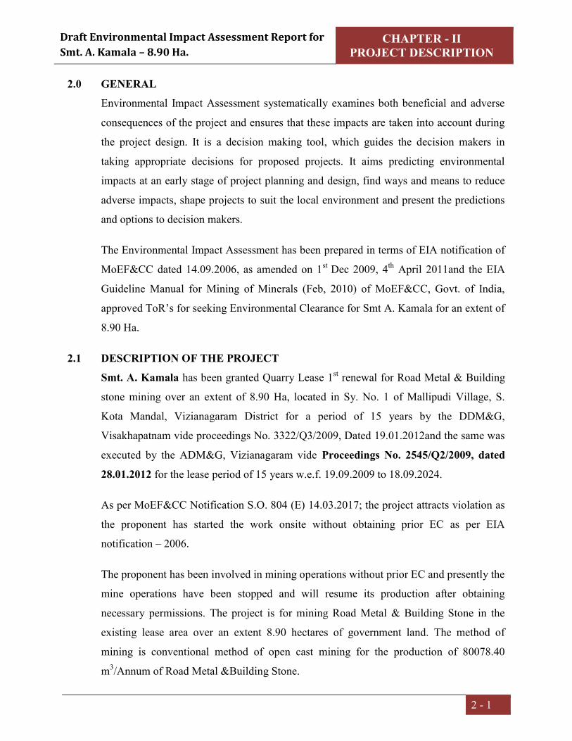
Draft Environmental Impact Assessment Report for Smt. A. Kamala – 8.90 Ha.
CHAPTER - II PROJECT DESCRIPTION
2 - 1
2.0 GENERAL Environmental Impact Assessment systematically examines both beneficial and adverse
consequences of the project and ensures that these impacts are taken into account during
the project design. It is a decision making tool, which guides the decision makers in
taking appropriate decisions for proposed projects. It aims predicting environmental
impacts at an early stage of project planning and design, find ways and means to reduce
adverse impacts, shape projects to suit the local environment and present the predictions
and options to decision makers.
The Environmental Impact Assessment has been prepared in terms of EIA notification of
MoEF&CC dated 14.09.2006, as amended on 1st Dec 2009, 4th April 2011and the EIA
Guideline Manual for Mining of Minerals (Feb, 2010) of MoEF&CC, Govt. of India,
approved ToR’s for seeking Environmental Clearance for Smt A. Kamala for an extent of
8.90 Ha.
2.1 DESCRIPTION OF THE PROJECT Smt. A. Kamala has been granted Quarry Lease 1st renewal for Road Metal & Building
stone mining over an extent of 8.90 Ha, located in Sy. No. 1 of Mallipudi Village, S.
Kota Mandal, Vizianagaram District for a period of 15 years by the DDM&G,
Visakhapatnam vide proceedings No. 3322/Q3/2009, Dated 19.01.2012and the same was
executed by the ADM&G, Vizianagaram vide Proceedings No. 2545/Q2/2009, dated 28.01.2012 for the lease period of 15 years w.e.f. 19.09.2009 to 18.09.2024.
As per MoEF&CC Notification S.O. 804 (E) 14.03.2017; the project attracts violation as
the proponent has started the work onsite without obtaining prior EC as per EIA
notification – 2006.
The proponent has been involved in mining operations without prior EC and presently the
mine operations have been stopped and will resume its production after obtaining
necessary permissions. The project is for mining Road Metal & Building Stone in the
existing lease area over an extent 8.90 hectares of government land. The method of
mining is conventional method of open cast mining for the production of 80078.40
m3/Annum of Road Metal &Building Stone.

Draft Environmental Impact Assessment Report for Smt. A. Kamala – 8.90 Ha.
CHAPTER - II PROJECT DESCRIPTION
2 - 2
2.2 LOCATION DETAILS The mining area is located in Sy. No. 1, Mallipudi Village, S.Kota Mandal, Vizianagaram
District, Andhra Pradesh. The mine area is located at a distance of 30.40km from the
district headquarters, Vizianagaram.
The nearest railway station is S. Kota Railway station at a distance of 4.4 km and nearest
airport is Visakhapatnam International Airport at 42.87 km from the mine lease area. The
boundary coordinates of the mine area are provided in Table 2.1 and the details of the
mine lease area are provided in Table 2.2.
Table 2.1 Boundary Coordinates
Boundary Point Latitude (N) Longitude (E) 1 18° 5'16.33"N 83° 6'20.49"E
2 18° 5'9.02"N 83° 6'20.13"E
3 18° 5'9.03"N 83° 6'24.78"E
4 18° 5'8.38"N 83° 6'24.78"E
5 18° 5'8.38"N 83° 6'25.12"E
6 18° 5'9.08"N 83° 6'26.69"E
7 18° 5'9.12"N 83° 6'28.66"E
8 18° 5'9.08"N 83° 6'29.27"E
9 18° 5'10.73"N 83° 6'29.94"E
10 18° 5'12.49"N 83° 6'30.33"E
11 18° 5'13.85"N 83° 6'30.76"E
12 18° 5'14.25"N 83° 6'32.97"E
13 18° 5'14.93"N 83° 6'36.25"E
14 18° 5'15.40"N 83° 6'37.51"E
15 18° 5'15.36"N 83° 6'37.71"E
16 18° 5'16.14"N 83° 6'38.00"E
17 18° 5'17.55"N 83° 6'37.30"E
18 18° 5'17.44"N 83° 6'35.53"E
19 18° 5'17.04"N 83° 6'33.55"E
20 18° 5'16.81"N 83° 6'30.52"E
21 18° 5'16.74"N 83° 6'25.11"E

Draft Environmental Impact Assessment Report for Smt. A. Kamala – 8.90 Ha.
CHAPTER - II PROJECT DESCRIPTION
2 - 3
Table: 2.2Details about the Project Site
Name of the project Smt. A. Kamala Mining of Road Metal & Building Stone
Extent 8.90 Ha
Production Capacity Road Metal & Building Stone Maximum Production: 80078.4 m3/Annum
Location of the project
District & State Vizianagaram & Andhra Pradesh
Mandal S. Kota
Village Mallipudi
General climatic conditions
Maximum Temperature 47° C
Minimum Temperature 28° C
Annual average rain fall 1020 mm
General location details
Nearest Habitation Gadabavalasa Village at a distance of 0.22 km
Nearest town S. Kota Mandal distance of 3.74 km
District headquarters Viziznagaram at 30.40 km
Nearest railway station S. Kota Railway station at a distance of 4.4 km
Nearest Airport Visakhapatnam International Airport at 42.87 km
Archaeological/Historically important site
None within 10 km radius
Infrastructure Facilities Hospitals and schools are present in S. Kota Mandal
Sanctuaries/National parks None within 10 km radius
Nearest RF/PF Ananthagiri Reserved Forest-0.57 Km-N & NW Mariki Reserve Forest- 2.0 Km- SW
Nearest Water Bodies Pond -0.12 Km-S Pond – 0.23 Km – E Pond- 0.59 Km - S Pond- 0.71 Km - S Pond- 0.6 Km - S

Draft Environmental Impact Assessment Report for Smt. A. Kamala – 8.90 Ha.
CHAPTER - II PROJECT DESCRIPTION
2 - 4
Pond- 0.25 Km - SW Pond- 0.63 Km- SW Pond- 0.84 Km- SW One stream – 1.3 Km - SE Pond- 1.8 Km- E Pond- 1.2 Km- E Pond – 5.76 km SE Stream – 8.90 km SE Kantham Cheruvu – 9.56 km - S

Draft Environmental Impact Assessment Report for Smt. A. Kamala – 8.90 Ha.
CHAPTER - II PROJECT DESCRIPTION
2 - 5
Figure. 2.1: Google map of mine area with 10 Km radius buffer zone

Draft Environmental Impact Assessment Report for Smt. A. Kamala – 8.90 Ha.
CHAPTER - II PROJECT DESCRIPTION
2 - 6
Fig 2.2 Topomap of mine area with 10 Km radius buffer zone

Draft Environmental Impact Assessment Report for Smt. A. Kamala – 8.90 Ha.
CHAPTER - II PROJECT DESCRIPTION
2 - 7
2.3 GEOLOGY AND EXPLORATION: 2.3.1 Physiography
Topographically the quarry lease area is covered with denudations of 312 m to 802 m
above mean sea level. With reference to the Topomap 65N/4, the quarry lease area
covered between the 646 m and 312 m hills on the North and South side of mine area &
802 m hill to the North-West side of mine area. Notable perennial water bodies are not
present within or nearby area which may cause the inundation of quarry.
Fig 2.3 Surface & Geological Plan of mine area

Draft Environmental Impact Assessment Report for Smt. A. Kamala – 8.90 Ha.
CHAPTER - II PROJECT DESCRIPTION
2 - 8
2.3.2 Regional Geology: The applied area falls in one discontinuous and isolated hillock system, which comes
under Eastern Ghat Tectonic system of Achaean Age group. The study area is
characterized by Eastern Ghats mobile belt. The area covered with denudation hills of
range between 312 m to 802 m above mean sea level. Kondakindam hillocks in Northern
side and Vendram Hillock in North Eastern side are two important hill ranges Eastern
Ghats prove to be a store-house of many valuable mineral resources which are coming to
light year by year. Garnet-sillimanitebiotite gneisses, Pyroxene Granulites (Charnockites),
garnetiferous granites (Leptynites), quartizites and pegmatite's are the chief rock types
that occur as bedded and banded as well as massive formations in the study area. The
Eastern Ghats complex mainly comprises of Khondalite suites with a set of sub-suites.
Intrusive activity might have caused migmatisation. The terrain must have subjected to
cycles of metamorphism. The local geology shows the occurrence of Granite gneisses,
Charnockite, Khondalite, Quartz and soil. The following is the local stratigraphy of the
mining lease area. Quartz (intrusive), Granite gneisses, Charnockite (Charnockite Group),
and Khondalite is the dominant rock type of the area. It is olden metamorphic schistose
rock with garnet, sillimanite, graphite, Feldspar, Quartz and Biotite as essential minerals
and Garnets, Mica, Hornblends are accessory minerals. Charnockites are fresh looking
light coloured, showing schistosity consisting Quartz, Feldspars, Garnet and Sillimanite
schist. Alternate alignment of leuco and melanocratic minerals attains gnessic property.
Garnet is also observed as discrete grains of reddish, brown, colour and equigranular
texture. The formation is highly structural disturbed with joints, fractures and thickly
penetrated with weather in influences.
2.3.3 Local Geology The lease area is not suitable for agriculture as it is strewed with small stones/boulders
and covered with Charnockites /Pyroxene Granulites which is raising up to 78 M above
ground level, the strike length of the body is measured374.43 M in the area with an
average width of 224.14M. The rock type stones have perpendicular jointing, hence not
suitable for colour granites.

Draft Environmental Impact Assessment Report for Smt. A. Kamala – 8.90 Ha.
CHAPTER - II PROJECT DESCRIPTION
2 - 9
Based on these quarry lease litho logical sequence, the pit wall information is as furnished
below:
Existing pit geological map details is given in Plate No.4.
Soil cover up to 0 to 1M from surface RL
Road Metal 1M to 98 M.
Detailed description of geology of lease area: The applied area falls in one discontinuous and isolated hillock system, which comes
under Eastern Ghat Tectonic system of Achaean Age group. The study area is
characterized by Eastern Ghats mobile belt. The area covered with denudation hills of
range between 312 m to 802 m above mean sea level. These Charnockites are grey to
greasy in colour, medium to coarse grained with Quartz, Plagioclase feldspar, pyroxenes,
biotite and Fe-oxidies. The rock has horizontal and Vertical Joints. These Charnockites
are best suited for Building stone and road metal as they have low permeability, medium
to high load bearing capacity and good foundation characteristics. The Building Stone and
Road Metal produced in the area cater to the needs of civil constructions in and around
Vizianagaram for infrastructural works, construction projects etc. Mariki hillocks in
South-Western side and Kokkulabanda Hillock in North Western side are two important
hill ranges Eastern Ghats prove to be a store-house of many valuable mineral resources
which are coming to light year by year.
2.4 MINEABLE RESERVES: The deposit was estimated through cross sectional method. The reserves are estimated
through A-A’ – B-B’ with sectional influences 61 m which are drawn at appropriate
distance to estimate the reserves. The proved reserves were taken up to a depth RL 70 M
from surface of the area i.e., from hill peak i.e., 168 M RL point to bottom. The probable
reserves were taken up to 20 m below ground level i.e.70 M to 50 M RL.

Draft Environmental Impact Assessment Report for Smt. A. Kamala – 8.90 Ha.
CHAPTER - II PROJECT DESCRIPTION
2 - 10
GEOLOGICAL PROVED RESERVES Cross
Section No
Cross Section
Area
Cross section interval (Area of Influence)
Ore body Volume
Gross Reserves
Over burden 10% of volume
Net reserves
after 10% loss
in m2 in m in m3 in m3 in m3 in m3
A-A’ 16950.31 80.00 1356024.80 1356024.80 135602.48 1220422.32
B-B’ 12937.40 80.00 1034992.00 1034992.00 103499.20 931492.80
C-C’ 8450.30 80.00 676024.00 676024.00 67602.40 608421.60
D-D’ 4052.00 80.00 324160.00 324160.00 32416.00 291744.00
E-E’ 1749.95 80.00 139996.00 139996.00 13999.60 125996.40
F-F’ 1823.12 80.00 145849.60 145849.60 14584.96 131264.64
TOTAL RESERVES 3677046.40 3677046.40 367704.64 3309341.76
Mineral reserves blocked under bench slopes and 7.5 m buffer zone are estimated and are
tabulated below:
RESERVES BLOCKED PROVED AREA Cross
Section No
Cross Section
Area
Cross section interval
Ore body Volume
Gross Reserves
Over burden 10% of volume
Net reserves less 10%
waste
in m2 in m in m3 in m3 in m3 in m3 A-A’ 2676.00 80.00 214080.00 214080.00 21408.00 192672.00
B-B’ 1710.50 80.00 136840.00 136840.00 13684.00 123156.00
C-C’ 1002.00 80.00 80160.00 80160.00 8016.00 72144.00
D-D’ 612.00 80.00 48960.00 48960.00 4896.00 44064.00
E-E’ 516.00 80.00 41280.00 41280.00 4128.00 37152.00
F-F’ 264.00 80.00 21120.00 21120.00 2122.00 19008.00
TOTAL RESERVES 542440.00 542440.00 54244.00 488196.00

Draft Environmental Impact Assessment Report for Smt. A. Kamala – 8.90 Ha.
CHAPTER - II PROJECT DESCRIPTION
2 - 11
Table 2.3 Details of Mineable Reserves
MINEABLE PROVED RESERVES Cross
Section No
Cross Section
Area
Cross section interval
Ore body Volume
Gross Reserves
Over burden 10% of volume
Net reserves after 10 %
loss
in m2 in m in m3 in m3 in m3 in m3 A-A’ 14274.31 80.00 1141944.80 1141944.80 114194.48 1027750.32
B-B’ 11226.90 80.00 898152.00 898152.00 89815.20 808336.80
C-C’ 7448.30 80.00 595864.00 595864.00 59586.40 536277.60
D-D’ 3440.00 80.00 275200.00 275200.00 27520.00 247680.00
E-E’ 1233.95 80.00 98716.00 98716.00 9871.00 88844.40
F-F’ 1559.12 80.00 124729.60 124729.60 12472.96 112256.64
TOTAL RESERVES 3134606.40 3134606.40 313460.64 2821145.76
Life of Mine
Total Geological Proved Reserves : 3677046.40 m3
Blocked Reserves : 542440 m3
Mineable Reserves : 3134606.4 m3
Mineable @ 90% Recovery : 2821145.76 m3
Average Production per year : 73279.58m3
Life of Mine : 2821145.76/ 73279.58
= 38.5 say 39 years
2.5 METHOD OF MINING The mining operations were previously carried out by opencast semi mechanized method.
Road metal by nature is medium hard. So blasting is mandatory for excavation of road
metal. The operations will involve wet jacketed drilling, controlled blasting and
excavations and directly loads into the tippers/ tractors. The excavation will be carried
with bench height 5 to 10 meters and width 6 to 12 meters minimum. Haul roads gradient
will be 1:16.
The proposed method of working is by semi mechanized method of opencast quarrying.
Considering mining parameters and the technical parameters like surface topography,

Draft Environmental Impact Assessment Report for Smt. A. Kamala – 8.90 Ha.
CHAPTER - II PROJECT DESCRIPTION
2 - 12
rock mechanism factors & quality variations, geo-technical aspects, required rate of
production & available resources etc. Small scale building quarrying activities with jack
hammer drilling & blasting.
Due care will be taken on mining and safety aspects in designing the benches by
straightening & advancing the benches for effective and economical operation of the
quarry. Since the ground water table is much below and the rainfall is not very high
during monsoon, drainage of water inside the pit will not pose problem.
Loading of the Road metal & Building stone blocks will be done mechanically to tippers
and transported from the quarry to the stack yard or directly to the buyers and mineral
rejection/waste will also be handled mechanically; the rejects/waste will be dumped
separately. In the quarry road will be maintained with 1 in 16 gradients. Sufficient
number of bunds and parapet walls will be made all along the quarry haulage roads
wherever necessary in order to maintain safe working conditions.
2.6 DETAILS OF PRODUCTION Presently, the firm envisages extracting the Road Metal and Building Stone production to
the tune of 366397.92 m3@90% recovery during the plan period. Out of which 73279.58
m3/annum will be sold as mineral and 10 % overburden i.e., 8142.17 m3/annum will be
preserved to use it for regular road gradation and strengthening garland drains. During the
mining period it is proposed to exploit Road Metal & Building Stone from the existing
lease area with an average bench height 3 - 4 m along the Cross Section A-A’. The
workings will advance from South to North direction. The present workings are shown in
figure 2.4.
Table 2.4YEAR WISE PRODUCTION
Year of Production
Pit No.
Total tentative
excavation (m3)
Top Soil (m3)
OB/SB/IB (m3)
ROM from Mineralized Zone ROM Waste ratio Clean Ore
(m3)
Sub grade ore
(m3)
Mineral Rejects
1st year 2017-2018
1 51340.80 - 5134.08 46206.72 - - 9:1
2nd year 1 88960.00 - 8896.00 80064.00 - - 9:1

Draft Environmental Impact Assessment Report for Smt. A. Kamala – 8.90 Ha.
CHAPTER - II PROJECT DESCRIPTION
2 - 13
2018-2019
3rd year 2019-2020
1 88976.00 - 8897.60 80078.40 - - 9:1
4th year 2020-2021
1 88872.00 - 8887.20 79984.80 - - 9:1
5th year 2021-2022
1 88960.00 - 8896.00 80064.00 - - 9:1
TOTAL 407108.80 40710.88 366397.92
AVERAGE 81421.76 8142.17 73279.58
Figure 2.4: Production and development plan with sections

Draft Environmental Impact Assessment Report for Smt. A. Kamala – 8.90 Ha.
CHAPTER - II PROJECT DESCRIPTION
2 - 14
2.7 WASTE DUMP MANAGEMENT Out of the total excavated mineral about 90% saleable Road Metal & Building Stone and
10% overburden is expected to be generated in this ensuing plan period of about
40710.88 m3and the same will be dumped temporarily in 1.0218 Ha. within mine lease
area as step dumping. Dump area is in the South corner of QL covering area. The waste
generated can be used for regular gradation of approach/haul roads, maintaining retention
wall along the hill slopes and strengthening garland drains within the mine area. The
topsoil will be preserved within the lease area for mined area reclamation usage at the
time of closure. The year wise overburden generation from this mine is given below.
Table 2.5 Details of the OB during the plan period
Year OB/SB/IB @10% (m3)
1st Year 5134.08
2nd Year 8896.00
3rd Year 8897.60
4th year 8887.20
5th year 8896.00
TOTAL 40710.88
AVERAGE 8142.17
2.8 CONCEPTUAL PLAN During the ensuing five years plan period total tentative excavation about 366397.92m3
of Road Metal and Building Stone will be produced and about 40710.88m3 of OB will be
generated which will be dumped in 1.0218 Ha., for using it to regular gradation of
approach/haul roads and strengthening garland drains. Taking into consideration of
geology and its structural attitudes, opencast method of mining is adopted where as the
mode of working is by mechanized open cast mining with Excavator.
During the mining period it is proposed to exploit the Road Metal and Building stone
from the existing lease area with an average bench height of 3-4 m along the Cross

Draft Environmental Impact Assessment Report for Smt. A. Kamala – 8.90 Ha.
CHAPTER - II PROJECT DESCRIPTION
2 - 15
Section A-A’. The workings will advance from South to North direction. The roads will
be extended to proposed working faces and gradient will be maintained. As per the
reserves and proposed production the expected mine life is at least 39.0 years, proper
reclamation is planned after the complete mineral excavation.
2.8.1 Mine Drainage:
There are no ground water bodies such as open wells or bore wells in this lease area. The
ground water table is about 48 m depth from the ground level. Maximum depth of
workings is up to RL 70 m and minimum depth of workings is RL 80 m. The proposed
maximum quarry operations during the plan period, a depth of 98m from the top hill
which is above the ground level; thus no chances for accumulation of ground water in
working pit and no water will be discharged from the pit.
2.8.2 Land use The land use of the mining area is given below:
Table2.6Land Use details
S.No. Land Activity Area in Ha.
1 Area under Mining 2.4942
2 Over burden/Dump 1.0218
3 7.5 m Buffer zone 1.23
4 Infrastructure (Within B.Z) (0.002)
5 Roads 0.0775
6 Future Use 4.0765
Total 8.90
2.8.3 Mine Closure Plan Since it is envisaged that the quarry will be in operation for at least 39.0 years as per
proposed production in mining plan, no back filling is proposed during the plan period
After removal of mineral the benches below the surface level the top benches will be
applied top soil and develop grass and plantation. Pits will be used as water reservoir.

Draft Environmental Impact Assessment Report for Smt. A. Kamala – 8.90 Ha.
CHAPTER - II PROJECT DESCRIPTION
2 - 16
2.8.4 Mining Machinery The project is for mining of Road Metal and Building Stone. For this mine the following
machinery will be installed or purchased by the proponent.
Table 2.7 List of Machinery details
S. No. Machinery No. of Units Cost 1 Excavators(Hire) 2 40.0 Lakhs
2 Tippers(Hire) 3 30.0 Lakhs
3 Jackhammers 4 1.0 Lakh
4 Tractor Mounted Compressor 1 6.0 Lakhs
5 Water tanker 1 10.0 Lakhs
6 Miscellaneous -- 2.0 Lakhs
TOTAL 89.0 Lakhs 2.8.5 Site Services
An office room, rest shelters, drinking water facility, public utilities and first aid services
are provided.
2.8.6 Water Requirement Around 11.2 KLD of water will be required for the project activity. Water requirement
will be met through water tankers from nearest village. Water is required in the mine for
spraying on the roads and working faces to suppress the dust and for drilling by wet
jacket method. Also a small quantity of drinking water is required.
Table 2.8 Fresh Water Requirement & Wastewater generation
S. No Description Fresh water (KLD)
Waste water (KLD) Disposal
1. Domestic 1.2 1.0 Septic tank followed by soak pit
2. Green belt 2.0 -- --
3. Drilling by Wet Jacket Method 5.0 -- --
4. Dust suppression 3.0 -- --
TOTAL 11.2 1.0 --

Draft Environmental Impact Assessment Report for Smt. A. Kamala – 8.90 Ha.
CHAPTER - II PROJECT DESCRIPTION
2 - 17
1.0 KLD of domestic effluent will be generated at the mine site. Domestic wastewater
generated will be treated through septic tank followed by soak pit.
2.9 EMPLOYMENT POTENTIAL The project will employ nearly 27 workers from nearby villages. The following persons
are employed to carryout/ supervise the day to day mining operations shown below
Table 2.9 Employment details
S.No Category No. of Persons 1. Mines Manager 1
2. Site Supervisor 1
3. Licensed Blaster 1
4. Excavator Operators 2
5. Tipper/Tractor Operators 2
6. Compressor operator 2
7. Skilled Workers 5
8. Unskilled Workers 10
9. Drivers 2
10. Watchman 1
TOTAL 27

CHAPTER – III DESCRIPTION OF ENVIRONMENT

Draft Environmental Impact Assessment Report for Smt. A. Kamala – 8.90 Ha.
CHAPTER – III DESCRIPTION OF THE
ENVIRONMENT
3- 1
3.0 INTRODUCTION Collection of base line data is an integral aspect of the preparation of Environmental
Impact Assessment report. Base line data reflects the present status of Environment
before the initiation of any activity. The possible effects due to the mining project are
estimated and superimposed on the compiled baseline data subsequently to asses
Environmental Impacts.
3.1 STUDY AREA Study area covers 10 kms radius from the miningmine located at Sy. No.1 of Mallipudi
Village, S.Kota Mandal, Vizianagaram District, Andhra Pradesh
3.2 STUDY PERIOD
The baseline environmental quality represents the background scenario of various
environmental components in the study area.
As part of the Environmental Impact Assessment study, baseline environmental
monitoring was carried out for the month of October 2021 to December 2021. Studies
were under taken to generate base line data of the following:-
3.3 METHODOLOGY OF EIA STUDY The various steps involved in Environmental Impact Assessment Study of the mine site
are divided into following phases:
Identification of significant environmental parameters and assessing the existing
status within the impact zone with respect to air, water, noise, soil and socio-
economic components of environment. Following studies will be carried out
Micrometeorological data
Air quality – existing ambient air quality
Water analysis - ground water& surface water
Noise levels
Flora and fauna
Geology & Hydrogeology

Draft Environmental Impact Assessment Report for Smt. A. Kamala – 8.90 Ha.
CHAPTER – III DESCRIPTION OF THE
ENVIRONMENT
3- 2
Soil environment
Land use / Land coverand
Socio – economic status surrounding the mine area
Study of various mining activities of the mine to identify the area leading to
impact/change in environmental quality.
Quantification/prediction of impacts for the identified activities and to study the
level of impacts on various environmental components.
Evaluation of impacts after superimposing the predicted/quantified scenario over
the baseline scenario.
Formulation of Environmental Management Plan for implementation in the mine.
3.4 COLLECTION OF BASELINE DATA 3.4.1 Micro meteorological data
Micrometeorological studies are simultaneously conducted with the ambient air quality
monitoring. Meteorology plays an important role in the dispersion of pollutants. The
meteorological data is very useful for interpretation of the base line information and for
model study of air quality impacts also.
Atemporary meteorological station was installed at mine lease area. The station was
installed at a height of 4 m above the ground level in such a way that there are no
obstructions facilitating flow of wind, wind speed, wind direction, humidity and
temperature are recorded on hourly basis.
CLIMATE The tropical climate of the region is manifested as hot and humid summer, moderately
monsoon and mild winter seasons. The climate of the region is characterized as hot &
dry.
Regional Meteorology: Climate:
The climate of the region is governed by its location in the tropics and by the monsoon.
The climate of the southeastern coast of the Bay of Bengal is characterized by the

Draft Environmental Impact Assessment Report for Smt. A. Kamala – 8.90 Ha.
CHAPTER – III DESCRIPTION OF THE
ENVIRONMENT
3- 3
annually recurring seasonal monsoons, which divide the year in to four seasons as Indian
Meteorological Department.
The winter season of the year from December to February predominantly north
winds and recorded coolest season of the year.
The summer season (Pre monsoon period) from March to May predominantly W
and SW winds and is hottest part of the year.
The South-West monsoon tropical rainy season from June to September is
characterized by predominantly South-west winds.
The Post monsoon period (North-east monsoon) from October to November when
predominant winds are North-east and wind changes the direction from North-east
to North-west or west when, cyclones are active in Bay-of-Bengal.
IMD Climatological Data (1981-2010) of nearest IMD station Visakhapatnam Airport
Month Temperature ºC Mean Relative
Humidity % Rainfall
mm Maximum Minimum January 29 17.5 78 14.3 February 31.2 19.2 76 28.9 March 33.1 21 75 14.6 April 33.5 21.5 76 25 May 36.1 21.3 77 66 June 36.8 22.4 79 107.6 July 34.8 22.1 83 131.8 August 33.6 22.2 83 132.6 September 33 22.2 82 161.6 October 32.3 21.4 79 270.4 November 30.8 19.3 73 105.1 December 29.1 18 72 3.5
Ref: IMD, Dolphin Nose/ CDR-Visakhapatnam

Draft Environmental Impact Assessment Report for Smt. A. Kamala – 8.90 Ha.
CHAPTER – III DESCRIPTION OF THE
ENVIRONMENT
3- 4
Temperature: The maximum temperature recorded is 36.8º C in June and the minimum is 17.5º C in
January.
Relative Humidity: The relative humidity is comparatively high and uniform throughout the year. The
average relative humidity was maximum 83% in July & August and minimum 72%
recorded in December.
Rainfall: The region of Visakhapatnam district receives an annual rainfall of 1061.2 mm. The
region also receives rain from the occasional low-pressure systems developing during the
post monsoon and pre-monsoon season. Recorded maximum rainfall of 270.4 mm in
October and minimum 3.5 mm rainfall during December.
3.4.2 Winds A weather station was installed near the site for hourly monitoring of temperature,
humidity and wind velocity for the month of October’2021 to December’2021.
Summarized data is given in Table 3.1. Wind rose diagram shown in Figure 3.1.
Table 3.1 Micro meteorological data at site
S. No. Parameter Oct'21 Nov'21 Dec'21 1
Temperature (0C)
Maximum 31.51 29.01 27.6 Minimum 21.17 17.13 12.64 Average 26.66 24.31 21.33
2
Relative Humidity (%)
Maximum 92.78 94.89 97.84 Minimum 63.97 62 40.41 Average 83.26 85.39 78.88
3
Wind Speed (m/sec)
Maximum 6.74 6.75 8.68 Minimum 0.07 0.17 0.23 Average 2.56 3.76 3.38
4
Wind Direction (%)
N 10.35 2.92 15.32 NNE 10.08 13.06 20.03

Draft Environmental Impact Assessment Report for Smt. A. Kamala – 8.90 Ha.
CHAPTER – III DESCRIPTION OF THE
ENVIRONMENT
3- 5
NE 10.48 29.44 29.30 ENE 10.62 24.31 11.43
E 13.31 19.58 4.84 ESE 3.23 8.47 3.36 SE 4.57 1.25 2.15
SSE 5.51 0.28 1.48 S 10.89 0.14 0.67
SSW 5.18 0.00 0.67 SW 1.88 0.00 0.54
WSW 1.88 0.00 0.54 W 1.61 0.00 0.54
WNW 2.55 0.00 2.15 NW 2.96 0.00 2.55
NNW 3.76 0.14 4.03 Calm 1.08 0.28 0.27

Draft Environmental Impact Assessment Report for Smt. A. Kamala – 8.90 Ha.
CHAPTER – III DESCRIPTION OF THE
ENVIRONMENT
3- 6
Fig.3.1 Wind rose diagram for the month of October 2021- December2021

Draft Environmental Impact Assessment Report for Smt. A. Kamala – 8.90 Ha.
CHAPTER – III DESCRIPTION OF THE
ENVIRONMENT
3- 7
3.5 AIR ENVIRONMENT 3.5.1 Selection of Sampling Locations: To assess the baseline ambient air quality a
scientifically designed ambient air quality-monitoring network was established. Air
quality monitoring study was carried out during post-monsoon season (i.e. October’21 to
December’21) within 10km radius of the mine lease area. The ambient air quality
monitoring stations were selected after a brief study based on the following
considerations;
Meteorological conditions
Topography of the study area
Predominant wind direction
Emission sources
Receptors sensitivity
Ambient Air Quality monitoring stations were set up at eight locations with due
consideration to the above-mentioned points. The locations of the sampling stations are
given in Table 3.3 and the same are show in the Figure3.2.
3.5.2 Methodology of Sampling and Analysis Air samples collected were tested for the following parameters
PM10
PM2.5
Sulphur Dioxide (SO2)
Oxides of Nitrogen ( NOx)
Free silica
The sampling and analysis of ambient air quality parameters was carried out as per the
procedures detailed in relevant parts of IS: 5182 (Indian Standards for Ambient Air Quality
Test Methods). The methods used for determining the above mentioned parameters and
furnished in the Table 3.2.
3.5.3 Frequency of Sampling: 24 hourly samples for PM10, PM2.5, SO2, NOxand free silica
were collected from each station, at a frequency of twice a week for Pre-Monsoon Season

Draft Environmental Impact Assessment Report for Smt. A. Kamala – 8.90 Ha.
CHAPTER – III DESCRIPTION OF THE
ENVIRONMENT
3- 8
Table 3.2 Techniques and detectable limits for Ambient air quality monitoring
S. No.
Parameter Technique Technical Protocol Minimum Detectable Limit (g/m3)
1 PM10 Respirable Dust Sampler (Gravimetric method) IS-5182 (Part-XXIII) 5.0
2 PM2.5 Fine Particulate Sampler (Gravimetric method) IS-5182 (Part-XXIV) 5.0
3 Sulphur dioxide Modified West and Gaeke IS-5182 (Part-II) 4.0
4 Oxides of Nitrogen Jacob &Hochheiser IS-5182 (Part-VI) 4.0
5 Free Silica Personal Respirable Dust Sampler
OSHA (0142) (Occupational Safety and Health Administration)
3.5
Table 3.3 Locations of Ambientair quality-monitoringstations
Sl. No Location Station
Code
Direction from
Project Site
Distance w.r.t
Project Site km
Latitude and Longitude
1 Project site (Core Zone) A1 ... ... 18° 5'12.98"N 83° 6'25.34"E
2 Kondagangupudi A2 SW 3.4 18° 4'1.54"N 83° 4'48.81"E
3 Sontivarepalem A3 WSW 3.2 18° 4'41.63"N 83° 4'35.64"E
4 Pedda Krishnarajapuram A4 SSW 1.8 18° 4'13.44"N 83° 6'8.80"E
5 Kotta Boddam A5 SE 4.4 18° 3'48.60"N 83° 8'35.95"E
6 Srungavarapu Kota A6 NE 3.6 18° 6'36.54"N 83° 8'7.44"E
7 Vantinivanipalem A7 NNE 5.7 18° 8'18.97"N 83° 7'18.67"E
8 Jeelugulapadu A8 N 5.2 18° 8'5.46"N 83° 6'15.95"E

Draft Environmental Impact Assessment Report for Smt. A. Kamala – 8.90 Ha.
CHAPTER – III DESCRIPTION OF THE
ENVIRONMENT
3- 9
Fig.3.2Location of Ambient air quality stations

Draft Environmental Impact Assessment Report for Smt. A. Kamala – 8.90 Ha.
CHAPTER – III DESCRIPTION OF THE
ENVIRONMENT
3- 10
Table 3.4Summary of analysis of ambient air quality in the study area
Parameter PM10(µg/m3) PM2.5(µg/m3) SO2(µg/m3) NOx(µg/m3)
Monitoring Station
No.
of sa
mpl
es
Max
imum
Min
imum
98th
per
cent
ile
No.
of s
ampl
es
Max
imum
Min
imum
98th
per
cent
ile
No.
of sa
mpl
es
Max
imum
Min
imum
98th
per
cent
ile
No.
of sa
mpl
es
Max
imum
Min
imum
98th
per
cent
ile
A1 26 62.2 41.6 62.1 26 31.7 20.0 31.6 26 11.8 9.7 11.7 26 15.2 12.7 15.1
A2 26 59.6 38.4 59.4 26 30.4 18.4 30.2 26 10.6 8.4 10.4 26 14.2 11.9 14.1
A3 26 56.3 35.8 56.2 26 28.7 17.2 28.6 26 9.8 7.4 9.7 26 11.8 9.4 11.6
A4 26 57.8 37.2 57.7 26 29.5 17.9 29.4 26 10.2 8.1 10.1 26 13.4 10.8 13.2
A5 26 61.5 40.8 61.3 26 31.4 19.6 31.2 26 11.2 9.3 11.1 26 14.5 12.1 14.4
A6 26 56.9 36.2 56.8 26 29.0 17.4 28.9 26 11.5 9.5 11.3 26 14.8 12.3 14.6
A7 26 53.4 32.5 53.2 26 27.2 15.6 27.1 26 9.5 7.3 9.4 26 12.4 10.2 12.2
A8 26 50.2 30.4 50.1 26 25.6 14.6 25.4 26 9.2 6.8 9.1 26 11.2 8.7 11.1
NAAQS 100(µg/m3) 60(µg/m3) 80(µg/m3) 80(µg/m3) Note: Free Silica was also monitored at all locations during the study period and was found to be Below Detectable limit

Draft Environmental Impact Assessment Report for Smt. A. Kamala – 8.90 Ha.
CHAPTER – III DESCRIPTION OF THE
ENVIRONMENT
3- 11
Graphical presentation of ambient air quality in the study area
62.1 59.4 56.2 57.7 61.3 56.8 53.2 50.1
100
0
20
40
60
80
100
120
A1 A2 A3 A4 A5 A6 A7 A8
PM10
Conc
entr
atio
n
Sampling Locations
98 Percentile of PM10 (µg/m3)
98 Percentile of PM10 (µg/m3) NAAQS
31.6 30.2 28.6 29.4 31.2 28.9 27.1 25.4
60
010203040506070
A1 A2 A3 A4 A5 A6 A7 A8
PM2.
5Co
ncen
trat
ion
Sampling Locations
98 Percentile of PM2.5 (µg/m3)
98 Percentile of PM2.5 (µg/m3) NAAQS

Draft Environmental Impact Assessment Report for Smt. A. Kamala – 8.90 Ha.
CHAPTER – III DESCRIPTION OF THE
ENVIRONMENT
3- 12
Graphical presentation of ambient air quality in the study area
11.7 10.4 9.7 10.1 11.1 11.3 9.4 9.1
80
0102030405060708090
A1 A2 A3 A4 A5 A6 A7 A8
SO2
Conc
entr
atio
n
Sampling Locations
98 Percentile of SO2 (µg/m3)
98 Percentile of SO2 (µg/m3) NAAQS
15.1 14.1 11.6 13.2 14.4 14.6 12.2 11.1
80
0102030405060708090
A1 A2 A3 A4 A5 A6 A7 A8
NOx
Conc
entr
atio
n
Sampling Locations
98 Percentile of NOx (µg/m3)
98 Percentile of NOx (µg/m3) NAAQS

Draft Environmental Impact Assessment Report for Smt. A. Kamala – 8.90 Ha.
CHAPTER – III DESCRIPTION OF THE
ENVIRONMENT
3- 13
3.5.4 Existing Ambient air quality On the perusal of above summary of analysis of ambient air quality in the study are it is
evident that all monitored values in various locations are well within the specified limits
of CPCB. The results are summarized below:
PM10: The highest PM10 concentration 62.2µg/m3 was observed in the ambient air was
recorded at station A1 while the lowest PM10concentration was found to be 30.4µg/m3 at
A8. All the monitored values of PM10 are well below the specified limit of 100 µg/m3.
PM2.5: The highest PM2.5 concentration 31.7µg/m3 was observed in the ambient air was
recorded at station A1 while the lowest PM2.5concentration was found to be 14.6µg/m3
at A8. All the monitored values of PM2.5 are well below the specified limit of 60 µg/m3.
SO2: The highest SO2 concentration 11.8µg/m3 was observed in the ambient air was
recorded at station A1 while the lowest SO2 concentration was found to be 6.8µg/m3 at
A8. All the monitored values of SO2 are well below the specified limit of 80 µg/m3.
NOx: The highest NOx concentration 15.2 µg/m3 was observed in the ambient air was
recorded at station A1 while the lowest NOx concentration was found to be 8.7µg/m3 at
A8. All the monitored values of NOx are well below the specified limit of 80µg/m3.
Silica: Free Silica was also monitored at all locations during the study period and was
found to be Below Detectable limit.
3.6 WATER ENVIRONMENT The water resources, both surface and groundwater play an important role in the
development of the area. Likewise, the water resources of the area have been studied
to establish the current status of water quality in the area. The parameters of prime
importance were selected under physical, chemical inorganic, chemical organic and
heavy metal groups. Water samples from ground and surface water sources were
collected. The water samples were collected in pretreated sampling cans and
transported to laboratory for analysis. Due care was taken during sampling &
transportation of these samples.

Draft Environmental Impact Assessment Report for Smt. A. Kamala – 8.90 Ha.
CHAPTER – III DESCRIPTION OF THE
ENVIRONMENT
3- 14
3.6.1 Surface water and ground water quality assessment In order to assess water quality impacts surface water and ground water samples are
collected from the surrounding villages. The samples analyzed for various physical
and chemical parameters to know the contamination levels as per the IS Standards.
1. Ground water quality --- IS 10500-2012
2. Surface/canal/sea water quality --- IS 2296
3.6.2 Selection of sampling locations Sampling locations were selected on basis of:
a) Drainage pattern
b) Location of residential areas respecting different activities
c) Likely areas those can represent baseline conditions
Samples for bacteriological analysis were collected in sterilized glass bottles. Selected
physico-chemical and bacteriological parameters have been analyzed for projecting
the existing water quality status in the study area.
The samples were analyzed in accordance with “Standard Methods for Examination
of Water and Wastewater Analysis” published by APHA.
3.6.3 Sampling techniques Samples for chemical analysis were collected in polyethylene carboys. Samples collected
for metal content were acidified with 1 ml HNO3. Samples for bacteriological analysis were
collected in sterilized glass bottles. Selected physico-chemical and bacteriological
parameters have been analyzed for projecting the existing water quality status in the study
area. Parameters like temperature, Dissolved Oxygen (DO) and pH were analyzed at the
time of sample collection.
The methodology for sample collection and preservation techniques was followed as per
the Standard Operating Procedures (SOP) mentioned in Table 3.5.
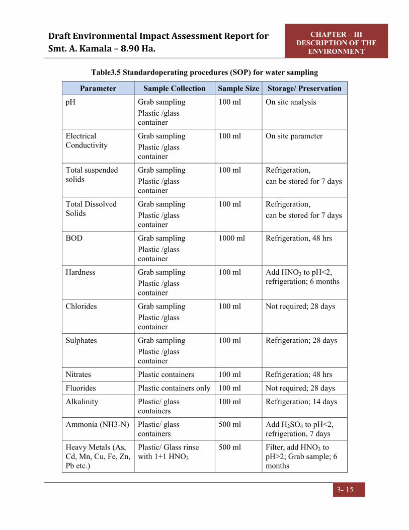
Draft Environmental Impact Assessment Report for Smt. A. Kamala – 8.90 Ha.
CHAPTER – III DESCRIPTION OF THE
ENVIRONMENT
3- 15
Table3.5 Standardoperating procedures (SOP) for water sampling
Parameter Sample Collection Sample Size Storage/ Preservation pH Grab sampling
Plastic /glass container
100 ml On site analysis
Electrical Conductivity
Grab sampling Plastic /glass container
100 ml On site parameter
Total suspended solids
Grab sampling Plastic /glass container
100 ml Refrigeration, can be stored for 7 days
Total Dissolved Solids
Grab sampling Plastic /glass container
100 ml Refrigeration, can be stored for 7 days
BOD Grab sampling Plastic /glass container
1000 ml Refrigeration, 48 hrs
Hardness Grab sampling Plastic /glass container
100 ml Add HNO3 to pH<2, refrigeration; 6 months
Chlorides Grab sampling Plastic /glass container
100 ml Not required; 28 days
Sulphates Grab sampling Plastic /glass container
100 ml Refrigeration; 28 days
Nitrates Plastic containers 100 ml Refrigeration; 48 hrs
Fluorides Plastic containers only 100 ml Not required; 28 days
Alkalinity Plastic/ glass containers
100 ml Refrigeration; 14 days
Ammonia (NH3-N) Plastic/ glass containers
500 ml Add H2SO4 to pH<2, refrigeration, 7 days
Heavy Metals (As, Cd, Mn, Cu, Fe, Zn, Pb etc.)
Plastic/ Glass rinse with 1+1 HNO3
500 ml Filter, add HNO3 to pH>2; Grab sample; 6 months

Draft Environmental Impact Assessment Report for Smt. A. Kamala – 8.90 Ha.
CHAPTER – III DESCRIPTION OF THE
ENVIRONMENT
3- 16
Source: Standard Methods for the Examination of Water and Wastewater, Published By
APHA (American Public Health Association) 23rd Edition 2017.
3.6.4 Analytical techniques
The analytical techniques used for water analysis is given in theTable3.6.
Table 3.6Analytical techniques forwater analysis
Parameter Method pH APHA, 4500-H+B
Colour APHA, 2120-C
Odour APHA, 2150
Temperature APHA, 2550-B
Oil & Grease APHA, 5520-D,5-38
Dissolved Oxygen APHA, 4500-DC
Electrical conductivity APHA, 2510-B
Turbidity APHA, 2130-B
Chlorides APHA, 4500-Cl, B
Fluorides APHA, 4500-FD
Total dissolved solids APHA, 2540-C
Total suspended solids APHA, 2540-D
Total hardness APHA, 2340-C
Sulphates APHA, 4500-SO4-2-E
Phosphates APHA, 4500-P C&D
Arsenic APHA, 3120-B
Calcium APHA, 3500-Ca B
Magnesium APHA, 3500-Mg B
Manganese APHA, 3120-B
Mercury APHA, 3120-B
Lead APHA, 3120-B
Copper APHA, 3120-B
Cadmium APHA, 3120-B

Draft Environmental Impact Assessment Report for Smt. A. Kamala – 8.90 Ha.
CHAPTER – III DESCRIPTION OF THE
ENVIRONMENT
3- 17
Parameter Method Iron APHA, 3120-B
Zinc APHA, 3120-B
Chromium APHA, 3120-B
Aluminium APHA, 3120-B
Cyanide APHA, 4500-CN-E
Coliform organisms IS 15185
Alkalinity APHA, 2320-B
COD APHA, 5220-B
BOD IS 3025 P:44
Total Kjheldhal Nitrogen APHA,4500-Norg B
Ammonical Nitrogen APHA, 4500-NH3 F
Residual Free Chlorine IS 3025 P:26
Phenolic Compounds (as C6H5OH)
APHA, 5530-C
Source: Standard Methods for the Examination of Water and Wastewater, Published By
APHA (American Public Health Association) 23rd Edition 2017
3.6.5 Water sampling stations The locations of the water samples collected in the study area are furnished hereunder
Table 3.7Water sampling stations
Code Station Direction
bearing w.r.t Project Site
Distance from Project Site
(km) Latitude & Longitude
Source of collection
GW1 Kasipathi Rajapuram NE 1.1 18° 5'45.82"N 83° 6'48.80"E Ground water
GW2 Srungavarapu Kota ENE 3.2 18° 6'9.13"N 83° 8'10.91"E Ground water
GW3 Vantinivanipalem NNE 5.7 18° 8'18.00"N 83° 7'19.05"E Ground water
GW4 Chilakalagedda W 1.6 18° 5'11.20"N 83° 5'24.82"E Ground water

Draft Environmental Impact Assessment Report for Smt. A. Kamala – 8.90 Ha.
CHAPTER – III DESCRIPTION OF THE
ENVIRONMENT
3- 18
GW5 Sontivarepalem WSW 3.3 18° 4'40.38"N 83° 4'34.16"E Ground water
GW6 S Kota Seetharamapuram SW 2.5 18° 4'3.16"N
83° 5'30.49"E Ground water
GW7 Mallipudi SSE 1.5 18° 4'22.24"N 83° 6'45.84"E Ground water
GW8 Dampuram ESE 3.9 18° 4'24.36"N 83° 8'31.17"E Ground water
SW1 Kondagangupudi Cheruvu WSW 3.5 18° 4'20.21"N
83° 4'32.92"E Surface water
SW2 Mallipudi Cheruvu SSE 1.9 18° 4'12.60"N 83° 6'53.33"E Surface water
SW3 Kothavooru Cheruvu E 2.8 18° 5'12.91"N 83° 8'12.46"E Surface water
SW4 Kapusompuram Cheruvu NNE 4.5 18° 7'26.71"N
83° 7'34.93"E Surface water

Draft Environmental Impact Assessment Report for Smt. A. Kamala – 8.90 Ha.
CHAPTER – III DESCRIPTION OF THE
ENVIRONMENT
3- 19
Fig.3.3Water samplinglocations

Draft Environmental Impact Assessment Report for Smt. A. Kamala – 8.90 Ha.
CHAPTER – III DESCRIPTION OF THE
ENVIRONMENT
3- 20
3.6.6 Ground water quality of the study area The water in the region (ground water) has been compared with respect to the Drinking water Quality Standards as IS: 10500. The
summarized analysis of results of the ground water quality in the study area are given in the below Table 3.8.
Table 3.8 Ground water quality results
S.No. PARAMETER UNIT GW1 GW2 GW3 GW4 GW5 GW6 GW7 GW8 IS:10500-Standards Acceptable Permissible
1. Color Hazen < 2 < 2 < 2 < 2 < 2 < 2 < 2 < 2 5 15 2. Temperature of Water 0C 21.1 20.2 19.3 20.4 19.5 19.8 19.1 21.3 - - 3. pH - 7.4 7.2 7.1 7.5 7.3 7.2 7.1 7.3 6.5-8.5 6.5-8.5 4. Turbidity NTU 1.4 1.1 1.3 1.2 1.1 1.2 <1 <1 1 5 5. Total Dissolved Solids mg/l 591 484 552 493 454 543 548 497 500 2000 6. Total alkalinity (as CaCO3) mg/l 286 228 252 238 215 243 259 236 200 600 7. Total Hardness (as CaCO3) mg/l 423 316 395 339 308 362 372 342 300 600 8. Chlorides as Cl mg/l 132 110 124 104 98 128 121 112 250 1000 9. Calcium as Ca mg/l 86 62 79 68 64 69 78 71 75 200 10. Magnesium as Mg mg/l 51 39 48 41 36 46 43 40 30 100 11. Fluoride as F mg/l 0.59 0.67 0.51 0.46 0.49 0.62 0.58 0.68 1.0 1.5 12. Nitrates as NO3 mg/l 9.9 7.6 9.3 7.9 7.1 8.5 8.8 7.5 45 45 13. Sulphates as SO4 mg/l 31 19 29 24 18 26 28 23 200 400 14. Arsenic as As mg/l <0.001 <0.001 <0.001 <0.001 <0.001 <0.001 <0.001 <0.001 0.01 0.05

Draft Environmental Impact Assessment Report for Smt. A. Kamala – 8.90 Ha.
CHAPTER – III DESCRIPTION OF THE
ENVIRONMENT
3- 21
15. Cadmium as Cd mg/l <0.002 <0.002 <0.002 <0.002 <0.002 <0.002 <0.002 <0.002 0.003 0.003 16. Copper as Cu mg/l <0.05 <0.05 <0.05 <0.05 <0.05 <0.05 <0.05 <0.05 0.05 1.5 17. Lead as Pb mg/l <0.001 <0.001 <0.001 <0.001 <0.001 <0.001 <0.001 <0.001 0.01 0.01 18. Iron as Fe mg/l 0.11 0.08 0.16 0.14 0.13 0.09 0.13 0.10 0.3 0.3 19. Manganese as Mn mg/l <0.05 <0.05 <0.05 <0.05 <0.05 <0.05 <0.05 <0.05 0.1 0.3 20. Zinc as Zn mg/l 0.5 0.24 0.29 0.21 0.17 0.25 0.31 0.35 5.0 15.0 21. Dissolved phosphates mg/l <0.01 <0.01 <0.01 <0.01 <0.01 <0.01 <0.01 <0.01 - - 22. Phenolic Compounds as
C6H5OH mg/l <0.001 <0.001 <0.001 <0.001 <0.001 <0.001 <0.001 <0.001 0.001 0.002
23. Residual Chlorine mg/l <0.1 <0.1 <0.1 <0.1 <0.1 <0.1 <0.1 <0.1 0.2 1 24. E. Coli CFU/100
ml ND ND ND ND ND ND ND ND ND ND
25. Total Coliforms CFU/100 ml 68 44 58 38 60 39 40 50 ND ND
ND - Not Detected

Draft Environmental Impact Assessment Report for Smt. A. Kamala – 8.90 Ha.
CHAPTER – III DESCRIPTION OF THE
ENVIRONMENT
3- 22
3.6.7 Summary of Groundwater Quality
The pH limit fixed for drinking water samples as per IS: 10500 is 6.5 to 8.5. During the
study period, the pH of the groundwater was found varying between 7.1 and 7.5. The pH
values for all the samples collected in the study area during study period were found to
be within the acceptable limits.
The acceptable limit for total dissolved solids as per IS: 10500 are 500 mg/l whereas the
permissible limit of the same is 2000 mg/l. In groundwater samples collected from the
study area, the total dissolved solids (TDS) were found to be varying between 454 mg/l
and 591 mg/l. The TDS of all the samples were below the permissible limit of 2000
mg/l.
The acceptable limit for Chloride is 250 mg/l as per IS: 10500 whereas the permissible
limit of the same is 1,000 mg/l. The Chloride levels in the groundwater samples
collected in the study area were ranging from 98 – 132 mg/l, which were within
acceptable limits.
The acceptable limit as per IS: 10500 for hardness are 300 mg/l whereas the permissible
limit for the same is 600 mg/l. In the groundwater samples collected from the study area,
the hardness was found to be varying from 308 mg/l to 423 mg/l. The hardness of all the
samples were below the permissible limits of 600 mg/l.
Fluoride is the other important parameter, which has the acceptable limit of 1 mg/l and
permissible limit of 1.5 mg/l. However, the optimum content of fluoride in the drinking
water is 0.6 to 1.5 mg/l. In the groundwater samples of study area, the fluoride values
were found to be within a range of 0.46 mg/l to 0.68 mg/l, which were within acceptable
limits.
All the heavy metals in all samples were found to be below the acceptable limits.
An overview of the results obtained reveals that all the parameters were found below the
permissible limits of IS: 10500 Drinking Water Standards.

Draft Environmental Impact Assessment Report for Smt. A. Kamala – 8.90 Ha.
CHAPTER – III DESCRIPTION OF THE
ENVIRONMENT
3- 23
3.6.8. Surface water quality of the study area The water in the region (surface water) has been compared with respect to the IS: 2296.
The summarized analysis of results of the surface water quality in the study area are
given in the below Table 3.9.
Table 3.9 Surface water quality of the study area
S. No.
PARAMETER UNIT SW1 SW2 SW3 SW4 IS:2296 -Standards
1. Color Hazen <1 <1 <1 <1 -
2. Odour - Agreeable Agreeable Agreeable Agreeable -
3. Turbidity NTU 6.2 8.4 5.7 5.3 -
4. pH - 7.4 7.3 7.3 7.2 6.50 – 8.50
5. Temperature 0C 25.8 25.6 25.3 25.2 -
6. Electrical Conductivity mmhos/cm 405 464 375 348 -
7. Total Dissolved Solids mg/l 253 267 231 215 1500
8. Total Suspended Solids mg/l 25 22 26 20 -
9. Total Alkalinity as CaCO3
mg/l 82 93 79 72 -
10. Total Hardness as mg/l 118 126 110 101 -
11. Calcium as Ca mg/l 23.4 25.6 22.1 20.8 -
12. Magnesium as Mg mg/l 14.5 15.1 13.2 11.8 -
13. Chloride as Cl mg/l 65.2 68.4 54.5 51.3 -
14. Sulphate as SO4 mg/l 25.2 25.8 24.3 20.6 -
15. Nitrate as NO3 mg/l 0.24 0.28 0.22 0.21 -
16. Iron as Fe mg/l 0.08 0.13 0.1 0.07 -
17. Hexavalent Chromium as Cr6+ mg/l <0.001 <0.001 <0.001 <0.001 0.05
18. Phenolic Compounds mg/l <0.001 <0.001 <0.001 <0.001 0.005
19. Cyanide as CN mg/l <0.002 <0.002 <0.002 <0.002 0.05
20. Zinc as Zn mg/l < 0.01 < 0.01 < 0.01 < 0.01 15

Draft Environmental Impact Assessment Report for Smt. A. Kamala – 8.90 Ha.
CHAPTER – III DESCRIPTION OF THE
ENVIRONMENT
3- 24
21. Lead as Pb mg/l <0.001 <0.001 <0.001 <0.001 0.01
22. Copper as Cu mg/l <0.05 <0.05 <0.05 <0.05 1.5
23. Aluminium as Al mg/l <0.005 <0.005 <0.005 <0.005 0.1
24. Manganese as Mn mg/l <0.05 <0.05 <0.05 <0.05 5.0
25. Mercury as Hg mg/l <0.001 <0.001 <0.001 <0.001 -
26. Arsenic as As mg/l <0.001 <0.001 <0.001 <0.001 -
27. Cadmium as Cd mg/l <0.002 <0.002 <0.002 <0.002 -
28. Dissolved Oxygen mg/l 5.7 5.5 5.8 6.2 5.0 min
29. Chemical Oxygen Demand mg/l <10 <10 <10 <10 -
30. Biochemical Oxygen Demand mg/l <1 <1 <1 <1 3.0
31. Total Kjheldhal Nitrogen mg/l < 1.0 < 1.0 < 1.0 < 1.0 -
32. Free Ammonical Nitrogen mg/l < 0.01 < 0.01 < 0.01 < 0.01 -
33. Oil & Grease mg/l < 0.1 < 0.1 < 0.1 < 0.1 -
34. E. Coli MPN/100 ml Absent Absent Absent Absent Absent
35. Total Coliforms MPN/100 ml 500 900 500 300 5000
3.6.9 Surface water quality results are summarized below:
pH of the surface water collected was neutral with pH ranging from 7.2 -7.4
TDS was found to be 215mg/l to 267mg/l. The tolerance limit of 1,500 mg/l as per
IS:2296
Total hardness was found to be 101 mg/l to 126 mg/l
Presence of Nitrate was recorded as 0.21 mg/l to 0.28 mg/l
DO was observed as 5.5 mg/l to 6.2 mg/l
Total coliform in water was 300 MPN/100ml to 900 MPN/100ml. The likely source of
bacteriological contamination was due to the proximity to residential area
All the heavy metals were found to be within below detectable limits.

Draft Environmental Impact Assessment Report for Smt. A. Kamala – 8.90 Ha.
CHAPTER – III DESCRIPTION OF THE
ENVIRONMENT
3- 25
3.7 SOIL QUALITY 3.7.1 Selection of sampling locations
For studying soil profile of the region, sampling locations were selected to assess the
existing overall soil conditions around the mine lease area. The study of the soil profile
establishes the baseline characteristics and this will help in future for identifying the
incremental concentrations if any, due to the resumed mine operations. The sampling
locations have been identified with following objectives.
a) To determine the baseline soil characteristics ofthe study area
b) To determine the impact of the mining activities on soil characteristics
3.7.2 Sampling and analytical techniques Five sampling locations were selected to assess the existing soil conditions representing
various land use conditions and geological features. At each location, soil samples were
collected from three different depths viz. 30 cm, 60 cm and 90 cm below the surface and
are homogenized. This is in line with IS: 2720 & Methods of Soil Analysis, Part-1, 2nd
edition, 1986 of (American Society for Agronomy and Soil Science Society of America).
The homogenized samples were analyzed for physical and chemical characteristics. The
soil samples were collected and analyzed once in pre-monsoon season.
The samples analyzed as per the established scientific methods for physico-chemical
parameters. The heavy metals analyzed by using Atomic Absorption
Spectrophotometer.The methodology adopted for each parameter is described
inTable3.10.
Table3.10 Analyticaltechniques for soil analysis
Parameter Method (ASTM number)
Textural classification Chart developed by Public Roads Administration
pH IS 2720 P 26
Electrical conductivity IS 14767 : 2002
Bulk Density IS 2720 P 8

Draft Environmental Impact Assessment Report for Smt. A. Kamala – 8.90 Ha.
CHAPTER – III DESCRIPTION OF THE
ENVIRONMENT
3- 26
Parameter Method (ASTM number)
Moisture Content IS 2720 P 2
Nitrogen IS 14684 : 1999
Phosphorus Manual Soil Testing in India, Ministry of
Agriculture
Potassium Manual Soil Testing in India, Ministry of
Agriculture
Sodium Manual Soil Testing in India, Ministry of
Agriculture
Calcium Manual Soil Testing in India, Ministry of
Agriculture
Magnesium Manual Soil Testing in India, Ministry of
Agriculture
Chlorides Argentometric Method
Sulphates IS 2720 P 27 : 1977
Organic Carbon IS 2720 P 22
Organic Matter IS 2720 P 22
3.7.3 Details of Soil sampling locations The soil sampling locations and distance from mine lease are mentioned in the below
Table 3.11 Soil sampling locations
Code Location/Villages Direction Bearing
w.r.t Project Site
Distance from Project
Site(km) Latitude and Longitude
S1 Project site (Core Zone) --- --- 18° 5'12.56"N
83° 6'25.82"E
S2 Chilakalagedda WSW 2.8 18° 4'54.94"N 83° 4'44.62"E
S3 Kondagangupudi N 1.5 18° 4'19.46"N 83° 6'21.72"E

Draft Environmental Impact Assessment Report for Smt. A. Kamala – 8.90 Ha.
CHAPTER – III DESCRIPTION OF THE
ENVIRONMENT
3- 27
S4 Kothavooru ESE 2.3 18° 4'50.86"N 83° 7'52.83"E
S5 Kasipathi Rajapuram NE 1.1 18° 5'47.47"N 83° 6'55.50"E

Draft Environmental Impact Assessment Report for Smt. A. Kamala – 8.90 Ha.
CHAPTER – III DESCRIPTION OF THE
ENVIRONMENT
3- 28
Fig 3.4 Soil sampling locations

Draft Environmental Impact Assessment Report for Smt. A. Kamala – 8.90 Ha.
CHAPTER – III DESCRIPTION OF THE ENVIRONMENT
3 - 29
3.7.4. Soil analysis results in the study area The summarized analysis results of the soil samples in the study area are presented in the
Table 3.12
Table 3.12 Soil Analysis Results
S.No Parameter Unit S1 S2 S3 S4 S5 1. pH (1:5) Aq Extract -- 7.0 6.8 6.7 6.9 7.1 2. Conductivity
(1:5 Aq Extract) mhos /cm 138 168 186 181 175
3. Texture (a) Sand (b) Silt (c) Clay
%
43.4
26.5
30.1
38.9
20.4
40.7
33.1
19.3
47.6
35.2
17.9
46.9
34.2
21.3
44.5
4. Bulk Density gm/cm3 1.14 1.41 1.35 1.33 1.32 5. Moisture Content % 2.8 3.7 4.2 4.1 3.9 6. Available Nitrogen as N kg/ha 68 92 108 97 95 7. Available Phosphorous as P kg/ha 28.7 40.2 40.4 41.6 40.5 8. Available Potassium as K kg/ha 141.5 176 179 177 175 9. Exchangeable Sodium as Na mg/kg 127 145 151 153 155
10. Exchangeable Calcium as Ca mg/kg 121 142 148 150 146 11. Exchangeable Magnesium as Mg mg/kg 18.3 28.4 31.2 32.1 30.3 12. Water Soluble Chlorides as Cl mg/kg 162 191 186 190 193 13. Water Soluble Sulphates as SO4 mg/kg 11.2 15.9 16.2 16.7 16.4 14. Organic matter % 0.27 0.51 0.61 0.57 0.55 15. Organic Carbon % 0.19 0.28 0.32 0.30 0.31
3.7.5 Summary of Soil Analysis Data
The analytical results of the soil samples collected during the study period are
summarized below.
The normal range of pH in the soils is 6.0 to 8.5. The pH values in the study area
are varying from 6.7 to 7.1 indicating that the soils are falling in neutral soil.

Draft Environmental Impact Assessment Report for Smt. A. Kamala – 8.90 Ha.
CHAPTER – III DESCRIPTION OF THE ENVIRONMENT
3 - 30
Nitrogen encourages the vegetative development of plants by imparting a healthy
green color to the leaves. The available Nitrogen as N in the study area is varying
from 68 to 108kg/ha. This is less for crops when compared with soil standards.
Phosphorus influences the vigour of plants and improves the quality of crops. In
the study area available, Phosphorus was found in varying quantities of 28.7 to
41.6kg/ha. This is medium sufficient level when compared to soil standards.
Potassium enhances the ability of the plants to resist diseases, insect attacks, cold
and other adverse conditions. The available potassium in the study area varies
between 141.5 to 179 kg/ha. This is less level for crops.
Organic Carbon in the study area ranges from 0.19 to 0.32%. This is less level for
crops.
Based on the above results, the soils in the region are average fertile enough for
cultivation of crops.
3.7.6 Standard Soil Classification
S.No Soil Test Classification 1. pH <4.5 Extremely acidic
4.51- 5.50 Very strongly acidic 5.51-6.00 moderately acidic 6.01-6.50 slightly acidic 6.51-7.30 Neutral 7.31-7.80 slightly alkaline 7.81-8.50 moderately alkaline 8.51-9.0 strongly alkaline >9.00 very strongly alkaline
2. Electrical Conductivity (ppm) (1ppm = 640 µmhos)
Upto 1.00 Average 1.01-2.00 harmful to germination 2.01-3.00 harmful to crops (sensitive to salts)
3. Organic Carbon Upto 0.2: very less 0.21-0.4: less 0.41-0.5 medium, 0.51-0.8: on an average sufficient

Draft Environmental Impact Assessment Report for Smt. A. Kamala – 8.90 Ha.
CHAPTER – III DESCRIPTION OF THE ENVIRONMENT
3 - 31
0.81-1.00: sufficient >1.0 more than sufficient
4. Nitrogen (Kg/ha) Upto 50 very less 51-100 less 101-150 good 151-300 Better >300 sufficient
5. Phosphorus (Kg/ha) Upto 15 very less 16-30 less 31-50 medium 51-65 on an average sufficient 66-80 sufficient >80 more than sufficient
6. Potassium (Kg/ha) 0 -120 very less 120-180 less 181-240 medium 241-300 average 301-360 better >360 more than sufficient
*Source: Hand Book of Agriculture, ICAR, New Delhi
3.8 NOISE ENVIRONMENT 3.8.1 Identification of sampling locations
Noise at different generating sources has identified based on the activities in the village
area and the noise at sensitive areas. A detailed survey on noise environment was carried
in and around the mine lease area to study the levels of noise, as the high dB (A) levels
may cause adverse effect on human beings and associated environment, including
structures, domestic animals and natural ecological systems. The locations were
identified keeping in view the land use pattern and environmental setting spot noise
levels were measured using a precision noise level meter at mine areaand residential
areas in all eight locations were covered with in study zone.

Draft Environmental Impact Assessment Report for Smt. A. Kamala – 8.90 Ha.
CHAPTER – III DESCRIPTION OF THE ENVIRONMENT
3 - 32
3.8.2 Methodology The monitoring was carried out at each location for a period of 24hrs, once in a season.
The locations were identified keeping in view the land use pattern and environmental
setting. The day levels of noise have been monitored during 6 am to 10 pm and the night
levels during 10 pm to 6 am. The Ld, Ln and Ldn were calculated based on the hourly
Leq values. Spot noise levels were measured using a precision noise level meter at
residential areas and the mine area, in all five locations which were covered with in study
zone. The noise levels include vehicular movement and local activities.Noise levels were
recorded for every 15minutes in a clock hour for a continuous 24-hour period at all
locations.
3.8.3 Noise Monitoring Locations -The noise monitoring locations along with their distance
from the mine area are mentioned in the below Table 3.13.
Table 3.13Noise Monitoring Locations
S.No Location Statio
n Code
Direction from
Project Site
Distance w.r.t
project Site Km
Latitude and Longitude
Environmental Setting
1. Project site (Core Zone) N1 ... ...
18° 5'12.23"N 83° 6'29.50"E
Mine Area
2. Kondagangupudi N2 SW 3.4 18° 3'59.65"N 83° 4'48.64"E
Residential Area
3. Sontivarepalem N3 WSW 3.2 18° 4'40.98"N 83° 4'36.04"E
Residential Area
4. Pedda Krishnarajapuram N4 SSW 1.8
18° 4'13.73"N 83° 6'7.06"E
Residential Area
5. Kotta Boddam N5 SE 4.4 18° 3'49.55"N 83° 8'36.32"E
Residential Area
6. Srungavarapu Kota N6 NE 3.6
18° 6'36.54"N 83° 8'5.31"E
Residential Area
7. Vantinivanipalem N7 NNE 5.7 18° 8'18.05"N 83° 7'20.78"E
Residential Area
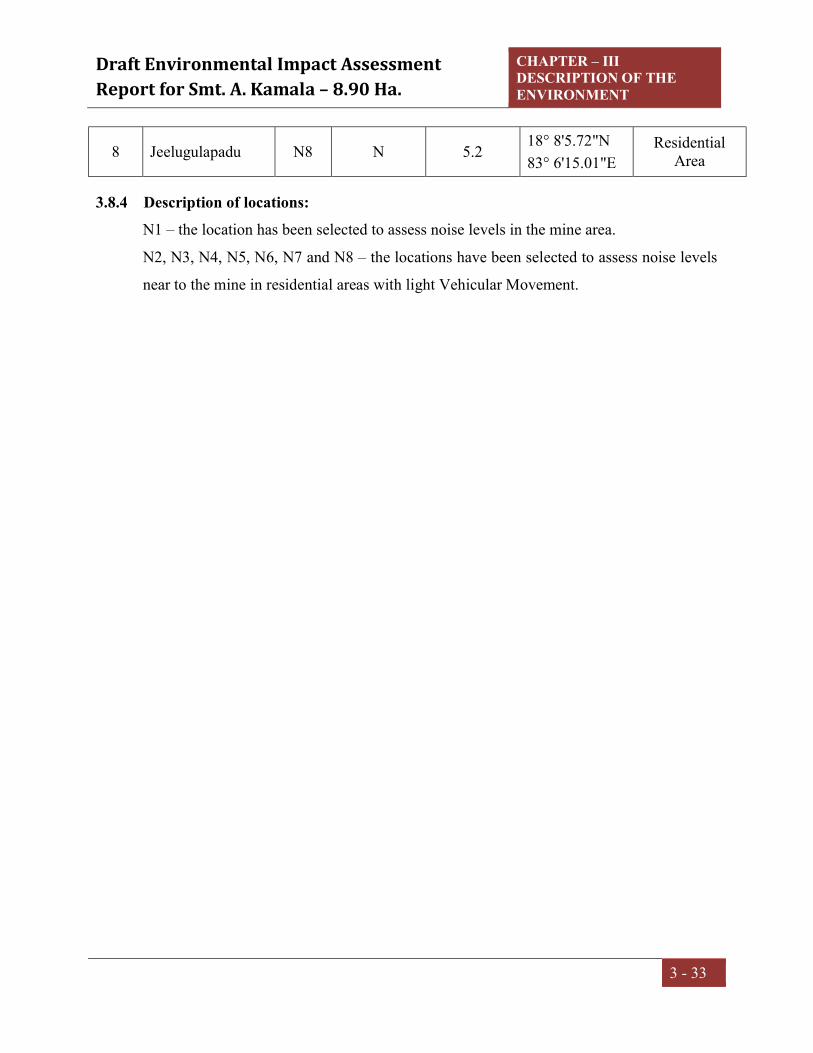
Draft Environmental Impact Assessment Report for Smt. A. Kamala – 8.90 Ha.
CHAPTER – III DESCRIPTION OF THE ENVIRONMENT
3 - 33
8 Jeelugulapadu N8 N 5.2 18° 8'5.72"N 83° 6'15.01"E
Residential Area
3.8.4 Description of locations: N1 – the location has been selected to assess noise levels in the mine area.
N2, N3, N4, N5, N6, N7 and N8 – the locations have been selected to assess noise levels
near to the mine in residential areas with light Vehicular Movement.

Draft Environmental Impact Assessment Report for Smt. A. Kamala – 8.90 Ha.
CHAPTER – III DESCRIPTION OF THE ENVIRONMENT
3 - 34
Fig.3.5 Noise Monitoring Locations

Draft Environmental Impact Assessment Report for Smt. A. Kamala – 8.90 Ha.
CHAPTER – III DESCRIPTION OF THE ENVIRONMENT
3 - 35
3.8.5 Noise levels in the study area The noise level monitored during the study period is given in Table 3.14 in the
form of Lday, Lnight and Ldn compared with CPCB Standards.
Table3.14 Noise levels in the study area
Location Code
Environmental Setting
CPCB norms Leq dB(A) Leq dB(A)
day Leq dB(A)
night Day Night
N1 Project site 75 70 62.3 48.5
N2 Residential 55 45 54.2 42.6
N3 Residential 55 45 54.9 44.3
N4 Residential 55 45 53.6 42.2
N5 Residential 55 45 55.2 43.8
N6 Residential 55 45 60.2 47.5
N7 Residential 55 45 53.5 41.8
N8 Residential 55 45 49.6 35.7

Draft Environmental Impact Assessment Report for Smt. A. Kamala – 8.90 Ha.
CHAPTER – III DESCRIPTION OF THE ENVIRONMENT
3 - 36
Graphical presentation of ambient noise levelsin the study area
62.354.2 54.9 53.6 55.2 60.2
53.5 49.6
75
55
01020304050607080
N1 N2 N3 N4 N5 N6 N7 N8
Noise
Val
ues
Sampling Locations
Equivalent Noise Day Time Leq dB(A)
Leq dB(A) day Industrial Residential
48.542.6 44.3 42.2 43.8 47.5
41.835.7
70
45
01020304050607080
N1 N2 N3 N4 N5 N6 N7 N8
Noise
Val
ues
Sampling Locations
Equivalent Noise Night Time Leq dB(A)
Leq dB(A) night Industrial Residential

Draft Environmental Impact Assessment Report for Smt. A. Kamala – 8.90 Ha.
CHAPTER – III DESCRIPTION OF THE ENVIRONMENT
3 - 37
3.9 GEOLOGY AND HYDROGEOLOGY 3.9.1 Physiography
Topographically the quarry lease area is covered with denudations in the range of 312
m to 802 m above mean sea level. The quarry lease area covered between the 646 m
and 312 m hills on the North and South side of mine area, & 802m hill to the North-
West side of mine area.
3.9.2 Drainage The major rivers that drain the district are Nagavali, Gosthani and Champavathi and
their tributaries viz. Swarnamukhi, Janjavati and Vegavathi. Nagavali, Swarnamukhi
and Vegavathi are perennial in nature and the remaining are of ephemeral type. They
originate in the Eastern Ghats and after flowing through the district, finally join Bay
of Bengal. The drainage exhibits sub-dendritic to dendritic pattern and is of medium
to coarse texture and drainage density is worked out to be 0.6 to 1km/sq.km.
The Nagavali is the main river that flows for 112 KM in the district and joins the sea
near Mofuzbander, Srikakulam district. It is also known as Langulya, has 200 KM of
total length and has a catchment area of 8,964 KM2. It originates in Odisha state and
flows through Komarada, Jiyyammavalasa and Garugubilli mandals before entering in
to Srikakulam district. The important tributaries of the Nagavali River are
Suvarnamukhi, Vegavathi, Janjhavathi and Vottigedda.
The Gostani River originates in the Ananthagiri forest area of Srungavarapukota near
Borra caves. It flows through Jami mandal before entering Visakhapatnam district.
The River Suvarnamukhi originates in the hills of Saluru, flows eastward in Bobbili
area before joining Nagavali River near Palakonda of Srikakulam district. The
Vegavathi River starts from Pachipenta hills of Pachipenta mandal, flows parallel to
Suvarnamukhi before joining Nagavali River.
Notable water bodies either seasonal or perennial are not present in nearby area which
may cause the inundation of quaary. However, suitable storm water garland drainage
system will be adopted to divert the rain water to accumulated into quarry bottom and
provision of suitable dump arrangement wil be provided at the pit bottom for
collection of rain water within the quarry and a proper pumping system will be
adopted at all times for pumping of such water as and when needed. The benches and
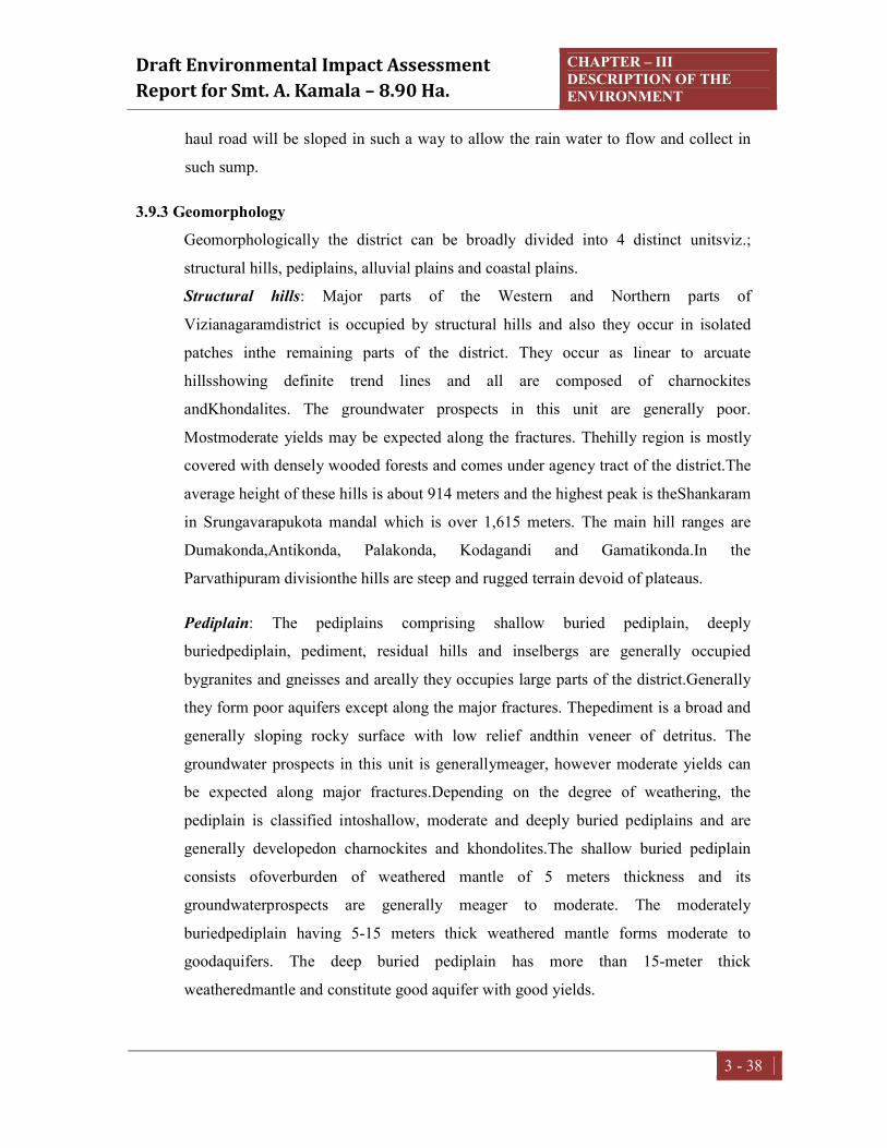
Draft Environmental Impact Assessment Report for Smt. A. Kamala – 8.90 Ha.
CHAPTER – III DESCRIPTION OF THE ENVIRONMENT
3 - 38
haul road will be sloped in such a way to allow the rain water to flow and collect in
such sump.
3.9.3 Geomorphology Geomorphologically the district can be broadly divided into 4 distinct unitsviz.;
structural hills, pediplains, alluvial plains and coastal plains.
Structural hills: Major parts of the Western and Northern parts of
Vizianagaramdistrict is occupied by structural hills and also they occur in isolated
patches inthe remaining parts of the district. They occur as linear to arcuate
hillsshowing definite trend lines and all are composed of charnockites
andKhondalites. The groundwater prospects in this unit are generally poor.
Mostmoderate yields may be expected along the fractures. Thehilly region is mostly
covered with densely wooded forests and comes under agency tract of the district.The
average height of these hills is about 914 meters and the highest peak is theShankaram
in Srungavarapukota mandal which is over 1,615 meters. The main hill ranges are
Dumakonda,Antikonda, Palakonda, Kodagandi and Gamatikonda.In the
Parvathipuram divisionthe hills are steep and rugged terrain devoid of plateaus.
Pediplain: The pediplains comprising shallow buried pediplain, deeply
buriedpediplain, pediment, residual hills and inselbergs are generally occupied
bygranites and gneisses and areally they occupies large parts of the district.Generally
they form poor aquifers except along the major fractures. Thepediment is a broad and
generally sloping rocky surface with low relief andthin veneer of detritus. The
groundwater prospects in this unit is generallymeager, however moderate yields can
be expected along major fractures.Depending on the degree of weathering, the
pediplain is classified intoshallow, moderate and deeply buried pediplains and are
generally developedon charnockites and khondolites.The shallow buried pediplain
consists ofoverburden of weathered mantle of 5 meters thickness and its
groundwaterprospects are generally meager to moderate. The moderately
buriedpediplain having 5-15 meters thick weathered mantle forms moderate to
goodaquifers. The deep buried pediplain has more than 15-meter thick
weatheredmantle and constitute good aquifer with good yields.

Draft Environmental Impact Assessment Report for Smt. A. Kamala – 8.90 Ha.
CHAPTER – III DESCRIPTION OF THE ENVIRONMENT
3 - 39
Alluvial plains: The alluvial plains are developed along major river courses,valleys
and at the feet of structural hills in the district. The alluvial plains alongmajor river
courses are known as floodplains and consist of unconsolidatedgravels, sands, silts
and clays. The flood plains of fairly good thicknessusually form shallow to deep fresh
water aquifers with good to very goodyields. The alluvial plains along valley fills
consists of gravels, sands, silts andclays and the thickness of valley fills is
considerable extending upto 35meters, they are generally capable of giving very high
yields. The occurrenceof alluvial plains in the district is seen partly in the northwest,
northeast and inthe central mid plains and also in the southeast and south western
parts. The plain portion of the district is a well cultivated tract.Flood plains are
restricted to river basin.Thickmantle of flood plain deposits comprising clay and silt
are restricted to the Gostani, Champavathi, Kandivalasa,Vegavathi, Suvarnamukhi
and Nagavali river valleys.
Coastal plains: The coastal plain occurs parallel and nearer to the sea and isof marine
origin consisting of generally saline aquifers except on beach ridgeswhere moderate
to fresh water aquifers occur. The beach ridges are suitablefor construction of very
shallow dug wells of 2-3m.in depth and infiltrationgalleries. Active beach forms a
narrow strip along the coast. Coastal deposits comprising beach sand and dune
sandoccur as a narrow belt of 500 m to 2 km wide along the coast between Konada
and Duvapeta regions.

Draft Environmental Impact Assessment Report for Smt. A. Kamala – 8.90 Ha.
CHAPTER – III DESCRIPTION OF THE ENVIRONMENT
3 - 40
Fig.3.6 Map of the Geomorphology –Vizianagaram district

Draft Environmental Impact Assessment Report for Smt. A. Kamala – 8.90 Ha.
CHAPTER – III DESCRIPTION OF THE ENVIRONMENT
3 - 41
3.9.4 Geology The lease area is not suitable for agriculture as it is strewed with small stones/boulders
and covered with Charnockites /Pyroxene Granulites which is raising up to 78 M
above ground level, the strike length of the body is measured374.43 M in the area with
an average width of 224.14M. The rock type stones have perpendicular jointing, hence
not suitable for colour granites.
Based on these quarry lease litho logical sequence, the pit wall information is Soil
cover up to 0 to 1M from surface RL and Road Metal 1M to 98 M.
Detailed description of geology of lease area: The applied area falls in one discontinuous and isolated hillock system, which comes under Eastern Ghat Tectonic system of Achaean Age group. The study area is characterized by Eastern Ghats mobile belt. The area covered with denudation hills of range between 312 m to 802 m above mean sea level. These Charnockites are grey to greasy in colour, medium to coarse grained with Quartz, Plagioclase feldspar, pyroxenes, biotite and Fe-oxidies. The rock has horizontal and Vertical Joints. These Charnockites are best suited for Building stone and road metal as they have low permeability, medium to high load bearing capacity and good foundation characteristics. The Building Stone and Road Metal produced in the area cater to the needs of civil constructions in and around Vizianagaram for infrastructural works, construction projects etc. Mariki hillocks in South-Western side and Kokkulabanda Hillock in North Western side are two important hill ranges Eastern Ghats prove to be a store-house of many valuable mineral resources which are coming to light year by year.
Regional Geology: The applied area falls in one discontinuous and isolated hillock system, which comes
under Eastern Ghat Tectonic system of Achaean Age group. The study area is characterized by Eastern Ghats mobile belt. The area covered with denudation hills of
range between 312 m to 802 m above mean sea level. Kondakindam hillocks in
Northern side and Vendram Hillock in North Eastern side are two important hill
ranges Eastern Ghats prove to be a store-house of many valuable mineral resources
which are coming to light year by year. Garnet-sillimanitebiotite gneisses, Pyroxene
Granulites (Charnockites), garnetiferous granites (Leptynites), quartizites and

Draft Environmental Impact Assessment Report for Smt. A. Kamala – 8.90 Ha.
CHAPTER – III DESCRIPTION OF THE ENVIRONMENT
3 - 42
pegmatite's are the chief rock types that occur as bedded and banded as well as
massive formations in the study area. The Eastern Ghats complex mainly comprises of
Khondalite suites with a set of sub-suites. Intrusive activity might have caused
migmatisation. The terrain must have subjected to cycles of metamorphism. The local
geology shows the occurrence of Granite gneisses, Charnockite, Khondalite, Quartz
and soil. The following is the local stratigraphy of the mining lease area. Quartz
(intrusive), Granite gneisses, Charnockite (Charnockite Group), and Khondalite is the dominant rock type of the area. It is olden metamorphic schistose rock with garnet,
sillimanite, graphite, Feldspar, Quartz and Biotite as essential minerals and Garnets,
Mica, Hornblends are accessory minerals. Charnockites are fresh looking light
coloured, showing schistosity consisting Quartz, Feldspars, Garnet and Sillimanite
schist. Alternate alignment of leuco and melanocratic minerals attains gnessic
property. Garnet is also observed as discrete grains of reddish, brown, colour and
equigranular texture. The formation is highly structural disturbed with joints, fractures
and thickly penetrated with weather in influences.
3.9.5 Hydrogeology
The hydrogeological conditions prevailing in the district generallydepends on various
factors like climate, rainfall, topography, geological settingand structure. In turn the
occurrence and movement of groundwater alsodepend on these factors. The rocks
occurring in the district can be broadlyclassified as two types viz; hard and soft rocks.
Crystalline formations likekhondolites, charnockites, migmatites and gneisses etc. can
be grouped ashard rocks, while the unconsolidated formations like the alluvial
sedimentscan be classified as soft rocks. The semi consolidated formations
likesandstones are grouped under soft rocks, though limited in occurrence. The
hydrogeololgical conditions in the district are presented in Figure 3.7.

Draft Environmental Impact Assessment Report for Smt. A. Kamala – 8.90 Ha.
CHAPTER – III DESCRIPTION OF THE ENVIRONMENT
3 - 43
Fig.3.7 Map of the Hydrogeology –Vizianagaram district
3.10 LAND USE/LAND COVER
The Land Use / Land Cover (LULC) pattern of any region is an outcome of various
physical and cultural factors and their utilization by a man in time and space. Land
use refers to the type of utilization to which man has put the land. It also refers to the
evaluation of the land with respect to various natural characteristics. But land cover
describes the vegetal attributes of land. Land use/land cover data is essential for
planners, decision makers and those concerned with land resources management. For
the proper understanding of the influence of the various human-induced land use
practices with regard to the environmental change, it is essential to help simulate the
land use changes. Remote sensing technology is considered the most effective as it
provides timely and authentic information about the spatial distribution of land
use/land cover, while Geographical Information System (GIS) provides a flexible
digital environment for collecting, storing, visualizing and analyzing the spatial data.
Remote sensing as a vital tool helps for rapid assessment and monitoring of a natural

Draft Environmental Impact Assessment Report for Smt. A. Kamala – 8.90 Ha.
CHAPTER – III DESCRIPTION OF THE ENVIRONMENT
3 - 44
resource. When combined with GIS, it makes it possible to map land use/cover
phenomena in detail for further planning, development, and decision-making, which
is essential for meeting the increasing demands and welfare of the ever-growing
population
Land use Land Cover map is prepared by adopting interpretation techniques of the
image classification. Image classification has been done by using supervised
classification of satellite images by running an training sample manage based on
colours, various activities has been included in the preparation of Land Use Land
Cover Maps such as Satellite Image/Data Acquisition, Preprocessing, Rectification,
Ground Truthing etc., Satellite Images are processed and producing LULC maps are
being done by using Arc GIS 10.6.
The basic purpose of land use pattern and classification in an EIA study is to identify
the manner in which different parts of land area is utilized or not utilized. Remote
sensing data provides reliable accurate baseline information for land use mapping as
it is a rapid method of acquiring up-to-date information of over a large geological
area.
Studies on land use aspects of eco-system play an imperative role in identifying
susceptible issues and to take appropriate action to uphold ecological equilibrium in
the region. The main objective of this section is to provide a baseline status of the
study area covering 10 km radius around the mining site so that temporal changes due
to the industrial activities on the surroundings can be assessed in future.
The objectives of Land use Pattern are to:
Determine the present Land use pattern
Analyze the impacts on Land use due to the mining site in the study area
Study area with proposed unit as epicentre 10 km radius from the core area is
considered for land use study.
3.10.1 Methodology:
The overall methodology (Fig 3.8) adopted and followed to achieve the objectives of
the present study involves the following:

Draft Environmental Impact Assessment Report for Smt. A. Kamala – 8.90 Ha.
CHAPTER – III DESCRIPTION OF THE ENVIRONMENT
3 - 45
Procurement of Satellite images.
Collection of source data of Survey of India (SOI) toposheets. These are the
main inputs for the preparation of essential layers.
Atmospheric and Radiometric corrections of Satellite data by using nearest
neighborhood resampling technique
Preparation of basic themes like layout map, transport & settlement map and
contour map from the source data. Then updating of layout map, transport map
and drainage map from the satellite image by visual interpretation
Performing image analysis in ArcGIS and Extraction of whole satellite image
into study area, processing and producing various maps such as LULC, Contour
Maps, Digital Elevation Maps, Drainage Maps
Preliminary quality check and necessary corrections are carried out for all the
maps.

Draft Environmental Impact Assessment Report for Smt. A. Kamala – 8.90 Ha.
CHAPTER – III DESCRIPTION OF THE ENVIRONMENT
3 - 46
Figure – 3.8: Methodology
LULC Study:
The LULC Study has been done for the 10km radius area from the project site by
using visual interpretation techniques in Arc GIS 10.6. Output of the map has been
provided in 1:50000 scale, along with LULC MAP 10KM Radius False Colour
Composite Map provided below.
Procurement of Satellite Data
SOI Toposheets
Processing of Satellite Images (Radiometric & Atmospheric Corrections )
Ground Truthing
Classification of Accuracy Assessment
Necessary Corrections and Finalizing maps
Image Analysis
Extraction of Study Area
Processing and Producing Various Maps

Draft Environmental Impact Assessment Report for Smt. A. Kamala – 8.90 Ha.
CHAPTER – III DESCRIPTION OF THE ENVIRONMENT
3 - 47
Fig 3.9 Satellite Image within 10 km radius

Draft Environmental Impact Assessment Report for Smt. A. Kamala – 8.90 Ha.
CHAPTER – III DESCRIPTION OF THE ENVIRONMENT
3 - 48
Fig 3.10False colour composite map within 10 km radius

Draft Environmental Impact Assessment Report for Smt. A. Kamala
Interpretation
The area distributions along with percentage of different land use classes are listed
below table and Fig 3.12.
Total study area for the mining
use class covered by Forest area
landand Plantation11481
occupied 4.59%& 0.92%
respectively.Out of all mined out area
(74 Ha).
S.No. Land Use/Land Cover1 Agricultural land
2 Builtup area
3 Forest area
4 Minedout area
5 Plantation6 Waterbody
Total
Figure 3.11: Graphical representation of Land Use and Land Cover
43.53 %
0.23 %
Agricultural land
Minedout area
Draft Environmental Impact Assessment Smt. A. Kamala – 8.90 Ha.
CHAPTER – III DESCRIPTION OF THE ENVIRONMENT
The area distributions along with percentage of different land use classes are listed
.
mining project is 32817 Ha. Out of that major portion of land
Forest area i.e., 14284 Ha (43.53%), followed by
Plantation11481 Ha, 5168 Ha respectively. Builtup area and Waterbody
& 0.92% of the total area which covering1507 Ha
mined out area covers least percentage of the area that is
Land Use/Land Cover Area, Ha Percentage, %Agricultural land 11481 34.98
Builtup area 1507 4.59
Forest area 14284 43.53
Minedout area 74 0.23
Plantation 5168 15.75 Waterbody 302 0.92
32817 100
: Graphical representation of Land Use and Land Cover
34.98 %
4.59 %43.53 %
0.23 %15.75 % 0.92 %
Land use Statistics
Agricultural land Builtup area Forest area
Minedout area Plantation Waterbody
III DESCRIPTION OF THE ENVIRONMENT
3 - 49
The area distributions along with percentage of different land use classes are listed
Ha. Out of that major portion of land
%), followed by Agriculture
and Waterbody
and 302 Ha
covers least percentage of the area that is 0.23%
Percentage, %
: Graphical representation of Land Use and Land Cover

Draft Environmental Impact Assessment Report for Smt. A. Kamala – 8.90 Ha.
CHAPTER – III DESCRIPTION OF THE ENVIRONMENT
3 - 50
Fig 3.12 Land use/Land cover map

Draft Environmental Impact Assessment Report for Smt. A. Kamala – 8.90 Ha.
CHAPTER – III DESCRIPTION OF THE ENVIRONMENT
3 - 51
3.10.2 Digital Elevation Maps A digital elevation model (DEM) is a digital representation of ground surface
topography or terrain. It is also widely known as a digital terrain model (DTM). A
DEM file can be downloaded from the ISRO Bhuvan (Cartosat Satellite) Digital
Elevation maps are a type of raster GIS Layer. In a DEM each cell having a value
corresponding to its elevation. By adding Hill shading tool a reader can see the
relationship between terrain and other things. Digital Elevation Model or Digital
Terrain Model map has been shown in the Fig – 3.13.
3.10.3 Contour Map A contour line connects a series of equal elevation points, the contours have been
generated in the GIS environment with reference to the mean sea level by using the
DEM (Digital Elevation Model) data, the elevation values has been verified.
Thereafter final contour map has been prepared with combination of Toposheet and
DEM with contour interval of 10 m. In the study area highest contour observed as
1050m of MSL that is situated towards North west direction of the project site and
lowest contour is 50 m of MSL that is situated towards South east direction of the
project site. Contour Map for the mining project study area has been shown in the
below Fig 3.14.
3.10.4 Drainage Map Drainage Map for the study area has been developed in the GIS Environment by using
Digital Elevation Model. Methodology involved for producing of Drainage maps has
been discussed below.
Strahler method of ordering is used for developing drainage map for the study area.
Based on the elevation profiles of the study area drains will be formed as First order,
Second Order, Third Order and so on. Some of the artificial water bodies (Aqueducts,
Man Made Canals) have been traced out by using google earth and Survey of India
Topomaps. Accuracy of the maps will be checked by using Ground Truthing
Technique. Drainage map for the project site and study area is as shown in the Fig
3.15.

Draft Environmental Impact Assessment Report for Smt. A. Kamala – 8.90 Ha.
CHAPTER – III DESCRIPTION OF THE ENVIRONMENT
3 - 52
Fig 3.13 Digital Elevation map

Draft Environmental Impact Assessment Report for Smt. A. Kamala – 8.90 Ha.
CHAPTER – III DESCRIPTION OF THE ENVIRONMENT
3 - 53
Fig 3.14 Contour map
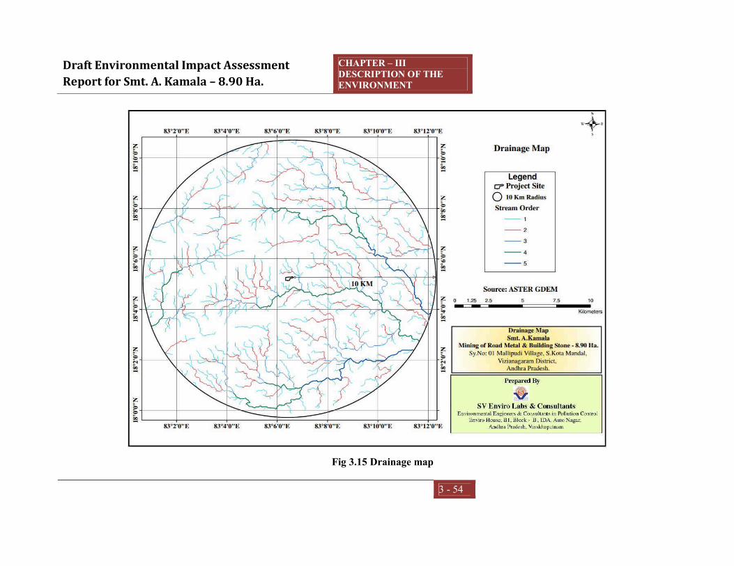
Draft Environmental Impact Assessment Report for Smt. A. Kamala – 8.90 Ha.
CHAPTER – III DESCRIPTION OF THE ENVIRONMENT
3 - 54
Fig 3.15 Drainage map

Draft Environmental Impact Assessment Report for Smt. A. Kamala – 8.90 Ha.
CHAPTER – III DESCRIPTION OF THE ENVIRONMENT
3 - 55
3.11 BIOLOGICAL ENVIRONMENT Introduction Collection of comprehensive baseline information on flora and fauna is the
prerequisite for assessment of impacts of any developmental activities. Ecological
environment is an important component of environment of any area. It covers flora
and fauna in the region, details of forests and wild life sanctuaries in the region, with
list of endangered species.
The loss of biological diversity has become a national and a global concern over the
years. Ecological assessment therefore is very critical for decision-making and for the
getting of a developmental projects or industries. An ecological study of the
ecosystem is essential to understand the impacts of industrialization and urbanization
on existing flora and fauna of the area. Studies on various aspects of ecosystem play
an important role in identifying sensitive issues for undertaking appropriate action to
mitigate the impact, if any. The objective of this section is characterized to understand
the present status of the ecosystems in the study area to assess the biodiversity.
Objectives (i) To study the present ecological and biodiversity of core and buffer zones of
project areas
(ii) To generate baseline data on flora and fauna of core and buffer zones with
assessment of possible impacts
(iii) To suggest a mitigation plan for biodiversity in core and buffer zones.
Study area The study area is secondary dry deciduous forest in which all trees are growing with
less than 30cm girth. The primary forest completely degraded due to anthropogenic
activities. The tree begin to shed their leaves by about December and between
February and May the forest looks very open and at times eye-soaring, but some areas
are bald hills in the study area. Flowering and fruiting are generally far advanced
before the first flush of new leaves appears with the conventional showers in April-
May.

Draft Environmental Impact Assessment Report for Smt. A. Kamala – 8.90 Ha.
CHAPTER – III DESCRIPTION OF THE ENVIRONMENT
3 - 56
Diospyros sylvatica is perhaps the commonest tree in this area. Wrightia tinctoria,
Cochlospermum religiosum, Gardenia latifolia, Sterculia urens, Strychnos potatorum,
Ziziphus xylopyrus, Terminalia spp., Chloroxylon swietenia, Pterospermum
xylocarpum, Albizia chinense,Cassia fistula, Diospyros melanoxylon etc. are some of
the typical trees;Flaucortia indica, Gmelina asiatica and Naringi crenulata are armed
trees present, at the edges of the mine.Holarrhena antidysenterica,Alangium
salvifolium, Bauhinia racemosa, Tarenna asiatica, Flacourtia indica, Helicteris isora,
Woodfordia fruticosa, Grewia rothii etc. are some of the common small trees found in
this area.
A number climbers and twiners are found in this type of forests. To mention, some of
them areButea superba, Cansjera rheedii, Celastrus paniculatus, Combretum
ovalifolium, Dioscorea spp., Pueraria tuberosa, Ventilago denticulata, Mucuna spp.
etc.
The ground flora is mostly seasonal. Achyranthes aspera, Aerva sanguinolenta, Sida
glutinosa, Solanum indicum, Scilla hyacinthina, Habenaria roxburghii etc. are some
of the common examples.
Forest blocks in studyarea
The details of forest blocks in study area are presented below in the Table 3.15Small
plantations agro forestrycould also be seen in the buffer zone of the projecti.e.
Anacardium occidentale, Tectona grandis and Mangifera indica.
Table 3.15 Details of the forest blocks in the study area
S.No Details of forest blocks Distance (KM) Direction 1 Ananthagiri Reserved Forest 0.57 N & NW 2 Mariki Reserved Forest 2.0 SW
Cropping pattern The agriculture is dependent on the moderate monsoon. Irrigation facilities in form of
canals/ponds/wells are available in the study area. The main crop of the area is paddy.
The area under major field crops and horticulture is given in Table 3.16.

Draft Environmental Impact Assessment Report for Smt. A. Kamala – 8.90 Ha.
CHAPTER – III DESCRIPTION OF THE ENVIRONMENT
3 - 57
Table 3.16 Area under major field crop & Horticulture in the study area
S.No. Particulars Major field crop cultivated
1 Paddy 2 Horse gram 3 Green gram 4 Black gram 5 Groundnut 6 Sugarcane
Horticulture crops - fruits 1 Mango 2 Citrus 3 Cashew 4 Coconut 5 Banana
Horticulture crops - Vegetables 1 Tomato 2 Onion 3 Sweet potato 4 Vegetables
Medicinal and Aromatic crops 1 Garlic 2 Turmeric 3 Ginger 4 Coriander
Plantation crops 1 Eucalyptus 2 Teak 3 Casurina
Methodology Flora Vegetation and plant species composition observed and documented during field visit
in and around the mining siteduring study period. Besides primary surveys in the
mining site, published literature and various floras were consulted to prepare an
inventory of plant species growing at project sites. The vegetation of the study area is
highly degraded. The plant diversity is classified into various plant groups such as
tree, shrubs, herbs, climbers, sedges and grasses. The plant diversity survey in the
project area was undertaken during the summer season with the objectives of
preparing a checklist of flora in the study area.

Draft Environmental Impact Assessment Report for Smt. A. Kamala – 8.90 Ha.
CHAPTER – III DESCRIPTION OF THE ENVIRONMENT
3 - 58
Fauna Information pertaining to the existence of migratory corridors and breeding habitats of
endangered and threatened fauna were assessed based on the information provided
by the local inhabitants and forest department personnel. The conservation status of
each faunal species recorded from the project areas were ascertained as per schedules
of Indian wildlife (protection) Act, 1972 and IUCN -Red Data Book (RDB).The
survey of faunal elements of core and buffer zone were assessed as per the following
sampling techniques:
Taxa Sampling techniques Butterflies Random walk, Opportunistic observations Amphibians Visual encounter survey (Search) Reptiles Visual encounter survey (Search) Birds Random walk, Opportunistic observations Mammals Tracks and Signs, and Fishes Landings
Flora of the Core zone The core zone comprises of hill, where mining operation is being carried out. This
area consists of secondary forest in which Diospyros sylvatica, Pterospermum
xylocarpum, Lannea coromandelica and Garuga pinnata are common trees. No
ecologically sensitive and threatened plant species has been reported from this area.
The checklist of plants given in the Table 3.16.
Table 3.16 List of plant species observed in core area of the project
S.No. Botanical name Family Local name Habit 1 Abrus precatorius L. Fabaceae Gurivinja Climber 2 Abutilon indicum (L.) Sweet Malvaceae Tuthurabenda Shrub 3 Acacia leucophloea (Roxb.) Willd. Mimosaceae Tella thumma Tree 4 Acalypha indica L. Euphorbiaceae Muripindi Herb 5 Achyranthes aspera L. Amaranthaceae Duchena Herb 6 Aerva lanata (L.) Juss. Amaranthaceae Pindikura Herb 7 Aganosma caryophyllata G.Don Apocynaceae Mogari Climber 8 Alangium salviifolium (L.f.)
Wangerin Alangiaceae Udugu Tree
9 Albizia chinensis (Osbeck) Merr. Mimosaceae Nalla regi Tree 10 Albizia odoratissima (L.f.) Benth. Mimosaceae Ganara Tree 11 Alloteropsis cimicina (L.) Stapf Poaceae - Grass

Draft Environmental Impact Assessment Report for Smt. A. Kamala – 8.90 Ha.
CHAPTER – III DESCRIPTION OF THE ENVIRONMENT
3 - 59
12 Alysicarpus monilifer (L.) DC. Fabaceae Amera Herb 13 Andrographis paniculata (Burm.f.)
Nees Acanthaceae Nela vemu Herb
14 Antidesma acidum Retz. Stilaginaceae Pulleru Tree 15 Apluda mutica L. Poaceae - Grass 16 Argyreia nervosa (Burm. f.) Bojer Convolvulaceae Samudra pala Climber 17 Aristida funiculata Trin. & Rupr. Poaceae Cheepurugaddi Grass 18 Aristolochia indica L. Aristolochiaceae Nall eswari Herb 19 Asparagus racemosus Willd. Liliaceae Pilli tigalu Herb 20 Asystasia gangetica (L.)
T.Anderson Acanthaceae - Herb
21 Atalantia monophylla DC. Rutaceae Karu nimma Tree 22 Atylosia scarabaeoides (L.) Benth. Fabaceae - Herb 23 Azadirachta indica A.Juss. Meliaceae Vepa Tree 24 Bauhinia racemosa Lam. Caesalpiniaceae Are Tree 25 Biophytum sensitivum (L.) DC. Oxalidaceae Jala puspa Herb 26 Boerhavia diffusa L. Nyctaginaceae Atikamamidi Herb 27 Spermacoce hispida L. Rubiaceae Nadana Herb 28 Brachiaria ramosa (L.) Stapf Poaceae - Grass 29 Breynia vitis-idaea (Burm.f.)
C.E.C.Fisch. Euphorbiaceae Tella pulcheri Shrub
30 Bridelia montana (Roxb.) Willd. Euphorbiaceae Balli chettu Tree 31 Bridelia retusa (L.) A.Juss. Euphorbiaceae Anemu Tree 32 Buchanania lanzan Spreng. Anacardiaceae Jarumamidi Tree 33 Bulbostylis barbata (Rottb.)
C.B.Clarke Cyperaceae - Sedge
34 Butea superba Roxb. Fabaceae Tiga moduga Climber 35 Calotropis gigantea (L.) Dryand. Asclepiadaceae Jilledu Shrub 36 Canthium dicoccum (Gaertn.) Merr. Rubiaceae Alli Tree 37 Canthium parviflorum Lam. Rubiaceae Balusu Shrub 38 Capparis zeylanica L. Capparidaceae Uppi Shrub 39 Careya arborea Roxb. Lecythidaceae Kumbi Tree 40 Carissa carandas L. Apocynaceae Vaka Shrub 41 Casearia elliptica Willd. Flacourtiaceae Chilakaya Shrub 42 Casearia tomentosa Roxb. Flacourtiaceae Gidiguru Tree 43 Cassia auriculata L. Caesalpiniaceae Tangedu Shrub 44 Cassia fistula L. Caesalpiniaceae Rela Tree 45 Cassia occidentalis L. Caesalpiniaceae Kasinda Herb 46 Cassia tora L. Caesalpiniaceae Tantemu Herb 47 Cayratia auriculata (Roxb.) Gamble Vitaceae Mura palleru Climber 48 Chloris barbata Sw. Poaceae - Grass

Draft Environmental Impact Assessment Report for Smt. A. Kamala – 8.90 Ha.
CHAPTER – III DESCRIPTION OF THE ENVIRONMENT
3 - 60
49 Chloroxylon swietenia DC. Flindersiaceae Billa Tree 50 Chromolaena odorata (L.)
R.M.King & H.Rob. Asteraceae Kampu rodda Shrub
51 Cipadessa baccifera (Roth) Miq. Meliaceae Ranaberi Tree 52 Cleistanthus collinus (Roxb.) Benth.
ex Hook.f. Euphorbiaceae Vadisa Tree
53 Clerodendrum serratum (L.) Moon Verbenaceae Bharangi Shrub 54 Clitoria ternatea L. Fabaceae Sanku puspamu Climber 55 Cocculus hirsutus (L.) W.Theob. Menispermaceae Dusarituga Climber 56 Cochlospermum religiosum (L.)
Alston Cochlospermaceae Konda gogu Tree
57 Commelina benghalensis L. Commelinaceae - Herb 58 Corchorus acutangulus Lam. Tiliaceae Nela bera Herb 59 Costus speciosus (J.König) Sm. Costaceae Bogachika dumpa Herb 60 Crotalaria laburnifolia L. Fabaceae Pedda giligicha Herb 61 Crotalaria verrucosa L. Fabaceae Giligicha Herb 62 Croton bonplandianus Baill. Euphorbiaceae Galivana Herb 63 Cynodon dactylon (L.) Pers. Poaceae Gariki Grass 64 Dactyloctenium aegyptium (L.)
Willd. Poaceae - Grass
65 Dalbergia paniculata Roxb. Fabaceae Saibothu Tree 66 Dendrophthoe falcata (L.f.)
Ettingsh. Loranthaceae - Tree
67 Desmodium gangeticum (L.) DC. Fabaceae Kola panna Herb 68 Desmodium triflorum (L.) DC. Fabaceae Munta mandhu Herb 69 Dichrostachys cinerea (L.) Wight &
Arn. Mimosaceae Veluthuru Tree
70 Digera muricata (L.) Mart. Amaranthaceae Chenchalikura Herb 71 Dioscorea bulbifera L. Dioscoreaceae Karukanda Climber 72 Dioscorea pentaphylla L. Dioscoreaceae Tella gadda Climber 73 Dioscorea tomentosa J.Koenig ex
Spreng. Dioscoreaceae Tiga dumpa Climber
74 Diospyros chloroxylon Roxb. Ebenaceae Thorika Tree 75 Diospyros melanoxylon Roxb. Ebenaceae Thummika Tree 76 Diospyros sylvatica Roxb. Ebenaceae Gatha Tree 77 Dipteracanthus prostratus (Poir.)
Nees Acanthaceae - Herb
78 Dolichandrone atrovirens (Roth) K.Schum.
Bignoniaceae Tree
79 Eclipta prostrata (L.) L. Asteraceae Guntagalagara Herb 80 Emilia sonchifolia (L.) DC. ex DC. Asteraceae - Herb 81 Euphorbia antiquorum L. Euphorbiaceae Benta jemudu Tree

Draft Environmental Impact Assessment Report for Smt. A. Kamala – 8.90 Ha.
CHAPTER – III DESCRIPTION OF THE ENVIRONMENT
3 - 61
82 Euphorbia hirta L. Euphorbiaceae Reddi vari nanubalu
Herb
83 Evolvulus alsinoides (L.) L. Convolvulaceae Vishnukrantha Herb 84 Evolvulus nummularius (L.) L. Convolvulaceae - Herb 85 Ficus hispida L.f. 86 Ficus racemosa L. Moraceae Medi Tree 87 Ficus semicordata Buch.-Ham. ex
Sm. Moraceae Bommala marri Tree
88 Ficus tomentosa Roxb. ex Willd. Moraceae Tree 89 Flacourtia indica (Burm.f.) Merr. Flacourtiaceae Kanaregu Tree 90 Gardenia latifolia Aiton Rubiaceae Bikki Tree 91 Garuga pinnata Roxb. Burseraceae Garugu Tree 92 Gisekia pharnaceoides L. Aizoaceae Isaka dintikura Herb 93 Glycosmis mauritiana (Lam.)
Tanaka Rutaceae Golugu Shrub
94 Gmelina arborea Roxb. Verbenaceae Gummidi Tree 95 Gmelina asiatica L. Verbenaceae Salla gummidi Tree 96 Grewia rothii DC. Tiliaceae Pedda chipuru Tree 97 Grewia tiliifolia Vahl Tiliaceae Tada Tree 98 Gynura lycopersicifolia DC. Asteraceae - Herb 99 Gyrocarpus americanus Jacq. Hernandiaceae Poliki Tree
100 Oldenlandia corymbosa L. Rubiaceae - Herb 101 Helicteres isora L. Sterculiaceae Chemali-Nara Shrub 102 Holarrhena pubescens Wall. ex
G.Don Apocynaceae Tedla pala Tree
103 Hybanthus enneaspermus (L.) F.Muell.
Violaceae Ratna purusa Herb
104 Hyptis suaveolens (L.) Poit. Lamiaceae Simathulasi Herb 105 Ipomoea hederifolia L. Convolvulaceae Kasirathnam Herb 106 Ipomoea obscura (L.) Ker Gawl. Convolvulaceae Nalla kokita Herb 107 Ixora pavetta Roxb. Rubiaceae Kolimi Tree 108 Jatropha gossypiifolia L. Euphorbiaceae Seema nepalamu Herb 109 Justicia betonica L. Acanthaceae Tellarantu Herb 110 Justicia glauca Rottler Acanthaceae Konda pindi Herb 111 Lagerstroemia parviflora Roxb. Lythraceae Chennangi Tree 112 Lannea coromandelica (Houtt.)
Merr. Anacardiaceae Gumpena Tree
113 Lantana camara L. Verbenaceae Gajukampa Shrub 114 Leucas cephalotes (Roth) Spreng. Lamiaceae Thummi Herb 115 Lindernia anagallis (Burm.f.)
Pennell Scrophulariaceae - Herb
116 Lindernia crustacea (L.) F.Muell. Scrophulariaceae - Herb

Draft Environmental Impact Assessment Report for Smt. A. Kamala – 8.90 Ha.
CHAPTER – III DESCRIPTION OF THE ENVIRONMENT
3 - 62
117 Litsea glutinosa (Lour.) C.B.Rob. 118 Ludwigia perennis L. Onagraceae - Herb 119 Maba buxifolia (Rottb.) Pers. Ebenaceae Pisini Tree 120 Mallotus philippensis (Lam.)
Müll.Arg. Euphorbiaceae Sindhuaram Tree
121 Mangifera indica L. Anacardiaceae Mamidi Tree 122 Manilkara hexandra (Roxb.)
Dubard Sapotaceae Palachettu Tree
123 Martynia annua L. Pedlaiaceae Geddagoru Shrub 124 Maytenus emarginata (Willd.) Ding
Hou Celastraceae Danti Shrub
125 Memecylon edule Roxb. Melastomataceae Alli Tree 126 Merremia tridentata (L.) Hallier f. Convolvulaceae Suraputiga Herb 127 Mimosa pudica L. Mimosaceae Attipatti Herb 128 Mimosa rubicaulis Lam. Mimosaceae Korendum Shrub 129 Mimusops elengi L. Sapotaceae Pogada Tree 130 Mitragyna parvifolia (Roxb.) Korth. Rubiaceae Nirkadamba Tree 131 Momordica charantia L. Cucurbitaceae Kakara Climber 132 Morinda pubescens Sm. Rubiaceae Togaru Tree 133 Mucuna pruriens (L.) DC. Fabaceae Dulagondi Climber 134 Mollugo nudicaulis Lam. Aizoaceae Pedda paripata Herb 135 Mollugo pentaphylla L. Aizoaceae Verri chatarasi Herb 136 Naringi crenulata (Roxb.) Nicolson Rutaceae Torru velaga Tree 137 Ochna obtusata DC. Ochnaceae Tammi Tree 138 Oplismenus burmannii (Retz.)
P.Beauv. Poaceae - Grass
139 Oxalis corniculata L. Oxalidaceae Puli chinta Herb 140 Pavetta tomentosa Roxb. ex Sm. Rubiaceae Tella papidi Shrub 141 Pavonia zeylanica (L.) Cav. Malvaceae Karu benda Herb 142 Pedalium murex L. Pedlaiaceae Enugu palleru Herb 143 Pergularia daemia (Forssk.) Chiov. Asclepiadaceae uriti tiga Climber 144 Perotis indica (L.) Kuntze Poaceae Nakka thoka Grass 145 Phyllanthus amarus Schumach. &
Thonn. Euphorbiaceae Nela usiri Herb
146 Phyllanthus reticulatus Poir. Euphorbiaceae Nalla pulugudu Shrub 147 Plumbago zeylanica L. Plumbaginaceae Chitra mulamu Herb 148 Polyalthia cerasoides (Roxb.) Bedd. Annonaceae Chilka dudduga Tree 149 Polyalthia suberosa (Roxb.)
Thwaites Annonaceae Chilka dudduga Tree
150 Polycarpaea corymbosa (L.) Lam. Caryophyllaceae Rajuma Herb 151 Premna latifolia Roxb. Verbenaceae Nelli Tree 152 Premna tomentosa Willd. Verbenaceae Kokkitha Tree

Draft Environmental Impact Assessment Report for Smt. A. Kamala – 8.90 Ha.
CHAPTER – III DESCRIPTION OF THE ENVIRONMENT
3 - 63
153 Protium serratum (Wall. ex Colebr.) Engl.
Burseraceae Chitrek chettu Tree
154 Pseudarthria viscida (L.) Wight & Arn.
Fabaceae Muyak Herb
155 Pterospermum xylocarpum (Gaertn.) Santapau & Wagh
Sterculiaceae Lolugu Tree
156 Rhynchosia minima (L.) DC. Fabaceae - Herb 157 Rothia indica (L.) Druce Fabaceae - Herb 158 Sapindus emarginatus Vahl Sapindaceae Kunkudu Tree 159 Schleichera oleosa (Lour.) Merr. Sapindaceae Busi chettu Tree 160 Securinega virosa (Roxb. ex Willd.)
Baill. Euphorbiaceae Tella puplcheri Shrub
161 Semecarpus anacardium L.f. Anacardiaceae Nalla jeedi Tree 162 Sida acuta Burm.f. Malvaceae Gayapaku Herb 163 Sida cordifolia L. Malvaceae Chiru benda Herb 164 Solanum torvum Sw. Solanaceae Vusti Shrub 165 Sphaeranthus indicus L. Asteraceae Kukka pogaku Herb 166 Stachytarpheta jamaicensis (L.)
Vahl Verbenaceae - Herb
167 Sterculia urens Roxb. Sterculiaceae Kondathamara Tree 168 Streblus asper Lour. Moraceae Barnika Tree 169 Strychnos nux-vomica L. Loganiaceae Mushidi Tree 170 Strychnos potatorum L.f. Loganiaceae Indupu Tree 171 Syzygium cumini (L.) Skeels Myrtaceae Neredu Tree 172 Tamarindus indica L. Caesalpiniaceae Chinta Tree 173 Tephrosia purpurea (L.) Pers. Fabaceae Vempali Herb 174 Teramnus labialis (L.f.) Spreng. Fabaceae Masha parni Herb 175 Terminalia alata Roth Combretaceae Nallamaddi Tree 176 Terminalia bellirica (Gaertn.) Roxb. Combretaceae Thadi chettu Tree 177 Terminalia chebula Retz. Combretaceae Karaka Tree 178 Thysanolaena maxima (Roxb.)
Kuntze Poaceae Konda cheepuru
gaddi G
179 Tiliacora acuminata Miers Menispermaceae Kappa teega Cl 180 Tragia involucrata L. Euphorbiaceae Duradagondi Herb 181 Tridax procumbens (L.) L. Asteraceae Gaddi chamanti Herb 182 Triumfetta rhomboidea Jacq. Tiliaceae Chiru sitrika Herb 183 Tylophora indica (Burm. f.) Merr. Asclepiadaceae Gori pala Herb 184 Urena lobata L. Malvaceae Nalla benda Herb 185 Vernonia cinerea (L.) Less. Asteraceae - Herb 186 Woodfordia fruticosa (L.) Kurz Lythraceae Jeguru Shrub 187 Wrightia tinctoria R.Br. Apocynaceae Ankudu Tree 188 Xylia xylocarpa (Roxb.) Taub. Mimosaceae Konda tangini Tree

Draft Environmental Impact Assessment Report for Smt. A. Kamala – 8.90 Ha.
CHAPTER – III DESCRIPTION OF THE ENVIRONMENT
3 - 64
189 Ziziphus mauritiana Lam. Rhamnaceae Regu Tree 190 Ziziphus oenopolia (L.) Mill. Rhamnaceae Parimi Climber 191 Ziziphus xylopyrus (Retz.) Willd. Rhamnaceae Gotti chettu Tree
Flora of the buffer zone Buffer zone of the proposed project is mainly forest and agricultural land. The flora of
buffer zone comprises of Wrightia tinctoria, Hollarhena pubescens, Diospyros
sylvatica, Pterospermum xylocarpum, Lannea coromandelica, Cassia fistula, Gmelina
arborea and Garuga pinnata trees are growing. Many tree species are planted in the
area because of their usefulness, economic and aesthetic values. The tree species
observed in the area are, Mangifera indica, Albizia lebbeck, Bombax ceiba, Sapindus
emarginatus, and Tamarindus indica etc. Flora of the buffer zone provided in the
Table 3.17.
Table 3.17 List of plant species observed in buffer area of the project
S.No Plant Name Vernacular name
Family Habit
1 Abrus precatorius L. Gurivinja Fabaceae Climber 2 Abutilon crispum(L.) Medik. Tutturabenda Malvaceae Herb 3 Abutilon indicum (L.) Sweet Tutturabenda Malvaceae Herb 4 Acacia caesia (L.) Will. Korintha Mimosaceae Climber 5 Acacia chundra (Rottler) Willd. Sundra Mimosaceae Tree 6 Acacia leucophloea (Roxb.) Wild. Tella tumma Mimosaceae Tree 7 Acacia nilotica (L.) Delile Nallathumma Mimosaceae Tree 8 Acacia pennata (L.) Willd. Guba korintha Mimosaceae Climber 9 Acalypha alnifolia Klein ex Willd. Euphorbiaceae Herb
10 Acalypha indica L. Muripindi Euphorbiaceae Herb 11 Acanthospermum hispidum DC. Asteraceae Herb 12 Achyranthes aspera L. Dechena Amaranthaceae Herb 13 Adhatoda vasica Nees Pink Morning
Glory Acanthaceae Shrub
14 Aegle marmelos (L.) Corrêa Maredu Rutaceae Tree 15 Aerva javanica (Burm.f.) Juss. Ex
Schult. Amaranthacea Herb
16 Aerva lanata (L.) Juss. Pindi kura Amaranthaceae Herb 17 Aganosma heynei (Spreng.) ined. Paalamalle Apocynaceae Climber 18 Aganosma caryophyllata G.Don Paalamalle Asclepiadaceae Climber 19 Agave americana L. Kithanara Agavaceae Herb

Draft Environmental Impact Assessment Report for Smt. A. Kamala – 8.90 Ha.
CHAPTER – III DESCRIPTION OF THE ENVIRONMENT
3 - 65
20 Ageratum conyzoides (L.) L. Asteraceae Herb 21 Ailanthus excelsa Roxb. Peddamanu Simaroubaceae Tree 22 Alangium salviifolium (L.f.) Wangerin Uduga Alangiaceae Tree 23 Albizia amara (Roxb.) B.Boivin Chikreni Mimosaceae Tree 24 Albizia chinensis (Osbeck.) Merr. Nallaregi Mimosaceae Tree 25 Albizia lebbeck (L.) Benth. Siris Mimosaceae Tree 26 Albizia odoratissima (L.f.) Benth. Ganara Mimosaceae Tree 27 Albizia saman (Jacq.) Merr. Ganneru Mimosaceae Tree 28 Allmania nodiflora (L.) R.Br. ex
Wight Amaranthaceae Herb
29 Allophylus cobbe (L.) Raeusch. Guvva gutti Sapindaceae Tree 30 Aloe vera (L.) Burm.f. Katabanda Liliaceae Herb 31 Alstonia scholaris (L.) R. Br. Yedakulapala Apocynaceae Herb 32 Alternanthera tenella Colla Mullu
ponnaganti Amaranthaceae Herb
33 Alternanthera pungens Kunth Ponngantikura Amaranthaceae Herb 34 Alternanthera sessilis (L.) R.Br. ex
DC. Ponngantikura Amaranthaceae Herb
35 Alysicarpus monilifer (L.) DC. Amera Fabaceae Herb 36 Amaranthus spinosus L. Needle burr Amaranthaceae Herb 37 Amaranthus viridis L. Thotkura Amaranthaceae Herb 38 Ammannia baccifera L. Agnivendramu Lythraceae Herb 39 Anacardium occidentale L. Cashew Nut Anacardiaceae Tree 40 Andrographis echioides (L.) Nees Acanthaceae Herb 41 Andrographis paniculata (Burm.f.)
Nees Nelavemu Acanthaceae Herb
42 Anisomeles indica (L.) Kuntze Chinna ranaberi Lamiaceae Shrub 43 Annona reticulata L. Ramaphalamu Annonaceae Tree 44 Annona squamosa L. Seetaphalamu Annonaceae Tree 45 Anogeissus latifolia (Roxb. Ex DC)
Wall. Ex Bedd. Sirumanu Combretaceae Tree
46 Antidesma acidum Retz. Pulleru Euphorbiaceae Tree 47 Apluda mutica L. Poaceae Grass 48 Argemone mexicana L. Baluranshasi Papavaraceae Herb 49 Argyreia hirsuta Arn. Adavi gummadi Convolvulaceae Climber 50 Argyreia nervosa (Burm. f.) Bojer Samudrapala Convolvulaceae Climber 51 Aristida adscensionis L. Poaceae Grass 52 Aristida funiculata Trin. & Rupr. Poaceae Grass 53 Aristida setacea Retz. Paraka gaddi Poaceae Grass 54 Aristolochia indica L. Nalla eeswari Aristolochiaceae Climber 55 Artocarpus heterophyllus Lam. Panasa Moraceae Tree

Draft Environmental Impact Assessment Report for Smt. A. Kamala – 8.90 Ha.
CHAPTER – III DESCRIPTION OF THE ENVIRONMENT
3 - 66
56 Arundinella pumila (Hochst.) Steud. Poaceae Grass 57 Asparagus racemosus Willd. Pilliteegalu Asparagaceae Herb 58 Asystasia gangetica (L.) T.Anderson Acanthaceae Herb 59 Atalantia monophylla DC. Karunimma Rutaceae Shrub 60 Atylosia scarabaeoides (L.) Benth. Fabaceae Herb 61 Azadirachta indica A.Juss. Vepa Meliaceae Tree 62 Azima tetracantha Lam. Uppukampa Salvadoraceae Shrub 63 Bacopa monnieri (L.) Wettst. Jalabrahmi Verbenaceae Herb 64 Balanites aegyptiaca (L.) Delile Gara, Ingalukke Balanitaceae Shrub 65 Bambusa arundinacea Willd. Veduru Poaceae Herb 66 Bambusa vulgaris Schrad. Golden veduru Poaceae Herb 67 Barleria prionitis L. Neellagorinta Acanthaceae Herb 68 Bauhinia vahlii Wight & Arn. Adda teega Caesalpiniaceae Climber 69 Bauhiniapurpurea L. Caesalpiniaceae Tree 70 Bauhiniaracemosa Lam. Aare Caesalpiniaceae Tree 71 Benkara malabarica (Lam.) Tirveng. Peddalli Rubiaceae Shrub 72 Biophytum sensitivum (L.) DC Pulichinta Oxalidaceae Herb 73 Blepharis maderaspatensis (L.)
B.Heyne ex Roth Athrintapulu Acanthaceae Herb
74 Blepharis repens (Vahl) Roth Acanthaceae Herb 75 Blumea mollis (D.Don) Merr Kukkapogaku Asteraceae Herb 76 Blumea virens DC. Kondapogaku Asteraceae Herb 77 Blumea solidaginoides (Poir.) DC. Kukka pogaku Asteraceae Herb 78 Boerhavia diffusa L. Atikamamidi Nyctaginaceae Herb 79 Boerhavia erecta L. Kanne komali Nyctaginaceae Herb 80 Bombax ceiba L. Buruga Bombacaceae Tree 81 Borassus flabellifer L. Thati chettu Arecaceae Tree 82 Borreria hispida Spruce ex K.Schum. Madana ghettu Rubiaceae Herb 83 Brachiaria mutica (Forssk.) Stapf Paragaddi Poaceae Grass 84 Brachiaria reptans (L.) C.A.Gardner
& C.E.Hubb Poaceae Grass
85 Brachiaria ramosa (L.) Stapf Aduru gaddi Poaceae Grass 86 Brachiaria semiverticillata (Rottler)
Alston Korama gaddi Poaceae Grass
87 Breynia vitis-idaea (Burm.f.) C.E.C.Fisch.
Coral Berry Tree Phyllanthaceae Shrub
88 Bridelia monoica (Lour.) Merr. Balli chettu Euphorbiaceae Tree 89 Bridelia montana (Roxb.) Willd. Pariki Euphorbiaceae Tree 90 Bridelia retusa (L.) A.Juss. Kora maddi Euphorbiaceae Tree 91 Buchanania lanzan Spreng. Morli Anacardiaceae Tree

Draft Environmental Impact Assessment Report for Smt. A. Kamala – 8.90 Ha.
CHAPTER – III DESCRIPTION OF THE ENVIRONMENT
3 - 67
92 Bulbostylis barbata (Rottb.) C.B.Clarke
Poaceae Grass
93 Butea monosperma (Lam.) Taub. Modugu chettu Fabaceae Tree 94 Cadaba fruticosa (L.) Druce Chikonda Capparidaceae Shrub 95 Caesalpinia bonduc (L.) Roxb. Gachapodha Caesalpiniaceae Shrub 96 Callicarpa arborea Roxb. Verbenaceae Tree 97 Calotropis gigantea (L.) Dryand. Jilledu Asclepiadaceae Shrub 98 Calotropis procera (Aiton) Dryand. Jilledu Asclepiadaceae Shrub 99 Calycopteris floribunda (Roxb.) Lam.
ex Poir. Pottengi Combretaceae Climber
100 Canavalia gladiata (Jacq.) DC. Tamma kaya Fabaceae Climber 101 Canthium dicoccum (Gaertn.) Merr. Neeralli Rubiaceae Tree 102 Canthium parviflorum Lam. Balusu Rubiaceae Shrub 103 Capparis sepiaria L. Nalla uppi Capparaceae Climber 104 Capparis zeylanica L. Nallabalasi Capparaceae Climber 105 Caralluma adscendens (Roxb.) R.Br. Kundetikommulu Asclepiadaceae Herb 106 Cardiospermum halicacabum L. Buddabudasa Sapindaceae Climber 107 Carissa carandas L. Vaka Apocynaceae Climber 108 Carissa spinarum L. Vaaka Apocynaceae Climber 109 Casearia tomentosa Roxb. Giduguru Salicaceae Shrub 110 Cassia auriculata L. Tangedu Caesalpiniaceae Shrub 111 Cassia fistula L. Rela Caesalpiniaceae Tree 112 Cassia occidentalis L. Kasintha Caesalpiniaceae Shrub 113 Cassia siamea Lam. Seemathangedu Caesalpiniaceae Tree 114 Cassia uniflora Mill. Rtagarisa Caesalpiniaceae Herb 115 Cassiaabsus L. Chanupalavittulu Caesalpiniaceae Herb 116 Cassiaalata L. Thamara mokka Caesalpiniaceae Shrub 117 Cassiatora L. Chinnakasinda Caesalpiniaceae Herb 118 Cassytha filiformis L. Aakashavalli Convolvulaceae Climber 119 Casuarina equisetifolia L. Kajurina Casuarinaceae Tree 120 Catharanthus roseus (L.) G.Don Billaganneru Apocynaceae Shrub 121 Catunaregam spinosa (Thunb.)
Tirveng. Manga chettu Rubiaceae Shrub
122 Cayratia trifolia (L.) Domin Kanupu tiga Vitaceae Climber 123 Ceiba pentandra (L.) Gaertn. Buruga Bombacaceae Tree 124 Celastrus paniculatus Willd. Manertiga Celastraceae Climber 125 Celosia argentea L. Gurumu Amaranthaceae Herb 126 Cenchrus ciliaris L. African Foxtail
Grass Poaceae Grass
127 Chloris barbata Sw. Uppu gaddi Poaceae Grass 128 Chloroxylon swietenia DC. Billudu Flindersiaceae Tree
Draft Environmental Impact Assessment Report for Smt. A. Kamala – 8.90 Ha.
CHAPTER – III DESCRIPTION OF THE ENVIRONMENT
3 - 68
129 Chromolaena odorata (L.) R.M.King & H.Rob.
Kampurodda Asteraceae Shrub
130 Chrysopogon orientalis (Desv.) A.Camus
Peddapala Poaceae Grass
131 Cipadessa baccifera (Roth) Miq. Ranaberi Meliaceae Shrub 132 Cissampelos pareira L. Adavi banka
teega Menispermaceae Climber
133 Cissus quandrangularis L. Nalleru Vitaceae Climber 134 Cissus vitiginea L. Adavidraksha Vitaceae Shrub 135 Cissus trifoliata (L.) L. Vitaceae Climber 136 Citrullus colocynthis (L.) Schrad. Eriipucha Cucurbitaceae Climber 137 Cleistanthus patulus (Roxb.)
Müll.Arg. Euphorbiaceae Tree
138 Cleistanthuscollinus (Roxb.) Benth. ex Hook.f.
Vadisa Euphorbiaceae Tree
139 Cleomeviscosa L. Kukkavaminta Cleomaceae Herb 140 Clerodendrum inerme (L.) Gaertn. Nillavuppi Verbenaceae Shrub 141 Clitoriaternatea L. Sankupuspi Fabaceae Climber 142 Cocciniaindica Wight & Arn. Kakidonda Cucurbitaceae Climber 143 Cocculushirsutus (L.) W.Theob. Dusaratiga Menispermaceae Climber 144 Cochlospermum religiosum (L.)
Alston Kondagogu Cochlospermaceae Tree
145 Cocosnucifera L. Kobbari Arecaceae Tree 146 Coldeniaprocumbens L. Hamsapadu Boraginaceae Herb 147 Colebrookeaoppositifolia Sm. Jolidi Lamiaceae Shrub 148 Combretumalbidum G.Don Bontha teega Combretaceae Climber 149 Commelinabenghalensis L. Kodukalu Commelinaceae Sedge 150 Commelinaerecta L. Commelinaceae Sedge 151 Commiphora caudata (Wight & Arn.)
Engler Kondaregu Burseraceae Tree
152 Corchorus trilocularis L. Bankitutturu Tiliaceae Herb 153 Corchorusacutangulus Lam. Nelabera Tiliaceae Herb 154 Cordiadichotoma G.Forst. Banka nakkera Boraginaceae Tree 155 Crateva religiosa G.Forst. Tree 156 Crotalaria angulata Mill. Fabaceae Herb 157 Crotalaria hebecarpa (DC.) Rudd Fabaceae Herb 158 Crotalaria medicaginea var. neglecta
(Wight & Arn.) Baker Fabaceae Herb
159 Crotalaria verrucosa L. Giligicha Fabaceae Herb 160 Crotalarialaburnifolia L. Giligicha Fabaceae Herb 161 Crotalarianana Burm.f. Fabaceae Herb

Draft Environmental Impact Assessment Report for Smt. A. Kamala – 8.90 Ha.
CHAPTER – III DESCRIPTION OF THE ENVIRONMENT
3 - 69
162 Crotonbonplandianus Baill. Galivanamokka Euphorbiaceae Herb 163 Cryptolepis buchanani Roem. &
Schult. Adavipalateega Apocynaceae Climber
164 Cucumismelo L. Gummadi Cucurbitaceae Climber 165 Curculigoorchioides Gaertn. Nakkudumpa Hypoxidaceae Herb 166 Cuscutareflexa Roxb. Sitamma
pogunalu Convolvulaceae Climber
167 Cyanotisaxillaris (L.) D.Don ex Sweet Golla gundi Commelinaceae Sedge 168 Cyanotiscristata (L.) D.Don Nethakina Commelinaceae Sedge 169 Cymbopogon citratus (DC.) Stapf Nimmagaddi Poaceae Grass 170 Cymbopogon coloratus (Hook.f.) Stapf Bodha gaddi Poaceae Grass 171 Cynodondactylon (L.) Pers. Gariki Poaceae Grass 172 Cyperus castaneus Willd. Cyperaceae Sedge 173 Cyperus pangorei Rottb. Cyperaceae Sedge 174 Cyperusiria L. Cyperaceae Sedge 175 Cyperusrotundus L. Thunga Cyperaceae Sedge 176 Dactylocteniumaegyptium (L.) Willd. Crow foot Poaceae Grass 177 Dalbergiapaniculata Roxb. Pachari Fabaceae Tree 178 Dalbergiasissoo DC. Sisam Fabaceae Tree 179 Daturastramonium L. Ummetha Solanaceae Shrub 180 Delonix regia (Hook.) Raf. Thurai Mimosaceae Tree 181 Dendrocalamus strictus (Roxb.) Nees Veduru Poaceae Herb 182 Dendrophthoe falcata (L.f.) Ettingsh. Badanika Loranthaceae Herb 183 Desmodium gangeticum (L.) DC. Kola panna Fabaceae Herb 184 Desmodium triflorum (L.) DC. Munta m andhu Fabaceae Herb 185 Dichanthium annulatum (Forssk.)
Stapf Marvel Grass Poaceae Grass
186 Dichrostachys cinerea (L.) Wight & Arn.
Veluthuru Mimosaceae Shrub
187 Digera muricata (L.) Mart. Chenchlakura Amaranthaceae Herb 188 Digitaria ciliaris (Lam.) Roem. &
Schult. Poaceae Grass
189 Dioscorea bulbifera L. Pendalam Dioscoriaceae Climber 190 Diospyros chloroxylon Roxb. Erragatha Ebenaceae Tree 191 Diospyros melanoxylon Roxb. Tuniki Ebenaceae Tree 192 Diospyros sylvatica Roxb. Ghaatha Ebenaceae Tree 193 Diospyrosvera (Lour.) A.Chev. Pisini Ebenaceae Shrub 194 Dipteracanthus prostratus (Poir.) Nees Acanthaceae Herb 195 Dodonaeaviscosa (L.) Jacq. Bandaru Sapindaceae Shrub 196 Dolichandrone falcata (Wall. ex DC.)
Seem. Chittodi Bignoniaceae Tree

Draft Environmental Impact Assessment Report for Smt. A. Kamala – 8.90 Ha.
CHAPTER – III DESCRIPTION OF THE ENVIRONMENT
3 - 70
197 Dolichandroneatrovirens (Roth) K.Schum.
Bignoniaceae Tree
198 Echinochloacrus-galli (L.) P.Beauv. Poaceae Grass 199 Echinopsechinatus Roxb. Brahmadandi Asteraceae Herb 200 Ecliptaprostrata (L.) L. Guntagalagaraku Asteraceae Herb 201 Ehretia laevis (Rottler ex G.Don)
Roxb. Tellapisini Boraginaceae Shrub
202 Elephantopus scaber L. Yeddu adugu Asteraceae Herb 203 Emiliasonchifolia (L.) DC. ex DC. Asteraceae Herb 204 Eragrostis amabilis (L.) Wight & Arn. Udaragaddi Poaceae Grass 205 Eragrostis minor Host Goobbai gaddi Poaceae Grass 206 Eragrostistenella (L.) Roem. & Schult. Small blade grass Poaceae Grass 207 Eragrostisunioloides (Retz.) Nees ex
Steud. Gobbi gaddi Poaceae Grass
208 Erythroxylum monogynum Roxb. Devadaru Linaceae Tree 209 Eucalyptusglobulus Labill. Neelagii Euphorbiaceae Tree 210 Eugeniabracteata (Willd.) Raeusch. ex
DC. Myrtaceae Shrub
211 Euphorbia heterophylla L. Wild Poinsettia Euphorbiaceae Herb 212 Euphorbia nivulia Buch.-Ham. Aku jemudu Euphorbiaceae Herb 213 Euphorbiaantiquorum L. Bonthajemudu Euphorbiaceae Shrub 214 Euphorbiacattimandoo Elliot ex Wight Kattimandu Euphorbiaceae Shrub 215 Euphorbiahirta L. Nanubalu Euphorbiaceae Herb 216 Evolvulus alsinoides (L.) L. Vishnukrantha Convolvulaceae Herb 217 Evolvulus nummularius (L.) L. Convolvulaceae Herb 218 Ficus racemosa L. Medi Moraceae Tree 219 Ficus tomentosa Tree 220 Ficusbenghalensis L. Banyan tree Moraceae Tree 221 Ficushispida L.f. Bodda Moraceae Tree 222 Ficusmollis Vahl Juvvi Moraceae Tree 223 Ficusnervosa B.Heyne ex Roth Vonjar Moraceae Tree 224 Ficusreligiosa L. Indian peepal
tree Moraceae Tree
225 Fimbristylis ferruginea (L.) Vahl Cyperaceae Sedge 226 Fimbristylisdichotoma (L.) Vahl Cyperaceae Sedge 227 Fimbristylisvahlii (Lam.) Link Cyperaceae Sedge 228 Flacourtiaindica (Burm.f.) Merr. Raamanchi Flacourtiaceae Shrub 229 Flacourtiajangomas (Lour.) Raeusch. Flacourtiaceae Tree 230 Flemingia semialata Roxb. Fabaceae Shrub 231 Flueggea virosa (Roxb. ex Willd.)
Royle Purugudu Euphorbiaceae Shrub

Draft Environmental Impact Assessment Report for Smt. A. Kamala – 8.90 Ha.
CHAPTER – III DESCRIPTION OF THE ENVIRONMENT
3 - 71
232 Galactia tenuiflora (Willd.) Wight & Arn.
Fabaceae Herb
233 Gardenia gummifera L.f. Bikki Rubiaceae Tree 234 Glinus lotoides L. Thella Aizoaceae Herb 235 Glinus oppositifolius (L.) Aug.DC. Chayuntharasi Aizoaceae Herb 236 Gloriosa superba L. Adavi Nabhi Liliaceae Climber 237 Glycosmis mauritiana (Lam.) Tanaka Golugu Rutaceae Shrub 238 Gmelina arborea Roxb. Gummudu teku Verbenaceae Tree 239 Gmelina asiatica L. Chiru nelli Verbenaceae Tree 240 Gomphrena serrata L. Neeru bogada Amaranthaceae Herb 241 Grewia rhamnifolia Heyne ex Roth Bampudu Tiliaceae Shrub 242 Grewiadamine Gaertn. Tiliaceae Tree 243 Grewiahirsuta Vahl Tadiki Tiliaceae Shrub 244 Grewiarothii DC. Peddachipuru Tiliaceae Shrub 245 Grewiatiliifolia Vahl Tada Tiliaceae Tree 246 Gymnemasylvestre (Retz.) R.Br. ex
Sm. Podapthri Asclepiadaceae Climber
247 Gymnosporia emarginata (Willd.) Thwaites
Danthi Rubiaceae Shrub
248 Gyrocarpus americanus Jacq. Poliki Hernandiaceae Tree 249 Hardwickia binata Roxb. Yepi Caesalpiniaceae Tree 250 Hedyotis corymbosa L. Rubiaceae Herb 251 Hedyotis umbellata L. Rubiaceae Herb 252 Helicteres isora L. Nulitada Tiliaceae Shrub 253 Heliotropium curassavicum L. Golividi Boraginaceae Herb 254 Heliotropium indicum L. Nagadanti Boraginaceae Herb 255 Hemidesmus indicus (L.) R. Br. ex
Schult. Sugandhi Asclepiadaceae Climber
256 Heteropogon contortus (L.) P.Beauv. ex Roem. & Schult.
Kaseri gaddi Poaceae Grass
257 Hibiscus micranthus L.f. Nityamalli Malvaceae Herb 258 Hibiscus lobatus (Murray) Kuntze Malvaceae Herb 259 Hibiscus vitifolius L. Malvaceae Herb 260 Holarrhena pubescens Wall. ex G.Don Tedlapala Apocynaceae Shrub 261 Holoptelea integrifolia Planch. Nemalichettu Ulmaceae Tree 262 Hugonia mystax Cav. Kakibira Linaceae Shrub 263 Hybanthus enneaspermus (L.)
F.Muell. Ratnapurusha Violaceae Herb
264 Hygrophila auriculata (Schumach.) Heine
Gobbi Acanthaceae Herb
265 Hyptis suaveolens (L.) Poit. Sima tulasi Lamiaceae Herb

Draft Environmental Impact Assessment Report for Smt. A. Kamala – 8.90 Ha.
CHAPTER – III DESCRIPTION OF THE ENVIRONMENT
3 - 72
266 Ichnocarpus frutescens (L.) W.T.Aiton Nallateega Apocynaceae Climber 267 Imperata cylindrica (L.) Raeusch. Dabbagaddi Cyperaceae Grass 268 Indigofera cassioides DC Cheragadam Fabaceae Herb 269 Indigoferaaspalathoides DC. Neeli Fabaceae Herb 270 Indigoferalinnaei Ali Yerra palleru Fabaceae Herb 271 Ipomoea pes-tigridis L. Tiger's Foot Convolvulaceae Climber 272 Ipomoeaaquatica Forssk. Tutikura, Convolvulaceae Climber 273 Ipomoeadichroa Choisy Convolvulaceae Climber 274 Ipomoeahederifolia L. Kasiratnamu Convolvulaceae Climber 275 Ipomoeamarginata (Desr.) Verdc. Tellatuthi Convolvulaceae Climber 276 Ipomoeaobscura (L.) Ker Gawl. Nallakokkitha Convolvulaceae Climber 277 Iseilema laxum Hack. Errachengali
gaddi Poaceae Grass
278 Ixora pavetta Lam. Korivichettu Rubiaceae Tree 279 Jasminum grandiflorum L. Jaji Oleaceae Climber 280 Jatrophacurcas L. Nepalamu Euphorbiaceae Shrub 281 Jatrophagossypiifolia L. Seema nepalamu Euphorbiaceae Herb 282 Justicia prostrata Gamble Acanthaceae Herb 283 Justicia procumbens L. Acanthaceae Herb 284 Justiciaglauca Rottler Kondapindi Acanthaceae Herb 285 Kyllinganemoralis (J.R.Forst. &
G.Forst.) Dandy ex Hutch. & Dalziel Cyperaceae Sedge
286 Lagerstroemia parviflora Roxb. Chennangi Lythraceae Tree 287 Lanneacoromandelica (Houtt.) Merr. Gumpena Anacardiaceae Tree 288 Lantanacamara L. Gajupulu Verbenaceae Shrub 289 Lemna perpusilla Torr. Lemnaceae Herb 290 Lepidagathis cristata Willd. Suryakantha Acanthaceae Herb 291 Leptochloa chinensis (L.) Nees Cyperaceae Se 292 Leucaena leucocephala (Lam.) de Wit Subabul Mimosaceae Tree 293 Leucas aspera (Willd.) Link Tella tummi Lamiaceae Herb 294 Leucas cephalotes (Roth) Spreng. Tummi Lamiaceae Herb 295 Lindernia anagallis (Burm.f.) Pennell Scrophulariaceae Herb 296 Lindernia crustacea (L.) F.Muell. Scrophulariaceae Herb 297 Litsea glutinosa (Lour.) C.B.Rob. Naramamidi Lauraceae Tree 298 Ludwigia perennis L. Lavangakaya Onagraceae Herb 299 Madhuca indica J.F. Gmel. Ippa Sapotaceae Tree 300 Mangifera indica L. Lantana Anacardiaceae Tree 301 Manilkara hexandra (Roxb.) Dubard Pala chettu Sapotaceae Tree 302 Maytenus emarginata (Willd.) Ding
Hou Danthi Rubiaceae Shrub
303 Melochia corchorifolia L. Sithakura Sterculiaceae Herb

Draft Environmental Impact Assessment Report for Smt. A. Kamala – 8.90 Ha.
CHAPTER – III DESCRIPTION OF THE ENVIRONMENT
3 - 73
304 Memecylon edule Roxb. Alli Melastomataceae Tree 305 Merremia emarginata (Burm. f.)
Hallier f. Elakachevulu Convolvulaceae Herb
306 Merremia gangetica Cufod. Elikajemudu Convolvulaceae Herb 307 Merremia tridentata (L.) Hallier f. Convolvulaceae Herb 308 Michelia champaca L. Sampangi Magnoliaceae Tree 309 Micrococca mercurialis (L.) Benth. Euphorbiaceae Herb 310 Microstachys chamaelea (L.)
Müll.Arg. Euphorbiaceae Herb
311 Mimosa rubicaulis Lam. pariki kampa Mimosaceae Shrub 312 Mimosapudica L. Attipatti Mimosaceae Herb 313 Mimusops elengi L. Pogada Sapotaceae Tree 314 Mollugonudicaulis Lam. Pedda paripata Molluginaceae Herb 315 Mollugopentaphylla L. Verrichatarasi Molluginaceae Herb 316 Morindatinctoria Roxb. Thogaru Rubiaceae Tree 317 Moringaoleifera Lam. Munaga Moringaceae Tree 318 Mukiamaderaspatana (L.) M.Roem. Potti budamu Cucurbitaceae Climber 319 Munduleasericea (Willd.) A.Chev. Neelamurri Fabaceae Tree 320 Muntingiacalabura L. Muntingiaceae Tree 321 Murraya koenigii (L.) Spreng. Karivapaku Rutaceae Tree 322 Naringicrenulata (Roxb.) Nicolson Torruvelaga Rutaceae Tree 323 Neolamarckia cadamba (Roxb.)
Bosser Kadambam Rubiaceae Tree
324 Nyctanthes arbor-tristis L. Parijathamu Oleaceae Shrub 325 Nymphaea nouchali Burm.f. Kaluva Nymphaeaceae Se 326 Ochna obtusata DC. Errajammi Ochnaceae Shrub 327 Ocimum americanum L. Bhutulasi Lamiaceae Herb 328 Ocimum tenuiflorum L. Tulasi Lamiaceae Herb 329 Olax scandens Roxb. Kogita teega Olacaceae Climber 330 Oldenlandia corymbosa L. Rubiaceae Herb 331 Oplismenus burmanni (Retz.)
P.Beauv. Kodijuttu gaddi Poaceae Grass
332 Opuntia dillenii (Ker Gawl.) Haw. Nagajamudu Opuntiaceae Shrub 333 Oxalis corniculata L. Pulichinta Oxalidaceae Herb 334 Oxystelma esculentum (L. f.) Sm. Palakikura Asclepiadaceae Climber 335 Panicum psilopodium Trin. Poaceae Grass 336 Parthenium hysterophorus L. Vayyaribhama Asteraceae Herb 337 Paspalidium flavidum (Retz.)
A.Camus Udagaddi Poaceae Grass
338 Passiflora foetida L. Tella jumiki Passifloraceae Climber 339 Pavetta tomentosa Roxb. ex Sm. Papidi Rubiaceae Shrub

Draft Environmental Impact Assessment Report for Smt. A. Kamala – 8.90 Ha.
CHAPTER – III DESCRIPTION OF THE ENVIRONMENT
3 - 74
340 Pavonia odorata Willd. Chitti benda Malvaceae Herb 341 Pavonia zeylanica (L.) Cav. Karu benda Malvaceae Herb 342 Pedalium murex L. Pedda palleru Pedaliaceae Herb 343 Peltophorum pterocarpum (DC.)
K.Heyne Copper Pod Fabaceae Tree
344 Pennisetum orientale Rich. Fox tail grass Poaceae Grass 345 Pergularia daemia (Forssk.) Chiov. Duchaputeega Asclepiadaceae Climber 346 Peristrophe paniculata (Forssk.)
Brummitt Chebura Acanthaceae Herb
347 Perotis indica (L.) Kuntze Indian Comet Grass
Poaceae Grass
348 Phoenix loureiroi Kunth Chitti eetha Arecaceae Shrub 349 Phoenix sylvestris (L.) Roxb. Date palm Arecaceae Tree 350 Phragmites karka (Retz.) Trin. ex
Steud. Eela karra Poaceae Grass
351 Phyla nodiflora (L.) Greene Bokkena Verbenaceae Herb 352 Phyllanthus amarus Schumach. &
Thonn. Nela usiri Euphorbiaceae Herb
353 Phyllanthus debilis Klein ex Willd. Euphorbiaceae Herb 354 Phyllanthus maderaspatensis L. Ranavali Euphorbiaceae Herb 355 Phyllanthus reticulatus Poir. Pindi Euphorbiaceae Shrub 356 Phyllanthus virgatus G.Forst. Euphorbiaceae Herb 357 Physalis minima L. Buddbudasa Solanaceae Herb 358 Pithecellobium dulce (Roxb.) Benth. Seemachinta Mimosaceae Tree 359 Plumbago zeylanica L. Chitramulamu Plumbaginaceae Herb 360 Polyalthia cerasoides (Roxb.) Bedd. Chilaka dudduga Annonaceae Tree 361 Polyalthia longifolia (Sonn.) Thwaites Naramamidi, Annonaceae Tree 362 Polyalthia suberosa (Roxb.) Thwaites Dudduga Annonaceae Tree 363 Polygala arvensis Willd. Polygalaceae Herb 364 Polygonum chinense L. Polygonaceae Herb 365 Pongamia pinnata (L.) Pierre Kanugua Fabaceae Tree 366 Portulaca oleracea L. Pappukura Portulacaceae Herb 367 Portulaca quadrifida L. Sanna pappukura Portulacaceae Herb 368 Pouzolzia zeylanica (L.) Benn. & R.
Br. Urticaceae Herb
369 Premna latifolia Roxb. Nelli Verbenaceae Tree 370 Premna tomentosa Willd. Kokkiti Verbenaceae Tree 371 Prosopis juliflora (Sw.) DC. Sarkaruthumma Mimosaceae Tree 372 Pseudarthria viscida (L.) Wight &
Arn. Fabaceae Herb

Draft Environmental Impact Assessment Report for Smt. A. Kamala – 8.90 Ha.
CHAPTER – III DESCRIPTION OF THE ENVIRONMENT
3 - 75
373 Pterolobium hexapetalum (Roth) Santapau & Wagh
Kadi mudasa Caesalpiniaceae Climber
374 Pterospermum xylocarpum (Gaertn.) Oken
Lolugu Sterculiaceae Tree
375 Pupalia lappacea (L.) Juss. Antreetha Amaranthaceae Herb 376 Randia dumetorum (Retz.) Lam. Manga chettu Rubiaceae Shrub 377 Rauvolfia tetraphylla L. Papataku Apocynaceae Herb 378 Rhynchosia minima (L.) DC. Nela alumu Fabaceae Herb 379 Richardia scabra L. Rubiaceae Herb 380 Rivea hypocrateriformis Choisy Boddi teega Convolvulaceae Climber 381 Rothia indica (L.) Druce Fabaceae Herb 382 Sansevieria roxburghiana Schult. &
Schult.f. Saganara Herb
383 Sapindus emarginatus Vahl Kunkudu Sapindaceae Tree 384 Sarcostemma acidum (Roxb.) Voigt Pulla jemudu Asclepiadaceae Shrub 385 Scleria lithosperma (L.) Sw. Cyperaceae Sedge 386 Scoparia dulcis L. Nallakorintha Rhamnaceae Shrub 387 Scutia myrtina (Burm.f.) Kurz Nallakorintha Rhamnaceae Climber 388 Sebastiania chamaelea (L.) Müll.Arg. Euphorbiaceae Herb 389 Semecarpus anacardium L.f. Nalla jeedi Anacardiaceae Tree 390 Setaria italica (L.) P.Beauv. Korralu Poaceae Grass 391 Setaria verticillata (L.) P.Beauv. Bristly fox tail Cyperaceae Grass 392 Sida acuta Burm.f. Chittemu Malvaceae Herb 393 Sida cordata (Burm.f.) Borss.Waalk. Gayapaku Malvaceae Herb 394 Sida cordifolia L. Chiru benda Malvaceae Herb 395 Sida rhombifolia L. Chiru benda Malvaceae Herb 396 Solanum americanum Mill. Kamanchi Solanaceae Herb 397 Solanum anguivi Lam. Vankudu Solanaceae Shrub 398 Solanum surattense Burm. f. Nela mulaka Solanaceae Herb 399 Solanum torvum Sw. Kondavusti Solanaceae Herb 400 Sorghum halepense (L.) Pers. Gala Poaceae Grass 401 Spermacoce articularis L.f. Madanaku Rubiaceae Herb 402 Spermacoce hispida L. Rubiaceae Herb 403 Sphaeranthus indicus L. Bodasaramu Asteraceae Herb 404 Stachytarpheta jamaicensis (L.) Vahl Verbenaceae Herb 405 Stenosiphonium cordifolium (Vahl)
Alston Nelakurji Acanthaceae Herb
406 Sterculia urens Roxb. Kovela chettu Sterculiaceae Tree 407 Stereospermum tetragonum DC. Isikarasi Bignoniaceae Tree 408 Streblus asper Lour. Baranika Moraceae Shrub

Draft Environmental Impact Assessment Report for Smt. A. Kamala – 8.90 Ha.
CHAPTER – III DESCRIPTION OF THE ENVIRONMENT
3 - 76
409 Striga asiatica (L.) Kuntze Scrophulariaceae Herb 410 Strychnos nuxvomica L. Mushidi Loganiaceae Tree 411 Synedrella nodiflora (L.) Gaertn. Asteraceae Herb 412 Syzygium cumini (L.) Skeels Neredu Myrtaceae Tree 413 Tamarindus indica L. Chinta Fabaceae Tree 414 Tarenna asiatica (L.) Kuntze ex
K.Schum. Papidi Rubiaceae Shrub
415 Tectona grandis L.f. Teku Verbenaceae Tree 416 Tephrosia procumbens (Ham.) Benth. Vempali Fabaceae Herb 417 Tephrosiamaxima (L.) Pers. Fabaceae Herb 418 Tephrosiapurpurea (L.) Pers. Vempali Fabaceae Herb 419 Tephrosiavillosa (L.) Pers. Nugu vempali Fabaceae Herb 420 Teramnuslabialis (L.f.) Spreng. Mashaparni Fabaceae Climber 421 Terminalia alata Roth Nalla maddi Combretaceae Tree 422 Terminalia arjuna (Roxb. ex DC.)
Wight & Arn. Arjuna Combretaceae Tree
423 Themeda quadrivalvis (L.) Kuntze Kangaroo Grass Poaceae Grass 424 Thespesia populnea (L.) Sol. ex
Corrêa Portia Tree Malvaceae Tree
425 Thysanolaena maxima (Roxb.) Kuntze Kondacheepuru Poaceae Grass 426 Tiliacora acuminata Miers Bandi teega Menispermaceae Climber 427 Tinospora cordifolia (Willd.) Miers Tippateega Menispermaceae Climber 428 Toddalia asiatica (L.) Lam. Kondamirapa Rutaceae Herb 429 Tragia involucrata L. Duradagondi Euphorbiaceae Herb 430 Tragia plukenetii Radcl.-Sm. Duradagondi Euphorbiaceae Herb 431 Trema orientalis (L.) Blume Morali Ulmaceae Tree 432 Trianthema portulacastrum L. Galijeru Aizoaceae Herb 433 Tribulus terrestris L. Palleru Zygophyllaceae Herb 434 Trichodesma indicum (L.) Lehm. Guvvagutti Boraginaceae Herb 435 Trichosanthes tricuspidata Lour. Avuduta Cucurbitaceae Climber 436 Tridax procumbens (L.) L. Gaddichamanthi Asteraceae Herb 437 Triumfetta pentandra A.Rich. Bankathuthara Tiliaceae Herb 438 Triumfetta rhomboidea Jacq. Dekki Tiliaceae Herb 439 Tylophora indica (Burm. f.) Merr. Goripala Asclepiadaceae Herb 440 Typha angustata Bory & Chaub. Jambu gaddi Typhaceae Grass 441 Urena lobata L. Nalla benda Malvaceae Herb 442 Vanda tessellata (Roxb.) Hook. ex
G.Don Vadanika Orchidaceae Herb
443 Vernonia cinerea (L.) Less. Sahadevi Asteraceae Herb 444 Vetiveria zizanioides (L.) Nash Vattivellu Poaceae Grass

Draft Environmental Impact Assessment Report for Smt. A. Kamala – 8.90 Ha.
CHAPTER – III DESCRIPTION OF THE ENVIRONMENT
3 - 77
445 Vitex negundo L. Vavili Verbenaceae Tree 446 Wattakaka volubilis (L. f.) Stapf Pala teega Asclepiadaceae Climber 447 Woodfordia fruticosa (L.) Kurz Jeguru Lythraceae Shrub 448 Wrightia arborea (Dennst.) Mabb. Ankudu Apocynaceae Tree 449 Wrightia tinctoria R.Br. Ankudu Apocynaceae Tree 450 Xanthium strumarium L. Marulamatangi Asteraceae Herb 451 Xylia xylocarpa (Roxb.) Taub. Tangini Mimosaceae Tree 452 Ziziphus rugosa Lam. Gacha Rhamnaceae Tree 453 Ziziphusmauritiana Lam. Regu Rhamnaceae Tree 454 Ziziphusoenopolia (L.) Mill. Parimi Rhamnaceae Climber 455 Ziziphusxylopyrus (Retz.) Willd. Gotti kaya Rhamnaceae Tree 456 Zornia diphylla (L.) Pers. Fabaceae Herb 457 Zornia gibbosa Span. Fabaceae Herb
Fauna As the core area is not isolated from its surroundings by any barrier, there are no
chances for any kind of isolation or restriction of any wild animal to the core area or
the buffer area. As they are capable of moving from place to place either for food or
shelter or mate. Hence, common lists are prepared based on available secondary data
and on the basis of direct observation, indirect or circumstantial evidence such as foot
prints, feathers, skin, hair, hooves etc. The area of survey and study extends up to a
radius of 10 km in case of terrestrial fauna. As there are no dense forests or wildlife
reserves or other protected areas around the mine lease area and as the area is
surrounded by croplands and villages. Among the mammals, monkeys, squirrels and
rats were found. There were no attacks on sheep or goat though sheep and goat rearing
is very common. Many terrestrial birds such as Indian Ring dove, Minnows, Finches,
Crows, Sparrows, Parrots, Mynas, Swifts, Doves, Pigeons, Egrets and Weaver birds
etc were common. A list of birds either spotted or reported from the study area is
given in Table 3.18. None of the species listed in Schedule I of the Indian Wildlife
(protection) Act was found in the study area.
Table 3.18. Checklist of fauna recorded in the study area
S.No. Scientific name Common name IWPA, 1972 Amphibians
1 Bufo melonostrictus Common Indian Toad Schedule IV 2 Duttaphrynus melanostictus Asian common toad Schedule IV

Draft Environmental Impact Assessment Report for Smt. A. Kamala – 8.90 Ha.
CHAPTER – III DESCRIPTION OF THE ENVIRONMENT
3 - 78
3 Microhyla ornata Ornate narrow mouth frog Schedule IV 4 Polypedates leucomystax Common tree frog Schedule IV 5 Rana cyanophlyctis Indian Skipper Frog Schedule IV 6 Rana limnocharis Asian grass frog Schedule IV 7 Acanthodactylus cantoris Indian Fringe-fingered
Lizard Schedule IV
8 Ahaetulla nasuta Common Vine snake Schedule II 9 Argyrogena fasciolata Banded Racer Schedule II
10 Bungarus caeruleus Common Krait Schedule II 11 Calotes versicolor Garden lizard Schedule IV 12 Chamaeleon zeylanicus Indian Chameleon Schedule IV 13 Cnemaspis indica Indian day gecko Schedule IV 14 Dryophis nasutus Whip Snake Schedule II 15 Dryophis pulverulentus Tree Snake Schedule II 16 Eublepharis macularius Common leopard gecko Schedule IV 17 Eutropis carinata Common keeled skink Schedule IV 18 Hemidactylus brookii Brook,s House Gecko Schedule IV 19 Hemidactylus frenatus Asian house gecko Schedule IV 20 Hemidactylus prashadi Wall lizard Schedule IV 21 Ptyas mucosus Rat snake Schedule II 22 Typholops braminus Blind Snake Schedule II 23 Varanus bengalensis Monitor lizard Schedule II
Mammals 24 Bandicota bangalensis Field Rat Schedule V 25 Funambulus palmarum Three Striped Squirrel Schedule IV 26 Golunda Indian bush Rat Schedule IV 27 Herpestes javanicus Small Indian Mongoose Schedule IV 28 Herpestes edwardsi Common Mongoose Schedule IV 29 Macaca mulatta Rhesus monkey Schedule II 30 Rattus rattus House Rat Schedule IV 31 Rousettus leschenaulti Fruit bat Schedule V 32 Suncus murinus Musk shrew Schedule V 33 Sus scrofa Wild Boar Schedule III 34 Hyaena hyena Indian striped Hyna Schedule III 35 Axis axis Spotted deer Schedule III 36 Gazella bennettii Chinkara Schedule IV 37 Lepus nigricollis Black naped hare Not listed
Avi fauna 38 Acedo atthis Common kingfisher Schedule IV 39 Acrocephalus dumetorum Schedule IV

Draft Environmental Impact Assessment Report for Smt. A. Kamala – 8.90 Ha.
CHAPTER – III DESCRIPTION OF THE ENVIRONMENT
3 - 79
40 Actitis hypoleucos Common sandpiper Schedule IV 41 Actitis macularia Spotted sandpiper Schedule IV 42 Alcedo atthis Small blue kingfisher Schedule IV 43 Amandava amandava Red munia Schedule IV 44 Anthus hodgosoni Oriental tree pipit Schedule IV 45 Anthus novaeseelandiae Paddy field Pipit Schedule IV 46 Ardea cinerea Grey heron Schedule IV 47 Ardeola grayii Indian pond Heron Schedule IV 48 Aythya ferina Common pochard Schedule IV 49 Bubulcus ibis Cattle egret Schedule IV 50 Butorides striatus Little green heron Schedule IV 51 Caprimulgus asiaticus Common Indian nightjar Schedule IV 52 Centropus sinensis Crow pheasant Schedule IV 53 Ceryle rudis Lesser Pied Kingfisher Schedule IV 54 Chaetornis striatus Bristled grass bird Schedule IV 55 Charadrius 14lexandrines Kentish plover Schedule IV 56 Charadrius dubius Little ringed plover Schedule IV 57 Chrysomma sinense Yellow eyed babbler Schedule IV 58 Chloropsis aurifrons Green Bulbul Schedule IV 59 Clamator jacobinus Pied crested cuckoo Schedule IV 60 Claridris temminckii Temmincks stint Schedule IV 61 Columba livia Blue rock pigeon Schedule IV 62 Copsychus saularis Oriental magpie robin Schedule IV 63 Coracena melanopetra Black headed cuckoo shrike Schedule IV 64 Coracias benghalensis Blue Jay Schedule IV 65 Coracina macei Large cuckoo shrike Schedule IV 66 Corvus macrorhyncos Jungle crow Schedule IV 67 Corvus splendens House crow Schedule IV 68 Cosmerodius albus Large egret Schedule IV 69 Coturnix coturnix Common grey quail Schedule IV 70 Cuculus micropterus Indian cuckoo Schedule IV 71 Culicicapa ceylonensis Grey headed flycatcher Schedule IV 72 Cyorns tickelliae Tickells blue flycatcher Schedule IV 73 Cypsiurus parvus Palm swift Schedule IV 74 Dendrocitta vagabunda Indian tree pie Schedule IV 75 Dendrocopos mahrattensis Yellow fronted pied
woodpecker Schedule IV
76 Dendrocopos nanus Brown capped pigmy woodpecker
Schedule IV
77 Dicaeum erythrorhynchos Blyth's reed warbler Schedule IV 78 Dicrurus asimilis Black drongo Schedule IV

Draft Environmental Impact Assessment Report for Smt. A. Kamala – 8.90 Ha.
CHAPTER – III DESCRIPTION OF THE ENVIRONMENT
3 - 80
79 Dicrurus paradiseus Greater Rocket tailed drongo Schedule IV 80 Dinopium benghalense Golden backed woodpecker Schedule IV 81 Egretta garzeta Little egret Schedule IV 82 Egretta intermedia Intermediate egret Schedule IV 83 Eudynamys scolopacea Asian koel Schedule IV 84 Falco tinnunculus Common kestrel Schedule IV 85 Francolinus pondicerianaus Grey Partridge Schedule IV 86 Gallinago gallinago Common snipe Schedule IV 87 Gallinula chloropus Common moorhen Schedule IV 88 Halcyon smyrnensis White breasted kingfisher Schedule IV 89 Hemiprocne coronata Crested tree swift Schedule IV 90 Himantopus himantopus Black winged stilt Schedule IV 91 Hippolais caligata Booted warbler Schedule IV 92 Hirundo daurica Striated swallow Schedule IV 93 Hirundo rustica Common swallow Schedule IV 94 Hirundo smithii Wire tailed swallow Schedule IV 95 Hydrophasianus chirurgus Pheasant tailed jacana Schedule IV 96 Limosa limosa Black tailed godwit Schedule IV 97 Lochura striata White rumped munia Schedule IV 98 Lonchura malabarica Silver billed munia Schedule IV 99 Lonchura puctulata Spotted munia Schedule IV
100 Luscinia svecica Blue throat Schedule IV 101 Megalaima haemocephala Copper smith Schedule IV 102 Melophus lathami Crested bunting Schedule IV 103 Merops etanus Chestnut headed bee eater Schedule IV 104 Merops orientalis Small green bee-eater Schedule IV 105 Merops persicus Blue cheeked bee eater Schedule IV 106 Merops philippinus Blue tailed bee eater Schedule IV 107 Mesophoyx intermedia Median egret Schedule IV 108 Metopidious indicus Bronze winged jacana Schedule IV 109 Microternus brachyurus Rufous Woodpecker Schedule IV 110 Milvus migrans Black kite Schedule IV 111 Monticola solitarius Blue rock thrush Schedule IV 112 Motacilla alba linnaeus White wagtail Schedule IV 113 Motacilla cinerea tunstall Grey wagtail Schedule IV 114 Motacilla flava linnaeus Yellow wagtail Schedule IV 115 Motacilla maderaspatensis White browed wagtail Schedule IV 116 Nectarinia asiatica Purple sunbird Schedule IV 117 Nectarinia lotenia Long billed sunbird Schedule IV 118 Nectarinia zeylonica Purple rumped sunbird Schedule IV

Draft Environmental Impact Assessment Report for Smt. A. Kamala – 8.90 Ha.
CHAPTER – III DESCRIPTION OF THE ENVIRONMENT
3 - 81
119 Numenius arquata Eurasian curlew Schedule IV 120 Nyticorax nyticorax Night heron Schedule IV 121 Orthotomus sutorius Common tailorbird Schedule IV 122 Parus major Great tit Schedule IV 123 Passer domesticus House sparrow Schedule IV 124 Pelargopsis capensis Spot billed kingfisher Schedule IV 125 Pericrocotus erythropygius White bellied minivet Schedule IV 126 Petronia xanthocollis Yellow throated sparrow Schedule IV 127 Pitta bracyura Indian pitta Schedule IV 128 Ploceus philippinus Baya weaver Schedule IV 129 Prinia hodgsonii Franklins prinia Schedule IV 130 Prinia inornata Plain prinia Schedule IV 131 Prinia socialis Ashy prinia Schedule IV 132 Psittacula krameri Rose ringed parakeet Schedule IV 133 Pycnonotus cafer Red vented bulbul Schedule IV 134 Rhipidura aureola lesson White browed fantail fly
catcher Schedule IV
135 Rhodonesa rufina Red crested pochard Schedule IV 136 Rostratula benghalensis Greater painted snipe Schedule IV 137 Saxicola caprata Pied bush chat Schedule IV 138 Saxicola torquata Common stonechat Schedule IV 139 Saxicoloides fulicata Indian robin Schedule IV 140 Sterna acuticauda Black bellied tern Schedule IV 141 Streptopelia chinensis Spotted dove Schedule IV 142 Streptopelia decaocto Indian Ring dove Schedule IV 143 Sturnus contra Asian pied myna Schedule IV 144 Sturnus pagodarum Brahminy starling Schedule IV 145 Sylvia curruca Lesser white throat Schedule IV 146 Tachybaptus ruficollis Little grebe Schedule IV 147 Tephrodornis pondicerianus Common wood shrike Schedule IV 148 Tringa glareola Wood sandpiper Schedule IV 149 Tringa ochropus Green sandpiper Schedule IV 150 Tringa stagnatilis Marsh sandpiper Schedule IV 151 Turdoides caudatus Common babbler Schedule IV 152 Turdoides malcolmi Large grey babbler Schedule IV 153 Turdoides striatus Jungle babbler Schedule IV 154 Turnix suscitator Common buttonquail Schedule IV 155 Upupa epops Hoopoe Schedule IV 156 Vanellus malabaricus Yellow wattled lapwing Schedule IV 157 Zosterops palpebrosus Oriental white eye Schedule IV

Draft Environmental Impact Assessment Report for Smt. A. Kamala – 8.90 Ha.
CHAPTER – III DESCRIPTION OF THE ENVIRONMENT
3 - 82
Based on the data collected and the survey conducted on
endangered/threatened/endemic plant/animal species were found in the study area
(core and buffer zones). The Indian Wildlife (protection) Act 1972 notified list of
fauna coming under the Schedule-I. During faunal survey no Schedule-I species have
reported from the study area.
Aquatic flora
The study area having major waterbody is Sarada River, several small streams and
village tanks on all sides within the 10 Km buffer zone. Most tanks were either totally
or partially dry during the period of survey. The present survey is confined to fresh
water environment only. Apart from the River and the tanks, the aquatic environment
is also represented by paddy fields and a few stagnant water ponds. In addition to
these village tanks, drains, and paddy fields provide the aquatic habitat for a
variety of very common aquatic plants and animals. All the aquatic plant
species listed in Table 3.19 is found in the study area only.
Table 3.19. Aquatic flora observed in the study area
Scientific name Family Status Aponogeton natans Aponogetonaceae Common Blyxa octandra Hydrocharitaceae Sporadic Ceratophyllum demersum Ceratophyllaceae Widespread Cyperus exaltatus Cyperaceae Locally abundant Cyperus pangorei Cyperaceae Scattered Eichhornia crassipes Pontederiaceae Extensive and
widespread Hydrilla verticillata Hydrocharitaceae Widespread Ipomoea aquatica Convolvulaceae Extensive and
widespread Limnophila heterophylla Scrophulariaceae Common Limnophila indica Scrophulariaceae Common Nechamandra alternifolia Hydrocharitaceae Sporadic Nelumbo nucifera Nelumbonaceae Very common Nymphaea nauchali Nymphaceae Widely scattred Nymphaea stellata Nymphaceae Widely scattred Numphoides hydrophylla Nymphaceae Scattered Nymphoides indica Nymphaceae Scattered Ottelia alismoides Hydrocharitaceae Widely scattred

Draft Environmental Impact Assessment Report for Smt. A. Kamala – 8.90 Ha.
CHAPTER – III DESCRIPTION OF THE ENVIRONMENT
3 - 83
Paspalidium geminatum Poaceae Common Phragmites karka Poaceae Dominant along
boundaries Pistia stratiotes Araceae Widespread Salvinia auriculata Salviniaceae Widespread Salvinia cucullata Salviniaceae Common Schoenoplectus articulatus Cyperaceae Occasional Typha angustata Typhaceae Extensive and
widespread Urticularia flexuosa Lentibulariaceae Sporadic Utricularia stellaris Lentibulariaceae Sporadic Vallisneria spiralis Hydrocharitaceae Widespread
3.12 SOCIO-ECONOMIC ENVIRONMENT Overview This report presents the socio-economic impact assessment (SIA), as part of the EIA
for the proposed Project. The socio-economic baseline focuses on demographic
patterns of socio economic conditions and livelihood profile and infrastructure
facilities in the study area. Based on the data that is collected in this section, the socio
economic impact assessment will envisage and evaluate any potential impacts of the
proposed project on the local community, livelihoods and other social systems.
METHODOLOGY: Aim and objectives: The study area presented in the socio-economic baseline comprises of the following:
Proposed project location – within the limits of St. A. KAMALA, (Mining of
Road Metal & Building Stone), Lease Area: 8.90 Hectares, Sy.No. 1, Mallipudi
(V), S.Kota(M), Vizianagaram District, Andhra Pradesh, and India
To identify the potential socio-economic positive and negative impacts of the
proposed project;
To develop attainable mitigation measures to enhance positive impacts and reduce
or avoid negative impacts; and
To develop management and monitoring measures to be implemented throughout
the life of the project.

Draft Environmental Impact Assessment Report for Smt. A. Kamala – 8.90 Ha.
CHAPTER – III DESCRIPTION OF THE ENVIRONMENT
3 - 84
Procedure and data collection The socio-economic baseline has been prepared in two phases of secondary and
primary methods.
The secondary data mainly focused on studies include of review of published
secondary data (District Census Statistical Handbooks- 2011 and Primary Census
Abstract of Census-2011), and other govt related govt office and web sources of
available secondary sources of information as well as select primary consultations
in the vicinity of the project area with respect to population, density, household
size, sex ratio, social stratification, literacy rate and occupational structure for 10
km radius study area.
The primary data has bee collected through Individual Questionnaire Survey
(IQS) and Focused Group Discussions (FGD). Samples of 58 persons were
participated from different communities from the study villages. Data analysis
was by using SPSS. It measures the impacts on proposed project in various
aspects, awareness of the project and community perceptions about the proposed
project and other related information.
DEMOGRAPHICAL DETAILS OF VIZIANAGARAM DISTRICT
Brief profile of Vizianagaram District Vizianagaram is the main city of the Vizianagaram District of North Eastern Andhra
Pradesh in Southern India. It is located about 18 km inland from the Bay of Bengal,
and 52 km northeast of Visakhapatnam. One becomes nostalgic when one looks at the
proud and undestroyed forts of antiquity. The land, inhabited by high spirited rajahs,
passionate poets and writers is not a stone, which is everywhere. With regard to
administration, the District is divided into 2 Revenue Divisions (Vizianagaram and
Parvathipuram), 34 Mandals, 14 towns and 1,520 villages. According to 2011 census
the district has a total population of 23,44,474 out of which 11,61,477 are males and
11,82,997 are females. The district has a sex ratio of 1019 females for every 1000
males. In the year 2001-2011 the population growth rate in the district was 4.23% out
of which 3.75% are males and 4.72% are females. The major religion in the

Draft Environmental Impact Assessment Report for Smt. A. Kamala
district is Hindu with 98.07% of the total population. As per 2001 census
language in the district is
Table 3.20 Demographic details of Vizianagaram district
Brief Profile of Visakhapatnam District
The Visakhapatnam district has witnessed positive trends in indicators such as
density, sex ratio, literacy rate, economic livelihood and urban population. For
instance, the sex ratio has improved from 985 in 2001 to 1006 females per 1000 males
in 2011. The density is 384
aaverage literacy rate in 2011 were 66.91 compared to 59.96 of 2001.
development of urban agglomerations has increased urban population from 23.5
2001 to 25.5% in 2011.
Paderu, Narisipatnam and Visakhapatanm 43 Tehsils 3 nagar nigam, 3 nagar palika,
944 gram panchayats and 3294 revenue villages
DEMOGRAPHICAL DETAILS OF THE STUDY AREA The study area falls between
Mandal’s covered in Vizianagaram are Vepada and Lakkavarapu Kota with 40
Series1, Population Growth, 4.23%
Series1, Area Sq. Km, 6,539
Series1, Density/km2, 359
Series1, Sex Ratio (Per 1000), 1019
Series1, Child Sex Ratio (0-6 Age), 960
Series1, Average Literacy, 58.89
Series1, Total Child Population
(0-6 Age), 2,41,657
Series1, Child Proportion (0-6
Age), 10.31%
ntal Impact Assessment Report for Smt. A. Kamala – 8.90 Ha.
CHAPTER – III DESCRIPTION OF THE ENVIRONMENT
district is Hindu with 98.07% of the total population. As per 2001 census
Telugu with 94.84%.
Table 3.20 Demographic details of Vizianagaram district
Brief Profile of Visakhapatnam District
The Visakhapatnam district has witnessed positive trends in indicators such as
density, sex ratio, literacy rate, economic livelihood and urban population. For
instance, the sex ratio has improved from 985 in 2001 to 1006 females per 1000 males
e density is 384 people per sq. km. In addition, the literacy rate, the
average literacy rate in 2011 were 66.91 compared to 59.96 of 2001.
development of urban agglomerations has increased urban population from 23.5
. The district has 4 revenue divisions namely, Anakpalle,
Paderu, Narisipatnam and Visakhapatanm 43 Tehsils 3 nagar nigam, 3 nagar palika,
944 gram panchayats and 3294 revenue villages.
DEMOGRAPHICAL DETAILS OF THE STUDY AREA The study area falls between Vizianagaram and Visakhapatnam Districts. The
Mandal’s covered in Vizianagaram are Vepada and Lakkavarapu Kota with 40
Series1, Population, 23,44,474
Series1, Male, 11,61,477
Series1, Female, 11,82,997
Series1, Total Child Population
Age), 2,41,657
Series1, Literates,12,38,388
III
DESCRIPTION OF THE ENVIRONMENT
3 - 85
district is Hindu with 98.07% of the total population. As per 2001 census the principal
Table 3.20 Demographic details of Vizianagaram district
The Visakhapatnam district has witnessed positive trends in indicators such as
density, sex ratio, literacy rate, economic livelihood and urban population. For
instance, the sex ratio has improved from 985 in 2001 to 1006 females per 1000 males
In addition, the literacy rate, the
average literacy rate in 2011 were 66.91 compared to 59.96 of 2001. The gradual
development of urban agglomerations has increased urban population from 23.5% in
The district has 4 revenue divisions namely, Anakpalle,
Paderu, Narisipatnam and Visakhapatanm 43 Tehsils 3 nagar nigam, 3 nagar palika,
Vizianagaram and Visakhapatnam Districts. The
Mandal’s covered in Vizianagaram are Vepada and Lakkavarapu Kota with 40
Series1, Population, 23,44,474

Draft Environmental Impact Assessment Report for Smt. A. Kamala – 8.90 Ha.
CHAPTER – III DESCRIPTION OF THE ENVIRONMENT
3 - 86
villages. The mandal’s in Visakhapatnam are Devarapalle, Ananthagiri and K.
Kotapdu and the villages are 50.
As per 2011 Census, the population of Vizianagaram area is 54585 population with
13,576 households. If look into the gender wise population is found that male 26,961
and female are 27624. The Children population of 0-6 year age group is 5,261. The
total Schedule Caste (SC) and Schedule Tribes (ST) are 5,030 and 3,071 respectively
in the study area. With regard to literacy and non literacy in this area population is
27,557 and 27,028. The below table represents the demographical of the study area of
Vizianagaram.
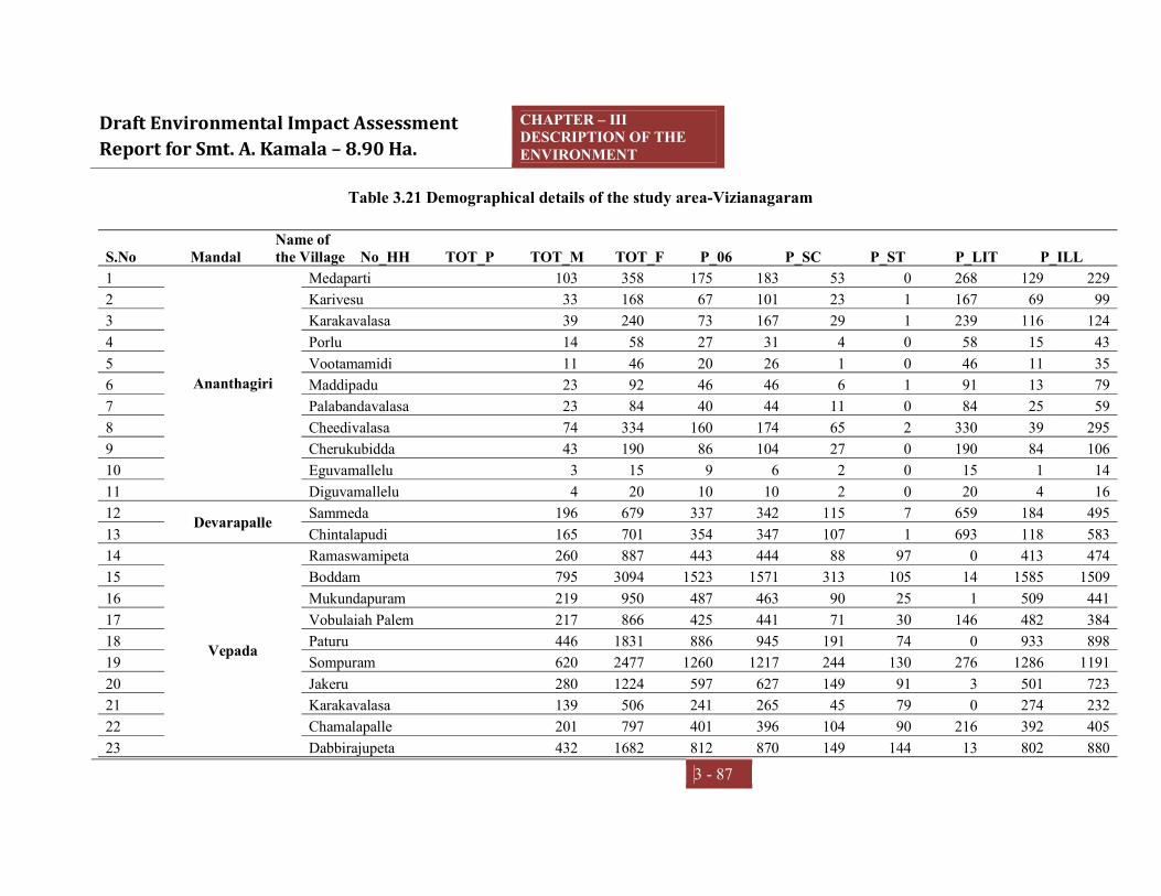
Draft Environmental Impact Assessment Report for Smt. A. Kamala – 8.90 Ha.
CHAPTER – III DESCRIPTION OF THE ENVIRONMENT
3 - 87
Table 3.21 Demographical details of the study area-Vizianagaram
S.No Mandal Name of the Village No_HH TOT_P TOT_M TOT_F P_06 P_SC P_ST P_LIT P_ILL
1
Ananthagiri
Medaparti 103 358 175 183 53 0 268 129 229 2 Karivesu 33 168 67 101 23 1 167 69 99 3 Karakavalasa 39 240 73 167 29 1 239 116 124 4 Porlu 14 58 27 31 4 0 58 15 43 5 Vootamamidi 11 46 20 26 1 0 46 11 35 6 Maddipadu 23 92 46 46 6 1 91 13 79 7 Palabandavalasa 23 84 40 44 11 0 84 25 59 8 Cheedivalasa 74 334 160 174 65 2 330 39 295 9 Cherukubidda 43 190 86 104 27 0 190 84 106 10 Eguvamallelu 3 15 9 6 2 0 15 1 14 11 Diguvamallelu 4 20 10 10 2 0 20 4 16 12 Devarapalle Sammeda 196 679 337 342 115 7 659 184 495 13 Chintalapudi 165 701 354 347 107 1 693 118 583 14
Vepada
Ramaswamipeta 260 887 443 444 88 97 0 413 474 15 Boddam 795 3094 1523 1571 313 105 14 1585 1509 16 Mukundapuram 219 950 487 463 90 25 1 509 441 17 Vobulaiah Palem 217 866 425 441 71 30 146 482 384 18 Paturu 446 1831 886 945 191 74 0 933 898 19 Sompuram 620 2477 1260 1217 244 130 276 1286 1191 20 Jakeru 280 1224 597 627 149 91 3 501 723 21 Karakavalasa 139 506 241 265 45 79 0 274 232 22 Chamalapalle 201 797 401 396 104 90 216 392 405 23 Dabbirajupeta 432 1682 812 870 149 144 13 802 880

Draft Environmental Impact Assessment Report for Smt. A. Kamala – 8.90 Ha.
CHAPTER – III DESCRIPTION OF THE ENVIRONMENT
3 - 88
24 Vepada 773 3754 1611 2143 288 907 46 2251 1503 25 Veeluparthi 236 884 455 429 96 6 84 452 432 26 Veldam 166 548 269 279 58 116 42 273 275 27 Vallampudi 711 2688 1287 1401 237 209 35 1373 1315 28 Gudivada 701 2715 1358 1357 250 277 2 1437 1278 29 Arigipalem 253 1007 497 510 94 193 0 561 446 30 Singarai 413 1563 787 776 146 162 0 832 731 31 Athava 358 1410 702 708 97 247 0 709 701
32
Lakkavarapukota
Lakkavarapukota Seetharampuram 174 650 318 332 78 80 0 352 298
33 Goljam 786 3004 1491 1513 328 126 0 1580 1424 34 Kallampudi 308 1111 561 550 117 5 4 575 536 35 Veerabhadrapeta 398 1520 738 782 131 109 1 786 734 36 Kotyada 637 2551 1211 1340 257 225 0 1164 1387 37 Khasapeta 591 2211 1109 1102 183 66 0 1139 1072 38 Lakkavarapukota 1154 4759 2375 2384 424 841 16 3085 1674 39 Kithannapeta 398 1702 849 853 178 69 0 549 1153 40 Marlapalle 873 3628 1842 1786 361 157 9 1773 1855 41 Chanduluru 865 3298 1641 1657 310 206 26 1792 1506 42
Srungavarapukota
Daraparthi 152 648 328 320 97 0 644 118 530 43 Kuridi 48 214 104 110 29 0 214 29 185 44 Gunapadu 34 171 83 88 32 0 171 20 151 45 Moolaboddavara 244 997 508 489 97 12 924 402 595 46 Tennuboddavara 622 2257 1099 1158 226 152 899 1299 958 47 Cheedipalem 61 189 83 106 22 4 170 106 83 48 Mushidipalle 212 1365 378 987 96 240 448 1022 343 49 Chinakhandepalle 68 201 107 94 17 0 19 105 96

Draft Environmental Impact Assessment Report for Smt. A. Kamala – 8.90 Ha.
CHAPTER – III DESCRIPTION OF THE ENVIRONMENT
3 - 89
50 Kiltampalem 518 2239 1162 1077 173 160 682 1425 814 51 Marupalle 91 358 188 170 28 2 328 170 188 52 Krishnamahanti Puram 97 354 171 183 39 61 0 204 150 53 Jirayathi Kumaram 181 651 312 339 57 50 137 365 286 54 Pedakhandepalle 681 2502 1238 1264 229 204 8 1346 1156 55 Kapusompuram 232 928 476 452 116 45 230 371 557 56 Srungavarapukota 7187 28304 13867 14437 2767 2484 1741 18615 9689 57 Kondamallipudi 13 54 25 29 8 0 54 20 34 58 Kasipathi Rajapuram 35 137 64 73 29 0 62 27 110 59 Mallipudi 8 32 15 17 8 0 0 16 16 60 Veeranarayanam 457 1658 800 858 121 288 0 933 725 61 Dampuram 68 266 135 131 25 5 0 162 104 62 Kothavooru 1113 4627 2279 2348 532 306 0 2215 2412 63 Balakrishna -Rajapuram 335 1300 626 674 126 126 0 684 616 64 Thimidi 607 2312 1136 1176 213 205 17 1282 1030 65 Santagavarampeta 428 1536 746 790 124 163 15 942 594 66 Pothanapalle 323 1283 650 633 124 142 110 755 528 67 Krishnapuram 352 1282 644 638 137 148 28 675 607 68 Viswanadhapuram 3 8 4 4 0 0 0 8 0 69 Vemulapalle 345 1252 636 616 113 22 1 664 588 70 Dharmavaram 1294 4740 2391 2349 424 659 133 2908 1832 71 Mamidipalle 297 1145 543 602 107 130 1 685 460 72 S. Kotatalari 497 1834 888 946 177 118 0 974 860 73 Vinayakapalle 218 816 393 423 88 89 0 419 397 74 Vasi 292 1067 526 541 91 117 0 618 449 75 Usiri 128 493 248 245 53 0 4 226 267

Draft Environmental Impact Assessment Report for Smt. A. Kamala – 8.90 Ha.
CHAPTER – III DESCRIPTION OF THE ENVIRONMENT
3 - 90
76 Alugubilli 459 1631 790 841 128 323 4 895 736 77 Chamalapalle 272 962 475 487 93 16 0 488 474 78 Kothakota 26 97 46 51 6 0 0 34 63 79 Gopalapalle 675 2566 1294 1272 231 111 17 1342 1224 80 Kottam 949 3441 1665 1776 348 277 17 1637 1804 Total 33757 132219 64703 67516 12853 11538 10872 72874 59345
Source: https://censusindia.gov.in/pca/cdb_pca_census/Houselisting-housing-AP.html

Draft Environmental Impact Assessment Report for Smt. A. Kamala – 8.90 Ha.
CHAPTER – III DESCRIPTION OF THE ENVIRONMENT
3 - 91
The Table 3.21 shows the demographical information of the study area of
Vizianagaram. As per 2011 Census, the population of Vizianagaram area is 1, 32,129
population with 33,757 households. If look into the gender wise population is found
that male 64,703 and female are 67,516. The Children population of 0-6 year age
group is 12,853. The total Schedule Caste (SC) and Schedule Tribes (ST) are 11,538
and 10,872 respectively in the study area. With regard to literacy and non literacy in
this area population is 72,874 and 59,345.
ECONOMIC & LAND BASED LIVELIHOOD OF VIZIANAGARAM
Economical resources Agriculture is the backbone of the economy of the in this study area and district. More
than half of their rural populations are engaged in agriculture in order to earn their
livelihood. Since the district has no big irrigation project, the farmers of the study
areas are solely dependent on rain water. The chief agricultural products in the
district are paddy, groundnut, cotton, sugarcane, pulses, etc. Every year a huge chunk
of revenue comes from the agricultural products in the district helps in its economy
to a greatextent.
Agricultural Resources: The project proposed area is predominantly an agricultural district as 68.4% of the
workers are engaged in Agriculture and about 82% of the population of the District is
livinig in Rural area s and depend on agriculture for theri livelihood. Rainfed farming
is the characteristic of Agriculture in the District as about 80% of its area is cultivated
purely under Rain fed conditions. Even the rest of the area which is termed as
irrigated area is mostly dependent on the rainfall received in the District. In view of
the un assured irrigation conditions in the district majority of crops grown are dry
crops. Paddy crop is irrigation conditions in the district majority of crops grown are
dry crops. Paddy crop is cultivated mainly during Kharif season with 80% of its area
under tank fed conditions which is turn depend on the local rainfall. The major crops
grown in the District are Paddy, Ragi, Bajra, Sugarcane, Pulses, Mestha, Cotton,
Maize, Korre Chillies, Seasonal Tobbaco and Groundnut. The average yields obtained
in the district are low due to the erratic rainfall generally received in the district.

Draft Environmental Impact Assessment Report for Smt. A. Kamala
Fig 3.16 Main and Marginal workers in the study area
Live Stock Resources: The Live stock maintained by
mostly less productive. Cross bredding program was taken up in the district. The
sheep in the district are nondescriptive type while pigs belong to Zenu type.
According to 2007 live stock census, the
which 4.91 lakhs are cattle, 2.59 lakhs are buffaloes and 3.88 lakhs are sheep. The
Poultry population of the District is 19.65 Lakhs. 150 veternary institutions including
hospitals are functioning in the district a
Industry
The study area and vizianagaram have rich in industrial resources which are utilized
by the FACOR andother industries. Sometime its economy is based on industrial
sector as well. The foremost industries in the district are Ferro
Limited, Jindal Stainless Limited, Andhra Ferro Alloys Limited, Matrix Laboratories
Limited, HBL Power systems Limited, APSRTC Garage
Workshop,Vizianagaram
ntal Impact Assessment Report for Smt. A. Kamala – 8.90 Ha.
CHAPTER – III DESCRIPTION OF THE ENVIRONMENT
Fig 3.16 Main and Marginal workers in the study area
The Live stock maintained by the inhabitants are non descriptive type in majority and
mostly less productive. Cross bredding program was taken up in the district. The
sheep in the district are nondescriptive type while pigs belong to Zenu type.
According to 2007 live stock census, the Live stock population is 13.70 lakhs of
which 4.91 lakhs are cattle, 2.59 lakhs are buffaloes and 3.88 lakhs are sheep. The
Poultry population of the District is 19.65 Lakhs. 150 veternary institutions including
hospitals are functioning in the district as on 31.3.2003.
The study area and vizianagaram have rich in industrial resources which are utilized
by the FACOR andother industries. Sometime its economy is based on industrial
sector as well. The foremost industries in the district are Ferro Alloys Corporation
Limited, Jindal Stainless Limited, Andhra Ferro Alloys Limited, Matrix Laboratories
Limited, HBL Power systems Limited, APSRTC Garage
Andhra Pradesh Tanneries Limited,etc.
III
DESCRIPTION OF THE ENVIRONMENT
3 - 92
the inhabitants are non descriptive type in majority and
mostly less productive. Cross bredding program was taken up in the district. The
sheep in the district are nondescriptive type while pigs belong to Zenu type.
Live stock population is 13.70 lakhs of
which 4.91 lakhs are cattle, 2.59 lakhs are buffaloes and 3.88 lakhs are sheep. The
Poultry population of the District is 19.65 Lakhs. 150 veternary institutions including
The study area and vizianagaram have rich in industrial resources which are utilized
by the FACOR andother industries. Sometime its economy is based on industrial
Alloys Corporation
Limited, Jindal Stainless Limited, Andhra Ferro Alloys Limited, Matrix Laboratories
and Zonal

Draft Environmental Impact Assessment Report for Smt. A. Kamala
ECONOMIC AND LAND BASED Land-Based LivelihoodsThe illustration of land-use patterns in the study area indicates the acute dependence
of land-based livelihood patterns such as agriculture, aquaculture, salt pans etc.
Agriculture Agriculture is the main stray of nearly 70% of the households.
Visakhapatnam city is industrially developing, the rural areas continued to be
backward. Rice is a staple food of the people and Paddy is therefore the principal
food crop of the district followed by Ragi, Bajra and Jowar and Cash Crops such as
Sugarcane, Groundnut, Sesamum Niger and Chillies are important.
Major Irrigation system, only about 36% of the cropped area is irrigated under the
Ayacut of the Medium Irriga
the cultivated area is covered under dry crops depending upon the vagaries of the
monsoon. The productivity of the crops is low. Fig 3.17 shows the Main and
Marginal Workers details of the Visakhapat
Fig 3.17 Main and Marginal Workers
ntal Impact Assessment Report for Smt. A. Kamala – 8.90 Ha.
CHAPTER – III DESCRIPTION OF THE ENVIRONMENT
ECONOMIC AND LAND BASED LIVELIHOOD-VISAKHAPATNAMBased Livelihoods
use patterns in the study area indicates the acute dependence
based livelihood patterns such as agriculture, aquaculture, salt pans etc.
Agriculture is the main stray of nearly 70% of the households.
Visakhapatnam city is industrially developing, the rural areas continued to be
Rice is a staple food of the people and Paddy is therefore the principal
rict followed by Ragi, Bajra and Jowar and Cash Crops such as
Sugarcane, Groundnut, Sesamum Niger and Chillies are important. Since there is no
Major Irrigation system, only about 36% of the cropped area is irrigated under the
Ayacut of the Medium Irrigation System and Mimnor Irrigation Tanks.
the cultivated area is covered under dry crops depending upon the vagaries of the
The productivity of the crops is low. Fig 3.17 shows the Main and
Marginal Workers details of the Visakhapatnam district.
Fig 3.17 Main and Marginal Workers
III
DESCRIPTION OF THE ENVIRONMENT
3 - 93
VISAKHAPATNAM
use patterns in the study area indicates the acute dependence
based livelihood patterns such as agriculture, aquaculture, salt pans etc.
Agriculture is the main stray of nearly 70% of the households. Though
Visakhapatnam city is industrially developing, the rural areas continued to be
Rice is a staple food of the people and Paddy is therefore the principal
rict followed by Ragi, Bajra and Jowar and Cash Crops such as
Since there is no
Major Irrigation system, only about 36% of the cropped area is irrigated under the
The rest of
the cultivated area is covered under dry crops depending upon the vagaries of the
The productivity of the crops is low. Fig 3.17 shows the Main and

Draft Environmental Impact Assessment Report for Smt. A. Kamala – 8.90 Ha.
CHAPTER – III DESCRIPTION OF THE ENVIRONMENT
3 - 94
PHYSICAL AND SOCIAL INFRASTRUCTURE FACILITIES- VISAKHAPATNAM
Transport and Communications The study area and District is well served by roads and railways. About 260.44 Kms
route length of broad gauge railway line with 31 railway stations (2015-16, DES) is
serving the needs of the people.
The network of National highways, State highways, District roads and Panchayat
roads is shown in. Lakkavarapukota Seetharamapuram Railway Station at 12.87 km.
The nearest airport and sea port are 37.6 KM (approximately) away at Visakhapatnam.
A new International Airport is coming up near Bhogapuram in the district which is the
only international airport in the north coastal districts. Most of the villages in and
around the villages well connected with metal and black top roads.
Tourism The study area and district has several centers of attraction which allures many
travelers from different parts of the country as well as all over the globe.
Vizianagaram fort, a beautiful fort in the district was constructed by Vijayarama Raju-
I in 1713 A.D. on the auspicious day of Vijaya Dashmi. The Victory arch was the
main entrance to the Vizianagaram fort.
Education There are Anganwadi’s and government and private schools also available in these
proposes study area villages. Most the villages have High schools. For vocational
education and higher secondary education and for college education is source
Anakaplle.
Health Health care facility is mainly lacking in the studied area, very less villages have the
dispensaries or Primary Health Care Centre (PHC) among in these villages. For
getting medical facility, people have to go to Mandal Head Quarter and nearby town
villages are the main source for visiting.

Draft Environmental Impact Assessment Report for Smt. A. Kamala – 8.90 Ha.
CHAPTER – III DESCRIPTION OF THE ENVIRONMENT
3 - 95
INFRASTRUCTURE FACILITIES: Post offices: All most all the villages have post offices.
Electricity: All the villages have electricity facilities.
Drinking Water Source: Bore well, Self-hand pump, water tankers and public
hand pumps are the main source of drinking water. Few over-head water tanks
(OHT) and mini water tanks are available in these villages.
Transport Facility: Among four villages, all villagers have good transport
facility through bus And nearest railway station is SKota (5 km approximately)
and airline services are from Visakhapatnam (55 km approximately).
Community Hall: Very fewvillages have community hall.
Recreational Facility: From four surveyed villages’ don’t have the recreational
facility likevillage level playground.
Temples: As majority of the people belong to Hindu religion, the villages have
many Hindutemples altogether. The villagers celebrate the village temple
function during August and April.
Toilet Facility: Toilet facility is not available in all the villages; this is the most
basic felt need of the people, which needs to be addressed immediately.
PRIMARY STUDY:
Community Perceptions The primary study was done during the period of baseline period. The study has been
done in folds such as Individual Questionnaire Survey and Focused Group
Discussion. This included the collection of baseline demographic and socio-economic
information through a standardized survey focusing on household composition,
education levels, general health status, livelihood strategies, employment, and income
and expenditure. In light of potential resettlement requirements, the survey took the
form of a census in villages of 10 km radius.
A primary survey was conducted within study areas of villages such as; Pedadungada,
Dharmavaram, Kothavooru, Vemulapalle Boddam, Vasi, Gopalapalle, and Sompuram
Villages. 58 participants were selected by sampling random method. The experts
have been collected the demographical details of participant and also focused on

Draft Environmental Impact Assessment Report for Smt. A. Kamala – 8.90 Ha.
CHAPTER – III DESCRIPTION OF THE ENVIRONMENT
3 - 96
various dimensions of economical, social & cultural, health & wellbeing, economical,
personal & psychological and heath & public infrastructure aspects to assess that
significant impact differences about this proposed project.
OVERALL OUTCOME OF THE PRIMARY SURVEY:
The proposed site is located with different sub castes. As a part of primary survey,
socio economic functional area expert raised different questioned related proposed
and impact due to project.
69% participants from primary participants of the study said that they are aware
of the proposed project mining project which is located in Village.
It was observed that the economic benefits with proposed in the study area are
commonly have direct, indirect, and induced
Increase the land and labour cost and direct and indirect economy to the stud area.
Households that receive income from employment in stevedoring and related
activities spend some of their income on local goods and services.
The economic benefits of are value-added, taxation revenue Govt. and return on
investment.
85% of the participants positively responded that the mining project has positive
developments various aspects such as employment to the local people on regular
and contractual bases and other related developments.
Many communities would be benefited in various aspect, such as establishment of
related stakeholders, opportunities to the transportation, suppliers, rental services,
self employment and many other aspects.
Local transport and infrastructure might be developed, namely roads, are usually
provided.
No community cohesion related issues were found.
No historical places and temple are found within the port proposed lands.

Draft Environmental Impact Assessment Report for Smt. A. Kamala – 8.90 Ha.
CHAPTER – III DESCRIPTION OF THE ENVIRONMENT
3 - 97
There is no R& R with proposed project. So, No change in envisaged.
It was also responded that there would be no lose of agricultural lands, trees
dwells due to this project.
No health issues will be raised due to this proposed mining project
Air and noise pollution would be during production, however, it will be resolved
by environment management plan
Helps to raise the profile of safety and health issues to the local people and in
ports.
Minimal level of noise can be emitted from engines and transmission equipment
fitted to lifting appliances and vehicles, and can be heightened when the
equipment is being used in a shed, warehouse or ship’s hold.
81% of the participants said they have positive opinion towards this project.
Majority of the participants are inviting mining and related services.
NEED ASSESSMENT:
From the survey of socio economic report, people are expressed various desires and
requirements to the local core and buffer villages. It has been suggested to the project
authorities through this survey, following facilities need to be provided to those
villages.

Draft Environmental Impact Assessment Report for Smt. A. Kamala
Majority of the local participants (25%) said that are looking work opportunities
on regular or temporary bases.
Some of the people (22%) have expectation on health related facilities.
CSR activity, management can take positive step by conducting frequent health
camps, medical assistance other health related. People not having proper any
health centers. Hence, the company should conduct health camp
Few of the respondents (19%
infra structure in school, support. If the management supports by sponsoring
education to those poor and low income students could be educated. In future,
those students also would have chance to get an
The socio economic survey revealed that the nearest villages of not having proper
connectivity in this villages. Hence, people (15%) are expecting civic amenities.
Some of the participants (11%) looking for skill development pr
candidates in the study area.
Series1Civic Amenities
ntal Impact Assessment Report for Smt. A. Kamala – 8.90 Ha.
CHAPTER – III DESCRIPTION OF THE ENVIRONMENT
Fig 3.18 Need Assessment
Majority of the local participants (25%) said that are looking work opportunities
on regular or temporary bases.
Some of the people (22%) have expectation on health related facilities.
CSR activity, management can take positive step by conducting frequent health
camps, medical assistance other health related. People not having proper any
health centers. Hence, the company should conduct health camp
Few of the respondents (19%) have expectation on education related support like
infra structure in school, support. If the management supports by sponsoring
education to those poor and low income students could be educated. In future,
those students also would have chance to get an employment in this project.
The socio economic survey revealed that the nearest villages of not having proper
connectivity in this villages. Hence, people (15%) are expecting civic amenities.
Some of the participants (11%) looking for skill development programs qualified
candidates in the study area.
Series1Employement
5225%
Series1Health
4622%
Series1Education
4119%
Series1Civic Amenities
3416%
Series1Skill
Development24
11%
Series1Others
157%
Need Assessment
III
DESCRIPTION OF THE ENVIRONMENT
3 - 98
Majority of the local participants (25%) said that are looking work opportunities
Some of the people (22%) have expectation on health related facilities. As part of
CSR activity, management can take positive step by conducting frequent health
camps, medical assistance other health related. People not having proper any
) have expectation on education related support like
infra structure in school, support. If the management supports by sponsoring
education to those poor and low income students could be educated. In future,
employment in this project.
The socio economic survey revealed that the nearest villages of not having proper
connectivity in this villages. Hence, people (15%) are expecting civic amenities.
ograms qualified

Draft Environmental Impact Assessment Report for Smt. A. Kamala – 8.90 Ha.
CHAPTER – III DESCRIPTION OF THE ENVIRONMENT
3 - 99
CONCLUSION Sri. A. Kamala, Mallipudi (V), S.Kota (M), Vizianagaram District, Andhra Pradesh,
and India has done Socioeconomic study. The study was designed with secondary
and primary source. The primary data was collected within the study area Proposed
project location – within the limits of. Sample of 48 participants were participated in
this survey method. The early consideration of social impacts, the alignment of
activities with regional and community planning objectives, and meaningful
participation of community in decision making are key features. Apart from the
socioeconomic process and findings it can be concluded that most the respondents
have positive perception about this proposed project.

CHAPTER –IV ANTICIPATED ENVIRONMENTAL IMPACTS
& MITIGATION MEASURES

Draft Environmental Impact Assessment Report for Smt. A. Kamala – 8.90 Ha.
CHAPTER- IV ANTICIPATED ENVIRONMENTAL
IMPACTS & MITIGATION MEASURES
4 - 1
4.0 INTRODUCTION The mining activity especially opencast mining is likely to make significant changes in land
use pattern. This activity may adversely alter existing Environmental conditions, biological
attributes, existing ecosystem and associated biodiversity unless proper environmental
management plan is adopted. This mining project has both positive as well as negative
impacts on Environment. Keeping in mind the Environmental baseline scenario as detailed
in Chapter III and the mine activity described in Chapter II, it is attempted to predict the
likely impacts, their extent on various parameters and likely mitigation measures to be
adopted.
Impact prediction is a very important phenomenon in evaluating the environmentally
potential adverse impacts for mining project. The impact prediction is always carried out
under worst possible conditions so as to mitigate or to eliminate the Environmental hazards.
These predictions thus calculated are superimposed over the baseline data (the quality of
Environment in the vicinity of the project site) so as to calculate the net impact on the
Environment after the project comes into production.
Table: 4.1Expected Nature of Impacts
ASPECT IMPACT Fugitive dust, Air emissions.
Effects on air quality, ecology due to increase in PM10& PM2.5, SO2, NOXand free silica levels depending up on the type of process involved in mining.
Noise emissions & Vibrations.
Effects on community noise environment of the region due to increase in day and night equivalent noise levels.
Transportation Impact on existing infrastructure.

Draft Environmental Impact Assessment Report for Smt. A. Kamala – 8.90 Ha.
CHAPTER- IV ANTICIPATED ENVIRONMENTAL
IMPACTS & MITIGATION MEASURES
4 - 2
Table: 4.2 Identified/Predicted Environmental Impacts with & without Mitigation Measures
S.No Description Activity Effect
Impact without
mitigation measure
Mitigation measure proposed
Impact after
mitigation Remarks
1 Impact on
Topography&
Drainage
Excavation Changes in land
use pattern
High It is proposed to
develop avenue
plantation on either
side of the approach
road.
After removal of
mineral the benches
are formed below the
surface level and the
top benches will be
applied with top soil
and developed with
grasses and plantation
The pits formed will
be used as water
Medium The
topographical
changes caused
due to mining
activity can be
transformed
into social
benefit by
adopting and
implementing
proper
reclamation
plan

Draft Environmental Impact Assessment Report for Smt. A. Kamala – 8.90 Ha.
CHAPTER- IV ANTICIPATED ENVIRONMENTAL
IMPACTS & MITIGATION MEASURES
4 - 3
storage structures.
The mining activity
will not intersect with
ground water.
2 Air Pollution Excavation operation
Fugitive dust
emissions
effecting ambient
air quality &
workers health
High Covered aprons with
nose masks will be
provided to the work
force.
Regular inspection
and maintenance of
machinery will be
practiced.
Low Localized
effect which
can be
mitigated with
controlled
mining
practices
Blasting Dust emissions High Covered aprons with
nose masks will be
provided to the work
force.
Controlled blasting
will be practiced.
Delayed detonators
will be used.
Low Periodical
impact on air
environment

Draft Environmental Impact Assessment Report for Smt. A. Kamala – 8.90 Ha.
CHAPTER- IV ANTICIPATED ENVIRONMENTAL
IMPACTS & MITIGATION MEASURES
4 - 4
Drilling by wet jacket
method will be
implemented.
Loading & Dispatch. Fugitive dust
effecting air
quality & health
effect
High Vehicles will be
covered with
tarpaulin.
Water will be
sprinkled regularly
along the haulage
roads
Vehicular speed will
be limited to
25KMPH.
Haul road compaction
and grading at
periodic intervals will
be practiced.
Green belt
development on either
side of the haulage
Low Localized
effect which
can be
mitigated

Draft Environmental Impact Assessment Report for Smt. A. Kamala – 8.90 Ha.
CHAPTER- IV ANTICIPATED ENVIRONMENTAL
IMPACTS & MITIGATION MEASURES
4 - 5
roads.
Vehicular movement and
machinery operation
Release of SO2
and NOx due to
combustion of
fossil fuels
Low Regular maintenance
of vehicles and
machineries will be
practiced to improve
their efficiency
Negligible
3 Water
Pollution
Run off from surrounding area
into ML area
Siltation of mine
pits.
High
During mining activities
desiltation works will be
carried out regularly
Low Negligible
effect which
can be
mitigated
Domestic sewage from mine
area
Increases BOD
levels of the water
bodies if released
directly
High Domestic waste water
generated is disposed
through septic tank
followed by soak pit
Low Negligible
effect which
can be
mitigated
Seepage of mine water to
aquifers
Contaminates
Ground water
High No effluents will
released from this
mine
Mining activity will
not intersect with
Low Negligible
effect which
can be
mitigated

Draft Environmental Impact Assessment Report for Smt. A. Kamala – 8.90 Ha.
CHAPTER- IV ANTICIPATED ENVIRONMENTAL
IMPACTS & MITIGATION MEASURES
4 - 6
aquifer.
4 Soil Erosion Exposure of soil results in soil
erosion
Loss of soil and
accreditation of
deposits in other
area
High Regular water
sprinkling is carried
out during mining
activities.
After removal of
mineral the top
benches will be
applied with top soil
and grasses and
plantation will be
developed
Plantation
development (plants
with soil binding
capacity) on plain area
is encouraged.
Low Effect can be
mitigated by
practicing
control
measures.
5 Noise
Pollution &
Excavation activities &
transportation of vehicles
Increase of
Ambient noise
levels resulting
High Excavation is through
semi mechanized
operations.
Low Localized
effect which
can be

Draft Environmental Impact Assessment Report for Smt. A. Kamala – 8.90 Ha.
CHAPTER- IV ANTICIPATED ENVIRONMENTAL
IMPACTS & MITIGATION MEASURES
4 - 7
Vibrations health effects Proper maintenance
and periodic
lubrication of noise
generating parts of the
machinery & vehicle
machines.
PPE such as ear plug
will be supplied for
the workers.
Vehicle speed is
controlled to a
maximum of
25KMPH
Green belt
development
mitigated.
Blasting Increase of
Ambient noise
levels and
Vibrations
High Controlled blasting
will be practiced to
regulate ground
vibrations within the
limits.
Delayed detonators
Medium No human
habitation is
located near the
mine area, thus
there will be no
impact for local

Draft Environmental Impact Assessment Report for Smt. A. Kamala – 8.90 Ha.
CHAPTER- IV ANTICIPATED ENVIRONMENTAL
IMPACTS & MITIGATION MEASURES
4 - 8
will be used.
PPEs such as Ear
plugs will be supplied
for worker’s
protection.
people.
Nearest village
is
Gadabavalasa
at a distance of
0.22 km.
6 Biological &
Socio-
economic
aspect
Operational activities of mine The mine area
comprised thorny-
scrub vegetation
with very few tree
species
High It is proposed to
develop avenue
plantation on either
side of the approach
road to 1.0km stretch.
After complete
exploration of the
mineral the land on top
benches will be
applied top soil and
developed with grasses
and plantation.
Medium No notable
biodiversity
resources are
present within
the mine site
Positive socio -- Medical/first aid
facilities, Employment
Positive --

Draft Environmental Impact Assessment Report for Smt. A. Kamala – 8.90 Ha.
CHAPTER- IV ANTICIPATED ENVIRONMENTAL
IMPACTS & MITIGATION MEASURES
4 - 9
economic effect. opportunities., Water
supply,
communication will
be enhanced due to the
mine activity
It is proposed to
develop avenue
plantation on either
side of the approach
road to 0.7km stretch.
7 Occupational
Health &
Safety
Operational activities of mine
like excavation, loading etc.
Pulmonary health
effects predicted
and other minor
injuries.
High Provision of appropriate
PPE viz., nose masks,
hand gloves, shoes and
aprons
First aid/Medical check
facilities will be provided
Low Medical/ Life
insurance &
Workman
compensation
procedures will
be followed.

Draft Environmental Impact Assessment Report for Smt. A. Kamala – 8.90 Ha.
CHAPTER- IV ANTICIPATED ENVIRONMENTAL
IMPACTS & MITIGATION MEASURES
4 - 10
4.1 IMPACTS ON AIR QUALITY The impact on air quality due to production of Road metal and Building Stone with
maximum production of about 80078.40m3/annum is limited to the mining lease area. The
Road Metal and Building Stone by nature is medium hard so drilling and blasting is
mandatory. The operations involve drilling, blasting, excavation by excavators. The major
source for dust emissions are from excavation operations and transportation of the material.
The mine rated capacity and the baseline ambient air quality values were monitored during
non-monsoon season reflects the emissions in the area. The impact due to mining activities
and transport of material has been considered to estimate the contribution of dust levels to
the existing ambient air quality by the mine.
4.1.1 Quantitative estimation of impacts on air environment The followingoptions have been employed to predict the ground level concentrations due to
emissions from the mine.
1. Area being rural, rural dispersion parameters is considered.
2. Predictions have been carried out to estimate concentration values over radial distance
of10 km around the sources.
3. Polar receptor network has been considered.
4. Emission rates from the point sources and area sources were considered as constant
during the entire period.
5. The ground level concentrations computed were as is basis without any consideration of
decay coefficient.
6. Calm winds recorded during the study period were also taken into consideration.
7. Site specific meteorological data to estimate ground level concentrations for period of
October21 to December21.
4.1.2 Sources of dust emission Based on the various operations involved in the production, the various emission sources at
each stage have been identified as given below.
a. Area sources
b. Line sources

Draft Environmental Impact Assessment Report for Smt. A. Kamala – 8.90 Ha.
CHAPTER- IV ANTICIPATED ENVIRONMENTAL
IMPACTS & MITIGATION MEASURES
4 - 11
Area Sources: Drilling, blasting & excavation by excavators and directly load into the
tippers/tractorsoperations of the mine are considered as area sources.
Line Sources: Transportation from mining pit to stock pile area and stockpile to end users is
considered as line sources.
The impacts of emission from above sources on air environment are discussed below:
4.1.3 Emission details All the emissions discussed above are quantified for material handling for Road metal &
Building Stone of 80078.40m3/annum. The existing baseline concentrations are already
covered in the baseline scenario (Chapter - III). Operational hours and activity rate have
been considered for estimation of emissions from point and area sources. For line source,
apart from operational hours and activity rate, moisture and silt content of the haulage road
have been considered.
4.1.4 Meteorological data The meteorological data recorded continuously during the months of October 2021 to
December 2021 on hourly basis on wind speed, wind direction and temperature has been
processed to extract the 24 – hourly meteorological data.
4.1.5 Assumptions made in the prediction of air pollution impacts For the purpose of computation of rise in the ground level concentrations due to mining
operations, the following assumptions have been considered.
Mining operations are carried out for a period of 8-10 hours a day and hence it is not a
continuous source of emission and other operations may not be simultaneous and
continuous. However, for the prediction of worst case concentration, the sources mentioned
in the above are assumed to be under simultaneous and continuous operation for8-hours.
4.1.6 Summary of predicted ground level concentrations of particulate matter By using the above-mentioned inputs, ground level concentrations due to the mining
activities have been estimated to know the incremental rise and distance of impact in the
study area.

Draft Environmental Impact Assessment Report for Smt. A. Kamala – 8.90 Ha.
CHAPTER- IV ANTICIPATED ENVIRONMENTAL
IMPACTS & MITIGATION MEASURES
4 - 12
The major source of dust pollution is from mining operations and transportation. This raises
suspended particulate matter concentrations in the mine area. Another major activity being
transport from the working pit to the stock pile and stock pile to end users, the dust levels
are distributed all along the transport route from the mine.
4.1.7 Air Quality Mitigation Measures
Preventing dispersal of air borne dust The main constitute of air pollutants from this mine will be suspended particulate matter.
The following mitigation measures will be brought into practice for maintaining emissions
within permissible limits.
1. Controlled blasting techniques with delayed detonators will be employed. Small
quantities of explosives will be used for blasting. The blasted blocks (temporary) are
wetted by spraying water.
2. Drilling by wet jacket method will be implemented.
3. Avoiding blasting during high windy periods, night times and temperature inversion
periods.
4. Effective water sprinkling at the time of mining operation i.e., excavation and
loading.
5. Development of green belt within the buffer zone area.
6. Material should be transported by truck which will be covered by tarpaulin.
7. Haul roads and approach roads should be graded to minimize dust suspension.
8. Regular air monitoring will be taken so that necessary steps can be practiced to
control emissions
Controlling gaseous emissions Since the mining activities are not expected to generate considerable quantities of gaseous
emissions such as NOx and SO2, hence there is no need of any special measures. However,
the following measures shall be implemented during operation as precautionary measures.
Controlled blasting techniques will be employed.

Draft Environmental Impact Assessment Report for Smt. A. Kamala – 8.90 Ha.
CHAPTER- IV ANTICIPATED ENVIRONMENTAL
IMPACTS & MITIGATION MEASURES
4 - 13
Water sprinkling arrangements such as specially fabricated tankers mounted on
tipper are deployed at mine site to control the fugitive dust generation from the
haulage roads.
The vehicles and machinery will be maintained in good condition so that emission
of gaseous constituents will be minimized.
Periodical monitoring of air quality will be done to take steps for controlling the
pollutant emissions.
4.2 WATER ENVIRONMENT
4.2.1 Impacts on surface water bodies and control measures The operation of Road Metal & Building Stone mining activity will require water for
drilling and the water will be used for drinking/domestic purpose and dust
suppression/plantation purpose. Hence, no impact on the quality of surface and ground
water is expected. Whereas the core zone will ultimately fall in safe zone, there is no
possibility of any changes in the water quality. The chemical analysis of water samples
collected reveal that there is no significant change in the constituents and surface water and
ground water in the nearby mining areas have remained suitable for all purposes and all
constituents within the water standards of IS-10500-2012.
There are no perennial or seasonal stream within or adjacent to the mine area. However,
garland drains along with siltation pond will be arranged to collect rain water.
The total water requirement is about 11.2KLD for various activities such as,
Green-belt watering
Dust suppression
Domestic use
Drilling by wet jacket method
The processes of mining do not generate any hazardous liquid effluent except domestic
sewage. About 1.0 KLD of domestic sewage will be generated during mine operations; the
same will be disposed through septic tank followed by soak pit.

Draft Environmental Impact Assessment Report for Smt. A. Kamala – 8.90 Ha.
CHAPTER- IV ANTICIPATED ENVIRONMENTAL
IMPACTS & MITIGATION MEASURES
4 - 14
The water requirement will be met from water supply through tankers from nearest village
and no bore well is proposed.
The mining operations will be carried out throughout the year avoiding rainy days. Rain
water collected in mine pits are withdrawn and will be used for water plants and sprinkling
on haul roads.
4.2.2 Rain water harvesting During mining operations the rain water stored in the pit area is pumped out to carry out
excavation operations without hindrance. At the end of mine life, rain water collected in pit
will be allowed to soak into the ground for recharging the ground water table.
4.2.3 Impacts on ground water table There are no ground water bodies such as open wells or bore wells in this lease area. The
ground water table is about 48 m depth from the ground level. Maximum depth of workings
is up to RL 70 m and minimum depth of workings is RL 80 m. The proposed maximum
quarry operations during the plan period, a depth of 98 m from the top hill i.e. which is
above the ground level; thus no chances for accumulation of ground water in working pit
and no water will be discharged from the pit.Hence, the possible impacts on the ground
water table because of open cast mining will be minimal.
4.3 LAND ENVIRONMENT Land environment is divided into the following three components
Solid waste management
Soil Erosion
Reclamation of degraded areas
Afforestation /Plantation/ Greenbelt development.
4.3.1 Solid waste generation
100% of the excavated mineral will be utilized; out of which 90% is Road Metal & Building
Stone and 10 % OB generated will be will be disposed in dump yard over an extent of

Draft Environmental Impact Assessment Report for Smt. A. Kamala – 8.90 Ha.
CHAPTER- IV ANTICIPATED ENVIRONMENTAL
IMPACTS & MITIGATION MEASURES
4 - 15
1.0218 Ha within mine lease area as step dumping and will be made useful for road
gradation, retention wall arrangement on hill slopes and strengthening garland drains.
4.3.2 Soil Erosion The mine activity will expose out the loose earthy material which leads to soil erosion
through runoff or wind action. This may cause in deposition of silt in low-lying water
bodies.
This effects can be controlled by following the below suggested conservation practices.
Regular water sprinkling is carried out during mining activities.
After removal of mineral the top benches will be applied with top soil and grasses and
plantation will be developed
Plantation development (plants with soil binding capacity) on plain area is encouraged
Construction of garland drains should be done to avoid siltation of nearby water
sources
4.3.3 Reclamation of degraded areas
i) Impact due to land degradation The mine lease area of 8.90hectares is a foothill. The lease area covers on slope of the
hillock. The proponent is maintaining a buffer zone of 7.5 m. It is proposed to develop
avenue plantation on either side of the approach road to a stretch of 1.0 km.
ii) Land reclamation Control Measures Opencast mining activity will change land use pattern of the present mine area. There will
be no top soil generation during this mine operation. The land degradation is minimal and
restricted only to the mining area and the facilities within the mine lease boundary.
iii) Reclamation of land affected due to mining activities. The Proponent must take steps to keep the granted lease area under disturbance at any stage
to the minimum. This can be achieved by ensuring reclamation practices.
Since it is envisaged that the quarry will be operate for at least for 39 years, no back filling
is proposed during the lease period. After removal of mineral the benches below the surface

Draft Environmental Impact Assessment Report for Smt. A. Kamala – 8.90 Ha.
CHAPTER- IV ANTICIPATED ENVIRONMENTAL
IMPACTS & MITIGATION MEASURES
4 - 16
level the top benches will be applied with top soil and developed with grass and plantation.
The pits created will be used as rain water harvesting structure.
iv) Soil conservation measures and Top soil management The top soil generation will be minimal. However the generated top soil will be used for
green belt development.
v) Maintenance of road The road for movement of trucks to the mine will be kept in good condition during the
reclamation/afforestation period till the mine is fully reclaimed and afforested. The material
required for planting and growth of plants and trees, measures, water etc. can be transported
to the site by trucks.
4.3.4 Program of Afforestation It is proposed to develop avenue plantation on either side of the approach road 1.0 km with 950 plants.
4.3.5 Impact on land use and reclamation measures Open cast semi mechanized mining activities may alter the landscape of the lease area and
some disturbance to the surface features of the surrounding areas. The total mine lease area
is about 8.90Ha. During the ensuing plan period an area of 2.4942 Ha of land will be mined
out.
It is proposed to develop avenue plantation on either side of the approach road. It can be
used for native species plantation at the end of the mining activity.
4.4 NOISE ENVIRONMENT AND VIBRATIONS:
4.4.1 Impact due to Noise and Vibration At mines, noise is generated by movement of machinery & transportation by vehicles, etc.
The noise level in the working environment are compared with the standards prescribed by
Occupational Safety and Health Administration (OSHA-USA) which has been adopted and
enforced by the Govt. of India through model rules framed under Factories Act, 1980 and

Draft Environmental Impact Assessment Report for Smt. A. Kamala – 8.90 Ha.
CHAPTER- IV ANTICIPATED ENVIRONMENTAL
IMPACTS & MITIGATION MEASURES
4 - 17
CPCB 2000 norms. The summary of the permissible exposures in case of continuous noise
as per above rules is given below:
Table4.3:Noise impact
Total time of exposure per day in hour
Sound pressure dB(A)
Remarks
1 2 ----
8.0 90 No exposure in excess of 115 dB(A) is permissible
6.0 92 --
4.0 95 For any period of exposure falling in between any figure and lower figure as indicated in column (1), the permissible sound is to be determined by extrapolation or proportionate scale.
3.0 97
2.0 100
1 ½ 102
1 105
¾ 107
½ 110
¼ 115
Noise at lower levels (sound pressure) is quite acceptable and does not have any bad effect
on human beings, but when it is abnormally high- it incurs some maleficent effects. For the
mining operations, the noise is expected to be generated from machineries used for this
project. During the mining the noise pollution can take place due to external transport
machinery as dumper/tractor etc.
4.4.2 Noise and Vibration Control Measures The ambient noise level monitoring carried out has revealed that the ambient noise levels
are well within the prescribed limits. However, the following measures will further tend to
abate the noise levels:
Excavation of Road metal and Building Stone is through semi mechanized
operations by wet jacketed drilling, blasting and excavating by excavator. Proper
maintenance and periodic lubrication of noise generating parts of the machinery &
vehicle machines.

Draft Environmental Impact Assessment Report for Smt. A. Kamala – 8.90 Ha.
CHAPTER- IV ANTICIPATED ENVIRONMENTAL
IMPACTS & MITIGATION MEASURES
4 - 18
Vehicle speed will be restricted to a maximum of 25KMPH.
Controlled blasting and delayed detonators will be practiced to regulate noise levels
within the limits.
A thick tree plantation will be developed.
Provision of silencers, to module the noise generated by the machines, where ever
required.
Equipments with permissible noise level will be procured.
Provision of Protective Devices like ear muffs/ear plugs will be provided to
workmen.
Control of ground vibrations During blasting, proper blast pattern should be adopted. The latest technology delay
detonator blasting should be adopted to reduce the impact on the ground vibration
generation during blasting operations.
Shock tube initiation system with sequential blasting should be adopted.
Charge weights per delay should be properly adopted so that the peak particle velocity
will be maintained as per the DGMS requirement.
4.5 SOLID WASTE GENERATION AND STACKING OF WASTES Out of the total excavated mineral 90% is Road Metal & Building Stone and 10 % OB
generated will disposed in dump yard over an extent of 1.0218 Ha within mine lease area as
step dumping. It will be made useful for road gradation, retention wall arrangement on hill
slopes and strengthening garland drains.
4.6 BIOLOGICAL ENVIRONMENT
4.6.1 Impacts on Biological Environment Mining activities generally result in the deforestation, land degradation, water, air and noise
pollution which directly or indirectly affect the faunal and floral status of the project area.
However, occurrence and magnitude of these impacts are entirely dependent upon the
project location, mode of operation and technology involved. Impact prediction is the main
footstep in impact evaluation and identifies project actions that are likely to bring significant
changes in the project environment. The present study was carried out to predict the likely

Draft Environmental Impact Assessment Report for Smt. A. Kamala – 8.90 Ha.
CHAPTER- IV ANTICIPATED ENVIRONMENTAL
IMPACTS & MITIGATION MEASURES
4 - 19
impacts of the existing Road Metal &Building Stone Mine of Smt. A. Kamala at Mallipudi
Village surrounding environment with special reference to biological attributes covering
habitats/ecosystems and associated biodiversity. Although impacts on key habitat elements
will occur on a local scale, but on a regional scale they would not be critical for the life
cycle needs of the species observed or expected. Moreover the successive reclamation of
mined out areas, following completion of mining activities, will replace habitat resources for
fauna species in this locality over a longer time.
The lease area comprised thorny-scrub vegetation owing to dry and hot summer season. The
lease area is having very few tree species. Apart from few tree species some grasses and
shrubs observed within the mine lease area. Wild life is not commonly found in the lease
area and its immediate environs because of lack of vegetal cover and surface water.
4.6.2 Mitigation Measures Keeping all in mind the mitigations have been suggested under environmental management
plan. With the understanding of the role of plant species as bio-filter to control air pollution,
appropriate plant species (mainly tree species) have been suggested conceding the area/site
requirements and needed performance of specific species.
In order to improve the fodder availability some of the grass species suggested growing
within the plantation area proposed by the proponent as silvopastural adaptation in the initial
phase. Wherever mining is completed, area of top benches will be grown with some grass
species by applying some fertile top soil before the onset of monsoon season. This can
provide fodder for the local livestock and also act as protective measure for soil erosion.
4.6.3 Greenbelt Development Development of the green belt is one of the most sensitive issues and shall be done with due
care. Selection of proper locally grown species in addition to checking of their growth rate,
quality, thickness of canopy cover, etc. shall be duly done as it helps in abatement of
fugitive noise, reduce the pollution level, thus making the place worth dwelling for the
diversified species flora. The plant species suitable for green belt development need to be
selected based on the flowing criteria.

Draft Environmental Impact Assessment Report for Smt. A. Kamala – 8.90 Ha.
CHAPTER- IV ANTICIPATED ENVIRONMENTAL
IMPACTS & MITIGATION MEASURES
4 - 20
Native plant species will be preferred
Fast growing plants will be planted
Plants having thick canopy cover will be used
Preferably perennial and evergreen species will be selected
Plants having large leaf area index will be considered
Road sides will be planted with local vegetation
While making choice of plant species for cultivation in green belts, weightage has to be
given to the natural factor of bio-climate. It is also presumed that the selected plants will be
grown as per normal horticultural or forestry practices.
Trees are important sinks for air pollutants. Trees absorb noise and by enhancing the green
cover, improve the ecology and aesthetics and affect the local micrometeorology. Trees also
have major long-term impacts on soil quality and the ground water table. By using suitable
plant species, green belts can be developed in strategic zones to provide protection from
emitted and noise.
In view of this, the list of species to be planted in the green belt area is illustrated below.
The suitable variety/species shall be finalized in consultation with local forest officer and
horticultural experts. Mixed plantation shall be done keeping optimum spacing between the
saplings.
Table 4.4 Selected Lists of Plant Species for Greenbelt Development
S.No. Botanical name Family 1 Albizia odoratissima Mimosaceae
2 Azadirachta indica Meliaceae
3 Dalbergia sissoo Fabaceae
4 Delonix regia Mimosaceae
5 Feronia elephanta Rutaceae
6 Ficus benghalensis Moraceae
7 Ficus religiosa Moraceae

Draft Environmental Impact Assessment Report for Smt. A. Kamala – 8.90 Ha.
CHAPTER- IV ANTICIPATED ENVIRONMENTAL
IMPACTS & MITIGATION MEASURES
4 - 21
8 Hardwickia binata Fabaceae
9 Mangifera indica Anacariaceae
10 Polyalthia longifolia Annonaceae
11 Pongamia pinnata Fabaceae
12 Sapindus emarginatus Sapindaceae
13 Syzygium cumini Myrtaceae 4.7 TRAFFIC ANALYSIS
During mine operation
Road Metal& Building Stone : 80078.40m3/annum
Truck Capacity :6.8m3 for dump truck (17 T)
No. of trips deployed/day : 43 - 44 trips per day
No. of working hours per day : 8 hours
No. of trips deployed/hour : 5 - 6 trips per hour
4.7.1 Impact on road network Following control measures will implemented for traffic management.
Usage of project vehicles will be restricted near sensitive zones such as schools,
settlements etc.
Speed of the vehicles will be restricted to 25 KMPH.
Vehicular movement will be restricted to specific routes.
Adequate training on traffic and road safety operations will be provided to the drivers.
Routine maintenance vehicles will be ensured to prevent any abnormal emissions and
high noise generation.
Road network within site and nearby site will be graded.
The entry and exit points carefully designed to avoid any disturbance to traffic and will
have enough buffer before merging into the main roads.
Signal for speed limit will be placed and are maintained.

Draft Environmental Impact Assessment Report for Smt. A. Kamala – 8.90 Ha.
CHAPTER- IV ANTICIPATED ENVIRONMENTAL
IMPACTS & MITIGATION MEASURES
4 - 22
4.8 SOCIO ECONOMIC IMPACT ASSESSMENT IN THE STUDY AREA This study mainly focused on six major domains and its impact with this project of Sri A
Kamala (Mining Of Road Metal & Building Stone), Mallipudu Village, Vizianagaram. The
domains are 1) Economical; 2) Public Infrastructure and services; 3) Social/cultural; 4)
Environmental; 5) Health and well-being 6) Psychological/personal.
4.8.1 Economical impact
This dimension mainly focuses impact of economical aspect the proposed mining project. It
can be said from the nature and scope of the proposed project there are direct and indirect
economical benefits with this project, If, we look into the direct benefits, manpower will be
required during pre and post production of the mining activities. People will be needed in
various levels such as contract, regular and also technical and non technical aspects. It is
approximately estimated that a total of 27 workers might be required for the proposed
project on pre and post production of mining work. The proposed project is surrounded with
different habitations with different communities and cultures. It was noticed during the
primary survey that most of villages in and around the study have mining and mining related
skills. Hence, most of employees would be recruited based on their skill like; skilled, semi
skilled people and unskilled. These people might be recruited as technical back ground like;
technicians, service providers, tipper driver, machine operators, supervisors in this project.
The uneducated persons would be useful as labor and helpers. Increases in income-earning
opportunities will also increase spending potential, providing opportunities for supply of
such services, indirectly increasing the overall wealth of the area. Indirect benefits are taxes
to the state Govt., Indirect income source to the local vendors, transportations, petty
business opportunities
4.8.2 Social & Cultural impacts: The socio & cultural domain is related to study the impact on social and cultural aspect with
the proposed project. It can be said from the primary survey that there is no in and out
migration are observed within the study area. Hence, No R& R are envisaged. With regard
to cultural aspect, it can be said that people were positively responded towards this project.

Draft Environmental Impact Assessment Report for Smt. A. Kamala – 8.90 Ha.
CHAPTER- IV ANTICIPATED ENVIRONMENTAL
IMPACTS & MITIGATION MEASURES
4 - 23
Most of the people in the study area are well aware with mining and mining related
activities. Hence, It can be said that people may not be have break ups with cohesion, may
not have any differences in social and cultural norms due to this project.
4.8.3 Health & wellbeing impacts:
It area focuses to know the impact of health and wellbeing. In general, the mining site
loaded with tipper, and drilling machines any other vehicles may temporarily generate
ambient noise and fugitive, dust from roads. Noise and air quality studies are included in the
full EIA and associated impacts need to refer to the social environment. But, the proposed
site is situated far away to the community livings. Control blasting and advanced methods
have been adopted as per the CPCB guidelines. Hence, it may be said the there would be
minimal health impact on local communities. With Regard to wellbeing, local communities
will have positive wellbeing in the form of income and other indirect source.
4.8.4 Public infrastructure & Services
It is estimated that the proposed project would be caused for Improvement in
communication, transport, education, community development and medical facilities. The
infrastructure development, extension of new roads for smooth transportation of vehicle,
increase of private services due to the activity, frequent health camps will be campaigned for
local people. By increasing of connectivity, people have more opportunities to enrich their
business in various sectors. As a part of Corporate Social Responsibility, proposed mine can
spend money for the development of infrastructure and services.
4.8.5 Personal and psychological Impact It is observed from personal and psychological context, most of the respondents have
positive attitude towards this project. Participants felt that have more economical and
infrastructure. And another words, it come to known people have thought of expression
towards encouraging new industries. Hence, this could be more helpful to the coming
generations, in context of education, business and employment aspect.
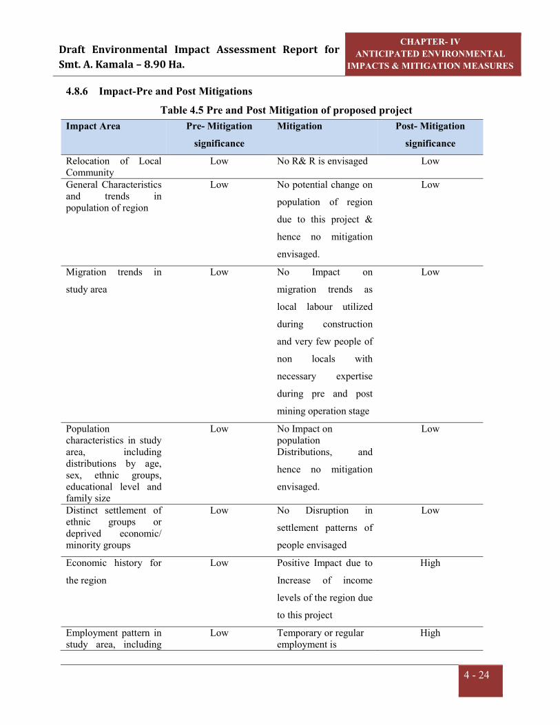
Draft Environmental Impact Assessment Report for Smt. A. Kamala – 8.90 Ha.
CHAPTER- IV ANTICIPATED ENVIRONMENTAL
IMPACTS & MITIGATION MEASURES
4 - 24
4.8.6 Impact-Pre and Post Mitigations Table 4.5 Pre and Post Mitigation of proposed project
Impact Area Pre- Mitigation significance
Mitigation Post- Mitigation significance
Relocation of Local Community
Low No R& R is envisaged Low
General Characteristics and trends in population of region
Low No potential change on
population of region
due to this project &
hence no mitigation
envisaged.
Low
Migration trends in
study area Low No Impact on
migration trends as
local labour utilized
during construction
and very few people of
non locals with
necessary expertise
during pre and post
mining operation stage
Low
Population characteristics in study area, including distributions by age, sex, ethnic groups, educational level and family size
Low No Impact on population Distributions, and
hence no mitigation
envisaged.
Low
Distinct settlement of ethnic groups or deprived economic/ minority groups
Low No Disruption in
settlement patterns of
people envisaged
Low
Economic history for
the region Low Positive Impact due to
Increase of income
levels of the region due
to this project
High
Employment pattern in study area, including
Low Temporary or regular employment is
High
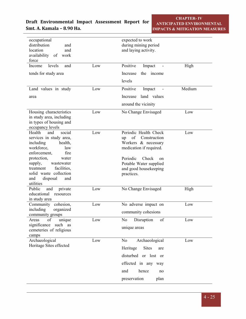
Draft Environmental Impact Assessment Report for Smt. A. Kamala – 8.90 Ha.
CHAPTER- IV ANTICIPATED ENVIRONMENTAL
IMPACTS & MITIGATION MEASURES
4 - 25
occupational distribution and location and availability of work force
expected to work during mining period and laying activity.
Income levels and
tends for study area Low Positive Impact -
Increase the income
levels
High
Land values in study
area Low Positive Impact -
Increase land values
around the vicinity
Medium
Housing characteristics in study area, including in types of housing and occupancy levels
Low No Change Envisaged Low
Health and social services in study area, including health, workforce, law enforcement, fire protection, water supply, wastewater treatment facilities, solid waste collection and disposal and utilities
Low Periodic Health Check up of Construction Workers & necessary medication if required. Periodic Check on Potable Water supplied and good housekeeping practices.
Low
Public and private educational resources in study area
Low No Change Envisaged High
Community cohesion, including organized community groups
Low No adverse impact on
community cohesions Low
Areas of unique significance such as cemeteries of religious camps
Low No Disruption of
unique areas Low
Archaeological Heritage Sites effected
Low No Archaeological
Heritage Sites are
disturbed or lost or
effected in any way
and hence no
preservation plan
Low

Draft Environmental Impact Assessment Report for Smt. A. Kamala – 8.90 Ha.
CHAPTER- IV ANTICIPATED ENVIRONMENTAL
IMPACTS & MITIGATION MEASURES
4 - 26
The resulting terms for the overall assessment for each socio economic environment aspect
were defined as follows:
High: impact acceptable if any criterion is awarded as high grade.
Medium: tolerable risk/ impact not acceptable if managed to level that is As low As
reasonably practicable, if the criteria have grades combining medium & low; and
Low: negligible risk/impact acceptable than all criteria are low
4.9 IMPACT ON OCCUPATIONAL HEALTH AND SAFETY During the high windy days in summer the Road Metal & Building Stone could be the
problems for eyes like itching and watering of eyes. Dust in air can be a health hazard
leading to respiratory issues such as asthma and irritating the lungs and bronchial
passages.Air Blast and fly rock may pose problem during blasting, thus blasting will be
avoided.
For mitigating the aspects following measures will be implemented:
Regular water sprinkling on haul roads.
Controlled blasting with prior warning system will be practiced.
Periodical medical examinations will be carried out for the workers as per norms,
Medical records will be maintained,
Medical facilities to the workers,
Any early symptom of diseases, if observed, such workers will be taken off in the
dusty atmosphere and suitably employed elsewhere,
Personal Protective Equipments such as helmets, safety shoes and aprons with nose
masks will be provided to the workers,
Good quality water will be provided to the workers and proper test for water quality
to be carried out regularly.
A well equipped first aid facility will be available in mine lease area,
Safety of the employee during operations, maintenance of mining equipments will be
taken care as per Mine Regulations 1961.
required,

Draft Environmental Impact Assessment Report for Smt. A. Kamala – 8.90 Ha.
CHAPTER- IV ANTICIPATED ENVIRONMENTAL
IMPACTS & MITIGATION MEASURES
4 - 27
Effective communication system like mobile phones, land line phones, e-mail etc.
facilities will be available at the mine site.
Uniforms will be provided to the workers and they will be allowed to go home after
changing clothes.
Trespassers are not allowed.
CHAPTER –V ANALYSIS OF ALTERNATIVES

Draft Environmental Impact Assessment Report for Smt. A. Kamala – 8.90 Ha.
CHAPTER-V ANALYSIS OF ALTERNATIVES
5- 1
5.0 GENERAL The analysis of alternative is the process of comparing potential impacts and mitigation
options of a series of alternative location, technologies, operation to identify optimal
alternatives.
5.1 ALTERNATE TECHNOLOGY Smt. A. Kamala has a Quarry lease for Road Metal & Building Stone over an extent of
8.90 Ha. in Sy. No. 1 of Mallipudi Village, S. Kota Mandal, Viziznagaram District,
Andhra Pradesh. The proposed production capacity is 80078.40m3/Annum of Road Metal
& Building Stone.
The production technology for excavation of Road Metal &Building Stone is open cast
semi mechanized method of mining with the help of drilling, blasting and excavation by
excavators. Road metal is medium hard mineral, so blasting and drilling are unavoidable
activities for this mine. The technology suggested is best suited for Road Metal and
Building Stone production. The present technology will be implemented in safe and
environmental friendly manner.
5.2 ALTERNATIVE SITE Mining activities are carried out based on local geology and availability of the mineral.
As it is existing mine, alternate site selection is not applicable.

CHAPTER –VI ENVIRONMENTAL MONITORING
PROGRAMME

Draft Environmental Impact Assessment Report for Smt. A. Kamala – 8.90 Ha.
CHAPTER-VI ENVIRONMENTAL MONITORING
PROGRAMME.
6 - 1
6.0 ENVIRONMENTAL MONITORING Success of any environmental management programme depends upon the efficiency of
the organizational set up responsible for Implementation of the programme. Post project
monitoring is an essential part to check the impact of any project activity. Hence
monitoring of various environmental parameters will be carried out a regular basis to
ascertain the following:
State of pollution within the mine and in its vicinity.
Generate data for predictive or corrective purpose in respect of pollution.
Examine the efficiency of pollution control systems installed in the ML area.
To assess and monitor environmental impacts.
Environmental monitoring will be taken up for various environmental components
as per conditions stipulated in Environmental Clearance Letter issued by SEIAA
Committee &Consent to operate issued by the State Pollution Control Board. Compliance
of same will be submitted to respective authorities on regular basis. The Management
will assign the third party which is recognized by MoEF&CC/NABL to monitor the
environmental parameters in the mine site and the surroundings as per the schedule and
will maintain the log books.
6.1 ENVIRONMENT MANAGEMENT In order to maintain the environmental quality within the stipulated standard, regular
monitoring of various environmental components is necessary which will be complied as
per condition.
An environmental management cell will be implemented. The structure of the team
proposed for environmental management is a simple one; this is due to the limited size of
the organization. As the employees are mostly unskilled labourers and the operating size
of the management is small, it is better that a member of senior management or a
manager level employee assumes the responsibility of complying with environmental
measures.

Draft Environmental Impact Assessment Report for Smt. A. Kamala – 8.90 Ha.
CHAPTER-VI ENVIRONMENTAL MONITORING
PROGRAMME.
6 - 2
6.2 MONITORING AROUND THE MINE SITE a. Meteorology The Management will assign the third party which is recognized by MoEF&CC to
monitor the weather conditions in the mine site and the surroundings as per the schedule
and will maintain the log books.
b. Ambient air quality monitoring Ambient air quality will be monitored in the mine site and in the surrounding villages
through a third party as per the guidelines.
c. Ground water monitoring Ground water levels for physical and chemical parameters will be monitored in and
around the mine site premises during the pre and post monsoon seasons.
d. Wastewater sampling The wastewater sample will be collected regularly for analysis.
6.3 POST PROJECT MONITORING PROGRAMME In order to maintain the environmental quality within the standards, regular monitoring of
various environmental components is necessary.
The proponent will allocate Capital Cost Rs. 5.6 Lakhs and recurring cost is 4.3 Lakhs
per annum budget towards environmental protection initiatives. The annual budget
allocated for Environmental monitoring is 0.5 Lakhs/annum.
6.3.1 Environmental Monitoring Regular monitoring of various Environmental parameters shall be carried out to ascertain
the following points.
Status of air, noise, water, land pollution within the mining activity and in its vicinity;
Generate data for predictive or corrective purpose in respect of pollution; and
To assess and monitor Environmental impacts periodically.

Draft Environmental Impact Assessment Report for Smt. A. Kamala – 8.90 Ha.
CHAPTER-VI ENVIRONMENTAL MONITORING
PROGRAMME.
6 - 3
6.4 MONITORING SCHEDULE FOR ENVIRONMENTAL PARAMETERS Table: 6.1Monitoring Schedule for Environmental Parameters
S.No. Particulars Monitoring Frequency
IMP. Monitoring Parameters
1.
Water and Wastewater Quality
a. DomesticSewage
b. Ground Water Quality
Once in a month
Pre monsoon and
Post monsoon season
pH,TDS,BOD,COD
pH,TDS,BOD,COD
2.
Air Quality
a. Ambient Air Quality
Monitoring at mine site &
other sampling locations
given in the report
Quarterly
PM10, PM2.5,SO2,
NOXand Free Silica
3. Noise levels in and around
Mine site Quarterly
Noise levels -
Day and Night in
dB(A)
6.5 IMPLEMENTATION SCHEDULE The mitigation measures suggested above should be implemented so as to reduce the
impact on environment due to the operation of the mining activities. In order to facilitate
easy implementation, the mitigation measures are phased as per the priority of
implementation. The implementation schedule is given as below (Table - 6.2) Table - 6.2Implementation Schedule
S.No Recommendations Time
Requirement Immediate Progressive
Discretion of the
Management
1 Air pollution
control measures
Being
implemented
* -- --
2 Water pollution
control measures
Being
implemented
* -- --

Draft Environmental Impact Assessment Report for Smt. A. Kamala – 8.90 Ha.
CHAPTER-VI ENVIRONMENTAL MONITORING
PROGRAMME.
6 - 4
3 Noise control
measures
Being
implemented
* -- --
4 Ecological
preservation and
Up gradation
Stagewise
implementation
* * --
5 Land
reclamation/Soil
waste management
Stagewise
implementation
* * --
6 Socio-economic
measures
As per the CER
activities
proposed by the
company and
the need of the
local residents
-- * *
Note (*) indicates implementation of recommendations
6.6 MONITORING EQUIPMENT AND CONSUMABLES 1. Handy samplers
2. Respirable Dust Sampler / Fine Particulate Sampler
3. Meteorological station

CHAPTER –VII ADDITIONAL STUDIES

Draft Environmental Impact Assessment Report for Smt. A. Kamala – 8.90Ha.
CHAPTER-VII ADDITIONAL STUDIES
7 - 1
7.0 PUBLIC CONSULTATION: As per MoEF&CC Notification S.O. 804 (E) 14.03.2017“Started the work onsite without
obtaining prior EC as per EIA notification – 2006”. Production started without EC from
the year 2016, the project attracted violation. Therefore, public consultation is mandatory
to seek the opinion of the people regarding the violation mine through public hearing
organized by the State Pollution Control Board.
The present Draft EIA is being submitted for conducting Public Hearing. The issues
raised during the public hearing, the response of the proponent along with action plan and
budgetary allocation will be given in the Final EIA report and submitted to MoEF&CC
for obtaining environmental clearance.
7.1 RISK ASSESSMENT
Risk analysis provides identification of the risks/accidents and to take necessary steps to
prevent it happening. The main objective of risk assessment includes;
To identify the potential hazardous areas so that necessary design safety measures
can be adopted to minimize the probability of accidents.
To identify the potential areas of Environmental disaster, this can be prevented by
proper design of the installations and their control operations.
To manage emergency situations or a disastrous event, if any, from the mining
operations.
It begins with the identification of probable hazardous events at an operational area and
categorization as per the predetermined criteria. Risk assessment should be done on the
basis of past accident analysis at similar projects, previous judgments and expertise in the
field of risk analysis especially in accident analysis.
7.1.1 Drilling and Blasting Risks Drilling is common operation for mining Road Metal & Building Stone, which is medium
hard mineral. The main hazards involved are as follows:
Drill falling from the edge of a bench
Dust created during the drilling operations

Draft Environmental Impact Assessment Report for Smt. A. Kamala – 8.90Ha.
CHAPTER-VII ADDITIONAL STUDIES
7 - 2
Noise produced during drilling
The risk will occur during the drilling of the first line of holes parallel with the working
edge of the bench. Measures that can be taken to reduce the risk of falling off the edge of
the bench is to provide suitable portable rail fencing which can be erected between the
drill and the edge of the bench and direction by the supervisor from guidance of the
driller.
The major issue during blasting is fly rock. Fly rock is controlled by implementing
controlled blasting with delayed detonators. Early warnings such as sirens or
announcements will be given for safety. Trespassers are not allowed during blasting
activity.
Control measures for Dust and Noise produced during drilling and blasting are discussed
in detail in Chapter IV.
7.1.2 Failure of Slope in the Pit In open pit mining, mineral deposits are mined from the ground surface and downward.
Consequently, pit slopes are formed as the mineral is being extracted. The issues
concerned with slope stability in the open cast mines have come to forefront in the
mining operations due to increasing pit depth.
The pit slopes must thus be inclined at some angle to prevent failure of the rock mass.
This angle is governed by the geo-mechanical conditions at the specific mine and
represent an upper bound to the overall slope angle. The actual slope angles used in the
mine depend upon (i) the presence of haulage roads, or ramps, necessary for the
transportation of the blasted ore from the pit (ii) possible blast damage (iii) mineral
grades, and (iv) economical constraints.
Besides determining factor of safety, the slopes shall be monitored at regular intervals by
using real time slope stability radar system to monitor for any possible failure. The well
developed drainage system over the lease area should ensure that storm water does not
accumulate in the lease area and therefore hydrostatic pressure remains at a low level.
Draft Environmental Impact Assessment Report for Smt. A. Kamala – 8.90Ha.
CHAPTER-VII ADDITIONAL STUDIES
7 - 3
7.1.3 Filling up the mine pit due to excessive rains
Filling up the mine pit due to excessive rains in the worked out area is a remote
possibility. Normally there will be sufficient warning time before such an incident takes
place, harming equipment and human life. However, as a precautionary measure,
interceptor ditches along the outer boundary of the pit area constructed to control inflow
of runoff into the mine pits. Water that collects in the mine pit from rainfall will be
coursed out from the pits, through garland drains.
7.1.4 Accidents of heavy machinery Most of the accidents during transfer of product, trucks and other vehicles are often
attributed to mechanical failures, in which the factor of human errors cannot be ruled out.
Regular maintenance and testing of all mine equipment as per manufacturer’s guidelines
can largely eliminate accidents of heavy machinery. Competent drivers will be employed
to minimize accidents during transportation.
7.2 DISASTER MANAGEMENT PLAN A disaster is a catastrophic event in which personnel working in the affected area are
immediately planed into a chaotic situation, which demands their immediate rescue,
medical and social case to restore normalcy. It creates a major emergency in mining area
requiring an Emergency response in accordance with a Mine Disaster Management Plan
formulated by the management.
A detailed DMP for handling emergencies includes;
Identification and assessment of major credible risk scenarios anticipated at a
particular workplace/activity (Slope failure, fly rock fragments, fires, etc.)
Setting up an Emergency response organization identified key personnel at the mine
with assigned duties and responsibilities for incident response and emergency
response.
Emergency action plan with implementation procedures by emergency response
personnel for each scenario after emergency warning.
Details of safety measures to prevent accident and disaster.

Draft Environmental Impact Assessment Report for Smt. A. Kamala – 8.90Ha.
CHAPTER-VII ADDITIONAL STUDIES
7 - 4
Emergency notification by sending warning messages to identified agencies for
liaison and stake holders.
Setting up a permanent organization for completion of emergency and restoration of
normalcy by complying with health, safety, and environmental laws and regulations
Supplementary response plans under mutual aid
Any other stipulations made by regulatory agencies for handling emergency
situations that may arise either from natural or manmade.
7.3 IMPLEMENTATION OF EMP AND MONITORING SYSTEM
7.3.1 General Various measures have been proposed to implement for mitigating the adverse impacts
due to mining on the environment in the area. A separate wing “Environmental
Management Cell (EMC)” will be formed to look after the inspection / monitoring
requirements. The mine management will undertake the control measures in coordination
with the State Forest Department, Regional APPCB and Environmental consultant. The
management of EMC shall be made an integral part of the major activities of mining.
Mines Manager
Geologist (Incharge of Supervisor
Mine monitoring and
Supervision& APPCB/ MoEF works)
Dust Suppression Mate
Helpers
Fig.7.1 Organizational setup of EMC

Draft Environmental Impact Assessment Report for Smt. A. Kamala – 8.90Ha.
CHAPTER-VII ADDITIONAL STUDIES
7 - 5
Important records to be maintained by EMC are: Field monitoring results for air, water, meteorology
Inspection records of slope failure, land erosion, drainage, Socio-economic
development.
Format to record / monitor plantation measures.
Nursery records
Environmental and related standards / norms
Records pertaining to statutory consents, approvals
Periodic medical examination (PME) records.
Records pertaining to laboratory equipment maintenance and calibration.
Complaints register (environmental pollution).
Records on water and electricity consumption.
Periodic progress records
Environmental audit records
Records of annual budgetary requirement and allocation for pollution control.
7.3.2 Implementation
The following system shall be followed to see that the environmental scheme is
implemented as per schedule.
a. A separate wing will be created to see that the engineering measures such as
construction of garland drains and retention walls are taken up, wherever necessary.
b. A crew attends for afforestation measures on a regular basis for culturing, manuring
and watering.
c. On an annual/quarterly basis, the quality of air, water, noise and soil will be
monitored to understand the status vis-à-vis the baseline data. This will enable the
management for taking up any corrective measures, if required. The frequency of
sampling will be as prescribed by the MoEF&CC guidelines issued in this regard.
Draft Environmental Impact Assessment Report for Smt. A. Kamala – 8.90Ha.
CHAPTER-VII ADDITIONAL STUDIES
7 - 6
7.4 ACTIVITIES TO BE MONITORED / INSPECTED BY EMC 7.4.1 Land erosion
The mine activity will expose out the loose earthy material which leads to soil erosion
through rain water runoff or wind action. This phenomenon should be monitored
regularly and necessary actions should be implemented. Garland drains will be
constructed around the mine area to avoid siltation of nearby lands/water bodies. These
constructed drains should be regularly inspected and desiltation works should be taken up
by the proponent.
7.4.2 Drainage There are no ground water bodies like open wells or bore wells in this area, the ground
water table is more than 48 m depth from the ground level. Since the mine workings are
proposed on top of the mound, no chances for accumulation of ground water in working
pit and no water will be discharged from the pit.
7.4.3 Re-vegetation and green belt development Planned schedule for green belt development will be checked after every year and
improvement required will be implemented. Post plantation status will be regularly
checked in every season. Phase wise development in the areas of plantation including rate
of growth, survival rate etc. will be recorded systematically.
7.4.4 Occupational Health Since it is opencast mining, health problems due to dust may be expected at various
locations (excavation & loading) during mining of Road Metal & Building Stone. Control
blasting will be done to minimize the impact on surroundings.
Monitoring: The efficiency of installed dust controlling equipments and water sprinkling system
should be monitored on regular basis. Measurements to determine employee ceiling
exposure can be taken during period of maximum expected air borne concentrations of
Road Metal & Building Stone. Safety measures followed by the work force during

Draft Environmental Impact Assessment Report for Smt. A. Kamala – 8.90Ha.
CHAPTER-VII ADDITIONAL STUDIES
7 - 7
mineral production (like usage of PPE) should be monitored by the mine
supervisor/management.
Control Measures: Location of dust generation:
1. Mining area
2. Loading & Transportation
It is advisable to use water sprinkling on haul roads to suppress the dust generated, so that
the work men will not get expose to the dust.
Precautions: By using various PPEs, the chances of occupational health disease will be
lowered.
Periodical medical checkups for lungs functioning and breathing.
First aid will be given for in case of emergency.
Each group of mine worker will undergo regular medical checkup at regular
intervals by specialist doctors.
Persons not wearing protective equipment and clothing should be restricted from
areas of spills until clean up has been completed.
The workmen especially who are literate should be sent for first aid training
conducted by the group vocational training centre to maintain by the DGMS
(Director General of Mine Safety).
7.4.5 Operation and Maintenance: The problem of occupational health in the operation and maintenance phase is primarily
due to dust and noise which could affect the workers from respiratory and hearing
problems. The necessary personal protective equipments will be provided to all the
workers. The working personnel will be given the following appropriate personnel
protective equipments.
Safety helmets
Face shield

Draft Environmental Impact Assessment Report for Smt. A. Kamala – 8.90Ha.
CHAPTER-VII ADDITIONAL STUDIES
7 - 8
Plain goggles with cut type filters on both ends.
Goggles with cut type filters on both sides and blue color glasses
Cylindrical type earplug
Ear muffs
Dust mask
Self contained breathing apparatus
Leather apron
Safety belt
Leather hand gloves
Safety shoes with steel toe
Full-fledged hospital facilities will be available round the clock for attending emergency
arising out of accidents, if any. All working personnel will be medically examined at least
once in every year.
7.5 COMPLIANCE FOR ADDITIONAL TERMS OF REFERENCE: TOR has been issued and the following points were added as additional conditions along
with terms of standard TOR vide Lr. No. SEIAA/AP/VSP/VIO/MIN/11/2021/3236-991
Dated: 23.12.2021. Additional TOR issued and the compliance to the same is given
below:
7.5.1 Proponent shall submit Cluster EIA & EMP. As per cluster notification by MoEF&CC mines which not executed lease or
Environmental Clearance before 9th September 2013 were considered and were included
in preparation of cluster EMP. As per records of the Asst. Director of Mines and
Geology, Vizianagaram vide Lr. No. 2515/Q/2009 Dt: 30.03.2021 there are no areas for
which L.O.I is issued for grant of mine lease, where as there are 3 working mines present
within 500 m distance which were granted before 09.09.2013 and those mines shall not
counted for cluster formation. Thus, the condition of cluster needs preparation of cluster
EMP for all working mines and attached as Annexure IV.

CHAPTER –VIII
PROJECT BENEFITS

Draft Environmental Impact Assessment Report for Smt. A. Kamala – 8.90 Ha.
CHAPTER-VIII PROJECT BENEFITS
8 - 1
8.0 GENERAL The surrounding inhabitants depends mainly agriculture for their livelihood.
Unemployment and under employment are the main problems of the inhabitants. No
displacement or evacuation of human settlement has been anticipated during mining
operation. Resuming the mining operations will help in improving the socio-economic
status in the area like employment, infrastructure development etc. It improves the living
standard of the people, supports for education and increase the ability of people to
understand the changes.
The following paragraphs will discuss the benefits that are obtained from this mining
activity.
8.1 EMPLOYMENT The upcoming project will generate direct and indirect employment opportunities for the
local people. The mine will create employment for a total of approximately 27 persons
including skilled as well as semi-skilled staff directly. Additionally, certain works like
security, housekeepers will be outsourced on contract. The secondary employment is in
the form of providing services to the employed manpower will also be developed in the
neighbouring villages. This will enhance their income and lead to overall economic
growth of the area.
8.2 OCCUPATIONAL HEALTH Each group of mine workers undergo regular medical checkup at regular intervals by
specialist doctors as per Mines Act/ Rules and other social development and promotional
activities will be undertaken. All this will lift the general health status of the residents of
the area around the mine.
8.3 IMPROVEMENTS IN PHYSICAL AND SOCIAL INFRASTRUCTURE The resumed operations of the mine will enhance the socio-economic activities in the
adjoining areas. This will result in following benefits:-
Improvements in physical infrastructure.
Improvements in social infrastructure.
Prevention of illegal mining.

Draft Environmental Impact Assessment Report for Smt. A. Kamala – 8.90 Ha.
CHAPTER-VIII PROJECT BENEFITS
8 - 2
During and post-mining enhancement of green cover.
8.3.1 Improvements in Physical Infrastructure Although the mining area is well connected with important places in the vicinity
however, the resumed operations of the mine will improve the physical infrastructure of
the adjoining areas. This will include the following.
Improved road communication due to operation of the mine.
Strengthening of existing community facilities through the Community Development
Program.
Creation of community assets (infrastructure) like provision for drinking water,
village roads/ linked roads, dispensary & health centre, community centre, market
place etc.
Awareness program and community activities, like health camps, medical aids,
family welfare programs, cultural activities, plantation etc.
8.3.2 Improvements in Social Infrastructure The mining activity shall create awareness with the local people for preferring permanent
services than seasonal agricultural activities. The activities will help them to analyze the
importance of education. With the increased amount of income, people can send their
children for higher education/professional courses. There will be some obvious changes
in various environmental parameters due to mining activity. There will also be positive
impact in socio-economic area due to increased economic activities, creation of new
employment opportunities, infrastructural development and better educational and health
facilities. Lessee will also undertake awareness program and community activities like
health camps, medical aids, family welfare camps, and awareness program etc.
8.3.3 Prevention of Illegal Mining & Contribution to the Exchequer Since the mine lease areas will be leased out to successful allottees, mining operation in
the state will get legalized and it will fetch income to the state exchequer. The proponent
will take due care to avoid illegal mining within the mine lease area. The production will
be as per approved mining plan after obtaining statutory clearances from respective
authorities.

Draft Environmental Impact Assessment Report for Smt. A. Kamala – 8.90 Ha.
CHAPTER-VIII PROJECT BENEFITS
8 - 3
8.3.4 Enhancement of Green Cover Plantation/Afforestation will be done as per program i.e. along the road sides and near
civic amenities. Post plantation, the area will be regularly monitored in every season for
evaluation of success rate. For selection of plant species local people will also be
involved. The management will provide free saplings of fruit and other trees, etc. to local
people during monsoon.
8.4 OTHER TANGIBLE BENEFITS
The resumed operations of mining activity are likely to have other tangible benefits as
given below.
Indirect employment opportunities to local people in contractual works like
transportation, sanitation, for supply of goods and services to the project and other
community services.
Market and business establishment facilities will also increase.
Improvement in communication, transport, education, community development and
medical facilities.
Overall change in employment and income opportunity.
The State Government will also be benefited directly from the project, through
increased revenue from royalties, excise duty.

CHAPTER –IX ENVIRONMENTAL MANAGEMENT PLAN

Draft Environmental Impact Assessment Report for Smt. A. Kamala – 8.90Ha.
CHAPTER-IX ENVIRONMENTAL MANAGEMENT
PLAN
9 - 1
9.0 INTRODUCTION Any types of development project exert certain benefits and adverse impacts on the
surroundings. The major objective and benefit of utilizing Environmental impact
Assessment in project planning stage itself, is to prevent avoidable losses of
Environmental resources and values as a result of Environmental Management Plan.
Environmental Management Plan includes protection/mitigation/enhancement measures
as well as suggesting post project monitoring program. Environmental Management Plan
may often suggest additional project operations that have to be incorporated in the
conventional operation.
Any development in the study area needs to be with judicious utilization of non-
renewable resources of the study area and within the limits of permissible assimilative
capacity. The assimilative capacity of the study area is the maximum amount of pollution
load that can be discharged in the environment without affecting the designated use and is
governed by dilution, dispersion, and removal due to physico-chemical and biological
processes. The Environment Management Plan (EMP) is required to ensure sustainable
development in the study area of the Mine Lease Area.
It has been evaluated that the study area has not been affected adversely as there are no
major polluting activities in the study area and likely to get economical fillip.
Environmental Management Plan aims at the preservation of ecosystem by considering
the pollution abatement facilities at the site inception.
Fully conscious towards Environmental responsibility the proponent mainly focuses,
apart from other relevant concerns, on the following important aspects,
a) Dust suppression measures by water sprinkling
b) Proper maintenance of vehicles and equipment.
The different Environmental components that are identified in the assessment chapter are
dealt hereunder with necessary Environmental Management Plan.

Draft Environmental Impact Assessment Report for Smt. A. Kamala – 8.90Ha.
CHAPTER-IX ENVIRONMENTAL MANAGEMENT
PLAN
9 - 2
Applicable Regulations Following Regulations & policies with the amendments thereof need to be taken into
consideration under comprehensive environmental management systems (EMS)
programme as an integral part of the mine operation:
The Mines Act, 1952
The Mines and Mineral (regulation and Development) Act, 1957.
Mineral conservation and Development Rules (MCDR), 1988.
Mines Rules, 1955 for Health and Safety of Mining workers.
Section 21 of Air (Prevention and Control of Pollution) Act, 1981.
Section 25 and 26 of Water (Prevention and Control of Pollution) Act, 1974.
Gazette Notifications of Central Pollution Control Board (CPCB) as and when
notified for pollution prevention and control.
Applicable State Acts and Rules for Mining.
Directives of Andhra Pradesh Pollution Control Board (APPCB) in their Consent
Letters and Notifications.
EP Act 2006
Table: 9.1 EMP costing for the project
S.No Details Capital Cost (in Lakhs)
Recurring Cost
(Lakhs) Remarks
1 Air Pollution Nose masks (Rs. 25/- each) - 0.24 Replaceable
once in a week
Sprinkling system 3.0 KLD (Rs. 750/- for 1 tank of capacity 10KL)
0.4 0.1 Required daily on 250 working days
Wet jacketed Drilling 5.0 KLD -- 0.8
Required daily on 250 working days
Gunny bags -- 0.05
Graded road Construction -- 0.04
2 Water Pollution Garland drains (approx top 0.5 0.1 Drains

Draft Environmental Impact Assessment Report for Smt. A. Kamala – 8.90Ha.
CHAPTER-IX ENVIRONMENTAL MANAGEMENT
PLAN
9 - 3
width 2m, bottom width 1m & height 1m) Rs. 270/- per sq.m & RWH
construction around the mine site
Construction of Septic tank -- 0.1 Cleaning twice in a year
3 Noise Pollution Regular maintenance of machinery (1500/- per month)
-- 0.2
Ear muffs (Rs. 50/- each) -- 0.03 Thrice in a year
4 Occupational Safety and Health First aid kits
0.1 0.03 Replaceable twice for every year
Fire extinguishers 0.1 0.03
PPE for all workers (hand gloves Rs. 30 /- each, helmets 500/- and Safety shoes 500/- each)
-- 0.3
Regular health checkups -- 0.28 Carried out once in a year
Training and awareness programs on risk factors during emergencies
0.3 0.1
5 Environmental Monitoring
Ambient air, water quality, Noise studies and Vibration studies
-- 0.5
6 Green belt development
Avenue Plantation along the approach road of 1.0 km stretch.
3.8 1.4 950 plants
TOTAL 5.6 4.3 CSR Budget 3.0 0.4
GRAND TOTAL 8.6 4.7
EMP BUDGET
Capital Cost : 5.6 Lakhs
Recurring cost per annum : 4.3 Lakhs
Draft Environmental Impact Assessment Report for Smt. A. Kamala – 8.90Ha.
CHAPTER-IX ENVIRONMENTAL MANAGEMENT
PLAN
9 - 4
9.1 CORPORATE ENVIRONMENT RESPONSIBILITY Smt. A. Kamala will follow Corporate Environmental Responsibility (CER) as per O.M.
File No. 22-65/2017-IA.III dated: 01.05.2018.
The following measures will be taken to maintain a clean and sustainable environment in
and around the plant:
Integrate sound environmental practices in all its activities.
Promote development of innovate environment friendly processes
Improve employee commitment and responsibility towards environment
protection
Promote environmentally responsible behaviour amongst contractual workforce
and suppliers.
Development of greenbelt in surrounding areas and along the approach road.
CER activities by the proponent Development of Infrastructure facilities in nearby schools
Health camps
Providing public toilets in nearby villages
Development of greenbelt in surrounding areas
9.2 OBJECTIVES OF ENVIRONMENTAL MANAGEMENT PLAN Overall objectives of EMP are:
Prevention: Measures aimed at impeding the occurrence of negative environmental
impact and/or preventing such as occurrence having harmful environmental impacts.
Preservation: Preventing any future actions that might adversely affect as environmental
resource or attribute.
Minimization: Limiting or reducing the degree, extent, magnitude or duration of adverse
impacts.
9.3 AIR QUALITY MANAGEMENT The mining activity would result in the increase of PM concentrations due to fugitive
dust. Frequent water sprinkling in the vicinity would be undertaken and will be continued

Draft Environmental Impact Assessment Report for Smt. A. Kamala – 8.90Ha.
CHAPTER-IX ENVIRONMENTAL MANAGEMENT
PLAN
9 - 5
as there is possibility for dust generation due to truck mobility. It will be ensured that
vehicles are properly maintained to comply with exhaust emission requirements.
Table: 9.2Ambient Air Quality Standards
Concentration Microgram's per Meter Cube
PM10 PM2.5 SO2 NOX 100 60 80 80
Mitigative measures suggested for air pollution control are based on the baseline ambient
air quality monitoring data. From the point of view of maintenance of an acceptable
ambient air quality in the region, it is desirable that air quality should be monitored on a
regular basis to check it vis-à-vis the standards prescribed by CPCB and in case of non-
compliance, appropriate mitigative measures shall be adopted.
As per the results of ambient air quality monitoring data, the background concentrations
of PM10, PM2.5, SO2, NOX and Free Silica are within the stipulated CPCB standards.
9.3.1 Air Pollution Control Measures Dust is the major pollutant generated from the mining operations. Dust would be
generated during mining, handling and transportation of the material. The Environmental
control measures proposed to control the fugitive dust releases during the Road Metal
&Building Stone production are given in the below table.
Table: 9.3Air Pollution Control Measures
S.No Dust Source Control measure
1 Haul Road Compaction, gradation and drainage on both sides. Proper maintenance. Regular water spraying.
2 Truck Movement
No overloading of trucks. Trucks to be covered with tarpaulin while
transporting Road Metal &Building Stone Enforcing speed limit.

Draft Environmental Impact Assessment Report for Smt. A. Kamala – 8.90Ha.
CHAPTER-IX ENVIRONMENTAL MANAGEMENT
PLAN
9 - 6
3 Blasting area
Proper charge per delay shall be regulated. Stemming column shall be more than the burden to
avoid blown out shots. Each blast would be is carefully planned,
supervised executed and observed by expert staff
In addition the following measures will be undertaken
Development of Green belt
Periodical monitoring of air quality to take steps to control the pollutants.
Regular water sprinkling to suppress the dust on haul roads, service roads and mining
face by truck mounted water tankers.
9.3.2 Controlling of other emissions The other emissions are mainly SO2, NOx and the source would be from vehicles. But,
these emissions are very minimal. This will be controlled by proper maintenance and
servicing of vehicles.
9.4 WATER QUALITY MANAGEMENT There will not be any waste water generation except domestic waste water, therefore no
post waste water monitoring required.
Water Pollution Management Channels and bunds would be constructed and maintained to avoid any erosion and
contamination.
The mine pit water collected due to rains will be utilized for water spraying on the
haul roads and for watering plantation.
9.5 NOISE LEVEL MONITORING There will be intermittent noise levels due to vehicular movement and mining activities.
The Management Plan for controlling noise pollution is envisaged as follows.
No mining activities are planned during night time.
A thick greenbelt will be developed
Selection of suitable machinery and equipment,

Draft Environmental Impact Assessment Report for Smt. A. Kamala – 8.90Ha.
CHAPTER-IX ENVIRONMENTAL MANAGEMENT
PLAN
9 - 7
Proper mounting of equipment,
Providing noise insulation/padding wherever practicable and
Machinery will be fitted with properly designed noise acoustic silencers.
Proper maintenance and periodic lubrication of noise generating parts of the
machines.
9.5.1 Parameters The noise level recordings are measured in dB (A) Leq values, where dB (A) denotes the
time weighted average of the level of sound in decibels on scale A, which is relatable to
human hearing.
9.5.2 Methodology Precision integrated sound level meters are being used for monitoring of Leq noise levels
in dB (A) scale at the work place and also in the surrounding villages.
9.5.3 Noise Quality Management The following measures shall be implemented
Proper lubrication, fitting of effective silencers and good maintenance.
Provision of personnel hearing protective equipment to all workers likely to be
exposed to noise.
Restricting duty hours of operators likely to be exposed to higher noise levels.
The maintenance of natural vegetation as well as afforestation in the lease shall serve
as acoustic barriers.
9.5.4 Noise Pollution Control The ambient noise level monitoring carried out in and around the mine shows that
ambient noise levels are well within the stipulated limits of CPCB.
Noise generation may be for an instant, intermittent or for continuous periods, with low
to high decibels. Periodic inspection and checks of the risk prone areas and equipments
have to be conducted.

Draft Environmental Impact Assessment Report for Smt. A. Kamala – 8.90Ha.
CHAPTER-IX ENVIRONMENTAL MANAGEMENT
PLAN
9 - 8
To control noise pollution during the proposed mining operations following steps will be
practiced.
Proper selection of machinery
Proper and timely maintenance of mining and plant machinery
Limiting of speed of haulage vehicles/tippers.
9.6 WATER CONSUMPTION AND WASTE WATER GENERATION A total of approximately 11.2 KLD of fresh water is required for the mining activity
which will be met through water tankers. Out of the total quantity, 1.2 KLD will be
utilized for domestic purpose, 5.0 KLD will be used for drilling by wet jacket method and
2.0 KLD for Green belt development. Remaining 3.0 KLD of water is required for dust
suppression as follows.
Fig 9.1 Water balance flow diagram
11.2 KLD (Water tankers)
11.2 KLD
Domestic purpose (1.2 KLD) Green Belt
(2.0 KLD) Dust Suppression
(3.0 KLD)
Septic Tank (Soak pit) (1.0 KLD)
No outflow No outflow No outflow
Drilling by wet jacket method
(5.0 KLD)

Draft Environmental Impact Assessment Report for Smt. A. Kamala – 8.90Ha.
CHAPTER-IX ENVIRONMENTAL MANAGEMENT
PLAN
9 - 9
9.7 BIOLOGICAL MANAGEMENT Trees are very suitable for detecting, recognizing and monitoring air pollution effects.
Monitoring of biological effects of air pollutant by the use of plants as indicators has
been applied on local, regional and national scale. Trees function as sinks of air
pollutants, besides their bio esthetical values, owing to its large surface area. Annual need
of oxygen for one person is met by 150 sq.m of leaf surface. So it is necessary to develop
green belt in and around the polluted site with suitable species to combat the air pollution
effectively. The plantation scheme covers the following areas.
Plantation around peripheral portion of mine and other structures.
Gardens, parks and haul road plantation.
Plantation by way of reclamation/rehabilitation of mined out blocks.
9.7.1 Tree Plantation Program The main aim of plantation of mined out areas is to stabilize the land, to protect it from
erosion and provide an aesthetic landscape. It is proposed to develop avenue plantation
on either side of the approach road to a stretch of 1.0 km out of the total approach road.
9.7.2 Mine Drainage: Water table: There are no ground water bodies such as open wells or bore wells in this
lease area. The ground water table is about 48 m depth from the ground level. Maximum
depth of workings is up to RL 70 m and minimum depth of workings is RL 80 m. The
proposed maximum quarry operations during the plan period, a depth of 98m from the
top hill, which is above the ground level; thus no chances for accumulation of ground
water in working pit and no water, will be discharged from the pit.
Encounter and discharge of mine water: There is no chance of groundwater likely to
be encountered in the mine. But the rainwater will accumulate at pit bottom in rainy
seasons and this may be dried up slowly by percolating to ground.

Draft Environmental Impact Assessment Report for Smt. A. Kamala – 8.90Ha.
CHAPTER-IX ENVIRONMENTAL MANAGEMENT
PLAN
9 - 10
9.8 SOIL MANAGEMENT Top Soil Management The minimum top soil preserved will be used for plantation, filling ditches and
reclamation wherever necessary.
Waste Management Out of the total excavated mineral i.e., 90% saleable Road Metal & Building Stone and
10% overburden which will be in dump yard over an extent of 1.0218 Ha within mine
lease area as step dumping. It is useful for road gradation, hence no need of waste dump
management. The topsoil will be preserved within the lease area for mined area
reclamation usage at the time of closure.
9.9 LAND ENVIRONMENT
9.9.1 Land use The project covers a total ML area of 8.90hectares of Govt. land presently granted for
Road Metal & Building Stone mining. During the ensuing plan period an area of 2.4942
hectares of land will be brought under mining by the end of the plan period. About
1.0218 Ha will be maintained as 7.5m buffer area. The remaining area shall be put to use
in the future basing on the demand for Road Metal & Building Stone. The core zone
landscape can be improved by tree plantation, shrub growth etc., which are outlined
separately under eco-restoration.
9.9.2 Mine roads Roads for haulage and access to different locations would be laid as per the statutory
regulations stipulated in the Metalliferrous Mines Regulations, 1961. Some of the basic
features of laying the haul roads at the Mine Lease Area as required from environmental
and safety angle cover the following:
The road layout would be generally followed as per scheme shown in mine general
layout. The main haul road and feeder roads would be generally of 6 m wide keeping
provisions for road side plantation.

Draft Environmental Impact Assessment Report for Smt. A. Kamala – 8.90Ha.
CHAPTER-IX ENVIRONMENTAL MANAGEMENT
PLAN
9 - 11
The corners and bends would be made in such a way as to offer the vehicle operator,
a clear visibility of at least 30m along the road.
The alignment of haul roads and feeder roads may require alteration with the progress of
mining work.
9.9.3 Proposed Mitigating Measures The land management plays an important role in reducing the adverse impacts caused by
surface mining operation. Land management is required in the key areas like land use
scheme with the ML area, calendar plan, mine bench advancement to arrest
indiscriminate degradation of landform, top soil preservation, soil erosion control and the
restoration of the mine pit.
Land restoration: Since it is envisaged that the quarry will be in operation for at least 39 years, so, no back
filling is proposed during the lease period. After removal of mineral, benches will be
formed below the surface level and the top of the benches will be applied with top soil
and developed with grasses and plantation. Fast growing trees and other native shrubs
would be planted to stabilize the reclaimed land and prevent wind erosion of solid
particles.
The pits formed will be used as rain water harvesting structures. While reclaiming the
mined out area, the original land form cannot be fully restored. This would be beneficial
in two aspects, namely (i) it may recharge the spring table by seepage of water through
cracks and joints and (ii) the impounded water reservoir can be utilized for development
of afforestation and irrigation source to nearby agricultural fields.
9.10 SOCIO-ECONOMIC ENVIRONMENT & SAFETY The company management shall give preference to local people through both direct and
indirect employment.
It will provide ample opportunity to the locals to up-lift their living standards by
organizing events that propagate mutual benefits to all, such as health camps,
awareness campaigns, donations to poorer sections of society and downtrodden.

Draft Environmental Impact Assessment Report for Smt. A. Kamala – 8.90Ha.
CHAPTER-IX ENVIRONMENTAL MANAGEMENT
PLAN
9 - 12
Educational needs of the region will be improved by encouraging the workers to
allow their children to attend schools.
Adequate supply of potable water to the workers will be made during the working
hours. Sufficient funds shall be allocated for these and other emergency needs.
The mines management will supervise the safe working of the contractor and their
employees. The working personnel will be provided with face masks, ear plugs,
safety helmets and goggles in order to reduce health hazards.
The proponent will provide all necessary provisions stipulated under the Mines Act. In
addition a Safety committee will be formed and manned by equal participants from
Management and Workers. Personnel Protection Equipment (PPE) will be issued to each
worker. Other safety equipments shall be used according to the nature of job involved.
9.11 BIOLOGICAL MANAGEMENT PLAN The mining activity will have low impact on shrubs in the mine lease area and in order to
minimize the impacts, it is proposed to reclaim the entire plain land available in mined
out area with indigenous plant species as early as possible. Plantation programme is
proposed to be carried out in and around the mine lease area so that the natural habitat is
restored.
9.11.1 Green Belt Development/Afforestation Plan
It is proposed to develop avenue on either side of the approach road to a stretch of 1.0 km
with 950 plants out of the total approach road. The year wise program of tree plantation is
being given in below table:
Table 9.4Details of Year Wise Tree Plantation Program
Year No. of Saplings I 150 II 200 III 200 IV 200 V 200
Total 950

Draft Environmental Impact Assessment Report for Smt. A. Kamala – 8.90Ha.
CHAPTER-IX ENVIRONMENTAL MANAGEMENT
PLAN
9 - 13
9.11.2Criteria for Selection of Species
Species to be selected should fulfill the following specific requirements of the area
- Availability of seed material
- Tolerance to specific conditions or alternatively wide adapts ability to eco-
physiological conditions.
- Rapid growth
- Capacity to endure water stress and climatic extremes after initial establishment
- Differences in height, growth habits
- Pleasing appearance
- Providing shade
- Ability of fixing atmospheric Nitrogen
- Improving waste lands.
9.11.3 Design of green development The greenbelt shall be developed around the mine to act as a sink for pollutants,
attenuation of noise levels and improvement in aesthetic quality of the plant. The
following criteria shall be adopted in the design of greenbelt:
1. Generally fast growing trees should be planted as otherwise it will take many years
for other types of trees to attain their full height.
2. Trees will be planted along the road side in such a way that there is no direct line of
sight when viewed from a point outside the foliage perimeter.
3. Trees growing up to 10 m or more in height with thick perennial foliage should be
planted around the plant.
4. Trees shall be planted staggered in each row (minimum three rows encircling the
perimeter of the plant).
5. Tree trunk being free foliage up to a height of 2 to 3 m, it is advisable to grow shrubs
in front of trees to give coverage to the open portion.
6. It is proposed to develop avenue plantation on either side of the approach road to a
stretch of 1.0 km out of the total approach road.

Draft Environmental Impact Assessment Report for Smt. A. Kamala – 8.90Ha.
CHAPTER-IX ENVIRONMENTAL MANAGEMENT
PLAN
9 - 14
9.12 OCCUPATIONAL HEALTH AND SAFETY MEASURES Mining profession involves exposure of workers to open area& dusty environment
requiring assessment of likely impacts on the health aspects. Workers are prone to be
affected by respiratory and pulmonary diseases, apart from health hazards related to
water pollution, noise and vibrations. Health impact assessment will be undertaken by
studying the nature of the mining activities and its impact. The proponent will appoint a
doctor periodically, well versed with occupational health surveillance to meet the medical
needs of the employees. The employees will be subjected to medical examination on an
annual basis. The medical histories of all the employees shall be maintained in a standard
format. These medical histories over a period will show if there is occupation related
deterioration in the employees’ health. The recurring budget allocated for occupational
health & safety measures is Rs. 0.74 Lakhs/Annum during plan period.
Fugitive dust, noise and fines, may affect the health of workers, safety of employees
during operation will be taken care of as per Mine Regulations Act, 1961. To avoid any
adverse effects on the health of workers due to dust and noise sufficient measures have
been provided in the mining project. These may include:
It should be ensured that all employees are adequately trained and qualified to
perform their duties. Visitors must be familiarized with the safety precautions of the
mine.
One occupational health and safety officer will be employed by the mine.
Provision of rest shelters for mine workers with amenities like drinking water, fans,
toilets etc.
Provision of personal protection devices to the workers.
Dust suppression of haul road.
First aid facilities within lease area.
Height, slope shall be developed as per the approved mining plan.
Regular medical examination shall be conducted for the employees.
Working benches shall be developed as per approved mining plan.

Draft Environmental Impact Assessment Report for Smt. A. Kamala – 8.90Ha.
CHAPTER-IX ENVIRONMENTAL MANAGEMENT
PLAN
9 - 15
9.12.1 Public Health Implication, Occupational Health Survey Program and First Aid: According to ILO and WHO, occupational health should aim at the promotion and
maintenance of the highest degree of physical, mental and social well being of workers in
all occupations; the prevention amongst workers of departures from health caused by
their working conditions; the protection of workers in their employment from risks
resulting from factors adverse to health. In brief, as applicable for Smt. A. Kamala, any
employee should not have any health risk due to its assigned occupation and should not
lose the productivity of the employee on health ground. The health checkups, other
occupational ailments and medical treatment as well as counseling willbe provided to all
employees periodically.
An occupational health survey program includes:
Preliminary screening of all the employees for their baseline health condition.
Medical evaluation of workers condition before joining to the duty.
Educating the workers w.r.t. the safety conditions & occupational health diseases.
Refresher Training will be provided on malaria eradication, health effects on
exposure to mineral dust.
Regular health checkups for all the workers will be conducted.
Data base will be created for individual worker and will be updated regularly to
compare the health status.
Ergonomic Program Manager will take care of all the needs of OH & S.
Doctor specialized in Occupational Health will be appointed for special needs.
Mine Safety Mine Safety is a statutory requirement, which Smt. A. Kamala fully complies. Mining
area will be fenced off to prevent falling down of man and animals.
Proposed security will be providing to prevent pilferage or theft.
Fuels: No fuel is required for minerals processing. Only diesel oil is required for operation of
mining machineries and mine vehicles.

Draft Environmental Impact Assessment Report for Smt. A. Kamala – 8.90Ha.
CHAPTER-IX ENVIRONMENTAL MANAGEMENT
PLAN
9 - 16
9.13 PROJECT COST Cost Estimates of the Project
The Total cost of the project would be around Rs. 89.0 Lakhs
EMP BUDGET
Capital Cost : 5.6 Lakhs
Recurring cost per annum : 4.3 Lakhs

CHAPTER –X SUMMARY AND CONCLUSIONS

Draft Environmental Impact Assessment Report for Smt. A. Kamala – 8.90 Ha.
CHAPTER-X SUMMARY & CONCLUSIONS
10 - 1
10.0 SUMMARY & CONCLUSION Smt. A. Kamala has been granted Quarry Lease for Road Metal & Building stone
mining over an extent of 8.90 Ha, located in Sy. No. 1 of Mallipudi Village, S. Kota
Mandal, Vizianagaram District for a period of 15 years by the DDM&G, Visakhapatnam
vide proceedings No. 3322/Q3/2009, Dated 19.01.2012 and the same was executed by the
ADM&G, Vizianagaram vide Proceedings No. 2545/Q2/2009, dated 28.01.2012 for the
lease period of 15 years w.e.f. 19.09.2009 to 18.09.2024..
The lease area is located in Survey of India, Topo sheet No: 65 N/4 at Latitude of
18°05'16.33"N to 18°05'16.74"Nand Longitude of 83°06'20.49"E to 83°06'25.11"E in
Malllipudi Village, S. Kota Mandal, Vizianagaram District, Andhra Pradesh.
10.1 NEED FOR THE PROJECT: Road metal and Building Stone has huge importance in almost any type of construction
activity. Further they are also required by railway projects for track laying and other
construction activities. Thus in current times, where the focus of the governments is on
improvement of basic infrastructure like roads, railways, dams and other social
infrastructure - both in rural and urban areas, there is a constant need for ensuring regular
supply of these and Road metal and Building Stone.
Considering the growing demand of the mineral, it necessitates the operation of this
mining project. In addition, this project will also generate direct and indirect employment
to the local villagers.
10.2 SALIENT FEATURES OF THE PROJECT: The salient features of the project are provided in the following table
Name of the project Smt. A. Kamala Mining of Road Metal & Building Stone
Extent 8.90 Ha
Production Capacity Road Metal & Building Stone Maximum Production: 80078.4 m3/Annum
Location of the project District & State Vizianagaram & Andhra Pradesh

Draft Environmental Impact Assessment Report for Smt. A. Kamala – 8.90 Ha.
CHAPTER-X SUMMARY & CONCLUSIONS
10 - 2
Mandal S. Kota
Village Mallipudi
General climatic conditions Maximum Temperature 47° C
Minimum Temperature 28° C
Annual average rain fall 1020 mm
General location details
Nearest Habitation Gadabavalasa Village at a distance of 0.22 km
Nearest town S. Kota Mandal distance of 3.74 km
District headquarters Viziznagaram at 30.40 km
Nearest railway station S. Kota Railway station at a distance of 4.4 km
Nearest Airport Visakhapatnam International Airport at 42.87 km
Archaeological/Historically important site
None within 10 km radius
Infrastructure Facilities Hospitals and schools are present in S. Kota Mandal
Sanctuaries/National parks None within 10 km radius
Nearest RF/PF Ananthagiri Reserved Forest-0.57 Km-N & NW Mariki Reserve Forest- 2.0 Km- SW
Nearest Water Bodies Pond -0.12 Km-S Pond – 0.23 Km – E Pond- 0.59 Km - S Pond- 0.71 Km - S Pond- 0.6 Km - S Pond- 0.25 Km - SW Pond- 0.63 Km- SW Pond- 0.84 Km- SW One stream – 1.3 Km - SE Pond- 1.8 Km- E Pond- 1.2 Km- E Pond – 5.76 km SE Stream – 8.90 km SE Kantham Cheruvu – 9.56 km - S

Draft Environmental Impact Assessment Report for Smt. A. Kamala – 8.90 Ha.
CHAPTER-X SUMMARY & CONCLUSIONS
10 - 3
10.3 RESERVES The deposit was estimated through cross sectional method. The reserves are estimated
through A-A’ – B-B’ with sectional influences 61 m which are drawn at appropriate
distance to estimate the reserves. The proved reserves were taken up to a depth RL 70 M
from surface of the area i.e., from hill peak i.e., 168 M RL point to bottom. The probable
reserves were taken up to 20 m below ground level i.e.70 M to 50 M RL.
Total Geological Proved Reserves : 3677046.40 m3
Blocked Reserves : 542440 m3
Mineable Reserves : 3134606.4 m3
Mineable @ 90% Recovery : 2821145.76 m3
Average Production per year : 73279.58m3
Life of Mine : 2821145.76/ 73279.58
= 38.5 say 39 years
10.4 MINING Presently, the firm envisages extracting the Road Metal and Building Stone production to
the tune of 366397.92 m3@90% recovery during the plan period. Out of which 73279.58
m3/annum will be sold as mineral and 10 % overburden i.e., 8142.17 m3/annum will be
preserved to use it for regular road gradation and strengthening garland drains. During the
mining period it is proposed to exploit Road Metal & Building Stone from the existing
lease area with an average bench height 3 - 4 m along the Cross Section A-A’. The
workings will advance from South to North direction.
The mining operations were previously carried out by opencast semi mechanized method.
Road metal by nature is medium hard. So blasting is mandatory for excavation of road
metal. The operations will involve wet jacketed drilling, controlled blasting and
excavations and directly loads into the tippers/ tractors. The excavation will be carried
with bench height 5 to 10 meters and width 6 to 12 meters minimum. Haul roads gradient
will be 1:16.

Draft Environmental Impact Assessment Report for Smt. A. Kamala – 8.90 Ha.
CHAPTER-X SUMMARY & CONCLUSIONS
10 - 4
10.5 DESCRIPTION OF THE ENVIRONMENT
10.5.1 Land Use: The total mining area of 8.90 Hectares is Government land and presently under mining.
The land is no fit for agriculture activities as it is a hill.
Soil Quality The analytical results of the soil samples collected during the study period are
summarized below.
The normal range of pH in the soils is 6.0 to 8.5. The pH values in the study area
are varying from 6.7 to 7.1 indicating that the soils are falling in neutral soil.
Nitrogen encourages the vegetative development of plants by imparting a healthy
green color to the leaves. The available Nitrogen as N in the study area is varying
from 68 to 108 kg/ha. This is less for crops when compared with soil standards.
Phosphorus influences the vigour of plants and improves the quality of crops. In
the study area available, Phosphorus was found in varying quantities of 28.7 to
41.6 kg/ha. This is medium sufficient level when compared to soil standards.
Potassium enhances the ability of the plants to resist diseases, insect attacks, cold
and other adverse conditions. The available potassium in the study area varies
between 141.5 to 179 kg/ha. This is less level for crops.
Organic Carbon in the study area ranges from 0.19 to 0.32%. This is less level for
crops.
Based on the above results, the soils in the region are average fertile enough for
cultivation of crops.
10.5.2 Water Quality
Ground water Quality:
During the study period, the pH of the groundwater was found varying between 7.1
and 7.5. The pH values for all the samples collected in the study area during study
period were found to be within the acceptable limits.
The TDS of all the samples were below the permissible limit of 2000 mg/l.

Draft Environmental Impact Assessment Report for Smt. A. Kamala – 8.90 Ha.
CHAPTER-X SUMMARY & CONCLUSIONS
10 - 5
The Chloride levels in the groundwater samples collected in the study area were
ranging from 98-132 mg/l
In the groundwater samples collected from the study area, the hardness was found to
be varying from 308 mg/l to 423 mg/l.
In the groundwater samples of study area the fluoride values were found to be
within a range of 0.46 mg/l to 0.68 mg/l.
All the heavy metals in all samples were found to be below the permissible limits.
Summary of surface water:
pH of the surface water collected was neutral with pH ranging from 7.2 -7.4
TDS was found to be 215 mg/l to 267mg/l. The tolerance limit of 1,500 mg/l as per
IS:2296
Total hardness was found to be 101 mg/l to 126 mg/l
Presence of Nitrate was recorded as 0.21 mg/l to 0.28 mg/l
DO was observed as 5.5 mg/l to 6.2 mg/l
Total coliform in water was 300 MPN/100ml to 900 MPN/100ml. The likely source of
bacteriological contamination was due to the proximity to residential area
All the heavy metals were found to be within below detectable limits.
10.5.3 Ambient Air Quality: On the perusal of above summary of analysis of ambient air quality in the study are it is
evident that all monitored values in various locations are well within the specified limits
of CPCB. The results are summarized below:
PM10: The highest PM10 concentration 62.2µg/m3 was observed in the ambient air was
recorded at station mine site while the lowest PM10concentration was found to be
30.4µg/m3 at Jeelugulapadu. All the monitored values of PM10 are well below the
specified limit of 100 µg/m3.
PM2.5: The highest PM2.5 concentration 31.7µg/m3 was observed in the ambient air was
recorded at station mine site while the lowest PM2.5concentration was found to be

Draft Environmental Impact Assessment Report for Smt. A. Kamala – 8.90 Ha.
CHAPTER-X SUMMARY & CONCLUSIONS
10 - 6
14.6µg/m3 at Jeelugulapadu. All the monitored values of PM2.5 are well below the
specified limit of 60 µg/m3.
SO2: The highest SO2 concentration 11.8 µg/m3 was observed in the ambient air was
recorded at station mine site while the lowest SO2 concentration was found to be
6.8µg/m3 at Jeelugulapadu. All the monitored values of SO2 are well below the specified
limit of 80 µg/m3.
NOx: The highest NOx concentration 15.2 µg/m3 was observed in the ambient air was
recorded at station mine site while the lowest NOx concentration was found to be
8.7µg/m3 at Jeelugulapadu. All the monitored values of NOx are well below the specified
limit of 80µg/m3.
Silica: Free Silica was also monitored at all locations during the study period and was
found to be Below Detectable limit.
10.5.4 Noise Quality: The Leq day noise level at the mine site is 62.3 dB (A) which is within the standard limit
of Industrial area i.e. ~75 dB (A). During night the Leq night noise level is 48.5 dB (A)
which is also within the night-time noise standard limit of 70.0 dB (A).
The noise levels in the buffer zone ranges between 49.6-60.2dB (A) during day time and
35.7-47.5 dB(A) during night time which is also within the standard limit for residential
area.
10.5.5 Biodiversity: The study area comprises thorny-scrub vegetation which is usually confined to the hill
top. This area once covered by dry deciduous forests, are very much exposed due to
biotic factors and the present condition is highly eroded and is primarily responsible for
the development of Thorny-scrub vegetation. In such open low forests, high percentage
of thorny and usually a few hard-wood species predominate where the canopy is open.
Diospyros sylvatica is perhaps the commonest tree in this area. Wrightia tinctoria,
Cochlospermum religiosum, Gardenia latifolia, Sterculia urens, Strychnos potatorum,
Ziziphus xylopyrus, Terminalia spp., Chloroxylon swietenia, Pterospermum xylocarpum,

Draft Environmental Impact Assessment Report for Smt. A. Kamala – 8.90 Ha.
CHAPTER-X SUMMARY & CONCLUSIONS
10 - 7
Albizia chinense, Cassia fistula, Diospyros melanoxylon etc. are some of the typical trees;
Flaucortia indica, Gmelina asiatica and Naringi crenulata are armed trees present, at the
edges of the mine. Holarrhena antidysenterica, Alangium salvifolium, Bauhinia
racemosa, Tarenna asiatica, Flacourtia indica, Helicteris isora, Woodfordia fruticosa,
Grewia rothii etc. are some of the common small trees found in this area.
A number climbers and twiners are found in this type of forests. To mention, some of
them are Butea superba, Cansjera rheedii, Celastrus paniculatus, Combretum
ovalifolium, Dioscorea spp., Pueraria tuberosa, Ventilago denticulata, Mucuna spp. etc.
The ground flora is mostly seasonal. Achyranthes aspera, Aerva sanguinolenta, Sida
glutinosa, Solanum indicum, Scilla hyacinthina, Habenaria roxburghii etc. are some of
the common examples.
Many terrestrial birds such as Indian Ring dove, Minnows, Finches, Crows, Sparrows,
Parrots, Mynas, Swifts, Doves, Pigeons, Egrets and Weaver birds etc. were common.
10.5.6 Socio-Economic: The population distribution of the study area is presented in Section 3.12 of Chapter - III.
The mining site is located in six mandals namely Ananthagiri, Devarapalle, Vepada,
Lakkavarapukota and Srungavarapukota. As per 2011 Census, the population of
Vizianagaram area is 1, 32,129 population with 33,757 households. If look into the
gender wise population is found that male 64,703 and female are 67,516. The Children
population of 0-6 year age group is 12,853. The total Schedule Caste (SC) and Schedule
Tribes (ST) are 11,538 and 10,872 respectively in the study area. With regard to literacy
and non literacy in this area population is 72,874 and 59,345.
10.6 ANTICIPATED IMPACT AND MITIGATION MEASURES: 10.6.1 Land Environment:
The proponent started mining operation without prior EC and presently the mine
operation has been stopped and will resume its production after obtaining necessary
permissions. The land degradation is minimal and restricted only to the mining area and
the facilities within the mine lease boundary.

Draft Environmental Impact Assessment Report for Smt. A. Kamala – 8.90 Ha.
CHAPTER-X SUMMARY & CONCLUSIONS
10 - 8
The total mine lease area is about 8.90 Ha. During the ensuing plan period, an area of
1.0218 Ha of land will be mined and 1.23 Ha of land will be kept as 7.5 m wide safety
zone. It can be used for native species plantation at the end of the mining activity.
10.6.2 Water Environment: Total water requirement of the mining project is 11.2 KLD. This requirement will be met
by water tankers from nearby villages. There will be no wastewater generation. The
domestic waste water of 1.0 KLD generated will be treated through septic tank followed
by soak pit.
10.6.3 Air Environment: The air borne particulate matter comprising of particulate matter is the main air pollutant
contributed by opencast mining. During the mining operations mitigation measures like
regular water sprinkling, plantation, maintenance of equipments, and vehicles etc will be
carried out.
10.6.4 Noise Environment: Mining will be open cast semi mechanized involves drilling and blasting. Still preventive
measures like Controlled blasting, regular maintenance of vehicles and equipments will
be done and protective gears like ear muffs etc will be provided to the workers.
10.6.5 Biological Environment No forest area diversion is required in the mining area and the land is non-agriculture
sandy vacant with insignificant vegetation. The fauna in the vicinity of the mine is
restricted to few common species. There will be no impact on flora and fauna due to the
project. Green belt development will not only increase the ambience of the area but will
also be helpful in the survival of core zone fauna especially avian fauna.
10.6.6 Socio-Economic Environment: The project will enhance chance of direct and indirect employment in the area. Therefore
overall economic development is much likely after resumed operations of the mine. The
budget for district mineral fund that will be given by the management will also increase
the living standard of the local community.

Draft Environmental Impact Assessment Report for Smt. A. Kamala – 8.90 Ha.
CHAPTER-X SUMMARY & CONCLUSIONS
10 - 9
10.6.7 Mine Waste: Out of the total excavated mineral 90% is Road Metal & Building Stone and 10 % OB
generated will be dumped in dump yard over an extent of 1.0218 Ha within mine lease
area as step dumping and will be made useful for road gradation, retention wall
arrangement on hill slopes and strengthening garland drains.
10.6.8 Impacts due to Transportation: Transportation of mined out mineral from the pit head will be transported by hired
/consumer’s trucks. Due to resumed operations of the mine increase in traffic density will
be very less as number of vehicle deployed and the road is capable of bearing the
increased traffic due to the project.
10.7 RISK ASSESSMENT & DISASTER MANGEMENT PLAN Mining will be carried out by semi-mechanized opencast mining, with mining
equipments such as excavator, dumpers etc. Drilling and blasting activities are proposed.
Operational risks such as drilling & blasting risks, failure of bench stability, accidents by
heavy machinery/vehicles and surface fires can be anticipated.
These risks can be minimized by taking care during mining operations, Providing PPE for
all work force and hiring competent personnel for handling the mine operations.
10.8 PROJECT BENEFITS: The mining project has a significant positive impact on the socio-economic environment
and it will help sustain the overall development of the area. The project significantly
contributes the economic development by providing direct employment to 27 and indirect
employment to many more people in the area. By organizing health checkup camps,
awareness programs about rural development of the locals in the field of education,
personal health care and skill development campaigns to improve standards of living in
the area.
10.9 ENVIRONMENTAL MANAGEMENT PLAN: Preparation of Environmental Management Plan (EMP) is required for formulation,
implementation and monitoring of environmental protection measures during and after

Draft Environmental Impact Assessment Report for Smt. A. Kamala – 8.90 Ha.
CHAPTER-X SUMMARY & CONCLUSIONS
10 - 10
resuming of the mining project. The project cost is 89.0 Lakhs and EMP capital cost Rs.
5.6 Lakhs and recurring cost as Rs. 4.3 Lakhs per annum.
Among other environmental protection, following measures are listed below:
• Applying water for dust suppression on mine haul roads, loading and unloading
areas.
• Regular Compaction & grading of haul roads and service roads to clear accumulation
of loose material.
• Avoid overloading of dumpers and consequent spillage on the roads.
• Good maintenance of vehicles & machinery.
• Implementation of wet jacketed drilling and controlled blasting
10.10 RECOMMENDATIONS The regular medical check-up of workers is to be carried out. Green belt development is
to be stressed and workers must be motivated for plantation care. The general
environmental awareness is given to the local workers. Regular maintenance of vehicle is
carried out. Slogans of Environment, health & safety are recommended for display in
local language. Hence significantly there is no likely impact is envisaged due to mining
activity. The management must keenly celebrate the importance of World Environment
Day to create awareness amongst the workers. Conservation of soil and water must be
emphasized not only at works but also at their own place. With implementation of
Environment management plan and providing continual improvement the mine may be
accorded Environmental Clearance.
Adequate measures will be taken for control of noise at source.
Intensive green belt will be developed.
Control of dust emissions.
Consequently,
This project aims at keeping the key industries within the country well supplied
with an essential raw material
Does not give rise to any adverse biophysical or socio-economic impacts

Draft Environmental Impact Assessment Report for Smt. A. Kamala – 8.90 Ha.
CHAPTER-X SUMMARY & CONCLUSIONS
10 - 11
No rehabilitation required
The project has significant positive aspects such generation of employment
Acceptable impact on environmental parameters

CHAPTER –XI
REMEDIATION PLAN AND THE NATURAL & COMMUNITY RESOURCE
AUGMENTATION PLAN

Draft Environmental Impact Assessment Report for Smt. A. Kamala – 8.90 Ha.
CHAPTER-XI REMEDIATION PLAN AND THE
NATURAL & COMMUNITY RESOURCE AUGMENTATION PLAN
11 -1
11.0 PREAMBLE: Smt. A. Kamala has been granted Quarry Lease 1st renewal for Road Metal & Building stone
mining over an extent of 8.90 Ha, located in Sy. No. 1 of Mallipudi Village, S. Kota Mandal,
Vizianagaram District for a period of 15 years by the DDM&G, Visakhapatnam vide
proceedings No. 3322/Q3/2009, Dated 19.01.2012 and the same was executed by the
ADM&G, Vizianagaram vide Proceedings No. 2545/Q2/2009, dated 28.01.2012 for the lease
period of 15 years w.e.f. 19.09.2009 to 18.09.2024.
The mine proponent has commenced Road metal and Building Stone mining operations
without obtaining prior Environmental Clearance, thus the project attracts violation, as per
MoEF & CC Notification S.O. 804 (E) 14.03.2017 and necessitates to obtain EC under B1
category with public hearing. Presentation of TOR under violation has been made before the
SEAC, Andhra Pradesh committee on 16.11.2021, 17.11.2021 & 18.11.2021 and the TOR has
been issued by SEIAA, AP vide order no: SEIAA/AP/VSP/VIO/MIN/11/2021/3236-991
Dated: 23.12.2021 for conducting public hearing.
This chapter is prepared as per Specific Terms of Reference for the project on assessment of
ecological damage, remediation plan and natural and community resource augmentation plan
for the proposals under violation of EIA Notification 2006 stating, “The Environment
Management Plan shall be prepared which shall comprise of the remediation plan and
community & natural resource augmentation plan corresponding to the ecological damage
assessed and economic benefits derived due to violation. The remediation plan and the natural
& community resource augmentation plan prepared shall be included as an independent
chapter in the EIA report.”
11.1 PREVIOUS PREFORMANCE RECORD The mine proponent has executed renewed mine workings to produce Road Metal & Building
Stone from 2012. The workings were started at Eastern side and also at South side of the
mine. Progressive Mine workings were studied at periodical intervals with the help of satellite
images from Google Earth. The mining conditions in successive years are represented below.

Draft Environmental Impact Assessment Report for Smt. A. Kamala – 8.90 Ha.
CHAPTER-XI REMEDIATION PLAN AND THE
NATURAL & COMMUNITY RESOURCE AUGMENTATION PLAN
11 -2
2010 2012
2013 2014

Draft Environmental Impact Assessment Report for Smt. A. Kamala – 8.90 Ha.
CHAPTER-XI REMEDIATION PLAN AND THE
NATURAL & COMMUNITY RESOURCE AUGMENTATION PLAN
11 -3
2016 2017
2019 2020
From the year of commencement, the excavations proceeded towards center from both the
direction. The working does not reach to ground level from the hill top. Presently the mine has
stopped its operations and will resume its activities after obtaining necessary permissions.
The generated OB is utilized for regular road gradation. The total buffer area for this mine is
1.23 Ha. But the area is not suitable for green belt development. Thus it is proposed to
develop avenue plantation on either side of the approach road to a stretch of 1.0 km.

Draft Environmental Impact Assessment Report for Smt. A. Kamala – 8.90 Ha.
CHAPTER-XI REMEDIATION PLAN AND THE
NATURAL & COMMUNITY RESOURCE AUGMENTATION PLAN
11 -4
The environmental protection measures undertaken during the period is as below:
Water sprinkling on the mining quarry, haul road and loading unloading points.
Restricted vehicular speed to 25 KMPH to reduce dust suspension.
Gradations of haul roads were done to avoid fugitive emissions.
PPE’s are provided to the work force.
11.2 IMPACT DUE TO MINING ACTIVITY As per notification vide S.O. 804(E) dated 14.03.2017 it has been notified that the violation
cases/non- Compliance will involve the assessment of ecological damage, remediation plan
and natural and community resource augmentation plan.
Assessment of ecological damage and remediation plan will address the following attributes:
Air Pollution Water Pollution Solid and Hazardous Waste Transportation Noise and Vibration Green belt Hydrogeology Occupational Health & Safety Soil Conservation Corporate Environmental Responsibility
To assess these environmental parameters site visit was carried out to assess preliminary
assessment of damage to environment. Based on site inspection and the documentary
evidences the environmental aspects vs activity has been filled. The Mining activity was
carried out by Smt. A. Kamala. The Damage Assessment and Remediation of environmental
parameters is explained in the Table 11.1.

Draft Environmental Impact Assessment Report for Smt. A. Kamala – 8.90 Ha.
CHAPTER-XI REMEDIATION PLAN AND THE
NATURAL & COMMUNITY RESOURCE AUGMENTATION PLAN
11 -5
Table 11.1: Damage Assessment and Remediation of Environmental Components
Environmental Component
Activities Damage Remediation
Air Pollution Drilling and Blasting Dust (PM10/PM2.5) is produced during drilling and blasting operations.
Use of dust aprons on drilling equipment and adopting wet jacketed drilling methods.
Avoiding blasting during adverse weather conditions.
Use of controlled blasting practice Development of greenbelt.
Extraction of Road Metal & Building Stone, Loading / unloading activities
Increase in dust levels in ambient air and SO2/NOx concentration levels in ambient air due to vehicular emissions.
Exposed area will be limited to the minimum required for mining operations. Periodic sprinkling of water
on working faces, Regular preventive
maintenance of mine machinery
Water Pollution
Dewatering Reduction in groundwater availability Deterioration in surface/ ground water quality of receiving body
Surface run-off from mining area will be collected in siltation pond/mine pits and will be used for dust suppression and plantation.
There will be negligible impact of groundwater availability since the proposed working is above water table and during the proposed working the mine will not intersect ground

Draft Environmental Impact Assessment Report for Smt. A. Kamala – 8.90 Ha.
CHAPTER-XI REMEDIATION PLAN AND THE
NATURAL & COMMUNITY RESOURCE AUGMENTATION PLAN
11 -6
water table. There will not be any
process effluent discharge from the existing mine.
Domestic effluent will be discharged in septic tank followed by soak pit system.
At conceptual stage, mined out pit will be converted into water reservoir, which will help in recharging ground water table and will be available to nearby villagers as an additional surface water body.
Water required in mine for dust suppression, plantation and domestic use
Reduction in groundwater availability for domestic and for irrigation purposes.
Surface run-off from mining area will be collected in siltation pond/mine pit and will be used for dust suppression and plantation. There will be negligible impact of groundwater availability since the proposed working is above water table and during the proposed working the mine will not intersect water table. Water for drinking and domestic use will be supplied by tanker from nearby village. At conceptual stage, mined out pit will be converted

Draft Environmental Impact Assessment Report for Smt. A. Kamala – 8.90 Ha.
CHAPTER-XI REMEDIATION PLAN AND THE
NATURAL & COMMUNITY RESOURCE AUGMENTATION PLAN
11 -7
into water reservoir, which will help in recharging ground water table and will be available to nearby villagers as an additional surface water body. Siltation pond will be constructed which act as Rainwater harvesting structures.
Waste water generated from domestic usage at mine
Deterioration in ground water and soil quality when discharged untreated for greenbelt development
There will not be any process effluent discharge from the mine. Rain water accumulated in mine pit will be used for water sprinkling on mine roads or discharged in nearby drainage after passing through settling pond. Domestic effluent will be discharged in septic tank and soak pit system.
Solid and Hazardous Waste
Extraction of Road Metal & Building Stone
Top Soil and Sub grade Waste Generation
The OB is generated during lapse mine activity is minimal i.e., 10% of the excavated material. Such OB is used for road grading. Dumped at the earmarked place within mine area and some quantity is used for regular road gradation. Top soil is stored for plantation use.

Draft Environmental Impact Assessment Report for Smt. A. Kamala – 8.90 Ha.
CHAPTER-XI REMEDIATION PLAN AND THE
NATURAL & COMMUNITY RESOURCE AUGMENTATION PLAN
11 -8
Oil and Blasting material
Machinery Oil and Explosives for Blasting
All vehicles will be serviced at service centers. Portable explosive magazine will be utilized for blasting purpose. Competent person will be employed for handling blasting explosives.
Transportation Transportation of the mineral.
Increase in SPM level due to dust generation and SO2/NOx concentration levels in ambient air due to vehicular emissions.
Regular sprinkling of water on haul and access roads. Periodic maintenance of transport vehicles. Regular gradation of haul roads All tippers would be covered by tarpaulin sheets at top and avoid spillage.
Noise and Vibration
Blasting High impulsive noise levels, overpressure and ground vibrations impacts and noise related community annoyance
Small scale blasting will be carried out. Controlled blasting using delay detonators will be carried out to minimize ground vibrations. Charge per delay will be kept optimum. Nearest habitation Gadabavalasa is at a distance of 0.22 km, thus the risk of blasting on habitation is minimum. Blasting will be conducted during lunch (noon) time when no employees are present in mine working

Draft Environmental Impact Assessment Report for Smt. A. Kamala – 8.90 Ha.
CHAPTER-XI REMEDIATION PLAN AND THE
NATURAL & COMMUNITY RESOURCE AUGMENTATION PLAN
11 -9
area.
General activities including machine/ operations and transportation of the material
Increase in noise levels occupational hazard due to noise exposures and increase in ambient noise levels
Periodic maintenance of all mining machinery and transport vehicles Provision of effective silencers to all mine machinery. Provision of ear plugs/ear muffs to workers exposed to high noise generating operations. Development of thick plantation around mine lease boundary to act as a noise screen. Regular noise monitoring will be carried-out.
Green Belt Dust emission due to Road metal & Building stone mining activity in Smt. A. Kamala.
Dust deposition on vegetation & agricultural crops around periphery of ML area may reduce the crop productivity specifically within 500m from mine lease area.
Development of thick green belt around mine lease boundary and plantation on undisturbed area, top benches of mined out area, waste dump area etc. using native flora species. Transport through covered trucks. Water sprinkling will be carried out at loading & unloading point; regular water sprinkling within the mining area and also on haulage road will be carried out. The waste material/OB dumps will be covered with shrubs and grasses plantation at the end of

Draft Environmental Impact Assessment Report for Smt. A. Kamala – 8.90 Ha.
CHAPTER-XI REMEDIATION PLAN AND THE
NATURAL & COMMUNITY RESOURCE AUGMENTATION PLAN
11 -10
mine life.
Hydrogeology Mining activities May impact regional hydrology and drainage pattern of the area.
There will be negligible impact of regional hydrogeology since the proposed working is above water table and during the proposed working the mine will not intersect water table. However, at conceptual stage, mined out pit will be converted into water reservoir, which will help in recharging ground water table and will be available to nearby villagers as an additional surface water body. Siltation pond, which act as rainwater harvesting structures will be constructed in nearby villages.
Risk Hazards/ Occupational Health & Safety
Overall Mining operation
Occupational health issues, Community disturbance, risk of accidents, etc
Adoption of suitable pollution control measures in the mines Provision of reemployment and periodic training on health and safety to all the workers in the mine Adoption of safe working practices. Maintaining proper housekeeping at working places. Provision of necessary personal protective

Draft Environmental Impact Assessment Report for Smt. A. Kamala – 8.90 Ha.
CHAPTER-XI REMEDIATION PLAN AND THE
NATURAL & COMMUNITY RESOURCE AUGMENTATION PLAN
11 -11
equipment’s to all mine workers Periodic maintenance of mine machinery and transport vehicles Display of warning signals at strategic locations.
Soil Conservation
Mining operations. Impact due to settling of air borne dust on soil outside ML area. Land degradation due to disposal of solid wastes.
Development of thick plantation, waste dump area and on undisturbed area at the end of mine life is proposed. In the present ensuing scheme plantation will be carried out on either side along the mine approach road. Adoption of adequate air pollution control measures to control dust emissions. At conceptual stage, mined out pit will be converted into water reservoir. Plantation will be developed on top benches of mined out pit. This will improve aesthetic view of the ML area.
Socio economic
Mining operations Increase in employment opportunities both direct and indirect thereby increasing economic status of people of the region
Will generate direct employment for 27 persons, along with it other ancillary activities will also generate employment. Mostly local people will be employed in the mine. Mine management will

Draft Environmental Impact Assessment Report for Smt. A. Kamala – 8.90 Ha.
CHAPTER-XI REMEDIATION PLAN AND THE
NATURAL & COMMUNITY RESOURCE AUGMENTATION PLAN
11 -12
carry out CER activities in the nearby villages to improve socio economic conditions of the villages. The Mine management will improve the basic facilities such as education, health and sanitation and communication etc. in the nearby villages under CER

Draft Environmental Impact Assessment Report for Smt. A. Kamala – 8.90 Ha.
CHAPTER-XI REMEDIATION PLAN AND THE
NATURAL & COMMUNITY RESOURCE AUGMENTATION PLAN
11 -13
Part-II
11.3 CALCULATION OF BANK GUARANTEE FOR REMEDIATION WORKS AND RESOURCE AUGMENTATION WORKS
The dictionary meaning of the word remediation is "the action of remedying something, in particular of reversing or stopping environmental damage". Before arriving at the
formation of ‘Unit costs’ the areas where the environmental protection works are needed are
enumerated.
a. The compensation to dust emissions due to carried out mining activities.
b. The compensation to loss of greenery due to felling of trees and clearing the area for
quarrying.
c. The compensation to the loss of rain water, that could have incurred due to poor/zero
planning of tapping the resources and streamlining them,
d. The cost of providing a proper fencing or wall around the boundary, whose failure can
create un-safe conditions of working,
e. Cost of water sprinkling for dust suppression, on roads used by the lessee which
otherwise do not belong to him,
f. Cost of providing boulder wall or trench as the case may be for arresting rolling
boulders,
g. Cost of providing a trench around the waste dump which can arrest the muddy waters
and allow clear waters outside.
Resource augmentation: To plan augmentation of resources that were otherwise existing or
getting supported from the virgin land of lease are to be considered. The community resources
are ‘Grazing Lands’, ‘Water tanks’, ‘Ground water’, ‘Gardens, Parks’ etc. The quarry
operations could have affected the ground water resources seriously. This area requires
augmentation of water resource that is generally used by the local community.
This part of the report briefly describes the basis of arriving at the standard costs for different
works. The rates that have been approved by different Governmental bodies are much lesser

Draft Environmental Impact Assessment Report for Smt. A. Kamala – 8.90 Ha.
CHAPTER-XI REMEDIATION PLAN AND THE
NATURAL & COMMUNITY RESOURCE AUGMENTATION PLAN
11 -14
than that of these rates, probably due to their past dated rates. The present rates are arrived at
by the available market prices in general. The variation if any may be 10% either side.
11.3.1 Air Pollution The major source of air pollution due to emission generation by is quarry machineries &
transportation of Road Metal & Building Stone. Drilling, Haul roads, Waste dump & Open pit
activities are considered for air emission generation.
Emission calculation References:
The drilling emission is calculated with the equation of Chakraborty, et al. (2002),
The emission factors for the haul roads the equation from the literature Chaulya,
(2006).
Haul Roads & Waste dump emission calculated based on the literature Chakraborty, et
al., (2002).
Open pit Emission calculation as per the open pit estimation is another tool than the
area source in AERMOD. (Neshuku, 2012).
Table 11.2 Quantification of Emissions due to quarry activities
S. No Emission
Details
Total Emissions quantity
(Tonne) for violation period
1 PM 0.1892
2 SO2 0.0016
3 NOx 0.5712

Draft Environmental Impact Assessment Report for Smt. A. Kamala – 8.90 Ha.
CHAPTER-XI REMEDIATION PLAN AND THE
NATURAL & COMMUNITY RESOURCE AUGMENTATION PLAN
11 -15
Table 11.3 Cost estimation for air emissions
Pollutants Total Emissions quantity (Tonne) for 3 years (Violation Period)
Penalty Cost (Rs.) Tonne/Year
Total Penalty cost for 4 years
PM 0.1892 38074.54 7204
SO2 0.0016 110.7819 --
NOx 0.5712 56243.93 32126
TOTAL COST 39330 Penalty cost Source: European Environmental Agency - EEA Technical report N15/2011 ‘’Revealing
the costs of air pollution”.
Note: Penalty cost is not available in India, So, HECS is considered the 65% of the standard cost only.
11.3.2 Water Environment
A. Water regime loss: The water regime loss is taken into account as the mining operations
without proper planning to manage water flow properly could have caused loss of recharge of
the ground water. For this purpose the total area taken in meter square multiplied with the
highest rain fall of the previous 10 years gives the water addition to the local regime. This is
taken for 10 years in kilo liters. Out of this water natural ground infiltration and evaporation is
taken collectively as 40% for hard grounds, 60% for permissible grounds and 80% for sandy
soils. In the same manner the water that could have naturally entered into the local course
(Without any attempts of lessee) is taken as 40% for hard ground, 10% for permissible
grounds, and nil for sandy soils. Thus in every case around 20% of water is lost due to poor
catchment water management due to the lessee. This cost is added as the bank guarantee
amount which will be used for community resource (Ground water) augmentation purposes.
The cost is taken as Rs.0.50 per kilo liter of water which is the cess value that is imposed by
existing standards.
The present area is 8.90 hectares. The average rain fall is taken as maximum of 1.238 m per
annum. The total rain catchment is 89000 x 1.238 = 110182 cubic meters. As explained above
10% of the water quantity is taken as mis-managed quantity i.e., 11018 m3. The cess is

Draft Environmental Impact Assessment Report for Smt. A. Kamala – 8.90 Ha.
CHAPTER-XI REMEDIATION PLAN AND THE
NATURAL & COMMUNITY RESOURCE AUGMENTATION PLAN
11 -16
taken as Rs.0.5/- kilo liter of water. Thus the cost of water loss per year is arrived at as Rs.
5509/- and for violation period it is Rs. 22036/-
B. Water Pollution: There is no wastewater generation in the Mine. The sewage generated is
being collected in Septic tank followed by soak pit. Assuming 100% of the sewage is treated
in soak pit. Thus, penalty for water pollution is not calculated for this mine.
C. Contour Trenching: The trench dug in the downward portion of the lease area (within
lease area) will allow water to collect and the pure water is let out. The cost of trenching forms
a part of the bank guarantee. This cost is applicable only for hilly deposits. In addition trench
around dump will arrest the boulders that may roll from the dump and also prevents muddy
water that can directly enter local water regime from the waste dump catchment. This cost is
also taken as a part of the bank guarantee.
The cost of trenching is taken on the basis of machine hours needed for preparing the trench.
A standard excavator of 200 range is sufficient for trenching. The present rent per excavator
per hour is Rs.3500/- including manpower cost and diesel cost. The material that an excavator
can excavate in hard ground is around 50 cubic meters. Although an excavator can excavate
around 300 tons per hour, the reduced quantum is owing to the difficulty of digging on ground
and the dimensions which are less. This machine associated with at least 2 tippers in one hour
to haul the given material. The cost of tippers with diesel per hour is around Rs.500/-. Thus
for hauling one cubic meter trench works out to be (3500 + 500)/ 50 = 80/-. The total cost of
trenching is arrived with a basic cost of Rs.80/- per cubic meter of material to be handled. In
the present case the total coverage of boulder wall and the trench around the down slope of the quarry and dump comes to 250 meters which costs 250 x 80 = Rs.20000/-.
11.3.3 Solid and Hazardous Waste
Tentative excavation of 100% material is utilized. 90% of Road Metal & Building stone is
sold to customers; out of which, 10% OB generated will be used for road gradation, retention
wall along the hill slope and strengthening of garland drains. Hence there is no solid waste and
Hazardous waste is taxed for this mine area.

Draft Environmental Impact Assessment Report for Smt. A. Kamala – 8.90 Ha.
CHAPTER-XI REMEDIATION PLAN AND THE
NATURAL & COMMUNITY RESOURCE AUGMENTATION PLAN
11 -17
11.3.4 Transportation
This part of the road on which the trucks move is not a part of the lease area. Since the lessee
is using this road, the responsibility of suppressing the dust on this road lies with the lessee.
The total road length is taken into consideration within 500 m boundary. The road width is
taken as ‘3’ meters which is most common. This width multiplied with the span of road gives
the area to be wetted. Thus the cost for sprinkling is part of the bank guarantee to be provided.
In the present case there is 321 meters of outside road that the lessee is using.
The consumption of water for only outside the lease area roads is considered. The total area
to be wetted is 1926 sqm. As per standards one square meter of area needs 1 liter for wetting.
Thus taking around 3 trips of water sprinkling per day a square meter of area needs 2 liters of
water. For the given area of 1926 square meters we need 2 x 1926 = 3852 liters of water per
day. For 9 months of period (leaving aside the rainy season) we need to sprinkle 250 days
(deducting 20 days of holidays and Sundays). With this basis the water consumption is 250 x
3852 = 963000 liters. Taking a standard tanker of 10000 liters we need 963000 / 10000 = 96.3
tankers of water. The cost of each tanker is taken as Rs.750/-. Thus the cost of water
sprinkling is arrived at as 96.3 x 750 = Rs.72225/-
11.3.5 Noise and Vibration
Noise levels generation in this quarry due to quarry machineries and transport vehicular
movement.
Table 11.4: Penalty for Noise pollution in Violation period
No. of Workers
No. of working days/year
Damage cost per day/person
Penalty cost per year (Rs.)
Penalty cost per Violation period
27 250 1 6750 270000
11.3.6 Green belt The greenery is to be provided on the buffer zone as per the conditions of EC. Apart from this
when the bench preparation is taken up there can be loss of initially existing greenery all over
the leased land. For this purpose the buffer zone area of the lease is arrived at initially. This

Draft Environmental Impact Assessment Report for Smt. A. Kamala – 8.90 Ha.
CHAPTER-XI REMEDIATION PLAN AND THE
NATURAL & COMMUNITY RESOURCE AUGMENTATION PLAN
11 -18
area is supposed to have been utilized for plantation. As per the standards 1 Ha (10000 square
meters) of area can be used for planting 1000 number of trees. This amounts to 10 square
meters per plantation. With this standard the number of plants to be planted is arrived at.
The tree density that originally existed in the lease area is approximately taken from the
available ‘Topo Sheets’. If the area was densely populated with trees, the loss per hectare is
taken as ‘10’. If the area was moderately populated with trees, the loss of trees per hectare is
taken as ‘6’ per hectare. Thus the loss of trees due to initial mining operations is arrived at.
The sum of the trees to be planted on buffer zone and the initial tree loss is taken as total trees
to be planted. The cost of the plantation is part of the remediation cost, which is part of the
bank guarantee.
The cost of each plant is taken as Rs.150/-. The cost of pitting is taken as Rs.50/- per plant.
The cost of guard that protects plant is taken as Rs.150/- per plant. This part of the cost comes
to Rs.350/- per plant. Coming to watering of plants daily consumption of water per plant is
taken as 5 liters. For a period of 9 months this comes to 1250 liters per plant. This is equal to
(1250/10000) 0.13 tankers. Cost of each tanker of water is taken as Rs.750/-. Thus the cost of
water per plant per year is 750 x 0.13 ≈ Rs.100/-. For two years this comes to Rs.200/- and
this adds up to the initial cost of Rs. 350/-. Thus the total cost of plantation works out to be
(350 + 200) Rs.550/-. This cost includes watch and ward also.
Total lease area is 89000 square meters. The extent of buffer zone is 1230 square meters. But
the area is a hill and not suitable for plantation, so plantation will be done on either side of the
approach road. Out of the total approach road for this mine 1.0 km will be planted with avenue
plantation. The number of plants to be planted in lieu of the approach road avenue plantation
is 950 numbers. The total number of plants consider for future development is 950 plants. The
cost of plantation for one plant is arrived at as Rs.550/- (See above). Thus the bank value to be
provided for plantation is equal to No. of plants x Rs.800. This comes to 950 x 550 = Rs.
520000/-. Thus for plantation the remediation cost is Rs. 522500/-

Draft Environmental Impact Assessment Report for Smt. A. Kamala – 8.90 Ha.
CHAPTER-XI REMEDIATION PLAN AND THE
NATURAL & COMMUNITY RESOURCE AUGMENTATION PLAN
11 -19
11.3.7 Hydrogeology The mine is located on a hill, excavation was carried in some extent only. No intersection of
ground water is observed within the mine and required water is sourced through water tankers
from nearby village. No bore well are observed within the mine area. This mine operation
hasn’t created any damage to the aquifer. So this cost is not levied for this mine.
11.3.8 Occupational Health & Safety
All the workers within the mine were provided with required PPE for carrying out mining
operations. Regular health checkups were implemented for workers of this mine. The mine
operations were carried out under competent person supervision. No accidents are recorded
from this mine during violation period. So this damage cost is exempted for this mine.
Construction of fencing: This cost is applicable only for the ground level quarries. As the
mine is hilly terrain. This cost is also not taken into consideration.
11.3.9 Corporate Environmental Responsibility
Smt. A. Kamala will follow Corporate Environmental Responsibility (CER) as per O.M. File
No. 22-65/2017-IA.III dated: 01.05.2018.
The following measures will be taken to maintain a clean and sustainable environment in and
around the plant:
Integrate sound environmental practices in all its activities. Promote development of innovate environment friendly processes Improve employee commitment and responsibility towards environment protection Promote environmentally responsible behaviour amongst contractual workforce and
suppliers.
Development of greenbelt in surrounding areas and along the approach road.
CER activities by the proponent Development of Infrastructure facilities in nearby schools Health camps Providing public toilets in nearby villages Development of greenbelt in surrounding areas

Draft Environmental Impact Assessment Report for Smt. A. Kamala – 8.90 Ha.
CHAPTER-XI REMEDIATION PLAN AND THE
NATURAL & COMMUNITY RESOURCE AUGMENTATION PLAN
11 -20
VALUE OF BANK GUARANTEE BEING SUBMITED S. No Remediation work Value in Rs. 1 Air Pollution 39330
2 Water Environment 42036
3 Transportation 72225
4 Noise Impact 27000
5 Plantation 522500
TOTAL 703091 As per the above calculation an amount of Rs. 703091/- will be submitted as bank
guarantee.
CONCLUSION: Smt. A. Kamala marking efforts to reduce the environmental and social impacts of mining and
minimize the footprint of their activities throughout the mining cycle, including planning for
post-closure restoration. Mine leases can become more environment friendly and socially
sustainable by integrating practices that reduce the environmental impact of mining operations
and implementing Corporate Environment Responsibility. The mitigation of mine impacted
environmental and social issues warrant a corrective action supported by appropriate post-
closure management strategies. By managing environmental impacts, the long-term viability
of mining operations can be secured, which in turn, addresses the social issues. It also
provides the opportunity to produce goods and services in mining and at the same time
ensures a sustainable and healthier ecosystem services. The strategic management and
assessment of social and environment impacts also ensures favour from the government and
policy makers for economic benefits to stakeholders.

CHAPTER –XII
DISCLOSURE OF CONSULTANTS

Draft Environmental Impact Assessment Report for Smt. A. Kamala – 8.90 Ha.
CHAPTER-XII DISCLOSURE OF CONSULTANTS
12 -1
12.0 DISCLOSURE OF CONSULTANT ENGAGED This chapter provides the overview of the consultants engaged in EIA studies.
12.1 ABOUT SV ENVIRO LABS & CONSULTANTS (SVELC): Pioneered its way in the mid 90’s in Yanam, the Evergreen Union Territory of
Puducherry, to cater quality service in the area of environmental pollution. The laboratory
serves have been set up in an extent of 7500 sft in the city of destiny Visakhapatnam. To
provide Analytical expertise in the field of Environmental Engineering. Our technical
expertise is one among the best in the country, providing economical & sound
environmental and safety solutions.
SVELC is an ISO 9001:2015 company and is accredited by:
ISO 9001:2015
ISO 14001: 2015
Ministry of Environment, Forests & Climate Change (MoEF&CC), Govt. of
India, New Delhi
National Accreditation Board for Education & Training (NABET) registered
Environmental consultants by Quality Council of India (QCI).
National Accreditation Board for Testing and Calibration Laboratories (NABL) in
the field of testing
ISO 45001: 2018
12.2 SERVICES OFFERED BY SV ENVIRO Environmental: Environmental Impact Assessments
Environmental Management Plan
Environmental Audits preparation
Solid and hazardous waste management
Risk assessment and Disaster Management Plans
Occupational health and safety studies
Socio-economic studies
Marine impact assessment

Draft Environmental Impact Assessment Report for Smt. A. Kamala – 8.90 Ha.
CHAPTER-XII DISCLOSURE OF CONSULTANTS
12 -2
Rehabilitation and resettlement studies
Analysis: Environmental monitoring for air, water, soil, noise, ecology, hazardous waste, etc
Industrial emission source monitoring
Offshore sampling and analysis of marine water and sediments
Analysis of water, wastewater, soil, solid waste, hazardous waste, lube oils, etc
Noise quality monitoring
Work zone source emission analysis
The firm has been engaged in the work of Environmental Impact Assessment studies for
category –A & B projects, preparation of Environmental management plans (EMP) for
the last 10 years for the purpose of obtaining clearance from Ministry of Environment,
Forests & Climate Change.

Draft Environmental Impact Assessment Report for Smt. A. Kamala – 8.90 Ha.
CHAPTER-XII DISCLOSURE OF CONSULTANTS
12 -3
Fig: 12.1 – NABET Certificate

Draft Environmental Impact Assessment Report for Smt. A. Kamala – 8.90 Ha.
CHAPTER-XII DISCLOSURE OF CONSULTANTS
12 -4
Fig: 12.2 – NABET Extension of Validity Certificate

ANNEXURES

ANNEXURE –I TOR COPY


ANNEXURE –II MINING PLAN &
DRAWINGS


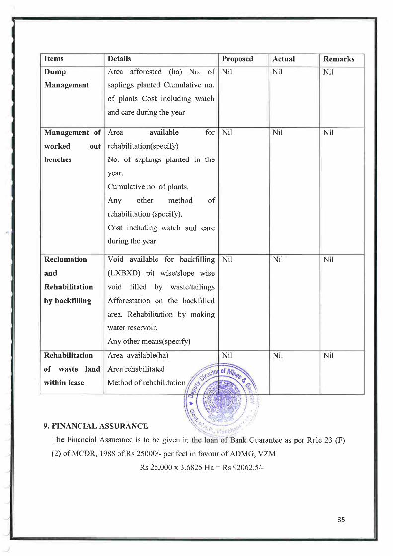


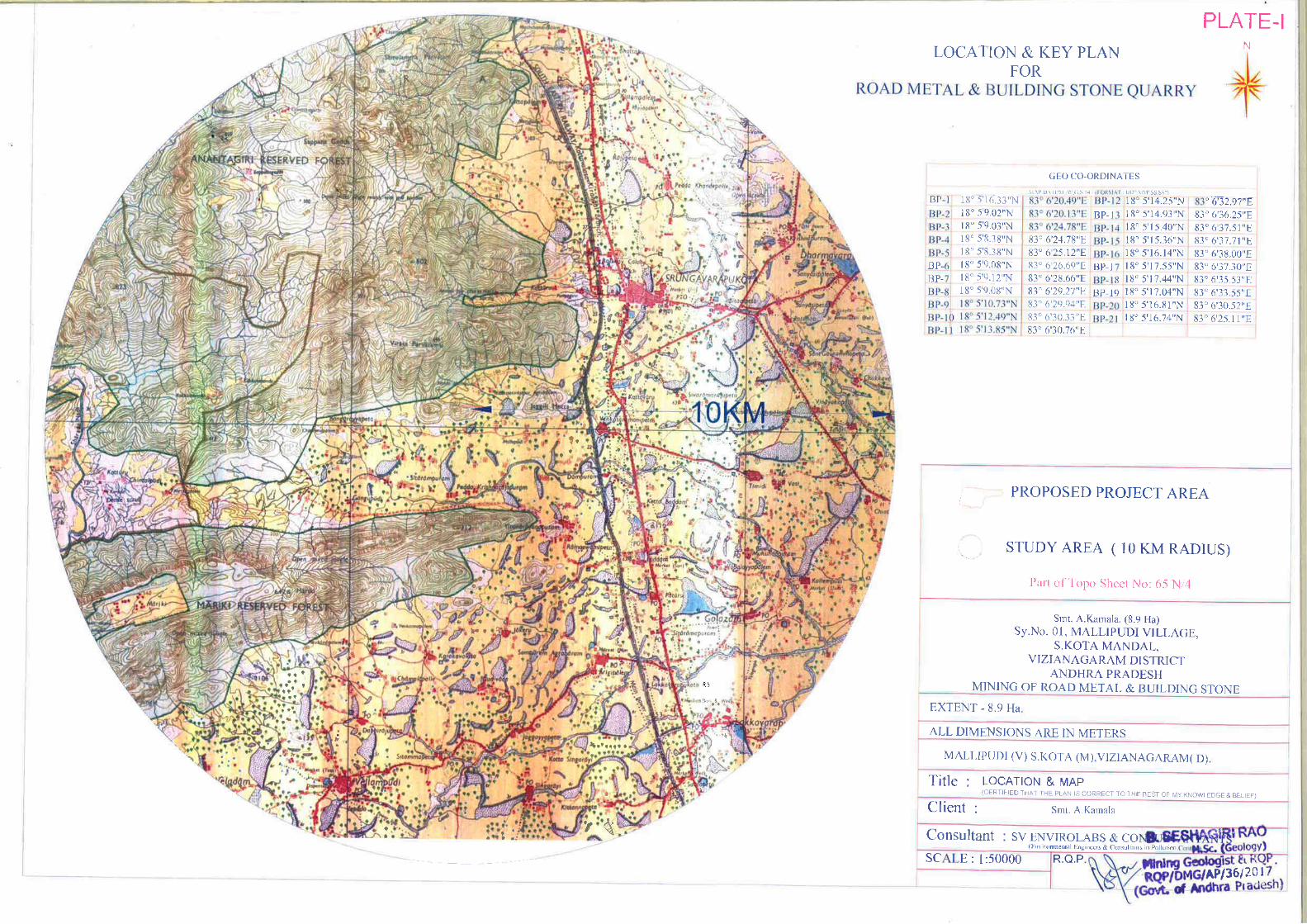

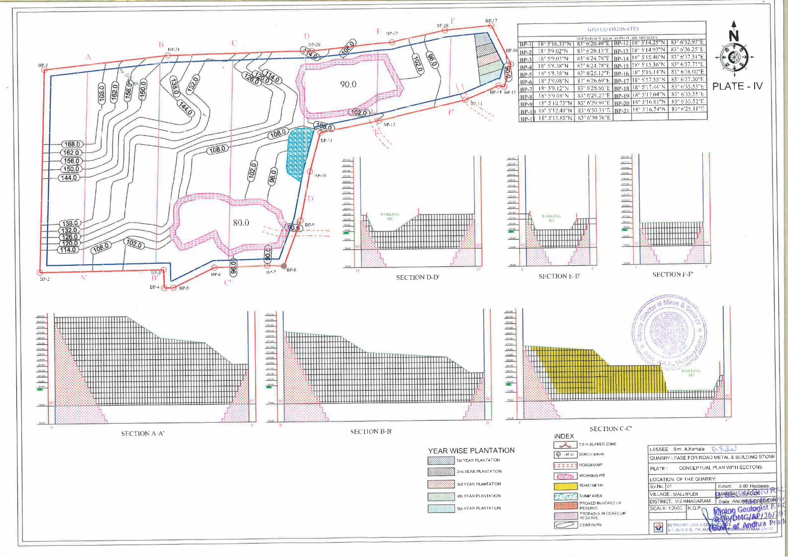


ANNEXURE –III CLUSTER LETTER
& MAP


ANNEXURE –IV CLUSTER EMP

CLUSTER ENVIRONMENTAL
MANAGEMENT PLAN
Submission to
The State Environmental Impact Assessment Authority (SEIAA) &
State Environmental Appraisal Committee (SEAC), A.P.
For
SMT. A. KAMALA MINING OF ROAD METAL & BUILDING STONE
OVER AN EXTENT: 8.90 HA Mine Address: Sy.No. 01
Mallipudi (V), S. Kota (M) Vizianagaram (Dt.), Andhra Pradesh
PREPARED BY
SV ENVIRO LABS & CONSULTANTS Environment Engineers & Consultants in Pollution Control
H.O: Block-B, B-1, IDA, Autonagar, Visakhapatnam – 530 012 Ph: 0891-2755528, 9440338628; Tel/Fax: 0891-2755529,
E-mail: [email protected] QCI NABET Accredited & Recognized by MOE&F, New Delhi

SMT. A. KAMALA (Extent – 8.90 Ha) Cluster EMP
Page 1 of 19
1.0 INTRODUCTION:
Smt. A. Kamala filed an application for grant a quarry lease for Road Metal &
Building Stone over an extent of 8.90 Ha. in Sy.No.1 of Mallipudi Village,
S.Kota Mandal, Vizianagaram District, Andhra Pradesh.
The DDM&G, Visakhapatnam granted 1st renewal quarry lease for Road Metal &
Building Stone over an extent of 8.90 Ha., in Sy.No.1 of Mallipudi Village, S.Kota
Mandal, Vizianagaram District, Andhra Pradesh for a period of 15 years vide
Proceedings No: 3322/Q3/2009, Dated: 19.01.2012 and the same was executed by
the ADM&G, Vizianagaram vide Proceedings No. 2545/Q2/2009, dated
28.01.2012 for the lease period of 15 years w.e.f. 19.09.2009 to 18.09.2024.
The Mining Plan was approved by DDM&G, Visakhapatnam vide Letter No.
1784/MP-VZM/2017, Dated: 11.09.2017.
Without obtaining prior EC order, the mining operations were carried out in this
present area. Due to that reason, the mine was filed under violation. As per
Notification S.O.No: 804 (E) Dt: 14.03.2017, the mine management has applied for
ToR under violation vide Online Proposal No: IA/AP/MIN/68679/2017 Dt:
12.09.2017 and the same has been transferred to SEIAA, Andhra Pradesh vide
Proposal No: SIA/AP/MIN/26748/2018, Dated: 12.09.2017.
The present proposal is for obtaining EC for existing mine to excavate Road Metal
and Building Stone with a production capacity of 80078.40 m3/annum under
violation and the mining activity will be carried out by opencast semi mechanized
mining method by developing benches with wet jacketed drilling and controlled
blasting.
Presentation of TOR under violation has been made before the SEAC, Andhra
Pradesh committee on 16.11.2021, 17.11.2021 & 18.11.2021 and the TOR has
been issued by SEIAA, AP vide order no: SEIAA/AP/VSP/VIO/MIN/
11/2021/3236-991, Dated: 23.12.2021 for conducting public hearing.

SMT. A. KAMALA (Extent – 8.90 Ha) Cluster EMP
Page 2 of 19
1.1 CLUSTER FORMATION: The mine area is an existing mine and violated EIA notification Dt: 14th Sep, 2006
& its amendments, cluster EMP has to submitted to get Environmental Clearance
(EC) under CategoryB1 under violation as the mine has operated without obtaining
prior EC..
As per MoEF & CC notification S.O. 141(E) dt: 15th January, 2016 “A cluster shall
be formed when the distance between the peripheries of one lease is less than 500
m from the periphery of other lease in a homogeneous mineral area” and the mine
is having 3 working mines within 500 m radius of the subjected mine area covering
in Mallipudi Village, S. Kota Mandal, Vizianagaram District.
As per the notification, the status of the 4 (one proposed mine and 3 cluster mines) quarrying projects is to be examined for a cluster situation.
As per S.O.2269 (E) dt 1st July, 2016 “(6) A cluster shall be formed when the
distance between the peripheries of one lease is less than 500 meters from the
periphery of other lease in a homogeneous mineral area which shall be applicable
to the mine leases or quarry licenses granted on and after 9th September 2013” and
mine leases not operative for three years or more and leases which got
environmental clearance as on 15th January 2016 shall not be counted for
calculating of cluster, but shall be included in the Environmental Management Plan
for cluster.
1.2 LOCATION OF THE MINE:
The mining area is located in Mallipudi Village, S. Kota Mandal, Vizianagaram
District, Andhra Pradesh. The area is located at a distance of 30.40 km from the
district headquarters, Vizianagaram
The mine lease area falls under the
Topo sheet No. : 65 N/4
Latitude : 18°05'16.33"N to 18°05'16.74"N
Longitude : 83°06'20.49"E to 83°06'25.11"E

SMT. A. KAMALA (Extent – 8.90 Ha) Cluster EMP
Page 3 of 19
1.3 CLUSTER CLASSIFICATION AND LOCATION DETIALS: A certificate about the existing quarries within 500 M radius range around the
periphery of the proposed quarry has been obtained from the Assistant Director,
Mines & Geology, Vizianagaram, Government of Andhra Pradesh. The Assistant
Director, Mines & Geology, Vizianagaram to ascertain whether the existing
quarries in the said range from a cluster situation and to prepare the EMP
accordingly the certificate & cluster map.
As per cluster notification by MoEF&CC mines which not executed lease or Environmental Clearance before 9th September 2013 were considered and
were included in preparation of cluster EMP. As per records of the Asst. Director of Mines and Geology, Vizianagaram vide Lr. No. 2515/Q/2009 Dt:
30.03.2021 there are no areas for which L.O.I is issued for grant of mine lease, where as there are 3 working mines present within 500 m distance which were granted before 09.09.2013 and those mines shall not counted for cluster formation. Thus, the condition of cluster needs preparation of cluster EMP
for all working mines. The cluster details are given below.
There are four (4) working mines falling under cluster area over a total extent of
25.23 Ha, including Smt. A. Kamala 8.90 Ha mine area and three (3) cluster mines
over an extent of 16.33 Ha, which is forming cluster with the EC proposed mine.
List of mines were shown as below. However, Environment Management Plan
(EMP) is prepared for cluster of mines by considering four mines.

SMT. A. KAMALA (Extent – 8.90 Ha) Cluster EMP
Page 4 of 19
Cluster Mine Details:
*The total considered area for cluster is 8.90 Ha
SI. No.
Name of the applicant
Location Extent (Ha)
Lease Status
From To
1. Smt. A. Kamala Sy. No. 1, Mallipudi, S. Kota, Vizianagaram 8.90 Proc. No. 2545/Q2/2009
dated 28.01.2012
TOR No: SEIAA/AP/VSP/VIO/MIN/11/2021/
3236-991 Dated: 23.12.2021
2. Sri. R. Chandrasekhar
Sy. No. 1, Kondamallipudi, S. Kota,Vizianagaram 8.00 04.07.2012 07.07.2022 Working
3. Sri B. Adinarayana Sy. No. 1, P.K.Rajapuram, Vepada, Viziznagaram 2.33 08.05.2012 08.01.2021 Working
4. Sri R. Sudhakar Sy. No. 1, Kondamallipudi, S. Kota,Vizianagaram 6.00 20.09.2012 05.05.2022 Working
TOTAL 25.23

SMT. A. KAMALA (Extent – 8.90 Ha) Cluster EMP
Page 5 of 19
Boundary Coordinates of Individual Mines:
SI. No.
Name of the applicant
Extent
(Ha.)
Points North Latitude East Longitude
1 Smt. A. Kamala 8.90
1
2
3
4
5
6
7
8
9
10
11
12
13
14
15
16
17
18
19
20
21
18° 5'16.33"N
18° 5'9.02"N
18° 5'9.03"N
18° 5'8.38"N
18° 5'8.38"N
18° 5'9.08"N
18° 5'9.12"N
18° 5'9.08"N
18° 5'10.73"N
18° 5'12.49"N
18° 5'13.85"N
18° 5'14.25"N
18° 5'14.93"N
18° 5'15.40"N
18° 5'15.36"N
18° 5'16.14"N
18° 5'17.55"N
18° 5'17.44"N
18° 5'17.04"N
18° 5'16.81"N
18° 5'16.74"N
83° 6'20.49"E
83° 6'20.13"E
83° 6'24.78"E
83° 6'24.78"E
83° 6'25.12"E
83° 6'26.69"E
83° 6'28.66"E
83° 6'29.27"E
83° 6'29.94"E
83° 6'30.33"E
83° 6'30.76"E
83° 6'32.97"E
83° 6'36.25"E
83° 6'37.51"E
83° 6'37.71"E
83° 6'38.00"E
83° 6'37.30"E
83° 6'35.53"E
83° 6'33.55"E
83° 6'30.52"E
83° 6'25.11"E
2 Sri. R. Chandrasekhar 8.00 1-15
18° 5'17.36"N - 18° 5'17.47"N
83° 6'4.11"E - 83° 6'5.77"E
3 Sri B. Adinarayana 2.33 1-7 18° 5'16.57"N - 18° 5'8.85"N
83° 6'13.48"E - 83° 6'12.06"E
4 Sri R. Sudhakar 6.00 1-10 18° 5'17.44"N - 18° 5'17.04"N
83° 6'35.53"E - 83° 6'33.55"E

SMT. A. KAMALA (Extent – 8.90 Ha) Cluster EMP
Page 6 of 19
2.0 Geology: The applied area falls in one discontinuous and isolated hillock system, which
comes under Eastern Ghat Tectonic system of Achaean Age group. The study area
is characterized by Eastern Ghats mobile belt. The area covered with denudation
hills of range between 312 m to 802 m above mean sea level. Kondakindam
hillocks in Northern side and Vendram Hillock in North Eastern side are two
important hill ranges Eastern Ghats prove to be a store-house of many valuable
mineral resources which are coming to light year by year. Garnet-sillimanitebiotite
gneisses, Pyroxene Granulites (Charnockites), garnetiferous granites (Leptynites),
quartizites and pegmatite's are the chief rock types that occur as bedded and
banded as well as massive formations in the study area. The Eastern Ghats
complex mainly comprises of Khondalite suites with a set of sub-suites. Intrusive
activity might have caused migmatisation. The terrain must have subjected to
cycles of metamorphism. The local geology shows the occurrence of Granite
gneisses, Charnockite, Khondalite, Quartz and soil. The following is the local
stratigraphy of the mining lease area. Quartz (intrusive), Granite gneisses,
Charnockite (Charnockite Group), and Khondalite is the dominant rock type of the
area. It is olden metamorphic schistose rock with garnet, sillimanite, graphite,
Feldspar, Quartz and Biotite as essential minerals and Garnets, Mica, Hornblends
are accessory minerals. Charnockites are fresh looking light coloured, showing
schistosity consisting Quartz, Feldspars, Garnet and Sillimanite schist. Alternate
alignment of leuco and melanocratic minerals attains gnessic property. Garnet is
also observed as discrete grains of reddish, brown, colour and equigranular texture.
The formation is highly structural disturbed with joints, fractures and thickly
penetrated with weather in influences.
Mineable Reserves:
The deposit was estimated through cross sectional method. The reserves are
estimated through A-A’ – B-B’ with sectional influences 61 m which are drawn at
appropriate distance to estimate the reserves. The proved reserves were taken up to
a depth RL 70 M from surface of the area i.e., from hill peak i.e., 168 M RL point
to bottom. The probable reserves were taken up to 20 m below ground level i.e.70
M to 50 M RL.

SMT. A. KAMALA (Extent – 8.90 Ha) Cluster EMP
Page 7 of 19
Total Geological Proved Reserves : 3677046.40 m3
Blocked Reserves : 542440 m3
Mineable Reserves : 3134606.4 m3
Mineable @ 90% Recovery : 2821145.76 m3
Average Production per year : 73279.58 m3
Life of Mine : 2821145.76/ 73279.58
= 38.5 say 39 years MINERAL RESERVES IN CLUSTER OF MINES
2.2 PROJECT DESCRIPTION
MINING PROCESS The mining operations were previously carried out by opencast semi mechanized
method. Road metal by nature is medium hard. So blasting is mandatory for
excavation of road metal. The operations will involve wet jacketed drilling,
controlled blasting and excavations and directly loads into the tippers/ tractors. The
excavation will be carried with bench height 5 to 10 meters and width 6 to 12
meters minimum. Haul roads gradient will be 1:16.
The proposed method of working is by semi mechanized method of opencast
quarrying. Considering mining parameters and the technical parameters like
surface topography, rock mechanism factors & quality variations, geo-technical
aspects, required rate of production & available resources etc. Small scale building
quarrying activities with jack hammer drilling & blasting.
Due care will be taken on mining and safety aspects in designing the benches by
straightening & advancing the benches for effective and economical operation of
S.No. Name of the applicant
Geological Reserves (m3)
Mineable Reserves (m3)
Mine Life (Years)
1. Smt. A. Kamala 3677046.40 2821145.76 39
2. Sri. R. Chandrasekhar 7959690 6438171 80
3 Sri B. Adinarayana -- 1400384.2 66
4 Sri R. Sudhakar -- 3543688.6 60

SMT. A. KAMALA (Extent – 8.90 Ha) Cluster EMP
Page 8 of 19
the quarry. Since the ground water table is much below and the rainfall is not very
high during monsoon, drainage of water inside the pit will not pose problem.
Loading of the Road metal & Building stone blocks will be done mechanically to
tippers and transported from the quarry to the stack yard or directly to the buyers
and mineral rejection/waste will also be handled mechanically; the rejects/waste
will be dumped separately. In the quarry road will be maintained with 1 in 16
gradients. Sufficient number of bunds and parapet walls will be made all along the
quarry haulage roads wherever necessary in order to maintain safe working
conditions.
Production Details of Cluster within 500 m:
Emissions due to transport on unpaved roads: Use of unpaved roads for transportation results pulverization of surface material
due to force of wheel on road surfaces. These particles will be suspended and
resuspended into air due to rolling wheels of vehicles. The lighter the particle will
tend to suspend more in air. Increase in vehicular traffic tends to increase the
suspended particles in air. Field investigations also have shown that emissions
depend on source parameters that characterize the condition of a particular road
and the associated vehicle traffic. Characterization of these source parameters
allow for “correction” of emission estimates to specific road and traffic conditions
present on public and industrial roadways. Dust emissions from unpaved roads
have been found to vary directly with the fraction of silt (particles smaller than 75
micrometers in diameter) in the road surface materials.
SI. No. Name of the applicant Maximum
Production (m3) Waste (m3)
1. Smt. A. Kamala 80078.40 40710.88
2 Sri. R. Chandrasekhar 71964.00 7996.0
3 Sri B. Adinarayana 20969.28 2329.92
4 Sri R. Sudhakar 54561.26 6062.36
TOTAL 227572.9 57099.16

SMT. A. KAMALA (Extent – 8.90 Ha) Cluster EMP
Page 9 of 19
At industrial sites, where haul trucks and other heavy equipment are common,
emissions are highly correlated with vehicle weight. For those roads, the moisture
content of the road surface material may be more dominant in determining
differences in emission levels between, for example a hot, desert environment and
a cool, moist location.
Material Transport of cluster mines:
S. No. Cluster Mineral production m3/annum
Internal Road Length (KM)
Common Road length (KM)#
Average trips /hour*
1 227572.9 1.0 0.321 5-6 * Considering the total working days as 250 and volume of each truck is 35T, # Nearest
Village/black top road. *Nearest Black Top road
To minimize the same wetting of haul roads will reduce the emissions by 70%.
Similarly development of plantation along the haul roads and safety barrier of
mine, control of speed of vehicles in haul roads will reduce the fugitive emissions.
The total internal road length of cluster mines is 1.0 km and common road length is
0.3 km. However, the suspension of fugitive dust from hauls roads as per the VKT
(vehicle kilometer travel) will reduce to 70 -75% through the water sprinkling.
Water Sprinkling: For the purpose of water sprinkling only the common road length of travel is taken
into account. Based on the data it is calculated that the water needed for sprinkling
is 2.0 Lt per sq.mt of road. This will reduce emissions upto 75%. The moisture
holding in summer is taken as 2 hours per trip. Thus for a duration of 8 hot hours
the total water needed is as under. As the nearest road length to black top road is
around 321 m from the edge of mine Total Length of travel of common road = 321 m
Average width of road = 6m
Total area in Sq.Mts = 1926 m2
Water needed for one round of sprinkling @2 lit per sq.m = 3852 lit
Number of tankers needed for common road alone per day = 1 tankers

SMT. A. KAMALA (Extent – 8.90 Ha) Cluster EMP
Page 10 of 19
Baseline Environment, Impact assessment and Mitigation:
The proposed mine is for production of Road Metal & Building Stone and another
three working mines. As per mining plan and obtained TOR, it is proposed to
produce Road Metal & Building Stone from the existing mine with production
capacity 80078.40 m3/annum. 10% intercalated waste will be generated while
excavating Road Metal & Building Stone.
Water Environment:
Smt. A. Kamala (Extent – 8.90 Ha) There is no remarkable water streams flowing through the mine area. Hence impact on
surface runoff is not envisaged. During mining operation, runoff will be collected in pit
and used for mining operations like wetting of haul roads and watering of plants etc.
During operation of mine, total water requirement for this mine is estimated to be 11.2
KLD. Out of which 1.2 KLD is for domestic purposes, 3.0 KLD is for water sprinkling for
dust suppression, 5.0 KLD for wet jacketed drilling and 2.0 KLD for Green belt
development. The source of water is through water tankers from nearby village.
3.0 ENVIRONMENTAL MANAGEMENT PLAN (EMP)
3.1 ENVIRONMENTAL IMPACTS AND MITIGATION MEASURES
Open cast method of Road Metal & Building Stone mining will result in some
adverse impacts on the surrounding environment and the magnitude and impact of
the Environmental pollution depends on method of mining, scale and concentration
of mining activity.
The following are the possible impacts while carrying out the quarrying activities.
Change in land use pattern
Waste generation
Impact on flora & fauna around quarry site.
Dust generation during mining, screening and transportation

SMT. A. KAMALA (Extent – 8.90 Ha) Cluster EMP
Page 11 of 19
Silting of local water bodies due to soil erosion
Vibrations and impact on surroundings
Noise from quarrying operations.
However the above impacts can be mitigated with proper Environmental
Management Plan supported by adequate financial allocation.
3.2 WASTE GENERATION
Solid waste About 90% of the excavated Road Metal & Building Stone will be utilized and
10% OB generated will be dumped in dump yard over an extent of 1.0218 Ha
within mine lease area as step dumping and will be made useful for road gradation,
retention wall arrangement on hill slopes and strengthening garland drains.
Liquid Waste:
The liquid waste will be mainly run of rain water during monsoon months from the
mine face. The rain water draining the exposed rocks, fragment and dust in the
quarry is susceptible for incorporating the above as suspended solids into the
runoff. Seepage of such water down to the water table may cause pollution to the
ground water.
However there is no scope for seepage of mine liquid waste, as the mining is above
the ground level. The rain water is collected in the low elevation portion of the
mine through garland drains and the same will be used for greenbelt development,
Dust depression.
Very small quantity of waste water will be generated from domestic consumption
which is treated through septic tank followed by soak pit.
3.3 WASTE MANAGEMENT:
Solid waste: About 90% of the excavated Road Metal & Building Stone will be utilized and
10% OB generated will be dumped in dump yard over an extent of 1.0218 Ha
within mine lease area as step dumping and will be made useful for road gradation,
retention wall arrangement on hill slopes and strengthening garland drains.

SMT. A. KAMALA (Extent – 8.90 Ha) Cluster EMP
Page 12 of 19
Liquid Waste: Since the stone is free toxic minerals, there will not be any toxicity in the collected
rain water. As no chemical activity is involved in the quarry operations, treatment
of waste water is not required.
The rain water is collected in the mine area at lowest elevated portion and the same
will be used for sprinkling on roads for wetting and mitigate the dust pollution,
wetting and also some quantity will be used in watering of plants.
The small quantity of waste water generated from domestic consumption will be
sent to septic followed by a soak pit.
3.4 AIR POLLUTION
Dust Generation during quarrying operation and transportation
Dust will be generated during the mine operations, handling of extracted mineral
and transportation of the material which needs to be controlled to mitigate the
pollution.
The following measures are proposed to mitigate pollution due to dust emissions.
Developing tree cover all along the periphery of the cluster of mines to reduce
dust impact
Sprinkling water at frequent intervals on the haul road to reduce dust
generation during plying of dumpers.
Periodic maintenance of haulage roads.
Wetting of road from quarry site to village road.
Spraying water over the ROM to be loaded to reduce dust generation during
loading operation.
Developing plantation along the mining leases cluster boundary and outside
roads to reduce spread of dust.
Green Belt Development Plan Green belt is proposed to be developed along the approach road of the mine during
the mining for mitigating the air pollution due to fugitive dust emissions and the
noise generated.

SMT. A. KAMALA (Extent – 8.90 Ha) Cluster EMP
Page 13 of 19
3.5 IMPACT ON FLORA AND FAUNA
Vegetation in the area is sparse and is mainly in the form of patches comprising
thorny bushes, small shrubs and some trees.
On the other hand green belt is proposed to be developed.
Plant species like Neem, Mango & Eucalyptus will be used to develop green
belt.
Sapling consisting of Neem, Teak will be planted along the cluster buffer zone
and the top soil bunds, and on foot of the hill.
3.6 VIBRATIONS AND IMPACT
Vibrations are determined by three factors for its intensity is Vibration Amplitude
(Peak Particle Velocity), duration and frequency. Studies show found that delay
interval of 17 to 43 milli seconds results into generation of lower level of ground
vibration. These can be controlled by non-electric delay detonators and sequential
blasting (Control blast) system. Blasting can be minimized by introducing latest
techniques like, line drilling and splitting or exponso mortar pouring, adopting
control blasting. otherwise; in-situ mass may damage due to blasting in hard and
compact rock.
As the nearest habitation Gadabavalasa Village at a distance of 0.22 km away from
the quarry site and there will not be any impact on buildings or structures as well
as local beings.
3.7 NOISE SOURCES AND CONTROL MEASURES
The main sources of noise in mining activity are drilling, blasting, material
handling machinery, and loading equipment, etc. The noise generated by the
machinery and vehicles as well as drilling operations will be minimal in the range
of maximum 100dB.
Following mitigation measures would control noise pollution:
Maintaining the machinery in good condition by properly lubricating all
moving parts.
Providing earmuffs, ear plugs etc. to workers.
Using hydraulic drills for drilling.

SMT. A. KAMALA (Extent – 8.90 Ha) Cluster EMP
Page 14 of 19
Designing and following the controlled blasting techniques in such a way that
only one holes should blast at a time by using non-electrical delay detonators
for sequential blasting.
Conventional mining methods will be implemented instead of blasting, line
drilling for splitting or chemical powder, hydraulic drilling etc.
Avoiding secondary blasting by using rock breakers.
Blasting to be done in noon’s when population is low or between 5.00 PM to
6.00 PM when temperature inversions are not likely to be there and air density
is less.
Developing thick greenbelt around the cluster and along the approach roads
along the haulage roads.
Limiting the use of horns by the drivers of the vehicles.
3.8 RISK ASSESSMENT AND DISASTER MANAGEMENT PLAN
The major risks associated with quarrying are drilling risks, slope failure; fly rocks
and vibration due to blasting, storage of explosives, toxic fumes from blasting etc.
Risk analysis involves systematic identification and assessment of major damage
potential credible risk scenario to help management to make objective decisions on
hazards reduction or avoidance measures meeting regulatory requirements and
develop a structured management framework for an effective Disaster
Management Plan including emergency preparedness and contingency plans.
The planning for mitigating the emergency involves the reorganization of the
accident or possible assessing the consequences of such possible accident and
deciding on emergency planning/procedures in advance.
Both on site & off site that would be necessary to be implemented in the event of
emergency without any delay and confusion.
Proper bench design in mines and observing safety measures for transportation
storage, handling of explosives & fuels, etc, good maintenance of vehicles, roads,
and fire prevention measures shall go in preventing disaster/accidents.
Mining shall be carried out as per Regulation of the MMR 1961 & rules and
Regulations made there under applicable. The project in charge is having a

SMT. A. KAMALA (Extent – 8.90 Ha) Cluster EMP
Page 15 of 19
mobile/alternative communication for quick intimation of information if need
arises.
As the quarry operation is open cast, only possible risk is collapse of quarry/ pit
sides when people are working. For this proper bench slope will be maintained as
per the mining plan.
Mining operation will not be conducted during rainy days to avoid any collapse of
the overburden into mine pit.
All precautions would be taken to control fly rock during the blasting operations.
The quarry area is to be provided with good communication facilities like
telephone & mobile phone or wireless walky talks.
In case of any minor/major accidents within the mine, the same will be
communicated to the DGMS officials, the District Magistrate and Mines &
Geology officials concern and local authorities concern.
A vehicle is kept all the time at the quarry site for conveyance.
The workmen in the project are periodically trained at group vocational training
center for proper safety training as per the DGMS circulars.
At quarry level first aid facility is provided and person(s) will be shifted to nearest
major hospital.
A key person will be assigned duties and responsibilities for incident response and
emergency response at the quarry. At mine level first aid will provide and person
shall be shifted to nearby government hospital, having all basic facilities and
qualified medical officer who is capable of handling normal accidents.
Mine manager is the person responsible of the disaster management and he need to
be contacted in case of any disaster.
3.9 OCCUPATIONAL HEALTH & SAFETY
As a measure of occupational safety & health, the following facilities will be
provided to the workmen;
Providing Dust masks to prevent exposure to dust

SMT. A. KAMALA (Extent – 8.90 Ha) Cluster EMP
Page 16 of 19
Providing ear muffs/ear plugs for protecting from adverse affects of noise
Monitoring the health of the workers on regular basis Periodical Medical
Examination (PME) as per Mines Rules 1956.
Providing First Aid Facility at the work site.
Providing basic amenities to the quarry workmen.
3.10 BUDGETS FOR IMPELEMENTATION OF EMP
The Environmental Management plan involves:
Dust Suppression measures
Green Belt Development,
Undertaking periodical Environmental monitoring
Providing personal protective equipments
3.11 ENVIRONMENTAL MONITORING PLAN
Monitoring Strategy The monitoring of various environmental parameters is necessary and is a part of
the environmental protection measures. Monitoring is as important as that of
controlling, since the efficiency of control measures can only be determined by
monitoring.
A well-defined environmental monitoring program would be taken up to monitor
the ambient air to check whether the quality of air is maintained within the
permissible limits.
The following environmental attributes should be monitored:
Air pollution.
Noise pollution
Workers Health
Locations and frequency of monitoring should be as per the guide lines of APPCB
and MOEF.
AMBIENT AIR MONITORING
As per MoEF, there is a need to identify 3 ambient air stations at 1200 angle
keeping the main source in the center.

SMT. A. KAMALA (Extent – 8.90 Ha) Cluster EMP
Page 17 of 19
The ground level concentrations of suspended particulate (PM10 &PM2.5,), sulphur
dioxide SO2 and Nitrogen Oxide (NOX) in the ambient air outside the quarry
boundaries shall be monitored at regular intervals.
Any deviation from predicted /expected values shall be investigated and necessary
action be taken.
NOISE MONITORING
Noise levels in the work space environment will be monitored periodically. If any
deviation is observed necessary corruptive measures will be taken.
Monitoring noise levels is essential to assess the efficacy of maintenance of
schedules undertaken to reduce noise levels and noise protection measures.
A good quality sound pressure level meter is essential for this purpose.
This work can be handled by out sourcing the surveillance is for the benefit of the
workers will being and to keep track of machine wear.
WORKERS HEALTH Regular health check up of workers will be carried out at the nearest hospital at
least once in an year as per the Rule 29 of Mines Rules 1955.
3.12 POST CLOSURE PLAN
Based on the estimation of mineable reserves in the mining plan, the quarrying
operations will be continued further reserves may be proved within the Mining
Plan period. At the end of the lease period after completion of the quarrying, the
quarry pits would be developed as reservoirs for rainwater collection, which act as
sources for recharging the ground water levels in the area. Green belt will be
developed on the bunds of the quarry and along the benches and approach road,
haulage roads, etc.
4.0 CONCLUSION:
The production of Road Metal & Building stone project held by Smt. A. Kamala proposed to obtain a EC under violation an Extent of 8.90 Ha which is located in
Sy. No. 01 of Mallipudi Village, S. Kota Mandal, Vizianagaram District, Andhra

SMT. A. KAMALA (Extent – 8.90 Ha) Cluster EMP
Page 18 of 19
Pradesh will be environmental compatible to the surrounding and there will be no
long term environmental impact based on the existing environmental scenario. The
particulate matter getting airborne from the quarrying activity gets dispersed in
close proximity itself and settles down early. The noise levels due to the proposed
quarry activity are also not of a higher order that calls for immediate corrective
measures. There will be positive socio-economic front in the surrounding region
due to the proposed quarrying activity. The green belt development would help in
achieving ecological balance.
Environmental Management Plan (EMP) will help mitigate adverse impacts on the
environment. Where impacts occur, immediate action would be taken to reduce the
escalation of effects associated with these impacts.
Hence, it is requested that Environmental Clearance be accorded to the Road Metal
& Building stone with production of 80078.40 m3/annum.
CLUSTER EMP BUDGET
S. No Details Capital Cost (In Lakhs)
Recurring Cost
(In Lakhs) Remarks
1 Dust Suppression along common approach road for 0.3 km (Sprinkling system 7.7 KLD)
0.6 0.45
Required daily on 250 working days. Rainwater collected in mine pits/ siltation ponds will also be used
2 Greenbelt along common approach road 1.2 0.45 300 plants
3 Ambient air quality monitoring (PM10 & PM2..5) -- 0.5 Noise level
TOTAL 1.8 1.4
Capital Cost : Rs. 1.8 Lakhs
Recurring Cost per annum : Rs. 1.4 Lakhs
Total Cluster EMP Budget : Rs. 3.2 Lakhs Total No. of mines in the Cluster : 4 mines
Cluster EMP Budget imposed for each mine : 3.2/4 = 0.8 Lakhs

ANNEXURE –V AFFIDAVIT


ANNEXURE –VI HYDROGEOLOGICAL
STUDY

A REPORT ON THE HYDROGEOLOGICAL AND HYDROLOGICAL CONDITIONS OF SMT A. KAMALA, ROAD METAL & BUILDING STONE
MINE IN SURVEY NO 1 OF MALLIPUDI VILLAGE S.KOTA MANDAL, VIZIANAGARAM DISTRICT, ANDHRA PRADESH
SUBMITTED TO
SMT. A. KAMALA EXTENT: 8.90 Ha.
VIZIANAGARAM DISTRICT
PREPARED BY
DR. V. VENKATESWARA RAO PROFESSOR (RETD.),
GEO-ENGINEERING, A.U QCI-NABET ACCREDITED FAE IN GEOLOGY & HYDROGEOLOGY
PLOT-119, SECTOR-4, MVP COLONY, VISAKHAPATNAM
& SV ENVIRO LABS & CONSULTANTS
VISAKHAPATNAM

SMT. A. KAMALA – 8.90 Ha. HYDROGEOLOGICAL REPORT
Page 2
I INTRODUCTION:
Smt. A. Kamala has been granted Quarry Lease 1st renewal for Road Metal & Building
stone mining over an extent of 8.90 Ha, located in Sy. No. 1 of Mallipudi Village, S. Kota
Mandal, Vizianagaram District for a period of 15 years by the DDM&G, Visakhapatnam
vide proceedings No. 3322/Q3/2009, Dated 19.01.2012and the same was executed by the
ADM&G, Vizianagaram vide Proceedings No. 2545/Q2/2009, dated 28.01.2012 for the
lease period of 15 years w.e.f. 19.09.2009 to 18.09.2024. The mine was executed since
2012 without prior EC and mine operations were stopped presently. As per MoEF & CC
Notification S.O. 804 (E) 14.03.2017, this mining project attracts violation as the Road
Metal & Building Stone production has been started without obtaining EC under EIA
notification 2006.
The present study on Hydrogeological and hydrological conditions of core and buffer
zone for Road Metal & Building Stone mine of Smt. A. Kamala, was conducted lead by
Dr. V. Venkateswara Rao, Consultant, Hydrogeology (FAE), Professor (Retd.), Andhra
University along with SV Enviro Labs & Consultants team to fulfill the requirement
mentioned in Specific Terms of Reference vide Lr. No. SEIAA/AP/VSP/VIO/MIN/11/
2021/3236-991 Dated: 23.12.2021. In this connection, detailed hydrological study is
carried out in core and buffer zone of the project as per recent GEC guidelines 2015.

SMT. A. KAMALA – 8.90 Ha. HYDROGEOLOGICAL REPORT
Page 3
Figure 1.1: Study area in S.Kota Mandal, Vizianagaram, Andhra Pradesh

SMT. A. KAMALA – 8.90 Ha. HYDROGEOLOGICAL REPORT
Page 4
1.1 OBJECTIVES:
To study the land forms and drainage pattern with special reference to ground water
regime.
To study ground water conditions in the area
To study the impact of mining activity on ground water regime.
To study the characteristics of environmental hydrology and their vulnerability to
mining activity.
1.2 SCOPE OF STUDY:
To map and characterize the drainage network from the SOI toposheets.
To observe the hydrogeomorphological features from the available remote sensing
products.
Collection, collation and compilation of hydro-geological information with special
reference to ground water storage, sub-surface geology, hydrochemical behavior,
climate characteristics. The data need to be processed for presentation and prediction
of future behavior activity in the region.
To study hydrological aspects of existing streams, tanks etc on mining.
To decipher the impact of mining, the mining implications may be critically
compared and evaluated vis-a-vis the hydro-geology of the area.
Design mitigation plans to preserve pre-mining hydrological conditions in the area.

SMT. A. KAMALA – 8.90 Ha. HYDROGEOLOGICAL REPORT
Page 5
1.3 METHODOLOGY OF THE STUDY:
Smt. A. Kamala proposes extraction of Road Metal & Building Stone to a maximum
production of 80078.40 m3/annum through open cast semi mechanized method. In any
open cast mining, it is probable for intersection of ground water storage of surrounding
area with mining activity due to regular inflow or seepage in mining areas. The
magnitude of impact shall depend upon size of mining project and the hydro-geological
conditions prevailed in the area. It is prior importance to evaluate the hydro-geological
conditions, storage of water in aquifers, etc for preparation of mitigation plan to control
negative impacts caused by mining activities.
To achieve the above objectives, geology of the area and the subsurface lithological
conditions were interpreted based on the exploratory drilling data and geological studies
carried by Geological Survey of India, Central Ground Water Board, State Groundwater
& Audit Department and other agencies. Well inventory conducted to ascertain the status
of weathered zone thickness and occurrence of groundwater in the core and buffer zones.
The seasonal fluctuation of water level in response to groundwater recharge due to
rainfall has been estimated based on the Andhra Pradesh state hydrograph network
stations and field observations.
Groundwater resources and its utilization have been worked out as per norms prescribed
by the Ground Water Estimation Committee (GEC-2015), Government of India.
The impact of mining on the ground water storage has been estimated based on the field
data analysis and interpretation.
1.4 LOCATION AND COMMUNICATION:
The Smt. A. Kamala Road Metal & Building Stone mining area is located in Mallipudi
village of S.Kota Mandal at Vizianagaram District, Andhra Pradesh. The mine area is
located at a distance of 30.40 km from the district headquarters, Vizianagaram.

SMT. A. KAMALA – 8.90 Ha. HYDROGEOLOGICAL REPORT
Page 6
The mine lease area falls under the
Toposheet No. : 65 N/4
Latitude : 18°05'16.33"N to 18°05'16.74"N
Longitude : 83°06'20.49"E to 83°06'25.11"E
The nearest railway station is S.Kota which is at 4.4 km from the mine lease area. The
nearest airport is Visakhapatnam Airport at 42.87 km from the mining site. The quarry
lease area is connected by Visakhapatnam - Araku Road (SH-39) which is 3.0 km away
from the mine.
1.5 LAND UTILIZATION:
Land use/ Land cover (LULC) pattern of any region is an outcome of various physical
and cultural factors and their utilization by man in time and space.
The lease area (8.90 Ha.) for Road Metal & Building Stone mining was granted to Smt.
A. Kamala is of very small extent in Mallipudi Village (324 Ha.) of S.Kota Mandal.
Land Use Land Cover Statistics of Mine Buffer Zone: Total study area for the mining project is 32817 Ha. Out of that major portion of land use
class covered by Forest area i.e., 14284 Ha (43.53%), followed by Agriculture landand
Plantation11481 Ha, 5168 Ha respectively. Builtup area and Waterbody occupied
4.59%& 0.92% of the total area which covering 1507 Ha and 302 Ha respectively.Out of
all mined out area covers least percentage of the area that is 0.23% (74 Ha). The
statistical break-up of the land use classes of buffer zone are presented in Table 1.1 and
depicted in Fig. 1.2.

SMT. A. KAMALA – 8.90 Ha.
Table 1.1: Land use and Land Covers Statistics of Buffer Zone
S. No LU LC Class
1 Agricultural land
2 Builtup area
3 Forest area
4 Minedout area
5 Plantation
6 Waterbody
Total
Agricultural land
Minedout area
8.90 Ha. HYDROGEOLOGICAL REPORT
: Land use and Land Covers Statistics of Buffer Zone
LU LC Class Area (Ha) Area (%
Agricultural land 11481 34.98
Builtup area 1507 4.59
Forest area 14284 43.53
Minedout area 74 0.23
Plantation 5168 15.75
Waterbody 302 0.92
Total 32817 100%
34.98 %
4.59 %43.53 %
0.23 %15.75 % 0.92 %
Land use Statistics
Agricultural land Builtup area Forest area
Minedout area Plantation Waterbody
HYDROGEOLOGICAL REPORT
Page 7
: Land use and Land Covers Statistics of Buffer Zone
Area (%)
34.98
4.59
43.53
0.23
15.75
0.92
100%

SMT. A. KAMALA – 8.90 Ha. HYDROGEOLOGICAL REPORT
Page 8
Fig 1.2 Land use/Land cover map

SMT. A. KAMALA – 8.90 Ha. HYDROGEOLOGICAL REPORT
Page 8
Land Use Land Cover of S.Kota Mandal, Vizianagaram.
Land utilization of S.Kota Mandal during 2017-2018 is given below. Around 49.96% and
8.17% of total area is under agriculture practice and forest area respectively.
Table 1.2: Land utilization of S.Kota mandal
S.No Category Area in Ha. Percentage %
1 Total Geographical area 14842
2 Forest area 271 1.80
3 Barren & uncultivable area 1502 10.10
4 Land up to Non Agricultural uses 3624 24.40
5 Cultivable waste 65 0.40
6 Permanent Pastures & other grazing
area
70 0.50
7 Mis. Tree crops & groves not
included in net area sown
394 2.70
8 Other fallows 441 3.00
9 Current fallows 1660 11.20
10 Net Area sown
a. Total cropped area
b. Area sown more than once
6815
10063
3248
45.90
67.80
21.90
11 Fish & Prawn culture 0 0.00%
* Source: Hand Book of Statistics, Chief Planning Officer, Vizianagaram District 2018.
1.6 SOILS AND CROP PATTERN: The major crops grown in the district are Paddy, Ragi, Bajra, Sugarcane, Pulses, Mesta,
Cotton and Groundnut. Out of the total area 19.12% of area is irrigated by minor
irrigation sources. The main soils in the District are Red soils, Sandy Loams and Sandy
Clay and they constitute 96% of the total area. The soils in the District are predominantly
loamy with medium fertility. There are mostly red loamy soils, as far as dry lands are
concerned and clay loamy in case of wet lands. The soils at some places are as thick as 4

SMT. A. KAMALA – 8.90 Ha. HYDROGEOLOGICAL REPORT
Page 9
Metres. It is likely that the thick soil cover might represent alluvium along the valleys.
Different types of rocks are in abundance in the District.
1.7 DEMOGRAPHICS:
There are 40 villages present in S.Kota mandal. Out of which, 39 villages are inhabited.
The population of S.Kota Mandal is in given below table.
Table 1.3: S.Kota Mandal demographics
S.No. Category Value
1 No. of villages inhabited 39
2 No. of villages un-inhabited 1
3 Population in S.Kota
Mandal
75917
4 Density of population in
S.Kota Mandal
512 persons/Sq. km
5 Population of Mallipudi Village
32
* Source: Hand Book of Statistics, Chief Planning Officer, Vizianagaram District 2018.

SMT. A. KAMALA – 8.90 Ha. HYDROGEOLOGICAL REPORT
Page 10
II GEOMORPHOLOGY 2.1 PHSIOGRAPHY
Topographically the quarry lease area is covered with denudations of 312 m to 802 m
above mean sea level. With reference to the Topomap 65N/4, the quarry lease area
covered between the 646 m and 312 m hills on the North and South side of mine area &
802 m hill to the North-West side of mine area. Notable perennial water bodies are not
present within or nearby area which may cause the inundation of quarry.
The district is physiographically comprises Eastern Ghat hilly region in the west and
north. Plains with scattered hills in the Central, Southern and Eastern parts. The
topographic elevation of the hilly area varies from 300 to 950 m amsl, whereas the
elevation of plains varies from 10 to 150 m. AMSL.
Geomorphology and Physiography of the Vizianagaram District Geomorphologically the district can be broadly divided into 4 distinct units viz.;
structural hills, pediplains, alluvial plains and coastal plains.
Structural hills: Major parts of the Western and Northern parts of Vizianagaram district
is occupied by structural hills and also they occur in isolated patches in the remaining
parts of the district. They occur as linear to arcuate hills showing definite trend lines and
all are composed of charnockites and Khondalites. The groundwater prospects in this unit
are generally poor. Most moderate yields may be expected along the fractures. The hilly
region is mostly covered with densely wooded forests and comes under agency tract of
the district. The average height of these hills is about 914 meters and the highest peak is
the Shankaram in Srungavarapukota mandal which is over 1,615 meters. The main hill
ranges are Dumakonda, Antikonda, Palakonda, Kodagandi and Gamatikonda. In the
Parvathipuram division the hills are steep and rugged terrain devoid of plateaus.
Pediplain: The pediplains comprising shallow buried pediplain, deeply buried pediplain,
pediment, residual hills and inselbergs are generally occupied by granites and gneisses
and areally they occupies large parts of the district. Generally they form poor aquifers
except along the major fractures. The pediment is a broad and generally sloping rocky

SMT. A. KAMALA – 8.90 Ha. HYDROGEOLOGICAL REPORT
Page 11
surface with low relief and thin veneer of detritus. The groundwater prospects in this unit
is generally meager, however moderate yields can be expected along major fractures.
Depending on the degree of weathering, the pediplain is classified into shallow, moderate
and deeply buried pediplains and are generally developed on charnockites and
khondolites. The shallow buried pediplain consists of overburden of weathered mantle of
5 meters thickness and its groundwater prospects are generally meager to moderate. The
moderately buried pediplain having 5-15 meters thick weathered mantle forms moderate
to good aquifers. The deep buried pediplain has more than 15-meter thick weathered
mantle and constitute good aquifer with good yields.
Alluvial plains: The alluvial plains are developed along major river courses, valleys and
at the feet of structural hills in the district. The alluvial plains along major river courses
are known as floodplains and consist of unconsolidated gravels, sands, silts and clays.
The flood plains of fairly good thickness usually form shallow to deep fresh water
aquifers with good to very good yields. The alluvial plains along valley fills consists of
gravels, sands, silts and clays and the thickness of valley fills is considerable extending
upto 35 meters, they are generally capable of giving very high yields. The occurrence of
alluvial plains in the district is seen partly in the northwest, northeast and in the central
mid plains and also in the southeast and south western parts. The plain portion of the
district is a well cultivated tract. Flood plains are restricted to river basin. Thick mantle of
flood plain deposits comprising clay and silt are restricted to the Gostani, Champavathi,
Kandivalasa, Vegavathi, Suvarnamukhi and Nagavali river valleys.
Coastal plains: The coastal plain occurs parallel and nearer to the sea and is of marine
origin consisting of generally saline aquifers except on beach ridges where moderate to
fresh water aquifers occur. The beach ridges are suitable for construction of very shallow
dug wells of 2-3m.in depth and infiltration galleries. Active beach forms a narrow strip
along the coast. Coastal deposits comprising beach sand and dune sand occur as a narrow
belt of 500 m to 2 km wide along the coast between Konada and Duvapeta regions.

SMT. A. KAMALA – 8.90 Ha. HYDROGEOLOGICAL REPORT
Page 12
Figure 2.1: Geomorphology of the Vizianagaram District

SMT. A. KAMALA – 8.90 Ha. HYDROGEOLOGICAL REPORT
Page 12
Figure 2.2: Contour map for the mine area with 10 km radius
SMT. A. KAMALA – 8.90 Ha. HYDROGEOLOGICAL REPORT
Page 13
2.2 DRAINAGE The major rivers that drain the district are Nagavali, Gosthani and Champavathi and their
tributaries viz. Swarnamukhi, Janjavati and Vegavathi. Nagavali, Swarnamukhi and
Vegavathi are perennial in nature and the remaining are of ephemeral type. They
originate in the Eastern Ghats and after flowing through the district, finally join Bay of
Bengal. The drainage exhibits sub-dendritic to dendritic pattern and is of medium to
coarse texture and drainage density is worked out to be 0.6 to 1km/sq.km.
The Nagavali is the main river that flows for 112 KM in the district and joins the sea near
Mofuzbander, Srikakulam district. It is also known as Langulya, has 200 KM of total
length and has a catchment area of 8,964 KM2. It originates in Odisha state and flows
through Komarada, Jiyyammavalasa and Garugubilli mandals before entering in to
Srikakulam district. The important tributaries of the Nagavali River are Suvarnamukhi,
Vegavathi, Janjhavathi and Vottigedda.
The Gostani River originates in the Ananthagiri forest area of Srungavarapukota near
Borra caves. It flows through Jami mandal before entering Visakhapatnam district. The
River Suvarnamukhi originates in the hills of Saluru, flows eastward in Bobbili area
before joining Nagavali River near Palakonda of Srikakulam district. The Vegavathi
River starts from Pachipenta hills of Pachipenta mandal, flows parallel to Suvarnamukhi
before joining Nagavali River.
The mine area and 10km radius around it falls in Champavathi river basin. As the mine
area is hilly terrain with maximum altitude of 531m (Regakonda) and other two hillocks
of 275m and 225m flanked to the main hill. First order drainage originates from these
hills and flow radial in all the directions. Streams originating on the west and south slopes
join with Eduvompulagedda and streams from north and east side join with water bodies
like tanks and excess water flows into Potulagedda. The drainage pattern of the study area
is observed to be sub parallel to sub dendritic. There are no water bodies within the mine
area and no major rivers flowing within buffer of 10kms radius area of the mine.
However, the streams mentioned above join with Champavathi river in the downstream
side of Gajapathinagaram town. There are few first order & second order streams and

SMT. A. KAMALA – 8.90 Ha. HYDROGEOLOGICAL REPORT
Page 14
lentic water bodies in the 10 kms radius buffer area of the mine. The water bodies present
within 10km radius consists of number of minor tanks and streams as shown in drainage
map fig. 2.2.
Figure 2.3: Drainage map within the radius of 10 kms for Mine area

SMT. A. KAMALA – 8.90 Ha. HYDROGEOLOGICAL REPORT
Page 15
III HYDROMETEOROLOGY 3.1 CLIMATE:
The climate of the District is characterized by high humidity, all the year round with
oppressive summer and good seasonal rainfall. The summer season is from March to
the middle of June. This is followed by the South-West monsoon season, which lasts
up to about the 2nd week of October. The period from Mid October to the end of
November constitutes the post monsoon or retreating monsoon season. December to
February is the season of generally fine weather. The Climate of the hill parts of the
district is different from that of the plains. Since hilly regions receive heavier rainfall
they are cooler than the plains. The maximum temperature will be recorded during
May and the minimum temperature will be during December.
3.2 TEMPERATURE: In the interior low level area of the district, the temperatures in summer are about 2 to
3 degrees higher than in the coastal region. In the hilly tracks, the temperature in
general may be lower than in the coastal region by about a couple of degrees or so,
depending on elevation. From about the middle of February, the temperatures rise
rapidly till May which is the hottest month with the mean daily maximum temperature
at about 35oC and the mean minimum at about 27oC. The weather is very oppressive
particularly in the coastal region where humidity is also generally high. Thunder
showers and sea breezes in the afternoons bring some relief from the heat in the
coastal region. With the onset of the south-west monsoon by about mid June the day
temperatures drop by a couple of degrees. But, the decrease in the night temperature is
only slight. After the withdrawal of the South-West monsoon, early in October,
temperature begins to decrease progressively. December and January are the coldest
months with the mean daily maximum temperature at about 28o C and the mean daily
minimum at about 18o C. During the fine weather season, the night temperature may
sometimes drop down to about 11o C. The variation in temperatures over the years
2017 to 2018 were given in table 3.1.

SMT. A. KAMALA – 8.90 Ha. HYDROGEOLOGICAL REPORT
Page 16
Table 3.1: Maximum and Minimum Temperature in 0C for 2015-2016
Mean Maximum Temperature Mean Minimum Temperature
S.No. Month inOC inOC Normal 2017 2018 Normal 2017 2018
1 January 28.9 27.6 28.1 18.0 20.4 20.5
2 February 31.3 29.5 20.8 19.9 21.0 24.6
3 March 33.8 33.6 33.6 23.0 25.3 26.6
4 April 35.3 36.9 37.9 26.1 28.2 30.0
5 May 36.2 36.3 35.3 27.7 28.4 30.2
6 June 35.3 35.2 31.2 27.3 29.1 29.7
7 July 32.9 30.6 29.8 26.1 28.0 28.9
8 August 32.7 30.7 30.5 26.0 27.5 29.1
9 September 32.5 30.8 30.8 25.6 27.6 28.5
10 October 31.7 29.6 30.0 24.3 26.1 26.7
11 November 30.4 29.1 28.0 21.6 24.1 22.2
12 December 28.9 28.3 27.9 -- -- 21.5
* Source: Hand Book of Statistics Vizianagaram 2018.
3.3 RAINFALL
The Rainfall is being recorded at 34 rain gauge stations in the Mandal headquarters in
the district. The Normal annual rainfall for the district is 1131 mm. The district mostly
gets rainfall during both the monsoon seasons of Southwest and North East. The
normal rainfall during South-west monsoon months, June to September amounts to
71% of the annual rainfall and that during North East monsoon months of October to
December constitutes 11 percent of the annual rainfall. June (380 mm), September
(321 MM) are the heavy rainfall months in the year. The rainfall data is presented in
table 3.2.
Table 3.2 Rainfall data for S.Kota Mandal and Vizianagaram District.
S.No. Year Rainfall in mm
S.Kota Mandal Vizianagaram
Normal Rainfall 1238.3 1130.7
1 2010-11 - 1611.6

SMT. A. KAMALA – 8.90 Ha. HYDROGEOLOGICAL REPORT
Page 17
2 2011-12 - 891.2
3 2012-13 - 1216.8
4 2013-14 1391.6 1239.0
5 2014-15 977.5 1013.8
6 2015-16 1328.1 1058.8
7 2016-17 1294.6 994.9
8 2017-18 1256.6 1071.5 * Source: Hand Book of Statistics Vizianagaram District.
Seasonal Rainfall of 2017-2018 for S.Kota Mandal and Vizianagaram District
SEASON S.KOTA MANDAL VIZIANAGARAM DISTRICT
Normal Actual Normal Actual
Sout
h-W
est
Mon
soon
Jun’17 137.5 137.2 128.4 121.3
Jul’17 154.0 95.0 178.7 125.4
Aug’17 202.6 333.4 195.1 306.9
Sep’17 207.7 187.8 190.5 168.1
Total 701.8 753.4 692.7 721.7
Nor
th-E
ast
Mon
soon
Oct’17 204.5 313.9 167.9 149.0
Nov’17 90.4 9.6 73.3 32.9
Dec’17 6.4 0.0 4.6 0.4
Total 301.3 323.5 245.8 182.3
Win
ter Jan’18 10.4 0.0 9.9 0.0
Feb’18 20.1 0.0 15.6 0.0
Total 30.5 0.0 25.5 0.0
Hot
Wea
ther
Pe
riod
March’18 21.7 0.0 21.8 1.5
April’18 41.9 83.0 30.7 81.7
May’18 141.1 96.7 114.2 84.3
Total 204.7 179.7 166.7 167.5
Grand Total 1238.3 1256.6 1130.7 1071.5

SMT. A. KAMALA – 8.90 Ha. HYDROGEOLOGICAL REPORT
Page 18
3.4 WATER QUALITY OF THE STUDY AREA
The water resources, both surface and groundwater play an important role in the
development of the area. Likewise, the water resources of the area have been studied
to establish the current status of water quality in the area. The parameters of prime
importance were selected under physical, chemical inorganic, chemical organic and
heavy metal groups. Water samples from ground and surface water sources were
collected. The water samples were collected in pretreated sampling cans and
transported to laboratory for analysis. Due care was taken during sampling &
transportation of these samples.
Sampling locations were selected on basis of:
a) Drainage pattern
b) Location of residential areas respecting different activities
c) Likely areas those can represent baseline conditions
Samples for bacteriological analysis were collected in sterilized glass bottles. Selected
physico-chemical and bacteriological parameters have been analyzed for projecting
the existing water quality status in the study area.
Ground water samples were collected from 8 locations and surface water samples
were collected from 4 locations. The locations of the water samples collected in the
study area are furnished in the table 3.3.
Table: 3.3 Water Sampling Stations
Code Station Direction
bearing w.r.t Project Site
Distance from mine Site (km)
Latitude & Longitude
Source of collection
GW1 Kasipathi Rajapuram NE 1.1
18° 5'45.82"N 83° 6'48.80"E
Ground water
GW2 Srungavarapu Kota ENE 3.2
18° 6'9.13"N 83° 8'10.91"E
Ground water
GW3 Vantinivanipalem NNE 5.7 18° 8'18.00"N 83° 7'19.05"E
Ground water
GW4 Chilakalagedda W 1.6 18° 5'11.20"N 83° 5'24.82"E
Ground water

SMT. A. KAMALA – 8.90 Ha. HYDROGEOLOGICAL REPORT
Page 19
GW5 Sontivarepalem WSW 3.3 18° 4'40.38"N 83° 4'34.16"E
Ground water
GW6 S Kota Seetharamapuram SW 2.5
18° 4'3.16"N 83° 5'30.49"E
Ground water
GW7 Mallipudi SSE 1.5 18° 4'22.24"N 83° 6'45.84"E
Ground water
GW8 Dampuram ESE 3.9 18° 4'24.36"N 83° 8'31.17"E
Ground water
SW1 Kondagangupudi Cheruvu WSW 3.5
18° 4'20.21"N 83° 4'32.92"E
Surface water
SW2 Mallipudi Cheruvu SSE 1.9
18° 4'12.60"N 83° 6'53.33"E
Surface water
SW3 Kothavooru Cheruvu E 2.8
18° 5'12.91"N 83° 8'12.46"E
Surface water
SW4 Kapusompuram Cheruvu NNE 4.5
18° 7'26.71"N 83° 7'34.93"E
Surface water
Figure 3.1: Google map Showing sampling stations

SMT. A. KAMALA – 8.90 Ha. HYDROGEOLOGICAL REPORT
Page 20
The collected samples were analyzed in accordance with “Standard Methods for
Examination of Water and Wastewater Analysis” published by APHA.
3.4.1 Ground Water Quality of the Study Area The pH limit fixed for drinking water samples as per IS: 10500 is 6.5 to 8.5.
During the study period, the pH of the groundwater was found varying between
7.1 and 7.5. The pH values for all the samples collected in the study area during
study period were found to be within the acceptable limits.
The acceptable limit for total dissolved solids as per IS: 10500 are 500 mg/l
whereas the permissible limit of the same is 2000 mg/l. In groundwater samples
collected from the study area, the total dissolved solids (TDS) were found to be
varying between 454 mg/l and 591 mg/l. The TDS of all the samples were
below the permissible limit of 2000 mg/l.
The acceptable limit for Chloride is 250 mg/l as per IS: 10500 whereas the
permissible limit of the same is 1,000 mg/l. The Chloride levels in the
groundwater samples collected in the study area were ranging from 98 – 132
mg/l, which were within acceptable limits.
The acceptable limit as per IS: 10500 for hardness are 300 mg/l whereas the
permissible limit for the same is 600 mg/l. In the groundwater samples collected
from the study area, the hardness was found to be varying from 308 mg/l to 423
mg/l. The hardness of all the samples were below the permissible limits of 600
mg/l.
Fluoride is the other important parameter, which has the acceptable limit of 1
mg/l and permissible limit of 1.5 mg/l. However, the optimum content of
fluoride in the drinking water is 0.6 to 1.5 mg/l. In the groundwater samples of
study area, the fluoride values were found to be within a range of 0.46 mg/l to
0.68 mg/l, which were within acceptable limits.
All the heavy metals in all samples were found to be below the acceptable
limits.
An overview of the results obtained reveals that none of parameters were found above
the permissible limits of IS: 10500 Drinking Water Standards.
The summarized analysis results of the ground water quality in the study area are
given in the table 3.5.
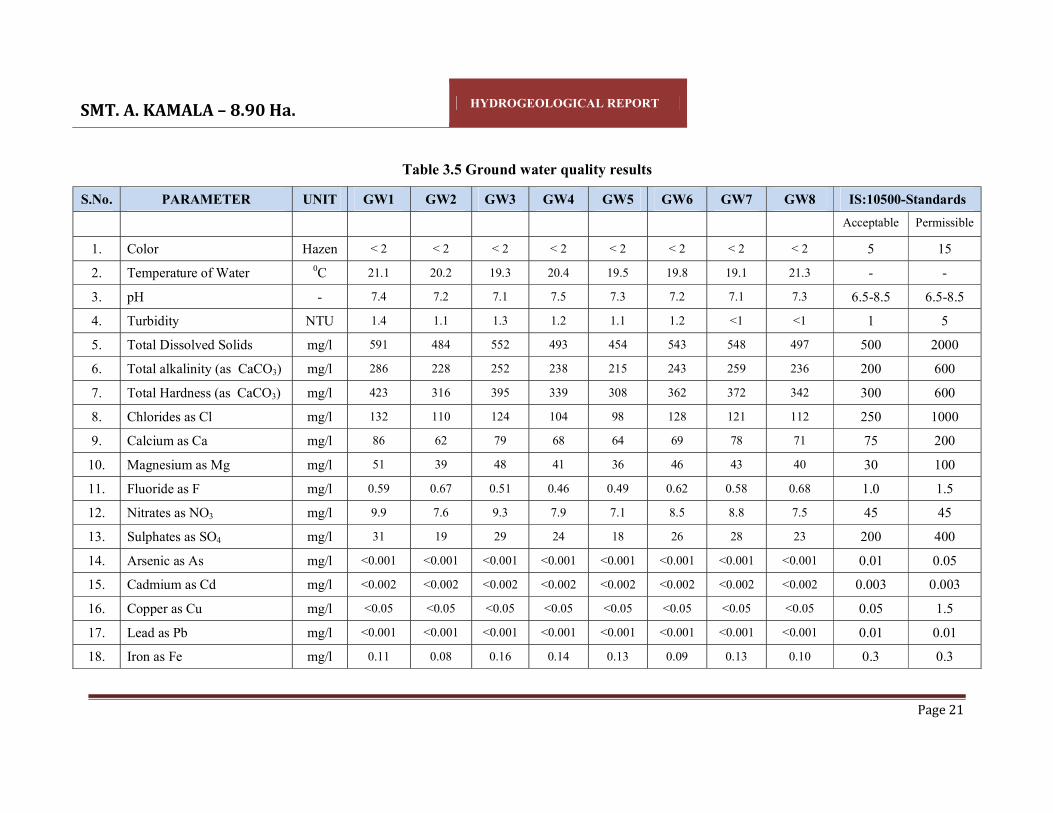
SMT. A. KAMALA – 8.90 Ha. HYDROGEOLOGICAL REPORT
Page 21
Table 3.5 Ground water quality results
S.No. PARAMETER UNIT GW1 GW2 GW3 GW4 GW5 GW6 GW7 GW8 IS:10500-Standards Acceptable Permissible
1. Color Hazen < 2 < 2 < 2 < 2 < 2 < 2 < 2 < 2 5 15 2. Temperature of Water 0C 21.1 20.2 19.3 20.4 19.5 19.8 19.1 21.3 - - 3. pH - 7.4 7.2 7.1 7.5 7.3 7.2 7.1 7.3 6.5-8.5 6.5-8.5 4. Turbidity NTU 1.4 1.1 1.3 1.2 1.1 1.2 <1 <1 1 5 5. Total Dissolved Solids mg/l 591 484 552 493 454 543 548 497 500 2000 6. Total alkalinity (as CaCO3) mg/l 286 228 252 238 215 243 259 236 200 600 7. Total Hardness (as CaCO3) mg/l 423 316 395 339 308 362 372 342 300 600 8. Chlorides as Cl mg/l 132 110 124 104 98 128 121 112 250 1000 9. Calcium as Ca mg/l 86 62 79 68 64 69 78 71 75 200
10. Magnesium as Mg mg/l 51 39 48 41 36 46 43 40 30 100 11. Fluoride as F mg/l 0.59 0.67 0.51 0.46 0.49 0.62 0.58 0.68 1.0 1.5 12. Nitrates as NO3 mg/l 9.9 7.6 9.3 7.9 7.1 8.5 8.8 7.5 45 45 13. Sulphates as SO4 mg/l 31 19 29 24 18 26 28 23 200 400 14. Arsenic as As mg/l <0.001 <0.001 <0.001 <0.001 <0.001 <0.001 <0.001 <0.001 0.01 0.05 15. Cadmium as Cd mg/l <0.002 <0.002 <0.002 <0.002 <0.002 <0.002 <0.002 <0.002 0.003 0.003 16. Copper as Cu mg/l <0.05 <0.05 <0.05 <0.05 <0.05 <0.05 <0.05 <0.05 0.05 1.5 17. Lead as Pb mg/l <0.001 <0.001 <0.001 <0.001 <0.001 <0.001 <0.001 <0.001 0.01 0.01 18. Iron as Fe mg/l 0.11 0.08 0.16 0.14 0.13 0.09 0.13 0.10 0.3 0.3

SMT. A. KAMALA – 8.90 Ha. HYDROGEOLOGICAL REPORT
Page 22
19. Manganese as Mn mg/l <0.05 <0.05 <0.05 <0.05 <0.05 <0.05 <0.05 <0.05 0.1 0.3 20. Zinc as Zn mg/l 0.5 0.24 0.29 0.21 0.17 0.25 0.31 0.35 5.0 15.0 21. Dissolved phosphates mg/l <0.01 <0.01 <0.01 <0.01 <0.01 <0.01 <0.01 <0.01 - - 22. Phenolic Compounds as
C6H5OH mg/l <0.001 <0.001 <0.001 <0.001 <0.001 <0.001 <0.001 <0.001 0.001 0.002
23. Residual Chlorine mg/l <0.1 <0.1 <0.1 <0.1 <0.1 <0.1 <0.1 <0.1 0.2 1 24. E. Coli CFU/100
ml ND ND ND ND ND ND ND ND ND ND
25. Total Coliforms CFU/100 ml 68 44 58 38 60 39 40 50 ND ND
Note: ND - Not Detected

SMT. A. KAMALA – 8.90 Ha. HYDROGEOLOGICAL REPORT
Page 23
3.4.2 Surface Water Quality of the Study Area o pH of the surface water collected was neutral with pH ranging from 7.2 -7.4
o TDS was found to be 215mg/l to 267mg/l. The tolerance limit of 1,500 mg/l as per
IS:2296
o Total hardness was found to be 101 mg/l to 126 mg/l
o Presence of Nitrate was recorded as 0.21 mg/l to 0.28 mg/l
o DO was observed as 5.5 mg/l to 6.2 mg/l
o Total coliform in water was 300 MPN/100ml to 900 MPN/100ml. The likely
source of bacteriological contamination was due to the proximity to residential
area
o All the heavy metals were found to be within below detectable limits.
An overview of the results obtained reveals that none of parameters were found above the
permissible limits of IS: 10500 Drinking Water Standards.
The summarized analysis of results of the surface water quality in the study area are
given in the below Table 3.6.

SMT. A. KAMALA – 8.90 Ha. HYDROGEOLOGICAL REPORT
Page 24
Table 3.5: Surface Water Quality of the Study Area
S. No.
PARAMETER UNIT SW1 SW2 SW3 SW4 IS:2296 -Standards
1. Color Hazen <1 <1 <1 <1 -
2. Odour - Agreeable Agreeable Agreeable Agreeable -
3. Turbidity NTU 6.2 8.4 5.7 5.3 -
4. pH - 7.4 7.3 7.3 7.2 6.50 – 8.50
5. Temperature 0C 25.8 25.6 25.3 25.2 -
6. Electrical Conductivity mmhos/cm 405 464 375 348 -
7. Total Dissolved Solids mg/l 253 267 231 215 1500
8. Total Suspended Solids mg/l 25 22 26 20 -
9. Total Alkalinity as CaCO3
mg/l 82 93 79 72 -
10. Total Hardness as mg/l 118 126 110 101 -
11. Calcium as Ca mg/l 23.4 25.6 22.1 20.8 -
12. Magnesium as Mg mg/l 14.5 15.1 13.2 11.8 -
13. Chloride as Cl mg/l 65.2 68.4 54.5 51.3 -
14. Sulphate as SO4 mg/l 25.2 25.8 24.3 20.6 -
15. Nitrate as NO3 mg/l 0.24 0.28 0.22 0.21 -
16. Iron as Fe mg/l 0.08 0.13 0.1 0.07 -
17. Hexavalent Chromium as Cr6+ mg/l <0.001 <0.001 <0.001 <0.001 0.05
18. Phenolic Compounds mg/l <0.001 <0.001 <0.001 <0.001 0.005
19. Cyanide as CN mg/l <0.002 <0.002 <0.002 <0.002 0.05
20. Zinc as Zn mg/l < 0.01 < 0.01 < 0.01 < 0.01 15
21. Lead as Pb mg/l <0.001 <0.001 <0.001 <0.001 0.01
22. Copper as Cu mg/l <0.05 <0.05 <0.05 <0.05 1.5
23. Aluminium as Al mg/l <0.005 <0.005 <0.005 <0.005 0.1
24. Manganese as Mn mg/l <0.05 <0.05 <0.05 <0.05 5.0
25. Mercury as Hg mg/l <0.001 <0.001 <0.001 <0.001 -

SMT. A. KAMALA – 8.90 Ha. HYDROGEOLOGICAL REPORT
Page 25
26. Arsenic as As mg/l <0.001 <0.001 <0.001 <0.001 -
27. Cadmium as Cd mg/l <0.002 <0.002 <0.002 <0.002 -
28. Dissolved Oxygen mg/l 5.7 5.5 5.8 6.2 5.0 min
29. Chemical Oxygen Demand mg/l <10 <10 <10 <10 -
30. Biochemical Oxygen Demand mg/l <1 <1 <1 <1 3.0
31. Total Kjheldhal Nitrogen mg/l < 1.0 < 1.0 < 1.0 < 1.0 -
32. Free Ammonical Nitrogen mg/l < 0.01 < 0.01 < 0.01 < 0.01 -
33. Oil & Grease mg/l < 0.1 < 0.1 < 0.1 < 0.1 -
34. E. Coli MPN/100 ml Absent Absent Absent Absent Absent
35. Total Coliforms MPN/100 ml 500 900 500 300 5000

SMT. A. KAMALA – 8.90 Ha. HYDROGEOLOGICAL REPORT
Page 26
IV HYDROLOGY AND SURFACE WATER UTILIZATION
Vizianagaram district is covered all minor rivers are directly joined to the Bay of Bengal.
The Vamsadhara, Nagavali, Peddagedda, Kandivalasagedda, Champavathi, Minor
drainages between Gosthani & Champavathi, Gosthani, Madhuravada minor drainages,
Naravagedda and Saradha are the minor basins covered in the district. These 10
minorbasins are further divided into 96 sub-basins subsequently divided into 522
cascades.
Irrigation has assumed an increasing significance in agriculture in the context of new
technology, where high yielding varieties and multiple cropping is being practiced. The
main reasons for low yields are inadequate rainfall, uneven and uncertain rains during the
period of crop growth. It is generally found that the introduction of irrigation is associated
with changes in the cropping pattern. The shift from traditional cropping pattern to the
most advantageous cropping pattern is possible only in the presence of irrigation
facilities. The new agricultural technology is highly based on sufficient moisture
conditions. Thus, the development of irrigation is crucial for increasing agricultural
production. The irrigation projects are classified as major, medium and minor irrigation
projects
Major Irrigation Project: The ongoing major irrigation projects in Vizianagaram district
is 1) Thotapalli Barrage is covered an ayacut of 70,770 ac falling in six assembly
constituencies namely as Bobbili, Cheepurupalle, Nellimarla and Parvathipuram.
Medium Irrigation Project: The completed medium irrigation project are (1)Thotapalli
Regulator is 6,938 ac (2)Vengala Raya Sagaram Project is 24,700 ac (3)Vottigedda
Reservoir is 16,670 ac (4)Seethanagaram Anicut is 4,118 ac (5)Peddankalam Anicut is
8,160 ac (6) Vegavathi Anicut is 4,142 ac (7) Tatipudi Reservoir is 15,366 ac (8) Andhra
Reservoir Project is 9,426 ac (9) Denkada Anicut is 5,203 ac (10) Pedda Gedda Project is
12,000 ac. The sources of minor irrigation systems in S.Kota mandal and Vizianagaram
district are given in table 4.1.

SMT. A. KAMALA – 8.90 Ha. HYDROGEOLOGICAL REPORT
Page 27
Table 4.1: Minor Irrigation Sources 2017-18
Category S.Kota Mandal Vizianagaram District
No. of Sources 259 10297
Regd. Ayacut 4165 104296
Actual area Irrigated 3837 79570
Sources of Irrigation
Canals 588 50277
Tanks 3884 80045
Tube wells 1065 48855
Dug wells 21 8514
Lift irrigation 0 595
others 0 2830
* Source: Hand Book of Statistics Vizianagaram District 2018.

SMT. A. KAMALA – 8.90 Ha. HYDROGEOLOGICAL REPORT
Page 28
V GEOLOGY Geology of the mine area:
The lease area is not suitable for agriculture as it is strewed with small stones/boulders
and covered with Charnockites /Pyroxene Granulites which is raising up to 78 M above
ground level, the strike length of the body is measured374.43 M in the area with an
average width of 224.14M. The rock type stones have perpendicular jointing, hence not
suitable for colour granites.
The applied area falls in one discontinuous and isolated hillock system, which comes
under Eastern Ghat Tectonic system of Achaean Age group. The study area is
characterized by Eastern Ghats mobile belt. The area covered with denudation hills of
range between 312 m to 802 m above mean sea level. Kondakindam hillocks in Northern
side and Vendram Hillock in North Eastern side are two important hill ranges Eastern
Ghats prove to be a store-house of many valuable mineral resources which are coming to
light year by year. Garnet-sillimanitebiotite gneisses, Pyroxene Granulites (Charnockites),
garnetiferous granites (Leptynites), quartizites and pegmatite's are the chief rock types
that occur as bedded and banded as well as massive formations in the study area. The
Eastern Ghats complex mainly comprises of Khondalite suites with a set of sub-suites.
Intrusive activity might have caused migmatisation. The terrain must have subjected to
cycles of metamorphism. The local geology shows the occurrence of Granite gneisses,
Charnockite, Khondalite, Quartz and soil. The following is the local stratigraphy of the
mining lease area. Quartz (intrusive), Granite gneisses, Charnockite (Charnockite Group),
and Khondalite is the dominant rock type of the area. It is olden metamorphic schistose
rock with garnet, sillimanite, graphite, Feldspar, Quartz and Biotite as essential minerals
and Garnets, Mica, Hornblends are accessory minerals. Charnockites are fresh looking
light coloured, showing schistosity consisting Quartz, Feldspars, Garnet and Sillimanite
schist. Alternate alignment of leuco and melanocratic minerals attains gnessic property.
Garnet is also observed as discrete grains of reddish, brown, colour and equigranular
texture. The formation is highly structural disturbed with joints, fractures and thickly
penetrated with weather in influences.

SMT. A. KAMALA – 8.90 Ha. HYDROGEOLOGICAL REPORT
Page 29
Geology of Vizianagaram District: Geologically, the district constitutes a part of Eastern Ghats Mobile Belt of Archaean age.
It includes rocks of Khondalite Group, Charnockite Group and Migmatite complex.
Sediments of Upper Gondwana, Cainozoic laterite and Quaternary deposits overlie the
Archaeans. The lithological units of Khondalite Group include quartzite, talc- granulite
and talc-silicate rock with bands and pockets of crystalline limestone +- scapolite +-
wollastonite and garnetiferous quartzofeldspathic gneiss with sillimanite +- graphite.
Khondalite is at places sheared and silicified with thin bands of chert. The various units
of Charnockite Group include pyroxene granulite (basic charnockite) and charnockite
(acid/intermediate). The Migmatite complex includes porphyroblastic hypersthene-biotite
gneiss, hypersthene-quartz-feldspar augen gneiss, cordierite-hypersthene gneiss +-
biotite, and at places, granitoid gneiss. Gneissosity in the granite gneiss is more
pronounced in the vicinity of Khondalite. Thick veins of pegmatite traverse these rocks in
the northwestern part of the area. Upper Gondwana sandstone (containing plant fossils
viz Hausmania sp. And Cladophlebis sp. And indeterminate bark impressions occur close
to the coast, in the southeast. Extensive capping of aluminous laterite is seen over
Khondalite Group. Quarternary formations, including brown, residual soil and fluvial and
marine sediments, occur along the river courses and coast respectively.
Thick mantle of flood plain deposits comprising clay and silt are restricted to the Gostani,
Champavati, Kandivalasa, Vegavati, Suvarnamukhi, and Nagavali river valleys. Coastal
deposits comprising beach sand and dune sand occur as a narrow belt of 500-m to 2 km
wide, along the east coast between Konada and Duvapeta.
Khondalite shows two distinct trends of foliation. In the west it shows NE-SW to ENE-
WSW trend with dips ranging from 50' to 809 towards SE. In the east the general trend of
foliation is N 30` W - S 30' E which swerves, at places. to WNW-ESE. The dip varies
from 40' to 70° easterly or southerly. However, reversal of dips is also noted. The area
has undergone poly phase deformation. Nagavali River is marked by a major NNW-SSE
trending lineament and the area to the east of the river represents a faulted block.

SMT. A. KAMALA – 8.90 Ha. HYDROGEOLOGICAL REPORT
Page 30
VI HYDRO-GEOLOGICAL ASPECTS The hydrogeological conditions prevailing in the district generally depends on various
factors like climate, rainfall, topography, geological setting and structure. In turn the
occurrence and movement of groundwater also depend on these factors. The rocks
occurring in the district can be broadly classified as two types viz; hard and soft rocks.
Crystalline formations like khondolites, charnockites, migmatites and gneisses etc. can be
grouped as hard rocks, while the unconsolidated formations like the alluvial sediments
can be classified as soft rocks. The semi consolidated formations like sandstones are
grouped under soft rocks, though limited in occurrence.
Groundwater in crystalline (Hard rock) formations: The hard crystalline formations
generally lack primary porosity and hence usually the secondary porosity developed
through weathering and fracturing plays a dominant role. The degree and depth of
weathering in the crystalline formations varies from place to place depending upon the
topography and structure etc. The thickness of weathered mantle on the hilltops and
outcrops is less than a metre whereas it is maximum as much as 40 m. in valleys and
topographic lows. The groundwater generally occurs under phreatic condition in the
shallow weathered mantle and under semi-confined conditions in the fracture zones.
Groundwater in crystalline rocks is generally developed by means of dugwells, dug cum
borewells and borewells. The dugwells in the district are generally circular in shape with
diameter ranging from 0.8 and 5.6m and depth of the wells vary between 4 and 12m.b.g.l.
and the depth to water level varies from 1.35 to 10.0m.b.g.l. The yield of the wells
piercing the weathered zone vary from 3.0 to 237.6 cu.m./day depending on the location.
The depth range of bore wells is between 30 to 200m.b.gl. with yields varying from
43.2cub.m./day to 432cu.m./day. The specific capacity of the wells varies from 3.77 to
17.1lpm/m/m.d.d. and the transmissivity of the aquifer varies from 6.0 to 85mts.sq./day.
Ground water in unconsolidated/semi-consolidated formation (soft rock): Alluvial
formations comprising fine to coarse sands, pebble beds and gravels constitute the aquifer
horizons. Groundwater occurs under both phreatic and semiconfined conditions. The
thickness of alluvium varies from a few meters to over 20 metres. Groundwater is

SMT. A. KAMALA – 8.90 Ha. HYDROGEOLOGICAL REPORT
Page 31
developed through dug wells, filter point wells and shallow tube wells to a limited extent
in the district at places in the area. The depth to water level in dug wells varies from 1.50
to 11.0 m.b.g.l.
Depth of shallow filter point/tube wells range between 8.0. and 20 m.b.g.l. and the yield
of the wells vary depending on the thickness of granular zones encountered and generally
ranges between 96 cu.m/day to 120 cu.m/.day. The dune sands or wind blown sands are
limited in their areal extent in the district and having no sufficient granular zones.
However potable groundwater occurs in these sands at shallow depths. In coastal sands,
the depth to water level varies from 1.36 to 5.20 m.b.g.l. and the depth of the wells range
between 3.0. to 7.50 m.b.g.l. The specific capacity of the shallow tube wells vary from 73
to 631 lpm/m/m.d.d. and the transmissivity value for alluvial aquifer range between 160
and 675 m.sq/day.
Fig: 6.1 Hydrogeology –Vizianagaram district
SMT. A. KAMALA – 8.90 Ha. HYDROGEOLOGICAL REPORT
Page 32
6.1 GROUNDWATER OCCURRENCE:
Ground water occurs in all most all geological formations and its potential depends upon
the nature of geological formations, geographical setup, and incidence of rainfall,
recharge and other hydrogeological characters of the aquifer. In consolidated formations
ground water occurs under unconfined to semi-confined conditions. Ground water is
developed in these formations by dug wells, dug cum bore wells and bore wells tapping
weathered and fractured zones.
The yields are in the range of 20 to 70 m3/day. The occurrence of fractures in the
crystalline formations is limited down to 30 to 40 m bgl and occasionally extends down
to 70 - 100 mbgl. The bore wells constructed in the crystalline formations generally tap
the weathered and fractured zones. The yields of the bore wells generally range between
80 to 400 m3/day.
The higher yields are limited to the available thickness of fractured and jointed zones. In
the meta sediments the yields are very limited and are in the range of 10 to 80 m3/day.
Higher yields occur in limestone formations. Ground water in semi-consolidated
formations occurs under unconfined to confined conditions. Ground water is developed in
these formations by dug cum tube wells and tube wells. These formations are potential
aquifers. The yields of the dug cum tube wells are in the range of 30 to 45 m3/day.
6.2 WATER LEVEL FLUCTUATION: The depth to water level during pre-monsoon season in the district ranges between 5.1 m
to 7.4 m bgl. High levels of Ground water levels during monsoon are observed in the year
2016-17 & 2017-18. In monsoon (South West monsoon) season, the ground water levels
of Vizianagaram district ranges between 2.3 m bgl and 6.1 m bgl. Deeper ground water
depths are recorded in the year 2016-17, which is in the range of 3.2 m – 7.4 m bgl.
Shallower depths of ground water levels for Vizianagaram district is observed during
post-monsoon season ranging between 2.7-5.2 m bgl. During winter again the depth of
ground water availability increases i.e., 4.9-6.4 m bgl for 2016-18.

SMT. A. KAMALA – 8.90 Ha. HYDROGEOLOGICAL REPORT
Page 33
Table 6.1: Month-wise Ground water levels and Rainfall data for Vizianagaram District from 2016-17 to 2017-18
Month
2016-17 2017-18
Ground water level (in m)
Rainfall (in mm)
Ground water level (in m)
Rainfall (in mm)
June 6.1 182.7 4.9 121.3
July 5.0 184.6 3.2 125.4
August 4.9 120.0 3.5 306.9
September 3.2 302.8 2.3 168.1
South-West Monsoon 19.2 790.1 13.9 721.7
October 3.5 103.0 2.7 149.0
November 4.4 1.7 3.4 32.9
December 5.2 0.7 4.1 0.4
North East Monsoon 13.1 105.4 10.2 182.3
January 5.9 0.3 4.9 0.0
February 6.4 0.0 5.8 0.0
Winter Period 12.3 0.3 10.6 0.0
March 6.8 32.6 5.1 1.5
April 7.2 5.0 5.5 81.7
May 7.4 61.5 5.8 84.3
Hot Weather Period 21.4 99.1 16.4 167.5
Total 66.0 994.9 51.0 1071.5
Average 5.5 82.9 4.3 89.3 * Source: CHIEF PLANNING OFFICER, VIZIANAGARAM

SMT. A. KAMALA – 8.90 Ha. HYDROGEOLOGICAL REPORT
Page 34
In S.Kota Mandal, the ground water levels in post monsoon season (i.e., Nov’ 2021)
shallow ground water depth is observed to be 4.7 bgl, whereas in pre-monsoon season
(i.e., May, 2021) is recorded as deeper depth with 7.35 bgl.
Table 6.2: Groundwater levels recorded by Piezometer (in bgl)
Month S.Kota Vizianagaram
Ground water level
(in meters)
Rainfall
(mm)
Ground water level
(in meters)
Rainfall
(mm)
Feb 2021 6.02 3.1 6.31 16.8
May 2021 7.35 29.3 6.76 27.9
Nov 2021 4.7 46.3 2.90 39.0
Feb 2022 6.02 0 5.34 16.8 * Source: Ground water Department–Govt. of Andhra Pradesh; https://apwrims.ap.gov.in/groundwater/levels
The analytical data of ground water level fluctuation between pre and post monsoon
during the period 2021-22 indicate the minimum water level is 4.7 m and maximum
ground water level is 7.35 m at S.Kota mandal. It is observed that there is not much
fluctuation in ground water levels during the years 2015-2018. Ground water recharge
through precipitation is not altered during the years.
6.3 PERCOLATION/RECHARGE FACTOR FOR MINE AREA
Rainfall infiltration factor is calculated by the following formula:
Rrf = RFIF * A * (R-a) / 1000
Where:
RFIF = Rainfall Infiltration Factor
A = Area for computation of recharge i.e., 8.90 Ha
(R-a)/1000 = Rainfall in meters
For computing rainfall percolation factor method
1. Normal South-West monsoon rainfall is considered as 0.702 m
2. Normal North-East monsoon rainfall is considered as 0.301 m

SMT. A. KAMALA – 8.90 Ha. HYDROGEOLOGICAL REPORT
Page 35
3. Normal Non monsoon rainfall is considered as 0.235 m
Rainfall percolation Factor for Granite weathered & Jointed (Road Metal & Building
Stone) has been considered as 0.11 (11 %).
1. Rrf = 0.11 * 8.90 * 0.702 = 0.687 ham
2. Rrf = 0.11 * 8.90 * 0.247 = 0.242 ham
3. Rrf = 0.11 * 8.90 * 0.172 = 0.168 ham
Total Rrf = 1.097 ham
Natural Discharge 5 % = 1.097 – 0.0549 = 1.042 ham
Hence, the total annual rain water percolating is estimated to be as 1.042 ham

SMT. A. KAMALA – 8.90 Ha. HYDROGEOLOGICAL REPORT
Page 36
VII GROUND WATER RESOURCES ASSESSMENT – GEC 2015
7.1 NORMS OF GROUNDWATER ESTIMATION COMMITTEE – 2015
The revised methodology Groundwater Estimation Committee (GEC) -2015 recommends
aquifer wise ground water resource assessment. Ground water resources have two
components- replenishable ground water resources or dynamic ground water resources
and in-storage resources or static resource. As per GEC - 2015 norms, a watershed with
well-defined hydrological boundaries is an appropriate unit for ground water resource
estimation, but, it is not applicable for present investigated area as it is only confined to
single revenue village. The methodology for ground water reserves estimation is based on
the principle of water balance as given below:
In flow - Out flow= change in storage (of an aquifer)
7.2 RAINFALL RECHARGE
GEC-2015 has recommended that ground water recharge should be estimated on
groundwater level fluctuation and specific yield approach since this method takes into
account the response of ground water levels to ground water input and output
components.
7.2.1 Ground Water Level Fluctuation Method
The change in storage can be estimated using the following equation:
ΔS = Δh * A * Sy
Where: ΔS = Change in Storage
Δh = Rise in water level in the monsoon season
A = Area for computation of recharge
Sy = Specific yield

SMT. A. KAMALA – 8.90 Ha. HYDROGEOLOGICAL REPORT
Page 37
The study area is limited to one village i.e., Mallipudi Village of S.Kota mandal,
Vizianagaram district. Hence the average water level fluctuation for the period of 2021-
2022 is considered as 2.65 m.
The specific yield is taken as 6.0% as the area is occupied by alluvium consisting of sand,
silt and clay (clay is dominant) by both fluvial and marine action representing the
quaternary in geological time scale.
The area of recharge for computation is taken for Mallipudi Village area, which is 324
hectares.
ΔS = 2.65 * 324 * 0.06
= 51.516 ham
Natural discharge of 5 % should be deducted from 51.516 ham i.e., 51.516–2.576
Available ground water at Mallipudi village for further exploitation is 48.94 ham.
7.2.2 Rainfall Infiltration Factor
Rainfall infiltration factor is calculated by the following formula:
Rrf = RFIF * A * (R-a) / 1000
Where:
RFIF = Rainfall Infiltration Factor
A = Area for computation of recharge
(R-a)/1000 = Rainfall in meters
For computing rainfall percolation factor method
1. Normal South-West monsoon rainfall is considered as 0.702 m
2. Normal North-East monsoon rainfall is considered as 0.301 m
3. Normal Non monsoon rainfall is considered as 0.235 m
Rainfall percolation Factor for Granite weathered & Jointed (Road Metal & Building
Stone) has been considered as 0.11 (11 %).

SMT. A. KAMALA – 8.90 Ha. HYDROGEOLOGICAL REPORT
Page 38
1. Rrf = 0.11 * 324 * 0.702 = 25.019 ham
2. Rrf = 0.11 * 324 * 0.301 = 10.728 ham
3. Rrf = 0.11 * 324 * 0.235 = 8.375 ham
Total Rrf = 44.122 ham
Natural Discharge 5 % = 44.122 – 2.206 = 41.916 ham
Hence, the total annual ground water for extraction is estimated to be as 41.916 ham
7.2.3 Recharge due to Other Sources
Recharge due to other sources constitute recharges from Canals, Applied Surface Water
irrigation, Applied Ground Water Irrigation, Tanks& Ponds and Water Conservation
Structures in Command areas. Whereas in Non-command areas only the recharge due to
Applied Ground Water Irrigation, Tanks & Ponds and Water Conservation Structures are
possible.

SMT. A. KAMALA – 8.90 Ha. HYDROGEOLOGICAL REPORT
Page 39
VIII IMPACT OF MINING IN GROUNDWATER REGIME
The mining lease applied area is covered with denudations of 312 m to 802 m above
mean sea level. With reference to the Topomap 65N/4, the quarry lease area covered
between the 646 m and 312 m hills on the North and South side of mine area & 802 m
hill to the North-West side of mine area. Notable perennial water bodies are not present
within or nearby area which may cause the inundation of quarry..
The ground water table is about 48 m depth from the ground level. Maximum depth of
workings is up to RL 70 m and minimum depth of workings is RL 80 m. The proposed
maximum quarry operations during the plan period, a depth of 98m from the top hill
which is above the ground level; thus no chances for accumulation of ground water in
working pit and no water will be discharged from the pit.
All precautionary measures, such as, garland drains, siltation pond and retention wall will
be constructed during implementation of mine activity. The rain water collected in the
mine pits and garland drains will be used for sprinkling haul & approach road and
greenbelt watering, if excess, the water will be discharged into nearby first order streams
if allowed into agricultural fields or water bodies after sedimentation.
There will be no impact on water quality as the mineral is insoluble and doesn’t react
with water. The process of the Road Metal & Building Stone mineral excavation doesn’t
involve washing of the mineral and mineral will be excavated as dry material. Drilling
and sprinkling of haul roads, mine area are the absolute water consumption sources
during this mining process.
Overburden over the mineral during mining may be dumped temporarily in 1.0218 Ha.
within mine lease area as step dumping. Dump area is in the South corner of QL covering
area. The waste generated can be used for regular gradation of approach/haul roads,
maintaining retention wall along the hill slopes and strengthening garland drains within
the mine area. The topsoil will be preserved within the lease area for mined area
reclamation usage at the time of closure.

SMT. A. KAMALA – 8.90 Ha. HYDROGEOLOGICAL REPORT
Page 40
IX CONCLUSIONS AND RECOMMMENDATIONS
CONCLUSIONS:
Based on the field observations and data collected from the Smt. A. Kamala, Road Metal
& Building Stone mining area in Mallipudi Village, it is concluded that.
1. Piezometer at S.Kota mandal indicates that the water table varying between 4.7bgl
during post monsoon and 7.35 m bgl during pre monsoon.
2. Area is moderate to steep slope in nature, thus recharge through rainfall is
moderate.
3. Road Metal & Building Stone deposits occupy the area.
4. Road Metal & Building Stone is still a porous stone with average water absorption
of between 0.1 and 1.4%.
5. Groundwater is not exploited within mine area.
6. Pre monsoon ground water levels and post monsoon groundwater levels are slightly
in declining trend. It may be due to erratic monsoon rainfall and ground water has
to use for Khariff crops (particularly Paddy).
7. Groundwater has been estimated by adopting norms prescribed by GEC - 2015.
8. The possibility of interaction and influence of the mining operations on the water
table conditions as well as groundwater regime either in quality or quantity aspects
may be meager. However, few observational wells may be established in the
downstream of the mining area to assess the impact of mining.
9. The mineral Road Metal & Building Stone is inert and insoluble in water, thus
deterioration of water quality is not expected from this mining.
The method of Road Metal & Building Stone mining is open cast which would result in a
depression that can hold considerable amount of rainwater and underground seepage
water. This acts as an impounding infiltration reservoir that can contribute to not only for
augmenting additional water resources but also as a direct water resource for mine and
nearby agricultural fields to the region.
SMT. A. KAMALA – 8.90 Ha. HYDROGEOLOGICAL REPORT
Page 41
RECOMMENDATIONS
Safe yield of the aquifer has been evaluated and accordingly the extraction has to be
restricted.
1. Groundwater table in the present area ranges between 4.7 m – 7.35 m.
Topographically the quarry lease area is covered with denudations of 312 m to 802 m
above mean sea level. With reference to the Topomap 65N/4, the quarry lease area
covered between the 646 m and 312 m hills on the North and South side of mine area
& 802 m hill to the North-West side of mine area.
2. There are no water bodies within the core area or immediate buffer zone of the mine.
3. Restriction of mining above, to top surface of water table may reduce the influence
of mining on water table.
4. The stagnated water in the left out mine pits may be pumped out and made useful for
mine operations or development of greenery over the dumped overburden. If excess
water is found in the mine pit that could used for irrigation in the low lying areas,
may be examined which may not require pumping.
5. Overburden over the mineral during mining may be dumped temporarily in 1.0218
Ha. within mine lease area as step dumping. Dump area is in the South corner of QL
covering area. The waste generated can be used for regular gradation of
approach/haul roads, maintaining retention wall along the hill slopes and
strengthening garland drains within the mine area. The topsoil will be preserved
within the lease area for mined area reclamation usage at the time of closure.
6. Contour trenches either Continuous Contour Trench (CCT) or Staggered Trench (ST)
are sug gested in the foot hill region along the East, South and West borders of the
mining site to catch the rainfall runoff from the up slope and recharge groundwater.
Fine material from the mining and dumping areas also gets trapped in the trench if it
is flown along with rainwater. An approximate location of the trenches is marked in
the mine layout map.

ANNEXURE –VII EARLIER
PRODUCTION DETAILS