Lafaigi area, central Bida basin - African Journals Online
17
GLOBAL JOURNAL OF GEOLOGICAL SCIENCES VOL 10, NO. 1, 2012: 111-127 COPYRIGHT© BACHUDO SCIENCE CO. LTD PRINTED IN NIGERIA. ISSN 1596-6798 www.globaljournalseries.com ; Email: [email protected] FACIES ANALYSIS AND PALEOENVIRONMENTS OF THE UPPER CRETACEOUS SEDIMENTS IN SHARE – LAFIAGI AREAS, NORTHERN BIDA BASIN, NIGERIA. OLUSOLA J. OJO AND SAMUEL O. AKANDE (Received 12 September 2011; Revision Accepted 22, February 2012) ABSTRACT The Bida Basin is located in central Nigeria and it is perpendicular to the main axis of the Benue Trough. Due to its large areal extent and facies variation, the basin is often geographically divided into northern and southern Bida Basins. Whereas, aspects of the mineral resource and sedimentation history of the sediments in NW and SE extremes have been consistently studied, the present study area (Share-Lafiagi-Shonga areas) remains either unknown or under-reported. In the study area, fifteen vertical profiles of the Campanian-Maastrichtian sediments were studied along road cuts, erosional channels and Cliff sides with special attention focused on their internal physical and biogenic attributes. The sedimentological analysis permitted recognition of five distinct depositional facies; alluvial fan, braided channel, floodplain, tidal channel and shoreface in the lithostratigraphic units mapped. In Unit I, the proximal alluvial fan facies were preserved as conglomeratic facies which overly non- conformably, the Pre-Cambrian weathered schists and granites. Both the matrix and grain supported subfacies are indicative of gravity induced alluvial processes. The braided channel facies comprising of conglomeratic sandstone, medium-coarse grained sandstone subfacies are wide spread and their fluvial origin is supported by unidirectional flow pattern and absence of marine biogenic features. The sequence grades into claystone facies which probably formed in localized non marine floodplains. The younger Unit II comprises of conglomerate, sandstone and claystone facies. The conglomerate facies is moderately sorted and mature showing evidence of reworking and recycling. Association of this facies with herringbone cross stratifified beds probably indicates tidal channel lag origin. The sandstone facies are commonly compositionally mature, bioturbated and contain clasts of reworked clays and clay drapes suggesting high energy tidal channels and shoreface subenvironments. The depositional model for the Upper Cretaceous sediments in the study area is strongly dominated by alluvial processes which in places evolved into shallow marine processes and frequently incised by fluvial channels. The clay deposits of the floodplain may offer economic resource potential in the area. KEY WORDS: Bida, Facies, Cretaceous, Fluvial, Sedimentation INTRODUCTION The Bida Basin (synonymous with middle Niger and Nupe Basins) is a 350km long NW – SE trending intracratonic embayment and is oriented perpendicular to the main axis of the Benue Trough of Nigeria (Fig. 1a). To the east, it is contiguous with or adjacent to the Anambra Basin. These basins were major depositional centres for transgressive and regressive sediments in the upper Cretaceous times of Nigeria. To the northwest, it is adjacent to the Sokoto basin. Due to its large areal extent and facies variation, the basin is often geographically divided into northern and southern Bida Basins. Among the previous studies on the geology of the Bida Basin are the works of Adeleye (1973, 1974), Braide (1992a), Olaniyan and Olabaniyi (1996) and Oluyide et al. (1998) which reported aspects of the stratigraphy and sedimentology of parts of the northern Bida Basin. Jan Du Chene et al (1978) recognized the presence of Maastrichtian pollen and spores in the shales in southern Bida Basin. The origin of the oolitic ironstones in the Bida Basin had been a principal subject of several works e.g. Adeleye (1973), Ladipo et al. (1994) and Abimbola et al. (1999). In recent time, investigations have also been made on the petroleum potentials of the Bida Basin (Idowu and Enu, 1992; Braide, 1992b; Obaje et al. 2004; Akande, et al. 2005). The stratigraphy, mineral resources and paleoenvironmental evolution of the sediments in northwest of the northern Bida Basin and southern Bida Basin have been consistently studied and published, however, no such information is available on the present investigated area (Share – Lafiagi - Shonga area) with hundreds of metres thick clastic sediments. The only effort in that direction, is, however, that of Braide (1992a) which presented facies association and tectonic implications of sediments north of the River Niger (Bida – Enagi traverse). This article covers the traverse south of the Niger River (Fig. 1b). Even though, the rocks in this region, may be lateral equivalents of those north of River Niger, their distribution, geological developments, depositional history and economic resources (main 111 Olusola J. Ojo, Department of Geology and Mineral Sciences, University of Ilorin, P.M.B. 1515, Ilorin, Nigeria. Samuel O. Akande, Department of Geology and Mineral Sciences, University of Ilorin, Ilorin, Nigeria.
-
Upload
khangminh22 -
Category
Documents
-
view
4 -
download
0
Transcript of Lafaigi area, central Bida basin - African Journals Online

GLOBAL JOURNAL OF GEOLOGICAL SCIENCES VOL 10, NO. 1, 2012: 111-127COPYRIGHT© BACHUDO SCIENCE CO. LTD PRINTED IN NIGERIA. ISSN 1596-6798
www.globaljournalseries.com; Email: [email protected]
FACIES ANALYSIS AND PALEOENVIRONMENTS OF THE UPPERCRETACEOUS SEDIMENTS IN SHARE – LAFIAGI AREAS,NORTHERN BIDA BASIN, NIGERIA.
OLUSOLA J. OJO AND SAMUEL O. AKANDE(Received 12 September 2011; Revision Accepted 22, February 2012)
ABSTRACT
The Bida Basin is located in central Nigeria and it is perpendicular to the main axis of the Benue Trough. Dueto its large areal extent and facies variation, the basin is often geographically divided into northern and southern BidaBasins. Whereas, aspects of the mineral resource and sedimentation history of the sediments in NW and SE extremeshave been consistently studied, the present study area (Share-Lafiagi-Shonga areas) remains either unknown orunder-reported. In the study area, fifteen vertical profiles of the Campanian-Maastrichtian sediments were studiedalong road cuts, erosional channels and Cliff sides with special attention focused on their internal physical andbiogenic attributes. The sedimentological analysis permitted recognition of five distinct depositional facies; alluvial fan,braided channel, floodplain, tidal channel and shoreface in the lithostratigraphic units mapped.
In Unit I, the proximal alluvial fan facies were preserved as conglomeratic facies which overly non-conformably, the Pre-Cambrian weathered schists and granites. Both the matrix and grain supported subfacies areindicative of gravity induced alluvial processes. The braided channel facies comprising of conglomeratic sandstone,medium-coarse grained sandstone subfacies are wide spread and their fluvial origin is supported by unidirectional flowpattern and absence of marine biogenic features. The sequence grades into claystone facies which probably formedin localized non marine floodplains. The younger Unit II comprises of conglomerate, sandstone and claystone facies.The conglomerate facies is moderately sorted and mature showing evidence of reworking and recycling. Associationof this facies with herringbone cross stratifified beds probably indicates tidal channel lag origin. The sandstone faciesare commonly compositionally mature, bioturbated and contain clasts of reworked clays and clay drapes suggestinghigh energy tidal channels and shoreface subenvironments.
The depositional model for the Upper Cretaceous sediments in the study area is strongly dominated byalluvial processes which in places evolved into shallow marine processes and frequently incised by fluvial channels.The clay deposits of the floodplain may offer economic resource potential in the area.
KEY WORDS: Bida, Facies, Cretaceous, Fluvial, Sedimentation
INTRODUCTIONThe Bida Basin (synonymous with middle Niger
and Nupe Basins) is a 350km long NW – SE trendingintracratonic embayment and is oriented perpendicularto the main axis of the Benue Trough of Nigeria (Fig.1a). To the east, it is contiguous with or adjacent to theAnambra Basin. These basins were major depositionalcentres for transgressive and regressive sediments inthe upper Cretaceous times of Nigeria. To thenorthwest, it is adjacent to the Sokoto basin. Due to itslarge areal extent and facies variation, the basin is oftengeographically divided into northern and southern BidaBasins.
Among the previous studies on the geology ofthe Bida Basin are the works of Adeleye (1973, 1974),Braide (1992a), Olaniyan and Olabaniyi (1996) andOluyide et al. (1998) which reported aspects of thestratigraphy and sedimentology of parts of the northernBida Basin. Jan Du Chene et al (1978) recognized thepresence of Maastrichtian pollen and spores in theshales in southern Bida Basin. The origin of the oolitic
ironstones in the Bida Basin had been a principalsubject of several works e.g. Adeleye (1973), Ladipo etal. (1994) and Abimbola et al. (1999). In recent time,investigations have also been made on the petroleumpotentials of the Bida Basin (Idowu and Enu, 1992;Braide, 1992b; Obaje et al. 2004; Akande, et al. 2005).
The stratigraphy, mineral resources andpaleoenvironmental evolution of the sediments innorthwest of the northern Bida Basin and southern BidaBasin have been consistently studied and published,however, no such information is available on the presentinvestigated area (Share – Lafiagi - Shonga area) withhundreds of metres thick clastic sediments. The onlyeffort in that direction, is, however, that of Braide(1992a) which presented facies association and tectonicimplications of sediments north of the River Niger (Bida– Enagi traverse). This article covers the traverse southof the Niger River (Fig. 1b). Even though, the rocks inthis region, may be lateral equivalents of those north ofRiver Niger, their distribution, geological developments,depositional history and economic resources (main
111
Olusola J. Ojo, Department of Geology and Mineral Sciences, University of Ilorin, P.M.B. 1515, Ilorin, Nigeria.Samuel O. Akande, Department of Geology and Mineral Sciences, University of Ilorin, Ilorin, Nigeria.

objectives of this study) are worth studying and indeedthe documentation will help to further understand thegeology of the entire basin. This approach will also helpto further appreciate the lateral and time variation infacies in the entire basin and their significance. It is
important to also note here that, from our experience inthe southern Bida Basin (Ojo and Akande, 2006, 2009),the depositional models of Braide (1992a & b) whichforeclose influence of marine processes in that basinneed to be re examined.
Fig. 1: (a) Geological map of Nigeria showing the position of Bida Basin (modified after Obaje et al. 2004).(b) Map of the study area (boxed area of Fig. 1a) and locations of the investigated outcrops.
112 OLUSOLA J. OJO AND SAMUEL O. AKANDE

Geological SettingConsensus of opinion on the origin of the Bida
Basin is that the upper Cretaceous sediments, which areessentially clastics were deposited in a rift basinassociated with drifting apart of south America andAfrica plates (King, 1950; Kennedy, 1965). The BidaBasin is popularly believed to be part of the tectonicevolution of the Benue Trough which perhaps, began inthe Jurassic – Early Cretaceous with the opening of Gulfof Guinea about a triple junction. Interpretations ofLandsat images, borehole logs as well as geophysicaldata across the entire Bida Basin by Kogbe et al. (1981)suggest that the basin is bounded by a system of linearfaults trending NW/SE. Gravity studies also confirmcentral positive anomalies flanked by negativeanomalies as shown for the adjacent Benue Trough andtypical of rift structures (Ojo and Ajakaiye, 1989; Kogbeet al. 1983). Ojo (1984) suggested an estimate of 3.5kmas the maximum thickness of the sedimentarysuccessions in the central axis based on gravity survey.Adeniyi (1985) through ground and aeromagneticstudies also outlined the basin configuration. A recentspectral analysis of the residual total magnetic fieldvalues over several sections of the basin, reveal anaverage depth to the basement of ca.3.4km andsedimentary thickness of up to 4.7km in the central andsouthern parts of the basin (Udensi and Osazuwa,2004). In a different model, the basin is thought to beassociated with isostatic readjustments and gentle downwarping or subsidence of the granitic basement complexas a result of the removal of mantle material which led tothe emplacement of the Younger granite ring complexes
during the Jurassic (Ojo and Ajakaiye, 1989; Whiteman,1982).
Braide (1992b) observed that the simple riftmodel could not explain the processes involved whenthe basins are put together as related horst and grabenstructures originating from the original NE/SW fracturesystems and therefore suggested a wrench fault tectonicmodel to explain the origin of the Bida Basin. By such amodel, the Bida Basin could be considered as a grabenresulting from the sinistral movements along thebounding Chain and Charcot fracture systems of theBenue Trough whereby the basin is developed at anangle to the major principal fault movements in whichthe horizontal movements translated to verticalmovements leading to basement fragmentation andsubsidence.
Four mappable stratigraphic horizons all ofwhich are Campanian – Maastrichtian have beendelineated and described in the northern Bida Basin(Adeleye, 1974). The formations are Bida Sandstone,Sakpe Ironstone, Enagi Siltstone and Batati Ironstone.These correlate with Lokoja Formation, Patti Formationand Agbaja Ironstone Formation in the southern BidaBasin (Ojo and Akande, 2003) (Fig. 2). Remark must bemade here that stratigraphic nomenclatures in this partof the basin as at today is chaotic and uncoordinated.Therefore, in the present study area, we provisionallyrefer to the mappable depositional sequences as Unit Iand Unit II which correlate with Bida Sandstone andEnagi siltstone of Adeleye (1976) respectively. Theseconstitute the stratigraphic framework in this study.
Bida BasinBida Basin
Batati Formation/ Agbaja Formation
Nsukka Formation
Patti FormationEnagi Formation
Sakpe Formation
Bida Formation Lokoja FormationMamu Formation
Ajali Formation
Nkporo Formation
Pre-Santonian Sediments
NW SESNorthern
Bida Sub Basin(Bida District)
Southern BidaSub Basin(Lokoja District)
MAASTRICHTIAN
CAMPANIAN –MAASTRICHTIAN
PRECAMBRIAN–
LOWERPALEOZOIC
Anambra Basin
Fig. 2: Regional stratigraphic successions in the Bida Basin and their lateral equivalents in the Anambra Basin(Ojo and Akande, 2009).
Methods of StudyIn this study, surface exposures of the
Campanian to Maastrichtian sediments in the study areawere measured and described with special attentionpaid to the internal features of the beds such as theirtexture, mineralogy and physical and biogenicsedimentary structures. Fifteen vertical profiles of the
outcrop sections were studied along road cuts, erosionalchannels and cliff-sides. The access roads used includeShare – Lafiagi – Pategi highway and Share – Shongaroad (Fig. 1b). Vertical stratigraphic columns (in somecases, composite) were constructed at various locationsand photographs of significant features were taken fordocumentation and reference purpose. The exposures
FACIES ANALYSIS AND PALEOENVIRONMENTS OF THE UPPER CRETACEOUS SEDIMENTS IN SHARE 113

are well preserved enough and suitable to permitdetailed study of the facies. The paleoenvironmentalinterpretation was attempted based on faciesassociation, sedimentary structures, textures andpetrography.
Sedimentary Facies Description and Interpretation.The sedimentological analysis of the sediments
permitted the recognition of distinct depositional facies;alluvial fan, braided channel, floodplain, tidal channeland shoreface in the study area. The facies aredistributed within two main stratigraphic units I and II.
Unit IThis comprises of the proximal alluvial facies, braidedriver facies and floodplain facies (Table 1).
Proximal Alluvial FanThe proximal alluvial fan processes were
preserved in the stratigraphic record as conglomeratesin various part of the study area. The conglomeratefacies can be distinguished into matrix-supportedconglomerate and clast to matrix-supportedconglomerate subfacies. The matrix-supportedconglomerate subfacies also vary in terms of theircomposition. At Yikpata, Sabagina, Zambufu andGbugbu, the matrix-supported conglomerates aremassive, friable and poorly sorted with red, muddy tosandy matrix (Fig. 3). Their pebbles and cobbles include
rounded to angular quartz, feldspars, and fragments ofquartzite, schist and granite. At Yikpata and Gbugbusections, this matrix-supported conglomerate subfaciesoccurs at the basal part of the sections where theyoverly unconformably the weathered basement complex(Figs. 3, 4 and 5). Some of the beds have irregular,scoured lower bounding surfaces. The average size ofthe clasts is 5cm. Cobble-size clasts constitute less than3%. The pebbles and cobbles are mostly well roundedto sub angular quartz, schist, quartzite and in few casesgranite. These clasts float within poorly sorted matrixconsisting of ferruginous sand and clays. Generally, thissubfacies are non-imbricated and lack any internalorganization and they commonly grade upward intoconglomeratic sandstone. In some other locations atZambufu and Sabagina, it is noticed that, theconglomerates have larger fragments (cobble size) andthe components are more indurated. Few imbricationsand burrows are observed. The average thickness of theconglomerate beds is 3m and in most cases they showsheet like geometry with thick tabular bodies that arelaterally continous for few tens of metres.
The grain to matrix-supported conglomeratessubfacies in the study area are observed only at middlepart of the Tsaragi and Yikpata sections (Figs. 3 and 5).This conglomerate bed appears to have less matrix andthe pebbles, mostly of well rounded quartz, are wellindurated. The beds with average thickness of 2 m ismassive and bioturbated. Generally the conglomeratesare immature.
Fig. 3: Lithostratigraphic sections of the Unit I exposed at Zambufu, Sabagina and Yikpata.
114 OLUSOLA J. OJO AND SAMUEL O. AKANDE

Fig. 4: (a) Matrix supported conglomerate showing fining-upward trend (Debris flow), exposed at Sabagina.
(b) Non conformable contact between matrix-supported conglomerate and basement rock at Yikpata.Note the irregular erosional contact.
FACIES ANALYSIS AND PALEOENVIRONMENTS OF THE UPPER CRETACEOUS SEDIMENTS IN SHARE 115

Fig. 5: Lithostratigraphic successions of the Unit I exposed at Wariku, Tsaragi and Gbugbu.
InterpretationBoth the matrix-supported and grain to matrix-
supported conglomerate subfacies contain featuresindicative of continental environment dominated bygravity induced alluvial processes. A comparison of thesedimentary features of these conglomerate beds withwell known and documented conglomerates in variousparts of the world suggest that the matrix-supportedconglomerates are products of cohesive debris flowdeposited from dense and viscous fluids (Hampton,1979; Collinson, 1996; El – Arabi and Abdel Motelib,1999). Guiraud (1990) and Ojo and Akande ( 2003)interpreted similar conglomerates characterized by poorsorting, lack of internal organization and non imbricateclasts in the upper Benue Trough and southern Bidabasin respectively as gravity-induced proximal alluvialfan deposits. This conglomerate also closely comparewith the fanglomerate around Doko and Baro north ofRiver Niger, northern Bida Basin, interpreted asdeposition from rapid freezing of cohesive debris flowsby Braide (1992b). The occurrence of grain to matrix-supported conglomerate towards the upper part ofTsaragi and Yikpata sections is an indication of changesin the flow system probably into streamflow. The well-rounded clasts of quartz which are significant or
prominent in this conglomerate suggests possiblederivation from older sedimentary rocks probably inadjacent sedimentary basins.
Braided Channel FaciesThis facies, widely distributed in the sections
studied comprises of conglomeratic sandstone, mediumto pebbly sandstone, and fine grained sandstonesubfacies. The conglomeratic sandstone subfacies iswell represented in the sections exposed at Tsaragi,Gbugbu and Wariku (Figs. 5 and 6). Generally, it isfriable and feldspathic. The thickness ranges from 0.50to 3.00m averaging 2.00m. In most of the sections, theyare massive and occur in repeated upward coarseningcycles, where they commonly pass upward intoconglomerates. In places, the pebbly clasts formirregular bands of conglomerates lag on the erosionalsurfaces defining the bounding surface between it andthe lower beds (Fig. 6). A variant of this is gradedbedded and stratified conglomeratic sandstone withaverage thickness of 2.00m. This was observed at thebasal part of the Tsaragi erosional channel section. InGbugbu and Wariku, trough cross bedded,conglomeratic sandstone subfacies are well exposed.Planar cross beds were also observed in places. The
116 OLUSOLA J. OJO AND SAMUEL O. AKANDE

trough cross bedding type occurs in most of thesections, with the sets varying in thickness from 0.40 to1.00m. The tangential surfaces are sharp and markedby train of pebbly to cobbly clasts showing impacts ofthe erosion of older sets (Fig. 6). The cross beddingsare generally unidirectional.
The medium to coarse sandstone subfacies isthe next in terms of grain sicz to conglomeraticsandstone sub facies in the study area. They arecomposed mainly of sands, minor silts and pebbles.
their thickness ranges from 0.30 to 1.00m. At Gbugbuand Wariku, it is frequently interbedded with claystone,both of which grade upward into conglomeraticsandstones (Fig. 6). Also, at Tsaragi, the medium tocoarse grained sandstone passes upward into theconglomeratic sandstones (Fig. 5). The medium tocoarse grained sandstone subfacies is commonlymassive and rarely cross or parallel stratified.Suchplanar cross bedded sandstone occurs in Lafiagi wherea small-scale low angle cross stratification is displayed.Petrographic evaluation of the sandstones shows thatthey are arkosic to sub-arkosic.
Fig. 6: (a) Unidirectional cross bedded sandstone subfacies (braided channel bar deposit) at Wariku.
(b) Fining-upward matrix-supported conglomerate within the alluvial fan facies at Gbugbu.
FACIES ANALYSIS AND PALEOENVIRONMENTS OF THE UPPER CRETACEOUS SEDIMENTS IN SHARE 117

InterpretationThe sandstone facies comprising of the
conglomeratic sandstone and medium to coarse grainedsandstone subfacies is interpreted as braided fluvialdeposits. The fluvial origin is supported by unidirectionalpaleocurrent pattern, shallow water traction-transportstructures like trough cross bedding, planar stratificationand absence of marine biogenic features (Rust andJones, 1987; Hendrix et al. 1992, 1995; Amireh andAbed, 1999; Ojo and Akande, 2003). The frequentlyinterbedded conglomeratic sandstone and medium tocoarse grained sandstone is suggestive of developmentof low sinuosity fluvial channel bars, probably arisingfrom high discharge, channel switching, and lack of point
bar sedimentation (Allen, 1982; Selley, 1985; Blair,1987). The conglomeratic sandstone lithofacies isthought to represent deep braided channel and channellag deposits. The most plausible scenario is that themassive conglomeratic sandstone were rapidlydeposited from a high velocity current whereas thegraded and trough cross stratified conglomeraticsandstones developed from downstream migration ofdunes of possibly straight crested bedforms in a low flowregime conditions (Miall, 1988, 1990; Amireh et al.1994). The thinly bedded medium to coarse grainedsandstone (massive to planar cross stratified) subfaciesis however interpreted as mid to distal channel barsdeposited in upper flow regimes (Table 1).
Table 1. Facies characteristics and interpretation
Unit Lithofacies Characteristics Microfacies InterpretationUnit I Ia: Matrix
supportedConglomerate
Polymictic, poorlysorted, no internal
organization, erosivebase, high matrix,few imbrication.
Immaturepolymictic
conglomerate.
Proximal alluvialfan (debris flow)
Ib: Matrix-Clast
supported
Less matrix, morerounded
cobbles/pebbles, lackbasal scour
Polymicticconglomerate
Proximal alluvialfan (cohesivedebris flow)
Ic: Massive tocross bedded,med.-pebblysandstone.
Uni-directionalpaleocurrent,
elongate sand body,lack of lateral
migration
Arkosicsandstone
Braided riverchannel
Id: Massive-Trough
conglomeraticsandstone
Uni-modalpaleoflow, channelscours, massive andtrough cross bedding
Arkosicsandstone
Deep braidedchannel/channel
lag
Ie: Claystone-Siltstone
Thin bed, clay/sand,intercalation, mudcrack, ripple markand laminations
Micaceous/kaolinitic
Low energyfloodplain/crevasse
splay
Unit II IIa:Horizontally-cross bedded
sandstone
Wavy laminations,wave ripples,bioturbations,
convolute bedding,clay clasts
Quartzarenite Subtidal shoreface
IIb: Crossbedded-massive
sandstone
Herringbone crossbedding, clay drapes,
bioturbations
Quartzarenite Tidal channel
IIc: Grainsupported
conglomerate
Well rounded quartzpebbles, no matrix
Quartzarenite Channel Lag
IId: Claystone Kaolinitic, massive,mudcrack, sand/clay
intercalation
Kaolinitic Floodplain/tidalflat
118 OLUSOLA J. OJO AND SAMUEL O. AKANDE

Floodplain FaciesThis facies is made up of claystone and siltstone
and it rarely occurs in isedimentary sections of unit I. Avery thin bed of the claystone occurs at Gbugbu andWariku where it attains thickness ranging from 0.20 to0.40 m. It is intercalated with siltstone and fine sandwhich may be crevasse splay deposit at Wariku. Theyare well laminated and kaolinitic. The colour isdominantly brown.
InterpretationThe argillceous nature of the claystone facies
coupled with the thin lamination suggest a low energydepostional system within floodplain and crevasse splayenvironment. Lack of any marine fauna or sedimentaryfeatures suggest a non marine floodplain or crevassesplay environment adjacent to the braided channels.
Unit IIThis unit directly overlies the unit I. It comprises
of depositional facies that are quite distinct in term of
architectural elements, lithofacies associations,microfacies, texture and sedimentary structures (Table1). Among the facies are conglomerate, sandstone andclaystone and they outcrop mainly around Share andShonga (Fig. 1b).
Tidal Channel Lag FaciesThis facies is composed of mainly clast-
supported conglomerates. The thickness varies from0.30 to 1.00 m (Fig. 7). The grains are mainly wellrounded quartz of average pebble size ranging from2.00 to 8.00cm. The matrix is almost zero and in deed,they are moderately sorted indicating compositionalmaturity which makes it distinct from those described inUnit I. In most cases, where they occur they aremassive. At Share, the conglomerates are less than0.40m and they fine upward into conglomeraticsandstone. At Shonga, the conglomerates are relativelythicker (Fig. 8). In both locations, Ophiomorpha “isp”burrows are observed.
Fig. 7: Lithostratigraphic successions of the Unit II exposed at Agbona Hill, Share, Shonga and Iyana, Share.
FACIES ANALYSIS AND PALEOENVIRONMENTS OF THE UPPER CRETACEOUS SEDIMENTS IN SHARE 119

A
B
Fig. 8: (a) Grain supported quartzose conglomerate subfacies (tidal channel lag) grades into tidal channel sandstonesubfacies at Share Ridge and (b) at Shonga
InterpretationThe conglomerate facies of Unit II shows
features that are reflective of tidal channel floor deposits,probably transported mainly via bottom traction. Themoderate sorting and the mineralogical maturity (lack offeldspar and other labile rock fragments) suggest somereworking or recycling of material, probably implyingdistal source. The presence of Ophiomorpha burrows in
this conglomerate may indicate a near shore marineenvironment. The scenario envisaged here is that of abraided river evolving distally into tidal channelsconsidering the association of this facies with hummockyand herringbone stratified sandstone in the sections(Amireh et al. 1994; Prave et al. 1996). Theconglomerates are therefore interpreted as tidal channellag deposits.
120 OLUSOLA J. OJO AND SAMUEL O. AKANDE
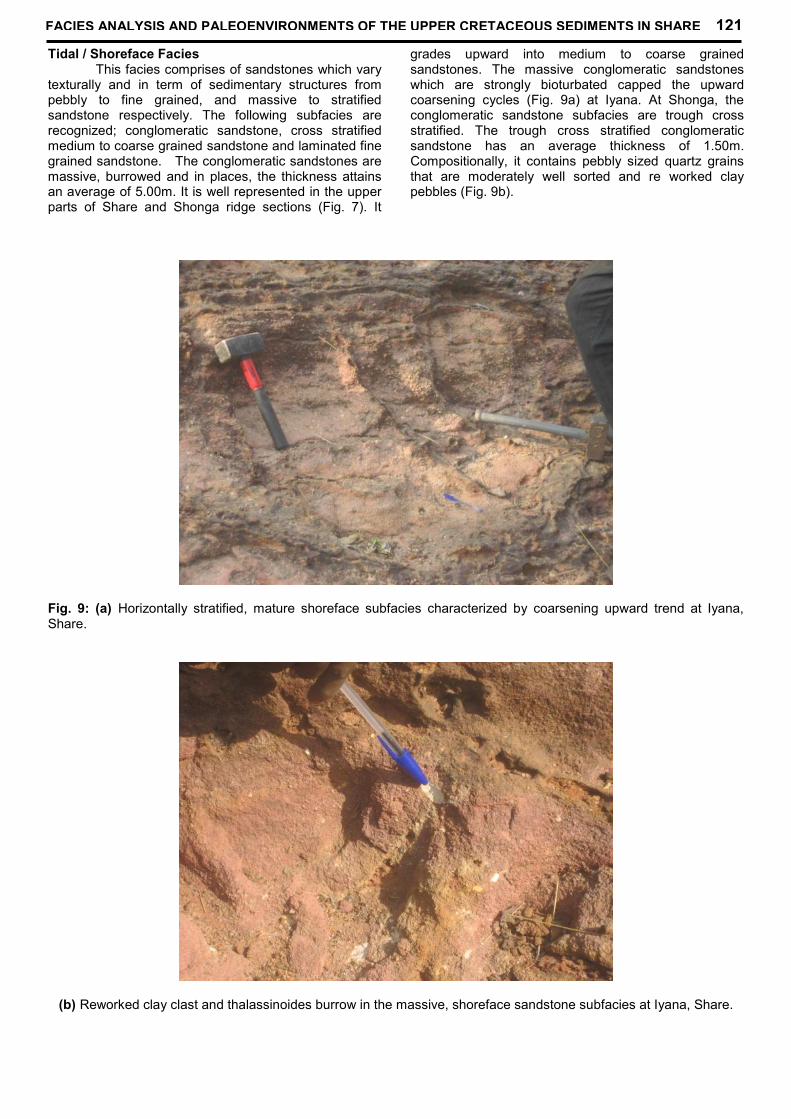
Tidal / Shoreface FaciesThis facies comprises of sandstones which vary
texturally and in term of sedimentary structures frompebbly to fine grained, and massive to stratifiedsandstone respectively. The following subfacies arerecognized; conglomeratic sandstone, cross stratifiedmedium to coarse grained sandstone and laminated finegrained sandstone. The conglomeratic sandstones aremassive, burrowed and in places, the thickness attainsan average of 5.00m. It is well represented in the upperparts of Share and Shonga ridge sections (Fig. 7). It
grades upward into medium to coarse grainedsandstones. The massive conglomeratic sandstoneswhich are strongly bioturbated capped the upwardcoarsening cycles (Fig. 9a) at Iyana. At Shonga, theconglomeratic sandstone subfacies are trough crossstratified. The trough cross stratified conglomeraticsandstone has an average thickness of 1.50m.Compositionally, it contains pebbly sized quartz grainsthat are moderately well sorted and re worked claypebbles (Fig. 9b).
Fig. 9: (a) Horizontally stratified, mature shoreface subfacies characterized by coarsening upward trend at Iyana,Share.
(b) Reworked clay clast and thalassinoides burrow in the massive, shoreface sandstone subfacies at Iyana, Share.
FACIES ANALYSIS AND PALEOENVIRONMENTS OF THE UPPER CRETACEOUS SEDIMENTS IN SHARE 121

In Share, Iyana, and Shonga, the crossstratified, medium to coarse grained sandstonesubfacies are exposed. They contain mainly planarcross stratification which in some cases, are small scaleand bidirectional (Fig. 10). At Iyana, they are overlain bythe massive, bioturbated, conglomeratic sandstone. Atother localities, they are interbedded with parallellaminated and massive fine grained sandstones. Thecross bedded sandstones show bounding surfaces withclay drapes. The cosets are small scale with low angles.The sands are typically reddish to pink in colour andcompositionaly mature. Small clasts of reworked claysare also common (Fig. 9b). In Share, some of the
medium to coarse grained sandstones display convolutebeddings, herringbone and small-scale hummocky crossstratification types. Ophiomorpha “isp” trace fossils arecommon in these deposits.
The fine grained sandstone subfacies is lesscommon in the sections. Where they occur particularlyat Share and Shonga, they are commonly parallellaminated and in some cases, ripple cross laminationsare preserved (Fig. 10a). Sometimes the lamination aredefined by alternation of kaolinitic clay laminea and redsands. The average thickness of this subfacies is 1.00min most localities. Sand size particles are dominated byquartz and muscovites.
A
B
Fig. 10: (a) Wave ripple laminated, subtidal sandstone facies at Shonga and (b) Herringbone cross bedded sandstonesubfacies (tidal channel sands) at Shonga.
122 OLUSOLA J. OJO AND SAMUEL O. AKANDE

InterpretationThe characteristics of the sandstone facies in
this area permit recognition of near shore high energymarine environments; tidal channels and shorefaceenvironments (Fig.12). The herringbone cross stratifiedsandstone subfacies is interpreted as tidal channelfacies. Klein (1970) and Amajor (1984) suggested thatcurrent direction reversals are associated with tidalprocesses. Clay drapes and worm burrows which arecommon in this subfacies have been reported assignatures of tidally influenced environments by Ladipo(1986) and Amireh and Abed (1994).
The parallel stratified to massive sandstonesubfacies characterized by hummocks in places,reworked clay pebbles and Ophiomorpha burrows areinterpreted as shoreface deposits (Walker, 1990; Taylorand Lovell, 1991). Most probably, the horizontallylaminated sands may be the product of sands beingtransported and reworked below the fair weather wave
base within upper flow regime. Generally, association ofthis subfacies with wavy laminations, convolutebeddings, clay clasts and wave ripples suggest storminfluenced, high energy shoreface domain (Castle, 2001;Dott and Buorgeois, 1982).
Floodplain FaciesThe claystone in this facies is well represented
in Share and Shonga ridge sections (Fig. 7). The dirtywhite claystone beds are massive and show shrinkagecrack features. At Share ridge sections, the claystonebed is about 2m thick. It is kaolinitic and interbeddedwith cross stratified sandstone. The base of theclaystone bed makes sharp contact with underlyingcross bedded sandstone (Fig. 11). The clay hasattracted the attention and activities of local miners. Thismay be due to its suitability as raw materials forceramics and potteries (Ojo et al, 2011).
A
B
Fig. 11: Floodplain kaolinitic claystone interbedded with mature tidal channel sands at Share Ridge(a) artificial cave created by local mining and (b) sampling pit (about 1.5m deep).
FACIES ANALYSIS AND PALEOENVIRONMENTS OF THE UPPER CRETACEOUS SEDIMENTS IN SHARE 123

InterpretationThe predominance of clay minerals and clay
size fraction in this facies indicate settling fromsuspension in a low energy environment, probably thefloodplain adjacent to the tidal channels.
Depositional ModelThe depositional model proposed for the upper
Cretaceous sediments in the study area is that of largelyalluvial dominated processes which evolvedtrangressively later into shallow marine processes andperiodically incised by fluvial channels (Fig.12). Theolder depositional sequence herein refer to as Unit I arecharacterized by well preserved, sharp based, non –imbricated to poorly imbricated, poorly sorted and matrixsupported conglomerates suggesting debris flow deposit(Nilsen, 1982; Steel and Thompson, 1983). They rest inmost localities, non-conformably on the pre Cambriancrystalline rock and contain various clasts or fragmentsof quartz, feldspar, pegmatite, gneiss and schist. Theabundant fresh feldspars in the sediments, high matrix,poorly developed stratitification, and lack of internallydeveloped structures are indicative of proximity to thehigh relief source area and gravity supported flows. Theimmature conglomerates were probably formed fromsediments that are transported to and filled the downthrown grabens formed during early rift phase of thebasin evolution. The adjacent, distinctly developedstream flow deposit (Wasson, 1979) characterized bychannel fill structure, grain to matrix supportedconglomerate facies with more well rounded quartz
grains and poor feldspar content is suggestive of downfan lateral migration in the area (Fig. 12). This mid todistal facies evolved into fluvial braided channelsandstones and floodplains with their characteristicfining upward, channel switching features and lenticulargeometry (Allen, 1982; Cant and Walker, 1978: Rustand Jones, 1987). Generally, the depositional Unit I ischaracterized by lack of marine fossil, presence ofunidirectional paleocurrent feature and compositionalimmaturity. These are features typical of most knownand described alluvial to fluvial deposits in continentalsettings (Guiraud, 1990; Braide, 1992; Ojo and Akande,2003). The depositional facies assemblage of the Unit Iprobably represent substantial sedimentation during thesyn-rift stage in lowstand system tract.
A shallow marine environment is represented bythe Unit II (Fig. 12). This consists of mainly shorefaceand tidal channel facies association. In this upper part,trangressive channel lag grades upward into tidalchannel conditions and shoreface characterized byOphiomorpha burrows, clay drapes and herringbone andhummocky cross stratifications (Prave et al. 1996;McCrory and Walker 1986; Amireh and Abed, 1994).Evidences of stream run offs such and periodicsubaerial exposure are common. Based on thelithofacies association and gross sedimentologicalcharacteristics Unit II is thought to represent thetrangressive phase during which tidal channels andshoreface sediments were deposited (Ojo and Akande,2009, 2011).
Fig. 12: Reconstructed depositional model, using block diagram for the investigated sediments.
124 OLUSOLA J. OJO AND SAMUEL O. AKANDE

CONCLUSIONS1. Depositional facies provide evidence of
transition from alluvial regime to shallow marine2. Facies association of Unit I indicates deposition
within low sinuosity braided channels associatedwith alluvial fan deposits and representlowstand system tract
3. Facies association of Unit II indicates landwardmigration of the shoreline and marine incursionand it probably represents trangressive phase.
AcknowledgementsWe thank our colleagues; O. Ogunsanwo, R.
Bale for stimulating discussions and our students;Suraju and Steven for their assistance in the field.James Adeoye prepared the graphics and we appreciatehim for this. The constructive criticism of Dr. A.U. Okoro,a reviewer and useful suggestions enriched the qualityof the article
REFERENCES
Abimbola, A. F., Badejoko, T. A; Elueze, A. A., andAkande, S. O., 1999. The Agbaja Ironstone Formation,
Nupe Basin, Nigeria. A product of replacementof a Kaolinite precursor. Global Journal of Pureand Applied Sciences 5: 375-384.
Adeleye, D. R., 1973. Origin of ironstones, an examplefrom the Middle Niger valley, Nigeria. Journal ofSedimentary Petrology 43: 709-727.
Adeleye, D.R., 1974. Sedimentology of the fluvial BidaSandstones (Cretaceous) Nigeria. SedimentaryGeology 12: 1-24.
Adeniyi, J. O., 1985. Ground total magnetic intensity inpart of Nupe Basin and the adjacent Basementcomplex, Niger State, Nigeria. Journal ofApplied Science 3: 67-68.
Akande, S. O., Ojo, O. J., Erdtmann, B. D., and Hetenyi,M., 2005. Paleoenvironments, Organic Petrology and
Rock Eval studies on source rock facies of theCampanian to Maastrichtian Patti Formation,southern Bida basin, Nigeria. Journal of AfricanEarth Sciences 41: 394-406.
Allen, J. R. L., 1982. Studies in fluvial sedimentationbars, bar complexes and sandstone sheets (lowsinuosity braided streams) in the BrownstoneFormation (L. Devonian) Welsch borders.Sedimentary Geology 33: 237-283.
Amajor, L. C., 1984. Sedimentary facies analysis of theAjali Sandstone (Upper Cretaceous), southernBenue Trough. Journal of Mining and Geology21: 171-176.
Amireh, B. S., Schneider, W., and Abed, A. M., 1994.Evolving fluvial – transitional – marinedeposition through the Cambrian sequence ofJordan. Sedimentary Geology 89: 65-90.
Amireh, B. S., 1997. Sedimentology andPaleogeography of the regressive –transgressive Kurnub Group (Early Cretaceous)of Jordan. Sedimentary Geology 112: 69-88.
Amireh, B. S. and Abed, M. A., 1999. Depositionalenvironments of the Kurnub Group (EarlyCretaceous) in northern Jordan. Journal ofAfrican Earth Sciences 29: 449-468
Blair, T. C., 1987. Tectonic and hydrologic controls oncyclic alluvial fan, fluvial, and lacustrine rift basinsedimentation, Jurassic – Lower mostCretaceous Todos Santos Formation, Chiapas,Mexico. Journal of Sedimentary Petrology 57,845-862
Braide, S. P., 1992a. Geological development, originand energy mineral resources potential of theLokoja Formation in the southern Bida Basin.Journal of Mining and Geology 28: 33-44.
Braide, S. P., 1992b. Syntectonic fluvial sedimentation inthe central Bida Basin. Journal of Mining andGeology 28: 55-64.
Cant, D. J. and Walker, R. G., 1978. Fluvial processesand facies sequences in the sandy braidedsouth Saskatchewan River, Canada.Sedimentology 25: 625-648.
Castle, J. W., 2001. Foreland-basin sequence responseto collisional tectonism. Geological Society ofAmerica Bulletin 113: 801 - 812.
Collinson, J. D., 1996. Alluvial sediments. In: Reading,H.G. (editor), Sedimentary Environments:Processes, Facies and Stratigraphy, Blackswellscientific Publications, London. 37-82.
Colguhoun, G. P., 1995. Siliciclastic sedimentation on astorm and tide- influenced shelf and shoreline:the Early Devonian Roxbourgh formation, NELacthan fold belt; Southeastern Australia.Sedimentary Geology 97: 69-98.
Dott, R. H. Jr. and Bourgeois, J., 1982. Hummockystratification: significance of its variable beddingsequences. Bulletin of Geological Society ofAmerica 93: 663-680.
El-Araby, A. and Abdel-Motelib, A., 1999. Depositionalfacies of the Cambrian Araba Formation in theTaba region, east Sinai, Egypt. Journal ofAfrican Earth Sciences 29: 429-447.
Elliott, T. E., and Gardiner, A. R., 1981. Ripple, mega-ripple and sandwave bedforms in the macrotidalLoughor Estuary, South Wales. U.K. Spec.Publs. Int. Ass. Sedim. 5: 51 – 64.
Guiraud, M., 1990. Tectono-sedimentary framework ofthe early Cretaceous continental BimaFormation (Upper Benue Trough N.E., Nigeria).Journal of African Earth Sciences 10: 341-353.
FACIES ANALYSIS AND PALEOENVIRONMENTS OF THE UPPER CRETACEOUS SEDIMENTS IN SHARE 125

Hampton, M.A., 1979. Bouyancy in debris flows.Journal of Sedimentary Petrology 49: 753-758.
Hendrix, M. S., Graham, S. A., Carroll, A. R., Sobel, E.R., McKnight, C. L., Schulein, B. J., and Wang, Z., 1992.
Sedimentary record and climatic implications ofrecurrent deformation in the Tian Shan:evidence from Mesozoicstrata of north Tarim,south Junggar, and Turpan basins, northwestChina. Geological Society of American Bulletin104: 53-79.
Hendrix, M. S., Brasell, S. C., Carroll, A. R. andGraham, S. A., 1995. Sedimentology, organic
geochemistry, and petroleum potential ofJurassic Coal Measures: Tarim, Junggar, andTurpan Basins, northwest China. AmericanAssociation of Petroleum Geologists Bulletin 79:929-959.
Idowu, J. O., and Enu, E. I., 1992. Petroleumgeochemistry of some late Cretaceous shalefrom the Lokoja Sandstone of Middle NigerBasin, Nigeria. Journal of African EarthSciences 14, 443-455.
Jan Du Chene, R. E., Adegoke, O. S., Adediran, S. A.,and Petters, S. W., 1978. Palynology and foraminifera of
the Lokoja Sandstone (Maastrichtian), BidaBasin, Nigeria. RevistaEspanola deMicropaleontotologia 10, 379 – 393.
Kennedy, W. Q., 1965. The influence of basementstructure on the evolution of the coastal(Mesozoic and Tertiary) basins. In: RecentBasins around Africa. Proceedings of theInstitute of Petroleum Geologists Society,London, pp. 35-47.
King, L. C., 1950. Outline and distribution ofGondwanaland. Geological Magazine 87: 353-359.
Klein, G. deV., 1970. Depositional and dispersaldynamics of intertidal sand bars. Journal ofSedimentary Petrology 40: 973-985.
Kogbe, C. A., 1981. Geological Interpretation of LandsatImagery of part of Central Nigeria. Journal ofMining and Geology, 28: 66-69
Kogbe, C. A., Ajakaiye, D. E., and Matheis, G., 1983.Confirmation of rift structure along the middle-Niger Valley, Nigeria. Journal of African EarthSciences 1: 127-131.
Ladipo, K. O., 1986. Tidal shelf depositional model forthe Ajali Sandstone, Anambra Basin southernNigeria. Journal of African Earth Sciences 5:177-185.
Ladipo, K. O., Akande, S. O., and Mucke, A., 1994.Genesis of ironstone from middle Nigersedimentary basin evidence fromsedimentological, ore microscopic and
geochemical studies. Journal of Mining andGeology 30: 161-168.
McCrory, V. L. C. and Walker, R. G., 1986. A storm- andtidally influenced prograding shoreline – UpperCretaceous Milk River Formation, southernAlberta, Canada. Sedimentology 33: 47-60.
Miall, A. D., 1988. Architectural elements and boundingsurfaces in fluvial deposits: anatomy of theKagenta Formation (Lower Jurasssic),southwest Colorado. Sedimentary Geology 55:233-262.
Miall, A. D., 1990. Principles of sedimentary basinanalyses. Springer Verlag, New York, 667pp.
Nilsen, T. H., 1982. Alluvial fan deposits. In: Scholle, P.A. and D. Spearing (Editors), SandstoneDepositional Environments. AmericanAssociation of Petroleum Geologists Memoir31,. 49-86.
Obaje, N. G., Wehner, H., Scheeder, G. and Abubakar,M. B., 2004. Hydrocarbon prospectivity of Nigeria’s
inland basins from the viewpoint of organicgeochemistry and organic petrology. AmericanAssociation of Petroleum Geologists Bulletin 88:325-353.
Ojo, O. J. and Akande, S. O., 2003. FaciesRelationships and Depositional Environments ofthe Upper Cretaceous Lokoja Formation in theBida Basin, Nigeria. Journal of Mining andGeology 39: 39-48.
Ojo, O. J., and Akande, S. O., 2006. Sedimentologicaland palynological studies of the Patti formation,southeastern Bida Basin, Nigeria: Implication forPaleoenvironments and paleogeography.Nigerian Association of PetroleumExplorationists Bulletin 19: 61-67.
Ojo, O. J and Akande, S. O., 2009. Sedimentology anddepositional environments of the MaastrichtianPatti Formation, southeastern Bida Basin,Nigeria. Cretaceous Research 30: 1415-1425.
Ojo, O. J and Akande, S. O., 2011. Sedimentology anddepositional environments of the UpperCretaceous sediments in the Share - Lafiagiarea, northen Bida Basin. Nigeria Mining andGeosciences Society (NMGS) AnnualInternational Conference, Abstract vol., p.30.
Ojo, O. J., Adepoju, S. A., Adewole, T. M., and Abiola,A. O., 2011. Sedimentological, geochemical and
economic appraisal of Maastrichtian clays inBida Basin, central Nigeria. In: Ekosee G-I.E, deJager, L and Ngole, V.M. (editors) An InnovativePerspective on the Role of Clays and Clayminerals, and Geophagia on EconomicDevelopment. Book of Proceedings of the 1st
International conference on Clays and ClayMinerals in Africa and 2nd International
126 OLUSOLA J. OJO AND SAMUEL O. AKANDE

Conference on Geophagia in Southern Africa,Bloemfontein, South Africa p.80-90
Ojo, S. B., 1984. Middle Niger Basin Revisited, Magneticconstraints on gravity interpretations. NigerianMining and Geosciences Society Conference,Nsukka, Nigeria, Abstract vol., 52-53.
Ojo, S. B. and Ajakaiye, D. E., 1989. Preliminaryinterpretation of gravity measurement in themiddle Niger Basin area, Nigeria. In; C.A. Kogbe(editor), Geology of Nigeria, 2nd Edition,Elizabeth Publishing Co., Lagos., 347-358
Olaniyan, O., and Olabaniyi, S. B., 1996. Faciesanalysis of the Bida Sandstone Formationaround Kajita, Nupe Basin, Nigeria. Journal ofAfrican Earth Sciences 23: 253-256.
Oluyide, P. O., Oni, A. O. and Fakuade, A., 1998.Geology of Ilorin Area. Explanation of Sheet 50(Ilorin). Geological Survey of Nigeria Bulletin 42,84.
Prave, A. R., Duke, W. L., and Slattery, W., 1996. Adepositional model for storm- and tide-influenced prograding siliciclastic shorelinesfrom the Middle Devonian of the centralAppalachian foreland basin, USA.Sedimentology 43: 611-629.
Rust, B. R. and Jones, B. G., 1987. The HawkesburgSandstone south of Sydney, Australia: Triassic
analogue for the deposit of a large braided river.Journal of Sedimentary Petrology 57: 222-233.
Selley, R. C., 1985. Ancient Sedimentary Environment,third ed. Cornell University Press, Ithaca, NY,317.
Taylor, D. R. and Lovell, R. W. W., 1991. Recognition ofhigh-frequency sequences in the Kenilworthmember of the Blackhawk Formation, BookCliffs, Utah. In: Van Wangoner, J.C.,Nummedal, D., Jones, C.R., taylor, D.R.,Jennette, D.C., Riley, G.W. (editors), Sequencestratigraphy applications to Shelf sandstonereservoirs, AAPG Field conference, September21-28, 1991., 1-8.
Udensi, E. E. and Osasuwa, I. B., 2004., Spectradetermination of depths to magnetic rocks underthe Nupe Basin, Nigeria. Nigeria Association ofPetroleum Explorationists Bulletin 17: 22-37.
Walker, R. G., 1990. Facies modeling and sequencestratigraphy. Journal of Sedimentary Petrology60: 777-786.
Wasson, R. J., 1979. Sedimentation history of the MundiMundi alluvial fans, western new south Wales.Sedimentary Geology 22: 21-51.
Whiteman, A., 1982. Nigeria: Its Petroleum Geology,Resources and Potential. Vol. 1 and 2, Grahamand Trotman, London, 349.
FACIES ANALYSIS AND PALEOENVIRONMENTS OF THE UPPER CRETACEOUS SEDIMENTS IN SHARE 127