Nitrogen dynamics in soils of forests and active pastures in the western Brazilian Amazon Basin
Upload
khangminh22Category
view
3download
0
GCSSEPM FOUNDATION 25th ANNUAL BOB F. PERKINS W. DICKSON, C SCHIEFELBEIN RESEARCH CONFERENCE, HOUSTON TX J. ZUMBERGE, & M. ODEGARD DECEMBER 4-7, 2005
BASIN ANALYSIS IN BRAZILIAN AND WEST AFRICAN CONJUGATES: COMBINING DISCIPLINES TO DECONSTRUCT PETROLEUM SYSTEMS
William Dickson Craig Schiefelbein Dickson International Geosciences (DIGs) Geochemical Solutions International (GSI) 12503 Exchange Drive, Suite 510A 1610 Woodstead Court, Suite 200 Stafford, TX 77477 The Woodlands, TX 77380 e-mail: [email protected] email: [email protected] John Zumberge Mark Odegard Geomark Research, Ltd. Grizzly Geosciences, Inc. 9748 Whithorn Drive 14019 SW Freeway, Suite 301-735 Houston, TX 77095 Sugar Land, TX 77478
Abstract
The authors have developed a technique for defining source rock sub-basins, particularly those with lacustrine source rocks, and the limits of the related petroleum systems, determining the risk of the petroleum system processes and elements, particularly for charge and to some extent for seal and reservoir. The key was learning how to integrate geophysical (especially gravity and magnetic data) and geochemical data with geologic understanding. This paper presents the development of the tools, techniques, and data sets assembled by our team with examples from prolific hydrocarbon provinces of Brazil and West Africa.
The initial work used regional gravity and magnetic data sets (Barritt, 1993, Fairhead et al., 1997, Dickson et al., 2003a) to define controlling structural/tectonic features, which influenced basin and source rock development and reservoir emplacement. Sedimentary basins were re-defined from gravity data. Correlations between sediment pathways and gravity signatures indicated redefined depocenters, largely controlled by the coast-parallel, syn-rift fault trend. Transfer faults, trending roughly orthogonally to the coasts of West Africa and Brazil resulted in “piano-key-like” segmentation of the margins. These were seen first on gravity imagery and later, along the Brazil margin, interpreted from magnetic attributes.
Adding geochemical data, we plotted oil families and noticed clear separation of these families across some of the coast-orthogonal transfer faults segmenting and dividing the source rock containing sub-basins. Oils tended strongly to stay within the compartments defined by the transfer faults and the coast-parallel, syn-rift fault trend and other lineations. These compartments were first matched to published interpretations of paleo-lakes. The correlation was then carried along the studied margins. Sub-basins correlated with clear differences in oil geochemistry, defining several petroleum meso-systems (Schiefelbein et al., 2003). More detailed analyses, using additional data (such as piston cores and surface slicks), within each basin revealed probable generative sub-basins, hydrocarbon migration pathways and barriers.
Pass-fail tests were established for various criteria, especially burial depth and adequacy of top seal for hydrocarbon generation and retention respectively. For example, offshore Brazil, depth of burial for oil generation from each source unit was correlated to sediment thickness mapping. The maps were based on magnetics, using multiple depth constraints including published cross-sections, surface geology, wells, and Euler deconvolution of gravity. Resulting depth accuracies of 500 m were sufficient to determine adequacy of present-day burial for the main lacustrine and marine source rocks.
Top seal was risked by correlating gravity attributes to published salt mapping and interpreted profiles to determine areas of near-surface disruption of top seal. We then compared
GCSSEPM FOUNDATION 25th ANNUAL BOB F. PERKINS W. DICKSON, C SCHIEFELBEIN RESEARCH CONFERENCE, HOUSTON TX J. ZUMBERGE, & M. ODEGARD DECEMBER 4-7, 2005
those attributes to oil gravities, piston core gas anomalies, and sea surface seep locations. Areas of diapir concentrations tended to correlate with the presence of oil slicks (from RadarSat) and seepage anomalies demonstrating leakage.
The outcome was a robust understanding of key prospect risks in this region. In addition, our methodology is transportable with application to other areas, including convergent margin basins in Southeast Asia.
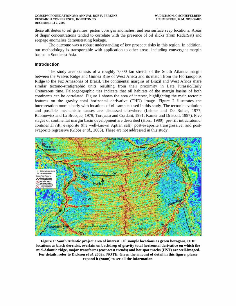
Introduction The study area consists of a roughly 7,000 km stretch of the South Atlantic margin
between the Walvis Ridge and Guinea Rise of West Africa and its match from the Florianopolis Ridge to the Foz Amazonas of Brazil. The continental margins of Brazil and West Africa share similar tectono-stratigraphic units resulting from their proximity in Late Jurassic/Early Cretaceous time. Paleogeographic ties indicate that oil habitats of the margin basins of both continents can be correlated. Figure 1 shows the area of interest, highlighting the main tectonic features on the gravity total horizontal derivative (THD) image. Figure 2 illustrates the interpretation more clearly with locations of oil samples used in this study. The tectonic evolution and possible mechanistic causes are discussed elsewhere (Lehner and De Ruiter, 1977; Rabinowitz and La Brecque, 1979; Torquato and Cordani, 1981; Karner and Driscoll, 1997). Five stages of continental margin basin development are described (Horn, 1980): pre-rift intracratonic; continental rift; evaporite (the well-known Aptian salt); post-evaporite transgressive; and post-evaporite regressive (Gibbs et al., 2003). These are not addressed in this study.
Figure 1: South Atlantic project area of interest. Oil sample locations as green hexagons, ODP
locations as black derricks, overlain on backdrop of gravity total horizontal derivative on which the mid-Atlantic ridge, major transforms (east-west trends) and hot spot tracks (HST) are well-imaged.
For details, refer to Dickson et al. 2003a. NOTE: Given the amount of detail in this figure, please expand it (zoom) to see all the information.

GCSSEPM FOUNDATION 25th ANNUAL BOB F. PERKINS W. DICKSON, C SCHIEFELBEIN RESEARCH CONFERENCE, HOUSTON TX J. ZUMBERGE, & M. ODEGARD DECEMBER 4-7, 2005
Figure 2: South Atlantic project area of interest; features as Figure 1 without gravity image
backdrop. Basin outlines in orange and deepwater fan areas in orange stipple; proto-oceanic crust (POC) in red stipple and volcanics in dark red stipple of inverted vees. NOTE: Given the amount of
detail in this figure, please expand it (zoom) to see all the information.
Hydrocarbon production to date has largely been oils generated from lacustrine sediments deposited during Neocomian rifting (Brice et al., 1980; Mello et al., 1988 a, b; Burwood, 1997). Future production will increasingly be sourced from Late Cretaceous post-evaporite sediments with liquid hydrocarbon potential, laid down in shallow marine and fluvial-deltaic environments as spreading continues (Mello et al., 1988 a, b; Teisserenc and Villemin, 1990; Sofer, 1993; Burwood, 1997; Katz et al., 1997).
The goal of our study was to understand the controls and risks on these petroleum systems by leveraging the exponential interpretive power of integrating multiple disciplines. We accessed inexpensive data sets of broad geographic distribution and combined them with geographic information systems (GIS) software. We then proceeded through four main phases of interpretation, described in the following sections.
Methods 1: Geological & Geophysical (G2) Integration Over these large areas, gravity and magnetic data sets of necessity represent
compilations, separate topics in themselves (Barritt 1993, Fairhead et al. 1997, Green and Fairhead, 1996, Sandwell and Smith, 1997). The gravity data were combined from land, marine and satellite altimetry sources with specific processing and integration steps outlined in the referenced papers. Magnetic data were aeromagnetic, supplemented by ship-borne data at the limits of the airborne surveys, again with specialized processing and merging steps. The final gravity and magnetic compilations were rendered as a series of images of attributes and enhancements as for example, Figure 1.
As work evolved on a non-exclusive study called SAMBA (South Atlantic Margins Basin Analysis), we considered ways to extrapolate the published understanding of the main oil source of Brazil’s Campos basin, the upper Barremian to lower Neocomian Lagoa Feia Formation. The distribution of Lagoa Feia source beds within the inner Campos basin was published in Dias et al., 1988 and Mello et al., 1994, based largely on well penetrations of immature source, oil

GCSSEPM FOUNDATION 25th ANNUAL BOB F. PERKINS W. DICKSON, C SCHIEFELBEIN RESEARCH CONFERENCE, HOUSTON TX J. ZUMBERGE, & M. ODEGARD DECEMBER 4-7, 2005
chemistries, and seismic correlations. Kean, 1999 made extrapolations of the Lagoa Feia-Carapebus petroleum system across the Campos basin using gravity and seismic data. Using gravity, magnetics, depth-to-basement maps, and published 2D seismic profiles, we extended the published area across the Campos and Santos basins (Fryklund et al., 2001) illustrating a revised source pod map for the Greater Campos (Santos-Campos-Espírito Santo or SCES) basin. The main source rock-containing basin was about 1,300 km long and from 150 to 340 km wide; eight sub-basins with the inferred thickest and richest accumulations included areas in the deepwater Campos and two large areas in the southern adjacent Santos basin. Figure 3 illustrates the interpreted area of Lagoa Feia deposition with effective present-day source rock areas in pale green (high-confidence) and aqua (speculative). Although oil sample locations are shown, this illustration is based chiefly on gravity data and has not benefited from geochemical integration.
Figure 3: Santos and Campos basins: Solid geology (onshore) showing Precambrian outcrop; gravity
first vertical derivative offshore overlain with interpreted lacustrine source area (brown stipple) including present-day oil mature areas (pale green – high confidence; aqua – speculative); volcanics
(red stipple); oils analysed for geochemistry and classified by source family (squares, circles, triangles). CH/BH = Campos Hinge/Badejo High; Rio Grande HST – Rio Grande Hot Spot Track. NOTE: Given the amount of detail in this figure, please expand it (zoom) to see all the information.
Although this lower level of data integration allows reasonable mapping of Lagoa Feia
(and equivalents) distribution, we recognize the need for geochemical data to determine source rock quality, transformation efficiency, and maturity timing. Factors of commercial significance are related to:
a) oil quality in the reservoir with correlations to faulting as migration paths and barriers ( Soldan et al., 1995; Trindade et al., 1993); and

GCSSEPM FOUNDATION 25th ANNUAL BOB F. PERKINS W. DICKSON, C SCHIEFELBEIN RESEARCH CONFERENCE, HOUSTON TX J. ZUMBERGE, & M. ODEGARD DECEMBER 4-7, 2005
b) thickness of top seal relating either to leakage or reservoir temperature and hence biodegradation.
Methods 2: Geochemical (3rd G) Integration The first attempt to incorporate geochemistry resulted in a presentation at an AAPG
Hedberg conference (Dickson et al., 2001). More than 750 oils were classified by family (i.e., marine, lacustrine-brackish, etc.), and their locations were plotted on the SAMBA tectono-stratigraphic analysis. This improved our understanding of the controlling structural/tectonic features that influenced basin and source rock development, and reservoir emplacement. A specific result was the correlation between some coast-orthogonal transfer faults and limits to oil families, suggesting barriers to source rock deposition and/or lateral migration in both Brazil and West Africa. Generative basins were defined from potential field data since oil families as determined from published geochemistry stayed in areas defined from the potential field images (Dickson et al., 2001). For example, Gabon had three main oil family/basin pairs including the Dianongo Trough (lacustrine fresh-brackish family), onshore paleo-Ogooue Delta (mature marine shale), and offshore Ogooue Fan (low-mature marine shale).
More detailed potential field data and greater populations of geochemical data attracted our focus to Brazil. With much denser sampling (>250 oil samples and >700 piston cores for the greater Campos basin alone) than for West Africa, we tested our hypotheses across a dozen basins from the southeastern greater Campos basin (Santos-Campos-Espírito Santo or SCES) to the northeastern Potiguar basin. These basins belonged to the same late-pre-breakup and early rifting system of lakes as the related West African basins.
Methods 3: Paleo-reconstructions with GIS (G4) Our reconstructions used information on one side of an South Atlantic to constrain the
interpretation of originally adjoining (pre-breakup) areas. South Atlantic reconstructions have progressed considerably since the original Bullard fit based on continental outlines. Five examples cited here illustrate key methods including re-projecting maps of compiled and matched surface geology; reconstructing to multiple, specific paleo-ages; matching oil family geochemistries; and attaching arbitrary data sets to global plate-history models.
Davison, (1997, 1999) generated map compilations for each continent from an extensive literature search. South America and Africa were re-projected separately into the reconstructed space to handle the tremendous map distortion that accompanies the movement of large map areas across great distances. In this case, one continent moved about 20 degrees of latitude and 40 degrees longitude (roughly 2,000 km by 4,000 km) with respect to the other.
Darros De Matos, (1998, 1999) demonstrated the problem of a closer fit at a time (Aptian) nearer breakup, clearly showing alignment of principal structural trends and features at the time. A difficulty remained of overlap of present-day coastlines of northeast Brazil and the Niger Delta. Present-day coastlines are commonly employed to aid recognition of original areas with the advantage of being readily available files that can be cut-and- pasted into drawings.
Norvick and Schaller, (1998a, b) showed a more dynamic system with reconstructions for three epochs. They redrew coastlines for each of the ages; however, the need to produce each illustration entirely by hand tended to reduce both the amount of data included and the number of iterations allowed as new data or ideas were encountered.
Schiefelbein et al. (2000) used geochemical signatures of oils for correlation. Gibbs et al., 2003 focused on the "distribution of syn-rift and transition stage source rocks in time and space".
Each of these reconstruction approaches advanced our understanding of limits of the basins, the paleogeography and its potential for influencing source rock and reservoir deposition,

GCSSEPM FOUNDATION 25th ANNUAL BOB F. PERKINS W. DICKSON, C SCHIEFELBEIN RESEARCH CONFERENCE, HOUSTON TX J. ZUMBERGE, & M. ODEGARD DECEMBER 4-7, 2005
and the tectonics that controlled the basin deformation. The next step was to combine methods and data sets to increase constraints and derive new insights.
Dickson et al. (2003a) used GIS-based illustrations including cultural data, oil families, ODP locations, and structural interpretation for ages of 55 Ma, 85 Ma, 95 Ma, 105 Ma, and 120 Ma. A reconstruction of the central South Atlantic at 120 Ma (Fig. 4) was plotted with:
a) all oils and ODP sites (ODP sites especially, since they often represented the only control on distal source facies) as shown in Figure 4,
b) only marine-sourced oils, and c) only lacustrine-sourced oils. The latter (c) were well correlated from east to west because the basins were contiguous
during source rock deposition. Ten correlation pairs were mapped with five more predicted matches between West
African basins from Rio Muni to Angola and the Brazilian conjugate basins from Recôncavo to Santos. As drifting progressed, the basins separated in latitude and total distance, resulting in much weaker correlations for marine-sourced oils. Marine oil families showed little trans-Atlantic correlation south of Brazil’s Recôncavo basin and Gabon’s Ogooue Delta. The marine source rocks are as young as Miocene. Consequently, the 120 Ma illustration (Fig. 4) was, for them, deceptive in terms of spatial proximity but useful for its compactness.
The Atlantic equatorial margins are sparsely drilled, and (as mapped at 105 Ma) they showed one clear link between the Ivory Coast and Brazil’s Para-Maranhao basin. Suggested extrapolations indicate possible similar sources offshore Liberia and Ghana.
Figure 4: South Atlantic at 120 Ma with ODP locations (black derricks) and all oils classified by
geochemical family. Countries and selected basins labeled. NOTE: Given the amount of detail in this figure, please expand it (zoom) to see all the information.
GCSSEPM FOUNDATION 25th ANNUAL BOB F. PERKINS W. DICKSON, C SCHIEFELBEIN RESEARCH CONFERENCE, HOUSTON TX J. ZUMBERGE, & M. ODEGARD DECEMBER 4-7, 2005
Methods 4: Full Integration Gibbs et al. (2003) illustrated a generalized central South Atlantic chronostratigraphy
showing four opening phases (pre-rift, syn-rift, transition, and drift); the paleogeography of syn-rift I (late Berriasian - middle Barremian) and syn-rift IIa (middle - late Barremian) with idealized syn-rift source rock, and example seismic profiles from the Campos basin, Brazil. In 2001, our first sample set included oils generated from source rocks deposited during all four of the phases of Gibbs et al. (2003).
Oils were analyzed and clustered into two minor (Tertiary terrestrial and marine marl) and two major (marine and lacustrine) families containing 15 sub-families. In 2004, an enlarged sample set was reclassified into five main families on the Brazilian margin and four on the West African margin. The lacustrine source basins, being part of the initial South Atlantic rift, all experienced similar depositional environments. Multiple geochemical data sets included oil families analyzed from well tests, piston core sampling, and surface slick mapping. Iteration of regional to sub-basinal structural and geochemical interpretation continued until results were consistent at all scales.
Oil maturity indicator analysis began with depth to basement mapping from magnetics. Handpicked spectral inversion of magnetics provided raw values for two depth horizons. Subtraction of bathymetry produced isopachs. Constrained by gravity data, well penetrations, outcrop geology, and seismic results, the depth to basement work yielded a total sediment isopach accurate to about 500 m. Areas were then ranked as over-mature to immature.
Detailed gravity and magnetics data along the Brazilian margin improved the definition of rhombohedral compartments formed by a series of coast-parallel syn-rift trend and coast-orthogonal transfer faults. Plotting oil families and interpreted lineations on the gravity imagery sharply illustrated segmentation of the margin and relative isolation of the various source rocks/oil families. The transfer faults correlated particularly well with segmentation of lacustrine oil families along the Brazilian margin, given the broader distribution of lacustrine-sourced oils in these basins. Similar limits to lacustrine oil families were inferred along the Gabon and Angola margins.
Comparing oils from Gabon to Brazil's Recôncavo and Sergipe basins or from Angola to the Espírito Santo basin (Fig. 4), despite large post-rift differences in overburden thicknesses, heat flow, and the timing of these two variables, the lacustrine-sourced oils were strongly correlated. Oil correlations were so strong along the East Brazil/Gulf of Guinea margins (northeast part of Fig. 1, and conjugate Brazilian margin) that it may be possible to predict source rock type on one margin based on observed oil chemistries from the conjugate basin. Only the Cabinda lacustrine oil family to date has no match on the conjugate margin.
Specific Example: Santos Basin Structural mapping in the Santos basin included salt piercements (from published seismic
mapping by Fainstein et al., 2001; Jamieson et al., 2002), transfer faults and lineations, volcanics and oil families. Salt piercements fit gravity first vertical derivative and especially second vertical derivative lows, while known volcanics correlated better to magnetics. As an aside, we observed a few diapir sites from the literature located above 2VD highs rather than lows. In these cases, the diapirs were on the southern margin of a diapir field. Given the typical basinward displacement of salt by advancing sediments, these features may be detached (allochthonous) rather than diapirs emanating from autochthonous salt. This suggests that the seismic interpretation should be re-evaluated at those locations.
Hydrocarbon indications clustered in diapir fields in two sub-basins seaward of the main sediment thick (basin axis) within or adjacent to areas of interpreted present-day source rock maturity. Piston core samples demonstrated two principal hydrocarbon families, one gas-prone
GCSSEPM FOUNDATION 25th ANNUAL BOB F. PERKINS W. DICKSON, C SCHIEFELBEIN RESEARCH CONFERENCE, HOUSTON TX J. ZUMBERGE, & M. ODEGARD DECEMBER 4-7, 2005
and one oil-prone, consistent with surface slick imagery. Oil families seemed to be separated by a combination of transfers and coast-parallel lineations.
Mixed Oils: Separating the Origins Mixing of oils in the reservoir complicates the story. This typifies most Brazilian margin
basins and increasingly is recognized elsewhere (i.e., Shirley, 2004). Our work in Brazil indicated potential for identifying fetch areas, for the syn-rift derived hydrocarbons, and at a lesser precision, given their more widespread distribution, of the drift-age derived hydrocarbons. Our data combinations enabled geologically reasonable and coherent explanations for source interval areal extents and migration distances.
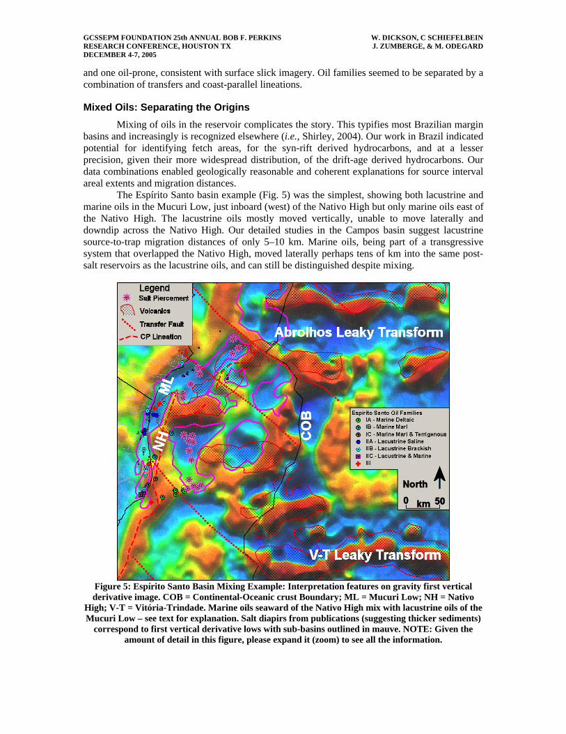
The Espírito Santo basin example (Fig. 5) was the simplest, showing both lacustrine and marine oils in the Mucuri Low, just inboard (west) of the Nativo High but only marine oils east of the Nativo High. The lacustrine oils mostly moved vertically, unable to move laterally and downdip across the Nativo High. Our detailed studies in the Campos basin suggest lacustrine source-to-trap migration distances of only 5–10 km. Marine oils, being part of a transgressive system that overlapped the Nativo High, moved laterally perhaps tens of km into the same post-salt reservoirs as the lacustrine oils, and can still be distinguished despite mixing.
Figure 5: Espírito Santo Basin Mixing Example: Interpretation features on gravity first vertical derivative image. COB = Continental-Oceanic crust Boundary; ML = Mucuri Low; NH = Nativo
High; V-T = Vitória-Trindade. Marine oils seaward of the Nativo High mix with lacustrine oils of the Mucuri Low – see text for explanation. Salt diapirs from publications (suggesting thicker sediments)
correspond to first vertical derivative lows with sub-basins outlined in mauve. NOTE: Given the amount of detail in this figure, please expand it (zoom) to see all the information.

GCSSEPM FOUNDATION 25th ANNUAL BOB F. PERKINS W. DICKSON, C SCHIEFELBEIN RESEARCH CONFERENCE, HOUSTON TX J. ZUMBERGE, & M. ODEGARD DECEMBER 4-7, 2005
Similarly, in West Africa just north of the Sumbe Volcanics trend, the southern Kwanza basin showed a pair of narrow, north-south trending features that were likely syn-rift thicks, locally sourcing lacustrine oils. The intermingled marine oils probably moved updip to the east from more westerly post-salt thicks with source rocks equivalent to the Iabe Formation. The same phenomenon was observed to the north where the Takula-Malongo-Kambala lows of Cabinda were source areas for lacustrine oils. Outboard, along the Likouala High, oils were mixed lacustrine and marine, becoming more marine.
We used our technique to disentangle a complicated generation and migration history in the Potiguar basin of northeast Brazil, in which the larger offshore fields exhibited up to four separate oil sources. Again, the story was based on defining rhombohedral compartments which changed orientation from northeasterly in the onshore part of the basin (older, syn-rift I of Gibbs et al., 2003) to west-northwesterly in the offshore region (younger, syn-rift II) where strike-slip opened the early central Atlantic. Redefining migration fetch areas, and "un-mixing" the Potiguar oils, may have application to the equatorial margin basins of West Africa from the Côté d'Ivoire to Benin. We predict an architecture with similar types and sizes of source rock-bearing basins along the conjugate African margin.
Conclusions The integration of geology, geophysics, and geochemistry (the G3 approach) can provide
powerful inferences on key elements and processes of the petroleum system, namely presence and maturity of hydrocarbons, controls on migration distance, and direction, and effectiveness of retention (top seal). In a passive margin setting, source type and location can be extrapolated, or predicted, from basin to basin. Large areas can be screened quickly for anomalies and prospectivity.
The technique is limited by the relative abundance of oil samples compared to basin compartmentalization rather than by the basin style (e.g., passive vs. transform vs. convergent margins). The authors are presently extending their work to integrate these geochemical methods and data sets to a regional study in Southeast Asia.
References
Barritt, S.D., 1993, The African Magnetic Mapping Project, ITC Journal, 2, 119-199. Brice, S.E., K.R. Kelts, and M.A. Arthur, 1980, Lower Cretaceous Lacustrine Source Beds from
Early Rifting Phases of South Atlantic: AAPG Bull, v. 64, no. 5, p. 680-681 (Abstract). Burwood, R., 1997, Source Rock Control for Angolan Atlantic Margin Petroleum Systems, in
M.R. Mello and B. Katz, eds., Petroleum Systems of the South Atlantic Margin: AAPG/ABGP Joint Research Symposium, Rio de Janeiro, Brazil, Nov. 16-19, 5 p (Abstract, unpaginated).
Davison, I., 1997, Tectonics and hydrocarbon distribution along the Brazilian South Atlantic margin, in The Oil and Gas Habitats of the South Atlantic: The Geological Society of London/PESGB, Burlington House, London, Feb. 24-26, p. 34 (Abstract). Editors not specified in abstracts booklet; conference Convenors are N.R. Cameron,, D. Bamford, J Pape, D. G. Roberts, and R.H. Bate
Davison, I., 1999, Tectonics and hydrocarbon distribution along the Brazilian South Atlantic margin, in N.R. Cameron,, R.H. Bate, and V.S. Clure, eds., The oil and gas habitats of the South Atlantic: The Geological Society special publication 153, p. 133-151.
Darros de Matos, R.M., 1998, The Transversal Zone: a Key Feature Between NE Brazil and W Africa, in AAPG International Conference and Exhibition, Rio de Janeiro, Brazil, Nov. 1998, p. 426-427 (Abstract).

GCSSEPM FOUNDATION 25th ANNUAL BOB F. PERKINS W. DICKSON, C SCHIEFELBEIN RESEARCH CONFERENCE, HOUSTON TX J. ZUMBERGE, & M. ODEGARD DECEMBER 4-7, 2005
Darros De Matos, R.M., 1999, History of the northeast Brazilian rift system: kinematic implications for the break-up between Brazil and West Africa, in N.R. Cameron, R.H. Bate, and V.S. Clure, eds., The oil and gas habitats of the South Atlantic: The Geological Society special publication 153, p. 55-73.
Dias, J.L., J.Q. Olivieira, and J.C. Vieira, 1988, Sedimentological and stratigraphic analysis of the Lagoa Feia formation, rift phase of Campos Basin, offshore Brazil: Revista Brasileira de Geosciências, v. 18, p. 252-260.
Dickson, W.G., M.E. Odegard, R.E. Fryklund, and C.F. Schiefelbein, 2001, South Atlantic Margin Basin Analysis using a G3 Approach (Geophysical, Geological and Geochemical) in C. Kluth & L. Legarreta, eds., AAPG Hedberg Research Conference: New Technologies and New Play Concepts in Latin America, Mendoza Argentina, Nov. 5-9, 2001; Meeting Abstracts p. 91.
Dickson, W.G., R.E. Fryklund, M.E. Odegard, and C.M. Green, 2003a, Constraints for plate reconstruction using gravity data - implications for source and reservoir distribution in Brazilian and West African margin basins: Marine and Petroleum Geology, v. 20, p. 309- 322.
Dickson, W.G., A.R. Danforth, and M.E. Odegard, 2003b, Gravity signatures of sediment systems: predicting reservoir distribution in Angolan and Brazilian basins, in T. J. Arthur, D.S. MacGregor, and N.R. Cameron, eds., Petroleum Geology of Africa: New Themes and Developing Technologies: The Geological Society special publication 207, p. 241- 256.
Fainstein, R., G. Jamieson, A. Hannan, N. Biles, A. Krueger, and D. Shelander, 2001, Offshore Brazil Santos Basin exploration potential from recently acquired seismic data in G. Fernandes, and O. Lima de Lima, Conference Co-Chairmen, Seventh 7o Congresso Internacional da Sociedade Brasileira de Geofísica, Salvador, Proceedings CD-ROM CISBGf/TS19A, p. 52-55.
Fairhead J.D., G.S. Bainbridge, C.M. Green, and S.W. Reford, 1997, Large scale compilation of magnetic, gravity, radiometric and electromagnetic data: the new exploration strategy for the 90s, in A.G. Gubins, ed., Proceedings of Exploration 97: Fourth Decennial International Conference on Mineral Exploration, p.805-816.
Fryklund, R.E., W.G. Dickson, and M.E. Odegard, 2001, Lagoa Feia of Brasil's Campos Basin: Observations on Source Potential and Quality: AAPG Bulletin, v. 85, no. 13 (Supplement), AAPG Annual Meeting, Denver, Colorado, June 3-6, 2001 (Abstract).
Gibbs, P.B., E.R. Brush, and J.C. Fiduk, 2003, The distribution of syn-rift and transition stage source rocks in time and space on the conjugate central/southern Brazilian and West African margins in: Bate, R and Al Danforth, eds, Proceedings HGS & PESGB Second International Symposium, Africa: New plays – New Perspectives, Houston, CD-ROM, unpaginated, 3 p. (Extended Abstract).
Horn, M.K., 1980, The habitat of oil and gas on continental margins: SEAPEX Proceedings, V, p 23-62.
Jamieson, G., R. Fainstein, A. Hannan, N. Biles, D. Shelander, and A. Krueger, 2002, Regional structure of offshore southeastern Brazil: Offshore, Sep., p. 38-39, 126.
Karner, G.D., and N. Driscoll, 1997, Timing, Distribution, and Structures of West African and Brazilian Offshore Rift Basins: Implications for Deepwater Exploration, in The Oil and Gas Habitats of the South Atlantic: The Geological Society of London/PESGB, Burlington House, London, 24-26 Feb., p 52-53 (Abstract).
Katz, B.J., W.C. Dawson, L.M. Liro, V.D. Robison, and J.D. Stonebraker, 1997, The Petroleum Systems of the Ogooué Delta, Offshore Gabon, in Petroleum Systems of the South Atlantic Margin: AAPG/ABGP Joint Research Symposium, Nov. 16-19, Rio de Janeiro, Brazil, 4 p.
GCSSEPM FOUNDATION 25th ANNUAL BOB F. PERKINS W. DICKSON, C SCHIEFELBEIN RESEARCH CONFERENCE, HOUSTON TX J. ZUMBERGE, & M. ODEGARD DECEMBER 4-7, 2005
Kean, A.E., 1999, Multidisciplinary, crossfunctional geophysical integration in the Campos Basin: The Leading Edge, v. 18, no. 7, p. 806-811.
Lehner, P., and P.A.C. de Ruiter, 1977, Structural History of Atlantic Margin of Africa: AAPG Bull., v. 61, no. 7, p. 961-981.
Mello, M.R., P.C. Gaglianone, S.C. Brassell, and J.R. Maxwell, 1988a, Geochemical and Biological Marker Assessment of Depositional Environments Using Brazilian Offshore Oils: Marine and Petroleum Geology, v. 5, p. 205-223.
Mello, M.R., N. Telnaes, P.C. Gaglianone, M.I. Chicarelli, S C. Brassell, and J.R. Maxwell, 1988b, Organic geochemical characterization of depositional paleoenvironments of source rocks and oils in Brazilian marginal basins: Organic Geochemistry, v. 13, p. 31-45.
Mello, M.R., E.A.M. Koutsoukos, W.U. Mohriak, and G. Bacoccoli, 1994, Selected Petroleum Systems in Brazil, in L.B. Magoon, and W.G. Dow, eds., The Petroleum System - from Source to Trap: AAPG Memoir 60, p. 449-512.
Norvick, M.S., and H. Schaller, 1998a, The post-rift paleogrographic evolution of the South Atlantic Basins of Brazil and West Africa and the Influence of Hinterland uplift on drainage and sedimentary depocenters: AAPG International Conference and Exhibition, Rio de Janeiro, Brazil, Nov. p. 36-37, (Abstract).
Norvick, M.S., and H. Schaller, 1998b, A Three-Phase Early Cretaceous Rift History of the South Atlantic Salt Basins and its Influence on Lacustrine Source Facies Distribution: AAPG International Conference and Exhibition, Rio de Janeiro, Brazil, Nov., p. 430-431, (Abstract).
Rabinowitz, P.D., and J. La Brecque, 1979, The Mesozoic South Atlantic Ocean and evolution of its continental margins: Journal of Geophysical Research, v. 84, p. 5973-6002.
Schiefelbein, C.F., J.E. Zumberge, N.C. Cameron, and S.W. Brown, 2000, Geochemical comparison of crude oil, South Atlantic Margins, in M.R. Mello, and B.J. Katz, eds., Petroleum Systems of the South Atlantic Margin: AAPG Memoir 73, p. 15-26.
Schiefelbein, C.F., W.G. Dickson, M.E. Odegard, and J. Brooks, 2003, South Atlantic Margin Basin Analysis using a G3 Approach (Geophysical, Geological and Geochemical):8th International Congress of the Brazilian Geophysical Society and 5th Latin American Geophysical Conference, (Abstract).
Shirley, K., 2004, A Complicated Stew; Quality An Issue; $$ Recipe Calls For Sweet Crude: AAPG Explorer, http://www.aapg.org/explorer/2004/10oct/oilquality.cfm.
Sofer, Z., 1993, Distribution of genetic oil families in West Africa based on biomarker ratios:3rd Latin American Congress on Organic Geochemistry, p. 134-137 (Abstract).
Soldan, A.L., J.R. Cerqueira, J.C. Ferreira, L.A. F. Trindade, J.C. Scarton, and C.A.G. Corá, 1995, Giant Deep Water Oil Fields in Campos Basin, Brazil: A Geochemical Approach: Revista Latino-Americana de Geoquimica Organica, v. 1, no. 1, p. 14-27.
Teisserenc, P., and J. Villemin, 1990, Sedimentary Basin of Gabon – Geology and Oil Systems, in J.D. Edwards, and P.A. Santogrossi, eds., Divergent/Passive Margin Basins: AAPG Memoir 48, p. 117-199.
Torquato, J.R., and U.G. Cordani, 1981, Brazil-Africa geologic links: Earth Science Reviews, v. 17, p. 155-176.
Trindade, L. A.F., J.L. Dias, and M.R. Mello, 1993, Sedimentological and Geochemical Characterization of the Lagoa Feia Formation, Rift Phase of the Campos Basin, Brazil, in B.J. Katz, and L.M. Pratt, eds., Source Rocks in a Sequence Stratigraphic Framework: AAPG Studies in Geology, v. 37, p. 149-165.
Copyright © 2022 FDOKUMEN