MORPHOMETRIC ANALYSIS OF THE POLYGENETIC DRAINAGE BASIN: A STUDY IN SALI RIVER, BANKURA DISTRICT,...
13
Geo-Analyst , ISSN 2249-2909 2014 11 MORPHOMETRIC ANALYSIS OF THE POLYGENETIC DRAINAGE BASIN: A STUDY IN SALI RIVER, BANKURA DISTRICT, WEST BENGAL Sujit Das* and Dr. Krishnendu Gupta** Abstract In the present study, an attempt has been made to apply the various morphometric techniques to Sali river basin in Bankura district, West Bengal, which is developed over polygenetic surface. The morphometric characteristics of the basin contain important information regarding its formation and development, as all hydrologic and geomorphic processes occur within the basin area. The quantitative analysis of morphometric techniques of the said basin is very significant in understanding the landform processes, estimation of run-off, flood discharge, ground water recharge, soil and water conservation and sustainable environmental management. For detailed study, different statistical techniques and Geographical Information System (GIS) has been applied to evaluate the linear, areal and relief aspects of the said basin. Different thematic maps i.e. drainage density, drainage frequency, stream ordering and other maps have been prepared by using GIS software. Keywords: Morphometric techniques, Polygenetic surface, Sustainable environmental management, Geographical Information System (GIS). Introduction The Morphometric Analysis of The Drainage Basin Plays A Vital Role In Understanding The Geo-Hydrological Behavior of drainage basin. Quantitative analysis in the field of geomorphology marked its era with the analysis of drainage basin. The drainage basin is considered as more logical geomorphic units, so the quantitative assessment of drainage networks of a basin can provide useful clues to understanding the basin geometry. According to Gardiner (1982, p.131), the morphometry is potentially a most important approach to geomorphology, since it affords quantitative information on large scale fluvial landforms, which make up the vast majority of the earth configuration. Morphometry is the measurement and mathematical analysis of configuration of the earth’s surface, shape and dimensions of its landforms (Clark, 1966, p. 235). Systematic description of the geometry of a drainage basin and its stream channel system requires measurement of linear aspects, areal aspects and relief properties of the drainage basin. Morphometric analysis of a watershed provides a quantitative description of the drainage system, *Research Scholar, Department of Geography, Visva-Bharati, Santiniketan **Assistant Professor, Department of Geography, Visva Bharati, Santiniketan
-
Upload
visvabharati -
Category
Documents
-
view
0 -
download
0
Transcript of MORPHOMETRIC ANALYSIS OF THE POLYGENETIC DRAINAGE BASIN: A STUDY IN SALI RIVER, BANKURA DISTRICT,...
Geo-Analyst , ISSN 2249-2909 2014
11
MORPHOMETRIC ANALYSIS OF THE POLYGENETIC DRAINAGE BASIN: A STUDY
IN SALI RIVER, BANKURA DISTRICT, WEST BENGAL
Sujit Das* and Dr. Krishnendu Gupta**
Abstract
In the present study, an attempt has been made to apply the various morphometric techniques to
Sali river basin in Bankura district, West Bengal, which is developed over polygenetic surface.
The morphometric characteristics of the basin contain important information regarding its
formation and development, as all hydrologic and geomorphic processes occur within the basin
area. The quantitative analysis of morphometric techniques of the said basin is very significant in
understanding the landform processes, estimation of run-off, flood discharge, ground water
recharge, soil and water conservation and sustainable environmental management. For detailed
study, different statistical techniques and Geographical Information System (GIS) has been applied
to evaluate the linear, areal and relief aspects of the said basin. Different thematic maps i.e.
drainage density, drainage frequency, stream ordering and other maps have been prepared by using
GIS software.
Keywords: Morphometric techniques, Polygenetic surface, Sustainable environmental
management, Geographical Information System (GIS).
Introduction
The Morphometric Analysis of The Drainage Basin Plays A Vital Role In Understanding The
Geo-Hydrological Behavior of drainage basin. Quantitative analysis in the field of geomorphology
marked its era with the analysis of drainage basin. The drainage basin is considered as more
logical geomorphic units, so the quantitative assessment of drainage networks of a basin can
provide useful clues to understanding the basin geometry. According to Gardiner (1982, p.131),
the morphometry is potentially a most important approach to geomorphology, since it affords
quantitative information on large scale fluvial landforms, which make up the vast majority of the
earth configuration. Morphometry is the measurement and mathematical analysis of configuration
of the earth’s surface, shape and dimensions of its landforms (Clark, 1966, p. 235). Systematic
description of the geometry of a drainage basin and its stream channel system requires
measurement of linear aspects, areal aspects and relief properties of the drainage basin.
Morphometric analysis of a watershed provides a quantitative description of the drainage system,
*Research Scholar, Department of Geography, Visva-Bharati, Santiniketan
**Assistant Professor, Department of Geography, Visva Bharati, Santiniketan
Geo-Analyst , ISSN 2249-2909 2014
12
which is an important aspect of the characterization of watersheds (Strahler, 1964). GIS techniques
are presently used for assessing various terrain and morphometric parameters of the Sali river
basin or watershed, as they provide a flexible environment and a powerful tool for the
manipulation and analysis of spatial information.
Geo-Identity of the Study Area
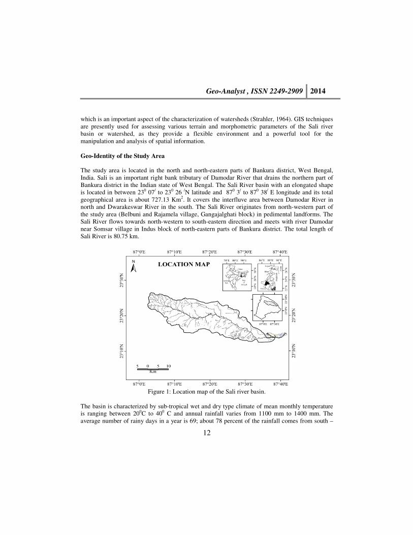
The study area is located in the north and north-eastern parts of Bankura district, West Bengal,
India. Sali is an important right bank tributary of Damodar River that drains the northern part of
Bankura district in the Indian state of West Bengal. The Sali River basin with an elongated shape
is located in between 230 07/ to 230 26 /N latitude and 870 3/ to 870 38/ E longitude and its total
geographical area is about 727.13 Km2. It covers the interfluve area between Damodar River in
north and Dwarakeswar River in the south. The Sali River originates from north-western part of
the study area (Belbuni and Rajamela village, Gangajalghati block) in pedimental landforms. The
Sali River flows towards north-western to south-eastern direction and meets with river Damodar
near Somsar village in Indus block of north-eastern parts of Bankura district. The total length of
Sali River is 80.75 km.
Figure 1: Location map of the Sali river basin.
The basin is characterized by sub-tropical wet and dry type climate of mean monthly temperature
is ranging between 200C to 400 C and annual rainfall varies from 1100 mm to 1400 mm. The
average number of rainy days in a year is 69; about 78 percent of the rainfall comes from south –

Geo-Analyst , ISSN 2249-2909 2014
13
west monsoon (four monsoon months June to September) wind. North-western and southern part
of the Sali basin is covered with Protected Forest (P.F), mainly dry deciduous forest (Sal,
Eucalyptus, Akashmani, Sonajuri, Mahua, Palsh and open scrubs,etc) .North-eastern and eastern
part is mainly characterized by fertile agricultural land. Lateritic soil, yellowish brown red soil,
yellowish alluvial soils are the dominant soils in the study area.
Data Source and Objectives
In the present study, the following data have been identified which is very much relevant in the
present work.
Table 1: Source of data for morphometric analysis.
Data Source Year
Topographic maps (Sheet Number 73M
/3,7,8,11,12; scale 1:50,000) Toposheet
No.73M on 1:250,000 scale
Survey of India 1976 &
2004
IRS P 6 LISS III in 4 bands (Green: 0.52 -
0.59µm, Red: 0.62 - 0.68µm, NIR: 0.77 -
0.86µm and SWIR: 1.55 - 1.70µm)
National Remote Sensing Agency
(NRSA), India
24 Jan,
2011
Geological map of Bankura Geological Survey of India 2001
Field data Ground truth collected during the
study
2013-2014
Morphometric analysis has been done based on Topographical map and satellite imagery. The
geological map of the study area under reference has been consulted to find out the relationship of
structure, lithology and tectonics with the various fluvio-geomorphic attributes of the basin and
finally different morphometric parameters have been generated through GIS software.
The main objectives of the study area are as follows:
• To analyze the linear, areal and relief morphometric characteristics of the Sali river
basin.
• To show relationship between different morphometric attributes with various
geomorphological processes operating in the basin.
• To identify the stage of the cycle of erosion in the Sali river basin and its tributary
basins.
Geology and Hydrological Condition
The Sali river basin is not developed over homogenous structure but developed over polygenetic
surface. The upper part of the Sali basin is predominantly a pre- cambrian gneissic terrain,
characterized by the Archean-Proterozoic associations whereas middle part of the basin formed by

Geo-Analyst , ISSN 2249-2909 2014
14
lalgarh formation (laterite -yellowish brown sandy silt (latosol),dark brown hard crust (duricrust))
and lower (eastern) parts of the basin are formed by Tertiary and Quaternary deposits( sandy
alluvial soil). Chotanagpur Granite- Gneiss Complex (CGC) consists of Achaean Gneiss, Schist,
Amphibolite, Hornblend, Dolerite, Porphyritic Granite, Pyroxinite Granite, Phyllite & Mica–Schist
of different ages with enclaves of meta sedimentaries. In the upper catchment presence of
crystalline rock and in the middle catchment lateritic mass due to their compactness and low
permeability do not serve as good aquifer for large ground water storage. But in this area fault,
joint and fracture identified as lineament act as conduits for ground water recharge. Lower and
middle parts mainly characterized by older and younger alluvium conducive for ground water
storage.
Morphometric Analysis
Table 2: Morphometric analysis of the Sali river basin
Morphometric
Parameter
Formula / Definition Reference Result
LINEAR ASPECT
Stream Order (Su) Hierarchical Rank Strahler (1964) 5th
Stream Number (Nu) Nu = N1+N2+…Nn Horton (1945) 311
Stream Length (Lu) Length of the all stream Strahler (1964) 540.37
km
Mean stream length
(Lsm)
Lsm=Lu/Nu; Where, Lu=Mean stream
length of a given order (km),
Nu=Number of stream segment.
Horton (1945) 1.01-
33.88
Stream length ratio (RL) RL= Lu / Lu-1 Where, Lu= Total
stream length of order (u), Lu-1=The
total stream length of its next lower
order.
Horton ( 1945) 0.54-6.36
Bifurcation Ratio (Rb ) Rb = Nu / Nu+1 Where, Nu=Number
of stream segments present in the given
order,Nu+1= Number of segments of
the next higher order
Strahler (1964)
Schumm
(1956)
2.00 –
7.50
Weighted Mean
Bifurcation Ratio(Rbw) Rbw = Rb1 × n1 + Rb2 × n2 + …../ n1 +
n2 + …..
Horton (1945) 3.88
AREAL ASPECT
Drainage density (Dd) Dd=L/A Where, L=Total length of
stream, A= Area of basin.
Horton(1945) 0.74
Km/Km2
Drainage Frequency (Df) Df = ∑ N / A , ∑ N= Total no. of
stream segment, A= Basin Area
Horton(1945) 0.43/km2
Drainage Texture (Dt) Dt = Nu /P Where, Nu = No. of streams
in a given order and P = Perimeter
(Km)
Horton(1945) 1.93/km

Geo-Analyst , ISSN 2249-2909 2014
15
Infiltration Number (Dn) Dn=Dd*Df Faniran (1968) 0.32
Drainage Intensity (Di) Di= Df/Dd Faniran (1968) 0.58
Length of Overland Flow
(Lg)
Lg =A/2*Lu or, Lg=1/2D Km Where,
D=Drainage density (Km/Km2)
Horton (1945) 0.67 km.
Constant of Channel
Maintenance (C)
C = 1 / Dd, where Dd =drainage
density
Schumm
(1956)
1.35
Km2/ Km
Elongation ratio (Re) Re=√(Au/π)/ Lb Where, A=Area,
Lb=length
Schumn
(1956)
0.47
Form Factor (Rf) Rf = A/Lb2 Where, A = Area of the
basin and Lb = (Maximum) basin
length
Horton (1945) 0.17
Circulatory ratio (Rc) Rc = 4πA/ P2 where, A = Basin area
(Km2) and P= Perimeter of the basin
(Km)
Strahler(1964),
Miller(1953)
0.35
RELIEF ASPECT
Basin Relief (H) H= E – e Where, E = Maximum
elevation of the basin (m) and e =
Minimum elevation (m)
Schumn
(1956)
117 m.
Relief Ratio (Rh ) Rh =H / Lb Where, H=Basin relief,
Lb=Basin length
Schumn
(1956)
1.81
Ruggedness Number (Rn) Rn = Dd * (H /1000) Where, H= Basin
relief, Dd=Drainage density
Schumn(1956) 0.087
Hypsometric Integrals
(Hi)
Hi=h/H & a/A Strahler (1952) 48.21%
Erosional Integrals (Ei) % Ei=h/H & a/A Strahler (1952) 51.79 %
Source: Calculated from Topographical map and satellite imagery.
Linear Properties of the Drainage Basin
Stream Order (Su)
The first step in basin morphometry is the stream ordering. The concept of stream order was first
introduced by Horton (1945) and later modified by Strahler (1957 and 1964), Bowden and Wallis
(1964), Scheidegger (1965), Woldenberg (1966) and Shreve (1967). In this paper the stream
ordering has been done by Strahler (1964) method. In the study reveals that the Sali basin is 5th
(V)
order drainage basin. It has also noticed that there is a decrease in stream frequency as the stream
order increases (Table 3). The variation in stream order in the said basin is due to physiographic
and geological condition of the basin.
Stream Number (Nu)
The total number of order wise stream segments is known as stream number. In this study, the
channel segments of different drainage basins are ranked according to Strahler’s stream ordering

Geo-Analyst , ISSN 2249-2909 2014
16
system. Horton (1945) states that the numbers of stream segments of each order form an inverse
geometric sequence with order number (Figure 2b).
Figure 2a: Sali watershed and its tributary basin. Figure 2b: Relationship between stream
ordering and number of
stream.
1
10
100
1000
1 2 3 4 5 6
Nu
nb
er o
f S
trea
m
Stream Order
Geo-Analyst , ISSN 2249-2909 2014
17
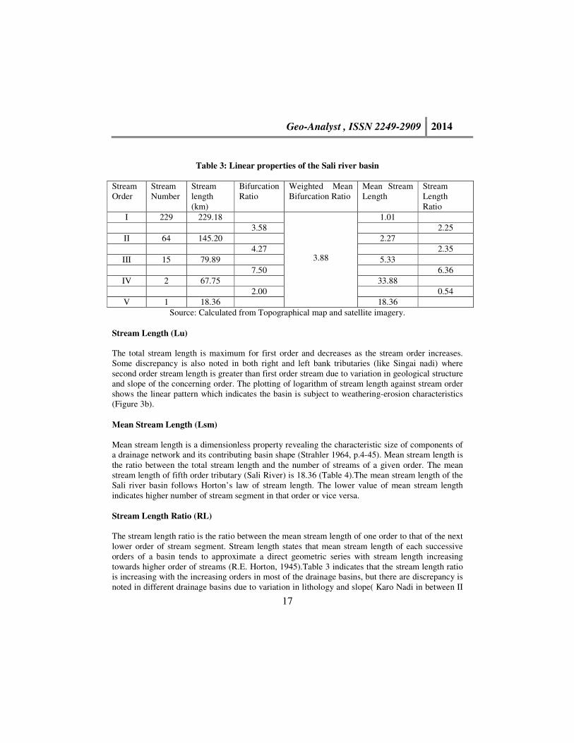
Table 3: Linear properties of the Sali river basin
Stream
Order
Stream
Number
Stream
length
(km)
Bifurcation
Ratio
Weighted Mean
Bifurcation Ratio
Mean Stream
Length
Stream
Length
Ratio
I 229 229.18
3.88
1.01
3.58 2.25
II 64 145.20 2.27
4.27 2.35
III 15 79.89 5.33
7.50 6.36
IV 2 67.75 33.88
2.00 0.54
V 1 18.36 18.36
Source: Calculated from Topographical map and satellite imagery.
Stream Length (Lu)
The total stream length is maximum for first order and decreases as the stream order increases.
Some discrepancy is also noted in both right and left bank tributaries (like Singai nadi) where
second order stream length is greater than first order stream due to variation in geological structure
and slope of the concerning order. The plotting of logarithm of stream length against stream order
shows the linear pattern which indicates the basin is subject to weathering-erosion characteristics
(Figure 3b).
Mean Stream Length (Lsm)
Mean stream length is a dimensionless property revealing the characteristic size of components of
a drainage network and its contributing basin shape (Strahler 1964, p.4-45). Mean stream length is
the ratio between the total stream length and the number of streams of a given order. The mean
stream length of fifth order tributary (Sali River) is 18.36 (Table 4).The mean stream length of the
Sali river basin follows Horton’s law of stream length. The lower value of mean stream length
indicates higher number of stream segment in that order or vice versa.
Stream Length Ratio (RL)
The stream length ratio is the ratio between the mean stream length of one order to that of the next
lower order of stream segment. Stream length states that mean stream length of each successive
orders of a basin tends to approximate a direct geometric series with stream length increasing
towards higher order of streams (R.E. Horton, 1945).Table 3 indicates that the stream length ratio
is increasing with the increasing orders in most of the drainage basins, but there are discrepancy is
noted in different drainage basins due to variation in lithology and slope( Karo Nadi in between II

Geo-Analyst , ISSN 2249-2909 2014
18
and III order , Kausutra Nala-Jugne Nadi in between III and IV order). The increasing length ratio
indicates mature stage of geomorphic development of the basin. So Sitaljor Nadi (23.27),
Subhankari-Kanjor Nadi (9.73), Barajuri nadi (8.52), Taljhitka Nadi (6.46), Singai Nadi (6.31) are
in early mature stage and other basins show the late mature stage of geomorphic development.
Bifurcation Ratio (Rb)
The ratio between the total numbers of streams of one order to that of the next higher order in a
drainage basin is known as bifurcation ratio. High values of the Rb indicate strong structural
control on drainage pattern and low value indicates that the basin has suffered less structural
disturbance and drainage pattern has not been distorted (Nag.S.K, 1998). The bifurcation ratio is
considered as an indicator of the shape of the basin. An elongated basin is likely to have a high
bifurcation ratio, while a circular basin is likely to have a low bifurcation ratio. The Rb value of
the study area ranges from 7.50 (III- IV order) to 2.00 (IV- V order).The large variation in stream
frequency between successively higher order stream result in higher values of bifurcation ratio
(Table 3).
Weighted Mean Bifurcation Ratio (Rbw)
The weighted mean bifurcation ratio is an index of the more representative bifurcation ratio for
each successive pair of orders, which is obtained by multiplying the bifurcation ratio for each
successive pair of stream orders by the total number of streams involved in the ratio and then
dividing the sum of these values by the sum of the total number of stream segments involved in
each pair (Strahler, 1953). The value of the weighted mean bifurcation ratio of the study area is
3.88 (Table 3).
Table 4: Linear properties of the Sali River and selected tributary basins.
Name of the
Basin
Area
(km2)
Order Total length
(km)
Mean Stream Length (km) Rb Dd Df Dn Er Cr Rf
I II III IV V
Sali River 727.1 5th 540.37 229.18 145.20 79.89 67.75 18.36 3.88 0.74 0.43 0.32 0.47 0.35 0.17
Kausutra
Nala-Jugne
Nadi
36.68 4th 54.33 28.74 12.09 9.84 3.65 4.25 1.48 1.5 2.22 0.65 0.46 0.34
Subhankari-
Kanjor Nadi
78.52 3rd 57.8 26.02 10.8 20.99 4.35 0.73 0.36 0.26 0.56 0.43 0.25
Sitaljor Nadi 36.07 3rd 18.27 9.6 0.69 7.98 3.13 0.51 0.28 0.14 0.61 0.51 0.29
Barajuri Nadi 21.00 3 rd 13.23 5.45 2.03 5.75 2.75 0.63 0.57 0.36 0.85 0.65 0.57
Karo Nadi 16.22 3 rd 19.51 8.88 6.82 3.81 3.79 1.2 1.00 1.18 0.67 0.54 0.36
Taljhitka Nadi 23.9 3 rd 27.67 12.64 7.24 7.8 3.68 1.16 1.05 1.22 0.71 0.66 0.4
Singai Nadi 29 2nd 12.63 4.07 8.56 3 0.44 0.14 0.06 0.68 0.5 0.36
Source: Calculated from Topographical map and satellite imagery.

Geo-Analyst , ISSN 2249-2909 2014
19
Areal Properties of the Drainage Basin
Drainage Density (Dd)
Drainage density is the ratio between the total lengths of stream in a drainage basin to the area of
that drainage basin. Drainage density is an important indicator of the linear scale of landform
element in stream eroded topography. Low drainage density generally results in the area of highly
resistant or permeable subsoil material and high drainage density is the resultant of weak or
impermeable subsurface material (S.K.Nag, 1998).The drainage density value in the study area is
0.74 Km/ Sq.Km indicating moderately low drainage density (Figure 3a) .
Figure 3a: Drainage density in the Sali river basin
Figure 3b: Relationship between stream ordering and stream length
1
10
100
1000
1 2 3 4 5 6Str
eam
Len
gth
(Km
)
Stream Order
Geo-Analyst , ISSN 2249-2909 2014
20
Drainage Frequency (Df)
Drainage frequency is defined as the number of stream segments per unit area of a drainage basin
(Horton, 1945). In the present study area, the value of drainage frequency is 0.43/ Sq.Km. It
exhibits positive correlation with drainage density in the basin indicating an increase in stream
segments with respect to increase in drainage density.
Drainage Texture (Dt)
Drainage texture is one of the important concept of geomorphology which means that the relative
spacing of drainage lines (Pareta.K, 2011). The drainage texture is defined as the ratio between
total number of stream segments of all orders per perimeter of that area. Smith (1950) has
classified drainage texture into five classes i.e, very coarse (<2), coarse (2 to 4), moderate (4 to 6),
fine (6 to 8) and very fine (>8).In the present study area, the drainage texture of the basin is 1.93
and categorized as very coarse drainage texture.
Infiltration Number (Dn)
The infiltration number of a basin is defined as the product of drainage density and stream
frequency which gives an idea about the infiltration characteristics of that basin. The higher the
infiltration number, the lower will be the infiltration and the higher run-off. The infiltration
number in the study area is 0.32 (Table 2).
Length of Overland Flow (Lg)
The Length of Overland Flow (Lg) is the length of water over the ground surface before it gets
concentrated into the definite stream channel (Horton, 1945). The length of overland flow is
approximately equal to the half of the reciprocal of drainage density. In the present study, the
length of overland flow of the Sali river basin is 0.67 Km, (Table 2), which indicating moderate
surface runoff of that area.
Constant channel maintenance (C)
Schumm (1956) used the inverse of drainage density or the constant of channel maintenance as a
property of landforms. The constant indicates the number of Km2 of basin surface required to
develop and sustain a channel 1 Km long. The constant of channel maintenance indicates the
relative size of landform units in a drainage basin and has a specific genetic connotation (Strahler,
1957). Channel maintenance constant of the watershed is 1.35 Km2/Km (Table 2). It means that on
an average 1.35 sq.km surface is needed in basin for creation of one linear km of the stream
channel.
Geo-Analyst , ISSN 2249-2909 2014
21
Elongation Ratio (Re)
The elongation ratio is a representation of the shape or form of a drainage basin. It is the ratio
between the diameter of a circle with the same area as basin and maximum basin length (Schumm,
1956, p.612). Elongation ratio can be grouped into three class namely Circular (>0.9), Oval (0.9-
0.8), and Less elongated (<0.7). In the present study area, the elongation ratio of the Sali river
basin is 0.47 which indicating moderately low relief of the terrain and elongated shape of the
drainage basin.
Form Factor (Rf)
The ratio of basin area (Au) to the square of basin length is called form factor (Horton, 1932). This
factor indicates the flow intensity of a basin of a defined area. The form factor value of the basin is
0.17 which indicates lower value of form factor and thus represents elongated in shape. The
elongated basin with low form factor indicates that the basin will have lower peak flows for longer
duration.
Basin Circularity Ratio (Rc)
Circularity ratio is also dimensionless index to indicate the outline form of drainage basins
(Strahler, 1964, p.451and Miller, 1953, p. 8).It is the ratio between the basin area and the area of a
circle having the same perimeter of the basin. This ratio is influenced by the length and frequency
of streams, geological structures, land use/ land cover, climate and slope of the basin. The
circularity ratio of the study area is 0.35 which indicating that the basin is elongated in shape and
highly permeability of the subsoil condition.
Relief Aspect of the Drainage Basin
Relief Ratio
Difference in elevation between highest point of the basin and lowest point of the valley floor of
that basin is known as the total relief of that drainage basin. The relief ratio is the ratio between the
total relief of a basin and the longest dimension of the basin parallel to the principal drainage line
(Schumm, 1956, p.119). It gives an idea of the overall steepness of a drainage basin and indicates
the intensity of degradational processes operating on slopes of that particular basin. There is a
direct relationship between relief ratio and channel gradient, i.e, lower the relief ratio, lower the
mean channel gradient of the main valley and vice versa. The relief ratio of the Sali river basin is
1.81 indicating moderately low relief and moderate slope.
Geo-Analyst , ISSN 2249-2909 2014
22
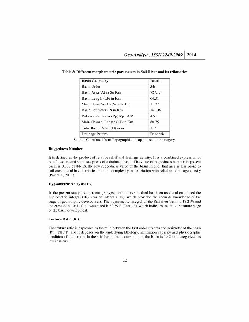
Table 5: Different morphometric parameters in Sali River and its tributaries
Basin Geometry Result
Basin Order 5th
Basin Area (A) in Sq Km 727.13
Basin Length (Lb) in Km 64.51
Mean Basin Width (Wb) in Km 11.27
Basin Perimeter (P) in Km 161.06
Relative Perimeter (Rp) Rp= A/P 4.51
Main Channel Length (Cl) in Km 80.75
Total Basin Relief (H) in m 117
Drainage Pattern Dendritic
Source: Calculated from Topographical map and satellite imagery.
Ruggedness Number
It is defined as the product of relative relief and drainage density. It is a combined expression of
relief, texture and slope steepness of a drainage basin. The value of ruggedness number in present
basin is 0.087 (Table.2).The low ruggedness value of the basin implies that area is less prone to
soil erosion and have intrinsic structural complexity in association with relief and drainage density
(Pareta.K, 2011).
Hypsometric Analysis (Hs)
In the present study area percentage hypsometric curve method has been used and calculated the
hypsometric integral (Hi), erosion integrals (Ei), which provided the accurate knowledge of the
stage of geomorphic development. The hypsometric integral of the Sali river basin is 48.21% and
the erosion integral of the watershed is 52.79% (Table 2), which indicates the middle mature stage
of the basin development.
Texture Ratio (Rt)
The texture ratio is expressed as the ratio between the first order streams and perimeter of the basin
(Rt = Nl / P) and it depends on the underlying lithology, infiltration capacity and physiographic
condition of the terrain. In the said basin, the texture ratio of the basin is 1.42 and categorized as
low in nature.
Geo-Analyst , ISSN 2249-2909 2014
23
Conclusion
The morphometric properties of the Sali basin clearly reflect the polygenetic character of the basin,
because morphometric parameters of the Sali basin and selected seven drainage basins are
different in different lithological condition. The overall morphometric analysis shows that the
basin has medium relief and elongated in shape. The dendritic pattern of drainage indicates that
there is less structural control in drainage network and the development of stream segments more
or less affected by rainfall. The coarse drainage texture and moderately low stream density of the
basin revels that the nature of subsurface strata is permeable. Rc, Rf and Re show that elongated
shape of the basin has low discharge of runoff and moderately low relief of the terrain. The study
also reveals that the basin is passing through middle to late mature stage of the geomorphic
development.
References
Chorley, R.J (1972): Spatial Analysis in Geomorphology, Mathuen and Co. Ltd., London.
Chorley, R.J, Schumm, S.A. and Sugden, D.E. (1984): Geomorphology, Methuen, London and
New York. pp. 605.
Horton, R.E (1932): Drainage Basin Characteristics, Transactions, American Geophysical Union,
13, pp 350-61.
Horton, R.E (1945): Erosional Development of Streams and their Drainage Basins, Bulletin of the
Geological Society of America, 56, pp-275-370.
Leopold, L.B, Wolman, M.G and Miller, J.P (1969): Fluvial Processes in Geomorphology, Eurasia
Publishing House, New Delhi.
Nag. S.K,(1998): Morphometric Analysis Using Remote Sensing Techniques in the Chaka Sub-
Basin, Purulia District, West Bengal, Journal of Indian society of Remote Sensing, Vol.26,
No.1&2, pp.69-76.
Pareta, K. and Koshta, Upasana (2009): Quantitative Morphometric Analysis of a Watershed of
Yamuna Basin, India using ASTER (DEM) Data and GIS, International Journal of Geomatices and
Geosciences, Vol.2, No. 1,pp-248-252.
Schumm, S.A (1956): Evolution of Drainage Systems & Slopes in Badlands at Perth Anboy, New
Jersey, Bulletin of the Geological Society of America, 67, pp 597-646.
Schumm, S.A. (1972): River Morphology, Dowden, Hutchinson, Ross, Inc., Stroudsburg,
Pennsylvania, pp 429.
Sen, Provat Kumar, (1993): Geomorphological Analysis of Drainage Basins, The University of
Burdwan, Burdwan.
Strahler, A.N (1964): Quantitative Geomorphology of Drainage Basin and Channel Network,
Handbook of Applied Hydrology, pp 39-76.
Thornbury, W.D (1954): Principles of Geomorphology, John Wiley and Sons, London.