Preservation and diagenesis of hopanoids in Recent lacustrine sediments of Priest Pot, England
Upload
independentCategory
view
2download
0
ARTICLE IN PRESS
1040-6182/$ - se
doi:10.1016/j.qu
�CorrespondEnvironment S
China. Tel: +8
E-mail addr
Quaternary International 136 (2005) 25–32
Lacustrine and eolian records of Holocene climate changes in theMongolian Plateau: preliminary results
Z.-D. Fenga,b,�, W.G. Wanga, L.L. Guoa, P. Khosbayarc, T. Narantsetsegc, A.J.T. Julld,C.B. Ana, X.Q. Lia, H.C. Zhanga, Y.Z. Maa
aNational Laboratory of Western China’s Environmental Systems, MOE, Lanzhou University, Lanzhou 730000, ChinabDepartment of Earth and Environmental Studies, Montclair State University, Upper Montclair, NJ 07043, USAcInstitute of Geology and Mineral Resources, Mongolian Academy of Sciences, Ulaan Baatar 210351, Mongolia
dNSF Arizona AMS Laboratory, University of Arizona, Tucson, AZ 85721, USA
Available online 19 January 2005
Abstract
This study compares two pairs of adjacent lacustrine and eolian sections at sites in the southern and northern Mongolian Plateaus
in order to test spatial climate variability during the Holocene. Based on the lithology, proxy data, and 14C dated and the
interpolated ages, the following observations can be made. In the northern Mongolian Plateau, a best developed Holocene paleosol
dated at 8672 14C yr BP at the Shaamar section and the carbonate-rich laminated layer in the Gun Nuur lake core mark the interval
of warmer and dryer climate during the early Holocene. Younger paleosols at the Shaamar section and corresponding organic-rich
layers in the Gun Nuur core were formed under distinctly cooler and more humid conditions. The Baahar Nuur lake core in the
southern Mongolian Plateau and the Dingxi-type section in the northern part of the Western Chinese Loess Plateau appear to
indicate that a prolonged interval of maximum humidity prevailed in this region during the early and mid-Holocene (9000–400014C yrBP). By contrast, in the northern Mongolian Plateau the most humid conditions seem to have occurred from 4500 to 2500
(possibly to 1650) 14C yrBP. This discrepancy implies that the concept of the Holocene climatic optimum has limitations and may
have to be reconsidered if it is intended to have a large-scale connotation.
r 2004 Elsevier Ltd and INQUA. All rights reserved.
1. Introduction
Possible human-induced climate change and adversehuman impacts on environment alert us to assess thefuture climatic stability and environmental sustainabil-ity. However, this assessment requires a solid under-standing of the natural climatic variability on differenttime scales. The Holocene is of particular interest in thatregard because the climatic boundary conditions aresimilar to those experienced now and possibly in thenear future. Of a special and most likely globalsignificance to the Holocene climatic history is the
e front matter r 2004 Elsevier Ltd and INQUA. All rights
aint.2004.11.005
ing author. National Laboratory of Western Chinas
ystems, Lanzhou University, MOE, Lanzhou 730000,
6 973 655 7811; fax: +86 973 655 4390.
ess: [email protected] (Z.-D. Feng).
traditionally defined Maximum Postglacial Warmthevent (Winkler and Wang, 1993) when large-scaleclimatic systems were interpreted to have reorganized(Stager and Mayewski, 1997; Steig, 1999). Its onset hasbeen variously placed at 10,000–7500 yr BP and its endat 5000–2000 yr BP (An et al., 2000). The MaximumPostglacial Warmth was reported to have occurredsynchronously between 8500 and 3000 yr BP acrosseast–central Asia with the climax (equivalent to theClimatic Optimum defined by An et al., 2000) from 7200to 6000 yr BP (Shi et al., 1994a,b). However, An et al.(2000) recently argued that the Climatic Optimum wastime-transgressive from northwest to the southeast inthe summer monsoon-influenced area of China (i.e.eastern China).To understand the global Holocene climate changes
and the controlling mechanisms, temporal and spatial
reserved.
ARTICLE IN PRESS
12 090°ã 100°ã 110°ã
50°ã
45°ã
40°ã
35°ã
S e l e n g e R
K e r u l e n R
O rh o n R
L B a ik a l
L Hovsgol
Uvs Nuur
Y el
lo
wR
G o b i
I n n e r M o n g o l i a
O rd o s
P la te a u
Ulaanbaatar
Lanzhou
Beijing
B A
C
D
Al
ta
i
MT
S
H a n g a y nM
T S
Ulaanbaatar
Lanzhou
Beijing
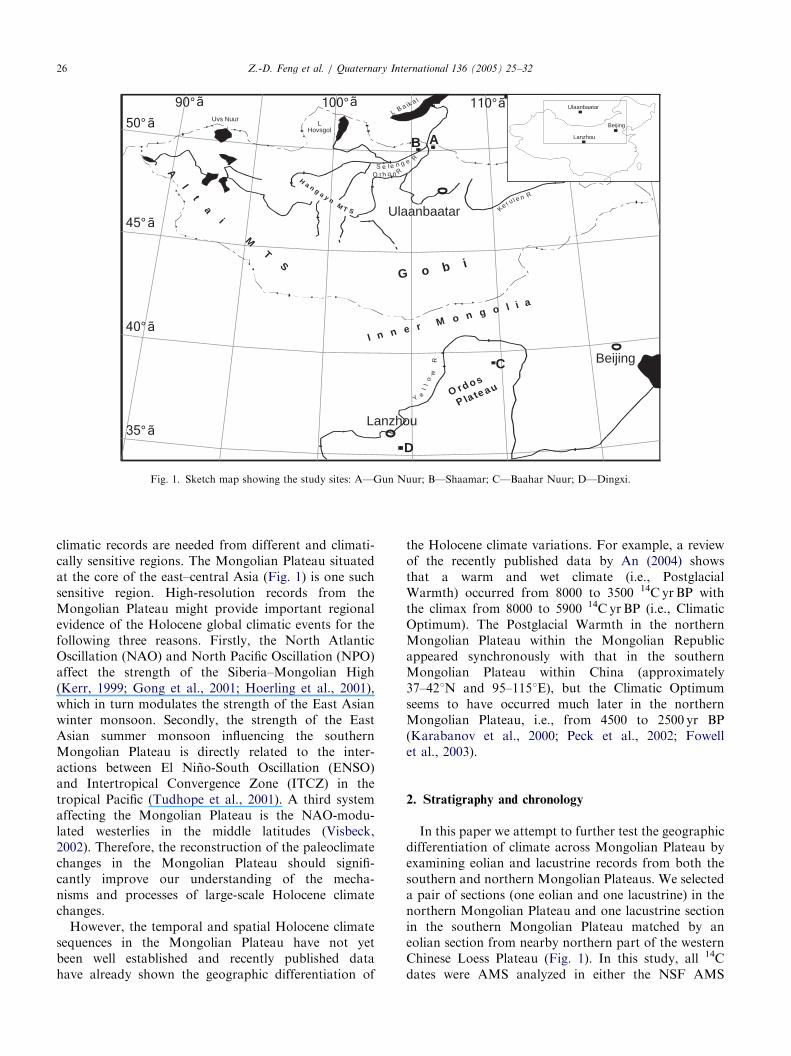
Fig. 1. Sketch map showing the study sites: A—Gun Nuur; B—Shaamar; C—Baahar Nuur; D—Dingxi.
Z.-D. Feng et al. / Quaternary International 136 (2005) 25–3226
climatic records are needed from different and climati-cally sensitive regions. The Mongolian Plateau situatedat the core of the east–central Asia (Fig. 1) is one suchsensitive region. High-resolution records from theMongolian Plateau might provide important regionalevidence of the Holocene global climatic events for thefollowing three reasons. Firstly, the North AtlanticOscillation (NAO) and North Pacific Oscillation (NPO)affect the strength of the Siberia–Mongolian High(Kerr, 1999; Gong et al., 2001; Hoerling et al., 2001),which in turn modulates the strength of the East Asianwinter monsoon. Secondly, the strength of the EastAsian summer monsoon influencing the southernMongolian Plateau is directly related to the inter-actions between El Nino-South Oscillation (ENSO)and Intertropical Convergence Zone (ITCZ) in thetropical Pacific (Tudhope et al., 2001). A third systemaffecting the Mongolian Plateau is the NAO-modu-lated westerlies in the middle latitudes (Visbeck,2002). Therefore, the reconstruction of the paleoclimatechanges in the Mongolian Plateau should signifi-cantly improve our understanding of the mecha-nisms and processes of large-scale Holocene climatechanges.However, the temporal and spatial Holocene climate
sequences in the Mongolian Plateau have not yetbeen well established and recently published datahave already shown the geographic differentiation of
the Holocene climate variations. For example, a reviewof the recently published data by An (2004) showsthat a warm and wet climate (i.e., PostglacialWarmth) occurred from 8000 to 3500 14C yrBP withthe climax from 8000 to 5900 14C yrBP (i.e., ClimaticOptimum). The Postglacial Warmth in the northernMongolian Plateau within the Mongolian Republicappeared synchronously with that in the southernMongolian Plateau within China (approximately37–421N and 95–1151E), but the Climatic Optimumseems to have occurred much later in the northernMongolian Plateau, i.e., from 4500 to 2500 yr BP(Karabanov et al., 2000; Peck et al., 2002; Fowellet al., 2003).
2. Stratigraphy and chronology
In this paper we attempt to further test the geographicdifferentiation of climate across Mongolian Plateau byexamining eolian and lacustrine records from both thesouthern and northern Mongolian Plateaus. We selecteda pair of sections (one eolian and one lacustrine) in thenorthern Mongolian Plateau and one lacustrine sectionin the southern Mongolian Plateau matched by aneolian section from nearby northern part of the westernChinese Loess Plateau (Fig. 1). In this study, all 14Cdates were AMS analyzed in either the NSF AMS

ARTICLE IN PRESSZ.-D. Feng et al. / Quaternary International 136 (2005) 25–32 27
Facility at University of Arizona (noted as AA-samples)or at Beta Analytical Inc. (noted as Beta-samples) exceptfor one date (4780780) that was conventionally datedat Lanzhou University (Table 1). The calendar ages arecalibrated using the INTCAL98 calibration database(Stuiver et al., 1998).
Table 1
Radiocarbon dates in sediment sections of this study
Lab
No.
Sample
No.
Site Depth
(cm)
d 13C,PDB
Age
Beta-182732 GN0-5 Gun Nuur 0–5 �18.2 1090740
Beta-171822 GN3 Gun Nuur 64 �23.1 1870740
Beta-171823 GN8 Gun Nuur 151 �24.1 2520740
Beta-171824 GN12 Gun Nuur 240 �21.0 3180740
Beta-171825 GN16 Gun Nuur 342 �22.7 4870740
Beta-171826 GN18 Gun Nuur 391 �20.9 5750750
AA-51953 GN22 Gun Nuur 485 �5.2 7836763
AA-51956 GN25 Gun Nuur 561 �5.6 8324763
Beta-171827 GN34 Gun Nuur 743 �26.8 9530750
AA51936 SH02-06 Shaamar-2 140 �24.8 620735
AA51935 SH02-04 Shaamar-2 195 �24.5 1423735
AA51934 SH02-02 Shaamar-2 245 �23.1 1681737
Lanzhou3465 Sh02 Shaamar-1 430 4780780
AA51928 MN-14 Shaamar-1 760 �25.9 8672790
Beta-171828 BN3 Baahar Nuur 487 �23.8 13910770
Beta-171829 BN6 Baahar Nuur 385 �24.8 8850740
Beta-171830 BN8 Baahar Nuur 327 �24.9 7960740
Beta-181619 BN11 Baahar Nuur 227 �24.2 7510740
Beta-181620 BN13 Baahar Nuur 167 �24.2 6350740
Beta-181621 BN16 Baahar Nuur 81 �23.8 5460740
AA44886 SJW410 Dingxi 410 �24.9 8885755
AA44886T SJW355 Dingxi 355 23.4 5581750
AA44885 SJW305 Dingxi 305 �24 3805745
Beta-181612 SJ295 Dingxi 295 �22.8 3770740
Beta-181611 SJ90 Dingxi 90 �23.1 1960740
Fig. 2. Strata and proxy data in Gun Nuur lake
2.1. Northern Mongolian sequences
A 7.45m lake core was drilled in the center of GunNuur Lake (50.251N and 106.61E, 600m above sea level)in the northern Mongolian Plateau, about 100 km southof Lake Baikal (site A in Fig. 1). Gun Nuur is afreshwater lake, about 4 km2 in area and 5m deep in thecenter. The following lithology was observed in the GunNuur lake core: a silty mud unit at the depth of0–570 cm; a unit of laminated carbonate mud at thedepth of 570–720 cm; and a sand unit at the bottom25 cm of the core (Fig. 2). The chronology is based onnine bulk AMS 14C dates shown in Fig. 2 (also see Table1). The 14C date at the top (surface) of the core indicatesthat the carbon reservoir effect in the Gun Nuur Lake isabout 1200 years with an assumption that this carbonreservoir effect applies to the entire Holocene. In ourinterpretation, we rely on uncorrected dates to comparewith other uncorrected dates. For instance, the lami-nated carbonate layer in our core is bracketed by thebulk dates of 8324 and 9500 14C yrBP. Our bulk datesare in good agreement with dates on organic fraction byDorofeyuk and Tarasov (1998), who bracketed thecorrelative carbonate layer in their core from Gun NuurLake between 8150 and 9550 14C yr BP.Our second focal section is the Shaamar sand/
palaeosol section (50.21N, 105.21E, 650m above sealevel), the thickest and well-preserved eolian section wefound in the northern Mongolian Plateau (site B at Fig.1). The section is about 100 km west to the Gun NuurLake in the northern Mongolian Plateau, wherenumerous eolian sections were reported (Feng et al.,1998; Feng, 2001; Khosbayar, 1989; Logatchov, 1989).According to the 14C dates, the Shaamar outcrop section
core and Shaamar sand/paleosol section.

ARTICLE IN PRESSZ.-D. Feng et al. / Quaternary International 136 (2005) 25–3228
contains approximately 10m of Holocene subaerialsediments interbedded with five paleosols (I, II, III, IV,and V in Fig. 2) intervened with sand units. A weakpaleosol (IV) in the Shaamar section at the depth of400–500 cm was dated at 4780780yrBP (LanzhouUniversity) and the bottom (760 cm) of a well-developedpaleosol (V) was dated at 8672790yrBP (Table 1). Aclinosol-amplified ‘‘top’’ soil (I) was found at the foothillof the Shaamar gully and three sub-paleosols (I2, I3, andI4) were AMS dated (on charcoals) at 620735, 1423735and 1681737yrBP, respectively (Fig. 2). The ages ofpaleosol II and III can be inferred from two dates:4780yrBP in the middle of the paleosol IV (430 cm) and1681yrBP at the bottom of the top soil (60 cm) assumingthat the depositional rate was relatively constant betweenthe two dates. The assumption is reasonably supportedby the fact that the mean grain size from 430 cm to 60 cmis relatively constant (see Fig. 2). The inferred age for thepaleosol II is about 3000 yrBP and the age for thepaleosol III is about 3800 yr BP.
2.2. Southern Mongolian sequences
A 5.3m lake core was drilled in the middle of BaaharNuur Lake (39.11N, 109.21E, 1450m above sea level), arecently desiccated salt lake located at the Yellow RiverBend area (Ordos Plateau) in the southern MongolianPlateau (site C in Fig. 1). The section consists of sandlayers and carbonate-silt mud layers (Fig. 3). Six AMS14C bulk samples were dated at Beta Analytic Inc.(Fig. 3). The carbon reservoir effect was not specificallytested in the Baahar Nuur core. However, a date of
Fig. 3. Strata and proxy data in Baahar Nuur lake core and Dingxi lo
1935 yr BP that we obtained (bulk sample) at the surfaceof recently desiccated saline lake (Gouchi), about100 km southwest to this lake core, and the reservoireffect of about 2000 yr estimated at other sites in thesouthern Mongolian Plateau (Chen et al., 2003b; Li etal., 1990; Ren, 1998) may be acceptable for the BaaharNuur lake core. Subtracting the carbon reservoir effectof 2000 yr suggests that the lake originated about10,000 yr BP and ended about 3640 yr BP.To search for Holocene eolian records compatible
with the lacustrine records, we found a well-preservedand relatively thick loess/wetland section (Dingxi sec-tion), a representative (or type) section of the northernpart of the Western Chinese Loess Plateau (Site D inFig. 1), only about 100 km away from the southernmargin of the southern Mongolian Plateau. Underlyingthree loess units interbedded with three weak soils is alayer of grayish-blue clayey silt, which was dated at3805–8885 yr BP (Fig. 3 and Table 1). Aquatic molluscsare abundant in this layer, and powdery carbonate andhalf-decomposed organic matter (plant litter) are readilyvisible. This grayish-blue layer can therefore be inter-preted confidently as wetland/swamp deposits (An et al.,2003; Feng et al., 2004). In addition, the first and thirdloess units in Dingxi section were dated at 1960740and 3770740 yr BP at the depth of 90 and 295 cmrespectively (Fig. 3).
3. Laboratory analysis
Magnetic susceptibility was measured by the proce-dure of Thompson and Oldfield (1986) using a
ess/wetland section at the southern part of Mongolian Plateau.

ARTICLE IN PRESSZ.-D. Feng et al. / Quaternary International 136 (2005) 25–32 29
Bartington MS2 susceptibility meter and the particle sizeof bulk samples was measured using a Malvern Co. Ltd.Mastersizer 2000 laser diffraction particle size analyzer.Organic matter content was determined by the antititra-tion method with sulfuric acid (H2SO4) and potassiumdichromate (K2Cr2O7), and carbonate content wasmeasured using a Bascomb Calcimeter (Singer andJanitzky, 1986). For pollen analysis, the sediments weretreated with HCl (10%), NaOH (10%) and HF (36%).Exotic Lycopodium tablets were added for calculation ofpollen concentration and 100–500 pollen grains werecounted. Samples (3–5 g) for organic carbon stableisotope analysis were first decalcified by treating with15% HCl for 24 h. The decalcified samples were thenrepeatedly washed with distilled water and dried at 60 1Cin an oven. The processed samples were combustedwith O2 at around 800 1C and the derived CO2 wasanalyzed using a Delta Plus mass spectrometer. Thecarbon isotope is expressed as d13C in per mil relative tothe PDB (Pee Dee Formation Belemnite) standard.Diatom counting was done in Geology Institute ofMongolian Academy of Sciences (by Dr. Narantsetseg)according to the procedures described in Karabanovet al. (2000). Analytical interval is 6 cm for diatomand 2 cm for other types of analyses (susceptibility,carbonate, organic matter, and organic carbon stableisotope).
4. Proxy data and interpretations
4.1. Northern Mongolian Plateau
The variations of proxies in the Gun Nuur lake coreare shown in Fig. 2. In the upper portion of the core(0–450 cm), the magnetic susceptibility, a concentrationindicator of magnetic minerals formed by biogenicprocesses in lacustrine environments or/and pedogenicprocesses in the watershed (Hu et al., 2001), is negativelycorrelated with organic matter content and to a lesserdegree the organic d13C ratio. In the lower portion(450–745 cm), the susceptibility seems to be negativelycorrelated with the carbonate concentration (%). Thelow susceptibility values are likely due to organic matterand carbonate dilution or/and less magnetic mineralinput from the watershed (Wang et al., 2004). Theorganic matter content, a proxy of primary productivity(Chen et al., 2002), is constantly low in the lower portion(450–745 cm) and has four progressively smaller peaksin the upper portion at 380–330, 270–220, 200–130, and100–50 cm. The carbonate concentration is relativelylow from 0 to 330 cm and relatively high from 330 to720 cm. The interpretation of organic d13C ratios isrelatively complicated due to various factors (see Yu etal., 2001). The organic d13C ratio variations can bedivided into four zones (I, II, III, IV in Fig. 2) based on
the relationship between the organic d3C ratio and theorganic matter content. The topmost Zone I (0–30 cm) ischaracterized by an extremely high (i.e., positive)organic d13C ratio with a relatively low organic matterand few benthic diatoms, possibly resulting from recenthuman disturbances (Shen et al., 2004). Zone II(130–30 cm) is the zone in which the organic d13C ratioincreases with a decrease in the organic matter content.Progressive trend of increasing d13C associated withincreasing benthic diatom abundance may be related toevaporative isotope enrichment of Gun Nuur waters.Organic d13C ratio in Zone III (130–450 cm) is positivelycorrelated with the organic matter content and also withthe planktonic diatom abundance. It is noticeable thatin Zone III organic matter content is anti-correlatedwith the magnetic susceptibility. In Zone IV(450–720 cm) magnetic susceptibility is negatively corre-lated with carbonate content, whereas organic d13C ratiodoes not seem to correlate with the organic mattercontent. It appears that the organic d13C ratio variationsin Zone IV are associated with the variations in benthicdiatom abundance. Overall, the organic d13C ratio peaks(i.e., positive) in Gun Nuur section tend to be associatedwith peaks of planktonic or benthic diatom abundance,except for the Zone I. It is therefore possible thattroughs in the organic d13C profile are associated withthe contribution of terrestrial C3 plant material, whichhas more negative organic d13C ratios than diatoms andshallow-water macrophytes (e.g., Wu et al., 1996; Yu etal., 2001; Shen et al., 2004).Below are our environmental reconstructions of the
four zones starting from the bottom of the Gun Nuurlacustrine sequence (720 cm):Zone IV (720–450 cm: approximately 9500–6800
14C yrBP): a general high content of benthic diatomindicates a shallow lake, and low organic matter contentsuggests a low primary productivity. A general lowmagnetic susceptibility suggests limited terrestrial (flu-vial and eolian) input from the watershed. Deposition ofthe carbonate-rich laminated layer recovered in thelower part of Gun Nuur core (720–570 cm) suggestsstrong seasonal evaporation (high summer tempera-ture?) and low lake level. A chronologically correspond-ing loessial and carbonate-rich paleosol dated at 867214C yrBP at the Shaamar section suggests that earlierHolocene was less windy and warmer than the rest of theHolocene that was characterized by alternative changesbetween sand depositions and sandy soil formations (seelater discussions for the Shaamar section). This inter-pretation is supported by relatively high organic d13Cratios and high abundance of benthic diatoms. Inaddition, Dorofeyuk and Tarasov (1998) found thatthis time interval in the Gun Nuur record is character-ized by highest abundant Cyperacea pollen, supportiveof lowered lake level. This laminated carbonate unit inour core is bracketed by the bulk dates of 9500 and 8324

ARTICLE IN PRESSZ.-D. Feng et al. / Quaternary International 136 (2005) 25–3230
14C yr BP (Fig. 2, Table 1). Our dates agree with earlierestimates by Dorofeyuk and Tarasov (1998) whoreported the date 8760 14C yrBP for the lower part ofthe laminated carbonate unit and the date 815014C yrBP for the base of the overlying layer.Zone III (450–130 cm: approximately 6800–2200
14C yrBP) is characterized by higher primary productiv-ity as indicated by increased organic matter content andpossibly by higher organic d13C ratio, whereas higherlake level is clearly documented by increased planktonicdiatom abundance. Dorofeyuk and Tarasov (1998) alsonoted this past expansion of planktonic diatoms in GunNuur Lake. However, they suggested that the maximumlake level corresponds to the time interval 8300–540014C yr BP.During the time interval approximately 2200–1550
14C yrBP corresponding to Zone II (130–30 cm) the lakebecame shallow again, as suggested by near disappear-ance of planktonic diatoms and dominance of benthics.Low organic matter content and high magnetic suscept-ibility indicate that the primary productivity decreasedand terrestrial input of magnetic minerals became higherpossibly due to reduced vegetation density in thewatershed.At the Shaamar section, the sand and paleosol units
are well defined by the organic matter content andparticle size (Fig. 2). That is, all paleosols arecharacterized by higher organic matter content andfiner grain size than the sand units, indicating that lesswindy conditions and/or higher vegetation densityprevailed during the intervals of paleosol formation. Itshould be particularly noted here that the bottompaleosol (V) formed in the early Holocene (i.e., datedat 8672 14C yrBP) differs from the upper four paleosols(I–IV). Specifically, this paleosol (V) is a typicalmollisol, developed in a loess parent material, with athick organic-enriched horizon and a well-developed Bkhorizon. In other words, organic matter was effectivelyaccumulated in the soil with the carbonate being leacheddownward to form a thick Bk horizon (Royer, 1999). Itis also notable that not only the parent material of thepaleosol V, but also the underlying older sand layer areconsistently finer than the overlying portion containingthe other four paleosols (I–IV), suggesting that theclimatic or/and environmental conditions were differentin the earlier portion of the Holocene than the laterportion of the Holocene.It is noticeable that the paleosols I–IV in the Shaamar
section can be approximately correlated with theintervals characterized by lower susceptibility, higherorganic matter content and higher organic d13C ratio inthe Gun Nuur core with consideration of the uncertain-ties of age determination. The better developed paleosol(V) is correlative with the carbonate-rich laminated layer(570–720 cm) and therefore both sections suggest thatthe warmest part of the Holocene have occurred in this
area of Mongolian Plateau sometime around 8000–900014C yr BP.
4.2. Southern Mongolian Plateau
Magnetic susceptibility and the carbonate concentra-tion profiles in Fig. 3 shows that both the bottom andtop sandy portions of the Baahar Nuur core arecharacterized by higher magnetic susceptibility andlower carbonate concentrations. By contrast, the middleportion (80–435 cm) consists of carbonate-rich silty-clayey lacustrine deposits with consistently low magneticsusceptibility and varying carbonate concentration andmean particle size. If the above-mentioned �2000-yrreservoir effect is used to adjust the bulk 14C dates, thiscarbonate-rich lacustrine unit indicates that the BaaharNuur lake level was higher from �9000 to 3640 14C yrBP. High carbonate concentration in this unit impliesthat the evaporation was also high during the early andmid-Holocene, thereby suggesting both warm andhumid climate over this time interval. Although a recentreview by Zhou et al. (2001) suggests that the HoloceneClimatic Optimum occurred between 10,000 and 500014C yr BP in northern China, an earlier summary of theHolocene climate reconstructions by Shi et al. (1994a,b)indicates that the Optimum occurred between 8300 and3800 14C yr BP with its climax between 7200 and 600014C yr BP in northern China. Our recent work in thewestern part of the Chinese Loess Plateau (Feng et al.,2004) is more supportive of the age interpretationproposed by Shi et al. (1994a,b). Following is a briefsummary of our recent work at Dingxi section, a typeHolocene section in the western part of the ChineseLoess Plateau.A grayish-blue layer at the Dingxi section (site D in
Fig. 1) formed in wetland/swampy conditions ischaracterized by high carbonate concentration and highorganic matter content. The layer is finer than otherstratigraphic units as indicated by grain size (e.g.,463 um fraction). Both the stratigraphy and the proxydata at the Dingxi section indicate that a humid andprobably also a warm climate prevailed between 8885and 3805 14C yrBP. The overlying three loess unitsinterstratified with three weakly developed paleosols(including the surface soil) in the Dingxi section suggestthat climate has been drier and probably also cooler inthe late Holocene (after 3805 14C yr BP). It is quiteinteresting to note that data both from the Baahar Nuurcore in the southern Mongolian Plateau and the Dingxisection in the western part of the Chinese Loess Plateaushow that the climate was humid and probably alsowarm during the early and mid-Holocene at 35–401N. Inthe late Holocene this region seems to have beendominated by a more arid and probably also coolerclimate, which has ameliorated at least three times asindicated by the three weakly developed paleosols.

ARTICLE IN PRESSZ.-D. Feng et al. / Quaternary International 136 (2005) 25–32 31
5. Discussions and conclusions
The sand/paleosol stratum at the Shaamar section hasregional implications for eolian climate changes in thenorthern Mongolian Plateau. For example, two majorpaleosols dated at 8672 and 4780 14CyrBP at theShaamar section have their counterparts at the Khyar-aany eolian section (50.21N, 106.71E, 600m above sealevel) near Gun Nuur Lake (Feng, 2001) and the eoliansequences are further supported by the lacustrine sequencefrom the Gun Nuur core (Fig. 2). Again, two majormagnetic susceptibility troughs, one at the depth of310–410 cm (bulk dates 4910 and 5820 14CyrBP, Fig.2), and another at the depth of 570–720cm (carbonatelaminated unit �9000–8300 14CyrBP, Fig. 2) in GunNuur section correspond chronologically to the two majororganic-enriched paleosols: one dated at 8672 14CyrBPand another dated at 4780 14CyrBP at the Shaamarsection. It is likely that a reservoir correction of at leastseveral centuries has to be applied in future to Gun Nuurage estimates to arrive at more accurate age model.It is worthwhile to point out that the best developed
Holocene paleosol (V), a typical Mollisol at theShaamar section, and the carbonate enrichment-markedlaminated layer (570–720 cm) at the Gun Nuur lake coreare chronologically corresponding to the treeline ad-vance period from 9000 to 7000 14C yrBP in the easternSiberia (MacDonald et al., 2000), implying a warmingclimate. The sand unit bracketed by two paleosols datedat 8672 and 4780 14C yr BP at the Shaamar section and asignificant increase in the magnetic susceptibility,accompanied with a relatively high abundance ofbenthic diatom, at the depth of 410–570 cm in the GunNuur lake core imply colder and relatively dry climateduring this time interval (approximately 7000 to 500014C yrBP). This interpretation is consistent with ob-servations of dry period in sedimentary proxy recordsfrom Lake Telmen, north-central Mongolia (Peck et al.,2002; Fowell et al., 2003). In addition, the interval withthe highest organic matter content from 130 to 450 cm(high primary productivity, approximately 6800–220014C yrBP) in Gun Nuur record is correlative with thepeak diatom abundance of ca. 4500–2500 14C yr BP inLake Baikal (Karabanov et al., 2000), and also with theinterval of more humid climate ca. 4060–1650 14C yr BPin NW Mongolia as inferred from pollen records atLake Telmen site (Fowell et al., 2003; Peck et al., 2002).The data from Baahar Nuur core and Dingxi section
suggest that climate was warm and humid during theearly and mid-Holocene (approximately between 9000and 4000 14C yr BP) in the southern Mongolian Plateauand has been predominantly cool in the late Holocene(after 4000 14C yrBP), although at least three episodes ofclimatic amelioration seem to have occurred. The datafrom other lake cores in the southern Mongolia Plateaualso show similar climate changes (e.g., Wang and Li,
1991; Li et al., 1992; Song et al., 1996; Zhang et al.,1997; Yang, 2001).To sum up, although several recent studies (e.g., Chen
et al., 2003a,b) suggest that the mid-Holocene was thedriest period during the entire Holocene, our prelimin-ary data from the Baahar Nuur lake core and fromDingxi section appear to be supportive to the notionthat not only a ‘‘megathermal’’ climate proposed by Shiet al. (1994a,b) but also ‘‘megahumid’’ climate proposedby Feng et al. (2004) prevailed both in the southernMongolian Plateau and in the western part of theChinese Loess Plateau during the early and mid-Holocene (9000–4000 14C yrBP). However, most humidconditions occurred during the period from 4500 to 2500(even to 1600) 14C yrBP in the northern MongolianPlateau. This discrepancy suggests that the MaximumPostglacial Warmth (between 8500 and 3000 14C yr BP)may still be an acceptable concept. But, the concept ofthe Holocene Climatic Optimum should be seriouslyreconsidered if the concept is intended to have a large-scale connotation. In other words, if this concept refersto ‘‘optimum’’ temperature, it may still be valid.However, if it is intended to be ‘‘optimum’’ precipitationor ‘‘optimum’’ combination of humidity and warmth, itmay not be useful at all.In addition, our study shows that there is great
potential to retrieve new high-resolution proxy datafrom the entire Mongolian Plateau to examine thetemporal and spatial patterns of the climatic or/andenvironmental changes. The reconstructed patterns willcontribute valuable share of regional data to our globaleffort in depicting the global patterns and finally inunderstating the controlling mechanisms.
Acknowledgements
This research is financially supported by the NSFC‘‘Outstanding Young Scholar Program’’ awarded toFeng (NSFC-40025105). A grant from the ChineseMinistry of Science and Technology (no. G2000048701),and a recent NSFC grant (NSFC-40334038) alsofinanced this research. Radiocarbon measurements werepartially supported by Grants by the US NationalScience Foundation (NSF-OISE98-06430, NSF-BCS00-78557, and NSF-ESH04-02509). We thank A. Proko-penko for helpful comments and suggestions.
References
An, C.B., 2004. Holocene Environmental Changes in the Western part
of the Chinese Loess Plateau. Ph.D. Dissertation, Lanzhou
University, China.
An, C.B., Feng, Z.D., Tang, L.Y., 2003. Evidences of a humid Mid-
Holocene in the western part of Chinese Loess Plateau. Chinese
Science Bulletin 48 (22), 2472–2478.

ARTICLE IN PRESSZ.-D. Feng et al. / Quaternary International 136 (2005) 25–3232
An, Z.S., Porter, S.C., Kutzbach, J.E., Wu, X.H., Wang, S.M., Liu,
X.D., Li, X.Q., Zhou, W.J., 2000. Asynchronous Holocene
optimum of the East Asian monsoon. Quaternary Science Reviews
19, 743–762.
Chen, J.A., Wan, G.J., Wang, F.S., Huang, R.G., Zhang, F., 2002.
Science in China Series D 32 (1), 73–80 (in Chinese).
Chen, C.A., Lan, H.C., Lou, J.Y., Chen, Y.C., 2003a. The dry
Holocene megathermal in inner Mongolia. Paleogeography,
Paleoclimatology, Paleoecology 193, 181–200.
Chen, F.H., Wu, W., Holmes, J.A., Madsen, D.B., Zhu, Y., Jin, M.,
Oviatt, C.G., 2003b. A mid-Holocene drought interval as evidenced
by lake desiccation in the Alashan Plateau, Inner Mongolia, China.
Chinese Science Bulletin 48 (14), 1401–1410.
Dorofeyuk, N.I., Tarasov, P.E., 1998. Vegetation and lake level in
Northern Mongolia in the last 12500 years as Indicated by data of
pollen and diatom analyses. Stratigraphy and Geological Correla-
tion 6, 70–83 (in Russian).
Feng, Z.D., 2001. Gobi dynamics in the Northern Mongolian Plateau
during the past 20,000+yr: preliminary results. Quaternary
International 76/77, 77–83.
Feng, Z.D., Chen, F.H., Tang, L.Y., 1998. East Asian monsoon vari-
ations and Gobi dynamics during stages 4 and 3. Catena 33, 29–36.
Feng, Z.D., An, C.B., Jull, A.J.T., Tang, L.Y., 2004. Stratigraphic
evidence of the mid-Holocene Megahumid climate in the western part
of the Chinese Loess Plateau. Global and Planetary Change, in press.
Fowell, S.J., Hansen, B.C.S., Peck, J.A., Khosbayar, P., Ganbold, E.,
2003. Mid to late Holocene climate evolution of the lake Telmen
Basin, North Central Mongolia, based on Palynological data.
Quaternary Research 59, 353–363.
Gong, D.Y., Wang, S.W., Zhu, J.H., 2001. East Asian winter monsoon
and arctic oscillation. Geophysical Research Letters 28, 2073–2076.
Hoerling, M.P., Hurrell, J.W., Xu, T., 2001. Tropical origins for recent
North Atlantic climate change. Science 292, 90–92.
Hu, S.Y., Deng, C.L., Appel, E., Verosub, K., 2001. Chinese Science
Bulletin, 46(17), 1491–1494 (in Chinese).
Karabanov, E.B., Prokopenko, A.A., Williams, D.F., Khursevich,
G.K., 2000. A new record of Holocene climate change from the
bottom sediments of Lake Baikal. Paleogeography, Paleoclimatol-
ogy, Paleoecology 156, 211–224.
Kerr, R.A., 1999. A new force in high-latitude climate. Science 284,
241–242.
Khosbayar, P., 1989. Map of Geological Complexes of Mongolia,
1:500,000. Moscow (in Russian).
Li, R.Q., Zheng, L.M., Zhu, G.R., 1990. Lakes and Environmental
Change. Beijing Normal University Press, Beijing (in Chinese).
Li, H.Z., Liu, Q.S., Wang, J.X., 1992. Study of evolution of
Huangqihai and Daihai lakes in Holocene in inner Mongolia
Plateau. Journal of Lake Sciences 4 (1), 31–39 (in Chinese).
Logatchov, N.A., 1989. Late Cenozoic of Mongolia (Stratigraphy and
Paleogeography). The Joint Soviet–Mongolia Scientific Research
Transcation, vol. 47, Moscow (in Russian).
MacDonald, G.M., Velichko, A.A., Kremenetski, C.V., Borisova, O.K.,
Goleva, A.A., Andreev, A.A., Cwynar, L.C., Riding, R.T., Forman,
S.L., Edwards, T.W.D., Aravena, R., Hammarlund, D., Szeicz,
J.M., Gattaulin, V.N., 2000. Holocene treeline history and climate
change across Northern Eurasia. Quaternary Research 53, 302–311.
Peck, J.A., Khosbayar, P., Fowell, S.J., Pearce, R.B., Ariunbileg, S.,
Hansen, B.C.S., Soninkhishig, N., 2002. Mid to Late Holocene
climate change in north central Mongolia as recorded in the
sediments of Lake Telmen. Palaeogeography, Palaeoclimatology,
Palaeoecology 183, 135–153.
Ren, G.Y., 1998. A finding of the influence of ‘‘hard water’’ on radio
carbon dating for lake sediments in Inner Mongolia, China.
Journal of Lake Science 10 (3), 80–82 (in Chinese).
Royer, D.L., 1999. Depth to pedogenic carbonate horizon as a
paleoprecipitation indicator? Geology 27, 1123–1126.
Shen, J., Yang, L.Y., Yang, X.D., Matsumoto, R., Tong, G.B., Zhu,
Y.X., Zhang, Z.K., Wang, S.M., 2004. Science in China Series D 34
(2), 130–138 (in Chinese).
Shi, Y.F., Kong, Z.Z., Wang, S.M., Tang, L.Y., Wang, F.B., Yao,
T.D., Zhao, X.T., Zhang, P.Y., Shi, S.H., 1994a. The climates and
environments of the Holocene Megathermal Maximum in China.
Sciences in China (D) 37 (4), 481–493 (in Chinese).
Shi, Y.F., Kong, Z., Wang, S.M., Tang, L.Y., Wang, F.B., Yao, T.D.,
Zhao, X.T., Zhang, P.Y., Shi, S.H., 1994b. The climatic fluctuation
and important events of Holocene Megathermal in China. Science
in China, Series B 37 (3), 353–365 (in Chinese).
Singer, M., Janitzky, P., 1986. Field and Laboratory Procedures Used
in Soil Chronosequence Study. US Geological Survey Bulletin
1648.
Song, C.Q., Wang, B.Y., Sun, X.J., 1996. Paleoclimatic significance of
pollen assemblages at DJ core in the Daqing Mountains. Acta
Botanica Sinica 38 (7), 568–575 (in Chinese).
Stager, J.C., Mayewski, P.A., 1997. Abrupt early to mid-Holocene
climatic transition registered at the equator and the poles. Science
276, 1834–1836.
Steig, E.J., 1999. Mid-Holocene climate change. Science 286,
1485–1487.
Stuiver, M., Reimer, P.J., Bard, E., Beck, J.W., Burr, G.S., Hughen,
K.A., Kromer, B., McCormac, F.G., v.d. Plicht, J., Spurk, M.,
1998. INTCAL98 radiocarbon age calibration 24,000-0cal BP.
Radiocarbon 40, 1041–1083.
Thompson, R., Oldfield, F., 1986. Environmental Magnetism. Allen
and Unwin, London.
Tudhope, A.W., Chilcott, C.P., McCulloch, M.T., Cook, E.R.,
Chappell, J., Ellam, R.M., Lea, D.W., Lough, J.M., Shimmield,
G.B., 2001. Variability in the El Nino-Southern Oscillation
through a glacial-interglacial cycle. Science 291, 1511–1517.
Visbeck, M., 2002. The ocean’s role in Atlantic climate variability.
Science 297, 2223–2224.
Wang, S.M., Li, J.R., 1991. A tool for studying lake history, case
studies from the Daihai and Qinghai Lakes. Chinese Science
Bulletin 36 (1), 54–56 (in Chinese).
Wang, W.G., Feng, Z.D., Li, X.Q., Zhang, H.C., Ma, Y.Z., An, C.B.,
Guo, L.L., 2004. The Holocene abrupt climate shifts recorded in
Gun Nuur lake core, Northern Mongolia. Chinese Science Bulletin
49 (5), 520–526.
Winkler, M.G., Wang, P.K., 1993. The late Quaternary vegetation and
climate of China. In: Wright, Jr., H.E., Kutzbach, J.E., Webb, III,
T., Ruddiman, W.F., Street-Perrott, F.A., Bartlein, P.J. (Eds.),
Global Climates since the Last Glacial Maximum. University of
Minnesota Press, Minneapolis, pp. 221–264.
Wu, J.L., Wang, S.M., Shen, J., 1996. Informations of climate and
environment deduced from the organic matter d13C of lacu-
strine sediments. Journal of Lake Sciences 8 (2), 112–118
(in Chinese).
Yang, Z.R., 2001. Reconstruction of climate and environment since
the Holocene in Diaojiaohaizi Lake Area, Daqing Mountains,
Inner Mongolia. Acta Ecologica Sinica 21 (4), 538–543 (in
Chinese).
Yu, J.Q., Wang, X.Y., Li, J., An, Z.S., 2001. Journal of Lake Sciences
13(1), 72–78 (in Chinese).
Zhang, L.S., Fang, X.Q., Ren, G.Y., Suo, X.F., 1997. Environmental
changes in the north China farming-Grazing transitional zone.
Earth Science Frontiers 4, 127–136 (in Chinese).
Zhou, W.J., Head, M.J., Deng, L., 2001. Climate changes in northern
China since the late Pleistocene and its response to global change.
Quaternary International 83/85, 285–292.
Copyright © 2022 FDOKUMEN