La Crosse Locality Oneota Architecture: A Functional Approach
146
UNIVERSITY OF OKLAHOMA GRADUATE COLLEGE LA CROSSE LOCALITY ONEOTA ARCHITECTURE: A FUNCTIONAL APPROACH A THESIS SUMBITTED TO THE GRADUATE FACULTY in partial fulfillment of the requirements for the Degree of MASTER OF ARTS By MIRANDA ALEXANDER Norman, Oklahoma 2013
Transcript of La Crosse Locality Oneota Architecture: A Functional Approach

UNIVERSITY OF OKLAHOMA
GRADUATE COLLEGE
LA CROSSE LOCALITY ONEOTA ARCHITECTURE:
A FUNCTIONAL APPROACH
A THESIS
SUMBITTED TO THE GRADUATE FACULTY
in partial fulfillment of the requirements for the
Degree of
MASTER OF ARTS
By
MIRANDA ALEXANDER Norman, Oklahoma
2013

LA CROSSE LOCALITY ONEOTA ARCHITECTURE: A FUNCTIONAL APPROACH
A THESIS APPROVED FOR THE DEPARTMENT OF ANTHROPOLOGY
BY
______________________________ Dr. Susan Vehik, Chair
______________________________ Dr. Patricia A. Gilman
______________________________ Dr. Richard Drass

© Copyright by MIRANDA ALEXANDER 2013 All Rights Reserved.

iv
ACKNOWLEDGEMENTS
First and foremost, I would like to thank my mentor Dr. James Theler for his
guidance, support, and patience. I would also like to thank Wendy Holtz-Leith, Jean
Dowiasch, Dr. Constance Arzigian, Dr. Joseph Tiffany, Dr. Kathy Stevenson, and
Mike Bednarchuk of the Mississippi Valley Archaeology Center for providing me
with the training in archaeological methods and for their assistance with my thesis.
Thanks also go out to Robert “Ernie” Boszhardt for conducting research on the La
Crosse locality Oneota and for guiding me towards the thesis topic at hand. Thank
you to Danielle Benden and the Anthropology Department of the University of
Wisconsin for taking the time to get the Overhead (47Lc20) collection ready for me
to analyze. Thank you to my thesis committee of Dr. Susan Vehik, Dr. Patricia
Gilman, and Dr. Richard Drass for taking me on as your student. Thank you to the
Wisconsin Historical Society and the Museum Archaeology Program for granting me
permission to use a graphic for the Tremaine site. Thanks also go out to my family
and friends for being patient and providing support during this process of obtaining
my master’s degree. Special thanks go to my mother Wanda, my boyfriend Bill, and
my friend and colleague Wendy for pushing me to finish. Also, special thanks to my
niece Annabelle and my boyfriend’s son Daniel for reminding me to take a break
here and there and have some fun.

v
TABLE OF CONTENTS
Page Acknowledgements ................................................................................................... iv List of Tables ............................................................................................................ vi List of Figures ......................................................................................................... vii Abstract ..................................................................................................................... ix Chapter 1: Variability in Oneota Architecture ........................................................... 1 Chapter 2: A Functional Approach to Oneota Architecture....................................... 9 Chapter 3: Oneota Tradition Background ................................................................ 17 Chapter 4: Archaeological Background of the Data Set .......................................... 36 Chapter 5: Architecture in the Ethnographic Record ............................................... 44 Chapter 6: Architecture, Internal Features, and Artifact Assemblages .................... 62 Chapter 7: La Crosse Locality Oneota Architecture Function ................................. 86 Chapter 8: Conclusions ............................................................................................ 96 References .............................................................................................................. 102
Appendix A: Descriptions of Artifact Types Listed on the MVAC Catalog Forms for Cataloging and Analysis ....................................................................... 117

vi
LIST OF TABLES
Page Table 1.1. Oneota Sites with Architecture ................................................................. 3 Table 5.1. Types of Structures Used by Native Americans in the Northeast/Great Lakes Area ............................................................................................................... 45 Table 6.1. Activities and Their Expected Artifacts .................................................. 63 Table 6.2. Expectations for Determining the Function of Oneota Architecture ...... 64 Table 6.3. Individual Oneota House Statistics in the La Crosse Locality................ 66 Table 7.1. House Phase Designation Based on Ceramics ........................................ 88 Table 7.2. Functional Classification of Houses ....................................................... 89

vii
LIST OF FIGURES
Page Figure 1.1. Map of Sites within the Study Area ......................................................... 1 Figure 3.1. Midwestern Taxonomic Method............................................................ 18 Figure 3.2. Willey and Phillips Taxonomic System ................................................ 20 Figure 3.3. Geographical Area Covered by the Oneota ........................................... 21 Figure 3.4. Description of Ceramic Styles by Phase in the La Crosse Locality ...... 27 Figure 3.5. Ceramic Style Types by Phase in the La Crosse Locality ..................... 28 Figure 3.6. Map of the Driftless Area in Wisconsin ................................................ 31 Figure 4.1. Location of the Midway Village Complex Site (47Lc19) and the Tremaine Site (47Lc95) ........................................................................................... 37 Figure 4.2. Location of the Overhead Site (47Lc20) ............................................... 39 Figure 4.3. Location of the Krause Site (47Lc41) and the Meier Farm Site (47Lc432) ................................................................................................................ 41 Figure 5.1. Winnebago Wigwam Covered with Reed Mats .................................... 49 Figure 5.2. Summer House of the Ioway, Oklahoma ............................................... 52 Figure 5.3. Plan View Map of a Fox Summer House with an Attached Shelter ..... 54 Figure 5.4. Artist’s Rendition of an Oneota Longhouse .......................................... 55 Figure 6.1. House 1 at the Midway Village Complex Site ...................................... 68 Figure 6.2. Profile House 1 ...................................................................................... 68 Figure 6.3. House 2 at the Midway Village Complex Site ...................................... 70 Figure 6.4. Profile of House 2 .................................................................................. 70 Figure 6.5. House 3 at the Overhead Site................................................................. 71 Figure 6.6. House 4 at the Krause Site ..................................................................... 73

viii
Figure 6.7. Profile of House 4 .................................................................................. 74 Figure 6.8. Houses 5 – 11 at the Tremaine Site ....................................................... 75 Figure 6.9. House 12 at the Meier Farm Site ........................................................... 79 Figure 6.10. Houses 13 and 14 at the Meier Farm Site ............................................ 80

ix
ABSTRACT
This study examines the various forms of La Crosse locality Oneota
architecture using a functional approach. I argue that the variability in La Crosse
locality Oneota architecture is due to function. At least three different structure
forms were built during the Oneota occupation of the La Crosse locality: circular or
oval wigwams, semi-subterranean or pit structures, and longhouses. The data set for
this study contains 14 Oneota structures (two wigwams, three semi-subterranean, and
nine longhouses) from five Oneota sites.
To examine the functional use of each structure, I used multiple lines of
evidence. I examined the ethnographic record to gain a better understanding of the
types of structures used by Native Americans in historic times. The formal
properties of each structure, including size and form, were recorded. Another line of
evidence was the presence or absence and function of internal features. Artifact
assemblages were also used as data to determine the function of the structures.
Based on the evidence, I have found that the La Crosse locality Oneota
structures were used for domestic purposes rather than ceremonial. This claim is
supported by the formal properties of the architecture, presence/absence and function
of internal features, and artifact assemblages. A semiannual shift in residency or
dual structure pattern, i.e., wigwam for winter and longhouse for summer, is likely
based on the ethnographic record.

1
CHAPTER 1: VARIABILITY IN ONEOTA ARCHITECTURE
I argue that the variability in La Crosse locality Oneota house architecture is
due to function. At least three different house structure forms were built during the
Oneota occupation of the La Crosse locality: circular or oval wigwams, semi-
subterranean or pit structures, and longhouses. The La Crosse locality (Figure 1.1) is
an ideal area to study due to the variation in architecture and extensive excavations
and research, and it is the most well dated Oneota locality. The La Crosse locality is
located in southwestern Wisconsin.
Figure 1.1. Map of Sites within the Study Area. Courtesy of the Mississippi Valley Archaeology Center.

2
I am looking at house form variation at the locality level rather than a
regional level in hopes that the scale is small enough to ascertain function of
structures. Six Oneota sites in the La Crosse locality have architecture. Those sites
are Midway Village Complex (47Lc19), Tremaine (47Lc95), Krause (47Lc41),
Meier Farm (47Lc432), Gundersen (47Lc394), and Overhead (47Lc20).
A relatively low number of house structures have been identified at large,
extensive Oneota village sites. Postmolds and postmold patterns, i.e., structure
outlines, are extremely rare at these sites and this may be due to 1) the soft, sandy
soil which increases rodent disturbance and blurs soil stains, and 2) modern farming
causing a plow zone of 30 cm in depth which may distort or destroy postmolds and
house floors. Another problem with locating structures could be the project limits
that cultural resource management (CRM) firms face when conducting excavations.
Project boundaries can sometimes obscure site boundaries and the possible
identification of architecture which limits the knowledge an archaeologist can gain
about a site. Although these limiting factors are present, archaeologists who
specialize in the Oneota time period (A.D. 950–1650) have noted variation in shape
and size of architecture.
Throughout the Oneota region, various types of architecture have been
identified (Table 1.1). Types of house architecture include rectangular structures
with the individual posts dug into the ground, rectangular structures with posts set
into wall-trenches, semi-subterranean or pit structures, oval/circular wigwams, and
longhouses.

4
3
Table 1.1. Oneota Sites with Architecture.

4
Archaeologists are quick to assume that a structure is a house, but there is a
wide variety of structures that did not function in the domestic domain, such as sweat
lodges, charnel houses, menstruation huts, and ceremonial buildings. Postmolds may
also belong to arbors, windbreaks, outdoor kitchens, drying racks, palisades, or
fences. Dolan and Kuehn (2006) state that to better understand Oneota architecture
“season of occupation and structure function are key factors that need to be
addressed in any study of Late Prehistoric structures.”
Boszhardt (2004) and Dolan and Kuehn (2006) suggest that the variation in
architecture represents seasonal and functional differences, but yet very little has
been written in regards to interpretations of structure usage. Most details about
structures are relegated to generic, descriptive information about structure shape and
size (length and width), postmold information, and internal feature specifics.
Analyses have been conducted that address different research questions about
Oneota architecture (Hollinger 1993, 1995; McKusick 1973, 1974; Moss 2008, 2010;
O’Gorman 1995, 1996, 2001, 2010; O’Gorman and Hollinger 1991). Hollinger
(1993) concludes that regional or seasonal variation in house form could not be
determined with the available evidence.
Moss (2010) conducted an intrasite feature analysis at the Crescent Bay Hunt
Club site to differentiate between two different forms of structures at the site. He
used radiocarbon dates and artifact inventories with GIS to determine which of three
hypotheses was true. The three hypotheses were:
1) The two different forms of structures is the result of a seasonal shift in
residence patterns, where the smaller Houses 1 and 2 are single family

5
winter dwellings, and the larger Longhouse 1 is an extended family
summer dwelling.
2) The difference is functional, with Longhouse 1 representing a communal
structure, and Houses 1 and 2, residential ones.
3) The two patterns represent a diachronic shift in post-marital residence
patterns, where Houses 1 and 2 represent an early, patrilineal post-marital
residence pattern and Longhouse 1 represents a later, matrilineal post-
marital residence pattern (Moss 2010:1-2).
Moss (2010) concluded that the second hypothesis was supported. Therefore,
wigwams represented residential structures and longhouses were of the communal
type.
McKusick (1973) examined seasonality of structures at the Grant site in Iowa
and proposed that the Oneota practiced a seasonal round and dual structure pattern,
i.e., longhouses during the summer and wigwams during the winter. Hollinger
(1993:47) argued that seasonality is difficult to determine “due to the fact that most
seasonal indicators (i.e., plants) occur only from spring through fall.” I do not
disagree with this statement.
Hollinger (1993, 1995) examined 95 Oneota structures throughout the
geographical area inhabited by the Oneota. He examined temporal variations
throughout the tradition. Hollinger (1993, 1995) examined the floor area of each
house to test his expectation that there would be a shift from small floor areas
(patrilocal) to large floor areas (matrilocal) and back to small floor areas (patrilocal)
throughout time. He based his rules of residence on the generalization that smaller

6
houses are associated with patrilocal societies and larger houses are linked to
matrilocal societies. This generalization is supported by observations made in the
ethnographic record of matrilocal societies having significantly larger floor areas
than patrilocal societies (Hollinger 1993:15). Hollinger attributed the variation in
structure form to shifts in residence, i.e., patrilocal to matrilocal and then back to
patrilocal.
One problem with this claim of a shift in residence patterns has to do with
multiple structure forms that are contemporaneous. If a site has multiple
contemporaneous structure forms, then the claim of shift in residence would be null,
unless the site has different structure types that are associated with different
components, then the claim could be valid.
O’Gorman (1995) excavated and reported on the Tremaine site, a site I will
be examining in this thesis. In her site report, she proposed six research questions
revolving around the longhouses found at the site. The research topics included: 1)
houses functioned as domestic dwellings, 2) continuity of occupation, 3) length of
house occupation, 4) population size, 5) temporal relationship between longhouses
and burials, and 6) activity areas in the surrounding vicinity of the structures.
O’Gorman and Hollinger (1991) and O’Gorman (1995) determined that the
longhouses at the Tremaine site primarily functioned as domestic dwellings based on
structural data.
O’Gorman (1996, 2001) examined Oneota social organization at the
Tremaine site through a gender approach using domestic architecture and mortuary
practices. She observed production, distribution, and subsistence within and between

7
households and determined that an “incipient social inequality” constituted Oneota
social organization at the Tremaine site.
In her 2010 American Antiquity article, O’Gorman used the Tremaine site
longhouse data to explore the relationship between the longhouse and community
dynamics. She identifies five kinds of communities that may operate in longhouse
societies: longhouse, natal, marital, village, and regional. O’Gorman approaches the
study using the imagined community (material culture is the means, medium, and
outcome of social reproduction) rather than the natural community (material culture
is a reflection of the community). The imagined community focuses on identity,
agency, social boundaries, meaning, and social repercussions (O’Gorman 2010:572-
573). O’Gorman’s (2010:592) study had five findings. 1) The longhouse is critical
to individual and group identity and creates a distinctive type of household that in
and of itself can profitably be considered a community. 2) Individual longhouse
communities are also the spatial nexus for other kinds of community. 3) The
experience of community may be quite different for men and women. 4) Historical
circumstances, types of integration, and human relationships have had a significant
impact on the stability of longhouse-using village communities. 5) Community as a
whole may exist in multiple places, i.e., occupation of large tracts of land results in
multiple communities comprising a greater whole.
As you can see, a few studies have been conducted that present more than the
descriptive details of Oneota architecture. This thesis will also add to the knowledge
of Oneota architecture from a functional perspective. Multiple lines of evidence will
be used to address my argument that the variability in La Crosse locality Oneota

8
architecture is due to function. The lines of evidence include the ethnographic
record (Knight 2002; Lightfoot 1994; Morin 2006, 2010; Savelle and Habu 2004;
Smith 1995), formal properties of architecture including size and form (Hendon
1989; Johnston and Gonlin 1998; Mehrer 1995; Rogers 1995; Savelle and Habu
2004; Smith 1995), presence or absence and type of internal features (Harn and
Klobucher 2000; Johnston and Gonlin 1998; Lightfoot 1994; Mehrer 1995;
O’Gorman and Hollinger 1991; Rogers 1995; Smith 1995), and artifact
assemblage/activity areas (Harn and Klobucher 2000; Hendon 1989; Johnston and
Gonlin 1998; Lightfoot 1994; Mehrer 1995; Morin 2006, 2010; O’Gorman and
Hollinger1991; Rogers 1995; Savelle and Habu 2004; Smith 1995).
Summary
The purpose of this thesis is to determine why there is variability in shape
and size of La Crosse locality Oneota architecture. I argue that the variability is due
to function (domestic or ceremonial). I have identified three structure types in the La
Crosse area: wigwams, semi-subterranean structures, and longhouses. Multiple lines
of evidence will be used to address my research, including the ethnographic record,
the formal properties of architecture (size and form), the presence or absence and
type of internal features, and the artifact assemblages from each building.

9
CHAPTER 2: A FUNCTIONAL APPROACH TO ONEOTA ARCHITECTURE
“Archaeologists do not excavate households; they find the material remains
of dwellings” (Wilk and Rathje 1982:620). Determining the function of architecture
is the first step in addressing questions of household organization, activity areas, and
the composition of social groups (Clark 1998). Allison (1999:2) argues that “without
some structured perspective on the nature of households in the past they become an
elusive concept.” The primary goal of this thesis is to determine the function of La
Crosse locality Oneota architecture using the functional approach. Before I describe
the functional approach, I will briefly provide some background information on
middle range theory and household archaeology. Both are important to
understanding why I approached my thesis statement the way I did.
Middle-Range Theory
Middle-range theory links arguments between the present (static data) and the
past (dynamics) using analogy (Binford 1967; Gould and Watson 1982; Johnson
1999; Schiffer 1988). Static data are the archaeological record. The dynamics of
past societies are “the way past cultural systems functioned, developed, [and] were
transformed” (Johnson 1999:49). Middle-range theory infers human behavior from
archaeological data. Binford’s (1983:24) goal for middle-range theory “was to study
the relation between statics and dynamics in a modern setting. If understood in great
detail, it would give us a kind of Rosetta Stone: a way of ‘translating’ the static…”
Analogy is a means of linking the present and the past via the ethnographic
record. An analogy uses information from the present ethnographic record to explain

10
cultural materials found in the archaeological record. Ethnographic data include
published or unpublished written accounts, photographs, informant’s oral accounts,
and/or private collections of artifacts (Gould and Watson 1982). An analogy should
have some implicit or explicit relevance to the study (Stahl 1993).
Binford (1967:1) states that “Analogies should be documented and used as
the basis for offering a postulate as to the relationship between archaeological forms
and their behavioral context in the past.” An analogy is used to formulate
hypotheses, formulate general principles, extend theory, and provide interpretations
(Charlton 1981; Gould and Watson 1982). Analogs should be sought on a case-by-
case basis (Wylie 1985).
There are two types of analogy: direct historical and general comparative
(Charlton 1981; Gould and Watson 1982; Stahl 1993). A direct historical analogy is
based on the assumption that there was a direct historical connection between the
archaeological culture and the ethnographic cultures. A general comparative analogy
is one where prehistoric cultures have no known descendants.
Middle-range theory must be based on a uniformitarian assumption. A
uniformitarian assumption is where we assume that conditions in the past were
similar to those in the present. With that being said, analogy is strengthened when
some form of cultural continuity is present (Johnson 1999). “The past, although
never directly observable, is nevertheless knowable” (Gould and Watson 1982).
Shortcomings of Middle-range Theory
Raab and Goodyear (1984:258) consider middle-range theory in archaeology
to be methodological rather than theoretical. They state that middle-range theory is

11
too “focused on the methodological problems of dealing with material data” (Raab
and Goodyear 1984:262). Schiffer (1988:463) argues that “a theory can function as
method, but that use makes it no less theory.” Some archaeologists feel insecure
about using analogy. For example, Wylie (1985) feels that analogy should only be
used to generate hypotheses.
“Because analogical inference is a matter of projecting aspects of the present
onto the past, it carries an unavoidable risk of limiting what archaeologists can
understand of the past, obscuring what may be unique about past cultural forms”
(Wylie 1985:136). Analogical inference is always liable to error and distorts the
past. There is too vast a temporal distance and spatial distance to feel secure in using
analogy to bridge the present and the past.
Analogy does not prove or test anything. Also, uniformitarian assumptions
cannot be proven as correct (Johnson 1999). A caveat is that other interpretations are
possible (Gould and Watson 1982). What one person interprets, another may find a
different interpretation.
Another issue with the use of analogy is that the ethnographic record lacks
precise descriptions of material culture (Charlton 1981). Some archaeologists
replied to this problem through the use of ethnoarchaeology. Ethnoarchaeology is
where archaeologists observe an ethnographic culture in order to make
archaeological interpretations. In other words, the archaeologists are working from
the known (ethnographic record) to the unknown (interpretations of archaeological
data).

12
Household Archaeology
Household archaeology is the study of the material culture and activities
associated with households. First, it must be clarified that households and families
are not one and the same. The household is a task oriented residence unit, and a
family is a kinship group (Netting et al. 1984). There are two categories of family:
nuclear and extended. A nuclear family is a couple and their offspring, while an
extended family consists of several related nuclear families. It is important to note
that not all members of a household are necessarily in the same family, and not all
family members reside in the same household.
A household is composed of three elements: 1) social, 2) material, and 3)
behavioral (Wilk and Rathje 1982:618). The social element is the demographic unit.
The material element includes the dwelling, activity areas, and possessions. The
behavioral element of a household is the activities it performs.
A household has five functions or activities (Wilk and Netting 1984:5 prefer
the use of the term activities rather than functions): production (resource
procurement), distribution (moving resources from producers to consumers),
transmission (transferring rights, roles, land, and property between generations),
reproduction (rearing children), and co-residence (Wilk and Netting 1984:6-19; Wilk
and Rathje 1982:621-631). The size and form of a household are affected by the
activities/functions performed by the household (Wilk and Netting 1984:19; Wilk
and Rathje 1982:631).

13
The Functional Approach/Activity Area Studies
The functional approach “focuses on the house as an artifact endowed with
social organizational meaning” (Johnston and Gonlin 1998:143). The primary
function of a house is to provide shelter, but it also is constructed “for a complex set
of purposes” (Rapoport 1969:46). The function of a structure is indicated by the
presence of artifacts and features. The distribution of artifacts and features provides
an insight into activity organization and the function of a structure prior to
abandonment (Lightfoot 1994:87-88). Johnston and Gonlin (1998) and Knight
(2002) state that to determine function one must study:
1) The formal properties of architecture (size, form, construction materials),
2) The presence or absence of features (hearths, caches, burials), and
3) The composition of artifact assemblages found within the structures.
Knight (2002:31) argues “that the size of structures and the organization of
their interior space will be a reflection of the activities that have taken place in
them.” Households generally consist of activity areas. Activity areas are spatial
zones that illustrate evidence of regular and repeated activities (Flannery 1976;
Flannery and Winter 1976), such as food processing/preparation, tool
manufacture/maintenance, food storage, craft production, refuse dumping, and
ceremonial activities.
Activity area studies provide insight into the day-to-day activities of a
household. Size, feature morphology and arrangement, and debris attributes are
determining factors of an activity area. The study of activity areas is also used as
one line of evidence in determining the function of a structure. Unfortunately, the

14
data for this thesis are not adequate enough to determine activity areas. Piece
plotting is a means of determining activity areas. Although artifacts in a few of the
structures at the Midway site (47Lc19) were piece plotted, not all of them were. To
gain an idea of activity areas it would be better to have all of the structures excavated
the same way, which is not the case for this thesis.
Determining function of a structure, especially room function, is fairly
popular in the Southwest. The structures being dealt with in the Midwest are
different in form and construction than those studied in the Southwest. Even with
the differences, activity area studies in the Southwest are beneficial to developing
methods for determining function of Midwest structures. Cameron (1999) used
room size, floor features, and artifacts to assign function to pueblos in the Southwest.
Other methods used to determine room function in the Southwest include the
ethnographic data approach to ascertain architectural characteristics, the inventory
approach using artifact distributions, and the activity-oriented approach using a
multivariate statistical technique and room types (Clark 1998).
It should be noted though that structure abandonment affects the functional
interpretation of activity areas (Cameron 1991:155). Diehl (1998) argues that at least
some of the variation in artifact frequencies is due to abandonment or post-
abandonment activities. Reasons for structure abandonment include structure
deterioration and social causes. Types of structure deterioration are intended
settlement longevity, rate of structural decay, changing structure function, and
maintenance. Domestic cycles, changes in population, external social causes, and
death and disease are all types of social causes for structure abandonment.

15
Structures are generally in a constant state of construction, repair, abandonment, and
reuse (Cameron 1991).
I will be using many lines of evidence to determine the function of Oneota
architecture. Those lines of evidence are:
1) The ethnographic record.
2) Formal properties of architecture including size and form.
3) Presence or absence and type of internal features.
4) Artifact assemblages.
The ethnographic record will be used as a guide to understand what historic Native
Americans built as architecture and what each type of architecture was used for and
in what season it was used. Documenting the formal properties of the architecture
will assist in recognizing patterns and applying those patterns to Oneota architecture.
The presence or absence and types of internal features (storage/refuse pit, hearths,
middens, burials, processing and/or manufacturing pits, and indeterminate pits) are
also important in determining function of a structure. Artifact assemblages are very
important in determining the function of a structure. The artifacts provide clues as to
what types of activities were being performed in that structure. Those activities help
determine whether or not a structure was occupied for domestic or ceremonial
purposes.
Summary
I will use a functional approach to address my research question. The
functional approach uses the formal properties of architecture, the presence and type
of internal features, and the composition of artifact assemblages to determine

16
structure function. Other theoretical perspectives present in this thesis are middle-
range theory and household archaeology. Middle-range theory links the present and
the past using analogy. I will use information from the ethnographic record to
explain the function of Oneota architecture. Household archaeology focuses on
households, especially their material culture and activities. I am looking at the
material elements of a household, which includes the dwelling, activity areas, and
cultural objects.

17
CHAPTER 3: ONEOTA TRADITION BACKGROUND
The following chapter will provide background information about the Oneota
tradition. This chapter will be divided into three sections: Oneota taxonomy and
terminology, the Oneota tradition, and the La Crosse locality. It is important to
understand the history of Oneota taxonomy and terminology as it has changed over
the years. Oneota taxonomy and terminology provides insight into why things are
classified the way they are. The background information on the Oneota and the La
Crosse locality are also needed because they are the people and study area of this
thesis.
Oneota Taxonomy and Terminology
McKern (1939) called for a taxonomic classification system for pre-European
contact Native American cultures in the Midwest. The system became known as the
Midwestern Taxonomic Method, also erroneously known as the McKern Method.
The Midwestern Taxonomic Method is a system for classifying cultural
manifestations based on material culture or “a complex of characteristics” (McKern
1939:304). Time depth is not a factor in the Midwestern Taxonomic Method
because the system was developed before the advent of radiocarbon dating. So, the
Midwestern Taxonomic Method is based on cultural factors, but not temporal and
geographical (spatial) factors (McKern 1939:303).
Although this taxonomic system is rarely in use, it is important for
archaeologists who study the Oneota time period to know and understand the
terminology as some of the sites and site information are still listed under the

18
Midwestern Taxonomic Method terminology. The Midwestern Taxonomic Method
uses terms such as focus, aspect, phase, and pattern. The terms are classified in order
of detailed, local types to general, broad types, respectively (McKern 1939). A focus
consists of culture traits that form a trait complex at the site level. If the trait
complex “is found to recur in characteristic purity and practical completeness at
other sites, to an extent suggestive of cultural identity,” (McKern 1939:308) then one
has identified a focus. An aspect results from comparing and contrasting foci for
similarities and dissimilarities. “All foci in a given aspect share the somewhat less
specific aspect trait units, but possess additional peculiarities in fine cultural detail”
(McKern 1939:308). A phase is a group of similar aspects and is more general than
the focus or aspect. A pattern, the most broad and general classifier, is several
phases that “share a small complex of broadly general traits” (McKern 1939:309).
Using the Midwestern Taxonomic Method, the classification for the cultural
manifestation being discussed in this paper would be Mississippian pattern, Upper
Mississippian phase, and Oneota aspect (Hall 1962; McKern 1945). Three foci of
the Oneota Aspect were identified: the Orr focus of northeastern Iowa and western
Wisconsin, and the Grand River and Lake Winnebago foci of eastern Wisconsin
(Figure 3.1).
Figure 3.1. Midwestern Taxonomic Method.

19
Subsequent archaeological finds and the development of radiocarbon dating
resulted in a change of Oneota taxonomy and terminology. The old terminology of
the Midwestern Taxonomic Method was replaced with new terminology introduced
by Willey and Phillips (1958) and became known as the Willey and Phillips
Taxonomic System. Unlike the Midwestern Taxonomic Method, the Willey and
Phillips Taxonomic System is comprised of cultural, temporal (time), and spatial
(geographical) data (Willey and Phillips 1958:17). Terminology used by Willey and
Phillips include tradition, horizon, phase, and locality.
A tradition is “a (primarily) temporal continuity represented by persistent
configurations in single technologies or other systems of related forms” (Willey and
Phillips 1958:37). Traditions are based on material culture and relative and
chronometric dating. A tradition is distinguished from another by differences in
settlement and subsistence patterns, changes in style and function of stone tools, the
appearance of pottery and the subsequent changes in types and motifs, and mortuary
practices. A horizon is defined as “a primarily spatial continuity represented by
cultural traits and assemblages whose nature and mode of occurrence permit the
assumption of a broad and rapid spread” (Willey and Phillips 1958:33).
The rules for defining a phase are tight temporal parameters, spatially limited
to the locality or region, and discontinuous, culturally or spatially separate, from
other phases. Willey and Phillips (1958:22) define a phase as:
an archaeological unit possessing traits sufficiently characteristic to distinguish it from all other units similarly conceived, whether of the same or other cultures or civilizations, spatially limited to the order of magnitude of a locality or region and chronologically limited to a relatively brief interval of time.

20
The guidelines for a locality are size with a range from a single site to a district, no
larger than an area occupied by a single community, and culturally homogenous at
any point in time.
In 1960, Robert T. Hall, Waldo R. Wedel, Mildred Mott Wedel, Carl H.
Chapman, Robert T. Bray, and Dale R. Henning decided to change the terminology
from aspect to tradition (Figure 3.2).
Figure 3.2. Willey and Phillips Taxonomic System.
After much discussion it was decided that Oneota should be conceived of as a tradition, the Oneota tradition, within which Emergent, Developmental, and Classic horizons should be recognized, with the Classic horizon corresponding largely to the Oneota Aspect as it has been described in the past. The Oneota tradition would derive its identity from the Oneota Aspect, and more particularly from its Classic horizon, but would also include selected components of the Apple River and Silvernale foci, which have never been included within the Oneota Aspect [Hall 1962:106].
Oneota Tradition
Keyes used the term Oneota in 1927 to designate archaeological finds in
northeastern Iowa. The Oneota tradition (Hall 1962) covered a vast geographical
area throughout the Midwest including Indiana, Illinois, Iowa, Michigan, Minnesota,
Missouri, Nebraska, South Dakota, Kansas, and Wisconsin (Figure 3.3). Sites in

21
Wisconsin are primarily located within the southern portion of the state. Oneota
occupation throughout Wisconsin dates to A.D. 950–1650.
Figure 3.3. Geographical Area Covered by the Oneota.
There are many current debates pertaining to the Oneota such as the
relationship between Late Woodland (A.D. 500–1200), Mississippian (A.D. 1000–
1200), and Oneota (A.D. 950–1650) traditions; Oneota origins (Benchley et al. 1997;
Boszhardt 1998; Gibbon 1972a, 1982; Griffin 1960; Hall 1962; Overstreet 1995,
1997, 1998; Theler and Boszhardt 2003); Oneota migration/site abandonment; and
Oneota site occupation duration, i.e., seasonal versus year-round (Hollinger 1995).
A number of theories have been postulated pertaining to the origins of the Oneota
including the Oneota being a Mississippian derived culture (Griffin 1960), an in situ
development from Woodland traditions (Gibbon 1972a; Stoltman 1983, 1986), or a

22
combination of the two (Gibbon 1982), and Oneota migration into Wisconsin from
the south (McKern 1945; Overstreet 1995; Ritzenthaler 1953).
Just as there are a number of theories pertaining to the origins of the Oneota,
there are an equal number of theories as to why the Oneota abandoned the area.
Oneota abandonment theories include transitioning into the Chiwere Siouan tribes
including the Winnebago (Ho-Chunk), Ioway, Oto, and Missouri (Griffin 1960;
McKern 1945; Wedel 1959), European diseases (Overstreet 1997), warfare, internal
strife, and changing social and economic patterns (Lurie 1960; Overstreet 1997).
Oneota sites are most easily recognized by their distinctive pottery. In fact,
ceramics are the single most diagnostic artifact of Oneota material culture. Oneota
vessels are usually shell tempered, smoothed, and globular in shape with wide
mouths and straight, flaring rims. The pottery was tempered with crushed mussel
shells. The tempering differs from Woodland pottery, which is grit tempered. The
exterior surface treatment of an Oneota vessel is also different from Woodland
pottery in that it is smoothed rather than cord roughened. Although Oneota ceramics
and Middle Mississippian ceramics both use shell temper, Middle Mississippian
vessels are more finely made, have different vessel forms, and have a polished or
painted exterior surface treatment.
The shoulders and rims of the pottery were decorated using a finger or a
narrow tool. Shoulder decorations are geometric motifs consisting of trailing,
incising, and/or punctates and are repeated around the area of the shoulder. The
most common designs are grouped parallel lines positioned vertically, vertically and
horizontally, vertically and obliquely, or obliquely; chevrons; punctates; and

23
curvilinear designs such as festoons, meanders, and arches. Rectilinear designs are
much more common than curvilinear designs. The rims are decorated with finger or
tool impressions either on the interior of the rim or on the lip top. Handles consist of
either broad, flat straps or small, round loops. Handles are usually found in pairs
with the most common occurrence of one pair, but occasionally two pairs of handles
are present. The handles of a vessel may also be decorated with trails. The lower
body of the vessel is rarely decorated. Vessel diameters vary from a few centimeters
to almost one-half meter.
Assortments of tool types are associated with but not exclusive of the Oneota
time period. The Oneota made knives, triangular projectile points, scrapers, drills
and perforators, manos and metates, sandstone abraders, and celts. The point type
associated with the Oneota is the small unnotched triangular point. This point type is
generally referred to as the Madison Triangular point, but it is also known as the
Triangular, Fresno, and Sanders Triangular (Boszhardt 2003:77-78). Madison
Triangular points are distributed all over North America. Scrapers are primarily end
or “thumbnail,” but side scrapers are also recovered.
The most common bone tool is the bison scapula hoe. The bison scapula may
also have been used as a fiber and hide processor. Bison scapulae were obtained
directly and/or through trade in the La Crosse locality (Sasso 1989, 1993; Theler
1989:170-171). Other bone tools include awls, perforators, pendants, bird bone
tubes, rasps, deer mandibles used as sickles or corn shellers, and worked beaver
incisors.

24
Other artifacts that are not as common are copper artifacts, catlinite pipes,
and worked catlinite. Copper artifacts tend to be in the form of beads, both tubular
and circular. A majority of copper artifacts excavated are in poor condition.
Catlinite pipes are generally found in burial contexts.
The Oneota tradition is characterized as having an egalitarian tribal level of
sociopolitical organization. Oneota culture lacked the complexity that the Middle
Mississippian culture had in settlement hierarchies, complex sociopolitical
organization, status indicators in mortuary practices, and craft specialization (Hall
1962; O’Gorman 2001; Stevenson 1984, 1985).
The Oneota in southwestern Wisconsin practiced an intensively diverse
subsistence strategy that “takes advantage of resource variability by combining
different procurement strategies” (Gallagher and Arzigian 1994:184). Oneota
subsistence economy is mixed (Arzigian et al. 1989; Stevenson 1984, 1985) and four
fold: 1) maize-beans-squash agriculture, 2) wild plant gathering such as nuts, seeds,
berries, and fruits, 3) exploitation of riparian and wetland environments including
wild rice, turtles, fish, waterfowl, reptiles, mussels, and mammals, and 4) hunting
large and small mammals (Arzigian et al. 1989; Overstreet 1997; Sasso 1993;
Stevenson 1985; Theler 1994; Theler and Boszhardt 2003). Although the Oneota
practiced maize agriculture, they were also hunters and gatherers (Arzigian et al.
1989; Overstreet 1997), exploiting fish, mussels, wild rice, and terrestrial resources
such as deer, elk, bison, and small animals (Overstreet 1997; Sasso 1993; Theler
1994). They hunted the floodplain, terrace, and upland for fauna (Stevenson 1985).
Large mammals were processed at the kill site and only the “technologically

25
important bones” (Theler 1994:343) such as mandibles, antlers, and scapulae were
brought back to the village.
Maize-beans-squash agriculture was the primary focus of Oneota subsistence
(Sasso 1993). The Oneota conducted agriculture through the use of a ridged field
system (Boszhardt 1994a, 1998; Boszhardt et al. 1985; Gallagher et al. 1985;
Gallagher and Sasso 1987; Sasso 1993; Theler and Boszhardt 2003). Intact ridged
field systems have been identified at three sites in the La Crosse locality: Sand Lake,
State Road Coulee, and Midway Village Complex (Gallagher and Sasso 1987).
Sasso (1993:338) argues that the Oneota were not “amateur cultivators,” and they
purposely selected fertile, productive floodplain areas to practice agriculture.
Oneota villages were near rivers, lakes, or marshes. The villages are
comprised of storage pits, processing pits, hearths, midden areas, refuse pits, and
architecture. Some villages are fortified with palisades and ditches or placed in
defensive locations. To date, only one Oneota village that had a palisade has been
located in the La Crosse locality, the Valley View site (47Lc34). There may be other
palisaded villages, but excavation boundaries may be limiting the discovery of
palisades, or previous disturbance may have obliterated any evidence of a palisade.
Types of architecture include rectangular structures with the posts dug into the
ground, rectangular structures with posts set into wall trenches, semi-subterranean or
pit structures, oval/circular wigwams, and longhouses.
There are a variety of mortuary practices exhibited by the Oneota. Burial
practices include interment in cemeteries, mounds, or isolated pits in villages.

26
Wisconsin Oneota culture history can be subdivided into four horizons (Hall
1962; Overstreet 1978, 1995, 1997). A horizon consists of different Oneota regions
that undergo parallel developments over time. These are the Emergent horizon (A.D.
950–1150), the Developmental horizon (A.D. 1150–1350), the Classic horizon (A.D.
1350–1650), and the Historic horizon (post-A.D. 1650) (Overstreet 1997; Theler and
Boszhardt 2003). It is the Classic horizon that is of importance to this paper because
the La Crosse locality was occupied by the Oneota during this time period.
Each horizon of the Oneota is further divided into phases for their respective
localities. Localities are areas where populations of Oneota nucleated (Boszhardt
1998, 2004; Henning 1998). The localities display marked continuities resulting in
local phase sequences (Boszhardt 1994a; Overstreet 1995). A phase incorporates
both material culture and time depth.
The Oneota occupied the La Crosse locality from A.D. 1300–1625. During
this time there are three major phases: the Brice Prairie phase (A.D. 1300–1400), the
Pammel Creek phase (A.D. 1400–1500), and the Valley View phase (A.D. 1500–
1625) (Boszhardt 1994a, 1996, 1998). The dates for each phase were determined
through changing ceramic styles, a chronology based on 70 radiocarbon dates,
different settlement patterns, lithic raw material preference, and presence/absence of
protohistoric artifacts (Boszhardt 1994a:173). Each phase has distinctive ceramic
styles that allow a researcher of the Oneota in the La Crosse locality to determine
during which phase a site was occupied (Figures 3.4 and 3.5).

27
Figure 3.4. Description of Ceramic Styles by Phase in the La Crosse Locality. Courtesy of the Mississippi Valley Archaeology Center.

28
Figure 3.5. Ceramic Style Types by Phase in the La Crosse Locality. Courtesy of the Mississippi Valley Archaeology Center.
The Brice Prairie phase (A.D. 1300–1400) begins the initial Oneota
occupation of the La Crosse locality (Boszhardt 1994a, 1996). Sites are along the
edge of the Pleistocene terrace or along the Mississippi floodplain margins. Artifacts

29
are abundant, especially pottery. Pottery rim decorations are on the inner edge of the
lip or the interior. Shoulder decorations include punctates as borders; nested
chevrons, festoons, or zig-zags; and occasional concentric circles.
Any of these may be combined with blocks of tool trails. Handles are
commonly loops or narrow straps attached at the lip and are usually undecorated.
Lithic assemblage raw materials are primarily of silicified sandstone and Grand
Meadow chert. The best known source of silicified sandstone is the Silver Mound
quarry near Hixton, Jackson County, Wisconsin, approximately 89 kilometers (55
miles) northeast of the La Crosse area. There are, however, other outcrops of
silicified sandstone closer to the Mississippi Valley. The nonlocal Grand Meadow
chert is from southeastern Minnesota, approximately 80 kilometers (50 miles) west
of the La Crosse area.
The Pammel Creek phase (A.D. 1400–1500) represents a transitional period
in the La Crosse locality between the Brice Prairie and Valley View phases
(Boszhardt 1994a, 1996). Sites shift farther from the river and closer to the bluff
bases in the mouths of small interior valleys. Ceramics appear transitional between
the Brice Prairie and Valley View phases. Rims are boldly decorated with finger or
wide tool notching on the lip top. Shoulder decorations still include punctate-border
motifs, but punctate-filled zones also appear along with other new motifs: vertical
finger trails, and continuous panels of oblique tool trails. Handles still include loops
and narrow straps attached at the lip, but also wide, decorated straps and some
handles that attach below the lip. Lithic raw materials focus on the use of local
Prairie du Chien chert rather than silicified sandstone and Grand Meadow chert.

30
Prairie du Chien cherts are found in nearby outcrops in various locations along the
bluffs that line the Mississippi Valley between the Wisconsin and Minnesota and
Iowa borders.
The final occupation and abandonment of the La Crosse locality occurs
during the Valley View phase (A.D. 1500–1650). As of today’s knowledge, we
know that the La Crosse locality was abandoned prior to European contact based on
the lack of early historic artifacts at sites. Sites are predominantly along the bluff-
base, but there are some sites located along the terrace edge. Rims are decorated
with fine lip top notching using a tool. Shoulder decorations still include punctate-
filled zones, panels of oblique tool trails, and vertical finger trails. Handles are wide
straps attached below the lip with punctates or trails for decorations. As with the
Pammel Creek phase, the lithic raw material of choice is Prairie du Chien chert
(Boszhardt 1994a, 1996).
La Crosse Locality
The following sites discussed in this thesis are found in the geographical area
known as the La Crosse locality (Figure 1.1). The La Crosse locality is defined by
the terraces, including La Crosse, Onalaska, New Amsterdam, Trempealeau, and
Brice Prairie, and floodplains of the Mississippi River and the mouths of its major
tributaries from the town of Stoddard, Vernon County, Wisconsin in the south to the
town of Trempealeau, Trempealeau County, Wisconsin in the north and from the
Wisconsin bluff line to the Minnesota bluff line, east to west, respectively. The La
Crosse locality is marked by a broad shallow floodplain, Pleistocene outwash terrace,

31
and a bluff line on the eastern side of the Upper Mississippi River trench (Boszhardt
1994a, 1998; Stevenson and Boszhardt 1993).
Environmental Setting
The La Crosse locality is in the Driftless Area (Figure 3.6), which is within
the Western Upland physiographic region. A physiographic region is determined by
the variations of texture and structure in the underlying rocks (Martin 1965:32). The
Western Upland is characterized as mostly unglaciated, steep wooded slopes,
winding thin soiled ridges, deeply cut valleys, and bare rock exposures of sandstone
and limestone (Finley 1976a:23).
Figure 3.6. Map of the Driftless Area in Wisconsin (adapted from Wisconsin Geological and Natural History Survey 2003).

32
The Driftless Area is 15,000 square miles of unglaciated land in southwestern
and western Wisconsin, southeastern Minnesota, northeastern Iowa, and
northwestern Illinois. Of the 15,000 square miles, 13,000 of those are in Wisconsin
(Finley 1976a; Martin 1965). The unglaciated area in southwestern Wisconsin is
characterized by a dendritic stream pattern, deep stream cut valleys, winding ridges,
and an absence of natural lakes (Finley 1976a:21).
The Driftless Area, a large part of the Western Upland, is a thoroughly
dissected cuesta. A cuesta is “an upland belt with a short, steep descent, or
escarpment, on one side and a long, gentle slope on the other” (Martin 1965:44).
Soils in Wisconsin have derived
from a variety of parent materials and have been modified by climate, slope, and
vegetation. In the Driftless Area, the upland soils developed in silts from Pleistocene
loess deposition, and valley soils developed in alluvial and lacustrine clay and sand
deposits (Curtis 1971).
The Mississippi River contributed strongly to the topography of the Driftless
Area, resulting in a dissected system of ridges and coulees (Martin 1965:43, 48). A
coulee is a term coined by the French for a “deep picturesque secluded valley”
(Finley 1976a:54). A large gorge was formed by the Mississippi River with the
bottom of the trench from one to six-and-a-half miles wide and the valley walls
anywhere from 230 to 650 feet above river level (Finley 1976a:61).
Wisconsin is divided by a tension zone that runs southeast-northwest across
the state resulting in two floristic provinces, the conifer-hardwood province to the
north and the prairie-forest province to the south. The prairie-forest province is of

33
importance to this paper due to all of the La Crosse locality Oneota sites being
located south of the tension zone. Each floristic province has distinct plant
communities. Plant communities north of the tension zone include the Boreal Forest,
Northern Mesic Forest, Pine Forest/Barrens, and Wetlands. Plant communities south
of the tension zone include the Oak Savanna, Southern Mesic Forest, and Wetlands.
The Driftless area “was open to direct colonization by plants at all times”
(Curtis 1971:12). Due to the warm, moist growing season in the Driftless Area
during glacial times, it is likely that the vegetation was similar to that of today
(Curtis 1971:13). Pre-modern vegetation in southern Wisconsin consists of a
hardwood forest with scattered prairie openings. The area of study is comprised of
prairie (big bluestem and Indian Grass, composites, Graminae, legumes, and
flowers), deciduous forest including oak forests and oak openings (bur oak, white
oak, and black oak), and wetland vegetation including marsh and sedge meadows,
wet prairies, lowland shrubs, swamp conifers (white cedar, black spruce, tamarack,
and hemlock), and lowland hardwoods (willow, soft maple, box elder, ash, elm,
cottonwood, and river birch) (Finley 1976b).
The Driftless Area has a temperate, continental climate. The summers are
generally hot and humid, while the winters are long and cold (Finley 1976a:118;
Martin 1965:13). In the prairie-forest province, the mean January temperature is
15.1 degrees Fahrenheit, and the mean July temperature is 71.1 degrees Fahrenheit.
The mean annual temperature in the prairie-forest province is 44.6 degrees
Fahrenheit (Curtis 1971:37). The mean annual temperature in La Crosse, Wisconsin
is 47 degrees Fahrenheit. The extreme temperature ranges for the state of Wisconsin

34
are 111 degrees above zero in the summer time and 50 degrees below zero during the
winter months (Benchley et al 1997; Martin 1965:14). The growing season in
southern Wisconsin lasts from four-and-a-half to over five-and-a-half months (Finley
1976a:137).
Annual precipitation, snow in the winter and rainfall in the summer, in most
of the state ranges between 30 to 32 inches (Benchley et al. 1997; Finley 1976a:141).
The mean annual precipitation in La Crosse, Wisconsin is 30 inches (Martin
1965:15). Summer precipitation (June, July, and August) averages from 11 to 12
inches with June being the wettest month. Winter precipitation (December, January,
and February) totals three-and-a-half to four inches with February being the driest
month (Finley 1976a:146). Most winter precipitation in Wisconsin is snow, and one
inch of rainfall is equivalent to approximately 10 inches of snowfall. Snow covers
southern Wisconsin for an average of 85 days (Finley 1976a:147).
The Mississippi trench causes an ameliorating climatic effect in the La
Crosse locality. This ameliorating climatic effect results in temperatures in the
trench being several degrees warmer than those at upland localities of the same
latitude. The warmer temperature in the trench lengthens the growing season by
approximately 15 days (Cawley 1973). The end result is a longer growing season for
the La Crosse locality Oneota compared to other surrounding communities.
Summary
Oneota sites in Wisconsin are primarily located within the southern portion of
the state and date to A.D. 950-1650. The Oneota tradition is subdivided into four
horizons, including the Emergent (A.D. 950-1150), the Developmental (A.D. 1150-

35
1350), the Classic (A.D. 1350-1650), and the Historic (post-A.D. 1650). The Oneota
occupied the La Crosse locality from A.D. 1300-1625. There are three major phases
of the La Crosse area: the Brice Prairie phase (A.D. 1300-1400), the Pammel Creek
phase (A.D. 1400-1500), and the Valley View phase (A.D. 1500-1625). Oneota sites
are easily recognized by their distinctive shell tempered pottery. An assortment of
tool types are associated with but not exclusive of the Oneota tradition, including
triangular projectile points, scrapers, knives, drills and perforators, manos and
metates, sandstone abraders, celts, and bison scapula hoes.

36
CHAPTER 4: ARCHAEOLOGICAL BACKGROUND OF THE DATA SET
The La Crosse locality exhibits Oneota sites showing variation in
architecture. This variation raises many questions, and I am asking if this variation
is a result of structure function. The La Crosse locality has been selected because it
falls within only the Classic Horizon, rather than multiple horizons; it has three
phases that each span a century; and most importantly, it has variation in architecture
including wigwams, longhouses, and semi-subterranean houses.
Oneota sites are scattered throughout the La Crosse locality and date from
about A. D. 1300 to 1625. Although there are over 200 Oneota sites in the La Crosse
locality, only six of the 200 sites have recognized evidence of structures. It should
be noted that not all 200 Oneota sites are village sites, and so structures are not
necessarily expected at each site. The six sites with architecture are Midway Village
Complex (47Lc19), Overhead (47Lc20), Krause (47Lc41), Tremaine (47Lc95),
Gundersen (47Lc394), and Meier Farm (47Lc432) (Figure 1.1). The Gundersen site
will not be discussed any further in this thesis on the grounds that there is a lack of
well defined postmold patterns. Also, the Tremaine site will be approached
differently than the remaining sites discussed in this thesis, since O’Gorman (1995)
determined the function of the structures at the Tremaine site.
47Lc19 – Midway Village Complex Site
The Midway Village Complex site, a multi-component habitation and
mortuary site, is in the Township of Onalaska, La Crosse County, Wisconsin (Figure
4.1). The site sits on the edge of the La Crosse terrace at an elevation of 213 meters

37
(700 feet) above sea level. The nearest water source is Halfway Creek, a perennial
stream, which drains into the Black River. Halfway Creek separates the Midway
Village Complex site from the Tremaine site.
Figure 4.1. Location of the Midway Village Complex Site (47Lc19) and the Tremaine Site (47Lc95).
Numerous excavations have been conducted at the Midway Village Complex
site, but very little has been written. Excavations began in the 1920s by Professor

38
A.H. Sanford of the La Crosse State College, now known as the University of
Wisconsin-La Crosse. In 1929, W.C. McKern (1945) of the Milwaukee Public
Museum conducted an excavation. Approximately 35 years later, Guy Gibbon
(1970), a University of Wisconsin-Madison graduate student, excavated a portion of
the site in 1964. The State Historical Society-Burial Sites Program excavated in
1987. In 1994, the State Historical Society of Wisconsin-Museum Archaeology
Program conducted excavations. The Mississippi Valley Archaeology Center
(MVAC) conducted salvage excavations in 1983, 1985, 1988, 1994, and 1996 during
various quarry expansions. The MVAC excavations consisted of heavy machinery
stripping the plow zone, identification of features, and then hand excavation of
identified features. Due to a lack of funding, the excavations conducted by the
MVAC have not been written up as reports, although the site has been included in
reports as a brief site summary (Boszhardt 1994b).
During the 1988 Mississippi Valley Archaeology Center excavations, two
large feature stains were discovered. The features were designated as Feature 234
and Feature 241. Both features were determined to be semi-subterranean structures
by the principal investigators while in the field (Mississippi Valley Archaeology
Center [MVAC], 1988: field notes [FN], Midway site, 47Lc19). A radiocarbon
sample of wood charcoal (WIS-2110) was submitted for Feature 234 and resulted in
a corrected and calibrated date of A.D. 1409-1527 at the 2-sigma (80 percent)
(Boszhardt et al. 1995). Based on this date, Feature 234 can be classified as
primarily Pammel Creek phase. Radiocarbon dating was not conducted on any
samples from Feature 241.

39
47Lc20 – Overhead Site
The Overhead site is located in the Town of Shelby, La Crosse County,
Wisconsin (Figure 4.2). Overhead is a multi-component habitation and mortuary
site. The site is on the La Crosse terrace at an elevation of 195 meters (640 feet)
above sea level overlooking the Mississippi River floodplain. Both the Mississippi
River and Pammel Creek form a western boundary to the site.
Figure 4.2. Location of the Overhead Site (47Lc20).
Professional excavations were first conducted at the Overhead site in 1971 by
Dr. James B. Stoltman of the University of Wisconsin-Madison. Stoltman was
alerted of the site after bulldozers had removed an undetermined amount of topsoil
exposing artifacts and features. Stoltman (1973:7-15) and a crew of undergraduate
students from the University of Wisconsin-Madison excavated five features,
including an oval postmold pattern resembling a wigwam. The State Historical

40
Society-Highway Archaeology Program of Wisconsin conducted surveys in 1978
prior to highway work. The University of Wisconsin-La Crosse surveyed the area in
1979, 1980, 1983, 1985, and 1988-1989.
Stoltman set up a 183 meter (600 foot) long north-south baseline bisecting
the site. Three areas of high artifact concentration resulted in the excavation of a 3
meter (10 foot) square in each area. The area where the postmolds were found was
expanded to a 6 by 9 meter (20 by 30 foot) block to include all of the postmolds.
Stoltman and crew started out skim shoveling and sifting the soil through a ¼ inch
mesh screen. Screening was abandoned due to the sparse numbers of artifacts, but
the back dirt piles were periodically checked for artifacts. Features were troweled,
mapped, and photographed. Matrix samples were collected from the features for
water screening and flotation. Soil not collected for matrix was screened through ¼
inch mesh (Stoltman 1973:4-7).
Only Stoltman’s excavations at the Overhead site produced architecture, an
oval postmold pattern with two internal features, Features 2 and 4. Stoltman (1973)
submitted a wood charcoal sample for radiocarbon dating from Feature 4. The
sample (WIS-573) resulted in a corrected and calibrated date of A.D. 1405-1638 at
the 2-sigma (100 percent) (Boszhardt et al. 1995). This date would place that
structure in the Pammel Creek and Valley View phases.
47LC41 – Krause Site
The Krause site is on high sandy knolls overlooking what would have been
the eastern shore of Sand Lake in the City of Onalaska, La Crosse County,
Wisconsin (Figure 4.3). Krause is a multicomponent habitation and mortuary site.

41
The site is along the bluff line of Sand Lake Coulee with an elevation of 220 meters
(720 feet) above sea level. The nearest water source is an unnamed intermittent
stream. The nearest major water source is the Black River which is 2.5 miles to the
west of the site.
The Mississippi Valley Archaeology Center excavations in 2000 consisted of
heavy machinery stripping the plow zone, identification of features, and then hand
excavation of identified features. Excavations conducted by the MVAC in the
summer of 2000 resulted in the identification of a semi-subterranean structure
(Feature 423). As with the Midway site, the Krause site structure was defined in the
field by the principal investigator (MVAC, 2000: FN, Krause site, 47Lc41).
Figure 4.3. Location of the Krause Site (47Lc41) and the Meier Farm Site (47Lc432).

42
47LC95 – Tremaine Site
The Tremaine site, a multicomponent habitation and mortuary site with an
extensive Oneota occupation, is north of La Crosse in the Township of Onalaska, La
Crosse County, Wisconsin on a high terrace in the Mississippi River trench (Figure
4.1). The site is near Halfway Creek opposite the Midway Village Complex site.
The Tremaine site is one of four sites that compose the Tremaine Complex.
The earliest documentation of the site was by Charles E. Brown in 1906. In
1981, the site was surveyed for the Great River Road archaeological survey (Penman
1984). The area of interest at the Tremaine site is Area H, which contained at least
seven longhouses and numerous storage and processing pits. The Museum
Archaeology Program of the State Historical Society of Wisconsin excavated the
Tremaine site from 1987 to 1991 (O’Gorman 1993, 1994, 1995; Penman and
Hamilton 1990). The Mississippi Valley Archaeology Center also excavated at the
Tremaine site in 1990, but not to the extent of the Museum Archaeology Program of
the State Historical Society of Wisconsin (Gallagher et al. 1992).
47LC432 – Meier Farm Site
The Meier Farm site is on a sand dune overlooking what would have been the
southwest shore of Sand Lake in the City of Onalaska, La Crosse County, Wisconsin
(Figure 4.3). Meier Farm is a multicomponent habitation site. The site is near the
mouth of Sand Lake Coulee with an elevation of 223 meters (730 feet) above sea
level. The nearest water source is an unnamed intermittent stream. The nearest
major water source is the Black River which is 2.5 miles to the west of the site.

43
The Mississippi Valley Archaeology Center excavations consisted of heavy
machinery stripping the plow zone, identification of features, and then hand
excavation of identified features. Excavations conducted by the Mississippi Valley
Archaeology Center in the summer of 2003 (Boszhardt 2009) resulted in the
identification of at least two longhouses (Feature 239; the longhouses overlap) and
one wigwam (Feature 220).
Summary
There are six Oneota sites in the La Crosse locality with recognized evidence
of architecture. Five of the six sites will be discussed in this thesis. Those sites are
the Midway Village Complex (47Lc19), Overhead (47Lc20), Krause (47Lc41),
Tremaine (47Lc95), and Meier Farm (47Lc432). The function of the Tremaine site
longhouses has been determined by another researcher as domestic with some
ceremonial activities (O’Gorman 1995). The Midway Village complex site has two
semi-subterranean structures. The Overhead site has one wigwam. The Krause site
has one semi-subterranean structure. The Tremaine site has at least seven
longhouses. And, the Meier Farm site has one wigwam and two longhouses.

44
CHAPTER 5: ARCHITECTURE IN THE ETHNOGRAPHIC RECORD
“Without some structured perspective on the nature of households in the past
they become an elusive concept” (Allison 1999:2). The structured perspective
Allison mentions is the ethnographic record. The ethnographic record is
“fundamental” (Allison 1999:3) to the study of households. Allison (1999:3;
emphasis in original) states that “ethnography should be employed as a signifier of
complexity rather than a prescriber of household behavior.” For the purposes of my
study, I am using the ethnographic record as a guide or analytical tool to understand
the variability of structures used by Native Americans in the Upper Mississippi
Valley.
The ethnographic culture area of interest for this thesis is the Northeast/Great
Lakes (Nabokov and Easton 1989). Siouan, Algonquian, and Iroquoian language
groups are found throughout this culture area. The climatic zone is temperate, and
the ecology is that of the woodland/prairie boundary. The archaeological sites
discussed in this thesis are on a prairie-savanna overlooking the Mississippi River
floodplain and near uplands of mixed deciduous and coniferous woods and upland
prairie (Boszhardt 1994a). The most common domestic building types for Native
Americans in the Northeast/Great Lakes culture area prior to European contact were
wigwams, longhouses, and subarctic tipis (Nabokov and Easton 1989). See Table
5.1 for a list of possible structures used by Native Americans in the Northeast/Great
Lakes Area.

45
Table 5.1. Types of Structures Used by Native Americans in the Northeast/Great Lakes Area. Structure
Type Floor Plan Dimensions Season of
Occupation Function Internal
Layout Wigwam Circular or
elliptical -Circular: 2 - 6 meters in diameter -Elliptical: 6 meters long by 4 meters wide
-Winter -Late Fall -Early Spring
-Domestic -Seasonal
-Storage features -Hearth -Benches
Summer House
Square or rectangular
-5.5 meters square -9 - 12 meters long by 6 meters wide by 4 meters high
Summer (March to October)
-Domestic -Seasonal
-Storage features -Hearth -Benches
Longhouse Elongated with rounded, tapered, or rectangular ends
15 - 40 meters long
Summer -Domestic -Ceremonial -Seasonal
-Storage features -Hearth(s) -Benches
Menstrual Hut
Circular 2 - 4 meters in diameter
Year round -Ceremonial (Ritual seclusion)
Hearth
Sweat Lodge
Circular 2 meters in diameter
Year round Ceremonial Hearth
Ceremonial Lodge
Elongated 30 meters long Year round Ceremonial -Hearth(s) -Lack of benches
Council Lodge
Elongated 30 meters long Year round Ceremonial -Hearth(s) -Lack of benches
Medicine Lodge
Elongated 30 meters long Year round Ceremonial -Hearth(s) -Lack of benches
Although there is very little information in the ethnographic record
concerning the actual function of structures (Knight 2002:31), the ethnographic
record does provide details on structures and the variability of structures used by
Native Americans. Nabokov and Easton (1989:12) found that “native building
traditions designated specific structures for sleeping, working, worshipping,
meditating, dancing, lounging, giving birth, decision-making, cleansing, storing or
preparing food, caring for animals, and honoring the dead.” A group of Native

46
Americans could have more than one kind of dwelling that they used at any given
time.
Thus, it will be understood no one group occupied habitations of a single form to the exclusion of all others, and again practically all the tribes had two or more types of dwellings which were reared and used under different conditions, some forming their permanent villages, others, being easily removed and transported, serving as their shelters during long journeys in search of buffalo [Bushnell 1922:8].
The type of dwelling used depends on the season of the year, building materials, and
sometimes the occupant family’s wealth (Driver and Massey 1957:294).
Radin (1923) describes eight different types of structures, each used
synchronously by the Winnebago, also known as the Ho-Chunk Nation, in
Wisconsin. The eight types of structures included round lodge, long lodge, tipi,
gable lodge, platform lodge, ceremonial lodge, sweat lodge, and grass lodge. These
structures could be further divided by construction method, i.e., wigwam, longhouse,
and tipi. The round lodge, sweat lodge, and grass lodge would fall under the
wigwam construction method. The long lodge, gable lodge, platform lodge, and
ceremonial lodge best fit under the construction method of longhouse. The tipi is its
own category.
The Oto built bark houses similar to the Winnebago before the adoption of
Plains traditions (Whitman 1969:2). This statement also holds true for the Missouri
and the Ioway. As with the Winnebago, the Ioway were known to have a variety of
structures in use at one time. Skinner (1926:271) attributes this variety in structures
to the Ioway being a border Plains tribe and formerly a woodland people. The types
of structures found at Ioway villages were earth lodges, wattle and daub houses,

47
square bark and oval mat houses, and the buffalo hide tipi (Bushnell 1922; Radin
1923; Skinner 1926, Wedel 1986). The earth lodge is a Plains phenomenon and will
not be further discussed in this thesis.
Wedel (1986) describes the Ioway village as semi-permanent with separate
dwellings grouped around an open, ceremonial/ritual area. Along with the
dwellings, a village may have pole and brush arbors for shade located just outside the
dwelling doors, a large ceremonial lodge, sweat lodge, and menstruation huts. The
ceremonial lodge is a larger, longer structure (Bushnell 1922). Storage pits are found
within and outside of the houses, but not within the ceremonial lodge.
A semiannual shift in residency or dual structure pattern is evident in the
ethnographic record of tribes in the Midwest (Bushnell 1922; Faulkner 1977; Fugle
1954; Nabokov and Easton 1989; Skinner 1926; Wedel 1986). A dual structure
pattern is where two different types of structures are used depending on the season,
i.e., wigwam for the winter and a square or rectangular house for the summer.
Faulkner (1977:148-149) suggests two reasons for the dual structure pattern: 1)
cultural adjustment to the climate, and 2) changes in subsistence and settlement
patterns, i.e., shift to sedentism. Means of controlling climate included internal
partitions, centrally located hearths, double wall construction, arbors, thatched roofs,
open-sided buildings, and raised floors (Nabokov and Easton 1989:24-29).
People would live in a wigwam during the late fall, winter, and early spring,
while the summer house was occupied the remainder of the year (Bushnell 1922;
Faulkner 1977; Fugle 1954; Ritzenthaler and Ritzenthaler 1983; Skinner 1911, 1921,
1926). Larger structures are generally associated with summer occupation when

48
extended families lived together or for ceremonial purposes. Smaller structures are
likely for the winter because they are easier to heat and can house nuclear families
(Wedel 1986), and smaller family units make it easier to forage (McKusick 1974).
The tribes that practiced the dual structure pattern “…merely removed the mats from
the first house and placed them on the other. The framework of the abandoned house
was left standing, to be used at the next semiannual shift” (Ritzenthaler and
Ritzenthaler 1983:58). The winter house had substantial construction, large heating
and cooking facilities, and floral remains of primarily nut shells, while the summer
house had a lighter built framework and an absence of substantial heating facilities
(Faulkner 1977:144). Skinner (1921:96) describes the summer house of the
Menominee as “too open and airy for comfort in the winter,” whereas the winter
lodge is “comfortably warm in the coldest weather.” The oval bark and mat house of
the Ioway was used in the winter and the square bark house in the summer (Skinner
1926:277).
Wigwam
In the Midwest, the wigwam (Figure 5.1) was generally associated with the
winter season (Faulkner 1977; Skinner 1921, 1923, 1926) or inhabited from late fall
through the winter and into the spring (Ritzenthaler and Ritzenthaler 1983). The
wigwam is commonly known as the winter house, but it is also referred to as a hot
house by the Algonquian tribes (Faulkner 1977).

49
Figure 5.1. Winnebago Wigwam Covered with Reed Mats (Nabokov and Easton 1989:57).
The wigwam may be circular or elliptical in floor plan. A circular floor plan
accommodated a single family, while an elliptical floor plan housed an extended
family (Driver and Massey 1957:299). The circular floor plan ranged from 2 to 6
meters (7 to 20 feet) in diameter (Nabokov and Easton 1989:57). A typical elliptical
floor plan was 6 meters (20 feet) long by 4.2 meters (14 feet) wide (Ritzenthaler and
Peterson 1956:83). The Ioway generally constructed an elliptical bark and mat
wigwam with dimensions of 4 to 6 meters (14 to 16 feet) long by 3 meters (10 feet)
wide. Benches were along the side, and the fireplace was in the center (Skinner
1926:277). Nabokov and Easton (1989:72) describe the elliptical floor plan as 6
meters (20 feet) long by 4 meters (14 feet) wide and 3 meters (9 feet) tall. The
framework of the elliptical floor plan described by Nabokov and Easton was

50
comprised of 25 to 30 saplings set .46 to .61 meters (1.5 to 2 feet) apart in an ovoid
floor plan. Two interior posts supported a horizontal ridgepole. The wigwam
housed nuclear families for the winter months (Wedel 1986, 2001).
The Ojibwa of Wisconsin lived in a wigwam with a circular floor plan. The
wigwam was 3 to 5 meters (10 to 16 feet) in diameter and 2 to 3 meters (6 to 10 feet)
in height. There was a fireplace and smoke hole in the center of the structure. The
Ojibwa wigwam housed two to three nuclear families or 12 persons (Morgan
1965:117-118).
Pairs of poles were set vertically in the ground at the proper distance and bent over to form a series of arches. Encircling horizontal poles were firmly lashed to the arches to strengthen the frame, which was covered with woven or sewn mats, pieces of bark, and sometimes hides [Driver and Massey 1957:299].
The Menominee (Skinner 1921) and the Sauk (Skinner 1923) built a circular
wigwam or winter lodge. A smoke hole was placed in the center of the roof. A
bench was built around the inside of the wigwam from doorpost to doorpost.
“Crotched stakes are driven into the ground at intervals, two or more feet out from
the wall, and other poles are laid in the crotches, which are two to two and one-half
feet above the floor, to form an inner circle” (Skinner 1921:91). Objects were stored
under the wall bench.
…about sixteen saplings, each eighteen feet in length and about one and one-half inches in diameter at the butt, are selected and cut. Four of these poles are set upright in the ground so as to form a rectangle three or four feet broad by twelve or fifteen feet long, the latter dimension being intended for the breadth of the house. When these “doorposts” have been erected, the women (for generally two at least are required to build a wigwam of this character), bend the poles toward the center of the long sides of the rectangle, and lash them together with basswood bark…These doorposts having been connected,

51
the other poles are set up and arched over them transversely, and all are bound together in the same way [Skinner 1921:88-89].
A description of the Fox wickiup:
The framework of the Fox wickiup usually consisted of 15 or 16 saplings placed in the ground in a circle or oval which formed a round or oval structure with the entrance to the east. A second entrance sometimes faced the southwest. Some wickiups had a partition built at the rear that functioned as a storage place for firewood and as a windbreak [Fugle 1954:7].
There were two types of wigwams, residential and community, discussed by
Faulkner (1977). How does one tell the difference between a residential wigwam
and a community wigwam? Both structures were constructed the same way but had
different functions. The residential wigwam was primarily used for sleeping, while
the community wigwam functioned as a political and religious center for the
community (Faulkner 1977:142). Faulkner states that the two structures can be
differentiated based on size. The residential wigwam would be smaller than the
community wigwam.
Summer House
A summer house (Figure 5.2) was located nearby the winter house. The floor
plan of the summer house was rectangular or square with a gabled or arched roof
(Faulkner 1977; Skinner 1921). A bench was built .61 meters (2 feet) off the ground
by .61 meters (2 feet) wide along the interior wall (Skinner 1921:98). The fireplace
was built in the center of the summer house under the smoke hole in the roof. A
typical summer house measured 5.5 square meters (59 square feet). The summer
house would be occupied from March to October (Ritzenthaler and Peterson
1956:87).

52
The frame consisted of upright poles firmly set in the ground, usually five upon the sides, and four at the ends, including those at the corners. Upon the forks of these poles, about 10 feet from the ground, cross poles were secured horizontally, to which the rafters, also poles, but more numerous and slender, were adjusted. The rafters were strengthened with transverse poles, and the whole were usually so arranged as to form an arching roof [Morgan 1901:308-309].
Figure 5.2. Summer House of the Ioway, Oklahoma. Courtesy of Denver Public Library, Western History Collection, Call Number X-30974. The summer house described above by Morgan was 6 meters (20 feet) by 5 meters
(15 feet) and could accommodate a family of eight. The summer house of the
southeastern tribes housed a single family and was 5 to 6 meters (15 to 20 feet) in
length and the width was slightly less than the length. This version of the summer
house was rectangular, had a gabled roof, and was covered with wattle and daub or
thatch (Driver and Massey 1957).

53
The Menominee and Ioway tribes practiced the dual structure pattern. The
Menominee’s summer house was square and built with a gabled roof. An arbor was
built in front of the summer house (Skinner 1921). The Ioway summer house was
rectangular, 6 meters wide by 9 to 12 meters long (20 by 30 to 40 feet) (Skinner
1926:276), housed extended families for the summer months, and was also used for
ceremonial purposes (Wedel 1986, 2001).
Poles are cut and peeled, and four upright crotched saplings are set in the corners of a rectangle about fifteen to twenty-five feet long, by ten to twelve feet broad. Next, four horizontal connecting poles are laid in, or fastened close to, the crotches. A short, crotched upright is lashed at its butt to the center of each cross beam at each end of the framework, its apex being from seven to eight feet from the ground. The ridge-pole is then laid longitudinally in the crotches, and tied fast with basswood bark. Not infrequently the forked upright at the rear is run into the ground, since there is no door at this end to be allowed for. Next, poles to serve as rafters are lashed from the ridgepole to the longitudinal side beams. A pole bound horizontally across the front of the frame, at a height of about four or five feet, forms a lintel. Along the four sides, vertical poles are then set up, extending from the ground to the upper longitudinal beams, and securely tied in place. At intervals of about a yard apart, horizontal poles are bound to these from end to end [Skinner 1921:93-94].
The summer house of the Fox had a frame of timbers, which were up to 10
inches in diameter. The floor plan was square. The Fox attached an open shelter to
the front of the square summer house (Figure 5.3). An archaeologist looking at the
postmold pattern of this structure with the shelter would see a rectangular longhouse
(Fugle 1954).
The house is formed of a nearly square summer house with a shelter on the east side. The complete structure is forty-four and one-half feet long and twenty-two feet wide. Both roofs are gabled but that of the summer house is two feet higher than the shelter roof. Cedar posts were preferred for this house, but elm was also used. Some of the elm posts were charred to prevent rotting before being set in the post holes. The shelter, built mainly of soft locust posts which do not rot easily, is really another summer house without

54
sides which has been added. If necessary, one simply adds to the length of the summer house when additional material is available. The outer posts of this house are six inches in diameter and are seven and one-half feet high after placement in the post holes three feet deep. Two by four inch braces extend across the tops of the outer posts to support the roof rafters. The apex of the roof is fourteen feet high and is supported by a king post six and one-half feet high centered above each door and by the two center support posts that are nine inches in diameter. Two by four inch rafters twenty-eight inches apart extend one foot over the sides of the house and complete the roof frame. The roof is sheathed and shingled with an opening left in the center for the smoke hole which is twenty eight inches square. The sides of the house are sheathed with boards. The shelter roof is twelve feet high… [Fugle 1954:11-12].
Figure 5.3. Plan View Map of a Fox Summer House with an Attached Shelter (adapted from Fugle 1954:10).
Longhouse
The longhouse (Figure 5.4) was used as a place of dwelling by the Iroquois
and Eastern Algonquian tribes and as a ceremonial structure by the Menominee,

55
Central Algonquian, and Southern Siouan tribes (Skinner 1911, 1921). The
longhouse is most commonly associated with the Iroquois. A longhouse could hold
up to 200 people (Nabokov and Easton 1989:67).
Figure 5.4. Artist's Rendition of an Oneota Longhouse. Courtesy of the Mississippi Valley Archaeology Center.
The typical longhouse consists of a central corridor with hearths, interior
support posts, benches or sleeping platforms along the walls, partitions, smoke holes
in the roof, and storage space and doorways at the ends of the structure (Driver and
Massey 1957; Knight 2002; O’Donnell 2003). The ends of the longhouse could be
rounded, tapered, or rectangular (Noble 2002; Trigger 1990). The longhouse was a
windowless structure, resulting in natural light only entering through the entryways
and the smoke holes. The central hallway was 2 to 3 meters (6 to 10 feet) wide and
ran the length of the interior. A series of fireplaces ran down the center of the
hallway. Each fireplace was shared by a pairs of families in adjacent apartments.
The apartments were on each side of the central hallway, and each apartment was
occupied by a family (Driver and Massey 1957). Noble (2002:21) found that the

56
historic Neutral Iroquois sometimes used the end storage areas for primary subsoil
burial of an important adult, who would later have a secondary reburial in an
ossuary.
The Algonquian longhouse was 15 to 24 meters (50 to 80 feet) in length, and
round or barrel roofed. The structure was covered with matting. The Algonquian
longhouse was large enough to house several families. Algonquian villages
consisted of longhouses, a council house, and a chief’s house organized around a
central open plaza, and the whole village was surrounded with a palisade (Morgan
1965:119-120).
The Menominee built a longhouse that was similar in construction to the bark
house or summer house, but it was much longer and larger. The longhouse for the
Menominee served as a communal structure, but later the function of the longhouse
shifted to ceremonial, especially for the Medicine Dance. The longhouse is
rectangular in floor plan, 15 to 18 meters (50 to 60 feet) long by 3 to 5 meters (10 to
15 feet) wide, and with an arched roof approximately 2 meters (8 feet) high, a door at
each end, and no internal partitions (Skinner 1921:99-100).
Iroquois longhouses were matrilineal, matrilocal, multi-family living
structures (Trigger 1990). An Iroquois longhouse could be anywhere from 15 to 40
meters (50 to 130 feet) in length, but it was generally 15 to 18 meters (50 to 60 feet)
long and 5 meters (16 feet) wide. A Neutral Iroquois longhouse ranged from 9 to
44.5 meters (30 feet to 146 feet) in length with an average length of 18.2 meters (60
feet) (Noble 2002:22). Driver and Massey (1957:299) found that the average

57
longhouse was 18 meters (60 feet) in length, 5 meters (18 feet) in width, and 5
meters (18 feet) in height.
Poles were set in the ground at proper intervals around the periphery of the building. These were braced by horizontal poles across the tops of paired poles, and by other horizontal poles along the walls. The roof was made by bending over a series of pairs of flexible poles so that it formed a half cylinder, hence the label barrel-roofed [Driver and Massey 1957:299].
A house 37 meters (120 feet) long would have 10 fires and 20 families (Morgan
1901:307). Morgan (1965:64) described an Iroquois longhouse as 9, 15, 24, or 30
meters (30, 50, 80, or 100 feet) in length, and these houses would accommodate 5,
10, or 20 families.
It [Iroquois longhouse] consisted of a strong frame of upright poles set in the ground, which were strengthened with horizontal poles attached with withes, and surmounted with a triangular [gabled], and in some cases with a round roof. It is covered over, both sides and roof, with large strips of elm bark tied to the frame with strings or splints. An external frame of poles for the sides and of rafters for the roof were then adjusted to hold the bark shingles between them, the two frames being tied together.
The interior of the house was comparted at intervals of six or eight feet, leaving each chamber entirely open like a stall upon a passage way which passed through the center of the house from end to end. At each end was a doorway covered with suspended skins. Between each four apartments, two on each side, was a fire pit in the center of the hall, used in common by their occupants. Thus a house with five fires would contain twenty apartments and accommodate twenty families, unless some apartments were reserved for storage. They were warm, roomy, and tidily kept habitations. Raised bunks were constructed around the walls of each apartment for beds [Morgan 1965:126]. “…Since structures are generally built to last for the life of a settlement,
builders attempt to predict the abuse or stress a structure may encounter” (O’Donnell
2003:218). Each longhouse was constructed to last a few decades (Trigger 1990:71)
and to accommodate large or extended families (Noble 2002:20). A structure
58
encounters both environmental stress and stress from being modified to
accommodate more residents. Modification is more stressful to a structure than
environmental stressors. Iroquois longhouses were built to withstand the stress
incurred from extending the structure to accommodate more residents (O’Donnell
2003:218). To make more room, one end of the house was removed and a new
section was added (Trigger 1990).
Menstrual Hut
The menstrual hut was a smaller version of the wigwam near the family
dwelling (Radin 1923; Ritzenthaler and Ritzenthaler 1983; Skinner 1923; Whitman
1969). Both Skinner (1921) and Radin (1923) describe the menstrual hut as barely
large enough to accommodate one person. The women were watched and once
menses began a lodge was erected over their heads, large enough to fit their body
(Radin 1923:89). Radin (1923) also mentions that a menstrual hut could hold one to
three women at a time.
Sweat Lodge
The sweat lodge was a small pole framework similar to the wigwam
(Ritzenthaler and Ritzenthaler 1983). The sweat lodge of the Northeast/Great Lakes
culture area was 2 meters (7 feet) in diameter and 1.5 meters (5 feet) high.
Approximately 15 poles were set in a round floor plan to make the sweat lodge
(Nabokov and Easton 1989:72). The Winnebago (Radin 1923:57) and Oto
(Whitman 1969:104) sweat lodges were round bark buildings with a four pole
framework. The Oto heated the rocks outside of the sweat lodge, and once the rocks
were ready they were brought in.

59
Driver and Massey (1957:314) discuss two methods of introducing heat to the
sweat lodge: the direct fire method and the water vapor method. The direct fire
method is where a fire is built within a structure, and the individuals are confined
inside the building with the fire, while the water vapor method involves heating
stones outside of the structure, rolling them into the structure once they are hot, and
then pouring water over the stones to produce water vapor. The direct fire method is
usually in a permanent wigwam with a circular floor plan, and the structure is semi-
subterranean. The water vapor method is sometimes a permanent wigwam with a
circular floor plan.
The historic Neutral Iroquois also built cabins, which are virtually identical to
the longhouse, except they are shorter in length. The length of the cabin ranged from
6 to 8 meters (19 to 26 feet) with an average length of 6.8 meters (22 feet). The
cabins also differed from the longhouse in that they had one central entry, an activity
area on one side of the interior, and a clean space on the other side of the interior
(Noble 2002:21-22). The historic Neutral Iroquois cabins were not used for
habitation. The function could be a smoke house or a sweat lodge. Noble suggests
that the cabins were smoke houses developed in response to the white-tailed deer
trade.
Ceremonial Lodge
The ceremonial lodge of the Winnebago was a large, long bark lodge. The
structure was oriented east to west with one entrance at the eastern end. The western
end was reserved for the women and children to sit (Radin 1923:57, 395). The

60
ceremonial lodge built by the Menominee, Central Algonquian, and Southern Siouan
tribes was a longhouse (Skinner 1911, 1921).
Council Lodge
The council lodge was a long lodge (longhouse) with one doorway on the
east end and two fireplaces in the center of the lodge. Important decisions were
made in the council lodge (Radin 1923).
Medicine Lodge
Medicine lodges were built like wigwams, except longer, up to 30 meters (98
feet) in length (Ritzenthaler and Ritzenthaler 1983). The Menominee built their
Medicine lodge in the same manner as the wigwam, but longer (Skinner 1921:90).
The Winnebago Medicine Dance lodge was constructed like a longhouse with a
dome roof and center posts. There were no benches in the Medicine Dance lodge;
seating was on the ground (Radin 1923). The Oto Medicine lodge (Whitman 1969)
was an 18.3 meter long by 6.1 meter wide (60 feet long by 20 feet wide) wigwam
with the entrance to the east. In the summer, an arbor was built instead of a
wigwam.
Summary
I have identified eight types of buildings in the ethnographic culture area of
the Northeast/Great Lakes. The types of structures used by Native Americans in the
Northeast/Great Lakes area are wigwams, summer houses, longhouses, menstrual
huts, sweat lodges, ceremonial lodges, council lodges, and medicine lodges. Based
on the ethnographic record, wigwams, summer houses, and longhouses can be
identified as domestic structures. The following buildings were identified as

61
ceremonial in the ethnographic record: longhouses, sweat lodges, ceremonial lodges,
council lodges, medicine lodges, and menstrual huts. One caveat of the ethnographic
record is that Native Americans in the Northeast/Great Lakes culture area did not
build semi-subterranean structures. Thus, no data could be recorded about semi-
subterranean buildings from the ethnographic record of the Northeast/Great Lakes
culture area.

62
CHAPTER 6: ARCHITECTURE, INTERNAL FEATURES, AND ARTIFACT ASSEMBLAGES
Household data includes artifacts, dwellings, features, burials, and activity
areas (Nass 1989). This chapter will focus on three of the four lines of evidence used
in this thesis: the formal properties of architecture including size and form, presence
or absence and type of internal features, and artifact assemblages. The fourth line of
evidence is the ethnographic record, which was discussed in chapter 5.
The formal properties of architecture are fairly straightforward. I will
describe the structure type or form (wigwam, longhouse, semi-subterranean), size
(length, width, diameter), and number of postmolds. Presence or absence and type of
internal features will be noted.
Numerous features are identified at Oneota sites. The main feature
classifications are storage/refuse pits, hearths, middens, burials,
processing/manufacturing pits, and indeterminate pits. A storage/refuse pit is filled
with either stored or discarded artifacts and food refuse. A hearth is a fireplace or
oven used for cooking, heating, and processing stone, wood, and/or faunal/floral
remains. Hearths commonly contain FCR (fire-cracked rock), fragmented fish and
animal bones, carbonized shell, charcoal, ash, and other waste products. A midden is
a dump deposit of animal bone, floral remains, shells, pottery sherds, lithics
(especially debitage), and other artifacts and ecofacts. A burial is a ritual of placing
a dead person or animal into the ground. Processing/manufacturing pits are used in
the preparing of faunal or floral materials, including bone marrow extraction, or in
the manufacture of lithic tools (e.g., heat treatment) or pottery (e.g., firing of

63
vessels). The pit’s contents reflect which type of processing or manufacturing was
taking place in the feature. Lastly, indeterminate pits have an unknown function.
This is primarily due to a lack of artifacts in the feature to suggest which activities
were being conducted or what items were being stored or discarded.
Artifact assemblages will also be examined to determine which types of
activities (domestic or ceremonial) were conducted in the structures. Nass (1989:8)
states that all tool classes should be used to determine function of a structure. Each
tool category can be associated with one or many activities, i.e., food preparation and
processing, cooking, hide working, quillwork, agricultural activities, butchering,
bone/antler working, wood working, hunting, and warfare (Table 6.1). Appendix A
provides the Mississippi Valley Archaeology Center’s cataloging process and
procedures manual. The artifact assemblages discussed in this thesis were cataloged
using the Mississippi Valley Archaeology Center’s methods. The manual has a list
of terminology used to define artifact categories.
Table 6.1. Activities and Their Expected Artifacts. Activity Expected Artifacts
Food preparation and processing Grinding stones (metates) and manos, knives
Cooking Cooking jars
Hide working Knives, scrapers, awls, drills/perforators
Agricultural activities Knives, hoes
Butchering Knives
Hunting Points
Warfare Points
Wood working Stone axes, wedges, knives, scrapers, gravers,
abraders
Bone/antler working Scrapers, gravers, abraders
Lithic tool manufacturing Hammerstones, lithic debitage

64
As previously stated, the purpose of this thesis is to determine the function of
Oneota architecture. I have identified two types of Oneota architecture, domestic
and ceremonial, that may be represented at La Crosse locality sites. To determine
the function of a structure, the artifact assemblages from each structure need to be
compared and contrasted (Morin 2006, 2010). Specific artifacts and features reflect
activities occurring at a structure, thus defining its function (Table 6.2).
Table 6.2. Expectations for Determining the Function of Oneota Architecture. Function Expected Archaeological Evidence
Domestic domestic activities: food processing, cooking, ceramic and lithic tool manufacturing or maintenance, utilitarian objects
sleeping benches hearths and/or smudge pits trash/storage pits floral/faunal food remains maintenance and/or expansion of the
structure Ceremonial ritual activities
ritual seclusion (menstrual huts) burials (?) ceremonial objects ritual animal remains special or rare foods in large
quantities intentional destruction of the
structure hearths and/or smudge pits sparse and unique assemblages gender specific artifacts gathering space roasting pits storage/refuse pits no sleeping benches
Domestic structures are homes in which household affairs take place. They
could exhibit food processing, abundant utilitarian objects, hearths and/or smudge
pits, trash/storage pits, floral and faunal food remains, ceramic and lithic
manufacturing or maintenance, and maintenance and/or expansion of the structure

65
(O’Gorman and Hollinger 1991:9). Based on the ethnographic record, wigwams,
summer houses, and longhouses can be identified as domestic structures.
Ceremonial structures are locations where ceremonies or ritual acts take
place. A ceremony is an activity conducted on an important occasion. O’Gorman
and Hollinger (1991) determined that ceremonial structures would have evidence of
processing and display of human remains, cremation, ceremonial objects, ritual
animal remains, and intentional destruction of the structure. Ceremonial structures
would also have sparse and unique assemblages (Morin 2006, 2010). The following
structures were identified as ceremonial in the ethnographic record: longhouse, sweat
lodge, ceremonial lodge, council lodge, medicine lodge, and menstrual hut.
Menstrual huts were used for ritual seclusion (Morin 2006, 2010). Morin
(2006, 2010) found menstrual huts to have a central pit, no mammal bone due to
dietary restrictions, gender specific artifacts, and limited trampling of the floor.
Menstrual huts are smaller than wigwams, generally 3 meters in diameter.
Data Analysis
To date, 14 Oneota structures have been excavated in the La Crosse locality
(Table 6.3). There are three semi-subterranean structures, two wigwams, and nine
longhouses. Two of the three semi-subterranean structures are found at the Midway
site (47Lc19), and the third is at the Krause site (47Lc41). One wigwam was
discovered at the Overhead site (47Lc20) and the other at the Meier Farm site
(47Lc432). Seven of the nine longhouses are from the Tremaine site (47Lc95), and
the remaining two longhouses are at the Meier Farm site (47Lc432).

66
Table 6.3. Individual Oneota House Statistics in the La Crosse Locality. Site # House
# Structure
Type Length
(m) Width
(m) Number
of Internal Features
Number of
Postmolds
Comments
47Lc19 1 (F.234)
Semi-subterranean
8.75 5 0 0
2 (F.241)
Semi-subterranean
9 ? 1 0
47Lc20 3 Wigwam 7.6 5.5 2 64 47Lc41 4
(F.423) Semi-subterranean
9.5 3 0 0
47Lc95 *5 (1) Longhouse 47.4 7.5 133 4 burials *6 (2) Longhouse 48.2 7.6 42 7 burials *7 (3) Longhouse 40 8.5 57 19 burials *8 (4) Longhouse 26 7 16 1 burial *9 (5) Longhouse 49.4 7.4 80 16 burials
*10 (6) Longhouse >25 7.5 14 1 burial *11 (7) Longhouse 65 8.5 48 burials
47Lc432 12 (F.220)
Wigwam 7.5 5.5 5 40
13 (F.239)
Longhouse 34 9 13 321 Easternmost, House 13 and 14 overlap, 4 internal features are located within the overlap
14 (F.239)
Longhouse ? 9 2 321 Westernmost, House 13 and 14 overlap, 4 internal features are located within the overlap
* Houses 5-11 not analyzed using the same methods as the other houses due to the function being determined by O’Gorman (1995). The information for number of internal features and number of postmolds was not provided in O’Gorman (1995) for Houses 5-11, but I counted the number of internal features and burials from the house maps.
All of the structures were determined to be so in the field by the lead
archaeologist. It is not the purpose of this thesis to determine whether or not the
principal investigators were correct in their determinations. The most difficult
structures for the reader to agree as architecture would be those categorized as semi-
subterranean, as they do not have a distinct plan view. With that said, I am taking
the determination as is and not evaluating the lead archaeologists’ assessment.

67
47Lc19 – Midway Village Complex Site
House 1 (Feature 234). House 1 (Figures 6.1 and 6.2) is an irregular, semi-
subterranean structure. The structure is 8.75 meters long by 5 meters wide. No
internal features were discerned in the field. A total of 7,420 artifacts were collected
from House 1 including five stage I bifaces, two stage II bifaces, six stage III bifaces,
12 Madison Triangular points, one drill/perforator, one graver, one miscellaneous
biface fragment tip, one miscellaneous biface fragment midsection, 22 end scrapers,
one side scraper, 26 modified flakes, 27 bipolar cores, seven platform cores, 1,703
pieces of lithic debitage (20 primary flakes, 212 secondary flakes, 1,389 tertiary
flakes, 82 chunks/shatter), two abraders, five hammerstones, one metate, two
unidentifiable pecked/ground stone fragments, 5,474 shell tempered pottery sherds
(733 rim/handle/decorated pottery sherds and 4,741 undecorated pottery sherds), 10
grit tempered pottery sherds (four rim/decorated pottery sherds and six undecorated
pottery sherds), 12 pieces of daub, one piece of unworked copper, one worked bone
(antler tip), 67 bags of unworked bone, and 30 bags of unworked shell.
The Oneota ceramics for House 1 date to all three phases - Brice Prairie,
Pammel Creek, and Valley View. Of the rims available to examine, only one dates
to the Brice Prairie phase (A.D. 1300–1400). Four of the rims are from the Pammel
Creek phase (A.D. 1400–1500). One vessel dates to the Valley View phase (A.D.
1500–1625).

68
Figure 6.1. House 1 at the Midway Village Complex Site.
Figure 6.2. Profile of House 1.

69
House 2 (Feature 241). House 2 (Figures 6.3 and 6.4) is an oval, semi-
subterranean structure. The length is 9 meters and the width is not known. One
internal feature, Feature 242, was located within House 2. This feature was
classified as a charcoal lens in the field. Dimensions of Feature 242 were 90 cm by
70 cm with a circular plan view. A depth was not given for this feature. Feature 242
had 69 artifacts including one modified flake, one platform core, 33 pieces of lithic
debitage (four secondary flakes, 26 tertiary flakes, three chunks/shatter), 31 shell
tempered pottery sherds (one rim/handle/decorated pottery sherd and 30 undecorated
pottery sherds), one undecorated grit tempered pottery sherd, and two bags of
unworked bone.
A total of 1,921 artifacts were collected from House 2, not counting the
artifacts from Feature 242. The artifacts include one stage I biface, one stage II
biface, one stage III biface, four Madison Triangular points, one drill/perforator, one
graver, one miscellaneous biface fragment base, four end scrapers, 12 modified
flakes, three bipolar cores, 694 pieces of lithic debitage (12 primary flakes, 98
secondary flakes, 535 tertiary flakes, 49 chunks/shatter), one metate, 1,129 shell
tempered pottery sherds (104 rim/handle/decorated pottery sherds and 1,025
undecorated pottery sherds), 35 grit tempered pottery sherds (six rim/decorated
pottery sherds and 29 undecorated pottery sherds), seven pieces of daub, one piece of
worked copper, one piece of catlinite, 19 bags of unworked bone, and four bags of
unworked shell.
Three ceramic rims for House 2 date to the Brice Prairie phase (A.D. 1300–
1400) and two to the Valley View phase (A.D. 1500–1625). Due to the structure

70
having two different ceramic phase types present, the house can date to either the
Brice Prairie phase of the Valley View phase.
Figure 6.3. House 2 at the Midway Village Complex Site.
Figure 6.4. Profile of House 2. 47Lc20 – Overhead Site
House 3. Excavations at the Overhead site in 1971 resulted in five features
being discovered. Two of the five features are within a wigwam-like structure
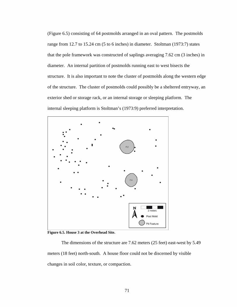
71
(Figure 6.5) consisting of 64 postmolds arranged in an oval pattern. The postmolds
range from 12.7 to 15.24 cm (5 to 6 inches) in diameter. Stoltman (1973:7) states
that the pole framework was constructed of saplings averaging 7.62 cm (3 inches) in
diameter. An internal partition of postmolds running east to west bisects the
structure. It is also important to note the cluster of postmolds along the western edge
of the structure. The cluster of postmolds could possibly be a sheltered entryway, an
exterior shed or storage rack, or an internal storage or sleeping platform. The
internal sleeping platform is Stoltman’s (1973:9) preferred interpretation.
Figure 6.5. House 3 at the Overhead Site.
The dimensions of the structure are 7.62 meters (25 feet) east-west by 5.49
meters (18 feet) north-south. A house floor could not be discerned by visible
changes in soil color, texture, or compaction.

72
Two features were found within the postmold pattern. Feature 2 was determined to
be a hearth. The hearth was circular and about 1 meter (3.5 feet) in diameter. The
feature profile was 20 cm (8 inches) deep and basin shaped. Seventy-one artifacts
were collected from Feature 2 including FCR, one stage II biface, two stage III
bifaces, one Madison Triangular point, one drill/perforator, one end scraper, five
modified flakes, two platform cores, 23 pieces of lithic debitage (16 tertiary flakes
and seven chunks/shatter), one abrader fragment, 34 shell tempered pottery sherds
(six rims/handles/decorated sherds and 28 undecorated sherds), unworked bone, and
unworked shell. An Oneota vessel from the hearth dates to the Brice Prairie phase
(A.D. 1300–1400).
Feature 4 was a storage pit. The feature was circular and about 1 meter (3.1
feet) in diameter. In profile the storage pit was 30 cm (1 foot) deep and basin
shaped. A wood charcoal sample (WIS-573) was submitted for radiocarbon dating
resulting in a corrected and calibrated date of A.D. 1405 – 1638 at 2-sigma (100
percent) (Boszhardt et al. 1995). An Oneota vessel found in this feature also dates to
the Brice Prairie phase (A.D. 1300–1400). Other artifacts collected from Feature 4
total 71 including one graver, one modified flake, 11 pieces of lithic debitage (seven
tertiary flakes and four chunks/shatter), one granite cobble, 56 shell tempered pottery
sherds (13 rims/handles/decorated pottery sherds and 43 undecorated pottery sherds),
and one bison scapula hoe.
47Lc41 – Krause Site
House 4 (Feature 423). House 4 (Figures 6.6 and 6.7) is an irregular oval,
semi-subterranean structure. The house is 9.5 meters long by 3 meters wide. No

73
internal features were defined in the field. A total of 5,660 artifacts were collected
from House 4. These artifacts include five stage I bifaces, six stage II bifaces, two
stage III bifaces, one wedge, one chopper, 10 Madison Triangular points, one Honey
Creek Corner-notched point, two knives, one drill/perforator, two miscellaneous
biface fragment tips, 13 end scrapers, eight modified flakes, one bipolar core, two
platform cores, 3,401 pieces of lithic debitage (19 primary flakes, 165 secondary
flakes, 2,561 tertiary flakes, 78 uncertain flakes, 578 chunks/shatter), two metates,
2,044 shell tempered pottery sherds (109 rim/handle/decorated pottery sherds and
1,935 undecorated pottery sherds), six grit tempered pottery sherds (one
rim/decorated pottery sherd and five undecorated pottery sherds), seven pieces of
daub, one piece of worked copper, three worked bone (two bison scapula hoes and
one deer jaw sickle), 88 bags of unworked bone, and 53 bags of unworked shell. All
ceramics from this house date to the Valley View phase, A.D. 1500–1625.
Figure 6.6. House 4 at the Krause Site.

74
Figure 6.7. Profile of House 4. 47Lc95 – Tremaine Site
The function of the Tremaine site longhouses are those of O’Gorman and
Hollinger (1991) and O’Gorman (1995), primarily from the latter reference. I am
providing their results, as the data for this site would be a thesis in and of itself. This
data is important to the overall picture of the analysis at hand, and I could not
exclude it from my analysis. My thoughts will be interjected about the Tremaine site
longhouses and how those compare and contrast to the longhouses at the Meier Farm
site.
At least seven postmold patterns were identified at Tremaine (O’Gorman
1995; O’Gorman and Hollinger 1991), and the seventh longhouse has been
interpreted as being two longhouses (Figure 6.8). All of the longhouses had long
parallel sides with rounded ends. The structures ranged in widths from 7 to 8.5
meters, and most exhibited rebuilding episodes and extensions of length, which
ranged anywhere from 35 to 50 meters. There was usually more than one end wall
due to extensions of the longhouse. An extension of the longhouse was a result of
longer occupations and/or an increase in the number of occupants.

75
Figure 6.8. Houses 5-11 at the Tremaine Site (adapted from O’Gorman 1995:57). Courtesy of the Wisconsin Historical Society and the Museum Archaeology Program.
Postmold diameters ranged from 16 to 18 cm and the walls were of single
post construction. Depths of postmolds ranged from 10 cm to over 40 cm below
ground surface (O’Gorman 1995:59). Various types of trees were used for the posts,
including spruce, larch, oak, and black ash. All of these trees were strong and
resistant to rotting (O’Gorman 1995:79). A center line of postmolds extended the
length of the longhouses. Entrances could not be identified in the postmold patterns.
Interior partitioning and benches were evident.

76
Numerous refuse/storage pits were found within and outside of the structures.
Hearths and/or smudge pits were identified. Burials were found in the structures and
numbered anywhere from one to 25 per structure, excluding House 11.
O’Gorman and Hollinger (1991) and O’Gorman (1995) found that the
primary function of the longhouses was domestic, although some ceremonial
activities also took place within the structures. Structural data were used to evaluate
the function of the longhouses. O’Gorman (1995:85) concluded that the longhouses
were for domestic purposes due to rebuilding and expansion episodes of the
postmold patterns and low density of graves.
House 5 (House 1 in O’Gorman 1995:61-64). House 5 is a longhouse. The
longhouse’s maximum dimensions are 47.4 meters long by 7.5 meters wide with a
maximum area of 355.5 meters2. There are 133 non-burial and four burial features
associated with this longhouse. House 5 dates to the Brice Prairie and Pammel
Creek phases and probably into the early Valley View phase based on radiocarbon
dates and ceramics (O’Gorman 1995:34-35).
House 6 (House 2 in O’Gorman 1995:64-69). House 6 is a longhouse, and
its maximum dimensions are 48.2 meters long by 7.6 meters wide with a maximum
area of 366.3 meters2. There are 42 non-burial and seven burial features associated
with this longhouse.
Remnants of a living floor were recorded in the northwest corner of House 6.
Numerous lithic tools, lithic debitage, and Oneota pottery sherds were recovered
from this occupational surface suggesting some manufacturing activities (O’Gorman
1995:67). The lithic tools included six scrapers, three points, and one graver.

77
Pecked/ground stone was also found on the remnant living floor and included one
metate, two hammerstones, and one abrader fragment. Based on radiocarbon dates
and ceramics, House 6’s primary date is the Pammel Creek phase with some Valley
View phase dates also present (O’Gorman 1995:35-38).
House 7 (House 3 in O’Gorman 1995:69-72). House 7 is a longhouse with
maximum dimensions of 40 meters long by 8.5 meters wide and a maximum area of
340 meters2. There are 57 non-burial and 19 burial features associated with this
longhouse. House 7 dates to the Pammel Creek phase based on radiocarbon dates
and ceramics (O’Gorman 1995:38).
House 8 (House 4 in O’Gorman 1995:64-69). The plan of House 8 is a
longhouse. The maximum dimensions are 26 meters long by 7 meters wide with a
maximum area of 182 meters2. There are 16 non-burial and one burial features
associated with this longhouse. Radiocarbon dates and ceramics date House 8 to the
transition between Brice Prairie phase and Pammel Creek phase, circa A.D. 1400
(O’Gorman 1995:38).
House 9 (House 5 in O’Gorman 1995:73-76). House 9 has a postmold
pattern in the shape of a longhouse. The maximum dimensions are 49.4 meters long
by 7.4 meters wide with a maximum area of 365.56 meters2. There are
approximately 80 non-burial and 16 confirmed burial features associated with this
longhouse. House 9 dates to the Pammel Creek phase based on radiocarbon dates
and ceramics (O’Gorman 1995:38-42).
House 10 (House 6 in O’Gorman 1995:76-78). House 10 is a longhouse in
plan view. The maximum dimensions are more than 25 meters long by 7.5 meters

78
wide with a maximum area of more than 187.5 meters2. There are 14 non-burial and
one burial features associated with this longhouse. Based on radiocarbon dates and
ceramics, House 10 dates to the Pammel Creek phase (O’Gorman 1995:42).
House 11 (House 7 in O’Gorman 1995:78-79). The postmold pattern of
House 11 is a longhouse, although the postmold pattern was not fully excavated.
House 11 could represent one large, heavily populated structure or more than one
structure (O’Gorman 1995:78). The maximum dimensions are 65 meters long by 8.5
meters wide with a maximum area of 552.5 meters2. There are numerous non-burial
features and 48 burial features associated with this longhouse. Radiocarbon dates
and ceramics date House 11 to the Pammel Creek and early Valley View phases
(O’Gorman 1995:42).
47Lc432 – Meier Farm Site
Three structures, one wigwam and two longhouses, were identified at the
Meier Farm site.
House 12 (Feature 220). Feature 220 (Figure 6.9) is a wigwam comprised of
40 postmolds in an oval pattern. The structure’s dimensions are 7.5 meters long by
5.5 meters wide. There are five features designated Features 220A-E within the
postmold walls. A total of 130 artifacts were found within the postmold pattern of
House 12: one stage II biface, one graver, one miscellaneous biface fragment tip,
three end scrapers, one uniface tool, one modified flake, 89 pieces of lithic debitage
(one primary flake, 17 secondary flakes, 68 tertiary flakes, three chunks/shatter), 31
shell tempered pottery pieces (four rim/handle/decorated pottery sherds and 27
undecorated pottery sherds), one bag of unworked bone, and one bag of unworked

79
shell. Based on lip decoration of the two diagnostic rims, House 12 dates to the
Pammel Creek phase, A.D. 1400–1500.
Figure 6.9. House 12 at the Meier Farm Site.
Feature 220A is an indeterminate pit. It is 158 cm by 152 cm with an oval
plan. The depth of the feature is 27 cmbss (cm below scraped surface). No cultural
materials were found.
Feature 220B is an indeterminate pit with a circular plan (50 cm by 43 cm).
It is a shallow basin in profile with a maximum depth of 14 cmbss. No artifacts were
recovered, but charcoal was scattered throughout.
Feature 220C is an indeterminate pit. The plan is circular (54 cm by 36 cm),
and the profile is a shallow basin (18 cmbss deep). Artifacts included FCR on the
surface of the feature.
Feature 220D is an indeterminate pit. The feature is 36 cm by 18 cm
(circular) and 23 cmbss deep (shallow basin). No cultural materials were found.

80
Feature 220E is an indeterminate pit with an oval plan view (59 cm by 63
cm). The feature is a shallow basin in profile with a depth of 20 cmbss. No cultural
materials were discovered.
Houses 13 and 14 (Feature 239). Feature 239 (Figure 6.10) contains two
longhouses, Houses 13 and 14, that overlap on the long axis. There were over 321
postmolds for the two longhouses. The easternmost longhouse has been designated
as House 13, while the westernmost longhouse is House 14. House 13 is 34 meters
long by 9 meters wide. House 14’s length is undeterminable due to a lack of
postmolds in the southeast end of the structure, but its width is 9 meters.
Figure 6.10. Houses 13 and 14 at the Meier Farm Site.

81
There are 20 internal features designated as Features 239A-S with Feature
239B being divided into two features, Feature 239B and Feature 239B1. Thirteen
features fall strictly within House 13, Features 239C, D, E, F, G, H, I, J, K, M, P, Q,
and R. Features 239F, 239G, and 239K have been eliminated as pit features. Two
features belong to House 14, Features 239N and O. After closer examination of
Feature 239O, it was removed from the study because it is a Woodland feature. Five
features overlap the two structures, Features 239A, B, B1, L, and S. Features 239L
and 239S have also been eliminated due to postmolds intruding into the features.
Ceramic rims were analyzed for phase designation. No rim sherds fell
strictly within House 13, but there were rim sherds excavated in the overlap area of
the longhouses, which date to the Pammel Creek phase (A.D. 1400–1500) and the
Valley View phase (A.D. 1500–1625). One rim sherd belonged to House 14 and that
dates to the Valley View phase (A.D. 1500–1625), although Pammel Creek phase
cannot be ruled out due to the overlapping of the two longhouses.
Feature 239C is an indeterminate pit. The plan is circular (72 cm by 64 cm),
and the profile is a shallow basin (15 cmbss). Only small flecks of charcoal were
discovered within the feature.
Feature 239D is a storage/refuse pit. The feature is ovoid (380 cm by 380
cm) with a maximum depth of 60 cmbss. Feature 239D is two conjoined features
(D1 and D2). A total of 12 artifacts were discovered in Feature 239D, prior to
learning that this was two features, including 11 pieces of lithic debitage (one
secondary flake and 10 tertiary flakes) and one undecorated shell tempered pottery
sherd. Feature 239D1 has a total of 84 artifacts including one Madison Triangular

82
point, one miscellaneous biface fragment tip, one scraper-other, 17 pieces of lithic
debitage (one primary flake, three secondary flakes, 13 tertiary flakes), 62 shell
tempered pottery (six rim/handle/decorated pottery sherds and 56 undecorated
pottery sherds), and two bags of unworked bone. Feature 239D2 has 179 artifacts
including two drills/perforators, one end scraper, one modified flake, one platform
core, 134 pieces of lithic debitage (three primary flakes, seven secondary flakes, 120
tertiary flakes, and four chunks/shatter), 30 shell tempered pottery (two
rim/handle/decorated pottery sherds and 28 undecorated pottery sherds), one
undecorated grit tempered pottery sherd, two bags of red ochre, five bags of
unworked bone, and two bags of unworked shell.
Feature 239E is an indeterminate pit. The feature dimensions are 55 cm by
55 cm (circular) with a depth of 20 cmbss (shallow basin). No cultural materials
were found.
Feature 239H is an indeterminate pit. This feature is irregular in shape (61
cm by 32 cm). The feature is a shallow basin (10 cmbss). One bag of unworked
bone was collected from this feature.
Feature 239I is a storage/refuse pit. The plan is oval (115 cm by 95 cm) with
a depth of 41 cmbss. Twelve artifacts were found in this feature including one
Madison Triangular point, four pieces of lithic debitage (one primary flake, one
secondary flake, one tertiary flake, one chunk/shatter), and seven undecorated shell
tempered pottery sherds.
Feature 239J is a storage/refuse pit. The feature plan is amorphous with
dimensions of 80 cm by 100 cm. The profile is that of a basin (30 cmbss deep). This

83
feature was very rich in artifacts, totaling 562. The artifacts include one stage I
biface, four stage II bifaces, two Madison Triangular points, one wedge, five end
scrapers, one uniface tool-other, five modified flakes, two platform cores, 380 pieces
of lithic debitage (three primary flakes, 36 secondary flakes, 331 tertiary flakes, and
10 chunks/shatter), two hammerstones, one mano, 146 shell tempered pottery (16
rim/handle/decorated pottery sherds and 130 undecorated pottery sherds), six bags of
unworked bone, and six bags of unworked shell.
Feature 239M is a storage/refuse pit. This feature is also amorphous in plan
(145 cm by 100 cm). The depth is 40 cmbss. A total of 52 artifacts was found
including six pieces of lithic debitage (five tertiary flakes and one chunk/shatter), 39
shell tempered pottery (one rim/handle/decorated pottery sherd and 38 undecorated
pottery sherds), two bags of red ochre, four bags of unworked bone, and one bag of
unworked shell.
Feature 239P is an indeterminate pit. The dimensions are 55 cm by 32 cm
(amorphous) with a depth of 15cmbss. This feature was originally thought to be a
postmold; however, while skimming the surface, the feature faded out. Feature 239P
was therefore not formally excavated. One tertiary flake was unearthed.
Feature 239Q is a midden with a depth of 7 cmbss. A total of 25 artifacts
was excavated including one Madison Triangular point, 19 pieces of lithic debitage
(two primary flakes, two secondary flakes, and 15 tertiary flakes), four undecorated
shell tempered pottery sherds, and one bag of unworked shell.
Feature 239R is an indeterminate pit. The feature dimensions are 80 cm by
75 cm (circular) with a depth of 10 cmbss (basin). The artifact count is 31 including

84
one modified flake, 18 pieces of lithic debitage (three secondary flakes and 15
tertiary flakes), and 12 undecorated shell tempered pottery sherds.
One feature belongs to House 14. Feature 239N is an indeterminate pit with
an amorphous plan (42 cm by 30 cm). The basin is 30 cmbss deep. A total of 25
artifacts were recovered including one knife, and 24 shell tempered pottery (three
rim/handle/decorated pottery sherds and 21 undecorated pottery sherds).
Two features were excavated in the longhouse overlap area, Feature 239A
and Feature 239B. Feature 239A is a storage/refuse pit. This feature is circular in
plan (90 cm by 88 cm), and 80 cmbss deep (basin-shaped). Two hundred seventy-
six artifacts were recovered including one stage I biface, one stage II biface, one
Madison Triangular point, three modified flakes, 44 pieces of lithic debitage (five
secondary flakes, 36 tertiary flakes, and three chunks/shatter), 204 shell tempered
pottery (25 rim/handle/decorated pottery sherds and 179 undecorated pottery sherds),
one bag of red ochre, one worked bone (bison scapula hoe), 13 bags of unworked
bone, and seven bags of unworked shell.
Feature 239B is two small circular features. The dimensions of the feature
are 155 cm by 200 cm, and 75 cmbss deep (irregular basin). Artifacts for Feature
239B total 136 and include one end scraper, one modified flake, nine pieces of lithic
debitage (one secondary flake, seven tertiary flakes, and one chunk/shatter), 123
shell tempered pottery (35 rim/handle/decorated pottery sherds and 88 undecorated
pottery sherds), and two bags of unworked bone. Feature 239B1 had one tertiary
flake unearthed from it.

85
Summary
This chapter focused on the formal properties of architecture, the presence or
absence and type of internal feature, and the artifact assemblages of each structure,
three of the four types of data used to answer my question pertaining to the function
of Oneota architecture. Based on the ethnographic record, two types of function
were identified, domestic and ceremonial. Details were provided about the formal
properties of architecture including size and form, the presence or absence and type
of internal features, and the artifact assemblages of each structure. To date, 14
Oneota buildings have been excavated in the La Crosse locality, including two
wigwams, three semi-subterranean structures, and nine longhouses. All but two of
the buildings, House 1 at the Midway Village Complex site and House 4 at the
Krause site, have internal features. Artifact assemblages were available for all of the
structures to use in determining building function.

86
CHAPTER 7: LA CROSSE LOCALITY ONEOTA ARCHITECTURE FUNCTION
A variety in Oneota architecture has been observed in the La Crosse locality.
Three different types of architecture have been identified: wigwam, longhouse, and
semi-subterranean. The Oneota structures were analyzed to determine their function,
domestic or ceremonial. I believe that function is the reason for the variation in
Oneota architecture. Several lines of evidence were used to determine the function
of each structure. The supporting evidence is the ethnographic record, the formal
properties of architecture including size and form, the presence or absence and type
of internal features, and the artifact assemblages.
The ethnographic record provided a guide for variation in types of structures
used by historic Native Americans. This record allowed me to see what was being
built by tribes in the Northeast/Great Lakes area and apply that knowledge to the
archaeological data in the La Crosse study area. The types of structures in the
ethnographic record, their construction methods, and the internal layout of the
structures were evaluated in relation to the use or function of each ancient building.
Three structures were identified in the ethnographic record as domestic:
wigwam, summer house, and longhouse. Structures of the ceremonial type include
longhouse, sweat lodge, ceremonial lodge, council lodge, medicine lodge, and
menstrual hut. The longhouse falls within both categories of function. A ceremonial
lodge, council lodge, medicine lodge, and to some extent summer house can look
like longhouses because they are all elongated. A summer house could be similar to
a smaller longhouse when an arbor is attached to the square or rectangular habitation

87
part of the structure resulting in an elongated look. A similar problem arises with the
circular structures, i.e., the wigwam, the menstrual hut, and the sweat lodge, but the
wigwam is larger in size than the menstrual hut or sweat lodge. Once shape of the
floor plan is determined, one must examine the internal layout of the structure, the
presence or absence and types of internal features, and the artifact assemblages to
differentiate between domestic or ceremonial structures.
A domestic structure differs from a ceremonial structure in the types of
activities performed in each building. Domestic activities include food preparation
and processing, cooking, butchering, hide working, wood working, bone/antler
working, and lithic tool manufacturing. The expected archaeological evidence of a
domestic structure includes sleeping benches, hearths, trash/storage pits, floral/faunal
food materials, and evidence of maintenance and/or expansion of the structure. An
abundant amount of utilitarian objects (cooking vessels, clay spoons, unnotched
triangular points, end scrapers, awls, drills/perforators, gravers, knives, manos and
metates) will be present.
Ceremonial structures will have a sparse and unique artifact assemblage. A
lack of artifacts suggests that it was not a location for domestic activities, but as a
place for special occasions. The expected archaeological evidence includes
ceremonial objects (exotic trade items, ritual paraphernalia, catlinite pipes, copper
ornaments), ritual animal remains (wolf skulls, bear skulls), special or rare foods in
large quantities (feasting), intentional destruction of the structure, hearths, a
gathering space, roasting pits, a lack of sleeping benches, and gender specific

88
artifacts. Ceremonial structures may also have evidence of human remains and/or
burials within the walls of the architecture.
As part of the artifact assemblage analysis, I also examined the ceramic
assemblages of each structure to determine within which of the three La Crosse
locality phases the structures dated (Table 7.1). The analysis involved examining
each rim sherd excavated from a structure to assign a phase designation. I did this to
determine whether or not structure variation might correlate with a La Crosse
locality Oneota phase. For example, there are three La Crosse locality Oneota
phases; does the wigwam belong to one phase, the longhouse to another, and the
semi-subterranean to the other? If the variation is due to Oneota phase then it would
not be due to function. Due to the sites being heavily occupied and multicomponent,
this form of analysis was not useful. Few of the houses can confidently be assigned
to only one phase.
Table 7.1. House Phase Designation Based on Ceramics. Brice Prairie Phase Pammel Creek Phase Valley View Phase
House 1 X X X House 2 X X House 3 X House 4 X House 5 X X X House 6 X X House 7 X House 8 X X House 9 X House 10 X House 11 X X House 12 X House 13* X X House 14* X X
*Phase designation for house overlap and general surface are included.

89
Table 7.2 provides the functional classification of each house in this thesis.
The table includes the house number, structure type, number of internal features,
type of internal features, and house function. Following Table 7.2 is a detailed
discussion of each building and how it fits my expectations of each function,
domestic or ceremonial.
Table 7.2. Functional Classification of Houses. House
Number Structure Type Number of
Internal Features
Type of Feature House Function*
House 1 Semi-subterranean 0 - Domestic House 2 Semi-subterranean 1 F.242 - Hearth Domestic House 3 Wigwam
2 F.2 - Hearth F.4 – Storage/refuse pit
Domestic
House 4 Semi-subterranean 0 - Domestic House 5 Longhouse
- - Domestic with some ceremonial activities
House 6 Longhouse - -
Domestic with some ceremonial activities
House 7 Longhouse - -
Domestic with some ceremonial activities
House 8 Longhouse - -
Domestic with some ceremonial activities
House 9 Longhouse - -
Domestic with some ceremonial activities
House 10 Longhouse - -
Domestic with some ceremonial activities
House 11 Longhouse - -
Domestic with some ceremonial activities
House 12 Wigwam
5
F.220A - Indeterminate pit F.220B - Indeterminate pit F.220C - Indeterminate pit F.220D - Indeterminate pit F.220E - Indeterminate pit
Domestic
House 13 Longhouse
10
F.239C - Indeterminate pit F.239D - Storage/refuse pit F.239E - Indeterminate pit F.239H - Indeterminate pit F.239I - Storage/refuse pit F.239J – Storage/refuse pit F.239M - Storage/refuse pit F.239P - Indeterminate pit F.239Q - Midden F.239R - Indeterminate pit
Domestic
House 14 Longhouse 1 F.239N – Indeterminate pit Domestic *The functions of Houses 5-11 were determined by O’Gorman and Hollinger (1991) and O’Gorman (1995).

90
House 1 is an irregular, semi-subterranean structure based on the field
assessment. Semi-subterranean structures were not built by Native Americans in the
Northeast/Great Lakes culture area, and so data were not obtained for this structure
type ethnographically. The structure is 8.75 meters long by 5 meters wide. There
are no internal features. There are 7,420 artifacts associated with this feature.
Artifact types include bifaces, Madison Triangular points, a drill/perforator, a graver,
end scrapers, a side scraper, modified flakes, bipolar and platform cores, lithic
debitage, sandstone abraders, hammerstones, a metate, pottery, pieces of daub, an
unworked piece of copper, a worked bone (antler tip), and faunal and floral
materials. The artifact assemblage is that which is commonly found in an Oneota
village. The artifacts are those that would be used in day-to-day activities (Table
6.1), such as food preparation and processing (metates), cooking (pottery), hide
working (scrapers), hunting and/or warfare (points), wood and bone/antler working
(scrapers, gravers, abraders), and lithic tool manufacturing (hammerstones and lithic
debitage). The tools were not unique or ceremonial in nature. Based on the artifact
assemblage, the primary function of House 1 is domestic (Table 7.2).
House 2 is an oval, semi-subterranean (determined by principal investigator)
structure with one internal feature (Feature 242) present. As with the other semi-
subterranean structure, the ethnographic record does not apply to this building. The
length of House 2 is 9 meters, and the width is not known. Feature 242 is a charcoal
lens, which suggests a hearth was present. Feature 242 had 69 artifacts including a
modified flake, a platform core, lithic debitage, pottery, and faunal remains.
Artifacts found while excavating House 2 (non-feature area) total 1,921. Artifact

91
categories include bifaces, Madison Triangular points, a drill/perforator, a graver,
end scrapers, modified flakes, bipolar cores, lithic debitage, a metate, pottery, pieces
of daub, a piece of unworked copper, a piece of catlinite, and faunal and shell
remains. House 2 artifact assemblage does not contain any unique artifacts. In fact,
the artifacts suggest activities of food preparation and processing, cooking, hide
working, hunting and/or warfare, and wood and bone/antler working (Table 6.1).
The primary function of House 2 is domestic (Table 7.2), based on the artifact
assemblage.
House 3 is a wigwam based on the ethnographic record and its size (7.62
meters east-west by 5.49 meters north-south) and form (oval postmold pattern). Two
internal features, a hearth and a storage/refuse pit, are within the postmold pattern of
this structure. A possible sleeping platform is also present based on a cluster of
postmolds (Figure 6.5). One hundred and forty-two artifacts were unearthed from
the two features including FCR, bifaces, a Madison Triangular point, a
drill/perforator, an end scraper, a graver, modified flakes, platform cores, lithic
debitage, pottery, a bison scapula hoe, and faunal and shell materials. The artifact
assemblage suggests day-to-day activities, such as cooking, hide working,
agricultural activities, hunting and/or warfare, wood working, and bone/antler
working (Table 6.1). The ethnographic record, formal properties of architecture,
presence and types of internal features, and artifact assemblage suggest that the
primary function of House 3 is domestic (Table 7.2).
House 4 is an irregular, semi-subterranean structure (field assessment). The
house dimensions are 9.5 meters long by 3 meters wide. No internal features were

92
identified. A total of 5,660 artifacts were collected from House 4 including bifaces,
a wedge, a chopper, Madison Triangular points, a Honey Creek Corner-notched
point, knives, a drill/perforator, end scrapers, modified flakes, a bipolar core,
platform cores, lithic debitage, metates, pottery, pieces of daub, a piece of worked
copper, worked bone (bison scapula hoes and a deer jaw sickle), faunal remains, and
shell. The activities present based on artifacts are food preparation and processing,
cooking, hide working, agricultural activities, butchering, hunting and/or warfare,
wood working, and bone/antler working. House 4 has more agricultural tools (bison
scapula hoes and a deer jaw sickle) than any other house. The primary function of
House 4 is domestic (Table 7.2), based on the artifact assemblage.
Houses 5-11 are longhouses, which ethnographically can be domestic or
ceremonial structures. Numerous storage/refuse pits were found within and outside
of the structures. Hearths and/or smudge pits were identified also. Houses 5-11
differ from Houses 13 and 14, which are also longhouses, in that they have burials.
In fact, Houses 5-11 are the only excavated structures in the La Crosse locality with
burials. O’Gorman and Hollinger (1991) and O’Gorman (1995) found the primary
function of the longhouses to be domestic, but they also state that some ceremonial
activities were taking place due to the burials. O’Gorman (1995:85) based her
conclusion that the longhouses were for domestic use rather than ceremonial due to
rebuilding and expansion episodes of the postmold patterns and low density of
graves.
House 12 is a wigwam based on the ethnographic record and its size (7.5
meters long by 5.5 meters wide) and form (oval postmold pattern). There are

93
internal postmolds which may suggest a sleeping platform. Five internal features, all
in the indeterminate pit category, were identified. One feature, Feature 220B, has
charcoal and another feature, Feature 220C, has FCR. Other than those cultural
materials, the features have no artifacts. A total of 130 artifacts were found within
the postmold pattern of House 12 including a biface, a graver, end scrapers, a uniface
tool, a modified flake, lithic debitage, pottery, and faunal and shell remains. House
12 is different than the other structures because it has very few artifacts. The lack of
artifacts could be a result of the building being thoroughly cleaned out when it was
abandoned. The few artifacts that are present suggest the following activities:
cooking (pottery), hide working (scrapers), wood and bone/antler working (scrapers
and gravers). The artifact assemblage does not seem to be unique and is similar to
the other structures. Based on the ethnographic record, the formal properties of
architecture, and the artifact assemblage, I feel that the primary function of House 12
is domestic (Table 7.2).
Houses 13 and 14 are longhouses that overlap on their long axis. House 13 is
34 meters long by 9 meters wide. House 14 has an undeterminable length due to a
lack of postmolds in the southeast end of the structure and a width of 9 meters. A
total of 10 internal features were located within the boundaries of House 13. Five of
the features were of indeterminate pit function, four were storage/refuse pits, and one
was a midden. Artifacts found within House 13 features include bifaces, Madison
Triangular points, drills/perforators, scrapers, a wedge, a uniface tool, modified
flakes, platform cores, hammerstones, a mano, lithic debitage, pottery, shell, and
faunal materials. House 13 also has evidence of partitioning based on the postmold

94
pattern, which suggests family units or apartments, rather than an open space. The
postmold pattern also suggests sleeping benches in House 13. House 14 has one
internal feature within in its postmold pattern. The feature function is in the
indeterminate pit classification. Twenty-five artifacts were excavated from the
feature including a knife and pottery. Two additional features, Features 239A and
239B, are present within the house overlap of Houses 13 and 14, but it is difficult to
discern whether or not they belong to House 13 or House 14. Both features are
categorized as storage/refuse pits. Artifacts found in the overlap features include
bifaces, a Madison Triangular point, modified flakes, a scraper, lithic debitage,
pottery, a bison scapula hoe, shell, and faunal remains. No unique artifact
assemblages were present in Houses 13 and 14. The artifact assemblage of House 13
is indicative of the following activities: food preparation and processing, cooking,
hide working, agricultural activities, hunting and/or warfare, wood working,
bone/antler working, and lithic tool manufacturing. The following activities were
present in House 14, cooking, hide working, agricultural activities, butchering,
hunting and/or warfare, wood working, bone/antler working, and lithic tool
manufacturing. The house overlap artifacts were factored into the types of activities
present in Houses 13 and 14. The primary function of Houses 13 and 14 is domestic
(Table 7.2) based on the ethnographic record, the formal properties of architecture,
the presence and types of internal features, and the artifact assemblages.
Summary
The following lines of evidence were used to address my research question
about La Crosse locality Oneota architecture: the ethnographic record, the formal

95
properties of architecture, the presence or absence and types of internal features, and
the artifact assemblages of each structure. Based on the lines of evidence, all of the
structures in the study area were used for domestic purposes. The structures
contained artifacts that were used in day-to-day activities, such as food preparation
and processing, cooking, butchering, hide working, wood working, bone/antler
working, lithic tool manufacturing, hunting, and agricultural activities. None of the
houses, except for the Tremaine site longhouses, had evidence of ceremonial use.
The Tremaine site longhouses are considered to be primarily domestic with some
ceremonial use, i.e., human burials.

96
CHAPTER 8: CONCLUSIONS
The La Crosse locality is an ideal area to study the Oneota due to the
variation in architecture, and it is the most well dated Oneota locality. I argued that
the variation in La Crosse locality Oneota architecture was due to function, i.e.,
domestic or ceremonial. Based on the results of all of the structures being used for
domestic purposes, another argument needs to be postulated to explain the variation
in La Crosse locality Oneota architecture.
The La Crosse locality Oneota sites fall within the Classic horizon and can be
divided into finer phase divisions; Brice Prairie (A.D. 1300–1400), Pammel Creek
(A.D. 1400–1500), and Valley View (A.D. 1500–1625). I conducted a locality level
study rather than a regional level study in hopes that the scale would be small enough
to determine the function of the structures. Although this study was at the locality
level, it was difficult to pinpoint the structures to just one phase. This difficulty is
due to Oneota sites being heavily occupied, and most of the sites are
multicomponent. Therefore, I could not detect whether there was a correlation
between phase and structure type.
Fourteen Oneota structures (two wigwams, three semi-subterranean
structures, and nine longhouses) were examined to determine their functional use.
The following lines of evidence were used in my research: the ethnographic record,
the formal properties of architecture, the presence or absence and function of internal
features, and the artifact assemblages of each structure.

97
Based on the artifact assemblages, I have concluded that all of the structures
were used for domestic purposes. O’Gorman and Hollinger (1991) and O’Gorman
(1995) also concluded that the Tremaine site longhouses, Houses 5-11 in this thesis,
were used for domestic reasons, but that those longhouses also showed some
evidence of limited ceremonial uses, i.e., human burials. The artifact assemblages of
the buildings, other than the Tremaine site longhouses, compare favorably with those
typical of a structure used for domestic purposes, suggesting domestic activities such
as food processing, cooking, ceramic and lithic manufacturing or maintenance, and
production of other tools and utilitarian objects.
Based on the ethnographic record, the structures compare favorably to those
used for domestic purposes. I identified three structures in the ethnographic record
with a domestic function (wigwams, summer houses, and longhouses). Structures of
the ceremonial type include longhouses, sweat lodges, ceremonial lodges, council
lodges, medicine lodges, and menstrual huts. The longhouse falls within both
categories of function. To differentiate a domestic longhouse from a ceremonial
longhouse, one must examine the artifact assemblage, the internal layout of the
longhouse, and the presence or absence of burials. The archaeological data for my
thesis included semi-subterranean structures, which were not present in the
ethnographic record of the Northeast/Great Lakes culture area.
The formal properties of architecture including size, form, and internal layout
were useful in classifying the wigwams and longhouses as domestic rather than
ceremonial. Some of the structures, Houses 3, 12, and 13, have evidence of sleeping
benches which are indicative of a domestic structure. The internal postmolds of

98
House 13 not only suggest sleeping benches, but also imply partitioning of the
longhouse into apartments or family units. All of the structures, except for the semi-
subterranean structures, exhibit maintenance and/or expansion of the building,
another indicator of a domestic use.
One caveat of this research is based on the assumption that the internal
features belonged to that structure. I was able to differentiate some features as not
belonging to a certain structure because the features had postmolds intruding on
them, and therefore I removed those features from the data set. Another feature was
eliminated from House 14 because it belonged to the earlier Woodland time period.
As for the rest of the features, I cannot say with complete certainty that they belong
to that structure, but I must approach the study as if they do. In general, Oneota sites
are very complex based on their extensive occupation of sites over a 300 year period.
Other than Houses 5–11, none of the structures in this thesis exhibit evidence
of use for ceremonial purposes. The only reason Houses 5–11 are an exception is
that they contain burials. The burials located within the structures do not make a
strong case that the longhouses were for primarily ceremonial purposes.
Hollinger (1993, 1995) has presented one opposing theory to the variation in
Oneota structures. He conducted a study of 95 Oneota structures throughout the
geographical area inhabited by the Oneota and found that the variation in structure
form is due to shifts in residence, i.e., patrilocal to matrilocal and then back to
patrilocal. Hollinger (1993, 1995) examined the floor area of each house to test his
expectation that there would be a shift from small floor areas (patrilocal) to large
floor areas (matrilocal) and back to small floor areas (patrilocal) throughout time.

99
He concluded that the variation in structure form was a result of the Oneota
practicing shifts in rules of residence, i.e., patrilocal during the Emergent and
Developmental horizons (small floor areas) to matrilocal during the Classic horizon
(large floor areas) and then back to patrilocal during the Historic horizon (small floor
areas).
There is no evidence for shifts in house forms within the Classic horizon in
the La Crosse area that would support Hollinger, but I did not have the fine temporal
control necessary to compare structures from different phases. The La Crosse
locality has multiple forms of structures including wigwams, longhouses, and semi-
subterranean houses during the Classic horizon of the Oneota time period. This
contrasts Hollinger’s findings that the Oneota should have been building structures
with large floor areas during the Classic horizon. Although there are a higher
number of longhouses compared to wigwams and semi-subterranean structures in the
La Crosse locality, they were all used for domestic purposes.
While viewing the ethnographic record, I came across a common practice of
Native Americans in the Great Lakes area practicing a semiannual shift in residency
or dual structure pattern. As stated before, a dual structure pattern is where two
different types of structures are used depending on the season, i.e., a wigwam for the
winter and a square/rectangular house or longhouse for the summer. Larger
structures are generally associated with summer occupation when extended families
lived together or for ceremonial purposes. Another argument that the larger
structures were used for summer occupation is that the Oneota agglomerated in the
summer for agricultural purposes which involved tending of the ridged field systems

100
(Boszhardt 2009). Smaller structures are likely for the winter because they are easier
to heat (Nabokov and Easton 1989) and can house nuclear families (Wedel 1986).
Breaking into smaller groups in the winter also made it easier to forage (McKusick
1974).
Although the evidence of a dual structure pattern is not strong, solely based
on the ethnographic record, I find it still to be plausible. Further research would
need to be conducted to address the seasonality of the domestic architecture. I bring
this up as an option for explaining the variation in the buildings simply because all of
the structure types in my study were determined to be used for domestic purposes.
Historic Native Americans were known to practice a semiannual shift in residency
by building different structure types, and so why would that not be the case for
prehistoric Native Americans?
Future work in the La Crosse locality needs to be done to gain more
information about Oneota architecture. Currently, our field methods may be hurting
us more than helping us. Most sites are stripped using heavy machinery. This is the
most expedient way to remove the plow zone, but it also removes more of the feature
than necessary and smears the sand, and so not all of the features at a site are
detected. Since I do not foresee a decrease in the use of heavy machinery, I suggest
that skim shoveling occur to uncover most if not all of the features after the heavy
machinery has been through.
I suggest that when a structure is discovered it would be beneficial to piece
plot the artifacts. This will help in determining activity areas. Although most
projects are under time constraints, which limits the amount of time that can be spent

101
on excavations, resulting in a loss of archaeological knowledge. The time constraint
also limits the type of excavation conducted at a site, i.e., use of remote sensing or
piece plotting.
Another item that hurts Oneota archaeology is modern farming, which causes
a plow zone of 30 cm in depth that may distort or destroy any evidence of postmolds
and house floors. Most features and postmolds are truncated by the plow zone,
which results in an incorrect depth of the feature or postmold. We as archaeologists
cannot control the damage that has already been done by modern farming, but we
could use remote sensing prior to excavations to locate features and postmolds.
Remote sensing techniques that would be beneficial are ground penetrating radar,
magnetometry, resistivity, and conductivity.
Hopefully, as excavations continue in the La Crosse locality, we will be able
to discover more structures. With the excavation of new structures, it would be
beneficial to set up a plan of action to obtain as much information as possible, i.e.,
piece plotting the artifacts; collecting GIS data of the structure location, postmolds,
and non-structure features at a site; faunal/floral data; and formal properties of
architecture including size, form, and construction materials. “The dilemma of
determining function is as old as archaeology itself and remains as problematic today
as ever. As difficult as it may be to ascertain, however, there is some consensus that
we must at least try to make such interpretations” (Knight 2002:27).

102
REFERENCES
Allison, Penelope M. 1999 Introduction. In The Archaeology of Household Activities, edited by Penelope
M. Allison, pp. 1-18. Routledge, New York. Arzigian, Constance M., Robert F. Boszhardt, Holly P. Halverson, and James L. Theler 1994 The Gundersen Site: An Oneota Village and Cemetery in La Crosse,
Wisconsin. Journal of the Iowa Archeological Society 41:3-75. Arzigian, Constance M., Robert F. Boszhardt, James L. Theler, Roland L. Rodell, and Michael J. Scott 1989 Human Adaptation in the Upper Mississippi Valley: A Study of the Pammel
Creek Oneota Site (47Lc61) La Crosse, Wisconsin. The Wisconsin Archeologist 70.
Benchley, Elizabeth D., Blane Nansel, Clark A. Dobbs, Susan M. Thurston Myster, and Barbara H. O’Connell 1997 Archaeology and Bioarchaeology of the Northern Woodlands. Arkansas
Archaeological Survey Research Series No. 52. Arkansas Archaeological Survey, Fayetteville.
Benn, D. W. 1984 Excavations at the Christenson Oneota Site (13Pk407), Central Des Moines
River Valley, Iowa. Center for Archaeological Research No. 592. Springfield. Binford, Lewis R. 1967 Smudge Pits and Hide Smoking: The Use of Analogy in Archaeological
Reasoning. American Antiquity 32:1-12. 1983 In Pursuit of the Past: Decoding the Archaeological Record. Thames and
Hudson, London. Bluhm, Elaine A., and Gloria J. Fenner 1961 The Oak Forest Site. Chicago Area Archaeology. Illinois Archaeological
Survey Bulletin 3:139-161. Bluhm, Elaine A., and Allen Liss 1961 The Anker Site. Chicago Area Archaeology. Illinois Archaeological Survey
Bulletin 3:89-137.

103
Boszhardt, Robert F. 1994a Oneota Group Continuity at La Crosse: The Brice Prairie, Pammel Creek,
and Valley View Phases. The Wisconsin Archeologist 75:173-236. 1994b Oneota Archaeology at La Crosse, Wisconsin: Introduction. The Wisconsin
Archeologist 75:165-172. 1998 Oneota Horizons: A La Crosse Perspective. The Wisconsin Archeologist
79:196-226. 2003 A Projectile Point Guide for the Upper Mississippi River Valley. University
of Iowa Press, Iowa City. 2004 Blind Dates and Blind Faith: The Timeless Story of the “Emergent” Oneota
McKern Phase. The Wisconsin Archeologist 85:3-30. 2009 Archaeological Data Recovery at the Meier Farm Development within the
Sand Lake Archaeological District, La Crosse County, Wisconsin. Reports of Investigations No. 576. Mississippi Valley Archaeology Center, University of Wisconsin-La Crosse.
Boszhardt, Robert F., Thomas W. Bailey, and James P. Gallagher 1985 Oneota Ridged Fields at the Sand Lake Site (47Lc44), La Crosse County,
Wisconsin. The Wisconsin Archeologist 66:47-67. Boszhardt, Robert F, Wendy Holtz, and Jeremy Nienow 1995 A Compilation of Oneota Radiocarbon Dates as of 1995. In Oneota
Archaeology: Past, Present, and Future, edited by William Green, pp. 203-227. Report 20. Office of the State Archaeologist, University of Iowa, Iowa City.
Bray, Robert T. 1991 The Utz Site: An Oneota Village in Central Missouri. The Missouri
Archaeologist 52:1-146. Brown, James A. 1961 The Zimmerman Site, a Report on Excavations at the Grand Village of the
Kaskaskia, LaSalle County, Illinois. Reports of Investigations 9. Illinois State Museum, Springfield.
Brown, Margaret K. 1975 The Zimmerman Site: Further Excavations at the Grand Village of the
Kaskaskia. Reports of Investigations 32. Illinois State Museum, Springfield.

104
Bushnell, David I., Jr. 1922 Villages of the Algonquian, Siouan, and Caddoan Tribes West of the
Mississippi. Bureau of American Ethnology Bulletin 77. Smithsonian Institution, Washington, D. C.
Cameron, Catherine M. 1991 Structure Abandonment in Villages. Archaeological Method and Theory
3:155-194. 1999 Room Size, Organization of Construction, and Archaeological Interpretation
in the Puebloan Southwest. Journal of Anthropological Archaeology 18:201-239.
Cawley, Edward T. 1973 Final Report, Environmental Impact Assessment Study, Pool 10 of the
Northern Section of the Upper Mississippi River. North Star Research Institute, Minneapolis.
Chapman, Carl H. 1959 The Little Osage and Missouri Indian Village Sites: Ca. 1727-1777 A.D. The
Missouri Archaeologist 21:1-69. 1985 Introduction. In Osage and Missouri Indian Life Cultural Change: 1675-
1825, pp.1-15. Final Performance Report on National Endowment for the Humanities Research Grant RS-20296.
Chapman, Carl H., and R. P. Wiegers 1985 Archaeological Investigations on Historic Missouri, Little Osage and Big
Osage Village Sites. In Osage and Missouri Indian Life Cultural Change: 1675-1825, pp.273-379. Final Performance Report on National Endowment for the Humanities Research Grant RS-20296.
Charlton, Thomas H. 1981 Archaeology, Ethnohistory, and Ethnology: Interpretive Interfaces. In
Advances in Archaeological Method and Theoy, Vol. 4, edited by Michael B. Schiffer, pp. 129-176. Academic Press, San Diego.
Clark, Tiffany C. 1998 Assessing Room Function Using Unmodified Faunal Bone: A Case Study
from East-Central Arizona. Kiva 64:27-51. Conrad, L. A., and D. Esarey 1985 The Bold Counselor Phase: The Oneota Occupation of the Central Illinois
River Valley. Manuscript on file at Dickson Mounds Museum and Western Illinois University.

105
Curtis, John T. 1971 The Vegetation of Wisconsin: An Ordination of Plant Communities.
University of Wisconsin Press, Madison. Diehl, Michael W. 1998 The Interpretation of Archaeological Floor Assemblages: A Case Study from
the American Southwest. American Antiquity 63:617-634. Dobbs, Clark A. 1984 Excavations at the Bryan Site: 1983-1984. The Minnesota Archaeologist
43:49-58. Dolan, Shannon, and Steven R. Kuehn 2006 An Oneota Longhouse Structure from East-Central Wisconsin. Paper
presented at the Midwest Archaeological Conference, Urbana. Driver, Harold E., and William C. Massey 1957 Comparative Studies of North American Indians. Transactions of the
American Philosophical Society 47:16-456. Faulkner, Charles H. 1972 The Late Prehistoric Occupation of Northwestern Indiana: A Study of the
Upper Mississippi Culture of the Kankakee Valley. Prehistoric Research Series 5, No. 1. Indiana Historical Society, Indianapolis.
1977 The Winter House: An Early Southeast Tradition. Midcontinental Journal of
Archaeology 2:141-159. Finley, Robert W. 1976a Geography of Wisconsin. The University of Wisconsin Press, Madison. 1976b Original Vegetation Cover of Wisconsin. University of Wisconsin Extension,
Madison. Flannery, Kent V. 1976 Research Strategy and Formative Mesoamerica. In The Early Mesoamerican
Village, edited by Kent V. Flannery, pp. 1-11. Academic Press, New York. Flannery, Kent V., and Marcus C. Winter 1976 Analyzing Household Activities. In The Early Mesoamerican Village, edited
by Kent V. Flannery, pp. 34-45. Academic Press, New York. Fugle, Eugene 1954 A Fox Village Site. Journal of the Iowa Archaeological Society 4:4-15.

106
Gallagher, James P., and Constance M. Arzigian 1994 A New Perspective on Late Prehistoric Agricultural Intensification in the
Upper Mississippi River Valley. In Agricultural Origins and Development in the Midcontinent, edited by William Green, pp. 171-188. Report No. 19. Office of the State Archaeologist. University of Iowa, Iowa City.
Gallagher, James P., Robert F. Boszhardt, Robert F. Sasso, and Katherine Stevenson 1985 Oneota Ridged Field Agriculture in Southwestern Wisconsin. American
Antiquity 50:605-612. Gallagher, James P., and Robert F. Sasso 1987 Investigations into Oneota Ridged Field Agriculture on the Northern Margin
of the Prairie Peninsula. Plains Anthropologist 32:141-151. Gibbon, Guy E. 1969 The Walker-Hooper and Bornick Sites: Two Grand River Phase Oneota Sites
in Central Wisconsin. Unpublished Ph.D. dissertation, Department of Anthropology, University of Wisconsin-Madison.
1970 The Midway Village Site: An Orr Phase Oneota Site in the Upper Mississippi
River Valley. The Wisconsin Archeologist 51:79-162. 1972a Cultural Dynamics and the Development of the Oneota Life-way in
Wisconsin. American Antiquity 37:166-185. 1972b The Walker-Hooper Site: A Grand River Phase Oneota Site in Green Lake
County. The Wisconsin Archeologist 53:149-290. 1979 The Mississippian Occupation of the Red Wing Area. Minnesota Prehistoric
Archaeology Series No. 13. Minnesota Historical Society, St. Paul. 1982 Oneota Origins Revisited. In Oneota Studies, edited by Guy E. Gibbon, pp.
85-90. Publications in Anthropology No. 1. University of Minnesota, Minneapolis.
Gibbon, Guy E., and Clark A. Dobbs 1991 The Mississippian Presence in the Red Wing Area, Minnesota. In New
Perspectives on Cahokia: Views from the Periphery, edited by James B. Stoltman, pp. 281-306. Monographs in World Archaeology No. 2. Prehistory Press, Madison, Wisconsin.
Gould, Richard A., and Patty Jo Watson 1982 A Dialogue on the Meaning and Use of Analogy in Ethnographical
Reasoning. Journal of Anthropological Archaeology 1:355-381.

107
Griffin, James B. 1960 A Hypothesis for the Prehistory of the Winnebago. In Culture in History:
Essays in Honor of Paul Radin, edited by Stanley Diamond, pp. 809-865. Columbia University Press, New York.
Griffin, John W. 1944 New Evidence from the Fisher Site. Illinois State Academy of Sciences
Transactions 37:37-40. Hall, Robert L. 1962 The Archeology of Carcajou Point. 2 volumes. University of Wisconsin
Press, Madison. Harn, Alan D., and Nicholas W. Klobuchar 2000 Inside Morton House 7: An Oneota Structure from the Central Illinois River
Valley. In Mounds, Modoc, and Mesoamerica: Papers in Honor of Melvin L. Fowler, edited by Steven R. Ahler, pp. 295-335. Illinois State Museum Scientific Papers Vol. XXVIII. Illinois State Museum, Springfield.
Harvey, Amy 1979 Oneota Culture in Northwestern Iowa. Report 12. Office of the State
Archaeologist, University of Iowa, Iowa City. Hendon, Julia A. 1989 Elite Household Organization at Copan, Honduras: Analysis of Activity
Distribution in the Sepulturas Zone. In Households and Communities: Proceedings of the Twenty-first Annual Conference of the Archaeological Association of the University of Calgary, edited by Scott MacEachern, David J.W. Archer, and Richard D. Garvin, pp. 371-380. University of Calgary, Alberta, Canada.
Henning, Dale R. 1998 Managing Oneota: A Reiteration and Testing of Contemporary
Archaeological Taxonomy. The Wisconsin Archeologist 79:9-28. Hollinger, R. Eric 1993 Investigating Oneota Residence through Domestic Architecture. Unpublished
Masters thesis, Department of Anthropology, University of Missouri-Columbia.
1995 Residence Patterns and Oneota Cultural Dynamics. In Oneota Archaeology:
Past, Present, and Future, edited by William Green, pp. 141-174. Report 20. Office of the State Archaeologist, University of Iowa, Iowa City.

108
Horner, G. R. 1947 An Upper-Mississippi House-Pit from the Fisher Village Site: Further
Evidence. Illinois Academy of Science Transactions 40:26-29. Hurley, W. M. 1978 The Armstrong Site: A Silvernale Phase Oneota Village in Wisconsin. The
Wisconsin Archeologist 59:1-88. Jackson, Douglas K., Andrew C. Fortier, and Joyce A. Williams 1992 The Oneota, Bold Counselor Complex Component. In The Sponemann Site 2:
The Mississippian and Oneota Occupations, with contributions by Lucretia S. Kelly, Kathryn E. Parker, and Maria Mercer Hajic. American Bottom Archaeology FAI-270 Site Reports Vol. 24. University of Illinois Press, Urbana.
Johnson, Matthew 1999 Archaeological Theory: An Introduction. Blackwell Publishing, Oxford. Johnston, Kevin J., and Nancy Gonlin 1998 What Do Houses Mean? Approaches to the Analysis of Classic Maya
Commoner Residences. In Function and Meaning in Classic Maya Architecture, edited by Stephen D. Houston. Pp. 141-185. Dumbarton Oaks Research Library and Collection, Washington, D.C.
Keyes, C. R. 1927 Prehistoric Man in Iowa. The Palimpsest 8:215-229. Knight, Dean H. 2002 The Function of Longhouses: An Example from the Ball Site. The Bulletin:
Journal of the New York State Archaeological Association 118:27-40. Lightfoot, Ricky R. 1994 The Duckfoot Site. Volume 2, Archaeology of the House and Household.
Occasional Paper No. 4. Crow Canyon Archaeological Center, Cortez, Colorado.
Lurie, Nancy O. 1960 Winnebago Protohistory. In Culture and History: Essays in Honor of Paul
Radin, edited by Stanley Diamond, pp. 790-808. Columbia University Press, New York.
McKern, W.C. 1939 The Midwestern Taxonomic Method as an Aid to Archaeological Culture
Study. American Antiquity 4:301-313.

109
1945 Preliminary Report on the Upper Mississippi Phase in Wisconsin. Bulletin of the Public Museum of the City of Milwaukee 16:109-285.
McKusick, Marshall 1973 The Grant Oneota Village. Report 4. Office of the State Archaeologist,
University of Iowa, Iowa City. 1974 Reconstructing the Longhouse Village Settlement Patterns. Plains
Anthropologist 19:197-210. Martin, Lawrence 1965 The Physical Geography of Wisconsin. University of Wisconsin Press,
Madison. Mehrer, Mark W. 1995 Cahokia’s Countryside: Household Archaeology, Settlement Patterns, and
Social Power. Northern Illinois University Press, DeKalb. Milner, G. R., T. Emerson, M. Mehrer, J. Williams, and D. Esarey 1984 Mississippian and Oneota Period. In American Bottom Archaeology, edited
by C. J. Bareis and J. W. Porter, pp. 158-186. University of Illinois Press, Urbana.
Mississippi Valley Archaeology Center 1988 Original unpublished field notes from the Midway site, 47Lc19. Manuscript
on file, University of Wisconsin-La Crosse. 2000 Original unpublished field notes from the Krause site, 47Lc41. Manuscript on
file, University of Wisconsin-La Crosse. Moffat, C. R., and B. Koldehoff 1990 Overview of Oneota Studies at Lake Red Rock. In Archaeological Data
Recovery at Five Prehistoric Sites, Lake Red Rock, Marion County, Iowa, pp. 417-465. American Resources Group, Carbondale.
Morgan, Lewis Henry 1901 League of the Ho-de-no-sau-nee or Iroquois, Volume I. Burt Franklin, New
York. 1965 Houses and House-Life of the American Aborignes. University of Chicago
Press, Illinois.

110
Morin, Jesse 2006 Non-Domestic Architecture in Prehistoric Complex Hunter-Gatherer
Communities: An Example from Keatley Creek on the Canadian Plateau of British Columbia. Unpublished Masters thesis, Department of Anthropology, University of British Columbia.
2010 Ritual Architecture in Prehistoric Complex Hunter-Gatherer Communities: A
Potential Example from Keatley Creek on the Canadian Plateau. American Antiquity 75:599-625.
Moss, James 2008 Intrasite Feature Analysis of the Crescent Bay Hunt Club Site. Paper
presented at the Midwest Archaeological Conference, Milwaukee. 2010 Intrasite Feature Analysis of the Crescent Bay Hunt Club Site (47Je904), An
Oneota Site in Southeastern Wisconsin. Unpublished Master’s thesis, Department of Anthropology, University of Wisconsin-Milwaukee.
Nabokov, Peter, and Robert Easton 1989 Native American Architecture. Oxford University Press, New York. Netting, Robert McC., Richard R. Wilk, and Eric J. Arnould 1984 Introduction. In Households: Comparative and Historical Studies of the
Domestic Group, edited by Robert McC. Netting, Richard R. Wilk, and Eric J. Arnould, pp. xiii-xxxviii. University of California Press, Berkeley.
Nass, John, Jr. 1989 Household Archaeology and Functional Analysis as Procedures for Studying
Fort Ancient Communities in the Ohio Valley. Pennsylvania Archaeologist 59:1-13.
Noble, William C. 2002 Historic Neutral Iroquois Settlement Structures. The Bulletin: Journal of the
New York State Archaeological Association 118:19-26. O’Donnell, Neil P. 2003 Eaton Longhouses: Considering the Development of a Standardized
Architecture. North American Archaeologist 24:215-220. O’Gorman, Jodie 1993 The Tremaine Site Complex: Oneota Occupation in the La Crosse Locality,
Wisconsin. Volume 1: The OT Site (47Lc262). Archaeology Research Series No. 1. Museum Archaeology Program, State Historical Society of Wisconsin, Madison.

111
1994 The Tremaine Site Complex: Oneota Occupation in the La Crosse Locality, Wisconsin. Volume 2: The Filler Site (47Lc149). Archaeology Research Series No. 2. Museum Archaeology Program, State Historical Society of Wisconsin, Madison.
1995 The Tremaine Site Complex: Oneota Occupation in the La Crosse Locality,
Wisconsin. Volume 3: The Tremaine Site (47Lc95). Archaeology Research Series No. 3. Museum Archaeology Program, State Historical Society of Wisconsin, Madison.
1996 Domestic Economics and Mortuary Practices: A Gendered View of Oneota
Social Organization. Unpublished Ph.D. dissertation, Department of Anthropology, University of Wisconsin-Milwaukee.
2001 Life, Death, and the Longhouse: A Gendered View of Oneota Social
Organization. In Gender and the Archaeology of Death, edited by Bettina Arnold and Nancy L. Wicker, pp. 23-49. AltaMira Press, Walnut Creek, California.
2010 Exploring the Longhouse and Community in Tribal Society. American
Antiquity 75:571-597. O’Gorman, Jodie A., and R. Eric Hollinger 1991 The Tremaine Structures: Methodological and Theoretical Issues. Paper
presented at the Midwest Archaeological Conference, La Crosse. Overstreet, David 1976 The Grand River, Lake Koshkonong, Green Bay and Lake Winnebago Phases
– Eight Hundred Years of Oneota Prehistory in Eastern Wisconsin. Unpublished Ph.D. dissertation, Department of Anthropology, University of Wisconsin-Milwaukee.
1978 Oneota Settlement Patterns in Eastern Wisconsin: Some Considerations of
Time and Space. In Mississippian Settlement Patterns, edited by Bruce D. Smith, pp. 21-49. Academic Press, New York.
1981 Investigations at the Pipe Site (47Fd10) and Some Perspectives on Eastern
Wisconsin Oneota Prehistory. The Wisconsin Archeologist 62:365-525. 1989 Oneota Tradition and Culture History – New Data from the Old Spring Site
(47Wn350). Great Lakes Archaeological Research Center. Reports of Investigations No. 219. Milwaukee, Wisconsin.

112
1995 The Eastern Wisconsin Oneota Regional Continuity. In Oneota Archaeology: Past, Present, and Future, edited by William Green, pp. 33-64. Office of the State Archaeologist Report 20. The University of Iowa, Iowa City.
1997 Oneota Prehistory and History. The Wisconsin Archeologist 78:250-297. 1998 East and West Expressions of the Emergent Oneota Horizon: Perceptual
Problems and Empirical Realities. The Wisconsin Archeologist 79:29-37. Penman, John T. 1984 Archaeology of the Great River Road: Summary Report. Archaeological
Report No. 10. Wisconsin Department of Transportation, Madison. Penman, John T., and Kelly Hamilton 1990 Prehistoric Sites in La Crosse County. Archaeological Report No. 17.
Wisconsin Department of Transportation, Madison. Peske, G. Richard 1973 Commentary. In The Grant Oneota Village, written by Marshall McKusick,
pp. 164-165. Report 4. Office of the State Archaeologist, University of Iowa, Iowa City.
Raab, L. Mark, and Albert C. Goodyear 1984 Middle-Range Theory in Archaeology: A Critical Review of Origins and
Applications. American Antiquity 49:255-268. Radin, Paul 1923 The Winnebago Tribe. Thirty-seventh Annual Report of the Bureau of
American Ethnology. Smithsonian Institution, Washington, D.C. Rapoport, Amos 1969 House Form and Culture. Prentice-Hall, Englewood Cliffs, New Jersey. Ritzenthaler, Robert E. 1953 Prehistoric Indians of Wisconsin. Popular Handbook Series, No. 4.
Milwaukee Public Museum, Wisconsin. Ritzenthaler, Robert E., and Fredrick A. Peterson 1956 The Mexican Kickapoo Indians. Publications in Anthropology 2. Milwaukee
Public Museum, Wisconsin. Ritzenthaler, Robert E., and Pat Ritzenthaler 1983 The Woodland Indians of the Western Great Lakes. Waveland Press, Prospect
Heights, Illinois.

113
Rodell, Roland L. 1991 The Diamond Bluff Site Complex and Cahokia Influence in the Red Wing
Locality. In New Perspectives on Cahokia: Views from the Periphery, edited by James B. Stoltman, pp. 253-280. Monographs in World Archaeology No. 2. Prehistory Press, Madison, Wisconsin.
Rogers, J. Daniel 1995 The Archaeological Analysis of Domestic Organization. In Mississippian
Communities and Households, edited by J. Daniel Rogers and Bruce D. Smith, pp. 7-31. University of Alabama Press, Tuscaloosa.
Sank, K. M. 1993 Salvage Excavations at an Oneota Village. Illinois Antiquity 28:6-10. Santure, Sharron K., Alan D. Harn, and Duane Esarey 1990 Archaeological Investigations at the Morton Village and Norris Farms 36
Cemetery. Reports of Investigations No. 45. Illinois State Museum. Sasso, Robert F. 1989 Oneota Settlement Practices in the La Crosse Region: An Analysis of the
Coon Creek Drainage in the Driftless Area of Western Wisconsin. Unpublished Ph.D. dissertation, Department of Anthropology, Northwestern University, Evanston, Illinois.
1993 La Crosse Region Oneota Adaptation Changing Late Prehistoric Subsistence
and Settlement Patterns in the Upper Mississippi Valley. The Wisconsin Archeologist 74:324-369.
Savelle, James M., and Junko Habu 2004 A Processual Investigation of a Thule Whale Bone House, Somerset Island,
Arctic Canada. Arctic Anthropology 41:204-221. Schiffer, Michael B. 1988 The Structure of Archaeological Theory. American Antiquity 53:461-485. Skinner, Alanson 1911 A Comparative Sketch of the Menomini. American Anthropologist 13:551-
565. 1921 Material Culture of the Menomini. Indian Notes and Monographs. Museum
of the American Indian, Haye Foundation, New York. 1923 Notes on the Museum’s Collecting Expeditions in 1922: A Summer among
the Sauk and Ioway Indians. Yearbook of the Public Museum of the City of Milwaukee 2:6-22.

114
1926 Ethnology of the Ioway Indians. Bulletin of the Public Museum of the City of
Milwaukee 5:189-362. Smith, Bruce D. 1995 The Analysis of Single-Household Mississippian Settlements. In
Mississippian Communities and Households, edited by J. Daniel Rogers and Bruce D. Smith, pp. 224-249. University of Alabama Press, Tuscaloosa.
Spector, Janet D. 1975 Crabapple Point (Je93): An Historic Winnebago Indian Site in Jefferson
County, Wisconsin. The Wisconsin Archeologist 56:270-345. Stahl, Ann Brower 1993 Concepts of Time and Approaches to Analogical Reasoning in Historical
Perspective. American Antiquity 58:235-260. Stevenson, Katherine P. 1984 The Oneota Study Unit in Region 6, Western Wisconsin. Reports of
Investigations No. 20. Mississippi Valley Archaeology Center, University of Wisconsin-La Crosse.
1985 Oneota Subsistence-Related Behavior in the Driftless Area: A Study of the
Valley View Site near La Crosse, Wisconsin. Unpublished Ph.D. dissertation, Department of Anthropology, University of Wisconsin-Madison.
Stevenson, Katherine P., and Robert F. Boszhardt 1993 The Current Status of Oneota Sites and Research in Western Wisconsin: The
Oneota Study Unit in Region 6, 1993 Update. Reports of Investigations No. 163. Mississippi Valley Archaeology Center, University of Wisconsin-La Crosse.
Stoltman, James B. 1973 The Overhead Site (47Lc20), an Orr Phase Site near La Crosse, Wisconsin.
The Wisconsin Archeologist 54:2-35. 1983 Ancient Peoples of the Upper Mississippi River Valley. In Historic Lifestyles
in the Upper Mississippi River Valley, edited by John Wozniak, pp. 197-255. University Press of America, New York.
1986 The Appearance of the Mississippian Cultural Tradition in the Upper
Mississippi Valley. In Prehistoric Mound Builders of the Mississippi Valley, edited by J.B. Stoltman, pp. 26-34. Proceedings of a symposium sponsored by Putnam Museum, Davenport, Iowa.

115
Stortroen, C. E. 1984 The Bryan Site: A Prehistoric Village in Southern Minnesota. The Minnesota
Archaeologist 43:37-48. Theler, James L. 1989 The Pammel Creek Site Faunal Remains. The Wisconsin Archeologist
70:157-241. 1994 Oneota Faunal Remains from Seven Sites in the La Crosse, Wisconsin, Area.
The Wisconsin Archeologist 75:343-392. Theler, James L., and Robert F. Boszhardt 2003 Twelve Millennia: Archaeology of the Upper Mississippi River Valley.
University of Iowa Press, Iowa City. Trigger, Bruce G. 1990 The Huron: Farmers of the North. 2nd edition. Holt, Rinehart and Winston,
Inc., Fort Worth, Texas. Wedel, Mildred Mott 1959 Oneota Sites on the Upper Iowa River. Missouri Archaeologist 21:1-181. 1986 Peering at the Ioway Indians Through the Mist of Time: 1650-Circa 1700.
Journal of the Iowa Archaeological Society 33:1-74. 2001 Iowa. In Plains, edited by Raymond J. DeMallie, pp. 432-446. Handbook of
North American Indians, Vol. 13, William C. Sturtevant, general editor. Smithsonian Institution, Washington, D.C.
Whitman, William 1969 The Oto. Reprinted. AMS Press, New York. Originally published 1937,
Columbia University Contributions to Anthropology Volume 28. Columbia University Press, New York.
Wilk, Richard R., and Robert McC. Netting 1984 Households: Changing Forms and Functions. In Households: Comparative
and Historical Studies of the Domestic Group, edited by Robert McC. Netting, Richard R. Wilk, and Eric J. Arnould, pp. 1-28. University of California Press, Berkeley.
Wilk, Richard R., and William L. Rathje 1982 Household Archaeology. In Archaeology of the Household: Building a
Prehistory of Domestic Life, edited by Richard R. Wilk and William L. Rathje, pp. 617-639. American Behavioral Scientist 25:611-724.

116
Willey, Gordon R., and Philip Phillips 1958 Method and Theory in American Archaeology. University of Chicago Press,
Illinois. Wisconsin Geological and Natural History Survey 2003 1971 Landforms of Wisconsin Map. Electronic document,
http://wisconsingeologicalsurvey.org/lnfm.htm, accessed December 12, 2011. Wylie, Alison 1985 The Reaction against Analogy. In Advances in Archaeological Method and
Theory, Vol. 8, edited by Michael B. Schiffer, pp. 63-111. Academic Press, San Diego.

117
APPENDIX A: DESCRIPTIONS OF ARTIFACT TYPES LISTED ON THE MVAC CATALOG FORMS FOR CATALOGING AND ANALYSIS
Stage I Biface: These are large pieces of raw material with evidence of bifacial percussion
flaking. The flaking forms a wavy edge on one or more of the margins; the tools vary in
shape and size. Cortex is often present on one or more faces or margins. Each of these tools
receives a catalog number and is labeled; broken pieces are also included in the count.
Stage II Biface: These tools are medium to large prefoms which have been reduced from
Stage I bifaces to a semi-oval shape, by percussion flaking. The percussion flaking produces
a wavy appearance on all the margins. At this stage, most - to all of the cortex has been
removed. Sometimes these preforms were shaped in a quarry area and brought back in this
form to the habitation or campsite; shaped preforms are easier to transport than large chunks
of raw material. Most Stage II bifaces are non-utilized, however, occasionally a piece will

118
show use wear in the form of crushing or additional flake removal on one or more margins.
Each of these tools receives a catalog number and is labeled; broken pieces are also included
in the count.
Stage III Biface: Point preforms – This stage is reserved for a special type of small, roughly
triangular preform. These are simply crude points with wavy margins that have not had the
fine pressure flaking retouch and final shaping and thinning applied to them. Each of these
tools receives a catalog number and is labeled; broken pieces are also included in the counts.

119
Points: These tools have a definite point or spear shape and are usually defined by
characteristics on the base. Basal features are considered diagnostic or specific
components and/or time periods, for example, Oneota points are usually triangular,
with a straight base. Earlier point types include a stemmed base, or a notched corner
or side for ease in hafting the point to a shaft made of wood or bone. Only artifacts
that are complete enough to definitely show their original shape are to be sorted into
this category; as a rule, tips, bases and midsections are considered fragments since
they could have been either points or knives. Points are symmetrical, and in finished
form, have regular bifacial flaking on both lateral margins. Each of these tools
receives a catalog number and is labeled; broken pieces are not included in the
counts unless it is possible to determine that the fragment is definitely from a point,
i.e. a diagnostic base.
Knives: These tools usually differ from points in size and use wear. They are
essentially larger bifaces than points, although they can vary in size. Often they are
asymmetrical in shape from use and/or retouching on one lateral margin more than
the other. Knives may or may not have notched bases. Each of these tools receives a

120
catalog number and is labeled; broken pieces are not included in the count unless it is
possible to determine that the piece is definitely from a knife.
Drills/perforators: These tools have a specialized function and shape. Drills are
bifaces with steep retouching on both lateral margins, which produces a rod-like
projection with a rounded or chisel-like tip. The lateral margins are usually not
sharpened but may show crushing. Sometimes drills are made out of discarded points
or knives so that the bases may have a variety of shapes. Perforators are steeply
retouched bifaces with a long, thick, and narrow blade. In cross section, this blade
may be slightly rounded or may be rhomboidal. The perforator is usually beveled
which makes it distinguishable from a drill. Each of these tools receives a catalog
number and is labeled; broken pieces are also included in the counts.

121
Miscellaneous biface fragments: These tool fragments are small pieces of points
and knives only. They are pieces that are too incomplete to determine whether or not
they belong in the point or knife categories. They are either tips, midsections, or
bases. Each of these tools receives a catalog number and is labeled.
Other Bifaces: These tools are fragments with undetermined function. They are
found too infrequently to warrant a category of their own. They show bifacial
retouching on one or more margins. Use the comment section for specific
descriptions. Each of these tools receives a catalog number and is labeled; broken
pieces are also included in the counts.
Scrapers: Scrapers are a special form of retouched flake with a known function and
distinctive shape. Scrapers have at least one steeply retouched edge. End Scrapers
are often teardrop in shape, with the scraping edge on the distal end. Bifacially
modified end scrapers contain bifacial retouching on the lateral margins and/or the
end opposite the scraping edge. The retouch was applied to the piece to remove a
Tip
Mid-section
Base

122
prominent bulb of percussion or other hafting obstruction and is usually limited to
one or two flakes. Side Scrapers are less distinctive in overall shape, but they
usually have a steeply retouched lateral edge. Miscellaneous scrapers are fragments
with distinctive retouch but they are so incomplete that they cannot be placed in
either the side or end scraper category. This category also contains whole scrapers
that exhibit steeply retouched edges on tools lacking distinctive characteristics, in
other words, you cannot determine whether the retouch is on the distal or lateral
margin, or on a flake or other type of artifact. Each of these tools receives a catalog
number and is labeled; broken pieces are also included in the counts.
Other
End End
End
Side
Side Side
End

123
Gravers: Gravers are flake tools, which show evidence of fine retouch producing a
triangular projection used in engraving or incising. Unifacial retouch must be present
on both lateral margins. Each tool receives a catalog number and is labeled; broken
pieces are also included in the count.
Other Unifaces: These are tools or fragments with undetermined function or are
tools found too infrequently to warrant a category of their own. They show unifacial
retouching on one or more margins. Use the comment section for specific
descriptions. Each tool receives a catalog number and is labeled; broken pieces are
also included in the counts.
Modified Flakes: These flakes have been intentionally modified for use as tools, or
modified while used as tools. Plow zone materials may sometimes look like modified
flakes. Plowing sometimes scars the flakes, leaving a “retouched” or “utilized” edge.
Retouched flakes show obvious intentional pressure flaking along one or more
edges, which modifies the overall shape of the flake. This modification may be

124
unifacial or bifacial. Usually a series of three or more continuous flake scars is
enough to classify the artifact as a retouched flake. Utilized flakes are less obvious
than retouched flakes (plow zone materials are often mistaken for utilized flakes).
These flakes show discontinuous edge damage from using the flake without first
retouching the edge. The characteristic to look for in distinguishing retouched from
utilized flakes is the intentional modification, which leaves a continuous flow of
flake scars on the retouched flake. Worn flakes will have a rounded edge from
extended use. These flakes may have been discarded because of being too worn, too
small to resharpen or broken. Watch out for water worn edges or edges with hinge
fractures. Hinge fractures have rounded edges caused by natural or unintentional
cultural actions. Other flakes may show special modification or a combination of
retouching and utilization. This category is to be used sparingly; ask before you
assign any artifact to this category. Each of these flakes receives a catalog number
but will not be labeled, as a specialist will do the determination of retouch,
utilization, etc. later; broken pieces are also included in the counts.

125
Cores: Cores are chunky pieces of raw material, which is usually chert, and silicified
sandstone (orthoquartzite), which exhibit evidence of flake removal to obtain pieces
to be shaped into tools. Large cores often have cortex while small cores probably
will not. Bipolar Cores are fairly distinctive from the more numerous platform
varieties. Placing the raw material on an anvil stone and striking the top with a
hammer stone, to remove the flakes, form them. This causes crushing to appear on
both distal and proximal ends as well as flake scarring from the top to the bottom.
Bipolar cores are often called wedges. Bipolar core fragments are also included in
this category. Platform Cores have a prepared platform from which the flakes are
struck. These cores usually have a flat surface (platform) with flake scars emanating
down from the platform. These are the most numerous types of cores and are found
in all shapes and sizes. Core fragments are usually of platform cores. Each of these
cores and fragments receive a catalog number and are labeled.
Platform
Bipolar

126
Unmodified Flakes: These flakes are the waste product of stone tool manufacturing
and maintenance. They are driven from cores, bifaces and other tools by either
percussion or pressure flaking techniques. Flakes are distinct from naturally broken
aw material as they have a bulb of percussion, a striking platform, and a smooth, flat
ventral surface. The dorsal surface will often show flake scars from flakes taken
previously from the core or tool. Flakes are classified as primary, secondary, or
tertiary, depending upon the amount of cortex present on the dorsal surface. Primary
flakes are often large and have 100% cortex covering the dorsal surface. These flakes
were formed in an initial stage of core reduction. Secondary flakes are various sizes
and have less than 100% cortex on the dorsal surface Tertiary flakes have no cortex
and exhibit multiple and/or overlapping flake scars on the dorsal surface. Each of
these flakes receives a catalog number but is not labeled; broken pieces are also
included in this count. Chunks/Shatter are pieces of debitage that do not have a
bulb of percussion, striking platform or other flake characteristics. They are usually
blocky in shape and should not be confused with small reduced or exhausted cores,
which show distinct core characteristics. Each piece of debris receives a catalog
number but is not labeled; broken pieces are also included in the count.
Abraders: Abraders are tools made of coarse raw material such as sandstone. They
exhibit broad, concave grooves produced during grinding, sharpening, or soothing
materials such as wood, bone, and antler. Each of these pieces receives a catalog
number and is labeled; broken pieces are also included in the counts.

127
Axes/Celts: Axes and Celts are ground stone tools most commonly made of basalt.
These tools were used primarily for woodworking and may exhibit grinding on the
whole artifact, or sometimes only on the bit edge. Lateral edges are usually straight
and parallel, and sometimes convex and parallel. The working edge is generally
tapered and straightedges. Axes my or may not be grooved; if grooves exist, they can
be one-quarter of the way around the piece, three quarters off the way around the
piece, or fully-grooved. Sometimes axes have bits (tapered straight edges) on both
ends (double-bitted). Axes and celts may be fluted on their faces or margins. Both
tool types may also exhibit polish on all surfaces (part of the manufacturing process)
or only on the bit (from use). Each of these tools receives a catalog number and is
labeled; broken pieces are also included in the count.

128
Hammer stones/Anvils: A Hammer stone is a cobble with evidence of battering on
one or more lateral edges from use in percussion flaking. An anvil/anvil may show,
in addition to the battering, pecking on one or more surfaces where it has been used
to hold a piece of raw material during bipolar flaking. Each tool receives a catalog
number and is labeled; broken pieces are also included in the count.
Axes
Celts
Axe with fluted blade (decoration)
Axe with fluted margin (shaping)
½ ¾ Full

129
Manos: A mano is a hand-held grinding stone with at least one smoothed surface.
Sometimes manos have slight pitting on one or more surfaces from cracking
nutshells or corn kernels. Each tool receives a catalog number and is labeled; broken
pieces are also included in the count.
Metate: These tools are frequently large, flat cobbles with evidence of pecking
and/or smoothing on one or two opposing surfaces. These surfaces are usually
concave. This is the lower grinding stone used in conjunction with a mano, and is
larger than the hand can hold. Each tool receives a catalog number and is labeled;
broken pieces are also included in the counts.

130
Unidentifiable fragments: These groundstone tool fragments are so small or
fractured that they cannot be placed in any of the other groundstone tool categories.
These fragments are also called spalls. Each tool fragment receives a catalog number
and is labeled.
Other Groundstone: This category is reserved for tools, ornaments, or other
groundstone artifacts that are not frequently found in the assemblages, such as
sandstone or limestone pipes, stone beads, etc. Catlinite artifacts are also included in
this category. Each piece receives a catalog number and is labeled; broken pieces are
also included in the counts.
Burned Rock: This category consists of fire-cracked and/or burned rock, which
appears, primarily in sandstone, limestone and chert raw materials. This rock has
been culturally modified by burning only and appears as blocky pieces with irregular
faces however, (limestone is smooth and gritty). These rocks usually break apart
easily; they sometimes are charred but other than that, color will vary and is not a
determining factor. Do not give a catalog number or label burned rock. Do not count
the pieces, this rock is sorted into pieces larger than ½ inch, weighed and later
discarded.

131
Unburned Rock: For most of the sites, only a few categories of unburned rock are
kept. Small rounded pebbles and debris are sorted out and discarded since small
pieces occur naturally on the sites. All pieces of water worn chert and medium to
large cobbles of igneous and calcareous rock are kept. At some sites these pieces
have been manually carried onto the site (manuport) and even though they do not
have any evidence of cultural reshaping, they are still considered cultural materials,
as they do not occur naturally. Each cultural piece is assigned a catalog number and
is labeled; broken pieces are included up to ½ inch. All natural rock is later
discarded. Weigh only the cultural pieces as a group.
Pottery: Pottery from prehistoric sites is either Woodland (primarily Grit-
Tempered) or Oneota (primarily Shell-Tempered). Temper is the material added to
the clay to strengthen the vessel and to prevent cracking during firing. Shell-temper
has pieces of crushed shell mixed with the clay. Grit-temper has pieces of crushed
rock mixed with the clay. Other temper includes pottery with pieces of grog (crushed
fired pottery from old broken pots), sand, limestone or a mixture of temper mediums.
Decorated Sherds: Decoration is any intentional design, paint or slip placed on a
pot or other ceramic artifact. It does not include impressions left from shaping the
pot with a special tool or wrapping, i.e. cord roughening. Undecorated Sherds: This
pottery includes plain sherds and those with impressions left from shaping the pot
with a special tool or wrapping (called surface treatment). All ceramics are separated
into handles, rims, decorated body sherds, and undecorated body sherds, and then
sorted by temper. All handles, rims, and decorated body sherds receive a catalog

132
number. All undecorated body sherds less than a ¼” will be noted and later discarded
unless there is only one sherd in the bag. Saved undecorated body sherds receive a
catalog number but are not labeled. Note, when doing totals, place the number of
Oneota sherds (shell-tempered) and the number of Woodland sherds (grit tempered)
in the spaces provided.
Cord roughening process (Woodland)
Cord roughened body sherd
(not decoration)
Woodland grit-tempered decorated pottery

133
Other Ceramics: This category includes ceramic pipes and beads etc., as well as
pieces of daub (unshaped pot making medium and/or patching material used during
house construction). Burnt clay is usually a sample from the base of a fire pit or
hearth. This clay will not have temper, which makes it distinguishable from daub or
pieces of pottery. Each piece receives a catalog number but is not labeled.
Oneota shell-tempered decorated pottery
Body sherd
Rim
Rim sherd with handle and decoration
Handle
Body sherd

134
Prehistoric Worked Metal: artifacts are usually made by taking a piece of ore and
cold hammering, or grinding and smoothing it into a tool or ornament. Excavated
copper artifacts usually have a blue/green coating on them; this is caused by the
oxidation of the copper molecules as a result of exposure to natural weathering.
Other Material: This category is for non-metal worked and selected
work/unworked raw materials that occur infrequently in our region. Catlinite
artifacts are those made from reddish raw material (pipestone) quarried primarily in
southwest Minnesota. Pieces of this material were chipped and ground into a wide
range of artifact types: pipes, pendants, ear whorls, etc. Only worked pieces of
catlinite are to be included here. Hematite is an iron concretion found in glacial
debris and among some rock formations. Usable hematite is sometimes encased n a
sheet of lesser quality and varies in size and shape. Hematite was chipped and/or
ground into a variety of tools and ornaments; the ore was also ground up to make red
ochre. Only unworked pieces of hematite are included here. Each piece receives a
catalog number and is labeled; broken pieces are included in the count. Unworked
Copper may take the form of nuggets or pieces of ore impregnated with natural
copper veins. They may exhibit a blue/green patina on them. Galena Ore has a dull
Ceramic pipe

135
gray luster and is the principal ore of lead. Care should be taken when handling the
material. Always wash hands after handling. Ochre is the medium used in paint.
Most ochre samples will be red although any of the primary colors is possible. This
medium was mixed with dap, blood, spit or other viscous liquid to a consistency
optimal for application on pottery, ornaments, hide materials, basketry and bodies of
humans and animals. Place ochre in a glass vial by color and assign a catalog number
to the vial each vial. Do not count the pieces.
Animal Remains: These faunal remains include bone, shell, scales, etc. A specialist
will analyze this category further. There are two groups (four categories) for animal
remains: Worked Bone and Shell, and unworked bone and shell. Worked bone are
pieces of animal bone that have been reshaped into tools or ornaments (i.e. bison
scapula hoes, awls, needles, fishhooks, beads, pendants, etc.) and/or exhibit applied
decoration such as incising or engraving. (Bones with cut marks from breaking open
for marrow extraction are not considered worked but should be noted in the
comments). Each piece receives a catalog number and is labeled only if the label can
be applied without destruction. Bone preservation is usually poor; the bone is porous
and brittle and must be handled with extreme care. Broken pieces are included in the
count. Use the comment section for specific description. Worked shell are pieces of
mussel shell that have also been shaped or used for a specific purpose (i.e. spoons,
pendants, hoes, beads, etc). Each piece receives a catalog number and again is only
labeled if the shell is well preserved. Most worked shell cannot be labeled; ask if
unsure. Broken pieces are also included in the counts. Use the comment section for

136
specific description. Unworked bone is bagged, and given one catalog number. A
count of unworked bone within the bag is not necessary. Unworked shell is handled
in a similar manner. Do not count or label the shell and assign one catalog number to
the bag. Place the total number of bags that you have from each of the sub-categories
on the line provided for totals. For example, if there are two worked bones, one bag
of unworked bone, and one bag of unworked shell, there will be 3 bags on the total
line. This count is designed to alert the specialist to the number of bags he or she
needs to locate for this particular catalog number.
Shell hoe Shell spoon
Shell beads
Bone bead (incised)
Bone awl
Bison scapula hoe
Bone fishhook

137
Plant Remains: These floral remains include all seeds, charcoal, bark and other
primarily charred plant remains. A specialist will analyze this category separately.
Pull out and discard modern grass, roots, and twigs. Place all remains in one bag,
weigh it and record the weight on the catalog sheet. Plant remains gets one catalog
number per bag. Do not count the remains.
Historic Remains: This category includes both early and modern historic. With
post-WWII pieces, check with the project manager; most pieces may not be kept.
The metal, glass, and ceramic categories include broken as well as unbroken pieces.
Other (early) refers to pieces of bone, shell, cloth, and perishables, which happen to
have survived. Other (20th Century) are pieces of late artifacts that the field managers
decide to keep (primarily for information concerning modern disturbances to
prehistoric or early historic components). Each piece receives a catalog number
unless otherwise advised.