Kercado’s Roof Axe as the Diagramming of an Astronomical Principle
16
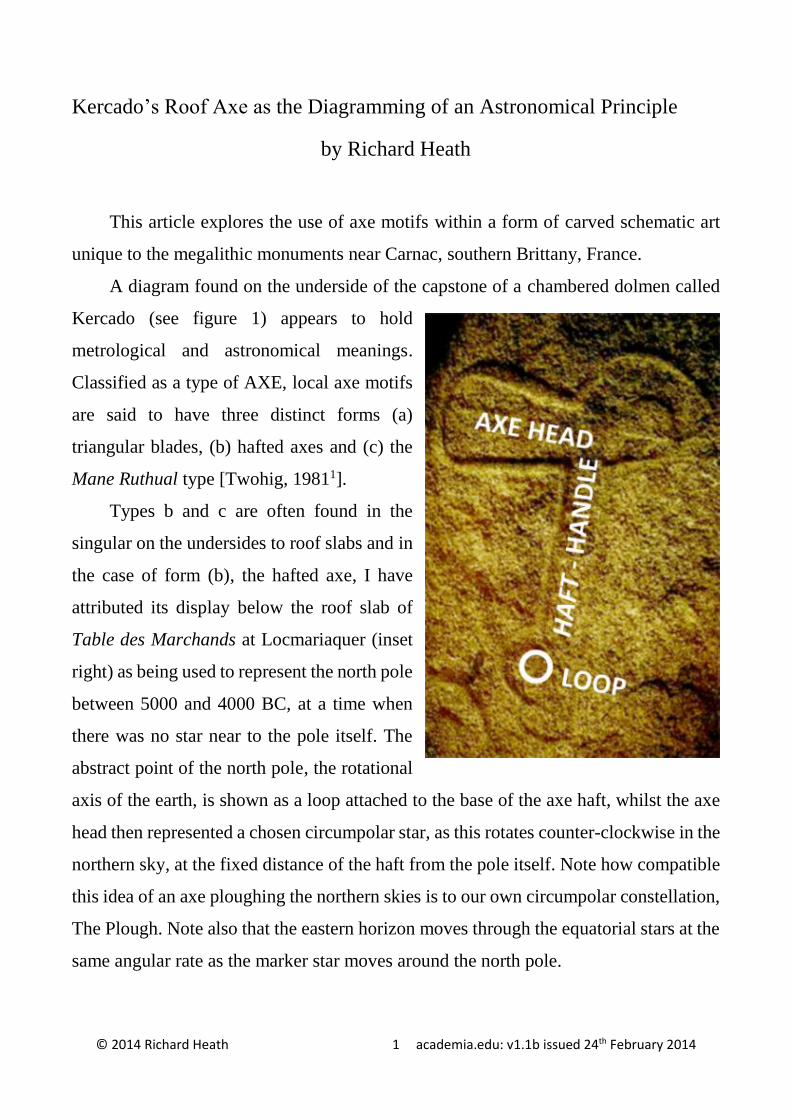
© 2014 Richard Heath 1 academia.edu: v1.1b issued 24 th February 2014 Kercado’s Roof Axe as the Diagramming of an Astronomical Principle by Richard Heath This article explores the use of axe motifs within a form of carved schematic art unique to the megalithic monuments near Carnac, southern Brittany, France. A diagram found on the underside of the capstone of a chambered dolmen called Kercado (see figure 1) appears to hold metrological and astronomical meanings. Classified as a type of AXE, local axe motifs are said to have three distinct forms (a) triangular blades, (b) hafted axes and (c) the Mane Ruthual type [Twohig, 1981 1 ]. Types b and c are often found in the singular on the undersides to roof slabs and in the case of form (b), the hafted axe, I have attributed its display below the roof slab of Table des Marchands at Locmariaquer (inset right) as being used to represent the north pole between 5000 and 4000 BC, at a time when there was no star near to the pole itself. The abstract point of the north pole, the rotational axis of the earth, is shown as a loop attached to the base of the axe haft, whilst the axe head then represented a chosen circumpolar star, as this rotates counter-clockwise in the northern sky, at the fixed distance of the haft from the pole itself. Note how compatible this idea of an axe ploughing the northern skies is to our own circumpolar constellation, The Plough. Note also that the eastern horizon moves through the equatorial stars at the same angular rate as the marker star moves around the north pole.
-
Upload
independent -
Category
Documents
-
view
5 -
download
0
Transcript of Kercado’s Roof Axe as the Diagramming of an Astronomical Principle
© 2014 Richard Heath 1 academia.edu: v1.1b issued 24th February 2014
Kercado’s Roof Axe as the Diagramming of an Astronomical Principle
by Richard Heath
This article explores the use of axe motifs within a form of carved schematic art
unique to the megalithic monuments near Carnac, southern Brittany, France.
A diagram found on the underside of the capstone of a chambered dolmen called
Kercado (see figure 1) appears to hold
metrological and astronomical meanings.
Classified as a type of AXE, local axe motifs
are said to have three distinct forms (a)
triangular blades, (b) hafted axes and (c) the
Mane Ruthual type [Twohig, 19811].
Types b and c are often found in the
singular on the undersides to roof slabs and in
the case of form (b), the hafted axe, I have
attributed its display below the roof slab of
Table des Marchands at Locmariaquer (inset
right) as being used to represent the north pole
between 5000 and 4000 BC, at a time when
there was no star near to the pole itself. The
abstract point of the north pole, the rotational
axis of the earth, is shown as a loop attached to the base of the axe haft, whilst the axe
head then represented a chosen circumpolar star, as this rotates counter-clockwise in the
northern sky, at the fixed distance of the haft from the pole itself. Note how compatible
this idea of an axe ploughing the northern skies is to our own circumpolar constellation,
The Plough. Note also that the eastern horizon moves through the equatorial stars at the
same angular rate as the marker star moves around the north pole.
Kercado’s Roof Axe as the Diagramming an Astronomical Principle
© 2014 Richard Heath 2 version 1.1
Figure 1 The Kercado Axe Diagram (E.S. Twohig, 1981)
My interpretation of the Kercado roof axe (above) is that the circumpolar region
was used as an observatory clock, directly monitoring sidereal time and thence able to
predict the point of the ecliptic currently rising on the eastern horizon (represented by
the vertical, right hand edge of this “axe”). The ability to know what part of the sky is
rising on the eastern horizon, from observations of the rotating circumpolar stars,
appears to have been the subject for this third type of axe, the Mane Ruthual type, though
the Kercado variant demonstrates my interpretation in the simplest way.
Kercado’s Roof Axe as the Diagramming an Astronomical Principle
© 2014 Richard Heath 3 version 1.1
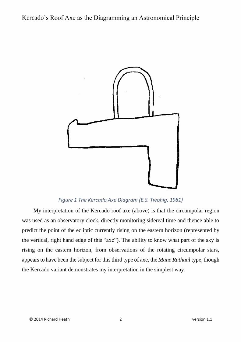
Figure 2 Mane Ruthual’s Axe, in situ (AAK2)
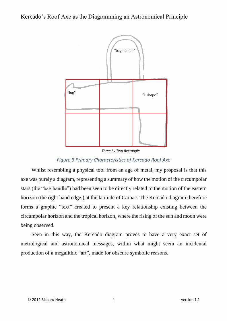
The Kercado axe appears (see figure 3) to be formed as an L-shape having a
horizontal-to-vertical extent contained within a simple three-by-two square rectangle.
Attached on the top is a wide slot terminated by a semicircle, which looks like a “bag
handle”. The top of the structure tapers from right to left until terminated by a “lug”,
which appears to have a definite purpose, also present in the version at Mane Ruthual.
Kercado’s Roof Axe as the Diagramming an Astronomical Principle
© 2014 Richard Heath 4 version 1.1
Figure 3 Primary Characteristics of Kercado Roof Axe
Whilst resembling a physical tool from an age of metal, my proposal is that this
axe was purely a diagram, representing a summary of how the motion of the circumpolar
stars (the “bag handle”) had been seen to be directly related to the motion of the eastern
horizon (the right hand edge,) at the latitude of Carnac. The Kercado diagram therefore
forms a graphic “text” created to present a key relationship existing between the
circumpolar horizon and the tropical horizon, where the rising of the sun and moon were
being observed.
Seen in this way, the Kercado diagram proves to have a very exact set of
metrological and astronomical messages, within what might seem an incidental
production of a megalithic “art”, made for obscure symbolic reasons.
Kercado’s Roof Axe as the Diagramming an Astronomical Principle
© 2014 Richard Heath 5 version 1.1
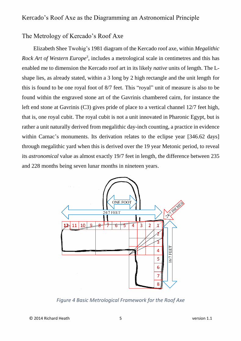
The Metrology of Kercado’s Roof Axe
Elizabeth Shee Twohig’s 1981 diagram of the Kercado roof axe, within Megalithic
Rock Art of Western Europe3, includes a metrological scale in centimetres and this has
enabled me to dimension the Kercado roof art in its likely native units of length. The L-
shape lies, as already stated, within a 3 long by 2 high rectangle and the unit length for
this is found to be one royal foot of 8/7 feet. This “royal” unit of measure is also to be
found within the engraved stone art of the Gavrinis chambered cairn, for instance the
left end stone at Gavrinis (C3) gives pride of place to a vertical channel 12/7 feet high,
that is, one royal cubit. The royal cubit is not a unit innovated in Pharonic Egypt, but is
rather a unit naturally derived from megalithic day-inch counting, a practice in evidence
within Carnac’s monuments. Its derivation relates to the eclipse year [346.62 days]
through megalithic yard when this is derived over the 19 year Metonic period, to reveal
its astronomical value as almost exactly 19/7 feet in length, the difference between 235
and 228 months being seven lunar months in nineteen years.
Figure 4 Basic Metrological Framework for the Roof Axe
Kercado’s Roof Axe as the Diagramming an Astronomical Principle
© 2014 Richard Heath 6 version 1.1
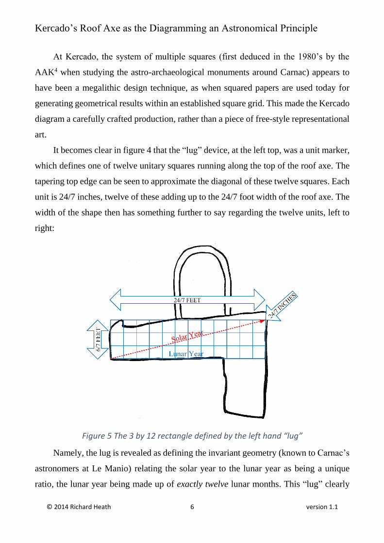
At Kercado, the system of multiple squares (first deduced in the 1980’s by the
AAK4 when studying the astro-archaeological monuments around Carnac) appears to
have been a megalithic design technique, as when squared papers are used today for
generating geometrical results within an established square grid. This made the Kercado
diagram a carefully crafted production, rather than a piece of free-style representational
art.
It becomes clear in figure 4 that the “lug” device, at the left top, was a unit marker,
which defines one of twelve unitary squares running along the top of the roof axe. The
tapering top edge can be seen to approximate the diagonal of these twelve squares. Each
unit is 24/7 inches, twelve of these adding up to the 24/7 foot width of the roof axe. The
width of the shape then has something further to say regarding the twelve units, left to
right:
Figure 5 The 3 by 12 rectangle defined by the left hand “lug”
Namely, the lug is revealed as defining the invariant geometry (known to Carnac’s
astronomers at Le Manio) relating the solar year to the lunar year as being a unique
ratio, the lunar year being made up of exactly twelve lunar months. This “lug” clearly
Kercado’s Roof Axe as the Diagramming an Astronomical Principle
© 2014 Richard Heath 7 version 1.1
delimits a single lunar month by its left, top and right boundaries. The top of the lug is
set down, 12/7 inches below the top of the overall 3 by 2 rectangle, 12/7 inches being
exactly half the unitary grid size of 24/7 inches.
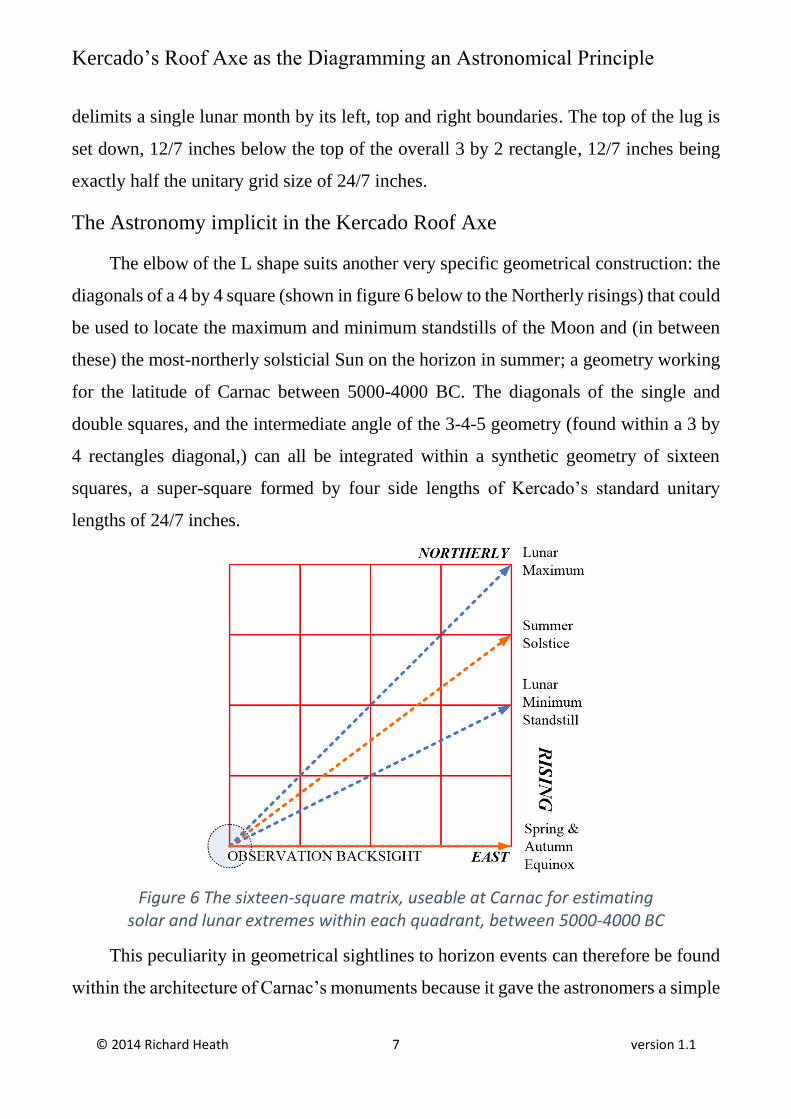
The Astronomy implicit in the Kercado Roof Axe
The elbow of the L shape suits another very specific geometrical construction: the
diagonals of a 4 by 4 square (shown in figure 6 below to the Northerly risings) that could
be used to locate the maximum and minimum standstills of the Moon and (in between
these) the most-northerly solsticial Sun on the horizon in summer; a geometry working
for the latitude of Carnac between 5000-4000 BC. The diagonals of the single and
double squares, and the intermediate angle of the 3-4-5 geometry (found within a 3 by
4 rectangles diagonal,) can all be integrated within a synthetic geometry of sixteen
squares, a super-square formed by four side lengths of Kercado’s standard unitary
lengths of 24/7 inches.
Figure 6 The sixteen-square matrix, useable at Carnac for estimating solar and lunar extremes within each quadrant, between 5000-4000 BC
This peculiarity in geometrical sightlines to horizon events can therefore be found
within the architecture of Carnac’s monuments because it gave the astronomers a simple
Kercado’s Roof Axe as the Diagramming an Astronomical Principle
© 2014 Richard Heath 8 version 1.1
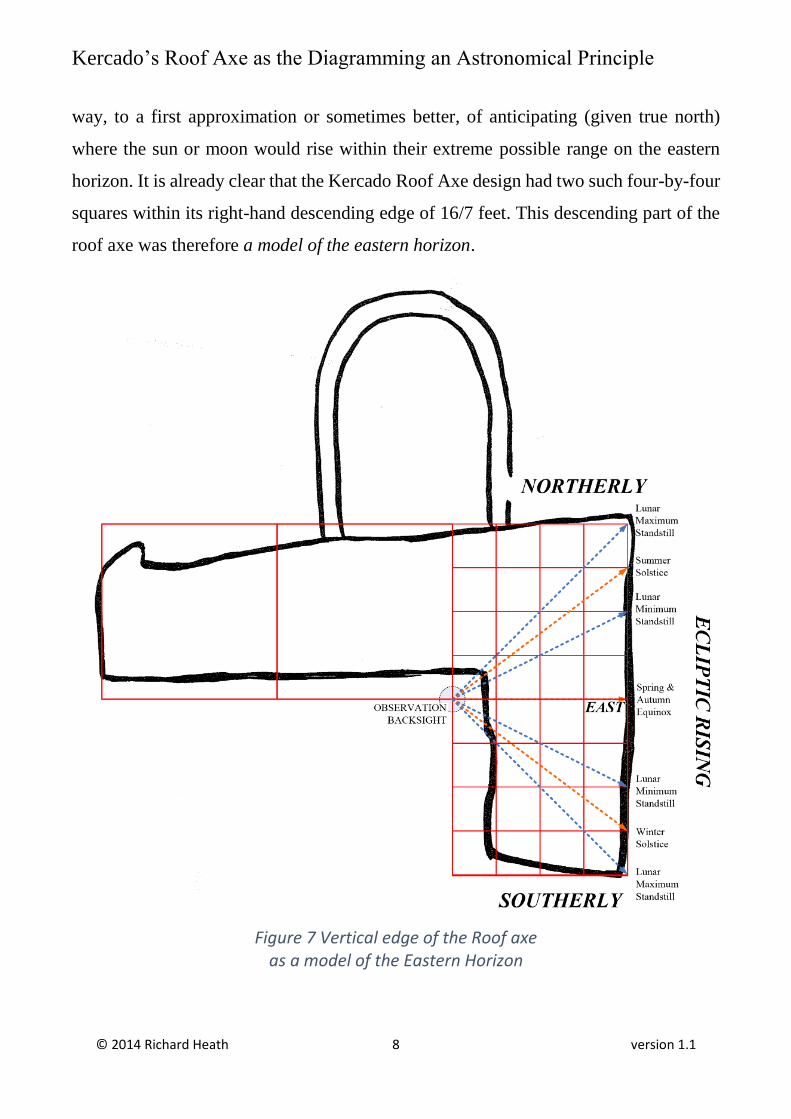
way, to a first approximation or sometimes better, of anticipating (given true north)
where the sun or moon would rise within their extreme possible range on the eastern
horizon. It is already clear that the Kercado Roof Axe design had two such four-by-four
squares within its right-hand descending edge of 16/7 feet. This descending part of the
roof axe was therefore a model of the eastern horizon.
Figure 7 Vertical edge of the Roof axe as a model of the Eastern Horizon
Kercado’s Roof Axe as the Diagramming an Astronomical Principle
© 2014 Richard Heath 9 version 1.1
Whilst this geometry formed a fine rule-of-thumb for horizon astronomy at Carnac,
(in establishing key sightlines to the east,) something more was achieved within the
Kercado diagram in that the rising, eastern horizon of its right hand edge was shown as
connected to the circumpolar stars (the rather strange “bag handle”).
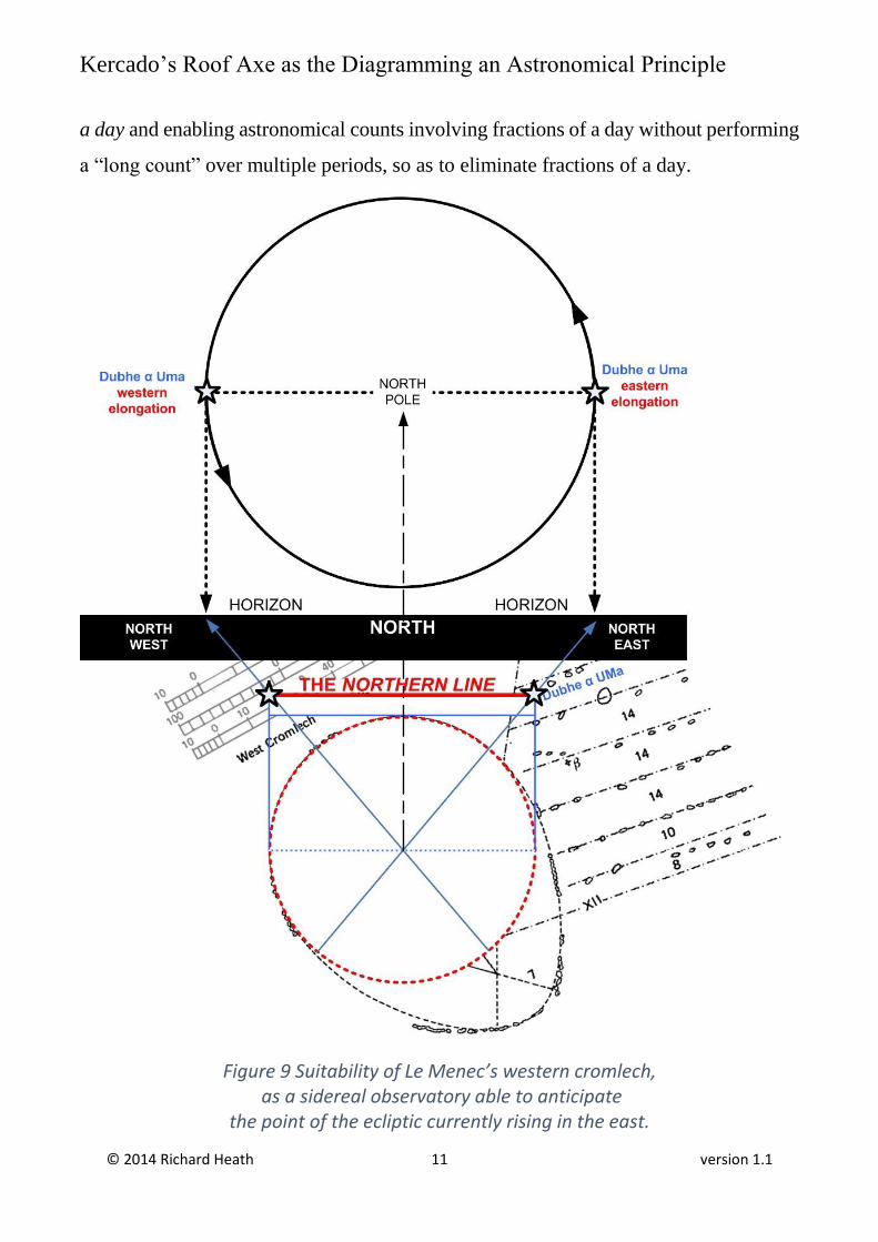
In 2011 I made a study of Le Menec’s western cromlech5, as to its possible
astronomical purpose in generating the western stone rows (called alignments) which
issue eastwards from it. I came to see that the Cromlech’s forming circle was strangely
open to the north. This would have allowed alignments to have been made to the
northern horizon, through the centre of the cromlech (see figure 9). The only interesting
phenomena to the north are the circumpolar stars and it seems Carnac’s astronomers
saw that by tracking the rotation of the circumpolar stars (and hence the rotation of the
earth itself) the location of the eastern horizon amongst the stars could be known.
Furthermore, such tracking enabled rising events to be anticipated.6
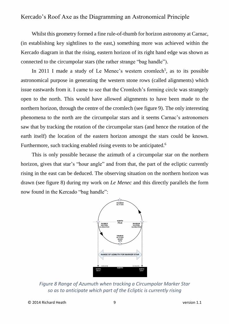
This is only possible because the azimuth of a circumpolar star on the northern
horizon, gives that star’s “hour angle” and from that, the part of the ecliptic currently
rising in the east can be deduced. The observing situation on the northern horizon was
drawn (see figure 8) during my work on Le Menec and this directly parallels the form
now found in the Kercado “bag handle”:
Figure 8 Range of Azumuth when tracking a Circumpolar Marker Star so as to anticipate which part of the Ecliptic is currently rising
Kercado’s Roof Axe as the Diagramming an Astronomical Principle
© 2014 Richard Heath 10 version 1.1
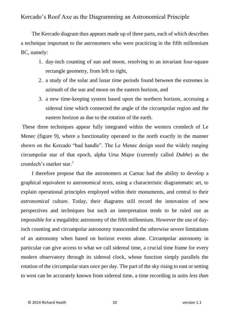
The Kercado diagram thus appears made up of three parts, each of which describes
a technique important to the astronomers who were practicing in the fifth millennium
BC, namely:
1. day-inch counting of sun and moon, resolving to an invariant four-square
rectangle geometry, from left to right,
2. a study of the solar and lunar time periods found between the extremes in
azimuth of the sun and moon on the eastern horizon, and
3. a new time-keeping system based upon the northern horizon, accessing a
sidereal time which connected the angle of the circumpolar region and the
eastern horizon as due to the rotation of the earth.
These three techniques appear fully integrated within the western cromlech of Le
Menec (figure 9), where a functionality operated to the north exactly in the manner
shown on the Kercado “bad handle”. The Le Menec design used the widely ranging
circumpolar star of that epoch, alpha Ursa Major (currently called Dubhe) as the
cromlech’s marker star.7
I therefore propose that the astronomers at Carnac had the ability to develop a
graphical equivalent to astronomical texts, using a characteristic diagrammatic art, to
explain operational principles employed within their monuments, and central to their
astronomical culture. Today, their diagrams still record the innovation of new
perspectives and techniques but such an interpretation tends to be ruled out as
impossible for a megalithic astronomy of the fifth millennium. However the use of day-
inch counting and circumpolar astronomy transcended the otherwise severe limitations
of an astronomy when based on horizon events alone. Circumpolar astronomy in
particular can give access to what we call sidereal time, a crucial time frame for every
modern observatory through its sidereal clock, whose function simply parallels the
rotation of the circumpolar stars once per day. The part of the sky rising to east or setting
to west can be accurately known from sidereal time, a time recording in units less than
Kercado’s Roof Axe as the Diagramming an Astronomical Principle
© 2014 Richard Heath 11 version 1.1
a day and enabling astronomical counts involving fractions of a day without performing
a “long count” over multiple periods, so as to eliminate fractions of a day.
Figure 9 Suitability of Le Menec’s western cromlech, as a sidereal observatory able to anticipate
the point of the ecliptic currently rising in the east.
Kercado’s Roof Axe as the Diagramming an Astronomical Principle
© 2014 Richard Heath 12 version 1.1
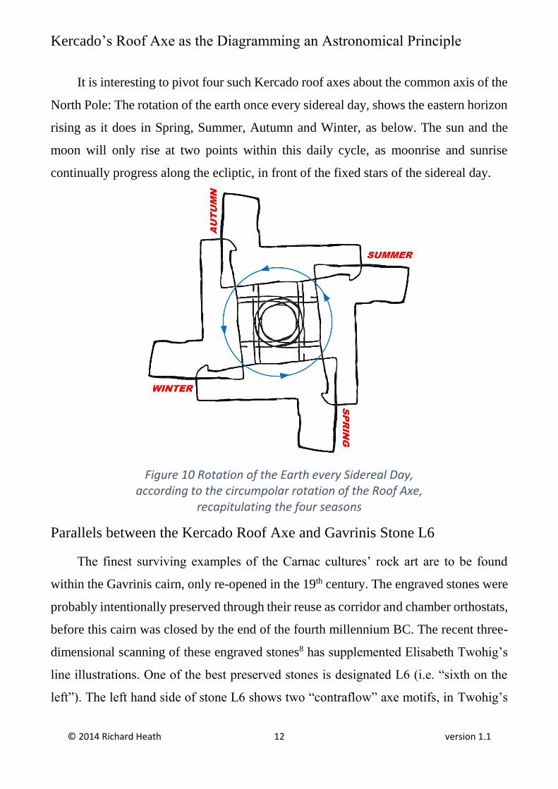
It is interesting to pivot four such Kercado roof axes about the common axis of the
North Pole: The rotation of the earth once every sidereal day, shows the eastern horizon
rising as it does in Spring, Summer, Autumn and Winter, as below. The sun and the
moon will only rise at two points within this daily cycle, as moonrise and sunrise
continually progress along the ecliptic, in front of the fixed stars of the sidereal day.
Figure 10 Rotation of the Earth every Sidereal Day, according to the circumpolar rotation of the Roof Axe,
recapitulating the four seasons
Parallels between the Kercado Roof Axe and Gavrinis Stone L6
The finest surviving examples of the Carnac cultures’ rock art are to be found
within the Gavrinis cairn, only re-opened in the 19th century. The engraved stones were
probably intentionally preserved through their reuse as corridor and chamber orthostats,
before this cairn was closed by the end of the fourth millennium BC. The recent three-
dimensional scanning of these engraved stones8 has supplemented Elisabeth Twohig’s
line illustrations. One of the best preserved stones is designated L6 (i.e. “sixth on the
left”). The left hand side of stone L6 shows two “contraflow” axe motifs, in Twohig’s
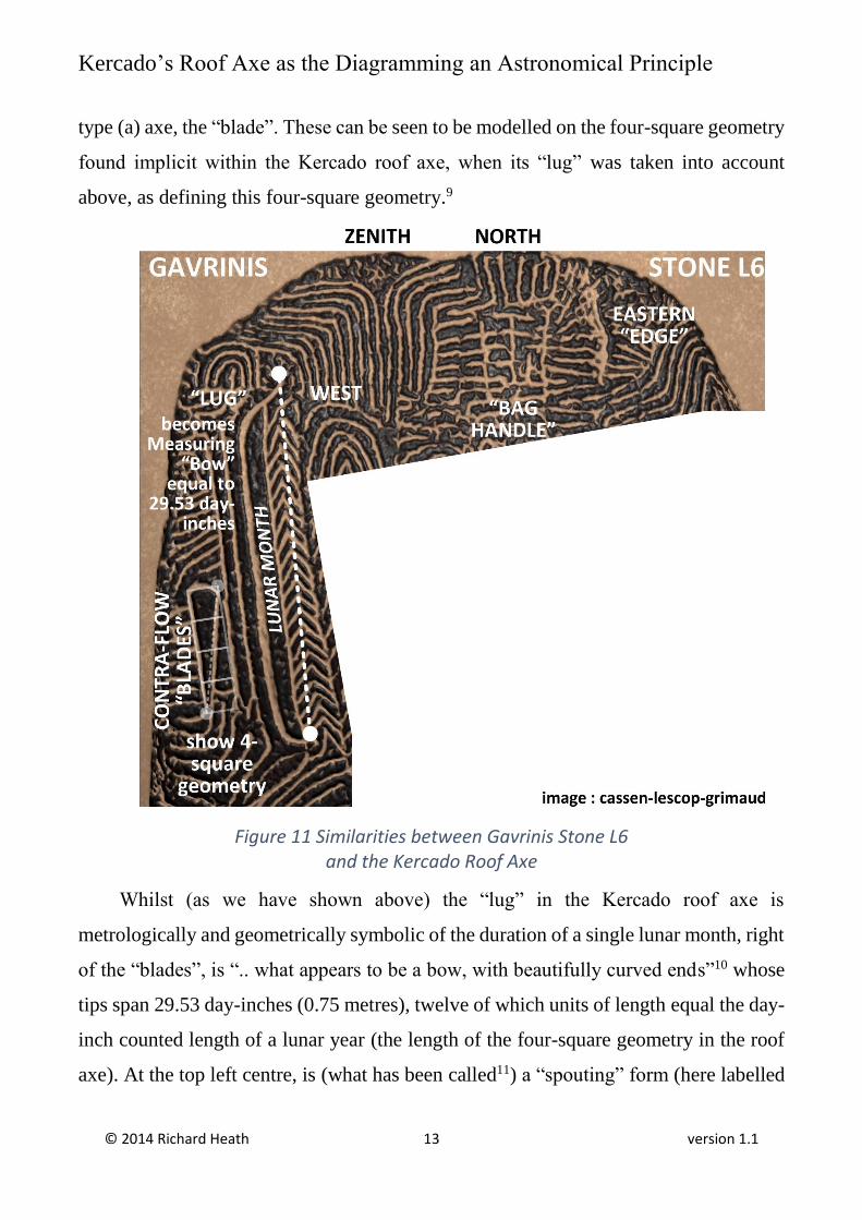
Kercado’s Roof Axe as the Diagramming an Astronomical Principle
© 2014 Richard Heath 13 version 1.1
type (a) axe, the “blade”. These can be seen to be modelled on the four-square geometry
found implicit within the Kercado roof axe, when its “lug” was taken into account
above, as defining this four-square geometry.9
Figure 11 Similarities between Gavrinis Stone L6 and the Kercado Roof Axe
Whilst (as we have shown above) the “lug” in the Kercado roof axe is
metrologically and geometrically symbolic of the duration of a single lunar month, right
of the “blades”, is “.. what appears to be a bow, with beautifully curved ends”10 whose
tips span 29.53 day-inches (0.75 metres), twelve of which units of length equal the day-
inch counted length of a lunar year (the length of the four-square geometry in the roof
axe). At the top left centre, is (what has been called11) a “spouting” form (here labelled
Kercado’s Roof Axe as the Diagramming an Astronomical Principle
© 2014 Richard Heath 14 version 1.1
ZENITH). I believe the reason for these parallel bands, starting parted to left and right
from above and then joining below, is that these are the tracks of stars to left and right,
of the zenith (of local space) as defined by the latitude of Carnac.
At any given latitude, the stars of declination equal to that latitude pass directly
overhead and are “zenith stars”. Looking west, other stars of lesser and greater
declination pass an observer as two “parted” streams which eventually move to the
western horizon as a single (seamlessly joined) group of stars currently setting in the
west. I therefore view the upwardly-pointing spouting motif as expressing the Zenith.
The stars with higher declination, to the right, become the circumpolar stars of the
Kercado “bag handle”, here symbolised as three lines, the middle representing true north
and those either side the limits of a given circumpolar marker star in azimuth. Above
the “bag handle” is a large and impressive motif, perhaps for the North Pole. To the
right can be seen a single vertical line, somewhat wavy and connected by horizontal
lines from the circumpolar region. This wavy line was probably the ecliptic rising on
the eastern horizon, each point of which is connected to a specific “hour angle” of the
circumpolar stars.
Conclusions
My conclusions here appear in a void with regard to the views of current
archaeology, views that rarely touch on the astronomical purposes of Carnac’s
monuments, or of its rock art, as providing an explanation for Carnac’s megalithism.
Decades of resistance to a competent megalithic astronomy by European archaeologists
has resulted in a “catch-22” rubric that the Stone Age could never have been technically
equipped to accurately measure solar, lunar and eclipse periods – it was Neolithic. The
monuments and the people who built them therefore remain an official enigma.
The most destructive step in this regard has been the elimination of metrology as a
key measuring and counting tool for the megalithic stone age in Western Europe.
Standardised units of length to build monuments, develop alignments and record periods
Kercado’s Roof Axe as the Diagramming an Astronomical Principle
© 2014 Richard Heath 15 version 1.1
of time, can provide remarkable insights into the structure of time on earth but
metrology dropped out of archaeology after the work of William Petrie in Egypt.
A pertinent example thereafter is Alexander Thom’s deduced unit of length
megalithic yard, a unit whose existence is still officially disputed. My brother and I have
pointed out that the difference between a day-inch count of three solar and three lunar
years is naturally equal to the megalithic yard in day-inches [32 and 5/8th inches]. We
have also shown12 that Le Manio’s Quadrilateral was built to exactly demonstrate this
knowledge, that the megalithic yard is simply a differential length developed whilst
counting time. Here, in addition, I have been led to embrace circumpolar astronomy as
obviously providing some new and compatible megalithic capabilities, needed to
explain Le Menec’s western alignments. This opens up the scope of astronomical
phenomena that might lie behind local rock art such as the Kercado roof axe.
Once you understand megalithic astronomy, the monuments at Carnac are cross-
explained by the rock art at Carnac and this provides a significant verification that
megalithic astronomy was the principle inspiration for Carnac’s monuments, rock art
and intellectual life. Previous explanations for the meaning behind individual symbols
found within rock art or for the purpose of the evidently associated monuments, fail to
provide any comparable “big picture” to provides necessary insight into the culture that
made both the art and the monuments or show how these are intellectually related. There
is much talk of funerary and ritual significance for example, but few human remains or
evidence of habitation have been found at Carnac during its megalithic period. The
perfectly reasonable astronomical hypothesis is therefore being neglected in favour of
no significant explanation as to what made Carnac such a unique manifestation of the
Stone Age.
There had to have been astronomy, metrology and geometry at work to create the
monuments found at Carnac and now, to this, one can add some form of circumpolar
astronomy and a role for rock art as the means used of recording actual megalithic
thinking within a developed graphical canon, whose motifs recur because these relate to
Kercado’s Roof Axe as the Diagramming an Astronomical Principle
© 2014 Richard Heath 16 version 1.1
astronomical phenomena within graphic sensibility of an advanced though stone age,
naked eye astronomy.
Endnotes
1 Elizabeth Shee Twohig, Megalithic Art of Western Europe, Clarendon, Oxford, 1981, page 58-61. 2 See note 3 below. 3 E.S. Twohig 1981, as above. 4 Association Archeologique Kergal were an independent research group focussed on the megaliths at Carnac between 1977 and 1983, publishing Etudes et Travaux nos 1 to 20 5https://www.academia.edu/5384849/The_Meaning_of_Le_Menec_A_Study_of_the_Moon_using_the_Circumpolar_Stars 6 Additionally the early or late rising of the moon, due to its ecliptic latitude, could have been measured and incarcerated within the displacements of stones within the stone rows away from their given alignment to east, of about 18.4 degrees. In other words, circumpolar astronomy could explain the western alignments as the measurements of successive moonrises, day by day, during at least the half period of the Moon’s maximum standstill. 7 Other candidate stars appear to have formed alignments to the first stones of other rows from the centre of the cromlech, see 2 above. 8see Gavrinis, The Raising of Digital Stones by Lescop, Cassen, Grimauld https://www.academia.edu/4925749/Gavrinis_The_raising_of_digital_stones 9 The most popular proportion for such axe blades at Gavrinis seems to be this “four-square” geometry, having a blade with a tip angle equal to 14 degrees. 10 E.S. Twohig, 1981, page 173. 11 By archaeologist Serge Cassen, who interpreted what is clearly another “roof axe” (with a “lug”) as a “figuration of a sperm whale”, see http://archeovision.cnrs.fr/pdf/vr05_pdf/05_cassen.pdf Moving the immovable. A short study of methods of recording and illustrating Neolithic engraved stelae in Brittany. 12 https://www.academia.edu/5384545/The_Origins_of_Megalithic_Astronomy_as_found_at_Le_Manio