Karst water resources in a changing world: Review of hydrological modeling approaches
25
Karst water resources in a changing world: Review of hydrological modeling approaches A. Hartmann 1 , N. Goldscheider 2 , T. Wagener 1 , J. Lange 3 , and M. Weiler 3 1 Department of Civil Engineering, University of Bristol, Bristol, UK, 2 Institute of Applied Geosciences, Karlsruhe Institute of Technology, Karlsruhe, Germany, 3 Chair of Hydrology, Freiburg University, Freiburg, Germany Abstract Karst regions represent 7–12% of the Earth’ s continental area, and about one quarter of the global population is completely or partially dependent on drinking water from karst aquifers. Climate simulations project a strong increase in temperature and a decrease of precipitation in many karst regions in the world over the next decades. Despite this potentially bleak future, few studies specifically quantify the impact of climate change on karst water resources. This review provides an introduction to karst, its evolution, and its particular hydrological processes. We explore different conceptual models of karst systems and how they can be translated into numerical models of varying complexity and therefore varying data requirements and depths of process representation. We discuss limitations of current karst models and show that at the present state, we face a challenge in terms of data availability and information content of the available data. We conclude by providing new research directions to develop and evaluate better prediction models to address the most challenging problems of karst water resources management, including opportunities for data collection and for karst model applications at so far unprecedented scales. 1. Introduction The current global abstraction of groundwater is equal to more than double the volume of groundwater recharge [Gleeson et al., 2012]. This value would increase to 3.5 times the recharge volume if we maintained minimum environmental flows in our rivers, i.e., the flow rate that ensures the environmental integrity of surface water systems. Karst regions cover 7–12% of the Earth’ s continental area, and their aquifers are at least a partial source of drinking water supply to almost a quarter of the world’ s population [Ford and Williams, 2007]. Stress on groundwater resources has increased significantly in recent decades [Wada et al., 2010], (1) in terms of water quantity due to excessive irrigated agriculture [Aeschbach-Hertig and Gleeson, 2012] and (2) in terms of quality due to pollution by fertilizers [Foley et al., 2011]. Projections of 20 general circulation models using the A1B emission scenario for the years 2081–2090 [Christensen et al., 2007] suggest that an increase of temperatures for North America and Europe, and a strong decrease in precipitation in the more densely populated areas of North America and southern Europe (Mediterranean), can be expected (Figure 1). In these regions, stress on karst water resources, in terms of both quantity and quality, is likely to increase dramatically in the future. How will potential changes in temperature and precipitation affect local or regional water availability in these karst regions? This question is still very difficult to address given current tools and methods as we discuss in detail below. We need hydrologic models to understand the impact of climate change on water resources. Such models transform scenarios of climate or land use change into their hydrological implications. Hydrologic models require an adequate representation of karst specific processes, like the strong subsurface hydraulic heterogeneity of karstified rocks [Bakalowicz, 2005], if they are meant to provide realistic water resources simulations. Unfortunately, this heterogeneity is most often poorly characterized by available data and is not reflective of information required for modeling karst systems. Providing reliable simulations for the sustainable protection and management of karst water resources is therefore still challenging, both scientifically and operationally. In this review we provide an overview about the relevance of karst regions for human water supply and discuss the importance of quantitative projections of future karst water availability. We (1) start with an introduction to karst including its evolution and hydrogeology, (2) present an overview of karst exploration methods with a particular focus on the data requirements of karst models, (3) discuss the present state of hydrologic models for simulating karst water resources, and (4) discuss challenges and new directions in karst HARTMANN ET AL. ©2014. American Geophysical Union. All Rights Reserved. 1 PUBLICATION S Reviews of Geophysics REVIEW ARTICLE 10.1002/2013RG000443 Key Points: • We elaborate the importance of karst water resources • We provide a detailed overview of karst modeling approach • We present new methods and direc- tions for their improvement Correspondence to: A. Hartmann, [email protected] Citation: Hartmann, A., N. Goldscheider, T. Wagener, J. Lange, and M. Weiler (2014), Karst water resources in a chan- ging world: Review of hydrological modeling approaches, Rev. Geophys., 52, doi:10.1002/2013RG000443. Received 15 SEP 2013 Accepted 2 APR 2014 Accepted article online 8 APR 2014
Transcript of Karst water resources in a changing world: Review of hydrological modeling approaches

Karst water resources in a changing world: Reviewof hydrological modeling approachesA. Hartmann1, N. Goldscheider2, T. Wagener1, J. Lange3, and M. Weiler3
1Department of Civil Engineering, University of Bristol, Bristol, UK, 2Institute of Applied Geosciences, Karlsruhe Institute ofTechnology, Karlsruhe, Germany, 3Chair of Hydrology, Freiburg University, Freiburg, Germany
Abstract Karst regions represent 7–12% of the Earth’s continental area, and about one quarter of theglobal population is completely or partially dependent on drinking water from karst aquifers. Climatesimulations project a strong increase in temperature and a decrease of precipitation in many karst regions inthe world over the next decades. Despite this potentially bleak future, few studies specifically quantify theimpact of climate change on karst water resources. This review provides an introduction to karst, itsevolution, and its particular hydrological processes. We explore different conceptual models of karst systemsand how they can be translated into numerical models of varying complexity and therefore varying datarequirements and depths of process representation. We discuss limitations of current karst models and showthat at the present state, we face a challenge in terms of data availability and information content of theavailable data. We conclude by providing new research directions to develop and evaluate better predictionmodels to address the most challenging problems of karst water resources management, includingopportunities for data collection and for karst model applications at so far unprecedented scales.
1. Introduction
The current global abstraction of groundwater is equal to more than double the volume of groundwaterrecharge [Gleeson et al., 2012]. This value would increase to 3.5 times the recharge volume if we maintainedminimum environmental flows in our rivers, i.e., the flow rate that ensures the environmental integrity ofsurface water systems. Karst regions cover 7–12% of the Earth’s continental area, and their aquifers are atleast a partial source of drinking water supply to almost a quarter of the world’s population [Ford andWilliams,2007]. Stress on groundwater resources has increased significantly in recent decades [Wada et al., 2010], (1) interms of water quantity due to excessive irrigated agriculture [Aeschbach-Hertig and Gleeson, 2012] and (2) interms of quality due to pollution by fertilizers [Foley et al., 2011]. Projections of 20 general circulation modelsusing the A1B emission scenario for the years 2081–2090 [Christensen et al., 2007] suggest that an increase oftemperatures for North America and Europe, and a strong decrease in precipitation in the more denselypopulated areas of North America and southern Europe (Mediterranean), can be expected (Figure 1). In theseregions, stress on karst water resources, in terms of both quantity and quality, is likely to increase dramaticallyin the future. How will potential changes in temperature and precipitation affect local or regional wateravailability in these karst regions? This question is still very difficult to address given current tools andmethods as we discuss in detail below.
We need hydrologic models to understand the impact of climate change on water resources. Such modelstransform scenarios of climate or land use change into their hydrological implications. Hydrologic modelsrequire an adequate representation of karst specific processes, like the strong subsurface hydraulicheterogeneity of karstified rocks [Bakalowicz, 2005], if they are meant to provide realistic water resourcessimulations. Unfortunately, this heterogeneity is most often poorly characterized by available data and isnot reflective of information required for modeling karst systems. Providing reliable simulations for thesustainable protection and management of karst water resources is therefore still challenging, bothscientifically and operationally.
In this review we provide an overview about the relevance of karst regions for human water supply anddiscuss the importance of quantitative projections of future karst water availability. We (1) start with anintroduction to karst including its evolution and hydrogeology, (2) present an overview of karst explorationmethods with a particular focus on the data requirements of karst models, (3) discuss the present state ofhydrologic models for simulating karst water resources, and (4) discuss challenges and new directions in karst
HARTMANN ET AL. ©2014. American Geophysical Union. All Rights Reserved. 1
PUBLICATIONSReviews of Geophysics
REVIEW ARTICLE10.1002/2013RG000443
Key Points:• We elaborate the importance of karstwater resources
• We provide a detailed overview ofkarst modeling approach
• We present new methods and direc-tions for their improvement
Correspondence to:A. Hartmann,[email protected]
Citation:Hartmann, A., N. Goldscheider,T. Wagener, J. Lange, and M. Weiler(2014), Karst water resources in a chan-ging world: Review of hydrologicalmodeling approaches, Rev. Geophys., 52,doi:10.1002/2013RG000443.
Received 15 SEP 2013Accepted 2 APR 2014Accepted article online 8 APR 2014

modeling and exploration for better simulations in the future. Furthermore, we provide a glossary with themost relevant expressions at the end of the review.
2. Introduction to Karst
Raindrops collect atmospheric carbon dioxide (CO2) when they form in the atmosphere. Vegetation andmicrobial processes in the soil further increase the CO2 concentration in the water after the rain has fallen onthe land surface and infiltrated in the soil. Soil moisture will further percolate and, if the underlying bedrock iscomposed of carbonate rock, its CO2 will dissolve the bedrock material. In this way, the landform of karstdevelops over tens of thousands of years, creating a landscape with specific surface and subsurface features.Karst landforms, such as karren, dolines, swallow holes, dry valleys, and poljes, indicate the presence ofsurface karstification processes (Figures 2a–2c). Even if no superficial karst features are present, subsurfacedissolution can create hierarchically organized networks of open fractures, karst conduits, and caves in thesubsurface that often drain to large karst springs (Figures 2d and 2e).
The term “karst” also refers to the particular hydrologic behavior of karst regions. Due to the dissolutionprocesses, enclosed depressions at the surface (swallow holes, dolines) channel water to dissolution-enhanced fractures (karst conduits). Entire streams sink into karst conduits and emerge again as large springsin well-developed karst systems.
3. Specific Characteristics of Karst3.1. Karst Evolution
Karst typically develops from carbonate rocks, such as limestone (consisting of the mineral calcite, CaCO3)and dolomite rock or dolostone (consisting of the mineral dolomite, CaMg(CO3)2). Karst can also developfrom gypsum or halite. However, contributions of gypsum and halite karst systems are unimportant for water
Figure 1. Location of carbonate rock outcrops in Europe (Williams and Ford [2006], modified) compared to expected mean change of temperature and precipitationin (a and b) North America and (c and d) Europe from 1961–1990 to 2081–2090, derived from 20 general circulation models [Christensen et al., 2007].
Reviews of Geophysics 10.1002/2013RG000443
HARTMANN ET AL. ©2014. American Geophysical Union. All Rights Reserved. 2

resources management, and we will therefore only focus on carbonate rock in the subsequent discussion.Karst landscapes and aquifers result from intense water-rock interaction over long time periods. The solubilityof carbonate minerals in pure water is very low, but the presence of CO2 strongly increases this solubility. Thedissolution of carbonate rock, here represented by calcite, is described by the following chemical equilibrium:
CaCO3 þ H2Oþ CO2 ↔ Ca2þ þ 2HCO2�3 (1)
The products of this reaction are dissolved calcium (Ca2+) and bicarbonate (HCO3�). Carbonate rock
dissolution depends on lithological factors, such as chemical and mineralogical purity of the rock (seeGoldscheider and Drew [2007] for more details), and physicochemical factors, such as temperature and CO2
partial pressure [e.g., Buhmann and Dreybrodt, 1985]. The CO2 contained in the water originates from theatmosphere (approximately 400 ppm) [Mauna Loa Observatory, 2013] and, to an even larger extent, frombiological processes in the soil, such as respiration of plant roots and decomposition of buried plant material.Soil CO2 partial pressures often range between 5,000 and 50,000 ppm [Liu et al., 2007].
The formation of karst aquifers and caves, a process also referred to as karstification, is controlled bydissolution kinetics. Water rich in CO2 enters a narrow fracture and rapidly dissolves calcite in the first fewmeters until it reaches 75% calcite saturation. Beyond this point, dissolution rates drop to very low levels[Berner and Morse, 1974; Dreybrodt, 1990; Plummer and Wigley, 1976]. This means that water does not reachfull saturation with respect to calcite quickly but remains slightly undersaturated when it enters fractures andcauses initial karstification at very slow rates. The karstification process shows a positive feedback whendissolution causes wider fractures, allowing for higher flow and therefore increased calcite dissolution, whichincreases fracture size and so forth (see Figure 3). For the same reason, karstification is a selective process.Fractures that are initially only slightly wider than others have higher initial flow and calcite dissolution ratesand thus grow faster than the narrower fractures. As a result, karstification transforms fractured carbonaterock into a karst aquifer that includes a hierarchically organized network of hydraulically connected openfractures, conduits, and caves, sometimes drained by only one major spring (Figure 2) [Worthington andFord, 2009].
At the land surface, dissolution together with other hydrologic and geomorphologic processes give rise tocharacteristic karst landforms (Figure 2) [Ford and Williams, 2007; Goeppert et al., 2011]. These landformsdepend on climatic conditions and can be used as archives for past environmental changes [De Waele et al.,2009]. For example, karren that form under soil cover tend to be rounded, while karren that form on exposed
Figure 2. Typical surface and subsurface karst features: (a) karren field in the North of Málaga, Spain (photo by Andreas Hartmann), (b) karren field with doline in theSwiss Jura Mountains, Switzerland (photo by Nico Goldscheider), (c) cross section through the epikarst zone and a funnel-shaped doline observed in a quarry in theSwabian Alb, Germany (photo by Nico Goldscheider), (d) cave in the Ardèche region, France (photo by Remy Wenger, SISKA), and (e) spring of the Loue River, France(photo by Nico Goldscheider).
Reviews of Geophysics 10.1002/2013RG000443
HARTMANN ET AL. ©2014. American Geophysical Union. All Rights Reserved. 3

limestone tend to be sharped rimmed. Rounded karren on exposed rock surfaces therefore indicate recentsoil erosion [Goldscheider, 2012; Liu et al., 2007].
3.2. Karst Hydrology
There are three types of porosities in karst systems: (1) micropores that develop during the genesis of thecarbonate rock, (2) small fissures and fractures that develop due to tectonic processes, and (3) large fracturesand conduits that develop due to karstification (section 3.1). The first two porosities are usually referred to asthe matrix, while the latter are called (karst) conduits. These three types of porosities result in a strongheterogeneity of water movement at the surface and in the subsurface [Bakalowicz, 2005]. Figure 4 provides aschematic illustration of the functioning of karst systems based on a general conceptual model for karsticaquifers [White, 2003]. Internal runoff and diffuse infiltration represent autogenic recharge, while externalrunoff and sinking streams provide allogenic recharge from the surrounding areas [Goldscheider and Drew,2007]. The uppermost layer of the carbonate rock is referred to as the “epikarst.” It develops close to thetopographic surface through rapid dissolution (see section 3.1) [Williams, 2008]. In the epikarst, storage andfurther concentration of the downward flow can occur, which is then routed downward to the karst conduits[Aquilina et al., 2006; Williams, 1983]. Soils that develop on carbonate rock are usually high in clay content[Ford and Williams, 2007] and therefore exhibit low infiltration capacities when analyzed at small spatialscales. However, larger-scale karst systems usually have high infiltration capacities, which is due to lateral flowtoward larger fractures and swallow holes on the surface and in the epikarst [Jeannin and Grasso, 1997]. Whilediffusively infiltrated water percolates slowly through the matrix, flow in the karst conduits is often fast andturbulent [White, 2002]. These water pressure gradients can produce exchange flow between the matrix and
Figure 4. Conceptual model of a karst system including all characteristic karst processes; dark green and red dashed linesrepresent the soil/epikarst and the groundwater subsystems (see section 5.2).
Figure 3. Schematic description of the karstification process and its influence on the hydrodynamic behavior of spring discharge.
Reviews of Geophysics 10.1002/2013RG000443
HARTMANN ET AL. ©2014. American Geophysical Union. All Rights Reserved. 4
the karst conduits [White, 2003]. Additionally, varying recharge conditions can result in water losses toneighboring systems through conduits (piracy routes) [Jukic and Denic-Jukic, 2009] or through movinggroundwater divides [Le Moine et al., 2007]. Depending on the degree of karstification, discharge takes placeat one or several main springs contributing to rivers or subterraneous lakes or the ocean [Fleury et al., 2007a].Overflow springs are activated when the conduit carrying capacity is exceeded [Worthington, 1991]. Overall,the hydrological behavior of karst systems shows a duality in its process and storage dynamics [Kiraly, 1998]:(1) Duality of infiltration and recharge processes: diffusive, slow infiltration and recharge into the matrix,concentrated, rapid infiltration, and recharge into the conduits; (2) duality of the subsurface flow field:low flow velocity in the matrix and fast flow velocity in the karst conduits; and (3) duality of dischargeconditions: low and continuous discharge during dry periods when the system is dominated by flow throughthe matrix and high discharge with high temporal variability during rainfall events when flow through theconduits is dominant.
4. Investigation Techniques for Karst Systems
Sustainable karst water resources management requires an adequate knowledge of the functioning of karstsystems. Understanding the characteristics of a karst system will allow us to assess its potential for drinkingwater supply and other uses [Sheffer et al., 2010], its sensitivity to dry spells and pumping [Hao et al., 2012],and its vulnerability to contamination [Pronk et al., 2009]. Monitoring and understanding the spatial andtemporal variability of flow and storage behavior will further enable the development and application ofappropriate prediction models for water management under potential future conditions. Furthermore, fielddata are necessary to “tune” the model parameters to the conditions of the specific karst system under study.Karst systems require specific investigation methods that capture their duality due to their particulardynamics, i.e., both slow/diffuse and fast/concentrated flow and storage dynamics [Goldscheider and Drew,2007]. In the following paragraphs we discuss those methods and methodological adaptations that areparticularly suitable and relevant for analyzing karst systems.
4.1. Application of Artificial and Natural Tracers
Artificial tracers are substances added to moving water so that the actual travel flow paths and flow timesthrough hydrologic systems can be estimated. The ideal artificial tracer is highly soluble, detectable atextremely low concentrations (thus requiring only low injection quantities), behaves conservatively (i.e., nodegradation or adsorption), and is nontoxic to humans and the environment [Käss, 1998; Leibundgut et al.,2009]. There are also natural tracers, i.e., natural substances added continuously and spatially to the water.Widely used natural tracers include solutes of major ions or heavy isotopes of water [Leibundgut et al., 2009;Mazor, 2004]. Oxygen-18, deuterium, and tritium can be regarded as ideal natural tracers since they are partof the water molecule. Both artificial and natural tracers are widely used to study hydrologic systems.
Artificial tracers are particularly useful and applicable in karst aquifer systems where transit times are short(thus limiting the required sampling and monitoring periods) and where the sole application of conventionalhydrogeological methods, such as piezometric maps and numerical groundwater models, often leads toambiguous and incomplete results [Worthington et al., 2012]. In karst hydrogeology, artificial tracers can beapplied (1) to define underground connections and to delineate spring catchment areas, (2) to estimategeometric and hydraulic properties, such as conduit diameters and flow velocities, and (3) to identify theorigin or destination of contaminants, as well as to quantify contaminant transport processes [Goldscheideret al., 2008].
Fluorescent dyes, such as uranine, sulforhodamine, eosin, or naphthionate, are the most commonly usedartificial tracers, as they behave very close to ideal tracers. The detection limit of uranine, for example, is aslow as 2μg/m3 [Käss, 1998] so that long-distance tracer tests (order of tens of kilometers) are possible withonly small injection quantities (order of a few kilograms). It is possible to apply several tracers in so-calledmultitracer tests since the abovementioned dyes have distinct fluorescent properties allowing for theiranalytical separation [Leibundgut et al., 2009].
Different methods are available to observe artificial tracers at relevant monitoring sites, such as manualor automatic sampling with subsequent laboratory analysis or the use of continuously recording fieldfluorometers [Schnegg, 2002]. The primary result of a tracer test is a breakthrough curve (BTC) showing
Reviews of Geophysics 10.1002/2013RG000443
HARTMANN ET AL. ©2014. American Geophysical Union. All Rights Reserved. 5

concentration over time (Figure 5). BTCs allow direct determination of transit times and different flow velocities(maximum, peak, and mean velocity). The recovered tracer mass (R) is obtained as follows:
R ¼ ∫∞
t¼0Q � cð Þdt (2)
where Q is discharge, c is concentration, and (Q · c) defines the flux. Recovery can be expressed as an absoluteor a relative quantity. Under ideal experimental conditions (i.e., ideal tracer, injection into flowing water,and monitoring of the complete BTC), recoveries can be used to quantify underground flow rates and toestimate the so-called system discharge. Based on such simple approaches, but with more data andsophistication, it is possible to resolve complex conduit networks, determine conduit diameters, and toestimate water volumes and conduit flow rates even at inaccessible locations [Goldscheider, 2009; Pronk et al.,2005; Smart, 1988]. In a comparative study at Mammoth Cave karst aquifer, Worthington [2009] has shownthat the inclusion of tracer test results in numerical groundwater models can substantially improve thevalidity of the model.
Natural tracers provide integrated information about karst systems without allowing for the specification ofinput locations and times [Clark and Fritz, 1997; Mazor, 2004]. They can be used (1) to estimate the fractionsand mixing of water from different sources [Aquilina et al., 2006; Plummer et al., 1998], (2) to assess thefunctioning of karst systems [Barberá and Andreo, 2011; Mudarra and Andreo, 2011], and (3) to determineorigin and residence times of karst waters [Batiot et al., 2003; Long and Putnam, 2004]. Typical natural tracersare major ions, trace elements, dissolved organic carbon DOC and natural fluorescence, and water isotopes[Hunkeler and Mudry, 2007; Leibundgut et al., 2009; Mazor, 2004]. While water isotopes are part of the watermolecule, and can therefore be regarded as the “most ideal tracer,” other natural tracers often show reactivebehavior in terms of exchange with soil and rock or in terms of decomposition. Simultaneous consideration ofnatural tracers and spring discharge provides integrated information regarding key systems characteristics(see section 4.2).
More advanced interpretation techniques make it possible to quantify dispersion, physical nonequilibriumexchange between mobile (conduits) and immobile fluid regions (e.g., matrix), as well as relevantcontaminant transport parameters [e.g., Field and Pinsky, 2000; Maloszewski et al., 2002]. These techniquesusually include the application of spatially lumped hydrologic models that conceptualize the transportof the artificial or natural tracer through the karst system considering convection, dispersion, mixing,separate flow paths through different conduits, and exchange of tracer with the matrix [Maloszewski,1994; Maloszewski et al., 1998]. That way, transit times (through artificial tracers), residence times(through natural tracers), mixing fractions, aquifer characteristics, and diffusion losses to the matrixcan be estimated.
4.2. Continuous Monitoring
Karst springs and karst aquifers typically show marked and rapid reactions to precipitation events in bothwater quantity and quality variables. Therefore, monitoring at high temporal resolutions, ideally continuousmonitoring, is required to characterize the dynamic behavior and variability of karst systems. The combined
Figure 5. (left) Injection of tracer in the Blue Cave System, Blaubeuren, Swabian Jura, Germany (photo by Andreas Kuecha);(right) example of a tracer breakthrough curve (BTC) and illustration of relevant parameters that can be directly obtainedfrom this curve.
Reviews of Geophysics 10.1002/2013RG000443
HARTMANN ET AL. ©2014. American Geophysical Union. All Rights Reserved. 6
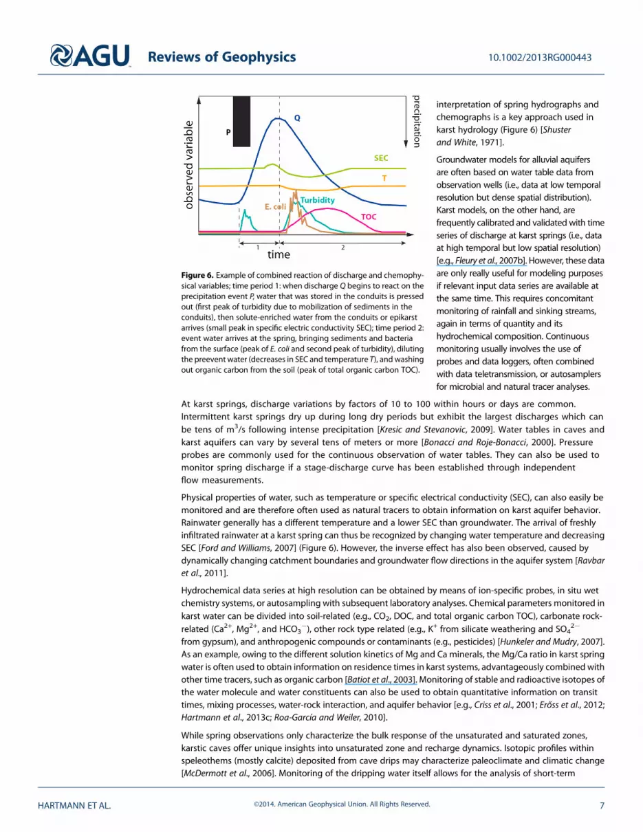
interpretation of spring hydrographs andchemographs is a key approach used inkarst hydrology (Figure 6) [Shusterand White, 1971].
Groundwater models for alluvial aquifersare often based on water table data fromobservation wells (i.e., data at low temporalresolution but dense spatial distribution).Karst models, on the other hand, arefrequently calibrated and validated with timeseries of discharge at karst springs (i.e., dataat high temporal but low spatial resolution)[e.g., Fleury et al., 2007b]. However, these dataare only really useful for modeling purposesif relevant input data series are available atthe same time. This requires concomitantmonitoring of rainfall and sinking streams,again in terms of quantity and itshydrochemical composition. Continuousmonitoring usually involves the use ofprobes and data loggers, often combinedwith data teletransmission, or autosamplersfor microbial and natural tracer analyses.
At karst springs, discharge variations by factors of 10 to 100 within hours or days are common.Intermittent karst springs dry up during long dry periods but exhibit the largest discharges which canbe tens of m3/s following intense precipitation [Kresic and Stevanovic, 2009]. Water tables in caves andkarst aquifers can vary by several tens of meters or more [Bonacci and Roje-Bonacci, 2000]. Pressureprobes are commonly used for the continuous observation of water tables. They can also be used tomonitor spring discharge if a stage-discharge curve has been established through independentflow measurements.
Physical properties of water, such as temperature or specific electrical conductivity (SEC), can also easily bemonitored and are therefore often used as natural tracers to obtain information on karst aquifer behavior.Rainwater generally has a different temperature and a lower SEC than groundwater. The arrival of freshlyinfiltrated rainwater at a karst spring can thus be recognized by changing water temperature and decreasingSEC [Ford and Williams, 2007] (Figure 6). However, the inverse effect has also been observed, caused bydynamically changing catchment boundaries and groundwater flow directions in the aquifer system [Ravbaret al., 2011].
Hydrochemical data series at high resolution can be obtained by means of ion-specific probes, in situ wetchemistry systems, or autosampling with subsequent laboratory analyses. Chemical parameters monitored inkarst water can be divided into soil-related (e.g., CO2, DOC, and total organic carbon TOC), carbonate rock-related (Ca2+, Mg2+, and HCO3
�), other rock type related (e.g., K+ from silicate weathering and SO42�
from gypsum), and anthropogenic compounds or contaminants (e.g., pesticides) [Hunkeler and Mudry, 2007].As an example, owing to the different solution kinetics of Mg and Ca minerals, the Mg/Ca ratio in karst springwater is often used to obtain information on residence times in karst systems, advantageously combined withother time tracers, such as organic carbon [Batiot et al., 2003]. Monitoring of stable and radioactive isotopes ofthe water molecule and water constituents can also be used to obtain quantitative information on transittimes, mixing processes, water-rock interaction, and aquifer behavior [e.g., Criss et al., 2001; Erőss et al., 2012;Hartmann et al., 2013c; Roa-García and Weiler, 2010].
While spring observations only characterize the bulk response of the unsaturated and saturated zones,karstic caves offer unique insights into unsaturated zone and recharge dynamics. Isotopic profiles withinspeleothems (mostly calcite) deposited from cave drips may characterize paleoclimate and climatic change[McDermott et al., 2006]. Monitoring of the dripping water itself allows for the analysis of short-term
Figure 6. Example of combined reaction of discharge and chemophy-sical variables; time period 1: when discharge Q begins to react on theprecipitation event P, water that was stored in the conduits is pressedout (first peak of turbidity due to mobilization of sediments in theconduits), then solute-enriched water from the conduits or epikarstarrives (small peak in specific electric conductivity SEC); time period 2:event water arrives at the spring, bringing sediments and bacteriafrom the surface (peak of E. coli and second peak of turbidity), dilutingthe preevent water (decreases in SEC and temperature T), and washingout organic carbon from the soil (peak of total organic carbon TOC).
Reviews of Geophysics 10.1002/2013RG000443
HARTMANN ET AL. ©2014. American Geophysical Union. All Rights Reserved. 7

dynamics. Thereby, drips can be classifiedinto distinct types [Arbel et al., 2010]:(1) perennial drips discharge all year long,(2) seasonal drips during the rainy season,and (3) poststorm/overflow drips responddirectly to rainfall events. This behavior cancharacterize the duality of infiltration,recharge, and unsaturated flow in karsticsystems with the first two types dominatedby thematrix and the third type dominatedby the conduit system [Lange et al., 2010].
More recent monitoring approaches alsoinclude parameters such as dissolved gases[Klump et al., 2008; Savoy et al., 2011], tracemetals [Vesper and White, 2003], turbidity,and particle size distribution [Pronk et al.,2007], as well as microbiological variables[Pronk et al., 2008]. These variables yieldconsiderable information concerning karstaquifer dynamics and transport processes,though this knowledge has not yet beenfully transferred to modeling.
4.3. Assessment of Karst Aquifer Properties
Direct and indirect information concerning the conduit network can be obtained by means ofspeleological exploration and tracer tests as discussed earlier, while hydraulic methods and geophysicalsurveys help to investigate the aquifer at other places. Hydraulic methods require pumping and/orobservation wells, while geophysical methods can be applied where drilling is not available (besidesborehole geophysics). In this context, the hydraulic conductivity-scale effect [Kiraly, 1975] is of primaryimportance. Due to the spatial scale of observation, the conductivity of carbonate rock samples obtainedfrom laboratory tests (scale of micropores) is several orders of magnitude lower than the conductivityobtained from hydraulic borehole tests (scale of fissures and small fractures), which is again much lowerthan the conductivity of the conduit network at aquifer scale (scale of large fractures and conduits)obtained from tracer tests (Figure 7).
Hydraulic methods, including pumping tests, slug tests, and multiple pressure permeability tests, deliverquantitative hydraulic parameters, such as transmissivity values and storage coefficients, while also allowingfor the estimation of the basic hydraulic aquifer setting (confined, unconfined, semiconfined, etc.) and of theboundary conditions (fixed hydraulic head, no-flow boundary, etc.). A large number of analytical solutions areavailable not only for a variety of aquifer types and settings, mostly for porous aquifers, but also for karstaquifers [Kresic, 2007]. In karst aquifers, flow is often concentrated in a small number of dissolution-enlargedbedding planes or fractures [Worthington et al., 2012]. This can lead to discontinuous, stepped drainagecharacteristics of a pumped well (Figure 8a). Major karst conduits near the pumped well can have a similarhydraulic effect as a nearby river or lake, i.e., a fixed hydraulic head boundary that leads to quasi-stationaryconditions (Figure 8b) [Larsson, 1984].
In locations where boreholes are not available, or for interpolation between existing boreholes,geophysical methods can be used to obtain indirect information on the internal geometry and the externalboundaries of the aquifer and on its hydraulic properties [Bechtel et al., 2007]. Seismic methods are mostsuitable to delineate geological boundaries and, thus, the external geometry of the aquifer [Bechtel et al.,2007]. Microgravity, a method that measures very small changes in the Earth’s gravity, can be used toidentify large voids, such as potential sinkholes, as well as caves and major karst conduits [e.g., Debegliaet al., 2006]. Electromagnetic methods are useful to identify anomalies, such as fractures [e.g., Bosch andMueller, 2001]. Spontaneous potential methods that measure the electrical potential field caused bynatural-occurring currents of the Earth can be used to identify downward movement of water and thus
Figure 7. Hydraulic conductivity-scale effect [after Kiraly, 1975], expandedby a temporal dimension that includes the evolution of a conduitnetwork (early stage of karstification: no karst conduit network devel-oped, hydraulic conductivity at catchment/aquifer scale not muchhigher than at the borehole scale; system strongly karstified: devel-oped network of karst conduits, hydraulic conductivity at much largerthan at the borehole scale; see also section 3.1).
Reviews of Geophysics 10.1002/2013RG000443
HARTMANN ET AL. ©2014. American Geophysical Union. All Rights Reserved. 8

help to identify zones of preferential infiltration. Ground-penetrating radar is most useful to characterizeepikarst structure and heterogeneity [Al-fares et al., 2002]. A wide range of borehole geophysicalmethods can be combined with hydraulic borehole methods to obtain a more complete picture ofaquifer structure and hydraulics. More detailed information on geophysical methods can be found inBechtel et al. [2007].
5. Approaches to the Prediction of Karst Water Resources
Karst simulation models cover a wide range of application areas. They can be used for “global” analysis, i.e.,the analysis of the integrated behavior of the karst system hydrodynamics [Kovacs and Sauter, 2007], forthe theoretical investigation of karst evolution [see Gabrovsek and Dreybrodt, 2001; Kaufmann and Braun,2000; Liedl et al., 2003], for water quality and vulnerability simulations [Butscher and Huggenberger, 2008;Charlier et al., 2012; Hartmann et al., 2013a], and finally for the simulation of karst hydrology and theprediction of karst water resources. The simplest way to model karst hydrology is the application of “blackbox” models. They transfer input to output without the explicit representation of any physical processes.Often they are composed of analytical transfer functions [Jukic and Denic-Jukic, 2006, 2008] or neuralnetworks [Hu et al., 2008; Kurtulus and Razack, 2006]. Due to the lack of process representation, their resultslose their reliability outside the range of conditions they were calibrated for [Kuczera and Mroczkowski,1998]. For this reason, estimates of future karst water resources likely require the application of process-based models that adequately consider karst hydrology and how it might vary over longer time periods(see section 4). There are two main groups of such process-based models: distributed and lumped karstmodeling approaches.
5.1. Distributed Karst Simulation Models
Karst systems cover areas from< 1 km2 up to thousands of km2. Distributed karst models discretize thekarst system in two- or three-dimensional grids and require the assignment of characteristic hydraulicparameters and system states to each grid cell. For a two-dimensional grid, the grid resolution is usuallyaround 0.01–1 km2. Distributed karst models are further described in Kinzelbach [1986], Wang and Anderson
Figure 8. Examples of time-drawdown curves from pumping tests in karst aquifers: (a) stepped drawdown resulting fromconsecutive drainage of a limited number of solutionally enlarged bedding planes and (b) a nearby karst conduit acts asfixed-head boundary and leads to quasi-stationary conditions (modified after Kresic [2006] and Larsson [1984]).
Reviews of Geophysics 10.1002/2013RG000443
HARTMANN ET AL. ©2014. American Geophysical Union. All Rights Reserved. 9

[1982], and Huyakorn and Pinder [1983]. In distributed karst models, groundwater flow in the matrix iscommonly described using Darcy’s law:
Ss∂H∂t
¼ ∇ K∇Hð Þ (3)
Where SS is the specific storage coefficient, K the hydraulic conductivity, H is the hydraulic head, ∇ is the Nablaoperator, and t is time. In the more dynamic conduits, flow is most often represented by the Darcy-Weisbachequation [e.g., Liedl et al., 2003; Reimann et al., 2011a]:
∂H∂x
¼ �μq2
2gd(4)
Where μ represents a friction coefficient, d is the conduit diameter, q is the mean flow velocity, and x is theflow length along the flow path. There are different possibilities to include karst heterogeneity in distributedmodels that we will elaborate on in the following sections.5.1.1. Equivalent Porous Medium ApproachThe equivalent porous medium approach (EPM) assumes that hydraulic heterogeneities can be representedby “average” properties, i.e., an equivalent porous medium (Figure 9b). Previous studies showed that atregional scales this assumption can be used for karst water resource estimation and predictions [e.g., Loaicigaet al., 2000; Rodríguez et al., 2013; Scanlon et al., 2003], since local influences of karst conduits may averageout over larger areas [Abusaada and Sauter, 2013]. However, since the EPM approach does not considerrapid flow in the karst conduits, it loses realism in systems with a high degree of karstification [Worthington,2009]. To apply this approach, average hydraulic properties and aquifer geometry have to be known(see section 4.3). In addition, groundwater level time series that represent the average groundwaterdynamics over the whole aquifer area should be available to calibrate the model.5.1.2. Double Continuum ApproachThe Double Continuum approach (DC) considers the heterogeneity of karst systems through the definition oftwo interacting continua, one for the matrix and another one for the karst conduits (Figure 9c). Using a linearexchange term, both continua exchange water as a function of their states (water levels). That way the DCapproach can describe the dual behavior of karst aquifers as shown in Teutsch and Sauter [1998], Maréchalet al. [2008], and Kordilla et al. [2012]. Hydraulic properties of the matrix and the karst conduits, as well as theaquifer geometry, should be known when applying this approach (see section 4.3). Possible evaluationvariables for this strategy include spring discharges, groundwater head observations, and tracer observationsthat represent both the karst conduits behavior as well as the matrix behavior.5.1.3. Combined Discrete-Continuum ApproachThe combined discrete-continuum approach (CDC) models the matrix as a continuum in which the karstconduits are embedded as discrete elements [Kiraly and Morel, 1976] (Figure 9d). In this way, the spatialinfluence of the karst conduits on groundwater levels in thematrix can be calculated across the whole extent ofthe karst system. The CDC approach has been applied in many theoretical studies of karst processes [Reimannet al., 2011a, 2011b] and of karst evolution [Bauer and Liedl, 2005; Liedl et al., 2003]. It is included in the widelyused groundwater model MODFLOW (MODFLOW-CFP) [Shoemaker et al., 2008]. For its application, hydraulicproperties of the matrix and the karst conduits should be known, as well as aquifer and conduits’geometry andlocation (see section 4.3). It can be evaluated using similar variables as the discussed for the DC approach above.
There have also been attempts to explicitly consider the geometry of the fracture network [Cacas et al.,1990; Dverstorp et al., 1992], but the data required to achieve robust karst water resources predictions aregenerally not available. Further information can be found in other reviews, which describe the capabilitiesand applications of the different subtypes of distributive modeling approaches in greater detail [e.g.,Ghasemizadeh et al., 2012; Kovacs and Sauter, 2007].
5.2. Lumped Karst Simulation Models
Lumped approaches conceptualize the physical processes at the scale of the whole karst system withoutmodeling spatial variability explicitly. They are mostly based on linear or nonlinear relationships betweenstorage and discharge:
Q ¼ dSdt
¼ a � Sb (5)
Reviews of Geophysics 10.1002/2013RG000443
HARTMANN ET AL. ©2014. American Geophysical Union. All Rights Reserved. 10

Where Q is discharge, S is the stored water volume, and a and b are model parameters that can be relatedto system properties [Rimmer and Hartmann, 2012]. In the special case when b=1, equation (5) becomes alinear relationship. The model parameters represent average or “effective” values over the whole modelingdomain due to the lumped structure of the model. Such parameters are generally incommensurate withfield measurements [Wagener and Gupta, 2005]. Instead, their specific values are estimated through acalibration process, in which the model parameters are systematically varied until an acceptable fit betweenobservations and simulations, e.g., discharge at the karst spring, is found. Therefore, lumped karst modelingapproaches require continuously monitored discharge data (see section 4.2). In contrast to distributed karstmodels that focus mostly on the movement of groundwater in the karst aquifer (see section 5.1), lumpedkarst models are used to simulate karst processes from the infiltration into the soil to discharge at thekarst spring in different ways and detail. In the following sections, a selection of lumped karst predictionmodels is presented that consider (1) internal and external runoff, (2) epikarst storage and flow processes,(3) groundwater storage and flow in karst conduits and the matrix, (4) varying surface and subsurfacerecharge areas, and (5) drainage through several springs.
Figure 9. Representation of (a) the real karst system (medium scale: 50–200 km2) by the different distributed modelingapproaches: (b) equivalent porous medium approach EPM, (c) Double Continuum approach DC, and (d) combineddiscrete-continuum approach CDC.
Reviews of Geophysics 10.1002/2013RG000443
HARTMANN ET AL. ©2014. American Geophysical Union. All Rights Reserved. 11

5.2.1. Internal and External RunoffIn the majority of the lumped karst models, soil and epikarst are represented by a single overflow storage(Figure 10b). In such a model, actual evapotranspiration is a direct function of the soil moisture state, andrecharge only occurs when the infiltrating water exceeds the water holding capacity of the soil compartment.Using such an overflow reservoir, Jukic and Denic-Jukic [2009] identified recharge area variations of a springthat were partially attributed to allogenic recharge. However, the majority of lumped karst models considersconcentrated infiltration without a distinction between internal and external runoff [e.g., Butscher andHuggenberger, 2008; Fleury et al., 2007b; Le Moine et al., 2008].5.2.2. Epikarst Storage and Flow ConcentrationTritz et al. [2011] showed how epikarst recharge dynamics can be included in a lumped karst model byintroducing a model structure that simulates diffuse recharge to a groundwater matrix and hysteresis effectsin the initiation and routing of concentrated recharge. In their model, a soil and epikarst reservoir providesdiffuse recharge via slow drainage. It only produces concentrated recharge when the stored water volumeexceeds an activation threshold. Concentrated recharge stops when the water volume falls below a secondthreshold, which is lower than the activation threshold. In a similar but slightly simpler approach, Rimmer andSalingar [2006] distinguished between diffuse and concentrated recharge. They defined a soil and epikarstroutine that provides concentrated recharge only when its capacity is exceeded. Diffuse recharge is providedvia slow drainage from a lower outlet of the reservoir (similar to Figure 10b but with a second outlet at thebottom of the reservoir that accounts for diffuse recharge). Hartmann et al. [2012b] found a way to considerthe spatial variability of the soil and epikarst characteristics in karst systems without explicit parameterizationof spatial heterogeneity. By defining distribution functions of system properties, their semilumped modelprovides a set of simulation time series that represents the spatial and temporal variability of rechargestatistically (Figure 10c). Models that do not consider flow concentration in the epikarst rely on rechargeseparation factors that define constant fractions of matrix and conduit recharge [e.g., Charlier et al., 2012;Fleury et al., 2009].5.2.3. Groundwater Flow and Storage in Conduits and MatrixThe duality of slow and diffuse groundwater flow and fast and concentrated flow in the karst conduits is animportant concept in karst hydrology (section 3.2). Therefore, many lumped karst models include thisprocess, for example, by defining two separate groundwater reservoirs, one representing the matrix and theother representing the conduits (Figure 11c). Somemodels simply combine both reservoirs [e.g., Butscher andHuggenberger, 2008; Fleury et al., 2007b], while the matrix recharges the conduit reservoir in others [Geyeret al., 2008; Kiraly, 2003]. Yet others only consider a matrix reservoir and define routing functions that transfer
Figure 10. Representation of (a) the real soil/epikarst system by (b) a simple overflow reservoir [Fleury et al., 2007b] and by(c) separate soil epikarst storages with varying depth [Hartmann et al., 2013a].
Reviews of Geophysics 10.1002/2013RG000443
HARTMANN ET AL. ©2014. American Geophysical Union. All Rights Reserved. 12

the concentrated recharge directly to the spring [e.g., Le Moine et al., 2008; Tritz et al., 2011] or assume abidirectional exchange between matrix and conduits (Figure 11c) [e.g., Cornaton and Perrochet, 2002;Hartmann et al., 2013b; Rimmer and Hartmann, 2012].5.2.4. Varying Recharge AreaOnly few modeling studies consider varying recharge areas in lumped karst models. Le Moine et al. [2007]used an empirical function to calculate intercatchment groundwater flow from storage filling of the matrixreservoir (Figure 11b). This way, their approach considers effects of moving groundwater divides and piracyroutes (Figure 4), though allogeneic recharge from external runoff is not explicitly included. Jukic and Denic-Jukic [2009] took allogeneic recharge into account, as well as other contributions from moving groundwaterdivides and piracy routes (see section 5.2.1). However, because their inverse modeling strategy requiresdischarge observations as model input to obtain recharge as model output, it cannot be used for prediction.Hartmann et al. [2013a] allowed for variably saturated soil and epikarst compartments through distributionfunctions of soil and epikarst properties in their model. In their model, a soil compartment only contributes torecharge when it is saturated. Hence, the area contributing to recharge is expressed by the number ofsaturated model compartments and therefore varies with time.5.2.5. Drainage by Several SpringsRimmer and Salingar [2006] simulated the discharge behavior of a large karst system draining to severalsprings. They considered the fact that a fraction of the recharge is not appearing at any of the observedsprings but drains to other outlets. Inside the model this assumption is included by attributing a constantfraction of recharge to each spring. These factors that define this attribution do not sum up to one but includea certain fraction of recharge as an unknown system loss. Tritz et al. [2011] included an overflow spring intheir conceptual model. Recharge to an overflow spring is initiated when the threshold is exceeded in theircombined soil and epikarst reservoir (section 5.2.1). An extra reservoir with its own dynamics simulatesthe discharge of the overflow spring. Other studies simply allowed a second outflow from their conduitreservoir (Figure 11c) [Rimmer and Hartmann, 2012].
5.3. Comparison and Benchmarking5.3.1. Calibration of Karst ModelsThe parameters of karst models can rarely be measured directly in the field and therefore typically have tobe determined by calibration. This is due to the simplification of karst processes within distributed andlumped karst models, the incommensurability between observations and model parameters, or the lackof information. Calibration can be done manually by considering discharge observations [e.g., Jukic andDenic-Jukic, 2009; Rimmer and Salingar, 2006], though this process is time consuming and cumbersome. Inmost cases automatic calibration routines are applied involving the definition of a measure for the goodness
Figure 11. Representation of different components of (a) the real karstic groundwater system, (b) intercatchment ground-water flow [Le Moine et al., 2007], (c) exchanging matrix and conduits [Hartmann et al., 2013b], and (d) overflow springs[Rimmer and Hartmann, 2012].
Reviews of Geophysics 10.1002/2013RG000443
HARTMANN ET AL. ©2014. American Geophysical Union. All Rights Reserved. 13

of fit, like the Nash-Sutcliffe efficiency [Nash and Sutcliffe, 1970] or modifications thereof [e.g., Charlier et al.,2012;Mazzilli et al., 2012a]. The reason most lumped karst models introduced above only consider some, butnot all important karst processes, is overparameterization. Typically no more than four to six parameters canbe estimated when calibrating a model with a particular goodness of fit measure [Jakeman and Hornberger,1993]. More complex models can show increased prediction uncertainty because different combinations oftheir parameters provide similar model performance [Wheater et al., 1986; Ye et al., 1997], i.e., the parameterslose their identifiability [Beven, 2006; Perrin et al., 2001]. If this occurred, the uncertainty of lumped (andalso distributed) models strongly increases [Wagener et al., 2002] and both modeling approaches can losetheir reliability in predicting karst water resources.
In order to improve parameter identifiability, recent studies tried to extract more information from availabledata or to use additional information. For example, in addition to the Nash-Sutcliffe efficiency, Moussu et al.[2011] considered autocorrelation of discharges, which has widely been used for the characterization ofkarst systems [Mangin, 1984]. In another study, Mazzilli et al. [2012b] included ground-based gravitymeasurements to improve the identifiability of model parameters controlling the volume of groundwaterstored in thematrix. The value of using hydrochemical data and tracer information to increase parameter andmodel structure identifiability was shown, for instance, by Hartmann et al. [2013a, 2013b].5.3.2. Data Requirements of Distributed Karst ModelsDistributed karst models provide spatial information about the temporal evolution of groundwater levels.Except for single applications of the EPM approach (section 5.1.1) [see Brouyère et al., 2003; Loaiciga et al.,2000; Scanlon et al., 2003], most studies with distributed karst models were performed at well-explored testsites [e.g., Birk et al., 2005; Doummar et al., 2012], or they restricted themselves to theoretical calculations ofgeneral behavior of karst hydrology [e.g., Birk et al., 2006; Reimann et al., 2011b]. This is due to generally highdata requirements of distributed karst models. The necessary spatial information about hydraulic propertiesof the matrix and the karst conduits, aquifer geometry (EPM and DC approach), or conduit geometry (CDCapproach) must all be determined in the field (see section 4.3). This is rarely feasible at the same resolutionwith which the model was discretized, which is commonly around 0.01–1 km2 per grid cell. Even aninverse calibration with several time series of groundwater levels at several wells will most probably yieldwrong or biased groundwater levels at other grid points [Refsgaard, 1997]. For this reason, applications ofdistributed karst models for spatial predictions of karst water resources predictions are limited.5.3.3. SynthesisKarst simulation models find their application in karst evolution studies, in karst system characterization, inwater quality modeling and vulnerability assessment, and in water resources prediction. The approachespresented in the preceding sections are, in theory, useful for the prediction of future karst water resourceswhen coupled with projections of future climates or scenarios of land use change. However, karst simulationmodels have to adequately represent karst processes to provide robust predictions, and the availableinformation has to be sufficient to determine the model parameters. Even though distributed modelingapproaches show a high sophistication in karst process representation, the lack of available data oftenprohibits their application for water resources prediction. For the calibration of lumped karst models,information is more often available because their simple structures result in a low number of parameters. Butthe simple structures are often not sufficient to represent the karst processes of the system to be modeled.Therefore, their prediction performance is rather limited. Introducing more complex, process-based modelstructures will result in overparameterization because of the large number of model parameters. In addition,the parameters of karst models may not be stable in time [Singh et al., 2014; Wagener et al., 2003], and theyare dependent on the period they were calibrated [Merz et al., 2011]. For these reasons, and despite theimportance of karst water resources for human water supply, the impact of climate or land use changehas rarely been addressed separately for karst regions. There is an urgent need to develop adequatesimulation tools that make better use of the available data and to apply these tools to larger scales to allowsustainable water management and to avoid threats for water security.
6. Challenges in the Prediction of Karst Water Resources
Natural and anthropogenic changes increasingly impact our environment. Many of these changes havestrong impacts on the hydrological regime of the watershed in which they occur [Déry et al., 2009; Stahl et al.,2012; Wagener, 2007]. Furthermore, these changes can have significant negative impacts on water security
Reviews of Geophysics 10.1002/2013RG000443
HARTMANN ET AL. ©2014. American Geophysical Union. All Rights Reserved. 14

for the population and ecosystems in manyregions of the world [Conway andToenniessen, 1999; Falkenmark, 2001;Johnson et al., 2001]. The problems willcontinue to increase through the growingimbalances between freshwater supply,water consumption, and populationgrowth [De Stefano et al., 2012; Vörösmartyet al., 2000]. Therefore, a major challenge forhydrological science lies in providingpredictive models to support waterresources management decisionsunder different future environmental,population, and institutional scenarios[Wagener et al., 2010].
About one quarter of the global populationis at least partially depending on freshwaterfrom karst aquifers [Ford and Williams, 2007],and many countries receive a large fractionof their drinking water from karst regions(sometimes more than 50%, Figure 12).
Many karst regions will experience strong natural and anthropogenic changes in the future (Figure 1).Reduced precipitation in some areas and higher temperatures will result in reduced groundwater recharge,and rising agricultural demands will aggravate the depletion of karstic groundwater resources and theircontamination by fertilizers and pesticides. Although there are many large-scale modeling studies that dealwith changes of water availability due to global change [Gleeson et al., 2012; Milly et al., 2005; Taylor et al.,2012], only few studies consider karst water resources at a large scale or possible threats to their futureavailability [e.g., Finger et al., 2013; Hartmann et al., 2012c]. The reason for this gap lies majorly in a lack of data.In this section, we discuss methods and directions (1) to enhance the available information that is necessaryto apply prediction models for karst water resources, (2) to produce reliable future predictions, and (3) toapply karst models on large scales.
6.1. Dealing With an Insufficient Database
The tremendous heterogeneity of karst system characteristics means that detailed local observations have tobe made to define a catchment or to tune a local model. A range of experimental karst catchments with amore or less intensive monitoring databases are available [Hartmann et al., 2013c;White, 2002], but for mostkarst systems, the available data are insufficient for the application of mechanistic distributed karst models(see section 4.3). Methods to transfer information from sites with better data availability, like those reviewedfor the Predictions in Ungauged Basins initiative [Blöschl et al., 2013; Sivapalan, 2003], are still insufficientgiven the specific local evolution each karst system undergoes [Hartmann et al., 2013c]. The urgent need forkarst water resources prediction forces us to consider alternative solutions applicable under current dataconditions. Recent studies showed that there is a way to reduce the problem of overparameterization (seesection 5.3.1) by extracting more information from discharge and other time series of relevant hydrologicvariables. Several studies—without a specific karst focus—showed that it is possible to extract moreinformation from existing time series by (1) multiobjective calibration with additional output variables likehydrochemical time series, water isotopes or SEC (e.g., in Kuczera and Mroczkowski [1998], Seibert andMcDonnell [2002], Son and Sivapalan [2007], and Vaché and McDonnell [2006]), (2) time series broken intomultiple time periods (e.g., in Dunne [1999], Gupta et al. [1998], Madsen et al. [2002], and Wagener et al.[2001]), and (3) by signatures, i.e., hydrologically relevant metrics extracted from hydrological time series[Gupta et al., 2008, 1992; Wagener et al., 2007; Yadav et al., 2007; Yilmaz et al., 2008].
These methods offer a high potential for advancement in karst hydrology, especially since such systemcharacterization is usually performed through the integrated system behavior at one major karst spring alone[Jeannin and Sauter, 1998]. If a larger part of continuously monitored data and tracers (see sections 4.1 and 4.2)
Figure 12. Comparison of percentage of carbonate outcrops ontotal country area and contribution of karst water to total watersupply for selected countries in Europe [Cooperation in Science andTechnology, 1995].
Reviews of Geophysics 10.1002/2013RG000443
HARTMANN ET AL. ©2014. American Geophysical Union. All Rights Reserved. 15

could be considered in model identification and calibration, more complex and hence more process-basedmodels could be developed and applied. Existing process knowledge obtained from various karst explorationtechniques (see section 4) should guide the development of newmodeling concepts. Successful examples ofincorporating hydrochemical information for calibration and evaluation of conceptual karst models can befound in Charlier et al. [2012] and Hartmann et al. [2013a, 2013b]. Many studies performed in nonkarstic areasalready showed the value of remotely sensed data for better identification of model parameters. For instance,Werth et al. [2009] used satellite gravity measurements to assess temporal variations of the water storage tobetter calibrate a large-scale water balance model. Miralles et al. [2011] constrained their estimates of actualevaporation using satellite-derived soil moisture data. Parajka and Blöschl [2008] improved their modelcalibration by assimilating satellite snow cover data. The value of these data sources for constraining karstmodel parameters is different for each case and has to be explored by uncertainty and sensitivity analysis (seemethods in Hartmann et al. [2012a] and Hartmann et al. [2013a].
6.2. Simulations of Future Karst Water Resources
Climate change (Figure 1), as well as excessive water consumption (Figure 13), can have strong impacts onfuture availability of karst water resources [Gleeson et al., 2012; Taylor et al., 2012]. Large uncertainties inclimate change projections propagate through both numerical groundwater models [Crosbie et al., 2011; Stollet al., 2011] and lumped karst models [Hartmann et al., 2012c], thus limiting their value for long-termmanagement and planning. These uncertainties are further exacerbated by the difficulty of predictingland use changes, such as urbanization or an intensification of agriculture. Alternative and more robustapproaches to provide insight into potential implication of future change are needed to supportdecision making.
One possibility is the model-based assessment of conditions under which critical stakeholder-definedthresholds of water availability are exceeded [Lempert et al., 2008; Singh et al., 2014]. Rather than propagatinghighly uncertain downscaled climate change projections forward, one starts with critical model outputs anduses the modeled system to estimate which combination of input conditions (including climate and land use)
Figure 13. Example for excessive pumping: large karst spring in the Middle East (Faria spring, Palestine) before and afterexcessive pumping began (photos by Jens Lange); hydrological impact modeling of climate change indicated that evenunder a drier and warmer climate, the spring would have yielded significant amounts of water if pumping had been limited[Hartmann et al., 2012c].
Reviews of Geophysics 10.1002/2013RG000443
HARTMANN ET AL. ©2014. American Geophysical Union. All Rights Reserved. 16

produce unwanted outcomes. That way, it is possible to compare these combinations with climate changeprojections to assess their probability.
Another possibility is the use of paleoclimatic records to estimate possible future changes in wateravailability. In karst caves, drip water containing dissolved calcium and bicarbonate can precipitate calciumcarbonate to form speleothems that contain paleoclimatic records (see reviews of Lachniet [2009] andMcDermott [2004]. Even though much uncertainty goes along with the interpretation of speleothem records[Bradley et al., 2010; Fairchild et al., 2006], there have already been studies that exemplify their strong scientificvalue. For instance, Medina-Elizalde and Rohling [2012] used quantitative paleoclimatic records from karstcaves and lake sediments in a simulation model and found that the collapse of the classic Maya civilizationwas likely caused by only a modest reduction in precipitation. They did not mention that their study region(Yukatan Peninsula, Mexico) is mainly a karstic region but highlighted that paleoclimatic records have ahigh potential to constrain projections of future water availability. In another speleothem study, Baker et al.[2013] provided quantitative assessments of changes in temperature, precipitation, water balance, andspecifically in the timing and amount of groundwater recharge during glacial transition phases in China, i.e.,during time periods when temperature rapidly increased or decreased.
6.3. Large-Scale Simulation of Karst Water Resources
As stated above, existing large-scale global change impact studies do not consider the particularities ofkarst hydrology. Therefore, the reliability of these predictions remains limited for karst regions. A prioriinformation, i.e., maps of soil types, geology, etc., is often incommensurable with model parameters becauseof their different scales. In addition, there is usually no a priori information about the degree of karstificationpresent. Hence, the necessary information to apply karst models at large scales is not available.
In recent years, mathematical techniques have been developed that use local a priori information about soiland other characteristics to constrain the parameters of distributed models using so-called regularizationstrategies [e.g., Pokhrel et al., 2008]. There was also progress in the combined application of local explorationtechniques (section 4.3) and distributed modeling [Geyer et al., 2013]. Regionalization, i.e., transferringinformation from measured to unmeasured sites, is another widely used strategy, though the regionalizationof model parameters is often highly uncertain [Merz and Blöschl, 2004; Samaniego et al., 2010; Wagenerand Wheater, 2006]. The regionalization of hydrologic signatures (e.g., runoff ratio or base flow index) issometimes shown to be more reliable [Sawicz et al., 2011; Yadav et al., 2007]. Even though there have beenmany attempts to regionalize system signatures in nonkarstic regions [Anderson and Goulden, 2011; Carrilloet al., 2011; Harman and Sivapalan, 2009; Oudin et al., 2010], studies addressing the transfer of karst models toungauged basins are rarely found. Hartmann et al. [2013c] found correlations between hydrologic andhydrochemical system signatures and the parameters of a process-based karst model. However, they did notsucceed in regionalizing the signatures with the available predictors (mean temperature, altitude difference,andmean annual precipitation). Usually, size and location of the subsurface catchment are unknown for karstsystems, which is why metrics that include the catchment area, e.g., runoff ratio or specific runoff [see Sawiczet al., 2011; Yadav et al., 2007], cannot be used. Instead, information about general geological properties andthe degree of karstification might be quantified, using, for instance, descriptors of initial porosity, fractures,and age of the karst system derived from modeling studies [e.g., Bloomfield et al., 2005; Hubinger and Birk,2011] or age dating of speleothems [e.g.,Vaks et al., 2003;White, 2007]. Using such descriptors, regionalizationof the necessary information to apply karst models at larger scales might be feasible.
Another possibility is the large-scale estimation of karst recharge. Recharge determines the maximumamount of water that can be sustainably extracted from the aquifer for water supply [Seiler and Gat, 2007],although hydraulic transmissivity and ecological aspects, such as minimum flow rates in springs and riversalso have to be considered [Bredehoeft, 2002]. Hence, future water supply in karst regions depends on futurekarst recharge as much as on extractions. Global modeling studies already tried to determine recharge atlarge scales [e.g., Bundesanstalt für Geowissenschaften und Rohstoffe/United Nations Educational, Scientific andCultural Organization, 2008;Wada et al., 2010], but their results have a limited value for karst water resourcesestimation since they do not consider the particularities of karst hydrology. Present modeling approaches[Andreu et al., 2011; Ireson and Butler, 2013] face the same problems as the prediction models for entire karstsystems when they attempt to predict karst recharge (sections 5.3 and 6.1). However, since infiltrationcapacities are usually high in karst regions [Jeannin and Grasso, 1997], surface runoff may often be neglected,
Reviews of Geophysics 10.1002/2013RG000443
HARTMANN ET AL. ©2014. American Geophysical Union. All Rights Reserved. 17
and the difference between precipitation and actual evaporation can be used to estimate recharge. This waythe determination of recharge reduces to measuring precipitation and to assessing actual evaporation, whichis often feasible at the relevant scale [e.g., Armbruster, 2002].
7. Conclusions and Summary
Karst regions represent a large part of the Earth’s continental area and provide drinking water to almosta quarter of the world’s population. This review highlights the relevance of karst regions for humanwater supply and the importance of projections of future karst water availability. Existing experimentalmethods to explore and characterize karst systems are presented followed by a review of the mostimportant approaches to karst modeling for water resources predictions. We show that karst systemsare distinct from other hydrological systems both in terms of their evolution and their hydrologicalbehavior. They are characterized by strong heterogeneities in their hydraulic characteristics and porosities.They therefore need specific exploration techniques and modeling approaches. However, (1) difficultiesin collecting sufficient information about the karst system properties, i.e., to capture its entire spatialheterogeneity, and (2) the limited information content of observed discharge make the parameterizationand hence the application of presently available model approaches highly uncertain. Consequently,there is still limited knowledge about how karst systems might respond to future changes of climateand land use.
We will likely experience an increase of temperature and a decrease in precipitation in many karst areas in theworld—the Mediterranean region serves as a prominent example. We can also expect continuous populationgrowth, paired with industrial expansion and improving (and more water-intensive) lifestyles. This has andwill put pressure on karst water resources in terms of water quantity and water quality. Hence, there is adefinite need for modeling approaches to provide reliable projections of future water availability in karstregions. Such projections must include all relevant karst processes while reconciling data requirementswith data availability and existing exploration methods. Furthermore, we need better methods to apply karstmodels at large scales.
However, heterogeneity of karst systems might also help to face the challenge of future predictions:
1. Due to their complex hydrological behavior, most databases of monitored karst springs also include alarge variability of water quality variables for a better understanding of the spring behavior and tosecure drinking water quality. This combined data can be used to enhance the information content ofobserved spring discharge time series and may allow for the calibration of more realistic lumped karstmodels with better prediction skills.
2. Many karst systems provide their own climate archives stored in the speleothems of their caves—aunique advantage of karst hydrology. This information can be used to understand the hydrologicalresponse to past changes and to provide better estimates of how the karst system and its water resourceswill respond to future changes.
3. There is also considerable knowledge about the evolution of karst systems. Since the duality of preferen-tial flow in the conduits and diffuse flow in the matrix is dominating karst hydrology, knowledge aboutthe evolution of conduit networks may help to transfer karst prediction models to sites with no or onlylittle information. Hence, we could make progress in the large-scale application of karst models toprovide estimates of karst water resources at relevant scales.
We are living in a changing world. Many of the expected changes force us to develop adaptationstrategies, especially for the management of our water resources. But we can only develop adaptationstrategies if we can anticipate the expected changes. As demonstrated in this review, achievingprojections of such expected changes is far from straightforward for karst water resources. The directionswe elaborated on show that it is feasible to improve our tools for karst water resources prediction andprojection and to provide the necessary information for decision makers though. In addition, theprocesses that govern karst hydrology are not as special as they may appear. For instance, similardynamics of preferential and diffuse flow have also been found in soils and hillslopes where plant andanimals form and generate preferential pathways [Weiler and Naef, 2003]. Transferring knowledge frommodeling approaches in these fields to karst modeling and vice versa might open new researchperspectives that have not yet been explored.
Reviews of Geophysics 10.1002/2013RG000443
HARTMANN ET AL. ©2014. American Geophysical Union. All Rights Reserved. 18

Glossary
Allogenic recharge is run off from neighboring or overlying nonkarstic rocks that drain into the karst aqui-fer. Diffuse allogenic recharge percolates through overlaying layers before it slowly recharges the karstaquifer. Concentrated allogenic recharge is run off from neighboring catchments that recharge the karstaquifer by draining into fractures or swallow holes.Artificial tracers are substances that are added to the water in well-defined hydrologic situations in space
and time. They travel through a hydrological system, and their concentration is measured at the outlet ofthe investigated system (see BTC). The ideal tracer is highly soluble, detectable at extremely low concentra-tions (thus requiring only low injection quantities), behaves conservative (i.e., no degradation or adsorption),and is nontoxic to humans and the environment [Käss, 1998; Leibundgut et al., 2009].Autogenic recharge originates from precipitation directly on the karst landscape. Diffuse autogenic
recharge is produced by water slowly percolating vertically through the soil and the unsaturated matrix,while concentrated autogenic recharge results from lateral flow concentration at the surface and in theepikarst toward fracture and swallow holes that feed the karst conduits.Breakthrough curves (BTC) are the primary result of a tracer test. They show the concentration of
the injected tracer over time at the outlet of the investigated system.Carbonate rock is a type of sedimentary rock that is composed primarily of carbonate minerals. The two
major subtypes are limestone, which is composed of calcite or aragonite CaCO3, and dolostone, which iscomposed of the mineral dolomite CaMg(CO3)2.Calibration (of hydrological models): The process of model calibration is the systematic variation of
model parameters within a certain predefined parameter range to find an optimum agreement betweenobserved and modeled discharge (or other modeled and observed variables). It can be done manually, butin most cases it is done by automatic calibration routines [e.g., Beven and Binley, 1992; Duan et al., 1992; Vrugtet al., 2003] using measures for the goodness of fit like the Nash-Sutcliffe efficiency [Nash and Sutcliffe, 1970].Distributed karst models are hydrologic models that discretize the karst system into a two- or three-
dimensional grid. To each grid cell characteristic hydraulic parameters are assigned that allow thenumerical solution of groundwater flow equations. That way, they provide spatial information about thetemporal evolution of groundwater levels.Dolines or sinkholes are natural depressions or holes in the ground caused by surface dissolution or a
collapse of the surface layer due to karstification in the subsurface.Dry valleys develop on carbonate rocks. They do not hold surface water because the karstified surface
has too high infiltration capacities.Epikarst is the uppermost layer of the carbonate rock that develops due to higher availability of CO2
originating from the precipitation and the soil [Williams, 2008]. It can store and further concentrate thedownward flow before it is routed to the karst conduits [Aquilina et al., 2006; Williams, 1983].Hydrologic models are prediction tools that transformmeteorological time series (precipitation, tempera-
ture, etc.) into discharge or groundwater level time series. Depending on their spatial resolution anddegree of process representation, they provide information about the fillings of the different hydrologicalstorages (e.g., the soil or the karst aquifer) and different locations.Karren develop on the surface due to karstification. When they form under soil cover, they tend to be
rounded, when formed on exposed limestone, they tend to be sharped rimmed. Hence, rounded karrenon exposed rock surfaces give indications for recent soil erosion [Goldscheider, 2012; Liu et al., 2007].Karst: The term Karst comes from a Slavic word “Kras” or “Krs,”which means bleak waterless place. There is
also a region called Kras in Slovenia. Karst shows characteristic surface and subsurface karst features. One ofthe first persons exploring it was Jovan Cvijic in 1893, and the slightly modified name of the region wasused later on to refer to this type of landscape and its hydrological behavior.Karst aquifers are groundwater bodies that store the water in a karst system. The water is stored in
both the karst conduits and the matrix (see their definitions in the glossary).Karst conduits are dissolution-enlarged fissures or fractures. In a developed karst system they form a network
that rapidly conducts water to the spring on the one hand and exchangeswater with thematrix on the other hand.Karstification is the process of the formation of karst aquifers and caves by dissolution kinetics.Lumped karst models hydrologic models that use mathematical expressions that conceptualize the
physical processes in the scale of the whole karst system, mostly based on linear or nonlinear relations
Reviews of Geophysics 10.1002/2013RG000443
HARTMANN ET AL. ©2014. American Geophysical Union. All Rights Reserved. 19

between storage and discharge. They transform input time series (precipitation, temperature, etc.) intosystem output (spring discharge).Model parameters represent the characteristics of the modeled hydrological system that are commonly
considered to be constant over time. Mostly, they are effective or average representations of physicalproperties of the system at the simulation scale of themodel (lumpedmodels: entire karst system, distributedmodels: grid resolution). In many cases, when the measurement scale is not in accordance with the modelingscale, they have to be estimated by calibration.Natural tracers or environmental tracers are inherent components of the water cycle. Instead of being
added to the water at a well-defined time and location like artificial tracers, they are naturally abundantand added spatially and continuously to the hydrological system, for instance, heavy isotopes in the preci-pitation or dissolution of components of the rock.Preferential flow: Water flowing in areas of higher hydraulic conductivities than their surroundings is
called preferential flow. It can take place at the surface (rills), within the soil (wormholes, voids created byroots), and in the rock (karst conduits, large fractures).Poljes are large flat plains formed by karstification in regions with carbonate rocks. Superficial deposits
tend to accumulate on their floor. They are mostly drained by swallow holes or by episodic streams.Swallow holes are places where water drains to the subsurface in a carbonate rock area. They are similar to
dolines, but they can also be the locations where entire streams from allogenic areas infiltrate submergeinto the karst system.Speleothem is the general term for all cave mineral deposits. In karst caves calcium-saturated water can
precipitate again and form speleothems (e.g., stalactites and stalagmites), mainly controlled by CO2 level inthe water that reaches the karst caves. They also contain paleoclimatic records (see reviews of Lachniet[2009], and McDermott [2004]).
ReferencesAbusaada, M., and M. Sauter (2013), Studying the flow dynamics of a karst aquifer system with an equivalent porous mediummodel, Ground
Water, 51(4), 641–650.Aeschbach-Hertig, W., and T. Gleeson (2012), Regional strategies for the accelerating global problem of groundwater depletion, Nat. Geosci.,
5(12), 853–861.Al-fares, W., M. Bakalowicz, R. Guérin, and M. Dukhan (2002), Analysis of the karst aquifer structure of the Lamalou area (Hérault, France) with
ground penetrating radar, J. Appl. Geophys., 51(2–4), 97–106.Anderson, R. G., and M. L. Goulden (2011), Relationships between climate, vegetation, and energy exchange across a montane gradient,
J. Geophys. Res., 116(G1), G01026, doi:10.1029/2010JG001476.Andreu, J. M., F. J. Alcalá, Á. Vallejos, and A. Pulido-Bosch (2011), Recharge to mountainous carbonated aquifers in SE Spain: Different
approaches and new challenges, J. Arid Environ., 75(12), 1262–1270.Aquilina, L., B. Ladouche, and N. Doerfliger (2006), Water storage and transfer in the epikarst of karstic systems during high flow periods,
J. Hydrol., 327, 472–485.Arbel, Y., N. Greenbaum, J. Lange, and M. Inbar (2010), Infiltration processes and flow rates in developed karst vadose zone using tracers in
cave drips, Earth Surf. Processes Landforms, 35(14), 1682–1693.Armbruster, V. (2002), Grundwasserneubildung in Baden-Württemberg, Freiburger Schriften zu Hydrologie, Band 17, Freiburg im Breisgau, Germany.Bakalowicz, M. (2005), Karst groundwater: A challenge for new resources, Hydrogeol. J., 13, 148–160.Baker, A., C. Bradley, and S. J. Phipps (2013), Hydrological modeling of stalagmite δ18O response to glacial-interglacial transitions, Geophys.
Res. Lett., 40, 3207–3212, doi:10.1002/grl.50555.Barberá, J. A., and B. Andreo (2011), Functioning of a karst aquifer from S Spain under highly variable climate conditions, deduced from
hydrochemical records, Environ. Earth Sci., 65(8), 2337–2349.Batiot, C., C. Emblanch, and B. Blavoux (2003), Total Organic Carbon (TOC) and magnesium (Mg2+): Two complementary tracers of residence
time in karstic systems, C. R. Geosci., 335(2), 205–214.Bauer, S., and R. Liedl (2005), Modeling the influence of epikarst evolution on karst aquifer genesis: A time-variant recharge boundary
condition for joint karst-epikarst development, Water Resour. Res., 41, W09416, doi:10.1029/2004WR003321.Bechtel, T., F. Bosch, and M. Gurk (2007), Geophysical methods in karst hydrogeology, in Methods in Karst Hydrogeology, edited by
N. Goldscheider and D. Drew, pp. 171–199, Taylor and Francis/Balkema, London, U. K.Berner, R. A., and J. W. Morse (1974), Dissolution kinetics of calcium carbonate in sea water: IV. Theory of calcite dissolution, Am. J. Sci., 274(2),
108–134.Beven, K. J. (2006), A manifesto for the equifinality thesis, J. Hydrol., 320(1–2), 18–36.Beven, K. J., and A. Binley (1992), The future of distributed models: Model calibration and uncertainty prediction, Hydrol. Processes, 6,
279–298.Bundesanstalt für Geowissenschaften und Rohstoffe/United Nations Educational, Scientific and Cultural Organization (BGR/UNESCO) (2008),
Groundwater Resources of the World 1: 25 000 000, BGR/UNESCO, Paris, Hannover.Birk, S., R. Liedl, and M. Sauter (2006), Karst spring responses examined by process-based modeling, Ground Water, 44(6), 832–836.Birk, S., T. Geyer, R. Liedl, and M. Sauter (2005), Process-based interpretation of tracer tests in carbonate aquifers, Ground Water, 43,
381–388.Bloomfield, J. P., J. A. Barker, and N. Robinson (2005), Modeling fracture porosity development using simple growth laws, Ground Water, 43(3),
314–326.
Reviews of Geophysics 10.1002/2013RG000443
HARTMANN ET AL. ©2014. American Geophysical Union. All Rights Reserved. 20
AcknowledgmentsThis article belongs to a series of“Reviews in Karst Hydrogeology” pro-moted by the IAH Karst Commission(www.iah.org/karst) with the goal tocollect and evaluate current knowledgein different fields of karst hydrogeologyand make it available to the scientificcommunity. In addition, we want tothank Juergen Strub from the Chair ofHydrology, Freiburg, Germany, fordesigning large parts of the figurespresented in this review. This work wassupported by a fellowship within thePostdoc Programme of the GermanAcademic Exchange Service (DAAD).
The Editor on this paper was FabioFlorindo. He thanks two anonymousreviewers for their review assistance onthis paper.

Blöschl, G., M. Sivapalan, T. Wagener, A. Viglione, and H. Savenije (2013), Runoff Prediction in Ungauged Basins: Synthesis Across Processes,Places and Scales, Cambridge Univ. Press, Cambridge, U. K.
Bonacci, O., and T. Roje-Bonacci (2000), Interpretation of groundwater level monitoring results in karst aquifers: Examples from the Dinarickarst, Hydrol. Processes, 14(14), 2423–2438.
Bosch, F., and I. Mueller (2001), Continuous gradient VLF measurements: A new possibility for high resolution mapping of karst structures,First Break, 19(6), 343–350.
Bradley, C., A. Baker, C. N. Jex, andM. J. Leng (2010), Hydrological uncertainties in themodelling of cave drip-water δ18O and the implicationsfor stalagmite palaeoclimate reconstructions, Quat. Sci. Rev., 29(17–18), 2201–2214.
Bredehoeft, J. D. (2002), The water budget myth revisited: Why hydrogeologists model, Ground Water, 40(4), 340–345.Brouyère, S., G. Carabin, and A. Dassargues (2003), Climate change impacts on groundwater resources: Modelled deficits in a chalky aquifer,
Geer basin, Belgium, Hydrogeol. J., 12(2), 123–134.Buhmann, D., and W. Dreybrodt (1985), The kinetics of calcite dissolution and precipitation in geologically relevant situations of karst areas:
1. Open system, Chem. Geol., 48(1), 189–211.Butscher, C., and P. Huggenberger (2008), Intrinsic vulnerability assessment in karst areas: A numerical modeling approach, Water Resour.
Res., 44, W03408, doi:10.1029/2007WR006277.Cacas, M. C., E. Ledoux, G. de Marsily, B. Tilie, A. Barbreau, E. Durand, B. Feuga, and P. Peaudercerf (1990), Modeling fracture flow with a
stochastic discrete fracture network model: Calibration and validation, 1. The flow model, Water Resour. Res., 26, 479–489.Carrillo, G., P. A. Troch, M. Sivapalan, T. Wagener, C. Harman, and K. Sawicz (2011), Catchment classification: Hydrological analysis of catch-
ment behavior through process-based modeling along a climate gradient, Hydrol. Earth Syst. Sci., 15(11), 3411–3430.Charlier, J.-B., C. Bertrand, and J. Mudry (2012), Conceptual hydrogeological model of flow and transport of dissolved organic carbon in a
small Jura karst system, J. Hydrol., 460–461, 52–64.Christensen, J. H., et al. (2007), Regional Climate Projections, in Climate Change 2007: The Physical Science Basis. Contribution of Working Group
I to the Fourth Assessment Report of the Intergovernmental Panel on Climate Change, edited by S. Solomon et al., 996 pp., Cambridge Univ.Press, Cambridge, U. K., and New York.
Clark, I. D., and P. Fritz (1997), Environmental Isotopes in Hydrogeology, Crc Pr Inc., Boca Raton, Fla.Conway, G., and G. Toenniessen (1999), Feeding the world in the twenty-first century, Nature, 402, C55–C58.Cornaton, F., and P. Perrochet (2002), Analytical 1D dual-porosity equivalent solutions to 3D discrete-continuum models. Application to
karstic spring hydrograph modelling, J. Hydrol., 262, 165–176.Cooperation in Science and Technology (COST) (1995), COST 65: Hydrogeological aspects of groundwater protection in karstic areas, Final
report (COST action 65) Rep., 446 pp., Bruessel, Luxemburg.Criss, R. E., S. A. Fernandes, and W. E. Winston (2001), Isotopic, geochemical and biological tracing of the source of an impacted karst spring,
Weldon Spring, Missouri, Environ. Forensics, 2(1), 99–103.Crosbie, R. S., W. R. Dawes, S. P. Charles, F. S. Mpelasoka, S. Aryal, O. Barron, and G. K. Summerell (2011), Differences in future
recharge estimates due to GCMs, downscaling methods and hydrological models, Geophys. Res. Lett., 38, L11406, doi:10.1029/2011GL047657.
De Stefano, L., J. Duncan, S. Dinar, K. Stahl, K. M. Strzepek, and A. T. Wolf (2012), Climate change and the institutional resilience of interna-tional river basins, J. Peace Res., 49(1), 193–209.
De Waele, J., L. Plan, and P. Audra (2009), Recent developments in surface and subsurface karst geomorphology: An introduction,Geomorphology, 106(1–2), 1–8.
Debeglia, N., A. Bitri, and P. Thierry (2006), Karst investigations using microgravity and MASW: Application to Orléans, France, Near Surf.Geophys., 4(4), 215–225.
Déry, S. J., K. Stahl, R. D. Moore, P. H. Whitfield, B. Menounos, and J. E. Burford (2009), Detection of runoff timing changes in pluvial, nival, andglacial rivers of western Canada, Water Resour. Res., 45, W04426, doi:10.1029/2008WR006975.
Doummar, J., M. Sauter, and T. Geyer (2012), Simulation of flow processes in a large scale karst system with an integrated catchment model(Mike She)—Identification of relevant parameters influencing spring discharge, J. Hydrol., 426–427, 112–123.
Dreybrodt, W. (1990), The role of dissolution kinetics in the development of karst aquifers in limestone: A model simulation of karst evolu-tion, J. Geol., 98(5), 639–655.
Duan, Q. Y., S. Sorooshian, and H. V. Gupta (1992), Effective and efficient global optimization for conceptual rainfall-runoff models, WaterResour. Res., 28(4), 1015–1031, doi:10.1029/91WR02985.
Dunne, S. M. (1999), Imposing constraints on parameter values of a conceptual hydrological model using baseflow response, Hydrol. EarthSyst. Sci., 3(2), 271–284.
Dverstorp, B., J. Andersson, and W. Nordqvist (1992), Discrete fracture network interpretation of field tracer migration in sparsely fracturedrock, Water Resour. Res., 28, 2327–2343, doi:10.1029/92WR01182.
Erőss, A., J. Mádl-Szőnyi, H. Surbeck, Á. Horváth, N. Goldscheider, and A. É. Csoma (2012), Radionuclides as natural tracers for the charac-terization of fluids in regional discharge areas, Buda Thermal Karst, Hungary, J. Hydrol., 426–427, 124–137.
Fairchild, I. J., C. L. Smith, A. Baker, L. Fuller, C. Spötl, D. Mattey, F. McDermott, and E.I.M.F (2006), Modification and preservation of environ-mental signals in speleothems, Earth Sci. Rev., 75(1–4), 105–153.
Falkenmark, M. (2001), The greatest water problem: The inability to link environmental security, water security and food security, Int. J. WaterResour. Dev., 17(4), 539–554.
Field, M. S., and P. F. Pinsky (2000), A two-region nonequilibriummodel for solute transport in solution conduits in karstic aquifers, J. Contam.Hydrol., 44(3–4), 329–351.
Finger, D., et al. (2013), Identification of glacial meltwater runoff in a karstic environment and its implication for present and future wateravailability, Hydrol. Earth Syst. Sci., 17(8), 3261–3277.
Fleury, P., M. Bakalowicz, and G. de Marsily (2007a), Submarine springs and coastal karst aquifers: A review, J. Hydrol., 339(1–2), 79–92.Fleury, P., V. Plagnes, and M. Bakalowicz (2007b), Modelling of the functioning of karst aquifers with a reservoir model: Application to
Fontaine de Vaucluse (South of France), J. Hydrol., 345, 38–49.Fleury, P., B. Ladouche, Y. Conroux, H. Jourde, and N. Dörfliger (2009), Modelling the hydrologic functions of a karst aquifer under active
water management—The Lez spring, J. Hydrol., 365(3–4), 235–243.Foley, J. A., et al. (2011), Solutions for a cultivated planet, Nature, 478(7369), 337–342.Ford, D. C., and P. W. Williams (2007), Karst Hydrogeology and Geomorphology, Wiley, Chichester.Gabrovsek, F., and W. Dreybrodt (2001), A model of the early evolution of karst aquifers in limestone in the dimensions of length and depth,
J. Hydrol., 240(3–4), 206–224.
Reviews of Geophysics 10.1002/2013RG000443
HARTMANN ET AL. ©2014. American Geophysical Union. All Rights Reserved. 21

Geyer, T., S. Birk, R. Liedl, and M. Sauter (2008), Quantification of temporal distribution of recharge in karst systems from spring hydrographs,J. Hydrol., 348, 452–463.
Geyer, T., S. Birk, T. Reimann, N. Dörfliger, and M. Sauter (2013), Differentiated characterization of karst aquifers: Some contributions,Carbonates Evaporites, 28(1–2), 41–46.
Ghasemizadeh, R., F. Hellweger, C. Butscher, I. Padilla, D. Vesper, M. Field, and A. Alshawabkeh (2012), Review: Groundwater flow andtransport modeling of karst aquifers, with particular reference to the North Coast Limestone aquifer system of Puerto Rico, Hydrogeol. J.,20(8), 1441–1461.
Gleeson, T., Y. Wada, M. F. Bierkens, and L. P. van Beek (2012), Water balance of global aquifers revealed by groundwater footprint, Nature,488(7410), 197–200.
Goeppert, N., N. Goldscheider, and H. Scholz (2011), Karst geomorphology of carbonatic conglomerates in the Folded Molasse zone of theNorthern Alps (Austria/Germany), Geomorphology, 130(3–4), 289–298.
Goldscheider, N. (2009), Delineation of spring protection zones, in Groundwater Hydrology of Springs - Engineering, Theory, Management, andSustainability, edited by N. Kresic and Z. Stevanovic, pp. 305–338, Elsevier, Oxford, U. K.
Goldscheider, N. (2012), A holistic approach to groundwater protection and ecosystem services in karst terrains, AQUA mundi, 3(2), 117–124.Goldscheider, N., and D. Drew (2007), Methods in Karst Hydrogeology, 264 pp., Taylor and Francis Group, Leiden, Netherlands.Goldscheider, N., J. Meiman, M. Pronk, and C. Smart (2008), Tracer tests in karst hydrogeology and speleology, Int. J. Speleol., 37(1), 3.Gupta, H. V., S. Sorooshian, and P. Yapo (1998), Toward improved calibration of hydrologic models: Multiple and noncommensurable
measures of information, Water Resour. Res., 34(4), 751–763, doi:10.1029/97WR03495.Gupta, H. V., T. Wagener, and Y. Liu (2008), Reconciling theory with observations: Elements of a diagnostic approach to model evaluation,
Hydrol. Processes, 22(18), 3802–3813.Gupta, S. K., W. L. Darnell, and A. C. Wilber (1992), A parameterization for longwave surface radiation from satellite data: Recent improve-
ments, J. Appl. Meteorol., 31(12), 1361–1367.Hao, Y., G. Liu, H. Li, Z. Li, J. Zhao, and T.-C. J. Yeh (2012), Investigation of karstic hydrological processes of Niangziguan Springs (North China)
using wavelet analysis, Hydrol. Processes, 26(20), 3062–3069.Harman, C., and M. Sivapalan (2009), Effects of hydraulic conductivity variability on hillslope-scale shallow subsurface flow response and
storage-discharge relations, Water Resour. Res., 45, W01421, doi:10.1029/2008WR007228.Hartmann, A., M. Kralik, F. Humer, J. Lange, and M. Weiler (2012a), Identification of a karst system’s intrinsic hydrodynamic parameters:
Upscaling from single springs to the whole aquifer, Environ. Earth Sci., 65(8), 2377–2389.Hartmann, A., J. Lange, M. Weiler, Y. Arbel, and N. Greenbaum (2012b), A new approach to model the spatial and temporal variability of
recharge to karst aquifers, Hydrol. Earth Syst. Sci., 16(7), 2219–2231.Hartmann, A., J. Lange, À. Vivó Aguado, N. Mizyed, G. Smiatek, and H. Kunstmann (2012c), A multi-model approach for improved simulations
of future water availability at a large Eastern Mediterranean karst spring, J. Hydrol., 468–469, 130–138.Hartmann, A., J. A. Barberá, J. Lange, B. Andreo, and M. Weiler (2013a), Progress in the hydrologic simulation of time variant recharge areas of
karst systems—Exemplified at a karst spring in Southern Spain, Adv. Water Resour., 54, 149–160.Hartmann, A., T. Wagener, A. Rimmer, J. Lange, H. Brielmann, and M. Weiler (2013b), Testing the realism of model structures to identify karst
system processes using water quality and quantity signatures, Water Resour. Res., 49, 3345–3358, doi:10.1002/wrcr.20229.Hartmann, A., et al. (2013c), Process-based karst modelling to relate hydrodynamic and hydrochemical characteristics to system properties,
Hydrol. Earth Syst. Sci., 17(8), 3305–3321.Hu, C., Y. Hao, T.-C. J. Yeh, B. Pang, and Z. Wu (2008), Simulation of spring flows from a karst aquifer with an artificial neural network,
Hydrol. Processes, 22, 596–604.Hubinger, B., and S. Birk (2011), Influence of initial heterogeneities and recharge limitations on the evolution of aperture distributions in
carbonate aquifers, Hydrol. Earth Syst. Sci., 15(12), 3715–3729.Hunkeler, D., and J. Mudry (2007), Hydrochemical tracers, inMethods in Karst Hydrogeology, edited by N. Goldscheider and D. Drew, pp. 93–121,
Taylor and Francis/Balkema, London, U. K.Huyakorn, P. S., and G. F. Pinder (1983), Computational Methods in Subsurface Flow, Academic Press, London, U. K.Ireson, A. M., and A. P. Butler (2013), A critical assessment of simple recharge models: Application to the UK Chalk, Hydrol. Earth Syst. Sci.,
17(6), 2083–2096.Jakeman, A. J., and G. M. Hornberger (1993), Howmuch complexity is warranted in a rainfall-runoff model?,Water Resour. Res., 29, 2637–2649,
doi:10.1029/93WR00877.Jeannin, P.-Y., and D. A. Grasso (1997), Permeability and hydrodynamic behavior of karstic environment, in Karst Waters Environmental
Impact, edited by G. Gunay and A. I. Johnson, pp. 335–342, A.A. Balkema, Rotterdam, Netherlands.Jeannin, P.-Y., andM. Sauter (1998), Analysis of Karst Hydrodynamic Behaviour Using Global Approach: A Review, Université deNeuchatel, Neuchatel.Johnson, N., C. Revenga, and J. Echeverria (2001), Managing water for people and nature, Science, 292(5519), 1071–1072.Jukic, D., and V. Denic-Jukic (2006), Nonlinear kernel functions for karst aquifers, J. Hydrol., 328, 360–374.Jukic, D., and V. Denic-Jukic (2008), Estimating parameters of groundwater recharge model in frequency domain: Karst springs Jadro and Zˇ
rnovnica, Hydrol. Processes, 22, 4532–4542.Jukic, D., and V. Denic-Jukic (2009), Groundwater balance estimation in karst by using a conceptual rainfall-runoff model, J. Hydrol., 373(3–4),
302–315.Käss, W. (1998), Tracing Technique in Geohydrology, Balkema, Rotterdam, Netherlands.Kaufmann, G., and J. Braun (2000), Karst Aquifer evolution in fractured, porous rocks, Water Resour. Res., 36(6), 1381–1391, doi:10.1029/
1999WR900356.Kinzelbach, W. (1986), Groundwater Modelling, Elsevier, Amsterdam, N. Y.Kiraly, L. (1975), Rapport sur l’état actuel des connaissances dans le domaine des caractères physiques des roches karstiques, in
Hydrogeology of Karstic Terrains, edited by A. Burger and L. Dubertret, pp. 53–67, International Union of Geological Sciences, Paris, France.Kiraly, L. (1998), Modelling karst aquifers by the combined discrete channel and continuum approach, Bull. d’Hydrogéologie, 16, 77–98.Kiraly, L. (2003), Karstification and groundwater flow, Speleogenesis Evolution Karst Aquifers, 1(3), 1–24.Kiraly, L., and G. Morel (1976), Etude de regularisation de l’Areuse par modèle mathématique, Bull. du Centre d’Hydrogéologie, Neuchatel, 1,
19–36.Klump, S., O. A. Cirpka, H. Surbeck, and R. Kipfer (2008), Experimental and numerical studies on excess-air formation in quasi-saturated
porous media, Water Resour. Res., 44, W05402, doi:10.1029/2007WR006280.Kordilla, J., M. Sauter, T. Reimann, and T. Geyer (2012), Simulation of saturated and unsaturated flow in karst systems at catchment scale using
a double continuum approach, Hydrol. Earth Syst. Sci., 16(10), 3909–3923.
Reviews of Geophysics 10.1002/2013RG000443
HARTMANN ET AL. ©2014. American Geophysical Union. All Rights Reserved. 22

Kovacs, A., and M. Sauter (2007), Modelling karst hydrodynamics, in Methods in Karst Hydrogeology, edited by N. Goldscheider and D. Drew,pp. 65–91, Taylor and Francis/Balkema, London, U. K.
Kresic, N. (2006), Hydrogeology and Groundwater Modeling, 2nd ed., 828 pp., CRC Press, Boca Raton, Fla., 2 edition (October 26, 2006).Kresic, N. (2007), Hydraulic methods, inMethods in Karst Hydrogeology, edited by N. Goldscheider and D. Drew, pp. 65–91, Taylor and Francis/
Balkema, London, U. K.Kresic, N., and Z. Stevanovic (2009), Groundwater Hydrology of Springs: Engineering, Theory, Management and Sustainability, Butterworth-
Heinemann, Oxford, U. K.Kuczera, G., and M. Mroczkowski (1998), Assessment of hydrologic parameter uncertainty and the worth of multiresponse data, Water
Resour. Res., 34(6), 1481–1489, doi:10.1029/98WR00496.Kurtulus, B., and M. Razack (2006), Evaluation of the ability of an artificial neural network model to simulate the input–output responses of a
large karstic aquifer: The La Rochefoucauld aquifer (Charente, France), Hydrogeol. J., 15, 241–254.Lachniet, M. S. (2009), Climatic and environmental controls on speleothem oxygen-isotope values, Quat. Sci. Rev., 28(5–6), 412–432.Lange, J., Y. Arbel, T. Grodek, and N. Greenbaum (2010), Water percolation process studies in a Mediterranean karst area, Hydrol. Processes,
24(13), 1866–1879.Larsson, I. (1984), Ground Water in Hard Rocks. Project 8.6 of the International Hydrological Programme, UNESCO, Paris, France.Le Moine, N., V. Andréassian, C. Perrin, and C. Michel (2007), How can rainfall-runoff models handle intercatchment groundwater flows?
Theoretical study based on 1040 French catchments, Water Resour. Res., 43, W06428, doi:10.1029/2006WR005608.Le Moine, N., V. Andréassian, and T. Mathevet (2008), Confronting surface- and groundwater balances on the La Rochefoucauld-Touvre
karstic system (Charente, France), Water Resour. Res., 44, W03403, doi:10.1029/2007WR005984.Leibundgut, C., P. Maloszewski, and C. Kulls (2009), Tracers in Hydrology, 1st ed., 415 pp., Wiley-Blackwell, Chichester, U. K.Lempert, R., J. Benjamin, P. Bryant, and S. C. Bankes (2008), Comparing algorithms for scenario discovery, Rep., Santa Monica, Calif.Liedl, R., M. Sauter, D. Hückenhaus, T. Clemens, and G. Teutsch (2003), Simulation of the development of karst aquifers using a coupled
continuum pipe flow model, Water Resour. Res., 39(3), 1057, doi:10.1029/2001WR001206.Liu, Z., Q. Li, H. Sun, and J. Wang (2007), Seasonal, diurnal and storm-scale hydrochemical variations of typical epikarst springs in subtropical
karst areas of SW China: Soil CO2 and dilution effects, J. Hydrol., 337(1–2), 207–223.Loaiciga, H. A., D. R. Maidment, and J. B. Valdes (2000), Climate-change impacts in a regional karst aquifer, Texas, USA, J. Hydrol., 227(1–4),
173–194.Long, A. J., and L. D. Putnam (2004), Linear model describing three components of flow in karst aquifers using 18O data, J. Hydrol., 296, 254–270.Madsen, H., G. Wilson, and H. C. Ammentorp (2002), Comparison of different automated strategies for calibration of rainfall-runoff models,
J. Hydrol., 261(1–4), 48–59.Maloszewski, P. (1994), Mathematical Modelling of Tracer Experiments in Fissured Aquifers, Professur fur Hydrologie Univ. Freiburg i. Br.,
Freiburg, Germany.Maloszewski, P., R. Benischke, T. Harum, and H. Zojer (1998), Estimation of solute transport parameters in a karstic aquifer using artificial
tracer experiments, Int. Contrib. Hydrogeol., 18, 177–190.Maloszewski, P., W. Stichler, A. Zuber, and D. Rank (2002), Identifying the flow systems in a karstic-fissured-porous aquifer, the Schneealpe,
Austria, by modelling of environmental 18O and 3H isotopes, J. Hydrol., 256, 48–59.Mangin, A. (1984), Pour une meilleure connaissance des systèmes hydrologiques à partir des analyses corrélatoire et spectrale, J. Hydrol.,
67(1–4), 25–43.Maréchal, J. C., B. Ladouche, N. Doerfliger, and P. Lachassagne (2008), Interpretation of pumping tests in a mixed flow karst system,
Water Resour. Res., 44, W05401, doi:10.1029/2007WR006288.Mauna Loa Observatory (2013), Carbon cycle gases, Mauna Loa, Hawaii, United States, time series, in Manua Loa Obervatory, Global
Monitoring Division, Earth System Research Laboratory, National Oceanic and Atmospheric Administration, Mauna Loa. [Available athttp://www.esrl.noaa.gov/gmd/obop/mlo/.]
Mazor, E. (2004), Chemical and Isotopic Groundwater Hydrology, Marcel Dekker, New York.Mazzilli, N., V. Guinot, and H. Jourde (2012a), Sensitivity analysis of conceptual model calibration to initialisation bias. Application to karst
spring discharge models, Adv. Water Resour., 42, 1–16.Mazzilli, N., H. Jourde, T. Jacob, V. Guinot, N. Moigne, M. Boucher, K. Chalikakis, H. Guyard, and A. Legtchenko (2012b), On the inclusion of
ground-based gravity measurements to the calibration process of a global rainfall-discharge reservoir model: Case of the Durzon karstsystem (Larzac, southern France), Environ. Earth Sci., 68(6), 1631–1646.
McDermott, F. (2004), Palaeo-climate reconstruction from stable isotope variations in speleothems: A review, Quat. Sci. Rev., 23(7–8),901–918.
McDermott, F., H. Schwarcz, and P. J. Rowe (2006), Isotopes in Speleothems, Springer, Dordrecht, Netherlands.Medina-Elizalde, M., and E. J. Rohling (2012), Collapse of classic Maya civilization related to modest reduction in precipitation, Science,
335(6071), 956–959.Merz, R., and G. Blöschl (2004), Regionalisation of catchment model parameters, J. Hydrol., 287(1–4), 95–123.Merz, R., J. Parajka, and G. Blöschl (2011), Time stability of catchment model parameters: Implications for climate impact analyses,
Water Resour. Res., 47, W02531, doi:10.1029/2010WR009505.Milly, P. C. D., K. A. Dunne, and A. V. Vecchia (2005), Global pattern of trends in streamflow and water availability in a changing climate,
Nature, 438(7066), 347–350.Miralles, D. G., T. R. H. Holmes, R. A. M. De Jeu, J. H. Gash, A. G. C. A. Meesters, and A. J. Dolman (2011), Global land-surface evaporation
estimated from satellite-based observations, Hydrol. Earth Syst. Sci., 15(2), 453–469.Moussu, F., L. Oudin, V. Plagnes, A. Mangin, and H. Bendjoudi (2011), A multi-objective calibration framework for rainfall-discharge models
applied to karst systems, J. Hydrol., 400(3–4), 364–376.Mudarra, M., and B. Andreo (2011), Relative importance of the saturated and the unsaturated zones in the hydrogeological functioning of
karst aquifers. The case of Alta Cadena (Southern Spain), J. Hydrol., 397, 263–280.Nash, J. E., and J. V. Sutcliffe (1970), River flow forecasting through conceptual models. Part I: A discussion of principles, J. Hydrol., 10, 282–290.Oudin, L., A. Kay, V. Andréassian, and C. Perrin (2010), Are seemingly physically similar catchments truly hydrologically similar?,Water Resour.
Res., 46(11), W11558, doi:10.1029/2009WR008887.Parajka, J., and G. Blöschl (2008), The value of MODIS snow cover data in validating and calibrating conceptual hydrologic models, J. Hydrol.,
358(3–4), 240–258.Perrin, C., C. Michel, and V. Andréassian (2001), Does a large number of parameters enhance model performance? Comparative assessment
of common catchment model structures on 429 catchments, J. Hydrol., 241, 275–301.
Reviews of Geophysics 10.1002/2013RG000443
HARTMANN ET AL. ©2014. American Geophysical Union. All Rights Reserved. 23

Plummer, L. N., and T. M. L. Wigley (1976), The dissolution of calcite in CO2-saturated solutions at 25°C and 1 atmosphere total pressure,Geochim. Cosmochim. Acta, 40(2), 191–202.
Plummer, L. N., E. Busenberg, J. B. McConnell, S. Drenkard, P. Schlosser, and R. L. Michel (1998), Flow of river water into a karstic limestoneaquifer: 1. Tracing the young fraction in groundwater mixtures in the Upper Floridan Aquifer near Valdosta, Georgia, Appl. Geochem., 13(8),995–1015.
Pokhrel, P., H. V. Gupta, and T. Wagener (2008), A spatial regularization approach to parameter estimation for a distributed watershed model,Water Resour. Res., 44, W12419, doi:10.1029/2007WR006615.
Pronk, M., N. Goldscheider, and J. Zopfi (2005), Dynamics and interaction of organic carbon, turbidity and bacteria in a karst aquifer system,Hydrogeol. J., 14(4), 473–484.
Pronk, M., N. Goldscheider, and J. Zopfi (2007), Particle-size distribution as indicator for fecal bacteria contamination of drinking water fromkarst springs, Environ. Sci. Technol., 41(24), 8400–8405.
Pronk, M., N. Goldscheider, and J. Zopfi (2008), Microbial communities in karst groundwater and their potential use for biomonitoring,Hydrogeol. J., 17(1), 37–48.
Pronk, M., N. Goldscheider, J. Zopfi, and F. Zwahlen (2009), Percolation and particle transport in the unsaturated zone of a karst aquifer,Ground Water, 47(3), 361–369.
Ravbar, N., I. Engelhardt, and N. Goldscheider (2011), Anomalous behaviour of specific electrical conductivity at a karst spring induced byvariable catchment boundaries: The case of the Podstenjšek spring, Slovenia, Hydrol. Processes, 25(13), 2130–2140.
Refsgaard, J. C. (1997), Parameterisation, calibration and validation of distributed hydrological models, J. Hydrol., 198(1–4), 69–97.Reimann, T., C. Rehrl, W. B. Shoemaker, T. Geyer, and S. Birk (2011a), The significance of turbulent flow representation in single-continuum
models, Water Resour. Res., 47(9), W09503, doi:10.1029/2010WR010133.Reimann, T., T. Geyer, W. B. Shoemaker, R. Liedl, andM. Sauter (2011b), Effects of dynamically variable saturation andmatrix-conduit coupling
of flow in karst aquifers, Water Resour. Res., 47, W11503, doi:10.1029/2011WR010446.Rimmer, A., and Y. Salingar (2006), Modelling precipitation-streamflow processes in karst basin: The case of the Jordan River sources, Israel,
J. Hydrol., 331, 524–542.Rimmer, A., and A. Hartmann (2012), Simplified conceptual structures and analytical solutions for groundwater discharge using reservoir
equations, in Water Resources Management and Modeling, edited by D. P. C. Nayak, pp. 217–238, InTech, Kakinada, India.Roa-García, M. C., and M. Weiler (2010), Integrated response and transit time distributions of watersheds by combining hydrograph separation
and long-term transit time modeling, Hydrol. Earth Syst. Sci., 14(8), 1537–1549.Rodríguez, L., L. Vives, and A. Gomez (2013), Conceptual and numerical modeling approach of the Guarani Aquifer System, Hydrol. Earth Syst.
Sci., 17(1), 295–314.Samaniego, L., R. Kumar, and S. Attinger (2010), Multiscale parameter regionalization of a grid-based hydrologic model at the mesoscale,
Water Resour. Res., 46, W05523, doi:10.1029/2008WR007327.Savoy, L., H. Surbeck, and D. Hunkeler (2011), Radon and CO2 as natural tracers to investigate the recharge dynamics of karst aquifers,
J. Hydrol., 406(3–4), 148–157.Sawicz, K., T. Wagener, M. Sivapalan, P. A. Troch, and G. Carrillo (2011), Catchment classification: Empirical analysis of hydrologic similarity
based on catchment function in the eastern USA, Hydrol. Earth Syst. Sci., 15(9), 2895–2911.Scanlon, B. R., R. E. Mace, M. E. Barrett, and B. Smith (2003), Can we simulate regional groundwater flow in a karst system using equivalent
porous media models? Case study, Barton Springs Edwards aquifer, U.S.A, J. Hydrol., 276(1–4), 137–158.Schnegg, P.-A. (2002), An inexpensive field fluorometer for hydrogeological tracer tests with three tracers and turbidity measurement, in
Groundwater and Human Development, edited by E. Bocanegra, D. Martinez, and H. Massone, pp. 1484–1488, Leiden, Netherlands.Seibert, J., and J. J. McDonnell (2002), On the dialog between experimentalist and modeler in catchment hydrology: Use of soft data for
multicriteria model calibration, Water Resour. Res., 38(11), 1241, doi:10.1029/2001WR000978.Seiler, K. P., and J. R. Gat (2007), Groundwater Recharge From Run-Off and Infiltration, Springer Verlag, Dordrecht, Netherlands.Sheffer, N. A., E. Dafny, H. Gvirtzman, S. Navon, A. Frumkin, and E. Morin (2010), Hydrometeorological daily recharge assessment model
(DREAM) for the Western Mountain Aquifer, Israel: Model application and effects of temporal patterns, Water Resour. Res., 46, W05510,doi:10.1029/2008WR007607.
Shoemaker, W. B., E. L. Kuniansky, S. Birk, S. Bauer, and E. D. Swain (2008), Documentation of a Conduit Flow Process (CFP) for MODFLOW-2005,US Department of the Interior, US Geological Survey, Reston, Va.
Shuster, E. T., and W. B. White (1971), Seasonal fluctuations in the chemistry of lime-stone springs: A possible means for characterizingcarbonate aquifers, J. Hydrol., 14(2), 93–128.
Singh, R., T. Wagener, R. Crane, M. E. Mann, and L. Ning (2014), A vulnerability driven approach to identify 1 adverse climate and land usechange combinations for critical hydrologic indicator thresholds—Application to a watershed in Pennsylvania, U.S.A., Water Resour. Res.,50, 3409–3427, doi:10.1002/2013WR014988.
Sivapalan, M. (2003), Prediction in ungauged basins: A grand challenge for theoretical hydrology, Hydrol. Processes, 17(15), 3163–3170.Smart, C. (1988), Artificial tracer techniques for the determination of the structure of conduit aquifers, Ground Water, 26(4), 445–453.Son, K., and M. Sivapalan (2007), Improving model structure and reducing parameter uncertainty in conceptual water balance models
through the use of auxiliary data, Water Resour. Res., 43(1), W01415, doi:10.1029/2006WR005032.Stahl, K., L. M. Tallaksen, J. Hannaford, and H. A. J. van Lanen (2012), Filling the white space on maps of European runoff trends: Estimates
from a multi-model ensemble, Hydrol. Earth Syst. Sci., 16(7), 2035–2047.Stoll, S., H. J. Hendricks Franssen, M. Butts, and W. Kinzelbach (2011), Analysis of the impact of climate change on groundwater related
hydrological fluxes: A multi-model approach including different downscaling methods, Hydrol. Earth Syst. Sci., 15(1), 21–38.Taylor, R. G., et al. (2012), Ground water and climate change, Nat. Clim. Change, 3(4), 322–329.Teutsch, G., andM. Sauter (1998), Distributed parametermodelling approaches in karst hydrological investigations, Bull. d’Hydrogéologie, 16, 99–109.Tritz, S., V. Guinot, and H. Jourde (2011), Modelling the behaviour of a karst system catchment using non-linear hysteretic conceptual model,
J. Hydrol., 397(3–4), 250–262.Vaché, K. B., and J. J. McDonnell (2006), A process-based rejectionist framework for evaluating catchment runoff model structure, Water
Resour. Res., 42, W02409, doi:10.1029/2005WR004247.Vaks, A., M. Bar-Matthews, A. Ayalon, B. Schilman, M. Gilmour, C. J. Hawkesworth, A. Frumkin, A. Kaufman, and A. Matthews (2003),
Paleoclimate reconstruction based on the timing of speleothem growth and oxygen and carbon isotope composition in a cave located inthe rain shadow in Israel, Quat. Res., 59(2), 182–193.
Vesper, D. J., and W. B. White (2003), Metal transport to karst springs during storm flow: An example from Fort Campbell, Kentucky/Tennessee, U.S.A, J. Hydrol., 276(1–4), 20–36.
Reviews of Geophysics 10.1002/2013RG000443
HARTMANN ET AL. ©2014. American Geophysical Union. All Rights Reserved. 24

Vörösmarty, C. J., P. Green, J. Salisbury, and R. B. Lammers (2000), Global water resources: Vulnerability from climate change and populationgrowth, Science, 289(5477), 284.
Vrugt, J. A., H. V. Gupta, W. Bouten, and S. Sorooshian (2003), A shuffled complex evolution metropolis algorithm for optimization anduncertainty assessment of hydrologic model parameters, Water Resour. Res., 39(8), 1201, doi:10.1029/2002WR001642.
Wada, Y., L. P. H. van Beek, C. M. van Kempen, J. W. T. M. Reckman, S. Vasak, and M. F. P. Bierkens (2010), Global depletion of groundwaterresources, Geophys. Res. Lett., 37, L20402, doi:10.1029/2010GL044571.
Wagener, T. (2007), Can we model the hydrological impacts of environmental change?, Hydrol. Processes, 21(23), 3233–3236.Wagener, T., and H. V. Gupta (2005), Model identification for hydrological forecasting under uncertainty, Stoch. Environ. Res. Risk Assess., 19(6),
378–387.Wagener, T., and H. S. Wheater (2006), Parameter estimation and regionalization for continuous rainfall-runoff models including uncertainty,
J. Hydrol., 320(1–2), 132–154.Wagener, T., D. P. Boyle, M. J. Lees, H. S. Wheater, H. V. Gupta, and S. Sorooshian (2001), A framework for development and application of
hydrological models, Hydrol. Earth Syst. Sci., 5(1), 13–26.Wagener, T., M. J. Lees, and H. S. Wheater (2002), A toolkit for the development and application of parsimonious hydrological models,
Math. Models Large Watershed Hydrol., 1, 87–136.Wagener, T., N. McIntyre, M. J. Lees, H. S. Wheater, and H. V. Gupta (2003), Towards reduced uncertainty in conceptual rainfall-runoff modelling:
Dynamic identifiability analysis, Hydrol. Processes, 17(2), 455–476.Wagener, T., M. Sivapalan, P. Troch, and R. Woods (2007), Catchment classification and hydrologic similarity, Geography Compass, 1(4), 901–931.Wagener, T., M. Sivapalan, P. A. Troch, B. L. McGlynn, C. J. Harman, H. V. Gupta, P. Kumar, P. S. C. Rao, N. B. Basu, and J. S. Wilson (2010),
The future of hydrology: An evolving science for a changing world, Water Resour. Res., 46, W05301, doi:10.1029/2009WR008906.Wang, H. F., and M. P. Anderson (1982), Introduction to Groundwater Modeling, W. H. Freeman, San Francisco.Weiler, M., and F. Naef (2003), An experimental tracer study of the role of macropores in infiltration in grassland soils, Hydrol. Processes, 17(2),
477–493.Werth, S., A. Güntner, S. Petrovic, and R. Schmidt (2009), Integration of GRACE mass variations into a global hydrological model, Earth Planet.
Sci. Lett., 277(1–2), 166–173.Wheater, H. S., K. H. Bishop, and M. B. Beck (1986), The identification of conceptual hydrological models for surface water acidification,
Hydrol. Processes, 1(1), 89–109.White, W. B. (2002), Karst hydrology: Recent developments and open questions, Eng. Geol., 65, 85–105.White, W. B. (2003), Conceptual models for karstic aquifers, Speleogenesis, 1(1), 1–6.White, W. B. (2007), Cave sediments and paleoclimate, J. Cave Karst Studies, 69(1), 76–93.Williams, P. W. (1983), The role of the Subcutaneous zone in karst hydrology, J. Hydrol., 61, 45–67.Williams, P. W. (2008), The role of the epikarst in karst and cave hydrogeology: A review, Int. J. Speleol., 37(1), 1–10.Williams, P. W., and D. C. Ford (2006), Global distribution of carbonate rocks, Z. Geomorphol., Suppl. 147, 1–2.Worthington, S. R. (1991), Karst Hydrogeology of the Canadian Rocky Mountains, 227 pp., McMaster Univ., Hamilton, Ont., Canada.Worthington, S. R. (2009), Diagnostic hydrogeologic characteristics of a karst aquifer (Kentucky, USA), Hydrogeol. J., 17(7), 1665–1678.Worthington, S. R., and D. C. Ford (2009), Self-organized permeability in carbonate aquifers, Ground Water, 47(3), 326–336.Worthington, S. R., C. Smart, andW. Ruland (2012), Effective porosity of a carbonate aquifer with bacterial contamination: Walkerton, Ontario,
Canada, J. Hydrol., 464–465, 517–527.Yadav, M., T. Wagener, and H. Gupta (2007), Regionalization of constraints on expected watershed response behavior for improved
predictions in ungauged basins, Adv. Water Resour., 30(8), 1756–1774.Ye, W., B. C. Bates, N. R. Viney, M. Sivapalan, and A. J. Jakeman (1997), Performance of conceptual rainfall-runoff models in low-yielding
ephemeral catchments, Water Resour. Res., 33(1), 153–166, doi:10.1029/96WR02840.Yilmaz, K. K., H. V. Gupta, and T. Wagener (2008), A process-based diagnostic approach to model evaluation: Application to the NWS
distributed hydrologic model, Water Resour. Res., 44, W09417, doi:10.1029/2007WR006716.
Reviews of Geophysics 10.1002/2013RG000443
HARTMANN ET AL. ©2014. American Geophysical Union. All Rights Reserved. 25