Jöns, Lübke, Lüth, Terberger 2009 - Prehistoric settlements and development of the regional...
42
SINCOS – Sinking Coasts. Geosphere, Ecosphere and Anthroposphere of the Holocene Southern Baltic Sea SINCOS – Sinkende Küsten. Geosphäre, Ecosphäre und Anthroposphäre im Holozän der südlichen Ostsee SINCOS – Recul des côtes. Géosphère, écosphère et anthroposphère de la Baltique méridionale à l’Holocène Edited by Jan Harff and Friedrich Lüth Content Preface Einleitung Introduction By Jan Harff und Friedrich Lüth ................................................. 9 Assembly of a dendrochronological data bank along the southern coast of the Baltic Sea and its application as a dating tool and climatic archive Aufbau einer dendrochronologischen Datenbank für die südliche Ostseeküste und deren Anwendung als Datierungswerkzeug und Klimaarchiv Création d’une banque de données dendrochronologiques le long de la côte méridionale de la mer Baltique comme outil de datation et archive climatique By Susanne Haeseler, Dieter Eckstein and Sigrid Wrobel .............................. 15 Changing Holocene coastal zones of the Baltic Sea – A modelling approach Der Wandel der Ostseeküsten im Holozän – ein Modellansatz Evolution des zones côtières de la Baltique à l’Holocène – Une approche de modélisation By Jan Harff and Michael Meyer ................................................. 29 Estimation of the influence of regional climate on recent past and future sea-level changes in the Baltic Sea with statistical methods and simulations of climate models Schätzungen zum Einfluss des regionalen Klimas auf Meeresspiegelschwankungen in der jüngsten Vergangenheit und Zukunft mittels statistischer Methoden und der Simulationen von Klimamodellen Estimation de l’influence du climat régional sur les variations passées et futures du niveau de la Baltique par des méthodes statistiques et des simulations de modèles climatiques By Birgit Hünicke and Eduardo Zorita ............................................ 55
Transcript of Jöns, Lübke, Lüth, Terberger 2009 - Prehistoric settlements and development of the regional...

7Geosphere, Ecosphere and Anthroposphere of the Holocene Southern Baltic Sea
Bericht der RGK ,
SINCOS – Sinking Coasts. Geosphere, Ecosphere and Anthroposphere of the Holocene Southern Baltic Sea
SINCOS – Sinkende Küsten. Geosphäre, Ecosphäre und Anthroposphäre im Holozän der südlichen Ostsee
SINCOS – Recul des côtes. Géosphère, écosphère et anthroposphère de la Baltique méridionale à l’Holocène
Edited by Jan Harff and Friedrich Lüth
Content
PrefaceEinleitungIntroductionBy Jan Harff und Friedrich Lüth . . . . . . . . . . . . . . . . . . . . . . . . . . . . . . . . . . . . . . . . . . . . . . . . . 9
Assembly of a dendrochronological data bank along the southern coast of the Baltic Sea and its application as a dating tool and climatic archiveAufbau einer dendrochronologischen Datenbank für die südliche Ostseeküste und deren Anwendung als Datierungswerkzeug und KlimaarchivCréation d’une banque de données dendrochronologiques le long de la côte méridionale de la mer Baltique comme outil de datation et archive climatiqueBy Susanne Haeseler, Dieter Eckstein and Sigrid Wrobel . . . . . . . . . . . . . . . . . . . . . . . . . . . . . . 15
Changing Holocene coastal zones of the Baltic Sea – A modelling approach Der Wandel der Ostseeküsten im Holozän – ein ModellansatzEvolution des zones côtières de la Baltique à l’Holocène – Une approche de modélisationBy Jan Harff and Michael Meyer . . . . . . . . . . . . . . . . . . . . . . . . . . . . . . . . . . . . . . . . . . . . . . . . . 29
Estimation of the influence of regional climate on recent past and future sea-level changes in the Baltic Sea with statistical methods and simulations of climate modelsSchätzungen zum Einfluss des regionalen Klimas auf Meeresspiegelschwankungen in der jüngsten Vergangenheit und Zukunft mittels statistischer Methoden und der Simulationen von KlimamodellenEstimation de l’ influence du climat régional sur les variations passées et futures du niveau de la Baltique par des méthodes statistiques et des simulations de modèles climatiquesBy Birgit Hünicke and Eduardo Zorita . . . . . . . . . . . . . . . . . . . . . . . . . . . . . . . . . . . . . . . . . . . . 55

8 SINCOS • Sinking Coasts
Prehistoric settlements and development of the regional economic area. Archaeological investigations along the Northeast-German Baltic Sea coastPrähistorische Siedlungen und die Entwicklung regionaler Wirtschaftsräume. Archäologische Untersuchungen an der nordostdeutschen OstseeküsteLes habitats préhistoriques et le développement de zones économiques régionales. Investigations archéologiques le long de la côte baltique du nord-est de l’AllemagneBy Hauke Jöns, Harald Lübke, Friedrich Lüth, and Thomas Terberger . . . . . . . . . . . . . . . . . . 77
Holocene evolution of the irregularly sinking southern Baltic Sea coast and the interactions of sea-level rise, accumulation space and sediment supplyDie holozäne Entwicklung der ungleichmäßig sinkenden Küste der südlichen Ostsee und das Zusammenspiel von Meeresspiegelanstieg, Akkumulationsraum und Sedimentangebot L’ évolution du recul irrégulier de la côte baltique méridionale à l’Holocène et l’ interaction de l ’ élévation du niveau de la mer, de la zone d’accumulation et de l’apport sédimentaireBy Reinhard Lampe, Hinrich Meyer, Regine Ziekur, Wolfgang Janke, Elisabeth Endtmann . . . 117
Mire development, relative sea-level change, and tectonic movement along the Northeast-German Baltic Sea coastMoorgenese, relative Meeresspiegelschwankungen und tektonische Veränderungen an der nordostdeutschen OstseeküsteGenèse des marais, variations relatives du niveau de la mer et mouvements tectoniques le long de la côte baltique du nord-est de l’AllemagneBy Dierk Michaelis and Hans Joosten . . . . . . . . . . . . . . . . . . . . . . . . . . . . . . . . . . . . . . . . . . . . . 149
The stone artefacts of Timmendorf-Nordmole I Die Steinartefakte von Timmendorf-Nordmole ILes artefacts lithiques de Timmendorf-Nordmole IBy Svea Mahlstedt . . . . . . . . . . . . . . . . . . . . . . . . . . . . . . . . . . . . . . . . . . . . . . . . . . . . . . . . . . . . . 183
Sea-level changes and crustal deformations at the southern Baltic Sea during the last 200 yearsMeeresspiegeländerungen und Erdkrustendeformationen in der südlichen Ostsee in den letzten 200 JahrenFluctuations du niveau de la mer et déformations de la croûte terrestre en Baltique méridionale durant les derniers 200 ansBy Andreas Richter, Reinhard Dietrich and Gunter Liebsch . . . . . . . . . . . . . . . . . . . . . . . . . . . 201
Reconstruction of the Littorina Transgression in the Western Baltic SeaRekonstruktion der Littorina-Transgression in der westlichen OstseeReconstitution de la transgression Littorina dans la mer Baltique occidentaleBy Doreen Rößler, Wolfram Lemke (†) and Matthias Moros . . . . . . . . . . . . . . . . . . . . . . . . . . 221
Faunal development in the southwestern Baltic areaFaunenentwicklung im südwestlichen OstseeraumDéveloppement de la faune dans le sud-ouest de la région baltiqueBy Ulrich Schmölcke, Aikaterini Glykou and Dirk Heinrich . . . . . . . . . . . . . . . . . . . . . . . . . . 241
Seafloor exploration with sidescan sonar for geo-archaeological investigationsMeeresbodenerkundungen mit sidescan-Sonar für geoarchäologische UntersuchungenExploration du fond marin à l’aide d’un sonar latéral pour des recherches géoarchéologiquesBy Franz Tauber . . . . . . . . . . . . . . . . . . . . . . . . . . . . . . . . . . . . . . . . . . . . . . . . . . . . . . . . . . . . . . 255

77Hauke Jöns et al. • Prehistoric settlements and the regional economic area
Bericht der RGK ,
Prehistoric settlements and development of the regional economic area. Archaeological investigations along the Northeast-German Baltic Sea coast
By Hauke Jöns, Harald Lübke, Friedrich Lüth and Thomas Terberger
Schlagwörter : Ostsee – Ertebølle-Kultur – Landschaftsentwicklung – Meeresspiegelschwankungen / Küstenverlauf – Kulturentwicklung – Subsistenzwirtschaft – Handel – Wasserwege – RadiokarbondatierungKeywords : Baltic Sea – Ertebølle culture – landscape evolution – sea-level changes / shoreline displacement – development of culture – subsistence strategies – commerce – waterway – radiocarbon datingMots-clés : Mer Baltique – culture d’Ertebølle – évolution du paysage – eustasie / évolution côtière – développement culturel – économie de subsistance – commerce – voies navigables – data- tion par le radiocarbone
Introduction
The aim of the archaeological sub-project . within SINCOS was to collect information on whether, and to what extent, ancient human societies reacted to changes of their natural environ-ment by adaptation of their economic system, their social structures or their communication nets. The reactions to the coastal decline caused by climate evolution and geological processes were of special interest. Spatial emphasis was put on the Wismar Bight as part of the Bay of Mecklenburg in the West and Rügen Island in the East.
The period between c. and BC was of particular interest, because of the rapid rise in sea level at the time which caused considerable environmental changes. Obviously it must have affected the behaviour of human cultures. Several well preserved coastal settlement sites were already known in both areas, but further investigation and evaluation was required to produce the proxy data needed by other sub-projects of the research unit. Moreover, the localisation and survey of additional Late Mesolithic and Early Neolithic sites was necessary in order to clarify and generalise the expected results.
In addition, all available information on modifications and changes in the coastline and sea level based on the investigation of coastal sites from the Bronze Age, the Iron Age and the Early Medieval Period had to be integrated into the SINCOS database. However, new fieldwork within the SINCOS research programme was not necessary for that.

78 Jan Harff, Friedrich Lüth • SINCOS
In summary Jöns a. In summary Hartz , ; Lübke et al. . Cf. Klug ; Gramsch ; Kliewe / Janke . Cf. e. g. Meurers-Balke ; Hoika ; Lange et al. .
In summary Hoffmann et al. . In summary Hartz ; . Meurers-Balke .
State of the art
The coastal landscapes of the southern Baltic Sea have been settled continuously since the end of the last Ice Age. For more than years, human beings have been using the natural resources offered to them in different ways. The development of the climate, the rise in sea level and changes of habitat caused by anthropogenic factors since the Neolithic led to different reactions depending on the epoch. In this way the natural maritime landscape developed into a maritime man-made landscape. Elements of it have been examined within a framework of interdisciplinary research projects, which were intensified during the last years .
Landscape variation and cultural development from 8000 to 2000 BC in the southwestern Baltic Sea area in the light of geo-archaeological investigations
The Late Mesolithic dredge-finds from Kiel-Ellerbek at the end of the th century led to the first systematic geological-botanical investigations in the northern German coastal region. They were influenced by the interdisciplinary research into changes in living conditions at the transition from the Mesolithic to the Neolithic already done in the middle of the th century in Denmark. In the s and s excavations and explorations of settlement sites of the same period on Rügen Island followed, and took into account the regional coastal development .
After World War II, archaeological and geological data from several coastal sites were used for the reconstruction of the rise in the post-glacial sea level and the history of the Baltic Sea. In addition, geological and palaeobotanical investigations were increasingly integrated into the discussion of the natural environment, economic system and settlement behaviour of Mesolithic and Neolithic cultures.
Close cooperation between geology and archaeology was also the basis of the research-project „Differenzierung natürlicher und anthropogener Einflüsse auf die postboreale SEDimentation in der westlichen OSTsee“ (SEDOST), directed by the GEOMAR Forschungszentrum für Marine Geowissenschaften and the Institut für Ur- und Frühgeschichte of the Christian-Albrechts-Uni-versität zu Kiel .
In recent decades the scientific dating (C and / or C-AMS) of sample material from archaeological sites with clearly stratified layers became importance. It provided absolute-chrono-logical dates for the cultural development during the Neolithisation process in northern Europe. According to Persson (), more than dates from the entire Baltic Sea area were available at the end of the s. They are the basis for establishing a regionally differentiated model of the process of Neolithisation in the area.
Present knowledge about the adoption of the Neolithic way of life along the southern Baltic coast is mostly based on research on settlements of the Late Mesolithic and Early Neolithic during the last years. In Schleswig-Holstein the Universität zu Köln started extensive excavations on several sites in the s, e. g. in Grube-Rosenhof and Siggeneben-Süd . From the late s until the beginning of the s a couple of sites from the period in the Trave valley were inves-tigated by the Stiftung Schleswig-Holsteinische Landesmuseen with the support of the Deutsche Forschungsgemeinschaft (DFG ). For Mecklenburg-Vorpommern systematic exploration of sites
79Hauke Jöns et al. • Prehistoric settlements and the regional economic area
Bericht der RGK ,
Gramsch ; Wechler . In summary Lübke / Terberger .
Ilkiewicz . Cf. e. g. Hodder ; Tilley . Madsen ; Nielsen . Kalis / Meurers-Balke .
Hartz et al. ; Hartz / Lübke . Skaarup . Hartz / Lübke . Enghoff . Andersen . Schlichtherle .
dating to the transition from the Mesolithic to the Neolithic was very rare until the end of the s. The most important earlier investigations were done in Ralswiek-Augustenhof and Lietzow-Buddelin during the s . They indicated that there were agrarian elements, although contacts to the Neolithic already established in the Oder valley could be proved . New systematic research about the Ertebølle culture and the change from an acquiring to a producing economy at the end of the Mesolithic and the beginning of the Neolithic started in the late s. Sites from this period are also known from Poland, but until now large scale scientific investigations have only been conducted on the well known site Dąbki .
Recently Klassen () presented a paper about the Neolithisation of northern Germany and southern Scandinavia. Klassen’s analysis follows the Anglo-Saxon research trend of post-proc-essual archaeology . Based on the analysis of imported goods and the graves of the Ertebølle culture, he saw the cause of the Neolithisation process mainly in changes in the social structures of the domestic population. These were influenced in particular by acculturation processes, which were not only caused by the presence of Neolithic populations already established immediately to the South, but moreover by neighbouring hunter-gatherer cultures to the West and East. Possible influences of the considerable environmental changes and their effects on the economy caused by the rise in sea level during the same period are not discussed in Klassen’s paper.
To sum up, it would seem that the Funnel Beaker culture in the southwestern Baltic region is not of allochthonous origin, but arose from the domestic Ertebølle culture through accultura-tion processes, thus confirming the Danish model of the process . Obviously Neolithic elements gained acceptance in the southern coastal area first, under influence of the Neolithic societies already established in the southern Middle European interior . However, it is still not known how the first domestic animals and cultivated plants came to the coastal area, nor why the Late Meso-lithic cultures in the southwestern Baltic region first developed their hunter-gatherer-fisherman subsistence system from BC. We also do not know why, after more than years, they finally gave it up within a comparably short period after c. BC for the benefits of a producing economic system.
Although the archaeological potential of submarine sites had been recognised early in neigh-bouring Denmark, underwater investigations on the German Baltic coast were hardly considered before the middle of the s . In Denmark, underwater exploration of Mesolithic and Early Neolithic sites already started in the s, and due to the extraordinary conditions of preservation for organic materials, this led to a considerable increase in knowledge about subsistence activities and showed the importance of fishing in the diet . The extensive spectrum of organic implements (e. g. dugouts, decorated paddles, bows, arrowshafts, textiles and cords) provided insights into the material culture of the Terminal Mesolithic that were completely unknown from excavations on land . Similar experiences were made in the area of Lake Constance. The underwater archaeo-logical investigations carried out there since the end of the s increased our knowledge about the local Neolithic cultures considerably .

80 Jan Harff, Friedrich Lüth • SINCOS
In summary Benecke . Rindel , –, Fig. . In summary Jöns a. Hoffmann . Hedengran ; Kaul .
In summary Nørgård Jørgensen . Näsmann , Thomsen et al. . In summary Callmer . Ambrosiani / Clarke , –, Fig. .
The man-made traffic and communication zone in the southwestern Baltic area from 2000 BC to AD 1900
From the Neolithic Period the meat requirement of people increasingly started to be covered by domestic animals. As a result the economic importance of game and maritime food resources decreased strongly in the entire Baltic Sea area. According to the investigations of faunal remains from settlements of the Bronze and Iron Age, and subsequent periods, fishing was still practised continuously, but played only a subordinate role for the food supply for humans . Settlements were established in inhabitable agriculturally favourable areas, instead of in immediate proximity to the coast . Seasonal settlements with shell-middens close to the coast in Jutland and the Flens-burg Förde used in the last centuries BC and the first centuries AD are an exception. These sites are in direct proximity to the present coastline and therefore can be taken as evidence that the sea level in Denmark and the northern most parts of Germany reached approximately its present level as early as the Iron Age .
While the importance of maritime food resources for nutrition decreased, the sea, lakes and rivers gained increasingly in importance as routes of traffic and communication. Depictions of ships from the Bronze Age carved into rocks or bronze objects , single salvaged dugouts, boats from the last millennium BC and the first centuries AD, and the building of ship-barriers of the same date demonstrate this impressively . There is no archaeological evidence for docks at this time, presumably because they are not to be expected as such boats could land almost everywhere thanks to their construction. In the rd and th century AD individual markets and commercial sites began to be established in Denmark in immediate proximity to the coast. In the eastern Baltic area they can be found from the th century AD onwards. The exchange of goods was organ-ised via such centres .
In the th century specialised commercial and craft centres were finally set up in the entire Baltic Sea area. Some of these sites have been investigated intensely for many years . Most of them were located in secure bays, or on river banks with shallow waters up to km inland but with direct access to the open sea. A location on calm and secure, easily controllable waters is characteristic for these sites. Economically they already functioned as points of exchange for the supra-regional exchange of goods and wares of all kinds. In some cases the harbours of these sites have also been localised and explored, allowing inferences about the respective sea levels. In particular, the considerable sea-level changes that were documented in the harbours of the early town Birka, on an island in Lake Mälar, Sweden are worthy mention. Birka was the most important trading centre for the central Baltic area from the th until the th century AD, and is well known from written sources. Here the water level around AD was approximately . m above today’s mean water level. As a result of powerful land uplift processes, the sea level changed rapidly and in the th century AD reached a level some m above the modern mean. As a result the harbours constantly dried up, so that landing ships became more and more difficult. Although Birka was finally abandoned in the th century AD for political reasons, the worsening conditions for landing ships surely also played a role in the decision.
For the southwestern Baltic Sea coast less dramatic modifications of the sea level are detect-able during the Iron Age and the Medieval Period (AD –AD ). Investigations at several coastal sites show that the sea level was around . m–. m lower than today.

81Hauke Jöns et al. • Prehistoric settlements and the regional economic area
Bericht der RGK ,
Köster / . Gläser , ; Id. .
During the late th and the th century many new towns, most of them organised in the Hanseatic League, were set up on the coast of the Baltic Sea. The importance of direct access to the sea for the survival and economic development of towns was recently analysed for the southern Scandinavian area by Bill (). Based on written sources and archaeological evidence, the author concludes that in Schleswig-Holstein, Denmark and southern Sweden the existence of towns can be proved for the th–th century. It is remarkable that less than % of these towns were located more than km from navigable waters. Most of them date back to the th to the th century, and thus were not new foundations. Nevertheless, the majority ( %) of these ‘inland’ towns were given up or moved nearer to the sea during the th to th century. All other towns were founded in the estuaries of rivers or in open bays with direct access to the Baltic Sea. Only % of them have been abandoned up to today. It is obvious that the economical survival of such towns was guaranteed by their partly ‘man-made’ maritime position favouring transport and communication.
Numerous archaeological investigations in the harbour areas of these towns show that the Late Medieval sea level was more or less similar to today’s, and that the towns’ citizens were willing to invest in the port infrastructure and to reshape the landscape partially. The harbours were extended at great expense. Sea defences and piers were constructed in the ports on a scale unknown previously. Clearly – and in contrast to the Early Medieval trading centres that were adapted to existing environmental conditions – the Late Medieval towns already dramatically shaped the coastal landscape to their needs, especially for the organisation of transport, trade and traffic.
Although the political situation in the southwestern Baltic area between the Oldenburger Graben and the river Oder was different from that in southern Scandinavia, the economic depend-ence of the late medieval towns on international trade can be confirmed here too. As early as in the s archaeological investigations in Alt-Lübeck led to the presumption that the water level of the Baltic Sea was about . m lower in the th century AD than today . On the other hand, recent excavations in the city of the Hanseatic town of Lübeck indicate that here the sea level was no more than . m lower in the th century than the present level. Hence the data has to be dis-cussed and re-evaluated in the light of present-day research. During the last decade, archaeological investigations carried out in several harbours along the coast of Mecklenburg-Vorpommern have also produced data about sea-level variation.
Own contributions
Archaeological field work of the SINCOS research group 2002–2005
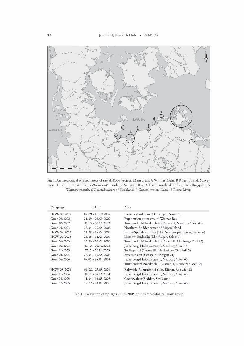
Two main areas, the Wismar Bight in the West and Rügen Island in the East, as well as further areas along the Baltic Sea coast, were selected for archaeological investigations by the SINCOS project (Fig. ). In each of the first and second years of the project, five months of field work were carried out (Table ). Exploration and documentation of new sites, as well as archaeological excavation of settlement sites with well preserved organic remains took place during this time. As a result of our research several shorelines could be reconstructed and dated by C analyses, but
82 Jan Harff, Friedrich Lüth • SINCOS
Fig. 1. Archaeological research areas of the SINCOS project. Main areas: A Wismar Bight. B Rügen Island. Survey areas: 1 Eastern mouth Grube-Wessek-Wetlands, 2 Neustadt Bay, 3 Trave mouth, 4 Trollegrund / Bugspitze, 5
Warnow mouth, 6 Coastal waters of Fischland, 7 Coastal waters Darss, 8 Peene River.
Tab. 1. Excavation campaigns 2002–2005 of the archaeological work group.
Campaign Date Area
HGW 09/2002 02.09.ª–ª11. 09.2002 Lietzow-Buddelin (Lkr. Rügen, Saiser 1)Goor 09/2002 04.09.ª–ª09.09.2002 Exploration outer area of Wismar BayGoor 10/2002 01.10.ª–ª07.10. 2002 Timmendorf-NordmoleªII (OstseeªII, Neuburgª/ªPoel 47)Goor 05/2003 28.04.ª–ª26.05.2003 Northern Bodden water of Rügen IslandHGW 08/2003 12. 08.ª–ª16. 08.2003 Parow-Sportboothafen (Lkr. Nordvorpommern, Parow 4)HGW 09/2003 25. 08.ª–ª12. 09.2003 Lietzow-Buddelin (Lkr. Rügen, Saiser 1)Goor 06/2003 10.06.ª–ª07. 09.2003 Timmendorf-NordmoleªII (Ostsee II, Neuburgª/ªPoel 47)Goor 10/2003 02.10.ª–ª05.10. 2003 Jäckelberg-Huk (OstseeªII, Neuburgª/ªPoel 45)Goor 11/2003 27.10.ª–ª02.11.2003 Trollegrund (OstseeªIII, Neubukowª/ªSalzhaff 5)Goor 05/2004 26.04.ª–ª16. 05.2004 Breetzer Ort (OstseeªVI, Bergen 24)Goor 06/2004 07. 06.ª–ª26. 09.2004 Jäckelberg-Huk (OstseeªII, Neuburgª/ªPoel 45)
Timmendorf-Nordmole I (OstseeªII, Neuburgª/ªPoel 12)
HGW 08/2004 09. 08.ª–ª27.08.2004 Ralswiek-Augustenhof (Lkr. Rügen, Ralswiek 8)Goor 11/2004 08.11.ª–ª05.12. 2004 Jäckelberg-Huk (OstseeªII, Neuburgª/ªPoel 45)Goor 04/2005 11. 04.ª–ª13.05.2005 Greifswalder Bodden, StrelasundGoor 07/2005 18. 07.ª–ª30.09.2005 Jäckelberg-Huk (OstseeªII, Neuburgª/ªPoel 45)
83Hauke Jöns et al. • Prehistoric settlements and the regional economic area
Bericht der RGK ,
AZ : LU /- a. LU /-
also important information about the cultural historical development could be gained.In addition, the archaeological scientific diving group participated in the weekly expeditions
of sub-project . with the research vessel ‘Professor Albrecht Penck’, with the aim of exploring areas of the Bay of Mecklenburg and the Wismar Bight.
Key reg ion A : t he Wisma r Bight
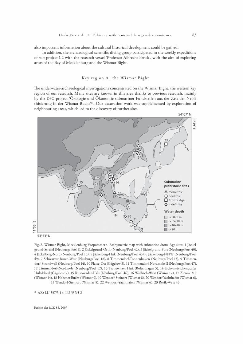
The underwater-archaeological investigations concentrated on the Wismar Bight, the western key region of our research. Many sites are known in this area thanks to previous research, mainly by the DFG-project ‘Ökologie und Ökonomie submariner Fundstellen aus der Zeit der Neoli-thisierung in der Wismar-Bucht’ . Our excavation work was supplemented by exploration of neighbouring areas, which led to the discovery of further sites.
Fig. 2. Wismar Bight, Mecklenburg-Vorpommern. Bathymetric map with submarine Stone Age sites: 1 Jäckel-grund-Strand (Neuburg/Poel 5), 2 Jäckelgrund-Orth (Neuburg/Poel 42), 3 Jäckelgrund-Furt (Neuburg/Poel 40), 4 Jäckelberg-Nord (Neuburg/Poel 16), 5 Jäckelberg-Huk (Neuburg/Poel 45), 6 Jäckelberg-NNW (Neuburg/Poel 49), 7 Schwarzer Busch-West (Neuburg/Poel 18), 8 Timmendorf-Tonnenhaken (Neuburg/Poel 15), 9 Timmen-dorf-Strandwall (Neuburg/Poel 14), 10 Platte-Ost (Gägelow 3), 11 Timmendorf-Nordmole II (Neuburg/Poel 47), 12 Timmendorf-Nordmole (Neuburg/Poel 12), 13 Tarnewitzer Huk (Boltenhagen 5), 14 Hohenwieschendorfer Huk-Nord (Gägelow 7), 15 Rustwerder-Hals (Neuburg/Poel 46), 16 Walfisch-West (Wismar 7), 17 Zierow MF (Wismar 14), 18 Hobener Bucht (Wismar 9), 19 Wendorf-Steinort (Wismar 8), 20 Wendorf-Yachthafen (Wismar 6),
21 Wendorf-Steinort (Wismar 8), 22 Wendorf-Yachthafen (Wismar 6), 23 Rerik-West 43.
84 Jan Harff, Friedrich Lüth • SINCOS
Jäcke lberg-Huk
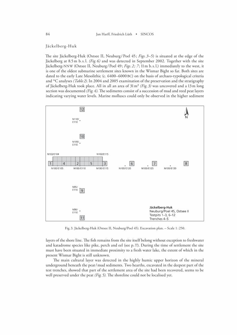
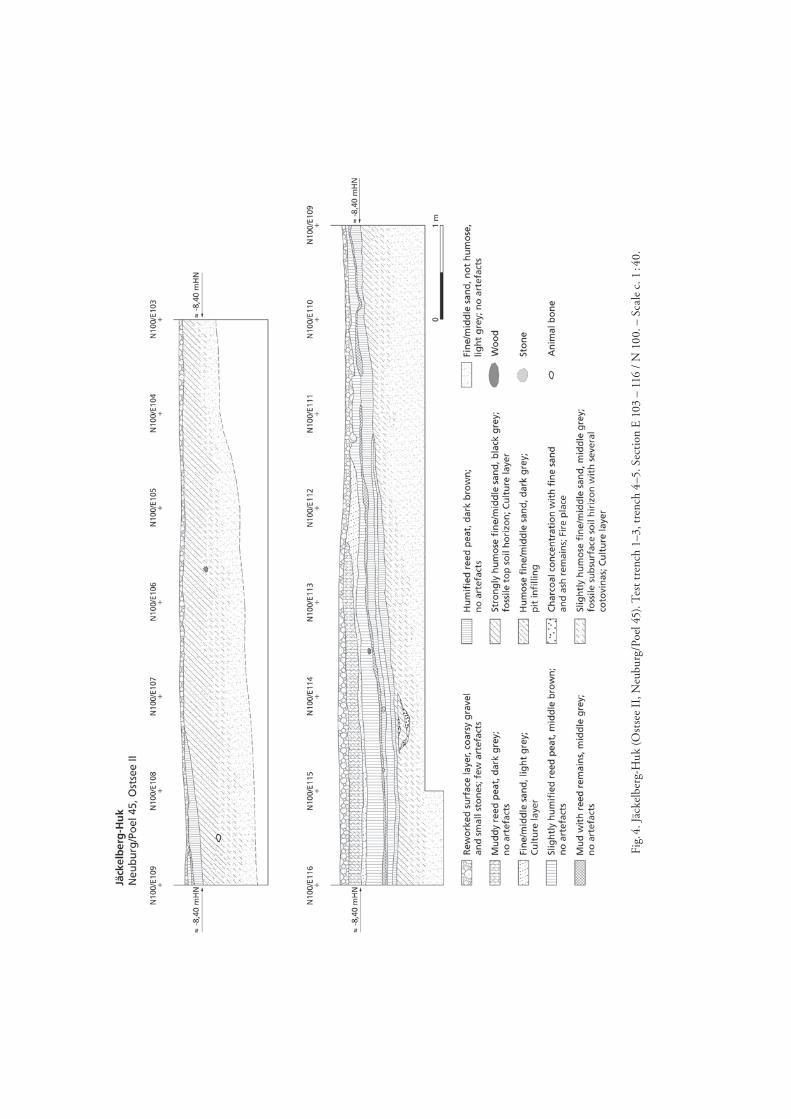
The site Jäckelberg-Huk (Ostsee II, Neuburg / Poel ; Figs. –) is situated at the edge of the Jäckelberg at . m b. s. l. (Fig. ) and was detected in September . Together with the site Jäckelberg-NNW (Ostsee II, Neuburg / Poel ; Figs. ; ; m b. s. l.) immediately to the west, it is one of the oldest submarine settlement sites known in the Wismar Bight so far. Both sites are dated to the early Late Mesolithic (c. – BC) on the basis of archaeo-typological criteria and C analyses (Table ). In and examination of the preservation and the stratigraphy of Jäckelberg-Huk took place. All in all an area of m² (Fig. ) was uncovered and a m long section was documented (Fig. ). The sediments consist of a succession of mud and reed peat layers indicating varying water levels. Marine molluscs could only be observed in the higher sediment
layers of the shore line. The fish remains from the site itself belong without exception to freshwater and katadrome species like pike, perch and eel (see p. ??). During the time of settlement the site must have been situated in immediate proximity to a fresh water lake, the extent of which in the present Wismar Bight is still unknown.
The main cultural layer was detected in the highly humic upper horizon of the mineral underground beneath the peat / mud sediments. Two hearths, excavated in the deepest part of the test trenches, showed that part of the settlement area of the site had been recovered, seems to be well preserved under the peat (Fig. ). The shoreline could not be localised yet.
Fig. 3. Jäckelberg-Huk (Ostsee II, Neuburg/Poel 45). Excavation plan. – Scale 1 : 250.
85Hauke Jöns et al. • Prehistoric settlements and the regional economic area
Bericht der RGK ,
Fig.
4. J
äcke
lber
g-H
uk (O
stse
e II
, Neu
burg
/Poe
l 45)
. Tes
t tre
nch
1–3,
tren
ch 4
–5. S
ectio
n E
103
– 11
6 / N
100
. – S
cale
c. 1
: 40.
86 Jan Harff, Friedrich Lüth • SINCOS
Sørensen . Bokelmann .
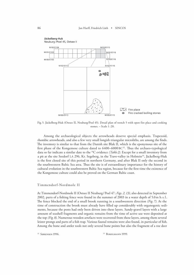
Among the archaeological objects the arrowheads deserve special emphasis. Trapezoid, rhombic arrowheads, and also a few very small longish triangular microliths, are among the finds. The inventory is similar to that from the Danish site Blak II, which is the eponymous site of the first phase of the Kongemose culture dated to – BC . Thus the archaeo-typological data so far indicate a similar date to the C evidence (Table ). Except for a small inventory from a pit at the site Seedorf LA , Kr. Segeberg, in the Trave-valley in Holstein, Jäckelberg-Huk is the first closed site of this period in northern Germany, and after Blak II only the second in the southwestern Baltic Sea area. Thus the site is of extraordinary importance for the history of cultural evolution in the southwestern Baltic Sea region, because for the first time the existence of the Kongemose culture could also be proved on the German Baltic coast.
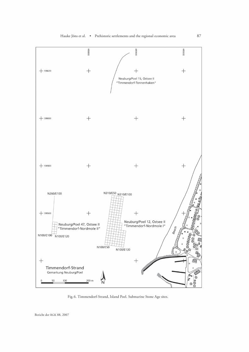
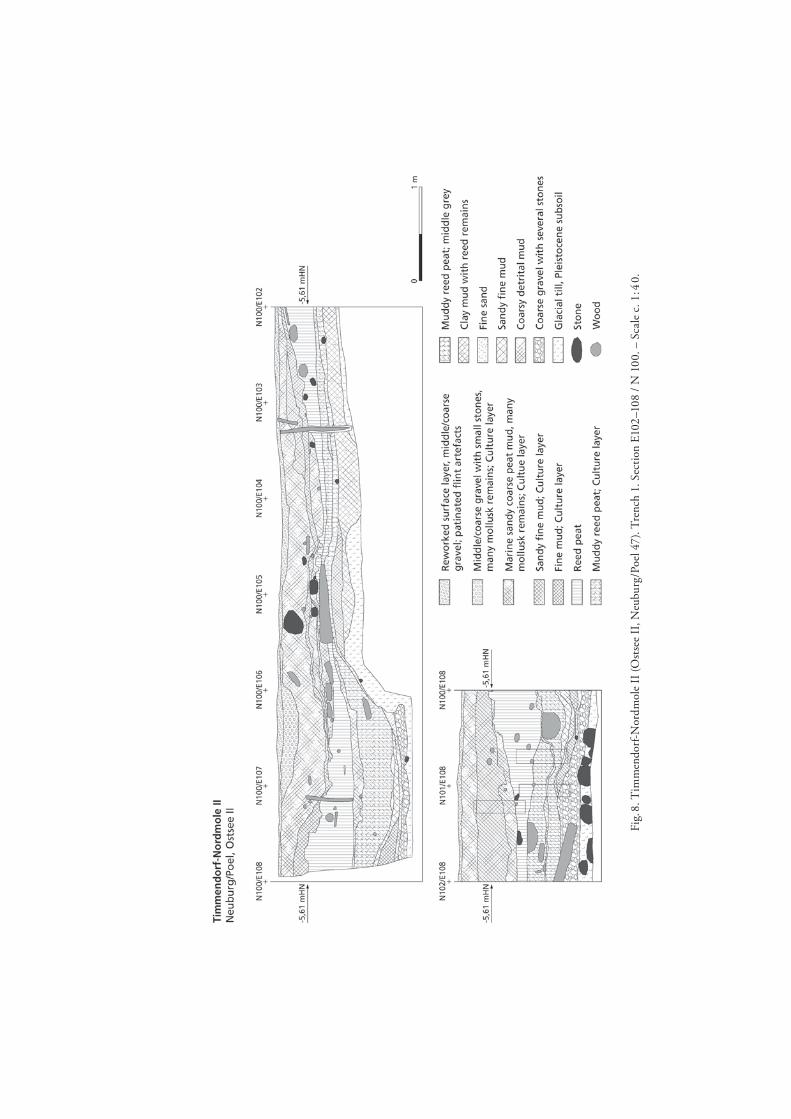
Timmendor f-Nordmole I I
At Timmendorf-Nordmole II (Ostsee II Neuburg / Poel ; Figs. , ), also detected in September , parts of a fishing fence were found in the summer of in a water depth of . m b. s. l.. The fence blocked the end of a small brook running in a southwestern direction (Fig. ). At the time of construction the brook must already have filled up considerably with organogenic sedi-ments, because the posts had only been driven into these layers. Sandy-gravel layers with a large amount of seashell fragments and organic remains from the time of active use were deposited at the top (Fig. ). Numerous wooden artefacts were recovered from these layers, among them several leister prongs and parts of a fish trap. Various faunal remains were also found, in particular of fish. Among the bone and antler tools not only several bone points but also the fragment of a roe deer
Fig. 5. Jäckelberg-Huk (Ostsee II, Neuburg/Poel 45). Detail plan of trench 5 with open fire place and cooking stones. – Scale 1 : 20.
87Hauke Jöns et al. • Prehistoric settlements and the regional economic area
Bericht der RGK ,
Fig. 6. Timmendorf-Strand, Island Poel. Submarine Stone Age sites.

88 Jan Harff, Friedrich Lüth • SINCOS
antler harpoon are particularly worth mentioning. Thus next to active and passive fishing, the hunting of sea mammals can be established for this site. Since no ceramics have been found, the main culture layer of Nordmole II can be assigned to an a-ceramic phase of the Ertebølle culture.
A series of C data indicate that this layer developed over a period between c. and BC (Table ). Some fish vertebrae and animal bones are dated a little earlier, but this can be attributed to maritime reservoir effects.
Underneath the marine deposits which constitute the main culture layer, a second small layer with finds could be detected within the limnic sediments of the brook bed and under the peat at the shore. A small open hearth was also found. C data of two mammal bones date this layer to the Late Mesolithic between BC and BC (Table ).
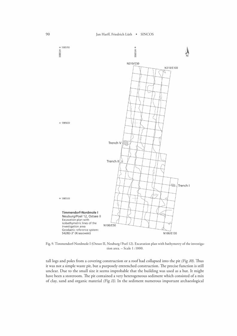
Timmendor f-Nordmole I
During the investigations at the site Timmendorf-Nordmole I (Ostsee II, Neuburg / Poel ) in the years –, the find layer of a settlement of the late Ertebølle culture (– BC) could be located at . m-. m b. s. l. (Fig. ). The area has a length of more than m and is up to m wide (Fig. ).
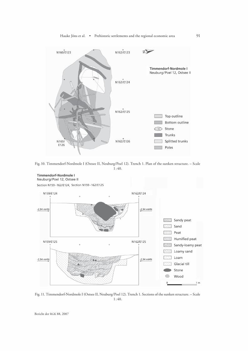
The surveys showed that large parts of the former settlement surface . m b. s. l. were destroyed by erosion, as an abraded marl layer appeared directly below a cm thick surface layer consisting of gravel with numerous eroded stone artefacts. However, sunken settlement features are preserved in the area, for example a pit which was excavated in summer . It was . m long and . m wide at the surface with a surviving depth of . m. The base had a pear-shaped outline with a narrow entry on one side and an extended utilisation area on the other. Numerous
Fig. 7. Timmendorf-Nordmole II (Ostsee II, Neuburg / Poel 47). Excavation plan. – Scale 1 : 40.
89Hauke Jöns et al. • Prehistoric settlements and the regional economic area
Bericht der RGK ,
Fig.
8. T
imm
endo
rf-N
ordm
ole
II (O
stse
e II
, Neu
burg
/Poe
l 47)
. Tre
nch
1. S
ectio
n E1
02–1
08 /
N 1
00. –
Sca
le c
. 1 : 4
0.
90 Jan Harff, Friedrich Lüth • SINCOS
tall logs and poles from a covering construction or a roof had collapsed into the pit (Fig. ). Thus it was not a simple waste pit, but a purposely entrenched construction. The precise function is still unclear. Due to the small size it seems improbable that the building was used as a hut. It might have been a storeroom. The pit contained a very heterogeneous sediment which consisted of a mix of clay, sand and organic material (Fig. ). In the sediment numerous important archaeological
Fig. 9. Timmendorf-Nordmole I (Ostsee II, Neuburg / Poel 12). Excavation plan with bathymetry of the investiga-tion area. – Scale 1 : 1000.
91Hauke Jöns et al. • Prehistoric settlements and the regional economic area
Bericht der RGK ,
Fig. 10. Timmendorf-Nordmole I (Ostsee II, Neuburg/Poel 12). Trench 1. Plan of the sunken structure. – Scale 1 : 40.
Fig. 11. Timmendorf-Nordmole I (Ostsee II, Neuburg / Poel 12). Trench 1. Sections of the sunken structure. – Scale 1 : 40.

92 Jan Harff, Friedrich Lüth • SINCOS
Lübke ; Id. a. Hartz / Lübke , – ; Lübke a, .
Labes . Hartz .
artefacts were found, the most remarkable of which is a truncated blade with a preserved handle made of hazelwood with a binding of lime bast (Fig. ) .
The results of the C dated samples from the pit cover a period of about years (Table ), but the data older than cal BC might be the result of various reservoir effects . The younger dates between and cal BC, derived from the poles and split trunks of the roof structure, as well as from the wooden handle of the flint knife, most probably indicate the actual age of the pit.
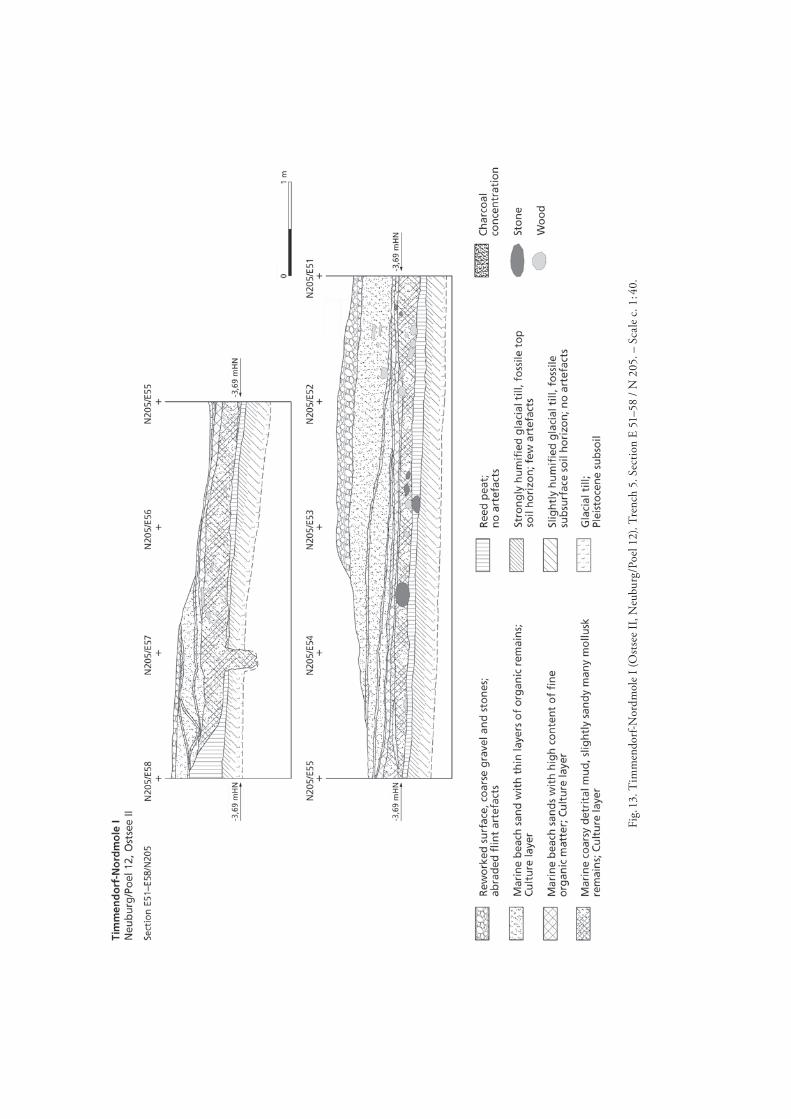
In deeper water the original boundary of the settlement and the organic shore zone are pre-served. In some areas the occupation layer could be traced directly below a thin sandy layer on the sea bed. These layers contain non-patinated flint artefacts, large pottery fragments, bone or antler tools, as well as wooden implements. A trench in the shore zone proved that the upper part of the stratum consists of gravely sand, within which some thin layers of organic substratum are enclosed. They contain countless remains of plants, wooden particles, smaller vertebrate animals such as fish, birds, etc., and numerous archaeological artefacts. The sandy layers cover a marine mud which contains reed and wood remains, as well as many artefacts. Beneath the mud are a reed peat layer and finally the glacial till with a palaeosol (Fig. ). Radiocarbon samples from different layers dated the upper marine sediments between and cal BC, artefacts from the surface of the reed peat layer between and cal BC and from the palaeosol around cal BC (Table ).
This site was particularly notable for its well preserved wooden tools . Despite the extent of surface finds, there is evidence that the site was only used seasonally. Current archaeo-zoological investigations indicate that it was only used in the cooler half of the year. Comparison with set-tlements like Neustadt-Marienbad or Rosenhof in Ostholstein supports this thesis, since in
Fig. 12. Timmendorf-Nordmole I (Ostsee II, Neuburg/Poel 12). Flint blade knife with preserved handle of hazel wood and lime bast (Trench 1, sunken structure). – Scale 1 : 2.
93Hauke Jöns et al. • Prehistoric settlements and the regional economic area
Bericht der RGK ,
Fig.
13. T
imm
endo
rf-N
ordm
ole
I (O
stse
e II
, Neu
burg
/Poe
l 12)
. Tre
nch
5. S
ectio
n E
51–5
8 / N
205
. – S
cale
c. 1
: 40.
94 Jan Harff, Friedrich Lüth • SINCOS
Kaute et al. ; Lübke c ; Mandelkow et al. .
Kaute et al. ; Klooss .
Timmendorf-Nordmole I characteristic T-shaped axes made of red deer antler or imported goods like Danubian ground stone axes are missing in the artefact spectrum. Even pottery was found only in small numbers.
Remarkably, early Neolithic ceramics were found in the upper layers of a test trench in the North of the site in summer . The oldest objects dated by means of C came from the southern area of the site, so that it must be assumed that Nordmole I consists of several sites which shifted over time (Table ). The activities moved from South to North. Further excavations are necessary to gather material to observe this working hypothesis and in order to be able to get more exact data from the site.
Explorat ion of f u r ther s ite s in the Wisma r Bight
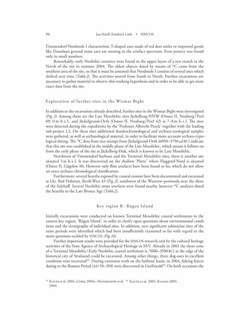
In addition to the excavations already described, further sites in the Wismar Bight were investigated (Fig. ). Among them are the Late Mesolithic sites Jäckelberg-NNW (Ostsee II, Neuburg / Poel ) m b. s. l., and Jäckelgrund-Orth (Ostsee II, Neuburg / Poel ) at – m b. s. l. The sites were detected during the expeditions by the ‘Professor Albrecht Penck’ together with the leading sub-project .. On these sites additional dendrochronological and archaeo-zoological samples were gathered, as well as archaeological material, in order to facilitate more accurate archaeo-typo-logical dating. The C data from tree stumps from Jäckelgrund-Orth (– cal BC) indicate that this site was established in the middle phase of the Late Mesolithic, which means it follows on from the early phase of the site at Jäckelberg-Huk, which is known to be Late Mesolithic.
Northwest of Timmendorf harbour and the Terminal Mesolithic sites, there is another site situated m b. s. l. It was discovered on the shallow ‘Platte’ where Flaggtief-Nord is situated (Ostsee II, Gägelow ). However only flint artefacts have been found so far, which do not allow an exact archaeo-chronological classification.
Furthermore, several hearths exposed by coastal erosion have been documented and excavated at Lkr. Bad Doberan, Rerik-West (Fig. ), southwest of the Wustrow peninsula near the shore of the Salzhaff. Several Neolithic stone artefacts were found nearby, however C analyses dated the hearths to the Late Bronze Age (Table ).
Key reg ion B : Rügen I s l a nd
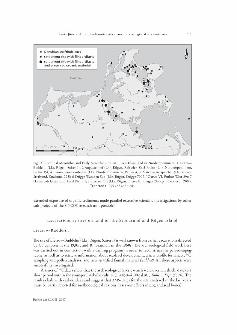
Initially excavations were conducted on known Terminal Mesolithic coastal settlements in the eastern key region, ‘Rügen Island’, in order to clarify open questions about environmental condi-tions and the stratigraphy of individual sites. In addition, new significant submarine sites of the same periods were identified which had been insufficiently examined so far with regard to the main questions tackled by SINCOS (Fig. ).
Further important results were provided for the SINCOS research unit by the cultural heritage activities of the State Agency of Archaeological Heritage in M-V. Already in the shore zone of a Terminal Mesolithic / Early Neolithic coastal settlement (c. – BC) at the edge of the historical city of Stralsund could be excavated. Among other things, three dug-outs in excellent condition were recovered . During extension work on the harbour basin, in , fishing fences dating to the Roman Period (AD –) were discovered in Greifswald. On both occasions the
95Hauke Jöns et al. • Prehistoric settlements and the regional economic area
Bericht der RGK ,
extended exposure of organic sediments made parallel extensive scientific investigations by other sub-projects of the SINCOS research unit possible.
Excavat ions at s ite s on l a nd on the St re l a sund a nd Rügen I s l a nd
Lie t zow-Budde l in
The site of Lietzow-Buddelin (Lkr. Rügen, Saiser ) is well known from earlier excavations directed by C. Umbreit in the s, and B. Gramsch in the s. The archaeological field work here was carried out in connection with a drilling program in order to reconstruct the palaeo-topog-raphy, as well as to retrieve information about sea-level development, a new profile for reliable C sampling and pollen analyses, and new stratified faunal material (Table ). All these aspects were successfully investigated.
A series of C dates show that the archaeological layers, which were over m thick, date to a short period within the younger Ertebølle culture (c. – cal BC ; Table ; Figs. ; ). The results clash with earlier ideas and suggest that AMS-dates for the site analysed in the last years must be partly rejected for methodological reasons (reservoir effects in dog and seal bones).
Fig. 14. Terminal Mesolithic and Early Neolithic sites on Rügen Island and in Nordvorpommern: 1 Lietzow-Buddelin (Lkr. Rügen, Saiser 1); 2 Augustenhof (Lkr. Rügen, Ralswiek 8); 3 Prohn (Lkr. Nordvorpommern, Prohn 15); 4 Parow-Sportboothafen (Lkr. Nordvorpommern, Parow 4; 5 Mischwasserspeicher (Hansestadt Stralsund, Stralsund 225); 6 Drigge-Wampen Süd (Lkr. Rügen, Drigge 7002 / Ostsee VI, Putbus-West 29); 7 Hansestadt Greifswald, Insel Riems 1; 8 Breetzer Ort (Lkr. Rügen, Ostsee VI, Bergen 24); cp. Lübke et al. 2000;
Terberger 1999 and additions.

96 Jan Harff, Friedrich Lüth • SINCOS
When it was first founded, the settlement at Lietzow-Buddelin was situated by a small river close to a lake separated by a spit from the Kleiner Jasmunder Bodden. Later, after a rise in sea level, the lake was connected to the Bodden (see p. ??). These environmental changes are clearly reflected in the fish remains : they show a shift from mainly fresh water fish in the lower levels to salt water fish in the upper ones (see p. ??). On the basis of these results, Lietzow-Buddelin can now contribute information to the question of sea-level development (see p. ??).
The subsistence strategy of the later Ertebølle population was mainly based on hunting and fishing. New pollen analyses provide no evidence for cereals. It is possible that the beginnings of the use of domesticated animals is reflected in the Late Atlantic (see p. ??).
The excavation made new stratified material available (silex artefacts, a few organic artefacts and pottery fragments). Of special interest is an amphibolite adze (Flachhacke), which must have been imported. It is the first find of the kind reported from a stratified context in the Rügen area. The excavations also confirmed evidence for Neolithic remains at Lietzow-Buddelin. To sum up, the scientific potential of this large site for the period about – BC can be demonstrated (Fig. ). Of even more importance is the fact that the final phase of the regional Ertebølle culture on Rügen Island can be seen here.
Fig. 15. Lietzow-Buddelin (Lkr. Rügen, Saiser 1). Southern section of Qu. 92,5–94/219 in the wetland. Artefact positions are marked.

97Hauke Jöns et al. • Prehistoric settlements and the regional economic area
Bericht der RGK ,
Klinghardt ; Petzsch ; Gramsch . Lübke / Terberger ; Id. ; Terberger .
Id. . Terberger / Seiler .
R a l sw iek-Augustenhof
The site of Ralswiek-Augustenhof (Lkr. Rügen, Ralswiek ) has been known for about years and various field work campaigns have taken place there. In the summer of test trenches were opened with the aid of a small mechanical excavator in order to get some insights into the structure of the site. In a longer trench an undisturbed stratigraphy was observed and small test areas of one square metre each were excavated in detail. They revealed a stratigraphic sequence of an Ertebølle and a Neolithic layer (Fig. ). According to AMS-dates (Table ) they probably belong to the later Ertebølle culture and the Funnel Beaker culture. The most interesting find was a decorated roe deer harpoon from the lower layer.
The environmental situation at the site could be reconstructed as the result of a drilling pro-gram. The site was originally situated on a sandy hill by a lake that was separated by a spit from the Großer Jasmunder Bodden. This seems to be the reason for the relatively high position of the find layer above the modern sea level (see p. ??).
Pa row-Spor tbootha fen
In the s dredging work for a small harbour led to the discovery of a coastal Stone Age site, Parow-Sportboothafen (Lkr. Nordvorpommern, Parow ), situated on the Strelasund. AMS-dating shows a sequence of Mesolithic and Neolithic layers on the site. In the summer of a small test trench close to the harbour was excavated. The stratigraphy demonstrated the existence of two archaeological layers that can be assigned to the Ertebølle culture (about BC) and prob-ably to the earliest Funnel Beaker culture around BC (Table ). On the basis of an imported Linear Band pottery fragment found by an amateur archaeologist, the existence of an early Erte-bølle layer was suggested for Parow . The test trench, however, does not confirm this.
Drilling demonstrated that the site was situated in a typical position where a small brook flows into the Strelasund. The existence of a very Early Neolithic layer is of particular interest and makes the site ideal for further analyses, because it might be possible to document here the transition from a Mesolithic to a Neolithic subsistence strategy and way of life.
Fig. 16. Ralswiek-Augustenhof (Lkr. Rügen, Ralswiek 8). Section trench 8. 1 Glacial till. – 2 sandy layer with roots. – 3 fine sand, bright. – 4 transitional layer Ah-Bh-soil horizons. – 5a find layer: fine to coarse sand, black, charcoal, stone artefacts. – 5b find layer: fine sand. – 6 yellow coarse sand. – 7 brown coarse sand, with single
larger stones. – 8 fine to middle sized sand, forest soil with roots. – wood: brown. – stones: darkgrey.
98 Jan Harff, Friedrich Lüth • SINCOS
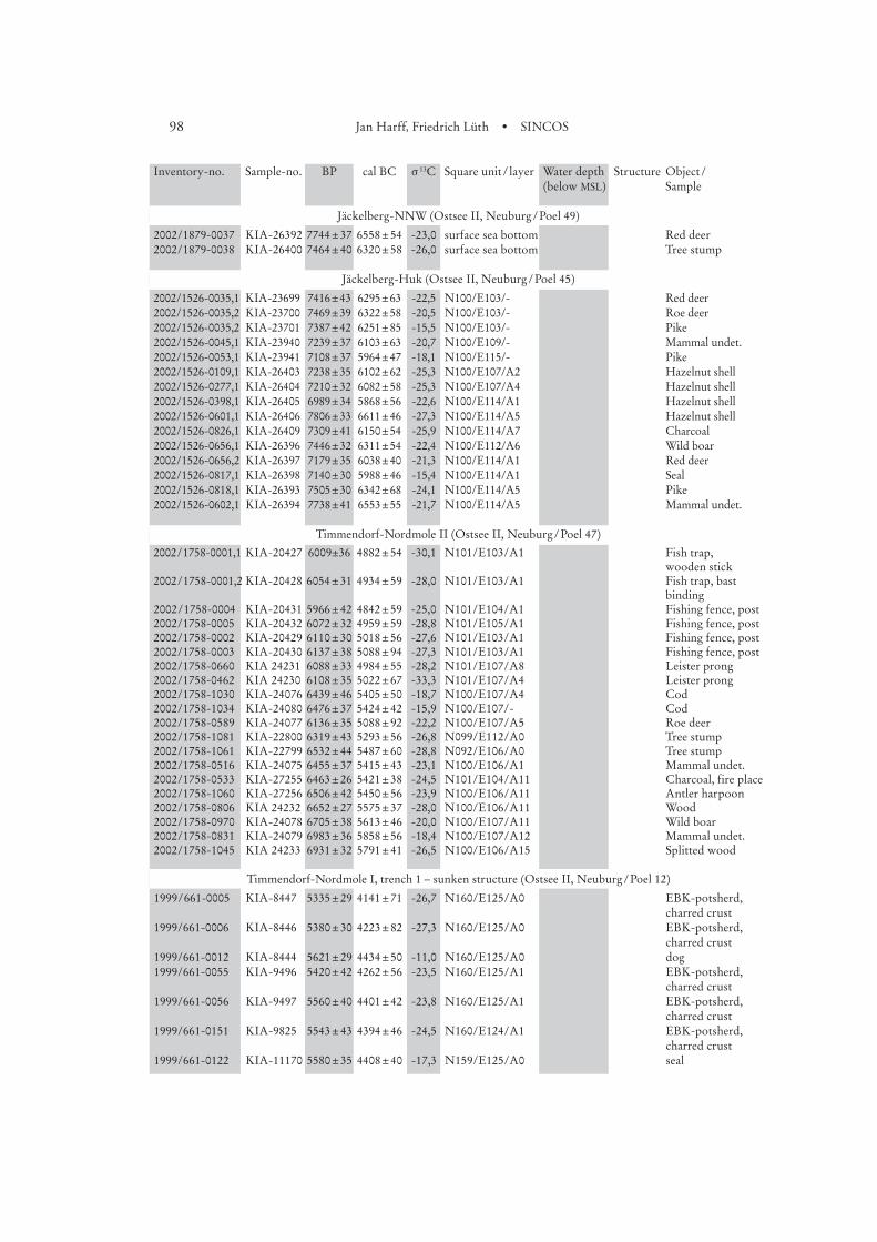
Inventory-no. Sample-no. BP cal BC sª13C Square unitª/ªlayer Water depth Structure Objectª/ª (below MSL) Sample
Jäckelberg-NNW (Ostsee II, Neuburgª/ªPoel 49)
2002/1879-0037 KIA-26392 7744ª±ª37 6558ª±ª54 -23,0 surface sea bottom Red deer2002/1879-0038 KIA-26400 7464ª±ª40 6320ª±ª58 -26,0 surface sea bottom Tree stump
Jäckelberg-Huk (Ostsee II, Neuburgª/ªPoel 45)
2002/1526-0035,1 KIA-23699 7416ª±ª43 6295ª±ª63 -22,5 N100/E103/- Red deer2002/1526-0035,2 KIA-23700 7469ª±ª39 6322ª±ª58 -20,5 N100/E103/- Roe deer2002/1526-0035,2 KIA-23701 7387ª±ª42 6251ª±ª85 -15,5 N100/E103/- Pike2002/1526-0045,1 KIA-23940 7239ª±ª37 6103ª±ª63 -20,7 N100/E109/- Mammal undet.2002/1526-0053,1 KIA-23941 7108ª±ª37 5964ª±ª47 -18,1 N100/E115/- Pike2002/1526-0109,1 KIA-26403 7238ª±ª35 6102ª±ª62 -25,3 N100/E107/A2 Hazelnut shell2002/1526-0277,1 KIA-26404 7210ª±ª32 6082ª±ª58 -25,3 N100/E107/A4 Hazelnut shell2002/1526-0398,1 KIA-26405 6989ª±ª34 5868ª±ª56 -22,6 N100/E114/A1 Hazelnut shell2002/1526-0601,1 KIA-26406 7806ª±ª33 6611ª±ª46 -27,3 N100/E114/A5 Hazelnut shell2002/1526-0826,1 KIA-26409 7309ª±ª41 6150ª±ª54 -25,9 N100/E114/A7 Charcoal2002/1526-0656,1 KIA-26396 7446ª±ª32 6311ª±ª54 -22,4 N100/E112/A6 Wild boar2002/1526-0656,2 KIA-26397 7179ª±ª35 6038ª±ª40 -21,3 N100/E114/A1 Red deer2002/1526-0817,1 KIA-26398 7140ª±ª30 5988ª±ª46 -15,4 N100/E114/A1 Seal2002/1526-0818,1 KIA-26393 7505ª±ª30 6342ª±ª68 -24,1 N100/E114/A5 Pike2002/1526-0602,1 KIA-26394 7738ª±ª41 6553ª±ª55 -21,7 N100/E114/A5 Mammal undet.
Timmendorf-Nordmole II (Ostsee II, Neuburgª/ªPoel 47)
2002 / 1758-0001,1 KIA-20427 6009±36 4882ª±ª54 -30,1 N101/E103/A1 Fish trap, wooden stick
2002 / 1758-0001,2 KIA-20428 6054ª±ª31 4934ª±ª59 -28,0 N101/E103/A1 Fish trap, bast binding
2002 / 1758-0004 KIA-20431 5966ª±ª42 4842ª±ª59 -25,0 N101/E104/A1 Fishing fence, post2002/1758-0005 KIA-20432 6072ª±ª32 4959ª±ª59 -28,8 N101/E105/A1 Fishing fence, post2002/1758-0002 KIA-20429 6110ª±ª30 5018ª±ª56 -27,6 N101/E103/A1 Fishing fence, post2002/1758-0003 KIA-20430 6137ª±ª38 5088ª±ª94 -27,3 N101/E103/A1 Fishing fence, post2002/1758-0660 KIA 24231 6088ª±ª33 4984ª±ª55 -28,2 N101/E107/A8 Leister prong2002/1758-0462 KIA 24230 6108ª±ª35 5022ª±ª67 -33,3 N101/E107/A4 Leister prong2002/1758-1030 KIA-24076 6439ª±ª46 5405ª±ª50 -18,7 N100/E107/A4 Cod2002/1758-1034 KIA-24080 6476ª±ª37 5424ª±ª42 -15,9 N100/E107/- Cod2002/1758-0589 KIA-24077 6136ª±ª35 5088ª±ª92 -22,2 N100/E107/A5 Roe deer2002/1758-1081 KIA-22800 6319ª±ª43 5293ª±ª56 -26,8 N099/E112/A0 Tree stump2002/1758-1061 KIA-22799 6532ª±ª44 5487ª±ª60 -28,8 N092/E106/A0 Tree stump2002/1758-0516 KIA-24075 6455ª±ª37 5415ª±ª43 -23,1 N100/E106/A1 Mammal undet.2002/1758-0533 KIA-27255 6463ª±ª26 5421ª±ª38 -24,5 N101/E104/A11 Charcoal, fire place2002/1758-1060 KIA-27256 6506ª±ª42 5450ª±ª56 -23,9 N100/E106/A11 Antler harpoon2002/1758-0806 KIA 24232 6652ª±ª27 5575ª±ª37 -28,0 N100/E106/A11 Wood2002/1758-0970 KIA-24078 6705ª±ª38 5613ª±ª46 -20,0 N100/E107/A11 Wild boar2002/1758-0831 KIA-24079 6983ª±ª36 5858ª±ª56 -18,4 N100/E107/A12 Mammal undet.2002/1758-1045 KIA 24233 6931ª±ª32 5791ª±ª41 -26,5 N100/E106/A15 Splitted wood
Timmendorf-Nordmole I, trench 1 – sunken structure (Ostsee II, Neuburgª/ªPoel 12)
1999 / 661-0005 KIA-8447 5335ª±ª29 4141ª±ª71 -26,7 N160/E125/A0 EBK-potsherd, charred crust
1999/661-0006 KIA-8446 5380ª±ª30 4223ª±ª82 -27,3 N160/E125/A0 EBK-potsherd, charred crust
1999/661-0012 KIA-8444 5621ª±ª29 4434ª±ª50 -11,0 N160/E125/A0 dog1999/661-0055 KIA-9496 5420ª±ª42 4262ª±ª56 -23,5 N160/E125/A1 EBK-potsherd,
charred crust1999/661-0056 KIA-9497 5560ª±ª40 4401ª±ª42 -23,8 N160/E125/A1 EBK-potsherd,
charred crust1999/661-0151 KIA-9825 5543ª±ª43 4394ª±ª46 -24,5 N160/E124/A1 EBK-potsherd,
charred crust1999/661-0122 KIA-11170 5580ª±ª35 4408ª±ª40 -17,3 N159/E125/A0 seal

99Hauke Jöns et al. • Prehistoric settlements and the regional economic area
Bericht der RGK ,
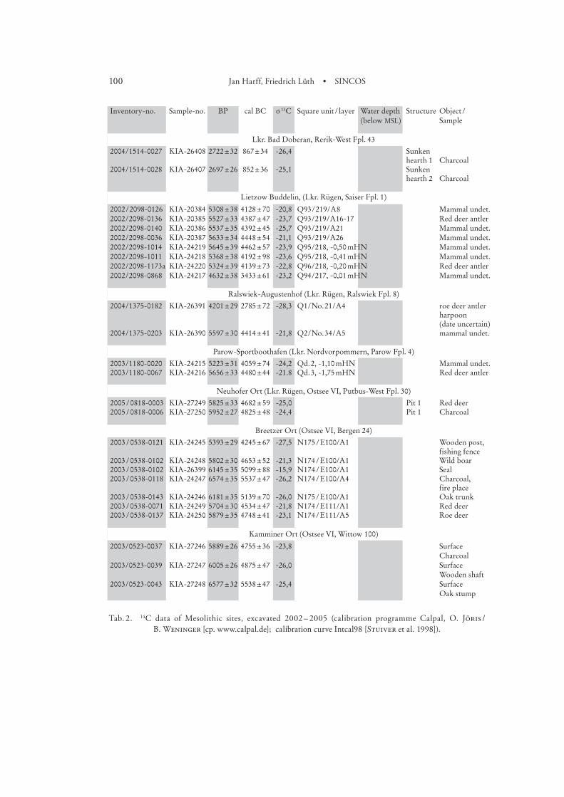
Inventory-no. Sample-no. BP cal BC sª13C Square unitª/ªlayer Water depth Structure Objectª/ª (below MSL) Sample
Timmendorf-Nordmole I (Ostsee II, Neuburgª/ªPoel 12) Forts.
1999/661-1245 KIA-16017 5280ª±ª35 4109ª±ª81 -30,7 N160/E124/A9 Shafted flint blade, wooden handle
1999/661-1245 KIA-16018 5582ª±ª34 4408ª±ª40 -26,6 N160/E124/A9 Shafted flint blade, lime bast
1999/661-1280 KIA-16019 5443ª±ª36 4289ª±ª40 -28,9 N160/E124/A9 Wooden bowl or logboat stem
1999/661-0850 KIA-16020 5613ª±ª29 4427ª±ª48 -24,6 N161/E123/A3 Decorated rim potsherd charred crust
1999/661-1245 KIA-18208 5065ª±ª177 3882ª±ª193 -37,9 N160/E124/A9 Shafted flint blade, lime bast (2. meas.)
1999/661-1101 KIA-19318 5427ª±ª27 4285ª±ª36 -23,6 N160/E124/A3 Trunk, pit cover1999/661-0959 KIA-19319 5354ª±ª27 4164ª±ª81 -25,3 N160/E125/A5 Trunk, pit cover1999/661-0990 KIA-19320 5256ª±ª30 4096ª±ª93 -27,0 N160/E125/A5 Pole, pit cover1999/661-0917 KIA-19321 5301ª±ª27 4123ª±ª64 -27,8 N160/E125/A4 Pole, pit cover1999/661-0956 KIA-19322 5338ª±ª27 4142ª±ª71 -27,3 N160/E125/A4 Splitted trunk, pit
cover
Timmendorf-Nordmole I, trench 5 – shore zone (Ostsee II, Neuburgª/ªPoel 12)
1999/661-ª0230 KIA-11620 5327ª±ª39 4141ª±ª74 -28,2 N207/E55/A1 Log boat fragment1999/661-ª0253 KIA-11618 5343ª±ª34 4153ª±ª79 -26,2 N206/E55/A2 Leister prong1999/661-ª0543 KIA-12476 5388ª±ª28 4240ª±ª70 -24,0 N204/E56/A2 Log boat fragment1999/661-ª0355 KIA-11619 5505ª±ª37 4354ª±ª61 -27,6 N208/E54/A5 Leister prong1999/661-ª0638 KIA-12475 5418ª±ª32 4276ª±ª43 -28,4 N205/E53/A6 Bow fragment1999/661-1908 KIA-20118 5293ª±ª32 4119ª±ª70 -25,9 N206/E51/A2 Leister prong1999/661-ª2020 KIA-20120 5311ª±ª31 4127ª±ª65 -27,3 N206/E51/A4 Leister prong1999/661-ª2010 KIA-20121 5885ª±ª22 4750ª±ª33 -19,3 N206/E51/A7 Leister prong1999/661-ª2055 KIA-20122 5785ª±ª30 4634ª±ª53 -30,2 N206/E51/A9 Hazel nut shells1999/661-1836 KIA-20123 5347ª±ª28 4155ª±ª78 -23,6 N208/E51/A1 Leister prong1999/661-1948 KIA-20124 5405ª±ª25 4271ª±ª45 -29,1 N208/E51/A4 Leister prong1999/661-ª2022 KIA-20126 5478ª±ª22 4305ª±ª44 -26,7 N208/E51/A6 Leister prong1999/661-ª2009 KIA-20127 6035ª±ª24 4907ª±ª45 -28,5 N208/E51/A9 Splitted wood
Timmendorf-Nordmole I, trench 2 and surface finds (Ostsee II, Neuburgª/ªPoel 12)
1999/661-0014 KIA-8443 5604ª±ª29 4418ª±ª43 -13,8 surface Seal1999/661-0007 KIA-8445 5362ª±ª39 4184ª±ª97 -24,3 surface EBK-potsherd,
charred crust1999/661-0302 KIA-11615 5692ª±ª35 4522ª±ª47 -24,5 Trench „Poel Cog“ Wooden tool1999/661-0089 KIA-9498 5323ª±ª35 4136ª±ª70 -31,7 N182/E52/A0 Leister prong1999/661-0093 KIA-9499 5456ª±ª37 4295ª±ª41 -22,8 N182/E53/A1 Red deer1999/661-0090 KIA-9500 5791ª±ª39 4638ª±ª59 -19,8 N182/E53/A1 EBK-lamp charred
crust1999/661-0091 KIA-9501 5536ª±ª32 4392ª±ª45 -27,0 N182/E53/A1 EBK-potsherd,
charred crustJäckelgrund-Strand (Ostsee II, Neuburgª/ªPoel 5)
2001/2114-008 KIA-18210 6882ª±ª33 5762ª±ª36 -28,0 7,80ªm Tree stump
Jäckelgrund-Furt (Ostsee II, Neuburgª/ªPoel 40)
2001/2112-004 KIA-19323 7022ª±ª33 5905ª±ª57 -25,2 7,90ªm Tree stump
Jäckelgrund-Orth (Ostsee II, Neuburgª/ªPoel 42)
2002/977-005 KIA-18209 6969ª±ª33 5835ª±ª49 -24,4 7,20ªm Tree stump2002/977-025 KIA-19240 7022ª±ª44 5900ª±ª62 -24,1 6,50ªm Tree stump2002/977-026 KIA-19241 7014ª±ª36 5898ª±ª60 -22,9 6,70ªm Tree stump2002/977-027 KIA-19242 6888ª±ª35 5767ª±ª38 -21,5 6,60ªm Tree stump2002/977-028 KIA-19243 6916ª±ª35 5783ª±ª40 -24,3 7,20ªm Tree stump
100 Jan Harff, Friedrich Lüth • SINCOS
Inventory-no. Sample-no. BP cal BC sª13C Square unitª/ªlayer Water depth Structure Objectª/ª (below MSL) Sample
Lkr. Bad Doberan, Rerik-West Fpl. 43
2004/1514-0027 KIA-26408 2722ª±ª32 867ª±ª34 -26,4 Sunken hearth 1 Charcoal
2004/1514-0028 KIA-26407 2697ª±ª26 852ª±ª36 -25,1 Sunken hearth 2 Charcoal
Lietzow Buddelin, (Lkr. Rügen, Saiser Fpl. 1)
2002 / 2098-0126 KIA-20384 5308ª±ª38 4128ª±ª70 -20,8 Q93 / 219/A8 Mammal undet.2002/2098-0136 KIA-20385 5527ª±ª33 4387ª±ª47 -23,7 Q93/219/A16-17 Red deer antler2002/2098-0140 KIA-20386 5537ª±ª35 4392ª±ª45 -25,7 Q93/219/A21 Mammal undet.2002/2098-0036 KIA-20387 5633ª±ª34 4448ª±ª54 -21,1 Q93/219/A26 Mammal undet.2002/2098-1014 KIA-24219 5645ª±ª39 4462ª±ª57 -23,9 Q95/218, -0,50ªmHN Mammal undet.2002/2098-1011 KIA-24218 5368ª±ª38 4192ª±ª98 -23,6 Q95/218, -0,41ªmHN Mammal undet.2002/2098-1173a KIA-24220 5324ª±ª39 4139ª±ª73 -22,8 Q96/218, -0,20ªmHN Red deer antler2002/2098-0868 KIA-24217 4632ª±ª38 3433ª±ª61 -23,2 Q94/217, -0,01ªmHN Mammal undet.
Ralswiek-Augustenhof (Lkr. Rügen, Ralswiek Fpl. 8)
2004/1375-0182 KIA-26391 4201ª±ª29 2785ª±ª72 -28,3 Q1/No.ª21/A4 roe deer antler harpoon (date uncertain)
2004/1375-0203 KIA-26390 5597ª±ª30 4414ª±ª41 -21,8 Q2/No.ª34/A5 mammal undet.
Parow-Sportboothafen (Lkr. Nordvorpommern, Parow Fpl. 4)
2003/1180-0020 KIA-24215 5223ª±ª31 4059ª±ª74 -24,2 Qd.ª2, -1,10ªmHN Mammal undet.2003/1180-0067 KIA-24216 5656ª±ª33 4480ª±ª44 -21.8 Qd.ª3, -1,75ªmHN Red deer antler
Neuhofer Ort (Lkr. Rügen, Ostsee VI, Putbus-West Fpl. 30)
2005ª/ª0818-0003 KIA-27249 5825ª±ª33 4682ª±ª59 -25,0 Pit 1 Red deer2005ª/ª0818-0006 KIA-27250 5952ª±ª27 4825ª±ª48 -24,4 Pit 1 Charcoal
Breetzer Ort (Ostsee VI, Bergen 24)
2003ª/ª0538-0121 KIA-24245 5393ª±ª29 4245ª±ª67 -27,5 N175ª/ªE100/A1 Wooden post, fishing fence
2003ª/ª0538-0102 KIA-24248 5802ª±ª30 4653ª±ª52 -21,3 N174ª/ªE100/A1 Wild boar2003ª/ª0538-0102 KIA-26399 6145ª±ª35 5099ª±ª88 -15,9 N174ª/ªE100/A1 Seal2003ª/ª0538-0118 KIA-24247 6574ª±ª35 5537ª±ª47 -26,2 N174ª/ªE100/A4 Charcoal,
fire place2003ª/ª0538-0143 KIA-24246 6181ª±ª35 5139ª±ª70 -26,0 N175ª/ªE100/A1 Oak trunk2003ª/ª0538-0071 KIA-24249 5704ª±ª30 4534ª±ª47 -21,8 N174ª/ªE111/A1 Red deer2003ª/ª0538-0137 KIA-24250 5879ª±ª35 4748ª±ª41 -23,1 N174ª/ªE111/A5 Roe deer
Kamminer Ort (Ostsee VI, Wittow 100)
2003/0523-0037 KIA-27246 5889ª±ª26 4755ª±ª36 -23,8 Surface Charcoal
2003/0523-0039 KIA-27247 6005ª±ª26 4875ª±ª47 -26,0 Surface Wooden shaft
2003/0523-0043 KIA-27248 6577ª±ª32 5538ª±ª47 -25,4 Surface Oak stump
Tab. 2. 14C data of Mesolithic sites, excavated 2002 – 2005 (calibration programme Calpal, O. Jöris / B. Weninger [cp. www.calpal.de]; calibration curve Intcal98 [Stuiver et al. 1998]).
101Hauke Jöns et al. • Prehistoric settlements and the regional economic area
Bericht der RGK ,
Lübke .
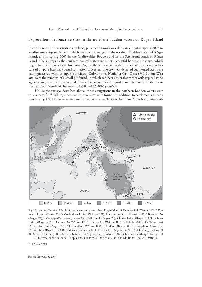
Explorat ion of subma r ine s ite s in the nor thern Bodden water s on Rügen I s l a nd
In addition to the investigations on land, prospection work was also carried out in spring 2003 to localise Stone Age settlements which are now submerged in the northern Bodden waters of Rügen Island, and in spring 2005 in the Greifswalder Bodden and in the Strelasund south of Rügen Island. The surveys in the southern coastal waters were not successful because most sites which might had been favourable for Stone Age settlements were eroded or covered by beach ridges caused by post-littorina coastal formation processes. The few new detected submerged sites were badly preserved without organic artefacts. Only on site, Neuhofer Ort (Ostsee VI, Putbus-West 30), were the remains of a small pit found, in which red deer antler fragments with typical stone-age working traces were preserved. Two radiocarbon dates for antler and charcoal date the pit to the Terminal Mesolithic between c. 4850 and 4650 BC (Table 2).
Unlike the surveys described above, the investigations in the northern Bodden waters were very successful . All together twelve new sites were found, in addition to settlements already known (Fig. ). All the new sites are located at a water depth of less than . m b. s. l. Sites with
Fig. 17. Late and Terminal Mesolithic settlements on the northern Rügen Island: 1 Dranske-Süd (Wittow 102), 2 Kon- toper Haken (Wittow 99), 3 Woldenitzer Haken (Wittow 101), 4 Kamminer Ort (Wittow 100), 5 Breetzer Ort (Bergen 24), 6 Vieregge-Westhaken (Bergen 23), 7 Fährbusch (Bergen 25), 8 Finkenhaken (Bergen 29), 9 Lebbiner Haken (Bergen 27), 10 Gelmer Ort (Wittow 97), 11 Kleiner Ort (Wittow 103), 12 Lebbin-Südostufer (Bergen 26), 13 Banzelvitz-Süd (Bergen 28), 14 Helmutflach (Wittow 104); 15 Enddorn (Kloster 8), 16 Königshörn (Glowe 5,7) 17 Bakenberg (Ruschvitz 8) 18 Baldereck (Baldereck 6) 19 Grämer Ort (Spycker 5) 20 Röddelin-Berg (Liddow 7), 21 Banzelvitzer Berge (Groß Banzelvitz 3), 22 Augustenhof (Ralswiek 8), 23 Lietzow-Fährberge (Lietzow 1),
24 Lietzow-Buddelin (Saiser 1); cp. Gramsch 1978, Lübke et al. 2000 and additions. – Scale 1 : 250 000.
102 Jan Harff, Friedrich Lüth • SINCOS
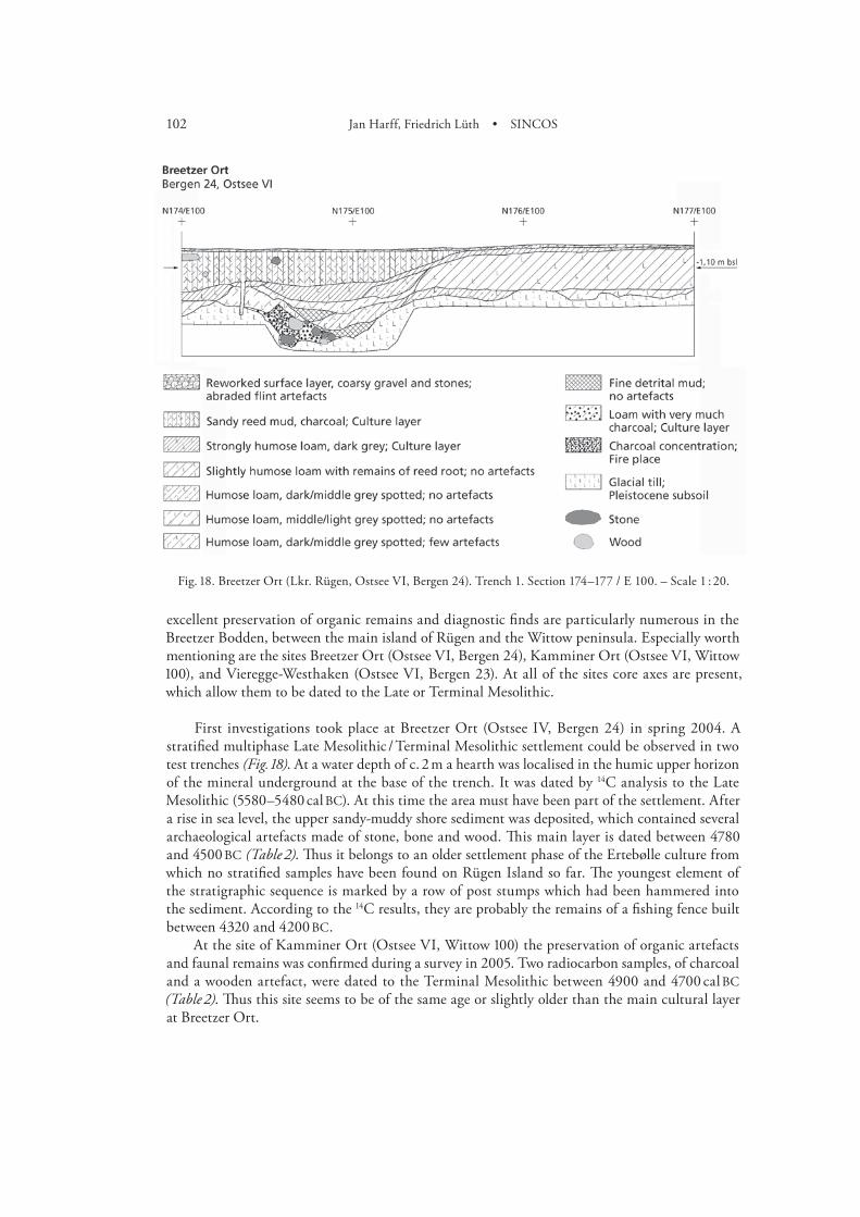
excellent preservation of organic remains and diagnostic finds are particularly numerous in the Breetzer Bodden, between the main island of Rügen and the Wittow peninsula. Especially worth mentioning are the sites Breetzer Ort (Ostsee VI, Bergen ), Kamminer Ort (Ostsee VI, Wittow ), and Vieregge-Westhaken (Ostsee VI, Bergen ). At all of the sites core axes are present, which allow them to be dated to the Late or Terminal Mesolithic.
First investigations took place at Breetzer Ort (Ostsee IV, Bergen ) in spring . A stratified multiphase Late Mesolithic / Terminal Mesolithic settlement could be observed in two test trenches (Fig. ). At a water depth of c. m a hearth was localised in the humic upper horizon of the mineral underground at the base of the trench. It was dated by C analysis to the Late Mesolithic (– cal BC). At this time the area must have been part of the settlement. After a rise in sea level, the upper sandy-muddy shore sediment was deposited, which contained several archaeological artefacts made of stone, bone and wood. This main layer is dated between and BC (Table ). Thus it belongs to an older settlement phase of the Ertebølle culture from which no stratified samples have been found on Rügen Island so far. The youngest element of the stratigraphic sequence is marked by a row of post stumps which had been hammered into the sediment. According to the C results, they are probably the remains of a fishing fence built between and BC.
At the site of Kamminer Ort (Ostsee VI, Wittow ) the preservation of organic artefacts and faunal remains was confirmed during a survey in . Two radiocarbon samples, of charcoal and a wooden artefact, were dated to the Terminal Mesolithic between and cal BC (Table ). Thus this site seems to be of the same age or slightly older than the main cultural layer at Breetzer Ort.
Fig. 18. Breetzer Ort (Lkr. Rügen, Ostsee VI, Bergen 24). Trench 1. Section 174–177 / E 100. – Scale 1 : 20.

103Hauke Jöns et al. • Prehistoric settlements and the regional economic area
Bericht der RGK ,
Hartz / Lübke .
Fur ther explorat ion a rea s
Besides the field work in the main research areas, occasional limited investigations were conducted in the exploration areas along the Baltic coasts of Mecklenburg-Vorpommern and Ostholstein, both in expeditions with the RV ‘Professor Albrecht Penck’ (see p. ??) and in the archaeological project group’s own campaigns. While at Stoltera-Wilhelmshöhe (Ostsee III, Rostock-Ost ), Großes-Tief-Ostufer (Ostsee II, Neuburg / Poel ) and Schwarzer Grund (Dahmeshöved, Lkr. Ostholstein) so far only scientific samples for the other sub-projects were gathered, archaeological objects were found at Groß Schwansee (Ostsee I, Dassow / Ostseestrand ) and Trollegrund (Ostsee III, Neubukow-Salzhaff ). In addition, archaeological remains were located on several occasions in the peat outcrops of Trollegrund. However, because density of finds is low, there was no potential for test trenches so far.
Summa r y of t he inve s t ig at ion re su lt s
In the key research area A, the Wismar Bight, we were able to locate fresh water sediments at a water depth between m and m thanks to geo-archaeological investigations conducted on the shorelines of the archaeological sites of the Late Mesolithic in cooperation with sub-project . (see p. ??).
These sediments must have belonged to a fresh water drainage system in the Wismar Bight before it was flooded by the marine waters of the Littorina Transgression. It is remarkable that, at least in the initial phase around BC, in the Bay of Mecklenburg immediately to the north the sea level must have been considerably lower, for otherwise the deposition of marine sediments would not have been possible at the time. However, the corresponding thresholds in the drainage system between the Wismar Bight and the Bay of Mecklenburg are still unknown. The differing sea levels must have soon been equalised by the further transgression of the th millennium BC, because at Jäckelberg-Nord marine sediments dated to BC were found at m b. s. l. A further boundary between fresh water and marine sediments was found at m b. s. l. at Timmendorf-Nordmole II, and could be dated around BC. Finally, for the period – BC a sea level of c. - m b. s. l. was determined at Timmendorf-Nordmole I.
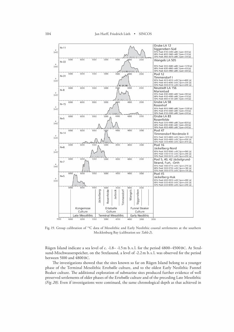
In addition, further knowledge could be gained about the cultural development of the Ter-minal Mesolithic in the southern Bay of Mecklenburg. A comparison with the results achieved in Ostholstein (see p. ??) facilitated a first chronostratigraphic division of the Terminal Mesolithic Ertebølle culture and the oldest Early Neolithic Funnel Beaker culture between and BC (Fig ). In the Wismar Bight further information could be gained on the Late Mesolithic, between and BC. A site from the early phase of this period could already be examined in more detail, and further sites from the later phases with preservation of organic remains are now known. Therefore we can expect that continuing investigations will allow us to retrieve sufficient informa-tion on the adaptation of settlement behaviour and the economic system (anthroposphere), as well as the modifications of the environmental systems for the period between and BC.
In key region B, Rügen Island, it was possible to redress problems of the chronostratigraphic situation of sites investigated earlier, and to collect significant new samples for further scientific analyses. In particular, previous ideas about the sea-level rise in the th millennium BC could be verified. Unlike in the Bay of Mecklenburg, the sea level at Rügen Island had reached a level of -.– -. m of HN as early as – BC. There are also considerable differences to be found in earlier periods. The preliminary results from Breetzer Ort in the northern Bodden waters of
104 Jan Harff, Friedrich Lüth • SINCOS
Rügen Island indicate a sea level of c. -.– -. m b. s. l. for the period – BC. At Stral-sund-Mischwasserspeicher, on the Strelasund, a level of -. m b. s. l. was observed for the period between and BC.
The investigations showed that the sites known so far on Rügen Island belong to a younger phase of the Terminal Mesolithic Ertebølle culture, and to the oldest Early Neolithic Funnel Beaker culture. The additional exploration of submarine sites produced further evidence of well preserved settlements of older phases of the Ertebølle culture and of the preceding Late Mesolithic (Fig. ). Even if investigations were continued, the same chronological depth as that achieved in
Fig. 19. Group calibration of 14C data of Mesolithic and Early Neolithic coastal settlements at the southern Mecklenburg Bay (calibration see Table 2).

105Hauke Jöns et al. • Prehistoric settlements and the regional economic area
Bericht der RGK ,
the Wismar Bight can not be reached in this region. However, for the period – BC it will be possible to gather sufficient information to compare the cultural development in both key research areas under the influence of changing geo- and ecospheres.
Additional investigations on the man-made traffic and communication zone in the southwestern Baltic area from 2000 BC to AD 1900
Although numerous coastal sites dating to the last years are known from the southwestern Baltic region and registered in the archives of the State Agencies for Archaeological Heritage of Schleswig-Holstein and Mecklenburg-Vorpommern, systematic investigations with respect
Fig. 20. Group calibration of 14C dates of Mesolithic and Early Neolithic coastal settlements of the area Rügen Island (calibration see Table 2).
106 Jan Harff, Friedrich Lüth • SINCOS
Kaute et al. . Hoffmann , . In summary Schulze .
Hoffmann ; Jöns b. Herrmann , ff.
to sea-level variations are rare. Nevertheless, within the framework of interdisciplinary research-projects, and as a result of excavations necessitated by construction work, new data has recently been gathered about sea-level modifications at several sites along the coast.
For the last two millennia BC several graveyards and settlements are known which were already affected by coastal erosion. These sites indicate that the sea level must have been much lower then it is today. Good examples of this are hearths of the Late Bronze Age (c. – BC) which were exposed by coastal erosion at Rerik-West , Lkr. Bad Doberan, southwest of the Wustrow peninsula by the shore of the Salzhaff. Clearly the the Baltic must have been at least m lower than today.
More precise information could be gained for the Roman Iron Age. During construction work for the extension of the harbour basin of Greifswald, fishing fences of the period (AD –) were discovered in . On the one hand, they show that the sea level must have been at least m lower than today, and on the other hand, they indicate that the fishing techniques used in the Iron Age were at least partially the same as those used during the Late Mesolithic and Early Neolithic.
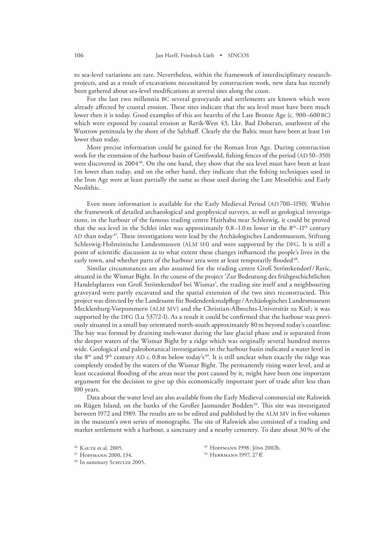
Even more information is available for the Early Medieval Period (AD –). Within the framework of detailed archaeological and geophysical surveys, as well as geological investiga-tions, in the harbour of the famous trading centre Haithabu near Schleswig, it could be proved that the sea level in the Schlei inlet was approximately . –. m lower in the th–th century AD than today . These investigations were lead by the Archäologisches Landesmuseum, Stiftung Schleswig-Holsteinische Landesmuseen (ALM SH) and were supported by the DFG. It is still a point of scientific discussion as to what extent these changes influenced the people’s lives in the early town, and whether parts of the harbour area were at least temporarily flooded .
Similar circumstances are also assumed for the trading centre Groß Strömkendorf / Reric, situated in the Wismar Bight. In the course of the project ‘Zur Bedeutung des frühgeschichtlichen Handelsplatzes von Groß Strömkendorf bei Wismar’, the trading site itself and a neighbouring graveyard were partly excavated and the spatial extension of the two sites reconstructed. This project was directed by the Landesamt für Bodendenkmalpflege / Archäologisches Landesmuseum Mecklenburg-Vorpommern (ALM MV) and the Christian-Albrechts-Universität zu Kiel ; it was supported by the DFG (Lu /-). As a result it could be confirmed that the harbour was previ-ously situated in a small bay orientated north-south approximately m beyond today’s coastline. The bay was formed by draining melt-water during the late glacial phase and is separated from the deeper waters of the Wismar Bight by a ridge which was originally several hundred metres wide. Geological and paleobotanical investigations in the harbour basin indicated a water level in the th and th century AD c. . m below today’s . It is still unclear when exactly the ridge was completely eroded by the waters of the Wismar Bight. The permanently rising water level, and at least occasional flooding of the areas near the port caused by it, might have been one important argument for the decision to give up this economically important port of trade after less than years.
Data about the water level are also available from the Early Medieval commercial site Ralswiek on Rügen Island, on the banks of the Großer Jasmunder Bodden . This site was investigated between and . The results are to be edited and published by the ALM MV in five volumes in the museum’s own series of monographs. The site of Ralswiek also consisted of a trading and market settlement with a harbour, a sanctuary and a nearby cemetery. To date about % of the
107Hauke Jöns et al. • Prehistoric settlements and the regional economic area
Bericht der RGK ,
Lampe ; Ruchhöft . Schäfer / Schäfer ; Scharmach / Schäfer ; Kulessa .
Filipowiak .
settled area has been excavated. Based on numerous profiles documented during the excavations, the former project director, J. Herrmann, concluded that the settlement existed from the th until the th century AD. The excavation showed that the inhabitants here reacted to the changing water levels by filling in land to increase the settlement area and so assure better protection against flooding. Based on these observations it was concluded that the water level around Ralswiek varied in this period between + . and + . m relative to the present water level.
The results of the SINCOS research-group will undoubtedly necessitate further discussion about the reconstruction of sea levels , and all data and profiles are available for further studies by the SINCOS project.
Data about the level of the Baltic Sea are also available from some excavations carried out by the ALM MV in the course of construction works in the harbour areas of the historical cities and ports of the Hanseatic League, Rostock, Greifswald and Stralsund . On the one hand, they show clearly that the foundation of the ports, and particularly the construction of moles and docks, resulted in considerable changes in the natural environment ; on the other hand, the data indicate that the water level was only insignificantly lower than today’s. It is almost impossible to determine the Medieval sea level more precisely, because the seasonal variations alone can be more than . m. These results fit well with the measurements and observations of the Late Medieval sea level in the Polish part of the Oder region . New large scale construction works have already been announced at the docks of Stralsund, Wismar and Rostock, so that additional data will be gained by the LBD during the next years. The information from the investigations of these sites, as well as data from future excavations, will be fully accessible for further studies within the framework of the SINCOS II project.
108 Jan Harff, Friedrich Lüth • SINCOS
Abstract
The main task of the archaeological part of the SINCOS research team were investigations on Stone Age sites dated between and cal BC in the two areas west and east of the Darss Sill, Wismar Bight in the West, and the island of Rügen in the East. In Wismar Bight, due to the more significant relative sea-level rise, excavations were only carried out on settlements submerged today. The archaeological work on Rügen and in the Strelasund was concentrated on wetland sites above modern sea level. In addition, underwater archaeological surveys were carried out in the coastal waters of Rügen, as well as along other sections of the Baltic coast of Mecklenburg-Vorpommern. For the more recent periods from the Late Neolithic to the Late Middle Ages, all available data on modifications and changes in the coastline and sea level were extracted from the archives of the relevant heritage agencies of Mecklenburg-Vorpommern and Schleswig-Holstein, and integrated into the SINCOS database. In both of the main areas investigated the results provide first evidence, especially for the period before cal BC, of differences in the regional sea-level rise, for the chronology of the transformation of freshwater into brackish-marine environments, and for the resulting adaptation of the economic systems of the local communities. However, further investi-gations are necessary prior to the publication of final results.
Zusammenfassung
Im Teilprojekt Archäologie der SINCOS Forschergruppe wurden primär steinzeitliche Fundstellen aus der Zeit zwischen und v. Chr. in den beiden Schlüsselegionen westlich und östlich der Darsser Schwelle Wismarbucht und Insel Rügen untersucht. In der Wismarbucht erfolgten aufgrund des stärker ausgeprägten relativen Meeresspiegelanstiegs ausschließlich Untersuchungen an heute submarin gelegenen Siedlungsplätzen, auf der Insel Rügen und am Strelasund hingegen primär landseitige Feuchtbodenausgrabungen. Diese wurden durch unterwasserarchäologische Sondierungen in den Küstengewässern Rügens, aber auch an anderen Küstenabschnitten Meck-lenburg-Vorpommerns ergänzt. Für die jüngeren ur- und frühgeschichtlichen Perioden wurden die bislang publizierten und in den Ortsakten der Landesämter Schwerin und Schleswig verfügbaren Daten über Veränderungen der Küstenlinie und des Meeresspiegels in die SINCOS Datenbank integriert. Die ermittelten Daten zeigen vor allem für die Zeit vor v. Chr. bereits erste Unter-schiede in den relativen Strandlinienverschiebungskurven beider Schwerpunktregionen, dem zeitlichen Ablauf der Biotopumwandlung von einem limnischen hin zu einem brackisch-marinen Milieu und der damit verbundenen Anpassung des ökonomischen Systems der damaligen Küsten-bewohner. Weitere Untersuchungen zur Verdichtung des Datenbestandes sind aber erforderlich, um abschließende Aussagen zu ermöglichen.

109Hauke Jöns et al. • Prehistoric settlements and the regional economic area
Bericht der RGK ,
Résumé
Le projet « archéologie » du programme de recherche SINCOS visait tout d’abord les sites datables entre et av. J.-C. situés des deux côtés du seuil de Darss, dans la baie de Wismar à l’ouest et sur l’île de Rügen à l’est. Suite à l’élévation relative plus marquée du niveau de la mer, ce sont uniquement des habitats aujourd’hui immergés qui furent examinés dans la baie de Wismar ; sur l’île de Rügen et dans le Strelasund, par contre, on fouilla tout d’abord des sites côtiers en milieu humide. Ces fouilles furent complétées par des sondages dans les eaux côtières de Rügen et sur d’autres tronçons de la côte de Mecklenburg-Vorpommern. Pour les périodes préhistoriques plus récentes et la protohistoire, les données publiées jusqu’ici et disponibles aux offices nationaux de Schwerin et de Schleswig, qui concernent les modifications de la ligne de côte et du niveau de la mer, furent intégrées à la banque de données de SINCOS. Déjà pour la période antérieure à av. J.-C., les données accumulées dans les deux régions principales marquent des différences pour les courbes relatives de déplacement de la ligne de rivage, la durée du passage d’un milieu lacustre à un milieu saumâtre et l’adaptation du système économique des habitants de la côte qui en découle. Mais des études supplémentaires, permettant de compléter le catalogue des données, seront nécessaires pour aboutir à des conclusions définitives.
Illustration credits
Fig. , , : by H. Lübke – Figs. , , , , , , , , , : by J. Freigang / H. Lübke – Figs. , : by J. Freigang – Figs. , , : by T. Terberger – Fig. : by H. Lübke / T. Terberger.
110 Jan Harff, Friedrich Lüth • SINCOS
Bibliography
Ambrosiani / Clarke B. Ambrosiani / H. Clarke, Birka and the begin-
ning of the Viking Age. In : A. Wesse (Hrsg.), Studien zur Archäologie des Ostseeraums von der Eisenzeit bis zum Mittelalter [Festschrift M. Müller-Wille] (Neumünster ) –.
Andersen S. H. Andersen, Coastal adaptation and marine
exploration in Late Mesolithic Denmark – with special emphasis on the Limfjord region. In : A. Fischer (ed.), Man and Sea in the Mesolithic. Coastal Settlement above and below Present Sea Level. Oxbow Monogr. (Oxford ) –.
Benecke N. Benecke, Archäozoologische Studien zur
Entwicklung der Haustierhaltung in Mitteleuropa und Südskandinavien von den Anfängen bis zum ausgehenden Mittelalter. Schr. Ur- u. Frühgesch. (Berlin ).
Bill J. Bill, Port topography in medieval Denmark. In :
J. Bill / B. L. Clausen (eds.), Maritime Topography and the Medieval Town. Publ. Nat. Mus. Stud. Arch. and Hist. (København ) –.
Bill / Clausen J. Bill / B. L. Clausen (eds.), Maritime Topogra-
phy and the Medieval Town. Publ. Nat. Mus. Stud. Arch. and Hist. (København ).
Bokelmann K. Bokelmann, Zum Beginn des Spätmesolithi-
kums in Südskandinavien. Geweihaxt, Dreieck und Trapez, cal BC. Offa , –.
Callmer J. Callmer, Urbanization in Scandinavia and
the Baltic Region c. AD – : trading places, centres and early urban sites. In : B. Ambrosiani / H. Clarke, Developments around the Baltic and the North Sea in the Viking Age. Birka Stud. , , –.
Enghoff I. B. Enghoff, Fishing in Denmark during
Mesolithic Period. In : A. Fisher (ed.), Man and Sea in the Mesolithic. Coastal Settlement above and below Present Sea Level. Proceedings of the International Symposium, Kalundborg, . Oxbow Monogr. (Oxford ) –.
Filipowiak W. Filipowiak, Wolin und Szczecin – Hafen
und Topographie der mittelalterlichen Stadt. In : J. Bill / B. L. Clausen (eds.), Maritime Topogra- phy and the Medieval Town. Publ. Nat. Mus. Stud. Arch and Hist. (København ) –.
Gläser M. Gläser, Die Ausgrabungen in der großen
Petersgrube zu Lübeck. Befunde und Funde. Lübecker Schr. Arch. u. Kunstgesch. , , –.
Gläser M. Gläser (Hrsg.), Archäologie des Mittelalters
und Bauforschung im Hanseraum [Festschrift G. P. Fehring] (Rostock ).
Gläser M. Gläser, The development of the harbours and
market places of Lübeck. In : J. Bill / B. L. Clausen (eds.), Maritime Topography and the Medieval Town. Publ. Nat. Mus. Stud. Arch and Hist. (København ) – .
Gramsch B. Gramsch, Das Mesolithikum im Flachland
zwischen Elbe und Oder. Veröff. Mus. Ur- u. rühgesch. Potsdam (Berlin ).
Gramsch B. Gramsch, Die Lietzow-Kultur Rügens und ihre
Beziehungen zur Ostseegeschichte. Petermanns Geogr. Mitt. , , –.
Hartz S. Hartz, Ertebøllekultur im Travetal. Ausgra-
bungen auf dem Fundplatz Travenbrück LA
111Literaturverzeichnis
Bericht der RGK ,
(Gemarkung Schlamersdorf ), Kreis Stormarn. Ein Vorbericht. Denkmalpflege in Stormarn III, Stormarner H. , , –.
Hartz / S. Hartz, Frühbäuerliche Küstenbesiedlung
im westlichen Teil der Oldenburger-Graben-Niederung. Ein Vorbericht. Offa / , / , – .
Hartz S. Hartz, Die Steinartefakte des endmesoli-
thischen Fundplatzes Grube-Rosenhof LA (Ostholstein). Studien an Flintinventaren aus der Zeit der Neolithisierung in Schleswig-Holstein und Südskandinavien. Unters. u. Mat. Steinzeit Schleswig-Holstein (Schleswig ).
Hartz S. Hartz, Aktuelle Forschungen zur Chronolo-
gie und Siedlungsweise der Ertebølle- und frühe-sten Trichterbecherkultur in Schleswig-Holstein. Jahrb. Bodendenkmalpfl. Mecklenburg-Vor-pommern , , –.
Hartz / Lübke S. Hartz / H. Lübke, Erste Ansätze zur Pro-
spektion submariner steinzeitlicher Küsten- wohnplätze an der schleswig-holsteinischen Ostseeküste. Arch. Nachr. Schleswig-Holstein , , –.
Hartz / Lübke S. Hartz / H. Lübke, Zur chronostratigraphi-
schen Gliederung der Ertebølle-Kultur und frühesten Trichterbecher-Kultur in der südli-chen Mecklenburger Bucht. Jahrb. Bodendenk-malpfl. Mecklenburg-Vorpommern , , –.
Hartz / Lübke S. Hartz / H. Lübke, New evidence for a chro-
nostratigraphic division of the Ertebølle culture and the earliest Funnel Beaker culture on the southern Mecklenburg Bay. In : C. J. Kind. (ed.), After the Ice Age. Settlements, Subsistence and Social Development in the Mesolithic of Cent- ral Europe. Materialh. Arch. Baden-Württem- berg (Stuttgart ) –.
Hartz et al. S. Hartz / D. Heinrich / H. Lübke, Frühe
Bauern an der Küste. Neue C-Daten und Aspekte zum Neolithisierungsprozess im norddeutschen Ostseeküstengebiet. Prähist. Zeitschr. , , , –.
Hartz et al. S. Hartz / H. Lübke / H. Schlichtherle, Wohnen am Wasser – Steinzeitliche Feucht-
bodensiedlungen. In : W. Menghin / D. Planck (eds.), Menschen, Zeiten, Räume – Archäo- logie in Deutschland. Begleitband zur Aus- stellung Berlin und Bonn (Stuttgart ) –.
Hartz et al. S. Hartz / H. Lübke / Th. Terberger, From
fish and seal to sheep and cattle : new research into the process of Neolithisation in northern Germany. In : A. Whittle / V. Cummings (eds.), Going Over : The Mesolithic-Neolithic Transition in West Europe (London ) –.
Hedengran I. Hedengran, The shipwrecked and their re-
scuer. In : O. Crumlin-Pedersen / B. Munch Thye (eds.), The Ship as Symbol in Prehistoric and Me- dieval Scandinavia. Papers from an International Research Seminar at the Danish National Museum, Copenhagen, th–th may . Publ. Nat. Mus., Arch. and Hist. (København ) –.
Herrmann J. Herrmann, Ralswiek auf Rügen. Die sla-
wisch-wikingischen Siedlungen und deren Hinterland. Teil I – Die Hauptsiedlung. Beitr. Ur- Frühgesch. Mecklenburg-Vorpommern (Lübstorf ).
Herrmann / Warnke J. Herrmann / D. Warnke, Die slawisch-wiking-
ischen Siedlungen und deren Hinterland. Teil IV – Das Hügelgräberfeld in den ‘Schwarzen Bergen’ bei Ralswiek. Beitr. Ur- Frühgesch. Meck-lenburg-Vorpommern (Schwerin ).
Hodder I. Hodder, The Domestication of Europe
(Oxford ).Hoffmann D. Hoffmann, Wasserspiegelveränderungen
an der schleswig-holsteinischen Ostseeküste im . Jahrtausend n. Chr. In : A. Wesse (eds.), Studien Archäologie Ostseeraum [Festschrift M. Müller-Wille] (Neumünster ) –.
Hoffmann D. Hoffmann, Archäologische Beiträge zu
Wasserstandsveränderungen der Ostsee. Eine kriti- sche Betrachtung. Arch. Nachr. Schleswig-Hol-stein , , –.
112 Jan Harff, Friedrich Lüth • SINCOS Hoffmann et al. G. Hoffmann / W. Dörfler / M. Müller-Wille /
J. Thiede, Zum Einfluss des Menschen auf den nacheiszeitlichen Landschaftswandel an der schles- wig-holsteinischen Ostseeküste (SEDOST-For-schungsprojekt). Siedlungsforschung , , –.
Hoika J. Hoika, Das Mittelneolithikum zur Zeit der
Trichterbecherkultur in Holstein. Unters. Inst. Ur.- u. Frühgesch. Univ. Kiel . (Neumünster ).
Ilkiewicz J. Ilkiewicz, From studies on Ertebølle type
cultures in the Koszalinian coastal area (Dabki , Koszalin-Dzierzecino ). In : D. Krol (ed.), The Built Environment of Coast Areas during the Stone Age. Baltic Sea-Coast Landscapes Seminar (Gdansk ) –.
Jöns a H. Jöns, Neue Möglichkeiten und Wege der
Maritimen Archäologie. In : K. Krüger / C. O. Cederlund (ed.), Maritime Archäologie heute. rd Meeting of the International Marine Archaeo- logical Conference of the Baltic Sea Area (Rostock ) –.
Jöns b H. Jöns, The proto-historic sea-trading port at
Groß Strömkendorf – the ‘emporium reric’ of the Royal Frankish Annals. In : Lampe R. (ed.) Holocene Evolution of the South-Western Baltic Coast – Geological Archaeological and Palaeo- environmental Aspects [INQUA-Field meeting ]. Greifswalder Geogr. Arbeiten (Greifswald ) –.
Kalis / Meurers-Balke A. J. Kalis / J. Meurers-Balke, Die ‘Landnam’-
Modelle von Iversen und Troels-Smith zur Neolithisierung des westlichen Ostseegebietes – ein Versuch ihrer Aktualisierung. Prähist. Zeitschr. , , , –.
Kaul F. Kaul, Ships on Bronzes. A Study in Bronze Age
Religion and Iconography. Publ. Nat. Mus. Stud., Arch and Hist. (København ).
Kaute et al. P. Kaute / G. Schindler / H. Lübke, Der
endmesolithisch / frühneolithische Fundplatz Stralsund-Mischwasserspeicher – Zeugnisse
früher Bootsbautechnologie an der Ostseeküste Mecklenburg-Vorpommerns. Jahrb. Bodendenk-malpfl. Mecklenburg-Vorpommern , , –.
Kaute et al. P. Kaute / S. Labes / G. Schindler, Ein kaiser-
zeitlicher Fischzaun im Greifswalder Museums-hafen. Arch. Ber. Mecklenburg-Vorpommern , , –.
Klassen L. Klassen, Jade und Kupfer. Untersuchungen
zum Neolithisierungsprozess im westlichen Ost-seeraum unter besonderer Berücksichtigung der Kulturentwicklung Europas – BC. Jysk Ark. Selskab Skr. (Højbjerg ).
Kliewe / Janke H. Kliewe / W. Janke, Zur Stratigraphie und
Entwicklung des nordöstlichen Küstenraumes der DDR. Petermanns Geogr. Mitt. , , –.
Kliewe / Janke H. Kliewe / W. Janke, Der holozäne Meeresspie-
gelanstieg der Ostsee im nordöstlichen Küsten-gebiet der DDR. Petermanns Geogr. Mitt. , , , –.
Klinghardt F. Klinghardt, Die steinzeitliche Kultur von
Lietzow auf Rügen. Mitt. Slg. Univ. Greifswald , , –.
Klooss S. Klooss, Der Fischzaun aus der römischen
Kaiserzeit von Greifswald-Museumshafen und vergleichbare Befunde. Jahrb. Bodendenk-malpfl. Mecklenburg-Vorpommern , , –.
Klug H. Klug, Der Anstieg des Ostseespiegels im deut-
schen Küstenraum seit dem Mittelatlantikum. Eiszeitalter u. Gegenwart , , –.
Köster / R. Köster, Alt Lübeck und die Frage der Küsten-
senkung. Offa / , / , –.Kulessa B. Kulessa, The harbour suburb and its signi-
ficance for the urban development of Stralsund. In : J. Bill / B. L. Clausen (eds.), Maritime Topo-graphy and the Medieval Town. Publ. Nat. Mus., Stud. Arch and Hist. (København ) –.
113Literaturverzeichnis
Bericht der RGK ,
Labes S. Labes, Endmesolithische Holzfunde von dem
submarinen Fundplatz Timmendorf-Nordmole I. Jahrb. Bodendenkmalpfl. Mecklenburg-Vor-pommern , , –.
Lampe R. Lampe (ed.), Holocene Evolution of the South-
Western Baltic Coast – Geological, Archaeolo- gical and Palaeo-environmental Aspects. Field meeting of INQUA Subcommission V, Septem- ber . Greifswalder Geogr. Arbeiten (Greifswald ).
Lampe R. Lampe, Wasserstandsentwicklung in der
süd-lichen Ostsee während des Holozäns. In : P. Hupfer (ed.), Die Wasserstände an der Ostsee-küste. Entwicklung – Sturmfluten – Klimawan- del. Küste (Heide ) –.
Lampe et al. R. Lampe / E. Endtmann / W. Janke / H. Meyer /
H. Lübke / J. Harff / W. Lemke, A new relative sea-level curve for the Wismar Bay, N-German Baltic coast. Meyniana , , –.
Lange et al. E. Lange / L. Jeschke / H. D. Knapp, Ralswiek
und Rügen. Landschaftsentwicklung und Sied- lungsgeschichte der Ostseeinsel. Teil I. Die Land- schaftsgeschichte der Insel Rügen seit dem Spät-glazial. Schr. Ur- u. Frühgesch. (Berlin ).
Lübke a H. Lübke, Die steinzeitlichen Fundplätze Be-
bensee LA und LA , Kreis Segeberg. I. Die Steinartefakte. Technologisch-ergologische Stu-dien zum Nordischen Frühneolithikum. Unters. Mat. Steinzeit Schleswig-Holstein (Schleswig ).
Lübke b H. Lübke, Jäckelberg-Nord und Timmendorf-
Nordmole. Erste Untersuchungsergebnisse zu submarinen Siedlungsplätzen der endmesoli-thischen Ertebølle-Kultur in der Wismar-Bucht, Mecklenburg-Vorpommern. Nachrbl. Arbeitskr. Unterwasserarch. , –.
Lübke H. Lübke, Eine hohlendretuschierte Klinge mit
erhaltener Schäftung vom endmesolithischen Fundplatz Timmendorf-Nordmole, Wismarbucht, Mecklenburg-Vorpommern. Nachrbl. Arbeitskr. Unterwasserarch. , , –.
Lübke a H. Lübke, Submarine Stone Age settlements as
indicators of sea-level changes and the coastal evo- lution of the Wismar Bay area. In : R. Lampe (ed.), Holocene Evolution of the South-Western Baltic Coast – Geological, Archaeological and Palaeo-environmental Aspects (INQUA-Field meeting ). Greifswalder Geogr. Arbeiten (Greifswald ) –.
Lübke b H. Lübke, Steinzeit in der Wismarbucht. Ein
Überblick. Nachrbl. Arbeitskr. Unterwasserarch. , , –.
Lübke H. Lübke, New investigations on submarine Stone
Age settlements in the Wismar Bay area. In : H. Kindgren / K. Knutsson / L. Larsson / D. Loeffler / A. Åkerlund (eds.), Mesolithic on the Move. Papers presented at the th International Conference on the Mesolithic in Europe, Stockholm . Oxbow Books (Oxford ), –.
Lübke a H. Lübke, Spät- und Endmesolithische Küsten-
siedlungsplätze in der Wismarbucht. Neue Grabungsergebnisse zur Chronologie und Sied-lungsweise. Jahrb. Bodendenkmalpfl. Mecklen- burg-Vorpommern , , –.
Lübke b H. Lübke, Vorbericht zu den Sondierungen
submariner steinzeitlicher Fundstellen in den nördlichen Boddengewässern Rügens. Jahrb. Bodendenkmalpfl. Mecklenburg-Vorpommern , , –.
Lübke c H. Lübke, Ergänzende Anmerkungen zur
Datierung der Einbäume des endmesolithisch / frühneolithischen Fundplatzes Stralsund-Misch-wasserspeicher. Jahrb. Bodendenkmalpfl. Meck-lenburg-Vorpommern , , –.
Lübke H. Lübke, Filling a gap – Five years of under-
water archaeological investigations on submarine Stone Age sites in Wismar Bay, Mecklenburg-Vor-pommern, Germany. In : A. Hafner / U. Niffeler / U. Ruoff (eds.), Unterwasserarchäologie und Ge- schichtsbild. L’apport de l’archéologie subaqua-tique. Underwater Archaeology and the Historical Picture. Proceedings of the nd International Congress of Underwater Archaeology. Rüschlikon
114 Jan Harff, Friedrich Lüth • SINCOS bei Zürich, .–. Oktober . Antiqua (Basel ), –.
Lübke H. Lübke, Hunter and Fisher in a changing world.
Investigations on submerged Stone Age sites off the Baltic Coast of Mecklenburg-Vorpommern, Germany. In : S. McCartan / R. Schulting / G. Warren / P. Woodman (eds.), Mesolithic Hori- zons. Papers presented at the Seventh Inter- national Conference on the Mesolithic in Europe, Belfast . Vol. (Oxford ) –.
Lübke / Terberger H. Lübke / Th. Terberger, New evidence on the
Ertebølle culture on Rügen and neighbouring areas. In : R. Lampe (ed.), Holocene Evolution of the South-Western Baltic Coast – Geolo- gical, Archaeological and Palaeo-environmental Aspects. (INQUA-Field meeting ). Greifs-walder Geogr. Arbeiten (Greifswald ) –.
Lübke / Terberger H. Lübke / Th. Terberger, Das Endmesolithi-
kum in Vorpommern und auf Rügen im Lichte neuer Daten. Jahrb. Bodendenkmalpfl. Mecklen-burg-Vorpommern , , –.
Lübke et al. H. Lübke / S. Schacht / Th. Terberger, Final
Mesolithic coastal settlements on the island of Rügen and in Northern Vorpommern. In : F. Lüth / U. Schoknecht (Hrsg.), Schutz des Kul- turerbes unter Wasser. Veränderungen europäi- scher Lebenskultur durch Fluss- und Seehandel. Internationaler Kongress für Unterwasserarchäo-logie (IKUWA ’) .–. Februar in Sassnitz auf Rügen. Beitr. Ur- u. Frühgesch. Mecklenburg-Vorpommern (Lübstorf ) –.
Madsen T. Madsen, Where did all the hunters go ? An
assessment of an epoch-making episode in Danish Prehistory. Journal Danish Arch. , , –.
Mandelkow et al. E. Mandelkow / P. Frenzel / R. Lampe / P.
Kaute / G. Schindler, Paläontologische Unter- suchungen von Sedimentprofilen der archäolo- gischen Grabung Stralsund-Mischwasserspei- cher. Jahrb. Bodendenkmalpfl. Mecklenburg-Vor-pommern , , –.
Meurers-Balke J. Meurers-Balke, Siggeneben-Süd, ein Fundplatz
der frühen Trichterbecherkultur an der holsteini- schen Ostseeküste. Offa (Neumünster ).
Näsmann U. Näsmann, Om fjärrhandel i Sydskandina-
viens yngre järnålder. Handel med glas under germansk järnålder och vikingatid. Hikuin , , –.
Nielsen P. O. Nielsen, The beginning of the Neolithic –
assimilation or complex change ? Journal Danish Arch. , , –.
Nielsen P. O. Nielsen, The Neolithic. In : St. Hvass / B.
Storgaard, Digging into the Past. Years of Archaeology in Denmark (Århus ) –.
Nørgård Jørgensen A. Nørgård Jørgensen, Sea defense in Den-
mark AD –. In : A. Nørgård Jørgensen / B. L. Clausen (eds.), Military aspects of Scandi- navian society in a European perspective, AD –. Publ. Nat. Mus., Stud. Arch and Hist. (København ) –.
Persson P. Persson, Neolitikums början. Undersökningar
kring jordbrukets introduktion i Nordeuropa (Göteburg, Uppsala ).
Petzsch W. Petzsch, Die Steinzeit Rügens. Mitt. Slg. Univ.
Greifswald , .Rindel P. O. Rindel, Development of the village
community BC– AD in west Jutland, Denmark. In : C. Fabech / J. Ringtved (eds.), Settlement and Landscape. Proceedings of a Conference in Århus, Denmark, may –, . (Århus ) –.
Ruchhöft F. Ruchhöft, Fragen an den Seehandelsplatz
Ralswiek auf Rügen. Zeitschr. Arch. Mittelalter , , –.
Schäfer / Schäfer H. Schäfer / C. Schäfer, Die St. Katharinen-
kirche zu Rostock. Erste Ausgrabungsergeb- nisse unter besonderer Berücksichtigung der Baulandgewinnungsschichten von bzw. kurz danach. Jahrb. Bodendenkmalpfl. Mecklenburg-Vorpommern , , –.
115Literaturverzeichnis
Bericht der RGK ,
Scharmach / Schäfer K. Scharmach / H. Schäfer, Archäologische
Untersuchungen zwischen Steinbeckertor und Fangelturm in Greifswald. Arch. Ber. Mecklen-burg-Vorpommern , , –.
Schlichtherle H. Schlichtherle (Hrsg.), Pfahlbauten rund
um die Alpen (Stuttgart ).Schmölcke et al. U. Schmölcke / E. Endtmann / S. Klooss /
M. Meyer / D. Michaelis / B.-H. Rickert / D. Rössler, Changes of sea level, landscape and culture : A review of the south-westernBaltic area between and BC. Palaeogeogr., Pa- laeoclimatol., Palaeoecol. , , –.
Schulze J. Schulze, Zur Frage der Entwicklung des
zentralen Siedlungskernes von Haithabu. In : C. Dobiat (ed.), Reliquiae Gentium [Festschrift Böhme] (Rahden / Westf. ) –.
Skaarup J. Skaarup, Hunting the hunters and fishers of
the Mesolithic – twenty years of research on the sea floor south of Funen, Denmark. In : A. Fisher (ed.), Man and Sea in the Mesolithic. Coastal Settlement above and below Present Sea Level. Proceedings of the International Symposium, Kalundborg, . Oxbow Monogr. (Oxford ) –.
Sørensen S. A. Sørensen, Kongemosenkulturen i Syd-
skandinavien (Færgegaarden ).Stuiver et al. M. Stuiver / P. J. Reimer / E. Bard / J. W. Beck /
G. S. Burr / K. A. Hughen / B. Kromer / G. McCormac / J. van der Plicht (eds.). INT- CAL Radiocarbon Age Calibration, – cal BP. Radiocarbon , ().
Terberger Th. Terberger, Endmesolithische Funde von
Drigge, Lkr. Rügen – Kannibalen auf Rügen ? Jahrb. Bodendenkmalpfl. Mecklenburg-Vor-pommern , , – .
Terberger Th. Terberger, Aspekte zum Endmesolithi-
kum der Insel Rügen (Mecklenburg-Vor-pommern). In : E. Cziesla / T. Kersting / S. Pratsch (Hrsg.), Den Bogen spannen. [Festschrift Bern-hard Gramsch] Beitr. Ur- u. Frühgeschichte Mitteleuropa , –.
Terberger Th. Terberger, Neu Forschungen am steinzeit-
lichen Fundplatz Ralswiek-Augustenhof, Kr. Rü- gen. In: Terra Praehistorica. Festschrift für Klaus- Dieter Jäger zum . Geburtstag. Neue Ausgra-bungen und Funde in Thüringen – Sonderband = Beiträge zur Ur- und Frühgeschichte Mittel- europas (Langenweißbach ) –.
Terberger / Seiler Th. Terberger / M. Seiler, Flintschläger und
Fischer – Neue interdisziplinäre Forschungen zu steinzeitlichen Siedlungsplätzen auf Rügen und dem angrenzenden Festland. Jahrb. Bodendenk-malpfl. Mecklenburg-Vorpommern , , –.
Thomas J. Thomas, Neolithic explanations revisited : the
Mesolithic-Neolithic transition in Britain and South Scandinavia. Proc. Praehist. Soc. , , –.
Thomsen et al. P. O. Thomsen / B. Blæsild / N. Hardt / K. Kjer
Michaelsen, Lundeborg : en handelsplads fra jernalderen. Skr. fra Svendborg og Omegn Mus. (Ringe ).
Tilley Ch. Tilley, An ethnography of the Neolithic.
Early prehistoric societies in southern Scandinavia (Cambridge ).
Umbreit C. Umbreit, Buddelin, ein mittelsteinzeitlicher
Wohn- und Werkplatz bei Lietzow auf Rügen. Mannus , , –.
Umbreit C. Umbreit, Zur Chronologie der Lietzow-Kul-
tur. Mitt. Slg. Univ. Greifswald –, , –.
Wechler K.-P. Wechler, Mesolithikum – Bandkera-
mik – Trichterbecherkultur. Zur Neolithisierung Mittel- und Ostdeutschlands aufgrund verglei- chender Untersuchungen zum Siliexinventar. Beitr.Ur- u. Frühgesch. Mecklenburg-Vorpom- mern (Lübstorf ).
Wiethold J. Wiethold, Studien zur jüngeren postglazia-
len Vegetations- und Siedlungsgeschichte im östlichen Schleswig-Holstein. Univforsch. Prähist. Arch. (Bonn ).
116 Jan Harff, Friedrich Lüth • SINCOS Contact details of the authors
Hauke JönsNiedersächsisches Institut für historische KüstenforschungViktoriastraße /D– [email protected]
Ha ra ld LübkeZentrum für Baltische und Skandinavische ArchäologieStiftung Schleswig-Holsteinische Landes-museenSchloss GottorfD– [email protected]
Fr ied r ich LüthRömisch-Germanische Kommission des Deutschen Archäologischen InstitutsPalmengartenstraße –D– Frankfurt a. [email protected]
Thoma s TerbergerLehrstuhl für Ur- und FrühgeschichteUniversität GreifswaldHans-Fallada-Straße D– [email protected]