Jhelum and Tawi Flood Recovery Project - GFDRR
187
Project Management Unit, J&T FRP Government of Jammu and Kashmir Draft Version: April 18, 2015 Jhelum and Tawi Flood Recovery Project Environment and Social Management Framework Public Disclosure Authorized Public Disclosure Authorized Public Disclosure Authorized Public Disclosure Authorized Public Disclosure Authorized Public Disclosure Authorized Public Disclosure Authorized Public Disclosure Authorized
-
Upload
khangminh22 -
Category
Documents
-
view
0 -
download
0
Transcript of Jhelum and Tawi Flood Recovery Project - GFDRR

Project Management Unit, J&T FRP
Government of Jammu and Kashmir
Draft Version: April 18, 2015
Jhelum and Tawi Flood Recovery Project
Environment and Social
Management Framework
Pub
lic D
iscl
osur
e A
utho
rized
Pub
lic D
iscl
osur
e A
utho
rized
Pub
lic D
iscl
osur
e A
utho
rized
Pub
lic D
iscl
osur
e A
utho
rized
Pub
lic D
iscl
osur
e A
utho
rized
Pub
lic D
iscl
osur
e A
utho
rized
Pub
lic D
iscl
osur
e A
utho
rized
Pub
lic D
iscl
osur
e A
utho
rized
wb371432
Typewritten Text
RP1790
wb371432
Typewritten Text
wb371432
Typewritten Text

Jhelum and Tawi Flood Disaster Recovery Project
Pg 2
Table of Contents
1. Introduction .......................................................................................... 8
1.1 Background .................................................................................. 8
1.2 Disaster September 2014 ............................................................... 8
1.2.1 Joint Rapid Damage Needs Assessment (JRDNA) ....................... 9
1.3 Present Project .............................................................................. 9
1.3.1 Project Development Objective ................................................ 9
1.3.2 Project Beneficiaries ............................................................... 9
1.3.3 PDO Level Results Indicators ................................................. 10
1.4 Project Components ..................................................................... 10 1.4.1 Component 1 – Reconstruction and strengthening of critical infrastructure 10 1.4.2 Component 2 – Reconstruction of roads and bridges .......................... 11 1.4.3 Component 3 – Restoration of urban flood management infrastructure . 11 1.4.4 Component 4 – Restoration and strengthening of livelihoods ............... 11 1.4.5 Component 5 – Strengthening DRM capacity ..................................... 11
1.4.6 Component 6 – Contingent Emergency Response ............................... 13 1.4.7 Component 7 – Implementation Support ........................................... 13
2. Environmental Baseline ..................................................................... 15
2.1 Geographic Details ....................................................................... 15
2.2 Administrative Profile ................................................................... 15
2.3 Environmental Profile ................................................................... 15
2.3.1 Land Use ............................................................................ 15
2.3.2 Water Regime ..................................................................... 16
2.3.3 Climate and Rainfall ............................................................. 17
2.3.4 Soil Types ........................................................................... 18
2.3.5 Agriculture .......................................................................... 18
2.3.6 Industries ........................................................................... 19
2.3.7 Forests ............................................................................... 20
2.3.8 Biodiversity ......................................................................... 20
2.3.9 Cultural Heritage ................................................................. 22
3. Environmental Laws and Regulations ................................................... 23
3.1 Introduction ................................................................................ 23
3.2 Operational Policies and Directive of the World Bank ........................ 23
3.3 Environmental Policy and Regulatory Framework of GoI and the State 26
3.4 List of Statutory Clearances and Authorizations Required .................. 31
4. Environmental Impacts ...................................................................... 33
4.1 Prediction of Impacts ................................................................... 33
4.1.1 Potential Environmental and Social Impacts ............................ 33
4.2 Potential Adverse Environmental Impacts ....................................... 36
4.2.1 Critical Infrastructure ........................................................... 36
4.2.2 Roads and Bridges ............................................................... 36
4.2.3 Urban Flood Management Infrastructure ................................. 36
4.2.4 Livelihoods .......................................................................... 37
4.2.5 Impacts Common to all Components ...................................... 37

Jhelum and Tawi Flood Disaster Recovery Project
Pg 3
5. Environment Management Framework ................................................. 40
5.1 Introduction ................................................................................ 40
5.2 Screening ................................................................................... 40
5.3 Environmental Categorization ........................................................ 40
5.4 Environmental Impacts and Mitigation ............................................ 41
5.4.1 E1 Category ........................................................................ 41
5.4.2 E2 Category ........................................................................ 42
5.4.3 EMP to be Part of Contract Documents ................................... 42
5.5 Sub-project Cycle and Environmental and Social Requirements ......... 42
5.6 Monitoring and Evaluation ............................................................ 48
5.6.1 Safeguards Supervision ........................................................ 48
5.6.2 Concurrent Monitoring and Quarterly Reporting ....................... 48
5.6.3 Safeguards Monitoring Plan ................................................... 49
5.6.4 Independent Safeguards Audits ............................................. 50
5.6.5 Environmental and Social Capacity Building ............................ 50
5.7 Stakeholder Consultation .............................................................. 50
5.7.1 Stakeholder Involvement and Consultation ............................. 51
5.8 Disclosure ................................................................................... 51
5.8.1 State Level ......................................................................... 51
5.8.2 District Level ....................................................................... 51
5.8.3 Disclosure by The World Bank at the Infoshop ......................... 51
5.9 Grievance Redressal Mechanism .................................................... 52
6. Institutional and Implementation Arrangements ................................... 53
6.1 Introduction ................................................................................ 53
6.1.1 Project Management Unit (PMU) ............................................ 54
6.1.2 Project Implementation Units (PIU) ........................................ 55
6.2 Monitoring and Evaluation ............................................................ 55
6.3 Training and Capacity Building ...................................................... 56
6.3.1 Capacity Building Objectives ................................................. 56
6.3.2 Training Details ................................................................... 57
6.3.3 Training Budget ................................................................... 58
6.4 ESMF Budget .............................................................................. 58
7. Environment Impact Mitigation Plan - Guidance .................................... 60
7.1 Introduction ................................................................................ 60
7.2 How to use this Guidance ............................................................. 60
7.2.1 For E1 sub-projects .............................................................. 60
7.2.2 For E2 sub-projects .............................................................. 60
7.2.3 Budget ............................................................................... 60
8. Social Context .................................................................................. 82
8.1 History ....................................................................................... 82
8.2 Geographic Details ....................................................................... 82
8.3 Administrative Divisions ............................................................... 82
8.4 Three Main Regions ..................................................................... 82
8.4.1 Jammu Region ................................................................... 82
8.4.2 Kashmir Region .................................................................. 84
8.4.3 Ladakh Region .................................................................... 85
8.5 Socio-Economic and Demographic Profile ........................................ 86
8.5.1 Population .......................................................................... 86
8.5.2 Sex Ratio ............................................................................ 88
Jhelum and Tawi Flood Disaster Recovery Project
Pg 4
8.5.3 Life Expectancy at Birth ........................................................ 88
8.5.4 Crude Birth Rate (CBR) ........................................................ 89
8.5.5 Crude Death Rate (CDR) ....................................................... 89
8.5.6 Total Fertility Rate (TFR)....................................................... 89
8.5.7 Maternal Mortality Ratio (MMR) ............................................. 89
8.5.8 Infant Mortality Rate (IMR) ................................................... 89
8.5.9 Neo-natal Mortality Rate (NMR) ............................................. 90
8.5.10 Literacy .............................................................................. 90
8.5.11 Housing .............................................................................. 90
8.5.12 Basic Services ..................................................................... 90
8.5.13 Livelihoods .......................................................................... 90
9. Legal and Regulatory Context ............................................................. 92
9.1 Introduction ................................................................................ 92
9.2 Operational Policies and Directive of the World Bank ........................ 92
9.3 Social Policy and Regulatory Framework of GoI and the State ........... 93
9.3.1 State Land Acquisition Act 1990 (1934 AD) ............................. 93
9.3.2 National Resettlement and Rehabilitation Policy, 2007 .............. 95
9.3.3 The Right to Fair Compensation and Transparency in Land
Acquisition and Rehabilitation and Resettlement Act 2013 ...................... 96
9.3.4 Other Revenue Related Acts .................................................. 97
9.3.5 Other Applicable Acts ........................................................... 99
10. Social Impacts, and their categorization ............................................. 101
10.1 Summary of Activities and Likely Impacts ................................. 101
10.2 Alternatives to Minimize Adverse Impacts ................................. 101
10.3 Potential Adverse Social Impacts ............................................. 101
10.4 Guidelines for Social Screening ................................................ 102
10.5 Social Categorization .............................................................. 103
10.6 Social Impacts and Mitigation .................................................. 104
10.6.1 S1 Category ...................................................................... 104
10.6.2 S2 Category ...................................................................... 104
10.7 Sub-project Cycle and Social Safeguard Requirements ............... 105
11. Resettlement Policy Framework ......................................................... 106
11.1 Introduction .......................................................................... 106
11.1.1 Objective of RPF ................................................................ 106
11.2 Land Requirement ................................................................. 107
11.3 Types of Land Ownership ........................................................ 107
11.4 Usual Practice ....................................................................... 107
11.5 Voluntary Donation for Rural Roads ......................................... 108
11.6 Direct Purchase ..................................................................... 108
11.7 Options for JKFDRP ................................................................ 108
11.7.1 Voluntary Land Donation .................................................... 108
11.7.2 Land Acquisition through Private Negotiations under J&K LA Act
1990 111
11.7.3 Consent Award .................................................................. 112
11.7.4 Compensation for Structures and other Assets ...................... 112
11.8 Categories of Project Affected People ....................................... 112
11.8.1 Cut-Off Date ..................................................................... 113
11.8.2 Identification of PAPs ......................................................... 113
11.8.3 Valuation of Structures and Assets ....................................... 114
11.8.4 Entitlement Matrix ............................................................. 114
11.9 Grievance Redressal ............................................................... 122

Jhelum and Tawi Flood Disaster Recovery Project
Pg 5
11.9.1 R&R Committee (RRC) ........................................................ 122
11.9.2 Grievance Redressal Committee (GRC) ................................. 122
11.9.3 Legal Options to PAPs ......................................................... 123
11.10 Monitoring and Evaluation ....................................................... 128
11.10.1 Safeguards Supervision .................................................. 128
11.10.2 Concurrent Monitoring and Quarterly Reporting ................. 128
11.10.3 Safeguards Monitoring Plan ............................................. 129
11.10.4 Independent Safeguards Audits ....................................... 130
11.10.5 Environmental and Social Capacity Building ....................... 130
11.11 Stakeholder Consultation ........................................................ 130
11.11.1 Stakeholder Involvement and Consultation ....................... 131
11.12 Right to Information and Disclosure ......................................... 131
11.12.1 State Level ................................................................... 131
11.12.2 District Level ................................................................. 131
11.12.3 Disclosure by the World Bank at the Infoshop .................... 132
11.13 Means of Disclosure ............................................................... 132
12. Indigenous People’s Development Framework (IPDF) ........................... 133
12.1 Introduction .......................................................................... 133
12.2 SC and ST Population in J&K ................................................... 133
12.3 Role of Social Welfare Department in SC and ST Development .... 134
12.3.1 Vision ............................................................................... 134
12.3.2 Mission ............................................................................. 134
12.3.3 Objectives ........................................................................ 135
12.3.4 Acts and Rules .................................................................. 135
12.4 Tribals/ Indigenous People ...................................................... 136
12.4.1 IPDF Objectives ................................................................. 136
12.5 Preparation of TDP ................................................................. 137
12.5.1 Screening ......................................................................... 138
12.5.2 Social Assessment ............................................................. 138
12.6 Tribal Development Plan ......................................................... 139
12.6.1 Consultation for recording Broad Community Support ............ 139
12.6.2 Institutional Arrangements and Budget................................. 140
12.6.3 Monitoring and Evaluation ................................................... 140
12.6.4 Disclosure ......................................................................... 140
13. Gender Equality and Social Inclusion (GESI) Guidelines ........................ 141
13.1 Status of Women in J&K ......................................................... 141
13.2 Legal Provision Related to Women in J&K .................................. 142
13.2.1 J&K Protection of Women from Domestic Violence Act, 2010 ... 142
13.2.2 Jammu and Kashmir Juvenile Justice (Care and Protection of
Children) Act, 2013 ......................................................................... 142
13.2.3 State Commission for Women Act, 1999 ............................... 143
13.2.4 Implementation of the National Mission for Empowerment of
Women in Jammu & Kashmir............................................................ 143
13.2.5 Setting up of State Resource Centre for Women .................... 144
13.3 New Initiatives ...................................................................... 144
13.3.1 Beti Bachao Beti Padhao ..................................................... 144
13.3.1.1 Monitorable Targets: .................................................. 144
13.3.1.2 Strategies ................................................................. 145
13.3.1.3 Components .............................................................. 145
13.3.1.4 District Level ............................................................. 145
13.3.1.5 Block Level ................................................................ 146
13.3.1.6 Time Line .................................................................. 146
Jhelum and Tawi Flood Disaster Recovery Project
Pg 6
13.3.1.7 Implementationtivities ................................................ 146
13.4 Special Attention to Women and Other Vulnerable Groups .......... 148
13.4.1 Information on Vulnerable Groups ....................................... 148
13.4.2 Actions to be taken ............................................................ 149
13.4.2.1 Participation .............................................................. 149
13.4.2.2 Involvement during Construction ................................. 150
13.4.2.3 Ensuring Facilities in Construction Camps ...................... 150
13.4.2.4 Other Actions ............................................................ 151
14. Institutional Arrangements, Capacity Building and Budget .................... 153
14.1 Introduction .......................................................................... 153
14.1.1 Project Management Unit (PMU) .......................................... 154
14.1.2 Project Implementation Units (PIU) ...................................... 155
14.2 Monitoring and Evaluation ....................................................... 155
14.3 Training and Capacity Building ................................................ 156
14.3.1 Capacity Building Objectives ............................................... 157
14.3.2 Training Details ................................................................. 157
14.3.3 Training Budget ................................................................. 158
14.4 ESMF Budget ......................................................................... 158
15. Annexures ...................................................................................... 160
15.1 Annexure 1: Environmental and Social Screening Data Sheet –
Critical Infrastructure/ Flood Management Infrastructure/ Livelihoods ....... 160
15.2 Annexure 2: Environmental Social Data Sheet – Roads and Bridges
167
15.3 Annexure 3: Format for Voluntary Land Donation ...................... 174
15.4 Annexure 4: Format for Preparation of Resettlement Action Plan . 177
15.5 Annexure 5: Format for Preparation of Abbreviated Resettlement
Action Plan ........................................................................................ 181
15.6 Annexure 15.6: Content of an Environmental Assessment Report for
a Category E1 Category Project ........................................................... 184
15.7 Annexure 15.7: Environmental Management Plan ...................... 186

Jhelum and Tawi Flood Disaster Recovery Project
Pg 7
List of Tables
Table 1: Total Area and its Classification (Area in 1000 hectares) ........ 15
Table 2: Status of Ground Water ..................................................... 17
Table 3: Ground Water Quality Problems .......................................... 17
Table 4: Cropping Pattern in the State (area in hectares) ................... 18
Table 5: Indicative Monitoring Parameters for Project Investments ...... 49
Table 6: Administrative budget for ESMF activities ............................ 59
Table 7: Demographic Indicators ..................................................... 87
Table 8: District Wise Population of J&K as per 2011 Census............... 87
Table 9: Operational Policy and Directives of World Bank .................. 92
Table 10: Process of voluntary donation of land .............................. 109
Table 11: Entitlement Matrix ......................................................... 115
Table 12: Grievance Redressal Mechanism ..................................... 123
Table 13: Environmental and Social Activities and Responsibilities to be
fulfilled during the sub-project cycle .............................................. 124
Table 14: ST and ST Population .................................................... 133
Table 15: Training Budget ............................................................ 158
Table 16: Administrative Budget for ESMF activities ........................ 159
List of Figures
Figure 1: JTFRP Environmental and Social Management Flow Chart ............... 43
Figure 2: JTFRP Environmental and Social Management Flow Chart .............. 105

Jhelum and Tawi Flood Disaster Recovery Project
Pg 8
1. Introduction
1.1 Background
The state of Jammu and Kashmir (J&K) is the northern-most state of India. The
state comprises of three natural divisions, namely, Jammu, Kashmir and Ladakh.
For administrative purposes, the state is divided into two main divisions, i.e.,
Kashmir and Jammu Provinces. The State, with its summer and Winter Capitals
at Srinagar and Jammu respectively, consists of 22 districts (10 districts in
Kashmir Valley, 10 districts in Jammu Division and 2 districts in Ladakh region).
According to Census of India 2011, the state has a population of 12.5 million,
registering a population density of 56 persons per sq.km and a sex ratio of 883
females per 1,000 men. The literacy level is 67.16% with men having a literacy
rate of 76.75%, while female literacy is 49.12%.
J&K is basically an agrarian state. Agriculture occupies an important place in the
economy of the state whereby nearly 70% of the population derives their
livelihood directly or indirectly from the sector. In addition, the state is also a
tourist and pilgrimage destination. Every year, more than 10 million tourists visit
the state, a majority of who are pilgrims visiting the holy shrines of Vaishno Devi,
Amarnath, Hazratbal shrine and the Buddhist monasteries of Ladakh which
contribute significantly to the state's economy.
The state, owing to its geographical and geo-climatic setting, is a multi-hazard
prone region that has experienced natural disasters like earthquakes, floods,
landslides, avalanches, high velocity winds, and snowstorms. Most parts of the
Kashmir Valley fall in Seismic Zone V. The rest of the State falls in the Seismic
Zone IV. Floods and flash floods are also frequent in Kashmir. Floods generally
occur in the summer when heavy rains are followed by snowmelt. Flooding of the
river Jhelum is the main cause of floods in the Kashmir valley. Floods also occur
occasionally in the Jammu Province.
1.2 Disaster September 2014
In September 2014, J&K experienced torrential monsoon rains in the region
causing major flooding and landslides. The continuous spell of rains from
September 2 - 6, 2014, caused Jhelum and Chenab Rivers as well as many other
streams/tributaries to flow above the danger mark. The Jhelum River also
breached its banks flooding many low-lying areas in Kashmir, including the
capital. In many districts, the rainfall exceeded the normal by over 600%. The
Indian Meteorological Department (IMD) records precipitation above 244.4 mm
as extremely heavy rainfall, and J&K received 558mm of rain in the June-
September period, as against the normal 477.4 mm. For example, the district of
Qazigund recorded over 550 mm of rainfall in 6 days as against a historic normal
of 6.2 mm over the same period.
Due to the unprecedented heavy rainfall the catchment areas particularly the low
lying areas were flooded for more than two weeks. Some areas in urban Srinagar
stayed flooded for 28 days. Water levels were as high as 27 feet in many parts of
Srinagar. The areas from the main tributaries of river Jhelum vis-à-vis Brengi

Jhelum and Tawi Flood Disaster Recovery Project
Pg 9
nallah, Vishav nallah, Lider nallah and Sandran nallah started overflowing due to
the heavy rainfall causing water levels in Jhelum river to rise. Subsequently, the
discharge of the river Suran was 200 thousand cusecs as against an average of
50 thousand cusecs. With the excessive discharge of water, the river Suran
affected the basin areas and also took a different course at various locations
causing damages to the surrounding villages in the catchment area. Water levels
also increased in the rivers of Chenab and Tawi, both of which were flowing above
normal levels. Due to the rivers overflowing nearly 20 districts of the State were
impacted.
1.2.1 Joint Rapid Damage Needs Assessment (JRDNA)
A Joint team led by the Department of Economic Affairs (DEA), GoI, with
representation from the World Bank visited J&K on October 21, 2014.
Subsequently, GoI has sent a request to the World Bank on January 5, 2015 to
field a Joint Rapid Damage and Needs Assessment (RDNA) Mission within the
State. In response, a mission of the World Bank visited the state during February
1-6, 2015 in order to produce a rapid multi-sectoral assessment report of the
damages and needs. The RDNA estimates the total damages and loss caused by
floods at about INR 211,975 million (US$ 3,550.45), most of it to housing,
livelihoods, and roads and bridges, which combined represented more than 70%
of the damages in terms of value. Public service infrastructure and equipment of
hospitals and education centers were also severely damaged and are still not fully
operational.
1.3 Present Project
Based on the RDNA results, restoration works underway, and discussions with the
GoJ&K, the project will focus on restoring critical infrastructure using international
best practice on resilient infrastructure. Given the state’s vulnerability to both
floods and earthquakes, the infrastructure will be designed with upgraded resilient
features, and will include contingency planning for future disaster events.
Therefore, the project aims at both restoring essential services disrupted by the
floods and improving the design standard and practices in the state to increase
resilience.
1.3.1 Project Development Objective
The Project Development Objective (PDO) is to support the recovery and increase
disaster resilience in targeted areas of the state, and increase the capacity of the
State entities to respond promptly and effectively to an eligible crisis or
emergency.
1.3.2 Project Beneficiaries
The primary beneficiaries would be the communities in the State that were affected
by loss of public service infrastructure being restored and improved under the
project. By strengthening disaster risk management systems and institutions, the
project will benefit the entire State.

Jhelum and Tawi Flood Disaster Recovery Project
Pg 10
1.3.3 PDO Level Results Indicators
The achievement of the PDO will be monitored by the following indicators:
Number of people served by restored and improved public buildings.
Number of people with access to restored and improved roads and bridges.
Number of people benefiting from improved flood management.
Number of people who received support to restoration of livelihoods.
Results of the urban vulnerability assessment and design standards study
being used by the State Disaster Management Authority to issue urban
construction guidelines.
1.4 Project Components
The project is comprised of the following seven components:
(i) Reconstruction and strengthening of critical infrastructure (US$60 million)
(ii) Reconstruction of roads and bridges (US$80 million)
(iii) Restoration of urban flood management infrastructure (US$50 million)
(iv) Strengthening and restoration of livelihoods (US$15 million)
(v) Strengthening disaster risk management capacity (US$25 million)
(vi) Contingent Emergency Response (US$0 million)
(vii) Implementation Support (US$20 million)
1.4.1 Component 1 – Reconstruction and strengthening of critical infrastructure
The objective of this component is to support the reconstruction/restoration of
damaged public buildings, such as hospitals, schools, higher education buildings,
fire stations, and selected block and district offices, and other important public
buildings. It will include the restoration of partially damaged structures and the
reconstruction of fully damaged structures, including equipment and furniture.
The component will finance infrastructure and equipment damaged by the
disaster, and improvements to current structures to increase resilience.
Assessments will be carried out to determine the extent of structural integrity and
retrofitting/reconstruction needs. For hospitals, the reconstruction will be focused
on replacement of damaged specialized medical equipment, setting up specialized
equipment on higher levels which will entail strengthening the structural integrity
of buildings in order to be able to sustain the heavy load. For some hospitals,
special diagnostics and pathology sections/extensions will be built since existing
structures will be unable to sustain the load of heavy equipment on higher levels.
Some older hospitals will also require retrofitting in order to ensure seismic
resistance. The component will also finance the repair and reconstruction of
damaged higher education, fire station, and other public buildings, including the
procurement of equipment/furniture, etc.

Jhelum and Tawi Flood Disaster Recovery Project
Pg 11
1.4.2 Component 2 – Reconstruction of roads and bridges
The objective of this component is to restore and improve the connectivity
disrupted due to the disaster through the reconstruction of damaged roads and
bridges. The infrastructure will be designed to withstand earthquake and flood
forces as per the latest official design guidelines. The affected areas will benefit
by the restored access to the markets thereby increasing the economic growth in
these areas and timely access to health and education services. Restoration of
roads will also serve as supply/rescue lines in the event of disaster.
The component will finance support the reconstruction of about 300km of
damaged roads and associated drainage works, retaining walls, breast walls and
other structures to increase resilience. It will also finance the restoration and
improvement of about 40 damaged bridges, designed to be seismic resilient (per
the guidelines of the Bureau of Indian Standards) and with regard to topography
and hydrology (per the guidelines of the Indian Roads Congress, the Ministry of
Road Transport and Highways), and projected demographic changes.
1.4.3 Component 3 – Restoration of urban flood management infrastructure
The objective of this component is to strengthen and reinforce existing weak and
vulnerable flood control infrastructure. Investments will primarily include
rehabilitation/renovation of around 56 storm water pumping stations in Srinagar
city, and replacement of the power equipment, switch/ panel boards at elevated
places, and related investments for improvement and increased resilience.
1.4.4 Component 4 – Restoration and strengthening of livelihoods
1. Subcomponent 4.1 - Restoration of physical and productive assets (US$13
million). To finance the restoration of the training workshop and display building
within the premises of the main handicraft & handloom market in Srinagar and
the School of Design, as well as damaged productive assets in livelihood training
institutions and affected craftsman families.
Subcomponent 4.2 -Technical assistance for risk proofing non-farm livelihood
(US$2 million). To finance: i) vulnerability assessment of non-farm livelihoods and
to identify opportunities for increased resilience; and ii) developing options to
increase access to finance and insurance for non-farm livelihood
1.4.5 Component 5 – Strengthening disaster risk management capacity
The objective of this component is to enhance the capabilities of GoJ&K entities
in managing disaster risks, enhancing preparedness, and achieving resilient
recovery. This component will entail the following:
1. Capacity Building of the State Disaster Management Authority (SDMA)
and Disaster Response Networks. To finance the development of SDMA’s
institutional set up including its organizational structure, staffing, and resources.
It will also fund training programs and regular drills for the emergency operations
center staff and Disaster Management Officers at the District and State levels. It
will also include setting up Disaster Response Force and upgradation of fire and
civil defense services.

Jhelum and Tawi Flood Disaster Recovery Project
Pg 12
2. Setting up Decision Support System (DSS) and Emergency Operation
Centers. To finance the establishment of a DSS that will integrate and analyze
information from multiple sources in an integrated geo-spatial system. The
system will be designed to display information and provide access in a user-
friendly manner. It will also finance the upgrading of existing Emergency
Operation Centers and the establishment of new ones in critical areas.
3. Hydro-meteorological Resilience Action plan. To finance the review of
existing hydro-meteorological capabilities and preparation of resilience action plan
that will focus on extreme weather events; develop resilience
solutions/recommendations for sectors impacted by disasters such as agriculture,
livelihoods, energy, infrastructure etc.; and focus on urban hot-spot areas in
helping develop urban resilience plans. This will also review existing early warning
systems (EWS), identify gaps and establish a robust, fail safe EWS in the State
including optimum use of strengthened networks and facilities.
4. River Morphology Study. This will support the study of the entire
morphology of some key rivers impacted by the disaster. The study will also
analyze and identify critical protective infrastructure works needed for river bank
strengthening.
5. Urban vulnerability assessment study with specific focus on seismic
risk mitigation. To finance a detailed urban vulnerability analysis and model
various risks for effective mitigation planning and disaster response preparedness,
with a focus on seismic risk. This will include, inter alia assessment of existing
compliance and enforcement mechanisms for disaster risk management,
consultation workshops for policy makers/decision-makers on techno-legal
regimes and amendments to existing by-laws, workshops for engineers/town
planners/ municipal corporations on urban risk reduction, preparation of city/ward
level DRM plans, including evacuation routes and identification of safe shelters,
disaster resources, advocacy workshops on mainstreaming/integrating urban risk
reduction in development plans, and awareness for community on safer
construction practices and disaster preparedness.
6. Upgrading design guidelines and material specification for
construction in seismic zones. To carry out an update of current construction
design standards and material specifications to align them with national and
international best practice given the risk profile of the state.
7. Disaster Risk Financing and Insurance (DRFI). To finance an assessment
of options to increase the financial resilience of the State, which is essential to
increase a state’s financial response capacity to secure cost-effective access to
adequate funding for emergency response, reconstruction, and recovery. This
involves ensuring that funds can be allocated and disbursed effectively following
disasters. This includes, inter alia, targeted public sector insurance coverage to
protect critical assets, including public infrastructure, and promoting responsible
property and agricultural insurance.

Jhelum and Tawi Flood Disaster Recovery Project
Pg 13
1.4.6 Component 6 – Contingent Emergency Response
Following an adverse natural event that causes a major natural disaster, the
GoJ&K may request the Bank to re-allocate project funds to support response and
reconstruction. This component would draw resources from the unallocated
expenditure category and/or allow the GoJ&K to request the Bank to re-categorize
and reallocate financing from other project components to partially cover
emergency response and recovery costs. This component could also be used to
channel additional funds should they become available as a result of the
emergency.
1.4.7 Component 7 – Implementation Support
This component would finance incremental operating costs of the Project,
including the operation of the Project Management Unit (PMU) and Project
Implementation Units (PIUs). In addition, the component will include
consultancies required for the preparation and supervision of specific activities,
trainings, exposure visits and knowledge exchange programs, etc.

Jhelum and Tawi Flood Disaster Recovery Project
Pg 14
Part A
Environment Management Framework
Jhelum and Tawi Flood Disaster Recovery Project
Pg 15
2. Environmental Baseline
2.1 Geographic Details
The state of Jammu and Kashmir is the northern-most state of India. It comprises
of three natural divisions, namely, Jammu, Kashmir and Ladakh. The entire State
lies between 32.17o and 36.58 o North latitude and East to West, the State lies
between 73.26 o and 80.30 o longitude, covering an area of 101,387 km2 (area
administered by India). The State has contiguous international boundaries with
Pakistan, Afghanistan, Russian, China and Tibet. The states of Punjab and
Himachal Pradesh lie south and south-west of the State. The Himalayas divide the
Kashmir valley from Ladakh while the Pir Panjal range, which encloses the valley
from the west and the south, separates it from the Great Plains of northern India.
Along the northeastern flank of the Valley runs the main range of the Himalayas.
The valley has an average height of 1,850 meters (6,070 ft) above sea-level but
the surrounding Pir Panjal range has an average elevation of 5,000 meters
(16,000 ft). The Jhelum River is the only major Himalayan river which flows
through the Kashmir valley. The Indus, Tawi, Ravi and Chenab are the major
rivers flowing through the state. Jammu and Kashmir is home to several
Himalayan glaciers. With an average altitude of 5,753 metres (18,875 ft) above
sea-level, the Siachen Glacier is 70 km (43 mi) long making it the longest
Himalayan glacier.
2.2 Administrative Profile
The State is divided into three divisions, i.e., Kashmir, Jammu and Ladakh
Provinces for administrative purposes. The state has special autonomy
under Article 370 of the Constitution of India. The State with its summer and
winter capitals at Srinagar and Jammu respectively consists of 22 districts; 10
districts in Kashmir Valley (Kathua, Jammu, Samba, Udhampur, Reasi, Rajouri,
Poonch, Doda, Ramban, Kishtwar), 10 districts in Jammu Division (Anantnag,
Kulgam, Pulwama, Shopian, Budgam, Srinagar, Ganderbal, Bandipora, Baramulla,
Kupwara) and 2 districts in Ladakh region (Kargil and Leh).
2.3 Environmental Profile
2.3.1 Land Use
Land use statistics is available for 2,416,000 hectares. Over the past few years
land use statistics has not undergone any significant change with 31% of the land
being used for agriculture, 27% area under forests and 10% of land being used
for non-agricultural purpose.
Table 1: Total Area and its Classification (Area in 1000 hectares)
Classification 2011-12 Percentage
Total Area according to Village Papers 2416 100%
Area Under Forest 658 27%

Jhelum and Tawi Flood Disaster Recovery Project
Pg 16
Classification 2011-12 Percentage
Land put to non-agricultural uses 245 10%
Barren & Uncultivable Land 312 13%
Marshy & water logged Land Neg 0%
Land under still water 5 0%
Social Forestry 10 0%
Permanent pastures & other grazing lands 123 5%
Land under Miscellaneous tree crops 61 3%
Cultivable Waste land 135 6%
Fallow land other fallows than current 13 1%
Current Fallows 108 4%
Net Area Sown 746 31%
2.3.2 Water Regime
Jammu and Kashmir is drained by rivers Jhelum, Indus, Tawi, Ravi and Chenab.
The State is home to several Himalayan glaciers, Siachin being the longest with
an average altitude of 5,753 m above sea-level and length 70 km. The Kashmir
valley is having numerous lakes and wetlands at different altitudes which are
divided into two categories. These fresh water lakes play an important role in the
socio-economic set up of the valley. These constitute high altitude lakes
(Gangabal,Vishan Sar, Kishan Sar, Sheesh Nag, Nilnag, Kauser Nag, etc.) and
valley lakes (Wul
The occurrence of ground water in the State is primarily confined to five alluvial
regions namely (i) Piedmont deposits of outer plain of Jammu, (ii) Dune belt in
the outer Himalayas, (iii) Isolated valley fill deposits in lesser Himalayas, (iv)
Fluvio-lacustrine deposits in Kashmir valley and (v) Moraines and Fluvio-glacial
deposits of Ladakh. Ground water potential in the Dune belt is limited and yield
of wells, 80 to 130 m deep is 3-6 m3/hr. In isolated valley fills, the yield from
confined aquifer is about 3 m3/hr from well of 65 m depth. Dug wells in Kashmir
valley have limited yield whereas deep tube wells yield between 17-216 m3/hr.
Ground water occur as perched water table and gives rise to spring or unconfined
conditions in Moraines and fluvio-glacial deposits. In these areas, yield of tube
well varies from 36-54 m3/hr. The ground water in hard rock of Jammu region is
confined to weathered residuum, where the tube wells go dry during summer
seasons. The quality of ground water is generally potable. Status of ground water
in the State is as given below:

Jhelum and Tawi Flood Disaster Recovery Project
Pg 17
Table 2: Status of Ground Water
Dynamic Ground Water Resources (2011)
Annual Replenishable Ground water
Resource
4.25 BCM
Net Annual Ground Water Availability 3.83 BCM
Annual Ground Water Draft 0.81 BCM
Stage of Ground Water Development 21 %
Ground Water Development & Management
Over Exploited, Critical and Semi-critical NIL
Ground Water Quality: The quality of ground water in the State is provided in
the table below:
Table 3: Ground Water Quality Problems
Contaminants Districts affected (in part)
Fluoride (>1.5 mg/l) Rajaori, Udhampur
Iron (>1.0 mg/l) Baramulla, Budgam, Kathua, Kupwara,
Pulwama, Srinagar
Nitrate (>45 mg/l) Jammu, Kathua, Anantnag, Kupwara
Heavy metals:
Lead (above 0.01 mg/l)
Cadmium (above 0.003
mg/l)
Lead: Jammu (Gangyal), Bari Brahma, Kathua
Cadmium: Kathua
2.3.3 Climate and Rainfall
The climate of the State varies greatly due to its rugged topography. The average
temperatures in Jammu Valley vary between 5oC to 40oC across the year,
receiving upto 1400 mm of average annual rainfall. North of Jammu Valley, the
temperatures fall in Kashmir Valley and Ladakh province with average
temperatures varying from -2oC to -30oC and -40oC to 20oC respectively. The
rainfall reduces as well with Kashmir Valley receiving average annual rainfall of
upto 950 mm and Ladakh upto only 100 mm.

Jhelum and Tawi Flood Disaster Recovery Project
Pg 18
2.3.4 Soil Types
There are five types of soil found across the State.
Alluvial soils are found in Kathua and Jammu Valley. The soil is loamy with
little clay content and contains small quantity of lime with high magnesium
content.
There are three parallel belts widely apart from Forest and Hill soils, which
are generally mixed with pebbles; (a) from Poonch to Kathua in Jammu
province, (b) north-west of Jhelum valley in Kashmir province and (c) from
south eastern part of Ladakh range.
Brown soil under deciduous forests are found in southern part of Udhampur
and Doda district. Color of the soil is dark-brown and varies from dry loams
to silt loams with gravels in a small percentage.
Podzolised soil occur over a long stretch in middle Ladakh range.
Sub-mountain soils are mainly found in Poonch, Udhampur and Anadtnag.
In the valley this soil is cultivated intensively and rice is the main crop.
2.3.5 Agriculture
The state of J&K is basically an agrarian state. Nearly 70% of the population in
the state derives its livelihood directly or indirectly from agricultural sector. The
state of J&K is predominantly rain fed with about 40% of the area in Jammu
division and 60% in Kashmir Division having assured means of irrigation through
canal irrigation which is a crucial input for development of agriculture in the state.
Rice, Maize and Wheat are the major crops in the state. The following table
provides the cropping pattern, which has not changed significantly over time.
Table 4: Cropping Pattern in the State (area in hectares)
S.No. Crop 2008-09 2009-10 2010-11 2011-12
Food Crops
1) Rice 257.63 259.89 261.35 262.17
2) Jowar - - 0.06 -
3) Bajra 17.89 17.4 16.59 18.93
4) Maize 315.81 311.02 308.22 314.03
5) Wheat 278.72 288.94 290.72 296.17
6) Barley 13.47 14.23 13.31 7.28
7) Millets 4.14 4.01 4.49 5.77
8) Pulses 30 30.3 28.91 27.44

Jhelum and Tawi Flood Disaster Recovery Project
Pg 19
S.No. Crop 2008-09 2009-10 2010-11 2011-12
9) Sugarcane 0.02 - 0.02 0.02
10) Condiments &
Spices 2.69 2.34 2.39 2.43
11) Fruits &
Vegetables 87.42 89.32 87.19 94.3
12) Other Food Crops 6.24 6 5.12 9.96
Total Food Crops 1014.03 1023.45 1018.36 1037.5
13) Oilseeds 65.24 65.26 64.56 64.53
14) Fibres 0.1 0.17 0.19 0.11
Non-Food Crops
15) Dyes & tanning
Material 2.67 2.69 2.72 2.73
16) Drugs narcotics &
plantation crops 0.05 0.13 0.13 0.2
17) Fodder Crops 34.22 52.44 21.76 21.86
19) Other non-food
crops 0.6 0.43 32.09 27.19
Total non-food crops 122.76 121.12 121.47 123.62
Total Area Sown 1136.73 1144.57 1139.81 1161.11
Area Sown more than
once 398.11 409.26 408.17 415.03
Net Area Sown 738.62 735.32 731.63 746.08
2.3.6 Industries
The State is agriculture based and is on the path of industrialization, despite its
topographical limitations. The main industrial activities, mostly small scale,
include horticulture, floriculture, handloom and handicraft, tourism, mineral based
industries, gem and jewelry, sericulture, insecticides and pesticides. Main
industrial activity is concentrated in Jammu and Kathua districts of Jammu
province since the Jammu is the only rail head. The rail road is planned to be
extended upto Srinagar-Baramullah under the State’s Industrial Policy (2004-15)

Jhelum and Tawi Flood Disaster Recovery Project
Pg 20
to attract investments and promote small scale industries. The policy provides
incentives in the form of subsidies for all sorts of industries, especially for small-
scale industries to make them capable of competing in the present market. The
policy also lays emphasis on promoting industries based on local raw materials
and skills. The State has set up two industrial growth centers - one in Samba,
Jammu and other in Lassipora, Pulwama under the centrally sponsored schemes.
2.3.7 Forests
The forests of Jammu and Kashmir are not only indispensable repositories of
important plant species that give food, fuel, fodder and shelter, but are also vital
for maintaining the ecosystems in and around the state. A total of 10,656 km of
roads, trails, bridle paths are under Forest Department, of which 70 km are
surfaced. As per the statistics provided by the Forest Department, revenue of
more than INR 440 million was generated by the Forestry Sector during the year
2011.
The state is endowed with a rich array of forest types from tropical to alpine. The
forest area in the state constitutes roughly about 20% of the state’s geographic
area covering about 20,230 sq. km. Of this, 8128 sq. km (about 51%) is located
in Kashmir Valley and the remaining 12,066 sq. km is located in Jammu region.
Ladakh region, which is primarily a high altitude cold desert has 0.06% of the
total forest area in the state. The forests are classified as 4140 sq.km of Very
Dense Forest, 8760 sq.km of Moderately Dense Forest and 9639 sq. km of Open
Forest. The state has are six types of forests, namely Sub-Tropical Dry Deciduous
(Shiwaliks), Sub-Tropical Pine (upper Shiwalik), Himalayan Moist Temperate
(Chenab Valley), Himalayan Dry Temperate (Kashmir Valley), Alpine and Forests
in cold arid zone (Leh and Kargil). Some of important forest produce includes
Anardana, Rasount, Resin (oleo), Deodar Oil, Timber, Firewood, Fodder,
Turpentine Oil, Chillion Oil, Bamboo Dry and Walnut.
Table 4: Forest Cover, 2011
Forest Cover Districts
Less than 10 square km Kargil
10 to 100 square km Leh
100 to 500 square km Srinagar, Budgam
500 to 1000 square km Pulwama, Jammu, Kathua, Poonch
More than 1000 square km Anantnag, Baramulla, Kupwara, Udhampur,
Doda, Rajouri
2.3.8 Biodiversity
Conservation Areas: There are five national parks in Jammu and Kashmir,
namely Dachigam National Park, Salim Ali National Park, Kazinag National Park,
Kishtwar High Altitude National Park and Hemis National Park. Apart from the

Jhelum and Tawi Flood Disaster Recovery Project
Pg 21
National Parks, the designated Protected Areas in the State include 16 wildlife
sanctuaries, 25 conservation reserves and 14 wetland reserves. Additionally,
there are 4 Ramsar sites in the state; i.e., Surinsar-Mansar lake, Hokensar, Wular
lake and Tsomoriri. The 5 national parks and 16 wildlife sanctuaries, covering an
area of 1.48 million hectares, constitutes 6.67% of the geographical area in the
state.
Flora: The biodiversity of Jammu and Kashmir happens to be in the list of 26
hotspots in India with a high endemic character. The whole Himalayan belt is one
hotspot mega-center having eight critical areas, which includes two regions from
the state, namely Kashmir and Ladakh. The state has fairly rich diversity of plant
life and people depend on this for their daily needs of food, medicine, fuel, fiber
and other needs. The varied plant life also contributes to food and habitat needs
of wild and domesticated animals in the state.
The flora of Himalayan Kashmir comprises about 3054 species. About 880 species
are found in Ladakh and 506 species found in Jammu. This area is a store house
of medicinal and aromatic plants (more than 55 species) which are used in
pharmaceutical and perfume industries. Several medicinal plants grow wild and
some have been taken up for cultivation.
Fauna: The faunal diversity of the state is diverse due to its unique location and
climatic condition. About 16% (571 species) of Indian mammals are present in
the state including birds, reptiles, amphibians and butterflies. Carnivores
represent 32% of the total mammalian fauna of the state. Out of a total of 19
species of ungulates, 13 have been listed as globally threatened. The avian
diversity of state varies seasonally and available data suggest the existence of as
many as 358 species of birds. Also, the available data suggests that 44 species of
fishes are found in the state. The rare mammals of the region include the Kashmir
stag or Hangul, Musk Deer, Tibetan Antelope or Chiru, Tibetan Gazele, Serow,
Markhor, Wild Yak, Tibetan Wild Ass, Snow Leopard and the Brown Bear.
Table 5: Wildlife Areas (National Parks, Wildlife Sanctuaries &
Reserved Areas), 2011
Forest Cover Districts
Nil Kupwara, Rajouri, Poonch
0 to 100 square km Badgam, Udhampur, Kathua
100 to 500 square km Srinagar (note that most forests in Srinagar district
are wildlife areas), Pulwama, Baramulla, Kargil,
Jammu, Doda
More than 500 sq. km Anantnag, Leh (note that most wildlife areas high
altitude areas without any forest cover)

Jhelum and Tawi Flood Disaster Recovery Project
Pg 22
2.3.9 Cultural Heritage
Jammu and Kashmir is rich in diverse Architectural, Natural, Material and
Intangible Cultural Heritage. The Directorate of Archives, Archaeology and
Museums, the Archaeological Survey of India, numerous civil society
organizations play an important role in the preservation, restoration of this
heritage. The Department of Archives, Archaeology and Museums looks after 2
museums, 48 state protected museums and 3 Archive Repositories. Five sites in
the three divisions of Jammu, Kashmir and Ladakh have been submitted for listing
as UNESCO World Heritage Sites. Additionally 850 buildings, of which about 80%
are residential have been listed as heritage buildings by INTACH Srinagar chapter.
The Jammu and Kashmir Heritage Conservation and Preservation Act, 2010 and
other central acts covers conservation and preservation of heritage both tangible
and intangible, including buildings, structures, monuments, precincts, etc. to be
preserved. It also gives special norms for heritage buildings.

Jhelum and Tawi Flood Disaster Recovery Project
Pg 23
3. Environmental Laws and Regulations
3.1 Introduction
This chapter deals with the laws, regulations and policies, of Government of India,
the State Government and the World Bank, related to environment and social
issues. Only the laws, regulations and policies relevant to the project are
discussed here. This sections needs to be updated as when new laws,
regulations and policies are made and enforced or the existing ones are
revised.
3.2 Operational Policies and Directive of the World Bank
The relevant and applicable safeguards policies of the World Bank are also
reviewed. The potential impacts of proposed activities cannot be envisaged based
on information available. To mitigate any potential impacts, assessment
procedures and mitigation measures have been put into place through the ESMF
so that any likely negative impacts are minimized. However, the applicability of
this safeguard policy will be ascertained after screening of sub-projects. The below
table describes the relevant safeguard policies of the World Bank and discusses
their applicability to the project.
Table 7: Operational Policy and Directives of World Bank
Policy Key Features Applicability to the Project
OP/BP 4.01
Environmental
Assessment
Potential environmental
consequences of projects
identified early in project
cycle.
EAs and mitigation plans
required for projects with
significant environmental
impacts or involuntary
resettlement.
EAs should include
analysis of alternative
designs and sites, or
consideration of “no
option”.
Requires public
participation and
information disclosure
before Board approval
Applicable
Specific interventions
envisaged under the project
such as those for strengthening
of critical infrastructure and
road transportation, flood
control and restoration of
livelihoods may have some
potential adverse
environmental impacts in the
project area. Such impacts will
depend upon the location,
nature and magnitude of
interventions. Identification of
sub-projects and their
environmental screening will
help identify possible
environmental impacts.
OP 4.01 has been triggered to
ensure that such investments
are planned and designed to be

Jhelum and Tawi Flood Disaster Recovery Project
Pg 24
Policy Key Features Applicability to the Project
sound and sustainable by
integrating environmental
dimensions into the overall
decision making process.
Identification of any potential
impacts and their
mitigation/enhancement
measures is proposed.
OP/BP 4.04
Natural
Habitats
Prohibits financing of
projects involving
“significant conversion of
natural habitats unless
there are no feasible
alternatives”.
Requires environmental
cost benefit analysis
Requires EA with
mitigation measures
Applicable
The proposed activities such as
reconstruction of roads and
bridges, and flood management
infrastructure might have
impacts on natural habitats,
flora and fauna and the local
natural ecosystem.
Activities such as strengthening
of existing embankments,
channel improvements,
dredging and other activities
might have potential impacts
on surrounding natural
habitats.
OP/BP 4.36
Forestry
Prohibits financing for
commercial logging
operations or acquisition
of equipment for use in
tropical forests.
Applicable
The proposed activities such as
strengthening road
transportation and restoration
of livelihoods might have
impacts on forests in the
project area.
Activities envisaged under the
project include, but not limited
to, minor realignment of roads
and change of bridge locations
might result in impact on
adjoining forest areas.
No commercial logging will be
supported under the project.

Jhelum and Tawi Flood Disaster Recovery Project
Pg 25
Policy Key Features Applicability to the Project
OP/BP 4.09
Pest
Management
Supports environmentally
sound pest management
including integrated pest
management, but does
not prohibit the use of
highly hazardous
pesticides.
Pest management is the
responsibility of the
borrower in the context of
Project’s EA
Not Applicable
The project is not financing any
activities related to agriculture
or horticulture or procurement
of any pesticides.
OP/BP 4.11
Physical
Cultural
Resources
Purpose is to assist in the
preservation of cultural
properties such as sites
having archeological,
paleontological, historical,
religious and unique
cultural values.
Generally seeks to assist
in their preservation and
avoid their elimination.
Discourages financing of
projects that will damage
cultural property.
Applicable
A few project interventions may
be located close to sites,
structures, natural/man-made
features that have historical,
archeological, religious or other
cultural significance.
Through screening EA/SA
process, the project’s potential
impacts on physical cultural
resources will be determines
and management measures, as
required, will be integrated into
the sub-project cycle. The
ESMF also provides procedures
to deal with chance finds during
the implementation of sub-
projects.
OP/BP 4.37
Safety of Dams
Applicable when a project
involves construction of
large dam (15m or higher)
or when a project is
dependent upon an
existing dam.
Requires review by
independent experts
throughout the project
cycle.
Requires preparation of
EA and detailed plans for
Not Applicable
The project will not finance any
dam or dam-like structures, or
any detailed deign for any such
structure. The project is also
not dependent on any dam.

Jhelum and Tawi Flood Disaster Recovery Project
Pg 26
Policy Key Features Applicability to the Project
construction and
operation and periodic
inspection the Bank.
Other World Bank Policy important to Environmental Concerns is the BP 17.50.
This policy deals with Disclosure of Operational Information. The Bank’s Policy
on Disclosure of Information, has been incorporated in the Project
Implementation Plan.
3.3 Environmental Policy and Regulatory Framework of GoI and the
State
This deals with various policies, acts, rules and regulations promulgated by the
central and state governments related to environment and relevant to present
project. Scope of relevant environment regulations and implications for the
ESMF are furnished in the table below:
Table8: Environmental Regulation
S.No. Relevant
Act Scope of the Act
Implication for the
EMF
1 The
Environment
(Protection)
Act
No.29 of
1986
Under this Act, the central
government is empowered
to take measures
necessary to protect and
improve the quality of the
environment by setting
standards for emissions
and discharges; regulating
the location of industries;
management of hazardous
wastes, and protection of
public health and welfare.
This encompasses all
legislations providing for
the protection of
environment in the
country.
It includes the power to
direct the closure,
prohibition or regulation of
any industry, operation or
process by the government
Relevant to sub-
projects to be taken
up, viz., buildings,
roads, bridges, etc.
activities
Preservation of air
and water quality
Control dust
pollution due to
quarrying, which
might harm the
vegetation

Jhelum and Tawi Flood Disaster Recovery Project
Pg 27
S.No. Relevant
Act Scope of the Act
Implication for the
EMF
2 Water and
Air
(Prevention
and Control
of Pollution)
Act, 1974 &
1981
(Central Act
6 of 1974) as
amended
in1988
This Act prohibits the
discharge of pollutants into
water bodies beyond a
given standard and lays
down penalties for
noncompliance.
Water act includes the
maintenance or restoring
the wholesomeness of the
water
Air act restricts the
operation of any industrial
plant in an air pollution
control area without a valid
consent
Generally not
relevant to project
activities.
Relevant only for
hot mix/ batching
plants/ stone
crushers which might
be established for
executing sub-
projects.
3 Forest
(Conservatio
n) Act No. 69
of 1980 and
amended in
1988
This Act restricts the
powers of the state in
respect of de-reservation
of forests and use of
forestland for non-forest
purposes.
All diversions of forestlands
to any non- forest purpose,
even if the area is privately
owned, require approval of
the central government
Leases of forest land to any
organization or individual
require approval of the
central government
Proposals for diversion of
forest land for construction
of dwelling houses are not
to be entertained
Generally not
relevant to project
activities
Permission is to be
obtained from the
Forest Department
when forest land is
required for the
project activities.
4 National
Forest Policy,
1988
Protect and enhance the
yields of non-timber forest
products in order to
generate employment and
Generally not
relevant to project
activities.

Jhelum and Tawi Flood Disaster Recovery Project
Pg 28
S.No. Relevant
Act Scope of the Act
Implication for the
EMF
income for forest and
village communities
Relevant if
employment
generation for
resettlement and
rehabilitation are
taken up in villages
near forests.
5 Joint Forest
Management
, 1993
Induces people
participation in forest
management sharing
mechanism to distribute
the benefits of
interventions carried out
on common resources
property, government
lands, wastelands, etc.
Benefits are categorized
into two – ecological
benefits and economic
benefits
Not relevant to
project activities.
Relevant if
employment
generation for
resettlement and
rehabilitation are
taken up in villages
near forests.
6 The Wildlife
(Protection)
Act I972,
Amendment
1991
This Act provides for
protection to listed species
of Flora and Fauna in the
declared network of
ecologically important
protected areas such as
wild life sanctuaries and
national parks.
The wildlife protection act
has allowed the
government to establish a
number of national Parks
and Sanctuaries, over the
past 25 years, to protect
and conserve the flora and
fauna of the state
Not relevant to
project activities.
Preservation of bio
diversity
Ecologically
sensitive areas, wild
life sanctuaries and
national parks
should be avoided
while selecting sites
for project
components. If this
is not possible,
permission should
be obtained from
the Forest
Department and
appropriate
safeguards must be
adopted.

Jhelum and Tawi Flood Disaster Recovery Project
Pg 29
S.No. Relevant
Act Scope of the Act
Implication for the
EMF
7 EIA
Notification
of MoEF 2006
All projects listed under
Schedule-I of the
Notification require
environmental clearance
from the MoEF. The list of
project categories under
Schedule I of the
Environmental Impact
assessment Notification is
available on the MoEF
Website.
Could Be
Applicable.
If any of the roads
are in Hilly Terrain
(above 1000 AMSL)
and passing through
ecologically
sensitive areas.
However, the EMF is
designed to ensure
that environmental
safety measures are
integrated into the
project.
8 The Ancient
Monuments,
Archaeologic
al sites and
Remains Act,
1958
The Ancient Monuments
and Archaeological sites
should be protected from
any developmental
activity. The area within
the radial of 100 m and
300m from the Protected
Property are designated as
Protected area and
Controlled Area
respectively. No
development activity
(including building, mining,
excavating, blasting etc.,)
is permitted in the
Protected Area and
developmental activities
likely to damage the
protected property are not
permitted in the Controlled
Area without prior
permission of the
Archaeological Survey of
India.
Relevant
Deals with Cultural
safeguards when
project activities are
on, or at close
proxityany
monument or their
sites
9 Biological
Diversity Act
2002
The Biological Diversity
Act, which came into force
in February 2003, aims to
promote conservation,
Not relevant to
project activities,
except for new road
alignments passing

Jhelum and Tawi Flood Disaster Recovery Project
Pg 30
S.No. Relevant
Act Scope of the Act
Implication for the
EMF
Biological
Diversity
Rules 2004
sustainable use and
equitable sharing of
benefits of India’s
biodiversity resources. It
provides for establishment
of a National Biodiversity
Authority at national level,
State Biodiversity Boards
at state level and
Biodiversity Management
Committees at the level of
Panchayats and
Municipalities
through ecologically
sensitive areas.
Provides Ecological
integration
Increased ecological
symbiosis (e.g.
Pollination) increases
production
10 Jammu and
Kashmir
Heritage
Conservation
and
Preservation
Act, 2010
This act came in force in
April 2010, aims to provide
for conservation and
preservation of heritage,
both tangible and
intangible (including
buildings, structures,
monuments, precincts,
areas/sites, artifacts,
sculptures, paintings,
handicrafts, manuscripts,
etc. and music, dance,
drama, performing arts,
poetry, living traditions,
traditional knowledge
systems, folklores, spiritual
traditions) of historic or
cultural or religious or
aesthetic or architectural
or environmental
significance.
Not relevant
Under the Act the
heritage buildings,
precincts, natural
features, etc., are
identified, listed and
graded. Heritage
Conservation and
Preservation Plans
are prepared
regarding
regulations for
conservation,
preservation and
administration of
heritage, listing and
grading,
rural/urban projects
at heritage sites,
control of
changes/distortion/
tampering of
heritage and
proposal of
incentives for the
protection and
enhancement of
heritage sites.
This policy and regulatory analysis suggests that the proposed sub-projects

Jhelum and Tawi Flood Disaster Recovery Project
Pg 31
to be taken does not fall under any of the project categories listed in
Schedule-I of the Environmental Impact Assessment Notification and hence
does not require any formal environmental clearance of the Ministry of
Environment and Forests, GOI. The project area has not been notified as
ecologically sensitive or fragile under the Environment Protection Act, 1986.
Though the State is dotted with a number of sites of religious, cultural and
historical importance, wildlife sanctuaries and national parks, the proposed
reconstruction of sub-projects are expected to have limited impact on these
sites. The project will also ensure that the requirements of activities in the
influence areas of any protected areas are also followed in the design and
implementation of sub-projects.
3.4 List of Statutory Clearances and Authorizations Required
It is expected that certain permission, clearances and authorizations need to be
obtained from competent authorities during the design, planning and
implementation of the sub-projects. This will depend mainly on the area, type,
size and scope of the sub-project. This requirement is summarized below:
Table 8: List of Statutory Clearances and Authorization Requirement
S.No. Clearance/
Authorization Relevant Act
Competent
Authority Responsibility
1 Environment
Clearance/NOC
(For sub-projects
which requires
such clearance,
ex.: housing and
new roads, roads
in hilly terrain
(above 1000
AMSL) and in
ecologically
sensitive areas, if
their location
requires)
EIA Notification,
2006 (including
amendments)
issued under
Environment
Protection Act,
1986
State Pollution
Control Board;
MoEF, Govt. of
India
PMU/ Line
Department
2 Forest clearance Forest
Conservation
Act, 1980
State Forest
Department,
MoEF, Govt. of
India
PMU/ Line
Department
3 Tree Cutting
Permission
Forest
Conservation
Act, 1980
State Forest
Department,
MoEF, Govt. of
India
PMU/ Line
Department

Jhelum and Tawi Flood Disaster Recovery Project
Pg 32
4 Hot mix plants,
Wet Mix Macadam
plants, Crushers,
Batching Plants
Air (Prevention
and Control of
Pollution) Act,
1981 and Noise
Pollution
(Regulation and
Control) Rules,
2000
State Pollution
Control Board
Concerned
Contractor
5 Storage, handling
and transport of
hazardous
materials
Hazardous
Waste
(Management
and Handling)
Rules, 1989 and
Manufacturing,
Storage and
Import of
Hazardous
Chemicals
Rules, 1989
State Pollution
Control Board
Concerned
Contractor
6 Location/ layout of
workers camp,
equipment and
storage yards
Environment
Protection Act,
1986 and
Manufacturing,
Storage and
Import of
Hazardous
Chemicals
Rules, 1989
State Pollution
Control Board
Concerned
Contractor
7 Discharges from
Labor Camp
Water
(Prevention and
Control of
Pollution) Act,
1974
State Pollution
Control Board
Concerned
Contractor
8 Permission for
sand mining from
river bed
Environment
Protection Act,
1986
Mines and
Geology
Department,
GoJK
Concerned
Contractor
Jhelum and Tawi Flood Disaster Recovery Project
Pg 33
4. Environmental Impacts
4.1 Prediction of Impacts
The Project aims to reconstruct and strengthen critical infrastructure including,
public buildings; roads and bridges; flood management infrastructure;
restoration of livelihoods and strengthening disaster risk management capacity,
leading to overall improvement of quality of life in the habitations of the
project area. Hence, from the project development objective, it can be seen
that this project and the sub-projects would yield positive and beneficial impacts
on the target population. However, any and all development interventions will
also have some negative impacts. Keeping this in view the likely positive and
negative impacts are listed below. The significance of these impacts would vary
depending on the individual sub-project, its size and location. The size of the
sub-projects would normally be small both physically and financially. Due to
the likely small size of the sub-projects, adverse impacts, if any, would be
minimum, localized and reversible for the following reasons:
The proposed project includes reconstruction of damaged public buildings,
roads and bridges, flood management infrastructure and strengthening of DRM
capacity. These activities would result in mitigation measure for floods as flood
resilient structures will be constructed and capacity building initiatives to
mitigate future risks will be undertaken
Significantly low social and environmental impacts
4.1.1 Potential Environmental and Social Impacts
The following environmental and social impacts are predicted based on Rapid
Damage and Needs Assessment (RDNA). The impacts could occur during the
construction phase and/or operation phase. These potential positive impacts
are:
Improved public safety and security
Reduced sufferings during monsoons and adverse climatic conditions
Better infrastructure and connectivity
Improved access to services
Productive use of time
Improvements in income patterns
Health and Environmental improvements
Improvements in quality of life and human dignity
Opportunities for social interaction
Improved community participation and sense of ownership

Jhelum and Tawi Flood Disaster Recovery Project
Pg 34
The potential negative environmental and social impacts for each component are summarized in the table below:
Table10: Potential Negative Environmental and Social Impacts
Component/ Impact A B C D E F G H I J K L N M O P Q R S
1. Reconstruction and strengthening of critical
infrastructure M M M L L L L L L N N L L L L L L L L
2. Reconstruction of roads and bridges M M M L L L L L M N N L L M L L L L L
3. Reconstruction of urban flood management
infrastructure L M M L L L L L L N N L L L L L L L L
4. Strengthening and restoration of livelihoods N N N N N N N N N N N N N N N N N N N
5. Strengthening of disaster risk management
capacity N N N N N N N N N N N N N N N N N N N
6. Contingency emergency response N N N N N N N N N N N N N N N N N N N
7. Implementation support N N N N N N N N N N N N N N N N N N N

Jhelum and Tawi Flood Disaster Recovery Project
Pg 35
Code Impact Code Impact Code Impact
A Land acquisition H Ground Water Quality O Noise
B Transfer of Government Land under
Different Tenures I Destruction of Habitat/Flora Fauna P Smell
C Involuntary Resettlement J Insect and Pest Menace Q Smoke
D Land Use K Increased chemical
pesticides/ fertilizers use R
Disturbance to Other
Services
E Hydrology and drainage Pattern L Public Health S Air Quality
F Water logging M Safety
G Surface Water Quality N Bio-diversity
Impacts: S – Significant M – Moderate L – Low N – Nil
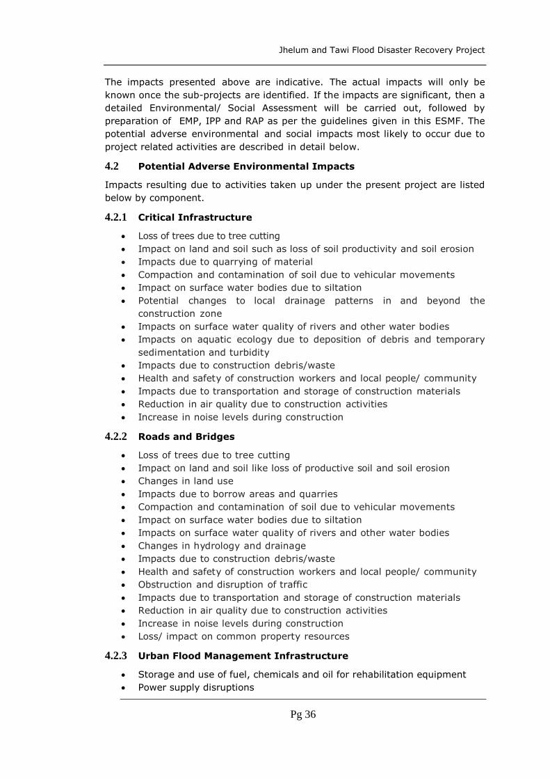
Jhelum and Tawi Flood Disaster Recovery Project
Pg 36
The impacts presented above are indicative. The actual impacts will only be
known once the sub-projects are identified. If the impacts are significant, then a
detailed Environmental/ Social Assessment will be carried out, followed by
preparation of EMP, IPP and RAP as per the guidelines given in this ESMF. The
potential adverse environmental and social impacts most likely to occur due to
project related activities are described in detail below.
4.2 Potential Adverse Environmental Impacts
Impacts resulting due to activities taken up under the present project are listed
below by component.
4.2.1 Critical Infrastructure
Loss of trees due to tree cutting
Impact on land and soil such as loss of soil productivity and soil erosion
Impacts due to quarrying of material
Compaction and contamination of soil due to vehicular movements
Impact on surface water bodies due to siltation
Potential changes to local drainage patterns in and beyond the
construction zone
Impacts on surface water quality of rivers and other water bodies
Impacts on aquatic ecology due to deposition of debris and temporary
sedimentation and turbidity
Impacts due to construction debris/waste
Health and safety of construction workers and local people/ community
Impacts due to transportation and storage of construction materials
Reduction in air quality due to construction activities
Increase in noise levels during construction
4.2.2 Roads and Bridges
Loss of trees due to tree cutting
Impact on land and soil like loss of productive soil and soil erosion
Changes in land use
Impacts due to borrow areas and quarries
Compaction and contamination of soil due to vehicular movements
Impact on surface water bodies due to siltation
Impacts on surface water quality of rivers and other water bodies
Changes in hydrology and drainage
Impacts due to construction debris/waste
Health and safety of construction workers and local people/ community
Obstruction and disruption of traffic
Impacts due to transportation and storage of construction materials
Reduction in air quality due to construction activities
Increase in noise levels during construction
Loss/ impact on common property resources
4.2.3 Urban Flood Management Infrastructure
Storage and use of fuel, chemicals and oil for rehabilitation equipment
Power supply disruptions

Jhelum and Tawi Flood Disaster Recovery Project
Pg 37
Impacts due to disposal of defunct/damaged equipment both mechanical
and electrical
Impacts due to disposal of dewatered storm water
Impacts on surface water quality of rivers and other water bodies
Loss of tree cover
Land acquisition
Compaction and contamination of soil due to vehicular movement
Impacts on aquatic ecology due to deposition of debris and temporary
sedimentation and turbidity
Impacts due to construction debris/waste
Health and safety of construction workers and local people/ community
Impacts due to transportation and storage of construction materials
Reduction in air quality due to construction activities
Increase in noise levels during construction
Impacts due to quarrying of material
Health and safety of construction workers and local people/ community
Obstruction and disruption of traffic
4.2.4 Livelihoods
Labor and working conditions
Community health and safety
Resource efficiency and pollution prevention
Land acquisition
Conservation of biodiversity and sustainable management of natural
resources
Cultural heritage
4.2.5 Impacts Common to all Components
Impacts on topography: The following temporary impacts are envisaged during
implementation of sub-project activities:
Erosion and sedimentation
Temporary disruption of natural drainage pattern
Loss of fertile top soil of the agriculture lands
Accumulation of excess excavated earth in the area of construction and
operation
Excess earth and debris blockage and change in drainage pattern
Changes to hydrological regime, increased flooding, siltation
hampering stream flows, etc.
Impacts on Climate: No changes in climatic conditions or impacts on climate are
anticipated due to the sub-projects to be proposed as part of the project.
Impacts on Surface Water: The sub-project activities during construction or
operations might interfere with the surface water characteristic of the river or its
tributaries. Hence, some impacts on surface water are anticipated. The following
temporary impacts are identified:
Pollution of surface water due to desludging/dredging of water logged
areas.

Jhelum and Tawi Flood Disaster Recovery Project
Pg 38
Reduced flow to the downstream users at specific points due to river
diversions.
Surface water pollution due to oil and grease from construction vehicles.
Degradation of river banks due to excavation and construction activities.
Impacts on Air Quality: During the construction phase, suspended particulate
matter and dust are major sources of pollution impairing air quality. However, on
the road sub-project construction sites the impact on air quality due to the sub-
projects is likely to be higher. During construction and sometimes during
operation, use of hot mix plants, generators, transportation and lifting machinery
will be unavoidable. Emissions from the exhaust of these are likely to cause
localized and temporary air quality impacts. Adequate dust suppression measures
and protective measures to the work force will significantly reduce impacts. As the
sub-projects to be proposed would be small by nature, the impact of air pollution
will not be very significant. Since these impacts are temporary, adequate
precautions during the construction period will mitigate them. Significant air
quality impacts during the operation phase of the sub-projects are not envisaged.
The possible impacts are listed below:
Increased dust levels due to earth work and construction activities
Air pollution through ventilating shafts of machinery, plant and equipment
Impacts on Noise Level: Movement of vehicles transporting construction
material and noise generating activities at the construction site, are major sources
of noise pollution during construction. Material movement and associated work are
the primary noise generating activities on site. These will be distributed over the
entire construction period. Construction activities are expected to produce noise
levels that can affect the personnel working on site. Activities involving vehicles,
plant and equipment in the close proximity of households will have an adverse
impact due to noise pollution. These impacts are temporary and limited to the
construction phase. Except during regular maintenance activities, no noise
generating activities are envisaged during the sub-projects operation phase.
Hence, no noise impacts are predicted. However, the some possible impacts are
listed.
Increased Noise Levels during construction
Noise due to movement of vehicles
Increased noise levels during operation
Noise impact due to operation of DG sets
Impacts on Ecological Resources: It is not envisaged that the sub-project
activities will involve encroachment of sensitive environmental features,
widespread cutting of trees or removal of vegetation. The proposed sub-projects
are not expected to be in an eco-sensitive zone or coastal zone. Hence, there will
not be any adverse ecological impacts due to the project. However, the impacts
due to cutting of trees is expected, which need to be taken care of in the ESMF.
Other Impacts: Other environmental impacts envisaged during implementation
of project activities are:

Jhelum and Tawi Flood Disaster Recovery Project
Pg 39
Visual Impacts including:
Damage to road surfaces and other utilities.
Digging of unplanned borrow pits on the road side causing inconvenience
to public and leading to accidents
Storage of materials causing disturbance to public and traffic
Nuisance due to vectors like mosquitos and flies
Disease transmission and public health issues
Spills of solid waste enroute construction sites
Plying vehicles on unpaved roads
Stagnation of water inside facilities and on roads
On site health and safety of workers
Oil spillages

Jhelum and Tawi Flood Disaster Recovery Project
Pg 40
5. Environment Management Framework
5.1 Introduction
The JTFRP sub-projects are yet to be identified. Further the implementation of
these sub-projects will take place over a period of time and this time lag will lead
to changes in the environmental and social assessments. For such reasons
preparation and implementation of Environmental Management Framework (EMF)
and a Social Management Framework (SMF) are proposed for this project.
5.2 Screening
During the screening, as a first step, the environmental and social impacts are
identified through filling in an Environmental and Social Data Sheet (ESDS). This
ESDS is same for both EMF and SMF The basic objective of the filling in this data
sheet is to collect basic information on environmental and social aspects of the
proposed sub-projects. Further the ESMF requires that basic environmental and
social data pertaining to the proposed sub-projects be compiled during the field
data collection stage. For this purpose, simple ESDS were formulated for Critical
Infrastructure (Public Buildings) sub-projects and Roads and Bridges sub-projects
and annexed to this ESMF. For the other sub-projects the Critical Infrastructure
ESDS may be used. The sub-project Implementing Agency fills up these ESDS with
the facilitation support of the PIU duly identifying the environmental and social
issues of concern. Supplementary notes on environmental and social concerns will
also be added to those ESDS. The sub-project Implementing Agency will do the
screening through collection of necessary filed data. These ESDS are attached to
the sub-project project proposal/ concept note.
During the screening process, the sub-projects are also categorized. The basic
objective of this categorization is to ensure that sub-projects with potentially
significant environmental/ social issues are identified at an early stage for detailed
environmental/ social assessment. Further evaluation of all the available
information on environmental and social aspects as provided in the ESDS and
assessment based on the level of expected environmental and social impacts
(including any field visits if required), whether the proposed sub-project is
qualified for categorization as E1/E2 and S1/ S2 takes place during this phase. As
a part of ESMF process the screening and sub-project categorization will be cleared
by The World Bank, before taking up EA/SA. This is further detailed in the
paragraphs below.
5.3 Environmental Categorization
In order to give an indication of scale and size of environmental and social impacts,
the sub-projects are categorized. This categorization is required to carry out the
appropriate level of assessments for different types of sub-projects based on the
nature, scale and magnitude of their social and environmental impacts.
Categorization would help in focussing time and effort in sub-projects that have
significant impacts. Based on environmental impacts the sub-projects are
categorized into two categories;

Jhelum and Tawi Flood Disaster Recovery Project
Pg 41
1) E1, where there are relatively higher chances of creating adverse environmental
impacts
2) E2, where there are relatively lower chances of creating adverse environmental
impacts
It is important to note that the above categories of E1/E2 are not equivalent to
World Bank environmental categorization of A/B/C. This project as a whole is a
(World Bank) Environmental category B project, and all sub-projects are expected
to be a category B sub-projects. Any sub-project which is seen to be equivalent to
a (World Bank) Environmental category A project (sub-project) will be excluded
from the project (determination by World Bank that a particular sub-project is
equivalent to a category A sub-project will be deemed final). In effect, therefore
E1/E2 categorization will correspond to “relatively higher impact B category sub-
project” and “relatively lower impact B category sub-project”.
The E1 category sub-projects require conducting a comprehensive Environmental
Assessment (EA) and preparation of an Environment Management Plan (EMP) by
Independent Consultants prior to preparation of DPR for appraisal by PMU. This
EA and EMP need to be disclosed before the start of procurement for that sub-
project. Annexure 15.6 provides the contents of an EIA for sub-projects
categorized as E1. Additional guidance on EMP contents is also attached as
Annexure 15.7.
The E2 category sub-projects need not conduct an EA, but require an EMP, which
is to be prepared by Design Consultants following the guidelines given in this
ESMF. This EMP becomes a part of the DPR, which will be appraised by PMU. If,
under special circumstances, PMU identifies a need for a limited environmental
assessment, then it needs to be conducted.
5.4 Environmental Impacts and Mitigation
The sub-project categorization as E1 or E2 need to be done on the basis of field
visits, primary and secondary data and analysis. After identifying the impacts, the
mitigation measures need to be determined. Some generic mitigation measures
are included as guidance in this ESMF. These have not been included here to avoid
repetition. This guidance table also includes information on whether these
mitigation measures have to be undertaken in the planning/ design, construction
and operation phases. However, each category of sub-projects needs to
incorporate mitigation measures as given below:
5.4.1 E1 Category
For E1 category sub-projects, a social and environmental consultant, independent
of the design consultants, need to be engaged to carry out an Environment Impact
Assessment and prepare an Environment Management Plan. In this regard PMU
need to prepare a Terms of Reference (ToR) for the environmental consultants for
EA of this category of projects. This ESMF needs to be shared with these
consultants for following the procedures and using the relevant information in their
assessment. This EA and EMP need to be disclosed before the start of procurement
for that sub-project.

Jhelum and Tawi Flood Disaster Recovery Project
Pg 42
5.4.2 E2 Category
For E2 category sub-projects, the design consultants would have to prepare the
EMP. PMU need to share this ESMF containing the impacts and mitigation measures
with the design consultants for them to use in the preparation of the EMP that
needs to be submitted along with the DPR. PMU will ensure that the Terms of
Reference for the Design Consultants will include these.
5.4.3 EMP to be Part of Contract Documents
In case of E1 and E2 sub-projects, PMU need to ensure that the EMP is provided
as a part of the contract documents to the contractor facilitating its integration
into the main works.
5.5 Sub-project Cycle and Environmental and Social Requirements
The environmental and social required to be fulfilled during the sub-project cycle;
i.e., during pre-planning, planning, implementation and Operation and
Maintenance (O&M) are listed in the below table and the flow chart.

Jhelum and Tawi Flood Disaster Recovery Project
Pg 43
Environmental and Social Appraisal by PMU
Confirmation that the relevant management provisions
are included in the bid/contract documents
EMP/ ARAP/ RAP Implementation by IA
Supervision by PMU, PIU, IA and Supervision Consultants
En
vir
on
men
tal
and
So
cial
Co
mp
lian
ce C
erti
fica
tio
n b
y
Hal
qa
Pan
chay
at
Rev
iew
by
Th
e
Wo
rld
Ban
k
Qu
arte
rly
Mo
nit
ori
ng
by
Ind
epen
den
t
Co
nsu
ltan
ts
Sub-Project Approval by PMU
Filling of Environmental and Social Data Sheet
for Screening by Design Consultants
Identification of Environmental and
Social Impacts of Sub-Projects
under JTFDRP by Design
Consultants
Sub-Project
Categorizatio
n
Category E1/
S1
Category E2/
S2
EMP/ ARAP
Prepared by
Design
Consultants
EA/ SA conducted by
Independent Consultants
EMP/ RAP prepared by
Independent Consultants
Fo
llo
w E
SM
F G
uid
ance
Figure 1: JTFDRP Environmental and Social Management Flow Chart

Jhelum and Tawi Flood Disaster Recovery Project
Pg 44
Table 11: Environmental and Social Activities and Responsibilities to be fulfilled during the sub-project cycle
Phase ESMF Activity Objectives Process Responsibility Result
Preplanning Identification
Environmental
and Social Data
Sheet
To collect basic
information on
environmental
and social aspects
of the proposed
sub-project.
The ESMF requires that basic environmental and
social data pertaining to the proposed sub-project be
compiled at the field data collection stage. For this
purpose, a simple Environmental and Social Data
Sheet (ESDS) and a simple Socio-Economic Survey
format were formulated for sub-projects. The
formats for the ESDS are furnished under
annexures. The sub-project Implementing Agency
(IA) fills up the ESDS with the facilitation support of
the PIUs duly identifying the environmental and
issues of concern. Supplementary notes on
environmental and social concerns to be added to
those data sheets.
Implementing
Agencies (IAs)
ESDS prepared
and attached with
the project
proposal /
concept note
Planning Screening and
Categorization
Environmental
and Social
classification of
the sub-project
To ensure that
sub-projects with
potentially
significant
environmental/
social issues are
identified at an
early stage for
detailed
environmental/
Evaluate all the available information on
environmental and social aspects as provided in the
ESDS and assess, based on the level of expected
environmental and social impacts (including any
field visits if required), whether the proposed sub-
project is E1/E2 and S1/ S2.
For E2 and S2, the design consultants will prepare
EMP along with the DPR.
PIU,
Design
Consultants
Sub-project
classified as
E1/E2 and S1/S2.
As a part of ESMF
process the
screening and
sub-project
categorization
need to be
cleared by The
World Bank,

Jhelum and Tawi Flood Disaster Recovery Project
Pg 45
Phase ESMF Activity Objectives Process Responsibility Result
social
assessment.
before taking up
EA/SA.
Planning Preparation
Environmental
and Social
Assessment and
Management
Plans
To conduct
Environmental/
Social
Assessment and
Prepare
Management
Plans for
integration into
sub-project DPR
For E1/ S1 category sub-projects for which detailed
environmental/ social assessment is required, this
EA/SA and preparation of EMP/ RAP/ ARAP will be
done by consultants independent of the Design
Consultants.
Independent
Consultants
EA/ SA done.
EMP/ RAP/ ARAP
Prepared and
disclosed prior to
start of
procurement for
that sub-project.
Planning Appraisal
Environmental
and Social
appraisal
To ensure that
relevant
environmental
and social issues
have been
identified and
appropriate
mitigation
measures have
been designed to
address them.
For E2 and S2 sub-projects, there shall be no
separate environmental/ Social appraisal but
environmental/ social aspects shall be included in
the normal appraisal and evaluation process for the
proposed sub-project, based on the ESDS included
in the DPR. All these sub-projects need to follow the
mitigation measures detailed in the ESMF Guidance.
This will be ensured by the PIUs.
For projects requiring a detailed Environmental/
Social Assessment, including evaluation of
environmental/ social impacts, risk assessment if
needed, and design of mitigation measures, will be
done by the PMU Environmental and Social
PMU
Environmental
Expert
Social Expert
Environmental
and social
appraisal of the
project is made
and approval of
proposed sub-
project, with
decision to (i)
accept scheme as
submitted, or (ii)
accept scheme
with modification
suggested in the

Jhelum and Tawi Flood Disaster Recovery Project
Pg 46
Phase ESMF Activity Objectives Process Responsibility Result
Specialists /Managers (Officers with previous social
and environment specialization can be appointed as
Social and Environment Managers).
environmental/
social appraisal.
Planning Approval
Environmental
and Social
approval
required
To ensure that
mitigation
measures and
their cost are
integrated in
scheme design
and
implementation
plans
Approval for the sub-project will not be accorded
without the appraisal by PMU including review of
ESDS/ and approval of SA, EIA, (RAP, TDP, EMP).
The World Bank will randomly check quality of ESDS,
and will review all RAPs and TDPs wherever
prepared.
PMU Technical
Sanction for sub-
projects with
environmental
and social
mitigation
measures and
accordingly its
costs are
integrated in sub-
project design
and
implementation
plans.
Implementatio
n
Implementati
on
Implementation
of
Environmental
and social
mitigation
measures.
To ensure that
the prescribed
environmental
and social
mitigation
measures
(including
construction
The prescribed environmental and social mitigation
measures (including construction stage measures)
as identified through the environmental and social
appraisal process are adequately implemented.
Implementation Completion Report (ICR) for sub-
project will need to include an Environmental
Compliance Certificate and Social Compliance
Certificate given by the Halqa Panchayat indicating
Halqa Panchayat
PMU
ICR with
environmental
and social
compliance
information.

Jhelum and Tawi Flood Disaster Recovery Project
Pg 47
Phase ESMF Activity Objectives Process Responsibility Result
stage) are
implemented.
that the mitigation measures identified in the
appraisal (including construction stage) have been
implemented.
O&M Supervision,
Monitoring
and Evaluation
Environmental
supervision,
monitoring and
evaluation
IEC and capacity
building on
environmental
and social
issues.
To ensure that
environmental
and social aspects
are integrated in
the O&M phase.
Monitoring of indictors will be conducted as per
project monitoring protocol.
Supervision will be conducted by the designated
environmental officers of the implementing agencies
for all the sub-projects
All sub-projects will be monitored by PMU.
Capacity building and IEC activities are undertaken
to enable effective implementation of the ESMF
including assessment procedures, supervision,
monitoring, etc. as well as for community awareness
and sensitization. This will be done by the IA and in
turn the IA will be trained by PMU.
PMU
External
Consultants
PMU will submit
quarterly reports
to The World
Bank on
Safeguards
Implementation.
Quarterly
monitoring
reports by
Independent
Consultants.
Periodic
environmental
and social
supervision
reports.
Training and IEC
activity reports.

Jhelum and Tawi Flood Disaster Recovery Project
Pg 48
5.6 Monitoring and Evaluation
The ESMF requires detailed supervision, monitoring and evaluation of the impact of
the project on the environment and social aspects. In order to carry out this, PMU
will have specific arrangements made at state and district level. This includes
appointment of an Environmental Specialist and Social Specialist for the project
period. Further the PMU will instruct PIUs on how to implement the provisions of this
ESMF. At the field level the staff of the implementing agencies have experience of
implementing projects concerning their departments and do land acquisition for their
project. Implementation of the provisions of ESMF will be new to these staff and
hence preparatory orientations and trainings are proposed as a part of this ESMF to
build their capacity. In order to achieve the objectives of this ESMF and to ensure the
safeguards are implemented in a proper manner, the following provisions are made
in this ESMF:
Environmental Supervision by PMU, PIU and Implementing Agencies
Exclusive Environmental Specialist and Social Specialist at PMU for overall
ESMF implementation coordination and reporting
Concurrent Environmental and Social Monitoring and Evaluation and Quarterly
Environmental and Social Monitoring Reports to the World Bank
Independent Safeguards Audit (ISA): Half-yearly Environmental and Social
Audit, of ESMF implementation by independent consultants.
Environmental and Social Management Capacity Building of PMU, PIU and
Implementing Agencies including Consultants, Contractors and Community
Based Organizations and Community Members.
The PMU will be in charge of implementing the ESMF. The Environmental and Social
Specialists of PMU will guide and oversee the implementation of the ESMF at field
level. This overall guidance will be given by them. Further the PMU will incorporate
the provisions of this ESMF as actionable points in the Project Operations Manual or
other similar document for the project. These will be non-negotiable and will have to
be followed by all PMU and PIUs. The Environmental and Social Specialists will
oversee the application of these provisions and guide the process, while at the same
time building the capacity of the PMU and PIUs.
At the field level the designated environmental engineers of the implementing
agencies/ the supervision consultants will ensure the implementation of the ESMF.
The following provisions include the arrangements made for the effective
implementation of the ESMF:
5.6.1 Safeguards Supervision
This is basically done by PMU. All the sub-projects will be visited at regular intervals
by PMU to check if all safeguard requirements are met and to identify any issues that
need to be addressed. PMU would submit quarterly progress reports to The World
Bank on safeguards implementation.
5.6.2 Concurrent Monitoring and Quarterly Reporting
The concurrent internal environmental social monitoring will be done as part of the
regular monitoring by the PIU, Implementing Agencies, and design and supervision
consultants. However, PMU, with the help of in-house Environmental and Social
Specialists will do the regular environmental and social monitoring of sub-projects
for safeguards compliance. The PMU, PIU and the Implementing Agencies will do the

Jhelum and Tawi Flood Disaster Recovery Project
Pg 49
regular monitoring of ESMF implementation of all sub-projects. This is done under
the supervision and coordination of the Environmental and Social Specialists at PMU.
5.6.3 Safeguards Monitoring Plan
Apart from the quarterly monitoring reports submitted to The World Bank, once every
year, the PMU will prepare a report of the environmental and social situation in the
project districts including data and analysis of relevant parameters as given in the
plan below. This report also should give a listing of relevant new legislation and
regulations that have a bearing on the environmental social performance of the
project. PMU will submit this report to The World Bank. The ESMF will be reviewed
annually by the Bank on the basis of this document by the PMU and ESMF shall be
updated as agreed with the Bank, when so required. Given in the table below are
indicators for project investments, for which monitoring need to be taken up by PMU
in a regular manner.
Table 5: Indicative Monitoring Parameters for Project Investments
Project
Components
Indicative Monitoring
Parameters Frequency Agency
Reconstruction and
strengthening of
critical infrastructure
Water Availability rate (lpm)
in downstream sources
Drinking Water quality –
Surface and Groundwater
Soil erosion – Area Affected
Sq. m
Sand casting
Sedimentation in water
bodies - Turbidity
Soil quality – presence of
heavy metals, oil, chemicals,
etc.
Changes in Tree cover
Debris deposits on lands –
Area/ No. of locations
Sites, buildings, precincts,
etc., identified as heritage
and cultural resources and
impacted directly and
indirectly
Quarterly
by
Independen
t
Consultants
Annually by
PMU
PMU guiding
the collection
of
information
on indicators
Independent
Quarterly
Monitoring
Consultants
Implementin
g Agencies/
Departments
for
department
specific
information
Reconstruction of
roads and bridges
Reconstruction of
urban flood
management
infrastructure
Strengthening and
restoration of
livelihoods
Strengthening of
disaster risk
management
capacity
Contingency
emergency response
Implementation
support

Jhelum and Tawi Flood Disaster Recovery Project
Pg 50
Project
Components
Indicative Monitoring
Parameters Frequency Agency
Other
No. of training programs
conducted
No. of personnel trained
Achievement of learning
objectives
Adherence to contract
conditions and standards
(housing, sanitation, crèches,
use of local labour, equal
wages to men and women,
avoidance of child labour,
etc.)
No. of complaints on
inconvenience, nuisance
Adherence to ESMF
provisions/ guidelines during
sub-project cycle
5.6.4 Independent Safeguards Audits
The PMU will appoint Independent Project Implementation Quality Audit Consultants
with expertise in social and environmental safeguards to conduct half-yearly
Environmental and Social Audit as a part of overall project implementation monitoring
each half-year a minimum of 20% of ongoing sub-projects.
5.6.5 Environmental and Social Capacity Building
The PMU will organize regular trainings on Environmental and Social Management for
capacity building of PMU, PIU and Implementing Agencies including Consultants,
Contractors and Community Based Organizations and Community Members. These
details are further elaborated in chapter 6.
5.7 Stakeholder Consultation
Due to bad weather, continued landslides in some areas and affected areas being
largely inaccessible, the team was unable to undertake independent on-site
assessment. In the circumstances the damage and loss assessment carried out by
the State government of Jammu and Kashmir has been relied upon. During the
JRDNA mission several consultations were held with the line departments, where
several details regarding the actual situation in the affected area were gathered.
Discussion with implementing agencies of on-going projects also helped to negate
the absence of stakeholder consultations. The issues presented in the following
section 5.7.1 are the summary of those consultations. Stakeholder Consultation
Workshops with the participating departments and other stakeholders will be held
regularly during implementation, to gather their feedback on the environmental

Jhelum and Tawi Flood Disaster Recovery Project
Pg 51
issues arising out of implementation of the project, further remedial measures if
required; and accordingly the ESMF will be revised as needed1.
5.7.1 Stakeholder Involvement and Consultation
PMU would engage Design consultants to assist them in preparing the sub-project
DPRs. In the ToR for these consultants, there is an explicit requirement for the
consultants to carry out public/ stakeholder consultations. This is a mechanism to
ensure the upfront public/ stakeholder inputs in the preparation of the sub-projects.
For Category E1 and S1 sub-projects, PMU would have to engage independent
consultants to prepare the SA / RAP and EA / EMP respectively. In the ToR for the
preparation of these outputs, public/ stakeholder consultations form an integral part.
For such type of sub-projects obtaining consent of the local agencies and necessary
clearances from competent authorities is mandatory and should form part of the EA/
SA. These EA/ SA will be reviewed by The World Bank.
During sub-project implementation Halqa Panchayats, NGOs, Community Based
Organisations (CBOs) will be involved. Project monitoring reports would be
disseminated in the public consultation meetings in the Halqa Panchayats. The
stakeholder meetings would discuss the sub-project progress reports and make
recommendations for sub-project control and modifications. These recommendations
would be made use for future sub-project design. Consultations are required for
preparation of all safeguards mitigation documents and these consultations should
be an on-going activity over the life of the project. These would be documented in
the EA/SA documentation for each sub-project.
5.8 Disclosure
5.8.1 State Level
PMU and the implementing agencies shall disclose this entire ESMF at their website.
The summary of the ESMF need to be translated into local languages (Urdu and Hindi)
and placed on the website. The Resettlement Policy Framework will be disclosed along
with the entitlement framework, though this is a part of the SEMF, these documents
shall be separately identified and disclosed in the PMU website. These two documents
shall also be translated into Hindi and Urdu and made available at the PMU’s website.
5.8.2 District Level
PMU will also arrange to disclose the final versions of the ESMF and Resettlement
Policy Framework and Entitlement Matrix in all the District Collectors Offices, PIUs,
and the local offices of the implementing agencies. These would be in place once the
final versions are ready. When this document is updated, then the copies in the
different locations would also be updated.
5.8.3 Disclosure by The World Bank at the Infoshop
The World Bank will disclose this ESMF and any future EA/ SA along with EMP/ RAP
at the Infoshop for downloading and reference by interested parties.
1 Note that revision(s) of the ESMF is subject to agreement of the World Bank.

Jhelum and Tawi Flood Disaster Recovery Project
Pg 52
During the implementation phase, all the sub-project EMP/RAP/TDP shall be disclosed
by PMU and the implementing agencies both at the local level and at the state level.
These EMP/RAP/TDP s will also be disclosed at the Infoshop of The World Bank.
5.9 Grievance Redressal Mechanism
PMU will have a grievance redressal mechanism which will look into all aspects of
sub-projects and their activities apart from R&R related grievances. The SMF can be
referred for details on Grievance Redressal Mechanism.

Jhelum and Tawi Flood Disaster Recovery Project
Pg 53
6. Institutional and Implementation Arrangements
6.1 Introduction
A Project Steering Committee (SC) will be set up for the overall strategy guidance
and monitoring of the project. It will be headed by the Chief Secretary and will
comprise all involved line departments, and additionally the departments of Finance,
Planning, Environment, and Social Welfare. The SC will formally approve the project
investments and help coordinate the activities of various departments, including in
obtaining required approvals/clearances for the Project. This shall be done through
semi-annual review meetings, where the SC shall:
Review the budgets
Review progress against the defined milestones
Review critical findings of the audit and evaluation reports
Provide such guidance, as it may deem necessary for the Project
A Project Management Unit (PMU), housed within the Relief & Rehabilitation
Department (R&RD), will be responsible for overall project management,
coordination, and reporting, and for implementation of Component 5. The PMU will
also be responsible to carry out procurement of goods, services, and small scale
works for other components, with technical inputs from the relevant line
departments.
There will be three Project Implementation Units (PIUs) that will be set up at the
beginning of the Project. During project implementation, additional PIUs might be
set-up depending on the volume of investments and capacity. The three PIUs are:
(i) Roads and Building Department (R&B), will be responsible for all civil
works under Components 1, and 2, and it will receive technical inputs
from the Departments of Health, Higher Education, Fire, and others as
relevant depending on the nature of the civil works;
(ii) Srinagar Municipal Corporation (SMC) will be responsible for
implementation of Component 3 and it will be assisted by the Urban
Environment Engineering Department (UEED) for technical inputs and
procurement of goods, works, and services in line with its official
responsibilities and capacity; and
(iii) Industry & Commerce Department (I&CD) will be responsible for
implementation of Component 4 with support from other agencies.
The graph below outlines the proposed implementation arrangements:

Jhelum and Tawi Flood Disaster Recovery Project
Pg 54
6.1.1 Project Management Unit (PMU)
The PMU will be responsible for:
a) Overall project management and reporting.
b) Coordination with PIUs and line departments in approval of designs, assisting
the PIUs in preparation of: DPRs, bidding documents, tendering schedules,
etc.
c) Appointment of technical assistance consultants and others safeguards
management support to the implementing agencies.
d) Quality Assurance through third party audits.
e) Maintaining MIS and Quarterly reporting.
f) Progress reporting, financial management, monitoring and reporting.
g) Implementation of Component 5.
h) Ensuring compliance with agreed implementation procedures and other Bank
requirements, etc.
i) Grievance redress.
Steering Committee
PMU (Relief & Rehabilitation Department)
- Overall Coordination - Implementation of Component 5 - Procurement and FM for Component 5, and for
goods, services, and small-scale works for other
components. - Safeguards and fiduciary management
PIU (R&B: PWD)
- Implementation of
Components 1, and 2 - Procurement and FM - Safeguards - Technical inputs, as
relevant, from: Public Health
Department (C1), Higher
Education Department (C1),
Fire Department (C1),
Industry Department (C4),
and others* as needed.
*For public buildings under responsibility from a separate
government department.
PIU (SMC)
- Implementation of
Component 3 - Procurement and FM - Safeguards. - Technical inputs, as
relevant, from: Urban
Environment Engineering
Department.
PIU (I&CD)
- Implementation of
Component 4 - Procurement and FM - Safeguards. - Technical inputs, as
relevant, from: Cooperatives
Department.

Jhelum and Tawi Flood Disaster Recovery Project
Pg 55
6.1.2 Project Implementation Units (PIU)
Specific sub-project activities will be planned and carried out by one or more
Implementing Agencies (IA), who will be monitored by The PIUs established for each
Project component. The PIUs will be responsible for:
a) Preparation of Detailed Project Reports including technical designs, surveys
and investigations, etc.
b) Tendering, bid evaluation, contract award, contract management, etc.
c) Financial Management and safeguards compliance.
d) Progress and expense reporting to the PMU.
e) Coordination with line departments for design, implementation, and hand-
over arrangements.
f) Grievance redress.
Line departments will provide technical inputs to the PIUs as relevant, in line with
their sectoral responsibility. In line with their capacity and, ad agreed by the PMU
and the respective PIU, they will also carry out procurement of goods, works, and
services.
Support and Monitoring of Reconstruction components: The PMU will put in
place a monitoring mechanism that includes photo identification and tracking system
for individual beneficiaries. In addition the PMU will also put in place a GIS based
reporting and monitoring system for all other reconstruction works in the State.
Partnership with NGOs/CBOs and consultations with communities will be integral to
the reconstruction work particularly the reconstruction of roads and bridges and
restoration of livelihoods.
Project Management Consultants: PMU will hire consultants using pre-agreed
Terms of References, for:
Technical Support and Advise
Financial/Procurement Management and Project Audit
Developing the GIS based reporting and monitoring system
Result monitoring and impact evaluation, etc.
6.2 Monitoring and Evaluation
The PMU will have the overall responsibility for project implementation including,
but not limited to, reporting, monitoring and evaluation, procurement control,
financial management, audit and disbursements, compliance with the
environmental and social policy requirements, as well as coordination with the line
agencies and the World Bank. The PMU will put in place a monitoring mechanism
that includes photo identification and geo-referenced tracking system for works. The
PIUs will be responsible for feeding the required information into the system.
Within the PMU, full time Environment Specialist and Social Specialist will be
appointed to handle all matters pertaining to environment and social management
under the project, including implementing the ESMF and compliance with it. These
Environment Specialist and Social Specialist will be available for the entire project
life.

Jhelum and Tawi Flood Disaster Recovery Project
Pg 56
The key responsibilities of the Environment and Social Specialists include:
a) Orientation and training of implementing agency teams and the contractors on
environmental and social management
b) Leading/ providing oversight on the EA/SA process and its outputs
c) Review of monitoring reports submitted by the implementing agencies on
ESMF/EMP/RAP/TDP implementation
d) Conducting regular visits to project sites to review ESMF compliance during sub-
project planning, design and execution
e) Providing guidance and inputs to the implementing agency teams on
environment and social management aspects
f) Reporting to PMU, Steering Committee and The World Bank as specified in the
ESMF
g) Coordinating with the Quality Audit Consultants
These Specialists will also deal with matters pertaining to integration of ESMF into
the sub- project design and contract documents; preparation of Terms of
References for studies such as for EA/SA; reporting, documentation, monitoring and
evaluation on environment and social aspects and will ensure overall coordination
with the Implementing Agencies and PIUs and PMU. The PIU offices at the district
and block levels will support preparation of ESDS, and detailed EA/SA if
required, and preparation and implementation of RAP/TDP/EMPs wherever
required. The Environment and Social Specialists of the PMU will be supported by
full time Environment and Social Specialists/ nodal officers positioned in the PIUs.
These Specialists will be available for the entire project life.
Further to support the Environment and Social Specialists, an ‘Independent Project
Implementation Quality Audit’ Consultants will have expertise in social and
environmental safeguards and monitor compliance with ESMF and
implementation of various EMP/ RAP/TDP activities by all the sub-projects as a part
of Project Implementation Quality Monitoring.
6.3 Training and Capacity Building
The project staff will need to have awareness, sensitivity, skills and experience
regarding the environmental and social aspects of sub-projects planning and
implementation. For sustainability and seamless adaption of the environmental and
social principles and safeguards by all the implementing partners, awareness creation
and capacity building becomes necessary. This capacity building and IEC strategy has
been outlined as part of the ESMF program developed for the project. It aims at
building environmental and social awareness and management capacity in the project
implementation structure as well as in the intended target communities. Capacity
building for environmental and social management will be integrated with overall
capacity building component of the project.
6.3.1 Capacity Building Objectives
The objectives of the capacity building initiatives are:
Jhelum and Tawi Flood Disaster Recovery Project
Pg 57
To build and strengthen the capability of project implementation staff,
participating departments, and other partners to integrate sound
environmental and social management into sub- project implementation.
To orient the project implementation staff, participating departments and IAs
at district level and communities to the requirements of the project’s ESMF.
Systematic capacity building initiatives need to be introduced only after completion
of training needs assessment. The training should be of cascade mode. All the trained
staff and others will in turn conduct further trainings at district, block and village
levels. However, since capacity building goes beyond imparting training,
institutionalization of best practices becomes a prerequisite for improved sub-project
environmental and social management. The training outcomes like trainees’
understanding of the training content, achievement of learning objectives,
application of methods, tools and techniques learnt during training, etc. need to
be monitored and audited. This will be done by the monitoring consultants.
6.3.2 Training Details
In view of the specialized training and capacity building envisaged under the ESMF
of the project, it is necessary to identify nodal training institutes that will work closely
with PMU for conceptualizing, designing, conducting and managing training programs
on the ESMF. Some such specialized institutions are:
Selected Expert Staff of Participating Departments
Selected Expert Staff of Disaster Management Department, Environment and
Forest
Department, Mines and Geology Department, etc.
Indian Institute of Technology, Roorkee
Uttarakhand State Pollution Control Board
Engineering Staff College of India, Hyderabad
Other Identified Consultants
The details of the proposed training programs are as below:
Orientation/ Learning Training Programs
Training on the ESMF and Mitigation Plans
Training on Environmental and Social Management
Workshops on ESMF
The likely participants are key officials of the project, PMU staff, PIUs, Participating
Departments’ staff, IAs and State Level Environmental and Social Specialists,
Environment and Social Experts at the PIUs, Resource Persons, Halqat Panchayat
Representatives, Community Representatives, NGOs, CBOs, Women Groups, etc.
About 20 to 30 trainees would participate in each of the training programs. It is
intended that these trained persons will in turn provide onsite training to Participating
Departments’ Staff, IAs, Resource Persons, HP Representatives, Community
Representatives, NGOs, CBOs, Women Groups, etc., onsite at district/ block level.

Jhelum and Tawi Flood Disaster Recovery Project
Pg 58
6.3.3 Training Budget
The total estimated cost of training on environmental and social management
under the proposed project is presented in the table below:
Table 13: Training Budget
S.No. Training No. of
Programs
Estimated
Unit Cost
(in Rs.)
Total Cost
(in Rs.)
1. Orientation/ Learning
Training Programs 20 1,00,000 20,00,000
2. Training on the ESMF and
Mitigation Plans 10 5,00,000 50,00,000
3. Training on Environmental
and Social Management 5 10,00,000 50,00,000
4. Workshops (State) 10 2,00,000 20,00,000
5. Workshops (District) 10 1,00,000 10,00,000
6.
Provision for travel,
allowance, other training
expenses, etc.
1,50,00,000
7. Environmental Audits Included as part of the Third Party Quality
Audits for the Project
Total - - 3,00,00,000
6.4 ESMF Budget
The total administrative budget for environmental and social management
activities under the UDRP has been worked out as Rs. 9.10 crore. The cost of
implementing the proposed mitigation measures is not included in this costing. The
cost of mitigating environmental and social impacts need to be included in the
respective sub-projects’ budgets. The detailed breakup of the administrative budget
is presented in the table below.

Jhelum and Tawi Flood Disaster Recovery Project
Pg 59
Table 6: Administrative budget for ESMF activities
S No. Activity Amount in Rs.
1. Training and workshops (as estimated) 3,00,00,000
2. Community Mobilization Staff Costs (lump sum) 2,00,00,000
3. ESMCs for 4.5 Years @ Rs. 50 Lakhs per year 2,25,00,000
4. Preparation of specific environment and social related
community awareness materials (lumpsum) 1,00,00,000
5. Sub Total 8,25,00,000
6. Contingencies @ 10% 82,50,000
7. Other unforeseen items 2,50,000
Total 9,10,00,000

Jhelum and Tawi Flood Disaster Recovery Project
Pg 60
7. Environment Impact Mitigation Plan - Guidance
7.1 Introduction
This guidance includes a generic Environment Mitigation Plan (EMP), listing
mitigation measures for the possible impacts caused by the sub-projects. This
also includes the project phase, where each of the mitigation measures needs to be
considered and also indicates the implementation responsibility. For the Roads and
Bridges component, the use of Environmental Codes of Practice (ECoPs) of PMGSY
for various stages in the rural roads sub-projects, for management of environmental
and social impacts, are recommended as the unit operations of the project are the
same and the PMGSY program is being supported by the World Bank. These are
annexed to this report. This guidance provides for a Generic Environment Impact
Mitigation Plan which can be made use of by both E1 and E2 category sub-projects.
7.2 How to use this Guidance
7.2.1 For E1 sub-projects
This category of sub-projects requires a full-fledged EA that is to be done by
environmental consultants separate from the design consultants. The EA should
bring out a sub-project specific EMP. The Generic Environment Impact Mitigation
Plan can also be made use of where applicable. The relevant environmental
management measures from the sub-project specific EMP must be integrated into
the bid/contract documents. This would be confirmed by the PMU to the Bank for
such sub-projects and shared for review and concurrence.
7.2.2 For E2 sub-projects
For this category of sub-projects, the design consultants have to prepare an EMP.
The Generic Environment Impact Mitigation Plan should be referred to develop the
EMP by the design consultants to prepare a table of mitigation measures for the
sub-project EMP. The PIU shall ensure that relevant mitigation measures are
implemented as sub-projects go into implementation.
7.2.3 Budget
The budget for complying with the EMP needs to be worked out for each sub-project
by working out the cost of implementing each mitigation measure suggested in
the EMP. Where this is not possible, provision of a minimum of 2% of the sub-
project cost or actual, needs to be earmarked for complying with the EMP.

Jhelum and Tawi Flood Disaster Recovery Project
Pg 61
Table 14: Generic Environment Impact Mitigation Plan – Guidance
S.
No. Issues / Impacts Mitigation Measures
Project
Phase Responsibility
1 Utility Relocation
and common
property resources
In case of utilities and common property resources being impacted due to
the project, they will be relocated with prior approval of the concerned
agencies before construction starts, on any sub-section of the project road.
The relocation site identification will be in accordance with the choice of the
community.
Pre-
construction
Contractor, PIU
2 Relocation of
Cultural Property
In case there is an impact on cultural properties, they will be relocated at
suitable locations, as desired by the community before construction starts.
Local Community meetings, will be held to discuss relocation aspects, siting
of structures etc.
Pre-
construction
Contractor, PIU
3 Site clearance Site clearance will be done only in the area required for the sub-project. Pre-
construction
Contractor, PIU
4 Tree Cutting Trees will generally not be removed unless they are a safety hazard.
Removal of trees shall be done only after the permissions / approvals are
obtained. Disposal of cut trees is to be done immediately to ensure that the
traffic movement is not disrupted.
Pre-
construction
Contractor, PIU
5 Debris disposal
site identification
Site for temporary storage and disposal of debris refuse to be identified.
These disposal sites shall be finalized such that they are not located within
any designated forest or other eco-sensitive areas, does not impact natural
drainage courses and no endangered / rare flora is impacted by such
Pre-
Construction
Contractor, PIU

Jhelum and Tawi Flood Disaster Recovery Project
Pg 62
S.
No. Issues / Impacts Mitigation Measures
Project
Phase Responsibility
disposal. Pre-designated sites for disposal by PMU could be used with prior
permission from PMU.
6 Joint Field
Verification
The Engineer and the Contractor will carry out joint field verification of the
EMP. The efficacy of the mitigation measures suggested in the EMP will be
checked.
Pre-
Construction
Contractor/ PIU,
Social and
Environmental
Managers and
Experts
7 Modification of the
Contract
Documents
If required, the Engineer will modify the EMP and Contract documents
(particularly the BOQs).
Pre-
construction
PIU, Contractor,
Design
Consultant,
Social and
Environmental
Managers and
Experts
8 Crushers, Hot-mix
plants & Batching
Plants
Specifications hot mix plants and batching plants (existing or new) will
comply with the requirements of the relevant national, state and local
pollution control requirements. Hot mix plants and batching plants will be
sited sufficiently away from habitation, agricultural operations or industrial
establishments. Such plants will be located at least 1000m away from the
nearest habitation, preferably in the downwind direction.
Pre-
Construction
Contractor, PIU
9 Other Construction
Vehicles,
The discharge standards promulgated under the Environment Protection
Act, 1986 will be strictly adhered to. All vehicles, equipment and machinery
to be procured for construction will conform to the relevant Bureau of Indian
Pre-
Construction
Contractor, PIU

Jhelum and Tawi Flood Disaster Recovery Project
Pg 63
S.
No. Issues / Impacts Mitigation Measures
Project
Phase Responsibility
Equipment and
Machinery
Standard (BIS) norms. Noise limits for construction equipments to be
procured such as compactors, rollers, front loaders, concrete mixers, cranes
(moveable), vibrators and saws will not exceed 75 dB (A), measured at one
metre from the edge of the equipment in free field, as specified in the
Environment (Protection) Rules, 1986.
10 Material sourcing
(sand, borrow
material and stone
material)
Procurement of construction material only from permitted sites and licensed
/ authorized quarries. Farm land and forest belts shall not be used for
material sourcing or borrow sites.
Arable land shall not be selected as borrow sites as much as possible. If
excavation has to be done in arable land, top soil layer (30 cm) shall be
saved and returned after construction work is completed, so as to minimize
impacts.
Pre-
Construction
Contractor , PIU
11 Quarries The Contractor will identify materials from existing licensed quarries with
the suitable materials for construction.
Apart from approval of the quality of the quarry materials, the Engineer’s
representative will verify the legal status of the quarry operation.
The quarry operations will be undertaken within the rules and regulations in
force.
Pre-
Construction
Contractor
12 Water The Contractor will be responsible for arranging adequate supply of water
for the entire construction period. The contractor shall consult the local
people before finalizing the locations. The contractor will preferentially
source all water requirements from surface water bodies. The contractor will
Pre-
construction
Contractor

Jhelum and Tawi Flood Disaster Recovery Project
Pg 64
S.
No. Issues / Impacts Mitigation Measures
Project
Phase Responsibility
be allowed to pump only from the surface water bodies. Boring of any tube
wells will be prohibited. Any groundwater to be extracted requires
permission from PIU/ DPIU and Department of Mines and Geology. The
contractor will minimize wastage of water during construction.
13 Sand The contractor will identify sand quarries with requisite approvals for the
extraction of sand.
Pre-
construction
Contractor
14 Labour
Requirements
The contractor will use unskilled labour drawn from local communities to
avoid any additional stress on the existing facilities (medical services,
power, water supply, etc.). Planning of labour camps, if required, needs to
be done to ensure adequate water supply, sanitation and drainage etc., in
conformity with the Indian Labour Laws.
Mobilization Contractor
15 Generation of
Debris from
dismantling of
pavement
structures
Debris generated due to the dismantling of the existing pavement
structure shall be suitably reused in the proposed construction, subject
to the suitability of the material and the approval of the Engineer. The
contractor shall suitably dispose off unutilized debris material; either
through filling up of borrows areas created for the project or at pre-
designated dump locations, subject to the approval of the Engineer.
Debris generated from pile driving or other construction activities shall be
disposed such that it does not flow into the surface water bodies or form
mud puddles in the area. Dumping sites shall be identified by the contractor
as per regulations in force. The identified locations will be reported to the
Engineer.
Construction Contractor, PIU

Jhelum and Tawi Flood Disaster Recovery Project
Pg 65
S.
No. Issues / Impacts Mitigation Measures
Project
Phase Responsibility
16 Bituminous wastes
disposal
The disposal of residual bituminous wastes will be done by the contractor at
secure landfill sites, with the requisite approvals for the same from the
concerned government agencies.
Construction Contractor, PIU
17 Non-bituminous
construction
wastes disposal
Location of disposal sites will be finalized prior to completion of the
earthworks on any particular section of the road. The Engineer shall approve
these disposal sites conforming to the following (a) These are not located
within designated forest areas. (b) The dumping does not impact natural
drainage courses (c) No endangered/rare flora is impacted by such
dumping. (d) Settlements are located at least 1.0km away from the site. (e)
Not located 1 Km within any mangrove vegetation/ecologically sensitive
areas.
Construction Contractor, PIU
18 Stripping, stocking
and preservation
of top soil
The topsoil from borrow areas, areas of cutting and areas to be permanently
covered will be stripped to a specified depth of 150mm and stored in
stockpiles. At least 10% of the temporarily acquired area will be earmarked
for storing topsoil. The stockpile will be designed such that the slope does
not exceed 1:2 (vertical to horizontal), and the height of the pile is to be
restricted to 2m. Stockpiles will not be surcharged or otherwise loaded and
multiple handling will be kept to a minimum to ensure that no compaction
will occur. The stockpiles will be covered with gunny bags or tarpaulin. It
will be ensured by the contractor that the topsoil will not be unnecessarily
trafficked either before stripping or when in stockpiles. Such stockpiled
topsoil will be returned to cover the disturbed area and cut slopes. The
management of topsoil shall be reported regularly to the Engineer.
Construction Contractor, PIU
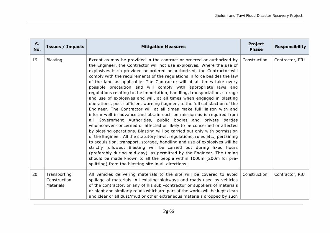
Jhelum and Tawi Flood Disaster Recovery Project
Pg 66
S.
No. Issues / Impacts Mitigation Measures
Project
Phase Responsibility
19 Blasting Except as may be provided in the contract or ordered or authorized by
the Engineer, the Contractor will not use explosives. Where the use of
explosives is so provided or ordered or authorized, the Contractor will
comply with the requirements of the regulations in force besides the law
of the land as applicable. The Contractor will at all times take every
possible precaution and will comply with appropriate laws and
regulations relating to the importation, handling, transportation, storage
and use of explosives and will, at all times when engaged in blasting
operations, post sufficient warning flagmen, to the full satisfaction of the
Engineer. The Contractor will at all times make full liaison with and
inform well in advance and obtain such permission as is required from
all Government Authorities, public bodies and private parties
whomsoever concerned or affected or likely to be concerned or affected
by blasting operations. Blasting will be carried out only with permission
of the Engineer. All the statutory laws, regulations, rules etc., pertaining
to acquisition, transport, storage, handling and use of explosives will be
strictly followed. Blasting will be carried out during fixed hours
(preferably during mid-day), as permitted by the Engineer. The timing
should be made known to all the people within 1000m (200m for pre-
splitting) from the blasting site in all directions.
Construction Contractor, PIU
20 Transporting
Construction
Materials
All vehicles delivering materials to the site will be covered to avoid
spillage of materials. All existing highways and roads used by vehicles
of the contractor, or any of his sub -contractor or suppliers of materials
or plant and similarly roads which are part of the works will be kept clean
and clear of all dust/mud or other extraneous materials dropped by such
Construction Contractor, PIU

Jhelum and Tawi Flood Disaster Recovery Project
Pg 67
S.
No. Issues / Impacts Mitigation Measures
Project
Phase Responsibility
vehicles. The unloading of materials at construction sites close to
settlements will be restricted to daytime only.
21 Planning Traffic
Diversions &
Detours
Temporary diversions will be constructed with the approval of the Engineer.
Detailed Traffic Control Plans will be prepared and submitted to the Engineer
for approval, 5 days prior to commencement of works on any section of
road. The traffic control plans shall contain details of temporary diversions,
details of arrangements for construction under traffic, details of traffic
arrangement after cessation of work each day, safety measures for
transport of hazardous material and arrangement of flagmen.
Environmental personnel of the Engineer will assess the environmental
impacts associated as the loss of vegetation, productive lands and the
arrangement for temporary diversion of the land prior to the finalization of
diversions and detours. Special consideration will be given to the
preparation of the traffic control plan for safety of pedestrians and workers
at night.
The Contractor will ensure that the diversion/detour is always
maintained in running condition, particularly during the monsoon to
avoid disruption to traffic flow. He shall inform local community of
changes to traffic routes, conditions and pedestrian access
arrangements. The temporary traffic detours will be kept free of dust by
frequent application of water.
Construction Contractor, PIU,
Social and
Environmental
Managers and
Experts
22 Infrastructure
provisions at
The Contractor during the progress of work will provide, erect and maintain
necessary (temporary) living accommodation and ancillary facilities for
labour to standards and scales approved by the Engineer.
Construction Contractor, PIU,
Social and
Environmental

Jhelum and Tawi Flood Disaster Recovery Project
Pg 68
S.
No. Issues / Impacts Mitigation Measures
Project
Phase Responsibility
construction
camps
There shall be provided within the precincts of every workplace, latrines and
urinals in an accessible place, and the accommodation, separately for each
for these, as per standards set by the Building and other Construction
Workers (regulation of Employment and Conditions of Service) Act, 1996.
Except in workplaces provided with water-flushed latrines connected with a
water borne sewage system, all latrines shall be provided with dry-earth
system (receptacles) which shall be cleaned at least four times daily and at
least twice during working hours and kept in a strict sanitary condition.
Receptacles shall be tarred inside and outside at least once a year. If women
are employed, separate latrines and urinals, screened from those for men
(and marked in the vernacular) shall be provided. There shall be adequate
supply of water, close to latrines and urinals.
All temporary accommodation must be constructed and maintained in such
a fashion that uncontaminated water is available for drinking, cooking and
washing. The sewage system for the camp must be designed, built and
operated so that no health hazard occurs and no pollution to the air, ground
or adjacent watercourses takes place. Compliance with the relevant
legislation must be strictly adhered to. Garbage bins must be provided in
the camp, shall be regularly emptied and the garbage disposed off in a
hygienic manner. Construction camps are to be sited at least 1000m away
from the nearest habitation and adequate health care is to be provided for
the work force. Unless otherwise arranged for by the local sanitary authority,
arrangement for disposal of excreta by putting a layer of night soils at the
bottom of a permanent tank prepared for the purpose shall be taken up by
the contractor. It should be covered with 15 cm layer of waste or refuse
Managers and
Experts
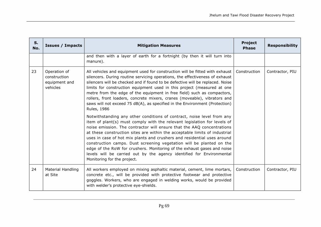
Jhelum and Tawi Flood Disaster Recovery Project
Pg 69
S.
No. Issues / Impacts Mitigation Measures
Project
Phase Responsibility
and then with a layer of earth for a fortnight (by then it will turn into
manure).
23 Operation of
construction
equipment and
vehicles
All vehicles and equipment used for construction will be fitted with exhaust
silencers. During routine servicing operations, the effectiveness of exhaust
silencers will be checked and if found to be defective will be replaced. Noise
limits for construction equipment used in this project (measured at one
metre from the edge of the equipment in free field) such as compactors,
rollers, front loaders, concrete mixers, cranes (moveable), vibrators and
saws will not exceed 75 dB(A), as specified in the Environment (Protection)
Rules, 1986
Notwithstanding any other conditions of contract, noise level from any
item of plant(s) must comply with the relevant legislation for levels of
noise emission. The contractor will ensure that the AAQ concentrations
at these construction sites are within the acceptable limits of industrial
uses in case of hot mix plants and crushers and residential uses around
construction camps. Dust screening vegetation will be planted on the
edge of the RoW for crushers. Monitoring of the exhaust gases and noise
levels will be carried out by the agency identified for Environmental
Monitoring for the project.
Construction Contractor, PIU
24 Material Handling
at Site
All workers employed on mixing asphaltic material, cement, lime mortars,
concrete etc., will be provided with protective footwear and protective
goggles. Workers, who are engaged in welding works, would be provided
with welder’s protective eye-shields.
Construction Contractor, PIU

Jhelum and Tawi Flood Disaster Recovery Project
Pg 70
S.
No. Issues / Impacts Mitigation Measures
Project
Phase Responsibility
Workers, engaged in stone breaking activities will be provided with
protective goggles and clothing and will be seated at sufficiently safe
intervals.
The use of any herbicide or other toxic chemical will be strictly in accordance
with the manufacturer’s instructions. The Engineer will be given at least 6
working days notice of the proposed use of any herbicide or toxic chemical.
A register of all herbicides and other toxic chemicals delivered to the site
will be kept and maintained up to date by the Contractor. The register will
include the trade name, physical properties and characteristics, chemical
ingredients, health and safety hazard information, safe handling and storage
procedures, and emergency and first aid procedures for the product.
No man below the age of 14 years and no woman will be employed on the
work of painting with products containing lead in any form. No paint
containing lead or lead products will be used except in the form of paste or
readymade paint. Face masks will be supplied for use by the workers when
paint is applied in the form of spray or a surface having lead paint dry rubbed
and scrapped.
25 Precautionary/Safe
ty Measures
During
Construction
All relevant provisions of the Factories Act, 1948 and the Building and
other Construction Workers (regulation of Employment and Conditions
of Service) Act, 1996 will be adhered to. Adequate safety measures for
workers during handling of materials at site will be taken up. The
contractor has to comply with all regulations regarding safe scaffolding,
ladders, working platforms, gangway, stairwells, excavations, trenches and
safe means of entry and egress.
Construction Contractor, PIU

Jhelum and Tawi Flood Disaster Recovery Project
Pg 71
S.
No. Issues / Impacts Mitigation Measures
Project
Phase Responsibility
26 Protection of
Religious
Structures and
Shrines
All necessary and adequate care shall be taken to minimize impact on
cultural properties (which includes cultural sites and remains, places of
worship including temples, mosques, churches and shrines, etc.,
graveyards, monuments and any other important structures as identified
during design and all properties/sites/remains notified under the Ancient
Sites and Remains Act). No work shall spillover to these properties, premises
and precincts.
Access to such properties from the road shall be maintained clear and clean.
Construction Contractor, PIU
27 Dust
contamination at
construction sites
and along the
roads
Unpaved haul roads near/passing through residential and commercial areas
to be watered thrice a day. Trucks carrying construction material to be
adequately covered. All earthwork will be protected in a manner acceptable
to the Engineer to minimise generation of dust. The contractor will take
every precaution to reduce the level of dust along construction sites
involving earthworks, by frequent application of water.
Construction Contractor, PIU
28 Earth work
Excavations
Ensure unobstructed natural drainage through proper drainage
channels/structures. Dispose surplus excavated earth at identified sites.
Ensure minimum hindrance to normal local activities and business. Avoid
damage to permanent structures. All excavations will be done in such a
manner that the suitable materials available from excavation are
satisfactorily utilized as decided upon beforehand. The excavations shall
conform to the lines, grades, side slopes and levels shown in the drawings
or as directed by the engineer.
Construction Contractor, PIU

Jhelum and Tawi Flood Disaster Recovery Project
Pg 72
S.
No. Issues / Impacts Mitigation Measures
Project
Phase Responsibility
While planning or executing excavation the contractor shall take all
adequate precautions against soil erosion, water pollution etc and take
appropriate drainage measures to keep the site free of water, through use
of mulches, grasses, slope drains and other devices. The contractor shall
take adequate protective measures to see that excavation operations do not
affect or damage adjoining structures and water bodies. For safety
precautions guidance may be taken from IS:3764.
29 Earth fill Embankment and other fill areas, unless other wise permitted by the
Engineer, be constructed evenly over their full width and the contractor will
control and direct movement of construction vehicles and machinery over
them
Construction Contractor, PIU
30 Slope protection
and control of
erosion
Embankments and other areas of unsupported fill will not be constructed
with steeper side slopes, or to greater widths than those shown in design
drawings. While planning or executing excavations the Contractor will take
all adequate precautions against soil erosion as per regulations. Turfing on
critical road embankment slopes with grass sods, in accordance with the
recommended practice for treatment of embankment slopes for erosion
control. The work will be taken up as soon as possible provided the season
is favorable for the establishment of sods. Other measures of slope
stabilization will include mulching, netting and seeding of batters and drains
immediately on completion of earthworks. Dry stone pitching for apron and
revetment will be provided for bridges and cross drainage structures.
Construction Contractor, PIU
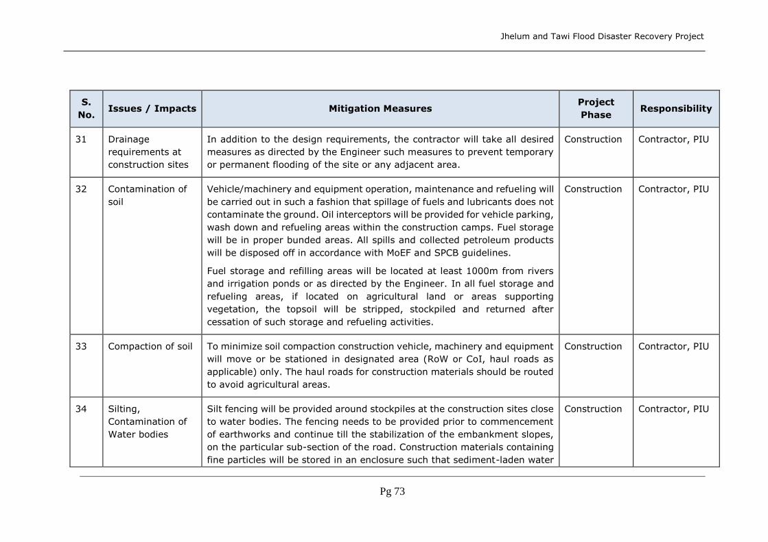
Jhelum and Tawi Flood Disaster Recovery Project
Pg 73
S.
No. Issues / Impacts Mitigation Measures
Project
Phase Responsibility
31 Drainage
requirements at
construction sites
In addition to the design requirements, the contractor will take all desired
measures as directed by the Engineer such measures to prevent temporary
or permanent flooding of the site or any adjacent area.
Construction Contractor, PIU
32 Contamination of
soil
Vehicle/machinery and equipment operation, maintenance and refueling will
be carried out in such a fashion that spillage of fuels and lubricants does not
contaminate the ground. Oil interceptors will be provided for vehicle parking,
wash down and refueling areas within the construction camps. Fuel storage
will be in proper bunded areas. All spills and collected petroleum products
will be disposed off in accordance with MoEF and SPCB guidelines.
Fuel storage and refilling areas will be located at least 1000m from rivers
and irrigation ponds or as directed by the Engineer. In all fuel storage and
refueling areas, if located on agricultural land or areas supporting
vegetation, the topsoil will be stripped, stockpiled and returned after
cessation of such storage and refueling activities.
Construction Contractor, PIU
33 Compaction of soil To minimize soil compaction construction vehicle, machinery and equipment
will move or be stationed in designated area (RoW or CoI, haul roads as
applicable) only. The haul roads for construction materials should be routed
to avoid agricultural areas.
Construction Contractor, PIU
34 Silting,
Contamination of
Water bodies
Silt fencing will be provided around stockpiles at the construction sites close
to water bodies. The fencing needs to be provided prior to commencement
of earthworks and continue till the stabilization of the embankment slopes,
on the particular sub-section of the road. Construction materials containing
fine particles will be stored in an enclosure such that sediment-laden water
Construction Contractor, PIU

Jhelum and Tawi Flood Disaster Recovery Project
Pg 74
S.
No. Issues / Impacts Mitigation Measures
Project
Phase Responsibility
does not drain into nearby watercourses. All discharge standards
promulgated under Environmental Protection Act, 1986, will be adhered to.
All liquid wastes generated from the site will be disposed off as acceptable
to the Engineer.
35 Cutting/Filling of
Surface water
bodies
Earth works shall be undertaken such that the existing embankments of
water bodies are not disturbed. In case of cutting of embankments, the
same shall be reconstructed with appropriate slope protection measures and
adequate erosion control measures. Filling of surface water bodies will be
compensated by digging an equal volume of soil for water storage. Such
dug-up soil will be used for spreading as topsoil. Wherever digging is
undertaken, the banks will be protected as designed or as approved by the
Engineer. The excavation will be carried out in a manner so that the side
slopes are no steeper than 1 vertical to 4 horizontal, otherwise slope
protection work, as approved by the Engineer will be provided. As far as
practicable, and as approved by the Engineer, excavation for replacement
of water bodies will be at the closest possible place/location, with respect to
the original water body or part thereof consumed by filling.
Construction Contractor, PIU
36 Sub-Base & Base The contractor will take all necessary measures/ precautions to ensure that
the execution of works and all associated operations are carried out in
conformity with statutory and regulatory environmental requirements. The
contractor will plan and provide for remedial measures to be implemented
in event of occurrence of emergencies such as spillage of oil or bitumen or
chemicals. The contractor will provide the Engineer with a statement of
measures that he intends to implement in event of such an emergency,
which will include a statement of how he intends to adequately train
Construction Contractor, PIU

Jhelum and Tawi Flood Disaster Recovery Project
Pg 75
S.
No. Issues / Impacts Mitigation Measures
Project
Phase Responsibility
personnel to implement such measures. Adequate safety measures for
workers during handling of materials at site will be taken up. The contractor
will take every precaution to reduce the level of dust along construction sites
by frequent application of water as per regulations. Noise levels from all
vehicles and equipment used for construction will conform to standards as
specified. Construction activities involving equipment with high noise levels
will be restricted to the daytime. Transport of materials for construction will
be as specified. The contractor will provide for all safety measures during
construction as per regulations in force.
37 Surfacing The contractor will take all necessary means to ensure that all surfacing
works and all associated operations are carried out in conformity with
regulations. All workers employed on mixing asphaltic material etc. will be
provided with protective footwear as specified. Noise levels from all vehicles
and equipment used for surfacing will conform to standards as specified.
Construction activities involving equipment with high noise levels will be
restricted to the daytime. Transport of materials for construction will be as
specified. The contractor will provide for all safety measures during
construction as per regulations in force.
Construction Contractor, PIU
38 Mitigation
Measures for Noise
Sensitive
Receptors
Noisy construction operations in residential and sensitive areas (hospitals,
schools and religious places) should be restricted between 7.30 a.m. to 6.00
p.m. Preventive maintenance of construction equipment and vehicles would
be done to meet emission standards and to keep them with low noise.
Provision of ear plugs to operators of heavy machinery and workers in near
Construction Contractor, PIU

Jhelum and Tawi Flood Disaster Recovery Project
Pg 76
S.
No. Issues / Impacts Mitigation Measures
Project
Phase Responsibility
vicinity. During night, material transport should be uniformly distributed to
minimize noise impacts.
39 Road Furniture Road furniture including footpaths, railings, storm water drains, crash
barrier, traffic signs, speed zone signs, pavement markers and any other
such items will be provided as per design. The contractor shall provide
Recharge pits for Urban drains. The drains will be provided for each
kilometer of the road through urban settlements and near the outfall to a
natural drain if the road crosses one inside a settlement. As part of this
recharge pits could be proposed as an enhancement measure.
Construction Contractor, PIU
40 Disposal of
construction debris
Daily inspection at haul roads and sites for construction debris for safe
collection and disposal to land fill sites. Collection and disposal of refuse.
Minimize construction debris by balancing cut and fill requirements, if
relevant.
Construction Contractor, PIU
41 Adjoining water
bodies
Provide slope protection works of water bodies, if any, abutting the road. Construction Contractor, PIU
42 Bridge Works &
Culverts
While working across or close to the rivers, avoid obstructing the flow of
water. If an obstruction is required, to serve notice on the downstream users
of water sufficiently in advance. Construction over and close to the non-
perennial streams will be undertaken in the dry session. Construction work
expected to disrupt users and impacting community water bodies will be
taken up after serving notice on the local community. Dry stone pitching for
Construction Contractor, PIU

Jhelum and Tawi Flood Disaster Recovery Project
Pg 77
S.
No. Issues / Impacts Mitigation Measures
Project
Phase Responsibility
apron and revetment will be provided for bridges and cross drainage
structures, if necessary.
43 Safety practices
during
construction
The Contractor is required to comply with all the precautions as required for
the safety of the workers as per the International Labour Organization (ILO)
Convention No. 62 as far as those are applicable to this contract. The
contractor will supply all necessary safety appliances such as safety goggles,
helmets, masks, etc., to the workers and staff. The contractor has to comply
with all regulation regarding, working platforms, excavations, trenches and
safe means of entry and egress.
Construction Contractor , PIU
44 Social disruptions Minimise interruptions to utility services through proper planning and
scheduling of activities and inter-departmental co-ordination. Construction
of temporary road/access and diversion of traffic.
Construction Contractor , PIU
45 Aesthetic
impairment
Aesthetic enhancement through proper housekeeping of construction sites.
Disposal of construction wastes at the approved disposal sites. Immediate
closure of the trenches after pipe laying/ completion of work. Complete
construction activity by removing all temporary structures, restoring the
sub-project and surrounding areas as near as possible to the pre-
construction condition.
Construction Contractor, PIU
46 Tree plantation Trees felled will be replaced as per the compensatory afforestation criteria
in accordance with the Forest (Conservation) Act, 1980. Two trees will be
planted for every tree lost along the sub-project roads in locations to be
identified with support from the PIU.
Construction Contractor,
PMU, Forest
Dept.

Jhelum and Tawi Flood Disaster Recovery Project
Pg 78
S.
No. Issues / Impacts Mitigation Measures
Project
Phase Responsibility
47 Risk of accidents In order to guarantee construction safety, efficient lighting and safety signs
shall be installed on temporary roads during construction and adequate
traffic regulations shall be adopted and implemented for temporary roads.
Construction Contractor, PIU
48 Traffic and
Transportation
Adequate actions to direct and regulate traffic shall be taken in consultation
with PIU/ DPIU/ Traffic Police to prevent jamming roads during construction
period. While planning alternative routes, care to be taken to minimize
congestion and negative impacts at sensitive receptors such as schools and
hospitals. Traffic controls and diversions marked with signs, lights and other
measures (flags) should be provided. Prior to creating diversions and
detours the citizens should be consulted well in advance through citizen’s
meetings. It should be an informed decision taken through public
participation. Diversion works to be dismantled to restore the area to
original condition after completion of construction.
Construction Contractor, PIU,
Traffic Police
49 Cultural relics /
Chance finds
If fossils, coins, articles of value or antiquity, structures, and their remains
of geologic or archaeological interest are found, local government shall be
immediately informed of such discovery and excavation shall be stopped
until identification of cultural relics by the authorized institution and
clearance is given for proceeding with work. All the above discovered on site
shall be the property of the Government, and shall be dealt with as per
provisions of the relevant legislation.
The contractor shall take reasonable precaution to prevent his workmen or
any other persons from removing and damaging any such article or thing.
He shall, immediately upon discovery thereof and before removal acquaint
Construction Contractor, PIU

Jhelum and Tawi Flood Disaster Recovery Project
Pg 79
S.
No. Issues / Impacts Mitigation Measures
Project
Phase Responsibility
the Engineer of such discovery and carry out the Engineer’s instructions for
dealing with the same, awaiting which all work shall be stopped.
The Engineer shall seek direction from the Archaeological Society of India
(ASI) before instructing the Contractor to recommence work on the site.
50 Monitoring
Environmental
Conditions
The contractor will undertake seasonal monitoring of air, water, noise and
soil quality through an approved monitoring agency. The parameters to be
monitored, frequency and duration of monitoring as well as the locations to
be monitored will be as per the Monitoring Plan prepared.
Construction Contractor, SPCB,
Social and
Environmental
Managers and
Experts
51 Clearing of
Construction of
Camps &
Restoration
Contractor to prepare site restoration plans for approval by the Engineer.
The plan is to be implemented by the contractor prior to demobilization. On
completion of the works, all temporary structures will be cleared away, all
rubbish burnt, excreta or other disposal pits or trenches filled in and
effectively sealed off and the site left clean and tidy, at the Contractor’s
expense, to the entire satisfaction of the Engineer. Residual topsoil will be
distributed on adjoining/proximate barren/rocky areas as identified by the
Engineer in a layer of thickness of 75mm - 150mm.
De-
mobilization
Contractor, PIU
52 Monitoring
Operational
Performance
The PIU will monitor the operational performance of the various mitigation
measures carried out as a part of sub-project. The indicators selected for
monitoring include the survival rate of trees, water bodies, status of
rehabilitation of borrow areas and utility of double glazing for noise sensitive
receptors.
Operation PIU, Social and
Environmental
Managers and
Experts

Jhelum and Tawi Flood Disaster Recovery Project
Pg 80
S.
No. Issues / Impacts Mitigation Measures
Project
Phase Responsibility
53 Orientation of
implementing
agency and
contractors
The PIU shall organize orientation sessions during all stages of the project.
The orientation session shall involve all staff of PIU and field level
implementation staff of Contractor.
Pre-
Construction
&
Construction
Social and
Environmental
Managers and
Experts, PIU
54 Handling of
flora/fauna found
in project sites
The Contractor shall train the workers to handle any accidental finds of
important species of flora and/or flora and on the procedures to be followed
to intimate the Forest Department, and PIU
Pre-
Construction
&
Construction
Contractor, PIU,
PMU, Forest
Department
55 Handling of
Natural Habitats
and Biodiversity
Issues
The PMU and PIUs will ensure that sub-project planning, preparation,
implementation and operation and maintenance will follow the ECoPs (19,
19A and other relevant) given under PMGSY.
Pre-
Construction
&
Construction
Contractor, PIU,
PMU, Forest
Department

Jhelum and Tawi Flood Disaster Recovery Project
Pg 81
Part B
Social Management Framework

Jhelum and Tawi Flood Disaster Recovery Project
Pg 82
8. Social Context
8.1 History
There are various versions of historical backgrounds available for the State of Jammu
& Kashmir in general and for the valley of Kashmir in particular. Kashmir has a
composite culture emerging from a rich history of various philosophical systems
including Hinduism (non-dual Kashmir Shaivism), Buddhism, and Sufi Islam.
8.2 Administrative Divisions
Kashmir comprises three natural divisions, namely, Jammu, Kashmir and Ladakh. For
administrative purposes, the state is divided into two main divisions, i.e., Kashmir
and Jammu Provinces. A Divisional Commissioner heads the administration of each
division. The two districts of Ladakh region, namely, Leh and Kargil are part of the
Kashmir Division for purposes of administration. At present, the Kashmir region
comprises the districts of Srinagar, Budgam, Pulwama, Anantnag, Kupwara,
Baramulla, Leh and Kargil and the Jammu region comprises the districts of Jammu,
Kathua, Poonch, Rajouri, Udhampur and Doda. A Deputy Commissioner who is also
District Development Commissioner, heads each district. In the Ladakh region in
1995, the ‘Autonomous Hill Development Council’ was established as part of
decentralized administration. Annex 1 provides an overview of Jammu and
Kashmir in terms of population, literacy rate, number of villages, tehsils, blocks
and panchayats and villages electrified and provided with drinking water facilities.
There is striking variation as far as the distribution of population among various
districts is concerned. The literacy rate also varies from 40.80 per cent in
Kupwara to 77.30 per cent in Jammu district. Administratively, the districts are
divided into blocks for development purposes and into tehsils for revenue
purposes. The state consists of 59 tehsils and 119 blocks spread over 14
districts.
8.3 Three Main Regions
Jammu and Kashmir is a multi-lingual, multi-religious and multi-racial
state and each group has its own distinct and peculiar cultural ethos, further
deepened by geographical divisions created by formidable mountain ranges.
Thus, the state comprises three main regions, namely, Jammu, Kashmir
and Ladakh. A brief description of these three regions provides the necessary
understanding about each of them.
8.3.1 Jammu Region
This region comprises the plains, hills and mountains south and west of the
mighty Pir Panjal range that separates Kashmir Valley from the plains of the
subcontinent. Today, the Jammu region comprises the districts of Kathua,
Jammu, Udhampur, Doda, Rajouri and Poonch.
Kathua town is situated on the Jammu - Pathankot National Highway at a
distance of about 87 km. east of Jammu and about 25 km. west of Pathankot.
The district shares its boundary with Punjab in the south, Himachal Pradesh
in the east and Udhampur in the north. The geographical area of the district
is 2,651 sq. km. with four tehsils namely, Basholi, Bilawar, Kathua and

Jhelum and Tawi Flood Disaster Recovery Project
Pg 83
Hiranagar. The literacy rate is 65.29 per cent. The majority of the population
of Kathua district is dependent on agriculture. About 80 per cent of agricultural
land in the district is non-irrigated.
A large section of the population depends on wage labour and government
employment.
Jammu district is extended along the whole length of the international border
with Pakistan. It shares its border with Rajouri, Udhampur and Kathua district
in the north in the east and in the southeast respectively. The geographical
area of the district is 3097 sq. km. with 5 tehsils, namely, Jammu, Samba,
Akhnoor, R.S. Pura and Bishnah. The literacy rate stands at 77.3 per cent,
which is not only highest among all the districts in the state but higher than
the national average. The rural population depends mainly on agriculture.
Except for the Kandi area, the land is irrigated and fertile.
Udhampur is the third largest district of Jammu and Kashmir and is situated
at an altitude of 2,134 feet above sea level. It is located at a distance of
66 km. from Jammu on the Jammu-Srinagar National Highway. Rajouri
bounds the district in the west, Jammu in the southwest, Doda in the east
and Kathua in the southeast. It also shares its boundary with Anantnag in
the north. The geographical area of the district is 4,550 sq. km. with 5
tehsils, namely, Udhampur, Chenani, Ramnagar, Reasi and Mahore. Literacy
rate is 54.16 per cent. The principal occupation of the people is agriculture.
There are few industries in the district.
Doda is the largest district in the Jammu region. Doda town, after which
the district is named, is situated at an altitude of 5,000 feet above sea
level. The Khilani village of the district is situated on the National Highway at
about 45 km. from Batot linking the Kashmir valley with Jammu and other
parts of the country. The district shares borders with Anantnag district of
Kashmir Valley and the Chamba district of Himachal Pradesh. The entire
area is hilly. The area of the district is 11,691 sq. km. The district
comprises six tehsils, namely, Doda, Kishtwar, Bhaderwah, Gandoh, Ramban
and Banihal. The literacy rate is 46.92 per cent. The people in general are
poor due to inadequate production of food grains in the district. The majority
of the population depends on ration supply through government shops (PDS).
The widespread unemployment has further increased after the government
banned leasing of forest to the contractors.
Rajouri district was carved out of Poonch district in 1968. It shares a long
border from Sunderbani to Bhimbergali with Pakistan occupied Kashmir
(PoK) in the west. It is bounded by Udhampur district in the east and
by Jammu in the southeast. The northern part of the district consists of
hilly terrain. The geographical area of the district is 2,630 sq. km. It comprises
of six tehsils, namely, Thanamandi, Rajouri, Budhal, Kalakote Sunderbani and
Nowshera. The literacy rate is 57.65 percent. About 80 per cent of the
population of the district depends on agriculture. There is no industry in the
district. Rearing livestock is the main source of income. The economic condition
of the people is generally unsatisfactory.

Jhelum and Tawi Flood Disaster Recovery Project
Pg 84
Poonch town, the headquarters of the district by the same name, is situated
at a distance of 246 km. northwest of Jammu. The town is at a height of
3,287 feet above sea level. It is surrounded by the Line of Control (LoC) on
three sides and is separated from Kashmir Valley by the mighty Pir Panjal range in
the north. The geographical area of the district is 1,674 sq. km., comprising
three tehsils, viz., Mendhar, Surankote, and Haveli (Poonch). The literacy rate
is 51.07 per cent. The people of Poonch district are mainly dependent on
agriculture and government jobs. There are no industrial units in the district.
The terrain is hilly with little fertile land and therefore there is great
dependency on government jobs.
8.3.2 Kashmir Region
The Kashmir region or valley, is a significant part of the state. The valley is
an ancient lake basin 140 km. long and 32 km. wide. The average elevation
of the valley is 5,300 feet above sea level. The tall mountains that surround
the valley rising up to 16,000 feet ensure that the weather here is pleasant
for most of the year. Its rich alluvial soil well drained by rivers and streams,
yields rice, saffron, vegetables and a variety of fruit. It comprises six
districts, namely, Anantnag, Baramulla, Budgam, Kupwara, Pulwama and
Srinagar.
Anantnag is the southern most district of the valley. It shares its border with district
Pulwama in the west and from south to east it is attached to Rajouri,
Udhampur and Doda districts respectively. It borders Kargil in the north. The
district is crisscrossed by a network of perennial rivers, streams and waterfalls.
The geographical area of the district is 3,984 sq. km. with five tehsils, namely,
Pahalgam, Anantnag, Doru, Kulgam and Bijbehara. The literacy rate is 44.10%.
Agriculture and livestock rearing are the main sources of livelihood. The district is
also well known for traditional handicraft like Gabbas and wooden craft. The district,
enriched with perennial streams with clean water has developed commercial fishing
activities with a scattering of trout farms. Sericulture industry has earned a good
name among all the small household industries in the district.
Baramulla district completely surrounds the district Kupwara and shares the
border with PoK at two places in the west as well as in the northeast. The
average height of the district is 5187 feet above sea level. It also shares its
border with Srinagar, Budgam and Poonch districts in the south and with
Kargil in the east. The district has a flat topography, salubrious climate and
scenic beauty. The geographical area of the district is 4,588 sq. km. with
six tehsils, namely, Bandipur, Sonawari, Sopore, Baramulla, Gulmarg and
Uri. The literacy rate is 44.57 per cent. Bulk of the district’s population
depends on agriculture for their livelihood. Sopore tehsil is very famous for
its apples. Rearing of livestock is one of the important occupations in the
district. It has been the first district to generate and provide electricity to
large parts of the state from Mohara Power House.
Budgam district was carved out from Srinagar on 1 July, 1979. It is
centrally located in the Kashmir valley. It is bounded by Srinagar in the
northeast, south and west by Poonch and in the north and northwest by
Baramulla. Although the district has several high mountains, its average height
is just 5,281 feet above sea level. The geographical area of the district is
Jhelum and Tawi Flood Disaster Recovery Project
Pg 85
1,371 sq. km. with three tehsils, namely, Chadura, Budgam and Beerwah. The
literacy rate is 40.94 per cent.
Kupwara district is situated at an altitude of 5,300 feet above sea level and
is the northern-most district of the Kashmir valley. It shares a long border
with PoK in its north and western side and is totally enclosed by the Baramulla
district on the other side. This district is endowed with rich dense forests.
The river ‘Kishan Ganga’ originating from the Himalayas flows through the
outer areas of the district from east to west. Some well-known passes located
in the district are Gabhra Pass, Sadham Pass and Nastuchan Pass. The
geographical area of the district is 2,379 sq. km. with three tehsils, namely,
Handwara, Karnah and Kupwara. The literacy rate is 40.80 per cent, the
lowest in the state. Although the district is considered deficient in natural
irrigation, about 90 per cent of the population depends in one way or other
on agriculture for their livelihood. Walnuts are the major horticultural produce
in the district. Rearing of livestock is also an important occupation of the
people.
Pulwama district came into existence in July 1979. It is situated in the
southeastern part of the valley. It shares its borders with Srinagar and Budgam
in the northwest and is bounded by the Anantnag district in the south and
east. The geographical area of the district is 1,398 sq. km. with three tehsils,
namely, Shopian, Pulwama and Tral. The literacy rate is 47.76 per cent.
Agriculture is the main source of livelihood in the district. About 0.73 lakhs
hectares of land is available for cultivation. Mushroom cultivation and
horticulture are of great importance to the economy. Livestock rearing is
also an important occupation.
Srinagar district is located to the southeast of Baramulla. It shares its border with
Baramulla, Budgam, Pulwama, Anantnag and Kargil districts from the west to
east. The valley is surrounded by the Hurmukh mountain (16,903 feet) in the
east, Tosh Maidan (4,000 feet) in the north and Snony Kazi Nag (12,125
feet) in the northwest and also the Mahadev Mountain. The valley is a land of
lakes, clear streams, green meadows and magnificent trees. The river Jhelum
dissects the district diagonally from the southeast to the northwest. Srinagar is the
state’s summer capital. The geographical area of the district is 2,228 sq. km. with
two tehsils, namely, Srinagar and Ganderbal. The literacy rate is 59.18 per cent.
The district is predominantly urban in character. According to the 2001 Census,
79.54 per cent of the total population was urban. It has developed all the
characteristics of a tourist paradise, with tremendous growth in the development
of handicraft and cottage industries, hotels, houseboats, guest houses and tourist
transport. The handicrafts of the district have become famous worldwide.
Livestock rearing is another important occupation in the district, engaging
about 5.25 per cent of the work force. Animal husbandry and sheep breeding
have received special attention. Rice and maize are the main crops of the
district.
8.3.3 Ladakh Region
Ladakh constitutes the eastern-most part of the state of Jammu and Kashmir.
It comprises two districts, namely, Leh and Kargil. This is one of the
most breathtakingly beautiful parts of the state and its surreal landscape

Jhelum and Tawi Flood Disaster Recovery Project
Pg 86
has often been termed as ‘moonscape’. Ladakh covers about 117,000 sq. km.
and includes the Karakoram Range and the upper Indus River valley. Ladakh
is one of the highest places on earth with the average altitude being
above 12,000 feet. Situated on the leeward side of the mountain, it hardly
gets any rain. People live a very traditional life, herding sheep and yak, and
growing barley near the riverbeds in summer.
Leh district is the northern as well as the eastern most part of Jammu
and Kashmir. It is linked with the Kashmir valley by the Zojila pass (10,098
feet) and forms part of the outer Himalayas. It is one of the highest regions
of the earth (altitude 8,800 feet to 18,000 feet approximately) with mountains
running along parallel ranges. The climate is very cold and in winter,
temperatures dip to minus 40 degrees centigrade. The district is bounded
by the international border or LoC with China in the north and east, and
with PoK in the north. The geographical area of the district is 45,110 sq. km. with
Leh as the district headquarters. The district has two assembly constituencies,
namely Nubra and Leh and five blocks namely, Leh, Khaisi, Nubra,
Nyoma and Durbuk. The literacy rate is 62.24 percent. Agriculture and
animal husbandry are the main sources of livelihood. Cultivation is possible
only during summer; barley, vegetables and fruits like apple and apricot are
the main crops. Forestry is also one source of income and Leh abounds in
medicinal herbs. This district is the source of origin of pashmina goat which
produces fibre used for high quality fabric pashmina wool. The district is also
rich in water resources like ponds, streams and rivers, which can be utilised
for fisheries.
Kargil town is located at a distance of 204 km from Srinagar almost midway
on the Srinagar - Leh National Highway. Most of the villages of the
district are located at an average height of 10,000 feet above sea level. It
shares the Line of Control (LoC) with PoK in the north and borders with Leh
in the east and the Kashmir valley in the west. The geographical area of the
district is 14,036 sq. km. The district has two tehsils as well as two assembly
constituencies, namely, Kargil and Zanskar. The climate is very cold and in
winter, the highway is blocked for more than six months, from December to
June every year. The snowfall around the Zojila pass and Drass region is very
heavy. The literacy rate is 58.21 per cent. Agriculture is the main occupation
and about 91 per cent of the population is engaged in it. Wheat and
millet are the major crops. The Baltal-Kargil road, linking Kargil with
Srinagar, is the lifeline of the district. Construction of the 230- kms Kargil-
Padam and Bodh Khushboochaktan roads is in progress. Tourism is being
promoted as an industry after Ladakh was opened to foreign tourists in 1974.
Horticulture and forestry are being given special attention.
8.4 Socio-Economic and Demographic Profile
8.4.1 Population
As per Census 2011, the total population of the J&K State is 1.25 Crore comprising
of 53% males and 47% females. Out of total population, 72.79% and 27.21% reside
in rural and urban areas, respectively. The decadal growth declined from 29.43%
(1991-2001) to 23.71% (2001-11), which resulted in addition of 24 lakh souls to the
overall population of the State thus resulting in less addition to the overall population

Jhelum and Tawi Flood Disaster Recovery Project
Pg 87
of the State since 1961. The Average Annual Exponential Growth Rate (AAEGR) of
the State declined from 2.61% per annum (during 1991-2001) to 2.15% per annum
(during 2001-2011). The density of the State is 124 per sq km, which is lower than
the national average i.e. 382 per sq km. The population of the J&K State accounts
for 1.04% of the total country’s population as per census 2011 as against 0.99% as
per census 2001. In terms of population, the J&K State stands at 19th rank among all
the States/ UTs of the country. The population in State across districts varies
considerably. The population in Ladakh province is less than 3 lakhs whereas the
districts of Baramullah, Anantnag, Srinigar and Jammu each have population of more
than 10 lakhs, together accounting for nearly 40% of the State’s population. The
population density also varies considerable across the districts. The districts of
Srinigar, Bandipora, Shopian, Jammu, Bugaon and Pulwama have the highest density
of 1,056, 967, 852, 653, 550 and 525 respectively. The districts of Ladakh province,
Leh and Kargil have the lowest density of 3 and 10 respectively.
Table 7: Demographic Indicators
(a) Total Population 1,25,48,926
(b) Male Population 66,65,561
(c) Female Population 58,83,365
(d) Sex Ratio (Females per 1000 males) 883
(e) Sex Ratio in rural areas 899
(f) Sex Ratio in urban areas 840
(g) Density (Person per sq. km) 124
(h) Percentage of Literacy 68.74%
Table 8: District Wise Population of J&K as per 2011 Census
S.No District Persons Male Female Rural Urban Density
1) Srinagar 1,250,173 665,789 584,384 15,928 1,234,245 1,056
2) Ganderbal 297,003 158,900 138,103 250,203 46,800 284
3) Budgam 755,331 400,583 354,748 666,620 88,711 550
4) Anantnag 1,069,749 552,203 517,546 791,237 278,512 366
5) Kulgam 423,181 216,873 206,308 343,739 79,442 396
6) Pulwama 570,060 297,988 272,072 491,370 78,690 525
7) Shopian 265,960 136,302 129,658 251,010 14,950 852

Jhelum and Tawi Flood Disaster Recovery Project
Pg 88
S.No District Persons Male Female Rural Urban Density
8) Baramulla 1,015,503 542,171 473,332 40,948 174,555 242
9) Bandipora 385,099 201,531 183,568 320,070 65,029 967
10) Kupwara 875,564 475,126 400,438 776,322 99,242 368
11) Leh
(Ladakh) 147,104 92,907 54,197 83,901 63,203 3
12) Kargil 143,388 80,791 62,597 130,635 12,753 10
13) Jammu 1,526,406 815,727 710,679 768,577 757,829 653
14) Samba 318,611 168,948 149,663 264,990 53,621 350
15) Kathua 615,711 327,953 287,758 527,176 88,535 246
16) Poonch 476,820 252,240 224,580 438,176 38,644 284
17) Rajouri 619,266 332,424 286,842 575,332 43,934 235
18) Udhampur 555,357 298,094 257,263 445,850 109,507 224
19) Reasi 314,714 166,392 148,322 288,010 26,704 185
20) Doda 409,576 213,091 196,485 377,003 32,573 137
21) Kishtwar 231,037 120,496 110,541 216,196 14,841 29
22) Ramban 283,313 149,032 134,281 271,527 11,786 210
TOTAL 12,548,926 6,665,561 5,883,365 9,134,820 3,414,106 124
8.4.2 Sex Ratio
The child sex ratio (0 to 6 years) has shown a sharp decline from 941 in 2001 to 859
as per census 2011. The overall sex ratio has also declined from 892 in 2001 to 883
as per census 2011. The major efforts are being done like organizing seminars,
camps, awaking the people about the consequences of imbalance in the population,
strict enforcement of PC&PNDT Act in the State etc., with the sole objective to boost
the sex ratio of the State in the coming years.
8.4.3 Life Expectancy at Birth
As per census 2011, the Life Expectancy of males and females at national level stands
at 63.95 and 67.08 years, respectively. As far as, the J&K State is concerned, the life
expectancy of males & females stands at 66.5 and 69.3 years, respectively; which is
more than the national average. Further, the Ministry of Health and Family Welfare,
Government of India, for the period 2011-15, has launched various health related
activities with the main objective of increasing the life expectancy at birth to 67.3
years for male and 69.6 years for female. The average life span has increased over

Jhelum and Tawi Flood Disaster Recovery Project
Pg 89
the years in the country as well as in the State which reveals decrease in death rate
and improvement in the quality of health services.
8.4.4 Crude Birth Rate (CBR)
As per the estimation made by the Registrar General of India, on the basis of Sample
Registration System (SRS- 2011), the crude birth rate of the J&K State is 17.8 which
is well below the national average of 21.8. While the crude birth rate dipped by 0.3
points at all India level during 2011 compared to 2010, it recorded decrease of 0.5
points in the State during the reference period. However, when we compare these
figures with the neighbouring states like Himachal Pradesh and Punjab whose crude
birth rate is 16.5 and 16.2, respectively, our State still requires improvements in its
health care system.
8.4.5 Crude Death Rate (CDR)
The crude death rate (CDR) of the J&K State is 5.5 which is quite low as compared
to national average of 7.1, as per census 2011. While studying the pattern of CDR
from 2006-2011, it reveals that the performance of the state is in line with the
national level scenario which has dipped by 0.4 points during the period. The CDR of
J&K State is far better than states like Himachal Pradesh (6.7), Punjab (6.8)
and Haryana (6.5).
8.4.6 Total Fertility Rate (TFR)
The total fertility rate has come down below the replacement level for the first time
in the State to 2.0 in 2010 as compared to 2.3 in 2006, which is quite low when
compared with the national average which stands at 2.5. The main thrust behind it,
is the focused attention of the state government on issues like un-met needs for
contraceptives, reduction in the child mortality rate, greater involvement of male in
family planning measures, decrease in early marriages etc.
8.4.7 Maternal Mortality Ratio (MMR)
Maternal Mortality Ratio (MMR) refers to the number of women aged 15-49 years
dying due to maternal causes per 1,00,000 live births. The Registrar General of India
in its publication “Maternal Mortality in India 2007-2009” published in June 2011
has put Maternal Mortality Ratio (all India level) at 212 as compared to 254 during
2004-2006. Under the category of “Other States”, the said publication depicts the
Maternal Mortality Ratio of Gujarat at 148, Haryana at153, Maharashtra at 104,
Punjab at 172, West Bengal at 145 and others at 160. The MMR of the J&K State is
well below the All India level and the results corroborate with another similar such
study conducted by the Directorate of Economics & Statistics.
8.4.8 Infant Mortality Rate (IMR)
As per SRS 2011, the State’s Infant Mortality Rate was registered at 41 as against
the national level figure of 44. The Infant Mortality Rate (IMR) of the State is showing
a consistent downward trend and is indicative of execution of host of child health
related program and activities undertaken by the department especially under NRHM
since 2006. No doubt, the Infant Mortality Rate of the State has declined over the
years; it still requires stringent measures to be adopted in order to achieve the goal
of Infant Mortality Rate less than 30 in coming years.

Jhelum and Tawi Flood Disaster Recovery Project
Pg 90
8.4.9 Neo-natal Mortality Rate (NMR)
Neo-natal survival is a very sensitive indicator of population growth and socio-
economic development. At national level, the neo-natal mortality rate was 37 per
1000 live births during 2006 which came down to 33 in 2010. The Neo-natal Mortality
Rate of the State remained stagnant at 39 during 2006 to 2008 and further declined
to 35 in 2010. Efforts are being made to reduce it further by laying stress on facility/
home based new-born care. However, at national level, Neo-natal Mortality Rate
constitutes 69.3% of the total infant deaths while as for the State the figure is as
high as 82.1% which is suggestive of the requirement for a more focused effort to
target the Neo-natal Mortality.
8.4.10 Literacy
During the decade 2001-2011, literacy rate increased from 55.50% to 68.74% in the
State as against 64.84% to 74.04% at the national level. As per 2011 census the
male literacy is 78.26% and female literacy rate is 58.01%. Despite number of
limiting factors, the state has been able to make a remarkable progress in the
field of education as is evident from the above figures. Although, the outcomes of
investment on education are no doubt quite visible, yet the State is committed to
achieve universalization of education. A number of steps in this direction have been
taken like easy access of schooling by way of opening/up gradation of schools,
development of infrastructure, provision of education manpower, establishment of
seasonal camps at various Behaks, nutritional support to the children upto
elementary level, free text books, scholarships etc.
8.4.11 Housing
Census 2001 has revealed that 55% households live in permanent houses, 32.15%
in semi-permanent houses and 12.85% in temporary houses. The relative position in
India was 51.80%, 30.04% and 18.16% respectively. Categorizing the households
living in owned, rented and other categories, it works out to 93%, 5% and 2% for
J&K and 87%, 11% and 2% respectively at all India level. These figures also depict
that housing facilities are better in our State compared to the position at all India
level.
8.4.12 Basic Services
Potable drinking water, system for disposal of excreta, good sanitation and personal
hygiene to reduce prevalence of morbidity are equally important like food for
sustenance. Census 2001 has recorded that safe drinking water facility has not been
available to 45% of the rural households in J&K as compared to only 27% rural
households in India. 47% Households in J&K have no latrine facility. 80% of the total
population has electricity in Jammu and Kashmir as compared to only 44% in India.
The various schemes initiated by the Govt. to provide basic amenities to its
population in J&K State are going in the right perspective.
8.4.13 Livelihoods
Jammu and Kashmir is basically an agrarian state. Agriculture occupies an important
place in the economy of the state whereby nearly 70% of the population derives their
livelihood directly or indirectly from the sector. In addition, the state is also a tourist
and pilgrimage destination. Every year, more than 10 million tourists visit the state,
a majority of who are pilgrims visiting the holy shrines of Vaishno Devi, Amarnath,

Jhelum and Tawi Flood Disaster Recovery Project
Pg 91
Hazratbal shrine and the Buddhist monasteries of Ladakh which contribute
significantly to the state's economy.
Handicraft activities occupy an important position in the economic structure of J&K
State. Being environment friendly, these activities are best suited to the state as they
are more labour intensive and less capital intensive in nature, therefore having scope
for employment generation at a large scale. The Kashmir handicraft products have
earned worldwide fame for their attractive designs, functional utility and high quality
craftsmanship. In absence of other manufacturing industries in the state, handicrafts
remained a key economic activity from time immemorial. The artistic imagination and
craftsmanship of the Artisans reflected through a wide range of products, has
delighted the connoisseurs world over for centuries. Crafts like Shawls, Crewel,
Namdha, Chain Stitch, Wood Carving, Paper Mache, Costume Jewelry, Kani Shawls
and the Carpets hold a significant share in the overall production and export of the
State. Silken carpets in particular constitute a specialty having no parallel in quality
and design at national level and, therefore, occupy an important position in the
international market. The handicraft sector of the state has great contribution
towards foreign exchange earnings to the state and country in particular.
As on 31.03.2013 there were 2730 handicrafts societies registered with a
membership of 15987. The department provides Managerial subsidy on tapering
basis @100% first year, 66%, 2nd year; and 33%, 3rd year to the pass out trainees
which is paid for formation of cooperative societies. During the year 2013-14, 58
societies have been formed with a membership of 580 by the end of Oct., 2013.
There are 2040 handloom units in the State which provide employment to 2875
persons. These units are producing Loies, Puttos, Tweed, Blankets, Raffal, Pashmina
and Dusoti Khad. The Department has 523 registered Handloom Industrial Co-
operative Societies in the State with a membership of 15275 weavers. There are
approximately 38,000 Handlooms in the State. During 2012-13, 10.88 million meters
of handloom fabrics valuing Rs 246.97 Crore were produced in the cooperative sector.
The production and value of handloom fabrics for the current financial year viz 2013-
14 (ending 10/2013) is of the order of 4.97 million meters and Rs 112.79 Crore
respectively. Loan facility is also being provided to these cooperative societies for
purchase of sewing machines.
The Department runs 100 training centers to impart training in various trades which
include readymade garments, handloom weaving, Pashmina spinning and weaving,
and Kani shawl weaving.
Jammu and Kashmir Khadi and Village Industries Board, established in the year 1962,
is playing a vital role in generating employment for rural poor, unemployed youth
and down-trodden artisans of the state by providing financial and technical assistance
for setting of micro and small industrial production units under various schemes which
come under the purview of All India Khadi and Village Industries Commission,
Government of India.

Jhelum and Tawi Flood Disaster Recovery Project
Pg 92
9. Legal and Regulatory Context
9.1 Introduction
This chapter deals with the laws, regulations and policies, of Government of India,
the State Government and the World Bank, related to social issues. Only the
laws, regulations and policies relevant to the project are discussed here. This
sections needs to be updated as when new laws, regulations and policies are
made and enforced or the existing ones are revised.
9.2 Operational Policies and Directive of the World Bank
The relevant and applicable safeguards policies of the World Bank are also reviewed.
The potential impacts of proposed activities cannot be envisaged based on
information available. To mitigate any potential impacts, assessment procedures and
mitigation measures have been put into place through the ESMF so that any likely
negative impacts are minimized. However, the applicability of this safeguard policy
will be ascertained after screening of sub-projects. The below table describes the
relevant safeguard policies of the World Bank and discusses their applicability to
the project.
Table 9: Operational Policy and Directives of World Bank
Policy Key Features Applicability to the
Project
OP/BP 4.12
Involuntary
Resettlement
The policy covers not only physical
relocation but any loss of land or
other assets resulting in relocation
or loss of shelter; loss of assets or
access to assets; loss of income
sources or means of livelihoods,
whether or not the affected people
must move to another location.
Intended to avoid or minimize
involuntary resettlement; improve
former living standards, income
earning capacity and production
levels of affected population.
Requires identification of “those
who have formal legal rights to the
concerned land (including
customary and traditional rights
recognized under the laws of the
country); and public participation
in resettlement planning as part of
SA.
Applicable.
Some project interventions
are likely to trigger issues
such as those related to land
acquisition, loss of assets
and impact on livelihood
sources. Identification of
any potential impacts and
mitigation measures to
address likely impacts is
proposed. Transfer of
Government land under
different tenure systems
could trigger adverse
impacts such as loss of
access to natural resources
– firewood, fodder, water etc
and loss of sources of
income/ livelihood/ shelter/
homestead.

Jhelum and Tawi Flood Disaster Recovery Project
Pg 93
Policy Key Features Applicability to the
Project
OP/BP 4.10
Indigenous
Peoples
Purpose is to ensure indigenous
peoples benefit from Bank financed
development and to avoid or
mitigate adverse effects on
indigenous peoples.
Applies to projects that might
adversely affect indigenous
peoples or when they are targeted
beneficiaries.
Requires participation of
indigenous peoples in creation of
“indigenous peoples development
plans”.
Applicable.
, Some of the flood affected
districts such as Rajouri
where reconstruction are
likely to be undertaken have
tribal groups living therein.
Therefore, the Policy is
Triggered and an IPPF has
been included in this SMF.
Based on social screening,
In case if any ST population
is affected by a specific sub-
project, Tribal Development
Plan will be prepared and
implemented in line with
IPPF. STs, if present among
the PAPs, will be given
certain special privileges;
they are considered as
vulnerable and they will be
given preference in selection
for any individual benefits
under the project.
Other World Bank Policy important to Environmental Concerns is the BP 17.50.
This policy deals with Disclosure of Operational Information. The Bank’s Policy on
Disclosure of Information, has been incorporated in the Project Implementation
Plan.
9.3 Social Policy and Regulatory Framework of GoI and the State
This deals with various policies, acts, rules and regulations promulgated by the
central and state governments related to environment and relevant to present
project.
9.3.1 State Land Acquisition Act 1990 (1934 AD)
The Land Acquisition Act (LAA) 1894, as amended in 1984 which was in force in rest
of India till 2013 is not applicable to the State of Jammu and Kashmir. The recently
promulgated “The Right to Fair Compensation and Transparency in Land Acquisition,
Rehabilitation and Resettlement Act 2013 has not been ratified by the state and is
not applicable to the State of Jammu and Kashmir. The Sate Land Acquisition Act
1990 (1934 AD) is in force in state of Jammu and Kashmir. This Act provides the
legal framework for land acquisition for public purposes in J&K. It enables the State
Government to acquire private lands for a public purpose, and seeks to ensure that
no person is deprived of land except under the Act. The general process for land
acquisition under LA Act is:

Jhelum and Tawi Flood Disaster Recovery Project
Pg 94
i. As per the rules of the State Land Acquisition Act 1990 (1934 AD) land for
public purpose could be acquired through two processes:
a. Private Negotiations
b. Compulsory Land Acquisition under the provisions of the Land
Acquisition Act 1990.
ii. Steps that are to be followed under Jammu and Kashmir State Land
Acquisition Act. 1990 (1934 AD) are as follows:
Placing of Intent by Intending Department. The department entrusted with
execution and supervision of the work shall prepare information as to the situation
and general character of the land acquired, after the information has been compiled,
the same is sent to Collector concerned with a request to acquire the land.
Preparation of the Revenue Documents (Shajra & Khasra): A Shajra or Village
Map is a detailed map of the village that is used for legaland administrative purposes
with regard to land ownership in Jammu and Kashmir. Shajra maps out the village
lands into land parcels and gives each parcel a unique number. A Khasra is an index
register to the map, listing, by number, all the fields and their area, measurement,
ownership, cultivators employed, what crops, what sort of soil, what trees, etc. are
on the land. Once the collector receives the indent from the concerned department;
the Revenue Documents, i.e., Shajra & Khasra are prepared to know the ownership
status and quantum of land to be acquired.
Issuance of Land Acquisition Notification: Once the revenue documents are
prepared, the collector issues notification under section 4(i) that the land is required
for the public purposes and inviting of objections from the land owners within fifteen
days of issuance of notification.
Conducting of the Private Negotiations: After the lapse of fifteen days, concerned
Deputy Commissioner is requested by the Collector to call a meeting of the Private
Negotiation Committee of which concerned District Collector is the Chairman. Other
members are:
1. Collector (Land Acquisition) to whom intent is placed
2. Engineer from Intending Department
3. Collector (Land Acquisition) of the concerned district
4. District Superintending Engineer
5. Concerned Tehsildar
6. Concerned Naib Tehsildar
7. Land owners
Before initiating the negotiations, the committee ascertains the maximum price
which is offered for land owners if acquired by private negotiations. The District
Collector takes following things into consideration:
i. Directs Tehsildar to communicate the rates.
ii. Refers to the Master rates approved by the Divisional Commissioner
concerned.

Jhelum and Tawi Flood Disaster Recovery Project
Pg 95
iii. Refers to the rate at which the land has been earlier acquired in the nearby
area.
iv. Utility and Location of the Land.
After taking in to consideration all the above information, appreciated rates are
offered and negotiated with the land owners. The valuation of structures is done by
PW (R&B) Department, for Fruit Trees from Horticulture Department and non fruit
trees from Forest or Social Forestry Department.
Compulsory Acquisition: Wherein the private negotiations with the title
holders fail, the Deputy Commissioner shall communicate the result of the
negotiation to Intending Department who may initiate proceeding for compulsory
acquisition of land under the provisions of the Act.
9.3.2 National Resettlement and Rehabilitation Policy, 2007
Prior to this policy evolution, there was no uniform approach adopted by states
towards the project affected population, as there were no safeguard policy to deal
with resettlement and rehabilitation of displaced persons in the country. In the
absence of such policies, ad-hoc administrative instructions, in conformity with the
land acquisition act were in practice. This policy was developed and promulgated by
the GoI during October 2007. This policy takes into consideration the safeguard
policies of international development bodies like the World Bank, Asian Development
Bank etc. The salient features of this policy are given below:
Makes SIA mandatory for all projects involving displacement of four hundred or
more families en-masse in plain areas, or two hundred or more families en-masse
in tribal or hilly areas etc.
Public hearing co-ordination with EIA done in the project affected area shall also
cover issues related to SIA.
Consultations with affected people and disclosure of relevant information to them
at various stages of resettlement planning.
Assistance to affected people without legal rights; affected people categorized as
landless agricultural workers, forest dwellers, tenants and artisans who are
critically dependent on the acquired assets for their subsistence/ livelihoods.
Preparation of resettlement plans that are disclosed to the affected people in
draft form, and reviewed and approved by competent authorities.
Collection of socio-economic base line information of the project affected
households.
Vulnerable project affected people will get extra cash/kind assistance.
The Grievance Redressal Cell shall have representatives of women, Schedule
Castes, Schedule Tribes residing in the affected zone. The Cell shall have the
power to consider and dispose of all complaints relating to resettlement and
rehabilitation against the decision of the Administrator/R&R Committee at Project
level.
Constitution of a monitoring cell under the project.
Jhelum and Tawi Flood Disaster Recovery Project
Pg 96
Each project affected family comprising of rural artisan/small trader and self
employed person shall get one-time financial assistance for construction of
working shed/shop for livelihood support.
9.3.3 The Right to Fair Compensation and Transparency in Land Acquisition
and Rehabilitation and Resettlement Act 2013
Land Acquisition (LA) Act of 1984 commonly used for acquisition of land for any
public purpose has been annulled with the enactment of the RTLARRA 2013. It
appears that the rules of the new Act have just been framed and might undergo
changes in days to come. The Government will not adopt the LARRA, 2013 for
obtaining any lands for the Project, and has instead decided to obtain private land
required through purchase (large parcels) or voluntary donations (small parcels) or
under the State LA Act 1990. The RTLARRA is mentioned here to provide a
perspective on the changing legal context with regard to land acquisition in
the country.
The new Act emphasizes elaborate social assessment and resettlement planning
even prior to issuance of the preliminary notification and proposes to provide a range
of R&R benefits along with the compensation package. Some of the highlights are as
follows:
Offers compensations up to 4 times the market value in rural areas and 2
times the market value in urban areas.
The Act applies retrospectively to cases where land acquisition award has
not been made.
LA in Scheduled Areas will require consent of the local general assembly
(Gram Sabhas).
No displacement or dispossession until full payment of compensation and RR
benefits are made and alternative sites for the resettlement and rehabilitation
have been prepared.
Bill requires the consent of no less than 70 per cent and 80 per cent
respectively (in both cases) of those whose land is sought to be acquired in
case of PPP or private projects.
To safeguard food security and to prevent arbitrary acquisition, the Bill directs
States to impose limits on the area under agricultural cultivation that can be
acquired.
In case land remains unutilised after acquisition, the new Bill empowers
states to return the land either to the owner or to the State Land Bank.
No income tax shall be levied and no stamp duty shall be charged on any
amount that accrues to an individual as a result of the provisions of the new
law.
Where acquired land is sold to a third party for a higher price than 40 per cent
of the appreciated land value (or profit) will be shared with the original owners.
In every project those losing land and belonging to the SC or ST will be
provided land equivalent to land acquired or two and a one-half acres,
whichever is lower (this is higher than in the case of non-SC/ST affected
families) -Where the affected families belonging to the SC and the ST are
relocated outside of the district then they shall be paid an additional 25%
rehabilitation and resettlement benefits to which they are entitled in
monetary terms along with a one-time entitlement of 50000 rupees.

Jhelum and Tawi Flood Disaster Recovery Project
Pg 97
Minimum R&R Entitlements under this Act
The following are the minimum R&R entitlements under this Act:
1. Subsistence allowance at Rs. 3000 per month per family for 12 months;
2. The affected families shall be entitled to: (a) Where jobs are created through
the project, mandatory employment for one member per affected family or
(b) Rupees 5 lakhs per family; or (c) Rupees 2000 per month per family as
annuity for 20 years, with appropriate index for inflation; The option of
availing (a) or (b) or (c) shall be that of the affected family
3. If a house is lost in rural areas, a constructed house shall be provided as per
the Indira Awas Yojana specifications. If a house is lost in urban areas, a
constructed house shall be provided, which will be not less than 50sqmts in
plinth area. In either case the equivalent cost of the house may also be
provided in lieu of the house as per the preference of the project affected
family;
4. One acre of land to each family in the command area, if land is acquired for
an irrigation project if possible BUT the same shall be in lieu of Compensation;
5. Rs 50,000 for transportation;
6. A one-time Resettlement Allowance of Rs 50,000;
Special Provisions for SCs and STs
In addition to the R&R package, SC/ST families will be entitled to the following
additional benefits:
1. Land to be given to each family in every project even in the case of irrigation
projects;
2. One time financial assistance of Rs. 50,000 per family;
3. Families settled outside the district shall be entitled to an additional 25% R&R
benefits;
4. Payment of one third of the compensation amount at very outset;
5. Preference in relocation and resettlement in area in same compact block;
6. Free land for community and social gatherings;
7. In case of displacement, a Development Plan is to be prepared.8. Continuation
of reservation and other Schedule V and Schedule VI area benefits from
displaced area to resettlement area.
9.3.4 Other Revenue Related Acts
1. Jammu and Kashmir Tenancy Act 1923: An Act to consolidate, amend and
declare the law relating to the tenancy of land in the State. First major reform
in the field of agrarian history in the State. Act defined the classes, rights,
liabilities and interests of tenants. Raised the economic, social and the
personal status of the tillers. Act has become redundant after enactment of
Jammu and Kashmir Agrarian Reforms Act, 1976.
2. Jammu and Kashmir Alienation of Land Act, 1938: An Act to consolidate
and enact the law relating of the transfer of agricultural land in the State.

Jhelum and Tawi Flood Disaster Recovery Project
Pg 98
3. Jammu and Kashmir Land Revenue Act, 1939: An Act to consolidate,
amend and declare the law in force with respect to making and maintenance
of Record-of Rights in land, the assessment and collection of land revenue and
other matters relating to land and the liabilities incident thereto. Basic
Revenue Law to deal with Revenue Administration. Deals with classes and
powers of various Revenue Officers, the procedure for appeals, review and
revision of the orders passed by Revenue Officers, procedure fro issue and
service of summons, proclamations and their appearances, preparation of
Record-of Rights, Annual Records and revision thereof and trial of suits.
4. Jammu and Kashmir Evacuee (Administration of Property Act), 1949:
An Act to provide for the administration of Evacuee’s property in the State.
Vests the powers to administer said property with Custodian General.
5. Jammu and Kashmir Big Landed Estates Abolition Act, 1950: An Act to
provide for the abolition of big landed estates and their transfer to actual
tillers. Optimum unit of land retainable by a landlord was fixed at 182 Kanals.
6. Jammu and Kashmir Utilization of Lands Act, 1953: An Act to provide
for utilization of lands in the State. Issue directions for bringing abandoned
land again under cultivation.
7. Jammu and Kashmir Kahcharai Act, 1954: An Act to make better
provision for and to consolidate and amend the Law relating to Kahcharai and
other matters connected therewith.
8. Jammu and Kashmir Chowkidari Act, 1956: An Act to amend, consolidate
and declare the Law relating to the appointment and maintenance of
Chowkidars in towns and villages.
9. Jammu and Kashmir Common Lands (Regulation) Act, 1956: An Act to
regulate the rights in common lands. Provide relief to the user of the lands,
used fro common purposes like roads, streets, lanes, pathways, water
channels, drains, wells, tanks or any other source of water supply to the
villagers in general. Provision for prohibition of encroachments over such
common lands and public places and eviction thereof and in case of
encroachments, to restore the rights of the users. Provision for assigning land
for extension of “Village Abadi”, if existing land is in adequate for habitation
of the villagers at any point of time.
10. Jammu and Kashmir Land Grants Act, 1960: An Act to provide for grant
of lands on lease by the Government. Applies to State and Nazool land only
including buildings.
11. Jammu and Kashmir Grant of Permanent Resident Certificate
(Procedure) Act, 1963: An Act to provide for regulation and Grant of
Permanent Resident Certificate.
12. Jammu and Kashmir Lambardari Act, 1972: An Act to amend and
consolidate the Law relating to payment of remuneration of Lambardars for
recovery of public demands.
13. Jammu and Kashmir Agrarian Reforms Act, 1976: An Act to provide for
transfer of land to tillers thereof subject to certain conditions and for better
utilization of land in the State. Transfer of land in ownership rights to tillers.
Optimum retainable land/Ceiling on land reduced to 121/2 Standard Acres
(100 Standard Kanals) per family and absentee landlordism abolished
altogether. Provision for resumption and disposal of surplus land. Prohibition
on creation of fresh tenancies.

Jhelum and Tawi Flood Disaster Recovery Project
Pg 99
14. Jammu and Kashmir State Lands (Vesting of Ownership rights to the
Occupants) Act, 2001: Popularly known as Roshni Act. An Act to provide
for vesting of ownership rights to occupants of State Land for purposes of
generating funds to finance Power Projects in the State. Kharief, 2004 as cut-
off date. Agricultural land was given free of cost.
9.3.5 Other Applicable Acts
The following acts are applicable for the sub-projects to be taken up under the
present project:
Minimum Wages Act, 1948
Contract Labour Act, 1970
The Bonded Labour System (Abolition) Act, 1976
Child Labour (Prohibition and Regulation) Act 1996 along with Rules, 1988
Children (Pledging of Labour) Act, 1933 (as amended in 2002)
The Persons with Disabilities (Equal Opportunities, Protection of Rights and
Full Participation) Act, 1995
The Persons with Disabilities (Equal Opportunities, Protection of Rights and
Full Participation) Rules, 1996
Untouchability Offences Act, 1955
The Scheduled Castes and the Scheduled Tribes (Prevention of Atrocities) Act,
1989
The Scheduled Castes and the Scheduled Tribes (Prevention of Atrocities)
Rules, 1995
Disaster Management Act 2005: specifies that while providing compensation
and relief to victims of disasters there shall be no discrimination on the
grounds of sex, caste, community, descent or religion.
The Jammu and Kashmir Protection of Human Rights Act 1997: deals
with rights relating to life, liberty, equality and dignity of individuals
guaranteed by The Constitution, Acts and other Safeguards.
The Jammu and Kashmir Natural Calamities Destroyed Areas
Improvement Act, 1955: deals with improvement of towns, villages, or
other areas destroyed by natural calamities in the State and dealing with land
required for such improvements.
The Jammu and Kashmir Right to Information Act 2004: This act makes
provision for securing right to information and for matters connected
therewith and incidental thereto, ,i.e., any document or information relating
to the affairs of the state or public body.
Backward Classes Commission Act, 1997: State has an Act to provide
for the constitution of a State Commission for Backward Classes other
than the SCs and STs, and for matters connected therewith are incidental
thereto called State Backward Classes Commission. Under the Act the
government has constituted a body to be known as the State Commission
Backward Classes to exercise the powers and perform the functions as under:-

Jhelum and Tawi Flood Disaster Recovery Project
Pg 100
Persons with Disabilities Act, 1998: An Act to provide equal opportunities,
care, protection, maintenance, welfare, training and rehabilitation to the
persons with disabilities was enacted by the J&K government called as “J&K
Persons with Disabilities (Equal Opportunities, Protection of Rights
and Full Participation) Act, 1998”.
J&K Reservation Act, 2004: An Act to provide for reservation in
appointments, and admission in professional institutions for the members
of Scheduled Castes, Scheduled Tribes and other Socially and Educationally
Backward Classes and for matters connected therewith or incidental thereto.

Jhelum and Tawi Flood Disaster Recovery Project
Pg 101
10. Social Impacts, and their categorization
10.1 Summary of Activities and Likely Impacts
The Project aims to reconstruct and strengthen critical infrastructure including,
public buildings; roads and bridges; flood management infrastructure; restoration
of livelihoods and strengthening disaster risk management capacity, leading to
overall improvement of quality of life in the habitations of the project area. These
activities would result in mitigation measure for floods as flood resilient structures
will be constructed and capacity building initiatives to mitigate future risks will be
undertaken. The positive impacts likely are:
Improved public safety and security
Reduced sufferings during adverse climatic conditions
Better infrastructure and connectivity
Improved access to services
Productive use of time
Improvements in income patterns
Health and Environmental improvements
Improvements in quality of life and human dignity
10.2 Alternatives to Minimize Adverse Impacts
Site selection of sub-project play an important role in minimizing the overall adverse
impact of the disaster either socially, economically or environmentally. The key
activities undertaken as a part of the Project, namely restoration of public buildings
will be carried out in situ and within existing premises. In case of roads, works will
be carried out mostly within existing alignments with suitable modifications in designs
to minimize impact on private lands, buildings, and livelihoods of people living
alongside the roads. In case of flood management works, the civil works will be
carried out at the existing locations with minimum impacts on lands, assets and
incomes of people. The actual designs for the sub-projects have not been prepared
yet. The basic principle of exploring project alternatives to avoid and minimize
impacts shall be adopted in sub-project selection and design.
10.3 Potential Adverse Social Impacts
The proposed works may not have significant social impacts due to the nature, type
and size of the works. However, the following social impacts could possibly arise out
of the proposed sub-projects:
Involuntary Resettlement: The road and urban flood management works may
have some involuntary resettlement impacts as follows:
o May require acquisition of private residential or agricultural or
commercial land
o Could cause in some cases loss of assets/ infrastructure
o Loss of Common Property Resources/ Community Assets
o Loss of Livelihoods
o Loss of access to houses/ businesses

Jhelum and Tawi Flood Disaster Recovery Project
Pg 102
Temporary Impacts: Inconvenience and Nuisance to Public
o Due to accumulation of excavated earth
o Disturbance to traffic and resulting congestion
o Disruption of utilities such as water, electricity, telephone, cable, etc.
Social Issues
o Social disruption in the area of construction
o Social unrest issues on construction sites
o Regional labour issues
o Child labour
o Unequal wages to men and women
Safety Hazards
o To the households in the neighborhood during construction
o Due to impact of vehicles on land outside RoW
o Due to risk of accidents
Health Hazards
o Due to stagnation of water leading to mosquito breeding and public
health problems
o Due to spread of AIDS at construction sites
o Due to surface water pollution
o Due to groundwater pollution
Implementing an appropriate mitigation measures as per EMF discussed in the first
part of this document and as per the Resettlement Policy Framework provided in the
next section will help to mitigate the above impacts.
Presently the sub-projects are yet to be fully identified, for the reason that the project
is in the process of taking a final shape. As this situation was envisaged beforehand,
GoJK went ahead with the preparation of ESMF for JTFRP. This ESMF has a system
for Environmental and Social categorization of sub-projects and Environmental and
Social Mitigation measures. As the sub-projects are yet to be identified and are yet
to be prepared, no sub-project specific mitigation measures could be identified. As
the sub-projects are continued to be identified and the identified ones are under
preparation, check lists have been provide for screening the sub-projects and
categorize them for further action.
10.4 Guidelines for Social Screening
In order to categorize social impacts, a social screening exercise shall be carried out
for all sub-projects. During the screening, as a first step, social impacts are identified
through filling in a social screening format. The environmental and social data
pertaining to the proposed sub-projects be compiled during the field data collection
stage. For this purpose, simple Environment and Social Data Sheets (ESDS) were
formulated for Critical Infrastructure (Public Buildings) sub-projects and Roads and
Bridges sub-projects and annexed to this ESMF. For the other sub-projects the Critical

Jhelum and Tawi Flood Disaster Recovery Project
Pg 103
Infrastructure ESDS may be used. The sub-project Implementing Agency fills up
these ESDS with the facilitation support of the PIU duly identifying the environmental
and social issues of concern. Supplementary notes on environmental and social
concerns will also be added to those ESDS. The sub-project Implementing Agency
will do the screening through collection of necessary filed data. These ESDS are
attached to the sub-project project proposal/ concept note.
During the screening process, the sub-projects will be categorized. The basic
objective of this categorization is to ensure that sub-projects with potentially
significant environmental/ social issues are identified at an early stage for detailed
environmental/ social assessment. Further evaluation of all the available information
on environmental and social aspects as provided in the ESDS and assessment based
on the level of expected environmental and social impacts (including any field visits
if required), whether the proposed sub-project is qualified for categorization as E1/E2
and S1/ S2 takes place during this phase. As a part of ESMF process the screening
and sub-project categorization will be cleared by The World Bank, before taking up
EA/SA. This is further detailed in the paragraphs below.
10.5 Social Categorization
In order to give an indication of scale and size of environmental and social impacts,
the sub-projects are categorized. This categorization is required to carry out the
appropriate level of assessments for different types of sub-projects based on the
nature, scale and magnitude of their social and environmental impacts.
Categorization would help in focussing time and effort in sub-projects that have
significant impacts. Based on social impacts the sub-projects are categorized into two
categories;
1) S1, where there are more than 200 Project Affected People,
2) S2, where there are less than 200 PAPs
3) S3, where any number of Indigenous (tribal) People are affected
The S1 category sub-projects require conducting a comprehensive Social Assessment
(SA) and preparation of a Resettlement Action Plan (RAP), as per format attached in
Annexures, by Independent Consultants prior to preparation of Detailed Project
Report (DPR) for appraisal by PMU. This SA and RAP need to be disclosed before the
start of procurement for that sub-project. It may be noted that if more than 200
persons are affected by the sub-project in a sub-project, then an RAP need to be
prepared.
The S2 category sub-projects need not conduct SA but need to prepare an
Abbreviated Resettlement Action Plan (ARAP), as per format attached in Annexures,
and need to include the Social Management Plan (SMP) which is to be prepared by
Design Consultants following the guidelines given in this ESMF. This SMP becomes a
part of the DPR, which will be appraised by PMU. If, under special circumstances,
PMU identifies a need for a limited social assessment, then it needs to be conducted.
In case of S3, an Indigenous People Development Plan (IPDP) shall be prepared
based on screening results indicating impact on tribal people.

Jhelum and Tawi Flood Disaster Recovery Project
Pg 104
10.6 Social Impacts and Mitigation
As mentioned earlier, all the sub-projects under the JTFRP aim at improving safety
and security of the target population from floods and improving their living standards.
Many of the sub-projects under JTFRP are mere reconstruction of damaged
infrastructure. These investments would improve the performance of the existing
infrastructure. The financial and physical size of the sub-projects would be
comparatively small. This makes the significance of the social impacts, if any, to be
low. However at this stage, it is not possible to identify as to how many and who will
be affected by which sub-project. The individual sub-projects proposals will mention
the number and categories of the population likely to be affected. Hence, a
Resettlement Policy Framework is prepared for the following reasons:
Most sub-projects are mere reconstruction of existing damaged infrastructure
The sub-projects are yet to be finalized/ proposed
Likely inclusion of new sub-projects
Time lag between sub-project identification and implementation
The proposed Resettlement Policy Framework would address these impacts. PMU will
screen all the sub-projects prior to approval to ensure their consistency with the
Resettlement Policy Framework provided as guidance.
10.6.1 S1 Category
As per the categorization of the projects, for S1 category sub-projects, if the number
of affected persons exceeds 200, then PMU would ask the concerned department to
conduct a comprehensive Social Assessment and prepare a Resettlement Action Plan
(RAP), as per format attached in Annexures before project appraisal. Like in case of
Environmental Impact Assessment, this Social Assessment too will be done by a
consultant independent of the design consultants and this SA and RAP need to be
disclosed before the start of procurement for that sub-project.
10.6.2 S2 Category
For these category sub-projects, PMU will ensure that an Abbreviated Resettlement
Action Plan (ARAP) is prepared as per format attached in Annexures and the project
proposals prepared by design consultants would include measures to mitigate
adverse impacts as per the Resettlement Policy Framework. PMU will ensure that the
ToR for the Design Consultants will include these.
10.6.3 S3 Category
Where the Social Screening results show that the specific sub-project may impact
tribal people, the PIU shall prepare and implement an Indigenous People’s/Tribal
Development Plan (IPDP/TDP) as per procedure established in Chapter 13 dealing
with the Indiegenous People’s Planning Framework.

Jhelum and Tawi Flood Disaster Recovery Project
Pg 105
10.7 Sub-project Cycle and Social Safeguard Requirements
The environmental and social required to be fulfilled during the sub-project cycle;
i.e., during pre-planning, planning, implementation and Operation and Maintenance
(O&M) are listed in the below table and the flow chart.
Environmental and Social Appraisal by PMU
Confirmation that the relevant management provisions
are included in the bid/contract documents
EMP/ ARAP/ RAP Implementation by IA
Supervision by PMU, PIU, IA and Supervision Consultants
En
vir
on
men
tal
and
So
cial
Co
mp
lian
ce C
erti
fica
tion
by
Hal
qa
Pan
chay
at
Rev
iew
by
Th
e
Wo
rld B
ank
Qu
arte
rly
Mo
nit
ori
ng b
y
Ind
epen
den
t
Co
nsu
ltan
ts
Sub-Project Approval by PMU
Filling of Environmental and Social Data Sheet for
Screening by Design Consultants
Identification of Environmental and
Social Impacts of Sub-Projects
under JTFDRP by Design
Consultants
Sub-Project
Categorizatio
n
Category E1/
S1
Category E2/
S2
EMP/ ARAP
Prepared by
Design
Consultants
EA/ SA conducted by
Independent Consultants
EMP/ RAP prepared by
Independent Consultants
Fo
llo
w E
SM
F G
uid
ance
Figure 2: JTFRP Environmental and Social Management Flow Chart

Jhelum and Tawi Flood Disaster Recovery Project
Pg 106
11. Resettlement Policy Framework
11.1 Introduction
This Resettlement Policy Framework for JTFRP is drawn in accordance with the World
Bank’s Safeguard Policy on Involuntary resettlement (OP 4.12). The framework
comprises of the following sections:
Land Requirement
Usual Practice
Options for JTFRP
Categories of PAPs
Legal Framework (described in detail in Chapter 3)
Entitlement Matrix
Grievance Redressal
Consultation
The framework has been developed based on the following policies/ legislations:
State Land Acquisition Act 1990 (1934 AD)
The Right to Fair Compensation and Transparency in Land Acquisition and
Rehabilitation and Resettlement Act 2013
This framework will act as guide for mitigating the social impacts that would be
triggered by the sub-projects under JTFRP.
11.1.1 Objective of RPF
The objective of this RPF is to set out guidelines for: (i) assessing nature and extent
of social impacts through initial social screening and detail impact survey, if impact
categorization so requires, (ii) preparing short or detailed resettlement action plans
(RAP) as required to mitigate impacts assessed, (iii) establishing implementation
arrangements to effectively implement the RAPs for specific sub-projects.
The RPF emphasizes providing better standard of living to the project affected
persons or at least restore their standard of living to that of before project. If the
affected persons belong to Below Poverty Line (BPL) category before the project,
then this RPF aims to bring them Above Poverty Line (APL). The principles guiding
the RPF are:
Avoid or minimize involuntary resettlement where feasible, exploring all
viable alternative project designs.
Assist displaced persons in improving their former living standards, income
earning capacity, and production levels, or at least in restoring them.
Encourage community participation in planning and implementing
resettlement.
Provide assistance to affected people regardless of the legality of land
tenure.
The following guidelines will be followed during implementation:
Compensation and Rehabilitation assistance will be paid before displacement.

Jhelum and Tawi Flood Disaster Recovery Project
Pg 107
Compensation will be at replacement cost.
No civil works will be initiated unless compensation for land and assets and
rehabilitation assistance is provided to all eligible PAPs.
Livelihood assistance will be given in form of Income Generation Assets (IGA)
to be chosen by the PAPs.
IA will provide information to the PAPs on alternative income generation
activities suitable for the area and help them in making choices.
The PIU established in the IA and PMU will monitor the provision of the IGA.
The IA will monitor the performance of the IGA and report to PMU.
11.2 Land Requirement
JTFRP proposes various types of sub-projects to be taken up. These sub-projects will
require land depending on their type and size, even as most works are visualized to
be taken up within the existing alignments. The land requirement would vary across
sub-projects and locations. The type and size of the sub-projects dictate the land
requirement. The extent of land required would vary across the sub-projects and
can’t be estimated at this stage.
11.3 Types of Land Ownership
Titleholder: A person who holds all legal rights to the land.
Protected Tenant: A tenant who is protected by law against eviction
Occupant: A person who is in actual physical possession of any State land personally
or through an authorized agent.
Authorized Occupant: A person who is in actual physical possession of the State
land, personally or through an authorized agent, by virtue of an existing valid lease
or grant made by the competent authority.
Authorized Overstayed Occupant: A person who is in actual physical possession
of State land, personally or through an authorized agent, but whose lease or grant
has expired and respect of whom no notice for eviction or assumption of lease has
been issued by the competent authority.
Available State Land: Means any State land, which is not in possession of any
person or which has been encroached upon by any person.
11.4 Usual Practice
GoJK is implementing similar projects on a regular basis, which require land, of which
the ownership could be either public or private. Accessing public land is easier, but
arrangements will have to be made for securing privately owned land. When
additional lands are required, GoJK, as a first step, would try and secure public lands
where feasible and available. If private lands are required, then GoJK would obtain
land through: (i) voluntary donation, (ii) direct purchase, or (iii) acquisition through
private negotiations under the State LA Act 1990.

Jhelum and Tawi Flood Disaster Recovery Project
Pg 108
11.5 Voluntary Donation for Rural Roads
Wherever there is requirement of additional land for rural roads built under PMGSY
scheme, the GoJK has procured these lands through voluntary donations. As there is
good demand for reasonable rural roads, many times the Halqa Panchayat (HP) and
the villages have come forward to donate any additional land. As the demand
outstrips supply, cases of hindrance to rural roads construction for want of additional
land were not heard. In the case of Rural Roads under the present project, it is rather
simple for the GoJK, as the requirements are not only minimal but also that:
almost all roads proposed will be existing roads (sometimes in badly damaged
and not motor-able) and the project intervention will be restricted to
improving/strengthening the existing road which would mean land
requirement will be nil or limited;
most of these rural roads do have sufficient RoW; and
in case, it becomes inevitable, the local communities will secure lands either
through voluntary donations subject to fulfillment of certain conditions or
outright purchase or acquisition using State LA Act.
With the immediate necessity of reconstructing these badly damaged roads and
several benefits to accrue due to these roads, the villagers might be willing to donate
small parcels of land if necessary. There may not be much of a problem in procuring/
acquiring the additional land required for rural roads, as these roads are a dire
necessity.
11.6 Direct Purchase
GoJK has experience of direct purchase of private lands for public purposes. Hence,
this method can be adopted, on a willing seller and willing buyer basis, to avoid
delays.
11.7 Options for JKFDRP
However, keeping in mind any eventuality, the following options are proposed for
procuring/ acquiring private lands:
Voluntary Land Donation
Land Acquisition through Private Negotiations under the State LA Act 1990
11.7.1 Voluntary Land Donation
JTFRP will completely avoid or at least minimize land acquisition. Whenever very
small parcels of additional land is required, JTFRP will interact with the land owners
and facilitate voluntary donation of land required for taking up sub-projects under
the project. This use of voluntary donation option will be limited to small strips of
land for rural roads and small plots of land for buildings. Under no circumstances, the
titleholder/ encroacher will be subjected to any pressure, directly or indirectly, to part
with the land. These actions are expected to minimize adverse impacts on the local
population and help in project benefits reaching all sections of community.
JTFRP will ensure that the process of voluntary donation of land will be meticulously
documented at all levels to avoid confusions, misunderstandings, litigations, etc. at
a later stage. A format for this purpose is enclosed in the Annexures. This process
will be taken up mainly at three levels as described below:

Jhelum and Tawi Flood Disaster Recovery Project
Pg 109
Table 10: Process of voluntary donation of land
Level Process Output Responsibility
HP/
Village
Level
Based on the revenue survey, lands
will be identified and the list of
titleholders/ encroachers will be
prepared. This will be done by HP
with the help of IA and HP Secretary.
HP motivates the title holders and
encroachers for voluntary land
donation required for the project. The
PIU will help in this process and will
document the willingness to donate
land by the titleholders and
encroachers in the presence of the
Sarpanch and HP Secretary in the
form of a Willingness Letter.
The list of such persons will be
displayed at the Halqa Panchyat
Office.
Willingness
Letters
Sarpanch, HP,
PIU, HP Secretary,
and affected
persons
(Titleholder/
Encroachers)
Block
Level
BDO or concerned Revenue Official
surveys the land and demarcates the
extent of area required. The survey
will identify if the land is public,
private or encroachment. Based on
the survey, maps are prepared. The
entire process will be carried out
along with HP, PIU, and HP Secretary.
The maps will be signed by Sarpanch,
HP Secretary, and concerned
Revenue Officer.
Survey map
signed by
relevant
persons
indicating
the extent
of land
required.
BDO, Surveyor,
Sarpanch, HP
Secretary, PIU
District
Level
Formalize relinquishment of land
rights where concerned local people
voluntarily donate their private land
for the project for public purpose.
Effect
Changes in
Land
Revenue
Records
District Collector,
BDO
Original copies of all documentation of voluntary donation of land will be kept with
the Block Development Officer with copies at HP. Complete documentation along with
a copy of the final document will be sent to PMU for records and for inspection at a
later date. In order to make this process transparent, the following rules are
prescribed:
The Titleholder/ Encroacher should not belong to the vulnerable sections/ BPL
category.

Jhelum and Tawi Flood Disaster Recovery Project
Pg 110
Voluntary donation shall not apply in cases where any structures are affected,
irrespective of title status
Identification of vulnerable PAPs: The vulnerability shall be assessed by the
project based on the census of the affected persons. The following categories of
PAFs/ PAPs shall not be asked to donate land:
o BPL households (with a valid proof), as per the State poverty line for
rural areas;
o BPL households without a proof of the same and belonging to the
following social categories (i) Women headed households with women
as sole earner (ii) Scheduled Caste/Scheduled Tribe and (iii)
Handicapped person, and is subject to any of the following impacts;
Loses land holding,
Loses shelter and
Loses source of livelihood.
The Titleholder/ Encroacher should be holding more than the minimum prescribed
land, i.e., 1 hectare of wet land and 2 hectares of dry land after donation.
The impacts must be minor. The voluntary donation should not be more than 10
percent of the area of that particular holding of the Titleholder/ Encroacher in that
category of land (dry, wet or commercial/ residential). This should not require
any physical relocation of the Titleholder/ Encroacher. The land donated should
not be more than 1 acre in case of dry land, 0.5 acre in case of wet land and 0.25
acre in case of commercial/ residential.
The land must be jointly identified by the HP, and PIU and PMU Representative or
other implementing agencies or project authorities. However the project technical
authorities should ensure that the land is appropriate for sub-project purposes
and that the sub-project will not invite any adverse social, health, environmental,
safety, etc. related impacts by procuring this land.
The land in question must be free of squatters, encroachers, or other claims or
encumbrances.
Verification of the voluntary nature of land donations must be obtained from each
of the persons donating land. This should be in the form of notarized witnessed
statements.
The land title must be vested in the HP and appropriate guarantees of public
access to services must be given by the private titleholder.
The Titleholder/ Encroacher donating land should be provided access on priority
basis, subject to eligibility, to the Government housing/ poverty reduction/
livelihoods/ etc. programs operating in the area.
The Titleholder/ Encroacher donating land should made to understand that they
will have equal access to the infrastructure built on the donated land like any
other community member and that they cannot claim for any priority treatment.
Grievance Redressal Mechanism must be available.

Jhelum and Tawi Flood Disaster Recovery Project
Pg 111
11.7.2 Land Acquisition through Private Negotiations under J&K LA Act 1990
The general process for land acquisition under LA Act is:
i. As per the rules of the State Land Acquisition Act 1990 (1934 AD) land for public
purpose could be acquired through two processes:
a. Private Negotiations
b. Compulsory Land Acquisition under the provisions of the Land Acquisition
Act 1990.
ii. Steps that are to be followed under Jammu and Kashmir State Land Acquisition
Act. 1990 (1934 AD) are as follows:
Placing of Intent by Intending Department. The department entrusted with
execution and supervision of the work shall prepare information as to the situation
and general character of the land acquired, after the information has been compiled,
the same is sent to Collector concerned with a request to acquire the land.
Preparation of the Revenue Documents (Shajra & Khasra): A Shajra or Village
Map is a detailed map of the village that is used for legaland administrative purposes
with regard to land ownership in Jammu and Kashmir. Shajra maps out the village
lands into land parcels and gives each parcel a unique number. A Khasra is an index
register to the map, listing, by number, all the fields and their area, measurement,
ownership, cultivators employed, what crops, what sort of soil, what trees, etc. are
on the land. Once the collector receives the indent from the concerned department;
the Revenue Documents, i.e., Shajra & Khasra are prepared to know the ownership
status and quantum of land to be acquired.
Issuance of Land Acquisition Notification: Once the revenue documents are
prepared, the collector issues notification under section 4(i) that the land is required
for the public purposes and inviting of objections from the land owners within fifteen
days of issuance of notification.
Conducting of the Private Negotiations: After the lapse of fifteen days, concerned
Deputy Commissioner is requested by the Collector to call a meeting of the Private
Negotiation Committee of which concerned District Collector is the Chairman. Other
members are:
1. Collector (Land Acquisition) to whom intent is placed
2. Engineer from Intending Department
3. Collector (Land Acquisition) of the concerned district
4. District Superintending Engineer
5. Concerned Tehsildar
6. Concerned Naib Tehsildar
7. Land owners
Before initiating the negotiations, the committee ascertains the maximum price
which is offered for land owners if acquired by private negotiations. The District
Collector takes following things into consideration:
i. Directs Tehsildar to communicate the rates.
Jhelum and Tawi Flood Disaster Recovery Project
Pg 112
ii. Refers to the Master rates approved by the Divisional Commissioner
concerned.
iii. Refers to the rate at which the land has been earlier acquired in the nearby
area.
iv. Utility and Location of the Land.
After taking in to consideration all the above information, appreciated rates are
offered and negotiated with the land owners. The valuation of structures is done by
PW (R&B) Department, for Fruit Trees from Horticulture Department and non fruit
trees from Forest or Social Forestry Department.
Compulsory Acquisition: Wherein the private negotiations with the title
holders fail, the Deputy Commissioner shall communicate the result of the
negotiation to Intending Department who may initiate proceeding for compulsory
acquisition of land under the provisions of the Act. This method shall not be
adopted in case of JTFRP.
11.7.3 Consent Award
The system of consent award requires an additional solatium to be paid to the
consenting titleholders, whereas only nominal solatium is paid for titleholders under
compulsory land acquisition. The additional solatium is to be determined by PMU.
11.7.4 Compensation for Structures and other Assets
Structures: The compensation for structures includes market price of the assets to
build/ procure a replacement asset, or to repair, if affected partially. In determining
the replacement cost, depreciation of the asset and the value of salvage materials
are not taken into account. Compensation for trees, crops and other assets will be
based on the replacement value using existing prices prepared by relevant agencies,
taking into account their productivity and/or local market prices. An addition of 30%
is made to the replacement value.
Common Property Resources: Grazing lands, places of worship, places of heritage
value, burial grounds, water points, community wells, bore wells for drinking water,
roads, path ways, community meeting places, wood lots, etc. are categorized under
this heading. These resources will be restored to an acceptable level at an appropriate
place as agreed with the community. Community will be fully involved in their
replacement.
11.8 Categories of Project Affected People
GoJK has implemented several projects similar to the sub-projects proposed under
several externally aided projects in the past. From this experience, it is established
that lands acquired will normally be rural agricultural lands. Residential and
commercial lands may not be required to be acquired. In any case, project need not
acquire any structures. Taking these into account, and given that a generic
framework is being developed, following broad categories of Project Affected Persons
(PAPs) are identified:
1. Titleholders
a. Agricultural

Jhelum and Tawi Flood Disaster Recovery Project
Pg 113
b. Residential
c. Commercial
d. Lease holders (residential, commercial, agricultural)
2. Encroachers/ Squatters with no valid title
a. Agricultural
b. Residential
c. Commercial
11.8.1 Cut-Off Date
For preparing a list of PAPs, a Socio-economic survey of the affected families done
during the planning phase of a sub-project. The list will be appended to the sub-
project DPR. This date on which the socio-economic survey is conducted will serve as
the cut-off date. No additions to this list will be made unless authorized with concrete
proof by Project Director, PMU.
11.8.2 Identification of PAPs
JTFRP proposed community participation through participation of Halqa Panchayats,
to shoulder some responsibilities such as identification of PAPs, mobilizing community
for voluntary land donations, implementing RAPs (if any), grievance redressal. The
following process will be adopted to identify PAPs:
HP identifies the affected area at the village level along with IA duly
involving Halqa Panchayat members, HP Secretary, in identifying affected
area.
Once the land required is identified, it is classified as either government
land or encroached land and/or private land based on ownership status
HP with the Implementing Agency announces a cut-off date as the Base
line Socio-Economic survey date for identification of affected people.
HP identifies the encroachers and titleholders as per the ownership status
with the help of community members.
Based on this information arrive at the number of PAPs
A detailed census based socio-economic survey will be conducted and extensive
consultations will be held with the project affected families, i.e. the land losers. Each
target community will be identified and differentiated on the basis of their source and
level of income. The survey will focus on land and various productive assets including
wages. This information will be used to determine the nature and extent of livelihood
support/assistance (over and above the provision made for compensation) required
to restore adequate income levels. All these measures will be taken only after
consulting the affected families and wider community. This approach will help the
project in achieving its objective of ensuring that no affected household becomes
poorer with the intervention.

Jhelum and Tawi Flood Disaster Recovery Project
Pg 114
11.8.3 Valuation of Structures and Assets
PMU or the concerned Department shall deploy its expert in civil engineering/
geology/ agriculture/ horticulture as required or alternatively hire the services of
government approved valuer for valuation of structures and other immovable assets.
The objective of this exercise is to establish the extent of loss and estimation of
replacement cost. The major tasks are as follows:
1. Measurement of affected structure/ immovable assets
2. Establishing construction typology
3. Establishing extent of loss
4. Estimation of replacement cost
Measurement provides required information for valuation. For valuation the latest
Schedules of Rates (SR) applicable to assets being valued need to be used. This SR
provides the consolidated unit rates for permanent, semi permanent and temporary
construction. Details as to how such consolidated unit rates have been arrived at is
also explained in the SR. Using the analysis as guide, the expert/ valuer can arrive
at the compensation value of a structure/ asset. Various SRs also provides rates for
hand pumps, dug-wells, tube wells etc including installation charges. Extent of loss
would be determined primarily in terms of the portion of the structure affected. While
calculating replacement cost the following principles need to be kept in mind:
If a structure/ asset is affected 25% or more, then consider the whole
structure as affected.
Do not depreciate the cost of the structure/ asset for its age.
Refer to the Schedule 1 of the RFCT-LARR, 2013 for guidance
Allow the PAPs to salvage and carry, for free, any materials for their use. Do
include the cost of salvaged material in the replacement cost.
11.8.4 Entitlement Matrix
This Entitlement Matrix is developed giving various entitlements for all categories of
PAPs, and has been aligned with RFCT-LARR Act 2013. This Matrix can be used as a
guide for designing Resettlement Action Plans for sub-projects. All the families will
be entitled to two broad categories of assistance; 1) compensation for land loss; and
2) livelihood (rehabilitation) assistance for starting some income generation activity,
which may include the purchase of lands, as decided by the PAF. The livelihood
assistance in the matrix are rather indicative (as they are average figures), whereas,
the actual assistance will relate to, at the minimum restoring, if not enhancing the
pre-land loss income levels. It may also be noted that livelihood assistance figures
have been worked out such as to yield an annual income of Rs 36,000 per family, an
income level corresponding to the initial ladder of the Above Poverty Line. The
amounts given in the Entitlement matrix are for the financial year 2014-15. After this
year these amounts will be indexed with the consumer price index and shall be
periodically updated to compensate for inflation. Details related to the entitlements
are presented in the matrix below.
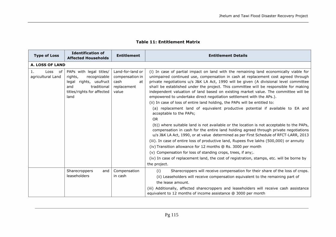
Jhelum and Tawi Flood Disaster Recovery Project
Pg 115
Table 11: Entitlement Matrix
Type of Loss Identification of
Affected Households Entitlement Entitlement Details
A. LOSS OF LAND
1. Loss of
agricultural Land
PAPs with legal titles/
rights, recognizable
legal rights, usufruct
and traditional
titles/rights for affected
land
Land-for-land or
compensation in
cash at
replacement
value
(i) In case of partial impact on land with the remaining land economically viable for
unimpaired continued use, compensation in cash at replacement cost agreed through
private negotiations u/s J&K LA Act, 1990 will be given (A divisional level committee
shall be established under the project. This committee will be responsible for making
independent valuation of land based on existing market value. The committee will be
empowered to undertake direct negotiation settlement with the APs.).
(ii) In case of loss of entire land holding, the PAPs will be entitled to:
(a) replacement land of equivalent productive potential if available to EA and
acceptable to the PAPs;
OR
(b)) where suitable land is not available or the location is not acceptable to the PAPs,
compensation in cash for the entire land holding agreed through private negotiations
u/s J&K LA Act, 1990, or at value determined as per First Schedule of RFCT-LARR, 2013
(iii). In case of entire loss of productive land, Rupees five lakhs (500,000) or annuity
(iv) Transition allowance for 12 months @ Rs. 3000 per month
(v) Compensation for loss of standing crops, trees, if any;.
(iv) In case of replacement land, the cost of registration, stamps, etc. will be borne by
the project.
Sharecroppers and
leaseholders
Compensation
in cash
(i) Sharecroppers will receive compensation for their share of the loss of crops.
(ii) Leaseholders will receive compensation equivalent to the remaining part of
the lease amount.
(iii) Additionally, affected sharecroppers and leaseholders will receive cash assistance
equivalent to 12 months of income assistance @ 3000 per month

Jhelum and Tawi Flood Disaster Recovery Project
Pg 116
2. Loss of
residential or
commercial land
PAPs with legal rights/
titles, recognizable
rights, or traditional
rights to the affected
land
Land-for-land or
compensation
at replacement
cost
For entire loss of residential, commercial, industrial, or institutional land, or where only
a part of the land is affected but the remaining land is rendered too small according to
the local zoning laws:
(i) Where available and feasible, PAPs will be provided replacement land of similar
attributes to that is lost or compensation in cash at replacement cost agreed through
private negotiations u/s J&K LA Act 1990 or with reference to the Second Schedule of the
RFCT-LARR 2013 for guidance.
(ii) In case of replacement land, the cost of registration, stamps, etc. will be borne by the
project.
(iii) Rupees five lakhs (500,000) or annuity
(iv) Transition allowance for 12 months @ Rs. 3000 per month
For loss of residential, commercial, industrial, or institutional land with remaining land
sufficient in accordance with the zoning law and for remaining affected structure,
PAPs will be entitled to compensation in cash at replacement cost.
Tenants and
leaseholders
Compensation
at replacement
cost
(i) For entire loss of land, the leaseholders will get an equivalent area of leased land or
reimbursement for unexpired lease period.
(ii) In case of partial loss of land, leaseholders will get reimbursement for unexpired
lease period for the portion of land lost. In case of replacement land, the cost of
registration, stamps, etc. will be borne by the project.
(iii) Tenants will receive rental allowance equivalent to 3 months rental value.
Compensation will be given for any improvements done by tenants and
leaseholders.
B. LOSS OF STRUCTURES
3. Loss of
structures
Owners of affected
structures
Compensation
in cash at
replacement
Cost
(i) For partial loss of structure and the remaining structure viable for continued use, PAPs
will be entitled to compensation for the affected part of the structures calculated as per
the latest prevailing Basic Schedule of Rates (BSR) without depreciation or deductions
for salvaged material agreed through private negotiations u/s J&K LA Act 1990 or with
reference to the Second Schedule of the RFCT-LARR 2013 for guidance.; and

Jhelum and Tawi Flood Disaster Recovery Project
Pg 117
(ii) repair allowance for improvement of the remaining structure where applicable at
10% of compensation will be calculated for the affected part of structure.
For entire loss of structures or where there is only partial impact, but the remaining
structure is rendered unviable for continued use:
(i) PAPs will be entitled to compensation for the entire structure calculated as per the
latest prevailing Basic Schedule of Rates (BSR) without depreciation or deductions for
salvaged material agreed through private negotiations u/s J&K LA Act 1990 or with
reference to the Second Schedule of the RFCT-LARR 2013 for guidance.;
(ii) they retain the right to salvage material from demolished structure; and
(iii) for displaced families, provision of house as per IAY norms in rural areas and as per
RAY norms in urban areas or cash equivalent thereof as decidied by the government with
a minimum of Rs 50,000 in rural and Rs. 100,000 in urban areas
(iv) Rs 50,000 as transport allowance.
(v) Onetime subsistence allowance of Rs.36000/-
(vi) Rs 25,000 for the loss of cattle shed, or petty shops
(vii) One time resettlement assistance of Rs 50,000/-
(viii) Rs. 25000 to who is a rural artisan, small trader or self-employed person,
(viii) One time grant of Rs. 500,000 towards employment.
Tenants and
leaseholders of affected
structures
Rental
assistance
a) Tenants would only be given rental assistance on a case-to-case basis in the form of
grant for a period of 3 months.
b) Additional structures erected by tenants will also be compensated and deducted
from owner’s compensation amount.
c) Any advance deposited by the tenants or leaseholders will be deducted from
owners’ total compensation package.
4. Impact on
marketplace,
shops,
businesses, and
Titleholder (owner
operator) and non-
titleholder (tenant
operator) losing
shops/
Relocation
assistance
Affected enterprise whose commercial structure can no longer be used for commercial
purpose as a result of project impact will be provided with the following options:
a) All operators will be provided cash compensation as decided by the DLC on case- to-
case basis, depending upon their income, size, and location of the shop agreed through

Jhelum and Tawi Flood Disaster Recovery Project
Pg 118
commercial
enterprises
commercial enterprise private negotiations u/s J&K LA Act 1990 or with reference to the Second Schedule of the
RFCT-LARR 2013 for guidance,
or project-assisted relocation option where available will be based on
i) owner operator: will be given a shop in lieu of compensation, with same ownership
status. No additional compensation will be paid to him/her.
ii) tenant operator: will be provided shop on rent. For first 3 months, no rent will be
charged, and after 3 months, tenants will have to pay the agreed rent. If a tenant
wishes to own the same, he/she has to pay the cost of the shop. Those opting for this
option will not be paid cash compensation for their structure loss.
iii) A lump sum transfer grant at the rate of Rs. 50,000.
iv) The right to salvage material from demolished structure
(v) Onetime subsistence allowance of Rs.36000/-
(vi) Rs 25,000 for the loss of cattle shed, or petty shops
(vii) One time resettlement assistance of Rs 50,000/-
(viii) Rs. 25000 to who is a rural artisan, small trader or self-employed person,
(viii) One time grant of Rs. 500,000 towards employment.
C: LOSS OF CROPS AND TREES
5. Loss of crops
and trees
Owner/operators/tenan
ts affected
Compensation
at
“market value”
a) Advance notice to PAPs to harvest their crops
b) In case of standing crops, cash compensation for loss of agricultural crops at current
market value of mature crops based on average production
c) Compensation for loss of timber trees at current market value of wood/timber or
firewood, depending on the kind of tree, to be computed by concerned department
d) In case of fruit trees, compensation at average fruit production to be computed by
concerned department
D: LOSS OF LIVELIHOOD SOURCE
6. Loss of
primary
source of income
Titleholders losing
income
through business
Transitional
assistance
PAPs losing their business establishment due to displacement will be assisted in the
form of a grant for the days of closure up to a maximum of 3 months of their income
from affected business.

Jhelum and Tawi Flood Disaster Recovery Project
Pg 119
Titleholders losing
income from loss of
agricultural
land
Assistance for
income
restoration
PAPs will be entitled to income restoration assistance, vocational training, and skill
upgrading options as per PAPs’ choice, equivalent to a maximum of Rs. 50,000 per
affected household. Specific income restoration measures will be decided in consultation
with the people based on their needs and priorities.
Non-titleholders,
namely squatters and
encroachers, losing
primary source of
income
Assistance for
income
restoration
PAPs losing their business establishment due to displacement will be assisted in the form
of a grant equivalent to 3 months of their income from affected business.
PAPs will be entitled to income restoration assistance, vocational training, and skill
upgrading options as per PAPs’ choice equivalent to a maximum of Rs. 50,000 per
affected household. Specific income restoration measures will be decided in
consultation with the people based on their needs and priorities.
Wage-earning
employees affected in
terms of loss of
employment
Transitional
assistance
Employees affected in terms of loss of employment due to displacement of commercial
structure will be given lump sum transitional assistance equivalent to Rs.
3,000/month for 3 months.
E: LOSSES OF NON-TITLEHOLDERS
7. Encroachers Households No
compensation
for land
a) Encroachers will be given 1 month notice to remove their assets that will be affected.
b) Right to salvage material from demolished structure c) Compensation for affected
structures at replacement
8. Squatters and
informal settlers
Households No
compensation
for land, but
compensation
for
structure at
replacement
cost
and other
assistance
a) Squatters will be given 1 month notice in which to remove their assets that will be
affected.
b) Compensation for loss of structure at replacement value or a house as per IAY
specifications in rural areas and RAY specifications in urban areas or cash equivalent
thereof as declared by the state government not less than Rs 50000 in rural areas and
100,000 in urban areas.
c) A lump sum shifting allowance of Rs. 10,000 for temporary, Rs. 30000 for semi-
permanent, and Rs.50,000 for permanent structures
d) Right to salvage material from demolished structure
(e) Subsistence allowance of Rs. 36,000 (other than kiosks)
(f) Rs 25,000 for rural artisans, small traders, self employed person

Jhelum and Tawi Flood Disaster Recovery Project
Pg 120
(g) Rs 5000 only as grant for kiosks which can be relocated without damage
F: TEMPORARY IMPACTS
9. Temporary
impacts on land
and other assets
during
construction
Owner/operator of
affected assets
Cash
compensation
for affected
assets and for
loss of income
potential
a) Compensation for affected standing crops and trees as per the market rates b) In case
of impacts on land:
-Restoration of land to its previous or better quality
-Contractor to negotiate a rental rate with the owner for temporary possession of land.
-Compensation for crop losses for the duration of temporary occupation, plus 1 more
year necessary for the soil to be adequately restored to its original productive
potential
-Project and contractor to ensure that persons other than the owner affected as a result
of the temporary acquisition are compensated for the temporary period
c) Compensation in cash for the loss of income due to temporary loss of access for
the duration of the impact
d) In case of any impact on the properties (structure) during construction,the contractor
will restore the impacted structure to its previous condition before handing over to the
owners.
e) Any temporary acquisition of land for the project will be done in accordance with the
prevalent local laws.
G: LOSS OF COMMON PROPERTY RESOURCES
10. Loss of
common
property
resources
Affected
community/institution
responsible
Cash
compensation/
recon struction
Cash compensation at replacement value or reconstruction of the community structure
in consultation with the community/institution
H: REHABILITATION MEASURES
11. Additional
assistance to
vulnerable
groups
Households
categorized as
vulnerable (The
groups of people
considered socially
Lump sum
assistance
Additional lump sum assistance of Rs. 50,000 per household to vulnerable groups such
as female-headed households, households with disabled family members, households
below poverty line, scheduled tribe and scheduled caste households,
etc.

Jhelum and Tawi Flood Disaster Recovery Project
Pg 121
vulnerable comprise
(i) those who are
below the poverty line
(BPL); (ii) those who
belong to scheduled
castes (SC)
and and scheduled
tribes (ST); (iii)
female-headed
households (FHH);
(iv) elderly; and (v)
disabled persons.)
I: UNIDENTIFIED IMPACTS
12. Any
unanticipated
adverse impacts
due to project
intervention
Any unanticipated consequence of the project will be documented and mitigated based
on the spirit of the principles agreed upon in this policy framework.

Jhelum and Tawi Flood Disaster Recovery Project
Pg 122
11.9 Grievance Redressal
This section deals with the Grievance Redressal Mechanism, the Grievance Redressal
Cell and the legal options available to the PAPs.
11.9.1 R&R Committee (RRC)
In order to address grievances related to land acquisition and resettlement and
rehabilitation implementation, two bodies are to be established; R&R Committee at
the state level and Grievance Redressal Committee at the district level. The former
will be established under the chairmanship of Principal Secretary, Relief and
Rehabilitation, to monitor and review the progress of implementation of resettlement,
in his capacity as Chairman. Project Director, PMU will be convener of this committee.
The composition of the committee will be with the following members:-
1. Heads of participating departments
2. A senior representative, one each from BC&EBC Welfare and SC&ST Welfare
3. A senior representative of the Revenue Department
4. A senior representative of Disaster Management Department
5. A representative of the PRIs
6. A prominent academician (Social Scientist)
7. A prominent woman development professional
8. A representative of a prominent voluntary organization
9. A representative of PAPs who can articulate well
This committee should meet every quarter to review the progress made in the
implementation of the RAPs and to solve any grievances of the PAPs. This committee
will also provide policy related direction to the Grievance Redressal Cell and the
participating departments with regard to Land Acquisition and Resettlement and
Rehabilitation.
11.9.2 Grievance Redressal Committee (GRC)
The Grievance Redressal Committee will be established at each project district under
the chairmanship of District Collector for redressal of grievances of the PAPs. PIU in-
charge shall be the convener of these committees. At the district level, the IA will
provide support to these committees. District level head of all participating
departments will be members along with a PAPs representative and a prominent
Social Worker of the district.
Macro level issues, at the village level, beyond the purview of the ‘District’ shall be
addressed by the HP and the project staff. It is proposed that the PAPs first registers
the grievances with the IA. After receipt of grievance, the IA should take them to the
committee to take up the matter during the next immediate meeting and initiate
measures for redressal. No grievance can be kept pending for more than a month
which means the committee has to meet every month. Implementation of the
redressal rests with the PMU. In case the aggrieved party is not satisfied with the
proposed redressal measures, it can take approach the state level committee. If the
aggrieved party is not satisfied with the decision of state level committee, it can
approach the court of law.

Jhelum and Tawi Flood Disaster Recovery Project
Pg 123
Table 12: Grievance Redressal Mechanism
Level Agency
Time period
for
redressal of
grievances
Issues likely to
emerge Responsibility
Village Halqa Panchayat Maximum of
one week
Encroachment
Land
acquisition
Livelihood
Assistance
Compensation
Inclusion of
households
HP, Project Staff
District
Grievance
Redressal
Committee
Maximum of
one month
District Collector as
Chairperson and DPIU in-
charge as Convener
State R&R Committee Maximum of
three months
Principal Secretary, Planning
as Chairman, Project Director,
PMU as Convener
11.9.3 Legal Options to PAPs
The PAPs will have two kinds of options for addressing their grievance s relating to
the Land Appropriation. One is the grievance redressed mechanism incorporate in
this framework as above. The other is the general legal environment consisting of
court of law to address their grievance. These options will be disclosed to the PAPs
during the public consultation process.

Jhelum and Tawi Flood Disaster Recovery Project
Pg 124
Table 13: Environmental and Social Activities and Responsibilities to be
fulfilled during the sub-project cycle
Phase ESMF Activity Objectives Process Respons
ibility Result
Preplanning Identification
Environmental and Social Data Sheet
To collect
basic information on environmental and social aspects of the proposed sub-project.
The ESMF requires
that basic environmental and social data pertaining to the proposed sub-project be compiled at the field data collection stage. For
this purpose, a simple
Environmental and Social Data Sheet (ESDS) and a simple Socio-Economic Survey format were
formulated for sub-projects. The formats for the ESDS are furnished under annexures. The sub-project Implementing Agency (IA) fills up
the ESDS with the facilitation support of
the PIUs duly identifying the environmental and issues of concern. Supplementary notes
on environmental and social concerns to be added to those data sheets.
Impleme
nting Agencies (IAs)
ESDS
prepared and attached with the project proposal / concept note
Planning Screening and Categorization
Environmental and Social
classification of the sub-project
To ensure that
sub-projects with potentially significant
environmental
/ social issues are identified at an early stage for detailed environmental
/ social assessment.
Evaluate all the
available information on environmental and social aspects as provided in the ESDS
and assess, based on
the level of expected environmental and social impacts (including any field visits if required), whether the proposed
sub-project is E1/E2 and S1/ S2.
For E2 and S2, the
design consultants will prepare EMP along with the DPR.
PIU,
Design Consultants
Sub-
project classified as E1/E2 and S1/S2.
As a part of ESMF
process the screening and sub-project categoriz
ation need to be cleared
by The World
Bank, before
Jhelum and Tawi Flood Disaster Recovery Project
Pg 125
Phase ESMF Activity Objectives Process Respons
ibility Result
taking up EA/SA.
Planning Preparation
Environmental
and Social
Assessment and Management Plans
To conduct
Environmental
/ Social Assessment and Prepare Management Plans for
integration into sub-project DPR
For E1/ S1 category
sub-projects for which
detailed environmental/ social assessment is required, this EA/SA and preparation of
EMP/ RAP/ ARAP will be done by consultants independent of the Design Consultants.
Independ
ent
Consultants
EA/ SA
done.
EMP/ RAP/ ARAP Prepared and
disclosed prior to start of procurement for that sub-project.
Planning Appraisal
Environmental and Social appraisal
To ensure that
relevant
environmental
and social issues have been identified and appropriate mitigation measures
have been designed to address them.
For E2 and S2 sub-
projects, there shall
be no separate
environmental/ Social appraisal but environmental/ social aspects shall be included in the normal appraisal and evaluation process for
the proposed sub-project, based on the ESDS included in the DPR. All these sub-projects need to follow the mitigation
measures detailed in
the ESMF Guidance. This will be ensured by the PIUs.
For projects requiring a detailed Environmental/ Social Assessment, including evaluation of environmental/ social impacts, risk
assessment if needed,
and design of mitigation measures, will be done by the PMU Environmental and Social Managers.
PMU
Environmental Expert
Social Expert
Environm
ental and
social
appraisal of the project is made and approval of
proposed sub-project, with decision to (i)
accept
scheme as submitted, or (ii) accept scheme
with modification suggested in the environmental/
social appraisal.

Jhelum and Tawi Flood Disaster Recovery Project
Pg 126
Phase ESMF Activity Objectives Process Respons
ibility Result
Planning Approval
Environmental and Social approval required
To ensure that
mitigation measures and their cost are integrated in scheme design and
implementation plans
Approval for the sub-
project will not be accorded without the appraisal by PMU and the review of EMP/RAP/TDP by The World Bank
PMU Technical
Sanction for sub-projects with environmental and
social mitigation measures and
accordingly its
costs are integrated in sub-project design and impleme
ntation plans.
Implementation
Implementation
Implementation
of Environmental
and social mitigation measures.
To ensure that
the prescribed environmental
and social mitigation measures (including construction
stage) are implemented.
The prescribed
environmental and social mitigation
measures (including construction stage measures) as identified through the environmental and
social appraisal process are adequately implemented.
Implementation Completion Report (ICR) for sub-project will need to include an Environmental
Compliance Certificate and Social Compliance Certificate given by the Halqa Panchayat indicating that the
mitigation measures identified in the appraisal (including construction stage) have been implemented.
Halqa
Panchayat
PMU
ICR with
environmental and
social compliance information.

Jhelum and Tawi Flood Disaster Recovery Project
Pg 127
Phase ESMF Activity Objectives Process Respons
ibility Result
O&M Supervision,
Monitoring and Evaluation
Environmental supervision, monitoring and evaluation
IEC and capacity building on environmental and social issues.
To ensure that
environmental and social aspects are integrated in the O&M phase.
Monitoring of indictors
will be conducted as per project monitoring protocol.
Supervision will be conducted by the designated environmental officers of the implementing
agencies for all the sub-projects
All sub-projects will be monitored by PMU.
Capacity building and IEC activities are undertaken to enable effective implementation of the ESMF including assessment
procedures, supervision, monitoring, etc. as well as for community
awareness and sensitization. This will
be done by the IA and in turn the IA will be trained by PMU.
PMU
External Consultants
PMU will
submit quarterly reports to The World Bank on
Safeguards Implementation.
Quarterly
monitoring reports by
Independent Consultants.
Periodic environmental and social supervisi
on reports.
Training and IEC activity reports.

Jhelum and Tawi Flood Disaster Recovery Project
128
11.10 Monitoring and Evaluation
The ESMF requires detailed supervision, monitoring and evaluation of the impact of the
project on the environment and social aspects. In order to carry out this, PMU will have
specific arrangements made at state and district level. This includes appointment of an
Environmental Specialist and Social Specialist for the project period. Further the PMU will
instruct PIUs on how to implement the provisions of this ESMF. At the field level the staff
of the implementing agencies have experience of implementing projects concerning their
departments and do land acquisition for their project. Implementation of the provisions of
ESMF will be new to these staff and hence preparatory orientations and trainings are
proposed as a part of this ESMF to build their capacity. In order to achieve the objectives
of this ESMF and to ensure the safeguards are implemented in a proper manner, the
following provisions are made in this ESMF:
Environmental Supervision by PMU, PIU and Implementing Agencies
Exclusive Environmental Specialist and Social Specialist at PMU for overall ESMF
implementation coordination and reporting
Concurrent Environmental and Social Monitoring and Evaluation and Quarterly
Environmental and Social Monitoring Reports to the World Bank
Independent Safeguards Audit (ISA): Half-yearly Environmental and Social Audit,
of ESMF implementation by independent project quality audit consultants.
Environmental and Social Management Capacity Building of PMU, PIU and
Implementing Agencies including Consultants, Contractors and Community Based
Organizations and Community Members.
The PMU will be in charge of implementing the ESMF. The Environmental and Social
Specialists of PMU will guide and oversee the implementation of the ESMF at field level.
This overall guidance will be given by them. Further the PMU will incorporate the provisions
of this ESMF as actionable points in the Project Operations Manual or other similar
document for the project. These will be non-negotiable and will have to be followed by all
PMU and PIUs. The Environmental and Social Specialists will oversee the application of
these provisions and guide the process, while at the same time building the capacity of the
PMU and PIUs.
At the field level the designated environmental engineers of the implementing agencies/
the supervision consultants will ensure the implementation of the ESMF. The following
provisions include the arrangements made for the effective implementation of the ESMF:
11.10.1Safeguards Supervision
This is basically done by PMU. All the sub-projects will be visited at regular intervals by
PMU to check if all safeguard requirements are met and to identify any issues that need to
be addressed. PMU would submit quarterly progress reports to The World Bank on
safeguards implementation.
11.10.2Concurrent Monitoring and Quarterly Reporting
The concurrent internal environmental social monitoring will be done as part of the regular
monitoring by the PIU, Implementing Agencies, and design and supervision consultants.
However, PMU, with the help of in-house Environmental and Social Specialists will do the
regular environmental and social monitoring of sub-projects for safeguards compliance.

Jhelum and Tawi Flood Disaster Recovery Project
129
The PMU, PIU and the Implementing Agencies will do the regular monitoring of ESMF
implementation of all sub-projects. This is done under the supervision and coordination of
the Environmental and Social Specialists at PMU.
11.10.3 Safeguards Monitoring Plan
Apart from the quarterly monitoring reports submitted to The World Bank, once every year,
the PMU will prepare a report of the environmental and social situation in the project
districts including data and analysis of relevant parameters as given in the plan below. This
report also should give a listing of relevant new legislation and regulations that have a
bearing on the environmental social performance of the project. PMU will submit this report
to The World Bank. The ESMF will be suitably revised annually on the basis of this document
by the PMU. Given in the table below are indicators for project investments, for which
monitoring need to be taken up by PMU in a regular manner.
Table 22: Indicators for project investments
Project
Components Monitoring Indicators Frequency Agency
Reconstruction and
strengthening of
critical infrastructure
Disbursement of entitlements
(replacement cost, allowances,
income generation grant, etc.)
Time taken for payment of
entitlements
Time taken for land acquisition
Number of grievances
registered and resolved
Number of court cases
Women participation
Income patterns
Land holding status
Changes in occupations
Housing status (area, floor,
walls, roof, etc.)
Ownership of household assets
Length of rural roads
Journey time
Quarterly by
Independent
Consultants
Annually by
PMU
PMU
guiding
the
collection
of
informati
on on
indicator
s
Indepen
dent
Quarterl
y
Monitorin
g
Consulta
nts
Impleme
nting
Agencies
/
Departm
ents for
departm
Reconstruction of
roads and bridges
Reconstruction of
urban flood
management
infrastructure
Strengthening and
restoration of
livelihoods
Strengthening of
disaster risk
management
capacity
Contingency
emergency response
Implementation
support

Jhelum and Tawi Flood Disaster Recovery Project
130
Project
Components Monitoring Indicators Frequency Agency
Other
No. of training programs
conducted
No. of personnel trained
Trainees’ understanding of the
training content
Achievement of learning
objectives
Adherence to contract
conditions and standards
(housing, sanitation, crèches,
use of local labour, equal wages
to men and women, avoidance
of child labour, etc.)
No. of complaints on
inconvenience, nuisance
No. of sub-projects completed
without time and cost overruns
Adherence to ESMF provisions/
guidelines during sub-project
cycle
ent
specific
informati
on
11.10.4 Independent Safeguards Audits
The PMU will appoint Independent Project Implementation Quality Audit Consultants with
expertise in social and environmental safeguards to conduct half-yearly project quality
audit, which will include Environmental and Social Audit of selected sub-projects for
compliance with the ESMF.
11.10.5 Environmental and Social Capacity Building
The PMU will organize regular trainings on Environmental and Social Management for
capacity building of PMU, PIU and Implementing Agencies including Consultants,
Contractors and Community Based Organizations and Community Members. These details
are further elaborated in chapter 6.
11.11 Stakeholder Consultation
Due to bad weather, continued landslides in some areas and affected areas being largely
inaccessible, the team was unable to undertake independent on-site assessment. In the
circumstances the damage and loss assessment carried out by the State government of
Jammu and Kashmir has been relied upon. During the JRDNA mission several consultations
were held with the line departments, where several details regarding the actual situation

Jhelum and Tawi Flood Disaster Recovery Project
131
in the affected area were gathered. Discussion with implementing agencies of on-going
projects also helped to negate the absence of stakeholder consultations. The issues
presented in these sections are the summary of those consultations. A Stakeholder
Consultation Workshop with the participating departments and other stakeholders will be
held to gather their feedback on the ESMF and accordingly the ESMF will be revised.
11.11.1Stakeholder Involvement and Consultation
PMU would engage Design consultants to assist them in preparing the sub-project DPRs.
In the ToR for these consultants, there is an explicit requirement for the consultants to
carry out public/ stakeholder consultations. This is a mechanism to ensure the upfront
public/ stakeholder inputs in the preparation of the sub-projects.
For Category E1 and S1 sub-projects, PMU would have to engage independent consultants
to prepare the SA / RAP and EA / EMP respectively. In the ToR for the preparation of these
outputs, public/ stakeholder consultations form an integral part. For such type of sub-
projects obtaining consent of the local agencies and necessary clearances from competent
authorities is mandatory and should form part of the EA/ SA. These EA/ SA will be reviewed
by The World Bank.
During sub-project implementation Halqa Panchayats, NGOs, Community Based
Organisations (CBOs) will be involved. Project monitoring reports would be disseminated
in the public consultation meetings in the Halqa Panchayats. The stakeholder meetings
would discuss the sub-project progress reports and make recommendations for sub-project
control and modifications. These recommendations would be made use for future sub-
project design. Consultations are required for preparation of all safeguards mitigation
documents and these consultations should be an on-going activity over the life of the
project. These would be documented in the EA/SA documentation for each sub-project.
11.12 Right to Information and Disclosure
The Jammu and Kashmir Right to Information Act 2004 gives the right to persons to obtain
any document or information relating to the affairs of the state or public body.
In addition to the provisions of the above Act, the JTFRP provides for voluntary disclosure
of information and project documents in English, Hindi and Urdu on the Government and
implementing agencies’ websites for public consumption.
11.12.1State Level
PMU and the implementing agencies shall disclose this entire ESMF at their website. The
summary of the ESMF need to be translated into local languages (Urdu and Hindi) and
placed on the website. ESMF including the Resettlement Policy Framework will be disclosed
along with the entitlements matrix in the PMU website. The Entitlements Matrix and GRM
brochures shall be disseminated. The ESMF shall also be translated into Hindi and Urdu
and made available at the PMU’s website.
11.12.2 District Level
PMU will also arrange to disclose the final versions of the ESMF including the Resettlement
Policy Framework and Entitlement Matrix in all the District Collectors Offices, PIUs, and the
local offices of the implementing agencies. These would be in place once the final versions

Jhelum and Tawi Flood Disaster Recovery Project
132
are ready. When this document is updated, then the copies in the different locations would
also be updated.
11.12.3Disclosure by the World Bank at the Infoshop
The World Bank will disclose this ESMF and any future EA/ SA along with EMP/ RAP/ ARAP/
IPDP(TDP) at the Infoshop for reference by interested parties.
During the implementation phase, all the sub-project RAPs/ TDPs shall be disclosed by PMU
and the implementing agencies both at the local level and at the state level. These SAs/
RAPs/ TDPs will also be disclosed at the Infoshop of The World Bank.
11.13 Means of Disclosure
This RPF will be kept at the District Library, District Collector’s Office and Block
Development Office for interested persons to read and copy. This RPF will be made
available at the project web site as well. A summary of each RAP/ TDP prepared under the
project, will be displayed at the Halqa Panchayat Offices of the concerned villages. This
summary will include the details such as names of titleholders and/or encroachers,
voluntary donations made, detail of acquisition, land rate, rehabilitation assistance, etc.
This summary will be displayed at the Block Development Offices and at the District
Collectors offices too. Apart from this, all the RAPs/ TDPs will be placed on the project web
site.

Jhelum and Tawi Flood Disaster Recovery Project
133
12. Indigenous People’s Development Framework (IPDF)
12.1 Introduction
Since the Project is contemplating interventions in areas such as Rajouri where there are
tribals, it becomes imperative to prepare an Indigenous people development plan. No
adverse Impacts of the subprojects have been identified on the IP households in any of the
proposed subprojects. The key benefits envisaged out of the Project mainly comprise of
a sustained improvements in basic service provision within the flood affected areas.
Indirect benefits will be available in the form of improved living conditions, a healthier living
environment and the prospect of improved income and health status of the population plus
an improved economic climate with employment opportunities. This Indigenous Peoples
Development Framework (IPDF) has been prepared compliant with relevant
country legislations and the World Bank Policy on Indigenous People (OP
4.10) to guide selection and preparation of additional subprojects under the Project where
impacts on tribal people are identified to ensure better distribution of the Project benefits
and promote development of the indigenous peoples in the Project areas.
12.2 SC and ST Population in J&K
The J&K state has about 12% ST population and 7.4% SC population as per 2011 census.
The district wise SC and ST populatin of the project area is given below:
Table 14: ST and ST Population
S.
No
.
District Total
Population
ST
Population
%age of
Total
Population
SC
Population
%age of
Total
Population
1 Jammu 15,26,406.00 69,193.00 4.53 3,77,991.00 24.76
2 Samba 3,18,611.00 17,573.00 5.52 91,835.00 28.82
3 Kathua 6,15,711.00 53,307.00 8.66 1,41,224.00 22.94
4 Udhampur 5,55,357.00 56,309.00 10.14 1,38,569.00 24.95
5 Reasi 3,14,714.00 88,365.00 28.08 37,757.00 12.00
6 Doda 4,09,576.00 39,216.00 9.57 53,408.00 13.04
7 Kishtawar 2,31,037.00 38,149.00 16.51 14,307.00 6.19
8 Ramban 2,83,313.00 39,772.00 14.04 13,920.00 4.91
9 Rajouri 6,19,266.00 2,32,815.00 37.60 48,157.00 7.78
10 Poonch 4,76,820.00 1,76,101.00 36.93 556.00 0.12
11 Srinagar 12,50,173.00 8,935.00 0.71 1,068.00 0.09
12 Ganderbal 2,97,003.00 61,070.00 20.56 117.00 0.04
13 Badgam 7,55,331.00 23,912.00 3.17 368.00 0.05
14 Anantnag 10,69,749.00 1,16,006.00 10.84 1,826.00 0.17
15 Kulgam 4,23,181.00 26,525.00 6.27 21.00 0.00

Jhelum and Tawi Flood Disaster Recovery Project
134
16 Pulwama 5,70,060.00 22,607.00 3.97 402.00 0.07
17 Shopian 2,65,960.00 21,820.00 8.20 43.00 0.02
18 Baramulla 10,15,503.00 37,705.00 3.71 1,476.00 0.15
19 Bandipora 3,85,099.00 75,374.00 19.57 392.00 0.10
20 Kupwara 8,75,564.00 70,352.00 8.04 1,048.00 0.12
21 Leh 1,47,104.00 95,857.00 65.16 488.00 0.33
22 Kargil 1,43,388.00 1,22,336.00 85.32 18.00 0.01
Total 1,25,48,926.00 14,93,299.00 11.90 9,24,991.00 7.37
12.3 Role of Social Welfare Department in SC and ST Development
The Social Welfare Department plays an important role in addressing the
problems of the weaker and vulnerable sections of the Society, like old aged persons,
women in distress, children in distress, Physically Challenged People, Scheduled Castes,
Scheduled Tribes, Backward Classes and other socially & economically weaker sections.
The department is also in the fore- front to empower women and for the overall
development of the children, especially between the age group of 0-6 years through
ICDS. Social Welfare Department administers Central and State Sponsored welfare
schemes in the areas of Women and Child Development, Social Justice and Empowerment,
Social Security, Tribal Development, Minority Development, Rehabilitation of Militancy
Victims and Educational upliftment of SC, ST, PSP and OBC students. It provides direct
benefits to the target groups, through various schemes like, scholarship & Hostel facilities,
reimbursement of examination fee, old aged pension, widow pension etc.
12.3.1 Vision
To develop a society which offers conducive and stimulating atmosphere for the growth
and development, in a safe and protective environment; ensuring dignified life to all the
vulnerable groups such as children, women, elderly people, PwDs (Persons with
Disabilities), members of SC, ST and OBCs.
12.3.2 Mission
i. Ensuring development, care and protection for children and facilitating access to
learning, nutrition and health facilities.
ii. Promoting social and economic empowerment of women through various policies
and programs, providing social security and institutional support to the women in
distress.
iii. Providing equitable environment for development, growth and education of under
privileged classes.
iv. Providing equal opportunities for development, financial assistance and ensuring
compatible infrastructure for the PwDs (persons with Disabilities).
v. Provide social security and financial assistance to elderly people.

Jhelum and Tawi Flood Disaster Recovery Project
135
12.3.3 Objectives
i. Laying the foundation for development of children below 6Yrs with a focus on
supplementary nutrition and pre-school, non-formal education and to enhance the
awareness and capability of mothers for nutritional and health needs of the child;
ii. Empowering adolescent girls (11-18 years) through nutrition, health care and
life skills education, empowering marginalized women.
iii. Providing financial assistance and residential facilities to women in distress.
iv. Providing scholarship for educational upliftment of SCs, STs, OBCs and PSPs
children of persons engaged in unclean occupation, PwDs (persons with Disabilities),
student from minority communities and students from pahari speaking people
community.
v. Ensuring mobility of PwDs (persons with Disabilities) so that they can live
with dignity and honour and providing financial assistance & educational support to
them.
vi. Providing social security to elderly people.
vii. Providing residential facility for students of under privileged classes in the form of
hostels and for orphans in the form of Bal-Ashrams/Nari-Neketans.
viii. Encouraging NGOs/voluntary organization to work for the welfare of children,
women, elderly and PwDs (persons with Disabilities).
ix. Imparting vocational training to women to enhance their skills for earning
dignified livelihood.
x. Providing prosthetic aid to disabled persons with meager income.
12.3.4 Acts and Rules
The Acts & Rules under the Social Welfare Department are listed below:-
Acts:
1. Backward Classes Commission Act, 1997;
2. Persons with Disabilities Act, 1998;
3. Reservation Act, 2004;
4. State Commission for Women Act, 1999;
5. Protection of Women from Domestic Violence Act, 2010;
6. Jammu and Kashmir Juvenile Justice (Case and Protection of Children Act,
2013.
Rules:
1. J&K State Reservation Rules; 2005;
2. Protection of Women from Domestic Violence Rules, 2011;
3. J&K Juvenile Justice Rules, 2014;
4. J&K State Juvenile Justice (Care & Protection of Children) Rules, 2014.

Jhelum and Tawi Flood Disaster Recovery Project
136
12.4 Tribals/ Indigenous People
The terms ‘indigenous peoples’, indigenous ethnic minorities’, tribal groups,’ and
‘scheduled tribes’ describe social groups with a social and cultural identity distinct from
the dominant society that makes them vulnerable to being disadvantaged in the
development process. By definition, IP refers to peoples living in an area within a nation-
state, prior to the formation of a nation-state, but who do not identify with the dominant
nation. This group has social, cultural, economic, and political traditions and institutions
distinct from the mainstream or dominant society and culture. Essentially, indigenous
people have a social and cultural identity distinct from the mainstream society that makes
them vulnerable to being overlooked in development processes.
12.4.1 IPDF Objectives
The Indigenous People’s Development Framework seeks to ensure that indigenous
people and tribal communities are informed, consulted and mobilized to participate in
the subproject preparation. The Framework is intended to guide selection and preparation
of additional subprojects under the Project where impacts on tribal people are identified to
ensure better distribution of the Project benefits and promote development of the
indigenous peoples in the Project areas. IPPF sets out guidelines for: (i) assessing
impacts of sub-projects on the tribal people through social screening and follow up
social impact assessment if required, (ii) preparing and implementing Tribal
Development Plans (TDPs) as a part of safeguards due diligence to ensure that they
are adequately consulted and benefited.
Social Screening:
Social screening and categorization will be the key to identifying if any sub-project is
likely to imp act the indigenous/ tribal people. Sub-projects impacting tribal people will
be categorized as S3 and will require fuller assessment and preparation of a TDP.
The significance of impacts on Indigenous Peoples is determined by assessing (i) the
magnitude of impact in terms of (a) customary rights of use and access to land and natural
resources; (b) socioeconomic status; (c) cultural and communal integrity; (d) health,
education, livelihood, and social security status; and (e) the recognition of indigenous
knowledge; and (ii) the level of vulnerability of the affected Indigenous Peoples community.
The level of detail and comprehensiveness of the Indigenous People’s Development Plan/
Tribal Development Plan (TDP and IPDP have been used interchangeably and mean the
same) are commensurate with the significance of potential impacts on Indigenous Peoples.
The IPDF aims to protect ethnic minorities from the adverse impacts of development, and
to ensure that ethnic minorities benefit from development projects and programs. The
need for a full TDP will depend on the nature and magnitude of the Project impacts and
sensitivity of IP issues. The need for the TDP will be established on the basis of the following
criteria, to determine if project impacts are ‘significant’:
i. adverse impacts on customary rights of use and access to land & natural resources;
ii. negative impacts on socio-economic status and cultural identity;
iii. impacts on health, education, livelihood and social security status; and
iv. any other impacts that may alter or undermine indigenous knowledge and
customary institutions.
Jhelum and Tawi Flood Disaster Recovery Project
137
The TDP will ensure that project affected IPs are, as well off with the project as without
it after the implementation of the plan. This plan will also aim to identify measures towards
satisfying the needs and developmental aspirations of IPs.
If, the impacts on IP’s are insignificant and due to resettlement related activities then
specific actions in favour of the indigenous people will need to be integrated in the
Resettlement Plan for the subprojects or a community/ Indigenous People Development
Plan. This would ensure appropriate mitigations and benefits for the indigenous people.
Based on both India’s legal, constitutional and developmental strategies and The World
Bank Policy on indigenous people, the objectives of an IPDP will be as follows:
i. Ensure that tribal/ ST people affected by any sub-project will benefit from the sub-
project;
ii. Ensure tribal inclusion in the entire process of planning, implementation and
monitoring of the sub-project;
iii. Ensure that the benefits of the sub-projects are available to STs/ SCs more than or
at least at par with other affected groups; this may require giving preference to
tribal people as vulnerable groups over others on certain benefits under the
subprojects; and
iv. Provide a base for the tribal groups in the area to receive adequate development
focus and attention.
12.5 Preparation of TDP
Based on the screening using Environmental and Social Data Sheet (ESDS), showing that
the sub-project may impact indiegenous/tribal people, a field-based Social Assessment
(SA) will be conducted either as part of the feasibility study or as a stand-alone activity.
The SA will, in a gender-sensitive manner, in consultation with Indigenous Peoples
communities, identify the project-affected Indigenous Peoples and the potential impacts
of the proposed project on them. The SA will provide a baseline socioeconomic profile of
the indigenous groups in the project area and project impact zone; assess their access
to and opportunities to avail themselves of basic social and economic services; assess the
short- and long-term, direct and indirect, and positive and negative impacts of the project
on each group’s social, cultural, and economic status; assess and validate which
indigenous groups will trigger the Indigenous Peoples policy principles; and assess
the subsequent approaches and resource requirements for addressing the various
concerns and issues of projects that affect them. The level of detail and
comprehensiveness of the SIA will be proportional to the complexity of the proposed
project and commensurate with the nature and scale of the proposed project’s
potential effects on Indigenous Peoples, whether positive or negative In order to prepare
an IPP the following steps will be undertaken:
i. Based on the social assessment, establish baseline data on the tribal
people (subsistence, employment, community networks) affected by the project
(use the criteria in the section above to determine project impacts);
ii. Review policy guidelines both at national and state level regarding STs;
iii. If the impacts are considered significant as defined above, prepare an IPDP
Jhelum and Tawi Flood Disaster Recovery Project
138
iv. Submit IPDP to the World Bank for review and approval.
As enumerated above, the main features of the TDP will thus comprise of a preliminary
screening process, followed by a social impact assessment to determine the degree and
nature of impact of each subproject, and an action plan will be developed if warranted.
12.5.1 Screening
A project’s Indigenous Peoples category is determined by the category of its most
sensitive component in terms of impacts on Indigenous Peoples. Such sub-projects will
be categorized as S3. The significance of impacts of a sub-project on Indigenous Peoples
is determined by assessing (i) the magnitude of impact in terms of (a) customary
rights of use and access to land and natural resources; (b) socioeconomic status; (c)
cultural and communal integrity; (d) health, education, livelihood, and social security
status; and (e) the recognition of indigenous knowledge; and (ii) the level of
vulnerability of the affected Indigenous Peoples community. The level of detail and
comprehensiveness of the TDP are commensurate with the significance of potential
impacts on Indigenous Peoples. The Project Management Unit (PMU) and Design
Consultants a r e responsible for sub-project preparation and implementation will visit
all tribal settlements near the sub-project areas or in likelihood of being affected and
influenced by the subproject components. Public meetings will be arranged in selected
tribal communities by the PMU and implementing agencies to provide them information
about the subproject and take their views on the subproject.
During this visit, the social specialist of the PMU will undertake a screening of the tribal
communities with the help of the community leaders and local authorities. The screening
will cover the following aspects:
i. Name(s) of tribal community group(s) in the area;
ii. Total number of tribal community groups in the area;
iii. Percentage of tribal community population to that of total area/locality
population;
iv. Number and percentage of tribal community households along the zone of
influence of the proposed subproject.
v. Socio-economic, demographic, cultural and other details of each affected tribal
community household
If the results of the screening bring forth the presence of tribal community households
affected in the zone of influence of the proposed subproject, a social assessment will be
planned for those areas.
12.5.2 Social Assessment
The PMU will undertake a social assessment with the help of a consultant. The SA will
gather relevant information on demographic data; social, cultural and economic
situation; and social, cultural and economic impacts – positive and negative on the tribal
communities in the subproject area.
Information will be gathered from separate focus group meetings within the tribal
community, including tribal leaders; group of tribal men and women, especially those

Jhelum and Tawi Flood Disaster Recovery Project
139
who live in the zone of influence of the proposed subproject under the Project. Discussions
will focus on the positive and negative impacts of the subproject as well as
recommendations on the design of the subproject. The PMU and will be responsible for
analyzing the SA and based on it developing an action plan with the tribal community
leaders. If the SA indicates that the potential impact of the proposed Project will be
significantly adverse threatening the cultural practices and their source of livelihood, the
PMU will consider other design options to minimize such adverse impacts and will prepare
an Indigenous Peoples/Tribal Development Plan (TDP/IPDP).
12.6 Tribal Development Plan
TDP will consist of a number of activities and will include mitigation measures of potentially
negative impacts by means of modification of subproject design and development
assistance. Where there is land acquisition in tribal communities, the Project will ensure
that their rights will not be violated and that they will be compensated for the use of any
part of their land in a manner that is culturally acceptable to them. The compensation
will be in keeping with Entitlement Matrix as provided in the Resettlement Policy
Framework of the Project. The IPDP will include:
1. B a s e l in e da ta
2. Land tenure information
3. Impacts and Losses
4. Identification of mitigation measures
5. Institutional arrangement
6. Community p art I c ip at i o n
7. Entitlements by Household
8. Monitoring and evaluation
9. Implementation schedule
10. Budget
The PMU will send this TDP to The World Bank for review and comments and concurrence.
12.6.1 Free, Prior, Informed Consultation for recording Broad Community Support
Meaningful consultations would help with all iPs including women throughout the project
cycle to seek their informed participation at all stages. Consequently all relevant
information relevant to the project would be disseminated among them through regular
information disclosure workshops, pamphlets in local language etc. The tribal groups/iPs
will be consulted during the preparation of the IPDP. They will be informed of the
mitigation measures proposed and their views will be taken into account in finalizing the
plan. The Plan will be translated into the tribal language and made available to the
affected people before implementation. The disclosure will be in a manner accessible to
PAPs where there are differing levels of literacy skills. TDP/IPDPs will include dates,
locations and attendees for all consultations held; and that all TDP/IPDPs will include a
summary of the results of those consultation, evidence on the level of community support
for the project, as well as any concerns or potential risks or conflicts.

Jhelum and Tawi Flood Disaster Recovery Project
140
The tribal institutions and organizations in the affected area will also be
involved in implementing the TDP and in resolving any disputes that may arise.
12.6.2 Institutional Arrangements and Budget
The Implementing Agency will be i m p l e m e n t i n g t h e T D P for the sub -p roject
under the supervision of the PMU. However, PMU will have the primary responsibility for
the preparation of the TDP. The responsibility of financing, implementation and monitoring
of the TDP will rest with the P M U . A local NGO with the relevant experience m a y
be hired to assist the PMU in planning and implementing the TDP.
12.6.3 Monitoring and Evaluation
The monitoring and evaluation arrangements described under the SMF will apply to the
implementation of TDPs as well. The indicators for monitoring planning and implementation
of TDP/IPDPs will include the following:
1. That all sub-projects have been screened for presence of IPs, and prepared relevant
and practical SAs and IPDPs.
2. The sub-projects were planned in a manner that respected the dignity, human
rights, economies and cultures of Indigenous Peoples.
3. The sub-projects ensured that adverse effects were avoided, or if not feasible to
avoid, these adequately minimized, mitigated or compensated.
4. The sub-projects affecting tribal people ensured that indigenous peoples shared in
culturally appropriate social and economic benefits.
12.6.4 Disclosure
All TDPs will be disclosed as given in the ESMF.

Jhelum and Tawi Flood Disaster Recovery Project
141
13. Gender Equality and Social Inclusion (GESI) Guidelines
13.1 Status of Women in J&K
Women constitute around 47% of the total population of the State. The development of
women, no doubt, has been a part of the development planning process right from
inception of Five Year Plans but the shift in approach from welfare to development toward
women took place in a focused manner in the 6th and 7th Five Year Plans. The 8th Five Year
Plan promised to ensure that benefits of development do not by-pass women. The 9th Five
Year Plan changed the strategy for women from development to empowerment and
emphasis on preparation of separate Women Component Plan (WCP) by identifying specific
Schemes/Projects having direct bearing on welfare and development of Women. The 10th
Five Year Plan further strengthened the implementation of Women Component Plan (WCP).
Moreover, the Women and Child Development Department in the Ministry of Social Justice
and Empowerment has also enjoined upon the states to monitor closely the flow of benefits
of various schemes for the empowerment of women on regular basis. These initiatives have
helped in improving the status of women in various spheres to a great extent, but the
imbalance still exists which needs to be addressed over the years. The 11th Plan had taken
numerous steps forward. However, the targets set out could be only partially achieved. In
the 12th plan, the Government’s priority would be to consolidate the existing initiatives and
interventions relating to women, build upon the achievements and also move beyond to
respond to new challenges.
Female population of J&K State slashed down from 47.15% of the total population in 2001
to 46.88% in 2011. As per details from Census 2011, Jammu and Kashmir has population
of 1.25 Crore souls over the figure of 1.01 Crore in 2001 census. Total population of Jammu
and Kashmir as per 2011 census is 12,548,926 of which male and female are 6,665,561
and 5,883,365 respectively indicating a reduced sex ratio of 883. The corresponding figures
of male and female as per Census 2001 were 5,360,926 and 4,782,774 respectively
indicating sex ratio of 892. Sex ratio (females per thousand of males) is an important
indicator of the social conditions particularly with respect to women’s status in any society.
Low sex ratio shows indulgence of artificial interventions, distorting the biological trend
and natural balance in terms of number of females per thousand males. An important
concern in the present status of Jammu and Kashmir’s demographic transition relates to
adverse sex ratio. The sex-ratio as per census 2011 was 883 which is a matter of great
concern and needs to be addressed on priority.
Education of the women is very effective tool for women’s empowerment not only from the
point of view of literacy, but it has inter-linkage with other social parameters viz. population
growth, health care, education of children etc. It enables rural women to acquire new
knowledge and technology, required for improving and developing their tasks in all fields,
besides availing new opportunities and combating emerging challenges of dynamic society.
Female education is essential for higher standards of health and improved “maternal
competence” which leads to lower infant mortality. It also raises women’s economic
productivity. Despite its linkage to so many positive outcomes and the progress made over
the past 50 years, female literacy remains low in J&K State as compared to men. Jammu
and Kashmir’s literacy rate has increased by 13% in the last decade i.e. from 55% in 2001
Census to 68% in the 2011 Census. While female literacy has increased from 42.22% in

Jhelum and Tawi Flood Disaster Recovery Project
142
2001 Census to 58.01% in 2011. Gender differential still exists both in rural and urban
areas but it is comparatively higher in rural areas. This can be attributed to a number of
factors viz., lack of access to schools, parents feeling insecure about sending girl children
to schools, their engagement in agricultural and other domestic activities etc. Though, still
being at a disadvantageous position, the women folk are breaking the barriers/shackles to
get equal share in the basic human rights. With higher growth rate than male literacy, the
goal is expected to be achieved in near future. Some of the ongoing initiatives, which are
likely to spill over to 12th Five Year Plan are as under:
Sarva Shiksha Abhiyan (SSA), a flagship program, is being implemented in the State
for improvement in gross enrolment ratio apart from Universal Elementary Education
(UEE) and Universal retention.
National Program for Education of Girls at Elementary Level (NPEGEL) aimed to enhance
education of girls by providing need based incentives like stationery, books, uniforms
etc to the girl student. 287 Girls Middle Schools have been developed under NPEGEL in
the State.
Kishori Shakti Yojna (KSY) aims at addressing the needs of self development, nutrition
and health status, literacy, numerical skills and vocational skills of adolescent girls in
the age group of 11-18 years.
To reduce gender disparities in education, and to promote women empowerment, 9
womenIs and 12 Women Wings in the exisI ITIs have been established under Prime
Ministers Reconstruction Program (PMRP). 5 adIonal ITIs have been approved during
2007-08.
Pre-matric scholarship is provided by the State Government to girl students to enhance
their level of literacy and to reduce burden on the parents for sustained education.
12 Nari Niketans are functioning in the State having total capacity of 400 inmates to
provide free boarding, lodging and healthcare to the destitutes.
13.2 Legal Provision Related to Women in J&K
13.2.1 J&K Protection of Women from Domestic Violence Act, 2010
The State has enacted an act to provide for more effective protection of the rights of women
guaranteed under the constitution, who are victims of violence of any kind occurring within
the family and for matters connected therewith or incidental thereto called as “J&K
Protection of Women from Domestic Violence Act, 2010”. The Act provides for appointment
of a protection officer in each district by a notification as far as possible be women and
possess such qualification and experience as may be prescribed to assists the magistrate
in discharge of his functions under this act. The protection shall be under the control and
supervision of the magistrate. The protection officer shall report to the magistrate
regarding occurrence of domestic violence/incident.
13.2.2 Jammu and Kashmir Juvenile Justice (Care and Protection of Children) Act, 2013
The State has enacted an act to consolidate and amend the law relating to
Juveniles in conflict with law and children in need of care and protection by providing for
proper care protection and treatment by catering to their development needs and for the
adjudication and disposition of matters in the best interest of the children and for their

Jhelum and Tawi Flood Disaster Recovery Project
143
ultimate rehabilitation and for matters connected therewith or incidental thereto called
Jammu and Kashmir Juvenile Justice (Care and Protection of Children) Act, 2013. The act
provides for constitution of Juvenile Justice Boards and Child Welfare Committees,
establishment of observation homes, special homes, shelter homes and children homes in
the state.
The Juvenile Justice board shall consist of judicial magistrate of 1st class and two social
workers, forming a bench and every such bench shall have the powers conferred by the
code of criminal procedure Samvat 1989 on a judicial magistrate of the 1st class and the
magistrate of the board shall be designated the principal magistrate. The child welfare
committee shall consist of a chairperson and four other members of whom at least
one shall be a women and another an expert on matters concerning children. The
committee shall have the final authority to dispose of cases for care, protection, treatment,
development and rehabilitation of the children as well as to provide their basic needs and
protection of human rights.
13.2.3 State Commission for Women Act, 1999
The state has enacted an act to constitute a state commission for women and to provide
for matters connected therewith or incidental thereto called as “State Commission for
Women Act, 1999”. The act provides for constitution of a body to be known as State
Commission for women consisting of a whole time chairperson and two part-time members
nominated by the government from amongst eminent women of the state committed to
the cause of women. The commission shall investigate and examine all matters relating to
the safeguards provided for women under the constitution and other laws, present to the
government annual report, to review the existing provisions of the constitution of the J&K
and other laws affecting women and recommending amendments thereto.
13.2.4 Implementation of the National Mission for Empowerment of Women in Jammu &
Kashmir
Women constitute almost half of the population and are significant contributors to our
growing economy. Yet, they suffer from a number of disparities reflected in various social
and economic development indicators, such as health nutrition, literacy, education
attainment, skill levels, occupational status etc. in addition there are number of gender
specific barriers which prevent women from getting their rightful share of public goods and
services. With a view to create an environment in which the women realize their full
potential, they would need to be given equal access to healthcare, quality education,
career, vocational, employment, occupational health and safety social security etc.
Besides, the existing laws would need to be amended for progressive elimination of all
forms of violence and discrimination against them.
In Jammu and Kashmir, the implementing agency in the name and style of Jammu and
Kashmir Women Empowerment Society was established and registered under the Societies
Registration Action, VI of 1998, dated 6th March 2013. The bye laws of the Society were
formulated and certified under Section 17 of Jammu and Kashmir Society Registration Act-
1998.

Jhelum and Tawi Flood Disaster Recovery Project
144
13.2.5 Setting up of State Resource Centre for Women
Pursuit to this, State Mission Authority headed by the Hon’ble Chief Minister has been
constituted vide Government Order No. 1185-GAD of 2012 dated 22.10.2012 read with
Government Order No. 315-GAD of 2013 dated 22.02.2013, for implementation of the
Mission in the State. The State Mission Authority is responsible for setting the goals and
monitoring progress of Mission activities within the State. State Resource Centre for
Women (SRCW) provides requisite technical support to the SMA and act as the link between
the National Structures and grassroots level. The State Mission Authority with support from
the State Resource Centre for Women would utilize the existing state level implementation
and monitoring structures under relevant programs. In order to implement the Mission in
the State, the National Mission for Empowerment of Women was rolled out in the State
vide Government Order No. 97-SW of 2013 dated 28.03.2013.
13.3 New Initiatives
State has started disbursement of oldage pension under NSAP in six pilot districts namely
Leh, Kargil, Ganderbal, Srinagar, Rajouri and Jammu through direct benefit transfer (DBT)
mode wherein pension amount is credited to their individual accounts. The scheme is being
extended to other districts as well covering 1.5 lacs beneficiaries through Aadhar linked
Bank Account from next financial year. A detailed survey to capture account numbers,
Aadhar Card Number and IFSC Code is underway in the state. Similarly Pre and Post-Matric
Scholarship under various State/ Centre sponsored shall also be disbursed by Aadhar linked
Bank Account from next financial year. Accordingly, the requisite modalities are being
worked out.
13.3.1 Beti Bachao Beti Padhao
The Government has announced “Beti Bachao Beti Padhao” (BBBP) scheme to address the
issue of decline in sex ratio through a mass campaign across the country and focused
interventions and Multi-sectoral Action in five gender critical districts. This is a joint
initiative of Ministry of Women and Child Development, Ministry of Health and Medical
Education and Ministry of Human Resource Development, GOI.
GOAL: Celebrate the Girls Child and enable her education.
OBJECTIVE: Prevent gender biased sex selective elimination ensure survival and protection
of girl child.
Five pilot districts namely Pulwama, Budgam, Anantnag, Kathua and Jammu have
been selected under BBBP.
The Action Plan have been sought from the concerned DDCs .
13.3.1.1 Monitorable Targets:
Improve the SRB (Sex Ration and Birth) by 10 points in a year.
Reduce gender differentials in under five Child Mortality Rate from 8 points to 4
points in 2017.
Improve the nutrition status of girls –by reducing number of underweight and
anaemic girls under 5 years of age.
Ensure universalization of ICDS.

Jhelum and Tawi Flood Disaster Recovery Project
145
Increase girls enrolment in secondary education from 76% in 2013-14 to 77% by
2017.
Provide girls toilets in every school by 2017.
Promote protective environment for girl children through
implementation of Protection of Children from sexual offences (POCSO) Act,
2012.
Train elected representatives/gross-root functionaries as community chairperson to
mobilise communities to improve CSR and promote girls education. Addressing
trafficking, missing children, sexual abuse, tackling juvenile crime and
strengthening Child Protection System are priority areas for action.
Juvenile Justice Act, 2013.
Integrated Child Protection Scheme.
POCSO Act, 2012.
13.3.1.2 Strategies
Implement a sustained social mobilization and communication campaign to create
equal value for the girl child and promote her education.
Place the issue of CSR/SRB in public disclosure, improvement of which would be a
indication for good governance.
Mobilise and train Panchyati Raj Institution/ULB, grass-root workers as catalysts
for social change.
Ensure service delivery structures/schemes, programmes are sufficiently
responsive to issue of gender and children rights.
Enable inter-sectoral and inter-institutional convergence at District/ Block/ Grass-
root level.
13.3.1.3 Components
Mass communication campaign on Beti Bachao Beti Padhao:
The campaign will be aimed at ensuring girls are born, nurtured and educated
without discrimination to become empowered citizen with equal right.
Multi-sectoral intervention in gender critical Districts Low on CSR.
Multi-sectoral action have been drawn in consultation with MOHFW and MoHRD.
State to adopt flexible frame work for Multi-sectoral Action through the State Task
Force for devolving, implementing and monitoring State/District Action Plans of the
State/District Specific monitorable targets. Actions to be undertaken
13.3.1.4 District Level
Constitution of District Task Force (DTF) headed by Deputy Commissioner with
representative of line departments, Health & Family Welfare, Education,
Panchayati Raj and police.
Develop District Action Plan involving ICDS functionaries.

Jhelum and Tawi Flood Disaster Recovery Project
146
Provide guidance for implementation of Multi-sectoral action.
Undertake monthly review meeting.
Nominate Nodal Officer from each District for formulate, implementation and
monitoring of District Action Plan.
Designate a coordinating officer among the line departments to facilitate the
process.
Review the implementation of PC and PNDT.
13.3.1.5 Block Level
Constitution of Block Task Force (BTF) headed by Block Development
Officer with representative of line departments, Health & Family Welfare,
Education, Panchayati Raj and police.
Develop Block Action Plan involving ICDS functionaries.
Provide guidance for implementation of Multi-sectoral action.
Undertake monthly review meeting.
Designate a coordinating officer among the line departments to facilitate the
process.
13.3.1.6 Time Line
Constitution of District Task Force within one month of approval of the scheme.
Ensure first meeting of DTF/ BTF within a week’s time of its constitutions.
Finalize timeline and monitorable targets for District Plan with 15 days and submit
it to Government of India DWCD through State Government.
District Action Plan will be rolled out as soon as tools are transferred to the district.
13.3.1.7 Implementation activities
1. A. Orientation and sensitization
Orientation
Orientation of District Offices/ Zial Perishad, judiciary District Legal Services
Authority/Doctors with first orientation of the Roll out of the scheme.
Orientation of Block offices/ PRI/ Serpanchs frontline workers/ SHGs.
Orientation of panches/ village health sanitation monitor Committees•
Sensitization
Sensitization of MPs/ MLAs/ Religious leader/ community leaders with first
orientation of the Roll out of the scheme;
Sensitization of teachers on Child Sex Ratio through Sarve Shikha Abhyan with first
orientation of the roll out of scheme.
B. Effective Implementation of PC and PNDT
Identify source of baseline data for measuring the CSR, SRB.

Jhelum and Tawi Flood Disaster Recovery Project
147
Selected district will have to measure/ identify baseline data by December
31st, 2014. Against this, the progress of proposed intervention will be
measured after two years.
Strengthen District PC & PNDT cell by recruiting at-least 05 human reasons.
Map all available ultra-sonography machine in the district.
Ensure District statuary institutional bodies.
Analysis birth records.
Update information of all ongoing PNDT court cases by District legal consultation.
Ensure functioning of anonyms online complete portal.
C. Enabling environment for value and Education of girl child
Enabling environment for the birth of girl child through:
Registration of pregnancy in the first trimester at AWCs/ Health Centres, ante
natal care.
Promote effective implementation of Mother & Child Protection Card (MCPC) by
AWWs/ASHAs.
Using fixed monthly village health and nutrition days.
Improve awareness MoWCD program & schemes, ICDS, ICPS, IGMSY, SABLA,
Creche, Swadher Greh, Working Women Hostels.
Identify community watch groups.
Incentivise schools/Panchayat/ULB frontline worker on annual basis.
D. Enable Education
Activate school Management Committees (SMCs) to ensure universal enrolment of
girls through special drives-over a continuum.
Create Balika manches to encourage participation of girls in schools.
Construct Kasturba Gandhi Bal Vidyalayas (KGBV) to be completed.
Campaign to re-enroll drop-out girls in Secondary school.
Institute a district level award to five schools for promoting girls education.
E. Training and Capacity Building
Mainstreaming Gender equality related concerns.
Integration of the girl child and gender equality related concerns in the training
strategy of Administrative, Police, Judicial, medical colleges and other training
academies.
Strengthen capacities of the existing training institutions of the relevant
Departments.

Jhelum and Tawi Flood Disaster Recovery Project
148
Inclusion/ Integration of the girl child and gender equality related concerns into the
training curricula and modules of relevant flagship programs/ schemes such as
ICDS, NRHM/NHM, SSA, NRLM, MGNREGA, TSC and PRIs, ULBs.
Capacity Building
Training of frontline workers such AWW/ASHAs.
Training of District Appropriate Authorities.
Build Capacities of training institutions
F. Advocacy, Community Mobilisation and Awareness Generation
Community Mobilization and outreach through Naari KiChaupal, Beti Janmotsav,
Mann Ki Baat, etc. Spread the message of Beti Bachao Beti Padhao (BBBP).
Dedicate a special day every month for celebration of Beti Bachao Beti Padhao.
National girl child day be celebrated 24th January, 2015.
International Women’s Day on 8th March.
Pledge for protection, safety, value and education of the girl child.
Encouraging reversal of son centric rituals and customs.
Inclusion of local religious leaders.
Promoting of simple weddings.
Promoting of equal property rights.
Prevention of early/child marriage.
Awards and Incentives.
13.4 Special Attention to Women and Other Vulnerable Groups
The vulnerable groups include Scheduled Tribes and Castes, Women Headed Households,
Destitutes, Below Poverty Line families, Old Aged, Chronically Ill and Orphans. It is
envisaged that in the course of conducting Social Assessment and preparing and
implementing Resettlement Action Plans, interests of these vulnerable groups would be
adequately addressed and protected.
13.4.1 Information on Vulnerable Groups
Like in other projects, as per available experience, in these sub-projects as well, women
are likely to experience differential socio-economic setbacks due to their disadvantaged
positioning within socio-economic structures and processes. This is likely to be manifested
most in the loss of common property resources as a result of their displacement. In order
to mitigate such impacts the IA during verification and socio-economic survey shall collect
information on the following:
Number of women headed households and Tribal households and other
vulnerables
Socio-demographic characteristics of affected women and tribals and other
vulnerables

Jhelum and Tawi Flood Disaster Recovery Project
149
Health status including number of children per woman
Women’s role in household economy by collecting information on usual activity;
occupation; etc
Time Disposition
Decision making power among women PAPs
As women are often the worst victims of transition between displacement and resettlement,
they have to be integrated in the project as full-fledged participants taking part in all the
stages of the project starting from planning through implementation and on to the post-
project stages. This is the only way to make sure that the process of resettlement and
rehabilitation an exercise in equitable distribution of resources and benefits in a gender
sensitive manner.
13.4.2 Actions to be taken
IA has to perform following tasks:
Ensure participation of vulnerable in project activities
Ensuring facilities in construction camps
Carrying out other responsibilities towards vulnerable groups
13.4.2.1 Participation
Participation and engagement of women and other vulnerable can be ensured specifically
in the following ways:
Allow women to take part in the consultation process.
Ensure that the women are consulted and invited to participate in group-based
activities, to gain access and control over the resources. Compensation for land
and assets lost, being same for all the affected or displaced families, special
care needs to be taken by the IAs for women groups, while implementing the
process of acquisition and compensation as well.
Ensure that women are actually taking part in issuance of identify cards, opening
accounts in the bank, receiving compensation amounts through cheques in their
name, etc. This will further widen the perspective of participation by the women
in the project implementation. While registering properties make sure they are
registered in both the spouses names.
Provide separate trainings to women groups for upgrading the skill in the
alternative livelihoods and assist throughout till the beneficiaries start up with
production and business.
Initiate women’s participation through Self-Help Group formation in each of the
villages affected by the project. These groups can then be linked to special
development schemes of the Government.
Encourage women to evaluate the project outputs from their point of view and
their useful suggestions should be noted for taking necessary actions for further
modifications in the project creating better and congenial situation for increasing
participation from women.

Jhelum and Tawi Flood Disaster Recovery Project
150
Devise ways to make other vulnerable to participate in the project activities.
All these done in a participatory manner might bring sustainable results in terms of income
restoration of women as a vulnerable group.
13.4.2.2 Involvement during Construction
Wherever po’sible, women's involvement in construction activities should be encouraged
in order to help them have access to benefits of project activities. The construction works
starts after the R&R activities are over and sites are clear of any encroachment and other
encumbrances. The construction contractors set up their construction camps on identified
locations, where labour force required for the construction activities will be provided with
temporary residential accommodation and other necessary infrastructure facilities. The
labour force required for the construction activities has to be of a highly skilled nature, as
there150echanizedof mechanised work in construction of sub-projects. In addition, there
is also a requirement of unskilled labour, where women can certainly contribute.
Apart from this, women as family members of the skilled and semi-skilled labourers, will
also stay in the construction camps and will be indirectly involved during the construction
phase. The families of labourer will include their children also. The construction contractors
are expected to bring along skilled labour where as local labour available will be used for
unskilled activities. The labour force, both migratory as well as local will have male as well
as female members.
13.4.2.3 Ensuring Facilities in Construction Camps
Foreseeing the involvement of women, both direct and indirect in the construction
activities, IA shall ensure certain measures that are required to be taken by the
construction contractor towards welfare and well being of women and children during the
construction phase such as:
(a) Temporary Housing: During the construction the families of labourers/workers
should be provided with residential accommodation suitable to nuclear families.
(b) Health Centre: Health problems of the workers should be taken care of by
providing basic health care facilities through health centres temporarily set up
for the construction camp. The health centre should have at least a doctor,
nurses, General Duty staff, medicines and minimum medical facilities to tackle
first-aid requirements or minor accidental cases, linkage with nearest higher
order hospital to refer patients of major illnesses or critical cases. The health
centre should have MCW (Mother and Child Welfare) units for treating mothers
and children in the camp. Apart from this, the health centre should provide with
regular vaccinations required for children.
(c) Day Crèche Facilities: It is expected that among the women workers there
will be mothers with infants and small children. Provision of a day crèche may
solve the problems of such women, who can leave behind their children in such
a crèche and work for the day in the construction activities. If the construction

Jhelum and Tawi Flood Disaster Recovery Project
151
work involves women in its day-night schedules, the provision of such a crèche
should be made available on a 24-hour basis.
The crèche should be provided with at least a trained ICDS (Integrated Child
Development Scheme) worker with ‘Ayahs’ to look after the children. The ICDS
worker, preferably women, may take care of the children in a better way and
can manage to provide nutritional food (as prescribed in ICDS and provided free
of cost by the government) to them. In cases of emergency, a trained ICDS
worker can tackle the health problems of the children much more efficiently and
effectively and can organise treatment linking the nearest health centre.
(d) Proper Scheduling Of Construction Works: Owing to the demand of a fast
construction work, it is expected that a 24 hours-long work-schedule would be
in operation. Women, especially the mothers with infants, should to be
exempted from night shifts as far as possible. If unavoidable, crèche facilities in
the construction camps must be extended to them in the night shifts too.
(e) Education Facilities: The construction workers are mainly mobile groups of
people. They are found to move from one place to another taking along their
families with them. Thus, there is a need for educating their children at the place
of their work. Wherever feasible, day crèche facilities may be extended with
primary educational facilities or some kind of informal education facilities could
be created at the construction camp.
(f) Control on Child Labour: Minors, i.e. persons below the age of 14 years,
should be restricted from getting involved in the constructional activities. It will
be the responsibility of IA and social and environmental experts of PIUs to
ensure that no child labourer is engaged in the activities. Exploitation of women
is very common in such camps. IA shall keep strong vigilance to ensure
cessation of such exploitation.
(g) Special Measures For Controlling STD, AIDS: Solitary adult males usually
dominate the labour force of construction camps. They play a significant role in
spreading sexually transmitted diseases. In the construction camps as well as
in the neighbouring areas, they are found to indulge in high-risk behaviour
giving rise to STDs and AIDS.
While it is difficult to stop such activities, it is wiser to make provisions for means
of controlling the spread of such diseases. IA shall conduct awareness camps
for the target people, both in the construction camp and neighbouring villages
as well. IA shall have to tie up SACS for awareness and IEC materials, and
supply of condoms at concessional rate (or free) to the male workers may help
to a large extent in this respect.
13.4.2.4 Other Actions
Cases of compensation to vulnerable should be handled with care and concern
considering their inhibited nature of interaction.
All compensations and assistances would be paid in a joint account in the name
of both the spouses; except in the case of women headed households and women
wage earners.

Jhelum and Tawi Flood Disaster Recovery Project
152
IA shall prepare a list of able bodied and willing women PAPs for constructional
activities and hand over the same to IAs to be forwarded to contractor.
At least half (subject to a minimum of one third) of the IA staff and all other
involved agencies (including consulting agencies) staff should be woman. When
qualified/ skilled women are not available, women with lesser qualifications/ skills
may be employed and trained. They may be encouraged and facilitated to obtain
the necessary qualifications and/or skills during the employment. The proposed
women personnel shall be available to work at site for at least 50% of the
duration of the contract. Women may be replaced during the period of contract,
only with women persons of equivalent qualifications and experience.
Same wage rate for men and women must be ensured.
Scheduled tribe population identified and they should be given first preference in
selection for any project benefit, viz., agriculture demonstration plots, shared
tube wells, rehabilitation of silted lands, livelihoods, etc.
The petty contracts arising out of the sub-project should considered entrusting
to SHGs on community contract basis.
While selecting community members for training at least half of them should be
women and vulnerable people.

Jhelum and Tawi Flood Disaster Recovery Project
153
14. Institutional Arrangements, Capacity Building and Budget
14.1 Introduction
A Project Steering Committee (SC) will be set up for the overall strategy guidance and
monitoring of the project. It will be headed by the Chief Secretary and will comprise all
involved line departments, and additionally the departments of Finance, Planning,
Environment, and Social Welfare. The SC will formally approve the project investments
and help coordinate the activities of various departments, including in obtaining required
approvals/clearances for the Project. This shall be done through semi-annual review
meetings, where the SC shall:
Review the budgets
Review progress against the defined milestones
Review critical findings of the audit and evaluation reports
Provide such guidance, as it may deem necessary for the Project
A Project Management Unit (PMU), housed within the Relief & Rehabilitation Department
(R&RD), will be responsible for overall project management, coordination, and reporting,
and for implementation of Component 5. The PMU will also be responsible to carry out
procurement of goods, services, and small scale works for other components, with
technical inputs from the relevant line departments.
There will be three Project Implementation Units (PIUs) that will be set up at the beginning
of the Project. During project implementation, additional PIUs might be set-up depending
on the volume of investments and capacity. The three PIUs are:
(i) Roads and Building Department (R&B), will be responsible for all civil works
under Components 1, and 2, and it will receive technical inputs from the
Departments of Health, Higher Education, Fire, and others as relevant
depending on the nature of the civil works;
(ii) Srinagar Municipal Corporation (SMC) will be responsible for implementation
of Component 3 and it will be assisted by the Urban Environment Engineering
Department (UEED) for technical inputs and procurement of goods, works,
and services in line with its official responsibilities and capacity; and
(iii) Industry & Commerce Department (I&CD) will be responsible for
implementation of Component 4 with support from other agencies.
The graph below outlines the proposed implementation arrangements:

Jhelum and Tawi Flood Disaster Recovery Project
154
14.1.1 Project Management Unit (PMU)
The PMU will be responsible for:
j) Overall project management and reporting.
k) Coordination with PIUs and line departments in approval of designs, assisting the
PIUs in preparation of: DPRs, bidding documents, tendering schedules, etc.
l) Appointment of technical assistance consultants and others safeguards
management support to the implementing agencies.
m) Quality Assurance through third party audits.
n) Maintaining MIS and Quarterly reporting.
o) Progress reporting, financial management, monitoring and reporting.
p) Implementation of Component 5.
q) Ensuring compliance with agreed implementation procedures and other Bank
Steering Committee
PMU (Relief & Rehabilitation Department)
- Overall Coordination - Implementation of Component 5 - Procurement and FM for Component 5, and for
goods, services, and small-scale works for other
components. - Safeguards and fiduciary management
PIU (R&B: PWD)
- Implementation of
Components 1, and 2 - Procurement and FM - Safeguards - Technical inputs, as relevant,
from: Public Health
Department (C1), Higher
Education Department (C1),
Fire Department (C1),
Industry Department (C4), and
others* as needed.
*For public buildings under
responsibility from a separate
government department.
PIU (SMC)
- Implementation of
Component 3 - Procurement and FM - Safeguards. - Technical inputs, as relevant,
from: Urban Environment
Engineering Department.
PIU (I&CD)
- Implementation of
Component 4 - Procurement and FM - Safeguards. - Technical inputs, as relevant,
from: Cooperatives
Department.

Jhelum and Tawi Flood Disaster Recovery Project
155
requirements, etc.
r) Grievance redress.
14.1.2 Project Implementation Units (PIU)
Specific sub-project activities will be planned and carried out by one or more Implementing
Agencies (IA), who will be monitored by PIUs established for each Project component. The
PIUs will be responsible for:
Preparation of Detailed Project Reports including technical designs, surveys and
investigations, etc.
Tendering, bid evaluation, contract award, contract management, etc.
Financial Management and safeguards compliance.
Progress and expense reporting to the PMU.
Coordination with line departments for design, implementation, and hand-over
arrangements.
Grievance redress.
Line departments will provide technical inputs to the PIUs as relevant, in line with their
sectoral responsibility. In line with their capacity and, ad agreed by the PMU and the
respective PIU, they will also carry out procurement of goods, works, and services.
Support and Monitoring of Reconstruction components: The PMU will put in place a
monitoring mechanism that includes photo identification and tracking system for
individual beneficiaries. In addition the PMU will also put in place a GIS based reporting
and monitoring system for all other reconstruction works in the State. Partnership with
NGOs/CBOs and consultations with communities will be integral to the reconstruction work
particularly the reconstruction of roads and bridges and restoration of livelihoods.
Project Management Consultants: PMU will hire consultants using pre-agreed Terms of
References, for:
Technical Support and Advise
Financial/Procurement Management and Project Audit
Developing the GIS based reporting and monitoring system
Result monitoring and impact evaluation, etc.
14.2 Monitoring and Evaluation
The PMU will have the overall responsibility for project implementation including, but
not limited to, reporting, monitoring and evaluation, procurement control, financial
management, audit and disbursements, compliance with the environmental and social
policy requirements, as well as coordination with the line agencies and the World Bank.
The PMU will put in place a monitoring mechanism that includes photo identification and
geo-referenced tracking system for works. The PIUs will be responsible for feeding the
required information into the system.
Within the PMU, full time Environment Specialist and Social Specialist will be appointed to
handle all matters pertaining to environment and social management under the project,

Jhelum and Tawi Flood Disaster Recovery Project
156
including implementing the ESMF and compliance with it. These Environment Specialist
and Social Specialist will be available for the entire project life.
The key responsibilities of the Environment and Social Specialists include:
h) Orientation and training of implementing agency teams and the contractors on
environmental and social management
i ) Leading/ providing oversight on the EA/SA process and its outputs
j) Review of monitoring reports submitted by the implementing agencies on
ESMF/EMP/RAP implementation
k) Conducting regular visits to project sites to review ESMF compliance during sub-project
planning, design and execution
l) Providing guidance and inputs to the implementing agency teams on environment
and social management aspects
m) Reporting to PMU, Steering Committee and The World Bank as specified in the ESMF
n) Coordinating with Project Implementation Quality Audit Consultants
These Specialists will also deal with matters pertaining to integration of ESMF into the
sub- project design and contract documents; preparation of Terms of References for
studies such as for EA/SA; reporting, documentation, monitoring and evaluation on
environment and social aspects and will ensure overall coordination with the Implementing
Agencies and PIUs and PMU. The PIUs and their field offices at the district and block
level will support the preparation of ESDS, RAP, EMP, TDP and their implementation.
The PIUs will identify nodal officers to manage and social and environment safeguards
issues during planning and implementation of sub-projects.
Further to support the Environment and Social Specialist, the ‘Independent Project
Implementation Quality Audit Consultants will have expertise in social safeguards and will
review the compliance with RPF, TDP and GESI activities by all the sub-projects. The
quality audit consultants will submit half-yearly reports to PMU, which will be an important
resource for Bank team’s assessment on safeguards management of the project.
The ESMF will be reviewed annually by the Bank on the basis of this document by the PMU
and ESMF shall be updated as agreed with the Bank, when so required.
14.3 Training and Capacity Building
The project staff will need to have awareness, sensitivity, skills and experience
regarding the environmental and social aspects of sub-projects planning and
implementation. For sustainability and seamless adaption of the environmental and social
principles and safeguards by all the implementing partners, awareness creation and
capacity building becomes necessary. This capacity building and IEC strategy has been
outlined as part of the ESMF program developed for the project. It aims at building
environmental and social awareness and management capacity in the project
implementation structure as well as in the intended target communities. Capacity building
for environmental and social management will be integrated with overall capacity building
component of the project.

Jhelum and Tawi Flood Disaster Recovery Project
157
14.3.1 Capacity Building Objectives
The objectives of the capacity building initiatives are:
To build and strengthen the capability of project implementation staff, participating
departments, and other partners to integrate sound environmental and social
management into sub- project implementation.
To orient the project implementation staff, participating departments and IAs at
district level and communities to the requirements of the project’s ESMF.
Systematic capacity building initiatives need to be introduced only after completion of
training needs assessment. The training should be of cascade mode. All the trained staff
and others will in turn conduct further trainings at district, block and village levels.
However, since capacity building goes beyond imparting training, institutionalization of
best practices becomes a prerequisite for improved sub-project environmental and social
management. The training outcomes like trainees’ understanding of the training content,
achievement of learning objectives, application of methods, tools and techniques
learnt during training, etc. need to be monitored and audited. This will be done by the
monitoring consultants.
14.3.2 Training Details
In view of the specialized training and capacity building envisaged under the ESMF of the
project, it is necessary to identify nodal training institutes that will work closely with PMU
for conceptualizing, designing, conducting and managing training programs on the ESMF.
Some such specialized institutions are:
Selected Expert Staff of Participating Departments
Selected Expert Staff of Disaster Management Department, Environment and Forest
Department, Mines and Geology Department, etc.
Indian Institute of Technology, Roorkee
Uttarakhand State Pollution Control Board
Engineering Staff College of India, Hyderabad
Other Identified Consultants
The details of the proposed training programs are as below:
Orientation/ Learning Training Programs
Training on the ESMF and Mitigation Plans
Training on Environmental and Social Management
Workshops on ESMF
The likely participants are key officials of the project, PMU staff, PIUs, Participating
Departments’ staff, IAs and State Level Environmental and Social Specialists, Environment
and Social Experts at the PIUs, Resource Persons, Halqat Panchayat Representatives,
Community Representatives, NGOs, CBOs, Women Groups, etc. About 20 to 30 trainees

Jhelum and Tawi Flood Disaster Recovery Project
158
would participate in each of the training programs. It is intended that these trained persons
will in turn provide onsite training to Participating Departments’ Staff, IAs, Resource
Persons, HP Representatives, Community Representatives, NGOs, CBOs, Women Groups,
etc., onsite at district/ block level.
14.3.3 Training Budget
The total estimated cost of training on environmental and social management under
the proposed project is presented in the table below:
Table 15: Training Budget
S.No. Training No. of
Programs
Estimated
Unit Cost (in
Rs.)
Total Cost
(in Rs.)
1. Orientation/ Learning Training
Programs 20 1,00,000 20,00,000
2. Training on the ESMF and
Mitigation Plans 10 5,00,000 50,00,000
3. Training on Environmental and
Social Management 5 10,00,000 50,00,000
4. Workshops (State) 10 2,00,000 20,00,000
5. Workshops (District) 10 1,00,000 10,00,000
6. Provision for travel, allowance,
other training expenses, etc. 1,50,00,000
Total 3,00,00,000
14.4 ESMF Budget
The total administrative budget for environmental and social management
activities under the UDRP has been worked out as Rs. 9.10 crore. The cost of implementing
the proposed mitigation measures is not included in this costing. The cost of mitigating
environmental and social impacts need to be included in the respective sub-projects’
budgets. The detailed breakup of the administrative budget is presented in the table below.

Jhelum and Tawi Flood Disaster Recovery Project
159
Table 16: Administrative Budget for ESMF activities
S No. Activity Amount in Rs.
8. Training and workshops (as estimated) 3,00,00,000
9. Community Mobilization Staff Costs (lump sum) 2,00,00,000
10. ESMCs for 4.5 Years @ Rs. 50 Lakhs per year 2,25,00,000
11. Preparation of specific environment and social related
community awareness materials (lumpsum) 1,00,00,000
12. Sub Total 8,25,00,000
13. Contingencies @ 10% 82,50,000
14. Other unforeseen items 2,50,000
Total 9,10,00,000

Jhelum and Tawi Flood Disaster Recovery Project
160
15. Annexures
15.1 Annexure 1: Environmental and Social Screening Data Sheet – Critical
Infrastructure/ Flood Management Infrastructure/ Livelihoods
A. Environmental Screening
Part a: General Information
Location of the sub-project
Name of Sub-Project
Name of the State Jammu and Kashmir
District
Block
Village
Implementing Agency Details (sub-project level)
Name of the Department/Agency
Name of the designated contact person
Designation
Contact Number
E-mail Id
Part b: Environment Screening
Note: The boundary condition below (distance of 1km) has been considered to be a safe
distance from environmentally sensitive areas. If the distance is less than 1km, there might
be needs of changes in design to minimize or additional specific mitigation that will be
required to address the impacts – and the intent of screening is to pick up these cases.
Wherever, regulatory requirement (say in specific cases of protected areas) is more than
1km, those will remain in force as per the regulation, and should be considered for the
purpose of screening.

Jhelum and Tawi Flood Disaster Recovery Project
161
Question Yes No Details
1. Is the sub-project located in whole or part within a distance of 1 km from the
nearest edge of any of the following environmentally sensitive areas?
a. Biosphere Reserve If yes, mention name and
distance.
b. National Park If yes, mention name and
distance.
c. Wildlife/Bird Sanctuary If yes, mention name and
distance.
d. Game Reserve If yes, mention name and
distance.
e. Tiger Reserve/Elephant Reserve If yes, mention name and
distance.
f. Wetland If yes, mention name and
distance.
g. Natural Lake If yes, mention name and
distance.
h. Swamps/Mudflats If yes, mention name and
distance.
i. World Heritage Sites If yes, mention name and
distance.
j. Archaeological monuments/sites
(under ASI’s central/state list)
If yes, mention name and
distance.
k. Reservoirs/Dams If yes, mention name and
distance.
2. Is the sub-project located in whole or part within a radius of 500 m2 from the
following features?
2 Note: The boundary condition (distance of 500m) has been considered to be a safe distance from
non-protected, non-critical but environmentally sensitive areas. If the distance is less than 500m, there might be needs of changes in design to minimize or additional specific mitigation that will be required to address the impacts – and the intent of screening is to pick up these cases. Wherever, in the unlikely cases, local/state regulatory requirement is more than 500m, those will remain in force as per the regulation, and should be considered for the purpose of screening.

Jhelum and Tawi Flood Disaster Recovery Project
162
a. Reserved/Protected Forest If yes, mention name and
distance
b. Migratory Route of Wild Animals/Birds If yes, mention name and
distance
c. Area with threatened/rare/
endangered fauna (outside protected
areas)
If yes, mention name and
distance
d. Area with threatened/rare/
endangered flora (outside protected
areas)
If yes, mention name and
distance
e. Habitat of migratory birds (outside
protected areas)
If yes, mention name and
distance
f. Historic Places (not listed under ASI –
central or state list)
If yes, mention name and
distance
g. Regionally Important Religious Places If yes, mention name and
distance
h. Public Water Supply Areas from
Rivers/Surface Water Bodies/ Ground
Water Sources
If yes, mention name aistance
2. 3. Information related to sub-project impacts:
Will the construction, operation or decommissioning of this sub-project cause
changes to or have impacts on the following?
1. Land Use If yes, give full details.
2. Water If yes, give full details.
3. Air If yes, give full details.
Will the construction, operation or decommissioning of this sub-project
produce, cause or release any of the following?
4. Solid waste If yes, give full details.
5. Noise/ vibration/ light/ heat energy/
electromagnetic radiation
If yes, give full details.
6. Accidents If yes, give full details.
Other
Jhelum and Tawi Flood Disaster Recovery Project
163
7. Are there any areas around the project
location which are used by protected,
important or sensitive species of fauna
or flora e.g. for breeding, nesting,
foraging, resting, overwintering,
migration, which could be affected by
the sub-project?
If yes, give full details.
8. Any other impacts? If yes, give full details.
Part c: Transect Walk Map
While filling in this data sheet, the implementing agency should hold a consultation with
the local community through the Halqa Panchayat in order to determine and sort out issues
of land availability (including forest land), moderate any adverse social and environmental
impacts and elicit necessary community participation in the programme. For this purpose
the implementing agency should organise an informal ‘Transect Walk’ and prepare a map
(Not To Scale) of this and attach the same to this data sheet. The following points should
be borne in mind while preparing this map.
The Transect walk shall be undertaken by the Officer filling in this data sheet,
accompanied by the Sarpanch of the Halqa Panchayat/ Ward Member and other
community members after adequate advance publicity. The local Forest official may
also be associated if forest land is involved.
During the Transect Walk, issues relating to land requirements for the embankment
and its impact on landowners, encroachers, squatters, etc. need to be discussed
with members of the local community present. Collect all land related revenue
records, maps and gazettes for supporting the claims and attach to this report. To
this check list attach a typical cross section of the structure at its widest and note
the land required.
Environmental impact on vegetation, land, soil and water etc. shall be identified
and noted for resolution.
During the walk, due opportunity shall be given to interested persons to put forward
their points of view.
At the end of the walk and after recording the issues that arose during the walk,
the action taken/ proposed to resolve the issues be noted. This shall be recorded
by the Secretary of the Halqa Panchayat and countersigned by the Sarpanch/ Ward
Member. A copy of this document shall be attached to the data sheet.
During or after (as convenient) the Transect Walk, a map (Not To Scale) with the
location of buildings, the environmental features around the site, ownership of land
need to be prepared. Identify all structures, viz., places of worship, schools,
hospitals and other common property resources, forest land, etc. and locate on this
Transect Walk Map.
To this map attach some photographs showing and highlighting the most critical
places.

Jhelum and Tawi Flood Disaster Recovery Project
164
Part d : Result/ Outcome of Environmental Screening Exercise
1. No EIA Required
2. EIA Required
3. Regulatory Clearance Required If yes, mention type of clearance required.
B. Social Screening
Part a: Social Impacts Information
1. Land Requirement for the sub-project:
Details Unit Quantity
Government Land Acres
Private Land Acres
Title Holders Number
Non-Titleholders –
Encroachers
Number
Non-Titleholders – Squatters Number
2. Agricultural Land affected due to sub-project:
Details Unit Quantity
Total Affected Number
Title Holders Number
Non-Titleholders – Encroachers Number
Non-Titleholders – Squatters Number
BPL Families losing Agricultural Land Number
3. Dwellings affected due to sub-project:
Details Unit Quantity
Total Affected Number
Title Holders Number

Jhelum and Tawi Flood Disaster Recovery Project
165
Non-Titleholders – Encroachers Number
Non-Titleholders – Squatters Number
BPL Families losing Dwellings Number
4. Commercial properties affected due to sub-project:
Details Unit Quantity
Total Affected Number
Title Holders Number
Non-Titleholders – Encroachers Number
Non-Titleholders – Squatters Number
BPL Families losing Commercial
Properties
Number
5. Common Property Resources Affected: (Please give each type by number)
Type Unit Quantity
Number
Number
Number
Number
Number
6. Are there any tribal people living in the project area or in the near vicinity?
If yes, provide the following information.
i. Name(s) of tribal community group(s) in the area;
ii. Total number of tribal community groups in the area;
iii. Percentage of tribal community population to that of total area/locality
population;
iv. Number and percentage of tribal community households along the zone of
influence of the proposed subproject.
v. Socio-economic, demographic, cultural and other details of each affected tribal
community household

Jhelum and Tawi Flood Disaster Recovery Project
166
S
No Items Results
1. Total no of HH affected due to proposed project activity
(Single or multiple impacts)
2. Total no of vulnerable HH affected due to proposed project
activity (Single or multiple impacts)
3. Total number of Community Property Resources affected
4. Total number of tribal families living in project area/ or
are affected by the sub-project
Part b : Result/Outcome of Social Screening Exercise
1. No SA Required
2. SA Required

Jhelum and Tawi Flood Disaster Recovery Project
167
15.2 Annexure 2: Environmental Social Data Sheet – Roads and Bridges
A. Environmental Screening
Part a: General Information
1. Location of the sub-project
Name of Sub-Project with length in m
Name of the State Jammu and Kashmir
District
Block
Village
2. Implementing Agency Details (sub-project level)
Name of the Department/Agency
Name of the designated contact
person
Designation
Contact Number
E-mail Id
Part b: Environment Screening
Question Yes No Details
1. Is the sub-project located in whole or part within a band of 1 km from any of
the following environmentally sensitive areas?
l. Biosphere Reserve If yes, mention name and
distance.
m. National Park If yes, mention name and
distance.
n. Wildlife/Bird Sanctuary If yes, mention name and
distance.

Jhelum and Tawi Flood Disaster Recovery Project
168
o. Game Reserve If yes, mention name and
distance.
p. Tiger Reserve/Elephant Reserve If yes, mention name and
distance.
q. Wetland If yes, mention name and
distance.
r. Natural Lake If yes, mention name and
distance.
s. Swamps/Mudflats If yes, mention name and
distance.
t. World Heritage Sites If yes, mention name and
distance.
u. Archaeological monuments/sites
(under ASI’s central/state list)
If yes, mention name and
distance.
v. Reservoirs/Dams If yes, mention name and
distance.
2. Is the sub-project located in whole or part within a band of 500 m from the
following features?
i. Reserved/Protected Forest If yes, mention name and distance
j. Migratory Route of Wild
Animals/Birds If yes, mention name and distance
k. Area with threatened/rare/
endangered fauna (outside
protected areas)
If yes, mention name and distance
l. Area with threatened/rare/
endangered flora (outside
protected areas)
If yes, mention name and distance
m. Habitat of migratory birds (outside
protected areas) If yes, mention name and distance
n. Historic Places (not listed under
ASI – central or state list) If yes, mention name and distance
o. Regionally Important Religious
Places If yes, mention name and distance

Jhelum and Tawi Flood Disaster Recovery Project
169
p. Public Water Supply Areas from
Rivers/Surface Water Bodies/
Ground Water Sources
If yes, mention name and distance
3. Information related to sub-project impacts:
Will the construction, operation or decommissioning of this sub-project cause
changes to or have impacts on the following?
1. Land Use If yes, give full details.
2. Water If yes, give full details.
3. Air If yes, give full details.
Will the construction, operation or decommissioning of this sub-project produce,
cause or release any of the following?
4. Solid waste If yes, give full details.
5. Noise/ vibration/ light/ heat energy/
electromagnetic radiation
If yes, give full details.
6. Accidents If yes, give full details.
Other
7. Any other impacts? If yes, give full details.
Part c: Transect Walk Map
While filling in this data sheet, the implementing agency should hold a consultation with
the local community through the Halqa Panchayat in order to determine the most suitable
alignment, sort out issues of land availability (including forest land), moderate any adverse
social and environmental impacts and elicit necessary community participation in the
programme. For this purpose the implementing agency should organise an informal
‘Transect Walk’ and prepare a map (Not To Scale) of this and attach the same to this data
sheet. The following points should be borne in mind while preparing this map.
The Transect walk shall be undertaken by the Officer filling in this data sheet,
accompanied by the Sarpanch of the Halqa Panchayat/ Ward Member and other
community members after adequate advance publicity. The local Forest official may
also be associated if forest land is involved.
During the Transect Walk, issues relating to land requirements for the road/ bridges
and its impact on landowners, encroachers, squatters, etc. need to be discussed
with members of the local community present. Collect all land related revenue
records, maps and gazettes for supporting the claims and attach to this report. To
this check list attach a typical cross section of the structure at its widest and note
the land required.

Jhelum and Tawi Flood Disaster Recovery Project
170
Environmental impact on vegetation, land, soil and water etc. shall be identified
and noted for resolution.
During the walk, due opportunity shall be given to interested persons to put forward
their points of view.
At the end of the walk and after recording the issues that arose during the walk,
the action taken/ proposed to resolve the issues be noted. This shall be recorded
by the Secretary of the Halqa Panchayat and countersigned by the Sarpanch/ Ward
Member. A copy of this document shall be attached to the data sheet.
During or after (as convenient) the Transect Walk, a map (Not To Scale) with the
road/ bridges alignment, the environmental features along the road/ bridges,
ownership of land need to be prepared. Identify all structures, viz., places of
worship, schools, hospitals and other common property resources, forest land, etc.
and locate on this Transect Walk Map.
To this map attach some (a minimum of four on right side and four on left side and
one each at the beginning and ending) photographs showing and highlighting the
most critical places.
Part d : Result/Outcome of Environmental Screening Exercise
1. No EIA Required
2. EIA Required
3. Regulatory Clearance Required If yes, mention type of clearance required.
B. Social Screening
Part a: Social Impacts Information
1. Land Requirement for the sub-project:
Details Unit Quantity
Government Land Acres
Private Land Acres
Title Holders Number
Non-Titleholders –
Encroachers
Number
Non-Titleholders – Squatters Number

Jhelum and Tawi Flood Disaster Recovery Project
171
3. Agricultural Land affected due to sub-project:
Details Unit Quantity
Total Affected Number
Title Holders Number
Non-Titleholders – Encroachers Number
Non-Titleholders – Squatters Number
BPL Families losing Agricultural
Land
Number
4. Dwellings affected due to sub-project:
Details Unit Quantity
Total Affected Number
Title Holders Number
Non-Titleholders – Encroachers Number
Non-Titleholders – Squatters Number
BPL Families losing Dwellings Number
5. Commercial properties affected due to sub-project:
Details Unit Quantity
Total Affected Number
Title Holders Number
Non-Titleholders – Encroachers Number
Non-Titleholders – Squatters Number
BPL Families losing Commercial
Properties
Number
6. Common Property Resources Affected: (Please give each type by number)
Type Unit Quantity
Number

Jhelum and Tawi Flood Disaster Recovery Project
172
Number
Number
Number
Number
7. Are there any tribal families living in the road/bridge corridor or in the near vicinity?
If yes, provide the following information:
a. Name(s) of tribal community group(s) in the area;
b. Total number of tribal community groups in the area;
c. Percentage of tribal community population to that of total area/locality
population;
d. Number and percentage of tribal community households along the zone
of influence of the proposed subproject.
e. Socio-economic, demographic, cultural and other details of each
affected tribal community household
S No Items Results
7. Total no of HH affected due to proposed project
activity (Single or multiple impacts)
8. Total no of vulnerable HH affected due to proposed
project activity (Single or multiple impacts)
9. Total number of Community Property Resources
affected
10. Number of tribal families affected
Part b: Right of Way Table (A table giving the availability of government land on both
sides of centre line of the road need to be presented at every 100 m interval for the entire
road and certified by the concerned Superintending Engineer. ADD rows for subsequent
chainages, until end of road / bridge.)
S.No. Chainage,
km
Government Land
from Centre line
of Road
Proposed Road
Base Width
Additional Land
Requirement
Remarks
Left Right Left Right Left Right

Jhelum and Tawi Flood Disaster Recovery Project
173
1 0.000
2 0.100
3 0.200
4 0.300
Part c : Result/ Outcome of Social Screening Exercise
1. No SA Required
2. SA Required

Jhelum and Tawi Flood Disaster Recovery Project
174
15.3 Annexure 3: Format for Voluntary Land Donation
Voluntary Donation of Land
On a Rs. 10/- Stamp Paper
1. This deed of voluntary donation is made and executed on ............................ day of
...................………. between Sri/Smt ...............................................S/o
W/o……………………….. Age………… Occupation ……………………………………. resident of
......................................................................... herein after called the “Title
holder / Encroacher” on one part. This expression shall mean and include his legal
representatives, successors – in-interest, heirs, assignees, nominees etc.
AND
Sri. ………………………………..……. S/o W/o …………………………….. Aged…………
Designation……………………………. herein after called the “Recipient” which term denotes to
“for and on behalf of Project Management Unit, Jhelum Tawi Flood Recovery Project,
Government of Jammu and Kashmir” on the other part and shall mean and include his
successors –in-office, nominees and assignees etc.
2. Whereas, the details of the Location of the, land are given below:
Location Details
Village
Halqa Panchayat
Block
District
Title Holder/ Encroacher Details
Name of Title Holder/Encroacher
Father/ Husband’s Name of Title Holder/Encroacher
Status: Title Holder/ Encroacher
Age: occupation: Residence:

Jhelum and Tawi Flood Disaster Recovery Project
175
Gender:
Schedule -Land Details/Structure
Land in Question
Area
Location
North Boundary
East Boundary
West Boundary
South Boundary
Note: Detailed Map to the scale is appended.
3. Whereas the Title Holder is presently using/ holds the transferable right of the above
mentioned piece of land in the village mentioned above. Whereas the Encroacher does
not hold any transferable rights of the above mentioned piece of land in the village
mentioned above but has been a long standing encroacher dependant on its usufruct
hereditarily.
4. Whereas the Title Holder/Encroacher testifies that the land is free of encumbrances and
not subject to other claims/ claimants.
5. Whereas the Title Holder/Encroacher hereby voluntarily surrenders the land/structure
without any type of pressure, influence or coercion what so ever directly or indirectly
and hereby surrender all his/her subsisting rights in the said land with free will and
intention.
6. Whereas the Recipient shall construct and develop infrastructure facilities under the
project, Jhelum Tawi Flood Recovery Project, and take all possible precautions to avoid
damage to adjacent land/structure/other assets.
7. Whereas both the parties agree that the infrastructure so constructed/developed shall
be for the public purpose.
Jhelum and Tawi Flood Disaster Recovery Project
176
8. Whereas the provisions of this agreement will come into force from the date of signing
of this agreement.
Signature of Title Holder/Encroacher Signature of BDO
Name of Title Holder/Encroacher Name of BDO
Date Date
Identified by
1. Name: Signature:
2. Name: Signature:
Witnesses
Signature of Halqa Panchayat President
Halqa Panchayat President Name
Signature of HP Secretary
Name of HP Secretary
Signature of DPU Representative
Name of DPU Representative
Designation of DPU Representative

Jhelum and Tawi Flood Disaster Recovery Project
177
15.4 Annexure 4: Format for Preparation of Resettlement Action Plan
1. Introduction
1. Brief Introduction of the sub-project
2. Description of Component(s) that cause land acquisition/alienation and
resettlement
3. Overall Estimates of Land Acquisition and R&R
2. Measures to Minimise Resettlement
1. Description of Efforts Made for Minimizing Displacement
2. Description of the Results of these Efforts
3. Description of Mechanisms to Minimize Displacement and Loss of Livelihood/Income
during Implementation
3. Census and Socio-Economic Surveys
1. Provide the results of the census and socio-economic surveys
2. Identify all categories of impacts and the extent of impact on each affected
4. Consultation and involvement of PAPs
1. Describe various Stakeholders
2. Summarize process of consultation on the results of socio-economic surveys
3. Describe the need and mechanisms to conduct updates to socio-economic surveys
4. Describe how this process of consultation would be continued through
implementation and monitoring
5. Describe the plan for disseminating information to Project Affected Persons
5. Entitlement Framework
1. Provide a definition of PAFs and PAPs together with their categorization based on
impacts

Jhelum and Tawi Flood Disaster Recovery Project
178
2. Describe R&R entitlements for each category of impact
3. Describe method of valuation used for affected land, structures and other assets
4. Using Entitlement Matrix, present a table of all PAFs/PAPs and their losses/ impacts
and entitlements
6. Relocation (if applicable)
1. Does the Project need community relocation sites? If yes, have they been inspected
and accepted by PAPs?
2. Have the Project Affected Persons agreed to the strategy for housing replacement?
Will new housing be constructed/allocated? If PAPs are to construct houses, explain
if compensation entitlement for housing is sufficient to help them construct houses.
3. List of proposed sites along with number of affected families to be relocated
4. Describe respective mechanisms for (i) procuring/acquiring/alienating ; (ii)
developing and (iii) allotting resettlement sites
5. Provide detailed description of arrangements for development of resettlement sites
including provision of social infrastructure
6. Describe the feasibility studies conducted to determine the suitability of the
development of sites.
7. Income Restoration
1. Are the compensation entitlements sufficient to restore income streams for each
category of impact. If not, what additional economic rehabilitation measures are
necessary.
2. Briefly spell out the restoration strategies for each category of impacts, and describe
institutional, financial and technical arrangements/aspects involved
3. Describe the process of consultation with PAPs to finalize strategies for income
restoration
4. How do strategies for restoration vary with the area/locality of impact
5. If income restoration involves change in livelihoods or other economic activities
allow substantial amount of time for capacity building, accessing institutional
funds/credits/markets, preparation and implementation. Work out the rate of
returns for each of the economic activities opted by the entitled person.
6. How are the risks of impoverishment proposed to be addressed?
7. Explain the main institutional and other risks for effective implementation of plans
for restoration of livelihood

Jhelum and Tawi Flood Disaster Recovery Project
179
8. Describe the process for monitoring the effectiveness of income restoration
activities
8. Institutional Arrangements
1. Describe institution(s) responsible for: (a) delivery of each item/activity in the
entitlement policy; (b) implementation of resettlement and rehabilitation proHalqas
and (c) coordination of all other activities as described in the Rehabilitation Action
Plan
2. State how coordination issues will be addressed in cases where resettlement and
rehabilitation are spread over a number of institutional/departmental jurisdictions
3. Indicate the agency that will coordinate all implementing agencies – do they have
the necessary mandate and the resources
4. Describe the external (non-Project) institutions/departments involved in the
process of resettlement and restoration of income such as land development, land
allocation, credit, training for capacity building and the mechanisms in place to
ensure adequate cooperation and performance of these institutions/departments
5. Describe the results of the institutional capacity assessment and give the
institutional development plans including staffing schedule and training
requirements
6. Discuss institutional capacity for, and commitment to, resettlement and
rehabilitation
9. Monitoring and Evaluation
1. Describe the internal monitoring process
2. Define key monitoring indicators for resettlement, rehabilitation and participation
and provide a list of these indicators which would be used for internal monitoring
3. Describe institutional (including financial) arrangement
4. Describe frequency of reporting and contents of reports
5. Describe the process for integrating feedback from internal monitoring into
implementation
6. Describe financial arrangements for external monitoring including process for
awarding and maintenance of contracts for the entire duration of R&R
7. Describe the methodology for external monitoring
8. Describe frequency of external reporting and its contents
10. Redressal of Grievances

Jhelum and Tawi Flood Disaster Recovery Project
180
1. Describe the structure and process of grievances mechanisms at various levels
including step-by-step process for registering and addressing grievances and
provide specific details regarding registering complaints, discussing them with PAPs,
response time, communication modes etc.
2. Describe the mechanism for appeal
3. Describe the provision, if any, to enable PAPs to approach civil courts in case these
provisions fail.
11. Implementation Schedule
1. List the chronological steps in implementation of R&R Action Plan including
identification of agencies responsible for each activity along with a brief explanation
of each activity
2. A month-wise implementation schedule (Gantt chart) of activities to be taken as
part of R&R Action Plan
3. Description of the linkage between R&R implementation and initiation of civil works
for each of the Project component
12. Costs and Budgets
1. Clear statement of financial responsibility and authority
2. List the sources of funds for R&R and describe the flow of funds
3. Indicate if costs of R&R are included in the overall Project costs
4. Identify R&R costs, if any, to be funded by the WB
5. Provide a cost-wise, item-wise budget estimate for the entire R&R costs including
administrative expenses, monitoring and evaluation and contingencies
6. Describe the specific mechanisms to adjust cost estimates by inflation factor
7. Describe provisions to account for different types of contingencies

Jhelum and Tawi Flood Disaster Recovery Project
181
15.5 Annexure 5: Format for Preparation of Abbreviated Resettlement Action
Plan
1. Introduction
1. Brief Introduction of the sub-project
2. Description of Component(s) that cause land acquisition/alienation and
resettlement
3. Overall Estimates of Land Acquisition and R&R
2. Census and Socio-Economic Surveys
1. Provide the results of the census and socio-economic surveys
2. Identify all categories of impacts and the extent of impact on each affected
4. Consultation and involvement of PAPs
1. Describe various Stakeholders
2. Summarize process of consultation on the results of socio-economic surveys
3. Describe the plan for disseminating information to Project Affected Persons
5. Entitlement Framework
1. Describe R&R entitlements for each category of impact
2. Describe method of valuation used for affected land, structures and other assets
3. Using Entitlement Matrix, present a table of all PAFs/PAPs and their losses/ impacts
and entitlements
6. Income Restoration
1. Are the compensation entitlements sufficient to restore income streams for each
category of impact. If not, what additional economic rehabilitation measures are
necessary.
2. Briefly spell out the restoration strategies for each category of impacts, and describe
institutional, financial and technical arrangements/aspects involved

Jhelum and Tawi Flood Disaster Recovery Project
182
3. Describe the process of consultation with PAPs to finalize strategies for income
restoration
4. If income restoration involves change in livelihoods or other economic activities
allow substantial amount of time for capacity building, accessing institutional
funds/credits/markets, preparation and implementation. Work out the rate of
returns for each of the economic activities opted by the entitled person.
5. How are the risks of impoverishment proposed to be addressed?
7. Institutional Arrangements
1. Describe institution(s) responsible for: (a) delivery of each item/activity in the
entitlement policy; (b) implementation of resettlement and rehabilitation programs
and (c) coordination of all other activities as described in the Rehabilitation Action
Plan
8. Monitoring and Evaluation
1. Describe the internal monitoring process
9. Redressal of Grievances
1. Describe the structure and process of grievances mechanisms at various levels
including step-by-step process for registering and addressing grievances and
provide specific details regarding registering complaints, discussing them with PAPs,
response time, communication modes etc.
2. Describe the mechanism for appeal
3. Describe the provision, if any, to enable PAPs to approach civil courts in case these
provisions fail.
10. Implementation Schedule
1. List the chronological steps in implementation of R&R Action Plan including
identification of agencies responsible for each activity along with a brief explanation
of each activity
11. Costs and Budgets

Jhelum and Tawi Flood Disaster Recovery Project
183
1. Clear statement of financial responsibility and authority
2. List the sources of funds for R&R and describe the flow of funds
3. Indicate if costs of R&R are included in the overall Project costs
4. Identify R&R costs, if any, to be funded by the WB
5. Describe the specific mechanisms to adjust cost estimates by inflation factor
6. Describe provisions to account for different types of contingencies

Jhelum and Tawi Flood Disaster Recovery Project
184
15.6 Annexure 15.6: Content of an Environmental Assessment Report for a
Category E1 Category Project
1. An environmental impact assessment (EA) report for a Category E1 project focuses on
the significant environmental issues of a project. The report's scope and level of detail
should be commensurate with the project's potential impacts. The report submitted is
prepared in English, and the executive summary in English.
2. The EA report should include the following items (not necessarily in the order shown):
(a) Executive summary. Concisely discusses significant findings and recommended
actions.
(b) Policy, legal, and administrative framework. Discusses the policy, legal, and
administrative framework within which the EA is carried out.
(c) Project description. Concisely describes the proposed project and its geographic,
ecological, social, and temporal context, including any offsite investments that may
be required (e.g., dedicated pipelines, access roads, power plants, water supply,
housing, and raw material and product storage facilities). Normally includes a map
showing the project site and the project's area of influence.
(d) Baseline data. Assesses the dimensions of the study area and describes relevant
physical, biological, and socioeconomic conditions, including any changes
anticipated before the project commences. Also takes into account current and
proposed development activities within the project area but not directly connected
to the project. Data should be relevant to decisions about project location, design,
operation, or mitigatory measures. The section indicates the accuracy, reliability,
and sources of the data.
(e) Environmental impacts. Predicts and assesses the project's likely positive and
negative impacts, in quantitative terms to the extent possible. Identifies mitigation
measures and any residual negative impacts that cannot be mitigated. Explores
opportunities for environmental enhancement. Identifies and estimates the extent
and quality of available data, key data gaps, and uncertainties associated with
predictions, and specifies topics that do not require further attention.
(f) Analysis of alternatives. Systematically compares feasible alternatives to the
proposed project site, technology, design, and operation—including the "without
project" situation—in terms of their potential environmental impacts; the feasibility
of mitigating these impacts; their capital and recurrent costs; their suitability under
local conditions; and their institutional, training, and monitoring requirements. For
each of the alternatives, quantifies the environmental impacts to the extent
possible, and attaches economic values where feasible. States the basis for
selecting the particular project design proposed and justifies recommended
emission levels and approaches to pollution prevention and abatement.
(g) Environmental management plan (EMP). Covers mitigation measures,
monitoring, and institutional strengthening; see outline in Annexure 15.7

Jhelum and Tawi Flood Disaster Recovery Project
185
(h) Appendixes
(i) List of EA report preparers—individuals and organizations.
(ii) References—written materials both published and unpublished,
used in study preparation.
(iii) Record of interagency and consultation meetings, including
consultations for obtaining the informed views of the affected people
and local nongovernmental organizations (NGOs). The record
specifies any means other than consultations (e.g., surveys) that
were used to obtain the views of affected groups and local NGOs.
(iv) Tables presenting the relevant data referred to or summarized in
the main text.
(v) List of associated reports (e.g., resettlement plan or indigenous
peoples development plan).
____________

Jhelum and Tawi Flood Disaster Recovery Project
186
15.7 Annexure 15.7: Environmental Management Plan
A project's environmental management plan (EMP) consists of the set of mitigation,
monitoring, and institutional measures to be taken during implementation and operation
to eliminate adverse environmental and social impacts, offset them, or reduce them to
acceptable levels. The plan also includes the actions needed to implement these measures.
To prepare a management plan, the project authorities and its EA design team (a) identify
the set of responses to potentially adverse impacts; (b) determine requirements for
ensuring that those responses are made effectively and in a timely manner; and (c)
describe the means for meeting those requirements. More specifically, the EMP includes
the following components.
Mitigation
The EMP identifies feasible and cost-effective measures that may reduce potentially
significant adverse environmental impacts to acceptable levels. The plan includes
compensatory measures if mitigation measures are not feasible, cost-effective, or
sufficient. Specifically, the EMP
(a) Identifies and summarizes all anticipated significant adverse environmental impacts
(including those involving indigenous people or involuntary resettlement);
(b) describes—with technical details—each mitigation measure, including the type of
impact to which it relates and the conditions under which it is required (e.g.,
continuously or in the event of contingencies), together with designs, equipment
descriptions, and operating procedures, as appropriate;
(c) estimates any potential environmental impacts of these measures; and
(d) provides linkage with any other mitigation plans (e.g., for involuntary resettlement,
indigenous peoples, or cultural property) required for the project.
Monitoring
Environmental monitoring during project implementation provides information about key
environmental aspects of the project, particularly the environmental impacts of the project
and the effectiveness of mitigation measures. Such information enables the borrower and
the Bank to evaluate the success of mitigation as part of project supervision, and allows
corrective action to be taken when needed. Therefore, the EMP identifies monitoring
objectives and specifies the type of monitoring, with linkages to the impacts assessed in
the EA report and the mitigation measures described in the EMP. Specifically, the
monitoring section of the EMP provides (a) a specific description, and technical details, of
monitoring measures, including the parameters to be measured, methods to be used,
sampling locations, frequency of measurements, detection limits (where appropriate), and
definition of thresholds that will signal the need for corrective actions; and (b) monitoring
and reporting procedures to (i) ensure early detection of conditions that necessitate
particular mitigation measures, and (ii) furnish information on the progress and results of
mitigation.
Jhelum and Tawi Flood Disaster Recovery Project
187
Capacity Development and Training. To support timely and effective implementation of
environmental project components and mitigation measures, the EMP draws on the EA's
assessment of the existence, role, and capability of environmental units on site or at the
agency and ministry level. If necessary, the EMP recommends the establishment or
expansion of such units, and the training of staff, to allow implementation of EA
recommendations. Specifically, the EMP provides a specific description of institutional
arrangements—who is responsible for carrying out the mitigatory and monitoring measures
(e.g., for operation, supervision, enforcement, monitoring of implementation, remedial
action, financing, reporting, and staff training). To strengthen environmental management
capability in the agencies responsible for implementation, most EMPs cover one or more of
the following additional topics: (a) technical assistance programs, (b) procurement of
equipment and supplies, and (c) organizational changes.
Implementation Schedule and Cost Estimates. For all three aspects (mitigation,
monitoring, and capacity development), the EMP provides (a) an implementation schedule
for measures that must be carried out as part of the project, showing phasing and
coordination with overall project implementation plans; and (b) the capital and recurrent
cost estimates and sources of funds for implementing the EMP. These figures are also
integrated into the total project cost tables.
Integration of EMP with Project. The borrower's decision to proceed with a project, and the
Bank's decision to support it, are predicated in part on the expectation that the EMP will
be executed effectively. Consequently, the Bank expects the plan to be specific in its
description of the individual mitigation and monitoring measures and its assignment of
institutional responsibilities, and it must be integrated into the project's overall planning,
design, budget, and implementation. Such integration is achieved by establishing the EMP
within the project so that the plan will receive funding and supervision along with the other
components.
____________