J. Schneeweiss/T. Schatz, The impact of landscape change on the significance of political centres...
14
The impact of landscape change on the significance of political centres along the lower Elbe River in the 10th century A.D Jens Schneeweiss a, * , Thomas Schatz b,1 a University of Göttingen, Department of Pre- and Protohistory, Nikolausberger Weg 15, 37073 Göttingen, Germany b University of Applied Sciences Eberswalde, Friedrich-Ebert-Strasse 28, 16225 Eberswalde, Germany article info Article history: Available online 30 January 2014 abstract The Höhbeck, an insular elevation in the middle of the vast Elbe River floodplain, was a strategically important place in the Early and High Middle Ages. This is reflected in an unusually high density of strongholds. The Meetschow site was of major importance for several centuries, even when political power changed. Saxons, Franks, Slavs and Germans all kept their main fortification at this place e obviously because of its topographical position, controlling the intersection of a water route and a land route. The significance of Meetschow ended with the end of the 10th c. and was declining until the final abandonment. Lenzen on the other bank of the river took over the functions of Meetschow and developed into the administrative and political centre of the region. Geoarchaeological research revealed evidence for a short phase of heavy natural flooding events sometime between 950 and ca. 980 A.D. Its impact on the topo- graphical situation around the Höhbeck is discussed in the light of the political situation. The paper focuses on the coincidences in the history of strongholds and flood activity in the 8the10th c. at the Höhbeck. It is stressed that the documented large scale natural events should be possible to detect in a wider area of northern Europe. Ó 2014 Elsevier Ltd and INQUA. All rights reserved. 1. Introduction 1.1. Historical settings The region in the focus of this paper was never a central region, it was always peripheral. Nevertheless, at some time in the Early Middle Ages it was of a certain geopolitical significance. That was due to its frontier position between two Middle Age worlds e the Christian Carolingian Empire on the one hand and the pagan Slavonic-Viking world on the other. In the 9th c. A.D., the main parts of the lower Elbe River coin- cided with the northeastern frontier of the Carolingian Empire (Fig. 1). It was protected by trade controlling posts and strongholds. However, shortly after the death of Charlemagne in 814 some of the frontier trade posts and Carolingian strongholds were abandoned. It was not later than the middle of the 9th c. that a Slavonic pop- ulation crossed the river and started to build settlements and strongholds on its left bank. In the 10th c., the Höhbeck region at the Elbe turned out to be a key position for geopolitical changes, when Henry I defeated the Slavs in the famous battle of Lenzen in 929 A.D. In those years the northwest Slavs became tributary to the Ottonians who tended to expand their Empire eastwards. About half a century later, in 983 A.D., there was a great uprising of the Slavs, and the northwest Slavonic tribes became independent for at least another century. There is no direct historical information about the Lower Elbe re- gion at the Höhbeck after 929 A.D. at least until the middle of the 11th c. A.D. Therefore, we do not know the political impact of the Slavonic uprisings on this border region from the written sources. It is of special interest that only in the 11th c. did Lenzen became the centre for further regional development. The turn from the first to the second millennium A.D. is known for its wide social and economic changes all over Christian Europe (cf. the historical approach in western Europe: Duby, 1980; Bois, 1989; Barthélemy, 1997; for Scandinavia e.g. Callmer, 2008; for the Baltic and Sla- vonic area: e.g. Steuer, 2004; Biermann et al., 2011). Those changes were not necessarily bound to the political borders of that time. Therefore, the fact that Lenzen began to flourish in the 11th c., is to be seen in this wider context. The more interesting question is why this development took place at Lenzen and not at Meetschow on the other side of the Höhbeck, where the regional centre was sit- uated at least three centuries before. * Corresponding author. E-mail addresses: [email protected] (J. Schneeweiss), [email protected] (T. Schatz). 1 Permanent address: Soil and Landscape, Zerndorfer Weg 75, 13465 Berlin, Germany. Contents lists available at ScienceDirect Quaternary International journal homepage: www.elsevier.com/locate/quaint 1040-6182/$ e see front matter Ó 2014 Elsevier Ltd and INQUA. All rights reserved. http://dx.doi.org/10.1016/j.quaint.2013.12.059 Quaternary International 324 (2014) 20e33
Transcript of J. Schneeweiss/T. Schatz, The impact of landscape change on the significance of political centres...

lable at ScienceDirect
Quaternary International 324 (2014) 20e33
Contents lists avai
Quaternary International
journal homepage: www.elsevier .com/locate/quaint
The impact of landscape change on the significance of political centresalong the lower Elbe River in the 10th century A.D
Jens Schneeweiss a,*, Thomas Schatz b,1
aUniversity of Göttingen, Department of Pre- and Protohistory, Nikolausberger Weg 15, 37073 Göttingen, GermanybUniversity of Applied Sciences Eberswalde, Friedrich-Ebert-Strasse 28, 16225 Eberswalde, Germany
a r t i c l e i n f o
Article history:Available online 30 January 2014
* Corresponding author.E-mail addresses: [email protected] (J. Schn
(T. Schatz).1 Permanent address: Soil and Landscape, Zernd
Germany.
1040-6182/$ e see front matter � 2014 Elsevier Ltd ahttp://dx.doi.org/10.1016/j.quaint.2013.12.059
a b s t r a c t
The Höhbeck, an insular elevation in the middle of the vast Elbe River floodplain, was a strategicallyimportant place in the Early and High Middle Ages. This is reflected in an unusually high density ofstrongholds. TheMeetschow sitewas ofmajor importance for several centuries, evenwhenpolitical powerchanged. Saxons, Franks, Slavs and Germans all kept their main fortification at this place e obviouslybecause of its topographical position, controlling the intersection of a water route and a land route. Thesignificance ofMeetschowendedwith the end of the 10th c. andwas declining until thefinal abandonment.Lenzen on the other bank of the river took over the functions of Meetschow and developed into theadministrative and political centre of the region. Geoarchaeological research revealed evidence for a shortphase of heavy natural flooding events sometime between 950 and ca. 980 A.D. Its impact on the topo-graphical situation around the Höhbeck is discussed in the light of the political situation. The paper focuseson the coincidences in the history of strongholds and flood activity in the 8the10th c. at the Höhbeck. It isstressed that the documented large scale natural events should be possible to detect in a wider area ofnorthern Europe.
� 2014 Elsevier Ltd and INQUA. All rights reserved.
1. Introduction
1.1. Historical settings
The region in the focus of this paper was never a central region,it was always peripheral. Nevertheless, at some time in the EarlyMiddle Ages it was of a certain geopolitical significance. That wasdue to its frontier position between two Middle Age worlds e theChristian Carolingian Empire on the one hand and the paganSlavonic-Viking world on the other.
In the 9th c. A.D., the main parts of the lower Elbe River coin-cided with the northeastern frontier of the Carolingian Empire(Fig. 1). It was protected by trade controlling posts and strongholds.However, shortly after the death of Charlemagne in 814 some of thefrontier trade posts and Carolingian strongholds were abandoned.It was not later than the middle of the 9th c. that a Slavonic pop-ulation crossed the river and started to build settlements andstrongholds on its left bank.
eeweiss), [email protected]
orfer Weg 75, 13465 Berlin,
nd INQUA. All rights reserved.
In the 10th c., the Höhbeck region at the Elbe turned out to be akey position for geopolitical changes, when Henry I defeated theSlavs in the famous battle of Lenzen in 929 A.D. In those years thenorthwest Slavs became tributary to the Ottonians who tended toexpand their Empire eastwards. About half a century later, in983 A.D., there was a great uprising of the Slavs, and the northwestSlavonic tribes became independent for at least another century.There is no direct historical information about the Lower Elbe re-gion at the Höhbeck after 929 A.D. at least until the middle of the11th c. A.D. Therefore, we do not know the political impact of theSlavonic uprisings on this border region from the written sources.
It is of special interest that only in the 11th c. did Lenzen becamethe centre for further regional development. The turn from the firstto the second millennium A.D. is known for its wide social andeconomic changes all over Christian Europe (cf. the historicalapproach in western Europe: Duby, 1980; Bois, 1989; Barthélemy,1997; for Scandinavia e.g. Callmer, 2008; for the Baltic and Sla-vonic area: e.g. Steuer, 2004; Biermann et al., 2011). Those changeswere not necessarily bound to the political borders of that time.Therefore, the fact that Lenzen began to flourish in the 11th c., is tobe seen in this wider context. The more interesting question is whythis development took place at Lenzen and not at Meetschow onthe other side of the Höhbeck, where the regional centre was sit-uated at least three centuries before.
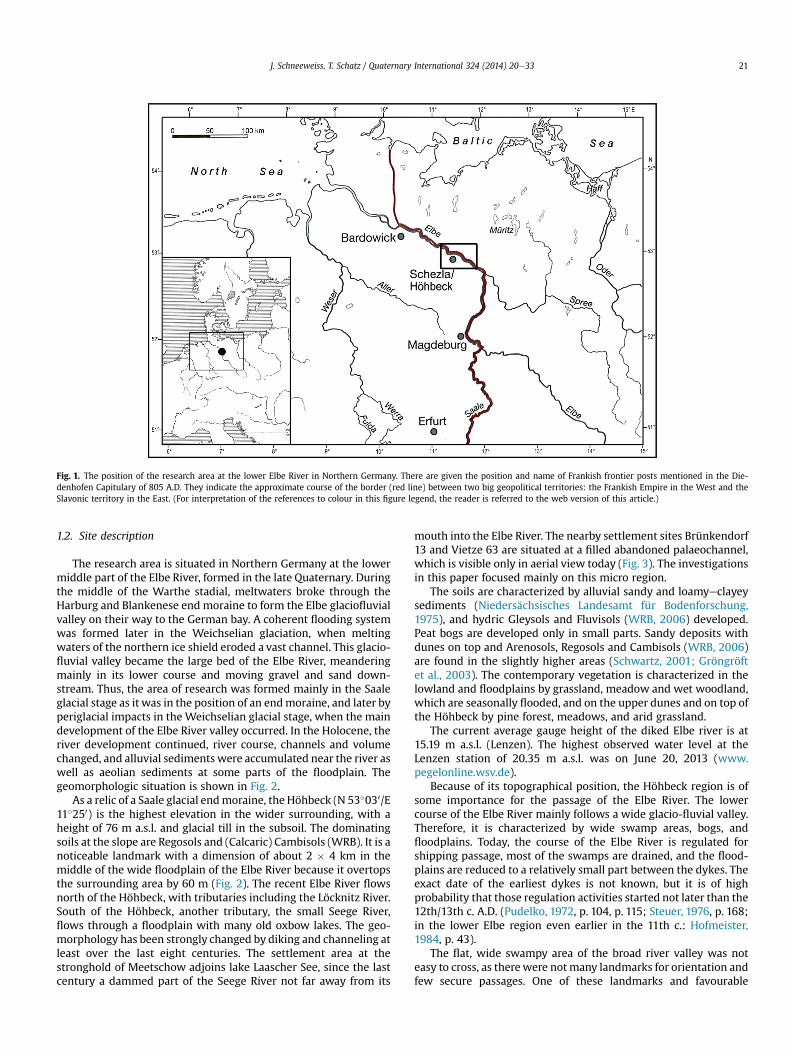
Fig. 1. The position of the research area at the lower Elbe River in Northern Germany. There are given the position and name of Frankish frontier posts mentioned in the Die-denhofen Capitulary of 805 A.D. They indicate the approximate course of the border (red line) between two big geopolitical territories: the Frankish Empire in the West and theSlavonic territory in the East. (For interpretation of the references to colour in this figure legend, the reader is referred to the web version of this article.)
J. Schneeweiss, T. Schatz / Quaternary International 324 (2014) 20e33 21
1.2. Site description
The research area is situated in Northern Germany at the lowermiddle part of the Elbe River, formed in the late Quaternary. Duringthe middle of the Warthe stadial, meltwaters broke through theHarburg and Blankenese end moraine to form the Elbe glaciofluvialvalley on their way to the German bay. A coherent flooding systemwas formed later in the Weichselian glaciation, when meltingwaters of the northern ice shield eroded a vast channel. This glacio-fluvial valley became the large bed of the Elbe River, meanderingmainly in its lower course and moving gravel and sand down-stream. Thus, the area of research was formed mainly in the Saaleglacial stage as it was in the position of an endmoraine, and later byperiglacial impacts in the Weichselian glacial stage, when the maindevelopment of the Elbe River valley occurred. In the Holocene, theriver development continued, river course, channels and volumechanged, and alluvial sediments were accumulated near the river aswell as aeolian sediments at some parts of the floodplain. Thegeomorphologic situation is shown in Fig. 2.
As a relic of a Saale glacial endmoraine, the Höhbeck (N 53�030/E11�250) is the highest elevation in the wider surrounding, with aheight of 76 m a.s.l. and glacial till in the subsoil. The dominatingsoils at the slope are Regosols and (Calcaric) Cambisols (WRB). It is anoticeable landmark with a dimension of about 2 � 4 km in themiddle of the wide floodplain of the Elbe River because it overtopsthe surrounding area by 60 m (Fig. 2). The recent Elbe River flowsnorth of the Höhbeck, with tributaries including the Löcknitz River.South of the Höhbeck, another tributary, the small Seege River,flows through a floodplain with many old oxbow lakes. The geo-morphology has been strongly changed by diking and channeling atleast over the last eight centuries. The settlement area at thestronghold of Meetschow adjoins lake Laascher See, since the lastcentury a dammed part of the Seege River not far away from its
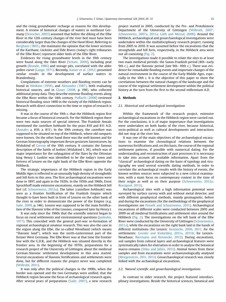
mouth into the Elbe River. The nearby settlement sites Brünkendorf13 and Vietze 63 are situated at a filled abandoned palaeochannel,which is visible only in aerial view today (Fig. 3). The investigationsin this paper focused mainly on this micro region.
The soils are characterized by alluvial sandy and loamyeclayeysediments (Niedersächsisches Landesamt für Bodenforschung,1975), and hydric Gleysols and Fluvisols (WRB, 2006) developed.Peat bogs are developed only in small parts. Sandy deposits withdunes on top and Arenosols, Regosols and Cambisols (WRB, 2006)are found in the slightly higher areas (Schwartz, 2001; Gröngröftet al., 2003). The contemporary vegetation is characterized in thelowland and floodplains by grassland, meadow and wet woodland,which are seasonally flooded, and on the upper dunes and on top ofthe Höhbeck by pine forest, meadows, and arid grassland.
The current average gauge height of the diked Elbe river is at15.19 m a.s.l. (Lenzen). The highest observed water level at theLenzen station of 20.35 m a.s.l. was on June 20, 2013 (www.pegelonline.wsv.de).
Because of its topographical position, the Höhbeck region is ofsome importance for the passage of the Elbe River. The lowercourse of the Elbe River mainly follows a wide glacio-fluvial valley.Therefore, it is characterized by wide swamp areas, bogs, andfloodplains. Today, the course of the Elbe River is regulated forshipping passage, most of the swamps are drained, and the flood-plains are reduced to a relatively small part between the dykes. Theexact date of the earliest dykes is not known, but it is of highprobability that those regulation activities started not later than the12th/13th c. A.D. (Pudelko, 1972, p. 104, p. 115; Steuer, 1976, p. 168;in the lower Elbe region even earlier in the 11th c.: Hofmeister,1984, p. 43).
The flat, wide swampy area of the broad river valley was noteasy to cross, as therewere notmany landmarks for orientation andfew secure passages. One of these landmarks and favourable
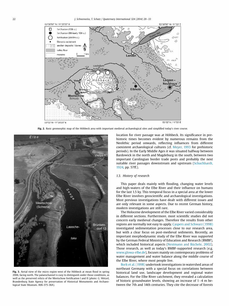
Fig. 2. Basic geomorphic map of the Höhbeck area with important medieval archaeological sites and simplified today’s river course.
Fig. 3. Aerial view of the micro region west of the Höhbeck at mean flood in spring2006, facing north. The palaeochannel is easy to distinguish under those conditions, aswell as the preserved relicts of the Meetschow fortification I and II (photo: G. Wetzel,Brandenburg State Agency for preservation of Historical Monuments and Archaeo-logical State Museum. A06-375-36A).
J. Schneeweiss, T. Schatz / Quaternary International 324 (2014) 20e3322
location for river passage was at Höhbeck. Its significance in pre-historic times becomes evident by numerous remains from theNeolithic period onwards, reflecting influences from differentcoexistent archaeological cultures (cf. Meyer, 1993 for prehistoricperiods). In the Early Middle Ages it was situated halfway betweenBardowick in the north and Magdeburg in the south, between twoimportant Carolingian border trade posts and probably the nextsuitable river passages downstream and upstream (Schuchhardt,1924, pp. 57ff.).
1.3. History of research
This paper deals mainly with flooding, changing water levelsand high-waters of the Elbe River and their influence on humansfor the last 1.5 ky. This temporal focus in a special area at the lowerElbe River involves geoscientific and archaeological investigations.Most previous investigations have dealt with different issues andare only relevant in some aspects. Due to recent German history,modern investigations are still rare.
The Holocene development of the Elbe River varied considerablyin different sections. Furthermore, most scientific studies did notconcern early medieval changes. Therefore the results from otherregions are normally not easy to apply. Caspers and Schwarz (1998)investigated sedimentation processes close to our research area,but with a clear focus on post-medieval sediments. Recently, animportant morphodynamic study of the Elbe River was supportedby the German Federal Ministry of Education and Research (BMBF),which included historical aspects (Nestmann and Büchele, 2002).Those research, as well as today’s BMBF-supported research (e.g.www.glowa-elbe.de), focuses mainly on contemporary problems ofwater management and water balance along the middle course ofthe Elbe River, where most people live.
Bork et al. (1998) undertook investigations inwatershed areas ofnortheast Germany with a special focus on correlations betweenhistorical land use, landscape development and regional waterbalances. For the Elbe River catchment, they revealed a calculationof historic groundwater levels, showing an increase of 1e4 m be-tween the 7th and 14th centuries. They cite the decrease of forests
J. Schneeweiss, T. Schatz / Quaternary International 324 (2014) 20e33 23
and the rising groundwater recharge as reasons for this develop-ment. A review of historical changes of waters in northeast Ger-many (Driescher, 2003) assumed that before the diking of the ElbeRiver in the 12th century changes of the river bed must have beenconsiderably larger than the changes of the Havel River. Referring toBerghaus (1865), she maintains the opinion that the lower sectionsof the Karthane, Löcknitz and Elde Rivers (today’s right tributariesof the Elbe River) represent older beds of the Elbe River.
Evidences for rising groundwater levels in the 10th centurywere found along the Oder River (Schatz, 2000), including peatgrowth (Brande, 1986) and storage pits, correlated with the alderpollen curve (Lange, 1971). Recently, Kaiser et al. (2012) presentedsimilar results in the development of surface waters inBrandenburg.
Compilations of extreme weathers and flooding events can befound in Weikinn (1958), and Alexandre (1987), both evaluatinghistorical sources, and in Glaser (2008, p. 198), who collectedadditional proxy data. They describe extreme flooding events alongthe Elbe River within the 14th century. Puffarth (2008) reviewedhistorical flooding since 1490 in the vicinity of the Höhbeck region.Research with direct connection to the time or region of research ismissing.
It was in the course of the 19th c. that the Höhbeck region firstbecame a focus of historical research. For the Höhbeck region therewere two main sources of special interest. The Frankish Annalsmentioned the castellum hohbuoki for the years 810 and 811 A.D.(Annales a. 810, a. 811). In the 19th century, the castellum wassupposed to be situated on top of the Höhbeck, where old rampartswere known. On the other hand there was the well-known and forGerman historiography important Rerum gestarum Saxonicarum, byWidukind of Corvey of the 10th century. It contains the famousdescription of the battle of lunkini (Widukind I, 36), which was ofmajor importance for the subjugation of the Slavs by the Ottonianking Henry I. Lunkini was identified to be the today’s town andfortress of Lenzen on the right bank of the Elbe River opposite theHöhbeck.
The strategic importance of the Höhbeck region in the EarlyMiddle Ages is reflected in an unusually high density of strongholdsand hill forts in this area. The first archaeological excavations weredone in 1897, and again in the 1920s. In the 1950s and 1960s, ErnstSprockhoff made extensive excavations, mainly on the Höhbeck hillfort (cf. Schneeweiss, 2012a). The latter (castellum hohbuoki) wasseen as a frontier fortification of the Frankish Empire whichthought to have been built in front of Lenzen on the other bank ofthe river in order to demonstrate the power of the Empire (e.g.Saile, 2009, p. 146). Lenzen was supposed to be the main fortifica-tion of the Slavonic tribe of the Linones, conquered later by Henry I.
It was only since the 1960s that the scientific interest began tofocus on rural settlements and environmental questions (Jankuhn,1977). This coincided with the general post-war re-formation ofregional archaeological amateur research. This was also the case inthe region along the Elbe, the so-called Wendland (which means“Slavonic land”), which was the north-easternmost part of theformer West Germany. The Elbe River was at that time the frontierline with the G.D.R., and the Höhbeck was situated directly in thefrontier area. In the beginning of the 1970s, preparations for aresearch project of the University of Göttingen about the medievalGerman-Slavonic settlement development in this area started.Several excavations of Slavonic fortifications and settlements weredone, but for different reasons the project never was completed(Willroth, 2011).
It was only after the political changes in the 1990s, when theborder was opened and the two Germanys were unified, that theHöhbeck region became the focus of archaeological research again.After several years of preparations (Saile, 2007), a new research
project started in 2005, conducted by the Pre- and ProtohistoricDepartment of the University of Göttingen (Willroth, 2007;Schneeweiss, 2007a, 2011a; Lüth and Messal, 2008). Around theHöhbeck, archaeological and geoarchaeological investigations wereundertaken within the multidisciplinary research project, runningfrom 2005 to 2010. It was assumed before the excavations that thestrongholds and hill forts, respectively, in the Höhbeck area werenot all coexisting (Fig. 2).
The investigations made it possible to relate the sites to at leasttwo main medieval periods: the Saxon-Frankish period (8theearly9th c.), and the Slavonic period (late 9the10th c.). There was evi-dence for remarkable flooding events and important changes of thenatural environment in the course of the Early Middle Ages, espe-cially in the 10th c. It is the objective of this paper to show thecorrelations between the natural changes of the landscape and thecourse of the regional settlement development within the politicalhistory at the turn from the first to the second millennium A.D.
2. Methods
2.1. Historical and archaeological investigations
Within the framework of the research project, extensivearchaeological excavations in the Höhbeck regionwere carried out.For the conclusions, it is of major importance that investigationswere undertaken on both banks of the river, because historical,socio-political as well as cultural developments and interactionsdid not stop at the river line.
It was one of the main objectives of the archaeological excava-tions to examine the chronological relations between thenumerous fortifications and, on this basis, the course of the regionalsettlement patterns, if possible with numerical dating. For theunderstanding and reconstruction of past processes it is necessaryto take into account all available information. Apart from the“classical” archaeological dating on the basis of typology and stra-tigraphy we used several scientific dating methods. In order tocorrelate the archaeological results with the history of events, theknown written sources were subjected to a new critical examina-tion, with a main focus on contemporary context in the time oftheir origin as well as on their purpose (Schneeweiss, 2012a;Rossignol, 2013).
Archaeological sites with a high information potential weresurveyed by surface survey with and without metal detector, andwith different geophysical methods, mainly geomagnetic, beforeand during the excavations (for the methodology of the geophysicalinvestigations see Posselt and Schneeweiss, 2011). Archaeologicalexcavations of different scales were conducted between 2005 and2009 on all medieval fortifications and settlement sites around theHöhbeck (Fig. 2). The investigations on the left bank of the ElbeRiver were conducted by the University of Göttingen (Schneeweiss,2011a), while the excavations on the right bank laid in the hands ofdifferent institutions (for Lenzen: Kennecke, 2006, 2011; for thesettlements: Gossler and Kinkeldey, 2011a, 2011b; for Lenzen-Neuehaus: Biermann and Kennecke, 2013). During excavations,soil samples from cultural layers and archaeological features weresystematically taken for elutriation in order to analyse the botanicalmacro-remains (Stika and Jahns, 2013). Animal bones from thesesamples and from excavations were archaeozoologically analysed(Morgenstern, 2011, 2013). Geoarchaeological research was closelylinked with the archaeological excavations.
2.2. Natural scientific and geoarchaeological investigations
In contrast to older research, the project featured interdisci-plinary investigations. Beside the historical sciences, botanical and

J. Schneeweiss, T. Schatz / Quaternary International 324 (2014) 20e3324
geoarchaeologicalepedological research was included. It was theobjective of geoarchaeologicalepedological investigations in thedirect and indirect surroundings of the excavations to reconstructthe natural situation in the Elbe valley at the Höhbeck before theconstruction of the river dykes in the 12th c. and to evaluatepossible impacts of environmental changes on the settlement.Therefore, soil profiles at the archaeological excavation sites wereinvestigated, documented, and stratigraphically interpreted; addi-tional profiles and borings were realized in the surroundings.
As the investigated Slavonic strongholds (Meetschow, Elb-holz) and settlements (Vietze, Brünkendorf) are situated nearrecent or previous tributaries of the Elbe River, the research wasconcentrated on sediments at the edge of the settlements andthe transition area to the previous floodplain. Locations wherecolluvial sediments from the slope-side and fluvial sedimentsfrom the running waters were alternately deposited, wereconsidered to reveal the best results for chronological conclu-sions. The value of the stratigraphy together with independentdating for interpretation can hardly be overestimated, becauseonly in that way it is directly possible to connect relative andnumerical chronology. The dynamic of flooding levels and phasesof settlement should be reconstructable, especially at those lo-cations where they contact each other. We found this situationnear the mouth of the Seege River in the vicinity of the Meet-schow stronghold and at the two sites Brünkendorf 13 and Vietze63. At these excavation sites, profiles from the edge of the set-tlement area to the floodplain were entirely documented withphotos and scaled drawings and supplemented with borings. Alllayers were characterized by field methods at different positions,determining grain size, soil colour (Munsell), and estimating thecontents of organic matter, stones and gravel, charcoal, ceramics,and burnt loam. As a result of this process it was possible todefine layer boundaries. In order to confirm the stratigraphicfield observations, soil samples from selected parts of the profilewere analyzed in the laboratory of the University of AppliedSciences Eberswalde to determine their genesis and to find par-allels concerning grain sizes, the contents of organic C, heavymetals, and P between different sites (Table 1). Grain size anal-ysis was carried out according to KÖHN referring DIN ISO 11277(Gutachterausschuss Forstliche Analytik, 2005, A2.5). Further-more, some samples were analyzed by specifying their sortingand roughness.
Table 1Grain size analyses from different layers of the Meetschow-profile (cf. Fig. 5).
Sample Layer >20[%]
2e20[%]
<2[%]
gS1(1.0e 2.0)
gS2(0.63e 1.0)
mS(0.2e 0.63)
fS1(0.1e 0.2
Mee1-071025/1
aM10 0.00 0.00 100 0.2 0.4 20.3 34.1
Mee1-071025/2
M9 0.00 0.00 100 0.0 0.1 17.8 48.7
Mee1-071025/3
aM8 0.00 0.19 99.81 0.1 0.1 26.1 66.6
Mee1-071025/4
aM6 0.07 0.27 99.66 0.0 0.2 18.7 63.0
Mee1-071025/5
M5 1.63 0.02 98.35 0.4 0.2 25.5 56.8
Mee1-071025/6
aM4 0.00 0.09 99.91 0.3 0.3 24.9 56.8
Mee1-071025/7
M3 0.05 0.77 99.18 0.7 1.5 30.7 56.1
Mee1-071025/8
aM2 0.00 0.04 99.96 0.1 0.4 42.6 52.3
Grain size in mm. The laboratory analyses were done in the Ecological laboratory of thefractions.
a Soil texture referring to EN ISO 14688 and ad hoc AG Boden 2005: Bodenkundliche
Pedological analyses of the soil profiles are of great value, but fortheir linking with each other and with the archaeological layers,dating is essential. Apart from archaeological dating and strati-graphic interpretation we used several scientific dating methods,including dendrochronology, radiocarbon dating, and opticallystimulated luminescence (OSL) (Table 2). The last is of specialimportance, because it enables the dating of minerals’ (quartz,feldspar, aluminium oxide) last exposure to sunlight (Aitken, 1990).For OSL special samples were taken. For good results, bleaching ofthe sediments during the sedimentation process is essential.Therefore, we took samples from sandy layers, taking into accountthat finer grained sediments normally cause cloudy suspensionwhen moving, where good bleaching is less likely. To get thesample without light in the centre and to fill the sample containercompletely, the layers must have a minimal thickness of about 5 cm(Kadereit et al., 2006). Such sandy sediments mark flooding eventswith high energy at this site. According to several on site and off siteprofiles at the Seege River, they reached higher water levels thanthe loamy-clayey sediments. To get more precise dating resultswith OSL we measured radiation by leaving calibrated dosimeters(Al2O3:C) at each layer for an exactly defined duration (at least 3months; cf. Schatz, 2013b). Measuring and dating of the Quartzminerals were made by Dr. C. Goedicke in the laboratory of theDepartment for Geomorphology of the Humboldt University,Berlin.
3. Results
3.1. The micro region around the Meetschow site west of theHöhbeck
3.1.1. Archaeological results3.1.1.1. The Saxon-Frankish period (8theearly 9th c.). During the so-called Saxon-Frankish period, the Höhbeck region became part ofthe Carolingian Empire, along its north-eastern border with theSlavonic neighbours (Fig. 1). In the context of the Frankish Empire,the excavations at the hill forts on top of the Höhbeck and at theMeetschow site at its foot were of major importance (Fig. 2). Theonly other sites of this period in the Höhbeck region are the earlySlavonic rural settlement Lenzen 32 at the Rudower See (Gosslerand Kinkeldey, 2011a; Glass et al., 2013) and a Slavonic strong-hold of the early 9th c. A.D. in Lenzen-Neuehaus (Biermann and
)fS2(0.063e 0.02)
gU(0.02e0.063)
mU0.0063e 0.02)
fU0.002e0.0063)
T(<0.002)
Texturea
4.7 4.8 4.9 6.1 24.5 Ls4
7.9 5.7 2.2 3.4 14.2 Sl4
3.0 1.8 0.2 0.1 2.0 Ss
7.8 3.4 1.8 0.1 5.0 St2
6.5 2.1 2.2 0.2 6.1 St2
5.9 4.1 2.0 0.0 5.7 St2
4.6 1.8 0.0 0.3 4.3 Ss
1.3 0.8 0.2 0.0 2.3 Ss
Unniversity of Applied Sciences Eberswalde by U. Thomas. gS1, gS2 ¼ coarse sand
Kartieranleitung.
Table 2Scientific dates (different methods) mentioned in the text.
No. Sample-No.(Lab. Code)
Method Laboratory Site, context, dated material Age Cal. Date s-range
1 Erl-12304 14C (AMS) Erlangen Meetschow, Organic layer 1355 � 44 BP cal. AD: 606e724 (82.2%),737e771 (13.2%)
2 s
2 Erl-13668 14C (AMS) Erlangen Meetschow, charred grain 1361 � 38 BP cal. AD: 606e713 (88.0%),744e767 (7.4%)
2 s
3 KIA 33563 14C (AMS) Kiel Meetschow, feature 22/1; bones 1274 � 22 BP cal. AD: 674e775 (95.4%) 2 s4 KIA 33564 14C (AMS) Kiel Meetschow, feature 22d/1; bones 1147 � 30 BP cal. AD: 780e791 (3.8%)
805e975 (91.6%)2 s
5 Erl-13289 14C (AMS) Erlangen Meetschow, feature 43/43a;charcoal
1286 � 42 BP cal. AD: 654e782 (87.8%)788e816 (4.8%)817e822 (0.6%)841e859 (2.3%)
2 s
6 Erl-13285 14C (AMS) Erlangen Meetschow, feature 45; bones 1290 � 40 BP cal. AD: 653e781 (90.8%)788e811 (3.3%)844e857 (1.3%)
2 s
7 Erl-13283 14C (AMS) Erlangen Meetschow, feature 150b, bones 1272 � 41 BP cal. AD: 660e783 (81.4%)787e828 (9.1%)838e865 (4.9%)
2 s
8 C 51233 Dendro-chronology Berlin Castellum hohbuoki, Oak 810 810 (d) Waney edge9 C 52050 Dendro-chronology Berlin Castellum hohbuoki, Elm 809 809 (d) Waney edge10 C 52062 Dendro-chronology Berlin Castellum hohbuoki, Elm 805 805 (d) Waney edge11 C 43729 Dendro-chronology Berlin Palaeochannel Vietze, oak >885 After 885 (d) Terminus
post quem12 MEET P1-355F77_0 Dendro-chronology DELAG (Göttingen) Meetschow I, phase 1, oak 906 906 (d) Waney edge13 MEET P1-355F14_0 Dendro-chronology DELAG (Göttingen) Meetschow I, phase 1, oak 915 �1/þ1 *914 (d) Waney edge14 MEET P2-355G25_0 Dendro-chronology DELAG (Göttingen) Meetschow I, phase 2, oak 929 929 (d) Waney edge15 MEET P3-355H10_0 Dendro-chronology DELAG (Göttingen) Meetschow I, phase 3, oak 946 �6/þ8 946 �6/þ8 (d) Heartwood-
sapwood-boundary16 MEET P4-355I11_0 Dendro-chronology DELAG (Göttingen) Meetschow I, phase 4, oak 1014 1014 (d) Waney edge17 MIL OSL GeLe1 OSL CUDaM Milano Elbholz, Ss (filling of the ditch) 1100 � 100 y 800e1000 A.D. 1 s18 BER 071101/3 OSL Berlin-Goedicke Meetschow, layer M6 1044 � 80 y 876e1036 A.D. 1 s19 BER-071101/4 OSL Berlin-Goedicke Meetschow, layer M4 1332 � 83 y 585e751 A.D. 1 s20 BER-071101/5 OSL Berlin-Goedicke Meetschow, layer M2 1406 � 101 y 493e695 A.D. 1 s
* Assuming that the waney edge (Waldkante) has preserved.
J. Schneeweiss, T. Schatz / Quaternary International 324 (2014) 20e33 25
Kennecke, 2013), both on the right bank of the Elbe River (Figs. 2and 4a). The excavations of the fortification on the Höhbeckresulted in its dendrochronological dating to 810 A.D. (No. 8e10 inTable 2; cf. Schneeweiss, 2009a, 2011b), which is the main evidencefor its identification with the castellum hohbuoki, known from theFrankish Annals (Annales: a. 810, a. 811). A detailed discussion ofthe dating and the identification of both hill forts as castellumhohbuoki is given elsewhere (Schneeweiss, 2012a).
Completely unexpected was the discovery of an unfortifiedsettlement at the Meetschow site, which preceded the knownSlavonic ring fort of the 10th c. It is characterized by a loamy cul-tural layer, containing abundant animal bones (food waste) andceramics. Sherds were often found in clusters, making it possible toreconstruct whole vessels. A strikingly large number of thirtyhearths, fire pits and furnaces were uncovered in an area of 400 m2
(trench 2 in Fig. 5). They apparently were concentrated in aparticular area and partially overlaid one another. Thus, the set-tlement must have existed for a longer period. Traces of buildingsare indicated by small wall trenches and postholes. Among thearchaeological finds there are several whetstones, a rectangulariron clasp knife with associated whetstone, an iron spearhead, andan arrowhead, as well as two iron spurs.
According to this, several approaches are available for dating thesettlement. The spurs belong to the beginning of the 9th c. (Stein,1967, pp. 85e86; Gabriel, 1991, pp. 182e184), as does the strapendwhichwas found together with one of the spurs. The analysis ofthe ceramics suggests a date from the 7th to the 9th c. Distinctparallels of thewares and profiles fromMeetschow can be observedin complexes with Saxonian pottery (Steuer, 1974, 1975, 1979;Hornig, 1993) and some vessels of the early Slavonic Sukow type
are also present. The late Saxonian age is supported by the char-acter of the archaeological features (absence of sunken buildings orpit-houses, instead presence of postholes) and by some of thearchaeological finds, including the clasp knife, the loop spur withits riveted decorated stimulus, and the ceramics. Only the vessels ofthe Sukow type, which are easily distinguishable from the Saxonianpottery, indicate the presence of Slavs, whowere living on the otherriver bank. The archaeological age determination is supported by aseries of 14C-data: currently there are five radiocarbon dates whichgive a time span from the 7th until the middle of the 9th c. for thesettlement (No. 2e3.5e7 in Table 2). The earliest dates are before775 A.D., and possibly even further back to the 7th c. (No. 2e3 inTable 2).
Thus, the beginning of the settlement still remains rather vaguein the 7th/8th c. A.D. The site was certainly abandoned in the firsthalf of the 9th c. This dating is supported especially by the ironspurs, the ceramics, and the radiocarbon dates. A settlement periodof two centuries or 6e8 generations, respectively (for the averageduration of a human generation, Fenner, 2005), seems too longgiven the amount of archaeological findings and the density offeatures. Therefore, beginning of the settlement in the first half ofthe 8th century is more likely. The stratigraphy indicates that thesettlement was fortified with a rampart around 800 A.D. (cf.Schneeweiss, 2010; Northern and Southern rampart in Fig. 5). Un-fortunately, no wood has preserved, with only a few constructiontimbers have been badly preserved in charcoal. Dendrochronolog-ical dating was not possible.
Despite the rather bad preservation of the Northern Meetschowrampart some remarkable construction similarities to the hill fortcould be observed. All timbers had been orientated perpendicular
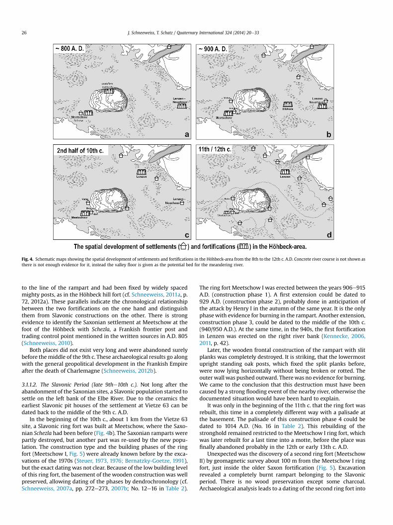
Fig. 4. Schematic maps showing the spatial development of settlements and fortifications in the Höhbeck-area from the 8th to the 12th c. A.D. Concrete river course is not shown asthere is not enough evidence for it, instead the valley floor is given as the potential bed for the meandering river.
J. Schneeweiss, T. Schatz / Quaternary International 324 (2014) 20e3326
to the line of the rampart and had been fixed by widely spacedmighty posts, as in the Höhbeck hill fort (cf. Schneeweiss, 2011a, p.72, 2012a). These parallels indicate the chronological relationshipbetween the two fortifications on the one hand and distinguishthem from Slavonic constructions on the other. There is strongevidence to identify the Saxonian settlement at Meetschow at thefoot of the Höhbeck with Schezla, a Frankish frontier post andtrading control point mentioned in the written sources in A.D. 805(Schneeweiss, 2010).
Both places did not exist very long and were abandoned surelybefore themiddle of the 9th c. These archaeological results go alongwith the general geopolitical development in the Frankish Empireafter the death of Charlemagne (Schneeweiss, 2012b).
3.1.1.2. The Slavonic Period (late 9the10th c.). Not long after theabandonment of the Saxonian sites, a Slavonic population started tosettle on the left bank of the Elbe River. Due to the ceramics theearliest Slavonic pit houses of the settlement at Vietze 63 can bedated back to the middle of the 9th c. A.D.
In the beginning of the 10th c., about 1 km from the Vietze 63site, a Slavonic ring fort was built at Meetschow, where the Saxo-nian Schezla had been before (Fig. 4b). The Saxonian ramparts werepartly destroyed, but another part was re-used by the new popu-lation. The construction type and the building phases of the ringfort (Meetschow I, Fig. 5) were already known before by the exca-vations of the 1970s (Steuer, 1973, 1976; Bernatzky-Goetze, 1991),but the exact dating was not clear. Because of the low building levelof this ring fort, the basement of the wooden constructionwas wellpreserved, allowing dating of the phases by dendrochronology (cf.Schneeweiss, 2007a, pp. 272e273, 2007b; No. 12e16 in Table 2).
The ring fort Meetschow I was erected between the years 906e915A.D. (construction phase 1). A first extension could be dated to929 A.D. (construction phase 2), probably done in anticipation ofthe attack by Henry I in the autumn of the same year. It is the onlyphasewith evidence for burning in the rampart. Another extension,construction phase 3, could be dated to the middle of the 10th c.(940/950 A.D.). At the same time, in the 940s, the first fortificationin Lenzen was erected on the right river bank (Kennecke, 2006,2011, p. 42).
Later, the wooden frontal construction of the rampart with slitplanks was completely destroyed. It is striking, that the lowermostupright standing oak posts, which fixed the split planks before,were now lying horizontally without being broken or rotted. Theouter wall was pushed outward. Therewas no evidence for burning.We came to the conclusion that this destruction must have beencaused by a strong flooding event of the nearby river, otherwise thedocumented situation would have been hard to explain.
It was only in the beginning of the 11th c. that the ring fort wasrebuilt, this time in a completely different way with a palisade atthe basement. The palisade of this construction phase 4 could bedated to 1014 A.D. (No. 16 in Table 2). This rebuilding of thestronghold remained restricted to the Meetschow I ring fort, whichwas later rebuilt for a last time into a motte, before the place wasfinally abandoned probably in the 12th or early 13th c. A.D.
Unexpected was the discovery of a second ring fort (MeetschowII) by geomagnetic survey about 100 m from the Meetschow I ringfort, just inside the older Saxon fortification (Fig. 5). Excavationrevealed a completely burnt rampart belonging to the Slavonicperiod. There is no wood preservation except some charcoal.Archaeological analysis leads to a dating of the second ring fort into
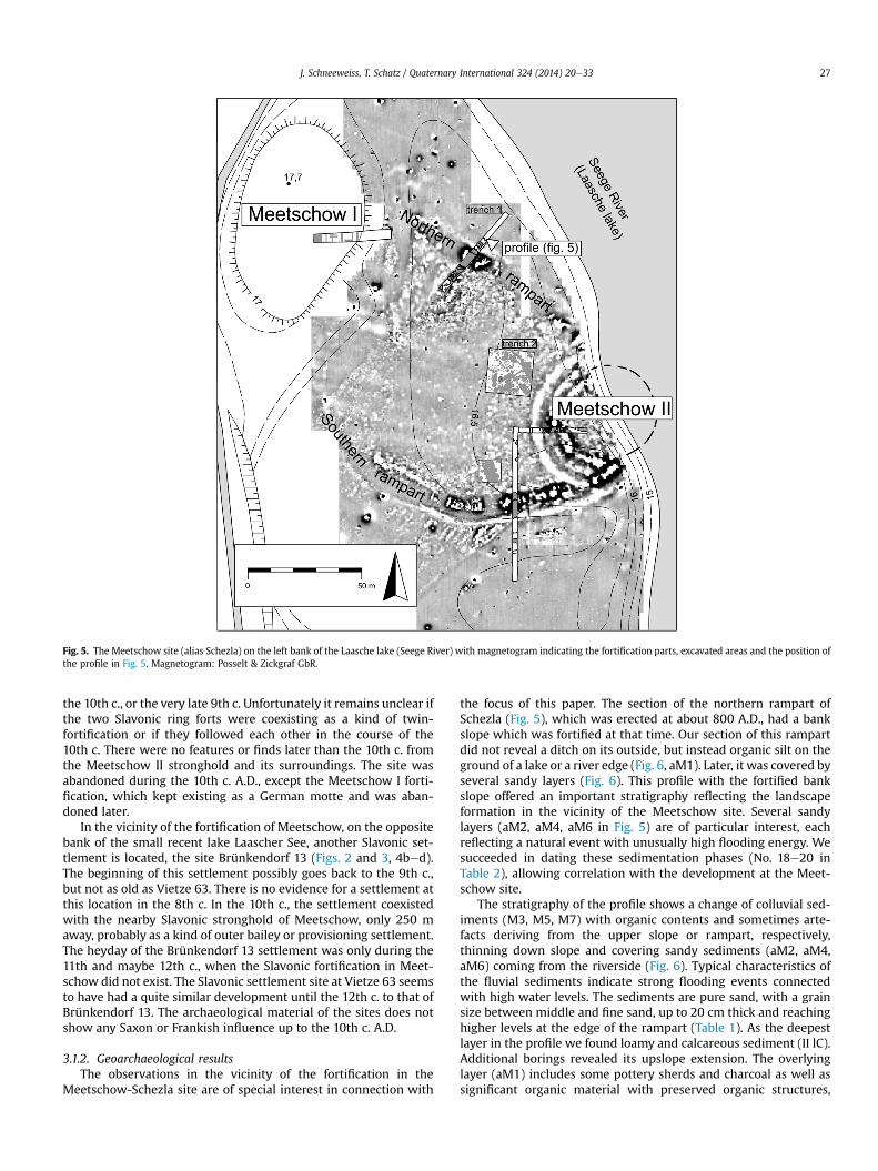
Fig. 5. The Meetschow site (alias Schezla) on the left bank of the Laasche lake (Seege River) with magnetogram indicating the fortification parts, excavated areas and the position ofthe profile in Fig. 5. Magnetogram: Posselt & Zickgraf GbR.
J. Schneeweiss, T. Schatz / Quaternary International 324 (2014) 20e33 27
the 10th c., or the very late 9th c. Unfortunately it remains unclear ifthe two Slavonic ring forts were coexisting as a kind of twin-fortification or if they followed each other in the course of the10th c. There were no features or finds later than the 10th c. fromthe Meetschow II stronghold and its surroundings. The site wasabandoned during the 10th c. A.D., except the Meetschow I forti-fication, which kept existing as a German motte and was aban-doned later.
In the vicinity of the fortification of Meetschow, on the oppositebank of the small recent lake Laascher See, another Slavonic set-tlement is located, the site Brünkendorf 13 (Figs. 2 and 3, 4bed).The beginning of this settlement possibly goes back to the 9th c.,but not as old as Vietze 63. There is no evidence for a settlement atthis location in the 8th c. In the 10th c., the settlement coexistedwith the nearby Slavonic stronghold of Meetschow, only 250 maway, probably as a kind of outer bailey or provisioning settlement.The heyday of the Brünkendorf 13 settlement was only during the11th and maybe 12th c., when the Slavonic fortification in Meet-schow did not exist. The Slavonic settlement site at Vietze 63 seemsto have had a quite similar development until the 12th c. to that ofBrünkendorf 13. The archaeological material of the sites does notshow any Saxon or Frankish influence up to the 10th c. A.D.
3.1.2. Geoarchaeological resultsThe observations in the vicinity of the fortification in the
Meetschow-Schezla site are of special interest in connection with
the focus of this paper. The section of the northern rampart ofSchezla (Fig. 5), which was erected at about 800 A.D., had a bankslope which was fortified at that time. Our section of this rampartdid not reveal a ditch on its outside, but instead organic silt on theground of a lake or a river edge (Fig. 6, aM1). Later, it was covered byseveral sandy layers (Fig. 6). This profile with the fortified bankslope offered an important stratigraphy reflecting the landscapeformation in the vicinity of the Meetschow site. Several sandylayers (aM2, aM4, aM6 in Fig. 5) are of particular interest, eachreflecting a natural event with unusually high flooding energy. Wesucceeded in dating these sedimentation phases (No. 18e20 inTable 2), allowing correlation with the development at the Meet-schow site.
The stratigraphy of the profile shows a change of colluvial sed-iments (M3, M5, M7) with organic contents and sometimes arte-facts deriving from the upper slope or rampart, respectively,thinning down slope and covering sandy sediments (aM2, aM4,aM6) coming from the riverside (Fig. 6). Typical characteristics ofthe fluvial sediments indicate strong flooding events connectedwith high water levels. The sediments are pure sand, with a grainsize between middle and fine sand, up to 20 cm thick and reachinghigher levels at the edge of the rampart (Table 1). As the deepestlayer in the profile we found loamy and calcareous sediment (II lC).Additional borings revealed its upslope extension. The overlyinglayer (aM1) includes some pottery sherds and charcoal as well assignificant organic material with preserved organic structures,
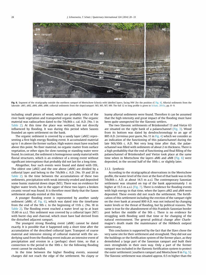
Fig. 6. Segment of the stratigraphy outside the northern rampart of Meetschow-Schezla with labelled layers, facing NW (for the position cf. Fig. 4). Alluvial sediments from thelakeside: aM1, aM2, aM4, aM6, aM8; colluvial sediments from the slope/rampart: M3, M5, M7, M9. The full 12 m long profile is given in Schatz, 2013a, pp. 8e9.
J. Schneeweiss, T. Schatz / Quaternary International 324 (2014) 20e3328
including small pieces of wood, which are probably relics of theriver bank vegetation and transported organic matter. The organicmaterial was radiocarbon dated to the 7th/8th c. cal. A.D. (No. 1 inTable 2). At this time the place was wetland, but not directlyinfluenced by flooding. It was during this period when Saxonsfounded an open settlement on the bank.
The organic sediment is covered by a sandy layer (aM2) repre-senting a first high energy flooding event. It accumulated materialup to 1m above the former surface. High waters must have reachedabove this point. No finer material, no organic matter from surfacevegetation, or other signs for slow running or standing water werefound. In contrast, the sediment is homogenous sandymaterial withfluvial structures, which is an evidence of a strong event withoutsignificant interruptions that probably did not last for a long time.
Altogether, four such events were found and dated with OSL.The oldest one (aM2) and the one above (aM4) are divided by acolluvial layer and belong to the 7th/8th c. A.D. (No. 19 and 20 inTable 2). In the time between the accumulations of these twosediments, precipitation with weak intensity eroded and depositedsome humic material down slope (M3). There was no evidence forhigher water levels, but in the upper of these two layers a brokenceramic vessel was found. It is therefore most likely that the Saxonsettlement already existed at this time.
A younger flooding event is represented by another sandysediment (aM6; cf. Fig. 6), which was dated into the timeframefrom the end of the 9th c. to the beginning of 11th c. (No. 18 inTable 2). The flooding event reached a water level up to at least15.80 m a.s.l. This sediment was covered by a colluvial layer (M7)with burnt clay and charcoal, which must have had derived fromthe disturbed adjacent rampart.
The youngest strong flooding event (aM8) cannot be datedexactly. It is possible that it happened only a short time after theaccumulation of the described colluvial layer. Transport of coarsematerial and intensive mixing of colluvial material with the un-derlying sand from the flooding event indicate an intensive event ofprecipitation and erosion in a (perhaps) short time, so that aconnection to the period in the 10th c. for the following floodingevent cannot be excluded.
In the time between the higher flooding events, seasonalchanges did not reach the edge of the settlement. No clayey or
loamy alluvial sediments were found. Therefore it can be assumedthat the high intensity and great impact of the flooding must havebeen quite unexpected for the Slavonic settlers.
The two Slavonic settlements of Brünkendorf 13 and Vietze 63are situated on the right bank of a palaeochannel (Fig. 3). Woodfrom its bottom was dated by dendrochronology to an age of885 A.D. (terminus post quem, No. 11 in Fig. 4) which we consider asan indication of the functioning of this palaeochannel during thelate 9th/10th c. A.D. Not very long time after that, the palae-ochannel was filled with sediments of about 2 m thickness. There isa high probability that the end of functioning and final filling of thepalaeochannel of Brünkendorf and Vietze took place at the sametime when in Meetschow the layers aM6 and aM8 (Fig. 6) weredeposited, in the second half of the 10th c. or slightly later.
3.1.3. SynthesisAccording to the stratigraphical observations in the Meetschow
profile, thewater level of the river at the foot of that bankwas in the7th/8th c. A.D. at about 14.5 m a.s.l. The contemporary Saxoniansettlement was situated on top of the bank approximately 1 mhigher at 15.5 m a.s.l. (Fig. 7). There is evidence for flooding eventswith high energy in that time, when the layers aM2 and aM4 weredeposited. These events did not reach the settlement. The fortifi-cation of this settlement including the erection of the rampart righton the river bank at around 800 A.D. was not induced by changingwater levels or the threat of flooding, but by political reasons. Thesame is true for the abandonment of this Frankish-Saxonian borderpost before the middle of the 9th c. There is no evidence forstruggling with flooding until that time or for changing of thenatural environment. The general political change after Charle-magne’s death made the maintenance of the Höhbeck outpostunnecessary.
This conclusion is supported by the fact that the Slavs chose thevery same site for their settlement and stronghold. They did not usethe buildings or the fortification system of the former place, as theydemolished a large part of the Saxonian rampart and built theirown strongholds in their own way. Only a part of the formerrampart was included in the Slavonic fortification system to protectthe outer settlement (southern rampart andMeetschow II in Fig. 5).The Slavonic settlement was situated approx. 0.5 m higher than the
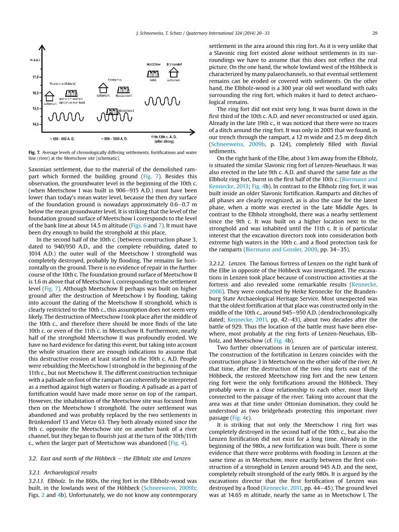
Fig. 7. Average levels of chronologically differing settlements, fortifications and waterline (river) at the Meetschow site (schematic).
J. Schneeweiss, T. Schatz / Quaternary International 324 (2014) 20e33 29
Saxonian settlement, due to the material of the demolished ram-part which formed the building ground (Fig. 7). Besides thisobservation, the groundwater level in the beginning of the 10th c.(when Meetschow I was built in 906e915 A.D.) must have beenlower than today’s mean water level, because the then dry surfaceof the foundation ground is nowadays approximately 0.6e0.7 mbelow themean groundwater level. It is striking that the level of thefoundation ground surface of Meetschow I corresponds to the levelof the bank line at about 14.5 m altitude (Figs. 6 and 7). It must havebeen dry enough to build the stronghold at this place.
In the second half of the 10th c. (between construction phase 3,dated to 940/950 A.D., and the complete rebuilding, dated to1014 A.D.) the outer wall of the Meetschow I stronghold wascompletely destroyed, probably by flooding. The remains lie hori-zontally on the ground. There is no evidence of repair in the furthercourse of the 10th c. The foundation ground surface of Meetschow IIis 1.6 m above that of Meetschow I, corresponding to the settlementlevel (Fig. 7). Although Meetschow II perhaps was built on higherground after the destruction of Meetschow I by flooding, takinginto account the dating of the Meetschow II stronghold, which isclearly restricted to the 10th c., this assumption does not seem verylikely. The destruction ofMeetschow I took place after themiddle ofthe 10th c., and therefore there should be more finds of the late10th c. or even of the 11th c. in Meetschow II. Furthermore, nearlyhalf of the stronghold Meetschow II was profoundly eroded. Wehave no hard evidence for dating this event, but taking into accountthe whole situation there are enough indications to assume thatthis destructive erosion at least started in the 10th c. A.D. Peoplewere rebuilding theMeetschow I stronghold in the beginning of the11th c., but not Meetschow II. The different construction techniquewith a palisade on foot of the rampart can coherently be interpretedas a method against high waters or flooding. A palisade as a part offortification would have made more sense on top of the rampart.However, the inhabitation of the Meetschow site was focused fromthen on the Meetschow I stronghold. The outer settlement wasabandoned and was probably replaced by the two settlements inBrünkendorf 13 and Vietze 63. They both already existed since the9th c. opposite the Meetschow site on another bank of a riverchannel, but they began to flourish just at the turn of the 10th/11thc., when the larger part of Meetschow was abandoned (Fig. 4).
3.2. East and north of the Höhbeck e the Elbholz site and Lenzen
3.2.1. Archaeological results
3.2.1.1. Elbholz. In the 860s, the ring fort in the Elbholz-wood wasbuilt, in the lowlands west of the Höhbeck (Schneeweiss, 2009b;Figs. 2 and 4b). Unfortunately, we do not know any contemporary
settlement in the area around this ring fort. As it is very unlike thata Slavonic ring fort existed alone without settlements in its sur-roundings we have to assume that this does not reflect the realpicture. On the one hand, thewhole lowlandwest of the Höhbeck ischaracterized by many palaeochannels, so that eventual settlementremains can be eroded or covered with sediments. On the otherhand, the Elbholz-wood is a 300 year old wet woodland with oakssurrounding the ring fort, which makes it hard to detect archaeo-logical remains.
The ring fort did not exist very long. It was burnt down in thefirst third of the 10th c. A.D. and never reconstructed or used again.Already in the late 19th c., it was noticed that there were no tracesof a ditch around the ring fort. It was only in 2005 that we found, inour trench through the rampart, a 12 mwide and 2.5 m deep ditch(Schneeweiss, 2009b, p. 124), completely filled with fluvialsediments.
On the right bank of the Elbe, about 3 km away from the Elbholz,is situated the similar Slavonic ring fort of Lenzen-Neuehaus. It wasalso erected in the late 9th c. A.D. and shared the same fate as theElbholz ring fort, burnt in the first half of the 10th c. (Biermann andKennecke, 2013; Fig. 4b). In contrast to the Elbholz ring fort, it wasbuilt inside an older Slavonic fortification. Ramparts and ditches ofall phases are clearly recognized, as is also the case for the latestphase, when a motte was erected in the Late Middle Ages. Incontrast to the Elbholz stronghold, there was a nearby settlementsince the 9th c. It was built on a higher location next to thestronghold and was inhabited until the 11th c. It is of particularinterest that the excavation directors took into consideration bothextreme high waters in the 10th c. and a flood protection task forthe ramparts (Biermann and Gossler, 2009, pp. 34e35).
3.2.1.2. Lenzen. The famous fortress of Lenzen on the right bank ofthe Elbe in opposite of the Höhbeck was investigated. The excava-tions in Lenzen took place because of construction activities at thefortress and also revealed some remarkable results (Kennecke,2006). They were conducted by Heike Kennecke for the Branden-burg State Archaeological Heritage Service. Most unexpected wasthat the oldest fortification at that placewas constructed only in themiddle of the 10th c., around 945e950 A.D. (dendrochronologicallydated; Kennecke, 2011, pp. 42e43), about two decades after thebattle of 929. Thus the location of the battle must have been else-where, most probably at the ring forts of Lenzen-Neuehaus, Elb-holz, and Meetschow (cf. Fig. 4b).
Two further observations in Lenzen are of particular interest.The construction of the fortification in Lenzen coincides with theconstruction phase 3 in Meetschow on the other side of the river. Atthat time, after the destruction of the two ring forts east of theHöhbeck, the restored Meetschow ring fort and the new Lenzenring fort were the only fortifications around the Höhbeck. Theyprobably were in a close relationship to each other, most likelyconnected to the passage of the river. Taking into account that thearea was at that time under Ottonian domination, they could beunderstood as two bridgeheads protecting this important riverpassage (Fig. 4c).
It is striking that not only the Meetschow I ring fort wascompletely destroyed in the second half of the 10th c., but also theLenzen fortification did not exist for a long time. Already in thebeginning of the 980s, a new fortification was built. There is someevidence that there were problems with flooding in Lenzen at thesame time as in Meetschow, more exactly between the first con-struction of a stronghold in Lenzen around 945 A.D. and the next,completely rebuilt stronghold of the early 980s. It is argued by theexcavations director that the first fortification of Lenzen wasdestroyed by a flood (Kennecke, 2011, pp. 44e45). The ground levelwas at 14.65 m altitude, nearly the same as in Meetschow I. The
J. Schneeweiss, T. Schatz / Quaternary International 324 (2014) 20e3330
observation that then the construction ground was filled withapproximately 1 m with clay and debris before building the newfortification, providing an additional interpretation as protectionagainst flooding. In 983, just after the construction of the newfortification, the Slavonic revolt against Christianization and theOttonian domination occurred. The archaeological results do notshowclear evidence for this revolt. Subsequently, Lenzen prosperedand developed into the regional centre, while the significance ofMeetschow was declining (Fig. 4d).
3.2.2. Geoarchaeological resultsThe most important results east of the Höhbeck were revealed
by the investigation in the vicinity of the Elbholz stronghold. Beforethe first excavations in 2005, a ditch outside the well preservedrampart was not known. The reason for this became clear whenwefound that the ditch of the Elbholz ring fort was completely filledwith sandy river deposits. There are no indications for an inter-ruption of the sedimentation process. No material from the sur-rounding surface was found within the sediment. Inclined gradingindicates the direction of the flooding. The course of the ditch wasdetermined by borings by V. Kultan, Technical University ofBraunschweig, Institute of Geosystem and Bioindication. The bor-ings as well as several sondages showed that the ditch is filled withthe same sandy deposits nearly all around the rampart. Only at itsnortheast part it was not possible to find the ditch, probablybecause of modern building activities which also partly destroyedthe rampart.
On this basis, we assume that the ditch served as a kind ofsedimentary trap and was filled in the course of one great floodingevent with very high flow energy, or several such events in a shorttime span. The stratigraphy shows that the fill of the ditch occurredafter the destruction of the stronghold, but not very long time afterit (Schatz, 2011, pp. 136e138). The river sediments directly overliethe destruction layer of the rampart, which is clearly indicated by aburnt rubble layer. The OSL-dating of the sandy sediments from theditch revealed a date between 800 and 1000 A.D. for their sedi-mentation (No. 17 in Table 2).
Inside the stronghold there is no sandy deposit. Besides theSlavonic cultural layer, there are only alluvial loamy or clayey de-posits, as in the vicinity of the stronghold.
3.2.3. SynthesisAt several positions north and east of the Höhbeck, there is
evidence for flooding events and high waters in the 10th c. A.D. InLenzen the first stronghold of the 940swas probably demolished byflooding. The protective measures against the high waters indicatecorresponding experience and expectations of the inhabitants. Theevent or the events, respectively, must have occurred before theearly 980s, when the new stronghold in Lenzen was built.
Similar evidence was revealed in the Elbholz, where the outerditch of the stronghold was filled with sandy sediment. The stra-tigraphy shows clearly that the fluvial sediments were depositedafter the destruction of the rampart. The deposition of the sedi-ments could be dated by OSL to the 9th and 10th c. The destructionof the Elbholz stronghold happened in the first third of the 10th c.A.D., probably in connection with the battle of 929 A.D. This date isindicated by archaeological dating (ceramics, spurs; Schneeweiss,2009b). Considering the stratigraphic evidence, the depositionand therefore the flooding eventmust have happened in the secondhalf of the 10th c.
As another impact of the flooding event, it can be assumed thatthe whole area around the Elbholz ring fort, which was located at alower level, was flooded. Borings did not detect the same sandysediments there, but thick alluvial clay and loam above an olderuneven surface. Evidence for a cultural layer or other traces of a
contemporary settlement could not be found, but it is very unlikelythat there was no settlement next to the stronghold. One or severalheavy flooding events would be a coherent explanation, becausethey would be able to demolish and erode a settlement, or to coverit, respectively. At least those events could involve landscapechanges and therefore also indirectly induce a settlementdisplacement. Considering the findings of flooding events northand east of the Höhbeck, we can assume that probably the sameevent affected both Lenzen as well as the Elbholz stronghold.
4. Discussion
In the early 9th c. A.D., there was a complex Carolingian frontierpost at the Elbe, consisting of the so-called castellum hohbuoki hillfort on top of the Höhbeck and of the border trade post Schezla inMeetschow at its foot. Both were not very long in use and wereabandoned soon after the death of Charlemagne (y 814), and theSlavonic population took over the place since the middle of the 9thc. A.D. While the Carolingian hill fort on top of the Höhbeckremained abandoned, in Meetschow a Slavonic stronghold wasbuilt where the Carolingian border trade post Schezla had beenbefore (Fig. 4aeb). Although the political situation changed, thetopographical and strategic importance of its position obviouslyremained unaffected. In total, there were three Slavonic strong-holds in the vicinity of the Höhbeck in the beginning of the 10th c.A.D. Meetschow seems to have been the most important of them,probably because of its good position, which was most likely thereason for the foundation of Schezla at this place. It must have beenthe best strategic position for controlling the passage of the river.
We found no evidence for greater natural changes in the twocenturies before the 10th c. A.D. The similar levels of the foundationground surface in Meetschow in 906 A.D. and in Lenzen around950 A.D. to the bank line in Schezla before the 8th c. (approx. 14.5e14.65 m a.s.l.) are considered as indications for more or less stableconditions in that period. Changes in population and settlementpatterns were caused, obviously, mainly by political processes.Unfortunately, there is a lack of written sources for that region until929 A.D., when Widukind of Corvey described a battle at the ElbeRiver near the Höhbeck. The Saxons defeated the Slavs in this battleand all three Slavonic strongholds suffered. Although two of them,Elbholz and Lenzen-Neuehaus east of the Höhbeck, were finallydestroyed and not restored, the Meetschow stronghold was usedfurther by the new sovereigns (Fig. 4bec). There still must haveexisted advantages to the position of Meetschow. In the middle ofthe 10th c. A.D. a new stronghold in Lenzen was built on the rightbank of the Elbe River. At the same time there were building ac-tivities in Meetschow. Both strongholds can be interpreted asOttonian bridgeheads for the passage of the river. Again politicalauthority changed, but the place in Meetschow remained the same.Important finds, including spurs and a golden book clasp, indicatethe importance of Meetschow in the 10th c., which was at that timeat least a local centre with some good expectations for futuredevelopment.
The situation then changed. Summing up the evidence, at sometime in the second half of the 10th c., after a relatively stable periodof at least 200 years, flooding events had great impact on the sit-uation in the Höhbeck area. All around the Höhbeck we found ev-idence for destruction by flooding and significant sedimentation,dated in the time span between 950 A.D. and the late 10th c.,probably the early 980s. People then reinforced the river banks andthe construction ground for their fortifications, against flooding, orthey abandoned the destroyed places. A palaeochannel runningsouth of the Höhbeck could probably be recognized as the relic ofone of the arms of the 9th/10th c. Elbe River. This river segment is
J. Schneeweiss, T. Schatz / Quaternary International 324 (2014) 20e33 31
filled with thick sedimentary deposits. We can assume the secondhalf of the 10th c. as a terminus post quem for their deposition.
However, there can be no doubt that, before the dykes werebuilt, the river was meandering and changing its bed continuously,all around the Höhbeck. Unfortunately it is impossible to establishwith the available data where at a certain moment the main riverbranch was exactly. The archaeological and geoarchaeologicalfindings in the vicinity of the Höhbeck clearly indicate high flowenergy south of the Höhbeck, indicated by several sandy depositson the one hand and by significant erosion on the other. Thesefindings, as well as similar findings east and north of the Höhbeck,can be dated mostly into the 2nd half of the 10th c. A.D. It probablycould have been at that time that the main amount of water of theElbe River turned to run north of the Höhbeck, where it wasembanked during the following centuries. The now available evi-dence is far too weak for such an assumption, but this hypothesiswould provide a coherent explanation not only for the presentedresults but also for the settlement development at the Höhbeck.
At least since the late 8th c., the Meetschow/Schezla site wassituated in an advantageous position, in all probability due to theriver passage. In consequence of an accumulation of flooding eventsand a most likely modified river passage, the Meetschow site couldhave turned out to be situated too far away from the main river tofulfil the same functions as before. The main passage was by thensomewhere in the direction of Lenzen, which was rebuilt in the endof the 10th c. and began to flourish. It is striking that the furtherdevelopment in Meetschow was declining until the final aban-donment of the place sometime in the 12th/13th c., when the dykeline was finally closed. In the beginning of the 11th c., the oldstronghold was rebuilt with flood protection and then used as amotte for a local lower noble of minor importance (Fig. 4d). Thefunction of the place changed since it was presumably no longersuitable for controlling the river passage. In any case, from then on,there is no evidence for any further central function in Meetschow.Trade and craft prospered in the nearby rural settlements of Vietzeand Brünkendorf during the 11th c., as they did in Lenzen, whichinherited the function of Meetschow. Lenzen became the maincentre of prosperity and town-development in this region for atleast several hundred years.
5. Conclusions
The 11th c. in general was marked by a focused development oflocal central sites which were developing into regional centres (cf.e.g. Biermann, 2011). Those new developing places often adoptedthe functions of nearby older sites at the turn of the millennia(Brather, 2008, p. 145). There is a corresponding situation at theHöhbeck, where Lenzen pursued the functions of Meetschow anddeveloped into the administrative and political centre of the regionafter some coexistence. Of course we will never know the exactreasons for this development, but the topographical position ofLenzen was better suited to the new requirements of politicalcentres in the 11th c. than theMeetschow site. This could have beencaused by a change of environmental conditions and channelrouting during the second half of the 10th c., when several floodingevents occurred. These changes at the Höhbeck probably promotedthis political process, if they were not actually the main cause for it.
It is a matter of particular interest that very similar processescan be observed all over Northern Europe during the 10th and 11thc. A.D. Probably the most prominent examples are the Viking Agetrading posts. They were founded mainly in the 8th c. A.D. anddeclined in the 10th c. A.D. There are only a few sites which existeduntil the middle of the 11th c. Nearly all of those trading sites wereabandoned in favour of another site in the near vicinity, whichadopted and extended the former central functions. Haithabu e
Schleswig, Birka e Sigtuna, Gnëzdovo e Smolensk, Izborsk e Pskovare only some of many well-known examples. These displacementsclearly reflect structural changes, connected also with the politicalformation of states and sovereignty. It is often presumed thatenvironmental alterations at least partly induced those socio-political developments, namely the change of the sea level in theBaltic Sea (Müller-Wille, 2002; Brather, 2008, p. 145). In this timeperiod, the Medieval Climatic Optimum began. There is evidencefrom the northern Atlantic region (Ogilvie, 1991) as well as sub-stantial retreating of mountain glaciers throughout Europe at thistime (Wigley et al., 1981; Grove and Switsur, 1994). The globalnature of this warm period is discussed (Broecker, 2001). In such abroader context, the changes around the Höhbeck can be perceivedas a reflection of the large scale natural alterations at this time. It isa main challenge for today’s geoarchaeological research to evaluatethe impact of these natural events and landscape changes on thegeopolitical changes around the turn from the 1st to the 2nd mil-lennium A.D.
Acknowledgements
The research project was funded by the German ResearchFoundation (DFG). The authors wish to thank Dr. Christian Goe-dicke, Berlin, who was responsible for the Berlin OSL-dating, for hissupport and many fruitful discussions.
References
Aitken, M.J., 1990. Science Based Dating in Archaeology. Longman, London NewYork.
Alexandre, P., 1987. Le climat en Europe au Moyen Age. Contribution a l’histoire desvariations climatiques de 1000 a 1425, d’après les sources narratives de l’Europeoccidentale. In: Recherches d’histoire et de sciences sociales 24. Editions del’école des hautes études en sciences sociales, Paris.
Annales. Die Reichsannalen (Annales regni Francorum). In: Rau, R. (Ed.), Quellen zurkarolingischen Reichsgeschichte Teil 1. Darmstadt 1955, pp. 1e156.
Barthélemy, D., 1997. La mutation de l’an mil a-t-elle eu lieu? Servage et chevaleriedans la France des Xe et XIe siècles. Fayard, Paris.
Berghaus, H., 1865. Landbuch des Herzogthums Pommern und des FürstenthumsRügen, Theil II, vol. II. Anklam Berlin.
Bernatzky-Goetze, M., 1991. Die slawisch-deutsche Burganlage von Meetschow unddie slawische Siedlung von Brünkendorf, Landkreis Lüchow-Dannenberg. NeueAusgrabungen und Forschungen in Niedersachsen 19, 229e367.
Biermann, F., 2011. Der Wandel um 1000 e Einführung. In: Biermann, F., Kersting, T.,Klammt, A. (Eds.), Der Wandel um 1000. Beiträge der Sektion zur slawischenFrühgeschichte der 18. Jahrestagung des Mittel- und Ostdeutschen Verbandesfür Altertumsforschung in Greifswald, 23. bis 27. März 2009. Beier and Beran,Langenweissbach, pp. 3e14.
Biermann, F., Gossler, N., 2009. Brunnen, Graben, Wasserstrasse. Leben mit demWasser in der mittelalterlichen Nordwestprignitz (Brandenburg). In: Wasser-bau in Mittelalter und Neuzeit. Mitteilungen der deutschen Gesellschaft fürArchäologie des Mittelalters und der Neuzeit 21, pp. 31e38.
Biermann, F., Kennecke, H., 2013. Slawenzeitliche Burgen im Lenzener Raum eLenzersilge, Lenzen-Neuehaus, Lenzen-Burgberg. In: Willroth, K.-H., Beug, H.-J.,Lüth, F., Schopper, F., Messal, S., Schneeweiss, J. (Eds.), Slawen an der unterenMittelelbe. Untersuchungen zur ländlichen Besiedlung, zum Burgenbau, zurBesiedlungsstruktur und zum Landschaftswandel, Beiträge zum Kolloquiumvom 7. bis 9. April 2010 in Frankfurt a. M., Frühmittelalterliche Archäologiezwischen Ostsee und Mittelmeer 4. Reichert Verlag, Wiesbaden, pp. 69e78.
Biermann, F., Kersting, T., Klammt, A. (Eds.), 2011. Der Wandel um 1000. Beiträgeder Sektion zur slawischen Frühgeschichte der 18. Jahrestagung des Mittel- undOstdeutschen Verbandes für Altertumsforschung in Greifswald, 23. bis 27. März2009. Beier and Beran, Langenweissbach.
Bois, G., 1989. La Mutation de l’An Mil. Lournand, village mâconnais, de l’Antiquitéau féodalisme. Fayard, Paris.
Bork, H.-R., Bork, H., Dalchow, C., Faust, B., Piorr, H.-P., Schatz, T., 1998. Landschafts-entwicklung in Mitteleuropa e Wirkungen des Menschen auf Landschaften.Perthes, Gotha.
Brande, A., 1986. Stratigraphie und Genese Berliner Kleinmoore. Telma 16, 319e321.Brather, S., 2008. Archäologie der westlichen Slawen. Siedlung, Wirtschaft und
Gesellschaft im früh- und hochmittelalterlichen Ostmitteleuropa. 2 Reallexikonder Germanischen Altertumskunde, Ergänzungsband 61. Walter de Gruyter,Berlin New York.
Broecker, W.S., 2001. Was the medieval warm period global? Science 291, 1497e1499.
J. Schneeweiss, T. Schatz / Quaternary International 324 (2014) 20e3332
Callmer, J., 2008. Scandinavia and the continent in the Viking Age. In: Brink, S.,Price, N. (Eds.), The Viking World. Routledge, London New York, pp. 439e452.
Caspers, G., Schwarz, C., 1998. Fluviatile und äolische Prozesse im Gebiet derunteren Elbe bei Neuhaus (Niedersachsen) seit dem Weichsel-Spätglazial.Mitteilungen des Geologischen Instituts der Universität Hannover 38, 49e64.
Driescher, E., 2003. Veränderungen an Gewässern Brandenburgs in historischerZeit. In: Studien und Tagungsberichte, 47Landesumweltamt Brandenburg,Rüdersdorf Potsdam.
Duby, G., 1980. L’An Mil. Gallimard, Paris.Fenner, J.N., 2005. Cross-cultural estimation of the human generation interval for
use in genetics-based population divergence studies. American Journal ofPhysical Anthropology 128, 415e423.
Gabriel, I., 1991. Hofkultur, Heerwesen, Burghandwerk, Hauswirtschaft. In: Müller-Wille, M. (Ed.), Starigard/Oldenburg. Ein slawischer Herrschersitz des frühenMittelalters in Ostholstein. Wachholtz-Verlag, Neumünster, pp. 181e250.
Glaser, R., 2008. Klimageschichte Mitteleuropas. 1200 Jahre Wetter, Klima,Katastrophen.
Glass, S., Gossler, N., Kinkeldey, T., 2013. Frühe Slawen in der Westprignitz. In:Willroth, K.-H., Beug, H.-J., Lüth, F., Schopper, F., Messal, S., Schneeweiss, J.(Eds.), Slawen an der unteren Mittelelbe. Untersuchungen zur ländlichenBesiedlung, zum Burgenbau, zur Besiedlungsstruktur und zum Land-schaftswandel, Beiträge zum Kolloquium vom 7. bis 9. April 2010 in Frankfurt a.M., Frühmittelalterliche Archäologie zwischen Ostsee und Mittelmeer 4.Reichert Verlag, Wiesbaden, pp. 39e52.
Gossler, N., Kinkeldey, T., 2011a. Eine frühslawische Siedlung am Rudower See beiLenzen (Lkr. Prignitz, Brandenburg). In: Biermann, F., Kersting, T., Klammt, A.(Eds.), Der Wandel um 1000. Beiträge zur der Sektion zur slawischen Frühge-schichte der 18. Jahrestagung des Mittel- und Ostdeutschen Verbandes fürAltertumsforschung in Greifswald, 23. bis 27. März 2009, Beiträge zur Ur- undFrühgeschichte in Mitteleuropa 59. Beier and Beran, Langenweissbach, pp. 317e328.
Gossler, N., Kinkeldey, T., 2011b. Der slawische Fundplatz Wustrow 10, Kr. Prignitz(Land Brandenburg) vom 9. bis zum 11. Jahrhundert e Bemerkungen zurSiedlungsdynamik und zum Bearbeitungsstand der Keramik. In: Biermann, F.,Kersting, T., Klammt, A. (Eds.), Der Wandel um 1000. Beiträge zur der Sektionzur slawischen Frühgeschichte der 18. Jahrestagung des Mittel- und Ostdeut-schen Verbandes für Altertumsforschung in Greifswald, 23. bis 27. März 2009,Beiträge zur Ur- und Frühgeschichte in Mitteleuropa 59. Beier and Beran,Langenweissbach, pp. 147e162.
Gröngröft, A., Schwartz, R., Nebelsiek, A., Miehlich, G., 2003. Eigenschaften undsystematische Stellung von Flussuferböden an der Mittelelbe. Mitteilungen derDeutschen Bodenkundlichen Gesellschaft 102-I, pp. 15e16.
Grove, J.M., Switsur, R., 1994. Glacial Geological evidence for the medieval warmperiod. Climatic Change 26, 143e169.
Gutachterausschuss Forstliche Analytik (Ed.), 2005. Handbuch Forstliche Analytikund ergänzungen. www.bmelv.de.
Hofmeister, A.E., 1984. Zum mittelalterlichen Deichbau in den Elbmarschen beiStade. Probleme der Küstenforschung im südlichen Nordseegebiet 15, 41e50.
Hornig, C., 1993. Das spätsächsische Gräberfeld von Rullstorf, Ldkr. Lüneburg.Internationale Archäologie 14. Verlag Marie Leidorf, Buch am Erlbach.
Jankuhn, H., 1977. Einführung in die Siedlungsarchäologie. Walter de Gruyter, BerlinNew York.
Kadereit, A., Sponholz, B., Rösch, M., Schier, W., Kromer, B., Wagner, G.A., 2006.Chronology of Holocene environmental changes at the tell site of Uivar,Romania, and its significance for late Neolithic tell evolution in the temperateBalkans. Zeitschrift für Geomorphologie N.F. Supplement Volume 142, 19e45.
Kaiser, K., Günther, K., Lorenz, S., Merz, B., Bens, O., Hüttl, R.F., 2012. HistorischeVeränderungen des Wasserhaushalts und der Wassernutzung in Nordost-deutschland. In: Kaiser, K., Merz, B., Bens, O., Hüttl, R.F. (Eds.), HistorischePerspektiven auf Wasserhaushalt und Wassernutzung in Mitteleuropa. Cott-buser Studien zur Geschichte von Technik, Arbeit und Umwelt 38, pp. 73e102.Münster.
Kennecke, H., 2006. Wo Slawen gegen Sachsen kämpften. Archäologie inDeutschland 1/2006, 8e13.
Kennecke, H., 2011. Die slawenzeitliche Befestigung von Lenzen an der Elbe. In:Willroth, K.-H., Schneeweiss, J. (Eds.), Slawen an der Elbe, Göttinger For-schungen zur Ur- und Frühgeschichte 1. Wachholtz-Verlag, Neumünster,pp. 39e56.
Lange, E., 1971. Botanische Beiträge zur mitteleuropäischen Siedlungsgeschichte,Schriften zur Ur- und Frühgeschichte 27. Akademie-Verlag, Berlin.
Lüth, F., Messal, S., 2008. Slawen an der unteren Mittelelbe. Archäologie inDeutschland 4, 6e11.
Meyer, M., 1993. Pevestorf 19. Ein mehrperiodiger Fundplatz im Landkreis Lüchow-Dannenberg, vol. 41. Veröffentlichungen der urgeschichtlichen Sammlungendes Landesmuseums zu Hannover, Isensee, Oldenburg.
Morgenstern, P., 2011. Die Tierknochenfunde von Meetschow im Wandel derBesiedlung. In: Willroth, K.-H., Schneeweiss, J. (Eds.), Slawen an der Elbe,Göttinger Forschungen zur Ur- und Frühgeschichte 1. Wachholtz-Verlag, Neu-münster, pp. 121e134.
Morgenstern, P., 2013. Die Tierknochen aus Meetschow, Lkr. Lüchow-Dannenberg.In: Willroth, K.-H., Beug, H.-J., Lüth, F., Schopper, F., Messal, S., Schneeweiss, J.(Eds.), Slawen an der unteren Mittelelbe. Untersuchungen zur ländlichenBesiedlung, zum Burgenbau, zur Besiedlungsstruktur und zum Land-schaftswandel, Beiträge zum Kolloquium vom 7. bis 9. April 2010 in Frankfurt a.
M., Frühmittelalterliche Archäologie zwischen Ostsee und Mittelmeer 4.Reichert Verlag, Wiesbaden, pp. 243e252.
Müller-Wille, M., 2002. Frühstädtische Zentren der Wikingerzeit und ihr Hinter-land. Die Beispiele Ribe, Hedeby und Reric. Akademie der Wissenschaften undder Literatur. In: Abhandlungen der Geistes- und sozialwissenschaftlichenKlasse 2002, 3. Mainz.
Nestmann, F., Büchele, B. (Eds.), 2002. Morphodynamik der Elbe. Schlussbericht desBMBF-Verbundprojektes mit Einzelbeiträgen der Partner und Anlagen-CD.Eigenverlag des Instituts für Wasserwirtschaft und Kulturtechnik, UniversitätKarlsruhe.
Niedersächsisches Landesamt für Bodenforschung, 1975. Bodenkarte von Nie-dersachsen 1:25000. Blatt 2934 Lenzen.
Ogilvie, A.E.J., 1991. Climatic changes in Iceland, AD 865 to 1598. Acta Archaeologica61, 233e251.
Posselt, M., Schneeweiss, J., 2011. Die geophysikalischen Prospektionen der Jahre2005/2006 am Burgwall von Meetschow. In: Willroth, K.-H., Schneeweiss, J.(Eds.), Slawen an der Elbe, Göttinger Forschungen zur Ur- und Frühgeschichte 1.Wachholtz-Verlag, Neumünster, pp. 103e120.
Pudelko, A., 1972. Zur slawischen Besiedlung des westlichen Elbufers zwischenSchnackenburg und Langendorf, Kr. Lüchow-Dannenberg. Nachrichten ausNiedersachsens Urgeschichte 41, 103e126.
Puffahrt, O., 2008. Historische und neuzeitliche Hochwassergeschehnisse im RaumHitzacker. Dannenberg.
Rossignol, S., 2013. Die Linonen zwischen Tat undWort. In: Willroth, K.-H., Beug, H.-J., Lüth, F., Schopper, F., Messal, S., Schneeweiss, J. (Eds.), Slawen an der unterenMittelelbe. Untersuchungen zur ländlichen Besiedlung, zum Burgenbau, zurBesiedlungsstruktur und zum Landschaftswandel, Beiträge zum Kolloquiumvom 7. bis 9. April 2010 in Frankfurt a. M., Frühmittelalterliche Archäologiezwischen Ostsee und Mittelmeer 4. Reichert Verlag, Wiesbaden, pp. 135e150.
Saile, T., 2007. Slawen in Niedersachsen. Zur westlichen Peripherie der slawischenÖkumene vom 6. bis 12. Jahrhundert. Göttinger Schriften zur Vor- und Früh-geschichte 30. Wachholtz-Verlag, Neumünster.
Saile, T., 2009. Aspekte des Grenzbegriffs in den frühgeschichtlichen Elblanden. In:Hesse, S. (Ed.), Grenzen in Archäologie und Geschichte, Archäologische Berichtedes Landkreises Rotenburg (Wümme) 15. Oldenburg, pp. 121e163.
Schatz, T., 2000. Untersuchungen zur holozänen Landschaftsentwicklung Nor-dostdeutschlands. ZALF-Bericht 41. Müncheberg.
Schatz, T., 2011. Bodenkundlich-geoarchäologische Untersuchungen zur histor-ischen Gewässerdynamik in der Aue der unteren Mittelelbe. In: Willroth, K.-H.,Schneeweiss, J. (Eds.), Slawen an der Elbe, Göttinger Forschungen zur Ur- undFrühgeschichte 1. Wachholtz-Verlag, Neumünster, pp. 135e146.
Schatz, T., 2013a. Bodenkundlich-geoarchäologische Untersuchungen am Höhbeck(Niedersachsen/Brandenburg). In: Willroth, K.-H., Beug, H.-J., Lüth, F.,Schopper, F., Messal, S., Schneeweiss, J. (Eds.), Slawen an der unteren Mittelelbe.Untersuchungen zur ländlichen Besiedlung, zum Burgenbau, zur Besiedlungs-struktur und zum Landschaftswandel, Beiträge zum Kolloquium vom 7. bis 9.April 2010 in Frankfurt a. M., Frühmittelalterliche Archäologie zwischen Ostseeund Mittelmeer 4. Reichert Verlag, Wiesbaden, pp. 7e12.
Schatz, T., 2013b. Zur Anwendung von OSL-Datierungen bei Auensedimenten unterBerücksichtigung der mittleren Bodenfeuchte. In: Heske, I., Nüsse, H.-J.,Schneeweiss, J. (Eds.), Landschaft, Besiedlung und Siedlung“. ArchäologischeStudien im nordeuropäischen Kontext, Göttinger Schriften zur Vor- und Früh-geschichte 33. Wachholtz-Verlag, Neumünster, pp. 363e368.
Schneeweiss, J., 2007a. Teilprojekt 3: Slawische Burgen und ihr ländliches Umfeldim nordöstlichen Niedersachsen. Archäologisches Nachrichtenblatt 12, 272e276.
Schneeweiss, J., 2007b. 1100 Jahre Meetschow e neue Einblicke in eine alte Burg.Archäologie in Niedersachsen 10, 102e105.
Schneeweiss, J., 2009a. Kastell Karls des Grossen an der Elbe eindeutig datiert.Archäologie in Deutschland 4, 52e53.
Schneeweiss, J., 2009b. Siedlungsgeschichtliche Forschungen am Höhbeck: Derslawische Burgwall im Elbholz. In: Biermann, F., Kersting, T., Klammt, A. (Eds.),Siedlungsstrukturen und Burgen imwestslawischen Raum. Beiträge der Sektionzur slawischen Frühgeschichte der 17. Jahrestagung des Mittel- und Ostdeut-schen Verbandes für Altertumsforschung in Halle an der Saale, 19. bis 21. März2007. Beier and Beran, Langenweissbach, pp. 121e130.
Schneeweiss, J., 2010. Neue Überlegungen zur Lokalisierung von Schezla. Arch-äologische Berichte des Landkreises Rotenburg (Wümme) 16, 119e161.
Schneeweiss, J., 2011a. Sachsen, Franken, Slawen e zur Geschichte einer Grenzre-gion an der Elbe. Ein Vorbericht zu den Ausgrabungen des Göttinger Seminarsfür Ur- und Frühgeschichte am Höhbeck. In: Willroth, K.-H., Schneeweiss, J.(Eds.), Slawen an der Elbe, Göttinger Forschungen zur Ur- und Frühgeschichte 1.Wachholtz-Verlag, Neumünster, pp. 57e102.
Schneeweiss, J., 2011b. Die Datierung des Höhbeck-Kastells an der Elbe. In:Biermann, F., Kersting, T., Klammt, A. (Eds.), Der Wandel um 1000. Beiträge derSektion zur slawischen Frühgeschichte der 18. Jahrestagung des Mittel- undOstdeutschen Verbandes für Altertumsforschung in Greifswald, 23.bis 27. März2009, Beiträge zur Ur- und Frühgeschichte Mitteleuropas 60. Beier and Beran,Langenweissbach, pp. 371e377.
Schneeweiss, J., 2012a. Neues vom Höhbeck-Kastell. Nachrichten aus Nie-dersachsens Urgeschichte 81, 81e110.
Schneeweiss, J., 2012b. The rise and fall of a Frankish intention. The early history ofa frontier site between Saxons and Slavs on the river Elbe. In: Annaert, R., deGroote, K., Hollevoet, Y., Theuws, F., Tys, D., Verslype, L. (Eds.), The VeryBeginning of Europe? Cultural and Social Dimensions of Early-medieval
J. Schneeweiss, T. Schatz / Quaternary International 324 (2014) 20e33 33
Migration and Colonisation (5the8th Century). Archaeology in ContemporaryEurope. Conference Brussels e May 17e19 2011 (¼ Relicta Monografieën 7).Flanders Heritage Agency, Brussels, pp. 265e275.
Schuchhardt, C., 1924. Die frühgeschichtlichen Befestigungen in Niedersachsen.Georg Schade, Bad Salzuflen.
Schwartz, R., 2001. Die Böden der Elbaue bei Lenzen und ihre Veränderungen nachRückdeichung. In: Hamburger bodenkundliche Arbeiten 48. Verein zur För-derung der Bodenkunde in Hamburg, Hamburg.
Stein, F., 1967. Adelsgräber des 8. Jahrhunderts in Deutschland. In: GermanischeDenkmäler der Völkerwanderungszeit A 9. Walter de Gruyter, Berlin.
Steuer, H., 1973. Slawische Siedlungen und Befestigungen im Höhbeck-Gebiet.Kurzer Bericht über die Probegrabungen 1972 und 1973. HannoverschesWendland 4, 75e86.
Steuer, H., 1974. Die Südsiedlung von Haithabu. Studien zur frühmittelalterlichenKeramik im Nordseeküstenbereich und in Schleswig-Holstein. In: Die Aus-grabungen in Haithabu 6. Wachholtz-Verlag, Neumünster.
Steuer, H., 1975. Die frühgeschichtliche Siedlung bei Liebenau, Kr. Nienburg(Weser). I. Frühmittelalterliche Keramik aus der Siedlung Liebenau. Nachrichtenaus Niedersachsens Urgeschichte 44, 199e244.
Steuer, H., 1976. Die slawische und deutsche Burganlage bei Meetschow, KreisLüchow-Dannenberg. Archäologisches Korrespondenzblatt 6, 163e168.
Steuer, H., 1979. Die Keramik aus der frühgeschichtlichen Wurt Elisenhof. In: Diefrühgeschichtliche Marschensiedlung beim Elisenhof in Eiderstedt 3. Peter LangVerlag, Frankfurt/Main Bern Las Vegas.
Steuer, H., 2004. Die Ostsee als Kernraum des 10. Jahrhunderts und ihre Peripher-ien. Siedlungsforschung. Archäologie-Geschichte-Geographie 22, 59e88.
Stika, H.-P., Jahns, S., 2013. Pflanzliche Grossreste und Pollen aus slawenzei-tlichen Siedlungen an der unteren Mittelelbe. In: Willroth, K.-H., Beug, H.-J.,
Lüth, F., Schopper, F., Messal, S., Schneeweiss, J. (Eds.), Slawen an derunteren Mittelelbe. Untersuchungen zur ländlichen Besiedlung, zum Bur-genbau, zur Besiedlungsstruktur und zum Landschaftswandel, Beiträge zumKolloquium vom 7. bis 9. April 2010 in Frankfurt a. M., FrühmittelalterlicheArchäologie zwischen Ostsee und Mittelmeer 4. Reichert Verlag, Wiesbaden,pp. 253e268.
Widukind von Corvey. Rerum gestarum Saxonicarum libri tres. In: Waitz, K., Kehr,A., Hirsch, P., Lohmann, H.-E. (Eds.), Hannover 1935 (MGH Scriptores rerumGermanicarum in usum scholarum separatim editi, 60).
Weikinn, C., 1958. Quellentexte zur Witterungsgeschichte Europas von der Zeit-wende bis zum Jahre 1850, Quellensammlung zur Hydrographie und Meteor-ologie 1, Teil 1 (Zeitwende-1500). Akademie-Verlag, Berlin.
Wigley, T.M.L., Ingram, M.J., Farmer, G., 1981. Past climates and their impact on man:a review. In: Wigley, T.M.L., Ingram, M.J., Farmer, G. (Eds.), Climate and History.Cambridge University Press, New York, pp. 3e50.
Willroth, K.-H., 2007. DFG-Projekt: Die slawische Besiedlung an der unteren Mit-telelbe. Untersuchungen zur ländlichen Besiedlung, zum Burgenbau, zuBesiedlungsstrukturen und zum Landschaftswandel. Einführung. Arch-äologisches Nachrichtenblatt 12 (3), 261e263.
Willroth, K.-H., 2011. “Germanen e Slawen e Deutsche.“ e Eine unendliche For-schungsgeschichte. Interdisziplinäre Forschungen zum frühen und hohenMittelalter im Hannoverschen Wendland. In: Willroth, K.-H., Schneeweiss, J.(Eds.), Slawen an der Elbe, Göttinger Forschungen zur Ur- und Frühgeschichte 1.Wachholtz-Verlag, Neumünster, pp. 1e14.
WRB, 2006. World reference base for soil resources 2006-a framework for inter-national classification, correlation and communication. ISRIC World Soil Re-sources Reports 103.