Lateglacial/early Holocene fluvial reactions of the Jeetzel river (Elbe valley, northern Germany) to...
19
Lateglacial/early Holocene fluvial reactions of the Jeetzel river (Elbe valley, northern Germany) to abrupt climatic and environmental changes Falko Turner a, * , Johann Friedrich Tolksdorf b , Finn Viehberg c , Antje Schwalb d , Knut Kaiser e , Felix Bittmann f , Ullrich von Bramann d , Richard Pott a , Ulrich Staesche g , Klaus Breest g , Stephan Veil g a Institut für Geobotanik, Leibniz-Universität Hannover, Nienburger Straße 17, D-30167 Hannover, Germany b Seminar für Vor- und Frühgeschichte, Philipps-Universität Marburg, Biegenstraße 11, D-35032 Marburg, Germany c Institut für Geologie und Mineralogie, Universität Köln, Zülpicher Str. 49a, D-50674 Köln, Germany d Institut für Geosysteme und Bioindikation, Technische Universität Braunschweig, Langer Kamp 19c, D-38106 Braunschweig, Germany e Deutsches GeoForschungsZentrum GFZ, Telegrafenberg, D-14473 Potsdam, Germany f Niedersächsisches Institut für historische Küstenforschung, Viktoriastraße 26/28, D-26382 Wilhelmshaven, Germany g Niedersächsisches Landesmuseum Hannover, Willy-Brandt-Allee 5, D-30169 Hannover, Germany article info Article history: Received 7 June 2012 Received in revised form 25 October 2012 Accepted 29 October 2012 Available online 12 December 2012 Keywords: River system development Climatic fluctuations Palaeochannels Biostratigraphy Lateglacial Elbe Late Palaeolithic abstract Mechanisms of climatic control on river system development are still only partially known. Palaeo- hydrological investigations from river valleys often lack a precise chronological control of climatic processes and fluvial dynamics, which is why their specific forces remain unclear. In this multidisci- plinary case study from the middle Elbe river valley (northern Germany) multiple dating of sites (palynostratigraphy, radiocarbon- and OSL-dating) and high-resolution analyses of environmental and climatological proxies (pollen, plant macro-remains and ostracods) reveal a continuous record of the environmental and fluvial history from the Lateglacial to the early Holocene. Biostratigraphical corre- lation to northwest European key sites shows that river system development was partially out of phase with the main climatic shifts. The transition from a braided to an incised channel system predated the main phase of Lateglacial warming (w14.6 ka BP), and the meandering river did not change its drainage pattern during the cooling of the Younger-Dryas period. Environmental reconstructions suggest that river dynamics were largely affected by vegetation cover, as a vegetation cover consisting of herbs, dwarf- shrubs and a few larger shrubs seems to have developed before the onset of the main Lateglacial warming, and pine forests appear to have persisted in the river valley during the Younger Dryas. In addition, two phases of high fluvial activity and new channel incision during the middle part of the Younger Dryas and during the Boreal were correlated with changes from dry towards wet climatic conditions, as indicated by evident lake level rises. Lateglacial human occupation in the river valley, which is shown by numerous Palaeolithic sites, forming one of the largest settlement areas of that period known in the European Plain, is assigned to the specific fluvial and environmental conditions of the early Allerød. Ó 2012 Elsevier Ltd. All rights reserved. 1. Introduction Over the last two decades numerous studies have improved the knowledge on the late Quaternary evolution of river systems in several European landscapes and sediments in river valleys have increasingly been used as archives of climate change (e.g. Starkel, 1982-1996; Frenzel et al., 1995; Van Balen et al., 2003). Based on these case studies, various models of fluvial activity for the glaciale interglacial cycles in Europe have been introduced (Vandenberghe, 1995; Starkel, 2000; Bogaart et al., 2003; Vandenberghe, 2008; B1aszkiewicz, 2010; Van Balen et al., 2010; Kaiser et al., 2012). Conceptual models characterise periods of instability with erosion of the river bed, followed by aggradation and transformation of river channel patterns both at the transitions from cold to warm periods and vice versa. During the Late Pleistocene models gener- ally show channel incision and development from a braided river with many shallow channels to a meandering river with a single, deeper channel. However, accurately dated Lateglacial sequences that provide links between the transformation of river systems and climatic * Corresponding author. Tel.: þ49 511 762 4451; fax: þ49 511 762 3633. E-mail addresses: [email protected], [email protected] (F. Turner). Contents lists available at SciVerse ScienceDirect Quaternary Science Reviews journal homepage: www.elsevier.com/locate/quascirev 0277-3791/$ e see front matter Ó 2012 Elsevier Ltd. All rights reserved. http://dx.doi.org/10.1016/j.quascirev.2012.10.037 Quaternary Science Reviews 60 (2013) 91e109
-
Upload
landesmuseum -
Category
Documents
-
view
0 -
download
0
Transcript of Lateglacial/early Holocene fluvial reactions of the Jeetzel river (Elbe valley, northern Germany) to...
at SciVerse ScienceDirect
Quaternary Science Reviews 60 (2013) 91e109
Contents lists available
Quaternary Science Reviews
journal homepage: www.elsevier .com/locate/quascirev
Lateglacial/early Holocene fluvial reactions of the Jeetzel river (Elbe valley,northern Germany) to abrupt climatic and environmental changes
Falko Turner a,*, Johann Friedrich Tolksdorf b, Finn Viehberg c, Antje Schwalb d, Knut Kaiser e,Felix Bittmann f, Ullrich von Bramann d, Richard Pott a, Ulrich Staesche g, Klaus Breest g, Stephan Veil g
a Institut für Geobotanik, Leibniz-Universität Hannover, Nienburger Straße 17, D-30167 Hannover, Germanyb Seminar für Vor- und Frühgeschichte, Philipps-Universität Marburg, Biegenstraße 11, D-35032 Marburg, Germanyc Institut für Geologie und Mineralogie, Universität Köln, Zülpicher Str. 49a, D-50674 Köln, Germanyd Institut für Geosysteme und Bioindikation, Technische Universität Braunschweig, Langer Kamp 19c, D-38106 Braunschweig, GermanyeDeutsches GeoForschungsZentrum GFZ, Telegrafenberg, D-14473 Potsdam, GermanyfNiedersächsisches Institut für historische Küstenforschung, Viktoriastraße 26/28, D-26382 Wilhelmshaven, GermanygNiedersächsisches Landesmuseum Hannover, Willy-Brandt-Allee 5, D-30169 Hannover, Germany
a r t i c l e i n f o
Article history:Received 7 June 2012Received in revised form25 October 2012Accepted 29 October 2012Available online 12 December 2012
Keywords:River system developmentClimatic fluctuationsPalaeochannelsBiostratigraphyLateglacialElbeLate Palaeolithic
* Corresponding author. Tel.: þ49 511 762 4451; faE-mail addresses: [email protected], turner@
(F. Turner).
0277-3791/$ e see front matter � 2012 Elsevier Ltd.http://dx.doi.org/10.1016/j.quascirev.2012.10.037
a b s t r a c t
Mechanisms of climatic control on river system development are still only partially known. Palaeo-hydrological investigations from river valleys often lack a precise chronological control of climaticprocesses and fluvial dynamics, which is why their specific forces remain unclear. In this multidisci-plinary case study from the middle Elbe river valley (northern Germany) multiple dating of sites(palynostratigraphy, radiocarbon- and OSL-dating) and high-resolution analyses of environmental andclimatological proxies (pollen, plant macro-remains and ostracods) reveal a continuous record of theenvironmental and fluvial history from the Lateglacial to the early Holocene. Biostratigraphical corre-lation to northwest European key sites shows that river system development was partially out of phasewith the main climatic shifts. The transition from a braided to an incised channel system predated themain phase of Lateglacial warming (w14.6 ka BP), and the meandering river did not change its drainagepattern during the cooling of the Younger-Dryas period. Environmental reconstructions suggest that riverdynamics were largely affected by vegetation cover, as a vegetation cover consisting of herbs, dwarf-shrubs and a few larger shrubs seems to have developed before the onset of the main Lateglacialwarming, and pine forests appear to have persisted in the river valley during the Younger Dryas. Inaddition, two phases of high fluvial activity and new channel incision during the middle part of theYounger Dryas and during the Boreal were correlated with changes from dry towards wet climaticconditions, as indicated by evident lake level rises. Lateglacial human occupation in the river valley,which is shown by numerous Palaeolithic sites, forming one of the largest settlement areas of that periodknown in the European Plain, is assigned to the specific fluvial and environmental conditions of the earlyAllerød.
� 2012 Elsevier Ltd. All rights reserved.
1. Introduction
Over the last two decades numerous studies have improved theknowledge on the late Quaternary evolution of river systems inseveral European landscapes and sediments in river valleys haveincreasingly been used as archives of climate change (e.g. Starkel,1982-1996; Frenzel et al., 1995; Van Balen et al., 2003). Based onthese case studies, various models of fluvial activity for the glaciale
x: þ49 511 762 3633.geobotanik.uni-hannover.de
All rights reserved.
interglacial cycles in Europe have been introduced (Vandenberghe,1995; Starkel, 2000; Bogaart et al., 2003; Vandenberghe, 2008;B1aszkiewicz, 2010; Van Balen et al., 2010; Kaiser et al., 2012).Conceptual models characterise periods of instability with erosionof the river bed, followed by aggradation and transformation ofriver channel patterns both at the transitions from cold to warmperiods and vice versa. During the Late Pleistocene models gener-ally show channel incision and development from a braided riverwith many shallow channels to a meandering river with a single,deeper channel.
However, accurately dated Lateglacial sequences that providelinks between the transformation of river systems and climatic
F. Turner et al. / Quaternary Science Reviews 60 (2013) 91e10992
change at a high temporal resolution are still scarce. Furthermore,each river presents a unique system, with potentially differentresponses, depending on a multitude of factors such as river-bedgradient, basin size, sediment load, distance to sea level, positionof ice sheet margins and climatic variations in the catchment area.For instance, comparing the response of rivers Maas and Warta tothe Younger Dryas cooling, Vandenberghe et al. (1994) showed thatone river remained in a meandering stage, while the other changedto a braided river channel pattern. For large systems differences influvial regime even within a drainage basin have been described(Buch, 1989; Vandenberghe, 1995; Starkel, 2000).
Previous studies on the fluvial history of the Elbe river catch-ment concentrated on local (glacio-) fluvial stratigraphies, land-forms and large scale shifts of river valleys over the last twoglacialeinterglacial cycles (e.g. Illies, 1954; Klafs, 1965; Schröder,1988; Mol et al., 2000; Tyrá�cek, 2001; Thieke, 2002), with recent,detailed studies primarily focussed on the glacial landscapes ofnortheast Germany (e.g. Kühner et al., 1999; Juschus, 2003;Terberger et al., 2004; Börner, 2007; Kaiser et al., 2007, 2012;Schatz, 2011). Only few sequences composed of Lateglacial andearly Holocene sediments have been investigated and dated (e.g.Kloss, 1987; Hiller et al., 1991; Litt, 1992; Mania et al., 1993; Caspersand Schwarz, 1998). Compared with other large European rivers,responses of the Elbe system to Late Pleistocene climate change arebasically unknown. The following results from the river Jeetzel,a tributary of the Elbe, give first insights into the Late Pleistoceneeearly Holocene evolution of an immediately adjacent tributarycatchment in lowland Germany.
The primary aims of our research on the Jeetzel floodplain are(1) to reveal structures/forms and sediments of a fluvial/lacustrine(palaeo-) environment, (2) to reconstruct the fluvial evolution from
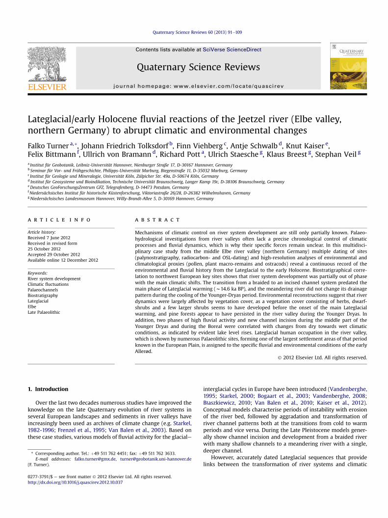
Fig. 1. A) Location map of the study area of the Jeetzel river. B)
the late Pleniglacial to early Holocene, (3) to detect changes in riverregime, periods of incision and aggradation, and (4) to analyse thecorrelation to climate and environmental change. In order to relateriver system evolution with other records and to detect responsesof river systems to climate change, reliable dating of sediments iscrucial. Therefore multidisciplinary chronological tools (radio-carbon-dating, OSL-dating, archaeological artefacts) as well asbiostratigraphical proxies (pollen analysis, ostracods, palaeo-botanical remains) and high resolution spatial analyses (drillings,archaeological survey, digital elevation models) are used to estab-lish a sound chronological framework.
This paper demonstrates how the drastic climatic changesduring the Late PleistoceneeHolocene transition affected geomor-phic processes and ecosystems e including human activities e inlowland river valleys in northern Germany.
2. Regional setting
The Jeetzel is a small, western tributary of the Elbe in thelowlands of northern Germany with a length of 73 km anda catchment of 1928 km2, covered mainly by Pleistocene glacialsediments. Originating at 61m a.s.l. in the Altmark, a till-dominatedlandscape formed during the Saalian glaciation, the Jeetzel entersthe Elbe valley near Lüchow and flows through the western fringeof this glacial valley below 20 m a.s.l. (Fig. 1). After pre-site surveysan area of 2 � 1.5 km next to the village of Grabow was chosen fora small-scale survey on river system evolution (Fig. 2). Here, thetopmost glacial fluvial sediments of the Elbe river plain are domi-nated by horizontally bedded, fine to medium sand.
The study area includes an unusually high number of archaeo-logical surface sites dating from the Late Palaeolithic to the
General geological setting of the middle Elbe river valley.
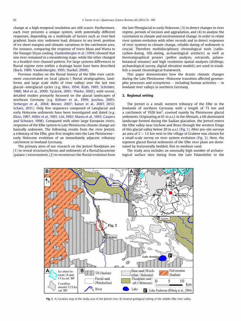
Fig. 2. Map of the Jeetzel valley east of Grabow with Lateglacial and Holocene palaeochannels, floodplain sediments and surface scatter of artefacts.
F. Turner et al. / Quaternary Science Reviews 60 (2013) 91e109 93
Neolithic (Fig. 2, Veil and Breest, 1995, 1997, 2006; Veil et al., 2012).The proven intense occupation during the Lateglacial adds anotherperspective to geoscientific research, as detailed environmentalreconstructions detect former structures defining the livingconditions of local hunter-gatherer groups. This may enhance ourunderstanding about why the Jeetzel valley was a favoured regionfor Late Palaeolithic man.
3. Methods
Geological mapping and sampling are based on 850 hand dril-lings, which were performed from 2007 to 2010. Detailed transectswere made across river palaeochannels using a semi-closed augersystem with a core diameter of 5 cm. Drilling positions weremeasured with a tachymeter or a differential-GPS to be able to link
F. Turner et al. / Quaternary Science Reviews 60 (2013) 91e10994
stratigraphical records of different sites. Cores for laboratory analy-ses were taken with a Usinger piston corer (Mingram et al., 2007)to guarantee undisturbed sampling of sequences. Carbon andnitrogen content were measured using a combined CNS-analyser(Elementar vario EL III), content of calcium carbonate was deter-mined volumetrically using the Scheibler-method. Loss-on-ignition was determined after ignition at 550 �C for 3 h. Soil pHwas analysed potentiometrically in 0.01 M CaCl2 (soil:solutionratio ¼ 1:2.5). Electrical conductivity was measured by means of anelectrode in distilled water (soil:solution ratio ¼ 1:2.5). After theremoval of organic matter, grain size analysis was performed bylaser diffraction using a laser particle sizer (Fritsch Analysette 22).
Samples for pollen analysis were prepared according to stan-dard methods described by Berglund and Ralska-Jasiewiczowa(1986). Lycopodium spores were added to determine the pollendensity (Stockmar, 1971). Principally, identification and taxonomyfollow Beug (2004). At least 500 pollen grains of terrestrial plantswere counted for each sample and percentages were calculated inrelation to the sum of terrestrial pollen, excluding Poaceae,Cyperaceae and herbs of wet habitats (according to De Klerk,2002, 2004). The resulting diagrams were divided into sitepollen zones (SPZ). Zonation and correlation of pollen diagramsare based on the detection of common trends in the arboreal (AP)/non-arboreal pollen (NAP)-ratio and percentages of taxa that areassumed to be synchronous. Division into biostratigraphical zoneswas done according to other well-documented Lateglacial pollenrecords of northern Germany (e.g. Usinger, 1985; Merkt andMüller, 1999; De Klerk, 2002, 2008). In addition, several radio-carbon dates were used to cross-check the biostratigraphicalcorrelations.
Material for ostracod analysis was continuously sampled in 2 cmintervals from cores “W IV” (Fig. 2, no. 4), and “WVIII” (Fig. 2, no. 7).Sample sizes varied between 1.2 and 8.9 g. The organic rich sampleswere leached in hot KOH (5%) or NaOH (5%) for 30 min and wet-sieved through a 200 mm sieve. Subsequently, the residue wasfreeze-dried, sorted and enumerated for ostracod valves undera dissecting microscope. If ostracods were abundant, only the first300 valves were counted. All samples were standardised to 10 g drysample weight. Identification, taxonomy and ecological interpre-tation followed Meisch (2000). In order to reconstruct past watertemperature changes, we applied an ostracod transfer functioncalibrated from modern lake localities in northeast Germany(Viehberg, 2006).
OSL-dating was applied to quartz minerals with grain sizes of150e200 mm that had been separated by dry sieving. HCl (10%),H2O2 (10%) and Na2C2O4 (0.01%) were used to remove organicmatter, carbonates and clay. Subsequently, quartz minerals wereextracted by heavy liquid separation 2.58e2.68 g/cm3 and etchedwith HF (40%) for 45 min. The determination of the equivalentdose (DE) was performed on samples fixed on stainless steeldiscs by silicon oil using a Risø TL/OSL DA 15 reader running
Table 1AMS-radiocarbon dates from the Jeetzel valley near the village of Grabow. Calibration w
Lab. No. Site Depth (cm) Dated material d13C (&
KIA 26,439 Excavation site ca 50 Bone �25.0KIA 35,664 Excavation site ca 50 Bone �25.6KIA 41,861 Excavation site ca 60 Bone �23.8KIA 41,862 Excavation site ca 60 Charcoal, Betula �27.7KIA 41,864 W VI (Fig. 2, no. 4) 373 Wood �24.0KIA 41,863 W VI (Fig. 2, no. 4) 185 Wood �29.4KIA 35,106 W IV (Fig. 2, no. 2) 246 Wood �28.3KIA 35,107 W IV (Fig. 2, no. 2) 178 Plant detritus �27.6KIA 35,108 W IV (Fig. 2, no. 2) 65 Wood �26.52KIA 35,103 W II (Fig. 2, no. 3) 171 Wood �25.58
a SAR-protocol (Murray and Wintle, 2000). The dose rate (D0)was calculated based on Neutron Activation Analysis of uranium,thorium and potassium content. Mean water content was assumedto be 12% in the sands and 18% in organic sediments.
Radiocarbon dating of organic material from cores and ofcharcoal/bones from the excavation area was conducted by theLeibniz-Laboratory for Radiometric Dating and Isotope Research inKiel. The ages were subsequently calibrated using OxCal 4.1 (BronkRamsey, 2009) and the IntCal09-calibration curve (Reimer et al.,2009) (Table 1).
Reconstructions of river system development are based onparallelisation of lithostratigraphic units and boundaries, radio-carbon- and OSL-dates, plus biostratigraphical correlations. Mainlydetailed palynological analyses of eight sequences and more than80 additional samples from the base of palaeochannel fills andfloodplain sediments were used (Fig. 2).
4. Results
4.1. Geological mapping
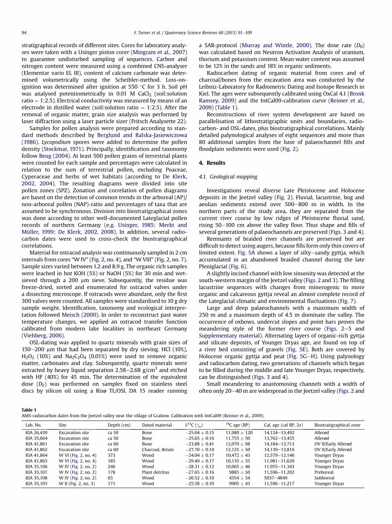
Investigations reveal diverse Late Pleistocene and Holocenedeposits in the Jeetzel valley (Fig. 2). Fluvial, lacustrine, bog andaeolian sediments extend over 500e800 m in width. In thenorthern parts of the study area, they are separated from thecurrent river course by low ridges of Pleistocene fluvial sand,rising 50e100 cm above the valley floor. Thus shape and fills ofseveral generations of palaeochannels are preserved (Figs. 3 and 4).
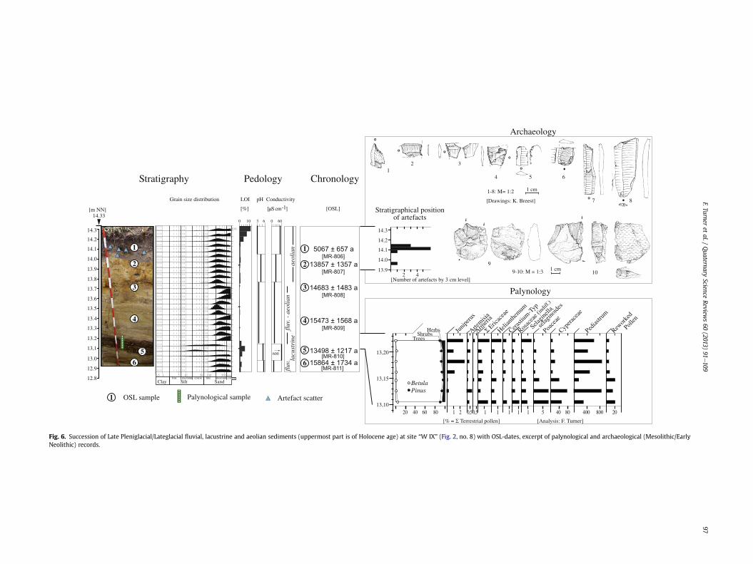
Remnants of braided river channels are preserved but aredifficult to detect using augers, because fills form only thin covers oflimited extent. Fig. 5A shows a layer of siltyesandy gyttja, whichaccumulated in an abandoned braided channel during the latePleniglacial (Fig. 6).
A slightly incised channel with low sinuosity was detected at thesouth-westernmargin of the Jeetzel valley (Figs. 2 and 3). The fillinglacustrine sequences with changes from minerogenic to moreorganic and calcareous gyttja reveal an almost complete record ofthe Lateglacial climatic and environmental fluctuations (Fig. 7).
Large and deep palaeochannels with a maximum width of250 m and a maximum depth of 4.5 m dominate the valley. Theoccurrence of oxbows, undercut slopes and point bars proves themeandering style of the former river course (Figs. 2e5 andSupplementary material). Alternating layers of organic-rich gyttjaand silicate deposits, of Younger Dryas age, are found on top ofa river bed consisting of gravels (Fig. 5E). Both are covered byHolocene organic gyttja and peat (Fig. 5GeH). Using palynologyand radiocarbon dating, two generations of channels which beganto be filled during the middle and late Younger Dryas, respectively,can be distinguished (Figs. 3 and 4).
Small meandering to anastomosing channels with a width ofoften only 20e40m arewidespread in the Jeetzel valley (Figs. 2 and
ith IntCal09 (Reimer et al., 2009).
) 14C age (BP) Cal. age (cal BP, 2s) Biostratigraphical zone
4 � 0.15 11,980 � 120 14,124e13,492 Allerød5 � 0.16 11,755 � 50 13,762e13,435 Allerød8 � 0.41 12,070 � 98 14,184e13,713 OV II/Early Allerød0 � 0.10 12,125 � 50 14,139e13,816 OV II/Early Allerød4 � 0.17 10,472 � 43 12,579e12,146 Younger Dryas9 � 0.17 10,135 � 35 11,981e11,620 Younger Dryas1 � 0.12 10,065 � 46 11,955e11,343 Younger Dryas5 � 0.16 9885 � 50 11,596e11,202 Preboreal� 0.10 4354 � 34 5037e4849 Subboreal� 0.10 9905 � 43 11,596e11,217 Younger Dryas
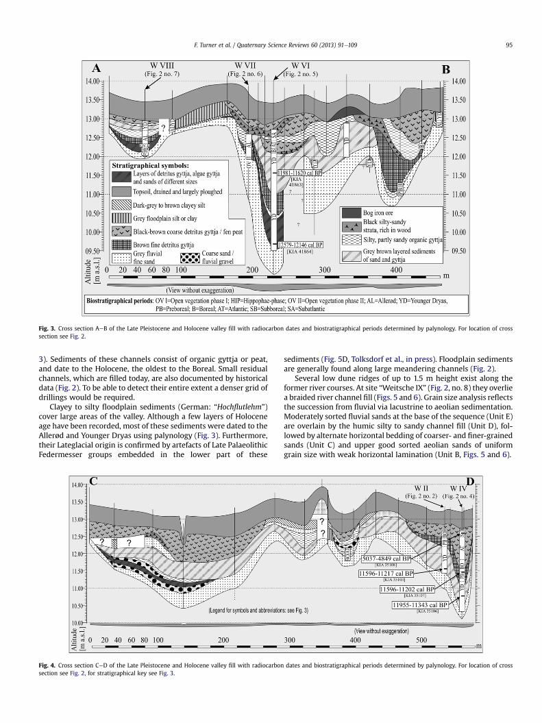
Fig. 3. Cross section AeB of the Late Pleistocene and Holocene valley fill with radiocarbon dates and biostratigraphical periods determined by palynology. For location of crosssection see Fig. 2.
F. Turner et al. / Quaternary Science Reviews 60 (2013) 91e109 95
3). Sediments of these channels consist of organic gyttja or peat,and date to the Holocene, the oldest to the Boreal. Small residualchannels, which are filled today, are also documented by historicaldata (Fig. 2). To be able to detect their entire extent a denser grid ofdrillings would be required.
Clayey to silty floodplain sediments (German: “Hochflutlehm”)cover large areas of the valley. Although a few layers of Holoceneage have been recorded, most of these sediments were dated to theAllerød and Younger Dryas using palynology (Fig. 3). Furthermore,their Lateglacial origin is confirmed by artefacts of Late PalaeolithicFedermesser groups embedded in the lower part of these
Fig. 4. Cross section CeD of the Late Pleistocene and Holocene valley fill with radiocarbonsection see Fig. 2, for stratigraphical key see Fig. 3.
sediments (Fig. 5D, Tolksdorf et al., in press). Floodplain sedimentsare generally found along large meandering channels (Fig. 2).
Several low dune ridges of up to 1.5 m height exist along theformer river courses. At site “Weitsche IX” (Fig. 2, no. 8) they overliea braided river channel fill (Figs. 5 and 6). Grain size analysis reflectsthe succession from fluvial via lacustrine to aeolian sedimentation.Moderately sorted fluvial sands at the base of the sequence (Unit E)are overlain by the humic silty to sandy channel fill (Unit D), fol-lowed by alternate horizontal bedding of coarser- and finer-grainedsands (Unit C) and upper good sorted aeolian sands of uniformgrain size with weak horizontal lamination (Unit B, Figs. 5 and 6).
dates and biostratigraphical periods determined by palynology. For location of cross
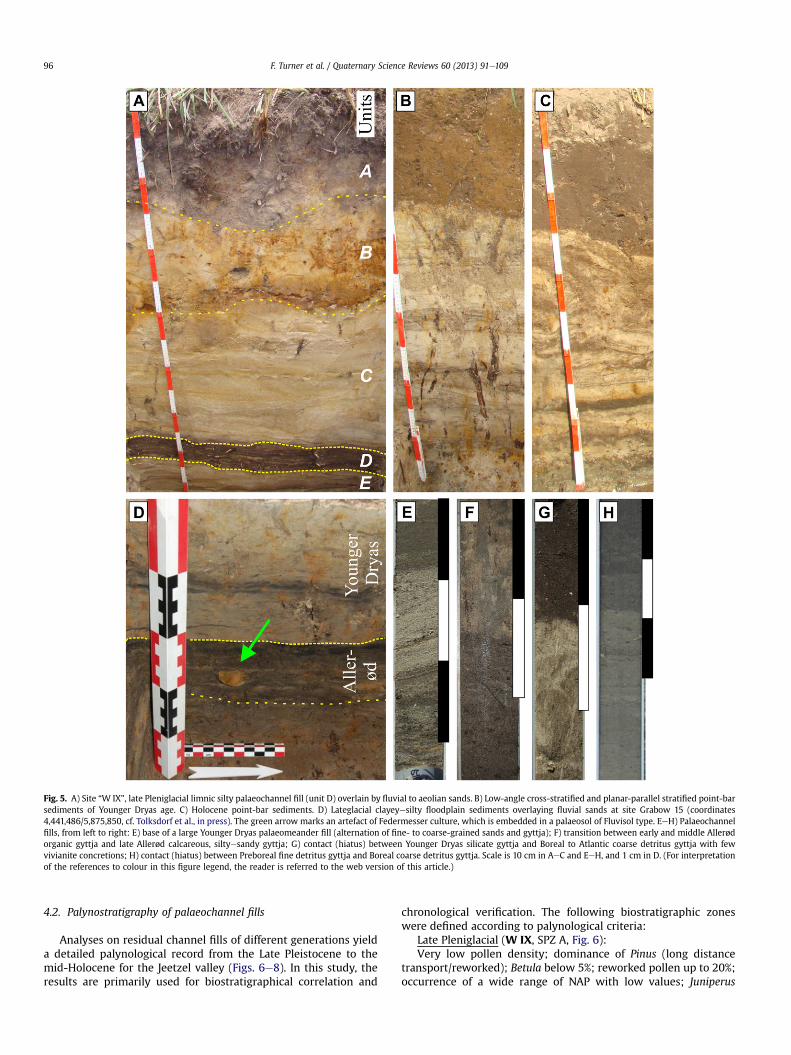
Fig. 5. A) Site “W IX”, late Pleniglacial limnic silty palaeochannel fill (unit D) overlain by fluvial to aeolian sands. B) Low-angle cross-stratified and planar-parallel stratified point-barsediments of Younger Dryas age. C) Holocene point-bar sediments. D) Lateglacial clayeyesilty floodplain sediments overlaying fluvial sands at site Grabow 15 (coordinates4,441,486/5,875,850, cf. Tolksdorf et al., in press). The green arrow marks an artefact of Federmesser culture, which is embedded in a palaeosol of Fluvisol type. EeH) Palaeochannelfills, from left to right: E) base of a large Younger Dryas palaeomeander fill (alternation of fine- to coarse-grained sands and gyttja); F) transition between early and middle Allerødorganic gyttja and late Allerød calcareous, siltyesandy gyttja; G) contact (hiatus) between Younger Dryas silicate gyttja and Boreal to Atlantic coarse detritus gyttja with fewvivianite concretions; H) contact (hiatus) between Preboreal fine detritus gyttja and Boreal coarse detritus gyttja. Scale is 10 cm in AeC and EeH, and 1 cm in D. (For interpretationof the references to colour in this figure legend, the reader is referred to the web version of this article.)
F. Turner et al. / Quaternary Science Reviews 60 (2013) 91e10996
4.2. Palynostratigraphy of palaeochannel fills
Analyses on residual channel fills of different generations yielda detailed palynological record from the Late Pleistocene to themid-Holocene for the Jeetzel valley (Figs. 6e8). In this study, theresults are primarily used for biostratigraphical correlation and
chronological verification. The following biostratigraphic zoneswere defined according to palynological criteria:
Late Pleniglacial (W IX, SPZ A, Fig. 6):Very low pollen density; dominance of Pinus (long distance
transport/reworked); Betula below 5%; reworked pollen up to 20%;occurrence of a wide range of NAP with low values; Juniperus
0 10 0 603 6
600 13498 ± 1217 a [MR-810] 15864 ± 1734 a
[MR-811]
15473 ± 1568 a [MR-809]
14683 ± 1483 a [MR-808]
13857 ± 1357 a [MR-807]
5067 ± 657 a [MR-806]
14.3
14.2
14.1
14.0
13.92 4
[Analysis: F. Turner]
OSL sample Artefact scatterPalynological sample
[m NN]14.33
14.2
14.3
14.1
14.0
13.9
13.8
13.7
13.6
13.5
13.3
13.2
13.0
13,1
13.4
12.9
12.8
1-8: M= 1:2
12 3
54
7 8
9
6
10
[% = Σ Terrestrial pollen]
20 40 60 80 1 1 1 1 1 1 5 40 80 400 800 202 0,50,5
13,20
13,15
13,10
BetulaPinus
TreesShrubs
Herbs Junip
erus
Artemisi
a
Armeri
a
Helian
themum
Cerasti
um-T
yp
Rosac
eae (
indiff
.)
Selagin
ella
se
lagino
ides
Poace
aeCyp
erace
aePed
iastru
m
Rewor
ked
P
ollen
Σ Eric
acea
e
9-10: M = 1:3
1 cm
[Drawings: K. Breest]
1 cm
nailoeaenirtsucal
fluv
.fl
uv. -
aeo
lian
Stratigraphy Pedology
LOI pH Conductivity
[%]
Grain size distribution
[µS cm-1] [OSL]
Chronology
1
1
2
3
4
6
5
1
2
3
4
5
6
Archaeology
Palynology
[Number of artefacts by 3 cm level]
Stratigraphical position of artefacts
Clay Silt Sand
0,5 1 5 10 50 100 500 µmfine medium mediumcoarse coarsefine
10%
Fig. 6. Succession of Late Pleniglacial/Lateglacial fluvial, lacustrine and aeolian sediments (uppermost part is of Holocene age) at site “W IX” (Fig. 2, no. 8) with OSL-dates, excerpt of palynological and archaeological (Mesolithic/EarlyNeolithic) records.
F.Turneret
al./Quaternary
ScienceReview
s60
(2013)91
e109
97

Fig. 7. Lithology, sedimentological data and selected pollen spectra of core “W VIII” (Fig. 2, no. 7). Relative pollen values are presented as percentages (solid black curves) and a 10-times exaggeration (grey shading).
F. Turner et al. / Quaternary Science Reviews 60 (2013) 91e10998
increases from 0 to 2%; Ericaceae,Helianthemum and Selaginella risemoderately; Poaceae and Cyperaceae decrease to 1% and 10%,respectively.
Upper transition (to next zone): distinct increase in Artemisia,pollen-containing sediments from the Jeetzel valley covering thisperiod are not known yet.
Fig. 8. Lithology, sedimentological data, selected pollen spectra and ost
Open vegetation phase I (W VIII, SPZ A, this period is repre-sented in only two samples, Fig. 7):
Very low pollen density; Pinus decreases from values of 60% to40%; Betula rises from 10% to 30%; Helianthemum with high valuesaround 5%; high percentages of reworked pollen; high values ofNAP (20%); Poaceae up to 45%.
racod inferred temperature estimates of core “W IV” (Fig. 2, no. 4).

F. Turner et al. / Quaternary Science Reviews 60 (2013) 91e109 99
Upper transition: decrease of Helianthemum, NAP and values ofreworked pollen; increase of Betula, Juniperus, Poaceae and thepollen density.
Hippophae-phase (W VIII, SPZ B):Slightly increased pollen density; occurrence of Hippophae;
Betula with rising but fluctuating values up to 40%; high values ofSelaginella and Poaceae (up to 50%); maximum of Juniperus duringsecond half of this phase.
Upper transition: Betula decreases to percentages below 20%;distinct increase of Helianthemum; strongly increased values ofPoaeceae and Cyperaceae; values of Hippophae decrease to zero.
Open vegetation phase II (W VIII, SPZ C):Maximum of Helianthemum, Achillea-type, Pinus and reworked
pollen; overall maximum of Poaceae and Cyperaceae; occurrence ofArmeria and cf. Dryas; distinct minimum of Betula.
Upper transition: decreasing values of Pinus (to 20e30%), NAP,Poaceae and Cyperaceae; distinct increase in Betula, Juniperus, Salixand Apiaceae; recurrence of Hippophae.
Allerød (W VIII, SPZ D):First subzone (W VIII, SPZ D1): Betulawith percentages of more
than 40%; rising values of Salix and Apiaceae; decrease in Heli-anthemum, Achillea-type and other NAP; Artemisia and Thalictrumremain with high values; first Allerød maximum of Juniperus.Moreover SPZ D1 is characterised by a strong increase in thesediments’ organic content. Zone SPZ D1 of core “W VIII” is furtherdivided into SPZ D1a (Allerød a) with higher percentages of Juni-perus, Hippophae, Selaginella and SPZ D1b (Allerød b) with highervalues of Artemisia and Helianthemum as well as slightly increasingvalues of Pinus, Filipendula and a distinct Juniperus- and Hippophae-minimum.
Upper transition: strong increase in Pinus, Filipendula;decreasing percentages of Artemisia, Thalictrum, Poaceae and totalNAP; disappearance of Helianthemum.
Second subzone (Allerød c, W VIII, SPZ D2): lower values ofshrubs and herbs after a second Allerød maximum of Juniperus,high values of cf. Populus and Poaceae at the beginning; Pinus withrising percentages up to 60%; high values of Filipendula; gaps in theoccurrence of Helianthemum and Selaginella.
Upper transition: decrease in Betula and Filipendula; recurrenceof Helianthemum; increasing percentages of reworked pollen.
Younger Dryas (W VIII, SPZ D; W IV, SPZ A):First subzone (W VIII, SPZ D1): dominance of Pinus; Betulawith
a decrease to values below 20%; higher values of reworked pollen;frequent occurrence of Helianthemum.
Upper transition: increase of NAP; most notably Empetrum andArtemisia.
Second subzone (W VIII, SPZ D2; W IV, SPZ A, Fig. 8): Overallmaximum of Empetrum (5%); maximum of herbs and Poaceae; bothcores show increases in organic content and pollen density towardsthe end of this zone.
Upper transition: Increase of Betula, Filipendula and pollenconcentration; decrease of Pinus and Poaceae.
Preboreal (W IV, SPZ B):
Table 2Optically stimulated luminescence (OSL) dates from the Jeetzel valley near the village of
Lab. No. Sample Depth[cm]
U [ppm] Th [ppm] K [ppm] H2O measured[% dry weight]
H[%
MR-806 WEI1-1 20 0.52 � 0.06 1.2 � 0.06 0.65 � 0.03 8.4 12MR-807 WEI1-2 40 0.49 � 0.06 1.5 � 0.08 0.70 � 0.03 6.2 12MR-808 WEI1-3 60 0.21 � 0.04 0.9 � 0.05 0.54 � 0.02 1.6 12MR-809 WEI1-4 95 0.44 � 0.06 1.6 � 0.08 0.68 � 0.03 4.7 12MR-810 WEI1-5 125 1.49 � 0.12 5.7 � 0.25 1.26 � 0.05 20.5 18MR-811 WEI1-6 140 0.34 � 0.04 0.9 � 0.05 0.54 � 0.02 7.5 12
Dominance of Betula; maximum of Filipendula; a maximum ofNAP followed by decreasing values.
Upper transition: increase in Pinus and Corylus; decrease ofBetula; disappearance of Helianthemum, Juniperus, Empetrum andother herbs; frequent occurrence of elements of mixed deciduousforest (Ulmus, Tilia and Quercus); sediments from the late Prebor-eal/early Boreal are missing.
Boreal (W IV, SPZ C, sediments represent only the second part ofthis biozone):
Dominance of Pinus; Corylus around 5%; Ulmus and Quercuswithslightly increasing values; Alnus increasing up to 15%.
Upper transition: elements of mixed deciduous forest and Alnuswith a major increase.
4.3. Radiocarbon- and OSL-dating
Ten radiocarbon dates from floodplain sediments and twodifferent generations of palaeochannels complement bio-stratigraphical interpretations and help to establish a chronologyfor the river system development (Table 1). The base of a largemeandering channel in the southern part of the investigated areawas dated to 12,579e12,146 cal BP (Fig. 3), and the base of anotherlarge channel in the central part to 11,955e11,343 cal BP (Fig. 4).Therefore the abandonment of large meandering river channelsoccurred between 12,500 and 11,500 cal. BP. Two dates fromarchaeological artefacts embedded in the basal part of the flood-plain loams, representing a palaeosol of Fluvisol type (Tolksdorfet al., in press), assign the beginning of floodplain sedimentationto approx. 14,200e13,800 cal BP (Table 2, Fig. 10).
OSL-dates of aeolian sands, fluvio-aeolian sands and underlyingfluvial sands indicate a reduction of sediment aggradation ina braided system around 16,000 years BP, followed by a phase ofmainly aeolian activity until 14,000 years BP, which in palynologicalterms is from the late Pleniglacial to the early Allerød (see Section5.1). Furthermore, a mid-Holocene reactivation of aeolian sedi-mentation can be seen (Table 2, Fig. 6).
4.4. Ostracod succession
Twenty-two different freshwater ostracod species were identi-fied from sediment cores “W VIII” and “W IV” (Table 3). Ostracodshells were found in core “W IV” at depths from 216 to 158 cm, insediments of Preboreal and Boreal age. The fauna is dominated byCandona candida, Candona neglecta, Cypridopsis vidua and Limno-cythere inopinata. The accompanied juvenile record suggestsautochthonous populations for each of these species. The fauna andlow percentage of broken valves suggest stagnant and slowlyflowing aquatic habitats. Finds of Metacypris and Potamocyprisindicate the presence of submerged vegetation. Herpetocypris andNotodromas are characteristic of a shallow aquatic environment atthe core site.
In order to reconstruct spring and summer water temperatures,two groups of Ostracod species were chosen. Cold stenothermal
Grabow.
2O (assumed mean)dry weight]
Grain sizefraction used
D0 [Gy/ka] DE [Gy] Age [a]
175 � 25 0.88 � 0.14 4443 � 0.44 5067 � 657175 � 25 0.88 � 0.09 12,163 � 0.31 13,857 � 1357175 � 25 0.73 � 0.08 10,693 � 0.38 14,683 � 1483175 � 25 0.85 � 0.09 13,130 � 0.45 15,473 � 1568175 � 25 1.34 � 0.12 18,125 � 0.31 13,498 � 1217175 � 25 0.73 � 0.09 11,514 � 0.65 15,864 � 1734
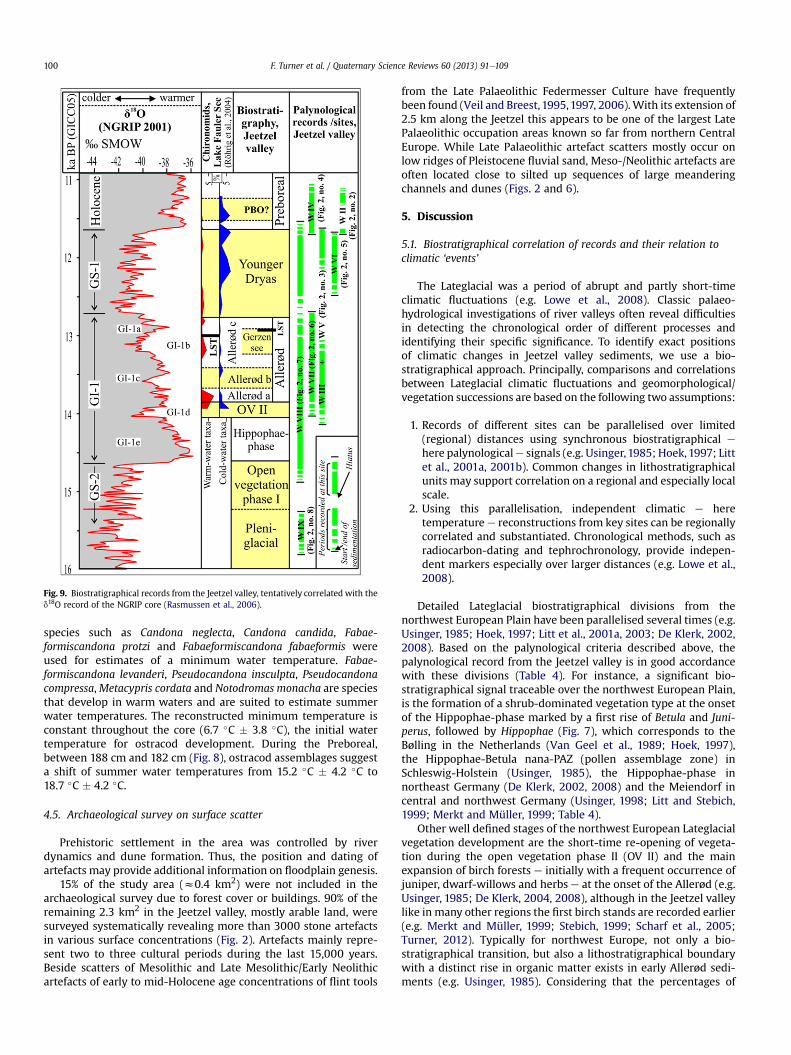
Fig. 9. Biostratigraphical records from the Jeetzel valley, tentatively correlated with thed18O record of the NGRIP core (Rasmussen et al., 2006).
F. Turner et al. / Quaternary Science Reviews 60 (2013) 91e109100
species such as Candona neglecta, Candona candida, Fabae-formiscandona protzi and Fabaeformiscandona fabaeformis wereused for estimates of a minimum water temperature. Fabae-formiscandona levanderi, Pseudocandona insculpta, Pseudocandonacompressa,Metacypris cordata and Notodromas monacha are speciesthat develop in warm waters and are suited to estimate summerwater temperatures. The reconstructed minimum temperature isconstant throughout the core (6.7 �C � 3.8 �C), the initial watertemperature for ostracod development. During the Preboreal,between 188 cm and 182 cm (Fig. 8), ostracod assemblages suggesta shift of summer water temperatures from 15.2 �C � 4.2 �C to18.7 �C � 4.2 �C.
4.5. Archaeological survey on surface scatter
Prehistoric settlement in the area was controlled by riverdynamics and dune formation. Thus, the position and dating ofartefacts may provide additional information on floodplain genesis.
15% of the study area (z0.4 km2) were not included in thearchaeological survey due to forest cover or buildings. 90% of theremaining 2.3 km2 in the Jeetzel valley, mostly arable land, weresurveyed systematically revealing more than 3000 stone artefactsin various surface concentrations (Fig. 2). Artefacts mainly repre-sent two to three cultural periods during the last 15,000 years.Beside scatters of Mesolithic and Late Mesolithic/Early Neolithicartefacts of early to mid-Holocene age concentrations of flint tools
from the Late Palaeolithic Federmesser Culture have frequentlybeen found (Veil and Breest,1995,1997, 2006).With its extension of2.5 km along the Jeetzel this appears to be one of the largest LatePalaeolithic occupation areas known so far from northern CentralEurope. While Late Palaeolithic artefact scatters mostly occur onlow ridges of Pleistocene fluvial sand, Meso-/Neolithic artefacts areoften located close to silted up sequences of large meanderingchannels and dunes (Figs. 2 and 6).
5. Discussion
5.1. Biostratigraphical correlation of records and their relation toclimatic ‘events’
The Lateglacial was a period of abrupt and partly short-timeclimatic fluctuations (e.g. Lowe et al., 2008). Classic palaeo-hydrological investigations of river valleys often reveal difficultiesin detecting the chronological order of different processes andidentifying their specific significance. To identify exact positionsof climatic changes in Jeetzel valley sediments, we use a bio-stratigraphical approach. Principally, comparisons and correlationsbetween Lateglacial climatic fluctuations and geomorphological/vegetation successions are based on the following two assumptions:
1. Records of different sites can be parallelised over limited(regional) distances using synchronous biostratigraphical e
here palynologicale signals (e.g. Usinger,1985; Hoek,1997; Littet al., 2001a, 2001b). Common changes in lithostratigraphicalunits may support correlation on a regional and especially localscale.
2. Using this parallelisation, independent climatic e heretemperature e reconstructions from key sites can be regionallycorrelated and substantiated. Chronological methods, such asradiocarbon-dating and tephrochronology, provide indepen-dent markers especially over larger distances (e.g. Lowe et al.,2008).
Detailed Lateglacial biostratigraphical divisions from thenorthwest European Plain have been parallelised several times (e.g.Usinger, 1985; Hoek, 1997; Litt et al., 2001a, 2003; De Klerk, 2002,2008). Based on the palynological criteria described above, thepalynological record from the Jeetzel valley is in good accordancewith these divisions (Table 4). For instance, a significant bio-stratigraphical signal traceable over the northwest European Plain,is the formation of a shrub-dominated vegetation type at the onsetof the Hippophae-phase marked by a first rise of Betula and Juni-perus, followed by Hippophae (Fig. 7), which corresponds to theBølling in the Netherlands (Van Geel et al., 1989; Hoek, 1997),the Hippophae-Betula nana-PAZ (pollen assemblage zone) inSchleswig-Holstein (Usinger, 1985), the Hippophae-phase innortheast Germany (De Klerk, 2002, 2008) and the Meiendorf incentral and northwest Germany (Usinger, 1998; Litt and Stebich,1999; Merkt and Müller, 1999; Table 4).
Other well defined stages of the northwest European Lateglacialvegetation development are the short-time re-opening of vegeta-tion during the open vegetation phase II (OV II) and the mainexpansion of birch forests e initially with a frequent occurrence ofjuniper, dwarf-willows and herbs e at the onset of the Allerød (e.g.Usinger, 1985; De Klerk, 2004, 2008), although in the Jeetzel valleylike in many other regions the first birch stands are recorded earlier(e.g. Merkt and Müller, 1999; Stebich, 1999; Scharf et al., 2005;Turner, 2012). Typically for northwest Europe, not only a bio-stratigraphical transition, but also a lithostratigraphical boundarywith a distinct rise in organic matter exists in early Allerød sedi-ments (e.g. Usinger, 1985). Considering that the percentages of
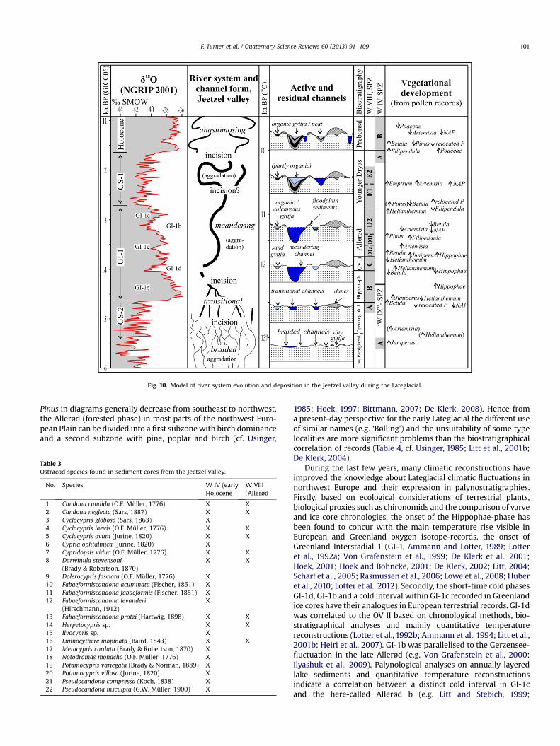
Fig. 10. Model of river system evolution and deposition in the Jeetzel valley during the Lateglacial.
F. Turner et al. / Quaternary Science Reviews 60 (2013) 91e109 101
Pinus in diagrams generally decrease from southeast to northwest,the Allerød (forested phase) in most parts of the northwest Euro-pean Plain can be divided into a first subzonewith birch dominanceand a second subzone with pine, poplar and birch (cf. Usinger,
Table 3Ostracod species found in sediment cores from the Jeetzel valley.
No. Species W IV (earlyHolocene)
W VIII(Allerød)
1 Candona candida (O.F. Müller, 1776) X X2 Candona neglecta (Sars, 1887) X X3 Cyclocypris globosa (Sars, 1863) X4 Cyclocypris laevis (O.F. Müller, 1776) X X5 Cyclocypris ovum (Jurine, 1820) X X6 Cypria ophtalmica (Jurine, 1820) X7 Cypridopsis vidua (O.F. Müller, 1776) X X8 Darwinula stevensoni
(Brady & Robertson, 1870)X X
9 Dolerocypris fasciata (O.F. Müller, 1776) X10 Fabaeformiscandona acuminata (Fischer, 1851) X11 Fabaeformiscandona fabaeformis (Fischer, 1851) X12 Fabaeformiscandona levanderi
(Hirschmann, 1912)X
13 Fabaeformiscandona protzi (Hartwig, 1898) X X14 Herpetocypris sp. X X15 Ilyocypris sp. X16 Limnocythere inopinata (Baird, 1843) X X17 Metacypris cordata (Brady & Robertson, 1870) X18 Notodromas monacha (O.F. Müller, 1776) X19 Potamocypris variegata (Brady & Norman, 1889) X20 Potamocypris villosa (Jurine, 1820) X21 Pseudocandona compressa (Koch, 1838) X22 Pseudocandona insculpta (G.W. Müller, 1900) X
1985; Hoek, 1997; Bittmann, 2007; De Klerk, 2008). Hence froma present-day perspective for the early Lateglacial the different useof similar names (e.g. ‘Bølling’) and the unsuitability of some typelocalities are more significant problems than the biostratigraphicalcorrelation of records (Table 4, cf. Usinger, 1985; Litt et al., 2001b;De Klerk, 2004).
During the last few years, many climatic reconstructions haveimproved the knowledge about Lateglacial climatic fluctuations innorthwest Europe and their expression in palynostratigraphies.Firstly, based on ecological considerations of terrestrial plants,biological proxies such as chironomids and the comparison of varveand ice core chronologies, the onset of the Hippophae-phase hasbeen found to concur with the main temperature rise visible inEuropean and Greenland oxygen isotope-records, the onset ofGreenland Interstadial 1 (GI-1, Ammann and Lotter, 1989; Lotteret al., 1992a; Von Grafenstein et al., 1999; De Klerk et al., 2001;Hoek, 2001; Hoek and Bohncke, 2001; De Klerk, 2002; Litt, 2004;Scharf et al., 2005; Rasmussen et al., 2006; Lowe et al., 2008; Huberet al., 2010; Lotter et al., 2012). Secondly, the short-time cold phasesGI-1d, GI-1b and a cold interval within GI-1c recorded in Greenlandice cores have their analogues in European terrestrial records. GI-1dwas correlated to the OV II based on chronological methods, bio-stratigraphical analyses and mainly quantitative temperaturereconstructions (Lotter et al., 1992b; Ammann et al., 1994; Litt et al.,2001b; Heiri et al., 2007). GI-1b was parallelised to the Gerzensee-fluctuation in the late Allerød (e.g. Von Grafenstein et al., 2000;Ilyashuk et al., 2009). Palynological analyses on annually layeredlake sediments and quantitative temperature reconstructionsindicate a correlation between a distinct cold interval in GI-1cand the here-called Allerød b (e.g. Litt and Stebich, 1999;

Table 4Proposed parallelisation of biostratigraphical zones in cores of the Jeetzel valley, with common biostratigraphical divisions of theWeichselian Lateglacial in north-western andcentral Europe. Parallelisation of ice-core and radiocarbon years is tentative and has to be interpreted carefully because of still uncertain calibrations of radiocarbon dates,especially for the early Lateglacial (Reimer et al., 2009).
F. Turner et al. / Quaternary Science Reviews 60 (2013) 91e109102
Von Grafenstein et al., 1999; Brauer et al., 2000; Hoek and Bohncke,2001; Zicheng and Eicher, 2001; Litt, 2004; Lang et al., 2010).
The Younger Dryas cooling (zGS-1) is clearly visible in allrecords around the Northern Atlantic (e.g. Lowe et al., 2008). In theJeetzel valley e like in many other northwest European records e
the boundary Allerød-Younger Dryas is represented by a sharpdecrease in carbonate and organic content within the sediments(e.g. Mayle et al., 1999; Kaiser, 2004a), and by a decrease of Betulawith an increase of Helianthemum and reworked pollen in thepollen record, representing the beginning opening of forests andassociated erosion of soils (Fig. 7). The Younger Dryas can bedivided biostratigraphically into two subzones, with a majorincrease of NAP and especially Ericaceae (Empetrum) in the secondsubzone. This is consistent with the expression of the YD in theNetherlands (e.g. Hoek, 1997).
Overall, a clear correlation between vegetation phases in theJeetzel valley and the Lateglacial climatic development representedby the Greenland oxygen isotope shift can be established based onbiostratigraphical parallelisation, the correlation of independentclimatic reconstructions and the control of chronological methods(Fig. 9). Correlations are corroborated by a local chironomid recordfrom the adjacent lake Fauler See (cf. Fig. 1), with maxima of coldwater chironomid taxa occurring during OV II, Allerød b and theYounger Dryas (Fig. 9; Röhrig et al., 2004).
Using the biostratigraphical records from palaeochannel fills atthe Jeetzel river, the local river system development can be linkedcomprehensively with climatic shifts. Moreover, based on bio-stratigraphical correlation, radiocarbon or varve chronologies fromthe Netherlands (Hoek, 1997) and northwest Germany (Litt andStebich, 1999; Merkt and Müller, 1999) may be used carefully forrough estimates of absolute ages in the Jeetzel river networkdevelopment e considering, that several problems with the
correlation of different Lateglacial chronologies and detection andspecification of possible time lags in climatic development betweenregions have not yet been solved (e.g. Blockley et al., 2004; Loweet al., 2008; Blaauw, 2012).
5.2. Late Pleniglacial to mid-Holocene development of the Jeetzelriver valley
Detailed geological mapping and multi-proxy analyses wereemployed to establish a comprehensive reconstruction of the localriver system development from the late Pleniglacial to mid-Holocene, with unique accuracy for this part of the northwestEuropean Plain (Fig. 10). Furthermore, radiocarbon- and OSL-datesin combination with the biostratigraphical evidence describedabove, allow for the first time a comparison of Lateglacial riversystem evolution in the middle Elbe river valley with well-investigated European river systems, e.g. Warta/Vistula in Polandor Rhine/Meuse in western Germany and in the Netherlands,respectively (e.g. Kozarski et al., 1988; Vandenberghe et al., 1994;Kasse et al., 1995, 2005; Starkel, 1995).
5.2.1. Late Pleniglacial braided river system and fluvio-aeoliansuccession
Although rivers in the northwest European Plain were probablycharacterised by braided discharge patterns during the lateWeichselian Pleniglacial 20e15 ka BP, detailed records of latePleniglacial fluvial activity and especially well-dated sequenceswith partly organic channel infills are still rare in northwest Europe(cf. Mol et al., 2000).
Due to its stratigraphical position, and limited local extent, itsfine-grained composition and higher organic content (LOI), as wellas the abundance of lacustrine green algae (Pediastrum) in the
F. Turner et al. / Quaternary Science Reviews 60 (2013) 91e109 103
microfossil record, we interpret a layer of humic silty sand (10e15 cm) overlying glacial fluvial sands as gyttja accumulated in anabandoned braided river channel (Unit D, Fig. 6). OSL-dates belowand above this layer suggest a late Pleniglacial sedimentationage. This is confirmed by the pollen stratigraphy showing highpercentages of pollen, which had been reworked and/or transportedover long distances. Furthermore, the palynological sequence showsa slight increase in Juniperus, which is also recorded in late Plen-iglacial sediments of eastern Germany (De Klerk et al., 2001) duringthe period predating the Artemisia-rise, representing the regionalpalynological signal for the PleniglacialeLateglacial transition or‘Oldest Dryas’ sensu Van der Hammen (Van der Hammen,1951; VanGeel et al., 1989; De Klerk, 2004). Due to indications for the glacialpersistence of Juniperus in northwest Europe (Michalczyk et al.,2010), we interpret this signal as autochthonous.
The existence and preservation of shallow ponds in abandonedchannels as well as the relative fine grain size of fluvial sedimentspoint to a, at least locally, low energy environment of the braidedsystem during the late Pleniglacial. Similar results have been ob-tained for other parts of the middle Elbe catchment as well as otherregions on the European Plain (Mol, 1995, 1997; Huisink, 2000; Molet al., 2000).
The sands overlying the silt gyttja reflect changing depositionalprocesses by alternating grain sizes, but good sortation of hori-zontal layers (Unit C, Figs. 5 and 6). Unit C with its horizontalalternation resembles a widespread facies of late Peniglacial sands,whose formation has been attributed to aeolian plus adhesionprocesses on a seasonal frozen and damp or waterlogged ground(Schwan, 1988; Vandenberghe, 1991; Kasse, 1997, 2002). However,as unit C differs from most of these records by definite coarsergrain-sizes, especially a very low amount of silt (Fig. 6), its forma-tion may rather represent the shift from fluvial to aeolian sedi-mentation typical for European river valleys during the latePleniglacial (Schwan, 1987; Vandenberghe et al., 1987; Kasse, 1997;Kasse et al., 2007). Following aeolian sedimentation of mediumsands with uniform grain size and weak horizontal lamination(Unit B) formed low dunes instead of sand sheets in the Jeetzelvalley, as proposed by Kasse (1997) for the eastern parts of theNorthwest European Plain. By their structure and OSL-dates ofw15.4, w14.7 and w13.9 ka BP, the aeolian sediments can beassigned to the ‘Older coversand II’ formation according to Van derHammen (1971); cf. (Kasse et al., 2007).
In summary, the middle Elbe-Jeetzel river network can becharacterised as low-energy sand-dominated braided river systemwith aeolian activity at the channel banks during the late Plen-iglacial (cf. Mol, 1997). The similarity of these processes in riverplains in northwest Europe in different geomorphological settingshighlights their climatic cause, the increased aridity from the LastGlacial Maximum to late Pleniglacial (Mol et al., 2000; Kasse, 2002;Kasse et al., 2003).
5.2.2. Early Lateglacial transitional phaseThe low sinuous palaeochannel at the western fringe of the
Jeetzel valleymarks the first stage of Lateglacial river system incisionduring a transitional phase from braided to meandering (Figs. 2 and3). Pollen analysis reveals that the 1.5 m deep lacustrine fill of this70e100 m wide channel includes the transition from the openvegetation phase I to the Hippophae-phase representing theformation of a shrub dominated vegetation type (Fig. 7). Using thebiostratigraphical correlation described in Section 5.1, we concludethat the first incision of the Jeetzel river predates the main Late-glacial temperature rise at w14.6e14.7 ka cal BP, as this ‘event’ isrecorded in residual channel fills. Our investigations hereby sharpenresults from the Somme basin, which also suggest that Lateglacialriver incisionwas out of phase with main climate warming (Antoine
et al., 2003; Vandenberghe, 2003). River incision during a transi-tional phase may have been a reaction to a minor increase in vege-tation cover, which initially stabilised sediments and diminished therivers’ sediment load, representing a slight climatic amelioration,perhaps in seasonality, before the general temperature rise (Wagner-Cremer and Lotter, 2011). Another related trigger may have been thethawing of permafrost (Huijzer and Vandenberghe, 1998), whichalso could explain the sink in water table of 1.5 m correlated withriver incision during this period (Turner, 2012). The interpretation offluvial dynamics being a direct response to temperature changemaytherefore be too simplistic (Vandenberghe, 1995, 2003).
The final change from the transitional phase with a few activechannels to a meandering system with only one large meandercannot be dated exactly. The onset of sedimentation of floodplain‘loams’ in the OV II around 14,000 cal BP, which is well dated byradiocarbon and pollen analyses of cores “W III” and “W V” (Fig. 9,Tolksdorf et al., in press), probably postdates this transition, asLateglacial fine-grained floodplain deposits are clearly connectedwith periodic overbank floods of a meandering system (e.g.Berendsen et al., 1995). Another indication, suggesting a concen-tration of the drainage into one channel, is the start of lacustrinesedimentation during OV II in the palaeochannel of core “W VII”,which due to later erosion is only partly preserved in the rivervalley (Figs. 3 and 9). The simultaneity in abandonment of this lastdetected transitional channel with the onset of fine-grainedfloodplain sedimentation points to the final establishment ofa single-channel system. Thus, some of the transitional channelsseem to have remained active during the Hippophae-phase witha trend towards further incision. Comparable stages of river systemdevelopment are reported from the Warta, Weser, Meuse andNiers-Rhine systems, but mostly could not be dated exactly due tothe absence of organic deposits in residual channels (Kozarski et al.,1988; Caspers, 1993; Vandenberghe et al., 1994; Bohncke et al.,1995; Kasse et al., 1995, 2005; Huisink, 1997).
5.2.3. Allerød ‘low energy’ meandering system and Federmesseroccupation
Residual channels abandoned during the Allerød or dated point-bar sediments of Allerød age were not discovered. Geologicalmapping detected only limited lateral migration and low sinuosityof large meanders. The inactivation of dunes and a change toorganic sedimentation in residual channels point towards stabil-ising conditions in the Jeetzel valley due to increased forest coverand the corresponding stabilisation of soils. The deposition of finegrained floodplain sediments indicates slowmoving and longlasting floods with periodically high discharges, which probablyoccurred during spring caused by the thaw of thick snow coversformed during the cold winters in the Lateglacial (Tolksdorf et al., inpress; cf.; Vandenberghe and Woo, 2002).
Extensive artefact concentrations of Early Federmesser groupsare dated in the early Allerød by radiocarbon and pollen analyses(Figs. 2 and 11). Multiple river-lake structures with an active largemeandering channel, periodically flooded river banks and severalshallow ‘residual channel-lakes’ of the former transitional phaseformed diverse freshwater and openwetland habitats, which in thelandscape of regrowing woodlands certainly attracted interest ofgame and consequently that of hunter-gatherer-groups (Fig. 11).The artefact concentrations known so far suggest that relatively dryridges represented centres of human occupation in the valley(Fig. 2), while at least periodic occupation of the floodplain isdocumented by an in-situ artefact concentration embedded inLateglacial floodplain sediments (site Grabow 15, Tolksdorf et al., inpress). As large areas in the valley are covered by floodplain sedi-ments, the real intensity of prehistoric occupation in these partscannot be estimated. Nevertheless, despite surveying large areas,
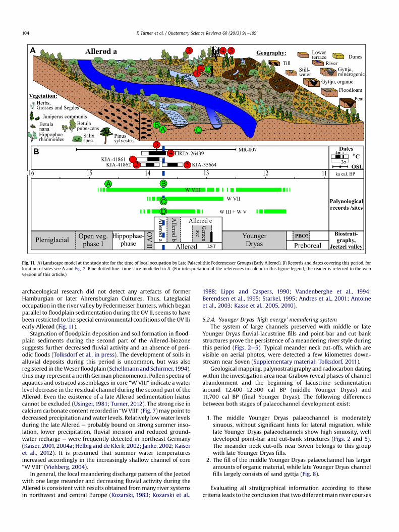
Fig. 11. A) Landscape model at the study site for the time of local occupation by Late Palaeolithic Federmesser Groups (Early Allerød). B) Records and dates covering this period, forlocation of sites see A and Fig. 2. Blue dotted line: time slice modelled in A. (For interpretation of the references to colour in this figure legend, the reader is referred to the webversion of this article.)
F. Turner et al. / Quaternary Science Reviews 60 (2013) 91e109104
archaeological research did not detect any artefacts of formerHamburgian or later Ahrensburgian Cultures. Thus, Lateglacialoccupation in the river valley by Federmesser hunters, which beganparallel to floodplain sedimentation during the OV II, seems to havebeen restricted to the special environmental conditions of the OV II/early Allerød (Fig. 11).
Stagnation of floodplain deposition and soil formation in flood-plain sediments during the second part of the Allerød-biozonesuggests further decreased fluvial activity and an absence of peri-odic floods (Tolksdorf et al., in press). The development of soils inalluvial deposits during this period is uncommon, but was alsoregistered in theWeserfloodplain (Schellmann and Schirmer,1994),thus may represent a north German phenomenon. Pollen spectra ofaquatics and ostracod assemblages in core “WVIII” indicate awaterlevel decrease in the residual channel during the second part of theAllerød. Even the existence of a late Allerød sedimentation hiatuscannot be excluded (Usinger, 1981; Turner, 2012). The strong rise incalcium carbonate content recorded in “WVIII” (Fig. 7) may point todecreased precipitation andwater levels. Relatively lowwater levelsduring the late Allerød e probably bound on strong summer inso-lation, lower precipitation, fluvial incision and reduced ground-water recharge e were frequently detected in northeast Germany(Kaiser, 2001, 2004a; Helbig and de Klerk, 2002; Janke, 2002; Kaiseret al., 2012). It is presumed that summer water temperaturesincreased accordingly in the increasingly shallow channel of core“W VIII” (Viehberg, 2004).
In general, the local meandering discharge pattern of the Jeetzelwith one large meander and decreasing fluvial activity during theAllerød is consistent with results obtained frommany river systemsin northwest and central Europe (Kozarski, 1983; Kozarski et al.,
1988; Lipps and Caspers, 1990; Vandenberghe et al., 1994;Berendsen et al., 1995; Starkel, 1995; Andres et al., 2001; Antoineet al., 2003; Kasse et al., 2005, 2010).
5.2.4. Younger Dryas ‘high energy’ meandering systemThe system of large channels preserved with middle or late
Younger Dryas fluvial-lacustrine fills and point-bar and cut bankstructures prove the persistence of a meandering river style duringthis period (Figs. 2e5). Typical meander neck cut-offs, which arevisible on aerial photos, were detected a few kilometres down-stream near Soven (Supplementary material; Tolksdorf, 2011).
Geological mapping, palynostratigraphy and radiocarbon datingwithin the investigation area near Grabow reveal phases of channelabandonment and the beginning of lacustrine sedimentationaround 12,400e12,300 cal BP (middle Younger Dryas) and11,700 cal BP (final Younger Dryas). The following differencesbetween both stages of palaeochannel development exist:
1. The middle Younger Dryas palaeochannel is moderatelysinuous, without significant hints for lateral migration, whilelate Younger Dryas palaeochannels show high sinuosity, welldeveloped point-bar and cut-bank structures (Figs. 2 and 5).The meander neck cut-offs near Soven belongs to this groupwith late Younger Dryas fills.
2. The fill of the middle Younger Dryas palaeochannel has largeramounts of organic material, while late Younger Dryas channelfills largely consists of sand gyttja (Fig. 8).
Evaluating all stratigraphical information according to thesecriteria leads to the conclusion that two differentmain river courses
F. Turner et al. / Quaternary Science Reviews 60 (2013) 91e109 105
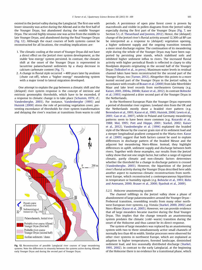
existed in the Jeetzel valley during the Lateglacial. The first onewithlower sinuosity was active during the Allerød and in the first half ofthe Younger Dryas, but abandoned during the middle YoungerDryas. The second highly sinuous onewas active from themiddle tolate Younger Dryas, and abandoned during the final Younger Dryas(Fig. 12). Although the exact courses of both systems cannot bereconstructed for all locations, the resulting implications are:
1. The climatic cooling at the onset of Younger Dryas did not havea direct effect on the Jeetzel river system development, as thestable ‘low energy’ system persisted. In contrast, the climaticshift at the onset of the Younger Dryas is represented inlacustrine palaeochannel sediments by a sharp decrease incalcium carbonate content (Fig. 7).
2. A change in fluvial style occurred w400 years later by avulsion(chute cut-off), when a “higher energy” meandering systemwith a major trend to lateral migration developed.
One attempt to explain the gap between a climatic shift and the(delayed) river system response is the concept of intrinsic andextrinsic geomorphic thresholds, which have to be exceeded, ifa response to climatic change is to take place (Schumm, 1979; cf.;Vandenberghe, 2003). For instance, Vandenberghe (1995) andHuisink (2000) stress the role of persisting vegetation cover, pre-venting exceedance of thresholds for river system transformationand delaying the river’s reaction at transitions from warm to cold
Fig. 12. Reconstruction of possible Lateglacial river courses of large meanderingsystems. Note the differences in sinuosity between the systems active during Allerød/early Younger Dryas and during the second part of Younger Dryas.
periods. A persistence of open pine forest cover is proven bymacrofossils and visible in pollen diagrams from the Jeetzel valleyespecially during the first part of the Younger Dryas (Fig. 7, seeSection 5.1, cf. Theuerkauf and Joosten, 2012). Hence, the (delayed)change of the Jeetzel river’s fluvial activity around 12,300 cal BP canbe interpreted as a response to (delayed) vegetation opening,a higher sediment supply and the ongoing transition towardsa more nival discharge regime. The continuation of its meanderingstyle during the whole of the Younger Dryas may have been sup-ported by persisting pine stands, which stabilised soils andinhibited higher sediment influx to rivers. The increased fluvialactivity with higher periodical floods is reflected in clayey to siltyfloodplain deposits originating in the second half of the YoungerDryas (Tolksdorf et al., in press). Maximumwater levels in residualchannel lakes have been reconstructed for the second part of theYounger Dryas, too (Turner, 2012). Altogether this points to a morehumid second part of the Younger Dryas in the Jeetzel valley, inaccordancewith results of Brauer et al. (2000) from lakeMeerfelderMaar and lake level records from northeastern Germany (e.g.Kaiser, 2001, 2004a, 2004b; Kaiser et al., 2012). In contrast Bohnckeet al. (1993) registered a drier second part of the Younger Dryas inthe Netherlands.
In the Northwest European Plain the Younger Dryas representsa period of dissimilar river regimes. Lowland sites from the UK andthe Netherlands mostly show a braided river pattern (e.g.Berendsen et al., 1995; Kasse et al., 1995; Huisink, 2000; Lewis et al.,2001; Gao et al., 2007), while in Poland and Germany meanderingpatterns seem to have been more common (e.g. Kozarski et al.,1988; Mol, 1995; Pott and Hüppe, 2001; Starkel, 2002; Kaiseret al., 2012). Vandenberghe et al. (1994) explained the braidedstyle of the Meuse by the coarser grain size of its sediment load anda steeper longitudinal gradient compared to the Warta river. Kasseet al. (2005) suggest that both factors cannot be used to explaindifferences in discharge pattern of the braided Meuse and theadjacent but meandering Niers-Rhine. Instead, they highlightdifferences in uplift, sediment supply and discharge between bothrivers. Together with these examples, our results from the Jeetzelvalley show that not one single factor, but rather a range of regionalclimatic, partly climatic and non-climatic factors determineswhether the threshold for a change in discharge pattern is crossed(Vandenberghe, 2003). However, the bipartition of the Jeetzelriver’s fluvial activity during the Younger Dryas described here addsanother aspect to numerous climatic reconstructions from north-west Europe, which reconstructed a contemporaneous bipartitionin temperature or humidity signals (e.g. Bohncke et al., 1993; Birksand Ammann, 2000; Brauer et al., 2000; Ilyashuk et al., 2009).
5.2.5. Holocene anastomosing systemThe channel infillings in the Jeetzel valley show a phase of
abandonment of large palaeomeanders around the Younger DryasePreboreal transition, resembling results from many other north-west European river systems, e.g. Vistula (Starkel, 2000, 2002) andNiers-Rhine (Kasse et al., 2005). However, we can provide evidencethat all large meanders became inactive during the final YoungerDryas. This implies that the change towards an anastomosingsystem predates the climatic (coldewarm) transition during theonset of the Holocene and thus cannot be its direct response.
The system of large meanders was replaced by an anastomosingsystem with two to three simultaneously active small channels ofnormally less than 40mwidth. Similar processes were observed forother river systems in northwest Europe, which are explained asadaption to higher temperatures, forested landscape, diminishedsediment load, and less seasonally distributed discharge (Starkel,1995, 2002). In contrast to the early Lateglacial, at the beginningof the Holocene there is no evidence for a transitional phase, which
F. Turner et al. / Quaternary Science Reviews 60 (2013) 91e109106
has been described by Gibbard and Lewin (2002) from the BritishIsles. Beside different preconditions in discharge regime (braidingversus meandering), vegetation cover and soil development, thelack of an early Holocene transitional phase according toVandenberghe and Woo (2002) can be explained with the absenceof intense winter frost and lower snowmelt peaks in discharge.
The anastomosing system remained relative stable during theHolocene and probably was active until it was replaced by a singlemeandering system during modern times through human impact(Fig. 2). Several channels of this system had already been aban-doned during the Boreal, probably indicating a phase of highfluvialegeomorphic activity during this period. Remarkably, duringthe late Younger Dryas/early Holocene phase of channel insion,a branch of the new system took a completely new river coursethrough a depression east of the Lateglacial floodplain by avulsion,leading to preservation of Lateglacial sediments (Fig. 2).
Lacustrine sediments, which subsequently accumulated inabandoned large meanders of the Younger Dryas, reveal a highresolution record of the late Younger Dryas and the early Holocenedue to the high sedimentation rate during this period (w3 mm/year). The PleistoceneeHolocene boundary is clearly marked by anincrease in CaCO3-content, higher pollen concentration within thesediment, gradually rising percentages of Betula pollen and higheramounts of organic matter (Fig. 8). On the one hand, a delayedclosing of the forest cover is indicated by the percentages of heli-ophilous pollen (Helianthemum, Artemisia, Empetrum) reachingamaximum in early Preboreal sediments. Hindered regeneration offorests may, on the other hand, be interpreted as a reaction to thePreboreal oscillation, a short-time, early Holocene climatic deteri-oration prevalent around the North Sea (e.g. Usinger, 2004; Boset al., 2007). A quantitative temperature reconstruction based onostracods indicates a subsequent temperature rise of 4e6 �C(Fig. 8), which during the early Preboreal was reported fromGreenland, Norway and Switzerland as well (e.g. Birks andAmmann, 2000; Kobashi et al., 2008). A widespread hiatus inlacustrine sedimentation during the late Preboreal/early Borealpoints to a significant lowering in water levels during this time,which is recorded in Polish, German and Dutch lakes, possiblyindicating a longer, dry climatic phase (e.g. Van Geel et al., 1981;Bohncke and Wijmstra, 1988; Wojciechowski, 1999; Kleinmannet al., 2000; _Zurek et al., 2002; Bos et al., 2007; Kaiser et al., 2012).
Subsequently, the wetter and more stable conditions during theHolocene are also expressed in the mainly organic lacustrinesedimentation in residual channels (Fig. 8). Nevertheless temporaryreactivation of abandoned channels associated with erosion alsotook place, as is shown, for example, by hiatuses in the palae-ochannel stratigraphy in core “W VI” (Fig. 3).
5.2.6. Jeetzel research and its relevance for middle Elbe catchmentTo what extent are the results obtained from the Jeetzel river
characteristic for the entire middle Elbe catchment? Both the Elbeand the Jeetzel show only limited lateral erosion at ‘coldewarm’
shifts during the Last Glacialeinterglacial transition, as postu-lated by the model of Vandenberghe (2008). The ‘warmecold’transition at the onset of the Younger Dryas did not lead toa major erosion phase. Accordingly, the absence of different Late-glacial and Holocene surface terrace levels is a characteristic forthe entire lower middle Elbe region. In addition, the occurrence ofresidual channels at more or less the same elevation from the latePleniglacial to the present suggests relative tectonic stability in thelower middle Elbe part of the North German Basin since the LastGlacial Maximum.
While no direct records of the PleniglacialeLateglacial riversystem evolution from the adjacent Elbe valley are known, the fewexisting records from other parts of the middle Elbe catchment are
generally comparable to those from the Jeetzel (e.g. Mol, 1995,1997; Kühner et al., 1999; Mol et al., 2000; Juschus, 2003).Juschus (2003) proves the existence of Lateglacial large meandersof the Spree river in the vicinity of the Weichselian maximum iceextent (Brandenburg ice marginal zone), which were abandonedduring the Hippophae-phase (zGI-1e), but detects small meanderswith Allerød fill. A possible explanation for the differences may bethe dead ice lakes in the course of the Spree, which acted as local‘sediment traps’ (Juschus, 2003).
A difference between the Elbe and Jeetzel rivers represents theHolocene floodplain with pronounced sedimentation of alluvialclay at the Elbe, which to this extent cannot be found at the Jeetzel.However, investigations from the middle Elbe suggest minorHolocene activity, detected only small anastomosing channelscomparable to those of the Jeetzel and dated the earliest largepalaeomeanders of a single channel system to the Medieval period(Caspers and Schwarz, 1998; Caspers, 2000). Thus the naturalHolocene channel pattern of the middle Elbe may have been a ‘low-energy-anastomosing’ systemwith small channels like those of theJeetzel river. During the last millennium a single meander channelsystem evolved, largely influenced by human impact (see Caspers,2000; Schatz, 2011).
These similarities, together with the study area’s positioninside the Elbe ice-marginal spillway (Urstromtal in German),highlight that the Jeetzel river evolution can be used as a goodmodel for only partially climate dependent river system devel-opment in the middle Elbe basin. Finally, the question ariseswhether the fluvial record described here really belongs to theJeetzel or to the Elbe floodplain? Large Lateglacial meanderscompared to present ones are recorded from other small riversystems, e.g. the Mark (Vandenberghe et al., 1987). Similardifferences in meander size are also observed for rivers from theeastern European Plain, and are explained by the mean annualdischarge having been much higher than today, with notablygreater spring floods due to nival discharge regimes (Sidorchuket al., 2001; Kasse et al., 2010). Considering these results, thedescribed meanders do not seem too large to belong to the Late-glacial Jeetzel river. However, the existence of a PleniglacialeLateglacial western ’palaeo-branch’ of the Elbe cannot be excludedwithout further research (see Fig. 1).
6. Conclusions
Geoarchives in the Jeetzel valley contain an almost completerecord of Lateglacial/Holocene fluvial and environmental changes,the first reported in detail from the middle Elbe river valley. Theenvironmental record from the Jeetzel valley can be correlatedwithexisting regional biostratigraphies and climate reconstructionsfrom NW-Europe using palynological criteria. A succession ofdifferent fluvial patterns becomes apparent, from braided tomeandering to anastomosing, with three phases of channel inci-sion, characterised by the following stages (Fig. 10):
1. Low energy braided river system with aeolian activity duringthe cold and dry conditions of the late Pleniglacial (zGS-2).
2. Transitional phase with a few active channels of low sinuosityand moderate depth during the early Lateglacial (zGI-1e).
3. Meandering system with one active large and deep meanderduring the Allerød (zGI-1ceGI-1a) and early Younger Dryas(zGs-1), a stable and moderately sinuous system replaced bya highly sinuous, laterally migrating system in the middlephase of the Younger Dryas (w12,300 years cal BP).
4. Anastomosing systemwith two to three active small meandersunder relatively stable climatic and environmental conditionsduring the Holocene.
F. Turner et al. / Quaternary Science Reviews 60 (2013) 91e109 107
Although the evolution of the Jeetzel is generally linked toclimatic changes, the following phases were detected during whichprocesses either preceded climatic shifts or occurred as a delayedresponse:
1. Delayed change to a meandering river style of several hundredyears during the early Lateglacial.
2. Incision with changes from a braided to a transitional regime,which predates the main temperature rise during the onset ofthe Lateglacial.
3. Delayed river system transformation about 400 years after theonset of the Younger Dryas, with new channel incision.
4. Incision with change to an anastomosing pattern, whichpredates the temperature rise at the onset of the Holocene.
This demonstrates the complex interactions between climatechange and fluvial development. A multitude of regional climatic,climate-derived and non-climatic factors controls river systemevolution. Based on palaeoenvironmental data our research high-lights the importance of the vegetation cover, as leads and lags influvial development can partly be explained by previous vegetationrecovering during the ‘coldewarm’ transitions and persisting vege-tation cover after ‘warmecold’ transitions. Two phases of increasedfluvial activity and new channel formation by avulsion during themiddle Younger Dryas and Boreal were correlated with the shiftsfrom dry to wet conditions noticeable through water level changes,and indicate the strong influence of changes in humidity on riversystemdevelopment. High structural diversity of the river landscapefacilitated intense human occupation during the early Allerød.
Acknowledgements
This work is part of the multidisciplinary project ‘Weitsche/Grabow’ led by Stephan Veil (Niedersächsisches LandesmuseumHannover), which was supported by the state government ofLower-Saxony during 2007e2010. The contribution of Knut Kaiserwas partly enabled by the projects ICLEA and TERENO of theHelmholtz Association. Peter Kewitsch and many students were ofgreat assistance during archaeological excavations. Several localfarmers and property owners kindly allowed us to work on theirland. We thank Reinhard Lampe, Sebastian Lorenz (both Universityof Greifswald) and Jürgen Böttcher (Leibniz Universität Hannover)to allow analyses in their laboratories. We thank Hartmut Usingerfor his great assistance and inspiration during fieldwork and Ger-fried Caspers for valuable discussions. The constructive commentsof Jef Vandenberghe and of an anonymous reviewer led to valuableimprovements to this manuscript.
Appendix A. Supplementary material
Supplementary material related to this article can be found athttp://dx.doi.org/10.1016/j.quascirev.2012.10.037.
References
Ammann, B., Lotter, A.F., 1989. Late-Glacial radiocarbon- and palynostratigraphy onthe Swiss Plateau. Boreas 18, 109e126.
Ammann, B., Lotter, A.F., Eicher, U., Gaillard, M.-J., Wohlfarth, B., Haeberli, W.,Lister, G., Maisch, M., Niessen, F., Schlüchter, C., 1994. The Würmian late-glacialin lowland Switzerland. Journal of Quaternary Science 9, 119e125.
Andres, W., Bos, J.A., Houben, P., Kalis, A.J., Nolte, S., Rittweger, H., Wunderlich, J.,2001. Environmental change and fluvial activity during the Younger Dryas incentral Germany. Quaternary International 79, 89e100.
Antoine, P., Munaut, A.-V., Limondin-Lozouet, N., Ponel, P., Duperon, J., Duperon, M.,2003. Response of the Selle River to climatic modifications during the Late-glacial and Early Holocene (Somme Basin-Northern France). Quaternary ScienceReviews 22, 2061e2076.
Berendsen, H., Hoek, W.Z., Schorn, E., 1995. Late Weichselian and Holocene riverchannel changes of the rivers Rhine and Meuse in the Netherlands. Paläokli-maforschung 14, 151e171.
Berglund, B.E., Ralska-Jasiewiczowa, M., 1986. Pollen analysis and pollen dia-gramms. In: Berglund, B.E. (Ed.), Handbook of Holocene Palaeoecology andPalaeohydrology. John Wiley & Sons, Chichester, pp. 455e484.
Beug, H.-J., 2004. Leitfaden der Pollenbestimmung für Mitteleuropa und angren-zende Gebiete. Pfeil, München.
Birks, H.H., Ammann, B., 2000. Two terrestrial records of rapid climatic changeduring the glacial-Holocene transition (14,000e9,000 calendar years B.P.) fromEurope. Proceedings of the National Academy of Sciences 97, 1390e1394.
Bittmann, F., 2007. Reconstruction of the Allerød vegetation of the Neuwied Basin,western Germany, and its surroundings at 12,900 cal B.P. Vegetation Historyand Archaeobotany 16, 139e156.
Blaauw, M., 2012. Out of tune: the dangers of aligning proxy archives. QuaternaryScience Reviews 36, 38e49.
Blockley, S.P.E., Lowe, J.J., Walker, M.J.C., Asioli, A., Trincardi, F., Coope, G.R.,Pollard, A.M., Donahue, R.E., 2004. Bayesian analysis of radiocarbon chronolo-gies: examples from the European Lateglacial. Journal of Quaternary Science 19,159e175.
Bogaart, P.W., Van Balen, R.T., Kasse, C., Vandenberghe, J., 2003. Process-basedmodelling of fluvial system response to rapid climate change II. Application tothe river Maas (The Netherlands) during the Last GlacialeInterglacial transition.Quaternary Science Reviews 22, 2097e2110.
Bohncke, S., Wijmstra, T., 1988. Reconstruction of Late-Glacial lake level fluctuationsin The Netherlands based on palaeohotanical analyses, geochemical results andpollen-density data. Boreas 17, 403e425.
Bohncke, S., Vandenberghe, J., Huijzer, A.S., 1993. Periglacial environments duringthe Weichselian Late Glacial in the Maas valley, the Netherlands. Geologie enMijnbouw 72, 193e210.
Bohncke, S., Kasse, C., Vandenberghe, J., 1995. Climate induced environmentalchanges during the Vistulian Lateglacial at Zabinko, Poland. Quaestiones Geo-graphicae 4, 43e64.
Börner, A., 2007. Das Eberswalder Urstromtal e Untersuchungen zur pleistozänenLandschaftsgenese zwischen Niederem Oderbruch und Werbellinseerinne(Nordost-Brandenburg). In: Schriftenreihe für Geowissenschaften 17. Störr.Ostklüne.
Bos, J.A.A., Van Geel, B., Van Der Plicht, J., Bohncke, S.J.P., 2007. Preboreal climateoscillations in Europe: wiggle-match dating and synthesis of Dutch high-resolution multi-proxy records. Quaternary Science Reviews 26, 1927e1950.
Brauer, A., Günter, C., Johnsen, S.J., Negendank, J.F.W., 2000. Land-ice tele-connections of cold climatic periods during the Last Glacial/Interglacial tran-sition. Climate Dynamics 16, 229e239.
Bronk Ramsey, C., 2009. Bayesian analysis of radiocarbon dates. Radiocarbon 51,337e360.
Buch, M.W., 1989. Late Pleistocene and Holocene development of the Danube valleyeast of Regensburg. Catena 15 (Suppl.), 279e287.
B1aszkiewicz, M., 2010. Development of fluvio-lacustrine systems in the youngglacial area in Poland based on the research in the valleys of the rivers Wierzycaand Wda. Questiones Geographicae 29, 13e19.
Caspers, G., 1993. Fluviatile Geomorphodynamik und Vegetationsentwicklung imTal der Weser seit dem Spätglazial. Berichte der Naturhistorischen GesellschaftHannover 135, 29e48.
Caspers, G., 2000. Sedimente und Entwicklung des Elbetals im Gebiet der Wische(Sachsen-Anhalt) seit der Weichsel-Kaltzeit. Untere Havel: NaturkundlicheBerichte aus Altmark und Prignitz 10, 32e43.
Caspers, G., Schwarz, C., 1998. Fluviatile und äolische Prozesse im Gebiet der unterenElbe bei Neuhaus (Niedersachsen) seit dem Weichsel-Spätglazial. Mitteilungenaus dem Geologischen Institut der Universität Hannover 38, 49e64.
De Klerk, P., 2002. Changing vegetation patterns in the Endinger Bruch area (Vor-pommern, NE Germany) during the Weichselian Lateglacial and early Holocene.Review of Palaeobotany and Palynology 119, 275e309.
De Klerk, P., 2004. Confusing concepts in Lateglacial stratigraphy and geochro-nology: origin, consequences, conclusions (with special emphasis on the typelocality Bøllingsø). Review of Palaeobotany and Palynology 129, 265e298.
De Klerk, P., 2008. Patterns in vegetation and sedimentation during the WeichselianLate-glacial in north-eastern Germany. Journal of Biogeography 35, 1308e1322.
De Klerk, P., Helbig, H., Helms, S., Janke, W., Krügel, K., Kühn, P., Michaelis, D.,Stolze, S., 2001. The Reinberg researches: palaeoecological and geomorpho-logical studies of a kettle hole in Vorpommern (NE Germany), with specialemphasis on a local vegetation during the Weichselian Pleniglacial/Lateglacialtransition. Greifswalder Geographische Arbeiten 23, 43e131.
Frenzel, B., Vandenberghe, J., Kasse, C., Bohncke, S., Gläser, B. (Eds.), 1995. EuropeanRiver Activity and Climatic Change during the Lateglacial and Early Holocene.ESF Project European Plaeoclimate and Man 9, Paläoklimaforschung, vol. 14.Gustav Fischer, Stuttgart.
Gao, C., Boreham, S., Preece, R.C., Gibbard, P.L., Briant, R.M., 2007. Fluvial response torapid climate change during the Devensian (Weichselian) Lateglacial in theRiver Great Ouse, southern England, UK. Sedimentary Geology 202, 192e210.
Gibbard, P.L., Lewin, J., 2002. Climate and related controls on interglacial fluvialsedimentation in lowland Britain. Sedimentary Geology 151, 187e210.
Heiri, O., Cremer, H., Engels, S., Hoek, W.Z., Peeters, W., Lotter, A.F., 2007. Lateglacialsummer temperatures in the Northwest European lowlands: a chironomidrecord from Hijkermeer, the Netherlands. Quaternary Science Reviews 26,2420e2437.
F. Turner et al. / Quaternary Science Reviews 60 (2013) 91e109108
Helbig, H., de Klerk, P., 2002. Befunde zur spätglazialen fluvial-limnischen Mor-phodynamik in kleinen Talungen Vorpommerns. Eiszeitalter und Gegenwart 51,51e66.
Hiller, A., Litt, T., Eißmann, L., 1991. Zur Entwicklung der jungquartären Tief-landstäler im Saale-Elbe-Raum unter besonderer Berücksichtigung vonl4C-Daten. Eiszeitalter und Gegenwart 41, 26e46.
Hoek, W.Z., 1997. Palaeogeography of Lateglacial vegetations. Aspects of Lateglacialand early Holocene vegetation, abiotic landscape, and climate in TheNetherlands. Nederlandse Geografische Studies 230, 1e147.
Hoek, W.Z., 2001. Vegetation response to the w14.7 and w11.5 ka cal. BP climatetransitions: is vegetation lagging climate? Global and Planetary Change 30,103e115.
Hoek, W.Z., Bohncke, S.J.P., 2001. Oxygen-isotope wiggle matching as a tool forsynchronising ice-core and terrestrial records over Termination 1. QuaternaryScience Reviews 20, 1251e1264.
Huber, K., Weckström, K., Drescher-Schneider, R., Knoll, J., Schmidt, J., Schmidt, R.,2010. Climate changes during the last glacial termination inferred from diatom-based temperatures and pollen in a sediment core from Längsee (Austria).Journal of Paleolimnology 43, 131e147.
Huijzer, B., Vandenberghe, J., 1998. Climatic reconstruction of the WeichselianPleniglacial in northwestern and central Europe. Journal of Quaternary Science13, 391e417.
Huisink, M., 1997. Late Glacial sedimentological and morphological changes ina lowland river as a response to climatic change: the Maas, The Netherlands.Journal of Quaternary Science 12, 209e223.
Huisink, M., 2000. Changing river styles in response to Weichselian climatechanges in the Vecht valley, eastern Netherlands. Sedimentary Geology 133,115e134.
Illies, H., 1954. Entstehung und eiszeitliche Geschichte der unteren Elbe. Mittei-lungen aus dem Geologischen Staatsinstitut in Hamburg 23, 42e49.
Ilyashuk, B., Gobet, E., Heiri, O., Lotter, A.F., van Leeuwen, J.F.N., van der Knaap, W.O.,Ilyashuk, E., Oberli, F., Ammann, B., 2009. Lateglacial environmental andclimatic changes at the Maloja Pass, Central Swiss Alps, as recorded bychironomids and pollen. Quaternary Science Reviews 28, 1340e1353.
Janke, W., 2002. The development of the river valleys from the Uecker to theWarnow. Greifswalder Geographische Arbeiten 27, 101e106.
Juschus, O., 2003. Das Jungmoränenland südlich von Berlin e Untersuchungen zurjungquartären Landschaftsentwicklung zwischen Unterspreewald und Nuthe.Berliner Geographische Arbeiten 95, 1e152.
Kaiser, K., 2001. Die spätpleistozäne bis frühholozäne Beckenentwicklungin Mecklenburg-Vorpommern e Untersuchungen zur Stratigraphie, Geo-morphologie und Geoarchäologie. Greifswalder Geographische Arbeiten 24,1e208.
Kaiser, K., 2004a. Geomorphic characterization of the PleistoceneeHolocene tran-sition in Northeast Germany. In: Terberger, T., Eriksen, B.V. (Eds.), Hunters ofa Changing World e Environment and Archaeology of the PleistoceneeHolo-cene Transition in Northern Central Europe ca. 11,500 Years Ago. Marie Leidorf,Rhaden/Westfalen, pp. 53e73.
Kaiser, K., 2004b. Lake basin development in the Endinger Bruch area (Vorpom-mern, NE Germany) during the Late Pleistocene and Early Holocene. Zeitschriftfür Geomorphologie 48, 461e480.
Kaiser, K., Rother, H., Lorenz, S., Gärtner, P., Papenroth, R., 2007. Geomorphicevolution of small river-lake systems in northeast Germany during the LateQuaternary. Earth Surface Processes and Landforms 32, 1516e1532.
Kaiser, K., Lorenz, S., Germer, S., Juschus, O., Küster, M., Libra, J., Bens, O., Hüttl, R.F.,2012. Late Quaternary evolution of rivers, lakes and peatlands in northeastGermany reflecting past climatic and human impact e an overview. E&GQuaternary Science Journal 61, 103e132.
Kasse, C., 1997. Cold-climate aeolian sand-sheet formation in North-Western Europe(c. 14e12.4 ka); a response to permafrost degradation and increased aridity.Permafrost and Periglacial Processes 8, 295e311.
Kasse, C., 2002. Sandy aeolian deposits and environments and their relation toclimate during the Last Glacial Maximum and Lateglacial in northwest andcentral Europe. Progress in Physical Geography 26, 507e532.
Kasse, C., Vandenberghe, J., Bohncke, S., 1995. Climatic change and fluvial dynamicsof the Maas during the late Weichselian and early Holocene. Paläoklimafor-schung 14, 123e150.
Kasse, C., Vandenberghe, J., Van Huissteden, J., Bohncke, S.J.P., Bos, J.A.A., 2003.Sensitivity of Weichselian fluvial systems to climate change (Nochten mine,eastern Germany). Quaternary Science Reviews 22, 2141e2156.
Kasse, C., Hoek, W.Z., Bohncke, S.J.P., Konert, M., Weijers, J.W.H., Cassee, M.L., Vander Zee, R.M., 2005. Late Glacial fluvial response of the Niers-Rhine (westernGermany) to climate and vegetation change. Journal of Quaternary Science 20,377e394.
Kasse, C., Vandenberghe, D., De Corte, F., Van Den Haute, P., 2007. Late Weichselianfluvio-aeolian sands and coversands of the type locality Grubbenvorst(southern Netherlands): sedimentary environments, climate record and age.Journal of Quaternary Science 22, 695e708.
Kasse, C., Bohncke, S.J.P., Vandenberghe, J., Gabris, G., 2010. Fluvial style changesduring the last glacial-interglacial transition in the middle Tisza valley(Hungary). Proceedings of the Geologists’ Association 121, 180e194.
Klafs, G., 1965. Flussterrassen im Mittelelbegebiet. Archiv für Naturschutz undLandschaftsforschung 5 (3), 141e158.
Kleinmann, A., Merkt, J., Müller, H., 2000. Climatic lake-level changes in Germanlakes during the Holocene? Terra Nostra 2000 (7), 55e63.
Kloss, K., 1987. Zur Umwelt mesolithischer Jäger und Sammler in Unteren Rhinluchbei Frisack. Versuch einer Rekonstruktion mit Hilfe von Moorstratigraphie undPollenanalyse. Veröffentlichungen des Museums für Ur- und FrühgeschichtePotsdam 21, 121e129.
Kobashi, T., Severinghaus, J.P., Barnola, J.-M., 2008. 4 � 1.5 �C abrupt warming11,270 yrs ago identified from trapped air in Greenland ice. Earth and PlanetaryScience Letters 268, 397e407.
Kozarski, S., 1983. River channel changes in the middle reach of the Warta valley,Great Poland lowland. Quaternary Studies in Poland 4, 159e169.
Kozarski, S., Gonera, P., Antzak, B., 1988. Valley floor development and paleohy-drological changes: the Late Vistulian and Holocene history of the Warta River(Poland). In: Lang, G., Schlüchter, C. (Eds.), Lake, Mire and River Environments.Balkema, Rotterdam, pp. 185e203.
Kühner, R., Hiller, A., Junge, F.W., 1999. Die spätweichselzeitlichen Ablagerungen derSpree im Tagebau Cottbus-Nord und ihre zeitliche Einordnung unter beson-derer Berücksichtigung von 14C-Daten an Hölzern. Quartär 49e50, 8e20.
Lang, B., Brooks, S.J., Bedford, A., Jones, R.T., Birks, H.J.B., Marshall, J.D., 2010.Regional consistency in Lateglacial chironomid-inferred temperatures from fivesites in north-west England. Quaternary Science Reviews 29, 1528e1538.
Lewis, S.G., Maddy, D., Scaife, R.G., 2001. The fluvial system response to abruptclimate change during the last cold stage: the Upper Pleistocene River Thamesfluvial succession at Ashton Keynes, UK. Global and Planetary Change 28, 341e359.
Lipps, S., Caspers, G., 1990. Spätglazial und Holozän auf der Stolzenauer Terrasse imMittelwesertal. Eiszeitalter und Gegenwart 40, 111e119.
Litt, T., 1992. Fresh investigations into the natural and anthropogenically influencedvegetation of the earlier Holocene in the Elbe-Saale Region, Central Germany.Vegetation History and Archaeobotany 1, 69e74.
Litt, T., 2004. Eifelmaare als Archive für die Vegetations- und Klimageschichte derletzten 15000 Jahre. Berichte der Reinhold-Tüxen-Gesellschaft 16, 87e95.
Litt, T., Stebich, M., 1999. Bio and chronostratigraphy of the Lateglacial in the Eifelregion, Germany. Quaternary International 61, 5e16.
Litt, T., Brauer, A., Goslar, T., Lotter, A., Merkt, J., Ralska-Jasiewiczowa, M., 2001a.Correlation of large-scale climate events during the Lateglacial and earlyHolocene as inferred from the study of annually laminated lake sediments inEurope. Terra Nostra 2001 (3), 26e32.
Litt, T., Brauer, A., Goslar, T., Merkt, J., Bazaga, K., Müller, H., Ralska-Jasiewiczowa, M.,Stebich, M., Negendank, J.F.W., 2001b. Correlation and synchronisation ofLateglacial continental sequences in northern Central Europe based on annuallylaminated lacustrine sediments. Quaternary Science Reviews 20, 1233e1249.
Litt, T., Schmincke, H.-U., Kromer, B., 2003. Environmental response to climatic andvolcanic events in central Europe during the Weichselian Lateglacial. Quater-nary Science Reviews 22, 7e32.
Lotter, A.F., Eicher, U., Siegenthaler, U., Birks, H.J.B., 1992a. Late-glacial climaticoscillations as recorded in Swiss lake sediments. Journal of Quaternary Science7, 187e204.
Lotter, A.F., Ammann, B., Sturm, M., 1992b. Rates of change and chronologicalproblems during the late-glacial period. Climate Dynamics 6, 233e239.
Lotter, A.F., Heiri, O., Brooks, S., van Leeuwen, J.F.N., Eicher, U., Ammann, B., 2012.Rapid summer temperature changes during Termination 1a: high-resolutionmultiproxy climate reconstructions from Gerzensee (Switzerland). QuaternaryScience Reviews 36, 103e113.
Lowe, J.J., Rasmussen, S.O., Björck, S., Hoek, W.Z., Steffensen, J.P., Walker, M.J.C.,Yu, Z.C., The INTIMATE Group, 2008. Synchronisation of palaeoenvironmentalevents in the North Atlantic region during the Last Termination: a revisedprotocol recommended by the INTIMATE group. Quaternary Science Reviews27, 6e17.
Mania, D., Seifert, M., Thomae, M., 1993. Spät- und Postglazial im Geiseltal (mitt-leres Elbe-Saalegebiet). Eiszeitalter und Gegenwart 43, 1e22.
Mayle, F.E., Bell, M., Birks, H.H., Brooks, S.J., Coope, G.R., Lowe, J.J., Sheldrick, C., Li, S.,Turney, C.S.M., Walker, M.J.C., 1999. Climatic variations in Britain during the lastglacial-Holocene transition (15.0e11.5 cal. ka BP). Comparisons with the GRIPice-core record. Journal of the Geological Society, London 156, 411e423.
Meisch, C., 2000. Freshwater Ostracoda of Western and Central Europe. In:Schwoerbel, J., Zwick, P. (Eds.), Süßwasserfauna von Mitteleuropa, vol. 8/3.Spektrum, Heidelberg, pp. 1e522.
Merkt, J., Müller, H., 1999. Varve chronology and palynology of the Lateglacial inNorthwest Germany from lacustrine sediments of Hämelsee in Lower Saxony.Quaternary International 61, 41e59.
Michalczyk, I.M., Opgenoorth, L., Luecke, Y., Huck, S., Ziegenhagen, B., 2010. Geneticsupport for perglacial survival of Juniperus communis L. in Central Europe. TheHolocene 20, 887e894.
Mingram, J., Negendank, J., Brauer, A., Hendrich, A., Köhler, M., Usinger, H., 2007.Long cores from small lakes e recovering up to 100 m-long lake sedimentsequences with a high-precision rod-operated piston corer (Usinger-corer).Journal of Paleolimnology 37, 517e528.
Mol, J., 1995. Weichselian and Holocene river dynamics in relation to climatechange in the Halle-Leipziger Tieflandsbucht (Germany). Eiszeitalter undGegenwart 45, 32e41.
Mol, J., 1997. Fluvial response to Weichselian climate changes in the Niederlausitz(Germany). Journal of Quaternary Science 12, 43e60.
Mol, J., Vandenberghe, J., Kasse, C., 2000. River response to variations of periglacialclimate in mid-latitude Europe. Geomorphology 33, 131e148.
Murray, A., Wintle, A., 2000. Luminescense dating of quartz using an improvedsingle-aliquot regenerative dose protocol. Radiation Measurements 32, 57e73.
F. Turner et al. / Quaternary Science Reviews 60 (2013) 91e109 109
Pott, R., Hüppe, J., 2001. Flussauen und Vegetationsentwicklung an der mittlerenEms. Zur Geschichte eines Flusses in Nordwestdeutschland. Abhandlungen ausdem Westfälischen Museum für Naturkunde 63 (2), 1e119.
Rasmussen, S.O., Andersen, K.K., Svensson, A.M., Steffensen, J.P., Vinther, B.M.,Clausen, H.B., Siggard-Andersen, M.-L., Johnsen, S.J., Larsen, L.B., Dahl-Jensen, D.,Bigler, M., Röthlisberger, R., Fischer, H., Goto-Azuma, K., Hansson, M.E., Ruth, U.,2006. A new Greenland ice core chronology for the last glacial termination.Journal of Geophysical Research 111, D06102. http://dx.doi.org/10.1029/2005JD006079.
Reimer, P.J., Baillie, M.G.L., Bard, E., Bayliss, A., Beck, J.W., Blackwell, P.G., BronkRamsey, C., Buck, C.E., Burr, G.S., Edwards, R.L., Friedrich, M., Grootes, P.M.,Guilderson, T.P., Hajdas, I., Heaton, T.J., Hogg, A.G., Hughen, K.A., Kaiser, K.F.,Kromer, B., McCormac, F.G., Manning, S.W., Reimer, R.W., Richards, D.A.,Southon, J.R., Talamo, S., Turney, C.S.M., van der Plicht, J., Weyhenmeyer, C.E.,2009. IntCal09 and Marine09 radiocarbon age calibration curves, 0e50,000years cal BP. Radiocarbon 51, 1111e1150.
Röhrig, R., Beug, H.J., Trettin, R., Morgenstern, P., 2004. Subfossil chironomidassemblages as paleoenvironmental indicators in Lake Faulersee (Germany).Studia Quaternaria 12, 117e127.
Scharf, B.W., Bittmann, F., Boettger, T., 2005. Freshwater ostracods (Crustacea) fromthe Lateglacial site at Miesenheim, Germany, and temperature reconstructionduring the Meiendorf Interstadial. Palaeogeography, Palaeoclimatology, Palae-oecology 225, 203e215.
Schatz, T., 2011. Bodenkundlich-geoarchäologische Untersuchungen zur histor-ischen Gewässerdynamik in der Aue der unteren Mittelelbe (Lkr. Lüchow-Dannenberg). In: Willroth, K.-H., Schneeweiß, J. (Eds.), Slawen an der Elbe.Göttinger Forschungen zur Ur- und Frühgeschichte, vol. 1. Wachholtz, Neu-münster, pp. 135e146.
Schellmann, G., Schirmer, U., 1994. Zur Alterstellung der Niederterrassen im RaumHameln (unteres Oberwesertal). Düsseldorfer Geographische Schriften 34,57e71.
Schröder, P., 1988. Aufbau und Untergliederung des Niederterrassenkörpers derUnterelbe. Mitteilungen aus dem Geologischen Institut der Universität Hann-over 27, 1e121.
Schumm, S.A., 1979. Geomorphic thresholds: the concept and its applications.Transactions of the Institute of British Geographers, New Series 4, 485e515.
Schwan, J., 1987. Sedimentologic characteristics of a fluvial to aeolian succession inWeichselian Talsand in the Emsland (F.R.G.). Sedimentary Geology 52, 273e298.
Schwan, J., 1988. The structure and genesis of Weichselian to early Holocene aeoliansand sheets in western Europe. Sedimentary Geology 55, 197e232.
Sidorchuk, A., Borisova, O., Panin, A.V., 2001. Fluvial response to the Late Valdair/Holocene environmental change on the East European Plain. Global and Plan-etary Change 28, 303e318.
Starkel, L., 1982. Evolution of the Vistula River Valley During the Last 15000 Years,Part I-VI. Prace Geograficzne IG i PZ PAN. Special Issues, Warsaw.
Starkel, L., 1995. The place of the vistula river valley in the late Vistulian e earlyHolocene evolution of European valleys. Paläoklimaforschung 14, 75e88.
Starkel, L., 2000. Chronology of phases of various fluvial activity, of erosion anddeposition in the Vistula catchment during Late Quaternary. Geochronometria19, 53e58.
Starkel, L., 2002. Younger Dryas-Preboreal transition documented in the fluvialenvironment of Polish rivers. Global and Planetary Change, 157e167.
Stebich, M., 1999. Palynologische Untersuchungen zur Vegetationsgeschichte desWeichsel-Spätglazial und Frühholozän an jährlich geschichteten Sedimentendes Meerfelder Maares (Eifel). Dissertationes Botanicae 320, 1e127.
Stockmar, J., 1971. Tablets with spores used in absolute pollen analyses. Pollen etSpores 13, 615e621.
Terberger, T., de Klerk, P., Helbig, H., Kaiser, K., Kühn, P., 2004. Late Weichselianlandscape development and human settlement in Mecklenburg-Vorpommern(NE Germany). Eiszeitalter und Gegenwart 54, 138e175.
Theuerkauf, M., Joosten, H., 2012. Younger Dryas cold stage vegetation patterns ofcentral Europe e climate, soil and relief controls. Boreas 41, 391e407.
Thieke, H.U., 2002. Mittelpleistozäner Berliner Elbelauf. In: Stackebrandt, W.,Manhenke, V. (Eds.), Atlas zur Geologie von Brandenburg im Maßstab 1:1.000.000. Landesamt für Geowissenschaften und Rohstoffe Brandenburg,Kleinmachnow, pp. 42e43.
Tolksdorf, 2011. Mesolithisches Landschaftsmanagement oder klimatisch-ökologi-sche Krise? Studie zu den Ursachen früh- und mittelholozäner äolischer Sed-imentumlagerungen im nördlichen Mitteleuropa. Ph.D. thesis, Philipps-Universität Marburg, Germany.
Tolksdorf, J., Turner, F., Kaiser, K., Eckmeier, E., Stahlschmidt, M., Housley, R., Veil, S.Stratigraphy and palaeoenvironment of the Late Palaeolithic Grabow site (Elbevalley, northern Germany). Journal of Geoarchaeology, in press.
Turner, F., 2012. Biogeowissenschaftlich-paläoökologische Untersuchungen zurspätglazialen und holozänen Entwicklung von Landschaft und Flusssystem ander Jeetzel im Mittleren Elbetal. Ph.D. thesis, Leibniz Universität Hannover,Germany.
Tyrá�cek, J., 2001. Upper Cenozoic fluvial history in the Bohemian Massif. QuaternaryInternational 79, 37e53.
Usinger, H., 1981. Ein verbreiteter Hiatus in spätglazialen Seesedimenten: MöglicheUrsache für Fehlinterpretation von Pollendiagrammen und Hinweis auf kli-matisch verursachte Seespiegelbewegungen. Eiszeitalter und Gegenwart 31,91e107.
Usinger, H., 1985. Pollenstratigraphische, vegetations- und klimageschichtlicheGliederung des “Bølling-Allerød-Komplexes” in Schleswig-Holstein und ihreBedeutung für die Spätglazial-Stratigraphie in benachbarten Gebieten. Flora177, 1e43.
Usinger, H., 1998. Pollenanalytische Datierung spätpaläolithischer Fundschichtenbei Ahrenshöft, Kr. Nordfriesland. Archäologische Nachrichten aus Schleswig-Holstein 8, 50e73.
Usinger, H., 2004. Vegetation and climate of the lowlands of northern CentralEurope and adjacent areas around the Younger Dryas-Preboreal transition ewith special emphasis on the Preboreal oscillation. In: Terberger, T.,Eriksen, B.V. (Eds.), Hunters in a Changing World. Environment and Archae-ology of the PleistoceneeHolocene Transition (ca. 11000e9000 B.C.) inNorthern Central Europe. Marie Leidorf, Rhaden/Westfalen, pp. 1e26.
Van Balen, R.T., Vandenberghe, J., Kasse, K. (Eds.), 2003. Fluvial Response to RapidEnvironmental Change. Quaternary Science Reviews, vol. 22. issue 20.
Van Balen, R.T., Busschers, F.S., Tucker, G.E., 2010. Modeling the response of theRhine-Meuse fluvial system to Late Pleistocene climate change. Geomorphology114, 440e452.
Van der Hammen, T., 1951. Late-glacial flora and periglacial phenomena in TheNetherlands. Leidse Geologische Mededelingen 17, 71e183.
Van der Hammen, T., 1971. The Upper Quaternary stratigraphy of the Dinkel valley.Mededelingen Rijks Geologische Dienst Nieuwe Serie 22, 59e72.
Van Geel, B., Bohncke, S.J.P., Dee, H., 1981. A palaeoecological study of an upperLateglacial and Holocene sequence from “De Borchert”, The Netherlands.Review of Palaeobotany and Palynology 31, 367e448.
Van Geel, B., Coope, G.R., Van der Hammen, T., 1989. Palaeoecology and stratigraphyof the Lateglacial type section at Usselo (The Netherlands). Review of Palaeo-botany and Palynology 60, 25e129.
Vandenberghe, J., 1991. Changing conditions of aeolian sand deposition during thelast deglaciation period. Zeitschrift für Geomorphologie 90 (Suppl.), 193e207.
Vandenberghe, J., 1995. Timescales, climate and river development. QuaternaryScience Reviews 14, 631e638.
Vandenberghe, J., 2003. Climate forcing of fluvial system development: an evolu-tion of ideas. Quaternary Science Reviews 22, 2053e2060.
Vandenberghe, J., 2008. The fluvial cycle at cold-warm-cold transitions in lowlandregions: a refinement of theory. Geomorphology 98, 275e284.
Vandenberghe, J., Woo, M.K., 2002. Modern and ancient periglacial river types.Progress in Physical Geography 26, 479e506.
Vandenberghe, J., Bohncke, S., Lammers, W., Zilverberg, L., 1987. Geomorphology andpalaeoecology of the Mark valley (southern Netherlands): geomorphologicalvalley development during the Weichselian and Holocene. Boreas 16, 55e67.
Vandenberghe, J., Kasse, C., Bohncke, S., Kozarski, S., 1994. Climate-related riveractivity at the Weichselian-Holocene transition: a comparative study of theWarta and Maas rivers. Terra Nova 6, 476e485.
Veil, S., Breest, K., 1995. Figurenfragmente aus Bernstein vom Federmesser-Fundplatz Weitsche bei Lüchow, Ldkr. Lüchow-Dannenberg (Niedersachsen)(Mit einem Beitrag von Gerfried Caspers). Archäologisches Korrespondenzblatt25, 29e47.
Veil, S., Breest, K., 1997. La figuration animale en ambre du gisement Federmesser deWeitsche, Basse-Saxe (Allemagne) et son contexte archéologique: les résultatsde la fouille de 1996. Bulletin de la Société Préhistorique Française 94, 387e392.
Veil, S., Breest, K., 2006. Origins of Mesolithic art? A recently discovered Pendantand other objects of amber for the Federmesser site Weitsche, County ofLüchow-Dannenberg (Lower Saxony, Germany). Materialhefte zu Archäologiein Baden-Württemberg 78, 285e295.
Veil, S., Breest, K., Grootes, P., Nadeau, M., Hüls, M., 2012. A 14 000-year-old amberelk and the origins of northern European art. Antiquity 68, 660e673.
Viehberg, F.A., 2004. Paleolimnological study based on ostracods (Crustacea) inLate-glacial and Holocene deposits of Lake Krakower See in Mecklenburg-Vorpommern, NE Germany. Studia Quaternaria 21, 109e115.
Viehberg, F., 2006. Freshwater ostracod assemblages and their relationship toenvironmental variables in waters from northeast Germany. Hydrobiologia 571,213e224.
Von Grafenstein, U., Erlenkeuser, H., Brauer, A., Jouzel, J., Johnsen, S.J., 1999. A mid-European decadal isotope-climate record from 15,500 to 5000 years B.P. Science284, 1654e1657.
Von Grafenstein, U., Eicher, U., Erlenkeuser, H., Ruch, P., Schwander, J., Ammann, B.,2000. Isotope signature of the Younger Dryas and two minor oscillations atGerzensee (Switzerland): palaeoclimatic and palaeolimnologic interpretationbased on bulk and biogenic carbonates. Palaeogeography, Palaeoclimatology,Palaeoecology 159, 215e229.
Wagner-Cremer, F., Lotter, A.F., 2011. Spring-season changes during the LatePleniglacial and Bølling/Allerød interstadial. Quaternary Science Reviews 30,1825e1828.
Wojciechowski, A., 1999. Late Glacial and Holocene lake-level fluctuataions in theKórnik-Zaniemy�sl lakes area, Great Poland Lowlands. Quaternary Studies inPoland 16, 81e101.
Zicheng, Y., Eicher, U., 2001. Three amphi-Atlantic century-scale cold events duringthe Bølling-Allerød warm period. Géographie physique et Quaternaire 55,171e179.
_Zurek, S., Michczynska, D.J., Pazdur, A., 2002. Time record of palaeohydrologicchanges in the development of mires during the Late Glacial and Holocene,north Podlasie Lowland and Holy Cross Mts. Geochronometria 21, 109e118.