Spatiotemporal analysis of precipitation trends in the Yangtze River catchment
Upload
independentCategory
view
1download
0
This article was downloaded by: [East China Normal University]On: 27 October 2011, At: 20:23Publisher: Taylor & FrancisInforma Ltd Registered in England and Wales Registered Number: 1072954 Registered office: Mortimer House,37-41 Mortimer Street, London W1T 3JH, UK
Hydrological Sciences JournalPublication details, including instructions for authors and subscription information:http://www.tandfonline.com/loi/thsj20
Is the Three Gorges Dam the cause behind theextremely low suspended sediment discharge into theYangtze (Changjiang) Estuary of 2006?Zhijun Dai a b , Ao Chu b , Marcel Stive b , Jinzhou Du a & Jiufa Li aa State Key Laboratory of Estuarine and Coastal Research, East China Normal University,Shanghai, 200062, Chinab Faculty of Civil Engineering and Geosciences, Delft University of Technology, Delft, TheNetherlands
Available online: 19 Oct 2011
To cite this article: Zhijun Dai, Ao Chu, Marcel Stive, Jinzhou Du & Jiufa Li (2011): Is the Three Gorges Dam the cause behindthe extremely low suspended sediment discharge into the Yangtze (Changjiang) Estuary of 2006?, Hydrological SciencesJournal, 56:7, 1280-1288
To link to this article: http://dx.doi.org/10.1080/02626667.2011.585136
PLEASE SCROLL DOWN FOR ARTICLE
Full terms and conditions of use: http://www.tandfonline.com/page/terms-and-conditions
This article may be used for research, teaching, and private study purposes. Any substantial or systematicreproduction, redistribution, reselling, loan, sub-licensing, systematic supply, or distribution in any form toanyone is expressly forbidden.
The publisher does not give any warranty express or implied or make any representation that the contentswill be complete or accurate or up to date. The accuracy of any instructions, formulae, and drug doses shouldbe independently verified with primary sources. The publisher shall not be liable for any loss, actions, claims,proceedings, demand, or costs or damages whatsoever or howsoever caused arising directly or indirectly inconnection with or arising out of the use of this material.
1280 Hydrological Sciences Journal – Journal des Sciences Hydrologiques, 56(7)2011
Is the Three Gorges Dam the cause behind the extremely low suspendedsediment discharge into the Yangtze (Changjiang) Estuary of 2006?
Zhijun Dai1,2 , Ao Chu2, Marcel Stive2, Jinzhou Du1 & Jiufa Li1
1State Key Laboratory of Estuarine and Coastal Research, East China Normal University, Shanghai 200062, [email protected]
2Faculty of Civil Engineering and Geosciences, Delft University of Technology, Delft, The Netherlands
Received 14 September 2010; accepted 1 February 2011; open for discussion until 1 January 2012
Citation Dai, Z. J., Chu, A., Stive, M, Du, J. Z. & Li, J. F. (2011) Is the Three Gorges Dam the cause behind the extremely lowsuspended sediment discharge into the Yangtze (Changjiang) Estuary of 2006? Hydrol. Sci. J . 56(7), 1280–1288.
Abstract In 2006, the suspended sediment discharge (SSD) into the Yangtze (Changjiang) Estuary, China, reachedthe historical low value of 85 × 106 t. One hypothesis is that this was caused by the second impoundment, i.e.the second stage of the water-level increase behind the Three Gorges Dam (TGD). However, coincidentally, asignificant drought occurred in the same year. From our analysis of long-term data on discharge and SSD, weconclude that the SSD decrease in the upstream catchment area resulting from the extreme drought is primarilyresponsible for the historical low SSD into the Yangtze Estuary. We quantified the contributions of the extremedrought and the second impoundment to the reduction of SSD into the Yangtze Estuary in 2006 as 82% and 18%,respectively. Even though the TGD is the largest dam in the world, the results indicate that the extreme droughtconditions had a greater impact than such a manmade river regulation.
Key words suspended sediment discharge (SSD); Yangtze (Changjiang) Estuary; China; Three Gorges Dam (TGD); extremedroughtLe barrage des Trois Gorges est-il la cause du débit des sédiments en suspension extrêmement basde 2006 au niveau de l’Estuaire du Yangtze (Changjiang)?Résumé En 2006, le débit des sédiments en suspension (DSS) dans l’estuaire du Yangtze (Changjiang), en Chine,a atteint la valeur historiquement basse de 85 × 106 t. Une hypothèse est que cela est causé par la seconde mise eneau, i.e. la seconde étape de l’élévation du niveau de l’eau derrière le Barrage des Trois Gorges (BTG). Toutefois,une sécheresse importante s’est produite en coïncidence la même année. D’après notre analyse des données àlong terme de débit et de DSS, nous concluons que la diminution du DSS dans le bassin versant amont résultantde l’extrême sécheresse est la cause principale du niveau historiquement bas du DSS dans l’estuaire du Yangtze.Nous avons quantifié les contributions des effets de la sécheresse extrême et de la seconde mise en eau sur ladiminution de 2006 du DSS au niveau de l’estuaire du Yangtze respectivement à 82 et 18%. Même si le BTG est leplus grand barrage du monde, les résultats indiquent que les conditions de sécheresse extrême ont eu une influenceplus grande que cette infrastructure anthropique de régulation fluviale.
Mots clefs débit des sédiments en suspension (DSS); estuaire du Yangtze (Changjiang); Chine; Barrage des Trois Gorges(BTG); sécheresse extrême
INTRODUCTION
Presently, there is considerable concern about thedecrease in suspended sediment discharge (SSD) inthe large estuaries of the world as a result of extensivehuman activities in their catchment areas (Milliman1997, Syvitski et al. 2005, Zhang et al. 2008). Moststudies indicate that dam constructions have led to asignificant impact on the decrease of SSD in rivers
(Vörösmarty et al. 2003, Walling and Fang 2003,Dai et al. 2010b, Yang et al. 2010). As a conse-quence of the upstream obstruction due to dams,notable reductions of SSD into the estuaries of largerivers, such as the Nile, Mississippi, Colorado, Ebroand Yellow rivers have been reported (Sánchez et al.1998, Carriquiry et al. 2001, Frihy et al. 2003, Yanget al. 2004, Syvitski et al. 2005). However, a decreasein SSD to an estuary may also be due to soil and
ISSN 0262-6667 print/ISSN 2150-3435 online© 2011 IAHS Presshttp://dx.doi.org/10.1080/02626667.2011.585136http://www.tandfonline.com
Dow
nloa
ded
by [
Eas
t Chi
na N
orm
al U
nive
rsity
] at
20:
23 2
7 O
ctob
er 2
011
Suspended sediment discharge in the Yangtze (Changjiang) Estuary 1281
water conservation and sediment control programmesin the upper reaches, and may be aggravated by cli-mate change (Walling and Fang 2003). For example,decrease in precipitation is responsible for 30% ofthe decrease in sediment load at Huayuankou stationin the Yellow River; soil conservation practices con-tribute 40% to the total decrease (Wang et al. 2007).However, the remaining 30% of the decrease in sed-iment load is a result of the operation of reservoirsupstream at Huayuankou station in the Yellow River(Wang et al. 2007). It is difficult to separate the impactof climate change from that due to human activitieson the decreasing levels of SSD (Walling and Fang2003).
Since the Three Gorges Dam (TGD), the largestdam in the world, was constructed in the HubeiProvince of China, the decrease of SSD into theYangtze Estuary has been investigated (Syvitski et al.2005). Previous studies have addressed the impactsof human activities on the SSD changes (Yang et al.2002, Gao and Wang 2008), the impacts of the firstimpoundment in 2003 (Chu and Zhai, 2006, Yanget al. 2007) and an assessment of SSD into the estu-ary (Yang et al. 2007). In general, insufficient data areavailable to distinguish between the impact of climatechange and that due to the TGD on SSD. However,our collection of a long data series allows this distinc-tion to be made. As described by the Changjiang RiverWater Resource Commission (CRWRC), the droughtsituation in the catchment area in 2006 was the worstin the previous 50 years (CRWRC, 2007). The precip-itation in the Yangtze River basin in 2006 was verylow compared to normal years: e.g. it was 15–25%lower than that in the years 2000–2005. The precipita-tion measured in 2006 at some stations (e.g. Cuntan,Beibei) was as much as 30% lower than that in nor-mal years (CRWRC, 2007, Dai et al. 2010b). Theflood season in the Yangtze River lasts from May toOctober and the dry season from November to April(Liu et al. 2010). However, between 20 Septemberand 27 October 2006, water was stored behind theTGD, increasing the water level from 135 m to 156 m,and this has been suggested as one of the reasons forthe low discharge in the Yangtze River (Dai et al.2008). The total SSD at Datong, the tidal limit ofthe Yangtze River, reached a historical low value of85 × 106 t in 2006, which might be due to the sedi-ment trapping efficiency of the TGD, but also to otherfactors. Therefore, the purposes of this study are: (a)to analyse the characteristics of SSD into the YangtzeEstuary in 2006; (b) to assess the SSD changes beforeand after the water-level increase from 135 to 156 m
behind the TGD; (c) to assess the factors contribut-ing to the lowest value of SSD into the YangtzeEstuary in 2006; and (d) to quantify the contribu-tion of the extreme drought conditions and the secondTGD impoundment on the SSD decrease in 2006.
DATA COLLECTION AND METHODS
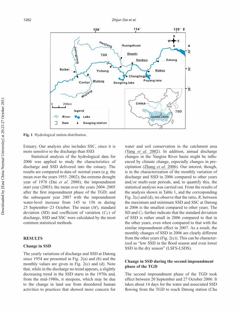
Daily discharge and suspended sediment concen-tration (SSC) data for the gauging stations shownin Fig. 1 were obtained for the years 2000–2007from the CRWRC, Ministry of Water Conservancyof China (Bulletin of Yangtze River Sediment, 2000–2007). Monthly accretion amounts behind the TGDfrom 2003 to 2007 were also obtained from theCRWRC (Bulletin of Yangtze River Sediment, 2000–2007). Monthly discharge and SSC data from 1955to 1999 at gauging stations were provided by theCRWRC. The gauging stations Cuntan, Yichang,Hankou and Datong, are on the Yangtze River; Beibei,Wulong and Huangzhuan are on the tributaries of theYangze, Jialingjiang, Wujiang and Hanjiang, respec-tively (see Fig. 1). The sediment load contributionfrom Dongting and Poyang lakes into the YangtzeRiver is gauged at Chenglingji and Hukou stations,respectively. These are two main sediment suppliesin the middle of the Yangtze River, besides the riverHanjiang (Yang et al. 2007, Xu and Milliman 2009).Observations of discharge and SSC at these hydro-logical stations are based on the national standardsissued by the Ministry of Water Conservancy andElectric Power (e.g. 1962, 1975), and the proce-dures followed for hydrological surveys, samplingand laboratory SSC analyses at hydrological stationsin China are based on international standards (Xu2007). In addition, the homogeneity and the relia-bility of the data have been checked by CRWRCbefore the data were released (Zhang et al. 2006).Therefore, hydrological data in this study should beconsidered reliable. Here, based on the characteris-tics of sediment supply to the Yangtze River, thetotal SSD (being the product of river discharge andSSC) at Cuntan, Beibei and Wulong stations (collec-tively referred to as CBW) represents the suspendedsediment discharge upstream of the TGD. The totalSSD at Chenglingji, Hukou and Huangzhuan sta-tions (CHH) represents the SSD in the middle reachof the Yangtze River, where the sediment supplyfrom Dongting Lake is the difference between that atChenglingji and the three distributaries into DongtingLake from the Yangtze River (Yang et al. 2007). Thedata at Datong represent the SSD into the Yangtze
Dow
nloa
ded
by [
Eas
t Chi
na N
orm
al U
nive
rsity
] at
20:
23 2
7 O
ctob
er 2
011
1282 Zhijun Dai et al.
Fig. 1 Hydrological station distribution.
Estuary. Our analysis also includes SSC, since it ismore sensitive to the discharge than SSD.
Statistical analysis of the hydrological data for2006 was applied to study the characteristics ofdischarge and SSD delivered into the estuary. Theresults are compared to data of: normal years (e.g. themean over the years 1955–2002); the extreme droughtyear of 1978 (Dai et al. 2008); the impoundmentstart year (2003); the mean over the years 2004–2005after the first impoundment phase of the TGD; andthe subsequent year 2007 with the impoundmentwater-level increase from 145 to 156 m during25 September–23 October. The mean (M), standarddeviation (SD) and coefficient of variation (CV) ofdischarge, SSD and SSC were calculated by the mostcommon statistical methods.
RESULTS
Change in SSD
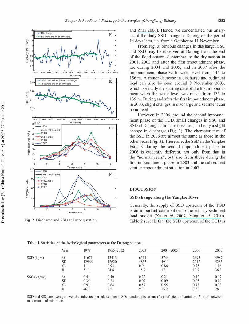
The yearly variations of discharge and SSD at Datongsince 1954 are presented in Fig. 2(a) and (b) and themonthly values are given in Fig. 2(c) and (d). Notethat, while in the discharge no trend appears, a slightlydecreasing trend in the SSD starts in the 1970s and,from the mid-1980s, it steepens, which may be dueto the change in land use from disordered humanactivities to practices that showed more concern for
water and soil conservation in the catchment area(Yang et al. 2002). In addition, annual dischargechanges in the Yangtze River basin might be influ-enced by climate change, especially changes in pre-cipitation (Zhang et al. 2006). Our interest, though,is in the characterization of the monthly variation ofdischarge and SSD in 2006 compared to other yearsand/or multi-year periods, and, to quantify this, thestatistical analysis was carried out. From the results ofthe analysis shown in Table 1, and the correspondingFig. 2(c) and (d), we observe that the ratio, R, betweenthe maximum and minimum SSD and SSC at Datongin 2006 is the smallest compared to other years. TheSD and CV further indicate that the standard deviationof SSD is rather small in 2006 compared to that inthe other years, even when compared to that with thesimilar impoundment effect in 2007. As a result, themonthly changes of SSD in 2006 are clearly differentfrom the other years (Fig. 2(c)). This can be character-ized as “low SSD in the flood season and even lowerSSD in the dry season” (LSFS-LSDS).
Change in SSD during the second impoundmentphase of the TGD
The second impoundment phase of the TGD tookeffect between 20 September and 27 October 2006. Ittakes about 14 days for the water and associated SSDflowing from the TGD to reach Datong station (Chu
Dow
nloa
ded
by [
Eas
t Chi
na N
orm
al U
nive
rsity
] at
20:
23 2
7 O
ctob
er 2
011
Suspended sediment discharge in the Yangtze (Changjiang) Estuary 1283
1.4Discharge
Suspended sediment discharge
Running mean of 10 years0.8
0.6
SS
D(1
09 t
/y)
0.4
0.2
0
81978
mean 1955–2002
2003
2004–2005
2006
2007
7
6
5
Wa
ter
dis
charg
e (
m3/s
)
4
3
2
1
120
90
60
SS
D(1
06t/m
onth
)
30
0
1978
mean 1955–20022003
2004–2005
2006
2007
Time (month)
0 2 4 6 8 10 12
Time (month)
0 2 4 6 8 10 12
Time (year)
1955 1960 1965 1970 1975 1980 1985 1990 1995 2000 2005 2009
(a)
(b)
(c)
(d)
Time (year)
1955
x 104
1960 1965 1970 1975 1980 1985 1990 1995 2000 2005 2009
Running mean of 10 years1.3
1.2
1.1
Dis
charg
e (
10
12 m
3/y
)
1
0.9
0.8
0.7
Fig. 2 Discharge and SSD at Datong station.
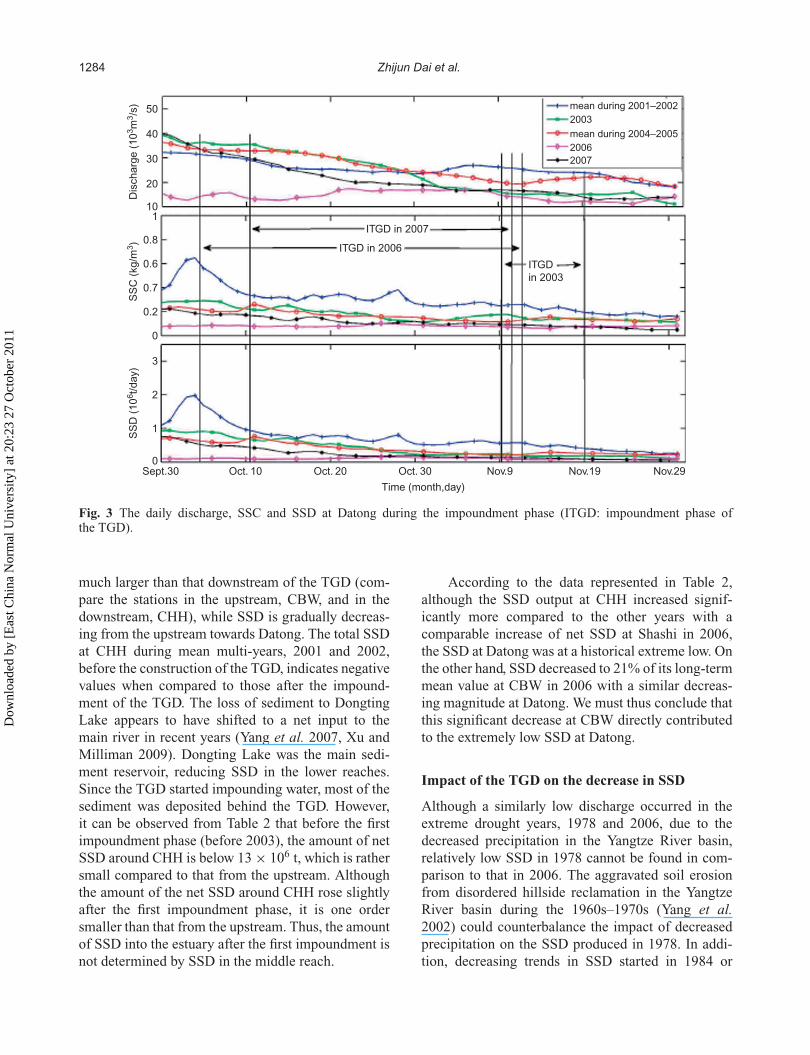
and Zhai 2006). Hence, we concentrated our analy-sis of the daily SSD change at Datong on the period14 days later, i.e. from 4 October to 11 November.
From Fig. 3, obvious changes in discharge, SSCand SSD may be observed at Datong from the endof the flood season, September, to the dry season in2001, 2002 and after the first impoundment phase,i.e. during 2004 and 2005, and in 2007 after theimpoundment phase with water level from 145 to156 m. A minor decrease in discharge and sedimentload can also be seen around 8 November 2003,which is exactly the starting date of the first impound-ment when the water level was raised from 135 to139 m. During and after the first impoundment phase,in 2003, slight changes in discharge and sediment canbe noticed.
However, in 2006, around the second impound-ment phase of the TGD, small changes in SSC andSSD at Datong station are observed, and only a slightchange in discharge (Fig. 3). The characteristics ofthe SSD in 2006 are almost the same as those in theother years (Fig. 3). Therefore, the SSD in the YangtzeEstuary during the second impoundment phase in2006 is evidently different, not only from that inthe “normal years”, but also from those during thefirst impoundment phase in 2003 and the subsequentsimilar impoundment situation in 2007.
DISCUSSION
SSD change along the Yangtze River
Generally, the supply of SSD upstream of the TGDis an important contribution to the estuary sedimentload budget (Xu et al. 2007, Yang et al. 2010).Table 2 reveals that the SSD upstream of the TGD is
Table 1 Statistics of the hydrological parameters at the Datong station.
Year 1978 1955–2002 2003 2004–2005 2006 2007
SSD (kg/s) M 11671 13413 6511 5744 2693 4987SD 12966 12620 5855 4911 2012 5283CV 1.11 0.94 0.9 0.86 0.75 1.06R 51.3 34.6 15.9 17.1 10.7 36.3
SSC (kg/m3) M 0.41 0.40 0.22 0.21 0.12 0.17SD 0.35 0.24 0.07 0.09 0.05 0.09CV 0.93 0.64 0.57 0.55 0.43 0.73R 46.7 7.5 9.7 15.2 7.32 28
SSD and SSC are averages over the indicated period; M : mean; SD: standard deviation; CV: coefficient of variation; R: ratio betweenmaximum and minimum.
Dow
nloa
ded
by [
Eas
t Chi
na N
orm
al U
nive
rsity
] at
20:
23 2
7 O
ctob
er 2
011
1284 Zhijun Dai et al.
50
40
30
Dis
charg
e (
10
3m
3/s
)S
SC
(kg/m
3)
SS
D (
10
6t/day)
20
101
0.8
0.6
0.7
0.2
0
3
2
1
0Sept.30 Oct. 10 Oct. 20 Oct. 30
Time (month,day)
Nov.9 Nov.19 Nov.29
mean during 2001–2002
2003
mean during 2004–2005
2006
2007
ITGD in 2007
ITGD in 2006
ITGD
in 2003
Fig. 3 The daily discharge, SSC and SSD at Datong during the impoundment phase (ITGD: impoundment phase ofthe TGD).
much larger than that downstream of the TGD (com-pare the stations in the upstream, CBW, and in thedownstream, CHH), while SSD is gradually decreas-ing from the upstream towards Datong. The total SSDat CHH during mean multi-years, 2001 and 2002,before the construction of the TGD, indicates negativevalues when compared to those after the impound-ment of the TGD. The loss of sediment to DongtingLake appears to have shifted to a net input to themain river in recent years (Yang et al. 2007, Xu andMilliman 2009). Dongting Lake was the main sedi-ment reservoir, reducing SSD in the lower reaches.Since the TGD started impounding water, most of thesediment was deposited behind the TGD. However,it can be observed from Table 2 that before the firstimpoundment phase (before 2003), the amount of netSSD around CHH is below 13 × 106 t, which is rathersmall compared to that from the upstream. Althoughthe amount of the net SSD around CHH rose slightlyafter the first impoundment phase, it is one ordersmaller than that from the upstream. Thus, the amountof SSD into the estuary after the first impoundment isnot determined by SSD in the middle reach.
According to the data represented in Table 2,although the SSD output at CHH increased signif-icantly more compared to the other years with acomparable increase of net SSD at Shashi in 2006,the SSD at Datong was at a historical extreme low. Onthe other hand, SSD decreased to 21% of its long-termmean value at CBW in 2006 with a similar decreas-ing magnitude at Datong. We must thus conclude thatthis significant decrease at CBW directly contributedto the extremely low SSD at Datong.
Impact of the TGD on the decrease in SSD
Although a similarly low discharge occurred in theextreme drought years, 1978 and 2006, due to thedecreased precipitation in the Yangtze River basin,relatively low SSD in 1978 cannot be found in com-parison to that in 2006. The aggravated soil erosionfrom disordered hillside reclamation in the YangtzeRiver basin during the 1960s–1970s (Yang et al.2002) could counterbalance the impact of decreasedprecipitation on the SSD produced in 1978. In addi-tion, decreasing trends in SSD started in 1984 or
Dow
nloa
ded
by [
Eas
t Chi
na N
orm
al U
nive
rsity
] at
20:
23 2
7 O
ctob
er 2
011
Suspended sediment discharge in the Yangtze (Changjiang) Estuary 1285
Tab
le2
Com
pari
son
ofS
SD
betw
een
atga
ugin
gst
atio
nsan
dat
Dat
ong
stat
ion.
CB
W1
Yic
hang
Sha
shi
CH
H2
Dat
ong
SS
D3
R14
(%)
R25
(%)
SS
DR
1(%
)R
2(%
)S
SD
R36
SS
DR
2(%
)S
SD
R1
(%)
Acc
reti
onbe
hind
TG
D(1
06t)
Mul
tiye
ar7
555
–13
447
0–
114
415
−558
−13
414
–20
0135
364
128
299
6410
831
314
−10
276
6720
0222
440
8122
849
8324
113
−427
566
2003
251
4512
298
2147
138
4029
1420
650
124
2004
201
3613
764
1444
9632
1913
147
3610
220
0531
757
147
110
2351
132
2224
1121
652
151
2006
116
2113
79
211
2516
3036
8521
9320
0724
845
179
5311
3875
2219
1413
833
169
Dis
tanc
efr
omT
GD
(km
)62
0937
137
99210
1177
1to
tal
inth
eup
stre
am(1
06t/
year
);2
tota
lin
the
mid
dle
stre
am(1
06t/
year
);3
year
lyav
erag
e(1
06t/
year
);4
rati
oof
SS
Dof
ace
rtai
nye
arto
the
mul
tiye
aron
e;5:
rati
oof
SS
Dat
ace
rtai
nst
atio
nto
that
atth
eD
aton
g;6
netS
SD
inth
ese
ctio
nbe
twee
nY
icha
ngan
dS
hash
i;7
aver
age
duri
ng19
50–2
005
(106
t/ye
ar);
8po
sitiv
eva
lues
repr
esen
tSS
Din
crea
sing
and
nega
tive
repr
esen
tSS
Dde
crea
sing
;9di
stan
cebe
twee
nC
unta
nan
dT
GD
;10di
stan
cebe
twee
nT
GD
and
Huk
ou.
Dow
nloa
ded
by [
Eas
t Chi
na N
orm
al U
nive
rsity
] at
20:
23 2
7 O
ctob
er 2
011
1286 Zhijun Dai et al.
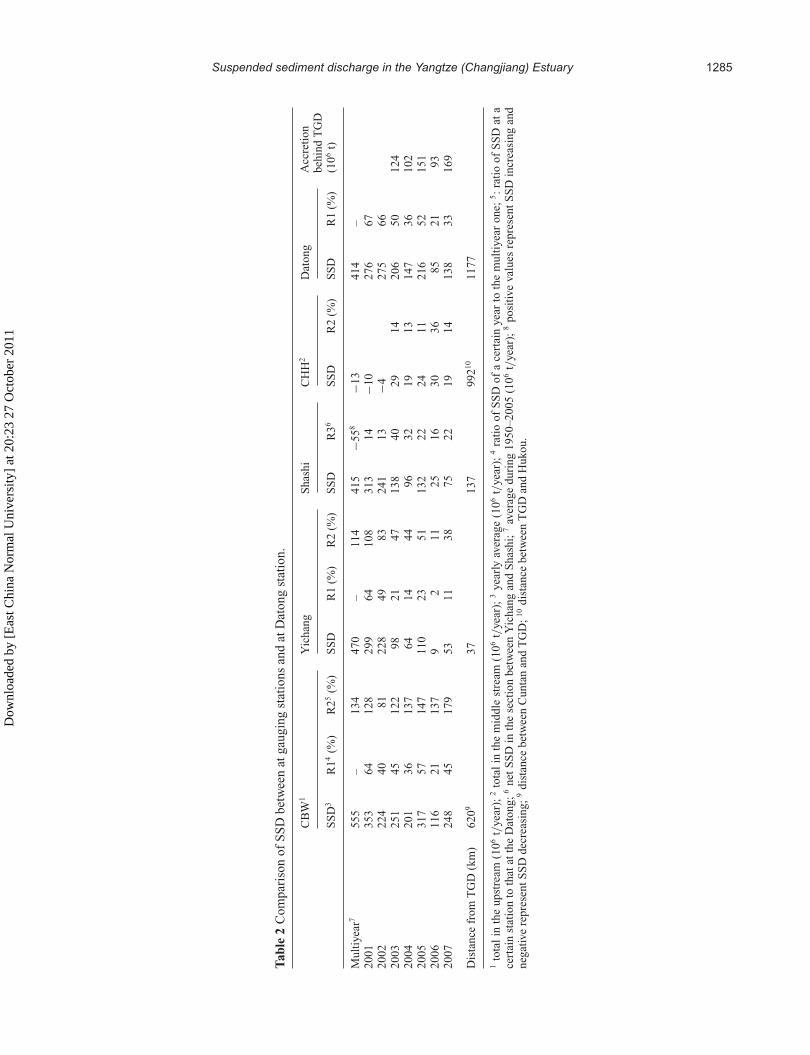
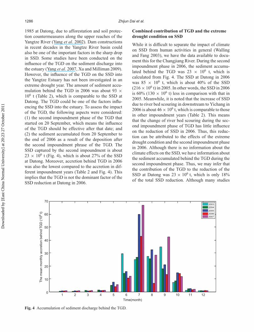
1985 at Datong, due to afforestation and soil protec-tion countermeasures along the upper reaches of theYangtze River (Yang et al. 2002). Dam constructionsin recent decades in the Yangtze River basin couldalso be one of the important factors in the sharp dropin SSD. Some studies have been conducted on theinfluence of the TGD on the sediment discharge intothe estuary (Yang et al. 2007, Xu and Milliman 2009).However, the influence of the TGD on the SSD intothe Yangtze Estuary has not been investigated in anextreme drought year. The amount of sediment accu-mulation behind the TGD in 2006 was about 93 ×106 t (Table 2), which is comparable to the SSD atDatong. The TGD could be one of the factors influ-encing the SSD into the estuary. To assess the impactof the TGD, the following aspects were considered:(1) the second impoundment phase of the TGD thatstarted on 20 September, which means the influenceof the TGD should be effective after that date; and(2) the sediment accumulated from 20 September tothe end of 2006 as a result of the deposition afterthe second impoundment phrase of the TGD. TheSSD captured by the second impoundment is about23 × 106 t (Fig. 4), which is about 27% of the SSDat Datong. Moreover, accretion behind TGD in 2006was also the lowest compared to the accretion in dif-ferent impoundment years (Table 2 and Fig. 4). Thisimplies that the TGD is not the dominant factor of theSSD reduction at Datong in 2006.
Combined contribution of TGD and the extremedrought condition on SSD
While it is difficult to separate the impact of climateon SSD from human activities in general (Wallingand Fang 2003), we have the data available to docu-ment this for the Changjiang River. During the secondimpoundment phase in 2006, the sediment accumu-lated behind the TGD was 23 × 106 t, which iscalculated from Fig. 4. The SSD at Datong in 2006was 85 × 106 t, which is about 40% of the SSD(216 × 106 t) in 2005. In other words, the SSD in 2006is 60% (130 × 106 t) less in comparison with that in2005. Meanwhile, it is noted that the increase of SSDdue to river bed scouring in downstream to Yichang in2006 is about 46 × 106 t, which is comparable to thosein other impoundment years (Table 2). This meansthat the change of river bed scouring during the sec-ond impoundment phase of TGD has little influenceon the reduction of SSD in 2006. Thus, this reduc-tion can be attributed to the effects of the extremedrought condition and the second impoundment phasein 2006. Although there is no information about theclimate effects on the SSD, we have information aboutthe sediment accumulated behind the TGD during thesecond impoundment phase. Thus, we may infer thatthe contribution of the TGD to the reduction of theSSD at Datong was 23 × 106 t, which is only 18%of the total SSD reduction. Although many studies
The
mean m
onth
ly a
ccre
tion b
ehin
d T
GD
(10
6 t)
70
60
50
40
30
20
10
01 2 3 4 5 6 7
Time(month)
8 9 10 11 12
20032004
200520062007
Fig. 4 Accumulation of sediment discharge behind the TGD.
Dow
nloa
ded
by [
Eas
t Chi
na N
orm
al U
nive
rsity
] at
20:
23 2
7 O
ctob
er 2
011
Suspended sediment discharge in the Yangtze (Changjiang) Estuary 1287
hypothesize that the regulation of water and sedimentdischarge in most rivers is due to dams alone (Nilssonet al. 2005), it is our hypothesis that the SSD dis-charge is impacted by the combination of the extremedrought in 2006 and the second impoundment phaseof the TGD. Hence, we quantify the contributionof the extreme drought on the SSD reduction to be82% in 2006. Therefore, the extreme drought in 2006played a dominant role in the extremely low SSD intothe estuary.
CONCLUSIONS
Extreme drought occurred in the catchment area ofthe Yangtze River in 2006, simultaneously with thesecond impoundment phase of the TGD. It can beconcluded that the SSD into the Yangtze Estuary inthat year has the following characteristics:
1. The change of SSD into the Yangtze Estuary canbe characterized as “low SSD in the flood season,lower SSD in the dry season” (LSFS-LSDS), andSSD has been regulated both by the TGD and theextreme drought condition.
2. The SSC in the Yangtze Estuary experienced nochanges around the second impoundment phaseof the TGD in 2006.
3. The extremely low SSD into the Yangtze Estuaryoccurring in 2006 was caused by the low SSDin the upstream area, with less influence fromthe TGD.
4. The SSD at Datong in 2006 was 60% less thanthat in 2005. We estimate that this reduction is dueto the second impoundment phase of the TGD andto the extreme drought in 2006, at 18% and 82%,respectively.
In other words, the extreme drought in 2006 is themain reason for the extremely low SSD to the estuaryin that year.
Acknowledgements This research was sup-ported by the National Science Key Foundationin China (50939003), the National Great ScienceProject of China (2010CB951202), the ProgrammeStrategic Scientific Alliances between China andThe Netherlands (2008DFB90240), and the NationalScience Foundation in China (Grant no. 41076050).
REFERENCES
Bulletin of Yangtze River Sediment (2000–2007) Press of Ministryof Water Resources of the People’s Republic of China.http://www.cjh.com.cn/.
Carriquiry, J. D., Sαnchez, A., and Camacho-Ibar, V. F. (2001)Sedimentation in the northern Gulf of California after cessationof the Colorado River discharge. Sediment. Geol. 144 (1–2),37–62.
CRWRC (Changjiang River Water Resource Commission) (2007)Report of drought situation in Changjiang Basin of 27 February2006. Wuhan, China: Bureau of Hydrology.
Chu, Z. X., and Zhai, S. K. (2006) Effects of Three Gorges Reservoir(TGR) water storage in June 2003 on Yangtze River sedimententering the estuary. Hydrol. Earth System Sci. 3, 1553–1567.
Dai, Z. J., Chu, A., Du, J. Z., Stive, M. J. F., and Yan, H. (2010a)Assessment of extreme drought and human interference onbaseflow of the Yangtze River. Hydrol. Processes 24, 749–757.
Dai, Z. J., Du, J. Z., Li, J. F., Li, W. H., and Chen, J. Y. (2008) Runoffcharacteristics of the Changjiang river during 2006: effect ofextreme drought and the impounding of the Three George Dam.Geophy. Res. Lett. 35, L07406, doi:10.1029/2008GL033456.
Dai, Z. J., Du, J. Z., Zhang, X. Y., Su, N., and Li, J. F. (2010b)Variation of riverine material loads and environmental conse-quences on the Changjiang (Yangtze) estuary in recent decades(1955–2008). Environ. Sci. Technol. doi:10.1021/es103026a.
Frihy, O. E., Debes, E. A., and Sayed, W. R. E. (2003) Processesreshaping the Nile Delta promontories of Egypt: pre- andpost-protection. Geomorphology 53, 263–279.
Gao, S., and Wang, Y. P. (2008) Changes in material fluxes fromthe Changjiang River and their implications on the adjoin-ing continental shelf ecosystem. Cont. Shelf Res. 28 (12),1490–1500.
Liu, P., Guo, S. L., Xiong, L. H., and Chen, L. (2010) Flood seasonsegmentation based on the probability change-point analysistechnique. Hydrol. Sci. J . 55 (4), 540–554.
Milliman, J. D. (1997) Blessed dams or damned dams. Nature 386,325–326.
Nilsson, C., Reidy, C. A., Dynesius, M., and Revenga, C. (2005)Fragmentation and flow regulation of the world’s large riversystems. Science 308, 405–408.
Sánchez, A., Jiménez, A. J. A., and Valdemoro, H. I. (1998) The EbroDelta: morphodynamics and vulnerability. J. Coastal Res. 14,754–772.
Syvitski, J. P. M., Vörösmarty, C. J., Kettner, A. J., and Green, P.(2005) Impact of humans on the flux of terrestrial sediment tothe global ocean. Science 308, 376–380.
Vörösmarty, C. J., Meybeck, M., Fekete, B., Sharma, K., Green, P.,and Syvitski, J. P. M. (2003) Anthropogenic sediment reten-tion: major global impact from registered river impoundments,Global Planet. Change 39, 169–190.
Walling, D. E., and Fang, D. (2003) Recent trends in the suspendedsediment loads of the world rivers. Global Planet. Change 39,111–126.
Wang, H. J., Yang, Z. S., Saito, Y., Liu, P. J., Sun, X. X., and Wang, Y.(2007) Stepwise decrease of the Huanghe (Yellow River) sedi-ment load (1950–2005): impacts of climate change and humanactivities. Global Planet. Change 57, 331–354.
Xu, J. X. (2007) Trends in suspended sediment grain size in theupper Yangtze River and its tributaries, as influenced by humanactivities. Hydrol. Sci. J . 52 (4), 777–792.
Xu, K., and Milliman, J. D. (2009) Seasonal variations of sedimentdischarge from the Yangtze River before and after impoundmentof the Three Gorges Dam. Geomorphology 104, 276–283.
Xu, K. H., Milliman, J. D., Yang, Z. S., and Xu, H. (2007) Climaticand anthropogenic impacts on the water and sediment dischargefrom the Yangtze River (Changjiang), 1950–2005. In: A. Gupta(ed.), Large Rivers: Geomorphology and Management. NewYork: Wiley, 609–626.
Yang, S. L., Milliman, J. D., Li, P., and Xu, K. (2010) 50,000 damslater: erosion of the Yangtze River and its delta. Global Planet.Change doi:10.1016/j.gloplacha.2010.09.006.
Dow
nloa
ded
by [
Eas
t Chi
na N
orm
al U
nive
rsity
] at
20:
23 2
7 O
ctob
er 2
011
1288 Zhijun Dai et al.
Yang, S. L., Zhang, J., Dai, S. B., Li, M., and Xu, X. J. (2007) Effect ofdeposition and erosion within the main river channel and largelakes on sediment delivery to the estuary of the Yangtze River.J. Geophys. Res. 112, F02005, doi:10.1029/2006JF000484.
Yang, S. L., Zhao, Q., and Belkin, I. M. (2002) Temporal variation inthe sediment load of the Yangtze River and the influences of thehuman activities. J. Hydrol. 263, 56–71.
Yang, Z. S., Wang, H. J., Saito, Y., Li, G. X., and Sun, X. X.(2004) Phase change of the modern Huanghe Delta evolutionsince its last end channel shift in 1976 (and its phase change).
In: T. Jarupongsakul, and Y. Saito (eds.), Fifth InternationalConference on Asian Marine Geology AGCP-475 Delta MAPand APN Mega-Delta (Bangkok).
Zhang, Q., Chen, G., Su, B. D., and Disse, M. (2008) Periodicity ofsediment load and runoff in the Yangtze River basin and possi-ble impacts of climatic changes and human activities. Hydrol.Sci. J . 53 (2), 457–465.
Zhang, Q., Xu, C. Y., Becker, S., and Jiang, T. (2006) Sediment andrunoff changes in the Yangtze River basin during past 50 years.J. Hydrol. 331, 511–523.
Dow
nloa
ded
by [
Eas
t Chi
na N
orm
al U
nive
rsity
] at
20:
23 2
7 O
ctob
er 2
011
Copyright © 2022 FDOKUMEN