Synthesis Yangtze Harbour Mesolithic
31
287 7.1 Introduction In the foregoing chapters, various disciplines have focused on data relating to the stratigraphy, palaeogeography, archaeozoology, archaeobotany, and lithic material from Rotterdam’s Yangtze Harbour. This chapter presents a synthesis, aimed at integrating the results on different spatial scales: the site, the Rhine-Meuse estuary, and the southern North Sea basin. Subsequently we shall discuss the scientific significance of these investigations for our understanding of the area’s Mesolithic occupation in an international perspective. A link is made to current research into the drowning of the postglacial landscape in what is now the North Sea. 7.2 The Mesolithic habitation on the river dune The following sections focus on the character of the Mesolithic settlement on the river- dune complex. 2 Attention is given to the exploitation of food resources, craft activities, and the provenance of raw materials. The discussion of these aspects is preceded by a brief review of the chronological context and representativity of the recovered material. 7.2.1 Chronological context and representativity The geological study (Chapter 3) has shown that the river-dune complex in the Yangtze Harbour lies in the southern margin of the Rhine-Meuse floodbasin. On the basis of OSL datings and other evidence, it was concluded that the dune complex evolved in the Preboreal, around 9000 BC. The AMS analyses on a few samples of burnt bone (of wild boar and an unidentified mammal) produced dates between circa 8550 and 8300 BC (see Section 5.8). As these are the earliest dates that can be directly associated with human activity, it seems likely that the occupation started in the Late Preboreal. Charred botanical macrofossils recovered at the foot of the dune were found to date from circa 8250 to 6500 BC (see Table 6.3). The micromorphological analysis showed that the humic soil in the top of the dune sand can be related to slope processes (colluvial reworking) in the Early Atlantic, which may be anthropogenic in origin. Given the covering of the colluvial layer by the Basal Peat (dated between 7000 and 6500 BC), it is clear that such processes at any rate coincided with the final occupation activity, at the transition from the Boreal to the Early Atlantic. From the regional history of the rise in sea level and the reconstructed height of the dune, it is clear that the dune complex was submerged by circa 6400/6300 BC at the latest. Judging by the datings of charred plant remains that can be related to human intervention, it seems that human activity ceased around 6500 BC. When considering the time depth of Mesolithic occupation at this site, it is important to keep in mind that the landscape in the river zone was subject to continuous change. The nature of the inundations and the situation of the river-dune complex changed as a result. Initially the dunes lay far inland in the Rhine-Meuse valley and floodings were infrequent. With the approach of the sea in the last part of the Boreal, the rivers inundated the floodplain and the foot of the dune ever more frequently and for longer periods. It was not until the Early Atlantic that the area actually became submerged; in the first instance it became a freshwater tidal area with a regime of daily flooding, which gradually transformed into a brackish estuarine context several metres under water. The interplay between the hydrological conditions (ground water and surface water), the supply of nutrients (in the case of inundation: eutrophic versus mesotrophic), soil formation, and sedimentary processes (erosion and deposition) brought about physical changes to the landscape. Consequently, the accessibility of the dune complex to hunter-gatherers changed as well (Fig. 7.1). 7 Synthesis J.H.M. Peeters 1 , D.C. Brinkhuizen, K.M. Cohen, L.I. Kooistra, L. Kubiak-Martens, J.M. Moree, M.J.L.Th. Niekus, D.E.A. Schiltmans, A. Verbaas, F. Verbruggen, P.C. Vos, and J.T. Zeiler
Transcript of Synthesis Yangtze Harbour Mesolithic

287
7.1 Introduction
In the foregoing chapters, various disciplines have focused on data relating to the stratigraphy, palaeogeography, archaeozoology, archaeobotany, and lithic material from Rotterdam’s Yangtze Harbour. This chapter presents a synthesis, aimed at integrating the results on different spatial scales: the site, the Rhine-Meuse estuary, and the southern North Sea basin. Subsequently we shall discuss the scientific significance of these investigations for our understanding of the area’s Mesolithic occupation in an international perspective. A link is made to current research into the drowning of the postglacial landscape in what is now the North Sea.
7.2 The Mesolithic habitation on the river dune
The following sections focus on the character of the Mesolithic settlement on the river-dune complex.2 Attention is given to the exploitation of food resources, craft activities, and the provenance of raw materials. The discussion of these aspects is preceded by a brief review of the chronological context and representativity of the recovered material.
7.2.1 Chronological context and representativity
The geological study (Chapter 3) has shown that the river-dune complex in the Yangtze Harbour lies in the southern margin of the Rhine-Meuse floodbasin. On the basis of OSL datings and other evidence, it was concluded that the dune complex evolved in the Preboreal, around 9000 BC. The AMS analyses on a few samples of burnt bone (of wild boar and an unidentified mammal) produced dates between circa 8550 and 8300 BC (see Section 5.8). As these are the earliest dates that can be directly associated with human activity, it seems likely that the occupation started in the Late Preboreal. Charred botanical macrofossils recovered at the foot of the dune were found to date from circa 8250 to 6500 BC (see Table 6.3). The micromorphological analysis showed that the humic soil in the top of the dune sand can be related to slope processes (colluvial reworking) in the Early Atlantic, which may be anthropogenic in origin. Given the covering of the colluvial layer by the Basal Peat (dated between 7000 and 6500 BC), it is clear that such processes at any rate coincided with the final occupation activity, at the transition from the Boreal to the Early Atlantic. From the regional history of the rise in sea level and the reconstructed height of the dune, it is clear that the dune complex was submerged by circa 6400/6300 BC at the latest. Judging by the datings of charred plant remains that can be related to human intervention, it seems that human activity ceased around 6500 BC.
When considering the time depth of Mesolithic occupation at this site, it is important to keep in mind that the landscape in the river zone was subject to continuous change. The nature of the inundations and the situation of the river-dune complex changed as a result. Initially the dunes lay far inland in the Rhine-Meuse valley and floodings were infrequent. With the approach of the sea in the last part of the Boreal, the rivers inundated the floodplain and the foot of the dune ever more frequently and for longer periods. It was not until the Early Atlantic that the area actually became submerged; in the first instance it became a freshwater tidal area with a regime of daily flooding, which gradually transformed into a brackish estuarine context several metres under water. The interplay between the hydrological conditions (ground water and surface water), the supply of nutrients (in the case of inundation: eutrophic versus mesotrophic), soil formation, and sedimentary processes (erosion and deposition) brought about physical changes to the landscape. Consequently, the accessibility of the dune complex to hunter-gatherers changed as well (Fig. 7.1).
7 Synthesis
J.H.M. Peeters1, D.C. Brinkhuizen, K.M. Cohen, L.I. Kooistra, L. Kubiak-Martens, J.M. Moree, M.J.L.Th. Niekus, D.E.A. Schiltmans, A. Verbaas, F. Verbruggen, P.C. Vos, and J.T. Zeiler
288
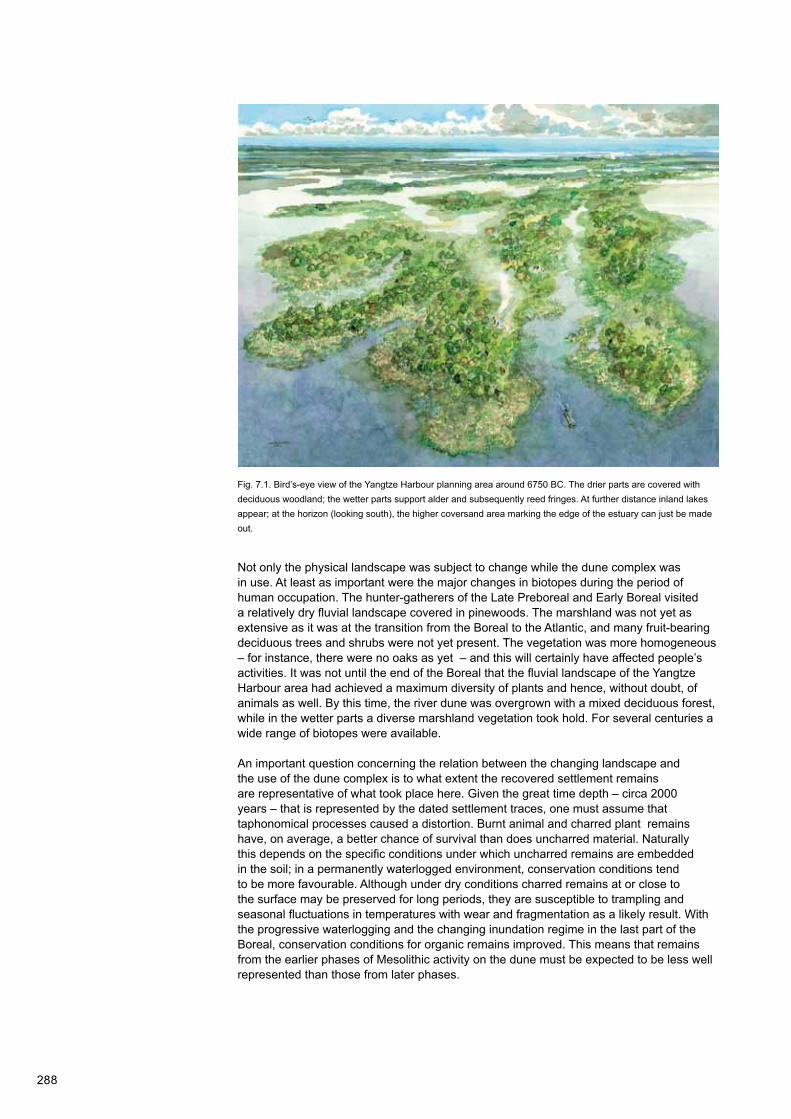
Not only the physical landscape was subject to change while the dune complex was in use. At least as important were the major changes in biotopes during the period of human occupation. The hunter-gatherers of the Late Preboreal and Early Boreal visited a relatively dry fluvial landscape covered in pinewoods. The marshland was not yet as extensive as it was at the transition from the Boreal to the Atlantic, and many fruit-bearing deciduous trees and shrubs were not yet present. The vegetation was more homogeneous – for instance, there were no oaks as yet – and this will certainly have affected people’s activities. It was not until the end of the Boreal that the fluvial landscape of the Yangtze Harbour area had achieved a maximum diversity of plants and hence, without doubt, of animals as well. By this time, the river dune was overgrown with a mixed deciduous forest, while in the wetter parts a diverse marshland vegetation took hold. For several centuries a wide range of biotopes were available.
An important question concerning the relation between the changing landscape and the use of the dune complex is to what extent the recovered settlement remains are representative of what took place here. Given the great time depth – circa 2000 years – that is represented by the dated settlement traces, one must assume that taphonomical processes caused a distortion. Burnt animal and charred plant remains have, on average, a better chance of survival than does uncharred material. Naturally this depends on the specific conditions under which uncharred remains are embedded in the soil; in a permanently waterlogged environment, conservation conditions tend to be more favourable. Although under dry conditions charred remains at or close to the surface may be preserved for long periods, they are susceptible to trampling and seasonal fluctuations in temperatures with wear and fragmentation as a likely result. With the progressive waterlogging and the changing inundation regime in the last part of the Boreal, conservation conditions for organic remains improved. This means that remains from the earlier phases of Mesolithic activity on the dune must be expected to be less well represented than those from later phases.
Fig. 7.1. Bird’s-eye view of the Yangtze Harbour planning area around 6750 BC. The drier parts are covered with deciduous woodland; the wetter parts support alder and subsequently reed fringes. At further distance inland lakes appear; at the horizon (looking south), the higher coversand area marking the edge of the estuary can just be made out.

289
It is difficult to dissect the recovered assemblages chronologically. Most remains come from the humic top layer of the dune flank, where slope processes and possibly trampling have led to mixing up of material of different periods. Only for the directly dated remains can an age be effectively established. Given the available datings and stratigraphical associations, most of the (charred and uncharred) plant remains seem to date from the Late Boreal/Early Atlantic (Middle Mesolithic). A similar age is likely for the unburnt bone material, most of which is likely to be associated with the later habitation phase, when increasingly wet conditions prevailed. One Early Boreal dating of hazelnut shells and two Late Boreal datings of unburnt mammalian remains must be regarded as vestiges of Early Mesolithic activity on the dune complex. At any rate part of the flint assemblage typologically and technologically ties in with a Late Boreal to Early Atlantic settlement period.
Another factor which affects representativity is the position of the investigated sites relative to the dune complex. It was explained in Chapter 3 that throughout the area the highest parts of the river dunes have been eroded away. This goes for the dune in Target zone West and adjacent areas to the southwest, as well as for the smaller dune tops in Target zone East. Any settlement remains will have been destroyed during the process. The position of the sampling excavations on the lower part of the dune flanks implies that the recovered archaeological remains derive from depositional contexts differing from those that once existed higher up. On the flanks we are likely to be dealing with slopewash, containing remains from above and/or with dumped rubbish, and we should not assume that all erstwhile activities or behavioural contexts will be represented down below. Shelter structures and burials, for instance, will presumably have been present only on the highest parts (Hamburg and Louwe Kooijmans 2001; Louwe Kooijmans and Nokkert 2001; Zijl et al. 2011). Conversely, it might be that certain activities were specifically linked to the zones lower down. Still, all this does not mean that the material gathered in this investigation only represents activities differing from those performed on the higher, uninvestigated or eroded parts of the dunes. Both intentionally discarded and post-depositionally displaced material on the lower flanks will still, to some extent, reflect activities performed on the higher parts of the dune (Amkreuz 2013).
7.2.2 The exploitation of food resources
As was shown in Chapters 5 and 6, the investigations produced a great deal of evidence about the use of animal and plant food resources that might be found in and around the dune complex. This section examines how the encountered botanical and faunal remains are to be interpreted in the changing geographical context. This is the basis for an exploitation model of the research area in, particularly, the Boreal and Early Atlantic.
7.2.2.1 Animal food resources
The archaeozoological study (Chapter 5) produced evidence of a wide range of potential animal food. The recovered bone remains represent mammals, birds and fishes, as well as some amphibians and reptiles. An important question of course is which part of this assemblage actually fed humans and which part should be regarded as naturally accumulated background fauna. Because of the severe fragmentation of the bone material, this cannot be determined on the evidence of for instance butchery and cut marks. The most direct evidence lies in the burnt preservation condition of bone fragments and in the range of species.
Given the rather limited proportion of identifiable fragments, the range of species is remarkably wide. The recovered remains represent various ecological zones (Table 7.1). Species that belong in dry or wet terrestrial environments (marshy floodbasin, riverbanks) predominate. The plentiful ‘microfauna’ also fits into this picture. Also there are species which may be found in a range of geographical zones, from the coast to estuary and the hinterland, such as various diadromous fishes which migrate between marine, brackish, and freshwater environments. Only spotted ray and turbot are true marine fishes. Strictly speaking, this also goes for plaice, but its remains are hard to distinguish from flounder, a species which may live in marine, brackish, and coastal freshwater habitats.

290
Although the dominance of water vole may reflect a natural accumulation of rodent remains (as in owl pellets), it cannot be ruled out that this animal was eaten by hunter-gatherers. In principle this goes for other creatures as well, such as reptiles and amphibians. Equally when it comes to fish remains, it may be hard to tell whether they represent food waste or a natural accumulation.3 The use-wear study on flint artefacts (Chapter 4) has shown that on the Yangtze Harbour dune not only butchering but also fish processing took place.
Mammalian remains in particular showed evidence of burning in a significant number of cases; calcination almost always occurred. Calcination requires temperatures between circa 650 and 700 ºC, which can be attained in surface hearths (Shipman, Foster, and Schoeninger 1984). The proportion of burnt bird and fish bones is considerably lower.4 The burning of bones can be an indication of consumption, with food remains having been thrown into the fire, as fuel or otherwise.
If the remains of smaller rodents, reptiles, and amphibians are interpreted as background fauna – i.e. as merely reflecting local conditions – we find a preponderance of species that belong in freshwater marshland and along rivers (root vole, water vole, grass snake, green frog), and in drier, woodland biotopes (field vole, bank vole). This suggests that the recovered remains mostly relate to a phase when the fluvial landscape was as yet (virtually) unaffected by the sea. The fact that the sampled layers were covered by Basal Peat confirms this impression.
Habitat Marine: saline Tidal zone: brackish-freshwater Interior: freshwater
Dry: terrestrial Mammals- Otter and wild boar Red deer, roe deer, wild boar,
wildcat, polecat, ermine, and marten
Birds- - Goshawk, wood pigeon,
woodcock, and small songbird
Wet: riparian MammalsOtter Otter Beaver and otter
BirdsGull and wader Gull, wader, mallard, teal/
garganey, and gooseWader, grey heron, bittern, and water rail
Aquatic: open water Mammals- - Beaver and otter
Birds- Mallard, teal/garganey, and
goose Mallard, teal/garganey, shoveller, diving duck, goose, smew, goldeneye, moorhen, and coot
Anadromous fishesAtlantic sturgeon, eel, salmon/sea trout, Allis shad/thwaite, and plaice/flounder
Atlantic sturgeon, eel, salmon/sea trout, Allis shad/thwaite, and plaice/flounder
Atlantic sturgeon, eel, salmon/sea trout, and Allis shad/thwaite
Sea fishesSpotted ray and turbot - -
Fishes- - Pike, perch, cyprinids, bream,
roach, and tench
Table 7.1 The identified species (macrofauna) and their various natural habitats.

291
7.2.2.2 Plant-food resources
As regards the use of plant-food and subsistence resources, charred remains (roots, tubers, acorns, nutshells, seeds) of plants provide the most immediate evidence. Here also a wide variety of species are encountered, representing various environments ranging from dry woodland to more or less open water (Table 7.2). Evidently various ecological zones were exploited, which offered a variety of plant-food resources to the hunter-gatherers who visited the Yangtze Harbour dune. The zones are (1) woodland and forest margins on dry (to moist) places for gathering acorns, hazelnuts, tubers of lesser celandine, berries of dogwood, and hawthorn, and possibly also other berry-bearing plants and crab apples; (2) wet zones for gathering underground plant parts, such as rhizomes of common club-rush and tubers of the sedge family; and, (3) open water for gathering fruits of water chestnut and seeds of the yellow water-lily. Hazelnut and acorn are the best-documented food resources for the Mesolithic and are almost invariably part of Mesolithic assemblages throughout Europe. Fragments of charred hazelnut shells are easily identified even by non-experts, but other remains are less readily picked out. To a large degree this is due to methodical limitations; the identification of fragile, charred archaeological parenchyma remains requires specialist analysis (see e.g. Perry 1997; Kubiak-Martens 1999; idem 2002).
Hazelnuts especially are often considered an important part of the Mesolithic diet (Holst 2010), but their importance may well be overestimated in proportion to starch-rich roots and tubers, and fruits and seeds. In this respect especially, the Yangtze Harbour research has yielded unanticipated results. Owing to the explicit attention to charred plant remains, important evidence emerged for the use of starch-rich vegetative foods (including rhizomes of common club-rush and tubers of lesser celandine), as well as non-vegetative starchy foods (such as acorns and water lily seeds, Table 7.2). This probably was food that was seasonally gathered at and in the close vicinity of the site. The identification of starch-rich food resources has definite implications for our understanding of the plant food component in the hunter-gatherers’ diet. Starch-rich roots and tubers formed an important part of the diet, especially when they were accessible and plentiful. The Yangtze Harbour-results support the notion that starch was an important source of energy and that the Mesolithic diet was considerably more varied than is commonly assumed, with a more balanced ratio of plant to animal food (cf. Zvelebil 1994). To gain better insight into the importance to Mesolithic hunter-gatherers of plant food resources – starch-rich ones in particular – compared to animal protein, it is necessary to extend sophisticated research into archaeological parenchyma remains also to other sites.
Species Plant part used Habitat AgeOak (Quercus robur/petraea) Acorns Woodland Late Boreal*Hazel (Corylus avellana) Nuts Woodland/scrub Early Boreal - Early Atlantic*Hawthorn (Crataegus monogyna) Berries Forest margin/scrub UndeterminedLesser celandine (Ranunculus ficaria) Tubers Moist woodland Late Boreal - Early AtlanticSedges (Cyperaceae)Dogwood (Cornus sanguinea)
Rhizome/seedBerries/seeds
Marsh/water edge Forest margin
Early BorealLate Boreal - Early Atlantic
Common club-rush (Schoenoplectus lacustris) Rhizomes Water edge Late Boreal - Early Atlantic*Yellow water-lily (Nuphar lutea) Seeds Shallow/deep water Late Boreal - Early AtlanticWater chestnut (Trapa natans) Nuts Shallow/deep water Late Boreal - Early Atlantic
Table 7.2 Overview of identified plant-food resources (all found in charred remains).* AMS radiocarbon-dated.

292
7.2.2.3 Exploitation strategies
The relatively wide range of identified animals and plants will have been hunted, caught and gathered in various ways. The larger mammals (red deer, roe deer and wild boar) were hunted. Flint points can be regarded as evidence of hunting from the settlement, be it that this could not be corroborated by use-wear analysis, because much of the flint had suffered recent damage. The estimated age of the animals suggests a preference for adult individuals. Yet it should be remembered that young animals tend to be underrepresented in bone assemblages.
To what extent active hunting took place in the close vicinity of the dune complex cannot be established. Although the above-mentioned species potentially lived in the immediate surroundings of the site, this does not necessarily imply that they were also hunted most intensively and successfully there. The local and regional presence of large game may strongly vary throughout the year and over the years. From ethnographic sources it is known that hunter-gatherers, like for instance the Mistassini Cree in the north of Quebec, keep a close eye on the game population.5 Hunting is usually done near the settlement, but expeditions may also be undertaken from hunting camps at considerable distances, with hunters covering as much as 30 or 40 kilometres in a single day (Rogers 1963).
Evidence of the exploitation of food resources at considerable distance from the river-dune complex is found in the presence of some marine fish species and coastal birds. As was explained in Chapter 3, well into the Boreal the coast lay over 20km away, and – given the results of the diatom analysis – there was no hint of a nearby marine environment until the transition to the Early Atlantic. Yet it cannot be ruled out that even at this early date (peri-)marine food resources were exploited in the more remote coastal and estuarine areas. Although fishing generally takes place in the immediate surroundings of a settlement, we should definitely allow for the possibility that greater distances were involved. With waterborne transportation, the distance to be covered (there and back by canoe) may be great, as long as harvesting the resource within a single day is feasible. The marine fish species are likely to have been caught at a considerable distance from the dune, as the sampled deposits were covered by a layer of Basal Peat which was formed in a freshwater environment.
Given the large number of freshwater fish species, it is likely that fishing mainly took place close by. The remains show that the fish often were large specimens, although smaller fishes too are represented. This may indicate the use of a diversity of fishing methods such as fish traps, nets, or harpoons. The bone artefacts from this site include no (fragments of) harpoon heads, in contrast to those of Maasvlakte 1, where hundreds of specimens were collected (see Section 7.3.2.1; Verhart 1988).
Collecting plant foods and hunting for strongly territorial game (for instance beavers and otters) by means of snares and traps will have been done in the vicinity of the dune. In this respect the position of the river-dune complex in the margin of an extensive river valley is ideal, not only because of the availability of a wide range of food sources, but also the possibility of waterborne transport of people and materials.
Good accessibility of the settlement would have been a prerequisite. The investigations yielded strong evidence of the repeated burning off of vegetation in the marshy zone around the dune. This conclusion is based on the horizontal position of charred plant remains in the cores, especially Core B37A0675/W-06 (see Chapter 6). In the microscopic and macroscopic analyses, the charred remains were identified largely as culms and (possibly) leaves of reeds (Phragmites). In macro-remains, these are accompanied by charred seeds of plants common in reedmarsh vegetation - including yellow flag, branched burr-reed and galingale. It is unlikely that these remains represent food plants. In various micromorphological thin sections too, horizontally oriented, charred plant remains were encountered in dark-coloured levels within the upper part of the Wijchen Member (Fig. 7.2). This orientation indicates that the remains are an in situ reflection of the burning of the local reed vegetation.6 Although several different reasons may be suggested for intentionally burning marsh vegetation, such as economic and strategic considerations (e.g. Mellars 1976), creating a connection between the waterside and the dune may have been an important motive. The marshy zone around the dune in

293
SBBL
NAWO
EC
NIBA/EC
NIBA
KRWY
LOCATION
CORE
asl:-
Fig. 7.2. Core B37A0677/W-08 from Target zone West. From bottom to top, it shows successively: Early Holocene fluvial clay with clearly identifiable soils (KRWY) and Basal Peat (NIBA), contemporary with the site’s Middle Mesolithic occupation; freshwater tidal deposits (EC) and estuarine deposits (NAWO) from the period of rapid drowning by the sea from 6500 BC onwards; and young marine sediments (SBBL) of the past 2500 years. The harbour floor (marked 00-, top left) lay at 17.32m - asl.

294
the Yangtze Harbour area would have constituted an inconvenient barrier between the sandy knoll and the open water; burning the reeds may have been an effective strategy for facilitating and maintaining accessibility.
7.2.2.4 Food processing and preparation
The acquisition and consumption of food is a primary condition for life. Since no direct ‘field observations’ could be made, it is not possible to draw specific conclusions about the way foodstuffs were processed or prepared, for instance in cooking pits. Burnt bone and charred macro-remains of nuts, acorns, fruits, seeds, rhizomes, and tubers which are considered food remains, do however indicate that fire was employed. Burnt artefacts and presumed cooking stones point to the presence of hearths. Charcoal too can – among other things – be interpreted as waste from hearths.
There are various reasons to believe that the charcoal – other than the above-mentioned reed and other marsh plant remains – did not derive from natural marsh fires. The charcoal spectrum is dominated by deciduous trees and shrubs that grew on the dry dune crest, while the surrounding marshland supported far fewer trees – such as alder and willow – that could have been a source of the charcoal. This indicates that the charcoal would not have been the result of marsh fires. It is theoretically possible that the charcoal resulted from natural fires on the dune, but this explanation is rather unlikely given the absence of charred herbaceous plants of dry habitats, other than food remains such as the retrieved, charred tubers of lesser celandine.
A comparison of the charcoal assemblages with the evidence from the pollen and macro-remains prompts the tentative conclusion that not all of the woody vegetation on the dune was affected by fire. For instance, charcoal of fruit-bearing trees and shrubs is scarce. Though there is some charcoal of apple-like trees or shrubs, possibly apple or hawthorn. Of sloe and dogwood there is no charcoal at all, whereas their fruit-stones do appear in macro-remains. An explanation may be that no sloe or dogwood was gathered for fuel, because these made poor firewood, while other wood types – pine and oak – were plenty available and burn with a good flame.
7.2.3 Craft activities
The Yangtze Harbour dune also saw a wide diversity of activities of a more artisan nature. To a large degree these can be inferred from the way in which flint and other stone tools were used for the processing of non-food resources. The use-wear traces on flint artefacts show that plant as well as animal and mineral materials were worked. Besides, the archaeozoological and botanical macro-remains themselves provided evidence of the use of plant and faunal resources for non-food uses.
7.2.3.1 Animal and mineral materials
The larger mammals such as red deer, roe deer, wild boar, and beaver will have been important as sources of meat and fat. This also goes for smaller species such as otter and maybe even water vole. The animals may also have yielded skins and sinews, as well as bones, teeth, and antler. It is likely that some smaller mammals such as wildcat, polecat, and ermine were caught primarily for their fur.
The processing of skins is one of the activities documented by the use-wear analysis on flints (Chapter 4). Various flint artefacts can by their use-wear traces be attributed to the cleaning of fresh skins, the production of leather or furs, and the processing of skins into items such as garments or containers. To these ends, people used various flint tools: scrapers, burins and flakes (both retouched and unmodified ones). Also there is evidence that hints at the addition of mineral materials, for instance as tanning agents, but it is not quite clear whether this was intentional. Important in any case is the observation that no specific stage in skin processing predominates, which suggests that these crafts were practiced in the domestic sphere.

295
Some use wear on flint tools points to bone working. The traces of working fresh and dry bone may reflect the production of implements such as harpoon heads and axe hafts. Also the chunks of sandstone – fragmented through heating – with evidence of grinding might point to the polishing of bone or antler. Among the archaeozoological material, a few fragments of bone implements were found, which is an indication of local use.
Also, some flint tools showed traces pointing to the processing of jet and shell. The activities this entails are cutting, scraping, engraving and widening of perforations. It is possible that also the lumps of sandstone with grinding marks are connected with this craft. Although this is a tentative idea, the working of jet and shell might be linked to the production of jewellery or other ornaments.7 This activity is not known to have been documented earlier in a Mesolithic context. As so far just a few Early Mesolithic assemblages have been properly examined for use wear on flint tools, it is not possible to say to what extent this was a common or an unusual activity. The bone material retrieved at the Yangtze Harbour at any rate included part of a bead made out of bird bone (see Fig. 5.8c).
7.2.3.2 Plant materials
Although no utensils made from plant materials were recovered, it is likely that plant materials played an important part in the production of utensils. The study of use wear on flint artefacts produced evidence of bark, which may have been used to make for instance rope or containers, and wood (Chapter 4). Traces of woodworking may relate to making canoes, paddles, bows, or hafts for flints, such as scrapers.
The use-wear analysis also showed that the working of siliceous plants (such as grasses, reeds or horsetail) was a regular activity. Evidence of this activity has been frequently observed in the Mesolithic and the Early Neolithic, and appears to be expressly related to wetland contexts (van Gijn 2010). Siliceous plant matter was processed in a scraping fashion, yet it is unclear whether this activity is related to food processing, such as harvesting the seeds of wild grasses, or maybe to the production of for example containers or mats from flattened and scraped reeds.8
A remarkable discovery is the presence of charred and broken or crushed fruit-stones of dogwood. At various Mesolithic sites in southern Sweden (Bökeberg, Tågerup), fruit-stones of dogwood have been found in large numbers (Regnell et al. 1995, Regnell 2012). This could point to oil extraction from the fruit-stones and the seeds, which contain up to 50% of non-volatile oil that can be used as a fuel or impregnation agent.
7.2.3.3 Flint
The typo-technological composition of the flint assemblage shows that flint-knapping was a regular activity. All stages of the process are represented. There are a few raw, unworked flint nodules, as well as cores in various stages of processing, decortication, core-preparation, core-rejuvenation, and corrective flakes, blades, and retouched tools. Almost 4% of all flint artefacts are retouched tools, such as points, scrapers, burins, notched pieces, and borers. Burin spalls, notch remnants (‘microburins’), a resharpening flake (presumably of a scraper), and a retouch chip all point to the production and/or maintenance of tools.
Relatively small flint nodules were brought to the dune to be knapped there into flakes and small blades for the production of tools, such as points, scrapers, burins, and borers. The flint nodules are unlikely to have been gathered in the immediate vicinity of the dune. It is possible that they were picked up in the beds of the active rivers further north during periods of low water. Meuse gravel does have a flint component, but the fluvial deposits underlying the Maasvlakte contain very little gravel. Older Rhine-Meuse terrace deposits, such as those occurring south of the Yangtze Harbour area, are somewhat more gravelly. These deposits are covered almost entirely by coversands from the final part of the Pleistocene, but where streams cut more deeply into the coversand during the Early Holocene, such gravel could outcrop locally in the slopes and beds. Hence streams that

296
Fig. 7.3. Distribution of Wommersom quartzite used as a raw material for tools during the Middle and Late Mesolithic (after Gendel 1984 and 1987, see Louwe Kooijmans, van den Broeke, Fokkens, and van Gijn 2005, with additional data from the sites Rotterdam-Beverwaard Tramremise, Rotterdam-’t Hart, Rotterdam-Yangtze Harbour, and Hoge Vaart A27 in Flevoland). Based on the wetland context of the sites from Rotterdam and Hoge Vaart, a tentative northern boundary of the distribution area is indicated in pink. The yellow dot marks the location where the Wommersom quartzite outcrops, and was quarried; Rotterdam-Yangtze Harbour is indicated with a red dot.
0 100 km
0 100 km
at a short distance to the southeast of the Yangtze Harbour drained into either the Rhine-Meuse valley or the river Scheldt, and thereby cut into the Kreftenheije Formation (Units B5 and B6; Busschers et al. 2007), also may have provided access to raw flint.
At a greater distance downstream, but accessible along the Rhine-Meuse system, the gravel and flint component rises again, also in the active riverbeds of the Early Holocene. From the confluence with the river Thames, the deposits can be classed as rich in flint. The Early Holocene coastal zone in that particular area may therefore have been an important source of flint nodules. This potential source was partly lost around 8000 BC because of the rising sea level, but flint could still be gathered along the seashore in the drowning regions. Other more remote occurrences of flint similar to that which was worked on the Yangtze Harbour dune, are found in the ice-pushed ridges of the central Netherlands, especially the Utrechtse Heuvelrug.
That connections with far-flung locations existed, however, is evident from the occasional occurrence of Wommersom quartzite, a rock from a specific area near the Belgian town of Tienen/Tirlemont. Mapping the geographical distribution of this rock (van Oorsouw 1993) shows that progressively less Wommersom quartzite is found as the distance from its source increases (a distance-decay curve). Rotterdam lies in the marginal zone of the distribution area (Fig. 7.3). The river Scheldt connected Tienen/Tirlemont with the Maasvlakte area and would have been a distribution route for this material. The fragment of amber too (Chapter 4) may have come from quite far away. In the Netherlands, amber – originally deriving from the Baltic area – is found mainly on the coast.

297
7.2.4 The nature of the habitation on the Yangtze Harbour dune
The foregoing sections together paint a differentiated picture of human occupation that is marked by a wide variety of activities and use of resources. The diversity implicit in the data is remarkable, especially given the relatively modest volume of the overall assemblage and the proportion of identifiable material. This prompts the question of how to envisage the nature of the habitation on the dune. As was discussed in Section 7.2.1, it is unlikely that the history of occupation and the activities performed at the site through time are ‘fully’ represented in the data (cf. Amkreuz 2013). Nonetheless, the results definitely illuminate aspects that offer deeper insight into the nature of the habitation on the Yangtze Harbour dune.
7.2.4.1 Duration of occupation and seasonal indicators
As was established in the foregoing sections, the dune site in the Yangtze Harbour was visited by people at any rate from the Late Preboreal into the earliest part of the Atlantic. On the basis of radiocarbon datings of archaeozoological and archaeobotanical remains and the palaeogeographical developments, we must reckon with a good millennium-and-a-half of human activity. But this would not have been a period of continuous human presence. Groups of hunter-gatherers came and went, for generations upon generations. How frequently and how long they resided on the dune is unknown, but the evidence of single use on most of the flint tools suggests that these periods were always of fairly short duration, maybe in the order of a few weeks. In the course of this interval the landscape changed dramatically, and with it the availability of various resources. Whether the site became more intensively used over the course of this period, or when it saw its heyday, cannot be determined unambiguously on the basis of the evidence alone.
Some insight into the possible duration of human residence might be derived from the seasonal clues implicit in the recovered plant and animal resources that were available in the Late Boreal and Early Atlantic. The best season to collect seeds and berries listed in Table 7.2 would have been late summer and early autumn. Early to late autumn would have been best for gathering hazelnuts, acorns, and chestnuts. Rhizomes of common club-rush too may have been harvested in the autumn. Even though many root foods would have been available throughout the year, their highest concentration of starch occurs between autumn and early spring. A problem however is that especially nuts and roots/tubers can be eaten throughout the year, if they are stored for later consumption. Hazelnuts and acorns were probably roasted, which made them more preservable. Storage of food by Mesolithic hunter-gatherers is difficult to demonstrate, but is very likely to have been practised (Binford 1980). For instance, Cunningham (2011) stresses the importance of small-scale food storage by hunter-gatherers as a prerequisite for maintaining their mobility system.
The identified animal species offer some rough seasonal indications. Although the mammals would have occurred locally throughout the year, the presence of fur animals could point to winter activity, when pelts are at their best, if these animals were indeed hunted for their fur. Other clues come from some birds (smew and goldeneye), which nowadays appear mainly from late autumn into spring, and from diadromous fish species (thwaite, Ellis shad, sea salmon), which migrate upriver in spring and summer.
The combined archaeobotanical and archaeozoological data thus represent all seasons. The broad seasonal spread of the find assemblage, in as far as it relates to the Late Boreal and the Early Atlantic, may be a palimpsest of many shifts and alternations in the seasonal use of the site throughout its occupation history. Indeed it is possible that there were (brief) visits in all seasons, throughout the year. The absence of a distinct clustering of season-specific species does suggest that the visits to the Yangtze Harbour dune were not perennially limited to a particular part of the year. There may have been considerable variation over the long chronological interval in which the dune was used.
Another tricky question concerns the intensity of occupation. How much time passed between the various periods of activity on the Yangtze Harbour dune? Did people return to this location on an annual basis, or might several years pass before people ‘disembarked’

298
here again? An answer may be (partly) implicit in the levels with burnt marsh vegetation remains that were found in the cores. Micromorphological thin-section analysis and the archaeobotanical data have shown that reedmarsh vegetation must have been burnt in situ on multiple occasions. The conditions for burning reeds are best when they are dry, in autumn and winter through early spring. It is very likely that the intentional burning of marsh vegetation was repeatedly done in order to make the dune flank accessible after periods of absence, in which the vegetation would time and again recover. Reed fringes may in the course of one or two years regrow sufficiently to render passage virtually impossible without renewed intervention. This observation may allow a glimpse of the rhythms governing the use of the Yangtze Harbour dune, at any rate in a particular period.
7.2.4.2 The settlement context
The evidence that groups of hunter-gatherers in the course of many centuries, over many generations, kept returning to the Yangtze Harbour dune means that the site continued to play a role in the lives of these people. The great diversity of activities that could be demonstrated, suggests that the settlement was not one of ‘specialised’ use with a marked emphasis on just a few, directly related activities. So-called ‘special-purpose’ encampments are marked by a one-sided range of functions and associated tools. This was not the case on the Yangtze Harbour dune, which nonetheless does not exclude the possibility that the dune was also used for specific activities such as seasonal harvesting of plant resources. However, on the basis of the present evidence this cannot be ascertained.
The functional variation that could be demonstrated by the use wear on the flint tools points to a context in the domestic or residential sphere. That is to say, a settlement or encampment where one or more families resided, where food was prepared and consumed, and where all sorts of materials were processed into utilitarian items, possibly including personal and other ornaments. Despite the lack of direct evidence, shelters will have been built on the dune, as well as other structures that for instance served the processing and storage of animal and plant foods. The production, use and disposal of tools at the site tie in with such a context, which most closely matches what in the literature is termed a ‘base camp’ (Binford 1980).
The recovered evidence of the production of various tools and possibly also decorative or artistic items on the dune in the Yangtze Harbour does not necessarily mean that these were all used locally. Some tools and ornaments are likely to have been carried from one location to the next, and may have been retained for years, or indeed generations.
It must be kept in mind that the dune site may have served different purposes through time. Given the great time depth that is evident from the vestiges, it is quite plausible that the role of the site changed over time. The physical landscape was subject to dramatic changes and the vegetation evolved from rather homogeneous to highly varied, which resulted in shifting possibilities for exploitation of all sorts of resources. Nor does the social context of settlers’ activities need to have remained constant, whether or not in response to the geographical transformations. Maybe this location was repeatedly used for many generations (‘continuity of habitation’), while the focus of their activities strongly changed (‘behavioural discontinuity’; Peeters 2007; idem 2009a; idem 2009b).
7.3 The Yangtze Harbour dune in relation to the Rhine-Meuse estuary
The habitation on the Yangtze Harbour dune should not be considered in isolation. Traces of Mesolithic habitation have been encountered at various locations in the Rhine-Meuse estuary, so far all on river dunes (Figs 7.4 and 7.5). Besides, numerous stray items of Mesolithic age are known, especially from Maasvlakte 1 (and now also from the beach of Maasvlakte 2), where – since its construction in the 1970s – hundreds of bone harpoon heads have been gathered from the dredged-up sand (Verhart 1988). On beaches elsewhere along the coast (and now also from Maasvlakte 2), many Mesolithic objects are collected that were brought up with sand from the North Sea. This section examines how the picture presented by the Yangtze Harbour ties in with what else is known from the region.

299
Fig. 7.4. Location of the discussed Mesolithic sites in and around Rotterdam, in relation to the river-dune complexes identified by detailed mapping programmes (compiled by: Municipality of Rotterdam Archaeological Service BOOR). 1. Rotterdam-Maasvlakte 1; 2. Rotterdam-Yangtze Harbour; 3. Rotterdam-Emplacement Centraal Station; 4. Rotterdam-Hillegersberg; 5. Rotterdam-Grindweg/Argonautenweg; 6. Rotterdam-Bergse Bos; 7. Rotterdam-De Velden; 8. Rotterdam-Blankenburgstraat/Hoogvlietstraat; 9. Rotterdam-’t Hart; 10. Rotterdam-IJsselmonde; 11. Rotterdam-Beverwaard Tramremise; 12. Hardinxveld-De Bruin; 13. Hardinxveld-Polderweg.
Scheldt and Rhine-Meuse river- and stream valleys
River dunes
Coversand on fluvial terraces
!(!(
!( !(!(
!(
!(!(!(
!(!(
!(
!(!(!(
!(
!(
!(
0 10 km
´
!(
1
2
4
5 6
3
87
9 10
11
1213
Rhine-Meuse
Scheldt
!(!(
!( !(!(
!(
!(!(!(
!(!(
!(
!(!(!(
!(
!(
!(
0 10 km
´
!(
1
2
4
5 6
3
87
9 10
11
1213
Rhine-Meuse
Scheldt
!(!(
!( !(!(
!(
!(!(!(
!(!(
!(
!(!(!(
!(
!(
!(
0 10 km
´
!(
1
2
4
5 6
3
87
9 10
11
1213
Rhine-Meuse
Scheldt
!(!(
!( !(!(
!(
!(!(!(
!(!(
!(
!(!(!(
!(
!(
!(
0 10 km
´
!(
1
2
4
5 6
3
87
9 10
11
1213
Rhine-Meuse
Scheldt
7.3.1 Chronology and palaeogeographical context
Since the construction of Maasvlakte 1 in the 1970s and early 1980s, private collectors have gathered remarkable numbers of bone harpoon heads and various other antler and bone artefacts. In 1988 Verhart published an overview of these finds. On typological grounds, an (Early) Mesolithic age was deemed the most likely, and this was supported by two radiocarbon dates which indicated Preboral and Late Boreal ages (Verhart 1988). But a third point produced a Middle Atlantic origin.9 For a long while, the ‘Maasvlakte points’ were regarded as the earliest signs of hunter-gatherer activity around the Meuse estuary. The excavations carried out earlier by Louwe Kooijmans on river-dune crests (donken) and on dune flanks in the polder Alblasserwaard related mainly to the Neolithic. In this region the excavations at Hardinxveld-Polderweg and Hardinxveld-De Bruin yielded the very first evidence from the Late Mesolithic (Louwe Kooijmans 2001a; idem 2001b; Figs 7.4 and 7.5). In recent years, however, the archaeologists from BOOR have carried out various investigations in Rotterdam, which also brought to light earlier phases of Mesolithic occupation, in part contemporary with the occupation on the Yangtze Harbour dune (Döbken, Guiran, and van Trierum 1992; Guiran and Brinkkemper 2007; Moree, Schoonhoven, and van Trierum 2010; Zijl et al. 2011; Schiltmans 2013).
7.3.1.1 Continuity of occupation in the Rhine-Meuse estuary
The available radiocarbon dates show that the settlement traces from the Yangtze Harbour dune are among the earliest in the Rhine-Meuse estuary (Table 7.3). The harpoon heads of Maasvlakte 1 are (in part?) contemporaneous, as are the Mesolithic settlement traces that were found at Rotterdam-Beverwaard Tramremise (Zijl et al. 2011). A chronological gap of several centuries, between circa 6400 and 6000 BC (Table 7.3), appears between the end of the Mesolithic settlement on the Yangtze Harbour dune and the beginning of activity at the sites of Rotterdam-Emplacement Centraal Station (Guiran and Brinkkemper

300
2007), Hardinxveld-Polderweg (Louwe Kooijmans 2001a), Hardinxveld-De Bruin (Louwe Kooijmans 2001b), and Rotterdam-Groenenhagen, the possible result of the fairly small number of available radiocarbon datings and the generally limited size of the investigated areas. Equally, it may reflect an interruption in the occupation of the region or specific taphonomic conditions due to the environmental change from a river valley to an estuary in this particular period (see also Section 7.4.1.3).
Only the sites at Hardinxveld have been investigated more intensively, but here too it should be said that only relatively small parts of the dunes were excavated. The ‘starting dates’ of both sites around 5500 BC (Late Mesolithic) are based mainly on radiocarbon dating. Yet the flints include various microliths (triangles, segments, and fairly many A- and B-points), which may in fact be of Middle Mesolithic age.
For the site of Rotterdam-Beverwaard Tramremise, the few radiocarbon dates of the Mesolithic fall between circa 7600 and 7100 BC. To what extent these dates are a reliable reflection of local Mesolithic activity is hard to assess. Given the presence of Swifterbant-type pottery, there was local activity even into the Neolithic, and the crest of this river dune was not submerged until circa 3500 BC (Zijl et al. 2011, 25). The flint assemblage includes material which on technological and typological grounds may well be of Late Mesolithic and/or Early Neolithic age.
The investigated sites in the Rhine-Meuse estuary display a quasi-continuous Mesolithic/Neolithic occupation history from the second half of the Preboreal onwards. The earliest phase is represented by the site in the Yangtze Harbour. The long habitation history of the dune is paralleled at the other investigated sites, be it that the starting and ending dates of their occupation markedly differ. As the dating possibilities and research strategies strongly vary among the investigated sites, the starting date is not always clear. Only in the case of the Yangtze Harbour dune can it be positively demonstrated, thanks to radiocarbon datings of burnt bone and OSL datings of dune sand and underlying fluvial sand, that human activity started as early as the second half of the Preboreal. The end date in the Rhine-Meuse estuary seems always to coincide with the submersion of the sandy knolls that Mesolithic and Neolithic people inhabited.10
7.3.1.2 Shifting geographical context
As a result of the rising sea level, all of the known sites in the area were progressively influenced by the proximity of the sea. The major rivers and the upstream regions underwent great changes since the Late Glacial. Climate change caused the width of the rivers to decrease from ca 13,000 BC onwards (Hijma et al. 2009), whereas in the preceding millennia it had increased (Busschers et al. 2007). The Bølling interstadial, the first warm phase in the Late Glacial, saw a rise in mean summer temperature. As a result, the subsoil was no longer permanently frozen and the braided river system became a network of meandering, parallel channels, the largest of which were to remain active into the Early Holocene. In response to the rising temperature, precipitation and soil humidity, a dense vegetation cover developed in the river valley and its catchment area. As a result a more regular discharge was established, transporting less sediment than in the preceding colder periods. Beside the remaining channels, fluvial plains abandoned by the river survived as low terraces which flooded only at high water levels, when they received deposits of silt and clay. The river channels themselves continued to meander actively. Their meandering belt became wider and the beds of the larger channels deepened. An effect of this was that the smaller channels lost their share in the discharge and in the course of the Late Glacial became obsolete. The smaller Late Glacial channels became residual channels, winding depressions in the floodplain holding stagnant water, which gradually filled up with organic sediment. Residual channels are known from all periods of the Later Glacial and Early Holocene. In the Rhine-Meuse valley in the central and western Netherlands, the river did not abandon the last of its secondary channels until sometime in the Early Holocene (Hijma et al. 2009).
Concurrent with the trend towards progressive warming of the climate from the Last Glacial Maximum (LGM) into the Holocene, the Late Glacial period saw some major climatic fluctuations. The most striking one occurred between 11,900 and 9750 BC:
301
100
30km
+10 0
-10
-20
-30depth in m - asl
Maa
svla
kte
river
dun
eR
otte
rdam
-Y
angt
ze H
arbo
ur
coastal dunes
river
dun
eR
otte
rdam
-B
ever
waa
rdTr
amre
mis
e
river
dun
eH
ardi
nxve
ld-
Pol
derw
eg
0 -10
+10
Rot
terd
amci
ty-c
entr
eN
ethe
rland
s | G
erm
any
wes
tea
st
Nor
th S
ea
young marine sands
outle
t cha
nnel
s
7000
BC
6500
BC
7500
BC
valle
y flo
or b
etwe
en
9000
BC
and
the
star
t
of d
elta
form
atio
n
terra
ce s
urfa
ce, f
orm
ed
circa
12,
000
year
s ag
o fluvia
l sed
imen
ts d
epos
ited
betw
een
24,0
00 y
ears
ago
and
the
star
t of d
elta
form
atio
n
olde
r Ple
istoc
ene
fluvia
l sed
imen
ts
faults
Peelho
rst
valle
y flo
or b
etwe
en
9000
BC
and
the
star
t
of d
elta
form
atio
n
terra
ce s
urfa
ce, f
orm
ed
circa
15,
000
year
s ag
o
fluvi
al c
lay
beach barrier expansion
since 4000 BC
brac
kish
brac
kish
peat
1000
BC
fresh
wat
er
trans
gres
sive
con
tact
650
0 BC
fluvi
al c
lay
and
peat
fresh
wat
er
fluvia
l cla
y an
d pe
at
6000
BC
5000
BC
4000
yea
rs B
CD
ELT
AD
ELT
A
VALL
EY
VALL
EY
‘ant
ropo
cene
’, en
larg
ed, y
oung
est H
oloc
ene
delta
Late
Hol
ocen
e de
lta
Mid
dle
Holo
cene
del
taLa
te H
oloc
ene
lago
on
Mid
dle
Hol
ocen
e es
tuar
y
Early
Hol
ocen
e
delta
peat
exc
avat
ion
and
pold
er re
clam
atio
ns o
f the
pas
t 100
0 ye
ars
clay
500
100k
m
Meu
se
Rhi
ne
Ger
man
y
Am
ster
dam
Rot
terd
am
0
50 k
m
500
100k
m
Maa
s
Rijn
Dui
tsla
nd
Am
ster
dam
Rot
terd
am
0
50 k
mFi
g. 7
.5. S
chem
atic
sec
tion
show
ing
the
anat
omy
of th
e R
hine
-Meu
se d
elta
, with
tim
e lin
es in
dica
ting
wat
er-ta
ble
rise
and
drow
ning
.

302
Tabl
e 7.
3. D
ates
of s
ites
and
stra
y fin
ds.
=
Trac
es o
f hab
itatio
nX
=
Trac
es o
f hab
itatio
n w
ith g
rave
s2
= N
umbe
r of d
ated
stra
y fin
ds*
=
From
var
ious
loca
tions
in th
e N
orth
Sea
and
bea
ches
of t
he w
este
rn N
ethe
rland
s
Age
in c
alen
dar y
ears
BC
11,000
10,000
9600
9200
8800
8400
8000
7600
7200
6800
6400
6000
5600
5200
4800
4400
4000
3600
3200
2800
Site
Rot
terd
am-Y
angt
ze H
arbo
ur R
otte
rdam
-Bev
erw
aard
Tra
mre
mis
eX
X R
otte
rdam
-Em
plac
emen
t CS
Rot
terd
am-IJ
ssel
mon
de R
otte
rdam
-’t H
art
Har
dinx
veld
-Pol
derw
egX
X H
ardi
nxve
ld-D
e B
ruin
XX
Rot
terd
am-G
roen
enha
gen
Stra
y fin
ds H
uman
ske
leta
l rem
ains
*1
13
11
21
Arte
fact
s: P
oint
s fro
m M
aasv
lakt
e 1
11
1 A
rtefa
ct: W
illem
stad
figu
rine
1

303
the Late or Younger Dryas, a temporary cooling of the climate in especially Greenland, the northern Atlantic Ocean, and Europe. The then active riverbeds in part broadened again and returned to a semi-braided pattern. Also the vegetation in the Netherlands reverted from a Boreal pioneer woodland (Allerød) to a tundra-like landscape. Also, and especially along the widening sandy riverbeds, the displacement of sand by the wind strongly increased. From the periodically dried-out floodplain and the larger stream valleys, the wind threw up river dunes along the river courses and terrace slopes. At a greater distance from riverbeds and stream valleys, fresh sand-drifting occurred among the sparse vegetation, and a final generation of parabolic dunes formed in the coversand regions. Along the great rivers, river dunes would continue to form in the Preboreal and locally even into the Boreal (Maasvlakte: the present report; Schiedam and Rotterdam: Pons and Bennema 1958; Rotterdam Blijdorp: Cohen and Hijma 2008; Hijma et al. 2009; Alblasserwaard (Hazendonk): van der Woude 1983).
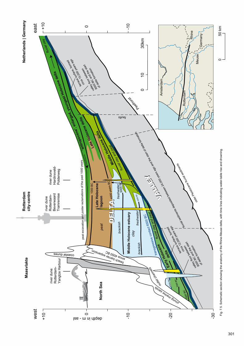
The Yangtze Harbour research has shown that it was a long while before any direct marine influence became noticeable. In the course of the Preboreal and indeed most of the Boreal, there continued to be a freshwater, fluvial environment around this westerly dune. At the beginning of the Preboreal the coast still lay far off in the present North Sea, and the sea level was some 50m below where it is today. The Rhine drained towards the southwest with the Meuse, Scheldt, and Thames as tributaries, and emptied into the sea at the Strait of Dover. The confluence of the Rhine and Thames is envisaged as some 150km downstream from the Maasvlakte (Bridgland and d’Olier 1995), off the coast of Flanders. North of the Rhine valley lay an extensive coversand region drained by the rivers Overijsselse Vecht and Eem. Here and there in the dry North Sea plain were some elevated areas as well, such as the current Dogger Bank. At the beginning of the Holocene, the North Sea coast lay over 300km to the north. Reconstructions (Jelgersma 1979; Coles 1998) put the coast north of the Dogger Bank (the current 60m-depth contour), running from northern England to the northern tip of Denmark. A watershed would have run between the isle of Texel and the Dogger Bank. The river Elbe formed the most important drainage system east of this watershed (Figge 1980; Fig. 7.6), while the lower courses of rivers like the Weser, Ems, and Hunze (northeastern Netherlands) traversed the area in a northerly direction. The English rivers drained into the western catchment area.
In the Early Mesolithic, the Rotterdam area still occupied an inland position in the Rhine-Meuse valley. In the Preboreal it periodically experienced brief (some weeks, varying from year to year) inundations of the floodplain. For most of the year, however, the water table lay below the surface, allowing soil formation and sand drifting to occur. With the development to a more deltaic situation in the Boreal, flooding occurred with greater regularity and frequency. Groundwater would appear at or a little above the surface for larger parts of the year, and over the width of the river valley more differentiated wetland environments developed. Only the valley margins and the river-dune areas within in the valley remained as elevated parts unaffected by inundation along the river. This continued to be the situation into the Early Atlantic.
It was not until halfway through the Early Atlantic that the sea level had risen to such an extent that an estuary formed in this area. Such an environment had earlier occurred in the Boreal, be it dozens of kilometres downstream. In the estuary, the inundation regime was determined mainly by the sea level and tidal fluctuations, and occasionally by high river discharge or storm surges. In the estuarine area a freshwater tidal environment prevailed. By the time of the younger radiocarbon-dated settlement phases in the Yangtze Harbour, such an environment must have existed a few kilometres downstream from the site. Between 6500 and 6300 BC the site itself briefly lay in the freshwater zone of the estuary (Chapter 3). Towards the end of the Early Atlantic the freshwater estuary zone had moved upstream of the site, and the Maasvlakte area had become part of a brackish to marine environment. In the Middle/Late Atlantic, the presence of salt-tolerant vegetation such as glasswort and saltmarsh rush at the site of Rotterdam-Emplacement Centraal Station points to marine influence (Brinkkemper in: Guiran and Brinkkemper 2007). The area between the Maasvlakte and Rotterdam Centrum in this period would have been a brackish estuary (Hijma and Cohen 2011). The site in the Yangtze Harbour by then had already been submerged for centuries.

304
circa 7000 years BC
Today's coastline
Afb. 7.6. De holocene inundatie van de Noordzee. De kustlijnen en de veronderstelde positie van een door zeegaten onderbroken strandwallengordel
(stippellijnen) is voor drie tijdstippen gereconstrueerd (naar Beets en Van der Spek 2000, in: De Mulder, Geluk, Ritsema, Westerhof en Wong 2003).
Fig. 7.6. The Holocene flooding of the North Sea. Deeper parts (darker shade of blue) drowned between 8000 and 7000 BC. The presumed coastline position at 7000 BC and a beach-barrier alignment breached by tidal inlets are indicated, the latter by a dotted line. Rotterdam-Yangtze Harbour is marked with the red dot.
circa 7000 years BCToday's coastline
Afb. 7.6. De holocene inundatie van de Noordzee. De kustlijnen en de veronderstelde positie van een door zeegaten onderbroken strandwallengordel (stippellijnen) is voor drie tijdstippen gereconstrueerd (naar Beets en Van der Spek 2000, in: De Mulder, Geluk, Ritsema, Westerhof en Wong 2003).
An important supra-regional aspect of the submersion is the fact that a connection was made between the northern (from Scotland-Scandinavia) and southern (from the Strait of Dover) sea basins, as a result of which the current tidal regime established itself. Between 6500 and 5500 BC, this was accompanied by a considerable increase of the tidal range (Fig. 7.7). Initially, the tidal range was slightly tempered by a rise of the mean sea level resulting from the establishment of an amphidromic point in the Southern Bight, around which the tidal surge has rotated ever since (van der Molen and de Swart 2001; Hijma and Cohen 2010).11 The configuration between 8000 and 7000 BC with a narrow Strait of Dover and a relatively broad, shallow bay in the southern North Sea suggests that the tides at the mouth of the Rhine at the time were strongly subdued (see also Uehara, Scourse, Horsburgh, Lambeck, and Purcell 2006).12
For the Rhine-Meuse estuary, the sea-level rise meant that the water-table regime from about 6550 BC was directly influenced by the sea. Because of its westward position, the Yangtze Harbour dune had earlier experienced ‘wet feet’ (Chapter 3; Fig. 7.5). Regionally, peat formation could occur from as early as 7250 BC in lower, frequently flooded spots along the river courses, as well as in depressions in river-dune areas and along the feet of dunes in the margins of floodplains. Previously, floods had mostly deposited clay, while in the remainder of the year soil formation could take place and peat growth was limited to local pools and residual channels.

305
Afb. 7.7. Storegga tsunami van tussen 8300 en 8000 jaar geleden/6250 voor Chr.
b. Onzekere kustlijnposities Nederland ten tijde van de tsunami. De witte lijnen
illustreren hoe het tsunami gol�ront de Noordzee binnenliep - de dikste lijnen
zijn de vermoedelijke brekerzones (naar Cohen en Hijma 2008).
Fig. 7.7. The Storrega tsunami, occurring between 6250 and 5950 BC. The position of the Dutch coastline at the time of the tsunami is uncertain (cf Fig. 7.6). The red dot indicates the location of Rotterdam-Yangtze Harbour.
7.3.2 Exploitation of resources
The palaeogeographical transformation of the wider Meuse-estuary region was not uniform, neither in chronological (in the course of the Mesolithic), nor in geographical terms (over the full width of the valley and its full length from floodplain to mouth). Various differences at different scale levels made it a caleidoscopic complex of changes. In the Early Mesolithic (up to 7500 BC) the transformation was limited to geographical changes within the valley (changes in river style, dune formation, vegetation succession, and soil formation). In the Middle Mesolithic, with shortening lines to the approaching estuary, it also entailed transformation to wetland conditions for the lower-lying parts. By the Late Mesolithic, (from circa 6500 BC) the river mouth lay in the present Rhine-Meuse estuary. There were still dune outcrops beside the channels in the wetland areas upstream, but no longer in the Maasvlakte area. The main question is what this meant to the Mesolithic hunter-gatherers who were active in the Rhine-Meuse estuary. It is obvious to seek the influence of these changes in resource exploitation mainly in the coast approaching from the west. What resources were exploited and where could they be found? Could it be that forms of exploiting the partially aquatic environment were practised in the Maasvlakte area (Yangtze Harbour) during the Middle Mesolithic, which upstream, in Rotterdam, were not in evidence until the Late Mesolithic, when the estuarine environment had shifted even further east?
7.3.2.1 The aquatic environment
The Yangtze Harbour is the westernmost excavated site; Hardinxveld-Polderweg and Hardinxveld-De Bruin in the polder Alblasserwaard are the easternmost relevant to the debate. While the faunal remains from the Yangtze Harbour dune included some fish species that are decidedly marine, these were entirely absent from the two Late Mesolithic sites at Hardinxveld. In the case of the Yangtze Harbour, it is quite likely that the presence of marine species is linked to the approaching coast. Yet it is an oversimplification to presume that with the shifting coastline eventually more or less automatically marine fish would be caught throughout the Meuse estuary. The sites at Hardinxveld remained

306
relatively far inland, in a fluvial environment without any evidence of marine influence, even long after the Yangtze Harbour was drowned by the sea. Other sites have yielded too few faunal remains to show what happened in the intervening region, which underlines how fragmentary the data base still is.
Judging by the currently known evidence, it appears that many resources were exploited in close proximity to the site. In the case of the Yangtze Harbour dune, it is clear that a rich variety of plant and animal resources were available on and near the dune complex. A comparable picture emerges for Hardinxveld-Polderweg and Hardinxveld-De Bruin. Also Rotterdam-Beverwaard Tramremise, Rotterdam-Groenenhage, and Rotterdam-Emplacement Centraal Station tie in with this, although for these sites considerably fewer data are available. At the same time, one should be cautious in considering the ‘potential availability’ and the actual provenance of a recovered/demonstrated resource. Resources may well have been potentially available, but in reality their availability may have strongly fluctuated in space and time. As was mentioned in Section 7.2.2.3, certain resources may have been brought in over considerable distances, even if in landscape reconstructions they might be deemed potentially available ‘locally’. This goes both for mammals and fishes. On the basis of ethnographic evidence relating to hunter-gatherers in Boreal landscapes in particular, it seems likely that smaller game and fur mammals, as well as birds, fishes and plant foods were sourced in the immediate surroundings.
Although the species marked as food resources in the recovered assemblages were available in the close vicinity, this does not necessarily imply either that these were exploited randomly and in the same way throughout the region. The well-preserved faunal remains from Hardinxveld-Polderweg and Hardinxveld-De Bruin show that pike was a specifically targeted fish species, probably in late winter and early spring, when these fish congregate in shallow floodwaters to spawn (Beerenhout 2001a, 264; idem 2001b, 323-324). Also it was clear that fishes from a range of biotopes were caught: the main channels of large rivers, the pools outside them with stagnant or slowly flowing water, and the seasonally inundated areas. This range of biotopes is fully represented also by the fish remains found on the Yangtze Harbour dune.
The exploitation of fishes from different biotopes implies different fishing methods. In active channels the use of fishing weirs – consisting of wattle panels with one or more gaps with funnels in them – is a very effective way of catching fish migrating upstream (Bulten, van der Heijden, and Hamburg 2009). It is a passive method, based on a knowledge of the seasonal migratory behaviour of fish species. Also tidal channels where certain marine fish species swim upstream with the tide, can be used in this manner; as the tide goes out, the fish will be trapped by the weir. Various Neolithic examples of such fishing systems are known from the Netherlands (Hoge Vaart-A27; Emmeloord-J97). Besides, traps and nets may have been used, both in running and stagnant water. Fish traps are known from various findspots in the Netherlands, including Hardinxveld-De Bruin (Louwe Kooijmans, Hänninen, and Vermeeren 2001b), Hoge Vaart-A27 (Hamburg, Kruijshaar, Nientker, Peeters, and Rast-Eicher 2001) and Emmeloord-J97 (Bulten et al. 2009). Fragments of knotted string that may represent parts of nets are known from Rotterdam-Emplacement Centraal Station (Guiran and Brinkkemper 2007) and Hardinxveld-Polderweg (Louwe Kooijmans, Vermeeren, and van Waveren 2001a).
Less clarity exists about the use of harpoons in fishery. As noted earlier, the Rhine-Meuse estuary stands out for the hundreds of points made of bone, at least part of which are interpreted as harpoon heads (Verhart 1988; idem 1995). Given the lack of evidence about the original context from which these artefacts derive, it is not certain that they all relate to fishery. Yet the research into the palaeogeographical evolution of the Yangtze Harbour has made it clear that the harpoon heads of Maasvlakte 1, judging by their (in most cases presumed) antiquity, were in fact ‘discarded’ in a freshwater estuarine landscape rather than a marine one. It is well possible that harpoons were used for spearing larger fishes, such as salmon, sea trout and sturgeon, once they had been trapped by a fish weir.

307
7.3.2.2 Plants aplenty
As shown in Sections 7.2.2.2 and 7.2.2.3, the study in the Yangtze Harbour yielded a surprising amount of evidence about the use of plant resources. It was established that the dune flank deposits contained quite a wide range of species which may have provided plant foods. The intensively visited sites at Hardinxveld a similar picture. Other Mesolithic (and Early Neolithic) sites in the Rhine-Meuse estuary have yielded less evidence, mainly because of less intensive research.
Besides hazelnut and acorn, water chestnut seems to be a standard feature. Charred remains of water chestnut are known from Yangtze Harbour, Rotterdam-Emplacement Centraal Station, Hardinxveld-Polderweg and Hardinxveld-De Bruin.13 Also, charred remains of starch-rich tubers of lesser celandine have been found at Yangtze Harbour and in the nearby river-dune site Hardinxveld-Polderweg (Bakels and van Beurden 2001). Seeds of yellow water-lily and berries of hawthorn and dogwood – whose charred remains have been identified at the above-mentioned sites – may also have been eaten.
As was mentioned in Section 7.2.3.2, oil may have been extracted from the seeds of dogwood. The systematic occurrence of dogwood seeds in the more sizeable botanical assemblages, not only in the Rhine-Meuse estuary but also elsewhere in the Netherlands and abroad (southern Sweden), may point to this. Notably, the charred specimens from the Yangtze Harbour are broken or crushed, which is a strong indication that the berries and/or seeds were processed.
From the currently available data it becomes increasingly clear that plant resources played a significant role in the life of the Mesolithic hunter-gatherers. The importance of plant resources and their exploitation was earlier emphasised by Zvelebil (1994). The insights from the Yangtze Harbour study and the data from elsewhere in the Rhine-Meuse estuary offer supporting arguments for this. The importance of plant resources is apparent not only from the recovered plant remains, but also from the use-wear traces identified on the flint and other stone artefacts. The use of blades for scraping and flattening siliceous plants was documented also at both Hardinxveld sites (van Gijn et al. 2001a; idem 2001b). The flints from Rotterdam-Beverwaard Tramremise and Rotterdam-Groenenhagen have not (yet) been examined for use wear, but it is likely that such processing took place at these sites too. According to van Gijn (2010) it was a recurrent activity, apparently linked to wetland hunter-gathering.
There are also signs of Mesolithic hunter-gatherers having actively interfered in the vegetation. Fire played an important part in this process. Along the Yangtze Harbour dune, indications were found of repeated burning of reed beds, in all probability to improve access to the sandy knoll, or conversely to improve access to the river. Although in a wetland setting this may appear less likely, there may be other reasons too for burning off patches of vegetation (Mellars 1976). Ethnographically it is known that hunter-gatherers – like those in North America and Australia – did so to create open country and improve the view, while attracting game to the rejuvenated vegetation. A more open vegetation may also boost the production of nuts and fruits in the spinneys.
In the Netherlands and other northwest European countries, there has been growing evidence of the deliberate burning of vegetation. For the Early and Middle Mesolithic in the Netherlands, the Yangtze Harbour, Zutphen-Ooijerhoek (Bos, van Geel, Groenewoudt, and Lauwerier 2005), Almere-Overgooi (Opbroek and Lohof 2011), Hanzelijn-Gebied VIII (de Moor et al. 2009), and Groningen-Meerstad (Woldring, Schepers, Mendelts, and Fens 2012) are important sites. A distinct parallel to the Yangtze Harbour is the English site of Star Carr (Yorkshire), where evidence of the intermittent burning-off of reeds has also been connected to keeping open water accessible and creating wider views (Mellars and Dark 1998). But even for the Late Glacial there are various indications of such practices, for instance at Milheeze in the Netherlands (Bos and Janssen 1996; Bos, Bohncke, and Janssen 2006), Rieme in Belgium (Bos, Verbruggen, Engels, and Crombé 2013), and the Lahn valley in Germany (Bos and Urz 2003). In particular it is the repeated occurrence of horizontally lying, charred reed remains like those encountered in the Yangtze Harbour and at Star Carr, that makes a natural explanation unlikely.

308
7.3.3 Social context and ideology
In all likelihood, rivers played an important role in the provision of information (Lovis and Donahue 2011). Information about the availability of all sorts of subsistence resources is of crucial importance to hunter-gatherer groups (Whallon 2011). But also, information about the activities of more or less related groups is essential for maintaining social contacts (Kelly 1995, 150-151). Choices about residing at site A or B in particular seasons are strongly affected by the available information.
In Section 7.2.4 it was proposed that the broad spectrum of activities and the great time depth of the Yangtze Harbour dune site might reflect repeated use of this site as a base camp.14 People will in the course of time have adjusted their activities to the changing landscape and biotopes. The river-dune complex was certainly suitable as a location for long-term use. Other extensive river-dune complexes near the Meuse estuary, where also the higher parts of the dune could be investigated (Rotterdam-Beverwaard Tramremise, Hardinxveld-Polderweg, and Hardinxveld-De Bruin), show evidence of various phenomena which for reasons of non-preservation and excavation method could not be studied in the Yangtze Harbour. At the two Hardinxveld sites, pits of varying sizes were uncovered, including a few large ones which were interpreted as sunken-floored huts (Hamburg and Louwe Kooijmans 2001; Louwe Kooijmans and Nokkert 2001). At Hardinxveld-De Bruin some small pits in the surrounding peat were found to contain ritual depositions from the Early Neolithic habitation phase (Louwe Kooijmans and Nokkert 2001). Besides, burials came to light at both Hardinxveld sites and at Rotterdam-Beverwaard Tramremise. At Hardinxveld-Polderweg the graves were inhumations of humans and dogs (Smits and Louwe Kooijmans 2001a) and at Hardinxveld-De Bruin, human inhumation graves (Smits and Louwe Kooijmans 2001b). Both sites also yielded isolated human remains which were recovered among the settlement debris. At the site of Rotterdam-Beverwaard Tramremise, cremation remains were recovered (Zijl et al. 2001).
Although at the sites in the Yangtze Harbour any evidence of built structures or burials is obviously lacking, such features are likely to have been present originally. Archaeological research into the early prehistoric occupation of the Rhine-Meuse estuary has consistently focused on the (higher) river-dune crests. Human – and canine – burials would then be no exception. In other areas too, for instance in Flevoland, river dunes and natural levees consistently yield graves, while isolated human remains are frequently found among the traces of settlements. Maybe this reflects a specific meaning of such sites in the landscape, maintaining historical relations between people and places, as nodes in time (time nodes; Peeters 2007). In a transforming landscape, close to a shifting coastline, such a function may be of a persistent nature and determine the structure of landscape use. Human skeletal remains from the Mesolithic that are on occasion picked up along the Dutch coast or fished up from the North Sea near the Brown Ridge, may derive from eroded graves or cemeteries.
In this connection it should be remembered that it is hard to get a grip on the spatial scale on which to consider the use of landscapes by Mesolithic (and Early Neolithic) hunter-gatherers, not only when it comes to the spots where people lived for shorter or longer periods, but also for the interconnections between these places. The ‘exotic’ provenance of certain raw materials, for instance, may reveal links to relatively distant areas. In Section 7.2.3.3 the presence of Wommersom quartzite on the Yangtze Harbour dune was already mentioned. Some artefacts of this material were identified also at both Hardinxveld sites, Rotterdam-Beverwaard Tramremise, Rotterdam-’t Hart, and at Hoge Vaart-A27 in Flevoland (van Gijn et al. 2001a; idem 2001b; Niekus in Zijl et al. 2011; Schiltmans 2010; Peeters et al. 2001; Amkreuz 2013). The material may have been acquired by the estuary dwellers themselves from outcrops in Belgium. These outcrops were accessible via the river Scheldt and its tributaries Dijle and Demer. It is quite possible that both the downstream Rhine-Meuse valley and the Scheldt catchment area were exploited by the same population group.
Lithic raw material gathered at various spots in that area became widely distributed. It cannot be ruled out that Wommersom quartzite ended up this far north from its source through contacts with other groups. Unfortunately, the distribution areas of other lithic raw materials are more difficult to establish. In contrast to the Wommersom quartzite – easily

309
recognisable and with just one source area – the exact provenance and subsequent distribution of other flint and stone resources is not simply traceable on the basis of petrographic traits, because of their widespread primary and secondary source areas. In rare cases it can be made plausible on the basis of technological arguments that materials or artefacts ended up far from their source area through inter-group contacts. A good example are some large blades of Rijckholt flint recovered at Hardinxveld-De Bruin (van Gijn et al. 2001b; Amkreuz 2013).
7.4 Changing perspectives: on the archaeological understanding of hunter- gatherer landscapes and the significance of the Yangtze Harbour investigations
Just as the settlement on the Yangtze Harbour dune cannot be seen in isolation from the geographical context of the Rhine-Meuse estuary, so the activities of hunter-gatherers in the wider region cannot be considered separate from developments in the southern North Sea Basin and adjoining areas in England, Belgium, the Netherlands, and northwestern Germany. Throughout northwestern Europe, processes were being set in motion as a result of the climate changes starting in the Late Glacial, which were to dramatically alter the landscape and its potential for habitation.
7.4.1 The drowning of the southern North Sea basin
7.4.1.1 The end of a glacial
In the coldest phase of the last glacial (Last Glacial Maximum - LGM), between 26,000 and 20,000 years ago, the sea level was roughly 120m below where it is today. Northwestern Europe formed a continuous landscape, comprising the British Isles, the North Sea area, the British Channel, and the current continent. An ice cap lay across Ireland, Wales, and Scotland, and an even larger one covered the Scandinavian-Baltic region. The landscape south of these ice caps was dissected by large river systems, including those of the Rhine and Meuse. The joint lower course of these rivers, from their confluence with the Thames, is known as the Channel River. It passed through a limestone gorge at the Dover Strait and followed the English Channel, and beyond Brittany emptied into the Atlantic Ocean (Jelgersma 1979; Bourillet, Reynaud, Baltzer, and Zaragosi 2003; Ménot et al. 2006). Along its course, the river was joined also by the Somme and the Seine. In the flat North Sea basin, the Rhine-Meuse river was a broad one, traversing a coversand landscape. In the confluence zone of the Rhine-Meuse and Thames, the Channel River was flanked by a landscape of dissected, eroded river terraces and hills. In the actual Dover Strait it was a gorge, and further downstream the river passed through an alternation of river terraces and gorges (Gupta, Collier, Palmer-Felgate, and Potter 2007; Mellet et al. 2013).
The southern North Sea basin, to which the present southwestern Netherlands and Rhine-Meuse estuary belonged also, was an important confluence area of river courses on their way to the Dover Strait (Bridgland and d’Olier 1995; Hijma, et al. 2012). Before the LGM, presumably also northern meltwater rivers temporarily fed into this extensive river system. During the LGM, this already was no longer the case. From 26,000 years ago onwards, it was in the first instance especially the British ice cap and the southwestern sectors of the Scandinavian ice cap that considerably decreased in size. Other parts of the ice cap started to melt from about 23,000 years ago. Meltwater lakes formed in the peri-Baltic region (Poland, Baltic Sea). Along the southwestern edge of Scandinavia, drainage occurred via the river Elbe towards the North Sea near Norway. In the dry southern North Sea, the Rhine-Meuse system survived after the LGM as the principal river system (Hijma et al. 2012).
In this period, periglacial conditions with permanently frozen subsoil prevailed in the Netherlands and surrounding areas. Vegetation was absent or very sparse, and over wide expanses the wind found no obstacles. As a result, a great deal of sand was locally displaced throughout the North Sea basin, which resulted in a vast landscape of dunes across the Northwest-European Plain, dissected by major and minor river valleys. These
310
river systems were fed by snowmelt water, which could not adequately drain into the frozen subsoil. In many cases this resulted in a braided river pattern with a relatively broad active bed with sand bars. These sand bars in their turn formed the sources of driftsand, which created extensive coversand landscapes.
The end of the LGM marks the beginning of the worldwide melting of ice caps, and with it the sea-level rise. The total sea-level rise has been 120m and some 60% of this rise occurred even in the Late Pleniglacial and Late Glacial, between ca 20,000 and 11,700 years ago, i.e. before the beginning of the Holocene (9700 BC). Initially the sea level rose fairly slowly, by circa 20m in 5000 years. With the staggered warming at the start of the Bølling interstadial, 14,500 years ago, the deglaciation of the Scandinavian-Baltic zone and the much larger North American ice cap accelerated spectacularly, thus also accelerating the worldwide sea-level rise. The English Channel was engulfed by sea water in this period, and the Channel River ceased to exist. The valley floor in the Strait of Dover and the southern North Sea basin lay at a higher elevation, so this region continued to be drained by rivers up to the end of the Pleistocene.
7.4.1.2 Shifting coastlines and waterlogging
As was indicated in Section 7.3.1.2, the coast at the start of the Holocene still lay far out in what now is North Sea. The mean sea level lay some 50m lower than it does today. There was a northern coastline running from the north of England, via the Dogger Bank, to northern Denmark, and a southern, bay-shaped coastline south of the Dover Strait. The Dover Strait gorge changed into an estuary at the transition from the Younger Dryas to the Holocene. In the Preboreal, the estuary lay between Flanders and England, and in the course of the Boreal it shifted to the Dutch sector (Hijma and Cohen 2010; idem 2011). The Maasvlakte underwent the transgression at the transition from the Early to the Middle Holocene, in the earliest Atlantic, as is evident also from the Yangtze Harbour investigations (Fig. 7.5). In the Early Holocene the northern coastline too shifted rapidly towards the Rhine-Meuse valley. From the deeper part of the North Sea, between Scotland and Norway, the transgression progressed southward, along both the English and the Danish-German sides of the Dogger Bank. After circa 8000 BC it was no longer possible to reach Britain over land, and between 7550 and 6550 BC most of the southern North Sea basin was engulfed by the sea. Sediment analyses on a core in the Danish part of the North Sea (Skågerrak) suggest that the first marine contact with the southern North Sea was made around 6800 BC; from ca 6200 BC the contact was of a strength comparable to the current situation (Gyllencreutz and Kissel 2006). For about 1000 years the Dogger Bank formed an island in the North Sea, only to be eventually swallowed up. Nowadays its tops lie at a depth of 24m. Moreover, the past 8000 years have seen a subsidence of some 5 to 10m, as well as truncation. Allowing for the subsidence, the drowning of the last top of the Dogger Bank presumably coincided with a sea level of circa 15m below the current one, at around 6000 BC, roughly at the same time when the Yangtze Harbour area became permanently submerged. Not only variations in the pace of sea-level rise, but also differences in topography meant that the speed of submersion was not the same everywhere. Relatively flat areas, like the Dutch part of the North Sea, were drowned in a relatively short period over large expanses, while the effects were more gradual in steeper valleys like that of the Channel River between the Thames confluence and the Strait of Dover. Where the coastline moved across critical points in the gradient of river valleys – as in the Rhine-Meuse system during the Boreal when the river mouth shifted from the Thames confluence to the Dutch sector – this would, by affecting the water table, have caused landscape changes upstream as well. Conversely, the beginning of Basal Peat formation in the Maasvlakte area (around 7500 BC; see Chapter 3) and the switch whereby meandering main channels deepened into an aggrading deltaic pattern (Hijma et al. 2009), may offer clues about the moment when a final threshold in the valley in the southern North Sea was overtopped.
311
7.4.1.3 A tipping point around 6500 BC
The moment around 6500 BC manifests itself in several locations in the North Sea basin – and around all oceans throughout the world – as an important tipping point during the transgression. Between 8050 and 6450 BC, Hijma and Cohen (2010) state, the mean water table in the future Rhine-Meuse estuary rose from about 24 to 19.5m - asl (Fig. 7.5). From ca 7000 BC this water-table rise progressively accelerated. Around 6450 BC (± 44 years) the area was drowned, and within 200 years the sea level rose from 19.7m - asl to 15.6m - asl. This four-metre rise according to Hijma and Cohen comprised a structural background rise of circa 2m and a sea-level ‘jump’ of similar amplitude. The ‘jump’ is related to the Hudson Bay being freed of its ice cap, and the sudden wholesale drainage of the meltwater-filled Lake Agassiz-Ojibway in Canada. This released a gigantic volume of fresh water into the ocean, which resulted in a worldwide absolute sea-level rise (among others, Törnqvist and Hijma 2012; Cohen and Hijma 2013; see Fig. 3.21).
The drainage of Lake Agassiz-Ojibway is also linked to a brief climatic ‘blip’ in particularly the North-Atlantic part of the world, the so-called ‘8.2 ka event’.15 The influx of fresh water into the ocean slowed down the warm Gulf Stream and the northern hemisphere experienced a cooler phase. In the same time frame, a submarine landslide on the edge of the Norwegian continental shelf (the Storegga landslide) caused a tsunami. This tsunami certainly affected the coasts of Norway, Iceland, and Scotland, as well as those of the southern North Sea: the coasts of the Dogger uplands, eastern England and offshore parts of the Netherlands (Weninger et al. 2008). In contrast to the sea-level jump preceding the ‘8.2 ka event’, well-documented in the Maasvlakte area, neither the timing of the Storegga tsunami, nor the water depths and location of contemporary coastlines in the North Sea area are accurately known (Fig. 7.8). Below Rotterdam Centrum, around 13m - asl, there is sedimentary evidence of a region-wide marine flooding having occurred around 6000 BC; possibly this sedimentary marker may be linked to the Storegga tsunami rolling up the Rhine-Meuse estuary. Yet the erosive impact of this tsunami may have been limited in these parts, owing to the buffering capacity of the estuary and the Rhine delta which had by then formed (Cohen and Hijma 2008; Hijma 2009). Research into the antiquity of tsunami-related deposits in Norway and Scotland has dated the tsunami to between 6200 and 5950 BC (Weninger et al. 2008). The background of steady sedimentation in the Rhine-Meuse estuary and the limited erosive effect lend the Rotterdam dating of the tsunami to circa 6000 BC greater accuracy than do the spectacularly thicker deposits left under high-energetic conditions along the Norwegian and British coasts.
In considering the permanent sea-level jump and the possible one-off impact of a tsunami, it is remarkable that their timing should coincide with the chronological gap, mentioned in Section 7.3.1.1, which separated the submergence of the Early/Middle Mesolithic site in the Yangtze Harbour from the (Late) Mesolithic sites further inland. The absence of sites in the Rhine-Meuse estuary with hard evidence of human activity between circa 6400 and 6000 BC may, as suggested earlier, be an artefact of research intensity. But it is also imaginable that the gap is due to the effects of accelerated sea-level rise on Mesolithic habitation in the area, which may have suffered a brief interruption (discontinuity of habitation). At the same time, erosion along the banks of the broad, young estuary may have affected the preservation of many contemporary traces of habitation. Remains lying at or close to the surface would run a greater chance of being washed away than those which at deeper levels – on the flanks and at the feet of river dunes – had already been embedded in sediment. On the basis of current evidence, it is unclear what factors – research intensity, sedimentary conditions during occupation, preservation conditions immediately afterwards, habitation discontinuity – are responsible for the chronological hiatus, but it is a phenomenon that does require further investigation.
7.4.2 Mesolithic hunter-gatherers in a drowning landscape
The Mesolithic occupation of the southern North Sea basin, also known as ‘Doggerland’, has over the past fifteen years enjoyed a great deal of attention, mainly as a result of an article by Coles, published in 1998, in which he presented an overview of the changing palaeogeographical conditions and the then known archaeological evidence. The
312
significance of Coles’ article lies mainly in its emphatic statement that the former dry land in the current southern North Sea should not be regarded as a mere land bridge between England and the continent, but as part of a continuous landscape. From the perspective that coastal zones must have been particularly attractive to Mesolithic hunter-gatherers because of the wealth and relative stability and predictability of resources, Doggerland may even have constituted a core region (Fig. 7.9).
As much as a century ago, Reid (1913) formulated the first ideas relating to the North Sea as a formerly wooded and habitable region. Clark in 1936 also pointed out the potential importance of this submerged land, when he realised that settlement traces of the early Maglemosian culture, which in southern Scandinavia was known especially from the coasts, must largely have disappeared into the sea. Despite more evidence having since then become available about its palaeogeographical features (Gaffney, Thomson, and Fitch 2007), it must be admitted that the archaeological significance of Doggerland is still highly speculative. However, the growing number of finds (Glimmerveen et al. 2004; van Kolfschoten and van Essen 2004; Verhart 2004) does suggest that the expectation of archaeological ‘wealth’ – at any rate in the region where Doggerland bordered on the Rhine-Meuse-Thames valley – is not wholly unfounded.
In relation to the drowning of the southern North Sea region, the geographical position of the Yangtze Harbour dune is exemplary. The dune in the Preboreal is contemporary with the Dogger uplands16 becoming an island in the North Sea and the context in which the dune was inhabited changed from a terrestrial landscape into an estuarine one until the dune was entirely submerged by the transgression which also engulfed the Dogger uplands. Yet there is an important difference between the situation of the Dogger uplands and that of the Rhine-Meuse estuary: the island had no hinterland, while the estuary did. This implies that human exploitation of the changing landscape in the estuary must be placed in a different context from that of the drowning Dogger uplands.
Even though in several respects the resolution of the data is less than optimal for adequately answering all the questions, it should be stated that a ‘window’ like the Yangtze Harbour presents a unique contribution to our understanding of a distant past: the Early and Middle Mesolithic of the drowning North Sea. Importantly, our knowledge of Mesolithic hunter-gatherers is almost entirely based on sites located in today’s dry or reclaimed land, and rarely in what then were lush lowland areas in the vicinity of the sea. Clark (1936) argued that the North Sea area played a large role in the technological and typological correspondences between artefacts from England and southern Scandinavia. His ideas were supported by palaeo-ecological evidence derived from scattered lumps of peat retrieved from the sea. Moreover, one chunk of peat from the ‘Leman and Ower Banks’, off the Norfolk coast, was found to contain a bone harpoon head. Some 35 years later, Louwe Kooijmans (1971) published a series of Mesolithic artefacts from the Europoort area and from the Brown Ridge. Over the past ten years, more new finds have been published (Glimmerveen et al. 2004; van Kolfschoten and van Essen 2004; Verhart 2004) and further theoretical arguments have been put forward for attaching greater value to drowned, prehistoric landscapes, and to coastal regions in particular (Bailey 2004; Flemming 2004).
Around the millennium, research in the southern Scandinavian coastal zone strongly influenced ideas about how prehistoric hunter-gatherers made use of coastal zones and how the exploitation of aquatic resources would have contributed to the development of sedentism, territoriality and social differentiation (Fischer 1995; idem 2004; Waddington 2007). But the question, of course, is to what extent that region can serve as a model for what went on elsewhere along the northwest-European coasts. There may well have been greater regional differentiation than was initially presumed (cf. Louwe Kooijmans 2001a).
Essential to our understanding is the spatial scale on which hunter-gatherers made use of the landscape and the role of information (Whallon 2011). Ethnographic evidence may be instructive in this respect.17 For instance, Lovis and Donahue (2011) show the kind of geographical knowledge about river courses and lakes that is current among hunter-gatherer groups in southeastern Labrador. Although geometrically distorted, the maps drawn by native Americans display huge detailing of river systems and lakes across vast areas, equivalent in size up to the Netherlands, Flanders, and southeast England, the southern North Sea and the Dover Strait combined (Fig. 7.10).18 A crucial role in

313
Rhine
Elbe
Channel
Thames
North Sea
Shetland
Dogger uplands
Fig. 7.8. Northwestern Europe around 8000 BC. The progressive sea-level rise eventually turned the Dogger uplands into a North Sea island, and drowned them altogether around 6250 BC. Rotterdam-Yangtze Harbour is indicated with the red dot.
the provision of information is played by the rivers and open water as routes through the landscape, with confluences of tributories and features such as characteristic cliffs, headlands, and hills along watercourses serving as landmarks. Also overland routes have a place in the mental maps employed by these hunter-gatherers (Istomin and Dwyer 2009; Jordan 2012). Spatial information about the landscape and knowledge of routes and landmarks in this perspective form important conditions for exploiting the resources of a particular region and for instance anticipating the annually varying availability of certain food sources.
Given the great spatial scale on which geographical information may be available to hunter-gatherers, we must seriously consider the question of how representative our archaeological data base is when it comes to Mesolithic use of the landscape. The Early Mesolithic sites which are known mainly from the higher-lying parts of the Netherlands (in particular the Pleistocene coversand areas in the north, east and south of the country) at the time lay far inland. The few Mesolithic locations that we know from the western Netherlands make it clear that the sites in the more elevated parts of the country represent just a (perhaps small) part of a far greater diversity in forms of landscape use. If we focus on the time frame relevant to the river dune in the Yangtze Harbour, i.e. the Preboreal to Early Atlantic (Early and Middle Mesolithic), it should first of all be remembered that it was only towards the end of this interval that the coastline came to lie close to our research area. The site in the Yangtze Harbour lies at a tipping point, where Mesolithic coastal habitation may have direct links to sites uncovered elsewhere in the terrestrial Netherlands. Although sites covering the same chronological period have been found elsewhere in the Netherlands and adjacent parts of Belgium and Germany, the Yangtze

314
Afb. 7.9. Kaart van Zuidoost-Labrador in Canada. Het weergegeven gebied is ongeveer zo groot als de Benelux, het aangrenzende deel van Duitsland, de zuidelijke Noordzee en Oost-Engeland teza-men (naar Lovis en Donahue 2011).a. Het systeem van rivieren en meren (getekend door Mathieu Medicabo).b. Een gecorrigeerd beeld (naar Leacock 1969, 7, map 1 en map 2).
a
b
Afb. 7.9. Kaart van Zuidoost-Labrador in Canada. Het weergegeven gebied is ongeveer zo groot als de Benelux, het aangrenzende deel van Duitsland, de zuidelijke Noordzee en Oost-Engeland teza-men (naar Lovis en Donahue 2011).a. Het systeem van rivieren en meren (getekend door Mathieu Medicabo).b. Een gecorrigeerd beeld (naar Leacock 1969, 7, map 1 en map 2).
a
bFig. 7.9. Maps of southeastern Labrador, Canada. The area shown is roughly the size of the Benelux, the adjacent part of Germany, the southern North Sea, and eastern England put together. a. The map drawn by Mathieu Medicabo shows a distorted image of the area, which on the other hand is very detailed in representing the coastline, river courses, and lakes.b. A conventional map with the cartographically correct representation of the area (after Leacock 1969, 7, Folders 1 and 2).
Scale 1:3,000,000
a
b
0 100 km

315
Fig. 7.10. Scatter diagram of uncalibrated radiocarbon dates and elevations above prehistoric sea level. In addition to Niekus 2006 (black dots, N = 393; plotted in relation to the sea-level rise curve of the northern Netherlands). With additional data from the Yangtze Harbour (the present report), Hardinxveld-Polderweg, and Hardinxveld-De Bruin (Out 2009), Willemstad (van Es and Casparie 1968; van de Plassche 1982; Amkreuz 2013) and several Rotterdam sites (see Table 7.3, data from the site list attached to the ROaA, in preparation), plotted in relation to the sea-level rise curve of the Rhine-Meuse estuary (Hijma and Cohen 2010).
90
80
70
60
50
40
30
20
10
0
Ele
vatio
n in
met
res
abov
e pr
ehis
toric
sea
leve
l
14C years BP 9600 8860
7000
7600
6000
6600
5000
5600
8000
Rotterdam-Yangtze HarbourRotterdam-Beverwaard TramremiseRotterdam-IJsselmondeRotterdam-‘t HartRotterdam-Emplacement Centraal StationWillemstad figurine Hardinxveld-De Bruin phase 1Hardinxveld-De Bruin phase 2Hardinxveld-Polderweg
Hearth/fire pitBone/charcoal from graveCharcoal from pitCharcoal from occupation layerCarbonised hazelnut shellOther botanical materialBone, wood, antlerWillemstad figurine
calendar years BC
Harbour site at present is the only one where the drowning process can be closely followed in relation to this early phase of the Mesolithic (cf. Niekus 2006; Figs 7.5 and 7.11).
One aspect that once again emerged from the research into the dune occupation in the Yangtze Harbour is that the formation of river dunes continued into the Early Holocene. Preboreal habitation on river dunes is well documented in various parts of the country, for instance in the current IJssel valley in the eastern Netherlands (Groenewoudt et al. 2001). It is remarkable that in other periods, where river dunes are present, as at Swifterbant (in the polder Oostelijk Flevoland), evidence of Early Mesolithic activity on river dunes is lacking, whereas it does appear in coversand areas in the same region (Peeters 2007). Conversely, there is intensive activity on the river dunes at Swifterbant, mainly in the Late Mesolithic and Early Neolithic, while at this time hardly any is documented

316
on the river dunes and coversand ridges in the eastern Netherlands. Such shifts within and among regions may be connected to the dynamics of the landscape at different scale levels (Peeters 2007; idem 2009a). As regards the Early Mesolithic, it is possible that the formation process of river dunes was decisive for the presence or absence of human activity. In areas where river dunes stabilised more readily under the influence of waterlogging and vegetation growth, human activity may have manifested itself sooner than in dune areas that formed over a longer period. The question therefore is whether prehistoric hunter-gatherers were keen to occupy any river dune as soon as it was consolidated by vegetation, or only those dunes with a favourable location for other reasons as well. For a better insight into such potential links, we need to chart the age of individual river dunes in different regions. The research in the Yangtze Harbour is of obvious importance in this respect too.
Sites like those in the Rhine-Meuse estuary of course do not stand alone. They are part of a pattern which reflects the use of the landscape in a broader context. Given the archaeozoological and archaeobotanical evidence from the Yangtze Harbour, different landscape zones were exploited: the freshwater fluvial plain and the drier elevations enclosed by or adjacent to this, the brackish tidal zone and the marine environment. It is unclear to what extent the various plant and animal (food) resources were exploited in the immediate proximity of the dune, or were imported to the site from elsewhere. But it is evident that the Yangtze Harbour and other Mesolithic river-dune sites in the western Netherlands should be considered as part of a network of places and zones in the landscape, that were linked together through routes (Amkreuz 2013).
The occurrence of non-anadromous marine fishes indicates that these hunter-gatherers must have travelled across open water to the sea over a distance of 10 to 20km. It should be remembered that the distances over which hunter-gatherers move in watery landscapes can be considerable. Remains of canoes are found relatively often in Mesolithic contexts where wood has been preserved, indicating that they were a regular means of transport. The major systems of the Rhine, Meuse, and Scheldt may in the Preboreal and Boreal have been important lines of communication. With their numerous tributaries and streams they form a network – a dendritic ‘nerve system’ – crisscrossing this hunter-gatherer landscape. The scattered occurrence of Wommersom quartzite, for instance, is an indication of the geographical scope of Mesolithic contacts and transport movements within this network.
While the river and stream systems would have been of great significance as routes in the terrestrial parts of hunter-gatherer landscapes, coasts too must have played an important part. On the one hand as waterways connecting coastal locations and separate river systems/estuaries, on the other, as part of a differentiated landscape offering extra opportunities for resource exploitation. However, relatively little is known about the use of coastal zones by Mesolithic hunter-gatherers. Most of the research has been done in the southern Scandinavian region, where the generally shallow waters with good visibility offer favourable opportunities for systematic underwater research (Pedersen, Fisher, and Aaby 1997; Harff and Lüth 2007). Also some research has been performed along the British coast, e.g. around the Severn estuary (Bell 2007), in the Solent (Momber, Tomalin, Scaife, Satchell, and Gillespie 2011), and the estuary of the Howick Burn, Northumberland (Waddington 2007). Yet in terms of geological and geographical development, these regions are not comparable to the lowlands of the North Sea basin. The southern Scandinavian region lies at the pivotal point of isostatic sinking and uplift, which means that here the influence of the global sea-level rise has affected the geographical dynamics quite differently. Besides, the steep coast of the British Isles gave rise to different coastal developments on the western shore of the North Sea than on the eastern. From the perspective of regionally differing geological processes and palaeogeographical conditions, the low-lying North Sea basin in the course of the Late Glacial and Early Holocene transgression underwent a continuously changing structure in terms of shifting coastlines, the position and nature of estuaries, and the presence of lakes. As a consequence, the opportunities offered by coasts, rivers and lakes for waterborne transport also changed. Especially in those areas where the drowning at times progressed very rapidly, as in the Dutch part of the continental shelf, these changes are likely to have fundamentally affected the ‘infrastructure’ of the hunter-gatherers’ landscape.

317
7.4.3 Conclusion
Questions relating to the representativity of the current archaeological data base, both from a national and from an international perspective, can be answered only when more insight is gained into what went on in these ‘black box’ areas. How representative is the current ‘terrestrial’ archaeological archive of the ways in which Mesolithic hunter-gatherers exploited the landscape? What correspondences or differences may there be between developments in the North Sea basin and the southern Scandinavian region?
Improving our insight into these matters is important in order to eventually identify any behavioural changes instigated by the dynamic landscape. Did the development towards a more sedentary way of life occur through an increased focus on the exploitation of stable, predictable, marine resources, as the ‘Scandinavian model’ suggests? Did, as a result of the shrinking habitable area, population densities everywhere increase, with stronger territoriality and social differentiation as a result? To what extent is there a causal link to the technological changes – a Middle Mesolithic versus a Late Mesolithic technology – which seem to have taken hold after the southern North Sea filled up?
To achieve a more nuanced picture of what effect the drowning southern North Sea basin would have had on the hunting-gathering landscape, it is necessary for investigations into the submerged areas to be continued. So far, the research in the Yangtze Harbour has been exceptional. The study, in many ways a pioneering one, has shown that a well thought-out, phased research strategy, even in challenging conditions, may produce very valuable results.