Integrating Urban Datasets: The Path to Effective SocioEconomic Planning in Urban Pakistan
9
IGC Pakistan Policy Brief February 2012 1 Integrating Urban Datasets: The Path to Effective Socio-Economic Planning in Urban Pakistan By Sohaib Khan, Amal Aslam, Maria Zubair and Ali Rehan The Importance of Cities & Urban Policy in Pakistan Approximately 40% of Pakistan’s population resides in urban areas around the country, and urban population contributes an estimated 75 % of the country’s GDP. The importance of cities to the socio-economic growth of the country is only set to rise in the foreseeable future as increasing numbers of Pakistan’s youth migrate from rural areas to cities in search of employment opportunities. Pakistan’s urban population is set to equal its rural population in the year 2030. This calls for effective urban planning tools to ensure universal delivery of basic municipal services, control of the spread of slums, the minimization of pollution and the control of crime and political violence. Understanding the Bottlenecks to Effective Urban Planning in Pakistan Missing: An Integrated View of Urban Datasets Efficient urban policy making depends on access to an integrated picture of socio-economic datasets at the micro-level for urban areas. For instance, a health department official deciding where to locate the next health centre should have simultaneous access to information pertaining to the locations of existing health centers, population figures, access to electricity and access to water and sanitation amongst other socio- economic variables. It is precisely this, however, which is missing. Various socio-economic datasets for urban areas cannot be cross-linked as a common spatial identifier does not exist across and between these. Consequently, there is very little coordination between and data sharing across different urban government departments. This results in poorly targeted and short-sighted policies in the urban centers of the country. Missing: A Common Spatial Identifier Effective urban policy making and implementation in Pakistan is impeded by the problem of integrating data containing incompatible spatial references. There is great heterogeneity across spatial units being used by different urban government departments for data collection and reporting in Pakistan. Each individual agency/ department has imagined and generated its own divisions of the city as suits its own indivi dual needs. For instance, Lahore Electric Supply Corporation (LESCO) has divided the city of Lahore into 4 circles and a further 163 sub-divisions in order to facilitate its operations. The Excise and Taxation Department has divided the city into two zones and 160 tax circles for tax collection purposes. The Population Census Organization (PCO) has divided Lahore into approximately 5000 census blocks to aid in the collection of census data. Each of these departments has, therefore, indexed its data by a different spatial unit (see Table 1 below).
Transcript of Integrating Urban Datasets: The Path to Effective SocioEconomic Planning in Urban Pakistan

IGC Pakistan Policy Brief February 2012
1
Integrating Urban Datasets: The Path to Effective Socio-Economic Planning in Urban
Pakistan
By Sohaib Khan, Amal Aslam, Maria Zubair and Ali Rehan
The Importance of Cities & Urban Policy in Pakistan
Approximately 40% of Pakistan’s population resides in urban areas around the country, and urban population
contributes an estimated 75 % of the country’s GDP. The importance of cities to the socio-economic growth
of the country is only set to rise in the foreseeable future as increasing numbers of Pakistan’s youth migrate
from rural areas to cities in search of employment opportunities. Pakistan’s urban population is set to equal
its rural population in the year 2030. This calls for effective urban planning tools to ensure universal delivery
of basic municipal services, control of the spread of slums, the minimization of pollution and the control of
crime and political violence.
Understanding the Bottlenecks to Effective Urban Planning in Pakistan
Missing: An Integrated View of Urban Datasets
Efficient urban policy making depends on access to an integrated picture of socio-economic datasets at the
micro-level for urban areas. For instance, a health department official deciding where to locate the next
health centre should have simultaneous access to information pertaining to the locations of existing health
centers, population figures, access to electricity and access to water and sanitation amongst other socio-
economic variables. It is precisely this, however, which is missing. Various socio-economic datasets for urban
areas cannot be cross-linked as a common spatial identifier does not exist across and between these.
Consequently, there is very little coordination between and data sharing across different urban government
departments. This results in poorly targeted and short-sighted policies in the urban centers of the country.
Missing: A Common Spatial Identifier
Effective urban policy making and implementation in Pakistan is impeded by the problem of integrating data
containing incompatible spatial references. There is great heterogeneity across spatial units being used by
different urban government departments for data collection and reporting in Pakistan. Each individual
agency/ department has imagined and generated its own divisions of the city as suits its own indivi dual
needs. For instance, Lahore Electric Supply Corporation (LESCO) has divided the city of Lahore into 4 circles
and a further 163 sub-divisions in order to facilitate its operations. The Excise and Taxation Department has
divided the city into two zones and 160 tax circles for tax collection purposes. The Population Census
Organization (PCO) has divided Lahore into approximately 5000 census blocks to aid in the collection of
census data. Each of these departments has, therefore, indexed its data by a dif ferent spatial unit (see Table
1 below).

IGC Pakistan Policy Brief February 2012
2
The problem is aggravated by the fact that the boundaries of these department specific spatial units are far
from stable and prone to constant revision. Moreover, there is no common denominator across these:
LESCO’s sub-divisions, the Excise and Taxation’s tax circles and the PCO’s census blocks do not arise from,
and are not reducible to, the same building blocks. This is commonly known as the ‘Spatial Hierarchy
Problem’ where the administrative boundaries of each department do not align with one another and
therefore do not allow for cross analysis. This limits the scope for data sharing between departments and
increases the likelihood of duplication of efforts in data collection, wastage of resources and poorly targeted
policies.
Type of Boundary Department Spatial Unit No. of Units Average Size (pop)
Administrative City District
Government Lahore (CDGL)
Town 10 1 million
Administrative Police Police Station 74 135,000
Political Secretary Punjab Local Government
Union Council 150 66,000
Electoral Election Commission Pakistan
National Assembly Constituencies
13 700,000
Electoral Election Commission Pakistan
Provincial Assembly Constituencies
25 400,000
Statistical Population Census
Organization (PCO) Census Charges Census Circles Census Blocks
178 869
4931
50,000 10,000 2000
Service Post Office Postcodes 43 200,000
Service Excise and Taxation Zones Tax Circles
2 160
5 million 60,000
Service Lahore Electric Supply Company (LESCO)
Circles Sub-divisions
4 163
2.5 million 60,000
Table 1. Diversity of Type and Size of Spatial Units in Use by Urban Government Departments: Lahore

IGC Pakistan Policy Brief February 2012
3
Recommendations
Establishing the Mohalla as the Common Spatial Identifier in Urban Pakistan
As established earlier, if policy makers and planners are to tackle urban management problems holistically,
they must have access to an integrated view of socio-economic datasets which in turn is only possible where
a common spatial identifier exists across datasets as collected, reported and utilized by various urban
government departments. In the rural parts of Pakistan, it is the mauza or revenue village which serves as the
unifying thread between datasets (population, education,
health and other datasets are indexed by the revenue village).
The mauza is a meaningful geographic level at which to
aggregate and visualize data as it is (i) small in size (ii)
ubiquitously used across government departments (iii) easily
referred to by citizens and (iv) hierarchical in nature (primary
building block of other administrative divisions). A mauza-
equivalent, possessing these four characteristics, is missing in
urban Pakistan. It is imperative for policy makers to introduce
a basic common zoning scheme for the urban areas of
Pakistan that is used in a standardized manner by urban
government departments.
Spatial units currently in use by urban government
departments are inadequate as they do not meet the criteria
outlined above (see table 1 above). It is the recommendation
of this research team that the hitherto unused mohalla or
neighbourhood serve as the common spatial identifier
between and across urban government departments. If
adopted, such a strategy will mean that all administrative and
other divisions will either be reducible to the neighbourhood
or aggregate to form a neighbourhood. All urban datasets will
resultantly be indexed by neighbourhood making possible an
integrated view of data at the micro-level and improved policy
making.
This is precisely what occurred in Barcelona, Spain where the
city administration was reorganized around the
neighbourhood in 2008. The city was divided into 73
neighbourhoods to improve municipal service delivery by
providing a more detailed picture of the data at this
meaningful geographical level. Boundaries of other units have
subsequently taken neighbourhood boundaries into account;
For instance, Barcelona’s districts are reducible to the
neighbourhood, while census tracts aggregate to form a
Why is the neighbourhood a good spatial
unit for the urban areas of Pakistan to be
mapped at?
The neighbourhood is ideal because it is:
1. Small in Size: There is great potential for
improved governance and service delivery as
neighbourhoods are small in nature thereby
supplying a more detailed picture of intra-
district inequalities in socio economic
development, facilitating the formulation of
targeted socio-economic policies and
efficient use of resources. Neighbourhood
divisions will comprise of 5-10,000 people
making it a good unit of analysis. The
neighbourhood is very small in comparison
with the district, town or union council (see
table 1). For instance, while there are only 10
towns in the city of Lahore and 150 Union
Councils, the number of neighbourhoods will
stand at more than1000.
2. Easily Referred to by Citizens:
Individuals in urban areas are typically well
aware of which neighbourhood they belong
to. There is a great familiarity with the
mohalla; even more than which Union
Council individuals are residing in. The
citizen experiences governance i.e. service
delivery at the level of the neighbourhood
and so policy makers and planners will be
better able to identify inadequacies in the
delivery of municipal services and respond to
these.

IGC Pakistan Policy Brief February 2012
4
neighbourhood. The neighbourhood, therefore, acts as a common spatial identifier across datasets and at
present a variety of data is aggregated and represented at the neighbourhood level to aid city managers in
decision making.
This IGC funded country project titled “Integrating Urban Datasets: The path to effective socio-economic
planning in urban Pakistan” has culminated in the development
and testing of a comprehensive methodology specific to dividing
and mapping urban Pakistan at the level of the neighbourhood.
This strategy has been piloted in the second largest city of the
country: Lahore.
Implementation: Process & Issues
A time efficient and cost effective methodology has been
developed for identifying and/or creating neighbourhood divisions
in the urban areas of Pakistan. This process (see Text box 2) is
guided by the following five principles:
1. Neighbourhoods will respect Union Council boundaries
UC boundaries are currently used widely across
government departments. It is an important administrative
boundary set, therefore, that neighbourhoods will not cut
across.
2. Neighbourhoods will be categorized according to Land Use/
Land Cover types
Neighbourhood units will be categorized according to
residential, industrial and commercial use. For example,
where possible a neighbourhood unit will not comprise of
both residential and industrial areas.
3. Neighbourhoods will align with major features on the
ground
Neighbourhoods will not cut across natural barriers such as
a streams/ rivers or man-made barriers such as a canals/
major roads and railway lines.
4. Neighbourhoods will be small and of roughly equal size
The neighbourhood units will be small and of roughly equal
size. Improved urban policy making and better urban
management will only be possible where policy makers are
able to visualize data at the micro-level. The UC is
inadequate precisely because it is too large (with an
Process of Mapping Urban Area at the
Level of the Neighbourhood
Step 1:
Overlay Union Council boundary on
Google Maps (see Fig. 1)
Step 2:
Categorize area falling within UC
boundary according to land use/ cover
type: residential, industrial, commercial,
green spaces (see Fig. 2)
Step 3:
Mark major roads visible on Google Earth
satellite imagery within UC boundary (see
Fig.3)
Step 4:
Using available population figures for the
UC in question arrive at appropriate
number of neighbourhood units for UC
area (e.g. if UC population is 50,000,
divide area into 5-10 neighbourhood units
of 5,000-10, 000 persons each). Mark
neighbourhood units on satellite imagery
while honouring UC boundary, land
use/cover type and major road markings
(see Fig.4)
Step 5:
Verify that neighbourhood units are in line
with citizens and residents perceptions of
neighbourhood boundaries. Re-adjust
neighbourhood boundaries where they
undermine the historical identity of the
area (see Fig.5)
IGC Pakistan Policy Brief February 2012
5
average population of 60,000). In comparing the socio-economic development of one UC with
another, therefore, it is likely that resources will be misdirected as intra-inequalities within a UC will
be masked to a great extent. Our intuition is that the city be divided into neighbourhoods of
approximately 10,000 persons each.
5. Neighbourhoods will account for citizens’ perceptions of space
The neighbourhood based zoning of the city will take into consideration the historical identity of
different quarters of the city, though this can be difficult to capture. This stage requires fieldwork
and consulting with locals in order to understand where one neighbourhood ends and another
begins. In practice, this is a difficult criterion to meet as a certain level of consensus amongst
residents as to the constitution of neighbourhood boundaries is required. While some overlap is
likely, it is possible that perceptions of neighbourhood boundaries vary with gender, age and race
amongst other factors. However, empirically, we have found that if most of the divisions are base d
on prominent features, such as major roads or water bodies, then they rarely cut across
neighborhoods. Hence, in Step 3, it is important to divide UCs along major features.
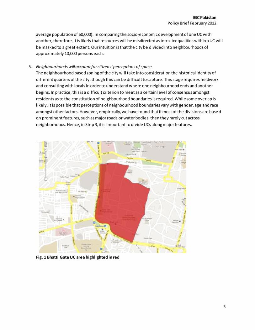
Fig. 1 Bhatti Gate UC area highlighted in red

IGC Pakistan Policy Brief February 2012
6
Fig.2 Bhatti Gate UC area is categorized according to land use
Fig.3 Major Roads falling within Bhatti Gate UC are marked in red

IGC Pakistan Policy Brief February 2012
7
Fig. 4 Bhatti Gate UC is divided into 9 neighbourhood units
Fig.5 Neighbourhood units are assigned names based on discussions with locals during field visits
Park
Commercial and Service Area
Aurangzeb Mohallah
Mohallah Sathaan
Moti Tibba
Bazaar Hakeemaan
JogiMohallah
MohallahChomaala

IGC Pakistan Policy Brief February 2012
8
Step Forward
The methodology outlined above has been tested in the second largest urban centre of Pakistan: Lahore.
More than 130 Union Councils of Lahore were divided into more than 1100 sub-units using this methodology
(see Figure below). The results have been presented to officials at the Urban Unit, Government of Punjab
who have fully the merits of the mohalla or neighbourhood as the common spatial identifier between and
across urban government departments and are eager to undertake the mapping of another important urban
centre of the country: Sialkot in the same manner. Once the necessary field visits are conducted and the
methodology verified, findings will be disseminated to policy makers, urban planners and urban government
department officials to push for the adoption of the neighbourhood as the universal building block of other
administrative divisions of the urban areas of Pakistan. Urban mapping at the level of the neighbourhood and
the integration of urban datasets using this spatial unit holds great promise for improving future urban policy
making and implementation.
Figure 6: Administrative divisions generated by our study for North Lahore. Each dvision is a distinct Land
Use type, with up to 10,000 people.

IGC Pakistan Policy Brief February 2012
9
References
Alesina, A., Baqir, R. & Hoxby, C. (2004) Political Jurisdictions in Heterogeneous Communities, Journal of Political Economy, 112:2, pp. 348-396 Barcelona City Council, Department of Statistics (n.d.) Territorial Division, Retrieved from: http://www.bcn.es/estadistica/angles/terri/index.htm Bari, F. (2000) Review of Seeing Like a State: How Certain Schemes to Improve the Human Condition Have Failed by James C. Scott, Pakistan Development Review, 39: 1, pp.76-78 Blanchfield, F. (2004) Mesh Blocks: A new building block of Australian geography, Australian Population Association, pp.1-17 Coulton, C.J, Korbin, J., Chan T. & Su, M. (2001) Mapping Residents’ Perceptions of Neighbourhood Boundaries: A Methodological Note, American Journal of Community Psychology, 29:2, pp. 371-383 Eagleson, S., Escobar, F. & Williamson, I. (2001) Developing a Theoretical Framework for the Delineation of Administrative Boundaries within a Rural Context, pp.1-11 Haider, M. (2006) Urbanization Challenges in Pakistan: Developing vision 2030, pp.1-9 Lowndes, V. & Sullivan, H. (2008) How Low Can You Go? Rationales and challenges for neighbourhood governance, Public Administration, 86:1, pp.1-22 Pakistan: New Growth Framework (2011) Planning Commission, Government of Pakistan, pp.1-45 Qureshi, F.M., Rajabifard, A. & Olfat, H. (2009) Facilitating Urban Planning and Management at Local Level through the Development of SDI (Case study of Lahore- Pakistan), pp.1-15 Scott, J.C. (1998) Seeing Like a State: How Certain Schemes to Improve the Human Condition have Failed, Yale University Press: New Haven and London, pp.1-445 Thorvaldsen, G. (1997) On Boundaries and Areas in Local Historical Research, pp.1-18 Retrieved from: http://www.rhd.uit.no/art/boundaries.html