
INTEGRATED LAND USE ASSESSMENT: THE CASE OF KLANG VALLEY REGION, MALAYSIA
16
INTEGRATED LAND USE ASSESSMENT: THE CASE OF KLANG VALLEY REGION, MALAYSIA Ahris YAAKUP Professor Department of Urban and Regional Planning Faculty of Built Environment, University of Technology Malaysia 81310 Skudai, Johore Malaysia Tel: +6 07 5537360 Fax: +6 07 5566155 E-mail: [email protected] / [email protected] Foziah JOHAR Head Department / Lecturer Department of Urban and Regional Planning Faculty of Built Environment, University of Technology Malaysia 81310 Skudai, Johore Malaysia Tel: +6 07 5530607 Fax: +6 07 5566155 E-mail: [email protected] / [email protected] Siti Zalina ABU-BAKAR Susilawati SULAIMAN Mohd Nizam BAHARUDDIN Researchers GIS and Planning Unit, University of Technology Malaysia No. 23, Jln Pendidikan 3, Tmn Universiti, 81300 Skudai, Johore Malaysia Tel: +6 07 5516584 Fax: +6 07 5518781 E-mail: [email protected] Abstract: The dynamic nature of planning and monitoring of development in Klang Valley, the fastest growing region in Peninsular Malaysia, apparently requires a ‘tool’ for continuous evaluation and analysis of current environment as well as the capacity for future development. As such, the concept of Integrated Land use Assessment (ILA) was introduced through the “Application of GIS for Klang Valley Region” (AGISwlk) project. The ILA model developed is implemented through incorporation with the use of What if?, a scenario-based, policy-oriented planning support system. A user interface is also developed to ease the access and preparation of data from the AGISwlk database to run the ILA model and generate alternative scenarios. Keywords: integrated land use assessment, GIS, planning support system, alternative scenarios, user interface Paper 223 1
-
Upload
independent -
Category
Documents
-
view
1 -
download
0
Transcript of INTEGRATED LAND USE ASSESSMENT: THE CASE OF KLANG VALLEY REGION, MALAYSIA

INTEGRATED LAND USE ASSESSMENT: THE CASE OF KLANG VALLEY REGION, MALAYSIA
Ahris YAAKUP
Professor Department of Urban and Regional Planning
Faculty of Built Environment, University of Technology Malaysia 81310 Skudai, Johore
Malaysia Tel: +6 07 5537360 Fax: +6 07 5566155
E-mail: [email protected] / [email protected]
Foziah JOHAR Head Department / Lecturer
Department of Urban and Regional Planning Faculty of Built Environment, University of Technology Malaysia
81310 Skudai, Johore Malaysia
Tel: +6 07 5530607 Fax: +6 07 5566155
E-mail: [email protected] / [email protected]
Siti Zalina ABU-BAKAR Susilawati SULAIMAN
Mohd Nizam BAHARUDDIN Researchers
GIS and Planning Unit, University of Technology Malaysia No. 23, Jln Pendidikan 3, Tmn Universiti,
81300 Skudai, Johore Malaysia
Tel: +6 07 5516584 Fax: +6 07 5518781
E-mail: [email protected]
Abstract: The dynamic nature of planning and monitoring of development in Klang Valley, the fastest growing region in Peninsular Malaysia, apparently requires a ‘tool’ for continuous evaluation and analysis of current environment as well as the capacity for future development. As such, the concept of Integrated Land use Assessment (ILA) was introduced through the “Application of GIS for Klang Valley Region” (AGISwlk) project. The ILA model developed is implemented through incorporation with the use of What if?, a scenario-based, policy-oriented planning support system. A user interface is also developed to ease the access and preparation of data from the AGISwlk database to run the ILA model and generate alternative scenarios.
Keywords: integrated land use assessment, GIS, planning support system, alternative scenarios, user interface
Paper 223 1
INTEGRATED LAND USE ASSESSMENT: THE CASE OF KLANG VALLEY REGION, MALAYSIA
1 INTRODUCTION Planning and monitoring of the urban area are important as it involve the need to understand and review current development scenarios to predict changes that will occur, formulate policies and strategies, as well as control the urban development. According to Chadwick (1971), a plan is a general conceptual system. By creating a conceptual system independent of, but corresponding to, the real world system, we can seek to understand the phenomena of change, then anticipate them and finally evaluate them – to concern ourselves with the optimisation of the real world system by seeking optimisation of the conceptual system.
Clearly this requires the planner to understand the system involved before a plan can be drawn. As McLoughlin (1969) pointed out, the preparation of alternative plans must be based on an understanding of how the urban system works, how it would react to different policies. Invariably the activity of planning is more than producing plans and controlling development in accordance with these plans. The planning task embraces policy making and implementation which have a significant bearing on the spatial distribution of investment and the development and use of land at all scales. This is of course, a complex exercise since an urban system contains a networking of other subsystems.
In the past, the number of alternative planning scenarios were rather limited due to the difficulties in producing them, mainly owing to the time consuming procedures of creating scenarios as well as the evaluation that follows. However, with the advancement of Geoinformation Technology (GIT) these days, having prepared the evaluation model, the operation can be accomplished within a much shorter time frame by computer processing of the data and computer mapping of the results even though huge data and information from various sectors is involved (Yaakup and Johar, 1996a; 1996b).
Geographic Information Systems (GIS) has long been accepted as the most appropriate solution to address spatially referenced data. The essence of GIS in the plan making process, quoting Calkins (1972), suggested that ‘better planning will be achieved through better information, and better information will necessarily flow from an information system’. The Planning Support System (PSS) which is a combination of GIS data, urban model and presentation technique using computer for planning support has also been increasing in use for more enhanced end products.
This paper attempts to demonstrate the adoption of ILA for urban control in metropolitan development using PSS/GIS in defining the situation of current development (e.g. environment sensitive area and urban changes) as well the suitability for future development.
2 TOWARD SUSTAINABLE DEVELOPMENT: THE NEED FOR AN INTEGRATED LAND USE ASSESSMENT
2.1 Development IssuesRelative to the rapid land use growth, various issues and problems arise especially those pertaining to environmental pollution, land use conflicts, as well as the
Paper 223 2
availability of land for future development. Rapid development and expansion of city limits have either directly or indirectly affected environmental quality, which in turn contribute to the degradation of the quality of urban life. Increase in temperature, geohazard occurrence, pollution from noise, air and water are typical phenomena of environmental problems in urban areas (Yaakup et al., 2004). The changes that occur necessitate continuous monitoring to ensure sustainable development in the environmental as well as socio-economic aspects. Assessment of these changes is crucial not only to understand and review current development scenarios, but also to predict changes that will occur, formulate policies and strategies, as well as control the urban development.
The Klang Valley conurbation is considered the most developed and fastest growing region in the country with the highest rate of urban growth. Development trends in Klang Valley Region assessed in term of land use changes have indicated an approximate 20% lost of green areas which have been converted to other uses including those allocated as green areas in the structure plan, mainly for housing to cater for the population increase and industrial development as well as other uses (Ibrahim et al., 2001; Yaakup et al., 2002; 2003). The green areas being an important component of the urban systems as they act as buffers in stabilizing the ecosystem, have been inevitably affected by the impact of development especially in urban areas. The region is faced with the most serious urbanisation problems such as urban sprawl and scattered development, land use conflicts, squatters and slum housing development, inadequate network facilities, land shortage, inevitable high land prices and the degradation of environmental quality.
In response to the current need for application of information technology for development planning and monitoring purpose, the Federal Territory Development and Klang Valley Planning Division (BKWPPLK) as the coordinator in the planning and development of Klang Valley had initiated the development of a comprehensive database and GIS-based planning application under the project named “Application of Geographical Information System for Klang Valley Region (AGISwlk)” in 1995. AGISwlk have been designed and developed regionally to support ten main application modules namely built up area, green and recreational area, traffic and urban transportation, squatter and low cost housing, environment, utilities and community services, industrial and commercial development, population and socio-economic, geohazard and tourism. In order to support these application modules, ten elements of data have been prepared including base map, administrative boundary, physical characteristics, land development, population and socio-economic, environmental quality, traffic and urban transportation, green and recreational areas, public facilities and utilities. It was to be used as a planning support tool for formulating and evaluating development policies and strategies as well as coordinating and monitoring the development of the region. This project is considered successful and has significantly contributes to the understanding of the development characteristic of the Klang Valley region and thus helps in planning, coordinating and monitoring development programmes of the area through utilising every potential of the system mainly as a decision support tool. AGISwlk is seen able to help improve the decision-making process pertaining the planning and monitoring of the region.
Nevertheless, the information system developed must expand correspondingly if anything like effective understanding and control is to be achieved. An information system is part of the mechanism for reducing uncertainty in the knowledge and
Paper 223 3
understanding of the environment and can contribute to a much clearer understanding of real planning problems as well as prescriptive planning scenarios to enhance the quality of urban planning and management.
2.2 Balancing the Need for Development and Environmental Sustainability In an era of increasing urban and regional problems, the planning authority must increase their effectiveness by developing innovative ideas in carrying out their functions. The urban system can no longer be treated in terms of simple land use and traffic concepts. The planner’s conception of the urban system must extend to include a host of social, political and economic variables. The mixture of problems which must all be resolved together, creates a situation in which many alternatives must be tried, combined, improved and tested by analysis, by experiment, and by public discussion.
Much concern needs to be given in respect to development control as the development activities may adversely affect the form of the planned growth if not properly and efficiently controlled. The need to ensure harmonious integration of a particular proposed development into the larger scale surrounding urban landscape should also not be overlooked. This requires that development be synchronized and coordinated wherever common administrative boundaries are concerned, and in the case of Klang Valley, between the five districts. This has set the need for proper and effective planning which calls for a framework to develop a consensus around a sustainable development policy and programs. For this purpose, a comprehensive information concerning the past, present and future, crucial for effective policy plans and decisions to reduce uncertainty throughout the planning process is required.
The need for more effective land use planning and monitoring at the regional level is emphasised by the government due to the rapid urban land use expansion in Klang Valley influenced by the drastic increase in population with the growth rate of 3.6% between 1991 and 2000, increase in urbanisation causing a four-fold growth of built up areas in the duration of ten years (1988-1998), increase in status of living as well as individual mobility (BKWPPLK, 2002).
Toward better management of the metropolitan growth, faster planning decisions and careful management is imperative. Currently, more efforts are directed at assessing the ability to supply land and supporting infrastructure to meet future needs. What needed is a tool to better manage outward growth and channelling development into designated growth areas as to strike a sustainable balance for economic growth and protection of environmental assets.
The GIS capabilities as a regional development planning and management tool in AGISwlk is further enhanced through integration with a Planning Support System especially in generating development scenario alternatives that can serve as basis for the formulation of more rational and effective development policies and strategies. An integrated approach called ILA was employed in order to integrate AGISwlk’s sector-based analyses previously undertaken and the concept was translated into a model that enables the generation of development scenario alternatives.
Paper 223 4
3 INTEGRATED LAND USE ASSESSMENT (ILA) MODEL FOR KLANG VALLEY
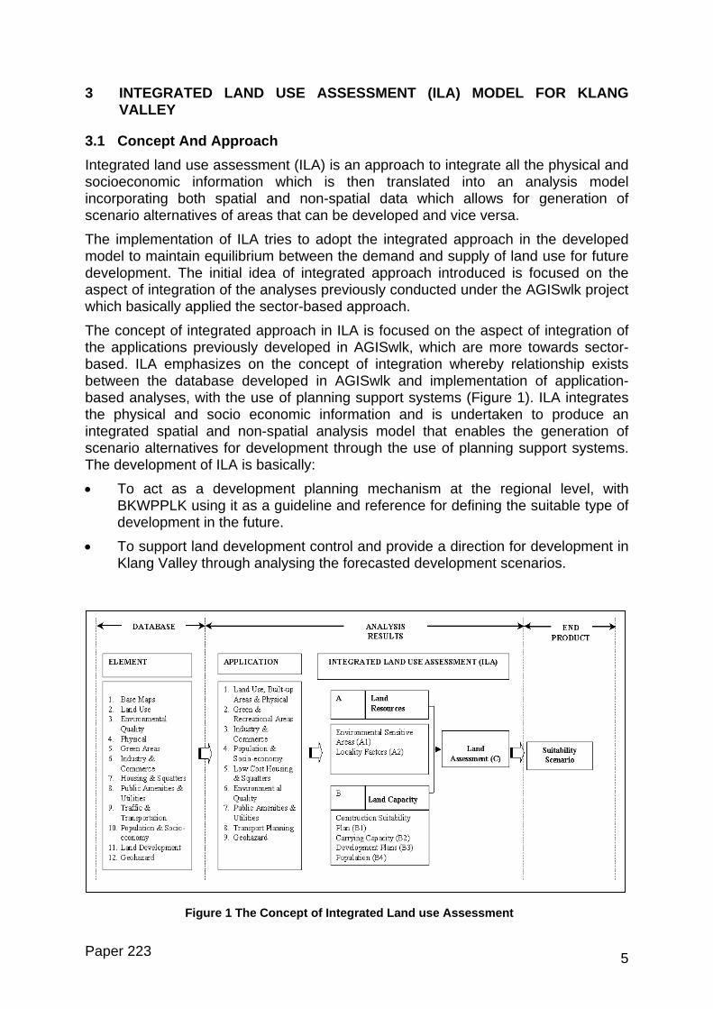
3.1 Concept And Approach Integrated land use assessment (ILA) is an approach to integrate all the physical and socioeconomic information which is then translated into an analysis model incorporating both spatial and non-spatial data which allows for generation of scenario alternatives of areas that can be developed and vice versa.
The implementation of ILA tries to adopt the integrated approach in the developed model to maintain equilibrium between the demand and supply of land use for future development. The initial idea of integrated approach introduced is focused on the aspect of integration of the analyses previously conducted under the AGISwlk project which basically applied the sector-based approach.
The concept of integrated approach in ILA is focused on the aspect of integration of the applications previously developed in AGISwlk, which are more towards sector-based. ILA emphasizes on the concept of integration whereby relationship exists between the database developed in AGISwlk and implementation of application-based analyses, with the use of planning support systems (Figure 1). ILA integrates the physical and socio economic information and is undertaken to produce an integrated spatial and non-spatial analysis model that enables the generation of scenario alternatives for development through the use of planning support systems. The development of ILA is basically:
• To act as a development planning mechanism at the regional level, with BKWPPLK using it as a guideline and reference for defining the suitable type of development in the future.
• To support land development control and provide a direction for development in Klang Valley through analysing the forecasted development scenarios.
t
Paper 223
Figure 1 The Concept of Integrated Land use Assessmen
5

3.2 Model Development Evaluation is an essential step in the planning process especially in selecting the appropriate development scenario alternative to be implemented. As such, it is necessary for decision-makers to define the suitable planning evaluation model so that the development scenario chosen could cater for future planning and its implementation is beneficial to the public. In defining the planning evaluation model, the development scenario alternatives should satisfy various criteria such as the proposed planning objectives and the costs and benefits for every sector.
The dynamic nature of planning and monitoring of development in Klang Valley region needs for a continuous evaluation and analysis of the current environment situation as well as its carrying capacity for future development. Planners should be able to identify and make adjustments to deriving factors as well as evaluation criteria to develop scenarios for generating development alternatives to support the decision makers. The choice of deriving factors should include the aspect of land resources and land capacity.
Taking all the considerations into account, the model developed is designed to provide sufficient flexibility to users in terms of evaluating development planning within various situations. The ILA Model is dynamic in approach, providing flexibility for users in manipulating the selection criteria and organizing them on priority basis for scenario generation. The assessment technique in ILA adopts the GIS spatial analysis technique combined with the weighting and sequential techniques. ILA involves two types of assessment namely Land Resources and Land Capacity (Figure 2).
A LAND RESOURCES
B LAND CAPACITY
A1. Environmentally Sensitive Areas
A2. Locality Factors
B1. Construction Suitability
B2. Carrying Capacity
B3. Development Plans
B4. Population
C LAND ASSESSMENT
Scenario 3
Scenario 2
Scenario 1
Figure 2 ILA Model
Land Resources Assessment (A) aims at evaluating potential land resources for development in terms of suitability by considering two deriving factors, which are Environmentally Sensitive Areas (ESAs) and Potential Areas for Development base on locality factors. Meanwhile, Land Capacity Assessment (B) evaluates the extent of
Paper 223 6
acceptable development in terms of supply and carrying capacity. The Land Capacity Assessment involves four deriving factors including Construction Suitability; Carrying Capacity for River Basin, Transportation as well as Public Facilities; Development Plans; and Population. Each deriving factor involves several selection criteria such as heritage value, hazard risk and life support in the case of ESA.
The overall Land Assessment (C) generally shows the scenario alternatives of land available and suitable for development based on all the factors considered.
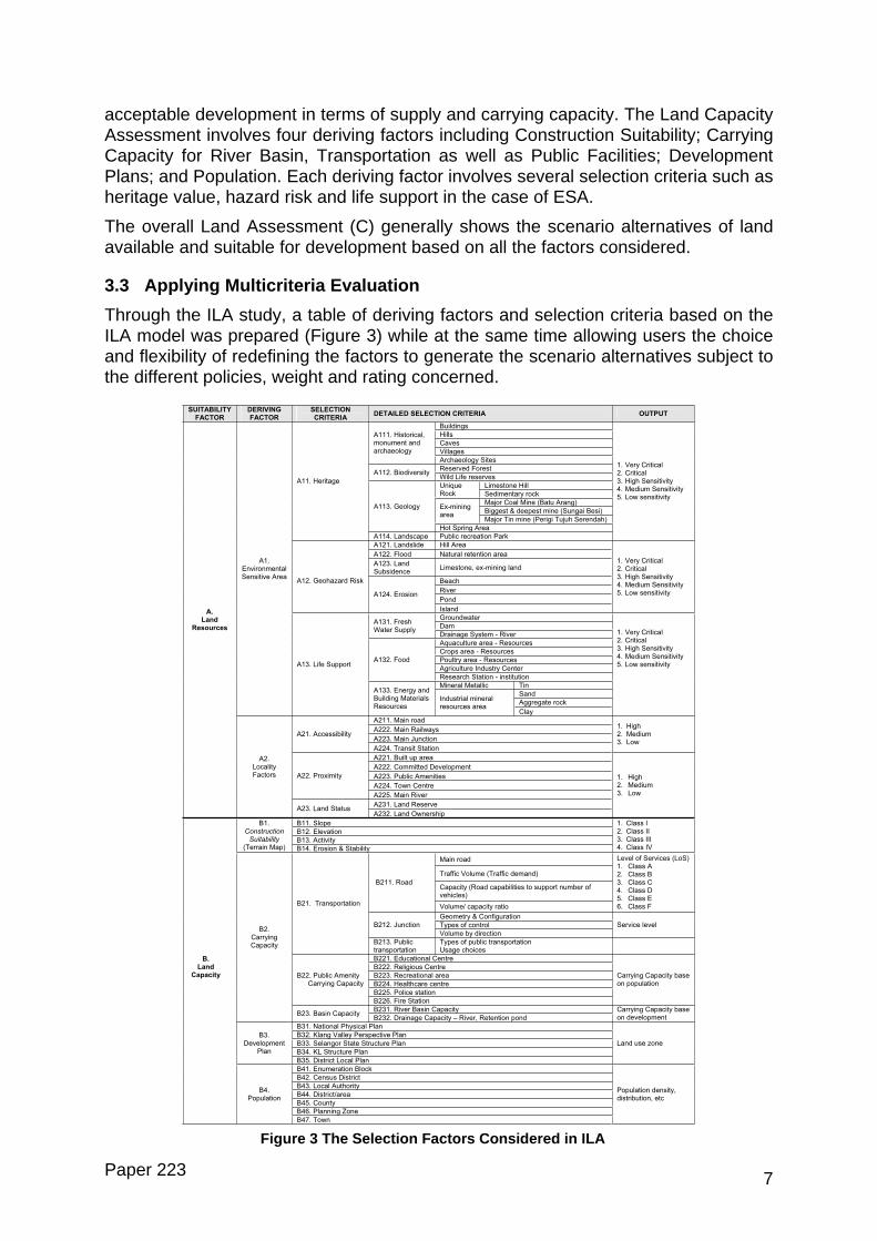
3.3 Applying Multicriteria Evaluation Through the ILA study, a table of deriving factors and selection criteria based on the ILA model was prepared (Figure 3) while at the same time allowing users the choice and flexibility of redefining the factors to generate the scenario alternatives subject to the different policies, weight and rating concerned.
Figu
Paper 223
SUITABILITY FACTOR
DERIVING FACTOR
SELECTION CRITERIA
DETAILED SELECTION CRITERIA OUTPUT
Buildings
Hills
Caves
Villages
A111. Historical, monument and archaeology
Archaeology Sites
Reserved Forest A112. Biodiversity
Wild Life reserves
Limestone Hill UniqueRock Sedimentary rock
Major Coal Mine (Batu Arang)
Biggest & deepest mine (Sungai Besi) Ex-mining area
Major Tin mine (Perigi Tujuh Serendah)
A113. Geology
Hot Spring Area
A11. Heritage
A114. Landscape Public recreation Park
1. Very Critical 2. Critical 3. High Sensitivity 4. Medium Sensitivity 5. Low sensitivity
A121. Landslide Hill Area
A122. Flood Natural retention area
A123. Land Subsidence
Limestone, ex-mining land
Beach
River
Pond
A12. Geohazard Risk
A124. Erosion
Island
1. Very Critical 2. Critical 3. High Sensitivity 4. Medium Sensitivity 5. Low sensitivity
Groundwater
DamA131. Fresh Water Supply
Drainage System - River
Aquaculture area - Resources
Crops area - Resources
Poultry area - Resources
Agriculture Industry Center
A132. Food
Research Station - institution
Mineral Metallic Tin
Sand
Aggregate rock
A1.EnvironmentalSensitive Area
A13. Life Support
A133. Energy and Building Materials Resources
Industrial mineral resources area
Clay
1. Very Critical 2. Critical 3. High Sensitivity 4. Medium Sensitivity 5. Low sensitivity
A211. Main road
A222. Main Railways
A223. Main Junction A21. Accessibility
A224. Transit Station
1. High 2. Medium 3. Low
A221. Built up area
A222. Committed Development
A223. Public Amenities
A224. Town Centre
A22. Proximity
A225. Main River
A231. Land Reserve
A. Land
Resources
A2.Locality Factors
A23. Land Status A232. Land Ownership
1. High 2. Medium 3. Low
B11. Slope
B12. Elevation
B13. Activity
B1.ConstructionSuitability
(Terrain Map) B14. Erosion & Stability
1. Class I 2. Class II 3. Class III 4. Class IV
Main road
Traffic Volume (Traffic demand)
Capacity (Road capabilities to support number of vehicles)
B211. Road
Volume/ capacity ratio
Level of Services (LoS) 1. Class A 2. Class B 3. Class C 4. Class D 5. Class E 6. Class F
Geometry & Configuration
Types of control B212. Junction
Volume by direction
Service level
B21. Transportation
B213. Public transportation
Types of public transportation Usage choices
B221. Educational Centre
B222. Religious Centre
B223. Recreational area
B224. Healthcare centre
B225. Police station
B22. Public Amenity Carrying Capacity
B226. Fire Station
Carrying Capacity base on population
B231. River Basin Capacity
B2.Carrying Capacity
B23. Basin Capacity B232. Drainage Capacity – River, Retention pond
Carrying Capacity base on development
B31. National Physical Plan
B32. Klang Valley Perspective Plan
B33. Selangor State Structure Plan
B34. KL Structure Plan
B3.Development
Plan
B35. District Local Plan
Land use zone
B41. Enumeration Block
B42. Census District
B43. Local Authority
B44. District/area
B.Land
Capacity
B4.Population
Population density, distribution, etc
re 3 The Selection Factors Considered in ILA
B45. County
B46. Planning Zone
B47. Town
7
The multcriteria evaluation method is used to select the best scenario alternative. The evaluation involves four steps which are:
i. Define the evaluation criteria
ii. Define the measurement unit of the criteria
iii. Multicriteria analysis
a) Criteria standardization
b) Specify Weight
c) Specify Ranking
iv. Sensitivity analysis
The multicriteria analysis is carried out using the DEFINITE software while adopting the pairwise comparison technique for relative comparisons of priority or possibility of certain criteria having influence over others (BKWPPLK, 2004).
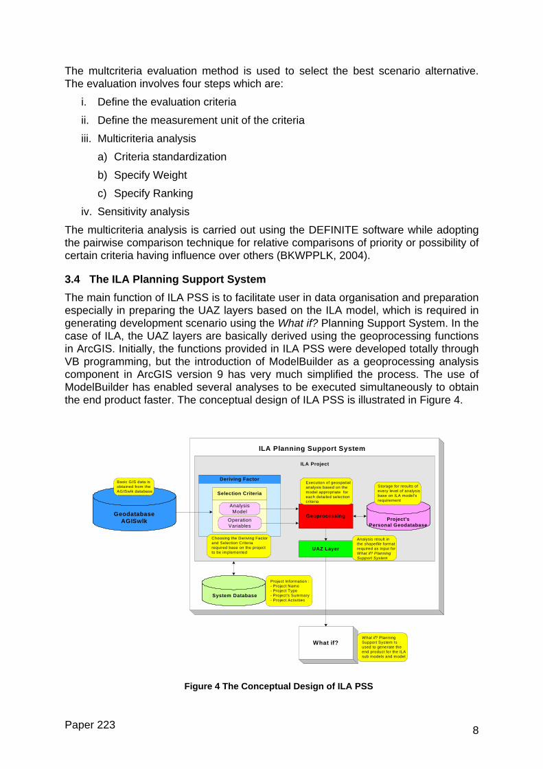
3.4 The ILA Planning Support System The main function of ILA PSS is to facilitate user in data organisation and preparation especially in preparing the UAZ layers based on the ILA model, which is required in generating development scenario using the What if? Planning Support System. In the case of ILA, the UAZ layers are basically derived using the geoprocessing functions in ArcGIS. Initially, the functions provided in ILA PSS were developed totally through VB programming, but the introduction of ModelBuilder as a geoprocessing analysis component in ArcGIS version 9 has very much simplified the process. The use of ModelBuilder has enabled several analyses to be executed simultaneously to obtain the end product faster. The conceptual design of ILA PSS is illustrated in Figure 4.
Deriving Factor
Geoprocessing
UAZ Layer
Analysis Model
Operation Variables
Selection Criteria
Project’sPersonal Geodatabase
System Database
ILA Planning Support System
What if?
Geodatabase AGISwlk
Project Information :- Project Name- Project Type- Project’s Summary- Project Activities
Basic GIS data is obtained from the AGISwlk database
Execution of geospatial analysis based on the model appropriate for each detailed selection criteria
Analysis result in the shapefile format required as input for What if? Planning Support System
What if? Planning Support System Is used to generate the end product for the ILA sub models and model
Storage for results of every level of analysis base on ILA model’s requirement
Choosing the Deriving Factor and Selection Criteria required base on the project to be implemented
ILA Project
Paper 223
Figure 4 The Conceptual Design of ILA PSS
8
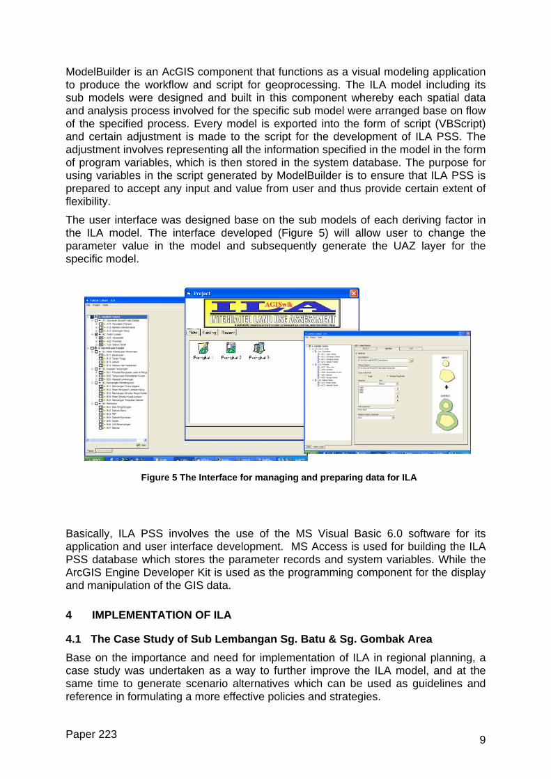
ModelBuilder is an AcGIS component that functions as a visual modeling application to produce the workflow and script for geoprocessing. The ILA model including its sub models were designed and built in this component whereby each spatial data and analysis process involved for the specific sub model were arranged base on flow of the specified process. Every model is exported into the form of script (VBScript) and certain adjustment is made to the script for the development of ILA PSS. The adjustment involves representing all the information specified in the model in the form of program variables, which is then stored in the system database. The purpose for using variables in the script generated by ModelBuilder is to ensure that ILA PSS is prepared to accept any input and value from user and thus provide certain extent of flexibility.
The user interface was designed base on the sub models of each deriving factor in the ILA model. The interface developed (Figure 5) will allow user to change the parameter value in the model and subsequently generate the UAZ layer for the specific model.
Figure 5 The Interface for managing and preparing data for ILA
Basically, ILA PSS involves the use of the MS Visual Basic 6.0 software for its application and user interface development. MS Access is used for building the ILA PSS database which stores the parameter records and system variables. While the ArcGIS Engine Developer Kit is used as the programming component for the display and manipulation of the GIS data.
4 IMPLEMENTATION OF ILA
4.1 The Case Study of Sub Lembangan Sg. Batu & Sg. Gombak Area Base on the importance and need for implementation of ILA in regional planning, a case study was undertaken as a way to further improve the ILA model, and at the same time to generate scenario alternatives which can be used as guidelines and reference in formulating a more effective policies and strategies.
Paper 223 9
ILA study was implemented for the area of Batu and Gombak sub river basins, covering about 7,508.2 hectare of the District of Gombak in Klang Valley. In this study, both the Land Resources Assessment and Land Capacity Assessment sub models were applied to generate development scenario alternatives but due to several constraints, not all the selection factors were used. The Land Resources Assessment was carried out by considering two deriving factors, which are Environmentally Sensitive Areas (ESAs) and Potential Areas for Development based on locality factors. While Land Capacity Assessment only involved only one deriving factor which is Construction Suitability (the terrain map). This is considered the preliminary study to design a model based on an integrated approach in generating development scenario alternatives while considering the land resources and land capacity factors.
4.2 Methods and Methodology of Implementation The study was divided into three main stages. The methodology was developed and organised based on the GIS spatial analysis process and What if? planning support system framework. The stages can be simplified as follows:
Stage 1: Identify Policy and Strategy
This stage involves identification of policy and strategy to be used as guideline and direction of study in achieving the desired output.
Stage 2: Collecting Data for analysis
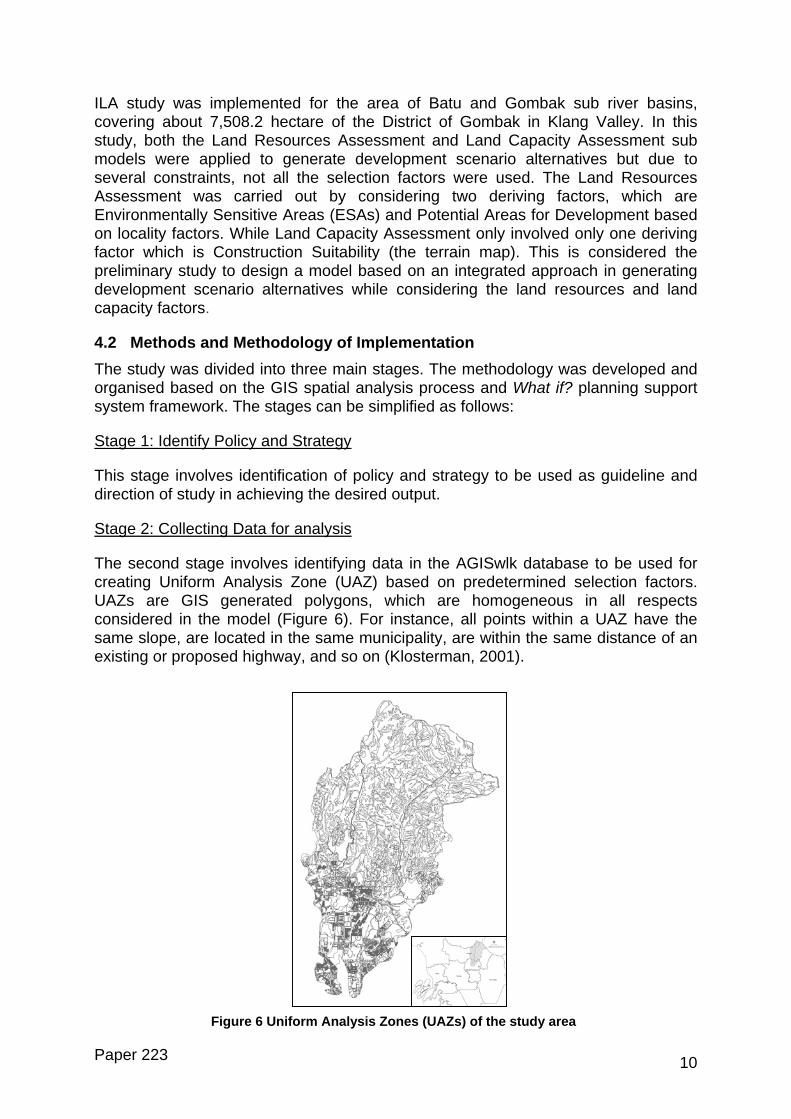
The second stage involves identifying data in the AGISwlk database to be used for creating Uniform Analysis Zone (UAZ) based on predetermined selection factors. UAZs are GIS generated polygons, which are homogeneous in all respects considered in the model (Figure 6). For instance, all points within a UAZ have the same slope, are located in the same municipality, are within the same distance of an existing or proposed highway, and so on (Klosterman, 2001).
Paper 223
Figure 6 Uniform Analysis Zones (UAZs) of the study area
10
Stage3: Analysis and Modeling
The analysis and modelling stage involves the process of creating Uniform Analysis Zone (UAZ), designing project file and conducting land suitability analysis. The process of creating UAZ layer includes combining of GIS data layers. The GIS functions involved in the process are overlay, classification and measurement. Designing the project file is most important because it influence the suitability analysis and affects the resulting output.
The suitability analysis involves four steps which are selecting the land suitability factors, selecting the deriving factors, specifying weights and ratings for each category of factors and identifying land use conversion. The mathematical formula below was applied for all factors considered in generating the development scenarios.
y = ∑ wiri
n
i
where,
y = the Suitability Score
wi = the Weight of factor; and
ri = the Rating of factors by category
The weight of each factor (wi) is assigned on a three-point scale from 3 to 1 whereby the value ‘1’ indicates that the factor is of low importance, ‘2’ moderately important and ‘3’ very important in term of relative importance in determining land use suitability for development. While the rating for each category of factor is the numerical value that shows relative locations’ suitability to particular factor type which detailed the factor’s set of possible values. The rating value (ri) is either ‘1’ (high), ‘2’ (moderately high), ‘3’ (moderate), ‘4’ (moderately low) or ‘5’ (low) which indicate level of suitability, and ‘0’ for exclusion of area from any development.
4.3 Results The end product is in the form of maps, graphs and tables. Basically, the map showed the areas suitable for development based on level of suitability namely most suitable, moderately suitable, least suitable and not suitable. The generated report provides a formal documentation on the assumption used for each alternative scenario and summary of the result in the form of graph and table. The table listed the category of suitability and calculated areas in the unit of hectare (Table 1) while the graph provides comparison in term of areas (hectare) between the different generated scenarios. Three scenario alternatives were generated by using the same factors but by applying different weights and ratings appropriate to three different strategies (Figure 7).
Paper 223 11
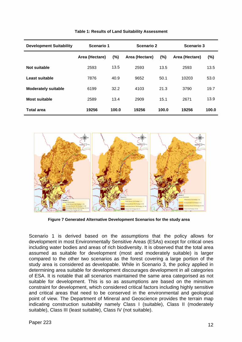
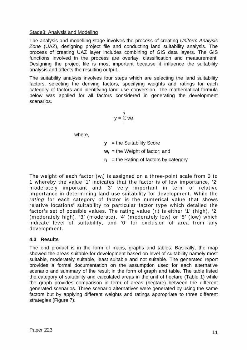
Table 1: Results of Land Suitability Assessment
Development Suitability Scenario 1 Scenario 2 Scenario 3
Area (Hectare) (%) Area (Hectare) (%) Area (Hectare) (%)
Not suitable 2593 13.5 2593 13.5 2593 13.5
Least suitable 7876 40.9 9652 50.1 10203 53.0
Moderately suitable 6199 32.2 4103 21.3 3790 19.7
Most suitable 2589 13.4 2909 15.1 2671 13.9
Total area 19256 100.0 19256 100.0 19256 100.0
Scenaridevelopincludinassumecomparestudy ardeterminof ESA.suitableconstraiand critpoint ofindicatinsuitable
Paper 2
Figure 7 Generated Alternative Development Scenarios for the study area
o 1 is derived based on the assumptions that the policy allows for ment in most Environmentally Sensitive Areas (ESAs) except for critical ones g water bodies and areas of rich biodiversity. It is observed that the total area d as suitable for development (most and moderately suitable) is larger d to the other two scenarios as the forest covering a large portion of the ea is considered as developable. While in Scenario 3, the policy applied in ing area suitable for development discourages development in all categories
It is notable that all scenarios maintained the same area categorised as not for development. This is so as assumptions are based on the minimum nt for development, which considered critical factors including highly sensitive ical areas that need to be conserved in the environmental and geological view. The Department of Mineral and Geoscience provides the terrain map g construction suitability namely Class I (suitable), Class II (moderately ), Class III (least suitable), Class IV (not suitable).
23 12
At this level of the study, the ‘suitable’ aspect defined in the case study can be largely relative and thus with appropriate auxiliary measure, areas being least suitable can be reconsidered as either moderately suitable or even most suitable. This is where the roles of discriminative land use policy comes, covering the exact development standards, earthworks guidelines, preventive measures and so forth (Hasnol et al., 2000). Thus, further location-based/micro analyses using detailed and specific criteria need to be applied to identify suitable areas relevant to specific types of development. This end product would help in the decision making process by providing support for a more rational and reliable judgement.
5 MODEL DEVELOPMENT AND IMPLEMENTATION ISSUES From the study conducted, it is clear that the usage of GIS and PSS can enhance planning and monitoring. In this case for example, the environmental aspect can be well incorporated into development planning through good modeling for producing a better ESA map. The study also raises several issues that need to be given particular attention:
a) Defining data requirements
Data and information is an important component in ensuring the success of GIS analyses. In implementing ILA, the detailed information required needs to be defined. User should list out the factors and criteria to be used in the GIS analysis such as current land use, forest area, flood area, recreation and etc. Clarifying the use of data for analysis purpose with concern on limitation and availability of data would much help in minimising the time, cost and effort consumed in analyses implementation.
b) Number of criteria used
There are lots of criteria involved in ILA implementation. The criteria used in the study were based on the availability of data. The number of criteria used could reflect the end products. So it is important to choose and design the criteria based on discussions with the stakeholders. As a guide to choose the number of criteria to be used in the study, several questions were raised to check criteria uncertainty including i) are all the relevant criteria considered in the study ?; ii) do all the criteria’s definition fulfils the objective of the study ?; and iii) are all the sub criteria equally distributed among all the categories ?
Although PSS is a useful tool to carry out sophisticated works as data can quickly be modeled and the result can be presented efficiently with high quality, it is highly dependable on the availability and quality of the data used in the model. Data availability would very much depend on the cooperation of various agencies and stakeholders involved either at the regional or local level. In brief, the application of a PSS requires collaboration, often among different professional and disciplines, and often individuals at different locations, without which the PSS application cannot be effectively performed.
In planning, obtaining relevant information is crucial for the purpose of decision-making and good information would certainly lead to better decision. However, relevant information is usually unavailable due to factors such as lack of effectiveness in information sharing and communication between stakeholders. Nevertheless, this problem is believed to be overcome through the concept of
Paper 223 13
consensus building which is further accelerated with support from information system technology.
The continuous cycle of data collection, consultation, analysis and reporting engaging planning and development programs implementation is hoped to provide a shared understanding of:
• Current development activity and trends
• The availability and allocation of land for future development
• The adequacy of land supplies to meet future needs
• The implications of projected development activity for infrastructure requirements; and
• The actions required in overcoming any potential land-supply shortfalls and infrastructure constraints.
Clearly that effective planning requires descriptive, predictive and prescriptive information inputs (Webster 1993; 1994). As planning is always oriented towards the future, forecasting becomes a necessary part of it. Following through the planning process, planners attempt to understand and define current issues, foresee future developments, and propose feasible plans based on available information. Among available approaches for meeting the forecasting requirements of planners, urban models can be efficient and effective support tools.
6 CONCLUDING REMARKS The tremendous pressure of rapid development has created a greater and massive development growth just to fit human needs physically, socially and economically. The surrounding man-made environments (e.g infrastructure and facilities) built to satisfy human needs, at some point ignores the right of natural environment itself that consequently affects the environmental quality. The Klang Valley Region which is experiencing the highest rate of urban growth in the country, has of late shows all the evidences of going through the metropolisation process including urban sprawl and scattered development, land use conflicts, squatters and slum housing development, inadequate network facilities, land shortage, inevitable high land prices and the degradation of environmental quality. This has set the need for a ‘tool’ for continuous evaluation and analysis of the current environment as well as the capacity for future development. In formulating the sustainable development strategy, the GIS database developed in AGISwlk can be extensively interrogated to generate several alternative solutions to urban planning problems.
Subsequently, in response to the urbanisation challenge, the Integrated Land use Assessment (ILA) concept per se is introduced as an integrated land use planning approach that exploits the GIS analysis capabilities, supported by the use of a planning support system. The approach of ILA became a pivotal role to evaluate the land capacity and availability of land resources. Various scenarios, which take into account the socio-economic characteristic of urban dwellers, the constraints of physical development, availability of land and land suitability for particular type of development can be generated using ILA. It is seen as a good mechanism for monitoring urban development especially in environmentally sensitive areas. Finding that ILA could exploit GIS capabilities accurately in spatial analysis, it would be useful
Paper 223 14
for decision makers to achieve sustainable development through incorporation of the use of Spatial Multi-Criteria Evaluation (SMCE) method and base on Development Scenario Assessment.
The implementation of ILA supported by the What if? planning support system resulted in a more integrated planning and serves as a good alternative in producing more rational decisions. ILA has all the components as a planning support system. ILA incorporates data and data manipulation procedures, user interface and a system which links and coordinates models and data. ILA has the edge over conventional geographical information systems in that it incorporates a greater level of analytic and statistical modeling than is required to assist the process of decision making.
The ever-accelerating growth of the computer technology especially that involving the GIS and PSS have further simplified the method of land and environmental assessment. The use of ILA for controlling, monitoring and managing development is hoped to facilitate planning and management agencies in deriving at more effective decisions towards sustainable metropolitan development.
ACKNOWLEDGEMENTS The authors would like to thank the Ministry of Federal Territory, Malaysia, for allowing and granting permission to present this paper.
REFERENCES
a) Books and Books chapters
Chadwick, G. (1971) A System View of Planning. Pergamon, Oxford.
Klosterman R.E (2001) The What if? Planning Support System. In R.K. Grail and R.E. Klosterman (eds), Planning Support System. ESRI Press, Redland, California.
McLoughlin, J.B. (1969) Control and Urban Planning. Faber and Faber Ltd., London.
b) Journal papers
Webster C.J. (1993) GIS and the scientific inputs to urban planning. Part 1: Description. Environment and Planning B: Planning and Design, Vol. 20, No.6, 709-28.
Webster C.J. (1994) GIS and the scientific inputs to urban planning. Part 2: Prediction and Prescription. Environment and Planning B: Planning and Design, Vol. 21, No. 6, 145-57.
Yaakup A.B., Sulaiman S. and Abu-Bakar S.Z. (2004) Integrated land use assessment (ILA) model: ‘What if’ approach, Malaysian Townplan, Vol. 2, Issue 1, 5-14.
c) Papers presented to conferences
Hasnol, Z.Z. Musa, N. and Esa, N. (2000). Geologycal input and discriminative land use policy in urban planning. AGISwlk’s Stakeholders Workshop Series, Kuantan, Malaysia.
Paper 223 15
Ibrahim M., Yaakup A.B., Sulaiman S. and Ahmad M.J. (2001) Environmental analyses in Geographical Information System (GIS): Klang Valley case study. Proceedings 8th International Conference on Computers in Urban Planning and Urban Management (CUPUM 2001), Hawaii, 18-21, July 2001.
Yaakup, A.B. and Johar, F. (1996a) GIS for integrated planning decision for the development of Sungai Lembing Historical Park, Malaysia. Proceedings Geoinformatic’96, Wuhan: International Symposium on the Occasion of the 40th Annivasary of Wuhan Technical University of Survey and Mapping, Wuhan, China, 16-19, October 1996.
Yaakup, A.B. and Johar, F. (1996b) GIS for integrated planning decision for conserving the Malaysian urban heritage. Proceedings 3rd International Conference on Design and Decision Support System in Architecture and Urban Planning, Spa, Belgium, 18-21, August 1996.
Yaakup A.B., Johar F., Che’ Ngah M. and Sulaiman S. (2004) Innovative measures for urban planning and management: The case of development control system of City Hall of Kuala Lumpur. Proceedings INTA28: World Urban Development Congress, Kuala Lumpur, 5-9, September 2004.
Yaakup, A.B., Ludin, A.N.M and Bajuri, H. (2003) Information technology and urban green analysis, Proceedings Urban Forest Workshop: Assessing the Need for Sustainable Landscape in a Changing Society, Kuala Lumpur, 14-15, October 2003.
Yaakup A., Sulaiman S. and Abdul Kadir M.N., (2002) GIS as tools for monitoring the urban development in metropolitan region: A case of Klang Valley region, Peninsular Malaysia. Proceedings 6th Seminar on GIS for Developing Countries (GISDECO 2002), ITC, Enschede, Netherlands, 15-18, May 2002.
d) Other documents
BKWPPLK (2002) Laporan Aplikasi Sistem Maklumat Geografi Wilayah Lembah Klang (Aplikasi & Analisis), Bahagian Kemajuan Wilayah Persekutuan dan Perancangan Lembah Klang, Jabatan Perdana Menteri
BKWPPLK (2004) Laporan Kemajuan 5: 2001-2005, Aplikasi Sistem Maklumat Geografi Wilayah Lembah Klang, Bahagian Kemajuan Wilayah Persekutuan dan Perancangan Lembah Klang, Jabatan Perdana Menteri
Calkins, H.W. (1972) An information system and monitoring framework for plan implementation and the continuing planning process. Unpublished Ph.D. Dissertation, University of Washington, Seattle, USA, p. 78.
Klosterman, R.E. (2002) User’s guide to What if? 1.1, Community Analysis and Planning Sysems, Inc., Ohio, USA.
Janssen, R., Herwijnen M.V. and Beinat E. (2001) DEFINITE case studies and user manual, Institute for Environmental Studies, Vrije Universiteit Amsterdam, The Netherlands
Paper 223 16