Incoming plate faulting in the Northern and Western Pacific and implications for subduction zone...
11
Earth and Planetary Science Letters 414 (2015) 176–186 Contents lists available at ScienceDirect Earth and Planetary Science Letters www.elsevier.com/locate/epsl Incoming plate faulting in the Northern and Western Pacific and implications for subduction zone water budgets Erica L. Emry ∗,1 , Douglas A. Wiens Department of Earth and Planetary Sciences, Washington University in St. Louis, Campus Box 1169, One Brookings Drive, St. Louis, MO 63130, USA a r t i c l e i n f o a b s t r a c t Article history: Received 30 August 2014 Received in revised form 17 December 2014 Accepted 22 December 2014 Available online xxxx Editor: P. Shearer Keywords: pacific plate incoming plate faulting subduction zone trench serpentinite The greatest uncertainty in the amount of water input into the Earth at subduction zones results from poor constraints on the degree of mantle serpentinization in the incoming plate. Recent studies suggest that the depth of serpentinization within the incoming plate mantle is likely controlled by the depth of extensional faulting caused by lithospheric bending at the outer rise and trench. We explore the maximum depth of extension within the incoming plate at Northwestern Pacific subduction zones in order to estimate the depth limit of serpentinization and to identify any significant variation between subduction zone segments. We relocate trench earthquakes to identify which events occurred within the incoming plate and determine accurate depths for 63 incoming plate earthquakes occurring during 1988–2011 by inverting teleseismic broadband P and SH waveforms. We observe that the top 10–15 km of the incoming plate mantle experiences extensional faulting at all of the subduction zones with a reasonable sample of earthquakes; 60% of the total number of extensional earthquakes occur at crustal depths or within the top 5 km of the incoming plate mantle, 80% occur above 10 km within the mantle, and 95% occur above 15 km. There is evidence for variation throughout the different regions of study, for example extensional earthquakes occur down to 20 km below the crust in the western Aleutians and Izu–Bonin. We propose that the incoming plate mantle is most strongly hydrated in the upper 5 km, and that partial serpentinization exists regionally within the incoming plate mantle to ∼15 km. Making reasonable assumptions about the degree of serpentinization and incorporating previous estimates of crustal water, we calculate that the total water carried into the Northern and Western Pacific subduction zones is generally higher than previous estimates, and is approximately 4–6 × 10 8 Tg/Myr, or ∼45–70 × 10 3 Tg/Myr per kilometer of subduction zone. © 2014 Elsevier B.V. All rights reserved. 1. Introduction Prominent extensional faulting within the incoming plates at subduction zone trenches may provide a pathway by which sea- water can enter the plate down to mantle depths and hydrate dry mantle rocks prior to subduction. In this case, large amounts of mantle serpentinite within the incoming plate may significantly impact subduction zone and upper mantle water budgets (e.g. Ranero et al., 2003). Mantle serpentinites within the subducting slab can remain colder and thus more stable to greater depths than crustal hydrated rocks and therefore may significantly con- tribute to water flux from the slab at intermediate and deep depths (e.g. Jarrard, 2003; Hacker, 2008; Van Keken et al., 2011). Depend- ing on the subduction zone, this could impact island arc and back * Corresponding author. E-mail address: [email protected] (E.L. Emry). 1 Now at: Department of Geosciences, Pennsylvania State University, 407 Deike Building, University Park, PA 16802, USA. arc basin volcanism (e.g. Kelley et al., 2006) or the amount of wa- ter carried deeper into the Earth’s mantle (e.g. Rüpke et al., 2004; Hirschmann, 2006). Surveys of faults, seismicity and seismic tomography at the same region of the Nicaragua incoming plate show that deep ex- tensional faults are continuous from the surface to mantle depths (Ranero et al., 2003), that locally-detected extensional earthquakes occur down to ∼6–9 km within the mantle (Lefeldt et al., 2009), and that regions of slow mantle P-wave velocities extend to roughly 10 km deep within the mantle in some regions (Ivandic et al., 2010; Van Avendonk et al., 2011; Lefeldt et al., 2012). The estimates of mantle hydration from Van Avendonk et al. (2011) from seismic tomography extend slightly deeper than the depth estimate for the neutral plane (maximum depth of extensional earthquakes) from small, locally-recorded earthquakes Lefeldt et al. (2009, 2012); however this difference may be explained by the effect of seismic anisotropy on P-wave velocities or by the effect of plate interface seismic cycle on the short-term stress dis- tribution within the incoming plate (Van Avendonk et al., 2011). http://dx.doi.org/10.1016/j.epsl.2014.12.042 0012-821X/© 2014 Elsevier B.V. All rights reserved.
Transcript of Incoming plate faulting in the Northern and Western Pacific and implications for subduction zone...
Earth and Planetary Science Letters 414 (2015) 176–186
Contents lists available at ScienceDirect
Earth and Planetary Science Letters
www.elsevier.com/locate/epsl
Incoming plate faulting in the Northern and Western Pacific and
implications for subduction zone water budgets
Erica L. Emry ∗,1, Douglas A. Wiens
Department of Earth and Planetary Sciences, Washington University in St. Louis, Campus Box 1169, One Brookings Drive, St. Louis, MO 63130, USA
a r t i c l e i n f o a b s t r a c t
Article history:Received 30 August 2014Received in revised form 17 December 2014Accepted 22 December 2014Available online xxxxEditor: P. Shearer
Keywords:pacific plateincoming plate faultingsubduction zone trenchserpentinite
The greatest uncertainty in the amount of water input into the Earth at subduction zones results from poor constraints on the degree of mantle serpentinization in the incoming plate. Recent studies suggest that the depth of serpentinization within the incoming plate mantle is likely controlled by the depth of extensional faulting caused by lithospheric bending at the outer rise and trench. We explore the maximum depth of extension within the incoming plate at Northwestern Pacific subduction zones in order to estimate the depth limit of serpentinization and to identify any significant variation between subduction zone segments. We relocate trench earthquakes to identify which events occurred within the incoming plate and determine accurate depths for 63 incoming plate earthquakes occurring during 1988–2011 by inverting teleseismic broadband P and SH waveforms. We observe that the top 10–15 km of the incoming plate mantle experiences extensional faulting at all of the subduction zones with a reasonable sample of earthquakes; 60% of the total number of extensional earthquakes occur at crustal depths or within the top 5 km of the incoming plate mantle, 80% occur above 10 km within the mantle, and 95% occur above 15 km. There is evidence for variation throughout the different regions of study, for example extensional earthquakes occur down to 20 km below the crust in the western Aleutians and Izu–Bonin. We propose that the incoming plate mantle is most strongly hydrated in the upper 5 km, and that partial serpentinization exists regionally within the incoming plate mantle to ∼15 km. Making reasonable assumptions about the degree of serpentinization and incorporating previous estimates of crustal water, we calculate that the total water carried into the Northern and Western Pacific subduction zones is generally higher than previous estimates, and is approximately 4–6 × 10⁸ Tg/Myr, or ∼45–70 × 103 Tg/Myr per kilometer of subduction zone.
© 2014 Elsevier B.V. All rights reserved.
1. Introduction
Prominent extensional faulting within the incoming plates at subduction zone trenches may provide a pathway by which sea-water can enter the plate down to mantle depths and hydrate dry mantle rocks prior to subduction. In this case, large amounts of mantle serpentinite within the incoming plate may significantly impact subduction zone and upper mantle water budgets (e.g. Ranero et al., 2003). Mantle serpentinites within the subducting slab can remain colder and thus more stable to greater depths than crustal hydrated rocks and therefore may significantly con-tribute to water flux from the slab at intermediate and deep depths (e.g. Jarrard, 2003; Hacker, 2008; Van Keken et al., 2011). Depend-ing on the subduction zone, this could impact island arc and back
* Corresponding author.E-mail address: [email protected] (E.L. Emry).
1 Now at: Department of Geosciences, Pennsylvania State University, 407 Deike Building, University Park, PA 16802, USA.
http://dx.doi.org/10.1016/j.epsl.2014.12.0420012-821X/© 2014 Elsevier B.V. All rights reserved.
arc basin volcanism (e.g. Kelley et al., 2006) or the amount of wa-ter carried deeper into the Earth’s mantle (e.g. Rüpke et al., 2004;Hirschmann, 2006).
Surveys of faults, seismicity and seismic tomography at the same region of the Nicaragua incoming plate show that deep ex-tensional faults are continuous from the surface to mantle depths (Ranero et al., 2003), that locally-detected extensional earthquakes occur down to ∼6–9 km within the mantle (Lefeldt et al., 2009), and that regions of slow mantle P-wave velocities extend to roughly 10 km deep within the mantle in some regions (Ivandic et al., 2010; Van Avendonk et al., 2011; Lefeldt et al., 2012). The estimates of mantle hydration from Van Avendonk et al. (2011)from seismic tomography extend slightly deeper than the depth estimate for the neutral plane (maximum depth of extensional earthquakes) from small, locally-recorded earthquakes Lefeldt et al. (2009, 2012); however this difference may be explained by the effect of seismic anisotropy on P-wave velocities or by the effect of plate interface seismic cycle on the short-term stress dis-tribution within the incoming plate (Van Avendonk et al., 2011).
E.L. Emry, D.A. Wiens / Earth and Planetary Science Letters 414 (2015) 176–186 177
Despite small differences between the studies, it is clear that the region of the slowest observed mantle P-wave velocities (and the greatest amount of mantle hydration) extends to depths that are generally consistent with the observed depth of normal fault-ing (Lefeldt et al., 2009). Although there is compelling evidence for serpentinites within the mantle of incoming ocean plates, the mechanism by which water is brought to depth in the in-coming plate in order to hydrate dry mantle peridotites, is un-certain. Many mechanisms have been proposed (Sibson, 1994;Phipps Morgan and Holtzman, 2005; Korenaga, 2007); most re-cently Faccenda et al. (2009) proposed that the increasing curva-ture of the slab as it nears the trench and begins to subduct creates subhydrostatic pressures within the crust and uppermost mantle, pulling water from hydrated regions through fractures and deeper into the incoming plate.
A significant percentage of material subducted into the man-tle descends at Northwest Pacific subduction zones, and most of these regions lack the detailed local surveys such as described above for Central America. As Hacker (2008) and Van Keken et al. (2011) highlight from numerical models, flux of water from the subducting slab is dependent on several variables including the hydration state, temperature and convergence rate of the sub-ducting slab. The Northern and Western Pacific oceanic plate is converging at a moderate rate, yet it also is subducting some of the oldest and coldest oceanic lithosphere on Earth. Most of the Northern and Western Pacific subduction zones have ex-perienced large extensional incoming plate earthquakes during instrumental and historic records (Kanamori, 1971; Abe, 1972;Lay et al., 2009). Similar to results from Van Avendonk et al. (2011)that show regions of slow seismic velocities varying in depth within the incoming plate between Nicaragua and Costa Rica, we expect that varying amounts of faulting and subsequent hydration of the Northern and Western Pacific subduction zones may con-tribute to regional differences in mantle wedge water contents, occurrence of intermediate depth earthquakes, and possibly even mantle transition zone water concentrations.
In this paper, we focus on incoming plate earthquakes at North-ern and Western Pacific subduction zones spanning from the Alaska–Aleutian system to the Izu–Bonin subduction zone. These earthquakes have often been termed “outer rise” in the seismolog-ical literature, but in fact many of them occur beneath the trench axis, so we prefer the term “incoming plate” earthquakes. Although the International Seismic Centre (ISC) systematically determines earthquake depths, depths determined from teleseismic phase ar-rival picks are subject to large uncertainties (see Supplementary Figs. S2, S3). Additionally, depths determined by the Global Cen-troid Moment Tensor (GCMT) catalog for their moment tensor in-version are determined using long period waveforms and are sub-ject to significant uncertainties and trade-offs at shallow depths, so shallow earthquake depths are often fixed at ∼15 km. Many of these incoming plate regions have been evaluated separately in event-specific studies (Table S1); however we present a system-atic analysis spanning a larger time period at regions with varying tectonic characteristics and compare and contrast our observations throughout the entire Northern and Western Pacific region. We es-timate the extent of serpentinization within the incoming oceanic plate from the depth of incoming plate extensional faulting, how hydration may vary throughout these subduction zones, and dis-cuss how these patterns may impact subduction zone processes and the global water budget.
2. Data sets and methods
2.1. Earthquake relocation
We first relocated all GCMT earthquakes that occur near the subduction trench axis; we do this in order to help distinguish
earthquakes that occur along the shallow thrust plate interface from those that occur within the incoming plate (Emry et al., 2014). Arrival time data for all GCMT earthquakes occurring in the Western and Northern Pacific during January 1976–July 2011 were collected from the International Seismic Center (ISC) Bulletin (2010). All GCMT earthquakes occurring within 60 km landward of the trench axis or occurring at any distance seaward of the trench were split into separate groups for relocation. We divide earthquakes by region in order to ensure that travel times of all events are affected by a roughly similar Earth structure. The divi-sions used to separate events were based on spatial distributions of events prior to relocation and are listed in Table S2.
We used the hypocentroidal decomposition relative relocation algorithm (Jordan and Sverdrup, 1981) to relocate groups of earth-quakes. Initial earthquake locations were taken from the ISC bul-letin (2010). Travel times for P, pP, PKP, and S phases from each event were calculated from the IASP91 earth model (Kennett and Engdahl, 1991). S phases for stations farther than 20◦ to the earth-quake hypocenter were omitted due to generally larger arrival time uncertainties. The total number of earthquakes relocated in each group is listed in Table S2.
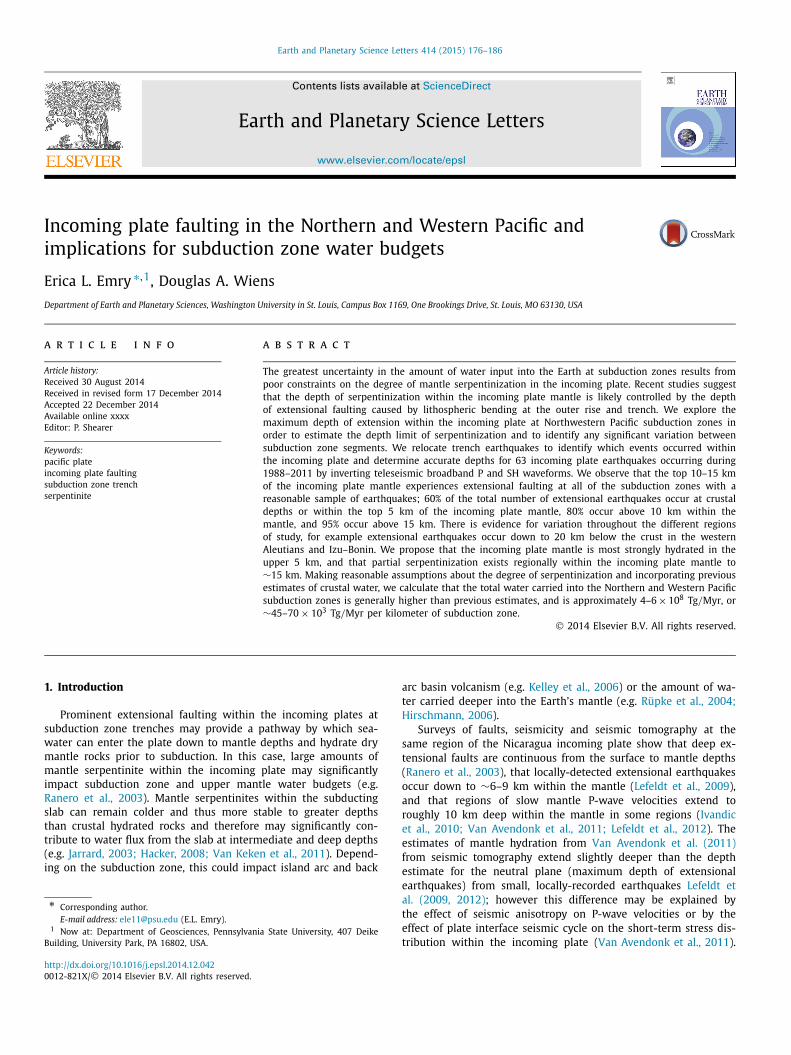
The epicentral locations and the lateral relationships between the events aid us somewhat in deciding whether events are shal-low thrust or within the incoming plate, but subsequent waveform inversions are not reliant upon the relocated event depths as we employ a grid search and forward modeling of waveforms. If the setting of the earthquake (shallow thrust, incoming plate) was questionable, we continued with the waveform inversion in order to correctly identify the type of earthquake source. The differences between our locations and other catalogs are discussed in the sup-plementary, but overall we find the differences to be too small to significantly affect our depth determinations, given the 30–90◦ dis-tances to seismic stations. The final set of earthquakes analyzed in this paper are shown in Fig. 1 and listed in Table 1.
2.2. Waveform inversion
Following relocation, we use teleseismic P- and SH-waveform inversion to determine best fitting source parameters for moderate-sized earthquakes located on the incoming plate or near the trench axis. We obtained waveform data from Global Seismograph Net-work (GSN) stations through the IRIS DMC (www.iris.edu) for all events greater than Mw 5.5 occurring after 1990, for two events greater than Mw 6.0 occurring prior to 1990, and for events with Mw 5.0–5.5. Using the GSN data, we first tested the lower mag-nitude (5.0–5.5) events for high signal to noise ratio (SNR), as discussed below, and if high SNR was found, additional data from other global stations were requested. We did not request any data for earthquakes closely resembling shallow thrust events (located notably landward of the trench axis, shallow dip �25◦ , oriented perpendicular to plate convergence, slip angle ∼90◦). As men-tioned above, if the event could not be identified as distinctly in-coming plate or shallow thrust, we proceeded with the waveform inversion. Of 8 ambiguous events, following waveform inversion, 5 were interpreted to be shallow thrust events and 3 were identified as occurring within the incoming plate.
Waveforms for Mw 5.0–5.4 incoming plate earthquakes were tested to find events with sufficient signal to noise ratio (SNR) at the frequency range used in this study from GSN broadband data. For each event, instrument response was removed, and SNR was determined for three passbands: 0.02–0.5 Hz, 0.02–0.2 Hz, and 0.02–0.18 Hz. For each passband, the SNR was computed using three methods within the SEIZMO MATLAB package (Eu-ler, https :/ /github .com /g2e /seizmo): peak-to-peak amplitude, root-mean-square (RMS), and the ratio of peak-to-peak signal amplitude vs. noise RMS. The time window used for noise was 50–10 s prior
178 E.L. Emry, D.A. Wiens / Earth and Planetary Science Letters 414 (2015) 176–186
Table 1New locations and depths (this study).
Event Date Time (UTC)
Latitude (◦ North)
Longitude (◦ East)
Deptha,b
(km)Time func. (s)
Mw Event typec
Top freq. (Hz)
# of Wvfms.
Misfitd
Alaska–Aleutian1 16 Jan 1999 10:44:42.90 56.3538 −147.2899 26.5 ± 2 2 5.93 C 0.5 45 0.28582 23 Jan 2000 08:42:29.10 57.6226 −149.0905 4.5 ± 2 1 5.52 SS 0.5 21 0.64253 27 Sept 1992 17:48:12.96 53.7911 −157.4670 9.5 ± 2 2 5.87 N 0.5 29 0.40724 3 May 2010 14:04:23.70 52.5430 −163.6016 9.5 ± 1 1 5.46 N 0.5 22 0.48865 7 Aug 2004 09:30:17.98 51.7127 −166.3158 8.5 ± 1 4 6.00 N 0.5 50 0.31916 4 May 1994 11:47:23.12 51.5844 −168.5367 12.5 ± 2 1 5.43 N 0.5 10 0.69137 28 Dec 2002 09:36:12.73 51.5603 −168.5633 10.5 ± 2 1 5.49 N 0.5 37 0.42948 14 Apr 1993 05:58:34.24 51.1857 −168.8008 10.5 ± 2 3 5.95 N 0.5 29 0.35229 19 Aug 1992 00:57:41.81 50.5824 −174.9484 13.5 ± 2 3 6.08 N 0.5 32 0.2557
10 15 Apr 1992 05:35:04.50 50.3010 −176.0652 10.5 ± 2 2 5.53 N–SS 0.5 30 0.399911 26 June 2006 01:59:17.20 50.3040 −176.1655 9.5 ± 2 2 5.41 N 0.5 46 0.405612 11 Nov 1993 00:28:36.38 50.3164 −177.4839 24.5 ± 2 3 5.95 N 0.5 37 0.349613 15 Aug 2007 20:22:13.32 50.3687 −177.5885 8.5 ± 2 3 6.41 N 0.5 42 0.243014 2 Sept 1999 02:33:37.56 50.7070 −177.6827 8.5 ± 2 2 5.34 SS 0.4 31 0.507715 6 July 2009 14:53:12.71 50.4593 177.0526 30.5 ± 3 1 6.05 N–SS 0.5 22 0.467416 7 Feb 1988 18:15:07.40 50.8566 173.4344 9.5 ± 4 6 6.38 N 0.18 25 0.363217 12 Feb 1997 05:19:04.70 52.1393 171.2434 8.5 ± 1 1 5.51 N 0.5 27 0.465618 4 Aug 2006 07:45:49.69 52.1743 171.0589 11.5 ± 1 1 5.49 N 0.5 20 0.3610
Kamchatka19 18 May 2011 17:42:36.55 55.4763 163.8497 16.5 ± 2 1 5.50 N 0.5 44 0.569120 26 Nov 1999 00:29:01.84 55.2337 165.3382 21 ± 3 2 6.06 SS 0.5 37 0.430121 11 Apr 1989 03:56:37.29 49.5404 159.0874 9.5 ± 2 8 6.71 N 0.18 42 0.233822 10 Aug 2005 12:47:39.77 48.6982 158.0978 42 ± 2 1 5.38 C 0.5 40 0.5105
Kuril23 28 May 1992 21:24:51.36 47.6389 155.3989 7 ± 2 2 5.58 N 0.5 47 0.619124 17 Nov 2006 04:09:55.38 47.0563 155.4486 4 ± 1 2 5.53 N 0.5 32 0.562825 17 Nov 2006 06:33:50.32 47.0434 155.5093 4 ± 1 1 5.43 N 0.5 33 0.651226 15 Nov 2006 19:25:26.56 47.0323 154.9654 3 ± 1 1 5.65 N 0.5 33 0.523427 13 Jan 2007 17:37:07.41 46.9146 156.2605 17 ± 2 3 6.01 N–SS 0.5 38 0.301728 5 Sept 1994 22:13:48.95 46.8178 155.1344 9 ± 2 1 5.55 N–SS 0.5 41 0.462029 24 Nov 2006 15:34:11.04 46.7845 153.7519 10 ± 2 1 5.61 N 0.5 50 0.475530 16 Nov 2006 06:20:21.76 46.3528 154.4874 10 ± 1 2 6.00 N 0.5 50 0.477431 7 Dec 2006 19:10:21.77 46.1696 154.3725 10 ± 2 4 6.37 N 0.5 50 0.394032 13 Sept 2004 03:00:14.75 43.8884 151.3214 4 ± 1 3 5.97 N 0.5 44 0.363433 6 Feb 2003 18:48:40.02 43.1867 147.9108 23 ± 5 4 5.57 N–SS 0.5 37 0.5450
Northern Japan34 7 May 1991 13:09:31.72 39.4835 144.6595 20 ± 2 1 5.99 N 0.5 19 0.261435 5 May 2011 14:58:20.68 38.2463 144.0672 18 ± 5 3 5.96 N 0.5 50 0.561036 14 Nov 2005 21:38:51.86 38.1550 144.9285 12 ± 2 9 7.01 N 0.5 50 0.201337 17 Jan 2010 06:04:37.92 37.9833 143.5729 24 ± 2 3 5.57 SS 0.5 44 0.332538 18 Mar 2011 03:23:55.61 37.8227 143.5179 15 ± 3 1 5.62 N 0.5 45 0.568539 9 May 2011 20:15:55.89 37.8124 143.5359 13 ± 2 1 5.70 N 0.5 44 0.585240 17 Mar 2011 06:12:40.49 37.7967 143.4238 7 ± 3 7 5.73 N 0.5 32 0.492041 14 June 2011 13:06:54.78 37.7940 143.5197 16 ± 3 1 5.80 N–SS 0.5 50 0.643142 12 Mar 2011 12:53:50.52 37.7827 143.5197 20 ± 3 3 5.96 N 0.5 44 0.617143 3 June 2011 00:05:05.29 37.3472 143.9234 14 ± 3 3 6.15 N–SS 0.5 50 0.381944 22 Mar 2011 07:18:47.55 37.2562 144.1037 10 ± 1 5 6.45 N 0.5 50 0.239845 22 Mar 2011 12:01:21.94 36.8978 143.2142 22 ± 4 2 5.76 N 0.5 29 0.725846 17 Aug 2011 11:44:09.36 36.8189 143.7666 8 ± 2 3 6.22 N 0.5 50 0.329147 14 Mar 2011 03:15:53.22 36.3166 142.0871 13 ± 3 2 5.47 C 0.5 33 0.557548 13 Mar 2011 01:26:06.28 35.7527 141.6793 19 ± 3 4 6.26 N 0.5 49 0.4761
Izu–Bonin49 24 May 1997 05:15:39.27 33.7168 142.0872 9 ± 2 1 5.33 N–SS 0.5 21 0.517250 29 July 2005 20:25:03.96 33.4587 142.3966 4 ± 1 4 5.55 N 0.5 47 0.407251 27 July 2005 02:39:22.51 33.4050 142.3880 3 ± 1 1 5.41 N 0.5 43 0.598852 25 Oct 1999 07:29:58.65 32.1033 142.2747 11 ± 3 2 5.87 N 0.5 41 0.582053 5 Jan 2011 00:57:31.69 31.6720 142.2905 10 ± 1 1 5.63 N 0.5 49 0.591954 2 Nov 2004 08:46:00.58 28.8189 143.2545 10 ± 1 3 5.74 N–SS 0.5 35 0.433455 4 Mar 2002 20:21:23.42 28.5644 143.3213 9 ± 2 1 5.51 N 0.5 39 0.566456 1 June 2003 17:50:26.96 28.2978 142.8072 9 ± 2 2 5.62 N 0.5 45 0.480357 6 Nov 1996 20:01:02.53 28.1193 143.5693 12 ± 1 4 6.46 N–SS 0.5 47 0.255758 21 Dec 2010 17:19:41.19 26.9231 143.7696 18 ± 2 6 7.18 N–SS 0.5 50 0.253359 15 June 2011 04:40:59.72 26.8284 144.1564 5 ± 1 3 5.52 N 0.5 48 0.342860 22 Dec 2010 21:49:41.05 26.8056 143.6767 29 ± 5 2 6.40 SS 0.5 50 0.587061 22 Dec 2010 01:31:20.03 26.7521 143.5144 8 ± 1 4 5.65 N–SS 0.5 22 0.435662 6 Aug 2006 18:16:40.48 26.1467 144.0780 24 ± 1 2 5.92 N 0.5 50 0.243963 9 Feb 2005 18:46:10.91 26.1019 144.1007 26 ± 2 5 6.31 N 0.5 50 0.2126
a Denotes depth beneath seafloor (depth within plate).b Depth uncertainty calculated as depth difference where the misfit is 5% more than the best-fitting model, as in Emry et al. (2014).c SS – strike-slip; C –compression; N – extensional; ST – shallow thrust.d Misfit is measured as the squared amplitude error.
E.L. Emry, D.A. Wiens / Earth and Planetary Science Letters 414 (2015) 176–186 179
Fig. 1. Focal mechanisms of the studied earthquakes near the trench axes of Northern and Western Pacific subduction zones. Black focal mechanisms correspond to events on Table 1 and are relocated GCMT earthquakes for which new depths are inverted. Throughout the paper, all plotted focal mechanisms in map-view are lower-hemisphere projections with compressional quadrants shown in black or gray and dilatational quadrants are shown in white. Depth of seafloor corresponds to the colorbar on the left.
to the P- and S-arrival times calculated according to the TauP travel time calculator (Crotwell et al., 1999), and the window for signal was 10 s prior to the estimated arrival to 40 s following. The SNR for P-wave arrivals were determined from the vertical component and the SNR for S-wave arrivals were determined from the hori-zontal components. Events with 10+ P or S traces with SNR 5+were further analyzed. This criterion was based on the peak-to-peak signal vs. peak-to-peak noise of the 0.02–0.5 Hz pass band. We use this SNR criterion, because the waveforms for Mw 5.5+events in this study and in Emry et al. (2014) were visually in-spected for high SNR – an approach that resembles peak-to-peak SNR.
Broadband data were used for most earthquakes in this study; for two events occurring before 1990, broadband and long-period data were used. Although most Mw 5.5+ earthquakes after 1990 have high SNRs at a sufficient number of stations, a few were omitted, either due to low SNRs (determined visually) within the 0.02–0.5 Hz passband or because long period signal from prior large events overwhelmed signal from the earthquake. Many Mw 5.5+ events had sufficient signal to invert using only GSN-broadband stations, although where necessary additional data were requested; for most Mw 5.0–5.5 events, additional waveform data were requested. All waveforms were recorded at 30–90◦ from the GCMT earthquake source. Waveforms were visually checked for clear signals at 0.02–0.5 Hz, and instrument responses from the IRIS DMC were deconvolved prior to fitting the synthetics.
We use the ray theory method (e.g. Langston and Helmberger, 1975) and the ray parameter that corresponds to teleseismic prop-agation to the station using the IASP91 model to compute our synthetic waveforms (Emry et al., 2014). Synthetics were first cal-culated for three fundamental double-couple source geometries and then combined to obtain synthetics for each focal mechanism
tested within the grid search. A ray expander routine was used to compute all the reflections and conversions in the near-source structure model above a cut-off amplitude, and the duration of the source time function, which was modeled as a half sine, was de-termined within the grid search. The 1-d average shallow velocity structures used to compute synthetics were estimated from active source refraction experiments and are listed in Table S3. Fig. S1 shows an example of waveforms and matching synthetics for an incoming plate earthquake at the Aleutian trench.
A thorough discussion of the waveform modeling method as well as uncertainties in estimated depths are available at length in Emry et al. (2014), however, we briefly discuss here the contribu-tions to uncertainty for our depths. The first contributing factor is the goodness of fit between the modeled waveform and the data, which is dependent upon having a high data SNR from several sta-tions at many backazimuths. To address the first contribution to uncertainty (modeled waveform fits) in Emry et al. (2014), we as-signed uncertainties based on the depth at which the calculated misfit was 5% greater than the best-fitting solution – allowing us to identify which events had better constrained depths relative to the others in the group. For consistency, we compute uncertainties in the same manner as in Emry et al. (2014), and the results are included in Table 1.
The second contributing factor is the assumed source-side ve-locity model: the thickness of the crustal layers and the velocities assumed for the crust and upper mantle. We attempted to limit this error by using velocity models from active-source refraction seismology rather than a global average model for oceanic crust; however, generally only one refraction survey had been completed over the incoming plate at the subduction zones of interest (Ta-ble S3). Given a reasonable range for the thickness of the crust and the seismic velocities assumed, we reasoned in Emry et al. (2014)

180 E.L. Emry, D.A. Wiens / Earth and Planetary Science Letters 414 (2015) 176–186
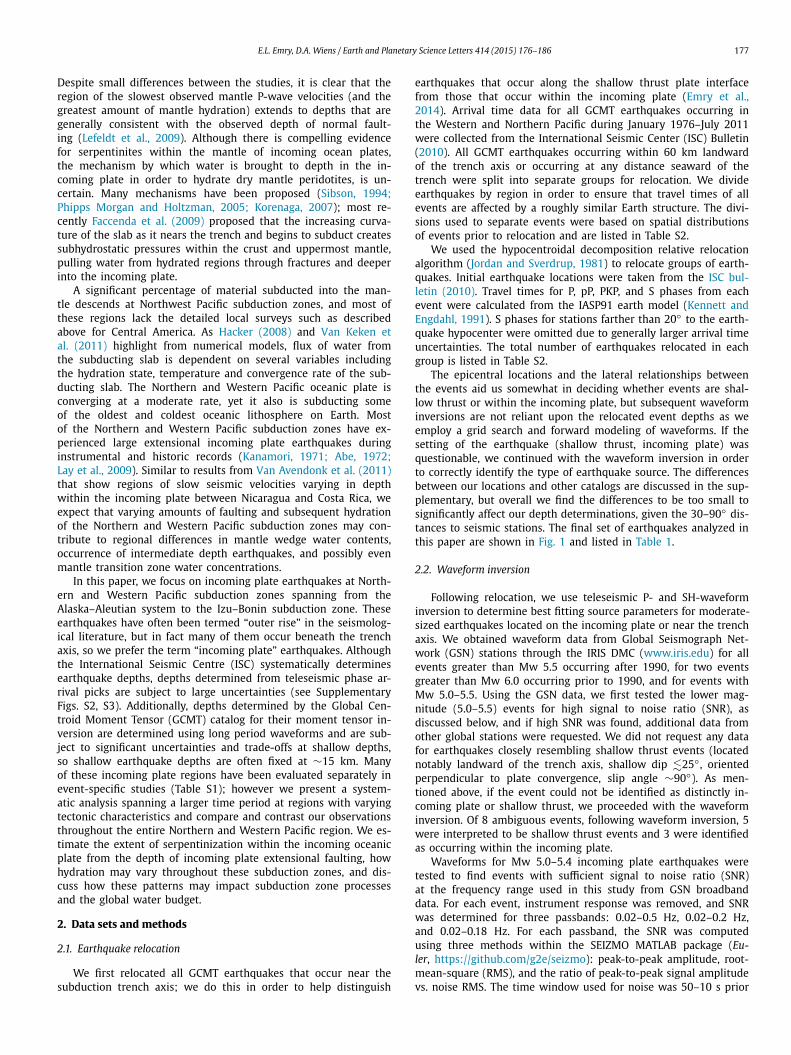
Fig. 2. Top: Map view of the Central and Western Aleutian Trench showing the lo-cation of earthquakes for which depths were inverted in this paper. Solid black lines show the locations of the cross-sectional profiles below. Bottom: Cross-section near the Andreanof and Delarof Islands showing the distance and depth of studied earthquakes. The thick black line shows bathymetry; the thick red line shows the boundary between the crust and mantle (Moho) as input into our waveform inver-sion. All focal-mechanisms plotted in cross-sectional view in this paper are rotated 90◦ from their map-view orientation. Bottom: Cross-section at the Rat and Near Islands in the Western Aleutians similar to above. (For interpretation of the refer-ences to color in this figure legend, the reader is referred to the web version of this article.)
that about 1–2 km of uncertainty could result from having an in-accurately known incoming plate velocity model, given the depths at which the majority of our crustal and uppermost mantle events occurred. However, for only a few events in our results that oc-cur at deeper depths (∼35+ km), the uncertainty could become as large as 4–5 km (Emry et al., 2014). These estimates for uncer-tainty are on par with those suggested by prior studies (∼3–5 km) (e.g. Taymaz et al., 1991; Tilmann et al., 2010; Craig et al., 2014).
3. Results
In total, we relocated 759 GCMT earthquakes and successfully inverted the waveforms of 63 earthquakes with Mw 5.2–7.4 (Ta-ble 1; Figs. 1–5, S4–S7). The results from waveform inversion for depth within the plate tend to be 1–5 km shallower than the orig-inal GCMT event depths for events in the 20–50 km depth range, likely due to the use of a specific source-side velocity model; how-ever for events with GCMT depths fixed at 12–15 km, our final depth solutions range from less than 5 km to greater than 20 km beneath the seafloor (Fig. S2). We consider the waveform inver-sion depths to be more accurate than the GCMT depths because 1) the passband of our analysis extends to 0.5 Hz whereas the general GCMT analysis uses longer period waves, and higher fre-quencies are better able to resolve depth, 2) the depth of GCMT inversions are often necessarily fixed at 12 or 15 km due to poor depth resolution for shallow events resulting from use of only long period data, and 3) we compute our depths as the depth below the seafloor using 1-d local velocity models, which provides us with
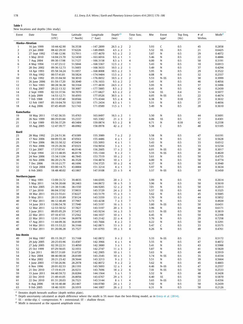
Fig. 3. Top: Map view of the Kuril Islands showing relocated earthquakes with newly determined depths. Fault parameters for two large events from 2007 and 2009 are also plotted (in gray) with dashed tie lines pointing to their locations (Lay et al., 2009). Middle: Cross-section near the Northern Kuril Islands showing the distance and depth of earthquakes in this study (colors and focal mechanisms are plotted as in Fig. 2). Gray and white focal mechanisms correspond to the two large 2007 and 2009 outer rise events with fault parameters and fault plane dimensions as modeled by Lay et al. (2009). Bottom: Cross-section near the Southern Kuril Islands similar to above.
better information to place the event depth within the local struc-ture by including the pP and sP reflections from the seabottom and the pwP water reverberation. A summary of the waveform inver-sion results is provided in Table 1. We find that, in general, our earthquake depths agree with new results from Craig et al. (2014), who use slightly different locations and a somewhat different ap-proach to invert P- and SH-waveforms (Fig. S2).
To make our interpretation of incoming plate faulting as com-plete as possible, we include results from several previous stud-ies that used waveform inversion methods to obtain accurate depths (Table S1). Most of these results come from several studies of pre-1990 incoming plate earthquakes using analog data from the WWSSN seismic network (e.g., Forsyth, 1982; Ward, 1983; Christensen and Ruff, 1988), and a few others include the depth range of faults as inferred from finite fault models of large events (Raeesi and Atakan, 2009; Lay et al., 2009).
4. Discussion
4.1. Depth extent of faulting within the incoming plate
The occurrence of incoming plate extensional earthquakes is variable along the ∼13 000 km of the Northwest Pacific subduc-tion zones during the ∼20 yr record of good broadband global network coverage; however, we note that extensional earthquakes

E.L. Emry, D.A. Wiens / Earth and Planetary Science Letters 414 (2015) 176–186 181
Fig. 4. Top: Map view of Northern Japan showing relocated earthquakes with newly determined depths. Middle: Cross-section along the northern Japan profile line showing the distance and depth of earthquakes in this study (colors and focal mech-anisms are plotted as in Fig. 2). Bottom: Cross-section along the southern Japan profile line similar to above.
occur in the incoming plate of every subduction zone down to at least 5 km within the mantle (Figs. 6, 7). In addition, most of the studied Pacific subduction zones have evidence for at least one extensional earthquake at ∼10–15 km below the incoming plate moho. At the Western Aleutians and Southern Bonin trenches, ex-tensional earthquakes occur even deeper, down to ∼20 km below the top of the incoming plate mantle (Figs. 6, 7). Due to the short record of globally distributed broadband seismographs, the long-term pattern of incoming plate extensional earthquakes cannot be obtained; however after consideration of results from prior studies obtaining accurate event depths from waveform inversion or finite-fault modeling (Table S1, Fig. 7), it appears that extensional events at ∼10–20 km below the moho although occurring less frequently, may be distributed more evenly throughout the entire length of the incoming plate in the Northwest Pacific. In comparison, the accurate depths determined in this study are predominantly shal-lower than the depths assigned to the shallowest GCMT events (Supplementary Fig. S8). If we had used GCMT depths for the shal-lowest incoming plate earthquakes, we would likely predict that
Fig. 5. Top: Map view of the Bonin Trench showing relocated earthquakes with newly determined depths. Bottom: Cross-section along the Northern Bonin profile line showing the distance and depth of earthquakes in this study (colors and fo-cal mechanisms are plotted as in Fig. 2). Bottom: Cross-section along the Southern Bonin profile line similar to above.
the region of greatest serpentinization extends deeper into the in-coming plate (down to 10 km instead of the 5 km suggested by our results) and thus would overpredict the amount of hydration brought into the subduction zone. Based on our ∼20 yr earthquake distribution and results from previous studies, we postulate that pervasive faulting occurs globally within the top 5 km of the in-coming plate mantle and that deeper extensional faulting occurs intermittently or discontinuously along the length of the Northern and Western Pacific subduction zones down to 10–20 km within the incoming plate mantle.
4.2. Variations in faulting and hydration with time and space
It is clear that the largest extensional incoming plate earth-quakes can extend 25–30 km into the mantle, generally deeper than those observed in this study (e.g. Abe, 1972; Kanamori, 1972;Kao and Chen, 1996; Lynnes and Lay, 1988; Lay et al., 2009). It seems likely that these large incoming plate events are associ-ated with temporal variations in stress and neutral plane depth within the incoming plate that result from the plate interface seismic cycle (Christensen and Ruff, 1983, 1988; Dmowska et al., 1988). After the great Tohoku plate interface earthquake, many extensional outer rise earthquakes occurred within the incom-ing plate at depths previously reported as compressional (Seno and Gonzalez, 1987; Hino et al., 2009; Gamage et al., 2009;Obana et al., 2012), which suggests that stresses within the in-

182 E.L. Emry, D.A. Wiens / Earth and Planetary Science Letters 414 (2015) 176–186
Fig. 6. Top: Histogram showing the number of extensional outer rise earthquakes occurring at each depth range: Crustal, 0–4 km below the moho, 5–9 km below the moho, 10–14 km below the moho, 15–19 km, and 20–24 km below the moho. Alaska and the Aleutians are shown in blue, Kamchatka is red, Kurils are shown in green, Japan is shown in purple, Izu–Bonin is light-blue, and Mariana (Emry et al., 2014) is orange. (For interpretation of the references to color in this figure legend, the reader is referred to the web version of this article.)
coming plate might be dependent upon the seismic cycle. These possible temporal variations of stress distributions within the in-coming plate make it difficult to presume the long-term state of stress within the incoming plate, as some of our analyzed earth-quakes followed great plate interface earthquakes. However, the plate interface seismic cycle may help to explain the lateral varia-
tions in maximum incoming plate event depth that we observe in this study, as different sections of the subduction zone may be at different stages of the seismic cycle, with recently ruptured regions showing the greatest event depths.
The extent to which the subduction plate interface seismic cycle might sway our results for incoming plate seismicity is not known. As discussed by Lefeldt et al. (2012), following active source seis-mic experiments in Central America, infrequent large extensional events may not be the best predictors of the depth of serpentiniza-tion; therefore it seems likely that the infrequent Mw 7+ events that occur within the incoming plate may be less important to mantle serpentinization than the general trend of Mw 5–6 events that we explore in our study. The event locations and depths deter-mined in this paper, based on readily available teleseismic records, provide a useful first-order observation that extensional outer rise seismicity is prevalent throughout most of the Northwest Pacific subduction zones generally to a depth of at least 5 km below the moho, and deeper in some locations.
4.3. Water infiltration and storage in Pacific Oceanic mantle
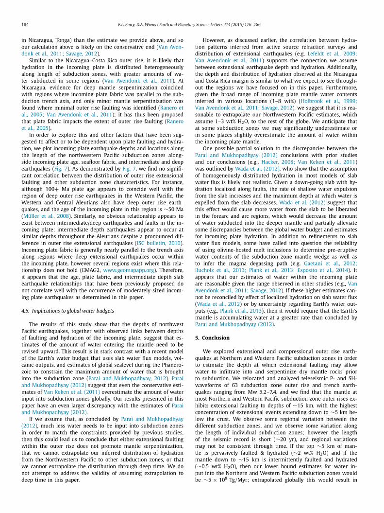
We observe that extensional incoming plate faulting occurs at all subduction zones within at least the top 5 km, and in some places down to ∼10–20 km within the incoming plate mantle. Nearly half of the extensional incoming plate events occur within the upper 5 km of the mantle, suggesting that the intensity of faulting is greater in the mantle than in the crust and that fault-ing decreases with depth below the uppermost mantle (Fig. 6). The deepest extensional incoming plate events are found at the Central and Western Aleutian Islands and at the Southern Bonin segment of the Izu–Bonin–Mariana subduction zone. Ranero et al. (2003)and Lefeldt et al. (2009) have suggested that the extensional in-coming plate faults allow water to travel into the plate down to the
Fig. 7. Subduction zone processes and depth of outer rise faulting. (a) The depths of outer rise earthquakes versus the distance along the length of the entire North and Western Pacific subduction zones, starting at the eastern end of the Alaskan trench (0 km) to the southern end of the Mariana (Emry et al., 2014) trench (10 000 km). Earthquakes from this study are plotted as yellow diamonds and events from previous studies are plotted as dark red diamonds. (b). Incoming plate age (Myr) determined by Müller et al. (2008) was extracted using GEOMAPAPP and is plotted in the second window. (c) The fabric-trench incidence angle determined from the orientation of magnetic lineations (EMAG2) extracted using GEOMAPAPP and the orientation of the subduction trench axis. Seemingly spurious incidence angles are a result of small sections of the subduction trench axis that have significantly different orientations in comparison to the overall subduction zone. (d) Locations and depths of intermediate and deep slab earthquakes were extracted from the ISC bulletin (2010) plotted along the length of the margin. (For interpretation of the references to color in this figure legend, the reader is referred to the web version of this article.)
E.L. Emry, D.A. Wiens / Earth and Planetary Science Letters 414 (2015) 176–186 183
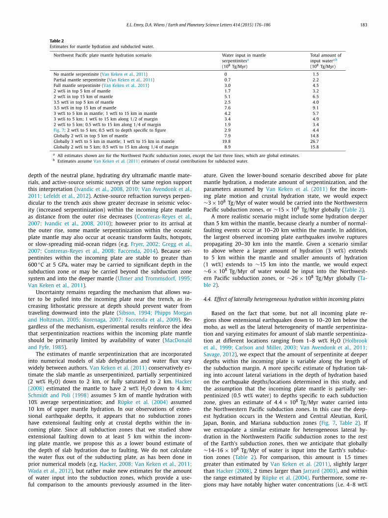
Table 2Estimates for mantle hydration and subducted water.
Northwest Pacific plate mantle hydration scenario Water input in mantle serpentinitesa
(108 Tg/Myr)
Total amount of input watera,b
(108 Tg/Myr)
No mantle serpentinite (Van Keken et al., 2011) 0 1.5Partial mantle serpentinite (Van Keken et al., 2011) 0.7 2.2Full mantle serpentinite (Van Keken et al., 2011) 3.0 4.52 wt% in top 5 km of mantle 1.7 3.22 wt% in top 15 km of mantle 5.1 6.53.5 wt% in top 5 km of mantle 2.5 4.03.5 wt% in top 15 km of mantle 7.6 9.13 wt% to 5 km in mantle; 1 wt% to 15 km in mantle 4.2 5.73 wt% to 5 km; 1 wt% to 15 km along 1/2 of margin 3.4 4.92 wt% to 5 km; 0.5 wt% to 15 km along 1/4 of margin 1.9 3.4Fig. 7: 2 wt% to 5 km; 0.5 wt% to depth specific to figure 2.9 4.4Globally 2 wt% in top 5 km of mantle 7.9 14.8Globally 3 wt% to 5 km in mantle; 1 wt% to 15 km in mantle 19.8 26.7Globally 2 wt% to 5 km; 0.5 wt% to 15 km along 1/4 of margin 8.9 15.8
a All estimates shown are for the Northwest Pacific subduction zones, except the last three lines, which are global estimates.b Estimates assume Van Keken et al. (2011) estimates of crustal contributions for subducted water.
depth of the neutral plane, hydrating dry ultramafic mantle mate-rials, and active-source seismic surveys of the same region support this interpretation (Ivandic et al., 2008, 2010; Van Avendonk et al., 2011; Lefeldt et al., 2012). Active-source refraction surveys perpen-dicular to the trench axis show greater decrease in seismic veloc-ity (increased serpentinization) within the incoming plate mantle as distance from the outer rise decreases (Contreras-Reyes et al., 2007; Ivandic et al., 2008, 2010); however prior to its arrival at the outer rise, some mantle serpentinization within the oceanic plate mantle may also occur at oceanic transform faults, hotspots, or slow-spreading mid-ocean ridges (e.g. Fryer, 2002; Gregg et al., 2007; Contreras-Reyes et al., 2008; Faccenda, 2014). Because ser-pentinites within the incoming plate are stable to greater than 600 ◦C at 5 GPa, water may be carried to significant depth in the subduction zone or may be carried beyond the subduction zone system and into the deeper mantle (Ulmer and Trommsdorf, 1995;Van Keken et al., 2011).
Uncertainty remains regarding the mechanism that allows wa-ter to be pulled into the incoming plate near the trench, as in-creasing lithostatic pressure at depth should prevent water from traveling downward into the plate (Sibson, 1994; Phipps Morgan and Holtzman, 2005; Korenaga, 2007; Faccenda et al., 2009). Re-gardless of the mechanism, experimental results reinforce the idea that serpentinization reactions within the incoming plate mantle should be primarily limited by availability of water (MacDonald and Fyfe, 1985).
The estimates of mantle serpentinization that are incorporated into numerical models of slab dehydration and water flux vary widely between authors. Van Keken et al. (2011) conservatively es-timate the slab mantle as unserpentinized, partially serpentinized (2 wt% H2O) down to 2 km, or fully saturated to 2 km. Hacker(2008) estimated the mantle to have 2 wt% H2O down to 4 km; Schmidt and Poli (1998) assumes 5 km of mantle hydration with 10% average serpentinization; and Rüpke et al. (2004) assumed 10 km of upper mantle hydration. In our observations of exten-sional earthquake depths, it appears that no subduction zones have extensional faulting only at crustal depths within the in-coming plate. Since all subduction zones that we studied show extensional faulting down to at least 5 km within the incom-ing plate mantle, we propose this as a lower bound estimate of the depth of slab hydration due to faulting. We do not calculate the water flux out of the subducting plate, as has been done in prior numerical models (e.g. Hacker, 2008; Van Keken et al., 2011;Wada et al., 2012), but rather make new estimates for the amount of water input into the subduction zones, which provide a use-ful comparison to the amounts previously assumed in the liter-
ature. Given the lower-bound scenario described above for plate mantle hydration, a moderate amount of serpentinization, and the parameters assumed by Van Keken et al. (2011) for the incom-ing plate motion and crustal hydration state, we would expect ∼3 × 10⁸ Tg/Myr of water would be carried into the Northwestern Pacific subduction zones, or ∼15 × 108 Tg/Myr globally (Table 2).
A more realistic scenario might include some hydration deeper than 5 km within the mantle, because clearly a number of normal-faulting events occur at 10–20 km within the mantle. In addition, the largest observed incoming plate earthquakes involve ruptures propagating 20–30 km into the mantle. Given a scenario similar to above where a larger amount of hydration (3 wt%) extends to 5 km within the mantle and smaller amounts of hydration (1 wt%) extends to ∼15 km into the mantle, we would expect ∼6 × 10⁸ Tg/Myr of water would be input into the Northwest-ern Pacific subduction zones, or ∼26 × 108 Tg/Myr globally (Ta-ble 2).
4.4. Effect of laterally heterogeneous hydration within incoming plates
Based on the fact that some, but not all incoming plate re-gions show extensional earthquakes down to 10–20 km below the moho, as well as the lateral heterogeneity of mantle serpentiniza-tion and varying estimates for amount of slab mantle serpentiniza-tion at different locations ranging from 1–8 wt% H2O (Holbrook et al., 1999; Carlson and Miller, 2003; Van Avendonk et al., 2011;Savage, 2012), we expect that the amount of serpentinite at deeper depths within the incoming plate is variable along the length of the subduction margin. A more specific estimate of hydration tak-ing into account lateral variations in the depth of hydration based on the earthquake depths/locations determined in this study, and the assumption that the incoming plate mantle is partially ser-pentinized (0.5 wt% water) to depths specific to each subduction zone, gives an estimate of 4.4 × 10⁸ Tg/Myr water carried into the Northwestern Pacific subduction zones. In this case the deep-est hydration occurs in the Western and Central Aleutian, Kuril, Japan, Bonin, and Mariana subduction zones (Fig. 7, Table 2). If we extrapolate a similar estimate for heterogeneous lateral hy-dration in the Northwestern Pacific subduction zones to the rest of the Earth’s subduction zones, then we anticipate that globally ∼14–16 × 108 Tg/Myr of water is input into the Earth’s subduc-tion zones (Table 2). For comparison, this amount is 1.5 times greater than estimated by Van Keken et al. (2011), slightly larger than Hacker (2008), 2 times larger than Jarrard (2003), and within the range estimated by Rüpke et al. (2004). Furthermore, some re-gions may have notably higher water concentrations (i.e. 4–8 wt%
184 E.L. Emry, D.A. Wiens / Earth and Planetary Science Letters 414 (2015) 176–186
in Nicaragua, Tonga) than the estimate we provide above, and so our calculation above is likely on the conservative end (Van Aven-donk et al., 2011; Savage, 2012).
Similar to the Nicaragua–Costa Rica outer rise, it is likely that hydration in the incoming plate is distributed heterogeneously along length of subduction zones, with greater amounts of wa-ter subducted in some regions (Van Avendonk et al., 2011). At Nicaragua, evidence for deep mantle serpentinization coincided with regions where incoming plate fabric was parallel to the sub-duction trench axis, and only minor mantle serpentinization was found where minimal outer rise faulting was identified (Ranero et al., 2005; Van Avendonk et al., 2011); it has thus been proposed that plate fabric impacts the extent of outer rise faulting (Ranero et al., 2005).
In order to explore this and other factors that have been sug-gested to affect or to be dependent upon plate faulting and hydra-tion, we plot incoming plate earthquake depths and locations along the length of the northwestern Pacific subduction zones along-side incoming plate age, seafloor fabric, and intermediate and deep earthquakes (Fig. 7). As demonstrated by Fig. 7, we find no signifi-cant correlation between the distribution of outer rise extensional faulting and other subduction zone characteristics. For instance, although 100+ Ma plate age appears to coincide well with the region of deep outer rise earthquakes in the Western Pacific, the Western and Central Aleutians also have deep outer rise earth-quakes, and the age of the incoming plate in this region is ∼50 Ma (Müller et al., 2008). Similarly, no obvious relationship appears to exist between intermediate/deep earthquakes and faults in the in-coming plate; intermediate depth earthquakes appear to occur at similar depths throughout the Aleutians despite a pronounced dif-ference in outer rise extensional earthquakes (ISC bulletin, 2010). Incoming plate fabric is generally nearly parallel to the trench axis along regions where deep extensional earthquakes occur within the incoming plate, however several regions exist where this rela-tionship does not hold (EMAG2, www.geomapapp.org). Therefore, it appears that the age, plate fabric, and intermediate depth slab earthquake relationships that have been previously proposed do not correlate well with the occurrence of moderately-sized incom-ing plate earthquakes as determined in this paper.
4.5. Implications to global water budgets
The results of this study show that the depths of northwest Pacific earthquakes, together with observed links between depths of faulting and hydration of the incoming plate, suggest that es-timates of the amount of water entering the mantle need to be revised upward. This result is in stark contrast with a recent model of the Earth’s water budget that uses slab water flux models, vol-canic outputs, and estimates of global sealevel during the Phanero-zoic to constrain the maximum amount of water that is brought into the subduction zone (Parai and Mukhopadhyay, 2012). Parai and Mukhopadhyay (2012) suggest that even the conservative esti-mates of Van Keken et al. (2011) overestimate the amount of water input into subduction zones globally. Our results presented in this paper have an even larger discrepancy with the estimates of Parai and Mukhopadhyay (2012).
If we assume that, as concluded by Parai and Mukhopadhyay(2012), much less water needs to be input into subduction zones in order to match the constraints provided by previous studies, then this could lead us to conclude that either extensional faulting within the outer rise does not promote mantle serpentinization, that we cannot extrapolate our inferred distribution of hydration from the Northwestern Pacific to other subduction zones, or that we cannot extrapolate the distribution through deep time. We do not attempt to address the validity of assuming extrapolation to deep time in this paper.
However, as discussed earlier, the correlation between hydra-tion patterns inferred from active source refraction surveys and distribution of extensional earthquakes (e.g. Lefeldt et al., 2009;Van Avendonk et al., 2011) supports the connection we assume between extensional earthquake depth and hydration. Additionally, the depth and distribution of hydration observed at the Nicaragua and Costa Rica margin is similar to what we expect to see through-out the regions we have focused on in this paper. Furthermore, given the broad range of incoming plate mantle water contents inferred in various locations (1–8 wt%) (Holbrook et al., 1999;Van Avendonk et al., 2011; Savage, 2012), we suggest that it is rea-sonable to extrapolate our Northwestern Pacific estimates, which assume 1–3 wt% H2O, to the rest of the globe. We anticipate that at some subduction zones we may significantly underestimate or in some places slightly overestimate the amount of water within the incoming plate mantle.
One possible partial solution to the discrepancies between the Parai and Mukhopadhyay (2012) conclusions with prior studies and our conclusions (e.g., Hacker, 2008; Van Keken et al., 2011) was outlined by Wada et al. (2012), who show that the assumption of homogeneously distributed hydration in most models of slab water flux is likely not realistic. Given a down-going slab with hy-dration localized along faults, the rate of shallow water expulsion from the slab increases and the maximum depth at which water is expelled from the slab decreases. Wada et al. (2012) suggest that this effect would cause more water from the slab to be liberated in the forearc and arc regions, which would decrease the amount of water subducted into the deeper mantle and partially alleviate some discrepancies between the global water budget and estimates for incoming plate hydration. In addition to refinements to slab water flux models, some have called into question the reliability of using olivine-hosted melt inclusions to determine pre-eruptive water contents of the subduction zone mantle wedge as well as to infer the magma degassing path (e.g. Gaetani et al., 2012;Bucholz et al., 2013; Plank et al., 2013; Esposito et al., 2014). It appears that our estimates of water within the incoming plate are reasonable given the range observed in other studies (e.g., Van Avendonk et al., 2011; Savage, 2012). If these higher estimates can-not be reconciled by effect of localized hydration on slab water flux (Wada et al., 2012) or by uncertainty regarding Earth’s water out-puts (e.g., Plank et al., 2013), then it would require that the Earth’s mantle is accumulating water at a greater rate than concluded by Parai and Mukhopadhyay (2012).
5. Conclusion
We explored extensional and compressional outer rise earth-quakes at Northern and Western Pacific subduction zones in order to estimate the depth at which extensional faulting may allow water to infiltrate into and serpentinize dry mantle rocks prior to subduction. We relocated and analyzed teleseismic P- and SH-waveforms of 63 subduction zone outer rise and trench earth-quakes ranging from Mw 5.2–7.4, and we find that the mantle at most Northern and Western Pacific subduction zone outer rises ex-hibits extensional faulting to depths of ∼15 km, with the highest concentration of extensional events extending down to ∼5 km be-low the crust. We observe some regional variation between the different subduction zones, and we observe some variation along the length of individual subduction zones; however the length of the seismic record is short (∼20 yr), and regional variations may not be consistent through time. If the top ∼5 km of man-tle is pervasively faulted & hydrated (∼2 wt% H2O) and if the mantle down to ∼15 km is intermittently faulted and hydrated (∼0.5 wt% H2O), then our lower bound estimates for water in-put into the Northern and Western Pacific subduction zones would be ∼5 × 10⁸ Tg/Myr; extrapolated globally this would result in

E.L. Emry, D.A. Wiens / Earth and Planetary Science Letters 414 (2015) 176–186 185
∼15 × 108 Tg/Myr, which is towards the larger end of previous estimates.
Acknowledgements
Thank you to C. Ammon, M. Brounce, H. Chou, G. Euler, K. Furlong, M. Herman, K. Kelley, P. LaFemina, B. Shiro, P. Shore, S. Solomatov, and L. Warren for discussion and technical assis-tance. Thank you to editor P. Shearer, B. Savage, and one anony-mous reviewer whose helpful reviews improved this paper and are very appreciated. The IRIS Data Management Center provided access to all of the waveform data used in this study. Sup-port for this research was provided under grants OCE-0426408, OCE-0752476, and OCE-0841074 as well as the NSF Earth Sci-ences postdoctoral fellowship (grant EAR-1349684). Funding to present this research was also provided by the NSF Earthscope, GeoPRISMs, and the CIDER II program (EAR-1135452). Maps and cross-sections were created using the GMT software (Wessel and Smith, 1991). Data for oceanic plate age and seafloor mag-netic anomalies were extracted from EMAG2 using the GeoMa-pApp program (www.geomapapp.org). Programs to compute SNR came from the SEIZMO MATLAB programs, courtesy of G. Euler (github.com/g2e/seizmo).
Appendix A. Supplementary material
Supplementary material related to this article can be found on-line at http://dx.doi.org/10.1016/j.epsl.2014.12.042.
References
Abe, K., 1972. Lithospheric normal faulting beneath the Aleutian trench. Phys. Earth Planet. Inter. 5, 190–198. http://dx.doi.org/10.1016/0031-9201(72)90091-X.
Bucholz, C.E., Gaetani, G.A., Behn, M.D., Shimizu, N., 2013. Post-entrapment modifi-cation of volatiles and oxygen fugacity in olivine-hosted melt inclusions. Earth Planet. Sci. Lett. 374, 145–155. http://dx.doi.org/10.1016/j.epsl.2013.05.033.
Carlson, R.L., Miller, D.J., 2003. Mantle wedge water contents estimated from seismic velocities in partially serpentinized peridotites. Geophys. Res. Lett. 30 (5), 1250. http://dx.doi.org/10.1029/2002GL016600.
Christensen, D.H., Ruff, L.J., 1983. Outer-rise earthquakes and seismic coupling. Geo-phys. Res. Lett. 10 (8), 697–700. http://dx.doi.org/10.1029/GL010i008p00697.
Christensen, D.H., Ruff, L.J., 1988. Seismic coupling and outer rise earth-quakes. J. Geophys. Res. 93 (B11), 13421–13444. http://dx.doi.org/10.1029/JB093iB11p13421.
Contreras-Reyes, E., Grevemeyer, I., Flueh, E.R., Scherwath, M., Heesemann, M., 2007. Alteration of the subducting oceanic lithosphere at the Southern Central Chile trench-outer rise. Geochem. Geophys. Geosyst. 8 (7), Q07003. http://dx.doi.org/10.1029/2007GC001632.
Contreras-Reyes, E., Grevemeyer, I., Flueh, E.R., Scherwath, M., Bialas, J., 2008. Ef-fect of trench-outer rise bending-related faulting on seismic Poisson’s ratio and mantle anisotropy: a case study offshore of Southern Central Chile. Geophys. J. Int. 173, 142–156. http://dx.doi.org/10.1111/j.1365-246X.2008.03716.x.
Craig, T.J., Copley, A., Jackson, J., 2014. A reassessment of outer-rise seismicity and its implications for the mechanics of oceanic lithosphere. Geophys. J. Int. 197, 63–89. http://dx.doi.org/10.1093/gji/ggu013.
Crotwell, H.P., Owens, T.J., Ritsema, J., 1999. The TauP Toolkit: flexible seismic travel-time and ray-path utilities. Seismol. Res. Lett. 70, 154–160. http://dx.doi.org/10.1785/gssrl.70.2.154.
Dmowska, R., Rice, J.R., Lovison, L.C., Josell, D., 1988. Stress transfer and seismic phe-nomena in coupled subduction zones during the earthquake cycle. J. Geophys. Res. 93 (B7), 7869–7884. http://dx.doi.org/10.1029/JB093iB07p07869.
Emry, E.L., Wiens, D.A., Garcia-Castellanos, D., 2014. Faulting within the Pacific Plate at the Mariana Trench: implications for plate interface coupling and sub-duction of hydrous minerals. J. Geophys. Res. 119. http://dx.doi.org/10.1002/2013JB010718.
Esposito, R., Hunter, J., Schiffbauer, J.D., Shimizu, N., Bodnar, R.J., 2014. An assess-ment of the reliability of melt inclusions as recorders of the pre-eruptive volatile content of magmas. Am. Mineral. 99, 976–998. http://dx.doi.org/10.2138/am.2014.4574.
Faccenda, M., Gerya, T.V., Burlini, L., 2009. Deep slab hydration induced by bending-related variations in tectonic pressure. Nat. Geosci. 2, 790–793. http://dx.doi.org/10.1038/NGEO656.
Faccenda, M., 2014. Water in the slab: a trilogy. Tectonophysics 614, 1–30. http://dx.doi.org/10.1016/j.tecto.2013.12.020.
Forsyth, D.W., 1982. Determinations of focal depths of earthquakes associated with the bending of oceanic plates at trenches. Phys. Earth Planet. Inter. 28 (2), 141–160. http://dx.doi.org/10.1016/0031-9201(82)90079-6.
Fryer, P., 2002. Recent studies of serpentinite occurrences in the oceans: mantle–ocean interactions in the plate tectonic cycle. Chem. Erde 62, 257–302.
Gaetani, G.A., O’Leary, J.A., Shimizu, N., Bucholz, C.E., Newville, M., 2012. Rapid reequilibration of H2O and oxygen fugacity in olivine-hosted melt inclusions. Geology 40 (10), 915–918. http://dx.doi.org/10.1130/G32992.1.
Gamage, S.S.N., Umino, N., Hasegawa, A., Kirby, S.H., 2009. Offshore double-planed shallow seismic zone in the NE Japan forearc region revealed by sP depth phases recorded by regional networks. Geophys. J. Int. 178, 195–214. http://dx.doi.org/10.1111/j.1365-246X.2009.04048.x.
Gregg, P.M., Lin, J., Behn, M.D., Montési, L.G.J., 2007. Spreading rate dependence of gravity anomalies along oceanic transform faults. Nature 448, 183–187. http://dx.doi.org/10.1038/nature05962.
Hacker, B.R., 2008. H2O subduction beyond arcs. Geochem. Geophys. Geosyst. 9, Q03001. http://dx.doi.org/10.1029/2007GC001707.
Hino, R., Azuma, R., Ito, Y., Yamamoto, Y., Suzuki, K., Tsushima, H., Suzuki, S., Miyashita, M., Tomori, T., Arizono, M., Tange, G., 2009. Insight into complex rup-turing of the immature bending normal fault in the outer slope of the Japan Trench from aftershocks of the 2005 Sanriku earthquakes (Mw = 7.0) located by ocean bottom seismometry. Geochem. Geophys. Geosyst. 10 (7), Q07O18. http://dx.doi.org/10.1029/2009GC002415.
Hirschmann, M.M., 2006. Water, melting, and the deep Earth H2O cycle. Annu. Rev. Earth Planet. Sci. 34, 629–653. http://dx.doi.org/10.1146/annurev.earth.34.031405.125211.
Holbrook, W.S., Lizarralde, D., McGeary, S., Bangs, N., Diebold, J., 1999. Struc-ture and composition of the Aleutian island arc and implications for conti-nental crustal growth. Geology 27 (1), 31–34. http://dx.doi.org/10.1130/0091-7613(1999)027<0031:SACOTA>2.3.CO;2.
International Seismological Centre, 2010. On-line bulletin, http :/ /www.isc .ac .uk, In-ternatl. Seis. Cent., Thatcham, United Kingdom.
Ivandic, M., Grevemeyer, I., Berhorst, A., Flueh, E.R., McIntosh, K., 2008. Impact of bending related faulting on the seismic properties of the incoming oceanic plate offshore of Nicaragua. J. Geophys. Res. 113, B05410. http://dx.doi.org/10.1029/2007JB005291.
Ivandic, M., Grevemeyer, I., Bialas, J., Petersen, C.J., 2010. Serpentinization in the trench-outer rise region offshore of Nicaragua: constraints from seismic refrac-tion and wide-angle data. Geophys. J. Int. 180, 1253–1264. http://dx.doi.org/10.1111/j.1365-246X.2009.04474.x.
Jarrard, R.D., 2003. Subduction fluxes of water, carbon dioxide, chlorine, and potassium. Geochem. Geophys. Geosyst. 4 (5), 8905. http://dx.doi.org/10.1029/2002GC000392.
Jordan, T.H., Sverdrup, K.A., 1981. Teleseismic location techniques and their appli-cation to earthquake clusters in the South-Central Pacific. Bull. Seismol. Soc. Am. 71 (4), 1105–1130.
Kanamori, H., 1971. Seismological evidence for a lithospheric normal faulting—the Sanriku earthquake of 1933. Phys. Earth Planet. Inter. 4, 289–300. http://dx.doi.org/10.1016/0031-9201(71)90013-6.
Kanamori, H., 1972. Mechanism of tsunami earthquakes. Phys. Earth Planet. Inter. 6, 346–359. http://dx.doi.org/10.1016/0031-9201(72)90058-1.
Kao, H., Chen, W.-P., 1996. Seismicity in the outer rise-forearc region and configu-ration of the subducting lithosphere with special reference to the Japan Trench. J. Geophys. Res. 101 (B12), 27,811–27,831. http://dx.doi.org/10.1029/96JB01760.
Kelley, K.A., Plank, T., Grove, T.L., Stolper, E.M., Newman, S., Hauri, E., 2006. Man-tle melting as a function of water content beneath back-arc basins. J. Geophys. Res. 111, B09208. http://dx.doi.org/10.1029/2005JB003732.
Kennett, B.L.N., Engdahl, E.R., 1991. Traveltimes for global earthquake location and phase identification. Geophys. J. Int. 105 (2), 429–465. http://dx.doi.org/10.1111/j.1365-246X.1991.tb06724.x.
Korenaga, J., 2007. Thermal cracking and the deep hydration of oceanic litho-sphere: a key to the generation of plate tectonics? J. Geophys. Res. 112, B05408. http://dx.doi.org/10.1029/2006JB004502.
Langston, C.A., Helmberger, D.V., 1975. A procedure for modeling shallow dislocation sources. Geophys. J. R. Astron. Soc. 42 (1), 117–130. http://dx.doi.org/10.1111/j.1365-246X.1975.tb05854.x.
Lay, T., Kanamori, H., Ammon, C.J., Hutko, A.R., Furlong, K., Rivera, L., 2009. The 2006–2007 Kuril Islands great earthquake sequence. J. Geophys. Res. 114, B11308. http://dx.doi.org/10.1029/2008JB006280.
Lefeldt, M., Grevemeyer, I., Goßler, J., Bialas, J., 2009. Intraplate seismicity and re-lated mantle hydration at the Nicaraguan trench outer rise. Geophys. J. Int. 178 (2), 742–752. http://dx.doi.org/10.1111/j.1365-246X.2009.04167.x.
Lefeldt, M., Ranero, C.R., Grevemeyer, I., 2012. Seismic evidence of tectonic con-trol on the depth of water influx into incoming oceanic plates at subduc-tion trenches. Geochem. Geophys. Geosyst. 13 (5), Q05013. http://dx.doi.org/10.1029/2012GC004043.
Lynnes, C.S., Lay, T., 1988. Source process of the great 1977 Sumba earth-quake. J. Geophys. Res. 93 (B11), 13407–13420. http://dx.doi.org/10.1029/JB093iB11p13407.

186 E.L. Emry, D.A. Wiens / Earth and Planetary Science Letters 414 (2015) 176–186
MacDonald, A.H., Fyfe, W.S., 1985. Rate of serpentinization in seafloor environments. Tectonophysics 116, 123–135. http://dx.doi.org/10.1016/0040-1951(85)90225-2.
Müller, R.D., Sdrolias, M., Gaina, C., Roest, W.R., 2008. Age, spreading rates, and spreading asymmetry of the world’s ocean crust. Geochem. Geophys. Geosyst. 9 (4), Q04006. http://dx.doi.org/10.1029/2007GC001743.
Obana, K., Fujie, G., Takahashi, T., Yamamoto, Y., Nakamura, Y., Kodaira, S., Taka-hashi, N., Kaneda, Y., Shinohara, M., 2012. Normal-faulting earthquakes beneath the outer slope of the Japan Trench after the 2011 Tohoku earthquake: implica-tions for the stress regime in the incoming Pacific plate. Geophys. Res. Lett. 39, L00G24. http://dx.doi.org/10.1029/2011GL050399.
Parai, R., Mukhopadhyay, S., 2012. How large is the subducted water flux? New constraints on mantle regassing rates. Earth Planet. Sci. Lett. 317, 396–406. http://dx.doi.org/10.1016/j.epsl.2011.11.024.
Phipps Morgan, J., Holtzman, B.K., 2005. Vug waves: a mechanism for coupled rock deformation and fluid migration. Geochem. Geophys. Geosyst. 6 (8), Q08002. http://dx.doi.org/10.1029/2004GC000818.
Plank, T., Kelley, K.A., Zimmer, M.M., Hauri, E.H., Wallace, P.J., 2013. Why do mafic magmas contain ∼4 wt% water on average? Earth Planet. Sci. Lett. 364, 168–179. http://dx.doi.org/10.1016/j.epsl.2012.11.044.
Raeesi, M., Atakan, K., 2009. On the deformation cycle of a strongly coupled plate interface: the triple earthquakes of 16 March 1963, 15 November 2006, and 13 January 2007 along the Kurile subduction zone. J. Geophys. Res. 114, B10301. http://dx.doi.org/10.1029/2008JB006184.
Ranero, C.R., Phipps Morgan, J., McIntosh, K., Reichert, C., 2003. Bending-related faulting and mantle serpentinization at the Middle America trench. Nature 425 (6956), 367–373. http://dx.doi.org/10.1038/nature01961.
Ranero, C.R., Villasenor, A., Morgan, J.P., Weinrebe, W., 2005. Relationship between bend-faulting at trenches and intermediate-depth seismicity. Geochem. Geo-phys. Geosyst. 6 (12), Q12002. http://dx.doi.org/10.1029/2005GC000997.
Rüpke, L.H., Phipps Morgan, J., Hort, M., Connolly, J.A.D., 2004. Serpentine and the subduction zone water cycle. Earth Planet. Sci. Lett. 223 (1–2), 17–34. http://dx.doi.org/10.1016/j.epsl.2004.04.018.
Savage, B., 2012. Seismic constraints on the water flux delivered to the deep Earth by subduction. Geology 40 (3), 235–238. http://dx.doi.org/10.1130/G32499.1.
Schmidt, M.W., Poli, S., 1998. Experimentally based water budgets for dehydrating slabs and consequences for arc magma generation. Earth Planet. Sci. Lett. 163 (1–4), 361–379. http://dx.doi.org/10.1016/S0012-821X(98)00142-3.
Seno, T., Gonzalez, D.G., 1987. Faulting caused by earthquakes beneath the outer slope of the Japan trench. J. Phys. Earth 35, 381–407.
Sibson, R.H., 1994. Crustal stress, faulting and fluid flow. In: Parnell, J. (Ed.), Geoflu-ids: Origin, Migration and Evolution of Fluids in Sedimentary Basins. In: Geo. Society. Spec. Pub., vol. 78. Geological Society, London, pp. 69–84.
Taymaz, T., Jackson, J., McKenzie, D., 1991. Active tectonics of the north and central Aegean Sea. Geophys. J. Int. 106, 433–490. http://dx.doi.org/10.1111/j.1365-246X.1991.tb03906.
Tilmann, F.J., Craig, T.J., Grevemeyer, I., Suwargadi, B., Kopp, H., Flueh, E., 2010. The updip seismic/aseismic transition of the Sumatra megathrust illuminated by af-tershocks of the 2004 Aceh-Andaman and 2005 Nias events. Geophys. J. Int. 181, 1261–1274. http://dx.doi.org/10.1111/j.1365-246X.2010.04597.x.
Ulmer, P., Trommsdorf, V., 1995. Serpentine stability to mantle depths and subduction-related magmatism. Science 268 (5212), 858–861. http://dx.doi.org/10.1126/science.268.5212.858.
Van Avendonk, H.J.A., Holbrook, W.S., Lizarralde, D., Denyer, P., 2011. Struc-ture and serpentinization of the subducting Cocos plate offshore Nicaragua and Costa Rica. Geochem. Geophys. Geosyst. 12, Q06009. http://dx.doi.org/10.1029/2011GC003592.
Van Keken, P.E., Hacker, B.R., Syracuse, E.M., Abers, G.A., 2011. Subduction factory: 4. Depth-dependent flux of H2O from subducting slabs worldwide. J. Geophys. Res. 116, B01401. http://dx.doi.org/10.1029/2010JB007922.
Wada, I., Behn, M.D., Shaw, A.M., 2012. Effects of heterogeneous hydration in the incoming plate, slab rehydration, and mantle wedge hydration on slab-derived H2O flux in subduction zones. Earth Planet. Sci. Lett. 353, 60–71. http://dx.doi.org/10.1016/j.epsl.2012.07.025.
Ward, S.N., 1983. Body wave inversion: moment tensors and depths of oceanic intraplate bending earthquakes. J. Geophys. Res. 88. http://dx.doi.org/10.1029/JB080i011p09315.
Wessel, P., Smith, W.H.F., 1991. Free software helps map and display data. Eos Trans. AGU 72, 441.