In situ and satellite observations of a harmful algal bloom and water condition at the Pearl River...
11
Harmful Algae 2 (2003) 89–99 In situ and satellite observations of a harmful algal bloom and water condition at the Pearl River estuary in late autumn 1998 DanLing Tang a,b,∗ , Dana R. Kester c , I-Hsun Ni d , YuZao Qi b , Hiroshi Kawamura a a Center for Atmospheric and Oceanic Studies, Graduate School of Science, Tohoku University, Sendai 980-8578, Japan b Institute of Hydrobiology, Jinan University, Guangzhou 510632, PR China c Graduate School of Oceanography, University of Rhode Island, Narragansett, RI, USA d Department of Environment Biology and Fishery Science, National Taiwan Ocean University, Keelung, Taiwan, ROC Received 7 November 2002; received in revised form 12 March 2003; accepted 20 March 2003 Abstract Harmful algal blooms (HABs) have posed a serious threat to the aquaculture and fisheries industries in recent years, especially in Asia. During 1998 there were several particularly serious blooms in the coastal waters of south China, which caused a serious damage to aquaculture. We report a massive dinoflagellate bloom near the mouth of Pearl River in November 1998 with analyses of data from both in situ sea water measurements and satellites. A multi-parameter environmental mapping system was used to obtain real-time measurements of water quality properties and wind data through the algal bloom area, which allow us to compare water measurements from inside and outside of the bloom areas. This bloom with high concentrations of algal cells was evident as a series of red colored parallel bands of surface water that were 100–300 m long and 10–30 m wide with a total area of about 20–30 km 2 by visual. The algal density reached 3.8×10 7 cells l -1 and the surface chlorophyll-a (Chl-a) concentration was high. The algal species has been identified as Gymnodinium cf. catenatum Graham. The water column in the bloom area was stratified, where the surface temperature was 24–25 ◦ C, the salinity was 18–20%, and the northern wind was about 3–4 m s -1 in the bloom area. The SeaWiFS image has shown high Chl-a area coinciding with the bloom area. The sea surface temperature (SST) image of the Pearl River estuary combined with the in situ measurements indicated that the bloom occurred along a mixing front between cooler lower salinity river water and warmer higher saline South China Sea (SCS) water. © 2003 Elsevier Science B.V. All rights reserved. Keywords: AVHRR; China; Dinoflagellate; Harmful algal bloom (HAB); In situ measurement; Pearl River estuary; SeaWiFS 1. Introduction Over the past two decades, harmful algal blooms (HABs) appear to have increased in frequency, inten- sity and geographic distribution worldwide. This in- crease is not only a threat to the coastal fish/shellfish aquaculture throughout the world, but it is also of great ∗ Corresponding author. Tel.: +81-22-217-6744; fax: +81-22-217-6748. E-mail address: [email protected] (D.L. Tang). concern to human health (Anderson, 1998; Hallegreaff et al., 1995). It is, however, difficult to quantify such outbreaks in order to document trends since there are so many different types of blooms with so many differ- ent impacts (Anderson, 1998). In November 1998 we obtained a set of water quality data near the mouth of the Pearl River estuary in the northern of South China Sea (SCS) (Fig. 1) at a time when there was a massive algal bloom. This study reports our observations and findings of this autumn algal bloom with analyses of in situ water column measurements supplemented by 1568-9883/03/$ – see front matter © 2003 Elsevier Science B.V. All rights reserved. doi:10.1016/S1568-9883(03)00021-0
Transcript of In situ and satellite observations of a harmful algal bloom and water condition at the Pearl River...
Harmful Algae 2 (2003) 89–99
In situ and satellite observations of a harmful algal bloom andwater condition at the Pearl River estuary in late autumn 1998
DanLing Tanga,b,∗, Dana R. Kesterc, I-Hsun Nid, YuZao Qib, Hiroshi Kawamuraaa Center for Atmospheric and Oceanic Studies, Graduate School of Science, Tohoku University, Sendai 980-8578, Japan
b Institute of Hydrobiology, Jinan University, Guangzhou 510632, PR Chinac Graduate School of Oceanography, University of Rhode Island, Narragansett, RI, USA
d Department of Environment Biology and Fishery Science, National Taiwan Ocean University, Keelung, Taiwan, ROC
Received 7 November 2002; received in revised form 12 March 2003; accepted 20 March 2003
Abstract
Harmful algal blooms (HABs) have posed a serious threat to the aquaculture and fisheries industries in recent years,especially in Asia. During 1998 there were several particularly serious blooms in the coastal waters of south China, whichcaused a serious damage to aquaculture. We report a massive dinoflagellate bloom near the mouth of Pearl River in November1998 with analyses of data from both in situ sea water measurements and satellites. A multi-parameter environmental mappingsystem was used to obtain real-time measurements of water quality properties and wind data through the algal bloom area, whichallow us to compare water measurements from inside and outside of the bloom areas. This bloom with high concentrations ofalgal cells was evident as a series of red colored parallel bands of surface water that were 100–300 m long and 10–30 m widewith a total area of about 20–30 km2 by visual. The algal density reached 3.8×10⁷ cells l−1 and the surface chlorophyll-a (Chl-a)concentration was high. The algal species has been identified asGymnodiniumcf. catenatumGraham. The water column in thebloom area was stratified, where the surface temperature was 24–25◦C, the salinity was 18–20%, and the northern wind wasabout 3–4 m s−1 in the bloom area. The SeaWiFS image has shown high Chl-a area coinciding with the bloom area. The seasurface temperature (SST) image of the Pearl River estuary combined with the in situ measurements indicated that the bloomoccurred along a mixing front between cooler lower salinity river water and warmer higher saline South China Sea (SCS) water.© 2003 Elsevier Science B.V. All rights reserved.
Keywords:AVHRR; China; Dinoflagellate; Harmful algal bloom (HAB); In situ measurement; Pearl River estuary; SeaWiFS
1. Introduction
Over the past two decades, harmful algal blooms(HABs) appear to have increased in frequency, inten-sity and geographic distribution worldwide. This in-crease is not only a threat to the coastal fish/shellfishaquaculture throughout the world, but it is also of great
∗ Corresponding author. Tel.:+81-22-217-6744;fax: +81-22-217-6748.
E-mail address:[email protected] (D.L. Tang).
concern to human health (Anderson, 1998; Hallegreaffet al., 1995). It is, however, difficult to quantify suchoutbreaks in order to document trends since there areso many different types of blooms with so many differ-ent impacts (Anderson, 1998). In November 1998 weobtained a set of water quality data near the mouth ofthe Pearl River estuary in the northern of South ChinaSea (SCS) (Fig. 1) at a time when there was a massivealgal bloom. This study reports our observations andfindings of this autumn algal bloom with analyses ofin situ water column measurements supplemented by
1568-9883/03/$ – see front matter © 2003 Elsevier Science B.V. All rights reserved.doi:10.1016/S1568-9883(03)00021-0
90 D.L. Tang et al. / Harmful Algae 2 (2003) 89–99
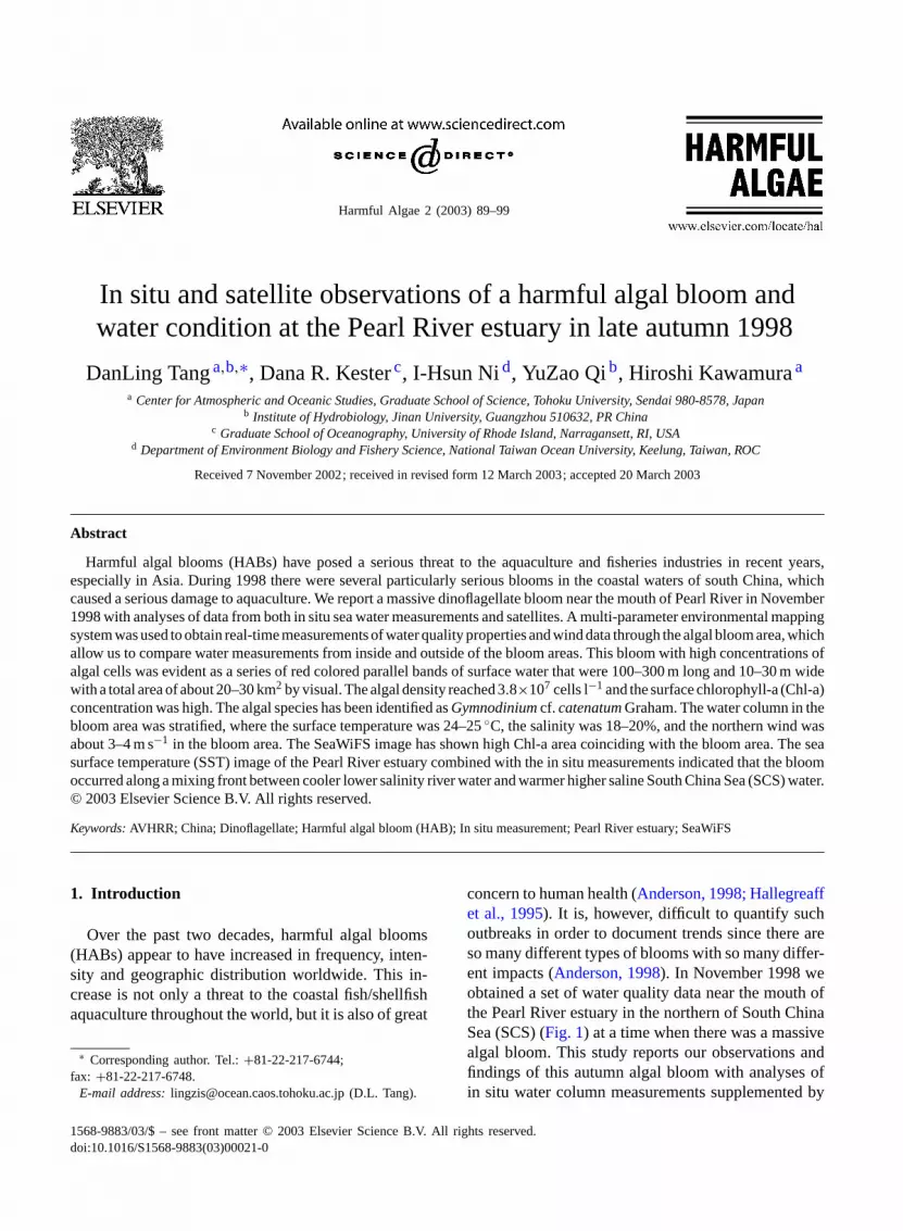
Fig. 1. The northern South China Sea. (a) Small box indicates the study area: HN, Hainan Island; NA, Nanao; TW, Taiwan; XM, Xiamen.(b) A set of boat cruise transects (transects a., b. and c.) for in situ water measurements in the Pearl River estuary (a) waters on 16, 17and 18 November 1998. The algal bloom area is indicated by a dashed circle near Macao: HKI, Hong Kong Island; HKUST, Hong KongUniversity of Science and Technology; LMI, Lamma Island; LTI, Lantau Island. (c) Location of the cruise in the mouth of Pearl Riveron 17 November 1998 (b). Number 3–9 in the figure indicates sampling stations. The algal bloom was observed around station 9. (d)Detailed location of the north-south transect in the cruise (c).
satellite images. This examination of the algal bloomwith physical and chemical water column measure-ments would enhance our knowledge of water condi-tions during a HAB.
China has the highest fishery production in theworld and over 50% of the fishery products arefrom aquaculture (Qian, 1994). The rapid increasein coastal aquaculture production has created seriousproblems because marine pollution and eutrophi-cation are unavoidable by-products of the marineaquaculture system (Stewart, 1997). The resulting in-tensified HABs have posed very serious threats to thefisheries and aquaculture industries along the Chinesecoast (Lam and Ho, 1988; Qi et al., 1995, 1996a).Consequently, the introduction of management mea-
sures to mitigate deteriorating coastal water qualityand the adverse environmental impacts of aquacul-ture development have become urgent matters to theregion (Chua et al., 1989). Over 146 red tides eventshave been recorded in the South China Sea since1981 (Qi et al., 1996b). The actual incidence of suchblooms may be even greater because of the lack ofa regular monitoring system. The frequency of HABoccurrences was high during late 1997 to early 1999particularly in Hong Kong waters. A series of HABsof Phaeocystis globosaoccurred along the coast ofthe southeast China, from the beginning of October1997 in Fujian to February 1998 in Shanwei (Luand Huang, 1999). These HABs caused tremendousdamage to the coastal aquaculture industry in China.
D.L. Tang et al. / Harmful Algae 2 (2003) 89–99 91
Hong Kong also experienced a series HABs duringMarch–April 1998 (Dickman and Tang, 1999). It wasthe worst outbreak of HABs of the decade, wipingout 1500 tonnes of farmed fish, which was equiv-alent to half of the entire Hong Kong aquaculturalproduction of 1997 (Anderson, 1998). In the past,most studies on those HABs were mainly focused onspecies identification and toxin effect; here is lackingof oceanography study for HABs in this area.
Satellite remote sensing data have been used tostudy pigment concentration and sea surface tem-perature (SST) in the coastal areas of China (Tanget al., 1998, 1999, 2003a,b). By examining satelliteocean color data and sea surface temperature,Tanget al. (1999, 2002)reported winter phytoplanktonblooms near the Luzon Strait in the South China Sea,and observed short-term variability of phytoplanktonblooms in the northern Arabian Sea. SST images canbe used to determine water temperature in nearshoreareas (Fox et al., 2000; Tang et al., 2003a). SST andSeaWiFS images have also been applied for a HAB(Gymnodinium catenatum) study in New Zealandwaters (Chang et al., 2001). At the present, we areunable to detect the species of HAB by using satelliteocean color image, therefore we call for more in situstudy between HAB and satellite remote sensing forfurther application of satellite technology on HABs.
Most of the algal blooms occurred in spring in manysmall bays in the east side of Hong Kong, where loca-tions are also mariculture fish farm with water of en-trophication. We observed a massive algal bloom whenwe carried out a research cruises in November 1998near the mouth of the Pearl River in the west side ofHong Kong (Fig. 1b). The present paper presents theexamination of this autumn algal bloom from three dif-ferent aspects: (1) What is the species for this autumnphytoplankton bloom? (2) What is the water conditionin the mouth of the river? (3) What kind of informa-tion we could obtain from satellite image?
2. Material and methods
2.1. Study area and cruise measurements
The study area is located in the northern part ofSouth China Sea (Fig. 1a), where Macao is in the westside and Hong Kong in the east side (Fig. 1b). The
Pearl River discharges into the river estuary. On 16–18November 1998, a series of 23 stations were sampledto provide vertical profiles of the physical and chem-ical properties of the waters in this region (Fig. 1b).A multi-parameter environmental sensor system (YSImodel 6000) was used to obtain real-time underwaymeasurements of surface water quality properties, in-cluding water temperature, salinity, turbidity, oxygen,and chlorophyll-a (Chl-a). A differential GPS elec-tronic charting system was used to track the locationof the vessel. Measurements were made every minutealong the cruise track. A massive algal bloom was ob-served at station 9 between Lantau Island and Macau(Fig. 1b) on 17 November. Locations of sampling sta-tions 3–9 are displayed inFig. 1c. Fig. 1dshows detailsof the north-south transect inFig. 1c. We measuredChl-a concentrations along this transect. Algae weresampled, fixed with Lugol’s solution (Sournia, 1978)and examined under a microscope in laboratory. Wa-ter measurements from inside and outside the bloomareas were compared.
2.2. Satellite remote sensing data
NOAA series satellites have a near-polar sun-syn-chronous orbit at a height of about 850 km (Schumacheret al., 1991). The advanced very high resolution ra-diometer (AVHRR) has five channels that cover thevisible and infrared (IR) spectrum; it detects the SST.This study analysis images from AVHRR local data at1.1× 1.1 km2 resolution from the receiving station atthe Hong Kong University of Science and Technology(HKUST) (Tang et al., 2003a). The TerraScan SSTalgorithm is MCSST-based (McClain et al., 1985).One SST image of the Hong Kong region was founduseful in this consideration of a HAB. We then ex-tracted water temperature values along a transect T(T in Fig. 6a) from this SST image.
SeaWiFS data were also received by HKUST; Chl-aimage is processed through SeaWiFS data analysissystem (SeaDAS) by ocean color 4-band algorithm(OC4) (O’Reilly et al., 2000) at Asian I-Lac project(Tang and Kawamura, 2002; Tang et al., 2003b).
2.3. HAB events in the Hong Kong waters
There were a series of HABs during 1998 in HongKong waters. All incidences with algal species and
92 D.L. Tang et al. / Harmful Algae 2 (2003) 89–99
dates of occurrence in Hong Kong waters has beenprovided by Hong Kong Agriculture, Fisheries andConservation Department (HKAFCD) that enabled usto compile a summary of these events.
3. Results
3.1. Algal bloom and in situ measurements
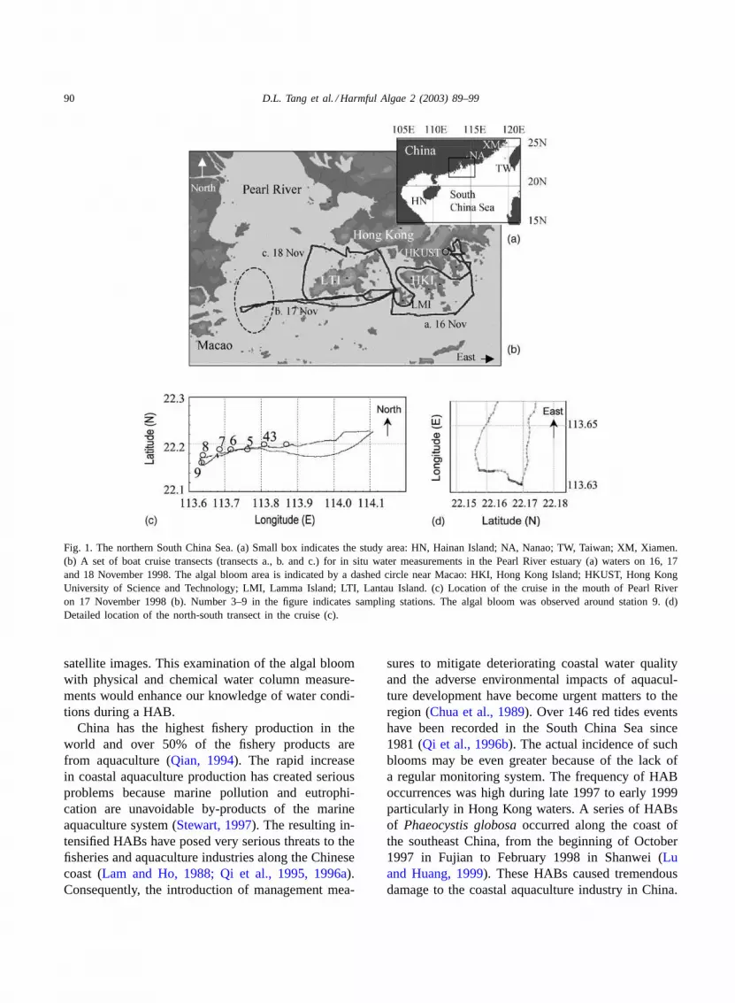
The algal bloom with a deep-red color was ob-served on 17 November 1998 around station 9 nearthe mouth of the Pearl River (Fig. 1b and c). It was lo-cated near Macao. The bloom area appeared as manyparallel strips of 100–300 m long and 10–30 m wide,with a total area at least 20–30 km2 (Fig. 2a). Thealgal cell concentrations reached 3.8 × 10⁷ l−1. Thespecies was a chain-forming unarmored dinoflagellate(Fig. 2b) with distinguishing characteristic of its con-spicuous sulcus that could be easily seen. The sulcusextended from the antapex to the apex and the girdleshowed a descending spiral that was up to one-fifth ofthe cell length. The cells contained numerous chloro-
Fig. 2. (a) Deep-red color paths of the algal bloom near the mouthof the Pearl River on 17 November 1998. (b) Chains ofGymno-dinium cf. catenatumcells. (c) Two algal cells ofGymnodiniumcf. catenatum.
plasts with remarkable pyrenoids and were sphericalcysts with size ranging from about 45�m long and40�m wide (Fig. 2c). This species is identified asGymnodiniumcf. catenatumGraham. A definitive ver-ification of the species has not been possible with theavailable samples.
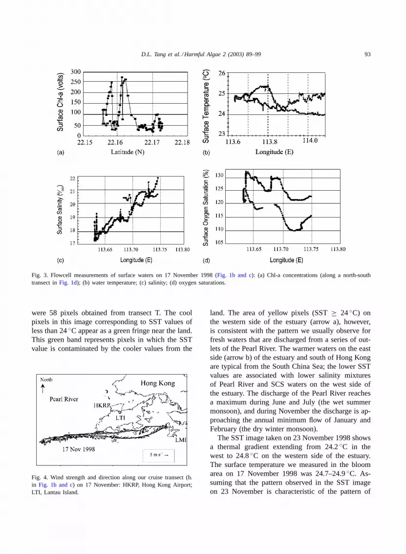
A portion of the underway measurements from22.15 to 22.18 N (Fig. 1c and d) is shown inFig. 3. Sur-face Chl-a fluorescence values along the north-southtransect (Fig. 1d) are indicated by the voltage outputof the fluorometer inFig. 3a. The Chl-a concentra-tion in surface reached high level and highly variableas we crossed two big strips of about 1000 m wide(22.156–22.164 N) (Fig. 3a). This matches with visualobservation in the field (Fig. 2). The water tempera-ture was between 24 and 25.0◦C in the area with thealgal bloom (Fig. 3b). Salinity decreased from east(22‰) to west (17.2‰) as we approached the algalbloom region (Fig. 3c). Oxygen saturations on thesurface reached 130% in the bloom area (Fig. 3d).These results also indicate a spatial variation of wa-ter condition from east to west in the month of thePearl River. The wind was from the northeast at about3–4 m s−1 (Fig. 4).
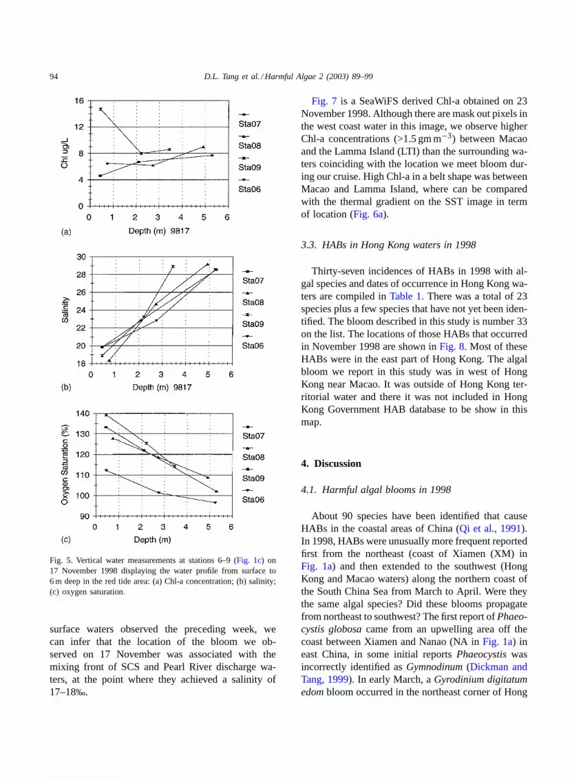
The vertical structure of the water column inside andoutside the bloom is shown inFig. 5. The algal bloom,which occurred around station 9, was concentrated atthe surface with Chl-a values of 15�g l−1 decreasingto 8�g l−1 at a depth of 2 m (Fig. 5a). The salinitywas low (around 19‰) on the surface and increasedto 29‰ at a depth of 3–4 m (Fig. 5b). Surface oxygen(Fig. 5c) saturations were 125% at several stations,reaching 140% in one of the bands of concentratedalgal cells. The water column was highly stratified atthe time of these observations.
3.2. Water temperature and Chl-a distributionin the river estuary
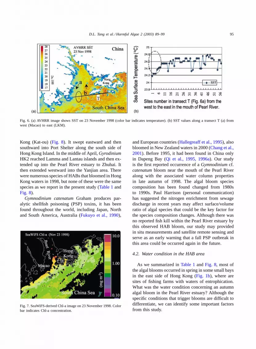
There was no NOAA SST data or SeaWiFS imagesfrom 17 to 20 November 1998 because the sensorswere turned off due to a meteor shower. The SSTimage (Fig. 6a) closest to 17 November 1998 wasobtained on 23 November. SST values were extractedfrom the image along transect T (approximatelyeast-west) (T inFig. 6a) to illustrate the gradientsand magnitudes for comparison with the shipboardsurface temperatures measured 6 days earlier. There
D.L. Tang et al. / Harmful Algae 2 (2003) 89–99 93
Fig. 3. Flowcell measurements of surface waters on 17 November 1998 (Fig. 1b and c): (a) Chl-a concentrations (along a north-southtransect inFig. 1d); (b) water temperature; (c) salinity; (d) oxygen saturations.
were 58 pixels obtained from transect T. The coolpixels in this image corresponding to SST values ofless than 24◦C appear as a green fringe near the land.This green band represents pixels in which the SSTvalue is contaminated by the cooler values from the
Fig. 4. Wind strength and direction along our cruise transect (b.in Fig. 1b and c) on 17 November: HKRP, Hong Kong Airport;LTI, Lantau Island.
land. The area of yellow pixels (SST≥ 24◦C) onthe western side of the estuary (arrow a), however,is consistent with the pattern we usually observe forfresh waters that are discharged from a series of out-lets of the Pearl River. The warmer waters on the eastside (arrow b) of the estuary and south of Hong Kongare typical from the South China Sea; the lower SSTvalues are associated with lower salinity mixturesof Pearl River and SCS waters on the west side ofthe estuary. The discharge of the Pearl River reachesa maximum during June and July (the wet summermonsoon), and during November the discharge is ap-proaching the annual minimum flow of January andFebruary (the dry winter monsoon).
The SST image taken on 23 November 1998 showsa thermal gradient extending from 24.2◦C in thewest to 24.8◦C on the western side of the estuary.The surface temperature we measured in the bloomarea on 17 November 1998 was 24.7–24.9◦C. As-suming that the pattern observed in the SST imageon 23 November is characteristic of the pattern of
94 D.L. Tang et al. / Harmful Algae 2 (2003) 89–99
Fig. 5. Vertical water measurements at stations 6–9 (Fig. 1c) on17 November 1998 displaying the water profile from surface to6 m deep in the red tide area: (a) Chl-a concentration; (b) salinity;(c) oxygen saturation.
surface waters observed the preceding week, wecan infer that the location of the bloom we ob-served on 17 November was associated with themixing front of SCS and Pearl River discharge wa-ters, at the point where they achieved a salinity of17–18‰.
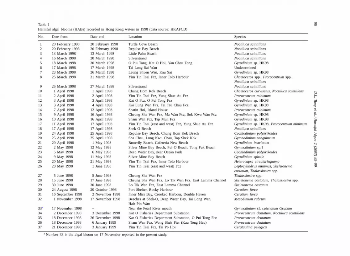
Fig. 7 is a SeaWiFS derived Chl-a obtained on 23November 1998. Although there are mask out pixels inthe west coast water in this image, we observe higherChl-a concentrations (>1.5 gm m−3) between Macaoand the Lamma Island (LTI) than the surrounding wa-ters coinciding with the location we meet bloom dur-ing our cruise. High Chl-a in a belt shape was betweenMacao and Lamma Island, where can be comparedwith the thermal gradient on the SST image in termof location (Fig. 6a).
3.3. HABs in Hong Kong waters in 1998
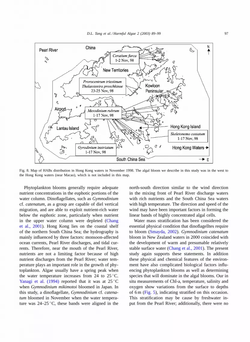
Thirty-seven incidences of HABs in 1998 with al-gal species and dates of occurrence in Hong Kong wa-ters are compiled inTable 1. There was a total of 23species plus a few species that have not yet been iden-tified. The bloom described in this study is number 33on the list. The locations of those HABs that occurredin November 1998 are shown inFig. 8. Most of theseHABs were in the east part of Hong Kong. The algalbloom we report in this study was in west of HongKong near Macao. It was outside of Hong Kong ter-ritorial water and there it was not included in HongKong Government HAB database to be show in thismap.
4. Discussion
4.1. Harmful algal blooms in 1998
About 90 species have been identified that causeHABs in the coastal areas of China (Qi et al., 1991).In 1998, HABs were unusually more frequent reportedfirst from the northeast (coast of Xiamen (XM) inFig. 1a) and then extended to the southwest (HongKong and Macao waters) along the northern coast ofthe South China Sea from March to April. Were theythe same algal species? Did these blooms propagatefrom northeast to southwest? The first report ofPhaeo-cystis globosacame from an upwelling area off thecoast between Xiamen and Nanao (NA inFig. 1a) ineast China, in some initial reportsPhaeocystiswasincorrectly identified asGymnodinum(Dickman andTang, 1999). In early March, aGyrodinium digitatumedombloom occurred in the northeast corner of Hong
D.L. Tang et al. / Harmful Algae 2 (2003) 89–99 95
Fig. 6. (a) AVHRR image shows SST on 23 November 1998 (color bar indicates temperature). (b) SST values along a transect T (a) fromwest (Macao) to east (LKM).
Kong (Kat-ou) (Fig. 8). It swept eastward and thensouthward into Port Shelter along the south side ofHong Kong Island. In the middle of April,GyrodiniumHK2 reached Lamma and Lantau islands and then ex-tended up into the Pearl River estuary to Zhuhai. Itthen extended westward into the Yanjian area. Therewere numerous species of HABs that bloomed in HongKong waters in 1998, but none of these were the samespecies as we report in the present study (Table 1andFig. 8).
Gymnodinium catenatumGraham produces par-alytic shellfish poisoning (PSP) toxins, it has beenfound throughout the world, including Japan, Northand South America, Australia (Fukuyo et al., 1990),
Fig. 7. SeaWiFS-derived Chl-a image on 23 November 1998. Colorbar indicates Chl-a concentration.
and European countries (Hallegreaff et al., 1995), alsobloomed in New Zealand waters in 2000 (Chang et al.,2001). Before 1995, it had been found in China onlyin Dapeng Bay (Qi et al., 1995, 1996a). Our studyis the first reported occurrence of aGymnodiniumcf.catenatumbloom near the mouth of the Pearl Riveralong with the associated water column propertiesin late autumn of 1998. The algal bloom speciescomposition has been found changed from 1980sto 1990s. Paul Harrison (personal communication)has suggested the nitrogen enrichment from sewagedischarge in recent years may affect surface/volumeratio of algal species that could be the key factor forthe species composition changes. Although there wasno reported fish kill within the Pearl River estuary bythis observed HAB bloom, our study may providedin situ measurements and satellite remote sensing andserve as an early warning that a fall PSP outbreak inthis area could be occurred again in the future.
4.2. Water condition in the HAB area
As we summarized inTable 1andFig. 8, most ofthe algal blooms occurred in spring in some small baysin the east side of Hong Kong (Fig. 1b), where aresites of fishing farms with waters of entrophication.What was the water condition concerning an autumnalgal bloom in the Pearl River estuary? Although thespecific conditions that trigger blooms are difficult todifferentiate, we can identify some important factorsfrom this study.
96D
.L.
Tan
ge
ta
l./Ha
rmfu
lA
lga
e2
(20
03
)8
9–
99
Table 1Harmful algal blooms (HABs) recorded in Hong Kong waters in 1998 (data source: HKAFCD)
No. Date from Date end Location Species
1 20 February 1998 20 February 1998 Turtle Cove Beach Noctiluca scintillans2 20 February 1998 20 February 1998 Repulse Bay Beach Noctiluca scintillans3 13 March 1998 13 March 1998 Little Palm Beach Noctiluca scintillans4 16 March 1998 20 March 1998 Silverstrand Noctiluca scintillans5 18 March 1998 30 March 1998 O Pui Tong, Kat O Hoi, Yan Chau Tong Gyrodiniumsp. HK986 17 March 1998 17 March 1998 Tai Long Sai Wan Undetermined7 23 March 1998 26 March 1998 Leung Shuen Wan, Kau Sai Gyrodiniumsp. HK988 25 March 1998 31 March 1998 Yim Tin Tsai Fcz, Inner Tolo Harbour Chaetocerosspp.,Prorocentrumspp.,
Noctiluca scintillans9 25 March 1998 27 March 1998 Silverstrand Noctiluca scintillans
10 1 April 1998 1 April 1998 Chung Hom Kok Beach Chaetoceros curvisetus, Noctiluca scintillans11 2 April 1998 2 April 1998 Yim Tin Tsai Fcz, Yung Shue Au Fcz Prorocentrum minimum12 3 April 1998 3 April 1998 Kat O Fcz, O Pui Tong Fcz Gyrodiniumsp. HK9813 3 April 1998 4 April 1998 Kai Lung Wan Fcz, Tai Tau Chau Fcz Gyrodiniumsp. HK9814 7 April 1998 12 April 1998 Shatin Hoi, Island House Prorocentrum minimum15 9 April 1998 16 April 1998 Cheung Sha Wan Fcz, Ma Wan Fcz, Sok Kwu Wan Fcz Gyrodiniumsp. HK9816 10 April 1998 16 April 1998 Sham Wan Fcz, Tap Mun Fcz Gyrodiniumsp. HK9817 11 April 1998 17 April 1998 Yim Tin Tsai (east and west) Fcz, Yung Shue Au Fcz Gyrodiniumsp. HK98,Prorocentrum minimum18 17 April 1998 17 April 1998 Shek O Beach Noctiluca scintillans19 24 April 1998 25 April 1998 Repulse Bay Beach, Chung Hom Kok Beach Cochlodinium polykrikoides20 25 April 1998 25 April 1998 Sha Chau, Lung Kwu Chau, Tap Shek Kok Gymnodinium sanguineum21 29 April 1998 1 May 1998 Butterfly Beach, Cafeteria New Beach Gyrodinium instriatum22 2 May 1998 12 May 1998 Silver Mine Bay Beach, Pui O Beach, Tong Fuk Beach Gymnodiniumsp.123 5 May 1998 6 May 1998 Deep Water Bay, near Ocean Park Cochlodinium polykrikoides24 9 May 1998 11 May 1998 Silver Mine Bay Beach Gyrodinium spirale25 20 May 1998 21 May 1998 Yim Tin Tsai Fcz, Inner Tolo Harbour Heterocapsa circularisquama26 28 May 1998 1 June 1998 Yim Tin Tsai (east and west) Fcz Leptocylindrus minimus, Skeletonema
costatum, Thalassiosiraspp.27 5 June 1998 5 June 1998 Cheung Sha Wan Fcz Thalassiosiraspp.28 15 June 1998 17 June 1998 Cheung Sha Wan Fcz, Lo Tik Wan Fcz, East Lamma ChannelSkeletonema costatum, Thalassiosiraspp.29 30 June 1998 30 June 1998 Lo Tik Wan Fcz, East Lamma Channel Skeletonema costatum30 24 August 1998 20 October 1998 Port Shelter, Rocky Harbour Ceratium furca31 16 September 1998 2 November 1998 Inner Mirs Bay, Crooked Harbour, Double Haven Ceratium furca32 1 November 1998 17 November 1998 Beaches at Shek-O, Deep Water Bay, Tai Long Wan,
Hair Pin WanMesodinium rubrum
33a 17 November 1998 – Near the Pearl River mouth Gymnodiniumcf. catenatum Graham34 2 December 1998 3 December 1998 Kat O Fisheries Department Substation Prorocentrum dentatum, Noctiluca scintillans35 18 December 1998 26 December 1998 Kat O Fisheries Department Substation, O Pui Tong Fcz Prorocentrum dentatum36 18 December 1998 6 January 1999 Sham Wan Fcz, Wong Shek Pier (Kau Tong Hau) Prorocentrum dentatum37 21 December 1998 3 January 1999 Yim Tin Tsai Fcz, Tai Po Hoi Cerataulina pelagica
a Number 33 is the algal bloom on 17 November reported in the present study.
D.L. Tang et al. / Harmful Algae 2 (2003) 89–99 97
Fig. 8. Map of HABs distribution in Hong Kong waters in November 1998. The algal bloom we describe in this study was in the west tothe Hong Kong waters (near Macao), which is not included in this map.
Phytoplankton blooms generally require adequatenutrient concentrations in the euphotic portions of thewater column. Dinoflagellates, such asGymnodiniumcf. catenatum, as a group are capable of diel verticalmigration, and are able to exploit nutrient-rich waterbelow the euphotic zone, particularly when nutrientin the upper water column were depleted (Changet al., 2001). Hong Kong lies on the coastal shelfof the northern South China Sea; the hydrography ismainly influenced by three factors: monsoon-affectedocean currents, Pearl River discharges, and tidal cur-rents. Therefore, near the mouth of the Pearl River,nutrients are not a limiting factor because of highnutrient discharges from the Pearl River; water tem-perature plays an important role in the growth of phy-toplankton. Algae usually have a spring peak whenthe water temperature increases from 24 to 25◦C.Yanagi et al. (1994)reported that it was at 25◦CwhenGymnodinium mikimotoibloomed in Japan. Inthis study, a dinoflagellate,Gymnodiniumcf. catena-tum bloomed in November when the water tempera-ture was 24–25◦C, these bands were aligned in the
north-south direction similar to the wind directionin the mixing front of Pearl River discharge waterswith rich nutrients and the South China Sea waterswith high temperature. The direction and speed of thewind may have been important factors in forming thelinear bands of highly concentrated algal cells.
Water mass stratification has been considered theessential physical condition that dinoflagelltes requireto bloom (Smayda, 2002). Gymnodinium catenatumbloom in New Zealand waters in 2000 coincided withthe development of warm and presumable relativelystable surface water (Chang et al., 2001). The presentstudy again supports these statements. In additionthese physical and chemical features of the environ-ment have also complicated biological factors influ-encing phytoplankton blooms as well as determiningspecies that will dominate in the algal blooms. Our insitu measurements of Chl-a, temperature, salinity andoxygen show variations from the surface to depthsof 6 m (Fig. 5), indicating stratified on this occasion.This stratification may be cause by freshwater in-put from the Pearl River; additionally, there were no
98 D.L. Tang et al. / Harmful Algae 2 (2003) 89–99
strong winds during the algal bloom period that mayalso contribute to the water stratification.
4.3. Satellite remote sensing on HAB research
HABs have been reported in the Pearl River estu-ary but we need more evidence of the meteorologicaland oceanographic conditions that are associated withthese HABs. Satellite imagery can provide records ofenvironmental changes before, during, and after the al-gal bloom incidences. It can offer better interpretationof field survey in the context of overall temporal spa-tial patterns that may have rapidly varying conditions(Richard and Megan, 1997; Tang et al., 1999, 2002,2003b). In the present study, the SST data are compat-ible with in situ measurements to determine the distri-bution of water properties in a larger area, indicatingthe HAB in front water area.
In this SeaWiFS image (Fig. 7), some pixels in thebloom area were masked out, and we are unable to es-tablish a relationship between this bloom and featuresin the ocean color image. SeaWiFS imagery currentlycannot discriminate between different algal classesand that the elevated Chl-a concentrations seen in theriver plume are most likely contaminated by high con-centration of colored dissolved organic mater. How-ever, satellite images could help to detect the locationand to estimate the spatial extend of the bloom within situ measurements (Tang et al., 2002). This kind ofresearch between in situ HAB observation and satel-lite data analysis is necessary. Satellite derived Chl-adata can be reprocessed by improved algorithms andnew products may provide more information for HABresearch in turbid coastal waters.
5. Conclusions
We observed a dinoflagellateGymnodiniumcf. cate-natumGraham bloom at the Pearl River estuary in lateautumn 1998 by analysis of in situ and satellite mea-surements. The bloom occurred along a mixing frontbetween cold Peril River discharge water with rich nu-trient and warmer SCS water with high salinity, wherethe water were stratified. The bloom area was about20–30 km2 with high density of 3.8 × 10⁷ cells l−1.Satellite images are helpful for observing the spatialvariation of water temperature and the spatial extend
of the bloom. This study may serve as an early warn-ing that autumn PSP outbreak within the Pearl Riverestuary in fall could be possible in the future. Sum-mary of HABs events in 1998 indicates more HABsoccurred in the east water than in the west water inHong Kong.
Acknowledgements
Dr. DanLing Tang’s work was jointly supported bya grant from the Hong Kong Croucher Foundation toProf. Gary Heinke at Hong Kong University of Sci-ence and Technology (HKUST), a grant by the Na-tional Space Development Agency of Japan (NASDA)through the Asian I-Lac project, and special coordi-nation funds for promoting science and technologyof MEXT (Japan). Additionally, Dr. Yuzao Qi’s workwas partially supported by National Science Founda-tion, China (No. 39790110). Dr. Patsy Wong and Ms.Minna Wong of the Hong Kong Agriculture, Fish-eries and Conservation Department provided HABsincidences in Hong Kong waters. We thank Dr. S.M.Tang and Dr. D.K.O. Chan of Hong Kong University,Dr. Paul Harrison and Ms. Y.K. Tam of HKUST, andDr. Alain Pittet of Nestlé Research Center, Lausanne,Switzerland, for their help and valuable comments onthis study.
References
Anderson, D.M., 1998. Study of red tide monitoring andmanagement in Hong Kong: literature review and backgroundinformation. Technical Report No. 1, Hong Kong Agricultureand Fisheries Department, p. 120.
Chang, F.H., Uddstrom, M., Pinkerton, M., 2001. Studies ofthe winter 2000Gymnodinium catenatumouterbreaks in NewZealand using remotely sensed sea surface temperature andchlorophyll a data from satellites. In: Proceedings of the MarineBiotoxin Science Workshop No. 15, Wellington, New Zealand,pp. 165–173.
Chua, T.E., Paw, J.N., Guarin, F.Y., 1989. The environmentalimpact of aquaculture and the effects of pollution on coastalaquaculture development in southeast. Asian Mar. Pollut. Bull.20 (7), 335–343.
Dickman, M.D., Tang, S.M., 1999. AGymnodinium mikimototoioccurrence spring 1998. In: An IOC Newlatter on Toxic Algaeand Algal Blooms. Harmful Algae News No. 18, available athttp://ioc.unesco.org/hab.
Fox, M.F., Kester, D.R., Andrews, J.E., Magnuson, A., Zosksi,C.G., 2000. Seasonal warming of Narragansett Bay and Rhode
D.L. Tang et al. / Harmful Algae 2 (2003) 89–99 99
Island Sound in 1997: advanced very high resolution radiometersea surface temperature and in situ measurements. J. Geophys.Res. 105 (C9), 22071–22082.
Fukuyo, Y., Takano, H., Chihara, K., Matsuoka, M., 1990. RedTide Organisms in Japan—An Illustrated Taxonomic Guide.Uchida Rokakuho, Tokyo, pp. 46–47.
Hallegreaff, G.M., Anderson, D.M., Cembella, A.D., Enevoldsen,H.O., 1995. Manual on Harmful Marine Microalgal. UNESCO,Paris.
Lam, C.W.Y., Ho, K.C., 1988. Red tide studies in Tolo Harbor,Hong Kong. In: Okaicji, T., Anderson, D., Nemoto, T. (Eds.),Red Tides, Biology, Environmental Science, and Toxicology.Elsever, Amsterdam, pp. 49–53.
Lu, D.D., Huang, W.G., 1999. Phaeocystis blooms in southeastChina coastal water 1997. In: An IOC Newlatter on Toxic Algaeand Algal Blooms. Harmful Algae News No. 19, available athttp://ioc.unesco.org/hab.
McClain, E.P., Pichel, W.G., Walton, C.C., 1985. Comparativeperformance of AVHRR based multichannel sea surfacetemperatures. J. Geophys. Res. 90, 11587–11601.
O’Reilly, J.E., Maritorena, S., Siegel, D.A., et al., 2000.Ocean color chlorophyll a algorithms for SeaWiFS, OC2 andOC4: version 4. In: Hooker, S.B., Firestone, E.R. (Eds.),SeaWiFS Postlaunch Calibration and Validation Analyses.NASA Technical Memo 206892, vol. 11, Part 3. NASA GoddardSpace Flight Center, Greenbelt, MD, pp. 9–23.
Qi, Y.Z., Lu, S., Qian, H.L., 1991. Red tides and red tide researchin China. Special issue on the causes and counter measures ofnatural disaster. J. Nanjing Univ. (Nat. Sci. Ed.), 353–360 (inChinese).
Qi, Y.Z., Qian, F., Zheng, L., 1995. Physiol-ecology research onharmful algal blooms along the coasts of Southeast China Sea.In: Zhu, M., et al. (Eds.), Proceedings of the Second Meeting ofChinese Committee. Qiangdaio Publishing Housing, Qiangdaio,China, pp. 6–14 (in Chinese).
Qi, Y.Z., Hong, Y., Zheng, L., Davia, M.K., Donala, M.A., 1996a.Dinoflagellate cysts from recent marine sediments of the southand east China Seas. Asian Mar. Biol. 13, 87–103.
Qi, Y.Z., Lei, Z., Lu, S.H., Qian, H.L., 1996b. The ecology andoccurrence of harmful algal blooms in the South China Sea.Intergovernmental Oceanographic Commission of UNESCO,pp. 33–36.
Qian, Z.L. (Ed.), 1994. The Development of the Chinese Fisheriesand Manpower in Aquaculture. China’s Agriculture Press,Beijing, p. 212 (in Chinese).
Richard, P.S., Megan, L.F., 1997. Use of AVHRR imagery toexamine long-term trends in water clarity in coastal estuaries:example in Florida Bay. In: Kahru, Brown (Eds.), MonitoringAlgal Blooms: New Techniques for Detecting Large-ScaleEnvironment Change. Springer, Berlin, pp. 1–23.
Schumacher, J.D., Barver, W.E., Holt, B., Liu, A.K., 1991. NOAATechnical Report ERL-445-PMEL 40.
Smayda, T.J., 2002. Turbulence, watermass stratification andharmful algal blooms: an alternative view and frontal zones aspelagic seed banks. Harmful Algae 1 (1), 95–112.
Sournia, A., 1978. Phytoplankton Manual. Monographs onOceanographic Methodology, vol. 6. UNESCO, Paris, p. 337.
Stewart, J.E., 1997. Environmental impacts of aquaculture. WorldAquaculture 28, 47–52.
Tang, D.L., Kawamura, H., 2002. Ocean color monitoring ofcoastal environments in the Asian waters. J. Korea Soc.Oceanogr. 37 (3), 154–159.
Tang, D.L., Ni, I.-H., Müller-Karger, F.E., Liu, Z.J., 1998. Analysisof annual and spatial patterns of CZCS-derived pigmentconcentration on the continental shelf of China. ContinentalShelf Res. 18, 1493–1515.
Tang, D.L., Ni, I.-H., Kester, D.R., Müller-Karger, F.E., 1999.Remote sensing observation of winter phytoplankton bloomssouthwest of the Luzon Strait. Mar. Ecol. Prog. Ser. 191, 43–51.
Tang, D.L., Kawamura, H., Luis, A.J., 2002. Short-term variabilityof phytoplankton blooms associated with a cold eddy on thenorth-western Arabian Sea. Remote Sens. Environ. 81 (1), 81–89.
Tang, D.L., Kester, D.R., Wang, Z.D., Lian, J.S., Kawamura, H.,2003a. AVHRR satellite remote sensing of the thermal plumefrom the Daya Bay, China, nuclear power station. Remote Sens.Environ. 84 (4), 506–511.
Tang, D.L., Kawamura, H., Lee, M.A., Dien, V.T., 2003b. Seasonaland spatial distribution of chlorophyll a and water conditionsin the Gulf of Tonkin, South China Sea. Remote Sens. Environ.85 (4), 457–483.
Yanagi, T., Hirao, K., Matsuyama, Y., Honjyo, T., 1994. Red tideof Gymnodinium mikimotoiat Gukasho Bay. Umi/Mer. 32, 65–70.