Hydromorphological conditions of the Lower Vistula in the development of navigation and hydropower
14
83 Hydromorphological conditions of the Lower Vistula in the development of navigation and hydropower Authors Zygmunt Babiński Michał Habel Keywords fluvial processes, channel pattern, morphodynamics of sandbars, inland navigation, hydropower, Lower Vistula (dolna Wisła) Abstract The article presents general principles of development of the Lower Vistula (dolna Wisła) channel in the Holocene period, with a particular emphasis on the unintentional human interference in the fluvial processes associated with deforestation and cultivation of cereals and root crops. It also characterises the basic hydraulic engineering works in the form of construction of embank- ments, adjustment of bed and construction of the barrage Włocławek as factors of deliberate human interference and their impact on changes channel. The article characterises morpho- logical and morphodynamic conditions of the basic bed forms, i.e. sandy and gravel bars and pools determining the possibility of river transport, its development in time and space (depth of navigable route). Perspectives of multi-directional hydraulic development are presented, inclu- ding the main cascade developments of the Lower Vistula (dolna Wisła). The article presents the opportunities for a comprehensive use of the waterway, which forms route E40 in the section of the Lower Vistula (dolna Wisła), taking into account sustainable development and compensation in the form of restoration of the valley bottom. DOI: Introduction The use of river waters for economic purposes is dependent on the hydromorphological features of their channels, shaped by the climate and human activity. The climate affects the fluvial processes by precipitation (water regime) and air tempera- ture (growth of vegetation in the basin and ice phenomena), phenomena independent of humans. Human activity can have a direct and indirect impact on changes in river channels. The first case concerns a change in the structure of forests for agri- cultural fields; such works accelerate the natural water flow (run- off ) and increase the supply of load to channels. In the second case we are dealing with deliberate water management, aimed at control of the water regime by all kinds of hydraulic structures, including embankments, adjustment of channels or dams. An additional factor affecting the development of inland navigation is the change in technical conditions of vessels, e.g. an increase in draft of river boats associated with the transition to motor power. However, the river water regime and the transport volume of bed load have a leading role in the conditions of development of water transport and hydropower; those phenomena shape the channel patterns with the system of bed mesoforms of posi- tive sandbars and the opposing negative forms, pools. They determine the parameters of waterways (width and depth of water routes), durability and functionality of hydraulic structures, including hydropower (reservoir filling time). The purpose of the article is to present the main stages and general trends in the development of the bottom of the Lower Vistula (dolna Wisła) valley on the section from the mouth of the Narew to the mouth of the Vistula (dolna Wisła) to the Baltic Sea (Fig. 1), with particular emphasis on the influence of human economic activity. This applies mainly to changes in the spatial arrangement of the river channel, as well as to vertical move- ments of the bottom associated with the process of erosion and deposition of clastic load, mainly bed load. The main purpose is to define the dynamics of bed mesoforms like sandbars and pools, with an indication of possible directions of adaptation in terms of development of international waterway E40, improve- ment for ferry and road passages, construction of dams, improve- ment (elimination) of flood conditions while maintaining sustain- able development (environmental protection). Furthermore, the article is to present the possible full utilisation of water in the Lower Vistula (dolna Wisła) for economic purposes, including revitalization of the valley floor. The study has been prepared on the basis of the literature and own research in the field of hydromorphological changes occur- ring in the Lower Vistula (dolna Wisła) channel. The analysis
Transcript of Hydromorphological conditions of the Lower Vistula in the development of navigation and hydropower

83
Hydromorphological conditions of the Lower Vistula in the development of navigation and hydropower
AuthorsZygmunt BabińskiMichał Habel
Keywords fluvial processes, channel pattern, morphodynamics of sandbars, inland navigation, hydropower, Lower Vistula (dolna Wisła)
AbstractThe article presents general principles of development of the Lower Vistula (dolna Wisła) channel in the Holocene period, with a particular emphasis on the unintentional human interference in the fluvial processes associated with deforestation and cultivation of cereals and root crops. It also characterises the basic hydraulic engineering works in the form of construction of embank-ments, adjustment of bed and construction of the barrage Włocławek as factors of deliberate human interference and their impact on changes channel. The article characterises morpho-logical and morphodynamic conditions of the basic bed forms, i.e. sandy and gravel bars and pools determining the possibility of river transport, its development in time and space (depth of navigable route). Perspectives of multi-directional hydraulic development are presented, inclu-ding the main cascade developments of the Lower Vistula (dolna Wisła). The article presents the opportunities for a comprehensive use of the waterway, which forms route E40 in the section of the Lower Vistula (dolna Wisła), taking into account sustainable development and compensation in the form of restoration of the valley bottom.
DOI:
IntroductionThe use of river waters for economic purposes is dependent on the hydromorphological features of their channels, shaped by the climate and human activity. The climate affects the fluvial processes by precipitation (water regime) and air tempera-ture (growth of vegetation in the basin and ice phenomena), phenomena independent of humans. Human activity can have a direct and indirect impact on changes in river channels. The first case concerns a change in the structure of forests for agri-cultural fields; such works accelerate the natural water flow (run-off) and increase the supply of load to channels. In the second case we are dealing with deliberate water management, aimed at control of the water regime by all kinds of hydraulic structures, including embankments, adjustment of channels or dams. An additional factor affecting the development of inland navigation is the change in technical conditions of vessels, e.g. an increase in draft of river boats associated with the transition to motor power. However, the river water regime and the transport volume of bed load have a leading role in the conditions of development of water transport and hydropower; those phenomena shape the channel patterns with the system of bed mesoforms of posi-tive sandbars and the opposing negative forms, pools. They determine the parameters of waterways (width and depth of
water routes), durability and functionality of hydraulic structures, including hydropower (reservoir filling time). The purpose of the article is to present the main stages and general trends in the development of the bottom of the Lower Vistula (dolna Wisła) valley on the section from the mouth of the Narew to the mouth of the Vistula (dolna Wisła) to the Baltic Sea (Fig. 1), with particular emphasis on the influence of human economic activity. This applies mainly to changes in the spatial arrangement of the river channel, as well as to vertical move-ments of the bottom associated with the process of erosion and deposition of clastic load, mainly bed load. The main purpose is to define the dynamics of bed mesoforms like sandbars and pools, with an indication of possible directions of adaptation in terms of development of international waterway E40, improve-ment for ferry and road passages, construction of dams, improve-ment (elimination) of flood conditions while maintaining sustain-able development (environmental protection). Furthermore, the article is to present the possible full utilisation of water in the Lower Vistula (dolna Wisła) for economic purposes, including revitalization of the valley floor.The study has been prepared on the basis of the literature and own research in the field of hydromorphological changes occur-ring in the Lower Vistula (dolna Wisła) channel. The analysis

84
applies in particular to transformations resulting from regulatory work (of channel) and construction of the Włocławek barrage, so it includes the period of the last 150 years.
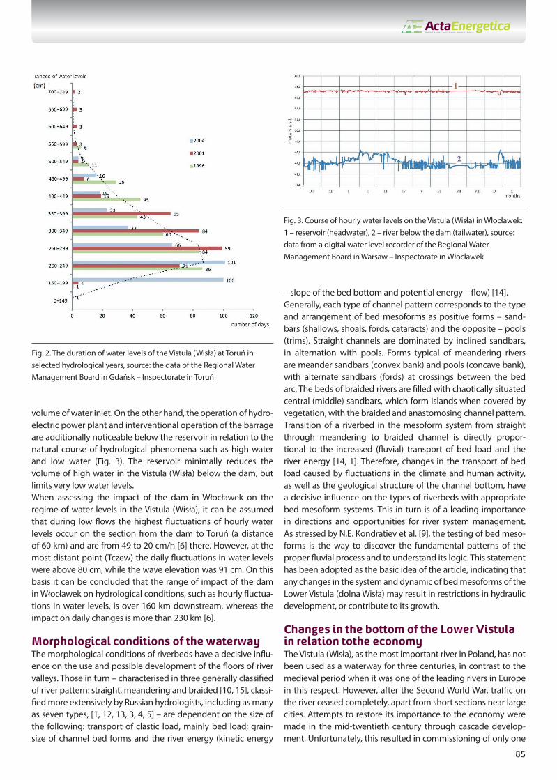
Hydrological conditions of the waterwayThe water levels in the Lower Vistula (dolna Wisła) are deter-mined mainly by its flows, but occasionally their fluctuations are dependent on pancake ice and ice jamming. In the event of jamming the water level is not a flow function. Therefore, it is wrong to connect them with the winter and spring, extremely high freshets – for example large flows estimated at 11,000 m3/s (referred to as the 0.1% water) recorded on the walls of Toruń in historical times. The hydrological data show that high levels of the Lower Vistula (dolna Wisła) are most common in March and April, less frequent during the late spring and summer. The first are related to early-spring run-off of meltwater, often intensified by pancake ice and ice jamming. The latter are usually short-term and are a result of widespread rainfall. In both cases, flood waves with a relative height of 3–5 m, up to 8 m, are formed. Lower water levels occur primarily in the late autumn and winter (September
– November). The annual amplitude of the free surface of water in the Lower Vistula (dolna Wisła) may reach 753 cm (in the Fordon-Bydgoszcz profile, period of 1976 to 1980). 46 flood waves were recorded on the Lower Vistula (dolna Wisła) in the last 40 years (1970 to 2010). Flow rate above 2400 m3/s is considered a limit value (the permitted flow rate, corresponding to the bank-full discharge), during which the flood plain is inundated from Włocławek to Toruń [8]. The value of bank-full discharge applicable in the Vistula (dolna Wisła) below the Włocławek barrage corresponds approximately to the value set by Stanislaw Siebauer (1947) on the basis of multi-annual obser-vations in Toruń, which is 2320 m3/s.In 1970 to 2005 the river had average annual flow rates of 895 m3/s in Włocławek and 1004 m3/s in Toruń. However, in wet years (1971, 1974 to 1975, 1977 to 1982, 1998 to 2002) they were 945 to 1342 m3/s in Włocławek. In dry years (1972, 1984, 1987, 1990 to 1992, 2003 to 2004) those values reached 580 to 790 m3/s. The minimum flow rate of the Vistula (dolna Wisła) at Toruń was 158 m3/s in September 1992. Flow rates (water levels) in the range from average water levels in the year (SW) to the lowest observed water levels (NNW) inclusive are of importance to the river transport. It should be assumed that water levels in the Lower Vistula (dolna Wisła) below SW, on the unregulated section above the reservoir and the erosive section below the dam in Włocławek, are not suffi-cient for water transport to properly function, and for the regu-lated section they are conditional to the average minimum levels observed in the period (SNW). The analysis of duration of water levels in Toruń for selected hydrological years – 1996 (average: h = 330 cm), 2001 (average: h = 319 cm) and 2004 (dry: h = 264 cm) for SW and SNW ranges shows that the three lowest ranges representing SNW have the following total number of days: 87, 75 and 202, respectively, whereas the five lowest ranges (below SW) have duration: 231, 258 and 305 days (Fig. 2). This means that the section of the Lower Vistula (dolna Wisła) in average (wet) years has a similar number of days duration of water levels in particular ranges, but the number of days in particular ranges varies considerably in a dry year. In general, during average and wet years, more than 200 days and approx. 90 days a year are bad for navigation on the unregulated section (SW) and on the regulated section (SNW), respectively. However, in dry years the number is as many as 300 days on the braided and anastomo-sing section and 200 days on the regulated section. In relation to the area of sandbars, the duration of their emergence on the regulated section is approx. 165 days (almost half a year), mainly in the winter period. It should be noted, however, that the nature of their emergence is oscillatory, with amplitude higher in Toruń than, for example, in Fordon, which is associated with mitigation of the reservoir impact downstream the Vistula (Wisła).The natural regime of flows in the Vistula (Wisła) above (the rese-rvoir) and below Włocławek is disturbed by the dam, which since 1968 has dammed and retained the Vistula (Wisła) waters in the reservoir with a capacity of 370 million m3. As a result of the over 11-metre high damming in Włocławek, the water levels in the Vistula (Wisła) on the section up to 50–60 km upstream from the dam have a similar value throughout the year, regardless of the
Fig. 1. Location plan of the floor of the Vistula (Wisła) River Valley in rela-tion to development of the bed. The Vistula (Wisła) section: 1 – above Płock, unregulated; 2 – below the dam, erosive; 3 – below Silna, regulated in the second half of the 19th century.; 4 – Płock – Włocławek (Włocławek Reservoir with the planned cascade stages); 5 – tributaries; 6 – water gauges; 7 – km of the Vistula (Wisła) course; 8 – bed width
85
volume of water inlet. On the other hand, the operation of hydro-electric power plant and interventional operation of the barrage are additionally noticeable below the reservoir in relation to the natural course of hydrological phenomena such as high water and low water (Fig. 3). The reservoir minimally reduces the volume of high water in the Vistula (Wisła) below the dam, but limits very low water levels. When assessing the impact of the dam in Włocławek on the regime of water levels in the Vistula (Wisła), it can be assumed that during low flows the highest fluctuations of hourly water levels occur on the section from the dam to Toruń (a distance of 60 km) and are from 49 to 20 cm/h [6] there. However, at the most distant point (Tczew) the daily fluctuations in water levels were above 80 cm, while the wave elevation was 91 cm. On this basis it can be concluded that the range of impact of the dam in Włocławek on hydrological conditions, such as hourly fluctua-tions in water levels, is over 160 km downstream, whereas the impact on daily changes is more than 230 km [6].
Morphological conditions of the waterwayThe morphological conditions of riverbeds have a decisive influ-ence on the use and possible development of the floors of river valleys. Those in turn – characterised in three generally classified of river pattern: straight, meandering and braided [10, 15], classi-fied more extensively by Russian hydrologists, including as many as seven types, [1, 12, 13, 3, 4, 5] – are dependent on the size of the following: transport of clastic load, mainly bed load; grain-size of channel bed forms and the river energy (kinetic energy
– slope of the bed bottom and potential energy – flow) [14].Generally, each type of channel pattern corresponds to the type and arrangement of bed mesoforms as positive forms – sand-bars (shallows, shoals, fords, cataracts) and the opposite – pools (trims). Straight channels are dominated by inclined sandbars, in alternation with pools. Forms typical of meandering rivers are meander sandbars (convex bank) and pools (concave bank), with alternate sandbars (fords) at crossings between the bed arc. The beds of braided rivers are filled with chaotically situated central (middle) sandbars, which form islands when covered by vegetation, with the braided and anastomosing channel pattern. Transition of a riverbed in the mesoform system from straight through meandering to braided channel is directly propor-tional to the increased (fluvial) transport of bed load and the river energy [14, 1]. Therefore, changes in the transport of bed load caused by fluctuations in the climate and human activity, as well as the geological structure of the channel bottom, have a decisive influence on the types of riverbeds with appropriate bed mesoform systems. This in turn is of a leading importance in directions and opportunities for river system management. As stressed by N.E. Kondratiev et al. [9], the testing of bed meso-forms is the way to discover the fundamental patterns of the proper fluvial process and to understand its logic. This statement has been adopted as the basic idea of the article, indicating that any changes in the system and dynamic of bed mesoforms of the Lower Vistula (dolna Wisła) may result in restrictions in hydraulic development, or contribute to its growth.
Changes in the bottom of the Lower Vistula in relation to the economyThe Vistula (Wisła), as the most important river in Poland, has not been used as a waterway for three centuries, in contrast to the medieval period when it was one of the leading rivers in Europe in this respect. However, after the Second World War, traffic on the river ceased completely, apart from short sections near large cities. Attempts to restore its importance to the economy were made in the mid-twentieth century through cascade develop-ment. Unfortunately, this resulted in commissioning of only one
Fig. 2. The duration of water levels of the Vistula (Wisła) at Toruń in selected hydrological years, source: the data of the Regional Water Management Board in Gdańsk – Inspectorate in Toruń
Fig. 3. Course of hourly water levels on the Vistula (Wisła) in Włocławek: 1 – reservoir (headwater), 2 – river below the dam (tailwater), source: data from a digital water level recorder of the Regional Water Management Board in Warsaw – Inspectorate in Włocławek

86
cascade in Włocławek in 1970. This contributed to diversifica-tion of the Lower Vistula (dolna Wisła) channel into four separate sections (Fig. 1) in a special way, from the mouth of the Narew to the mouth of the Vistula (Wisła) to the Baltic Sea. In addition, the Vistula (Wisła) was abandoned as a shipping lane with the introduction of steam engines, which meant higher draft of ships, as well as due to shallowing of the river caused by an increased quantity of bed load. In this way the river located in the central part of our continent prevented the connection of a continuous functioning network of inland waterways in Western Europe and Eastern Europe (Fig. 4).
An important factor impeding transport on the Vistula (Wisła) is the problem of sand and gravel bars in the channel, their morphology and morphodynamics associated with the relevant type of channel macro-form. As already mentioned, the current channel of the Lower Vistula (dolna Wisła) is divided into four main types: (1) the upper, unregulated, braided and anastomo-sing section, (2) Włocławek Reservoir, (3) previously braided and anastomosing section, heavily transformed by bottom erosion process, (4) the section regulated at the end of the 19th century (Fig. 1). Additionally, two subtypes can be distinguished as part of the division: backwater zone (2a) and reservoir bowl (2b) in the case of the Włocławek Reservoir, and straight and slightly mean-dering sections (4a) and pseudo-meander (4b) in the case of the regulated channel.
1. Unregulated braided and anastomosing sectionBraided sections (anastomosing sections include islands) of the Vistula (Wisła) are characterised by a chaotic system of various types of sandbars [1], including mainly central, inter-bed and tongue sandbars. In the case of human interference in the fluvial processes (fragmentary regulatory work, bed adjustments, e.g. at Wyszogród) side sandbars, transformed into a new flood plain, appear next to disappearing central sandbars. In such condi-tions, the Vistula (Wisła) channel, at average water levels, reaches
an average width (without clusters) of 685–785 m, an average depth of 1.6–1.8 m, a minimum depth of 0.5 m over shoals, and not exceeding 6 m in pools [1]. The following occur in the period of low water levels: on the one hand the process of lateral erosion of sandbars and clusters, the material from which forms shallow and very dynamic tongue sandbars (high variability of the ship-ping lane excludes it entirely), on the other hand, with the favour-able process of “cutting in” of the riverbed, the shipping lane is improved so that it can be more passable than in the case of the regulated section. Generally, however, a high dynamic of chaoti-cally formed tongue sandbars (up to 8 m/day) limits water trans-port on this section to the period when water levels are above the average (Fig. 2).
2. Włocławek ReservoirThe first and, so far, the last cascade on the Lower Vistula (dolna Wisła) is the dam built from 1962 to 1968 with a damming height of 11.3 m, which forms the largest reservoir in Poland, with an area of 70 km2, a length of 55 km, an average width of 1.3 km, an average depth of 5.5 m and a capacity of 360 million m3 of water (second in Poland). Among many environmental changes resulting from separation of the bed from the dam and from damming of waters, two aspects remain the same: (a) accumulation of bed load in 100% and suspended load in 42% of the reservoir, and (b) perma-nent process of erosion of the bed below the dam [2]. From the point of view of morphology of the reservoir, it is gener-ally divided into two sections: (2a) upper – as accumulation of bed load, subject to shallowing process and (2b) bottom – accumula-tion of suspension, subject to partial resuspension and removal of sediments during passage of flood waves. In the first case, as a result of constant supply of 1.8 million m3 of bed load through the Vistula (Wisła) River per year on average, the reservoir bottom is being shallowed in its backwater, which could lead to removal of an almost 20-km section from river transport in the absence of dredging works. This section of the Vistula (Wisła), which is also conducive to the formation of ice jams (catastrophic jam flood in January 1982), must be dredged, which is currently done insuf-ficiently. Therefore, the backwater part of the reservoir and the braided and anastomosing section located on a above reservoir make this part of the Lower Vistula (dolna Wisła) unnavigable and predisposed to flooding (flood: May/June 2010, Świniary). However, the lower part of the reservoir bowl (2b) not only protects against flooding, but also forms a section of at least class IV waterway of international importance. It can be used for navi-gation for a significant part of the year, except when ice occurs.
3. Erosive section below the Włocławek (dam)Since the construction of the cascade in Włocławek, the section below the dam is subject to intensive bottom erosion. After more than 40 years of its impact, the barrage has deepened the bed in the immediate vicinity of the dam to approx. 4.0 m and widened it over a section reaching as far as Toruń (Fig. 1). The braided and anastomosing river is being transformed into an almost straight bed (with uneven shoreline determined by the geological struc-ture), with a new flood plain [7]. Effects of changes in average water levels are mostly noticeable in Włocławek, where some of
Fig. 4. International waterways E40 and E70 in relation to the inland waterways in Europe

87
the hydrotechnical structures no longer meet their functions, including: the lower outer harbour, boulevard, water intakes for industrial plants, winter port. The total process of bottom erosion has a negative impact on the hydraulic infrastructure of the riverbed from the beginning of the section regulated in the 19th century. The bed bottom cleaned of sandy formations with numerous clay and rock cataracts (Fig. 5) and diverse bottom surface already completely prevents river transport over this section during average water levels [7]. This process, which is harmful to the economy, can only be stopped by construction of another barrage to support Włocławek Reservoir.
4. Section regulated in the 19th centuryIn terms of morphology and morphodynamics of bed meso-forms, the regulated section is divided into two subtypes of channel: (4a) to the mouth of the Tążyna River – Ciechocinek Lowland (Nizina Ciechocińska) to Solec Kujawski (768 km) and from Fordon (775 km) to the Baltic Sea as a straight section with an alternating arrangement of inclined sandbars and pools, and (4b) pseudo-meander on two sections from 728 to 732 km in Toruń and from 768 to 775 km at the gorge of the Vistula (Wisła) at Fordon, with parallel arrangement of pool and sandbars. In the case of regulated type 4a sections, many years of studying the dynamics of bed mesoforms in the Lower Vistula (dolna Wisła) show that alternate bars, which are common here and are in the range of average levels (SW) and low levels (SNW) in terms of the height of their surface, reach a length of 800–1200
m and an average width of 300 m. As indicated by the bathy-metric calculations (to a depth of 3.5 m), each of the analysed alternate bars contains over 350,000 m3 of sandy and gravel material (Fig. 6). Tongue sandbars with an average length of 450 m, a width of 200 m and an surface of less than 0.5 m to SNW are formed from eroded inclined alternate sandbars during low water levels. Erosion formations – pools – which accompany alternate sandbars and at the same time are characterised by commensurate size, reach a depth of 5–7 m (measured from the average level), with local dredging up to 12 m. The width of pools (route for convenient transport) varies from 50 to 150 m. The speed of movement of alternate sandbar heads is 0.4 to 2.4 m per day (1.1–1.2 m/day on average), whereas the lowest (corre-sponding to levels below SNW) and most dynamic tongue sandbars have a speed of 0.6 to 4.3 m/day (1.7–1.8 m per day on average). The alternating and almost harmonious arrangement of post-regulatory sandbars facilitates the forecast of duration of transport by the Vistula (Wisła). On the other hand, as shown by the measurements of transport of bed load – dredging works in an amount of 0.15 million tonnes per year during the dry period up to 1.0 million tonnes per year in the wet period, i.e. 0.5 million tonnes per year on average, which lasts more than 240 days for collection of aggregate, may contribute to unblocking the Vistula (Wisła) channel for transport purposes, including even container transport. This is based mainly on lowering of the pool bottom. However, ice phenomena, which last 87 days on average (no more than 122 days and at least 37 days) on the entire analysed section, may be an additional restriction on transport.
In the case of a pseudo-meander type (4b) the constant current flows over the entire length at the right bank on the Toruń section, and at the left concave bank near Fordon (Fig. 7). In both cases, river transport may be carried out without interruptions caused by sandbars, as the width of the pool ranges from 50 to 120 m. Only during long low-water periods a single current may be split into two, by intersection of current along the convex bank. In addition, both currents may be connected, thus forming sepa-rate central sandbars similar to straight sections. This may cause difficulties in river transport, although this is highly unlikely. The process of division of meander sandbars during low water levels occurs when the hydrological conditions fail to adapt to an increased meander curvature, making it a pseudo-meander.
Fig. 5. Bathymetric plan of the rock and clay cataract during average water level on the bottom of the Vistula (Wisła) bed below the dam in Włocłwek (683 km), which prevents river transport: 1 – groynes; 2 – waters; 3 – new flood plain; 4 – islands; 5 – outcrops of formations difficult to be washed out; 6 – directions of main flow streams. Bed condition as at July 2010 Fig. 6. Bathymetric plan of the straight channel of the Vistula (Wisła) on
the Solec Kujawski section, at 760–762 km, with characteristic alterna-ting current, regulated in the 19th century

88
Based on the depth analysis of the current it has been found that cataracts [7] similar to those washed in the erosion zone below the reservoir occur in addition to the obstacles to navigation at the point of passages between pools on the regulated section from Ciechocinek Lowland (Nizina Ciechocińska) to Grudziądz (Fig. 5). Such shallowing of the bottom resistant to erosion in the form of moraine layer and clay (loam), but covered with a thin layer of alluvium (not always) occur, for example, at the following km of the Vistula (Wisła) (zone): 720. (Silno), 735th (Toruń), 765th (Solec Kujawski), 782nd–785th (poniżej Fordonu), 802nd–804th (Chełmno). In the case of progressing bottom erosion down-stream the Vistula (Wisła) below Włocławek Reservoir to the Baltic Sea, in the near future those cataracts will become addi-tional difficulties for navigation on that regulated section, which may even make navigation impossible.
Current directions of development of the Vistula (Wisła)Regardless of whether the cascade development of the Lower Vistula (dolna Wisła) will continue, or only the works to protect the section below the dam against further bottom erosion will be carried out, there are attempts made to accelerate the process of revitalization of the bottom in the Lower Vistula (dolna Wisła), to at least partially restore the importance of the waterway. This applies mainly to the Bydgoszcz Water Junction (Bydgoski Węzeł Wodny), which connects the international waterways E70 (Noteć, Brda and the Bydgoszcz Canal) and E40 (Vistula (Wisła) with Solec Kujawski, located in its vicinity, at a distance of 200 km from the mouth of the Vistula (Wisła) to the Baltic Sea (Fig. 1). This is because a ferry crossing on 763.56 km of the Vistula (Wisła) is already being constructed there, with a regular collection of aggregate from the bed at 759.55–759.85 km and collection planned at 761.15–761.35 km (as a result of improvement of navi-gation conditions). In addition, construction of a tourist marina
is planned at km 763.45, with a multimedia container base for river transport from Gdańsk (the Vistula (Wisła) mouth) planned at 768.50 km. For proper operation this comprehensive system of hydraulic structures must be examined in relation to hydrological phenomena, morphology and morphodynamics of the channel (sandbars – pools) together with its forecast. This applies in particular to ensuring the depth for ferry crossings and container transport associated with the route’s navigability after passing of flood waves and occurrence of pancake-ice jamming. Taking into account the duration of ice phenomena, floods and low-water periods, whose restrictions on transport may be shortened by dredging works, ferry and container transport as well as tourist transport may be carried out without interference from the Baltic Sea to Solec Kujawski up to 240 days a year. The remaining exam-ined upper section of the Lower Vistula (dolna Wisła), with the exception of the bowl of the Włocławek Reservoir, can not be considered suitable for transport, as transport can only operate here during water levels higher than average annual levels, and is affected by an extended period of ice phenomena (unregulated). The Toruń section to the meander at Fordon should also be included in this section, because the impact of the bed erosion process below the dam and the appearance of rock and clay cataracts will also occur here in the near future. The problematic location of the regatta port in Włocławek should undoubtedly be associated with the aforementioned process and its impact on navigation conditions.
River transport and power engineering in the conditions of the Lower Vistula cascade development As already mentioned above, construction of a multi-function cascade on the Lower Vistula (dolna Wisła) (Fig. 1) will contribute to ensuring at least a class IV international waterway (restric-tions may result from sizes of locks), and will also allow full energy use of waters in an average amount of 32 km3 per year, which currently flow to the Baltic Sea unproductively. Extension by three dams upstream of the Włocławek Reservoir (today an unregulated braided and anastomosing section) and inclusion of the Warsaw section of the Vistula (Wisła) (Fig. 1), and the adjust-ment of the Narew (Bug) to class II, would contribute to the opening of international waterways E70 and E40, connecting the canal system of Western Europe with Eastern Europe (Fig. 4). It would enable unrestricted container transport from Warsaw to the Baltic Sea (E40), with restrictions to class II in the direction of Antwerp (E70) and from Zegrze Lake (Jezioro Zegrzyńskie) to Belarus (E40), which has already revitalised canals and rivers to enable water transport, for example to the Black Sea. It should be added that any other, incomplete cascade development of the Lower Vistula (dolna Wisła) will improve only fragmented water transport, therefore only on the section(s) of reservoir(s) in the areas of cities, with a limited capacity on the Solec Kujawski – Baltic Sea route (Fig. 1).The examined multi-variant hydraulic development of the Lower Vistula (dolna Wisła) brings tangible benefits from electricity production. Hydroelectric power plants accompanying each
Fig. 7. Bathymetric plan of the pseudo-meander channel of the Vistula (Wisła) at the Gorge at Fordon on 770–773 km, regulated in the 19th century
89
cascade in the Lower Vistula (dolna Wisła) will be able to generate 3000–4000 GWh of electricity in total, with a total installed capacity of 700–1300 MW. Green electricity and possible continuous production with the preferred peak demand fully justify the need to continue cascade development of the Lower Vistula (dolna Wisła). Proper development of the Vistula (Wisła) waters ensures continuous energy production (in contrast to e.g. wind energy), eliminates negative effects of flooding, including ice and pancake ice jams floods, allows full control of the river outflow regime and, finally, slows down the process of bed erosion below the dams. The proper level of water tables in reservoirs with the minimum fluc-tuations in their levels (dependent mainly on work of hydroelec-tric power plants and passage of flood waves) will definitely have a positive impact on the revitalization of the reservoir zones. This is the main factor for compensating the negative effects of inunda-tion of the flood plain, which occurs in the area of reservoirs.
ConclusionsBecause of temporally and spatially varied bed processes of the Lower Vistula (dolna Wisła), mainly in the form of transport of bed loads, morphology and morphodynamics of sandbars and pools, the medieval queen of European rivers is currently without water transport, and the economy has turned away from the river. More than 32 km3 of water per year flows to the Baltic Sea almost unproductively. A class IV water route of international importance (E40) is available only in the Żuławy Loop (Pętla Żuławska) and on the Włocławek Reservoir section. The remaining part, which is however a dominant fragment of the river, is almost unused, with hardly any tourist and cargo traffic. This applies in particular to the following: the unregulated braided and anastomosing section above the reservoir backwater, and the strongly trans-formed section below the head dam in Włocławek. In addition, in the first case – the upper section – there are seasonal floods, while in the latter case – below, at the dam – there is a constantly increasing threat to operation (existence) of hydraulic infrastruc-ture, caused by the bed erosion process. Only the possibility of limited container transport on the Solec Kujawski – Baltic route is considered, with regular control of bed load dynamics in the form of sandbars, using proper dredging works. Only a full cascade development of the Lower Vistula (dolna Wisła) ensures navigation conditions necessary for at least class IV International Waterway E40 connecting water transport in Western Europe and Eastern Europe. Certain restrictions in this respect may result from the parameters of locks. Furthermore, such a development of the Lower Vistula (dolna Wisła) will bring tangible benefits in obtaining green electricity, completely eliminate the risk of floods on this section of the river, remove the problems with erosive sections below dams, enable the process of revitalization of the reservoir areas as compensa-tion for flooding of zones between reservoir embankments and stabilise the hydrological regime of the Vistula (Wisła) with the ability to irrigate the areas of Kujawy experiencing water deficits. It will become the driving force for economic development of the Vistula (Wisła) region, with cities and villages turning towards the Vistula (Wisła).
REFERENCES
1. Babiński Z., Współczesne procesy korytowe dolnej Wisły [Contemporary fluvial processes of the Lower Vistula (dolna Wisła)], Prace Geograficzne 1992, IGiPZ PAN, p. 157.
2. Babiński Z., Wpływ zapór na procesy korytowe rzek aluwialnych [Impact ofdams on fluvial processes in alluvial rivers], Wydawnictwo Akademii Bydgoskiej, Bydgoszcz 2002.
3. Chalov R.S., Faktory ruslovych processov i hierarchija ruslovych form, [Factors channel processes and hierarchy of channel forms] Geomorfologia 1983, No. 2, pp. 16–26.
4. Chalov R.S., Ruslovedenije: teoria, geografia, praktika, [Fluvial pro-cesses: theory, geography, practica], Moskov. Gosud. Univers., Vol. I, Moscow 2007.
5. Chalov R.S., Ruslovedenije: teoria, geografia, praktika, Moskov. Gosud. Univers., Vol. II, Moscow 2011.
6. Habel M., Zasięg oddziaływania stopnia wodnego we Włocławku na wahania stanów wód dolnej Wisły [Range of impact of the barrage Włocławek on fluctuations in water levels of the Lower Vistula (dolna Wisła)], Monografie Komitetu Inżynierii Środowiska PAN 2010, Vol. 68.
7. Habel M., Morfodynamika dna doliny dolnej Wisły poniżej zbiornika włocławskiego, maszynopis pracy doktorskiej [Morphodynamics of the bottom of the Lower Vistula (dolna Wisła) valley below the Włocławek reservoir, Ph.D. dissertation manuscript], IGiPZ PAN, Warsaw 2011.
8. Instrukcja gospodarowania wodą na stopniu wodnym Włocławek, materiały niepublikowane [Instructions for water management on the barrage Włocławek, unpublished], RZGW, Warsaw 2006.
9. Kondriatiev N.E., Popov I.V., Sniszczenko B.E., Osnovy gidromorfolog-iczeskoj teorii ruslogo processa [Base of hydromorphological theory of fluvial processes], Gidrometeoizdat, Leningrad 1982.
10. Leopoldt L.B., Wolman M.G., Miller J.P., Fluvial processes in geomor-phology, Freeman and Co., San Francisco 1964.
11. Makkavjejev N.I., Ruslo rieki i erozija v jejo baseine [River channel and erosion in its catchment], Izdat. Moskov. Univer., Moscow 1955.
12. Popov I.V., Issledovanije morfologi riek pri reszeni zadacz chozjajstvi-ennogo osvojenija pojm [Research of river morphology – flood plain for economic purposes], Trudy GGI, 74, Leningrad 1960, pp. 22–54.
13. Popov I.V., Zagadki recznogo rusla [Puzzles of river channel], Gidrometeoizdat, Leningrad 1977.
14. Schumm S.A., Evolution and response of the fluvial system sedimen-tologic implications, SEPM, Special Publ. 1981, No. 31, pp. 19–29.
15. Schumm S.A., Explanation and extrapolation in geomorphol-ogy: Seven reasons for geologic uncertainty, Transactions, Japan Geomorph. Union 1985, No. 6(1), pp. 1–18.
16. Siebauer S., Charakterystyczne stany wody i objętości przepływu w przekrojach wodowskazowych rzeki Wisły, Wiadomości Służby Hydrologicznej i Meteorologicznej [Characteristic water levels and flow volumes in water gauge sections of the Vistula (Wisła), Information of the Hydrological and Meteorological Department] 1947, No. 1(1).

90
Zygmunt Babiński Kazimierz Wielki University in Bydgoszcz
e-mail: [email protected]
Dean of the Faculty of Physical Education, Health and Tourism at Kazimierz Wielki Academy in Bydgoszcz, Head of the Department of Revitalization of Waterways, long-
-time Director of the Institute of Geography. Researcher of the Geomorphology and Hydrology Department at the Institute of Geography and Spatial Organization,
Polish Academy of Sciences in Toruń (1971–1998).
Author of almost 190 scientific works published in Poland, Russia, Mongolia, the Czech Republic, Sweden, Switzerland and the United Kingdom. Participant of three
physico-geographical expeditions of the Polish Academy of Sciences to Mongolia in the 1970s and the head of three expeditions in the 1990s and in 2005. Main fields
of research: contemporary riverbed processes, the impact of regulatory works and dams on changes in riverbeds, transport of bed load and suspension, water circu-
lation in the area of long-term permafrost, occurrence and seasonal degradation of long-term permafrost, permafrost forms with particular emphasis on pingo forms.
Research objects: the bed of the Lower Vistula (dolna Wisła) valley – Włocławek Reservoir, Mongolia – the Khangai Mountains. For seven years he has been involved
in research in the field of revitalization of waterways. Founder of an engineering course with the same name, unique on the European scale, and originator of the
European Centre for Revitalization of Waterways in Bydgoszcz.
Michał HabelKazimierz Wielki University in Bydgoszcz
e-mail: [email protected]
Researcher and lecturer in the Department of Revitalization of Waterways. Author and co-author of 25 scientific articles and 8 implementation works. Co-originator
and co-organiser of five conferences on revitalization of waterways, organised since 2007. Author and co-researcher of the project co-funded by the Kujawsko-
Pomorskie Marshall’s Office in Toruń, entitled ”Assessment of options for revitalization of navigation functions in the Vistula (Wisła)-Oder waterway, in particular the
Bydgoszcz Canal”. Prepared a bilateral agreement between Admiral Makarov State University of Maritime and Inland Shipping in St. Petersburg and Kazimierz Wielki
University in Bydgoszcz. Member of the Intercollegiate Association for Erosion, Bed and Estuary Processes in Rivers at Lomonosov Moscow State University and the
European Geoscience Union. Major research objects: bed processes on the Lower Vistula (dolna Wisła), the Bydgoszcz Canal and the Brda.

91
Uwarunkowania hydromorfologiczne dolnej Wisły w rozwoju żeglugi i hydroenergetyki
AutorzyZygmunt BabińskiMichał Habel
Słowa kluczoweprocesy fluwialne, typy koryt, morfodynamika łach, żegluga śródlądowa, hydroenergetyka, dolna Wisła
StreszczenieW artykule przedstawiono ogólne prawidłowości rozwoju koryta dolnej Wisły w okresie holocenu, ze szczególnym uwzględnie-niem nieświadomej ingerencji człowieka w procesy korytowe, związane z wylesianiem i uprawą zbóż oraz roślin okopowych. Scharakteryzowano podstawowe prace hydrotechniczne w postaci budowy wałów przeciwpowodziowych, regulacji koryta i budowy stopnia wodnego we Włocławku jako czynników świadomej działalności człowieka i ich wpływ na zmiany koryta. Scharakteryzowano warunki morfologiczne i morfodynamiczne podstawowych form korytowych, tj. łach piaszczysto-żwirowych i plos, warunkujących możliwości istnienia transportu rzecznego, jego rozwoju w czasie i przestrzeni (głębokość szlaku żeglow-nego). Przedstawiono perspektywy wielokierunkowej zabudowy hydrotechnicznej, w tym głównie skaskadowania dolnej Wisły. Zaprezentowano możliwości kompleksowego wykorzystania drogi wodnej, jaką jest E40 w odcinku dolnej Wisły, z uwzględnieniem zrównoważonego rozwoju i rekompensaty w postaci rewitalizacji dna doliny.
WprowadzenieWykorzystanie wód rzecznych do celów gospodarczych jest zależne od właściwości hydromorfologicznych ich koryt, kształ-towanych przez klimat i działalność czło-wieka. Klimat wpływa na procesy korytowe poprzez opady atmosferyczne (reżim wód) i temperaturę powietrza (rozwój roślin-ności w zlewni i zjawiska lodowe), zjawiska niezależne od człowieka. Działalność czło-wieka może mieć za to wpływ pośredni i bezpośredni na zmiany koryt rzecznych. W pierwszym przypadku dotyczy to zmiany struktury zalesienia na rzecz pól uprawnych, które to prace powodują przyspieszenie ruchu wody w przyrodzie (spływ) i wzrost dostawy rumowiska do koryt. W drugim zaś mamy do czynienia ze świadomą gospo-darką wodną, zmierzającą do kontroli reżimu wód poprzez wszelkiego rodzaju zabudowę hydrotechniczną, m.in. wały przeciwpowodziowe, regulację koryt, zapory wodne. Dodatkowym czynnikiem, mającym wpływ na rozwój żeglugi śródlądowej, jest zmiana warunków technicznych obiektów pływających, np. wzrost zanurzenia statków rzecznych wraz z przejściem na zasilanie silnikowe. W sumie jednak wiodącą rolę w uwarunkowaniach rozwoju transportu wodnego i hydroenergetyki ma reżim wód rzecznych i wielkość transportu rumo-wiska wleczonego, które to zjawiska kształ-tują typy koryt wraz z układem mezoform korytowych w postaci pozytywnych łach piaszczystych i im przeciwstawnych form negatywnych, plos. Od nich to zależą para-metry dróg wodnych (szerokość i głębokość szlaku wodnego), trwałość i funkcjonalność obiektów hydrotechnicznych z hydroenerge-tyką włącznie (czas wypełniania zbiornika). Celem artykułu jest przedstawienie głów-nych etapów i ogólnych trendów w rozwoju dna doliny dolnej Wisły na odcinku od ujścia Narwi do ujścia Wisły do Bałtyku (rys. 1), ze szczególnym uwzględnieniem wpływu gospodarczej działalności człowieka. Dotyczy to przede wszystkim zmian w ukła-dzie przestrzennym koryta, jak również jego pionowych przemieszczeń dna, związanych
z procesem erozji i depozycji rumowiska klastycznego, głównie wleczonego. Celem nadrzędnym jest określenie dynamiki mezoform korytowych typu łach i plos, ze wskazaniem na możliwe kierunki dosto-sowania ich pod kątem rozwoju międzyna-rodowej drogi wodnej E40, udoskonalenia dla przejść promowo-drogowych, budowy zapór wodnych, polepszenia (wyelimino-wania) warunków przeciwpowodziowych, z zachowaniem zrównoważonego rozwoju (ochrona środowiska). Ponadto artykuł ma przedstawić pokazanie możliwości pełnego wykorzystania wód dolnej Wisły do celów gospodarczych, ze zjawiskiem rewitalizacji dna doliny włącznie.Opracowanie wykonano na podstawie lite-ratury i własnych badań w zakresie zmian hydromorfologicznych, zachodzących w obrębie koryta dolnej Wisły. Analiza dotyczy w szczególności przekształceń wynikających z prac regulacyjnych i budowy stopnia wodnego we Włocławku, a więc obejmuje okres ostatnich 150 lat.
Hydrologiczne uwarunkowania drogi wodnejStany wody dolnej Wisły kształtowane są w głównej mierze jej przepływami, spora-dycznie jednak ich wahania uzależnione są od zatorów śryżowych i śryżowo-lodowych. W przypadku wystąpienia zatorów stany wody nie są funkcją przepływu. Dlatego wiązanie ich z zimowo-wiosennymi, ekstre-malnie wysokimi wezbraniami – w czasach historycznych np. notowanymi na murach miasta Torunia dużymi przepływami szaco-wanymi na 11 tys. m3/s (tzw. woda 0,1%) – jest błędne. Z danych hydrologicznych wynika, że wysokie stany dolnej Wisły występują najczęściej w marcu i kwietniu, rzadziej późną wiosną i w lecie. Pierwsze z nich są związane z wczesnowiosennym spływem wód roztopowych, potęgowanym często pochodem śryżu i kry lodowej. Drugie zaś, najczęściej krótkotrwałe, są wynikiem opadów rozlewnych. W obydwu przypadkach tworzą się fale wezbraniowe o wysokości względnej 3–5 m, maksymalnie
do 8 m. Niższe stany wody występują przede wszystkim na przełomie jesieni i zimy (wrze-sień - listopad). Roczne amplitudy poło-żenia zwierciadła wody dolnej Wisły mogą dochodzić do 753 cm (w profilu Fordon-Bydgoszcz, okres 1976–1980). W ostatnich 40 latach (1970–2010) na dolnej Wiśle zarejestrowano 46 fal powodziowych. Za wartość graniczną uznano przepływ powyżej 2400 m3/s (nazwano przepływem dozwolonym, odpowiadającym stanom wody brzegowej), podczas którego następuje zalanie równiny zalewowej od Włocławka do Torunia [8]. Wartość przepływu wody brzegowej, obowiązująca na Wiśle poniżej stopnia wodnego we Włocławku,
PL
This is a supporting translation of the original text published in this issue of “Acta Energetica” on pages 4–13. When referring to the article please refer to the original text.
Rys. 1. Szkic sytuacyjny dna doliny Wisły na tle rozwoju koryta. Odcinek Wisły: 1 – powyżej Płocka, nieuregu-lowany; 2 – poniżej zapory, erozyjny; 3 – poniżej Silna, uregulowany w II poł. XIX w.; 4 – Płock – Włocławek (zbiornik włocławski wraz z planowanymi stopniami kaskady); 5 – dopływy; 6 – wodowskazy; 7 – km biegu Wisły; 8 – szerokości koryta

92
odpowiada w przybliżeniu wartości, którą określił na podstawie wieloletnich obser-wacji w Toruniu Stanisław Siebauer (1947), czyli 2320 m3/s.Rzeka we Włocławku w latach 1970–2005 miała średnie roczne przepływy 895 m3/s, a w Toruniu 1004 m3/s. Natomiast w latach wilgotnych (1971, 1974–1975, 1977–1982, 1998–2002) wynosiły one we Włocławku od 945 do 1342 m3/s. W latach suchych (1972, 1984, 1987, 1990–1992, 2003–2004) wartości te sięgały od 580 do 790 m3/s. Minimalny przepływ Wisły w profilu Torunia wyniósł 158 m3/s we wrześniu 1992 roku. Istotne dla transportu rzecznego są prze-pływy (stany wody) w przedziale od średnich stanów wody w danym roku (SW) do najniż-szych obserwowanych stanów wody (NNW) włącznie. Należy przyjąć, że stany (przy-pływy) dolnej Wisły poniżej SW na odcinku nieuregulowanym powyżej zbiornika i erozyjnym, poniżej zapory we Włocławku, są niewystarczające dla prawidłowo funk-cjonującego transportu wodnego, zaś dla uregulowanego – warunkowo do stanów średnich z najniższych z obserwowanych danym okresie (SNW). Z analizy czasu trwania stanów wody w Toruniu dla wybra-nych lat hydrologicznych – 1996 (przeciętny: h = 330 cm), 2001 (przeciętny: h = 319 cm) i 2004 (suchy: h = 264 cm), dla przedziałów SW i SNW – wynika, że reprezentujące SNW trzy najniższe przedziały mają łączną liczbę dni odpowiednio: 87, 75 i 202, zaś pięć najniższych (poniżej SW) odpowiednio: 231, 258 i 305 dni (rys. 2). Oznacza to, że odcinek dolnej Wisły w latach średnich (wilgot-nych) ma podobną liczbę dni czasu trwania stanów w danych przedziałach, a różni się znacznie w przypadku liczby dni w roku suchym. Generalnie, w latach przeciętnych i wilgotnych, ponad 200 dni w roku jest niekorzystne dla żeglugi na odcinku nieure-gulowanym (SW) i ok. 90 dni na odcinku uregulowanym (SNW). Natomiast w latach suchych aż 300 dni na odcinku roztokowo--anastomozującym i 200 dni na uregulo-wanym. W odniesieniu do powierzchni łach czas trwania ich wynurzenia w odcinku uregulowanym wynosi ok. 165 dni (prawie połowa roku), głównie w okresie zimowym.
Należy jednak zaznaczyć, że ich wynurzenie ma charakter oscylacyjny, z większą ampli-tudą w Toruniu niż np. w Fordonie, co wiąże się z łagodzeniem wpływu zbiornika w dół Wisły.Naturalny reżim przepływów Wisły powyżej (zbiornika) i poniżej Włocławka zabu-rzony jest pracą stopnia wodnego, który od 1968 roku piętrzy i retencjonuje wody Wisły w zbiorniku o pojemności całkowitej 370 mln m3. Na skutek przeszło 11-metro-wego spiętrzenia we Włocławku stany wody Wisły w odcinku do 50–60 km w górę rzeki od stopnia wodnego, niezależnie od wiel-kości dopływów wody, mają podobną wartość w ciągu roku (rys. 3). Z kolei poniżej zbiornika na tle naturalnego prze-biegu zjawisk hydrologicznych, takich jak wezbrania i niżówki, dodatkowo zaznacza się praca hydroelektrowni oraz interwen-cyjna praca stopnia wodnego (rys. 3). Zbiornik w minimalnym stopniu łagodzi wielkość wezbrań Wisły poniżej zapory, za to ogranicza bardzo niskie stany wody. Oceniając zasięg wpływu zapory we Włocławku na reżim stanów wody Wisły, można przyjąć, że podczas niskich przepływów największe wahania godzin-nych stanów wody występują na odcinku od zapory do Torunia (dystans 60 km) i wynoszą tu od 49 do 20 cm/h [6]. Jednak w najodleglejszym posterunku (Tczew) dobowe wahania stanów wody wyniosły przeszło 80 cm, a elewacja fali alimenta-cyjnej miała 91 cm. Na tej podstawie można uznać, że zasięg oddziaływania zapory we Włocławku na przebieg warunków hydrologicznych, takich jak cogodzinne wahania stanów wody, sięga przeszło 160 km w dół rzeki, zaś wpływ na dobowe zmiany wynosi przeszło 230 km [6].
Morfologiczne uwarunkowania drogi wodnejDecydujący wpływ, na wykorzystanie i możliwości zagospodarowania den dolin rzecznych mają warunki morfologiczne ich koryt. Te z kolei, charakteryzowane w formie typów powszechnie klasyfikowanych jako trzy: prostoliniowe, meandrujące i rozto-kowe [10, 15], a przez hydrologów rosyjskich bardziej rozbudowanych, bo aż siedmiu [1, 12, 13, 3, 4, 5], są zależne od wielkości: trans-portu rumowiska klastycznego, głównie wleczonego; średnicy ziaren utworów budu-jących dno koryta oraz energii rzeki (kine-tycznej – spadek dna koryta i potencjalnej – przepływ) [14].Generalnie każdemu typowi koryta odpo-wiada rodzaj i układ mezoform korytowych
w postaci form pozytywnych – łach (mielizny, przemiały, brody, progi) i im prze-ciwstawnych – plos (przegłębienia). W przy-padku koryt prostoliniowych dominują łachy skośne, będące w alternacji z plosami. Formami typowymi dla rzek meandrujących są łachy zakolowe (brzeg wypukły) i plosa (brzeg wklęsły), z łachami skośnymi (brody) na przejściach między łukami koryta. Z kolei koryta rzek roztokowych wypeł-nione są bezładnie usytuowanymi łachami centralnymi (środkowymi), które porośnięte roślinnością tworzą wyspy (kępy), z typem koryta roztokowo-anastomozującego. Przejścia koryta rzecznego, wraz z układem mezoform, od prostoliniowego, poprzez meandrujące, do roztokowego jest odpo-wiednio wprost proporcjonalne do wzrostu transportu rumowiska wleczonego i energii rzeki [14, 1]. Tak więc zmiany transportu rumowiska wleczonego, spowodowane fluk-tuacjami klimatu i działalnością człowieka wraz z budową geologiczną podłoża, mają decydujący wpływ na typy koryt rzecznych, z odpowiednim dla nich układem mezo-form korytowych. To z kolei ma wiodące znaczenie w kierunkach i możliwości zagospodarowania systemu rzecznego. Jak podkreślają N.E. Kondratiev i inni [9], badanie mezoform korytowych jest drogą do odkrycia podstawowych prawidłowości właściwego procesu korytowego i do zrozu-mienia jego logiki. Stwierdzenie to przyjęto za myśl przewodnią artykułu, oznaczającą, że każde zmiany w układzie i dynamice mezoform korytowych dolnej Wisły mogą powodować ograniczenie w zabudowie hydrotechnicznej bądź przyczynić się do jej rozwoju.
Zmiany dna doliny dolnej Wisły na tle gospodarkiWisła, jako najważniejsza rzeka Polski, już od trzech stuleci nie pełni roli drogi wodnej, w przeciwieństwie do okresu średniowiecza, gdy była wiodącą pod tym względem w Europie. Natomiast już po II wojnie świa-towej zamarł całkowicie ruch na tej rzece, poza krótkimi odcinkami w obrębie dużych miast. W połowie XX w. podjęto próby przywrócenia jej znaczenia dla gospodarki poprzez jej kaskadyzację. Niestety, zakoń-czyło się to oddaniem do użytku w 1970 roku tylko jednego stopnia wodnego we Włocławku. To w szczególny sposób przyczyniło się do zróżnicowania koryta dolnej Wisły, od ujścia Narwi do ujścia Wisły do Bałtyku, na cztery odrębne odcinki (rys. 1). Dodatkowo, odwrócenie się od Wisły jako szlaku żeglugowego nastąpiło z chwilą zastosowania silników parowych, które dawały statkom większe zanurzenie, a także na skutek spłycenia dna koryta spowodowanego zwiększoną dostawą rumo-wiska wleczonego do koryta. W ten sposób rzeka, leżąca w centralnej części naszego kontynentu, uniemożliwiła połączenie stale funkcjonującej sieci śródlądowych dróg wodnych Europy Zachodniej ze Wschodnią (rys. 4).Istotnym czynnikiem utrudniającym szeroko pojęty transport na Wiśle jest problem piaszczysto-żwirowych łach w korycie, ich morfologia i morfodynamika, związana z odpowiednim typem makro-formy, jaką jest koryto. Jak już wspomniano wyżej, aktualnie koryto dolnej Wisły dzieli się na cztery zasadnicze typy: (1) odcinek
Rys. 2. Czas trwania stanów wody Wisły w Toruniu w wybranych latach hydrologicznych, źródło: dane Regionalnego Zarządu Gospodarki Wodnej w Gdańsk – Inspektorat w Toruniu
Rys. 3. Przebieg cogodzinnych stanów wody na Wiśle we Włocławku: 1 – zbiornik (górna woda), 2 – rzeka poniżej stopnia wodnego (dolna woda), źródło: dane z limnigrafu cyfrowego Regionalnego Zarządu Gospodarki Wodnej w Warszawie – Inspektorat we Włocławku

93
górny, nieuregulowany, roztokowo-anasto-mozujący, (2) zbiornik włocławski, (3) silnie przekształcany, przez proces erozji wgłębnej, dotychczasowy odcinek rozto-kowo-anastomozujący, (4) uregulowany pod koniec XIX wieku (rys. 1). W ramach tego podziału wyróżnia się ponadto podtypy, w przypadku zbiornika włocławskiego strefa cofki (2a) i czasza zbiornika (2b), zaś koryta uregulowanego (4a) – odcinki prostoliniowe i nieznacznie kręte oraz (4b) pseudozakolowe.
1. Odcinek nieuregulowany roztokowo-anastomozującyOdcinki roztokowe (anastomozujące są z wyspami) Wisły charakteryzuje bezładny układ licznych rodzajów łach [1], w tym głównie łach centralnych, śródkorytowych, językowych. W przypadku ingerencji czło-wieka w procesy fluwialne (fragmenta-ryczne prace regulacyjne, korekcyjne koryta, np. pod Wyszogrodem) obok zanikających łach centralnych pojawiają się łachy boczne, przekształcane w nową równinę zalewową. Koryto Wisły w tych warunkach, przy śred-nich stanach wody, osiągnęło przeciętną szerokość (bez kęp) 685–785 m, średnią głębokość 1,6–1,8 m, minimalne głębokości na tzw. przemiałach 0,5 m, a w miejscu plos nieprzekraczającą 6 m [1]. W okresie trwania niskich stanów wody następuje: z jednej strony proces erozji bocznej łach i kęp, z których materiału tworzą się płytkie i bardzo dynamiczne łachy językowe (duża zmienność trasy żeglugowej całkowicie ją wyklucza), z drugiej zaś, przy sprzyjającym procesie „wcinania” się dna koryta trasy żeglugowej – ją polepsza tak, że może być bardziej drożna niż w przypadku odcinka uregulowanego. Generalnie jednak duża dynamika bezładnie tworzących się łach językowych (do 8 m/dobę) ogranicza transport wodny na tym odcinku do czasu trwania stanów powyżej średnich (rys. 2).
2. Zbiornik włocławskiPierwszym i jak dotychczas ostatnim stop-niem wodnym na dolnej Wiśle jest wybu-dowana w latach 1962–1968 tama, o wyso-kości piętrzenia 11,3 m, która utworzyła
największy w Polsce zbiornik retencyjny o powierzchni 70 km2, długości 55 km, śred-niej szerokości 1,3 km, średniej głębokości 5,5 m i pojemności 360 mln m3 wody (drugi w Polsce). Spośród wielu zmian środowiska, wynikających z przegrodzenia koryta zaporą i piętrzenia wód, dwa z nich pozostają niezmienne: (a) akumulacja rumowiska wleczonego w 100% i rumowiska zawieszo-nego w 42% w zbiorniku i (b) trwały proces erozji dna koryta poniżej zapory [2]. Z punktu widzenia morfologii zbiornika dzieli się on generalnie na dwa odcinki: (2a) górny – jako akumulacyjny rumowiska wleczonego, podlegający procesowi spły-cania i (2b) dolny – akumulacyjny zawie-siny, podlegający częściowej resuspensji i usuwania osadu podczas przejścia fal wezbraniowych. W pierwszym przypadku, w wyniku stałej „dostawy” przez Wisłę prze-ciętnie 1,8 mln m3 rumowiska wleczonego
rocznie, następuje spłycanie dna zbior-nika w jego cofce, co w przypadku braku prowadzenia prac bagrowniczych, mogłoby doprowadzić do wyeliminowania tego prawie 20-km długości odcinka, z trans-portu rzecznego. Ten jednocześnie zatoro-genny odcinek Wisły (katastrofalna powódź zatorowa w styczniu 1982 roku) musi być bagrowany, co jednak czyni się obecnie w niewystarczającym stopniu. Tak więc cofkowa część zbiornika, wraz z wyżej poło-żonym odcinkiem roztokowo-anastomo-zującym, czyni ten fragment koryta dolnej Wisły nieżeglownym i do tego podatnym na powodzie (powódź: maj/czerwiec 2010, Świniary). Tymczasem dolny fragment czaszy zbiornika (2b) zabezpiecza nie tylko przed powodziami, ale tworzy odcinek co najmniej IV klasy drogi wodnej o znaczeniu międzynarodowym. Może być wykorzy-stany do celów żeglugowych przez znaczną część roku, z wykluczeniem czasu trwania zjawisk lodowych.
3. Odcinek erozyjny poniżej stopnia wodnego we WłocławkuOd momentu wybudowania stopnia wodnego we Włocławku odcinek poniżej zapory podlega intensywnemu procesowi erozji wgłębnej. Po ponad 40 latach jego oddziaływania spowodował pogłębienie dna koryta w bezpośrednim sąsiedztwie tamy do ok. 4,0 m i rozprzestrzenienie na odcinku, który sięga już Torunia (rys. 1). Z rzeki rozto-kowo-anastomozującej tworzy się koryto niemal prostoliniowe (o nierównej linii brze-gowej, warunkowanej budową geologiczną), z nowym poziomem zalewowym [7]. Efekty zmian średnich stanów wody zauważalne są najbardziej we Włocławku, gdzie niektóre z obiektów hydrotechnicznych przestały spełniać swoje funkcje, w tym: dolny awanport śluzy, bulwar spacerowy, ujęcia wód dla zakładów przemysłowych, port zimowy. Łącznie proces erozji wgłębnej negatywnie oddziałuje na infrastrukturę hydrotechniczną dna koryta do początku odcinka uregulowanego w XIX wieku.
Rys. 4. Międzynarodowe drogi wodne E40 i E70 na tle dróg śródlądowych Europy
Rys. 5. Plan batymetryczny progu kamienno-gliniastego dla średniego stanu wody w dnie koryta Wisły poniżej zapory we Włocławku (683 km), uniemożliwiający transport rzeczny: 1 – ostrogi rzeczne; 2 – wody; 3 – nowa równina zalewowa; 4 – kępy; 5 – wychodnie utworów trudno rozmywalnych; 6 – kierunki głównych strumieni prze-pływu wody . Stan koryta na lipiec 2010 roku

94
„Oczyszczone” z utworów piaszczystych dno koryta z licznymi progami ilasto-kamieni-stymi (rys. 5) i zróżnicowaną powierzchnią dna całkowicie uniemożliwia transport rzeczny na tym odcinku już podczas trwania stanów średnich [7]. Zahamowanie tego szkodliwego dla gospodarki procesu może nastąpić wyłącznie poprzez budowę kolej-nego stopnia wodnego, „podpierającego” zbiornik włocławski.
4. Odcinek uregulowany w XIX wiekuOdcinek uregulowany, pod względem morfologii i morfodynamiki mezoform korytowych, dzieli się na dwa podtypy koryta: (4a) do ujścia rzeki Tążyny – Nizina Ciechocińska do Solca Kujawskiego (768 km) i od Fordonu (775 km) do Bałtyku jako prostoliniowy z naprzemianległym układem łach skośnych i plos oraz (4b) o charakterze pseudozakolowym na dwóch odcinkach od 728 do 732 km w Toruniu i od 768 do 775 km w przełomie Wisły pod Fordonem, o równoległym względem siebie przebiegu plosa i łachy. W przypadku odcinków uregulowanych typu 4a wieloletnie badania dynamiki mezoform korytowych dolnej Wisły wyka-zały, że powszechnie występujące tu łachy skośne, które pod względem wysokości ich powierzchni mieszczą się w strefie stanów średnich (SW) i średnich niskich (SNW), osiągają długości 800–1200 m i przeciętną szerokość 300 m. Jak wynika z obliczeń baty-metrycznych (do głębokości 3,5 m), każda z badanych łach zawiera w sobie ponad 350 000 m3 materiału piaszczysto-żwiro-wego (rys. 6). Podczas niskich stanów wody tworzą się, z wyerodowanych łach skośnych, łachy językowe o przeciętnej długości 450 m, szerokości do 200 m i powierzchni poniżej 0,5 m do SNW. Towarzyszące łachom i zarazem współmierne rozmiarami formy erozyjne – plosa osiągają głębokości (mierzone od stanu średniego) 5–7 m, z lokalnymi przegłębieniami dochodzącymi do 12 m. Szerokość plos (trasa dla dogod-nego transportu) waha się od 50 do 150 m. Tempo przemieszczania się czół łach skośnych wynosi od 0,4 do 2,4 m na dobę (przeciętnie 1,1–1,2 m/dobę), a najniższe (odpowiadające stanom poniżej SNW) i najbardziej dynamiczne łachy językowe – od 0,6 do 4,3 m/dobę (przeciętnie 1,7–1,8 m na dobę). Naprzemianległy i niemal harmo-nijny układ poregulacyjnych łach skośnych ułatwia prognozę czasu trwania transportu przez Wisłę. Z kolei, jak wykazały pomiary transportu rumowiska wleczonego – prace bagrownicze w ilości od 0,15 mln ton rocznie w okresie „suchym” do 1,0 mln ton rocznie w latach wilgotnych, przeciętnie 0,5 mln ton w ciągu roku, który dla poboru kruszywa trwa ponad 240 dni w roku, mogą przyczynić się do udrożnienia koryta Wisły dla celów transportu nawet kontenerowego. Polega ono głównie na obniżeniu dna plos. Dodatkowym jednak ograniczeniem w tym transporcie mogą być zjawiska lodowe, które na całym analizowanym odcinku trwają przeciętnie 87 dni (najdłużej 122 dni, a najkrócej 37 dni).W przypadku typu pseudozakolowego (4b) stały nurt płynie na całej długości przy prawym brzegu na odcinku toruńskim, zaś pod Fordonem przy lewym brzegu wklę-słym (rys. 7). W obydwu przypadkach trans-port rzeczny może przebiegać bez zakłóceń
spowodowanych przez łachy, bowiem szerokość plosa waha się od 50–120 m. Jedynie podczas długotrwałych niżówek może nastąpić rozdzielenie pojedynczego nurtu na dwa, poprzez wcięcie się nurtu wzdłuż brzegu wypukłego. Ponadto może następować łączenie się obydwu nurtów, w wyniku czego mogą tworzyć się odrębne łachy centralne, podobne do odcinków prostoliniowych. Wówczas mogą zaist-nieć utrudnienia w transporcie rzecznym, choć jest to mało prawdopodobne. Proces podziału łachy zakolowej podczas trwania niskich stanów wody wynika z niedosto-sowania się warunków hydrologicznych do zwiększonej krzywizny meandru, co czyni go pseudomeandrem.Na podstawie analizy głębokościowej nurtu stwierdzono, że na uregulowanym odcinku od Niziny Ciechocińskiej do Grudziądza, poza utrudnieniami dla żeglugi w miejscu przejść międzyplosowych, występują progi [7] podobne do tych „wymytych” w strefie erozyjnej poniżej zbiornika (rys. 5). Takie spłycenia dna odpornego na erozję w postaci bruku morenowego i gliny (iłu), jednak przykrytych cienką warstwą aluwiów (nie zawsze), występują np. w kilometrze Wisły (strefa): 720. (Silno), 735. (Toruń), 765. (Solec Kujawski), 782.–785. (poniżej
Fordonu), 802.–804. (Chełmno). W przy-padku postępującej erozji wgłębnej w dół Wisły, poniżej zbiornika włocławskiego do Bałtyku, progi te będą w najbliższej przy-szłości stanowiły dodatkowe utrudnienia dla żeglugi na tym odcinku uregulowanym, do jej całkowitej eliminacji włącznie.
Aktualne kierunki zagospodarowania dolnej WisłyBez względu na to, czy będzie kontynuowana kaskadowa zabudowa dolnej Wisły, czy będą prowadzone wyłącznie prace zabez-pieczające odcinek poniżej zapory przed dalszą erozją wgłębną, w celu przyspieszenia procesu rewitalizacji dna doliny dolnej Wisły podjęte są próby zmierzające choćby do częściowego przywrócenia znaczenia tej drodze wodnej. Dotyczy to głównie tzw. Bydgoskiego Węzła Wodnego, łączącego międzynarodowe drogi wodne E70 (kanały: Notecki, Brdy i Bydgoski) z E40 (Wisła) i leżącej w jego sąsiedztwie miejscowości Solec Kujawski, odległej o 200 km od ujścia Wisły do Bałtyku (rys. 1). Tu bowiem jest już w realizacji przejście promowe na 763,56 km Wisły, prowadzi się stały pobór kruszywa z dna koryta na 759,55–759,85 km i planuje na 761,15–761,35 km (efekt poprawy warunków żeglugowych). Ponadto
Rys. 6. Plan batymetryczny uregulowanego w XIX w. koryta prostoliniowego Wisły na odcinku Solca Kujawskiego, na 760–762 km, z charakterystycznym naprzemianległym nurtem
Rys. 7. Plan batymetryczny uregulowanego w XIX w. koryta pseudozakolowego Wisły na odcinku tzw. Przełomu pod Fordonem na 770–773 km

95
projektuje się budowę tzw. mariny dla trans-portu turystycznego w km 763,45 oraz multi-medialną bazę kontenerową na 768,50 km dla transportu rzecznego z Gdańska (ujście Wisły). Ten kompleksowy układ budowli hydrotechnicznych, aby mógł prawidłowo funkcjonować, musi być rozpatrzony na tle zjawisk hydrologicznych, morfologii i morfodynamiki dna koryta (łachy – plosa) wraz z jego prognozą. Dotyczy to w szcze-gólności zagwarantowania głębokości dla przeprawy promu, transportu kontenero-wego, powiązanego z drożnością trasy po przejściu fal wezbraniowych i wystąpienia zatorów śryżowo-lodowych. Biorąc pod uwagę czas trwania zjawisk lodowych, powodzi i niżówek – ich ograniczenia dla transportu mogą być skrócone pracami bagrowniczymi, to okres, podczas którego może odbywać się bez zakłóceń transport promowy, kontenerowy i ruch turystyczny od Bałtyku do Solca Kujawskiego, może trwać do 240 dni w roku. Pozostały rozpa-trywany odcinek górny dolnej Wisły, z wyłą-czeniem czaszy zbiornika włocławskiego, nie może być uważany jako drożny dla trans-portu, bowiem ogranicza się on wyłącznie do czasu trwania stanów wyższych niż śred-nich rocznych, a także podlega wydłużo-nemu okresowi zjawisk lodowych (nieure-gulowany). Do tego należy również włączyć odcinek toruński do zakola pod Fordonem, bowiem i tu w najbliższym czasie zaznaczy się wyraźny wpływ procesu erozji wgłębnej poniżej zapory i pojawienia się progów kamienno-gliniastych. Z tym procesem i jego wpływem na warunki żeglugowe niewątpliwie należy wiązać problematyczną lokalizację portu regatowego we Włocławku.
Transport rzeczny i energetyka w warunkach kaskadyzacji dolnej WisłyJak już wspomniano wyżej, wybudowanie wielofunkcyjnej kaskady dolnej Wisły (rys. 1) przyczyni się m.in. do zapew-nienia co najmniej IV klasy międzynaro-dowej drogi wodnej (ograniczenia mogą wynikać z rozmiarów śluz), a także umoż-liwi pełne wykorzystanie energetyczne, dziś bezproduktywnie uchodzących do Bałtyku wód o przeciętnej ilości 32 km3 rocznie. Przedłużenie o trzy stopnie w górę rzeki powyżej zbiornika włocławskiego (dziś odcinek nieuregulowany, roztokowo--anastomozujący) i włączenie odcinka warszawskiego Wisły (rys. 1), a także regu-lacja koryta Narwi (Bugu) do klasy II, przy-czyniłyby się do uruchomienia międzynaro-dowych dróg wodnych E70 i E40, połączenia systemu kanałów Europy Zachodniej z Europą Wschodnią (rys. 4). Możliwy byłby wówczas swobodny transport konte-nerowy z Warszawy do Bałtyku (E40), z ograniczeniami do klasy II w kierunku Antwerpii (E70) i od Zalewu Zegrzyńskiego do Białorusi (E40), która już dokonała rewi-talizacji kanałów i rzek, umożliwiającej transport wodny m.in. do Morza Czarnego. Należy dodać, że każda inna, niekompletna zabudowa kaskadowa dolnej Wisły usprawni tylko fragmentaryczny transport wodny, a więc na odcinku(ach) zbiornika(ów), w strefie miast, z ograniczoną możliwością na trasie Solec Kujawski – Bałtyk (rys. 1).
Rozpatrywana wielowariantowa zabudowa hydrotechniczna dolnej Wisły stanowi wymierne korzyści z pozyskania energii elektrycznej. Towarzyszące na dolnej Wiśle każdemu stopniowi wodnemu hydroelek-trownie są w stanie wygenerować łącznie 3000–4000 GWh energii elektrycznej, przy łącznej zainstalowanej mocy 700–1300 MW. Ekologicznie czysta energia elektryczna i do tego możliwa ciągła produkcja z prefe-rencją zapotrzebowania szczytowego w pełni uzasadnia potrzebę kontynuacji kaskadowej zabudowy dolnej Wisły. Z kolei prawi-dłowe zagospodarowanie wód wiślanych gwarantuje stałą produkcję energii (w prze-ciwieństwie np. do wiatrowej), wyeliminuje negatywne skutki występowania zjawiska powodzi, także zatorowo-śryżowych, umoż-liwi pełną kontrolę nad reżimem odpływu rzecznego i wreszcie zahamuje proces erozji wgłębnej koryta poniżej stopni wodnych. Odpowiednie położenie poziomu wód zbiorników wodnych, z minimalnymi waha-niami ich stanów (zależne głównie od pracy hydroelektrowni i przejść fal wezbranio-wych), w zdecydowanie pozytywny sposób wpłyną na rewitalizację stref zawala zbior-ników. Jest to główny czynnik rekompensu-jący negatywne skutki zalewu powierzchni równiny zalewowej, który znajdzie się na obszarze zbiorników.
WnioskiZróżnicowany czasowo i przestrzennie proces korytowy dolnej Wisły, głównie w postaci transportu rumowiska wleczo-nego, morfologii i morfodynamiki łach i plos, sprawia, że średniowieczna królowa rzek europejskich jest aktualnie pozba-wiona transportu wodnego, gospodarka odwróciła się od rzeki. Ponad 32 km3 wody rocznie uchodzi prawie bezproduktywnie do Bałtyku. Droga wodna o znaczeniu międzynarodowym klasy IV (E40) jest jedynie dostępna na fragmencie tzw. Pętli Żuławskiej i na odcinku zbiornika włocław-skiego. Pozostała część, stanowiąca jednak dominujący fragment rzeki, jest praktycznie bezużyteczna, nie istnieje na niej prawie żaden ruch turystyczno-towarowy. Dotyczy to przede wszystkim odcinków: nieuregu-lowanego roztokowo-anastomozującego powyżej cofki zbiornika i silnie przekształca-nego poniżej włocławskiej zapory czołowej. Ponadto, w pierwszym przypadku – górnym, występują sezonowe powodzie, natomiast w drugim – poniżej, zaporowym – istnieje stale pogłębiające się zagrożenie funkcjo-nowania (istnienia) infrastruktury hydro-technicznej, powodowane procesem erozji wgłębnej. Jedynie rozpatruje się możliwość ograniczonego transportu kontenerowego na trasie Solec Kujawski – Bałtyk, przy stałej kontroli dynamiki rumowiska wleczonego w postaci łach, jednak przy udziale odpo-wiednich prac bagrowniczych. Warunki żeglugowe, na miarę co najmniej IV klasy Międzynarodowej Drogi Wodnej E40, z możliwością połączenia transportu wodnego Europy Zachodniej z Europą Wschodnią, gwarantuje dopiero pełna kaskadyzacja dolnej Wisły. W tym wzglę-dzie pewne ograniczenia mogą wynikać z parametrów śluz. Ponadto taka zabudowa
dolnej Wisły przyniesie wymierne korzyści w pozyskiwaniu czystej ekologicznie energii elektrycznej, całkowicie wyeliminuje zagro-żenia powodziowe na tym odcinku rzeki i nie będzie już problemów z odcinkami erozyjnymi poniżej zapór, umożliwi proces rewitalizacji obszarów zawala zbiorników jako rekompensatę za zalanie obszarów międzywala zbiorników, ustabilizuje reżim hydrologiczny Wisły z możliwością nawad-niania deficytowego w wodę obszaru Kujaw. Stanie się motorem rozwoju gospodarczego regionu nadwiślańskiego, z efektem „odwró-cenia” się miast i wsi w kierunku Wisły.
Bibliografia 1. Babiński Z., Współczesne procesy kory-
towe dolnej Wisły, Prace Geograficzne 1992, IGiPZ PAN, s. 157.
2. Babiński Z., Wpływ zapór na procesy korytowe rzek aluwialnych, Wydawnictwo Akademii Bydgoskiej, Bydgoszcz 2002.
3. Chalov R.S., Faktory ruslovych processov i hierarchija ruslovych form, Geomorfologia 1983, nr 2, s. 16–26.
4. Chalov R.S., Ruslovedenije: teoria, geografia, praktika, Moskov. Gosud. Univers., tom I, Moskwa 2007.
5. Chalov R.S., Ruslovedenije: teoria, geografia, praktika, Moskov. Gosud. Univers., tom. II, Moskwa 2011.
6. Habel M., Zasięg oddziaływania stopnia wodnego we Włocławku na wahania stanów wód dolnej Wisły, Monografie Komitetu Inżynierii Środowiska PAN 2010, Vol. 68.
7. Habel M., Morfodynamika dna doliny dolnej Wisły poniżej zbiornika włocław-skiego, maszynopis pracy doktorskiej, IGiPZ PAN, Warszawa 2011.
8. Instrukcja gospodarowania wodą na stopniu wodnym Włocławek, mate-riały niepublikowane, RZGW, Warszawa 2006.
9. Kondriatiev N.E., Popov I.V., Sniszczenko B.E., Osnovy gidromorfologiczeskoj teorii ruslogo processa, Gidrometeoizdat, Leningrad 1982.
10. Leopoldt L.B., Wolman M.G., Miller J.P., Fluvial processes in geomorphology, Freeman and Co., San Francisco 1964.
11. Makkavjejev N.I., Ruslo rieki i erozija v jejo baseine, Izdat. Moskov. Univer., Moskwa 1955.
12. Popov I.V., Issledovanije morfologi riek pri reszeni zadacz chozjajstviennogo osvo-jenija pojm, Trudy GGI, 74, Leningrad 1960, s. 22–54.
13. Popov I.V., Zagadki recznogo rusla, Gidrometeoizdat, Leningrad 1977.
14. Schumm S.A., Evolution and response of the fluvial system sedimentologic implica-tions, SEPM, Special Publ. 1981, No. 31, s. 19–29.
15. Schumm S.A., Explanation and extrapola-tion in geomorphology: Seven reasons for geologic uncertainty, Transactions, Japan Geomorph. Union 1985, No. 6(1), s. 1–18.
16. Siebauer S., Charakterystyczne stany wody i objętości przepływu w prze-krojach wodowskazowych rzeki Wisły, Wiadomości Służby Hydrologicznej i Meteorologicznej 1947, nr 1(1).

96
Zygmunt Babiński prof. zw. dr hab. Uniwersytet im. Kazimierza Wielkiego w Bydgoszczye-mail: [email protected] Wydziału Kultury Fizycznej, Zdrowia i Turystyki Akademii Bydgoskiej im. Kazimierza Wielkiego w Bydgoszczy, kierownik Katedry Rewitalizacji Dróg Wodnych, wieloletni dyrektor Instytutu Geografii. Pracownik naukowy Zakładu Geomorfologii i Hydrologii Niżu Instytutu Geografii i Przestrzennego Zagospodarowania PAN w Toruniu (1971–1998). Autor prawie 190 prac naukowych opublikowanych w Polsce, Rosji, Mongolii, Czechach, Szwecji, Szwajcarii i Wielkiej Brytanii. Uczestnik trzech wypraw fizyczno-geograficznych PAN do Mongolii w latach 70. i kierownik trzech wypraw w latach 90. i w 2005 roku. Główne zainteresowania badawcze: współczesne procesy korytowe rzek, wpływ prac regulacyjnych i zapór na zmiany koryt rzecznych, transport rumowiska wleczonego i zawiesiny, obieg wody w strefie występowania wieloletniej zmarzliny, występowanie i sezonowa degradacja wieloletniej zmarzliny, formy zmarzlinowe ze szczególnym uwzględnieniem form typu pingo. Obiekty badawcze: dno doliny dolnej Wisły – zbiornik włocławski, Mongolia – góry Changaj. Od siedmiu lat zaangażowany w badania z zakresu rewitalizacji dróg wodnych. Twórca unikatowego w skali europejskiej kierunku inżynierskiego o tej nazwie, pomysłodawca utworzenia Europejskiego Centrum Rewitalizacji Dróg Wodnych w Bydgoszczy.
Michał HabeldrUniwersytet im. Kazimierza Wielkiego w Bydgoszczye-mail: [email protected] naukowo-dydaktyczny w Katedrze Rewitalizacji Dróg Wodnych. Autor i współautor 25 artykułów naukowych oraz 8 prac wdrożeniowych. Współinicjator i współorganizator pięciu konferencji poświęconych rewitalizacji dróg wodnych, organizowanych od 2007 roku. Autor i współwykonawca projektu dofinansowanego przez Kujawsko-Pomorski Urząd Marszałkowski w Toruniu pt. „Ocena możliwości rewitalizacji funkcji żeglugowych drogi wodnej Wisła – Odra, w szczególności Kanału Bydgoskiego”. Wykonawca umowy dwustronnej między Państwowym Uniwersytetem Floty Rzecznej i Morskiej im. Komandora Makarowa w St. Petersburgu a Uniwersytetem Kazimierza Wielkiego w Bydgoszczy. Członek Międzyuczelnianego Stowarzyszenia Erozji, Procesów Korytowych i Ujściowych Rzek przy Państwowym Moskiewskim Uniwersytecie im. Łomonosowa oraz European Geoscience Union. Główne obiekty badawcze: procesy korytowe dolnej Wisły, Kanału Bydgoskiego i Brdy.