Human disturbance and environmental factors as drivers of long-term post-fire regeneration patterns...
10
- Long-term post-fire regeneration patterns in Mediterranean forests - 243 Journal of Vegetation Science 18: 243-252, 2007 © IAVS; Opulus Press Uppsala. Abstract Question: What are the main forces driving natural regenera- tion in burned mature Mediterranean forests in the medium- long term and what are the likely successional trajectories of unmanaged vegetation? Location: Valencia Region, eastern Spain. Methods: A wildfire burned 33 000 ha of Pinus halepensis and P. pinaster forest in 1979, and subsequent smaller wildfires took place between 1984 and 1996. The study was designed to sample the range of environmental and disturbance (fire recurrence and land use) conditions. The territory was classified into 17 different geomorphological and fire-recurrence units. Vegetation cover and floristic composition were measured on a total of 113 plots (1000 m 2 each) randomly selected within these units. Results: The results show that 23 years after the fire the regen- erated vegetation consists of successional shrublands, and that forest ecosystem resilience can be very low. The vegetation presents a strong correlation with most of the environmental variables, but fire (one or two fires), soil type and land use (in that order) are the main drivers of vegetation composition. Quercus coccifera shrublands persist on limestone soils while diverse types of other shrublands (dominated by seeder species) are found on marl soils. Conclusions: The results of this study indicate that disturbance factors strongly coupled to human activities, such as land use and fire, play a critical role in the current state of vegetation. Fire creates vegetation patches in different successional states while land use and soil type define the different types of shrubland in terms of their specific composition. Keywords: Environmental variable; Land use; Mediterranean Basin; Pine forest; Shrubland; Successional stage; Vegetation dynamics. Introduction In ecological studies, species-environment relation- ships have been crucial for explaining the spatial struc- turing of natural ecosystems. Climate and topography have been shown to be important environmental factors that modulate landscape patterns because they drive the soil moisture distribution (Brown 1994). Villers-Ruiz et al. (2003) found that altitude, rainfall, temperature and bedrock can explain the differences between important vegetation types. Nevertheless, correlations between vegetation types and physical environmental factors may be weak or absent; which suggests that disturbance or biological factors may have significant effects on the patchy distributions of the vegetation types (Cal- laway & Davis 1993). The landscape of Mediterranean ecosystems has been subjected to a long history of natural and anthropogenic disturbances (Henry 1994), generating a mosaic of vegetation formations with high spatial heterogeneity. Fire has been considered one of the most important driving forces determining the current forest landscape in the Mediterranean basin (Naveh 1994). Likewise, land use and land-use change, in so far as they are subject to the complexities of the prevailing socio-economic situation, have also trans- formed the Mediterranean ecosystem for centuries. In this regard, industrialization (1960-1970) and pressure from tourist activities led to a massive abandonment of marginal terrace cultivations in rural areas and pro- foundly modified the natural landscape (Le Houérou 1981; Dunjó et al. 2003). The present state of the land- scape is thus the result of the interaction between the different environmental gradients and the disturbance types and regimes (Roche et al. 1998), an interaction that promotes different vegetation successional stages through time (Platt & Connell 2003). In different mediterranean-climate regions, notably the Mediterranean basin, California and Australia, the Human disturbance and environmental factors as drivers of long-term post-fire regeneration patterns in Mediterranean forests Baeza, M.J. 1 ; Valdecantos, A. 1,2* ; Alloza, J.A. 1,3 & Vallejo, V.R. 1,4 1 Fundación Centro de Estudios Ambientales del Mediterráneo. C/ Charles R. Darwin, 14, Parque Tecnológico, ES-46980 Paterna, Valencia, Spain; 2 Dep. Ecosistemas Agroforestales, Escuela Politécnica Superior Gandía, Universidad Politécnica Valencia, Ctra Nazaret-Oliva s/n, ES-46730 Gandía, Valencia, Spain; 3 [email protected]; 4 [email protected]; [email protected] * Corresponding author; Fax +34 965909825; E-mail [email protected]; http://www.ceam.es
Transcript of Human disturbance and environmental factors as drivers of long-term post-fire regeneration patterns...

- Long-term post-fire regeneration patterns in Mediterranean forests - 243Journal of Vegetation Science 18: 243-252, 2007© IAVS; Opulus Press Uppsala.
AbstractQuestion: What are the main forces driving natural regenera-tion in burned mature Mediterranean forests in the medium-long term and what are the likely successional trajectories of unmanaged vegetation?Location: Valencia Region, eastern Spain.Methods: A wildfire burned 33 000 ha of Pinus halepensis and P. pinaster forest in 1979, and subsequent smaller wildfires took place between 1984 and 1996. The study was designed to sample the range of environmental and disturbance (fire recurrence and land use) conditions. The territory was classified into 17 different geomorphological and fire-recurrence units. Vegetation cover and floristic composition were measured on a total of 113 plots (1000 m2 each) randomly selected within these units.Results: The results show that 23 years after the fire the regen-erated vegetation consists of successional shrublands, and that forest ecosystem resilience can be very low. The vegetation presents a strong correlation with most of the environmental variables, but fire (one or two fires), soil type and land use (in that order) are the main drivers of vegetation composition. Quercus coccifera shrublands persist on limestone soils while diverse types of other shrublands (dominated by seeder species) are found on marl soils.Conclusions: The results of this study indicate that disturbance factors strongly coupled to human activities, such as land use and fire, play a critical role in the current state of vegetation. Fire creates vegetation patches in different successional states while land use and soil type define the different types of shrubland in terms of their specific composition.
Keywords: Environmental variable; Land use; Mediterranean Basin; Pine forest; Shrubland; Successional stage; Vegetation dynamics.
Introduction
In ecological studies, species-environment relation-ships have been crucial for explaining the spatial struc-turing of natural ecosystems. Climate and topography have been shown to be important environmental factors that modulate landscape patterns because they drive the soil moisture distribution (Brown 1994). Villers-Ruiz et al. (2003) found that altitude, rainfall, temperature and bedrock can explain the differences between important vegetation types. Nevertheless, correlations between vegetation types and physical environmental factors may be weak or absent; which suggests that disturbance or biological factors may have significant effects on the patchy distributions of the vegetation types (Cal-laway & Davis 1993). The landscape of Mediterranean ecosystems has been subjected to a long history of natural and anthropogenic disturbances (Henry 1994), generating a mosaic of vegetation formations with high spatial heterogeneity. Fire has been considered one of the most important driving forces determining the current forest landscape in the Mediterranean basin (Naveh 1994). Likewise, land use and land-use change, in so far as they are subject to the complexities of the prevailing socio-economic situation, have also trans-formed the Mediterranean ecosystem for centuries. In this regard, industrialization (1960-1970) and pressure from tourist activities led to a massive abandonment of marginal terrace cultivations in rural areas and pro-foundly modified the natural landscape (Le Houérou 1981; Dunjó et al. 2003). The present state of the land-scape is thus the result of the interaction between the different environmental gradients and the disturbance types and regimes (Roche et al. 1998), an interaction that promotes different vegetation successional stages through time (Platt & Connell 2003). In different mediterranean-climate regions, notably the Mediterranean basin, California and Australia, the
Human disturbance and environmental factors as drivers of long-term post-fire regeneration patterns in Mediterranean forests
Baeza, M.J.1; Valdecantos, A. 1,2*; Alloza, J.A. 1,3 & Vallejo, V.R.1,4
1Fundación Centro de Estudios Ambientales del Mediterráneo. C/ Charles R. Darwin, 14, Parque Tecnológico, ES-46980 Paterna, Valencia, Spain; 2Dep. Ecosistemas Agroforestales, Escuela Politécnica Superior Gandía,
Universidad Politécnica Valencia, Ctra Nazaret-Oliva s/n, ES-46730 Gandía, Valencia, Spain; 3 [email protected]; [email protected]; [email protected]
*Corresponding author; Fax +34 965909825; E-mail [email protected]; http://www.ceam.es
244 Baeza, M.J. et al.
vegetation consists of a mosaic of grassland, shrubland, and woodland (Gill et al. 1990; Debussche et al. 1996; Keeley 2002). Investigations using multitemporal satellite imagery and aerial photography observed that in the absence of disturbances, grasslands reverted to shrublands or forests and that fire increased the rate of transition from shrubland to grassland and from forest to shrubland (Callaway & Davis 1993). Similar dynamics have been observed in the Mediterranean Basin and in North-African agroforestry systems (Debussche et al. 1996; de Blois et al. 2001). Lloret et al. (2002) observed an important post-fire decrease in both the forested area, which became shrublands, and old fields, which also changed towards shrubland. Currently, matorral (Quézel 1981) covers more than half of the Mediterranean region (Le Houreou 1981); in the Valencia region it represents 65% of the total wildland area (Vallejo & Alloza 1998). The latter authors found two large shrubland groups that can be identified accord-ing to the reproductive strategy of their dominant plant species: shrublands dominated by resprouting species, which include garrigues and maquis, where the dominant shrub species is Quercus coccifera or Pistacia lentiscus, and shrublands dominated by species that regenerate from seed, e.g. Ulex parviflorus, Rosmarinus officinalis and Cistus spp. In Mediterranean ecosystems, resprouting species frequently co-exist with seeder species (Pausas 2003) in a mosaic of different shrubland types ranging from mono-specific communities to mixed shrublands with varying degrees of vegetation cover. Information on successional trajectories in these areas is essential for applying management strategies, silvicultural treatments and afforestation procedures that facilitate the transition towards later successional stages and mitigate the effects of new disturbances. Considering the profound effects that anthropogenic activities, such as fire and land use, have on vegetation composition and structure (Vallejo & Alloza 1998; Compton & Boone 2000), we hypothesize that human disturbances shape landscape structure in a higher extent than environmental factors. Assuming that an intense land use (clearing, terracing and cropping) for a long time may be related to the near absence of reprouter species, our second hypothesis is that areas previously used for cropping and then abandoned are dominated by seeder species, while in uncultivated stands the major regeneration mechanism is resprouting. These often occur on shallow and rocky soils over limestone in the study area. In order to address these hypotheses, we develop a conceptual model of vegetation dynamics on dry Mediterranean rangelands where we suggest likely shrubland transitions associated with soil type and fire recurrence. More specifically, our aims are: (1) to study the long-
term post-fire vegetation regeneration at the landscape scale; (2) to explore the relative importance of environ-mental and disturbance factors in explaining the current vegetation patterns in our study area, and (3) to suggest likely successional trajectories in vegetation dynamics after disturbances.
Methods
Study area
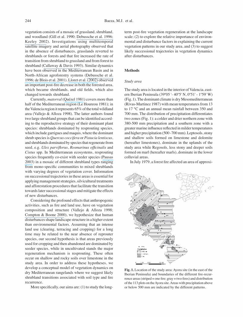
The study area is located in the interior of Valencia, east-ern Iberian Peninsula (39º05 '- 40º5' N, 0º51' - 1º59' W) (Fig. 1). The dominant climate is dry Mesomediterranean (Rivas-Martinez 1987) with mean temperatures from 13 to 17 °C and an annual mean rainfall between 350 and 700 mm. The distribution of precipitation differentiates two zones (Fig. 1): a colder and drier northern zone with 380-500 mm precipitation and a southern zone with a greater marine influence reflected in milder temperatures and higher precipitation (500 -700 mm). Leptosols, stony and shallow soils formed on limestone and dolomite (hereafter limestones), dominate in the uplands of the study area while Regosols, less stony and deeper soils formed on marl (hereafter marls), dominate in the lower colluvial areas. In July 1979, a forest fire affected an area of approxi-
Fig. 1. Location of the study area: Ayora site (in the east of the Iberian Peninsula) and boundaries of the different fire-recur-rence areas (striped = one fire; gray = two fires) and distribution of the 113 plots on the Ayora site. Areas with precipitation above or below 500 mm are indicated by the different patterns.

- Long-term post-fire regeneration patterns in Mediterranean forests - 245
mately 33000 ha and caused important environmental and socio-economic repercussions. The municipality most affected by this fire was Ayora, with 26% of its surface area burned (henceforth Ayora site). Prior to this forest fire the vegetation consisted of mature P. halepensis forests in lower sunny areas and P. pinaster in higher, preferably shady, areas. The exploitation of these forests (wood and livestock) constituted one of the most important economic resources on the Ayora site. Subsequent to the large 1979 fire, several smaller fires took place between 1984 and 1996. The most important of these occurred in 1991, burning 5000 ha in the higher elevations of the Ayora site (Fig. 1). The potential vegetation is a sclerophyllous oak forest of Quercus ilex (Bupleuro rigidi-Quercetum rotundifoliae, Rivas-Martinez 1987). With the exception of valley bottoms and other very localized areas, this vegetation is extremely degraded at present. The land-scape is covered mainly by regenerated shrublands with different degrees of development and species composi-tions. The main species are the grasses Brachypodium retusum and B. phoenicoides and the shrubs Rosmarinus officinalis, Ulex parviflorus and Quercus coccifera. The dominant shrub species combine in the landscape in different proportions with no apparent pattern. Forests are absent except for small isolated stands that were not affected by fire. These areas correspond to pine forests of Pinus halepensis and P. pinaster.
Field survey
The territory was classified into different fire recur-rence and landscape geomorphological units (landforms and topography) derived from Digital Elevation Models (DEM, 30 m grid resolution), by applying multivari-ate classification methods (Del Barrio et al. 1996). In Mediterranean forests, vegetation patterns can often be explained by changes in soil hydrological behaviour and, subsequently, in soil moisture availability. Because vegetation distribution depends on the interaction be-
tween the geomorphology and the disturbance regimes, our field sampling stratification considered both factors: two levels of fire recurrence and nine geomorphological units (Table 1). This territorial classification determined the optimization of the field work effort (number of replicates, minimum 4 plots) for each of the resulting classes (category × fire recurrence) as a function of their representation in the territory. A total of 17 classes were identified and 113 plots were sampled; 15 plots were discarded from the analysis because they had undergone previous management treatment (reforested or cleared). The different geomorphological and fire boundary units were spatially integrated in a geographic information system (GIS). Plot selection was previously determined randomly on the basis of the pixels obtained in each of the resulting classes (Table 1). To more precisely locate the site-level plots from the UTM coordinates, a global positioning system (GPS) was used (Fig. 1).
Vegetation and environmental data
Vegetation sampling was carried out in summer 2002 (23 and 11 years after the last fire in one and two recurrences, respectively). Each plot measured 30 m × 30 m, and the centre of each plot coincided with the UTM coordinates of the directly selected pixels. Vege-tation cover was recorded by the point-intersect method (Greig-Smith 1983) in four 20 m-long linear transects oriented NW, NE, SE and SW from the central point. Measurements were taken every 40 cm with a metal rod to record the contacts between each species (200 points per plot). Percent cover values were registered for all vascular species. For the quantitative vegetation analysis described in this paper the species computed are the species present on at least five plots; thus, of the 122 species present, 56 species have been included in the analysis. On each plot we recorded six environmental vari-ables (climate, elevation, aspect, slope, soil type and topographical landform) and two disturbance variables
Table 1. Number of plots sampled and surface percentage represented by each class. Stratification of the territory on the basis of the number of fires since 1979 (one and two recurrences) and the geomorphological category.
Category % total surface Plot number 1 fire 2 fires 1 fire 2 fires
Alluvial fans 1.4 0.0 4 0Terrace front and steep valley sites 7.4 1.0 7 4Midslope sections and footslopes: E-W 20.3 4.5 20 6Steep upperslope 9.9 3.1 8 6Plateaus and mountain tops 9.1 1.5 8 4Gullies 6.8 1.5 6 4Streams and flood areas and areas near channels 4.1 0.8 6 4Midslope sections and footslopes: N 13.2 3.7 8 6Midslope sections and footslopes: S 10.2 1.5 8 4 Total 82.3 17.7 75 38

246 Baeza, M.J. et al.
(fire and land use). Aspect was determined by compass and slope by clinometer. Elevation was registered on the basis of the Z coordinate extracted from the GPS. Bedrock type, which strongly influences soil type, was recorded directly on the plots. Two explanatory variables were derived from the GIS database: the digital maps on fire history (one and two recurrences) validated from the Landsat images, and the climate data (rainfall > 500 mm and < 500 mm, determined by kriging performed on the annual precipitation averages registered in the contigu-ous stations). Land use history refers to the activities that took place on the sampling site: forest (this use was not detected) and abandoned cropland (terraces). Land use and bedrock/soil type are not completely independ-ent variables (Pausas 1999). The geomorphology class (topography) was also included in the analysis as a categorial environmental variable.
Data analysis
Ordination is used to identify gradients in the ex-planatory variables which are correlated with and likely controlling the vegetation composition. Plots with similar composition should group near each other in the space ordination. Both detrended correspondence analysis (DCA) and canonical correspondence analysis (CCA) were conducted on the plant species-explanatory variable matrices using the CANOCO programs for Windows 4.5 (ter Braak & Šmilauer 1998). The first ordination (DCA) was performed on sample scores with all the data. DCA graphical profiles were created by plotting sample plot scores from the first axis of the respective DCA. Plot classification was also conducted with a hierarchical cluster analysis of the first two axes of the sample plot scores (DCA) to help clarify the validity of the ordina-tion detected. We compared the importance of environ-ment vs. disturbance in determining vegetation types by means of CCA. CCA was used as a hypothesis-testing technique for understanding some of the determining environmental and disturbance factors in the establish-ment of a particular vegetation composition. Monte Carlo tests were performed to determine the significance of the eigenvalues and the species-environment correlations up to a significance level < 0.05 (500 randomizations). The explained variation in the species data was determined by the inertia from marginal and conditional effects.
Results
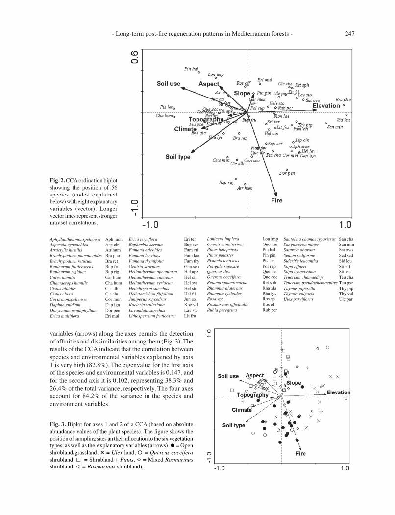
In general terms, the current vegetation on the Ayora site corresponded to a shrubland with different degrees of development and species composition, in a range that runs from sparse shrubland with a high presence of grasses (mainly B. retusum) to very young regenerating forest with a well-developed understorey. Within these two extremes we found most of the vegetation types. Grasses were present everywhere, with the most abundant species being B. retusum (32%). The main shrubland spe-cies were present in quite similar percentages throughout the entire territory: R. officinalis (20.0%), U. parviflorus (17.5%) and Q. coccifera (16.3%). The most abundant tree species, P. halepensis, hardly reached 5% of the total surface area. The sample-plots ordination by composition and specific cover was analysed in the DCA. The explained cumulative percentage of variance in the species data was 15.7% (eigenvalues = 0.27) for the first axis and a cumulated 26.4% (second axis eigenvalues = 0.18) for the two axes. The DCA axis samples scores showed strong correlations with the environmental variables (Table 2). The first axis correlated strongly with soil type and this discriminates largely between vegetation types that occur on limestone vs. marl soils. The second axis showed strong correlations with fire and land use and, to a lesser extent, with elevation and aspect. The gradient established by fire separates the types of vegetation that are sensitive to fire recurrence. Moreover, plot ordina-tion along the second axis was also the result of the high correlation maintained with land use history. The sample plots scores from the first two DCA axes were subjected to cluster analysis (App. 1). The 98 plots could be grouped into six clusters that define the different vegetation types obtained previously:Open Shrubland/Grassland, Quercus coccifera shrubland, Mixed Rosmarinus shrubland, Ulex land, Shrubland + Pinus, Rosmarinus Shrubland. The first two canonical axes of the CCA ordination biplots for environmental variables and species (Fig. 2) and sampling plots (Fig. 3) are presented. The distribution of the species or plots and environmental and anthropic
Table 2. Pearsonʼs correlation coefficients between variables and DCA axes. Significance P < 0.05 * P < 0.001**
Variables DCA Axis 1 DCA Axis 2
Fire –0.126 –0.531 **Climate –0.211 * 0.153Elevation 0.226 * –0.319 **Aspect 0.050 0.344 **Slope 0.011 0.052Soil type –0.464 ** 0.185 Land use –0.153 0.520 **Topography –0.113 0.007
- Long-term post-fire regeneration patterns in Mediterranean forests - 247
variables (arrows) along the axes permits the detection of affinities and dissimilarities among them (Fig. 3). The results of the CCA indicate that the correlation between species and environmental variables explained by axis 1 is very high (82.8%). The eigenvalue for the first axis of the species and environmental variables is 0.147, and for the second axis it is 0.102, representing 38.3% and 26.4% of the total variance, respectively. The four axes account for 84.2% of the variance in the species and environment variables.
Fig. 2. CCA ordination biplot showing the position of 56 species (codes explained below) with eight explanatory variables (vector). Longer vector lines represent stronger intraset correlations.
Fig. 3. Biplot for axes 1 and 2 of a CCA (based on absolute abundance values of the plant species). The figure shows the position of sampling sites an their allocation to the six vegetation types, as well as the explanatory variables (arrows). ≈ = Open shrubland/grassland, – = Ulex land, Å = Quercus coccifera shrubland, £ = Shrubland + Pinus, ≤ = Mixed Rosmarinus shrubland, v = Rosmarinus shrubland).
Aphyllanthes monspeliensis Aph monAsperula cynanchica Asp cinAtractylis humilis Atr humBrachypodium phoenicoides Bra phoBrachypodium retusum Bra retBupleurum fruticescens Bup fruBupleurum rigidum Bup rigCarex humilis Car humChamaerops humilis Cha hum Cistus albidus Cis albCistus clussi Cis cluCoris monspeliensis Cor monDaphne gnidium Dap ignDorycnium pentaphyllum Dor penErica multiflora Eri mul
Erica terniflora Eri terEuphorbia serrata Eup serFumana ericoides Fum eriFumana laevipes Fum laeFumana thymifolia Fum thyGenista scorpius Gen scoHelianthemum apenninum Hel apeHelianthemum cinereum Hel cinHelianthemum syriacum Hel syrHelichrysum stoechas Hel stoHelictotrichon filifolium Hel filJuniperus oxycedrus Jun oxiKoeleria vallesiana Koe valLavandula stoechas Lav stoLithospermum fruticosum Lit fru
Lonicera implexa Lon impOnonis minutissima Ono minPinus halepensis Pin halPinus pinaster Pin pinPistacia lentiscus Pis lenPoligala rupestre Pol rupQuercus ilex Que ileQuercus coccifera Que cocRetama sphaerocarpa Ret sphRhamnus alaternus Rha alaRhamnus lycioides Rha lycRosa spp. Ros spRosmarinus officinalis Ros offRubia peregrina Rub per
Santolina chamaecyparissus San chaSanguisorba minor San minSatureja obovata Sat ovoSedum sediforme Sed sedSideritis leucantha Sid leuStipa offneri Sti offStipa tenacissima Sti tenTeucrium chamaedrys Teu chaTeucrium pseudochamaepitys Teu pseThymus piperella Thy pipThymus vulgaris Thy vulUlex parviflorus Ule par

248 Baeza, M.J. et al.
Brachypodium phoenicoides showed a high posi-tive correlation with elevation, in contrast to Pistacia lentiscus and Chamaerops humilis which showed the opposite pattern. Species like Erica multiflora, Cistus clusii, Helictotrichon filifolium and Ulex parviflorus presented negative values for soil type. These species mostly occur on marl soils (recorded with low values for this variable) in contrast with other species such as Rhamnus alaternus, R. lycioides or Q. coccifera which prefer limestone soils (high values). Fire recurrence, the environmental variable explaining the highest variance in the model, presented a highly negative correlation with P. halepensis, Juniperus oxycedrus and Rosmarinus of-ficinalis while the opposite occurred with Cistus albidus, Fumana thymifolia and Dorycnium pentaphyllum, which showed higher cover with higher fire recurrence. The results of the stepwise CCA forward selection showed that these variables accounted for 38.3% of the variance in the data (Table 3). Topography variables were not significant in the Monte Carlo permutation test (P > 0.05). The first variables selected in the model were fire and elevation, and both explained 8% of the variation. These were followed by the soil variables. The smallest variance explained corresponded to several individual topographical variables and to annual rainfall. Analysis of Fig. 3 shows the correspondence be-tween the plot ordination (plant communities) and the environmental variables. A group of plots located in the lower part of the figure correspond to open shrubland/grassland with high specific richness, dominated by the grass B. retusum with low cover of individual shrub species and found in areas burned twice. On marls and in previously cultivated areas with a northern or eastern aspect we found plots where the dominant vegetation was the shrub U. parviflorus and the grass species of Brachypodium, which were differentiated according to an elevation gradient. That is, plots located at higher elevations and with lower precipitation rates presented a
herbaceous stratum dominated by B. phoenicoides while those at lower elevations were dominated by B. retusum. Quercus coccifera formations corresponded to plots with low soil perturbation levels and low-medium elevations. It was found on limestone substrates with forest use. On the basis of fire recurrence, two kinds of kermes oak groups can be differentiated. Those affected by one fire presented high cover values while those affected by two fires showed lower cover values and a higher pres-ence of other species such as C. albidus. The former plots were found at low elevations on soils assigned to forest use. As previously noted, R. officinalis was the species with the highest cover on the entire Ayora site, and it was the dominant vegetation on 37% of the plots studied. Rosmarinus shrublands were monospecific on high-elevation plots assigned to forest land-use with a south-southeastern aspect and precipitation < 500 mm. In another widely distributed group of plots within the study area, vegetation corresponded to mixed shrubland, with R. officinalis co-dominating with other species such as U. parviflorus and Q. coccifera.
Discussion
Forest resilience
Mediterranean vegetation has been considered highly resilient to disturbances. In different Mediterranean-type ecosystems it has been observed that both shrublands (Malanson & Trabaud 1988; Seligman & Henkin 2000; Keeley 2002) and grasslands (Caturla et al. 2000; Har-rison & Shackleton 1999) return to their previous state in just a few years. On the other hand, other studies (Lloret et al. 2002) have found a slower tree recovery rate. Thus, the forests are expected to recover slowlier. Our results show that 23 years after one forest fire, the Ayora site has changed from mature P. halepensis and P. pinaster forest to mainly shrubland. In areas affected by two fires the dominant vegetation is mainly open shrub-land/grassland without pines. Pinus spp. regeneration has been described as recurrence-dependent, i.e., it will not occur if the fire-free period is shorter than the age to reach maturity (Fox & Fox 1986; Zedler 1995; Keeley 2002). Pinus halepensis needs 7-10 years to reach the reproductive stage (Thanos & Daskalakou 2000) and, therefore, when the second fire occurred the availability of seeds would be quite low and probably consumed by fire. Several studies support the hypothesis that the re-generation of Pinus spp. cannot be guaranteed after a fire because factors such as fire severity (Martínez-Sánchez et al. 1995) and seed-bank availability (canopy) (Thanos & Daskalakou 2000), along with all the environmental factors that influence germination (Trabaud 2000), must
Table 3. Ranking in importance of environmental and distur-bance variables by their conditional effects on the CCA obtained through a forward selection procedure by means of the Monte Carlo permutation test.
Step Variable F P-value VE (%)
1 Fire 4.94 0.002 82 Elevation 4.43 0.002 83 Soil type 4.38 0.002 74 Land use 3.29 0.002 55 Aspect 2.11 0.004 36 Slope 1.60 0.050 37 Climate 1.65 0.026 28 Topography 1.48 0.062 2 Total 38.3VE = Variation explained.

- Long-term post-fire regeneration patterns in Mediterranean forests - 249
coincide in time and space. On the Ayora site, the cover values of the key tree species (sensu Michell et al. 2000) P. halepensis, Q. ilex and P. pinaster are 5%, 2.6% and <1%, respectively. These low cover values indicate that the regeneration of these ecosystems at the landscape scale may be very slow in the medium term.
Disturbance and environmental variables
Our CCA results show that, at the landscape level, fire was the main driver of vegetation structure and composi-tion in the area during the study period (23 years). Fire recurrence and severity have been described as important factors that increase landscape heterogeneity by frag-menting the vegetation into different states of succession (Turner et al. 1994; Trabaud & Galtier 1996; Lloret et al. 2002). We have observed that 75% of the plots that sustained two fires corresponded to shrublands in early successional stages with high species richness and a high cover of grasses and seeder species typical of early post-fire stages (Ulex parviflorus, Fumana thymifolia and Cistus albidus). But shrublands dominated by resprouter species that are more persistent to fire recurrence, e.g. Quercus coccifera (Trabaud 1991), were also present. The areas that sustained only one fire consisted of dense and structurally homogeneous shrublands pertaining to later successional stages, although still lacking character-istic sclerophyllous of mature vegetation in the area. Both the altitudinal and the geomorphological (topo-graphic and landform) gradients are strongly correlated with the availability of resources and conditions (i.e. temperature, water and solar radiation) that regulate veg-etation growth and distribution (Houston 1994; Franklin 1998; Villers-Ruiz et al. 2003). On the Ayora site, altitude was the environmental variable that explained the largest proportion of the variations in vegetation type. Brachy-podium phoenicoides cover showed a strong positive correlation with altitude and was distributed throughout the highest areas in the study zone; it constitutes the gorseland herbaceous stratum. Thermophyllous species like Pistacia lentiscus and Chamaerops humilis (with scant presence in our study zone) were found especially in the lower areas, in agreement with other studies (Ar-royo & Marañón 1990). To interpret the landscape and identify the possible mechanisms involved in the vegetation dynamics, it is crucial to know whether the current vegetation distri-bution is connected to the variation in environmental variables or to land use (Keeley 2002; Pausas 2003). In Mediterranean ecosystems, fire has been recognised as an important force in molding the landscape. Nevertheless, studies on Arizona chaparral (Huebner & Vankat 2003) observed that what separated the chaparral from other vegetation types was the environmental variables; the
disturbance variables (fire and grazing) were relatively unimportant. These results agree with those found by Richardson et al. (1995) in SW Australia, where topography and soil varibility explained the distribu-tion patterns of Banksia species. In a rural landscape of France, Roch et al. (1998) found that both environmental and land use factors controlled patterns of woody species cover. Our results indicate that factors related to land use (fire and terracing) shaped the landscape, a finding that coincides with other studies on Mediterranean vegetation (Callaway & Davis 1993; Kadmon & Harari-Kremer 1999). Nevertheless, Lloret & Vilá (2003) studied the di-versity pattern of plant functional types in relation to fire and previous land use in Mediterranean woodlands and did not find differences in species composition between old fields and uncultivated garrigues. These apparent opposite results suggest that in moister Mediterranean areas, land abandonment may have shorter-term conse-quences and the landscape may be regenerated faster to natural vegetation in comparison to drier Mediterranean areas, where intense past land use involves slow growth of resilient species with longer-term consequences. In our study area, fire (one or two recurrences in 23 years) introduces a variability factor in the landscape which creates vegetation patches in different succes-sional states; on the other hand, land use and soil type define the different types of shrubland in terms of their specific composition. Seeder species were strongly as-sociated with abandoned fields and marl-limestone soils while sprouter species were associated with forest use (non-cultivated) and limestone soils. This suggests that the transformation of natural vegetation on soft substrates to cropland through the long-term elimination of natural vegetation will condition the type of vegetation which develops on these soils after abandonment, at least in the short and middle term. It has been observed that shrub invasions of grassland were significantly lower on silty clay to clay soils than on other soil types, which suggests that soil characteristics affect transition rates (Callaway & Davis 1993). Given the disturbance regime in the study area, it is likely that the elimination of the original forests, the land use transformation to cultivation terraces and the fire-return intervals (22 years on the Ayora site, J. Pausas pers. comm.) have modified some of the micro-environmental conditions (e.g. light and temperature), favouring the strong presence of disturbance-dependent shrublands as stages of forest degradation (de Blois et al. 2001).

250 Baeza, M.J. et al.
Vegetation dynamics
After a disturbance, secondary successional processes are set in motion; these vary with the intensity of the per-turbation. Disturbances such as fire eliminate the aerial vegetation but not the propagules (lignotuber, bulbs and seeds) in the soil (see examples in Trabaud & Lepart 1981 and Keeley 1986). In contrast, the change to agricultural land use implies the elimination of soil propagules and after abandonment successional processes begin from the borders of the perturbation (Debussche et al. 1996). Both of these situations are contemplated in our study. The fol-lowing vegetation dynamics model (Fig. 4) is proposed as an explanation for the above-mentioned vegetation types on the basis of plant functional traits (seeder and resprouter) (Pausas & Lavorel 2003) and soil type. The resilience to fire (Trabaud 1991; Delitti et al. 2005) of the resprouter species growing on hard, unaltered soils (limestones) is characteristic of shrublands dominated by Quercus coccif-era. A second fire in these shrublands produces ephemeral changes towards earlier successional stages but the high resilience of the resprouters guarantees a rapid shrubland re-establishment. Q. coccifera may coexist with seeder species forming mixed shrublands; however, the dynamics of the Mixed Rosmarinus shrubland is not evident in our study. Theoretical (Keeley 1986) and simulation (Pausas 2003) studies on plant functional traits predict that these shrublands will be dominated by resprouter species in later successional stages. Nevertheless, these processes must be slow since seedling recruitment of resprouters is never very abundant (Keeley 1986; Vallejo & Alloza 1998) and most Quercus species have a limited capacity for expansion through acorn dispersion (Gómez et al. 2003).
On the other hand, seeder species predominate on marl-limestone colluvium and/or set-aside agricultural areas. Ulex parviflorus and especially Cistus albidus are found in areas with high fire recurrence, while Rosma-rinus officinalis and Pinus halepensis show a higher presence in areas with low fire recurrence. This could indicate that they correspond to different post-fire suc-cessional stages in this soil type. Thorny leguminous species (U. parviflorus in our study) constitute the early successional stages in the post-fire vegetation that persists (seed bank) after two fires on abandoned cultivation ter-races (Tatoni et al. 1994; Baeza 2001). After 17 years, U. parviflorus individuals show structural disorganization and the community enters into a senescent phase with many dead plants (Baeza 2001). The spaces opened by the dead plants could become occupied by species such as R. officinalis. This suggests that Rosmarinus shrub-land could constitute a later successional stage in these systems with or without Pinus spp. and Q. coccifera, depending on the distance to parent trees. Due to the current wildfire recurrence in many Mediterranean-type ecosystems, understanding these successional trajectories after fire increases the likelihood that an accurate and effective management plan will be achievable. Fuel load rates and each characteristics is strongly dependent on the successional trajectories. Vegetation management should integrate this knowledge in order to reduce fire hazard and promote succession to desired stages.
Fig. 4. Conceptual model of vegetation dy-namics after fire on the basis of soil type and disturbance recurrence (one and two fires) on the Ayora site. The starting point in the early 1970s was pine forest. Arrows are transitions from one vegetation state to another. The arrows marked with a question mark and broken lines indicate unknown transitions.
- Long-term post-fire regeneration patterns in Mediterranean forests - 251
Acknowledgements. We thank J. Scheiding for the English translation of the text and J. Llovet, B. Rouiller, S. Arce, M. Pérez, J. Belda, I. Almudéver and R. Fernández for their collaboration in the field work. We thank F.T. Maestre, S. Bautista and A. Bonet for their comments on the development of this study. Comments from J. Franklin and two anonymous referees have greatly improved the quality of the manuscript. This research was financed by the GeoRange European project (EVK2-2000-22089). CEAM is supported by the Generalitat Valenciana and Bancaja.
References
Arroyo, J. & Marañon, T. 1990. Community ecology and distributional spectra of Mediterranean shrublands and heathlands in Southern Spain. J. Biogeogr. 17: 163-176.
Baeza, M.J. 2001. Aspectos ecológicos y técnicas de control del combustible (roza y quema controlada) en matorrales con alto riesgo de incendio dominados por U. parviflorus (Pourr.). Ph.D. Thesis.[on line] Biblioteca Virtual Miguel de Cervantes.URL: http://www.cervantesvirtual.com/FichaObra.html?Ref=5920, Alicante, ES.
Brown, D.G. 1994. Predicting vegetation types at treeline us-ing topography and biophysical disturbance variables. J. Veg. Sci. 5: 641-656.
Callaway, R.M. & Davis, F.W. 1993. Vegetation dynamics, fire, and the physical environment in coastal Central California. Ecology 74: 1567-1578.
Caturla, R.N., Raventós, J., Guárdia, R. & Vallejo, V.R. 2000. Early post-fire regeneration dynamics of Brachypodium retusum Pers. (Beauv.) in old fields of the Valencia region (eastern Spain). Acta Oecol. 21: 1-12.
Compton, J.A. & Boone, R.D. 2000. Long-term impacts of agriculture on soil carbon and nitrogen in New England forests, Ecology 81: 2314-2330.
de Blois, S., Domon, G. & Bouchard A. 2001. Environmental, historical, and contextual determinants of vegetation cover: a landscape perspective. Landscape Ecol. 16: 421-436.
Debussche, M., Escarré, J., Lepart, J., Houssard, C. & Lavorel, S. 1996. Changes in Mediterranean succession: old-fields revisited. J. Veg. Sci. 7: 519-526.
Del Barrio, G., Boer, M. & Puigdefábregas, J. 1996. Select-ing representative drainage basins in a large research area using numerical taxonomy on topographic and climatic raster overlays. Second Joint European Conference & Exhibition on Geographical Information, pp. 398-407, Barcelona, ES.
Delitti, W., Ferran, A., Trabaud, L. & Vallejo, V.R. 2005. Ef-fects of fire recurrences in Quercus coccifera L. shrublands of the Valencia region (Spain): I. Plant composition and productivity. Plant Ecol. 177: 57-70.
Dunjó, G., Pardini, G., & Gispert, M. 2003. Land use change effects on abandoned terraced soils in a Mediterranean catchment, NE Spain. Catena 52: 23-37.
Fox, M.D. & Fox, B.J. 1986. The effect of fire frequency on the structure and floristic composition of a woodland understorey. Aust. J. Ecol. 11: 77-85.
Franklin, J. 1998. Predicting the distributions of shrub species
in California from climate and terrain-derived variables.ʻJ. Veg. Sci. 9: 733-748.
Gill, A.M., Groves, R.H. & Noble, I.R. 1981. Fire and Aus-tralian Biota. Australian Academy of Science, Canberra, AU.
Gómez, J.M., García, D. & Zamora, R. 2003. Impact of vertebrate acorn- and seedling-predators on a Mediter-ranean Quercus pyrenaica forest. For. Ecol. Manage. 180: 125-134.
Greig-Smith, P. 1983. Quantitative plant ecology (3rd ed.) Blackwell, Oxford, UK.
Harrison, Y.A. & Shackleton, C.M. 1999. Resilience of South African communal grazing lands after the removal of high grazing pressure. Land Degrad. Dev. 10: 225-239.
Henry, D.O. 1994. Prehistoric cultural ecology in southern Jordan. Science 265: 336-341.
Houston, M.A. 1994. Biological diversity. The coexistence of species on changing landscape. Cambridge University Press, Cambridge, UK.
Huebner, C.D. & Vankat, J.L. 2003. The importance of environ-ment vs. disturbance in the vegetation mosaic of Central Arizona. J. Veg. Sci. 14: 25-34.
Kadmon, R. & Harari-Kremer, T. 1999. Landscape-scale re-generation dynamics of disturbed Mediterranean maquis. J. Veg. Sci. 10: 393-402.
Keeley, J.E. 1986. Resilience of Mediterranean shrub commu-nities to fires. In: Dell, B., Hopkins, A.J. & Lamont, B.B. (eds.) Resilience in Mediterranean-type ecosystems, pp. 95-112. Dr W. Junk Publishers, Dordrecht, NL.
Keeley, J.E. 2002. Native American impacts on fire regimes of the California coastal ranges. J. Biogeogr. 29: 303-320.
Le Houréou, H.N. 1981. Impact of man and his animals on mediterranean vegetation. In: di Castri, F., Goodwall, D.W., Specht, R.C. (eds.) Ecosystems of the World. Medi-terranean type shrublands, pp. 479-522. Elsevier, New York, NY, US.
Lloret, F. & Vilá, M. 2003. Diversity patterns of plant functional types in relation to fire regime and previous land use in Mediterranean woodlands. J. Veg. Sci. 14: 387-398.
Lloret, F., Calvo, E., Pons, X. & Díaz-Delgado, R. 2002. Wildfires and landscape patterns in the Eastern Iberian Peninsula. Landscape Ecol. 17: 745-759.
Malanson, G.P. & Trabaud, L. 1988. Vigour of post-fire res-prouting by Quercus coccifera L. J. Ecol. 76: 351-365.
Martínez-Sánchez, J.J., Marín, A., Herranz, J.M., Ferrandis, P. & De las Heras, J. 1995. Effects of high temperatures on germination of Pinus halepensis Mill. and P. pinaster Aiton subsp. pinaster seeds in southeast Spain. Vegetatio 116: 69-72.
Mitchell, R.J., Auld, M.H.D., Le Duc, M.G. & Marrs, R.H. 2000. Ecosystem stability and resilience: a review of their relevance for the conservation management of lowland heaths. Perspect. Plant Ecol. Evol. Syst. 3: 142-160.
Naveh, Z. 1994. The role of fire and its management in the conservation of Mediterranean ecosystems and landscapes. In: Moreno, J.M. & Oechel, W. (eds.) The role of fire in Mediterranean type ecosystems, pp. 163-186. Springer-Verlag, New York, NY, US.
Pausas, J.G. 1999. The response of plant functional types to

252 Baeza, M.J. et al.
changes in the fire regime in Mediterranean Ecosystems. A simulation approach. J. Veg. Sci. 10: 717-722.
Pausas, J.G. 2003. The effect of landscape pattern on Mediter-ranean vegetation dynamics: A modelling approach using functional types. J. Veg. Sci. 14: 365-374.
Pausas, J.G. & Lavorel, S. 2003. A hierarchical deductive approach for functional types in disturbed ecosystems. J. Veg. Sci. 14: 371-378.
Platt, W.J. & Connell, S.H. 2003. Natural disturbances and directional replacement of species. Ecol. Monogr. 73: 507-522.
Quézel, P. 1981. The study of plant groupings in the countries surrounding the mediterranean: some methodological aspects. In: Di Castri, F., Goodall, D.W., Specht, R.L. (eds.). Mediterranean type shrublands, pp. 87-93 Elsevier, Amsterdam, NL.
Richardson, D.M., Cowling, R.M., Lamont, B.B. & van Hensbergen, H.J. 1995. Coexistence of Banksia species in southwestern Australia: the role of regional and local processes. J. Veg. Sci. 6: 329-342.
Rivas-Martinez, S. 1987. Mapa de series de vegetación de España. ICONA. Madrid, ES.
Roche, P., Tatoni, T. & Médail, F. 1998. Relative importance of abiotic and land use factors in explaining variation in woody vegetation in a French rural landscape. J. Veg. Sci. 9: 221-228.
Seligman, N.G. & Henkin, Z. 2000. Regeneration of a domi-nant Mediterranean dwarf-shrub after fire. J. Veg. Sci. 11: 893-902.
Tatoni, T., Magnin, F., Bonin, G. & Vaudour, J. 1994. Sec-ondary successions on abandoned cultivation terraces in calcareous Provence. I- Vegetation and soil. Acta Oecol. 15 (4): 431-447.
ter Braak, C.J.F. & Šmilauer, P. 1998. CANOCO reference manual and user s̓ guide to Canoco for Windows: Software for Canonical community ordination (version 4). Micro-computer Power, Ithaca, NY, US.
Thanos, C.A. & Daskalakou, E.N. 2000. Reproduction in Pinus halepensis and P. brutia. In: Ne´eman, G. & Trabaud, L. (eds.) Ecology, biogeography and management of Pinus halepensis and P. brutia forest ecosystems in the Mediter-ranean Basin, pp. 79-90. Backhuys, Leiden, NL.
Trabaud, L. 1991. Fire regimes and phytomass growth dy-namics in a Quercus coccifera L. garrigue. J. Veg. Sci. 2: 307-314.
Trabaud, L. 2000. Seeds: their soil bank and their role in post-fire recovery of ecosystems of the Mediterranean basin. In: Trabaud, L. (ed.) Life and environment in the Mediter-ranean, pp. 229-259. Wit Press, Southampton, UK.
Trabaud, L. & Galtié, J. 1996. Effects of fire frequency on plant communities and landscape pattern in the Massif des Aspres (southern France). Landscape Ecol. 11: 215-224.
Trabaud, L. & Lepart, J. 1981. Floristic changes in a Quercus coccifera L. garrigue according to different fire regimes. Vegetatio 46: 105-116.
Turner, M.G., Hargrove, W.W., Gardner, R.H. & Romme, W.H. 1994. Effects of fire on landscape heterogeneity in Yellow-stone National Park, Wyoming. J. Veg. Sci. 5: 731-742.
Vallejo, V.R. & Alloza, J.A. 1998. The restauration of burned
lands: The case of eastern Spain. In: Moreno, J.M. (ed.) Large forest fires, pp. 91-108. Backhuys, Leiden. NL.
Villers-Ruiz, L., Trejo-Vázquez, I. & López-Blanco, J. 2003. Dry vegetation in relation to the physical environment in the Baja California Peninsula, Mexico. J. Veg. Sci. 14: 517-524.
Zedler, P.H. 1995. Fire frequency in southern California shrublands: biological effects and management options. In: Keeley, J.E. & Scott, T. (eds.) Brushfires in California: ecol-ogy and resource management, pp 101-112. International Association of Wildland Fire, Fairfield, WA, US.
Received 4 April 2006;Accepted 20 October 2006;
Co-ordinating Editor: J. Franklin.
For App. 1, see also JVS/AVS Electronic Archives;www.opuluspress.se/