
Heft 204 Muhammad Mahboob Alam Statistical Downscaling ...
240
Heft 204 Muhammad Mahboob Alam Statistical Downscaling of Extremes of Precipitation in Mesoscale Catchments from Different RCMs and Their Effects on Local Hydrology
-
Upload
khangminh22 -
Category
Documents
-
view
3 -
download
0
Transcript of Heft 204 Muhammad Mahboob Alam Statistical Downscaling ...

Heft 204 Muhammad Mahboob Alam
Statistical Downscaling of Extremes of Precipitation in Mesoscale Catchments from Different RCMs and Their Effects on Local Hydrology


Statistical Downscaling of Extremes of Precipitatio n in Mesoscale Catchments from Different RCMs and Their
Effects on Local Hydrology
Von der Fakultät Bau- und Umweltingenieurwissenschaften der Universität Stuttgart zur Erlangung der Würde eines Doktor-Ingenieurs (Dr.-Ing.) genehmigte Abhandlung
Vorgelegt von
Muhammad Mahboob Alam aus Swat, Pakistan.
Hauptberichter: Prof. Dr. rer. nat. Dr.-Ing. András Bárdossy Mitberichter: Prof. Dr. Axel Bronstert Tag der mündlichen Prüfung: 19. Juli 2011
Institut für Wasserbau der Universität Stuttgart 2011


Heft 204 Statistical Downscaling of Extremes of Precipitation in Mesoscale Catchments from Different RCMs and Their Effects on Local Hydrology
von Dr.-Ing. Muhammad Mahboob Alam
Eigenverlag des Instituts für Wasserbau der Universität Stuttgart
D93 Statistical Downscaling of Extremes of Precipit ation in Mesoscale Catchments from Different RCMs and Their Effects on Local Hydrology
Bibliografische Information der Deutschen Nationalb ibliothek Die Deutsche Nationalbibliothek verzeichnet diese Publikation in der Deutschen Nationalbibliografie; detaillierte bibliografische Daten sind im Internet über http://www.d-nb.de abrufbar
Alam, Muhammad Mahboob: Statistical Downscaling of Extremes of Precipitation in Mesoscale Catchments from
Different RCMs and Their Effects on Local Hydrology / von Muhammad Mahboob Alam. Institut für Wasserbau, Universität Stuttgart. - Stuttgart: Inst. für Wasserbau, 2011
(Mitteilungen / Institut für Wasserbau, Universität Stuttgart: H. 204) Zugl.: Stuttgart, Univ., Diss., 2011 ISBN 978-3-942036-08-5 NE: Institut für Wasserbau <Stuttgart>: Mitteilungen
Gegen Vervielfältigung und Übersetzung bestehen keine Einwände, es wird lediglich um Quellenangabe gebeten. Herausgegeben 2011 vom Eigenverlag des Instituts für Wasserbau Druck: Document Center S. Kästl, Ostfildern

Contents
Acknowledgements vii
List of Figures ix
List of Tables xv
List of Abbreviations xvii
List of symbols xix
Kurzfassung xxi
1. Introduction 1
1.1. Background and Motivations . . . . . . . . . . . . . . . . . . . . . . . 2
1.2. Organization of thesis . . . . . . . . . . . . . . . . . . . . . . . . . . . 4
2. Downscaling 5
2.1. Preface . . . . . . . . . . . . . . . . . . . . . . . . . . . . . . . . . . . 5
2.2. Downscaling . . . . . . . . . . . . . . . . . . . . . . . . . . . . . . . . . 5
2.2.1. Dynamical Downscaling . . . . . . . . . . . . . . . . . . . . . . 5
2.2.1.1. Short comings of dynamical downscaling . . . . . . . 8
2.2.2. Statistical Downscaling . . . . . . . . . . . . . . . . . . . . . . 9
2.2.2.1. Issues in Statistical downscaling . . . . . . . . . . . . 10
2.2.2.2. Transfer Function . . . . . . . . . . . . . . . . . . . . 12
2.2.2.3. Weather Generator . . . . . . . . . . . . . . . . . . . 13
2.2.2.4. Analog Method . . . . . . . . . . . . . . . . . . . . . 16
2.2.2.5. Weather typing . . . . . . . . . . . . . . . . . . . . . . 19
2.2.2.6. Short comings of statistical downscaling . . . . . . . . 20
3. Methodology 21
3.1. Preface . . . . . . . . . . . . . . . . . . . . . . . . . . . . . . . . . . . 21
3.2. Fuzzy rule based classification of large scale circulation patterns . . . . 21
3.2.1. Low discharge based objective function . . . . . . . . . . . . . 24
3.2.2. An objective function based on a cluster of precipitation stations 28
3.3. Statistical downscaling of precipitation . . . . . . . . . . . . . . . . . . 29
3.3.1. Statistical downscaling based on the conditional multivariatedownscaling approach . . . . . . . . . . . . . . . . . . . . . . . 29
3.3.2. Statistical downscaling based on quantile-quantile bias correc-tion approach . . . . . . . . . . . . . . . . . . . . . . . . . . . . 32
iii

Contents Contents
4. Catchments and Data 37
4.1. Catchments & Data . . . . . . . . . . . . . . . . . . . . . . . . . . . . 37
4.1.1. OPAQUE Catchments & Data . . . . . . . . . . . . . . . . . . 37
4.1.2. ENSEMBLES Catchments & Data . . . . . . . . . . . . . . . . 45
5. Results-Circulation pattern classification 51
5.1. Preface . . . . . . . . . . . . . . . . . . . . . . . . . . . . . . . . . . . 51
5.2. Classification of critical circulation patterns . . . . . . . . . . . . . . . 51
5.2.1. ENSEMBLES data sets classification . . . . . . . . . . . . . . . 56
5.2.1.1. RT5 observational data set classification . . . . . . . . 56
5.2.1.2. RACMO data set classification . . . . . . . . . . . . . 76
5.2.1.3. REMO data set classification . . . . . . . . . . . . . . 83
5.2.1.4. HadRM data sets classification . . . . . . . . . . . . . 90
5.2.2. OPAQUE catchments classification . . . . . . . . . . . . . . . . 103
5.2.2.1. Upper Danube catchment classification . . . . . . . . 103
5.2.2.2. Alb catchment classification . . . . . . . . . . . . . . 106
5.2.2.3. Iller catchment classification . . . . . . . . . . . . . . 108
5.2.2.4. Weisseritz catchment classification . . . . . . . . . . 110
5.3. Conclusions . . . . . . . . . . . . . . . . . . . . . . . . . . . . . . . . . 112
6. Results-Downscaling 113
6.1. Preface . . . . . . . . . . . . . . . . . . . . . . . . . . . . . . . . . . . 113
6.2. Bias correction using quantile-quantile exchange . . . . . . . . . . . . 113
6.2.1. Grid point based analysis . . . . . . . . . . . . . . . . . . . . . 121
6.2.2. Sub catchment based analysis . . . . . . . . . . . . . . . . . . . 124
6.3. Autoregressive multivariate CP conditioned downscaling . . . . . . . . 129
6.3.1. Upper Danube Catchment . . . . . . . . . . . . . . . . . . . . . 129
6.3.2. Alb Catchment . . . . . . . . . . . . . . . . . . . . . . . . . . . 133
7. Drought Analysis 137
7.1. Preface . . . . . . . . . . . . . . . . . . . . . . . . . . . . . . . . . . . 137
7.2. Classification of droughts and frequently used indices . . . . . . . . . . 137
7.2.1. Climatological drought . . . . . . . . . . . . . . . . . . . . . . . 137
7.2.2. Hydrological drought . . . . . . . . . . . . . . . . . . . . . . . . 138
7.2.3. Agro-Meteorological drought . . . . . . . . . . . . . . . . . . . 138
7.3. Palmer drought severity index (PDSI) . . . . . . . . . . . . . . . . . . 139
7.4. Application of PDSI to raw RCM and downscaled RCM data . . . . . 141
8. Hydrological modeling application 147
8.1. Preface . . . . . . . . . . . . . . . . . . . . . . . . . . . . . . . . . . . 147
8.2. HBV model . . . . . . . . . . . . . . . . . . . . . . . . . . . . . . . . . 147
8.3. HBV Model description . . . . . . . . . . . . . . . . . . . . . . . . . . 148
8.3.1. Snow accumulation and snow melt process . . . . . . . . . . . . 148
8.3.2. Soil moisture process . . . . . . . . . . . . . . . . . . . . . . . . 149
8.3.3. Evapotranspiration . . . . . . . . . . . . . . . . . . . . . . . . . 149
8.3.4. Runoff production and concentration process . . . . . . . . . . 150
8.4. Results . . . . . . . . . . . . . . . . . . . . . . . . . . . . . . . . . . . . 150
iv

Contents Contents
8.5. Conclusions . . . . . . . . . . . . . . . . . . . . . . . . . . . . . . . . . 159
9. Conclusions and Outlook 1619.1. Conclusions . . . . . . . . . . . . . . . . . . . . . . . . . . . . . . . . . 1619.2. Outlook . . . . . . . . . . . . . . . . . . . . . . . . . . . . . . . . . . . 162
A. German part of Rhine basin,Grid point locations 173
B. Spatial maps of wetness indices 176B.1. Spatial wetness index maps-RACMO . . . . . . . . . . . . . . . . . . . 177B.2. Spatial wetness index maps-REMO . . . . . . . . . . . . . . . . . . . . 181B.3. Spatial wetness index maps-HadRM . . . . . . . . . . . . . . . . . . . 185
C. Contingency tables for all RCMs of ENSEMBLES data set 193
v

vi

Acknowledgements
I can not thank Prof. Bardossy enough for his support throughout my stay here atthe Institute of Hydraulics. I am grateful to him for giving me a chance to work hereat IWS. It was only possible through his constant guidance and extreme patiencewith me that I was able to finish my PhD. I truly believe that the scientific ideasthat he cultivated in my mind would help me immensely in my future life.
I would also like to thank here Prof. Axel Bronstert who gave me valuable feed-back about my work and guided me whenever it was required. Thanks are also dueto Prof. Caspary whose ideas and review of my work motivated me immensely toimprove both my PhD. research and our common project ENSEMBLES work. Iwould thank also Dr. Edwin Ayros of Fichtner GmbH for his kind support wheneverit was required and for giving me a chance to work at Fichtner.
Once I leave IWS, the thing I am sure to miss the most would be the great workingenvironment here. I would like to thank Ferdinand, Thomas, Min, Jing, Henning,Christian, Shailesh, Claus and Jan for their great company and help. I wish all ofthem a bright and successful future and hope that we would be in touch wherever weare in our future lives. I, Min and Jing always considered Helen and Pawan as ourrole models when we started our PhD almost at the same time and hence I can notforget their help, ideas and support. I would specially like to thank Frau Uhrmannfor her support throughout my stay here. Whenever there was a need for fulfillingsome bureaucratic formalities she was always there to help. She is soon going toretire and I wish her peaceful and content life. Special thanks are also due to Dr.Jochen Seidel for his support whenever it was required.
I would do great injustice if I do not mention my family here. My stay in Ger-many since starting my MSc. here was long enough for me to observe some drasticchanges in my country in general and in Swat (from where I belong) in particular.Unfortunately those changes were not for the betterment. In spite of all the difficultsituations that my immediate and extended family faced, I was always given uncon-ditional and tremendous support. I can not pay back for the support that I receivedfrom my parents and my brothers and sister. Last but surely not the least I haveto thank my beloved wife Aisha and our daughter Amina. There presence here inGermany really changed my life. After a tiring day in the office, their company al-ways relaxed and refreshed me. I hope now that I am finished with my PhD., I couldtake some burden of raising our daughter off from my wife and give her a chance toconcentrate on her career.
vii

viii

List of Figures
2.1. A general picture of RCM embedded in a GCM. (Image source: WorldMeteorological Organization, Bulletin 57-2) . . . . . . . . . . . . . . . 7
2.2. One-way and two-way nesting of REMO model. . . . . . . . . . . . . . 82.3. Flow charts of precipitation occurrence process in weather generators
using (a)Markov chain and (b) Spell length procedures (D.S.Wilks andR.L.Wilby, 1999) . . . . . . . . . . . . . . . . . . . . . . . . . . . . . . 16
2.4. Step one of analog search process Obled et al. (2002) . . . . . . . . . . 182.5. Step two of analog search process Obled et al. (2002) . . . . . . . . . . 18
3.1. Daily discharge (thick solid black line), discharge increment/decrementon 1 day lag (thick dashed black line), positive part of discharge incre-ment on 1 day lag (thick solid gray line) and daily precipitation (thingray solid lines) for Alb catchment for year 1982 . . . . . . . . . . . . 26
3.2. Daily discharge difference series on 1 day lag (thick solid black line)along with the two limits (thick solid gray lines) representing the “equi-librium” state of Alb catchment for year 1982 . . . . . . . . . . . . . . 27
3.3. Weibull probability density functions for different values of δ and β(D.C.Montgomery and Runger, 2002) . . . . . . . . . . . . . . . . . . 35
4.1. Location and size of catchments under study in OPAQUE Project. . 384.2. Upper Danube catchment in detail. . . . . . . . . . . . . . . . . . . . . 394.3. Daily average discharge (to the left) and 1995 flood event discharge (to
the right) for River Breg (Black) and Brigarch (Gray). Daily averageis calculated from 1991-2006, excluding flood year 1995. . . . . . . . . 39
4.4. Weisseritz catchment in detail. . . . . . . . . . . . . . . . . . . . . . . 404.5. Daily average discharge (to the left) and 2002 flood event discharge
(to the right) for all the rivers in Weisseritz catchment. Daily averageis calculated from 1971-2001. . . . . . . . . . . . . . . . . . . . . . . . 41
4.6. Iller catchment in detail. Whole catchment is to the left and upper Illercatchment to the right.(Left figure courtesy of http://de.wikipedia.org/wiki/Iller) . . . . . . . . . . . . . . . . . . . . . . . . . . . . . 42
4.7. Daily average discharge (to the left) and 1999 flood event discharge (tothe right) of all the rivers in Iller catchment(gauge:Kempton). Dailyaverage is calculated from 1971-1991. . . . . . . . . . . . . . . . . . . 43
4.8. Daily average precipitation and discharge ( in gray) and 1998 floodevent precipitation and discharge (in black) of river Alb . Averagesare calculated from 1971-1995, excluding flood year 1998. . . . . . . . 45
4.9. Precipitation (a) and temperature station (b) location used in gen-eration of daily observational gridded data set Haylock et al. (2008).. . . . . . . . . . . . . . . . . . . . . . . . . . . . . . . . . . . . . . . . 46
ix

List of Figures
4.10. Rhine catchment (Image retrived on 12.03.2010 from United NationsEnvironment Programme’s (UNEP) collaborating center. http://
www.grida.no/ . . . . . . . . . . . . . . . . . . . . . . . . . . . . . . 47
4.11. selected grid points in German part of Rhine basin . . . . . . . . . . . 48
4.12. Mean sea level pressure (MSLP) of 01.01.2001.(a) Original RCMMSLPof RACMO on left and HadRM on the right (b) MSLP Interpolatedto geographic coordinates of RACMO on the left and HadRM on theright. . . . . . . . . . . . . . . . . . . . . . . . . . . . . . . . . . . . . 49
5.1. Topographic map of the state of Baden Wurttemberg, along with theprecipitation (in black) and discharge (in red) stations . . . . . . . . . 52
5.2. Two sets of precipitation stations in Baden Wurttemberg used forprecipitation coverage based objective functions . . . . . . . . . . . . . 53
5.3. Daily discharge differences along with 25%-75% lines (red) for Plochin-gen (on river Neckar) and Maxau (on river Rhine) for year 2006(Plochingen in upper panel). . . . . . . . . . . . . . . . . . . . . . . . 54
5.4. Information measures Ip3 (solid black line) and Z1p (solid gray line)for different number of CPs. . . . . . . . . . . . . . . . . . . . . . . . . 56
5.5. Wetness indices (WI) and occurrence frequencies of all CPs for winter(Nov.-April) and summer (May-Oct.) half year. . . . . . . . . . . . . . 57
5.6. Combined wet (black line) and dry (gray line) CP frequencies for eachyear. . . . . . . . . . . . . . . . . . . . . . . . . . . . . . . . . . . . . . 63
5.7. Mean sea level pressure maps of all CPs (contd...) . . . . . . . . . . . 65
5.7. Mean sea level pressure maps of all CPs . . . . . . . . . . . . . . . . . 66
5.8. CP conditioned precipitation of two wettest and driest CP for winter(above) and summer (below). . . . . . . . . . . . . . . . . . . . . . . . 67
5.9. Spatial distribution of wetness index for each CP for winter . . . . . . 70
5.10. Spatial distribution of wetness index for each CP for summer. . . . . . 73
5.11. RACMO control run (1961-1991) CP statistics . . . . . . . . . . . . . 78
5.12. RACMO SRES A1B scenario (2021-2050) CP statistics . . . . . . . . 79
5.13. RACMO SRES A1B scenario (2071-2100) CP statistics . . . . . . . . 80
5.14. RACMO SRES A1B scenario (2001-2100) CP statistics . . . . . . . . 81
5.15. Occurrence frequencies of combined dry CPs-RACMO . . . . . . . . . 82
5.16. Occurrence frequencies of combined wet CPs-RACMO . . . . . . . . . 83
5.17. REMO control run (1961-1991) CP statistics . . . . . . . . . . . . . . 85
5.18. REMO SRES A1B scenario (2021-2050) CP statistics . . . . . . . . . 86
5.19. REMO SRES A1B scenario (2071-2100) CP statistics . . . . . . . . . 87
5.20. REMO SRES A1B scenario (2001-2100) CP statistics . . . . . . . . . 88
5.21. Occurrence frequencies of combined dry CPs-REMO . . . . . . . . . . 89
5.22. Occurrence frequencies of combined wet CPs-REMO . . . . . . . . . . 89
5.23. HadRM control run (1961-1991) CP statistics . . . . . . . . . . . . . . 93
5.24. HadRM SRES A1B scenario-low climate sensitivity (2001-2099) CPstatistics . . . . . . . . . . . . . . . . . . . . . . . . . . . . . . . . . . . 94
5.25. HadRM SRES A1B scenario-normal climate sensitivity (2001-2099)CP statistics . . . . . . . . . . . . . . . . . . . . . . . . . . . . . . . . 95
5.26. HadRM SRES A1B scenario-high climate sensitivity (2001-2099) CPstatistics . . . . . . . . . . . . . . . . . . . . . . . . . . . . . . . . . . . 96
x

List of Figures
5.27. HadRM SRES A1B scenario (2001-2099) winter CP statistics . . . . . 97
5.28. HadRM SRES A1B scenario (2001-2099) summer CP statistics . . . . 98
5.29. Occurrence frequencies of combined dry CPs-HadRM (low climate sen-sitivity) . . . . . . . . . . . . . . . . . . . . . . . . . . . . . . . . . . . 99
5.30. Occurrence frequencies of combined wet CPs-HadRM (low climate sen-sitivity) . . . . . . . . . . . . . . . . . . . . . . . . . . . . . . . . . . . 100
5.31. Occurrence frequencies of combined dry CPs-HadRM (normal climatesensitivity) . . . . . . . . . . . . . . . . . . . . . . . . . . . . . . . . . 100
5.32. Occurrence frequencies of combined wet CPs-HadRM (normal climatesensitivity) . . . . . . . . . . . . . . . . . . . . . . . . . . . . . . . . . 101
5.33. Occurrence frequencies of combined dry CPs-HadRM (high climatesensitivity) . . . . . . . . . . . . . . . . . . . . . . . . . . . . . . . . . 101
5.34. Occurrence frequencies of combined wet CPs-HadRM (high climatesensitivity) . . . . . . . . . . . . . . . . . . . . . . . . . . . . . . . . . 102
5.35. Upper Danube CP statistics . . . . . . . . . . . . . . . . . . . . . . . . 104
5.36. Upper Danube flood associated CPs . . . . . . . . . . . . . . . . . . . 105
5.37. Alb flood associated CPs . . . . . . . . . . . . . . . . . . . . . . . . . . 106
5.38. Alb CP statistics . . . . . . . . . . . . . . . . . . . . . . . . . . . . . . 107
5.39. Iller flood associated CPs . . . . . . . . . . . . . . . . . . . . . . . . . 108
5.40. Iller CP statistics . . . . . . . . . . . . . . . . . . . . . . . . . . . . . . 109
5.41. Weisseritz flood associated CPs . . . . . . . . . . . . . . . . . . . . . . 110
5.42. Weisseritz CP statistics . . . . . . . . . . . . . . . . . . . . . . . . . . 111
6.1. Mean daily wet day precipitation (Winter) . . . . . . . . . . . . . . . . 114
6.2. Mean daily wet day precipitation (Summer) . . . . . . . . . . . . . . . 115
6.3. Wetness index maps of wet CP (CP04) for observational, RACMO,REMO and HadRM control runs. . . . . . . . . . . . . . . . . . . . . . 116
6.4. Wetness index maps of dry CP (CP02) for observational, RACMO,REMO and HadRM control run. . . . . . . . . . . . . . . . . . . . . . 117
6.5. Weibull distribution parameters of observational gridded dataset andall RCMs . . . . . . . . . . . . . . . . . . . . . . . . . . . . . . . . . . 119
6.6. Observational and RCMs gridded dataset based precipitation distri-bution . . . . . . . . . . . . . . . . . . . . . . . . . . . . . . . . . . . . 120
6.7. Grid points and sub catchments in German part of Rhine basin . . . . 121
6.8. Annual maximum precipitation plots of raw and downscaled precipi-tation scenarios for all RCMs . . . . . . . . . . . . . . . . . . . . . . . 122
6.9. Annual total precipitation plots of raw and downscaled precipitationscenarios for all RCMs . . . . . . . . . . . . . . . . . . . . . . . . . . . 123
6.10. Maximum areal precipitation of raw and downscaled precipitation sce-narios of all RCMs (2001-2030) . . . . . . . . . . . . . . . . . . . . . . 125
6.11. Maximum areal precipitation of raw and downscaled precipitation sce-narios of all RCMs (2070-2099) . . . . . . . . . . . . . . . . . . . . . . 126
6.12. Minimum API of raw and downscaled precipitation scenarios of allRCMs (2001-2030) . . . . . . . . . . . . . . . . . . . . . . . . . . . . . 127
6.13. Minimum API of raw and downscaled precipitation scenarios of allRCMs (2070-2099) . . . . . . . . . . . . . . . . . . . . . . . . . . . . . 128
xi

List of Figures
6.14. Mean and variance of observed and simulated precipitation of UpperDanube catchment . . . . . . . . . . . . . . . . . . . . . . . . . . . . . 130
6.15. Monthly observed and simulated precipitation sums of Upper Danubecatchment . . . . . . . . . . . . . . . . . . . . . . . . . . . . . . . . . . 131
6.16. Yearly observed and simulated areal precipitation sums of upper Danubecatchment . . . . . . . . . . . . . . . . . . . . . . . . . . . . . . . . . . 132
6.17. Mean and variance of observed and simulated precipitation of Albcatchment . . . . . . . . . . . . . . . . . . . . . . . . . . . . . . . . . . 134
6.18. Monthly observed and simulated precipitation sums of Alb catchment 135
6.19. Yearly observed and simulated areal precipitation sums of Alb catchment136
6.20. Observed and simulated (with and with out considering MF) precipi-tation statistics of Alb precipitation stations for Summer. . . . . . . . 136
7.1. Yearly averaged PDSI values of observational and all RCM’s griddeddata sets . . . . . . . . . . . . . . . . . . . . . . . . . . . . . . . . . . . 142
7.2. Calculated PDSI for three extremely wet years of German part ofRhine basin. PDSI based on observational gridded data set and controlruns of three RCMs are shown. . . . . . . . . . . . . . . . . . . . . . 143
7.3. Calculated PDSI for three extremely dry years of German part ofRhine basin. PDSI based on observational gridded data set and controlruns of three RCMs are shown. . . . . . . . . . . . . . . . . . . . . . . 144
7.4. Time series of PDSI for all raw and downscaled RCM data sets . . . . 145
8.1. Grid points of German part of Rhine basin . . . . . . . . . . . . . . . 151
8.2. Observed and simulated discharge-Calibration & Validation . . . . . . 152
8.3. Observed & Simulated discharge statistics during calibration . . . . . 153
8.4. Observed & Simulated discharge statistics during validation . . . . . . 154
8.5. SRES A1B / downscaled data set based discharge statistics (2001-2030)157
8.6. SRES A1B / downscaled data set based discharge statistics (2070-2099)158
B.1. Spatial maps of wetness index for each CP of RACMO control run forwinter . . . . . . . . . . . . . . . . . . . . . . . . . . . . . . . . . . . . 177
B.2. Spatial maps of wetness index for each CP of RACMO control run forsummer . . . . . . . . . . . . . . . . . . . . . . . . . . . . . . . . . . . 178
B.3. Spatial maps of wetness index for each CP of RACMO SRES A1Bscenario run for winter . . . . . . . . . . . . . . . . . . . . . . . . . . . 179
B.4. Spatial maps of wetness index for each CP for RACMO SRES A1Bscenario run for summer . . . . . . . . . . . . . . . . . . . . . . . . . . 180
B.5. Spatial maps of wetness index for each CP for REMO control run forwinter . . . . . . . . . . . . . . . . . . . . . . . . . . . . . . . . . . . . 181
B.6. Spatial maps of wetness index for each CP for REMO control run forsummer . . . . . . . . . . . . . . . . . . . . . . . . . . . . . . . . . . . 182
B.7. Spatial maps of wetness index for each CP for REMO SRES A1Bscenario run for winter . . . . . . . . . . . . . . . . . . . . . . . . . . . 183
B.8. Spatial maps of wetness index for each CP for REMO SRES A1Bscenario run for summer . . . . . . . . . . . . . . . . . . . . . . . . . . 184
xii

List of Figures
B.9. Spatial maps of wetness index for each CP for HadRM control run forwinter . . . . . . . . . . . . . . . . . . . . . . . . . . . . . . . . . . . . 185
B.10.Spatial maps of wetness index for each CP for HadRM control run forsummer . . . . . . . . . . . . . . . . . . . . . . . . . . . . . . . . . . . 186
B.11.Spatial maps of wetness index for each CP for HadRM SRES A1Bscenario run (low climate sensitivity) for winter . . . . . . . . . . . . . 187
B.12.Spatial maps of wetness index for each CP for HadRM SRES A1Bscenario run (low climate sensitivity) for summer . . . . . . . . . . . . 188
B.13.Spatial maps of wetness index for each CP for HadRM SRES A1Bscenario run (normal climate sensitivity) for winter . . . . . . . . . . . 189
B.14.Spatial maps of wetness index for each CP for HadRM SRES A1Bscenario run (normal climate sensitivity) for summer . . . . . . . . . . 190
B.15.Spatial maps of wetness index for each CP for HadRM SRES A1Bscenario run (high climate sensitivity) for winter . . . . . . . . . . . . 191
B.16.Spatial maps of wetness index for each CP for HadRM SRES A1Bscenario run (high climate sensitivity) for summer . . . . . . . . . . . 192
xiii

xiv
List of Tables
4.1. Selected precipitation stations of Upper Danube catchment. . . . . . . 384.2. Selected precipitation stations of Weisseritz catchment . . . . . . . . . 404.3. Selected precipitation stations of Iller catchment . . . . . . . . . . . . 424.4. Selected precipitation stations of Alb catchment . . . . . . . . . . . . . 44
5.1. Contingency Table for ERA40 and NCEP based classification of CPs . 585.2. Basic CP statistics averaged over all 172 grid points of German part
of Rhine basin for winter . . . . . . . . . . . . . . . . . . . . . . . . . 615.3. Basic CP statistics averaged over all 172 grid points of German part
of Rhine basin for summer . . . . . . . . . . . . . . . . . . . . . . . . 625.4. Historical European drought spells of 1976 and 1991 and associated
identified dry CPs (in shaded boxes) . . . . . . . . . . . . . . . . . . . 69
7.1. Classification of PDSI. . . . . . . . . . . . . . . . . . . . . . . . . . . . 141
8.1. Basic statistics for calibration and validation process of HBV modelfor German part of Rhine basin. . . . . . . . . . . . . . . . . . . . . . 153
8.2. Basic statistics of daily simulated discharge obtained from SRES A1Bscenarios of daily precipitation and temperature of RACMO, REMOand HadRM for German part of Rhine basin. . . . . . . . . . . . . . . 155
8.3. Basic statistics of daily simulated discharge obtained from uncondi-tional downscaling of SRES A1B scenarios of daily precipitation andtemperature of RACMO, REMO and HadRM for German part ofRhine basin. . . . . . . . . . . . . . . . . . . . . . . . . . . . . . . . . . 156
8.4. Basic statistics of daily simulated discharge obtained from CP con-ditioned downscaling of SRES A1B scenarios of daily precipitationand temperature of RACMO, REMO and HadRM for German partof Rhine basin. . . . . . . . . . . . . . . . . . . . . . . . . . . . . . . . 156
A.1. Grid point location used for German part of Rhine basin . . . . . . . . 173
C.1. Contingency Table for ERA40 and RACMO (control run) based clas-sification of CPs . . . . . . . . . . . . . . . . . . . . . . . . . . . . . . 194
C.2. Contingency Table for ERA40 and REMO (control run) based classi-fication of CPs . . . . . . . . . . . . . . . . . . . . . . . . . . . . . . . 195
C.3. Contingency Table for ERA40 and HadRM (control run) based clas-sification of CPs . . . . . . . . . . . . . . . . . . . . . . . . . . . . . . 196
xv

xvi

List of Abbreviations
Abbreviation Meaning
API Antecedent precipitation indexBMBF Bundesministerium fur Bildung und ForschungCART Classification And Regression TreesCCA Canonical Correlation AnalysisCRCM Canadian Regional Climate ModelCP Circulation PatternDWD Deutscher WetterdienstECMWF European Centre for Medium-Range Weather ForecastsEOF Empirical Orthognal AnalysisEU European UnionEVT Extreme Value TheoryFORTRAN Formula Translator (Programming language)GCM Global Circulation ModelGIS Geographical Information SystemHBV A Swedish rainfall-runoff modelIAHS International Association of Hydrological SciencesIPCC Intergovernmental Panel on Climate ChangeIWRM Integrated Water Resources ManagementKNMI Koninklijk Nederlands Meteorologisch Instituutm.a.s.l. Meters Above Sea LevelMF Moisture FluxMPI-M Max-Planck-Institut fur MeteorologieMSLP Mean Ssea Level PressureNCAR National Center for Atmospheric ResearchNCEP National Center for Environmental PredictionNOAA National Oceanic and Atmospheric AdministrationOPAQUE Operationelle Abfluss- und Hochwasservorhersage in Quellgebi-
etenPDSI Palmer Drought Severity IndexPHDI Palmer Hydrological Severity IndexRCM Regional Climate ModelSMHI Swedish Meteorological and Hydrological InstituteSRES Special Report on Emissions Scenarios (by IPCC)
xvii

xviii

List of symbols
Symbol Definition
α Vector of stochastic parameters of statistical downscaling modelβ Model parameter∆Q(t) Discharge increment or decrementǫ Random part of climate that could not be explained by the
model formulationΓ(α) Gamma functionΓ0i(t
∗) Spatial covariance matrixΓ1i(t
∗) Spatial covariance matrix for 1 day lagλ Parameter of exponential distributionπ Long run relative frequency of precipitation dayµ0(t
∗, u) Expectation of precipitation on julian day t∗
ψ(t) Random number of independent normal distributionρ(a, b) Parameter describing spatial structure of rainfall occurrence be-
tween stations a and bAPI Antecedent precipitation indexb0, b1, bk Parameters of logistic regressionCi(t
∗) Spatial variability matrixC∆(t) Ratio of precipitation coverage in neighborhood ∆dQ+(t) Positive values of discharge increment/decrement time seriesE Expected valueFdQ Probability distribution function of discharge incre-
ment/decrementg(i, t) Normalized anomaly vectorh(a, b) Distance between station a and bI(u, z) Binary indicator variable conditioned upon zIdQ≈0 Binary indicator of dry day in discharge increment/decrement
time seriesK Total number of stations used in CP classification and down-
scalingK0 Recession coefficient of near surface runoffK1 Recession coefficient of interflowK2 Recession coefficient of baseflowKperc Recession coefficient of percolated flowL(λ) Likelihood function for certain parameterLvar Large scale variable in statistical downscalingO1..O6 Objective functionspi and qi Parameters dependent upon circulation pattern and time
xix

List of symbols
Symbol Definition
p00 Probability of occurrence of dry day followed by dry dayp01 Probability of occurrence of wet day followed by dry dayp10 Probability of occurrence of dry day followed by wet dayp11 Probability of occurrence of wet day followed by wet daypdQ+
Probability of occurrence of positive values in discharge incre-ment/decrement time series
Q(t) Discharge for time tQ0 Near surface runoffQ1 InterflowQ2 BaseflowQperc Percolated flow from upper reservoir of HBV model to lower
reservoirr1 One lag autocorrelationSvar Surface variable in statistical downscalingt∗ Julian dayu and v Westerly and southerly wind componentsV Membership function vectorwα(x) Wetness index of CP α at location xWn(t, u) Normally distributed random variable at certain time and loca-
tionz Threshold precipitation amountZ1P and Z2P Performance measures of CP classification methodologyZD(x, t) Downscaled precipitation amount at certain location and timeZR(x, t) Precipitation amount simulated by RCM at certain location and
time
xx

Kurzfassung
Globale Klimamodelle sind das einzige Werkzeug, um die Effekte des globalen Kli-mawandels in Bezug auf quantitative Veranderungen in den unterschiedlichen mete-orologischen und hydrologischen Variablen abzuschatzen. Niederschlag und Temper-atur sind dabei zwei der wichtigsten Großen, da sie andere meteorologische Variablen,(wie z. B. die Luftfeuchtigkeit oder die Verdunstung), hydrologische Variablen (wiez. B. den Oberflachenabfluss) und ganz direkt die Lebensbedingungen des Men-schen (z. B. die Nahrungsmittelproduktion) stark beeinflussen. Unter den weiterengroßraumigen und lokalen Bedingungen, die das Auftreten von Niederschlag unddie Niederschlagsmenge bestimmen, spielen die geographischen und topographischenGegebenheiten die wahrscheinlich wichtigste Rolle. Darum mussen diese Großen,fur jedes einzelne Zielgebiet einer Klimawandelabschatzung lokal analysiert werden.Unglucklicherweise ist die Skala, auf der die globalen Klimamodelle (engl. “GlobalCirculation Models” - kurz: “GCM”) arbeiten, zu groß fur sinnvolle Untersuchungenzukunftiger Niederschlag- und Temperaturverhaltnisse auf lokalem Maßstab. De-shalb wurden andere Methoden entwickelt, um die Nutzlichkeit und die Auflosungder GCM-Daten auf lokaler Ebene zu erhohen (sog. “Downscaling”).
Als eine grobe Einteilung der Dowscaling-Methoden spricht man von statistischemund dynamischem Downscaling. Beim statistischen Downscaling wird versucht, eineBeziehung zwischen den großskalig simulierten Variablen aus den GCMs (Pradik-toren) und beobachteten lokalen Messwerten (Pradiktanten) zu etablieren. Unterder Annahme, dass diese Beziehung in der Zukunft konstant bleiben wird, kannsie dazu genutzt werden, die zukunftigen lokalen Werte der Pradiktanten aus densimulierten Zukunftszenarien der Pradiktoren vorherzusagen. Der Ansatz des dy-namischen Downscaling mittels regionaler Klimamodelle (engl. “Regional Circula-tion Models” - kurz: “RCM”) besteht darin, eine physikalisches Model mit mehroder weniger der gleichen Komplexitat wie das GCM in dieses einzubetten. DasRCM erhalt seine Eingabewerte als Randbedingungen aus dem GCM und berechnetdie vorliegenden physikalischen Gleichungen erneut auf einer deutlich feineren Skala.Damit konnen die lokalen Einflussfaktoren berucksichtigt werden. Es angenommen,dass die Ergebnisse somit besser fur Untersuchungen im lokalen Maßstab geeignetsind. Beide Downscaling-Methoden werden weltweit vielfaltig in Klimawandel-Studienund Klimafolgekosten-Analysen eingesetzt. Die Gute der Ergebnisse ist sehr unter-schiedlich und es werden standig neue Techniken entwickelt, um diese zu verbessern.Beide Methoden haben ihre typischen Vor- und Nachteile. Satistische DownscalingMethoden sind weit weniger rechenintensiv. Allerdings basieren sie auf der Annahme,dass der Zusammenhang zwischen globalen und lokalen Variablen konstant ist, wasin manchen Fallen schwer zu rechtfertigen ist. RCMs auf der anderen Seite konnenzwar die physikalischen Gleichungen auf einem lokalen Maßstab losen, erben aberuber die Randbedingungen die Modelfehler aus dem antreibenden GCMs.
xxi

Kurzfassung
In dieser Arbeit wird eine statistische Downscaling Methode vorgestellt, die ver-sucht, die aus dem GCM geerbten Modellfehler zu korrigieren. Es werden drei RCMsfur den deutschen Teil des Reineinzugsgebiets betrachtet. Die Methode basiert aufeiner Korrektur der Quantile der Verteilung der Niederschlagswerte (in einigen Un-tersuchungen auch der Temperatur). Nach der Korrektur werden Szenarios deszukunftigen Niederschlags entwickelt. Daruber hinaus wird eine raumlich detaillierteVersion des konzeptionellen hydrologischen Models HBV fur den deutschen Teil desRheineinzugsgebiets kalibriert und mit den rohen sowie den korrigierten Zukunfts-daten beschickt. Damit soll eine sinnvolle Prognose des hydrologischen Regimesdieses wichtigen europaischen Stroms ermoglicht werden.
Die im letzten Abschnitt erwahnte Downscaling-Methode wurde auf zwei ver-schiedene Weisen implementiert. Im ersten Fall wurde die Methode auf die RCMDaten angewandt, ohne irgendwelche Einschrankungen in der Quantil-Quantil Trans-formation zwischen den Kontroll- und den Szenariolaufen fur die Zukunft zu beruck-sichtigen. Im zweiten Fall wurde die Quantil-Quantil-Transformation auf das Auftretenbestimmter großraumiger Wetterlagen (engl. “Ciruclation Patterns”, kurz: CPs)konditioniert. In einem vorherigen Abschnitt wurde kurz diskutiert, wie Niederschlagin seiner Haufigkeit und Menge von verschiedenen Phanomenen beeinflusst wird.Neben den geographischen und topographischen Verhaltnissen am Erhebungsort spie-len dabei auch die großskaligen atmospharischen Stromungsverhaltnisse eine Rolle.Es wird somit angenommen, dass die Konditionierung der Downscaling-Methode aufdie Wetterlage bessere Ergebnisse bringen konnte.
Um das oben skizzierte Konzept zu verwirklichen, wurde eine Klassifizierung derWetterlagen durchgefuhrt. Die Klassifizierung basiert auf einem Fuzzy-Logik Regel-system. In dieser Arbeit werden zwei neuartige Fuzzy-Logik Klassifizierungsmetho-den vorgestellt: Die erste Methode basiert auf den Niedrigwasser-Abflussverhaltnis-sen der Flusse im Untersuchungsgebiets, die andere auf einem Clustering von Nieder-schlagsmessstationen. Die neue Klassifizierungsmethode scheint eine bessere Klassi-fizierung der Wetterlagen zu liefern, gemessen daran, dass der Unterschied zwischenden einzelnen Klassen ausgepragter ist und Ahnlichkeit der Mitglieder einer Klasseerhoht. Um die Klassifikation zu prufen, wurde ein Gutemaß namens “WetnessIndex” entwickelt. Der Wetness-Index wurde dazu verwendet, besonders kritischeWetterlagen, die also fur extrem nasse oder extrem trockene Verhaltnisse verant-wortlich sind, zu identifizieren. Es konnte gezeigt werden, dass alle extremen Fallevon Hochwasser oder Trockenheit auf die gleichen, kritischen CPs zuruckgefuhrt wer-den konnen.
In dieser Arbeit wird daruber hinaus eine weitere statistische Downscaling Meth-ode vorgestellt, die auf einem multivariaten, autoregressiven Model erster Ordnungbasiert. Diese Methode verwendet die Informationen der im letzten Abschnitt beschriebenWetterlagenklassifikation. Die Parameter des autoregressiven Modells werden dabeiCP abhangig gewahlt. Die Methodik wird auf eine Reihe von Oberstrom-Einzugsgebietenin Sud- und Ostdeutschland angewendet. Oberstrom-Einzugsgebiete haben per Def-inition eine sehr kurze Reaktionszeit auf signifikante Regenereignisse. Sie tragen
xxii

Kurzfassung
sehr schnell zum Oberflachenabfluss bei und wenn sie Teil des Einzugsgebiets einesgroßen Flusses sind, konnen sie auch großere Hochwasserereignisse auslosen. DasNiederschlags-Downscaling fur diese Einzugsgebiete wurde mit dem mittleren Luft-druck auf Meereshohe als Pradiktor und der Niederschlagshohe an einer lokalenMessstation als Pradiktant durchgefuhrt. Das Model wurde so aufgesetzt, dass einEnsemble der taglichen Niederschlagshohe erzeugt werden kann. Dadurch wird esmoglich, die Unsicherheit der Methode mit abzuschatzen.
Letztlich wurde noch eine Untersuchung bezuglich Durreperioden im deutschenTeil des Rheineinzugsgebietes durchgefuhrt. Dazu wurde der Palmer Durre Indexverwendet. Es wurde ein FORTRAN-Programm entwickelt, welches verschiedeneDurre Indices wie den Palmer Durre Index, den hydrologischen Palmer Durre In-dex und den monatlichen Feuchteanomalie Index fur ein bestimmtes Einzugsgebietberechnen kann. Das Programm vermag die berechneten Ergebnisse gleichzeitig ineiner Karte darzustellen. Die Kartendarstellung ermoglicht es, die Schwere einerDurre auch fur ein großeres Gebiet abzuschatzen. Die Analyse von Durreperiodenwurde fur gerasterte Beobachtungsdaten sowie fur Daten aus den Kontroll- und A1B-Szenariolaufen dreier RCMs durchgefuhrt.
xxiii

xxiv

1. Introduction
The importance of data for scientific research in any field can not be over empha-sized. As in all other fields the advancement in hydrological and meteorologicalsciences would be halted if representative, relatively accurate and spatially and tem-porally extensive data were not available. Hydrological sciences particularly requiresspatially and temporally extensive data of several physical variables to drive differentmodels (physical or conceptual) to help understand important physical hydrologicalphenomena. Hydrological models are used to simulate the physical reaction of cer-tain catchment to occurrence of particular short term event or extended absence ofcertain event. The simulation of hydrological models would only be plausible andreliable if the models are first of all based on hypothesis that are physically andtheoretically sound and second of all the developed models are tested (calibrated) onrepresentative data.
Floods and droughts are considered two of the most important hydrological phe-nomena that affects human life. Be they may loss of life, loss of property or distur-bance to eco-system as a whole, the affects of floods and droughts are both short andlong term. Modeling of extremes of hydrological phenomena is complicated process.As the extremes events are rare , there may not be enough measured data availableto model certain catchment for these extremes. Statistical tests and inference pro-cedures are also hampered by scarcity of data for extreme events. Extreme valuetheory (EVT) is widely used by hydrologists for flood and drought mitigation. Theseverity of a hydrological extreme event is expressed as a non-exceedance probability,or equivalently, in terms of return period (Renard and Lang, 2007). Flood frequencyanalysis are also used for extreme hydrological phenomena simulation while morerecently Copulas are used for multivariate extreme value analysis (Chebana andOuarda, 2008) and (Renard and Lang, 2007). The core of the problem in most ofthe cases is scarcity of extremes of data and hence different statistical proceduresare adopted to cater for this scarcity. The drawback in frequency and return periodbased analysis was pointed out as early as 1941 in Gumbel (1941) where on page 187he states:
In order to apply any theory we have to suppose that the data are homogeneous,i.e. that no systematical change of climate and no important change in the basinhave occurred within the observation period and that no such changes will take placein the period for which extrapolations are made.
So very early on, it was understood that the climate change is an important phe-nomenon that needs to be looked into when modeling for important hydrologicalprocesses like floods and droughts. Human activities like burning of fossil fuels,changes in land cover and use have impact on concentration of green house gases
1

1. Introduction
which in turn alters the energy balances and tends to warm the atmosphere. Thewarming of atmosphere results in climate change and alters the usual (observed inpast) behavior of hydrological cycle (Some reports indicate that mean annual globalsurface temperature has increased by about 0.3 ◦C-0.6 ◦C since the late 19th centuryand it is anticipated to further increase by 1 ◦C-3.5 ◦C over the next 100 years (Wat-son et al., 1995). Specification of bounds on flood and drought extremes in changedclimate situations for future then becomes questionable. This was also observed byGumbel (1941) on page 163 where for specific cases of floods he states “Some au-thors have tried to introduce upper and lower limits to the discharges, even though itis doubtful that such limits exist”.
Meteorological and hydrological data derived from global and regional climatemodels are one another possibility for use in modeling for extreme hydrological sit-uations. These models provide extensive data in temporal and spatial resolutionswhich can be used in hydrological models for simulation in mesoscale catchments.Additionally different scenario considerations in transient run simulations of regionalclimate models make them useful for climate change assessment. These models arestate of the art numerical coupled models that represent different subsystems ofearth’s climate. Depending upon which global and regional climate model one isconsidering, they provide different large scale and local scale variables over differentcharacteristic grid sizes over different areas. Although global climate models reliablysimulate large scale variables, at finer spatial resolutions, climate models have muchsmaller skill (Grotch and MacCracken, 1991). It is this limitation of global climatemodels that downscaling is considered as an important preliminary step in usage ofdata from global and regional climate models.
This thesis attempts to present statistical downscaling of large scale data fromregional climate model using quantile-quantile exchange as a methodology and as-sesses the results obtained from this methodology by applying the downscaled infor-mation to hydrological model on selected catchments of Germany. Circulation pat-terns (CPs) associated with extremes of hydrological situations are identified bothin observational gridded data sets and in regional climate models. CP conditioneddownscaling is performed and resulting information is applied to distributed versionof conceptual hydrological model HBV for different catchments in Germany to assessthe model’s response to different scenarios of precipitation.
1.1. Background and Motivations
Global circulation models (GCM) are comprehensive climate models that are basedon physical laws represented by mathematical equations that are solved using a three-dimensional grid over the globe. For climate simulation, the major components of theclimate system must be represented in sub-models (atmosphere, ocean, land surface,cryosphere and biosphere),along with the processes that go on within and betweenthem (Houghton et al., 2001). All these sub models are working within the wholeat a very coarse resolution. Currently, the resolution of the atmospheric part of atypical model is about 250 km in the horizontal and about 1 km in the vertical above
2

1.1. Background and Motivations
the boundary layer. The resolution of a typical ocean model on the other hand isabout 200 to 400 m in the vertical, with a horizontal resolution of about 125 to 250km.
Given the coarse resolution of GCM, they can not be directly used for hydrologicalstudies on local scale neither are they designed for it. Instead the information fromGCM are downscaled to limited-area and finer resolution. This downscaling processis usually called as dynamical downscaling (2.2.1). Regional climate models (RCM)are used to perform dynamical downscaling to make information suitable to be usedfor regional studies. RCM are driven by coarse resolution GCM models ( boundaryconditions of RCM coming from GCM), and they provide different variables (hydro-logical or/and meteorological) at a scale finer than GCM’s scale. Unlike the globalnature of global circulation models, RCMs cover only a section of the globe, whichcan be modeled at a finer spatial resolution. RCMs used in this study e.g. havespatial resolution as fine as 25Km x 25Km. Although this resolution may seem tobe adequate for regional studies yet to obtain accurate information on the location,quantity and intensity of precipitation and on changes in precipitation characteristicscaused by climate change, one may still wish and opt for finer resolution (Bronstert,2009). Xu (1999) presents the following reasons for insufficient spatial scale andinaccuracies of RCMs.
1. The boundary conditions of the regional model are obtained from the GCM,and therefore frequently contain a systematic error of atmospheric dynamics,which is transferred to the respective region. Errors in the GCM thus directlylimit the capacity of the regional climate model.
2. The parameterization of important processes in the RCM, such as the formationof clouds, soil water dynamics, or land-surface interactions, has not yet beenresolved in a way that allows for a definition of the natural variability under anyweather condition or for the recognition of a possible signal of climate change.
3. The resolution of the RCMs is sufficiently detailed to represent large-scale pre-cipitation patterns. However, these resolutions are not sufficient to cover smallscale precipitation, such as convective thunderstorms of local orographic rain-fall. Though processes taking place at a smaller scale than represented by thegrid box (“subgrid-scale processes”) can be parameterized by the subdivisionof the grid boxes into a clouded and a cloud-free section, several convectivesystems cannot be localized within a grid square.
4. Regional climate models have not yet been sufficiently tested with regard tohow realistically they represent rainfall-runoff events caused by storm rainfall.
Given these short comings in RCM generated data, a downscaling procedure basedupon the quantile-quantile exchange of precipitation quantiles is developed. Observa-tional gridded data set’s precipitation amounts are related with RCM control period’sprecipitation amounts. The relationship is further used for future scenario of precip-itation amounts and extreme situations are analyzed. Further, given the importanceof extreme hydrological situations,a new methodology for CP classification is intro-duced and the methodology is applied to smaller head catchments (for floods) andbigger catchments (for droughts) in Germany.
3

1. Introduction
1.2. Organization of thesis
This thesis is organized as follows. After this introduction chapter, a brief overview of different downscaling procedures adopted and used in hydrological and me-teorological sciences is presented along with the advantages and disadvantages ofeach method in chapter 2 called “Downscaling”. Chapter 3 “Methodology” thenpresents the methodology adopted in this thesis for downscaling and circulation pat-tern classification with that is useful both for extreme wet and dry conditions atthe same time. Before the results of application of this methodology are presentedin Chapter 5 (“Results-Circulation pattern classification”) and Chapter 6 (“Results-Downscaling”), it is felt important to describe the data that is used in this thesis inChapter 4 called “Catchments and Data”. Chapter 7, “Application of PDSI to rawRCM and downscaled RCM data” provides the drought analysis of German part ofRhine basin while Chapter 8 “Application of raw and downscaled RCM informationto hydrological model” finally provides the results of possible changes in hydrologicalregime of river Rhine due to climate change. Discussion and conclusions are thensummed up in Chapter 9 (“Conclusions”) of this thesis.
4

2. Downscaling
2.1. Preface
This chapter gives a brief over view of downscaling procedures used in hydrologicaland meteorological sciences. After an introduction to the downscaling methodol-ogy, need and concept, different classifications of downscaling procedures is pre-sented.Each type of downscaling procedure are then briefly explained along withnecessary references that would provide more in-depth details. This review of down-scaling procedures is in no way a comprehensive review of vast field of downscaling.
2.2. Downscaling
As a reference was made to the scales on which GCMs and RCMs operate in section1.1, the need and importance of downscaling could be inferred from that. GCMsneither can be used nor are they designed for regional climate impact studies. Onehas to resort to some kind of downscaling procedure to make use of both the data(number of different meteorological variables) obtained/provided from/by GCMs andsome locally measured variable. Two procedures/methods are commonly followed tocombine large scale and local scale variables, dynamical downscaling and statisticaldownscaling. While the former is more or less a GCM on a regional scale the secondmake uses of different statistical procedures to reach to a conclusion about kind ofrelationship between large scale variable and local scale variable and then use thatrelationship in different spatial and temporal domain for intended studies.
2.2.1. Dynamical Downscaling
Synoptic climatology focuses on developing empirical-statistical associations to deter-mine relationships between atmospheric circulation and surface environment. Em-pirical downscaling (statistical downscaling 2.2.2) on the other hand attempts todescribe the relationship between the two precisely. Regional climate models are thedynamical downscaling tools that attempts to combine both the goals of synopticclimatology and empirical downscaling. Regional climate modeling presents the sci-entist with the opportunity to grasp the dynamics of individual synoptic systems andtheir interaction with surface environmental systems. Additionally they can also beused for predicting contemporary regional climates from large scale circulation dataand developing regional scenarios for studying the impacts of climate change. Firstregional climate simulations were carried out by Dickinson et al. (1989) and Giorgiand Bates (1989), where downscaling was performed from global climate models forclimate impact studies. Although the information downscaled from GCM is at a re-gional scale, the definition of regional scale is difficult. Different definitions are oftenimplied in different contexts. For example, definitions can be based on geographical,
5

2. Downscaling
political or physiographic considerations, considerations of climate homogeneity, orconsiderations of model resolution. Because of this difficulty, an operational defini-tion can be adopted from literature as follows.
Regional scale is here defined as describing the range of 104 km2 to 107 km2. Theupper end of the range (107 km2) is also often referred to as sub-continental scale,and marked climatic inhomogeneity can occur within sub-continental scale regions inmany areas of the globe. Circulations occurring at scales greater than 107 km2, alsocalled “planetary scales”, are clearly dominated by general circulation processes andinteractions. The lower end of the range (104 km2) is representative of the small-est scales resolved by current regional climate models. Scales smaller than 104 km2
are referred to as “local scale” (Houghton et al., 2001). Ironically almost all hydro-logical processes occur at local scale or even sub-local scale. Hydrological modelsare frequently concerned with small, sub-catchment processes, occurring on spatialscale much smaller than those resolved in GCM or RCM. There is a need of furtherdownscaling of information provided by RCM to better represent the catchments inhydrological models and hence reach to results which are representative. Keepingaside the issue of further downscaling of RCM data, we would in this section restrictourselves only to the issue of regional climate modeling.
Regional climate models or limited area models use large scale and lateral bound-ary conditions from GCMs to produce higher resolution outputs (Figure 2.1). Afterthe first successful demonstration of RCMs by Dickinson et al. (1989) and Giorgiand Bates (1989), much attention has been given to development, evaluation andapplication of RCMs. The main idea behind regional climate modeling is that givendetailed representations of physical processes and high spatial resolution that resolvescomplex topography, land-sea contrast and land use, RCM can generate realistic re-gional climate information consistent with the driving large scale circulation suppliedby either reanalysis data or a GCM. RCMs bridges the spatial gap between GCMand other modeling components such as hydrological models that require regionalclimate information. As such RCMs are critical component of climate modeling andclimate impact prediction. RCMs usually resolve the forcings of GCMs to finer scale(typically 0.5◦ as opposed to 5.0◦ of GCM) of latitude and longitude and param-eterize physical atmospheric processes (Fowler et al., 2007). Thus, they are able torealistically simulate regional climate features such as orographic precipitation (e.g.Frei et al. (2003)), extreme climate events (e.g. H.J.Fowler et al. (2005), Frei et al.(2006)) and regional scale climate anomalies, or non-linear effects, such as those as-sociated with the El Nino Southern Oscillation (e.g. Leung et al. (2003)).
Almost all RCMs are grid point models which employ not only variety of stagger-ings for the wind components but also variety of time integrations schemes, includingthe split explicit scheme used in NCAR RegCM2 and semi-implicit schemes. Mostof the RCMs are formulated using the hydrostatic primitive equations while fewlike PSU/NCAR mesoscale model (aka MM5) and Canadian regional climate model(CRCM) also include nonhydrostatic terms. Nonhydrostatics terms allow more accu-rate representation of phenomena such as deep convection and mountain waves whichare thought to produce large vertical motions when fine grid are used. However, in
6

2.2. Downscaling
Figure 2.1.: A general picture of RCM embedded in a GCM. (Image source: WorldMeteorological Organization, Bulletin 57-2)
the context of regional climate modeling, improvement in the simulated climatologyfrom the use of nonhydrostatic formulations has yet to be demonstrated as mostRCMs have been applied at relatively coarse spatial resolution between 30 Km and100 Km. Higher resolution modeling can be achieved through model nesting to tele-scopically zoom into finer spatial resolution with one or more level of nesting (Figure2.1), and with the use of nonhydrostatic formulations (Grell et al., 2000). Two typeof nesting methodologies are found in RCMs namely one-way nesting and two-waynesting.
In one-way nesting RCM is nested in a GCM in such a way that RCM could onlyreceive the lateral boundary conditions/initial conditions from GCM without havingany influence or feedback on the subsequent GCM runs/simulations. GCM is usedto simulate the response of the global circulation to large scale forcings and RCM isused
1. to account for sub-GCM grid scale forcing like complex topographical featuresand land cover inhomogeneity in a physically-based way and
2. to enhance the simulation of atmospheric circulations and climatic variables atfine spatial scales.
With one-way nesting the RCM circulation may differ from that of host GCM e.g.when large domains are used or in the tropical regions where the boundary forcingis relatively weak. Weather this difference in circulation in RCM and GCM has animpact on the credibility of RCM is an issue and diverging views can be found inR.G.Jones and Noguer (1995) and McGregor (1997).
7

2. Downscaling
In two-way nesting, once RCM receives lateral boundary conditions from GCM,it feedbacks some of the results of finer resolution integrations to subsequent GCMruns. Although regional models can be run with two way interacting nested sub-domains, two way interacting experiments between global and regional models haveseldom been attempted. One of the reason is the technical difficulty of coupling twophysically complex models running at two different spatial and temporal resolutionand because this technical difficulty outweighs the gains from such an exercise (Giorgiand Mearns, 1999). An alternate approach to two-way nesting is variable resolutionglobal climate models,where the model’s horizontal grid point spacing is graduallyrefined toward the area of interest.
Figure 2.2.: One-way and two-way nesting of REMO model.
2.2.1.1. Short comings of dynamical downscaling
Although Regional climate models (RCMs) are important tool for dynamical down-scaling of large scale forcings to regional scale due to superior and consistent inheritphysics involved during the process, yet there are certain short comings of this pro-cedure that can not be ignored;
1. RCMs are computationally intensive and requires expensive resources.
2. Limited number of scenarios ensembles are available from RCMs.
3. Results from RCMs are strongly dependent on GCM boundary forcings (hencemaking them biased).
4. Lack of two-way nesting may raise concern regarding completeness.
8

2.2. Downscaling
5. There occasionally are problems in maintaining viable parameterizations acrossscales.
2.2.2. Statistical Downscaling
Statistical downscaling is based on the view that regional climate is conditioned bytwo factors: the large scale climatic state, and regional/local physiographic features(e.g. topography, land-sea distribution and landuse; (Storch, 1995)). The main goalin statistical downscaling of GCM data is thus to define a relationship between largescale variable (derived from GCM e.g. geopotential height, generally called predictor)and local scale variable (observed and measured variable e.g. temperature, gener-ally called predictant). Assuming that the developed relationship will hold in time,the relationship is used for future scenarios provided by GCMs. Given that statisti-cal downscaling is computationally inexpensive compared to dynamical downscaling,multiple realization of future scenarios can be generated at local scale. Uncertaintyof the realizations can thus be estimated. Another advantage is that they can be usedto provide specific local information (e.g., points, catchments), which are generallymost needed in many climate change impact studies (Mearns et al., 2003). With thedevelopment of general circulation models, came the realization of their inability torepresent sub-grid, regional- and local-scale climate information. Although the long-term goal of numerical climate modellers is to develop accurate fine-grained modelscenarios, it became obvious in the late 1980s that this goal might take decades torealize. Because climate impact assessors needed believable regional- and local-scalescenarios immediately, statistical downscaling became a workable alternative. Con-sequently, statistical downscaling, emerged as a stopgap effort in the late 1980s, andtook on a life of its own in the 1990s (Brent et al., 2001).
Statistical downscaling of large scale variables is the topic that has evolved anddeveloped tremendously over the last decade and a half. Different methods have beendeveloped to ascertain the relationship between predictor and predictant. The mostcommon form of the relationship has been the predictant as a function of predictor,but other relationships such as relationship between predictors and the statisticaldistribution parameters of the predictant (Pfizenmayer and Storch, 2001) or thefrequencies of extremes of the predictant (Katz et al., 2002) have also been explored.The relationship can be expressed as a stochastic and/or deterministic function. Inthis thesis we restrict ourselves to most common practice of relationship identificationi.e. predictant as a function of predictor. The following steps are commonly adoptedfor statistical downscaling model development and application (Zorita and Storch,1997).
1. Downscaling model design:
a) Identification of surface variable Svar, e.g. Precipitation or temperature
b) Selection of large scale variable Lvar (reliably simulated by GCM) suchthat the relationship between Lvar and Svar is of the type:
Svar = f(
Lvar, α)
+ ǫ (2.1)
9

2. Downscaling
Where ǫ represents part of Svar that could not be described by the functionf and α is a vector of unknown stochastic parameters (α1, ...αm)
c) Fitting of parameter α using paired samples (Svar, Lvar) such that
|ǫ| =∣
∣Svar − f(
Lvar, α)∣
∣ = minimum (2.2)
d) Verification of the fitted model by means of independent data set
2. Downscaling model application:
a) Getting large scale variable Lvar from GCM
b) Checking if GCM reproduces the link between Svar and Lvar
c) Calculation of surface variable Svar using
Svar = f(
Lvar, α) (2.3)
d) Using Svar in any impact model e.g. any rainfall-runoff model
Depending upon what kind of statistical tool is used to find the relationship be-tween predictor and predictant, statistical downscaling has been grouped in differenttypes. Regardless of the type of statistical downscaling that is employed to derivea relationship between predictor and predictant, there are certain important issuesthat need to be considered when working with statistical downscaling. In the follow-ing, after discussing the important issues in statistical downscaling, different kindsof statistical downscaling techniques are presented.
2.2.2.1. Issues in Statistical downscaling
1. Assumptions: The main assumption made in statistical downscaling is thestability of atmosphere-surface relationship over time. Yet, there are manyreasons for this assumption to be wrong. The least probable explanation fortransient relationships is a change in the underlying physics as climate changes(Brent et al., 2001). A more likely reason is that short-term relationships areconditional on longer-term variations in the climate system. Unstable relation-ships can be enhanced further when there are multiple factors responsible fora surface condition, each of which can change in their own way. Precipitation,for instance, is controlled not only by vertical ascent, but also by availableatmospheric moisture.
The second assumption is related to the belief in GCMs representation of thelarge-scale features of the atmosphere. Inherent in this assumption is thatgeneral circulation modelers have an adequate understanding of atmosphericphysics and that the free atmosphere is not dominated by poorly resolvedboundary conditions (Winkler et al., 1997). However it has been shown thateven when large-scale circulation features are modeled, GCMs tend to producesignificant errors. Heyen et al. (1996) and R.L.Wilby et al. (1998) are coupleof references that present these errors.
It is also assumed in statistical downscaling that the predictors fully representthe climate change signal.
10

2.2. Downscaling
2. Predictor variable selection: Importance should be given to the large scalevariable selection during statistical downscaling procedure. During model de-velopment for present conditions, certain predictor may not seem importantbut future changes in that predictor may be critical in determining climatechange. As an example local temperature change under a 2 x CO2 scenariois dominated by change in atmospheric radiative properties rather than cir-culation changes (Schubert, 1998) but for local precipitation change the in-clusion of low-frequency atmospheric predictors can produce enhanced simula-tions (R.L.Wilby, 1998). Circulation based predictors have been widely usedin downscaling procedures owing to their long available records and reason-able skill of GCMs simulating these variables, but it is also acknowledged thatcirculation predictors alone may not be sufficient as they may fail to capturethe mechanisms of precipitations that are based on thermodynamics and vaporcontent. Thus humidity should also be considered together with circulationbased predictor ( a practice that is followed in this thesis as well).
3. Predictor domain selection: It is important to give due consideration tothe domain selection during downscaling procedure. The smaller the predictordomain, the more direct the influence of host GCM on the downscaled sce-nario. Additionally the positioning of the domain should reflect the dominantprocesses affecting the region in question. A study by Brinkmann (2002) sug-gests that, for studies where only one grid point is used, the optimum grid pointlocation for downscaling may be a function of the timescale under considerationand is not necessarily related solely to location. If the position of downscalingdomain is not adequate, subtle variations in present and future storm track po-sitions may not be captured. R.L.Wilby and T.M.L.Wigley (2000) found thatin many downscaling cases, maximum correlations between predictant (precip-itation) and predictor (mean sea level pressure) occurred away from the gridbox, suggesting that the choice of predictor domain, in terms of location andspatial extent, is a critical factor affecting the realism and stability of down-scaled precipitation scenarios.
4. Model structure and Evaluation: The main step in statistical downscal-ing involves classifying the atmospheric data and determining the relationshipbetween the atmosphere and the surface variable. Although there are a lot ofways to categorize the model, almost all fall along the two axes: one represent-ing a continuum that ranges from lumped to split, and another that rangesfrom stochastic to deterministic. The traditional approach is to lump the cir-culation into discrete classes. Different techniques have been used to classifythe weather-types including the manual and automated methods. The relation-ship between the lumped patterns and the surface environment is then definedeither deterministically or stochastically. A more common approach however,has been to define stochastic relationships between the circulation patterns andthe surface variable. The alternative to grouping the circulation into discretegroups is to consider the continuity of circulation where there are as manycirculation classes as observations. Continuous-stochastic models though, havenot received much attention (Brent et al., 2001).
11

2. Downscaling
No matter which technique is used in statistical downscaling, evaluating the method-ology is a necessary (but problematic) step. It is important to demonstrate the va-lidity of downscaling function under future climate and that the predictors representthe climate change signal. Unfortunately it is not possible because of insufficientempirical knowledge available. A comparison of downscaled information betweenrecent and historical periods as well as with GCMs may provide the support forassumption that climate change signal is present. The traditional approach to vali-dation remains the specification of downscaling technique from segment of availabledata and then assessing the performance of the model by comparing its predictionswith independent observed values. This approach certainly needs long observationalrecords which sometimes is not available.
2.2.2.2. Transfer Function
In this kind of statistical downscaling technique, a relationship is directly quantifiedbetween predictant and set of predictor variables. Individual downscaling schemesdiffer according to the choice of mathematical transfer function, predictor variablesor statistical fitting procedure. Regression models are commonly used to derive arelationship between predictor and predictant. Both linear and nonlinear relation-ship could be obtained using regression methods. Although regression method offerscomparatively simpler mean of obtaining the relationship, yet the complexity of theprocedure can be increased by using other methods than regression. The amount ofadditional information that complex methods offer however, is sometimes not enoughto justify the effort that is put into them.
In the simplest form multiple regression models are built using grid cell values ofatmospheric variables as predictors for surface temperature and precipitation (Fowleret al., 2007). The main advantage of regression based methods is their ease of applica-tion and their use of observable trans-scale relationships. The downside of regressionbased methods is their inability to portray reasonable variability in the downscaledvariable. Although there have been suggestions of incorporating additional variabilityusing different statistical techniques. Yet there may still be an issue of downscalingof extreme events using regression models since events by definitions tend to lie atthe margins (or even may be beyond the range of calibration data set).
As an example Zorita and Storch (1997) used canonical correlation analaysis(CCA) (for details of the CCA the reader is referred to the book Statistical analysisin climate research (Storch and Zwiers, 1999)), for expressing surface scale rainfallanomaly S(i,t) at certain location j and time t from large scale pressure anomalyL(i,t) at certain location i and time t. CCA basically identifies pairs of patternswhose time evolution is optimally correlated. if pk and qk are identified patterns forlarge and surface scale variables then first step in obtaining surface scale variable isto calculate amplitude ak with which kth large scale CCA pattern appears. Thiswas achieved by minimizing the sum of the squares in the following equation.
E =∑
t,i
[
L (i, t)−∑
k
ak(t)pk(i)
]2
(2.4)
12

2.2. Downscaling
Above equation is differentiated w.r.t E, equated to 0 and the resulting linear sys-tem of equation is solved by standard methods. The surface scale rainfall anomaliesare then just the sum of the estimated amplitudes of the local CCA patterns.
R (j, t) =∑
k
ckak(t)qk(j) (2.5)
Where ck are the canonical correlations.
In addition to using CCA as a tool to derive a relationship between predictorand predictant, a large battery of traditional and modern statistical tools havebeen used as transfer functions in statistical downscaling procedures with varyingsuccess. Piecewise linear and non-linear interpolation techniques (Brandsma andBuishand (1997)), Logistic regression (Abaurrea and Asın (2005)), multi-way partialleast squares regression (Bergant and Kajfez-Bogataj (2005)), Artificial neural net-work (ANN) (Zorita and von Storch (1999)), canonical correlation analysis (CCA)(Busuioc et al. (2001)) and expanded downscaling (Burger (1996)) are some of theexamples.
2.2.2.3. Weather Generator
Weather generators are not specifically developed for downscaling purposes. Weathergenerators are basically statistical models used for generating sequences of weathervariables such as precipitation, maximum and minimum temperature, humidity, etc.Usually precipitation sequences are generated first, and other data sequences are de-rived using statistical relationships between these data and precipitation. Differentrelationships are used for wet and dry days. For downscaling purposes the precip-itation occurrence in weather generators are conditioned on large scale circulationrealized/simulated by a GCM. Weather generators may be driven by weather typingschemes. For example daily weather patterns have been identified from principalcomponents of mean sea level pressure to condition a weather generator. Improve-ments in the modeling of the autocorrelation structure of wet and dry days wereobserved when the probability of rain is conditioned on the current circulation pat-tern and the weather regime of the previous day (Fowler et al. (2007)). As in otherprecipitation modeling methodologies, precipitation generation in weather generatorsare also divided in occurrence and amount processes. Most of the weather generatorsfocus on daily time scale but there are also sub daily models also exist for exampleKatz and Parlange (1995).
Precipitation occurrence process is usually modeled in two ways, either usingMarkov chain approach or spell length approach. The performance of each method inrealistically simulating precipitation occurrence depends much on the climatic prop-erties of the area where each method is applied. For example Wilks (1999) found thefirst-order Markov model to be adequate for the central and eastern USA, but thatspell length models performed better in the western USA.
Markov chain models (Figure 2.3a) are used in an attempt to realistically simulatethe natural behavior of precipitation occurrence. Precipitation data exhibit distinc-
13
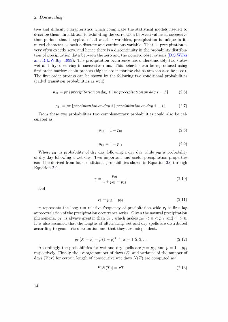
2. Downscaling
tive and difficult characteristics which complicate the statistical models needed todescribe them. In addition to exhibiting the correlation between values at successivetime periods that is typical of all weather variables, precipitation is unique in itsmixed character as both a discrete and continuous variable. That is, precipitation isvery often exactly zero, and hence there is a discontinuity in the probability distribu-tion of precipitation data between the zero and the nonzero observations (D.S.Wilksand R.L.Wilby, 1999). The precipitation occurrence has understandably two stateswet and dry, occurring in successive runs. This behavior can be reproduced usingfirst order markov chain process (higher order markov chains are/can also be used).The first order process can be shown by the following two conditional probabilities(called transition probabilities as well).
p01 = pr {precipitation on day t | no precipitation on day t − 1} (2.6)
p11 = pr {precipitation on day t | precipitation on day t − 1} (2.7)
From these two probabilities two complementary probabilities could also be cal-culated as:
p00 = 1− p01 (2.8)
p10 = 1− p11 (2.9)
Where p00 is probability of dry day following a dry day while p10 is probabilityof dry day following a wet day. Two important and useful precipitation propertiescould be derived from four conditional probabilities shown in Equation 2.6 throughEquation 2.9.
π =p01
1 + p01 − p11(2.10)
and
r1 = p11 − p01 (2.11)
π represents the long run relative frequency of precipitation whle r1 is first lagautocorrelation of the precipitation occurrence series. Given the natural precipitationphenomena, p11 is always greater than p01, which makes p01 < π < p11 and r1 > 0.It is also assumed that the lengths of alternating wet and dry spells are distributedaccording to geometric distribution and that they are independent.
pr [X = x] = p (1− p)x−1 , x = 1, 2, 3, ... (2.12)
Accordingly the probabilities for wet and dry spells are p = p01 and p = 1 − p11respectively. Finally the average number of days (E) and variance of the number ofdays (V ar) for certain length of consecutive wet days N(T ) are computed as:
E[N(T )] = πT (2.13)
14

2.2. Downscaling
V ar[N(T )] ≈ π(1− π)T1 + r11− r1
(2.14)
spell length models (Figure 2.3b) are another alternative for generating occurrenceseries of precipitation. This methodology generates the lengths of wet or dry spellnot by operating on daily basis but instead in form of spells. Different probabilitydistributions are fitted to observed relative frequencies of wet and dry spell lengths.Random numbers are then generated for each length of spell. A new spell length ofopposite type is generated only when previous spell length has ended. The advantageof this method is that precipitation occurrence sequences with different statisticalcharacteristics can be obtained using different distributions for the frequencies ofspell lengths. Various distributions can be used for spell lengths e.g. truncatednegative binomial, negative binomial distribution and mixed geometric distributionare some of the frequently used distributions.
Once a decision about the day being wet or dry is made, the next step is togenerate precipitation amount on a wet day. Daily precipitation amount distributionis strongly skewed toward the right side, with small precipitation amounts occurringcommonly and large precipitation amounts rarely. Different types of theoreticaldistributions have been used in weather generators to estimate non-zero precipitationamount. Most common and simple is the exponential distribution where only oneparameter µ is needed.
f(x) =1
µexp
[
−x
µ
]
(2.15)
Average precipitation in equation 2.15 is µ and variance σ2 = µ2. Comparativelycomplicated distributions such as gamma distribution (Equation 2.16) (with twoparameters: the shape parameter α and scale parameter β and gamma function Γevaluated at α. With distribution mean µ = αβ and variance σ2 = αβ2) and variantof exponential distribution (Equation 2.17) are also used for precipitation amountestimation. The probability density function of the two distributions are:
f(x) =(x/β)α−1exp[−x/β]
βΓ(α)(2.16)
f(x) =α
µ1exp
[
−x
µ1
]
+1− α
µ2exp
[
−x
µ2
]
(2.17)
Equation 2.17 indicates a combination of two exponential distributions with re-spective means of µ1 and µ2. Third parameter α is called mixing parameter. Firstexponential distribution generates precipitation amount with probability α and thesecond one with 1−α. The distribution has mean µ = αµ1+(1−α)µ2 and varianceσ2 = αµ21+(1−α)µ22+α(1−α)(µ1−µ2)
2) (first suggested by Woolhiser and Pegram(1979)). Although the mixed distribution is rarely used, it has been showed that itprovides substantially better overall fits to daily precipitation data than the gammadistribution (e.g. Wilks (1998) and Foufoula-Georgiou and Lettenmaier (1987)).
The major disadvantage of WGs is that they are conditioned using local climaterelationships and so may not be automatically applicable in other climates. They
15

2. Downscaling
Figure 2.3.: Flow charts of precipitation occurrence process in weather generatorsusing (a)Markov chain and (b) Spell length procedures (D.S.Wilks andR.L.Wilby, 1999)
also tend to underestimate inter-annual variability (Fowler et al. (2007)). Further, forfuture climate scenario studies it needs arbitrary adjustment in parameters. Changesin precipitation occurrence parameters may have unanticipated effects on other vari-ables as well.
2.2.2.4. Analog Method
The idea of Analog downscaling is comparatively simple. The method is more ap-plied in weather forecasting than in statistical downscaling of large scale variables.There are very few published examples of usage of analog method as a downscal-ing tool.Zorita et al. (1995), Cubasch et al. (1996) and Biau et al. (1999) are few
16

2.2. Downscaling
of the examples. The main idea of analog downscaling methodology is that similargeneral circulation patterns should provide similar local effects (Obled et al., 2002).Major task then in analog downscaling is to search for best analog of the given dayin the historical archive and associate the corresponding reaction of that circulationpattern to given day’s circulation pattern. Different similarity measures can be usedto search for the best analog. E.N.Lorenz (1969) lists the following assumptions foranalog search approach:
1. that there have been synoptic situations in the past that were not necessarilyidentical but similar to the current one for which a forecast is required
2. that during such situations, local variables, such as precipitation over a medium-sized mountain catchment, react partly in response to the synoptic situation,but also to more local features (e.g. orography, wind channeling, etc. )
3. that for this given day, the part explained by regional circulation will be similarto that observed in analogous situations.
The analog search and application of adopted analog are diagrammatically shownin figure 2.4 and figure 2.5. Given the synoptic patterns characterizing current day,the most similar past situations are looked up in comparatively long meteorologicalarchive and a subset of analog is extracted. Assuming that precipitation amounts arethe predictants of the downscaling process undertaken, for every day of this analogsubset, the rainfall amounts collected over the specific catchment for these particulardays are extracted from a hydrological archive. The resulting amounts provides anempirical sample of the amounts of rain for the current day’s characteristic synopticpattern. Any appropriate theoretical distribution can finally be fitted to the ex-tracted amounts and a probabilistic forecast could be made. It should be noted thatthe process can be performed for the current day for which the synoptic patterns areeither observed values or are simulated by GCM/RCM.
Often reported drawback of use of analog method for downscaling is the need oflong homogeneous record of the large and local scale variables. It has been reportedthat due to the number of degrees of freedom of the large-scale atmospheric circula-tion, several thousand years of recorded data would be needed for finding appropriateanalog. But it has been shown that using different statistical tools (e.g. empiricalorthogonal analysis EOF) most of the degree of freedoms can be reduced as theyare associated with background noise in the data and hence in comparatively shorteravailable records, analogs could be found.
17

2. Downscaling
Figure 2.4.: Step one of analog search process Obled et al. (2002)
Figure 2.5.: Step two of analog search process Obled et al. (2002)
18

2.2. Downscaling
2.2.2.5. Weather typing
The basic idea of weather typing or classification is simple. Atmospheric circulationsare classified in several classes using different schemes and criterions and a poolof historical observations is distributed into these defined classes. For downscalingpurposes, atmospheric circulations simulated by GCMs are classified into the classesdefined earlier. To each observed circulation there exists a simultaneous observationof the local variable, which could be assigned to the simulated circulation either as:
1. an average of all regional observations simultaneous to the elements of thatclass
2. or only the regional observations simultaneous to one element of the class,selected at random.
The choice among the two options depend upon the problem at hand. In case ofsimulation of daily rainfall, opting for case 1 above will in general lead to an under-estimation of the local rainfall variance and extreme events. The rainfall probabilitydistribution may also be different than the observed one. On the other hand, aver-aging over several elements of the class will filter out more effectively measurementerrors at that station. Important aspect of weather typing is the methodology ofclassification employed for identification of classes. The classification can be subjec-tive or objective.
The typical example of subjective classification schemes is the traditional Gross-wetterlagen classification of the German Weather Service for the Western EuropeNorth Atlantic sector (Zorita and von Storch, 1999). This classification has been usedfor downscaling purposes by Bardossy and Plate (1992). Based on local expertiseweather typing procedures have been developed by many national weather servicesfor their particular regions. Subjective schemes of Schuepp (1953) for Switzerlandand Lamb (1972) classification for the British Isles are the most important ones.Local surface variables, typically precipitation, are conditioned on daily weatherpatterns by deriving conditional probability distributions for observed statistics, e.g.p(wet-wet) or mean wet day amount, associated with a given atmospheric circula-tion. Climate change is estimated by evaluating the change in the frequency of theweather classes simulated by the GCM. The method assumes that the characteristicsof the weather classes will not change (Fowler et al., 2007).
Depending upon the methodology employed for classification, objective classifica-tion can technically become quite complicated. Three major schemes of objectiveclassification are:
1. classifications that only depend upon large scale circulation area
2. classifications that depend only on local scale variables
3. classifications that make use of both large scale and local scale variables
X.Cheng and Wallace (1993), used cluster analysis for classification of atmosphericcirculation which is a typical example of first and second class of objective classifi-cation. In the first case the classes of the large-scale circulation are given directly
19

2. Downscaling
by the analysis. In the second case the elements of the large-scale circulation classare defined as the simultaneous circulation to each element of the local climate class.This second method has the advantage that the resulting large-scale classes shouldreally correspond to different local situations, which is not necessarily the case in aclassification based only on the large-scale patterns (Zorita and von Storch, 1999).Classifications that make use of both large scale and local scale variables are com-paratively more complicated. Classification and regression trees (CART) used byBreimann et al. (1984), used for simulation of local daily rainfall is one example ofthis class. However, comparing with the first two categories it needs more computerresources.
2.2.2.6. Short comings of statistical downscaling
The major theoretical weakness of statistical downscaling methods is that their basicassumption is often not verifiable, i.e. that the statistical relationships developedfor present day climate also hold under the different forcing conditions of possiblefuture climates. Another caveat is that these empirically based techniques cannotaccount for possible systematic changes in regional forcing conditions or feedbackprocesses. Long and reliable observed time series of predictant variable is required forestimation of reliable relationship between predictor and predictant. As is the case inRCMs, statistical downscaling methods are also affected by the biases in underlyingGCM. some statistical downscaling techniques e.g. transfer function approaches andweather typing approaches suffer from under prediction of temporal variability.
20

3. Methodology
3.1. Preface
This dissertation employs statistical downscaling methodology to downscale largescale meteorological variable to local scale. Large scale variables (e.g. sea levelpressure, geo-potential height etc.) are classified into certain groups representingdifferent meteorological situations. These different meteorological situations are as-sociated with different local scale variable’s (e.g. precipitation, temperature etc.)reactions. The Weather typing approach of statistical downscaling was introducedin Chapter 2 (2.2.2.5), where different types of classification techniques, namely thesubjective and objective classification, were presented. A fuzzy rule based objectiveclassification method is used here to classify large scale circulation patterns (CPs).The fuzzy rule based classification system was developed by Bardossy et al. (2002).The methodology is further developed in this dissertation to achieve a classificationscheme that is representative of not only floods but droughts as well.
This chapter will present the methodology that is employed in fuzzy rule basedclassification of large scale circulation patterns and is followed by the developmentsmade in the methodology. This chapter will also present the two statistical downscal-ing methodologies which make use of the improved classification system of criticalcirculation patterns explained in the first part of the chapter.
3.2. Fuzzy rule based classification of large scale circulationpatterns
This type of classification of large scale circulation patterns is based on the conceptof fuzzy sets defined by Zadeh (1965). Fuzzy logic works with imprecise/inconclusivestatements and attempts to deduce meaning from them by assigning a membershipfunction to each variable involved in a set. The membership function provides ameasure to represent the degree up to which certain members of a set belongs tothat set. It can be recalled that in conventional set theory a certain variable eitherbelongs to a set or it does not. Detailed methodology of fuzzy rule based classifica-tion is presented in Bardossy et al. (2002); here only a brief necessary background ispresented.
The objective classification and optimization system necessarily consist of threesteps;
1. Transformation of data
2. Definition of fuzzy rules for large scale circulation patterns
21

3. Methodology
3. Classification
Assuming that we have certain large scale predictor data available over a regulargrid in daily resolution, the first step is to normalize the data by calculating anomaliesat each grid point i :
g(i, t) =h(i, t)− h(i, t)
s(i, t)(3.1)
Where g(i,t) is the normalized anomaly vector of the large scale predictor data h(i,t),with a mean and standard deviation of h(i, t) and s(i,t), respectively, for grid pointi and time t.
Bardossy et al. (2002) describes the fuzzy rules as more or less the same as classicalexpression based on logical operators except that in fuzzy rules the consequence andits opposite may both be “true” to a certain degree. Before the actual classificationis performed, however, fuzzy rules of the type IF, THEN, ELSE are described first.The classification is then done by finding the most appropriate rule for the selectedobject (in this case, the calculated strength of daily anomalies). Daily anomalies aredivided in following five classes:
1. Large positive
2. Medium positive
3. Medium negative
4. Large negative
5. Irrelevant
As the names would suggest, the first four describe the anomaly strength at anygiven location on the regular grid, while the last one defines the anomaly that doesnot make much impact on the class as such. A typical fuzzy rule for a certain largescale circulation pattern would thus resemble the following:
IF ( AT LEAST A FEW of the locations (from all available locations) have verylow pressure anomalies) AND (MOST OF the locations (from all availablelocations) have medium low pressure anomalies) AND (MOST OF the locations(from all available locations) have medium high pressure anomalies) AND ( ATLEAST A FEW of the locations (from all available locations) have very highpressure anomalies) THEN the CP is i.
Thus a CP k on a day can be described as a vector that contains index values from 1to 5, corresponding to anomaly strength at each grid point i, v(k) = (v(1,k),...v(I,k)).The rule system for all CPs can thus be represented by the matrix V as:
V =
v(1, 1) · · · v(I, 1)· · ·· · ·· · ·
v(1,K) · · · v(I,K)
(3.2)
22

3.2. Fuzzy rule based classification of large scale circulation patterns
Once the data transformation and fuzzy rule development is performed, the daysare classified as belonging to distinct circulation patterns by calculating the degreeof fulfillment (DOF) for each rule:
DOF(k, t) =
4∑
m=1
1
Nk,m
∑
v(i,k)=m
µm(g(i, t))pm
(1/pm)
(3.3)
Assuming that fuzzy rules are developed such that there are m classes, then Nk,m
is the number of grid points that are assigned to each class in rule k. µm is the mem-bership function of the anomalies corresponding to defined strength of anomalies,and pm is used for taking care of small differences in calculation of exact location ofthe anomalies. The rule which obtains the highest value of DOF(k,t) is selected asgoverning CP for day t.
The fuzzy rule based classification was developed for downscaling the climate vari-ables of precipitation and temperature. Circulation patterns were classified in num-ber of different classes and based upon certain statistics, indicators and formulationof objective functions; critical circulation patterns (CPs) were distinguished fromnormal CPs. The indicators were developed keeping in mind the objective of thestudy, in most cases being floods. Hence a precipitation and temperature based clas-sification was used for flood producing CPs. The methodology was further developedby Bardossy and Filiz (2005) where, instead of precipitation, discharge was used toidentify critical circulation patterns related to floods. The daily discharge time serieswas changed to a daily positive discharge increment series with a 1 day lag and usedas the predictant. The idea behind using discharge based with a 1 day lag was tobetter capture the reaction of the catchment, as higher discharge may result becauseof precipitation that had occurred a day earlier. Hence the delayed reaction timeof the catchment is attempted to be captured using this methodology. The dailydischarge data set is first changed to discharge differences on 1 day lag (∆Q), and anew variable Z(t) is used to classify large scale variable with:
Z(t) =
{
∆Q(t), if ∆Q(t) > 0;
0, otherwise.(3.4)
The optimal rules were obtained in Bardossy et al. (2002) who introduced thefollowing two objective functions: one related to the occurrence of days with a largepositive discharge increment (Equation 3.5), and second, related to the amount ofdischarge increment (Equation 3.6) as follows:
O1 =
S∑
s=1
√
√
√
√
1
T
T∑
t=1
(p(z0(CP (t) = i))− pz0)2 (3.5)
O2 =
S∑
s=1
1
T
T∑
t=1
∣
∣
∣z(CP (t) = i)z − 1
∣
∣
∣ (3.6)
23

3. Methodology
p is the probability of an increase in discharge, exceeding threshold z0 on a certainday, while p(z(CP(t)=i)) is the same probability but conditioned upon the occur-rence of CP i on day t. In the second equation, z is the mean increase of dischargeincrement amount on a certain day, while z(CP (t) = i) is the same amount but con-ditioned upon the occurrence of CP i on day t. Both Equation 3.5 and Equation 3.6are summed over all the gauge stations S. Both of these objective functions wouldresult in higher values if the relative increase in occurrence and amount of dischargeincrement given certain CP classification, is large than it is when no classification isconsidered at all. Both the objective functions are added to one objective function(with a possibility of giving different weights to each one, depending upon the need)and maximized with the help of a simulated annealing algorithm.
Above methodology was developed to obtain a classification that explains andidentifies critical circulation patterns related to extreme flood events. Droughts areanother extreme manifestation of a hydrological system that need to be consideredin relation to large scale circulation pattern classification as well as downscaling.Floods are associated with certain meteorological and hydrological situations (fre-quent heavy rainfall, antecedent conditions, glacial melt) to which approximate de-grees of certainty can be ascribed. Droughts, on the other hand, are associated withconditions which are difficult to predict. The time scales involved for these two ex-tremes are very different in that floods could occur after a few hours of consistentheavy rainfall and pass through certain area within hours, whereas droughts are char-acterized by slow onset and unclear end. Thus bringing with them the impacts whichare spread over larger geographical areas. Therefore droughts are rightly consideredto be the most complex and least understood hydrological phenomenon of the two.In the following, two methodologies are presented for large scale circulation patternclassification that are hoped to give a more robust classification of large scale circula-tion patterns. The aim of the classification is to achieve a single classification systemthat gives distinct “critical” circulation patterns both for floods and droughts.
3.2.1. Low discharge based objective function
Low flow based objective function, as the name suggests, is based again on dailyriver discharge increments/decrements but instead of working with the discharge in-crements values above certain threshold value (like 95th percentile value), here, limitson the probability distribution function of the discharge increments/decrements areused. As explained in the previous section, daily discharge values recorded at certaingauge stations can not be directly linked with atmospheric circulation. For a selectedday, the river discharge amount is the function of several processes that include base-flow, interflow, antecedent soil moisture content and glaciel melt, etc. Hence, if ahigher discharge has been recorded on a day at certain location x1 this may prob-ably be because of heavy precipitation occurring at location x2 or glacier meltingat x3 due to higher temperatures . Therefore it might not be appropriate to relatethe high discharge at location x1 with flood producing large scale circulation pattern.
While discharge at a certain location x1 and time t1 can not be directly linkedwith the corresponding large scale active circulation pattern at the same time t1, it
24

3.2. Fuzzy rule based classification of large scale circulation patterns
can, however, be written as a function of precipitation, which can be directly linkedto atmospheric circulation. Hence, if for a certain catchment A the lag time ∆t isknown then the discharge can be written as:
Q(t) =
∫ t
t−∆t
∫
Ah(P (x, t))dxdt+KQ(t− 1) (3.7)
where h is the rainfall-runoff transformation process, K represents memory of thedischarge and is constant (usually equal to 1), Q(t) is the discharge amount at timet of catchment A which understandably is a function of precipitation P at certainlocation x. Discharge difference series can thus be formulated as:
∆Q(t) = Q(t)−Q(t− 1) =
∫ t
t−∆t
∫
Ah(P (x, t))dxdt− (1−K)Q(t− 1) (3.8)
Equation 3.8 represents daily discharge increments and is strongly related to theprecipitation. It is very small for dry periods, positive for increasing limb of hy-drograph and negative right after the flood wave. Figure 3.1 shows the discharge,discharge increment/decrement and positive discharge increment series for gaugestation Ettlingen at Alb catchment in southern Germany for year 1982. It can beseen that the discharge increment/decrement series is closely related to precipitation.From this the following objective functions can thus be formulated:
O3 =1
T
T∑
t=1
∣
∣
∣
∣
logdQ+(CP (t))
¯dQ+
∣
∣
∣
∣
(3.9)
dQ+(t) is the positive values of discharge increment series. This value is closely re-lated to precipitation and increases as precipitation amount dQ+(t) = max(0, dQ(t))increases. As mentioned earlier, this condition although is true, it is not alwaysnecessarily the case . Since discharge may increase due to other reasons. Differentpre-event conditions stimulate different catchment reactions from the same precipi-tation event. Thus the second objective function to be defined takes in to accountthe occurrence of positive discharge increments as follows:
O4 =1
T
T∑
t=1
(pdQ+(CP (t))− ¯pdQ+
)2 (3.10)
Within the time period T , this objective function when maximized using opti-mization algorithms, will maximize the difference between CP conditioned relativefrequency of dQ+(t) > 0 (pdQ+
(CP (t))i at station i) and the unconditional relativefrequency ¯pdQ+
of a day with dQ+(t) > 0 for all days.
For dry periods, the classification based on an objective function related with smalldischarge changes is presented. While the large positive discharge increment timeseries of a river indicates large amount of precipitation in the area, small dischargechanges indicate the dry period in the river’s catchment system. Additionally largepositive discharge changes in regulated rivers can be misleading, as they might wellbe an anthropogenic change in the river discharge. Referring to the time series of
25

3. Methodology
Figure 3.1.: Daily discharge (thick solid black line), discharge increment/decrementon 1 day lag (thick dashed black line), positive part of discharge incre-ment on 1 day lag (thick solid gray line) and daily precipitation (thingray solid lines) for Alb catchment for year 1982
discharge, discharge increment/decrement and positive part of discharge incrementin Figure 3.1, one can see that most of the time series consist of small dischargechanges, and they change to large changes only when there is additional water intro-duced in to the system. Hence the “equilibrium” state of the time series is disturbedeither by additional precipitation coming from the atmosphere and/or from any riverregulation authority managing the flow in the rivers. Hence, the extreme increaseand decrease in the time series of discharge increment/decrement, displayed by curvein Figure 3.1 is specific to each river. This is because topography, land use, nature ofcatchment drained by the river, and antecedent state of the river plays an importantrole also. Small discharge changes, on the other hand, are always related to the drystate of atmosphere, that is independent of the catchment properties. Thus we canestablish a mathematical link between discharge and the dry state of atmosphereby considering an objective function for classification of circulation patterns that isbased on low flow or small discharge changes.
The dry state of atmosphere can thus be represented by an indicator IdQ(t):
IdQ≈0(t) =
{
1 if pmin ≤ FdQ(dQ(t)) ≤ pmax
0 else(3.11)
26

3.2. Fuzzy rule based classification of large scale circulation patterns
Figure 3.2.: Daily discharge difference series on 1 day lag (thick solid black line) alongwith the two limits (thick solid gray lines) representing the “equilibrium”state of Alb catchment for year 1982
Where FdQ is the probability distribution function of the discharge differences.The equilibrium state of the catchment is represented by the limits pmin and pmax
which are defined as 0 < pmin < pmax < 1. Two conditions must be consideredregarding the selection of pmin and pmax:
1. No major flood should have occurred/included between these limits
2. All non-natural discharge increments (or decrements) must remain in the in-terval [F−1
dQ (pmin), F−1dQ (pmax)]
A choice of pmax = 0.75 and pmin = 0.25 can be used if no specific informa-tion on discharge regulations is available. Figure 3.2 displays the discharge incre-ment/decrement time series for 1982 of the Alb catchment along with the limits forthe low discharge changes corresponding to pmax = 0.85 and pmin = 0.20.
The third objective function based on discharge can thus be written as:
O5 =1
T
T∑
t=1
(pIdQ≈0(CP (t))− ¯pIdQ≈0
)2 (3.12)
27

3. Methodology
3.2.2. An objective function based on a cluster of precipitation stations
One potential problem with the optimization of the objective functions of the typepresented in Equations 3.5 and 3.6, is that the shape of objective function obtainedfrom them is extremely irregular. This might make it difficult for the optimizationalgorithm to reach to a global maximum (or minimum). It is especially true in casethe algorithm attempts to optimize the objective function for each individual gaugestation involved. An objective function with less irregular shape may result in betterclassification. Areal precipitation (zA(t)) is one variable that can used instead ofpoint precipitation. For a certain catchment A, the objective function based on arealprecipitation (zA(t)) can be written as:
O6 =1
T
T∑
t=1
∣
∣
∣
∣
logzA(CP (t))i
zAi
∣
∣
∣
∣
(3.13)
Where
zA(t) =
∫
Az(x, t) dx
Large scale critical circulation patterns by definition affect larger areas. If a wetCP is considered then the area affected by it, in terms of amount of precipitationreceived, should be large. Some isolated precipitation events, although important,may not necessarily be because of a large scale circulation pattern and may justinstead be a local phenomenon. Thus, an objective function should be developed totake into consideration total precipitation that is encompassed in a certain area bya certain rainfall event. This objective function should also not be affected by thehigh skewness of precipitation amounts. For a certain catchment, the ratio of wetprecipitation stations (precipitation greater than certain threshold amount) to totalprecipitation stations in a neighborhood ∆ is calculated and used in the objectivefunction as:
C∆(t) =#{xi
∣
∣
∣ xi ∈ ∆ , z(xi, t) > 0}
#{xi
∣
∣
∣ xi ∈ ∆}(3.14)
O7(η) =
√
√
√
√
1
T
T∑
t=1
(pC(CP (t))i − pCi)2 (3.15)
Where # is the total number of elements in a set of precipitation stations, pC(CP (t))iis the relative frequency of the coverage exceeding a selected threshold η on a daywith given CP at station i and pCi is the relative frequency of a day with coverageexceeding 0 ≤ η < 1 for all days without classification and within the time period T .
Wet and dry conditions in the catchment can be captured using the above objectivecondition by manipulating the value of η in Equation 3.15. If η = 0, the objectivefunction then helps to identify situations where no precipitation in the neighborhood
28

3.3. Statistical downscaling of precipitation
∆ is found; this indicates prevailing dry situations. Alternatively, if η is close to1, the objective function helps to identify situations where precipitation is found inwhole of the neighborhood ∆; this indicates then very wet situations. Thus, thecombination such as O4 = O4(0) + O4(0.999) provides an objective function thatmight lead to CPs corresponding to very wet and very dry situations.
3.3. Statistical downscaling of precipitation
Chapter 2 presented the need for downscaling of large scale variables from large scaleto local scale. Different methodologies employed in downscaling were also presented,namely, statistical downscaling (2.2.2) and dynamical downscaling (2.2.1) along withthe different procedures for each methodology. The initial part of this chapter pre-sented the methodology for achieving a set of circulation patterns which describe as awhole the weather situation in a certain study area with emphasis on identifying crit-ical circulation patterns related to floods and droughts. In this section, the statisticaldownscaling approach, based on the classification obtained from methodology in thefirst part, is presented. Two statistical downscaling methodologies are explained; oneis based on Bardossy and Plate (1992) and the PhD dissertation of Yang (2007), andthe other methodology concerns the downscaling from RCM generated data usingCP based quantile-quantile exchange of precipitation amounts for bias correction.
3.3.1. Statistical downscaling based on the conditional multivariatedownscaling approach
The statistical downscaling is based upon multivariate autoregressive model, param-eters of which depend upon atmospheric circulation pattern. Using this downscalingtechnique daily rainfall is modeled such that the spatial and temporal dependence ofthe original time series is maintained in the modeled time series. The spatial depen-dence is the model is captured by spatial covariance matrices. Temporal dependencein the model is captured by logistic regression technique which uses combined term ofmoisture flux (geostrophic wind and specific humidity) as regressor. In the followingthe components of model (occurrence model, amount model and spatial dependencestructure) are briefly described.
Precipitation occurrence is modeled using logistic regression. Moisture flux (MF)is used as a predictor in the logistic regression equation. In previous studies, oc-currence of precipitation was tied only to occurrence or non-occurrence of certaincirculation patterns. Although precipitation occurrence probabilities achieved onlyfrom coupling of circulation patterns did provide reasonable results, they did result ina static model. Precipitation occurrence not only depends upon weather state, rep-resented by circulation patterns, but also on multitude of other continuous variables.Moisture flux is thus used as an additional parameter and predictor in the logisticregression equation with rainfall probability as predictant. Moisture flux is supposedto catch within-type dynamic variability during classification of circulation patterns.It is a combined term achieved from geostrophic wind (summation of both u andv components of wind field) and specific humidity (sh). The moisture flux is thussupposed to describe the amount of water vapor transported by the wind in or out
29

3. Methodology
of the selected area, and, consequently, influences the occurrence or non-occurrenceof precipitation.
MF (x, t) = (u(x,t)+ v(x,t)) .sh(x, t) (3.16)
All the terms are for certain location x and time t. The logistic regression is definedas:
y(x, t) =1
1 + exp(b0(x, t) + b1(x, t).MF1(x, t) + b2(x, t).MF2(x, t) + ...+ bk(x, t).MFk(x, t))(3.17)
b0, b1...bk are the parameters of the logistic regression equation and MF’s are themoisture flux values considered for for location x and time t. They are approximatedusing fourier series.
b0(t∗) =
a0(i, x)
2+
K∑
k=1
(ak(i, u)cos(kwt∗) + bk(i, u)sin(kwt
∗)) (3.18)
and
b1(t∗) =
c0(i, x)
2+
K∑
k=1
(ck(i, u)cos(kwt∗) + dk(i, u)sin(kwt
∗)) (3.19)
ak, bk, ck and dk are the coefficients of harmonics of fourier series, b0 and b1 are theapproximated parameters of the regression equation, i is the CP, x is the location,K is the total number of precipitation stations and t∗ is the julian day of the year.
The precipitation amount distribution is highly skewed and unlike precipitationoccurrence, which is modeled as discrete process, is a continuous process. Differentprobability distribution models have been used for the simulation of precipitationamounts e.g. weibull, transformed normal and gamma distribution. The exponentialdistribution model is used here for the precipitation amount process. For a certainvariable value x,its probability density function can be written as:
f(x) = λ.exp(−λ.x) (3.20)
Where x and λ are always greater than 0 . λ is the parameter of exponentialdistribution controlling the shape of distribution function and is estimated using themaximum likelihood estimator.
L(λ) =∑
Z(t,u)≤Z0
(λ(t, u).x) +∑
Z(t,u)>Z0
(lnλ(t, u)− λ(t, u).x) (3.21)
λ(t, u) =1
µ0(t∗, u) + a.MF(3.22)
where Z(t, u) is daily precipitation amount at time t and location u and µ0(t∗, u)
is the expectation of precipitation on the julian day t∗.
30

3.3. Statistical downscaling of precipitation
The spatial structure of precipitation is taken care of by using spatial covarianceand auto-correlation. Instead of calculating the two measures directly from precipi-tation values, a binary indicator variable based on certain threshold value is used toregionalize the precipitation in certain catchment.
I(u, z) =
{
1, if z(u) ≤ z;
0, otherwise.(3.23)
z(u) is the precipitation amount at certain location u and z is the cutoff cor-responding to the conditional cumulative distribution of the precipitation amount.I(u, z) is thus a binary variable which is used in the subsequent calculation of Γ0i, thespatial covariance matrix, and Γ1i, the space-time covariance for one day lag. BothΓ0i and Γ1i are calculated independently for each CP considered in the classificationsystem.
Γ0i(t∗) = E
[(
W (t)− wi(t∗))(
W T (t)− wTi (t
∗))]
(3.24)
Γ1i(t∗) = E
[(
W (t− 1)− wi(t∗ − 1)
)(
W T (t)− wTi (t
∗))]
(3.25)
Auto-correlation factor r(t∗) links Γ0i and Γ1i as:
r(t∗) =Γ1i(t
∗)
Γ0i(t∗)(3.26)
The spatial structure of rainfall is described using Equation 3.27, where parameterspi and qi depend upon circulation pattern i and the day t∗of the year.
cov[Wx(t∗, u),Wy(t
∗, u)]i(t) = Pi(t∗)e−h(x,y)qi(t
∗) (3.27)
Where h(x, y) is the distance between two considered stations x and y. Finallyprecipitation series is generated for each day using:
W (t, u) = r(t∗)(W (t− 1, u) + Ci(t∗)ψ(t) (3.28)
Where ψ(t) is the random number of independent N(0, 1) random variables. Avector ψ(t) can also be used to generate multiple realizations of precipitation for eachday. Ci(t
∗) matrix takes spatial variability of the process into account and is relatedto W(t) through Equations 3.24 and 3.25 by:
Ci(t∗)CT
i (t∗) = Γ0i(t
∗)− Γ1i(t∗)Γ−1
0i (t∗)ΓT
1i(t∗) (3.29)
Using the relation in Equation 3.26, one could reach
Ci(t∗)CT
i (t∗) = (1− r2(t∗))Γ0i(t
∗) (3.30)
The decomposition of Ci(t∗)CT
i (t∗) is detailed in Bardossy and Plate (1992).
31

3. Methodology
3.3.2. Statistical downscaling based on quantile-quantile bias correctionapproach
The second statistical downscaling approach is based on the bias correction of re-gional climate models (RCM) output using quantile-quantile correction. Chapter2 introduced dynamical downscaling and Section 2.2.1.1, specifically, penned thedrawbacks of the use of regional climate models as a downscaling tool. One ofthe shortcomings of RCM is the transfer of bias from the global circulation model(GCM),through which the bias present in the GCM generated data is systematicallytransferred to the underlying RCM.
Since GCMs are usually considered to yield unrealistic results on spatial scalessmaller than several grid cells, there is in general little confidence in the simulated,regional-scale climate variability. In particular, the regional precipitation in the mod-els is discounted, because precipitation can be strongly influenced by subgrid-scaleprocesses, some of which are parameterized while others, such as details of the land-water distribution or topography, are not represented at all (Widmann et al., 2003).RCMs downscale the GCM provided data to the local scale assuming that the at-mospheric variability on small spatial scale is conditioned by larger scales. Even ifRCMs improve the realism of simulated regional climate properties, some importantbiases may still exist, especially concerning precipitation that need to be corrected(A.W.Wood et al., 2004). Houghton et al. (2001) mentions that GCMs display area-average biases that are highly variable from region to region and among models, withsub-continental area averaged seasonal temperatures biases typically within 4◦C andprecipitation biases mostly between -40% and +80% of observations. RCMs on theother hand while improving upon the spatial detail of simulated climate comparedto GCMs show area-averaged temprature biases generally within 2◦C and precipi-tation biases within 50% of observations. Nonetheless, RCMs are useful in impactstudies whereby upon subjection of different forcings (approximation of patterns ofdevelopment in future world and associated green house emission scenarios) they canprovide useful insight in to the future projected climates. This particular property ofRCM make them an important and necessary tool in climate change impact studies.Regarding their inadequency in simulation of different climatic variables, differentstatistical techniques can be applied to correct them. Michel (2007) proposes classesof correcting techinques that could be applied to outcomes of RCMs. Consideringthe output from the RCM model as M and some reference value as R, one can writethe impact I as the difference of the two:
I =M −R (3.31)
Given that M is provided (in most cases) by RCM and, as discussed earlier, thatRCM inherit bias from GCMs, I would include that bias as well. Different statisti-cal methods can be employed to bring the inherit bias in RCMs to some reasonableacceptable levels and thus giving more value to the I.
1. The delta method: In this method the terms M and R in Equation 3.31(both can be considered as daily values), are replaced by O+ (M −R) and O,
32

3.3. Statistical downscaling of precipitation
respectively. Where O is an equivalent series of (daily) observation data andrepresents a multi-annual average operator. This method of bias correction,although being very robust, assumes the availability of daily data. It also as-sumes that the climate variability is unchanged in the scenario projection.
2. The unbiasing method: The terms M and R in Equation 3.31 (both can beconsidered as daily values), are replaced by M +(O −R) and R+(O −R), re-spectively. This method although does corrects the mean error, it does assumethat the variability of the RCM is good.
3. The regime method: Here the terms M and R in Equation 3.31 (both canbe considered as daily values), are replaced by O(d2) and O(d1), respectively.d1 and d2 are dates chosen in the observation dataset. This method is alsoemployed in cluster and analogue techniques. The drawback of this methodis that, although it can change the frequency of the different meteorologicalevents, it can not produce events that are not recorded. It is also not a verysuitable method when working with extremely high temperatures or extremelyhigh precipitation events.
The method used here is a CP based quantile-quantile exchange of RCM generatedprecipitation amounts in control runs with that of observed time periods. Hence itis a variable correction method that compares quantiles between two data sets. Theterms M and R in Equation 3.31 are equated to f(M(d)|O) and f(R(d)|O), respec-tively. This way it is assumed that RCM is able to predict the ranked category ofprecipitation but not the actual value of precipitation. In other words the qualitativeforecast/prediction of RCM can be trusted but not the quantitative part of that fore-cast/prediction. That is why there is the need of correcting that quantitative partof RCM, which in this case is the precipitation amount on the wet days. The precip-itation distribution generated by RCM (control runs) is related to the precipitationdistribution of the observed time series for the same time period. The precipitationamounts are corrected in control time periods of RCMs and for future scenarios thequantiles from control periods are used. This way, the downscaled precipitation sig-nal becomes similar to the RCM generated signal and the bias is corrected. Thedownscaling process can be written as:
ZD(x, t) = F−1O (FR(ZR(x, t), x), x) (3.32)
Where ZR(x, t) is the precipitation at location x and day t simulated by the RCM,ZO(x, t) is the observed precipitation at location x and day t available for t ≤ TO.FO(z, x) is the distribution function of the observed precipitation amounts at locationx while the corresponding RCM precipitation distribution for the control climate runis FR(z, x).
This kind of transformation ensures that if control period and observation periodare identical and the model is able to reproduces the observations perfectly then:
ZD(x, t) = ZO(x, t) (3.33)
33

3. Methodology
else one can at least assume that
FO(z, x) = FD(z, x) (3.34)
The transformation can be applied either universally without any added conditionson days, seasons etc., or for selected time periods (seasons) separately. The secondcase would naturally be the ideal choice, since one can reproduce season specificprecipitation phenomena in the downscaled precipitation series. For precipitationdistribution FO, the following choices could be considered.
The first is to use the empirical distribution function. This method has of coursethe advantage that no distribution is needed to be fitted, but the possible criticaldisadvantage could be that the maximum observed precipitation amount can notbe exceeded in the downscaled time series. The second possibility- which is a bittedious- is to assign to each location (precipitation station, or grid point) a proba-bility describing the location/grid point experiencing a dry day and then fitting acontinuous distribution to amounts on the wet days. The problem of maximum pre-cipitation in downscaled time series exceeding maximum observed in observationaltime series can be overcome, though at the cost of selecting an appropriate distribu-tion and estimating its parameters for each location/grid point.Different continuousprobability distributions can be used to fit to the amounts on wet days. Weibulldistribution is selected to be used in this thesis owing to its relative simplicity inparameter estimation and its flexibility.
Weibull distribution is a two parameter distribution function closely linked withexponential and normal distribution. The two parameter Weibull probability densityfunction with parameters δ and β > 0 is given by:
fX(x) =β
δ
(x
δ
)(β−1)exp
[
−(x
δ)β]
(3.35)
for x > 0. For all other values the function equates to 0. The cumulative distributionfunction for x > 0 can be written as:
FX(x) = 1− exp[
−(x
δ)β]
(3.36)
The scale parameter δ controls the spread of the distribution, and the shape pa-rameter β controls the form of the distribution. Weibull distribution is flexible inthat at β value near 3.6, it closely approximates Gaussian distribution, while at βequal to 0, it approximates exponential distribution (Figure 3.3).
The bias in RCMs predominantly comes from the underlying GCMs. GCMs areknown for not representing the effects of local scale phenomena such as topography,orography, near surface wind speed etc., in their simulations. On the other hand,large scale variables such as sea level pressure and geopotential heights are skillfullysimulated by GCMs. In the first section of this chapter, identification of circula-tion patterns was discussed based on sea level pressure. The circulation patternsare believed to represent different climatic conditions efficiently. The errors in RCMsimulations may come from different sources and it is believed that introduction ofidentified circulation patterns in the development of relationship between controlperiod precipitation and observed precipitation, can bring physical meaning to and
34

3.3. Statistical downscaling of precipitation
Figure 3.3.: Weibull probability density functions for different values of δ and β(D.C.Montgomery and Runger, 2002)
potentially improve the downscaling procedure which is purely a statistical correc-tion. The fact that the precipitation amounts corresponding to different circulationpatterns might change differently in the future,is taken into account in Equation3.37. As non-stationary relationship is assumed between CPs and precipitation, theprecipitation amounts would change if CP characteristics are changed.
ZD(x, t) = F−1Oα(t)
(
FRα(t)(ZR(x, t), x), x)
(3.37)
Where α(t) is the circulation pattern on day t for either the control or future runsof RCM generated data sets.
This methodology of bias correction and development of new scenarios from RCMdata is applied to three different regional climate models for precipitation and tem-perature. RCMs used in this study are presented in the following chapter. Thedownscaled results and its application to regional hydrological model is presented inchapter 6 and Chapter 8 respectively.
35

36

4. Catchments and Data
This chapter presents the information regarding the catchments and precipitation anddischarge stations therein, that are used in application of methodology presented inthe previous chapter. Sources and availability of data is also discussed.
4.1. Catchments & Data
Two major sets of data and catchments were used for application of the method-ologies developed and explained in Chapter 3. The first set of data was kindlyprovided by the Federal Ministry of Education and Research (Bundesministeriumfur Bildung und Forschung, BMBF. ) funded project “Operational Discharge andFlooding Predictions in Head Catchments” (Operationelle Abfluss- und Hochwasser-vorhersage in Quellgebieten, OPAQUE). This set of data was used in developmentof identification of circulation patterns related with extreme hydrological and mete-orological situations and downscaling using circulation pattern based autoregressivemultivariate statistical method. The second set of data was kindly provided by Euro-pean union (EU) funded 6th Framework program’s project ENSEMBLES (contractnumber: GOCE-CT-2003-505539). This set was primarily used for application ofidentified critical circulation patterns and statistical downscaling of RCM data fornew scenario generation.
4.1.1. OPAQUE Catchments & Data
One of the task in OPAQUE project was to better represent the hydrology of fourimportant head catchments in different parts of Germany. Given that head catch-ments by definition have very short reaction time, it is important to have very preciseoperational prediction system. In addition to have better understanding of the hy-drology of head catchments, it is also very necessary for forecast purposes to havevery distinct set of critical circulation patterns based on which precise forecasts couldbe made.
Four head catchments, three present in southern Germany and one in the eastwere considered for identification of critical circulation patterns. The location of thecatchments are shown in figure 4.1. The size (in Km2) of each catchment is includedin brackets.
Upper Danube catchment, mainly consist of two rivers Breg and Brigach that joinat Donaueschingen to make river Danube. Daily and hourly discharge data for thetwo rivers of Breg and Brigach, shown in Figure 4.2, were provided from 1991 to 2006.Daily precipitation data was also provided for over 100 precipitation stations in thiscatchment with varying lengths of records. Table 4.1 shows the precipitation stations
37

4. Catchments and Data
Upper Danube (525 Km2)
Iller (250 Km2)
Alb (150 Km2)
Weisseritz (384 Km2)
Figure 4.1.: Location and size of catchments under study in OPAQUE Project.
used in classification and downscaling processes. These 7 stations were selected onthe basis of length of precipitation data associated with each station.
Upper Danube floods are usually caused by the simultaneous effect of intense rainand snow melt in the Black forest region. The long-time average runoff at the gaugeDonaueschingen/Danube is 9 m3/sec. During the flood event of January 1995 thepeak runoff of the Danube in Donaueschingen reached 312 m3/sec, roughly equal to50-year flood (Figure 4.3).
Table 4.1.: Selected precipitation stations of Upper Danube catchment.
X Y Alt. (m.a.s.l) Station ID Name
3478811 5304953 738 70194 Wellendingen3436453 5307117 846 70204 Titisee3440230 5310783 870 70206 Titisee-Langenordnac3440153 5303372 818 70207 Lenzkirch3451390 5305119 830 70208 Feldberg (Wst.)3443947 5308892 928 70209 Friedenweiler3450079 5297718 875 70210 Bondorf
38

4.1. Catchments & Data
Figure 4.2.: Upper Danube catchment in detail.
Figure 4.3.: Daily average discharge (to the left) and 1995 flood event discharge (tothe right) for River Breg (Black) and Brigarch (Gray). Daily average iscalculated from 1991-2006, excluding flood year 1995.
39

4. Catchments and Data
Weisseritz catchment is another head catchment which was studied for extremeflooding events. Weisseritz catchment is drained by two rivers called Rote Weisseritzand Wilde Weisseritz originating in the eastern ore mountains at the Czech-Germanborder close to Altenberg. The two branches join at the city of Freital to form theUnited Weisseritz (Vereinigte Weißeritz). Daily mean and monthly mean discahrgedata for number of gauge stations was available for this catchment. The temporallength of data varied from gauge station to gauge station. Daily precipitation stationdata for 7 stations were provided from 1947 to 2006. The details of the precipitationstations are provided in Table 4.2. The main flooding event in this catchment wasAugust 2002 flood which was 100 year flood event and caused significant damage toproperty and life. The location of the rivers are shown in Figure 4.4 while mean dailydischarge calculated for period 1971-2001 at location Freital and daily discharge forflooding year of 2002 at the same location are shown in Figure 4.5.
Figure 4.4.: Weisseritz catchment in detail.
Table 4.2.: Selected precipitation stations of Weisseritz catchment
X Y Alt. (m.a.s.l) Station ID Name
5421640 5654650 114 41080 Dresden-hosterwitz5411750 5623281 877 41135 Zinnwald5406202 5641924 365 41242 Dippoldiswalde5412504 5667779 227 41524 Dresden-Klotz.5382836 5646108 380 42235 Freiberg5394025 5619901 615 42351 Neuhausen5391632 5618095 593 42354 Neuhausen-Erzbeg.
40

4.1. Catchments & Data
Figure 4.5.: Daily average discharge (to the left) and 2002 flood event discharge (tothe right) for all the rivers in Weisseritz catchment. Daily average iscalculated from 1971-2001.
Iller river is in Southwestern Germany. It is on German-Austrian border and is oneof the most important tributary to the German part of Danube. The highest point ofthe catchment is at 3000 m.a.s.l while the lowest is at 650 m.a.s.l. Daily and sub-dailydata, both for precipitation and discharge was available for number of precipitationand dischrage stations along the upper Iller river. The precipitation stations used forclassification and downscaling purposes are tabulated in Table 4.3. Iller has alpineand sub-alpine flow regime with low flows in winter, medium flows in summer andhigh flows during the snow melt season of spring. Among the number of floods thathave occurred in this river the most important one in terms of destruction and lossof lives was the summer flood of May 1999. The peak discharge at gauge stationKempton was 850 m3/sec (mean annual flow at gauge Kempten is 47 m3/sec). Thiswas 100 year flood event. The flood of August 2005 had a return period of 300-400years (peak discharge at gauge station Kempton =900 m3/sec) but had significantlysmaller associated losses because of the flood protection measures taken after 1999flood.
41

4. Catchments and Data
Figure 4.6.: Iller catchment in detail. Whole catchment is to the left and upper Illercatchment to the right.(Left figure courtesy of http://de.wikipedia.org/wiki/Iller)
Table 4.3.: Selected precipitation stations of Iller catchment
X Y Alt. (m.a.s.l) Station ID Name
4369046 5245938 950 90215 Oberstdorf-Birgsau4369947 5252498 810 90216 Oberstdorf4369641 5259487 757 90226 Fischen4371550 5265315 754 90233 Sonthofen4378410 5262048 828 90243 Hindelang4356042 5270527 745 90251 Oberstaufen4365169 5269073 935 90252 Immenstadt (Warterhaus)4366367 5270219 731 90253 Immenstadt (Liststr.)4380871 5284116 896 90254 Durach4373961 5273264 865 90256 Rettenberg
42

4.1. Catchments & Data
Figure 4.7.: Daily average discharge (to the left) and 1999 flood event discharge (tothe right) of all the rivers in Iller catchment(gauge:Kempton). Dailyaverage is calculated from 1971-1991.
43

4. Catchments and Data
Alb catchment is another head catchment studied for extreme hydrological condi-tions in this study. Alb is to the west of Black forest in southern Germany. It hasits source in the northern black forest at about 750 m.a.s.l and leaves black forestnear Ettlingen entering into the Rhine valley. Daily discharge data at gauge stationEtllingen from 1980 to 2009 and daily precipitation for the stations Tabulated in Ta-ble 4.4 from 1971 to 2009 was available for the forthcoming analysis of classificationand downscaling. The major floods in this catchment were in 1995 and 1998 (Figure4.8).
Table 4.4.: Selected precipitation stations of Alb catchment
X Y Alt. (m.a.s.l) Station ID Name
3524930 5357540 740 61314 Hohenstein3461030 5392270 600 61373 Enzkloesterle3446160 5391410 750 61377 Forbach3466000 5401485 740 61485 Wildbad3462750 5406450 717 61529 Dobel
44

4.1. Catchments & Data
Figure 4.8.: Daily average precipitation and discharge ( in gray) and 1998 flood eventprecipitation and discharge (in black) of river Alb . Averages are calcu-lated from 1971-1995, excluding flood year 1998.
All the four catchments are small head catchments that are drained by small riversnamed above. All these rivers on its way either join or turn into some of the largestrivers in Central Europe (Rhine, Danube, Elbe). Therefore its is very importantto understand the climatological conditions that result in large scale floods in thesehead catchments. Given that there are huge population concentration along thesebig rivers it becomes more important to identify the circulation patterns that resultin extremely large floods and use that information for predicting future flows.
4.1.2. ENSEMBLES Catchments & Data
This set of data, in addition to analysis for extremes, was also used in application ofquantile-quantile basede bias correction of RCM data for downscaling purposes. Thedata was kindly provided by EU funded project 6th Framework program’s projectENSEMBLES (contract number: GOCE-CT-2003-505539). The results presentedhere are part of the results that were submitted to ENSEMBLES deliverable No.D5.36 titled “Optimization of the objective drought CP classification” and deliv-erable No. D5.37 titled “Validation of critical CPs associated with hydrologicalextremes”. The deliverables were submitted while working for research theme 5(RT5) of the project. The aim of RT5 was to perform a comprehensive and inde-
45

4. Catchments and Data
pendent evaluation of the performance of the ENSEMBLES simulation-predictionsystem against analyses/observations, including the production of a high-resolutionobservational dataset necessary to perform the task. The evaluation was supposed tocover all spatial scales and seasonal to decadal timescales in an integrated way. Theevaluation was also supposed to be performed fully independently from the ENSEM-BLES system and to consider processes and phenomena, forecast quality, extremeevents in observational and RCM data, and impact models when forced with down-scaled ERA-40, hindcasts and gridded observational datasets. (ENSEMBLES RT5web page: http://www.knmi.nl/samenw/ensembles_rt5/)
Keeping in view the aim of the project, different research teams were responsiblefor different research themes (RT). RT5 provided the observational gridded datasetfor precipitation and temperature over European continent over two different gridsizes (Haylock et al. (2008)) of 25km x 25Km and 50km x 50Km. The daily time serieswas prepared using data from 2191 meteorological and hydrological stations locatedin Europe and the Mediterranean. Figure 4.9 shows the location of precipitation andtemperature stations used in generation of daily gridded data set for observationaldata.
Figure 4.9.: Precipitation (a) and temperature station (b) location used in generationof daily observational gridded data set Haylock et al. (2008).
RCM data sets for ERA40 driven control runs and Special report on Emission Sce-narios (SRES) A1B scenario runs were provided by researchers working for RT3 andRT2B respectively. The output of three different regional climate models HadRM3(developed by Hadley center for Climate prediction and research, Met office UK.Model description reference Collins et al. (2005) ? and M. Noguer and Murphy(1998)), RACMO2 (developed by the Royal Netherlands Meteorological Institute,KNMI. Model description reference Meijgaard et al. (2008)) and REMO (developedby Max-Planck-Institute fur Meteorologie, MPI-M. Model description reference Ja-cob (2001)) were considered in this study. The RCM data sets predominantly coverthe European continent to different extents and with spatial resolutions of 25 km x25 km and 50 km x 50 km grid sizes. Unlike observational gridded data set which
46

4.1. Catchments & Data
was available only on daily scale, the RCM data sets were available on more extendedtemporal scales of 6 hourly, 12 hourly, daily and monthly mean. All RCMs that wereused in this study provided data on rotated spherical coordinate system with a northpole latitude placed at −39.25◦ and longitude at 18◦. The extent of coverage withthis rotated grid system was different for each RCM used.
The downscaling methodology was applied to German part of Rhine basin. RiverRhine is approximately 1320 Km long and rises in Switzerland as a fast flowingmountain river, being fed by the melting waters of glaciers and snow in the Alps. Itdrains almost 185,000 Km2 of area, of which more than 100,000 Km2 lies in Germany.Approximately 50 million people live in the Rhine basin. It is one of the largest riverin Europe, fed by rainwater and glacial melt from 9 countries and flows out into theNorth Sea in Netherlands. About 50% of the area from the Rhine basin is utilised foragriculture, about 33% is covered by forest, 11% is built-up area and the remainingis composed of surface water. It is estimated that the assets in the flood prone areaare worth 1500 billion Euro. So, it is very important to consider this area for boththe extremes of floods and drought. Figure 4.10 displays the total area drained bythe Rhine basin.
Figure 4.10.: Rhine catchment (Image retrived on 12.03.2010 from United NationsEnvironment Programme’s (UNEP) collaborating center. http://www.grida.no/
47

4. Catchments and Data
Figure 4.11.: selected grid points in German part of Rhine basin
Based on 25 km x 25 km grid resolution, 172 grid points were selected within thecatchment for analysis and evaluation (Figure 4.11). For observational and RCMcontrol runs the analysis was based on a common time period of 1961-1990 whilefor SRES future scenario run, different time periods between 2001-2100 (2001-2099in case of HadRM3 transient futures runs) were considered for evaluation. Giventhat the considered RCMs provide different meteorological variables over the Eu-ropean continent on a rotated grid system, the data was first transformed to thegeographical longitude latitude grid using the Bi-cubic spline interpolation methodbefore they were used for classification and downscaling purposes. Climate data oper-ators (CDO) (https://code.zmaw.de/projects/cdo/) developed by Max-Planck-Institut fur Meteorology (MPI) were used for interpolation.
48

4.1. Catchments & Data
Figure 4.12.: Mean sea level pressure (MSLP) of 01.01.2001.(a) Original RCM MSLPof RACMO on left and HadRM on the right (b) MSLP Interpolated togeographic coordinates of RACMO on the left and HadRM on the right.
49

50

5. Results-Circulation patternclassification
5.1. Preface
This chapter presents the results obtained from the application of improved classifica-tion method of critical circulation patterns discussed in Chapter 3 . The methodologyis applied to both the data sets described in Chapter 4 titled “About Catchmentsand Data” i.e. to gauge station based data of OPAQUE and grid point based dataof ENSEMBLES.
5.2. Classification of critical circulation patterns
Chapter 3 described the methodology used for classification of critical circulationpatterns and introduced certain objective functions that were used in automatedprocedure of fuzzy rule based classification system. Two sets of objective functionsbased on daily values of precipitation and discharge were introduced. Given thatthe aim of classification of atmospheric circulation patterns was to associate some ofthe circulation patterns with the extremes of hydrological system and that in boththe projects (introduced in chapter 4 ) the aim was to identify in the respectivecatchments critical circulation patterns, it was thought that instead of optimizingthe fuzzy classification rules for each individual gauge station of each catchment ofOPAQUE project, or for each of the grid point in the German part of Rhine basinof ENSEMBLES project, a single set of rules obtained from independent data setrepresenting the same area would both be logical and less tedious.
For this purpose the discharge data at two rivers and precipitation data at 294stations in Baden Wurttemberg, Germany is used for fuzzy rule optimization. Thelocation of river Rhine (at Maxau) and Neckar (at Plochingen) used for dischargeand 294 precipitation stations are shown in Figure 5.1. The figure also shows thetopography of the region. The catchment area of the upper Neckar at Plochingen is3995 km2. The climate is temperate and humid with an annual mean temperatureof 8.7 ◦C and a mean annual precipitation of 870 mm. Precipitation shows a weakannual cycle. Due to the marked annual cycle of radiation and temperature dischargehas strong annual cycle with maxima around February and minima in September-October. The Rhine at Maxau on the other hand has a catchment area of 50196km2, most of which is upstream the Lake Constance in Switzerland. Flows from theBlack Forrest also contribute to the discharge and are responsible for quick increases.These increases are different from those slow and long lasting increases caused byfloods in the Swiss part of the catchment.
51

5. Results-Circulation pattern classification
Figure 5.1.: Topographic map of the state of Baden Wurttemberg, along with theprecipitation (in black) and discharge (in red) stations
Daily mean sea level pressure (MSLP) from National Center for Atmospheric Re-search (NCAR), National Centers for Environmental Prediction (NCEP) and Eu-ropean Centre for Medium-Range Weather Forecasts (ECMWF) has been used aslarge scale predictor in different cases. The grid resolution of both the data sets are2.5◦. The lower left and upper right corners of the spatial window used for MSLPare (35◦N,15◦W) and (65◦N,40◦E). The two discharge gauges shown in Figure 5.1were used for discharge based objective functions (Equations 3.5 through 3.12) whileprecipitation stations shown in Figure 5.2 were used for precipitation based objectivefunctions. For the rainfall coverage based objective functions (Equations 3.13 and3.15) the two sets of precipitation stations are marked in Figure 5.2.
For classification, discharge measured at two locations - Maxau (river Rhine) andPlochingen (river Neckar) were selected. The time series of the discharge differencesdQ(t) for the two gauges are shown in Figure 5.3. The limits corresponding to the25% and 75% value of the distributions are marked with the two horizontal lines.One can see that the two gauges have quite similar behaviour. The number of daysfalling within the limits for both locations is very high - which indicates that bothrivers are simultaneously in a quasi equilibrium state.
Selecting appropriate number of circulation patterns to be defined by the auto-mated fuzzy rules is very important. Too many classes of CPs may average out theassociated extreme conditions and hence may hide the true critical CPs. Too few
52

5.2. Classification of critical circulation patterns
Figure 5.2.: Two sets of precipitation stations in Baden Wurttemberg used for pre-cipitation coverage based objective functions
on the other would clearly be not enough do describe the unique characteristics ofdifferent circulation patterns active in certain area. Therefore different informationmeasures were used to assess the optimum number of CPs that should be used todefine certain catchment/area with. These measures should help in better repre-sentation of quality of each considered number of patterns both in space and time.A good classification should ideally lead to classes which differ from climatologicalmean for the selected variable.
For precipitation amounts a selected number of thresholds 0 ≤ z0 < . . . < zk canbe selected. For each circulation pattern α and each location x the probability ofthe precipitation not exceeding zi(x) is denoted as pα,i(x). The probability of notexceeding zi(x) calculated over all days is pi(x). The quality measure with respectto zi is defined as:
IPi(x) =
∑
α
hα,i(pα,i(x)− pi(x))2 (5.1)
The more the CP conditioned probability of precipitation increment pα,i(x) differfrom unconditioned probability incrment pi(x), the bigger IPi
gets.
Another measure related to the mean precipitation amounts can also be intro-duced. Let z(x) be the mean daily precipitation amount at location x while zα(x)be the CP α conditioned daily precipitation amount at the same location. The ratio
53

5. Results-Circulation pattern classification
Figure 5.3.: Daily discharge differences along with 25%-75% lines (red) for Plochingen(on river Neckar) and Maxau (on river Rhine) for year 2006 (Plochingenin upper panel).
54

5.2. Classification of critical circulation patterns
of these two quantities
wα(x) =zα(x)
z(x)(5.2)
is an indicator for the relative wetness of a pattern and referred to as wetness index.A pattern with wetness index 1 does not provide additional information at site com-pared to climatology. For extreme wet patterns wα(x) should ideally be far greaterthan 1 (e.g. to the order 2 or 3, implying that the CP which has a wetness indexequal to 3 is bringing in thrice the amount of precipitation comparing with a CPwith wetness index 1). For dry circulation patterns wα(x) < 1. The smaller thewetness index is, the drier CP would it represent. In a given classification the morethe values differs from 1 the better the classification describes precipitation behavior.
The overall performance of a classification can be measured using the followingtwo equations:
Z1P (x) =∑
α
hα
∣
∣
∣
∣
zα(x)
z(x)− 1
∣
∣
∣
∣
(5.3)
or
Z2P (x) =∑
α
hα
∣
∣
∣
∣
log
(
zα(x)
z(x)
)∣
∣
∣
∣
(5.4)
Both Z1P (x) and Z2P (x) measure the difference from the unconditional mean, theformer describing the overall wetness of the classification system while the later ex-plains the extent of dryness of the classification system in question.
With the precipitation and discharge data described above, the quality measuresoutlined in equations 5.1 through 5.4 and NCEP-NCAR daily MSLP from 1979-1988,different number of CPs were used to classify the atmospheric circulations with andtheir quality assessed. For the quality assessment of each classification, precipitationdata from Baden-Wurttemberg at 294 stations shown in Figure 5.1 were used from1958-2000. Classification quality measures defined in equations 5.1 through 5.4 wereused for different precipitation threshold values (e.g. z1=0 mm, z2=1 mm, z3 =5mm and z4=10 mm). Z1P and Z2P were calculated for each precipitation stationin order to compare the different classification results. Subsequently sum of each ofthese measures was calculated using all available measurement stations as an overallperformance measure. Two of the calculated quality measures are shown in Figure5.4 where mean of IP3 (in black) and Z1P (in gray) are plotted for different number ofpatterns investigated. Given the heuristic nature of the optimization method, bothcurves show random fluctuations but generally both the measures increase with theincrease of number of classification patterns. Both the measures peak at around 17and afterward either decrease or stay the course.
17 CP classification was thus considered for further classification of OPAQUEand ENSEMBLES catchments and data sets respectively. The CP classification isobtained using precipitation and discharge based objective functions. The analysis(validation) is made using only the precipitation data. CP classification based on17 CPs was made using both NCEP’s reanalysis and ECMWF’s ERA40 MSLP. The
55

5. Results-Circulation pattern classification
Figure 5.4.: Information measures Ip3 (solid black line) and Z1p (solid gray line) fordifferent number of CPs.
resulting CPs from both data sets displayed similar characteristics. Further classifi-cation for ENSEMBLES and OPAQUE data sets and catchments were made usingERA40 MSLP as all the control runs provided by different RCM’s in ENSEMBLEdata set were also driven by ERA40 data. ERA40 daily MSLP are available from1958-2001 while for NCEP’s reanalysis are available from 1957-2009. In some caseswhen longer CP classification time series was needed, NCEP’s MSLP has also beenused. Optimized fuzzy rules were obtained using the data from 1979-1988. For val-idation purposes different time periods for the two data sets of ENSEMBLES andOPAQUE has been used and would be noted in respective sections.
5.2.1. ENSEMBLES data sets classification
All ENSEMBLES data sets have been analyzed for extremes using the classificationobtained from methodology presented in chapter 3. RT5 observational gridded dataset has been considered as standard against which all other RCM data sets havebeen compared. Comparisons have been made by calculating the wetness indices foreach individual data sets, for each grid point considered in the German part of Rhinebasin and for winter (November to April) and summer (May to October) half years.
5.2.1.1. RT5 observational data set classification
As discussed in previous chapter in section 4.1.2, RT5 data set is the interpolatedgridded data set for European continent obtained from 2191 meteorological and hy-drological stations located in Europe and the Mediterranean. The data set would thusbe called observational gridded data set. Based on 25 km x 25 km grid resolution, 172grid points were selected within the catchment for analysis and evaluation. The gridpoints are shown in Figure 4.11 and the location of each grid point are tabulated inTable A.1 of Appendix A. Both NCAR’s NCEP and ECMWF’s ERA40 Daily MSLPwas available to be used as large scale variable for classification purposes. Classi-
56

5.2. Classification of critical circulation patterns
fication was made using both the data sets and close similarity was found betweenthe two. Table 5.1 shows the contingency table between two classifications for all 17CPs. CP18 is the unclassified CP in both cases. ERA40 CPs are in rows and NCEPCPs in columns. It can be seen that for all CPs both classifications have agreementin terms of occurrence on a certain day. Given that control runs of all RCMs stud-ies in this thesis are also based on ERA40 data, subsequent observational griddeddata set’s classification is also based on ERA40 daily MSLP for comparison of results.
Winter CP-statistics for RT5 gridded obsr. dataset (ERA40-MSLP)
(1961-1991)
00.51
1.5
22.53
3.5
1 2 3 4 5 6 7 8 9 10 11 12 13 14 15 16 17 99
CP
WI(-)
0
10
20
30
Occr. freq (%)
WI(-) Occr. freq
Summer CP-statistics for RT5 gridded obsr. dataset (ERA40-MSLP)
(1961-1991)
00.51
1.5
22.53
3.5
1 2 3 4 5 6 7 8 9 10 11 12 13 14 15 16 17 99
CP
WI(-)
0
10
20
30
Occr. freq (%)
WI(-) Occr. freq
Figure 5.5.: Wetness indices (WI) and occurrence frequencies of all CPs for winter(Nov.-April) and summer (May-Oct.) half year.
57

5.Results-Circulation
pattern
classification
Table 5.1.: Contingency Table for ERA40 and NCEP based classification of CPs
CP/CP 1 2 3 4 5 6 7 8 9 10 11 12 13 14 15 16 17 18
1 406 14 8 9 8 36 9 6 11 6 14 3 46 12 28 0 0 4
2 21 457 0 2 22 4 42 21 3 20 41 14 8 8 0 1 0 14
3 9 0 670 42 1 51 0 0 21 2 1 4 3 7 9 1 20 9
4 14 1 78 432 33 8 0 4 8 7 3 0 50 2 16 0 13 0
5 7 13 15 80 818 1 7 23 16 42 19 1 13 6 14 19 29 1
6 28 4 41 13 2 260 11 4 12 1 2 19 16 17 10 1 7 6
7 12 51 0 0 6 13 418 17 7 3 11 44 0 17 2 11 15 15
8 2 17 1 1 27 0 10 372 0 29 32 6 13 3 0 3 3 6
9 5 2 31 7 5 23 7 1 658 2 3 16 0 23 25 14 34 9
10 6 12 0 13 41 2 5 37 1 285 12 4 14 2 3 1 2 3
11 12 38 0 1 31 0 7 26 4 7 579 10 12 8 1 1 0 6
12 5 40 0 0 1 22 49 5 13 2 23 725 1 28 1 28 5 3
13 36 12 2 18 22 5 2 24 0 15 25 0 478 1 18 0 0 3
14 13 11 4 1 6 13 23 8 10 5 23 14 0 321 6 9 5 4
15 18 1 11 6 1 11 0 0 22 1 3 0 21 3 184 0 3 5
16 1 0 8 2 6 4 24 1 45 2 3 40 0 17 0 252 18 1
17 0 1 39 12 15 6 11 2 31 1 1 6 1 22 5 8 500 13
18 0 2 9 0 0 2 8 6 15 0 2 0 0 3 7 0 8 164
No. of classified days=11315, Cramer’s V=0.679
58

5.2. Classification of critical circulation patterns
Figure 5.5 shows the CP statistics in terms of wetness indices and occurrencefrequency for Grid point 1 (for grid point location please refer to Table A.1 of Ap-pendix A) of grid system used. Wetness index was defined in Equation 5.2 asthe ratio of CP conditioned precipitation amount and unconditioned precipitationamount. Higher values of wetness index generally would portray wet CPs and lowervalues would represent dry CPs. For identifying wet CPs we have selected 1.5 asthe threshold value for wetness index. Any CP having wetness index value larger orequal to 1.5 would be regarded as wet CP. For Dry CP the corresponding thresholdvalue for wetness index has been set as 0.5. In terms of wetness indices, CP03 is thewettest CP followed by CP04, CP06 and CP17 in winter while the same CPs are wetin summer half year except that CP09 (wet in winter as well) also appears as oneof the more wetter CP. CP02, CP08, CP10, CP11, CP12 and CP13 are the driestCPs both in winter and summer. The occurrence frequencies of individual CPs arealso shown in Figure 5.5. Dry CP’s frequencies remain more or less the same inboth seasons while wet CPs behavior is not very clear. While for most wet CP thefrequency in winter is more than in summer, for other wet CPs the frequencies tendto increase in summer.
Table 5.2 and Table 5.3 show in addition to wetness indices and occurrence fre-quencies, some other basic statistics of all CPs. These are averaged values over all172 grid points of German part of Rhine basin. For each CP the table (it also holdsfor subsequent CP statistics tables for different RCMs) show the CP number (tablecolumn heading: CP), number of days belonging to each CP out of total analysisperiod (table column heading: Days), number of missing data days out of total CPdays (table column heading: No data), total CP days minus the missing numberof days (table column heading: CPdays), number of dry and wet days based uponthreshold precipitation value of 1 mm. (table column headings: Dry and table col-umn heading: Wet), the occurrence frequency of each CP throughout the time period(table column heading: Freq), the occurrence frequency of each CP throughout theidentified wet days (table column heading: dQfreq), probability of precipitation as-sociated with each CP (table column heading: prob.), contribution to precipitationincrease for each CP (table column heading: Cont.), wetness index (table columnheading: WI), total precipitation sum associated with each CP (table column head-ing: Sum), Mean daily precipitation amount associated with each CP (table columnheading: Mean), standard deviation (table column heading: St.Dev. ) and finallythe maximum precipitation amount that was associated with each CP during theanalysis period (table column heading: Max).
In terms of wetness indices it can be seen that although the degree of wetness anddryness change to some extent when compared with the values shown in Figure 5.5,yet wet CPs remain wet and dry CPs remain dry. This shows the classification isrobust in a sense that each class of CP consistently represent a particular type ofbehavior. The wettest CP in winter has wetness index value of 3.36 for Grid point1, but when averaged the value reduces to 2.98. This shows that there are certainareas in the catchments where local effects influences the degree of wetness of wetCPs. The spatial behavior of each CP would be shown later which would help toidentify areas where individual CP tend to differ to its general behavior. On the other
59

5. Results-Circulation pattern classification
hand CP07 (identified dry CP) when averaged over all the grid points becomes evendrier in winter (from a wetness index value of 0.48 to 0.43). Comparing sum, meanand maximum precipitation for each CP in winter and summer show that winterclassification seem to be more representative than summer classification. For wetCPs the total sum, mean and maximum precipitation in winter have larger valuesthan in summer and similarly dry CPs are drier in winter than in summer.
60

5.2.Classifi
cationof
criticalcircu
lationpattern
s
Table 5.2.: Basic CP statistics averaged over all 172 grid points of German part of Rhine basin for winter
Average CP statistics over 172 grid points of German part of Rhine basin (observational data set)( Winter )
CP Days No data CPdays Dry Wet Freq dQfreq Prob. Cont. WI Sum Mean St.Dev. Max[-] [-] [-] [-] [-] [%] [%] [%] [%] [-] [mm] [mm] [-] [mm]
01 280 0 280 196 84 5.00 3.47 30.08 2.79 0.56 335.11 3.96 3.37 18.16
02 347 0 347 323 24 6.20 1.01 7.11 0.62 0.10 74.09 2.99 2.40 10.64
03 497 0 497 58 439 8.80 18.26 88.35 26.37 2.98 3155.20 7.16 5.51 36.37
04 361 0 361 63 298 6.40 12.41 82.77 14.52 2.26 1738.14 5.78 4.42 30.06
05 539 0 539 239 300 9.60 12.44 55.73 9.42 0.98 1142.52 3.72 2.93 20.54
06 205 0 205 77 128 3.60 5.33 62.79 5.28 1.45 632.20 4.86 3.87 24.03
07 304 0 304 232 72 5.40 3.00 23.89 2.33 0.43 280.26 3.83 2.98 15.32
08 264 0 264 226 38 4.70 1.58 14.53 1.07 0.23 128.11 3.36 2.43 10.97
09 460 0 460 214 246 8.20 10.23 53.64 9.40 1.15 1127.61 4.51 3.74 23.76
10 174 0 174 131 43 3.10 1.77 24.79 1.03 0.33 124.93 2.89 2.31 12.55
11 413 0 413 360 53 7.40 2.23 13.06 1.59 0.22 190.52 3.50 3.10 17.37
12 469 0 469 391 78 8.30 3.22 16.64 2.64 0.32 319.06 4.01 3.85 23.09
13 336 0 336 233 103 6.00 4.27 30.84 3.65 0.61 433.61 4.06 3.38 19.11
14 239 0 239 171 68 4.30 2.84 28.78 1.99 0.47 238.60 3.43 2.97 16.85
15 112 0 112 58 54 2.00 2.23 48.23 1.89 0.95 224.78 4.16 2.98 14.57
16 184 0 184 89 95 3.30 3.96 51.78 3.27 1.00 390.43 4.02 3.05 16.01
17 321 0 321 86 235 5.70 9.78 73.40 9.43 1.65 1142.40 4.79 3.79 26.95
99 113 0 113 66 47 2.00 1.97 42.07 1.76 0.87 215.80 4.43 3.18 15.42
61

5.Results-Circulation
pattern
classification
Table 5.3.: Basic CP statistics averaged over all 172 grid points of German part of Rhine basin for summer
Average CP statistics over 172 grid points of German part of Rhine basin (observational data set)( Summer )
CP Days No data CPdays Dry Wet Freq dQfreq Prob. Cont. WI Sum Mean St.Dev. Max[-] [-] [-] [-] [-] [%] [%] [%] [%] [-] [mm] [mm] [-] [mm]
01 340 0 340 242 98 6.00 4.27 28.84 3.93 0.66 510.02 5.18 4.26 22.50
02 331 0 331 303 28 5.80 1.24 8.66 0.85 0.15 112.64 3.83 3.07 13.51
03 353 0 353 72 281 6.20 12.27 79.77 15.63 2.53 2025.56 7.18 5.68 38.36
04 308 0 308 105 203 5.40 8.89 66.23 9.08 1.68 1177.16 5.77 4.72 27.57
05 585 0 585 296 289 10.30 12.58 49.51 10.16 0.99 1343.28 4.54 3.72 26.93
06 249 0 249 123 126 4.40 5.52 50.99 5.27 1.21 680.25 5.33 4.26 23.43
07 338 0 338 260 78 5.90 3.42 23.33 3.10 0.52 405.56 5.11 5.09 30.31
08 261 0 261 228 33 4.60 1.43 12.69 1.00 0.22 135.91 3.95 2.94 12.98
09 405 0 405 143 262 7.10 11.40 64.74 12.46 1.76 1636.93 6.19 5.69 43.40
10 269 0 269 223 46 4.70 2.01 17.25 1.33 0.28 173.89 3.72 2.97 14.36
11 330 0 330 286 44 5.80 1.94 13.52 1.82 0.31 242.70 5.25 4.63 22.47
12 482 0 482 393 89 8.50 3.87 18.57 3.58 0.42 475.54 5.19 4.49 25.20
13 325 0 325 263 62 5.70 2.70 19.19 1.76 0.31 228.30 3.70 2.92 14.69
14 237 0 237 158 79 4.20 3.46 33.62 3.02 0.73 392.34 4.90 3.95 20.56
15 178 0 178 85 93 3.10 4.06 52.41 3.84 1.23 501.93 5.37 4.94 27.76
16 240 0 240 92 148 4.20 6.45 61.71 7.50 1.78 975.70 6.54 6.22 42.12
17 353 0 353 85 268 6.20 11.69 76.08 12.78 2.07 1674.42 6.20 4.90 31.33
99 120 0 120 56 64 2.10 2.82 53.93 2.91 1.38 381.29 5.85 5.04 26.65
62

5.2. Classification of critical circulation patterns
To assess the long term occurrence behavior of wet and dry CPs, the identifiedextreme wet and extreme dry CPs were grouped together. For wet CP group, CP03,CP04, CP06, and CP17 where combined, while CP02, CP08, CP10, CP11, CP12 andCP13 were combined together to form a dry CP group. The occurrence frequencies ofthe combined wet and dry CPs for each year are plotted in Figure 5.6. The gradualincrease in dry CP frequency can be seen even for the comparatively shorter timeperiod of 30 years. The wet CP group on the other hand remain inconclusive in termsof increasing or decreasing trend in occurrence frequency. These frequencies wouldlater be compared with the frequencies achieved in SRES RCM control and A1Bscenario runs in the following sections. This will be important in a sense that RCMcontrol run comparison would give an indication towards the skill of the individualmodel used and comparison with SRES A1B scenarios would provide potential trendof extremes of climate in future.
Figure 5.6.: Combined wet (black line) and dry (gray line) CP frequencies for eachyear.
Mean sea level pressure anomaly maps of all the CPs are shown in Figure 5.7which corresponds quite well to wet and dry CP classification based on the wetnessindex. The anomaly maps are created from 1961-1991 daily normalized MSLP. Thewet group of CPs (CP03, CP04, CP06 and CP17) have marked low pressure centerseither at north Atlantic or central Europe (in case of CP17). Dry group of CPs(CP02, CP08, CP10, CP11, CP12 and CP13) on the other hand have predominantlyhigher pressure anomaly centered over eastern British isles and changing its posi-tion in north-south direction. The pressure system causes a weak air movement andtransports dry air masses from eastern Europe to central Europe. CP02 is the driest
63

5. Results-Circulation pattern classification
CP with minimum precipitation probability in both winter and summer (7.11% and8.66%) and minimum contribution to precipitation increase (0.62% in winter and0.85% in summer). The occurrence frequency of CP02 tend to marginally increasein winter (6.2% in winter against 5.8% in summer).
The two wettest CPs are CP03 and CP04. Both CPs have strong negative pressureanomalies over north of British Isles and high pressure anomalies over eastern Atlanticocean (with slight difference in location of pressure centers). This is a typical wetpressure system and causes a typical west cyclonic transport of moist ocean air massesfrom the Atlantic Ocean to Central Europe. The two CPs have highest probability ofprecipitation in both winter and summer (88.35% and 82.77% in winter and 79.77%and 66.23% in summer for CP03 and CP04 respectively). They also contribute morethan any other CPs to total precipitation in both winter in summer. The contributionto precipitation for the two CPs are 26.37% and 14.52% in winter and 15.63% and9.08% in summer.
64

5.2. Classification of critical circulation patterns
CP01
CP02
CP03
CP04
CP05
CP06
CP07
CP08
CP09
CP10
Figure 5.7.: Mean sea level pressure maps of all CPs (contd...)
65

5. Results-Circulation pattern classification
CP11
CP12
CP13
CP14
CP15
CP16
CP17
Figure 5.7.: Mean sea level pressure maps of all CPs
66

5.2. Classification of critical circulation patterns
Figure 5.8 shows the CP conditioned precipitation distribution for summer andwinter of wettest and driest CPs. The distribution clearly show difference of precip-itation associated with each identified critical CP.
0.1
0.2
0.3
0.4
0.5
0.6
0.7
0.8
0.9
1
0.1 1 10 100
prec ( mm/day )
cumm. Distr.
obsr.CP3 obsr.CP4
obsr. CP2 obsr. CP8
0.1
0.2
0.3
0.4
0.5
0.6
0.7
0.8
0.9
1
0.1 1 10 100
prec ( mm/day )
cumm. Distr.
obsr.CP3 obsr.CP4
obsr.CP2 obsr.CP8
Figure 5.8.: CP conditioned precipitation of two wettest and driest CP for winter(above) and summer (below).
Given that dry spells usually are characterized by long spells of no precipitation,only the precipitation amounts, means and precipitation contribution to total precip-itation associated with certain identified dry CP in certain area may not be the onlyway of showing worthiness of dry CP identification. Thats why in Table 5.4, the twohistorical drought spells in summer of 1976 and 1991 along with the classification ofCPs is shown. It can be clearly seen that identified critical dry CPs (backgroundshaded in gray) dominate the two dry spells. The cells shaded light gray are alsoidentified dry CPs but they have wetness indices slightly above 0.5. e.g. CP07 hasaverage wetness index of 0.52 in summer and 0.43 in winter.
67

5. Results-Circulation pattern classification
In order to investigate the spatial relationship between CPs and daily precipitationthe wetness indices were calculated for each CP and grid point and interpolated usingexternal drift kriging ( Ahmed and Marsily (1987)). The topographic elevation wasused as external drift and calculations were carried out for the winter and summerhalf years separately. The results for winter are shown in Figure 5.9 while Figure5.10 displays the same for summer.
It can be seen that regardless of the season, dry CPs remain dry while wet CPsremain wet. Additionally dry CPs show more spatial homogeneity than wet CPsmainly because of the physical nature of two phenomena. High pressure anomaliesusually are more widely spread with mild gradients and effect larger areas as com-pared to low pressures which are localized and have steep gradients. Dry CPs remaindry both in winter and summer and are homogeneous in their spread of WI valuesexcept CP13 which is considerably dry in summer than it is in winter. In fact innorth-western part there are areas which have WI values larger than 1 for CP13 inwinter. In terms of wet CPs, the biggest difference in spatial distribution of wetnessindex can be seen in CP17 where it is more wetter with more even spread of wetnessin summer than it is in winter.
68

5.2. Classification of critical circulation patterns
Table 5.4.: Historical European drought spells of 1976 and 1991 and associated iden-tified dry CPs (in shaded boxes)
Date 1976 CPs 1991 CPs
1.06 CP04 CP08
2.06 CP05 CP17
3.06 CP05 CP03
4.06 CP02 CP06
5.06 CP11 CP03
6.06 CP13 CP09
7.06 CP02 CP03
8.06 CP12 CP06
9.06 CP14 CP04
10.06 CP01 CP13
11.06 CP07 CP06
12.06 CP13 CP06
13.06 CP10 CP01
14.06 CP13 CP01
15.06 CP01 CP09
16.06 CP07 CP09
17.06 CP10 CP05
18.06 CP01 CP04
19.06 CP15 CP03
20.06 CP01 CP13
21.06 CP08 CP15
22.06 CP08 CP14
23.06 CP02 CP04
24.06 CP02 CP13
25.06 CP07 CP03
26.06 CP07 CP17
27.06 CP11 CP05
28.06 CP02 CP05
29.06 CP07 CP13
30.06 CP07 CP11
1.07 CP07 CP07
2.07 CP12 CP12
3.07 CP12 CP12
4.07 CP06 CP12
5.07 CP12 CP12
6.07 CP12 CP12
7.07 CP12 CP06
8.07 CP17 CP01
9.07 CP14 CP02
10.07 CP14 CP14
11.07 CP12 CP01
12.07 CP16 CP04
13.07 CP16 CP05
14.07 CP14 CP05
15.07 CP06 CP10
16.07 CP01 CP05
Date 1976 CPs 1991 CPs
17.07 CP06 CP05
18.07 CP06 CP06
19.07 CP01 CP10
20.07 CP04 CP10
21.07 CP09 CP02
22.07 CP05 CP14
23.07 CP05 CP17
24.07 CP05 CP17
25.07 CP11 CP05
26.07 CP11 CP11
27.07 CP05 CP12
28.07 CP05 CP12
29.07 CP10 CP12
30.07 CP06 CP16
31.07 CP09 CP03
1.08 CP05 CP05
2.08 CP13 CP05
3.08 CP13 CP05
4.08 CP10 CP02
5.08 CP11 CP13
6.08 CP11 CP01
7.08 CP08 CP05
8.08 CP07 CP10
9.08 CP99 CP13
10.08 CP99 CP01
11.08 CP99 CP04
12.08 CP06 CP10
13.08 CP07 CP02
14.08 CP07 CP11
15.08 CP07 CP05
16.08 CP12 CP15
17.08 CP05 CP10
18.08 CP08 CP10
19.08 CP07 CP13
20.08 CP07 CP13
21.08 CP12 CP12
22.08 CP12 CP01
23.08 CP12 CP08
24.08 CP07 CP02
25.08 CP07 CP12
26.08 CP07 CP12
27.08 CP16 CP12
28.08 CP07 CP12
29.08 CP12 CP12
30.08 CP04 CP12
31.08 CP03 CP0669

5. Results-Circulation pattern classification
CP01
CP02
CP03
CP04
CP05
CP06
Figure 5.9.: Spatial distribution of wetness index for each CP for winter
70

5.2. Classification of critical circulation patterns
CP07
CP08
CP09
CP10
CP11
CP12
Figure 5.9.: Spatial distribution of wetness index for each CP for winter. Contd...
71

5. Results-Circulation pattern classification
CP13
CP14
CP15
CP16
CP17
Figure 5.9.: Spatial distribution of wetness index for each CP for winter. Contd...
72

5.2. Classification of critical circulation patterns
CP01
CP02
CP03
CP04
CP05
CP06
Figure 5.10.: Spatial distribution of wetness index for each CP for summer.
73

5. Results-Circulation pattern classification
CP07
CP08
CP09
CP10
CP11
CP12
Figure 5.10.: Spatial distribution of wetness index for each CP for summer. Contd...
74

5.2. Classification of critical circulation patterns
CP13
CP14
CP15
CP16
CP17
Figure 5.10.: Spatial distribution of wetness index for each CP for summer. Contd...
75

5. Results-Circulation pattern classification
5.2.1.2. RACMO data set classification
RACMO is the regional climate model developed by the Royal Netherlands Meteoro-logical Institute, KNMI. The details of the model, its resolution, underlying physicsand driving GCM can be found in Meijgaard et al. (2008). Daily mean sea level pres-sure and daily precipitation values available on 0.22◦ regular grid resolution have beenused for classification purposes. RACMO provides all its data on rotated sphericalcoordinate system with a north pole latitude placed at −39.25◦ and longitude at 18◦.On a rotated grid system the data is provided with lower left corner at (−21.72 ,−20.68) and upper right corner at (15.46 , 20.90) as its x and y coordinates. This gridcorresponds to (4.806W , 26.719N) and (58.32E , 67.365N) window on a geographiccoordinate system with irregular coordinates spacing. To convert the data to regulargrid spacing of 0.22◦ on geographical coordinate system the data was interpolated toa working window with (4W , 30N) and (27.68E , 61.68N) as lower left and upperright corners respectively. With interpolated geographic coordinate system, Germanpart of Rhine basin is represented by 172 grid points shown in Figure 4.11.
Comparing the individual grid point based results with observational gridded dataset results shown in Figure 5.5 it can be seen that the basic CP statistics for this Gridpoint have been maintained by RACMO control run data set. Wet CPs remain wetand dry CPs remain dry in both observational and RACMO gridded data set albeitsome small differences. For example CP03 remains the wettest CP both in winterand summer but the degree of wetness decreases from 3.4 in observational griddeddata set to 3.0 in RACMO data set for winter and from 3.0 for observational to 2.5 forRACMO data set for summer. Similarly CP06 has also lower wetness index value inboth winter and summer. RACMO data set’s dry CPs are the same as observationalgridded data set except that the degree of wetness for dry CPs is slightly larger inRACMO. Figure 5.11 displays the averaged values of different important statisticsof all CPs for winter and summer. These values are averaged over all the 172 gridpoints to obtain the general picture of RACMO classification for each CP. The samepicture of reduced degree of wetness index values for wet CPs arise here. ExceptCP16 which increases slightly (significantly) in wetness index all other classified wetCPs have lower index value in RACMO classification in winter (summer). In termsof occurrence frequencies on the other hand RACMO tends to have higher valuesfor the two wettest CPs than observational gridded data set for both winter andsummer and considerably lower values for other wet CPs. Looking specifically intothe dry CPs it is found that on average RACMO overestimates (4%) the occurrencefrequencies of combined dry CPs in winter while there is negligible overestimation(0.5%) in summer.
Three times periods are selected for classification for assessing how the extremeCPs change over time in selected RCM. 2021-2050 and 2071-2100 are the two shortertime periods selected in the initial and later part of 21st century. Finally the wholetime period made available by each RCM (2001-2100) was selected for performing CPclassification. For the same time periods, averaged values of important CP statisticsare displayed for each season in Figure 5.12 through Figure 5.14. In terms of “inter-time period” changes among the CP statistics, except some few instances, most of the
76

5.2. Classification of critical circulation patterns
values does not alter that much. Wet CPs classified in observational gridded data setand in RACMO control run data set remain wet here although with smaller valuesof wetness indices. Two of the wettest CPs have lower wetness index value than theywere either in observational gridded data set or in RACMO control run data set.Except CP06 which has higher value of wetness index than it had in observational orRACMO control run. The increase is more in 2021-2050 time period than in 2071-2100. This increase though is only in winter and in summer it more or less remainsstable. Occurrence frequencies of both wet and dry CPs remain on average the same.Year wise occurrence frequencies of combined wet and dry CPs in control and A1Bscenario would be shown later. The biggest change in occurrence frequency in dryCPs occur in CP02 which has increased in A1B scenario. In winter the increase in2021-2050 is more than 2071-2100 while in summer the opposite is true. In terms of“inter-season” changes, it can be seen that the classification is quite homogeneousin that wet CPs remain wet and dry remain dry both in summer and winter but insome cases the strength of wetness indices fluctuates. Case in point CP13, where itis twice as dry in summer as it is in winter in almost all the cases of RACMO controland three time periods of RACMO A1B scenario .
77

5. Results-Circulation pattern classification
Figure 5.11.: Basic CP statistics averaged over all 172 grid points of German partof Rhine basin for winter (black circles) and summer (gray circles) forRACMO control run scenario (1961-1991) dataset
78

5.2. Classification of critical circulation patterns
Figure 5.12.: Basic CP statistics averaged over all 172 grid points of German partof Rhine basin for winter (black circles) and summer (gray circles) forRACMO SRES A1B scenario (2021-2050) dataset
79

5. Results-Circulation pattern classification
Figure 5.13.: Basic CP statistics averaged over all 172 grid points of German partof Rhine basin for winter (black circles) and summer (gray circles) forRACMO SRES A1B scenario (2071-2100) dataset
80

5.2. Classification of critical circulation patterns
Figure 5.14.: Basic CP statistics averaged over all 172 grid points of German partof Rhine basin for winter (black circles) and summer (gray circles) forRACMO SRES A1B scenario (2001-2100) dataset
81

5. Results-Circulation pattern classification
Figures 5.15 and 5.16 shows the combined dry and wet CP occurrence frequenciesfor observational (solid black line) and RACMO (solid gray line) gridded data setrespectively. Control period of RACMO and SRES A1B scenario have both been in-cluded in the figures along with the linear trend (shown in dashed black line). It canbe seen that during the control period of 1961-1991 RACMO simulates the occurrencefrequency of combined dry and wet CP’s reasonably well. Given that RACMO con-trol runs are driven by ERA40 data, the similarity with observational frequency (alsoobtained from ERA40 MSLP classification)is not surprising. Although the patternof increase and decrease are simulated well, yet there are some consistent underesti-mation of combined wet CP occurrence frequencies during the control time period.In case of combined dry CP occurrence frequencies though, there are no consistentunder or over estimation and increase and decrease in occurrence frequency is wellsimulated. In case of RACMO A1B scenario occurrence frequencies for combinedwet and dry CPs, the two figures show contrasting and interesting behavior. In caseof wet CPs there is visible downward trend in occurrence of extreme wet CPs over2001-2100 period and increasing trend of extreme dry CPs. RACMO thus predictsa more drier situation in coming 90 years.
Figure 5.15.: Occurrence frequencies of combined dry CPs for observational gridded(solid black line) and RACMO control and SRES A1B scenario (solidgray line) data sets
Spatial structure of wetness indices for all CPs and for each season are presented inAppendix B. Section B.1 presents spatial maps for both control and SRES A1B sce-nario runs with Figure ?? and B.2 showing control run maps for winter and summerwhile Figure B.3 and Figure B.4 showing the same for A1B scenario respectively. Itcan be seen that extreme CPs are predominantly remaining very homogeneous anddepending upon the extreme CP one is looking at remain wet or dry over the wholeregion. Considering dry CPs of CP02 and CP10 in summer, it can be seen thatin southern part of German part of Rhine basin (Black forest and Alps) the CPs
82

5.2. Classification of critical circulation patterns
Figure 5.16.: Occurrence frequencies of combined wet CPs for observational gridded(solid black line) and RACMO control and SRES A1B scenario (solidgray line) data sets
are marginally wetter than they are in northern areas. This difference is more incontrol run than observational gridded data set and more in A1B scenario run thanin control run. Giving an indication of possible bias in the model. In some CPs (forexample CP06, both in winter and summer) the spatial behavior of wetness indexcorresponds very well with the topographical nature of the catchment with distinctareas of comparatively wet and dry situation in northern and southern part of thebasin. CP16 and CP17, both wet CPs, show considerable inter-season variation interms of wetness index for both control and A1B scenario runs. Both CPs are con-siderably wet in summer than in winter.
Appendix B Table C.1 presents the contingency table between ERA40 based CPclassification and RACMO control run classification.
5.2.1.3. REMO data set classification
REMO is the regional climate model developed by the Max-Planck-Institute furMeteorologie, (MPI-M). Model description, resolution and underlying GCM infor-mation can be found in Jacob (2001). REMO is based on the “Europamodell”D. (2008), the former numerical weather prediction model of the German WeatherService (Deutscher Wetterdienst, DWD. ). MPI-M made further development of themodel, where the physical parameterisations from ECHAM4/T106 were implementedinto the Europamodell code in addition to the ones which already existed. REMOcan be used both in forecast and in climate mode. REMO provides different mete-orological variables for control and SRES A1B scenario runs in different temporaland spatial resolutions. Daily mean sea level pressure and daily precipitation values
83

5. Results-Circulation pattern classification
available on 0.22◦ regular grid resolution have been used for classification purposes.As was the case with RACMO, REMO also provides all of its modeled data on ro-tated spherical coordinate system with a north pole latitude placed at −39.25◦ andlongitude at 18◦. The data was first interpolated to geographical coordinate systembefore being used for classification purposes.
The general picture for control runs classification remains very much the same asRT5 observational gridded data set. Wet CPs remain wet and dry CPs remain dryin REMO simulations. Figure 5.17 shows the more detailed CP statistics averagesover all 172 grid points of Rhine basin for control winter and control summer period.Comparing with RT5 observational gridded data set’s averaged CP statistics, it canbe seen that wet CP occurrence frequencies tend to increase in REMO control runswhile dry CP occurrence frequencies tend to decrease a bit. CP08 is exceptionallydry CP in summer which is increasing in occurrence as well. The wetness indicesof both wet and dry CP remain more or less stable but generally in dry CPs casethe wetness indices are a bit higher, indicating less dryness. Figure 5.18 throughFigure 5.20 show averaged CP statistics value for SRES A1B scenario for three timeperiods of 2021-2050, 2071-2100 and 2001-2100 for winter and summer half yearsrespectively. In case of wet CPs the occurrence frequencies for all three time periodsremain in the same range as observational gridded dataset showing not a markeddifference in future. But in case of dry CPs the occurrence frequencies of two mostdry CPs i.e. CP02 and CP08 tend to increase both in summer and winter. Otherdry CPs either remain in the range that were observed in observational gridded dataset or decrease a bit. The increase in occurrence frequencies of these two CPs affectthe overall behaviour of dry CP occurrence. The same can be seen in the combineddry and wet CP frequencies in Figure 5.21 and Figure 5.22 respectively. The clearincreasing and decreasing trends in the two figures for SRES A1B scenario run aremore or less the same as was the case in RACMO model.
84

5.2. Classification of critical circulation patterns
Figure 5.17.: Basic CP statistics averaged over all 172 grid points of German partof Rhine basin for winter (black circles) and summer (gray circles) forREMO control run scenario (1961-1991) dataset
85

5. Results-Circulation pattern classification
Figure 5.18.: Basic CP statistics averaged over all 172 grid points of German partof Rhine basin for winter (black circles) and summer (gray circles) forREMO SRES A1B scenario (2021-2050) dataset
86

5.2. Classification of critical circulation patterns
Figure 5.19.: Basic CP statistics averaged over all 172 grid points of German partof Rhine basin for winter (black circles) and summer (gray circles) forREMO SRES A1B scenario (2071-2100) dataset
87

5. Results-Circulation pattern classification
Figure 5.20.: Basic CP statistics averaged over all 172 grid points of German partof Rhine basin for winter (black circles) and summer (gray circles) forREMO SRES A1B scenario (2001-2100) dataset
88

5.2. Classification of critical circulation patterns
Figure 5.21.: Occurrence frequencies of combined dry CPs of observational gridded(solid black line) and REMO control and SRES A1B scenario (solidgray line) data sets
Figure 5.22.: Occurrence frequencies of combined wet CPs of observational gridded(solid black line) and REMO control and SRES A1B scenario (solidgray line) data sets
89

5. Results-Circulation pattern classification
Appendix B contains the spatial distribution maps of wetness index for all CPsand winter and summer seasons obtained from REMO classification. B.5 and B.6are winter and summer maps for control runs while B.7 and B.8 are the two set ofmaps for SRES A1B scenario run. REMO simulates the control period quite well.The spatial structure of wetness index follow the patterns that were witnessed in ob-servational gridded data set. Spatial maps for winter are especially well simulated.In summer there are certain CPs which have different structure of wetness indexmaps. The two wettest CPs of CP03 and CP04 are less wetter throughout the basinthan control run. Similarly the two classified dry CPs of CP08 and CP13 are alsoless drier than control run maps. Inter-season differences can be seen for CP16 andCP17 which are more wetter in summer than in winter. CP14 (not recognized asone of the extreme wet or dry CP) show big difference in wetness index distributionin summer and winter. In winter it has average wetness index value of 0.51 whilein summer it shoots up to almost 1. The spatial maps of REMO control run showsthe difference more clearly. SRES A1B scenario maps show the possible future asdepicted by REMO model. Almost all classified wet CPs are less wetter in A1B sce-nario and classified dry CPs are more drier both in winter and summer. For exampleCP16 and CP17 both classified wet CPs, are less wetter in A1B scenario run than incontrol run. This difference is more pronounced in summer though. In case of dryCPs also A1B scenario seem to predict more dry future. In control runs some of thedry CP spatial maps do show some areas where the wetness index is larger than themean CP wetness index for the same CP but in A1B scenario maps the dry CPs aremore homogeneously dry.
Appendix B Table C.2 presents the contingency table between ERA40 based CPclassification and REMO control run classification.
5.2.1.4. HadRM data sets classification
The results presented in this section are obtained from analysis and classification ofdata obtained from Hadley regional climate model (HadRM). HadRM is developedby Hadley center for climate prediction and research, Met office UK. Model descrip-tion can be found in Collins et al. (2005). HadRM provide several atmosphericvariables in different temporal formats of 6 hourly, 12 hourly, daily and monthlydata. The data is available in different spatial resolutions and extents. The data isavailable both in regular grid of 0.22◦( roughly 25Km square) and 3.75◦ x 2.5◦ grid.Both resolutions are based on spherical rotated coordinate system. Before usingthe data for classification purposes the data is converted to geographic coordinatesystem. HadRM provides extensive sets of atmospheric variables in three differentflavors. These flavors are achieved by forcing the regional climate model by GCMwhich is run under different climate sensitivity 1 parameter.Each GCM possesses a
1The term “climate sensitivity ” refers to the steady-state increase in the global annual meansurface air temperature associated with a given global-mean radiative forcing. It is commonpractice to use CO2 doubling as a benchmark for comparing GCM climate sensitivities. Thusin practice the climate sensitivity may be defined as the change in global-mean temperaturethat would ultimately be reached following a doubling of carbon dioxide concentration in theatmosphere (e.g. from 275 ppmv to 550 ppmv, where ppmv is parts per million by volume). TheIntergovernmental Panel on Climate Change (IPCC) 4th Assessment Report reported the likely
90

5.2. Classification of critical circulation patterns
different climate sensitivity, depending on the representation of various feedback pro-cesses in the model. It is generally assumed that the climate sensitivity of a modelis approximately constant over the range of forcings expected for the next century.Three climate sensitivity runs (namely low, normal and high climate sensitivity) areprovided by HadRM for control and SRES A1B scenario run and each of them areconsidered for classification of extreme CPs. For SRES A1B scenario runs HadRMprovides data from 2001-2099 with 360 days in a year.
Figure 5.23 presents the classification results for HadRM control run while ??, 5.25and 5.26 provide the same for SRES A1B scenario for low, normal and high climatesensitivity runs. All the values are averaged over 172 grid points of German part ofRhine basin. Given that in previous cases the difference between three different timeperiod analysis of 2021-2050, 2071-2100 and 2001-2100 was not too much, only theanalysis from 2001-2099 (HadRM provide SRES A1B scenario runs from 2001-2099)are shown in these tables for winter and summer half years.
Both the wetness indices and occurrence frequencies of extreme wet and dry CPsin HadRM control runs are closely matching with the values of observational griddeddata set. Wet CPs classified in observational gridded data set remain wet here aswell, with the only difference that instead of CP04 being the second most wettestCP, CP06 is the second wettest one. Also the wetness index values are a bit on thelower side as compared to observational gridded data set. But this was the case inboth the RCMs of RACMO and REMO as well. Dry CPs do not show much differ-ence from the dry CPs of observational gridded data set. Comparing the averagedvalues of winter and summer with the averaged value of observational gridded dataset (please refer to Table 5.2 and Table 5.3 for observational mean CP statistics forwinter and summer respectively), it can be seen that in both winter and summerthe occurrence frequencies of wet CPs have increased in HadRM control run and atthe same time the wetness indices have decreased. The only exceptions are CP16 inwinter and CP16 and CP17 in summer. The inter-season difference between CP16and CP17 is also quite big, with both CPs marginally wet in winter but extreme wetin summer. This picture is seemed to be repeated in all three RCMs. Dry CPs onthe other hand also show increased occurrence frequencies and higher wetness indices(meaning on average dry CP of HadRM is less drier than observational gridded dataset’s dry CP). The increased occurrence frequencies are specially visible for two ofthe extreme dry CPs.
The low climate sensitivity runs of HadRM predicts on average lower occurrencefrequencies values for extreme wet CPs in winter and comparable or slightly largervalues in summer than control run statistics. Wetness indices values on the otherhand are larger than control runs. Except CP16 and CP17 in summer which haveslightly lower wetness index values. Mean wet day precipitation amounts of low cli-mate sensitivity runs for wet CPs are clearly larger than control run amounts. Insummer the picture is more or less same as CP16 and CP17 have lower wet day pre-cipitation amounts. Maximum precipitation associated with each wet CP is clearly
range for this quantity to be between 2o and 4.5oC, with a ’best’ estimate of 3oC.
91

5. Results-Circulation pattern classification
larger than control run statistics for both winter and summer (the only exceptionagain are CP16 and CP17 in summer). So although wet CPs remain wet in HadRMlow climate sensitivity run, the degree of wetness comparing to its control run arelower and are less frequent. However, whenever these extreme wet CP bring rain inthe catchment it tends to be more extreme. Probability of rain associated with occur-rence of wet CPs remain more or less the same in low climate sensitivity runs duringwinter periods of 2001-2099. In summers though, probabilities tends to come down.Contribution to precipitation increase are also shown in the Figure 5.24 throughFigure ?? and the pattern closely follows that of wetness indices. Except CP03 forwhich the contribution to precipitation increase has lower value than control timeperiod, all other wet CPs have larger or equivalent values both in winter and summer.Extreme dry CPs on average have larger occurrence frequencies and lower or equiv-alent values of wetness indices. Low climate sensitivity run of HadRM thus predictseven drier dry CPs occurring more frequently than present or previous occurrences.Mean daily precipitation amounts associated with days with active dry CPs havelarger values than control period of HadRM in winter. In summer the picture is notconclusive and in some cases the amounts are decreasing and in some cases increasing.
Normal climate sensitivity and high climate sensitivity runs of HadRM SRES A1Bscenario on average paints the same picture for future as low climate sensitivity runsin terms of wet and dry CPs and their important statistics. Referring to Figure 5.27and Figure 5.28 which are the combined figures for all three climate sensitivity runsand HadRM control run, it can be seen that in most of the cases the three circlesassociated with SRES A1B scenario tend to stick together on either side of the blackcrosses (representing HadRM control run). Hence most of the discussion associatedwith low climate sensitivity runs and its statistics in previous paragraph also holdfor normal and high climate sensitivity runs. There are some marginal exceptionsthough. For example the maximum precipitation amounts related to each CP inwinter predicted by all three SRES scenario are far larger than control run amounts.In some cases high climate sensitivity run provides the largest maximum (e.g. CP17in winter) while in some cases it is the smallest maximum (e.g. CP03 in winter).But this does not change the overall picture.
92

5.2. Classification of critical circulation patterns
Figure 5.23.: Basic CP statistics averaged over all 172 grid points of German partof Rhine basin for winter (black circles) and summer (gray circles) forHadRM control run scenario (1961-1991) dataset
93

5. Results-Circulation pattern classification
Figure 5.24.: Basic CP statistics averaged over all 172 grid points of German partof Rhine basin for winter (black circles) and summer (gray circles)forHadRM SRES A1B low climate sensitivity scenario (2001-2099) dataset
94

5.2. Classification of critical circulation patterns
Figure 5.25.: Basic CP statistics averaged over all 172 grid points of German partof Rhine basin for winter (black circles) and summer (gray circles)forHadRM SRES A1B normal climate sensitivity scenario (2001-2099)dataset
95

5. Results-Circulation pattern classification
Figure 5.26.: Basic CP statistics averaged over all 172 grid points of Germanpart of Rhine basin for winter (black circles) and summer (gray cir-cles)for HadRM SRES A1B high climate sensitivity scenario (2001-2099) dataset
96

5.2. Classification of critical circulation patterns
Figure 5.27.: Basic CP statistics averaged over all 172 grid points of German part ofRhine basin for winter for HadRM control (black cross) and three SRESclimate scenarios of HadRM of low climate sensitivity (light-light graycircles), normal climate sensitivity (light gray circles) and high climatesensitivity (black circles) datasets
97

5. Results-Circulation pattern classification
Figure 5.28.: Basic CP statistics averaged over all 172 grid points of German partof Rhine basin for summer for HadRM control (black cross) and threeSRES climate scenarios of HadRM of low climate sensitivity (light-light gray circles), normal climate sensitivity (light gray circles) andhigh climate sensitivity (black circles) datasets
98

5.2. Classification of critical circulation patterns
Figure 5.29 through Figure 5.34 present the combined wet and dry CP yearly fre-quencies for all the three climate sensitivity runs of HadRM along with control andobservation gridded data set’s frequencies. The three figures are considerably dif-ferent than the ones presented in Figure 5.15 through Figure 5.16 for RACMO andFigure 5.21 through Figure 5.22 for REMO. RACMO and REMO both predicted in-creasing trends in occurrence frequencies of combined dry CPs and decreasing trendsin combined wet CP frequencies. HadRM related combined occurrence frequenciesare different in three different climate sensitivity runs. For low climate sensitivityruns there is an increasing trend visible in combined dry CP occurrence but it isnot as steep as it was for RACMO and REMO. Further the control run dry CPfrequencies also does not capture the observational CP frequencies that well. Forcombined wet CP’s a mild decreasing trend can be detected in occurrence frequen-cies. For normal climate sensitivity runs both wet and dry combined CP frequenciesshow decreasing trend while in high climate sensitivity the trend for combined dryCP frequency is almost negligible while for wet CPs it is a clear decreasing trend.So although in terms of some basic statistics there are similarities in three climatescenarios, for yearly occurrence frequencies the three runs differ considerably fromeach other (in some cases they are even exhibiting contradictory results).
Figure 5.29.: Occurrence frequencies of combined dry CPs of observational gridded(solid black line) and HadRM control and SRES A1B scenario (solidgray line) of low climate sensitivity data sets
99

5. Results-Circulation pattern classification
Figure 5.30.: Occurrence frequencies of combined wet CPs for observational gridded(solid black line) and HadRM control and SRES A1B scenario (solidgray line) of low climate sensitivity data sets
Figure 5.31.: Occurrence frequencies of combined dry CPs for observational gridded(solid black line) and HadRM control and SRES A1B scenario (solidgray line) of normal climate sensitivity data sets
100

5.2. Classification of critical circulation patterns
Figure 5.32.: Occurrence frequencies of combined wet CPs for observational gridded(solid black line) and HadRM control and SRES A1B scenario (solidgray line) of normal climate sensitivity data sets
Figure 5.33.: Occurrence frequencies of combined dry CPs for observational gridded(solid black line) and HadRM control and SRES A1B scenario (solidgray line) of high climate sensitivity data sets
101

5. Results-Circulation pattern classification
Figure 5.34.: Occurrence frequencies of combined wet CPs for observational gridded(solid black line) and HadRM control and SRES A1B scenario (solidgray line) of high climate sensitivity data sets
Spatial maps of wetness indices of three sets of HadRM SRES A1B scenario forwinter and summer are presented in Appendix B Section B.3. Spatial distributionsof wetness indices vary slightly in some cases and considerably in others. CP08 whichis very dry in observational gridded data set is not that dry in HadRM control andSRES A1B low climate sensitivity runs in winter. Similarly CP16 is more wetter inSRES A1B low climate scenario in winter than it is in observational gridded dataset or HadRM control run. Comparing summer distributions of wetness indices dif-ferences can be seen for CP11, CP12 and CP14 where they are more drier in A1Bscenario than either observational and control data sets. Inter-season differences arealso visible, specially for CP16 and CP17 which are markedly wetter in summer thanin winter. Normal climate sensitivity run related spatial maps are shown in FigureB.13 for winter and Figure B.14 for summer. CP08 is less drier both in control andSRES A1B normal sensitivity scenario. CP04 which is uniformly wet throughout thecatchment in winter for observational gridded data set is progressively decreasing inuniformity of wetness from control run to normal climate sensitivity run. Inter-seasondifferences are dominant in wet CPs of CP16 and CP17, where they are consider-ably wet in summer than in winter and for dry CPs of CP08 and CP10, which areconsiderably dryer in summer than in winter. This particular feature of inter-seasondifference is well captured in all three climate sensitivity runs of HadRM. FigureB.15 and Figure B.16 showing the spatial maps of wetness indices for high climatesensitivity runs of HadRM SRES A1B scenario for winter and summer respectively,depicts the same spatial behavior as was shown by the other scenario runs.
The differences between the three climate sensitivity runs of HadRM are not verylarge. There are subtle differences but they are more in CPs which are not classified
102

5.2. Classification of critical circulation patterns
as extreme wet or dry CPs. For example comparing the three sets of figures forsummer, one can see differences for CP01 and CP06 for summer which are gettingdrier in intensity over the catchment when moving from low climate sensitivity tohigh climate sensitivity . Both the CPs are not extreme CPs, CP01 is closer to dryCPs in its anomaly map structure and CP06 to wet CPs. The spatial structure ofwetness indices in winter are surprisingly identical. Even when comparing the smalldetails of local intensities of wetness indices for each CP in the region, there seem tobe quite good convergence between the results.
5.2.2. OPAQUE catchments classification
The results presented in this section are related to the head catchments that arebriefly described in Chapter 4, Section 4.1.1. The main objective of this study wasto identify critical circulation patterns responsible for creating flood like situationin the head catchments. The four head catchments of upper Danube, Iller, Alb andWeisseritz are studied for critical wet CPs and the resulting circulation patterns areused in statistical downscaling explained in Chapter 3, Section 3.3.1.
5.2.2.1. Upper Danube catchment classification
The same set of circulation patterns classification obtained in Section 5.2 has beenused of Upper Danube catchment owing to the same area of interest. Validation ofthe classification is performed by analyzing daily precipitation data of seven precip-itation stations of upper danube catchment (for precipitation station details, pleaserefer to Table 4.1). Important statistics obtained from validation (1971-1991) andaveraged over all the seven precipitation stations are shown in Figure 5.35. CP03,CP04, and CP17 comes out to be the most wettest CPs for Upper Danube catchmentboth in winter and summer. These CPs were also identified as wet CPs in valida-tion process of ENSEMBLES RT5 observational gridded data set for German part ofRhine basin. Figure 5.35 also displays mean and maximum precipitation associatedwith wet CPs for both winter and summer half years. It can be seen that the differ-ence between winter and summer mean and maximum precipitation for CP03, CP04and CP09 is considerable. CP17 related values on the other hand, seem to be muchcloser together regardless of the season. CP03 and CP04 are more wet in wintersthan in summer while CP09 which is also a wet CP, is more wet in summer. CP17remains wet both in winter and summer. Mean sea level pressure anomaly maps forthese CPs can be seen in Figure 5.7.
Figure 5.35 displays the precipitation associated with winter floods of 1990 and1995 in upper Danube catchment along with associated CPs. It can be seen thatalmost all the days with peak precipitation values are associated with CPs which areclassified as wet CPs. Additionally the days prior to occurrence of peak precipitationare also associated with extreme wet classified CPs.
103

5. Results-Circulation pattern classification
Figure 5.35.: Basic CP statistics averaged over all precipitation stations of Upperdanube catchment for winter (black circles) and summer (gray circles).
104

5.2. Classification of critical circulation patterns
Figure 5.36.: Daily total precipitation over 7 precipitation stations of Upper Danubecatchment associated with the winter floods of 1990 (in Black) and1995 (in Gray). Associated CPs are marked as well. Only January andFebruary days are included.
105

5. Results-Circulation pattern classification
5.2.2.2. Alb catchment classification
17CP classification obtained from extreme hydrological condition (Section 5.2) isused for Alb catchment as well. Figure 5.40 displays the important CP statisticsvalidated through Alb precipitation. 5 precipitation stations (Table 4.4) were usedfor analysis from 1961-2000. The values shown in Figure 5.40 are averaged over theseprecipitation stations. In terms of wetness indices the results look quite similar tothe ones obtained for Upper Danube catchment. Owing to the proximity of twostations the patterns look very similar and the same set of CPs i.e. CP03, CP04and CP17 are the most wettest CPs. Mean and maximum precipitation associatedwith each CP are also shown in Figure 5.40 and it can be seen that the differencebetween winter and summer mean precipitation is not as large as was the case inUpper Danube catchment classification. Probability of precipitation occurring inpresence of a wet CP and contribution to total precipitation are higher in winterthan in summer. Precipitation associated with summer flood of 1998 is shown inFigure 5.37 along with the associated CPs. Classified wet CPs can be clearly seenassociated with the days with maximum precipitation and days prior to occurrenceof precipitation peak. CP09 and CP16 are also marked in this figure as they are alsoidentified wet CPs.
Figure 5.37.: Daily total precipitation over 5 precipitation stations of Alb catchmentassociated with the summer flood of 1998 . Associated CPs are markedas well.
106

5.2. Classification of critical circulation patterns
Figure 5.38.: Basic CP statistics averaged over all precipitation stations of Alb catch-ment for winter (black circles) and summer (gray circles).
107

5. Results-Circulation pattern classification
5.2.2.3. Iller catchment classification
Although wetness indices calcualted from Iller catchment’s precipitation stations areon slightly lower side, yet the distinction between wet and dry CPs is very clear.CP03, CP04, CP05, CP16 and CP17 are the most wet CPs while the rest are clearlydry CPs. Averaged CP statistics over 10 precipitatin stations (for precipitationstations used, please refer to Table 4.3). Validation for 17 CP classification wasperformed from 1961-2000. Surprisingly CP05 also turns out to be one of the wetCPs. This CP was not classified as wet CP either in previous two head catchmentsnor when classification was performed for ENSEMBLES RT5 observational griddeddata set of German part of Rhine basin. Probability of ocuurrence of rain with CP05is higher than with CP16 and CP17 which were wet CPs in all the previous cases.Similarly it contributes more to total precipitation increase than CP04, CP16 andCP17. Figure 5.39 displays total daily precipitation over 10 precipitation stationsassocited with two historical flood events of 1999 and 2005 along with the CPs. Againwet classified CPs seem to active on these critically wet days.
Figure 5.39.: Daily total precipitation over 10 precipitation stations of Iller catchmentassociated with summer floods of 1999 (in Black) and 2005 (in Gray).Associated CPs are marked as well.
108

5.2. Classification of critical circulation patterns
Figure 5.40.: Basic CP statistics averaged over all precipitation stations of Iller catch-ment for winter (black circles) and summer (gray circles).
109

5. Results-Circulation pattern classification
5.2.2.4. Weisseritz catchment classification
CP04, CP05, CP16 and CP17 are most wet CPs for weisseritz catchment. CP03,which was wettest CP in all cases of classification so far is taken over by CP04 aswettest CP. All of these wet CPs have higher wetness indices in winter than summerexcept CP17 which has opposite behaviour. Additionally there are certain CPs forexample CP09 and CP15 which show big difference in wetness index values betweensummer and winter. Both these CPs have extremely low wetness index in wintermaking them almost dry CPs, but in summer they are reasonably wet. This is alsoshown in Figure 5.41 where precipitation corresponding to summer flood of 2002 isplotted along with the associated CPs. It can be seen that in addition to the wet CPsthat are active on peak precipitation days in this flooding event, CP15 and CP09 areoccuring on days prior to extreme precipitation day. Additionally CP conditionedmaximum precipitation shown in Figure 5.42 also confirms this, where the differencebetween winter and summer maximum precipitation for some CPs is exceptionallygreat.
Figure 5.41.: Daily total precipitation over 7 precipitation stations of Weisseritzcatchment associated with August floods of 2002 . Associated CPsare marked as well.
110

5.2. Classification of critical circulation patterns
Figure 5.42.: Basic CP statistics averaged over all precipitation stations of Weisseritzcatchment for winter (black circles) and summer (gray circles).
111

5. Results-Circulation pattern classification
5.3. Conclusions
The new optimization methodology for classification and identification of circula-tion patterns, developed in this thesis is applied in this chapter. The classificationobtained from precipitation and discharge data of Baden Wurttemberg was appliedto several smaller head catchments of Germany and to the number of data sets ob-tained from three different RCMs for German part of Rhine basin. This served asthe validation of the process and the results prove the methodology to be effectiveand robust for classification of circulation patterns. The identified extreme wet anddry CPs remained the same in different cases with slight changes in wetness indexand occurrence frequency. The observed extreme events of floods and droughts wereclearly identified by the classification with almost all floods occurring simultaneouslywith identified extreme wet CPs. In majority of the cases the preceding days ofmaximum flood were also classified as extreme wet CP day. This makes the classifi-cation important for forecasts and warnings. Additionally this also reflect that thenatural phenomena of clustering of wet days is well represented and captured by theclassification system. The same classification is also analyzed for drought years andthe extreme summer heat waves of European continent during 1976 and 1991 arewell captured by identified extreme dry CPs. The single classification can thus beused for identification of both wet and dry conditions.
112

6. Results-Downscaling
6.1. Preface
This Chapter presents the results obtained from application of the downscalingmethodologies presented in Chapter 3. Multivariate statistical downscaling tech-nique presented in Section 3.3.1 is applied to OPAQUE classified data while biascorrection method presented in Section 3.3.2 is applied to ENSEMBLES griddeddata sets of all the RCMs.
6.2. Downscaling based on bias correction in RCMs using
quantile-quantile exchange of simulated variables
The need of downscaling of different variables simulated by GCMs from global scaleto local scale was presented in Chapter 2. Two main methodologies adopted fordownscaling were also presented along with the shortcomings of each one of them.Section 2.2.1.1 specifically penned down the shortcomings associated with dynami-cal downscaling. One of the most serious and well reported drawback of dynamicaldownscaling is the transfer of bias from global to local scale. GCMs are inheritlybiased and it is but natural for RCM, run by certain GCM to inherit this bias.In spite of this drawback, the output of RCMs (specially if outcome is precipitationand/or temperature) is finally used in hydrological and/or impact assessment modelswhich at the minimum could be described as questionable approach. The approachis questionable because hydrological cycle is known to be highly non linear and sameclimatic signal applied to a biased baseline could produce completely different hydro-logical signal. Given that regional hydrology is extremely sensitive to precipitationand temperature ( in some cases temperature is conditioned upon the presence orabsence of precipitation), small biases may change the whole hydrological equilib-rium.
Different RCMs produce different simulation of different hydrological and meteo-rological variables. Unfortunately the accuracy of these simulations, specially in caseof precipitation and temperature, are not that accurate. Example of this in termsof mean daily wet day precipitation for winter and summer is shown in Figure 6.1and Figure 6.2 respectively. For German part of Rhine basin three RCMs studied inthis thesis produce different realization of precipitation. It can be seen that neitherspatial patterns nor amounts of precipitation are modeled adequately. All RCMs areconsiderably different from observational gridded data set and also from each other.Perhaps because of the biases that each model inherit from its parent GCM. Thegoal of bias corrected downscaling is thus to bring the bias to some reasonable limitby relating the distribution of precipitation amounts generated by RCMs during the
113

6. Results-Downscaling
control runs with the distribution of observed amounts. For the future scenario runsof each RCM then, this “corrected” quantile of control run is used to develop a newfuture scenario. Given that the bias of the model would have been corrected in thefirst step, it is believed that the future scenario would be more plausible.
Observational gridded data set
RACMO
REMO
HadRM
Figure 6.1.: Mean daily wet day precipitation of observational gridded data set andRACMO, REMO and HadRM RCMs. Averages are calculated for winterfrom 1961-1991.
114

6.2. Bias correction using quantile-quantile exchange
Observational gridded data set
RACMO
REMO
HadRM
Figure 6.2.: Mean daily wet day precipitation of observational gridded data set andRACMO, REMO and HadRM RCMs. Averages are calculated for sum-mer from 1961-1991.
115

6. Results-Downscaling
Circulation patterns for control period of each RCM were presented in Chapter5, Section 5.2.1.2, Section 5.2.1.3, Section 5.2.1.4 for RACMO, REMO and HadRMrespectively. Figure 6.3 and Figure 6.4 display the wetness indices for wet and dryCPs for observational gridded data set and control runs of three RCMs. Comparingwith Figures 6.1 and Figure 6.2 of precipitation amounts, it can be seen that wetnessindices maps of wet and dry CPs are more skillfully represented in RCMs. Converselyone can also say that CPs can successfully capture the same behavior for each RCM.Thus conditioning the bias correction on CPs would bring more robust downscalingresults.
Observational gridded data set
RACMO
REMO
HadRM
Figure 6.3.: Wetness index maps of wet CP (CP04) for observational, RACMO,REMO and HadRM control runs.
Two approaches are considered for the application of the above idea. One is de-velopment of relationship between quantiles of observational gridded data and RCMgenerated precipitation amounts without any additional condition on any of the two
116

6.2. Bias correction using quantile-quantile exchange
Observational gridded data set
RACMO
REMO
HadRM
Figure 6.4.: Wetness index maps of dry CP (CP02) for observational, RACMO,REMO and HadRM control run.
117

6. Results-Downscaling
quantiles, called as “Universal approach” and the second one is the development ofrelationship conditioned on circulation pattern called “CP based approach”. Thereason of conditioning the development of relationship on circulation pattern is thatcirculation patterns represents different climatic conditions in terms of precipitationamount skillfully and thus by adding this information the relationship between theamounts of observational gridded data set and RCM control run would be more rep-resentative. In both the approaches, Weibull distribution, defined in section 3.3.2, isfit to the precipitation amounts for each grid point, season and dataset. The scaleparameter δ and shape parameter β are shown for each data set in Figure 6.5. Asmentioned earlier, the scale and shape parameter controls the spread and shape (ap-pearance) of the distribution. It can be seen that for observational gridded dataset (bold solid blue for winter and bold solid red for summer) the shape parameterconsistently hover around value 1 for each station in both seasons, thus following adistribution very close to exponential. As expected the RCM generated precipita-tion’s distribution parameters for control period are different than the observed ones.RACMO, REMO and HadRM based parameters are shown in first, second and thirdrow. It can also be noted that while in case of observational precipitation amountsthe shape and scale parameters are not that far away from each other for winterand summer, in case of RCMs the differences between summer and winter values areconsiderable.
118

6.2.
Bias
correctionusin
gquan
tile-quan
tileexchan
ge
Figure 6.5.: Shape (left column) and scale (right column) parameters for RACMO (top row), REMO (middle row) and HadRM (bottomrow) RCMs for each station. Parameters are estimated for Winter (blue) and Summer (red) seperately. Observationalgridded data set is represented in bold solid line, control run in solid line and SRES A1B scenario (2001-2030) in dashedline. Parameter values of SRES A1B scenario for time period 2069-2099 are shown in dashed line with symbols.
119

6. Results-Downscaling
Before the results of downscaling are presented and analysis are made, Figure 6.6 ispresented which shows the distribution of observed and RCM modeled precipitation.This figure is shown as an example of substantial differences between the models sim-ulation for control runs and observational gridded data set. Considering also Figures6.1 and 6.2 one can conclude that not only RCMs have problems in simulating spa-tial patterns and amounts but also grid point based distributions. This discrepancyis further translated to the simulations of future scenarios. The quantile-quantilemethod of downscaling is supposed to bring this discrepancy to reasonable limits.
Figure 6.6.: Precipitation distributions for Grid point 2 (selected randomly, gridpoint shown in Figure 6.7 ) of observational (solid Green color) andRCMs gridded data sets for winter. RACMO is shown in red, REMOin black and HadRM in blue. Control runs are shown in solid lines andSRES A1B scenario (2001-2031) in dashed. For observational and RCMcontrol data sets, the time period is from 1961-1991.
The results from both “universal” and “CP based” approaches for downscalingare analyzed by considering each of 172 grid points in German part of Rhine basinindependently and also by delineating smaller catchments inside the German partof Rhine basin and considering their areal properties. For the grid point analysis,the results are mostly presented for the grid points shown and labeled in the leftpanel of Figure 6.7. These grid points are selected in different areas (and differentsub catchments) of German part of Rhine basin exhibiting different hydrologicalproperties. The right panel of the same figure shows the grid points associated withsmaller sub catchments of German part of Rhine basin. The areal properties arecalculated for these sub catchments.
120

6.2. Bias correction using quantile-quantile exchange
!
!
!
!
!
!
!
!
!
!
!
!
!
!
!
!
!
!
!
!
!
!
!
!
!
!
!
!
!
!
!
!
!
!
!
!
!
!
!
!
!
!
!
!
!
!
!
!
!
!
!! !
!
D
D
D
D
D
D
D
D
D
D
D
D
D
D
D
D
D
D
D
D
D
D
D
D
D
D
D
D
D
D
D
D
D
D
D
D D
_
_
_
_
_
_
_
_
_
_
_
_
_
_
_
_
_
_
_
_
_
_
_
_
_ _ _ _
_ _ _ _
__
_ _ _ _ ____
E
E
E
E
E
E
E
E
E
E
E
E
E
E
E
E
E
E
E
E
E
E
E
E
E
E
E
E
E
E
E E
EEE
E
Figure 6.7.: Selecting grid points (shown in the left as labeled plus signs) for pointbased analysis and sub catchments (to the right sub catchment Main isshown as black dots, Necker as plus sign, Rhineland-Pfalz as crosses andNordrhein-Westfalen as stars) for areal based analysis of the downscaleddata
For grid point based analysis, measures such as annual maximum precipitation andannual precipitation sums are calculated for downscaled precipitation series while forcatchment scale analysis, average areal precipitation sums, maximum areal precip-itation sums and antecedent precipitation index are calculated. While average andmaximum areal precipitation measures, portray the wet situations in the model sim-ulated and downscaled scenarios, antecedent precipitation index represent the drysituation in the two series. Antecedent precipitation index (API) can be formulatedas:
API(x, t) = ηAPI(x, t− 1) + Z(x, t) (6.1)
For a certain day t and location x, API indicate dry situation by consideringprecipitation Z(x,t). Lower API values would indicate drought situation and byconsidering minimum API values for two series, the drought situation in original anddownscaled series can be compared.
6.2.1. Grid point based analysis
Figure 6.8 displays annual maximum daily precipitation for all RCMs from 2001 to2030 (in upper panel) and from 2070 to 2099 (in lower panel) for randomly selectedgrid point 2 (left) and 49 (right). It can be seen that all RCMs understandablyproduce different annual maxima.Both universal downscaling approach and CP con-ditioned downscaling approach tends to lower the annual extreme of precipitation foreach RCM. CP conditioned downscaling reduces the annual maximum precipitationmore than universal downscaling approach. Comparing the two time periods it can
121

6. Results-Downscaling
also be seen that annual maximum daily precipitation tend to touch higher precip-itation amounts more frequently in later time periods than in earlier time periods.Looking at the annual precipitation sums represented in Figure 6.9, one can see a bigdifference in raw RCM scenarios. HadRM and REMO models predicts considerablewet years than RACMO for grid point 85 located close to Lake constance in southernGermany. The downscaling process reduces the annual precipitation amounts of allRCMs to almost the same level.
2001
2004
2007
2010
2013
2016
2019
2022
2025
2028
2031
2034
Years (Transient A1B time period)
0
20
40
60
80
100
120
Ann
ual M
axim
um p
pt. (
mm
)
Grid point 2 (2001-2030)
2069
2072
2075
2078
2081
2084
2087
2090
2093
2096
2099
Years (Transient A1B time period)
0
20
40
60
80
100
120
Ann
ual M
axim
um p
pt. (
mm
)
Grid point 2 (2070-2099)
2001
2004
2007
2010
2013
2016
2019
2022
2025
2028
2031
2034
Years (Transient A1B time period)
0
20
40
60
80
100
120
Ann
ual M
axim
um p
pt. (
mm
)
Grid point 49 (2001-2030)
2001
2004
2007
2010
2013
2016
2019
2022
2025
2028
2031
2034
Years (Transient A1B time period)
0
20
40
60
80
100
120
Ann
ual M
axim
um p
pt. (
mm
)
Grid point 49 (2070-2099)
Figure 6.8.: Annual maximum precipitation plots of raw and downscaled precipita-tion scenarios for all RCMs. RACMO is in red, REMO in black andHadRM in blue. Plots obtained from universal downscaling applicationare shown with dots as symbol while CP conditioned downscaling basedresults are shown with plus sign as symbol.
122

6.2. Bias correction using quantile-quantile exchange
2001
2004
2007
2010
2013
2016
2019
2022
2025
2028
2031
2034
Years (Transient A1B time period)
400
800
1200
1600
2000
2400
2800
3200
Ann
ual
ppt.
sum
(m
m)
Grid point 85 (2001-2030)
2069
2072
2075
2078
2081
2084
2087
2090
2093
2096
2099
Years (Transient A1B time period)
400
800
1200
1600
2000
2400
2800
3200
Ann
ual p
pt. s
um (
mm
)
Grid point 85 (2070-2099)
2001
2004
2007
2010
2013
2016
2019
2022
2025
2028
2031
2034
Years (Transient A1B time period)
400
800
1200
1600
Ann
ual
ppt.
sum
(m
m)
Grid point 166 (2001-2030)
2069
2072
2075
2078
2081
2084
2087
2090
2093
2096
2099
Years (Transient A1B time period)
400
800
1200
1600
Ann
ual p
pt. s
um (
mm
)
Grid point 166 (2070-2099)
Figure 6.9.: Annual total precipitation plots of raw and downscaled precipitationscenarios for all RCMs. RACMO is in red, REMO in black and HadRMin blue. Plots obtained from universal downscaling application are shownwith dots as symbol while CP conditioned downscaling based results areshown with plus sign as symbol.
123

6. Results-Downscaling
6.2.2. Sub catchment based analysis
To consider the effects of downscaling on sub catchments of German part of Rhinebasin, areal precipitation and antecedent precipitation index (API) were calculatedfor four different areas within larger basin. Yearly maximum areal precipitation andminimum API are shown for time period 2001-2030 and 2070-2099 for all RCMs,downscaled scenarios and observational gridded data set in Figure 6.10 to Figure 6.13.Maximum areal precipitation portrays the extreme wet situation while minimumAPI shows the driest situation within the area. It can be seen that all models showincrease in absolute value of maximum areal precipitation for all four areas from2001-2030 to 2070-2099.Additionally unlike the downscaling effect on grid point basedyearly maximum precipitation values where mostly the extreme values were reduced,the downscaling affect here on areal based maximum yearly precipitation is different.In some cases (e.g. RACMO in Figure 6.10 for Main catchment) the downscalingincrease the areal maximum yearly precipitation values (for 2016) and in some casesdecrease the amount (2005). The effect of downscaling process on minimum APIindex is not significant for time period between 2001-2030. But for time period 2070-2099 the two downscaling processes tend to differ much from each other. HadRM ismore sensitive to CP conditioned downscaling process than RACMO and REMO.
124

6.2. Bias correction using quantile-quantile exchange
1962 1965 1968 1971 1974 1977 1980 1983 1986 1989 1992Years (Observational)
2001 2004 2007 2010 2013 2016 2019 2022 2025 2028 2031
Years (SRES A1B scenario)
10
20
30
40
50
60
Are
al p
reci
p (m
m)
Neckar
1962 1965 1968 1971 1974 1977 1980 1983 1986 1989 1992Years (Observational)
2001 2004 2007 2010 2013 2016 2019 2022 2025 2028 2031
Years (SRES A1B scenario)
10
20
30
40
50
60
Are
al p
reci
p (m
m)
Main
1962 1965 1968 1971 1974 1977 1980 1983 1986 1989 1992Years (Observational)
2001 2004 2007 2010 2013 2016 2019 2022 2025 2028 2031
Years (SRES A1B scenario)
10
20
30
40
50
60
Are
al p
reci
p (m
m)
Rheinland-Pfalz
1962 1965 1968 1971 1974 1977 1980 1983 1986 1989 1992Years (Observational)
2001 2004 2007 2010 2013 2016 2019 2022 2025 2028 2031
Years (SRES A1B scenario)
10
20
30
40
50
60A
real
pre
cip
(mm
)
Nordrhein-Westfalen
Figure 6.10.: Maximum areal precipitation of raw and downscaled precipitation sce-narios of all RCMs and for selected sub catchments within German partof Rhine basin . RACMO is in red, REMO in black and HadRM inblue. plots obtained from universal downscaling application are shownwith dashed lines while CP conditioned downscaling based results areshown with plus sign as symbol. All results are based on time period2001-2030
125

6. Results-Downscaling
1962 1965 1968 1971 1974 1977 1980 1983 1986 1989 1992Years (Observational)
2070 2073 2076 2079 2082 2085 2088 2091 2094 2097 2100
Years (SRES A1B scenario)
10
20
30
40
50
60
Are
al p
reci
p (m
m)
Neckar
1962 1965 1968 1971 1974 1977 1980 1983 1986 1989 1992Years (Observational)
2070 2073 2076 2079 2082 2085 2088 2091 2094 2097 2100
Years (SRES A1B scenario)
10
20
30
40
50
60
Are
al p
reci
p (m
m)
Main
1962 1965 1968 1971 1974 1977 1980 1983 1986 1989 1992Years (Observational)
2070 2073 2076 2079 2082 2085 2088 2091 2094 2097 2100
Years (SRES A1B scenario)
10
20
30
40
50
60
Are
al p
reci
p (m
m)
Rheinland-Pfalz
1962 1965 1968 1971 1974 1977 1980 1983 1986 1989 1992Years (Observational)
2070 2073 2076 2079 2082 2085 2088 2091 2094 2097 2100
Years (SRES A1B scenario)
10
20
30
40
50
60
Are
al p
reci
p (m
m)
Nordrhein-Westfalen
Figure 6.11.: Maximum areal precipitation of raw and downscaled precipitation sce-narios of all RCMs and for selected sub catchments within German partof Rhine basin . RACMO is in red, REMO in black and HadRM inblue. plots obtained from universal downscaling application are shownwith dashed lines while CP conditioned downscaling based results areshown with plus sign as symbol. All results are based on time period2070-2099
126

6.2. Bias correction using quantile-quantile exchange
1962 1965 1968 1971 1974 1977 1980 1983 1986 1989 1992Years (Observational)
2001 2004 2007 2010 2013 2016 2019 2022 2025 2028 2031
Years (SRES A1B scenario)
0
5
10
15
20
25
30
AP
I (-)
Neckar
1962 1965 1968 1971 1974 1977 1980 1983 1986 1989 1992Years (Observational)
2001 2004 2007 2010 2013 2016 2019 2022 2025 2028 2031
Years (SRES A1B scenario)
0
5
10
15
20
25
30
AP
I (-)
Main
1962 1965 1968 1971 1974 1977 1980 1983 1986 1989 1992Years (Observational)
2001 2004 2007 2010 2013 2016 2019 2022 2025 2028 2031
Years (SRES A1B scenario)
0
5
10
15
20
25
30
AP
I (-)
Rheinland-Pfalz
1962 1965 1968 1971 1974 1977 1980 1983 1986 1989 1992Years (Observational)
2001 2004 2007 2010 2013 2016 2019 2022 2025 2028 2031
Years (SRES A1B scenario)
0
5
10
15
20
25
30
AP
I (-)
Nordrhein-Westfalen
Figure 6.12.: Minimum API of raw and downscaled precipitation scenarios of allRCMs and for selected sub catchments within German part of Rhinebasin . RACMO is in red, REMO in black and HadRM in blue. plotsobtained from universal downscaling application are shown with dashedlines while CP conditioned downscaling based results are shown withplus sign as symbol. All results are based on time period 2001-2030
127

6. Results-Downscaling
1962 1965 1968 1971 1974 1977 1980 1983 1986 1989 1992Years (Observational)
2070 2073 2076 2079 2082 2085 2088 2091 2094 2097 2100
Years (SRES A1B scenario)
0
5
10
15
20
25
30
AP
I (-)
Neckar
1962 1965 1968 1971 1974 1977 1980 1983 1986 1989 1992Years (Observational)
2070 2073 2076 2079 2082 2085 2088 2091 2094 2097 2100
Years (SRES A1B scenario)
0
5
10
15
20
25
30
AP
I (-)
Main
1962 1965 1968 1971 1974 1977 1980 1983 1986 1989 1992Years (Observational)
2070 2073 2076 2079 2082 2085 2088 2091 2094 2097 2100
Years (SRES A1B scenario)
0
5
10
15
20
25
30
AP
I (-)
Rheinland-Pfalz
1962 1965 1968 1971 1974 1977 1980 1983 1986 1989 1992Years (Observational)
2070 2073 2076 2079 2082 2085 2088 2091 2094 2097 2100
Years (SRES A1B scenario)
0
5
10
15
20
25
30
AP
I (-)
Nordrhein-Westfalen
Figure 6.13.: Minimum API for raw and downscaled precipitation scenarios for allRCMs and for selected sub catchments within German part of Rhinebasin . RACMO is in red, REMO in black and HadRM in blue. plotsobtained from universal downscaling application are shown with dashedlines while CP conditioned downscaling based results are shown withplus sign as symbol. All results are based on time period 2070-2099
128

6.3. Autoregressive multivariate CP conditioned downscaling
6.3. Downscaling based on CP conditioned Autoregressivemultivariate technique considering Moisture Flux
This downscaling methodology is applied to OPAQUE catchments for precipitationforecast (for information regarding catchment and precipitation stations therein,please refer to Chapter ch:A, Section A:catch:opaque). The methodology is basedupon multivariate autoregressive model. The components of the model such as pre-cipitation occurrence and precipitation amount are explained in Chapter 3, Section3.3.1. The circulation pattern classification obtained earlier and explained in Section5.2 is used here as well. Given that the circulation patterns were classified based oncompletely independent data set, the downscaled precipitation simulations discussedbelow can be taken as kind of validation.
In addition to MSLP, Moisture flux (MF) is also used as large scale predictor.Moisture flux is the product of geostrophic wind and specific humidity at a givenlocation. U and V components of wind and MSLP is obtained from NCEP NCARreanalysis data. Reanalysis data provide U and V components of wind at differ-ent pressure levels. To find out the most appropriate pressure level for MF, Yanget al. (2010) analyzed correlation between local rainfall events and MF calculated atdifferent levels. MF calculated at 700 hpa. was found to strongly correlated withprecipitation comparing with other levels. Given that the area of interest in bothstudies is almost the same, the MF at 700 hpa. is also used here as large scale pre-dictor.
The methodology is further improved in this thesis and it is now possible to havemultiple realizations of daily precipitation amount. This way it would be possible tocarry out uncertainty analysis on predicted results. Downscaling is performed for allOPAQUE catchements, but the results are only shown for Upper Danube and AlbCatchments.
6.3.1. Upper Danube Catchment
Information about Upper Danube catchment and precipitation stations therein arepresented in Section 4.1.1. Simulations are performed from 1971-1991. All theprecipitation stations in upper Danube catchment are located approximately at48◦05′38.64′′N, 08◦15′55.90′′E. MF is calculated at 47◦30′N, 09◦30′E for all the sta-tions. Figure 6.14 presents mean and variance of observed and simulated precipita-tion for summer and winter for all precipitation stations. The figure contains thesimulations made with and without considering MF. It can be seen that multiplesimulations made considering MF are more closer to the observed values. The dif-ference between simulations made with and with out considering MF are more clearin the variance of precipitation.
Figure 6.15 shows monthly precipitation sums of observed and simulated precipita-tion for four of the upper Danube precipitation stations. The difference between twosimulation methodology is quite evident in this figure. Observed monthly precipita-tion sums are almost without exception bounded by the multiple simulations made
129

6. Results-Downscaling
70194 70204 70206 70207 70208 70209 70210Station ID.
0
2
4
6
8
10
mea
n pr
ecip
. (m
m)
Daily mean observed and simulated summer precipitation for all stations
70194 70204 70206 70207 70208 70209 70210Station ID.
0
2
4
6
8
10
mea
n pr
ecip
. (m
m)
Daily mean observed and simulated winter precipitation for all stations
70194 70204 70206 70207 70208 70209 70210Station ID.
0
40
80
120
prec
ip. v
ar. (
mm
2 )
Observed and simulated summer precipitation variance for all stations
70194 70204 70206 70207 70208 70209 70210Station ID.
0
20
40
60
80
100pr
ecip
. var
. (m
m2 )
Observed and simulated winter precipitation variance for all stations
Figure 6.14.: Mean and variance of observed and simulated precipitation of all pre-cipitation stations of upper Danube catchment for summer and winterseason. Dark black cross represent observed values, light black repre-sent simulation without considering MF, while gray crosses representmultiple realizations of precipitation considering MF.
130

6.3. Autoregressive multivariate CP conditioned downscaling
considering MF. The downscaling methodology is able to capture the seasonal vari-ability of precipitation amounts whether the simulations are made with or withoutconsidering the MF. The multiple realizations of MF considered simulation addition-ally gives the information about the possible range of monthly precipitation amounts.
1 2 3 4 5 6 7 8 9 10 11 12Month
20
40
60
80
100
120
Pre
cip.
Sum
s (m
m)
Average monthly observed and simulated precipitation sums for station Wellendingen
1 2 3 4 5 6 7 8 9 10 11 12Month
40
80
120
160
200
Pre
cip.
Sum
s (m
m)
Average monthly observed and simulated precipitation sums for station Titisee-n.titis.
1 2 3 4 5 6 7 8 9 10 11 12Month
40
80
120
160
200
Pre
cip.
Sum
s (m
m)
Average monthly observed and simulated precipitation sums for station Lenzkirch
1 2 3 4 5 6 7 8 9 10 11 12Month
40
80
120
160
200
Pre
cip.
Sum
s (m
m)
Average monthly observed and simulated precipitation sums for station Friedenweile
Figure 6.15.: Monthly observed and simulated precipitation sums of four precipita-tion stations of upper Danube catchment. Solid black line representobserved values, dashed black line represent simulation without consid-ering MF, while gray lines represent multiple realizations of precipita-tion considering MF.
Figure 6.16 finally compares yearly areal observed and simulated precipitation.Areal precipitation is calculated from gauge precipitation as:
APi =
tot.st.i∑
j=1
Pij
tot.st.i(6.2)
Where AP is areal precipitation in units [mm] for certain catchment i, tot.st.is total number of precipitation gauge station located in catchment i and P is theprecipitation amount in [mm].
131

6. Results-Downscaling
Yearly observed and simulated areal precipitation of Upper Danube catchment
500
1000
1500
2000
2500
19701971
19721973
19741975
19761977
19781979
19801981
19821983
19841985
19861987
19881989
19901991
Year
prec
ip. (
mm
)
obs sim sim_MF
Figure 6.16.: Yearly observed and simulated areal precipitation sums of upperDanube catchment. Squares represent observed values, circles repre-sent simulation without considering MF, while gray triangles representmultiple realizations of precipitation considering MF.
132

6.3. Autoregressive multivariate CP conditioned downscaling
6.3.2. Alb Catchment
Downscaling was performed from 1971-1991 for Alb catchment. The precipitationstations used in Alb catchments are tabulated in Table 4.4. The mean precipitationamounts and variance of precipitation of simulated precipitation are shown in Figure6.17. The results show that both the statistics are nicely captured by the downscalingmethodology for all catchments and for winter and summer. Unlike upper Danubecatchment results, where winter precipitation variance was not simulated adequatelyfor some of the catchments, here the same is simulated efficiently for all stations.Monthly precipitation sums and areal precipitation for the catchment shown in Figure6.18 and Figure 6.19 respectively are also efficiently simulated. The additional effortof including moisture flux as additional predictor in the downscaling process canbe justified by considering Figure 6.20. The figure displays, as an example, thebasic statistics of summer precipitation of four precipitation stations. It can be seenthat the basin statistics based on MF conditioned downscaling process are more inagreement with the observed precipitation than they are with the simulation whereMF is not considered.
133

6. Results-Downscaling
61314 61373 61377 61485 61529Station ID.
0
2
4
6
8
10
prec
ip. (
mm
)
Daily mean observed and simulated summer precipitation for all stations
61314 61373 61377 61485 61529Station ID.
0
2
4
6
8
10
mea
n pr
ecip
. (m
m)
Daily mean observed and simulated winter precipitation for all stations
61314 61373 61377 61485 61529Station ID.
20
40
60
80
100
120
prec
ip. v
ar. (
mm
2 )
Observed and simulated summer precipitation variance for all stations
61314 61373 61377 61485 61529Station ID.
0
40
80
120
160
200pr
ecip
. var
. (m
m2 )
Observed and simulated winter precipitation variance for all stations
Figure 6.17.: Mean and variance of observed and simulated precipitation of all pre-cipitation stations of Alb catchment for summer and winter season.Dark black cross represent observed values, light black represent sim-ulation without considering MF, while gray crosses represent multiplerealizations of precipitation considering MF.
134

6.3. Autoregressive multivariate CP conditioned downscaling
1 2 3 4 5 6 7 8 9 10 11 12Month
20
40
60
80
100
120
Pre
cip.
Sum
s (m
m)
Average monthly observed and simulated precipitation sums for station Hohenstein
1 2 3 4 5 6 7 8 9 10 11 12Month
40
80
120
160
200
Pre
cip.
Sum
s (m
m)
Average monthly observed and simulated precipitation sums for station Enzkloesterle
1 2 3 4 5 6 7 8 9 10 11 12Month
80
120
160
200
240
Pre
cip.
Sum
s (m
m)
Average monthly observed and simulated precipitation sums for station Forbach
1 2 3 4 5 6 7 8 9 10 11 12Month
40
80
120
160
200
Pre
cip.
Sum
s (m
m)
Average monthly observed and simulated precipitation sums for station Wildbad
Figure 6.18.: Monthly observed and simulated precipitation sums of four precipita-tion stations of Alb catchment. Solid black line represent observedvalues, dashed black line represent simulation without considering MF,while gray lines represent multiple realizations of precipitation consid-ering MF.
135

6. Results-Downscaling
Yearly observed and simulated areal precipitation of Alb catchment
500
1000
1500
2000
2500
19701971
19721973
19741975
19761977
19781979
19801981
19821983
19841985
19861987
19881989
19901991
Year
prec
ip. (
mm
)
obs sim sim_MF
Figure 6.19.: Yearly observed and simulated areal precipitation sums of Alb catch-ment. Squares represent observed values, circles represent simulationwithout considering MF, while gray triangles represent multiple real-izations of precipitation considering MF.
Hohenstein
0
5
10
15
20
25
30
35
40
45
MEAN(mm)
VAR(mm^2)
STD(mm)
SKEW(-)
KUR (-) Q75(mm)
Q75-Q25(mm)
Q70(mm)
Q80(mm)
Q90(mm)
Q95(mm)
Q99(mm)
obs Sim Sim_MF
Enzkloesterle
0
10
20
30
40
50
60
70
MEAN(mm)
VAR(mm^2)
STD(mm)
SKEW(-)
KUR (-) Q75(mm)
Q75-Q25(mm)
Q70(mm)
Q80(mm)
Q90(mm)
Q95(mm)
Q99(mm)
obs Sim Sim_MF
Forbach
0
20
40
60
80
100
120
MEAN(mm)
VAR(mm^2)
STD(mm)
SKEW(-)
KUR (-) Q75(mm)
Q75-Q25(mm)
Q70(mm)
Q80(mm)
Q90(mm)
Q95(mm)
Q99(mm)
obs Sim Sim_MF
Wildbad
0
10
20
30
40
50
60
MEAN(mm)
VAR(mm^2)
STD(mm)
SKEW(-)
KUR (-) Q75(mm)
Q75-Q25(mm)
Q70(mm)
Q80(mm)
Q90(mm)
Q95(mm)
Q99(mm)
obs Sim Sim_MF
Figure 6.20.: Observed and simulated (with and with out considering MF) precipi-tation statistics of Alb precipitation stations for Summer.
136

7. Drought Analysis
7.1. Preface
Reference was made to drought as one of the manifestation of extreme hydrologicalsituation in chapter 1. Comparing with floods, the other manifestation of extremehydrological situation, drought situation are difficult to be represented in precipi-tation simulations. A reference to this difficulty was also made during circulationpattern classification methodology in Chapter 3 where it was mentioned that classifi-cation of circulation patterns for drought situation can not be efficiently made owingto complex nature of droughts. Floods can directly be associated with extreme shortevents of precipitation which is a measurable and observable meteorological event.Droughts on the other hand are difficult to be directly associated with any one ofmeteorological event. Rather it is a result of occurrence of some and non occurrenceof other meteorological events over a long period of time. E.L.Tate and Gustard(2000) acknowledges that there is no universally accepted definition of drought andthat the definition of drought strongly depends upon the region in which it is con-sidered and on the aim of the study for which it is considered. Different definitionshave been put forward for droughts and similarly number of measures or indices havebeen developed to characterize drought situations. T.A.McMahon and Diaz (1982)defined drought as “a period of abnormally dry weather sufficiently prolonged forthe lack of precipitation to cause a serious hydrological imbalance, carrying conno-tations of a moisture deficiency with respect to man’s usage of water”. As can benoted this definition circumscribes a lot of areas and needs clarification for wordslike “abnormally”,“sufficiently”,“lack”,“serious” etc. Clarification of all these termswould clearly make drought definition more complex. In the following different kindsof droughts classified in literature and some frequently used drought indices are out-lined.
7.2. Classification of droughts and frequently used indices
Drought is site specific phenomena in that if certain precipitation deficit is con-sidered as a drought onset criteria at certain place than the same criteria can notbe directly applied to other areas as drought indicator. A classification of differenttypes of droughts thus should consider its type, intensity, duration and spatial extentin conjunction with its perceived impact (E.L.Tate and Gustard, 2000). Followingcategories of drought are usually found in literature.
7.2.1. Climatological drought
Climatological droughts are usually defined on the basis of precipitation deficits.Previously defined site specific precipitation limits are considered as threshold values
137

7. Drought Analysis
along with the duration taken to reach this limit. Once these limits are crossed,climatological drought is declared to be on. The main advantage of this type ofclassification is that it only needs precipitation as input meteorological variable.Comparing with other variables like temperature and evapotranspiration, longer ob-servation records for precipitation can easily be found. The draw back of usingprecipitation deficit based drought definition is that antecedent moisture conditionsare not taken into account. Laux (2008) used effective precipitation based droughtindex for drought studies for Volta basin in West Africa. Although effective precipi-tation is more useful than pure precipitation based indicators but then again one isin need of available evapotranspiration data. Palmer drought severity index (PDSI)(W.C.Palmer, 1965), (sec. 7.3) is one the most widely used drought severity indexthat uses precipitation as drought indicator along with other data. Number of otherindicators have been developed based on PDSI and used around the world. Otherindicators based on precipitation anomalies have also been developed in areas whereprecipitation is normally received at fairly frequent interval. For example Hulme(1996) plotted precipitation trends from 1900 to 1995 as percent anomalies from1961-90 average. Similarly Welsh National Water development Authority gaugedWales drought of 1975-1976 as percentage of average of 1941-1970 period (Anon,1977).
7.2.2. Hydrological drought
Hydrological droughts are sub divided usually in stream flow drought and groundwater drought. The effect of hydrological drought usually lag behind in terms of itsfirst appearance in time series than climatological and Agro-Meteorological droughts.Stream flow droughts are primarily related to the effect of precipitation deficit on sur-face and subsurface water supply. Flow frequency curves (Ben-Zvi, 1987), Gumbel’sextreme minimum flow analysis (T.J.Chang and Stenson, 1990) and discrete markovanalysis (Sen, 1980) are some of the methods that are used to describe drought basedon stream flow.
Ground water drought on the other hand is represented by lower than averageannual recharge for more than one year. Ground water drought characterization ishighly subjective and comparing with its importance as a water source, its considera-tion in drought study is very minimal. Calow et al. (1999) and van Lanen and Peters(2000) uses ground water drought indices for ground water management strategieswhich are primarily dependent upon ground water levels. Three kind of parameterscan be investigated for ground water characterization i.e. recharge, ground waterlevel and ground water discharge. Hydrological drought is out of phase with cli-matological and agro-meteorological drought, and ground water drought is slowercomponent of hydrological drought cycle. Given its slow reaction to natural precip-itation and temperature inputs, only major droughts would show up as a groundwater drought.
7.2.3. Agro-Meteorological drought
As the name suggests this classification of drought primarily deals with agriculture. Itlinks various categories of meteorological and hydrological droughts to its impacts on
138

7.3. Palmer drought severity index (PDSI)
agriculture out put. Any water deficiency in the soil (root zone) that is going to affectthe normal cropping behavior in certain area is considered as Agro-meteorologicaldrought. As such this kind of drought usually use indicators based on soil water anddifferences between actual and potential evapotranspiration for drought onset. Thedeficiency in root zone is expressed by the water content of the soil profile per meterdepth. Different indices have been developed to cater for the definition of onset ofagro-meteorological drought. FAO water satisfaction index (Frere and Popov, 1979)is used for crop monitoring and yield prediction and make use of 10 day based soilmoisture balance indicator. Although this measure is used in different studies butnumber of short comings of this indicator have been documented by E.L.Tate andGustard (2000). Petrasovits (1990) uses the so called agrohydropotential of certaincrop which is a ratio of actual water consumption and the optimal water requirementof a crop. The advantage of this index is that it is possible to prepare comparativedrought prognoses for any crop and also to estimate the degree of drought suscepti-bility by the frequency of occurrence (Petrasovits, 1990).
7.3. Palmer drought severity index (PDSI)
Previous section outlined different kinds of classification of droughts and associ-ated drought indices used. Perhaps the most used and best known among them isPalmer drought severity index (PDSI). PDSI is a meteorological drought index andW.C.Palmer (1965) defined drought period as “an interval of time, generally of theorder of months or years in duration, during which the actual moisture supply ata given place rather consistently falls short of the climatically appropriate moisturesupply”. Based on this definition and the fact that PDSI takes into account evapo-transpiration and soil moisture conditions in addition to precipitation, the PDSIcan also be used as hydrological drought index as noted by Fieldhouse and Palmer(1965). The index can be related to water supplies in streams and rivers and hencebe of interest equally for hydrologists, meteorologists and climatologists. The mainadvantage of PDSI is that it is a standardized drought index and can be readilycompared with the same index calculated in other regions.
The PDSI is based on water balance equations on monthly or weekly basis. Theunderlying concept is that the amount of precipitation required for the near nor-mal operation of the established economy of an area during some stated period isdependent on the average climate of the area and on the prevailing meteorologicalconditions both during and preceding the period under consideration (E.L.Tate andGustard, 2000). The weighted difference between actual precipitation and requiredprecipitation for certain area is accumulated and related with severity index. Inaddition to its ease in comparison with PDSI calculated in other areas, PDSI is use-ful in the sense that it can be used for identifying wet situations as well. PDSI iswidely used in USA and is routinely calculated by the NOAA (National Oceanic andAtmospheric Administration) for all the states. Additionally the index is also usedby private industry for real-time drought management and planning (Karl, 1991).Based on the PDSI concept following indices have been developed;
1. Palmer drought severity index (PDSI)
139

7. Drought Analysis
2. Palmer hydrological drought index (PHDI)
3. Monthly moisture anomaly index (ZINX)
4. Colorado Palmer Drought index (CPDI)
These indices respond differently to changes in supply and demand for moistureand thus represent different kinds of droughts. ZINX is used primarily for agri-cultural drought, CPDI is developed for areas with lower elevations while PHDI ismodified form of PDSI that is used for drought impacts on river flow, groundwateravailability and lake or reservoir levels. All these variables are derived from waterbalance equations with complex calculation procedures. A brief review of the proce-dure for 1 month time step is given here which is based directly on original paper ofW.C.Palmer (1965).
For each month of the year, four values are computed related to the soil mois-ture along with with their complementary potential values. The eight values arecomputed assuming a two stage bucket model of the soil and the computed valuesare evapotranspiration (ET) and potential evapotranspiration (PE), recharge (R)and potential recharge (PR), runoff (RO) and potential runoff (PRO), loss (L) andpotential loss (PL). Thornthwaite’s (Thornthwaite, 1948) method of calculation ofpotential evapotranspiration is used. The upper layer is assumed to hold 25mm ofwater. The potential values are weighted according to the climate of the area usingα, β, γ and σ to obtain the so called climatically appropriate for existing conditions(CAFEC) potential values. The four coefficients are called water- balance coefficientsand are found as follows:
αi =ETi
PEi
(7.1)
βi =Ri
PRi
(7.2)
γi =ROi
PROi
(7.3)
σi =Li
PLi
(7.4)
Where i is the month and the bar over the values suggest an average value over allthe time period. From potential values and water-balance coefficients the so calledCAFEC precipitation P is calculated which is assumed to represent the amount ofprecipitation needed to maintain a normal soil moisture level for certain month.
P = αiPE + βiPR+ γiPRO − σiPL (7.5)
Moisture departure thus is then the difference between actual precipitation P fellin a specific month and P.
d = P − (αiPE + βiPR+ γiPRO − σiPL) (7.6)
140

7.4. Application of PDSI to raw RCM and downscaled RCM data
The moisture departure d is mainly used in calculating PDSI for different regionsand for different times. Given that same d will mean different things at differenttimes and location, straight forward comparisons could not be made. To correct forthis W.C.Palmer (1965) suggest weighting d with K, the climatic characteristic. Kcorrects for the deviations in values of d due to climate of the region. The resultingindex is called moisture anomaly index and is the measure of wetness or drynessduring a single month.
Z = dK (7.7)
Using Z for month i, the PDSI for corresponding month is thus calculated as:
Xi = 0.897Xi−1 +
(
1
3
)
Zi (7.8)
All the weighting factors (W.C.Palmer (1965) calls them the duration factors) inabove equation and in estimating values forK are empirically derived by W.C.Palmer(1965) but are frequently treated as fixed parameters regardless of the climate regimein which the index is computed (Wells et al., 2004). The following limits for PDSIwere finally set.
Table 7.1.: Classification of PDSI.
PDSI values Category
Above 4.00 Extreme wet spell
3.00 to 3.99 Severe wet spell
2.00 to 1.99 Moderate wet spell
1.00 to 1.99 Mild wet spell
0.50 to 0.99 Incipient wet spell
0.49 to −0.49 Normal
−0.50 to −0.99 Incipient drought
−1.00 to −1.99 Mild drought
−2.00 to −2.99 Moderate drought
−3.00 to −4.99 Severe drought
Below −4.99 Extreme drought
7.4. Application of PDSI to raw RCM and downscaled RCMdata
A FORTRAN-90 routine was written based on above methodology and applied to alldata sets. Both Observational gridded data set and RCM (control and SRES A1B
141

7. Drought Analysis
scenario) datasets were analyzed for drought situations in German part of Rhinebasin. Figure 7.1 shows the yearly averaged PDSI values for observational and controlrun of all RCMs for one randomly selected grid point of Rhine basin. Observedhistorical floods (summer floods of 1965, 1968, and 1995) and droughts/major heatwaves (1964,1976,1991) within 1960 and 2000 are captured by PDSI. Major Europeanheat wave of 2006 is also captured by PDSI but is not shown in Figure 7.1. Thecontrol runs of RACMO, REMO and HadRM mimics the observed record to differentdegrees. For example although the drought of 1964 is captured by RACMO andREMO, both the models seem to miss the timing of 1991 drought. HadRM seem tomiss completely these droughts. Similarly for floods the three control runs althoughcapture the summer floods of 1965 and 1966, they seem to highly exaggerate andportray extreme wet conditions in other wise relatively less wet conditions.
Figure 7.1.: Yearly averaged PDSI values of observational gridded data set (green)and control runs of RACMO (red), REMO (black) and HadRM (blue)datasets. PDSI values are on top and running average of the same basedon 3 year window are on bottom. The values are for one randomlyselected grid point in German part of Rhine basin.
Figure 7.1 showed the time series of PDSI at one randomly selected location. Tolook at the spatial behavior of all RCMs for extreme flooding and drought years,Figures 7.2 and 7.3 are presented for floods and droughts respectively. Three his-torically wet years of 1965, 1966 and 1995 are shown in Figure 7.2 for observationalgridded data set and for control runs of three RCMs. According to calcualted PDSI1965 and 1966 were moderate to extreme wet years for German part of Rhine basin.
142

7.4. Application of PDSI to raw RCM and downscaled RCM data
While all RCMs portray the same thing for 1966, they fail to mimic the observedmeteorological situation for 1965 and the severely wet year is classified as slightlywet. The situation for 1995 winter floods of river Rhine is different where all RCMshighly exaggerate the wetness.
Observed RACMO REMO HadRM
1965
1966
1995
PDSI values
Figure 7.2.: Calculated PDSI for three extremely wet years of German part of Rhinebasin. PDSI based on observational gridded data set and control runsof three RCMs are shown.
Considering the historical dry years of 1964, 1976 and 1991, one can see in Figure7.3 that RCMs generally tend to simulate more wet conditions than they really are.Moderate to severe droughts of 1964, 1976 and 1991 are simulated by control runsof RACMO, REMO and HadRM as incipient to slightly dry situation.
143

7. Drought Analysis
Observed RACMO REMO HadRM
1964
1976
1991
PDSI values
Figure 7.3.: Calculated PDSI for three extremely dry years of German part of Rhinebasin. PDSI based on observational gridded data set and control runsof three RCMs are shown.
144

7.4. Application of PDSI to raw RCM and downscaled RCM data
Figure 7.4 shows PDSI calculated for all RCMs’ SRES A1B scenario. Downscaledprecipitation and temperature are also analyzed for PDSI and plotted in the samefigure. The monthly PDSI values at each grid point are averaged to get one yearlyPDSI value for each grid and then for each year all grid points values are averagedto get one PDSI value for whole German part of Rhine basin. Understandably allRCMs have different time series for PDSI but the common thing is the similarityin the fitted linear trend line. All RCMs tend to forecast more drier conditions forGerman part of Rhine basin. The same result was also reached to when occurrencefrequencies of combined dry circulation patterns were plotted for the same RCMs inchapter 5. HadRM SRES A1B scenario show more fluctuation in PDSI than RACMOand REMO.
Figure 7.4.: Time series of PDSI for all raw and downscaled RCM data sets. RACMOis shown on the top, REMO in the middle and HadRM in the bottom.PDSI based on downscaled data are shown as dashed lines and linearlyfitted trend line is shown as solid black line in all three plots.
145

146

8. Application of raw and downscaledRCM information to hydrologicalmodel
8.1. Preface
This chapter presents a brief introduction to the distributed version of conceptualhydrological model HBV used in this thesis. Model is calibrated for German partof Rhine basin and raw RCM data and downscaled RCM data are fed to calibratedmodel to analyze the change in hydrological regime of this important European river.
8.2. HBV model
HBV is a multi-purpose conceptual hydrological model. It has been widely used indifferent climatic regions of the world for different objectives such as flood forecast-ing, hydro power plant planning, hydraulic structure designing, pollutant transportand irrigation planning. It is also been widely used for climate change impacts onhydrological regimes of rivers.
The model was initially developed for comparatively smaller catchments in Swedenfor rainfall-runoff modeling at Hydrologiska Byrans Vattenbalansavdelning (Hydro-logical water balance section, former section of Swedish Meteorological and Hydrolog-ical Institute SMHI). The name of the model HBV is adapted from institute namewhere it was developed. According to SMHI 1 website, different versions of HBVhave been developed in over 40 countries for specific purposes. Bergstrom (1976),Bergstrom (1995) and Lindstrom (1997) provide the particulars of original and im-proved HBV model in detail. An independent version of HBV is also maintained andcontinuously developed at Institute of hydraulic engineering, Stuttgart University(IWS-STU). The model is used for water balance studies, rainfall-runoff modelingand climate change impact studies for German rivers like Neckar, Rhine, Rems etc.The developments made in HBV model at IWS-STU can be found in Yi (2008) andHundecha and Bardossy (2004). Distributed version of HBV model is further de-veloped in this thesis to cater for the inflow into Rhine river and is adapted to the25Km square grid. Below are the salient features of HBV described.
1http://www.smhi.se/sgn0106/if/hydrologi/hbv.htm
147

8. Hydrological modeling application
8.3. HBV Model description
HBV model describes the itinerary of water from atmosphere to the surface of earthand below. The model tries to simulate the natural flow of water on the surface ofearth and part of water going into deeper earth taking into account the change in itsstate and its dependence on temperature. An attempt has been made to translatethe natural processes into mathematical formulae by developing smaller interactingroutines for snow accumulation and snow melt depending upon temperature, soilmoisture accounting, evapotranspiration, production of runoff and finally routing offlow between subcatchments. As such the input data required to run the modelare observations of precipitation and temperature and long term estimates of meanevapotranspiration of the area. Daily time step is used for the mentioned data. Likeall hydrological models, HBV is based on water balance equation:
P − ET − I −Q = SP + SM +GWSu +GWSl + SurS (8.1)
Where P is precipitation, ET is evapotranspiration, I is interception, Q is runoff,SP is snow pack, SM is soil moisture, GWSu is upper groundwater storage, GWSlis lower groundwater storage and SurS is surface storage. The main processes of themodel described below are adapted mainly from Yi (2008).
8.3.1. Snow accumulation and snow melt process
This routine mainly caters for the state of water once it reaches earth surface. De-pending on air temperature, the routine either accumulates the incoming precipita-tion as snow to already existing snow pack, or starts the melting process and add torunoff. The decision between either of the two options is reached to using degree dayapproach. For snow melt to occur a threshold temperature(TT) is set which need tobe exceeded by air temperature. Hundecha and Bardossy (2004) also included theeffect of additional energy introduced by falling rainfall that may increase the snowmelt rate. Degree day factor is then modified as a linear function of precipitation.
Smelt = DD(T − TT ) (8.2)
Where Smelt is snow melt in [mm/day], DD is degree day factor in [mm/◦C.day],T is daily average air temperature in [◦C] and TT is the threshold temperature againin [◦C].
DD =
{
DD◦ + kP, if P ≤ Dmax−DD◦
k ;
Dmax, else.(8.3)
Where Dmax is maximum limit to the degree day factor in [mm/◦C.day] and isused to avoid unrealistically high snow melt during intense rainfall event, DD◦ isdegree day factor in the absence of rainfall in [mm/◦C.day], k is positive constantcoefficient with units [(◦C.day)−1] and P is the daily precipitation amount with units[mm].
148

8.3. HBV Model description
8.3.2. Soil moisture process
In any precipitation event not all precipitation reaches the ground surface and affectsthe soil moisture. Some parts of precipitation is intercepted before it reaches theground mainly by vegetation along with other factors. Given that vegetation is themain factor of interception, fixed values of interception are defined for each land useand month. It is assumed that if T ≤ TT then there would be no interception andtotal precipitation amount would be considered in soil moisture accounting process.Precipitation must be corrected before using in soil moisture equation in case if thereis intercepted precipitation. The relationship between runoff formation R in [mm]and precipitation is described as follows:
R
P − I=
(
SM
FC
)β
(8.4)
Where I is intercepted water storage, SM is actual soil moisture and FC is fieldcapacity. All three are in [mm]. β is model a parameter.
8.3.3. Evapotranspiration
ET is calculated using a product of long term mean monthly average ET and adjustedcoefficient. The adjusted coefficient in turn is made up of product of difference of dailytemperature and long term mean monthly temperature and a model parameter. Theparameter in evaptranspiration formula takes into account vegetation and elevationetc.
PEA = (1 + CET (T − TM ))PEM (8.5)
Where PEA and PEM are daily potential evapotranspiration and long term meanmonthly evapotranspiration in units of [mm/day] and [mm/month]. T and TM aremean daily and long term mean monthly air temperature in units [◦C] while CET isa model parameter with units [(◦C)−1].
In case if intercepted precipitation is greater than 0, then it would also contributeto evapotranspiration such that:
Eint = min(Iact, PEA) (8.6)
Where Eint and Iact are evaporation from intercepted storage and total amount ofintercepted storage respectively. Both have [mm/day] as units. So PEA can now beadjusted taking into account Eint as:
PEA = PEA − Eint (8.7)
Finaly ET can be obtained as:
ET =
{
min(SM,PEA), if SM > PWP ;
min(SM, SMLP PEA), else.(8.8)
Where PWP is the minimum soil moisture at which plant wilts. This is theminimum SM at which potential ET takes place from the soil water.
149

8. Hydrological modeling application
8.3.4. Runoff production and concentration process
The HBV-IWS model uses two reservoirs system for runoff generation. The tworeservoirs, upper and lower reservoir, arranged one above the other are connectedto each other through a constant percolation rate and are considered linear witha constant recession coefficient. The upper reservoir has two outlets, one abovethe other, simulating near surface runoff (Q◦) and interflow (Q1) respectively. Thetwo outlets of upper reservoirs are separated by threshold depth, exceeding whichthe reservoir starts outflow from upper outlet. The lower reservoir simulates thebaseflow (Q2) and takes input from the upper reservoir as percolation flow (Qperc).The outflow equations follow Darcy’s flow and are outlined below as:
Q◦ =
{
1K◦
(Su − L)A, if S > L;
0, else.(8.9)
Q1 =1
K1SuA (8.10)
Qperc =1
KpercSuA (8.11)
Q2 =1
K2SlA (8.12)
Where K◦, K1, Kprec and K2 are the recession coefficients for each outflow in[(day)−1] units, all outflows are in [m3/day] units, Su, Sl and L are upper reservoirwater level, lower reservoir water level and threshold water level for near surface flowto occur respectively. A is the catchment area.
The three runoffs are added to have a combined value and smoothed by a trian-gular transformation function. The base of the function is defined with a parametercalled MAXBAS [days], which approximates the delayed time required for runoffconcentration at the outlet of the catchment.
Q = g(t,MAXBAS)(Q◦ +Q1 +Q2) (8.13)
Finally Muskinghum method of routing is applied to route the flow between thecatchments.
8.4. Results
HBV model was calibrated for German part of Rhine basin from 1981-1990, whilevalidation was performed for the years 1991-1995. Grid points used for the dis-tributed HBV model are shown in Figure 8.1. These are the same grid points thatwere used for CP classification and downscaling. The inflow into Rhine river sys-tem was considered at Rheinfelden while outflow, against which the system wascalibrated and validated, was considered at Lobith on German-Netherlands border(Figure 8.1). Observed daily discharge data was obtained from Global runoff data
150

8.4. Results
center (GRDC) 2. The mean river flow at the two locations is 1070 m3/sec and 2480m3/sec respectively. The model was first calibrated using daily precipitation andtemperature data obtained from ENSEMBLES RT5’s observational gridded data set(Sec. 4.1.2). After validating the model, gridded precipitation and temperature dataobtained from control runs of three RCMs i.e. RACMO, REMO and HadRM werealso analyzed for their behavior in reproducing the observed daily discharge. Figure8.2 shows the time lines of observed and simulated daily discharge at Lobith for thewhole calibration and validation process and also for one year alone from the twoseries. Observational gridded data set of RT5 seem to capture the dynamics of dailyriver flow. This is confirmed by Nash-Sutcliffe (NS) coefficient (Nash and Sutcliffe,1970) of 0.70 and correlation of 0.84 between observed and simulated discharge. Thecalibration year 1988 time series shows that simulated runoff tend to under estimatethe peaks while simulating the low flow periods efficiently. During validation processboth the NS coefficient and correlation improves further for observational griddeddata set. Validation for control runs of all RCMs shows that NS coefficient decreaseswhile correlation improves marginaly. Table 8.1 tabulates the basic calibration andvalidation statistics.
Figure 8.1.: Considered grid points in German part of Rhine basin for hydrologicalmodeling and location of Rheinfelden and Lobith.
Among the three RCMs, RACMO and REMO simulate the dynamics of observeddaily discharge better than HadRM. HadRM simulates a hydrological regime of riverRhine that is quite different than observed, RACMO and REMO based simulations.The difference is more clear when validation results for year 1995 (flood year) areobserved. RACMO and REMO capture the flood of 1995 to some extent both inmagnitude and timing. HadRM on the other hand seem to miss this particularflood. The basic discharge based statistics of observed and simulated daily dischargeare shown in Figure 8.3 and Figure 8.4 for calibration and validation runs of themodel. The model simulates yearly statistics of mean, minimum and maximum
2http://www.bafg.de/GRDC/EN/Home/homepage__node.html
151

8. Hydrological modeling application
Figure 8.2.: Time series of observed and simulated discharge during calibration andvalidation for observational gridded data set and control runs of allRCMs. For a closer look, a time series of only one year both fromcalibration and validation time periods are also shown.
152

8.4. Results
satisfactorily. The yearly difference between the 75th and 25th quantiles are not thatskillfully simulated. During validation on the other hand, except maximum yearlydischarge all other basic statistics are simulated satisfactorily.
Table 8.1.: Basic statistics for calibration and validation process of HBV model forGerman part of Rhine basin.
Data set Obs. mean Obs. Std. Sim. mean Sim. Std. NS Corr.
Calibration (1981-1990)
Obs.gridded data set 2480.89 1274.04 2409.37 1011.45 0.70 0.84
Validation (1991-1995)
Obs.gridded data set 2220.98 1321.74 2338.31 1116.67 0.74 0.86
RACMO-ctl 2220.98 1321.74 1860.55 1005.00 0.68 0.87
REMO-ctl 2220.98 1321.74 2011.44 1038.98 0.73 0.87
HadRM-ctl 2220.98 1321.74 1962.80 1233.06 -0.44 0.25
Yearly & Seasonal stats (Validation and RCM Ctl.)
Yearly mean Q (calibration-1981-1990)
0
500
1000
1500
2000
2500
3000
3500
4000
1981 1982 1983 1984 1985 1986 1987 1988 1989 1990
Years
Q (c
u.m
/Sec
.)
sim obs
Yearly max Q (calibration-1981-1990)
0
2000
4000
6000
8000
10000
12000
1981 1982 1983 1984 1985 1986 1987 1988 1989 1990
Years
Q (c
u.m
/Sec
.)
sim obs
Yearly min Q (calibration-1981-1990)
0
500
1000
1500
2000
2500
3000
3500
4000
1981 1982 1983 1984 1985 1986 1987 1988 1989 1990
Years
Q (c
u.m
/Sec
.)
sim obs
Yearly diff. Between Q75 and Q25 (calibration-1981-1990)
0
500
1000
1500
2000
2500
3000
3500
4000
1981 1982 1983 1984 1985 1986 1987 1988 1989 1990
Years
Q (c
u.m
/Sec
.)
sim obs
Figure 8.3.: Yearly mean, minimum, maximum and difference between the 75th and25th quantiles of observed and simulated discharge during calibration.
SRES A1B scenarios of daily precipitation and temperature of all three RCMswere then fed to the HBV model to analyze the resulting discharges of river Rhine.The model was run from 2001 to 2099. Unlike RACMO and REMO which provide
153

8. Hydrological modeling application
Yearly mean Q (validation-1991-1995)
0
500
1000
1500
2000
2500
3000
3500
1991 1992 1993 1994 1995
Years
Q (c
u.m
/Sec
.)
sim obs rac-ctl rem-ctl had-ctl
Yearly max Q (validation-1991-1995)
0
2000
4000
6000
8000
10000
12000
14000
1991 1992 1993 1994 1995
Years
Q (c
u.m
/Sec
.)
sim obs rac-ctl rem-ctl had-ctl
Yearly min Q (validation-1991-1995)
0
500
1000
1500
2000
2500
3000
3500
4000
1991 1992 1993 1994 1995
Years
Q (c
u.m
/Sec
.)
sim obs rac-ctl rem-ctl had-ctl
Yearly diff. between Q75 and Q25 (validation-1991-1995)
0
500
1000
1500
2000
2500
3000
3500
4000
1991 1992 1993 1994 1995
Years
Q (c
u.m
/Sec
.)
sim obs rac-ctl rem-ctl had-ctl
Figure 8.4.: Yearly mean, minimum, maximum and difference between the 75th and25th quantiles of observed and simulated discharge during validation.
one realization of future, HadRM provides three realization of precipitation andtemperature based upon model’s sensitivity to increase in CO2 concentrations. Low,normal and high climate sensitivity runs of HadRM were analyzed for hydrologicalregime behavior. Although the model was run from 2001-2099, results below arepresented for two selected time periods of 30 years each from 2001-2030 and 2070-2099. Table 8.2 provides the mean and standard deviation of daily discharge for thethree SRES A1B scenarios. It can be seen that all three models predict increasedmean daily discharge for Rhine river in future. The increase in later 30 years ismore than the initial 30 years of 21st century.This behavior of increased dischargeis in accordance with analysis of SRES A1B precipitation simulation of all RCMsexcept for the normal and high climate sensitivity runs of HadRM. The increasedprecipitation amounts is understandably translated into increased discharge.
Table 8.3 and 8.4 tabulates the mean and standard deviations of unconditional andCP conditioned downscaled precipitation and temperature based results. The down-scaled precipitation and temperature scenarios, result in the increase of mean dailydischarge both for unconditional and CP conditioned downscaling procedure. Thedifference between the two downscaling procedures in terms of mean daily dischargeis not that big but differs considerably from raw SRES A1B scenarios. Looking atFigure 8.5 and 8.6 on the other hand, it can be seen that among different RCMsthe yearly mean, minimum, maximum and variance vary considerably. The resultsfrom downscaled precipitation and temperature closely follow the raw RCM basedresults. For RACMO and REMO, the downscaling process results in yearly mean,maximum and minimum values which are larger than raw RCM based results, while
154

8.4. Results
Table 8.2.: Basic statistics of daily simulated discharge obtained from SRES A1Bscenarios of daily precipitation and temperature of RACMO, REMO andHadRM for German part of Rhine basin.
Data set Sim. mean Sim. Std.
SRES A1B scenario (2001-2030)
RACMO 2302.81 1110.72
REMO 2309.14 1054.17
HadRM (low cli. Sens.) 2183.61 1010.28
HadRM (normal cli. Sens.) 2398.39 1058.81
HadRM (high cli. Sens.) 2455.62 1087.69
SRES A1B scenario (2070-2099)
RACMO 2511.60 1202.46
REMO 2416.55 1113.54
HadRM (low cli. Sens.) 2204.25 982.66
HadRM (normal cli. Sens.) 2373.91 1054.72
HadRM (high cli. Sens.) 2312.01 1059.70
for HadRM the same are lower than raw RCM results. This perhaps is because CPbased downscaling process corrected the precipitation and temperature values forbias in different directions for different RCMs.
155

8. Hydrological modeling application
Table 8.3.: Basic statistics of daily simulated discharge obtained from unconditionaldownscaling of SRES A1B scenarios of daily precipitation and tempera-ture of RACMO, REMO and HadRM for German part of Rhine basin.
Data set Sim. mean Sim. Std.
SRES A1B scenario (2001-2030)
RACMO 2496.48 1186.51
REMO 2320.17 1054.17
HadRM (low cli. Sens.) 1881.05 800.83
HadRM (normal cli. Sens.) 2047.23 874.84
HadRM (high cli. Sens.) 2098.97 860.00
SRES A1B scenario (2070-2099)
RACMO 2686.27 1286.39
REMO 2406.73 1104.25
HadRM (low cli. Sens.) 1899.27 771.38
HadRM (normal cli. Sens.) 2015.01 827.20
HadRM (high cli. Sens.) 1960.61 808.78
Table 8.4.: Basic statistics of daily simulated discharge obtained from CP conditioneddownscaling of SRES A1B scenarios of daily precipitation and tempera-ture of RACMO, REMO and HadRM for German part of Rhine basin.
Data set Sim. mean Sim. Std.
SRES A1B scenario (2001-2030)
RACMO 2550.44 1264.90
REMO 2390.00 1102.38
HadRM (low cli. Sens.) 1973.58 891.76
HadRM (normal cli. Sens.) 2139.66 958.30
HadRM (high cli. Sens.) 2191.63 961.61
SRES A1B scenario (2070-2099)
RACMO 2717.47 1352.28
REMO 2465.97 1154.38
HadRM (low cli. Sens.) 1993.87 869.70
HadRM (normal cli. Sens.) 2098.42 932.73
HadRM (high cli. Sens.) 2037.18 900.33
156

8.4. Results
Yearly mean Q- RCM Scenario A1B (2001-2030)
0
500
1000
15002000
2500
3000
3500
4000
2000 2005 2010 2015 2020 2025 2030
Years
Q (c
u.m
/Sec
.)
rac-A1B rem-A1B had-nor-A1B
rac_down_CP rem_down_CP rac_down_GL
rem_down_GL had_nor_down_GL had_nor_down_CP
Yearly max Q- RCM Scenario A1B (2001-2030)
0
2000
4000
6000
8000
10000
12000
14000
2000 2005 2010 2015 2020 2025 2030
Years
Q (c
u.m
/Sec
.)
rac-A1B rem-A1B had-nor-A1B
rac_down_CP rem_down_CP rac_down_GL
rem_down_GL had_nor_down_GL had_nor_down_CP
Yearly min Q- RCM Scenario A1B (2001-2030)
0
500
1000
1500
2000
2500
2000 2005 2010 2015 2020 2025 2030
YearsQ
(cu.
m/S
ec.)
rac-A1B rem-A1B had-nor-A1B
rac_down_CP rem_down_CP rac_down_GL
rem_down_GL had_nor_down_GL had_nor_down_CP
Yearly difference between Q75 and Q25- RCM Scenario A1B (2001 -2030)
0
500
1000
1500
2000
2500
2000 2005 2010 2015 2020 2025 2030
Years
Q (c
u.m
/Sec
.)
rac-A1B rem-A1B had-nor-A1B
rac_down_CP rem_down_CP rac_down_GL
rem_down_GL had_nor_down_GL had_nor_down_CP
Figure 8.5.: Yearly mean, minimum, maximum and difference between the 75th and25th quantiles of observed and simulated discharge for raw and down-scaled RCM data. Raw RCM based results are shown as blocks, uncon-ditioned downscaled as dashed line and CP conditioned downscaled assolid line. RACMO is in red, REMO in black and HadRM in blue. Theresults are from 2001-2030.
157

8. Hydrological modeling application
Yearly difference between Q75 and Q25- RCM Scenario A1B (2070-2099)
0
500
1000
1500
2000
2500
2070 2075 2080 2085 2090 2095 2100
Years
Q (c
u.m
/Sec
.)
rac-A1B rem-A1B had-nor-A1B
rac_down_CP rem_down_CP rac_down_GL
rem_down_GL had_nor_down_GL had_nor_down_CP
Yearly min Q- RCM Scenario A1B (2070-2099)
0200400600800
10001200140016001800
2070 2075 2080 2085 2090 2095 2100
Years
Q (c
u.m
/Sec
.)
rac-A1B rem-A1B had-nor-A1B
rac_down_CP rem_down_CP rac_down_GL
rem_down_GL had_nor_down_GL had_nor_down_CP
Yearly mean Q- RCM Scenario A1B (2070-2099)
0
500
1000
1500
2000
2500
3000
3500
4000
2070 2075 2080 2085 2090 2095 2100
Years
Q (c
u.m
/Sec
.)
rac-A1B rem-A1B had-nor-A1B
rac_down_CP rem_down_CP rac_down_GL
rem_down_GL had_nor_down_GL had_nor_down_CP
Yearly max Q- RCM Scenario A1B (2070-2099)
0
2000
4000
6000
8000
10000
12000
14000
2070 2075 2080 2085 2090 2095 2100
Years
Q (c
u.m
/Sec
.)
rac-A1B rem-A1B had-nor-A1B
rac_down_CP rem_down_CP rac_down_GL
rem_down_GL had_nor_down_GL had_nor_down_CP
Figure 8.6.: Yearly mean, minimum, maximum and difference between the 75th and25th quantiles of observed and simulated discharge for raw and down-scaled RCM data. Raw RCM based results are shown as blocks, uncon-ditioned downscaled as dashed line and CP conditioned downscaled assolid line. RACMO is in red, REMO in black and HadRM in blue. Theresults are from 2070-2099.
158

8.5. Conclusions
8.5. Conclusions
Observational gridded dataset, control, SRES A1B and downscaled SRES A1B sce-narios of three RCMs were analyzed for the daily discharge of river Rhine at Lobith.Control runs of all three RCMs underestimate the mean daily discharge at Lobith.Analyzing the daily discharge values for 2001-2099 time period, each RCM resultin increased discharge from its corresponding control run during initial time periodof 2001-2030. RACMO, REMO and three climate sensitivity runs of HadRM (low,normal and high) increase by 23%, 14%, 11%, 22%, and 25%. For the later period of21st century the increase is more for RACMO, REMO and low climate sensitivity runof HadRM, with the percent increase of 35%, 20%, 12%, 20%, and 17% in the sameorder of RCMs. The downscaling process result in further increase of daily mean dis-charge at Lobith, with CP conditioned downscaling process bring in more water thanunconditional downscaling of precipitation and temperature. The increase though isnot considerable. The increased discharge in raw SRES A1B scenarios based resultsare in perhaps becasue of the increase in temperature in 21st century. The increasein temperature results in increased snow melt in Alpine regions of Rhine basin thusincreasing the discharge in winter. This automaticaly results in damped increase insummer.
159

160

9. Conclusions and Outlook
9.1. Conclusions
This thesis presented an improved methodology for circulation pattern classification.Additionally different information measures were developed which help in quantify-ing worth of classification system. Critical circulation patterns were identified fromset of circulation patterns using wetness index. Classification pattern methodologywas improved using new objective functions based on daily precipitation and dis-charge values. While the former was used to identify the coverage extent of certainprecipitation event, low values of the later were used to identify the equilibriumstate of catchment and use it as an objective function. The resulting classificationof circulation patterns was found to be robust and representative in that extremehydrological situations such as flood and droughts were represented in them. Theclassification system was tested on completely independent data sets and was foundto capture the extreme situation efficiently. Classification scheme was further usedin future scenarios of different RCMs and frequency analysis were made with regardsto occurrence of critical CPs. It was concluded that comparing with earlier periodsof 21st century, there would be more occurrence of dry period in the later part of21st century.
A new statistical downscaling methodology was also developed with the main aimof removing bias from RCM simulated data sets. The downscaling methodology wasconditioned upon previously achieved classified set of circulation patterns. It wasshown how different RCMs produce different realization of past observed precipita-tion amounts and that perhaps that was because of bias that each RCM inherits fromdriving parent GCM. Downscaling methodology was applied to three different RCMs,comprising of five gridded data sets of precipitation and temperature. Downscalingof data was performed both in “Global mode” and in “CP conditioned” mode. In-vestigation were made with regards to the difference in precipitation amount changethat each methodology brings in RCM simulation.
A FORTRAN-90 code was developed based on Palmer drought severity index toanalyze the data for extreme situations in future. All gridded data sets were ana-lyzed for drought severity and it was concluded (and earlier findings confirmed) thatin later 21st century there would be more occurrences of dry periods in the study area.
A distributed version of conceptual hydrological model was calibrated for Germanpart of Rhine basin and raw and downscaled precipitation and temperature scenarioswere analyzed for possible hydrological regime change in the study area.
161

9. Conclusions and Outlook
9.2. Outlook
Although the results obtained from the new improved classification methodology werequite encouraging, there are, as always, certain possibilities that can make the pro-cess even more effective. One possibility would be to add to the existing methodologythe concept of data depth. Data depth is a statistical technique developed originallyby Tukey (1975) to order multivariate data sets. The details of the methodologyand its usage in hydrological studies can be found in Zhang (2002) and Chebanaand Ouarda (2008) respectively. Briefly, the methodology assigns greater depth topoints which are deeper inside the data cloud and assigns lower depth to ones onperipheries. Hence unusual data points can be identified from the cloud. Given thatthe circulation patterns are defined by the anomalies of large scale predictor suchas mean sea level pressure at certain locations, the anomalies can be ordered withrespect to observed precipitation at the same location. Data depth technique wouldbe useful in a sense that one can order multi-dimensional data (e.g. mean sea levelpressure data obtained from multiple grid points around precipitation station) withrespect to precipitation at the same time. Ordering of multi-variate data of morethan two dimensions is always a difficult task. With this technique one can attempt(and has been attempted by this author) to order multi-variate data set with ninedimensions. Specific to circulation pattern classification methodology, If one onlyconsider the mean sea level pressure anomalies of already defined critical circulationpattern, and order the data with respect to precipitation amounts, one can practi-cally filter out even more critical days out of already declared/identified critical days.Hence additional condition with respect to certain days’ anomaly depth can be putduring classification methodology which can help for forecast purposes.
There is also a possibility of using other large scale predictors than mean sea levelpressure. It has been reported and and also mentioned Chapter 3, that role of someof the large scale predictors which are not used in the training period of the down-scaling methodology might be more important in the future perturbed climate (e.g.humidity). Hence the statistical relationship developed during the training periodmay not hold to the same degree in the future. One of the selection criteria oflarge scale predictor is that it should be reliably simulated by GCM. Geopotentialheight is one of the possibility that can be used as large scale predictor. Given thatgeopotential height is available at different pressure levels, multiple levels can also beconsidered (e.g. by considering difference of geopotential height obtained from twoadjacent pressure levels) in downscaling methodology.
During quantile-quantile correction of RCM precipitation, Weibull distribution wasused in this thesis. The parameters for which were estimated for each grid point andseason (summer and winter). We were lucky in a sense that we had to deal with anarea where the climatic conditions are not very different from each other. Assumingan area where available data are not on such a high resolution as we had the luxuryto use, and climate which changes significantly due to topography of the area, itwould not have been easy to find a distribution which fits all the climate conditions.An alternate way then to make use of quantile-quantile correction of RCM (or GCM)precipitation methodology is to use non-parametric distribution. One possibility of
162

9.2. Outlook
fitting a non-parametric distribution to the data set is the so called Kernel densityestimation. The advantage in comparison with the theoretical or empirical distribu-tion are that Kernel distributions smoother and continuous. Additionally they coverthe range of the values which exceeds the ones on which the Kernel densities werecalculated. Hence practically one can deal with the values not simulated by RCMfor which the quantile-quantile correction is intended.
163

164

Bibliography
Abaurrea, J. and Asın, J.: Forecasting local daily precipitation patterns in a climatechange scenario, Climate Research, 28, 183–197, 2005.
Ahmed, S. and Marsily, G. D.: Comparison of Geostatistical Methods for Estimat-ing Transmissivity Using Data on Transmissivity and Specific Capacity, Waterresources research, 23, 1717–1737, 1987.
Anon: The 1975 Drought, Tech. rep., Welsh National Water Development Author-ity,Directorate of resource planning, 1977.
A.W.Wood, L.R.Leung, Sridhar, V., and Lettenmaier, D.: Hydrologic implicationsof dynamical and statistical approaches to downscaling climate model outputs,Climate change, 62, 189 – 216, 2004.
Bardossy, A. and Filiz, F.: Identification of flood producing atmospheric circulationpatterns, Journal of hydrology, 313, 48–57, 2005.
Bardossy, A. and Plate, E. J.: Space time model for daily rainfall using atmosphericcirculation patterns, Water resources research, 28, 1247–1259, 1992.
Bardossy, A., Stehl/’ik, J., and Caspary, H.: Automated objective classification ofdaily circulation patterns for precipitation and temprature downscaling based onoptimized fuzzy rules, Climate research, 23, 11–22, 2002.
Ben-Zvi, A.: Indices of hydrological drought in Israel, Journal of Hydrology, 92,179–191, 1987.
Bergant, K. and Kajfez-Bogataj, L.: N-PLS regression as empirical downscaling toolin climate change studies, Theoretical and Applied Climatology, 81, 11–23, 2005.
Bergstrom, S.: Development and application of a conceptual runoff model for scandi-navian catchments, Tech. Rep. RHO-7, Swedish Metereological and HydrologicalInstitute,Norrkoping, Sweden, 1976.
Bergstrom, S.: “The HBV model” In Computer Models of Watershed HydrologyEdited by V.P.Singh, Water Resources Publications, Highlands Ranch, CO., 1995.
Biau, G., Zorita, E., von Storch, H., andWackernagel, H.: Estimation of precipitationby kriging in the EOF space of the sea level pressure field, Journal of Climate, 12,1070–1085, 1999.
Brandsma, T. and Buishand, T.: Statistical linkage of daily precipitation in Switzer-land to atmospheric circulation and temperature, Journal of hydrology, 198, 98–123, 1997.
165

Bibliography
Breimann, L., Friedmann, J. H., Olsen, R. A., and Stone, J. C.: Classifications andRegression Trees, Wadsworth, Cambridge, 1984.
Brent, Y., Comrie, A. C., Frakes, B., and Brown, D. P.: Developments and prospectsin synoptic climatology, International Journal of climatology, pp. 1923–1950, doi:10.1002/joc.675, 2001.
Brinkmann, W.: Local versus remote grid points in climate downscaling, ClimateResearch, 21, 27–42, 2002.
Bronstert, A.: Encyclopedia of Hydrological Sciences, chap. 132, pp. 1–28, JohnWiley and Sons, College Station, Texas, 2009.
Burger, G.: Expanded downscaling for generating local weather scenarios, ClimateResearch, 7, 111–128, 1996.
Busuioc, A., Chen, D., and Hellstrom, C.: Performance of statistical downscalingmodels in GCM validation and regional climate change estimates: application forSwedish precipitation, International Journal of Climatology, 21, 557–578, 2001.
Calow, R., Robins, N., Macdonald, A., and Nicol, A.: Planning for ground wa-ter drought in Africa, in: Interdisciplinary international conference on integrateddrought management, Pretoria, South-Africa, 1999.
Chebana, F. and Ouarda, T. B. M. J.: Depth and homogeneity in regional flood fre-quency analysis, Water resources research, 44, doi:10.1029/2007WR006 771, 2008.
Collins, M., Booth, B., Harris, G., Murphy, J., Sexton, D., and Webb, M.: TowardsQuantifying Uncertainty in Transient Climate Change, Climate Dynamics, 27,127–147, doi:10.1007/s00382-006-0121-0, 2005.
Cubasch, U., von Storch, H., Waszkewitz, J., and Zorita, E.: Estimates of climatechanges in southern Europe using different downscaling techniques, Climate Re-search, 7, 129 – 149, 1996.
D., M.: The Europa-modell of the Deutscher wetterdienst, Tech. rep., ECMWFSeminar on Numerical Methods in Atmospheric Models, 2008.
D.C.Montgomery and Runger, G. C.: Applied statistics and probability for engineers,John Wiles and Sons, Inc., Arizona, 2002.
Dickinson, R., Errico, R. M., Giorgi, F., and Bates, G. T.: A regional climate modelfor western united states, climate change, 15, 383 – 422, 1989.
D.S.Wilks and R.L.Wilby: The weather generation game: a review of stochasticweather models, Progress in physical Geography, 23, 329–357, 1999.
E.L.Tate and Gustard, A.: Drought definition: A hydrological prespective, InDrought and Drought mitigation in Europe, chap. 2, pp. 23–48, Kluwer AcademicPublishers, The Netherlands, 2000.
E.N.Lorenz: Atmospheric predictability as revealed by natural occurring analogues,Journal of atmospheric sciences, 26, 636 – 646, 1969.
166

Bibliography
Fieldhouse, D. and Palmer, W. C.: Meteorological and Agricultural drought, Tech.rep., University of Delaware, Agricultural Experiment Station,Delaware Bulletin353, 1965.
Foufoula-Georgiou, E. and Lettenmaier, D.: A Markov renewal model for rainfalloccurrences, Water Resources Research, 23, 875–884, 1987.
Fowler, H. J., Blenkinsop, S., and Tebaldi, C.: Linking climate change modelling toimpact studies: recent advances in downscaling techniques for hydrological mod-elling, International journal of climatology, 27, 1547–1578, 2007.
Frei, C., Christensen, J. H., De´que´, M., Jacob, D., Jones, R. G., and Vidale,P. L.: Daily precipitation statistics in regional climate models:Evaluations andintercomparison for the European Alps, Jouranl of Geophysical research, 108(D3),doi:10.1029/2002JD002 287, 2003.
Frei, C., Scholl, R., Fukutome, S., Schmidli, J., and Vidale, P. L.: Future changeof precipitation extremes in Europe:Intercomparison of scenarios from regionalclimate models, Jouranl of Geophysical research, 111, doi:10.1029/2005JD005 965,2006.
Frere, M. and Popov, G.: Agrometerological crop monitoring and forecasting, FAOplant production and protection, pp. 1–64, 1979.
Giorgi, F. and Bates, G. T.: The climatological skill of a regional model over complexterrain, Monthly weather review, 117, 2325 – 2347, 1989.
Giorgi, F. and Mearns, L. O.: Introduction to special section:REgional climate mod-eling revisited, Journal of geophysical research, 104(D6), 6335 – 6352, 1999.
Grell, G., Schade, L., Knoche, R., Pfeiffer, A., and Egger, J.: Nonhydrostatic climatesimulations of precipitation over complex terrain, Journal of Geophysical research,105(D24), 29 595 – 29 608, 2000.
Grotch, S. and MacCracken, M.: The use of general circulation models to predictregional climatic change, Journal of climate, 4, 286 – 303, 1991.
Gumbel, E. J.: The Return Period of Flood Flows, The Annals of MathematicalStatistics, 12, 163–190, http://www.jstor.org/stable/2235766, 1941.
Haylock, M., Hofstra, N., Tank, A. K., Klok, E., and P.D. Jones, M. N.: A Europeandaily high-resolution gridded dataset of surface temperature and precipitation, J.Geophys. Res (Atmospheres), 113, D20 119, doi:10.1029/2008JD10201, 2008.
Heyen, H., Zorita, E., and von Storch, H.: Statistical downscaling of monthly meannorth Atlantic air-pressure to sea level anomalies in the Baltic Sea, Tellus SeriesA, Dynamic Meteorology and occeanography, 48, 312–323, 1996.
H.J.Fowler, Ekstrom, M., Kilsby, C. G., and Jones, P.: New estimates of futurechanges in extreme rainfall across the UK using regional climate model integrations1.Assessment of control climate, Journal of Hydrology, 300, 212–233, 2005.
167

Bibliography
Houghton, J., Ding, Y., Griggs, D., Noguer, M., van der Linden, P., Dai, X., Maskell,K., and (eds.), C. J.: Climate Change 2001: The Scientific Basis. Contribution ofWorking Group I to the Third Assessment Report of the Intergovernmental Panelon Climate Change. Cambridge University Press, Cambridge, United Kingdom andNew York, NY, USA , Tech. rep., Intergovernmental Panel on Climate Change,2001.
Hulme, M.: climate change and south Africa an exploration of some potential im-pacts and implications for the SADCC region, Tech. rep., Climatic research unit,University of East Anglia,UK, 1996.
Hundecha, Y. and Bardossy, A.: Modeling of the effect of land use changes on therunoff generation of a river basin through parameter regionalization of a watershedmodel, Journal of Hydrology, 292, 281–295, 2004.
Jacob, D.: A note to the simulation of the annual and inter-annual variability of thewater budget over the Baltic Sea drainage basin, Meteorology and AtmosphericPhysics, 77, 61 – 73, 2001.
Karl, T. R.: Climatological drought prediction, Proceedings of the Seminar andWorkshop on Drought Management and Planning, pp. 9 – 16, Institute of agricul-ture and natural resources, University of Nebraska, 1991.
Katz, R. and Parlange, M.: Generalizations of chain dependent processes Applicationto hourly precipitation, Water resources research, 31, 1331 – 1341, 1995.
Katz, R., Parlange, M., and Naveau, P.: statistics of extremes in hydrology, Advancesin water resources, 25, 1287 – 1304, 2002.
Lamb, H.: British Isles weather types and a register of daily sequences of circulationpatterns 1861-1971, Geophysical Memoir, p. 85, 1972.
Laux, P.: Statistical modelling of precipitation for agriculutral planning in the Voltabasin of West Africa, Ph.D. thesis, Universitat Stuttgart, 2008.
Leung, R., L.O.Mearns, F.Giorgi, and R.L.Wilby: Regional Climate research:Needsand opportunities, Bulletin of the American Meteorological society, 84, 89 – 95,2003.
Lindstrom, G.: A simple automatic calibration routine for the HBV model, NordicHydrology, 28, 153 – 168, 1997.
M. Noguer, R. J. and Murphy, J.: Sources of systematic errors in the climatologyof a regional climate model over Europe, Climate Dynamics, 14, 691 – 712, doi:10.1007/s003820050249, 1998.
McGregor, J.: Regional Climate modelling, Meteorology and Atmospheric Physics,63, 105 – 117, 1997.
Mearns, L. O., Giorgi, F., Whetton, P., Pabon, D., Hulme, M., and M.Lal: Guidelinesfor use of Climate scenarios developed from Regional climate model experiments,Tech. rep., Intergovernmental Panel on Climate Change, 2003.
168

Bibliography
Meijgaard, E., van Ulft, L., van de Berg, W., Bosveld, F., van den Hurk, B.,Lenderink, G., and Siebesma, A.: The KNMI regional atmospheric climate modelRACMO, version 2.1, Tech. rep., KNMI, 2008.
Michel, D.: Frequency of precipitation and temperature extremes over France inan anthropogenic scenario: Model results and statistical correction according toobserved values, Global and Planetary Change, 57, 16–26, 2007.
Nash, J. and Sutcliffe, J. V.: River flow forecasting through conceptual models partI-A discussion of principles, Journal of Hydrology, 10, 282–290, 1970.
Obled, C., Bontron, G., and Remy, G.: Quantitative precipitation forecasts: a sta-tistical adaptation of model outputs through an analogues sorting approach, At-mospheric research, 63, 303 – 324, 2002.
Petrasovits, I.: General review of drought strategies, Transactions of 14th congresson irrigation and drainage, 1, 1990.
Pfizenmayer, A. and Storch, H. V.: Anthropogenic climate change shown by localwave conditions in the north sea, Climate research, 19, 15 – 23, 2001.
Renard, B. and Lang, M.: Use of a Gaussian copula for multivariate extreme valueanalysis:Some case studies in hydrology, Advances in Water Resources, 30, 897 –912, 2007.
R.G.Jones, J. and Noguer, M.: Simulation of climate change over Europe using anested regional-climate model Part 1: Assessment of control climate, including sen-sitivity to locations of lateral boundaries, Quarterly journal of royal meteorologicalsociety, 121, 1413 – 1449, 1995.
R.L.Wilby: Statistical downscaling of daily precipitation using daily airflow andseasonal teleconnection indices, Climate research, 10, 163–178, 1998.
R.L.Wilby and T.M.L.Wigley: Precipitation predictors for downscaling: observedand general circulation model relationships, International Journal of Climatology,20, 641–661, 2000.
R.L.Wilby, T.M.L.Wigley, D.Conway, P.D.Jones, B.C.Hewitson, J.Main, andD.S.Wilks: Statistical downscaling of general circulation model output: A com-parison of methods, Water resources research, 34, 2995–3008, 1998.
Schubert, S.: Downscaling local extreme temperature changes in south-eastern Aus-tralia from the CSIRO Mark2 GCM., Journal of Climatology, 18, 1419 – 1438,1998.
Schuepp, M.: Die Klassifikation der Wetterlagen im Alpengebiet, Geofis. Pura Appl.,44, 242 – 248, 1953.
Sen, Z.: Statistical analysis of hydrologic critical droughts, Journal of the HydraulicsDivision, 106, 1980.
169

Bibliography
Storch, H. V.: Inconsistencies at the interface of climate impact studies and globalclimate research, Meteorol. Zeitschrift, 4 NF, 72 – 80, 1995.
Storch, H. V. and Zwiers, F.: Statistical analysis in climate research, CambridgeUniversity Press, Cambridge, 1999.
T.A.McMahon and Diaz, A. A.: Methods of computation of low stream flow,Studiesand reports in Hydrology, chap. 36, UNESCO press Paris, 1982.
Thornthwaite, C.: An approach towards a rational classification of climate, Geo-graphical Review, 38, 55 – 94, 1948.
T.J.Chang and Stenson, J. R.: Is it realistic to define a 100-year drought for watermanagement?, Water resources bulletin, 26, 823–829, 1990.
Tukey, J.: Mathematics and the picturing of data, Proceedings of the InternationalCongress of Mathematicans, 2, 523 – 531, 1975.
van Lanen, H. and Peters, E.: Definitions, effects and assessment of groundwaterdroughts, Kulwer Academic Publishers, The Netherlands, 2000.
Watson, R., M.C.Zinyowera, and (Eds.), R. M.: Impacts, Adaptations and Mitigationof Climate Change: Scientific-Technical Analysis. Cambridge University Press,UK,Tech. rep., Intergovernmental panel on climate change, 1995.
W.C.Palmer: Meteorological Drought, Tech. rep., U.S. Weather Bureau, WashingtonD.C., 1965.
Wells, N., Goddard, S., and Hayes, M.: A self-calibrating Palmer drought severityindex, Journal of Climate, 17, 2335–2351, 2004.
Widmann, M., Bretherton, C., and Jr., E. P. S.: Statistical Precipitation Downscal-ing over the Northwestern United States Using Numerically Simulated Precipita-tion as a Predictor, Journal of climate, 16, 799–816, 2003.
Wilks, D.: Multisite generalizations of a daily stochastic precipitation generationmodel, Journal of Hydrology, 210, 178–191, 1998.
Wilks, D.: Interannual variability and extreme value characteristics of severalstochastic daily precipitation models, Agricultural and forest Meteorology, 93,153–169, 1999.
Winkler, J., J.P.Palutikof, J.A.Andresen, and C.Goodess: The simulation of dailytemperature time series from GCM output. Part II: Sensitivity analysis of anempirical transfer function methodology, Journal of Climate, 10, 2514–2532, 1997.
Woolhiser, D. and Pegram, G.: Maximum likelihood estimation of Fourier coefficientsto describe seasonal variations of parameters in stochastic daily precipitation mod-els, Journal of Applied Meteorology, 18, 34 – 42, 1979.
X.Cheng andWallace, J. M.: Cluster analysis of the Northern Hemisphere wintertime500-hPa height fields: Spatial patterns., Journal of atmospheric sciences, 50, 2647–2696, 1993.
170

Bibliography
Xu, C.-Y.: Climate Change and Hydrologic Models: A Review of Existing Gapsand Recent Research Developments, Water Resources Management, 13, 369 – 382,1999.
Yang, W.: Discrete-continuous Downscaling Model for Generating Daily Precipita-tion Time Series, Ph.D. thesis, Universitat Stuttgart, 2007.
Yang, W., Bardossy, A., and Caspary, H.-J.: Downscaling daily precipita-tion time series using a combined circulation- and regression-based approach,Theoretical and Applied Climatology, pp. 1–16, http://dx.doi.org/10.1007/s00704-010-0272-0, 10.1007/s00704-010-0272-0, 2010.
Yi, H.: Application of a Non-Parametric Classification Scheme to Catchment Hy-drology, Ph.D. thesis, Universitat Stuttgart, 2008.
Zadeh, L.: Fuzzy sets, Information control, 8, 338 – 353, 1965.
Zhang, J.: Some extensions of Tukey’s Depth Function, Journal of multivariate anal-ysis, 82, 134 – 165, 2002.
Zorita, E. and Storch, H. V.: A survey of statistical downscaling techniques, Tech.Rep. GKSS 97/E/20, GKSS-Forschunszentrum Geesthacht GmbH, 1997.
Zorita, E. and von Storch, H.: The analog method as a simple statistical downscalingtechnique: Comparison with more complicated methods, 12, 2474–2489, 1999.
Zorita, E., Hughes, J., Lettenmaier, D., and von Storch, H.: Stochastic downscalingof regional circulation patterns for climate model diagnosis and estimation of localprecipitation, Journal of climate, 8, 1023–1042, 1995.
171

172

A. German part of Rhine basin,Grid pointlocations
Table A.1.: Grid point location used for German part of Rhine basin
Grid No. Easting[◦] Northing[◦] Grid No. Easting[◦] Northing[◦]
1 6.53 49.51 32 6.74 51.54
2 6.42 49.95 33 6.68 51.76
3 6.37 50.17 34 7.95 47.65
4 6.26 50.60 35 7.90 47.87
5 6.21 50.82 36 7.86 48.09
6 6.15 51.03 37 7.81 48.30
7 6.91 49.33 38 7.63 49.18
8 6.86 49.55 39 7.58 49.39
9 6.81 49.76 40 7.53 49.61
10 6.76 49.98 41 7.49 49.83
11 6.71 50.20 42 7.44 50.05
12 6.66 50.42 43 7.39 50.26
13 6.60 50.63 44 7.34 50.48
14 6.55 50.85 45 7.29 50.70
15 6.50 51.07 46 7.24 50.92
16 6.44 51.29 47 7.19 51.14
17 6.39 51.51 48 7.14 51.35
18 6.33 51.72 49 7.09 51.57
19 7.62 47.62 50 7.03 51.79
20 7.58 47.84 51 8.27 47.68
21 7.30 49.15 52 8.23 47.90
22 7.25 49.36 53 8.14 48.33
23 7.20 49.58 54 8.10 48.55
24 7.15 49.80 55 8.05 48.77
25 7.10 50.01 56 7.96 49.21
26 7.05 50.23 57 7.92 49.42
27 7.00 50.45 58 7.87 49.64
28 6.95 50.67 59 7.82 49.86
29 6.89 50.89 60 7.78 50.08
30 6.84 51.10 61 7.73 50.30
31 6.79 51.32 62 7.68 50.51
63 7.63 50.73 104 9.09 48.64
Continued on Next Page. . .
173

A. German part of Rhine basin,Grid point locations
Table A.1 – Continued
Grid No. Easting[◦] Northing[◦] Grid No. Easting[◦] Northing[◦]
64 7.59 50.95 105 9.05 48.85
65 7.54 51.17 106 9.01 49.07
66 7.49 51.38 107 8.97 49.29
67 7.44 51.60 108 8.92 49.51
68 8.51 48.15 109 8.88 49.73
69 8.47 48.36 110 8.84 49.95
70 8.43 48.58 111 8.80 50.16
71 8.38 48.80 112 8.76 50.38
72 8.34 49.02 113 8.71 50.60
73 8.30 49.24 114 8.67 50.82
74 8.25 49.45 115 8.58 51.26
75 8.21 49.67 116 8.53 51.47
76 8.16 49.89 117 8.49 51.69
77 8.12 50.11 118 9.60 47.57
78 8.07 50.33 119 9.57 47.79
79 8.02 50.54 120 9.45 48.44
80 7.98 50.76 121 9.42 48.66
81 7.93 50.98 122 9.38 48.88
82 7.88 51.20 123 9.34 49.10
83 7.84 51.42 124 9.30 49.32
84 7.79 51.63 125 9.26 49.54
85 8.92 47.74 126 9.22 49.75
86 8.88 47.95 127 9.18 49.97
87 8.80 48.39 128 9.14 50.19
88 8.76 48.61 129 9.10 50.41
89 8.71 48.83 130 9.06 50.63
90 8.67 49.04 131 9.01 50.85
91 8.63 49.26 132 8.97 51.06
92 8.59 49.48 133 8.84 51.72
93 8.54 49.70 134 9.93 47.59
94 8.50 49.92 135 9.89 47.81
95 8.46 50.14 136 9.75 48.69
96 8.41 50.35 137 9.71 48.90
97 8.37 50.57 138 9.67 49.12
98 8.32 50.79 139 9.64 49.34
99 8.23 51.23 140 9.60 49.56
100 8.19 51.44 141 9.56 49.78
101 8.14 51.66 142 9.52 50.00
102 9.24 47.76 143 9.48 50.22
103 9.13 48.42 144 9.44 50.44
145 9.93 49.58
Continued on Next Page. . .
174

Table A.1 – Continued
Grid No. Easting[◦] Northing[◦] Grid No. Easting[◦] Northing[◦]
146 9.90 49.80
147 9.86 50.02
148 9.82 50.24
149 10.27 49.61
150 10.24 49.83
151 10.20 50.05
152 10.16 50.26
153 10.13 50.48
154 10.61 49.63
155 10.57 49.85
156 10.54 50.07
157 10.51 50.29
158 11.01 49.22
159 10.98 49.43
160 10.95 49.65
161 10.91 49.87
162 10.88 50.09
163 10.85 50.31
164 11.32 49.45
165 11.29 49.67
166 11.26 49.89
167 11.22 50.11
168 11.19 50.33
169 11.62 49.69
170 11.60 49.91
171 11.56 50.13
172 11.53 50.35
175

B. Spatial maps of wetness indices for allRCM control and SRES A1B scenarioruns for each CP and season (Winterand Summer)
176

B.1. Spatial wetness index maps-RACMO
B.1. Spatial maps of wetness indices for all CPs for RACMORCM
CP01
CP02
CP03
CP04
CP05
CP06
CP07
CP08
CP09
CP10
CP11
CP12
CP13
CP14
CP15
CP16
CP17
Figure B.1.: Spatial maps of wetness index for each CP of RACMO control run forwinter
177

B. Spatial maps of wetness indices
CP01
CP02
CP03
CP04
CP05
CP06
CP07
CP08
CP09
CP10
CP11
CP12
CP13
CP14
CP15
CP16
CP17
Figure B.2.: Spatial maps of wetness index for each CP of RACMO control run forsummer
178

B.1. Spatial wetness index maps-RACMO
CP01
CP02
CP03
CP04
CP05
CP06
CP07
CP08
CP09
CP10
CP11
CP12
CP13
CP14
CP15
CP16
CP17
Figure B.3.: Spatial maps of wetness index for each CP of RACMO SRES A1B sce-nario run for winter
179

B. Spatial maps of wetness indices
CP01
CP02
CP03
CP04
CP05
CP06
CP07
CP08
CP09
CP10
CP11
CP12
CP13
CP14
CP15
CP16
CP17
Figure B.4.: Spatial maps of wetness index for each CP for RACMO SRES A1Bscenario run for summer
180

B.2. Spatial wetness index maps-REMO
B.2. Spatial maps of wetness indices for all CPs for REMORCM
CP01
CP02
CP03
CP04
CP05
CP06
CP07
CP08
CP09
CP10
CP11
CP12
CP13
CP14
CP15
CP16
CP17
Figure B.5.: Spatial maps of wetness index for each CP for REMO control run forwinter
181

B. Spatial maps of wetness indices
CP01
CP02
CP03
CP04
CP05
CP06
CP07
CP08
CP09
CP10
CP11
CP12
CP13
CP14
CP15
CP16
CP17
Figure B.6.: Spatial maps of wetness index for each CP for REMO control run forsummer
182

B.2. Spatial wetness index maps-REMO
CP01
CP02
CP03
CP04
CP05
CP06
CP07
CP08
CP09
CP10
CP11
CP12
CP13
CP14
CP15
CP16
CP17
Figure B.7.: Spatial maps of wetness index for each CP for REMO SRES A1B sce-nario run for winter
183

B. Spatial maps of wetness indices
CP01
CP02
CP03
CP04
CP05
CP06
CP07
CP08
CP09
CP10
CP11
CP12
CP13
CP14
CP15
CP16
CP17
Figure B.8.: Spatial maps of wetness index for each CP for REMO SRES A1B sce-nario run for summer
184

B.3. Spatial wetness index maps-HadRM
B.3. Spatial maps of wetness indices for all CPs for HadRMRCM
CP01
CP02
CP03
CP04
CP05
CP06
CP07
CP08
CP09
CP10
CP11
CP12
CP13
CP14
CP15
CP16
CP17
Figure B.9.: Spatial maps of wetness index for each CP for HadRM control run forwinter
185

B. Spatial maps of wetness indices
CP01
CP02
CP03
CP04
CP05
CP06
CP07
CP08
CP09
CP10
CP11
CP12
CP13
CP14
CP15
CP16
CP17
Figure B.10.: Spatial maps of wetness index for each CP for HadRM control run forsummer
186

B.3. Spatial wetness index maps-HadRM
CP01
CP02
CP03
CP04
CP05
CP06
CP07
CP08
CP09
CP10
CP11
CP12
CP13
CP14
CP15
CP16
CP17
Figure B.11.: Spatial maps of wetness index for each CP for HadRM SRES A1Bscenario run (low climate sensitivity) for winter
187

B. Spatial maps of wetness indices
CP01
CP02
CP03
CP04
CP05
CP06
CP07
CP08
CP09
CP10
CP11
CP12
CP13
CP14
CP15
CP16
CP17
Figure B.12.: Spatial maps of wetness index for each CP for HadRM SRES A1Bscenario run (low climate sensitivity) for summer
188

B.3. Spatial wetness index maps-HadRM
CP01
CP02
CP03
CP04
CP05
CP06
CP07
CP08
CP09
CP10
CP11
CP12
CP13
CP14
CP15
CP16
CP17
Figure B.13.: Spatial maps of wetness index for each CP for HadRM SRES A1Bscenario run (normal climate sensitivity) for winter
189

B. Spatial maps of wetness indices
CP01
CP02
CP03
CP04
CP05
CP06
CP07
CP08
CP09
CP10
CP11
CP12
CP13
CP14
CP15
CP16
CP17
Figure B.14.: Spatial maps of wetness index for each CP for HadRM SRES A1Bscenario run (normal climate sensitivity) for summer
190

B.3. Spatial wetness index maps-HadRM
CP01
CP02
CP03
CP04
CP05
CP06
CP07
CP08
CP09
CP10
CP11
CP12
CP13
CP14
CP15
CP16
CP17
Figure B.15.: Spatial maps of wetness index for each CP for HadRM SRES A1Bscenario run (high climate sensitivity) for winter
191

B. Spatial maps of wetness indices
CP01
CP02
CP03
CP04
CP05
CP06
CP07
CP08
CP09
CP10
CP11
CP12
CP13
CP14
CP15
CP16
CP17
Figure B.16.: Spatial maps of wetness index for each CP for HadRM SRES A1Bscenario run (high climate sensitivity) for summer
192

C. Contingency tables for all RCMs ofENSEMBLES data set
193

C.Con
tingency
tablesforallRCMsof
ENSEMBLESdata
set
Table C.1.: Contingency Table for ERA40 and RACMO (control run) based classification of CPs
CP/CP 1 2 3 4 5 6 7 8 9 10 11 12 13 14 15 16 17 18
1 163 34 13 20 12 11 27 13 46 9 22 10 137 13 77 4 3 6
2 10 269 3 1 27 3 106 32 7 17 48 65 19 38 1 12 5 15
3 7 1 519 122 14 18 4 7 41 4 6 6 16 8 40 4 16 17
4 6 2 61 339 86 2 1 10 15 14 10 1 89 1 16 0 11 5
5 6 50 21 87 521 1 20 70 24 80 70 6 48 6 11 38 51 14
6 23 6 100 19 4 88 26 3 56 6 4 31 23 15 31 2 5 12
7 13 59 4 1 7 11 272 13 29 6 22 106 2 30 2 18 15 32
8 6 33 5 4 38 7 37 205 3 19 53 16 32 13 2 4 13 35
9 19 11 84 10 11 15 22 2 455 6 6 51 5 27 35 17 39 50
10 6 27 4 8 47 2 20 125 11 100 17 7 26 8 3 2 20 10
11 23 86 7 7 56 5 47 52 16 11 221 31 39 46 2 15 4 75
12 6 34 8 1 2 28 94 13 69 2 7 541 8 53 3 46 26 10
13 14 14 5 45 39 4 3 50 2 17 34 2 392 6 20 0 1 13
14 17 16 28 3 8 18 34 3 52 1 24 67 14 106 28 24 13 20
15 9 4 23 19 8 7 1 0 42 1 4 4 36 8 101 0 7 16
16 1 10 21 5 11 7 59 4 69 2 5 78 0 18 6 82 37 9
17 4 10 88 33 40 11 15 4 92 15 2 26 2 30 13 12 206 71
18 1 5 12 1 4 5 3 4 24 1 13 2 4 8 5 0 3 131
No. of classified days=11315, Cramer’s V=0.393
194

Table C.2.: Contingency Table for ERA40 and REMO (control run) based classification of CPs
CP/CP 1 2 3 4 5 6 7 8 9 10 11 12 13 14 15 16 17 18
1 277 37 10 15 19 41 23 8 29 6 18 9 74 6 30 7 2 9
2 20 291 1 1 59 6 79 36 9 20 49 42 11 20 3 14 2 15
3 21 2 510 67 9 78 1 2 54 4 5 7 5 7 25 7 15 31
4 14 1 79 362 64 11 1 12 10 10 9 1 51 1 24 0 13 6
5 10 38 17 95 644 4 10 49 18 45 50 4 17 11 16 40 47 9
6 33 4 55 8 2 188 20 4 37 2 9 27 17 12 20 3 5 8
7 9 71 6 0 11 21 233 17 24 11 24 87 2 20 4 45 21 36
8 15 32 9 7 49 5 18 221 2 27 55 14 21 5 2 5 8 30
9 32 7 60 7 3 42 12 3 464 3 8 39 4 29 38 31 39 44
10 7 40 0 6 68 4 7 105 5 114 19 3 26 10 3 5 17 4
11 33 99 2 5 88 2 28 48 13 8 239 28 32 25 7 19 5 62
12 18 71 6 1 5 49 79 7 46 6 14 502 3 43 1 78 15 7
13 47 16 4 49 63 13 4 41 1 22 42 1 335 2 10 0 0 11
14 29 28 16 2 18 37 43 9 45 2 14 37 11 101 14 32 18 20
15 34 3 14 14 9 13 0 1 37 2 10 5 38 4 86 2 6 12
16 4 5 11 2 23 5 27 7 63 5 4 55 0 19 6 154 29 5
17 3 2 68 26 38 20 21 7 114 8 4 15 0 26 7 25 212 78
18 2 2 3 0 6 6 4 4 21 0 17 5 2 4 2 0 8 140
No. of classified days=11315, Cramer’s V=0.422
195

C.Con
tingency
tablesforallRCMsof
ENSEMBLESdata
set
Table C.3.: Contingency Table for ERA40 and HadRM (control run) based classification of CPs
CP/CP 1 2 3 4 5 6 7 8 9 10 11 12 13 14 15 16 17 18
1 216 33 31 26 20 36 30 8 44 10 11 17 70 6 36 5 2 19
2 31 243 3 1 69 9 82 26 13 13 41 51 23 24 4 13 4 28
3 29 2 418 80 20 71 4 7 49 7 7 11 13 24 31 14 19 44
4 7 3 120 280 81 11 1 20 27 11 8 1 53 2 18 5 12 9
5 11 45 49 106 551 3 14 69 17 45 49 8 36 14 7 31 40 29
6 41 7 48 4 6 144 28 7 38 4 1 41 15 9 18 12 10 21
7 24 75 3 0 19 13 224 18 30 9 17 73 6 20 7 46 23 35
8 10 39 5 6 49 9 31 207 4 37 41 22 19 6 0 3 4 33
9 42 19 46 12 20 31 23 5 393 6 6 43 7 33 40 58 26 55
10 5 36 7 22 80 6 15 80 10 95 13 12 22 6 4 2 14 14
11 41 89 10 11 91 3 28 53 14 15 175 39 53 14 4 22 9 72
12 25 76 14 3 9 49 94 16 58 6 22 416 2 47 9 64 27 14
13 60 16 23 81 58 11 7 40 4 12 19 7 284 4 14 2 2 17
14 26 28 16 5 11 29 31 6 42 4 21 51 11 88 20 44 21 22
15 27 3 35 12 8 12 6 2 43 3 8 5 22 5 72 6 5 16
16 3 21 22 3 35 1 40 7 43 2 6 62 1 22 3 124 22 7
17 9 11 62 34 60 11 17 10 93 15 5 19 5 24 17 39 172 71
18 3 6 8 3 7 5 9 6 22 1 20 3 3 3 1 0 8 118
No. of classified days=11315, Cramer’s V=0.346
196

Curriculum vitae
30. Dec. 1977 born in Swat, Pakistan
1997 - 2001 B.Sc. Civil Engineering, N-W.F.P. University of Engineeringand Technology,Peshawar,Pakistan.
2001 - 2003 Project Engineer, Al-Faylaka Ltd., Dubai, U.A.E.
2003 - 2006 Master of Science (M.Sc.) in Water Resources Engineeringand Management (WAREM), Universitat Stuttgart
since Sep. 2006 Research Assistant at the Institute for Hydraulic Engineering,Universitat Stuttgart
197

Institut für Wasserbau Universität Stuttgart
Pfaffenwaldring 61 70569 Stuttgart (Vaihingen) Telefon (0711) 685 - 64717/64749/64752/64679 Telefax (0711) 685 - 67020 o. 64746 o. 64681 E-Mail: [email protected] http://www.iws.uni-stuttgart.de
Direktoren Prof. Dr. rer. nat. Dr.-Ing. András Bárdossy Prof. Dr.-Ing. Rainer Helmig Prof. Dr.-Ing. Silke Wieprecht
Vorstand (Stand 01.04.2009) Prof. Dr. rer. nat. Dr.-Ing. A. Bárdossy Prof. Dr.-Ing. R. Helmig Prof. Dr.-Ing. S. Wieprecht Jürgen Braun, PhD Dr.-Ing. H. Class Dr.-Ing. S. Hartmann Dr.-Ing. H.-P. Koschitzky PD Dr.-Ing. W. Marx Dr. rer. nat. J. Seidel
Emeriti Prof. Dr.-Ing. habil. Dr.-Ing. E.h. Jürgen Giesecke Prof. Dr.h.c. Dr.-Ing. E.h. Helmut Kobus, PhD
Lehrstuhl für Wasserbau und Wassermengenwirtschaft Leiter: Prof. Dr.-Ing. Silke Wieprecht Stellv.: PD Dr.-Ing. Walter Marx, AOR
Versuchsanstalt für Wasserbau Leiter: Dr.-Ing. Sven Hartmann, AOR
Lehrstuhl für Hydromechanik und Hydrosystemmodellierung Leiter: Prof. Dr.-Ing. Rainer Helmig Stellv.: Dr.-Ing. Holger Class, AOR
Lehrstuhl für Hydrologie und Geohydrologie Leiter: Prof. Dr. rer. nat. Dr.-Ing. András Bárdossy Stellv.: Dr. rer. nat. Jochen Seidel
VEGAS, Versuchseinrichtung zur Grundwasser- und Altlastensanierung Leitung: Jürgen Braun, PhD Dr.-Ing. Hans-Peter Koschitzky, AD
Verzeichnis der Mitteilungshefte
1 Röhnisch, Arthur: Die Bemühungen um eine Wasserbauliche Versuchsanstalt an
der Technischen Hochschule Stuttgart, und Fattah Abouleid, Abdel: Beitrag zur Berechnung einer in lockeren Sand geramm-ten, zweifach verankerten Spundwand, 1963
2 Marotz, Günter: Beitrag zur Frage der Standfestigkeit von dichten Asphaltbelägen
im Großwasserbau, 1964 3 Gurr, Siegfried: Beitrag zur Berechnung zusammengesetzter ebener Flächen-
tragwerke unter besonderer Berücksichtigung ebener Stauwände, mit Hilfe von Randwert- und Lastwertmatrizen, 1965
4 Plica, Peter: Ein Beitrag zur Anwendung von Schalenkonstruktionen im Stahlwas-
serbau, und Petrikat, Kurt: Möglichkeiten und Grenzen des wasserbaulichen Ver-suchswesens, 1966

2 Institut für Wasserbau * Universität Stuttgart * IWS
5 Plate, Erich: Beitrag zur Bestimmung der Windgeschwindigkeitsverteilung in der durch eine Wand gestörten bodennahen Luftschicht, und Röhnisch, Arthur; Marotz, Günter: Neue Baustoffe und Bauausführungen für den Schutz der Böschungen und der Sohle von Kanälen, Flüssen und Häfen; Geste-hungskosten und jeweilige Vorteile, sowie Unny, T.E.: Schwingungs-untersuchungen am Kegelstrahlschieber, 1967
6 Seiler, Erich: Die Ermittlung des Anlagenwertes der bundeseigenen Bin-
nenschiffahrtsstraßen und Talsperren und des Anteils der Binnenschiffahrt an die-sem Wert, 1967
7 Sonderheft anläßlich des 65. Geburtstages von Prof. Arthur Röhnisch mit Beiträ-
gen von Benk, Dieter; Breitling, J.; Gurr, Siegfried; Haberhauer, Robert; Hone-kamp, Hermann; Kuz, Klaus Dieter; Marotz, Günter; Mayer-Vorfelder, Hans-Jörg; Miller, Rudolf; Plate, Erich J.; Radomski, Helge; Schwarz, Helmut; Vollmer, Ernst; Wildenhahn, Eberhard; 1967
8 Jumikis, Alfred: Beitrag zur experimentellen Untersuchung des Wassernachschubs
in einem gefrierenden Boden und die Beurteilung der Ergebnisse, 1968 9 Marotz, Günter: Technische Grundlagen einer Wasserspeicherung im natürlichen
Untergrund, 1968 10 Radomski, Helge: Untersuchungen über den Einfluß der Querschnittsform wellen-
förmiger Spundwände auf die statischen und rammtechnischen Eigenschaften, 1968
11 Schwarz, Helmut: Die Grenztragfähigkeit des Baugrundes bei Einwirkung vertikal
gezogener Ankerplatten als zweidimensionales Bruchproblem, 1969 12 Erbel, Klaus: Ein Beitrag zur Untersuchung der Metamorphose von Mittelgebirgs-
schneedecken unter besonderer Berücksichtigung eines Verfahrens zur Bestim-mung der thermischen Schneequalität, 1969
13 Westhaus, Karl-Heinz: Der Strukturwandel in der Binnenschiffahrt und sein Einfluß
auf den Ausbau der Binnenschiffskanäle, 1969 14 Mayer-Vorfelder, Hans-Jörg: Ein Beitrag zur Berechnung des Erdwiderstandes un-
ter Ansatz der logarithmischen Spirale als Gleitflächenfunktion, 1970 15 Schulz, Manfred: Berechnung des räumlichen Erddruckes auf die Wandung kreis-
zylindrischer Körper, 1970 16 Mobasseri, Manoutschehr: Die Rippenstützmauer. Konstruktion und Grenzen ihrer
Standsicherheit, 1970 17 Benk, Dieter: Ein Beitrag zum Betrieb und zur Bemessung von Hochwasser-
rückhaltebecken, 1970

Verzeichnis der Mitteilungshefte 3
18 Gàl, Attila: Bestimmung der mitschwingenden Wassermasse bei überströmten Fischbauchklappen mit kreiszylindrischem Staublech, 1971,
19 Kuz, Klaus Dieter: Ein Beitrag zur Frage des Einsetzens von Kavitationserschei-
nungen in einer Düsenströmung bei Berücksichtigung der im Wasser gelösten Ga-se, 1971,
20 Schaak, Hartmut: Verteilleitungen von Wasserkraftanlagen, 1971 21 Sonderheft zur Eröffnung der neuen Versuchsanstalt des Instituts für Wasserbau
der Universität Stuttgart mit Beiträgen von Brombach, Hansjörg; Dirksen, Wolfram; Gàl, Attila; Gerlach, Reinhard; Giesecke, Jürgen; Holthoff, Franz-Josef; Kuz, Klaus Dieter; Marotz, Günter; Minor, Hans-Erwin; Petrikat, Kurt; Röhnisch, Arthur; Rueff, Helge; Schwarz, Helmut; Vollmer, Ernst; Wildenhahn, Eberhard; 1972
22 Wang, Chung-su: Ein Beitrag zur Berechnung der Schwingungen an Kegelstrahl-
schiebern, 1972 23 Mayer-Vorfelder, Hans-Jörg: Erdwiderstandsbeiwerte nach dem Ohde-
Variationsverfahren, 1972 24 Minor, Hans-Erwin: Beitrag zur Bestimmung der Schwingungsanfachungs-
funktionen überströmter Stauklappen, 1972, 25 Brombach, Hansjörg: Untersuchung strömungsmechanischer Elemente (Fluidik)
und die Möglichkeit der Anwendung von Wirbelkammerelementen im Wasserbau, 1972,
26 Wildenhahn, Eberhard: Beitrag zur Berechnung von Horizontalfilterbrunnen, 1972 27 Steinlein, Helmut: Die Eliminierung der Schwebstoffe aus Flußwasser zum Zweck
der unterirdischen Wasserspeicherung, gezeigt am Beispiel der Iller, 1972 28 Holthoff, Franz Josef: Die Überwindung großer Hubhöhen in der Binnenschiffahrt
durch Schwimmerhebewerke, 1973 29 Röder, Karl: Einwirkungen aus Baugrundbewegungen auf trog- und kastenförmige
Konstruktionen des Wasser- und Tunnelbaues, 1973 30 Kretschmer, Heinz: Die Bemessung von Bogenstaumauern in Abhängigkeit von
der Talform, 1973 31 Honekamp, Hermann: Beitrag zur Berechnung der Montage von Unterwasserpipe-
lines, 1973 32 Giesecke, Jürgen: Die Wirbelkammertriode als neuartiges Steuerorgan im Was-
serbau, und Brombach, Hansjörg: Entwicklung, Bauformen, Wirkungsweise und Steuereigenschaften von Wirbelkammerverstärkern, 1974

4 Institut für Wasserbau * Universität Stuttgart * IWS
33 Rueff, Helge: Untersuchung der schwingungserregenden Kräfte an zwei hinterein-ander angeordneten Tiefschützen unter besonderer Berücksichtigung von Kavita-tion, 1974
34 Röhnisch, Arthur: Einpreßversuche mit Zementmörtel für Spannbeton - Vergleich
der Ergebnisse von Modellversuchen mit Ausführungen in Hüllwellrohren, 1975 35 Sonderheft anläßlich des 65. Geburtstages von Prof. Dr.-Ing. Kurt Petrikat mit Bei-
trägen von: Brombach, Hansjörg; Erbel, Klaus; Flinspach, Dieter; Fischer jr., Ri-chard; Gàl, Attila; Gerlach, Reinhard; Giesecke, Jürgen; Haberhauer, Robert; Haf-ner Edzard; Hausenblas, Bernhard; Horlacher, Hans-Burkhard; Hutarew, Andreas; Knoll, Manfred; Krummet, Ralph; Marotz, Günter; Merkle, Theodor; Miller, Chris-toph; Minor, Hans-Erwin; Neumayer, Hans; Rao, Syamala; Rath, Paul; Rueff, Hel-ge; Ruppert, Jürgen; Schwarz, Wolfgang; Topal-Gökceli, Mehmet; Vollmer, Ernst; Wang, Chung-su; Weber, Hans-Georg; 1975
36 Berger, Jochum: Beitrag zur Berechnung des Spannungszustandes in rotations-
symmetrisch belasteten Kugelschalen veränderlicher Wandstärke unter Gas- und Flüssigkeitsdruck durch Integration schwach singulärer Differentialgleichungen, 1975
37 Dirksen, Wolfram: Berechnung instationärer Abflußvorgänge in gestauten Gerin-
nen mittels Differenzenverfahren und die Anwendung auf Hochwasserrückhalte-becken, 1976
38 Horlacher, Hans-Burkhard: Berechnung instationärer Temperatur- und Wärme-
spannungsfelder in langen mehrschichtigen Hohlzylindern, 1976 39 Hafner, Edzard: Untersuchung der hydrodynamischen Kräfte auf Baukörper im
Tiefwasserbereich des Meeres, 1977, ISBN 3-921694-39-6 40 Ruppert, Jürgen: Über den Axialwirbelkammerverstärker für den Einsatz im Was-
serbau, 1977, ISBN 3-921694-40-X 41 Hutarew, Andreas: Beitrag zur Beeinflußbarkeit des Sauerstoffgehalts in Fließge-
wässern an Abstürzen und Wehren, 1977, ISBN 3-921694-41-8, 42 Miller, Christoph: Ein Beitrag zur Bestimmung der schwingungserregenden Kräfte
an unterströmten Wehren, 1977, ISBN 3-921694-42-6 43 Schwarz, Wolfgang: Druckstoßberechnung unter Berücksichtigung der Radial- und
Längsverschiebungen der Rohrwandung, 1978, ISBN 3-921694-43-4 44 Kinzelbach, Wolfgang: Numerische Untersuchungen über den optimalen Einsatz
variabler Kühlsysteme einer Kraftwerkskette am Beispiel Oberrhein, 1978, ISBN 3-921694-44-2
45 Barczewski, Baldur: Neue Meßmethoden für Wasser-Luftgemische und deren An-
wendung auf zweiphasige Auftriebsstrahlen, 1979, ISBN 3-921694-45-0

Verzeichnis der Mitteilungshefte 5
46 Neumayer, Hans: Untersuchung der Strömungsvorgänge in radialen Wirbelkam-merverstärkern, 1979, ISBN 3-921694-46-9
47 Elalfy, Youssef-Elhassan: Untersuchung der Strömungsvorgänge in Wirbelkam-
merdioden und -drosseln, 1979, ISBN 3-921694-47-7 48 Brombach, Hansjörg: Automatisierung der Bewirtschaftung von Wasserspeichern,
1981, ISBN 3-921694-48-5 49 Geldner, Peter: Deterministische und stochastische Methoden zur Bestimmung der
Selbstdichtung von Gewässern, 1981, ISBN 3-921694-49-3, 50 Mehlhorn, Hans: Temperaturveränderungen im Grundwasser durch Brauchwas-
sereinleitungen, 1982, ISBN 3-921694-50-7, 51 Hafner, Edzard: Rohrleitungen und Behälter im Meer, 1983, ISBN 3-921694-51-5 52 Rinnert, Bernd: Hydrodynamische Dispersion in porösen Medien: Einfluß von Dich-
teunterschieden auf die Vertikalvermischung in horizontaler Strömung, 1983, ISBN 3-921694-52-3,
53 Lindner, Wulf: Steuerung von Grundwasserentnahmen unter Einhaltung ökologi-
scher Kriterien, 1983, ISBN 3-921694-53-1, 54 Herr, Michael; Herzer, Jörg; Kinzelbach, Wolfgang; Kobus, Helmut; Rinnert, Bernd:
Methoden zur rechnerischen Erfassung und hydraulischen Sanierung von Grund-wasserkontaminationen, 1983, ISBN 3-921694-54-X
55 Schmitt, Paul: Wege zur Automatisierung der Niederschlagsermittlung, 1984, ISBN
3-921694-55-8, 56 Müller, Peter: Transport und selektive Sedimentation von Schwebstoffen bei ge-
stautem Abfluß, 1985, ISBN 3-921694-56-6 57 El-Qawasmeh, Fuad: Möglichkeiten und Grenzen der Tropfbewässerung unter be-
sonderer Berücksichtigung der Verstopfungsanfälligkeit der Tropfelemente, 1985, ISBN 3-921694-57-4,
58 Kirchenbaur, Klaus: Mikroprozessorgesteuerte Erfassung instationärer Druckfelder
am Beispiel seegangsbelasteter Baukörper, 1985, ISBN 3-921694-58-2 59 Kobus, Helmut (Hrsg.): Modellierung des großräumigen Wärme- und Schadstoff-
transports im Grundwasser, Tätigkeitsbericht 1984/85 (DFG-Forschergruppe an den Universitäten Hohenheim, Karlsruhe und Stuttgart), 1985, ISBN 3-921694-59-0,
60 Spitz, Karlheinz: Dispersion in porösen Medien: Einfluß von Inhomogenitäten und
Dichteunterschieden, 1985, ISBN 3-921694-60-4, 61 Kobus, Helmut: An Introduction to Air-Water Flows in Hydraulics, 1985,
ISBN 3-921694-61-2

6 Institut für Wasserbau * Universität Stuttgart * IWS
62 Kaleris, Vassilios: Erfassung des Austausches von Oberflächen- und Grundwasser in horizontalebenen Grundwassermodellen, 1986, ISBN 3-921694-62-0
63 Herr, Michael: Grundlagen der hydraulischen Sanierung verunreinigter Poren-
grundwasserleiter, 1987, ISBN 3-921694-63-9 64 Marx, Walter: Berechnung von Temperatur und Spannung in Massenbeton infolge
Hydratation, 1987, ISBN 3-921694-64-7 65 Koschitzky, Hans-Peter: Dimensionierungskonzept für Sohlbelüfter in Schußrinnen
zur Vermeidung von Kavitationsschäden, 1987, ISBN 3-921694-65-5 66 Kobus, Helmut (Hrsg.): Modellierung des großräumigen Wärme- und Schadstoff-
transports im Grundwasser, Tätigkeitsbericht 1986/87 (DFG-Forschergruppe an den Universitäten Hohenheim, Karlsruhe und Stuttgart) 1987, ISBN 3-921694-66-3
67 Söll, Thomas: Berechnungsverfahren zur Abschätzung anthropogener Tempera-
turanomalien im Grundwasser, 1988, ISBN 3-921694-67-1 68 Dittrich, Andreas; Westrich, Bernd: Bodenseeufererosion, Bestandsaufnahme und
Bewertung, 1988, ISBN 3-921694-68-X, 69 Huwe, Bernd; van der Ploeg, Rienk R.: Modelle zur Simulation des Stickstoffhaus-
haltes von Standorten mit unterschiedlicher landwirtschaftlicher Nutzung, 1988, ISBN 3-921694-69-8,
70 Stephan, Karl: Integration elliptischer Funktionen, 1988, ISBN 3-921694-70-1 71 Kobus, Helmut; Zilliox, Lothaire (Hrsg.): Nitratbelastung des Grundwassers, Aus-
wirkungen der Landwirtschaft auf die Grundwasser- und Rohwasserbeschaffenheit und Maßnahmen zum Schutz des Grundwassers. Vorträge des deutsch-franzö-sischen Kolloquiums am 6. Oktober 1988, Universitäten Stuttgart und Louis Pas-teur Strasbourg (Vorträge in deutsch oder französisch, Kurzfassungen zwei-sprachig), 1988, ISBN 3-921694-71-X
72 Soyeaux, Renald: Unterströmung von Stauanlagen auf klüftigem Untergrund unter
Berücksichtigung laminarer und turbulenter Fließzustände,1991, ISBN 3-921694-72-8
73 Kohane, Roberto: Berechnungsmethoden für Hochwasserabfluß in Fließgewäs-
sern mit überströmten Vorländern, 1991, ISBN 3-921694-73-6 74 Hassinger, Reinhard: Beitrag zur Hydraulik und Bemessung von Blocksteinrampen
in flexibler Bauweise, 1991, ISBN 3-921694-74-4, 75 Schäfer, Gerhard: Einfluß von Schichtenstrukturen und lokalen Einlagerungen auf
die Längsdispersion in Porengrundwasserleitern, 1991, ISBN 3-921694-75-2 76 Giesecke, Jürgen: Vorträge, Wasserwirtschaft in stark besiedelten Regionen; Um-
weltforschung mit Schwerpunkt Wasserwirtschaft, 1991, ISBN 3-921694-76-0

Verzeichnis der Mitteilungshefte 7
77 Huwe, Bernd: Deterministische und stochastische Ansätze zur Modellierung des Stickstoffhaushalts landwirtschaftlich genutzter Flächen auf unterschiedlichem Skalenniveau, 1992, ISBN 3-921694-77-9,
78 Rommel, Michael: Verwendung von Kluftdaten zur realitätsnahen Generierung von
Kluftnetzen mit anschließender laminar-turbulenter Strömungsberechnung, 1993, ISBN 3-92 1694-78-7
79 Marschall, Paul: Die Ermittlung lokaler Stofffrachten im Grundwasser mit Hilfe von
Einbohrloch-Meßverfahren, 1993, ISBN 3-921694-79-5, 80 Ptak, Thomas: Stofftransport in heterogenen Porenaquiferen: Felduntersuchungen
und stochastische Modellierung, 1993, ISBN 3-921694-80-9, 81 Haakh, Frieder: Transientes Strömungsverhalten in Wirbelkammern, 1993,
ISBN 3-921694-81-7 82 Kobus, Helmut; Cirpka, Olaf; Barczewski, Baldur; Koschitzky, Hans-Peter: Ver-
sucheinrichtung zur Grundwasser und Altlastensanierung VEGAS, Konzeption und Programmrahmen, 1993, ISBN 3-921694-82-5
83 Zang, Weidong: Optimaler Echtzeit-Betrieb eines Speichers mit aktueller Abflußre-
generierung, 1994, ISBN 3-921694-83-3, 84 Franke, Hans-Jörg: Stochastische Modellierung eines flächenhaften Stoffeintrages
und Transports in Grundwasser am Beispiel der Pflanzenschutzmittelproblematik, 1995, ISBN 3-921694-84-1
85 Lang, Ulrich: Simulation regionaler Strömungs- und Transportvorgänge in Karst-
aquiferen mit Hilfe des Doppelkontinuum-Ansatzes: Methodenentwicklung und Pa-rameteridentifikation, 1995, ISBN 3-921694-85-X,
86 Helmig, Rainer: Einführung in die Numerischen Methoden der Hydromechanik,
1996, ISBN 3-921694-86-8, 87 Cirpka, Olaf: CONTRACT: A Numerical Tool for Contaminant Transport and
Chemical Transformations - Theory and Program Documentation -, 1996, ISBN 3-921694-87-6
88 Haberlandt, Uwe: Stochastische Synthese und Regionalisierung des Niederschla-
ges für Schmutzfrachtberechnungen, 1996, ISBN 3-921694-88-4 89 Croisé, Jean: Extraktion von flüchtigen Chemikalien aus natürlichen Lockergestei-
nen mittels erzwungener Luftströmung, 1996, ISBN 3-921694-89-2, 90 Jorde, Klaus: Ökologisch begründete, dynamische Mindestwasserregelungen bei
Ausleitungskraftwerken, 1997, ISBN 3-921694-90-6, 91 Helmig, Rainer: Gekoppelte Strömungs- und Transportprozesse im Untergrund -
Ein Beitrag zur Hydrosystemmodellierung-, 1998, ISBN 3-921694-91-4,

8 Institut für Wasserbau * Universität Stuttgart * IWS
92 Emmert, Martin: Numerische Modellierung nichtisothermer Gas-Wasser Systeme in porösen Medien, 1997, ISBN 3-921694-92-2
93 Kern, Ulrich: Transport von Schweb- und Schadstoffen in staugeregelten Fließge-
wässern am Beispiel des Neckars, 1997, ISBN 3-921694-93-0, 94 Förster, Georg: Druckstoßdämpfung durch große Luftblasen in Hochpunkten von
Rohrleitungen 1997, ISBN 3-921694-94-9 95 Cirpka, Olaf: Numerische Methoden zur Simulation des reaktiven Mehrkomponen-
tentransports im Grundwasser, 1997, ISBN 3-921694-95-7, 96 Färber, Arne: Wärmetransport in der ungesättigten Bodenzone: Entwicklung einer
thermischen In-situ-Sanierungstechnologie, 1997, ISBN 3-921694-96-5 97 Betz, Christoph: Wasserdampfdestillation von Schadstoffen im porösen Medium:
Entwicklung einer thermischen In-situ-Sanierungstechnologie, 1998, ISBN 3-921694-97-3
98 Xu, Yichun: Numerical Modeling of Suspended Sediment Transport in Rivers,
1998, ISBN 3-921694-98-1, 99 Wüst, Wolfgang: Geochemische Untersuchungen zur Sanierung CKW-
kontaminierter Aquifere mit Fe(0)-Reaktionswänden, 2000, ISBN 3-933761-02-2 100 Sheta, Hussam: Simulation von Mehrphasenvorgängen in porösen Medien unter
Einbeziehung von Hysterese-Effekten, 2000, ISBN 3-933761-03-4 101 Ayros, Edwin: Regionalisierung extremer Abflüsse auf der Grundlage statistischer
Verfahren, 2000, ISBN 3-933761-04-2, 102 Huber, Ralf: Compositional Multiphase Flow and Transport in Heterogeneous Po-
rous Media, 2000, ISBN 3-933761-05-0 103 Braun, Christopherus: Ein Upscaling-Verfahren für Mehrphasenströmungen in po-
rösen Medien, 2000, ISBN 3-933761-06-9 104 Hofmann, Bernd: Entwicklung eines rechnergestützten Managementsystems zur
Beurteilung von Grundwasserschadensfällen, 2000, ISBN 3-933761-07-7 105 Class, Holger: Theorie und numerische Modellierung nichtisothermer Mehrphasen-
prozesse in NAPL-kontaminierten porösen Medien, 2001, ISBN 3-933761-08-5
106 Schmidt, Reinhard: Wasserdampf- und Heißluftinjektion zur thermischen Sanie-
rung kontaminierter Standorte, 2001, ISBN 3-933761-09-3 107 Josef, Reinhold:, Schadstoffextraktion mit hydraulischen Sanierungsverfahren un-
ter Anwendung von grenzflächenaktiven Stoffen, 2001, ISBN 3-933761-10-7

Verzeichnis der Mitteilungshefte 9
108 Schneider, Matthias: Habitat- und Abflussmodellierung für Fließgewässer mit un-scharfen Berechnungsansätzen, 2001, ISBN 3-933761-11-5
109 Rathgeb, Andreas: Hydrodynamische Bemessungsgrundlagen für Lockerdeckwer-
ke an überströmbaren Erddämmen, 2001, ISBN 3-933761-12-3 110 Lang, Stefan: Parallele numerische Simulation instätionärer Probleme mit adapti-
ven Methoden auf unstrukturierten Gittern, 2001, ISBN 3-933761-13-1 111 Appt, Jochen; Stumpp Simone: Die Bodensee-Messkampagne 2001, IWS/CWR
Lake Constance Measurement Program 2001, 2002, ISBN 3-933761-14-X 112 Heimerl, Stephan: Systematische Beurteilung von Wasserkraftprojekten, 2002,
ISBN 3-933761-15-8 113 Iqbal, Amin: On the Management and Salinity Control of Drip Irrigation, 2002, ISBN
3-933761-16-6 114 Silberhorn-Hemminger, Annette: Modellierung von Kluftaquifersystemen: Geosta-
tistische Analyse und deterministisch-stochastische Kluftgenerierung, 2002, ISBN 3-933761-17-4
115 Winkler, Angela: Prozesse des Wärme- und Stofftransports bei der In-situ-
Sanierung mit festen Wärmequellen, 2003, ISBN 3-933761-18-2 116 Marx, Walter: Wasserkraft, Bewässerung, Umwelt - Planungs- und Bewertungs-
schwerpunkte der Wasserbewirtschaftung, 2003, ISBN 3-933761-19-0 117 Hinkelmann, Reinhard: Efficient Numerical Methods and Information-Processing
Techniques in Environment Water, 2003, ISBN 3-933761-20-4 118 Samaniego-Eguiguren, Luis Eduardo: Hydrological Consequences of Land Use /
Land Cover and Climatic Changes in Mesoscale Catchments, 2003, ISBN 3-933761-21-2
119 Neunhäuserer, Lina: Diskretisierungsansätze zur Modellierung von Strömungs-
und Transportprozessen in geklüftet-porösen Medien, 2003, ISBN 3-933761-22-0 120 Paul, Maren: Simulation of Two-Phase Flow in Heterogeneous Poros Media with
Adaptive Methods, 2003, ISBN 3-933761-23-9 121 Ehret, Uwe: Rainfall and Flood Nowcasting in Small Catchments using Weather
Radar, 2003, ISBN 3-933761-24-7 122 Haag, Ingo: Der Sauerstoffhaushalt staugeregelter Flüsse am Beispiel des Ne-
ckars - Analysen, Experimente, Simulationen -, 2003, ISBN 3-933761-25-5 123 Appt, Jochen: Analysis of Basin-Scale Internal Waves in Upper Lake Constance,
2003, ISBN 3-933761-26-3

10 Institut für Wasserbau * Universität Stuttgart * IWS
124 Hrsg.: Schrenk, Volker; Batereau, Katrin; Barczewski, Baldur; Weber, Karolin und Koschitzky, Hans-Peter: Symposium Ressource Fläche und VEGAS - Statuskol-loquium 2003, 30. September und 1. Oktober 2003, 2003, ISBN 3-933761-27-1
125 Omar Khalil Ouda: Optimisation of Agricultural Water Use: A Decision Support
System for the Gaza Strip, 2003, ISBN 3-933761-28-0 126 Batereau, Katrin: Sensorbasierte Bodenluftmessung zur Vor-Ort-Erkundung von
Schadensherden im Untergrund, 2004, ISBN 3-933761-29-8 127 Witt, Oliver: Erosionsstabilität von Gewässersedimenten mit Auswirkung auf den
Stofftransport bei Hochwasser am Beispiel ausgewählter Stauhaltungen des Ober-rheins, 2004, ISBN 3-933761-30-1
128 Jakobs, Hartmut: Simulation nicht-isothermer Gas-Wasser-Prozesse in komplexen
Kluft-Matrix-Systemen, 2004, ISBN 3-933761-31-X 129 Li, Chen-Chien: Deterministisch-stochastisches Berechnungskonzept zur Beurtei-
lung der Auswirkungen erosiver Hochwasserereignisse in Flussstauhaltungen, 2004, ISBN 3-933761-32-8
130 Reichenberger, Volker; Helmig, Rainer; Jakobs, Hartmut; Bastian, Peter; Niessner,
Jennifer: Complex Gas-Water Processes in Discrete Fracture-Matrix Systems: Up-scaling, Mass-Conservative Discretization and Efficient Multilevel Solution, 2004, ISBN 3-933761-33-6
131 Hrsg.: Barczewski, Baldur; Koschitzky, Hans-Peter; Weber, Karolin; Wege, Ralf:
VEGAS - Statuskolloquium 2004, Tagungsband zur Veranstaltung am 05. Oktober 2004 an der Universität Stuttgart, Campus Stuttgart-Vaihingen, 2004, ISBN 3-933761-34-4
132 Asie, Kemal Jabir: Finite Volume Models for Multiphase Multicomponent Flow
through Porous Media. 2005, ISBN 3-933761-35-2 133 Jacoub, George: Development of a 2-D Numerical Module for Particulate Con-
taminant Transport in Flood Retention Reservoirs and Impounded Rivers, 2004, ISBN 3-933761-36-0
134 Nowak, Wolfgang: Geostatistical Methods for the Identification of Flow and Trans-
port Parameters in the Subsurface, 2005, ISBN 3-933761-37-9 135 Süß, Mia: Analysis of the influence of structures and boundaries on flow and
transport processes in fractured porous media, 2005, ISBN 3-933761-38-7 136 Jose, Surabhin Chackiath: Experimental Investigations on Longitudinal Dispersive
Mixing in Heterogeneous Aquifers, 2005, ISBN: 3-933761-39-5 137 Filiz, Fulya: Linking Large-Scale Meteorological Conditions to Floods in Mesoscale
Catchments, 2005, ISBN 3-933761-40-9

Verzeichnis der Mitteilungshefte 11
138 Qin, Minghao: Wirklichkeitsnahe und recheneffiziente Ermittlung von Temperatur und Spannungen bei großen RCC-Staumauern, 2005, ISBN 3-933761-41-7
139 Kobayashi, Kenichiro: Optimization Methods for Multiphase Systems in the Sub-
surface - Application to Methane Migration in Coal Mining Areas, 2005, ISBN 3-933761-42-5
140 Rahman, Md. Arifur: Experimental Investigations on Transverse Dispersive Mixing
in Heterogeneous Porous Media, 2005, ISBN 3-933761-43-3 141 Schrenk, Volker: Ökobilanzen zur Bewertung von Altlastensanierungsmaßnahmen,
2005, ISBN 3-933761-44-1 142 Hundecha, Hirpa Yeshewatesfa: Regionalization of Parameters of a Conceptual
Rainfall-Runoff Model, 2005, ISBN: 3-933761-45-X 143 Wege, Ralf: Untersuchungs- und Überwachungsmethoden für die Beurteilung na-
türlicher Selbstreinigungsprozesse im Grundwasser, 2005, ISBN 3-933761-46-8 144 Breiting, Thomas: Techniken und Methoden der Hydroinformatik - Modellierung
von komplexen Hydrosystemen im Untergrund, 2006, 3-933761-47-6 145 Hrsg.: Braun, Jürgen; Koschitzky, Hans-Peter; Müller, Martin: Ressource Unter-
grund: 10 Jahre VEGAS: Forschung und Technologieentwicklung zum Schutz von Grundwasser und Boden, Tagungsband zur Veranstaltung am 28. und 29. Sep-tember 2005 an der Universität Stuttgart, Campus Stuttgart-Vaihingen, 2005, ISBN 3-933761-48-4
146 Rojanschi, Vlad: Abflusskonzentration in mesoskaligen Einzugsgebieten unter
Berücksichtigung des Sickerraumes, 2006, ISBN 3-933761-49-2 147 Winkler, Nina Simone: Optimierung der Steuerung von Hochwasserrückhaltebe-
cken-systemen, 2006, ISBN 3-933761-50-6 148 Wolf, Jens: Räumlich differenzierte Modellierung der Grundwasserströmung allu-
vialer Aquifere für mesoskalige Einzugsgebiete, 2006, ISBN: 3-933761-51-4 149 Kohler, Beate: Externe Effekte der Laufwasserkraftnutzung, 2006,
ISBN 3-933761-52-2 150 Hrsg.: Braun, Jürgen; Koschitzky, Hans-Peter; Stuhrmann, Matthias: VEGAS-
Statuskolloquium 2006, Tagungsband zur Veranstaltung am 28. September 2006 an der Universität Stuttgart, Campus Stuttgart-Vaihingen, 2006, ISBN 3-933761-53-0
151 Niessner, Jennifer: Multi-Scale Modeling of Multi-Phase - Multi-Component Pro-
cesses in Heterogeneous Porous Media, 2006, ISBN 3-933761-54-9 152 Fischer, Markus: Beanspruchung eingeerdeter Rohrleitungen infolge Austrocknung
bindiger Böden, 2006, ISBN 3-933761-55-7

12 Institut für Wasserbau * Universität Stuttgart * IWS
153 Schneck, Alexander: Optimierung der Grundwasserbewirtschaftung unter Berück-sichtigung der Belange der Wasserversorgung, der Landwirtschaft und des Natur-schutzes, 2006, ISBN 3-933761-56-5
154 Das, Tapash: The Impact of Spatial Variability of Precipitation on the Predictive
Uncertainty of Hydrological Models, 2006, ISBN 3-933761-57-3 155 Bielinski, Andreas: Numerical Simulation of CO2 sequestration in geological forma-
tions, 2007, ISBN 3-933761-58-1 156 Mödinger, Jens: Entwicklung eines Bewertungs- und Entscheidungsunterstüt-
zungssystems für eine nachhaltige regionale Grundwasserbewirtschaftung, 2006, ISBN 3-933761-60-3
157 Manthey, Sabine: Two-phase flow processes with dynamic effects in porous
media - parameter estimation and simulation, 2007, ISBN 3-933761-61-1 158 Pozos Estrada, Oscar: Investigation on the Effects of Entrained Air in Pipelines,
2007, ISBN 3-933761-62-X 159 Ochs, Steffen Oliver: Steam injection into saturated porous media – process
analysis including experimental and numerical investigations, 2007, ISBN 3-933761-63-8
160 Marx, Andreas: Einsatz gekoppelter Modelle und Wetterradar zur Abschätzung
von Niederschlagsintensitäten und zur Abflussvorhersage, 2007, ISBN 3-933761-64-6
161 Hartmann, Gabriele Maria: Investigation of Evapotranspiration Concepts in Hydro-
logical Modelling for Climate Change Impact Assessment, 2007, ISBN 3-933761-65-4
162 Kebede Gurmessa, Tesfaye: Numerical Investigation on Flow and Transport Char-
acteristics to Improve Long-Term Simulation of Reservoir Sedimentation, 2007, ISBN 3-933761-66-2
163 Trifković, Aleksandar: Multi-objective and Risk-based Modelling Methodology for
Planning, Design and Operation of Water Supply Systems, 2007, ISBN 3-933761-67-0
164 Götzinger, Jens: Distributed Conceptual Hydrological Modelling - Simulation of
Climate, Land Use Change Impact and Uncertainty Analysis, 2007, ISBN 3-933761-68-9
165 Hrsg.: Braun, Jürgen; Koschitzky, Hans-Peter; Stuhrmann, Matthias: VEGAS –
Kolloquium 2007, Tagungsband zur Veranstaltung am 26. September 2007 an der Universität Stuttgart, Campus Stuttgart-Vaihingen, 2007, ISBN 3-933761-69-7
166 Freeman, Beau: Modernization Criteria Assessment for Water Resources Plan-
ning; Klamath Irrigation Project, U.S., 2008, ISBN 3-933761-70-0

Verzeichnis der Mitteilungshefte 13
167 Dreher, Thomas: Selektive Sedimentation von Feinstschwebstoffen in Wechselwir-kung mit wandnahen turbulenten Strömungsbedingungen, 2008, ISBN 3-933761-71-9
168 Yang, Wei: Discrete-Continuous Downscaling Model for Generating Daily Precipi-
tation Time Series, 2008, ISBN 3-933761-72-7 169 Kopecki, Ianina: Calculational Approach to FST-Hemispheres for Multiparametrical
Benthos Habitat Modelling, 2008, ISBN 3-933761-73-5 170 Brommundt, Jürgen: Stochastische Generierung räumlich zusammenhängender
Niederschlagszeitreihen, 2008, ISBN 3-933761-74-3 171 Papafotiou, Alexandros: Numerical Investigations of the Role of Hysteresis in Het-
erogeneous Two-Phase Flow Systems, 2008, ISBN 3-933761-75-1 172 He, Yi: Application of a Non-Parametric Classification Scheme to Catchment Hy-
drology, 2008, ISBN 978-3-933761-76-7 173 Wagner, Sven: Water Balance in a Poorly Gauged Basin in West Africa Using At-
mospheric Modelling and Remote Sensing Information, 2008, ISBN 978-3-933761-77-4
174 Hrsg.: Braun, Jürgen; Koschitzky, Hans-Peter; Stuhrmann, Matthias; Schrenk, Vol-
ker: VEGAS-Kolloquium 2008 Ressource Fläche III, Tagungsband zur Veranstal-tung am 01. Oktober 2008 an der Universität Stuttgart, Campus Stuttgart-Vaihingen, 2008, ISBN 978-3-933761-78-1
175 Patil, Sachin: Regionalization of an Event Based Nash Cascade Model for Flood
Predictions in Ungauged Basins, 2008, ISBN 978-3-933761-79-8 176 Assteerawatt, Anongnart: Flow and Transport Modelling of Fractured Aquifers
based on a Geostatistical Approach, 2008, ISBN 978-3-933761-80-4 177 Karnahl, Joachim Alexander: 2D numerische Modellierung von multifraktionalem
Schwebstoff- und Schadstofftransport in Flüssen, 2008, ISBN 978-3-933761-81-1 178 Hiester, Uwe: Technologieentwicklung zur In-situ-Sanierung der ungesättigten Bo-
denzone mit festen Wärmequellen, 2009, ISBN 978-3-933761-82-8 179 Laux, Patrick: Statistical Modeling of Precipitation for Agricultural Planning in the
Volta Basin of West Africa, 2009, ISBN 978-3-933761-83-5 180 Ehsan, Saqib: Evaluation of Life Safety Risks Related to Severe Flooding, 2009,
ISBN 978-3-933761-84-2 181 Prohaska, Sandra: Development and Application of a 1D Multi-Strip Fine Sedi-
ment Transport Model for Regulated Rivers, 2009, ISBN 978-3-933761-85-9

14 Institut für Wasserbau * Universität Stuttgart * IWS
182 Kopp, Andreas: Evaluation of CO2 Injection Processes in Geological Formations for Site Screening, 2009, ISBN 978-3-933761-86-6
183 Ebigbo, Anozie: Modelling of biofilm growth and its influence on CO2 and water
(two-phase) flow in porous media, 2009, ISBN 978-3-933761-87-3 184 Freiboth, Sandra: A phenomenological model for the numerical simulation of
multiphase multicomponent processes considering structural alterations of po-rous media, 2009, ISBN 978-3-933761-88-0
185 Zöllner, Frank: Implementierung und Anwendung netzfreier Methoden im Kon-
struktiven Wasserbau und in der Hydromechanik, 2009, ISBN 978-3-933761-89-7
186 Vasin, Milos: Influence of the soil structure and property contrast on flow and
transport in the unsaturated zone, 2010, ISBN 978-3-933761-90-3 187 Li, Jing: Application of Copulas as a New Geostatistical Tool, 2010, ISBN 978-3-
933761-91-0 188 AghaKouchak, Amir: Simulation of Remotely Sensed Rainfall Fields Using Copu-
las, 2010, ISBN 978-3-933761-92-7 189 Thapa, Pawan Kumar: Physically-based spatially distributed rainfall runoff model-
ling for soil erosion estimation, 2010, ISBN 978-3-933761-93-4 190 Wurms, Sven: Numerische Modellierung der Sedimentationsprozesse in Retenti-
onsanlagen zur Steuerung von Stoffströmen bei extremen Hochwasserabflusser-eignissen, 2011, ISBN 978-3-933761-94-1
191 Merkel, Uwe: Unsicherheitsanalyse hydraulischer Einwirkungen auf Hochwasser-
schutzdeiche und Steigerung der Leistungsfähigkeit durch adaptive Strömungs-modellierung, 2011, ISBN 978-3-933761-95-8
192 Fritz, Jochen: A Decoupled Model for Compositional Non-Isothermal Multiphase
Flow in Porous Media and Multiphysics Approaches for Two-Phase Flow, 2010, ISBN 978-3-933761-96-5
193 Weber, Karolin (Hrsg.): 12. Treffen junger WissenschaftlerInnen an Wasserbauin-
stituten, 2010, ISBN 978-3-933761-97-2 194 Bliefernicht, Jan-Geert: Probability Forecasts of Daily Areal Precipitation for Small
River Basins, 2011, ISBN 978-3-933761-98-9 195 Hrsg.: Koschitzky, Hans-Peter; Braun, Jürgen: VEGAS-Kolloquium 2010 In-situ-
Sanierung - Stand und Entwicklung Nano und ISCO -, Tagungsband zur Veran-staltung am 07. Oktober 2010 an der Universität Stuttgart, Campus Stuttgart-Vaihingen, 2010, ISBN 978-3-933761-99-6

Verzeichnis der Mitteilungshefte 15
196 Gafurov, Abror: Water Balance Modeling Using Remote Sensing Information - Fo-cus on Central Asia, 2010, ISBN 978-3-942036-00-9
197 Mackenberg, Sylvia: Die Quellstärke in der Sickerwasserprognose:
Möglichkeiten und Grenzen von Labor- und Freilanduntersuchungen, 2010, ISBN 978-3-942036-01-6
198 Singh, Shailesh Kumar: Robust Parameter Estimation in Gauged and Ungauged
Basins, 2010, ISBN 978-3-942036-02-3 199 Doğan, Mehmet Onur: Coupling of porous media flow with pipe flow, 2011,
ISBN 978-3-942036-03-0 200 Liu, Min: Study of Topographic Effects on Hydrological Patterns and the Implica-
tion on Hydrological Modeling and Data Interpolation, 2011, ISBN 978-3-942036-04-7
201 Geleta, Habtamu Itefa: Watershed Sediment Yield Modeling for Data Scarce Ar-
eas, 2011, ISBN 978-3-942036-05-4 202 Franke, Jörg: Einfluss der Überwachung auf die Versagenswahrscheinlichkeit von
Staustufen, 2011, ISBN 978-3-942036-06-1 203 Bakimchandra, Oinam: Integrated Fuzzy-GIS approach for assessing regional soil
erosion risks, 2011, ISBN 978-3-942036-07-8 204 Alam, Muhammad Mahboob: Statistical Downscaling of Extremes of Precipita-
tion in Mesoscale Catchments from Different RCMs and Their Effects on Local Hydrology, 2011, ISBN 978-3-942036-08-5
Die Mitteilungshefte ab der Nr. 134 (Jg. 2005) stehen als pdf-Datei über die Homepage des Instituts: www.iws.uni-stuttgart.de zur Verfügung.