heavy-minerals-Kollam-NGT-order-report.pdf - India ...
67
BEFORE THE HONOURABLE NATIONAL GREEN TRIBUNAL PRINCIPAL BENCH, NEW DELHI Original Application no. 76/2019 State of Kerala & Others Respondent(s) Report filed bv the Joint Committee constituted in Orieinal Application No. 7 612019. Adv.Jog.v Scaria. ADDITIONAL STA}TDING COUNSEL
-
Upload
khangminh22 -
Category
Documents
-
view
1 -
download
0
Transcript of heavy-minerals-Kollam-NGT-order-report.pdf - India ...

BEFORE THE HONOURABLE NATIONAL GREEN TRIBUNAL
PRINCIPAL BENCH, NEW DELHI
Original Application no. 76/2019
State of Kerala & Others Respondent(s)
Report filed bv the Joint Committee constitutedin Orieinal Application No. 7 612019.
Adv.Jog.v Scaria.
ADDITIONAL STA}TDING COUNSEL

BEFORE THE HONOURABLE NATIONAL GREEN TRIBUNAL
PRINCIPAL BENCH, NEW DELHI
Original Application no. 76/2019
State of Kerala & Others : Respondent(s)
VOLUME 1
Index\
SL NO Description Pages
I Report filed by the Joint committee constitutedin OA No.7612019.
l-32
Dated this the 2"d day of November 2}lg.
Jow Scaria, AdvocateAdditional Standing Counsel
SINDHU RADHAKRISHNAN€niet Environmental Engineqr

BEFORE THE HONOURABLE NATIONAL GREEN TRIBUNALPRINCIPAL BENCH, NEW DELHI
Original Application no. 76/2019
State of Kerala & Others Respondent(s)
VOLUME 2
Index
Dated this the 2"d day of November 2019.
Jogy Scaria, AdvocateAdditional Standing Counsel
SLNO
Description Pages
I Annexure r - copy of the NGT order dated19.07.2019 r-4
2 Annexure II - copy of Minutes of the meeting conductedon 1310812019.
r-6
3 Annexure III - Copy of the Mining details furnished byIWs. IREL.
1-5
3 Annexure IV - Copy of the Mining details furnished byIWs.KMML.
1- 16
?'$f*ffi':$\lt]'

BEFORE THB HONOURABLE NATIONAL GREEN TRIBUNAL
PRINCIPAL BENCHN NEW DELHI
Original Application no. 7 6f20l9
State of Kerala & Othen: Respondent(s)
Report frled by the Joint Committee Members, Smt. Sindhu Radhakrishnan, Chief
Environmental Engineer, Kerala State Pollution Control Board (KSPCB) and Dr.
Deepesh V, Scientist B, Centnal Pollution Control Board (CPCB), Regional
Directorate, Bengaluruin the matter of Original Application No.7612019.
This report is submitted in continuation to the report submitted on 1810912019 by the
Chief Environmental Engineer on behalf of the Joint Committee requesting one month
additional time to collect releVant data and information to prepare the environmental
damage assessment report. Due to paucity of data, report preparation was delayed and
delay in submitting the report may be kindly be accepted.
1.0 Background
The issue for consideration in the O.A No.76l2019 is the illegal mining carried out by
lvl/s. Indian Rare Earths Limited (IREL) and Ms. Kerala Minerals & Metals Limited
(Kl\ffvtr ) along the coastal area of Alappad and Chavara, in Kollam District, Kerala. As
per the direction of tle Honorable National Green Tribund, a study report, on the beach
erosions along the lQyamkulam - Neendakra coastal stretch and the contribution of
beach sand extraction on tle extent of.wlnerabiliry prepared by National Centre for
Earth Science Studies INCESS) has been submitted. The NCESS has conducted the
study along 22 Km long coastal stretch extending from Kayamkulam inlet at northto
Neendakaa inlet at south during February - March, 2019.
The main finding in the report submitted by NCESS that 'the severe erosion is
attributed to the unsustainable mining practices that have been going on along the coast
had been noted by the Honorable Tribunal in the Order dated 19-07 -2019 (Annexure I)
and pronounced that Ms IREL and Ms KMML had mined excess quantity during the
period 2001-2010 and 2010-2019.
As per the direction of the Honorable National Cr."o l.ibrroA in the above order a
Joint Committee has been constituted with Dr. Deepesh V., Scientist B of Central
onal Directorate, Bengahuu and Smt. Sindhu
HURADHAKRT'HNAN e4=-'Environmental Enginee{

Radhakrishnan, Chief Environmental Engineer, Regional Office, Kerala State Pollution
Control Board, Thiruvananth4uram as members.
Beach sand along the eastern and westem coast of India is found to be rich in heavy
minerals such as ihnenite, rutile, zircon, monazite, sillimanite etc. These minerals have
considerable use in the production of various industrial products like titanium dioxide,
ceramic, welding electrode, pigments, paint additives, etc. The major deposit along the
west coast isthe Quilon depositknown as "Chavora deposits" along 22.5 Km length ofNeendakara - Kayamkulam (NK) belt in Kerala. Chavara deposit, 'Q' grade ilmenite
has high titanium oxide content. It is preferred worldwide due to its high titanium oxide
content and less iron.
Neendakma - Kayarnkulam (NK) belt has been under mining since 1909 by various
companies. Since 1965,IWs. Indian Rare Earth Limited (IREL), a Government of India
undertaking under the department of Atomic Energy, succeeded in taking over the
assets of 2 companies. Initially, their activities confined to mining and separation of
heavy minerals from beach washings deposited by wave action. Later on the Atomic
Mineral Division, (Atomic Minerals Directorate for Exploration and Research) under
the Department of Atomic Energy carried out geological exploration of the are4 and
company started inland dredging operations since 1990.
The Neendakara Kayamkulam stretch was divided into 8 blocks (NK Blocks). Mining
leases for NK Blocks I, III, V and VII was granted originally to KSIDC (Kerala State
Industries Development Corporation) and were subsequently given to IWs. KMML a
public sector unit under the Govemment of Kerala. Mining lease has been renewed
vide GO (MS) No. 2l4l20IllID dated 24-10-2011 for 20 years. Mining lease for NK
Blocks II, IV, VI and VIII were granted to lWs. IREL vide G.O. No. l95l70tID of
3010511970. Afterthe expiry of mining leases in 1990, the mining leases of IREL were
extended periodically for short periods. In 2005, vide G.O.(MS)No22/2005/ID dated
221212005 the mining lease was renewed to IREL with retrospective effect from 1990
for 20 years for NK Block II. Subsequently, vide G.O. (MS)No .3212006/ID dated
L51312006, the period of the lease was extended till 2020. The mining plan was
approved by Atomic Minerals Directorate (AI\D) vide AMD Approval No. AMD-20
190 - PMSG 134 dated l2l0lll99l.
SINDHU RADHAKRISHChief Environmental Engineer

according to various factors mentioned in the NCESS report zuch as wind velocity,
wave action, season, etc.
Inland mining: The coastal inland up to 100 m is permitted to be mined for the heavy
minerals. The mining is done in the 4proved blocks by excavating the sand up to 3 to 7
m using earth excavators or by Dredge Wet Concentrator (DWC) method.
The mined sand from both cases is then transported to the mineral extraction plant
where the heavy minerals are separated by gravity separation using hydro cyclones. For
this process the sand is passed through a series of gravity separators albng with water.
The heavier particles are collected as raw material for further purification & separation.
The lighter particles are collected at the plant itself which are to be utilized for refilling
excavated area.
Subsequent to the Honorable NGT order dated 19-07-2019, the Chairman of Kerala
State Pollution Control Board (KSPCB) had convened a meeting on 13108/2019 with
various stake holders concerned with the mining of heavy minerals from the Chavara
coastal area and with technical experts in this field. The discussions were intended to
sort out the problems in recovering mineral resource without causing further
environmental damage.
It was explained by the Assistant Manager from Atomic Minerals Division (AMD),
Department of Atomic Energy that Chavara region in Kollam District is having a major
mineral deposit extending225 Km length from Neendakara to Kayamkulam. Titanium
content of more than 62% and low iron content minerals naturally occurs from High
Tide Level (HTL) to 200 m towards east.up to the inland navigation channeU estuary
called T S (Thiruvananthapurarn - Shoranur) Canal which is separating the present
mining area from main land. From T S Canal to I Km east, heavy mineral potential is
l0 % and up to 6 Km it is 6 - 7 .5 %. lWs. KMML and IWs. IREL together is carrying
out mining in 8 blocks for which they are holding lease. The mineral deposit in the
offshore is 7.5 - 9 m depth in Chavaraarea.
SINDHU RADHAKRISHNANChief Environmental Engineer

According to the Senior Geologist from Mining & Geology Department, Atomic
Mineral Division (AI\D) has explored 347 50 Ha of land for mining and mineral
extraction. Out of which, 550 Ha has been given on lease to lWs. KMML (l lease) and
lWs. IREL (4 leases). IWs. IREL has Environmental Clearance (EC) for 2 blocks,
whereas, lWs. KMML has not yet obtained EC. If the mining is conducted as per the
approved Mining Plan, Environmental Impact Assessment, Environmental Clearance
and according to the relevant statutes, the environmental damages could have been
averted or minimized. As per the Mining Plan, provision is given only for manual
mining using shovels and in pracfice the companies are using heavy .urttt movers for
beach mining.
In the meeting, representatives of IWs. IREL reported that the percentage of heavy
minerals received from beach washing has come down to 10 12 % after the
devastating tsunam i in 2004. Representatives of IWs. KMML explained that they had
applied for Environmental Clearance and public hearing has been conducted. They also
reported that it is practically and technically not feasible to put back the tailing sand
after mineral separation. As per EIA report, it is committed that the tailing sand will be
returned to beach as per the mining plan and none of the regulatory/ technical
authorities had advised them not to return the sand to the beach.
The Director, Geological Survey of India (GSI) informed that a mobile gravity
separator is being used in East African Countries, for beach mining. The unit travels in
one direction for about 500 m separating the minerals and depositing the rejects on the
beach itself. The deposition of heavy mineral containing sand happens on the beach by
wave action by the time one transit is over. hus mining can be done without disturbing
the beach. However, it was opined that this will be feasible for long beach stretches and
the available beach length in the present case is only 700 m.
As per the request of the Chairman, KSPCB, possibilities of offshore mining were also
discussed in the meeting. It was informed that the GSI has identified 2l blocks of sea
bed in different sectors like Chavara, Varkala, etc. in Kerala. It was informed that the
sea bed is having 125 million Tonnes/ metre of heavy minerals at lm depth. The sea
depth is 10 to 60 m extending up to I Km away from seashore with in average heavy
mineral concentration of 18 %. As per a notification published by Government of India,
the operating rights with respect to sea minerals, in offshore urea can be granted only to
Government or Government owned public limited companies. The Senior Geologist
informed thatoffshore mining shall be carried out as per 'Offshore Mineral
Government of
lrry?lv $Pji[TL'Ji^t]

l.l
India by auctions. Amendment in the act is required for this and there are some
litigations pending.
It was decided in the meeting to make plans and proposals to mine offshore minerals
and rebuild the beach using the reject sand and also to place the matter before
Honorable NGT for consideration. Copy of minutes of this meeting is produced
herewith as Annexure II.
Prospect of mineral sand mining
According to the Indian Minerals Yearbook prepared by Indian Bureau of Mines (Blv1),
Ministry of Mines, India is endowed with large resources of heavy metal minerals
which occur along the coastal stretches and also as inland placers. The heavy minerals
sand comprises a group of seven minerals: ilmenite, leucoxene (brown ilmenite), rutile,
zircon, sillimanite, garnet and monante.In India there are five well defined zones rich
in heavy metal rich sand deposits and one of the zone is in Kerala: 22 lffi stretch
between Neendakara - Kayamkulam (NK) block, Kollam district, Kerala (known as
'Chavara' deposit after the main mining centre). The average grade of total heavy
minerals inthese deposits is 10 -25 % of which 30 - 40% is ihnenite. Ilmenitereserve/
deposit in Kerala is in the following stretches.
Mining and processing of beach sand are carried out by the IREL, a Government of
India Undertaking; KMML, a Kerala State Government Undertaking and two Private
Sector Producers N{,is V V Mineral, Thoothukudi, Tamil Nadu and IWs Beach Minerals
Co. Pl,t. Ltd, Kuttam, Tamil Nadu.
It was reported that, IREL, Chavara, collected beach sand over a
between Neendakara and Kayamkulam in Kerala (Indian Minerals
The unit has adopted wet mining operations using two Dredge and
(DWC) of 100 TP to exploit the inland deposits awa from the beaches.
stretch of 22 kan
Yearbook,2018).
Wet Concentrator
Ilmenite rcsoarceil dqosiE in Kerala Million Tonnes
Chavara Barier beach 13.17
Chavara Eastern Extension (Phase-I) 17 .02
Chav ar a E astern Extens ion (Phase-II) 49.26
Trikkunnapuzha-Thotapally beach & Eastern extension 9.50
Alappuzha-Kochi 5.88
Brahmagiri (Phase I-V & NW extension), Odisha (For reference) 86.04
I*o*u RADHAITF:pI'

However, during site visit, IREL is employrng mining with earth movers instead of
DWC. Chavara ilmenite is the richest in TiO2 content (75.8 % TiOz) and has great
demand in India and abroad for manufacturing pigments. The sand deposits of OSCOM
(Orissa Sands Complex) at Chatrapur in district Ganjam extend along the coast of Bay
of Bengal with an average width of 1.4 Km and average depth of 7 .5 m. Mining
operations involve suction dredging to 6 m depth below water level on a much larger
scale (500 TPH) augmented by a smaller sized (100 TPH) supplementary.
As per the IBM's annual mineral yearboolg it is explained that, dry mining of beach
washings laden with 40 - 70 o Heavy Minerals (Iiltr) are collected through front-end
loaders and bulldozers for further concentration to 90 % HM at land based
concentrators. Though dry mining is very simple and econo-ic, there is considerable
opposition by local people for this form of mining for reasons that removal of sand
would expose the land area to sea erosion.
As an alternate approach, IREL has adopted wet mining involving dredging and wet
concentration (DWC) from inland areas away from the beach lines. In this mode, an
artificial pond is created, the sand bed is cut and the slurry is pumped to spiral
concentrdor for removal of quartzl silica.
As per the IBM yearbook, KMML collects seasonal accretions of heavy mineral sand
from the beach front. The pit so formed gets filled by fresh accretions of heavy mineral
sand. The rnineral sand is collected using bulldozers and wheel loaders and transported
in trucks to Mineral Separation Plant (MSP).
2.0 Site visit & ground reality
In order to ascertain the ground realities, the joint committee supported by a team of
Environmental Engineer, Assistant Environmental Engineer from KSPCB, Kollam
district office and field staff from CPCB, Bengaluru conducted site visit & field survey
along the coast of Alappad and Panmana Panchayat on 2210812019. The tearn visited the
beach mining sites of lrrf/s IREL and IlOs KMML. The Alappad Panchayat office was
also visited to gather information about the environmental issues caused due to beach
sand mining.
At Vellanathuruth in Alappad Panchayat, about I Km length has been allotted to lWs.
fnpl- for beach mining. It is located in l6ftward of Alappad Panchayat. Except for this
SINDHU RADHAKRISHNAN;i;'"f Environmental Engineer

wall protection. The sea wall is reported to have constructed as early as in the yer
rg77 -During the visit, beach mining operations were not observed. Two officers from
N4/s. IREL were present at the site. It was informed that beach mining operations were
temporarily halted for past 6 months on the direction of chief Minister of Kerala on
account of public complaints. However inland mining was going on using excavators,
front wheel loaders, other earth movers and was told that Dwc is under repair.
It was reported that lws. IREL separates minerals such as Ilmenite, Rutile' zkcon,
Monazite, sillimanite and Garnet after washing and gravity separation'of the dredged
sand using hydro-cyclones. Approximatery, 1000 Tonnes of sand is dredged from the
areaper day. IREL has an on-site primary mineral separation plant at vellanathuruth
beach. Heary minerals fractions are separated and transported to the mineral separation
prant. The tailings i*e seen heaped in the beach itself- some part of the excavated
(inland) ilea was seen refilled with tailing sand and planted with coconut saplings' The
company has provided temporary/ contract/ permanent jobs for the people who have
leased their land to them for a period of 3 years as per the lease agreement' It was
reported that lws IREL has the Govemment pennit to dredge coastal shore line to a
maximum width of 100 m.
The ground water in the wells of this area has salt content due to the proximity of the
sea and the water for drinking purpose is provided by Kerala water Authority and if any
shortage occurs, the water is supplied in tankers by }rf/s. IREL- The seashore and sea
wall in the area is also maintained by }vvs. IREL.
During the visit it was noticed that beach mining was being done in the site of lws'
KMML in ponm ana areain panmana village. The site is adjacent to IREL site, in the
northern part of panmana village. About 50 temporry mining staff were employed in
transferring the heaped sand into trucks. Two front loading earth movers were seen at
the site. The conffactual mining staffs are reported to be from the displaced fumilies,
who have sold their land to the KMML. Large heaps of left over sand could be seen
near this beach which was not utilized for refilling the mined Neas.
T s canal is east of the minin g arca and is separated from the sea by the beach and
inland mining areas at vellanathuruth & Ponmana. In the beach mining are4 the land
had dwindled to a meager 50 m at Vellanathuruth. Minfu8 activities at beach front and
land over a period of time.
:s.??Yfi*IisE$mI'

Beach mining activifies at Ponmona (KMML mining site)
Inland mining by IREL at vetlanatndth @Ifiip;id rtiiosa
sl N DH u RAD H AKRLS H l{:ll\tChief Environmental
Engineer

Ponmana (KMML beach mining site)
s r N D H u $P,iif"T'r=sH |'Chief Environt

sand tailing heop at LREL prtmary processing site, vellanarhuruth
Beach mining site of IREL, Vellononthuruth
As per NCESS reports, approval letter of mine plan, Govt. lease orders and EIA reportsby the project proponent, only sustainable volume of sand shail be mined from thebeach and proper reclamation / mine closure measures are to be followed for continuingthe mining without causing harm to the environment. The ta4ing, which is more than 70Yo of thecollected sand, shall be returned to the beach itself The indiscriminate removalof sand from the beach is the major reason for the beach erosion and in the NCESS
monsoon season when the beach
s, N D H u T lPl*f,.T J$l.t );Cnitt Environ

trvf/s. IREL obtained Ec vide F.No. LL-3612008-IA-III, dated 01-03-2011 for mining m
lg0 Ha areain Alappad, panmana and Ayanivelikulangara villages in Kollam District'
They have obtained Integrated consent to operate under water, Air & pnvilsnment
protection Act for beach washing, for a quantity of 800 TonneJ day and having mineral
separation of 160 Tonnev day. Iws. IREL also has applied for Environmental clearance
for g Ha of land in Block II on mining lease valid ti1281212020. In the case of KMML,
has applied for EC for block IIr and public hearing was conducted. They have not
applied for consent to operate under water, Air & Environment Protection Act for
beach washing and mineral separation operations.
2.1 Specifrc obsenations based on the site visit:
During the site visit ii was noticed that both companies are not returning the
tailing sand to the beach-
Heaps of tailing sand could be observe d at vellanathuruth near primary sand
processing facitity of IREL and at KMML mining site, ponman4 northern side
of Panmana village.
, A part of the tailing sand was found to be reused for refilling the leased inland
mine ffie^at vellanath'rth. This reclaimed area was leased private property-
r Dwc for inland mining was found to be not in operation and mechanical
excavation using earth movers was observed. In the case of DWc, the separation
of the minerals happen on-site and tailings will be deposited to the mined area
simultaneously.
r Abandoned school and other struct*res were observed in Ponmana afea near to
present KMML mining site'
. Mangroves were observed along the T S canal side of Ponmana area'
o A locally famous temple Kattil Mekathil Durga temple is located in the KMML
mining site at Ponman4 Panmana village'
o constructed groins for promoting beach accretion were observed in the
Vellanathuruth and Ponmana beaches'
. As per the local people surveyed at vellanathuruttu they are willing to lease out
their property to IREL because of the fair lease package offered by the company.
This fact was firrther confirmed by the Alappad panchayath authorities-
o As per the IREL lease, reclaimed site is returned to the owner within three years
and valuation of structures, trees, etc' are as
relocation charges are borne by the company'
SINDHU RADHAKRISHNAN;h"f Environmental Engineer
1l
per Govt. rates. APart from this

3.0
Temporary/ permanent employment is offered by the company to one member
of each displaced family.
As per the local people, KMML is purchasing private lands in the lease area and
temporary job as mining staff is offered to one member of each displaced
family.
Due to the unsustainable mining practices, there are environmental damages/
degradation to the area with respect to the following:
Environmental damage
The term environmental damage is linked with serious cases of pollution, contamination
and loss to biodiversity and is often dealt with environmental liability regulations and
through ecologicaV environmental compensation under the ambit of 'polluter pays
principle'. The concept of ecological compensation is the charges to be paid for
polluting environment and the charges are mrived on the basis of the ecologic-economic
assessment of that particular environment.
On assessing the environmental damages, adequate ecological compensation is levied
upon the defaulters to implement measures intended to restore, rehabilitate,
decontaminate and enhance the concerned environment. Hence, the environmental
compensation imposed for environmental damages essentially includes restoration/
rehabilitation expenses, fine/ penaltyi financial deterrent for the activities which caused
the environmental damages and the expenses incurred for identrfying the extent of
environmental de gradation.
Environmental damages due specific anthropogenic activities have far reaching effects
on various habitats and ecosystems and also impair human's consumer & non-consumer
values. Environmental damages significantly vary in terms of the damage's space,
scop'e, level and magnitude. Due to this, significant indiceJor markers of environmental
damage differ considerably and one of the initial steps of environmental darnage

daunting task to understand and assess the extent of environmental damages, This also
holds good on the fact that; it is quite a complicated task to correctly assess the benefits
to emerge from the restoration measures as a rezult of implementdion of compensatory
activities.
3.1 Environmental Damage Assessment
Environmental damage assessmept and compensation involves three modules. The first
and foremost step is to assess. the interim compensation for interirn/ temporary
restoration process. This is assessed by quantrfuing the interim damages with the help of
equivalency analysis. In the present case (unsustainable mining of black sand at beach
front), reserye equivalency method can be used where potential interim environmental
damages can be assessed in each compartment of habitat like air, water, land, flor4
faun4 etc. Potential damages calculated for each compartment sums up as the interim
compensation for immediat e re storation measure s.
The equivalency analysis, selection of environmental indiceV markers and appropriate
restorations always represent a repeated process. Thus, the initial decisions on the
choice of equivalency approaches and restoration measures can be changed after
gaining more knowledge about the nature of the relevant damage and the effective
restoration. It is also highlighted that there is no established standard for any of the
components of environmental equivalency analysis and so, it would be fully reasonable
to consider any approach which promises to reach the appropriate restordion of type
and amount through the most efficient way as the 'most correct' approach.
After the interim assessment, environmental restoration plan has to be made by a
detailed investigation and appropriate restoration measures has to be zeroed on by a
panel of environmental experts. The actual cost of such a restoration plan/ project has to
be imposed on the defaulter. The third component of the environmental damage is the
actual cost of studieV surveys/ investigationV discussionV monitoring/ reviews/ field
visitV laboratory assessments, etc. carried out by the regulatory authorities and expert
team assigned with the implementation/ monitorngl review of the restoration project.
Therefore, environmental damage essentially includes following three components:
a) Interim damage assessment and compensation for temporary restoration
acfivifies. 'r
Expenses with respect to long term restorafion/ rehabilitation plan.
Cost associated with all studies, invatigations and reviews ossociated with
b)
c)
SINDHU RADHAKRISHNANChief Environmental Engineer
damage (Nsessment and restoration activitiq

3.2 Interim damage assessment
The first step of damage assessment is to impose compensation on interim darnages
emerged in each compartment of the habitat/ ecosystems. This include the cost of
resources, which has been impaired of its intended uses after the emergence of damage.
The matter in question is the unsustainable beach mining of black sand by lWs. Indian
Rare Earth Ltd ([REL) and IWs. Kerala Metals &, Minerals Ltd (KMML) in
Vellanathuruthu (Alappad PaRchayat), Ponmana (Panmana Panchayat) and
Kovilthottam (Chavara Panchayat) in Kollam district, Kerala. The potential damage
assessment is limited to land and water funds. Due to unsustainable mining activities,
damages are manifested on coastal land and the subsequent effects are, lossofland
resources, deprived natural coastal protection, altered coastal micro climate, aggravated
beach erosion, effect on recreational/ cultural aspects, etc.
Damages are believed to be negligible on surface waters and ground water. The
environmental damages associated with coastal productivity, fauna and fish stock are to
be investigated thoroughly to delineate any effects if exist in the restoration phase.
Similarly, health effect of such unsustainable mining requires a very detailed study as
black sand deposits are associated with natural background radiation as traces of
radioactive minerals occur along with other heavy metal minerals. The effect of mining
on the background radiation needs a thorough investigation and implication on human
health has to be elucidated.
In this report the interim damages are.assessed with respect to land resources and
unsustainable extraction of mineral reserves. Any other damages on account of other
environmental components can be integrated with this assessment if required.
The damage assessment is confined only to 2001 - 2019 as there is great limitation in
obtaining relevant data for the period prior to 2000. The committee has referred World
Bank document, "Methodology for calculating environmental damage assessment and
relevant compensation" (World Bank, 20lI) developed for mining sector.
Potential environmental damages can be listed as following:
; Land destruction due to tailings
. Land lost due to unsustainable mining
o Value of land
SINDHU RADHAKRISHNANChief Environmental Engineer
t4

Land plot dam age - Lost opportunities on account of:
o Agriculture revenue lost
o Recreational
o Cultural
o Traditional fishing
Damage due to unsustainable extraction of minerals
Restoration expenses
Ecological services lost
o Natural coastal protection
o Coastal micro climate control
3.2.1 Land deteriorationldestruction due to tailing
The following formula is applied for calculating damage to be caused to the
surrounding environment because of the deterioration/ degradation/ pollution of the
ground surface with solid wastes:
The land reserve's relative value can be taken as 0.5 for barren lands, 1.0 for grass
lands/ recreational plots, 1.5 for agricultural lands,2.0 for plantations, wetlands&
coastal area,2.5 for forest lands and 3.0 for ecologically sensitive zones.
The amount of unit damage to be caused to the surrounding environment in the result ofreleasing of 1.0 ton of solid waste into the environment can be expressed by the sum of
the expenses on removal, detoxification, disposal charges, cost of land polluted,
expenses on hygiene and environmental restoration measures.
In tbis specific scenario, the solid waste generated is the mine tailing resulted from the
beach mining/ washings. The black sand rich in ilmenite and other heavy metal minerals
are processed on or off site to separate heavy metal rich fractions and taifing consisting
a
a
a
il13?:"tflls':$H)'
D(GS):QxMxCF(SW)
D (cs) Darnage to be caused by land reserve destruction or land surface
deterioration.
a Index of land reserve's relative value (0.3 for barren lands to 3.0 for land
falling under ecologically sensitive zones).
M Weight/ quantity of solid waste released (TonV year)
cF(sw) Damage to be caused by I .0 ton of solid waste (Rs.)

of silica sand are deposited in surrounding treas as mounts or in trenches in the industry
premises.
As per the recommendations of NCESS for srstainable mining, these mine tailing have
to be deposited back to the beach to prevent further erosion of beach and to reclaim the
lost beach due to mining activities. This is one of the requirement as per the approved
mining plan and Government mining lease, where it is imposed that the reclamation ofmined irea and progressive closrre of mine shall be done as per the plan. However, the
industry representatives were of the opinion that depositing sand t"iliitg back to beach
front was not viable for two main r@sons: a) loose sand depositions at beach front willbe carried off by wave action and b) tailing deposition at beach front will reduce firther
deposition of the heavy metal rich black sand and its heavy mineral content.
Hence, excessive extraction oft'beach sand using heavy erth moving equipment and
non-deposition of sand tailings back to the extracted areas in beach front resulted in the
loss of beach area. Or in other words the intensive beach mining operations and
associated anthropogenic perturbations disturbed the natural beach formation, increased
beach erosion and ultimately resulted in the destruction of beach front. The extent ofland loss is evident from the Google Earth imagery.
Vellanathnruth (IREL beach mining site) 08-04-2019Yellow reference line is 300 m long
SINDHU RADHAKRISHNAN;ilil inuitonmental Ensineqr

Vellanathuruth (IREL beach mining site) 29-01-2003
tir , pah PdtFn Crda _ :I)p6tr Spol)'gEi
flc6r. tt|e &fE bctffl hro ptirE m trt gund
M+teDh:
Gcrdta4ilhrtleafig:
f $.ce rafirtm
ti1e Pl0l Pdyg1 Gdi lDpath 3Ddltgon
fthE e thc dstrrcc bctwclfr tyro trrtE sr the grurrd
t4+ terigilhl
eurdLrngth:rcedngr
0.+1 lCilEtgil0.44
A).E{t drgrras
Panmana (KMML beach mining site) 13-04-2019Yellow reference line is 440 m long

Panmana (Kllnfl, beach mining site) 29-01-2003
To calculate the exte,nt of damage, total mine tailings generated during the beach mining
operation is required. Reports regarding quantity of beach washing, healy mineral
conte,lrt, tailing generated etc have been called for from the concerned industries and it
is attached as Annexure trt & tV. The complete detail of mine tailings generated by the
beach washing by lWs. IREL and lWs KMML is not provided by the industries and is
not available in the NCESS report of April, 2019. Hence, the quantity of mine tailings
is calculated from the total sand excavated from beach washing / mining and the
average heavy mineral (o/o) in the excavated sand. 1[s lsmaining sand after the
extraction of minerals is taken as the tailing which has to be disposed of scientifically
for reclaiming mined areas. Details of mine tailings generated by the industries are
given bellow.
Pafiicularc IREL KMML
Period of mining activity 2001-10 20lt-t9 2001-10 20tt-19
Mined volume (MI) 1643976 rl7 5784 1573070 r77892r
Average heavy rhineral
(rlM) (7o)54.47 30.s2 23 24.91
Approx. mineral sand in
the mined volume (I\[f)89s473.73 3s8849.28 361806.10 443129.22
Tailings generated based
ontheHM % (MI)748s02.27 .816934.72 1211263.90 1335791.78
2N O NNI+AKRIS HNAN

There is a huge data gaps n% heavy metal contents in the mined sand \Mith respect to
KMML, the heavy metal content (%) was calculated with limited datamade available to
the committee. Data from 2008-09 onwards was provided by KMML and based on thiso InvI content was calculated. For the decade 2001 -2010, only two data sets were
available for the years 2008-09 and 2009-10 and from this heavy metal percentage
calculated (18.4 & 14.2 o/o respectively). However, considering the huge gap in data forthe period 200l'2010, approximate HM content of 23o/o was taken into consideration
for calculating the mine tailings generated by KMML.
For calculating the environmental damages to land deterioration/ destruction/ pollution
due to improper mine tailing disposal, following aspects have to be accounted/
considered.
No. Requirements Parficulars Remarles
1 Index of land
reserye's relative
value.
2.4 The land reserve's relative value can be taken
as 0.5 for barren lands, 1.0 for grass lands/
recreational plots, 1.5 for agricultural lands,
2.0 for plantations, marine & coast al are4 2.5
for forest lands and 3.0 for ecologically
sensitive zones.
2 Quantity of mine
tailings improperly
disposed (Tonnes)
156s436.99 Calculated quantity of tailings generated by
lWs. IREL for the period from 2001-19.
2547055.68 Calculated quantity of tailings generated by
lWs. KMML for the period from 2001-19.
3 Damage to be
caused by 1.0
tonne mine
tailings disposed
unscientifically.
Rs. 99i
tonne
context it is estimated that Rs.99l tonne is
required for the removal and disposal of mine
tailings using earth moving machineries.
Since, this *irtd stretches of southern
Kerala were once sand dunes, the best
restoration effort is to stop beach mining and
allow sand dunes to develop along with the
-. ^ ti._re.L{N AN

natural vegetation. In this context, a separate
re-plantation is not considered. The total
damage per unit failing is Rs 99/ Tonne.
Calculation for danrage to be caused to the land environment because of the
deterioration/ degradation of the ground surface with mine tailing:
Damage to be caused to the surrounding environment because of the deterioration of the
land surface with mine tailing and associated activities of IWs. IREL during the period
2001-2019:148203449.46 + 161753074.56 = Rs. 309956524.02 (30.995 Cr)
Damage to be caused to the surrounding environment because of the deterioration of the
land surface with mine tailing and associated activities of lWs. KMML during the
period 2001 -2019 :239830252.2 + 264486772.44: Rs. 5043f 7024.64 (50.43 Cr)
Other subsequent ecological cost arising from the
activity can be assessed separately and added to the
equation for land deterioration/ destruction.
land destructed by the specific
value obtained from the above
SINDHU RADHAKRISHNANci;"f Environmental Engineer
Industry > IREL KMML
Period of mining
activity2001-10 20tl-19 2001-10 20lt-19
M:Quanaity of mine
tailing generated
(Tonnes)
7 48s02.27 8t6934.72 1211263.90 133s791.78
Q:Index of land
reserve's relative
value
2.0 2.0 2.0 2.0
CF (SW): Damage to
be caused by a tonne
of mine tailing (Rs.)
99 99 99 99
Damage to be caused
by land reserve
destrustion/ pollution
D(GS):QxMxCF(SUD for the period
from 200I-2019
148203449.46
(14.82 Cr)
161753074.56
(16.18 Cr)
239830252.2
(23.98 Cr)
264486772.44
(26.45 Cr)
iiI i ,rri;,ir;,!ii oFitu ;j! i .-i-' rti i i.::,r\..\, *-"."r f i'i ,'

3J.2 Cost of land/ beach lost due to beach mining
lvf/s IREL was engagpd in btrh mining activities in two locatims, NK block IV
(Vellmdurth) ild NK bbck tr (Ner Koviffiottm). i[/s KMML was c€nying ort
beach mining in beac,h scctions in the NK block Itr (North & South of Kattil Mekkdlil
Temple).
The extent of beach arca lost/ affected by unzustainable beach mining by IREL and
KMML is take,n from Google earth gtellite historic data with respect to the 2000
shoreline determined by NCESS in their April, 2019 report. The exte,nt of beach mining
was determined by the geomorphologic changes observed in the Google earth historic
satellite imagerl'over a period from 2003 to 2019. Accordingly, argas of 29047.8 and
105924.66 # were affected due to beach mining activities of IREL near Kovilthottam
(NK block tr) and Vellanathuruth (NK block IV) respectively. The areas affected by
beach mining by KMML were 180481.87 and 58304.31 mzat north and south of
KattilMekil<athil temple, Panmana village (NK block trI) respectively.
s I N D H U RA D HAKR!-S H l'l
A|l
;hi.f Environmental Engineqr
Photograph : KafrilMehfothil Temple Ponmana

Beach area alfected due to mining acttvities by IREL (NK Block II)
vSINDHU RADHAKRISHNANGhief enuiilntental En gineqr
Beach area atfected due to mining activities by IREL (NK Block IV)
No.
I IREL 29047.8 m" (NI< block ID
r0ss24.66 # 0[K block IV)
134972.5 m" Rs. 66633204.05
(6.66 Cr)
2 KMML 180481 .87 m'CNK block III)
58304.31 #238786.18 m'
t
Rs. 1 17883961.34
(l l.7e Cr)
# Fair price of land Rs 49368/ Ares (100 m")

Beach area afficted due to mining activities by KMML(NK Bbck III -Ponmano, North of Kafril umple)
Beach area alfectd due to mining aaivilies by BMML(NK Block III - Ponmona" South of Kafril tsmple)
3.2.3 Land plot damage
Land plot danoge is.calculated on occount of dqrived or lost opporfrrnilics to utilizc
the lnnd tor other purposes, if il was not damnged lt ne unsustainable mining
activitics The nalrow coastal strip of land in question can be utilized for recreational
purposes, fishing activities, cultivation of coconut trees and other purposes had it been
not used for mining activities. These various other land use options are referred as 'lost
opportunities" and all these deprived uses of land come with their respective value/ cost.
srNDHu RADHAITLtj*II

Area affec"ted dne to mining activities by IREL wtth rryect to lost coconutcultivolion
Area alfected due to mining activities by KMML with rryM to tost coconutcaltivation
The Alappad and adjoining Panmsla is a narrow strip of land sandwiched between
Arabian sea and inland.estuary (T S canal) which is rich with black sand deposits. This
unique 22 Km long coastal land mass is one of the kinds ig Kerala with coastal waters,
backwaters and sandy beaches with chmacteristic sand dunes. Alappad is a uniciue
coastal ecosystem on a sand bar rich in heavy mineral deposits (approx. 50 - 200 m
wdth) and just 0.5 to l.5m above mean sea level. This make the village vulnerable to
slightest of perturbatlqqs caused either by natural or mthopogenic factors. Heavy
qtNNHU RADHAKRISHNAN

minerals, coconut palrns and fisheries are the major natural resources of the rea. The
:rea was bordered by sandy beaches with sand dunes in the past and at present most ofthe shoreline is bordered with seawall along the entire stretch, except in the beach
mining sites. Scattered mangrove patches are there at the eastern side of the land mass
along the backwater. The entire coastline of Alappad falls in a well-defined sediment
cell extending from the Kayamkulam breakwater in the north to Neendakkare inlet in
the south. The area is dotted with several temples and many are in the leased mining
sites. The area was severely affegted by the infamous tsunami of 200 4 and extensive
damages were reported in the area.
The lost opportunities or the deprived uses of this coastal strip of land due to
unsustainable beach mining are the following:
3.2.3.1 Agricultu re: gain from coconut cultivation
The sandy coastal area supports luxurious growth of coconut palms and is evident from
the Google earth satellite imagery of 2003. Due to intensive mining activities, the
coconut pahns were destroyed over a period of time. The economic loss from the
vanished coconut tree cover in this coastal area has to be assessed. However, there are
no baseline data on the extent of coconut cultivation and the yield in this locality.
Therefore, the economic gain from these coastal coconut grooves has to be calculated
by the theoretical yield per unit land. Normally,IT5 to 400 trees are grown in a hectare
of land and around 75 nuts per tree is the average yield from a single tree. In this
scenario, it is assumed to be a non-intensive cultivation of coconut palms in the area
with 110 trees per hectare with annual yield of 50 nuts. Thus the average gain from
coconut patms in one hectare (10000 m2; of coastal land is Rs.44000i year if the fair
price of coconut is Rs 8/-. The other resources derived from the coconut tree like
biomass, coir and timber is assumed to be around 5 Yo ofthe annual gain and hence, the
total unit gain per hectare is Rs. 462001- per year.
Damages caused to the land that had been previously utilized for recreationaV
agriculturaV or any other 'lost opportunities'is:
D(LP):A(LT+c)D(LP) Damage caused to the land that had been previously utilized for recreational/
agriculturaV or any other 'lost opportunities'(Rs). "A Area affected by direct impact (-')LT Average ta:< on land paid to the Govt. per unit land (Rs / 100 m5
G Cost of the lost opportunities (to be gained from recreationaU agriculturall or
any other activities) from unit land (Rs.i year)
,z

Particulars IREL KMMLPeriod/ duration of mining activity 2001-t0 | 20tt-r9 2001-10 | zot l-19
A: Area affected by direct impact (*1 977 47 .33 2883s7 .4
LT : Average tax on land paid to the Govt.
per unit land (Rs./ 100 m2)
Rs.1/ Are (l Are: 100 mrl year
Rs. 100i 10000 m' lyear
G : Cost of the lost opportunities (to be
gained from coconut plantation) from unit
land
Rs.46200/ 10000 tf I veau:
D(LP):A(LT+c)Damage caused to the land that had been
previously utrlaed for agricultural (Coconut
palms) (Rs/ year).
452570.1 1335094.76
Total damages (Rs) for the period 2001-19
(19 years)
8598831.9
(0.86 Cr)
25366900.49
(2.54 Cr)
3.2.3.2 RecreationaU cultural cost:
The unique coastal morphology of a narrow strip of land sandwiched between sea and
estuary is an important factor which enhances the tourism potential and associated
recreational activities. Industrial activities like mining and associated operations incontrary will affect the recreational value of such places. Therefore, the areaaffected by
the rnining attracts environmental cost with respect to the lost recreational potential.
Bequest and existence values have to be taken into account while calculating the cost oflost recreational opportunities. However, in practice, it is very difficult to assign
monetary values for such concepts and usually travel cost method (TCM) or willingness
to pay (VffP) approaches are used to determine the value lost recreational
opportunities. Similar is the case of culturaV spiritual values as the areas have more
temples and cultural centers. Due to intensive mining activities, the aesthetic attributes
ffie compromised and recreational potential has been destroyed over a period of time.
Due to the mining activities, temples were isolated and cultural centers were abandoned,
resulting in the deprivation of cultural values.
However, the approaches like TCM and WTP requires comprehensive studies and
scientific surveys over a period of time covering various sections of the society across
all income groups. Such studies are exhaustive, requires time and resources1o get
utilizable data for such monetary valuations. In this scenario, on interacting with a small

to be assumed with the extent of willingness to pay expressed by the local people to
enjoy the natural and cultural landscape of the locality, had it been preserved properly.
Recreational valae assigned by local populalion
Recreation value is a bequest/ existence value and it is hard to fetch price for such
entities. It is assumed that, l0% of the local people population is willing to payRs. 20l
person to enjoy the aesthetic value of coastal region with beaches and lush green cover
of coconut trees for 120 days ur a year. Therefore l0%o of population (5066 people)
visiting the beaches for 120 dayp in year spending Rs.2Olperson: Rs.'121584001- (1.21
Cr) per year.
Recreational valae assigned by oatstotion people
If same number of people (5066) comes from outstation localities for 30 days in a year
spending on an average of Rs. 100i- per person, then the approximate recreational value
placed on the area by outstation people is Rs. 15198000/- (1 .52 Cr)per year.
Cultural value ossigned hy the local population
rc% of population (5066 people) visiting the temple and cultural centers for 96 days ina year spending Rs. 10/ person: Rs. 4863360/- (0.4s cr) per year.
Total cost of lost opporhrnities on account of recreational and culfural purposes is:
1 2 1 58400+1 5 I 98000+ 4863360 : Rs. 322197 60/- per year.
Therefore the above cost projected for 2001-19 (19 yean) :612175440 (61.22 Cr\The above cost may be divided equally among IREL and KMML, which is Rs.
306;A87720.00 (30.61 Cr).
3.2.4 Damage due to unsustainable extraction of minerals
In case of illegaU unsustainable extraction operations, the total amount of damage shall
be calculated by below formula:
N
D(tE):QxP+RE
D(rE) Extent of damage to be caused by lllegall unsusfainable extraction of mineral
resources (Rs). 4
a Volume of illegally extracted mineral resources Gvil)P Market rate or price of mineral resources (Rs.)
RE Expenses on restoration measures (Rs.)

ln the April, 2019 report submitted by NCESS, it is clearly pointed out that both IREL
and KMML have not adhered to the sustainable mining quantities already
recommended by NCESS in previous study reports of 2012 & 2013. It is also
maintained that the unsustainable mining extraction beyond the recommended quantity
resulted in severe erosion of beach and coastal stretches. Had the industries, exercised
caution while mining, the present situation of loss of beach could be prevented.
In the report, NCESS has calculated the excess quantity mined by both industries which
is 50 o/o more than the recommended limits during 20I0-I9. The value of minerals
extracted over the recommended quantity has to be recovered from the defaulting
industries.
The base price of minerals extracted shall be used to calculate the damage. Though,
black sand is rich in seven heavy minerals (ilmenite, leucoxene, rutile, zncon,
sillimanite, garnet and monazite),lion share of production is through ilmenite. Hence,
base price of ilmenite is used to calculate the damages due to lllegaU unsustainable
extraction of minerals. For the purpose of calculation, the heavy metal content (%) of
the mined beach sand is taken as 54.47 E 30.52 for IREL for 2001-10 & 20II-I9
periods respectively. For KMML the heavy metal content taken are 23 & 24.91 o/o for
200 l - 10 and 201 1- 19 respectively.
As per the Indian Minerals Yearbooks 2011,2017& 2018 (Part [II: Minerals review),
prepared by Indian Bureau of Mines, Ministry of Mines, Govt. of India; IREL produced
Quilon (Q) grade Ilmenite prices from the period 2008-17, varies from 3775 to 6000/T
(2003-11) andl700 to 222501T (2011-i+1. The price range was Rs. 5850 to 151201 T
during 2015-17. Therefor the ilmenite price of IREL varied from Rs. 1700 to 22250
during the period20l3-I7 .
The average price calculated for ilmenite produced by IREL during 2008-17 is Rs
10390.56/ T. KMML produced ihnenite price for the above period is limited for 2008-
09,20lI-I2 and 2012-13 as per the Indian Minerals Yembook 2017 & 2018. The
average price based on the prices during the above period is Rs.15275l tonne.
SINDHU RADHAKRISHNANChief Environmental Engineer

Period of mining
activity2001-2010 2011-2019
Industry IREL KMML IREL KMML
Mined quantity (m3)
9r3326 873997* 653219 988297
Sustainable
mining limit
recommended by
NCESS (-' I
year)
7s000 7s000 48600 7 4500
Excess quantity
mined/ extracted
(-')
238326
(42893e.13 MT)
273997
(493139.8 MT)
215819
(388471 MT)
3r7797
(s72030
MT)
Heavy metal Yo 54.47 23.0 30.52 24.91
a _ Mineral
content in the
excess quantity
mined MT
233643.r3 113422.r5 118561.3 142492.6
P : Avg. price of
mineral resources
(Rs./ MT)
4306.7 5 4306.7 5 10390.s6 1527 5
Extent of damage
to be caused by
unsustainable
extraction of
mineral resources
(Value of excess
mining) (Rs)
D(IE)-QxP
1006242550. I 3
(100.60 Cr)
488480629.r8
(a8.85 Cr)
r23r9r 8301.33
(r23.19 Cr)
2r76574465
(2r7.66 Cr)
RE : Expenses
on restoration
measures (Rs.)
To be assessed separately
* KMML has not given mining quantityfor 2001-02
Value bf excess extraction of minerals for IREL:
Rs 1006242550.13 + 1231918301.33 = 2238160851.46 (223.82 Cr)
Value of excess extraction of minerals for KMML:
Rs 488480629.18 + 2176574465.00 = 2665055094.18 Q66.51 Cr)
JaaqN

4.0 Total interim environmental damages
No. Damage components IREL KMML
I Damages caused by land reserve
destruction (Tailing)
309956524.02
(30.995 Cr)
5043r7024.64
(50.43 Cr)
2 Cost of land affected bv
unsustainable beach mining.
66633204.10
(6.66 Cr)
117883961.30
(11.79 Cr)aJ Damage caused to the land that
had been previously utilized'for
Coconut cultivation
8598831.90
(0.86 Cr)
25335360.60
Q.Sa Cr)
4 Total cost of lost opportunities
on account of recreational and
cultural purposes (2001- 19)
306087720.00
(30.61 Cr)
306087720.00
(30.61 Cr)
Total Environmental damage
(l+2+3+4)
69,12,76,280
(69.12 Cr)
95,36r24,067
(95.36Cr)
5 Value of excess extraction of
mineral resources (200 1 -20 1 0)
t006242550.13
(100.62 Cr)
488480629.18
(48.85 Cr)
6 Value of excess extraction of
mineral resources (20 I | -2019)
1231918301.33
(123.19 Cr)
217 657 4465.00
(217.66 Cr)
Total value of excess mining
(s+6)
223r81,60,851
(223.81 Cr)
266r50r55r094
(266.51 Cr)
Summary of damage assessment
a) Interim damage assessment and compensation for temporary restoration
activities calculatedfor IRELfor'the period 2001-19 is 1ts.69,12,76,280 (69.12
Cr and the total value of excess mining 223,81,60,851 (223.81Cr)
b) Interim damage assessment and compensation for temporary restoration
activities calculated for KMML for the period 2001-19 l's Rs. 951361241067
(95.36 Cr) and the total value of excess mining is 266,50,55,094 (266.51 Cr)
4.1 Long term restoration plan and assessment of ecological services
Damages with respect to lost beach front have to be levied from the defaulters in the
form of actual restoration expenses. The restoration plan hdS to be made after consulting
with environmental & domain experts. Since, this process is an in-depth study
demanding resources and time; this has to be taken up separately. Along with this the
on account of deprived ecological services offered by beach if it had not been
,r,'/:{*r7:' ' e }Z-'tl
H A I(P.I3H}IAN"{fro
H u RAD H P l)-J :"; ;i n." t
Cnint Environrnental Enginee'

disturbed by mining activities (services like natural coastal protection, primary
productivity, services of coastal wetland, etc.) has to be taken up and assessed.
5.0 Finding and Suggestions
A. Environmental damages assessed by the joint committee may be recovered
from the defaulting industries with suitable modification in assessment ifrequired and may be utilized for making a restoration plan and itsimplementation.
B. The State Board opines that the value of excess minerals extracted even though
comes under environmental damage has already been accrued to the public as
both companies are fully owned by Government. Hence the committee leaves
open the question of whetherthe amount is to be recovered as damages.
C. The above assessment is not including the deprived ecological services of the
land I beach existed previously in the mining areas. The biggest hurdle in such
damage assessment studies is the lack of proper baseline datato compare withthe present scenario. In this scenario also, the baseline conditions/ data
collection was the most difficult part.Hence, it is suggested that, provisions may
be made to compile all relevant baseline datal conditions at the proposal stage ofall projects. This aspect should be included in the EIA/ EMP report, EC, etc., so
that it can be readily referred' in case of future environmental damages due to
that project.
D. The quantity of tailing sand available in stockpiles need to be surveyed and
estimated. The tailing sand must be used immediately for restoration of eroded
beaches. It is expected that the available sand is not sufficient for restoring the
entire atea lost. The companies must submit mine closure plans specifying the
method of restoration of sandy beaches.
It is unlikely that beach mining can be conducted without erosion. The beaches
in this area are subject to seasonal erosion and acpretion. Assuming the mean
shoreline position is steady in the absence of mining, it is clear that the net
removal of heavy minerals would cause erosion. Therefore it is necessary to
find alternatives for recovery of valuable minerals without damaging the
beaches.The companies must submit mining plans for offshore dredge mining
E.
and use of silica sand tailings therefrom for complete restoratiopof beaches.

F. Mining using mobile gravity separator in the shoreline also may be explored.
The present mining practices are totally unsr$ainable and should be
discontinued till other zustainable and viable options are made to tap the mineral
resources.
Offshore mining by suction dredging already being done by IREL at OSCOM
Odisha shall be implemented in the mining fields of IREL & KMML in Kerala.
The mineral budgeting ptudies done by AMD, points out ,good deposits of
minerals extending up to 1 Km in the sea. Possibility of offshore mining shall be
explored and beach mining may be stopped till the restoration projects are
completed.
Inland mining may be, allowed only with dredge wet concentration (DWC)
method, where the tailing will be deposited in the pit simultaneously with
mining. This will reduce the unscientific disposal of tailing and will have some
accountability on the sand tailing.
Since, it was opined by many experts that offshore mining by suction dredging
and mobile gravity separator will not be viable for short stretches of beaches, the
industries may be allowed to explore engaging a common facility for offshore
mining. In order to facilitate offshore mining, a window of two years may be
given to stop all existing mining practices and completely shift to offshore
mining.
Comparing to other beach mining sites in Tamil Nadu, the beach erosion is at a
higher magnitude at Alappad & Panmana due to its unique geographical
location. If the mining continues unabated, the inland waterways bordering the
mining sites will merge with the sea and subsequent after effects may have far
reaching effects on the ecology of the area.
G.
H.
I.
J.
:mH'*:llirl':$H)Dr Deepesh VScientist BContral Pollution Control Board,Regional Directorate, Bengaluru
Smt. Sindhu RadhalffishnanChief Environmental EngineerKerala StatdPollution Control Board,

BEFORE THE HONOURABLE NATIONAL GREEN TRIBUNAL
PRINCIPAL BENCH, NEW DELHI
Original Application no. 76/2OLg
State of Kerala & Others Respondent(s)
VERIFICATION
We, Sindhu Radhakrishnan, aged 50 years, D/o Sri.
R. Radhakrishnan Nair, Chief Environmental Engineer, Kerala State
Pollution Control Board, Regional Office, Thiruvananthapuraln, and
Dr. Deepesh V, aged 42 years, S/o Valsan VelacherY, Scientist B,
Central Pollution Control Board, Regional Directorate, Bengaluru, do
hereby verify on this the 2"d day of November 2019, that all what is
stated above are true and correct to the best of our knowledge,
information and belief.
Smt. Sindhu nadnarcf$?lanDr. Deepesh V.,Scientist BCentral Pollution Conffol Board.
Chief Environmental EngineerKerala State Pollution Confrol Board,
l
:
tu r
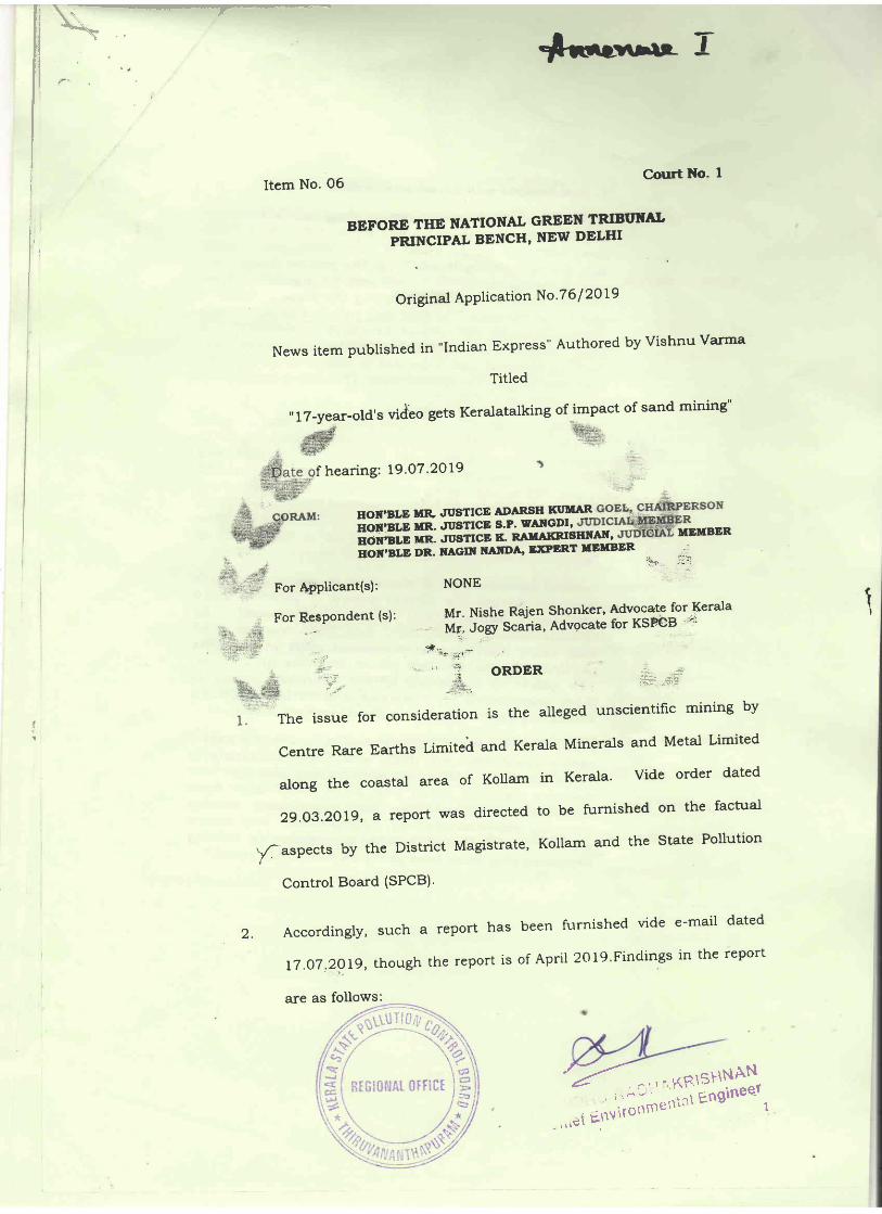
Item No. O6Court l{o' I
BEFORE THE NATIONAL GREEN TRIBI'XALPRINCIPAL BENCH, NEW DELIII
Original APPlication No'7 6 I 2Ol9
News item published in "Indian Express"
Titled
Authored bY Vishnu Varma
" !7 -year-old's video gets Keralatalking of impact of sand mining"
f hearing: 19.O7 .2019
HOIT'BLE MR' WSTICE ADARSH IN'UARson:sup uR. Jusrrcg 1'P: y-lr-{9Pi:
MEMBER;difi; rm- .rgstrcE K. RAuArGrsIrNArr'noi'ir,p DR. nAcrr IIATDA' ExPERT uEllBER ,. ..='F'r -::-'
For Applicant(s): NONE
ForRespondent(s):Mr.NisheRajenSh.onker,AdvocateforKerala' Mr..lory S"^tia, Advocate for KSF€B .:t;r
tI
2.
+i
:tf '''
{t"- ..
:'' *l
# -<i&,_:ta-. --1-r'n
faspects by the District Magistrate, Kollam and the state Pollution
Control Board (SPCB)'
AccordinglY, such a rePort has
17,O7,2OI9, though the rePort is
The issue for consid,eration is the alleged unscientific mining by
Centre Rare Earths Limited and Kerala Minerals and Metal Limited
alongthecoastalareaofKollaminKerala.Videorderdated
2g.o3.2o]g,areportwasdirectedtobefurnishedonthefacttrd
been furnishecl vide e-mail dated
of Aprit 2}Ig'Findings in the report
are as follows:
7"r;;;;[5':;$i]',-,,,9i Etrvirorrrn

"7. Cortctuslons and Recommendatlons:
A preliminary study on the eroston along the Neendakara-Kayantkula.m coo,stal stretch and the contributton of bea"ch
sand extraction on the extent of uulnerability was cariedout during February-March 2019. The present stud!/, euenthough carried out within a short period has uttlised olt thereleuant data needed for assessing the present status /stability of the coast. The field data collected as part'of thisstudy along with the qrchiued data with cEssA/cESS andotLter secondary data collected from uarious sources hauebeen synthesized and integrated to haue q. comprehensiueunderstanding of the present state. The salient conclusfonsare Q"s below:
\The bng-term shoreline changes computed from the aerialphotograph/ satellite imageries for.Tthe period lg68i0l9shou,rs severe'' erosion of the mining sites of IREL qndKMML. The shoreline retreats are to the extent of a25 m,382m and. 142 m respectiuelg at vellanathuruthu (IREL mintngstte), Ponmana (KMML mtning site) and Kouilthottam (IRELmintng site). During the period of 2000-2019 the shoretinehas receded bg 243 m,227 m and 57 m respectiuely atV ellanathurutLtu, P o nmqn a and K o u iltho tt am mining s lte s.
Crltlcal exqmlnatlon of the shlft ln nearshore depthcontours durlng the 79gear period of 2OOO to 2079utiltstng bathgrnetric charts prepared bgCESSAfC^ESS ln"zOOO, 2OlO q.nd. 2079 has reuealedthat there has been a shoreward shlft {n lsobo'thsparticularlg the shqllow water lsobaths of 2-7O m-The extent of deepening of the neq'rshore qreq.s ismore pronounced off Ponmana and. Vellanqthuntthutndicc,tir';g severe erosion ln the neq.rshore oreo's.
pentsal of the mlnlng do;ta provlded bg the two publicsector companles M/s, IREL and. I{,MML conclusluelgshout that the mlnlng uolumes durlng the last twodecad.es utz-2OOO -2O7O and 2O1O -2079 haue beencotr.std,erablg hlgher tho,n the sustainable minlngguantltg recommended bg CESS/VCESS. The seuereerosion fs o.ttrlbuted to the unsusta inable mlnlngpractlces that haue been golng on along thds coa.st-"
(emphasis added)
$

of 2OOI-201O and 2OIO-2O19
FSUs Iftning,quanedes for 9ge s (nf)
Auerage minin4guanfuUWVear)
Permisszbleq:uo;ility(n&/ gear)
Excessquanfiryminad for Iueans lmx)
2001-2010
KMML *8.73.997 *r"o9.254 1,5A,O00 4rp,6*w MT)
5,46.573 mg(9,83,824MT)
IREL ,i+i*..:+ 9.13.326 LO1.48rBhl 17.87.323 t,98.59t
20rc-zo19
rwrtLffi
9,98,297 1,a9,81tr m?
6,53,219 . llF,'; 19 me*4
a'.t:1,9t,391
..:r :,,i:ijjrr-j::_::lj .
;6 m.sr|n
1CI6,0 m cnd ISM m
etd,2012)
3. Thus, the report shows that mining volurnes have far exceeded the
sustainable mining quantitF ProPosed. The excess quantity is noted
as follosrs:
.T6{b& 71 Excess ryantiQ mined w IREI, an4 KMML during the period'
n?yj
4. In view of absve, $re constitute a joint Committee with representatives
fronn the Central Pollution Control Board (CPCB) and the State
p,ollution control. Board. tsP€Bl to determine the arnount of
compen'Eation to be rccovettd for darrage to the environment by
r,rnsu$tainable illegal mining. Such a report may be furnished within
twornonth$bye.mailatir+ciciql-nght+€;or'.irl.Itisopentothe
conc€rfled regulatory authorities to recover the comPensation by
foltowing due Procedure of law.
P{<>
/9RESIr,NAT
OFNCE

A copl, of this order be sent "o
the CPCB and the sPcB by e-mail for
compliance.
List for further consideradon on 16' t2 '2OI9 '
Adarsh Kumar Goel' CP
S.P. Wangdi, JM
K. Rarnakrishnan, JIvl
: .':. ' :,:.
Dr. Nagin Nanda, Elt{
''Iul1' 19' 2019Original APPlication No .7 6 I 2OI9
.,1, DV

f l- ' atq'
MINUTES OF TIil MEETING CONDUCTED ON 13/08/2019 N''[.CENNBCTTON
WTTU IUN rcSUBS NBLAIBN TO NEACH MINING'IN
TIIE C
Meeting started at Z.Lo pm. Chairman presided over the meeting. Member
Secretary was also present. The following offrcers attended the meeting.
t) Dr. L, SheelaNaii' ''' : -
," 2) R. V. Viswanath , : -
:. \'
, i 3) Sri. S. SurYa Kumar
:' 4) S'ri. T. S., Shaji
,, 5) Dr.'Mathew:JosePh.
6) Sri: Baiju Sebastian
7) Dr. J. Ansari
8) Sri. S. Anil Kumar
,'. ; . - '
9) 'Sri. V. AjaYakrishnan :
10) Sri. S. Karthikeyan
11) P. K. Baburajan
LZ) 'SrL M. P. ThrideeP Kumar
13) Smt. Simi. P
14) Smt. Saritha. R
' S'c. F& GrouP Head, NCESS Co & :
Group
General Manager (TS), IRBt 'Chavara
General Manager & Hea4 Chavara"'.t,:
IREL
Assistant Managing director
Diiector, Geological Survey of India
Senior'Geologist, Minin g &
Geology DePartment
CSIR - NIIST, ThiruvananthaPuram
Superintending Engineer,
Harbour Engineering D ePzrtlrant,
ThiruvananthaPursrrl , ri ,,
General Manager, $I\4[t{. ,
Assistant General Manager, Mines
Chief Environmental Engineer,
Head Offi ce, ThinrvananthaPuram-
Environmental Engineer,
Head Office, ThinrvananthaPuram.
Environmental Engineer,
District Office, Kollam.
Assistant Environmental Engineer,
Head Office, ThiruvananthaPuram.
,\.i -\-A!- ilificl j ;-;i
i i: j ?,}.e,u"$l:$$5':$'::"

a(=Jzlv!')..-tvv--
t:.-
Chairman welcomed all the officers and requested everyone to introduce
themselves' Chairman informed that the meeting was convened for discussing the
issuesrelatedtobeachminingandtofuIdasolutionfortheissues.Hesaidthatthe
mineralresourceshavetob".""ou",.dwithoutcausingenvironmentaldamage'
Cffshcre mining has to be promoted How to carry out ttre above in a practic:'i
way is the intention of this meeting
Sri: T' S' Shaji' Atomic Minerals Division' Departrnent qf Atomic Energy
explained the details' of mineraldeposits in that area' Chalara reei11 l
navtne a
. major'mineral deposit nr aZZ'S km stretch from Neendakara to Kayamkulan'
Titanium contpnt is more thxt 629/oand low iron content tom ttl lo.Z00
m'upto
T. S Canal, Frorn T' S' Canal to 1 km east' heavy mineral potential is 10 % and
upto 6 km, it is 6 ; i1''5o/o'':sedimentation deposit :
* ]:l: ]::-
Kerala
Minerals & Metals Ltd & Indian Rare Earth Ltd' together carrying out mining in 8
blocks, for that ttrey are holding lease. The mineral deposit in the offshore is 7'5 -
9m dePth in that area'
cbainnar a.sked wbeftrer any one cordrcted $dy on accrdion rde ofmireals d lhe beadt
Dr. L sheeraNar, c'"w r'1 c*T:)T:P:if-ff tffH ffiary gdf' rcgarding tfs 'Ert during fte'' peno
' as$ad*pt'ru*'ryt*"*tit "ati'eOm3linneacfrwastring:**.Tl""*' 700 rn The deuras colleeEdlt*a*Unpnofle admodel o$ conduoed Cltairra
opinedtr*fu decoltededtasedonrnodel $ldyisnotsoreliable"
' Chairman then asked what happened to the accretion rate when sea wall is
:constructed. She replied that sea wall will nqt help the beach building' Sea wall is
t for protecting the land' Due to sea wall mineral deposition will not take place in
thatareaandthedepositionwillbetakenelsewherewheretheseawallends.
chakman informed the Member Secretary that the sime has to be submitted before
the Hon'ble NGT'
Shri-
following;
Brju Sebastain, Sr'Geologis! Mining
i+tr4in"rai Division has exPlored
& Geology DePt' exPlained the
347 50 hectares of tand for sand
N
c rNi. i er-J_-

.mining for mineral extraction. Out of which 550 hectares has grven for lease.
KMML has one lease and IREL has 4 lease. KMML does not hold EC for mining-
IREL is having EC for one or two blocks. For conducting sand mining, a Mining
plan has to,be submitted by the project proponent and approved by Indian Bureau
of ${lnes (IBM). In that Mining Plan all do's and donots are clearly mentioned. If
: the project proponent conduct mining as per the Act, Rules, Mining Plan, EC, there
will not,arise any problem r.elated to the same. For example, in Mining Plan,
piovision is ,given 'for using shovel and cq-_1yine out hand mining. But these
, companies are using'nrachineries for mining. Bgach washing fhould be restricjed.
tnland mining shlt,be promoted,,For the same they have to purchase land and after
recovering the minerals, reject sand can be put back.
' , ' :IREL explained that,the,mineral part separated during beach, washing only
.l,O-IZoh,. May be Z0 or 30 years back the concentration was,higher. But, after
Tsunami taken place, the percentage getting from beach washing is only IU-I2a/o-'
IREL has conducted a study on this through NCESS- Ancl at present beach is not
there, 500 m already gone as per study report.
KMML offrcials explained that their intention is to recover the natural
resources fbr the sake of nation's wealth. They will not ever go against the law. For
, getting EC, ,I(il41\4L :has; :doner everything. Submitted application for the same
.before the MoEF, State PCts has conducted public hearing :ul''20l7 and all the
people supported the project. CSIR - NtrST is our consultant. Chairman pointed
out that KMML has already conducted beach mining to a large exfent. Erosion
took pl'ace due to that mining.,It, is a fac1, Then KMML said that mining alone is
not,the reason' for erosion of beach of that area. On the southern side of Kollam
also beach eroded.
is the construction
the lateral transport
of
of
AKR1SHNAN*-t'uf Engineer

*--r"-ul^^re E
" Chainnan asked KMML officials that whether they are putting back sand
after separation of minerals. They replied that practically and technically it is not
feasible tg put back the sand after mineral separation. Chainnan questioned
whether any technical authority advised on the matter and asked the same to all the
officers present. All replied that.they have not given any advise on the same'
Dr. Mathew Joseph, Director, Geological Sunrey of India informed that in
East African countries, they are using a mobile gravity separation unit for beach
sand. mining depositing reject sand back for renourishing the beach- The unit
travels from south to north for a 500 m in one direction. The redeposition of healy
minerals, taken place before to next transit. Mining can be ca:ried out without
disturbing the enviionment of the beach. Chainnan requested the Director to
provide the details to the Board for issuing necessary directiolls- : ' '' ' )
Sr. Geologist opined that in India it is not easy to allow mrning everywhere
fl
as in that cor:ntry because we are following some Rules and Acts and issued lease
for mining. Chairman explained that that issues have to be sorted out as it is
ultimately for the land welfare and for decreasing the environmental damage'
All opined that long stretches could
avarlable for mining- '-
not be mined as there is onlY 700 m
Dr. J. Ansari", Senior, soientist, NIIST" infonned that ,in tr.,EIA report
submiued for EC, it is agreed that the remaining sand shall be put back. But there
is no condition being insisted in the EC regarding this'
Sr. Geologist informed'that for carrying out mining, first prepare a mining
plan, afteri that EIA report is submitted, then based on EIA report'Ec is being
given. In that EC there is condition that mining has to be carried out as per the
Mining plan. Mining Plan is not a static one and it can be changed as per EIA and
got re approved from the concerned authorities.
Chairman asked Dr. Ansari whether the Mining plan has been amended
based on the EIA ther issues noticed during EtA are reflected in the
/1".i,"r', -q'- D{g
ti r,- I!i '-l'i .,..,. l r:,'.r ii Iil .:,1 i r,i i'i'ri,;ll l''iiiIJi ' =';iilii ; ''|': !'i'::L "' iii'i i ;= li
SINDHU RADHAKRIS'III

4rlt-g"^.rAt 9Mining plan, i.e., whether modified Mining plan has submitted for EC. Ih. Ansili
replied that it has not come to his notice till date.
Chairman informed this matter will be taken up by the Board and will
inform the concerned authorities.
Qhainnan questioneid whether instead of beach mining, the
explore the possibilities'of offlshore mining. Sr. geologist e4plained that offshore
mining has to be, carried out: as per the Offshore Mineial Development and:
Regulation Act, 2,002. The license is being issued by the Government'of India.
Earliei licenses were :,issued to explore 65 blocks. Later Government of India
cancelled the licenses and ordered henceforttu 'i, ,ho,rld be dorr" as per aiiction.
Amendment on the same also not yet come. Cases related to this are pending
before the Honlble Court. So at present exploring offshore mining is not possible.
Chairman said.that for the time being legal aspects of the suune- it may be
brought to the notice of the Hon'ble NGT ana will be sorted out. But the technical
aspects and other related issues have to be taken up.
GSI official replied that they have conducted a feasibility study of seabed
and identified 21 blocks in different seotors like Chavara sector, Varkals sector etc
, and that.is,having 125 rrnLlion,tonnes/ meter of heavy minerals. At present study
:conducted at'1 ,m.depth,seabed. The sea depth,(bathymetry) is 10 m but can go
upto 60 m depth and can go up to 1 km away from seashore. Started working near
the seashore also. 18 % heavy minerals is present in these deposits. Dredging cost
will be economical. tsut Govemment of India has to grve permission. Chairman:
.asked the quantity of heavy mineral deposit available in Chavara area. GSI official
replied that in whole Kerala it is g.5 million tons and in Varkala and Chavara
region it is 3 million tons.
IREL official informed that on the 7ft of July z}Ig,Government of India has
published a notification that the Central Governnent hereby prohibits grant of
operating rights with respect of the atomic minerals near the offshore area in the
country including 62 blocks to any except Govt or Govt Public limitedperson
srND(;RADHIT5P*yI-5_
SlNUnu t'^-,-,"ntal Enginee.r
Chief Environr

*r*xuAr Tgompanies. offshore deposits wil be considered as the extension of the land
deposit. Leases for offshore mining can be issued by Kerala Govt' sr' Geologist
informed that the lease is being given by IBM. chairman asked IREL to provide
the details.
chairman srrught one more clarification from officials- Provided
perrr,rission is granted f9r offshoie mining, why not use reject sand aft:t_:**ating
, to rebtrild the beaches destroyed by mining? He pointedthe I 8 % hearry minerals, to rebtntcl tne Deacnes os
out, that all official have to explore the possibility of the same- ,
,chair,rnan then asked Dr- Ansari what is the reason for the delay,in issue of
EC to KMIW;. Dr.. Ansari . replied that a 'violation was notised and 'so the
.Sideredbytheviolationcommittee.application has to be csnsrdereo Dy rn(
-chairman inf,ormed that in several cases, the
leving Enviionnrental compensation,for violations'
than profits made by causing environmental damage'
Hon'ble NGT has ordered
It is calculated to be higber
smt. simi, EE, DO, Kollam informed that the public protest is mainly due
to the reason that the companies are not returning the land to the public that was
takei:i &i.rm them for rease. chairrnan replied that the retun:lng of land etc is not
relevant..,The,matter,beforel,the,,Hon'ble NGT .is whether environmental damage
ocourred and thatwilt be Board's conoern.
mining, ffid re-building beaches eroded''
matters very seriously to avoid penalties.
The meeting comes to an end at 3'00 pm'
chainnan concluded with advice on making suitable plans for sea bed area
Both companies should take the said
l'f lP'|J-'
-e-
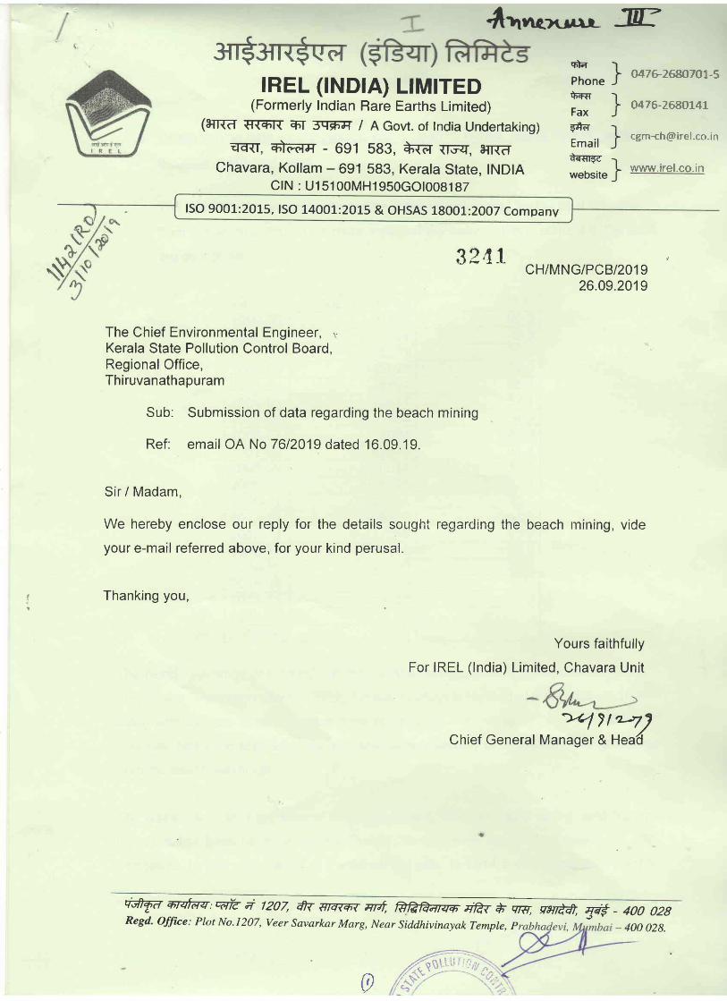
4trnornr^- JEmd -l
Phone js-+€ ]Fax )5+d IEmail Ji{sr{c Iwebsite J
|REL (tNDtA) LIM|TED(Formerly Indian Rare Earths Limited)
(eTrTd {T{mr{ Eh'I SGEF-JI / A Gov,t. of tndia Undertaking)qE{T, *ttrfr - 691 593, +Tf, {T3il[, e{r{d
Chavara, Kollam - 691 583, Kerala State, INDIACf N : U15100MH1950cOt008187
047Glffi70L-5
o476-2680141
www.irel.co.in
lso 9001 :2015, lso 1400 r:2o1,5 & OHSAS 18001 :2oo7 companv
32,1 1 /
CH/MNG/PCB 1201926.09.2019
The Chief Environmental Engineer, ,,
Kerala State Pollution Control Board,Regional Office,Thiruvanathapu ram
Sub: Submission of data regarding the beach mining
Ref. email OA No 7612019 dated 16.09.19.
Sir / Madam,
We hereby enclose our reply for the details sought regarding the beach rnining, vide
your e-mail referred above, for your kind perusal.
Thanking you,
Yours faithfully
For IREL (lndia) Limited, Chavara Unit
wl 7try)Chief General Manager & Hea'd
qATv qrqfdzr:"dr? a /207, fi antqr qrat W i qta vsnAq gr€ - 4oo o2BRegd. office: Plot No.1207, veer savarkar Marg, Near siddhivinayak Temple, p - 400 028.
0

1.
The quantity of raw sand collected from the
from Vellanathuruthu - Ponmana area and
are as follows:
beach mining for the Past 20 Years
the heavy mineral content in the sand
Quantity mined HM%91443 80.2
141444 78.5
2001-0279.6
2002-03 145928 74.065.4
9561 1 57.1
157 494 54.3
2006-07 8034 43.9
67676 54.4
250021 34.4
2009-1 0 206395 27 1
2010-11 221024 30.7
2011-12 1 08205 33.0
2012-13 117349 266
2013-14 90026 26.0
2014-15 47 120 33.8
2015-16 0
2016-17 1 3938 33.0
2017 -18 0
2018-19 0
The beach washings collected from the Vellanathuruthu area is transported and fed to
the Minerar separation prant at rREL, chavara (which is located at a distance of 18 km)
along with the raw sand collected from other lease hold areas for recovery of heavy
minerals, hence no separate data available for the quantity of heavy minerals recovered
from the beach washings'
The waste sand from the Mineral separation plant which coi-rtains tailing sand from all
the areas has been used, as per the Mining pran approved by AMD, Hyderabad & IBM'
Bengaruru, for the recrarnation of the mined out pits. In 2014 a mini separation plant to
q

upgrade the mineral sand collected from the vellanathuruthu area was set up ild #
that the tailing sand generated from the mini separation plant has been usiru br
refilling the ihined out pits at Vellanathuruthu itself'
Approximate quantity of tailing sand generated from beach washing since zJ14 and
utilized for refilling in mined out pit'in Vellanathuruthu is tabulated below:
Year Tailing sand generated
from the beach washing
(approx) in tones
2013-14 45000
2014-15 23000
2015-16 No collection of beachwashings
2016-17 6000
2017-18 -No collection of beachwashings
-2018-19 No collection of beachwashings
2.
proPosed to be mined. :
Map attached
3.
Copy of the agreement attached
4.
IREL has not conducted any health studies
a-il \r-E i frrclon n, orncr i F

5. Reports of anv studv conducted on backqround radiation
Pre-Operational Radiological Monitoring at the proposed MineralSeparation Plant site of IREL, Chavara at Vellanathuruthu coastal region ofKollam District. Kerala
The pre operational radiological monitoring of the proposed mining area atVellanathuruthu region was carried out by Health Physics unit (HPU) of IRELUdyogamandal along with HPU of IREL Manavalakurichi.. The site is located in
the Alappad village of Karunagappally block and lies between the latitude of N
9" 02' 44 to 9" 03'74 and longitude 76' 50'61 to 76" 56'77.
External Gamma radiation monitoring
An extensive radiation suivey of the mining area was carried out using a
sensitive Geiger Muller tube detector integrated with Global Position System(GPS) and a pocket size radiation survey meter (RadEye PRD) whichincorporates a high sensitivity Nal(Tl) detector with an integrated photo multipliertube. Measurements were recorded at 1 m above the ground level. .Gamma rayexposure rate at eighteen locations along with latitude and longitude values isgiven in Table 10.
Table : External Gamma radiation monitoring
SL
No
Location Radiation Field(pGy/h)
Latitude Longitude
1 Pushpamangalam House 0.4 9.0244 76.5139
2 Kunnumpurath House 1.7 9.0244 76.5129
3 Thuppassery House 1.7 9.0267 76.5112
4 Thekke thuppassery 2.0 9.0271 76.5115
5 New mining area 1.2 9.0285 76 51 08
6 Panda rath u ruth 1.7 9.0300 76.5096
7 Mukkumpuzha junction 05 9.0308 76.5122
8 Panamoottil 1.2 9 0305 76 5095
9 Haribhavanam 11 9.031 0 76.5093
9'si'"llliiAL iriFiil

10 ntappad Govt L.P School 1.7 9.0328 7e5(F
11 Alappad Church 1.7 9.0357 76.5073
12 Panikkar Kadav 0.7 9.0374 76.5061
13 Kurusum Moottil 2.7 9.0362 76.5069
1.4 9.0348 76.567714 Nishayalam
15 Kollampurath 1.3 9.0314 76.5095
16 Edayil House 1.3 9.0314 76.5095
17 Padattedath 1.35 9.0318 76.5080
18 Ramanamadam \: 1.4 9.0320 76.5084
\
l1
li
I
il '
i, i
I
orruoHu RADlsS':$s)':';;; Environ:\rlrrv' -.

The Kerala ^llinersls artd_lfcrci_i lri.(;4 Govt. o! Kerci!t; {'. ,,i,t,r,-.;.._;r.,
Minernl Scperation LjnitKts v jLtjt nttain, Ll fu x y n1s
ala, ,!. lndiag*049, ?6f32727
F.-ssnitr : <igmn:s G! krnr: r LcamC,IN
{e-mait} dtd 15.fir}^Z$}a} _<eg
Tlt* tletaiis request edby yarl tts
I{-tvIML / MS 1 Min* s / p CB / {} X?,8,Aq.2AW
The Chi e{ b,n rri rr:nm*n laj Engine*r.,f{.*giona? *ffi ce" y,r;p {:H,F alLrs rn, T h i ru van a nth apur am.
Dear Sir /f,,latlam
F-*f; - Yt:rir offi?ce c*n.*uni*sti*n {*-rnai|} dtriz3.tlg!.aff)
sub: Lsetails *al\*d fbr r*gard ingb*a*hr.varhings c*rh*t]*n
This hirs rt{epence to your cc}nrrn!"lnicarion,.ma *tia*ed ahrtve,furnished b*fcrv,
1) D':ta rv6;:rding b'*ack vrasldngs ccillriction ancl lteavy mjnera] r.et*verec, ts enrtrosecl"{F"nnexur* I}
?J }rlap show'ir:g beach washings c*?lecti*'ilreas is enclosed.[Annt;<ure IIJ3) Pr*sentiy the rninirrg activities are b*ingcarriecl ouf at tire Hiack iltr, c*rnprfsing of88"119 ha aut *f the total lease area *f zfrs.gfrz h'a. Jn rhis blcck I{M&,IL c:,vnedar*rtnd lsha of land and the rest ofl lanel has been ta}<en possession rhr*ughacquisitlon *{ land based *n tr'A" Acr and negatiarerJ purchase. The process 14/asc":rrjed *ut'in fcur inain phases u*cier the supervision of committees head*dby theDistriet t$llect{ir r'vith necessar-y Governm ent apprcvars. The documentation fr:r. fhepurchase of land is very'' exhnusfive" Flowerrer 14/e rney pradurefh* cosunrentafian at
a nafel" stage if nercssary.
4) It is uneiers1'*rsd fhat Nl':e stucies irave L:eencarried r:r.it b3r E,t\F,cof DAE.iJowelee r thercp*rfs az-e n*t availabl* tc us.
5i RarL<gr*und radiaticn is b*ing mnnit$rsd as cire c*cetl byAERE in fhe liceni;e jn aurnlining are a' A crspy of the lasc quar Ter rep*rr js encl: sed hetewitl-r.-Annexr_rre Ill
Thanking you,
nerals & Mr:tals Ltd..
3
O
Krslktnt. Distnr_'r
' , ^iqu,N i' 1"
c,\i.iDh,u il; i''o't'tttit'.tnt en
Ia.eg$. Otfice :

j) w 2*{}8
KMWL, *riSaged f{C}155 tnr carryi:rg oret sand budgeting sluciies lor its s:a.rv*shings rollectian arr;rs in Z8\3 t*r sustainahle dev*Jopnlent, '{.hit stiidv 1,1,rscondi:cled *ver fw* seasons" The repwtx'as in:pienlent*ci fronr Seftembei 20 -i
*l':lverels' As pe:" th* r*portthe quantity ilf searn,ahings permiffi*d p*r year is, 1,?:4,LAfr T"4T and tI.,* sarffie is being {aljaz,ot*d
\'.1.':1.1 i .:,i:t ,t ^ ,.i.,:!: ;(: :lt!:::ii::,..t.:t1...,.,:;i,;;.,.i
ffi*arh Cailecti*n ffulTj
7008 - *g
35?,6S?
ztlt* - 11
7.411- 1.2 374,3.44
z*12 - L3 4t]1,557
7,*13-Z*L+ 212,2?,9
2{}14-2*'15 218,1*6
45,194
zfr16-?ft17 3.L3,147
2*17 -7,*18
2fi79-z0l,g+

M{h}E&AE" Pft.fi D {-T CTX*W FX{U M 7^&*E
Year Praenucfi*m
ffrcenite &ntile Zinccn SiIlixmanite
2008-20fi9 47,,51fr '?'r$98 z,+45 fl
7"409-24ffi 44,3*0 4"r 2,592 0
7,*Tfr-Z{}11 2,R q? nqv, / 1v 2,413 2,838
2{}11-',2012 43,4fr3 2,&fr{' 5,2\3 s39
2{12-20}.3 45,240 1,fi5fi 3,96{} 1,265
?,frrT-2fr74 62,850 ?,33* 3,635 J.,27{)
2AL4-2415 55,05CI '2,638 4,7 68 LAlZ
2A3,5-2*n{3 55,630 7.,775 5,346 .4 =a'tt {.
2*L6-Z{)'3,7 55,4fr4 2,4fr5 +,784 6CI0
28L7-z,fij".fr 56,757 '2,434 4,844 7t31
3ilr.8-?019 26,1,40 1,,548 +,7 67 ')*f 1Ll.L
,tI
5r t^r-l1rRl:'#NANF\ln- , -_e r..epl

i::; ,...i" :?
Spreating SPlend*ur
TFze Ker:ffilu fulineruls aild IIet'ils Ltd'{&. t}rsvt. r.'f fter*ln Uwdertak'mg)
h'Tjneral Sc:Peratictl UnitK*viLtl xstl;rn:., Ch a-;ara
K*itram"-691 S&3,Kerala, S' India
1!1r:{}47 6/1$&*047 , ?68}fi4&, 2?}827}-7
Fsx:tJ/+7{t'268WJE-z'*211 ; rjgntnis G kmrni'eom
CXtd : tJ 1 4I0!KL 1 972SGC0{}2399{
r\45 I p^Er,*/* r*s ry/:" 53 ! 20Lg
J b e&
ffilfrel2*1e
T*
TF{n g{f;,&.m,
Op*rating Flar:ts Saf*ty Division,
Fft*mk frr*rgy F,egu tatctry ffi oa nd,
14 iya m*k {Skavan-h,,4n usl'lakthln*ga r,
ild*rylha!* 4A* **4,
h*aharas'ntra.
Fleese fi',td encnrs*d thc llild qu*rter
TfrZg frr the tr4ine rai S*parati*rl Ur"rit
K*liarn, K*ratra,
Tl:anking y*tt,
Jrt t
Sub: l-iselth Fhyslcs Rep*rt fcr the l?nd QTffi -2ff18'
Healtli Fhysics fteport dur[ng April }OLg tu lune
of Tire Kerala lr4inerals and Metals Ltd, Chavara,
Ycurs faithfc"rll,/,
F*r Ttre Kerala Y,\irz*rals ar:d Meta?s ttd"
Assi:tar-rt fieneral $franag*r & l-{On {ft"45}
F,tgr1.{.-}flire:S agl. , w&-691383.1:io}larir]jisrtite: & us26B(t733

i
QUARTfrRLY F{TALTF{ PffiYs}{S TlEP*ftT FOR
hj#ru OAH ffirAfH sAru# fi#Eruffi'ffiAl-S {ES{\4} FP^CTL'TY
l,Jem* nithe facility:
Loe ation af the facility:
?*ri*d *{ rep*fting:
ftit/s T[ie K*rala ?,,4i.nerais and ?,4*tals Ltd, tl4"S" -Jnit"Chavar a, I{ci{an:. Kar ala
"
April 2C19 t$ June Z0'Ig {lne{ eua rt*rI
e.1 {ru&tvg*\LhL tr058 STAT{sT*Cs.
3."# m*fiY, S?A?tsTtc5.
fij*.of Al*rsonsnrcn?tsreei
C*ff*rtive dsse
{person-r'*Sv}
Average
individual
:.:.:tYfi,2*5
- *i\it
l"rTaxinrurn
ktdiu;iduatr
#qse{m5v}
fi;35
h. rrt6tutt
fttJARTEft gg
ftegallar !7 AF
Temp*rary htil fiJil
e*r*tslatlve an
th*Year
Regular L7 4.8 4"14 8.4
Tenrp*rary_"_-i-
rufi tvt{htil
lq,l il
**s*ftaut"ge
\mbv t
persofis in ayrar-ZfrLg
Regular
fulnre than&
Cant....2
2
s i :n t''1 u T^PlJ.st:[H]6r,i.t Environr

Z"# NiT*NAZITH HT**ICI-IEN TAILIN€S DETAILS.
3, pcp
Feed froncentrate Frodue*d Tailings
wf{r} 485S 9fr7 "5L5 3890.49t&*nazrte % A,L Q"4 Traces
?",Wst ifn
Feed eonc*ntrate Piodueed Tallings
aniri &&92"4 2*51s 586,9Manazite % 0.66 'l {}rr
a-,$) \J Traces
3" Srg MBfl"
MateriaB,
.
q**ntity{fifiT} t*nnazite Ys
Feed 24579 2.8
fr"2Nnn Mag ** 734LlVsn: trsnductings &L83" 4"7Sieve Waste 550 8.X8t{n**}te Vrryduct -7)A1
,t J.?-.I. 0.2F,utite'#r*duet
r{il
&. XZr **n^Sltl1waanite p! a nt_
at*riala
te*d Nan : r*ndurting 4e
QuantitytMTl Wjsnaz|t* %
83St 4.V8Tire*n Fr*&uqt 848.5 0.25?llicnaruite
Wet table Taillngss_,1 ' ruitr
bbSu Tnaces
&0fr {+4
x* K*cycBed In lf,np &zT4p far {r,srth*r red,,veryof niinerals.
C*nt 3

I2'1 IVIETHOD OF DISPOSAL OF MON AZTTEEITRICHEI)TAI1ITiE
d *isp*seel in trenches within the prant b.ouirr?-,.,
S"* m&ffig&Tfi#ru f\4#ruffi#ffifiruG ffiHSt jLTS {* wirichever is appticabiei
':/;
Prg Cpncentratisn plant
fu?ineraX prCIeess6ng
{Fhysical h*lnena! separaticn and/or chenricai processing}
{ant"..".4
/l*
l**nall"E*vx
3-40.3.5 ,
\".
Pl\
p
F"i'.,
p\.-
6eneraX bac$<ground nf plant pnemises.Raw nlaterial stcrage fir€0.lnsic,* Mineraf Separation plant
te.S"s*p*rat*rs, hig$r tensicn separetcrs etc.)F"utitre Retov*ry plant. {Dry eaiil}. .
Tattrings frsrn i RMS^Zirron plrnt.W,l *t tabi e-Zi r e* n p !a n t.Manazite enriched talli*gs storage frrea.{}n tap of trenehes fifted with nicnazite enrichedtailings and t*pped witltsilica rich sand.
-{h
J
L-2"5
3,.sa-2.25
15-?3.L
3ff-37n 1qv.&J
^ rt a1 i",'-r[i F'l':
, t. nrir iiAD.1:,:;ii ,gineer
bru-t Environ rrtit t'-'

ir*n *xidr slurry tan]< &, csrifteetntgftrangeis in A-cid
relerlerctir:n pSar;t * *r: ccntact
T?r* r*turn u,'ater pipeline in the ovarh*arJ inan
oxide s+l*rag* t.ank * on contaet
Tlre lron *v,ir]* s{urry plpeline !nthe *verk*,adirion
*xide st*rage tank * *n contact,r
F..s.ol
{Signature af th
frY"hn, Operating F[ants iaf ety *ivisEon,
htar*re Fn*r6y V,egulat*ry &nard,
l'|i'urp7l*y H h a rya r"l -A n &nr*xhakth ? n a g a r,
t'&urr&*i- 4*# **4,Y,rt*karas?ztra"
Radiation level
{micro €raylhour}i-ocatisn *T$tsnium Figmeart Unit
L8.25
30-58
2.5-3
t/ ' 't()\q'riliAN
?[l3'?Y'1;::.i'lll J'' ne er

-t'.t
07-0!l-2015
;I5+*afrfil=il"#ffiHffiffiS*'To5i frq Al;nAc lr# t 156 ffi t,,r 6.---_ r_. _r a.P; * +rEil;H;_r'il En',ilftr
f"f hiT rf,rG{ r'.s +ctr fr., qimh.D tn e*rrcise oFpower confer#il;" crauseI Yii:::fs- (Devgloptn.nt a n.gur.tion) Ast, r Sectlon 5 of Mines and
t,L1#t::192-ot- Lsso, ttt. rui,,il il,, ,l,_of lndia order-No. s.
I reus@) * snr'# H;'; tu#!ilffiilT'Rru *ffi',J: *m Fg y *t" **+-i'fu, ffir, FF,,r. ErErirr==rr
E o'd 3rk {Ei rdfuqa) resz ,*F ; E -sr _.- ^-
t Pntewya rfk gFft iliu.,, YaiFfAf, €-+fffidf,
F* fI u# condtttons of approvtt:
ffi m11 fiI *ili*ur verals*srq rrtufrqq r esTfr qRnF 3'rqfi + q€ s + *n"$-ffiffi0
7Ala5e, Ter$il. m+tfre rfu f- r ,. +G-r- r . .
;;;,,;ffi;#llmenite, Rutile. I eucnxana jh-l ?:__lff l':?,T:i,,?r:11?:.ffi iilfl,_.,"lJ
;i#-,:J'ff _tr',Jfl ffi [,:fl :j#Hl:part B of ririt scheduf. or'r,,rrvi?ril") ^.i[i
f.t
rt
I

D
D
D
t|-t
o
I
ifI\IDI
It!),D
D
D
tt6.D
lD
z ** +cd frf,rtr .b +4ffi Er+rq(mm*-.* @ sf'r ,
+r frqur $€ril Eo';r of h *nm,- fr ilan* ** E d,ffiHtrnl a Mrnerarq en,{
i . -
'r'r\r tr?r :"t"t i'M/s' Ker:ala Mlnerals
'"l^y"lds lim t- (rwMtl chavara shail furnrdr the detaid otgrant of lease or rcdificationb h ;i; fease uv s",- Govemment to Drrector, AryrDfOr feCOfd. j ! rs'r'rE IJy rrare govemment t
I
3' qrER, qgr Ffds fir qfr fi- Tfo,- frq,n + sf*tm un*fud frqr *i tT-H.T.tr*r mn*r"d,rqaoterrr rrr-'r! tr"Ettrry
|The lessee shatf submit a copf of fease ieed, executed as per the extant rures to thisDirectorate for record, I ;
4' H-Tflru;wti F'rq frerltudr ft Ts qrd 3it{ rs+ Erqlt
ffi*il-'i.TY,yqsE{#=;ffi*ff$Ite Government whil_e gpntjngthe mining feasetaken ciri or wnite irpt*.nting ttre ,siningPlan).
s. fg+ it('ff(,rr(rF{, +wgtstzoog *. rqr.srrtEr ri.
5 '5qt (FfupT irqnuD frsrT,
. frhrr | $F€r w,.sfr + Rq (rqffi 3if{ 3Tdfrca s} $fi ilsf
o) 6 3rqciqt # u=E*m qfrnrrfi $ dHds
M/s KMML Chavara shafl.Tt",1^:
tr,".T lFRl as per th.e provis,o*-* oroJ,.Ener.gy (Radiation protection!
copy of the same may be sent hilT, J:,,0,._ :: o. No. izio ci.r# ffi;;ffi:lxAMD and IBM for records.
produced from the.mineraf separaflon praht sharltions from AERB.
T{frq s,frt fr{ne. t frtlrrywrr qHq F{q +i+* *Rur $Frgr * ffiqr Gnnn
fdtFIFc T{trsifr qrThe monazite ridr concenstored sepbrately as per the
LlD 7'
-F y.* fu,1| ."ftnR-+ {u^rT FEsrT +r qrd 3t{
' :Jfr-frqiF,
1957 *, 3it4d SHrdt + fi h|f,,Fl ,. r,.\ rd-r\.fsr.rr{
The disposal of mona:T.:::Tlg: is cuhj.ct to the conditions of ficences bv nrnbI and afso the provisions under ,fron Act, tgsz. the conditions of ficences by
I| _- -rJ.. I
; p... I
$.fir 3rrril Bilfi sr;q ffil qErrr 3:frn/fu +Ti3tq nr{d S frnr C 1at*6 + g',a 3,r.}=.d,
,
9
.'r\ )refrrl {etrl qq .niGf 6I filqtdilf,f *P[an is approoed without anyprejudice to any bther __ _rr..wr,.E rL, ure ',,n.rrrJlil;ffirJ::t r;,JHH:lmade by the Government of fndia, state Governmenf or any other authority.
g 9. @rfl STffdn-fT(grJn?ff gJFr de mr* fF :rrrF--- A _ .

lut
NEXURE d T5
1960 qFrcr 5 i{"t ilrqr HGil. ila ,fti{qnur)d{eror JTFJfrqrq lrgee $ti *# Jftrn ir,w enr
3tfrqFr 3nfi + !f+* sr;q rqdq1 fi erff * TnFfi,rraff *'rar tr :
he Mintng Plan (lncluding Progressive M.tne closure plf n) does notthe Mines u,:'""Tif b""lH,lli,'"""T -=T;l,fiTl tyrttT +;fi};#liffillllllli?,lffl TJ.:'*: l* :::':l* ;:i"" (co,servatio4) Act re'o,;ffiH#:Iiffi ;TT[illH',,'"?etc. I
I
ro' fr' EI|;f 3tfrfrrfi, 1952 + iqdq 3rh 3:fl+ Jr$a ffiT(r * 'ftqa 3ikp|_s1fl trFr frg Sr g+ar en rq* n:(e, siiEffi:fir ffi
ttt-ttII)
)
)
)
)
)
)
)
I)
I
I
t
3it{ qrn 3tFFEh, 1ss2 +. Et-t qqErd";'ffi-'istK srn *FaqF, 1ss2 * tdRT qqrErd rrrq qttrfufi ffidr-;3rrdqrda ftqr qn'i II
ines Act, fgS2 and Rules andice of openingr,appoirrtmentMines Act, fSS2 shall be comp
11. fr' EF|ET 3trdtTtttqrrnft ]a?- TFr?',..- -.r, ^ ^ |
!tt'mg$fl ry fr'snfthar nrfil nr h*-.fi qfi frr$A*narq+ar + {E- Fti + 3rrftT il,tr
The executton of. $hing PFn (incfudfng pr reistve Mine closure plsubiected to vacatio{r or protriuitory oro.rrTnot if any.
n) shall be
13. EIFFr WTTTf, 3ndtrdr wffi1 h f EilETsrfrfrq4 19s2 qqrqftdEET fir fuqiqr ;lr;Tr frTr t
59ry H'i ffir'il afi tuqr erqr il 3rgd6 +t m+rs #'u"'HI
fur at;Tr aT('lrr II
llTJj[?'#::i"X."ij"^1ff1,::9 Yln:'.oct, 1es2 in the contents orthe Mining pranthffiJll:"T;:T:':il"iy[ffJ,':,:for rectification hai ',^r L-^- --r- -,
*i-::T.'.T::::l,l'i *' b..ln il;;]il-;;;;r ;ili;T:*:T ;tfre proposalsq have beenwithdrawn with imfiediate effect.
1c' sE ffifr m T{ur fr qr qrql rrqr H' gaa 3TrstJHr EFT4EnET f fi 'r$ q{dr3r+tFur 3r?Fn aezf 6t 3W+. trqir. +.ffi il il firrrFrf, +,1 36;faa F|FFTFTssr{ * tE e} urqrnrtr it any stage' it is observed that the information furnished in the Minins pfmdocumgnt arg incorrc"+ ^r r+riar--.-
(

)
tl
15..T6 grgdtFT EF|;T fir4 3it{ F{q qFfffi+ren Hl €;Fr Tgr fd +,l sf# ti-H, sftr' t 3id#a TiFdfur 3,rqlffir .r{t tar,"tt!= E{rrr ftqr rrqr q} Hr ;rsarr 3lfrw ffi rr$ qg fi frrnr #T rsar + iriq filfrHt irlThis apprp assoclated actlvities ls i.rtrirt.d to the mlntng
l?ffi::fl as shown on the.statutory prans under rure 28
,.,rp-o.Tribiltyr..;.',ff 'r.';rf.Tr::rt:f ;"n:n**tl*nd with reference to the lease map ,nH oc,.r pfans furnished
),
tt-
D
IttItD
tIilD
t
1G. erEil frriTfi, EfEFT 3Trffi$H arqrr qanr rd+ traim; o6t4t2o1o + qflfrIolt':{urslss=ffqtufr(rq .,Fta vn q+s ilt Bt i;'rft* 2t2o1o
fofF Er #g-'ild ..il # H #'# ffi;ffi1T{F fr.srEfr t'a;6 q(fu # w,,q,fr Firfrni*r r*, t*r r.srsT3fl- fi qr$F frqr Fn n;n urqqrlThe contfnts of circular No. ]zlzoto issued by the,chief *rf,ro,,er of tttnes, fBM,:'::i:J[j:J:'-l'Tll_1" _110-{ttuefso-cc6,n vor vr datfd 06.oq-zoro shalr be
ffi:,;i#ff :i:ff Hl',:r,yf,#?*:l'L:r:di]ffiffi ;H,'lJl"::h;il.j..'i.;tohave
rz, fr' frffi;rfrIrEftT
That ifbeing
bggn witHdrawn. ' . rr'.- er','vus' Jrlr€
@rdT fir4 + dfua qE q'qr
Fr H al freflq., (rsiH$ Rfurtuf
+'q.tt frl qr6l;T
+T FqFrm w rm* trsHUft *t f,i gu
mg during the operation of mlnes, it lq fouod that exlsting laws are not'l ''tIt3
D
,
il
Director, AMD may suspend the approval by givfng the)rrefevant asons In writlng.
tt'LT mr dr$ Tnsr qffid Fldr H h FRT d.iq fr g+arfrt*rn', T*s, t-{rdH +t tr ' -- e' *.''e-rl
I
*:.,:*t:"":,Uj'_..TI:lr:F, i: rhe m_ethod of minins/mirjins, the informagon inthls regard shall be sent to the Director, AMDittyderabad.
rs.ftt?*: rToe, Hq-{rErd h BdI sfr srfuf.d qft,frfr
i-ir, dftd frnrj sik m+cr d rfis sil s* frtrrEFFT 3fk dsnrdT
)'
t
Fuff facifities shall be accorded to any authorized representatlve of the Director, AMD toinspect the mine and the processing plant, concemed records and registers at any tlme.
ftJIF )atr, + ri--r{- -.o-JC-}-- 6- .\
SI|'i DHU RAD'rAKRISFTNANi Ei'ti.r en"ironmental Engineer
20. sffss3ff{. 1gg8 *

t9oD
D
9IilD
ID
D
D
IID
E
I0a
I''BD
D
e9
D
ANNEXURE -I5troq t'il gT EFfin 3lld|-rf,Io*, €F{ dE ild fr Jil*ffir star +3rc+dn t'sd qrd + $nR Fs#I t't sfr fihrn, (,('qs Tt ffi + R(,TsiP+il ffi gq trq-d fir orqrrThe Flnancial Assuranttit required under fe 23F of MCDR, lggg shourd be subrnittedto the Regtonat controfler of Mines, lndian eur.iu ;iil;;r Bangafore, if arready n6tdone' withln six mohths from the ipp-u.t of thts rtniiiis plan (includtng progressiveMlne cfosure Pfan) endorsing a copy of the same to Director, AMD for record.
2r.si*fun qq'r sI w'Hfr frfr {q*r sT*dq s,' Es rit{EI|;r duTr rgrfrhra'+t etfir Enflr H fi sfr Bfrm, RqtrCf, t6rd6 +t m1eiftrfiturclcopy of statutory notices, which will be sent by the KMMl{havara to rndian Bureau ofiljffi::.ott*or General of lvtinei safetv, win afso be endorsed to Director; AM4
zz' tr{rilT qfr# + ddE * ffi fr(, (rt-trg1 {d*r EFF' Jrrq;rdr err sraq}aaBtr Trqr H FTr+t *w?lt f qiaft-* F*-{t $ru F-8 il il'# *Eilq I
The statutory returns In the prescribed f.g.rmat, in respect of atomic mln€rats for whichthe minllt plan is approved byAMD rrtriid; #;;H- F-8 and H-g- '!-'r'|- '-' ':" ,.
''.qfqrr a}n Tgr rrcfu +' fr(' E,-d. ffiffi
"*. fit 3it{ T*F,- ffi +I
sEfl|t dlqtr EFrfr Tg + rtrtr+rur + iEiq f-(rQ-fis * rfira + Fq il$
pr the remaintnrr"rr.leilod ;r:;*,,f renewat (s) of
"iirting iining lease as per
ze'(ryqs 3nR d?itn -ufrhrq, 2015 #I rrRT:l 1(il) fi 3h?ilil fr*t + smi$rtk qA
%rrdtqFT (rir in1'q ffi +I
rmulated under Sestion_11(B) of MMDRable and this approvitl is subjest to revlsion
ID
qrG gffR/Govemrnent of IndiaL'-r..
1.,*.*:$5':$i:'li"t /

\
;3a- \_
\
E
D
D
ttD
D
D
D
tD
tD.
D
ItD
tD
ID
a
D
I.t
9
sfrfrfr copy to:
!"II
-ltlit
:'iL".,;''fi ::;Tffi##:;:x,';l:ff tl;^*,oo,Keasavadasapuram,partomparace2' 'le Fea.nal controlfer of Minei, lil; Bureau of Mrnes, Industriaf suburb, , stage,Tumkrrr Road,yeshwantpur, Bangarore -560 022
:s' Industriaf su
3' The Director, Bangafor€'Regron,-oir.ao' c"n.rar of Mrnes safety, No.S, 14th Marn(100ft1 Road, 4th B Btock, Koramangra, Bengaruru - s6oo344' shrlJacob Punnen' RQp, 'A'24,ranria'tuagar,
Thrruvananthapuram, Kerafa-6g5 003.
(rnrq ft qfr6R)
(P,S..Parihar|/ DIRECTOR
a..J
A\\
D
s
D
dr-
tII

Year
BeachCollection (t"f[) Beach Collection
Transported (lv{T)Inland Collection
(MT) TotalfMT)
Openine stock 110.000
2008 - 09 220,000 258,9M 22,636 28r,540
2009 - l0 208,000 204,2A4 632r3 267,4r7
2010 - 11 175-000 250,762 19,531 zto2e3
20rr - 12 195,000 l52,2Al 76,',|U 228985
2012 - l3 194,000 139,928 133,663 273,591
2013 - 14
200,000212,229 282Ar3 494,&2
33,156'527.79t
2014 - 15
134,000218,106 489,128 707,234
1E5,361'+(521,873'l
2015 - 16
134,00045,194 5M,948 592,142
zzaJ79.]'(812,321\
2016 - 17 134.000 I13,147 92,8ffi 205,953
2017 - 18 134,000 47,375 17,822 65_197
2018 - 19 134.000 219,698 212,979 432,677
TABLE 15
RAW SAND MINING DETAILS FROM 2OO8-09 tO 2OI8- 19
*The quantity is ttre prs-concentrat€s from PCPs which has to be deducted from the raw
sand collection, since it is the out-put of.the PCP
**The additional quantrty (18536lNfD is taken from handling of old d.tmp workings for
better resovery of minerals. The later stock in ttre dump yard at PCP I will be apx
220179M.T
**+The above additional quantity taken from handling of dumps for better recovery of
minerals & stock is nil at PCP I stock yard
200g49 b Z}fi -l 8 data from state DMG's audit certificate attached as Annexure 2 1 .
Inland collection of 92,806 MT in 20t6-17 includes 23288 MT from Intand Warerways
Auttrorities canal dredging,
Mining plq of NK Block trI of 203.902 Ha for the plan pefiod from 2016-17 w2020-21 P*e 44
T. KARTHIKEYAN
*.rzSIIiDHU RADHAKRISHNANj iiitr Envi ronme nt'al Engr neer

i Minirp Plani M/s. Kemla Mirerals and Metals Ltd.,iGhavara, Kdlamj Submitted Aryust 2015 Jrcob Punne,n,
ANT'MPA'RCIP'5':N1O
hehb 50
:
i watered using a Hydrocyctone and ilte sand will be loaded by wfieel loaders bi transport to Pre-Concentrator plant.
i The flow diagram br pre concenfratircn unit is shown in PlaF No.22.
;h) Indicate quantum af development and tonnqe and grude of produaion eryeded pil-lrie
:No developrnnt work is reguired because there is no overburdenTABLE NO 2I
PROPOSED OF'RAUU SAND.PRODUCilOil PROGRAT FOR BLGK 3
Yq PftT6.E otrrdtsdtrrmf Or?
IonsSde.ibh
qeSsbgffitc
Otrt3E
F rsf201 1-12
wROv.
.FjR
Second2012-13
wAROrtr,R
Thirdnr314
YEARowR
trorth201+15
9EACHWASHNG NIL 1,34,580 NIL il,L ffi,
trorth
201+15
,A''NAflAw(wLnDftAn N'L 5,50,(X)0 NIL N'L fltt
trotth?01+l5 fOTAL NIL 6,8+5fl)
'Y'LN//L ffiL
Fifrh201+16
BEACHWASH}IG NIL 1,34,580 NIL NIL ML
Flfrh?01+16
PANNA}JA &Ko/.il'fiOTTtr 6,50,000 N|iL NIL H'L
trifrtl201+.16 IIlSth- NllL 7.84,sfl) NIL N/,L NIL
a
('
\tl
[.:^-or^T^3*-o'l::H
),(X)0 Tonsfear.
E glvs in thefidlwtng dnwings on Pietr. llo. ts. la case sf 'A'clasE mlaesI rya[5t iuJtg utt(;t {r7ti
ryslNDHu RADHAKRTSHI-I|;iil.'d,nvironmental
Engineer