Heat flow and temperature gradients in Chile
34
HEAT FLOW AND TEMPERATURE GRADIENTS IN CHILE# MIGUEL Mu~oz I AND VALIYA HAMZA 2 Summary: Conventional heat-flow measurements in Chile carried out by other workers are summarized, Between latitudes 26 - 29 ° S heat flow is consistently low (< 42 m Wm -2) excepting a site in the Andes slope (75:3 mWm-2). In Central Chile (33 °S) near Santiago, a value in the Andes (60.7 mWm -2) is lower than the value in the Santiago basin (78.7 mWm-2). Heat flow through the sea bottom around the Chile Ridge (about 44 - 48 ° S; 75 - 80 ° W) ranges between 25 and 414 mWm-2; heat-flow estimates based upon the location in depth of the phase of gas hydrates have also been carried out in this area. In Tierra de/Fuego the only heat-flow value is 96.3 m Wm -2. The present heat-now studies in Chile do not allow any conclusions to be drawn on the genered heat-flow distribution and its description within the frame of new global tectonics. Only some preliminary modal results comparing heat-flow measurements in the area of the Chile Ridge to thermal effects produced by a ridge-trench collision may presently be partially adopted. A general discussion regarding the results from global seismic tomography, maximum depth of seismic coupling and thermal processes in Chile is also presented. The silica geotemperature in the Santiago basin resulting from 257 groundwater analyses is 77.4 +_ 10.4 °C; the equivalent heat flow is 92.5 ± 16.6 mWm -2 which is in agreement with the conventional heat-flow value in this area. Geochemical thermometry indicates fluid temperature at depth higher than 200 °C in some of the 33 hot-spring areas evaluated using SiO2 , Na-K-Ca and 1Va-Li geothermometers. The evalutation of fluid rock equilibrium and CO2 - fugacities by means of relative Na, K, Mg and Ca contents of thermal waters indicates that only in El 7htio and Puchuldiza in Northern Chile have fluids attained partial equilibrium with both K-Na and K-Mg mineral systems. Other geothermal areas in the north, and many hot springs in Central Chile, correspond to/mmature waters which are generally unsuitable for the evaluation of K/Na and K/Mg equilibrium temperatures. In Central Chile the evaluation of some hot-spring waters in partial equilihrium condition indicate deep temperatures between 80 °C and 245 °C. In the area of El Tatio the combined heat flow (conductive and convective) yields a value of 1465 m Wm -2 with fluid circulating within I km of an underlying magmatic intrusion at 5- 7 km depth. The water catchment area may be situated 20 krn to the east of the geothermal area, with the underground fluid moving at a rate of about 1.3 kmy -1 Temperature logs in wells for oil prospection show that temperatures are affected by drilling disturbances. Some preliminary BHT estimates of gradients yield between 26.3°C km -1 and 72.4 °C km-1. Thermal conductivity and diffusivity data from these wells are also shown. # Presented at the International Meeting on Terrestrial Heat Flow and the Structure of Lithosphere, Bechyn~ Castle, Czech Republic, September 2 - 7, 1991. 1 Address: Departamento de Geoffsica, Universidad de Chile, Casilla 2777, Santiago, Chile 2 Address: Institute Astron6mico e Geoffsico, Universidade de S~o Paulo, Caixa Postal 9638, 01050 S~o Paulo, SP, Brasil Studiagooph,etgeod.37 (1993) 3 15
-
Upload
independent -
Category
Documents
-
view
0 -
download
0
Transcript of Heat flow and temperature gradients in Chile

HEAT FLOW AND TEMPERATURE GRADIENTS IN CHILE #
MIGUEL Mu~oz I AND VALIYA HAMZA 2
S u m m a r y : Conventional heat-flow measurements in Chile carried out by other workers are summarized, Between latitudes 26 - 29 ° S heat flow is consistently low (< 42 m Wm -2) excepting a site in the Andes slope (75:3 mWm-2). In Central Chile (33 °S) near Santiago, a value in the Andes (60.7 m W m -2) is lower than the value in the Santiago basin (78.7 mWm-2). Heat flow through the sea bottom around the Chile Ridge (about 44 - 48 ° S; 75 - 80 ° W) ranges between 25 and 414 mWm-2; heat-flow estimates based upon the location in depth of the phase of gas hydrates have also been carried out in this area. In Tierra de/Fuego the only heat-flow value is 96.3 m Wm -2. The present heat-now studies in Chile do not allow any conclusions to be drawn on the genered heat-flow distribution and its description within the frame of new global tectonics. Only some preliminary modal results comparing heat-flow measurements in the area of the Chile Ridge to thermal effects produced by a ridge-trench collision may presently be partially adopted. A general discussion regarding the results from global seismic tomography, maximum depth o f seismic coupling and thermal processes in Chile is also presented.
The silica geotemperature in the Santiago basin resulting from 257 groundwater analyses is 77.4 +_ 10.4 °C; the equivalent heat flow is 92.5 ± 16.6 m W m -2 which is in agreement with the conventional heat-flow value in this area. Geochemical thermometry indicates fluid temperature at depth higher than 200 °C in some of the 33 hot-spring areas evaluated using SiO 2 , Na-K-Ca and 1Va-Li geothermometers. The evalutation of fluid rock equilibrium and CO 2 - fugacities by means o f relative Na, K, Mg and Ca contents of thermal waters indicates that only in El 7htio and Puchuldiza in Northern Chile have fluids attained partial equilibrium with both K-Na and K-Mg mineral systems. Other geothermal areas in the north, and many hot springs in Central Chile, correspond to/mmature waters which are generally unsuitable for the evaluation of K/Na and K/Mg equilibrium temperatures. In Central Chile the evaluation of some hot-spring waters in partial equilihrium condition indicate deep temperatures between 80 °C and 245 °C.
In the area of El Tatio the combined heat flow (conductive and convective) yields a value of 1465 m Wm -2 with fluid circulating within I km of an underlying magmatic intrusion at 5 - 7 km depth. The water catchment area may be situated 20 krn to the east of the geothermal area, with the underground fluid moving at a rate of about 1.3 kmy -1
Temperature logs in wells for oil prospection show that temperatures are affected by drilling disturbances. Some preliminary BHT estimates of gradients yield between 26.3°C km -1 and 72.4 °C km-1. Thermal conductivity and diffusivity data from these wells are also shown.
# Presented at the International Meeting on Terrestrial Heat Flow and the Structure of Lithosphere, Bechyn~ Castle, Czech Republic, September 2 - 7, 1991.
1 Address: Departamento de Geoffsica, Universidad de Chile, Casilla 2777, Santiago, Chile 2 Address: Institute Astron6mico e Geoffsico, Universidade de S~o Paulo, Caixa Postal 9638,
01050 S~o Paulo, SP, Brasil
Studia gooph, et geod. 37 (1993) 3 15

M, Mtr~oz and V. Hamza
1. INTRODUCTION
In this paper several results involving fundamental and applied problems of heat flow and thermal processes in Chile are presented. Many of these results were presented at the International Meeting on Geothermics and Geothermal Energy held in Guaruj~ (Sao Paulo) in 1986 [1]. A more detailed account concerning heat-flow studies, carried out by other workers, is given here. The results concerning geochemical thermometry are discussed in more detail in the present paper, including new outputs from the evaluation of fluid-rock equilibrium and CO L . fugacities using Na-K-Mg-Ca geoindicators. Also, some new geothermal data from wells for oil prospection are shown; particularly, thermal conductivity data of deep boreholes in continental Chile were obtained for the first time after the work by Uyeda et al. [2]. Some of the ongoing work concerning radiogenic heat production in Central Chile will not be presented here; a summary of preliminary results can be found in [3]. Also the effects of climatic changes on geothermal data are not discussed - a general approach to this problem in the southern hemisphere is summarized in [4].
10o I | 60 °
- 2 0 o
x ~7;3 33,5
SAINTA CLARA IO.O
EUSA 311~ BOOUERON G'HA f ~ ?
--30O
- 4 O °
- S O o
EL SALVaO,OR ~ 3
• J • VALLENAR 21.8 # (L:'9.3- 4L9)
o~LA AFRICANA 78.7 • ~ DiSPUTAOAeO.7
0 ~OIm
ISLATIERRAOEL FUEGO 9G.3
Fig. 1. Heat flow in mWm -2. Values in the Pacific Ocean are from von Herzen [5], values in brackets from Diment et al. [6]. Other values are from Uyeda et ai. [2]. Heat-flow values in the
Chile Ridge are presented in Figs. 2 and 3 and in Table 1.
316 Studia geoph, et geod. 37 (1993)

Heat Flow and Temperature Gradients in Chile
The perspective of heat-flow studies in Chile is one which points to the integration of fundamental and applied (energy) problems. This has been tried from the very beginning of heat- flow research conducted during the last decade. In this way this perspective can be set in agreement with the statement by Keflis-Borok [7]: "The integral approach to other studies of the lithosphere, besides it dynamics on short time scales, deserves attention. It is a major and, I believe, the major workhorse in the present perestroika of the solid-Earth sciences: their integration and globalization, integration of basic and applied problems, change of theoretical base, etc."
As will be shown in this paper no conclusions about the general heat-flow distribution in Chile can be drawn from the present state of studies. Only some remarks concerning small areas and localized thermal processes can be put forward.
2. HEAT-FLOW MEASUREMENTS BY CONVENTIONAL METHOD
The first heat-flow density determinations in continental Chile were communicated by Diment et al. [6]; these were the only heat-flow values known in South America till 1969. Also, two values in the Pacific Ocean near the coast of northern Chile were obtained previously by yon Herzen [5]. Other values of temperature gradients and conventional heat-flow density were published later by Uyeda and Watanabe [8], Uyeda et al. [2], Herron et al. [9] and Cande et al. [10].
Two heat-flow values in the Pacific Ocean (Fig. 1 - 37.3 and 33-5 mWrn -2) near the coast of northern Chile are from [5]. The lowest heat flows from the south-eastern Pacific may be due to the small amount of heat generated by radioactivity in the crust, with little or no heat coming from the mantle; no correction has been applied to the heat- flow measurements from these sites, and irregular sea-bottom topography may have no effect in these cases [5].
Between latitudes 26°S and 29°S (Fig. 1) heat flow is consistently low (< 42 mWm -2) excepting the area of El Salvador, in the middle slope of the Andes, with a heat-flow value of 75 mWm -2. Among the heat-flow measurements in continental Chile, a topography correction was felt to be needed only for this site [2] - the uncorrected value is 59.9 mWrn -2. The site of E1 Salvador is near the southern limit of the active volcanic chain of northern Chile. Low heat-flow values between latitudes 28 °S and 33 °S are encountered in a region where no active volcanism is observed. Also, it is worth noticing that no Andean thermal springs are found in Chile in zones with no active volcanos.
The La Africana Mine in the Santiago basin is characterized by a high heat flow (79 mWm -2) - estimates based upon geochemical thermometry corroborate this high value. At the same latitude (nearly 33 °S) the measurement in the La Disputada Mine in the western slope of the Andes yielded a "normal" value of 61 mWm -2. The only measurement in Tierra del Fuego - carried out in the area of an oil field - yielded a high value of 96.3 rnWm -2.
As stated by Uyeda et al. [2], the foregoing beat-flow data from Chile are neither sufficient to draw any solid conclusions on the heat-flow distribution of the South American continent, nor do they allow any definitive description of the distribution of heat flow in active arcs areas. Also, preliminary models used to study thermal processes
s~dia g~o~. et g~d. 37 (~993) 3 17

M, Mt~oz and V. Hamza
in subduction zones and to understand the volcanism in Chile - proposed by Honda and Uyeda [11], and based on the simple fluid dynamical model of McKenzie [12] - show only small differences in the thermal structure of the region with volcanic activity when compared with the region where volcanic activity is not observed. This suggests that more sophisticated models and additional heat-flow data are needed to explain the volcanism in Chile. Data are too scarce as to establish the trend of heat flow from the trench-arc zone to the volcanic line and to the back arc region. The contribution from crustal radiogenic sources to heat flow in back arc regions may be sustantial if the back arc region is continental [ 11]. A further preliminary model for the thermal structure of the Central Andes, proposed by Honda [13], shows a strong cooling of the upper continental mantle due to interaction with the subsiding oceanic plate; nevertheless, the model parameters assumed by Honda [13] do not correspond to the Chile subduction zone. Other studies on the thermal state of western South America are contained in [14,15]. A general vertical distribution of temperature in different regions of South America as well as the evolution of the thermal regime of the Archean crust are described in [16].
In the area of the Chile Ridge (44 °S - 48 °S; 75 °W - 79 °W) - including a ridge- trench collision zone - heat flow is very variable with values between 25 and 414 mWm -2. In this case a mean heat-flow value cannot be estimated-complex processes envolving hydrothermal circulation and sedimentation in tectonic areas such as the Chile Ridge may be linked to anomalous dispersion in heat-flow values [17,18]. Values in the area of the Chile Ridge are shown in Figs. 2 and 3 and in Table 1. Cande et al. [10] have found that the value of 212 mWm -2 on the seawardmost end of line A-A'
Fig. 2.
lo9
-4Ei° ~ 4
, , , o
e c' PE~l.s
Heat flow [mWm -2] in the Chile Ridge from Herron et al. [9] and Cande et al. [10]. Heat-flow values in cross-sections A-A' to D-D' are presented in Fig. 3 and Table 1.
318 Studia geoph, et geodo 37 (1993)

Heat Flow and Temperature Gradients in Chile
Table 1. Heat flow in the area of the Chile Ridge [10]
Latitude (S) Longitude (W) Water Depth [m] Heat flow [mWrn -2]
47°23.6' 76°24.7 ' 3656 129 47022.8 ' 76022.2 ' 3579 116 47019.4 ' 76010.5 ' 3510 148 47019.0 ' 76008.2 ' 3403 112 45054.4 ' 75044.9 ' 1701 116 45055.0 ' 75042.4 ' 1626 162 45054.5 ' 75052.9 ' 3153 90 45°54.2' 75052.0 ' 2775 343 45054.2 ' 75051.9' 2625 316 45°54.1 ' 75051.6 ' 2441 194 47044"0 ' 75051"7 ' 1879 79 47°44"0 ' 75047"9 ' 1710 I10 47044"0 ' 75047"8 ' 1110 92 47044"5 , 75°45"8 ' 1260 116 47°44"1 ' 75042'4 ' 842 132 45003"9 , 75047"2 ' 2017 72 45004"3 ' 75049"8 ' 2122 80 45003"8 ' 75°53"1 ' 2358 62 45004.6 ' 75055.8 ' 3225 132
(Figs. 2 and 3) is anomalously high by roughly 100 m W m -2 when compared with the theoretical Parsons and Sclater [19] value, and considering the effects of rapid sedimentation indicated by the model of Langseth et al. [20]; they conclude that this high value may be due to the effects of the flow of hot water from deeper levels along thrust faults near the foot of the landward slope. In the case of line C-C', the predicted value of heat flow, corrected for sedimentation, is about 112 m W m -2, which is only slightly less than the average of observed values. See also the caption to Fig. 3 for further comments on these heat-flow sites. Also, in this area the heat-flow estimates based upon the location in depth of the phase of gas hydrates in marine sediments [10] are found to be in good correlation with conventional measurements. The boundary of gas hydrates was determined by means of seismic reflection - this method of estimating heat flow is described in [21]. Cande et al. [10] have also compared the heat-flow measurements and estimates to the numerical model of DeLong et al. [22] which considers the thermal effects of a ridge-trench collision and assumes that heat is transferred conductively. The observed heat-flow values compare favourably with the predicted values at a point near (5 km) the trench axis in the case of line B-B'; along lines A-A' and D-D' the measured heat flow is higher than predicted values - Cande et al. [10] suspect that this difference may be due to the simplicity of the model describing the complex structure of the forearc region. The measurements along C-C, are not included in this comparison as they were made above recently deformed trench sediments and do not record the effects of ridge collision.
Studia geoph, et geod. 37 (1993) 3 !9

M. Muffoz and V. Hamza
3. GEOCHEMICAL THERMOMETRY OF HOT SPRINGS AND FLUID-ROCK EQUILIBRIUM
Fluid temperature at depth has been estimated in 33 areas with hot springs activity [ 1,23]. The geothermometers used were SiO2 [24], Na-K-Ca [25], Na-Li and Li [26].
The complex processes controlling fluid-rock equilibrium, and the evolution of fluid chemical composition along their circulation path in the earth, require a comparative study of temperature estimates provided by different geothermometers. Temperature estimates are shown in Table 2, and in a more detailed analysis in Table 3 and 4 for E1 Tatio - the most studied of the geothermal areas in Chile.
HEAT FLOW (mW/rn2)
A K - 0
so - 2
OSR - 4
c c' 0
-1
- 2
- 3
- 4
- 5
" ~ . ° - 6
B B'
,oI/4 . o
~ - - . ....... ~km ~4
D D' b32 ~ - 0
~ !o _. - 4
- 5
Fig. 3. Heat flow in the cross-sections of Fig. 2 (from [10]). The value of 212 mWm -2 [9] on line A-A' corresponds to the 5 m. y. old oceanic crust being subducted here; measurements along A-A' reflect the condition of the trench's landward slope about 3 m. y, before the collision. The heat-flow measurements along B-B' reflect the effect of ridge subduction; sites with heat-flow values over 300 mWm -2 on the lower slope above the oceanic crust are roughly 0.5 m. y. old. Sites along C-C' on the crust 9 m, y. old are above recently deformed sediments and do not reflect the effects of the ridge-trench collision. Measurements along D-D' reflect the effect of the
ridge-trench collision that ocurred about 6 m. y. ago.
320 Studia geoph, et geod. 37 (1993)

Heat Flow and Temperature Gradients in Chile
Table 2. Hot springs and geothermal areas in Chile. Ts: Temperature of spring discharges. T(SiO2), T(Na-Li), T(Na-K-Ca): Temperatures estimated by chemical geothermometers.
TMg(Na-K-Ca): T(Na-K-Ca), Mg corrected. Temperatures in *C.
Locality Latitude Ref. T S T(SiO2) T(Na-Li) T(Na-K-Ca) TMg(Na-K-Ca)
Longitude fl = 1/3 fl = 4/3
Bafios Juras¢ 18°12'S 69°32~/
Untupujo 18013'S
69"17'W Suriri 18055'S
68059'W Chinchillani 19"08'S
68°55'W Puchuldiza (1) 19"23'S
68°58'W Chusmiza 19041'S
69012'W Pampa L'Lrima 19°51'S
68o56'W Mamifia 20°15'S
69°10'W E1 "ratio (2) 22°20'S
68o01'W Socos 30043'S
71°35'W Colina 33010'S
70°38'W Apoquindo 33025'S
70°25~/ Bafios de Colina 33048'S
70000'W Bafios Morales 33°50'S
700035V Cauquenes 34°16'S
70°35'W Vegas del Flaco 34°57'S
70o28'W San Pedro 35008'S
70027'W
a 66 105 218 131 63* 129orn.a.
a 15 13 183 151 81. n.a.
a 82 164 229 234* 233* 197
a 29 116 176 193 79* n . a .
a 85 200 237 205* 245 196
a 46 101 58 133 76* n . a .
a 69 179 264 195. 147 48
b 41-52 92 112 111 53*
a,c,d,e 78 171 262 207* (see Table 3)
b 26 64 11 74 29*
f 30 58 189 112 38* 112 or n.a.
f 22 67 101 26* n.a.
g 50 - 257 170. 208 77
f 22 69 75 126. 116 126
f 48 90 134 226* 121 226
f 77 145 150 205* 193 194
f 34 69 235 234* 313 209
to be continued
Studia geoph, et geod, 37 (1993) 321

Table 2. continuation
M. Muftoz and V. Hamza
LocMi~ Latitude Ref. T S T(SiO2) T(Na-Li) T(Na-K-Ca) TMg(Na-K-Ca)
Longitude ]]= 1/3 /l= 4/3
Bafios de Azufre 35°16'S 70o38'W
Panim~ivida 35045'S
71°25~V Campanario (3) 35°56'S
70033'W
Catillo 36°16'S 71°34'W
ChillOn 36°57'S 71033'W
Pemehue 38°03'S 71o44'W
Tolguaca 38°14'S 71o44'W
Manzanar 38°27'S 71043'W
Rfo Blanco 38°35'S 71o42'W
AguasdelaVaca 38°37'S 71o37'W
Minettie 39°19'S 71o44'W
San Luis 39o2rs 71o33,w
Palgufn 39%3'S 71 °47'W
Llif6n 40°12'S 72°17a~V
AguasC~ientes 40°37'S 72°23"~V
Puyehue 40°39'S 72o21'W
f 39 150 141 193 92* n.a.
f 32 77 124 98 38* 98 or n.a.
f 32 120 90(259) 172. 172 153
f 35 97 185 103 64* 102or n.a.
f 89 204 242 191 71. n.a.
f 37 128 148 152. 126 152
f 90 145 266 150 93* 81
f 48 110 196 -
f 90 173 - 192 46* n.a.
f 60 141 280 212. 125 173
f 36-46 110
f 36-46 100
f 44-46 102
f 17 81
f 50-75 131
f 50-60 124
124 138.
158 140
157 129
287 165
164 154.
156. 142.
100
73*
70* 94 or n.a.
36* n.a.
109 147
108 112
to be continued
322 Studia geoph, et geod. 37 (1993)

Heat b'low and Temperature Gradients in Chile
Table 2. continuation
Ref.:
Notes: (1) (2)
(3)
(*)
(-)
Chemical composition taken from: a - Lahsen [27]; b - Merino [28]; c - Cusicanqui et al. [29]; d - Lahsen and Trujillo [30]; e - Ellis [31] as reported in Giggenbach [32]; f - De Grys [33]; g - Benado and Maffn [34]
temperatures are the mean calculated temperatures of three springs. temperatures are the mean calculated temperatures of the thirty-three springs sampled (see Table 3). T(Na-Li) has been calculated for C1- < 0.2 M and (CI- > 0.3 M) [26] as C1- in Campanario is 0.29 M. indicates the temperature to be chosen according to the rule by Fournier and Truesdell [25]. lack of data.
The Mg correction of the calculated T(Na-K-Ca) was carried out by referring to the graphs of Fournier and Potter [35]. n.a. an Mg correction according to [35] was not applied; in some particular cases an Mg
corrected temperature is given for the 13= 113 branch of the Na-K-Ca temperature [25]. An Mg correction to T(Na-K-Ca) was not applied (n.a.) if T(Na-K-Ca) was below 70 *(2, or if
R = {Mg/(/vlg + Ca + K)} x 100 (in equivalent units of concentration) was less than 0.5, or if the ATMg correction was negative.
Neither the SiO2 nor the Na-K-Ca geothermometers are reliable for acid sulfate-rich waters that contain little chloride [25]. This is the case of the Chillfm thermal waters (pH: 2.4 - 5-87; SO4/C1:300-500 - [36]) - a much lower SO4/CL ratio of 4.274 is given by De Grys [33]; a Na-Li temperature estimate for these fluids is 242 °C. Following the classification of White et ai. [37], the characteristics of this system seem to be those of a dry vapor system. These systems may provide a mechanism to separate volatile Fig from other volatile elements; Hg deposits could then be encountered in their surroundings and - this being more speculative - porphyritic copper below their phreatic level [37].
Rio Blanco (Table 2) is one of the moderate acid sulfate waters (pH: 4.33; SO4/C1: 5.0); no data on the Li content are available to calculate a T(Na-Li) estimate. For Baftos Jurase, Chinchillani and Chusmiza, the SO4/C1 ratio ranges between 4.3 and 5.0 (pH is about 7-5); the content of these waters corresponds approximately to the acid HCO3-SO4 type waters of White et al. [38]. Also, the composition of the Tolguaca springs is similar to those of acid sulfate waters, but their pH = 6.43 and the HCO3/C1 ratio is lower than that of acid HCO3-SO4 type waters. The analyses and classification of waters of central Chile were reported by De Grys [33].
A magnesium correction to the Na-K-Ca geothermometer [35] has also been carried out, and the TMg(Na-K-Ca) estimates are shown in Table 2. Magnesium corrections are important in the cases of Suriri, San Pedro, Campanario, Aguas de la Vaca and Puyehue.
Studia geoph, et geod. 37 (1993) 323

M. Mufloz and V. Hamza
Table 3. El Tatio. Analysis of 33 hot springs.
Number of sampled springs: 33 Mean surface temperature: 78 °C Standard deviation: 13 °C
mean T(SiO2): 171 °C st. dev: 170C mean T(Na-K-Ca): 207 *C st. dev: 20°C mean T(Na-Li): 262 °C st. dev: 9°C
ATMg: Mg correction to T(Na-K-Ca) - Temperature va,lues in *C •
Number of springs with available Mg analysis: 12
Spring T(Na-K-Ca) R% ATMg
65 173 3.8 6.2 80 175 0,6 7.2 109 202 0.3 n.a. 149 196 0.8 1-1 181 211 3.3 11.7 186 208 0.5 8.8 202 218 1-7 0.6 218 229 0-8 0.3 227 227 0.1 n.a. 238 230 0.2 n.a. 244 231 0-1 n.a. 339 229 0-2 n.a.
R% ,aTMg ATMg T n . a .
= { Mg/(Mg + Ca + K)} x 100, using equivalent units of concentration; to be subtracted from the calculated T(Na-K-Ca): = - 1.03 + 59.971 log R + 145.05 (log R) 2 - 36711 (log R)21T- 1.67 xl07 log R/T 2 the calculated Na-K-Ca temperature in K; an Mg correction to T(Na-K-Ca) according to [35] was not applied
For many hot waters a Mg correction is not applied according to [35] - see last note in Table 2. The cases of Pampa Lirima and Bafios de Colina will be considered later.
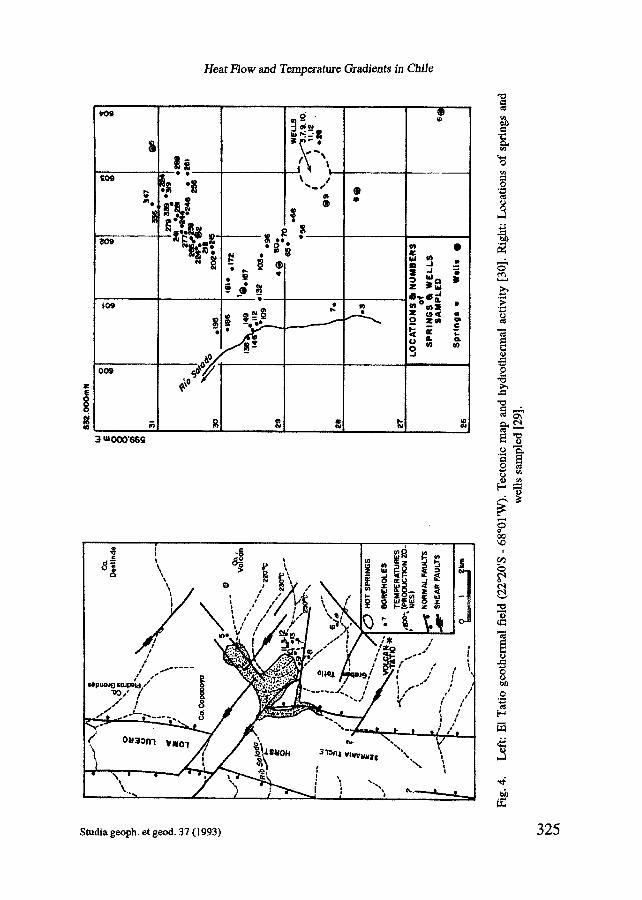
The results of geochemical thermometry applied to 33 hot spring-waters of the E1 Tatio geothermal area are shown in Table 3. The tectonic features and location of springs and wells of El Tatio are shown in Fig. 4. As can be seen in Table 3, the Mg correction to T(Na-K-Ca) is generally not relevant in E1 Tatio. The highest temperature estimate is given by the Na-Li geothermometer (262 °C) showing the smallest standard deviation (9 °C). The temperature estimates from well discharges are given in Table 4.
324 Studia geoph, et geod. 37 (1993)
H~at F/ow and Temperature Gradients in Chilo
t o g
~ e e - - £og •
309
®
- - ~ ~,~. , ~ ~ ' ~
® I I
w
n ° m ~ E
3 w o o o ' 6 6 g
l = 1 A !
I n I f . i , , .
r - - . - ~ l z / , / / ~ =~ | ® / " ; / ; I z ~ _ . / ,
,, . - " ~ g . ' : ~ - , , . , - / 4 , . . ~ ! ~/'.." / / ', / " - - ' : " - - ' / ! / t _ . / ; , ~ , ~ u ~ - , ~ , ,~ . , , ~ ; ~ ' . - ~ , , / , , . . . .
~ , , ~ / ~ t i " -. / I , ; , , . . _
- . L - . - - ~ ~ ~ ~ , .... .... ,, • ~
== &
o
g
e~ hi)
e~
==
<30 ~o
i
0
o
o e4
, °
Studia geoph, et geod. 37 (1993) 325

M. Mt~oz and V. Hamza
Table 4. E1 Tatio. Maximum temperature measured before discharge (T). Temperature estimates by geothermometers in well discharges: T(SiO2); T(Na-K-Ca); T(Na-Li).
Well Depth [m] T [°C] T(SiO2) [°C] T(Na-K-Ca) (1) [°C] T(Na-Li) [°C]
T1 617 211 207 212 221 652 227 208 232 240
T3 616 253 170 171 240 T4 733 229 194 170 204 T5 568 212 219 239 245
Chemical composition of well discharges taken from [32] (1) T(Ma-K-Ca) estimates after [32]
Well Depth [m] T [°(3] T(SiO 2) [°C] TfNa-K-Ca) [°C] T(Na-Li) [°C]
T1 617 211 232 215 219 T2 652 226 243 236 242 T3 616 253 192 172 250 T4 733 229 218 172 210 T5 568 212 244 242 249 T6 551 180 174 180 252 177 867 250 293 261 256
T10 1504 236 290 256 254 TI1 894 240 291 260 254 T12 1410 247 277 259 256
Chemical composition of well discharges taken from [29]
"mean depth" 637 m mean T 226 °C st. dev.: 33 °C mean T(SiO2) 200 °C st. dev.: 17 °C mean T(Na-K-Ca) 205 °C st. dev.: 33 °C mean T(Na-Li) 230 °(3 st. dev.: 17 °C
In order to evaluate the fluid-rock equilibrium in the geothermal systems of Chile, the relative Na, K, Mg and Ca contents of thermal waters have been established and compared with the full equilibrium curves of Giggenbach [39]. The pair K-Na reaches its equilibrium content according to L ~ = log (CKICNa) = 1.75 - 1390/T, where ci are the analytical concentrations in mg/kg and T is the absolute temperature in °K [40.]. For the quotient c2i(/CMg, the temperature dependence is Lkm = log (C2ktCMg) = 14.0 - (4410/T) [39,40]. COz-fugacities (f¢02) are evaluated by means of the relationship linking the sensitivity of the K-Ca system to variations in fco2: Lkc = tog (C2KICCa) = Iogfco2 + 3.0 [39].
326 Studia geoph, et geod. 37 (1993)

Heat b-low and Temperature Gradients in Chile
N o A O 0 0
©., / I000+=~/t00+ ~ , S
"%-Ne" zc k / 1 0 s "%.Mg" =tO0 ¢~'~/S
C I In mg/kg
• fulL~|l'b kl / \ |~ . / /1 _.. . ,~ ,~./----h, - - - ) . .
K / f O 0 ~ ~o 3o ,0 ~o ,,o/~ 7o . ,o V ~ -i#4)"
6~ o 10oo t (°1:1 200 o 300 °
0! . . . . .
Fig. 5. Northern Chile geothermal areas: Baflos Jurase (1); Untupujo (2); Suriri (3); Chinchillani (4); Puchuldiza (5a, b,c); Chusmiza (6); Pampa L'trima (7). Upper diagram: evaluation of Na-K and K-Mg equilibrium temperatures (tkn and t/on); lower diagram: evaluation of CO2-fugacities (fCO2) - for immature waters fco2 is not reliable. The CO2-contents of liquid and vapor phases as a function of fco2 and temperature are only valid for low-salinity systems (curves rco2). The rock-dissolution lines refer to solutions of varying amounts of an average
crustal rock in 1 kg of water.
Stadia geoph, et geol. 37 (1993) 3 2 7

M. Mu~oz and V. Hamza
N o l I O 0 0
©.~/Io0o+ cK/10o+ ~ =s
"%-#~" : c , ~ / l O S
~%-Mg" -100 c4~/S ©~ In m i / k o
t ~ ~ . , ~ ,,.J---k - - - t~
r ,' , , ,'?>' / i - - ~ - ' 7 - ~ , - . ~ K/f l : )O ,o I~ 3o .~ 5o tio . ,o .o so
~ ' M g
k~ (b~'i
0 " - " 4 6 7 ' ! 2 3 5 Lira
Fig. 6. El Tatio thermal springs. Evaluation of tkn and t/~ equilibrium temperatures (upper diagram). Evaluation of CO 2 fugacities (lower diagram). See also caption to Fig. 5. Locations of
springs are shown in Fig. 4.
328 Studia geoph, et geod, 37 (1993)

Heat Flow and Temperature Gradients in Chile
Na/lO00
m~ ©m/i°°°icK/i°°+ i~i--s / /\ -~.-.%.l~s
~ I I \ " % - M a ' , m O =4~"~" I S
7 / / ~ ©, In .g/k9 ""
? / i A Pull I¢luilllllilum / \ , t~.
T'f, 40 I I t l / i l
' ° # N ; i , , ~ - - i . i ./ / / , ~ / i / ~ / / / inbt~ wetws 1 /~-~ / / . ~ ; , < ' ~ / / ,,,,,,,_/ / / / / " ~
io , , ~ /
/ . / /,:o,,;,--- ~ - < . - ...... - - . . - K I I O ( ) ~ ~ ~o 4o so .o . To ~ go
"" / I <"
I 2 5 L / 6
Fig. 7. El Tatio well discharges (chemical composition taken from [29]. Evaluation of t~ and tb, equilibrium temperatures (upper diagram). Evaluation of CO 2 fugacitics (lower diagram).
See also caption to Fig. 5. Locations of wells arc shown in Fig. 4.
Studia geoph, et geod. 37 (1993) 329

M. Mu~oz and V. Hamza
The two subsystems, K-Na and K-Mg, are likely to provide the basis for suitable geothermometers. Figures 5, 6, 7 and 8 show the results obtained for Chile hot springs by using the diagrams of Giggenbach [39]. The subsystems are presented by two sets of isotherms, their intersection marks a "full equilibrium" curve that corresponds to the composition of waters in equilibrium with both mineral systems (see Fig. 5 - upper diagram). Also shown is the composition of waters formed through isochemical dissolution of varying amounts of crustal rock in 1 kg of water. The curve marked "weirbox", above the full equilibrium curve, describes the position of waters subject to maximum steam loss by flashing from their full equilibrium temperature to 100 °C. "Immature" waters correspond, generally, to waters unsuitable for the evaluation of K/Na equilibrium temperatures; for not too acid waters, K/Mg temperatures may still be valid. An area of partially equilibrated waters lies between the immature waters and the full equilibrium curve. The curve separating immature from partially equilibrated waters corresponds to a "maturity index" Mi of 2-0, according to.Mi = 0-315 Lbn- L~ = 2.0; the main value of this somewhat arbitrary definition lies in its use for distinguishing waters suitable for the application of the K-Mg-Ca geobarometer [39]. Evaluation of analytical Na, K and Mg contents by use of Giggenbach's diagram allows deeper equilibrium temperatures and the effects of processes such as re-equilibration and mixing of waters of different origin to be assessed. The evaluation of CO2- fugacities (fco2) - see Fig. 5, lower diagram - is only reliable for data points close to the equilibrium line. For waters identified as immature by use of the upper diagram, evaluation of fco2 in basis of their K-Ca contents is not possible. For partially equilibrated waters, the full equilibrium curve of the K-Ca geobarometer (lower diagram) may be taken to separate waters from two distinct alteration environments: data points plotted below it are likely to come from an alteration system dominated by acid fluids, those plotted above from a rock- dominated, CO2 - deficient environment [39]. In these diagrams rco2 are the mole-ratios nco21nH20 in the vapor and liquid phase, respectively. These curves relating CO2 - fugacities and the CO2 - content of co-existing vapor and liquid phases were plotted assuming ideal gas behavior and may, therefore, be applied to low salinity systems (< 0.1 M) at pressures lower than 100 bars [39].
The results of fluid-rock equilibrium based upon the Na-K-Mg-Ca geoindicators for geothermal areas in northern Chile are shown in Fig. 5 and, separately, in Figs. 6 and 7 for E1 Tatio. The plotts in Fig. 5 indicate that only Puchuldiza points to attainment of partial equilibrium - the diverse degree of equilibrium shown by three different discharges may be due to the mixing of waters and processes affecting the rising fluids. As indicated by the tkn geothermometer, deeper conditions in Puchuldiza may be characterized by temperatures as high as 235 °C - this is roughly the mean temperature estimate by the Na-Li geothermometer (Table 2). CO2-fugacities from Puchuldiza lie between 0.2 and 1.0 bar (Fig. 5, lower diagram). Bafios Jurase and Suriri are close to a partial equilibrium condition, and comparison with other estimates (Table 2) should be carried out in these cases. The great disparity between the temperature estimates by different geothermometers (Table 2) applied to Untupujo, Chinchilllani mid Pampa Lirima is reflected in the immature character of waters from these environments; the subsystems K-Na and K-Mg are unsuitable to provide valid geotemperatures in these
330 s~dia geoph, et geod, 37 (1993)

Heat b-low and Temperature Gradients in Chile
cases. For Chusmiza the K/Mg temperature (t~) can still be adopted; the deep temperature in this area seems to be less than 100 °C (Fig. 5; Table 2).
For E1 Tatio (Fig. 6) the plots indicate attainment of partial equilibrium or full equilibrium according to the K-Na and K-Mg mineral subsystems. The chloride springs located in the middle northeastern area of the geothermal field (Fig. 4: springs 227, 238, 244, 339) plot somewhat above the full equilibrium curve and near the curve marked "weirbox"; these are high temperature discharges with the highest associated Na-K-Ca temperature estimate (about 230°C - Table 3). Attainment of full equilibrium diminishes towards the SW (Fig. 4: springs 218, 202, 181) indicating dilution of the E1 Tatio north chloride waters (181 is a chloride-bicarbonate water). The west chloride waters (Fig. 4: springs 186, 149,109) plot near or above the full equilibrium curve, but they do not cluster as the plots of the northeastern springs. The south chloride springs (Fig. 4: springs 65, 80, 103) indicate a diverse degree of equilibrium, increasing towards the north; the plots fall on the same K-Na isotherm, and the geobarometer (Fig. 6, lower diagram) indicates two distinct alteration environments.
The indications of fluid-rock equilibrium derived from Na-K-Mg-Ca geoindicators are somewhat consistent with the indications from the correlation between the molecular CUB ratio and Na-K-Ca temperature of the El Tatio springs. A tight cluster of C1/B ratios about the value of 13-5 is obtained for the northeastern springs [41]; these waters ascend directly up the Geyser Fault from the ignimbrite main aquifer and partially mix with the overlying bicarbonate sulphate waters. A general scatter of C1/B ratios for the west springs is obtained; in this area the chloride concentration has a random spatial distribution but there is a broad correlation with Na-K-Ca geothermometry [41 ]. A tight cluster of C1/B ratios about the value of 13 was also obtained by Youngman [41] for the E1 Tatio south springs indicating an aquifer in which fluids are at equilibrium with the rock; partial achievement of equilibrium is rather indicated by the K/Na and K/Mg equilibrium temperatures - full equilibrium seems to be achieved towards the north sector of the south springs area, but lack of sufficient data does not allow further discussion about the fluid-rock equilibrium in this area.
The equilibrium diagrams for the E1 Tatio well discharges are shown in Fig. 7. The plots indicate full equilibrium in most cases; a partial equilibrium condition is indicated for discharges from T6 in the SE area of the geothermal field (Fig. 4). The lowest equilibrium temperature (165 °C) is for T4; this is the only shallow well to draw from the Tucle dacite aquifer overlying the major ignimbrite equifer [41]. The highest equilibrium temperature (285 °C) is indicated for wells T7, T l l and T12. Past investigation of El Tatio has established wells "1"7 and T l l as good producers; James [42] calculated that 15 MW electrical could be generated from these two wells [41].
The E1 Tatio CO2-fugacities derived by use of the K-Ca system are shown in Figs. 6 and 7 (lower diagrams). Low values of fco2 from 0.1 to 1.0 bar are observed for the El Tatio springs (Fig. 6). A larger value of about 5 bars is derived for discharges from wells T7, T l l and T12 (Fig. 7). The CO2-conteat of the fluids cannot be obtained from the values of rco2 in the case of E1Tatio - the salinity of E1Tatio is 0-16 M [41], and the assumption by Giggenbach [39] for this derivation is not fulfilled.
Studia geoph, et geod. 37 (1993) 331

M. Mufioz and V. Hamza
No/4000
"%4~o" =c~4/10 S "%-MO" ;X)O c ~ / S
C I in rag/k9
-__ ;.~.
7~/=~"," ~ - , - - Z - - = , = ~ - ~=, /," / - / .~ ._/ . ~ ~ <.,,ioo ,o , , ,> ,~ ,~ .,,,G,~,> ,o " < ~ t ~ - "
60 ° i00 o t ~ ZOOO+ 300 o
k (b~r)
3" .I .~
5 " ~ *100
~ " " " 4 7 t 2 3 5 Lira 6
Fig. 8. Central Chile geothermal areas: Colina (I), Apoquindo (2), Baflos de Colina (3), Bafios Morales (4), Cauqucncs (5), Vegas dcl Flaco (6), San Pedro (7), Baflos dc Azufr¢ (8), Panim~vida (9), Campanario (10), Catillo (I I), Chill~n (12), Pcmchuc (13), Tolguaca (14), Rfo Blanco (15), Aguas dc la Vaca (16), Palgufn (17), LlifSn (18), Aguas Calicntcs (19), Puychuc (20). Evaluation of t/o~ and tkm equilibrium temperatures (upper diagram). Evaluation of CO 2
fugacitics (lower diagram). Scc also caption to Fig. 5.
332 Studia geoph, et geod. 37 (1993)

Heat Flow and Temperature Grad/ents in Chile
The equilibrium diagrams for Central Chile geothermal waters are shown in Fig. 8. None of these waters plots on the full equilibrium curve A partial equilibrium condition is indicated for Apoquindo, Baitos de Colina, Bafios Morales, Vegas del Flaco, San Pedro, Campanario and Pemehue. San Pedro shows the highest degree of partial equilibrium, with t/on and t/m of about 195 °C and 245 °C, respectively. Plots indicate that waters in many areas are immature, and therefore unsuitable for the evaluation of tbn and tim equilibrium temperatures, ttm may still be valid for Catillo, Aguas Calientes and Puyehue. Evaluation from Na-K-Mg geoindicators are generally in agreement with the distinct features shown by the application of different geothermometers to central Chile hot-spring waters (Table 2). Particularly, Chill,~n and Rio Blanco plot as immature waters, near the Mg comer, and Na-K-Mg geoindicators are unsuitable for the evaluation of the equilibrium temperature of these high enthalpy acid sulfate waters. Note that even if all waters have been plotted on the diagram of CO2-fugacities (Fig. 8, lower diagram), the K-Mg-Ca geobarometer is unsuitable in most cases because of the immature character of waters, and the plots may be seen only as indicators of the completeness of the evaluation.
Besides the physical nature of geothemml systems, the assessment of geothermal resources needs drilling and economic problems to be considered. Muffler and Cataldi [43] have produced a definition of geothermal resources based on the terms used for material mineral resources by McKelvey [44]. The geothermal resource base is all the heat in the earth's crust beneath a specific area, measured from the local mean annual temperature; it seems unlikely that heat at temperatures between 0 °K (- 273 °C) and the mean annual temperature could ever be used [43]. The geothermal resource base is divided into the accessible resource base (ARB) and the inaccessible resource base (IRB) taking into account the depths that can be reached by production drilling. The ARB can be useful or residual, as a fraction of heat - for physical, environmental or legal considerations - will always be left in the ground. The last subdivision is made in the useful ARB into economic and subeconornic categories. A geothermal reserve is that part of the resource base that is identified and economical [43]. Or, following ~the definition by Diadkin [45], a geothermal reserve is all the identified heat contained between an upper boundary - deten~ned by the profitable lower temperature - and a lower boundary determined by the highest acceptable drilling costs.
As pointed out by Mufloz [1] - following the results shown in Table 2 - high, middle and low-entalphy fluids characterize the geothermal systems in Chile. But the assessment of these geothermal resources is almost absent in all the cases - excepting E1 Tatio - and it is not possible to designate them as geothermal reserves in the sense of the former definitions.
4. EL TATIO HYDROTHERMAL SYSTEM
In geothermal areas such as E1 Tatio (Fig. 4) it is necessary to consider the combined heat flow (conductive and convective) to properly characterize the thermal structure and estimate the geothermal potential. In geothermal systems associated with a magmatic intrusion at depth H and temperature Tm overlain by a fractured zone of thickness h
Studia geoph, et 8eod. 37 (1993) 333

M. Mu~oz and K Hamza
(h < H) and themml conductivity K, and provided the magma supply can maintain the isothermal condition (Tin) during the initial stages, an equilibrium state will be established in the overlying rocks at a characteristic time "r(H) [46]; the hydrothermal convection that should occur through the fractured zone of thickness h will set up an effective conductivity NK (N > 1). As shown in [46], the mean combined heat flow Qc from the system is equal to K TmI[H- h(N- 1)IN]. The expression in brackets can be called the "effective depth" of magma; it is the depth that would be implied by heat-flow observations if convection were absent [46]. The difference between depth H and the "effective depth" of magma is the thickness that is made "transparent" by hydrothennal convection.
Considering the temperature and volumetric flow characteristics of E1 Tatio - and following a procedure like the one described in [47] - a value of 2.03 x 10 s W is reached for the heat discharge by convection [1]. Taking into account the structure of the El Tatio graben the combined heat flow is estimated to be Qc = 1465 mWm -2. An "effective depth" of magma of 1.1 km has been obtained, indicating that hydrothermal convection evolves between the surface and within 1-1 km of the magmatic intrusion if circulation is vigorous (large N). If N is moderate circulation will develop even nearer to the magma intrusion. Magnetotellurie soundings [48] in the north of Chile indicate a highly anomalous zone of 0.4 ohm m of electrical resistivity at 5 - 7 km depth in the area of El Tatio ~ig. 9). This zone may correspond to granite at a temperature of about 800 °C enriched by a high electrical conductivity component (H20), as can be inferred from [49]. Assuming the value of 1.1 km for the magma "effective depth" in El Tatio, fluid circulation is evolving to a depth of 4 - 6 km, with magma becoming "transparent" through this thickness by means of hydrothermal convection [ 1].
The isotopic analyses of spring, well and meteoric water samples from El Tatio - deuterium/hydrogen and ISo/160 ratios - carried out by Giggenbach [32] and
NE SW W-Cordillera Altlplano E-Cordillera
SAG (:HI TUR TAT LAC POR SON ESC MAR ~ AZU
- - - - 7 - ~ ~ r ~ - - - - - ~ e = _ - - ' ~ - -
0,7 ! l " 1 ) 0 i';;' - -
- ~ " , , , ~
2 2
- 5 O k r a
Fig. 9. Electrical structure of the Andean crust in northern Chile and southern Bolivia as inferred from magnetotelluric studies [48]. Resistivity values in ohm rn. The anomalous zone in the area of El Tatio (TAT) may correspond to a rnagmatic intrusion at 5 - 7 km depth.
Hydrothermal convection evolves within I km of the intrusion upper contact.
334 Studia geoph, et geod. 37 (1993)

Heat Flow and Temperature Gradients in Chile
re-examined by Youngman [41], indicate that the composition of the groundwater (the cold unminemlized fluid) is - 9.5%o81sO, - 54~o b'D which is essentially the composition of the only meteoric sample, snow (other waters considered by Giggenbach [32] as meteoric were cold spring and drainage waters). Then the El Tatio groundwater is of meteoric origin. With a deuterium content of waters of about -78%0 the recharge catchment area is found to lie some 12 - 16 km to the east of the geothermal area [32]. Preliminary data for the tritium content of undiluted E1 Tatio waters yields a value of 3.2 T.U. (1 T.U. = 10 -8 T/H) [29]. Upon this result an age of about 15 - 17 years is suggested by Cusicanqui [29] for the E1 Tatio waters on discharge. Taking into account the former results on the depth of fluid circulation ( 4 - 6 kin) the actual distance travelled by the water may be estimated to be 20 kin, at a rate of aboutt 1.3 km/year.
5. TEMPERATURE OF WATER AND HEAT FLOW IN THE SANTIAGO BASIN (RESULTS FROM GEOCHEMICAL THERMOMETRY)
Estimates of water temperature and heat flow based upon geochemical methods is particularly significant in areas with no recent magmatic activity. In some cases sedimentary basins may be considered as potential areas of low-enthalpy geothermal
/ G . . . J ,Yl/ , Yit
• // () i . I i ~" . . . . ~ ' ~ ' ~ , i ~ , . k . ~ . ~I ~ ~ r ~
~al a
/ " ° ~ _ _ _ i ' ' - ' ~ 7 - -1 ' , , . / / t • L ...... ~ / v I "h
Fig. lO. The Santiago basin (~om [50]). Water analyses of the enclosed area (broken line) were considered to estimate the temperature at depth and equivalent heat flow (see Table 5). The zone of water discharge along the northwest basin boundary is characterized by the larger relative number of heat anomalies. Also shown is La Africana Mine with a conventional heat-flow value of 78.7 mW'2; in this zone the anomalous mean fluid temperature (silica) at depth and mean
o 2 surface equivalent heat flow are, respectively, 94 C and 117 roW" .
Stadia geoph, et geod. 37 (1993) 335

M. Muffoz and V. Hamza
Table 5. Temperature at depth T(SiO 2) and equivalent heat flow (Q equiv.) in the Santiago basin.
Number of T(SiO2) Q equiv. Q conventional samples [°C] [mWm -2] [mWm -2]
All data 257 77-4 + 10-4 92.5 + 16-6 Anomalies only 54 92.1 :t: 6-7 114-1 + 18-7 Anomalies excluded 203 73.5 + 7.1 86.8 + 16.0 La Africana Mine Area All data 56 75.6 + 12.4 89.9 + 16-3 Anomalies only 14 94.4 + 5-5 117.4 5:19.0 Anomalies excluded 42 69-4:1:5.9 80.8 5:15.4
78-7
Q equiv.: calculated after [24]: T(SiO2) = mQ equiv. + b; for the Santiago basin the following values have been adopted [1]: m = 683 + 67 [°C row-l]; b = 14.2 + 5-1 [°C]
Q conventional : value taken from [2].
systems - some insights on the existence of such systems in relation to tectonics in Chile have been presented in [51]. In the Santiago basin (Fig. 10) estimates from the Si t2 geothermometer [24] have been carried out which indicate anomalous high water temperature and high heat flow compatible with the only conventional heat-flow measurement in the area [1]. The larger relative number of anomalies is encountered in the northwest basin boundary - the zone of water discharge. The pattern of heat-flow anomalies was found to be in agreement with studies concerning this kind of areas (e.g., Smith and Chapman [52], Woodbury and Smith [53]) which indicate that deviations result in negative anomalies of heat flow in the recharge area and positive anomalies in the discharge area, with an intermediate zone characterized by a base heat flow. A further discussion of the hydrological characteristics of the Santiago basin can be found in [1].
The results for the Santiago basin are shown in Table 5, The possibility of using this basin as a low-enthalpy geothermal system - with industrial applications, heating, greenhouses - has to be studied. Recently, a preliminary project for the assessment of low and middle-enthalpy geothermal fields in Chile - including the case of the Santiago basin - has been proposed to the Chilean government.
It is woth noting that the application of the Na-K-Ca geothermometer of Fournier and Truesdell [25] to well waters of the Santiago basin gives irregular results in respect to the selection of the 13 - value to estimate temperatures. The 13 - value is assumed to be 1/3 or 4/3 [25] but - as these authors have observed - in some places the net rock-water reaction may be such that 13 is very different from the former values. Also, the evaluation of the fluid-rock equilibrium by means of the K-Na and K-Mg subsystems [39] indicates that the Santiago basin waters are immature and that many waters plot
336 Studia geoph, etgeod. 37 (1993)

Heath'love and Temperature Gradients in Chile
near the Mg comer of the equilibrium diagram. If K/Mg temperatures were still valid, deeper equilibrium temperatures in the Santiago basin may be of about 80 °C.
6. TEMPERATURE GRADIENTS IN BOREHOLES; THERMAL CONDUCTIVITY OF SAMPLES
Geothermal gradient data are shown in Table 6 and in Fig. 11 (the temperature axis does not start at T= 0 °C). The general form of T-logs show that temperatures are affected by drilling disturbances. The least affected part is at the bottom of the hole, but even here corrections are necessary. There is no reliable information about the duration of the last mud circulation, and the time elapsed between the end of mud circulation and the time of the bottom-bole temperature (BHT) measurement. Some preliminary and uncorrected estimates of gradients (G) are shown in Table 6, using the relation G = (TnHr- To)IZnHT); the value - that must be corrected - To = 10 °C was assumed. Gradient values (CVL) by least-squares fit to the T-log data along one depth interval are also given in Table 6. Presently, it is not possible to ascertain the propriety of these interval-gradient values - temperatures may be strongly affected by mud circulation. A change from high to very low values of temperature gradients in one borehole has been observed in other areas, and may be due to terrain effects (e.g. [54]).
Thermal conductivity of samples from the Pehu6n-1 borehole (depth interval between 475 and 1932 m) is given in Table 7 and in Table 8 - the geological formation and rock type have been considered. For other boreholes (Lebu-2, Dolores-1 and Curanilahue-2), thermal conductivities and diffusivities are shown in Table 9. The needle-probe method
Table 6. Geothermal gradients in boreholes. G: calculated by considering the bottom borehole temperature (BHT). CVL: gradient values by least-squares fit to temperature data along one depth
interval (see Fig. 7).
Borehole Latitude Depth interval G CVL Longitude [m] [°C/KIn] [°C/Km]
Pehu~n-1 37°39'08"S 0 - 1900 27.2 73°32'44"W 300 - 1800 6.0
Lebu-2 37°38'25"S 0 - 1300 72.4 73037'59"W 200- 1150 7.9
Dolores-1 19041'S 0 - 400 50.0 69055'W (approx.)
Curanilahue-2 37"25'S 0 - 1550 26.3 73030'W 325 - 1500 9-0
Cholchol-1 38035'S 0 - 315 38.8 72o50'W (approx.)
Studia geoph, et geod. 37 (1993) 3 37

M. Mt~oz and V. Hamza
Table 7. Borehole Pehu6n-1. Thermal conductivity (K) by considering geological formations of the site.
Geological formation Depth interval K [m] [W/m°C]
Millongue 475.0 - 478.0 1.7 633-0 - 639.0 1-5
Trihueco 873.5 - 877.5 2,1 1039.0- 1045.0 1.8 1051.0- 1057.0 3.2 1072.0- 1078.0 1,7 1098.0- 1104.0 2.6
Boca Lebu 1180.0 - 1183.0 1.9
Curanilahue 1456.0- 1460.0 1.7 1501,0- 1505,0 2-2
Quiriquina 1542-0- 1545.0 2,6 1704.0- 1708.0 1.6 1859-0- 1863-5 2.8 1930.0-1932.5 4-1
Thermal conductivity Pehudn-l: 2.3 ± 0.7 [W/m°C]
was used for conductivity measurements. The equipment used is a half-space line source device built at the Institute de Pesquisas Tecnol6gieas (Sao Paulo). This equipment is calibrated using fused silica discs which are internationally accepted as primary standards; in addition, reek samples of known thermal conductivity are also used as substandards,
Table 8. Bomhol¢ Pehu6n-1. Thermal conductivity of rocks.
Rock Number of samples K [W/m°C]
Conglomerate 2 3-4 ± 0-9 Sandstone 6 2.2 ± 0.6 Motasandstone 1 2-2 Lutit¢ (argillite) 3 1-7 + 0.1 Basalt 2 2.0 ± 0,8
338 Studia geoph, et geod. 37 (1993)

Heat Flow and Temperature CTadients in Chile
T("C) T("C) 4O Z o ,.,,~,, ?,.?,.,~,,.,~,...sF...~,...~.,.sP.,.~P o ~, . , .~ . , .~ . . .~ . . .~ . . -~ . . ,~ . . .~ . . .~ . . ~.. .7o ! _~ O •
200; 'V" I
800- 1ooo-,
1200-
1400
16(X)
1800,
2000-
S*'~, PEHUEN-t
\ *,f
~ | " t •
200,
400-
600,
800-
I000.
1200-
• t400i TPC) Z(m)
'°° i • ,
e~l • • J
• •dP ~ I
II • e e l
T(oc) ,4 ..~p...?.. ep..2e 2, es 2p .~ 3F..3 #
, , 1 . , , I . . . . . . .
zLm) ., p, ,.~0 ,., ,~...~., ,~, ,., o'"
::21 Z(m) Zlm)
t • LEBU-2
'"'%..,.
T(°C) .¥...~. :~.. ~,, ,4,e,, .~,..~,...~....V'...5~
CURANILAHUE- 2
~ o .
IOO- ==*% • .
2oo
3oo.
Z(m)
Fig. Ii.
CHOLCHOL-I
I
T-logs in boreholes. Location of boreholes is given in Table 6. Lcbu-2: the temperature value atZ= 1300 m (T= 104 °C) is not shown.
0N.B.: The temperature axis does not start at 0 °C).
Studia geoph, et good. 37 (1993) 339

M. Muffoz and V. Hamza
Table 9. Thermal conductivity (K) and thermal diffusivity 0¢) in samples of boreholes Lebu-2,
Dolores-4 and Curanilahue-2
Borehole Depth interval K ~¢ [m] [W/m'C] [10-6m2/s]
Lcbu-2 157.0- 161.0 2.67 1.08 348-0 - 353.0 2.96 0.91 446.0 - 448.5 2.13 1.30 664-0 - 669.0 1.30 1-47 818.0 - 822-0 1.78 1-33 909.0 - 915.0 1.93 1-43
1345.0- 1351.0 1-92 1.14 1539.0- 1543.5 2.84 1.09 1583.0- 1586.0 3.91 1.19
Dolores-1 198.5 - 200.5 2.14 1.25 374.0 - 380.0 2.04 1.45 453.0 - 458-5 1-63 1.27 582.0 - 585.0 1-26 1.25 763.0 - 767.5 1.33 1.43
1452-0- 1457.5 2.45 1-20 1687.0- 1693.0 1.75 1.45 1798-0- 1802-0 1-42 1-42 1952.0- 1955.0 2.28 1.22 2344.0 - 2346.0 2.20 1.41
Curanilahue-2 1518.0- 1521.0 2.68 --- 1536.0- 1541.0 4.07 0.95 1558.0- 1563.0 2-32 1.15
Lebu-2 2.38 + 0.74 1-22 + 0.17
Dolores-1 1.85 + 0.41 1-34 + 0.10
Curanilahue-2 3.02 5- 0.75 1-05 + 0-10
3 4 0 Studia geoph, et geod. 37 (1993)

Heat b'low and Temperature Gradients in Chile
7. CONCLUSIONS AND DISCUSSION
The heat flow measured in Chile is extremely variable with generally low values at latitudes 26.5 °S- 29 °S and higher values in the central region (33 °S). The latitude range characterized by low heat flow in part correlates with that where active volcanism is not observed. Higher values at latitude 33 °S coincide with the re-initiation of volcanic activity. A high value of heat flow is observed at Tierra del Fuego in the jigsaw mosaic of southern Chile. Also, geothermal BHT gradients in boreholes are very variable with normal or higher than normal values as compared to the standard value for the Earth. The highest gradients are encountered in Chile's extreme north (Dolores) and in the central-south region (Lebu) - both sites are situated in the coastal range in areas characterized inland by strong geothermal and volcanic activity. But near the Lebu borehole other BHT data ~ehu~n, Curanilahue, Cholchol) indicate nearly standard gradient values. BHT gradients are preliminary as it has not been possible to correct temperature measurements for mud circulation.
The former results of heat flow in Chile do not allow for any conclusions on the general beat-flow distribution and its description in the frame of new global tectonics. The present state of research does not show a simply connected relation of heat flow with other geophysical processes. This can be more clearly seen by considering the maximum depth of the seismic coupling along Chile and its relation to the heat flow and the geothermal structure. The maximum depth of seismic coupling is defined by Tichelaar and Ruff [55] as the depth of large magnitude (Mw>6) underthrusting earthquakes with foei at the downdip edge of the coupled plate interface, Their results, concerning the Chilean subduction zone [55] indicate that the coupling extends deeper (down to 48 - 53 kin) between latitudes 28 °S and 32 °S as compared to the coupling in the regions immediately north and south (36 - 41 km and 44 - 49 km, respectively). The largest depth range of seismic coupling is then encountered in the region with no active volcanoes and where heat flow at two sites - Boquer6n Chanar (iron mine) and Vallenar (Cachiyuyo area, copper mine) - is extremely low. In the calculations by Tichelaar and Ruff [55] a constant P-wave velocity of 6.7 ms -1 between the seismic source and the free surface along the Chilean subduction zone was assumed - as they pointed out this can be a handicap for the correctness of their conclusions. Tichelaar and Ruff [55] discuss various processes that may control the maximum depth of the seismic coupling. It seems to them that temperature effects associated with volcanism are not sufficient to explain the maximum depth of the seismically coupled zone - the large 1967 M w = 7.1
Tocopilla earthquake occurred at a depth of 45 - 48 km and Andean volcanism is still active [55]. The possibility of this control effect was suggested by the thermal modelling carried out by Van den Beukel and Wortel [56,57]. To these authors, reduced strength, due to thermally activated creep, seems the most likely explanation of the change from a seismically coupled zone at shallow depths to one uncoupled at larger depths. But a caveat in the correlation between volcanism and maximum depth of seismic coupling [55] cannot arise from the results by Van den Beukel and Wortel [57]: they have inferred that the volcanic line and the boundary of the asthenospheric wedge approximately coincide and that the asthenospheric wedge does not extend significantly
Studia geoph, et geod. 37 (1993) 3 4 1

M. Mu~oz and V. Hamza
into the arc-trench region. The 1967 Tocopilla earthquake used in [55] to counteract the correlation between volcanism and maximum depth of seismic coupling occurred in the coastal range, 100 krn west of the volcanic zone, far away from the part of the arc-trench transition zone where - as proposed in [57] - equilibrium exists between cooling (caused by the subsiding oceanic lithosphere) and heating (caused by the nearly continental asthenospheric wedge). With respect to this, magnetotelluric and geomagnetic deep soundings show distinctly different electrical conductivity structures from the coastal range to the Andes at latitudes 22 ° - 230 S in northern Chile [48,58]. A controversial point in the thermo-mechanical modelling by Van den Beukel and Wortel [56,57] is the requirement of an average heat flow in the central part of the arc-trench regions falling between 30 and 35 mWm -2. This average value is suggested to the authors by the published data on heat flow from northeast Honshu 0apan), Cascades (USA), Perd and northern Chile, as well as from heat-flow values for other subduction zones that have been active for more than 50 My (Kurile Islands, Central America). Northern Chile's low heat-flow values considered in [56,57] are from sites between latitudes 26°32 ' S and 28o05 ' S - in a region where active volcanism is almost absent - and from one site in the central Chile Andean region with a normal value of heat flow. Heat flow in the Santiago basin and preliminary uncorrected temperature gradients and conductivity measurements in boreholes in the coastal range are instead suggesting a normal or a high heat flow in other segments of the arc-trench zone. Also low heat-flow values in Perd taken by Van den Beukel and Wortel [56,57] are in regions with no active volcanism inland. Heat- flow measurements in western South America are too scarce for proposing an equivalence with heat flow in other subduetion zones. Even if the Kurile Islands, Japan, Pent, Chile and M6xico off Oaxaca can be considered, due to the dominant stress regime in the present phase of subduction, as Chilean-type subduction zones [59], there are other features which indicate the diversity of these regions. It is not clear to what extent the statement by Smirnov and Sugrobov [60] concerning the paradoxical relationship - from the viewpoint of radiogenic nature of heat flow - between high heat flow and thin ernst in continent-ocean transition zones - made by these authors on the basis of studies in the northwestern Pacific - can be applied to South American subduction zones. The distribution of radiogenic elements should be studied in detail for proposing more solid hypotheses concerning the similarity and disparity between these regions and for attempting to establish the relative importance of radiogenesis and zonal melting in volcanism and in the thermal evolution of the crust, as follows more specifically from part of the geophysical and geological literature (e.g. [61,62]). Also, the results of seismic tomography - which in part concern the thermal state of the Earth - are not conclusive as regards the degree of similarity between the northwestern and southeastern Pacific transition zones through different depth ranges in the upper and lower mantle [63-67]. Seismic imaging of these zones points out some features in common but also shows disparities which should be important in establishing the temperature structure and rbeological processes. Presently, many more constraints on upper mantle boundaries can be applied in the case of subduction zones in the northwestern Pacific where seismic coverage is more dense; preliminary results concerning temperature perturbations to the 660-km discontinuity within subduction plates in the northwestern Pacific argue against
3 4 2 SOadia geoph, et geod. 37 (1993)

Heat Flow and Temperature Gradients in Chile
models of clean plate slice through this discontinuity, and favor relatively models that include a gravitationally trapped megalith hypothesis and models of subducting plates encountering a viscosity contrast [68]. Besides the global complexity shown by seismic tomography, local effects having consequences on heat flow and volcanism in Chile may be considered. An increasing degree of coupling at the plate interface thrust between latitudes 37 ° S and 46°S has been estimated by Spence [69]. Variations of coupling fully coincide with maximum values of the degree of partial melting of mantle peridotite in volcanic products as inferred from Sr/Ca-Ba/Ca systematics [70]. The maximum values of the partial melting index are related by Onuma and L6per-Escobar [70] to the reduced strength of coupling between two neighboring segments of the fractured subducting oceanic lithosphere, through which deep mantle material could ascend into the upper layers. Also, the distinctly different uplift and erosional histories in western South America- as summarized in [14] - should be considered in establishing an appropriate description of heat flow and thermal processes in this region. The complexity of the tectonic structure along the Peni-Chile arc-trench zone is also apparent in the variegated picture of seismic velocities - also including low-velocity zones in different crustal depth ranges and important variations between the coastal and Andean ranges [71-77]. The intricate characteristics of the Chilean subduction zone indicate that solving for the major features of the associated heat flow makes unavoidable the measurement of temperature, conductivity and radiogenic heat generation through several deep drillings in different tectonic areas. A more dense coverage of measurements carried out in the ocean in the area of the Chile Ridge [9,10] has shown the arduous problems that may occur in interpreting heat flow on the basis of some hypothetical models. This scenario may be reproduced in some areas of continental Chile as more abundant data become available.
In respect to geothermal areas and hot springs in Chile, somewhat more definitive conclusions regarding temperatures at depth and fluid-rock equilibrium may be advanced. It has been shown that a large number of hot-spring areas are characterized as immature systems where partial fulfillment of fluid-rock equilibrium has been not attained. In northern Chile, the geothermal areas of E1 Tatio and Puchuldiza are instead mature, high-enthalpy systems that may be regarded as potential areas for energy production. Particularly, full equilibrium temperatures up to 285 °C were obtained for the E1 Tatio fluids; the recharge area is about 12 - 16 km to the east of the geothermal area and fluid circulation evolves to a depth of 4 - 6 kin, and within 1 km of a magmatic intrusion. In central Chile only seven of twenty hot-spring areas evaluated by the Na-K-Mg geoindicators satisfy partial fulfillment of fluid-rock equilibrium; temperatures at depth are generally much lower than in systems in northern Chile which satisfy the same condition ~1Tatio, Puchuldiza). San Pedro shows the highest degree of partial equilibrium, with equilibrium temperatures between 195 °C and 245 °C. Chill(m and Rio Blanco are acid sulfate waters characterized by high temperatures at depth (170°C- 240 °C). Hot-spring areas in central Chile are generally associated to active volcanoes, and no extended area showing surface thermal activity is encountered in this region. In northern Chile, besides the extrusive type of magmatic activity, it is possible
Studia geoph, etgeod. 37 (1993) 343

M. M ~ o z and V. Hamza
to distinguish a developed intrusive type - like at E1 Tatio - leading to the genesis of larger geothermal areas with fluids circulating over longer horizontal paths in the crust.
The thermal structure of the Santiago basin is still not well determined. Conventional measurements yield a high value of heat flow which is in agreement with estimates from the SiO2 geothermometer. Silica estimates indicate a temperature at depth of about 77 °C and up to 94 °C in the zone of water discharge. Evaluation of fluid-rock equilibrium by means of the Na-K-Mg geoindicators shows that waters are immature; if K/Mg temperatures were still valid, deeper equilibrium temperatures could be about 80 °C. On the basis of these results, further study of this area regarding low-enthalpy
geothermal applications can be proposed.
Acknowledgements: This work was supported by Departamento T6cnico de Investigaci6n (Universidad de Chile) with the collaboration of the Instituto de Pesquisas Tecnol6gicas (Sao Paulo, Brasil) and ENAP (Chilean Oil Concern). We especially wish to thank E d u a r d o G o n z ~il e z (ENAP) for data concerning borehole temperatures.
Received: 22. 1. 1992 Revised: 20. 9. 1992
References
[1] M. Muf loz : Flujo de calor en Chile con 6nfasis en las ~reas de El Tatio y de la cuenca de Santiago. In: V.M. Hamza, A. Frangipani, A.E. Beck and F.B. Ribeiro (Editors), Proc. Int. Meeting on Geotherrnics and Geothermal Energy, Guaruj~i (Sao Paulo), 1986. Spec. Issue Rev. Brasfleira Geoffsica, 5 (1987), 153-164.
[2] S. U y e d a , T. W a t a n a b e , E. Kause l , M. Kubo , Y. Y a s h i r o : Report of heat- flow measurements in Chile. Bull. Earthq. Res. Inst., Tokyo, 53 (1978), 131-163.
[3] M. Mui loz : Radiogenic heat producltion and erosion process in Central Chile. In: Abstracts Int. Meeting on Terrestrial Heat Flow and the Structure of the Lithosphere, Bechyn~ 1991, p.60.
[4] V. M. H a m z a , F. B. R i b e i r o , E. A. B e c k e r : Recent climatic change in the southerrn hemisphere. Abstracts Int. Meeting on Terrestrial Heat Flo~v and the Structure of the Lighosphere, Bechyn~ 1991, p.32.
[5] R. P. yon H e r z e n : Heat-flow values from the south-eastern Pacific. Nature, 183 (1959), 882-883.
[6] W. H. D i m e n t , F. Or t i z , L. S i lva , C. Ru iz : Terrestrial heat flow at two localities near Vallenar, Chile. Amer. Geophys. Un. Trans., 46 (1965), 175.
[7] V. I . K e i l i s - B o r o k : The lithosphere of the Earth as a nonlinear system with implications for earthquake prediction. Rev. Geophys., 28 (1990), 19-34.
[8] S. U y e d a, T. W a t a nab e: Preliminary report of terrestrial heat flow study in the South American continent; distribution of geothermal gradients. Tectonophysics, 10 (1970), 235- 242.
3 4 4 Studia geoph, et geod. 37 (1993)

Heat Flow and Temperature Gradients in Chile
[9] E. M. He r ron , S. C. Cande, B. R. Hal l : Am active spreading center collides with a subduction zone: A geophysical survey of the Chile margin triple junction. In: L.D. Kulm, J. Dymond, E. J. Dasch and D. M. Hussong (Editors), Nazca Plate: Crustal Formation and Andean Convergence. Geol. Soc. Am., Memoir 154 (1981), 683-701.
[10] S. C. Cande, R. B. Les l i e , J. C. Parra , M. Hobar t : Interaction between the Chile Ridge and Chile Trench: Geophysical and geothermal evidence. J. Geophys. Res., 92 (1987), 495-520.
[11] S. Honda , S. Uyeda : . Thermal process in subduction zone - A review and preliminary approach on the origin of arc volcanism. In: D. Shimozuru and I. Yokoyama (Editors), Arc Volcanism - Physics and Tectonics. Terra Scientific Publ. Co., Tokyo, 1983, pp. 117-140.
[12] D. P. M c K e n z i e : Speculations on the consequences and causes of plate motions. Geophys. J. R. astron. Soc., 18 (1969), 1-32.
[13] S. Honda: Thermal structure beneath Tohoku, north-east Japan - a case study for understanding the detailed thermal structure of the subduction zone. Tectonophysics, 112 (1985), 69-102.
[14] S. V. Henry : Terrestrial heat flow overlying the Andean subduction zone. Ph.D. Thesis, University of Michigan 1981, 194 pp.
[15] S. Uyeda , T. Watanabe : Terrestrial heat flow in western South America. Tectonophysics, 83 (1982), 63-70.
[16] V. M. Hamza : Thermal structure of South American continental lithosphere during Arcbean and Proterozoic. Revista Brasileira de Gcociencias, 12 (1982), 149-159
[17] C. R. B. Lister: On the thermal balance of a midocean ridge. Geophys. J.R. astr. Soc., 26 (1972), 465-509.
[18] R. N. Anderson , M. G. Langse th , J. G. Sc la ter : The mechanism of heat transfer through the floor of the Indian ocean. J. Geophys. Res., 82 (1977), 3391-3409.
[19] B. Pa r sons , J. G. Sc la te r : An analysis of the variation of ocean floor bathymctry and heat flow with age. J. Geophys. Res., 82 (1977), 803-827.
[20] M. G. L a n g s c t h , M. A. Hobar t , K. Horai : Heat flow in the Bering Sea. J. Geophys. Res., 85 (1980), 3740-3750.
[21] M. Yamano , S. Uyeda , Y. Aoki , T. H. Ship ley : Estimates of heat flow derived from gas hydrates. Geology, 10 (1982), 339-343.
[22] S. E. DeLong , W. M. Schwarz , R. N. Anderson: Thermal effects of ridge subduction. Earth Planet. Sci. Lctt., 44 (1979), 239-246.
[23] M. Mufloz: Report of heat flux density in Chilean localities based on geochemical data of hot springs. Dcpto Geoffsica, Univ. de Chile Santiago 1982, Unpubl. Report, 20 pp.
[24] C. A. Swanberg , P. Morgan : The silica heat flow interpretation technique: Assumptions and applications. J. Geophys. Res., 85 (1980), 7206-7214.
[25] R.O. Fourn ie r , A. H. Truesde l l : An empirical Na-K-Ca geothermometer for natural waters. Geochim. Cosmochim. Acta, 37 (1973), 1255-1275.
[26] C. Fou i l l a c , G. Micha rd : Sodium/lithium ratio in water applied to geothermometry of geothermal reservois. Geothcrmics, 10 (1981), 55-70.
[27] A. Lahsen : La actividad geothermal y sus relaciones con la tect6nica y el volcanismo en d nortc de Chile. In: Actas Primer Congreso Geo16gico Chilcno, Santiago 1976, B105- B127.
[28] R. Mer ino : Hidrologia termal. Proc. Simp. Termal, Climgtico y Balneo16gico, Santiago 1979; 7 pp.
Studia geoph, et good. 37 (1993) 345

M. Mufioz and V. Hamza
[29] H. Cus icanqu i , W. A. J. Mahon, A. J. Ell is : The geochemistry of theE1Tatio geothermal field. In: Proc. Second United Nations Symposium on the Development and Utilisation of Geothermal Resources, San Francisco, 1975, 703-711.
[30] A. Lahsen , P. Tru j i l lo : El campo geot~rmico de El Tatio, Chile. In: Proc. Second United Nations Symposium on the Development and Utilisation of Geothermal Resources, San Francisco 1975, 157-169.
[31] A. J. El l is : Survey for geothermal development in Northern Chile. Preliminary geochemistry report, E1 Tatio geothermal field. Unpubl. U.N. Project Report, 1969.
[32] W. F. G iggenbach : The isotopic composition of waters from the E1Tatio geothermal field, northern Chile. Geochim. Cosmochim. Acta, 42 (1978), 97%988.
[33] A. De Grys : Some observationes on the hot springs of Central Chile. Water Resour. Res., 1 (1965), 415-428.
[34] S. Benado , A. Marfn: Estudio y an~lisis de las aguas termominerales Bafios de Colina. IDIEF, Fac. de Ciencias Qufrnicas, Univ. de Chile, Santiago, 1975, 7 pp.
[35] R. O. Fourn ie r , R. W. Pot ter : Magnesium correction to the Na-K-Ca chemical geothermometer. Geochim. Cosmochim. Acta, 43 (1979), 1543-1550.
[36] A. Lahsen : Caracterfsticas geoqufmicas y origen de las aguas de las termas de Chill~in. Rev. Comunicaciones, Depto. Geologta, Univ. de Chile, No 24 (1978), 35-48.
[37] D. E .Whi te , L. J. P. Muf f l e r ,A . H. Truesde l l : Vapor-dominated hydrothermal systems compared with hot-water systems. Econ. Geol., 66 (1971), 75-97.
[38] D. E. Whi te , J. D. Hem, G. A. Waring: Chemical composition of subsurface waters. In: M. Fleischer (Editor), Data of Geochemistry. U.S. Geol. Survey, prof. paper 440-F; 1963, 67 pp.
[39] W. F. G iggenbach : Geothermal solute equilibria. Derivation of Na-K-Mg-Ca geoindicators. Geochim. Cosmochim Acta, 52 (1988), 2749-2765.
[40] W, F. G i g g e n b a c h , R. Gonf ian t in i , B. L. Jangi , A. H. T ruesde l l : Isotopic and chemical composition of Parbati Valley geothermal discharges, NW-Himalaya, India. Geothermics, 12 (1983), 199-222.
[41] K. J. Youngman : Hydrothermal alteration and fluid-rock interaction in the El Tatio geothermal field, Antofagasta province, Chile. Ms. Sc. Thesis, University of Auckland, 1984, 123 pp.
[42] R. James : The E1 Tatio geothermal field; test results, underground theory, power feasibility. Unpubl. U.N. Project Report 1974.
[43] P. M u f f l e r , R. Cata ld i : Methods for regional assessment of geothermal resources. Geothermics, 7 (1978), 53-89.
[44] V. E. M c K e l v e y : Mineral resource estimates and public policy. Amer. Scientist, 60 (1972), 32-40.
[45] Y. D. Diadk in : Technical, physical and economic problems in the development and use of petrogeothermal resources. In: A. Rapolla, G.V. Keller and J.S. Moore (Editors), Geophysical Aspects of the Energy Problem. Elsevier, Amsterdam, 1979, 157-204.
[46] A. H. Lachenb ruch , J. H. Sass: Heat flow in the United States and the thermal regime of the crust. In: J.G. Heacock (Editor), The Earth's Crust. AGU Geophys. Monogr., 20 (1977), 626-675.
[47] M. L. Sorey , R. E. Lewis : Convective heat flow from hot springs in the Long Valley Caldera, Mono County, California. J. Geophys. Res., 81 (1976), 785-791.
[48] G. Schwarz , V. Haak, E. Mar t fnez , J. Bann i s t e r : The electrical conductivity of the andean crust in northern Chile and southern Bolivia as inferred from magnetotelluric measurements. J. Geophys., 55 (1984), 169-178.
346 Studia geoph, et geod. 37 (1993)

Heat b'low and Temperature Gradients in Chile
[49] E. I . P a r k h k o m e n k o : Electrical resistivity of minerals and rocks at high temperature and pressure. Rev. Geophys. Space Phys., 20 (1982), 193-218.
[50] E. Fa lcon , O. Cas t i l l o , M. Va lenzue la : Hidrogeologfadelacuencade Santiago. Instituto de Investigaciones Geol6gicas, Chile; Publicaci6n Especial No 3, 1970, 46 pp., 21 ill.
[51] M. Muitoz: Fuentes geotermales de baja entalpfa. Minerales (Rev. del Inst. de Ing. de Minas), Santiago, 36 (1981), 19-23.
[52] L. Smi th , D. S. Chapman: On the thermal effect of groundwater flow, 1, Regional scale systems. J. Geophys. Res., 88 (1983), 593-608.
[53] A. D. W o o d b u r y , L. Smith: On the thermal effects of three-dimensional groundwater flow. J. Geophys. Res., 90 (1985), 759-767.
[54] D. D. B l a c k w e l l , J. L. S tee le , M. K. Frohme, C. F. M u r p h e y , G. R. P r i e s t , G. L. Black : Heat flow in the Oregon Cascade Range and its correlation with regional gravity, Curie point depths and geology. J. Geophys., Res., 95 (1990), 19475- 19493.
[55] B. W. T i c h e l a a r , L. J. Ruff : Seismic coupling along the Chilean subduction zone. J. Geophys. Res., 96 (1991), 11997-12022.
[56] J. Van den Beuke l , 'R. Wor te l : Temperature and shear stresses in the upper part of a subduction zone. Geophys. Res. Lett., 14 (1987), 1057-1060.
[57] J. Van den Beuke l , R. Wor te l : Thermo-mechanical modelling of arc-trench regions. Tectonophysics, 154 (1988), 177-193.
[58] G. Schwarz , G. Chong, D. Kriiger, E. Mar t fnez , W. Massow, V. Rath , J. V i r a m o n t e : Crustal high conductivity zones in the southern central Andes and their tectonic implications. In: Abstracts Final Workshop on the Structure and Evolution of the Central Andes in Northern Chile, Southern Bolivia and Northwestern Argentina, Freie Universit~it-Technische Universit~t, Berlin 1990, 99-100.
[59] S. Uyeda : Subduction zones: An introduction to comparative subductology. Tectonophysics, 81 (1982), 133-159.
[60] Ya. B. Smi rnov , V. M. Sugrobov : Terrestrial heat flow in the northwestern Pacific. Tectonophysics, 83 (1982), 109-122.
[61] V. A. M a g n i t s k y : The Internal Structure and Physics of the Earth. NASA T'f, Springfield 1967, 448 pp.
[62] G. D. A f a n a s i e v : Magmatic Formations and General Problems of Geological Petrology - Selected Papers. Nauka, Moscow, 1981, 514 pp. (in Russian).
[63] A. M. D z i e w o n s k i : Mapping the lower mantle: determination of lateral heterogeneity in P velocity up to degree and order 6. J. Geophys. Res., 89 (1984), 5929-5952.
[64] J. H. W o o d h o u s e , A. M. Dz iewonsk i : Mapping the upper mantle: Three- dimensional modeling of Earth structure by inversion of seismic waveforms. J. Geophys. Res., 89 (1984), 5953-5986.
[65] R. L. Woodward , G. Mas te r s : Global upper mantle structure from long-period differential travel times. J. Geophys. Res., 96 (1991), 6351-6377.
[66] Y. S .Zhang , T. Tan imo to : Three-dimensional modelling of upper mantle structure under the Pacific Ocean and surrounding area. Geophys. J. Int., 98 (1989), 255-269.
[67] T. T a n i m o t o : Long-wavelength S-wave velocity structure throughout the mantle. Geophys. J. Int., 100 (1990), 327-336.
[68] P. M. Sheare r : Constraints on upper mantle discontinuities from observations of long- period reflected and converted phases. J. Geophys. Res., 96 (1991), 18147-18182.
Studia geoph, et geod. 37 (1993) 347

M. Mu~oz and V, Hamza: Heat Flow and Temperature Gradients in Chile
[69] W. Spence: Slab pull and the seismotectonics of subducting lithosphere. Rev. Geophys., 25 (1987), 55-69.
[70] N. Onuma, L. L 6 p e z - E s c o b a r : Possible contribution of the astbenosphere below the subducted oceanic lithosphere to the genesis of arc magmas: Geochemical evidence from the Andean southern volcanic zone (33-46"S) L Volcanol. Geotherm. Res., 33 (1987), 283-298.
[71] A. Cis t e rnas : Crustal structure of the Andes from Rayleigh wave dispersion. Bull. Seism. Soc. Am., 51 (1961), 381-388.
[72] D. E. James : Andean crustal and upper mantle structure. J. Geophys. Res., 76 (1971), 3246-3271.
[73] P. R. Jones : Crustal structures of the Perd continental margin and adjacent Nazca plate, 9os latitude. In: L. D. Kulm, J. Dymond, E. J. Dasch and D. M. Hussong (Editors), Nazca Plate: Crustal Formation and Andean Convergence. Geol. Soc. Am., Memoir 154 (1981), 423-443.
[74] L. D. Kulm, W. J. Schwel le r , A. Masfas : A preliminary analysis of the subduction processes along the Andean continental margin, 6* to 45°S. In: M. Talwani and W. C. Pitman, m (Editors), Island Arcs, Deep Sea Trenches and Back-Arc Basins. Am. Geophys. Union, Washington D.C., 1977, 285-301.
[75] L. D. Kulm, R. A. Pr ince , W. French, S. Johnson , A. Mas t a s : Crustal structure and tectonics of the central Perd continental margin and trench. In: L D. Kulm, J. Dymond, E. J. Dasch and D. M. Hussong (Editors), Nazca Plate: Crustal Formation and Andean Convergence. Geol. Soc. Am., Memoir 154 (1981), 445-468.
[76] P. Acevedo , M. Pardo: Estructura cortical de Chile central (32.5* - 34.50S) utilizando el m6todo de velocidad aparente mfnima de ondas P. Rev. Tralka Depto. Geoffsica, Univ. de Chile, 2 (1985), 371-378.
[77] P. Giese : Crustal evolution of the ~ central Andes. In: Abstracts Final Workshop on the Structure and Evolution of the Central Andes in Northern Chile, Southern Bolivia and Northwestern Argentina, Freie Universit~it-Technische Universitiit, Berlin, 1990, 65-66a.
348 Studia geoph, et geod. 37 (1993)