floristic diversity along environmental gradients in district tor ...
171
i FLORISTIC DIVERSITY ALONG ENVIRONMENTAL GRADIENTS IN DISTRICT TOR GHAR AZHAR MEHMOOD DEPARTMENT OF BOTANY HAZARA UNIVERSITY MANSEHRA 2016
-
Upload
khangminh22 -
Category
Documents
-
view
1 -
download
0
Transcript of floristic diversity along environmental gradients in district tor ...

i
FLORISTIC DIVERSITY ALONG ENVIRONMENTAL GRADIENTS IN DISTRICT TOR GHAR
AZHAR MEHMOOD
DEPARTMENT OF BOTANY HAZARA UNIVERSITY MANSEHRA
2016

ii
HAZARA UNIVERSITY, MANSEHRA
Department of Botany
FLORISTIC DIVERSITY ALONG ENVIRONMENTAL GRADIENTS IN DISTRICT TOR GHAR
By
AZHAR MEHMOOD
This research study has been conducted and reported as partial fulfilment of requirement of Ph.D degree in Botany awarded by Hazara University, Mansehra, Pakistan
Mansehra, June 17, 2015

xxii
ABSTRACT
The Tor Ghar (Black Mountain) a newly established district lies on the extreme
western edge of the Himalayas where the Indus River separates it from the Hindu
Kush. This area of Pakistani Himalayas has remained botanically unexplored in the
history. In spite of number of social, administrative, communication problems and
rough terrain, it was felt necessary to document flora, ecology and syn-taxonomy of
this region. In view of the utmost importance of first ever exploration, study was
planned with the objectives to explore, identify and document vascular plant species
to provide a scientific basis for future research, evaluate species distributions and
plant communities using modern phytosociological techniques and to identify
environmental gradients responsible for species distribution. Extensive field work
was carried out during the summers of 2012 and 2013. Quadrats were randomly
used along the elevation gradient to measure various phytosociological attributes of
higher plants. A total of 331 vascular plant species belonging to 246 genera and 101
families were recorded in 320 quadrats each for herbs, shrubs and trees at 64 stations
of 12 different localities at a distance of about 5 km. Primary results showed that
vascular plants of To Ghar include 12 species of Pteridophytes, 6 Gymnosperms, and
313 Angiosperms. The dicotyledons dominate the flora of the study area that is
represented by 80 families, 199 genera and 270 species followed by monocotyledons
represented by 13 families, 36 genera and 43 species. Based on Raunkiaer System of
life form classification, all the recorded plant species were divided into eight classes.
The hemicryptophytes was dominant life form class represented by 108 species (32.6
%) followed by Therophytes with 73 plant species (22 %) of the total flora.

xxiii
Nanophanerophytes consist of 42 plant species (12.7%), Microphanerophytes 41
species (12.4 %), Chamaephytes 28 species (8.4%), Mesophanerophytes 12 plant
species (3.6%) and Mega phanerophytes 09 species. Similarly, class Geophytes
(Cryptophytes) was represented by 18 plant species.
For extensive results and vegetation modeling, presence, absence (1,0) data on 331
species and 64 stations were analyzed in PCORD version 5 to classify habitat types
and plant communities via Cluster and Two Way Cluster Analyses. Two major
habitat types and 6 plant communities were established. Species area curves were
drawn to prove the adequacy of sampling size. Indicator Species Analyses (ISA)
were used to identify indicator of each microenvironment and habitat type. Plant
abundance data were treated in CANOCO version 4.5 to measure the ecological
gradient of plant species and communities of the region. Detrended Correspondence
Analysis (DCA) a type of indirect gradient analyses reconfirms the results of Cluster
and Two way Cluster Analyses. Moreover, direct gradient analysis procedures were
adapted using Canonical Correspondence Analysis (CCA) to measure the effect of
environmental variables on vegetation structure, composition and diversity.
Variables like elevation, soil depth, soil erosion, grazing pressure and slope aspect
were significant in determining vegetation dynamics.The study furnishes baseline
data and useful information for taxonomic, bio-geographic, floristic and
conservation studies. This study will help botanists, conservationists, ecologists,
managers and policy makers to improve, protect and manage the present vegetation
status and sustainably for future generations.

1
Chapter 1 INTRODUCTION
1.1 Plant Biodiversity
The term Biodiversity was recently introduced by Walter Rosen in 1985, although
the origin of this concept can be observed in the past botanical studies (Jenkins,
2003). Biodiversity includes the diversity of all species of plants, animals and other
microorganisms. Wilcox, (1984) defined biodiversity as “the diversity of life form in
given region, the ecological role they perform and genetic diversity they comprise”.
Biodiversity positively affects ecosystem functioning (Hooper et al., 2005). It is of
great importance for human life, as most of the materials for food, fuel, clothing and
shelter are obtained from living organisms. Biodiversity also provides different
things indirectly, like water, air and fertile soil. Only 1.75 million living species of the
world are described out of approximately 30 million living species (Hawksworth &
Kalin-Arroyo, 1995). A large number of species are yet to be known to science.
1.1.1 Importance of Plant Diversity
Plants are vital part of biodiversity. Plants provide food, firewood, cover, medicines
and protection to other organisms. Biodiversity plays asignificant role in stoppage of
flood, landslides, soil degradation, wind erosion, siltation of water reservoir, global
warming and raising of the sea level. Plants play a vital role in protecting the
environment, and maintaining ecosystem constancy and provide habitats for other
living organisms. Most of the things we eat directly or indirectly obtained from
plants. Most of the people of the developing countries cannot afford medicines and
depend on natural medicines which are mainly obtained from plants. It is estimated

2
that 80% of the world’s population are dependent on traditional medicines (Akerele
1993). The World Heath organization estimates that 70-90% of the people living in
developing countries rely on medicinal plants for their primary health care (WHO,
2011). Several modern medicines contain active constituents that are directly
obtained from living organisms (Akerele et al., 1991). In Pakistan, about 50 % of the
drug currently used in modern medicine is prepared synthetically from
petrochemical-based raw materials (Hussain, 1987). Hocking (1958) estimated that in
early 1950 up to 84% of the Pakistani population was dependent on traditional
medicine for all or the majority of their medicinal requirements. Herbal medicins are
becoming more popular in the cure of minor ailments and there is great risk that
many medicinal plants today, face either extinction or loss of genetic diversity
(Hoareau and Silva, 1999).
1.1.2 Threats to Biodiversity
Plant biodiversity is changing rapidly due to a number of natural as well as
anthropogenic influences, e.g., climatic change, invasive species, over exploitation of
human and pollution. Climatic change may results the change in the timing of
seasonal activities of species. Species may not obtain suitable habitat and food for
survival due to local climatic changes. The high concentration of CO2 and reduction
of wind speed may result in the extinction of plant species which are dependent on
the wind for dispersal of their seeds (Nathan, et al., 2011). Another important threat
to biodiversity is rapid increase in population. With the increase of population,
natural habitats are being damaged and plant communities are disturbed. A number
of plant species are rapidly vanishing due to tremendous increase in human

3
population, urbanization and overuse of natural resources (Heywood, 1995;
Western, 2001). It is recognized that extinction of a species results due to human
activities who have transformed the natural habitat in agriculture and livestock
fields (Vitousek et al., 1997; Lambin et al., 2003). Habitat loss or degradation for one
species will certainly constitute habitat gain or enhancement for some other species
(Probst & Weinrich, 1993). Loss of species results in the change in diversity and it has
a significant impact on other vegetation. Woody plants affect the diversity and
richness of ground flora. Modifications in the forest structure may result in the
extinction of certain species. (Vellend et al., 2006). Nearly 380 plant species are
known to have become recently extinct globally (Walter & Gillet, 1998; Mishra et al.,
2004). Anthropogenic interference remained one of the major threat to the species
extinction during last 100 years. It is assessed that, this trend will result in the
elimination of about one million species, by the end of the 20th century (Meyers &
Ayensu, 1983).
Grazing is another important determinant of biodiversity loss (Sher et al., 2010)
investigated that grazing can reduce the diversity up to 60%. It has
a direct influence on the plant biodiversity of an area (Vallentine, 2001).
Overgrazing results in the decrease soil depth and organic matter and potential land
productivity.
Conservation of biodiversity is needed for survival and development of the human
being. The sustainable use of biological resources is the most effective conservation
method for biodiversity. The biodiversity can be conserved through the involvement
of local people who are the beneficiaries of natural resources. By conservation of

4
biodiversity, we can provide fuel wood, fiber, natural medicines and other
requirements for future generation and we can prevent land sliding, siltation in
dams, protect our water reservoir and maintain ecological balance.
1.1.3 Biodiversity of Pakistan
Pakistan has an important geographical location with rich floral diversity. The three
great mountains Karakoram, Hindukash and Himalaya are the important reservoirs
of biological diversity. Five of the fourteen highest mountains in the world are found
in Pakistan. There are four phytogeographical regions, i.e. Iranoturanian, Sino
Japanese, Soharo Sindian and Indian. Annual rainfalls in the country, ranging from
30-1350 mm. Some of the rarest animals and plants are found in Pakistan. There are
six endemic mammal species in Pakistan. More than 6000 vascular plants have been
reported in the region (Stewart, 1972). About 7.1% of the total flora is endemic.
About 80% of the endemic flowering plants of Pakistan are restricted to the northern
and western mountains (Ali & Qaiser, 1986).
About 4.8% of the total area in Pakistan consists of forest (Anonymous, 2005) and
40% of total forests comprise of coniferous forests (Aftab & Hickey, 2010). The most
familiar species found in these forests are Abies pindrow, Aesculus indica, Acacia
modesta, Juglans regia, Picea smithiana, Pinus roxburghii, Pinus wallichiana, and Taxus
wallichiana (Haq et al., 2010 & Awan et al., 2013).These forests are the important
source of timber, fuel wood, medicinal plants, and food for grazing animals and
protect soil from erosion. Similarly, they provide habitat for wildlife (Khan, 2009).

5
The study of biodiversity in our area was initiated in 1820-1822 by Moorcroft. He
documented the vegetation of Ladakh and Kashmir, followed by V. Jacquemont in
1828-1832 who described the flora of Punjab and Kashmir. The first extensive
exploration record in Pakistan is available in J. D Hooker’s “Flora of British India”
(1872-1997). It provided comprehensive information about the flora of the region.
Later on R. R. Stewart conducted extensive survey in almost all parts of the country
and deposited about 6000 species at Gorden College Herbarium, Rawalpindi. He
published“An Annotated Catalogue of the Vascular Plants of Pakistan and Kashmir”
(Stewart, 1972) providing a base for the flora of Pakistan. The Flora of Pakistan is a
comprehensive inventory of plants of Pakistan. About 47 Botanists have contributed
to the Flora of Pakistan. The floristic diversity of many regions has recently been
introduced by different botanists, Haq et al ., (2010); Khan et al .,(2013a); Ilyas et al .,
(2013); Badshah et al .,(2013); Shah & Rozina (2013) Qureshi et al ., (2014) and
Shaheen et al ., (2014).
1.2 Phytosociological approach to Plant Biodiversity
Information regarding vegetation provides basis for estimation of forthcoming
changes and help in biological conservation (Kent & Coker, 1994). Phytosociology is
study that attempts to describe the variation in plant communities.
Phytosociological procedures are used to classify plant species, quantify vegetation
and assess its relationships with the surrounding environment. It is involved in
quantitative calculation of various parameters like, density, frequency, cover and
abundance etc. The variation in the total number of species is a result of species
6
interaction of specific environmental setting (Ricklefs, 2006). Many factors are
considered to be important for exploring environmental gradients of vegetation
diversity (Lomolino, 2001). In mountainous landscape elevation is an important
factor for determination of vegetation types. Elevation from sea level represents a
complex gradient along which many environmental variables change concurrently.
The change in altitude is reflected by change in floristic composition (Sakya & Bania,
1998). It performs in the way as latitudinal gradient does; in both such cases a
decrease in species richness from equator to pole and sea level to mountain peaks
has been observed (Gaston, 2000; Willig et al., 2003; Rahbek, 1995; Brown &
Lomolino 1998). Generally temperature decreases with increasing altitude, which
further specifies the boundaries of prominent vegetation types (Komer, 2000).
Change in floristic diversity along different environmental variables is a key topic of
ecological study and has been described by different authors in different regions
with reference to meteorological conditions, yield, biotic interaction, environmental
variations and history (Givnish, 1999).
1.2.1 Phytosociological study in Pakistan
Pakistan is divided into nine ecological zones on the basis of temperature, moisture
availability, elevation and soil conditions. Due to these diverse climatic conditions;
Pakistan is rich in biodiversity of fauna and flora. Each ecological zone inhabits
particular trees and plant species. Himalaya is one of the mountainous regions
where most of the natural forest resources of Pakistan are found. Pakistan has an
altitude ranging from 0-8611m and is gifted with deserts, forest valleys, snow bound
mountains, rivers and lakes, estuaries and oceans.Due to important geographical
7
position it has rich floral diversity. A lot of research is reported in the area of
phytosociology on different scales in the world and Pakistan.
The phytosociological study in Pakistan was initiated by by D.M. Currie, under a
research project of FAO. The vegetation of Thal was investigated by Monsi and Khan
(1960) and it was compared with the flora of other areas of Pakistan. The
phytosociological research in Northern areas of Pakistan, was conducted by Ahmed,
(1976, 1986, and 1988). Ahmed (1986) studied the vegetation of some foot hills of
Himalaya range in Pakistan. He described many phytosociological attributes in the
area. Whittaker (1965) observed that the distribution of tree, shrub and herb
diversities has been found to be affected by the presence of different soil moisture
regimes. Malik et al., (1990a) described three plant communities in Sund Gali
Muzzafarabad Azad Jummu and Kashmir. They reported that in the study area
Therophytes and Nanophytes vegetation was dominant. Ahmed et al., (2006)
conducted phytosociological survey in 184 sampling stands in different climatic
zones of Himalayan forests of Pakistan. Based on floristic composition and
importance value, 24 different communities and 4 monospecific forest vegetations
were recognized. They described that many communities are similar in floristic
composition, but differ quantitatively. The phytosociology of Pir Chinasi Hills of
AJK Pakistan was described by Malik et al., (2007). They studied vegetation structure
in relation to ecological factors and documented thirteen plant communities in the
region. Many other workers have presented their research work in different regions
of the country i.e., Malik et al., (2001), Malik and Malik (2004), Malik (2005), Ahmed
et al., (2006) Ahmad et al. (2008), Choudhary (2001), Choudhary et al., (2005), Sher

8
and Khan (2007), Badshah et. al. (2010), Ahmed et al ., (2012), Saima et al ., (2010),
Qureshi et al ., (2014), Khan et al ., (2014) and Zareen et al., (2015) (Fig:1.1a).
In spite of many floristic explorations still certain areas in the northern Pakistan have
not been undergone detailed quantitative floristic studies. One of such regions is
district Tor Ghar Kyber Pakhtunkhwa, Pakistan situated on the western boundary of
lesser Himalayas. In these scenarios, it is important to quantify vegetation in relation
to its surroundings (Khan et al., 2011).

9
Fig:1.1a Map indicating the site where previous studies have been undertaken.

10
1.3 Study Area
1.3.1 Location
The study area Tor Ghar is situated at the western edge of the lesser Himalayas at
the bank of Indus (Hazara division Khyber Pakhtunkhwa province of Pakistan). It is
a rugged mountainous region, shares its borders with Tanawal on south, Agror,
Tikuari and Nandiar on the east, Indus River and Thakot on the north and District
Buner to the west. The only road transverse Tor Ghar from Darband to Thakot is 85
km. Floristically, it is part of the Western Himalayan Province (Takhtadzhian &
Cronquist, 1986).It can be located on 34º 32' - 34º 50' N, and 72º 48' - 72º58' E. The
altitude of District ranges from 450 masl to 3,500 masl.
1.3.2 Topography and Soil
Tor Ghar is largely dominated by mountains and hills. The lowest point of the
district is the Indus River while the highest peak is Machesar (2950 masl). Soil
erosion and land slides are common due to steep slopes. According to observations
of Divisional Forest Officer, Battagram, in 1976 the parent rocks are composed of
genesis, schists, granite and micaschists. The soil is loose, friable with a reasonable
amount of clay and is suitable for agriculture. Overgrazing and deforestation are the
major causes of soil erosion in the region. The soil in the sub alpine forest is rich in
humus. During construction of the Tarbela dam some of the best agricultural land
was damaged.

11
Figure 1.1b: Map indicating the location of study area

12
Figure 1.2 Scenic view of village Soral (Near Station 10, Zizari 2 above 800msl)
1.3.3 Geology
Geology of the area is not investigated in detail. Preliminary field visits by officers
from the geological survey of Pakistan indicates the occurrence of different minerals
like white marble, lead, zinc, magnetite, soap stone, mica and Bauxite.
1.3.4 Climate
The climate of the area is subtropical in the lower region and moist temperate and
sub alpine type in the higher elevations. In the district there is no meteorological
station, therefore, climatic data was got from nearest meteorological station at Oghi
which is situated on the eastern boundary. Total annual rain fall during the year

13
2013 was 38.9 inches. The maximum rain fall occurs during the month of February
and July. The climate of Tor Ghar is pleasant in spring and autumn but winter are
very harsh because of heavy snow fall. Heavy rainfall occurs in spring and early
autumn. The snow fall occurs generally between 15 December to the end of February
each year. During this period the area remains cut off from other parts of the
province and the life of the people living at high altitude becomes troublesome and
inactive. Snow fall is up to 8 feet at 3000 m elevation and decreases with the
descending altitude. The average rainfall data (inches) for the period of three years
(2012 to 2014) are given below:
Table-1.1 Monthly total precipitation of three years from 2012 to 2014 (Data rounded to 1 decimal unit)
Year 2014 2013 2012
January 1.3 0.7 0.5
February 5.8 8.7 8.5
March 4.1 3.3 3.3
April 3 2 3.5
May 1.8 3.2 0.5
June 3.1 5.8 0.6
July 5 6.7 1.5
August 3.2 5.1 8.9
September 2 0.7 7.2
October 0.5 0.5 0.6
November 1.7 1.5 0.6
December 3 0.2 4.2
Total rain (Inch)
34.5 38.7 39.9

14
Figure 1.3 Monthly Rain fall (inches) during the year 2012
Figure 1.4 Monthly Rain Fall (inches) during the year 2013
-2
0
2
4
6
8
10
Jan Feb March April May june July August Sept. Oct. Nov. Dec.
Rain FallJan Feb March April May june
July August Sept. Oct. Nov. Dec.
0
1
2
3
4
5
6
7
8
9
10
Jan Feb March April May june July August Sept. Oct. Nov. Dec.
Rain Fall Jan Feb March April May june
July August Sept. Oct. Nov. Dec.

15
Fig: 1.5 Monthly Rain Fall (inches) during the year 2014
The monthly mean maximum and mean minimum temperature (Fahrenheit) of three
last years from 2012 to 2014 is given below:
Table1.2 Mean maximum and minimum temperature (Fahrenheit) of three year
Year Jan. Feb. March April May June July Aug. Sep. Oct. Nov. Dec.
2012 Max. 53.6 59.6 60.2 66.5 76.3 90.8 91.5 82.6 80.3 76 61 54.7
Min. 36.9 41.5 42.2 40.7 56.5 67.1 68.4 66 50 54 45 39.2
2013 Max. 42.7 51.9 63.8 68.5 77.5 92.1 83.3 82.9 78.1 80 65 49.1
Min. 32.4 35.2 39.3 42.1 57.2 69.5 65.9 67.3 48.2 53 40 34
2014 Max. 49.8 55.3 64.1 70.2 78.8 94.1 88.7 83.1 79.3 81 64.1 50.2
Min. 34.2 37.3 40.1 39.7 58.1 68.9 70.2 68.1 49.2 52 43 36
0
1
2
3
4
5
6
7
Jan Feb March April May june July August Sept. Oct. Nov. Dec.
Rain Fall
Jan Feb March April May june
July August Sept. Oct. Nov. Dec.

16
1.3.5 Population
According to the 1998 population census the population of Tor Ghar was 1,74,862.
Total area is 454 sq. km. The majority of the population depends on forestry,
livestock, agriculture, etc. More than half of the population is settled in the highland
zone. Tor Ghar is a neglected side valley and lacks the facilities of education and
health. The society is tribal and attached to old tribal traditions. Conflicts are
resolved through jirga (a local jury of elders).
The major profession of the people is small scale agriculture. Only 25% land is
cultivable with maize and wheat as a major crop. There was a strong inclination
among the people to cultivate poppy or inclined toward deforestation. The other
source of income includes small scale business in the big cities of the country. A
large portion of the male population is working in Karachi. The most population is
below the poverty line and women are given low social status.
Fig: 1.6 Main tribes and percentage of Population in district Tor Ghar
Population %, Madakhel, 15.36, 15% Population %,
HassanZai, 18.38, 19%
Population %, AkaZai, 17.09,
17%
Population %, Basikhel,
43.02, 43%
Population %, Nusratkhel,
6.13, 6%
Population %
Madakhel HassanZai AkaZai Basikhel Nusratkhel

17
1.3.6. Livestock
There are vast and fertile grazing fields in the district Tor Ghar. Cattle and goats are
raised by the people living at higher altitudes for milk and meat. Due to overgrazing
significant degradation of certain slopes has taken place. The nomadic Gujars also
bring large number of sheep, cattle and goats during summer to grasslands.

18
1.3.7 Forests
The higher altitude is covered with blue pine forests which are described as
Himalayan moist temperate and are the best habitats of wild birds and animals.
These forests are owned by the inhabitant of the area who are not aware about the
significance of these forest resources. These forests are composed of Kail (Pinus
wallichiana), Fir (Abies pindrow) and spruce (Picea smithiana). Legal and illegal cuttings
had badly destroyed these forests. Management of forest resources is needed to save
this treasure of nature.
Figure. 1.7 Heavy snow fall during December 2012 at Manasar, 2650 msl (Station
Dni 11)

19
Figure 1.8 Highest peak of the district, Machasar 2950msl (Station Dni13)
1.3.8 Agriculture and Land Use
Agriculture land is less but there are abundant grassland and pastures which
support a large number of livestock, including goat, sheep, buffalo and cows.
Agriculture crops grown in the region are wheat, maize and rice. All the cereals are
inter-cropped with variety of vegetables. This region was also popular for poppy
cultivation. Kala Dhaka Area Development Project (KDADP) was started in 1990
through US Agency for international development in Pakistan to decrease the
Opium (Poppy) cultivation in the Tor Ghar. The project achieved the target of
eliminating the poppy from the region.

20
Figure 1.9 Ruin of oldest mosque near the transect 2, (Station Kk1).
1.3.9 Vegetation and Agro climatic Zones in the Study Area
The district can be divided into three general ecological zones viz. River valley,
evergreen forest and sub alpine pastures. The upper part of the district is covered
with thick forest of pine, oak, horse chestnut and wild cherry, but most of the slopes
are stony and barren.
21
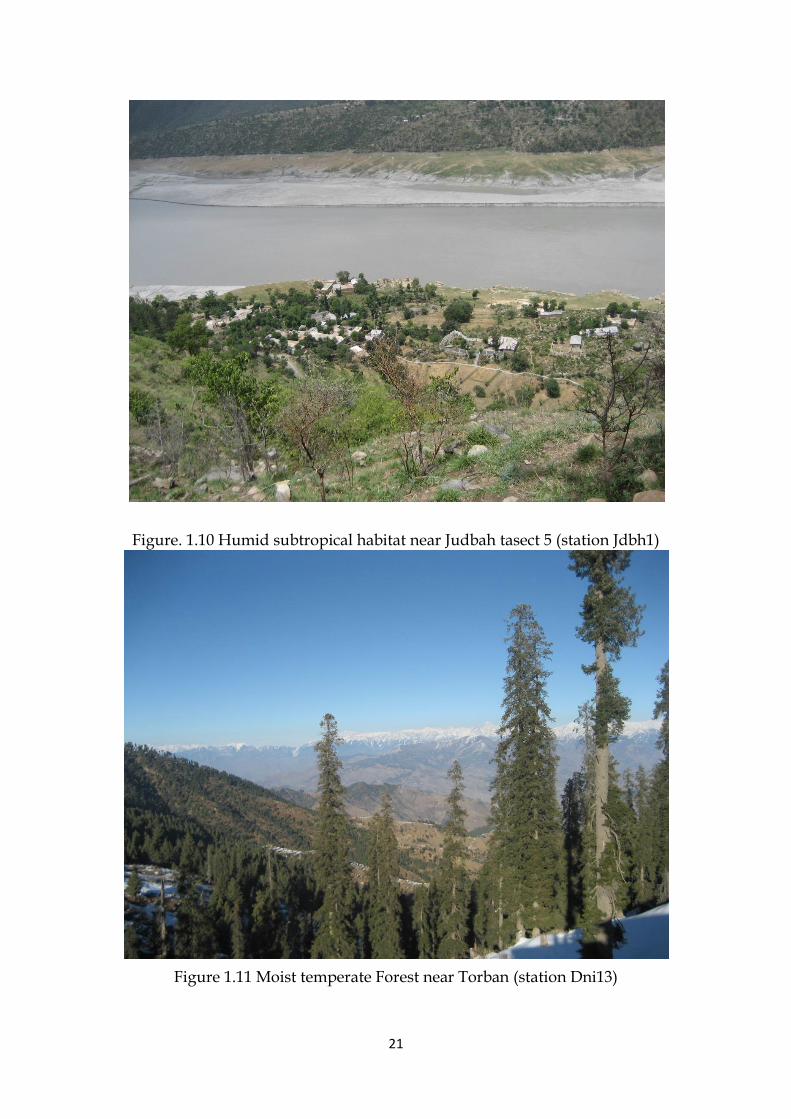
Figure. 1.10 Humid subtropical habitat near Judbah tasect 5 (station Jdbh1)
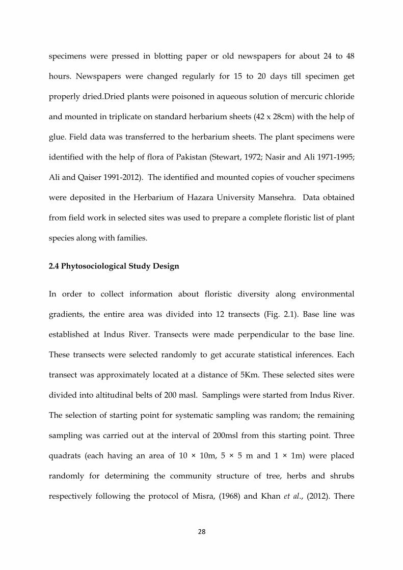
Figure 1.11 Moist temperate Forest near Torban (station Dni13)

22
1.4 Justification of Study /Rationale for Choice of Study location
The Himalaya is highest mountain of the world, having diverse vegetation therefore,
very important for biodiversity and ecological research (Sheng, 2001). More than
18,500 plant species were reported from these mountains (Sheng, 1998). The
Himalayas are the birth place of ten of the largest rivers in Asia. Economy of south
Asian countries is mainly based on the flow of these rivers from the Himalayas.
These rivers ensure food security by providing irrigation water for rice and wheat
crops which are the major staple food (Rasul, 2010). High mountains all over the
world are important hot spots for endemic floras (Nowak et al., 2011) and are the
ecosystem where climatic change is more visible and species extinction is very
rapid (Kullman, 2010). There is a dire need to study, document and map the
vegetation of diverse areas of Himalaya, according to international standards, to
provide a baseline for effective plant conservation strategies and sustainable
development.
Plants are the important source of food, shelter, medicines, fodder and are
contributing economic and social well being of the country and playing important
role in protecting environment, regulating climatic changes and preventing soil
erosion.
One major component of phytodiversity of the region are forests which act as a store
house of plant and animal genetic resources and contribute to genetic diversity.
Demand of the forests protection is increasing worldwide while forest area is
continuously decreasing. Preservation and sustainable management of forest

23
ecosystem is important. Anthropogenic pressure due to heavy deforestation, grazing
and soil erosion have destructed the vegetation. This situation will become worse if
present rate of deforestation and other anthropogenic influences continued and
reforestation on large scale are not made. It is dire need to protect, preserve and
maintain the plant resources of the area.
Floristic surveys are useful in proper identification of plant-wealth for their
utilization on a scientific and systematic basis. Inventorying of biodiversity is the
fundamental starting point of any phytosocialogical study needed for its
conservation, sustainable use and management. Similarly collections of Voucher
specimens from a region help to measure biodiversity and vegetation structure of
particular area. This data tells us changes occurring in the vegetation structure in
response to disturbances. Inventory of plants also play asignificant role in increasing
our understanding and information on availability of resources and its relationship
with the inhabitants. To develop conservation strategies and estimate the changes
taking place in the vegetation patterns of any area, it is required to have a detailed
floristic description of that area based on floristic surveys, collections and accurate
identification. A number of research workers prepared inventories based on plant
data collected from different parts of Himalaya and adjacent mountain ranges of
Pakistan.(e.g., Hussain et al., 2007, Khan et al., 2007, Khan & Khatoon, 2007,
Qureshi et al., 2009, Ahmad et al., 2009, Ali & Qaiser, 2009). Some areas of the
country including study area (District Tor Ghar) are still unexplored till this
study.

24
District Tor Ghar is the area lies in the western Himalya, which is neglected by
botanist and ecologists. A number of social, administrative and communication
problems were the main hurdles in the exploration of such a remote area.There is no
previous record of floristic or ecological study in the area. The area is unexplored in
all aspects of plants and no work has been done regarding plant phytosociolgy,
phytodiversity, conservation and restoration. Extensive review of literature revealed
that there is not a single record of collected specimens from District Torghar. The
indigenous peoples of Tor Ghar are continousely destroying plants wealth even
after establishment of the new district. People of the area are mostly illiterate and
not aware of loss of biodiversity and its impact on human life. They are using
natural resources ruthlessly. They use live stocks for milk, meat, transportation and
farming. Seasonal nomads with large number of cattle’s also stay in this area.
The large numbers of live stocks result in the overgrazing of natural vegetation. The
study area lies in the catchment area of Indus River. Over grazing, expansion of
agriculture land and recent development after creation of new district resulted in the
deforestration and enhanced rate of soil erosion which may increase siltation in the
Indus River. In this scenario, proper inventorying and monitoring of plant
biodiversity of the area is utmost important.
Keeping in view the utmost importance of first ever exploration of the western
most part of the Himalaya the present study was planned not only to explore,
identify and document vascular plant species to provide scientific basis for
future research but also mention the environmental gradients changing the
vegetation structure, species composition and even conservation stata of the plant

25
biodiversity. Phenological behavior of plants documented in the research project will
be helpful to study the relationship between climate and growing period.
In case of most of the phytosociological studies, researchers have studied either
qualitative characteristics of the vegetation or have recorded species importance
value indices. A very limited number of studies have used modern
numerical/statistical techniques to quantify vegetation particularly in the
distant and least accessible parts of these mountains. In addition, research on
plant community identification and classification (using modern techniques) has so
far been restricted to the plains and low altitude areas (eg., Malik & Husain, 2006,
Dasti et al., 2007, Malik et al., 2007, Saima et al., 2009, Siddiqui et al., 2009). Most
of the remote mountainous areas are the hotspots for vegetation due to their
important phytogeographical location. This research project not only resulted the
scientific exploration of plant resources but also also contributed to the literature,
information about the biodiversity, natural resources of the country, climate change,
habitat destruction, anthropogenic influences on plant species and understanding
the environmental gradients responsible for the distribution of species and
communities.
The quantitative and qualitative assessment of the results will be used to evaluate
the past, present and future of biodiversity and conservation status of the plant
resources of the area. In this study, modern statistical approaches were applied for
the first time in this region. This study will also provide a baseline for effective plant
conservation strategies and sustainable development. It provides a set of valuable
recommendations for improvement of socioeconomic conditions of the people.

26
The present study was, therefore, formulated to collect information about the plant
biodiversity of this region with a target to quantify plant communities at varying
landscape with following objectives.
1.4.1 Aims and Objectives
To explore, identify and document vascular plant species of the district.
To prepare checklist of vascular plant species of the area under study.
To evaluate species distributions and plant communities using modern
phytosociological techniques.
To identify environmental gradients responsible for species distribution.
To suggest possible measures for improvement of plant resources and
socioeconomic status of the area.
To furnish baseline data and useful informations to protect local flora for the
future generation.
Voucher specimen of valuable plant collection will be added to Herbarium of
Hazara University will serve as refrence for future research.

27
Chapter 2
MATERIAL AND METHODS
2.1 Study Area
Present study was designed to analyze floristic diversity along environmental
gradients in district Tor Ghar during 2012-13. Tor Ghar is situated at the bank of
Indus (Hazara division Khyber Pakhtunkhwa province of Pakistan) within latitude
on 34º 32' to 34º 50' north and between longitudes 72º 48' - 72º58' E. It has been given
a status of District of Khyber Pakhtunkhwa on 28 January, 2011. The altitudinal
variation of District Tor Ghar ranges between 450 to 2,950 masl.
2.2 Preparation for the field Study
Map of the district was obtained from forest department. Climatic data of study site
was obtained from Pakistan metrological department and general information about
the area was collected.
2.3 Field Survey
The research area was extensively visited throughout flowering and fruiting seasons
during 2012-13. Specimens were collected from various localities of the district,
properly tagged and given voucher number along field notes. The herbaceous
specimen always included enough of underground parts to show their
characteristics. Most of the plants were pressed on spot and data related to their
locality, scientific/ local names, habit, habitat and family was immediately recorded.
The plants were arranged in such a way that there were no overlapping parts. The
large size specimens were folded in the “V”, “Z”, “W” and “C” shapes. The
28
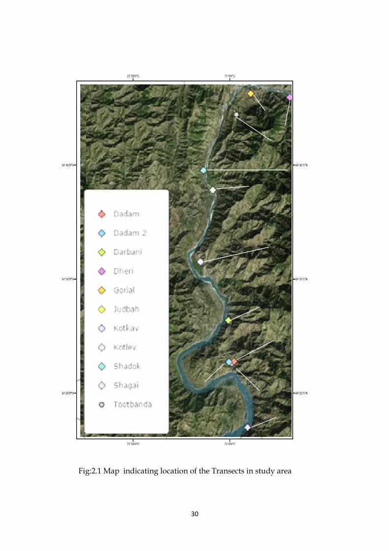
specimens were pressed in blotting paper or old newspapers for about 24 to 48
hours. Newspapers were changed regularly for 15 to 20 days till specimen get
properly dried.Dried plants were poisoned in aqueous solution of mercuric chloride
and mounted in triplicate on standard herbarium sheets (42 x 28cm) with the help of
glue. Field data was transferred to the herbarium sheets. The plant specimens were
identified with the help of flora of Pakistan (Stewart, 1972; Nasir and Ali 1971-1995;
Ali and Qaiser 1991-2012). The identified and mounted copies of voucher specimens
were deposited in the Herbarium of Hazara University Mansehra. Data obtained
from field work in selected sites was used to prepare a complete floristic list of plant
species along with families.
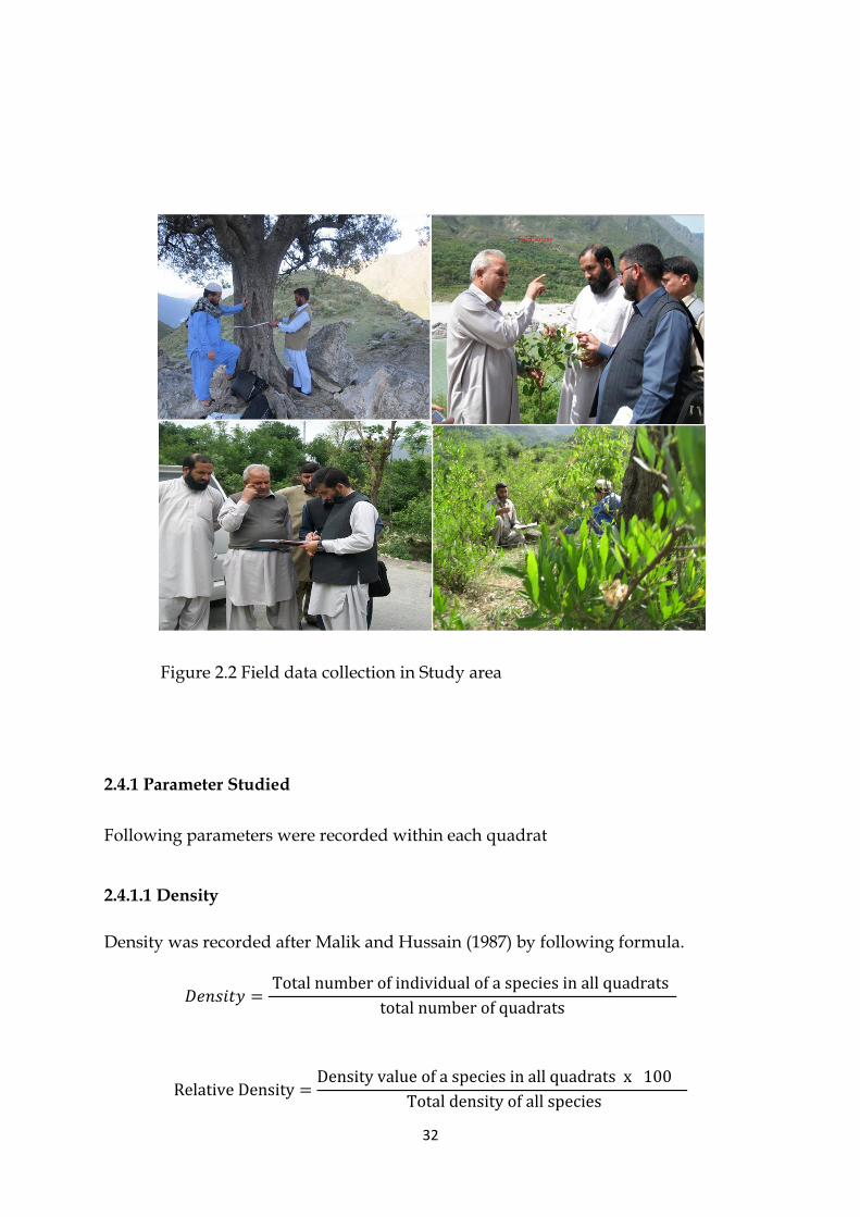
2.4 Phytosociological Study Design
In order to collect information about floristic diversity along environmental
gradients, the entire area was divided into 12 transects (Fig. 2.1). Base line was
established at Indus River. Transects were made perpendicular to the base line.
These transects were selected randomly to get accurate statistical inferences. Each
transect was approximately located at a distance of 5Km. These selected sites were
divided into altitudinal belts of 200 masl. Samplings were started from Indus River.
The selection of starting point for systematic sampling was random; the remaining
sampling was carried out at the interval of 200msl from this starting point. Three
quadrats (each having an area of 10 × 10m, 5 × 5 m and 1 × 1m) were placed
randomly for determining the community structure of tree, herbs and shrubs
respectively following the protocol of Misra, (1968) and Khan et al., (2012). There

29
were 5 replicate in each stand. In each quadrat, trees were recorded with >31.5cm
cbh (circumference at breast height i.e., 1.37m above ground). Individuals within the
cbh range of 10.5 to 31.4cm were considered as shrub and <10.5cm cbh as herb. The
data was collected during 2012 and 2013.
Coordinate including altitude, longitude and latitude of selected site was recorded
using GPS of Garmin e trex Hc series, vista HCx, while aspects were recorded by
compass (Table-2.1).
30
Fig:2.1 Map indicating location of the Transects in study area

31
Table 2.1 Detail of study sites: Localities, altitudinal range (msl), longitude N0,
latitude E0, aspect, number of stations and number of quadrates at each of 64 stations S
. N
o.
Lo
cali
tie
s
Alt
itu
din
al
ran
ge (
msl
)
L
on
git
ud
e N
0
Lati
tud
e E
0
Asp
ect
No
. o
f st
ati
on
No
. o
f q
uad
rate
1 Tor Kandow 640-1040 34025. 953” 0720 49.424” South 03 15
2 Kotkay 467-1260 340 27. 839” 0720 50.555” East 05 25
3a Dadam (E) 506-900 340 31. 335” 0720 49.312” East 03 15
3b Dadam (N) 600-950 340 31. 380" 0720 49.636" North 03 15
4 Toot banda 550-935 340 31. 222” 0720 49.534” East 03 15
5 Dar bani 650-2950 340 33. 576” 0720 49.262” East 10 30
6 Kotley 540-940 340 36. 717” 0720 49.8121” East 03 15
7 Judbah 530-2660 340 36. 6895” 0720 47.410” East 12 60
8 Shagahi 540-1600 340 40. 542” 0720 48.250” East 06 30
9 Shadock 550-1100 340 41 .590” 0720 47.628” East 04 20
10 Zizari 650-1450 340 44. 547” 0720 49.814” East 05 25
11 Dheri 600-1210 340 45. 666” 0720 50.766” East 04 20
12 Gorial 600-1000 340 45 .476” 0720 53.360” East 03 15
Total 64 320
32
Figure 2.2 Field data collection in Study area
2.4.1 Parameter Studied
Following parameters were recorded within each quadrat
2.4.1.1 Density
Density was recorded after Malik and Hussain (1987) by following formula.
𝐷𝑒𝑛𝑠𝑖𝑡𝑦 = Total number of individual of a species in all quadrats
total number of quadrats
Relative Density =Density value of a species in all quadrats x 100
Total density of all species

33
2.4.1.2 Frequency
Frequency was calculated after Brower and Zar (1977) and expressed as a
percentage.
Frequecny
=Density value of a species Number of time in which a species occur x 100
Total number of quadrats
Relative Frequecny =Frequency value of a species x 100
Total frequency of all species
2.4.1.3 Canopy Cover
Canopy Cover was calculated after Daubenmire (1959) using following scale.
Class Range of Coverage Midpoint %
1 Cover up to 5% of ground 2.5%
2 Cover 5% to 25% of ground 15.0%
3 Cover 25% to 50% of ground 37.5%
4 Cover 50% to 75% of ground 62.5%
5 Cover 75% to 95% of ground 85.0%
6 Cover 95% to 100% 0f ground 97.5%
2.4.1.4 Basal Area
Basal area was measured by dbh method. For trees including lianas the diameter or
circumference of the trunks was measured with the help of measuring tape at a
breast height (dbh) i.e. 1.5 metres above the ground. The diameter was converted to
basal area by the formula r2 where r equals to 1/2dbh.
34
Relative basal area was measured by following formula
Relative basal area = Basal area of a species × 100
Total basal area of all species
The relative values were summed up to represent important value index, IVI as per
Curtis, (1959).
2.4.1.5 Importance Value Index (IVI)
Importance Value Index (IVI) was calculated by the method of Curtis, (1959).
IVI = R.D + R.F + R.C
Where IVI; importance value index, R.D; relative density, R.F; relative frequency and
R.C; relative cover.
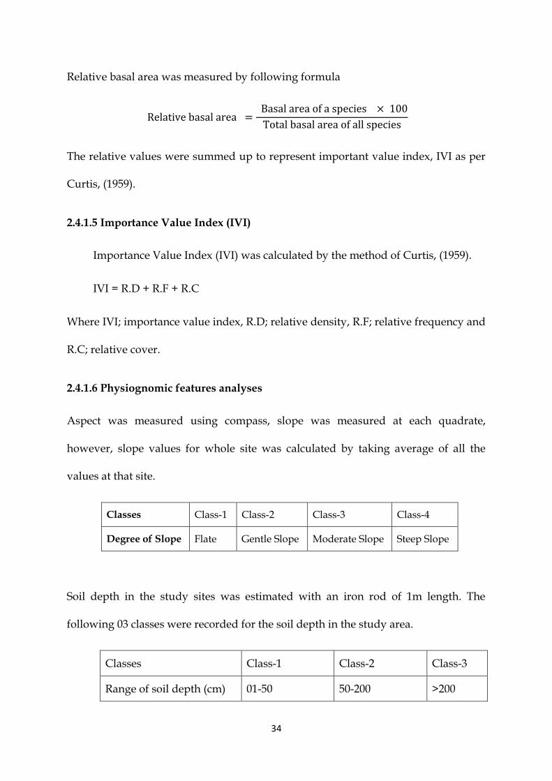
2.4.1.6 Physiognomic features analyses
Aspect was measured using compass, slope was measured at each quadrate,
however, slope values for whole site was calculated by taking average of all the
values at that site.
Classes Class-1 Class-2 Class-3 Class-4
Degree of Slope Flate Gentle Slope Moderate Slope Steep Slope
Soil depth in the study sites was estimated with an iron rod of 1m length. The
following 03 classes were recorded for the soil depth in the study area.
Classes Class-1 Class-2 Class-3
Range of soil depth (cm) 01-50 50-200 >200
35
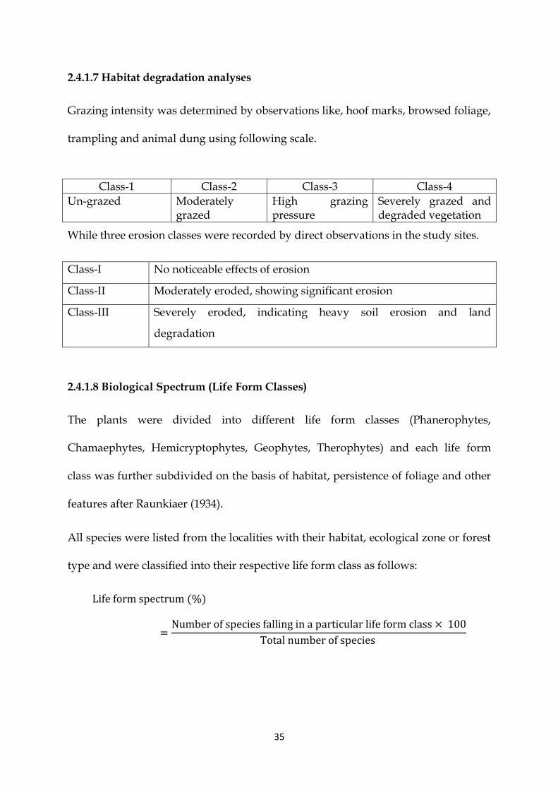
2.4.1.7 Habitat degradation analyses
Grazing intensity was determined by observations like, hoof marks, browsed foliage,
trampling and animal dung using following scale.
Class-1 Class-2 Class-3 Class-4
Un-grazed Moderately grazed
High grazing pressure
Severely grazed and degraded vegetation
While three erosion classes were recorded by direct observations in the study sites.
Class-I No noticeable effects of erosion
Class-II Moderately eroded, showing significant erosion
Class-III Severely eroded, indicating heavy soil erosion and land
degradation
2.4.1.8 Biological Spectrum (Life Form Classes)
The plants were divided into different life form classes (Phanerophytes,
Chamaephytes, Hemicryptophytes, Geophytes, Therophytes) and each life form
class was further subdivided on the basis of habitat, persistence of foliage and other
features after Raunkiaer (1934).
All species were listed from the localities with their habitat, ecological zone or forest
type and were classified into their respective life form class as follows:
Life form spectrum (%)
=Number of species falling in a particular life form class × 100
Total number of species

36
2.4.1.9 Species richness
Species richness in different localities of the area was calculated after Margalef (1958)
as follows.
R= S-1/In (n)
Where S; total number of species in a community, In; natural log, n; total number of
individual of all species in a community.
2.5 Statistical Analysis
Modern multivariate techniques were used to study the degree of variation found in
vegetation composition of a region.The use of these techniques make large data sets
mentally accessible, structurally recognizable and patterns explainable.
MS EXCEL 2013 was used for basic calculations like frequency, density, cover and
their relative values and to present different results graphically.
Modern statistical packages PC-ORD version 5 (McCune, 1986, McCune & Mefford,
1999) and CANOCO version 4.5 (ter Braak, 1988, ter Braak, 1989, ter Braak &
Smilauer, 2002) were used to analysed the data.
The data obtained for 331 vascular plant species 320 quadrats each for herbs, shrubs
and trees (total 960 quadrats) from 64 stations was subjected to statistical analysis to
find out relation between environmental factor, structure and composition of
vegetation. It includes qualitative data for all plant species i.e Presence/ absence
data and quantitative data consists of density, cover, frequency, relative density,
relative cover, relative frequency and Importance Values. For classification and
37
ordination qualitative data (presence/absence) was used as, it gives clear picture
than quatitative data.
The environmental data including altitude, soil erosion, slope, soil depth, grazing
pressure, for each station was also recorded. All the environmental variables were
treated as independent variables while quantitative attributes of plant species were
considered as dependent variables.
In present study different multivariate methods were used for community data.
These techniques are of two types: classification and ordination.
2.5.1 PC-ORD Analysis
To classify vegetation of the study area and identify different plant communities PC-
ORD version 5 was used. Different classification methods were used i.e., Cluster
Analysis (CA), Two Way Cluster Analysis (TWCA) and Indicator Species Analysis
(ISA), (Dufrene & Legendre, 1997).
2.5.1.1.Two Way Cluster Analyses (TWCA)
The (TWCA) is an important classification program used by plant ecologist. This
program results in the different communities. It was used for clusterization of
species and different localities in smaller groups which showed close
similarities. In this method results are presented in graphical form called a two-way
cluster dendrogram which explained the results more meaningfully and predictably
in the form of clusters. Dendrogram shows different groups or clusters in which the
degree of resemblance is reflected by size of branch. The vegetation
(presence/absence) data collected from district Tor Ghar was analyzed by two Way

38
Cluster Analysis (TWCA) to classify the vegetation into different plant communities.
The species are arranged in rows and samples in columns. A number of studies have
proved that TWCA is best method for the classification of the vegetation. Although a
great number of clustering systems for plant community classification are available
(Legendre & Legenrde, 1998) these techniques produce different outcomes on the
same data set. But the best technique is the one which provides a clear ecological
description for a specific purpose (Kent & Coker, 1992).
2.5.1.2 Cluster Analysis
Cluster analysis was used to describe the vegetation pattern in district Tor Ghar. The
data include 64 stations (samples) for 331 vascular plant species based on qualitative
data (presence/absence). It was used to identify different plant communities based
on Sorensen‘s (Bray Curtis) distance.
2.5.2 Indicator Species Analysis (ISA).
Informations about abundance of a species and fidelity in that group results in the
indicator value for each species. Each of the 331 species was evaluated to classify for
different environmental variables.
2.5.2 CANOCO Analysis
Indirect and direct environmental gradient analyses were performed using
CANOCO version 4.5 (Ter Braak &Barendregt, 1986, Ter Braak and Šmilauer. 1998).
It was used to investigate environmental gradients indirectly using a species matrix
or directly using both species and environmental data matrices.
2.5.2.1 InDirect gradient ordination

39
Indirect Ordination method includes Correspondence Analyses (CA), Principal
Component Analyses (PCA) and Detrended Correspondence Analysis (DCA).
Indirect gradient analysis involves the Ordination resulting only from species data.
These techniques have rarely been used in the phytosociological studies of Pakistani
terretories and can be found in the literature; For example the vegetation of Ayub
National Park was analysed by Jabeen and Ahmed (2009) using PCOrd version 5
and CANOCO 4.5 for the classification and ordination of vegetation. They used
TWINSPAN, DCA and CCA for analyses giving four plant communities and
correlations of association with different environmental variables.
Detrended Correspondence Analysis (DCA):
DCA is one of the important and efficient methods of indirect gradient analysis and
is used when there is no environmental data. The axes in DCA are measured by the
average standard deviation of species turnover (sd units). A 50% change in species
composition occurs in a distance of about 1 SD unit. A species disappear over a
distance of about 4 SD units. The more SD units that occur along the axis the more
change in species composition is revealed. Thus, the sd units of DCA are a helpful to
measure the beta diversity. Species have, on average, a habitat breadth (as measure
by standard deviations) of 1. Detrended Correspondence Analysis (DCA) was used
to avoid the distortion from results as described by Hill & Gauch Jr., (1980), and ter
Braak, (1988). DCA provide more efficient and interpretable results than CA and
PCA and hence was used in present study for ordination analysis. CANODRAW a
utility of CANOCO was used to plot the data as an ordination plot. Environmental
data are used after that to interpret the ordination. Data is initially arranged
40
according to their floristic resemblance without the addition of environmental
variables and then correlated the axes with environmental data. The axes formed
during the ordination analysis are in descending order of importance. The first axis
is most significant and describes the most variation in the floristic data
2.5.2.2 Direct gradient ordination
In direct gradient analysis we study the florostic changes along known
environmental gradients.
Canonical Correspondence Analysis (CCA)
Canonical Correspondence Analysis (CCA is a direct ordination method used to
study correlation and regression between the floristic data and environmental data.
It is widely used and most robust direct gradient exploration technique, therefore
selected for present research project. In this method species and environmental
factors are plotted on the same graph but using different scales. The Arrows are
strained from the joint centered ordination axes to the points showing environmental
variables and the directions of the arrows indicate the direction in which the
abundance of a variable increases most rapidly. The length of the arrow indicates the
rate of change in abundance in that direction. Occurrence of plant species at the end
or away from the tip of the arrows display positive correlation and the species which
occur at the opposite end reflect negative correlation.
These analyses were used to investigate different plant communities found in the
district Tor Ghar and to study the effect of different environmental variables in plant
distribution in the study area.

41
Chapter 3 RESULTS
3.1 Floristic Diversity
3.1.1 Diversity among Vascular Plant Groups
A total of 331 vascular plant species belonging to 246 genera and 101 families were
recorded including 12 species of Pteridophytes (3.61%) and 6 species of
gymnosperms (1.8%). Angiospermic flora consists of 313 species (94.5%) belonging
235 genera and 93 families. Among angiosperms, the dicotyledons dominated the
flora and were represented by 79 families, 197 genera and 267 species (80.66%), while
monocotyledons were composed of 14 families, 38 genera and 46 species (13.89%),
(Figure 3.1).
Figure 3.1: Pi chart representing floristic diversity

42
3.1.2 Species richness within families:
The highest number of species were recorded for Asteraceae (25., 7.53%) followed by
Leguminosae (Fabaceae) (24species., 7.22%), Poaceae (21 species.,6.32%), Lamiaceae
(17, 5.1%) Rosaceae and Polygonaceae (14 each, 4.2%).
Among Pteridophytes Adiantaceae and Dryopteridaceae were largest families
represented by 4 species each. Equisetaceae, Pteridaceae and Sinopteridaceae were
having one species each. Among Gymnosperms Pinaceae was the largest family (5
spp.) followed by Taxaceae (1 spp.).
Among Angiosperms, dicots were represented by forty two families having a single
species each, another twenty one families were represented by 2 species, whereas
thirteen families possessed 3 species each. Six families were composed of 4 species
and only one family containg 5 species (table 3.1).
Figure 3.2 Percentage of different plant families in District Tor Ghar

43
3.1.3 Diversity within plant habit:
Based on plant growth habit, 55 tree species, 48 species of shrubs and 240 herbs were
reported from the area. All the reported gymnosperms were represented by tree
habit only, while angiosperms were represented by 50 tree and 48 shrubs. Majority
of the flora was represented by herbs (240 species)
Figure 3.3: Diagramatic representation of plant habit (percent) diversity
3.1.4 Life Form diversity
Among Ruankiaer lifeform classes, hemicryptophyte was dominant life form class
represented by 108 species (32.6 %) followed by Therophytes (73 species, 22%),
Nanophanerophytes (42.species.12.7%), Microphanerophytes(41 species 12.4%),
Chamaephytes, 28 species (8.4%), Mesophanerophytes, 12 plant species (3.6%) and
Megaphanerophytes, (9 species, 2.7%). Geophytes were represented by 18 species
(5.4%) (Fig: 3.4).
Herbs70%
Shrubs14%
trees16%

44
Fig:3.4 Representation of Raunkiaer life form classes within flora
0
20
40
60
80
100
120

45
Table 3.1(a) Inventory of Vascular plants collected during first exploration of District Torghar
S. No
Family S.No
Botanical Name
Life form class
Local Name Habit Flowering period
Locality Altitude
Pteridophytes
1 Adiantaceae 1 Adiantum caudatum Linnaeus G Herb _______ Soral 1200
2 Adiantum incisum Forssk. G Sumbel Herb _____ Soral 1300
3 Adiantum venustum D. Don. G Babozai Herb ______ Soral 1200
4 Adiantum capillus - veneris Linn. G Sumbel Herb _______ Haleema 1400
2 Aspleniaceae 5 Asplenium septentrionL.) Hoffmann, CH
Wakha rangaey Herb ________ Haleema 2000
3 Dryoteridaceae 6 Polystichum lonchitis L G Herb ______ Shagae 800
7 Polystichum munitum (Kaulf.) C.Presl
G Herb Shagae 800
8 Polystichum squarrosum (D. Don) Fée,
G Herb Behrhi 1800
9 Polystichum tsussimense (Hook.) J.Sm.
G Herb Behrhi 1800
4 Equisetaceae 10 Equisetum ramosissimum Desf. H Bandakay Herb Kotkay 800
5 Pteridaceae 11 Pteris cretica Linnaeus, H Qinchi panra Herb ________ Soral 1200
6 Sinopteridaceae 12 Onychium contiguum Wall. Ex Hope H Herb Soral 1200
Dicotyledons
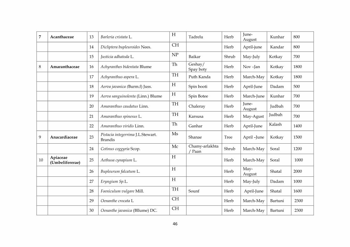
46
7 Acanthaceae 13 Barleria cristata L. H
Tadrelu Herb June- August
Kunhar 800
14 Dicliptera bupleuroides Nees. CH Herb April-june Kandar 800
15 Justicia adhatoda L. NP Baikar Shrub May-July Kotkay 700
8 Amaranthaceae 16 Achyranthes bidentata Blume Th Geshay/
Spay boty Herb Nov –Jan Kotkay 1800
17 Achyranthus aspera L. TH Puth Kanda Herb March-May Kotkay 1800
18 Aerva javanica (Burm.f) Juss. H Spin booti Herb April-June Dadam 500
19 Aerva sanguinolenta (Linn.) Blume H Spin Botee Herb March-June Kunhar 700
20 Amaranthus caudatus Linn. TH
Chaleray Herb June-August
Judbah 700
21 Amaranthus spinesus L. TH Karsusa Herb May-Agust Judbah 700
22 Amaranthus viridis Linn. Th Ganhar Herb April-June Kalash 1400
9 Anacardiaceae 23 Pistacia integerrima J.L.Stewart. Brandis
Ms Shanae Tree April –June Kotkay 1500
24 Cotinus coggyria Scop. Mc Chamy-arlakhta
/ Paan Shrub March-May Soral 1200
10 Apiaceae (Umbelifererae)
25 Aethusa cynapium L. H
Herb March-May Soral 1000
26 Bupleurum falcatum L. H
Herb
May-August
Shatal 2000
27 Eryngium Sp.L. H Herb May-July Dadam 1000
28 Foeniculum vulgare Mill. TH Sounf Herb April-June Shatal 1600
29 Oenanthe crocata L CH Herb March-May Bartuni 2300
30 Oenanthe javanica (Bllume) DC. CH Herb March-May Bartuni 2300

47
31 Scandix pectin-veneris L. Th Herb March-May Bartuni 2000
32 Torilis leptophylla (L.) Reichb Th
Herb March –May
Kotkay 600
11 Apocynaceae 33 Nerium indicum Mill. NP Gandirey Shrub May-July Maira 800
34 Nerium oleander L. NP
Kaneer Shrub March-August
Maira 900
35 Carissa opaca Stapf. en Haines NP Granda Shrub Kotkay 700
12 Aquifoliaceae 36 Ilex dipyrena Wall Ms Tree April-June Machasar 3000
13 Araliaceae 37 Hedra nepalensis K.Koch. NP
Parweta Shrub June-August
Gantharh 2600
14 Asclepiadaceae 38 Calotropis procera (Ait.) Ait. F NP
Spulmay Shrub Jan-December
Darbani 800
39 Caralluma tuberculata N.E. Brown H
Choung Herb June-July Machra Akazai
800
40 Periploca aphylla Dcne. H Bata/Barara Herb March-May Darbani 700
15 Asteraceae (Compositae)
41 Achillea millifolium L. H
Karkarah Herb April-June Soral 1000
42 Artemisia absinthium L H
Tarkha Herb April-August
Kandar 800
43 Artemisia scoparia Waldst. & Kit H Gandi booti/
Jaokae Herb April-July Kandar 900
44 Artemisia vulgaris L. H Joakay Herb April-June Haleema 1500
45 Calendula arvensis L. H Ziar Guley Herb April-July Maira 710
46 Carthmus oxycantha M.Bieb H Kareza Herb April-July Asharay 1150
47 Centaurea iberica Trevir & Spreng H
Herb May-July Dadam 800
48 Chamaemelum nobile (L.) All. H Herb June-July Machasar 2500

48
49 Cichorium intybus L CH Hanshamakey/
Kasny Herb April-June Shagai 800
50 Circium falconeri (Hook. F) Petr. Th
Herb Dada banda
1200
51 Cirsium arvense (L.) Scop. Th
Herb May-August
Soral 1250
52 Conyza canadensis (L.) Corgn. TH Maloocheii Herb April-June Balkot 1000
53 Galinsoga parviflora Cavanilles H
Herb March- May
Balkot 1000
54 Lactuca serriola L. Th Herb Shadak 730
55 Parthenium hysterophorus L. Th
Herb Through out the year
Maira 700
56 Pulicaria crispa (Forssk.) Oliv. TH
Herb November-March
Shatal 1000
57 Sassurea heteromalla (D.Don) Hand H
Herb May-June Shatal 1500
58 Senesio chrysanthemoides DC. G Ghopga Herb June-Sept Kamesar 2670
59 Silybum marianum (L) Gaertn Th
Karizaghena Herb Marc-June Gave bazar
800
60 Solidago virgaurea L. H Bangira Herb May-July Ganthar 1800
61 Sonchus asper (L) Hill. Th Shodapae Herb April-July Sargay 900
62 Taraxicum officinale Webb. H Ziar guley Herb April-July Sabe hill 1200
63 Tegetes erecta L Th Herb April –June Shah dak 700
64 Vernonia Sinerea (L.)Lees. Th Tor Zeera Herb May-July Sorban 2000
65 Xanthium strumarium Linn. NP Ghishkey Herb May-July Kotley 1510
49
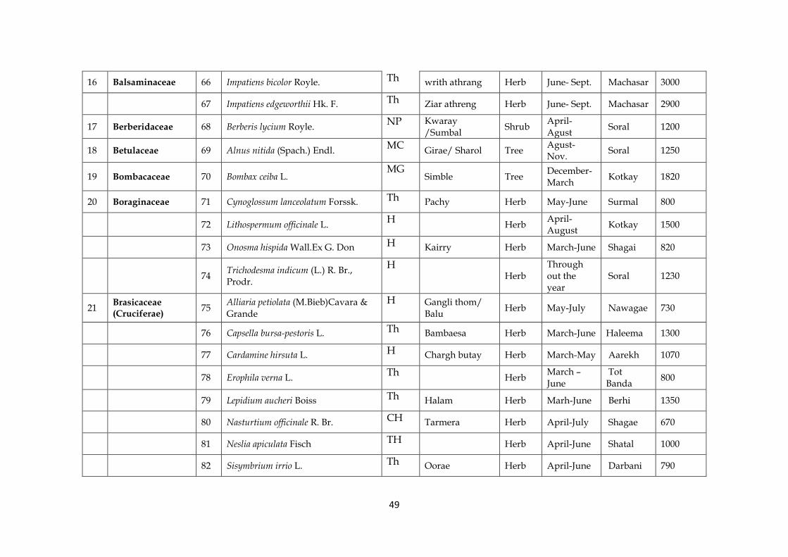
16 Balsaminaceae 66 Impatiens bicolor Royle. Th writh athrang Herb June- Sept. Machasar 3000
67 Impatiens edgeworthii Hk. F. Th Ziar athreng Herb June- Sept. Machasar 2900
17 Berberidaceae 68 Berberis lycium Royle. NP Kwaray
/Sumbal Shrub
April- Agust
Soral 1200
18 Betulaceae 69 Alnus nitida (Spach.) Endl. MC
Girae/ Sharol Tree Agust- Nov.
Soral 1250
19 Bombacaceae 70 Bombax ceiba L. MG
Simble Tree December-March
Kotkay 1820
20 Boraginaceae 71 Cynoglossum lanceolatum Forssk. Th Pachy Herb May-June Surmal 800
72 Lithospermum officinale L. H
Herb April- August
Kotkay 1500
73 Onosma hispida Wall.Ex G. Don H Kairry Herb March-June Shagai 820
74 Trichodesma indicum (L.) R. Br., Prodr.
H Herb
Through out the year
Soral 1230
21 Brasicaceae (Cruciferae)
75 Alliaria petiolata (M.Bieb)Cavara & Grande
H Gangli thom/ Balu
Herb May-July Nawagae 730
76 Capsella bursa-pestoris L. Th Bambaesa Herb March-June Haleema 1300
77 Cardamine hirsuta L. H Chargh butay Herb March-May Aarekh 1070
78 Erophila verna L. Th
Herb March – June
Tot Banda
800
79 Lepidium aucheri Boiss Th Halam Herb Marh-June Berhi 1350
80 Nasturtium officinale R. Br. CH Tarmera Herb April-July Shagae 670
81 Neslia apiculata Fisch TH Herb April-June Shatal 1000
82 Sisymbrium irrio L. Th Oorae Herb April-June Darbani 790

50
83 Arabidopsis thaliana (Linn.) Heynh. H
Herb April-July Judbah 900
84 Coronopus didymus (L.) Sm.
TH Hazar dani Herb
April-August
Soral 1650
22 Buddlejaceae 85 Buddleja crispa Bth. NP Booe Shrub March-May Ganthar 2300
23 Buxaceae 86 Buxus wallichiana Bill. NP Shrub March-May Ganthar 2600
87 Sarcococca saligna (D.Don) Muell. NP Ladan Shrub April-Sept Brathoo 2600
24 Cactaceae 88 Opuntia dillenii Haw. CH
Zakoom Herb June-August
Tot banda 800
25 Campanulaceae 89 Campanula benthamii Wall. H Herb March-July Soral 1200
90 Codonopsis clematidea (Schrenk) C.B.Clarke.
H Herb
July – august
Soral 1000
26 Cannabaceae 91 Cannabis sativa L. TH Bhang Herb April-July Kandar 800
27 Capparidaceae 92 Cleome scaposa DC., Prodr H
Herb May-August
Shatal 840
28 Caprifoliaceae 93 Viburnum grandiflorum Wall. ex DC. NP
Chamiaray Shrub March-July Kandow/ Manasar
2400
94 Viburnum cotinifolium D. Don NP
Ghanpmzewa Shrub March- May
Mana sar 2600
29 Caryophyllaceae 95 Silene conidea L. Th
Babrai Herb May-July Sarbago 1580
96 Sillene vulgaris (Moench) Garcke Th
Matranga Herb May- Agugust
Sarbago 730
97 Stellaria media (L.) Vill. Th
Laroley Herb April-August
Aarakh 1200
30 Celastraceae 98 Maytenus royleanus (Wall. ex Lawson) Cufodontis
NP Patakhi / Azghakay
Shrub March-July Kotkay 1150

51
31 Chenopodiaceae 99 Chenopodium album L. Th
Larmay Sarmea Herb March-May Dadam 700
100 Chenopodium ambrosioides L Th Benakai Herb Mach-May Dadam 756
101 Chenopodium botrys L. Th Skha Khawra Herb April-June Kotley 1050
102 Chenopodium murale L. Th Skha Botey Herb April-June Gut 1100
32 Convolvulaceae 103 Convolvulus arvensis L. H Pirwathai Herb April-July Jegal 840
104 Evolvulus alsinoides (L.) Th Sargulay Herb April-June Jegal 1100
33 Cornaceae 105 Cornus macrophylla Wall. ex Roxb MS
Kandara Tree April - june Soral 1300
34 Cucurbitaceae 106 Citrullus colocynthis (Linn.) Schrad
H Tumba / Manzil/ Markundai
Herb May-July Dadam 800
107 Solena amplexicaulis (Lam.)Gandhi Th
Kakora Herb April-June Soral Village
1240
35 Cuscutaceae 108 Cuscuta reflexa Roxb TH Zeara Zeelai Herb April-July Berrhi 1100
109 Cuscuta gigantea Griff. TH Ooloe Herb April-July Soral 1100
36 Dioscoraceae 110 Dioscorea deltoidea Wall.ex Kunth H
Konel Herb April-July Chor kalan
2300
37 Ebenaceae 111 Diospyrus lotus L. MC
Tor Amlok Tree June-Agugust
Manasar 2800
38 Euphorbiaceae 112 Andrachne cordifolia (Wall. ex Decne.) Muell.
H Kurkun Shrub June-Oct. Shahtal 1500
113 Euphorbia helioscopia L. H Mandro Herb April-June Kalash 1650
114 Euphorbia hirta L. H
Skha Botay Herb June-August
Kalash 1650

52
115 Euphorbia hispida Boiss. H Herb May-July Soral 1100
116 Euphorbia peplus L. H Herb Nawagae 650
117 Euphorbia prostrata Aiton CH Herb Nawagae 700
118 Euphorbia Wallichii Hk. H Zangly
Mandaro Herb June-Sept. Larhsar 2650
119 Mallotus philippensis (Lam.)Muess. NP
Kambella Shrub July-Sept. Kandar 900
120 Ricinus communis L. NP Arharhanda Herb March-July Judbah 700
39 Fagaceae 121 Quercus dilatata Lindle. ex Royle MC
Tor banj Tree April – May
Manasar 2500
122 Quercus baloot Griff. MC
Brungi Tree April –May Chor kalan
2300
123 Quercus leucotrichophora A. Camus MC
Rin Tree Manasar 2400
124 Quercus incana Roxb MC Spin banj Tree April-May Doda 1100
40 Fumariaceae 125 Fumaria indica (Hausskn) Pusley TH Papra Herb April-June Soral 1230
126 Fumaria officinalis L. TH Herb March-July Soral 1200
41 Gentianaceae 127 Gentiana kurroo Royle TH
Nilkant Herb Agust-Oct. Chota Kandow
2700
128 Swertia ciliata (G. Don) B.L. Burtt
Th Chirata/ Momera
Herb June-August
Loto Banda
1800
42 Geraniaceae 129 Geranium lucidum L. TH
Herb April-June Danda Banda
1300
130 Geranium ocellatum Camb. TH
Herb April-July Shangaldarh
1500

53
131 Geranium wallichianum D.Don ex Sweet
H Sargrrai Herb
June-August
Shangaldarh
2600
43 Guttiferae 132 Hypericum oblongifolium L. Np Shin Chai Shrub Mach-July Soral 1300
133 Hypericum perforatum L. H
Warmang Booty Herb June-September
Soral 1200
44 Hippocastanaceae 134 Aesculus indica (Wall.ex Camb.)Hk. MG
Ashanr Tree Jabara 2300
45 Juglandaceae 135 Juglans regia Linn MG Ghuz Tree April- July Soral 1240
46 Lamiaceae (Labiateae)
136 Ajuga bracteosa Wall., Benth. H
Guti Herb April-June Shagae 800
137 Ajuga reptan L. H Guti Herb April-June Nawagae 1800
138 Anisomeles indica (L.) O. Kuntze Th
Herb April-Sept
Shangaldarh
2400
139 Colebrookia oppositifolia Smith NP Balbadarh/
Benda Shrub Jan.- April Kotkay 700
140 Isodon rugosus (Wall. ex Benth.) Codd
MC Khangere/ Salasla
Shrub July-Sept Larsar 2300
141 Lamium amplexicaule L. Th Herb March-June Shatal 1450
142 Marrubium vulgare L. H
Gandana Herb May-August
Shatal 2000
143 Mentha arvensis L. H
Podina Herb July-August
Shagae 800
144 Mentha longifolia (L.) Huds H
Vanaley Herb June-August
Shagae 760
145 Mentha spicata L. H Zangli Podina Herb May-July Soral 1200
146 Nepeta cataria L. CH Jalbang Herb April-June Guth 1400

54
147 Otostegia limbata (Bth) Boiss NP
Spinaghzai Shrub March-June Tor Kandow
825
148 Salvia lanata Roxburgh CH Khathriki Herb April- july Soral 1200
149 Salvia moorcroftiana Wall. ex Benth. H Kali jarhi / Khar
ghoagh Herb April-June Soral 1200
150 Stachys parviflora Benth. H Spera Botay Herb March-July Larhsar 2300
151 Thymus linearis Benth NP Da Ghar sper
kay Herb Jun-August Manasar 2500
152 Salvia aethiopis L. Th Kali jarhi Herb March-July Kamesar 2300
47 Leguminosae (Caesalpinioideae)
153 Caesalpinia decapitala (Roth) Alston. MC
Jara Shrub March- April
Shagae 800
154 Bauhinia variegata Linn Np Kulhar Tree April-July Kotkay 750
47 Leguminosae (Mimosoideae)
155 Acacia modesta Wall. MS
Palosa Tree March- July
Kotkay 800
156 Acacia nilotica Linn. MC
Kikar Tree June- August
Kandar 700
157 Albezzia lebbek (L) Benth. MS Srikh Tree April –July Berhi 1200
158 Albezzia procera (Roxb) Benth. MC Tree April- june Berhi 900
47 Leguminosae (Papilionoideae)
159 Robinia pseudoacacia Linn.
CH
Toor kiker Tree April-June Kotkay 900
160 Butea monosperma (Lam.) O. Kuntz. H
Badar Tree Kotkay 680
161 Crotolaria mediginea Lamk H Herb Shagae 700

55
162 Delbergia sisso Roxb. H Shaewa Tree May-July Kandar 700
163 Indigofera heterantha Wall.ex rand. H
Ghoraja Shrub May-July Soral 1260
164 Trifolium repens L. MC Shaotal Herb April-June Judbah 800
165 Argyrolobium roseum (Comb) Janb & spach
H Makana Herb
February-April
Banda 1500
166 Astragalus amherstianus Royle ex Benth.
NP Asli Batawach Herb Soral 1300
167 Astragalus graveolens Buch.-Ham.ex Benth.
NP Bitawach E Naqli/Azghakay
Herb April-June Soral 1250
168 Astragalus macropterus DC Th
Herb June-July Danda Banda
1600
169 Astragalus neomonodelphus H. T. Tsai & T. T. Yu
Th Herb Soral 1300
170 Lathyrus aphaca L Th Korkamani Herb March-May Maira 600
171 Lathyrus emodii (Wall.ex Fritsch) Ali Th
Herb Maira 600
172 Lotus corniculatus L. Th Herb March-May Dheri 580
173 Medicago polymorpha L. MC
Shpeshtiary Herb March-April
Dheri 800
174 Melilotus officinalis (L.)Desr. H Lewanay Herb April-June Shadak 700
175 Trifolium pratense Linn. H
Herb
July – august
Judbah 720
176 Vicia hirsuta (Linn.) S.F.Gray Th Marghaikhpa Herb March-June Shadak 600

56
48 Loranthaceae 177 Viscum album Linn. NP
Prewatai Shrub July-September
Manasar 2360
49 Lythraceae 178 Woodfordia fruticosa (L.)S.Kurz NP Thawi Shrub March-May Soral 1230
50 Malvaceae 179 Malva neglecta Wall. Th
Panerak Herb April-July Dhera kahu
530
180 Malva sylvestris Linn Th
Samchal Herb May- Agugust
Dhera kahu
530
51 Meliaceae 181 Azadiracha indica L. MC Neem Tree April-May Soral 1200
182 Cedrella serrata Royle MC Daravi Tree May-June Shatal 1700
183 Melia azedarach Linn. MC
Bakaina/Lagan Tree April- July Daur Maira
680
52 Menispermaceae 184 Cissampelos pareira Linn Th
Katoon Herb March-july Macahasar
2200
53 Moraceae 185 Broussonetia papyrifera (L.)L’ Herit ex Vent
MC Kaghazi toot Tree June-July Kotkay 1100
186 Ficus benghalensis L. MS
Barh Tree Through out the year
Judbah 600
187 Ficus carica Forsk. MS
Inzar Tree April-June Dorh Mera
600
188 Ficus elastica Roxb. MS
Rubber Tree March-April
Dadam 700
189 Ficus palmata Forsk. MS
Inzar Tree March-June Daur Maira
600
190 Ficus racemosa L. MS
Armol Tree July-August
Berhi 1800
191 Moras nigra L. MC Tor toot Tree March-may Kotkay 730
192 Morus alba L. MC Spin Toot Tree May-June Kandar 680

57
54 Myrsinaceae 193 Myrsine africana Linn Np
Khukhar Shrub Kotkay 638
55 Myrtaceae 194 Eucalyptus spp. MS Leichi Tree April-June Kandar 700
56 Nyctaginaceae 195 Mirabilis jalapa L. G
Gul e badam Herb June-August
Balkot 950
57 Oleaceae 196 Jasminum humile Linn NP Konkoni Shrub April-July Soral 1200
197 Jasminum nudiflorum Lindl.
NP Zangli Chambeli Shrub March-May Soral 1200
198 Olea ferruginea Royle NP Khoona Tree April-June Arnil 1800
58 Onagraceae 199 Oenthera rosea L. CH Herb march-July Soral 1100
59 Oxalidaceae 200 Oxalis carniculatus L. H Threwakey Herb March-June Shagae 700
60 Plantaginaceae 201 Plantago lanceolata L. Th Shalet Herb March-May Guth 1000
202 Plantago major L. Th Baltanga jabai Herb March-May Guth 1100
61 Platanaceae 203 Platanus orientalis L. Mg Chinar Tree May-June Soral 1250
62 Podophyllaceae 204 Podophyllum emodi Wall. ex Royle, H Ban kakri /
Banwangun Herb April-May Tor band 2000
63 Polygonaceae 205 Persicaria hydropiper (L.) Spach, H Herb April-Sept Maira 500
206 Polygonum aviculare Linnaeus H Pal poluk Herb April-May Shagae 770
207 Polygonum plebejum R. Br. G Herb Shagae 680
208 Rumex acetosa L. CH Tarokey Herb May-Sept. Zizari 600
209 Rumex dentatus L. CH Shalkhay Herb May-June Zizari 620
210 Rumex hastatus D. Don, Prodr. CH Tarokai Herb April-June Soral 1100

58
211 Rumex vesicarius L. CH
Herb April-June
Tor Kandow
700
212 Bistorta amplexicaulis (D.Don) Greene
H Rain Herb March-June Soral 1200
64 Portulacaceae 213 Portulaca oleracea L. H
Warkharay Herb July-September
Shatal 1600
65 Primulaceae 214 Anagalus arvensis L. Th
Ghutyalai Herb Feb.-April Tot Banda
800
66 Punicaceae 215 Punica granatum Linn MC Narsaw-ay/
Anunghoray Tree March-May
Dorh mera
600
67 Ranunculaceae 216 Aconitum napellus L. G Herb Agust-Sept. Haleema 1200
217 Aconitum Sp G
Sarbawali Herb July-September
Soral 1200
218 Aquilegia Sp. L H
Oudi Guley Herb April-August
Soral 1260
219 Caltha alba Camb. TH Makhanr Path Herb May-July Kalash 2300
220 Clematis grata Wall. CH
Chenjan Wala Herb June-August
Kotkay 600
221 Clematis montana Buch CH Herb Kalash 1800
222 Clematis orientalis L. CH
Zelay Herb June-August
Kandar 800
223 Ranunculus arvensis L. CH Chaghchejakai Herb May-July Shadak 600
224 Ranunculus muricatus L. CH Ziar guley Herb April-June Shadak 6210
225 Ranunculus scleratus L. CH Jashaghai Herb April-June Gazagat 1600
68 Rhamnaceae 226 Ziziphus jujuba Mill. MC
Sezen Tree May-June Tot Banda
740
227
Ziziphus nummularia (Burm. f.) Wight & Arn.
MC Karkanda Shrub May-July
Gawe Bazar
600
228 Ziziphus oxyphylla Edgew. MC Elanai Shrub June- Tot 800

59
September Banda
69 Rosaceae 229 Cotoneaster bacillaris Wall. ex Lindl Mc
Looni Shrub May-August
Berhi 1100
230 Cotoneaster frigidusWall. ex Lindl Mc
Shrub May-August
Guth 1300
231 Cotoneaster nummularia Fish & Mey Mc Mamana Shrub May-July Berhi 1000
232 Cydonia oblonga Miller MC Pub Tree March-May Soral 1400
233 Duchesnea indica (Andr.)Focke H Mewa Herb March-May Shagae 800
234 Fragaria nubicola (Hook.f.) Lindl. ex Lacaita
TH Da zimakaytoot Herb
May-August
Shagae 800
235 Potentilla nepalensis Hook. f. TH
Kunacy Herb June-August
Kamesar 2500
236 Prunus armeniaca L. MC Khubanai Tree Feb.-March Shatal 1100
237 Pyrus communis L. MC
Nashpati Tree Feb.-April Shangaldarh
2300
238 Pyrus pashia Ham ex D. Don. MC
Tangai Tree March-May Shangaldarh
2300
239 Rosa indica L. NP Sor gulab Shrub April-June Shagae 700
240 Rosa moschata J. Herm NP Shrub Barhi 1000
241 Rubus ellipticus Smith. NP Karwara Shrub May-July Guth 1300
242 Rubus fructicosus Hook .f NP Karwara Shrub March-May Berhi 1040
70 Rubiaceae 243 Borreria articularis (L.F.) FN . Will. H Herb Guth 1040
244 Galium aparine L. H Herb March-July Gantharh 2500
245 Galium elegans Wall. In Roxb H
Herb June-August
Gantharh 2500
60
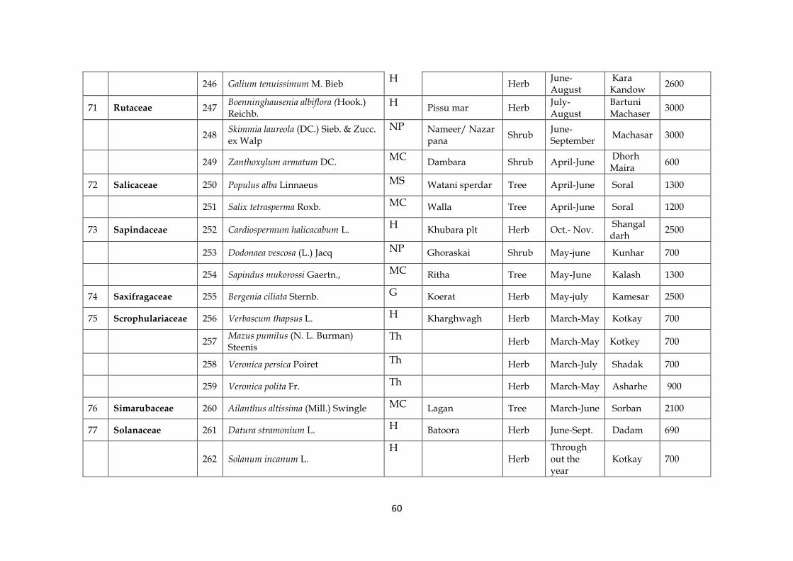
246 Galium tenuissimum M. Bieb H
Herb June-August
Kara Kandow
2600
71 Rutaceae 247 Boenninghausenia albiflora (Hook.) Reichb.
H Pissu mar Herb
July-August
Bartuni Machaser
3000
248 Skimmia laureola (DC.) Sieb. & Zucc. ex Walp
NP Nameer/ Nazar pana
Shrub June- September
Machasar 3000
249 Zanthoxylum armatum DC. MC
Dambara Shrub April-June Dhorh Maira
600
72 Salicaceae 250 Populus alba Linnaeus MS Watani sperdar Tree April-June Soral 1300
251 Salix tetrasperma Roxb. MC Walla Tree April-June Soral 1200
73 Sapindaceae 252 Cardiospermum halicacabum L. H
Khubara plt Herb Oct.- Nov. Shangal darh
2500
253 Dodonaea vescosa (L.) Jacq NP Ghoraskai Shrub May-june Kunhar 700
254 Sapindus mukorossi Gaertn., MC Ritha Tree May-June Kalash 1300
74 Saxifragaceae 255 Bergenia ciliata Sternb. G Koerat Herb May-july Kamesar 2500
75 Scrophulariaceae 256 Verbascum thapsus L. H Kharghwagh Herb March-May Kotkay 700
257 Mazus pumilus (N. L. Burman) Steenis
Th Herb March-May Kotkey 700
258 Veronica persica Poiret Th Herb March-July Shadak 700
259 Veronica polita Fr. Th Herb March-May Asharhe 900
76 Simarubaceae 260 Ailanthus altissima (Mill.) Swingle MC Lagan Tree March-June Sorban 2100
77 Solanaceae 261 Datura stramonium L. H Batoora Herb June-Sept. Dadam 690
262 Solanum incanum L. H
Herb Through out the year
Kotkay 700

61
263 Solanum nigrum L. Th Karmacho Herb April-June Dadam 700
264 Solanum pseudocapsicum L. NP
Mirchola Shrub May- June Machra Akazai
600
265 Solanum virginianum L. H
Herb Tor Kandow
800
266 Withania somnifera (L.) Dunal NP Shrub March-July Kalash 1800
78 Thymeliaceae 267 Daphne mucronata Royle H Laighonai/
Kutilal Shrub April-June Sorban 2300
79 Tiliaceae 268 Corchorus trilocularis Linn H Herb June-Sept. Shatal 1000
269 Grewia optiva Drummond .ex Burret MC Pastaw-oney Tree April- Sept. Shadak 500
80 Ulmaceae 270 Celtis australis Linn. MC Taghagaha /
Batkar Tree March-May
Charh/ Shagae
1100
81 Urticaceae 271 Urtica dioica L. H Jelbung Herb May-July Bartuni 2500
272 Urtica pilulifera Linn H Herb May-July Bartuni 2500
273 Debregeasia salicifolia (D.Don) Rendle
NP Chewr Shrub March-May Arekh 1800
82 Valerianaceae 274 Valeriana jatamansi Jones H
Mushk bala Herb March- May
Arekh 1800
83 Verbenaceae 275 Vitex negundo Linn NP Marghondai Shrub May-July Kalash 1700
276 Verbena officinalis Linn. Th Shmoakai Herb May-Sept. Palosa 800
84 Violaceae 277 Viola canescens Wall. ex Roxb Th
Herb April-July Shangal darh
2500
278 Viola odorata L. Th
Banafsha Herb May-August
Mana sar 2500
85 Vitaceae 279 Vitis vinifera L. NP Kwar Shrub May-June Soral 1400
Gymnosperms

62
86 Pinaceae 280 Cedrus deodara (Roxb. ex D. Don), G. Don
H Lamb. / Ranzhra
Tree ______ Machasar 3000
281 Picea smithiana (Wall.) Boiss, MG Nakhtar Tree ________ Machasar 3000
282 Pinus roxburghii Sargent MG Nakhtar Tree Guth 1240
283 Pinus wallichiana A. B. Jackson MG Pewach Tree ________ Manasar 2500
284 Abies pindrow Royle. MG Achal Tree Machasar 3000
87 Taxaceae 285 Taxus wallichiana (Zucc.)Pilger MG Bunya Tree __________ Arekh 2000
Monocotyledons
88 Agavaceae 286 Agave sisalana Perrine ex Engelm. Mc Herb April-June Darbani 600
287 Yucca aloifolia L NP Shrub Jun Darbani 600
89 Alliaceae 288 Allium griffithianum Boiss G Herb March-June Tot Banda 800
90 Amaryllidaceae 289 Narcissus tazetta L. TH
NargisGulae Herb December-March
Aararkh 2450
91 Araceae 390 Acorus calamus L. H Skhaweja Herb April-July Shatal 1625
291 Arisaema flavum (Forssk.)Schott. G Marjaarei Herb May-July Gantharh 2550
292 Arisaema jacquemontii Blume. G Marjaarei Herb May-July Manasar 2400
293 Arisaema utile Hook.f.ex. Schott G Tora marjarai Herb May-July Gantharh 2050
294 Colocasia esculenta (Linn.) Schott G
Karchalo Herb June-August
Judbah 700
92 Asparagaceae 295 Asparagus adscandens Roixb. CH Spin tindoray Herb March-July Totbanda 800
296 Asparagus capitatus Baker CH
Tindoray Herb March-July Machra Akazai
700
297 Asparagus officinalis L. CH
Tindoray Herb March-June Toot banda
830

63
93 Asphodelaceae 298 Aloe vera (L.) Burm. MC
Zaqam botay Herb May-August
Deheri 700
94 Cannaceae 299 Canna indica L. H Herb March-June Dehri 700
95 Colchicaceae 300 Colchicum luteum Baker. Th Herb Feb-May Pyan 2300
96 Commelinaceae 301 Commelina benghalensis L. CH
Kanchara Herb May-August
Shatal 1450
302 Commelina poludosa Blume CH Kanjuna Herb May-june Shatal 1400
97 Convallariaceae 303 Polygonatum multiforum (L.) All. H Noor e Alam Herb April-July Shagae 600
304 Polygonatum Verticillatum H
Noor e Alam Herb June-August
Shagae 600
98 Cyperaceae 305 Cyperus cyperoides L. H Della Herb May-June Berhi 1200
99 Liliaceae 306 Gagea lutea (L) Ker-Gawl H
Qaimat Gulay Herb June-August
Mahtorh 1100
307 Tulipa clusiana (Hook.) Regel H Gantul Herb March-May Banda 1100
100 Palmae 308 Nannorrhops ritchieana (Griff.) Aitchison
Np Mazri palm Shrub
Tot Banda
700
309 Phoenix dactylifera L. MC
Khajoor Tree March-April
Darbani 600
310 Phoenix sylvestris (L.) Roxb MC
Jangli khajur Tree March-April
Darbani 600
101 Poaceae (Gramineae)
311 Agrostis stolonifera L. H
Herb March-June Shatal 1500
312 Apluta aristata L. H Herb Kamesar 2400
313 Aristida depressa Retz H Herb March-July Nawagae 800
314 Arundo donax L. H Nara Herb April-June Kotkay 760
315 Avena fetua L. Th Jawdar Herb April-July Judbah 800

64
316 Bambusa glaucescens (Willd.) Sieb. H Bans Shrub Kunhar 700
317 Brachiaria ramosa (Linn.) Stap H Herb July – Oct Kandar 700
318 Calamagrostis decora Hook. f., Fl. Bri
H Herb Berhi 1000
319 Chrysopogon serrulatus Trin H Herb Jun-sep Arnil 730
320 Cynodon dactylon ( L) Pers H
Kabal Herb May-August
Arnil 730
321 Dactylotenium aegyptium (L) P.Beauv H Herb Shahtal 1530
322 Deschampsia caespitosa L H Broom grass Herb Kotkay 700
323 Desmostachya bipinnata (L) Stapf H
Drab Herb May-August
Kotley 700
324 Dichanthium annulatum (Forssk)Stapf.
H Herb Gigani 1600
325 Digitaria nodosa Perl. H Herb Berhi 1000
326 Imperata cylindrica (L)P. Beauv H
Herb Dehra kahu
570
327 Phalaris minor Retz Th Herb Shadak 600
328 Phragmites australis (Cay.) Trin. H Herb July- Oct Sorban 1200
329 Poa bulbosa L. H
Herb April-October
Larhsar 2000
330 Poa alpina Linn. H Herb June-Sept. Gantharh 2550
331 Sorghum haleeparse (L) Pers. H Dadam Herb May-Sept. Danda 1200

65
3.2 Phytosociological Aspects
Phytosocilogical features were studied in two sections i.e. classification and
ordination.
3.2.1 Classification: (Cluster Analysis)
Cluster analysis revealed that software divided all the 64 stations into two broad
groups. Upper arm again divided into subgroups at 30% cutoff level. The upper sub
group was composed of 5 stations representing Community 1. Lower subgroup was
further divided into two associations at 37% cutoff level depicting community 2 (13
stations) and 3 (8 stations).
Second major arm was divided at level of 20%. Upper subgroup again divided into
two associations representing Community 4 (14 stations) and 5 (12 stations), while
the lower subgroup represented Community 6 (8 stations).
Community 1 included Kotkay, Behri and Gut, while Community 2 was represented
by parts of Kotley, Judba, Shagai, Gorial and Zizari. Community 3 was located at
Toot banda Akazai, Darbani and Sabah Top. Important localities of community 4
were Dadabanda, Haleema, Nawagai and Pian hills. Community 5 was at South of
the Sahbah hill, Arnil, Shatal and lower part of Shangal Dar area. Community 6
represented the localities of Bakain, Bratho, Cando Gali, Mana Sar, Doda Gata,
Torban and Macahisar (Fig.3.5a & b).
3.2.1.1 Communities structure
The following communities were identified based on cluster analyses.

66
3.2.1.1.1 Community I: Delbergia sisso- Mallotus philippensis -Cyperus cyperoides
The community was located at altitude ranging from 467 -1260 masl (Table 3.1b).
Important localities of this community were Kotkay, Behrhi and Gut area. A total of
101 plants species were reported in this community including 22 tree, 19 shrub and
60 herb species.The tree, shrub and herb layers were characterized by Delbergia sisso,
Mallotus philippensis and Cyperus cyperoides as dominant species on the basis of
abundance. The other important tree species were represented by Pinus roxburghii,
Delbergia sisso, Ailanthus altissima and Acacia nilotica. The shrub layer consisted of
Mallotus philippensis, Dodonaea vescosa, Rubus spp, Colebrookia oppositifolia, Maytenus
royleanus, Berberis lycium, Cotinus coggyria and Carissa opaca. Important herbs
included Cynodon dactylon, Chrysopogon serrulatus, Digitaria nodosa, Verbena officinalis,
Erophila Verna, Trichodesma indicum, Torilis leptophylla.
Rare trees of this community included Bombax ceiba, Butea monosperma, Pyrus pashia,
Quercus incana and Alnus nitida. Among rare shrubs are Hypericum oblongifolium,
Rubus ellipticus, Justicia adhatoda, and Xanthoxylum armatum species. The rare herbs
comprised of Bergenia ciliata, Aerva sp. and Verbascum Thapsus (Fig 3.7-3.10).

67
Fig. 3.5 (a): Cluster dendrograms describing association among all six communities.

68
Figure 3.5 (b) Sketch Map Showing the location of different Plant communities in the study area

69
Fig.3.6 Habitat representation of community 1. (A Bheri, B: Kotkey)
A
B

70
The major life form was Hemicryptophytes (26.5%) followed by Nanophytes and
therophytes (18.2 and 17.3%). The microphanerophytes were 14.5%,
megaphanerophytes were 2.88% and mesophyte and chamaephytes were 6.7%
each.The share of geophytes was 8.6%.
Fig.3.7: Top 10 trees of the community 1 based on IVI in Delbergia-Mallotus-Cyperus
community. (Note:Pinus rox- Pinus roxburghii, Delbergia- Delbergia sisso, Acaci mod- Acacia
modesta, Acaci nil- Acacia nilotica Brousnetia- Broussonetia papyrifera, Celtis a- Celtis australis,
Ficus rac- Ficus racemosa, Alnthus alt- Ailanthus altissima, Albeza lb- Albezzia lebbek, Olea f- Olea
ferruginea).
0
50
100
150
200
250
300
IVI

71
Table: 3.1(b) Characteristic features of different Plant communities documented from
District Tor Ghar
Plant Community
CommunityI CommunityII Community III Community IV Community V Community VI
Elevation 467-1260 506-840 550-950 740-1400 900-2050 1930-2950
No of localities 5 15 8 16 12 8
Total No. of Species 101 160 121 229 220 149
Life form %
MC 14.5 14.9 16.5 15.15 6.5 12.4
MG 2.88 1.86 1.6 2.59 3.7 5.3
MS 6.7 5.59 2.47 3.03 3.7 3.35
Total ph 24.08 22.35 20.57 20.77 13.9 21.05
NP 18.2 14.28 20.66 15.5 17.4 13.5
TH 17.3 20.4 21.48 19.9 20 16.7
CH 6.7 7.4 6.6 6.6 8.9 6.77
G 8.6 3.72 1.65 5.6 6.3 7.3
H 26.5 31.6 28.9 32.03 32.8 32.0
No of Tree spp. 22 32 24 42 40 36
No. of Shrub spp. 19 23 24 38 38 26
No. of Herb spp. 60 105 73 149 142 86
Total spp. 101 160 121 229 220 148
Total IVI of 3 dominant tree species
954.0198
1778.78
917.2872
1431.006
1498.439
1104.649
Total IVI of 3 dominant Shrub species
531.6613
2000.198
1190.783
1021.539
1044.821
831.9647
Total IVI of 3 dominant Herb species
317.3438
1284.774
651.0351
597.3424
821.54
392.7304
Total IVI By tree species 1486.986 4272.181 300.8186 4110.033 3600.001 2300.402
Total IVI By Shrub species 1500 4302.49 292.9348 4200 3374.708 2230.089
Total IVI By Herb species 1500 4297.013 294.5652 4200 3481.292 2478.6

72
Fig. 3.8. Top 10 Shrub species of community 1 (Note: Malotus- Mallotus philippensis,
Ddonaea- Dodonaea vescosa, Rubus el- Rubus ellipticus, Maytenus- Maytenus royleanus, Colbrkia-
Colebrookia oppositifolia, Berbers l- Berberis lycium, Nerim ind- Nerium indicum, Myrsine- Myrsine
africana, Cotinus- Cotinus coggyria, Carissa- Carissa opaca)
Fig. 3.9. Top 10 Herbs of community 1 (Note: Cynodon- Cynodon dactylon, Cyperus- Cyperus
cyperoides , Dgitaria- Digitaria nodosa, Chryspgn- Chrysopogon serrulatus,Verbena of- Verbena officinalis,
Erophila-,Trchodsm- Trichodesma indicum,Torilis-Torilis leptophylla, Mrabilis- Mirabilis jalapa, Slanm
vir- Solanum virginianum)
0
20
40
60
80
100
120
140
160
180
200
IVI
0
20
40
60
80
100
120
140
IVI

73
Fig.3.10 Rare tree species of community 1 (Note Populus a- Populus alba, Ficus car- Ficus
carica, Melia az- Melia azedarach, Butea m- Butea monosperma, Pistacia- Pistacia integerrima, Bombax c-
Bombax ceiba, Pyrus pas- Pyrus pashia ,Qurcus fr- Quercus baloot Alnus nit- Alnus nitida, Tasy-
Unidentified)
Fig. 3.11 Total IVI of Rare herbs of the community 1(Note: Traxicum- Taraxicum officinale,
Adintm cp- Adiantum capillus- veneris, Acontm np- Aconitum napellus, Aerva san- Aerva sanguinolenta,
Bergenia- Bergenia ciliata, Acrnths b- Achyranthes bidentata, Verbascum- Verbascum thapsus, Ephrba hl-
Euphorbia helioscopia, Asplenium- Asplenium septentrionale, Acrnts as- Achyranthus aspera)
0
5
10
15
20
25
IVI
0
1
2
3
4
5
6
IVI

74
3.2.1.1.2 Community II Acacia modesta- Dodonaea viscosa - Cynodon dactylon
The second community is located at altitude ranging from 506-840 masl. Important
localities of this community were Kotley, Judbah, Sarbago, Shagai, Shadak, Gorial
and Zizari. A total of reported species from this community were 161.The dominant
tree species was Acacia modesta while other species with high IVI value were
Delbergia sisso, Ailanthus altissima, Broussonetia papyrifera, Acacia nilotica and Ficus
palmata. Characteristic species of shrub layer consists of Dodonaea vescosa, Mallotus
philippensis, Otostegia limbata, Justicia adhatoda, Colebrookia oppositifolia, Calotropis
procera, and Myrsine africana.
The dominant species of herb layer was Cynodon dactylon and other important herb
species include Chrysopogon, Digitaria nodosa, Agrostis stolonifera, Cannabis sativa,
Rumex hastatus and Aerva javanica.
Rare trees of the community include Cedrella serrata, Butea monosperma, Pyrus spp.and
Pistacia integerrima. Among rare shrubs Cotinus coggyria, Viburnum and Andrachne
cordifolia were documented, while the rare herbs consisted of Potentilla nepalensis,
Malva neglecta, Anagalus arvensis, and Melilotus officinalis (Fig. 3.12-3.18).
The dominant life form was Hemicryptophytes (31.6%) followed by therophytes
(20.4%). The Nanophytes and microphanerophytes were 14.28% and 14.9%
respectively while megaphanerophytes contributed 1.86% and Mesophytes were
5.59% and chamaephytes were 7.4% where as the share of Geophyteswas 3.72%.

75
Fig.3.12. Habitats and characteristic species of Community II (A Tor Kando:B: Kotley)
B
A

76
Fig: 3.13: IVI of top 10 tree species of community II (Note: Acaci mod- Acacia modesta,
Delbergia- Delbergia sisso, Alnthus alt- Ailanthus altissima, Brousnetia- Broussonetia papyrifera, Ficus pa-
Ficus palmate, Grewia op- Grewia optiva, Acaci nil- Acacia nilotica, Euclaptus- Euclaptus spp. ,Melia az-
Melia azedarach, Ficus car- Ficus carica)
Fig. 3.14: Top 10 Shrubs species of community II (Note: Ddonaea- Dodonaea vescosa,
Malotus- Mallotus philippensis, Otostgia- Otostegia limbata, Justicia- Justicia adhatoda, Myrsine- Myrsine
africana, Colbrkia- Colebrookia oppositifolia, Caltrops- Calotropis procera, Maytenus- Maytenus royleanus,
Carissa - Carissa opaca, Znthxylm- Zanthoxylum armatum)
0100200300400500600700800900
1000
IVI
0
200
400
600
800
1000
1200
IVI

77
Fig. 3.15 IVI of top 10 herbs species of community II (Note: Cynodon- Cynodon dactylon,
Chryspgn-Chrysopogon, Dgitaria- Digitaria nodosa, Agrostis- Agrostis stolonifera, Rumex has- Rumex
hastatus, Cannabis- Cannabis sativa, Phalaris- Phalaris minor, Aerva jav- Aerva javanica, Oxalis, Oxalis
carniculatus, Conyza- Conyza canadensis
Fig. 3.16 Rare tree species of community II (Note: Cedrella- Cedrella serrata, Butea-Butea
monosperma, Zzphs j- Ziziphus jujube, Pistacia- Pistacia integerrima, Bauhinia- Bauhinia variegate, Salix
tt- Salix tetrasperma, Populus a- Populus alba, Pyrus com- Pyrus communis, Pinus rox- Pinus roxburghii
Juglans- Juglans regia)
0
100
200
300
400
500
600
700
IVI
0
5
10
15
20
25
30
IVI

78
Fig.3.17: Total IVI of rare shrub species of community II (Note: Nanrhops- Nannorrhops
ritchieana, Yucca- Yucca aloifolia, Berbers l- Berberis lycium, Rosa ind- Rosa indica, Indgofra Vitis- Vitis
vinifera, Jsmnum hm- Jasminum humile, Andrchne- Andrachne cordifolia, Vburnm gr- Viburnum
grandiflorum, Cotinus- Cotinus coggyria)
Fig. 3.18 Total IVI of rare herbs species of the community II (Astrgls am- Astragalus
amherstianus, Ephrba hr- Euphorbia hirta, Evlvulus- Evolvulus alsinoides, Scandix p- Scandix pectin-
veneris, Lthosprmm- Lithospermum officinale, Melilotus- Melilotus officinalis, Anagalus- Anagalus
arvensis Clocasia- Colocasia esculenta, Malva neg- Malva neglecta, Potentla- Potentilla nepalensis)
0
10
20
30
40
50
60
70
0
0.5
1
1.5
2
2.5
3
3.5
4
IVI

79
3.2.1.1.3 Commuity III: Ailanthus altisima- Justicia adhatoda- Digitaria nodosa
Ailanthus altissima was the dominant species of tree layer. Other codominant tree
species of the community included, Acacia modesta, Delbergia sisso, Pinus roxburghii,
Ficus palmata, Olea ferruginea, Acacia nilotica, Broussonetia papyrifera and Phoenix
dactylifera. Characteristic shrubs species of this communities included Dodonaea
vescosa, Justicia adhatoda, Yucca aloifolia, Carissa opaca, Otostegia limbata and Calotropis
procera. Herb species of the community were represented by Cynodon dactylon,
Digitaria nodosa, Cannabis sativa, Phalaris minor, Aristida depressa, Imperata cylindrica,
Periploca aphylla and Arundo donax. Rare tree species of the community were
Diospyrus lotus, Quercus spp., Pyrus pashia and Morus spp. Among rare shrubs
species Maytenus royleanus, Colebrookia oppositifolia, Rubus fructicosus, Viburnum spp.,
Mallotus philippensis and Cotoneaster bacillaris, were included.The rare herbaceous
flora of this plant community include Argyrolobium roseum and Sisymbrium irrio.
The life form classification indicated that dominant life form was Hemicryptophytes
(28.9%) followed by therophytes (21.48%). The Nanophytes and microphanerophytes
were 20.66 and 16.5% respectively followed by megaphanerophytes (1.66%),
Mesophytes (2.47%), chamaephytes (,6.6%) where as the Geophytes were1.65%.
(Figure 3.19).

80
Fig.3.19: Habitats representing Community III (A: Akazai area B:Toot banda)
A
B

81
Fig: 3.20: Top 10 tree species of the community III (Note: Acaci mod- Acacia modesta,
Alnthus alt- Ailanthus altissima, Delbergia- Delbergia sisso, Pinus rox- Pinus roxburghii, Ficus pa-
Ficus palmata, Olea f- Olea ferruginea, Acaci nil- Acacia nilotica, Brousnetia- Broussonetia papyrifera
Phonx da- Phoenix dactylifera, Albeza pr- Albezzia procera).
Fig 3.21: Top 10 shrubs species of community III (Note: Ddonaea- Dodonaea vescosa, Justicia-
Justicia adhatoda, Yucca- Yucca aloifolia, Carissa- Carissa opaca, Otostgia- Otostegia limbata Caltrops-
Calotropis procera, Myrsine- Myrsine africana, Hyprcm ob- Hypericum oblongifolium Solnm ps- Solanum
pseudocapsicum, Nanrhops- Nannorrhops ritchieana)
0
50
100
150
200
250
300
IVI
0
50
100
150
200
250
300
IVI
Axis Title

82
Fig: 3.22: Important herb species of community III (Note: Cynodon- Cynodon dactylon,
Dgitaria- Digitaria nodosa, Cannabis-, Cannabis sativa, Phalaris- Phalaris minor, Aristida- Aristida
depressa, Imperata- Imperata cylindrical, Priploca- Periploca aphylla, Arundo d- Arundo donax
Lamium- Lamium amplexicaule, Poa blb- Poa bulbosa, Lthosprmm- Lithospermum officinale, Mntha ln-
Mentha longifolia, Plntgo mj- Plantago major, Acrnths b- Achyranthes bidentata Chnpodm al-
Chenopodium album)
Fig:3.23: Rare herbs of community III (Note: Sonchus-Sonchus asper, Swerti-Swertia ciliate, Slvia
mor- Salvia moorcroftiana, Duchsnea- Duchesnea indica, Crsum ar-Cirsium arvense, Ajuga br- Ajuga
bracteosa, Eryngium-Eryngium Sp., Cnvolvls-Convolvulus arvensis, Marubium- Clchcm lu- Colchicum
luteum, Oxalis-Oxalis carniculatus, Allium gr-Allium griffithianum, Impatin b- Impatiens bicolor,
Slybum ma- Silybum marianum, Agrlobum- Argyrolobium roseum)
050
100150200250300350
Cyn
odon
Dg
itar
ia
Can
nab
is
Ph
alar
is
Ari
stid
a
Impe
rata
Pri
ploc
a
Aru
nd
o d
Lam
ium
Poa
blb
Lth
osp
rmm
.
Mn
tha
ln
Pln
tgo
mj
Acr
nth
s b
Chn
pod
m a
l
IVI
01234567
Son
chu
s
Sw
erti
Slv
ia m
or
Du
chsn
ea
Crs
um
ar
Aju
ga b
r
Ery
ng
ium
Cn
vol
vls
Mar
ubi
um
Clc
hcm
lu
Ox
alis
All
ium
gr
Impa
tin
b
Sly
bum
ma
Ag
rlob
um
IVI

83
Fig.3.24: Rare shrub species of community III (Note: Rosa mos- Rosa moschata, Debrgsia-
Debregeasia salicifolia, Znthxylm- Zanthoxylum armatum, Cotnstr b- Cotoneaster bacillaris, Nerim ol-
Nerium oleander, Malotus- Mallotus philippensis, Vburnm gr- Viburnum grandiflorum, Rubus el- Rubus
ellipticus, Colbrkia- Colebrookia oppositifolia, Maytenus- Maytenus royleanus)
Fig. 3.25: Total IVI of rare tree species of community III (Note: Pistacia- Pistacia integerrima,
Grewia op- Grewia optiva, Phonx sy- Phoenix sylvestris, Qurcus dl- Quercus dilatata, Morus al- Morus
alba, Moras ni- Moras nigra, Qurcus fr- Quercus baloot, Pyrus pas- Pyrus pashia, Qurcs in- Quercus
incana, Diospyrus- Diospyrus lotus)
0
5
10
15
20
25
IVI
0
10
20
30
40
50
60
IVI

84
3.2.1.1.4 Community IV: Pinus roxburghii-Rubus ellipticus-Agrostis stolonifera
The Pinus roxburghii is the dominant texa of tree layer. Other companion species of
tree layer are Acacia modesta, Ailanthus altissima, Pinus wallichiana, Delbergia sisso and
Olea sp. The shrub layer consisted of Rubus ellipticus as a dominant species, Indigofera
heterantha, Dodonaea viscosa, Berberis lycium, Cotinus coggyria, Justicia adhatoda and
Otostegia limbata are the other important species of shrub layer. Important herbs of
the community were Cynodon dactylon, Agrostis stolonifera, Apluda aristata, Oxalis
carniculatus, Alliaria petiolata, Duchesnea indica, Taraxacum officinaleand
Partheniumhysterophorus. Among rare tree species of the community included
Quercus incana, Grewia optiva, Butea monospermum, and Bombax ceiba (Fig. 3.26-3.29).
The rare tree species of the community were Quercus incana, Bombax ceiba, Butea
monosperma, Cydonia oblonga, Grewia optiva, Moras nigra, Plantanus orientalis, Albezzia
procera, Aesculus indica, Sapindus mukorossi and Platanus orientaliswhile rare shrub
flora of the community consists of Caesalpinia decapitate, Rosa moschata, Calotropis
procera, Nerium indicum, Hedra nepalensis,Sarcococca saligna, Withania somnifera,
Jasminum humile, Cotoneaster nummularia andViscum album.
Among rare shrubs Equisetum, Plystichum lonchitis, Colchicum luteum, Arisaema
jacquemontii, Cordiospermum helicacabum, Impatiens bicolor, Priploca Aquilegia,
Astragalus macropterus are included.
The life form classification reflected that hemicryptophytes were dominant in the
community with 74 plant species and 32.03% of the total plant species followed by
therophytes with 19.9%. The contribution by Nanophytes was 15.5%, followed by

85
microphytes (15.15%), Chamaeophytes (6.06%), Geophytes (5.6%), Mesophytes
(3.03%) and megaphytes (2.59%).
Fig.3.26 Chir pine forest habitat (A: Bandan, B: Nawagae)
B
A

86
Fig. 3.27: Total IVI of top 10 tree species of community IV (Note: Pinus rox- Pinus
roxburghii, Acaci mod- Acacia modesta, Alnthus alt- Ailanthus altissima, Pinus wa- Pinus wallichiana,
Delbergia- Delbergia sisso, Juglans- Juglans regia, Olea f- Olea ferruginea, Punica g- Punica granatum,
Pyrus pas- Pyrus pashia, Qurcus dl- Quercus dilatata)
Fig. 3.28: IVI of Top 10 Herbs from community IV (Note: Cynodon- Cynodon dactylon,
Agrostis- Agrostis stolonifera, Apluta ar-Apluda aristata, Oxalis- Oxalis carniculatus, Aliaria pet -Alliaria
petiolata, Duchsnea-Duchesnea indica, Traxicum- Taraxacum officinale, and Prthenum-Parthenium
hysterophorus, Cardamin- Cardamine hirsute, Astrgls gr- Astragalus graveolens)
0100200300400500600700800900
1000
IVI
0
50
100
150
200
250
IVI

87
Fig. 3.29: IVI of Top 10 shrubs from community IV (Note: Rubus el- Rubus ellipticus, Indgofra-
Indigofera heterantha, Ddonaea- Dodonaea viscosa, Berbers l-Berberis lycium, Cotinus-Cotinus coggyria,
Otostgia-Otostegia limbata, Isodon- Isodon rugosus, Malotus- Mallotus philippensis, Carissa- Carissa
opaca, Justicia- Justicia adhatoda)
3.2.1.1.5 Community V: Pinus roxburghii- Berberis lycium–Chrysopogon
The community is located at North and South of Sahbah hill, Arnil, Shatal area,
Shangal Dar area and Haleema. Dominant tree species of this plant community was
Pinus roxburghii with total IVI 1015.2. Other Important tree species are Acacia modesta,
Pyrus pashia, Olea ferrugenia, Delbergia sisso, Ailanthus altissima and Juglans regia.
Prominent shrubs species in this community are represented by Indigofera heterantha,
Berberis lycium, Debregeasia salicifolia, Rubus ellipticus, Rosa moschata, Carissa opaca,
Dodonaea vescosa, Isodon rugosus, Zanthoxylum armatum and Cotinus coggyria.
0
50
100
150
200
250
300
350
400
IVI

88
Fig.3.30: Habitat representing Community V ( A: Gut Hill, B:Haleema Top)
Among important herbs Cynodon dactylon, Chrysopogonsp, Poa alpina, Digitaria nodosa,
Xanthium strumarium, Agrostis stolonifera and Taraxicum officinale are found (Fig. 3.31-
3.33).
B
B

89
Rare tree species of the community consist of Taxus wallichiana, Qercus
leucotrichophora, Sapindus mukorossi, Bombax ceiba, Plantanus orientalis, Bauhinia
variegate, Albezzia procera and Picea smithiana. Among rare shrubs are Vitex negundo,
Caesalpinia decapitate, Rosa moschata, Calotropis procera Cotoneaster frigidus, Buxus
Wallichiana, Viscum album andWithania somnifera. Rare herbaceous flora of this
community consists ofViola canescens, Urtica diocia, Arisaema jacquemontii, Asparagus
officinalis and Carthmus oxycantha.
The study of life form clsssification of this plant community revealed that
Hemicryptophytes with 62 plant species (32.8%) were dominant followed by
therophytes 20.0%) Nanophytes were represented by 33 plant species (17.4%).The
microphanerophytes were 6.5% followed by equal share of megaphanerophytes and
Mesophytes (3.7%) where as chamaephytes were 8.9% and Geophytes were 6.3%.
Fig. 3.31: Total IVI of Important tree species of community V (Note: Pinus rox- Pinus roxburghii,
Pinus wa- -- Pinus wallichiana, Acaci mod- Acacia modesta, Pyrus pas- Pyrus pashia, Qurcs in- Quercus
incana, Olea f- Olea ferrugenia, Alnthus alt- Ailanthus altissima, Delbergia- Delbergia sisso, Juglans-
Juglans regia Pistacia- Pistacia integerrima )
0
200
400
600
800
1000
1200
IVI
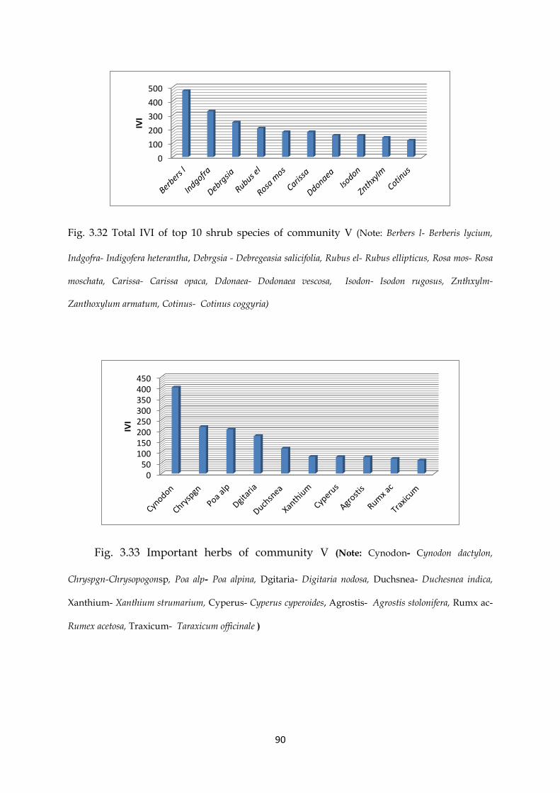
90
Fig. 3.32 Total IVI of top 10 shrub species of community V (Note: Berbers l- Berberis lycium,
Indgofra- Indigofera heterantha, Debrgsia - Debregeasia salicifolia, Rubus el- Rubus ellipticus, Rosa mos- Rosa
moschata, Carissa- Carissa opaca, Ddonaea- Dodonaea vescosa, Isodon- Isodon rugosus, Znthxylm-
Zanthoxylum armatum, Cotinus- Cotinus coggyria)
Fig. 3.33 Important herbs of community V (Note: Cynodon- Cynodon dactylon,
Chryspgn-Chrysopogonsp, Poa alp- Poa alpina, Dgitaria- Digitaria nodosa, Duchsnea- Duchesnea indica,
Xanthium- Xanthium strumarium, Cyperus- Cyperus cyperoides, Agrostis- Agrostis stolonifera, Rumx ac-
Rumex acetosa, Traxicum- Taraxicum officinale )
0
100
200
300
400
500
IVI
050
100150200250300350400450
IVI

91
3.2.1.1.6 Community VI: Pinus wallichiana -Viburnum grandiflorum- Poa alpine
The total documented species among this community were 36 trees, 26 shrubs and
86 herbs species. The dominant tree pecies of this community was Pinus wallichiana
with total IVI= 714. Other important trees of the community included Abies, Pinus
roxburghii, Quercus incana, Pyrus pashia, Quercus dilatata, Taxus wallichiana, Diospyrus
lotus, Cedrus deodara and Juglans regia.
Viburnum grandiflorum is represented as a dominat species while, Berberis lycium,
Indigofera heterantha, Sarcococca saligna, Hedra nepalensis, Viburnum cotinifolium, Rubus
ellipticus, Skimmia laureola, Isodon rugosus, and Cotoneaster bacillaris are the companion
species of shrub layer.
Among rare trees of this community are included Celtis australus, Sapindus mukorossi,
Broussnetia papyrifera, Ficus carica, Melia azedarach, Prunus armeniaca, Morus alba,
Delbergia sisso, Grewia optiva and Olea ferruginea. The rare shrubs are Cotinus coggyria,
Cotoneaster nummularia, Viscum album, Andrachne cordifolia, Cotoneaster frigidus,
Daphne mucronata, Zanthoxylum armatum, Debregeasia salicifolia, Buddleja crispa and
Vitex negundo. Among rare herbs, Chenopodium album, Crdiospermum helicacabum,
Cichorium intybus, Lactuca serriola, Malva sylvestris, Urtica pilulifera, Clematis montana,
Neslia apiculata, Plantago lanceolata are documented.

92
Fig.3.34(a) Habitats representing Community VI
B
A

93
Fig. 3.34 (b): Deforestation at different localities of community VI (A: Machasar, B:
Manasar, C: Shalangal dar, D: Kando Gali)
The life form classification described that hemicryptophytes were (32%) followed by
microphyte with 12.4% share and therophytes (16.7%). Nanophytes included 20
plant species (13.5%) of the total plant species in the community. The
megaphanerophytes and mesophytes were 5.3 and 3.35% where as chamaephytes
and geophytes were were 6.7%and 7.3% respectively.
C
B A
D

94
Fig: 3.35 Total IVI of top 10 tree species of community VI ( Note: Pinus wa- Pinus wallichiana,
Abie pind- Abies pindrow, Pinus rox- Pinus roxburghii, Qurcs in- Quercus incana, Pyrus pas- Pyrus
pashia, Qurcus dl- Quercus dilatata, Taxus w- Taxus wallichiana, Diospyrus- Diospyrus lotus, Cedrus
d- Cedrus deodara, Juglans- Juglans regia)
Fig. 3.36 Total IVI of Important shrubs of the community VI (Note: Vburnm gr- Viburnum
grandiflorum, Berbers l- Berberis lycium, Indgofra- Indigofera heterantha, Srcoca s- Sarcococca saligna,
Hedra nep- Hedra nepalensis, Vburnm ct- Viburnum cotinifolium, Rubus el- Rubus ellipticus, Skimia-
Skimmia laureola, Isodon- Isodon rugosus, Cotnstr b- Cotoneaster bacillaris).
0
100
200
300
400
500
600
700
800
IVI
0
50
100
150
200
250
300
350
IVI

95
Fig. 3.37 Total IVI of important herb species of the community VI (Note: Poa alp- Poa alpine,
Cyperus- Cyperus cyperoides, Dgitaria- Digitaria nodosa, Vleriana- Valeriana jatamansi, Poa blb- Poa
bulbosa, Fragaria- Fragaria nubicola, Pteris cr- Pteris cretica, Slvia lan- Salvia lanata, Ephrba Wl-
Euphorbia Wallichii, Urtica di- Urtica dioica, Oxalis- Oxalis carniculatus Duchsnea- Duchesnea indica,
Viola can- Viola canescens, Impatin b- Impatiens bicolor, Cynodon Cynodon dactylon)
Fig. 3.38 Total IVI of Rare tree species of the community VI (Note: Celtis a- Celtis australus,
Spnds muk- Sapindus mukorossi, Brousnetia- Broussnetia papyrifera, Ficus car- Ficus carica, Melia az-
Melia azedarach, Prunus ar- Prunus armeniaca, Morus al- Morus alba, Delbergia- Delbergia sisso, Grewia
op- Grewia optiva, Olea f- Olea ferruginea)
0
2
4
6
8
10
12
IVI
020406080
100120140160180
Po
a al
p
Cyp
eru
s
Dgi
tari
a
Vle
rian
a
Po
a b
lb
Frag
aria
Pte
ris
cr
Slvi
a la
n
Eph
rba
Wl
Urt
ica
di
Oxa
lis
Du
chsn
ea
Vio
la c
an
Imp
atin
b
Cyn
od
on
IVI

96
Fig. 3.39 Total IVI of Rare shrub species of the community VI (Note: Cotinus-Cotinus coggyria,
Cotnstr n- Cotoneaster nummularia, Viscum- Viscum album, Andrchne- Andrachne cordifolia, Ctnstr fr-
Cotoneaster frigidus, Daphne m- Daphne mucronata, Znthxylm- Zanthoxylum armatum, Debrgsia-
Debregeasia salicifolia Buddleja- Buddleja crispa, Vitex n- Vitex negundo)
Fig. 3.40 Total IVI of Rare herb species of the community VI (Note: Chnpodm al- Chenopodium album, Crdosprm-
Cordiospermum helicacabum, Cichorum- Cichorium intybus, Lactuca- Lactuca serriola, Malva syl- Malva sylvestris, Acrnths b- Achyranthes bidentata, Urtica pi-
Urtica pilulifera, Clmats mn- Clematis montana, Neslia a- Neslia apiculata, Plntgo ln- Plantago lanceolata)
0
5
10
15
20
25
30
IVI
0
0.5
1
1.5
2
2.5
3
3.5
4
4.5
5
IVI

97
3.2.2 Two Way Cluster Analysis (TWCA) Classification
TWCA and cluster analysis divided the samples into two main groups, which were
further divided into six plant associations.TWCA also describes species distribution
at different localities. The subtropical species were dominant in the investigated area
as shown in the two way cluster dendrogram. TWCA dendrogram show that plant
species like Abies pindrow, Taxus wallichiana, Skimmia laureola, Phoenix spp. and Cedrus
deodara were present in one plant association and were documented from few
stations i.e Abies pindrow and Cedrus deodara were recorded from 5 localitiesTaxus
wallichiana from 6 stations, Skimmia laureola was reported from 4 stations, while
species likePicea smithiana and Rumex vesicarius were reported from two localities
only, Dioscorea deltoidea from 4 stations, Viscum album, Cardiospermum halicacabum,
Aquilegia Sp.and Arisaema flavum were documented from 5 localities and Ficus
elasticawas found at 3 localities, representing rare plant species of the study area.
Similarly Aerva javanica, Phoenix spp. Artemisiaspp., Aconitum, sp Nannorrhops
ritchieanawere reported from two plant associations showing a narrow range of
distribution limit. Whereas the species, Acacia modesta, Delbergia sisso, Mallotus
philippensis, Dodonaea viscosa, Justacia, Otostegia limbata, chrysopogon, Cynodon,
digitariaand Rubus sp. having wide range were present in five out of six plant
communities recorded from study area (figure 3.41).

98
Fig. 3.41 TWCA dendrogram of 331 plant species and 64 stations based on Sorensor measures showing 6 plant communities.

99
3.3 Floristic Diversity along Environmental Gradients
In order to analyse effects of environmental varibales on the floristic diversity and
correlation among species, communities and localities, following two approaches
were adopted.
3.3.1 Indirect gradient analysis
DCA diagram (Figure 3.42) show the distribution of tree species and habitat type in
64 stations. The localities Jdbh I, Shagi I, Shdk 1, Zzari 1 and Ktky I are present at the
upper right side of the DCA diagram and are showing no correlation with most of
the stations. These stations show strong negative correlation with Dni2, Ddme 1,
Ttbda 3, Dni 10, Dni 9 and Ttbda. The stations Jdbh 12, Jdbh 11, Dni 13, Dni 12, Jdbh
10 and Jdbh 9 are located at the right side showing strong correlation with Axis Ist
and 2nd and negative correlation with certain stations like Tk2, Tkec1 and Dmn1. The
DCA diagram also reflected that the stations Ddme 1, Tk2 and Tk1 are locted at
negative side of the diagram showing negative correlation with other localities.
Table 3.2 Detail of the four axes of the DCA for 54 tree species and 64 stations data
Axes 1 2 3 4 Total
Inertia
Eigenvalues 0.630 0.212 0.103 0.083 3.543
Lengths of gradient 6.325 5.043 3.902 3.570
Cumulative percentage
variance of species data
17.8 23.8 26.7 29.0

100
Fig.3.42 DCA diagram displaying distribution of tree species and habitat types among 64 stations. (Codes in diagram indicates stations names refer to appendix 4)

101
Fig. 3.43 DCA diagram presenting the distribution of tree species in the district Tor ghar along the gradient (Codes in diagram indicates names of species refer to appendix 5)

102
The DCA diagram (Figure 3.43) revealed that most of tree species like Acacia
modesta, Delbergia sisso, Pinus roxburghii, Olea ferruginea and Acacia nilotica are
present in the centre of the diagram presenting strong correlation. Whereas tree
species Abies pindrow, Cedrus deodara, Picea, Aesculus and Taxus sp.are present at right
side of DCA diagram (Fig. 3.43) showing strong correlation with Ist axis and are
negatively correlated with species like Euclaptus, Delbergia sisso, Ficus elstica.
Similarly the species, Ficus benghalensis, Poplus, Butea monosperma and Bombax ceiba
are present at the upper right side of the DCA diagram show no correlation with
most of the tree species and are negatively correlated with the species Albezzia
proceraand Phoenix spp.
DCA diagram (Figure 3.44) produced through CANOCO revealed that majority of
shrub species stations were strongly correlated with 1st and 2nd axis (Eigen
value=0.64 and 0.189 respectively), while less correlation with 3rd and 4th axis (Eign
value=0.132, 0.099) (table 3.3).
The localities distributed at margins of the diagram represent habitat specificity
while the stations located in centre were showing similarity among each other. Jdbh
12, Dni13, Jdbh 11, jdbh 9 and Jdbh 10 are positively correlated with axis while
showing negative correlation with Kotly1, Kotly 2 and Tk 1. Locality shagai had
negative correlation most of the localities. The localities, Zizari3, Zizari 4, Shagai 6,
Gorl 3 and Shdk 4 are located at the center of diagram showing strong correlation.

103
Fig.3.44 DCA diagram presenting the distribution of shrub species and habitat types among 64 stations. (Codes in diagram indicates station’s names refer to appendix 4)

104
Fig. 3.45 DCA diagram presenting distribution of shrub species in district Tor ghar along the gradient (Codes in diagram indicates names of species refer to appendix 5)

105
Table 3.3 Detail of four axes of DCA for 48 shrub species and 64 stations data
Table 3.4 Description of four axes of the DCA for 420 herb species (using IVI data) for all 64 stations.
Detrended Correspondence Analysis (DCA) diagram Fig 3.45 revealed that the 1st
and 2nd DCA axis show strong correlation with shrub species. In the middle of the
DCA diagram, there are many shrubs which shared many vegetation types such as
Carissa opaca, Cotinus coggyria, Otostegia limbata and Zanthoxylum. Some shrubs show
no correlation with other plants like Bambusa, Yucca aloifolia and Nannorrhops
ritchieana. The species distribution along the first axis of DCA reflected altitudinal
gradient. While the shrub species like Skimmia laureola,Sarcococca saligna, Hedra
nepalensis are present on the right side of the diagram showing strong correlation
with axis and are negatively correlated with species like Yucca aloifolia, Calotropis
Axes 1 2 3 4 Total Inertia
Eigenvalues .508 .360 .270 .208 7.232
Lengths of gradient 6.723 5.074 6.242 5.231
Cumulative percentage
Variance of species data
7.0 12.0 15.7 18.6
Axes 1 2 3 4 Total
inertia
Eigenvalues 0.641 0.189 0.132 .099 3.299
Lengths of gradient 5.627 5.248 2.431 2.114
Cumulative percentage
variance of species data
19.4 25.1 29.1 32.1

106
procera,. The shrub species Vitis and Nannorrhops ritchieana showed negative
correlation with most of the species and axis.
Results of Detrended Correspondence Analysis (DCA) for all 240 herbaceous flora
and habitat types among 64 stations are represented in the Fig 3.46. Results revealed
that most of the sites are located in the center of DCA diagram.
The table 3.4 show that the Eigen value from Ist two axis were 0.58 and 0.360 while
the Eigen values from 3rd and 4rth axis were 0.270 and 0.208. Some localities like TK
EC1, Ttbda 3, Ttbda and Tk2 are located at the upper half showing negative
correlation with Dmn 1 Ddme 2, Dmn 2 and Ddme 3.
The habitats Ktky1, Ktky 2, Ktky3, Ktky 4 and Ktky 5 were located at lower left half
of the DCA diagram which show negative correlation with habitats; Dni 13, Dni 12,
Jdbh 12, jdbh 9, Jdbh 10 and Dni 11.
DCA diagram (Fig. 3.47) for herb species reflected that most of the herb species are
strongly correlated and are group together in the centre. While the species located at
the margin of the DCA diagram are showing less correlation. Herbaceous flora
located at the extreme right side of the diagram, Boenninghausenia albiflora, Impatiens
bicolor, Valeriana and Arisaema utileshowing strong correlation with axis 1 and 2.
These species are showing negative correlation with species located at the left side
i.eOpuntia, Canna, Solanum virginianum.

107
Fig. 3.46 Detrended Correspondence Analysis (DCA) diagram showing distribution of herbaceous flora and habitat types among 64 stations. (Codes in diagram indicates stations names refer to appendix 4)

108
Fig. 3.47 DCA diagram presenting the distribution of total herbs species among six plant communities along the gradient (Codes in diagram indicates names of species refer to appendix 5)
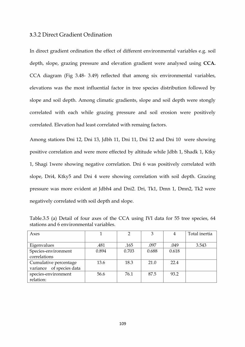
109
3.3.2 Direct Gradient Ordination
In direct gradient ordination the effect of different environmental variables e.g. soil
depth, slope, grazing pressure and elevation gradient were analysed using CCA.
CCA diagram (Fig 3.48- 3.49) reflected that among six environmental variables,
elevations was the most influential factor in tree species distribution followed by
slope and soil depth. Among climatic gradients, slope and soil depth were stongly
correlated with each while grazing pressure and soil erosion were positively
correlated. Elevation had least correlated with remaing factors.
Among stations Dni 12, Dni 13, Jdbh 11, Dni 11, Dni 12 and Dni 10 were showing
positive correlation and were more effected by altitude while Jdbh 1, Shadk 1, Ktky
1, Shagi 1were showing negative correlation. Dni 6 was positively correlated with
slope, Dri4, Ktky5 and Dni 4 were showing correlation with soil depth. Grazing
pressure was more evident at Jdbh4 and Dni2. Dri, Tk1, Dmn 1, Dmn2, Tk2 were
negatively correlated with soil depth and slope.
Table.3.5 (a) Detail of four axes of the CCA using IVI data for 55 tree species, 64 stations and 6 environmental variables.
Axes
1 2 3 4 Total inertia
Eigenvalues .481 .165 .097 .049 3.543
Species-environment correlations
0.894 0.703 0.688 0.618
Cumulative percentage variance of species data
13.6 18.3 21.0 22.4
species-environment relation:
56.6 76.1 87.5 93.2
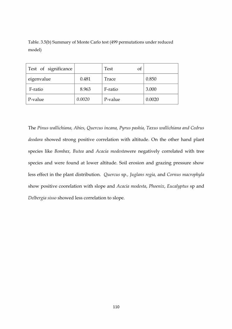
110
Table. 3.5(b) Summary of Monte Carlo test (499 permutations under reduced
model)
The Pinus wallichiana, Abies, Quercus incana, Pyrus pashia, Taxus wallichiana and Cedrus
deodara showed strong positive correlation with altitude. On the other hand plant
species like Bombax, Butea and Acacia modestawere negatively correlated with tree
species and were found at lower altitude. Soil erosion and grazing pressure show
less effect in the plant distribution. Quercus sp., Juglans regia, and Cornus macrophyla
show positive coorelation with slope and Acacia modesta, Phoenix, Eucalyptus sp and
Delbergia sisso showed less correlation to slope.
Test of significance
of first canonical
axis:
Test of
significance of all
canonical axes
eigenvalue
0.481 Trace
0.850
F-ratio 8.963
F-ratio 3.000
P-value 0.0020 P-value 0.0020

111
Fig:3.48 CCA diagram showing distribution of tree species among 64 stations in relation to various measured environmental variables (Codes in diagram indicates stations names refer to appendix 4)

112
Fig: 3.49 CCA diagram showing distribution of tree species in District Tor Ghar and the measured environmental gradients. (Codes in diagram indicates names of species refer to appendix 5)

113
Table. 3.6 (a) Description of four axes of the CCA using IVI data for 48 shrub species, 64 stations and 6 environmental variables.
Axes 1 2 3 4 Total
Inertia
Eigenvalues 0.422 0.120 .051 .043 3.299
Species-environment
correlations
0.848 0.660 0.617 0.559
Cumulative percentage variance of species data
12.8 16.4 18.0 19.3
species-environment
relation:
61.2 78.7 86.1 92.2
Table.3.6 (b) Summary of Monte Carlo test (499 permutations under reduced model)
Test of significance of
first canonical axis:
Test of significance
of all canonical axes
eigenvalue 0.422 Trace
0.689
F-ratio 8.365 F-ratio 2.509
P-value 0.0020 P-value 0.0020
The biplot diagram for shrubs species such as Sarcococca saligna, Hedera nepalensis,
Viburnum cotonifoliu, Rubus ellipticus, Skimmia laureola, and Cotoneaster bacillaris
showed positive correlation with slope and altitude while Dodonaea viscosa, Mallotus
philippensis, Otostegia limbata, Justicia adhatoda, Colebrookia oppositifolia, Calotropis
procera, and Myrsine africana were showing negative correlations. Other important
environmental factors affecting distribution of shrub species are slope and grazing
pressure. The plant species like Andrachne cordifolia, Xanthium sp. and Melilotus
officinalis were positively correlated with soil depth. Grazing pressure and soil
erosion was positively correlated with Yucca, Nannorops and Vitex while negatively
correlated with Caesalpinia, Zanthoxylum and Zizyphus.

114
Fig.3.50 CCA diagram showing distribution of shrub species among 64 stations in relation to different environmental variables (Codes in diagram indicates stations names refer to appendix 4)

115
Fig.3.51 Canonical Correspondence Analysis (CCA) diagram showing distribution of shrub species in relation to various measured environmental variables. (Codes in diagram indicates names of species refer to appendix 5)

116
The CCA diagram for herb localities (Fig 3.52) indicated that Dn12, Dn13 and Jdbh11
were positively coorelated with altitude whereas the stations Ktly1, Dri1, Shdk1,
Zzari and Ktky1 showed negative correlation with elevation. Jdbh7 was more
effected with slope. Zzari4, Dri4 and Zzari5 were positively correlated with soil
depth. Tk1, Tdbda1, Dmn1 and Ttbda2 were negatively correlated with soil depth.
CCA diagram for herb species (fig 3.53) showed that elevation was negatively
correlated with Ricinis communis, Opuntia and Sisymbrium while strongly correlated
with Poa alpina, Valeriana jatamansi, Viola odorata, Euphorbia wallichii, Impatiens bicolor,
Duchesnea indica, Boenninghausenia albiflora and Aquilegia sp.Swertia, Salvia, Bergenia
and Gernium were positively correlated with slope. Euphorbia, Astagalus and
Achyranthus showed positive correlation with grazing and soil erosion.
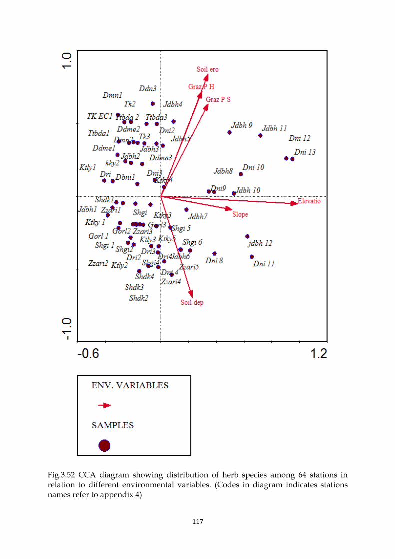
117
Fig.3.52 CCA diagram showing distribution of herb species among 64 stations in relation to different environmental variables. (Codes in diagram indicates stations names refer to appendix 4)

118
Fig. 3.53 CCA diagram showing distribution of herbs species in District Tor Ghar and different environmental gradients. (Codes in diagram indicates names of species refer to appendix 5)

119
3.4 Species Area Curve.
In present study species area curve was used to calculate the proper sampling size
for the collection of phytosociological data. PCORD was used to calculate species
area curve for tree, shrubs and herbs. The Fig 3.51 shows the species area curve for
tree species. It indicates that the number of species increases with an increase in the
number of sampling plotsand species curves reach to the region of constancy,
whereas the distance curves become zero. The diagram show that after 24 sub plot
the sample size become suitable and give constant species composition.
Fig. 3.54 Species area curves based on IVI data tree species and 64 stations
The relationship between area and number of shrub species is shown in the figure
3.55 and for herb species is presented in Fig. 3.56. These figures indicate that the
number of species increases with an increase in the number of sampling plots and
species curves reach to the region of constancy, whereas the distance curves become
zero. The diagram shows that after 20 sub plot the sample size for shrubs become

120
suitable and give constant species composition. The relationship of sample area and
number of species is shown in the figure 3.56.
Fig 3.55 Species area curves based on IVI data for all shrub species and 64 stations
Fig. 3.56 Species area curves based on IVI data for herb species

121
Chapter 4
DISCUSSION
Plants are the most expensive gift of Nature to mankind. It is the most important
treasure, much superior to other blessings because not only it is renewable but also
makes a very healthy contribution towards the development of environment. Plants
are imperative for the continuation of ecosystem services that is water, air and fertile
soil. Over 230,000 species of higher plants have been recorded in the world (Thorne,
1992). A large number of plant species are yet to be discovered.There has been much
research attempting to describe and explain this vast diversity and discover the
mechanisms which maintain it (Pitman et al., 1999).
Surveying of vegetation of an area is important because effective conservation
measures cannot be obtained without extensive knowledge of the flora of the region.
Plant checklist provides basic information about the vegetation of an area and serves
as a baseline for detailed study (Keith, 1988). Floristic listing helps in identification
and nomenclature of species (Ilyas et al., 2013).To develop conservation strategies
and estimate the changes taking place in the vegetation patterns of any area, it is
required to have a detailed floristic account of that area based on collections and
correct identification (Manikandan & Lakshminarasimhan, 2012).
Himalayas is one of the most complex and diverse mountain ecosystems on the
planet earth, possessing a unique climate, a strong degree of seasonality and diverse
plant communities and species due to wider elevation range, summer winter
precipitation, microclimatic variations, edaphic factors and landscape. It is one of the
mountain range where exist most of the natural forest resources of the subcontinent.

122
Pakistan is among one of few places on the earth with rich plant diversity, because of
varying geoclimatic zones in five significant mountain systems i.e. Western
Himalayas, Karakoram, Hindukush, Suleiman and Khirthar range (Perveen and
Hussain, 2007). Various floristic studies are reported from Pakistan and contributed
in term of ecological studies. The Flora of Pakistan is comprehensive inventory of
plants of Pakistan. About 47 Botanists have contributed to the Flora of Pakistan.
Litrature shows no available evidence of study from my project area although a
number of the studies were reported from adjacent area, for example Fazal et al.,
(2010) documented 211 species of 170 genera and 66 families from District Haripur.
Shah and Khan (2006) recorded 80 medicinal plants belong to 49 families from Sirin
Valley Mansehra. Haq et al., (2010) documented 402 vascular plants species
belonging to 110 families from Nandiar Valley western Himalaya, Pakistan. A
research project was conducted by Khan et al., (2013a) to study ecosystem services
provided by plants in the Naran Valley. They reported 101 plants belonging to 52
families used by the inhabitants for different medicinal purposes. Tor Ghar (Black
mountain) was explored for the first time in the history of plant sciences and
disclosed a diversity of flora.
4.1 Plant Diversity of District Tor Ghar
The study area, Tor Ghar (Black Mountain) can be located on the extreme western
edge of the Himalayas. Diversity in vegetation of the region is representative of Sub
tropical, Moist temperate and Sub alpine types of forests. Our findings showed that
the study area is blessed with diverse ecological habitats that host high floral

123
diversity. A total of 331 vascular plant species belonging to 246 genera and 101
families were recorded. Hosting 331 vascular plants species is evidence of a rich
diversity inspite of relatively harsh climate. The total area of district Tor Ghar is 454
Km2 which constitute .05% of the total area of Pakistan (796095 Km2) (Anon.,1999).
The present list of vascular plant species reported from district Tor Ghar has 331
plant species which constitute about 6% of the total 5783 species as reported by
Stewart, (1972). Most of these plants are important from ecosystem services point of
view such as medicinal plants, wild vegetables and timber plants. Besides providing
the first ever checklist of higher plant species of the region our study also fulfill
methodological gaps and use modern techniques for vegetation classification and
ordination. Preparation of inventories/checklists for unexplored regions can be seen
in previously published literature by various authors but most of them are on
smaller geographical units, like a valley and mountain etc. For example Perveen and
Hussain (2007) explored the flora of Gorakh hill (Khirthar range), Sindh, Pakistan
and reported 74 plant species belonging to 62 genera and 34 families. Shaheen et al .,
(2014) recorded the flora of Santh Saroola, Kotli Sattian, Pakistan and identified 186
plants species belonging to 148 genera and 63 families. Khan and Sardar, (2008)
described natural flora of Shakargarh District Narowal, Pakistan. It includes 83
families, 245 genera and 317 species. Similarly Fazal et al., (2010) documented a total
of 211 vascular plant species belonging to 170 genera and 66 families from District
Haripur. It includes 5 species of Gymnosperms of 5 genera and 4 families. Rafay et
al., (2013) studied life form, life trend and abundance of grass species in Cholistan
desert and described twenty seven grass species belonged to 16 genera from

124
Cholistan desert. Ilyas et al., (2013) surveyed the Kabal Valley Swat and reported 593
species of 408 genera and 130 families. Waris et al., (2013) documented the flora of
Cholistan desert and recorded 154 plant species, 106 genera and 38 families from 38
families, 106 genera and 154 species from the region. Qureshi et al., (2014) recorded
the flora of Khanpur Dam, Khyber Pakhtunkhwa, Pakistan. They documented 221
plant species of 169 genera and 66 families consisting of two ferns, one gymnosperm,
39 monocots and 179 dicots. Herbs were dominant in the floristic composition
followed by shrubs, grasses and trees. Khan et al., (2015) reported 252 species of
vascular plants belonging to 97 families from Thandiani sub forests division,
Abbottabad, Pakistan. I have tried to document higher vascular plants of a whole
district in my Ph.D project and hence cover comparatively a broader geopraphic unit
that is also a whole administrative unit.
In our project area the dicotyledons were dominating the flora and were represented
by 267 species (80.66%), while monocotyledons were composed of 46 species
(13.89%) and there were 6 species of gymnosperms (1.8%). Similar results were
presented in the previous study in the adjacent regions like, Qureshi et al., (2014)
reported one (0.5%) gymnosperm, 39 (17.64%) monocots and 179 (80%) dicots in the
flora of Khanpur Dam, Khyber Pakhtunkhwa, Pakistan. Ilyas et al., (2013) recorded 8
(1.3%) gymnosperms, 128 (21.58%) monocotyledons species and dicotyledons were
composed of 437 (73.69%) species from Kabal valley Swat. Khan et al., (2014) repoted
4 species of Gymnosperms, 56 species of Monocots and 357 plant species of Dicots
from Himalayan region of Poonch Valley, Azad Kashmir, Pakistan.

125
Our findings also show that the most prominent families in the District Tor Ghar
were Asteraceae, Leguminosae, Poaceae, Lamiaceae, Rosaceae, Ranunculaceae,
Brasicaceae, Euphorbiaceae, Moraceae and Apiaceae. These families all together
cover 43.82% of total number of species of the study area. Flora of the region showed
close affinities with the flora of adjacent areas in term of families. i.e., in the western
Himalayan region, the dominant angiospermic families are Asteraceae, Rosaceae,
Poaceae, Ranunculaceae and Brassicaceae (Rau, 1975). Many other studies have also
indicated the dominance of Asteraceae and Poaceae and can be seen in the literature
published. Fazal et al., (2010) reported that Family Asteraceae with 18 species was
the largest family in District Haripur and the Poaeae was the second largest family
with 16 species. Haq et al., (2010) also reported the dominance of family Asteraceae
with 36 species from the Nandyar Valley Western Himalaya, Pakistan. The family
Asteraceae was most species rich family from Kinnaur, Himachal Pradesh, India,
with 122 species, followed by Poaceae with 69 (Chawla et al., 2012). Qureshi et al .,
(2014) described that family Poaceae with 33 (14. 86%) species a dominant family
while documenting flora of the Khanpur Dam, Khyber Pakhtunkhwa, Pakistan.
Badshah et al., (2013) reported that Poaceae, Paplionaceae and Asteraceae are the
larger plant families of the District Tank, Pakistan. Ilyas et al., (2013) also indicated
that Poaceae was the largest family represented by 65 species, followed by
Asteraceae (44 spp), Rosaceae (33 spp), Papilionaceae (32 spp.,) and Lamiaceae (30
spp) from Kabal Valley Swat. Shaheen et al ., (2014) described the family Poaceae as
a largest family with (24 spp., 12.90%), followed by Asteraceae with 20 species
(10.75%) and Fabaceae having 16 spp., (8.60%) in the flora of Santh Saroola, Kotli
126
Sattian, Pakistan. Khan & Khatoon, (2008) also reported that the most important
plant family was Asteraceae with 14 plant species in Haramosh and Bugrote Valleys
in Gilgit, Northern areas of Pakistan. Similar results were obtained by many other
botanists like Marwat and Qureshi (2000), Saima et al., (2010), Khan et al., (2014) and
Durrani et al., (2005) in their respective study areas.
As a whole the family Asteraceae, the most prominent family in our study area, is
the largest plant family in Pakistan, ranks second, fourth, and seventh in the
western Himalaya, eastern Himalaya, and the Flora of British India, respectively
(Hooker, 1904; Hara and Hohashi, 1966- 1974; Rau 1975).Poaceae was another
prominent family in our study area.
Family to genera ratio in our study area was 1:2.44 and genera to species ratio was
1:3.4 which is similar to other reports from different region of Himalaya range, for
example the check list of Phanerogames presented by Fazal et al.,(2010) revealed that
genera to species ratio was 1:1.24 and genera to family ratio was 1:2.54 from district
Haripur, the study of Shaheen et al., (2014) from Santh Saroola, Kotli Sattian,
Pakistan indicated that family to genera ratio was 1:2.34 and genera to species ratio
was 1:1.25. Preliminarly check list reported by Ilyas et al., (2013) from Kabal Valley
Swat, Pakistan indicated that family to genera ratio was 1:3.1 and species to genera
ratio was 1:1.45 and Qureshi et al., (2014) rported family to genera ratio 1:2.56 and
genera to species ratio 1:1.30 in flora of Khanpur Dam, Khyber Pakhtunkhwa,
Pakistan.
Most part of our study area fall in subtropical and moist temperate habitat. In
present study most of the plant species collected from lower elevations of the district

127
were representing subtropical vegetation, for example, Acacia modesta, Calotropis
procera, Ficus palmata, Acacia nilotica Dalbergia sissoo, Justiceae adhatoda, Otostegia
limbataCarissa opaca,Dodonaea viscosa and Maytenus royleanus. These plant species
were reported from many other regions. Nazir et al., (2012) studied the subtropical
forests of Sarsawa Hills District Kotli, Azad Jammu & Kashmir, western Himalaya
and reported Pinus roxburghii,Ficus palmata, Acacia nilotica Dalbergia sissoo, Adhatoda
zeylonica, Carissa opaca, Dodonaea viscosa, Maytenus royleanus, Punica granatum,
Otostegia limbata, Themeda anathera, and Poa annua as indicator species of sub-tropical
vegetation. Hameed et al., (2012) indicated that Dodonaea viscosa, Justiceae adhatoda,
Otostegia limbataCarissa opacaChrysopogon serrulatus, Dichanthium foveolatum and
Cymbopogon spp.as indicator of lower altitudes. Shah & Rozina (2013) documenteda
total of 72 plant species belonging to 23 families from Dheri Baba hill Gohati and
Peer Taab graveyard District Swabi, Khyber Pakhtunkhwa, Pakistan. It includes
Zizyphus mauritiana, Acacia modesta, Calotropis procera, Carthamus oxycantha, Centaurea
calcitrapa, Eryngium bourgatii, Eucalyptus lanceolatus, Euphorbia prostrate, Solanum
surattense and Opuntia. Most of these plant species are similar to the species reported
from our research area.
The characteristic species of moist temperate sort of habitats were collected relatively
from higher elevations of the study area which include Abies pindrow, Quercus incana,
Pyrus pashia, Quercus dilata, Taxus wallichiana, Pinus roxburghii, Diospyrus lotus, Cedrus
deodara, Juglans regia, Viburnum grandiflorum, Berberis lycium, Indigofera heterantha,
Sarcococca saligna, Hedra nepalensis, Viburnum cotinifolium, Rubus ellipticus, Skimmia
laureola, Isodon rugosus and Cotoneaster bacillaris. Different authors from other parts

128
of Himalaya documented such species e.g. Pinus wallichiana, Aesculus indica,
Viburnum grandiflorum, Prunus cerasoides, Indigofera heterantha, , Viburnum cotinifolium,
Trifolium repens Paeonia emodi, and Bistorta amplexicaulis were documented from moist
temperate Himalaya of Pakistan by Saima et al., (2010). Hameed et al., (2012)
recorded Pinus wallichiana and Cedrus deodara from higher altitude of Himalayan
foothill region of Punjab.
4.2 Phytosociological classification
Scientific advances in ecology led towards the sciences of phytosociology, phyto-
geography and synecology (Leveque, 2001). Phytosociology is the study of plant
communities and associations. A community is assemblage of plant population
established in one habitat type in specific area and show mutual competition and
dependence. Certain plant species perform well in wide range of environmental
conditions while it is impossible for some plant species to perform well in different
environmental conditions (Atri et al., 2007). Different plant species are assembled in
different associations due to variations in habitat, environmental factors and biotic
relationships. Study of plant communities provides informations about plant species
distribution in relation to different ecological factors. This information gives basis for
estimation of probable future changes (Mueller and Ellenberg, 1974). Elevations,
aspect, degree of slope and precipitations phenomena are most important variables
affecting the distribution of vegetation in mountainous areas (Titshal et al., 2000).
Elevation from sea level is an important environmental variable for determination of
vegetation type (Day and Monk 1974; Busing et al., 1992). With change in altitude
floristic composition and community structure is changed (Sakya & Bania 1998;

129
Ayube et al., 2004). Ecological diversity of a community is considered to be a
measure of the health of its ecosystem (Mc Grady-Steed and Morin, 2000). Modern
phytosociological techniques are important tools to study the distribution of
vegetation of an area.
Champion et al., (1965) and Beg (1975) recognized various types of forests and
different vegetational zones in Pakistan and India, based on variation of temperature
and altitude. Rafi (1965) presented similar studies from Balochistan Province.
Hussain & Illahi (1991) described ecology and vegetation types of Lesser Himalaya
of Pakistan. Hussain (1984) documented vegetation of Karachi and Pakistan.
Number of phytosociological studies has been done in Pakistan on various scales.
Hussain (1964) surveyed the vegetation of Nagarparker. Hussain (1969) and Naqvi
(1974) conducted phytosociological study at Wah Garden and Murree Hazara Hills,
respectively. Phytosociological study of Sundangali, was carried out by Malik et al.,
(1990a). They described three plant communities (i) Malvestrum- Cymbopogon-
Adiantum (ii) Medicago-Cynodon-Euphorbia and (iii) Cynodon-Reinwardtia-Micromeria in
Sund Gali Muzzafarabad Azad Jummu and Kashmir. Shah et al., (2014) conducted
Phytosociological study of Farash hills Katlang, District Mardan. They identified 15
plant communities in the study area. Ahmad (2009) documented 52 herbs belonging
to 26 families from Margalla Hills National Park, Islamabad, Pakistan and classified
them into four plant communities by using TWINSPAN. Many other ecologists
carried out phytosociological studies from different areas of Pakistan. Most of these
studies were on small scale and there are only few studies about the phytosociology
of tropical and sub tropical regions involving the use of modern techniques like

130
TWCA, DCA and CCA. There is no previous record of phytosociological study in
District Tor Ghar. We have used modern phytosociological approaches in rugged
mountains which were rarely used in vegetation analysis in such remote areas in
developing world. We have used mixed methods of quadrat along transect to get
maximum diversity and enough data for vegetation maping. We have used modern
phytosociological techniques like TWCA, Cluster Analysis, and Indicator Species
Analysis etc. During the present research work phytosociological investigation was
carried out to explore the ecosystem and floristic biodiversity of the region. The
phytosociological attributes were recorded in three vegetational zones. In the
investigated area 64 stands were selected for phytosociological attributes. IVI data
obtained from these stands were further analyzed for classification and ordination.
The data from the study area revealed that plant communities confined in one region
are not available at the other sites due to differencesin altitude, soil depth, and other
environmental variables.
The present Phytosociological analyses have revealed different climatic zones in the
study area by applying TWCA, and CCA. Major vegetation zones were subtropical,
moist temperate and sub alpine region. During the research work in different sites
of the study area it was noticed that soil erosion due to deforestation and
constructions of roads were important factors causing a reduction in vegetation
abundance and species diversity of the region. Losses of soil due to soil erosion have
resulted in the loss of fauna and flora. In present research project vegetation of
district Tor Ghar was analysed. A total of 320 quadrats were used each for herb,
shrub and tree species at 12 different localities and 64 stations. A total of 331 vascular

131
plant species were recorded in these sites. The data collected from these sites was
analysed by cluster analysis and Two Way Cluster Analysis which give rise to six
different plant associations.
4.2.1 Cluster Analysis of Vegetation
Classification is used by ecologists for grouping the species or stands into groups on
the basis of similarity. In cluster analysis the samples or species are classified into
smaller number of interpretable groups or clusters that are meaningful and useful
and helps in understanding relationships between and within the community. In this
study we explored vegetation structure and composition from different vegetational
zone in the district. Using cluster analysis six plant communities were reported
which can be seen in the cluster dendrogram.In the dendrogram there were two
main branches indicating two different habitat types i.e. humid subtropical habitat
and the second half of the dendrogram includes the plant communities representing
chir pine forest type, moist temperate forests and subalpine type. Three plants
communities can be seen in first half of the dendrogram and three plant associations
are present in the second half of dendrogram.The presence of a species is important
in vegetation classification rather than its abundance (Greig-Smith, 1983). Therefore,
the analysis is done by cluster analysis and Two Way Cluster analysis using
presence/absence data.

132
4.2.2 Two Way Cluster Analysis (TWCA)
In present study TWCA was used for classification of plant species resulted in a two
way cluster Dendrogram. TWCA divided the samples into two main groups, which
were further separated into smaller groups.
The six plant communities were documented as a result of cluster analysis and Two
Way Cluster Analysis. In the investigated area altitude is the main factor change the
species diversity from Indus River to the top of altitude the study area. In the study
area communities located at low altitude indicated low species diversity while the
plant communities present at higher altitude were showing high diversity. Similar
results were reported by Malik et al., (1990b), Kharwal et al., (2005) and Khan et al.,
(2015). In contrast the diversity decreases with increase in elevation in subalpine and
alpine ecosystems as reported by Khan et al., (2012). They quantify the vegetation of
Naran Valley by using modern statistical techniques and reported that plant
biodiversity decreased along the altitude. The diversity decreased at higher altitude
due to steep slope, low temperature and high wind velocity. The six plant
communities on the basis of available indicator species can further be classified into
three categories (Haq et al., 2010; Champion et al., 1965); which are Tropical sub
humid forests, sub-tropical chir-pine forests and mixed coniferous forests.
4.2.2.1 Tropical Sub Humid Forest
Most of the sites included in this zone were located near the River Indus, near to
human settlements and are exposed to human disturbances. The study of plant
communities in the region shows that at lower altitude along the Indus River

133
Tropical sub humid vegetation is found which changes with changing altitude. At
lower altitude temperature was hot with poor rainfall while at higher altitude low
temperature prevails with significant precipitation. Primarily, community I, II and
III include the species of tropical sub humid and sub tropical vegetation. Community
I Delbergia sisso- Mallotus philippensis -Cyperus cyperoides was reported from five
localities at altitude 467-1260 msl. The biological spectrum was dominated by
Hemicryptophytes and therophytes. A total of 101 species were recorded in the
community. Total IVI of three dominant species was 954. Dalbergia sissoo was
reported from most of the localities and was dominant tree species in community I.
It is a deciduous tree and propagates by root suckers and seeds. Most of the sites in
this community provide suitable environment for the growth of Delbergia sisso,
Acacia modesta and Acacia nilotica. Pinus roxburghii was found above 900 masl at the
localities like Guth area. Mallotus philippensis is a large genus of trees and shrubs
distributed chiefly in the tropical and subtropical regions of the Himalayas
ascending to 1500 meters. It is frost-hardy and resistant to drought (Gangwar et al
.,2014) Under the pressure of regular human disturbance, M. philippensis is able to
show its constant presence in different forest communities. In addition to
recruitment by seeds, it exhibits efficient vegetative propagation and provides
enough and essential understorey cover for the ecosystem attributes of forests. Its
bushy sprouts and evergreen nature provide niches for other herbs, climbers and
wild fauna even in the presence of recurrent disturbance (Pandey & Shukla 2003).
The important grasses found in this zone were Cyperus cyperoides, Cynodon dactylon,
Chrysopogon serrulatus and Digitaria nodosa. These grasses were found in most of the

134
communities. Cyperus is a very noxious weed. It occurs in waste lands, along
pavements and farms. Cyperus is allelopathic to many plant species growing in the
locality and can reduce yield of crop to a great extent as it compete for mineral
resources with crop plant (Zareen et al., 2015)
The community II: Acacia modesta- Dodonaea viscosa - Cynodon dactylon was
established at lower altitude of the study region at altitude 506-840msl. It was
reported from 15 localities in the study area. Hemicryptophytes and therophytes
were the dominant life form classes from this community.
Important localities of this community were Kotley, Judbah, Sarbago, Shagai,
Shadak, Gorial and Zizari. All these localities were present near the Indus River. A
total of 161 species were reported from this community. The tree species were
represented by Acacia modesta as adominant species. Acacia modesta is a medium
sized tree dominant in community II and found abundantly in this vegetation zone
because it grows in different types of habitats. It is very drought resistant and can
easily be grown from seed. Pinus and Acacia spp. are commercially important plants
which provide gum, resin and wood which are important source of income for the
inhabitants who sell these products in nearby market.
Indicator species analysis identified Acacia modesta and Mallotus philippensis as
indicator species on the basis of degree of slope and low soil depth (appendix 8).
Other important tree species with high IVI value were Delbergia sisso, Ailanthus
altissima, Broussonetia papyrifera, Acacia nilotica and Ficus palmata. Characteristic
species of shrub layer consists of Dodonaea vescosa, Mallotus philippensis, Otostegia
limbata, Justicia adhatoda, Colebrookia oppositifolia, Calotropis procera, and Myrsine

135
africana. The dominant species of herb layer were Cynodon dactylon, Chrysopogon,
Digitaria nodosa, Agrostis stolonifera, Cannabis sativa, Rumex hastatus and Aerva javanica
(Appendix 3). Most of these species are the indicator species of the subtropical
habitats (Haq et al., 2010). Cynodon dactylon propagates by seeds and due to this
reason it flourishes in all type of habitat (Nasir and Rafique, 1995). Their seeds are
disbursed by wind to long distances and show good percent cover values. Cynodon is
considered as an important fodder grass (Cope, 1982.). Due to high grazing pressure
most of the dicot species are eradicated. Only less palatable and non palatable
species were present. Cynodon dactylon was dominant because it occurs on almost all
types of soils and was common in the habitat disturbed by man and under severe
grazing pressure, unused lands etc. (Martin et al., 1951). It has capability to resist the
drought and high temperature and can survive in the area where only few grasses
are found (Shah & Rozina, 2013).
Similar to community II, Acacia modesta community was recorded by Khan et al.,
(2014) from Poonch valley, Azad Kashmir Himalaya region at altitude of 3500 feet.
Ahmed et al., (2006) documented the dominance of Acacia modesta and Olea
ferruginaea community on the southern aspects of lower hills of Murree.
The community III: Ailanthus altisima- Justicia adhatoda- Digitaria nodosa represents the
degraded sites of the study area. It was reported from 8 localities. In the degraded
sites organic matter is reduced and species requiring low moisture and low fertility
will survive. Less number of species was recorded from this community (121). Total
IVI of three dominant tree species was 917.28. It is less than the rest of plant
communities. Due to degradation of habiatat and other human activities growth of

136
tree and shrubs is affected. This community represents highest number of
therophytes (21.48%) which is indication of habitate destruction, overgrazing and
other human interference. Therophytes are experts of occupying vacant niches as a
result of disturbances like deforestation and overgrazing (Pysek et al., 2005). The
localilities Dni 8 (Chor Kalan 1) and Dni 9 (Chor kalan 2) were present at higher
altitude, but due sever conditions like steep slope, habitat destruction and heavy
grazing pressure (Appendix 4) represent disturbed habitat. In degraded sites sun
tolerant or loving species which require low moisture and low humidity grow better.
This causes the reduction of species diversity as number of sciophytes reduced.
These findings are similar to the results of Malik et al., (1990). Important plant
species found in this community were Dodonaea vescosa, Acacia modesta, Justicia
adhatoda, Ailanthus altissima, Pinus roxburghii, Digitaria nodosa, Yucca aloifolia,
Calotropis procera, Broussonetia papyrifera, Myrsine Africana, Phoenix dactylifera,
Nannorrhops ritchieana. Ailanthus altissima is an introduced species and is mostly used
for fuel wood.
The dominance of Ailanthus altissima in community III indicates the anthropogenic
influence on the community structure. At lower elevation human interference results
in introduction of non-native species (Rawal & Pangtey, 1994). Broussonetia papyrifera
is an invasive species of this zone. Occurrence of non-native species like Broussonetia
papyrifera and Ailanthus altissima in this community were due to human caused
alterations in natural ecosystems. In this community original habitat was altered by
the removal of vegetation. Human influence on the natural flora has been studied by

137
different researchers in adjacent regions and found in accordance with our findings
(Peer et al., 2001; Kukshal et al., 2009; Malik & Hussain, 2006).
Characteristic species of this zone include Acacia modesta, Delbergia sisso, Broussonetia
papyrifera and Phoenix dactylifera, Acacia nilotica, Butea monosperma, Pistacia integerrima
Bombax ceiba, Aerva sp, Mallotus philippensis, Dodonaea vescosa, Colebrookia oppositifolia,
Maytenus royleanus, Carissa opaca, Otostegia limbata, Justicia adhatoda, Colebrookia
oppositifolia, Calotropis procera, Myrsine africana and Verbascum Thapsus. Important
factors affecting plants distributions in this zone were elevation from sea level, soil
depth and grazing pressure. Most of the localities are found on Gentle slope and at
low altitude.
The dominant life form was Hemicryptophytes and therophytes. Malik (2005)
reported high proportion of Hemicryptophytes and therophytes from Ganga Choti
Bedori hills due to deforestation and other anthropogenic influences. Higher
proportion of therophyte in this zone indicate harsh climate. Anthropogenic
influence is the main cause of change in biological spectra in given vegetational zone
(Zahid, 2007).
4.2.2.2 Sub-Tropical Chir-Pine Forests
The important localities in Sub tropical Chir pine forests were Dada Banda,
Haleema, Nawagae, North and South of Sahbah hill, Arnil, Shatal area, Shangal Dar
area and Pian hill. The altitude ranges from 740-1730 masl. Indicator species
identified by high soil depth indicated the Quercus and Pinus roxburghii as
characteristic species for tree layer. Community IV and V were representing this

138
vegetation zone. This zone of vegetation in study area is characterised by medium
slope, high soil depth and low grazing pressure (Appendix 4).
Important tree species were Pinus roxburghii, Acacia modesta, Ailanthus altissima,
Pinus wallichiana, Delbergia sisso, Quercus incana, Olea spp., Pyrus pashia, and Juglans
regia. Prominent shrubs species were Indigofera heterantha, Berberis lycium,
Debregeasia salicifolia, Rubus ellipticus, Rosa moschata, Carissa opaca, Dodonaea vescosa,
Isodon, Zanthoxylum armatum and Cotinus coggyria, Justicia adhatoda and Otostegia
limbata. Important herbs consist of Cynodon dactylon, Agrostis stolonifera, Apluta
aristata, Oxalis carniculatus, Alliaria petiolata, Duchesnea indica, Taraxicum officinale,
Parthenium hysterophorus, Poa alpina, Digitaria nodosa, and Taraxicum officinale. These
plant species are the characteristic of subtropical chir pine forest. Number of plant
species was highest in these two plant communities. It was due to similar elevation
from sea level, edaphic factors and habitat type. As habitat, elevation and edaphic
conditions are changed diversity is changed.
Community IV: Pinus roxburghii-Rubus ellipticus-Agrostis stolonifera was reported
from 16 localities in the study area at altitude 740-1400msl. The tree layer was
characterized by Pinus roxburghii as a dominat plant species. The dominant texa of
shrub layer is Rubus ellipticus and Agrostis stolonifera represents the dominant herb
of the community. The most effective environmental variable responsible for the
formation of this group was high soil depth associated with low grazing pressure. It
was most diverse community in the investigated area. A total of 229 vascular plant
species were documented from this community. Soil moisture and organic matter
139
due to deposition of litter was high under Pinus roxbergii community. Species
diversity increase with increasing the humidity (Danin,1999).
Community V:Pinus roxburghii- Berberis lycium–Chrysopogon was recorded from 12
localities at altitude 900-2050msl. Pinus roxburghii was the dominant tree species.
Berberis lycium emerged as dominant species in the shrub layer and Chrysopogon was
dominant herb species in this community. Total IVI of the tree layer was 3600 while
shrub layer represents 3374. A total of 220 vascular plant species were reported
showing rich plant diversity in the community.
The dominance of Pinus roxbergii in subtropical forests is reported in previous study
from Himalaya by Champion et al., (1965). In ideal conditions, the Pinus is dominant
due to its wide ecological amplitude and specific niche in this zone (Ahmad et al.,
2010). The study of life form classification of this plant community revealed that
Hemicryptophytes with 62 plant species (32.8%) were dominant followed by
therophytes (26.4%). Higher proportion of Hemicryptophytes than the tropical sub
humid forest vegetation zone reflects climatic condition of this zone. Many
ecologists documented similar vegetation from different part of the Himalaya and
our results are in agreement with them like Ahmed et al., (2006) reported Sub-
Tropical Chir Pine- Blue Pine Ecotonal Forests from Ghoragali Murree at an altitude
1570 msl and indicated that that Pinus roxburghii was dominant and Quercus incana
was in low density and other species include, Myrsine africana, Viburnum
cotinifolium, Berberis lyceum, Hedera nepalensis, Indigofera heterantha and
Chrysanthemum leucanthemum. It seems that due to anthropogenic influence these
plant communities might eventually modified to degraded scrub-land with

140
dominant species Maytenus royleanus, Justicia adhatoda, Dodonaea viscosa and other
related species (Malik et al., 1994).
4.2.2.3 Mixed Coniferous Forests
Pinus wallichiana - Viburnum grandiflorum - Poa alpina community (Community VI)
was reported in this vegetation zone. This zone can be established at 2130-2950 masl
hosting moist temperate reaching to subalpine ecosystem. The important stations at
this elevation range were Bakain, Bratho, Kando Gali, Mana Sar, Doda Gata, Tor Ban
and Machasar. Important environmental variable responsible for grouping the plant
species was altitude associated with low soil depth and grazing pressure. Severe
deforestation, over grazing, steep slope and soil erosion (appendix 4) have changed
the community structure. Some important plants such as Abies, Cedrus deodara, Picea
smithiana, Pyrus pashia and Taxus wallichiana are destroyed. Due to unavailability of
alternate source, people are dependent on these forests for fuelwood. The local
inhabitants use these plants for different benefits, causing degradation of plant
community. The plant species - Abies pindrow, Pinus roxburghii, Quercu dilata, Taxus
wallichiana, Diospyrus lotus, Cedrus deodara, Juglans regia, Viburnum grandiflorum,
Berberis lycium, Sarcococca saligna, Hedra nepalensis, Viburnum cotinifolium, Rubus
ellipticus, Skimmia laureola, Isodon rugosus and Cotoneaster bacillaris are the
characterictic plant species of moist temperate forests. Sarcococca saligna, Hedra
nepalensis, Viburnum cotinifolium, Skimmia laureola and Isodon rugosus are dominant
due to moist soil condition and are mostly unpalatable. These plants multiply under
grazing pressure. Viburnum grandiflorum was dominant shrub having highest IV.
Important herbs consist of Poa alpina, Cyperus cyperoides, Digitaria nodosa, Valeriana

141
jatamansi, Viola odorata, Euphorbia wallichii, Impatiens bicolor, Duchesnea indica. Pinus
wallichiana was characteristic tree species of this community. The community is
named on grass species i.e, poa due to highest presence of this species. It is group of
grasses with smooth and hollow stem and grows in clusters. It can compete with
other grasses. The dominance of hemicryptophytes is indication of temperate zone
(Cain and Castro 1959, and Shimwell, 1971). This community shows antrhropogenic
influence on the vegetation. Abies pindrow and Quercus spp. is the climax community
for western Himalaya (Champion & Seth, 1968). The change in this community is
due to destruction of these forests by deforestation and overgrazing. Quercus spp.
are widely used for fuel and fodder. These activities have resulted in the reduction
of vigour and seed production (Saxena & singh, 1984). Heavy browsing also causes
reduction in plant species. Large scale removal of certain species also produced
structural change of plant community (Spurr & Barnes, 1980). Similar vegetation
type was reported by Malik et al., (2007) from Pir Chinasi Hills. They reported Pinus-
Viburnum-Poa community as degraded vegetation at an altitude of 2000-2600 masl
and Pinus-Viburnum-Plantago community at an altitude of 2800m. Our results are
supporting them. Abies pindrow community was reported by Khan et al., (2013a) from
Naran valley at altitude of 2800-3400 and Ahmed et al., (2006) from Miandam,
Dungagali, Ayubia and Murree hills from 2245 to 2350 masl. In our study area due to
anthropogenic influence, like severe deforestation, over grazing and soil erosion, the
community structure has been changed and important woody plants Abies pindrow,
Cedrus deodara, Picea smithiana and Taxus wallichiana were destroyed.

142
Ahmed et al., (2006) reported Pinus wallichiana community from Murree, lower Topa,
and Jhikagali at altitude of 1970 - 2250 msl with Quercus incana as a codominant
species. Other species were Hedera nepalensis Lolium perenne Chrysanthemum
leuconthemum, Berberis lyceum, Myrsine Africana, Viburnum contifolium. Chaudhri,
(1960) indicated that Pinus wallichiana is a pioneer species present on all aspects
having wide altitudinal range.
Indicator species for each of the vegetation zone were identified by indicator species
analysis using PCORD. These species were Acacia modesta, Delbergia sisso, Euclaptus,
Bombax ceiba, Mallotus philippensis, Dodonaea vescosa, Otostegia limbata, Pinus
roxburghii, Cynodon dactylon, Quercus incana, Indigofera heterantha, Carissa opaca,
Duchesnea indica, Maytenus royleanus, Viburnum spp., Juglan regea, Ficus elastic and
Pinus wallichiana. Unlike the indicator species analysed by Khan et al., (2011) from
Naran valley which include, Aster falconeri, Iris hookeriana and Ranunculus hirtellu,
Achillea millfollium, Sambucus wightiana, Pinus wallichiana, Betula utilis, Abies pindrow,
Rheum austral, Poa alpina, plantago lanceolata, Impatiens bicolor, Fragariab nubicola,
Taraxicum officinale, Trifolium repens, Juniperus excels, Artemisia brervifolia, Onopordum
acanthium and Eremurus himalaicus. Hussain, (2014) identified indicator species
during the vegetation analysis of Deosai National Park, Gilgit Baltistan. Indicator
species were Saxifraga flagellari, Androsace mucronifolia, Agropyron longearistatum,
Carex cruenta, Agropyron longearistatum, Bromus oxydon Allium semenovii and Aster
flaccidus. Most of the study area falls in sub tropical habitat therefore, indicator
species are mostly subtropical.
143
Biodiversity of a region can be understood in a better way if certain systematic tools
are taken into consideration. Phytosociology is one of the branch of ecology having
such tools equipped with modern statistical approaches.
4.2.3 Environmental Gradient Analysis via Ordination Techniques
Environmental gradient or ordination analyses are analytical procedures used to
study species relationship with responsible ecological factors using statistical
approaches. These techniques using CANOCO version 4.5 showed that
environmental variables, like soil, light, water, temperature, elevation etc., play
important roles in species distributions. In present study indirect and direct
environmental gradient analyses were performed. Indirect method Detrended
Correspondence Analysis (DCA) was used for ordination analyses. Khan et al.,
(2012) used modern techniques like CANOCO to quantify the diversity Indices of
plant communities and habitat types. Ahmed et al., (2009) studied the vegetation
from Abbottabad road side using Detrended Correspondence Analysis (DCA) and
Canonical Correspondence Analyses (CCA). They identified 5 plant communities
along roadsides. TWINSPAN and DECORANA techniques were used by Ahmed
and Yasmin (2011) to analyze the vegetation along Hanna Lake, Baluchistan. They
described 2 main communities and 4 sub-communities. But all of these studies are at
smaller scales. For the first time we have used these techniques on a whole district
level.
144
4.2.3.1 Detrended Correspondence Analysis (DCA)
In Detrended Correspondence Analysis (DCA), only species data was used (Sagers
& Lyon, 1997). Detrended Correspondence Analysis was used to study the pattern of
species distribution among the major plant communities with in research area and to
confirm the outcomes of Cluster analysis and Two Way Cluster Analysis (TWCA).
Default sitting of CANOCO was adapted using DCA that resulted in AX1 and AX2
from which ordination diagram was constructed. Every point on the graph
corresponded to species. The different species which occur with same abundances in
the same site would occupy the same point. The distances among the points on the
graph represent the distribution of a plant species.
Ordination of the site and tree species reported from the district Tor Ghar by DCA
revealed that the Ist two axes have given useful information about the distribution of
species. Maximum gradient length 6.32 with Eigen value 0.63 were recorded for axis
1 and gradient length 5.0 with Eigen value 0.212 from 2nd axis of DCA reflected that
habitat and species were showing strong correlation with first and second axes while
the Eigen values 0.13 and 0.83 from 3rd and 4rth axis indicated that there was less
correlation with these axis. The localities Judbah (Jdbh I), Shagai Basi khel (Shagi I),
and Kotkey Hasan zai (Ktky I), Shadak (Shdk 1) and Zizari Basi Khel (ZZari 1)
(representing community 1 & 2) are present at the upper right side of the DCA
diagram. These sites occur near the Indus River showing negative correlation with
Darbani Akazai (Dni2), Dadam Hasan Zai (Ddme 1), Toot banda (tbda), Ttbda 3,
Dmn2, Darbani Dni 1 (community 3) most of these sites are also located at lower
altitude but representing the degraded localites. The DCA diagram reflected that the

145
vegetation of these habitats were different from rest of the region due to the presence
of these localities near the human settlements and are exposed to anthropogenic
disturbances. Some of the stations like Chor kalan and Chota kandow are present at
higher altitude but due to heavy human interference and sever climatic condition
showing resemblance with subtropical habitat. The stations Kando Gali (Jdbh 12),
Bratho (Jdbh 11), Tor Ban (Dni 13), Doda Gatta (Dni 12), Arekh (Jdbh 10) and Jdbh 9
(Community No. 6) are located at the right side of the diagram. These localities were
indicating moist temperate type of habitat and the sites present at the left side
reflecting subtropical habitat.
The DCA diagram for tree revealed that most of tree species like Acacia modesta,
Delbergia sisso, Pinus roxburghii, Olea ferruginea and Acacia nilotica are present in the
centre of the diagram, share more than one community. Whereas tree species Abies
pindrow, Cedrus deodara, Picea, Aesculus and Taxus wallichiana are present at right side
of DCA diagram showing strong correlation with Ist axis and are found in one plant
association (Community VI). These species were representing moist temperate and
subalpine vegetation. Similarly the species, Ficus benghalensis, Poplus, Butea
monosperma and Bombax ceiba were present at the upper right side of the DCA
diagram showing no correlation with most of the tree species and are negatively
correlated with the species Albezzia procera and Phoenix spp. These species were found
in different topographic conditions. The results also revealed that most of the plant
species followed arrangement similar to sites indicating that distribution of these
species is influenced by topographic factors.

146
DCA diagram representing shrubs species and habitat types reflected that majority
of shrub species stations were strongly correlated with 1st and 2nd axis.The localities
distributed at margins of the diagram represent habitat specificity while the stations
located in centre were showing similarity among each other. The site Kando Gali
(Jdbh 12), Torban (Dni13), Bratho (Jdbh 11), Arekh (jdbh 9) and Jdbh 10 are higher
altitude of the study area representing moist temperate and sub alpine habitate and
showing different vegetation from rest of the sites. The localities like Kotkey Hasan
Zai (Kotly1), Kotly 2 and Tor kandow (Tk 1), Kotley Nusrat Khel (Ktly 1), Gorial Basi
Khel (Gorl 1), Dheri (Dri 1) and Shadak (Shdk 1) are present at low altitude near the
Indus River representing Tropical Sub Humid climate. The stations Shagai and
Judbah showing different shrub vegetation due to occurrence near human
settlements.
The localities, Dada Banda (Zizari3), Banda (Zizari 4), Shangal Dar (Shagai 6), Danda
(Gorl 3) and Shatal (Shdk 4) are located at the center of diagram showing similarities.
Most of these localities are found at same altitude, share similar climatic condition
therefore, hosting similar shrub vegetation. Ordination of the site and shrub species
reported from the district Tor Ghar by DCA is depicted in DCA diagrams. The Ist
axis has given a best summary of original data (Eigen value 0.64 and for 2nd axes it is
0.189) Ordination diagram for sample of shrub species indicated a strong correlation
with 1st axes.
The plant species located at left side of the DCA diagram is the indication of sub
humid tropical habitat and shrub species present on right side of the DCA diagram
showing moist temperate and sub alpine habitat. Species like Skimmia laureola,

147
Sarcococca saligna and Hedra nepalensis are present on the right side of the diagram
and are found on high altitude and low soil depth conditions. Similar altitude is the
main environmental variable responsible for grouping these plant species and
representing moist temperate coniferous type of habitat. Comparison of localities
and species DCA diagram showed that these shrubs are absent from rest of localities
due altitudinal differences. The species like Yucca aloifolia, Calotropis procera and
Nannorrhops ritchieana were present at the right side of the diagrm indicated sub-
tropical habitat.
The occurrence of shrub species Vitis and Nannorrhops ritchieana on negative axis is
indication of habitat specificity of these species in study area. Where as many shrub
species are located at the center of diagram which shared many vegetation types
such as Carissa opaca, Cotinus coggyria, Otostegia limbata and Zanthoxylum. Some
shrubs show no correlation with other plants like Bambusa, Yucca aloifolia and
Nannorrhops ritchieana which is indication of specific locality. The species
distribution along the first axis of DCA reflected altitudinal gradient. In hilly
regions, elevation shows the greatest influence in controlling plant species and
community classification (Chawla et al., 2008).
The second axis represented the distribution of species along degree of slope and
soil depth. The results of the study revealed that elevation, soil depth and slope are
the main factor affecting the distribution of plant species.
Results of Detrended Correspondence Analysis (DCA) for all 240 herbaceous plant
species revealed that most of the sites are located in the center of DCA diagram
showing similarities and are found in many plant communities. The Eigen value 0.58

148
and 0.360 from Ist two axis of DCA indicating that habitat and species show strong
correlation while the Eigen values 0.270 and 0.208 from 3rd and 4rth axis indicated
that there was less correlation with these axis.
Some localities like Tor Kandow (TK EC1), Tk2, and Toot Banda (Ttbda 3), Ttbda
located at the left upper half of the DCA diagram showing different habitat than rest
of the locations. The Localities like Kotkey (Ktky 1), Ktky 2, Behri (Kt ky 3), Guth
hill (Ktky 4, Ktky 5) present at the lower left half of the DCA diagram are the sites
reflecting lower altitude. The vegetation of these habitats differs due to more
anthropogenic interference. Anthropogenic interferences are the major controlling
factors regulating species distribution (Mueller & Ellenberg, 1974). The herbaceous
habitats; Kandow gali (Jdbh 12), Tor ban (Dni 13), Doda gatta (Dni 12), Mana Sar
(Dni 11), Arekh (Jdbh 10) are the moist temperate habitat located at higher altitude.
DCA diagram for herb species revealed the distribution of herbaceous species in the
study area. Most of the herbs are present in more than one association showing
similarities. Where as, many plant species were showing specific localities in the
research area. Rumex vesicarius does not show correlation with rest of the herbs
showing specific locality. It was found in one association only. Herbaceous flora
located at the extreme right side of the diagram, Boenninghausenia albiflora, Impatiens
bicolor, Valeriana, Urtica pilulifera and Arisaema utile showing strong correlation with
axis 1 (representing community VI). The first axis represents altitudinal gradient.
Comparison of herb species and habitat revealed that these species are chacteristic of
moist temperate forest type habitat and are absent from rest of the habitats. The
dominance of these plant species decreased from higher altitude to lower

149
altitude.These species are showing negative correlation with species located at the
left side i.e Opuntia, Canna, Solanum virginianum which are located at low altitude
and poor soil condition.
In DCA diagram the position of some species is not similar to site indicated that the
distribution of thses species is not affected by topographic and edaphic factors.
Species distribution is controlled by a combination of environmental and
anthropogenic influence (Dolezol & Srutek, 2002).
Similar results were reported by Jabeen and Ahmad (2009). They conducted a
research project to study the vegetation and environment data of Ayub National
Park, Rawalpindi. Khan et al., (2011) studied 5 plant communities of Naran valley,
Pakistan by using TWCA and indicator species analysis and reported that aspect,
altitude and soil depth were important variables responsible for species distribution
in study area.
4.2.3.2 CCA Canonical Correspondence Analysis
Canonical Correspondence (CCA) has proved to be superior to others techniques
such as PCA (Gauch, 1982). When data sets are heterogeneous the results of CCA
are generally better than PCA and CA. However, when the data is relatively
homogenous with short gradients, PCA may be better option for ordination
procedures (Palmer, 1993). Species distribution pattern depend on various
environmental variables. Correlation between vegetation and different
environmental variables using CCA confirmed altitude, soil depth, degree of slope,
grazing pressure and soil erosion as more determinant environmental
150
variables.Biplots showed point locations as representative of individual species
whereas arrows indicate change in environmental factor. Length of arrow shows
strength of that particular variable.
CCA diagram for tree species reflected that among five environmental varibales
elevation was the most influential factor in tree species distribution followed by
slope and soil depth. Among climatic gradients, slope and soil depth were strongly
correlated with each while grazing pressure and soil erosion were positively
correlated. Among 4 CCA axes, the first and second axes (Eigen value 0.481, 0.165)
had strong correlation with environmental gradients. The stations Doda Gatta (Dni
12, Tor ban (Dni 13), Bratho (Jdbh 11), Manasar (Dni 11) and Chota Kandow (Dni 10)
were located at high altitude and represented the moist temperate and sub alpine
type of habitat.These stations are different from rest of localities due to altitude,
because with change of altitude,the vegetation also changes. Stations, Darbani
(Dni2). Dehri (Dri), TorKandow (Tk1), Dadam (Dmn 1, Dmn2) Tor Kandow 2 (Tk2)
were representing community II. Low soil depth and gentle slope was seemed to be
the effective variable responsible for grouping these sites. The altitude, soil depth
and slope were more effective variables responsible for distribution of tree species.
The Pinus wallichiana, Abies, Quercus incana, Pyrus pashia, Taxus wallichiana and Cedrus
deodara were found on high altitude and these species were separated from other
species.These tree species were present in one plant association (community VI) and
were absent from rest of the associations due to difference in elevation on the other
hand plant species like Bombax, Butea and Acacia modesta were present at low
altitude. Soil erosion and grazing pressure were less effectivein plant distribution.

151
Quercus sp., Pyrus sp., Juglans regia and Cornus macrophylawere present at steep slope.
Acacia modesta, Phoenix, Eucalyptus sp and Delbergia sisso were closely associated and
were found in gentle slope and low soil depth.
Vegetation association cannot be described on the basis of single process, altitude is
considered as a primary factor in community development (Billings, 1952; Whittaker
and Niering, 1975, Barbour et al., 1991). Altitude helps in representation for several
interrelated and biologically important environmental variables e.g. rainfall and
temperature, and is helpful in determining vegetation composition (Lookingbill &
Urban, 2005).
The biplot diagram for shrub species show that the distribution of species such as
Sarcococca saligna, Hedera nepalensis, Viburnum cotonifolium, Rubus ellipticus, Skimmia
laureola, and Cotoneaster bacillaris (representing Community VI) was more affected by
slope and altitude while Dodonaea viscosa, Mallotus philippensis, Otostegia limbata,
Justicia adhatoda, Colebrookia oppositifolia, Calotropis procera, and Myrsine Africana
(representing community I & II) were less affected and were found at lower altitude
of the district. Other important environmental factors affecting distribution of shrub
species were slope and grazing pressure. The plant species like Andrachne cordifolia,
Xanthium sp. and Melilotus officinalis were found in the location with high soil depth.
The plant species like Caesalpinia, Zanthoxylum and Zizyphus, which are palatable
species, were affected by grazing pressure while plant species Yucca, Nannorops and
Vitex were found more under high grazing pressure. The species richness of many of
the palatable plant species decreased due to grazing pressure while proportion of
non-palatable plant species will increase (Malik et al., 2007).

152
CCA diagram for herb localities indicated that the stations like Doda Gatta (Dn12),
Torban (Dn13) andBratho (Jdbh11) were located at higher altitude of the investigated
area whereas the stations Kotkey (Ktly1), Dehri (Dri1), Shadak (Shdk1) and Zizari
were the sub tropical habitat located at lower altitude. The soil depth was maximum
at location Banda (Zzari4), Matorh (Dri4) and Haleema (Zzari5).
CCA diagram for herb species and stations showed that herb species like Ricinis
communis, Opuntia and Sisymbrium were located at lower altitude and the species Poa
alpina, Valeriana jatamansi, Viola odorata, Euphorbia wallichii, Impatiens bicolor,
Duchesnea indica, Boenninghausenia albiflora and Aquilegia sp. were found at higher
altitude in study area. These species were more closely associated and were present
in one plant community only due similar altitude. Most of these species were absent
from other plant associations. Plant species; Swertia, Salvia, Bergenia and Gernium
were found on steep slope. Euphorbia, Astragalus and Achyranthus showed positive
correlation with grazing pressure and soil erosion. These species are unpalatable or
less palatable and were present in high grazing pressure.
The change in vegetation type along altitude gradient is investigated by many
studies. It was reported in CCA results of Jiang et al., (2007) that the change in flora
along the altitudinal gradient was more than that along the north-south latitudinal
gradient. Altitude is most effective variable describing the distribution of species
indirectly, by interacting with topography, light, soil, moisture, snow period and
temperature (Korner, 1999; Holten, 1998). Normal vegetation gradients in an area are
dependent on joint impact of historic, climatic variation, human interference and
comparative species performance (Jenik, 1990).

153
4.3 Life Form classification a reflection of microclimatic variation in Tor Ghar
Life form is the indicator of climate and can be used to compare plant communities.
Life form is characterized by plants to certain ecological conditions (Mera et al.,
1999). Raunkiaer (1934) proposed a system to classify plant life form based on
position and degree of protection of renewing buds.
Base on life forms, plant species reported from District Tor Ghar were grouped into
eight classes. Life form classes reflect the existing environment and are helpful in
comparing different plant communities and habitat types. Occurrence of similar life
form spectrum in different regions shows similar climatic conditions. According to
Raunkiaer (1934) the climate of a region, can be categorized by life form.
Anthropogenic disruption can change the life form of a region. Phyto-climatic
gradient and environmental indicators can help in policies related to long term
management and conservation of species and habitats (Khan et al., 2013b). The
biological spectra of flora and different plant communities in the present study
indicated that Hemicryptophytes and Therophytes were dominant in the study area.
At lower elevations high temperature, low precipitation and more anthropogenic
disturbance were reported. In Humid subtropical habitat high proportion
Phanerophytes and therophytes which are the elements of tropical region and
decreases in sub-tropical and subalpine region, reflecting climatic conditions. Life
form of a species changes with change in altitude from sea level. It reflects
adaptation of a species to different climatic conditions (Patel et al., 2010). The life
form of species in an area is always revealing plant-environment relations. Shimwell
(1971) reported that hemicryptophyte is the dominant life form of temperate zone

154
and therophytes are characteristic life form of desert climate and geophytes are the
indicator of Mediterranean climate. It confirms that climate of the study area vary
from subtropical to moist temperate and subalpine at different localities. The
vegetation of study area was predominantly Western Himalaya with SinoJapanese
and Irano-Turanians elements. The biological spectrum obtained in the present
study reflects the existing environmental conditions. Similar results were obtained
by different workers. Khan et al., (2013b) investigated the phyto-climatic gradient of
the flora in Naran valley by using Detrended Correspondence Analysis (DCA) and
Canonical Correspondence Analysis (CCA). They reported that hemicryptophyte
was the dominant life form in Naran Valley followed by Phanerophytes. Similar
observations were made by Malik et al., (1994) and Malik, (2005).
4.4 Plants in the Socioeconomics of the Region
Plants are precious resource and have vast impact on ecosystem and play important
role in socioeconomic conditions of the people. It was observed that most of the
plants reported in our project provide number of ecosystem services in the
region.These include traditional uses of plants as medicine, wild vegetables and
timber wood. Such plants have been reported in various studies.WHO highlighted
the need to use herbal medicines for treatment for different ailments. The medicinal
plants exhibit significant efficacy in curing various diseases without any side
effects. Plant based medicines are more effective, harmless and low-cost (Shinwari et
al., 2015). Over 21,000 plant species are used for medicinal purposes around the
world (Sultan et al., 2013).

155
Berberis lycium, Cyperus rotundus, Acacia modesta, Colchicum luteum, Ajuga bracteosa,
Cichorium intybus, Mentha longifolia, Hypericum oblongatum, Punica granatum, Ficus
carica, Podophyllum emodi, Valeriana jatamansi, Lactuca serriola, Viola canescens, Justicia
adhatoda, Skimmia laureola, Otostegia limbata, Dodonaea viscosa and Zanthoxylum
armatum are common medicinal plants found in our study area and are used by the
inhabitants for different ailments as reported by different authors from adjacent
areas (Haq et al., 2010; Qureshi et al., 2008; Hussain et al., 1996; Hamayun et al., 2003;
Adnan et al., 2015). Plant species like Acacia modesta, Acorus calamus, Amaranthus
spinosus, Chenopodium ambrosoides, Medicago sativa, Cyperus rotundus, Ficus religiosa,
Plantago ovata, Tagetes erecta, Ajuga bracteosa, Taxus wallichiana, Geranium
wallichianum, Achyranthes aspera andChenopodium ambrosoides, are frequently used by
women for treatment of their diseases. Similarly plant species such as, Dalbergia
sissoo, Adiantum capillusveneris, Melia azedarach, Datura stramonium, Valeriana
jatamansi, Sapindus mukorossi, and Vitex negundo are used for the treatment of hair fall,
anti-dandruff and antilice (Shah et al., 2013).
Punica granatum, Coriandrum sativum, Adiantum capillus-veneris, Lepidium sativum,
Foeniculum vulgare, Mentha longifoliaand and Paeonia emodi are used for number of
diseases to kill the harmful bacteria or stop their growth (Khan 2011). Important
timber yielding plants include Abies pindrow, Aesculus indica, Acacia modesta, Juglans
regia, Picea smithiana, Pinus roxburghii, Pinus wallichiana, and Taxus wallichiana (Haq et
al., 2010 & Awan et al., 2013, Hamayun et al., 2003). Taraxiacum officinale, Salvia lanata,
Oxalis corniculata, Trifolium repens, Rumex dentatus, Rumex hastatus, Caltha alba, Urtica

156
dioica, Dryopteris spp.and Caralluma tuberculata are the plant species used as wild
vegetables (Khan & Khatoon 2008; Haq et al., 2010; Khan, 2012).
A large area of the district is a grass land, serving as an important source of fodder
for animals. Important palatable grass species were Brachiaria ramose, Bromus
japonica, cenchrus bifloris, Cynodon dactylon, Desmostachya bipinnata, Dichanthium
annulatum, Poa alpina (Zahid, 2007). Other palatable species are Bistorta
amplexicaulis, Bromus hordeaceus, Eragrostis cilianensis, Lathyrus pratensis, Pimpinella
acuminata, Pimpinella diversifolia, Silene vulgaris and Chenopodium album (Khan, 2012).
Berberis lycium, Rosa moschata, Viburnum grandiflorum, Zanthoxylum armatum, are the
most preferred shrubs by cattle, goat and sheep (Zahid, 2007). Many plant species
reported from the study area are poisonous to the cattle, goat and sheep. Most of the
plants are poisonous to the animals only if taken in large amount (Vallentine, 1990).
Some plants are poisonous at particular stage of growth (Huston and Pinchak, 1993).
Astragulis, Solanum, Senecio and Cynoglossum containing a poisonous alkaloid
Pyrolizadin, which toxic to live stock. Similarly other poisonous plant species are
Andrachne cordifolia, Arisaema flavum, Datura innoxia, Nerium indicum, Datura
stramonium, and Urtica dioica (Haq et al., 2010).
The important plant species reported by different authors which are used as fuel
include Indigofera heterantha, Aesculus indica, Prunus spp., Viburnum cotinifolium Pinus
wallichiana, Pinus roxbergii, Abies pindrow, Picea smithiana and Cedrus deodara (Khan,
2012). Cedrus deodara and Pinus wallichiana which are native trees of the Himalayas
and the Hindu Kush, provide the best timber woods. Species of Abies pindrow, Picea
smithiana and Populus glauca also provide good quality timber, used in ceilings,

157
making doors and windows, utensils etc. Timber from species of Aesculus indica, Acer
caesium, Juglans regia and Prunus cerasoides is considered the best for agricultural
tools. Coniferous trees like Cedrus deodara, Pinus wallichiana, Abies pindrow, Picea
smithiana and Aesculus indica, have high aesthetic values for tourists as well as
inhabitants (Khan et al., 2012). Over exploitation of these plant species is major threat
to biodiversity in the area. Alam & Ali, (2010) presented the conservation status of 19
plant species and their study revealed that due to anthropogenic activities one
species is becoming extinct every day and this rate of species extinction is much
faster than that should occur naturally (Hilton-Taylor, 2000; Akeroyd, 2002). This
rate of plant extinction will result in the extinction of large number of species in near
future (Akeroyd, 2002).
4.5 Rare and Endemic Plant Species of District Tor Ghar
Rare plant species are applied to plant species which are uncommon and are
represented by small number of species in the study area. In this study IVI data or
abundance data (appendix 3) collected during field survey is used to designate
species as rare or common.
The present investigation is the first phytosociological study involving the use of
modern software to analyze the vegetation of the region. The species abundance
data and the data obtained from Indicator species analysis can be used to assess the
status of different plant species in the area. This data will be helpful to find out the
conservation status of the plant species documented from the study area. The plant
species having lower abundance and important values were used to asses the

158
conservation criterian. Identification of rare species is important for local and global
biodiversity. Plants used for the treatment of different diseases, fuel wood and for
other purposes, are valuable resource of the area. This information will be helpful to
develop awareness about these species among the people of the area. Indigenous
people can play major role in conservation of biodiversity of an area (Smith, 2004).
Local conservation exercise of the inhabitants can play significant role in biodiversity
management.
In the investigated area the rare tree species were found Bombax ceiba, Butea
monosperma, Quercus incana, Alnus nitida, Cedrella serrata, Pistacia integerrima,
Diospyrus lotus, Cydonia oblonga, Grewia optiva, Moras nigra, Albezzia procera, Aesculus
indica, Sapindus mukorossi, Platanus orientalis, Taxus wallichiana, Cedrus deodara,
Quercus leucotrichophora, Bauhinia variegate, Albezzia procera, Picea smithiana, Celtis
australus, Prunus armeniaca, Grewia optiva, Morus alba and Olea ferruginea.
Among rare shrubs were Hypericum oblongifolium, Xanthoxylum armatum, Cotinus
coggyria, Viburnum, Andrachne cordifolia, Cotoneaster bacillaris, Caesalpinia decapitate,
Rosa moschata, Calotropis procera, Nerium indicum, Hedra nepalensis, Sarcococca saligna,
Withania somnifera, Jasminum humile, Cotoneaster nummularia, Viscum album,
Cotoneaster frigidus, Buxus Wallichiana, Cotinus coggyria, Andrachne cordifolia, Daphne
mucronata, Zanthoxylum armatum, Debregeasia salicifolia, Buddleja crispa and Vitex
negundo.
The rare herbs included Bergenia ciliata, Aerva sp. and Verbascum thapsus, Potentilla
nepalensis, Malva neglecta, Anagalus arvensis, Melilotus officinalis, Argyrolobium roseum,
Sisymbrium irrio, Equisetum, Polystichum lonchitis, Colchicum luteum, Arisaema
159
jacquemontii, Cordiospermum helicacabum, Impatiens bicolor, Priploca, Aquilegia, Astragals
macropterus, Viola canescens, Urtica diocia, Asparagus officinalis, Carthmus oxycantha,
Chenopodium album, Crdiospermum helicacabum, Cichorium intybus, Lactuca serriola,
Malva sylvestris, Urtica pilulifera, Clematis montana, Neslia apiculata, and Plantago
lanceolata.
All these plant species having low abundance and importance values are considered
as rare species of the study area (appendix 3). The findings of present study revealed
that depence on these plants for the fuel wood, overgrazing, habitat degradation and
over exploitation for different purposes is resulting reduction in the population of
these species. Most of these plants were included in the list of globally or regionally
endangererd species by various authors in previous studies from the adjoining areas.
Aconitum heterophyllum, Colchicum luteum, Bistorta amplexicaulis, Geranium
wallichianum, Cedrus deodara, Juglans regia, Viola canescens Plantago major and
Polygonatum verticillatum are nearly threatened or vulnerable at a country level
(Khan, 2012).
The rare species documented from our study area like Taxus wallichiana, Cedrus
deodara, Poplus alba, Potentilla, Opuntia and Viscum album were reported as critically
endangered plant species from Nandiar valley, Battagram, KPK, Pakistan by Haq,
(2011). Whereas endangered flora of the area included Viola canescens, Salix spp.,
Withania somnifera, Grewia optiva, Aesculus indica, Quercus spp. Bauhinia variegate and
Podophyllum spp. They also described that these plants are used as fuel wood,
medicines and as a timber wood. In addition habitat loss, overgrazing and other
human interventions were the main causes of the reduction in the population of
160
these plant species. According to Shah and Hussain, (2012) rare plant species in
Chakesar valley, district Shangla, KPK, Pakistan were Acorus calamus, Arisaema
flavum, Artemisia vulgare, Clematis grata, Euphorbia wallichii, Geranium wallichianum,
Hypericum-perforatum, Urtica dioica. Vulnerable species of the valley included Bergenia
ciliate, Aconitum spp, Gerardiana palmate, Thymus serphylum, Indigofera hetrantha,
Podophylum emodi, Rubus fruticosus, Salvia lanata, Salvia nubicola and Valeriana
jacomontii.
According to Hamayun et al., (2006) about 50% medicinal plants are threatened due
to over exploitation and inappropriate harvesting. Destruction of Himalayan forest
in past is caused by different anthropogenic activities like increased population,
agriculture, expansion in human settlements (Shaheen et al., 2011; Ahmed et al.,
2006). Sheikh et al., (2002) studied the biodiversity of Naltar Valley, Gilgit and
reported that Gentiana kurroo, Stellaria media, Geranium wallichianum and Capparis sp.
having high demand as medicinal plants lead to overexploitation. Khan, (2003)
stated that in the recent years Anthropogenic activities by way of destruction of
biota, the natural habitats have accelerated the process of extinction to an alarmingly
faster rate. Shinwari et al., (2000) conducted studies to calculate the approximate
number of endangered plants which indicated that more than 10% flora is
endangered while another 10% is threatened or vulnerable. The Himalaya
experiences the worst position where 90 percent of the natural forest habitats have
already been lost.

161
Malla et al., (2015) reported that anthropogenic influence on the ecosystem like
unsystematic development works, habitat degradation, unsustainable use of
medicinal plants were the main causes of reduction of important medicinal plants.
Many plant species documented from our study area were reported as endemic to
Himalayas and Hindukush. Gentiana kurroo, Geranium wallichianum, Bergenia ciliata,
Aconitum spp, Podophylum emodi, Viola canescens, Cedrus deodara, Picea smithiana, Salvia
moorcroftiana, Bistorta amplexicaulis, Otostegia limbata, Impatiens bicolor (Khan, 2012;
Majid et al., 2015).
4.6 Threat to plant biodiversity of the study area
The present project also revealed that the people of the District Tor Ghar are
illiterate. They are unaware from the importance of biodiversity. They cut the
important plants for timber, fuel, fodder, fiber and wood. There is no influence of
forest department. Heavy deforestation can be seen at the higher altitudes of the
district especially in the Machasar, Manasar, Ganther and Shangaldar area, where
immature and large sized cut stem can be seen which are being destroyed ruthlessly
by the inhabitants. In these areas the forests of Picea smithiana, Pinus wallichiana,
Quercus incana, Quercus dilatata, Cedrus deodara and Abies pindrow are being destroyed
at large scale. It is great threat to biodiversity. There is no alternative fuel and
people are heavily depending on these species for fuel wood. These species are used
for construction, timber and formation of agriculture tools.
Overgrazing is another important threat to biodiversity. The heavily grazed
community results in the change in the species diversity. It was investigated that

162
protection of grazing had increased biodiversity and biomass in Kanak valley
Baluchistan (Mori & Rehman, 1997). Palatability of a plant species and preference for
grazing by a particular animal is dependent on certain characteristics such as
external plant form, chemical composition, kind of plant and growth stage of a plant
(Heady, 1964). Traditional grazing without any management practices is seen in
many parts of the study area. Overgrazing not only causes soil destruction but also
remove palatable species resulting soil erosion, this is seen at various places in the
investigated area. eg. Severe grazing effect and vegetation degradation is recorded in
the Dadem, Kotley, Sarbago, Tor kando, Toot banda, Arnil, Gut hill, Shatal, Chor
Kalan, Chota Kando, Doda Gata and Torban (appendix 4). Vegetation of these sites is
destroyed and soils of these locations were eroded by soil erosion. These sites show
low species diversity. Most of the locations are considered as degraded habitate of
the district. At the higher altitude of the study area like Torban (Machasar), Kando
gali, Chota kando and Chorkalan area seasonal nomads with large number of cattle’s
also stay. Large number of livestocks results in the overgrazing of natural
vegetation.
Soil erosion is also one of the threats to plant biodiversity. Degradation of land by
soil erosion not only decreases production capacity but also reduces the number of
palatable species. In degraded habitats only few plant species can survive and
complete their life cycle whereas, those species, which need better habitat in term of
soil, light, moisture and shade are generally eliminated. In our study area at higher
altitude the stations like Arekh1 and Arekh2 are located at steep slopes and the
stations: Manasar, Chota Kondo, Doda Gata, Machasar, Chor Kalan, Sargae, Toot
163
Banda and Dar Bani are representing moderate slopes. Due to steep slope soil
erosion habitat degradation was observed at these locations (Appendix 4). In newly
created district, developmental works like construction of roads and infrastructure is
in progress, which is another important cause of soil erosion in the area. Study site is
the catchment area of one of the largest water reservoir of the country (Tarbella
dam). Its storage capacity is rapidly reducing due to heavy siltation caused by soil
erosion. It is also major threat to biodiversity and agricultural land of the area. Haq
et al., (2011) conducted field survey in Nandiar valley District Battagram, KPK,
Western Himalaya and reported similar observations. They observed that major
threat to the biodiversity in the area was unawareness of local communities,
deforestation, population expansion, overgrazing, urbanization, deforestation,
habitat destruction and unsustainable use of natural vegetation.
4.7 Limitations of the present research project
The study area has never been surveyed in history because it is one of the farflung
and backward area of the Pakistani Himalaya region consisting of steep slope and in
accessable sites. The present study explored in detail the biodiversity and
phytosociology of the area. The research study was well planned to achieve almost
all aims and objectives. However it is not possible to achieve 100% perfection
especially in survey based studies in such remote, inaccessible area with strong tribal
cultural constraints which do not allow frequent visits of some localities.
I think few plant species might have been missed which were present at steep slopes
or at inaccessable sites. Due to accessability and transportation problem complete

164
soil analysis could not be done. A few plant species with short growing season may
have not been reported during the survey. The study provides information about the
important plant species used in different ecosystem survices and species abundance
but detailed study is needed. However, the study with a few limitations is first ever
attempt of exploration of a hard and tough western Himalayan region, which opens
the way for future researches.

165
CONCLUSIONS
Exploration of District Tor Ghar results in the documentation of 331 plant species
from 960 quadrats and 64 stations. District Tor Ghar represented rich plant
biodiversity. The study showed that the area is blessed with diverse ecological
habitat and inhabit high floral diversity. Our findings clearly show that vegetation of
the region is representative of humid subtropical and Subtropical Chir Pine Forest
type in lower region of district which gradually changes to Moist temperate and sub
alpine type of habitats at higher elevation. Hosting high number of vascular plants
species (331) is evidence of rich diversity of the region though most of the region
exhibit harsh climate. Most of reported plants are important from ecosystem services
point of view such as medicinal plants, wild vegetables and timber plants. This
study also provides first ever phytosociological classification based on robust
multivariate classification and ordination procedure via Canoco and PCORD
softwares. Six plant communites were reported in 3 vegetation zones i.e. Humid sub-
tropical, Sub tropical Chir pine and Moist temperate and sub alpine. Finding of this
project confirmed elevation from sea level, slope and soil depth as significant
environmental variables responsible for distribution of plant species. As for as
preservation of the natural plants and habitats are concerned, it was observed that
people of the area were mostly illiterate and were not aware of the biodiversity loss
and its impact on human life. They are using natural resources ruthlessly that
resulting disappearance of certain plants and habitats from the region. The study
also revealed that area is suitable for rangeland as grasses are dominant in the
region, which are mostly palatable. The study furnishes baseline data and useful

166
information to protect local flora for the future generation. The findings of the study
will be useful to rangeland managers, ecologist, medicinal plant growers, foresters,
collectors and conservationists to improve the bioresource base and socioeconomic
conditions of the people of the area under investigation.

167
RECOMMENDATIONS
Based on the finding of the present study following recommendations were made.
Law enforcement is essential to protect floristic diversity which is the treasure
of nature and in this regard proper legislation should be made for the
protection of threatened species.
Compilation of complete flora is essential.
Extensive reforestation in the study area is urgently needed
To launch awareness campaign among locals to stop over exploitation and
protect plant resources.
The higher altitudes dominated by moist temperate forests inhabiting
threatened species should be given the status of a protected area.
Proper rangeland management in the region can improve the socioeconomic
condition of the inhabitants.
The documentation and preservation of indigenous knowledge is needed for
conservation and sustainable utilization of plant resources.
Plant bio-resources of the area also need proper in-situ conservation measures.
Eco-tourism should be established which will be the good source of income for
the inhabitants.
Application of remote sensing is needed.