Groundwater Exploration and Drilling Problems Encountered in Basaltic and Granitic Terrain of Nanded...
11
0016-7622/2014-84-3-341/$ 1.00 © GEOL. SOC. INDIA JOURNAL GEOLOGICAL SOCIETY OF INDIA Vol.84, September 2014, pp.341-351 Groundwater Exploration and Drilling Problems Encountered in Basaltic and Granitic Terrain of Nanded District, Maharashtra PANDITH MADHNURE Central Ground Water Board, Southern Region, Ministry of Water Resources, Govt of India, GSI Post, Bandlaguda, Hyderabad – 500 068 Email: [email protected] Abstract: The Central Ground Water Board (CGWB) constructed 72 bore wells down to a targeted depth of 208 m in Nanded district, Maharashtra which is mainly underlain by hard rocks, namely basalts and granites. The yield of these bore wells varies from 0.10 litres/second (l/s) to 25 l/s and depth of weathering varies from less than 1 m to 24 meters below ground level (m bgl). The shallowest and the deepest aquifer zones are encountered at 7 and 172 m bgl respectively and majority of the productive aquifer zones are encountered within 100 meter (m) depth. Most productive zones are fractured basalts, fractured and weathered granites and 31 % of the zones are encountered within 25 m, 36 % within 25- 50 m, 24 % within 50-100 m, 8 % within 100-150 m and less than 1 % within 150-173 m depth ranges. Out of the three major sets of lineaments, the NE-SW trending lineaments are more productive, and a maximum of five fracture zones are encountered in all. Surface geophysical studies (profiling) reveal that wherever the ratio between high resistivity and low resistivity is high, the discharge is high, and where the ratio is low the discharge is low. The depth to water level in these bore wells are in the range of 1.5-47.5 m bgl (below ground level). The transmissivity (T) and Storativity (S) values of 21 wells range from 3 to 593 m 2 /day and 6.5 x 10 -6 to 7.32 x 10 -2 respectively. The groundwater from the area is mostly of Ca-Na-HCO 3 -Cl, Ca-Na-HCO 3 , Ca-HCO 3 -Cl, Na-HCO 3 , Na-HCO 3 -Cl, Na-Cl, Ca-HCO 3 types in the descending order of dominance and a few are found to be unsuitable for drinking. At a few sites, drilling down to the targeted depth of 200 m couldn’t be completed due to highly fractured nature of formations, hydraulic backpressure, occurrences of saturated intertrappean beds and high magnetic nature of formations. Keywords: Groundwater, Basalts, Granites, Aquifers, Fractured, Discharge, Maharashtra. specific studies for supply of drinking water to the villages. The present study will help the planners, research scholars and the farmers in locating the suitable well sites with advance information of yield prospects, and targeted drilling along with length of casing required. This will also help in minimising the cost of bore wells and avoiding the uncertainty of not getting water. STUDY AREA Nanded district lies between 18º16' and 19° 55' north latitudes, and 76°56' and 78°19' east longitudes (Fig.1). The area of the district is 10502 km 2 (Govt. of Maharashtra, 2005). According to 2001 census the population of the district is 28,76,259. The climate of the district is generally, dry except during the southwest monsoon season. The average annual rainfall of the district is 954 mm and on an average there are 47 rainy days in a year with 2.5 mm or more rainfall. INTRODUCTION In order to delineate the aquifer geometry, water bearing zones and their depth of occurrence, and aquifer properties, as also to assess the suitability of groundwater quality for drinking, in Nanded district, the Central Ground Water Board (CGWB) constructed 72 bore wells down to a depth of 208 meters under groundwater exploration programme. The area is mainly underlain by basalts and granites. Central Ground Water Board (CGWB), and Ground- water Surveys and Development Agency (GSDA), Govt. of Maharashtra have carried out many regional as well as site specific studies. CGWB carried out systematic surveys covering the entire district in 1989-90, and also reappraisal hydrogeological studies in 1993-94 and 1997-98 (Madhnure, 2001). Groundwater pollution studies were taken up in the industrial area of Nanded district in 2002 (Madhnure and Tambe, 2012) and urban hydrogeological studies for Nanded-Waghala municipal corporation (NWMC) in 2002 (Madhnure,2002). GSDA has also taken up site
Transcript of Groundwater Exploration and Drilling Problems Encountered in Basaltic and Granitic Terrain of Nanded...

0016-7622/2014-84-3-341/$ 1.00 © GEOL. SOC. INDIA
JOURNAL GEOLOGICAL SOCIETY OF INDIAVol.84, September 2014, pp.341-351
Groundwater Exploration and Drilling Problems Encountered inBasaltic and Granitic Terrain of Nanded District, Maharashtra
PANDITH MADHNURECentral Ground Water Board, Southern Region, Ministry of Water Resources,
Govt of India, GSI Post, Bandlaguda, Hyderabad – 500 068Email: [email protected]
Abstract: The Central Ground Water Board (CGWB) constructed 72 bore wells down to a targeted depth of 208 m inNanded district, Maharashtra which is mainly underlain by hard rocks, namely basalts and granites. The yield of thesebore wells varies from 0.10 litres/second (l/s) to 25 l/s and depth of weathering varies from less than 1 m to 24 metersbelow ground level (m bgl). The shallowest and the deepest aquifer zones are encountered at 7 and 172 m bgl respectivelyand majority of the productive aquifer zones are encountered within 100 meter (m) depth. Most productive zones arefractured basalts, fractured and weathered granites and 31 % of the zones are encountered within 25 m, 36 % within 25-50 m, 24 % within 50-100 m, 8 % within 100-150 m and less than 1 % within 150-173 m depth ranges. Out of the threemajor sets of lineaments, the NE-SW trending lineaments are more productive, and a maximum of five fracture zones areencountered in all. Surface geophysical studies (profiling) reveal that wherever the ratio between high resistivity andlow resistivity is high, the discharge is high, and where the ratio is low the discharge is low. The depth to water level inthese bore wells are in the range of 1.5-47.5 m bgl (below ground level). The transmissivity (T) and Storativity (S)values of 21 wells range from 3 to 593 m2/day and 6.5 x 10⁻⁶ to 7.32 x 10⁻² respectively. The groundwater from the areais mostly of Ca-Na-HCO3-Cl, Ca-Na-HCO3, Ca-HCO3-Cl, Na-HCO3, Na-HCO3-Cl, Na-Cl, Ca-HCO3 types in thedescending order of dominance and a few are found to be unsuitable for drinking. At a few sites, drilling down to thetargeted depth of 200 m couldn’t be completed due to highly fractured nature of formations, hydraulic backpressure,occurrences of saturated intertrappean beds and high magnetic nature of formations.
Keywords: Groundwater, Basalts, Granites, Aquifers, Fractured, Discharge, Maharashtra.
specific studies for supply of drinking water to the villages.The present study will help the planners, research
scholars and the farmers in locating the suitable well siteswith advance information of yield prospects, and targeteddrilling along with length of casing required. This will alsohelp in minimising the cost of bore wells and avoiding theuncertainty of not getting water.
STUDY AREA
Nanded district lies between 18º16' and 19° 55' northlatitudes, and 76°56' and 78°19' east longitudes (Fig.1).The area of the district is 10502 km2 (Govt. of Maharashtra,2005). According to 2001 census the population of thedistrict is 28,76,259. The climate of the district is generally,dry except during the southwest monsoon season. Theaverage annual rainfall of the district is 954 mm and on anaverage there are 47 rainy days in a year with 2.5 mm ormore rainfall.
INTRODUCTION
In order to delineate the aquifer geometry, water bearingzones and their depth of occurrence, and aquifer properties,as also to assess the suitability of groundwater quality fordrinking, in Nanded district, the Central Ground Water Board(CGWB) constructed 72 bore wells down to a depth of 208meters under groundwater exploration programme. The areais mainly underlain by basalts and granites.
Central Ground Water Board (CGWB), and Ground-water Surveys and Development Agency (GSDA), Govt. ofMaharashtra have carried out many regional as well as sitespecific studies. CGWB carried out systematic surveyscovering the entire district in 1989-90, and also reappraisalhydrogeological studies in 1993-94 and 1997-98 (Madhnure,2001). Groundwater pollution studies were taken up in theindustrial area of Nanded district in 2002 (Madhnure andTambe, 2012) and urban hydrogeological studies forNanded-Waghala municipal corporation (NWMC) in2002 (Madhnure,2002). GSDA has also taken up site

JOUR.GEOL.SOC.INDIA, VOL.84, SEPT. 2014
342 PANDITH MADHNURE
Fig.1. Hydrogeology and Location of Bore wells, Nanded District Maharashtra.
The district is situated on flat topped plateaus withundulations. The hills constitute NW-SE trending parallelranges with offshoots generally aligned in a perpendiculardirection. The Satmala range enters the district after thePenganga valley just west of Mahur town, and rises in threedistinct terraces having elevations of 350 to 570 m amsl,
570 to 600 m amsl and more than 600 m amsl. Nirmala hill,the other hill range is running parallel to it. The principalrivers of the district are the Godavari, the Penganga, theManjara and the Mannar (Fig.1). Based on thegeomorphologic setting and drainage pattern, the district isdivided into 49 Watersheds.

JOUR.GEOL.SOC.INDIA, VOL.84, SEPT. 2014
DRILLING PROBLEMS ENCOUNTERED IN BASALTIC AND GRANITIC TERRAIN, MAHARASHTRA 343
HYDROGEOLOGICAL SETUP
Nanded district is mainly underlain by unclassifiedcrystalline rocks, namely granites and gneisses of Archaeanto Palaeo-proterozoic age, basalts (Deccan Traps) of lateCretaceous to early Eocene age, and alluvium of recent tosub-recent age (Fig.1, Table 1) (Raychaudhary et al., 1984;Ramam and Murthy, 1997; CGWB, 1998, 2012).
Granites and gneisses are the oldest rock formations andhave negligible porosity. However, secondary porosity isdeveloped due to weathering and fracturing. The weatheringthickness varies from 6 to 29 m, and is maximum in Biloliand Deglur tahsils. As the depth increases the degree ofsecondary porosity reduces in the area and the groundwaterstorage and circulation are limited to 177 m depth.
Basaltic rocks occupy nearly 88 % of the area overlyingthe granites. The traps are massive, fine-grained, blackgrey to brown in colour, and both “pahoehoe” and “aa”types. The Pahoehoe type is predominantly characterisedby vesicular basalt with very thin massive portion. The “aa”flow comprises of lower thick massive basalt showingcolumnar jointing and spheroidal weathering, and an uppervesicular portion showing brecciation. In one sectionnear Kinwat (lat. 19° 37' N and long. 78° 12' E), out of 17flows, 12 are of “pahoehoe” type and the rest “aa” type,(Raychaudhary et al., 1984). The average thickness of eachflow is 20-25 m, and the individual flows are separated by1-1.5 m thick intertrappean beds (red, black or green incolour) (Madhnure, 2001, 2003). The transported recentalluvial deposits are confined to the valleys formed by riversand their major tributaries.
There are three major sets of lineaments in the areaviz; N20°E-S20°W, N30°E-S30°W and N47°W-S47°E. Amajor fault, known as Kadam fault trending NW-SE passesthrough Kinwat tahsil into the adjoining Yavatmal andAdilabad districts, Andhra Pradesh (Madhnure andSubramanian, 1996).
Groundwater Occurrences and Movement
Groundwater occurs under both unconfined and confinedconditions in fractures, joints, sheared and weathered zonesof basalts. In vesicular basalts, groundwater occurs infractures and interconnected vesicles. During the pre-monsoon season of 2002, the water table elevations in thearea varied from less than 300 m amsl to more than 500 mamsl (Fig.1).
As regards to overall groundwater potential in the graniticaquifer, the yield prospect varies from 30 to 80 m3/day withhigh yield around Biloli town. In basaltic aquifer, the overall,yield prospects in the area varies from 35 to 220 m3/day
with high yield in the central part on either side of the riverGodavari. In general, the yield prospect in alluvium variesin the range of 120 to 250 m3/day and the alluvium occurringalong the river Mannar and Manjra is highly potential (1.6to 2.9 l/s) as compared to the alluvial occurring along theGodavari river (Fig.1). As on 31st March 2004 the netannually available ground water resources are 1375 millioncubic meter (MCM) and ground water draft is 385 MCM.Overall stage of ground water development being 28 %,and all watersheds are under safe category. A total of961 MCM net ground water resources are available forfuture irrigation use after allocating 29 MCM for domesticand industrial use for the year 2025 (GSDA and CGWB,2005).
Depth to Water Level (DTW)
The DTW data from the existing observation wells weremonitored during the pre-monsoon (May) and post-monsoon(November) seasons of 1998 (Fig.1). During the pre-monsoon season, the DTW varied from 2.78 meters to22.05 m bgl (m bgl) to 22.05 m bgl and in most of the areawater levels were in the range of 3-9 m bgl. During post-monsoon season water level ranged from 0.80 to 9.30 mbgl, but was predominantly in the range of 3-6 m bgl.
Long-term Water Level Trends
Trend analyses of depth to water level data of 17hydrograph network stations of CGWB, were carried outfor the years 1989-98 through regression analysis of timeseries data. During the pre-monsoon season, declining trendsof 0.10- > 0.40 m/yr were observed all over the district exceptin the southwestern part of Kandhar tahsil which showed arising trend of < 0.10 m/yr. Deglur and the western part ofBiloli tahsil showed a declining trend of > 0.40 m/yr. In thepost-monsoon season rising trends of 0.10 to 0.40m/yr wereobserved all over the district, except in its southern part
Table 1. Generalized geological succession in Nanded district
Stratigraphic Rock Formations Ageunits
Alluvium Clay mixed with silt, sand and Recent togravel sub-recent
Deccan Black, grey, vesicular amygdaloidal, Late Cretaceoustraps massive basalt with intertrappean to early Eocene
red/black/green boles
~ ~ ~ ~ ~ ~ ~ ~ ~ ~ ~ ~ ~ ~Unconformity ~ ~ ~ ~ ~ ~ ~ ~ ~ ~ ~ ~ ~ ~
Unclassified Granite, granite-gneisses, pink and Archaean togneisses grey with numerous small bands of Paleoproterozoic
hematite-quartzite and epidiorites.Pegmatite and quartz veins asintrusive rocks.

JOUR.GEOL.SOC.INDIA, VOL.84, SEPT. 2014
344 PANDITH MADHNURE
i.e., Deglur and southeastern part of Biloli tahsil wheredeclining trends of < 0.10 to more than 0.40 m/yr areobserved (Table 2) and the representative 6 hydrographsare presented in Fig.2.
bgl (CGWB, 1998). Under this programme a total 72 borewells were drilled (37 Exploratory Wells (EW), 35Piezometers (Pz) (including 9 Pz constructed underHydrology Project for monitoring of phreatic unconfinedaquifer) (Fig.1).
The exploration in granitic and basaltic rocks mainlyinvolved delineation of zones with secondary porositydeveloped due to weathering, shearing and fracturing.Lineaments, which are surface manifestations of linearfeatures like fault or fracture plane, shear zones, dykes,represent zones of weakness were identified throughscanning aerial photographs, and satellite imageries, andwere demarcated on the map after field checks. Minimumone observation well was drilled wherever the well dischargefrom EW was more than 3 litres/second (l/s) (CGWB,1998).
Geophysical Surveys
Geophysical methods provide information about thephysical properties of the earth’s sub-surface and a relativelylow-cost approach to hydrogeologic characterization(Sandberg et al. 2002; Sonkamble et al. 2013). The theoryand practice of this method for groundwater investigationsare well documented by Bhattacharya and Patra (1968),Parasinis (1973), Kelly and Mares (1993).
In the present study, geophysical parameters from vertical electrical soundings (VES) were employed toexplore the groundwater potential zones. Surfacegeophysical surveys (profiling or lateral traversing) werealso carried out for about 2500 m line with station intervalof 5 m in order to select EW sites. In the study area, theresistivity values are in the range of 2 to >3800 Ωm.Correlative studies of resistivity interpretation with drilling
Table 2. Ground water level trends from National Hydrograph Stations (NHS), Nanded district, Maharashtra (1989-98)
NHS Village Name Co-ordinates Pre-monsoon Post-monsoonWell ID ( x and y) trend (m) trend (m)
1 Anjankhed 78.0539/19.8441 Y=-0.06x+06.12 Y=-0.10x+04.012 Gokunda (Kinwat) 78.2111/19.5965 Y=0.00x+08.55 Y=-0.06x+04.363 Bodhadi 78.1643/19.5057 Y=-0.03x+05.84 Y=-0.07x+02.664 Islapur 78.0277/19.4119 Y=0.09x+05.36 Y=0.04x+02.525 Himayatnagar 77.8897/19.4279 Y=0.12x+08.16 Y=-0.24x+04.926 Gojegaon 77.6361/19.5548 Y=0.01x+08.25 Y= -0.05x04.877 Sibdhara 77.4895/19.5083 Y=0.24x+06.99 Y=-0.14x+-06.428 Dhavari(Bk) 77.6619/19.3190 Y=0.09x+07.89 Y=-0.05x+03.799 Narwat 77.6369/19.2593 Y=0.03x+09.09 Y=-0.15x+04.8410 Bhokar 77.6705/19.2389 Y=0.24x+06.76 Y=0.01x+04.4011 Barad 77.4461/19.2333 Y=0.22x+09.01 Y=-0.16x+05.3812 Kahala(Kh) 77.4523/18.9978 Y=0.04x+08.23 Y=-0.01x+05.1213 Naigaon 77.5208/18.8585 Y=0.52x+05.23 Y=0.01x+03.2814 Biloli 77.7335/18.7584 Y=0.16x+06.22 Y=0.01x+04.2615 Deglur 77.5721/18.5680 Y=0.83x+06.43 Y=0.78x+04.9816 Karadkhed 77.4902/18.4752 Y=0.21x+05.37 Y=-0.12x+04.5917 Malegaon I 77.0198/18.8528 Y=0.12x+05.50 Y=-0.21x+03.73
Fig.2. Representative Long-term Water Level Trends, NandedDistrict Maharashtra.
GROUNDWATER EXPLORATION
Ground water exploration programme undertaken byCGWB aimed at delineating the groundwater worthy areasand productive aquifers down to a targeted depth of 200 m

JOUR.GEOL.SOC.INDIA, VOL.84, SEPT. 2014
DRILLING PROBLEMS ENCOUNTERED IN BASALTIC AND GRANITIC TERRAIN, MAHARASHTRA 345
results show, wherever the ratio between resistivity largeand resistivity low is high the discharge is high andwherever, the ratio between resistivity large and resistivitylow is low the discharge is low (Madhnure, 2001). It couldbe due to the immediate alteration in physical and chemicalcomposition of the sub-surface geological formations andtheir disposition vertically, where the possibility of abrupthigh or low resistivity indicates a saturated fracture zone(10-150 Ωm) overlying and/or underlying massive hardrocks (1000-3000 Ωm). Hence, the high ratio of electricalresistivity depicts vertical inhomogeneity where mostlysaturated fissured zones are predicted which bears highpotential for groundwater yield.
Exploratory Drilling
ROTAHAM-1000, Rotary cum Down the Hole Hammer(DTH) rigs were deployed during the year 1995 along withair compressors having capacity of developing 21.2 cum/min (Free Air Delivery) at 17.6 kg.cm2 pressure (Ozha, 1998)and all drilling activities were completed by 1998 using215.9, 203.2, 177.8, 165.1 and 152.4 mm size button bits.The drill cuttings of rocks were collected, stored, washedfree of mud and identified to prepare the lithological log ofthe borehole. A record was also kept of the fracture zonespenetrated and the yield of the boreholes at various depthsby installing a 90º “V” notch in the water channel to measure
the discharge. All the drilled bore wells were loggedelectrically by recording spontaneous potential (SP), normalresistivity (short and long) along with gamma logging forprecise delineation of various water bearing litho-units andfracture zones. The interpretations of electrical logs aftermatching with drill cutting were used to prepare integratedlithologicals logs of boreholes. The boreholes weredeveloped with air compressor till clear water was obtained,and the aquifer performance tests were preferred whereverthe drilling discharge was 3 l/s or more by installingsubmersible pump of suitable capacity. A preliminary yieldtest was carried out using compressor where the dischargewas less than 3 l/s. Representative lithologs of 10 exploratorybore wells are shown graphically in Fig.3 and the resultsare summarised in Table 3.
Important Findings
The important findings of exploratory drilling in thedistrict are as follows
� The thickness of basalt increases from east to west, andat some places the basement rock occurs at a depth of202 m bgl.
� Thirty six percent zones are encountered between 25and 50 m depths, followed by 31 % above 25 m depth,24% between 50 and 100 m depth and only 8% and
Locations:A-Karkheli, B-Lakhmapur, C-Vishnupuri, D-Shivani, E-Krishnur, F-Sindkhed, G-Berli (Bk), H-Loha, I-Osmannagar, J-Mokhandi.
Fig.3. Lithologs of Exploratory Bore wells, Nanded District, Maharashtra.

JOUR.GEOL.SOC.INDIA, VOL.84, SEPT. 2014
346 PANDITH MADHNURE
Tabl
e 3. S
umm
ariz
ed R
esul
ts o
f Gro
undw
ater
Exp
lora
tion
in N
ande
d D
istri
ct, M
ahar
asht
ra
Wel
lVi
llage
Acc
ess/
Loc
atio
nC
o-or
dina
tes
Type
of
Dep
thD
epth
of
Cum
ulat
ive
SWL
Zone
sA
quife
rsID
( x a
nd y
) /w
ell
Dril
led
casin
gD
rillin
g D
is-(m
bgl)
Enco
unte
red
Topo
shee
t No
(mbg
l) (m
bgl)
char
ge (l
ps)
(mbg
l)
1La
khm
apur
2km
Fro
m M
ahur
on
Kin
wat
road
.77
.964
4 19
.873
0EW
161.
2521
.30
10.3
415
.721
-25-
35-3
7,B
. & G
.In
the
GP
land
nea
r sch
ool.
56 E
/13-
2C95
-97
146-
150
OW
186
.05
24.3
00.
60-
24.3
-26
36.5
-40
F.V.
B. &
M. B
.O
W2
165.
4521
.30
8.77
-21
.5-2
5,42
-45,
146
-148
F.V.
B. &
M. &
F.G
.
2Si
ndkh
ed28
km
s fro
m M
ahur
on A
dila
bad
road
.78
.129
1 19
.864
6EW
122.
650.
609.
074
6.15
46.3
-49
58-6
4.6
F.B
. & F
. G.
In th
e gra
m p
anch
ayat
land
, beh
ind
PHC
56I/2
-2B
OW
90.0
00.
650.
145.
6043
.35–
49.4
5
3M
andw
i50
km
s fro
m M
ahur
on A
dila
bad
road
.78
.294
0 19
.793
7EW
123.
009.
701.
376.
739.
70-1
5B
.N
ear g
rave
yar
d be
hind
PW
D re
st h
ouse
.56
I/5-
3A
4R
ajga
r15
km
s fro
m K
inw
at o
n M
ahur
road
.78
.127
1 19
.728
6EW
183.
650.
700.
14>3
08-
12,
50F.
B. &
F. G
.In
the G
ayar
an,b
esid
e the
nal
a.56
I/2-1
B
5K
inw
at15
0 km
s fro
m N
ande
d on
Adi
laba
d ro
ad.
78.2
062
19.6
252
EW11
0.45
13.7
00.
386.
6913
.70
W .F
. G.
In th
e Mun
cipl
e lan
d, n
ear c
rem
atio
n gr
ound
.56
I/2-
2C
6B
odha
di (B
k)18
km
s fro
m K
inw
at o
n N
ande
d ro
ad.
78.1
926
19.4
907
EW14
1.55
4.75
3.77
4.78
6.75
-9, 2
7.50
-34,
W.V
. B. &
fre
sh G
In th
e ZPH
S Pr
emis
es.
56 I/
3-1C
73- 1
29-1
35O
W13
9.00
7.30
8.77
8.00
42-4
5 78
-85,
89-
92F.
M. G
.11
5-11
8 12
3-12
6
7Sh
ivan
i50
km
s fro
m K
inw
at o
n App
arao
peth
road
.78
.108
1 19
.328
8EW
140.
252.
505.
395
5.25
13-1
6, 2
0-30
, 58.
7-60
B. &
G.
In th
e GP
land
bes
ide P
ublic
wel
l.56
I/3-
3BO
W10
0.00
4.75
2.16
2.07
21-3
1 46
-53
F.V.
B; F
M,B
.&G
8Is
lapu
r95
km
s fro
m N
ande
d on
Kin
wat
road
.78
.019
0 19
.408
2EW
94.7
51.
550.
6030
.337
38, 4
649
91-9
4In
the
PHC
56 I/
3-2A
9H
imay
at n
agar
35 k
ms f
rom
Bho
kar o
n ki
nwat
road
. In
the
77.8
796
19.4
305
EW13
8.00
6.20
12.1
84.
406.
75-1
2.85
126
-128
.75
F.V.
B. &
W. G
.Pa
rmes
hwar
Man
dir S
anst
han
near
bus
stan
d.56
E/1
5-1B
OW
134.
006.
0012
.18
15.5
125.
75-1
28.7
5F.
V. B
. & W
. G.
10Ja
valg
aon
18 k
ms f
rom
Tam
sa o
n H
imay
atna
gar r
oad.
77.7
754
19.3
888
EW15
9.25
7.30
Dry
--
F.V.
B. &
W. G
.In
the
prem
ises
of Z
PHS.
56 E
/15-
2A
11A
mba
la1
km fr
om H
adga
on o
n N
ande
d ro
ad. I
n th
e77
.621
9 19
.514
4EW
201.
956.
500.
3810
.833
-35,
48-
51F.
M. B
.(N
aviA
badi
)G
ayar
an n
ear Z
PSch
ool.
56 E
/10-
3B
12K
oli
25 k
ms f
rom
Had
gaon
on
Kal
amnu
ri ro
ad v
ia77
.498
6 19
.580
7EW
201.
954.
250.
781.
4821
-35
F. M
. B.
Niv
agha
(Baz
ar)
56 E
/10-
3A
13Ta
msa
15 k
ms f
rom
Had
gaon
on
Bho
kar r
oad.
In th
e77
.602
2 19
.372
6EW
202.
004.
200.
789.
2513
-15.
4W
.V. B
.ZP
HS
prem
ises
.56
E/1
1-2B
14B
hoka
r45
km
s fro
m N
ande
d on
Kin
wat
road
. In
the
77.6
807
19.2
431
EW17
4.00
12.5
03.
178.
8012
.7-1
5.5
24.5
-25.
5,F.
and
W.B
.pr
emis
es o
f ZPH
S.56
E/1
2-3C
42-4
4, 8
9-92
OW
178.
1512
.50
4.43
8.50
12.7
15.5
0, 2
5-28
F. a
nd W
. B.
15M
atul
18 k
ms f
rom
Bho
kar o
n B
hain
sa ro
ad. I
n th
e77
.810
9 19
.145
2EW
70.0
04.
0012
.93
26.3
25.6
-40.
54-
60F.
M.B
.&W
.G.
ZPH
S Pr
emis
es.
56/1
6-2A
OW
85.8
04.
2017
.76
17.1
37-4
0, 4
4-47
F.M
.B. &
W. G
.
16M
okha
ndi
17 k
ms f
rom
Bho
kar o
n D
harm
abad
road
. In
the
77.7
381
19.0
951
EW97
.25
2.00
19.6
616
.931
-35.
5F.
W. M
. B.
Gao
than
a nea
r ZPH
S.56
/12-
3CO
W12
1.00
3.25
4.43
17.8
23-2
3.5
26-2
8F.
W. M
. B.
17M
udkh
ed22
km
s fro
m N
ande
d on
Um
ri ro
ad.
In th
e77
.523
4 19
.173
8EW
150.
755.
603.
1712
.221
-22.
55, 8
3-86
, 110
-114
F.V.
B. &
F.
mar
ket y
ard
near
ZPH
S.56
E/1
2O
W52
.00
5.60
0.14
10.1
129.
35-1
32.3
5 21
-22,
34-
37G.
18B
arad
22 k
ms f
rom
Nan
ded
on B
hoka
r roa
d. In
the
77.4
553
19.2
274
EW16
5.35
4.00
18.6
79.
226.
7-9.
7, 4
3.35
-46.
3, 8
9-92
.1F.
W. M
. B.
prem
ises
of Z
PHS.
56 E
/8-3
CO
W55
.55
4.20
16.4
09.
557-
9.75
40.
25-4
3.35
F.W
. M. B
.
19K
amth
a20
km
s fro
m N
ande
d on
Bas
mat
road
. In
fron
t77
.313
4 19
.261
2EW
199.
404.
003.
748.
4134
.70-
37.8
0W
. & F
V. B
of G
P of
fice.
56 E
/7-3
A

JOUR.GEOL.SOC.INDIA, VOL.84, SEPT. 2014
DRILLING PROBLEMS ENCOUNTERED IN BASALTIC AND GRANITIC TERRAIN, MAHARASHTRA 347
Tabl
e 3.
Con
td...
Wel
lVi
llage
Acc
ess/
Loc
atio
nC
o-or
dina
tes
Type
of
Dep
thD
epth
of
Cum
ulat
ive
SWL
Zone
sA
quife
rsID
( x a
nd y
) /w
ell
Dril
led
casin
gD
rillin
g D
is-(m
bgl)
Enco
unte
red
Topo
shee
t No
(mbg
l) (m
bgl)
char
ge (l
ps)
(mbg
l)
20M
ugat
18 k
ms f
rom
Nan
ded
on M
udkh
ed ro
ad. I
n th
e77
.420
9 19
.142
6EW
135.
504.
600.
785.
857.
40-9
26-
31V.
B.
GP
land
(Gao
ran)
nea
r Pha
ta56
E/8
21Ta
lega
on4
kms f
rom
Um
ri on
Bal
egao
n R
oad
In th
e77
.620
3 19
.006
2EW
86.0
57.
000.
1439
.242
-43,
63-
66, 7
3-86
F. B
. & F
. G.
prem
ises
of G
P la
nd56
E/1
2
22K
arkh
eli
35 k
ms f
rom
Bho
kar o
n D
harm
abad
road
. In
the
77.7
580
18.9
460
EW13
0.00
12.5
01.
377.
0515
-19.
50 5
7-59
W. G
& F
.G.
ZPH
S pr
emis
es.
56 F
/9-1
C
23A
rjapu
r5
km fr
om B
iloli
on D
harm
abad
road
. In
the
77.5
152
18.8
193
EW10
9.30
29.6
04.
0912
.029
.6-3
7 52
-55
W. F
.G.
Hut
atm
a G. P
ansa
re sm
arak
.56
F/9
-3C
OW
104.
3523
.50
0.60
16.9
23.5
-38
W. &
F. G
.
24N
arsi
50 k
m fr
om N
ande
d on
Hyd
erab
ad ro
ad.
77.5
152
18.8
193
EW71
.35
7.00
1.05
12.1
44 -
48 4
8 - 5
8F.
M.B
.W. G
.O
ppos
ite to
Vet
enar
y H
ospi
tal.
56 F
/9-3
A
25K
rishn
ur32
km
from
Nan
ded
on H
yder
abad
road
. In
the
77.4
618
18.9
401
EW90
.50
2.00
19.6
610
.840
-43
60-
64.7
79.
5-90
F.M
.B.W
. G.
prem
ises
of Z
P C
entra
l Prim
ary
Scho
ol.
56 F
/5O
W80
.25
3.00
10.9
89.
40 2
2-26
40-
44 6
0-64
.7F.
M.B
.W. G
.
26K
apsi
22 k
ms f
rom
Nan
ded
on O
sman
naga
r roa
d vi
a77
.383
2 19
.003
9EW
60.0
016
.50
25.0
56.
7421
-23
W.V
. F. M
. B.
Mar
tala
. In
the
Mar
ket Y
ard,
nea
r nal
a.56
E/8
OW
112
.85
12.1
50.
383.
0112
.15-
12.8
5W
.V. B
.O
W2
58.5
518
.75
18.5
66.
1715
.5-1
8F.
W. M
. B.
OW
360
.65
10.0
018
.40
6.58
12.5
-16,
48-
51,5
9-60
.8F.
W. M
. B.
27Vi
shnu
puri
8 km
s fro
m N
ande
d on
Lat
ur ro
ad. I
n fr
ont o
f77
.281
8 19
.104
9EW
208.
0013
.00
3.77
13.1
13-1
3.5
51.5
0-53
.50
F.V.
& M
. B.
GP
offic
e and
Vet
enar
y H
ospi
tal.
56 E
/8O
W20
1.55
11.5
03.
1714
.751
.5-5
3.5
56.5
-60
F.V.
& M
. B.
OW
77.4
04.
20Tr
aces
3.68
51.5
-53.
5W
. & F
V. B
28 O
sman
naga
r 2
1 km
s fro
m N
ande
d (s
outh
). In
the
ZPH
77.2
987
18.9
615
EW73
.85
4.00
8.01
76.
268-
10, 4
9-50
, 61
-62;
F.&
W. M
. B.
Scho
ol.
56 F
/5-1
AO
W1
120.
157.
009.
846.
398-
10, 4
9-50
, 60-
61F.
M. B
.& F
. G.
119-
120
OW
218
6.00
61.6
51.
376.
6117
2-17
3
29Lo
ha40
km
s fro
m N
ande
d on
Lat
ur ro
ad. I
n th
e77
.107
9 18
.954
5EW
201.
9514
.00
0.14
14.3
16-2
2F.
W. M
. B.
ZPH
S Pr
emis
es.
56 F
/1-
30M
anas
puri
2 K
ms f
rom
Kan
dhar
on
Bar
ul ro
ad. B
esid
e th
e77
.222
4 18
.857
5EW
139.
005.
757.
7647
.58-
10,
33-3
7 13
4-13
9F.
V. B
.ro
ad n
ear g
rave
yard
.56
F1/
2CO
W13
9.00
5.65
7.76
36.6
67-6
9, 1
37-1
39
31M
anja
ram
15 k
ms f
rom
Kah
ala
(K) o
n M
ukhe
d ro
ad. I
n th
e77
.439
6 18
.843
9EW
56.1
53.
155.
295
5.35
17-2
0, 4
7F.
M. B
Mul
tipur
pose
Soc
iety
Com
poun
d ne
ar ro
ad.
56F/
2-2C
32K
auth
a29
Km
s fro
m K
andh
ar o
n N
arsi
road
. In
the
GP
77.3
743
18.8
083
EW10
5.41
11.5
57.
769.
1262
-64
F. B
.la
nd ju
st b
ehin
d H
anum
an M
andi
r.56
F/5-
3BO
W1
116.
5511
.65
4.43
6.80
7-12
, 20-
30,
OW
230
.00
11.5
00.
787.
1056
-60
10-1
2, 2
0-30
33B
erli
(BK
)7
kms f
rom
Muk
hed
on N
arsi
road
. In
the
GP
77.3
776
18.7
174
EW10
7.50
2.55
3.34
65.
6510
-15,
44.
7-46
.7F.
M. B
.la
nd N
ear n
ala.
56 F
/6-1
BO
W93
.50
3.30
5.15
5.10
9.25
-15
44-4
6
34Su
gaon
8 km
s fro
m D
eglu
r on
Muk
hed
Roa
d (v
ia S
ugao
n)77
.554
7 18
.622
5EW
54.0
011
.90
3.35
11.0
18.5
-21
F.W
. G.
In th
e pr
emis
es o
f GP
land
Nea
r nal
a.56
F/10
-2A
OW
95.5
014
.00
3.17
10.5
17-2
5
35D
eglu
r80
km
s fro
m N
ande
d on
Bid
ar R
oad
In th
e77
.578
7 18
.529
3EW
122.
005.
600.
149.
7248
-50
F. P
ink
G.pr
emis
es o
f Gov
t. H
ospi
tal
56 F
/10
36Ba
raha
lli18
km
s fro
m M
ukhe
d on
Muk
ram
abad
road
. In
77.3
307
18.5
642
EW10
7.35
10.0
00.
784.
7010
-11,
48.
5-50
90-
98F.
M. B
. & W
. G.
the
Gra
m P
anch
ayat
land
, bes
ide
the
road
.56
F/6-
3B
37M
ukra
mab
ad25
km
s fro
m D
eglu
r on
Udg
ir ro
ad In
the
Gra
m77
.364
7 18
.475
7EW
78.0
06.
00Po
or y
ield
23.0
28-3
1, 3
4-37
, 43-
46,
F. B
.Pa
ncha
yat M
arke
t yar
d ne
ar L
endi
rive
r.56
F/7
-1B
68-7
1
(Abb
: EW
-Exp
lora
tory
Wel
l; O
W-O
bser
vatio
nW
ell;
F-Fr
actu
red;
W-W
eath
ered
M-M
assi
ve; B
-Bas
alt;
V-Ve
sicu
lar;
G-G
rani
te
JOUR.GEOL.SOC.INDIA, VOL.84, SEPT. 2014
348 PANDITH MADHNURE
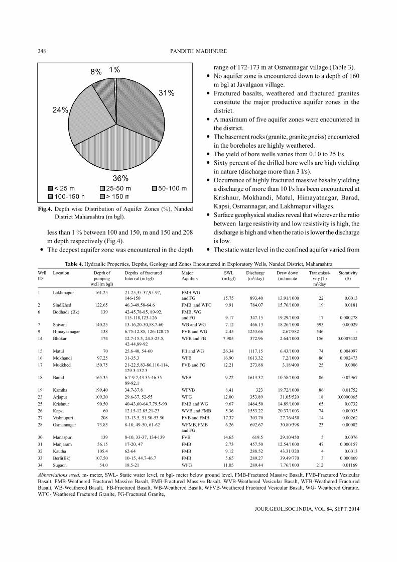
less than 1 % between 100 and 150, m and 150 and 208m depth respectively (Fig.4).
� The deepest aquifer zone was encountered in the depth
Table 4. Hydraulic Properties, Depths, Geology and Zones Encountered in Exploratory Wells, Nanded District, MaharashtraWell Location Depth of Depths of fractured Major SWL Discharge Draw down Transmissi- StorativityID pumping Interval (m bgl) Aquifers (m bgl) (m3/day) (m/minute vity (T) (S)
well (m bgl) m2/day
1 Lakhmapur 161.25 21-25,35-37,95-97, FMB,WG146-150 and FG 15.75 893.40 13.91/1000 22 0.0013
2 SindKhed 122.65 46.3-49,58-64.6 FMB and WFG 9.91 784.07 15.76/1000 19 0.01816 Bodhadi (Bk) 139 42-45,78-85, 89-92, FMB, WG
115-118,123-126 and FG 9.17 347.15 19.29/1000 17 0.0002787 Shivani 140.25 13-16,20-30,58.7-60 WB and WG 7.12 466.13 18.26/1000 593 0.000299 Himayat nagar 138 6.75-12.85, 126-128.75 FVB and WG 2.45 1253.66 2.67/582 546 -14 Bhokar 174 12.7-15.5, 24.5-25.5, WFB and FB 7.905 372.96 2.64/1000 156 0.0007432
42-44,89-9215 Matul 70 25.6-40, 54-60 FB and WG 26.34 1117.15 6.43/1000 74 0.00409716 Mokhandi 97.25 31-35.3 WFB 16.90 1613.32 7.2/1000 86 0.00247317 Mudkhed 150.75 21-22.5,83-86,110-114, FVB and FG 12.21 273.88 3.18/400 25 0.0006
129.3-132.318 Barad 165.35 6.7-9.7,43.35-46.35 WFB 9.22 1613.32 10.58/1000 86 0.02967
89-92.119 Kamtha 199.40 34.7-37.8 WFVB 8.41 323 19.72/1000 86 0.0175223 Arjapur 109.30 29.6-37, 52-55 WFG 12.00 353.89 31.05/520 18 0.000006525 Krishnur 90.50 40-43,60-64.7,79.5-90 FMB and WG 9.67 1464.50 14.89/1000 65 0.073226 Kapsi 60 12.15-12.85,21-23 WVB and FMB 5.36 1553.22 20.37/1003 74 0.0003527 Vishnupuri 208 13-13.5, 51.50-53.50 FVB and FMB 17.37 303.70 27.76/450 14 0.0026228 Osmannagar 73.85 8-10, 49-50, 61-62 WFMB, FMB 6.26 692.67 30.80/398 23 0.00002
and FG30 Manaspuri 139 8-10, 33-37, 134-139 FVB 14.65 619.5 29.10/450 5 0.007631 Manjaram 56.15 17-20, 47 FMB 2.73 457.50 12.54/1000 47 0.00015732 Kautha 105.4 62-64 FMB 9.12 288.52 43.31/320 4 0.001333 Berli(Bk) 107.50 10-15, 44.7-46.7 FMB 5.65 289.27 39.49/770 3 0.00086934 Sugaon 54.0 18.5-21 WFG 11.05 289.44 7.76/1000 212 0.01169
Abbreviations used: m- meter, SWL- Static water level, m bgl- meter below ground level, FMB-Fractured Massive Basalt, FVB-Fractured VesicularBasalt, FMB-Weathered Fractured Massive Basalt, FMB-Fractured Massive Basalt, WVB-Weathered Vesicular Basalt, WFB-Weathered FracturedBasalt, WB-Weathered Basalt, FB-Fractured Basalt, WB-Weathered Basalt, WFVB-Weathered Fractured Vesicular Basalt, WG- Weathered Granite,WFG- Weathered Fractured Granite, FG-Fractured Granite,
range of 172-173 m at Osmannagar village (Table 3).� No aquifer zone is encountered down to a depth of 160
m bgl at Javalgaon village.� Fractured basalts, weathered and fractured granites
constitute the major productive aquifer zones in thedistrict.
� A maximum of five aquifer zones were encountered inthe district.
� The basement rocks (granite, granite gneiss) encounteredin the boreholes are highly weathered.
� The yield of bore wells varies from 0.10 to 25 l/s.� Sixty percent of the drilled bore wells are high yielding
in nature (discharge more than 3 l/s).� Occurrence of highly fractured massive basalts yielding
a discharge of more than 10 l/s has been encountered atKrishnur, Mokhandi, Matul, Himayatnagar, Barad,Kapsi, Osmannagar, and Lakhmapur villages.
� Surface geophysical studies reveal that wherever the ratiobetween large resistivity and low resistivity is high, thedischarge is high and when the ratio is lower the dischargeis low.
� The static water level in the confined aquifer varied from
Fig.4. Depth wise Distribution of Aquifer Zones (%), NandedDistrict Maharashtra (m bgl).

JOUR.GEOL.SOC.INDIA, VOL.84, SEPT. 2014
DRILLING PROBLEMS ENCOUNTERED IN BASALTIC AND GRANITIC TERRAIN, MAHARASHTRA 349
4.4 to 26.3 m bgl and unusually deep water levels ofmore than 30 m bgl occurred in the wells at Talegaon,Manaspuri, Islapur and Rajgir villages.
Aquifer Properties
Aquifer properties are determined by conducting longduration pumping tests (1000 minute) and a total of 21tests were conducted on the wells, with drilling dischargeof more than 3 l/s (Table 4). Important aquifer propertiesas computed from the tests are discussed below.� The pumping discharge varies from 275 m3/d (day) to
1610 m3/d.� The minimum and maximum drawdown in pumping
wells varies from 0.05 to 43.3 m.� Transmissivity (T) of weathered and fractured vesicular
basalts varies from 3 to15 m2/d, and of weathered, andfractured basalts from 17 to 546 m2/d. The T value offractured basalt is 47 m2/d. However, a cumulativeT value for fractured basalt-granite complex is 19-593 m2/d. The transmissivity of weathered-fracturedgranite varies 18 to 212 m2/d.
� The storativity (S) of weathered and fractured vesicularbasalts varies from 0.0013 to 0.0021, and that ofweathered-fractured basalt and fractured granite from0.00028 to 0.0732. Storativity values of weatheredfractured granite, and fractured basalt are in the rangeof 0.0000065 to 0.012 and 0.00016 respectively.
GROUNDWATER CHEMISTRY
For ascertaining the quality of groundwater of the deeperaquifers, a total 34 samples were collected from theexploratory wells (Fig.1). The groundwater samples werecollected following the procedures suggested by Handa(1974), and the guidelines of American Public HealthAssociation (APHA, 1998) for preservation, storage andchemical analysis. The data are presented graphically intrilinear diagram (Fig.5) (Piper, 1940). The term hydro-chemical facies is used to distinguish the types ofgroundwater in an aquifer that differ in chemicalcomposition. Facies are a function of the lithology, solutionkinetics, and flow patterns of the aquifer (Back, 1966).Perusal of the Fig. 5, reveals that groundwater from the areais mostly of Ca-Na-HCO3-Cl, Ca-Na-HCO3, Ca-HCO3-Cl,Na-HCO3, Na-HCO3-Cl, Na-Cl, Ca-HCO3 types in thedescending order of dominance. The groundwater qualitydata are summarised in Table 5.
Based on the BIS (2003) drinking water standards, atotal of 8 samples are found to be unsuitable for drinkingbecause of high concentrations of sulphate, nitrate or fluorideexceeding permissible limits. In the Sindkhed and
Mukramabad exploratory wells, sulphate content is beyondmaximum permissible limit of 400 milligrams/litre (mg/L).The source of SO4 in groundwater at Sindhkhed may be dueto deep seated hot springs at Unkeswar. But at Mukramabadsite the source of sulphate may be due to use of sulphatewith charcoal and potassium in rock blasting. The fluorideconcentration is beyond the maximum permissible limit of1.5 mg/L in 5 wells, including 2 wells where sulphate tooexceeds the maximum permissible limit and it may begeogenic origin. Nitrate is beyond the maximum permissiblelimit of 45 mg/L in the four wells including 1 well wherefluoride is also beyond the maximum permissible limit. Themajor contribution of nitrate to groundwater of the studyarea is from anthropogenic sources like, sewage, leakage ofseptic tanks, waste disposal, fertilizers and decaying oforganic matters.
PROBLEMS ENCOUNTERD DURING DRILLING
During the construction of wells, operational problemswere encountered due to technical limitations such as sizeof boreholes, inadequate capacity of compressor andhammer tool, size, strength and torque limitations of thedrill string assembly, handling capacity of the rig. Some ofthe problems which occurred at various sites in the districtare given below.
Air Loss: Air loss while drilling through multi-layeredhighly fractured basalt is not uncommon, and it createsdrilling problems as it allows the air to pass through fractures,and thereby reducing the penetration rate. Because of thisproblem further drilling was not possible at Talegaon,
80
60
40
20 2
0
40
60
80
20
40
60
80 80
60
40
20
20
40
60
80
20
40
60
80
Ca Na+K HCO3 Cl
Mg SO4
C
C
C
C
C
C
C
C
C
C
C
C
C
C
C
C
C
C
C
C
C
C
C
C
C C
C
C
C
C
C
C
C
C
C
C
C
C
C
C
C
C
CC
C
C
C
C
C
C
C
C
C
C
C
C
C
C
C
C
C
C
C
CC
C
C
C
C
C
C
C
C
C
C
C C
C
CC
C
C
C
C
C
C
C
C
C
C
C
C
C
C C
C
C
C
C
C
C
C
Fig.5. Hydro-chemical classification of groundwater usingtrilinear diagram, Nanded district, Maharashtra.

JOUR.GEOL.SOC.INDIA, VOL.84, SEPT. 2014
350 PANDITH MADHNURE
couldn’t be completed down to the targeted depth of200 m at Krishnur, Osmannagar, Kapsi, Matul andLakhmapur sites.
Drilling capacity: Though DTH tools are basicallydesigned to drill through hard rock formations, mineralcomposition of rocks sometimes makes it so hard that evenTungsten Carbide buttons on the bit give way. At Sugaonsite the rate of penetration beyond 86 m was observed to beas low as 1.5 cm/minute to 1.1 cm/minute, and the drill bitwas also getting damaged. Here the formation is greyishgranite, and subsequently it was found that 40 % of the rocksamples were attracted by the magnet. Therefore, the drillingoperations were suspended at a depth of 92 m.
CONCLUSIONS
The following conclusions are drawn1. Geology and structure control the yields from the bore
wells.2. Wells located in the vicinity of NE-SW trending
lineaments yield better water than the wells in the vicinity
Table 5. Ground Water Quality from Exploratory Wells, in Nanded sistrictWell Village Date of PH E.C. in TDS TH as Ca++ Mg++ Na+ K+ CO3
– HCO3– Cl– SO4 NO3 F–
ID Collection mhos/ cm CaCo3at 250C. Mg/l
1 Lakh mapur 18.9.97 7.7 770 450 95 16 13 133 3 Nil 183 85 110 0.9 -2 Sindkhed 9.8.97 7.80 1820 1192 75 28 1.2 372 23 Nil 43 256 485 0.3 1.63 Mandwi 25.7.97 7.85 680 352 285 68 28 25 2 Nil 250 71 15 18 -4 Rajgad 10.9.97 7.35 590 325 190 50 16 46 4 Nil 189 57 20 39 -5 Kinwat 20.4.97 7.55 1680 900 560 92 80 107 14 Nil 348 259 130 42 -6 Bodhadi (Bk) 14.7.97 8.0 750 400 165 46 12 94 5 Nil 262 89 26 NIL -7 Shivani 23.5.97 7.95 520 307 200 36 34 40 4 Nil 293 18 30 NIL -8 Islapur 15.2.97 8.0 1070 456 125 26 15 189 3 Nil 49 308 60 1.0 -9 Himayatnagar 30.7.96 8.0 770 465 85 32 1 135 4 Nil 49 188 75 4.8 -11 Ambala 26.9.96 8.0 680 375 120 28 12 101 Nil Nil 183 50 20 3.8 -12 Koli 9.9.96 8.6 680 375 120 28 12 101 Nil 12 244 50 30 21 -13 Tamsa 17.7.96 8.5 810 440 355 70 44 23 Nil 6 153 138 50 31 -14 Bhokar 8.4.97 8.0 600 302 265 64 25 18 0.4 Nil 336 18 Tr. 8.2 -15 Matul 15.9.96 8.7 810 430 230 44 29 80 2 18 244 99 30 5.1 -16 Mokhandi 25.12.96 8.2 500 287 65 20 4 93 0.8 Nil 275 25 6 0.5 -17 Mudkhed 25.8.98 8.24 1240 765 250 62 23 166 11 Nil 153 202 115 109 2.318 Barad 8.2.97 8.1 1300 694 530 132 49 46 0.4 Nil 421 156 40 60 -19 Kamtha 14.10.96 8.9 1230 680 210 24 36 186 Nil 48 262 163 70 24 -20 Mugat 5.12.96 8.2 950 521 345 90 29 60 2 Nil 305 131 32 24 -21 Talegaon 29.7.98 7.64 1090 670 155 48 21 170 17 Nil 281 124 75 77 .0122 Karkheli 25.4.96 7.9 1950 975 355 76 40 276 16 Nil 140 266 60 8.5 -23 Arjapur 13.5.96 8.5 460 250 115 38 5 54 13 15 207 18 5 7 -24 Narsi 11.11.95 8.35 1700 1040 425 136 21 147 101 3 281 330 70 95 -25 Krishnur 24.11.95 8.4 660 370 165 30 22 75 2 9 201 57 60 15 -26 Kapsi 10.1.97 8.3 670 363 165 30 22 78 0.8 Tr. 262 53 30 19 -27 Vishnupuri 1.11.96 8.6 1000 600 235 70 15 122 2 12 98 177 120 32 -28 Osmannagar 7.2.98 7.35 1540 834 465 96 54 140 2 Nil 360 146 170 44 0.5730 Manaspuri 30.6.98 8.04 910 550 55 12 6 184 2 Nil 122 170 100 0.2 631 Manjaram 28.3.96 7.8 910 500 375 82 41 37 2 nil 201 131 75 33 -32 Kautha 31.7.98 7.94 1300 720 200 32 29 207 2 Nil 573 60 75 27 1.233 Berli(Bk) 10.2.98 8.5 570 301 15 4.0 1.2 117 2 30 195 11 35 1.6 1.634 Sugaon 8.4 800 440 235 42 32 75 6 15 281 50 60 18 -36 Barahalli 27.2.98 7.40 1200 600 505 108 57 23 7.8 Nil 274 163 101 2.7 0.937 Mukramabad 15.5.98 7.0 1870 1218 285 110 2.4 294 9 Nil 55 234 536 3 2.1
Mokhandi, Barad, and Osmannagar sites. At Barad site, airloss was taking place from a depth of 55.55 m to the nearbydry borehole 200 m away, and this bore well becameautoflowing for 2-3 days. Presently it is yielding goodquantity of water. At Talegaon site air loss was taking placeat a depth of 64 m and due to this drilling was abandoned at84 m depth.
Caving formations: It is often noticed that red bole layerbelow the surface casing collapses when saturated. Thisproblem is faced during drilling or at a later stage. Thisproblem was encountered at Manjaram and Kapsi sites. AtManjaram site the well was drilled and completed in March1996 down to a depth of 56.20 m, but the well had to beabandoned after 2 years of operation due to caving of redbole formation from the top. It is also observed that the redbole layer, which occurred below the saturated zone, suckedthe water and collapsed. Due to this the yield of the welldecreased from 0.14-0 to 0.25 l/s.
Hydraulic back pressure: Sometimes hydraulic backpressure from the aquifer poses problems during drilling,as it doesn’t allow continuous drilling, and due to this drilling

JOUR.GEOL.SOC.INDIA, VOL.84, SEPT. 2014
DRILLING PROBLEMS ENCOUNTERED IN BASALTIC AND GRANITIC TERRAIN, MAHARASHTRA 351
of NW-SE lineaments.3. Preference in drilling may be given to those sites where
the ratio between the high resistivity and low resistivityis high since discharge is found to be high at such places.
4. Vesicular basalts are not yielding appreciable quantitiesof water as the vesicles are highly irregular, but whenthey are fractured and interconnected they are yieldinggood quantity of water.
5. Fractured basalts, weathered and fractured granites formmajor productive aquifers.
6. The groundwater from the area is mostly of Ca-Na-HCO3-Cl, Ca-Na-HCO3, Ca-HCO3-Cl, Na-HCO3, Na-HCO3-Cl, Na-Cl, Ca-HCO3 types in the descending orderof dominance.
7. Fluoride and sulphate in groundwater is of geogenicorigin, while nitrate is of anthropogenic origin.
8. Bore wells may be restricted to 100 m depth as 90 %within the aquifer zones have been encountered at thisdepth.
9. Major drilling problems that hindered the drillingoperations include, air losses, caving, hydraulic backpressure and formation drilling capacity.
Acknowledgements: The author is thankful to theRegional Director, CGWB Southern Region, Hyderabad,for his valuable guidance and is grateful to the RegionalDirector, Central Region, Nagpur under whose jurisdictionthis work was carried out. Thanks are due to P. R.Subramanian and D. Subbarao, CGWB for guidance duringthe drilling operations and to P.N. Rao, for his valuablesuggestions. My sincere thanks are also due to the ExecutiveEngineer, CGWB Division VI, Nagpur and his drilling staff.
ReferencesAPHA (American Public Health Association) (1998) Standard
Methods for the Characteristics of Water and Wastewater. 20thEdition, NW Washington, DC. 20005-2605, pp10-161.
BACK, W. (1966) Hydrochemical Facies and Groundwater FlowPatterns in Northern Part of Atlantic Coastal Plain. US. Geol.Survey Professional Paper 498-A, US Government PrintingOffice 1988 0-227-224.
BHATTACHARYA, P.K. and PATRA, H.P. (1968) Direct CurrentElectrical Sounding. Amsterdam Elseveir.
BUREAU OF INDIAN STANDARDS (BIS) (2003) Indian StandardDrinking Water Specifications IS 10500:1991, Edition 2.2(2003-09), New Delhi.
CENTRAL GROUND WATER BOARD (CGWB) (1998) Ground WaterExploration in Maharashtra and Union Territory of DadraNagar Haveli., Ministry of Water Resources, Govt. of India,Nagpur, p294.
CENTRAL GROUND WATER BOARD (CGWB) (2012) Guidelines forAquifer Mapping, Govt. of India, Faridabad, p8.
GOVT. OF MAHARASHTRA (2005) Socio-economic Review andDistrict Statistical abstract for 2002-03, Nanded District,Maharashtra State, pp1-59.
HANDA, B.K. (1974) Technical Manual No.1. Methods of collectionand analysis of water samples and interpretations of watersample analysis. Ministry of Agriculture, Govt. of India.
GSDA and CGWB (2005) Dynamic Ground Water Resources ofMaharashtra as on March 2004. Report of GroundwaterSurveys and Development Agency, Govt. of Maharashtra andCentral Ground Water Board, Nagpur, p332.
KELLY, W.E. and MARES, S. (1993) Applied Geophysics inHydrogeological and Engineering Practice (Amsterdam:Elsevier), pp.290.
MADHNURE, P. and SUBRAMANIAN, P.R. (1996) Effect of Kadam FaultSystem on the Yield of Bore wells in Parts of Yavatmal district,Maharashtra. Proc. of the symposium on Mineral andGroundwater Resources of Vidarbha, Nagpur, pp.243-248.
MADHNURE, P. (2001) Ground Water Resources and DevelopmentPotential of Nanded district, Maharashtra State. Unpublished
Report No. 1111/DIS/2001, CGWB, Nagpur, p105.MADHNURE, P. (2002) Urban Hydrogeology and impact of pollution
on groundwater regime in Nanded-Waghala MunicipalCorporation, Nanded district, Maharashtra. Unpub.Report,Central Ground Water Board, Nagpur, p.61.
MADHNURE, P. (2003) Basic Data Report of Exploratory well drilledat Vishnupuri village, District Nanded. Un-published reportNo. 1235/BDR/2003, CGWB, Nagpur, p.16.
MADHNURE, P. and TAMBE, J. (2012) Assessment of GroundwaterPollution in the Vicinity of MIDC Industrial Complex, NandedDistrict, Maharashtra, India. Mem. Indian Soc. Appld.Geochem., pp264-277.
OZHA, G.D. (1998) Deep Exploration for Ground Water in HardRock Areas of Maharashtra-Keys to Successful Operation.Proc. of the workshop on Ground Water Development Trendand Its Related Issues in Maharashtra State, Central GroundWater Board, Nagpur, pp1-4-1 to 1-4-18.
PARASINIS, D.S. (1973) Principles of Applied Geophysics. FifthEdition, Chapman and Hall, London.
PIPER, A.M. (1940) A Graphical Procedure in the GeochemicalInterpretation of WaterAnalysis.Amer. Geophys. Union Trans.,v.25, pp.914-928.
RAMAM, B.K. and MURTHY, V.N. (1997) Geology of AndhraPradesh. Geological Society of India, Bangalore, 245p.
RAYCHAUDHARY, J.K., SAXENA, H.P., SINHA,A.K. and SEN, D. (1984)Deccan Trap Flows in Parts of Nanded and Yeotmal DistrictsMaharashtra. Proc.Symp. on Deccan Traps and Bauxite 1976.Geol. Surv. India, Spec. Publ. No.14, pp.6-8.
SANDBERG, S.K., SLATER, L.D. and VERSTEEG, R. (2002) An integ-rated geophysical investigation of the hydrogeology of an aniso-tropic unconfined aquifer. Jour. Hydrol., v.267, pp.227–243
SONKAMBLE, S., CHANDRA, S., NAGAIAH, E., DAR, F.A., SOMVANSHI,V.K. and AHMED, S (2013) Geophysical signatures resolvinghydrogeological complexities over hard rock terrain - a studyfrom Southern India. Arabian Jour. Geosci., DOI: 10.1007/s12517-013-0931-4
(Received: 28 June 2012; Revised form accepted: 22 May 2013)