Gravity-induced deformation on the north flank and floor of the sporadhes basin of the North Aegean...
14
Marine Geology, 44 (1981) 289--302 289 Elsevier Scientific Publishing Company, Amsterdam -- Printed in The Netherlands GRAVITY-INDUCED DEFORMATION ON THE NORTH FLANK AND FLOOR OF THE SPORADHES BASIN OF THE NORTH AEGEAN SEA TROUGH GEORGE FERENTINOS l, MICHAEL BROOKS 2 and MICHAEL COLLINS 3 1Department of Geology, University of Dundee, Scotland 2Department of Geology, University College Cardiff, Wales 3Department of Oceanography, University College Swansea, Wales (Received June 18, 1980; revised and accepted March 13, 1981) ABSTRACT Ferentinos, G., Brooks, M. and Collins, M., 1982. Gravity-induced deformation on the north flank and floor of the Sporadhes basin of the North Aegean sea trough. Mar. Geol., 44: 289--302. PDR and continuous seismic profiling surveys in the Sporadhes basin (the western part of the North Aegean sea trough) reveal active gravity-induced deformation of the postoro- genic sedimentary sequence. Different deformational patterns in the uppermost sedimen- tary layers of the flanks and floor of the basin suggest that the layers are deformed by several gravity-induced processes including slumping, sliding and creep contemporaneous with sediment deposition. Antithetic faulting on the northern flank of the basin (the Thermaieos slope) results from downslope creep of surface layers over deeper tilted bedding planes. This process is a consequence of progressive slope development associated with the evolution of the Sporadhes basin. The morphology of the sea floor and the deformation of the upper layers clearly reflect synsedimentary tectonics in a subsiding basin environment. INTRODUCTION Gravitational forces acting in slopes may cause instability and resultant mass movement. The movement may be rapid as in the case of slumps and slides, or very slow as in the case of gravitational creep. During the last twenty years many cases of submarine slumping, sliding and creeping have been reported and their effect in shaping the morphology of the continental slope has been studied in several regions (Moore et al., 1976; Embley and Jacobi, 1977; Hampton and Bouma, 1977; Moore, 1978; Almagor and Garfunkel, 1979). The purpose of this study is to examine the role of gravitational processes in the shaping of surface morphology and the deformation of sediment layers in the Sporadhes basin of the North Aegean trough (Fig.l). The data on which this study is based were collected during a RRS "Shackleton" research cruise in the NW Aegean Sea in 1978. The area under 0025-3227/82/0000---0000/$02.75 © 1981 Elsevier Scientific Publishing Company
Transcript of Gravity-induced deformation on the north flank and floor of the sporadhes basin of the North Aegean...

Marine Geology, 44 (1981) 289--302 289 Elsevier Scientific Publishing Company, Amsterdam -- Printed in The Netherlands
GRAVITY-INDUCED DEFORMATION ON THE NORTH FLANK AND FLOOR OF THE SPORADHES BASIN OF THE NORTH AEGEAN SEA TROUGH
GEORGE FERENTINOS l, MICHAEL BROOKS 2 and MICHAEL COLLINS 3
1Department of Geology, University of Dundee, Scotland 2Department of Geology, University College Cardiff, Wales 3Department of Oceanography, University College Swansea, Wales
(Received June 18, 1980; revised and accepted March 13, 1981)
ABSTRACT
Ferentinos, G., Brooks, M. and Collins, M., 1982. Gravity-induced deformation on the north flank and floor of the Sporadhes basin of the North Aegean sea trough. Mar. Geol., 44: 289--302.
PDR and continuous seismic profiling surveys in the Sporadhes basin (the western part of the North Aegean sea trough) reveal active gravity-induced deformation of the postoro- genic sedimentary sequence. Different deformational patterns in the uppermost sedimen- tary layers of the flanks and floor of the basin suggest that the layers are deformed by several gravity-induced processes including slumping, sliding and creep contemporaneous with sediment deposition.
Antithetic faulting on the northern flank of the basin (the Thermaieos slope) results from downslope creep of surface layers over deeper tilted bedding planes. This process is a consequence of progressive slope development associated with the evolution of the Sporadhes basin. The morphology of the sea floor and the deformation of the upper layers clearly reflect synsedimentary tectonics in a subsiding basin environment.
INTRODUCTION
Gravitational forces acting in slopes may cause instability and resultant mass movement. The movement may be rapid as in the case of slumps and slides, or very slow as in the case of gravitational creep. During the last twenty years many cases of submarine slumping, sliding and creeping have been reported and their effect in shaping the morphology of the continental slope has been studied in several regions (Moore et al., 1976; Embley and Jacobi, 1977; Hampton and Bouma, 1977; Moore, 1978; Almagor and Garfunkel, 1979).
The purpose of this study is to examine the role of gravitational processes in the shaping of surface morphology and the deformation of sediment layers in the Sporadhes basin of the North Aegean trough (Fig.l).
The data on which this study is based were collected during a RRS "Shackleton" research cruise in the NW Aegean Sea in 1978. The area under
0025-3227/82/0000---0000/$02.75 © 1981 Elsevier Scientific Publishing Company

290
-41°00" GREECE~~SlN Thessaloniki ~ ')~'~ ~0~' H'~ ~ y
/ , ~ S P O ~ E S . . ,ib+., ,v "$'-3 } I U H IXI:: 1 . f ) BA S I N " - - - ~ . ~ . . ~ / _
- ~ ~ ° % ~ o Pro f i l e B
~ J+oo ,.,,,+,,v / \ \ t l ~' L__, "_J
~ ' - ~ '%. ~, • ~ 36 60 84 km -,+o°oo" . o ~ ~ ~ ~ ~ ~ - _ _ _
#
t , :.X "+ ..++':.+ +.°, • ", O . , +~9 +. .+"r ' , + ~ k :,,x, . ,o ", ,~+, ,~ ~,ooO ~ ~:¢:+-
- - , . , , .+,++.; ++. +:,,,.( +~,.o\ : : S "' =,,,;+...,+ ~-7.,++.., . . . . . x * I ,9 :. ~+.~/J :,-',. \ \._+o? :ooo~-, ~,p +
- ~ 't 0 12 2 4 k i n N o r t h ¢ ~ o L ~ I
_ 3 9 ° 0 0 " 23°00" 2 4 ° 0 0 , I I
Fig.1. Map of study area showing the major physiographic provinces of the Sporadhes basin. Locations of pinger, sparker and air-gun profiles mentioned in the text are also shown. Bathymetric contours in metres.
investigation was surveyed using a 12 kHz echo-sounder, a 3.5 kHz pinger, a 3 kJ E.G.G. sparker and a Bolt PAR 1500 air-gun with a 160 in 3 chamber.
TECTONIC AND GEOLOGICAL FRAMEWORK
The Sporadhes basin is the western part of the North Aegean trough (Fig.l) which lies within a wide and diffuse zone of seismicity and active tectonism (McKenzie, 1972, 1977, 1978; Allen, 1975; Papazachos and Comninakis,
1977}. The formation of the North Aegean trough is widely attr ibuted to exten-
sional tectonics, but several different regional tectonic models have been postulated (Allan and Morelli, 1971; McKenzie, 1972, 1978; Dewey and SengSr, 1979).
Brooks and Ferentinos (I980) showed that the Sporadhes basin is an asym- metrical graben, or half-graben, closely similar to Gulf Coast, U.S.A., structures

291
that have been modelled experimentally by Cloos (1968). Major listric fault- ing characterises the southern margin of the basin and the wide northern flank represents an associated downbend or reverse drag structure with antithetic faulting.
The Gulf of Thermaicos (Fig.2) coincides with a major postorogenic, fault- bounded sedimentary basin known as the Axios basin, roughly coincident with the Vardar tectonic zone of the Hellenides. Two deep boreholes in the Gulf of Thermaicos reveal that the floor of the gulf is locally underlain by a postorogenic sedimentary sequence (Miocene-Quaternary) at least 3.5 km thick, of which the top kilometre comprises Quaternary conglomerates, gravels, sands, marls and clays (Faug~res and Robert, 1976). Air-gun records show that this thick sedimentary succession underlying the gulf extends southwards under the Sporadhes basin (Brooks and Ferentinos, 1980) so that the latter is a foundered extension of the Axios sedimentary basin. Refraction surveys in the Sporadhes basin (Needham et al., 1973) have shown it to be underlain by a sedimentary sequence up to 2.7 km thick of which the top kilometre was postulated to comprise unconsolidated sediments.
Thessaloniki ]
Fig.2. Detailed bathymetric chart of the Sporadhes basin. Depths in corrected metres (after an unpublished map produced by V. Licousis in 1979).

292
BATHYMETRY
The Sporadhes basin has an elongate shape in plan view, as defined by the 1000 m bathymetric contour, and is asymmetric in cross section {Fig.l). The basin narrows towards its northeastern end and it is separated from the Saros basin to the northeast by a sill about 400 m high.
A narrow shelf {Sporadhes shelf) about 4 km in width and a very steep wall {Sporadhes escarpment) about 800 m in height and with an average gradient ~f 7 °, flank the basin to the south. To the north the basin is flanked by Thermaicos shelf and slope (Fig.l). Thermalcos shelf dips very gently south° eastwards, at a gradient of less than 0.1 ° , to a depth of 150 m, where there is an abrupt break of slope marking the top of Thermaicos slope. The slope is about 35 km wide with an average gradient of 1 ° and it terminates in the Thermaicos escarpment, a steep section of sea floor with an average gradient of 4--5 ° and a height of about 400 m. Thermaicos slope and escarpment are incised by three major canyons which run in a northwest--southeast direction (Fig.2).
The floor of the Sporadhes basin (Sporadhes plain) has a rather uneven relief with two deep ponds whose depth is 1400 m and a circular plateau-like feature rising to a height of 100 m above the surrounding floor (Figs.1 and 2).
GRAVITY-INDUCED DEFORMATION
Selected seismic profiles located on Fig. 1 illustrate the general morphological and structural features of Thermaicos slope and Sporadhes plain.
In the western part of Thermaicos slope, pinger and sparker records {Fig.3, profile A of Fig.l) show evidence of gravitational creep in water depths of 300 m and on slopes of about 4 ° , as inferred from the existence of small hillocks 300 to 600 m wide, separated by elongate depressions {Fig.3a). The hillocks typically have an asymmetric cross-section with their steeper sides facing upslope and overlie zones of fracturing that die out within 200 m of the sea floor {Fig.3b). These features appear to result from the creep of t h e upper layers over inclined deltaic foreset layers dipping at up to 10 ° towards the axis of the basin, as is well displayed on the sparker record {Fig.3b).
Further downslope the sea floor is affected by recent faulting, resulting in the formation of small horst and graben structures (Fig.3a, b). The horsts and grabens are of low relief, up to l 0 m in height, and this faulting dies ou t at a depth of about 150 m, suggesting that it results from differential creep move- ments of the uppermost layers over the gently tilted underlying layers. Beneath the area of horst and graben topography, incipient antithetic faulting can be seen to affect deeper horizons {Fig.3b). The fault displacements of the deeper layers are different from the displacements of the surface layers, and appear to represent a buried and pronounced version of the hillock morph- ology described above; they are at tr ibuted to a separate, now terminated, phase of creep movements.
Pinger and sparker records from the central part of Thermaicos slope show the sea floor to be highly deformed by gravitational sliding and faulting

SE NW
293
"~ ) •
\
/ 3 0 0 m
450 m
150m
300 m
4 5 0 m
600 m
10 km
Figs.3a, b. Pinger and sparker records along profile A (see Fig.1 for location). Upper part of Thermaicos slope.
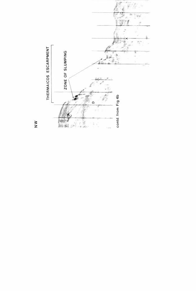
(Fig.4a, b, profile B of Fig.l). The shelf break is marked by a recent slide scar (Fig.4a). Below this break of slope, recent faulting affecting cross-bedded unit A has locally formed a pronounced horst block and, beyond it, a compound graben structure (Fig.4a, b). Fault displacements at the sea bed are only a few metres, but sparker records (Fig.4b) clearly indicate the downward growth of the faulting: e.g. at a depth of about 200 m, the amplitude of the graben

294
structure is 3--4 times its surface amplitude. It is of interest to note that air- gun records show the graben to overlie the crest of a gentle anticline affecting sediments of assumed Plio-Quaternary age thus suggesting that if the graben results from creep movements the latter are structurally controlled (Brooks and Ferentinos, 1980).
Further downslope, where the slope surface is flexured, the pattern of faulting changes. There are about twelve antithetic faults affecting cross- bedded unit B along a 15 km section, with fault scarps ranging from 5 to 50 m in height. Fault dips are steep and the fault scarps all face upslope (Fig.4a, b). Across this section the pinger records (Fig.4a) show a layered sequence of unconsolidated Holocene sediments up to 40 m thick. Variations in thickness of this sequence across individual faults and the existence of wedge-shaped layers within individual fault blocks indicate that these structures are growth faults and that the fault blocks have undergone progressive tilting during their evolution.
The pattern of upslope-facing scarps bears a striking resemblance to creep- affected hill slopes in various parts of the world, e.g. the Carpathians (Jahn, 1964; Nemock, 1972), New Zealand (Beck, 1968) and Alaska (Radbruch-Hall, 1978). The latter example of upslope-facing scarps in the Nunatak region of Alaska is reproduced here as Fig. 5. It should be noted that, in contrast to the North Aegean case, where soft sediment deformation takes place on very gentle slopes, the Alaskan occurrence affects a much steeper hill slope and involves fracturing along the foliation direction of steeply-dipping meta- morphic rocks (Radbruch-Hall, 1978).
The layered Holocene sequence visible in the pinger records is underlain by a sequence of deltaic foreset units that are well displayed in the sparker records (e.g. A, B, C, D in Fig.4b, c) and which have accumulated to a thick- ness of at least 600 m. Foreset unit C (Fig.4c) now underlies a water depth of 600 m while the younger unit A, nearer to the edge of Thermaicos shelf (Fig.4b), is under a water depth of only 180 m. The sequence contains very thick foreset units (e.g., unit C is about 250 m thick) indicative of rapid rates of subsidence to generate the necessary water depths in which these units could accumulate. The general disposition and size of the foresets implies that Thermaicos slope results from progradation of deltaic sediments into a rapidly subsiding basin environment, and that the steeper slopes of Thermaicos escarpment represent ancient delta fronts deformed by gravitational processes.
The geological structure under the eastern part of Thermaicos slope is dominated by a large anticline. An airgun profile (Fig.6, profile C of Fig.l) across the anticline shows evidence of a close association of faulting and fold- ing (Brooks and Ferentinos, 1980). The crest of the anticline has an associated graben and the flanks of the anticline are dominated by antithetic faults, with upslope-facing scarps. The antithetic faulting is identical to the pattern of faults generated experimentally by Cloos (1968) on the limbs of an anticline in a clay layer deformed by arching. The antithetic faults of the slope and escarpment seem to have formed by a process of gravity creep down fold limbs. Pinger records (e.g. Fig.4a) show that the faulting and folding is still active because Holocene layers are extensively affected.

pp
. 29
5--2
96
SE
SP
OR
AD
HE
S
ES
CA
RP
ME
NT
f
~,
~ ~i
{ ~
t I
I I
I Z
ON
E O
F H
UM
MO
CK
Y T
OP
OG
RA
PH
Y
• };~
:
10
km
for
loca
tion
). F
igs.
4a,
b:
:epr
esen
t tw
o se
para
te d
elta
ic
~po
radh
es p
lain
. C
and
D r
epre
-
~"~'
~ ~i
_
.
' i
f
, 1
05
0
m
~ ..
...
i ~!
: 1
20
0m
i?
,=~
;:
,:ii
!!l~
um
---
, iP

SE
L I S
CAR
i
iROW
TH'TY
PE
GRAB
EN
STRU
CTUR
E
~~
30
0 m
:/ ,:! ..
....
RPS
300 m
450 m
600 m
10 km
co
ntd, o
n fig
4c


299
Fig.5. Uphill-facing scarps resulting from gravitational creep in metamorphic rocks south- east of the Nunatak, Alaska. Maximum height of scarps approximately 3.8 m. This photo- graph is reproduced from the book "Rockslides and Avalanches" (p.633, fig.19) edited by B. Voight, with the kind permission of the Elsevier Publishing Company.
Thermaicos escarpment is widely affected by sliding and slumping (Figs.4c, 6, profiles B, C of Fig.l) that may be attributed to gravitational instability induced by progressive tilting of the deltaic units towards the basin axis during basin subsidence. The top of the escarpment now lies in a water depth of 600 m and associated with subsidence of this order is a tilting of 2 °.
Air gun records show that Sporadhes plain is underlain by a sedimentary sequence more than 1.5 km thick. Along profile C of Fig.1 (Fig.6), the southerly dip increases with depth and the sequence thickens southwards, indicating the contemporaneity of subsidence, and associated tilting of the basin floor, with sedimentation. The sparker record along profile B of Fig. 1 (Fig.4c) shows that the upper part of this sequence is separated from the slumped deltaic units of Thermaicos escarpment by a boundary (labelled X on Fig.4c) that may be a steep unconformity or a listric fault defining a slid- ing plane. If the latter, the pattern of deformation under Sporadhes plain may be explained in terms of sliding: an extensional regime adjacent to the fault, indicated by a graben structure, and a distal compressional regime, indicated by a surface zone of hummocky topography overlying a zone of small-scale folding (see Fig.4c). An alternative explanation for the hummocky topo- graphy is that it results from downslope movement of surface layers on the northwest flank of the anticlinal structure that gives rise to a ledge at a water depth of 1050 m.

SE
300
NW . . . . !
20 km
Fig.6. Air-gun record along profile C (see Fig.1 for location) across Thermaicos slope and Sporadhes basin showing evidence of the intimate relationship between folding and fault- ing in the sedimentary sequence and progressive subsidence of the floor of the basin.
It is of interest to note that the southeastern part of the zone of hummocky topography (Fig.4} is characterised by a hyperbolic reflection pat tern similar to that observed in the Bonin trough, western Pacific, by Jacobi and Mrozowski {1979) and at tr ibuted by them to deformation associated with gravity sliding.
DISCUSSION
The data presented above indicate that the morphology of the north flank and floor of the Sporadhes basin and the deformational patterns of the sedi- mentary layers are largely attributable to gravity-induced slope failure pro. cesses. The causative factors are discussed here in relation to the structural and sedimentary evolution of the basin.
The Sporadhes basin is an asymmetrical graben of which the northern flank constitutes a downbend (Thermaicos shelf and slope) and the south side is bounded by a major listric fault whose surface expression is the Sporadhes escarpment {Brooks and Ferentinos, 1980). The thickness of the sedimentary cover beneath the downbend is 3--3.5 km (Miocene to Recent) of which the top kilometre was deposited during the Quaternary (Faug~res and Robert , 1976).

301
The Sporadhes basin has evolved by progressive downwarping, as indicated by the progradational nature of Thermaicos slope and by a general steepening of the layer dips with depth in the thick sedimentary succession. Associated with this downwarping, gravitational mass movement by sliding, slumping and slow creep has influenced surface morphology and caused extensive sediment deformation.
The dominant morphological features attributable to creep are the upslope- facing scarps, which result from active growth faulting that can be traced to depths of about 500 m. Creep can take place with or wi thout the formation of shear zones or planes of slip (Zischinsky, 1966; Radbruch-Hall, 1978). In the present area, the close structural control of the creep mechanism (Brooks and Ferentinos, 1980) implies that creep is directed along beds or bedding planes. Creep must occur to the depth to which growth faulting extends, namely, about 500 m. The downhill mass movement associated with this creep may be the cause of the small-scale folding beneath the foot of Thermai- cos escarpment (Fig.4c).
Gravitational sliding and slumping is widespread on Thermaicos slope and the steeper escarpment, where the average slope is 4--5 ° . The main reason for these mass movements seems to be the progressive steepening of the slope, caused by the downbending of Thermaicos slope towards the subsiding basin axis, with resultant gravitational instability. Earthquakes associated with the regional tectonism may act as a triggering mechanism for the slides and slumps.
ACKNOWLEDGEMENTS
This study was funded by the Natural Environment Research Council. We are grateful for the co-operation and assistance given by the officers and crew of RRS "Shackle ton" during our cruise in the NW Aegean sea. Messrs. S. Jones, I. Chivers, P. Taylor and B. Lewis of N.E.R.C. provided invaluable technical support. We thank Prof. G. Kelling of Keele University and Dr. C. Talbot of Dundee University for having carefully examined the records and for their constructive discussions.
We thank also the Greek authorities for granting permission for the cruise and Dr. J. Bornovas and Mr. C. Perissoratis of I.G.M.E., Athens, for their generous assistance.
REFERENCES
Allan, T.D. and Morelli, C., 1971. A geophysical s tudy of the Mediterranean Sea. Boll. Geofis. Teor. Appl., 13: 99--142.
Allen, C.R., 1975. Geological criteria for evaluating seismicity. Geol. Soc. Am. Bull., 86: 1041--1057.
Almagor, G. and Garfunkel, Z., 1979. Submarine slumping in continental margin of Israel and Northern Sinai. Am. Assoc. Pet. Geol. Bull., 63: 324--340.
Beck, A.C., 1968. Gravity faulting as a mechanism of topographic adjustment. N.Z.J . Geol. Geophys., 11: 191--199.

302
Brooks, M. and Ferentinos, G., 1980. Structure and evolution of the Sporadhes basin of the North Aegean trough, Northern Aegean Sea. Tectonophysics,, 68: 15--30.
Cloos, E., 1968. Experimental analysis of Gulf Coast fracture patterns. Am. Assoc. Pet. Geol. Bull., 52: 420--444.
Dewey, J.F. and SengSr, A.M.C., 1979. Aegean and surrounding areas: complex multi- plate and continuum tectonics in a convergent zone. Geol. Soc. Am. Bull., 90: 89--92.
Embley, R.W. and Jacobi, R., 1977. Distribution and morphology of large submarine slides and slumps on Atlantic continental margins. Mar. Geotech., 2: 205--228.
Faug/~res, L. and Robert, C., 1976. Etude s~dimentologique et min~ralogique de deux forages du golfe Thermaique (mer Eg~e). G(~ol. M(~diterr., 3: 209--218.
Hampton, M.A. and Bouma, A.H., 1977. Slope instability near the shelf break, Western Gulf of Alaska. Mar. Geotech., 2: 309--332.
Jacoby, R.D. and Mrozowski, C.L., 1979. Sediment slides and sediment waves in the Bonin trough, western Pacific. Mar. Geol., 29: M1--M9.
Jahn, A., 1964. Slopes morphological features resulting from gravitation. Z. Geomorphol., Suppl., 5: 59--72.
McKenzie, D.P., 1972. Active tectonics of the Alpine--Himalayan belt: the Aegean Sea and surrounding areas. Geophys. J.IR. Astron. Soc., 30: 109--181.
McKenzie, D.P., 1977. Can plate tectonics describe continental deformation? In: B. Biju- Duval and L. Montadert (Editors), International Symposium on the Structural History of the Mediterranean Basins. Split, Yugoslavia, October 1976. Ed. Technip, Paris, pp.189--196.
McKenzie, D.P., 1978. Active tectonics of the Alpine--Himalayan belt: the Aegean Sea and surrounding areas. Geophys. J. R. Astron. Soc., 55: 217--254.
Moore, D.G., Curray, J.R. and Emmel, F.J., 1976. Large submarine slide (olistostrome) associated with Sunda Arc subduction zone, northeast Indian Ocean. Mar. Geol., 21: 211--226.
Moore, D.G., 1978. Submarine slides. In: B. Voight (Editor), Rockslides and Avalanches, 1. Elsevier, Amsterdam, pp.563--604.
Needham, H.D., Le Pichon, X., Melguen, M., Pautot, G., Renard, V., Avedik, F. and Carre, D., 1973. North Aegean sea trough: 1972. Jean Charcot cruise. Bull. Geol. Soc. Greece, 10: 152--153.
Nemock, A., 1972. Gravitational slope deformation in High-Mountains. Proc. 24th Int. Geol. Congr. Montreal, Section 13: 132-141 .
Papazachos, B.C. and Comninakis, P.E., 1977. Modes of tithospheric interaction in the Aegean area. In: B. Biju-Deval and L. Montadert (Editors), International Symposium on the Structural History of the Mediterranean Basins. Split, Yugoslavia, October 1976. Ed. Technip, Paris, pp.319--332.
Radbruch-Hall, D.H., 1978. Gravitational creep of rock masses on slopes. In: B. Voight (Editor), Rockslides and Avalanches, 1. Elsevier, Amsterdam, pp.607--657.
Zischinsky, U., 1966. On the deformation of high slopes. Proc. 1st Conf. Int. Soc. Rock Mech., Lisbon, 2: 179--185.