Oxygen isotope study of water masses in the Princess Elizabeth Trough, Antarctica
13
ELSEVIER Marine Chemistry 49 (199.5) 141-153 Oxygen isotope study of water masses in the Princess Elizabeth Trough, Antarctica Russell D. Frew, Karen J. Heywood, Paul F. Dennis School of Environmental Sciences,University of East An&a, Norwich, NR4 7TJ, UK Received 13 June 1994; accepted 18 January 1995 Abstract Data from a hydrographic survey located in the Princess Elizabeth Trough, near the Antarctic continent (63-65” S, 85” E) are presented and discussed. This region is covered by sea-ice for most of the year with the ice-edge retreating to the southern edge of the Trough during summer. Water samples were collected during the Austral summer, February 1993, to determine the ratio of the oxygen-18 to oxygen-16 isotope, 6180. Four water bodies are characterised by their temperature, salinity and alsO properties, Surface Water (O.O-1.2”C, 33.1-34.0, - 0.39960), Winter Water (- 1.7” C, 34.4, - 0.39%60), Warm Deep Water (2.0” C, 34.69, 0.02%00> and Bottom Water (- 0.43” C, 34.669, - 0.25%0). The Bottom Water is warmer, saltier and heavier isotopically than Weddell Sea Bottom Water (- 0.9” C, 34.65, - 0.29%~); and has T-S properties close to that of classical Antarctic Bottom Water ( - 0.4” C, 34.66). This Bottom Water is isotopically distinct from the Weddell Sea derived Bottom Water that ventilates the Indian ocean through the Kerguelen-Crozet gap. A mechanism for local formation of the Bottom Water involving freezing of Surface Water and entrainment of Warm Deep Water is described. 1. Introduction The varying proportions of “0 to I60 in seawater provide an oceanographic tracer like salinity, but with an extra degree of freedom: salt is a tracer for the oceanic fluid, whereas the isotopic composition is a tracer specifically for the water component of that fluid. Hydrogen and oxygen isotopes are the variables most intimately related to the water compo- nent in the sea, therefore they furnish a direct link to the water in the atmosphere and on continents and to the precipitation cycle which causes the salinity changes. The ratio of the oxygen isotopes in seawa- ter is altered by two main processes: (1) Evapora- tion/precipitation: due to the slightly higher vapour pressure of the molecules containing the lighter oxy- gen atom, water vapour is isotopically lighter than the water from which it is derived. Further fractiona- tion occurs during precipitation as the heavier molecules condense first leaving the residual vapour lighter. Therefore, freshwater is isotopically lighter than seawater (typical values -2 to - 1080) and glacial ice is lighter still ( - 20 to - 50%0). The 6 “0 of precipitation decreases with increasing latitude due to precipitation induced depletion of “0 as the vapour moves from temperate source regions. (2) The mixing of water masses with different isotopic composition. The isotopic composition of a water body is a conservative quantity altered only at the upper surface of the ocean. A further process that affects the ratio of 6 ‘*O to salinity is the formation of sea-ice. The fractionation 0304-4203/95/$09.50 0 1995 Elsevier Science B.V. All rights reserved .WIIO304-4203(95)00003-8
Transcript of Oxygen isotope study of water masses in the Princess Elizabeth Trough, Antarctica
ELSEVIER Marine Chemistry 49 (199.5) 141-153
Oxygen isotope study of water masses in the Princess Elizabeth Trough, Antarctica
Russell D. Frew, Karen J. Heywood, Paul F. Dennis
School of Environmental Sciences, University of East An&a, Norwich, NR4 7TJ, UK
Received 13 June 1994; accepted 18 January 1995
Abstract
Data from a hydrographic survey located in the Princess Elizabeth Trough, near the Antarctic continent (63-65” S, 85” E) are presented and discussed. This region is covered by sea-ice for most of the year with the ice-edge retreating to the southern edge of the Trough during summer. Water samples were collected during the Austral summer, February 1993, to determine the ratio of the oxygen-18 to oxygen-16 isotope, 6180.
Four water bodies are characterised by their temperature, salinity and alsO properties, Surface Water (O.O-1.2”C, 33.1-34.0, - 0.39960), Winter Water (- 1.7” C, 34.4, - 0.39%60), Warm Deep Water (2.0” C, 34.69, 0.02%00> and Bottom Water (- 0.43” C, 34.669, - 0.25%0). The Bottom Water is warmer, saltier and heavier isotopically than Weddell Sea Bottom Water (- 0.9” C, 34.65, - 0.29%~); and has T-S properties close to that of classical Antarctic Bottom Water ( - 0.4” C, 34.66). This Bottom Water is isotopically distinct from the Weddell Sea derived Bottom Water that ventilates the Indian ocean through the Kerguelen-Crozet gap. A mechanism for local formation of the Bottom Water involving freezing of Surface Water and entrainment of Warm Deep Water is described.
1. Introduction
The varying proportions of “0 to I60 in seawater
provide an oceanographic tracer like salinity, but
with an extra degree of freedom: salt is a tracer for the oceanic fluid, whereas the isotopic composition is a tracer specifically for the water component of that fluid. Hydrogen and oxygen isotopes are the variables most intimately related to the water compo-
nent in the sea, therefore they furnish a direct link to the water in the atmosphere and on continents and to
the precipitation cycle which causes the salinity changes. The ratio of the oxygen isotopes in seawa- ter is altered by two main processes: (1) Evapora- tion/precipitation: due to the slightly higher vapour pressure of the molecules containing the lighter oxy-
gen atom, water vapour is isotopically lighter than
the water from which it is derived. Further fractiona-
tion occurs during precipitation as the heavier
molecules condense first leaving the residual vapour lighter. Therefore, freshwater is isotopically lighter
than seawater (typical values -2 to - 1080) and glacial ice is lighter still ( - 20 to - 50%0). The 6 “0 of precipitation decreases with increasing latitude due to precipitation induced depletion of “0 as the
vapour moves from temperate source regions. (2)
The mixing of water masses with different isotopic composition. The isotopic composition of a water body is a conservative quantity altered only at the upper surface of the ocean.
A further process that affects the ratio of 6 ‘*O to salinity is the formation of sea-ice. The fractionation
0304-4203/95/$09.50 0 1995 Elsevier Science B.V. All rights reserved
.WIIO304-4203(95)00003-8
142 R.D. Frew et d/Marine Chemistry 49 (1995) 141-153
factor for ice in equilibrium with water cr (180/160) = 1.00291 (Lehmann and Siegenthaler,
1991), therefore sea-ice is less than + 3%0 relative to
the seawater from which it arose. It is this process
that makes S “0 a powerful tracer in polar regions
where sea-ice formation and melting causes large
changes in salinity but leaves 6 igO almost un-
changed, hence decoupling the two tracers. The total variation of 6 180 in the deep ocean is
small (about 0.3%0) requiring high-precision analysis
(1 (T = 0.020%0) for any quantitative interpretation of results. The precision achieved in most laboratories
is 0.05-O.lO%o, hence most stable isotope oceanog- raphy has consisted of studies in enclosed basins
with large freshwater inputs where the various end-
members have more widely varying 6 “0 composi-
tions (e.g. Fairbanks, 1982; Ostlund and Hut, 1984;
Tan and Strain, 1988). Recently there have been some regional studies to
elucidate specific oceanographic processes. Studies in the Weddell Sea (Weiss et al., 1979; Schlosser et
al., 1990; Schlosser et al., 1991) have used S”O to determine the relative contributions of the water
masses involved in the formation of Weddell Sea
Bottom Water (WSBW). Weiss et al. (1979) showed that the stable isotopes provide a direct link between the rate of ice shelf melting and the rate of bottom
water formation in the Weddell Sea. Schlosser et al.
(1990, 1991) showed that both oxygen and helium isotopes were suitable tracers of water/ice interac-
tion and circulation in the Weddell Sea and calcu-
lated the fraction of glacial melt water in Ice Shelf
Water (ISW) and the ISW contribution to WSBW. The formation of AABW has attracted much in-
terest in recent decades. Thermohaline circulation is driven by the input of dense water from two high-
latitude sources-the Greenland-Scotland Ridge overflow in the North Atlantic and the outflow of
Antarctic Bottom Water (AABW) formed at various
sites on the Antarctic continental shelf (Warren, 1981). The production of dense water masses around the Antarctic continent plays a major role in the ventilation of the deep world ocean (Brennecke, 1921; Mantyla and Reid, 1983). Craig and Gordon (1965) concluded that detailed isotopic studies in the Southern Oceans should be helpful in determining the processes by which these deep waters are re- newed.
The only water mass moving southward into
Antarctic regions is Warm Deep Water (WDW), derived from Circumpolar waters, whose main source
is North Atlantic Deep Water (NADW). Thus all the
water masses which eventually leave Antarctic re-
gions are essentially derived from WDW, modified by interaction with the atmosphere and with glacial
ice or sea-ice. WDW is indicated by temperature and
salinity maxima and is located at mid-depths. Above WDW is found a cold layer of Winter Water (WW),
the remnant of the cold winter mixed layer, capped in summer by a warm fresh layer of Surface Water
(SW) formed by seasonal heating and melting of
sea-ice. Below WDW are found newer water masses.
The simplest explanation for their formation (Bren-
necke, 1921; Mosby, 1934; Fofonoff, 1956) is that
during winter the surface waters freeze and leave
behind cold saline water that is sufficiently dense to sink, mixing with WDW, to form bottom water.
However, in recent years other formation processes
have been investigated, since it is clear that, at least in the Weddell Sea, bottom water formation occurs
all year round. WSBW is a main component of AABW (Seabrooke et al., 1971; Foster and Car- mack, 1976). Measurements in the Southern Weddell
Sea reveal WSBW with a temperature of - 0.9” C and a salinity of 34.65 (Weiss et al., 1979) and a
S180 value of -0.3%0 (Schlosser et al., 1990). This
is believed to form as a mixture of WDW with WW and/or shelf waters from the southern Weddell Sea,
which are particularly isotopically light due to signif- icant meltwater from the Filchner-Ronne Ice Shelf.
Classically defined AABW forms subsequently as a result of further mixing between WSBW and WDW, with a resultant temperature leaving the Weddell Sea of -0.4” C, and salinity of 34.66 (Weiss et al.,
1979). Jacobs et al. (1985) reported detailed oxygen iso-
tope measurements in the Ross Sea. The waters
showed similar temperature, salinity and 6 l8 0 prop- erties to the Weddell Sea data of Weiss et al. (1979), suggesting that the same processes influence salinity and 6 “0 in both subpolar gyres. Low salinity bot- tom water found on the shelf break in the Ross Sea (-0.16” C, 34.65, -0.26%60) probably mixes with shelf waters ( - 1.59” C, 34.526, - 0.45%0) to form a version of AABW comparable with that from the Weddell Sea.

R.D. Frew et al. /Marine Chemistry 49 (1995) 141-153 143
In this paper we shall discuss water masses close to Antarctica in the Princess Elizabeth Trough in the light of measurements of S”O. The Princess Eliza- beth Trough (PET) is at the southern end of the Kerguelen Plateau (63-65” S, 85” E). The PET is approximately 350 km wide with a maximum depth of 3700 m and is one of few channels sufficiently deep to connect the Weddell-Enderby Basin to the west with the South Indian Basin to the east (Fig. 1). Sea-ice cover in winter extends to 57” S but recedes to south of 65” S in summer (Gloersen et al., 1992).
The near-surface flow in the PET is to the east, part of the broad, primarily wind-driven, eastward flow associated with the Antarctic Circumpolar Cur- rent (Webb et al., 1991). The westward flow along the Antarctic Shelf is south of 65” S and our observa- tions do not cross this continental water boundary. The deep water flow through the PET is less well
known but is thought to come primarily from the east rather than from the Weddell Sea. Speer and Forbes (1994) undertook a hydrographic section across the PET in 1992 (some 3” to the west of the section reported here) and deduce a westward flow at depth, although the near surface flow may be east- ward. Chlorofluorocarbon observations (Mantisi et al., 1991) support this. They suggest that water from Prydz Bay (which will include melt water from the Amery Ice Shelf) will travel west, while water to the east is confined to the South Indian Basin. Distinctly different temperature-salinity relationships below 0” C on either side of the Kerguelen Plateau (Rod- man and Gordon, 1982) indicate that the potential flow of WSBW through the PET is negligible, and Speer and Forbes showed that the characteristics of the bottom water in the PET are more like that of South Indian Basin water than western basin water.
60”s South Indian Basin
20”E 50”E 80”E 110”E
Fig. 1. Bathymetry of the South Indian Ocean. Station locations in the Princess Elizabeth Trough (@) are shown for the AWX deployment
cruise, RRS Discovery cruise 200, February-March 1993.

144
Table 1
R.D. Frew et al./Marine Chemistry 49 (1995) 141-153
Data are given for each water bottle on the rosette, even where two bottles were closed at the same depth. Water masses Winter Water
(temperature minimum layer), WW, and Warm Deep Water (temperature maximum layer), WDW, are indicated at the nearest sample to
their core death
Depth (m) 680 C%o) 0 (” C) s 0, ( pmol kg-‘)
Station 12349 (62” 10.2’S, 83’ 16.2’E)
5 - 0.385
5 - 0.384
80 - 0.321
80 - 0.303
100 - 0.300
150 -0.111
200 - 0.065
300 X0.040
400 - 0.032
600 - 0.054
800 0.003
800 0.001
1000 - 0.021
1275 - 0.042
1500 - 0.058
1500 - 0.080
1750 - 0.080
2000 -0.128
2250 - 0.137
2250 - 0.133
2500 -0.169
2680 - 0.158
2680 -0.178
Station 12350 (62” 44.8’S, 83” 28.2’E)
5 - 0.415
15 - 0.410
15 - 0.406
80 - 0.328
150 - 0.162
200 -0.120
300 -0.135
400 - 0.018
600 - 0.025
800 - 0.060
800 - 0.022
1000 - 0.018
1275 - 0.024
1275 - 0.060
1500 - 0.060
1750 -0.136
2000 -0.197
2000 - 0.189
2300 - 0.212
2450 - 0.196
2450 - 0.201
1.175 33.754
1.178 33.753
- 0.793 33.983
- 0.796 33.980
0.473 34.263
1.576 34.472
1.760 34.531
1.949 34.611
1.965 34.657
1.934 34.712
1.809 34.739
1.809 34.739
1.636 34.747
1.417 34.746
1.160 34.735
1.156 34.734
0.944 34.723
0.726 34.712
0.548 34.702
0.550 34.702
0.401 34.695
0.333 34.693
0.333 34.693
367
367
312 ww
312
252
236
190
187
190
198
205
205
211
216
218
218
221
223
226
226
229
229
229
0.921 33.758 364
0.921 33.758 364
0.922 33.758 364
- 0.350 34.131 295 - 0.435 34.088 288
1.782 34.517 190
1.973 34.610 188
1.980 34.659 193
1.905 34.711 198
1.791 34.740 209 1.792 34.740 209
1.637 34.742 212
1.397 34.743 216
1.397 34.744 217
1.134 34.734 221
0.885 34.720 222
0.673 34.710 224
0.672 34.709 224
0.473 34.700 225
0.363 34.694 227
0.363 34.694 227
WDW
ww
WDW
2. Data collection and measurement
Samples were collected in February and March 1993 during the deployment cruise of the Antarctic
Deep Outflow experiment (ADOX), cruise 200 on board RRS Discovery (Dickson, 1993). Hydro- graphic sections were completed between Crozet and Kerguelen, across the southern Enderby Abyssal

Table 1 (continued)
R.D. Frew et al./Marine Chemistry 49 (1995) 141-153 145
Depth (m) s80 No,) 8 (“0 s O2 ( pmol kg-‘)
Station 12351 (63” 213’S, 83” 55S’E) 5 - 0.383 10 - 0.366 75 - 0.361 75 - 0.350 100 - 0.232 200 - 0.143 300 - 0.081 400 - 0.083 600 - 0.072 800 - 0.073 1000 -0.116 1275 -0.151 1275 -0.110 1500 -0.170 1750 -0.160 2000 - 0.225 2000 -0.181 2250 - 0.245 2450 - 0.227 2650 - 0.245 2650 - 0.238 2800 - 0.252 2850 - 0.238
Station 12355 (64” 10.1’S, 84” 34.4’E) 10 - 0.392 10 - 0.400 30 - 0.394 50 - 0.287 150 -0.106 200 - 0.089 300 - 0.091 500 - 0.060 700 - 0.056 900 - 0.052 1200 - 0.059 1600 -0.109 1600 -0.107 2000 -0.175 2250 -0.199 2500 - 0.197 2800 - 0.244 3000 - 0.258 3250 - 0.245 3250 - 0.256 3450 -0.251 3650 - 0.253 3650 - 0249
0.873 33.858 0.871 33.858 - 1.069 34.234 - 1.082 34.239 - 0.008 34.416 1.085 34.583 1.644 34.671 1.713 34.708 1.621 34.733 1.354 34.728 1.177 34.727 0.932 34.719 0.932 34.719 0.699 34.706 0.497 34.695 0.316 34.686 0.317 34.686 0.185 34.682 0.076 34.678 - 0.029 34.676 - 0.029 34.676 -0.109 34.673 -0.141 34.673
367 367 365 ww 312 312
252 195
190 187 190 198 205 205 211
216 218 218 221
223 226 226 229 229
0.899 33.653 352 0.902 33.653 352 0.973 33.783 339 - 0.449 34.267 291
1.782 34.625 199
1.803 34.650 195
1.805 34.685 198
1.724 34.727 208 1.507 34.734 214 1.296 34.732 219 0.940 34.719 223 0.513 34.693 228
0.513 34.693 228 0.232 34.682 231 0.083 34.677 235 - 0.069 34.672 242 -0.179 34.671 247 - 0.253 34.674 249 - 0.324 34.670 253 - 0.323 34.670 253 - 0.373 34.669 256 - 0.421 34.670 258 - 0421 34.670 258
WDW
ww
WDW
Plain, and across the PET. It is the southernmost CTD 9/10 concentration) was encountered at 65” 06’S, section with which this paper is concerned (Fig. 1). 85” 19’E. The edge of continuous sea-ice (approximately 7- Water samples were drawn from a conductivity-

146
Table 1 (continued)
R.D. Frew et al. /Marine Chemistry 49 (1995) 141-153
Depth (m) 680 C&u) 8 (” C) s 0, ( pmol kg-‘)
Station 12356 (64” 37.1’S, 84” 59.9’E) 4 - 0.369 20 - 0.418
70 - 0.358 100 - 0.280 200 - 0.258 300 -0.211 400 -0.163 600 -0.177 600 -0.154
1000 -0.131 1250 -0.151 1500 - 0.163 1750 - 0.165 2000 - 0.160
2250 -0.176 2500 - 0.226 2500 - 0.207 2800 - 0.196
3000 - 0.244 3250 - 0.233 3250 - 0.245
3450 - 0.224 3600 - 0.245 3600 - 0.249
Station 12358 (65” 5.5’S, 85” 19.2’E) 4 - 0.384
20 - 0.398 20 - 0.391
50 -0.395 100 - 0.391 175 - 0.387 400 - 0.206 800 - 0.130 1000 -0.145 1250 -0.169
1500 - 0.165 1750 - 0.230 2000 - 0.227 2200 - 0.225 2500 - 0.253
2750 -0.256 2750 - 0.259 2950 - 0.249 3050 - 0.265
0.087 33.156 372
0.300 33.305 354 - 1.046 34.227 318
- 1.052 34.219 312 WW
- 0.477 34.472 247 0.390 34.571 222 0.695 34.622 219 0.772 34.664 224
0.772 34.664 224 0.785 34.701 229 WDW 0.621 34.696 229 0.458 34.691 231 0.282 34.682 233 0.150 34.679 236 0.034 34.675 238 - 0.061 34.674 242 - 0.061 34.673 242 -0.151 34.671 245 - 0.223 34.669 249 - 0.338 34.668 252 - 0.335 34.668 252 - 0.433 34.669 256 - 0.434 34.668 255 - 0.434 34.669 255
- 0.742 33.106 357 - 0.606 33.512 384 - 0.607 33.517 384 - 1.669 34.298 351 - 1.748 34.353 338 - 1.665 34.390 -
0.014 34.592 267 0.627 34.694 252 0.396 34.681 233 0.260 34.682 237 0.099 34.677 241 - 0.018 34.674 244 -0.142 34.672 246 - 0.214 34.668 248 - 0.271 34.671 247 - 0.317 34.671 247 -0.316 34.671 247
- 0.354 34.669 248
- 0.380 34.671 268
uw
WDW
temperature-depth (CTD)/rosette system equipped with a Neil Brown Mark IIIB profiler, Beckman oxygen sensor and 24 X 10 1 Niskin Bottles. Water samples for isotopic analysis were collected in new
glass bottles of two types: 250 ml salinity bottles with polypropylene neck inserts and plastic caps, and 150 ml Winchesters with aluminium caps and rubber seals, further sealed with hot wax for transport and

R.D. Frew et al/Marine Chemistry 49 (1995) 141-153 147
Table 1 (continued)
Depth (m) 680 ($0)
Station 12361 (63” 42.7’S, 84” lO.O’E)
10 - 0.409 70 - 0.321 150 - 0.281 200 - 0.324 300 - 0.255 400 -0.196 500 -0.136 600 -0.149 1000 -0.197 1250 - 0.208 1500 - 0.209 2000 - 0.215 2250 - 0.206 2500 -0.214 2500 -0.196 2800 - 0.250 3000 - 0.220 3300 - 0.258 3300 - 0.257 3550 -0.251 3700 - 0.245 3700 - 0.245
8 (“0 s 0, (prnol kg-‘)
0.619 33.550 367 - 1.034 34.112 327 ww - 0.549 34.434 269 - 0.448 34.466 279 0.216 34.548 244 0.973 34.650 221 1.182 34.709 206 1.175 34.712 213 0.927 34.716 226 0.674 34.701 227 0.506 34.695 228 0.178 34.681 232 0.061 34.677 234 - 0.053 34.674 238 - 0.051 34.674 238 -0.172 34.672 244 - 0.254 34.672 247 - 0.331 34.672 250 -0.331 34.670 250 - 0.379 34.670 252 - 0.417 34.670 252 - 0.417 34.669 252
storage. A comparison of duplicate samples collected
in the two bottle types showed negligible difference
(mean O.OOl%;o). al80 was determined by the standard equilibra-
tion of water with CO, at 25” C (Epstein and Mayeda, 1953). Analytical runs comprised a batch of 9 prepa-
rations in parallel, two of which were internal stan- dards. The two internal standards, Norwich Tap Wa-
ter (NTW) and North Sea Water (NSW), were cali-
brated against Vienna Standard Mean Ocean Water (VSMOW) and had al80 values of -6.836%0 and 0.197%0 respectively. Samples were equilibrated with
CO, for 12 h before an aliquot of gas was cryogeni- cally purified for analysis using a VG ISOGAS SIRA triple collector mass spectrometer. All samples were
prepared and analysed in duplicate; the mean preci-
sion was better than 1 u = 0.020%0. Where the preci- sion of duplicates was poorer than 1 u = 0.040%0, the
samples were repeated in duplicate. The results are reported in Table 1. The long-term precision is esti- mated to be &- 0.024%0, being the standard deviation of 50 analyses of the laboratory standard over the period of one year. As each sample is referenced directly to the same secondary standard (NSW), the
entire data set is internally consistent within the stated precision. There is, however, the possibility of
a small offset when comparing to other data refer-
enced to a different secondary standard. This can
only be resolved through multiple long-term mea- surements of VSMOW and interlaboratory compar-
isons.
3. Results
Potential temperature (Fig. 2a) shows relatively
warm (1.2” C) surface water at the northern end of
the section with a sharp decrease to a minimum in the WW (T= -0.6” C) at a depth of 7.5 m. The
temperature increases with depth just as sharply to
the WDW (2.0” C, 400 m) and decreases from there to the bottom. The trend is for cooler temperatures at
all depths towards the southern end of the section,
for example at station 12358 the surface waters are -0.8” C decreasing to - 1.8” C at 100 m (WW); the WDW maximum is 0.8” C at 600 m. All stations converge on a temperature of -0.43” C at depths below 3000 m.

148 RD. Frew et al. /Marine Chemistry 49 (1995) 141-153
3000 t
3500
I
Latitude (“S)
Latitude (‘S)
-63 -64 -65
Latitude (“S)
3.90 1.73 1.50 I .oo 0.53 0.00 -0.20
-0.40
-0 60
-0.80
(b)
34 74
3472
34 7c
34.69
34 66
3467
34.66
34.65
34.60
34 50
300
275
250
240
230
220
210
200
190
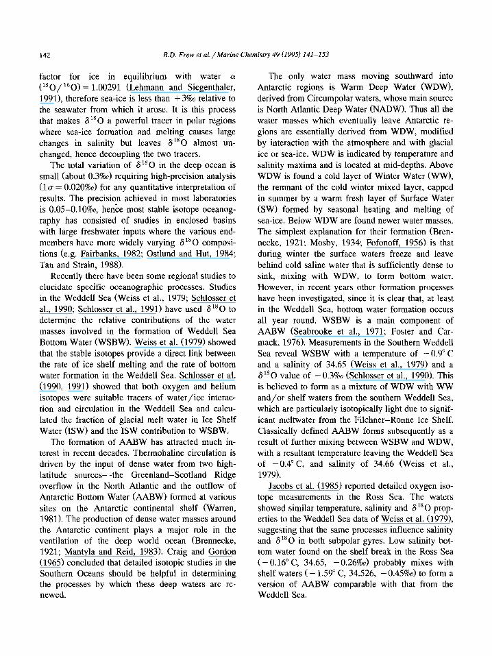
Fig. 2. Contoured sections across the Princess Elizabeth Trough. (a) Potential temperature. (b) Salinity. (c> Dissolved oxygen. (d) 6l8O.
R.D. Frew et al/Marine Chemistry 49 (1995) 141-153 149
Latitude (“S)
Fig. 2 (continued).
Salinity (Fig. 2b) increases from the SW down- wards through the WW to a maximum in the WDW core. The salinity maximum tends to decrease south- ward as the WDW mixes with the layers above and below. The salinity maximum (about 1000 m depth) is often identified as Lower Circumpolar Deep Water and is particularly low in chlorofluorocarbons (Mantisi et al., 1991) since it is largely composed of the remnant of NADW, while the temperature maxi- mum at about 500 m is denoted as Upper Circumpo- lar Deep Water and shows clearly as a minimum in dissolved oxygen (Fig. 2~).
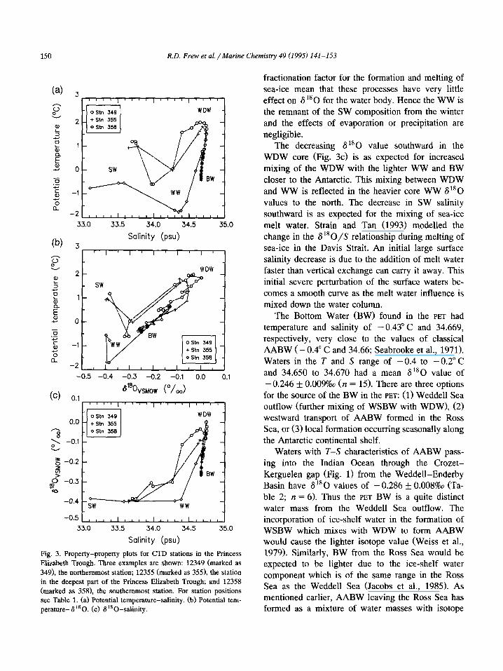
of measurements. The other stations lie within the envelope defined by these three. The potential tem- perature-alsO diagram (Fig. 3b) shows that the warm surface water at station 12358 has the same 6l*O value as the much cooler WW layer under- neath. There is a linear mixing line from the WW to the warm and isotopically heavier WDW and from there linear mixing to the cooler and lighter BW. The BW temperature and 6 ‘*O values are intermediate between the WW and WDW and lie on a mixing line between these two water masses.
The oxygen isotopes (Fig. 2d) have a distribution similar in most of the water masses to that of salin- ity, as would be expected. The surface waters are very light isotopically ( - 0.39%0). 6 180 shows a rapid increase with depth from the SW to a maxi- mum at depths of 500-800 m corresponding to the tongue of isotopically heavy WDW. The value of the S 180 maximum decreases southward from a value of - O.O3%o at station 12339 to -0.13%0 at station 12358. There is a steady decrease in S”O with depth to 3000 m, below which all stations converge on the value of -0.25%0.
The 6 180-salinity diagram (Fig. 3c) shows a large variation in salinity from the SW to WW (33.1-34.4) with little variation in 6”O. The WW al80 value decreases southward through the trough from -0.3%0 at station 12349 to -0.4%0 at station 12358. The salinity increases by approximately 0.3 in the WW over this distance. The WDW has the highest salinity and 6 ‘* 0 values; there is a very tight mixing line between WDW and AABW.
4. Discussion
The temperature-salinity relationship for three The constant value for 6 ‘* 0 in the surface waters stations spanning the PET (Fig. 3a) is similar to that down to the WW layer clearly show the concurrent of Speer and Forbes (1994) in the same area, the increase in temperature and decrease in salinity of salinity in the deep water being approximately 0.004 the SW to be due to the melting of sea-ice and fresher than theirs, within the accuracy of both sets warming of these surface waters. The negligible
150 R.D. Frew et al. /Marine Chemistry 49 (1995) 141-153
33.0 33.5 34.0 34.5 35.0
Salinity (psu)
J
II I ’ II I ( I I
2- wow
- SW
l-
O-
-1 -
-2, , , I , I , , -0.5 -0.4 -0.3 -0.2 -0.1 0.0 0.1
ostn 349 WDW -
0.0 - +stn 355
-0.5 , , , , , , , , , , , , , , , , , , , 33.0 33.5 34.0 34.5 35.0
Salinity (psu)
Fig. 3. Property-property plots for CTD stations in the Princess
Elizabeth Trough. Three examples are shown: 12349 (marked as
349), the northernmost station; 12355 (marked as 355), the station
in the deepest part of the Princess Elizabeth Trough; and 12358
(marked as 358), the southernmost station. For station positions
see Table 1. (a) Potential temperature-salinity. (b) Potential tem-
perature- 6 “0. (c) 6180-salinity.
fractionation factor for the formation and melting of
sea-ice mean that these processes have very little effect on 6 r*O for the water body. Hence the WW is
the remnant of the SW composition from the winter
and the effects of evaporation or precipitation are negligible.
The decreasing S “0 value southward in the
WDW core (Fig. 3c) is as expected for increased mixing of the WDW with the lighter WW and BW
closer to the Antarctic. This mixing between WDW
and WW is reflected in the heavier core WW 6 “0
values to the north. The decrease in SW salinity
southward is as expected for the mixing of sea-ice
melt water. Strain and Tan (1993) modelled the change in the S ‘* O/S relationship during melting of
sea-ice in the Davis Strait. An initial large surface salinity decrease is due to the addition of melt water
faster than vertical exchange can carry it away. This initial severe perturbation of the surface waters be-
comes a smooth curve as the melt water influence is
mixed down the water column.
The Bottom Water (BW) found in the PET had temperature and salinity of -0.43” C and 34.669,
respectively, very close to the values of classical
AABW (- 0.4” C and 34.66; Seabrooke et al., 1971).
Waters in the T and S range of -0.4 to -0.2” C and 34.650 to 34.670 had a mean S”O value of
- 0.246 f 0.009%0 (n = 15). There are three options for the source of the BW in the PET: (1) Weddell Sea
outflow (further mixing of WSBW with WDW), (2) westward transport of AABW formed in the Ross Sea, or (3) local formation occurring seasonally along
the Antarctic continental shelf. Waters with T-S characteristics of AABW pass-
ing into the Indian Ocean through the Crozet- Kerguelen gap (Fig. 1) from the Weddell-Enderby
Basin have 6 la0 values of - 0.286 + 0.00880 (Ta- ble 2; n = 6). Thus the PET BW is a quite distinct
water mass from the Weddell Sea outflow. The incorporation of ice-shelf water in the formation of WSBW which mixes with WDW to form AABW would cause the lighter isotope value (Weiss et al., 1979). Similarly, BW from the Ross Sea would be expected to be lighter due to the ice-shelf water
component which is of the same range in the Ross Sea as the Weddell Sea (Jacobs et al., 1985). As mentioned earlier, AABW leaving the Ross Sea has formed as a mixture of water masses with isotope

R.D. Frew et al. /Marine Chemistry 49 (I 995) 141-153 151
Table 2
Data for samples from the Crozet-Kerguelen Trough (Fig. 1) that
have temperature and salinity characteristics - 0.4 to - 0.2” C and
34.665 to 34.670, respectively
Depth 6’80 8 S
(ml MO) (” C)
4500 - 0.287 - 0.363 34.665
4500 - 0.284 - 0.363 34.665
4300 - 0.296 - 0.262 34.669
4250 - 0.294 - 0.284 34.666
3900 - 0.279 - 0.233 34.670
4500 - 0.276 - 0.269 34.669
These data represent the AABW component of the water passing
from the Weddell-Enderby Basin to the Indian Ocean and have
been extracted from a larger dataset of several CTD stations to be
published in a subsequent paper.
values between - 0.26%& and -0.45%0, thus the resultant AABW must be lighter than the waters found in the PET (- 0.25%). Therefore, while mea- surements of Ross Sea derived AABW are required to confirm this, it is unlikely that the BW observed in the PET has come from either of the subpolar gyres.
The direct observation of processes occurring dur- ing the period of sea-ice cover are made extremely difficult by the very presence of the sea-ice. The summer melting of the sea-ice changes the tempera- ture and salinity of the SW enormously. Thus we require temperature and salinity studies of processes occurring during the period of sea-ice cover to be made at the time when access is impossible to most research vessels. However, as discussed above, sea- ice formation does not alter the S”O of the seawater significantly, therefore measurements of this tracer made after the melt will directly reflect winter condi- tions. This allows us to test the hypothesis of season- ally occurring local formation of AABW.
The values for the WDW observed to the north of the PET (station 12349) are 6 “0 = - O.O2%o, T = 2.00” C and S = 34.657. During the formation of sea-ice the surface waters would attain a temperature of close to - 1.9” C, the freezing point for seawater of this salinity. For sufficiently low air temperatures, ice will form on a thin surface sub-layer with the bulk of the mixed layer at a slightly warmer tempera- ture. The heat flux supported by this temperature gradient would reduce the mixed layer temperature
to that of the surface sublayer in 2-3 weeks (Gordon and Huber, 1990).
We assume that, in winter, the water column temperature throughout the mixed layer would have cooled to - 1.9” C. The relative proportions of WDW and SW required to form BW with the observed temperature of -0.43” C from mixing of WDW (2.00” C) entering from the north and SW ( - 1.90” C) are 38% and 62%, respectively. Using these ratios and the measured values for the S l8 0 we predict the BW S”O = -0.249%0 which agrees very well with the observed value of -0.246 f 0.009%0. If the SW temperature was - 1.8” C the amounts would be 36% and 64% and the al80 of the BW would be - 0.257%0.
The required salinity of the SW would be 34.678, an increase of less than 0.3 on the salinity of the WW found at 150 m at station 12358, the most southern station of this study. The salinity change in the SW to WW layer at station 12358 is from 33.112 to 34.388 at 175 m, a change of nearly 1.3. Further increase of 0.3 would require the formation of ap- proximately 1.2 m of sea-ice, a reasonable amount at this latitude (Gordon and Huber, 1990). The density of the SW layer would then be u0 = 27.919, dense enough to de stabilise the water column.
The uncertainties in the above calculation lie in the characterisation and variability of the end-mem- bers. The WDW is well defined and, because it is isolated from the surface mixed layer, has little variability. The only process that changes its charac- teristics is the progressive mixing with mainly SW as it moves southward, the very process we are describ- ing here. The winter SW layer is much harder to define since winter conditions preclude direct mea- surements being made of its composition. Thus we assume our measurements of the WW to represent what remains of the winter SW, after the sea-ice has retreated and make some assumptions to arrive at the winter SW composition. Fig. 3 shows that large changes in both the SW temperature and salinity have no effect on the al80 of this water and that the entire SW layer down to the WW has a constant S l8 0 value. Thus we can have great confidence that the observed WW 6180 value at Station 358 is indeed the value the winter SW would have had under the ice. The main assumption in this calcula- tion is that the winter SW temperature would be

152 R.D. Frew et al. /Marine Chemistry 49 (1995) 141-153
close to freezing throughout the SW layer. As dis- cussed above, Gordon and Huber (1990) have shown this to be a valid assumption. An error of 0.1” C in the SW temperature would change the relative pro- portions of WDW and WW by 2% and the predicted BW al80 by less than O.Ol%o.
The water masses involved have extremely differ- ent dissolved oxygen concentrations (WDW [O,] < 190 pmol kg-‘: WW 330 pmol kg-‘). By the above mechanism the resultant BW is predicted to have about 270 pmol kg- ’ O,, which agrees rea- sonably with the observed value of 260 pmol kg-‘. One should consider here the large range of 0, (SO pmol kg-‘) observed in the SW layer at stn12358 and the uncertainties in deciding on a winter value for dissolved oxygen under the ice shelf. Thus the dissolved oxygen concentrations are consistent with the deep water formation mechanism proposed above, based on oxygen isotope observations.
5. Summary
There are two main findings arising from this work;
(1) From S180 results the AABW in the Princess Elizabeth Trough is clearly a water mass distinct from AABW formed from the Weddell basin over- flow. The more positive al80 values for PET bottom water indicate that it does not have a significant glacial melt water component. This is consistent with the view that there are insignificant amounts of Weddell Basin deep and bottom water passing through the PET (Rodman and Gordon, 1982), and that the deep current is westward through this basin @peer and Forbes, 1994). Similarly, the bottom wa- ter is unlikely to come from the Ross Sea, although waters formed there are believed to flow west to- wards the Kerguelen Plateau, but the oxygen isotope values are again heavier than found for Ross Sea waters. This is an important conclusion for the abyssal circulation, demonstrating the pathway for AABW derived from the Weddell Sea entering the Indian Ocean is exclusively to the north of 50” S.
(2) The classical process of local formation via seasonal deep convection is demonstrated by two independent means requiring only the assumption that the temperature of the surface mixed layer would
be close to freezing. The virtually zero fractionation of 180 during sea-ice formation allows the data obtained from samples collected in summer to be used to study processes occurring during the winter when the region is inaccessible due to sea-ice cover. The BW found in the PET can be formed from deep convection involving only WDW and winter SW, the relative amounts being about 40% and 60%, respec- tively. This is an important conclusion as it demon- strates that bottom water can form in the Antarctic by processes other than those involving ice-shelf components as occurs in the Weddell and Ross Seas.
Acknowledgements
We thank the scientists, officers and crew of RRS Discovery cruise 200, and particularly the principal scientist Dr. Bob Dickson (MAFF, Lowestoft), for obtaining data in a most inhospitable location. The Antarctic Deep Outflow experiment (ADOX) is part of the UK contribution to the World Ocean Circula- tion Experiment (WOCE). This work was supported by the NERC British Antarctic Survey Special Topic grant GST/02/650.
References
Brennecke, W., 1921. Die ozeanographischen Arbeiten der
deutschen antarktischen Expedition 1911-1912. Arch. Dtsch.
Seew., Hamburg, 39, 1.
Craig, H. and Gordon, L.I., 1965. Deuterium and oxygen 18
variations in the ocean and the marine atmosphere. In: E.
Tongiorgi (Editor), Stable Isotopes in Oceanographic Studies
and Palaeotemperatures. Spoleto Conf. Proc., Cons. Naz. Ric.,
V. Lischi Figli, pp. 9-130.
Dickson, R.R., 1993. Report of RRS Discovery Cruise 200, 6
February-18 March 1993, Circulation and structure in the
Southern Ocean between 20” E and 90” E and 40” S and 65” S.
MAFF Dir. Fish. Res., Lowestoft.
Epstein, S. and Mayeda, T., 1953. Variations of “0 content of waters from natural sources. Geochim. Cosmochim. Acta, 4:
213-224.
Fairbanks, R.G., 1982. The origin of continental shelf and slope
water in the New York Bight and Gulf of Maine: Evidence
from HisO/Hi60 ratio measurements. J. Geophys. Res., 87:
5796-5808.
Fofonoff, N.P., 1956. Some properties of seawater influencing the
formation of Antarctic Bottom Water. Deep-Sea Res., 4: 32-
35.

R.D. Frew et al/Marine Chemistry 49 (1995) 141-153 153
Faster, T.D. and Carmack, E.C., 1976. Frontal zone mixing and
Antarctic Bottom Water formation in the southern Weddell
Sea. Deep-Sea Res., 23: 301-317.
Gloersen, P., Campbell, W.J., Cavalieri, D.J., Comiso, J.C.,
Parkinson, CL. and Zwally, H.J., 1992. Arctic and Antarctic
Sea Ice, 1978-1987: Satellite passive microwave observations
and analysis. NASA SP-511 Sci. Techn. Inf. Progr., NASA,
Washington, DC, 290 pp.
Gordon, A.L. and Huber, B.A., 1990. Southern Ocean winter
mixed layer. J. Geophys. Res., 95(C7): 11,655-11,672.
Jacobs, S.S., Fairbanks, R.G. and Horibe, Y., 1985. Origin and
evolution of water masses near the Antarctic continental mar-
gin: Evidence from H~80/H~60 ratios in seawater. In: S.S.
Jacobs (Editor), Oceanology of the Antarctic Continental Shelf.
Am. Geophys. Union, Washington, DC, Antarct. Res. Ser., 43,
pp. 59-85,
Lehmann, M. and Siegenthaler, U., 1991. Equilibrium oxygen-
and hydrogen-isotope fractionation between ice and water. J.
Glacial., 37(125): 23-26.
Mantisi, F., Beauverger, C., Poisson, A. and Metzl, N., 1991.
Chlorofluoromethanes in the western Indian sector of the
Southern Ocean and their relations with geochemical tracers.
Mar. Chem., 35: 151-167.
Mantyla, A.W. and Reid, J. L., 1983. Abyssal characteristics of
the World Ocean waters. Deep-Sea Res., 30: 805-833.
Mosby, H., 1934. The results of the Atlantic Antarctic Ocean. Sci.
Results Nor. Antarct. Exped., 1927-1928, 1.
Ostlund, H. G. and Hut, G., 1984. Arctic Ocean water mass
balance from isotope data. J. Geophys. Res., 89: 6373-6381.
Rodman, M.R. and Gordon, A.L., 1982. Southern Ocean bottom
water of the Australian-New Zealand sector. J. Geophys.
Res., 87: 5771-5778.
Seabrooke, J.M., Hufford, G.L. and Elder, R.B., 1971. Formation
of Antarctic Bottom Water in the Weddell Sea. J. Geophys.
Res., 76(9): 2164-2178.
Schlosser, P., Bayer, R., Foldvik, A., Gammelsrod, T., Rohardt G.
and Munnich, K.O., 1990. Oxygen 18 and helium as tracers of
Ice Shelf Water and water/ice interaction in the Weddell Sea.
J. Geophys. Res., 95(C3): 3253-3263.
Schlosser, P., Bullister, J. L. and Bayer, R., 1991. Studies of deep
water formation and circulation in the Weddell Sea using
natural and anthropogenic tracers. Mar. Chem., 35: 97-122.
Speer, K. G. and Forbes, A., 1994. A deep western boundary
current in the South Indian Basin. Deep-Sea Res., 41: 1289-
1303.
Strain, P.M. and Tan, F.C., 1993. Seasonal evolution of oxygen
isotope-salinity relationships in high-latitude surface waters.
J. Geophys. Res., 98: 14,589-14,598.
Tan, F.C. and Strain, P.M., 1988. Stable isotope studies in the
Gulf of St. Lawrence. In: P.M. Strain (Editor), Chemical
Oceanography in the Gulf of St. Lawrence. Can. Bull. Fish.
Aquat. Sci., 220: 59-77.
Warren, B.A., 1981. Deep Circulation of the World Ocean. In
B.A. Warren and C. Wunsch (Editors), Evolution of Physical
Oceanography. MIT Press, Cambridge, MA, pp. 6-49.
Webb, D. J., Killworth, P. D., Coward, A. and Thompson, S.,
1991. The FRAM Atlas of the Southern Ocean. Nat. Environ.
Res. Count., Swindon, 67 pp.
Weiss, R.F., Ostlund, H.G. and Craig, H., 1979. Geochemical
studies of the Weddell Sea. Deep-Sea Res., 26A: 1093-1120.