GÖKÇEADA UĞURLU ARCHAEOLOGICAL PROJECT: A Preliminary Report from the 2011-2013 Field Seasons....
22
ANATOLICA XL, 2014 GÖKÇEADA UĞURLU ARCHAEOLOGICAL PROJECT: A Preliminary Report from the 2011-2013 Field Seasons Burçin Erdoğu * Abstract This is the second article published in Anatolica on excavations conducted at Uğurlu, located on the island of Gökçeada (Imbros). It constitutes a preliminary report of the field seasons carried out in 2011-2013. Because of its long occupational history Uğurlu is one of the most important prehistoric sites in the Northeast Aegean region. Stratigraphic excavations have clarified the spatial extent of the settlement from the earliest Neolithic occupation onwards (6500 cal. BC), and brought to light evidence of the transition from the Neolithic to the Chalcolithic period (5500 cal. BC) as well as transformations of the site in the late 5 th and the early 4 th millennium BC. The settlement was probably founded by newcomers from the Northwest Anatolian mainland, but afterwards islanders may have formed their own culture and identity. INTRODUCTION Maritime prehistory is a growing field of research with discussions concerning early human dispersals, insularity and colonization as well as trade and exchange. In the Aegean most of this work has focused on early seafaring and colonization and/or utilization of islands (e.g. Cherry 1990; Broodbank 2006). The Aegean Islands are critically located at the meeting point of Anatolia and the mainland of Greece. They were an important and useful landfall location for seafarers and could therefore have been part of a route for the spread of a Neolithic way of life to Southeast Europe. According to many researchers the Aegean Islands played an important role in the spreading of a Neolithic way of life to Southeast Europe. For example, Chapman (1994) argues that forager-farmer exchange networks in the Aegean probably kick-started the rise of a Neolithic way of life in Southeast Europe. Based on the comparison of the available C14 dates and the genetics of living European populations, Ammerman and Cavalli-Sforza (1984) proposed a model of “demic diffusion” or “wave of advance” which argued the spread of a Neolithic way of life to Europe by a more or less continuous migration of people from the Near East. The Jump Dispersal model for migration from Anatolia to the mainland of Greece, suggested by Van Andel and Runnels (1995), involved the crossing of the Aegean by movement from island to island. Recently, Perlès et al. (2013) mentioned island-hopping routes across the Aegean Sea for the spreading of a Neolithic way of life to Southeast Europe. The site of Uğurlu at the Island of Gökçeada is the earliest Neolithic settlement thus far known in the Eastern Aegean Islands, and it is likely to be critical for understanding the spread of a Neolithic way of life through to the west. * Trakya University, Department of Archaeology, Prehistory Section, 22030 Edirne.
Transcript of GÖKÇEADA UĞURLU ARCHAEOLOGICAL PROJECT: A Preliminary Report from the 2011-2013 Field Seasons....

ANATOLICA XL, 2014
GÖKÇEADA UĞURLU ARCHAEOLOGICAL PROJECT: A Preliminary Report from the 2011-2013 Field Seasons
Burçin Erdoğu*
AbstractThis is the second article published in Anatolica on excavations conducted at Uğurlu, located on
the island of Gökçeada (Imbros). It constitutes a preliminary report of the fi eld seasons carried out in 2011-2013. Because of its long occupational history Uğurlu is one of the most important prehistoric sites in the Northeast Aegean region. Stratigraphic excavations have clarifi ed the spatial extent of the settlement from the earliest Neolithic occupation onwards (6500 cal. BC), and brought to light evidence of the transition from the Neolithic to the Chalcolithic period (5500 cal. BC) as well as transformations of the site in the late 5th and the early 4th millennium BC. The settlement was probably founded by newcomers from the Northwest Anatolian mainland, but afterwards islanders may have formed their own culture and identity.
INTRODUCTION
Maritime prehistory is a growing fi eld of research with discussions concerning early human dispersals, insularity and colonization as well as trade and exchange. In the Aegean most of this work has focused on early seafaring and colonization and/or utilization of islands (e.g. Cherry 1990; Broodbank 2006). The Aegean Islands are critically located at the meeting point of Anatolia and the mainland of Greece. They were an important and useful landfall location for seafarers and could therefore have been part of a route for the spread of a Neolithic way of life to Southeast Europe. According to many researchers the Aegean Islands played an important role in the spreading of a Neolithic way of life to Southeast Europe. For example, Chapman (1994) argues that forager-farmer exchange networks in the Aegean probably kick-started the rise of a Neolithic way of life in Southeast Europe. Based on the comparison of the available C14 dates and the genetics of living European populations, Ammerman and Cavalli-Sforza (1984) proposed a model of “demic diffusion” or “wave of advance” which argued the spread of a Neolithic way of life to Europe by a more or less continuous migration of people from the Near East. The Jump Dispersal model for migration from Anatolia to the mainland of Greece, suggested by Van Andel and Runnels (1995), involved the crossing of the Aegean by movement from island to island. Recently, Perlès et al. (2013) mentioned island-hopping routes across the Aegean Sea for the spreading of a Neolithic way of life to Southeast Europe. The site of Uğurlu at the Island of Gökçeada is the earliest Neolithic settlement thus far known in the Eastern Aegean Islands, and it is likely to be critical for understanding the spread of a Neolithic way of life through to the west.
* Trakya University, Department of Archaeology, Prehistory Section, 22030 Edirne.

BURÇIN ERDOĞU158
The island of Gökçeada (Imbroz) is about 17 km from the Gelibolu Peninsula and covers an area of 289.5 sq km. Uğurlu is located on the western part of the island (Fig. 1). The site is a low mound covering an area of approximately 250 x 200 m on a gentle slope at the eastern foot of Mount Isa (Doğanlı). The main Uğurlu-Dereköy road cuts through the site (Fig. 2). The site has also been damaged by a long trench dug for the opening of an irrigation system. The Pilon stream lies at the eastern part of the site, and there is also a nearby spring. The island is mountainous. The solid geology is composed mainly volcanic rocks. The western part of the island is generally less steep and has the best agricultural land. During the four years of excavation fi ve main cultural phases, designated as I-V (counting from top to bottom), and at least 9 layers of occupation so far have been revealed (Erdoğu 2011). The earliest two phases (IV & V) date to the Neolithic period. Phase III is marked by the Neolithic-Chalcolithic transition at the site. The succeeding Phase II has revealed at least two occupational layers of Western Anatolian Kumtepe Ia-Beşik Sivritepe Culture. Scattered sherds from Early Bronze Age and Medieval times have been found in the surface, Phase I.
THE NEOLITHIC OCCUPATION
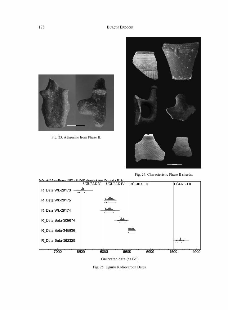
The earliest occupation is located in the eastern part of the settlement, close to the Pilon stream. So far two possible occupational layers of Phase V have been recorded. The early layer of Phase V is represented in sounding trenches. No architectural structures except scattered stones in clusters were found in this early layer. Extremely dense concentrations of animal bones were studied by Levent Atıcı who has identifi ed domestic sheep, goat, pig and cattle. The presence of wild boar, red deer, hare and fox indicate the practising of hunting. A single AMS radiocarbon date from the early layer of Phase V (Wk-29173: 7618±36 BP) calibrate respectively to 6566-6518 cal. BC (2α).
A single-room, earthened-fl oor building, about 5 x 4 m, has been excavated in the late layer of Phase V (Fig. 3). The walls are probably made of muds on stone foundations. The eastern and western walls are ca. 1.00 m thick, while the northern and southern walls are about 0.70 m in width. The northern wall is standing to a height of about 1.00 m, and a fi replace sets inside the wall. The fi replace seems to have been fi lled with earth and stones after its abandonment, and a stone axe consciously left on it. The southern wall of the building has been partly damaged by a long trench dug for the opening of an irrigation system. A massive exterior buttress is attached to the southern wall of the building. The small room size (9.2 m²), thick walls and massive exterior buttresses indicate that the building had an upper story. The northern wall stretches about 3,5 m towards the east with a parallel wall ca. 1 m wide, which creates a courtyard. There is a large oven approximately 1 m in diameter that lies in an open area in the southern part of the building.
The architecture of this early structure is characterized as a small-scale household with limited space for social interaction and no dedicated storage installations. A sherd with human motif in relief (Fig. 4) and a head from animal bone from a Acrolithic fi gurine were

ANATOLICA XL, 2014 159
found in the northwestern part of the building. The nose of the fi gurine head was shown in relief while the eyes were shown in red paint (Fig. 5). Some broken bone tools and a small stone axe made of serpentine were found in situ. A small broken malachite bead was also found in the building. There are a couple of malachite veins running between the villages of Dereköy and Tepeköy, close to site.
During Phase IV the settlement enlarged, and the Neolithic settlement covered an area of 6 hectares. The Phase IV deposit is about two and half meters thick and has revealed at least four occupational layers. No complete building plans have been exposed. In the western part of the settlement, sounding trench P5 yielded Phase IV occupation. So far 3 layers of Phase IV have been excavated, and they have been damaged by the upper Phase III. A thick yellow-colored compact fl oor with a circular hearth and a plastered pit were found in the fi rst layer of Phase IV. The hearth measures 0.90 x 0.90 m. The fl oor yielded an extremely dense concentration of animal bones and bone tools. A small pit lies close to the hearth and measures 0.70 x 0.70 m. The inner walls and the pit bottoms were plastered by yellow-coloured clay. 28 worked bones, 1 stone bowl and 1 broken stone adze were found inside the pit. 26 worked bones consist of fl attened awls with rounded heads. They should be considered to be symbolised human beings and interpreted as bone idols (Fig. 6).
A partly excavated building with damaged stone walls was found in the second layer of Phase IV. A large storage vessel was found in one corner of the building (Fig. 7). A partition wall within the building was constructed of muds and adobes. Multiple layers of a plastered fl oor, a large oven and two plastered oval features were found in the third layer of Phase IV. Two AMS radiocarbon dates (Wk-29175: 6982±42 & Wk-29174: 6996±36) range from ca. 5980-5750 cal. BC (2 α).
In the eastern part of the settlement, a building with a long exterior buttress has been partly excavated. The building has two architectural phases. During the latest phase, the building was narrowed. A single AMS radiocarbon date (Beta–309674: 6680 ± 40 BP) calibrates to ca. 5600 cal BC. A sounding trench also yielded a courtyard with at least 5 hearths in this part of the settlement.
One of the excavation objectives was to investigate the role of plants in the Neolithic economy of the settlement. A large number of soil samples was processed by fl otation. Examination of the carbonized botanical remains by Soultana Valamoti indicate domestic cereals including einkorn wheat (Triticum monococcum), six-rowed barley (Hordeum vulgare), naked barley (Hordeum vulgare var. nudum) and pea (Pisum sativum L.). Large quantities of shells and fi sh bones suggest the potential importance of marine sources in the Neolithic diet of Uğurlu. Among the shells, Patella and Mytiliades are numerous.
Polished stone axes/adzes and bone tools are abundant. Bone tools consist mainly of awls, chisels, spatulas and needles. Bone hooks and an antler hammer are noteworthy (Fig. 8). Pan-shaped stone vessels are also signifi cant (Fig. 9). Stone and shell beads and pendants are also the main fi nds (Fig. 10). Neolithic fi gurines are rare but signifi cant. Noteworthy among them are acrolithic fi gurines, a marble fi gurine head and a pregnant-like anthropomorphic fi gurine.

BURÇIN ERDOĞU160
Pottery is the most common artifact group in Neolithic Uğurlu. The vast majority of Phase V pottery is red slipped and burnished. Black burnished sherds were found in small quantities. All pottery is handmade and thin walled. Deep bowls with “S” profi le, hole-mouth vessels and straight-sided shallow dishes are common shapes (Fig. 11:1-9). Bases are either fl at or have a low pedestal. Vertically placed tube-like and knob-like perforated tubular lugs, as well as small crescent shaped lugs, are characteristic (Fig. 11:11-12). A human-faced sherd is unique. General parallels to Uğurlu pottery were found in Western Anatolian sites. However, several forms of pottery from this oldest known phase in Uğurlu show unmistakable parallels with Hoca Çeşme IV-III in Turkish Thrace as well as Aktopraklık and the basal layers of Menteşe in the Marmara region (Bertram&Karul 2005, Fig.1-3 ; Karul&Avcı 2011, Fig.11-12 ; Roodenberg et al. 2003, Fig.13:1-4; Fig.16:1-6).
There is apparent progress with regard to pottery production in Phase IV. Neolithic pottery from Phase IV is of an extremely high technological standard, demonstrating a degree of ingenuity and creativity. Pottery is handmade, lustrously burnished and thin-walled. It has been sorted out into seven ware groups. Red-slipped black ware is dominant, 60% of the total assemblage. A jet-black surface color is common. Different tones of red and pink slip are applied on the exterior surfaces and below the rim of the interior surfaces. The thickness of the slip application varies greatly, and generally shows a mottled appearance on the surface. Other wares include the red slipped buff ware (12%), the black/gray burnished ware (9%) and the brown burnished ware (7%).Red and black burnished coarse wares also occur.
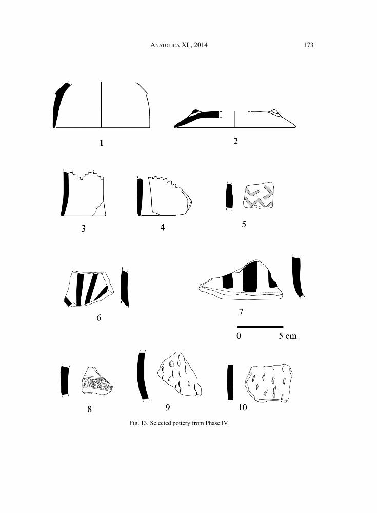
Looking at the repertoire of shapes, deep bowls with “S”-shaped profi les and bead rims are common (Fig. 12:1-5). The profi les are sometimes slightly carinated. Deep bowls with fl aring sides, bowls with internally thickened rims, hole-mouth jars, and tall-necked jars, occasionally with small handles, are also common (Fig. 12:6-8). Bases are fl at or ring-shaped. Four-footed vessels also occur. Vertically placed long, tube-like, perforated lugs are characteristic, and they were manufactured differently. Thick clay was added inside the walls and perforated, and then tube-like relief was made outside the vessels. Pedestals with cut outs, boxes and lids are also characteristic. Decoration is rare but the most characteristic decoration technique is impresso (Fig. 13:9-10). Another decoration is incised lines combined with dot impressions (Fig.13:8). Impressed cross or “T” motifs occur only on pedestals. The only fi ve small pieces of painted pottery found so far on the site were found in Phase IV. A white-on-red painted sherd is identical in ware, techniques and design to the pottery of Karanovo I (Fig. 13:5). Red-on-black sherds look like local productions (Fig.13:6-7). None of the Uğurlu Phase IV pottery is exactly identical to the Anatolian repertoire of shapes, but it bears general similarities. The pottery types are similar to those of contemporary cultures in the Aegean.
Thin-sections of 30 sherds (10 Phase V & 20 Phase IV) and 3 clay samples around Uğurlu were analysed by Chris Doherty and Eleni Palamara using an optical microscope to provide further information on the porosity of the fabric and the non-plastic inclusions. Later, the samples were analyzed with the use of a Scanning Electron Microscope. The

ANATOLICA XL, 2014 161
chemical composition of the fabric was also measured for each sample. Only one type of clay could be distinquished and it is non-calcareous of andesitic/dacitic composition. The minerals consist of quartz, alkali and plagioclase feldspars, amphiboles and titaniferous minerals, especially magnetite and titaniferous magnetite. This composition is compatible with the local geology of Gökçeada. The analysis has not shown important differences in clay source and the method of pottery production between Phase V and IV. The majority of Phase IV samples tend to be slightly coarser and have a larger amount of inclusions than Phase V samples. Some slight changes occur in the distribution of some minerals, such as amphiboles and magnetites. The changes in minerals between the two phases can be explained by the observed difference in the coarseness of the clay. Organic temper is almost absent. Only a very small number of organic inclusions were identifi ed and probably they were not deliberate additions. A very small number of bone fragments were identifi ed in a few samples, and only one sample has vegetable inclusion. A comparison between the results of the thin section analysis and the chemical composition of the sherds and clay samples gives the impression that the Neolithic pottery of Uğurlu has been made of local clays (Erdoğu 2013).
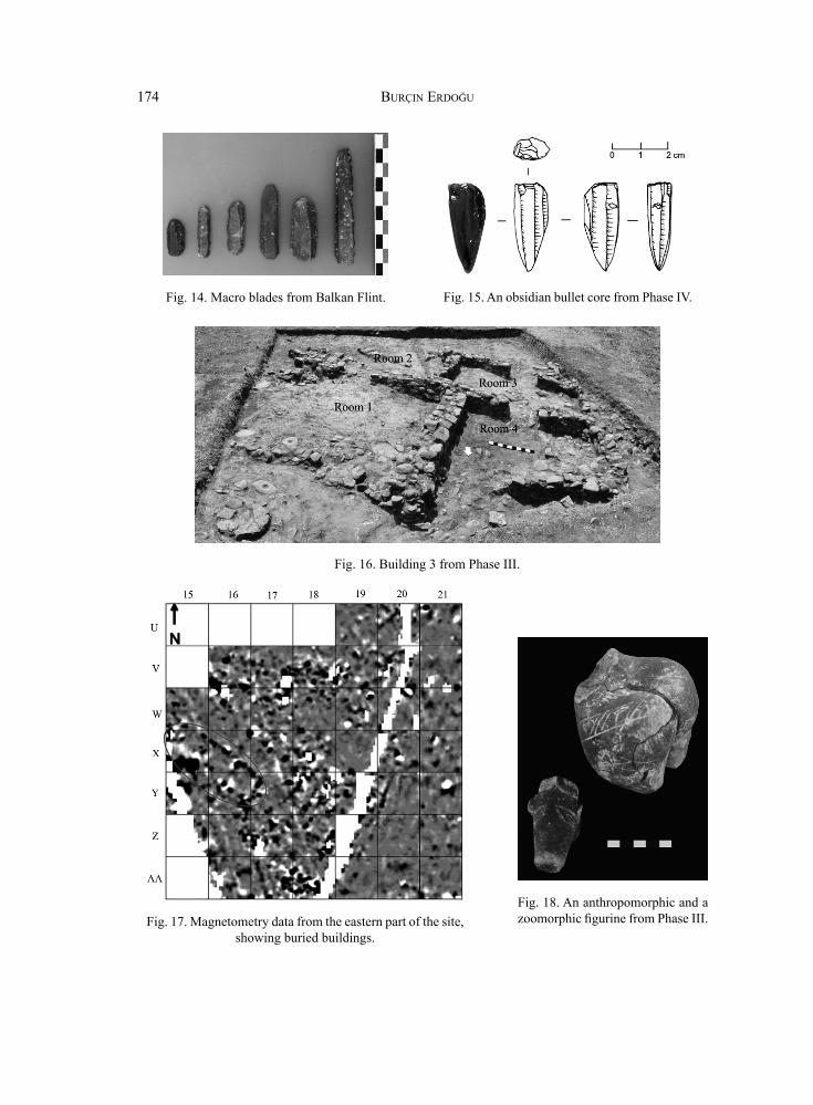
One distinctive aspect of Neolithic Uğurlu was long-distance trade and exchange, best refl ected in the distribution of obsidian and Balkan fl int. These were raw materials used from the beginning for knapped tools, but local fl int was used much more frequently, comprising 99% of lithic assemblage of the site. Denis Guilbeau, who works on chipped stones of Uğurlu, pointed out that fl akes are more common than blades. A total of ca. 20% of the chipped stones are blades in Phase V. Blades are also rare in Phase IV, represents ca. 9% of the total assemblages. Most of blades were made by the pressure technique in Phase V. Tools are very rare in both phases. The most distinctive tool in Phase IV is a fl int macro blade, the so-called “Karanovo macro blade” (Gurova 2008). About 25 macro blades were found in this phase and a core and some fl akes from the same raw material, the so-called “Balkan Flint”, were also recovered (Fig. 14). The origin of this type of fl int is in the Razgrad region of the Eastern Balkan Mountains. Most of the blades have deep retouched sides and some blades have polished surfaces. Other tools are sickle blades, scrappers, burins and pièces esquillées. Some geometric microlithic were also found.
Almost all obsidian pieces are blades, which were made by the pressure technique. The obsidian pieces were analyzed by Marina Milic using portable X-Ray Fluorescence. The results demonstrate that obsidian comes from 3 sources: the island of Melos, East Göllü Dağ and Nenezi Dağ of Central Anatolia. The Melos samples are much more frequent. An obsidian bullet core from Nenezi source is unique (Fig. 15). Similar cores were found only in the site of Aktopraklık North-west Anatolia (personal communication with Marina Milic).
Vessels and foot-shaped objects of marble are the main fi nds in Phase IV. A marble mace head is unique. No marble sources are found on the island. Western Anatolia and Aegean islands, such as Lesvos and Thasos, have sources of fi ne white marble. Unfortunately, quarry sites per se are generally unknown. A prehistoric marble factory, called Kulaksızlar, was found in Western Anatolia but it was dated to the fi fth millennium BC (Takaoğlu 2005).

BURÇIN ERDOĞU162
THE CHALCOLITHIC OCCUPATION
Phase III is marked by the Neolithic-Chalcolithic transition at the site. The settlement was divided into two sections, a residental area in the east and a storage area and workshops in the west. A large, multi-roomed structure (Building 3), about 10 x 10 m in size, has been excavated in the eastern part of the settlement (Fig. 16). The building was quite sophisticated, being built with drystone walls and yellow-coloured plaster clay fl oors. The plan of building consists of two cell-like rooms (R3&4) in the west and a relatively large room (R1) in the east. Another cell-like room (R2) in the east was almost completely destroyed by surface activities. The largest room measures ca. 4 x 4 m and corners of the room were paved with stone slabs. The northwestern corner of the room yielded several grind ing slabs, indicating these were areas in which foodstuffs were ground and food preparation took place. Most of animal bones and shells were also concentrated there. A narrow doorway lies in this part of the room, from which one stepped over a raised threshold to enter a courtyard. In the southwest corner of the room two large bone tools - an awl and a chisel, were found. They were presumably used for leatherworking or other purposes. A post hole with a large stone with a hole in the middle lies near the northeast corner of the room. A large, well made Spondylus bracelet was also found in this room. The cell-like small room (R3) in the west measures ca. 1,5 x 3 m. Storage vessels and two adzes from serpentinite were found in this room. A single AMS radiocarbon date from Building 3 of Phase III (Beta-345836; 6410±30 BP) calibrate respectively to 5470-5320 cal. BC (2α).
A geophysical survey was conducted as part of the Uğurlu Archaeological Project by Mahmut Drahor, with the aim of mapping the buried remains of the site. The magnetometry surveys on the eastern part of the settlements have identifi ed numerous Phase III structures including a large 20 x 5 m rectangular structure and probably multi-roomed buildings (Fig. 17).
In the western part of the settlement 12 pits were excavated. The inner walls and the pit bottoms were plastered by yellow-coloured clay, between 3 and 5 cm thick. They were circular in shape and some as deep as 1 m with diameters of 1 m. They were deliberately fi lled with large stones before abandonment. A large quantity of animal bones and pottery sherds was found inside the pits, as is usual for waste. Bracelets or rings from Spondylus gaederopys, pendants from Cerastoderma and bone tools were also recovered from the pits. Inside one pit a partial skeleton was found. It was a secondary burial of a middle-aged man. Red ochre was applied to the burial. Yellow-coloured plaster clay from the pit was examined for its mineral content using X-ray diffraction (XRD) and for its chemical composition using X-ray fl uorescence (XRF). XRD investigation showed that the plaster sample is Bentonite, contained montmorillonite, illite, quartz and calcite. Feldispat, clinochlore and christobalite were also present. Bentonite clay was used as plaster in historic times in this region. Pits were likely used for storage purposes. Wet bentonite prevents further expansion and therefore stops water absorption and/or penetration.
Pits were dug through a layer in which large quantities of Spondylus gaederopys pieces and bracelets or rings from Spondylus gaederopys were found. Bone tools are also abundant. Besides awls, there are smoothers and chisels of deer antler. Objects of

ANATOLICA XL, 2014 163
Spondylus were highly prized and probably endowed with symbolic signifi cance. The distribution of Aegean Spondylus in the Balkans and Central Europe during Neolithic and Chalcolithic periods is considered one of the most telling and important indications of large- scale prehistoric trade. Spondylus workshops have been identifi ed in Neolithic Greece at the sites of Dimini, Sitagroi and Stravroupolis (Souvatzi 2008). Uğurlu items indicate that a Spondylus workshop may also exist on the island. The anthropomorphic fi gurines from Phase III are large in number and typologically varied. Acrolithic fi gurines are common. These fi gurines possess fl attened bodies with folded arms and heads from a different material that would have been inserted in a hole on the neck. A triangular-shaped Spondylus head with slanted excised eyes indicates that they may have been inserted in these fi gurines. Other common anthropomorphic fi gurines have wide hips and thighs, thin bodies and folded arms. Schematic anthropomorphic fi gurines with exaggerated buttocks are also common. These fi gurines have incised decoration, and they have always been broken along the vertical axis. Venus-like fi gurines are also noteworthy. They hold their shoulder with one hand while shielding their genitals with the other. Zoomorphic fi gurines are rare (Fig. 18).
Phase III pottery is homogenous and completely different than previous phases. Sherds are coated with a black, grayish black slip on reddish brown surfaces, and generally show a mottled appearance on the surface. Fresh breaks in sherds show incomplete oxidation fi ring. Four-footed bowls with ear-like or strap handles, large lids, boxes, button-like or horned handles are characteristic (Figs. 19, 20).
Decoration is common and generally applied on four-footed bowls and boxes. Various decorative techniques have been employed, such as impression, incision and channeling. Impressed decoration comes in several variations, such as dots, triangles and rectangles. Chips of clay were cut and arranged in different patterns, such as chessboard and triangular. Spiral and meander designs are common. Incised decoration has white paste fi ll. No exact similarities exist between Uğurlu Phase III pottery and Anatolian pottery traditions. Though Phase III pottery bears some resemblance to the pottery of the Balkan Karanovo III and Early Vinca cultures, it is not identical and should be considered as a local development.
Preliminary analysis has not shown important differences in the lithic material between Phase III and Phases IV-V. However, Phase III tools are more numerous than previous occupations. Blades are very rare and pièces esquillées, scrapers and borers are more numerous than in Phases IV-V. Obsidian is now very rare and all from Melos. Only a few tools made of “Balkan fl int” were found.
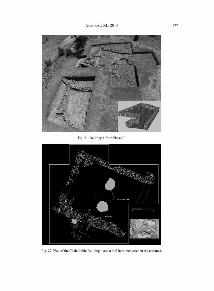
Excavations in Phase II have revealed evidence of the Western Anatolian Chalcolithic Kumtepe Ia-Beşik Sivritepe Culture. The excavation revealed two buildings in the western part of the settlement. A trapezoidal building (Building 1) with stone walls measure ca. 5 x 5 m (Fig. 21). It had suffered from a partial collapse, and an additional wall and a stone buttress were constructed on the northern part of the building to make it useable again. A stone buttress measures 1.50 x 0.87 m and stands to a height of 0.40 m. A post hole with a large stone with a hole in the middle lies near the stone buttress. The building has a compact earthen fl oor, and no features such as oven or hearth have been found in the building.

BURÇIN ERDOĞU164
The southwestern part of the building was designated for storage. Large storage vessels and a total of 130 Muricidae shells were found there. 7 stone axes and adzes, 11 worked bones, mostly awls, 4 Spondylus bracelets, worked shells and a clay fi gurine head were also found in the building. A half circular courtyard wall was discovered in the west end of the building. It is made of large stones 0.50-0.52 m in width. A unique human-faced vessel was found in the courtyard. A single AMS radiocarbon date from the Building 1 of Phase II (Beta-362320; 5500±30 BP) calibrate respectively to 4449-4267 cal. BC (2α).
The other building (Building 4) is rectangular in plan, measures ca. 7 x 6 m, and is constructed with stone walls (Fig. 22). The building was poorly preserved and damaged by surface activities. A centrally placed entrance lies on the southern long wall. There is a 1.40 x 1.00 m “patio” in front of the entrance. A large bull horn was found in the entrance (Fig. 22). It appears to have hung on an interior wall. The fl oor of the building was plastered with burnt lime mixed with soil and sediment. Traces of red paint remain on parts of the fl oor surface. Traces of red paint were also found near the entrance. Two broken clay fi gurines were discovered near the “patio”. One fi gurine has exaggerated buttock, fl at body and folded arms (Fig. 23). It is reminiscent of Balkan fi gurines. Another fi gurine looks like Phase III fi gurines with thin bodies and folded arms, but it has a long neck. Traces of building decoration with animal horns and paintings on walls and fl oors appear as early as PPNA in the Near East, and they often related to communal or public buildings. I also prefer to interprete this building at Uğurlu Phase II as a communal or public building.
The pottery of Phase II is characterized by burnished black, gray, red and buff coloured wares. Coarse wares seem larger than fi ne wares. The most noticeable feature of the pottery is decoration. Pattern burnished, channeling, incised decorations are characteristic (Fig. 24). Horned and wish-bone handles are also characteristic elements of this pottery. The chipped stones are too rare to make a precise study, but it seems there is no signifi cant change from the previous phase. Macro blades from Balkan Flint still exist in this phase. When compared to the Neolithic samples, they are long and thin.
DISCUSSIONS AND CONCLUDING REMARKS
Excavations at Uğurlu on the island of Gökçeada show that longer-term or permanent settlement on the Aegean islands was achieved from the early Neolithic onwards by people with an agricultural economic base, including cultivated plants and domesticated animals. The earliest Neolithic settlement of Uğurlu was probably founded by newcomers from Northwest Anatolia. The fi rst settlers were agriculturalists and they introduced domestic sheep, goats, cattle and pigs to the island. Sea level and the shoreline in the Aegean were different during prehistoric times (Lambeck 1996). During the early Neolithic period around 6500 BC sea level reached approximately -36 isobaths. Gökçeada Island was probably much closer to the mainland when the fi rst Neolithic settlers sailed to the island.
It is generally believed that the transition from a hunter-gatherer to a farming way of life is what defi nes the start of the Neolithic in Europe, and farming of crops and

ANATOLICA XL, 2014 165
domestication of animals were adopted from the Near East through Anatolia. Recent investigations show wild barley and wild einkorn in the Mesolithic deposits of Theopetra Cave (Kyparissi-Apostolika 1999) and stands of wild einkorn grow abundantly today in the hilly areas of northern Greece. Wild oats, barley, and lentils also exist in Upper Paleolithic and Mesolithic levels at Franchthi Cave (Hansen 1991). On the other hand, genetic studies have subsequently ruled out European ancestry for domestic wheat, barley, and pulses, confi rming the Near East as the source of these crops (Zeder 2008). In addition, genetic studies show a Near Eastern origin for domestic cattle and no indication of domestication of European aurochs, but recent genetic studies also show that early pigs in western Anatolia differed from those domesticated in the Near East and from western Anatolian pigs that were introduced to SE Europe (Baird at al. 2007; Ottoni et al. 2012).
The role of symbolic domestication and a social perspective on the transition to a new way of life show that the Neolithic is marked not only by the onset of farming but also by the emergence of complex symbolic and socio-political systems (Cauvin 1989; Hodder 1990; Hayden 1993). The most important question about European Neolithic now is, are any practices, such as mortuary, ritual or symbolic systems transferred? At fi rst sight all of these practices in Southeast Europe are different than those of the Near East. As Lichter (2011) pointed out, the term “package” is misleading and does not refl ect the heterogeneity and variety of the Neolithic.
The Neolithic Phase IV at Uğurlu has signs of continuity, but the cultures of island and mainland clearly diverge. Differences in material culture may be a deliberate expression of local identity within a wider cultural setting. The settlement enlarged towards the west. Orientation and sizes of buildings were changed. Phase IV at Uğurlu indicates some changes in pottery tradition. It seems likely that the pottery from this phase was the product of local development and it is different from other Western Anatolian sites. On the other hand, pottery shapes are fairly homogeous throughout the Aegean. Phase IV is characterized by the most striking evidence of early craft specialization and long-distance communications. The distribution of Melian and Central Anatolian obsidian as well as Balkan honey-fl int and marble suggests the intensifi cation of long distance exchange mechanisms and travels must have involved seafaring for some parts of the journeys.
Phase III at Uğurlu is a transitional phase with an increasing predominance of dark burnished wares with different decorations. Major change also occurred in the settlement system and architectural tradition. There is no comparable architectural tradition on other regions. The building plan of Phase III is advanced and extremely unusual for this period. The pottery of Phase III, though bearing some resemblance to the pottery of the Balkan Karanovo III and Early Vinca cultures, is not identical to them and so should be considered as a local development. A single radiocarbon AMS date from Phase III also matches Karanovo III dates as well as Aşağı Pınar 5 (Görsdorf 2005) and Ilıpınar VB (Thissen 2008). An abundance of untreated Spondylus gaederopys and Spondylus items indicate that a Spondylus workshop may exist in this phase.

BURÇIN ERDOĞU166
Phase II contained Kumtepe IA-Beşik Sivritepe material of Western Anatolia. This is a Chalcolithic culture which spread in Western Anatolia and Eastern Aegean Islands. Very little was known about the architecture of this culture in Western Anatolia; it is best known from its pottery. Our knowledge today indicates that the Kumtepe IA/Beşik Sivritepe Culture should be divided into at least two phases, and only the late phase of this culture exists in Uğurlu. Although only a very small section of the site was excavated, fi ndings indicate that Uğurlu is one of the most signifi cant settlements during this period. The communal building of Phase II suggest that Near Eastern traditional rituals of building decoration with animal horns and paintings on walls and fl oors continue to exist in the west.
Uğurlu is one of the most important prehistoric site in the north eastern Aegean. Since only part of the site has been excavated, it forms an exceptional archaeological reserve for future study.
ACKNOWLEDGEMENTS
I wish to thank Terry Christenson for his kind corrections to the language in this paper, as well as his valuable comments. The project is supported by The Turkish Ministry of Culture and Tourism and University of Thrace. In 2011-13 fi eld seasons, the team consisted of Burçin Erdoğu (University of Thrace, Edirne), Onur Özbek (18 Mart University, Çanakkale), Denis Guilbeau (University of Paris X), Levent Atıcı (University of Neveda), Soultana Valamoti (University of Thessaloniki), Adnan Baysal (University of Bülent Ecevit, Zonguldak), Fuat Yılmaz (University of Thrace, Edirne), Nejat Yucel (PhD candidate, Istanbul University), Kerem Demir (University of Pamukkale, Denizli), Erkan Gürçal, Burcu Birinci, Haralambos Nikolayidis, Ramazan Gündüz, İlkay Merve Duru (MA candidates), Melek Kuş (MA), Abdurrahman Sönmez (MA), Gülay Yılankaya-Erdoğu (MA), İncila Öztürkcan (Architect), Cüneyt Akgün, Zeki Şahbaz, Tolga Günaydın, Yasin Cemre Derici, Funda Değer, İbrahim Çolak (BA students).
BIBLIOGRAPHY
Ammerman, A.J., and L.L. Cavalli-Sforza, 1984 – The Neolithic Transition and the Genetics of Populations in Europe. Princeton, New Jersey: Princeton University Press.
Baird, J.F., A. Scheu, C.J. Edwards, and R. Bollongino, 2007 – “Mitochondrial DNA analysis shows a Near Eastern origin for domestic cattle and no indication of domestication of European aurochs”, Proceedings of the Royal Society (Biological Sciences), Series B 274: 1377-1385.
Bertram, Jan-K. & N. Karul, 2005 – “From Anatolia to Europe: The ceramic sequence of Hoca Çeşme in Turkish Thrace”, in C. Lichter (ed.), Byzas 2 – How Did Farming Reach Europe? Anatolian-European Relations from the Second Half of the 7th Through the First Half of the 6th Millennium Cal BC, 117-130. İstanbul.
Broodbank, C., 2006 – “The origins and early development of Mediterranean maritime activity”, Journal of Mediter ranean Archaeology 19, 199-230.
Cauvin, J., 1989 – “La neolithisation au Levant et sa première diffusion”, in O. Aurenche and J. Cauvin (eds.), Néolithisations, British Archaeological Reports, International Series 516, 3-36. Oxford.

ANATOLICA XL, 2014 167
Chapman, J., 1994 – “The Orgins of Farming in South East Europe”, Prehistoire Europeenne 6, 133-156.Cherry, J.F., 1990 – “The fi rst colonization of the Mediterranean islands: a review of recent research”, Journal
of Mediter ranean Archaeology 3, 145–221.Erdoğu, B., 2011 – “A Preliminary Report from the 2009 and 2010 Field Seasons at Uğurlu on the Island of
Gökçeada”, Anatolica XXXVII , 45-65. Erdoğu, B., 2013 – “Uğurlu: A Neolithic Settlement on the Aegean Island of Gökçeada”. In: M. Özdoğan, N.
Başgelen and P. Kuniholm (eds.), Neolithic in Turkey, vol. 5: Northwestern Turkey and Istanbul, 1-33. Istanbul: Arkeoloji ve Sanat.
Görsdorf, J. Von, 2005 – “14C-Datierungen aus Aşağı Pınar”. In: H. Parzinger and H. Schwarzberg (eds.), Aşağı Pınar II; Die mittel-und saptneolithische Keramik, 417-422. Mainz: Verlag Philipp Von Zabern.
Gurova, M., 2008 – “Towards an Understanding of Early Neolithic Populations: A Flint Perspective from Bulgaria”, Documenta Praehistorica XXXV, 111-129.
Hansen, J.M., 1991 – The Palaeoethnobotany of Franchthi Cave. Excavations at Franchthi Cave, Greece, Fascicle 7. Indiana University Press.
Hayden, B., 1993 – Archaeology: The Science of Once and Future Things. New York: W.H. Freeman.Hodder, I., 1990 – The Domestication of Europe. Oxford: Blackwell.Karul, N., & M.B. Avcı, 2011 – “Neolithic Communities in The Eastern Marmara Region: Aktopraklık C”,
Anatolica XXXVII, 1-15.Kyparissi-Apostolika, N., 1999 – “The Palaeolithic deposits of Theopetra Cave in Thessaly (Greece)”. In:
G. Bailey, E. Adam, E. Panagopoulou and K. Zachos (eds.), The Palaeolithic Archaeology of Greece and Adjacent Areas, Proceedings of the ICOPAG Conference, Ioannina 1994. British School at Athens Studies 3, 232-239. London: British School at Athens.
Lambeck, K., 1996 – “Sea-level change and shore-line evaluation in Aegean Greece since upper Palaeolithic time”, Antiquity 70, 588–611.
Lichter, C., 2011 – “Neolithic Stamps and Neolithization Process. A fresh look at an old issue”. In: R. Krauß (ed.), Beginnings – new research in the appearance of the Neolithic between Northwest Anatolia and the Carpathian Basin, 35-44. Rahden/Westf.
Ottoni, C., et al. 2012 – “Pig domestication and human-mediated dispersal in western Eurasia revealed through ancient DNA and geometric morphometrics”, Mol. Biol. Evol. 2012: mss261v1-mss261.
Özdoğan, M., 2008 – “An Alternative Approach in Tracing Changes in Demographic Composition: The Westward Expansion of the Neolithic Way of Life”. In: J. Bocquet-Appel and O. Bar-Yosef (eds.) The Neolithic Demographic Transition and its Consequences, 139-178.
Özdoğan, M., N. Başgelen and P. Kuniholm, 2012 – The Neolithic in Turkey: Western Anatolia. Istanbul, Archaeology and Art Publication.
Perlès, C., A. Quiles and H. Valladas, 2013 – “Early seventh-millennium AMS dates from domestic seeds in the Initial Neolithic at Franchthi Cave (Argolid, Greece)”, Antiquity 87 (338), 1001-1015.
Roodenberg, J., A. van As, L. Jacobs, and M.-H. Wijnen, 2003 – “Early settlement in the plain of Yenişehir (NW Anatolia). The basal occupation layers at Menteşe”, Anatolica XXIX, 17-59.
Takaoğlu, T., 2005 – A Chalcolithic marble workshop at Kulaksızlar in Western Anatolia: an analysis of production and craft specialization. BAR Int. Series 1358, Archaeopress, Oxford.
Thissen, L., 2008 – “The Pottery of Phase VB”. In: J. Roodenberg & S. Alpaslan-Roodenberg (eds.), Life and death in a prehistoric settlement in Northwest Anatolia: the Ilıpınar excavations, vol. III, 91-115. Istanbul: Nederlands Instituut voor het Nabije Oosten.
Van Andel, T.H., and C. Runnels, 1995 – “The earliest farmers in Europe”, Antiquity 69, 481-500.Zeder, M.A., 2008 – “Domestication and early agriculture in the Mediterranean Basin: Origins, diffusion, and
impact”. Proceedings of the National Academy of Sciences 105(33), 11597-11604.
BURÇIN ERDOĞU168
Fig. 1. Map of the island of Gökçeada showing the location of Uğurlu.
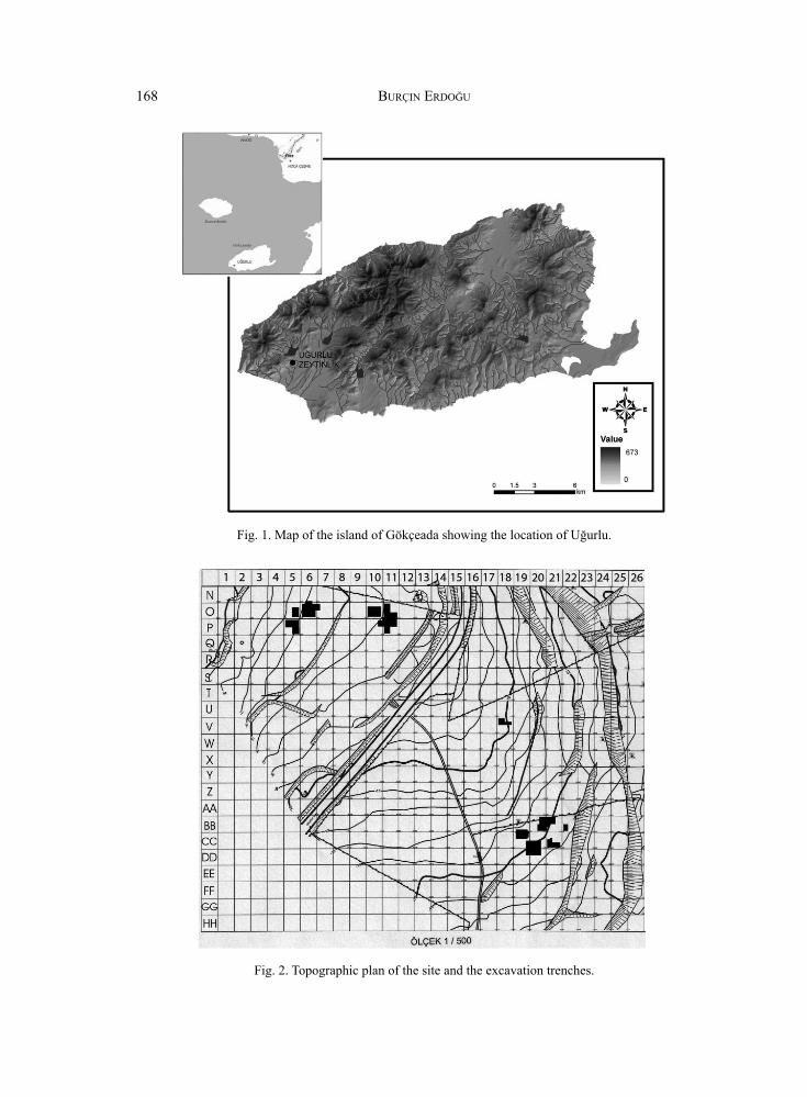
Fig. 2. Topographic plan of the site and the excavation trenches.

ANATOLICA XL, 2014 169
Fig. 3. Plan of the Neolithic Building 2.
Fig. 4. A relief decorated sherd from Phase V.
Fig. 5. A bone fi gurine head from Phase V.
Fig. 6. Bone awls recovered in a pit.

BURÇIN ERDOĞU170
Fig. 7. Partly excavated Neolithic building features from Phase IV.
Fig. 9. Pan-shaped vessels from Phase IV.
Fig. 10. Shell pendants and beads from Phase IV.
Fig. 8. Bone hooks from Phase IV.

ANATOLICA XL, 2014 171
Fig. 11. Selected pottery forms of Phase V.

BURÇIN ERDOĞU172
Fig. 12. Selected pottery forms ofPhase IV.
ANATOLICA XL, 2014 173
Fig. 13. Selected pottery from Phase IV.
BURÇIN ERDOĞU174
Fig. 16. Building 3 from Phase III.
Fig. 14. Macro blades from Balkan Flint. Fig. 15. An obsidian bullet core from Phase IV.
Fig. 17. Magnetometry data from the eastern part of the site, showing buried buildings.
Fig. 18. An anthropomorphic and a zoomorphic fi gurine from Phase III.

ANATOLICA XL, 2014 175
Fig. 19. Selected pottery forms of Phase III.

BURÇIN ERDOĞU176
Fig. 20. Selected pottery forms of Phase III.
ANATOLICA XL, 2014 177
Fig. 21. Building 1 from Phase II.
Fig. 22. Plan of the Chalcolithic Building 4 and a bull horn recovered in the entrance.
BURÇIN ERDOĞU178
Fig. 23. A fi gurine from Phase II.
Fig. 24. Characteristic Phase II sherds.
Fig. 25. Uğurlu Radiocarbon Dates.