GIS-based urban sustainability assessment: The case of Dammam city, Saudi Arabia
22
ARTICLE GIS-Based Urban Sustainability Assessment: The Case of Dammam City, Saudi Arabia HABIB M. ALSHUWAIKHAT & YUSUF A. AINA King Fahd University of Petroleum & Minerals, Dhahran, Saudi Arabia ABSTRACT This paper applies an integrated approach to assessing urban sustainability in Dammam City, Saudi Arabia. The approach, based on geographic information systems (GIS), involves the evaluation of the planning process, the master plan and the land use activities resulting from planning. It concludes that some aspects of sustainability are not addressed by the planning process and the plan document. The planning process and the plan document addressed economic sustainability issues more than social and environmental issues. The result of the GIS-based sustainability assessment of the study area produces similar findings. The paper develops a sustainable planning guidance and makes some recommendations based on the findings. Introduction The concept of sustainable development has been widely accepted as a laud- able goal to be achieved by different nations. The concept arose from the rec- ognition that the conventional economic imperative to maximize economic production must be accountable to an ecological imperative to protect the ecosphere, and a social equity imperative to minimize human suffering (Berke & Conroy, 2000). The concept seeks to give appropriate consider- ations to social, economic and environmental dimensions of developmental Local Environment Vol. 11, No. 2, 141–161, April 2006 Correspondence Address: Habib M. Alshuwaikhat, Department of City & Regional Planning, King Fahd University of Petroleum & Minerals, PO Box 1632, Dhahran 31261, Saudi Arabia. Email: [email protected] 1354-9839 Print=1469-6711 Online=06=020141-21 # 2006 Taylor & Francis DOI: 10.1080=13549830600558432
Transcript of GIS-based urban sustainability assessment: The case of Dammam city, Saudi Arabia
ARTICLE
GIS-Based Urban SustainabilityAssessment: The Case of Dammam
City, Saudi Arabia
HABIB M. ALSHUWAIKHAT & YUSUF A. AINA
King Fahd University of Petroleum & Minerals, Dhahran, Saudi Arabia
ABSTRACT This paper applies an integrated approach to assessing urban sustainabilityin Dammam City, Saudi Arabia. The approach, based on geographic informationsystems (GIS), involves the evaluation of the planning process, the master plan andthe land use activities resulting from planning. It concludes that some aspects ofsustainability are not addressed by the planning process and the plan document. Theplanning process and the plan document addressed economic sustainability issuesmore than social and environmental issues. The result of the GIS-based sustainabilityassessment of the study area produces similar findings. The paper develops asustainable planning guidance and makes some recommendations based on the findings.
Introduction
The concept of sustainable development has been widely accepted as a laud-able goal to be achieved by different nations. The concept arose from the rec-ognition that the conventional economic imperative to maximize economicproduction must be accountable to an ecological imperative to protect theecosphere, and a social equity imperative to minimize human suffering(Berke & Conroy, 2000). The concept seeks to give appropriate consider-ations to social, economic and environmental dimensions of developmental
Local EnvironmentVol. 11, No. 2, 141–161, April 2006
Correspondence Address: Habib M. Alshuwaikhat, Department of City & Regional Planning,King Fahd University of Petroleum & Minerals, PO Box 1632, Dhahran 31261, Saudi Arabia.Email: [email protected]
1354-9839 Print=1469-6711 Online=06=020141-21 # 2006 Taylor & FrancisDOI: 10.1080=13549830600558432
activities. The issues that are addressed by the dimensions of sustainabledevelopment are integral parts of human quality of life. Thus, betterquality of life could be ensured through sustainable development. The prin-ciples of sustainable development have become widely entrenched in environ-mental policies of different states. Despite the pervasiveness of the principlesof sustainable development in environmental policies, there is still a gapbetween theory and practice (Berke and Conroy, 2000; Briassoulis, 1999),since there is no precise framework for the interaction between differentdimensions of sustainability.
Agenda 21 was adopted by the Earth Summit in 1992 in order to translatethe agenda of sustainable development into action. Agenda 21 set goals forsocial and environmental sustainability, and governments were mandatedto develop plans to achieve the goals (UN, 1993). The significance of citiesin achieving sustainable development was recognized by Agenda 21 and‘Local Agenda 21’ programmes directed towards the cities and municipali-ties. In addition, different studies (Lake and Hanson, 2000; Mitlin andSatterthwaite, 1994; Newman, 1999) have indicated that the quest for sus-tainable development will be more fruitful if the process of ensuring sustain-ability is engendered in the cities. Thus, different frameworks andsustainability indicators have been developed to guide local implementationof Agenda 21 and foster sustainable cities. The concept of sustainability indi-cators is incorporated into sustainable development with a view to monitor-ing the status of progress towards sustainable development. Indicators serveas measures of progress (benchmarks) and they can be effective tools (means)for fostering sustainability if they are fully integrated into a sustainabilityappraisal program. The use of indicators to promote sustainability hasbeen constrained by lack of adequate data and capable tools for integratingthe data into a sustainability appraisal programme.
Sustainability Assessment: Spatial Dimension
Increasing number of studies have elaborated on the operationalization of theprinciples of sustainable development especially at the city level and quite anumber of authors have expounded on the different aspects of implementingand measuring urban sustainability. The spectrum of the studies ranges fromgiving workable definition to urban sustainability to monitoring and evaluat-ing sustainable cities. Also, due to the nature of most developmental activities(transboundary, spatially interdependent and hierarchical), the integration ofspatial dimension into sustainability appraisal and impact assessment hasbeen explored. The geographical pattern, scale and spatial hierarchy of devel-opmental processes influence the social, economic and environmentalimpacts of these processes. It is noted that sustainability is a process inspace, not a fixed or predetermined outcome, and sustainability should beapproached in terms of sustainable livelihoods, highlighting the conceptualcentrality of geographic scale (Center for Urban Policy and Research[CUPR], 2000). The study of the integration of spatial dimension intosustainability appraisal has broached the research into the utilization of
142 H. M. Alshuwaikhat & Y. A. Aina
geographic information systems (GIS) and related technologies (such asremote sensing) in assessing the impact of development activities on theenvironment and evaluating sustainability.
GIS as a spatial analytical tool has been noted to be very useful in monitor-ing and appraising urban sustainability. GIS has the capability to linklocation data with attributes and also perform spatial analysis on thesedata. Urban sustainability assessment involves measurement and evaluationof spatial data that can be handled to some extent by GIS. Apart from datamanipulation, integration and analysis, GIS could be used in visualizingdifferent scenarios of the indicators of sustainability. Thus, GIS is an essentialtool for evaluating urban sustainability. Experiences from empirical studies(Blaschke, 1997; 2001; Lautso et al., 2002) have shown that GIS andrelated technology could be very useful in urban sustainability assessmentand in the quest towards achieving sustainable cities. Indeed, the operationa-lisation of sustainable development locally and globally requires spatialthinking and spatially explicit approaches (Blaschke, 2001), that is,approaches that consider the spatial heterogeneity and interdependency ofdevelopmental processes and impacts. The trend of sustainability assessmentstudies is towards the development of a holistic approach that will integratethe different aspects of spatial planning into the appraisal (Bond et al., 2001).There is a need to integrate the evaluation of the planning process with theappraisal of the outcome of planning in order to improve the understandingof how planning could foster sustainable cities.
The Context of Saudi Arabia
In Saudi Arabia, the decision-making process is highly centralized. The plan-ning process is mainly a top–down process and the integration of the prin-ciples of sustainability (especially at the municipality level) into spatialplanning is still at an early stage. Municipal planning is coordinated by acentral body—the Ministry of Municipal and Rural Affairs (MOMRA). Asregards environmental issues, MOMRA is guided by the General Environ-mental Code, which mainly outlines environmental standards and EIA(Environmental Impact Assessment) guidelines. Consequently, environ-mental impacts of developmental activities are mainly considered at theproject level. Public participation is limited to passing public concernthrough the mass media to influence decisions. Also, there is limited publicaccess to EIA reports, since the reports are not published. The projectEIA falls short of the need to entrench the principles of sustainability in theplanning process and products.
It is noted by Alshuwaikhat and Al-Hussain (2001) in their study of Jubailindustrial city that the master plan has yet to cover some of the principles/indicators of sustainability. The implementation of sustainability principlesis limited to making general or broad statements on promoting sustainabilitywithout adequate planning measures to implement them. Given this back-ground, the paper attempts to explore an approach that will engender inte-grated sustainability appraisal through the evaluation of the planning
GIS-Based Urban Sustainability Assessment 143
process, the master plan and the land use activities resulting from planning.The study develops a framework of indicators for evaluating urban sustain-ability and assesses the sustainability of urban planning in the cityof Dammam, Saudi Arabia. It develops guidelines that could be adopted tointegrate the principles of sustainability into planning.
Method
Most of the studies on sustainability appraisal have focused on either theassessment of the planning process/plan (Berke & Conroy, 2000; Conroy,2003; Counsell, 1998; Bruff & Wood, 2000; Therivel, 1994) or the evalu-ation of the sustainability of land use activities (Abolina & Zilans, 2002;Porteny, 2002; Deal, 2001; Macoun et al., 2002). Unlike previous research,this paper explores an approach that integrates the assessment of the substan-tive and procedural aspects of development planning. It applies the differentassessment methods that have been developed from literature in evaluatingthe sustainability of the planning process, the plan document and the urbanland use. The assessments are based on data collected from both secondaryand primary sources. The main sources of data for the study are:
. Master plan documents.
. Secondary data collected from Dammam Municipality and data derivedand estimated from relevant publications.
. Interview with officials from Dammam Municipality who are in charge ofadministering the update of the Master Plan project (Group I) and repre-sentatives of the consulting firm and advisory and review committee(Group II) who are conducting and reviewing the project.
The tasks carried out by the study are divided into three as indicated above.The tasks involve the three aspects of plan making: the planning process, theplan document and the land use activities that resulted from the implemen-tation of the plan. The first task is the assessment of the planning processin Dammam to ascertain if sustainability principles have been integratedinto the process. The second task is to carry out a sustainability appraisalof the master plan document. The final task is to evaluate the sustainabilityof Dammam city applying GIS technology and sets of sustainabilityindicators.
Planning Process Survey
Interviews are conducted (with prepared questions) with 19 planners: eightadministrators and officials from the Urban Planning Department,Dammam Municipality (Group I), and 11 planners representing the consult-ing firm and advisory and review committee (Group II). The sample of GroupI represents 40% of the total employees of the Urban Planning Departmentand for Group II the sample represents 72% of the planners of the consultingfirm. The purpose of this interview is to make an evaluation of the integration
144 H. M. Alshuwaikhat & Y. A. Aina
of sustainability in the planning process. The relevant questions that areprepared for the interview sessions are framed around issues discussed inliterature such as the consideration of environmental effects of planningpolicies, integration of sustainability principles in the planning process,development of a system of indicators/targets, the adequacy of the insti-tutional framework, level of public participation, the development ofsustainability planning guidance, development of sustainability goals andobjectives and the collection of information on sustainability and relatedissues (Eggenberger & Partidario, 2000; Elling, 2000; Liang, 2002;Stoeglehner, 2004). Responses and comments made by the interviewees arenoted and the general direction of the planning process as per the integrationof sustainability is established.
Sustainability Appraisal of Master Plan
The master plan of Dammam city is examined and assessed on the integrationof sustainability in the plan document. A framework of sets of applicable sus-tainability indicators which is used for the assessment of the master plan isdeveloped by the study. The indicators are developed from literature(Office of the Deputy Prime Minister [ODPM], 2002; Florida SustainableCommunities Network [FSCN], 1999; UN Commission on SustainableDevelopment [CSD], 2002) and are classified based on the three majordimensions of sustainable development. The elements of the master planare studied and the criteria of assessing the master plan are developed fromthe sustainability indicators. Content analysis (Berke & Conroy, 2000;Bruff & Wood, 2000) is utilized for the evaluation to ensure systematicand objective assessment of the policies of the master plan. Qualitativeranking is used to grade the level of integration of different sustainability indi-cators in the master plan. The three ranks adopted are: ‘no coverage’ for acase where the principle is not explicitly considered by the plan, ‘limited cov-erage’ for a case where a sustainability principle/indicator is covered by theplan document but the plan does not make any policy statement on the sus-tainability principle and the principle is not included in the action plan, and‘policy level’ for a case where a sustainability principle/indicator is fullycovered and there is an explicit recommendation or policy statement on theprinciple.
GIS-Based Urban Sustainability Assessment
GIS technology is utilized to make an assessment of sustainability inDammam city. The spatial indicators used in the assessment include the per-centage of citizens who are exposed to an unacceptable level of air pollutants;percentage of land area that is utilized by transportation facilities (such asparking spaces); percentage of citizens who have access to health, openspaces and basic educational facilities; and percentage of the road networkwith pedestrian facilities (such as pavements). The land use density (whichis one of the measures of compactness) of the city is assessed using data on
GIS-Based Urban Sustainability Assessment 145
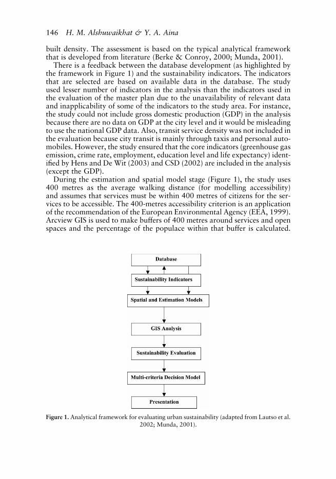
built density. The assessment is based on the typical analytical frameworkthat is developed from literature (Berke & Conroy, 2000; Munda, 2001).
There is a feedback between the database development (as highlighted bythe framework in Figure 1) and the sustainability indicators. The indicatorsthat are selected are based on available data in the database. The studyused lesser number of indicators in the analysis than the indicators used inthe evaluation of the master plan due to the unavailability of relevant dataand inapplicability of some of the indicators to the study area. For instance,the study could not include gross domestic production (GDP) in the analysisbecause there are no data on GDP at the city level and it would be misleadingto use the national GDP data. Also, transit service density was not included inthe evaluation because city transit is mainly through taxis and personal auto-mobiles. However, the study ensured that the core indicators (greenhouse gasemission, crime rate, employment, education level and life expectancy) ident-ified by Hens and De Wit (2003) and CSD (2002) are included in the analysis(except the GDP).
During the estimation and spatial model stage (Figure 1), the study uses400 metres as the average walking distance (for modelling accessibility)and assumes that services must be within 400 metres of citizens for the ser-vices to be accessible. The 400-metres accessibility criterion is an applicationof the recommendation of the European Environmental Agency (EEA, 1999).Arcview GIS is used to make buffers of 400 metres around services and openspaces and the percentage of the populace within that buffer is calculated.
Figure 1. Analytical framework for evaluating urban sustainability (adapted from Lautso et al.2002; Munda, 2001).
146 H. M. Alshuwaikhat & Y. A. Aina

In estimating the likely exposure of the citizens to air and noise pollutionsresulting from the volume of traffic along highway, noise and pollutantmodels (Transport and Road Research Institute [TRRI], 2002; Maithaniet al., 2000; Patania et al., 2001) are used to estimate the impact of transpor-tation on the environment, and the percentage of citizens affected is calcu-lated. For analysing the land redeveloped, use mix, open space and thedesignated area for preservation, a simple GIS analysis is used to computethe area of the land uses and the use mix index. This is carried out by selectingthe relevant parcels and calculating their area and their percentage of theoverall land area. The use mix index is calculated by summing the numberof non-residential parcels and finding their ratio to the residential parcels.
The numerical indicators are derived from the available data while thespatial indicators are derived from GIS analysis. The numerical and spatialindicators measurements for the study area are compared with a set of stan-dards which is mainly derived from the Organization for EconomicCooperation and Development (OECD) and standards recommended bythe United Nations Council on Sustainable Development. Due to lack ofextensive data on land use changes in the study area, the study made asimple comparison of the measurements derived from the study area withthe recommended standards instead of carrying out the multi-criteriadecision model (to compare scenarios) shown in the framework. Thecomparison showed the level of urban sustainability in the study area rela-tive to the recommended standards and indicated the aspects of urbansustainability that require some improvement.
Study Area
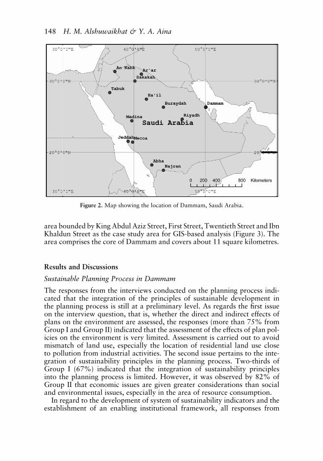
Dammam city is one of the largest and important administrative areas inSaudi Arabia. It is the capital of the Eastern Province and a major urbancentre in Dammam Metropolitan Area (DMA). Dammam is located on longi-tude 508 060 E and between latitude 268 060 N and 268 300 N (Figure 2). Thecity has witnessed one of the most spectacular urban growths in the Kingdom.The population of Dammam increased from about 14,000 in the 1940s to127,844 in 1974 and 478,000 in 2005. The population growth was due tooil production activities, the establishment of Dammam as the administrativecentre of Eastern Province and the development of economic infrastructure(such as King Abdul Aziz Sea Port) and recreational facilities.
The upsurge in population and economic activity has provided the thresholdfor a viable central business district (CBD) in Dammam. The density of theCBD residential land use ranges from over 50 dwelling units per hectare toaround 30 dwelling units per hectare for medium density and 10 dwellingunits per hectare in low density areas. Distinctive land use patterns havebeen established in Dammam based on the social and cultural characteristicsof the inhabitants. A traditional organic pattern of land development isevident in the older parts of the city while the newer sections are developedusing contemporary land subdivision and set-back of buildings (Ministry ofMunicipal and Rural Affairs [MOMRA], 1981). The study earmarked the
GIS-Based Urban Sustainability Assessment 147
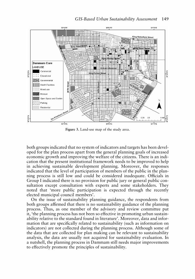
area bounded by King Abdul Aziz Street, First Street, Twentieth Street and IbnKhaldun Street as the case study area for GIS-based analysis (Figure 3). Thearea comprises the core of Dammam and covers about 11 square kilometres.
Results and Discussions
Sustainable Planning Process in Dammam
The responses from the interviews conducted on the planning process indi-cated that the integration of the principles of sustainable development inthe planning process is still at a preliminary level. As regards the first issueon the interview question, that is, whether the direct and indirect effects ofplans on the environment are assessed, the responses (more than 75% fromGroup I and Group II) indicated that the assessment of the effects of plan pol-icies on the environment is very limited. Assessment is carried out to avoidmismatch of land use, especially the location of residential land use closeto pollution from industrial activities. The second issue pertains to the inte-gration of sustainability principles in the planning process. Two-thirds ofGroup I (67%) indicated that the integration of sustainability principlesinto the planning process is limited. However, it was observed by 82% ofGroup II that economic issues are given greater considerations than socialand environmental issues, especially in the area of resource consumption.
In regard to the development of system of sustainability indicators and theestablishment of an enabling institutional framework, all responses from
Figure 2. Map showing the location of Dammam, Saudi Arabia.
148 H. M. Alshuwaikhat & Y. A. Aina
both groups indicated that no system of indicators and targets has been devel-oped for the plan process apart from the general planning goals of increasedeconomic growth and improving the welfare of the citizens. There is an indi-cation that the present institutional framework needs to be improved to helpin achieving sustainable development planning. Moreover, the responsesindicated that the level of participation of members of the public in the plan-ning process is still low and could be considered inadequate. Officials inGroup I indicated there is no provision for public jury or general public con-sultation except consultation with experts and some stakeholders. Theynoted that ‘more public participation is expected through the recentlyelected municipal council members’.
On the issue of sustainability planning guidance, the respondents fromboth groups affirmed that there is no sustainability guidance of the planningprocess. Thus, as one member of the advisory and review committee putit, ‘the planning process has not been so effective in promoting urban sustain-ability relative to the standard found in literature’. Moreover, data and infor-mation that are specifically related to sustainability (such as information onindicators) are not collected during the planning process. Although some ofthe data that are collected for plan making can be relevant to sustainabilityanalysis, the data are usually not acquired for sustainability evaluation. Ina nutshell, the planning process in Dammam still needs major improvementsto effectively promote the principles of sustainability.
Figure 3. Land-use map of the study area.
GIS-Based Urban Sustainability Assessment 149
Evaluation of the Dammam Master Plan
The results of the evaluation of the Dammam master plan showed that theplan document does not adequately address the issue of sustainability(Table 1). Although the result showed that about 18 of the 36 indicatorsare covered at the policy level by the master plan, critical examination ofthe result revealed the inadequacy in the coverage. The economic indicatorsare more covered than the social and environmental indicators. All the econ-omic indicators (GDP, investment, employment, jobs/housing balance) areelaborated upon in the master plan and policy recommendations are madeon the improvement of the economy of the city and the economic welfareof the citizenry. The coverage of other social and environmental indicatorsranges from ‘no coverage’ to ‘policy level’. Even the policy statements ofsome of the indicators that are fully covered do not embrace all the requiredaspects of sustainability pertaining to the indicators. For instance, the policyon water consumption only elaborated on meeting the water demand of thepopulace, making no explicit statement on the desirability of reducing waterconsumption per capita. The reduction of water consumption per capitacould be very relevant to sustainability issues if the huge amount spent onthe provision of water and the environmental impacts of desalinization areconsidered. In addition, some of the indicators are fully covered at thepolicy level but are not implemented. For example, public transit isrecommended in the plan document but the inhabitants of the city stilldepend mainly on taxis and automobiles for mobility.
The inadequacy of the master plan in fully addressing the different dimen-sions of sustainability is more evident if the coverage of the core indicators(GDP, greenhouse gases, employment, crime rate, education level and lifeexpectancy) is considered. Policy statements are made on three of the indi-cators (GDP, employment and education level) while other indicators arenot covered at all. This also buttresses the point that the plan addresses econo-mic issues rather more than social and environmental issues. By and large,similarity to the planning process, the master plan addresses the issuesrelevant to sustainable development in a rather traditional approach devoidof the rigorous approach required by contemporary literature. This showsthat more efforts have to be applied in the review of the master plan tomake it more sustainable and these efforts should start from the planningprocess, which greatly influences the plan document.
Sustainability Assessment of Dammam City Core
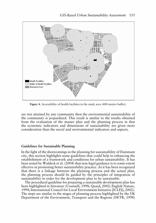
The results of the GIS-based assessment of sustainability in Dammam arepresented in Table 2. Figure 4 shows the buffer analysis of access of the popu-lace to dispensaries and primary health facilities. Using a buffer of 400 metresfor all facilities, the analysis shows that about 73% of the population hasaccess to basic health facilities and this fall short of the standard (80%).Thus, there is need to improve the access of the populace to health facilitiesin the study area. The results on the access of the populace to open space and
150 H. M. Alshuwaikhat & Y. A. Aina
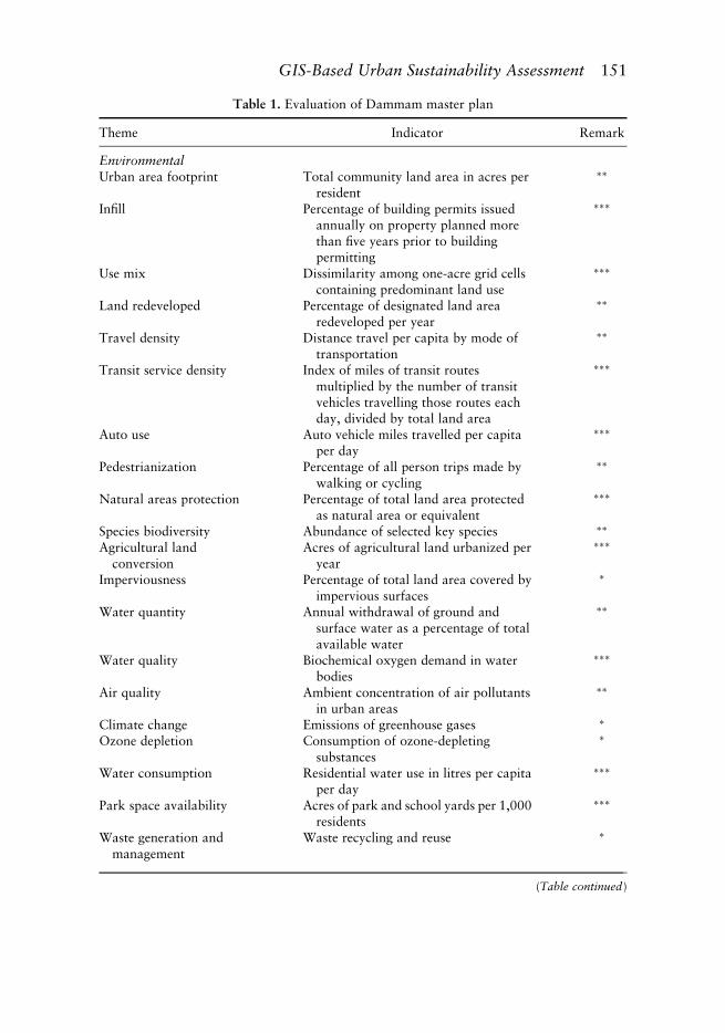
Table 1. Evaluation of Dammam master plan
Theme Indicator Remark
EnvironmentalUrban area footprint Total community land area in acres per
resident
��
Infill Percentage of building permits issuedannually on property planned morethan five years prior to buildingpermitting
���
Use mix Dissimilarity among one-acre grid cellscontaining predominant land use
���
Land redeveloped Percentage of designated land arearedeveloped per year
��
Travel density Distance travel per capita by mode oftransportation
��
Transit service density Index of miles of transit routesmultiplied by the number of transitvehicles travelling those routes eachday, divided by total land area
���
Auto use Auto vehicle miles travelled per capitaper day
���
Pedestrianization Percentage of all person trips made bywalking or cycling
��
Natural areas protection Percentage of total land area protectedas natural area or equivalent
���
Species biodiversity Abundance of selected key species ��
Agricultural landconversion
Acres of agricultural land urbanized peryear
���
Imperviousness Percentage of total land area covered byimpervious surfaces
�
Water quantity Annual withdrawal of ground andsurface water as a percentage of totalavailable water
��
Water quality Biochemical oxygen demand in waterbodies
���
Air quality Ambient concentration of air pollutantsin urban areas
��
Climate change Emissions of greenhouse gases �
Ozone depletion Consumption of ozone-depletingsubstances
�
Water consumption Residential water use in litres per capitaper day
���
Park space availability Acres of park and school yards per 1,000residents
���
Waste generation andmanagement
Waste recycling and reuse �
(Table continued)
GIS-Based Urban Sustainability Assessment 151
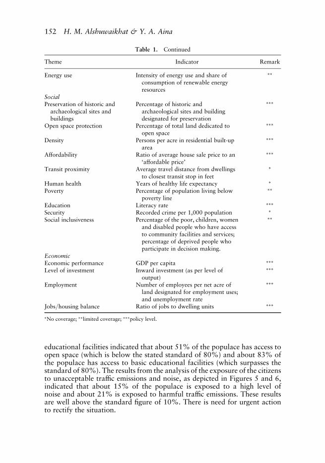
educational facilities indicated that about 51% of the populace has access toopen space (which is below the stated standard of 80%) and about 83% ofthe populace has access to basic educational facilities (which surpasses thestandard of 80%). The results from the analysis of the exposure of the citizensto unacceptable traffic emissions and noise, as depicted in Figures 5 and 6,indicated that about 15% of the populace is exposed to a high level ofnoise and about 21% is exposed to harmful traffic emissions. These resultsare well above the standard figure of 10%. There is need for urgent actionto rectify the situation.
Table 1. Continued
Theme Indicator Remark
Energy use Intensity of energy use and share ofconsumption of renewable energyresources
��
SocialPreservation of historic and
archaeological sites andbuildings
Percentage of historic andarchaeological sites and buildingdesignated for preservation
���
Open space protection Percentage of total land dedicated toopen space
���
Density Persons per acre in residential built-uparea
���
Affordability Ratio of average house sale price to an‘affordable price’
���
Transit proximity Average travel distance from dwellingsto closest transit stop in feet
�
Human health Years of healthy life expectancy �
Poverty Percentage of population living belowpoverty line
��
Education Literacy rate ���
Security Recorded crime per 1,000 population �
Social inclusiveness Percentage of the poor, children, womenand disabled people who have accessto community facilities and services;percentage of deprived people whoparticipate in decision making.
��
EconomicEconomic performance GDP per capita ���
Level of investment Inward investment (as per level ofoutput)
���
Employment Number of employees per net acre ofland designated for employment uses;and unemployment rate
���
Jobs/housing balance Ratio of jobs to dwelling units ���
�No coverage; ��limited coverage; ���policy level.
152 H. M. Alshuwaikhat & Y. A. Aina
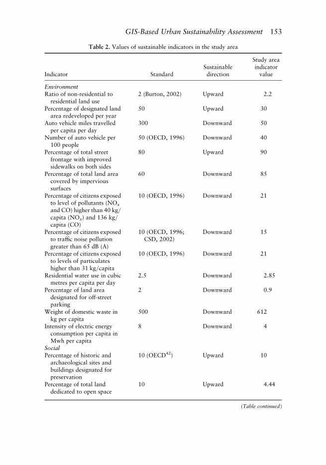
Table 2. Values of sustainable indicators in the study area
Indicator StandardSustainabledirection
Study areaindicator
value
EnvironmentRatio of non-residential to
residential land use2 (Burton, 2002) Upward 2.2
Percentage of designated landarea redeveloped per year
50 Upward 30
Auto vehicle miles travelledper capita per day
300 Downward 50
Number of auto vehicle per100 people
50 (OECD, 1996) Downward 40
Percentage of total streetfrontage with improvedsidewalks on both sides
80 Upward 90
Percentage of total land areacovered by impervioussurfaces
60 Downward 85
Percentage of citizens exposedto level of pollutants (NOx
and CO) higher than 40 kg/capita (NOx) and 136 kg/capita (CO)
10 (OECD, 1996) Downward 21
Percentage of citizens exposedto traffic noise pollutiongreater than 65 dB (A)
10 (OECD, 1996;CSD, 2002)
Downward 15
Percentage of citizens exposedto levels of particulateshigher than 31 kg/capita
10 (OECD, 1996) Downward 21
Residential water use in cubicmetres per capita per day
2.5 Downward 2.85
Percentage of land areadesignated for off-streetparking
2 Downward 0.9
Weight of domestic waste inkg per capita
500 Downward 612
Intensity of electric energyconsumption per capita inMwh per capita
8 Downward 4
SocialPercentage of historic and
archaeological sites andbuildings designated forpreservation
10 (OECD42) Upward 10
Percentage of total landdedicated to open space
10 Upward 4.44
(Table continued)
GIS-Based Urban Sustainability Assessment 153
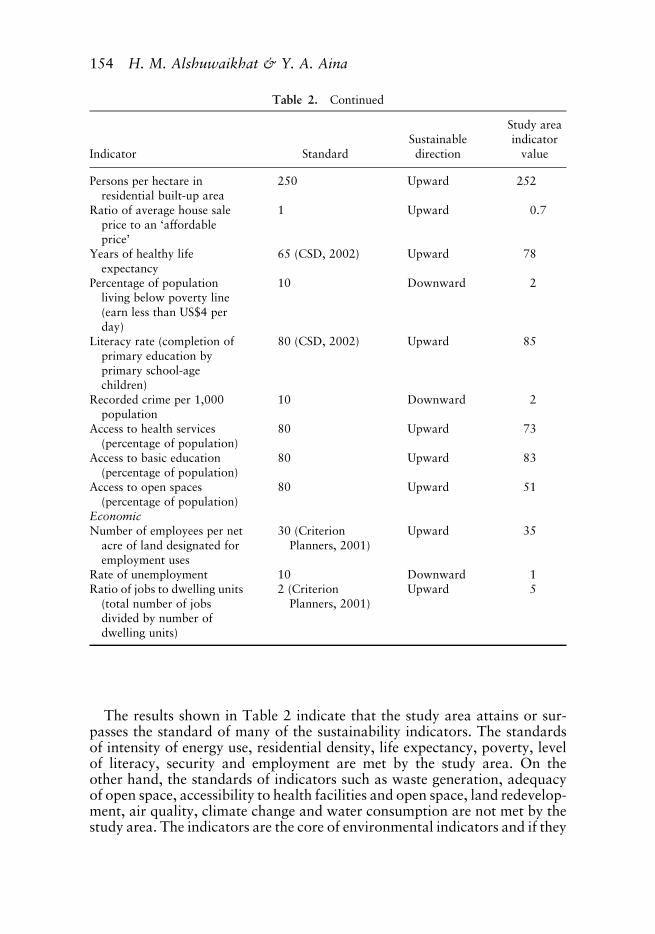
The results shown in Table 2 indicate that the study area attains or sur-passes the standard of many of the sustainability indicators. The standardsof intensity of energy use, residential density, life expectancy, poverty, levelof literacy, security and employment are met by the study area. On theother hand, the standards of indicators such as waste generation, adequacyof open space, accessibility to health facilities and open space, land redevelop-ment, air quality, climate change and water consumption are not met by thestudy area. The indicators are the core of environmental indicators and if they
Table 2. Continued
Indicator StandardSustainabledirection
Study areaindicator
value
Persons per hectare inresidential built-up area
250 Upward 252
Ratio of average house saleprice to an ‘affordableprice’
1 Upward 0.7
Years of healthy lifeexpectancy
65 (CSD, 2002) Upward 78
Percentage of populationliving below poverty line(earn less than US$4 perday)
10 Downward 2
Literacy rate (completion ofprimary education byprimary school-agechildren)
80 (CSD, 2002) Upward 85
Recorded crime per 1,000population
10 Downward 2
Access to health services(percentage of population)
80 Upward 73
Access to basic education(percentage of population)
80 Upward 83
Access to open spaces(percentage of population)
80 Upward 51
EconomicNumber of employees per net
acre of land designated foremployment uses
30 (CriterionPlanners, 2001)
Upward 35
Rate of unemployment 10 Downward 1Ratio of jobs to dwelling units
(total number of jobsdivided by number ofdwelling units)
2 (CriterionPlanners, 2001)
Upward 5
154 H. M. Alshuwaikhat & Y. A. Aina
are not attained by any community then the environmental sustainability ofthe community is jeopardized. This result is similar to the results obtainedfrom the evaluation of the master plan and the planning process in thatthe economic indicators and dimensions of sustainability are given moreconsideration than the social and environmental indicators and aspects.
Guidelines for Sustainable Planning
In the light of the shortcomings in the planning for sustainability of Dammamcity, this section highlights some guidelines that could help in enhancing theestablishment of a framework and conditions for urban sustainability. It hasbeen noted by Waldeck et al. (2004) that non-legal guidance is to some extenteffective in promoting better sustainability practice. As it has been recognizedthat there is a linkage between the planning process and the actual plan,the planning process should be guided by the principles of integration ofsustainability in order for the development plan to be sustainable.
The procedural guideline for preparing a sustainable development plan hasbeen highlighted in literature (Counsell, 1998; Quaid, 2002; English Nature,1994; International Council for Local Environment Initiative [ICLEI], 2002).The steps are similar to the stages of planning process highlighted by the UKDepartment of the Environment, Transport and the Regions (DETR, 1998)
Figure 4. Accessibility of health facilities in the study area (400-metres buffer).
GIS-Based Urban Sustainability Assessment 155
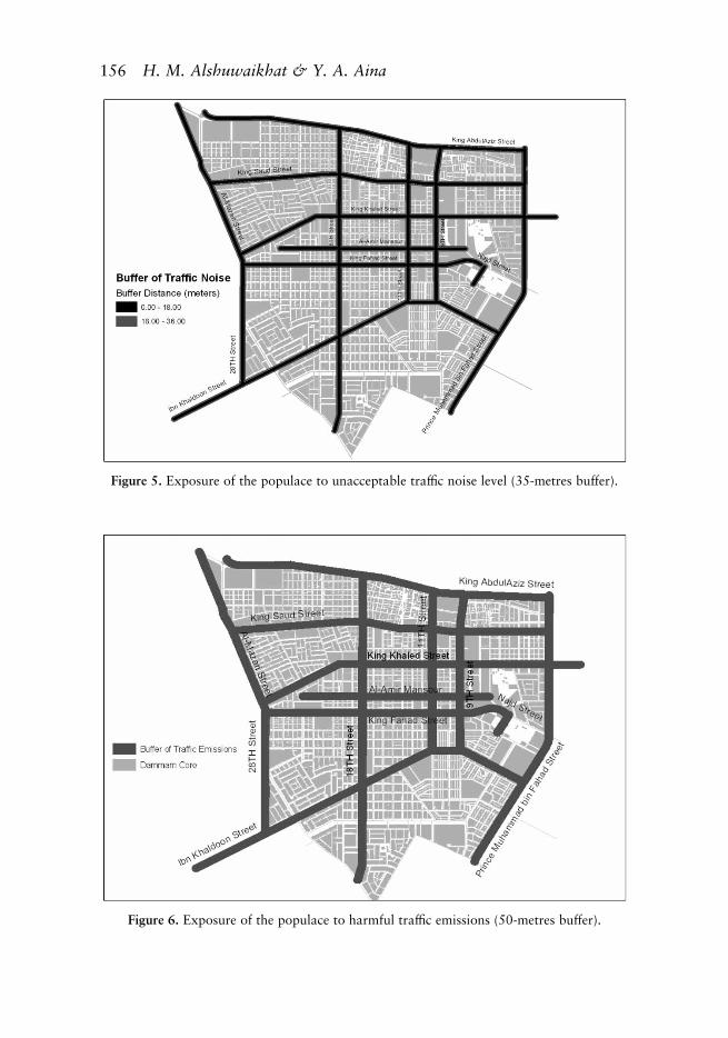
Figure 6. Exposure of the populace to harmful traffic emissions (50-metres buffer).
Figure 5. Exposure of the populace to unacceptable traffic noise level (35-metres buffer).
156 H. M. Alshuwaikhat & Y. A. Aina
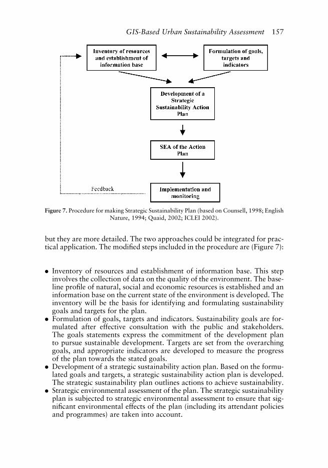
but they are more detailed. The two approaches could be integrated for prac-tical application. The modified steps included in the procedure are (Figure 7):
. Inventory of resources and establishment of information base. This stepinvolves the collection of data on the quality of the environment. The base-line profile of natural, social and economic resources is established and aninformation base on the current state of the environment is developed. Theinventory will be the basis for identifying and formulating sustainabilitygoals and targets for the plan.
. Formulation of goals, targets and indicators. Sustainability goals are for-mulated after effective consultation with the public and stakeholders.The goals statements express the commitment of the development planto pursue sustainable development. Targets are set from the overarchinggoals, and appropriate indicators are developed to measure the progressof the plan towards the stated goals.
. Development of a strategic sustainability action plan. Based on the formu-lated goals and targets, a strategic sustainability action plan is developed.The strategic sustainability plan outlines actions to achieve sustainability.
. Strategic environmental assessment of the plan. The strategic sustainabilityplan is subjected to strategic environmental assessment to ensure that sig-nificant environmental effects of the plan (including its attendant policiesand programmes) are taken into account.
Figure 7. Procedure for making Strategic Sustainability Plan (based on Counsell, 1998; EnglishNature, 1994; Quaid, 2002; ICLEI 2002).
GIS-Based Urban Sustainability Assessment 157

. Implementation and monitoring. The strategic sustainability action plan isimplemented with adequate monitoring and evaluation. The progressmade towards the achievement of the goals and targets of the strategic sus-tainability action plan is measured.
In the context of Saudi Arabia, early integration of sustainability principlesinto the planning process can be achieved by establishing a Strategic Environ-mental Assessment process in MOMRA (Alshuwaikhat & Aina, 2004). Thiswill ensure that environmental assessment is interlinked with city planning,since MOMRA is the central body that has the mandate for planning thecities and rural areas and providing infrastructure.
Concluding Remarks
This paper has attempted to develop a holistic framework for evaluatingurban sustainability. The framework incorporates the assessment of theplanning process, the outcome of the planning process (the plan) and theresult of the process (land use activities). The framework is applied in acase study to assess the sustainability of Dammam city through a GIS-based approach. The approach assesses the sustainability of the citybased on spatial and numerical indicators. The planning process and themaster plan are also evaluated. The evaluation of the planning processshows that the integration of sustainability in plan making at Dammamis still at the traditional level and there is limited public participation.The GIS-based evaluation shows that some aspects of urban sustainabilityneed to be addressed in Dammam. Issues related to economic sustainabilityare addressed more than social and environmental issues.
At this juncture, it is pertinent to note that the results from the analysishave to be interpreted with caution, since only the core of Dammam is con-sidered in the study. It is well known that city centres sometimes have thehighest employment opportunities and access to essential facilities. Citycentres also have the highest density of residential development. Simplebuffer analysis which returns the maximum level of accessibility was usedby the study. A more rigorous buffer analysis might yield different results.Another point is that the study did not assess the capacity of facilities inrelation to the served population in the accessibility analysis. The studyassessed only access to the facilities by the populace; if the capacities of thefacilities are considered, the result might be different. In addition, some ofthe data used for the assessment are estimated from the master plan andmight be different from the actual situation in the study area. Nevertheless,the sustainability trends indicated by the overall result are valid and couldbe very relevant to sustainable planning in Dammam.
The paper has demonstrated the importance of the spatial dimension inurban sustainability through GIS analysis. It also shows the need for accurateand current data in such analysis. Sustainability assessment is a data-intensiveexercise whose great benefits could be highly undermined by inadequate data.Further studies could be carried out in the study area to make a detail analysis
158 H. M. Alshuwaikhat & Y. A. Aina
of the measured indicators, such as a study of the capacities of the socialfacilities in relation to the number of people within their service areas.Urban dynamics modelling tools (such as Cellular Automata) could be usedby future studies to analyse and model spatial changes in the study areaand their impacts on sustainability. Also, future studies can examine thepossibility of quantitatively assessing the sustainability of the master/devel-opment plan. The following recommendations are made from this study onimproving the sustainability of the planning process, the plan documentand the land use activities in the study area:
. Sustainability goals and objectives should be developed for the planningprocess and the plan document.
. The centralized institutional framework is a constraint on public partici-pation and the involvement of the local authority. The municipal councilshould play greater role in the planning process.
. One of the constraints of the planning process is the lack of sustainableplanning guidance. The General Environment Code does not provide gui-dance on ensuring sustainable planning (especially at the municipalitylevel). The code should be revised to include a framework ensuring thatsustainability principles are integrated into planning.
. More consideration should be given to environmental dimensions in theplanning process and the plan document.
. The level of public participation should be improved by addressing the con-straints on public participation. The issues to be addressed include the levelof environmental awareness of the citizens, accessibility of the populace toenvironmental assessment reports, and a framework for public partici-pation in the planning process.
. A system of sustainable indicators and targets should be developed for theplanning process, and adequate data and information collection systemshould be put in place to make necessary data available for sustainableplanning.
. The system of plan implementation should be improved, especially in theaspect of the implementation of sustainability programmes such aspublic transit.
Acknowledgements
The authors acknowledge the support of King Fahd University of Petroleumand Minerals in carrying out this study. The comments made by the refereesare also appreciated.
References
Abolina, K. & Zilans, A. (2002) Evaluation of sustainability in specific sectors in Latvia, Environment,
Development and Sustainability, 4, pp. 299–314.
Alshuwaikhat, H. M. & Aina, Y. A. (2004) Sustainable cities: implementation of Strategic Environmental
Assessment in Saudi Arabian municipalities, Journal of Environmental Planning and Management,
47(2), pp. 303–311.
GIS-Based Urban Sustainability Assessment 159

Alshuwaikhat, H. & Al-Hussain, N. (2001) Sustainable indicators in master plans: towards sustainable
cities in Saudi Arabia—the case of Jubail Industrial City, in: Ministry of Municipal and Rural
Affairs, Proceedings of Performance in Municipalities First Meeting, October 30–31, 2001,
Amanat AlRiyadh, Riyadh, Saudi Arabia, pp. 1–37.
Berke, R. P. & Conroy, M. M. (2000) Are we planning for sustainable development?, Journal of the
American Planning Association, 66(1), pp. 21–33.
Blaschke, T. (1997) Sustainability with GIS? Towards a proactive nature conservation approach, in:
J. Johnston & M. Gomarasca (Eds) New Developments in GIS (Ann Arbor, Ann Arbor Press).
Blaschke, T. (2001) GIS-based regionalization of indicators and ecobalances for a sustainable regional
planning, in: F. Prettenthaler (Ed.) Human Dimensions Research in Austria and Central European
Countries (Graz, University of Graz).
Bond, R., Curran, J., Kirkpatrick, C., Lee, N. & Francis, P. (2001) Integrated impact assessment for
sustainable development: a case study approach, World Development, 29(6), pp. 1011–1024.
Briassoulis, H. (1999) Who plans whose sustainability? Alternative roles for planners, Journal of Environ-
mental Planning and Management, 42(6), pp. 889–903.
Bruff, G. E. & Wood, A. P. (2000) Local sustainable development: land-use planning’s contribution to
modern local government, Journal of Environmental Planning and Management, 43(4), pp.
519–539.
Burton, E. (2002) Measuring urban compactness in UK towns and cities, Environment and Planning B, 29,
pp. 219–250.
Conroy, M. M. (2003) The process of planning of sustainable development: dimensions, comparisons, and
insights, International Journal of Sustainable Development, 6(4), pp. 460–477.
Counsell, D. (1998) Sustainable development and structure plans in England and Wales: a review of
current practice, Journal of Environmental Planning and Management, 41(2), pp. 177–194.
Criterion Planners (2001) INDEX Demo: Software for Community Indicators—Users Guide (Portland,
OR, Criterion Planners/Engineers).
CSD (2002) Indicators of Sustainable Development: Guidelines and Methodologies (New York, United
Nations).
CUPR (2000) Towards a comprehensive geographical perspective on urban sustainability, Final Report of
the 1998 National Science Foundation Workshop on Urban Sustainability, Rutgers, NJ.
Deal, B. (2001) Ecological urban dynamics: the convergence of spatial modeling and sustainability, Build-
ing Research and Information, 29(5), pp. 381–393.
DETR (1998) Planning for Sustainable Development: Towards Better Practice (London, HMSO).
EEA (1999) Information tools for environmental policy under conditions of complexity, <http://reports.
eea.eu.int/index_table>.
Eggenberger, M. & Partidario, M. R. (2000) Development of a framework to assist the integration of
environmental, social and economic issues in spatial planning, Impact Assessment and Project
Appraisal, 18(3), pp. 201–207.
Elling, B. (2000) Integration of strategic environmental assessment into regional spatial planning, Impact
Assessment and Project Appraisal, 18(3), pp. 233–243.
English Nature (1994) Sustainability in Practice (Peterborough, England).
FSCN (1999) FSCN Index: Software for Sustainable Community Indicators (Tallahassee, FL, DCA).
Hens, L. & De Wit, J. (2003) The development of indicators and core indicators for sustainable develop-
ment: a state of the art review, International Journal of Sustainable Development, 6(4), pp. 436–459.
ICLEI (2002) A Local Government handbook: Accelerating Community Sustainability in the 21st Century
(Toronto, Ontario).
Lake, R. W. & Hanson, S. (2000) Needed: geographic research on urban sustainability, Urban Geography,
21(1), pp. 1–4.
Lautso, K., Spiekermann, K. & Wegener, M. (2002) Modelling policies for urban sustainability. Paper
presented at the 42nd Congress of the European Regional Science Association, August 27–31,
2002, Dortmund, Germany.
160 H. M. Alshuwaikhat & Y. A. Aina
Liang, C. (2002) Sustainability appraisal in the strategic planning process, International Association of
Impact Assessment (IAIA), Proceedings of the 22nd Annual Conference of the IAIA on Impact Assess-
ment for Informed Decision Making, June 15–21, 2002, The Hague, The Netherlands, pp. 167–176.
Macoun, T., Mitchell, G. & Huovila, P. (2002) Measuring urban sustainability: the challenge of
integrating assessment methods and indicators, EC Bequest Workshop, April 18–20, 2002, Lisbon.
Maithani, S., Sokhi, B. S., Subudhi, P. A. & Herath, K. B. (2000) Environmental effects of urban traffic—a
case study of Jaipur City, <http://www.gisdevelopment.net/application/utility/transport/utili-
tytr0023pf.htm>.
Mitlin, D. & Satterthwaite, D. (1994) Cities and sustainable development. Discussion paper for UN
Global Forum, held in Manchester (IIED, London).
MOMRA (1981) Existing conditions—Dammam Metropolitan Area. Technical Report, Riyadh.
Munda, G. (2001) Indicators and evaluation tools for the assessment of urban sustainability. Working
Paper, University of Barcelona, Barcelona.
Newman, P. W. G. (1999) Sustainability and cities: extending the metabolism model, Landscape and
Urban Planning, 44, pp. 219–226.
ODPM (2002) Draft Guidance on the Strategic Environmental Assessment (London, ODPM).
OECD (1996) Environmental Indicators: A Review of Selected Central and Eastern European Countries
(Paris).
Patania, F. G., Siracusa, A. & Gagliano, A. (2001) Air pollution drop by the technique of urban traffic
integrated control system in Catania city (Italy), in: L. J. Sucharov & C. A. Brebbia (Eds) Urban trans-
port and the Environment in 21st Century (Southampton, England, WIT Press).
Portney, E. K. (2002) Taking sustainability cities seriously: a comparative analysis of twenty-four US cities,
Local Environment, 7(4), pp. 363–380, <http://www.surveying.salford.ac.uk/resources/lisbon/
papers/thomas.pdf\>.
Quaid, A. (2002) The sustainability inventory: a tool to assist US municipalities advance towards sustain-
ability, Local Environment, 7(4), pp. 447–452.
Stoeglehner, G (2004) Integrating strategic environmental assessment into community development
plans—a case study from Austria, European Environment, 14, pp. 58–72.
Therivel, R (1994) Environmental appraisal of development plans in practice, Built Environment, 20(4),
pp. 321–331.
TRRI (2002) Calculation of Road Traffic Noise: A Simple Survey Method (Vilnius, Lithuania).
United Nations (1993) Earth Summit Agenda 21: The United Nations Programme of Action from Rio
(New York, United Nations Department of Public Information).
Waldeck, S., Morrison-Saunders, A. & Annandale, D. (2004) Effectiveness of non-legal EIA guidance from
the perspective of consultants in Western Australia, Impact Assessment and Project Appraisal, 21(3),
pp. 251–256.
GIS-Based Urban Sustainability Assessment 161