Geospatial Technology: A Tool to Aid in the Elimination of Malaria in Bangladesh
12
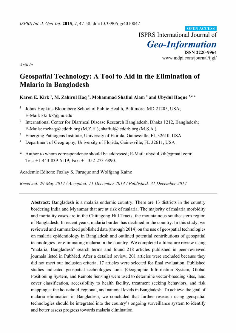
ISPRS Int. J. Geo-Inf. 2015, 4, 47-58; doi:10.3390/ijgi4010047 ISPRS International Journal of Geo-Information ISSN 2220-9964 www.mdpi.com/journal/ijgi/ Article Geospatial Technology: A Tool to Aid in the Elimination of Malaria in Bangladesh Karen E. Kirk 1 , M. Zahirul Haq 2 , Mohammad Shafiul Alam 2 and Ubydul Haque 3,4, * 1 Johns Hopkins Bloomberg School of Public Health, Baltimore, MD 21205, USA; E-Mail: [email protected] 2 International Center for Diarrheal Disease Research Bangladesh, Dhaka 1212, Bangladesh; E-Mails: [email protected] (M.Z.H.); [email protected] (M.S.A.) 3 Emerging Pathogens Institute, University of Florida, Gainesville, FL 32610, USA 4 Department of Geography, University of Florida, Gainesville, FL 32611, USA * Author to whom correspondence should be addressed; E-Mail: [email protected]; Tel.: +1-443-839-6119; Fax: +1-352-273-6890. Academic Editors: Fazlay S. Faruque and Wolfgang Kainz Received: 29 May 2014 / Accepted: 11 December 2014 / Published: 31 December 2014 Abstract: Bangladesh is a malaria endemic country. There are 13 districts in the country bordering India and Myanmar that are at risk of malaria. The majority of malaria morbidity and mortality cases are in the Chittagong Hill Tracts, the mountainous southeastern region of Bangladesh. In recent years, malaria burden has declined in the country. In this study, we reviewed and summarized published data (through 2014) on the use of geospatial technologies on malaria epidemiology in Bangladesh and outlined potential contributions of geospatial technologies for eliminating malaria in the country. We completed a literature review using “malaria, Bangladesh” search terms and found 218 articles published in peer-reviewed journals listed in PubMed. After a detailed review, 201 articles were excluded because they did not meet our inclusion criteria, 17 articles were selected for final evaluation. Published studies indicated geospatial technologies tools (Geographic Information System, Global Positioning System, and Remote Sensing) were used to determine vector-breeding sites, land cover classification, accessibility to health facility, treatment seeking behaviors, and risk mapping at the household, regional, and national levels in Bangladesh. To achieve the goal of malaria elimination in Bangladesh, we concluded that further research using geospatial technologies should be integrated into the country’s ongoing surveillance system to identify and better assess progress towards malaria elimination. OPEN ACCESS
Transcript of Geospatial Technology: A Tool to Aid in the Elimination of Malaria in Bangladesh
ISPRS Int. J. Geo-Inf. 2015, 4, 47-58; doi:10.3390/ijgi4010047
ISPRS International Journal of
Geo-Information ISSN 2220-9964
www.mdpi.com/journal/ijgi/
Article
Geospatial Technology: A Tool to Aid in the Elimination of Malaria in Bangladesh
Karen E. Kirk 1, M. Zahirul Haq 2, Mohammad Shafiul Alam 2 and Ubydul Haque 3,4,*
1 Johns Hopkins Bloomberg School of Public Health, Baltimore, MD 21205, USA;
E-Mail: [email protected] 2 International Center for Diarrheal Disease Research Bangladesh, Dhaka 1212, Bangladesh;
E-Mails: [email protected] (M.Z.H.); [email protected] (M.S.A.) 3 Emerging Pathogens Institute, University of Florida, Gainesville, FL 32610, USA 4 Department of Geography, University of Florida, Gainesville, FL 32611, USA
* Author to whom correspondence should be addressed; E-Mail: [email protected];
Tel.: +1-443-839-6119; Fax: +1-352-273-6890.
Academic Editors: Fazlay S. Faruque and Wolfgang Kainz
Received: 29 May 2014 / Accepted: 11 December 2014 / Published: 31 December 2014
Abstract: Bangladesh is a malaria endemic country. There are 13 districts in the country
bordering India and Myanmar that are at risk of malaria. The majority of malaria morbidity
and mortality cases are in the Chittagong Hill Tracts, the mountainous southeastern region
of Bangladesh. In recent years, malaria burden has declined in the country. In this study, we
reviewed and summarized published data (through 2014) on the use of geospatial technologies
on malaria epidemiology in Bangladesh and outlined potential contributions of geospatial
technologies for eliminating malaria in the country. We completed a literature review using
“malaria, Bangladesh” search terms and found 218 articles published in peer-reviewed
journals listed in PubMed. After a detailed review, 201 articles were excluded because they
did not meet our inclusion criteria, 17 articles were selected for final evaluation. Published
studies indicated geospatial technologies tools (Geographic Information System, Global
Positioning System, and Remote Sensing) were used to determine vector-breeding sites, land
cover classification, accessibility to health facility, treatment seeking behaviors, and risk
mapping at the household, regional, and national levels in Bangladesh. To achieve the goal of
malaria elimination in Bangladesh, we concluded that further research using geospatial
technologies should be integrated into the country’s ongoing surveillance system to identify
and better assess progress towards malaria elimination.
OPEN ACCESS
ISPRS Int. J. Geo-Inf. 2015, 4 48
Keywords: malaria; Bangladesh; GIS; GPS; remote sensing
1. Introduction
Malaria is a major public health problem in many developing countries, including Bangladesh.
In 2012, the official number of laboratory confirmed malaria cases in the country was 29,522 with 11
confirmed malaria deaths [1]. Thirteen million people are living in malaria risk areas in 13 of the
country’s 64 administrative districts [2]. The Bangladesh National Malaria Control Program (NMCP),
which is responsible for overseeing malaria control activities at the national level, has had some success
in controlling malaria with a reduction in prevalence of all malaria in the country by 65% (95% CI: 65-66)
between 2008 and 2012 [1,3]. Between 2008 and 2012, the NMCP, through the support of the Global
Fund, implemented in the 13 endemic districts, malaria control programs, including test and treat and
the distribution of long lasting insecticide-treated nets (LLINs) [1]. During this timeframe, the
prevalence rate in these 13 endemic districts decreased from 6.2 cases per 1000 population in 2008 to
2.1 cases per 1000 population in 2012 [1]. This steep decline in malaria prevalence has been attributed
to the increase distribution of LLINs [1]. After successful implementation of its malaria control program
in certain regions of the country, Bangladesh has started to eliminate malaria in eight of the 13 malaria
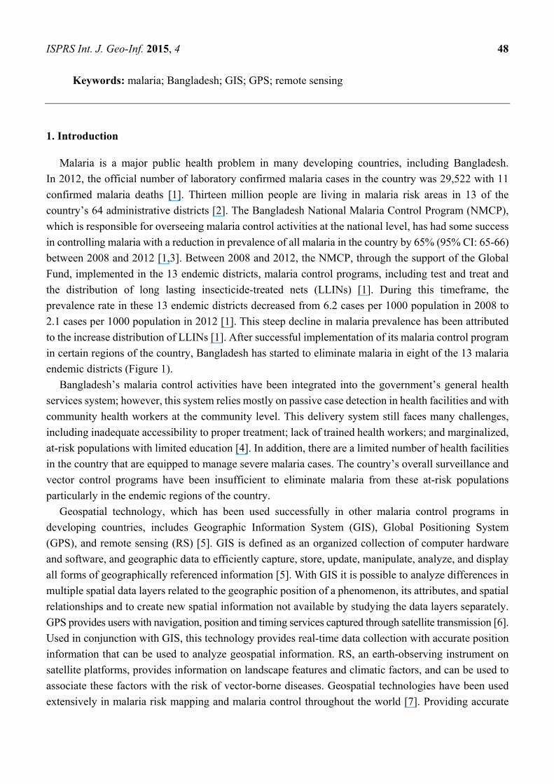
endemic districts (Figure 1).
Bangladesh’s malaria control activities have been integrated into the government’s general health
services system; however, this system relies mostly on passive case detection in health facilities and with
community health workers at the community level. This delivery system still faces many challenges,
including inadequate accessibility to proper treatment; lack of trained health workers; and marginalized,
at-risk populations with limited education [4]. In addition, there are a limited number of health facilities
in the country that are equipped to manage severe malaria cases. The country’s overall surveillance and
vector control programs have been insufficient to eliminate malaria from these at-risk populations
particularly in the endemic regions of the country.
Geospatial technology, which has been used successfully in other malaria control programs in
developing countries, includes Geographic Information System (GIS), Global Positioning System
(GPS), and remote sensing (RS) [5]. GIS is defined as an organized collection of computer hardware
and software, and geographic data to efficiently capture, store, update, manipulate, analyze, and display
all forms of geographically referenced information [5]. With GIS it is possible to analyze differences in
multiple spatial data layers related to the geographic position of a phenomenon, its attributes, and spatial
relationships and to create new spatial information not available by studying the data layers separately.
GPS provides users with navigation, position and timing services captured through satellite transmission [6].
Used in conjunction with GIS, this technology provides real-time data collection with accurate position
information that can be used to analyze geospatial information. RS, an earth-observing instrument on
satellite platforms, provides information on landscape features and climatic factors, and can be used to
associate these factors with the risk of vector-borne diseases. Geospatial technologies have been used
extensively in malaria risk mapping and malaria control throughout the world [7]. Providing accurate
ISPRS Int. J. Geo-Inf. 2015, 4 49
malaria risk maps can effectively guide the allocation of malaria resources and interventions in
developing countries [8].
Figure 1. Malaria prevalence in Bangladesh in 2008, and progress in malaria control from
2009 to 2012 *. * For 2009–2012, red areas show the regions with the largest decreases in malaria
prevalence. (Z-score: A statistically positive Z-score indicates high rates and a negative Z-score indicates of
low rates).
Geospatial technology has been previously implemented in Bangladesh to develop risk mapping in
parts of the country. In this study, we investigated the recent progress of malaria mapping in Bangladesh
with GIS, GPS, and RS, and identified potential future applications and contributions of geospatial
technologies to eliminate malaria in the country.
2. Materials and Methods
2.1. Study Area
Approximately 98% of all malaria morbidity and mortality cases reported in Bangladesh are located
in 13 malaria endemic districts along the India and Myanmar borders. These districts are situated in
densely forested, hilly areas with an average altitude of 500 meters above sea level. Eight of the districts,
ISPRS Int. J. Geo-Inf. 2015, 4 50
which are considered hyperendemic, are located in the country’s northern region. The three districts with
the highest malaria prevalence rates are Bandarban, Khagrachari, and Rangamati districts, located in the
southwestern area of the country, in the Chittagong Hill Tracts (CHT) region, home to 1.3 million
people [1–3]. CHT topographically encompasses hilly forests, lakes, rivers, canals, and waterfalls that
provide an excellent breeding ground for Anopheline species, the vector responsible for carrying malaria
parasites. Of the 35 Anopheline species found in the country, at least 26 were reported to be present in
the CHT region in recent times. More than 10 of these vectors have been implicated, through laboratory
testing, with the malaria parasite [9]. Historically, Anopheles minimus and An. Baimaii [10] were the
most abundant and efficient vectors in the area. Due to habitat destruction (deforestation) for the
expansion of human settlements and the introduction of irrigation systems among the farmlands, these
two species have declined in abundance and have been replaced by a number of plain land vector species
(Anopheles philippinensis, An. vagus, An. anularis, An. aconitus, An. sundaicus) [11,12].
2.2. Data Search
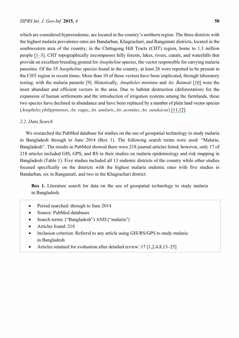
We researched the PubMed database for studies on the use of geospatial technology to study malaria
in Bangladesh through to June 2014 (Box 1). The following search terms were used: “Malaria,
Bangladesh”. The results in PubMed showed there were 218 journal articles listed; however, only 17 of
218 articles included GIS, GPS, and RS in their studies on malaria epidemiology and risk mapping in
Bangladesh (Table 1). Five studies included all 13 endemic districts of the country while other studies
focused specifically on the districts with the highest malaria endemic rates with five studies in
Bandarban, six in Rangamati, and two in the Khagrachari district.
Box 1. Literature search for data on the use of geospatial technology to study malaria
in Bangladesh.
• Period searched: through to June 2014
• Source: PubMed databases
• Search terms: (“Bangladesh”) AND (“malaria”)
• Articles found: 218
• Inclusion criterion: Referral to any article using GIS/RS/GPS to study malaria
in Bangladesh
• Articles retained for evaluation after detailed review: 17 [1,2,4,8,13–25]
ISPRS Int. J. Geo-Inf. 2015, 4 51
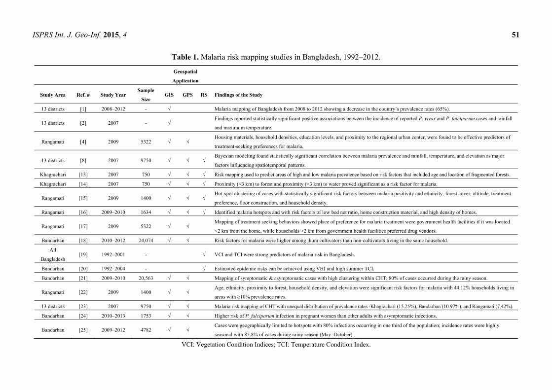
Table 1. Malaria risk mapping studies in Bangladesh, 1992–2012.
Geospatial
Application
Study Area Ref. # Study Year Sample
Size GIS GPS RS Findings of the Study
13 districts [1] 2008–2012 - √ Malaria mapping of Bangladesh from 2008 to 2012 showing a decrease in the country’s prevalence rates (65%).
13 districts [2] 2007 - √ Findings reported statistically significant positive associations between the incidence of reported P. vivax and P. falciparum cases and rainfall
and maximum temperature.
Rangamati [4] 2009 5322 √ √ Housing materials, household densities, education levels, and proximity to the regional urban center, were found to be effective predictors of
treatment-seeking preferences for malaria.
13 districts [8] 2007 9750 √ √ √ Bayesian modeling found statistically significant correlation between malaria prevalence and rainfall, temperature, and elevation as major
factors influencing spatiotemporal patterns.
Khagrachari [13] 2007 750 √ √ √ Risk mapping used to predict areas of high and low malaria prevalence based on risk factors that included age and location of fragmented forests.
Khagrachari [14] 2007 750 √ √ √ Proximity (<3 km) to forest and proximity (>3 km) to water proved significant as a risk factor for malaria.
Rangamati [15] 2009 1400 √ √ √ Hot-spot clustering of cases with statistically significant risk factors between malaria positivity and ethnicity, forest cover, altitude, treatment
preference, floor construction, and household density.
Rangamati [16] 2009–2010 1634 √ √ √ Identified malaria hotspots and with risk factors of low bed net ratio, home construction material, and high density of homes.
Rangamati [17] 2009 5322 √ √ Mapping of treatment seeking behaviors showed place of preference for malaria treatment were government health facilities if it was located
<2 km from the home, while households >2 km from government health facilities preferred drug vendors.
Bandarban [18] 2010–2012 24,074 √ √ Risk factors for malaria were higher among jhum cultivators than non-cultivators living in the same household.
All
Bangladesh [19] 1992–2001 - √ VCI and TCI were strong predictors of malaria risk in Bangladesh.
Bandarban [20] 1992–2004 - √ Estimated epidemic risks can be achieved using VHI and high summer TCI.
Bandarban [21] 2009–2010 20,563 √ √ Mapping of symptomatic & asymptomatic cases with high clustering within CHT; 80% of cases occurred during the rainy season.
Rangamati [22] 2009 1400 √ √ Age, ethnicity, proximity to forest, household density, and elevation were significant risk factors for malaria with 44.12% households living in
areas with ≥10% prevalence rates.
13 districts [23] 2007 9750 √ √ Malaria risk mapping of CHT with unequal distribution of prevalence rates -Khagrachari (15.25%), Bandarban (10.97%), and Rangamati (7.42%).
Bandarban [24] 2010–2013 1753 √ √ Higher risk of P. falciparum infection in pregnant women than other adults with asymptomatic infections.
Bandarban [25] 2009–2012 4782 √ √ Cases were geographically limited to hotspots with 80% infections occurring in one third of the population; incidence rates were highly
seasonal with 85.8% of cases during rainy season (May–October).
VCI: Vegetation Condition Indices; TCI: Temperature Condition Index.
ISPRS Int. J. Geo-Inf. 2015, 4 52
3. Results and Discussion
3.1. Results
Through June 2014, there were 17 published studies that have used geospatial technologies (GIS, GPS
and/or RS) to understand and predict malaria risks [1,2,8,13–21], develop malaria risk maps, [21,22] and
provide findings for targeted interventions strategies in Bangladesh. To supply feedback to the NMCP,
national malaria risk maps were produced [2,23]. Long-term average monthly rainfalls and
minimum/maximum temperatures ranges were interpolated, and elevation and vegetation coverage data
were obtained using satellite imagery. GIS was also employed to develop maps of posterior distributions
of predicted prevalence [13]. In one study, environmental variables were extracted from RS data to
predict malaria risk at the national level [8]. Since 2008, the NMCP has confirmed a reduction of malaria
in all endemic districts including CHT, which reported prevalence rate above 10%, the highest in the
country [1,23].
There were four published studies based in CHT that used satellite images for land cover
classification, risk mapping, and GIS mapping to investigate spatial relationships between malaria and
risk factors. In addition, GIS and GPS were used to understand malaria incidence and prevalence rates
with both active and passive surveillance at the individual and household levels. In another study, in the
Bandarban District, a cohort framework of over 4000 households was established and mapped for
a longitudinal study [21]. Four studies prepared risk maps in the same district focusing on pregnant
women and jhum cultivators—subsistent farmers that use slash and burn methods of farming [18,24].
There were six malaria risk mapping studies conducted in Rajasthali, a sub-district of Rangamati district,
which in 2007 had the highest (36%) malaria prevalence rates in the country [23]. All households
(n = 5322) studied in this sub-district were mapped using GPS and a household census was conducted
collecting socio-demographic information, linking this data to geocoded household locations [4]. In
addition, all health facilities and providers were mapped including the locations of community health
workers, satellite clinics, hospitals, and drug stores [4]. Spatial models were explored in these different
studies using ArcGIS, SaTScan, SAGA, and WinBugs mapping software. SAGA was used to extract
topographical wetness (a measure of the extent of flow accumulation at the given point of the topographic
surface) and elevation for all households surveyed in the Rangamati district. Satellite images using Advanced
Spaceborne Thermal Emission and Reflection Radiometer digital elevation models was used to create
water flow direction, accumulation, watershed, stream network, and stream link layers. Using cross-sectional
and longitudinal data from these studies, spatial modeling of treatment seeking behaviors [17] and risk
maps [8,13,16] were established and used to determine the progress and challenges to the NMCP.
3.2. Discussion
Geospatial technologies have been used for malaria risk mapping in Bangladesh since 2006 with
the updating of these maps in 2008 and 2012 by the NMCP in collaboration with other research
institutions [1,23]. Bangladesh has also developed spatial models for treatment seeking behavior,
hydrological and prediction analysis using geostatistical modeling. Findings have confirmed that
Bangladesh is closer to malaria elimination than ever before. The implementation of risk mapping with
ISPRS Int. J. Geo-Inf. 2015, 4 53
the NMCP, focusing particularly on targeted interventions in high risk areas in CHT, could provide
decision makers crucial information for their elimination strategies [16].
While GIS, GPS and RS have all shown to be beneficial in providing data for malaria elimination
strategies in both Bangladesh and other developing countries, improvements are still needed in the data
collection process and dissemination of findings from the different malaria studies. Using household
surveys, malaria hot-spots (the clustering of high malaria incidence cases) data, and more readily available
spatial malaria databases along with a better understanding by decision makers on the usages and capabilities
of these spatial analytical methods, can lead to more successful malaria elimination strategies [26]. The
use of GIS and GPS systems connected to mobile phones [27] can also aid in malaria case detection and
delivery of health services particularly in remote areas of CHT where tracking and analyzing malaria
prevalence data can often be difficult [28]. With changing malaria epidemiology and reduced burden of
malaria throughout the country, Bangladesh needs to focus on CHT region elimination strategies to
address malaria hot-spots efficiently and effectively as well as reduce malaria importation, insecticide
resistance, drug resistance [29], and the mapping of asymptomatic carrier [24]. Geospatial technology
can provide the necessary data to assist in these elimination strategies.
Bangladesh NMCP has an extensive network of community health workers in all endemic districts
but travel is often challenging in certain areas because of the difficult terrain and dense forest cover with
few roads and limited waterways, which is often the only way to travel in these remote regions during
the wet season. Thus, people living in these isolated areas are often deprived of many essential health
services including proper malaria prevention and treatment methods. Careful planning using geospatial
technologies to locate hot-spots particularly in the endemic districts of Bangladesh will be crucial in
achieving malaria elimination goals in a cost effective way by focusing resourcing in areas with high
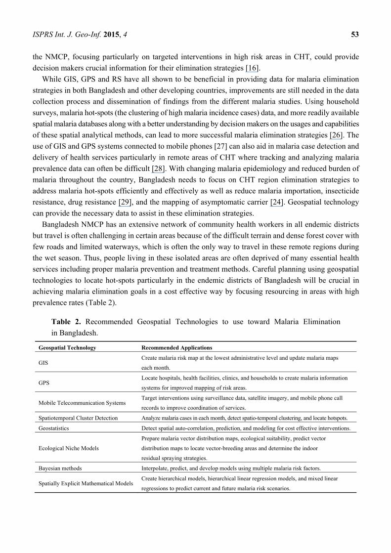
prevalence rates (Table 2).
Table 2. Recommended Geospatial Technologies to use toward Malaria Elimination
in Bangladesh.
Geospatial Technology Recommended Applications
GIS Create malaria risk map at the lowest administrative level and update malaria maps
each month.
GPS Locate hospitals, health facilities, clinics, and households to create malaria information
systems for improved mapping of risk areas.
Mobile Telecommunication Systems Target interventions using surveillance data, satellite imagery, and mobile phone call
records to improve coordination of services.
Spatiotemporal Cluster Detection Analyze malaria cases in each month, detect spatio-temporal clustering, and locate hotspots.
Geostatistics Detect spatial auto-correlation, prediction, and modeling for cost effective interventions.
Ecological Niche Models
Prepare malaria vector distribution maps, ecological suitability, predict vector
distribution maps to locate vector-breeding areas and determine the indoor
residual spraying strategies.
Bayesian methods Interpolate, predict, and develop models using multiple malaria risk factors.
Spatially Explicit Mathematical Models Create hierarchical models, hierarchical linear regression models, and mixed linear
regressions to predict current and future malaria risk scenarios.
ISPRS Int. J. Geo-Inf. 2015, 4 54
With the abundance of malaria vector breeding sites in the CHT region of the country, RS can be used
to look at vector’s oviposition site/breeding ground and thereby predict their abundance. There has been
a proliferation of some vector species in this region with an increase in standing water, particularly
during the rainy seasons, from deforestation for agricultural purposes, providing more breeding sites for
the mosquitos [30]. It has been noted that during the dry and malaria off-seasons, cases were found
clustered around natural streams and canals in the CHT region [25]. Locating land use patterns across
the vector breeding sites and using remotely sensed climatic environmental factors, particularly temperature,
humidity, and rainfall as they correlate to malaria outbreaks, could provide useful information on the
planning of vector control in this region. This same approach was applied in Indonesia and revealed
malaria vector abundance in certain areas where malaria control programs were then implemented with
much success [31]. The topographic variable can also be remotely-sensed to predict malaria vector’s
breeding site in malaria endemic areas [32].
It should be noted that Bangladesh performed much better in malaria mapping of its endemic areas
compared to its neighboring malaria endemic countries, India and Myanmar. Countries engage in malaria
control [33–36] and elimination [37] may learn from Bangladeshi experiences. Spatial analytical studies
have shown a higher incidence of malaria in areas adjacent to these international borders [26]. To sustain
recent gains in malaria elimination, the Bangladesh NMCP should look at cross-border movement
between Bangladesh and India and Myanmar. The mapping of malaria prevalence as well as surveying
for household movement along the borders can also be used to identify hotspots in these areas.
Based on the findings of these studies, the following are recommendations for the NMCP to implement
to further the malaria elimination program in Bangladesh: identify high-risk malaria zones to determine
spatial distribution; combine surveillance with GIS and weather pattern database to determine geographic
and climate risks [21]; conduct further studies to understand malaria transmission among impacted
populations during high transmission season; develop strategies to interrupt transmission in low transmission
settings [18]; use mass screening in stable hot-spot areas to identify asymptomatic reservoirs and provide
treatment to reduce the malaria burden [16]; promote malaria test and treatment services particularly
among vulnerable populations, such as children under five years and jhum cultivators [18]; monitor
asymptomatic malaria particularly among pregnant women living in low-intensity malaria transmission
areas [24]; target interventions at fine spatial scales for malaria control programs; improve equity of access
to interventions [15]; improve collaboration between researchers using geostatistical techniques and
malaria control managers; target high malaria transmission areas [8] to provide more GPS, GIS, and RS
strategies to characterize spatial heterogeneity with malaria risk at a fine scale and identify high risk areas
that have not been studied [19]; and lastly focus on interventions to be targeted and timed according to risk
profiles of endemic areas [38].
4. Conclusions
Bangladesh has made significant advancements in malaria reduction and has successfully used
geospatial technologies at various levels for risk mapping and targeted interventions in the 13 malaria
endemic districts. However, with the continued reduction in malaria burden along with the country’s
goal of elimination, this technology should be prioritized by the NMCP in their elimination strategy.
More effort should be made by the NMCP to incorporate these strategies with improved surveillance
ISPRS Int. J. Geo-Inf. 2015, 4 55
systems, particularly in the remote areas of the CHT region, to detect and address malaria hotspots.
Incorporating malaria ecology with spatial data along with malaria incidence maps, land usage maps,
and population distributions can be helpful for decision makers to establish elimination strategies in
these malaria endemic areas. Rapid advances in technology and analytical methods have allowed the
development of spatial decision support systems, which can improve the elimination programs by enabling
more accurate and timely resource allocation in high-risk areas. Geospatial technologies can play an
important role in identifying inequities in health services in endemic areas of the country. GIS, GPS and
RS are proven powerful tools that can provide important data and should be integrated with active and
passive surveillance systems to achieve malaria elimination in Bangladesh.
Acknowledgments
This work was funded in part by the Emerging Pathogens Institute at the University of Florida and
the College of Liberal Arts and Sciences, as part of the University of Florida Preeminence Initiative.
Author Contributions
K.E.K. and U.H. conceived the study design, analyzed data and drafted the manuscript. M.Z.H. and
M.S.A. contributed in writing and critically reviewed the manuscript.
Conflicts of Interest
The authors declare no conflict of interest.
References
1. Haque, U.; Overgaard, H.J.; Clements, A.C.; Norris, D.E.; Islam, N.; Karim, J.; Roy, S.; Haque, W.;
Kabir, M.; Smith, D.L.; et al. Malaria burden and control in Bangladesh and prospects for elimination:
An epidemiological and economic assessment. Lancet Glob. Health 2014, 2, e98–e105.
2. Reid, H.L.; Haque, U.; Roy, S.; Islam, N.; Clements, A.C. Characterizing the spatial
and temporal variation of malaria incidence in Bangladesh, 2007. Malar. J. 2012, 11,
doi:10.1186/1475-2875-11-170.
3. National Malaria Control Program. About NMCP in Bangladesh. Available online:
http://www.Nmcp.Info/nmcp.Aspx (accessed on 9 June 2014).
4. Haque, U.; Hashizume, M.; Sunahara, T.; Hossain, S.; Ahmed, S.M.; Haque, R.; Yamamoto, T.;
Glass, G.E. Progress and challenges to control malaria in a remote area of Chittagong hill tracts,
Bangladesh. Malar. J. 2010, 9, doi:10.1186/1475-2875-9-156.
5. What is a GIS? Available online: http://www.Volusia.Org/gis/whatsgis.Htm (accessed on 11
September 2014).
6. GPS. Available online: http://www.Gps.Gov/systems/gps/ (accessed on 28 May 2014).
7. Bautista, C.T.; Chan, A.S.; Ryan, J.R.; Calampa, C.; Roper, M.H.; Hightower, A.W.; Magill, A.J.
Epidemiology and spatial analysis of malaria in the northern Peruvian Amazon. Am. J. Trop. Med.
Hyg. 2006, 75, 1216–1222.
ISPRS Int. J. Geo-Inf. 2015, 4 56
8. Reid, H.; Haque, U.; Clements, A.C.A.; Tatem, A.J.; Vallely, A.; Ahmed, S.M.; Islam, A.; Haque, R.
Mapping malaria risk in Bangladesh using bayesian geostatistical models. Am. J. Trop. Med. Hyg.
2010, 83, 861–867.
9. Alam, M.S.; Chakma, S.; Khan, W.A.; Glass, G.E.; Mohon, A.N.; Elahi, R.; Norris, L.C.; Podder, M.P.;
Ahmed, S.; Haque, R.; et al. Diversity of anopheline species and their plasmodium infection status
in rural Bandarban, Bangladesh. Parasit. Vector 2012, 5, doi:10.1186/1756-3305-5-150.
10. Khan, A.Q.; Talibi, S.A. Epidemiological assessment of malaria transmission in an endemic area of
East Pakistan and the significance of congenital immunity. Bull. World Health Organ. 1972, 46,
783–792.
11. Elias, M.; Dewan, R.; Ahmed, R. Vectors of malaria in Bangladesh. J. Prev. Soc. Med. 1982, 1, 20–28.
12. Alam, M.; Khan, M.; Chaudhury, N.; Deloer, S.; Nazib, F.; Bangali, A.; Haque, R. Prevalence of
anopheline species and their plasmodium infection status in epidemic-prone border areas of Bangladesh.
Malar. J. 2010, 9, doi:10.1186/1475-2875-9-15.
13. Haque, U.; Magalhaes, R.J.S.; Reid, H.L.; Clements, A.C.A.; Ahmed, S.M.; Islam, A.; Yamamoto, T.;
Haque, R.; Glass, G.E. Spatial prediction of malaria prevalence in an endemic area of Bangladesh.
Malar. J. 2010, 9, doi:10.1186/1475-2875-9-120.
14. Haque, U.; Huda, M.; Hossain, A.; Ahmed, S.M.; Moniruzzaman, M.; Haque, R. Spatial malaria
epidemiology in Bangladeshi highlands. Malar. J. 2009, 8, doi:10.1186/1475-2875-8-185.
15. Haque, U.; Sunahara, T.; Hashizume, M.; Shields, T.; Yamamoto, T.; Haque, R.; Glass, G.E.
Malaria prevalence, risk factors and spatial distribution in a hilly forest area of Bangladesh.
PLoS One 2011, 6, doi:10.1371/journal.pone.0018908.
16. Haque, U.; Glass, G.E.; Bomblies, A.; Hashizume, M.; Mitra, D.; Noman, N.; Haque, W.;
Kabir, M.M.; Yamamoto, T.; Overgaard, H.J. Risk factors associated with clinical malaria episodes
in Bangladesh: A longitudinal study. Am. J. Trop. Med. Hyg. 2013, 88, 727–732.
17. Haque, U.; Scott, L.M.; Hashizume, M.; Fisher, E.; Haque, R.; Yamamoto, T.; Glass, G.E.
Modelling malaria treatment practices in Bangladesh using spatial statistics. Malar. J. 2012, 11,
doi:10.1186/1475-2875-11-63.
18. Galagan, S.R.; Prue, C.S.; Khyang, J.; Khan, W.A.; Ahmed, S.; Ram, M.; Alam, M.S.; Haq, M.Z.;
Akter, J.; Streatfield, P.K.; et al. The practice of jhum cultivation and its relationship to plasmodium
falciparum infection in the Chittagong hill districts of Bangladesh. Am. J. Trop. Med. Hyg. 2014,
91, 374–383.
19. Rahman, A.; Kogan, F.; Roytman, L. Short report: Analysis of malaria cases in Bangladesh with
remote sensing data. Am. J. Trop. Med. Hyg. 2006, 74, 17–19.
20. Rahman, A.; Krakauer, N.; Roytman, L.; Goldberg, M.; Kogan, F. Application of advanced very
high resolution radiometer (AVHRR)-based vegetation health indices for estimation of malaria
cases. Am. J. Trop. Med. Hyg. 2010, 82, 1004–1009.
21. Khan, W.A.; Sack, D.A.; Ahmed, S.; Prue, C.S.; Alam, M.S.; Haque, R.; Khyang, J.; Ram, M.;
Akter, J.; Nyunt, M.M.; et al. Mapping hypoendemic, seasonal malaria in rural Bandarban,
Bangladesh: A prospective surveillance. Malar. J. 2011, 10, doi:10.1186/1475-2875-10-124.
22. Haque, U.; Soares Magalhaes, R.J.; Mitra, D.; Kolivras, K.N.; Schmidt, W.P.; Haque, R.;
Glass, G.E. The role of age, ethnicity and environmental factors in modulating malaria risk in
Rajasthali, Bangladesh. Malar. J. 2011, 10, doi:10.1186/1475-2875-10-367.
ISPRS Int. J. Geo-Inf. 2015, 4 57
23. Haque, U.; Ahmed, S.M.; Hossain, S.; Huda, M.; Hossain, A.; Alam, M.S.; Mondal, D.;
Khan, W.A.; Khalequzzaman, M.; Haque, R. Malaria prevalence in endemic districts of Bangladesh.
PLoS One 2009, 4, e6737.
24. Khan, W.A.; Galagan, S.R.; Prue, C.S.; Khyang, J.; Ahmed, S.; Ram, M.; Alam, M.S.; Haq, M.Z.;
Akter, J.; Glass, G.; et al. Asymptomatic plasmodium falciparum malaria in pregnant women in the
Chittagong hill districts of Bangladesh. PLoS One 2014, 9, doi:10.1371/journal.pone.0098442.
25. Glass, G.; Alam, M.S.; Khan, W.A.; Sack, D.A.; Sullivan, D.J. Spatial clustering of malaria cases
during low-transmission season in Kuhalong, Bangladesh. In Proceedings of the 13th Ascon
Conference, Dhaka, Bangladesh, 28 March 2011.
26. Clement A.C.; Reid, H.; Kelly, G.; Hay, S. Further shrinking the malaria map: How can geospatial
science help to achieve malaria elimination? Lancet Infect. Dis. 2013, 13, 709–718.
27. Tatem, A.J.; Huang, Z.; Narib, C.; Kumar, U.; Kandula, D.; Pindolia, D.K.; Smith, D.L.; Cohen, J.M.;
Graupe, B.; Uusiku, P.; et al. Integrating rapid risk mapping and mobile phone call record data for
strategic malaria elimination planning. Malar. J. 2014, 13, doi:10.1186/1475-2875-13-52.
28. Prue, C.S.; Shannon, K.L.; Khyang, J.; Edwards, L.J.; Ahmed, S.; Ram, M.; Shields, T.; Hossain, M.S.;
Glass, G.E.; Nyunt, M.M.; et al. Mobile phones improve case detection and management of malaria
in rural Bangladesh. Malar. J. 2013, 12, doi:10.1186/1475-2875-12-48.
29. Haque, U.; Glass, G.E.; Haque, W.; Islam, N.; Roy, S.; Karim, J.; Noedl, H. Antimalarial drug
resistance in Bangladesh, 1996–2012. Trans. R. Soc. Trop. Med. Hyg. 2013, 107, 745–752.
30. Alam, M.S.; Chakma, S.; Al-Amin, H.M.; Elahi, R.; Mohon, A.N.; Khan, W.A.; Haque, R.;
Glass, G.E.; Sack, D.A.; Sullivan, D.J.; et al. Role of artificial containers as breeding sites for anopheline
mosquitoes in Malaria hypo endemic areas of rural Bandarban, Bangladesh: Evidence form a
baseline survey. In Proceedings of the Astmh Conference 2012, Atlanta, GA, USA, 11–15
November 2012.
31. Stoops, C.A.; Gionar, Y.R.; Shinta; Sismadi, P.; Rachmat, A.; Elyazar, I.F.; Sukowati, S.
Remotely-sensed land use patterns and the presence of anopheles larvae (diptera: Culicidae) in
Sukabumi, West Java, Indonesia. J. Vector. Ecol. 2008, 33, 30–39.
32. Nmor, J.C.; Sunahara, T.; Goto, K.; Futami, K.; Sonye, G.; Akweywa, P.; Dida, G.; Minakawa, N.
Topographic models for predicting malaria vector breeding habitats: Potential tools for vector
control managers. Parasit. Vector 2013, 6, doi:10.1186/1756-3305-6-14.
33. Kamuliwo, M.; Chanda, E.; Haque, U.; Mwanza-Ingwe, M.; Sikaala, C.; Katebe-Sakala, C.;
Mukonka, V.M.; Norris, D.E.; Smith, D.L.; Glass, G.E.; et al. The changing burden of malaria and
association with vector control interventions in Zambia using district-level surveillance data,
2006–2011. Malar. J. 2013, 12, doi:10.1186/1475-2875-12-437.
34. Mukonka, V.M.; Chanda, E.; Haque, U.; Kamuliwo, M.; Mushinge, G.; Chileshe, J.; Chibwe, K.A.;
Norris, D.E.; Mulenga, M.; Chaponda, M.; et al. High burden of malaria following scale-up of
control interventions in Nchelenge district, Luapula province, Zambia. Malar. J. 2014, 13,
doi:10.1186/1475-2875-13-153.
35. Chanda, E.; Mukonka, V.M.; Kamuliwo, M.; Macdonald, M.B.; Haque, U. Operational scale
entomological intervention for malaria control: Strategies, achievements and challenges in Zambia.
Malar. J. 2013, 12, doi:10.1186/1475-2875-12-10.
ISPRS Int. J. Geo-Inf. 2015, 4 58
36. Chanda, E.; Govere, J.M.; Macdonald, M.B.; Lako, R.L.; Haque, U.; Baba, S.P.; Mnzava, A.
Integrated vector management: A critical strategy for combating vector-borne diseases in South
Sudan. Malar. J. 2013, 12, doi:10.1186/1475-2875-12-369
37. Simon, C.; Moakofhi, K.; Mosweunyane, T.; Jibril, H.B.; Nkomo, B.; Motlaleng, M.; Ntebela, D.S.;
Chanda, E.; Haque, U. Malaria control in Botswana, 2008–2012: The path towards elimination.
Malar. J. 2013, 12, doi:10.1186/1475-2875-12-458.
38. Ahmed, S.; Galagan, S.; Scobie, H.; Khyang, J.; Prue, C.S.; Khan, W.A.; Ram, M.; Alam, M.S.;
Haq, M.Z.; Akter, J.; et al. Malaria hotspots drive hypoendemic transmission in the Chittagong hill
districts of Bangladesh. PLoS One 2013, 8, doi:10.1371/journal.pone.0069713.
© 2014 by the authors; licensee MDPI, Basel, Switzerland. This article is an open access article
distributed under the terms and conditions of the Creative Commons Attribution license
(http://creativecommons.org/licenses/by/4.0/).