Geospatial Data Sharing in Pakistan: Possibilities and Problems
20
Geospatial Data Sharing in Pakistan: Possibilities and Problems Asmat Ali¹, Munir Ahmad² ¹Survey of Pakistan,[email protected] ² Survey of Pakistan, [email protected] Abstract The benefits of sharing of geospatial data are well grounded in theory and practice. However, the mechanism to share geospatial data is still not in place in most of the countries like Pakistan. In Pakistan, immense geospatial data is available with various public and private sector organizations. Although, Government of Pakistan (GoP) is funding public sector organizations to develop geospatial data, but at the same time, its role lacks in reducing redundancies in geospatial investments. The dilemma is that presently, only a small part of this funded data is being benefited for empirical decision making process. This prevailing situation triggers the question, what are the issues relating to geospatial data sharing in Pakistan? The paper also explores the possibilities of data sharing, which is the overriding objective of Spatial Data Infrastructures (SDIs). Key words: Geospatial Data, Sharing, Issues, NSDI, Survey of Pakistan 1. Introduction We live in a data driven society where every one of us acts like a sensor to capture data and then make use of this data to form the basis for decision making in our daily lives. The same holds true for the governments as no government can function objectively without having data as well as information regarding its territorial boundaries, population, infrastructure and above all natural resources etc. This is one of the reasons that data acquisition and management as well as maintenance of data assets is always funded and owned by governments. All these data are location based therefore these are generally referred as geospatial data. To cope effectively with the process of national planning and decision making, every government must have detailed, updated, accurate and readily accessible geospatial information. Geospatial data is a kind of important and strategic information resource and is widely used in variety of disciplines and fields as well as closely related to national defence affairs. But the cost and efforts consuming acquisition, processing and maintenance of geospatial data, involve huge finances and large amount of mental and physical labour. Moreover, practically no single organization can have processing capability, storage capacity and skilled manpower to collect every type of geospatial data i.e. data relating to territories, population or natural resources etc. Therefore, each government organization is legally mandated to collect, process, and maintain specific type of geospatial data. As one special characteristic of geospatial data is that it can be shared and used for many other purposes in addition to the one, for which, it was originally produced (Asmat, 2008). That’s why governments all over the world are making efforts to enable sharing of geospatial data for optimum benefits. Some of the developed countries including USA, UK and Canada have established sustainable geospatial data sharing infrastructures but unfortunately countries like Pakistan are still lacking behind in this context. The problems in sharing of geospatial data among public sector organizations is a well established fact (Onsrud et al. 1995; McLaughlin, 2003; Williamson at el, 2004; Nebert, 2004; Masser ,2005; Georgiadou, 2006; Nama Raj Budhathoki and Zorica Nedovic-Budic, 2006; Rajabifard et al., 2009). The reasons for non-sharing of the
Transcript of Geospatial Data Sharing in Pakistan: Possibilities and Problems

Geospatial Data Sharing in Pakistan: Possibilities and Problems
Asmat Ali¹, Munir Ahmad²
¹Survey of Pakistan,[email protected] ² Survey of Pakistan, [email protected]
Abstract The benefits of sharing of geospatial data are well grounded in theory and practice. However, the mechanism to share geospatial data is still not in place in most of the countries like Pakistan. In Pakistan, immense geospatial data is available with various public and private sector organizations. Although, Government of Pakistan (GoP) is funding public sector organizations to develop geospatial data, but at the same time, its role lacks in reducing redundancies in geospatial investments. The dilemma is that presently, only a small part of this funded data is being benefited for empirical decision making process. This prevailing situation triggers the question, what are the issues relating to geospatial data sharing in Pakistan? The paper also explores the possibilities of data sharing, which is the overriding objective of Spatial Data Infrastructures (SDIs). Key words: Geospatial Data, Sharing, Issues, NSDI, Survey of Pakistan 1. Introduction We live in a data driven society where every one of us acts like a sensor to capture data and then make use of this data to form the basis for decision making in our daily lives. The same holds true for the governments as no government can function objectively without having data as well as information regarding its territorial boundaries, population, infrastructure and above all natural resources etc. This is one of the reasons that data acquisition and management as well as maintenance of data assets is always funded and owned by governments. All these data are location based therefore these are generally referred as geospatial data. To cope effectively with the process of national planning and decision making, every government must have detailed, updated, accurate and readily accessible geospatial information. Geospatial data is a kind of important and strategic information resource and is widely used in variety of disciplines and fields as well as closely related to national defence affairs. But the cost and efforts consuming acquisition, processing and maintenance of geospatial data, involve huge finances and large amount of mental and physical labour. Moreover, practically no single organization can have processing capability, storage capacity and skilled manpower to collect every type of geospatial data i.e. data relating to territories, population or natural resources etc. Therefore, each government organization is legally mandated to collect, process, and maintain specific type of geospatial data. As one special characteristic of geospatial data is that it can be shared and used for many other purposes in addition to the one, for which, it was originally produced (Asmat, 2008). That’s why governments all over the world are making efforts to enable sharing of geospatial data for optimum benefits. Some of the developed countries including USA, UK and Canada have established sustainable geospatial data sharing infrastructures but unfortunately countries like Pakistan are still lacking behind in this context. The problems in sharing of geospatial data among public sector organizations is a well established fact (Onsrud et al. 1995; McLaughlin, 2003; Williamson at el, 2004; Nebert, 2004; Masser ,2005; Georgiadou, 2006; Nama Raj Budhathoki and Zorica Nedovic-Budic, 2006; Rajabifard et al., 2009). The reasons for non-sharing of the

data cannot be exactly the same for developed and developing countries though it may have some commonalities. For example, developed countries may face more institutional rather than technical problems whereas the situation in some other countries may be in reverse order i.e. more technical and less institutional problems. A study carried out by Canadian Geospatial Data Infrastructure (CGDI) committee underscores quality, access and legal issues that hamper sharing of geospatial data. Whereas unavailability of digital datasets, non existence of infrastructure, policies and standards, unavailability of skilled human resources and lack of funding impede data sharing in Uganda (GIC/ESRI Canada, 2011).
Figure 1: Issues Faced by CGDI in Sharing of Geospatial Data
Source: http://geoconnections.nrcan.gc.ca/18
We argue that detailed and in-depth study is essentially required for finding out problems related to sharing of geospatial data for a specific country. Therefore, the main objective of this research is to investigate issues that impede sharing of geospatial data in Pakistan. Additionally, the research also explores possibilities for the data sharing and proposes guidelines for its objective implementation. The rest of this paper is structured as follows: Section 2 describes the research methodology and its rationale for this study. Section 3 describes the current status of public sector organizations dealing with geospatial data and the growing needs to share the data. Section 4 presents findings of this study about issues related to sharing of geospatial data and identify possibilities that could be helpful to enable data sharing in Pakistan. Finally, the paper serves conclusions of this research and proposals for future work. 2. Research Methodology
A great deal of thought was given to select an appropriate research methodology to explore and quantify issues related with sharing of geospatial data in Pakistan. After critical review of literature, case study method was selected for this research. A case study is an examination of the phenomenon in which the primary purpose of the observer is to carry out research rather than to implement a system or improve an operational environment (Onsrud et al.,1992). Case study is an ideal methodology

when a holistic and in-depth investigation is needed (Feagin et al., 1991; Yin, 2003). Based on literature review and study carried out by Asmat (2008), a questionnaire comprising of many technical and institutional issues was developed and distributed among various public and private sector organizations dealing with geospatial information. After getting responses of the questionnaire, the research was focused on only those technical and institutional issues that were pointed out by the majority of the respondents (Figure 2). Some brief interviews were also conducted telephonically as part of this research.
Figure 2: Research Focus
3. Geospatial Data-Pakistani Scenario
In Pakistan, immense geospatial data is available with various public and private sector organizations. The major part of this data is being produced by public sector organizations to facilitate their mandated responsibilities. These organizations are continuously busy in collecting, processing, updating and disseminating such data. People are increasingly accessing and using geographic map[s] and location-based services, (Oxera report for Google, 2013). The demand for maps and geospatial data is growing in Pakistan, too. For example, many public and private sector organizations in addition to individuals, approach Survey of Pakistan (SoP), for provision of geospatial data. As a standard procedure adopted by SoP, each customer’s data/map request is documented. The analysis of these data/map requests indicates that almost every year demand for geospatial data is growing (Figure 3).
Figure 3: Yearly Analysis of Data/Maps Requests Made to SoP
Institutional Issues
• Data Policy • Legal Framework • Data Management • Coordination • Data Cost
• Standards • Metadata • Technical Arrangements • Data Quality
Inter related
Technical Issues
Included Included

The public sector organizations that produce geospatial data include Survey of Pakistan (SoP), Pakistan Space and Upper Atmosphere Research Commission (SUPARCO), Pakistan Agricultural Research Council (PARC) and Census Department etc. Table 1 displays list of major geospatial datasets and their custodians in Pakistan.
Table 1: List of Major Geospatial Datasets and Their Custodians in Pakistan
Dataset Custodian Topographical data & Geodetic Control Survey of Pakistan (SoP)
Geological data Geological Survey of Pakistan (GSP) Satellite Imagery Pakistan Space and Upper Atmosphere
Research Commission (SUPARCO) Soil data Soil Survey of Pakistan (SSP) Water and Power resources data Water and Power Development Authority
(WAPDA) Weather information Pakistan Metrological Department Population Census information Pakistan Bureau of Statistics (PBS) Railway Lines Network Ministry of Railways Roads Network National Highway Authority Landuse and landcover data Pakistan Agricultural Research Council
(PARC) Data of earthquakes, floods & landslides etc National Disaster Management Authority
Although, Government of Pakistan (GoP) is funding public sector organizations to develop geospatial data, but at the same time, its role lacks in facilitating data sharing among public sector organizations. Resultantly, there are “redundancies in geospatial investments and [the organizations] are independently acquiring and maintaining potentially duplicative and costly datasets and systems. Until these problems are resolved, duplicative geospatial investments are likely to persist” (GAO report, 2004). For example, topographic mapping is an exclusive mandate of Survey of Pakistan but SUPARCO is also engaged with topographic surveying and mapping. Similarly, there may be more organizations and individuals collecting the same data. Therefore, lot of public money and effort can be saved annually by controlling duplication of efforts in geospatial data production. The problem at the moment is that no national strategy and mechanism for geospatial data sharing in Pakistan so far exists. Consequently, every organization has its own collected geospatial datasets. These datasets have different format, data model and map projection etc due to specific mandate and specific requirements of an organization. Therefore, one can see these geospatial datasets as islands of information. Thus under the prevailing situation, these are not discoverable, shareable, accessible and re-usable for other user community which may need these datasets. Unfortunately, if this situation continues, then inconsistent huge volume of data will keep on growing on one hand and requiring more space, time, and money to manage it on the other. Moreover, GIS applications like natural resources management, agriculture, urban property and disaster management announced by government of Pakistan in its E-Government programme (2005) cannot be developed with individual datasets because multiple datasets are needed for this task which may be incomplete or incompatible.

The above scenario can be summarized as:
• Data is expensive to collect and manage.
• Many organizations collect same or overlapping data.
• Incompatibility and non-standardization of data collected by different
organizations.
• To have a viable solution, most of the GIS and RS applications require more
than one datasets, collected and maintained by various organizations.
• No mechanism for sharing of geospatial data exists.
4. Geospatial Data Sharing in Pakistan-The Problems & Possibilities
The President of Pakistan has recently promulgated Surveying and Mapping Ordinance, 2013 tabled by Survey of Pakistan (SoP) that includes development of National Spatial Data Infrastructure (NSDI) for the country. SoP has been identified as the lead organization for the development of SDI at national level. But “SDI is an enabling platform that facilitates access to spatial data and sharing spatial resources” (Rajabifard et al., 2009). The focal concept of SDIs is sharing of geospatial data as asserts McLaughlin (2003), Williamson at el (2004), Nebert (2004), Masser (2005), Georgiadou (2006), Nama Raj Budhathoki and Zorica Nedovic-Budic (2006). Indeed, focal concept of SDIs is data sharing but at the same time data sharing is one of the key issues in SDI as argues Marc (2013) in a seminar at Brussels.
Figure 4: Snapshot of Marc (2013) Slide
Source: The Spatial Data Infrastructure for Georesources in Africa
The sharing of geospatial data among public sector organizations is itself an issue (McLaughlin, 2003; de Montalvo, 2003; Radwan, 2004; Masser, 2005; Lance, 2006). Therefore, it is necessary to investigate issues relating to data sharing and their possible solutions as a first step towards implementation of NSDI in Pakistan. 4.1 Institutional Issues Institutions are defined as “the rules of the game in a society or, more formally, institutions are the humanly devised constraints that shape human interactions” (North, 1990). Institutional issues are always tackled with the help of constitutions, specific acts, laws, legislations and regulations. These issues play a significant role in enabling sharing of geospatial data which is the crux of SDIs. Georgiadou et al. (2005) finds that Indian NSDI failed at its early stage because of institutional issues. The detailed findings of this research about institutional issues related to geospatial data sharing in Pakistan are elaborated next. 4.1.1 Data Policy and Legal Framework

This research finds that map policy has been one of the main reasons for hampering geospatial data sharing in Pakistan. Survey of Pakistan (SoP) prepares the policy as SoP is legally mandated to collect, maintain and disseminate geospatial information of the country. To cope up with the map mania era, SoP prepared comprehensive Surveying & Mapping Act which in principle supersedes the old map policy. The aforesaid Act has been recently promulgated by the President of Pakistan as Surveying & Mapping Ordinance 2013.
Some of the salient features of the ordinance are:
• Various terms related with Surveying, Mapping, Geospatial Data, GIS,
Geodesy and National Spatial Data Infrastructure (NSDI) etc have been officially defined in the history of Pakistan.
• To avoid duplication of efforts in collection of the same datasets, sharing of
data has been underscored.
• The value of data standards and specifications has been highlighted and it has been made compulsory for all public as well as private sector organizations to produce standardized geospatial datasets for its effective and objective usage.
• The need to have inter-agency coordination for acquisition, processing, and maintenance of geospatial data, has been inked.
• The emerging need for development of National Spatial Data Infrastructure
(NSDI) for Pakistan with the collaboration of all major stakeholders has been briefly outlined.
Indeed, the ordinance is a good mix of technical and non technical aspects for production, access, dissemination and sharing of geospatial data but its implementation would be a challenge due to the prevailing organizational culture of the public sector in Pakistan. 4.1.2 Data Management Information is a valuable national resource and a strategic asset to the Federal Government, its partners, and the public. In order to ensure that the Federal Government is taking full advantage of its information resources, executive departments and agencies must manage information as an asset throughout its life cycle to promote openness and interoperability, and properly safeguard systems and information. Managing government information as an asset will increase operational efficiencies, reduce costs, improve services, support mission needs, safeguard personal information, and increase public access to valuable government information (Executive Order- Obama, 2013). The significant importance of data/information management for governments can be noted from above referred Obama executive order. In Pakistan plenty of geospatial datasets are available with public and private sector organizations. The findings of this work indicate that most of the datasets are not properly managed and therefore are not ready for sharing. We argue that due to advancements in geospatial technologies, data is increasing in volume as well as in variety of formats which has made data management a challenge. Data management is an institutional matter as can be noted from the Executive Order-Obama, (2013). Managing large volumes of

datasets require sophisticated Data Storage (DS) and Archiving System (AS) as well as sufficient trained human resources. The storage of large amount of data is an issue as finds Kevany (1995),” Data storage can also become an issue for sharing because adequate storage capacity is required”. The cost of data storage system is so high that no organization can meet its cost from the usual allocated annual budget. Survey of Pakistan was allocated special budget grant for procurement of data storage system after running for months between various offices and ministries. Once data storage system is in place, it is also important to have specially trained staff in the discipline of geospatial information management as argues Onsrud and Rushton (1995) as well as de Montalvo (2003). Unfortunately, no such training facility is available in Pakistan. 4.1.3 Coordination Comprehensive and systematic, inter-agency coordination of geospatial investments still eludes most countries (Lance, 2006). Lack of coordination is one of the major issues in sharing of geospatial data as finds McLaughlin (2003), Williamson at el. (2004), Masser (2005), Georgiadou (2006) and Crompvoets et al. (2008). This is true for Pakistan, as well. Most of the respondents of the questionnaire mentioned lack of coordination among especially public sector organizations as the main reason for non-sharing of geospatial data in the country. Zahir (2013) noted that coordination among organizations is essential for data sharing in Pakistan. During an interview, Maj (R) Muhammad Tanvir, Director Map Publication, Survey of Pakistan underpinned this issue as the most significant problem in the context of sharing of geospatial data in the country. There is a degree of mistrust among data producer and data consumer organizations/users, he added. Katleen (2013) also highlights that trust is the main issue while dealing with sharing of geospatial data among organizations. Israel (1997) finds, “Nothing is more difficult in management than achieving coordination among different agencies. If institutional capacity is weak, coordination is practically impossible, or perverse.” It is argued that mutual trust is the foundation for coordination. To win trust, it is essential to communicate and interact. It merits mentioning here that Survey of Pakistan is continuously interacting with various public and private sector organizations. Recently, more than twenty public and private sector organizations (Figure 5) have been visited by a delegation of SoP headed by the Surveyor General of Pakistan. Visits to more sister organizations are also planned. The main objective of these visits is to promote inter-agency coordination for sharing of geospatial data in the context of NSDI implementation in Pakistan. To seek support from international community for capacity building and technology adoption, visit to office of USAID and JICA in Pakistan is planned, too.
Figure 5: Reflection of SoP’s Initiative to Promote Inter-Agency Coordination

MOFA=Ministry of Foreign Affairs GHQ=General Headquarters ASG 477=Army Survey Group 477 TerraData=Terra Data Pakistan SSOP=Soil Survey of Punjab CDA=Capital Development Authority QAU=Quaid-e-Azam University MOD=Ministry of Defence GSP= Geological Survey of Pakistan Planning Commission=Planning Commission of Pakistan
NDMA=National Disaster Management Authority
ERRA= Earthquake Reconstruction & Rehabilitation Authority
NESPAK= National Engineering Services Pakistan
NADRA=National Database & Registration Authority
ACS= Additional Chief Secretary of Govt of Punjab
WAPDA=Water and Power Development Authority
P&D Sindh=Planning and Development Department Sindh
PN Hydro=Pakistan Navy Hydrographic Department
ICTA=Islamabad Capital Territory Administration
SUPARCO= Pakistan Space and Upper Atmosphere Research Commission
GCS Saudi=General Commission for Survey Kingdom of Saudi Arabia
4.1.4 Data Cost All NMOs in the world are under pressure due to availability of almost free of cost geospatial data on the World Wide Web (WWW). Indeed, Google which is now a mapping company instead of a search giant, is the major competitor of all NMOs. It is important to mention that data downloaded from WWW may not be ground verified and therefore, accuracy as well as reliability of such datasets cannot be guaranteed (Asmat and Munir, 2012). The findings of this study reveal that end users of geospatial data in Pakistan are reluctant to buy data due to its cost which they find as high cost. But to revise the cost of data is beyond the full control of organizations. Ministries as also involved in setting the cost of such datasets. Hence data cost is an institutional subject that limits data sharing in the country.
4.2 Technical Issues
Many technical issues are barriers in sharing of geospatial data in Pakistan besides institutional issues mentioned earlier. However, majority of the questionnaire respondents pointed out standards, metadata, technical arrangements and data quality as the most significant issues. Therefore, these issues are addressed in detail because without a comprehensive investigation of technical issues (Crompvoets et al., 2008) a viable solution can not be proposed. 4.2.1 Standards

Standards are “documented agreements containing technical specifications or other precise criteria to be used consistently as rules, guidelines, or definitions of characteristics, to ensure that materials, products, procedures, and services are fit for their purpose" (www.iso.org). Standards facilitate the sharing of data and GIS resources (Radwan, 2004). The findings of this study divulge that most of the public sector organizations are producing geospatial data without adopting any standards except Survey of Pakistan and SUPARCO. However, awareness about the importance of standards is rising in the country. For example, to mark the value of standards a national conference (Figure 6) was jointly arranged by Pakistan Bureau of Statistics (PBS) in collaboration with UNFPA and UN HABITAT. It was held at Islamabad in March 2013. The event highlighted not only the added value of geospatial data standards, policies and sharing of geospatial data but also the urgent need to develop NSDI in the country. A large number of participants including three members delegation from SoP attended the conference. Some of the participants presented work done by their organizations in the subject of spatial discipline. All the participants highly appreciated the work done and presented by Urban Unit. Qazi Ismatullah, Deputy Census Commissioner (G) PBS, Islamabad, efficiently coordinated with all the participants to make this event successful.
Figure 6: Banner for National Conference on Geospatial Data Standardization
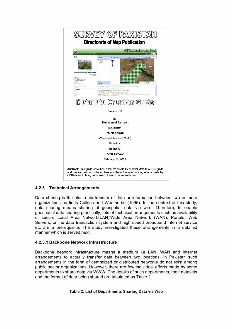
4.2.2 Metadata Metadata is a supporting information for a dataset. It helps to know a user, who collected and owns this data, what the data is about and what is the quality of the data, when and why the data was collected and how can I access this data etc. Without the added value of metadata, geospatial data is of little use. Simply said, metadata makes datasets discoverable. Metadata not only saves time in sharing of the data, but also in its creation (Bishop, 2007). Goodchild et al. (2012) also underscores the importance of metadata for data reusability. However, metadata created without accepted metadata standards is of no use as finds Masser (1998). The findings of the study disclose that situation regarding creation of metadata is the worst in public sector organizations. One of interviewee stated, "We have not yet thought about metadata". Presently, Survey of Pakistan (SoP) is the only public sector organization of the country that is producing standardized metadata. SoP has adopted ISO 19115:2003 Geographic Information – Metadata Standards. The creation of standardized metadata would give a jump start to NSDI implementation in the country. The standardized metadata prepared by Survey of Pakistan (SoP) enables other public and private sector organizations to harvest potential benefits of data collected by SoP and also to avoid duplication of efforts in collection of the same datasets.
Figure 7: Snapshot of SoP's Metadata Creation Guide
4.2.3 Technical Arrangements Data sharing is the electronic transfer of data or information between two or more organizations as finds Calkins and Weatherbe (1995). In the context of this study, data sharing means sharing of geospatial data via wire. Therefore, to enable geospatial data sharing practically, lots of technical arrangements such as availability of secure Local Area Network(LAN)/Wide Area Network (WAN), Portals, Web Servers, online data transaction system and high speed broadband internet service etc are a prerequisite. The study investigated these arrangements in a detailed manner which is served next. 4.2.3.1 Backbone Network Infrastructure Backbone network infrastructure means a medium i.e LAN, WAN and Internet arrangements to actually transfer data between two locations. In Pakistan such arrangements in the form of centralized or distributed networks do not exist among public sector organizations. However, there are few individual efforts made by some departments to share data via WWW. The details of such departments, their datasets and the format of data being shared are tabulated as Table 2.
Table 2: List of Departments Sharing Data via Web

Organization Dataset Format Pricing Survey of Pakistan (SoP) Topographical Maps PDF Free and Priced
Geological Survey of Pakistan (GSP)
Geological Maps PDF Free and Priced
Pakistan Space and Upper Atmosphere Research Commission (SUPARCO)
Satellite Mapping Products
PDF Free and Priced
Pakistan Bureau of Statistics (PBS)
Population Census Information
PDF Free and Priced
Pakistan Agricultural Research Council (PARC)
Land Use and Land Cover Maps
PDF Free
National Disaster Management Authority (NDMA)
Maps of Earthquakes, Floods &,Land Slides etc
PDF Free
There is an emergent need to establish such networks for geospatial data sharing. To start with, lessons can be learned from PERN (Pakistan Education & Research Network) that has now upgraded to PERN 2 (Figure 8) as NREN (National Research & Education Network of Pakistan). The network has evolved significantly and is providing valuable services, like high-speed internet, audio/video conferencing, and access to digital library resources.
Figure 8: PERN 2 High Level Design
Source: http://www.pern.edu.pk/
Besides implementation of network infrastructure, there is an equal importance of existence of internet users to get benefits from such networks. The study has, however, witnessed growth in internet users in Pakistan as portrays figure 9.
Figure 9: Internet Users (per 100 people)

Source: http://data.worldbank.org/
Geospatial imagery is regarded as fundamental dataset. But it possesses large volume. Therefore, to share this type of geospatial data quickly and efficiently, the need to have broadband internet service cannot be denied. Significant improvement (Figure 10) in this context is also evident from data collected by World Bank.
Figure 10: Fixed Broadband Internet Users (per 100 people)
Source: http://data.worldbank.org/
Presently, many public sector organizations are not equipped with these interconnecting technologies, such as high speed internet and fully established LAN/WAN therefore, making sharing of geospatial data impossible. 4.2.3.2 Portal The word portal roots from the Latin word 'porta' that point towards an entrance point (Annoni et al., 2004). Portals are web sites that act as an entry point to a collection of information resources, including datasets, services, cookbooks, news, tutorials, tools and an organized collection of links to many other sites usually through catalogs (Maguire and Longley 2005). Geoportal is a web site that presents an entry point to geographic content on the web (Tait, 2005). Geoportals are built upon World Wide Web (WWW) infrastructure technology using commercial/open source specialized GIS software. Network communication between clients and web servers uses HTTP (Hypertext Transmission Protocol). A geoportal is platform connected to a web server, which contains a database of metadata related to geospatial data and

services (Maguire and Longley 2005). System architecture of a geoportal is portrayed in figure 11.
Figure 11: System Architecture of a Geoportal
Source: Adapted from Maguire and Longley (2005)
The portal arranges metadata records from service providers into a consistent, searchable catalog and makes this catalog available to users. Through the catalog, users can search for services coming from any of the registered service providers (Tang and Selwood, 2005). Geoportals are sometime referred as clearinghouse. Crompvoets (2006) defined a clearinghouse as “an electronic facility for searching, viewing, transferring, ordering, advertising, and/or disseminating spatial data from numerous sources via the Internet and, as appropriate, providing complementary services”. A Clearinghouse involves bridging between spatial data producer, managers, and users electronically in a distributed network (Clinton, 1994; Crompvoets at el, 2004; FGDC, 2009). In Pakistan, geoportals are not yet developed by all public sector organizations to share data. Survey of Pakistan (SoP) has developed geoportal which is accessible through LAN (Figure 12).
Figure 12: Geoweb Portal Developed by SoP

4.2.3.3 Security Concerns
With the emergence of computers and web technologies, information security has evolved as a major challenge. Currently information systems are multifaceted collections of technologies, processes, and people, working together to facilitate organizations in capturing, processing, storing and disseminating information assets in quick span of time to sustain various decision making processes. In Pakistan security of cyber space is at high node as identified by Shahid Nadeem (2011). According to the study, many organizations prefer not to share data online due to the challenge of information security. However, studies conducted by World Bank (Figure 13) finds that number of secured Internet Servers in the country have been increasing over the past years. But still information security is one of the main reasons that hamper sharing of geospatial data in Pakistan.
Figure 13: Number of Secure Internet Servers in Pakistan

Source: http://data.worldbank.org/
4.2.4 Data Quality One of the objectives of data sharing is to improve decision making process by synthesizing multiple datasets collected by various organizations. Therefore, data quality is a growing interest (Goodchild, 1995; Veregin, 1999) because data of poor quality can misguide planners and policy makers and consequently, developmental plans could fail during or after implementation phase. Williamson et al. (2006) rightly noted that the ability of society to meet sustainable development objectives is a complex and temporal process involving multiple stakeholders. It requires data to be accessed and shared as information that is accurate, well maintained, and sufficiently reliable for use by a spatially literate society. In the data sharing environment quality is often regarded as one of the metadata elements, as it plays important role during the integration of data from multiple sources (Jakobsson and Tsoulos, 2007). However, the lack of effective communication of data quality is a key issue hampering the successful utilization of Geographical Information System (Paradis and Beard, 1994). This study reveals that fear of exposure of poor data quality is one of the technical reasons that impede data sharing in Pakistan. To ensure production of good quality data, it is essential to make data quality control arrangements comprising of skilled manpower as well as latest and state of the art geospatial tools and technologies. Public sector organizations were questioned about Data Quality Control (QC) arrangements. Except, Survey of Pakistan (SoP) no such arrangements were found visible by any other public sector organization.
Figure 14: SoP's Data Quality Control Initative

From all above discussions, a lot can be learnt about problems that hamper sharing of geospatial data in Pakistan. This study also identified possibilities for sharing of the data in the country in addition to presenting some guidelines for their implementation. The findings of this study are summarized as SWOT Analysis in table 3: Table 3: Strengths, Weaknesses, Opportunities and Threats to Data sharing in Pakistan Strengths Surveying & Mapping Ordinance-2013 E-government Multiple geospatial datasets Availability of software/hardware Existence of websites of major public
sector organizations
Weaknesses No inter-agency coordination Lack of data sharing mechanism Heterogeneity of datasets Unavailability of metadata High cost of data
Opportunities SoP’s initiative to promote inter-agency
coordination Availability of latest technology Availability of broadband internet SoP experience in metadata creation Growing secure internet servers Growth in internet users in Pakistan
Threats Data Security Culture of public sector organizations Budgetary constraints Mistrust among producers and consumers
of geospatial data Data Quality
5. Conclusions and Future Work
In this age of information technology, geospatial data has gained tremendous significance due to its diverse as well as multidimensional applications. It is reusable strategic information resource but the cost and effort in acquisition, processing, maintenance and archiving of geospatial data involve huge finances and large amount of mental and physical labour. This is one of the reasons that many countries are making extra efforts to make arrangements of its provision and sharing among stakeholders in order to reduce redundancies in geospatial investments. In Pakistan geospatial data is not being shared due to various institutional and technical problems. The findings of this study reveal that the institutional issues include; lack of data policy and legal framework, data management, lack of coordination among organizations and relatively high cost of the data itself. Whereas technical issues that contribute towards non-sharing of the data are, absence of data standards, non-availability of metadata and nonexistence of infrastructural arrangements as well as fear of exposure to data quality. Technical issues can be resolved with the assistance of international agencies such as GSDI, FGDC and JICA as these agencies are providing technical as well as financial support to implement data sharing related projects in many developing countries. However, one of the hardest problems in sharing of the data is, lack of coordination among organizations, which money can’t buy. Therefore, Government of Pakistan should come forward and play its role to enable a conducive environment for promoting coordination, collaborations and collations among public sector organizations especially by introducing and implementing requisite supportive policies.
This study reveals that a number of activates have taken place in the country that can contribute towards data sharing arrangements. The most significant is the recent promulgation of Surveying and Mapping Ordinance-2013. Some of the other possibilities include; SoP’s initiative to promote inter-agency coordination and development of standardized metadata as well as data quality control arrangements, growing awareness about NSDI, growth in secure internet servers, availability of broadband internet, existence of websites of major public sector organizations and Pakistan’s E-Government programme etc.
NSDI is a relatively new concept not only for Pakistan but also for most of the other developing countries. Moreover, there is no blue print available for its implementation. Therefore, efforts should be made to learn from the experience of other countries that have implemented SDIs at national level such as UK, Canada, USA and China to initiate in the right direction and implement successfully NSDI in Pakistan, as well. An in-depth study as future work is recommended to identify other issues, which could not be addressed in the current research such as political, economical and cultural etc that impede sharing of geospatial data in the country.
Acknowledgements We express our gratitude and acknowledge the valuable services of Mr. Ghulam Sarwar, Director Eastern Circle, Survey of Pakistan who took time from his very busy schedule and helped a lot in editing of this paper. Special thanks to Maj (R) Muhammad Tanvir, Director Map Publication and Capt (R) Aamir Jahangir Khan, Deputy Director, Survey of Pakistan who helped us to register online for this event.

References Annoni, A., Bernard, L., Fullerton, K., de Groof, H., Kanellopoulos, I., Millot, M., Peedell, S., Rase, D., Smits, P., and Vanderhaegen, M. (2004). Towards a European spatial data infrastructure: the INSPIRE initiative. In the proceedings of the 7th international global spatial data infrastructure conference, Bangalore, India, February 2-4(11 pp).
Asmat, A. (2008). Potential of Public Private Partnership for NSDI implementation in Pakistan. Master-Thesis, Enschede.
Asmat, A. and Munir, A.(2012). Land cover mapping using open source geospatial data and technologies: A case study from Islamabad, Pakistan. Proceedings of EORSA, 2012, Beijing, China.
Bishop, B. W. (2007). Organizing geographic information: The creation of the National Spatial Data Infrastructure. Advances in Classification Research Online, 18(1).
Calkins, H.W. and R. Weatherbe. (1995). Taxonomy of Spatial Data Sharing, in HJ Onsurd and G Rushton (Eds). Sharing Geographic Information, Urban Policy Research, Rutgers, New Brunswick, New Jersey. pp. 65-75.
Citypulse (2013). http://citypulse.com.pk/pakistangis/wp-content/uploads/2013/04/ Surveying-and-MApping-Act20131.pdf
Clinton, B. (1994). Coordinating Geographic Data Acquisition and Access: The National Spatial Data Infrastructure. Federal Register, 59(71), pp. 1-4.
Crompvoets, J., Bregt, A., Rajabifard, A., and Williamson, I. (2004). Assessing the worldwide developments of national spatial data clearinghouses. International Journal of Geographical Information Science, 18(7), pp. 665-689.
Crompvoets, J. (2006). National Spatial Data Clearinhouses Worldwide Development and Impact. PhD Thesis. Wageningen University, Wageningen.
Crompvoets, J. W. H. C., Rajabifard, A., van Loenen, B., and Delgado Fernandez, T. (2008). Future directions for spatial data infrastructure assessment. A Multi-view Framework to Assess Spatial Data Infarastructures. Digital Print Centre, The University of Melbourne, 383-399.
de Montalvo, U. W. (2003). Mapping the determinants of spatial data sharing. Ashgate Publishing.
Dercon, S. (2002). Income Risk, Coping Strategies and Safety Nets. World Bank Research Observer, 17 (2), pp.141-166.
Exective Order-Obama (2013). Exective Order No.M-13-13, Executive Office of the President, Office of Management and Budget Washington, D. C. 20503
Feagin, J., Orum, A. and Sjoberg, G. (1991). “A case for case study”, Chapel Hill, NC, University of North Carolina Press
FGDC. (2009). NSDI Clearinghouse Network. Retrieved from http://www.fgdc.gov/dataandservices
GAO report number GAO-04-824T (2004).Geospatial Information: Better Coordination and Oversight Could Help Reduce Duplicative Investments. Available at: http://www.gao.gov/assets/660/650293.pdf. Last accessed on May 30, 2013.
Georgiadou, Y., Puri, S. K., and Sahay, S. (2005). The rainbow metaphor: Spatial data infrastructure organization and implementation in India. International studies of management and organization, 35(4), pp. 48-70.

Georgiadou, Y., Puri, S. K., and Sahay, S. (2005). Towards a potential research agenda to guide the implementation of Spatial Data Infrastructures-A case study from India. International Journal of Geographical Information Science, 19(10), 1113-1130.
GIC/ESRI Canada (2011). Feasibility Study for a National Spatial Data Infrastructure in Uganda. Washington, D.C.: infoDev / World Bank. Available at http://www.infodev.org/publications.
Goodchild, M. F., (1995). Sharing Imperfect Data. In Sharing Geographic Information (Eds, Onsrud, H. J. and Rushton, G.) Rutgers University Press, New Brunswick, NJ, pp. 413-425.
Goodchild, M. F., Guo, H., Annoni, A., Bian, L., de Bie, K., Campbell, F., and Woodgate, P. (2012). Next-generation digital earth. In the Proceedings of the National Academy of Sciences, 109(28), pp.11088-11094.
Israel, A.(1997). A Guide for the Perplexed. Institutional Aspects of Social Programs. Paper No. SOC-104. Washington, D.C.: Inter-American Development Bank.
Jakobsson, A., & Tsoulos, L. (2007). The Role of Quality in Spatial Data Infrastructures. In Proceedings of the 23 rd International Cartographic Conference, Moscow.
Katleen Janssen (2013). Legal and policy requirements for data sharing, key note presentation, The NSDI Seminar, held at Belgrade, Serbia.
Kevany, M. J. (1995). A Proposed Structure for Observing Data Sharing. in H. J. Onsrud and G. Rushton, Eds. Sharing Geographic Information, New Brunswick, NJ: Center for Urban Policy Research, pp. 76-100.
Lance. K. (2006). Cross-Agency Alignment of Geospatial Investments for Spatial Data Infrastructure Development. Paper presented at the ISPRS Workshop on Service and Application of Spatial Data Infrastructure, XXXVI (4/W6), Oct.14-16, Hangzhou, China, pp.17-28.
Maguire, D. J., and Longley, P. A. (2005). The emergence of geoportals and their role in spatial data infrastructures. Computers, Environment and Urban Systems 29(1), pp.3-14
Marc Urvois (2013). The Spatial Data Infrastructure for Georesources in Africa. Slides presented in seminar “Why do we need data portals”, Brussels.
Masser, I.(1998).Governments and geographic information. London ; Bristol, PA: Taylor & Francis.
Masser, I. (2005). GIS worlds: creating spatial data infrastructures (Vol. 338). Redlands: ESRI press.
McLaughlin (2003). Geospatial Data Infrastructure: Concepts, Cases, and Good Practice.
Nama Raj Budhathoki and Zorica Nedovic-Budic. (2006). GSDI-9 Conference Proceedings,at Santiago, Chile
Nebert, D. D. e.(2004). Developing spatial data infrastructures GSDI: the SDI cookbook: Ver.2
North, D. C. (1990). Institutions, institutional change and economic performance, Cambridge University Press, New York
Onsrud, H.J., Jeffrey, K.P. and Azad, B. (1992). “Case Study Research methods for Geographic Information Systems”. Urban and Regional Information Systems Association (URISA), Vol. 1 (Spring(Part 4)), pp. 32-43

Onsrud, H. J. (1995). The Role of Law in Impeding and Facilitating the Sharing of Geographic Information” in H. J. Onsrud and G. Rushton, Eds. Sharing Geographic Information, New Brunswick, NJ: Center for Urban Policy Research, pp. 292-306.
Onsrud, H. J. and Rushton, G. (Eds.) (1995). .Sharing Geographic Information., New Brunswick, NJ: Center for Urban Policy Research.
Oxera (2013).What is the economic impact of Geo services? Published on January 30th 2013
Paradis, J. R., & Beard, K. (1994). Visualization of spatial data quality for the decision maker: a data quality filter (Master's thesis, in Surveying Engineering, University of Maine).
Pakistan E-Government Program (2005). Available online at http://www.pak.gov.pk/e_government.aspx.
Parente, S. and Prescott, E. (1994). Barriers to Technology Adoption and Development. Journal of Political Economy. 102 (2), pp.298-301.
Radwan, M.M., (2004). Geo-Data Infrastructure 'GDI' Concepts: Re-engineering of Information system in geoinformation organizations, The Netherlands.
Rajabifard, A., Mohsen Kalantari and Andrew Binns. (2009). SDI and Metadata Entry and Updating Tools, Proceedings of GSDI-11, Rotterdam, The Netherlands.
Shahid Nadeem Baloch (2011). Main Cybercrime Threats Experienced by Pakistan, Presented in International Workshop on Cooperation against Cybercrime in South Asia at Colombo, Sri Lanka, 5-6 April 2011.
Shariff, A. R. M., Hamzah, A. H., Mahmud, A. R., Yusof, N. M. Z. N., & Ali, H. M. (2011). Spatial data infrastructure for Malaysian land administration. International Journal of Spatial Data Infrastructures Research, Vol.6, pp. 389-409.
Tait, M. G. (2005). Implementing geoportals: applications of distributed GIS. Computers, Environment and Urban Systems, 29(1), pp. 33-47
Tang, W., and Selwood, J. (2005). Spatial Portals: Adding Value to Spatial Data Infrastructures, ISPRS Workshop on Service and Application of Spatial Data Infrastructure, Hangzhou, China.
Tosta, N. (1994). Continuing evolution of the National Spatial data Infrastructure. In Proceedings , pp. 769-777.
Williamson, I., Rajabifard, A., and Binns, A. (2006). Challenges and issues for SDI Development. International journal of spatial data infrastructures research, 1, pp. 24-35.
Veregin, H., (1999).Data quality parameters. In Geographical Information Systems, Vol. Principles and Technical Issues (Eds, Longley, P. A., Goodchild, M. F., Maguire, D. J. and Rhind, D. W.) John Wiley & Sons, Inc., pp. 177-189
Yin, Robert K. (2003). Case study research: design and methods. Third Edition, Applied social research methods series, Sage Publications, Newbury Park. p. 170
Zahir Ali (2013). Developing a Framework to Apply Total Quality Management Concepts to Land Administration (The case of Islamic Republic of Pakistan). PhD Thesis, Enschede.
This work is licensed under the Creative Commons Attribution 3.0 License. To view a copy of this license, visit http://creativecommons.org/licenses/by/3.0/legalcode
Proceedings of Global Geospatial Conference 2013 Addis Ababa, Ethiopia, 4-8 November 2013