state of stress at the southernmost end of the san andreas fault ...
Upload
independentCategory
view
1download
0
Geomorphology of the southernmost Longitudinal Valley fault:
Implications for evolution of the active suture of eastern Taiwan
J. Bruce H. Shyu,1,2,3 Kerry Sieh,1 Yue-Gau Chen,2 Ray Y. Chuang,2,4 Yu Wang,1,2
and Ling-Ho Chung2
Received 16 October 2006; revised 3 September 2007; accepted 26 October 2007; published 29 February 2008.
[1] In order to understand fully the deformationalpatterns of the Longitudinal Valley fault system, amajor structure along the eastern suture of Taiwan, wemapped geomorphic features near the southern end ofthe Longitudinal Valley, where many well-developedfluvial landforms record deformation along multiplestrands of the fault. Our analysis shows that theLongitudinal Valley fault there comprises two majorstrands. The Luyeh strand, on the west, haspredominantly reverse motion. The Peinan strand, onthe east, has a significant left-lateral component. Betweenthe two strands, late Quaternary fluvial sediments andsurfaces exhibit progressive deformation. The Luyehstrand dies out to the north, where it steps to the eastand joins the Peinan strand to become the main strandof the reverse sinistral Longitudinal Valley fault. Tothe south, the Luyeh strand becomes an E-W strikingmonocline. This suggests that the reverse motion onthe Longitudinal Valley system decreases drastically atthat point. The Longitudinal Valley fault system istherefore likely to terminate abruptly there and doesnot seem to connect to any existing structure further tothe south. This abrupt structural change suggests thatthe development of the Longitudinal Valley sutureoccurs through discrete structural ‘‘jumps,’’ rather thanby a continuous northward maturation. Citation: Shyu,
J. B. H., K. Sieh, Y.-G. Chen, R. Y. Chuang, Y. Wang, and L.-H.
Chung (2008), Geomorphology of the southernmost Longitudinal
Valley fault: Implications for evolution of the active suture of
eastern Taiwan, Tectonics, 27, TC1019, doi:10.1029/
2006TC002060.
1. Introduction
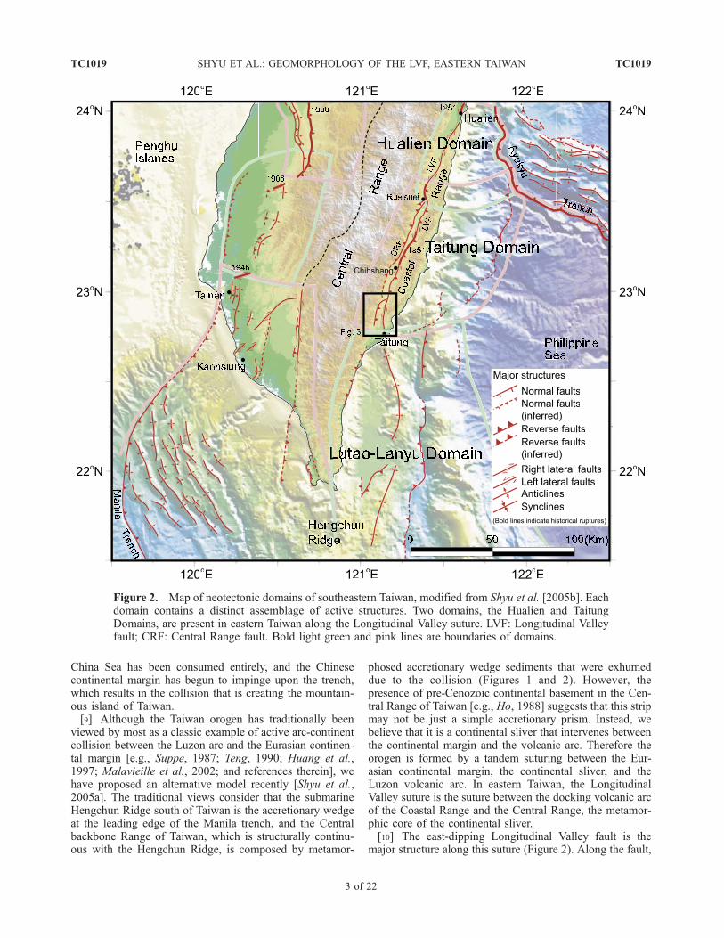
[2] The island of Taiwan is the product of the ongoingcollision of the Eurasian and the Philippine Sea plates [e.g.,
Ho, 1986; Teng, 1987, 1990; Shyu et al., 2005a, andreferences therein] (Figure 1). As one of the very few placeson Earth that is undergoing active suturing of lithosphericblocks, Taiwan provides valuable opportunities for under-standing suturing processes. The collision involves threelithospheric blocks, separated by two sutures on the island[Shyu et al., 2005a]. The eastern one, along the Longitu-dinal Valley in eastern Taiwan, is the active suture betweenthe Luzon volcanic arc and a continental sliver thatincludes the Central Range, the mountainous backbone ofTaiwan. The valley is very active seismically and containsmany active structures, the most important being the Lon-gitudinal Valley fault, one of the most active structures inthe world [e.g., Angelier et al., 1997; Shyu et al., 2005b].[3] As the suturing matures from south to north, active
structures of the Taiwan orogen manifest different character-istics, separating the island into several discrete neotectonicdomains [Shyu et al., 2005b] (Figure 2). Along the Longi-tudinal Valley are two: the Hualien and the TaitungDomains. In the Hualien Domain, which includes thenorthern third of the Longitudinal Valley fault, the faultappears to be predominantly sinistral and to slip at a lowerrate. In the Taitung Domain to the south, the fault slipsobliquely at a much higher rate, in association with the rapiduplift of the Coastal Range, in the hanging wall block of thefault [Yu and Liu, 1989; Hsu et al., 2003; Shyu et al., 2006a].[4] Although the activity of the Longitudinal Valley fault
has been known for decades and attracted numerous geo-detic and seismologic investigations [e.g., Angelier et al.,1997; Lee et al., 2001, 2003; Yu and Kuo, 2001; Kuochen etal., 2004; Wu et al., 2006], there have been very fewdetailed geomorphic analyses of the fault. Most maps ofthe fault are large-scaled maps of the entire LongitudinalValley, which contain very little detail [e.g., Wang andChen, 1993; Lin et al., 2000]. As a result, current knowl-edge of the fault is limited mostly to the main fault trace,which may absorb only a portion of the total deformationacross the entire fault system. Without knowledge of detailsof the surface manifestation of the fault system, it is difficultto design proper experiments to observe the details of activedeformation. For example, many of the current short-aper-ture geodetic experiments focus only on the main fault trace[e.g., Lee et al., 2001, 2003], and may underestimate theslip rate of the fault.[5] Near the southern end of the Longitudinal Valley, a
suite of well-developed fluvial surfaces provide a useful toolfor mapping the Longitudinal Valley fault system in detail[Shih et al., 1983, 1984]. The clear deformational patternsof these fluvial surfaces allow us to understand the charac-
TECTONICS, VOL. 27, TC1019, doi:10.1029/2006TC002060, 2008
1Tectonics Observatory, Division of Geological and Planetary Sciences,California Institute of Technology, Pasadena, California, USA.
2Department of Geosciences, National Taiwan University, Taipei,Taiwan.
3Currently at Section Geology, Department of Earth and EnvironmentalSciences, Ludwig-Maximilians University Munich, Germany.
4Department of Geological Sciences, Central Washington University,Ellensburg, Washington, USA.
Copyright 2008 by the American Geophysical Union.0278-7407/08/2006TC002060
TC1019 1 of 22

teristics of each strand of the fault. We have systematicallymapped these geomorphic features to enable better inter-pretation of geodetic and seismologic data related to thekinematics of the fault.[6] A detailed understanding of the geometry of the
southernmost section of the Longitudinal Valley fault sys-tem is also relevant to understanding the evolution of thesuture. How does the suture first appear at its southern end?What is the relationship between the Longitudinal Valleyfault and the subaqueous structures that border the collidingbut as yet unsutured volcanic arc and the continental sliverto the south? Answers to these questions will enhance ourknowledge of general suturing processes at arc-arc and arc-continent collisions.[7] Our principal means for geomorphic analysis is a set
of digital elevation models (DEM), with 40-m resolution.Although a more recent 5-m resolution DEM covers only
part of our study area, it significantly improved our abilityto identify small features and secondary structures of thefault. In this paper, we present the combined results of ourmapping using these two sets of DEM. Our DEM analysiswas followed by mapping and investigations of fluviallandforms in the field.
2. Tectonic Setting
[8] Taiwan is forming at the boundary between thePhilippine Sea plate and the South China block of theEurasian plate (Figure 1). South of Taiwan, the oceanicSouth China Sea plate is subducting eastward beneath thePhilippine Sea plate along the Manila trench. Above thatsubduction zone is the Luzon volcanic arc. At the latitude ofTaiwan, however, the oceanic lithosphere of the South
Figure 1. The island of Taiwan is being created by a tandem suturing of the Luzon volcanic arc and asliver of continental crust to the Chinese continental margin. The Longitudinal Valley suture (LVS) is theeastern of the two sutures. It joins the Coastal Range (CoR), the docked part of the Luzon volcanic arc,and the continental sliver of the Central Range (CeR), the mountainous backbone of the island. Currentvelocity vectors of the Philippine Sea plate relative to South China, at 124�E and 20�, 21�, and 22�N, arecalculated using the Recent plate velocity model (REVEL) of Sella et al. [2002]. Current velocity vectorof the Ryukyu arc is adapted from Lallemand and Liu [1998]. Black dashed lines are the northern andwestern limits of the Wadati-Benioff zone of the two subduction zones, taken from the seismicitydatabase of the Central Weather Bureau, Taiwan. DF: deformation front; LCS: Lishan-Chaochou suture;WF: Western Foothills; HP: Hengchun Peninsula. This figure is adapted from Shyu et al. [2005a], withpermission from Elsevier.
TC1019 SHYU ET AL.: GEOMORPHOLOGY OF THE LVF, EASTERN TAIWAN
2 of 22
TC1019
China Sea has been consumed entirely, and the Chinesecontinental margin has begun to impinge upon the trench,which results in the collision that is creating the mountain-ous island of Taiwan.[9] Although the Taiwan orogen has traditionally been
viewed by most as a classic example of active arc-continentcollision between the Luzon arc and the Eurasian continen-tal margin [e.g., Suppe, 1987; Teng, 1990; Huang et al.,1997; Malavieille et al., 2002; and references therein], wehave proposed an alternative model recently [Shyu et al.,2005a]. The traditional views consider that the submarineHengchun Ridge south of Taiwan is the accretionary wedgeat the leading edge of the Manila trench, and the Centralbackbone Range of Taiwan, which is structurally continu-ous with the Hengchun Ridge, is composed by metamor-
phosed accretionary wedge sediments that were exhumeddue to the collision (Figures 1 and 2). However, thepresence of pre-Cenozoic continental basement in the Cen-tral Range of Taiwan [e.g., Ho, 1988] suggests that this stripmay not be just a simple accretionary prism. Instead, webelieve that it is a continental sliver that intervenes betweenthe continental margin and the volcanic arc. Therefore theorogen is formed by a tandem suturing between the Eur-asian continental margin, the continental sliver, and theLuzon volcanic arc. In eastern Taiwan, the LongitudinalValley suture is the suture between the docking volcanic arcof the Coastal Range and the Central Range, the metamor-phic core of the continental sliver.[10] The east-dipping Longitudinal Valley fault is the
major structure along this suture (Figure 2). Along the fault,
Figure 2. Map of neotectonic domains of southeastern Taiwan, modified from Shyu et al. [2005b]. Eachdomain contains a distinct assemblage of active structures. Two domains, the Hualien and TaitungDomains, are present in eastern Taiwan along the Longitudinal Valley suture. LVF: Longitudinal Valleyfault; CRF: Central Range fault. Bold light green and pink lines are boundaries of domains.
TC1019 SHYU ET AL.: GEOMORPHOLOGY OF THE LVF, EASTERN TAIWAN
3 of 22
TC1019

the highly shortened volcanic rocks and forearc and intraarcbasin sediments of the Coastal Range are thrusting over thecurrent sediments of the Longitudinal Valley. Slip rate alongthe fault is up to several tens of mm/a [Angelier et al., 1997;Shyu et al., 2006a], making it one of the fastest slippingfaults in the world. Ages of uplifted fluvial terraces in theCoastal Range near Rueisuei (Figure 2) suggest that thefault has been slipping at such high rates throughout at leastthe Holocene [Shyu et al., 2006a]. Farther south along thefault near Chihshang, many small to moderate earthquakesilluminate the subsurface listric shape of the fault plane[Chen and Rau, 2002; Kuochen et al., 2004].[11] On the western side of the Longitudinal Valley, the
west-dipping Central Range fault slips at a lower rate thanthe Longitudinal Valley fault and is active along thesouthern two-thirds of the valley [Shyu et al., 2006b](Figure 2). Although currently not slipping at a high rate,geomorphic evidence of the fault is clear and widespreadalong the western side of the valley.[12] Although volcanic arc rocks and associated turbidite
deposits of the Coastal Range generally constitute thehanging wall block of the Longitudinal Valley fault, in thesouthern part of the valley, the Lichi Formation crops outimmediately to the east of the fault as a very distinctstratigraphic unit. This unit consists of various and abundantblocks, sometimes tens of kilometers in size, within highlysheared, chaotic sand and mud matrix [Ho, 1988]. The LichiFormation is either highly shortened and sheared deepmarine forearc or intraarc basin sediments [e.g., Biq,1971; Teng, 1981; Hsu, 1988; Huang et al., 1992; Changet al., 2001] or slump deposits associated with mass wastingof sediments on the steep slopes that bound these basins[e.g., Page and Suppe, 1981; Barrier and Muller, 1984;Barrier and Angelier, 1986].
3. Major Geomorphic Features of the
Southernmost Longitudinal Valley
[13] Along most of its length, the floor of the Longitu-dinal Valley is a low-relief plain between the Central andCoastal Ranges, formed by several trunk rivers and theirtributaries. In the southernmost part of the LongitudinalValley, however, several fluvial terraces, locally up to 300 mabove the current valley floor, exist between the two ranges(Figure 3). These terraces are underlain by late Quaternaryalluvial deposits, mostly gravels and sand. Distinct mem-bers of these fluvial landforms, from south to north, are thePeinanshan, the Kaotai and Pingting terraces.[14] The Peinanshan, south of the eastward flowing
Luyeh River, is a N-S elongated hill that perches up to300 m above the Longitudinal Valley floor (Figure 3). Thisfeature is also known as ‘‘The Foot,’’ due to its peculiarshape in map view. Lateritic soils overlie most of thewestern part of the Peinanshan. Judging from the dates ofsimilar lateritic terraces in other parts of Taiwan [e.g., Chen,1988], this implies that fluvial terraces atop the westernPeinanshan formed at least a couple tens of thousand ofyears ago. Late Quaternary Peinanshan Conglomerateunderlies the lateritic soils of the fluvial terraces. This
stratigraphic unit consists mostly of rounded fluvial cobblesof metamorphic rocks from the Central Range, includingschist and marble clasts [Hsu, 1956; Teng and Wang, 1981;Barrier et al., 1982]. Volcanic and sandstone clasts, prob-ably from the Coastal Range, are present locally. In theeastern part of the Peinanshan, the Peinanshan Conglomer-ate is indurated and dips steeply.[15] Between the Luyeh and Luliao Rivers are the Kaotai
and several lower terraces. The highest of these are alsocapped by lateritic soils. This and the fact that the Kaotaiterraces rest at elevations that are similar to elevations of thePeinanshan terraces suggest that the highest Kaotai andPeinanshan terraces are probably similar in age. The lateriticsoils of the Kaotai terraces are also underlain by fluvialcobbles derived mostly from the Central Range, whichimplies a source and origin similar to that of the PeinanshanConglomerate.[16] Farther north, and east of the Luliao River, the small
Pingting terraces appear to be uplifted Peinan River bed(Figure 3). The terraces divide into two major groups, thehigher eastern one sitting about 50 m above the currentriverbed. Uplift of the Pingting terraces has caused thecurrent Peinan River to narrow significantly where it flowsaround the terraces. The lower elevation of the Pingtingterraces above the current river bed suggests that they aremuch younger than the Peinanshan and the Kaotai terraces.This is consistent with the fact that no lateritic soil coversthem. Instead, they are capped only by a thin layer of fluvialgravels, locally up to 10 m thick. On both the northern andsouthern flanks of the terraces, the Lichi Formation cropsout beneath the thin fluvial gravels.
4. Neotectonic Geomorphology of the Kaotai
and Surrounding Terraces
[17] Although the topographic features on the Kaotai andsurrounding terraces are not the most impressive in the area,their relationship to underlying structures is the moststraightforward, and provides a basis for understandingneotectonic geomorphic features elsewhere in the area.North of the Luyeh River, geomorphic features clearlyindicate that a major reverse fault cuts across the large riverterrace 4, on which the village of Lungtien sits (Figure 4).This reverse fault extends further to the north and forms theapproximate boundary of the Kaotai terraces and the CentralRange. Still further to the north, the fault appears to die outto the north, just shy of the Luliao River.[18] A very clear monoclinal scarp, up to 15 m high, runs
N-S across the Lungtien terrace north of the Luyeh River,just west of Lungtien (Figures 4 and 5a). Between Lungtienand the scarp, the surface of the terrace forms an anticlinalwarp. Other than the scarp and the warp, the Lungtienterrace surface shows a gentle eastward slope that isconsistent with its Luyeh River origin. Therefore we believethe scarp and the anticline are manifestations of a fault-propagation fold updip of an east-dipping blind reverse faultbeneath the eastern part of the Lungtien terrace. In fact, thisclear feature was identified as an active structure long ago,and was named the Luyeh fault by several investigators
TC1019 SHYU ET AL.: GEOMORPHOLOGY OF THE LVF, EASTERN TAIWAN
4 of 22
TC1019

Figure 3. Major fluvial landforms near the southernmost Longitudinal Valley. Between the Central andCoastal Ranges are several uplifted fluvial surfaces. South of the Luyeh River, the Peinanshan is anelongate hill underlain by fluvial Peinanshan Conglomerate and capped by lateritic fluvial terraces. Northof the Luyeh River, the Kaotai terraces are lateritized fluvial surfaces that may be correlative with thehighest surfaces of the Peinanshan. East of the Luliao River, the lower Pingting terraces are underlain byyoung, thin uplifted Peinan River gravels deposited on Lichi Formation.
TC1019 SHYU ET AL.: GEOMORPHOLOGY OF THE LVF, EASTERN TAIWAN
5 of 22
TC1019

Figure
4
TC1019 SHYU ET AL.: GEOMORPHOLOGY OF THE LVF, EASTERN TAIWAN
6 of 22
TC1019

Figure 4. Detailed map of geomorphic features and active structures of the Kaotai terraces area. Note that the names ofterraces indicate only the relative ages of the terraces and do not imply correlation of the terraces; that is, terrace 4 north ofthe Luyeh River may not be the same age as terrace 4 elsewhere. The Luyeh strand, a major strand of the LongitudinalValley fault, runs along the western edge of the Kaotai terraces and has produced a monoclinal scarp on the Lungtien terraceto the south. To the north, the Luyeh strand dies out just south of the Luliao River. The other strand of the LongitudinalValley fault, the Peinan strand, runs within the Peinan River valley and through the Luanshan Bridge (LSB) about 200 mfrom the eastern end of the bridge. Ages of terraces are calibrated ages (2s), in cal BP.
Figure 5. Selected topographic profiles of the Kaotai terraces area. Locations of the profiles appear inFigure 4. (a) A topographic profile across the Lungtien and other terraces. The Luyeh strand produced amonoclinal scarp, about 15 m high, about halfway downstream on the Lungtien terrace (terrace 4). Otherthan the scarp, the terrace surface shows a gentle eastward slope that is consistent with the modern LuyehRiver bed. Notice that at the downthrown (west) side of the Luyeh strand, the Lungtien terrace is stillabout 60 m above the current Luyeh River bed. We hypothesize that the Longitudinal Valley and easternflank of the Central Range are on the hanging wall block of a deeper Central Range fault that dips west,under the Central Range. (b) A short topographic profile across the Luyeh strand on terrace 3. The terraceeast of the Luyeh strand is about 10 m higher than its counterpart west of the strand.
TC1019 SHYU ET AL.: GEOMORPHOLOGY OF THE LVF, EASTERN TAIWAN
7 of 22
TC1019

[Shih et al., 1983, 1984, 1986; Yang, 1986; Chu and Yu,1997]. It has been considered generally to be a thrust strandof the Longitudinal Valley fault. Since this reverse fault is astrand of the Longitudinal Valley fault, we refer to it as theLuyeh strand.[19] From a shallow pit dug into the terrace surface east
of Yenping, we collected a charcoal sample from the gravelbeds that underlie the Lungtien terrace. The sample yieldeda calibrated age of about 3.35 ka (Figure 4 and Table 1),which represents a maximum age for the terrace surface.Since the terrace surface has been offset vertically about 15mby the Luyeh strand (Figure 5a), the minimum vertical sliprate of the strand is about 4.5 mm/a. Because the gravel bedscontaining the charcoal sample are close to the terracesurface, we believe that the age of the sample is close tothe age of the terrace surface, and the 4.5 mm/a minimum isclose to the true vertical slip rate of the Luyeh strand.[20] On the southern edge of the Lungtien terrace, the
Luyeh strand descends a small south-flowing canyon to-ward the active bed of the Luyeh River, which dividesterrace 3 into two patches (Figure 4). Terrace 3, which isabout 10 m lower than terrace 4, has been clearly offset bythe Luyeh strand, since the small patch of terrace 3 east of thecanyon is about 10 m higher than its counterpart west of thecanyon (Figure 5b). Younger terrace 1, however, does notdisplay an offset by the Luyeh strand. If terrace 1 predatesthe most recent displacements, the magnitude of the offset istoo small to be seen in the cultivated surface of the terrace.[21] North of the Lungtien terrace, the Luyeh strand
extends into the valley between the Kaotai terraces andthe Central Range (Figure 4). The Kaotai terraces cap alarge, broad anticline, shown both by sloping terrace surfa-ces and bedding attitudes in the underlying gravels beds.This anticline may be the northern extension of the smallanticline west of Lungtien andmay also be a fault-propagationfold updip of the Luyeh strand.[22] West of the Kaotai terraces, the Luyeh strand
branches into three discrete sub-strands (Figure 4). At leastone of these sub-strands, along the western front of theterraces, appears to break the surface as a reverse fault. Thewesternmost strand, however, appears as a monocline. Thismonoclinal strand has produced a series of anticlinal ridgesof colluvium in the valley between the Kaotai terraces and
the Central Range and cuts through an E-W striking ridgeof metamorphic slates of the Central Range (point S inFigure 4). Therefore, although most of the deformationcaused by the Luyeh strand concentrates in late Quaternarygravels underlying the Kaotai terraces, the westernmost sub-strand has involved a small piece of the Central Range. Thismay be the only place where part of the Longitudinal Valleyfault system extends so far to the west that it deforms theCentral Range.[23] On the highest surface of the Kaotai terraces (terrace 7)
are several gentle E-W striking scarps (Figure 4). Thesescarps most likely are minor normal fault scarps formedathwart the anticlinal axis parallel to the convergencedirection. Alternatively, these gentle scarps may reflectirregularities in the geometry of the underlying fault, causedby its overriding of an irregular surface on the footwallblock.[24] Since the minimum vertical slip component of the
Luyeh strand is about 4.5 mm/a, we can estimate theminimum age of the highest Kaotai terraces. Assuming thatthe floor of the canyon between the Kaotai terraces and theCentral Range is correlative with the highest surface(terrace 7) above the Kaotai terraces, the surface has beenuplifted at least 135 m. This yields an age of at least 30 kafor the Kaotai terrace 7, consistent with their being cappedby lateritic soils.[25] Kaotai terrace 7 ends abruptly at an E-W trending
drainage just south of the village of Yungan (Figure 4).However, the Luyeh strand continues northeastward as aseries of anticlinal ridges on lower terraces. The height ofthese ridges decreases to the north. The fact that relief on thefolds decreases northeastward on the same terraces indicatesthe folds die out to the northeast. The northernmost andlowest anticlinal ridge ends just south of terrace 2 of theLuliao River. No deformation is visible on the low terraces1 and 2 of the Luliao River farther northeast.[26] Deformation of the Luanshan Bridge (LSB in
Figure 4), which crosses the Peinan River southeast ofLuyeh, indicates that another strand of the LongitudinalValley fault east of the Luyeh strand, within the PeinanRiver valley. We refer to this strand as the Peinan strand.About 200 m from the eastern end of the Luanshan Bridge,the bridge roadbed has been fractured by east-west com-
Table 1. List and Analytical Results of the Charcoal Samples Dated in This Research
Sample Number Site Name
GPS Location ofSite
Corresponding Figure Terrace Level Age, year BP Calibrated Age (2s)(cal BP)aX Y
BN-02B BN 258439 2534148 4 4 3130 ± 30b 3260–344020010917-2 CYB 264514 2533951 4 2 1170 ± 80b 940–1260LS-01 LSB 265256 2532808 7 d 2310 ± 80c 2120–2710LS-02 LSB 265256 2532808 7 d 2250 ± 70c 2040–2360LS-03 LSB 265256 2532808 7 d 850 ± 60c 670–910RY2-05 RY2 266018 2538348 11 4 1700 ± 30b 1530–1690
aCalibrated using the CALIB program [Stuiver and Reimer, 1993].bThese samples were dated in Lawrence Livermore National Laboratory using AMS.cThese samples were dated in National Taiwan University by conventional 14C dating.dLandslide complex.
TC1019 SHYU ET AL.: GEOMORPHOLOGY OF THE LVF, EASTERN TAIWAN
8 of 22
TC1019
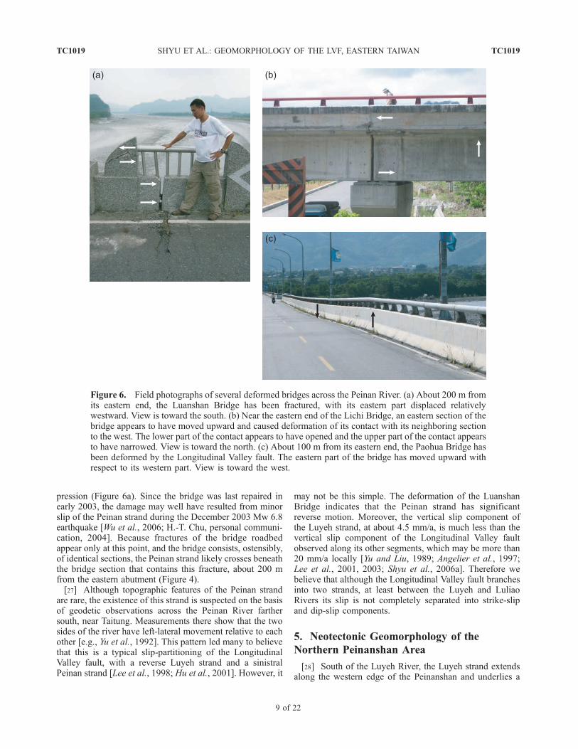
pression (Figure 6a). Since the bridge was last repaired inearly 2003, the damage may well have resulted from minorslip of the Peinan strand during the December 2003 Mw 6.8earthquake [Wu et al., 2006; H.-T. Chu, personal communi-cation, 2004]. Because fractures of the bridge roadbedappear only at this point, and the bridge consists, ostensibly,of identical sections, the Peinan strand likely crosses beneaththe bridge section that contains this fracture, about 200 mfrom the eastern abutment (Figure 4).[27] Although topographic features of the Peinan strand
are rare, the existence of this strand is suspected on the basisof geodetic observations across the Peinan River farthersouth, near Taitung. Measurements there show that the twosides of the river have left-lateral movement relative to eachother [e.g., Yu et al., 1992]. This pattern led many to believethat this is a typical slip-partitioning of the LongitudinalValley fault, with a reverse Luyeh strand and a sinistralPeinan strand [Lee et al., 1998; Hu et al., 2001]. However, it
may not be this simple. The deformation of the LuanshanBridge indicates that the Peinan strand has significantreverse motion. Moreover, the vertical slip component ofthe Luyeh strand, at about 4.5 mm/a, is much less than thevertical slip component of the Longitudinal Valley faultobserved along its other segments, which may be more than20 mm/a locally [Yu and Liu, 1989; Angelier et al., 1997;Lee et al., 2001, 2003; Shyu et al., 2006a]. Therefore webelieve that although the Longitudinal Valley fault branchesinto two strands, at least between the Luyeh and LuliaoRivers its slip is not completely separated into strike-slipand dip-slip components.
5. Neotectonic Geomorphology of the
Northern Peinanshan Area
[28] South of the Luyeh River, the Luyeh strand extendsalong the western edge of the Peinanshan and underlies a
Figure 6. Field photographs of several deformed bridges across the Peinan River. (a) About 200 m fromits eastern end, the Luanshan Bridge has been fractured, with its eastern part displaced relativelywestward. View is toward the south. (b) Near the eastern end of the Lichi Bridge, an eastern section of thebridge appears to have moved upward and caused deformation of its contact with its neighboring sectionto the west. The lower part of the contact appears to have opened and the upper part of the contact appearsto have narrowed. View is toward the north. (c) About 100 m from its eastern end, the Paohua Bridge hasbeen deformed by the Longitudinal Valley fault. The eastern part of the bridge has moved upward withrespect to its western part. View is toward the west.
TC1019 SHYU ET AL.: GEOMORPHOLOGY OF THE LVF, EASTERN TAIWAN
9 of 22
TC1019

large anticline-syncline pair, as shown by the deformedhighest terrace surface on the Peinanshan (Figure 7). ThePeinan strand appears to become more sinistral and cuts thenortheastern corner of the Peinanshan.[29] Geomorphic features indicate that the surface trace
of the Luyeh strand extends southward along the westernedge of the Peinanshan (Figures 7 and 8). Narrow scarpseast of the village of Chulu, for example, suggest that thefault breaks the surface. Slip on the Luyeh strand hasjuxtaposed the northwestern corner of the Peinanshanagainst a ridge of metamorphic rocks of the Central Range.Since the bedrock ridge shows no geomorphic evidence ofdeformation, we believe the Luyeh strand must crop out inthe small canyon flowing northward between the ridge andthe Peinanshan. If so, this part of the Luyeh strand has notyet faulted any of the Central Range rocks.[30] In the hanging wall block of the Luyeh strand is an
anticline-syncline pair (Figure 7). These folds are clearlymanifest in the deformed surface of terrace 7 on thenorthern Peinanshan (Figure 8a) and in bedding attitudesof the underlying gravel beds. On the younger terracesalong the northern side of the Peinanshan, the two foldshave smaller amplitudes than they do on the older terrace 7(Figure 8b). Moreover, the bedrock gravels dip more steeplythan the terrace 7 surface. These features indicate that thefolds have been growing progressively during deposition ofthe gravels and subsequent incision of the Luyeh River.[31] South of Chulu, the two folds turn slightly to the
southwest and are truncated by the Luyeh strand (Figure 7).Horizontal gravel beds along the small southwestward-flowing canyon south of Chulu suggest that the synclinalaxis may follow the canyon and connect with the Luyehstrand further south.[32] We are not sure if the anticlinal axis extends further
north under the Luyeh River and connects with the anti-clines west of Lungtien or beneath the Kaotai terraces. Thesynclinal axis, however, does appear to extend to the northand turns northeastward (Figures 4 and 7).[33] East of the synclinal axis, the dip of the Peinanshan
Conglomerate steepens to the east, becoming vertical nearthe eastern edge of the Peinanshan (Figure 7). This isevident from the presence of clear bedding plane ridgesnear the northeastern corner of the Peinanshan, and by thebedding attitude measurements along the eastward flowingcanyon south of the village of Shanli. The presence of verysteep beds in the eastern limb of the syncline and the factthat the synclinal axis merges to the south with the Luyehstrand suggest that the syncline formed as a fault-propagationfold. The gentle limbs of the anticline, on the other hand,suggest that the anticline is a fault-bend fold. Therefore thetwo folds found in the northern Peinanshan may representstructures developed in different stages. The syncline mayhave developed first, as a fault-propagation fold updip of ablind Luyeh strand. Later, when the tip of Luyeh strandbroke the ground surface, a bend formed along the faultplane as the hanging wall rode over the ground surface andproduced the gentle anticline. The Luyeh strand along thesouthern part of the Peinanshan breaks the surface along thesynclinal axis, but no anticline has developed. More detailed
subsurface information, such as seismic reflection profilesacross different parts of the Peinanshan, is needed to verifyour structural hypotheses.[34] On the surface of terrace 7 are many NNW-striking
scarps (Figure 7). The origin of these scarps is controversial.Some believe that they are terrace risers formed by eastwardmigration of the Luyeh River during the uplift of thePeinanshan [Shih et al., 1986; Yang, 1986]; others suggestthat they represent active fault scarps [Shih et al., 1983,1984]. The presence of several west-facing scarps arguesagainst an origin as terrace risers. Furthermore, at leastalong the westernmost scarps, the paleo-current direction ingravel outcrops is perpendicular to the scarps. Therefore wefavor a fault scarp origin. Because of the steepness of thescarps and the horst-and-graben-like topography, we suspectthat they are normal faults. Their limited distribution andtheir strike direction suggest that they formed due to theindentation of the metamorphic rock ridge of the CentralRange into the northwestern corner of the Peinanshan.[35] The Peinan strand cuts through the northeastern
corner of the Peinanshan (Figures 7 and 8). South of theconfluence of the Luyeh and Peinan Rivers, a �5 m high,east-facing scarp cuts terrace 1. The scarp appears to extendto the south into the hills and to connect with another scarpon terrace 2 just northeast of Shanli. In fact, the latter scarphas been identified previously as the Shanli fault [Shih etal., 1983, 1984, 1986; Yang, 1986]. In contrast to the scarpsouth of the Luyeh River, the Shanli scarp is higher andfaces west. Because of this scissoring, we suspect that thePeinan strand south of the Luyeh River is predominantly astrike-slip fault.[36] On the eastern side of the Peinan River, across from
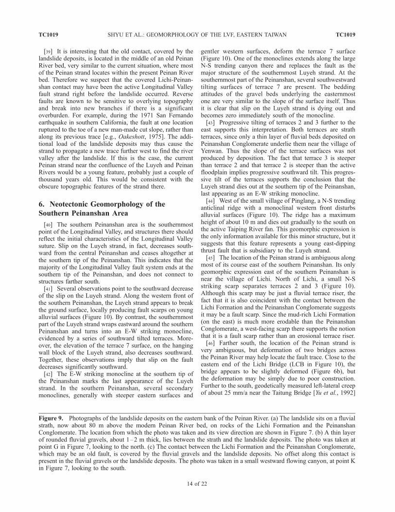
the Luyeh River junction, an enormous landslide complexhas formed on the western flank of the Coastal Range(Figure 7). The headscarps of this landslide complex areclose to the crest of the Coastal Range, and the toes restupon thin fluvial gravels on a bedrock strath, about 80 mabove the current Peinan River bed (Figure 9a). Thethickness of this landslide deposit locally exceeds 100 m.Since wood fragments found in the landslide depositsyielded ages that range from less than 1 ka to more than2 ka (Figure 7 and Table 1), the landslide deposits may havea complex history of multiple mass-wasting events.[37] The presence of a thin layer of rounded fluvial
gravels between the bedrock strath and the landslide deposit(Figure 9b) indicates that the landslide toe rode out overeither the active channel or an uplifted terrace of the PeinanRiver. In fluvial gravels above the terrace 2 strath just eastof Luanshan Bridge, we found a charcoal sample about 18 mabove the current Peinan River bed that yielded a calibratedradiocarbon age of about 1.1 ka (Figure 4 and Table 1). Thisyields an incision rate of about 16.4 mm/a for the PeinanRiver. If this incision rate of the Peinan River has beenconstant throughout the 80 m of uplift of the strathoverridden by the landslide toe, the age of the toe isabout 4.9 ka.[38] On some previous maps, the contact between the
Lichi Formation and the Peinanshan Conglomerate appearsas the major fault plane of the Longitudinal Valley fault
TC1019 SHYU ET AL.: GEOMORPHOLOGY OF THE LVF, EASTERN TAIWAN
10 of 22
TC1019

Figure
7
TC1019 SHYU ET AL.: GEOMORPHOLOGY OF THE LVF, EASTERN TAIWAN
11 of 22
TC1019

[e.g., Wang and Chen, 1993]. An outcrop of this highlysheared contact is present on the eastern Peinan River wallacross the junction of the Luyeh River (Figures 7 and 9a).The same contact appears in a small canyon farther north(Figure 9c). Although this highly sheared contact clearly isa major fault plane, it does not offset of the landslidedeposits or underlying strath. Hence it must have ceased
activity sometime before the emplacement of the landslidetoe. Further to the south, however, at the northeastern cornerof the Peinanshan, the Peinan strand is active where it cutsthrough a hill and separates a large limestone block of theLichi Formation on the east from Peinanshan Conglomerateon the west.
Figure 7. Detailed map of geomorphic features and active structures of the northern Peinanshan area. The Luyeh strandruns along the western front of the Peinanshan. An anticline and a syncline in the hanging wall block of the Luyeh strandclearly deform the highest terrace 7 atop the northern Peinanshan. The Peinan strand cuts through the northeastern corner ofthe Peinanshan and may be predominantly left-lateral. An immense landslide deposit covers a fluvial strath, about 80 mabove the modern Peinan River bed, east of the Peinan River on the western flank of the Coastal Range. Brown linesindicate head scarps of blocks, sometimes within the landslide complex. Ages of wood fragments found in the landslidedeposits are calibrated ages (2s), in cal BP.
Figure 8. Selected topographic profiles of the northern Peinanshan area. Locations of the profilesappear in Figure 7. (a) A topographic profile of terrace 7 atop the northern Peinanshan. The fluvialsurface has been deformed into an asymmetrical syncline in the east and an anticline in the west. (b) Thetopographic profile of lower terraces on the south side of the Luyeh River north of terrace 7 indicates thatthese lower terraces are also deformed by the folds, but to a lesser degree. This suggests that the foldshave been growing during incision of the Luyeh River.
TC1019 SHYU ET AL.: GEOMORPHOLOGY OF THE LVF, EASTERN TAIWAN
12 of 22
TC1019

Figure
9
TC1019 SHYU ET AL.: GEOMORPHOLOGY OF THE LVF, EASTERN TAIWAN
13 of 22
TC1019
[39] It is interesting that the old contact, covered by thelandslide deposits, is located in the middle of an old PeinanRiver bed, very similar to the current situation, where mostof the Peinan strand locates within the present Peinan Riverbed. Therefore we suspect that the covered Lichi-Peinan-shan contact may have been the active Longitudinal Valleyfault strand right before the landslide occurred. Reversefaults are known to be sensitive to overlying topographyand break into new branches if there is a significantoverburden. For example, during the 1971 San Fernandoearthquake in southern California, the fault at one locationruptured to the toe of a new man-made cut slope, rather thanalong its previous trace [e.g., Oakeshott, 1975]. The addi-tional load of the landslide deposits may thus cause thestrand to propagate a new trace further west to find the rivervalley after the landslide. If this is the case, the currentPeinan strand near the confluence of the Luyeh and PeinanRivers would be a young feature, probably just a couple ofthousand years old. This would be consistent with theobscure topographic features of the strand there.
6. Neotectonic Geomorphology of the
Southern Peinanshan Area
[40] The southern Peinanshan area is the southernmostpoint of the Longitudinal Valley, and structures there shouldreflect the initial characteristics of the Longitudinal Valleysuture. Slip on the Luyeh strand, in fact, decreases south-ward from the central Peinanshan and ceases altogether atthe southern tip of the Peinanshan. This indicates that themajority of the Longitudinal Valley fault system ends at thesouthern tip of the Peinanshan, and does not connect tostructures farther south.[41] Several observations point to the southward decrease
of the slip on the Luyeh strand. Along the western front ofthe southern Peinanshan, the Luyeh strand appears to breakthe ground surface, locally producing fault scarps on youngalluvial surfaces (Figure 10). By contrast, the southernmostpart of the Luyeh strand wraps eastward around the southernPeinanshan and turns into an E-W striking monocline,evidenced by a series of southward tilted terraces. More-over, the elevation of the terrace 7 surface, on the hangingwall block of the Luyeh strand, also decreases southward.Together, these observations imply that slip on the faultdecreases significantly southward.[42] The E-W striking monocline at the southern tip of
the Peinanshan marks the last appearance of the Luyehstrand. In the southern Peinanshan, several secondarymonoclines, generally with steeper eastern surfaces and
gentler western surfaces, deform the terrace 7 surface(Figure 10). One of the monoclines extends along the largeN-S trending canyon there and replaces the fault as themajor structure of the southernmost Luyeh strand. At thesouthernmost part of the Peinanshan, several southwestwardtilting surfaces of terrace 7 are present. The beddingattitudes of the gravel beds underlying the easternmostone are very similar to the slope of the surface itself. Thusit is clear that slip on the Luyeh strand is dying out andbecomes zero immediately south of the monocline.[43] Progressive tilting of terraces 2 and 3 further to the
east supports this interpretation. Both terraces are strathterraces, since only a thin layer of fluvial beds deposited onPeinanshan Conglomerate underlie them near the village ofYenwan. Thus the slope of the terrace surfaces was notproduced by deposition. The fact that terrace 3 is steeperthan terrace 2 and that terrace 2 is steeper than the activefloodplain implies progressive southward tilt. This progres-sive tilt of the terraces supports the conclusion that theLuyeh strand dies out at the southern tip of the Peinanshan,last appearing as an E-W striking monocline.[44] West of the small village of Pinglang, a N-S trending
anticlinal ridge with a monoclinal western front disturbsalluvial surfaces (Figure 10). The ridge has a maximumheight of about 10 m and dies out gradually to the south onthe active Taiping River fan. This geomorphic expression isthe only information available for this minor structure, but itsuggests that this feature represents a young east-dippingthrust fault that is subsidiary to the Luyeh strand.[45] The location of the Peinan strand is ambiguous along
most of its course east of the southern Peinanshan. Its onlygeomorphic expression east of the southern Peinanshan isnear the village of Lichi. North of Lichi, a small N-Sstriking scarp separates terraces 2 and 3 (Figure 10).Although this scarp may be just a fluvial terrace riser, thefact that it is also coincident with the contact between theLichi Formation and the Peinanshan Conglomerate suggestsit may be a fault scarp. Since the mud-rich Lichi Formation(on the east) is much more erodable than the PeinanshanConglomerate, a west-facing scarp there supports the notionthat it is a fault scarp rather than an erosional terrace riser.[46] Farther south, the location of the Peinan strand is
very ambiguous, but deformation of two bridges acrossthe Peinan River may help locate the fault trace. Close to theeastern end of the Lichi Bridge (LCB in Figure 10), thebridge appears to be slightly deformed (Figure 6b), butthe deformation may be simply due to poor construction.Further to the south, geodetically measured left-lateral creepof about 25 mm/a near the Taitung Bridge [Yu et al., 1992]
Figure 9. Photographs of the landslide deposits on the eastern bank of the Peinan River. (a) The landslide sits on a fluvialstrath, now about 80 m above the modern Peinan River bed, on rocks of the Lichi Formation and the PeinanshanConglomerate. The location from which the photo was taken and its view direction are shown in Figure 7. (b) A thin layerof rounded fluvial gravels, about 1–2 m thick, lies between the strath and the landslide deposits. The photo was taken atpoint G in Figure 7, looking to the north. (c) The contact between the Lichi Formation and the Peinanshan Conglomerate,which may be an old fault, is covered by the fluvial gravels and the landslide deposits. No offset along this contact ispresent in the fluvial gravels or the landslide deposits. The photo was taken in a small westward flowing canyon, at point Kin Figure 7, looking to the south.
TC1019 SHYU ET AL.: GEOMORPHOLOGY OF THE LVF, EASTERN TAIWAN
14 of 22
TC1019

(TTB in Figure 10) indicates that the Peinan strand runsvery close to the bridge.
7. Neotectonic Geomorphology of the Pingting
Terraces
[47] In previous sections, we have described from northto south the two major strands of the Longitudinal Valleyfault (Figures 4, 7 and 10). Farther north, the fault does notpartition into two widely separated, distinct strands. In thenorthwestern corner of Figure 3 and in the vicinity of theLuliao River, the Longitudinal Valley fault has clear ex-pression only at the Pingting terraces. Since the Luyehstrand does not continue north of the Luliao River, all slipon the Longitudinal Valley fault seems to be concentrated
on strands at the Pingting terraces, near the eastern edge ofthe valley.[48] The Pingting terraces consist of two major steps,
each bounded by a N-S trending and west-facing scarp(Figure 11). Both steps consist of several different terraces.The large abandoned alluvial fan of Luliao River abuts thewestern scarp.[49] Although the two N-S trending scarps bounding the
two Pingting steps may simply be fluvial terrace risers, webelieve that they are the two principal oblique-slip strandsof the Longitudinal Valley fault and that the Pingtingterraces are old Peinan River beds that have been upliftedalong the two strands. Two lines of evidence support thishypothesis: First, the Pingting terraces are strath terracesand the Lichi Formation underlies the thin fluvial gravelsbeneath the terrace surfaces. Thus the Pingting terraces areeast of and on the hanging wall block of the Longitudinal
Figure 10. Detailed map of geomorphic features and active structures of the southern Peinanshan area.The Luyeh strand runs along the western front of the Peinanshan, but becomes an E-W strikingmonocline that wraps around the southernmost part of the Peinanshan. The Peinan strand traverses thePeinan River valley, but produces a small N-S scarp on the terraces near Lichi.
TC1019 SHYU ET AL.: GEOMORPHOLOGY OF THE LVF, EASTERN TAIWAN
15 of 22
TC1019

Valley fault system. Second, the current Peinan River flowseast of the Pingting terraces farther into the hanging wallblock of the Longitudinal Valley fault (Figure 11). If the twowest-facing scarps were simply terrace risers formed as thePeinan River cut into the western portion of the Pingtingterraces, it would be hard to explain how the Peinan Rivercould later abandon these channels and develop a newchannel in the rapidly uplifting hanging wall of the Longi-tudinal Valley fault. The scarps are difficult to attribute toerosion of the Luliao River as well, since the scarps areperpendicular to its flow direction.[50] An outcrop on the southern side of the Pingting
terraces shows that the eastern scarp is indeed a fault scarp(point R in Figure 11). In this man-made excavation, theLichi Formation clearly thrusts over fluvial gravels along a
fault that dips about 70� to the east. The slightly warpedsurfaces of the eastern Pingting step likely reflect ananticlinal warp on the hanging wall block of this fault.South of point R, the terrace risers of terrace 2 have beenclearly offset left-laterally about 15 m by this fault. Terrace 2is also about 10 m higher in the hanging wall of the faultthan in the footwall. Therefore this fault clearly has bothreverse and sinistral motions. Left-lateral offset by this faultis also clear across the riser between terraces 1 and 2 nearthe northern end of the Pingting terraces.[51] Characteristics of the western Pingting scarp are less
well constrained. Although this strand may also havesinistral component, there is no good geomorphic evidence.Just southwest of the Pingting terraces, the fault exhibits aseries of en echelon minor strands that step slightly to the
Figure 11. Detailed map of geomorphic features and active structures of the Pingting terraces area. TheLuyeh strand steps to the east and joins with the Peinan strand to form the main strand of the LongitudinalValley fault. The fault has several minor strands, along the western flank of the Pingting terraces. Theeastern strand clearly shows sinistral as well as reverse offset. The age of the terraces is shown incalibrated ages (2s), in cal BP.
TC1019 SHYU ET AL.: GEOMORPHOLOGY OF THE LVF, EASTERN TAIWAN
16 of 22
TC1019

Figure 12
TC1019 SHYU ET AL.: GEOMORPHOLOGY OF THE LVF, EASTERN TAIWAN
17 of 22
TC1019

west and connect with the Peinan strand (Figure 11). Thesescarps on terrace 2 are all less than 5 m high.[52] Since both of the west-facing Pingting scarps are
strands of the Longitudinal Valley fault, we believe that thehighest terrace surface on each of the Pingting steps may becorrelated with the surface of the abandoned Luliao Riverfan. The lower and minor terraces on each Pingting stepmay have been cut by smaller channels during the aban-donment of the terraces. Southeast-directed paleo-currentsin a gravel bed beneath a slightly lower triangular surface onthe higher eastern Pingting step (at point F in Figure 11)support this hypothesis. The small terrace was probablyformed by a small stream that flowed southeastward acrossthe rising Pingting terraces into the Peinan River. Thenarrowest part of this terrace is coincident with the anticlinalaxis, which is consistent with the hypothesis that the terraceformed while the anticline is growing, and the growth of theanticline outpaced the incision of the minor channel.[53] If the highest terrace surface on each of the Pingting
steps is correlative, we may calculate the uplift rate usingthe age of the terraces. A charcoal sample from an outcropof gravel beds about 2 m beneath the western Pingtingterrace yields a calibrated radiocarbon age of about 1.6 ka(Figure 11 and Table 1). If the highest terrace 6 on theeastern Pingting step has the same age, the elevationdifference of about 25 m between the two Pingting stepsyields an uplift rate by the eastern strand of about 15.6 mm/a.Furthermore, if the abandoned Luliao River fan west ofthe Pingting terraces also has a similar age, the uplift rate bythe western strand would be about 12.5 mm/a, based uponthe about 20 m uplift of the western Pingting step. Assum-ing there is no other major strand of the Longitudinal Valleyfault in the vicinity of the Pingting terraces, the minimumtotal vertical slip component of the fault would be about28 mm/a. If we consider the observed 70� eastward dip ofthe fault to be representative, the minimum slip rate alongthe fault would be about 30 mm/a.[54] The location of the Longitudinal Valley fault north of
the Pingting terraces is not well constrained, but deforma-tion of the Paohua Bridge (PHB in Figure 3), about 3 km tothe north, indicates that the fault is in the Peinan River bed(Figure 11). The bridge was clearly deformed by fault
rupture during the December 2003 earthquake about 100 mfrom its eastern abutment [H.-T. Chu, unpublished data,2004] (Figure 6c).
8. Discussion
8.1. ‘‘The Foot,’’ the Valley, and the Mountains:Implications for the Development of the LongitudinalValley Suture and the Taiwan Orogen
8.1.1. The Southern End of the Taitung Domain:Structural Development Between Domains[55] As the active suturing that is producing the island of
Taiwan matures from south to north, active structures of theisland show different characteristics. This led us to proposethat the Taiwan orogen consists of several discrete neo-tectonic domains [Shyu et al., 2005b]. Each domain isdefined by a distinct suite of active structures, and fromone domain to the next the major structures behave differ-ently. This significant change in behavior sometimes occursthrough a transition zone, where characteristics of bothneighboring domains are superimposed. The existence ofthese discrete domains suggests that rather than a progres-sive growth of only a few pre-existing structures, thedevelopment of an orogen such as Taiwan is also largelycontrolled by the appearance of new sets of structures, atsome critical points of the development. That is, pre-existingstructures will re-rupture until creation of new faultsbecomes more energetically efficient, then the newlyappeared structures take over to become the major activeones.[56] In eastern Taiwan there are four domains: the Lutao-
Lanyu, Taitung, Hualien, and Ryukyu Domains from southto north [Shyu et al., 2005b]. Since the Peinanshan area is atthe southern end of the Taitung Domain (Figure 2), thestructures there should reflect the structural characteristicsof the boundary between the Taitung Domain and theLutao-Lanyu Domain to the south.[57] Our geomorphic analysis of the southern Peinanshan
indicates that the magnitude of reverse motion on the Luyehstrand decreases significantly southward. The elevation ofterrace 7 decreases southward and the southernmost expres-
Figure 12. Schematic crustal cross-sections show our hypothesis of the ‘‘Christmas tree’’ model for the evolution of theLongitudinal Valley suture, from Shyu et al. [2006b]. Each section is drawn using current topography and observationsalong the lines specified on the index map, with no vertical exaggeration. Red indicates the youngest and currently activefaults in each time frame, and blue indicates older faults, which may still be active. Faults are dashed where inferred.(a) Before suturing, the Luzon forearc oceanic lithosphere (FAO) subducts beneath the Central Range continental sliver(CR). (b) As the Luzon volcanic arc lithosphere (LVA) approaches the Central Range, an east-dipping thrust fault appears,allowing the FAO to also subduct underneath the LVA. Contemporaneously on the west side of the valley, the proximity ofthe LVA to the CR induces formation of a newer, shallower west-dipping thrust fault above the original one. This is thecurrent structural geometry near the southern end of the Longitudinal Valley, the area of analysis of this study. (c) As thesuture matures, the two non-oceanic lithospheric blocks both start to thicken by evolving multiple reverse-fault wedges,with the younger ones at shallower depth. (d) At the latitude of about 23�300N, the suture is nearing maturity. The suture hasevolved into a ‘‘Christmas tree’’ shape, with a thick pile of sediments between the two non-oceanic lithospheric blocks andunderlain by the subducted forearc oceanic lithosphere. (e) In northern Longitudinal Valley, the dominantly sinistralLongitudinal Valley fault appears to be the only major active structure. The west-dipping Central Range fault has becomeinactive, and sediments in the Longitudinal Valley are lapping on the eastern flank of the Central Range. Relocatedearthquake hypocenters in Figures 12c and 12d are adapted from Kuochen et al. [2004].
TC1019 SHYU ET AL.: GEOMORPHOLOGY OF THE LVF, EASTERN TAIWAN
18 of 22
TC1019
sion of the Luyeh strand is as a monocline that wrapsaround the southern Peinanshan. Although the Peinanstrand, with its sinistral motion, may extend further to thesouth, the reverse motion on the Luyeh strand clearly diesout at the monocline. This coincides with the dramaticdecline and disappearance of the Coastal Range to the east.[58] We propose that the coincident southern termini of
the Luyeh strand, the Peinanshan and the Coastal Rangerepresent the southern termination of the Taitung Domain.To the south, the major structure in the Lutao-LanyuDomain is a west-dipping thrust fault beneath forearc basinsediments, and no east-dipping structure equivalent to theLongitudinal Valley fault is present [Shyu et al., 2005b](Figure 2). The west-dipping thrust fault does not connect toany structure in the Taitung Domain and appears to endsouth of Taitung. The structural characteristics of thesouthern end of the Taitung Domain are therefore consistentwith our hypothesis that significant changes of structuralbehavior occur across the boundaries of the neotectonicdomains of Taiwan.8.1.2. The Development of the Longitudinal ValleySuture[59] Since the southern end of the Taitung Domain is
where the Longitudinal Valley suture of eastern Taiwanstarts to appear, structural characteristics there have signif-icant implications for the development of the suture. Re-cently, when we attempted to estimate the Holocene slip rateof the Longitudinal Valley fault from uplifted fluvial terra-ces, we found that although the fault appears to be more orless continuous in map view, the subsurface geometry of the
fault varies significantly [Shyu et al., 2006a]. The faultextends to much greater crustal depths in its southernreaches than farther north, where we did our analysis. Thisnew finding, combined with our analysis of the CentralRange fault on the western side of the valley [Shyu et al.,2006b], motivated us to propose a model for the develop-ment of the Longitudinal Valley suture (Figure 12). In thismodel, the sequential development of multitiered reverse-fault wedges facilitates the thickening of the margins ofboth non-oceanic blocks across the Longitudinal Valleysuture and results in the development of a ‘‘Christmas tree’’shaped suture.[60] The structural characteristics of the southernmost
Longitudinal Valley are also consistent with such a model.In the Lutao-Lanyu Domain, the west-dipping thrust faultbeneath the forearc basin sediments represents the firstgeneration of west-dipping reverse-fault wedges. Only atthe latitude of Taitung, where the colliding Luzon arc getsclose enough to the Central Range block, does the west-vergent Longitudinal Valley fault begin to appear. This isthe second discrete jump in development of the Longitudi-nal Valley suture. This mode of formation of the suturecontrasts with a continuous maturation of existing struc-tures. These structural ‘‘jumps’’ involve structures at differ-ent structural levels on both sides of the suture. In addition,the multitiered reverse-faulting geometry requires accom-modation structures to connect major reverse-fault wedgesat different crustal depths. In the southernmost TaitungDomain, the E-W striking monocline may represent onesuch accommodation structure.
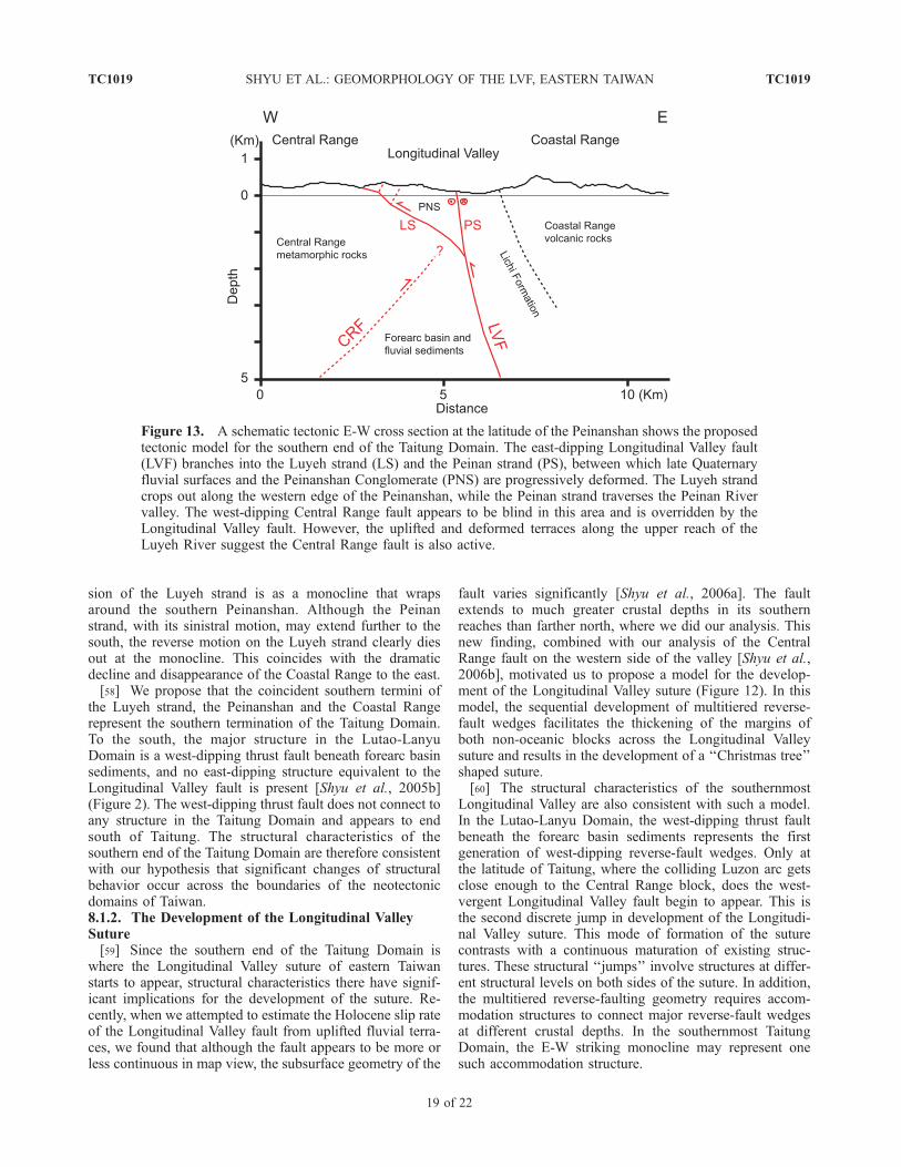
Figure 13. A schematic tectonic E-W cross section at the latitude of the Peinanshan shows the proposedtectonic model for the southern end of the Taitung Domain. The east-dipping Longitudinal Valley fault(LVF) branches into the Luyeh strand (LS) and the Peinan strand (PS), between which late Quaternaryfluvial surfaces and the Peinanshan Conglomerate (PNS) are progressively deformed. The Luyeh strandcrops out along the western edge of the Peinanshan, while the Peinan strand traverses the Peinan Rivervalley. The west-dipping Central Range fault appears to be blind in this area and is overridden by theLongitudinal Valley fault. However, the uplifted and deformed terraces along the upper reach of theLuyeh River suggest the Central Range fault is also active.
TC1019 SHYU ET AL.: GEOMORPHOLOGY OF THE LVF, EASTERN TAIWAN
19 of 22
TC1019

8.1.3. The Development of the Taiwan Orogenic Belt[61] The island of Taiwan is produced by the ongoing
collision between the Eurasian and the Philippine Seaplates. The Longitudinal Valley in eastern Taiwan, betweenthe Coastal and the Central Ranges, has long been consid-ered to be the locus of suturing in this collisional orogen.Therefore the structural characteristics of the southernmostpart of the valley have long been known to have importantimplications for the development of the orogenic belt.[62] One of the major puzzles of the Taiwan orogen is the
composition of the Central Range, the mountainous back-bone of the island. The traditional point of view is that theCentral Range is merely an exhumed and uplifted accre-tionary wedge. However, the presence of pre-Cenozoiccontinental basement in the Central Range rocks [e.g., Ho,1988] suggests that the range is a continental sliver sand-wiched between the Eurasian continental margin and theLuzon volcanic arc [Shyu et al., 2005a]. In our model, theslates and schists of the Central Range that overliethe continental basement are metamorphosed Eocene toMiocene continental margin sediments that were depositedupon and then rifted with the continental sliver.[63] The abrupt appearance of the Longitudinal Valley
suture at the southern end of the Taitung Domain isconsistent with this hypothesis. At the latitude of Taitung,the colliding Eurasian continental margin is still far to thewest of the volcanic arc, on the other (western) side of theCentral Range (Figures 1 and 2). Therefore the developmentof the Longitudinal Valley suture near the Peinanshanindicates that the Central Range is a rigid crustal blockbetween the continental margin and the volcanic arc. If theCentral Range comprises only accretionary wedge sedi-ments, convergence between the Eurasian continental mar-gin and the volcanic arc would be expected within the rangeat the latitude of Taitung. The result would be numerousactive structures across the range, and a narrower, discretesuture would only appear farther north, at a point wherecontinental margin and volcanic arc crusts actually collide.Instead, a well-defined suture occurs in the southernmostLongitudinal Valley, with structures that are accommodatingup to 30 mm/a of reverse slip, and no major structures havebeen observed within the Central Range at the samelatitude. Moving west from the Peinanshan area, the firstmajor structure system one encounters would be the Chao-chou fault-Lishan fault system as the western boundary ofthe Central Range (Figure 1), and this system is in fact animportant component of the other suture proposed in ourmodel, between the Eurasian continental margin and theCentral Range block [Shyu et al., 2005a]. The presence ofthe Central Range fault, which is blind near the Peinanshanbut emergent farther north [Shyu et al., 2006b], also impliesthat the range is acting as a rigid block.[64] In summary, the southernmost Longitudinal Valley is
a small but critical area for understanding the Taiwanorogenic belt. The abrupt appearance of the LongitudinalValley fault system there is consistent with the hypothesisthat the orogen comprises several distinct neotectonicdomains characterized by abrupt changes of structuralbehavior across domain boundaries [Shyu et al., 2005b].
The Longitudinal Valley suture therefore appears to beforming through several discrete structural ‘‘jumps,’’ ratherthan through a continuous maturation of existing structures.In cross-section these jumps appear as two opposing fam-ilies of imbricated reverse faults, reminiscent of the geom-etry of a Christmas tree [Shyu et al., 2006a, 2006b].Furthermore, the appearance of the suture at the latitudeof Taitung is consistent with our hypothesis that the CentralRange of Taiwan is a continental sliver sandwiched betweenthe collision of the Eurasian continental margin and theLuzon volcanic arc [Shyu et al., 2005a].
8.2. The Central Range Fault in the SouthernmostLongitudinal Valley
[65] All of the neotectonic features we have mapped inthe Peinanshan area are components of the east-dippingLongitudinal Valley fault system. The west-dipping CentralRange fault, though active and emergent in the middle partof the Longitudinal Valley, does not appear to break theground surface in this area [Shyu et al., 2006b] (Figure 2).Instead, the fluvial terraces along the northern bank of theLuyeh River provide evidence that the Central Range faultis active but blind.[66] West of and in the footwall block of the Luyeh
strand, the Lungtien terrace (terrace 4) sits up to 60 m abovethe current Luyeh River bed (Figure 5a). The absence of anyother strand of the Longitudinal Valley fault west of theLuyeh strand indicates that the incision of the Luyeh Riverto produce the Lungtien and other terraces west of theLuyeh strand is caused by uplift of the eastern flank of theCentral Range. In fact, the surface break of the Lungtienterrace by the Luyeh strand appears to be just a smallirregularity overprinted on the far greater incision of theLuyeh River. Therefore we believe the overall uplift ofthe eastern flank of the Central Range and the LuyehRiver terraces results from slip on a blind Central Rangefault. The fault would have to be overridden by the Luyehstrand, which breaks the surface of the Lungtien terrace(Figure 13).[67] The Lungtien terrace is a fill terrace, underlain by
thick fluvial deposits. At point N in Figure 4, a 40-m highoutcrop consists entirely of young fluvial gravels beneaththe Lungtien terrace surface. Thus the thickness of fluvialgravels underlying the Lungtien terrace is more than 40 m.This indicates that although the Luyeh River has cut about60 m into the Lungtien terrace, the net bedrock uplift of theterrace west of the Luyeh strand is less than 20 m. Since theage of the Lungtien terrace is about 3.5 ka, the uplift rate ofthe eastern Central Range flank can be no more than 6 mm/a.This is consistent with the suggested uplift rate of less than6.4 mm/a related to slip on the Central Range fault farthernorth [Shyu et al., 2006b].
8.3. Surface Creep of the Southernmost LongitudinalValley Fault
[68] It is well-known that the Longitudinal Valley fault iscreeping aseismically at rates as high as 20 mm/a nearChihshang, about 30 km north of the Peinanshan [Angelier
TC1019 SHYU ET AL.: GEOMORPHOLOGY OF THE LVF, EASTERN TAIWAN
20 of 22
TC1019

et al., 1997; Lee et al., 2001, 2003] (Figure 2). Othersegments of the fault, however, may be locked.[69] We conclude that the Luyeh strand of the fault is not
creeping at the surface, because we found no place whereany man-made structure is broken along the entire length ofthe fault. However, a leveling line installed in 2002 acrossthe Luyeh strand scarp on the Lungtien terrace shows rapiddeformation across an aperture of less than 3 km. Thisimplies that although it is not creeping at the surface, theLuyeh strand is indeed creeping at a very shallow depth.[70] Although several bridges built across the Peinan
strand are deformed, most of the deformation may haveoccurred during the December 2003 earthquake, by minorcoseismic slip or aftercreep [H.-T. Chu, unpublished data,2004]. Preliminary results of a short-aperture GPS transectacross the Peinan strand at the northeastern corner of thePeinanshan show that no significant near-field velocitydifference is present across the strand, which indicatesthat the strand may not be creeping at the surface at thatpoint.[71] A short-aperture GPS transect across the Pingting
terraces shows that large near-field velocity differences arepresent across the two strands of the Longitudinal Valleyfault there. Since we did not find any broken man-madestructures in this area, we believe that the strands may besimilar to the Luyeh strand, in that they have a very shallowlocking depth but are not creeping at the surface.
9. Conclusions
[72] Fluvial landforms allow detailed mapping of theLongitudinal Valley fault system near its southern terminusin eastern Taiwan. The fault system branches into two majorstrands: the Luyeh strand in the west and the Peinan strandin the east. The Luyeh strand has predominantly reversemotion, whereas the Peinan strand has a significant sinistralcomponent. Complete slip-partitioning, however, does notoccur throughout this reach, because the Peinan strand mayalso have a large reverse component north of the LuyehRiver.[73] The Luyeh strand produces a monoclinal scarp on
the Lungtien terrace. Both to the north and to the south ofthe Lungtien terrace, old fluvial surfaces of the Kaotai
terraces and the Peinanshan are moving upward and west-ward against the eastern flank of the Central Range. Fromthe age of the Lungtien terrace, the minimum vertical slipcomponent of the Luyeh strand is about 4.5 mm/a. TheLuyeh strand terminates to the south in an E-W strikingmonocline that wraps around the southern Peinanshan.[74] The Peinan strand appears to traverse the current
Peinan River bed for most of the fault’s length. The onlyexceptions are northeast of Shanli and on the terraces nearLichi, where the strand offsets fluvial terraces and producessmall scarps. South of the Luyeh River, the Peinan strand islikely to be predominantly left-lateral.[75] The Luyeh strand steps to the east south of the
Luliao River and joins with the Peinan strand to form themain strand of the Longitudinal Valley fault, which runsalong the western edge of the Pingting terraces and extendsto the north. The southern end of the Luyeh strand, on theother hand, is coincident with the southern end of theCoastal Range, and is likely to represent the abrupt southerntermination of the Taitung Domain. Most of the activestrands in the Peinanshan area have very shallow lockingdepths, but do not seem to be creeping at the surface.[76] The structural characteristics of the southernmost
Longitudinal Valley suture suggest that the suture developedthrough several discrete structural ‘‘jumps,’’ rather thanthrough a continuous maturation of existing structures.These structural ‘‘jumps’’ involve imbricate structures onboth sides of the suture.
[77] Acknowledgments. We greatly appreciate the assistance of Y.-C.Chen and T. Watanuki in the field. We have benefited significantly from theinformation collected by and the stimulating discussions with the studentsof two bi-national field classes of the National Taiwan University andCaltech, held in the Peinanshan area in 2001 and 2005. We are also gratefulfor valuable discussions with H.-T. Chu, J.-C. Lee, W.-T. Liang, D. V.Wiltschko, Y.-M. Wu, and S.-B. Yu. Our mapping was facilitated byJ. Giberson, manager of the Caltech’s GIS laboratory. The 5-m DEM wasgenerously provided by the Central Geological Survey, MOEA, Taiwan.Radiocarbon dating by M. Kashgarian in the Center for Accelerator MassSpectrometry, Lawrence Livermore National Laboratory, is greatly appre-ciated. The comments and suggestions of E. Kirby and two anonymousreviewers greatly helped us improve this manuscript. Our project in Taiwanwas supported by NSF grant EAR-0208505 and by the Gordon and BettyMoore Foundation. This is Caltech Tectonics Observatory Contribution#28.
ReferencesAngelier, J., H.-T. Chu, and J.-C. Lee (1997), Shear
concentration in a collision zone: Kinematics of theChihshang Fault as revealed by outcrop-scalequantification of active faulting, Longitudinal Val-ley, eastern Taiwan, Tectonophysics, 274, 117 –143.
Barrier, E., and C. Muller (1984), New observationsand discussion on the origin and age of the LichiMelange, Mem. Geol. Soc. China, 6, 303–325.
Barrier, E., and J. Angelier (1986), Active collision ineastern Taiwan: The Coastal Range, Mem. Geol.Soc. China, 7, 135 –159.
Barrier, E., J. Angelier, H. T. Chu, and L. S. Teng(1982), Tectonic analysis of compressional struc-ture in an active collision zone: The deformation ofthe Pinanshan Conglomerates, eastern Taiwan,Proc. Geol. Soc. China, 25, 123 –138.
Biq, C. (1971), Comparison of melange tectonics inTaiwan and in some other mountain belts, Pet.Geol. Taiwan, 9, 79 –106.
Chang, C. P., J. Angelier, C. Y. Huang, and C. S. Liu(2001), Structural evolution and significance of amelange in a collision belt: The Lichi Melange andthe Taiwan arc-continent collision, Geol. Mag.,138, 633–651.
Chen, Y.-G. (1988), C-14 dating and correlation of riverterraces along the lower reach of the Tahan-chi,northern Taiwan (in Chinese), M. S. thesis, 88 pp.,Natl. Taiwan Univ., Taipei.
Chen, H.-H., and R.-J. Rau (2002), Earthquake loca-tions and style of faulting in an active arc-continentplate boundary: The Chihshang fault of easternTaiwan, EOS, Trans., Am. Geophys. Uni., 83(47),Fall Meet. Suppl., Abstract T61B-1277.
Chu, H.-T., and M.-S. Yu (1997), The Relationshipsbetween Earthquakes and Faults in the TaitungLongitudinal Valley (in Chinese), Natl. Sci. Coun-cil Project Rep., Project No. NSC-86-2116-M-047-002, 133 pp., Taipei.
Ho, C. S. (1986), A synthesis of the geologic evolutionof Taiwan, Tectonophysics, 125, 1 – 16.
Ho, C. S. (1988), An Introduction to the Geology ofTaiwan, Explanatory Text of the Geologic Map ofTaiwan, 2nd ed., 192 pp., Cent. Geol. Surv., Min-istry Econ. Affairs, Taipei, Taiwan.
Hsu, K. J. (1988), Melange and the melange tectonicsof Taiwan, Proc. Geol. Soc. China, 31(2), 87– 92.
Hsu, T. L. (1956), Geology of the Coastal Range, east-ern Taiwan, Bull. Geol. Surv. Taiwan, 8, 39–63.
Hsu, Y.-J., M. Simons, S.-B. Yu, L.-C. Kuo, and H.-Y.Chen (2003), A two-dimensional dislocation model
TC1019 SHYU ET AL.: GEOMORPHOLOGY OF THE LVF, EASTERN TAIWAN
21 of 22
TC1019
for interseismic deformation of the Taiwan moun-tain belt, Earth Planet. Sci. Lett., 211, 287 –294.
Hu, J.-C., J. Angelier, C. Homberg, J.-C. Lee, andH.-T. Chu (2001), Three-dimensional modeling ofthe behavior of the oblique convergent boundary ofsoutheast Taiwan: Friction and strain partitioning,Tectonophysics, 333, 261–276.
Huang, C.-Y., C.-T. Shyu, S. B. Lin, T.-Q. Lee, andD. D. Sheu (1992), Marine geology in the arc-con-tinent collision zone off southeastern Taiwan: Im-plications for Late Neogene evolution of theCoastal Range, Mar. Geol., 107, 183 –212.
Huang, C.-Y., W.-Y. Wu, C.-P. Chang, S. Tsao, P. B.Yuan, C.-W. Lin, and K.-Y. Xia (1997), Tectonicevolution of accretionary prism in the arc-continentcollision terrane of Taiwan, Tectonophysics, 281,31– 51.
Kuochen, H., Y.-M. Wu, C.-H. Chang, J.-C. Hu, andW.-S. Chen (2004), Relocation of the eastern Tai-wan earthquakes and its tectonic implications, Terr.Atmos. Oceanic Sci., 15, 647–666.
Lallemand, S., and C.-S. Liu (1998), Geodynamic im-plications of present-day kinematics in the southernRyukyus, J. Geol. Soc. China, 41, 551–564.
Lee, J.-C., J. Angelier, H.-T. Chu, S.-B. Yu, and J.-C.Hu (1998), Plate-boundary strain partitioning alongthe sinistral collision suture of the Philippine andEurasian plates: Analysis of geodetic data and geo-logical observation in southeastern Taiwan, Tec-tonics, 17, 859–871.
Lee, J.-C., J. Angelier, H.-T. Chu, J.-C. Hu, and F.-S.Jeng (2001), Continuous monitoring of an activefault in a plate suture zone: A creepmeter study ofthe Chihshang Fault, eastern Taiwan, Tectonophy-sics, 333, 219–240.
Lee, J.-C., J. Angelier, H.-T. Chu, J.-C. Hu, F.-S. Jeng,and R.-J. Rau (2003), Active fault creep variationsat Chihshang, Taiwan, revealed by creep metermonitoring, 1998-2001, J. Geophys. Res. ,108(B11), 2528, doi:10.1029/2003JB002394.
Lin, C.-W., H.-C. Chang, S.-T. Lu, T.-S. Shih, andW.-J. Huang (2000), An Introduction to the Active
Faults of Taiwan, 2nd ed., Explanatory Text of theActive Fault Map of Taiwan (in Chinese withEnglish abstract), Spec. Pub. Cent. Geol. Surv.,13, 122 pp., Taipei, Taiwan.
Malavieille, J., S. E. Lallemand, S. Dominguez,A. Deschamps, C.-Y. Lu, C.-S. Liu, P. Schnurle, andthe ACT Scientific Crew (2002), Arc-continentcollision in Taiwan: new marine observations andtectonic evolution,Geol. Soc. Am. Spec. Paper, 358,187–211.
Oakeshott, G. B. (Ed.) (1975), San Fernando, CaliforniaEarthquake of 9 February 1971, California Divisionof Mines and Geology Bulletin 196, 462 pp.,Sacramento, CA.
Page, B. M., and J. Suppe (1981), The Pliocene LichiMelange of Taiwan: Its plate-tectonic and olistos-tromal origin, Am. J. Sci., 281, 193–227.
Sella, G. F., T. H. Dixon, and A. Mao (2002), REVEL:A model for Recent plate velocities from spacegeodesy, J. Geophys. Res., 107(B4), 2081,doi:10.1029/2000JB000033.
Shih, T.-T., J.-C. Chang, C.-E. Hwang, C.-D. Shih, G.-S.Yang, and Y.-M. Sunlin (1983), A geomorphologi-cal study of active fault in northern and easternTaiwan (in Chinese with English abstract), Geogr.Res., 9, 20– 72.
Shih, T.-T., J.-C. Chang, C.-E. Hwang, C.-D. Shih, andG.-S. Yang (1984), A geomorphological study ofactive fault in northern and eastern Taiwan, Geogr.Studies, 8, 1 –30.
Shih, T.-T., K.-H. Teng, J.-C. Chang, C.-D. Shih, andG.-S. Yang (1986), A geomorphological study ofactive fault in Taiwan (in Chinese with Englishabstract), Geogr. Res., 12, 1 –44.
Shyu, J. B. H., K. Sieh, and Y.-G. Chen (2005a),Tandem suturing and disarticulation of the Taiwanorogen revealed by its neotectonic elements, EarthPlanet. Sci. Lett., 233, 167–177.
Shyu, J. B. H., K. Sieh, Y.-G. Chen, and C.-S. Liu(2005b), Neotectonic architecture of Taiwan andits implications for future large earthquakes,J. Geophys. Res., 110, B08402, doi:10.1029/2004JB003251.
Shyu, J. B. H., K. Sieh, J.-P. Avouac, W.-S. Chen, andY.-G. Chen (2006a), Millennial slip rate of theLongitudinal Valley fault from river terraces: Im-plications for convergence across the active sutureof eastern Taiwan, J. Geophys. Res., 111, B08403,doi:10.1029/2005JB003971.
Shyu, J. B. H., K. Sieh, Y.-G. Chen, and L.-H. Chung(2006b), Geomorphic analysis of the CentralRange fault, the second major active structure ofthe Longitudinal Valley suture, eastern Taiwan,Geol. Soc. Am. Bull., 118, 1447–1462.
Stuiver, M., and P. J. Reimer (1993), Extended 14C database and revised CALIB 3.0 14C age calibrationprogram, Radiocarbon, 35, 215–230.
Suppe, J. (1987), The active Taiwan mountain belt, inAnatomy of Mountain Chains, edited by J. P.Schaer and J. Rodgers, pp. 277– 293, PrincetonUniv. Press, Princeton, N. J.
Teng, L. S. (1981), On the origin and tectonic signifi-cance of the Lichi Formation, Coastal Range, easternTaiwan (in Chinese with English abstract), Ti-Chih, 3,51–61.
Teng, L. S. (1987), Stratigraphic records of the lateCenozoic Penglai orogeny of Taiwan, Acta Geol.Taiwan., 25, 205–224.
Teng, L. S. (1990), Late Cenozoic arc-continent colli-sion in Taiwan, Tectonophysics, 183, 57–76.
Teng, L. S., and Y. Wang (1981), Island arc system ofthe Coastal Range, eastern Taiwan, Proc. Geol.Soc. China, 24, 99– 112.
Wang, Y., and W.-S. Chen (1993), Geologic Map ofEastern Coastal Range, Central Geological Survey,MOEA, scale 1:100,000, Taipei.
Wu, Y. M., Y. G. Chen, T. C. Shin, H. Kuochen, C. S.Hou, J. C. Hu, C. H. Chang, C. F. Wu, and T. L.Teng (2006), Coseismic versus interseismic grounddeformations, fault rupture inversion and segmen-tation revealed by 2003 Mw 6.8 Chengkung earth-quake in eastern Taiwan, Geophys. Res. Lett., 33,L02312, doi:10.1029/2005GL024711.
Yang, G.-S. (1986), A geomorphological study of ac-tive faults in Taiwan – especially on the relationbetween active faults and geomorphic surfaces (inChinese), Ph.D. thesis, 178 pp., Chinese CultureUniv., Taipei, Taiwan.
Yu, S.-B., and L.-C. Kuo (2001), Present-day crustalmotion along the Longitudinal Valley Fault, easternTaiwan, Tectonophysics, 333, 199–217.
Yu, S.-B., and C.-C. Liu (1989), Fault creep on thecentral segment of the Longitudinal Valley fault,eastern Taiwan, Proc. Geol. Soc. China, 32,209 –231.
Yu, S.-B., G.-K. Yu, L.-C. Kuo, and C. Lee (1992),Crustal deformation in the southern LongitudinalValley area, eastern Taiwan, J. Geol. Soc. China,35, 219–230.
���������Y.-G. Chen, R. Y. Chuang, and L.-H. Chung,Department of Geosciences, National Taiwan Univer-sity, Taipei 106, Taiwan.
J. B. H. Shyu, Section Geology, Department ofEarth and Environmental Sciences, Ludwig-Maximi-lians University Munich, Luisenstraße 37, 80333Munich, Germany. ([email protected])
K. Sieh and Y. Wang, Tectonics Observatory,Division of Geological and Planetary Sciences, Cali-fornia Institute of Technology, Pasadena, CA 91125,USA.
TC1019 SHYU ET AL.: GEOMORPHOLOGY OF THE LVF, EASTERN TAIWAN
22 of 22
TC1019
Copyright © 2022 FDOKUMEN