Geomorphology, stability and mobility of the Currituck slide
Geomorphology 207 (2014) 213–220
Contents lists available at ScienceDirect
Geomorphology
j ourna l homepage: www.e lsev ie r .com/ locate /geomorph
The drumlin field and the geomorphology of the Múlajökull surge-typeglacier, central Iceland
Sverrir Aðalsteinn Jónsson a,⁎, Anders Schomacker b, Ívar Örn Benediktsson c,Ólafur Ingólfsson a,d, Mark D. Johnson e
a Institute of Earth Sciences, University of Iceland, Sturlugata 7, Askja, IS-101 Reykjavík, Icelandb Department of Geology, Norwegian University of Science and Technology, Sem Sælands Veg 1, N-7491 Trondheim, Norwayc Department of Geology, Lund University, Sölvegatan 12, S-223 62 Lund, Swedend University Centre in Svalbard (UNIS), P.O. Box 156, N-9171 Longyearbyen, Norwaye Department of Earth Sciences, University of Gothenburg, Box 460, S-405 30 Göteborg, Sweden
⁎ Corresponding author. Tel.: +354 863 9674.E-mail address: [email protected] (S.A. Jónsson).
0169-555X/$ – see front matter © 2013 Elsevier B.V. All rhttp://dx.doi.org/10.1016/j.geomorph.2013.11.007
a b s t r a c t
a r t i c l e i n f oArticle history:Received 23 May 2013Received in revised form 6 November 2013Accepted 11 November 2013Available online 20 November 2013
Keywords:MúlajökullIcelandGlacial geomorphologySurge-type glacierDrumlin
Herewe present a new geomorphologicalmap of the active drumlin field and the forefield ofMúlajökull, a surge-type outlet glacier, Iceland. The map is based on aerial photographs taken in 1995 and LiDAR data recorded in2008. Mapping was done using ArcGIS 10 software on orthorectified imagery, LiDAR data and digital elevationmodels. The mapped landforms were initially identified on the aerial imagery and LiDAR and then ground-checked in the field. We mapped subglacial, supraglacial, ice-marginal, periglacial, and glaciofluvial landforms.The geomorphology of the Múlajökull forefield is similar to that of the forefields of other surge-type glaciers inIceland: with a highly streamlined forefield, crevasse-fill ridges, and series of glaciotectonic end moraines. How-ever, the large number (i.e., 110) of drumlins forming the drumlinfield is unique formodern Icelandic surge-typeglaciers and, as yet, unique for contemporary glaciers in general. Also apparent is that the drumlins arewider andshorter in the distal part of the drumlin field and narrower and longer in the proximal part. Hence, the mappingreveals a development of the drumlins toward a more streamlined shape of the proximal landforms that haveexperienced more surges. The drumlins in the drumlin field are active, i.e., they form during the modern surgesof Múlajökull.
© 2013 Elsevier B.V. All rights reserved.
1. Introduction
Conceptual models have been made for various types of glaciallandsystems based on studies of Icelandic glaciers; the glaciated valleylandsystem (Spedding and Evans, 2002), the active temperate glacierlandsystem (Evans and Twigg, 2002), the plateau icefield landsystem(Evans et al. 2006), and the surging glacier landsystem (Evans andRea, 1999, 2003). The active temperate glacier landsystem is consideredto be a suitable modern analogue for reconstructing the margins ofPleistocene glaciers and ice sheets (Evans et al. 1999; Evans andTwigg, 2002). The surging glaciers are considered to be suitablemodernanalogues to terrestrial palaeo-ice streams (Evans and Rea, 1999, 2003;Evans et al. 1999; Kjær et al. 2006, 2008).
Some glacial landforms have been considered as diagnostic ofsurges. These include, in particular, crevasse-fill ridges and concertinaeskers; but other landforms, such as long flutes, glaciotectonic endmoraines, and hummocky moraines have also been strongly linked toglacier surges (Knudsen, 1995; Evans and Rea, 1999, 2003; Schomackerand Kjær, 2007; Benediktsson et al. 2008, 2010; Evans et al. 2010;
ights reserved.
Schomacker et al. in press). Drumlins have also been described in asso-ciationwith surging glaciers, although they are not considered as partic-ularly typical of surging (Hart, 1995; Kjær et al. 2008;Waller et al. 2008;Johnson et al. 2010; Schomacker et al. in press). Johnson et al. (2010)described an active drumlin field at the margin of Múlajökull, a surge-type outlet glacier in central Iceland. This drumlin field is the onlyknown active drumlin field in the world, making the Múlajökull glacierand its forefield a unique site. The purpose of this study is to map thegeomorphology of theMúlajökull forefield (Fig. 1A) in order to enhancethe current understanding of the surging-glacier landsystem and thedevelopment of active drumlin fields. For this purpose, we present ageomorphological map of the forefield of Múlajökull (Fig. 2).
2. Setting
Múlajökull is a surge-type piedmont glacier of theHofsjökull ice cap,which rests on the largest central volcano in Iceland (Sigurðsson andWilliams, 2008; Björnsson, 2009). Múlajökull is about 7 km wide inthe accumulation zone and drains a part of the ice-filled caldera of thevolcano (Björnsson, 2009). The glacier drains through a 2-km narrowvalley between Mt. Hjartafell to the west and Mt. Kerfjall to the east(Fig. 1C). As the glacier leaves the valley, it spills onto the relatively

Fig. 1. (A) Location ofMúlajökull (red square) at the southernmargin of theHofsjökull ice cap;map based on a hillshade terrainmodel of Iceland. (B) Variations of the glacier snout duringpast decades, modified from Johnson et al. (2010). (C) Overview photo of the Hofsjökull ice cap, Mt. Hjartafell, Mt. Kerfjall, and the Múlajökull piedmont lobe. The vegetated wetlands ofÞjórsárver can be seen in the foreground.
214 S.A. Jónsson et al. / Geomorphology 207 (2014) 213–220
flat forefield forming a 4-km-wide piedmont lobe. The largest river inthe forefield is the glacial river Arnarfellskvísl that emerges from theice front close to Mt. Kerfjall. Apart from Arnarfellskvísl, numeroussmall streams drain the ice front and run toward the outwash plainsin the northeast and southwest corners of the map.
The glacier terminates with a 6.5-km-long ice margin at around620 masl. The ice margin lies about 2 km inside the outermost LittleIce Age (LIA) end moraine, and the glacier has a history of four surgessince 1924 (Fig. 1B; Johnson et al. 2010). In addition, a minor surgeoccurred in 2008 but produced, however, a significant push moraine.The glacier has retreated about 700 m since the last major surge in1992 revealing over 50 drumlins, which are argued by Johnson et al.(2010) to have been formed and shaped progressively during theprevious surges of the glacier.
3. Methods
The mapping of the forefield was done using panchromatic aerialphotographs taken in 1995 by Landmælingar Íslands. Mapping tookplace on derived orthophotographs with 1-m pixel size. A digital eleva-tion model (DEM) with 3-m ground sample distance produced withstereophotogrammetry was also used in the mapping. Ground-controlpoints were identified and measured in the field with a differentialGPS. All data were handled in the UTM/WGS84 reference system, andelevations are in metres above sea level.
An airborne 0.5-m LiDARDEM covering the glacier and about 600 minto the forefield was visualized as a terrain shade-relief model andused for mapping the recently deglaciated part of the forefield. TheLiDAR data were recorded in 2008 by the Icelandic MeteorologicalOffice and the Institute of Earth Sciences of the University of Iceland(Jóhannesson et al. 2013).
Landformswere mapped on the orthophotograph distal to the 1995glacier margin and on the LiDAR data, where theywere available, in thearea deglaciated after 1995. The geomorphic map was constructedusing ESRI ArcGIS 10 and ESRI ArcScene 10.
A three-dimensional assessment was made by draping the ortho-photograph over the 3-m DEM and using a hillshade model of the0.5-m LiDAR DEM. These were viewed in ArcScene while mappingin ArcGIS, aiding in identification and inmapping of landforms. Land-forms were mapped either as polygons or lines in a scale of 1:400 orlower. The resultingmap is designed to be viewed digitally or printed inA0 format (Fig. 2). Themap has been checked in the field, and all drum-linswere identified in thefield before beingmapped. The length, height,and width of all the drumlins that are outside the LiDAR data weremeasured in the field with a TopCon total station.
4. Mapped landforms
The glacial landforms and sediments occurring in the forefield ofMúlajökull can be divided into five main assemblages: (i) subglacial,(ii) supraglacial, (iii) ice-marginal, (iv) periglacial, and (v) glaciofluvial.A description of the landforms and their sediments follows below.
4.1. Subglacial landforms
4.1.1. Till plainThe forefield is predominantly coveredwith till; andbased on Johnson
et al. (2010) and observations of flutes, drumlins, and crevasse-fills onthe surface and bullet-shaped clasts, deformation, and fissility in thesediments, it is interpreted as a subglacial till plain (Fig. 3A–B). The tillplain is covered with a clast pavement of subrounded to rounded peb-bles, cobbles, and some boulders; and it is dissected by lakes and melt-water streams. The till plain mapped in Fig. 2 also includes somepatches of lake and outwash plains too small to map. It covers themajority of the area between the LIA end moraine and the glacier.
4.1.2. DrumlinsThe most striking features characterising the geomorphology of
the Múlajökull forefield are the drumlins and the drumlin field(Figs. 3C, 4A). We mapped 110 drumlins in front of Múlajökull with

Fig. 2.Geomorphologicalmap of theMúlajökull forefield. For a full resolution version of themap, see online supplementary data at 10.1016/j.geomorph.2013.11.007. Themap shown hereis downsized and modified slightly, but the full-resolution map is designed for printing on A0 paper size. The map is based on aerial photographs recorded in 1995 and LiDAR data from2008. Map projection and datum: UTM 27N, WGS 84. Scale 1:9000.
215S.A. Jónsson et al. / Geomorphology 207 (2014) 213–220

Fig. 3. (A) An overview of the till plain with a number of crevasse-fill ridges in the foreground. The crevasse-fill ridges are predominantly oriented subparallel to the ice flow direction.Because of low preservation potential the ridges appear slightly disintegrated. Photo location: 612158; 7171726 UTM. (B) Flute in front of Múlajökull. The boulder at the head of theflute is about 0.5 m in diameter. Photo location: 609510; 7170671 UTM. (C) A spindle-shaped drumlin exposed at the retreating ice front, the surrounding lake enhances the outlines.The drumlin is about 200 m long. Photo location: 610155; 7170758 UTM.
216 S.A. Jónsson et al. / Geomorphology 207 (2014) 213–220
an average spacing of 94 m and on average areal density of around10 drumlins/km2 on the till plain. Drumlin orientation varies bynearly 180° as they occur in a splayed fan distribution in theforefield, so that the stoss end of drumlins in the northeastern partof the forefield points toward NE whilst the stoss end points toward
Fig. 4. (A) An overview from south to north overMúlajökull and a part of the drumlin field. DruUTM. (B) Length and width of the drumlins in this study. Drumlins that are not fully exposed inspade for scale. In this photo it appears clearly that the crevasse-fill ridge is made up of till. Ph
SW in the southwestern part (Fig. 2). The drumlins range from 70 to380 m in length, 20 to 180 m in width, and 2 to 10 m in height(Fig. 4B) and tend to be asymmetric in the sense that they are higherandwider upglacier and taper downglacier. Close to the glacier front,lakes occupy depressions between the drumlins and accentuate the
mlins and crevasse-fill ridges can be seen on the till plain. Photo location: 609807 7170271front of the glacier were not measured. (C) A river cut through a large crevasse-fill ridge,
oto location: 612220; 7172556 UTM.
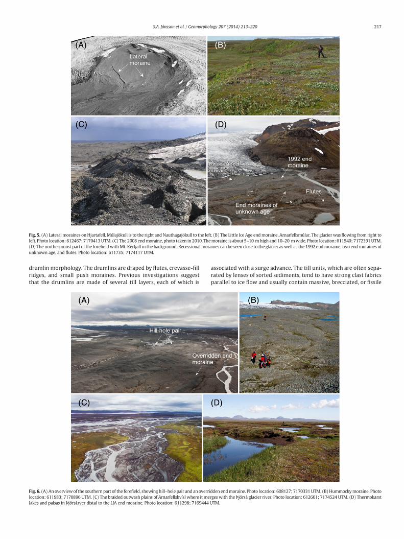
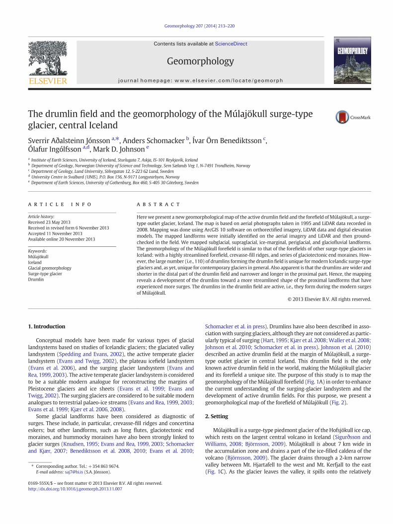
Fig. 5. (A) Lateral moraines onHjartafell. Múlajökull is to the right andNauthagajökull to the left. (B) The Little Ice Age endmoraine, Arnarfellsmúlar. The glacier was flowing from right toleft. Photo location: 612467; 7170413UTM. (C) The 2008 endmoraine, photo taken in 2010. Themoraine is about 5–10 mhigh and 10–20 mwide. Photo location: 611540; 7172391UTM.(D) The northernmost part of the forefield withMt. Kerfjall in the background. Recessionalmoraines can be seen close to the glacier as well as the 1992 endmoraine, two endmoraines ofunknown age, and flutes. Photo location: 611735; 7174117 UTM.
217S.A. Jónsson et al. / Geomorphology 207 (2014) 213–220
drumlin morphology. The drumlins are draped by flutes, crevasse-fillridges, and small push moraines. Previous investigations suggestthat the drumlins are made of several till layers, each of which is
Fig. 6. (A) Anoverviewof the southern part of the forefield, showing hill–hole pair and an overrilocation: 611983; 7170896 UTM. (C) The braided outwash plains of Arnarfellskvísl where it melakes and palsas in Þjórsárver distal to the LIA end moraine. Photo location: 611298; 7169444
associated with a surge advance. The till units, which are often sepa-rated by lenses of sorted sediments, tend to have strong clast fabricsparallel to ice flow and usually contain massive, brecciated, or fissile
dden endmoraine. Photo location: 608127; 7170331UTM. (B) Hummockymoraine. Photorges with the Þjórsá glacier river. Photo location: 612601; 7174524 UTM. (D) ThermokarstUTM.
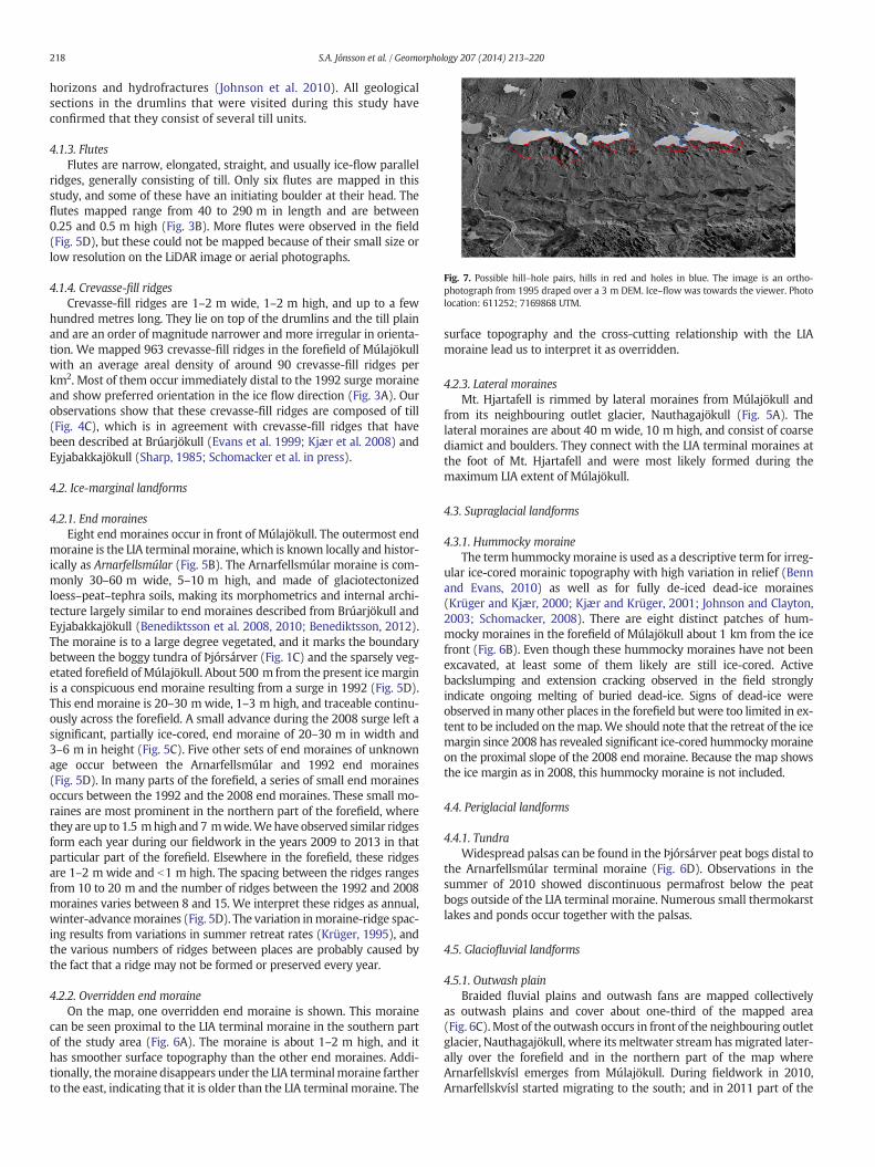
Fig. 7. Possible hill–hole pairs, hills in red and holes in blue. The image is an ortho-photograph from 1995 draped over a 3 m DEM. Ice–flow was towards the viewer. Photolocation: 611252; 7169868 UTM.
218 S.A. Jónsson et al. / Geomorphology 207 (2014) 213–220
horizons and hydrofractures (Johnson et al. 2010). All geologicalsections in the drumlins that were visited during this study haveconfirmed that they consist of several till units.
4.1.3. FlutesFlutes are narrow, elongated, straight, and usually ice-flow parallel
ridges, generally consisting of till. Only six flutes are mapped in thisstudy, and some of these have an initiating boulder at their head. Theflutes mapped range from 40 to 290 m in length and are between0.25 and 0.5 m high (Fig. 3B). More flutes were observed in the field(Fig. 5D), but these could not be mapped because of their small size orlow resolution on the LiDAR image or aerial photographs.
4.1.4. Crevasse-fill ridgesCrevasse-fill ridges are 1–2 m wide, 1–2 m high, and up to a few
hundred metres long. They lie on top of the drumlins and the till plainand are an order of magnitude narrower and more irregular in orienta-tion. We mapped 963 crevasse-fill ridges in the forefield of Múlajökullwith an average areal density of around 90 crevasse-fill ridges perkm2. Most of them occur immediately distal to the 1992 surge moraineand show preferred orientation in the ice flow direction (Fig. 3A). Ourobservations show that these crevasse-fill ridges are composed of till(Fig. 4C), which is in agreement with crevasse-fill ridges that havebeen described at Brúarjökull (Evans et al. 1999; Kjær et al. 2008) andEyjabakkajökull (Sharp, 1985; Schomacker et al. in press).
4.2. Ice-marginal landforms
4.2.1. End morainesEight end moraines occur in front of Múlajökull. The outermost end
moraine is the LIA terminal moraine, which is known locally and histor-ically as Arnarfellsmúlar (Fig. 5B). The Arnarfellsmúlar moraine is com-monly 30–60 m wide, 5–10 m high, and made of glaciotectonizedloess–peat–tephra soils, making its morphometrics and internal archi-tecture largely similar to end moraines described from Brúarjökull andEyjabakkajökull (Benediktsson et al. 2008, 2010; Benediktsson, 2012).The moraine is to a large degree vegetated, and it marks the boundarybetween the boggy tundra of Þjórsárver (Fig. 1C) and the sparsely veg-etated forefield of Múlajökull. About 500 m from the present icemarginis a conspicuous end moraine resulting from a surge in 1992 (Fig. 5D).This end moraine is 20–30 mwide, 1–3 m high, and traceable continu-ously across the forefield. A small advance during the 2008 surge left asignificant, partially ice-cored, end moraine of 20–30 m in width and3–6 m in height (Fig. 5C). Five other sets of end moraines of unknownage occur between the Arnarfellsmúlar and 1992 end moraines(Fig. 5D). In many parts of the forefield, a series of small end morainesoccurs between the 1992 and the 2008 end moraines. These small mo-raines are most prominent in the northern part of the forefield, wherethey are up to 1.5 mhigh and7 mwide.Wehave observed similar ridgesform each year during our fieldwork in the years 2009 to 2013 in thatparticular part of the forefield. Elsewhere in the forefield, these ridgesare 1–2 m wide and b1 m high. The spacing between the ridges rangesfrom 10 to 20 m and the number of ridges between the 1992 and 2008moraines varies between 8 and 15. We interpret these ridges as annual,winter-advancemoraines (Fig. 5D). The variation inmoraine-ridge spac-ing results from variations in summer retreat rates (Krüger, 1995), andthe various numbers of ridges between places are probably caused bythe fact that a ridge may not be formed or preserved every year.
4.2.2. Overridden end moraineOn the map, one overridden end moraine is shown. This moraine
can be seen proximal to the LIA terminal moraine in the southern partof the study area (Fig. 6A). The moraine is about 1–2 m high, and ithas smoother surface topography than the other end moraines. Addi-tionally, themoraine disappears under the LIA terminalmoraine fartherto the east, indicating that it is older than the LIA terminal moraine. The
surface topography and the cross-cutting relationship with the LIAmoraine lead us to interpret it as overridden.
4.2.3. Lateral morainesMt. Hjartafell is rimmed by lateral moraines from Múlajökull and
from its neighbouring outlet glacier, Nauthagajökull (Fig. 5A). Thelateral moraines are about 40 m wide, 10 m high, and consist of coarsediamict and boulders. They connect with the LIA terminal moraines atthe foot of Mt. Hjartafell and were most likely formed during themaximum LIA extent of Múlajökull.
4.3. Supraglacial landforms
4.3.1. Hummocky moraineThe term hummockymoraine is used as a descriptive term for irreg-
ular ice-cored morainic topography with high variation in relief (Bennand Evans, 2010) as well as for fully de-iced dead-ice moraines(Krüger and Kjær, 2000; Kjær and Krüger, 2001; Johnson and Clayton,2003; Schomacker, 2008). There are eight distinct patches of hum-mocky moraines in the forefield of Múlajökull about 1 km from the icefront (Fig. 6B). Even though these hummocky moraines have not beenexcavated, at least some of them likely are still ice-cored. Activebackslumping and extension cracking observed in the field stronglyindicate ongoing melting of buried dead-ice. Signs of dead-ice wereobserved inmany other places in the forefield but were too limited in ex-tent to be included on themap.We should note that the retreat of the icemargin since 2008 has revealed significant ice-cored hummockymoraineon the proximal slope of the 2008 end moraine. Because the map showsthe ice margin as in 2008, this hummocky moraine is not included.
4.4. Periglacial landforms
4.4.1. TundraWidespread palsas can be found in the Þjórsárver peat bogs distal to
the Arnarfellsmúlar terminal moraine (Fig. 6D). Observations in thesummer of 2010 showed discontinuous permafrost below the peatbogs outside of the LIA terminal moraine. Numerous small thermokarstlakes and ponds occur together with the palsas.
4.5. Glaciofluvial landforms
4.5.1. Outwash plainBraided fluvial plains and outwash fans are mapped collectively
as outwash plains and cover about one-third of the mapped area(Fig. 6C). Most of the outwash occurs in front of the neighbouring outletglacier, Nauthagajökull, where its meltwater stream hasmigrated later-ally over the forefield and in the northern part of the map whereArnarfellskvísl emerges from Múlajökull. During fieldwork in 2010,Arnarfellskvísl started migrating to the south; and in 2011 part of the
219S.A. Jónsson et al. / Geomorphology 207 (2014) 213–220
river was flowing proximal to the LIA terminal moraines for about1.5 km, causing severe erosion on their proximal side.
5. Discussion and conclusions
The main focus of this study was to map the geomorphology in theforefield of Múlajökull outlet glacier to better understand the Múlajökullglacial landsystem and its emerging drumlin field.
The geomorphology of theMúlajökull forefield agreeswell with pre-vious models of surging glacier landsystems (Evans and Rea, 1999,2003; Schomacker et al. in press). Evans and Rea (1999, 2003) andSchomacker et al. (in press) identified three zones in the forefields ofthe Brúarjökull and Eyjabakkajökull surging glaciers, although both rec-ognise that some mixing of the zones can take place where multiplesurges have occurred. Zone A, the outermost zone, is characterised byhill–hole pairs and thrust moraines of presurge sediments. This corre-sponds to the outermost glaciotectonic end moraine (Arnarfellsmúlar)at Múlajökull. We were not able to identify examples of hill–hole pairsin the Mulajökull forefield clear enough to include as a map unit inFig. 2. However, places can be found where lake basins and adjacentmorainic hills line up in such a way that a thrusting genesis for theexcavation of the lake basin and formation of the hills downice seemsplausible (Figs. 6A and 7). Weakly developed or patchy hummockymoraine draped on the ice-proximal side of the push moraines can beconsidered as part of zone A because of its association with the pushmoraines, following Schomacker et al. (in press), or as an independentzone (zone B) according to Evans and Rea (1999, 2003). This agrees inpart with the forefield of Múlajökull except for the patchy hummockymoraines, which are not situated on the ice-proximal side of theglaciotectonic moraine but proximal to the depression of the hill–holepair (Fig. 7). The lack of hummocky moraines on the ice-proximal sideof the outer glaciotectonicmoraine could be the result of erosion as out-wash almost always appears immediately on the ice-proximal side ofthe moraine. Zone C of Evans and Rea (1999, 2003) and Schomackeret al. (in press) is characterised by flutes, crevasse-fill ridges, and con-certina eskers. At Múlajökull, crevasse-fill ridges are abundant; andminor flutes are common, although only a few large flutes could bemapped. Concertina eskers are, on the other hand, completely absentfrom the Múlajökull forefield. To our knowledge, these landformshave only been identified in front of four surge-type glaciers inIceland, Svalbard, and Novaya Zemlya (Knudsen, 1995; Hansen,2003; Grant et al. 2009; Schomacker et al. in press). No concertinaeskers were described at Sátujökull, a surge-type outlet glacier onthe north margin of Hofsjökull (Evans et al. 2010). At Múlajökull,the inner zone is instead dominated by the drumlins of the drumlinfield.
We conclude that the geomorphology of theMúlajökull forefield andthe zonation of sediments and landforms correspond largely to thesurging-glacier landsystem models of Evans and Rea (1999, 2003) andSchomacker et al. (in press), as well as to the geomorphology of othersurge-type glaciers in Iceland (e.g., Kjær et al. 2008; Evans, 2011). Themajor difference between the forefield of Múlajökull and those ofother surge-type glaciers is the active drumlin field, which is uniquefor modern surge-type glaciers and, as yet, unique for contemporaryglaciers in general.
The lack of drumlin fields at other contemporary surge-type gla-ciers and thus their absence from the surging-glacier landsystemmodels could very well be because the drumlin fields have not yetbeen exposed. Drumlins are usually formed some distance behindthe glacier front and, generally, modern glaciers have not retreatedfar enough from their LIA end moraines to expose the potentialdrumlins and drumlin fields formed during the peak of the LIA.More modern drumlin fields might therefore become exposed inthe coming years.
The drumlins farther away from the ice front appear wider, shorter,and with lower relief than those closer to the glacier. Therefore, we
hypothesize that drumlins, which have only experienced a few surges,are shorter and wider with low relief; whilst those that have been at-tributed to more surges are longer and narrower with higher relief.This hypothesis, however, needs to be tested with further studies.
Acknowledgements
The Múlajökull project was funded by the Icelandic Centre forResearch (RANNÍS), the University of Iceland Research fund, the EnergyResearch Fund of Landsvirkjun, and the Carlsberg Foundation. GeoffGadd is thanked for the photograph in Fig. 4C and Skafti Brynjólfsson,Jón Björn Ólafsson, and Márus Hjörtur Jónsson are thanked for theirassistance in thefield. Themanuscript benefited from constructive com-ments from Kent M. Syversson and one anonymous reviewer.
Appendix A. Supplementary data
Supplementary data to this article can be found online at http://dx.doi.org/10.1016/j.geomorph.2013.11.007.
References
Benediktsson, Í.Ö., 2012. Polyphase structural evolution of a fine-grained, fold-dominatedend moraine, Brúarjökull surge-type glacier, Iceland. Jökull 62, 167–184.
Benediktsson, Í.Ö., Möller, P., Ingólfsson, Ó., van der Meer, J.J.M., Kjær, K.H., Krüger, J.,2008. Instantaneous end moraine and sediment wedge formation during the 1890glacier surge of Brúarjökull, Iceland. Quat. Sci. Rev. 27, 209–234.
Benediktsson, Í.Ö., Schomacker, A., Lokrantz, H., Ingólfsson, Ó., 2010. The 1890 surge endmoraine at Eyjabakkajökull, Iceland: re-assessment of a classic glaciotectonic locality.Quat. Sci. Rev. 29, 484–506.
Benn, D.I., Evans, D.J.A., 2010. Glaciers and Glaciation, 2nd edition. Hodder Education,London, England (802 pp.).
Björnsson, H., 2009. Jöklar á Íslandi. Opna, Reykjavík (479 pp. in Icelandic with Englishsummary).
Evans, D.J.A., 2011. Glacial landsystems of Sátujökull, Iceland: modern analogue for glaciallandsystem overprinting by mountain ice caps. Geomorphology 129, 225–237.
Evans, D.J.A., Rea, B.R., 1999. Geomorphology and sedimentology of surging glaciers: aland-systems approach. Ann. Glaciol. 28, 75–82.
Evans, D.J.A., Rea, B.R., 2003. Surging glacier landsystem. In: Evans, D.J.A. (Ed.), GlacialLandsystems. Arnold, London, England, pp. 259–288.
Evans, D.J.A., Twigg, D.R., 2002. The active temperate glacial landsystem: a model basedon Breiðamerkurjökull and Fjallsjökull, Iceland. Quat. Sci. Rev. 21, 2143–2177.
Evans, D.J.A., Lemmen, D.S., Rea, B.R., 1999. Glacial landsystems of the southwestLaurentide ice sheet: modern Icelandic analogues. J. Quat. Sci. 14, 673–691.
Evans, D.J.A., Twigg, D.R., Shand, M., 2006. Surface geology and geomorphology of theÞórisjökull plateau icefield, west-central Iceland. J. Maps 2006, 17–29.
Evans, D.J.A., Twigg, D.R., Orton, C., 2010. Satujökull glacial landsystem, Iceland. J. Maps2010, 639–650.
Grant, K.L., Stokes, C.R., Evans, I.S., 2009. Identification and characteristics of surge-typeglaciers on Novaya Zemlya, Russian Arctic. J. Glaciol. 55, 960–972.
Hansen, S., 2003. From surge-type to non-surge-type glacier behavior: midre Lovénbreen,Svalbard. Ann. Glaciol. 36, 97–102.
Hart, J.K., 1995. Recent drumlins, flutes and lineations at Vestari-Hagafellsjökull, Iceland.J. Glaciol. 41, 596–606.
Jóhannesson, T., Björnsson, H., Magnússon, E., Guðmundsson, S., Pálsson, F., Sigurðsson, O.,Thorsteinsson, Th., Berthier, E., 2013. Ice-volume changes, bias-estimation of mass-balance measurements and changes in subglacial lakes derived by LiDAR mappingof the surface of Icelandic glaciers. Ann. Glaciol. 63, 63–74.
Johnson, M.D., Clayton, L., 2003. Supraglacial landsystems in lowland terrain. In: Evans,D.J.A. (Ed.), Glacial Landsystems. Arnold, London, pp. 228–258.
Johnson, M.D., Schomacker, A., Benediktsson, Í.Ö., Geiger, A.J., Ferguson, A., Ingólfsson, Ó.,2010. Active drumlin field revealed at themargin of Múlajökull, Iceland: a surge-typeglacier. Geology 38, 943–946.
Kjær, K.H., Krüger, J., 2001. The final phase of dead-ice moraine development: processesand sediment architecture, Kötlujökull, Iceland. Sedimentology 48, 935–952.
Kjær, K.H., Larsen, E., van der Meer, J., Ingólfsson, Ó., Krüger, J., Benediktsson, Í.Ö.,Knudsen, C.G., Schomacker, A., 2006. Subglacial decoupling at the sediment/bedrock interface: a new mechanism for rapid flowing ice. Quat. Sci. Rev. 25,2704–2712.
Kjær, K.H., Korsgaard, N.J., Schomacker, A., 2008. Impact of multiple glacier surges — ageomorphological map from Brúarjökull, east Iceland. J. Maps 2008, 5–20.
Knudsen, Ó., 1995. Concertina eskers, Brúarjökull, Iceland: an indicator of surge-typeglacier behaviour. Quat. Sci. Rev. 14, 487–493.
Krüger, J., 1995. Origin, chronology and climatological significance of annual moraine-ridges at Mýrdalsjökull, Iceland. The Holocene 5 (4), 420–427.
Krüger, J., Kjær, K.H., 2000. De-icing progression of ice-cored moraines in a humid, subpo-lar climate, Kötlujökull, Iceland. The Holocene 10, 737–747.
Schomacker, A., 2008. What controls dead-ice melting under different climate condi-tions? A discussion. Earth Sci. Rev. 90, 103–113.

220 S.A. Jónsson et al. / Geomorphology 207 (2014) 213–220
Schomacker, A., Kjær, K.H., 2007. Origin and de-icing of multiple generations of ice-coredmoraines at Brúarjökull, Iceland. Boreas 36, 411–425.
Schomacker, A., Benediktsson, Í.Ö., Ingólfsson, Ó., 2014. The Eyjabakkajökull glacial land-system, Iceland: geomorphic impact of multiple surges. Geomorphology. http://dx.doi.org/10.1016/j.geomorph.2013.07.005 (in press).
Sharp, M., 1985. “Crevasse-fill” ridges — a landform type characteristic of surgingglaciers? Geogr. Ann. 67, 213–220.
Sigurðsson, O., Williams Jr., R.S., 2008. Geographic names of Iceland's glaciers: historicand modern. U.S. Geological Survey Professional Paper 1746, Reston, Virginia(225 pp.).
Spedding, N., Evans, D.J.A., 2002. Sediments and landforms at Kvíárjökull, southeastIceland: a reappraisal of the glaciated valley landsystem. Sediment. Geol. 149, 21–42.
Waller, R.I., Van Dijk, T.A.G.P., Knudsen, Ó., 2008. Subglacial bedforms and conditionsassociated with the 1991 surge of Skeiðarárjökull, Iceland. Boreas 37, 179–194.
Copyright © 2022 FDOKUMEN