Mapping and registration on Bjarneyjar, Iceland
68
Mapping and registration on Bjarneyjar, Iceland Per H Ramqvist RAPPORTER FRÅN ARKEOLOGI ARKEOLOGI REGIONAL REGIONAL 1 2
Transcript of Mapping and registration on Bjarneyjar, Iceland
Mapping and registration onBjarneyjar, Iceland
Per H Ramqvist
RAPPORTER FRÅN
ARKEOLOGIARKEOLOGIREGIONALREGIONAL 1
2
Iceland
Mapping and registration onBjarneyjar, Iceland
Per H Ramqvist
Utgivare: Regional Arkeologi, Mitthögskolan, ÖrnsköldsvikRedaktör: Per H Ramqvist
Örnsköldsvik 2002
RAPPORTER FRÅN REGIONAL ARKEOLOGI 1

Content Introduction 1 Maritime vs agrarian 1 The influence of Christianity, towns and the formative states 2 Important problem areas to be investigated 2 The landnam phase 2 The Hansa phase c. mid 13th century 2 The first half of the 17th century 3 Historical records 3 The archaeological sites 4 Langenes 4 Leirvik 4 Bjarneyjar 5 The historical record 7 The trial excavation 2000 9 The registrations 2000 9 Method of registration 10 Results of the registration and mapping 11 Heimaey (Home Island) 13 Búðey (Fishing-shed island) 18 Hólmí 20 Torfey and Höfði 22 Vatnsey 23 Final comments 23 Addendum 23 References 24 APPENDIX 1 25
1
MAPPING AND REGISTRATION ON BJARNEYJAR, ICELAND
MAPPING AND REGISTRATION ONBJARNEYJAR, ICELAND
byPer H Ramqvist
IntroductionIn the project ”Fishing communities of the NorthAD 800-1800” we made mappings, registrationsand trial excavations during the period June 25th- July 3rd 2000 on the island group of Bjarneyjarin Breidafjórdur, NW Iceland. To study the rela-tion between fishing and agriculture in maritimeeconomies of the North Atlantic room, the projectare conducting archaeological excavations on threesites. Apart from Bjarneyjar also in Langenes inVästerålen, North Norway and in Leirvik onEysturoy, in the Faeroes are beeing excavated.The members of the project are:
Reidar Bertelsen, University of Tromsø, Depart-ment of Archaeology (Univ. i Tromsø, Institutt forarkeologi)Alf Ragnar Nielssen, University of Tromsø, De-partment of History (Univ. i Tromsø, Institutt forhistorie)Jon Th. Thór, The Icelandic Centre for FisheriesHistory Research (Hafrannsóknastofnunin)Símun V. Arge, The National Museum of TheFaeroes (Føroya Fornminnissavn)Per H. Ramqvist, Mid Sweden university, Regio-nal Archaeology, Örnsköldsvik (Regional Arkeologi,Mitthögskolan, Örnsköldsvik)Reinhard Mook, University of Tromsø. Depart-ment of Archaeology (Univ. i Tromsø, Institutt forarkeologi).
Nielssen and Thór are historians and Bertelsen,Arge and Ramqvist are archaeologists. Mook isclimatolog and will in the project study the dryingof cod with different techniques and compare theresults for North Norway, Iceland and the Faeroes.It is quite possible that the climatic conditions fordrying cod on these three places are quite different.
Maritime vs agrarianIn northern Scandinavian coastal communities thecatch of marine mammals and fishing have beenarchaeologically documented back to the MesolithicPeriod. These activities were part of the economicadaptation also through the Iron Age and theMedieval Period. In the Faeroes and Iceland aswell as in the southern part of North Norway(Hålogaland), society has been defined as mainlyagrarian and the use of marine resources has beenregarded as economic supplements, necessiated bymarginal conditions for farming. The largecommercial fisheries in the High Middle Ages hasbeen seen as a way of maintaining an agrarianconsumption by trade. The weak point of thisreasoning is that ideas about the character of thesubsistence economy before the large scale trade,are rather vague.
In North Norway the commercial productionof dried cod, with export to different markets inEurope, was initiated at the latest in the 1100s anddeveloped to an important economic activity inthe 1200s. During the Late Middle Ages theIcelandic economy also became strongly involved(Þór 1996) and the same tendency is known fromthe Faeroes, but only lasting till c. 1600 (Joensen1996). The demand for dried cod was created bythe growth of towns in Europe and also by thefast regulations of the Catholic church whichallowed ”white flesh” to be eaten. Especially Ger-man tradesmen (the Hanseatics) took hand overthe fish trade, bringing cereals in return for thedried fish (Dollinger 1970).
2
RAPPORTER FRÅN REGIONAL ARKEOLOGI 1
The influence ofChristianity, towns andthe formative statesAround AD 1000 the Nordic region was markedby three major changes. Christianity replaced theregional domestic religions. The new religion wasuniversal, but it had its cultural roots in the EastMediteranean, and it carried a cultural rucksack fromthe agrarian Central Europe to the shores of theBaltic and the North Atlantic. Christian culturebecame dominant also in the Nordic societies anddid soon influence and regulate everyday life.
The cooperation with the church was also avery important factor in the establishment of king-doms and state organizations in the Nordic areaduring this period. The emergence of the firsttowns and the dynamic development of urbansocieties in southern and central parts of the Nordicregion also went hand in hand with thedevelopment of the new political and cultural in-stitutions.
A number of scholars have studied theemergence and influence of the internationaleconomy, trade and new markets which becameone economic basis for the kingdom and thechurch. The surplus of agrarian production wasby far their most important source of income.But the economic development gave room for awide range of specialized new economies, amongthem the commercial fisheries (cod and herring)and whaling. There are, however, no compre-hensive studies of the cultural influence that musthave been the effect of the everyday contact betweenthe new dominant institutions and the coastalpopulation.
Important problem areasto be investigatedIf we see the maritime economies of the NorthAtlantic in a long-term perspective it is ofimportance to study the European developmentconcerning trade and politics. Therefore we havechosen three key periods of study to compare thelocal reflections during each phase. Apart from
these key periods there should of course bepossible to study other periods that perhaps notwere important for the whole area. One suchexample is the plague during the mid 14th century.That had probably most impact at the Norwegiansite.
The landnam phaseThe first phase is the so-called landnam phase onIceland and the Faeroes, i.e. c. AD 600-1000. Theolder part of that interval is due to much discussionin Iceland (cf. Hermanns-Audardóttir 1989). TheEuropean context during that period is complexand in SW-Norway there were large politicalchanges. The settlement structure underwent largestructural changes and possibly some emigrantsfound their way to the Atlantic islands.
During the period AD 700-750 the first Scan-dinavian town emerges in Denmark (Ribe andHaithabu), Sweden (Birka) and probably also inNorway shown by the new excavations inKaupang. During this period an international tradesystem was established, involving the Scandina-vian areas. Effects of that is found on regionaland local levels of the societies (Ramqvist 2001).
During the 9th and 10th century AD the firstChristian cemeteries were established (and probablyalso churches), meaning that the first(?) missionfrom Hamburg clearly have got at least some resultsamong, in front of all, aristocratic families in WNorway. It is clearly a connection between the tradesystem and the change from Asa-faith to Christian-ity.
The Hansa phase c. mid13th centuryIn what way was the big change in internationaltrade reflected in the local sites like Langenes, Leirvikand Bjarneyjar? It should be possible at theexcavations to detect when and if the sitesparticipated in the intensive fishing activities takenplace during the 13th century. During this periodat least two kinds of fishing communitiesdeveloped in North Norway; seasonal fishingstations and permanent fishing villages (Nielssen1981).

3
MAPPING AND REGISTRATION ON BJARNEYJAR, ICELAND
One of the main reasons for the increasingdemand of dried cod was the growing towns inEurope and the fast regulations of the catholicchurch which allowed ”white flesh” to be eaten.
The first half of the 17thcenturyThis period was characterized by long Europeanwars. How did that affect the development of thefishing sites in the North Atlantic area? It has been
shown that the Langenes fishing station duringthe 30-year war decreased in population from 60families 1620 to only 4 families 1680 (Nielssen1996).
Historical recordsSince the project is an interdiciplinary project alsohistorians participate. They are Alf-Ragnar Nielssenfrom Tromsø university and Jon Th. Thór fromthe ”Icelandic centre for fisheries history research”
Fig. 1. The boat landing-places (No: stö) along the shore at the fishing station at Langenes, Västerålen,Norway. Photo: Reidar Bertelsen.
4
RAPPORTER FRÅN REGIONAL ARKEOLOGI 1
in Reykjavik. Since all three archaeological sites havecontinuity from the Late Iron Age up until today,we have a very unique opportunitu to comparethe archaeological results with the historicalrecords.
The archaeological sitesLangenesI will just briefly mention the sites underinvestigation before I go into a closer presenta-tion of the results from the registrations atBjarneyjar.
The North-Norwegian site Langenes (Fig. 1)at the northern part of Langøya in Vesterålen wasalready during 1995-1996 object for some trialexcavations by Reidar Bertelsen, Tromsø universityand a team part of the North Atlantic BioculturalOrganization (NABO). The fishing station inLangenes is the biggest in North Norway andcomprises an area c. 1,5 hectar. The site consistsof four ”mounds” with up to 2 meter thich layersand between them layers up to 0.5 meter thick.The investigations showed that it have had acontinuos settlement during the two millennia
with a large proportion maritime debris.The site is extremely well suited for long-term
study and the historical record from the Langenessite is good with the first taxation lists from 1567.
LeirvíkThe site is situated on Eusturey in a landscape wellsuited for agriculture and fishing. Four sites fromthe landnam phase is found in the vicinity of whichtwo lies by the sea and two up to 300 m awayfrom the sea.
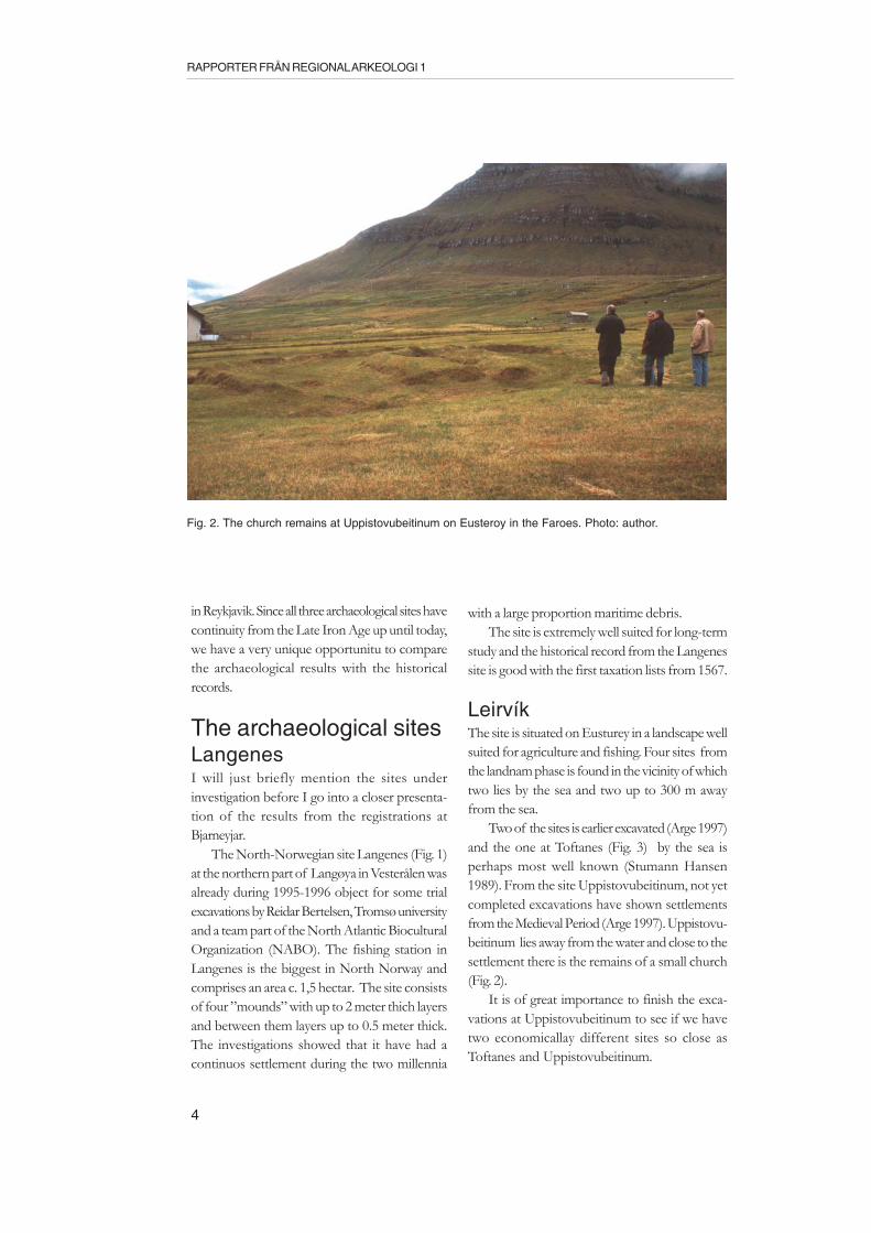
Two of the sites is earlier excavated (Arge 1997)and the one at Toftanes (Fig. 3) by the sea isperhaps most well known (Stumann Hansen1989). From the site Uppistovubeitinum, not yetcompleted excavations have shown settlementsfrom the Medieval Period (Arge 1997). Uppistovu-beitinum lies away from the water and close to thesettlement there is the remains of a small church(Fig. 2).
It is of great importance to finish the exca-vations at Uppistovubeitinum to see if we havetwo economicallay different sites so close asToftanes and Uppistovubeitinum.
Fig. 2. The church remains at Uppistovubeitinum on Eusteroy in the Faroes. Photo: author.

5
MAPPING AND REGISTRATION ON BJARNEYJAR, ICELAND
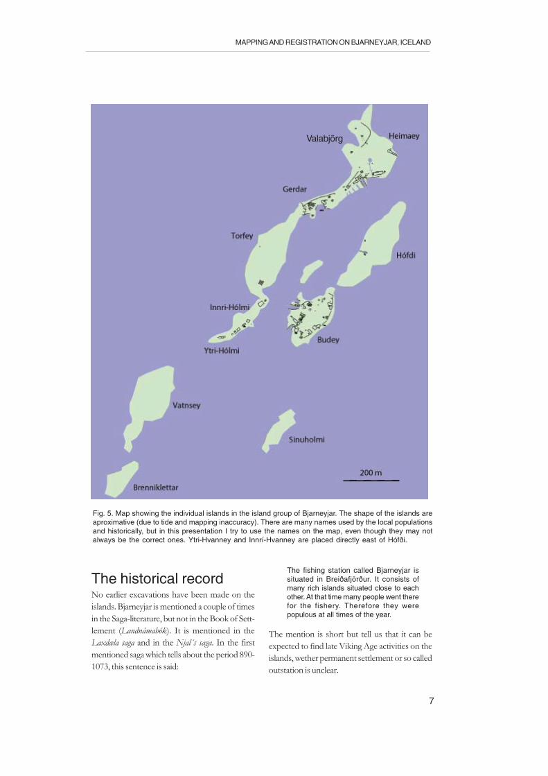
BjarneyjarThe island group of Bjarneyjar is situated in themiddle of Breiðafjörður c. 23 km N of the townof Stykkishólmur on the mainland of Iceland.The group consists of several smaller and biggerislands. The central islands, that also are coveredwith soil, are (Figs. 4-5):
HeimaeyBúðeyTorfeyHófðiInnri-HólmiYtri-HólmiVatnseySinuhólmiYtri-HvanneyInnrí-Hvanney
These are the islands (except Sinuhólmi, Ytri-Hvanney and Innrí-Hvanney) on which weconducted registrations. Concerning the Hvanney
island, Reidar Bertelsen later in 2002 found severalpossible cairns, that can be graves (se page 23f).There are also other smaller skerries like Selskerthat have no vegetation cover and which we didnot visit. Since the tide is large here it is at low tidepossible to walk across all of the islands mentio-ned and the difference between low and high tideis about three meters.
The islands Heimaey, Torfey, Innri-Holmi andYtri-Holm form an almost parallel line with thetwo islands Hófði and Búðey. The narrow channelbetween the two island groups is at high tide atmost 200 meter and they protect each other fromwinds from almost every direction. There are severalnatural landing places for rowing boats along thechannel.
The highest of the islands is Torfey (c. 12 m as l), while Búðey, Heimaey and Hófði at mostreach 10 m a s l. The ridge-formed Holmi islandsreach at their crown c. 6 m a s l. Especially in the
Fig. 3. The excavated Viking Age house foundation in Toftanes on Eusteroy in the Faroes. Photo: author.

6
RAPPORTER FRÅN REGIONAL ARKEOLOGI 1
NW part of Torfey; the N and NE parts ofHeimaey and the NE and E part of Hófði, thereare very steep rocks, which in seasons have a veryrich bird life. Large colonies of cormorant andseveral species of gull breed there. On shelteredplaces the grassgrown parts of the islands, lots ofeider find their homes during the spring and partsof the summer.
In the vicinity of the islands there are good
fishing banks and the soil covering large parts ofthe mentioned islands is fertile brown earth.Therefore the islands show a rich variety of possiblenatural resources; farming, livestock, fishing, sea-mammlas, eggs and eider-down from the sea birds.Theoretically, the resources possible to exploit withsurplus is the marine resources and during seasonsthe sea bird products like eggs and eider-down.
Fig. 4. Map showing the position of the island group of Bjarneyjar in Breiðafjörður and in relation to themainland of Iceland.
7
MAPPING AND REGISTRATION ON BJARNEYJAR, ICELAND
The historical recordNo earlier excavations have been made on theislands. Bjarneyjar is mentioned a couple of timesin the Saga-literature, but not in the Book of Sett-lement (Landnámabók). It is mentioned in theLaxdæla saga and in the Njal´s saga. In the firstmentioned saga which tells about the period 890-1073, this sentence is said:
The fishing station called Bjarneyjar issituated in Breiðafjörður. It consists ofmany rich islands situated close to eachother. At that time many people went therefor the fishery. Therefore they werepopulous at all times of the year.
The mention is short but tell us that it can beexpected to find late Viking Age activities on theislands, wether permanent settlement or so calledoutstation is unclear.
Fig. 5. Map showing the individual islands in the island group of Bjarneyjar. The shape of the islands areaproximative (due to tide and mapping inaccuracy). There are many names used by the local populationsand historically, but in this presentation I try to use the names on the map, even though they may notalways be the correct ones. Ytri-Hvanney and Innrí-Hvanney are placed directly east of Hófði.
Valabjörg
8
RAPPORTER FRÅN REGIONAL ARKEOLOGI 1
But there is also a very interesting story in theLaxdæla saga about Torkel Eyolvsson living atHelgafell on the mainland close to present dayStykkishólmur.The story should have happenedin the early 1000s. Torkel wanted to build a churchat Helgafell and sailed to Norway for timber. InTrondheim he recieved a gift from king Olavcorresponding the same amount of timber as thetimber church in Trondheim that the king nowwas building. The king thought that Torkel was abit unwise to build a church as big as the one inTrondheim. Torkel did not agree and went backto Iceland and Hrutafjord, where he left the timberover the winter. On the next oster thursday hestart transporting the timber on a ”ferry”. Theysailed in bad weather until they came to Bjarneyjar.People saw the ”ferry” from the shores of bothsides when a sudden wind gust turned the vesselupside down. There Torkel drowned and all hismen with him. The timber flowed around theislands.
This story tells us that an unexpected amountof timber can be found around 1000 AD on theislands of Bjarneyjar, could have a very welcomecontribution in the form of building material.
The text in the Njal´s saga tells about a mancalled Torvald Osvivrsson living in Meldal-fellstrand. He was rich and owned the islandsBjarneyjar in Breiðafjörður. From there he recieved
(or fetched) dry fish and flour. In a struggle withTjostolv, Torvald was killed there and it is saidthat when Tjostolv arrived all the people had rownaway from the islands.
From this early documents it can be concludedthat the islands of Bjarneyjar were exploited sinceat least AD 1000, probably already during the 10thcentury. During the first settlement period it ishowever uncertain if there were any permanentsettlement or if the islands were sesonally usedfor fishing, sea-mammal hunting and sea-birdexploitation. But the indication in Njal´s saga thatTorvald fetched flour there, is probably a sign ofthat there was a permanent settlement withagriculture and livestock. Why should he store flourproduced on the mainland so far out on theislands?
For the later parts of the history Jon Th. Thór(2000) has made a summary. The Medieval andthe sources of the 1600s are few but recognizeBjarneyjar as an important fishing station. Thefirst written record of permanent year-aound li-ving on Bjarneyjar derives from two Frenchmenthat 1659 are reported to have built a house forthemselves and lived there the following winter.These ”foreigners” must have had predecessorson the site.
Jon Thór says that the first register of Icelandwas put together 1703 and by that time the islands
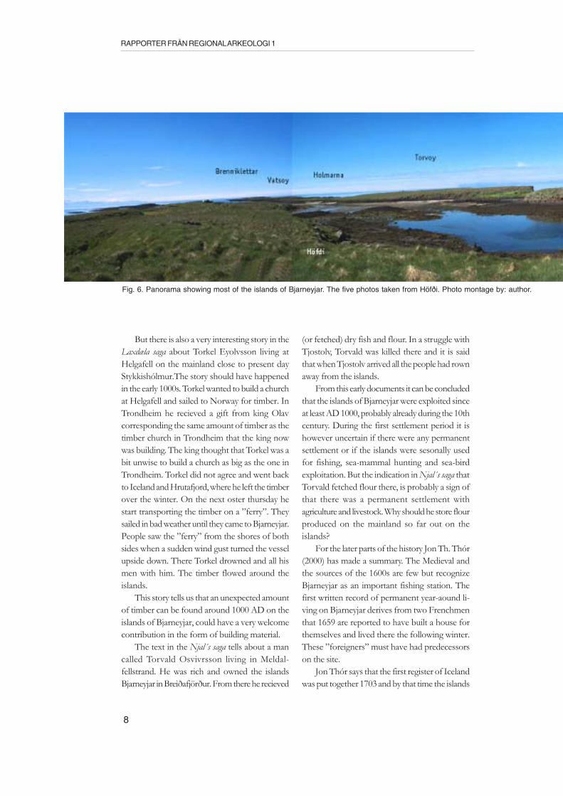
Fig. 6. Panorama showing most of the islands of Bjarneyjar. The five photos taken from Höfði. Photo montage by: author.

9
MAPPING AND REGISTRATION ON BJARNEYJAR, ICELAND
then were owned by the church at Surbær. At thatdate 8 tenant farms was mentioned, 4 on Heimaeyand 4 on Buðey. Also 4 peasant houses wasmentioned, 1 on Heimaey and 3 on Buðey. It isalso mentioned that Heimaey had 14 fishermen´shuts and Buðey 4. In the winter season the peasanthouses were so cold that the inhabitants had tomove into the tenants houses. The total popula-tion of these homes was 62, but there was 50boats operating in the islands during the high sea-son (mid-April - late June). Since the boats wereof different sizes, but normally with a crew of 3-7people, the total population in high seasonsprobably were c. 300-350 individuals on theislands. During this time Bjarneyjar was the largestfishing station among the Breiðafjörður islands.
Through a small-pox epidemic 1707, whichkilled c. 1/3 of the population, there was a declinein fishing activity around Bjarneyjar, but never-theless in 1840 c. 75 individuals were still livingthere. During the early 20th century the fishingaround Bjarneyjar declined permanently, mostprobably depending of the arrival of motor boats,allowing fishers to stay on the mainland of Iceland.In 1947 the last family left the islands. Today thethe islands are owned by an organization of localpeople.
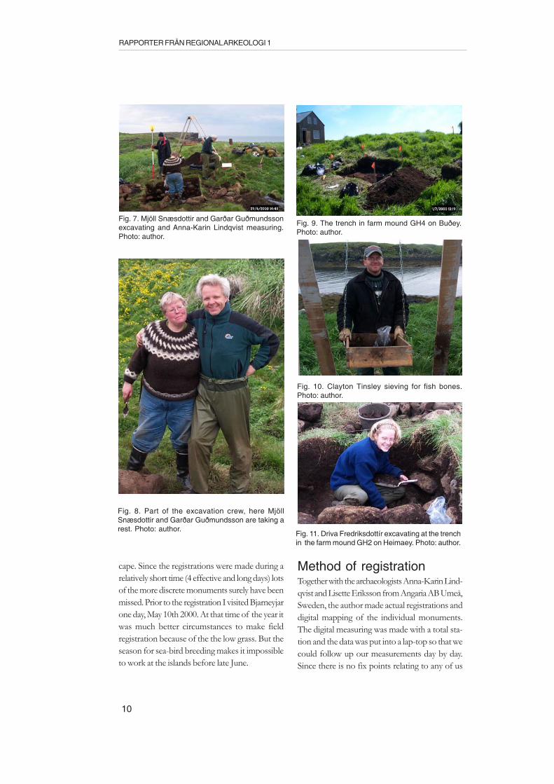
The trial excavation2000Mappings, registrations and trial excavations wereconducted during the period June 25th - July 3rd2000 on the island group of Bjarneyjar inBreiðafjórður, NW Iceland. The trial excavationwas conducted by Mjöll Snæsdottir and GarðarGuðmundsson from Fornleifastofnun Islands inReykjavik. Ragnar Edvardsson and Clayton Tinsleyfrom City university of New York also participated,as did the daughter of one of the owner of theislands Driva Fredriksdottir. Three smaller trencheswere opened. Two of them concerned farmmounds, one on Heimaey and the other on Búðey(see Figs. 15 and 17). The third trench was throughthe walls of a supposed timber building on Torfey(T1 on Fig. 21). The results from the trialexcavation is presented in a separate report by theleader of the excavation Mjöll Snæsdottir.
The registrations 2000There are a lot of monuments on the islands ofBjarneyjar. It is probably a continous settlementduring one millennium and at most it must havebeen houses of different kinds hosting perhaps400 people. Such things puts marks in the lands-
10
RAPPORTER FRÅN REGIONAL ARKEOLOGI 1
cape. Since the registrations were made during arelatively short time (4 effective and long days) lotsof the more discrete monuments surely have beenmissed. Prior to the registration I visited Bjarneyjarone day, May 10th 2000. At that time of the year itwas much better circumstances to make fieldregistration because of the the low grass. But theseason for sea-bird breeding makes it impossibleto work at the islands before late June.
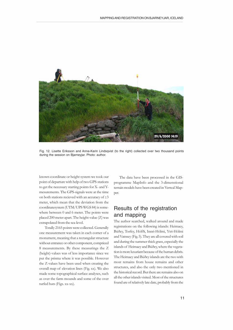
Method of registrationTogether with the archaeologists Anna-Karin Lind-qvist and Lisette Eriksson from Angaria AB Umeå,Sweden, the author made actual registrations anddigital mapping of the individual monuments.The digital measuring was made with a total sta-tion and the data was put into a lap-top so that wecould follow up our measurements day by day.Since there is no fix points relating to any of us
Fig. 8. Part of the excavation crew, here MjöllSnæsdottir and Garðar Guðmundsson are taking arest. Photo: author.
Fig. 11. Driva Fredriksdottír excavating at the trenchin the farm mound GH2 on Heimaey. Photo: author.
Fig. 10. Clayton Tinsley sieving for fish bones.Photo: author.
Fig. 7. Mjöll Snæsdottir and Garðar Guðmundssonexcavating and Anna-Karin Lindqvist measuring.Photo: author.
Fig. 9. The trench in farm mound GH4 on Buðey.Photo: author.
11
MAPPING AND REGISTRATION ON BJARNEYJAR, ICELAND
known coordinate or height system we took ourpoint of departure with help of two GPS-stationsto get the necessary starting points for X- and Y-mesurements. The GPS-signals were at the timeon both stations recieved with an accuracy of ±3meter, which mean that the deviation from thecoordinatesystem (UTM/UPS WGS 84) is some-where between 0 and 6 meter. The points wereplaced 200 meter apart. The height-value (Z) wasextrapolated from the sea-level.
Totally 2165 points were collected. Generallyone measurement was taken in each corner of amonument, meaning that a rectangular structurewithout entrance or other component, compriced8 measurements. By these measurings the Z(height)-values was of less importance since weput the prisma where it was possible. Howeverthe Z-values have been used when creating theoverall map of elevation lines (Fig. xx). We alsomade some topographical surface analyses, suchas over the farm mounds and some of the overturfed huts (Figs. xx-xx).
The data have been processed in the GIS-programme MapInfo and the 3-dimenstionalterrain models have been created in Vertcal Map-per.
Results of the registrationand mappingThe author searched, walked around and maderegistrations on the following islands: Heimaey,Búðey, Torfey, Hófði, Innri-Hólmi, Ytri-Hólmiand Vatnsey (Fig. 5). They are all covered with soiland during the summer thick grass, especially theislands of Heimaey and Búðey, where the vegeta-tion is more luxuriant because of the human debris.The Heimaey and Búðey islands are the two withmost remains from house remains and otherstructures, and also the only two mentioned inthe historical record. But there are remains also onall the other islands visited. Most of the structuresfound are of relatively late date, probably from the
Fig. 12. Lisette Eriksson and Anna-Karin Lindsqvist (to the right) collected over two thousand pointsduring the session on Bjarneyjar. Photo: author.
12
RAPPORTER FRÅN REGIONAL ARKEOLOGI 1
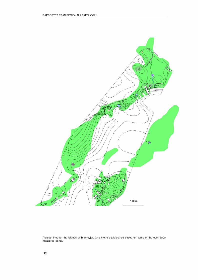
Altitude lines for the islands of Bjarneyjar. One metre eqvidistance based on some of the over 2000measured ponts.
13
MAPPING AND REGISTRATION ON BJARNEYJAR, ICELAND
last 200 years. Several of these building remainsare possible to identify through photos takenduring the first half of the 20th century. There arealso several written documents telling us the namesof houses, landing places, fish-drying structuresand other parts of the islands. The written mate-rial is of course in Icelandic and the work withidentification shall later be made in collaborationwith Mjöll Snæsdottir and the local historians.
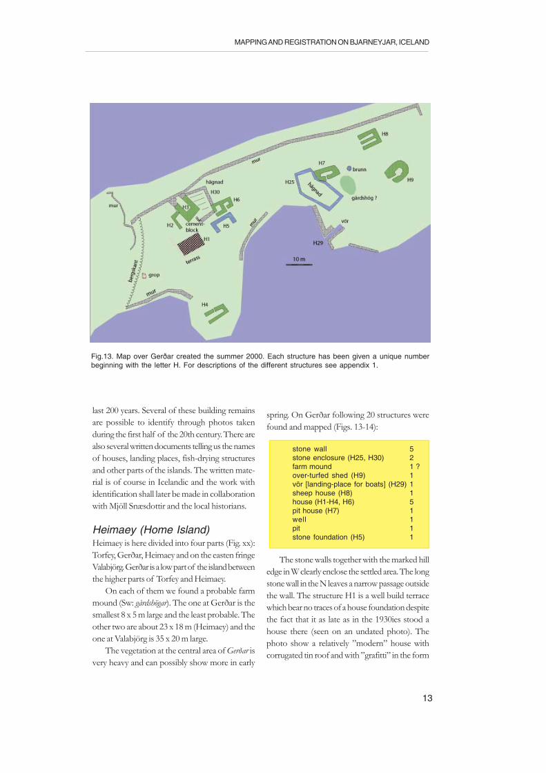
Heimaey (Home Island)Heimaey is here divided into four parts (Fig. xx):Torfey, Gerðar, Heimaey and on the easten fringeValabjörg. Gerðar is a low part of the island betweenthe higher parts of Torfey and Heimaey.
On each of them we found a probable farmmound (Sw: gårdshögar). The one at Gerðar is thesmallest 8 x 5 m large and the least probable. Theother two are about 23 x 18 m (Heimaey) and theone at Valabjörg is 35 x 20 m large.
The vegetation at the central area of Gerðar isvery heavy and can possibly show more in early
spring. On Gerðar following 20 structures werefound and mapped (Figs. 13-14):
stone wall 5stone enclosure (H25, H30) 2farm mound 1 ?over-turfed shed (H9) 1vör [landing-place for boats] (H29) 1sheep house (H8) 1house (H1-H4, H6) 5pit house (H7) 1well 1pit 1stone foundation (H5) 1
The stone walls together with the marked hilledge in W clearly enclose the settled area. The longstone wall in the N leaves a narrow passage outsidethe wall. The structure H1 is a well build terracewhich bear no traces of a house foundation despitethe fact that it as late as in the 1930ies stood ahouse there (seen on an undated photo). Thephoto show a relatively ”modern” house withcorrugated tin roof and with ”grafitti” in the form
Fig.13. Map over Gerðar created the summer 2000. Each structure has been given a unique numberbeginning with the letter H. For descriptions of the different structures see appendix 1.
14
RAPPORTER FRÅN REGIONAL ARKEOLOGI 1
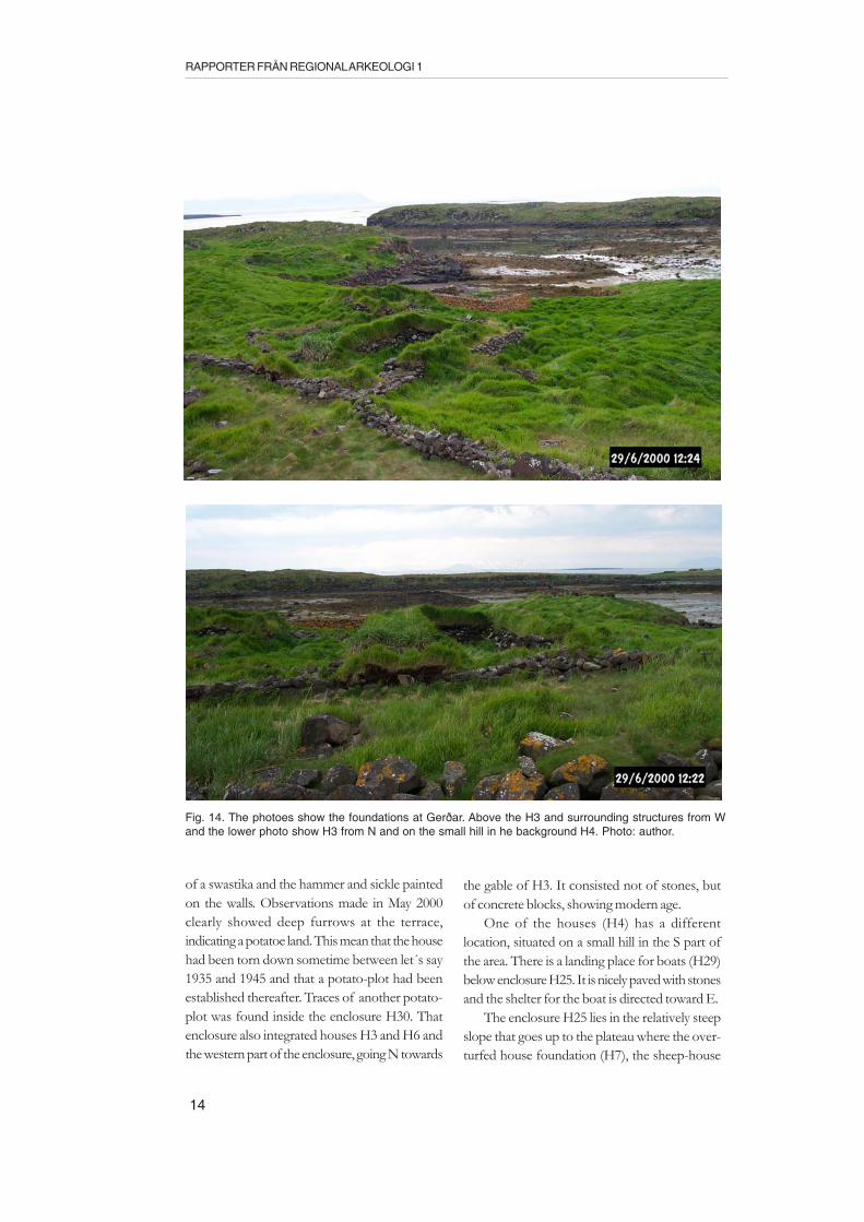
of a swastika and the hammer and sickle paintedon the walls. Observations made in May 2000clearly showed deep furrows at the terrace,indicating a potatoe land. This mean that the househad been torn down sometime between let´s say1935 and 1945 and that a potato-plot had beenestablished thereafter. Traces of another potato-plot was found inside the enclosure H30. Thatenclosure also integrated houses H3 and H6 andthe western part of the enclosure, going N towards
the gable of H3. It consisted not of stones, butof concrete blocks, showing modern age.
One of the houses (H4) has a differentlocation, situated on a small hill in the S part ofthe area. There is a landing place for boats (H29)below enclosure H25. It is nicely paved with stonesand the shelter for the boat is directed toward E.
The enclosure H25 lies in the relatively steepslope that goes up to the plateau where the over-turfed house foundation (H7), the sheep-house
Fig. 14. The photoes show the foundations at Gerðar. Above the H3 and surrounding structures from Wand the lower photo show H3 from N and on the small hill in he background H4. Photo: author.

15
MAPPING AND REGISTRATION ON BJARNEYJAR, ICELAND
(H8) and the over-turfed shed (H9) are situated.On the plateau there are also a well and the possiblesmall farm mound.
The sheep-house (H8) is of typical form withtwo aisles on each side of a bench centered alongthe mid-axis of the house. The bench is stonebuilt but lower (0.7 m high) than the outer wallsof the house that are 1.1 m high. There are severalconstructions of wood left in the foundation,showing that it is of late age.
There is only one structure here at Gerðar,except from the possible farm mound, that givesan impression of beeing older than the other andthat is the over-turfed shed H9 on the plateau. Itis a reactangular structure c. 9 x 7 m (E-W) outermeasure; The walls are 1.8 - 2.5 m wide and 0.3 mhigh. The inner part is bowl-shaped and c. 3.3 x2.8 m ( E-W) large. The NW inner corner isrelatively clear and can mark the original place ofthe inner corner. The entrance is c. 1 m wide andplacede in the W gable.
If we look at the central part of Heimaey (Fig.15) we find the following 26 mapped structures:
stone wall 2stone enclosure (H12, H14) 2farm mound (GH2) 1vör [landing-place for boats] 5house (H10, H15, H16-H19) 6pit house (H20) 1hjallur [fish-drying house] (H11) 1semi subterranean structure (H13, H24) 2stone paving 1well 3pit 1stone heap 1
Here there are in front of all a large farm moundlying in a central position close to a little springcoming from the pool (Sw: göl) in the N part ofthe area. In the E part of this farm mound one ofour trial trenches was placed. On top of the moundthere is a recent foundation (H17), whose wallswere made of concrete. In house H19 there arealso traces of concrete and also corrugated metalroof, plus lots of wooden construction lying aro-und. H17 and H19 are certainly the latest houseson the islands.
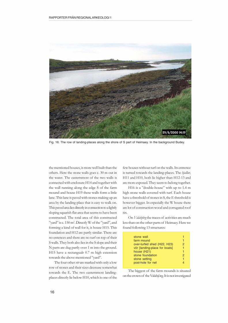
There are five landing-places for boats justbelow the farm mound. One of them, closest to
Fig. 15. Map over Heimaey created the summer 2000. Each structure has been given a unique numberbeginning at the letter H. For descriptions of the different structures see appendix 1
16
RAPPORTER FRÅN REGIONAL ARKEOLOGI 1
the mentioned houses, is more well built than theothers. Here the stone walls goes c. 30 m out inthe water. The easternmost of the two walls isconnected with enclosure H14 and together withthe wall running along the edge S of the farmmound and house H19 these walls form a littlelane. This lane is paved with stones making up anarea by the landing-place that is easy to walk on.This paved area lies directly in connection to a lightlysloping squarish flat area that seems to have beenconstructed. The total area of this constructed”yard” is c. 150 m2. Directly W of the ”yard”, andforming a kind of wall for it, is house H15. Thisfoundation and H12 are partly similar. There areno entences and there are no turf on top of theirS walls. They both also lies in the S slope and theirN parts are dug partly over 1 m into the ground.H15 have a rectangualr 0.7 m high extensiontowards the above mentioned ”yard”.
The four other vör are marked with only a lowrow of stones and their sizes decrease somewhattowards the E. The two easternmost landing-places directly lie below H10, which is one of the
few houses without turf on the walls. Its entrenceis turned towards the landing-places. The hjallur,H11 and H10, both lie higher than H12-13 andare more exposed. They seem to belong together.
H16 is a ”double-house” with up to 1.4 mhigh stone walls covered with turf. Each househave a threshold of stones in S, the E threshold ishowever bigger. In especially the W house thereare lot of construction wood and corrugated rooftin.
On Valabjörg the traces of activities are muchless than on the other parts of Heimaey. Here wefound following 13 structures:
stone wall 1farm mound 1over-turfed shed (H22, H23) 2vör [landing-place for boats] 1house (H21) 1stone foundation 2stone setting 1post-hole for net 4
The biggest of the farm mounds is situatedon the crown of the Valabjörg. It is not investigated
Fig. 16. The row of landing-places along the shore of S part of Heimaey. In the background Budey.

17
MAPPING AND REGISTRATION ON BJARNEYJAR, ICELAND
Topo
grap
hica
l 3D
-mod
el o
ver
farm
mou
nd 1
at
Val
abjö
rg (
red)
with
the
ove
r-tu
rfed
she
d H
23 o
n to
p of
it,
base
d on
Z-v
alue
s at
the
map
ping
..
farm
mo
un
dH
23
18
RAPPORTER FRÅN REGIONAL ARKEOLOGI 1
and is therefore to be looked at as plausible. Ontop of the farm mound there is an over-turfedshed (H23) of typical shape. It is 8 x 6 m (E-W)large in outer measurements. The walls are up to0.5 m high and 1.9 - 2.5 m wide. The entrance isplaced in the S longwall close to the W gable and is0.9 m wide. The inner surface is relatively clear andis 3.4 x 2.4 m large.
The other over-turfed shed here (H22) is of aquite different and on these islands unique shape.It has the basic shape as the other but is partly duginto the ground and very large boulders make upmost of its walls. The turf lies mostly outside thewalls. It is almost square with 6 m long walls andan inner surface with c. 2.5 m long sides. Theentrence in W c. 0.9 m wide. Close to H22 there are4 post-holes (Sw: giströsen) obvioulsy a constructionfor hanging up the fishing nets for repair anddrying. One similar posthole is found on Ytri-Holmí (see below).
The c. 120 m long stone wall surrounds H22and constructed of huge blocks. In the stone wallalso a house (H21) is integrated in front of whichthere is a well-built 2.2 x 2.7 m large, flat stoneconstruction. In the house there are among otherthings a wooden roof beam and three rafters insitu.
A bit away on the E part of the island there area very large vör with over 32 m long stone walls. Inconnection there is a well built, angled stoneconstruction. There is no settlement or otherconstructions within a radius of 90 m from thislanding-place.
If there is a farm mound on Valabjörg it mustrelatively soon have been deserted or have had arelatively short duration in later times. It is of coursepossible that the pressure on the islands were hardduring the hey-days in the early 1700ds and thatthe farm mound was an effect of settlement ofthe following c. 150 years, but more plausible isthat this is one of the oldest monuments of theislands. It is placed on a high part of the islands,with views in every direction and in that way it hada defensive placement. It is however also possiblethat this mound is secondary in relation to GH 2.During perhaps the Medieval Period with theHanseatic fish-commerce it could have been en
expansive period on the islands making room fortwo extended families conducting farming andfishing.
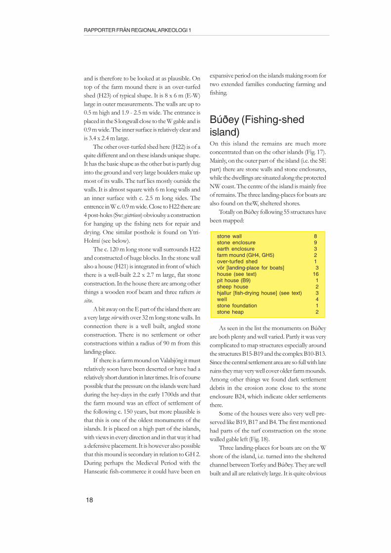
Búðey (Fishing-shedisland)On this island the remains are much moreconcentrated than on the other islands (Fig. 17).Mainly, on the outer part of the island (i.e. the SEpart) there are stone walls and stone enclosures,while the dwellings are situated along the protectedNW coast. The centre of the island is mainly freeof remains. The three landing-places for boats arealso found on theW, sheltered shores.
Totally on Búðey following 55 structures havebeen mapped:
stone wall 8stone enclosure 9earth enclosure 3farm mound (GH4, GH5) 2over-turfed shed 1vör [landing-place for boats] 3house (see text) 16pit house (B9) 1sheep house 2hjallur [fish-drying house] (see text) 3well 4stone foundation 1stone heap 2
As seen in the list the monuments on Búðeyare both plenty and well varied. Partly it was verycomplicated to map structures especially aroundthe structures B15-B19 and the complex B10-B13.Since the central settlement area are so full with lateruins they may very well cover older farm mounds.Among other things we found dark settlementdebris in the erosion zone close to the stoneenclosure B24, which indicate older settlementsthere.
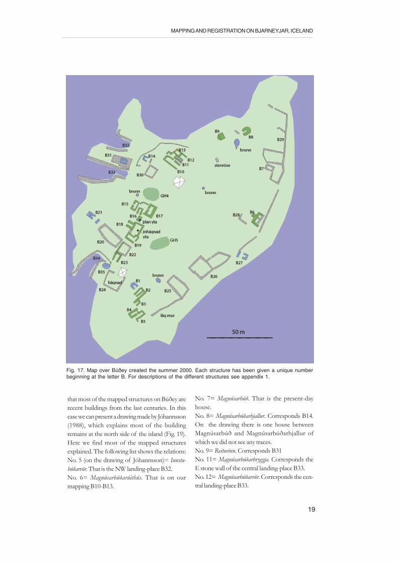
Some of the houses were also very well pre-served like B19, B17 and B4. The first mentionedhad parts of the turf construction on the stonewalled gable left (Fig. 18).
Three landing-places for boats are on the Wshore of the island, i.e. turned into the shelteredchannel between Torfey and Búðey. They are wellbuilt and all are relatively large. It is quite obvious
19
MAPPING AND REGISTRATION ON BJARNEYJAR, ICELAND
that most of the mapped structures on Búðey arerecent buildings from the last centuries. In thiscase we can present a drawing made by Jóhannsson(1988), which explains most of the buildingremains at the north side of the island (Fig. 19).Here we find most of the mapped structuresexplained. The following list shows the relations:No. 5 (on the drawing of Jóhannsson)= Innstu-búðarvör. That is the NW landing-place B32.No. 6= Magnúsarbúðarúithús. That is on ourmapping B10-B13.
No. 7= Magnúsarbúð. That is the present-dayhouse.No. 8= Magnúsarbúðarhjallur. Corresponds B14.On the drawing there is one house betweenMagnúsarbúð and Magnúsarbúðarhjallur ofwhich we did not see any traces.No. 9= Reiturinn. Corresponds B31No. 11= Magnúsarbúðarbryggja. Corresponds theE stone wall of the central landing-place B33.No. 12= Magnúsarbúðarvör. Corresponds the cen-tral landing-place B33.
Fig. 17. Map over Búðey created the summer 2000. Each structure has been given a unique numberbeginning at the letter B. For descriptions of the different structures see appendix 1.
20
RAPPORTER FRÅN REGIONAL ARKEOLOGI 1
No. 14= Snúruhóll. The farm mound GH4?No. 15= Nýirbrunnar. The well close to the farmmound GH4.No. 17= Miðbúð. Corresponds the houses B15-B19.No. 18= Miðbúðarvör. That is the S part of thecentral vör B33, of which follows thatNo. 19= Miðbúðarbryggja, i.e. the S stone wall ofthe central landing-place B33.No. 22= Miðbúðarhjallur. Corresponds B21.No. 23= Húsið (Ystabúð). Corresponds the pre-sent-day house.
That is what we have in common, but we did notsee No. 25 Benediktsbúð, which possibly can be B2-B5 on Figure 17. But as seen on Jóhannsson´sdrawing there are some houses indicated behindNo. 23, that is probably B2-B5. Therefore, eitheriwe have missed or there no traces of Benediktsbúð.Another difference is that the southernmost vörB34, is not indicated on the drawing, the name ofit should have been Ystabúðarvör.
The domination of clustered late settlementremains have made it difficult to see anything
Fig. 18. Anna-Karin Lindqvist standing by the well preserved gable of house B19. Photo from N bythe author.
beneath or beside these ruins. The only remainsthat possibly could have some age are B8 and GH4.B8 is an over-turfed, horse-shoe shaped shedmeasuring 6.8 x 5.8 m (NE-SW). Its banks are upto 2.6 m wide and 1.5 m high and it was difficultto see the original inner floor surface.
GH4 was 13 x 10 m large and 0.5 - 1.5 m high.A trial excavation was conducted in the N edge ofthis mound.
The other farm mound GH5 is highlyuncertain and could be a natural terrain formation.
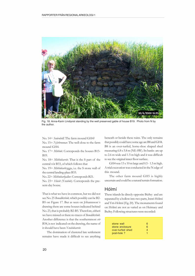
HólmíThese islands lie direcly opposite Búðey and areseparated by a hollow into two parts, Innri-Hólmíand Ytri-Hólmí (Fig. 20). The monuments foundon Hólmí are not as varied as on Heimaey andBuðey. Following structures were recorded:
stone wall 6stone enclosure 6over-turfed shed 4post-hole ? 1

21
MAPPING AND REGISTRATION ON BJARNEYJAR, ICELAND
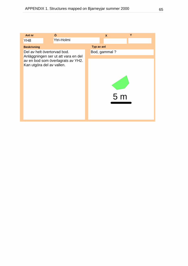
Two of the structures, one large stone enclosureand one over-turfed shed are placed on the smallhill named Innri-Hólmí, while the rest are lying ina row along the esker-like ridge making up Ytri-Hólmí. The stone enclosure YH2 is ovelappingtwo over-turfed sheds YH3 and YH8. About halfof YH3 is left and visible by the SW gable of YH2and it seems to have had its entrance towards SE.YH8 is visible by the SE long wall of YH2 and isapproximately preserved only to 1/3 or so. Theother over-turfed sheds YH5 and IH1 also have
Fig. 19. Drawing made of Jóhannsson, showing the N shore of Búðey. After Jóhannsson 1988.
their 0.9 m wide entrances towards SE and all areof similar size, 8 x 5.5 m (NE-SW) outer measureand with floors c. 3.3 x 2.3 m large.
In the southwesternmost part, in connectionwith the stone enclosure YH7 and the stone wallsthere, it was found a probable post-hole (SW: gist-röse) for fishing nets like the four found onValabjörg.
The impression given here is that there havebeen no permanent settlement but seasonal fishingcamps and grazing for sheep.
Fig. 20. Map over Innri-Hólmí and Ytri-Hólmí created the summer 2000. Each structure has been given aunique number beginning at the letter IH and YH respectively. For descriptions of the different structuressee appendix 1.
22
RAPPORTER FRÅN REGIONAL ARKEOLOGI 1
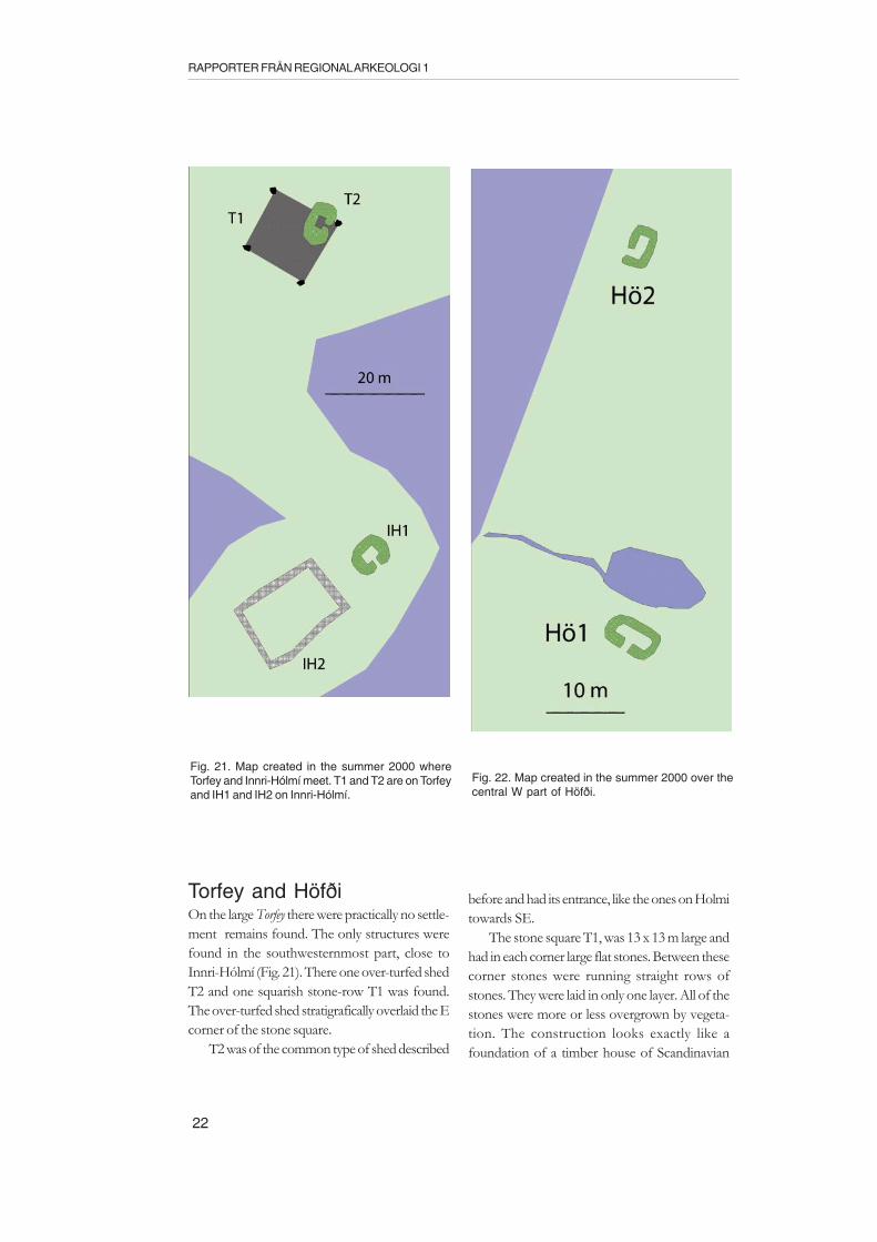
Torfey and HöfðiOn the large Torfey there were practically no settle-ment remains found. The only structures werefound in the southwesternmost part, close toInnri-Hólmí (Fig. 21). There one over-turfed shedT2 and one squarish stone-row T1 was found.The over-turfed shed stratigrafically overlaid the Ecorner of the stone square.
T2 was of the common type of shed described
before and had its entrance, like the ones on Holmitowards SE.
The stone square T1, was 13 x 13 m large andhad in each corner large flat stones. Between thesecorner stones were running straight rows ofstones. They were laid in only one layer. All of thestones were more or less overgrown by vegeta-tion. The construction looks exactly like afoundation of a timber house of Scandinavian
Fig. 21. Map created in the summer 2000 whereTorfey and Innri-Hólmí meet. T1 and T2 are on Torfeyand IH1 and IH2 on Innri-Hólmí.
Fig. 22. Map created in the summer 2000 over thecentral W part of Höfði.
23
MAPPING AND REGISTRATION ON BJARNEYJAR, ICELAND
type, or a ”frame-work” foundation (Ramqvist1998). The only unusual thing with it is the sizeand occurence in this context with the tree-poorenvironment. It is of course tempting to connectthis foundation with the story told in the Laxdalasaga about Torkel, mentioned above, namely thatthis house was built of the timber that Torkel lostoutside the Bjarneyjar, during that unhappy easterthursday about 1000 years ago!
Only two structures were found on Höfði andthat was a couple of over-turfed sheds lying c. 50m apart close to the northern relatively steep edgeof the island (Fig. 22). The NW of them, HÖ1,was placed in close connection to a small poolwith a ditch running out over the steep islandedge. The structures were not similar to each other,the HÖ2 had its entrance out towards the channelbetween the island Höfði and Heimaey and wasplaced in the corner. HÖ1 had its entrance morenormally placed at one of the long sides, but itwas turned towards south. The two Höfði shedswere also a bit smaller than many of the otherover-turfed sheds on the islands and they had notas wide turf banks.
VatnseyThis island only had one stone wall running severalhundred meters from the NE point along thenorthern and southern edges of the island. Thenorthern part of the wall was markedly longerthan the southern.
Final commentsApart from the the most recent settlement remainson the islands, there is a stratum that possibly canbe of Viking Age or Early Medieval origin. Thatcan be true for the 10 over-turfed sheds, the 5 farmmounds and the frame-work foundation. Especi-ally interesting is that, one of the over-turfed shedsoverlay the fram-work foundation at Torfey. Theoverturfed sheds are relatively evenly spread amongthe mapped islands. The farm mounds, on theother hand, only occur at Heimey and Budey.
The registrations made on Bjarneyjar were notoptimal concerning the time of period they wereconducted, on which it could be made a littele bit
earlier in the season, there are probably mych moreto be found on these exreaorinaly intresting, andwell preseved islands.
AddendumAccording to Reidar Bertelsen, who had theopportunity to revisit the islands in 2002, he ma-kes the following report in Norwegian:
Tilleggsregistreringer i BjarneyjarTorfey24.06.02Reidar Bertelsen og Mjöll SnæsdottirUTM, 27W, 0413833/7240209 +/-4 (ca 12 moh)Varde murt av stein, høgde 1,65, diameter ca 2mved basis. Rundt basis er det synlig ei steinleggingmed klart avgrenset ytre kant (større stein). Vardenstår litt øst for sentrum i steinlegginga. Ved basis,på vardens sørvestre kant, er det synlig ei rettlinjetsteinrekke på 8-10 stein som går på tvers avsteinlegginga. Steinlegginga antas å være rest av eigravrøys der det meste av steinen er brukt til å byggevarden. Steinrekka kan danne vestkanten av et grav-kammer. Det er ca 0,25 m djup jord øst forsteinrekka. Det kan også være snakk om en annentype konstruksjon enn gravrøys, men formen peikeri retning av grav.
Varden ligger nær høste punkt på Torfey ogden er synlig fra nesten alle steder i Bjarneyjar.Antakelig er varden bygd i forbindelse med Is-lands kartlegging tidlig på 1900-tallet og denmarkerer i så tilfelle fastpunkt nr 112 igrunnpunktsystemet.Fotos: DSCN 1000,1001,1018-1025
BuðeyHøgste pkt:UTM 27W 0413867/7239886 +/-3mBenediktsbúð:UTM 27W 0413842/7239853 +/3mSigurður Sveinbjörnsson (1974:19).Om stedet "Langigarður", mellom brønnen"Latur" og vasshullet "Duða", begge i nærheten av"Benediktsbúð", sier han "Þar voru höfuðbeinmanns".Fotos: DSCN 1106-1107

24
RAPPORTER FRÅN REGIONAL ARKEOLOGI 1
Innri-Hvanney28.06.02.Reidar Bertelsen og Børge EvensenUTM, 27W, 0415902/7240350 +/-3Overgrodd steinrøys, diameter 7m, høgde ca 0,5m.Antydning til fotgrøft. Forsenkning i sentrum,kan være plyndringskrater. Stor vannslipt steinsynlig mot øst, men ellers er steinene overgroddav standgras med sterk tuedannelse. De kanimidlertid føles under grastuene. Røysa ligger ca10m nordøst for flomålet og ca 75m nordvest forholmens sørende.
Er sannsynligvis identisk med "grjotrust"nevnt av Sigurður Sveinbjörnsson (1974:29).Fotos: DSCN 1058-1065, 1067,1098
Ytri-HvanneyUTM 27W mellom posisjonene:0415712/7239973 og 0415734/7239989 +/-4Fire små røyser ca 1,5-2m i tverrsnitt, uregelmessigform, men godt synlige. Bygd av små og storstein om hverandre. Røysene ligger på rekke isvak bue med ca 25m mellom ytterpunktene.Ca 10m fra flomålet på holmens nørdøstside.Fotos: DSCN 1090-1095
ReferencesArge, Símun 1997.I Uppistovubeitinum. Site and
settlement. Frodskaparrit 45. Bok 1997:227-244.Bertelsen, Reidar 1991. Gårdshaugene i Nord-
Norge. Eksempler på Nordatlantiske teller.Hikuin 15, 1989:171-182.
Dollinger, Philippe 1970. The emergence of internatio-nal buisness 1200-1800. Volume I. The germanHansa. Routledge. London.
Herrmans-Auðardottir, Margrét. 1989. Islands tidigabosättning. Studier med utgångspunkt i merovingertida-vikingatida gårdslämningar i Herjolfsdalur, Vestman-naeyjar, Island.Studia Archaeologica UniversitatisUmensis 1. Umeå.
Joensen, J.P. 1996. The fisheries of the Faroe islands.An overview. The North Atlantic fisheries 1100-1970. Studia Atlantica vol. 1. Esbjerg.
Christensen, Pål & Nielssen, Alf Ragnar 1996.Norwegian fisheries 1100-1970. The North At-lantic fisheries 1100-1970. Studia Atlantica vol.1. Esbjerg.
Ramqvist, Per H. 1998. Arnäsbacken. En gård frånyngre järnålder och medeltid. HB Prehistorica. Umeå.
Ramqvist, Per H. 2001. Utbytessystem under det1:a årtusendet e.Kr. Idéer utgående från tre imellannorrländska älvar. Fornvännen 2001/1:1-21.
Stumann Hansen, Steffen 1989. Toftanes - en færøsklandnamsgård fra 9-10 århundrede. Hikuin15:129-146.
Thór, Jon Th. 1996. Bjarneyjar - a short historical survey.Project manuscript.
Thór, Jon Th. 2000. The quest for cod: some causesof fishing conflicts in the North Atlantic. ActaBorealia 1-2000:41-50.
SourcesLaxdæla sagaNjal´s saga.
25
MAPPING AND REGISTRATION ON BJARNEYJAR, ICELAND
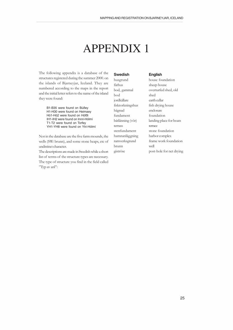
APPENDIX 1
The following appendix is a database of thestructures registered during the summer 2000. onthe islands of Bjarneyjar, Iceland. They arenumbered according to the maps in the reportand the initial letter refers to the name of the islandthey were found:
B1-B35 were found on BúðeyH1-H30 were found on HeimaeyHö1-Hö2 were found on HöfðiIH1-IH2 were found on Innri-HólmíT1-T2 were found on TorfeyYH1-YH8 were found on Ytri-Hólmí
Not in the database are the five farm mounds, thewells (SW: brunn), and some stone heaps, etc ofundistinct character.The descriptions are made in Swedish while a shortlist of terms of the structure types are necessary.The type of structure you find in the field called”Typ av anl”:
Swedish Englishhusgrund house foundationfårhus sheep housebod, gammal overturfed shed, oldbod shedjordkällare earth cellarfisktorkningshus fish drying househägnad enclosurefundament foundationbåtlänning (vör) landing place for boatsterrass terracestenfundament stone foundationhamnanläggning harbor complexramverksgrund frame work foundationbrunn wellgiströse post-hole for net drying
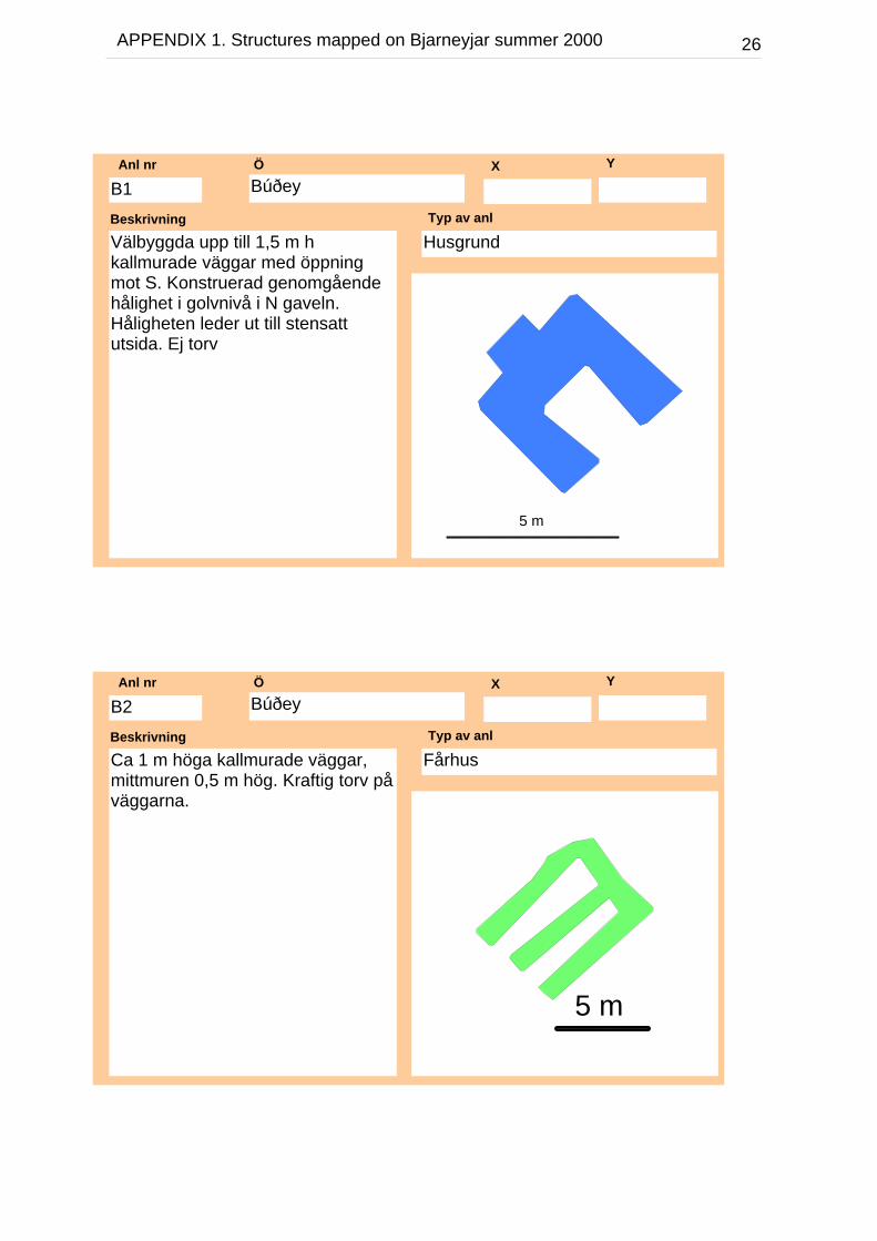
26APPENDIX 1. Structures mapped on Bjarneyjar summer 2000
BúðeyÖ X Y
Välbyggda upp till 1,5 m hkallmurade väggar med öppningmot S. Konstruerad genomgåendehålighet i golvnivå i N gaveln.Håligheten leder ut till stensattutsida. Ej torv
Beskrivning
HusgrundTyp av anl
B1Anl nr
5 m
BúðeyÖ X Y
Ca 1 m höga kallmurade väggar,mittmuren 0,5 m hög. Kraftig torv påväggarna.
Beskrivning
FårhusTyp av anl
B2Anl nr
5 m
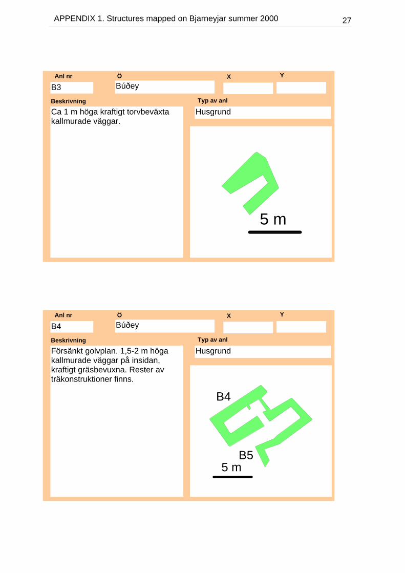
27APPENDIX 1. Structures mapped on Bjarneyjar summer 2000
BúðeyÖ X Y
Ca 1 m höga kraftigt torvbeväxtakallmurade väggar.
Beskrivning
HusgrundTyp av anl
B3Anl nr
5 m
BúðeyÖ X Y
Försänkt golvplan. 1,5-2 m högakallmurade väggar på insidan,kraftigt gräsbevuxna. Rester avträkonstruktioner finns.
Beskrivning
HusgrundTyp av anl
B4Anl nr
B4
B55 m

28APPENDIX 1. Structures mapped on Bjarneyjar summer 2000
BúðeyÖ X Y
Hopbyggd med B4 samt medanslutande hägnad i S. 0,5-1,5 m hkallmurade väggar torvbevuxna.
Beskrivning
HusgrundTyp av anl
B5Anl nr
B4
B55 m
BúðeyÖ X Y
Ca 1 meter höga kallmuradeväggar. Delvis utan gräsbeväxning
Beskrivning
HusgrundTyp av anl
B6Anl nr
5 m
29APPENDIX 1. Structures mapped on Bjarneyjar summer 2000
BúðeyÖ X Y
Ca 1 meter höga kallmurade väggarhelt utan gräs eller torv.
Beskrivning
HusgrundTyp av anl
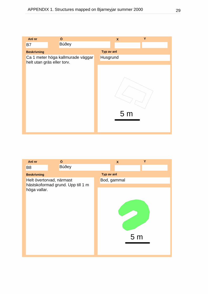
B7Anl nr
5 m
BúðeyÖ X Y
Helt övertorvad, närmasthästskoformad grund. Upp till 1 mhöga vallar.
Beskrivning
Bod, gammalTyp av anl
B8Anl nr
5 m
30APPENDIX 1. Structures mapped on Bjarneyjar summer 2000
BúðeyÖ X Y
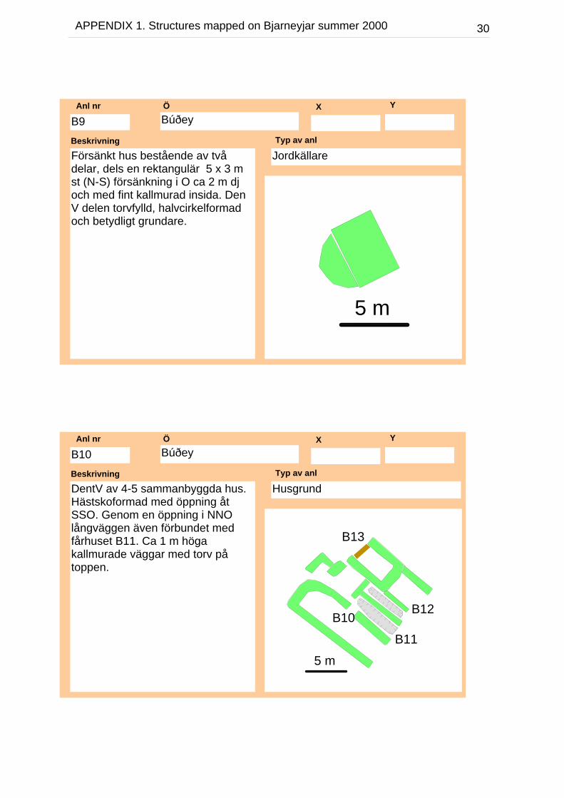
Försänkt hus bestående av tvådelar, dels en rektangulär 5 x 3 mst (N-S) försänkning i O ca 2 m djoch med fint kallmurad insida. DenV delen torvfylld, halvcirkelformadoch betydligt grundare.
Beskrivning
Jordkällare Typ av anl
B9Anl nr
5 m
BúðeyÖ X Y
DentV av 4-5 sammanbyggda hus.Hästskoformad med öppning åtSSO. Genom en öppning i NNOlångväggen även förbundet medfårhuset B11. Ca 1 m högakallmurade väggar med torv påtoppen.
Beskrivning
HusgrundTyp av anl
B10Anl nr
5 m
B10
B11
B12
B13
31APPENDIX 1. Structures mapped on Bjarneyjar summer 2000
BúðeyÖ X Y
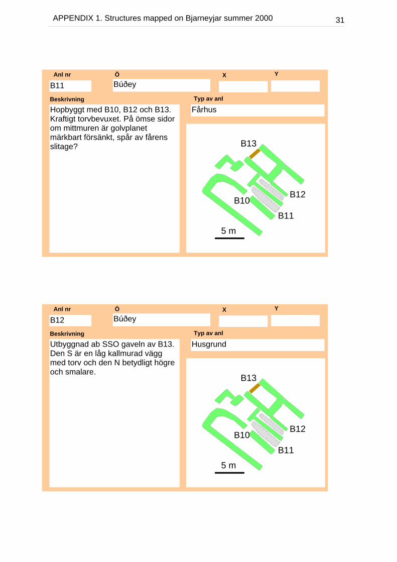
Hopbyggt med B10, B12 och B13.Kraftigt torvbevuxet. På ömse sidorom mittmuren är golvplanetmärkbart försänkt, spår av fårensslitage?
Beskrivning
FårhusTyp av anl
B11Anl nr
5 m
B10
B11
B12
B13
BúðeyÖ X Y
Utbyggnad ab SSO gaveln av B13.Den S är en låg kallmurad väggmed torv och den N betydligt högreoch smalare.
Beskrivning
HusgrundTyp av anl
B12Anl nr
5 m
B10
B11
B12
B13

32APPENDIX 1. Structures mapped on Bjarneyjar summer 2000
BúðeyÖ X Y
Höga kallmurade övertorvadeväggar med mycket kvarvarandeträvirke.
Beskrivning
HusgrundTyp av anl
B13Anl nr
5 m
B10
B11
B12
B13
BúðeyÖ X Y
Fint kallmurade väggar, 2,4 mmellan hästskoformationen och dentvärgående muren
Beskrivning
FisktorkningshusTyp av anl
B14Anl nr
5 m

33APPENDIX 1. Structures mapped on Bjarneyjar summer 2000
BúðeyÖ X Y
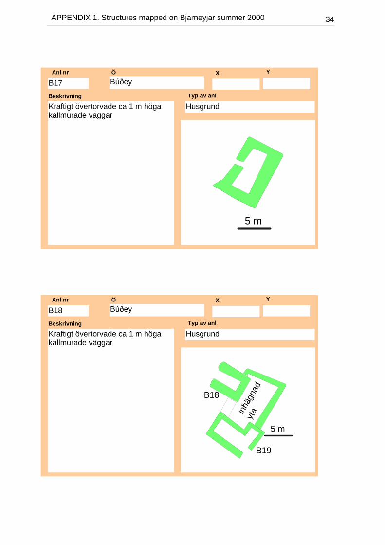
Kraftigt övertorvade ca 1 m högakallmurade väggar, något lägre iden S gaveln.
Beskrivning
BodTyp av anl
B15Anl nr
5 m
BúðeyÖ X Y
Kraftigt övertorvade ca 1 m högakallmurade väggar
Beskrivning
HusgrundTyp av anl
B16Anl nr
5 m
34APPENDIX 1. Structures mapped on Bjarneyjar summer 2000
BúðeyÖ X Y
Kraftigt övertorvade ca 1 m högakallmurade väggar
Beskrivning
HusgrundTyp av anl
B17Anl nr
5 m
BúðeyÖ X Y
Kraftigt övertorvade ca 1 m högakallmurade väggar
Beskrivning
HusgrundTyp av anl
B18Anl nr
5 m
inhäg
nad
yta
B18
B19

35APPENDIX 1. Structures mapped on Bjarneyjar summer 2000
BúðeyÖ X Y
Kraftigt övertorvade ca 1 m högakallmurade väggar. Mycket vackerttorvlagd gavel bevarad i V. Delar avtaknocken sitter delvis i ursprungligtläge.
Beskrivning
HusgrundTyp av anl
B19Anl nr
5 m
inhäg
nad
yta
B18
B19
BúðeyÖ X Y
Helt sluten rektangulär hägnad med0,4-0,7 m höga kallmurade väggar
Beskrivning
HägnadTyp av anl
B20Anl nr
5 m

36APPENDIX 1. Structures mapped on Bjarneyjar summer 2000
BúðeyÖ X Y
Fint kallmurade upp till 1,3 m högaväggar, 3,0 m mellanhästskoformationen och dentvärgående muren. En extrautbyggnad i NV
Beskrivning
FisktorkningshusTyp av anl
B21Anl nr
5 m
BúðeyÖ X Y
Hägnaden har den NV murenövertorvad och sitter samman medB23. 0,4 m höga murar, denövertorvade är docj 0,6 m hög.
Beskrivning
HägnadTyp av anl
B22Anl nr
5 m
B22
B23

37APPENDIX 1. Structures mapped on Bjarneyjar summer 2000
BúðeyÖ X Y
Upp till 1,8 m höga kallmurade ochövertorvade väggar, murbruk kvar.
Beskrivning
HusgrundTyp av anl
B23Anl nr
5 m
B22
B23
BúðeyÖ X Y
Ligger intill den mindre stugan ochöppningen är platsen för stugansplacering idag.
Beskrivning
HägnadTyp av anl
B24Anl nr
5 m
38APPENDIX 1. Structures mapped on Bjarneyjar summer 2000
BúðeyÖ X Y
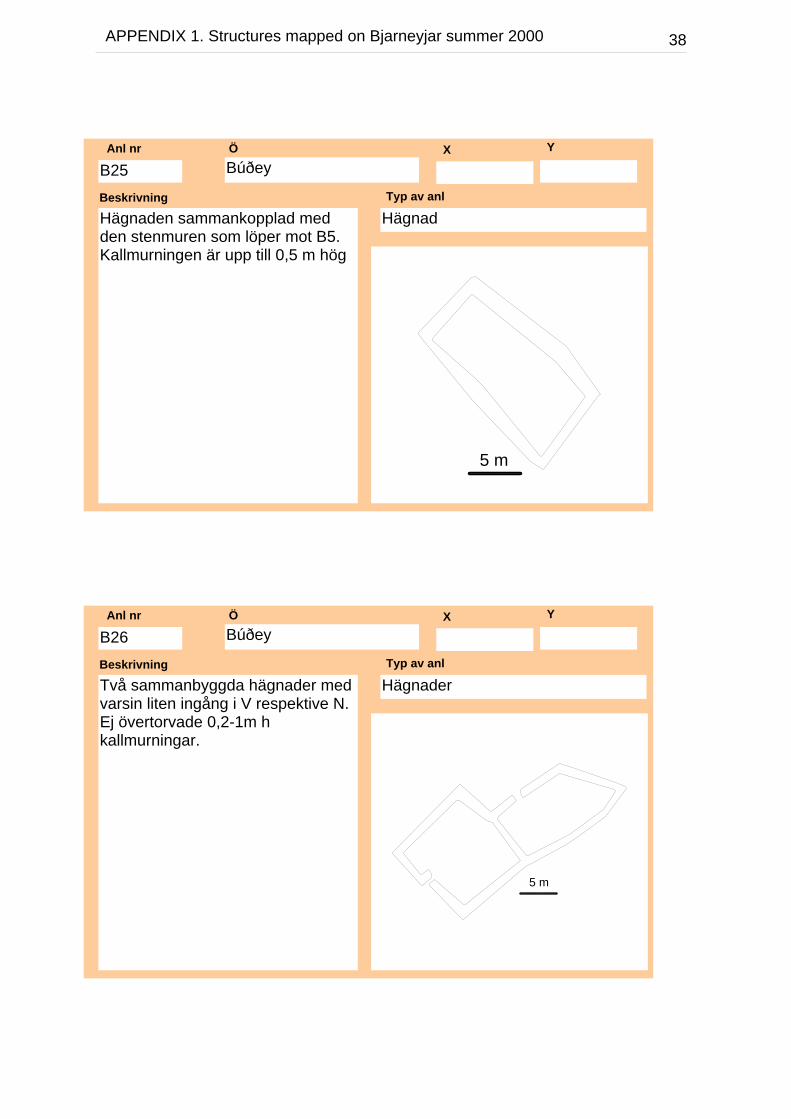
Hägnaden sammankopplad medden stenmuren som löper mot B5.Kallmurningen är upp till 0,5 m hög
Beskrivning
HägnadTyp av anl
B25Anl nr
5 m
BúðeyÖ X Y
Två sammanbyggda hägnader medvarsin liten ingång i V respektive N.Ej övertorvade 0,2-1m hkallmurningar.
Beskrivning
HägnaderTyp av anl
B26Anl nr
5 m

39APPENDIX 1. Structures mapped on Bjarneyjar summer 2000
BúðeyÖ X Y
Fint kallmurade upp till 1,4 m högaväggar, ca 2,8 m mellanhästskoformationen och dentvärgående muren. En extrautbyggnad i NV
Beskrivning
FisktorkningshusTyp av anl
B27Anl nr
5 m
BúðeyÖ X Y
Låg ca 0,2 m hög ej övertorvad mur.Rest av större?
Beskrivning
HägnadTyp av anl
B28Anl nr
5 m
40APPENDIX 1. Structures mapped on Bjarneyjar summer 2000
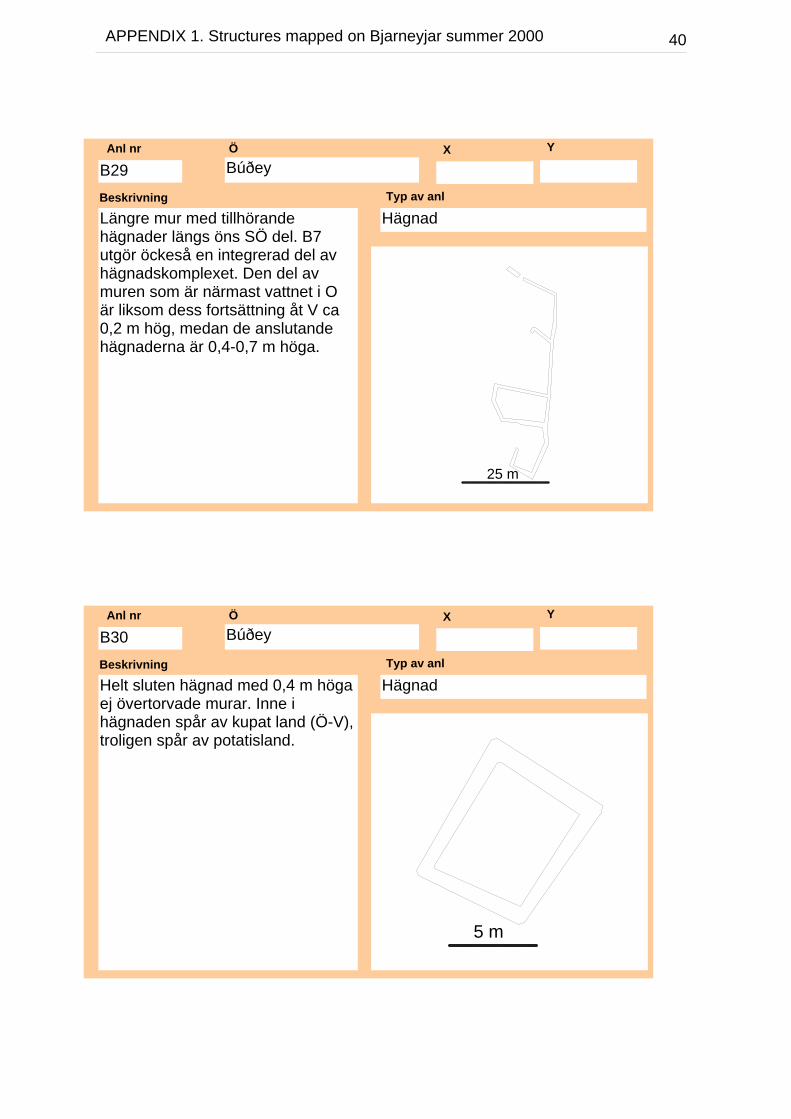
BúðeyÖ X Y
Längre mur med tillhörandehägnader längs öns SÖ del. B7utgör öckeså en integrerad del avhägnadskomplexet. Den del avmuren som är närmast vattnet i Oär liksom dess fortsättning åt V ca0,2 m hög, medan de anslutandehägnaderna är 0,4-0,7 m höga.
Beskrivning
HägnadTyp av anl
B29Anl nr
25 m
BúðeyÖ X Y
Helt sluten hägnad med 0,4 m högaej övertorvade murar. Inne ihägnaden spår av kupat land (Ö-V),troligen spår av potatisland.
Beskrivning
HägnadTyp av anl
B30Anl nr
5 m

41APPENDIX 1. Structures mapped on Bjarneyjar summer 2000
BúðeyÖ X Y
Kallmurat stenfundament medrektangulär påbyggnad på mitten.
Beskrivning
FundamentTyp av anl
B31Anl nr
5 m
BúðeyÖ X Y
Beskrivning
VörTyp av anl
B32Anl nr
5 m

42APPENDIX 1. Structures mapped on Bjarneyjar summer 2000
BúðeyÖ X Y
Beskrivning
VörTyp av anl
B33Anl nr
5 m
BúðeyÖ X Y
Beskrivning
VörTyp av anl
B34Anl nr
5 m
43APPENDIX 1. Structures mapped on Bjarneyjar summer 2000
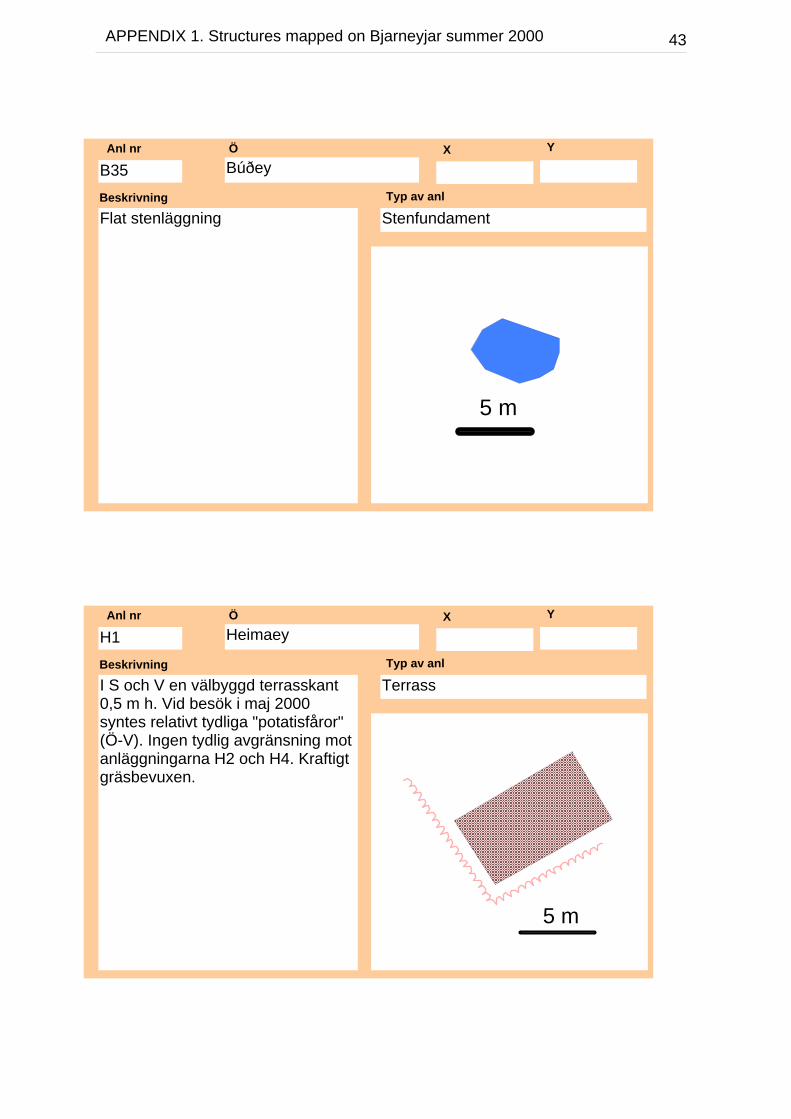
BúðeyÖ X Y
Flat stenläggningBeskrivning
StenfundamentTyp av anl
B35Anl nr
5 m
HeimaeyÖ X Y
I S och V en välbyggd terrasskant0,5 m h. Vid besök i maj 2000syntes relativt tydliga "potatisfåror"(Ö-V). Ingen tydlig avgränsning motanläggningarna H2 och H4. Kraftigtgräsbevuxen.
Beskrivning
TerrassTyp av anl
H1Anl nr
5 m
44APPENDIX 1. Structures mapped on Bjarneyjar summer 2000
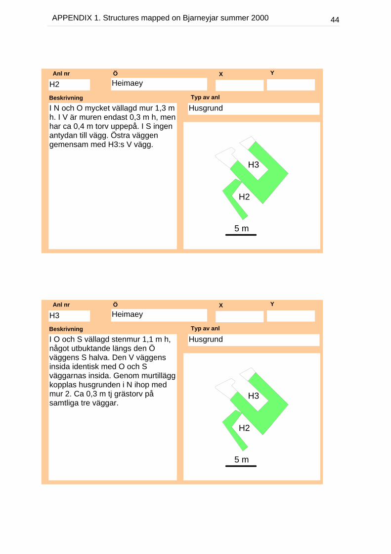
HeimaeyÖ X Y
I N och O mycket vällagd mur 1,3 mh. I V är muren endast 0,3 m h, menhar ca 0,4 m torv uppepå. I S ingenantydan till vägg. Östra väggengemensam med H3:s V vägg.
Beskrivning
HusgrundTyp av anl
H2Anl nr
5 m
H2
H3
HeimaeyÖ X Y
I O och S vällagd stenmur 1,1 m h,något utbuktande längs den Öväggens S halva. Den V väggensinsida identisk med O och Sväggarnas insida. Genom murtilläggkopplas husgrunden i N ihop medmur 2. Ca 0,3 m tj grästorv påsamtliga tre väggar.
Beskrivning
HusgrundTyp av anl
H3Anl nr
5 m
H2
H3
45APPENDIX 1. Structures mapped on Bjarneyjar summer 2000
HeimaeyÖ X Y
S väggen vällagd stenmur 0,7-1,1 mh. Ingen torv. O gavelväggen0,6-0,9 m h, mer oregelbunden ochmed 0,1 m torv (dock ejheltäckande). N väggen 0,4-1,1 m hmed samma torvbeväxning som Ögaveln. I mitten på N väggen enöppning 0,55 m bred. Inga spår avV gaveln. Inga spår av torv längshusets utsida.
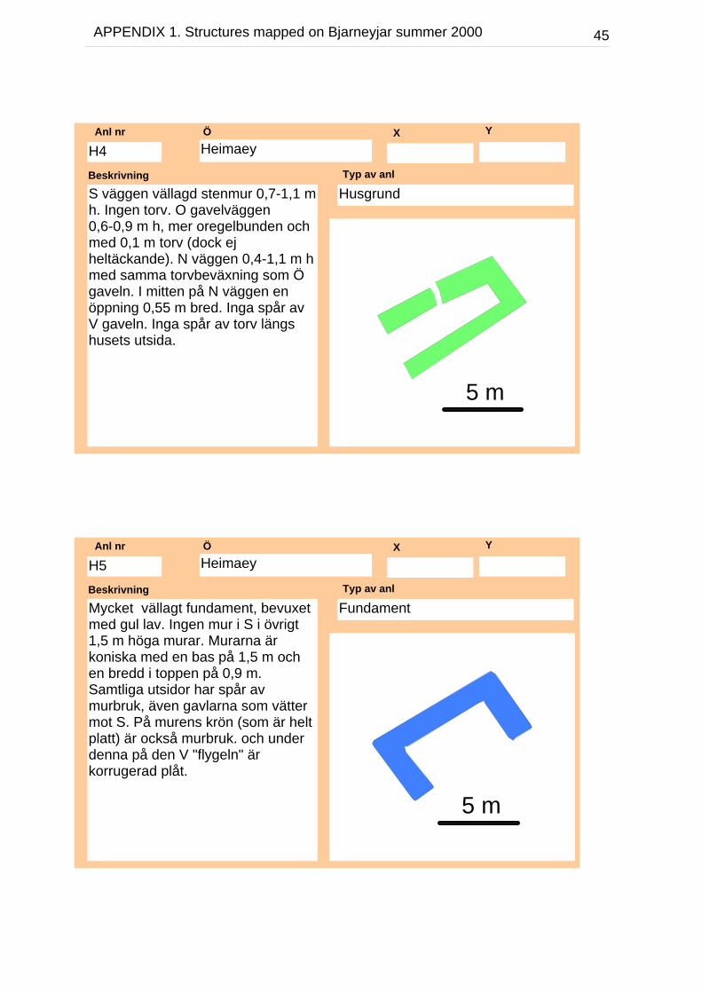
Beskrivning
HusgrundTyp av anl
H4Anl nr
5 m
HeimaeyÖ X Y
Mycket vällagt fundament, bevuxetmed gul lav. Ingen mur i S i övrigt1,5 m höga murar. Murarna ärkoniska med en bas på 1,5 m ochen bredd i toppen på 0,9 m.Samtliga utsidor har spår avmurbruk, även gavlarna som vättermot S. På murens krön (som är heltplatt) är också murbruk. och underdenna på den V "flygeln" ärkorrugerad plåt.
Beskrivning
FundamentTyp av anl
H5Anl nr
5 m
46APPENDIX 1. Structures mapped on Bjarneyjar summer 2000
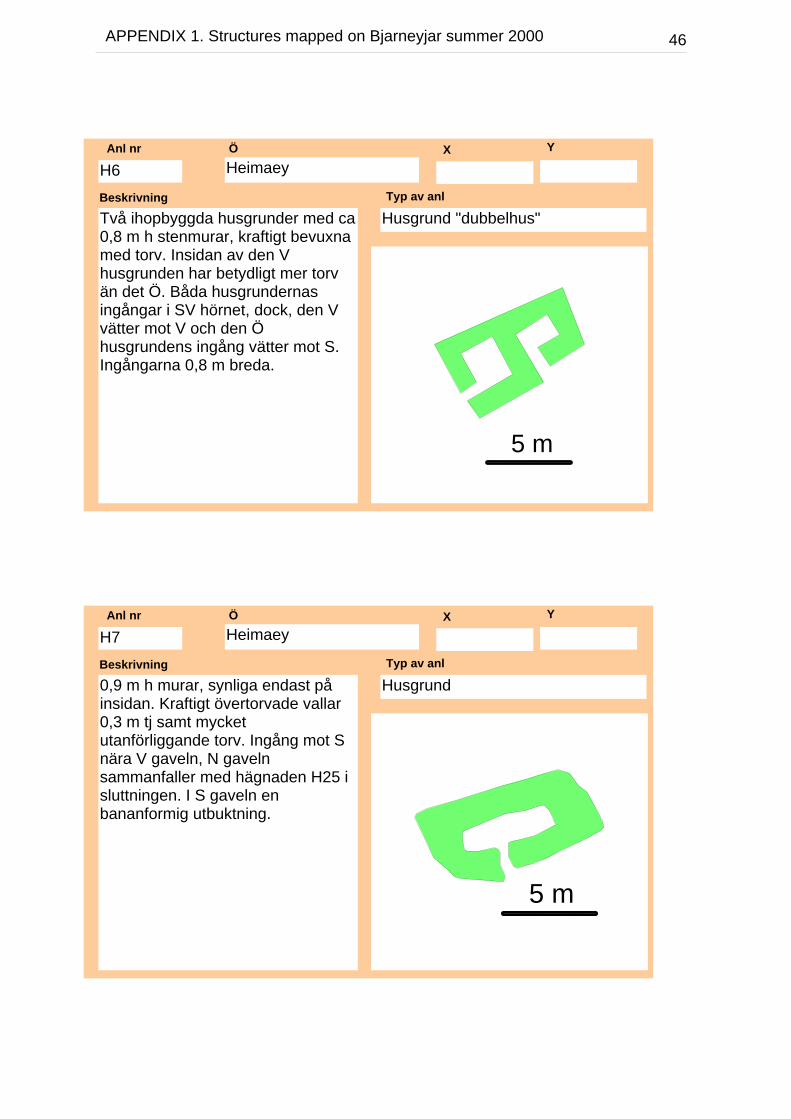
HeimaeyÖ X Y
Två ihopbyggda husgrunder med ca0,8 m h stenmurar, kraftigt bevuxnamed torv. Insidan av den Vhusgrunden har betydligt mer torvän det Ö. Båda husgrundernasingångar i SV hörnet, dock, den Vvätter mot V och den Öhusgrundens ingång vätter mot S.Ingångarna 0,8 m breda.
Beskrivning
Husgrund "dubbelhus"Typ av anl
H6Anl nr
5 m
HeimaeyÖ X Y
0,9 m h murar, synliga endast påinsidan. Kraftigt övertorvade vallar0,3 m tj samt mycketutanförliggande torv. Ingång mot Snära V gaveln, N gavelnsammanfaller med hägnaden H25 isluttningen. I S gaveln enbananformig utbuktning.
Beskrivning
HusgrundTyp av anl
H7Anl nr
5 m
47APPENDIX 1. Structures mapped on Bjarneyjar summer 2000
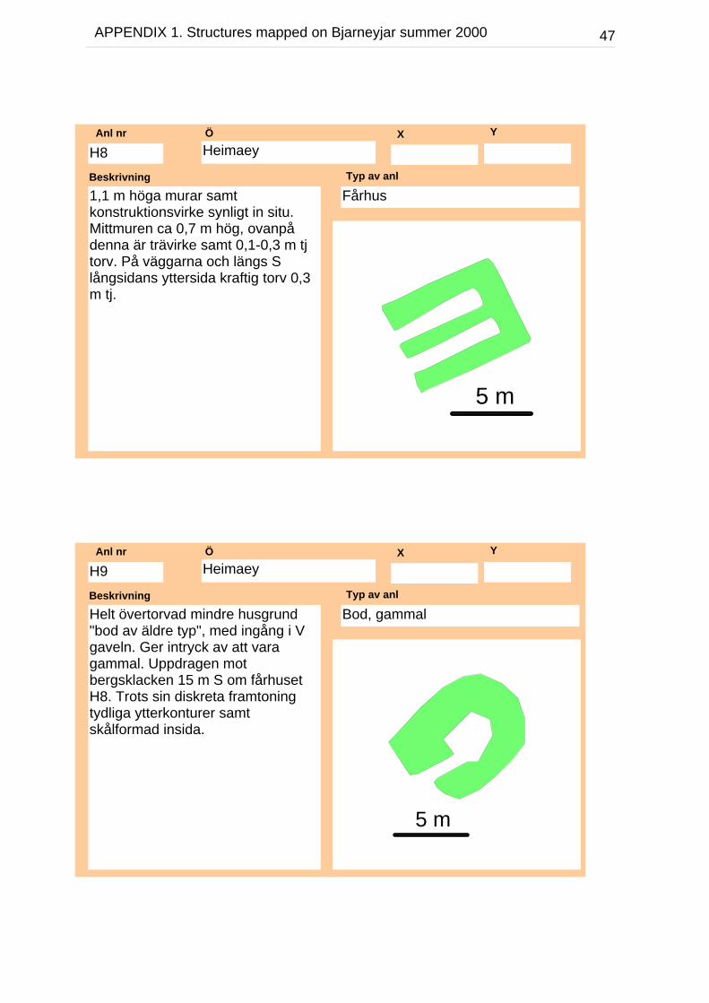
HeimaeyÖ X Y
1,1 m höga murar samtkonstruktionsvirke synligt in situ.Mittmuren ca 0,7 m hög, ovanpådenna är trävirke samt 0,1-0,3 m tjtorv. På väggarna och längs Slångsidans yttersida kraftig torv 0,3m tj.
Beskrivning
FårhusTyp av anl
H8Anl nr
5 m
HeimaeyÖ X Y
Helt övertorvad mindre husgrund"bod av äldre typ", med ingång i Vgaveln. Ger intryck av att varagammal. Uppdragen motbergsklacken 15 m S om fårhusetH8. Trots sin diskreta framtoningtydliga ytterkonturer samtskålformad insida.
Beskrivning
Bod, gammal Typ av anl
H9Anl nr
5 m
48APPENDIX 1. Structures mapped on Bjarneyjar summer 2000
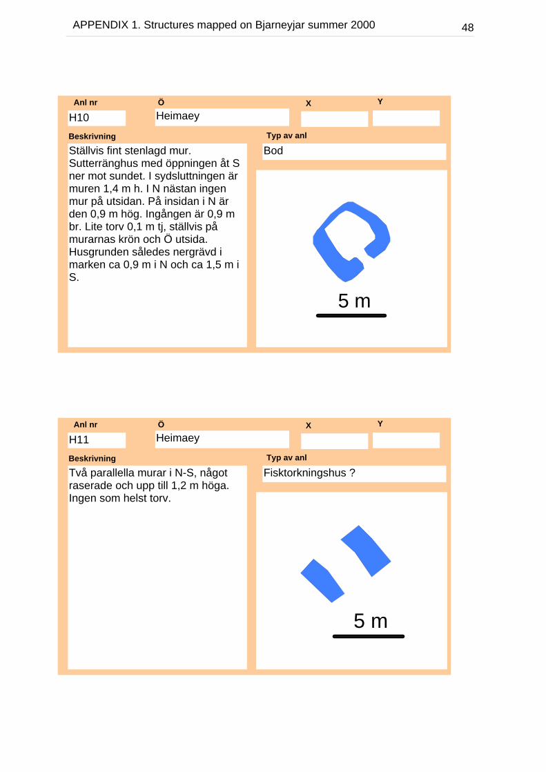
HeimaeyÖ X Y
Ställvis fint stenlagd mur.Sutterränghus med öppningen åt Sner mot sundet. I sydsluttningen ärmuren 1,4 m h. I N nästan ingenmur på utsidan. På insidan i N ärden 0,9 m hög. Ingången är 0,9 mbr. Lite torv 0,1 m tj, ställvis påmurarnas krön och Ö utsida.Husgrunden således nergrävd imarken ca 0,9 m i N och ca 1,5 m iS.
Beskrivning
BodTyp av anl
H10Anl nr
5 m
HeimaeyÖ X Y
Två parallella murar i N-S, någotraserade och upp till 1,2 m höga.Ingen som helst torv.
Beskrivning
Fisktorkningshus ?Typ av anl
H11Anl nr
5 m

49APPENDIX 1. Structures mapped on Bjarneyjar summer 2000
HeimaeyÖ X Y
Närmast kvadratisk anläggning utaningång. Försänkt bottenplan i V(möjligen också i Ö). Murarna ca0,8 m h. Beväxta med ca 0,1-0,3 mtj torv är endast N samt de nordliga3/4-delarna av de Ö och V murarna.Den S samt de resterande delarnaav Ö och V murarna har ingen ellermycket litet torv
Beskrivning
HägnadTyp av anl
H12Anl nr
5 m
HeimaeyÖ X Y
En försänkt rektangulär anläggningmed stenmurskant i N. Den Vbegränsningen sammanfaller medH12:s Ö sida. Den Öbegränsningen utgörs av ennergrävning (stenar ej noterade).Anläggningen är öppen mot S ochligger precis i erosionszonen.
Beskrivning
FörsänkningTyp av anl
H13Anl nr
5 m
50APPENDIX 1. Structures mapped on Bjarneyjar summer 2000
HeimaeyÖ X Y
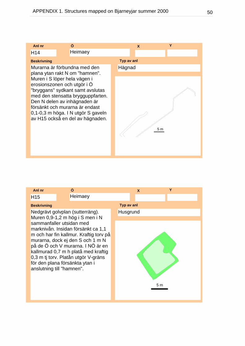
Murarna är förbundna med denplana ytan rakt N om "hamnen".Muren i S löper hela vägen ierosionszonen och utgör i Ö"bryggans" sydkant samt avslutasmed den stensatta brygguppfarten.Den N delen av inhägnaden ärförsänkt och murarna är endast0,1-0,3 m höga. I N utgör S gavelnav H15 också en del av hägnaden.
Beskrivning
HägnadTyp av anl
H14Anl nr
5 m
HeimaeyÖ X Y
Nedgrävt golvplan (sutterräng).Muren 0,9-1,2 m hög i S men i Nsammanfaller utsidan medmarknivån. Insidan försänkt ca 1,1m och har fin kallmur. Kraftig torv påmurarna, dock ej den S och 1 m Npå de Ö och V murarna. I NÖ är enkallmurad 0,7 m h platå med kraftig0,3 m tj torv. Platån utgör V-gränsför den plana försänkta ytan ianslutning till "hamnen".
Beskrivning
HusgrundTyp av anl
H15Anl nr
5 m

51APPENDIX 1. Structures mapped on Bjarneyjar summer 2000
HeimaeyÖ X Y
Två sammabyggda hus. Det Önågot mindre och bättre bevarad,med murar 1-1,4 m h och tämligenmycket torv. Öppna åt S men därfinns låga murar "trösklar" i det Öhuset i form av en enkel stenradoch i det V är "tröskeln" 1,3 m broch 0,3 m h. Mycketkonstruktionsträ och korrugerad plåti särskilt den V husdelen.
Beskrivning
DubbelhusTyp av anl
H16Anl nr
5 m
HeimaeyÖ X Y
Vinkelbyggt med väggar och delarav golv av betong. Även kamin avjärn.
Beskrivning
HusgrundTyp av anl
H17Anl nr
5 m
52APPENDIX 1. Structures mapped on Bjarneyjar summer 2000
HeimaeyÖ X Y
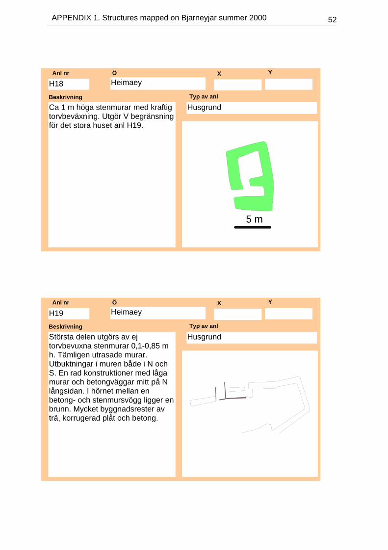
Ca 1 m höga stenmurar med kraftigtorvbeväxning. Utgör V begränsningför det stora huset anl H19.
Beskrivning
HusgrundTyp av anl
H18Anl nr
5 m
HeimaeyÖ X Y
Största delen utgörs av ejtorvbevuxna stenmurar 0,1-0,85 mh. Tämligen utrasade murar.Utbuktningar i muren både i N ochS. En rad konstruktioner med lågamurar och betongväggar mitt på Nlångsidan. I hörnet mellan enbetong- och stenmursvögg ligger enbrunn. Mycket byggnadsrester avträ, korrugerad plåt och betong.
Beskrivning
HusgrundTyp av anl
H19Anl nr

53APPENDIX 1. Structures mapped on Bjarneyjar summer 2000
HeimaeyÖ X Y
Litet fint grophus (jordkällare?).Nergrävt ca 1 m med fin insida ikallmur. Delar av torvtaket och fleraav stolparna och raften synliga.Ingen påtaglig ingång, dock en litensvacka och litet lägre innermur i Sgavlen.
Beskrivning
JordkällareTyp av anl
H20Anl nr
5 m
HeimaeyÖ X Y
N gaveln är gemensam med denlånga muren ytterst på Heimaey. Ngaveln 1,4 m hög och övriga väggar0,8 m h. Ingång i S gaveln i linjemed V väggen 0,7 m br. Kraftigttorvbevuxen. Hela mittåsen samt treraft in situ.
Beskrivning
HusgrundTyp av anl
H21Anl nr
5 m
54APPENDIX 1. Structures mapped on Bjarneyjar summer 2000
HeimaeyÖ X Y
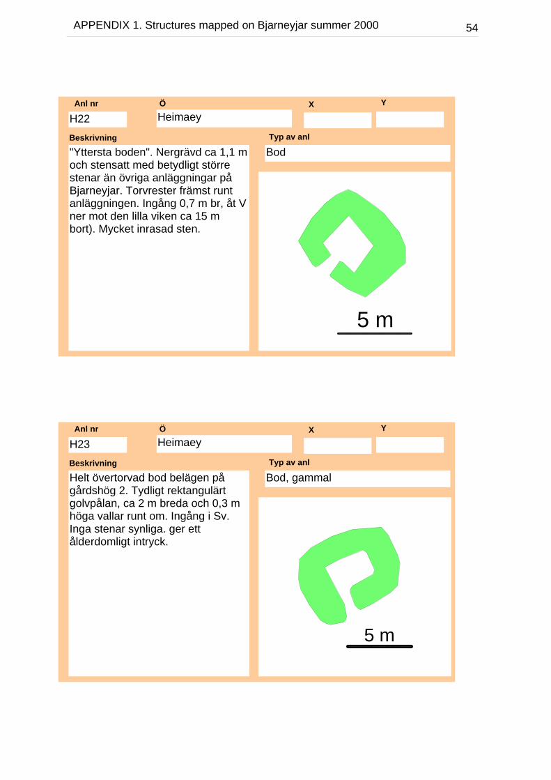
"Yttersta boden". Nergrävd ca 1,1 moch stensatt med betydligt störrestenar än övriga anläggningar påBjarneyjar. Torvrester främst runtanläggningen. Ingång 0,7 m br, åt Vner mot den lilla viken ca 15 mbort). Mycket inrasad sten.
Beskrivning
BodTyp av anl
H22Anl nr
5 m
HeimaeyÖ X Y
Helt övertorvad bod belägen pågårdshög 2. Tydligt rektangulärtgolvpålan, ca 2 m breda och 0,3 mhöga vallar runt om. Ingång i Sv.Inga stenar synliga. ger ettålderdomligt intryck.
Beskrivning
Bod, gammalTyp av anl
H23Anl nr
5 m
55APPENDIX 1. Structures mapped on Bjarneyjar summer 2000
HeimaeyÖ X Y
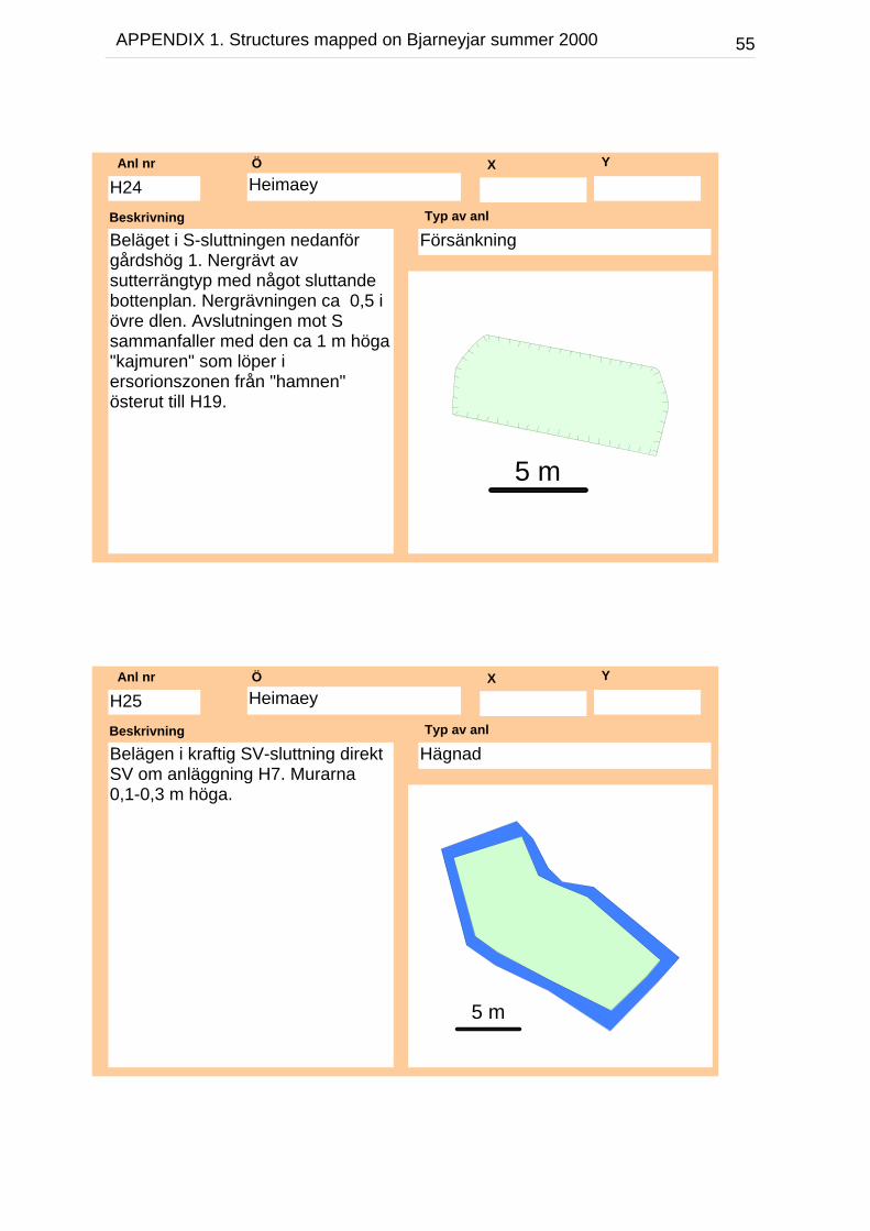
Beläget i S-sluttningen nedanförgårdshög 1. Nergrävt avsutterrängtyp med något sluttandebottenplan. Nergrävningen ca 0,5 iövre dlen. Avslutningen mot Ssammanfaller med den ca 1 m höga"kajmuren" som löper iersorionszonen från "hamnen"österut till H19.
Beskrivning
FörsänkningTyp av anl
H24Anl nr
5 m
HeimaeyÖ X Y
Belägen i kraftig SV-sluttning direktSV om anläggning H7. Murarna0,1-0,3 m höga.
Beskrivning
HägnadTyp av anl
H25Anl nr
5 m

56APPENDIX 1. Structures mapped on Bjarneyjar summer 2000
HeimaeyÖ X Y
Välbyggt stenfundament ca 1 mhögt. Bredare baser äm topp. Ianslutning till vören i NÖ
Beskrivning
StenfundamentTyp av anl
H26Anl nr
5 m
HeimaeyÖ X Y
Kraftiga murar delvis naturligabegränsningar och ovanligt lång.Ligger intill fundamentet H26 samthar en tillrättalagd jämnare yta ianslutning. Vören ligger i frånväntläge och ej i direkt anslutning tillbebygelsen.
Beskrivning
VörTyp av anl
H27Anl nr
10 m

57APPENDIX 1. Structures mapped on Bjarneyjar summer 2000
HeimaeyÖ X Y
Den mest utarbetadevöranläggningen där den Övörmuren fortsätter upp och bildaren fin uppfart till en stenlagdbrygga. Hägnaden H14 ochhusgrunden H15 bildar organiskadelar av komplexet
Beskrivning
Vör och hamnanläggningTyp av anl
H28Anl nr
10 m
H15
H14
HeimaeyÖ X Y
Beskrivning
VörTyp av anl
H29Anl nr
10 m

58APPENDIX 1. Structures mapped on Bjarneyjar summer 2000
HeimaeyÖ X Y
Hägnad som innefattar husen H3och H6 samt i S hörnet tvåbetongblock. Innanför hägnadentydliga "potatisfåror".
Beskrivning
Hägnat "potatisland"Typ av anl
H30Anl nr
H3
10 m
H6
H30
HöfðiÖ X Y
Helt övertorvad med flackakonturer.
Beskrivning
Bod, gammalTyp av anl
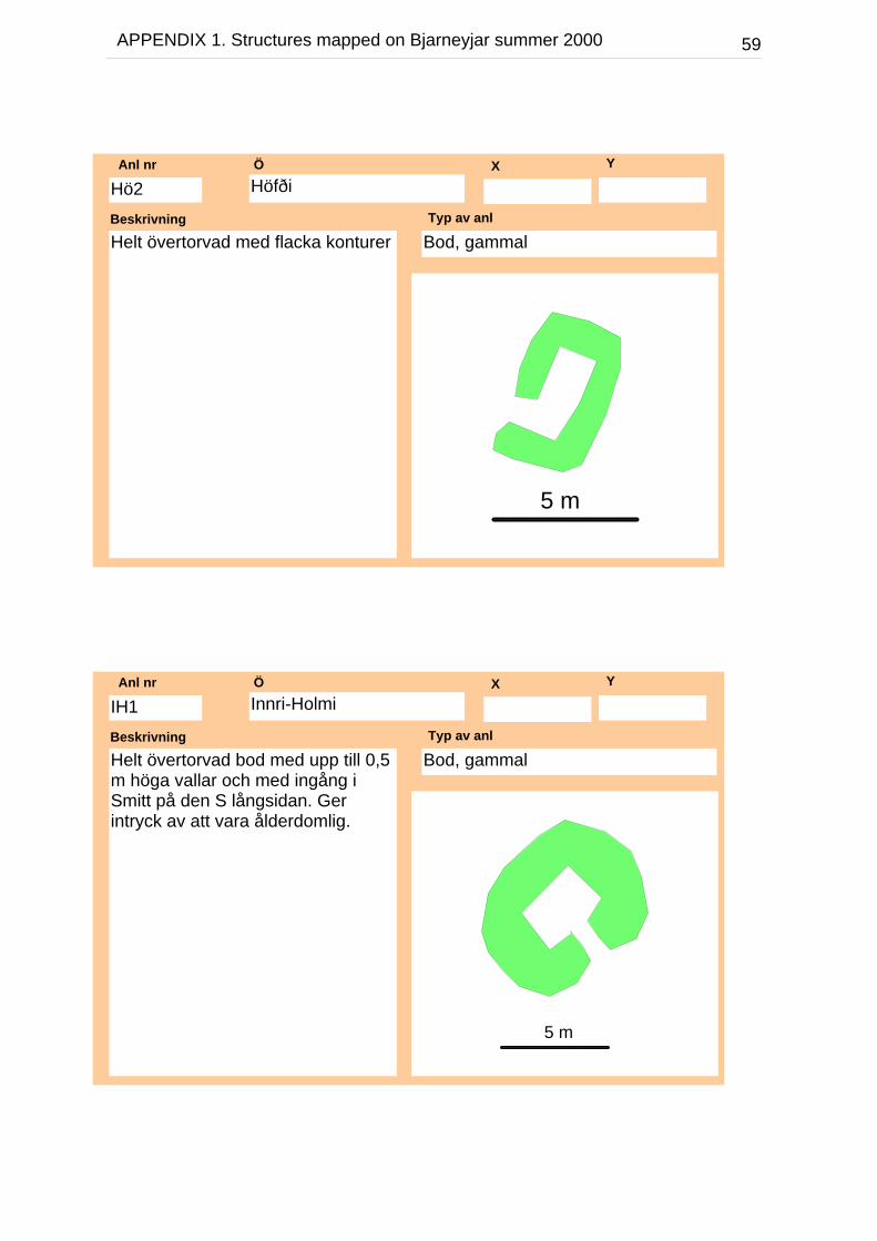
Hö1Anl nr
5 m
59APPENDIX 1. Structures mapped on Bjarneyjar summer 2000
HöfðiÖ X Y
Helt övertorvad med flacka konturerBeskrivning
Bod, gammalTyp av anl
Hö2Anl nr
5 m
Innri-HolmiÖ X Y
Helt övertorvad bod med upp till 0,5m höga vallar och med ingång iSmitt på den S långsidan. Gerintryck av att vara ålderdomlig.
Beskrivning
Bod, gammalTyp av anl
IH1Anl nr
5 m

60APPENDIX 1. Structures mapped on Bjarneyjar summer 2000
Innri-HolmiÖ X Y
Rektangulär hägnad med ca 0,5 mhög kallmur.
Beskrivning
HägnadTyp av anl
IH2Anl nr
5 m
TorfeyÖ X Y
Ca 13 x 13m st anläggning somutgörs av fyra större, flatahörnstenar. Mellan dessa löper rätarader av stenar lagda i ett skift.Mycket lik en vanligramverkskonstruktion, frånsettstorleken. I Ö hörnet överlagrasanläggningen av T2 en bod avgammal typ.
Beskrivning
RamverkshusgrundTyp av anl
T1Anl nr
5 m

61APPENDIX 1. Structures mapped on Bjarneyjar summer 2000
TorfeyÖ X Y
Helt övertorvad bod med ingång i Ö(ner mot vattnet). Ger ettålderdomligt intryck samt överlagrarT1.
Beskrivning
Bod, gammalTyp av anl
T2Anl nr
5 m
Ytri-HolmiÖ X Y
Närmast kvadratisk hägnad medupp till 0,5 m h kallmur.
Beskrivning
HägnadTyp av anl
YH1Anl nr
5 m
62APPENDIX 1. Structures mapped on Bjarneyjar summer 2000
Ytri-HolmiÖ X Y
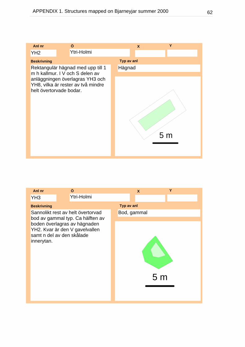
Rektangulär hägnad med upp till 1m h kallmur. I V och S delen avanläggningen överlagras YH3 ochYH8, vilka är rester av två mindrehelt övertorvade bodar.
Beskrivning
HägnadTyp av anl
YH2Anl nr
5 m
Ytri-HolmiÖ X Y
Sannolikt rest av helt övertorvadbod av gammal typ. Ca hälften avboden överlagras av hägnadenYH2. Kvar är den V gavelvallensamt n del av den skåladeinnerytan.
Beskrivning
Bod, gammalTyp av anl
YH3Anl nr
5 m
63APPENDIX 1. Structures mapped on Bjarneyjar summer 2000
Ytri-HolmiÖ X Y
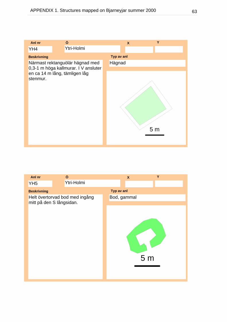
Närmast rektanguölär hägnad med0,3-1 m höga kallmurar. I V ansluteren ca 14 m lång, tämligen lågstenmur.
Beskrivning
HägnadTyp av anl
YH4Anl nr
5 m
Ytri-HolmiÖ X Y
Helt övertorvad bod med ingångmitt på den S långsidan.
Beskrivning
Bod, gammalTyp av anl
YH5Anl nr
5 m
64APPENDIX 1. Structures mapped on Bjarneyjar summer 2000
Ytri-HolmiÖ X Y
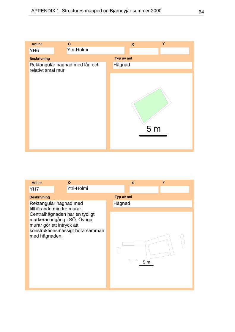
Rektangulär hagnad med låg ochrelativt smal mur
Beskrivning
HägnadTyp av anl
YH6Anl nr
5 m
Ytri-HolmiÖ X Y
Rektangulär hägnad medtillhörande mindre murar.Centralhägnaden har en tydligtmarkerad ingång i SÖ. Övrigamurar gör ett intryck attkonstruktionsmässigt höra sammanmed hägnaden.
Beskrivning
HägnadTyp av anl
YH7Anl nr
5 m
65APPENDIX 1. Structures mapped on Bjarneyjar summer 2000
Ytri-HolmiÖ X Y
Del av helt övertorvad bod.Anläggningen ser ut att vara en delav en bod som överlagrats av YH2.Kan utgöra del av vallen.
Beskrivning
Bod, gammal ?Typ av anl
YH8Anl nr
5 m