
Sawmill Brook: An Example of Rapid Geomorphic Change Related to Urbanization
Upload
independentCategory
view
1download
0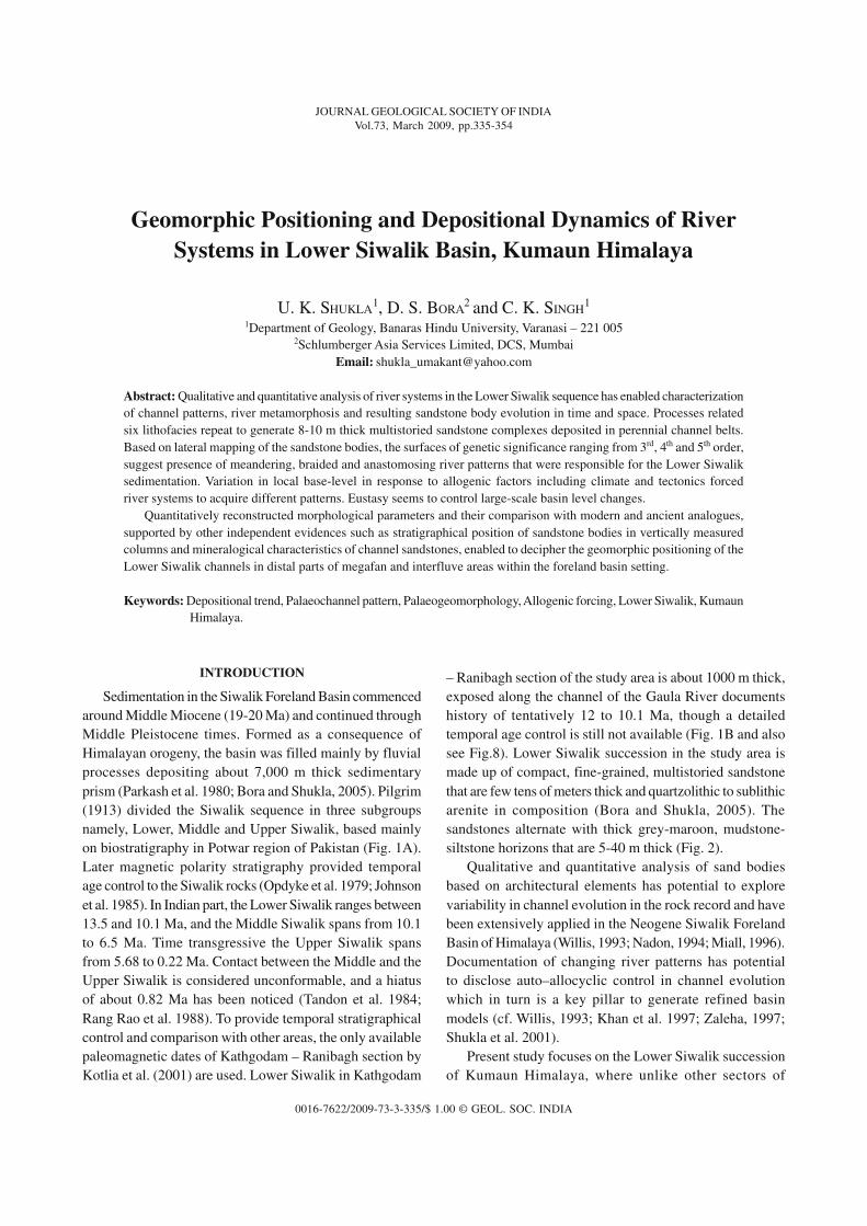
0016-7622/2009-73-3-335/$ 1.00 © GEOL. SOC. INDIA
JOURNAL GEOLOGICAL SOCIETY OF INDIAVol.73, March 2009, pp.335-354
Geomorphic Positioning and Depositional Dynamics of RiverSystems in Lower Siwalik Basin, Kumaun Himalaya
U. K. SHUKLA1, D. S. BORA
2 and C. K. SINGH1
1Department of Geology, Banaras Hindu University, Varanasi – 221 0052Schlumberger Asia Services Limited, DCS, Mumbai
Email: [email protected]
Abstract: Qualitative and quantitative analysis of river systems in the Lower Siwalik sequence has enabled characterizationof channel patterns, river metamorphosis and resulting sandstone body evolution in time and space. Processes relatedsix lithofacies repeat to generate 8-10 m thick multistoried sandstone complexes deposited in perennial channel belts.Based on lateral mapping of the sandstone bodies, the surfaces of genetic significance ranging from 3rd, 4th and 5th order,suggest presence of meandering, braided and anastomosing river patterns that were responsible for the Lower Siwaliksedimentation. Variation in local base-level in response to allogenic factors including climate and tectonics forcedriver systems to acquire different patterns. Eustasy seems to control large-scale basin level changes.
Quantitatively reconstructed morphological parameters and their comparison with modern and ancient analogues,supported by other independent evidences such as stratigraphical position of sandstone bodies in vertically measuredcolumns and mineralogical characteristics of channel sandstones, enabled to decipher the geomorphic positioning of theLower Siwalik channels in distal parts of megafan and interfluve areas within the foreland basin setting.
Keywords: Depositional trend, Palaeochannel pattern, Palaeogeomorphology, Allogenic forcing, Lower Siwalik, KumaunHimalaya.
– Ranibagh section of the study area is about 1000 m thick,exposed along the channel of the Gaula River documentshistory of tentatively 12 to 10.1 Ma, though a detailedtemporal age control is still not available (Fig. 1B and alsosee Fig.8). Lower Siwalik succession in the study area ismade up of compact, fine-grained, multistoried sandstonethat are few tens of meters thick and quartzolithic to sublithicarenite in composition (Bora and Shukla, 2005). Thesandstones alternate with thick grey-maroon, mudstone-siltstone horizons that are 5-40 m thick (Fig. 2).
Qualitative and quantitative analysis of sand bodiesbased on architectural elements has potential to explorevariability in channel evolution in the rock record and havebeen extensively applied in the Neogene Siwalik ForelandBasin of Himalaya (Willis, 1993; Nadon, 1994; Miall, 1996).Documentation of changing river patterns has potentialto disclose auto–allocyclic control in channel evolutionwhich in turn is a key pillar to generate refined basinmodels (cf. Willis, 1993; Khan et al. 1997; Zaleha, 1997;Shukla et al. 2001).
Present study focuses on the Lower Siwalik successionof Kumaun Himalaya, where unlike other sectors of
INTRODUCTION
Sedimentation in the Siwalik Foreland Basin commencedaround Middle Miocene (19-20 Ma) and continued throughMiddle Pleistocene times. Formed as a consequence ofHimalayan orogeny, the basin was filled mainly by fluvialprocesses depositing about 7,000 m thick sedimentaryprism (Parkash et al. 1980; Bora and Shukla, 2005). Pilgrim(1913) divided the Siwalik sequence in three subgroupsnamely, Lower, Middle and Upper Siwalik, based mainlyon biostratigraphy in Potwar region of Pakistan (Fig. 1A).Later magnetic polarity stratigraphy provided temporalage control to the Siwalik rocks (Opdyke et al. 1979; Johnsonet al. 1985). In Indian part, the Lower Siwalik ranges between13.5 and 10.1 Ma, and the Middle Siwalik spans from 10.1to 6.5 Ma. Time transgressive the Upper Siwalik spansfrom 5.68 to 0.22 Ma. Contact between the Middle and theUpper Siwalik is considered unconformable, and a hiatusof about 0.82 Ma has been noticed (Tandon et al. 1984;Rang Rao et al. 1988). To provide temporal stratigraphicalcontrol and comparison with other areas, the only availablepaleomagnetic dates of Kathgodam – Ranibagh section byKotlia et al. (2001) are used. Lower Siwalik in Kathgodam
JOUR.GEOL.SOC.INDIA, VOL.73, MARCH 2009
336 U. K. SHUKLA AND OTHERS
Himalaya (Tandon et al. 1984; Kumar et al. 2003; Nakayamaand Ulak, 1999; Zaleha, 1997), systematic sedimentologicalstudies have not yet been attempted (Bora and Shukla, 2005),probably because of difficult tectonic setting with intricatelyfolded, faulted and steeply dipping rocks and rarity oflaterally exposed sections (Figs. 1A, B). For the first time,well-developed sandstone bodies exposed along riverchannels (Nihal Nadi section) and road cuts (Kaladhungi –Ghatgad section) have been selected and laterally mapped,and their relationship with adjacent fine-grained units have
been emphasized (Fig. 1B). The most complete Kathgodam-Ranibagh section is very steeply dipping and providedopportunity to evaluate lateral and temporal variation andcomparison with other investigated sections (Bora andShukla, 2005). Based on detailed facies and architecturalelement analysis of sandstone bodies supported byquantitative morphological parameters and palaeocurrentpatterns, an attempt has been made to characterize thepalaeochannel patterns, river metamorphosis and sandstonebody evolution during the Lower Siwalik times. Comparison
Fig.1. (A) Geological map showing extent of Siwalik Hills forming Sub-Himalaya from Potwar Plateau of Pakistan in the east to Nanital(Kumaun Himalaya) and further west (Ramganga sub-basin) (modified after Raiverman et al. 1983). (B) Geological map of thestudy area showing major lithological distribution and tectonic subdivisions of Siwalik in Kumaun Himalaya around Nainital(modified after Karunakaran and Ranga Rao, 1976).
Ramnagar
HFF
KosiR
.
Nih
alN
.
Hi m
al a
ya
Le
ss
er
MBT
Sarpa dhuliDhikala thrust
N
0
Fault
Thrust
Lesser Himalaya
Lower Siwalik
Middle Siwalik
Upper Siwalik
Alluvium
Kaladhungi
HFF
Gaula
R.
Haldwani
Nainital
10km
Delhi
GTF
Dehra Dun
Shimla
HF
F
Lahore
Chandigarh
S R T Jammu
Kangra
MainM
antle
Kara
kora
mFault
TI B
ET
Thru
st
Yam
una
Riv
er
YTF
Gang
aR
ive
r
Satluj R.
Chenab River
Potwar Plateau
BeasR.
ITSZ
320
300
280
720 74
0
760
780
800
280
320
360
80078
0
740
360
1. Neoshera sub-basin
2. Ramnagar sub-basin
3. Kangra sub-basin
4. Subathu sub-basin
5. Dehra Dun sub-basin
6. Ramganga sub-basin
6
5
4
3
21
Nainital
Delhi
Nainital
Mangoli thrust
Kota bagh
Studied Transect
Main
Central T
hrust
Main
Boun
dary
Thrust
0 100 200 km
N
A
B
Siwalik belt
Himalayan Frontal Fault
Him
alayanFrontal Fault (H
FF)
Main
Boundary
Thrust (MBT)
Ghatgad
JOUR.GEOL.SOC.INDIA, VOL.73, MARCH 2009
DEPOSITIONAL DYNAMICS OF RIVER SYSTEMS IN LOWER SIWALIK BASIN, KUMAUN HIMALAYA 337
of quantitatively reconstructed parameters with modernanalogues enabled to comment on the positioning ofLower Siwalik channels in foreland basin setting. Anattempt has also been made to comment on the possiblecontrol of synsedimentary tectono-climate changes andeustasy on evolving fluvial styles through time.
TECTONIC SETTING
In Kumaun sector, the Siwalik succession has asporadic distribution of outcrops, which are differentiallyuplifted along Himalayan Frontal Fault (HFF) andrepeatedly, thrust southward by splays of Main BoundaryThrust (MBT), offset by many tear faults (Valdiya, 1988;Agarwal and Shukla, 2005). In the study area however, theLower Siwalik succession shows structural repetition.Tracing from south to north the Lower Siwalik rocks areuplifted along HFF forming the mountain front (Fig. 1).Further to north, the Lower Siwalik grades into theMiddle Siwalik succession which is again overlain by theLower Siwalik rocks with a thrust contact along roughlyE-W trending Mangoli Fault (Karunakaran and RangaRao, 1976; Valdiya, 1988) (Fig. 1B). In the eastern part ofthe study area, around Gaula River, sequence has steeperdips of 50°- 80° towards NW, and shows intense shearing,shattering and granulation. In contrast, western part ofthe study area, around Ram Ganga River, rocks aremoderately dipping at 20°-30° towards SW, and arerelatively less deformed (Agarwal and Shukla, 2005)(Fig. 1B). It is believed that activity along major thrustplanes of the Himalaya have had greatly influenced thesedimentological processes operative in the Siwalik
Foreland Basin through Miocene times (Brozovic andBurbank, 2000; Kumar et al. 2003).
METHODOLOGY
To understand geomorphic positioning and depositionaldynamics of Lower Siwalik river system, qualitative andquantitative channel reconstruction approach wasadopted. Qualitative approach involved vertical profiledocumentation at fixed lateral intervals of 4 m followed bylateral mapping of sand bodies in the field. Surfaces ofgenetic significance were identified, traced and interpretedfor sand body evolution and palaeochannel pattern (cf.Willis, 1993; Bridge, 1993; Miall, 1996). To understandstratigraphic changes, available sections were measured,lithologged and compared, so as to get a regional perspectiveof syndepositional events during the Lower Siwalik times.
Channel morphology is calculated using empiricalequations developed by various workers and tested onmodern and ancient analogues (Schumm, 1963, 1972; Cotter,1971; Miall, 1976; Ethridge and Schumm, 1978; Willis,1993; Gibling, 2006). Calculations are carried out forindividual stories (IInd order channels) within a sandstonebody (channel belt). The calculated channel morphologicalparameters include, bankful channel depth (Dbf), meanchannel depth (Dm), bankful channel width (Wbf), sinuosity(P), width to mean depth ratio (F) and meander wave length(Lm). The equations used to calculate these parameters arelisted in Table 1 with references, and results are given inTable 3. Channel depth and width is directly measuredfrom outcrop and measured dimensions are subjected tocorrection as suggested in Bridge and Diemer (1983).
Table 1. Empirical equations used in calculation of channel parameter following Ethridge and Schumm (1978),Cotter, (1971) and references therein
Channel Parameter Unit Empirical Equation Studies
Channel sinuosity (P) NA *P=1/1-(φ/252)2 *P=3.5F -0.27 Miall (1976); Schumm (1963)
Channel depth (Dm) m *H=0.086Dm1.19 Allen (1968)
*Dbf=cc'Dm Ethridge and Schumm (1978)
Channel width (W) m *W=42Dbf1.11& Wbf=KW Leopold and Meddock (1953);
(used for braided) Cotter (1971);*Wbf=6.8Dbf
1.54 Ethridge and Schumm (1978)(used for meandering)
Meander wave length (Lm) m Lm=18 (F0.53Wbf0.69) Schumm (1972); Leopold and
*Lm=10.9W1.01 Wolman (1960); Schumm (1968)
Where, φ (used in channel sinuosity) is mean palaeoflow direction measured from cross bed set, K (used inchannel width) varies from 1-1.5, H (used in channel depth) is cross bed set thickness, c (used in channel depth)is compaction of sand due to burial which varies from 1.1-1.2 (Ethridge and Schumm, 1978), c’ (used in channeldepth) is variation is depth between straight and sinuous channel which varies from 0.585-1.0 (Ethridge andSchumm, 1978), (Dbf) bankful channel depth, (Dm
) mean channel depth, (Wbf) bankful channel width, (P)sinuosity, (F) width to mean depth ratio.
JOUR.GEOL.SOC.INDIA, VOL.73, MARCH 2009
338 U. K. SHUKLA AND OTHERS
Channel depth is also calculated using average cross-bedset thickness and then width is calculated using depth.Two different equations are used to calculate channel widthfor meandering and braided river (Table 1), which givesclosure result to outcrop measured width of respectivechannels. These calculated channel dimensions are foundin close agreement with actually measured dimensionsdirectly from outcrop.
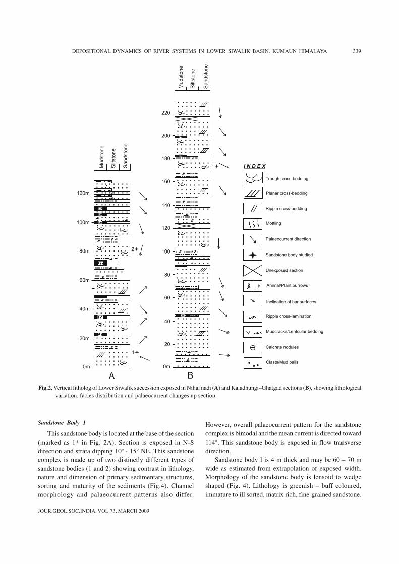
LITHOFACIES
In the present work, two well exposed sections rangingin thickness between 120 and 250 m were studied andlithologs were prepared based on distribution of lithologyand lithofacies (Fig. 2). Sandstone horizons constitute 60 -70% of the total thickness in these vertically documentedsections. Sandstone bodies are very fine to fine-grained,multistoried, light green to brownish-green coloured. Someof the sandstone bodies are medium-grained also. Individualsandstone bodies are generally 10 - 15 m thick, occasionally20 - 30 m thick (Fig. 2). Sandstone bodies exposed in flowtransverse direction show varied geometry viz. lensoid,wedge, tabular, ribbon shaped etc. Grain-size and thenature of the primary physical sedimentary structures varywithin the sandstone bodies both laterally and vertically(Figs. 2, 3). Thickly developed sandstone bodies arecomposed of three to seven vertically stacked stories.Prominent erosional relief, clast concentration and mudstonelenses mark the base of individual stories. Within individualfining upward stories cross-stratified bed sets dominate atthe lower level, whereas low-angle cross-stratification,current ripple lamination and subsequently bioturbated siltysandstone occur towards top (Figs. 2, 3). In general, troughcross-bedding is dominant physical sedimentary structurefollowed by planar cross-bedding and ripple cross-lamination.
Lithofacies analysis of the sandstone horizons is basedon geometry of lithounits, primary physical structures, grainsize, palaeocurrent and evidences of animal–plant activity.Process related six lithofacies identified in the sandstonebodies have been assigned to specific depositional settings(Fig. 3; Table 2). Identified lithofacies include Granularsandstone (Gm), Trough cross-bedded sandstone (St), Planarcross-bedded sandstone (Sp), Low-angle cross-beddedsandstone (Sl), Ripple-parallel laminated sandstone (Sh-Sr)and Mottled silty sandstone (Fl). These structures areinterpreted to be formed by migration of small to large-scalebedforms in perennial channels carrying silt and fine- tomedium-grained sand as bed load.
In the Lower Siwalik sequence, sandstone bodies are
often overlain by 2-10 m thick fine-grained mudstonedeposits (Fr) showing poorly developed small-scale physicalfeatures, animal and plant produced mottles and pedogenicalteration (Figs.2, 3H). Such units have been interpreted aschannel fill-floodplain deposits (Bora, 2003; Bora andShukla, 2005), and have not been addressed in the presentpaper in detail, though their relationships with the adjoiningsandstone bodies have been emphasized.
ARCHITECTURAL ELEMENTS
To characterize various channel patterns usingarchitectural element analysis, well developed sandstonebodies exposed in relatively gently dipping sections arelaterally mapped and described one by one in followingsection. Truncation relationships between stories (4th ordersurfaces), and inclination of 3rd order surfaces have beenemphasized (Willis, 1993; Bridge, 1993; Miall, 1996). The3rd order surfaces of Miall (1985) are equivalent to lateralaccretionary surfaces of Allen (1983), bedsets of Bridge andDiemer (1983), seasonal accretionary units of Bridge (1993),and large scale inclined strata of Zaleha (1997). Internally,3rd order surfaces contain down-current accretion (DA), up-current accretion (UA) and lateral accretion (LA) elementsgenerated in response to amalgamation of seasonal unit barsfrom different directions in the channels during individualflood events. They show systematic variation in sedimentarystructure, grain-size, palaeocurrent and mottling bothvertically and laterally.
Nihal-Nadi Section
This section is exposed nearly 3 - 4 km east ofKaladhungi along Nihal nadi (Nadi stands for River).Measured thickness of the Lower Siwalik sequence inthis section is 126 m where sandstone constitutes 64%,followed by 36% siltstone and mudstone units interpretedas flood plain deposits (Bora, 2003; Bora and Shukla, 2005)(Fig.2A). About 5-10 m thick greenish, very fine-grained,matrix-rich, large to small-scale cross-bedded sandstonebodies exposed at the lower level, gradually decrease inthickness to 2-5 m and become comparatively matureand buff coloured. These sandstone units are separated byequally thick silt-mudstone horizons imparting an overallfining upward character to the Siwalik succession exposedin the section. Sandstone bodies at upper stratigraphiclevels (above 8 m) are dominated by small-scale ripples,ripple cross-lamination and parallel lamination (Fig.2A).Within this section two sandstone bodies of contrastingcharacters were selected for qualitative and quantitativechannel reconstruction.
JOUR.GEOL.SOC.INDIA, VOL.73, MARCH 2009
DEPOSITIONAL DYNAMICS OF RIVER SYSTEMS IN LOWER SIWALIK BASIN, KUMAUN HIMALAYA 339
0m
20m
40m
60m
80m
100m
120m
220
200
180
160
140
100
80
60
40
20
0m
120
Mu
dsto
ne
Silts
ton
e
Sa
nd
sto
ne
Mu
dsto
ne
Silts
ton
e
Sa
nd
sto
ne
III
III
III
III
III
III
III
III
III
III
1
2
1
III
Trough cross-bedding
Planar cross-bedding
Ripple cross-bedding
Mottling
Palaeocurrent direction
Sandstone body studied
Unexposed section
I N D E X
A B
Animal/Plant burrows
Inclination of bar surfaces
Ripple cross-lamination
Mudcracks/Lentcular bedding
Calcrete nodules
Clasts/Mud balls
Fig.2. Vertical litholog of Lower Siwalik succession exposed in Nihal nadi (A) and Kaladhungi–Ghatgad sections (B), showing lithologicalvariation, facies distribution and palaeocurrent changes up section.
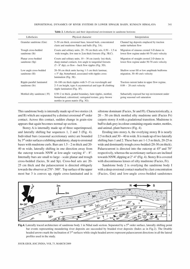
Sandstone Body 1
This sandstone body is located at the base of the section(marked as 1* in Fig. 2A). Section is exposed in N-Sdirection and strata dipping 10° - 15° NE. This sandstonecomplex is made up of two distinctly different types ofsandstone bodies (1 and 2) showing contrast in lithology,nature and dimension of primary sedimentary structures,sorting and maturity of the sediments (Fig.4). Channelmorphology and palaeocurrent patterns also differ.
However, overall palaeocurrent pattern for the sandstonecomplex is bimodal and the mean current is directed toward114°. This sandstone body is exposed in flow transversedirection.
Sandstone body I is 4 m thick and may be 60 – 70 mwide as estimated from extrapolation of exposed width.Morphology of the sandstone body is lensoid to wedgeshaped (Fig. 4). Lithology is greenish – buff coloured,immature to ill sorted, matrix rich, fine-grained sandstone.
JOUR.GEOL.SOC.INDIA, VOL.73, MARCH 2009
340 U. K. SHUKLA AND OTHERS
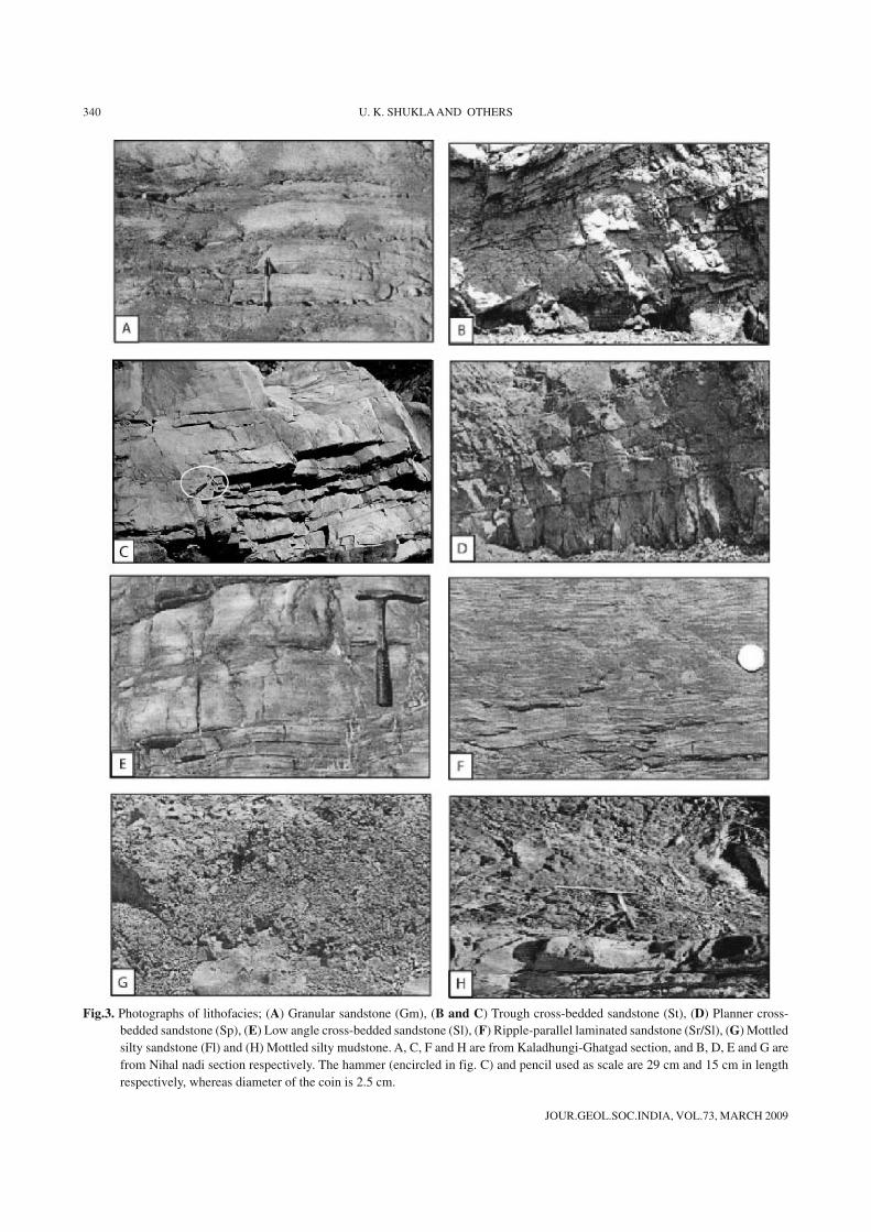
Fig.3. Photographs of lithofacies; (A) Granular sandstone (Gm), (B and C) Trough cross-bedded sandstone (St), (D) Planner cross-bedded sandstone (Sp), (E) Low angle cross-bedded sandstone (Sl), (F) Ripple-parallel laminated sandstone (Sr/Sl), (G) Mottledsilty sandstone (Fl) and (H) Mottled silty mudstone. A, C, F and H are from Kaladhungi-Ghatgad section, and B, D, E and G arefrom Nihal nadi section respectively. The hammer (encircled in fig. C) and pencil used as scale are 29 cm and 15 cm in lengthrespectively, whereas diameter of the coin is 2.5 cm.
JOUR.GEOL.SOC.INDIA, VOL.73, MARCH 2009
DEPOSITIONAL DYNAMICS OF RIVER SYSTEMS IN LOWER SIWALIK BASIN, KUMAUN HIMALAYA 341
This sandstone body is internally made up of two stories (Aand B) which are separated by a distinct erosional 4th ordercontact. Across this contact, sudden change in grain-sizeappears that again becomes normal up section.
Storey A is internally made up of three superimposed,and laterally shifting bar sequences 1, 2 and 3 (Fig. 4).Individual bars (seasonal accretionary units) are boundedby 3rd order surfaces exhibiting undulatory, sharp to erosionalbases with mudstone curls. Bars are 1.5 – 2 m thick and 20-40 m wide, laterally shifting in one direction away fromthe outcrop towards NNW at low-angle varying 4° - 8°.Internally bars are small to large - scale planar and troughcross-bedded (facies, St and Sp). Cross-bed sets are 20-25 cm thick and the palaeocurrent is directed obliquelytowards the observer at 270°- 300°. Top surface of the uppermost bar 3 is convex up, ripple cross-laminated and is
siltstone dominant (Facies, Sr and Fl). Characteristically, a20 – 50 cm thick mottled silty mudstone unit (Facies Fr)carpets storey A with a gradational transition. Mudstone isbuff to dark grey in colour containing organic matter, mottles,and animal, plant burrows (Fig. 4).
Eroding into storey A, the overlying storey B is nearly2.5 m thick and 30 – 40 m wide. It is made up of two laterallyshifting bars 1 and 2. These bars are 1-1.5 m thick, 20-25 mwide and dominantly trough cross-bedded (20-30 cm thick).Palaeocurrent is directed into the outcrop at 45° and 70°respectively, whereas the accretionary surfaces are inclinedtowards NNW, dipping at 2°-4° (Fig. 4). Storey B is coveredwith discontinuous lenses of silty mudstone (Facies, Fr).
Sandstone body 2 is overlying the sandstone body Iwith a deep erosional contact marked by clast concentration(Facies, Gm) and low-angle cross-bedded sandstones
Table 2. Lithofacies and their depositional environment in sandstone horizons
Lithofacies Physical character Interpretation
Granular sandstone (Gm) 5–50 cm thick, erosional base, lensoid beds, concentrated Channel lag deposits emplaced by tractionclasts and mudstone flakes and balls (Fig. 3A). under turbulent flow
Trough cross-bedded Cosets and solitary units, 20 –70 cm thick sets, 0.50 – 1.5 m Migration of sinuous crested 3-D dunes insandstone (St) wide troughs, few mm to 2cm thick foresets (Fig. 3B,C). lower flow regime under 60-70 cm/s velocity
Planar cross-bedded Cosets and solitary units, 10 – 30 cm (rarely 1m) thick, Migration of straight crested 2-D dunes insandstone (Sp) sharp mutual contacts, low-angle to tangential foresets lower flow regime under 50-70 cm/s velocity
(5 - 8° dip), co flow – back flow ripples (Fig. 3D).
Low angle cross-bedded 20–50 cm thick units having 1-3 cm thick laminae, Shallow scour fill or low amplitude bedformssandstone (Sl) < 5° dip, bioturbated, associated with ripples cross migration, 30–40 cm/s velocity
lamination (Fig. 3E).
Ripple-parallel laminated 10–100 cm thick ripples with 5–15 cm wavelength and Traction current laden in upper flow regime,sandstone (Sr) 2–5 cm height, type-A asymmetrical and type–B climbing 0.08 – 20 cm/s velocity
ripple lamination (Fig. 3F).
Mottled silty sandstone ( Fl) 0.50–2 m thick, graded boundary, faint ripples, mottled, Subaerially exposed bar top environment underbioturbated, calcretized, variegated texture, grey–brown going seasonal soil saturationmottles in green matrix (Fig. 3G).
A3rd
B
3rd
3rd
3rd
3rd
2
1
3
3
5
2
3rd
12
3rd
4th
2m
2m
0
260
114
0
4th
N S
4
5th
IIIIII
III
III
IIIIII
IIIIII
IIIIIII
IIN=
Fig.4. Laterally traced architecture of sandstone body 1 in Nihal nadi section. Separated by a 5th order surface, laterally shifting pointbar events representing meandering river deposits are succeeded by braided river deposits (Index as in Fig.2). The Doubleheaded arrows mark the inclination of 3rd surfaces while single headed arrows represent palaeocurrent directions in all the lateralprofiles used in the study.
JOUR.GEOL.SOC.INDIA, VOL.73, MARCH 2009
342 U. K. SHUKLA AND OTHERS
(Facies, Sl). Erosional relief of the contact varies from 1-2 m. This erosional contact may be considered equivalentto 5th order surface of Miall (1996), which separates twochannel belt events (Fig. 4). As compared to the underlyingsandstone body I, the sandstone body II shows contrast ingeometry, maturity of sediments, facies association andpalaeocurrent. However, there is no perceptible change ingrain size. The single storied sand body II is 4 – 6 m thickand 60 – 70 m wide (Fig. 4). It has green coloured, wellsorted, mature and fine-grained sandstone. The storey isinternally constituted of five variously oriented bar (seasonalaccretionary units) sequences. These bars are 1 – 2 m thickand 20 – 30 m wide, separated by erosional or non-erosional3rd order surfaces. As evidenced by the off-lappingerosional base and palaeocurrent trend, directed obliquelytowards the observer (240°), the bars 1, 2 and 4 representlateral accretion (LA) where successive bars are migratingaway from the bounding channel towards the center ofgrowing sandflat. On the other hand, bars 3 and 5 havingconvex up morphology, sloping towards the observer andpalaeocurrents directed 200° and 207° respectively implydown stream accretion (DA) (Fig. 4). Following low-anglecross-bedded units at the base (Facies, Sl), each bar isdominantly planar cross-bedded (Facies, Sp) with sub-ordinate representation of trough cross-beds (Facies, St),and ripple cross-laminated (Facies, Sr) near the top and atboth the corners. Marginal parts and top portion of the barsare feebly mottled and parallel laminated (Facies, Sh).Sandstone body has a thick (2 - 3 m ) cover of greenish grey
sandy siltstone (Facies, Fl and Fr), exhibiting calcretization,yellowish brown mottles, root and animal burrows andpoorly preserved organic matter (Fig. 4).
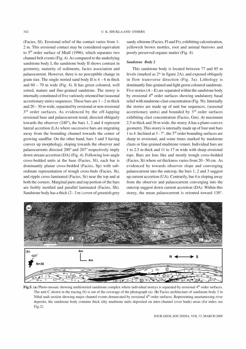
Sandstone Body 2
This sandstone body is located between 77 and 85 mlevels (marked as 2* in figure 2A), and exposed obliquelyin flow transverse direction (Fig. 5a). Lithology isdominantly fine-grained and light green coloured sandstone.Five stories (A – E) are separated within the sandstone bodyby erosional 4th order surfaces showing undulatory basalrelief with mudstone-clast concentration (Fig. 5b). Internallythe stories are made up of unit bar sequences, (seasonalaccretionary units) and bounded by 3rd order surfacesexhibiting clast concentration (Facies, Gm). At maximum2.5 m thick and 36 m wide, the storey A has a plano-convexgeometry. This storey is internally made up of four unit bars1 to 4. Inclined at 3 - 7°, the 3rd order bounding surfaces aresharp to erosional, and some times marked by mudstoneclasts or fine-grained mudstone veneer. Individual bars are1 to 2.5 m thick and 11 to 17 m wide with sharp erosionaltops. Bars are lens like and mostly trough cross-bedded(Facies, St) where set thickness varies from 20 - 50 cm. Asevidenced by towards observer slope and convergingpalaeocurrent into the outcrop, the bars 1, 2 and 3 suggestup current accretion (UA). Contrarily, bar 4 is sloping awayfrom the observer and palaeocurrent converging into theoutcrop suggest down current accretion (DA). Within thisstorey, the mean palaeocurrent is oriented toward 130°.
Fig.5. (a) Photo-mosaic showing multistoried sandstone complex where individual storeys is separated by erosional 4th order surfaces.The unit C shown in the tracing (b) is out of the coverage of the photograph (a). (b) Facies architecture of sandstone body 2 inNihal nadi section showing major channel events demarcated by erosional 4th order surfaces. Representing anastamosing riverdeposits, the sandstone body contains thick silty mudstone units deposited on inter-channel (over bank) areas (for index seeFig.2).
4m
4m
N S
1
2
3
4
5
123
3
2
2 1
1 1 4
4th
III
III
III
III
III
III
IIIIIIIII
III C3
3
N=38
1210
E
AB
D 4th
4th4th
2
(b)
JOUR.GEOL.SOC.INDIA, VOL.73, MARCH 2009
DEPOSITIONAL DYNAMICS OF RIVER SYSTEMS IN LOWER SIWALIK BASIN, KUMAUN HIMALAYA 343
Northern margin of this storey is blanketed with 20 – 50 cmthick carbonaceous silty mudstone, while southern face issteep erosional (Fig. 5b). Nature of the amalgamating barsand palaeocurrent trends, suggest that this storey is anexample of braid bar sedimentation that has grown in placeand not migrated.
Storey B, laterally occurring at the level of storey A is43 m wide and 2 m thick. It has a plano-convex geometryand is internally made up of three bars (bars 1-3). Lenslike bars are about 1 m thick and 20 – 30 m wide and havemutually concordant surfaces. As evidenced by palaeo-current trend directed obliquely into outcrop (190°) andconfirmative convex up top surface, these bars are verticallyaccreted in place mainly by down current migration (DA).Bars are mixed planar-trough cross-bedded (Facies, Stand Sp) and rippled-parallel laminated near the margins(Facies, Sh-Sr). The mean palaeocurrent direction for thestorey is 185°. Nearly 70 cm to 1 m thick mottled,bioturbated and carbonaceous silty mudstone unit (Facies,Fr) overlies storey B at the northern margin. Internally thisfine-grained horizon shows discordances and many rippledsilty lenses (Fig. 5b).
Storey C is 48 m wide and 5 m thick and internally madeup of five unit bars (bars 1-5). Individual bars are 1.5 to 2 mthick and 23 - 30 m wide. Bars 1 and 2 are having domeshaped top bounding surfaces sloping away from theobserver, in to outcrop and palaeocurrent oriented towardsobserver, which suggest down current accretion (DA).Laterally shifting bars 3, 4 and 5 with palaeocurrents parallelto the exposed face of the outcrop indicate lateral accretion(LA) or oblique down current accretion (DA). Bars aremixed planar-trough cross-bedded (Facies, St and Sp). Meanpalaeocurrent within this storey is toward 145°. These barshave first grown in-situ and then migrated in down streamdirection (Fig. 5b).
Storey D is 80 – 100 m wide and nearly 4.0 m thick. Ithas ribbon shaped geometry and internally made up of threebars (bars 1 - 3). These 20 - 80 m wide and 1-2 m thick barsare sheet like. Bars are mostly trough cross-bedded showingpalaeocurrent towards south (averaging 170°). However,mean palaeocurrent for the story is toward 120°, and barsurfaces are inclined in the same direction. Thus these barsshow oblique down-current migration across the channel(DA). Northern margin of the story is interfingering with70 cm thick silt-mudstone (Facies, Fl and Fr) drapes havingdeformation and root mottles. Storey E is 75 – 80 m wideand 3.5 m thick and internally made up of three bars (bars1-3). Because of outcrop inaccessibility, this storey couldnot be documented in detail (Fig. 5b).
Stories A, B and C occur adjacent to each other almost
at similar stratigraphical thickness. Margins of storey C, Dand E are inter-fingering with 2 – 5 m thick fine-grainedhorizon, which is carpeting the underlying sandy sequence.This fine-grained horizon is made up of interbedded mottledclayey siltstone, rippled-parallel laminated sandy siltstoneand carbonaceous mudstone (Facies, Sr, Fl and Fr), showingmud cracks and syn-depositional deformation featuresrepresenting channel–fill /floodplain sedimentation (Bora,2003; Bora and Shukla, 2005).
Kaladhungi-Ghatgad Section
This section is about 232 m thick exposed alongKaladhungi - Nainital road, between Ghatgad and milestoneindicating Nainital 29 Km (Figs. 1, 2B). The Lower Siwaliksuccession gradually grades into the Middle Siwalik towardsNE. Sequence is sandstone dominated (70%), wherethickness of sandstone bodies decrease from 15-20 m atlower levels to 5-10 m towards the upper stratigraphic levelswith concurrent increase of grain-size reaching to medium-grained sandstones (Fig. 2B). Interbedded 2-10 m thick fine-grained units of brown-buff coloured mottled mudstone-siltstones (Facies, Fr) is interpreted as over bank deposit(Bora, 2003; Bora and Shukla, 2005) (Fig. 3H). In thissection one sandstone body located between 170 – 177 mlevel selected for detailed mapping (marked by 1* inFig.2B).
Sandstone Body 1
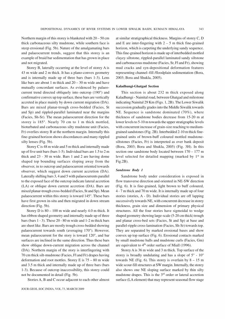
Sandstone body under consideration is exposed inflow transverse direction and oriented in NE-SW direction(Fig. 6). It is fine-grained, light brown to buff coloured,4 - 7 m thick and 70 m wide. It is internally made up of fourstories (stories, A - D). Individual stories are off lappingsuccessively towards NE, with concurrent decrease in storeythickness, grain size and dimension of primary physicalstructures. All the four stories have sigmoidal to wedgeshaped geometry showing large-scale (5-20 cm thick) troughand planar cross-bed sets (Facies, St and Sp) at base andparallel-ripple cross-lamination (Facies, Sh-Sr) towards top.They are separated by marked erosional bases and showconvex up top surface (Fig. 6). Erosional contacts markedby small mudstone balls and mudstone curls (Facies, Gm)are equivalent to 4th order surface of Miall (1996).
Storey A is 36 m wide and 3 m thick. Top surface of thestorey is broadly undulating and has a slope of 5° - 10°towards NE (Fig. 6). This storey is overlain by 8 – 15 mwide scour-fill structures at SW margin. Internally, the storeyalso shows one NE sloping surface marked by thin siltymudstone drapes. This is the 3rd order or lateral accretionsurface (LA element) that may represent seasonal flow stage
JOUR.GEOL.SOC.INDIA, VOL.73, MARCH 2009
344 U. K. SHUKLA AND OTHERS
variation or stage change. Facies association changes acrossthis surface. Mean palaeoflow direction within the storey isoriented towards 160° and directed into the outcrop.
Storey B is 19 m wide and 2.5 m thick and superimposesstorey A with off-lapped geometry (Fig. 6). NE margin ofthe storey B is sloping at 10°. This storey is internally madeup of two unit bars or seasonal accretionary units separatedby 3rd order (LA) surfaces. Bar 1 is 18 m wide and 2 m thickshowing mean palaeoflow toward 130°, whereas the bar2 is 14 m wide and 0.5 m thick. These bars are dominantlysmall-scale cross-bedded and having mean palaeoflowtoward 180° (Fig. 6).
Storey C is further off lapped on storey B, however slopeof the storey has reduced to 2-3° towards NE and meanpalaeoflow is towards 130°. It is 20 m wide, 2 m thick, andsuperimposed by draped ripple and mottled silty mudstonecouplets. Storey C is further overlain by storey D with offlapped relation. This storey is 30 m wide and 1.5 m thick,showing mean palaeoflow towards 120°.
All the stories are covered with a 2.5 m thick unit ofinterbedded siltstone, mudstone and fine-grained sandstone(Facies, Sr and Fl), showing solitary planar and trough cross-beds (5-8 cm thick), ripple-parallel lamination and low tomoderate degree of mottling (unit E) (Fig. 6). Sandy unitsare 5 – 10 m wide and 20 – 75 cm thick lense shaped,separated by sharp erosional discordance surfaces. Atthe NE corner of section, sequence is draped by 1 - 1.5 mthick bioturbated silt-mudstone unit (facies, Fr), whichprogressively thins out towards SW corner.
FACIES SUPERPOSITION
Constituent lithofacies of sandstone succession showvaried vertical and lateral association. Individual storieswithin a multi-storeyed sandstone complex, may have morethan one type of facies superposition. Different studiedsections are also showing changes in thickness, abundanceand association of the lithofacies. One or more lithofaciesmay be missing in stratigraphic records of sandstone bodies.
Based mainly on visual observation, an attempt has beenmade to identify variations in the facies associations withinthe sandstone bodies.
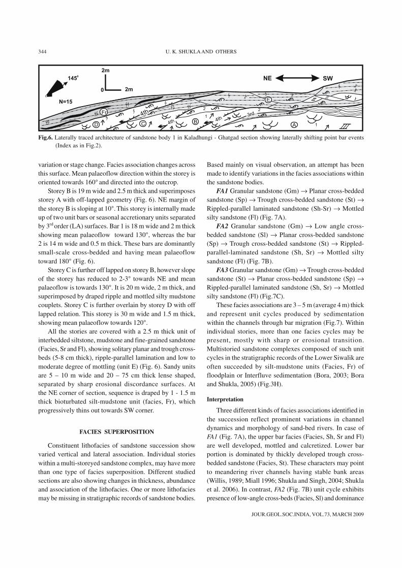
FA1 Granular sandstone (Gm) → Planar cross-beddedsandstone (Sp) → Trough cross-bedded sandstone (St) →Rippled-parallel laminated sandstone (Sh-Sr) → Mottledsilty sandstone (Fl) (Fig. 7A).
FA2 Granular sandstone (Gm) → Low angle cross-bedded sandstone (Sl) → Planar cross-bedded sandstone(Sp) → Trough cross-bedded sandstone (St) → Rippled-parallel-laminated sandstone (Sh, Sr) → Mottled siltysandstone (Fl) (Fig. 7B).
FA3 Granular sandstone (Gm) → Trough cross-beddedsandstone (St) → Planar cross-bedded sandstone (Sp) →Rippled-parallel laminated sandstone (Sh, Sr) → Mottledsilty sandstone (Fl) (Fig.7C).
These facies associations are 3 – 5 m (average 4 m) thickand represent unit cycles produced by sedimentationwithin the channels through bar migration (Fig.7). Withinindividual stories, more than one facies cycles may bepresent, mostly with sharp or erosional transition.Multistoried sandstone complexes composed of such unitcycles in the stratigraphic records of the Lower Siwalik areoften succeeded by silt-mudstone units (Facies, Fr) offloodplain or Interfluve sedimentation (Bora, 2003; Boraand Shukla, 2005) (Fig.3H).
Interpretation
Three different kinds of facies associations identified inthe succession reflect prominent variations in channeldynamics and morphology of sand-bed rivers. In case ofFA1 (Fig. 7A), the upper bar facies (Facies, Sh, Sr and Fl)are well developed, mottled and calcretized. Lower barportion is dominated by thickly developed trough cross-bedded sandstone (Facies, St). These characters may pointto meandering river channels having stable bank areas(Willis, 1989; Miall 1996; Shukla and Singh, 2004; Shuklaet al. 2006). In contrast, FA2 (Fig. 7B) unit cycle exhibitspresence of low-angle cross-beds (Facies, Sl) and dominance
D
Fr
CB
A4th 4th
3rd
1
1
2
SWNE
N=15
2m0
E
2
III
IIIIII
1450
4th
2m
Fig.6. Laterally traced architecture of sandstone body 1 in Kaladhungi - Ghatgad section showing laterally shifting point bar events(Index as in Fig.2).

JOUR.GEOL.SOC.INDIA, VOL.73, MARCH 2009
DEPOSITIONAL DYNAMICS OF RIVER SYSTEMS IN LOWER SIWALIK BASIN, KUMAUN HIMALAYA 345
of planar cross-bedding (Facies, Sp) over trough cross-bedding (St) in the lower bar; and poorly developed upperbar facies that may indicate sedimentation in braided riverregime whereby the muddy flood deposits were poorlydeveloped (Bridge, 1993; Clifford, 1993; Miall, 1996;Shukla et al. 2001). The FA3 association is characterizedby thinly developed trough cross-bedding (Facies, St) inlower bar and higher representation of mud-rich litho-facies (Facies, Sh, Fl) in upper bar environment that maysuggest sedimentation in anastomosing channels wheresuspension fall out over the stabilized bars (islands) mighthave been a dominant process (Smith and Putnam, 1980;Bridge, 1993; Clifford, 1993; Miall, 1996) (Fig. 7C).
PALAEOCHANNEL PATTERNS
Lower Siwalik succession shows different types ofpalaeochannel patterns with varied dimension. Within thesandstone body complex 1 of Nihal nadi section, based ondominance of LA element, trough cross-bedding, lowpalaeocurrent variability and overall lithofacies association(FA1), the sandstone body 1 is interpreted as meanderingrivers (cf. Willis, 1989; Miall, 1996; Shukla et al. 1999,2006). River channel was laterally shifting towards NNWforming successive point bar events within the storey A ofthe sandstone body 1 (Fig. 4). At the meander bend, riverwas flowing towards NW (300°). After deposition of the
storey A, sedimentation ceased and chute channel wasabandoned due to lateral shifting of main channel. In theabandoned channel, only silt-mud (Facies, Fl, Fr)sedimentation took place covering the underlying storey A.Shifted channel carved a new valley, and again sedimentationresumed forming point bar events of the storey B, howeverthe palaeoflow changes to NE (40°). Finally, the riveraggraded, channel was filled, and muddy flood plain deposits(Facies, Fr) accreted over the sandy bar sequence of thestorey B. Similar sequence of events in point bar depositshave been described from the Quaternary deposits of GangaPlain (Singh et al. 1998; Shukla and Singh, 2004) andTriassics of Germany (Shukla et al. 2006). Presence oflarge-scale planar and trough cross-beds indicate bedloadtransport under high energy conditions in the channels(Table 2). However, poorly sorted, immature lithology mayindicate proximity of the source terrain.
After a time gap, a new channel depositing the sandstonebody 2 might have reoccupied the existing river valley.Although, there is not any perceptible change in grain-sizebetween sandstone bodies 1 and 2, yet the sandstone body 2shows change in palaeocurrents direction towards SSW(207°). Moreover, increased variability in palaeocurrent,stacking pattern of unit bars and domination of planar cross-bedding (FA2) suggest that the new channel was braided(Bridge, 1993; Clifford, 1993; Shukla et al. 1999). Sandstonebody II represents marginal to central part of a sandflat
IIIIII
IIIIII
IIIIII
IIIIII
Cla
y
Silt
Sand
Cla
y
Silt
Sand
Cla
y
Silt
Sand
0 m
2
3
4
1
A B C
Gm
Sp
St
Sr
Sh
Fl Fl
Sr
St
Sp
Sl
Gm
Lo
we
rb
ar
Lo
we
rb
ar
Lo
we
rb
ar
Gm
St
Sp
Sr
Sh
Fl
Up
pe
rb
ar
Up
pe
rb
ar
Up.b
ar
Fig.7. Facies superposition representing unit facies cycles produced by meandering (A), braided (B) and anastomosing (C) typepalaeochannels in the Lower Siwalik sequence of Kumaun Himalaya.
JOUR.GEOL.SOC.INDIA, VOL.73, MARCH 2009
346 U. K. SHUKLA AND OTHERS
0 m
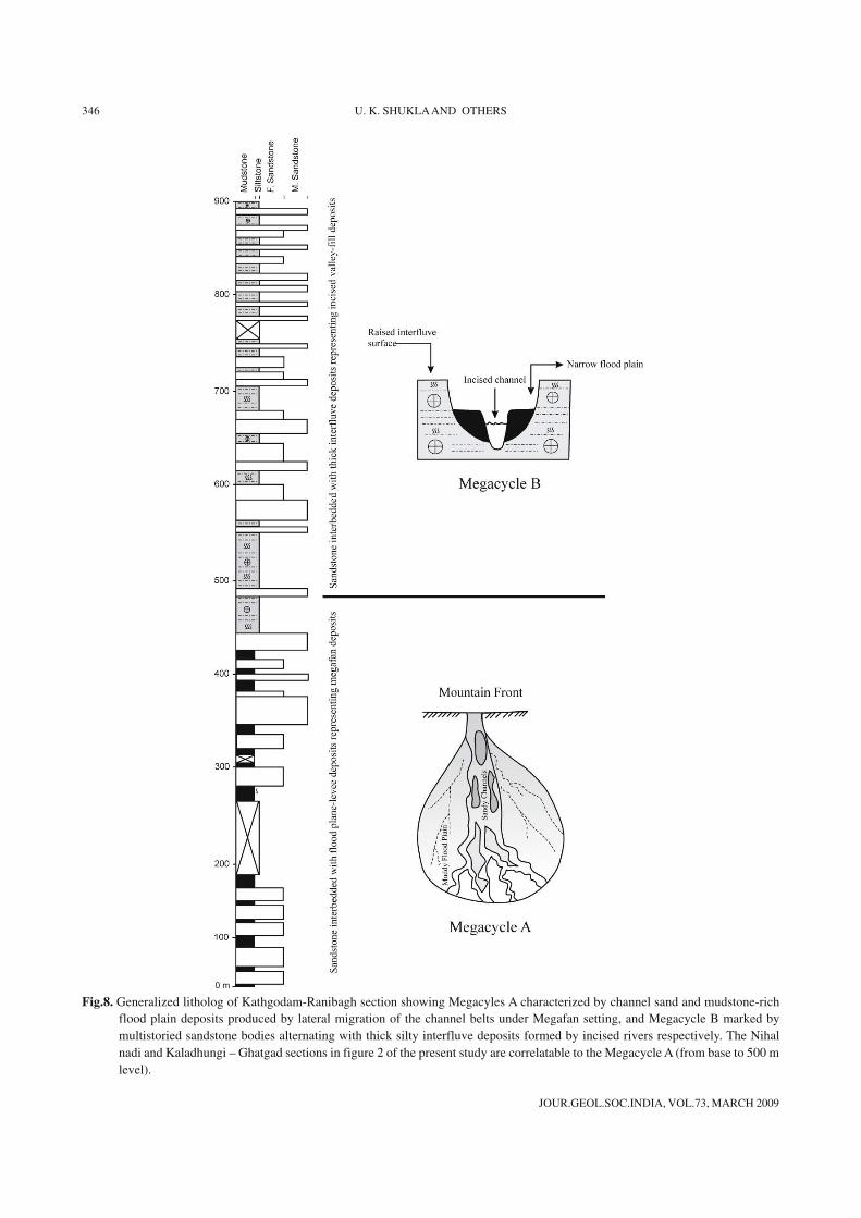
Fig.8. Generalized litholog of Kathgodam-Ranibagh section showing Megacyles A characterized by channel sand and mudstone-richflood plain deposits produced by lateral migration of the channel belts under Megafan setting, and Megacycle B marked bymultistoried sandstone bodies alternating with thick silty interfluve deposits formed by incised rivers respectively. The Nihalnadi and Kaladhungi – Ghatgad sections in figure 2 of the present study are correlatable to the Megacycle A (from base to 500 mlevel).
JOUR.GEOL.SOC.INDIA, VOL.73, MARCH 2009
DEPOSITIONAL DYNAMICS OF RIVER SYSTEMS IN LOWER SIWALIK BASIN, KUMAUN HIMALAYA 347
deposit where marginal portion is characterized by lateralaccretion of bars produced in response to boundingchannel, whereas central part shows domination of downcurrent accretion produced under strong flood surgesover the bar tops (Fig. 4).
In contrast, the sandstone body 2 of Nihal nadi sectionis characterized by the FA 3 type facies cycles. Nature ofunit bar migration is in the form of DA, UA and LA elements,and abundance of fine-grained facies along with highvariance in palaeocurrent indicates sedimentation inanastomosing river system (cf. Rust and Legun, 1983;Miall, 1996; Gibling et al. 1998). Nature of 3rd order surfacesindicates vertical accretion followed by lateral accretion ofthe bars. Shallow runnel like features and vegetated islandareas where fine-grained silt-mud sedimentation was takingplace, might have flanked the relatively sinuous secondorder channels producing sandy bars of limited lateral extent(Fig. 5).
In Kaladhungi – Ghatgad section, unidirectional shiftingof successively offlapped stories with concurrent decreasinggrain-size and storey dimensions along with developmentof LA elements and domination of trough cross-beds (Faciesassociation, FA1), suggest that sandstone body is a productof a meandering river (cf. Willis, 1989; Singh et al. 1998;Shukla et al. 2006). The SE flowing river channel waslaterally shifting towards NE, producing four point bar events(stories A - D, Fig.6). Unit E seems to have deposited inrunnels and linear low-lying areas, occurring on the top ofbars, creating ridges and swells topography (cf. Reading,1978; Shukla et al. 2006). Finally, the channel was filled bymud-rich unit F and got abandoned.
PALAEOCHANNEL MORPHOLOGY
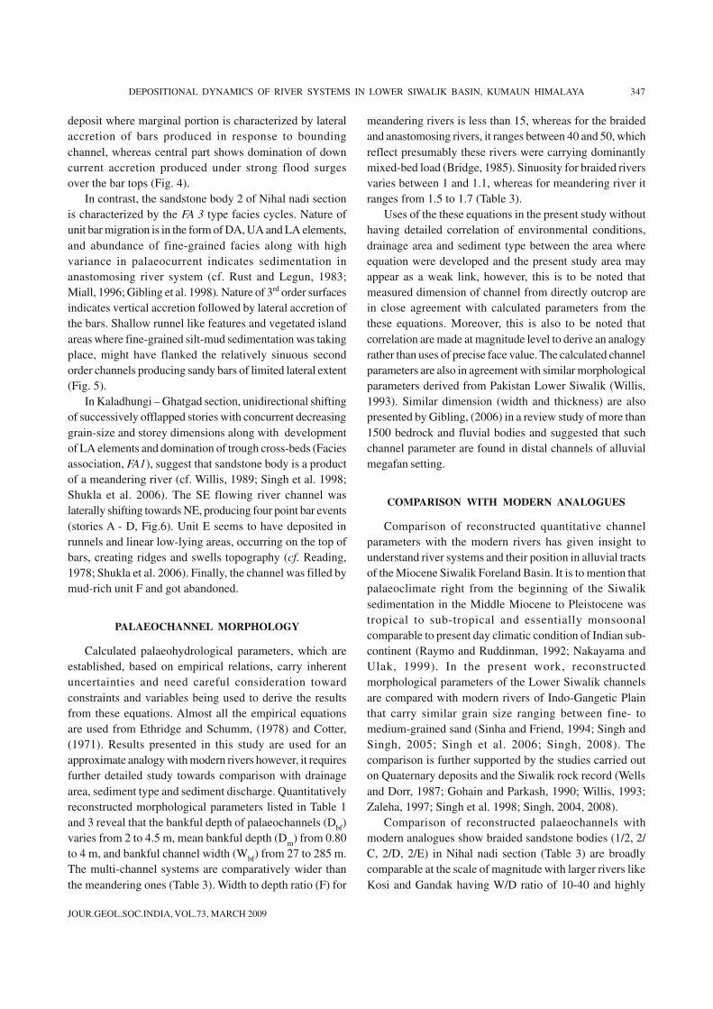
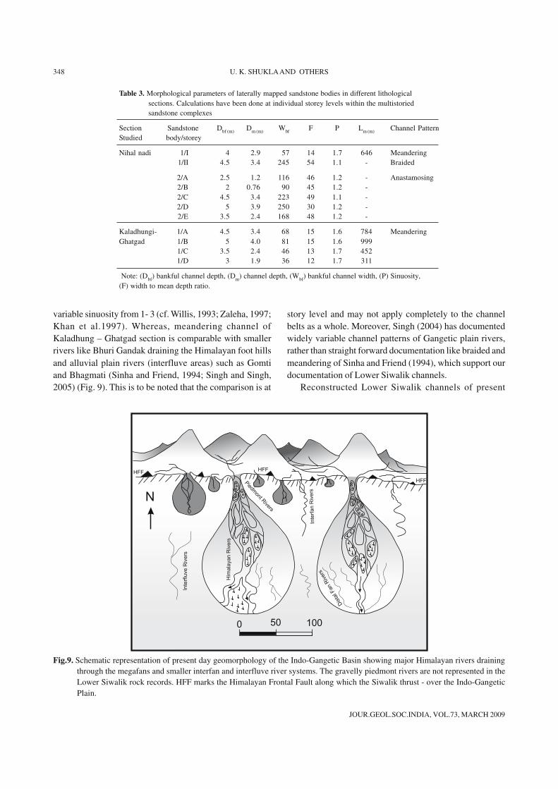
Calculated palaeohydrological parameters, which areestablished, based on empirical relations, carry inherentuncertainties and need careful consideration towardconstraints and variables being used to derive the resultsfrom these equations. Almost all the empirical equationsare used from Ethridge and Schumm, (1978) and Cotter,(1971). Results presented in this study are used for anapproximate analogy with modern rivers however, it requiresfurther detailed study towards comparison with drainagearea, sediment type and sediment discharge. Quantitativelyreconstructed morphological parameters listed in Table 1and 3 reveal that the bankful depth of palaeochannels (Dbf)varies from 2 to 4.5 m, mean bankful depth (Dm) from 0.80to 4 m, and bankful channel width (Wbf) from 27 to 285 m.The multi-channel systems are comparatively wider thanthe meandering ones (Table 3). Width to depth ratio (F) for
meandering rivers is less than 15, whereas for the braidedand anastomosing rivers, it ranges between 40 and 50, whichreflect presumably these rivers were carrying dominantlymixed-bed load (Bridge, 1985). Sinuosity for braided riversvaries between 1 and 1.1, whereas for meandering river itranges from 1.5 to 1.7 (Table 3).
Uses of the these equations in the present study withouthaving detailed correlation of environmental conditions,drainage area and sediment type between the area whereequation were developed and the present study area mayappear as a weak link, however, this is to be noted thatmeasured dimension of channel from directly outcrop arein close agreement with calculated parameters from thethese equations. Moreover, this is also to be noted thatcorrelation are made at magnitude level to derive an analogyrather than uses of precise face value. The calculated channelparameters are also in agreement with similar morphologicalparameters derived from Pakistan Lower Siwalik (Willis,1993). Similar dimension (width and thickness) are alsopresented by Gibling, (2006) in a review study of more than1500 bedrock and fluvial bodies and suggested that suchchannel parameter are found in distal channels of alluvialmegafan setting.
COMPARISON WITH MODERN ANALOGUES
Comparison of reconstructed quantitative channelparameters with the modern rivers has given insight tounderstand river systems and their position in alluvial tractsof the Miocene Siwalik Foreland Basin. It is to mention thatpalaeoclimate right from the beginning of the Siwaliksedimentation in the Middle Miocene to Pleistocene wastropical to sub-tropical and essentially monsoonalcomparable to present day climatic condition of Indian sub-continent (Raymo and Ruddinman, 1992; Nakayama andUlak, 1999). In the present work, reconstructedmorphological parameters of the Lower Siwalik channelsare compared with modern rivers of Indo-Gangetic Plainthat carry similar grain size ranging between fine- tomedium-grained sand (Sinha and Friend, 1994; Singh andSingh, 2005; Singh et al. 2006; Singh, 2008). Thecomparison is further supported by the studies carried outon Quaternary deposits and the Siwalik rock record (Wellsand Dorr, 1987; Gohain and Parkash, 1990; Willis, 1993;Zaleha, 1997; Singh et al. 1998; Singh, 2004, 2008).
Comparison of reconstructed palaeochannels withmodern analogues show braided sandstone bodies (1/2, 2/C, 2/D, 2/E) in Nihal nadi section (Table 3) are broadlycomparable at the scale of magnitude with larger rivers likeKosi and Gandak having W/D ratio of 10-40 and highly
JOUR.GEOL.SOC.INDIA, VOL.73, MARCH 2009
348 U. K. SHUKLA AND OTHERS
variable sinuosity from 1- 3 (cf. Willis, 1993; Zaleha, 1997;Khan et al.1997). Whereas, meandering channel ofKaladhung – Ghatgad section is comparable with smallerrivers like Bhuri Gandak draining the Himalayan foot hillsand alluvial plain rivers (interfluve areas) such as Gomtiand Bhagmati (Sinha and Friend, 1994; Singh and Singh,2005) (Fig. 9). This is to be noted that the comparison is at
story level and may not apply completely to the channelbelts as a whole. Moreover, Singh (2004) has documentedwidely variable channel patterns of Gangetic plain rivers,rather than straight forward documentation like braided andmeandering of Sinha and Friend (1994), which support ourdocumentation of Lower Siwalik channels.
Reconstructed Lower Siwalik channels of present
Table 3. Morphological parameters of laterally mapped sandstone bodies in different lithologicalsections. Calculations have been done at individual storey levels within the multistoriedsandstone complexes
Section Sandstone Dbf (m) Dm (m) Wbf F P Lm (m) Channel PatternStudied body/storey
Nihal nadi 1/I 4 2.9 57 14 1.7 646 Meandering1/II 4.5 3.4 245 54 1.1 - Braided
2/A 2.5 1.2 116 46 1.2 - Anastamosing2/B 2 0.76 90 45 1.2 -2/C 4.5 3.4 223 49 1.1 -2/D 5 3.9 250 30 1.2 -2/E 3.5 2.4 168 48 1.2 -
Kaladhungi- 1/A 4.5 3.4 68 15 1.6 784 MeanderingGhatgad 1/B 5 4.0 81 15 1.6 999
1/C 3.5 2.4 46 13 1.7 4521/D 3 1.9 36 12 1.7 311
Note: (Dbf) bankful channel depth, (Dm) channel depth, (Wbf) bankful channel width, (P) Sinuosity,(F) width to mean depth ratio.
N
0 50 100
Inte
rflu
ve
Riv
ers
Him
ala
ya
nR
ive
rs
Dis
talFan
Riv
ers
Inte
rfan
Riv
ers
HFF
HFF
HFF
Pie
dm
ontRive
rs
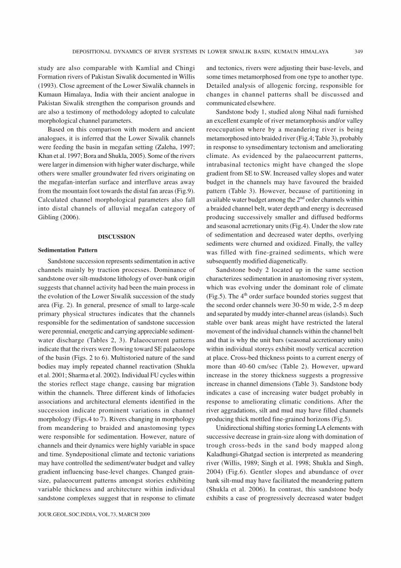
Fig.9. Schematic representation of present day geomorphology of the Indo-Gangetic Basin showing major Himalayan rivers drainingthrough the megafans and smaller interfan and interfluve river systems. The gravelly piedmont rivers are not represented in theLower Siwalik rock records. HFF marks the Himalayan Frontal Fault along which the Siwalik thrust - over the Indo-GangeticPlain.
JOUR.GEOL.SOC.INDIA, VOL.73, MARCH 2009
DEPOSITIONAL DYNAMICS OF RIVER SYSTEMS IN LOWER SIWALIK BASIN, KUMAUN HIMALAYA 349
study are also comparable with Kamlial and ChingiFormation rivers of Pakistan Siwalik documented in Willis(1993). Close agreement of the Lower Siwalik channels inKumaun Himalaya, India with their ancient analogue inPakistan Siwalik strengthen the comparison grounds andare also a testimony of methodology adopted to calculatemorphological channel parameters.
Based on this comparison with modern and ancientanalogues, it is inferred that the Lower Siwalik channelswere feeding the basin in megafan setting (Zaleha, 1997;Khan et al. 1997; Bora and Shukla, 2005). Some of the riverswere larger in dimension with higher water discharge, whileothers were smaller groundwater fed rivers originating onthe megafan-interfan surface and interfluve areas awayfrom the mountain foot towards the distal fan areas (Fig.9).Calculated channel morphological parameters also fallinto distal channels of alluvial megafan category ofGibling (2006).
DISCUSSION
Sedimentation Pattern
Sandstone succession represents sedimentation in activechannels mainly by traction processes. Dominance ofsandstone over silt-mudstone lithology of over-bank originsuggests that channel activity had been the main process inthe evolution of the Lower Siwalik succession of the studyarea (Fig. 2). In general, presence of small to large-scaleprimary physical structures indicates that the channelsresponsible for the sedimentation of sandstone successionwere perennial, energetic and carrying appreciable sediment-water discharge (Tables 2, 3). Palaeocurrent patternsindicate that the rivers were flowing toward SE palaeoslopeof the basin (Figs. 2 to 6). Multistoried nature of the sandbodies may imply repeated channel reactivation (Shuklaet al. 2001; Sharma et al. 2002). Individual FU cycles withinthe stories reflect stage change, causing bar migrationwithin the channels. Three different kinds of lithofaciesassociations and architectural elements identified in thesuccession indicate prominent variations in channelmorphology (Figs.4 to 7). Rivers changing in morphologyfrom meandering to braided and anastomosing typeswere responsible for sedimentation. However, nature ofchannels and their dynamics were highly variable in spaceand time. Syndepositional climate and tectonic variationsmay have controlled the sediment/water budget and valleygradient influencing base-level changes. Changed grain-size, palaeocurrent patterns amongst stories exhibitingvariable thickness and architecture within individualsandstone complexes suggest that in response to climate
and tectonics, rivers were adjusting their base-levels, andsome times metamorphosed from one type to another type.Detailed analysis of allogenic forcing, responsible forchanges in channel patterns shall be discussed andcommunicated elsewhere.
Sandstone body 1, studied along Nihal nadi furnishedan excellent example of river metamorphosis and/or valleyreoccupation where by a meandering river is beingmetamorphosed into braided river (Fig.4; Table 3), probablyin response to synsedimentary tectonism and amelioratingclimate. As evidenced by the palaeocurrent patterns,intrabasinal tectonics might have changed the slopegradient from SE to SW. Increased valley slopes and waterbudget in the channels may have favoured the braidedpattern (Table 3). However, because of partitioning inavailable water budget among the 2nd order channels withina braided channel belt, water depth and energy is decreasedproducing successively smaller and diffused bedformsand seasonal acrretionary units (Fig.4). Under the slow rateof sedimentation and decreased water depths, overlyingsediments were churned and oxidized. Finally, the valleywas filled with fine-grained sediments, which weresubsequently modified diagenetically.
Sandstone body 2 located up in the same sectioncharacterizes sedimentation in anastomosing river system,which was evolving under the dominant role of climate(Fig.5). The 4th order surface bounded stories suggest thatthe second order channels were 30-50 m wide, 2-5 m deepand separated by muddy inter-channel areas (islands). Suchstable over bank areas might have restricted the lateralmovement of the individual channels within the channel beltand that is why the unit bars (seasonal accretionary units)within individual storeys exhibit mostly vertical accretionat place. Cross-bed thickness points to a current energy ofmore than 40-60 cm/sec (Table 2). However, upwardincrease in the storey thickness suggests a progressiveincrease in channel dimensions (Table 3). Sandstone bodyindicates a case of increasing water budget probably inresponse to ameliorating climatic conditions. After theriver aggradations, silt and mud may have filled channelsproducing thick mottled fine-grained horizons (Fig.5).
Unidirectional shifting stories forming LA elements withsuccessive decrease in grain-size along with domination oftrough cross-beds in the sand body mapped alongKaladhungi-Ghatgad section is interpreted as meanderingriver (Willis, 1989; Singh et al. 1998; Shukla and Singh,2004) (Fig.6). Gentler slopes and abundance of overbank silt-mud may have facilitated the meandering pattern(Shukla et al. 2006). In contrast, this sandstone bodyexhibits a case of progressively decreased water budget
JOUR.GEOL.SOC.INDIA, VOL.73, MARCH 2009
350 U. K. SHUKLA AND OTHERS
where by the meandering river shrank in size, and becamehighly sinuous and finally abandoned (Table 3). Progressivepoint bars were smaller and muddier as compared to earlierevents (Fig.6). Similar evolutionary trends have beendocumented from the Quaternary deposits of the Gangaplain (Singh et al. 1998) and Arnstadt Formation (LateTriassic) of Germany (Shukla et al. 2006).
Geomorphic Positioning of River Systems
River system comparison based on sand body geometrysupported by quantitative morphological parameters is awidely used technique to characterize channel patterns inthe rock record (Bridge, 1985; Willis, 1993; Zaleha, 1997;Khan et al. 1997). Quantitative reconstruction andcomparison with modern and ancient analogues in thepresent study enabled to reconstruct depositional settingand geomorphic positioning of the river systems in theMiocene Lower Siwalik Foreland Basin. The inferencesabout this depositional setting go well with other evidencesgathered in terms of stratigraphic position of sandstonebodies and their physical characteristics. In the absence ofany age control on the Siwalik succession, Bora (2003)and Bora and Shukla (2005) tentatively correlated differentmeasured sections in the study area based on grain-size, relative abundance of sandstone-mudstone horizons,sandstone body geometry and palaeocurrent patterns.Both the studied sections namely Nihal nadi andKaladhungi – Ghatgad section spaced 4-5 km apart (Fig.1B),represent lower stratigraphic levels, i.e. from base to about500 m level (Megacyale A of Bora 2003), when comparedto about 900 m thick most complete section exposedalong the Gaula River (Fig. 8). The Gaula River section islocated some 20 km east of the former ones (Fig.1B). Boththe studied sections are uplifted at the base by HimalayanFrontal Fault (HFF) and shows almost similar structuraldip (20°- 25°) toward north (Agarwal and Shukla,2005).
Therefore, the sandstone bodies 1 and 2 in Nihal nadisection and the sandstone body 1 in Kaladhungi – Ghatgadsection corresponds to almost the same stratigraphiclevels, though their position in the measured sections isnot the same (Fig.2). Sandstone bodies interpreted torepresent braided – anastomosing rivers deposits in theNihal nadi sections are composed of buff coloured,moderately sorted, medium to fine-grained sandstone,whereas meandering river deposits of Kaladhungi – Ghatgadsection are represented by brownish – green coloured, fine-grained sandstone with comparatively better sorting.Based on these physical dissimilarities it may be inferredthat sediment source/transport distance/system dynamics
of both the river system was different. Moreover, physicaldissimilarities and variable disposition in the stratigraphiccolumns of the sandstone bodies, eliminate possibility ofsmaller river being distributaries of larger ones. Therefore,an alternative interpretation is that the rivers were drainedfrom different sources and operating adjacent to each other.One important indicator, the provenance of these rivers, isnot differentiated based on their compositional trends and ageneralized source comprising recycled orogen fold belt isidentified for the Lower Siwalik sedimentation in KumaunHimalaya (Bora and Shukla, 2005). Sandstones of the LowerSiwalik basin in Kumaun Himalaya are composed ofmono-and polycrystalline quartz, lithic and carbonatefragments, feldspar and mica in various proportions,however, the relative abundance of these fragments indifferent sandstone bodies is not measured (Bora andShukla, 2005). It is logical to envisage that abundance ofrecycled quartz, carbonate and lithic fragments mayindicate sedimentary Lesser Himalayan provenance. Thissuite of channel sandstone composition may be foundin Foothill Rivers which might be drained from a lowaltitude provenance of then existing Siwalik basin as isdocumented by Sinha and Friend (1994) for Bhuri Gandakand Bhagmati Rivers. Alternatively, they may representalluvium-fed (or groundwater fed) rivers draining vastrecycled interfluve areas making down slope continuumwith distal fan reaches (Fig. 9). Most of these rivers aremeandering, act as tributaries of major rivers and receivesediment budget from the piedmont zone juxtaposing themountain front by sheet flow processes, and alsocannibalized adjacent interfluve (Doab) areas (Singh et al.1999; Shukla and Bora, 2003). Though, they are perennial,their sediment and water discharge increases many foldduring summer monsoon months.
On the other hand, abundance of polycrystallinequartz, feldspar, and mica may indicate Higher Himalayan(Central crystalline) provenance and this suit of compositionmay be found in larger megafan rivers which are drainedfrom high altitude mountain and carried higher sedimentdischarge as is documented for Gangetic plain rivers likeKosi and Ganga (Sinha and Friend, 1994; Shukla et al. 2001;Singh, 2007). Similar deductions regarding sedimentsupply to the Siwalik Foreland Basin have also beenmade by Burbank et al. (1996) and Kumar et al. (1999).
Further, the qualitative and quantitative characteristicsof palaeochannels are typical of alluvial fan distributariesoperative towards distal fan areas (Miall, 1976; Shuklaet al. 2001; Shukla et al. 2006). In the distal fan areas,relatively shallow and narrow channels of smallerdimensions are commonly separated by vegetated
JOUR.GEOL.SOC.INDIA, VOL.73, MARCH 2009
DEPOSITIONAL DYNAMICS OF RIVER SYSTEMS IN LOWER SIWALIK BASIN, KUMAUN HIMALAYA 351
interchannel areas where muddy sediments are deposited(Fig. 9). Under such a setting dominant channel patterns areanastomosing and meandering types though some sandybraided streams may also present (Shukla et al. 2001;Shukla et al. 2006). Therefore, Lower Siwalik successionexposed in the study area seems to represent deposits ofdistal fan within the megafan and interfluve settings believedto have responded to changing conditions of climate andtectonics (Shukla et al. 2001; Singh, 2004; Bora and Shukla,2005) (Figs. 8, 9). These rivers quickly responded byadjusting their base-levels and metamorphosed from onepattern to another.
Allogenic Forcing
In the rock record, it is not very straight forward toevaluate the relative role of tectonics, climatic and eustasyforcing particularly on deep interior continental systems.Nevertheless, it is believed that the Siwalik Foreland Basinevolved in direct response to Himalayan orogeny and quicklyresponded to climatic variations through time. From theexisting literature, it is clear that tectonic activity acceleratedby the end of Lower Siwalik sedimentation along MainBoundary Thrust (MBT) and Main Central Thrust (MCT)(Meigs et al. 1995; Burbank et al. 1996; Brozovic andBurbank, 2000). The differential tectonic upliftment alongthe thrust plains have had primary control on sediment supplyto the Himalayan Foreland through Miocene times(DeCelloes et al. 1998; Najman and Garzanti, 2000). Large-scale up section variations in Siwalik succession aregenerally attributed to episodic tectonism and fanprogradation (Willis, 1993; Zaleha, 1997; Nakayama andUlak, 1999; Sharma et al, 2001; Bora and Shukla, 2005).Bora and Shukla (2005), indicated that from base to about500 m level thickness in the Kumaun Lower Siwalik isrepresented by Megafan sedimentation (Megacycle A ofBora, 2003) (Fig.8) wherein rivers were braided, meanderingto anastomosing types and channels were free to movelaterally producing couplets of sandy channel andmuddy flood plain deposits with well developed levee-crevasse sequences. Megafan sedimentation is interpretedto have taken place in response to episodic provenancetectonism under progressively ameliorating climate inactively subsiding narrow basin (Bora, 2003; Bora andShukla, 2005). Both the stratigraphic sections of the presentstudy are characterized by interbedded channel andflood plain deposits and are correlated to the Megacycle Aof Bora (2003), mainly in terms of channel patterns,lithofacies and sediment dispersal pattern (Figs.2 and 8).
It had been a warm and humid climate during the LowerSiwalik sedimentation (Molnar and England, 1990; Raymo
and Ruddinman, 1992; Nakayama and Ulak, 1999). Adramatic decrease in atmospheric CO2 from 11 to 8 Ma,with maximum sea level lowering (100-150 m) isdocumented at ca 10.8 Ma (Haq et al. 1987; Zaleha, 1997).The Siwalik succession of the study area documents thehistory of tentatively 12 to 10.1 Ma (Kotlia, 2001). Thesandstone bodies in the studied section exemplify all theevidences of progressively increasing water budget and welldeveloped flood plains. Additionally, the sea-level fall ofsuch a magnitude is enough to produce significant changeson the sedimentation style of the Siwalik Foreland Basinsystem, though near the mountain foot it could have beenoverwhelmed by the hinterland tectonism (Zaleha, 1997).According to Bora and Shukla (2005), the upperstratigraphic levels (above 500 m level) in the Lower Siwaliksequence is represented by incised valley fill deposits(Megacycle B of Bora, 2003), and is characterized byvertically stacked multiple multistoried sandstone bodiesassociated with thick interfluve deposits (up to 40 m thick)and a meager representation of active flood plain sediments(Fig. 8). The siltstone dominated sequences of interfluveorigin show complete degree of mottling, extensivecalcretization and absence of organic matter. These depositshave been interpreted to form by sheet flow processes onraised over bank areas not affected by contemporary activechannel processes. Such deposits are thickly developed whenthe rivers are deeply incised and confined to their valleyswith narrow flood plains (Singh et al. 1999; Shukla andBora, 2000; Sharma et al. 2001). Though, it is difficult toascertain the exact influence exerted by the changingsea-level on such a huge Himalayan Foreland Basinsystem located several hundred kilometers away from theinferred coast line. According to existing models, effect ofsea-level on alluvial valleys diminishes drastically beyond300-500 km away from the coast line (Schumm, 1993).Nevertheless, it is reasonable to believe that outstandingsea-level low-stand of more than 140 m (Haq et al. 1987)might have been capable of changing the base-level of riversin such a manner that to maintain the hydraulic gradient,channels can incise their valleys to transfer the sedimentloads to sea shelf and beyond. The incision of rivers drainingthe distal megafan areas away from the mountain front isadvocated to be in response to sea-level low-stand coupledwith intrabasinal tectonics (Shukla et al. 2001; Bora andShukla, 2005).
Acknowledgement: Thanks are extended to the Head ofDepartment of Geology, Banaras Hindu University, Varanasi,India for providing the working facilities to U. K. Shuklaand C.K.Singh. In the initial stages the study was funded by
JOUR.GEOL.SOC.INDIA, VOL.73, MARCH 2009
352 U. K. SHUKLA AND OTHERS
DST, New Delhi through a Young Scientist Project (Ref:HR/OY/A-12/95) awarded to U. K. Shukla. Later the workwas supported by a research grant provided by CSIR, New
Delhi to D. S. Bora in the form of SRF [Ref: 9/428(52)2003-EMR-1]. Mr. Samir Kumar Dubey carefully draftedthe figures.
References
AGARWAL, K.K. and SHUKLA, U.K. (2005) Deformational patternof the Siwalik sequence in the Gaula and Nihal Nadi sections,Kumaun Himalaya, India. Spec. Publ. Palaeont. Soc. India,v.2, pp.5-71.
ALLEN, J.R.L. (1968) Current ripples, their relation to pattern ofwater and sediment motion. North Holland, Amsterdam, 433p.
BORA, D.S. (2003) Facies architecture and sedimentary models ofthe Lower Siwalik succession between Ramganga and GaulaRivers in Kumaun Himalaya. Ph. D. Thesis, Department ofGeology, Kumaun University, Nainital, India.
BORA D.S. and SHUKLA, U.K. (2005) Petrofacies implication forthe Lower Siwalik Foreland Basin evolution, KumaunHimalaya, India. Spec. Publ. Palaeont. Soc. India, v.2, pp.163-179.
BRIDGE, J.S. (1985) Palaeochannels inferred from alluvialdeposits: a critical evaluation. Jour. Sediment. Pet., v.55,pp.579-589.
BRIDGE, J.S. (1993) The interaction between channel geometry,water flow, sediment transport and deposition in braided rivers.In: J.L. Best and C.S. Bristow (Eds.), Braided Rivers. Spec.Publ. Geol. Soc. London, v.75, pp.13-71.
BRIDGE, J.S. and DIEMER, J.A. (1983) Quantitative interpretationof an evolving ancient river system. Sedimentology, v.30,pp.599-623.
BROZOVIC, N. and BURBANK, D.W. (2000) Dynamic fluvial systemsand gravel progradation in the Himalayan Foreland. Jour. Geol.Soc. Amer. Bull., v.112, pp.394-412.
BURBANK, D.W., BECK, RA. and MULDER, T. (1996) The Himalayanforeland basins. In: A. Yin and T.M. Harrison (Eds.), Thetectonic evolution of Himalaya. Cambridge University press,pp.149-188.
CLIFFORD, N.J. (1993) Formation of riffle pool sequences: fieldevidences for an autogenic process. Sedimentary Geology, v.85,pp.39-51.
COTTER, E. (1971) Palaeoflow characteristics of a late Cretaceousriver in Utah from analysis of sedimentary structures in theFerron sandstone. Jour. Sed. Petrol, vv.41, pp.129-138.
DECELLES, P.G., GEHRELS, G.E., QUADE, G.E., OJHA, T.P. and UPRETI,B.N. (1998) Neogene foreland basin deposits, erosionalunroofing and the kinematic history of the Himalayan foldthrust belt, western Nepal. Geol. Soc. Am. Bull., v.110,pp.2-21.
ETHRIDGE, F.G. and SCHUMM, S.A. (1978) Reconstructingpalaeochannels morphology and flow characteristics:methodology, limitation and assessment. In: A.D. Miall (Eds.)Fluvial Sedimentology. Canadian Soc. Petroleum GeologistsMem., No.5, pp.703-721.
GIBLING, M.R. (2006) Width and thickness of fluvial channel bodies
and valley fills in the geological record: A literature compilationand classification. Jour. Sed. Res., v.76, pp.731-770.
GIBLING, M.R., NANSON, G.C. and MAROULIS, J.C. (1998)Anastomosing river sedimentation in the Central Country ofcentral Australia. Sedimentology, v.45, pp.595-619.
GOHAIN, K. and PARKASH, B. (1990) Morphology of Kosi MegafanIn: A. H Rachocki and M. Church (Eds.), Alluvial Fans - AField Approach. John Wiley, Chichester, pp.151-178.
HAQ, B.U., HARDENBOL, J. and VAIL, P.R. (1987) Chronology offluctuating sea level since the Triassic. Scienec, v. 235,pp.1156-1167.
JAIN, V. and SINHA, R. (2003) River systems in the Gangetic plainsand their comparison with the Siwaliks: A review. Curr. Sci.,v.84, pp.1025-1033.
JOHNSON, M.N., OPDYKE, N.D., JOHNSON, G. D., LINDSAY, E.H. andTAHIRKHELI, R.A.K. (1982) Magnetic polarity stratigraphy andages of Siwalik Group rocks of Potwar plateau, Pakistan.Palaeogeo., Palaeoclimat., Palaeoeco., v.37, pp.17-42.
JOHNSON, M.N., STRIX, J., TAUXE, L., CERVENY, P.F. and TAHIRKHELI,R.A.K. (1985) Palaeomagnetic chronology, fluvial processesand tectonic implications of the Siwalik deposits near Chingivillage, Pakistan. Jour. Geol., v.93, pp.27-40.
KARUNAKARAN, C. and RANGA RAO, A. (1976) Status of explorationfor hydrocarbons in the Himalayan region-contribution tostratigraphy and structure. Miscellaneous Publ. Geol. Surv.India, v.41, pp.1-66.
KHAN, I.A., BRIDGE, J.S., KAPPELAMAN, J. and WILSON, R. (1997).Evolution of Miocene fluvial environments, eastern Potwarplateau, Northern Pakistan. Sedimentology, v.44, pp.221-251.
KOTLIA, B.S., NAKAYAMA, K., BALLA, M.S., PHARTIYAL, B., KOSAKA,T., JOSHI, M., SANWAL, J. and PANDE, R.N. (2001).Plaeomagnetic studies in Kathgodam – Ranibagh section,Kumaun Himalaya, India. Jour. Geol. Soc. India, v.58, pp.411-423.
KUMAR, R., GOSH, S.K. and SANGODE, S. J. (1999) Evolution of aNeogene fluvial system in a Himalayan foreland basin India.In: A. Macfarlane, R. B. Sorkhabi and J. Quade (Eds.), Boulder,Colarado. Soc. Amer. Bull., v.328, pp.239-256.
KUMAR, R., GHOSH, S.K. and SANGODE, S.J. (2003) Mio-Pliocenesedimentation history in the northwestern part of the HimalayanForeland Basin, India. Current Science, v.84, pp.1006-1013.
LEOPOLD, L.B. and MADDOCK, JR., T. (1953) The hydraulic geometryof stream channels and some physiographic implications. U.S.Geol. Surv. Prof. Paper, 352p.
LEOPOLD, L.B. and WOLMAN, M.G. (1960) River Meanders. GSABull., v.71, pp.769-793.
JOUR.GEOL.SOC.INDIA, VOL.73, MARCH 2009
DEPOSITIONAL DYNAMICS OF RIVER SYSTEMS IN LOWER SIWALIK BASIN, KUMAUN HIMALAYA 353
MEIGS, A.J., BURBANK, D.W. and BECK, R.A. (1995) Middle - LateMiocene (>10Ma) formation of the main boundary thrust inwestern Himalayan. Geology, v.23, pp.423-426.
MIALL, A.D. (1976) Palaeocurrent and Palaeohydrological analysisof some vertical profiles through a Cretaceous braided streamdeposit, Banks Island, Arctic Canada. Sedimentology, v.23,pp.459-484.
MIALL, A.D. (1985) Architectural element analysis: a new methodof facies analysis applied to fluvial deposits. Earth Sci. Rev.,v.22, pp.261-308.
MIALL, A.D. (1996) The Geology of Fluvial Deposits. Springer,Berlin, 582pp.
MOLNAR, P. and ENGLAND, P. (1990) Late Cainozoic uplift ofmountain ranges and global climate change: chicken or egg?Nature, v.346, pp.29-34.
NADON, G. (1994) The genesis and recognition of anastomosedfluvial deposits: data from the St Mary River Formation, south-western Alberta. Jour. Sed. Res., v.B64, pp.451-463.
NAJMAN, Y. and GARZANTI, E. (2000) Reconstructing earlyHimalayan tectonic evolution and palaeogeography fromTertiary foreland basin sedimentary rocks, northern India. JSABull., v.112, pp.435-449.
NAKAYAMA, K. and ULAK, P. D. (1999) Evolution of the fluvialstyles in the Siwalik group in the foothills of the NepalHimalaya. Sedimentary Geol., v.125, pp.205-224.
OPDYKE, N.D., LINDSEY, E.H., JOHNSON, N.M., TAHIRKHELI, R.A.K.and MIRZA, M.A. (1979) Magnetic polarity stratigraphy andvertebrate palaeontology of the upper Siwalik subgroup ofnorthern Pakistan. Palaeogeo., Palaeoclimat., Palaeoeco., v.27,pp.1-34.
PARKASH, B., SHARMA, R.P. and ROY, A.K. (1980) The Siwalik group(Molasse) sediments shed by collision of continental plates.Sedimentary Geology, v.25, pp.127-159.
PILGRIM, G.E. (1913) Correlation of the Siwalik with Mammalhorizons of Europe. Rec. Geol. Surv. India, v.43, pp.264-326.
RAIVERMAN, V., KUNTE, S.V. and MUKHERJEA, A. (1983) Basingeometry, Cenozoic sedimentation and hydrocarbon prospectsin NW Himalaya and Indo-Gangetic plains. Pet. Asia Jour.,v.6 (iv), pp.67-92.
RANG RAO, A., AGARWAL, R.P., SHARMA, U.N., BHALLA, M.S. andNANDA, A.C. (1988) Magnetic polarity stratigraphy andvertebrate palaeontology of the Upper Siwalik Sub-Group ofJammu hills, India. Jour. Geol. Soc. India, v.31, pp.361-385.
RAYMO, M.E. and RUDDINMAN, W.F. (1992) Tectonic forcing ofLate Cainozoic climatic changes. Nature, v.359, pp.117-122.
READING, H.G. (1978) Sedimentary environment and facies. OxfordBlackwell Scientific Publication.
RUST, B.R. and LEGUN, A. S. (1983) Modern anatomising-fluvialdeposits in arid Central Australia, and a Carboniferousanalogue in New Brunswick, Canada. Spec. Publ. Internat.Assoc. Sedimentologists, No.6, pp.385-392.
SCHUMM, S.A. (1963) Sinuosity of alluvial rivers on the great plains.Geol. Soc. Amer. Bull, v.74, pp.1089-1100.
SCHUMM, S.A. (1968) Speculations concerning palaeohydrological
control of terrestrial sedimentation. Geol. Soc. Amer., Bull.,v.79, pp.1573-1588
SCHUMM, S.A. (1972) Fluvial palaeochannels. In: J.K. Rigby andW.K. Hamblin (Eds.), Recognition of ancient sedimentaryenvironments. SEPM Spec. Publ., No.16, pp.98-107.
SCHUMM, S.A. (1993) River response to base level change:implications for sequence stratigraphy. Jour. Geol., v.101,pp.279-294.
SHARMA, S., SHARMA, M. and SINGH, I.B. (2001) Faciescharacteristics and cyclicity of Lower Siwalik sediment,Jammu area: a new perspective. Geol. Mag., v.138(4), pp.455-470.
SHARMA, M., SHARMA, S., SHUKLA, U.K. and SINGH, I.B. (2002)Sandstone body architecture and stratigraphic trends in theMiddle Siwalik succession of Jammu area, India. Jour. AsianEarth Sci., v.20, pp.817-828.
SHUKLA, U.K., SINGH, I.B., SRIVASTAV, P. and SINGH, D.S. (1999)Palaeocurrent patterns in braid and point bar deposits:Examples from Ganga River, India. Jour. Sedimentary Res.,v.69, pp.992-1002.
SHUKLA, U.K. and BORA, D.S. (2000) Identification of Interfluve(Doab) deposits in the lower Siwalik succession of KumaunHimalaya: Their tectonic and palaeoclimatic significance.Symp. on Neogene climate of Indian Ocean and Indiansubcontinent, I.I.T. Khargpur, pp.39.
SHUKLA, U. K., SINGH, I..B., SHARMA, M. and SHARMA, S. (2001) Amodel of alluvial megafan sedimentation: Ganga Megafan.Sedimentary Geol., v.144, pp.243-262.
SHUKLA, U.K. and BORA, D.S. (2003) Geomorphology andSedimentology of the Piedmont zone, Ganga Plain, India. Curr,Sci,, v.84, pp.1034-1040.
SHUKLA, U.K. and SINGH, I.B. (2004) Signatures of palaeofloodsin sandbar-levee deposits, Ganga Plain, India. Jour. Geol. Soc.India, v.64, pp.455-460.
SHUKLA, U.K., BACHMANN, G.H., BEUTLER, G., BARNASCH, J. andFRANZ, M. (2006) Extremely distal fluvial sandstone withinthe playa system of Arnstadt Formation (Norian, Late Triassic),Central Germany. Facies, v.52, pp.541-554.
SINGH, I.B., SHUKLA, U.K. and SRIVASTAV, P. (1998) Point barcomplex of an exhumed channel in Upland Interfluve of theGanga plain, India. Jour. Geol. Soc. India, v.51, pp.315-322.
SINGH, I.B., SRIVASTAV, P., SHARMA, S., SHARMA, M., SINGH, D.S.,RAJAGOPALAN, G. and SHUKLA, U.K. (1999) Upland Interfluve(Doab) deposition: An alternative model to muddy overbankdeposits. Facies, v.40, pp.197-210.
SINGH, I. B. (2004) Late Quaternary history of the Ganga plan.Jour. Geol. Soc. India, v.64, pp.431-454.
SINGH, I.B. (2007) The Ganga River. In: A. Gupta (Ed.), LargeRivers: Geomorphology and Management. John Wiley & Sons,Ltd. (in press).
SINGH, M., SINGH, I.B. and MULLER, G. (2006) Sedimentcharacteristics and transportation dynamics of Ganga River.Geomorphology, v.86, pp.144-175.
SINGH, D.S. and SINGH, I.B. (2005) Facies architecture of theGandak megafan, Ganga plain, India. Spec. Publ. Palaeont.
JOUR.GEOL.SOC.INDIA, VOL.73, MARCH 2009
354 U. K. SHUKLA AND OTHERS
Soc. India, v.2, pp.125-140.SINHA, R. and FRIEND, P.F. (1994) River systems and their
sediment flux, Indo Gangetic plains, northern Bihar, India.Sedimentology, v.41, pp.825-845.
SMITH, D.G. and PUTNAM, P.E. (1980) Anastamosed river deposits:modern and ancient examples in Alberta, Canada. CanadianJour. Earth Sci., v.17, pp.1396-1406.
TANDON, S.K., KUMAR, R., KOYAMA, M. and NITSUMA, N. (1984)Magnetic polarity stratigraphy of the Upper Siwalik subgroup,East of Chandigarh, Punjab Himalaya, India. Jour. Geol. Soc.of India, v.25, pp.45-55.
VALDIYA, K.S. (1988) The tectonics and evolution of the centralsector of Himalaya. Phil. Trans. Royal Soc. London, A326,pp.151-175.
WELLS, N.A. and DORR, J.A., JR. (1987) A reconnaissance ofsedimentation of the Kosi alluvial fan of India. In: F.G.Ethridge, R.M. Flores and M.D. Harvey (Eds.), Recentdevelopments in fluvial sedimentology. Special SEPM Publ.,No.39, pp.51-61.
WILLIS, B.J. (1989) Palaeochannel reconstruction from point bardeposits: a three dimensional perspective. Sedimentology,v.36, pp.757-766.
WILLIS, B.J. (1993) Ancient river system in the HimalayanForedeep, Chinji village area, northern Pakistan. Jour.Sediment. Geol., v.88, pp.1-76.
ZALEHA, M.J. (1997) Intra and extra basinal control on fluvialdeposition in the Miocene Indo-Gangetic foreland basin,northern Pakistan. Sedimentology, v.44, pp.269-390.
(Received: 15 April 2008; Revised form accepted: 28 July 2008)
Copyright © 2022 FDOKUMEN