Sedimentologic and geomorphic studies on the Quaternary alluvial fan and terrace deposits along the...
19
See discussions, stats, and author profiles for this publication at: https://www.researchgate.net/publication/223475965 Sedimentologic and geomorphic studies on the Quaternary alluvial fan and terrace deposits along the Ganga exit Article in Quaternary International · November 2010 DOI: 10.1016/j.quaint.2009.09.015 CITATIONS 20 READS 81 5 authors, including: N. Suresh Wadia Institute of Himalayan Geology 42 PUBLICATIONS 471 CITATIONS SEE PROFILE Rohtash Kumar Wadia Institute of Himalayan Geology 79 PUBLICATIONS 1,112 CITATIONS SEE PROFILE Sharat Dutta Geological Survey of India 3 PUBLICATIONS 39 CITATIONS SEE PROFILE Baldev Raj Arora Ministry of Earth Sciences, 129 PUBLICATIONS 948 CITATIONS SEE PROFILE All content following this page was uploaded by Rohtash Kumar on 13 June 2014. The user has requested enhancement of the downloaded file. All in-text references underlined in blue are linked to publications on ResearchGate, letting you access and read them immediately.
-
Upload
independent -
Category
Documents
-
view
1 -
download
0
Transcript of Sedimentologic and geomorphic studies on the Quaternary alluvial fan and terrace deposits along the...

Seediscussions,stats,andauthorprofilesforthispublicationat:https://www.researchgate.net/publication/223475965
SedimentologicandgeomorphicstudiesontheQuaternaryalluvialfanandterracedepositsalongtheGangaexit
ArticleinQuaternaryInternational·November2010
DOI:10.1016/j.quaint.2009.09.015
CITATIONS
20
READS
81
5authors,including:
N.Suresh
WadiaInstituteofHimalayanGeology
42PUBLICATIONS471CITATIONS
SEEPROFILE
RohtashKumar
WadiaInstituteofHimalayanGeology
79PUBLICATIONS1,112CITATIONS
SEEPROFILE
SharatDutta
GeologicalSurveyofIndia
3PUBLICATIONS39CITATIONS
SEEPROFILE
BaldevRajArora
MinistryofEarthSciences,
129PUBLICATIONS948CITATIONS
SEEPROFILE
AllcontentfollowingthispagewasuploadedbyRohtashKumaron13June2014.
Theuserhasrequestedenhancementofthedownloadedfile.Allin-textreferencesunderlinedinblue
arelinkedtopublicationsonResearchGate,lettingyouaccessandreadthemimmediately.
This article appeared in a journal published by Elsevier. The attachedcopy is furnished to the author for internal non-commercial researchand education use, including for instruction at the authors institution
and sharing with colleagues.
Other uses, including reproduction and distribution, or selling orlicensing copies, or posting to personal, institutional or third party
websites are prohibited.
In most cases authors are permitted to post their version of thearticle (e.g. in Word or Tex form) to their personal website orinstitutional repository. Authors requiring further information
regarding Elsevier’s archiving and manuscript policies areencouraged to visit:
http://www.elsevier.com/copyright
Author's personal copy
Sedimentologic and geomorphic studies on the Quaternary alluvial fan andterrace deposits along the Ganga exit
Subhajit Sinha 1, N. Suresh, Rohtash Kumar*, Sharat Dutta, B.R. AroraWadia Institute of Himalayan Geology, Dehra Dun 248001, India
a r t i c l e i n f o
Article history:Available online 17 September 2009
a b s t r a c t
Sedimentologic and geomorphologic records of a section of the Ganga Valley in the tectonically activeeastern part of the Dehra Dun were studied to understand the interaction of tectonics and climate duringLate Pleistocene-Holocene. The 50 km long stretch of the valley examined encompasses the mountainfront from north of the Main Boundary Thrust (MBT) to south of the Himalayan Frontal Thrust (HFT). Thelandscape comprises two to four levels of fluvial terraces, both strath and fills, and alluvial fans. Thedistribution of these terraces reveal that the two topmost terraces (T4 and T3) are abruptly terminatedalong the HFT but the two successively lower terraces (T2 and T1) are developed across the MBT and HFT.Facies distribution coupled with sediment composition permits division of the fan and fluvial terraces ofthe study region into two distinct types: 1) those dominated by rounded to well rounded polymict clastsderived from the Higher and the Lesser Himalaya with palaeoflow similar to present day Ganga River,referred to as Ganga river terraces (GRT), and 2) those enriched in angular to sub-rounded argillites andquartzite with sandstone clasts deposited by local ephemeral stream and slope failures, interpreted aslocal river terraces (LRT).
Sedimentologic analysis coupled with optical stimulated luminescence (OSL) dating indicates that thenature of aggradation and incision phases vary across the mountain front. North of the HFT, aggradationcontinued until the development of T4, i.e. 11 ka, followed by incision, coinciding with a climatic changefrom drier to wetter conditions. This incision phase was punctuated by intermittent aggradation at 9.7and 6.9 ka in the form of the T3 and T2 terraces respectively. On the other hand, extended aggradation,south of the HFT, until 6 ka suggests continuous creation of accommodation space. Abrupt termination ofT4 and T3 along HFT suggests that at least two phases of tectonic activity along the HFT occurred after 11and 9.7 ka but before 6.9 ka. The uninterrupted occurrence of T2 and T1 terraces across the MBT and theHFT suggest that tectonic activity on these faults was not pronounced after 6 ka, or that it might beunidentified due to subdued scarps and erosion by lateral migration of the Ganga River.
� 2009 Elsevier Ltd and INQUA. All rights reserved.
1. Introduction
River systems are the primary agents for deposition and erosionand the resultant landscape evolution is controlled by climaticchanges and tectonic deformation. Studies of active mountainranges suggest that atmospheric and geodynamic processes may bestrongly coupled through erosion – a hypothesis that has led toa debate over the relative importance of climate and far-fieldtectonic forcing in influencing erosion (Molnar, 2003; Huntingtonet al., 2006). Renewed valley incision of former floodplains, either
due to climate or tectonics, leaves behind flights of terraces thatrecord the relative role of both these factors. In the Himalayanthrust belt, river terraces have been used to interpret tectonicallyinduced rock uplift (Valdiya, 1993; Lave and Avouac, 2000; Mukul,2000), incision rates (Burbank et al., 1996; Wesnousky et al., 1999)and climate induced changes (Suresh et al., 2007; Srivastava et al.,2008). The climatic induced aggradation and degradation of fluvialdeposits of late Pleistocene-Holocene are recorded from source tosink of major Himalayan Rivers, cutting across tectonic and climaticregime (Srivastava et al., 1994, 2008; Bookhagen et al., 2005;Gibling et al., 2005; Sinha et al., 2005; Tandon et al., 2006, 2008;Suresh et al., 2007). The mountain front region of Himalaya istectonically active as indicated by uplifted and truncated terracesagainst the Himalayan Frontal Thrust (HFT) in the Sub-Himalayaregion (e.g. Valdiya, 1993; Wesnousky et al., 1999; Lave and Avouac,2000; Thakur et al., 2007; Yeats and Thakur, 2008). Available data of
* Corresponding author.E-mail address: [email protected] (R. Kumar).
1 Present address: Dept. of Geology, Durgapur Govt. College, Durgapur 713 214,India.
Contents lists available at ScienceDirect
Quaternary International
journal homepage: www.elsevier .com/locate/quaint
1040-6182/$ – see front matter � 2009 Elsevier Ltd and INQUA. All rights reserved.doi:10.1016/j.quaint.2009.09.015
Quaternary International 227 (2010) 87–103
Author's personal copy
uplifted fluvial terraces gives vertical uplift rates of 4 to 6.9 mm/year due to slip on the underlying HFT (Wesnousky et al., 1999;Kumar et al., 2001, 2006). Therefore, the Sub-Himalayan region,represented by active tectonic deformation along the HFT as well asclimate induced changes during the late Quaternary, is ideal tounderstand the relative role of tectonic and climate in the evolutionof terraces.
In the Sub-Himalayan region, late Quaternary fluvial and alluvialdeposits are widespread in the ‘Duns’ (e.g. Dehra Dun, Pinjaur Dun,Soan Dun), mainly in the form of alluvial fans and fluvial terraces(Nossin 1971; Nakata, 1972; Valdiya,1993; Singh et al., 2001; Sureshet al., 2007). These deposits occur at multiple levels suggesting thatthe depositional phases are interrupted by incision in between(Nakata, 1972; Suresh et al., 2007). Luminescence chronology ofalluvial fans in the Dehra Dun (Singh et al., 2001) suggested thata prolonged period of deposition between 50 and 10 ka was fol-lowed by major incision. The phase of incision however waspunctuated by minor depositional phases forming a sequence of fillterraces (Singh et al., 2001). Given this proven sensitivity of thedynamic Himalayan-Ganges foreland basin to the rapidly changingQuaternary climate and tectonic deformation, this article reportsthe results of sedimentologic and geomorphic investigations ofalluvial fan and fluvial terrace deposits in the eastern part of theDehra Dun, the Ganga Valley (Fig. 1), to understand the relative roleof the tectonics and climate during the late Pleistocene-Holocene.
2. Study area, regional geology, and drainage
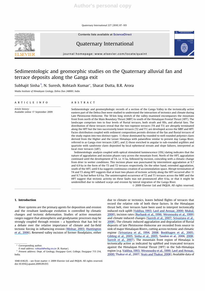
The present study focuses on the fluvial deposits of the GangaValley, located in the eastern part of Dehra Dun in the Sub-Hima-laya (Figs. 1 and 2). The Sub-Himalaya, the outermost division of theHimalaya, is bordered by Lesser Himalayan rocks in the north alongthe Main Boundary Thrust (MBT) and the Ganga Plain in the southalong the HFT (Fig. 1). The Lesser Himalaya comprises argillites,limestone and siliciclastics (quartzite) rocks of Proterozoic agewhereas the Sub-Himalaya encompasses the Subathu (Eocene toMiddle Miocene) and Siwalik (Mio-Pleistocene) groups of rockstogether with post-Siwalik deposits (known as ‘Dun gravels’).Subathu Group rocks (Lower Tertiary fluvio-marine deposit),comprising shale, sandstone and minor limestone, flank thenorthern and eastern margin of the Ganga Valley, and are separatedfrom the unconsolidated Siwalik and/or Dun deposits by animbricate thrust of the MBT- the Main Boundary Fault (MBF) ofMedlicott (1864), locally referred as the Mithiwala Thrust (Raiver-man, 2002). The southern margin of the Sub-Himalaya is marked byanticlinally folded (e.g. Mohand and Chandi anticlines) SiwalikGroup, comprising fluvial mudstone, sandstone and conglomerate,forming the southeast-northwest oriented detached Siwalik Hills(560–750 m asl). However, east of the Ganga River, the detachedSiwalik Hills are marked by series of anticline and syncline (Figs. 1and 2).
Fig. 1. (A) Major tectonic boundary of Himalaya. MCT¼Main Central Thrust; MBT¼Main Boundary Thrust; HFT¼Himalayan Frontal Thrust. (B) Geological and geomorphic map ofDehra Dun showing Siwalik and post-Siwalik deposits (compiled after Raiverman, 2002 and Thakur et al., 2007).
S. Sinha et al. / Quaternary International 227 (2010) 87–10388
Author's personal copy
In the study area, the drainage system is controlled by the GangaRiver, a glacier fed perennial stream that drains through the Higher,Lesser and Sub-Himalaya, and transects the detached Siwalik Hillsalong a gorge into Ganga Plain. Along the gorge, the Ganga TearFault (GTF) was mapped by various workers (Nakata, 1972; Rai-verman, 2002; and others). Of the approximately 50 km longsegment of the Ganga Valley studied here, the upper 25 km stretchlies in the region between the mountainous Lesser Himalayan andSubathu Group of rocks in the north and the detached Siwalik Hillsin the south whereas the remaining 25 km lies downstream, southof the HFT (Figs. 1 and 2). After crossing the HFT, the Ganga Riverflows toward the SSE for about 21 km and then bends toward theSSW (Fig. 2). Numerous tributary streams (locally known as Sot,Rao, Nadi etc), having major discharges during the SW monsoonseason, also drain into the Ganga Valley. The Ganga River hasvariable width and sinuosity across the different crustal blocksalong its course in the Ganga Valley. In the hanging wall of the MBT,the Ganga is confined in a narrow gorge with an active channelwidth of w0.11 km, but in the segment between the MBT anddetached Siwalik Hills it forms an approximately 6 km wide valleywith active channel width ranging from 0.7 to 1.8 km. In thedetached Siwalik Hills directly to the north of the HFT, the activechannel of Ganga River again narrows down to w0.3 km and afterexiting from mountain front, the width of the active channelbecomes w2.6 km within a broad valley (>10 km). The gradient ofthe Ganga River between the MBT and HFT is 0.14
�whereas
tributaries have variable gradients from 0.3�
(e.g. Song River) to 1.1�
(e.g. Chandrabhaga Nadi) with the exception of the Khara Sot(2.86
�) which lies north of the MBT.
3. Materials and methods
Landform mapping coupled with elevation of terraces andalluvial fan surfaces were carried out through total station survey.The stratigraphy of the deposits was established through verticallogs, constructed on the exposed sections on the banks of theGanga River and its tributaries. The lithofacies were identified andare broadly grouped into gravel, sand and mud, which are furtherdivided into sub-facies based on degree of organisation, stratifica-tion, colour and bedding geometry (Table 1). The river and land-form surface profiles and river bed elevations were constructedusing Survey of India toposheets (1:50,000 scale) at 20 m contourinterval, hand handle GPS and Global Mapper software.
The chrono-stratigraphy of fan and terrace deposits was estab-lished by applying optically stimulated luminescence (OSL) datingat Wadia Institute of Himalayan Geology, Dehra Dun. Twelve fine-to medium- grained sand samples were collected using metallicpipes and were analysed under subdued red light conditions.Samples from middle part of the pipe (unexposed to light) weretransferred to a beaker to remove carbonate and organic matterusing 1 N HCl and 30% H2O2 respectively, and were then sieved toobtain the 90–125 mm size fraction. From the separated fraction,quartz grains were extracted by density separation, using sodiumpolytungstate solution. The extracted quartz grains were etched for80 min in hydrofluoric acid to remove the outer layer (the HFtreatment also removes any feldspar contaminations) and subse-quently were treated with HCl (for about 30 min) and re-sieved.The purity of the etched quartz (i.e. feldspar contaminations) wastested using infra-red stimulated luminescence (IRSL).
The etched quartz grains were then fixed as a mono layer (about3 mm diameter) into the center of a stainless steel disc (10 mmdiameter) using silicon oil (adhesive agent) for determining theradiation energy received by the sample after its burial, i.e. palaeodose or equivalent dose (ED). The Single Aliquot Regenerationprotocol (Murray and Wintle, 2000, 2003) was used for ED deter-mination. The OSL measurements were carried out using 240 �C pre-heat for 10 s,160 �C cut heat, laboratory irradiation from a calibratedbeta source (Sr/Yr90) and 40 sec blue light stimulation, in an auto-mated Riso TL/DA 20 reader equipped with blue light emittingdiodes. The ED values (Table 2) were calculated using the initial0.8 second integral of the OSL by Duller’s Annalyse software. For theannual dose rate estimation, concentrations of uranium, thoriumand potassium in the sediments were measured by XRF. The watercontent was determined for all samples by heating at 100 �C.
4. Results
4.1. Distribution of fluvial terraces and alluvial fans
A staircase of terraces and alluvial fans are prominent geomor-phic and depositional features in the Ganga Valley (Fig. 3A). Theterraces, either fluvial or alluvial, are aligned parallel to the GangaRiver or its tributary streams. The alluvial fans are aligned almost90� to the present-day Ganga River, with the exception of Chan-drabhaga fan which is oblique, and the fan toes terminate at theGanga River floodplain. Two to four terrace risers, T1 to T4, areobserved between Lakshmanjhula (north of MBT) and Nagal (southof HFT; Fig. 2) with T4 the highest and T1 the lowest. These terracesare named locally based on their relative height from the GangaRiver bed (e.g. LJ-T1, SS-T2). These terraces either occur as strathscut on Lesser or Sub-Himalayan (Siwalik) rocks (Fig. 3B and C), or as
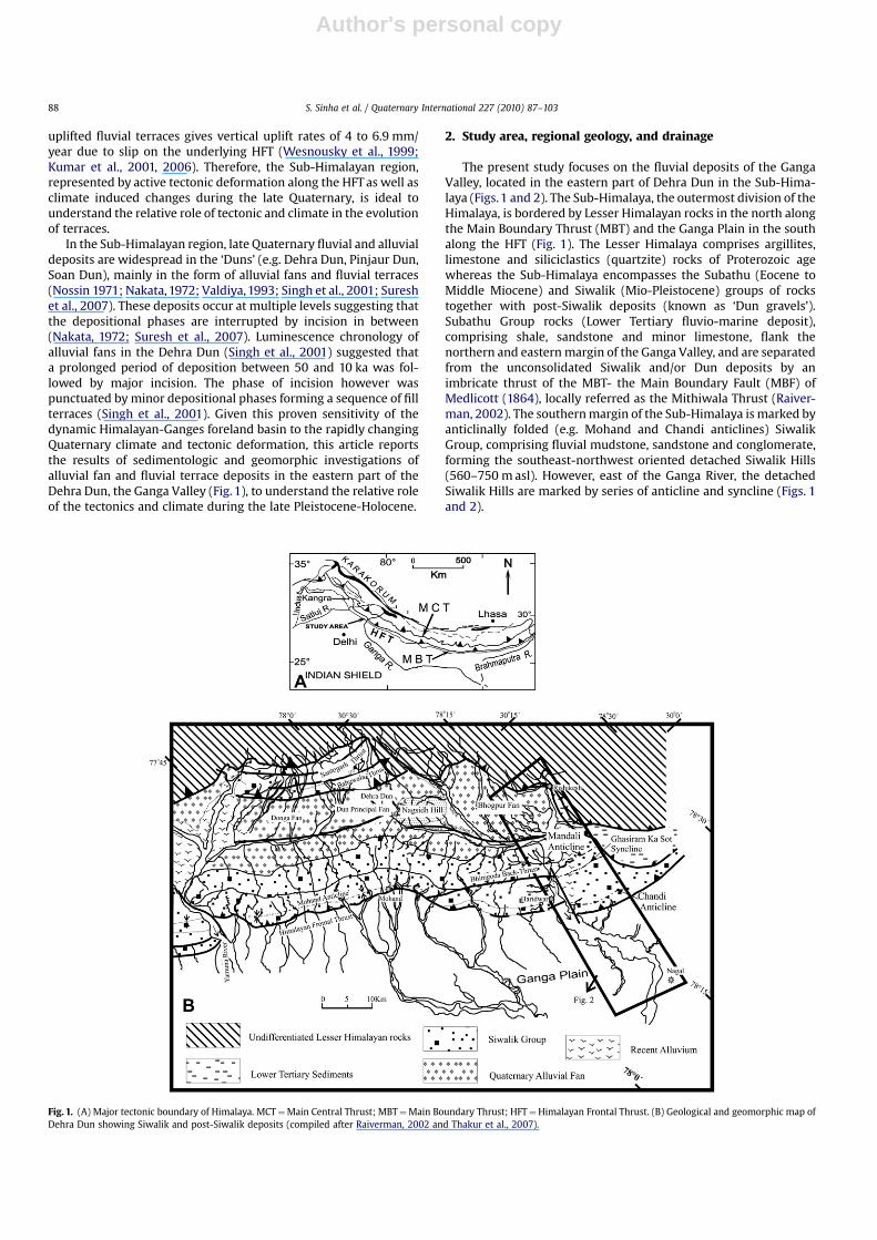
Fig. 2. Geomorphic map of Ganga Valley between the Main Boundary Thrust andHimalayan Frontal Thrust showing various major landforms. GTF¼Ganga Tear Fault.
S. Sinha et al. / Quaternary International 227 (2010) 87–103 89
Author's personal copy
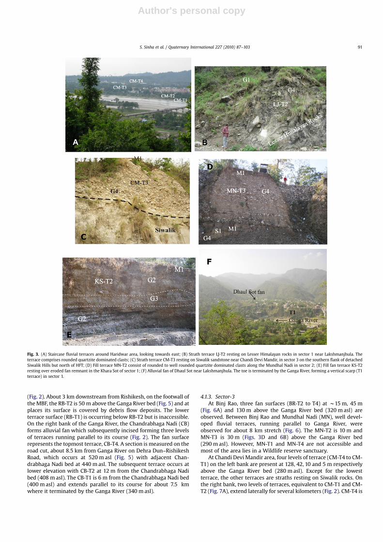
cut and fill terraces, carved out on fan deposits (Fig. 3D and E). Atplaces, the terraces are subsequently covered by colluvial depositsfrom the nearby mountains. The fans have been entrenched bystreams forming distinctive surfaces (Fig. 3F) running parallel to theincised streams (fan terraces). For better documentation andcorrelation, the study area is divided into four sectors (Fig. 2):Sector-1 represents the area north of the MBT; Sector-2 is the areabetween the MBT and detached Siwalik Hills; Sector-3 representsthe area within the detached Siwalik Hills; and Sector-4 is the areasouth of the HFT in the Ganga Plain.
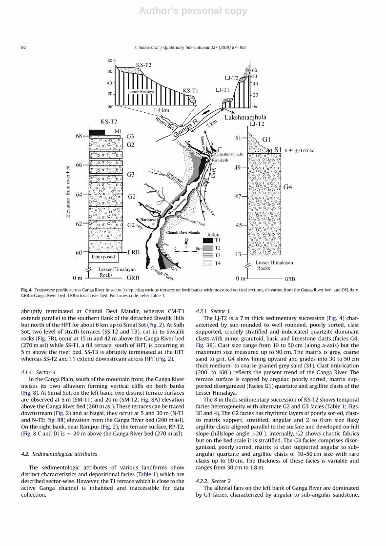
4.1.1. Sector-1In this sector, at Lakshmanjhula (LJ), two terrace risers have
been observed on the left bank of Ganga River (Figs. 2 and 4). Thelower terrace surface, LJ-T1, is at 18 m and the upper, LJ-T2, is at50.5 m from the Ganga River bed (360 m asl), both resting on Lesser
Himalayan succession. These terraces are observed in patches andextend in the downstream direction across the MBT and the MBF(Fig. 2). On the right bank of the Ganga River, two distinctivealluvial fans, resting on Lesser Himalayan rocks, are observed atDhaul Sot (Fig. 3F) and Khara Sot (KS; Fig. 2) with their toesterminated by Ganga River forming fan terraces. The Khara Sot fanterrace KS-T2, about 3 km downstream from Lakshmanjhula,occurs at 8 m from the Khara Sot bed (400 m asl) which meets theGanga River (340 m asl) w 1.4 km downstream (Fig. 4).
4.1.2. Sector-2Between Rishikesh and Binj Rao (RB), a series of coalescing
alluvial fans are observed on the left bank of the Ganga River withoccasional rounded quartzite clasts, similar to Ganga bed load,which are interbedded within the fan deposits. At places, twodistinctive levels of terraces are observed which occur in patches
Table 1Characteristics ithofacies of various landscapes in Ganga Valley between MBT and HFT.
Facies Sub-facies Description Interpretation
Gravel Disorganizedmatrix supportedgravel (Facies G1)
Pebble-boulder clasts, chaotic fabric, sub-angular to sub-rounded, very poorly sorted, muddy matrix- support. Bedshave sharp, non-erosional basal contact. Gravel contentrange from 30% to 60%.
Poorly sorted, muddy matrix-supported graveland disorganized fabric suggests deposition bycohesive debris flow.
Clast- to matrixsupported stratified,gravel (Facies G2)
Rhythmic layers of poorly sorted, clast- to matrix support,angular and 2 to 6 cm size Platy clasts aligned parallel to thesurface. At bed level stratified but internally has chaoticfabric. Matrix consists of coarse sand to silt grade. Gravelcontent varies from 85 to 70%.
Characteristic features suggest active rock falldeposits and individual layering revealssubsequent overlapping rock fall deposits onhill slope.
Disorganized,matrix- to clastsupported gravel(facies G3)
Pebble-boulder clasts, poorly sorted, disorganized,ungraded, matrix to clast support, outsize clasts up to 75 cmare common, clasts are sub-rounded to rounded toelongated, coarse sand to silty matrix. Beds have irregular,planar basal contact. Gravel content up to 80%.
Characteristic features indicate rapid depositionby catastrophic flood event.
Crudely stratifiedgravel (facies G4)
Pebble-boulder clasts, poorly to moderately sorted, crudelystratified, well-developed transverse clast fabric, matrix toclast support, clasts are well- to sub-rounded, planar toerosional basal contact. Ungraded to normal grading. Matrixconsists of coarse to medium sand and at places finegranules reached up to 40%.
These characteristic are common in gravelstransported as bed load and deposited underwaning flow by accretion of progressivelysmaller clasts, in channels and on longitudinalbars.
Sand Fine-medium-to coarse-grained,massive to stratified(Facies S1)
Fine-medium- to coarse-grained grey sand, locally pebbly,cross-stratified to massive, normal grading. Lenticular tosheet geometry. Basal contact is sharp, fining upward. Crossset thickness varies from 10 to >25 cm.
Deposition by broad lateral migrating braidedriver under waning stage.
Fine-grained sandto silt grademassive sand,(facies S2
Fine to very fine greyish brown sand and silt, massive,lenticular geometry.
Rapid deposition by piedmont channel. Inplaces, represent bar surface deposits
Mud Massive mud(Facies M1)
Silt to clay grade reddish brown, massive mud. Fine-grained nature indicates over bankdeposits.
Biotubated mud(Facies M2)
Silt to clay grade reddish brown, massive mud with biogenicactivity and locally developed calcareous concretions.
Over bank deposits; calcareous concretions andbiogenic activity indicate subareial exposureand inception of pedogenic activity.
Table 2The quartz OSL age, equivalent dose (E.D.) and annual dose rate for samples from the Ganga Valley. The concentrations of uranium, thorium, potassium and the present watercontent used for the annual dose rate calculation.
Sl. No. Lab No. Terraces location U (ppm) Th (ppm) Potassium K (%) Dry water content (%) Dose rate (Gy/ka) E.D. (Gy) Age (ka B.P.)
1 LD-187 LJ-T2 Top 2.6þ 0.03 12.2þ 0.12 1.32þ .01 1.1� 0.1 2.96� 0.04 20.56� 1.92 6.94� 0.652 LD-191 CB-T1 Top 3.7� 0.04 15.0� 0.15 2.43� 0.02 2.8� 0.3 4.42� 0.06 2.46� 0.29 0.56� 0.063 LD-190 CB-T2 Top 4.7� 0.05 16.1� 0.16 2.57� .03 8.2� 0.8 4.56� 0.07 26.67� 4.84 5.85� 1.074 LD-189 CB-T4 Top 4.6� 0.05 16.4� 0.16 2.98� .03 2.1� 0.2 5.30� 0.07 58.51� 4.61 11.04� 0.885 LD-192 CB-T4 Bottom 4.7� 0.05 15.7� 0.16 2.72� .03 8.3� .8 4.66� 0.07 53.24� 5.89 11.43� 1.286 LD-285 CM-T3 Top 2.6� 0.03 15.5� 0.16 2.32� .02 1.4� 0.1 4.17� 0.05 39.83� 5.64 9.55� 1.367 LD-286 CM-T4 Top 4.6� 0.05 12.0� 0.12 1.57� .02 5� 0.5 3.49� 0.05 38.69� 6.74 11.08� 1.948 LD-188 CM-T3 Top 2.5� 0.03 11.8� 0.12 1.53� .02 1.4� 0.1 3.11� 0.04 30.31� 3.19 9.76� 1.049 LD-124 SM-T2 Top 4.3� 0.04 12.2� 0.12 1.30� .01 4� 0.4 3.22� 0.05 19.51� 2.83 6.06� 0.8810 LD-123 SM-T2 bottom 2.1� 0.02 9.2� 0.09 1.50� .01 4� 0.4 2.72� 0.04 32.96� 2.15 12.14� 0.8111 LD-121 RP-T2 Bottom 2.2� 0.02 7.3� 0.07 0.79� .01 5� 0.5 1.91� 0.03 16.13� 1.92 8.46� 1.0112 LD-122 RP-T2 Top 2.3� 0.02 7.7� 0.08 0.78� .01 6� 0.6 1.93� 0.03 7.49� 2.47 3.89� 1.28
S. Sinha et al. / Quaternary International 227 (2010) 87–10390
Author's personal copy
(Fig. 2). About 3 km downstream from Rishikesh, on the footwall ofthe MBF, the RB-T2 is 50 m above the Ganga River bed (Fig. 5) and atplaces its surface is covered by debris flow deposits. The lowerterrace surface (RB-T1) is occurring below RB-T2 but is inaccessible.On the right bank of the Ganga River, the Chandrabhaga Nadi (CB)forms alluvial fan which subsequently incised forming three levelsof terraces running parallel to its course (Fig. 2). The fan surfacerepresents the topmost terrace, CB-T4. A section is measured on theroad cut, about 8.5 km from Ganga River on Dehra Dun–RishikeshRoad, which occurs at 520 m asl (Fig. 5) with adjacent Chan-drabhaga Nadi bed at 440 m asl. The subsequent terrace occurs atlower elevation with CB-T2 at 12 m from the Chandrabhaga Nadibed (408 m asl). The CB-T1 is 6 m from the Chandrabhaga Nadi bed(400 m asl) and extends parallel to its course for about 7.5 kmwhere it terminated by the Ganga River (340 m asl).
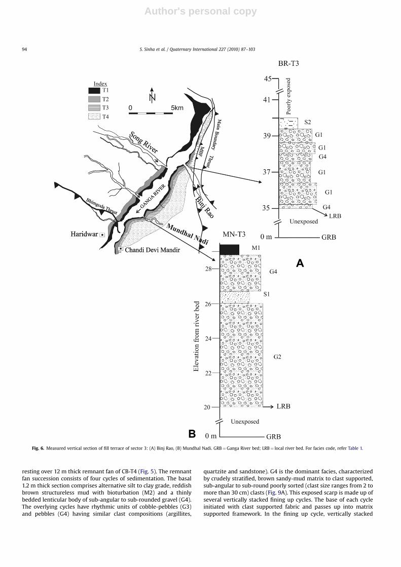
4.1.3. Sector-3At Binj Rao, three fan surfaces (BR-T2 to T4) at w15 m, 45 m
(Fig. 6A) and 130 m above the Ganga River bed (320 m asl) areobserved. Between Binj Rao and Mundhal Nadi (MN), well devel-oped fluvial terraces, running parallel to Ganga River, wereobserved for about 8 km stretch (Fig. 6). The MN-T2 is 10 m andMN-T3 is 30 m (Figs. 3D and 6B) above the Ganga River bed(290 m asl). However, MN-T1 and MN-T4 are not accessible andmost of the area lies in a Wildlife reserve sanctuary.
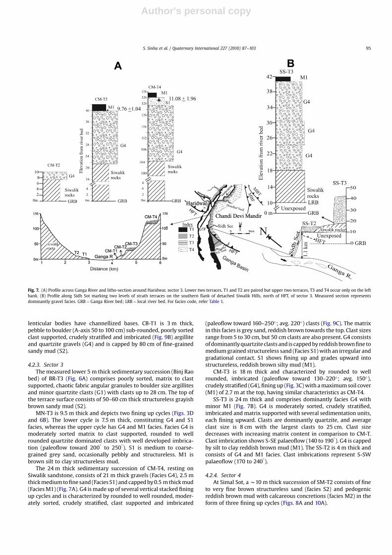
At Chandi Devi Mandir area, four levels of terrace (CM-T4 to CM-T1) on the left bank are present at 128, 42, 10 and 5 m respectivelyabove the Ganga River bed (280 m asl). Except for the lowestterrace, the other terraces are straths resting on Siwalik rocks. Onthe right bank, two levels of terraces, equivalent to CM-T1 and CM-T2 (Fig. 7A), extend laterally for several kilometers (Fig. 2). CM-T4 is
Fig. 3. (A) Staircase fluvial terraces around Haridwar area, looking towards east; (B) Strath terrace LJ-T2 resting on Lesser Himalayan rocks in sector 1 near Lakshmanjhula. Theterrace comprises rounded quartzite dominated clasts; (C) Strath terrace CM-T3 resting on Siwalik sandstone near Chandi Devi Mandir, in sector 3 on the southern flank of detachedSiwalik Hills but north of HFT; (D) Fill terrace MN-T2 consist of rounded to well rounded quartzite dominated clasts along the Mundhal Nadi in sector 2; (E) Fill fan terrace KS-T2resting over eroded fan remnant in the Khara Sot of sector 1; (F) Alluvial fan of Dhaul Sot near Lakshmanjhula. The toe is terminated by the Ganga River, forming a vertical scarp (T1terrace) in sector 1.
S. Sinha et al. / Quaternary International 227 (2010) 87–103 91
Author's personal copy
abruptly terminated at Chandi Devi Mandir, whereas CM-T3extends parallel to the southern flank of the detached Siwalik Hillsbut north of the HFT for about 6 km up to Simal Sot (Fig. 2). At SidhSot, two level of strath terraces (SS-T2 and T3), cut in to Siwalikrocks (Fig. 7B), occur at 15 m and 42 m above the Ganga River bed(270 m asl) while SS-T1, a fill terrace, south of HFT, is occurring at5 m above the river bed. SS-T3 is abruptly terminated at the HFTwhereas SS-T2 and T1 extend downstream across HFT (Fig. 2).
4.1.4. Sector-4In the Ganga Plain, south of the mountain front, the Ganga River
incises its own alluvium forming vertical cliffs on both banks(Fig. 8). At Simal Sot, on the left bank, two distinct terrace surfacesare observed at 5 m (SM-T1) and 20 m (SM-T2; Fig. 8A) elevationabove the Ganga River bed (260 m asl). These terraces can be traceddownstream (Fig. 2) and at Nagal, they occur at 5 and 30 m (N-T1and N-T2; Fig. 8B) elevation from the Ganga River bed (240 m asl).On the right bank, near Ranipur (Fig. 2), the terrace surface, RP-T2,(Fig. 8 C and D) is w 20 m above the Ganga River bed (270 m asl).
4.2. Sedimentological attributes
The sedimentologic attributes of various landforms showdistinct characteristics and depositional facies (Table 1) which aredescribed sector-wise. However, the T1 terrace which is close to theactive Ganga channel is inhabited and inaccessible for datacollection.
4.2.1. Sector 1The LJ-T2 is a 7 m thick sedimentary succession (Fig. 4) char-
acterized by sub-rounded to well rounded, poorly sorted, clastsupported, crudely stratified and imbricated quartzite dominantclasts with minor granitoid, basic and limestone clasts (facies G4;Fig. 3B). Clast size range from 10 to 50 cm (along a-axis) but themaximum size measured up to 90 cm. The matrix is grey, coarsesand to grit. G4 show fining upward and grades into 30 to 50 cmthick medium- to coarse grained grey sand (S1). Clast imbrication(200
�to 160
�) reflects the present trend of the Ganga River. The
terrace surface is capped by angular, poorly sorted, matrix sup-ported disorganized (Facies G1) quartzite and argillite clasts of theLesser Himalaya.
The 8 m thick sedimentary succession of KS-T2 shows temporalfacies heterogeneity with alternate G2 and G3 facies (Table 1; Figs.3E and 4). The G2 facies has rhythmic layers of poorly sorted, clast-to matrix support, stratified, angular and 2 to 6 cm size flakyargillite clasts aligned parallel to the surface and developed on hillslope (hillslope angle >20
�). Internally, G2 shows chaotic fabrics
but on the bed scale it is stratified. The G3 facies comprises disor-ganized, poorly sorted, matrix to clast supported angular to sub-angular quartzite and argillite clasts of 10–50 cm size with rareclasts up to 90 cm. The thickness of these facies is variable andranges from 30 cm to 1.8 m.
4.2.2. Sector 2The alluvial fans on the left bank of Ganga River are dominated
by G1 facies, characterized by angular to sub-angular sandstone,
Fig. 4. Transverse profile across Ganga River in sector 1 depicting various terraces on both banks with measured vertical sections, elevation from the Ganga River bed, and OSL date.GRB¼Ganga River bed; LRB¼ local river bed. For facies code, refer Table 1.
S. Sinha et al. / Quaternary International 227 (2010) 87–10392

Author's personal copy
quartzite and argillite clasts floating in reddish-brown mud matrix.The clasts are disorganized and do not show any grading. In places,2 to 5 m thick, rounded, crudely stratified quartzite clast-bearingG4 facies, similar to the LJ-T2 terrace, is sandwiched between G1facies.
The 7 m thick sedimentary succession of RB-T2, similar to LJ-T2,is dominated by G4 facies (Fig. 5) but reduction of clast size and
improved sorting is observed. RB-T2 rests on the 43 m thick Siwalikrocks with an irregular and erosional contact. The terrace is cappedwith an angular, disorganized red muddy matrix G1 facies withsandstone and quartzite clasts.
The exposed CB-T4 succession is w 3 m thick consist domi-nantly of G4 facies with minor 10 cm thick lenticular sandy-mudfacies (Fig. 5). CB-T2 is only 0.5 m thick, comprises sandy-mud unit,
Fig. 5. Transverse profile across Ganga River in sector 2 from Chandrabhaga fan on the right bank and RB-T terraces on the left bank with measured vertical height from Ganga Riverbed and OSL dates. GRB¼Ganga River bed; LRB¼ local river bed; Rd – road level. For facies code, refer Table 1.
S. Sinha et al. / Quaternary International 227 (2010) 87–103 93
Author's personal copy
resting over 12 m thick remnant fan of CB-T4 (Fig. 5). The remnantfan succession consists of four cycles of sedimentation. The basal1.2 m thick section comprises alternative silt to clay grade, reddishbrown structureless mud with bioturbation (M2) and a thinlybedded lenticular body of sub-angular to sub-rounded gravel (G4).The overlying cycles have rhythmic units of cobble-pebbles (G3)and pebbles (G4) having similar clast compositions (argillites,
quartzite and sandstone). G4 is the dominant facies, characterizedby crudely stratified, brown sandy-mud matrix to clast supported,sub-angular to sub-round poorly sorted (clast size ranges from 2 tomore than 30 cm) clasts (Fig. 9A). This exposed scarp is made up ofseveral vertically stacked fining up cycles. The base of each cycleinitiated with clast supported fabric and passes up into matrixsupported framework. In the fining up cycle, vertically stacked
Fig. 6. Measured vertical section of fill terrace of sector 3: (A) Binj Rao, (B) Mundhal Nadi. GRB¼Ganga River bed; LRB¼ local river bed. For facies code, refer Table 1.
S. Sinha et al. / Quaternary International 227 (2010) 87–10394
Author's personal copy
lenticular bodies have channellized bases. CB-T1 is 3 m thick,pebble to boulder (A-axis 50 to 100 cm) sub-rounded, poorly sortedclast supported, crudely stratified and imbricated (Fig. 9B) argilliteand quartzite gravels (G4) and is capped by 80 cm of fine-grainedsandy mud (S2).
4.2.3. Sector 3The measured lower 5 m thick sedimentary succession (Binj Rao
bed) of BR-T3 (Fig. 6A) comprises poorly sorted, matrix to clastsupported, chaotic fabric angular granules to boulder size argillitesand minor quartzite clasts (G1) with clasts up to 28 cm. The top ofthe terrace surface consists of 50–60 cm thick structureless grayishbrown sandy mud (S2).
MN-T3 is 9.5 m thick and depicts two fining up cycles (Figs. 3Dand 6B). The lower cycle is 7.5 m thick, constituting G4 and S1facies, whereas the upper cycle has G4 and M1 facies. Facies G4 ismoderately sorted matrix to clast supported, rounded to wellrounded quartzite dominated clasts with well developed imbrica-tion (paleoflow toward 200
�to 250
�). S1 is medium to coarse-
grained grey sand, occasionally pebbly and structureless. M1 isbrown silt to clay structureless mud.
The 24 m thick sedimentary succession of CM-T4, resting onSiwalik sandstone, consists of 21 m thick gravels (Facies G4), 2.5 mthick medium to fine sand (Facies S1) and capped by 0.5 m thick mud(Facies M1) (Fig. 7A). G4 is made up of several vertical stacked finingup cycles and is characterized by rounded to well rounded, moder-ately sorted, crudely stratified, clast supported and imbricated
(paleoflow toward 160–250�; avg. 220�) clasts (Fig. 9C). The matrixin this facies is grey sand, reddish brown towards the top. Clast sizesrange from 5 to 30 cm, but 50 cm clasts are also present. G4 consistsof dominantly quartzite clasts and is capped by reddish brown fine tomedium grained structureless sand (Facies S1) with an irregular andgradational contact. S1 shows fining up and grades upward intostructureless, reddish brown silty mud (M1).
CM-T3 is 18 m thick and characterized by rounded to wellrounded, imbricated (paleoflow toward 130–220�; avg. 150�),crudely stratified (G4), fining up (Fig. 3C) with a maximum soil cover(M1) of 2.7 m at the top, having similar characteristics as CM-T4.
SS-T3 is 24 m thick and comprises dominantly facies G4 withminor M1 (Fig. 7B). G4 is moderately sorted, crudely stratified,imbricated and matrix supported with several sedimentation units,each fining upward. Clasts are dominantly quartzite, and averageclast size is 8 cm with the largest clasts to 25 cm. Clast sizedecreases with increasing matrix content in comparison to CM-T.Clast imbrication shows S-SE palaeoflow (140 to 190
�). G4 is capped
by silt to clay reddish brown mud (M1). The SS-T2 is 4 m thick andconsists of G4 and M1 facies. Clast imbrications represent S-SWpalaeoflow (170 to 240
�).
4.2.4. Sector 4At Simal Sot, a w10 m thick succession of SM-T2 consists of fine
to very fine brown structureless sand (facies S2) and pedogenicreddish brown mud with calcareous concretions (facies M2) in theform of three fining up cycles (Figs. 8A and 10A).
Fig. 7. (A) Profile across Ganga River and litho-section around Haridwar, sector 3. Lower two terraces, T1 and T2 are paired but upper two terraces, T3 and T4 occur only on the leftbank. (B) Profile along Sidh Sot marking two levels of strath terraces on the southern flank of detached Siwalik Hills, north of HFT, of sector 3. Measured section representsdominantly gravel facies. GRB¼Ganga River bed; LRB¼ local river bed. For facies code, refer Table 1.
S. Sinha et al. / Quaternary International 227 (2010) 87–103 95
Author's personal copy
The exposed sedimentary succession of N-T2 is 6 to 18 m thick(Fig. 8B) and comprises coarse to fine grained, stratified grey sandwith rarely pebbly (Facies S1, Fig. 10B). The S1 has two prominent
stories separated by erosional surface and each storey showsfining upward. The width of the body, normal to palaeoflowdirection, is several hundreds of meters. Along the basal erosional
Fig. 8. Measured litho sections with OSL ages south of HFT in sector 4; A) SM-T2; B) Measured litho section of N-T2, both the OSL ages after Jaiswal et al. (2005); C) RP-T2 section-1showing two fining upward cycles and D) RP-T2 section-2 having dominantly gravel facies. GRB¼Ganga River bed; LRB¼ local river bed. For facies code, refer Table 1.
S. Sinha et al. / Quaternary International 227 (2010) 87–10396
Author's personal copy
contact of the upper storey, pebbles and mud clasts are common.Internally, S1 exhibits large scale trough and planar cross-strati-fication (Fig. 10C), parallel lamination and rarely ripple cross-laminations. In the upper storey, S1 grades upward into 1.8 mthick structureless, fine-grained grey sand (S2) and capped by1.5 m thick structureless, mottled and bioturbated silt to claygrade brown mud (M2).
The exposed succession of RP-T2, measured at two localities, is5 to 13 m thick and is comprised dominantly of facies G4, S1 andM1. Section-1 is 11 m thick, of which 5 m was measured in trench(Fig. 8C), and shows two fluvial cycles (Fig. 10D) capped bystructureless mud. The base of the lower cycle has G4 followed by1.2 m thick, grey, fine-grained structureless sand (S2) with inter-bedded thin lenticular G4. The S2 fines upward and passes intocrudely stratified, fine-grained grey sand with a sharp contact (S2facies) and capped by structureless brown bioturbated 1.2 m thickmud facies (M2) with sharp contact. The second cycle is 7.25 mthick (Figs. 8C and 10E) and has similar characteristics as the lowercycle except that the S1 and G4 facies are interbedded andcomparatively thick. The section-2, w3 km downstream fromsection 1, is 13 m thick (Fig. 8D) and comprise dominantly G4which is characterized by poorly sorted, pebble to boulder,rounded to well rounded, clast to matrix supported crudelystratified and imbricated quartzite clasts (maximum clast size is15 cm). Clast imbrications indicate S-SE palaeoflow (150
�to 210
�).
This facies does not show grading and passes upward into struc-tureless brown mud (M1).
4.3. Chronostratigraphy
Quartz OSL ages were derived from samples collected fromvarious units representing the terraces and the alluvial fan of theGanga Valley (Table 2) to constrain the age of deposition andincision phases. The sand bed representing the uppermost part ofthe terrace sequence LJ-T2 (Fig. 4) provided an age of 6.94� 0.65 ka(LD-187). The sample LD-189 from the upper part of the Chan-drabhaga fan sequence, i.e. fan terrace CB-T4, gave an age of11.04� 0.88 ka (Fig. 5). The OSL age obtained for the sandy mud bedfrom the two levels of the uppermost part of terrace deposits CB-T2and CB-T1 (Fig. 5), occurring below the CB-T4 surface, respectivelygave ages of 5.85�1.07 ka (LD-190) and 0.56� 0.06 ka (LD-191).The sample LD-192 from the exposed base of the remnant Chan-drabhaga fan below CB-T2 yielded an age of 11.43�1.28 ka (Fig. 5).
Three OSL ages were obtained from two levels of terracedeposits, resting on Siwalik bedrock exposed directly north of HFTin sector-3 (Fig. 7). A sandy unit from the top of CM-T4 terracesequence gave an age of 11.08� 1.94 ka (LD-286) indicating the ageof the oldest preserved depositional terrace in this locality. Twosamples obtained from the uppermost part of CM-T3 at two loca-tions yielded ages of 9.76�1.04 ka (LD-188) and 9.55�1.36 ka (LD-285).
In sector 4, in the Ganga Plain south of the HFT, four OSL ageswere obtained from two sedimentary sequences exposed on boththe banks of the Ganga River (Fig. 8). In the Simal Sot area, the twoages obtained from the SM-T2 terrace sequence, on the left bank ofthe Ganga River, are 12.14� 0.81 ka (LD-123) from the bottom and6.06� 0.88 ka (LD-124) for the top. In the Ranipur area, the twosamples obtained from the RP-T2 sequence produced an age of8.46�1.01 ka (LD-121) for the sand unit obtained from the bottompart of a trench whereas the uppermost part gave an age of3.89�1.28 ka (LD-122).
The terrace risers, T1 to T4, between Lakshmanjhula (north ofMBT) and Haridwar (north of HFT; Fig. 2), are laterally correlatedusing OSL ages and their relative height from the present GangaRiver bed. From the above chronostratigraphy, it can be inferred
Fig. 9. A) Angular to sub-angular, crudely stratified gravel punctuated by dis-organisedangular to sub-angular clast in CB-T4; B) Sub-rounded sandstone and quartzite clastsshowing stratification and imbrication (G4) of CB-T1 (ball pen length is 12 cm); C)Crudely stratified, well rounded quartzite dominated clast in CM-T4.
S. Sinha et al. / Quaternary International 227 (2010) 87–103 97
Author's personal copy
that the aggradation phase of the fan and topmost terrace (T4)sequence terminated around 11 ka (11.04� 0.88 and11.08� 1.94 ka). The other terrace surfaces, T3 and T2, weredeposited at around 9.7 ka (9.76�1.04 and 9.55�1.36 ka) and
7 ka (5.85�1.07 and 6.94� 0.65 ka) respectively. However, in thesouth of the HFT, sedimentation continued between 12.14� 0.81and 6.06� 0.88 ka (SM-T2) or even extended to 3.89�1.28 ka(RP-T2).
Fig. 10. A) Vertical scarp of SS-T2 showing temporal facies variation between S2 and M2; B) vertical scarp of N-T2 terrace representing thick sand punctuated by erosional surface;C) large scale cross-stratification in the S1 facies in N-T2 (scraper length is 30 cm); D) trench section showing temporal facies variation and terminated by modern alluvium of RP-T2.Measuring tape is 5 m long; E) exposed vertical scarp of RP-T2 showing temporal facies variation in second cycle. For facies code, refer Table 1.
S. Sinha et al. / Quaternary International 227 (2010) 87–10398

Author's personal copy
5. Discussion
5.1. Depositional setup
The high heterogeneity in facies distribution, depositionalarchitecture as well as variations in nature and material composi-tion amongst the fluvial and the fan terraces in the present studiedarea permits grouping the terraces into two distinct types. The first,named Ganga River terraces (GRT), are dominated by well roundedpolymict clasts (dominantly quartzite with minor granitoids, basicand limestone clasts) and grey sand derived from Higher to LesserHimalaya with palaeoflow similar to the present day Ganga River.Typical examples are LJ-T2; LJ-T1; RB-T2; MN-T3; CM-T1; CM-T2;CM-T3; CM-T4; SS-T2; SS-T1; RP-T2; N-T2; and N-T1. The secondgroup is characterized by angular to sub-rounded argillites andquartzite with sandstone clast derived from local hinterland. Thisgroup, referred to as local river terraces (LRT), is represented by KS-T2; BR-T2; CB-T1; CB-T2; and CB-T4. The LRT are the product ofentrenchment of alluvial fans either by the Ganga River or tributarystreams. The SM-T2 comprises fine-grained facies and is difficult toassign to GRT or LRT.
A range of sedimentary processes operated during deposition ofvarious fluvial and alluvial fan terraces. The GRT, from sector 1 to 3have dominantly G4 facies, and its characteristic features indicatethat the gravels were transported as bed load and deposited underwaning flow by accretion of progressively smaller clasts, in chan-nels and on longitudinal bars (Hein and Walker 1977; Tandon andKumar 1981; Rust 1984; Collinson 1986). In sector 1, G4 faciescapped by G1 and its characteristics features reveal its depositionby debris flow processes (e.g. Hubert and Filipov, 1989; Blair andMcPherson, 1994). However, in sector 2, G4 and G1 show inter-fingering and reveals that locally derived debris flow events wereseparated by aggradation phases deposited by the Ganga River. Insector 3, G4 facies shows fining upward and is capped by S1 and M1facies suggesting deposition during waning stage. Whereas, G4abruptly capped by M1 indicates channel abandonment and duringincision, surface occupied by floodplain.
The Simal Sot of sector 4, left bank of Ganga River, has domi-nantly S2 and M2 facies (Fig. 8A) suggest their deposition in thefloodplain by Ganga River during high flooding or represent distalpart of alluvial fan from the detached Siwalik Hill. Presence ofpedogenic concretion suggests sub-aerial exposure and disconti-nuity in sedimentation. Further downstream, at Nagal (Fig. 8B),multistory sand body with sheet geometry suggests deposition bya broad laterally-migrating braided river (e.g. Gordon and Bridge,1987; Rust and Jones, 1987; Kumar and Nanda, 1989; Kumar, 1993;Shukla et al., 2001), similar to the present Ganga River. Thepalaeoflow pattern, obtained through trough cross-stratification,almost parallels the present day trend of the Ganga River. On theother hand, on the right bank of the Ganga River, the associatedfacies of RP-T2 (Fig. 8 C and D) reveal deposition in a gravellybraided stream under a waning stage with a broad floodplain.However, the association of G4 in the S1 reveals overlappinglongitudinal bars with gravel at the base, reflecting initial growth ofbar formation in a braided stream. Their characteristic featuresreveal deposition by the Ganga River, subsequently incised by localstreams.
LRT show variable depositional environments. KS-T2 (Fig. 4)consists of interbedded G2 and G3 facies. The characteristics of G2indicate its deposition due to rock fall from the high angle slope ofthe surrounding Lesser Himalayas (e.g. Van Steijn, 1997; Bilkra andNemec, 1998; Sass and Krautblatter, 2007) and individual layeringreveals subsequent overlapping of rock falls. The interbedded G3facies requires deposition by catastrophic flood events duringmonsoons (e.g. Smith, 1986; Wells and Harvey, 1987; Blair, 1999;
Gupta, 1999). This suggests two main processes were operatingduring the depositional phase of the Khara Sot alluvial fan: rockfalls from high angle Lesser Himalayan hill slopes, and hyper-concentrated flow events from the local stream.
The CB-T4 has predominantly the G4 facies (Fig. 5) and itscharacteristic features indicate longitudinal bars deposited underwaning flow stages. Small channellised bodies suggest that, duringwaning stages, several small channels were flowing on the alluvialfan. The presence of subangular to sub-rounded quartzite clastsreveals a short transport distance. The S2 of CB-T2 indicatesfloodplain deposits. However, the dominant G4 in the CB-T1 withincrease in clast size (up to 100 cm) in comparison to CB-T4,coupled with the clast-supported framework, indicates a higherenergy condition as compared to older fan deposits. The clastcomposition and associated facies suggest their deposition by localstreams from the Lesser and Sub-Himalayan region.
Synthesizing the depositional setting, the LRT reveal variationsfrom Lakshmanjhula to Binj Rao. The Khara Sot fan located north ofthe MBT has developed in response to hill slope failure and highintensity flooding. South of the MBT, the fans on the left bank of theGanga River are marked by high slope and are nurtured primarilyby debris flow deposits, whereas fans on the right bank have gentleslopes and are characterized by multiple channel flows inter-spersed with catastrophic flood events. The facies distribution inthe LRT, governed by local ephemeral streams and hill slope fail-ures, shows high heterogeneity due to interfingering of the facies.On the other hand, GRT facies reflect deposition by persistentstream flow with more or less similar composition. Facies analysisclearly reveals that GRT facies show downstream fining fromgravelly to sandy facies from MBT to south of HFT in response tohydraulic sorting.
5.2. Evolution of terraces: climate and tectonic implications
Evolution of terraces in a given region is controlled by threemain processes: 1) sediment aggradation; 2) vertical incisionand/or 3) lateral erosion by an axial river. These processes ata given time have been controlled by upstream sediment flux,regional and local tectonic uplift and variation in climate.Synthesis of sedimentologic and geomorphic observations of theGanga Valley terraces illustrate that they are aggradationalterraces resting on bedrock or eroded fan remnants. However,their distribution shows marked variation across HFT, witha complete terrace flight (T4 to T1) in the hanging wall whereasthe footwall is marked by only the two youngest terraces (T2and T1). The topmost T4 terrace between the MBT and HFT hasa similar age, indicating that aggradation phase stopped ataround 11 ka. The initiation of the aggradation phase is notknown due to lack of any datable materials in the gravel faciesat the exposed base. However, upstream of the Ganga River,about 75 km north of MBT, at least 80 m of aggradation wasdocumented, initiated around 21 ka and stopping around 10 ka(Srivastava et al., 2008). In the Dehra Dun valley also the fanaggradation was stopped around 10.7 ka (Singh et al., 2001).These data sets suggest that abandonment and major break insedimentation followed by incision occurred between 10 and11 ka across the Ganga Valley in the Himalaya. Similar incisionhistories also have been reported far away from the mountainfront in the Ganga Plain (Fig. 11; Williams and Clarke, 1995;Gibling et al., 2005; Tandon et al., 2006). The transition fromLate Pleistocene to Holocene is widely marked by a change inclimate from drier to wetter conditions, with intensification ofthe Indian summer monsoon (Prell and Kutzbach, 1987; Good-bred and Kuehl, 2000; Chauhan, 2008). The higher intensity ofprecipitation caused an increase in transport capacity with low
S. Sinha et al. / Quaternary International 227 (2010) 87–103 99

Author's personal copy
S. Sinha et al. / Quaternary International 227 (2010) 87–103100

Author's personal copy
sediment flux due to decrease in hill-slope erosion which facil-itates incision. The subsequent aggradation phase ceased around9.7 ka, followed by incision forming the T3 terrace, which isextensive in sector 3. Time equivalent surfaces are rare atregional scale but 9.2–9.3 ka surfaces are documented in MarwarSection (Fig. 11) of the Ganga Plain, near Kanpur (Gibling et al.,2005) and Nepal Sub-Himalaya (Lave and Avouac, 2000).Conspicuously, the two aggradation events are not separated bymajor incision events (11 and 9.7 ka) along the mountain front,directly south of HFT, where sedimentation continued unabated(minor discontinuity) between w12 and 6 ka (Fig. 8; SM-T2).The aggradation and subsequent abandonment and incision ofT2 is observed across the mountain front at w6.9 ka, north ofMBT (LJ-T2; Fig. 4), to 6 ka (SM-T2; Fig. 8A), south of HFT.Jaiswal et al. (2005) also reported time equivalent aggradationand incision phases in the Nagal area corresponding to N-T2(Fig. 8B) of the present study. The incision phases around 11–10 ka and 7–6 ka (Fig. 11) are consistent from source to sink inGanga Valley irrespective of the various tectonic regimes ofHimalaya (Singh et al., 2001; Bookhagen et al., 2005; Srivastavaet al. 2008; Suresh and Kumar, 2009) and in the Ganga Plain(Gibling et al., 2005; Tandon et al., 2006; Sinha and Sarkar,2009; Srivastava and Shukla, 2009), except at the mountainfront where the 11 ka incision event is absent, suggesting thatthese incision phases are in response to enhanced precipitation.
The absence of the 11 and 9.7 ka incision phases at themountain front, directly south of HFT (Fig. 11) with extendedaggradation until 6 ka reveals that the incision phase was delayedhere. This out-of-phase sedimentation close to the mountainfront may be due to (1) excessive erosion in the upstream of theGanga Valley and subsequent offloading in the mountain frontand/or (2) uplift of mountain front along the HFT. During thewetter climate after 10 ka, elevated river discharge resulted inhigher erosion and incision rate (w14 mm/a) in the upstream ofthe Ganga River, about 75 km north of MBT (Srivastava et al.,2008) but downstream, after exiting from the mountain front,this elevated sediment flux was deposited due to decreasedstream power with increased active channel width. On the otherhand, the tectonic uplift of mountain front, due to the reac-tivation of the HFT, caused gradual creation of accommodationspace in the down-thrown side. The abrupt termination of T4 andT3 terraces at HFT, with elevation variations of CM-T4 and CM-T3of time equivalent sediment deposits with respect to SM-T2 of>100 m and w40 m respectively, suggest at least two phases oftectonic uplift might have occurred between 11–9.7 ka and 9.7–6.9 ka. These tectonic uplifts created accommodation space in themountain front where the eroded mass from the upstream mightbe rapidly accumulated until the subsequent incision phase ataround 6 ka. Moreover, the incision rate along the mountain frontshows high variability. The long term incision rate at themountain front, calculated using the incision of 102 m of Siwalikrocks below the strath of T4 (CM-T4 of sector 3; Fig. 7A), between11 ka and present, is 9.27 mm/year. The slip rate, calculated usingan average 30� dip of HFT, is w18.5 mm/year with a shorteningrate of w16.1 mm/year. However these rates vary widely betweenvarious strath terraces. In the period between the T4 and T3terraces (CM-T4 and CM-T3 of sector 3), the river incised about82 m thick Siwalik rocks in 1.3 ky, at the rate of w63 mm/year.The incision rate after T3 but before T2, which eroded 15 mSiwalik strata in 3 ky, is w5 mm/year. On the other hand, theincision rate at MBT (LJ-T2, 6.9 ka at 50 m above river bed with
rock strath 43 m) is w6.2 mm/year. The long term rate is more orless correlatable with the available data of vertical uplift(6.9 mm/year) and slip rate (13.8 mm/year) along the HFT,calculated using a 3.6 ka (radiocarbon date) uplift terrace about40 km west of Haridwar (Wesnousky et al., 1999). The calculatedhigher incision rate (w63 mm/year) between CM-T4 and CM-T3coupled with elevation difference of time equivalent depositsacross HFT (CM-T4 and SM-T2) suggest vertical uplift along theHFT. The CM-T4 and T3 terraces, resting over the anticlinally andsynclinally folded detached Siwalik Hills, do not show back-tilt-ing or upwarping. Therefore, the possible explanation for highincision rate and elevation variation of time equivalent depositsacross the HFT suggests reactivation of HFT coupled withincreased precipitation during the Pleistocene-Holocene climatictransition.
The continuation of T2 and T1 terraces cutting across the MBTand HFT indicates the probable present inactive nature of thesethrusts. However, a younger active phase on the HFT after 6 ka isreported from various parts of the mountain front (Wesnouskyet al., 1999; Lave and Avouac, 2000; Kumar et al., 2001, 2006;Thakur et al., 2007; Malik et al., 2008; Yeats and Thakur, 2008). Thisyounger phase of HFT activity may be absent in the Ganga Valley, ormight be unidentified due to the subdued scarp in response tolateral migration of the active channel of Ganga River. The observedyounger OSL age at Ranipur (RP-T2, Figs. 2 and 8C) suggests that theGanga River was aggrading until 4 ka on the western side of thepresent active channel. Tandon et al. (2006) also suggest progres-sive westward shift of Ganga River, in the western Ganga Plain eastof Delhi, for more than 15 km since w12 ka. This reveals thatwestward shifting of Ganga River from Nagal to Ranipur might havecontinued after 7 ka. Parkash et al. (2000) inferred this lateralshifting of the active channel is controlled by uplift of varioustectonic blocks in the piedmont zone of the mountain front.However, the Ganga River might have migrated about 10 kmwestward between Nagal and Ranipur after 7 ka, and back to Nagalafter 4 ka forming a west facing 30 m high cliff on the left bank ofthe river. This westward and eastward migration of Ganga Riverreveals climatic controlled lateral avulsion.
This study reveals that development of Late Pleistocene –Holocene terraces in the tectonically active Sub-Himalaya and theadjacent Ganga Plain is controlled by climate oscillation. However,at least two phases of tectonic upheaval in the Holocene havetruncated and uplifted the two uppermost terraces in the hangingwall, creating accommodation space for extended aggradation inthe footwall of the HFT.
6. Conclusion
Late Pleistocene-Holocene terraces of Ganga Valley showmarked variation in their distribution across the Himalayanmountain front, with four level of terraces in the hanging wall andtwo levels in the footwall. The approximate abandonment age ofterraces in the hanging wall are w11 ka, w9.7 ka and w6.9 ka. Theterraces were carved out in response to wetter conditions duringintensification of the summer monsoon. These incision phases arewidespread across source to sink in the Ganga valley. In the foot-wall, accommodation space was created due to two phases of rockuplift along HFT which resulted in an extended phase of aggrada-tion until w6 ka. This study reveals that, even in the tectonicallyactive Himalayan mountain front, terrace formation is controlled byclimate. The high incision rate with abrupt termination of T4 and T3
Fig. 11. Comparison of Late Pleistocene-Holocene aggradation - incision phases along Ganga River from Himalayan region to Ganga Plain. In the Himalayan region and far awayGanga Plain 11–10 ka and 7–6 ka incision phases are prominent. However in the Himalayan mountain front, south of HFT, extended aggradation till 6 ka reveals that incision phasedelayed in response to progressive creation of accommodation space due to tectonic deformation underlying the [Srivastava et al., 2003].
S. Sinha et al. / Quaternary International 227 (2010) 87–103 101
Author's personal copy
at the mountain front resulted from both climatic and tectonicprocess which acted concurrently.
Acknowledgments
The authors acknowledge with gratitude the free access to thefacilities of Wadia Institute of Himalayan Geology, Dehra Dun. Weare extremely thankful to the reviewer Dr. Alexander Densmore forfruitful comments and suggestions. Technical help for OSL analysisby Mr V. P. Gupta, Technical officer, OSL laboratory, WIHG is alsoacknowledged. This work was carried out under research grants SR/S4/ES-21/Ganga Plain/PI funded by Ministry of Science and Tech-nology, New Delhi, India. The advice of the monitoring committee isgratefully acknowledged.
References
Bilkra, L.H., Nemec, W., 1998. Postglacial colluvium in western Norway: deposi-tional processes, facies and palaeoclimatic record. Sedimentology 45,909–959.
Blair, T.C., 1999. Sedimentary processes and facies of the waterlaid AnvilSpring Canyon alluvial fan, Death Valley, California. Sedimentology 46,913–940.
Blair, T.C., McPherson, J.G., 1994. Alluvial fans and their natural distinction fromrivers based on morphology, hydraulic processes, sedimentary processes, andfacies. Journal of Sedimentary Research 64, 451–490.
Bookhagen, B., Thiede, R.C., Streckker, M.R., 2005. Abnormal monsoon years andtheir control on erosion and sediment flux in the High, arid northwest Hima-laya. Earth and Planetary Science Letters 231, 131–146.
Burbank, D.W., Leland, J., Fielding, E., Anderson, R.S., Brozovic, N., Reid, M.R.,Duncan, C., 1996. Bedrock incision, rock uplift and threshold hillslopes in thenorthwestern Himalayas. Nature 379, 505–510.
Chauhan, O.S., 2008. Past 20,000-year history of Himalayan aridity: evidencefrom oxygen isotope records in the Bay of Bengal. Current Science 84,90–93.
Collinson, J.D., 1986. Alluvial sediments. In: Reading, H.G. (Ed.), Sedimentary Envi-ronments and Facies. Blackwell Scientific, Oxford, pp. 20–62.
Gibling, M.R., Tandon, S.K., Sinha, R., Jain, M., 2005. Discontinuity-bounded alluvialsequences of the southern Gangetic plains, India: aggradation and degradationin response to monsoonal strength. Journal of Sedimentary Research 75,373–389.
Goodbred, S.L., Kuehl, S.A., 2000. Enormous Ganga-Brahmaputra sedimentdischarge during strengthened early Holocene monsoon. Geology 28,1083–1086.
Gordon, E.A., Bridge, J.S., 1987. Evolution of Catskill (Upper Devonian) riversystems: intra and extrabasinal controls. Journal of Sedimentary Petrology 57,234–249.
Gupta, S., 1999. Controls on sedimentation in distal margin palaeovalleys in theEarly Tertiary Alpine foreland basin, south-eastern France. Sedimentology 46,357–384.
Hein, F.J., Walker, R.G., 1977. Bar evolution and development of stratification in thegravelly, braided, Kicking Horse River, British Columbia. Canadian Journal ofEarth Science 14, 562–570.
Hubert, J.F., Filipov, A.J., 1989. Debris-flow deposits in alluvial fans on the west flankof the White Mountains, Owens valley, California, USA. Sedimentary Geology61, 177–205.
Huntington, K.W., Blythe, A.E., Hodges, K.V., 2006. Climatic change and Late Plio-cene accelerate of erosion in the Himalaya. Earth and Planetary Science Letters252, 107–118.
Jaiswal, M.K., Srivastava, P., Singhvi, A.K., 2005, Luminence Chronology of Mega andPiedmont Alluvial Fan Sequence in Ganga Plain, Abstract Volume XXII conventionof Indian Association of Sedimentologists, WIHG, p.21.
Kumar, R., 1993. Coalescence megafan: multistorey sandstone complex of the Late-Orogenic (Mio-Pliocene) sub-Himalayan belt, Dehra Dun, India. SedimentaryGeology 85, 327–337.
Kumar, R., Nanda, A.C., 1989. Sedimentology of the Middle Siwalik subgroup ofMohand area, Dehra Dun valley, India. Journal of the Geological Society of India34, 597–616.
Kumar, S., Wesnousky, S.G., Rockwell, T.K., Ragona, D., Thakur, V.C., Seitz, G.G., 2001.Earthquake recuuence and rupture dynamics of the Himalayan Frontal Thrust,India. Science 294, 2328–2331.
Kumar, S., Wesnousky, S.G., Rockwell, T.K., Briggs, R.W., Thakur, V.C.,Jayangondaperumal, R., 2006. Paleoseismic evidence of great surface ruptur-eearthquakes along the Indian Himalaya. Journal of Geophysical Research 111,B03304. doi:10.1029/2004JB3309.
Lave, J., Avouac, J.P., 2000. Active folding of fluvial terraces across the SiwalikHills, Himalayas of central Nepal. Journal of Geophysical Research 105,5735–5770.
Malik, J.N., Nakata, T., Philip, G., Suresh, N., Virdi, N.S., 2008. Active fault andpaleoseismic investigation: evidence of a historic earthquake along
Chandigarh fault in the Frontal Himalayan zone, NW India. HimalayanGeology 29, 109–117.
Medlicott, H.B., 1864. On the Geological Structure and Relationship of the SouthernPortion of the Himalayan Between the Rivers Ganga and Ravee, vol. 3.Geological Survey of India Memoir, 212 pp.
Molnar, P., 2003. Nature, nurture and landscape. Nature 426, 612–614.Mukul, M., 2000. The geometry and kinematics of the Main Boundary
Thrust and related neotectonics in the Darjiling Himalayan fold-and-thrust belt, West Bengal, India. Journal of Structural Geology 22,1261–1283.
Murray, A.S., Wintle, A.G., 2000. Luminescence dating of quartz using an improvedregenerative-dose protocol. Radiation Measurements 32, 57–73.
Murray, A.S., Wintle, A.G., 2003. The single aliquot regenerative dose protocol:potential for improvements in reliability. Radiation Measurements 37,377–381.
Nakata, T., 1972. Geomorphic History and Crustal Movements of the Himalayas.Institute of Geography, Tohuku University, Sendai, Japan, 77 pp.
Nossin, J.J., 1971. Outline of the geomorphology of the Doon valley, northern UP,India. Zeitscrift fur Geomorphologie NF 12, 18–50.
Parkash, B., Kumar, S., Rao, M.S., Giri, S.C., Kumar, C.S., Gupta, S., Srivastava, P., 2000.Holocene tectonic movements and stress field in the Western Gangetic Plains.Current Science 79, 438–449.
Prell, W.L., Kutzbach, J.E., 1987. Monsoon variability over the past 150,000 years.Journal of Geophysical Research 92, 8411–8425.
Raiverman, V., 2002. Foreland Sedimentation in Himalayan Tectonic Region:a Relook at the Orogenic Process. Bishen Singh Mahendra Pal Singh, Dehra Dun,India, 378 pp.
Rust, B.R., 1984. Proximal braidplain deposits in the Middle DevonianMalbaie Formation of eastern Gaspe, Quebec, Canada. Sedimentology 31,675–695.
Rust, B.R., Jones, B.G., 1987. The Hawkesbury sandstones south of Sydney, Australia.Triassic analogue for the deposits of large braided river. Journal of SedimentaryPetrology 57, 222–233.
Sass, O., Krautblatter, M., 2007. Debris flow-dominated and rockfall-dominatedtalus slopes: genetic models derived from GPR measurements. Geomorphology86, 176–192.
Shukla, U.K., Singh, I.B., Sharma, M., Sharma, S., 2001. A model of alluvial megafansedimentation: Ganga Megafan. Sedimentary Geology 144, 243–262.
Singh, A.K., Parkash, B., Mohindra, R., Thomas, J.V., Singhvi, A.K., 2001. Quaternaryalluvial fan sedimentation in the Dehradun valley piggyback basin, NWHimalaya: tectonic and palaeoclimatic implications. Basin Research 13,449–471.
Sinha, R., Sarkar, S., 2009. Climate-induced variability in the Late Pleistocene-Holocene fluvial and fluvio-deltaic succession in the Ganga Plains, India:a synthesis. Geomorphology. doi:10.1016/j.geomorph.2009.03.011.
Sinha, R., Tandon, S.K., Gibling, M.R., Bhattacharjee, P.S., Dasgupta, A.S., 2005. LateQuaternary geology and alluvial stratigraphy of the Ganga basin. Journal ofHimalayan Geology 26, 223–240.
Smith, G.A., 1986. Coarse-grained nonmarine volcaniclastic sediments: termi-nology and depositional process. Bulletin, Geological Society of America 97,1–10.
Srivastava, P., Parkash, B., Sehgal, J.L., Kumar, S., 1994. Role of neotectonics andclimate in development of the Holocene geomorphology and soils of theGangtic Plains between Ramganga and Rapti rivers. Sedimentary Geology 94,729–751.
Srivastava, P., Shukla, U.K., 2009. Quaternary evolution of Ganga River System: newquartz ages and a review of luminescence chronology. Himalayan Geology 30,85–94.
Srivastava, P., Sharma, M., Singhvi, A.K., 2003. Luminescence chronology of inci-sion and channel pattern changes in the River Ganga. Geomorphology 51,259–268.
Srivastava, P., Tripathi, J.K., Islam, R., Jaiswal, M.K., 2008. Fashion and phases of latePleistocene aggradation and incision in the Alaknanda River Valley, westernHimalaya, India. Quaternary Research 70, 68–80.
Suresh, N., Kumar, R., 2009. Variable period of aggradation and terminationhistory of two distinct Late Quaternary alluvial fans in the Soan Dun NWSub-Himalaya: impact of tectonics and climate, Himalayan Geology 30,155–165.
Suresh, N., Bagati, T.N., Kumar, R., Thakur, V.C., 2007. Evolution of Quaternaryalluvial fans and terraces in the intramontane Pinjaur Dun, Sub-Himalaya, NWIndia: interaction between tectonics and climate change. Sedimentology 54,809–833.
Tandon, S.K., Kumar, R., 1981. Gravel fabric in sub-Himalayan braided stream.Sedimentary Geology 28, 133–152.
Tandon, S.K., Gibling, M.R., Sinha, R., Singh, V., Ghazanfari, P., Dasgupta, A., Jain, M.,Jain, V., 2006. Alluvial valleys of the Gangetic Plains, India: causes and timing ofincision. Special Publication no. 85. In: Incised Valleys in Time and Space. SEPM,pp. 15–35
Tandon, S.K., Sinha R., Gibling M.R, Dasgupta, A.S., Ghazanfari, P., 2008. LateQuaternary evolution of the Ganga Plains: myths and misconceptions, recentdevelopments and future directions. Memoir, Geological Society of India, 66,259–299.
Thakur, V.C., Pandey, A.K., Suresh, N., 2007. Late Quaternary–Holocene evolution ofDun structure and the Himalayan Frontal Fault zone of the Garhwal Sub-Himalaya, NW India. Journal of Asian Earth Sciences 29, 305–319.
S. Sinha et al. / Quaternary International 227 (2010) 87–103102

Author's personal copy
Valdiya, K.S., 1993. Uplift and geomorphic rejuvenation of the Himalaya in theQuaternary period. Current Science 64, 873–885.
Van Steijn, H., 1997. Rain-generated overland flow as a factor in the development ofsome stratified scree deposits: a case study from the Pays du Buech (PrealpesFrance). Geographie Physique et Quaternaire 51, 3–15.
Wesnousky, S.G., Kumar, S., Mohindra, R., Thakur, V.C., 1999. Uplift andconvergence along the Himalayan Frontal Thrust of India. Tectonics 18,967–976.
Wells, S.G., Harvey, A.M., 1987. Sedimentologic and geomorphic variations in stormgenerated alluvial fans, Howgill Fells, northwest England. Bulletin. GeologicalSociety of America 98, 182–198.
Williams, M.A.J., Clarke, M.F., 1995. Quaternary geology and prehistoric environ-ments in the Son and Belan valleys, north central India. Geological Society ofIndia 32, 282–308. Memoir.
Yeats, R.S., Thakur, V.C., 2008. Active faulting south of the Himalayan Front:establishing a new plate boundary. Tectonophysics 453, 63–73.
S. Sinha et al. / Quaternary International 227 (2010) 87–103 103