Intra-and extra-caldera volcaniclastic facies and geomorphic characteristics of a frequently active...
16
This article appeared in a journal published by Elsevier. The attached copy is furnished to the author for internal non-commercial research and education use, including for instruction at the authors institution and sharing with colleagues. Other uses, including reproduction and distribution, or selling or licensing copies, or posting to personal, institutional or third party websites are prohibited. In most cases authors are permitted to post their version of the article (e.g. in Word or Tex form) to their personal website or institutional repository. Authors requiring further information regarding Elsevier’s archiving and manuscript policies are encouraged to visit: http://www.elsevier.com/copyright
Transcript of Intra-and extra-caldera volcaniclastic facies and geomorphic characteristics of a frequently active...

This article appeared in a journal published by Elsevier. The attachedcopy is furnished to the author for internal non-commercial researchand education use, including for instruction at the authors institution
and sharing with colleagues.
Other uses, including reproduction and distribution, or selling orlicensing copies, or posting to personal, institutional or third party
websites are prohibited.
In most cases authors are permitted to post their version of thearticle (e.g. in Word or Tex form) to their personal website orinstitutional repository. Authors requiring further information
regarding Elsevier’s archiving and manuscript policies areencouraged to visit:
http://www.elsevier.com/copyright

Author's personal copy
Intra- and extra-caldera volcaniclastic facies and geomorphic characteristics of afrequently active mafic island–arc volcano, Ambrym Island, Vanuatu
Károly Németh a,⁎, Shane J. Cronin a, Robert B. Stewart a, Douglas Charley a,b
a Institute of Natural Resources, Volcanic Risk Solutions, Massey University, Private Bag 11 222, Palmerston North, New Zealandb Department of Geology, Mines and Water Resources, Port Vila, Republic of Vanuatu
a b s t r a c ta r t i c l e i n f o
Article history:Received 9 November 2007Accepted 23 March 2009
Keywords:TephraCalderaVolcanic sedimentologyGrain flowHyperconcentrated flowAmbrymVanuatu
Ambrym is one of themost voluminous active volcanoes in theMelanesian arc. It consists of a 35 by 50 km islandelongated east–west, parallel with an active fissure zone. The central part of Ambrym, about 800 m above sealevel, contains a 12 kilometre-wide caldera, with two active intra-caldera cone-complexes, Marum and Benbow.These frequently erupting complexes provide large volumes of tephra (lapilli and ash) to fill the surroundingcaldera and create an exceptionally large devegetated plateau “ash plain”, as well as sediment-choked fluvialsystems leading outward from the summit caldera. Deposits from fall, subordinate base surge and small-volumepyroclastic (scoria)flowsdominate the volcaniclastic sequences innear vent regions. Frequent andhigh-intensityrainfall results in rapid erosion of freshly deposited tephra, forming small-scale debris flow- and modified grainflow-dominated deposits. Box-shaped channel systems are initially deep and narrow on the upper flanks of thecomposite cones and arefilledbank-to-bankwith lapilli-dominateddebrisflowdeposits. These units spill out intolarger channel systems forming debris aprons of thousands of overlapping and anastomosing long, narrow lobesof poorly sorted lapilli-dominated deposits. These deposits are typically remobilised by hyperconcentrated flows,debris-rich stream flows and rare debris flows that pass down increasingly shallower and broader box-shapedvalleys. Lenses and lags of fines and primary fall deposits occur interbedded between the dominantly tabularhyperconcentrated flow deposits of these reaches. Aeolian sedimentation forms elongated sand dunes flankingthe western rim of the ash-plain. Outside the caldera, initially steep-sided immature box-canyons are formedagain, conveyingdominantly hyperconcentratedflowdeposits. These gradually pass intobroad channels on lessergradients in coastal areas and terminate at the coast in the formofprograding fansof ash-dominateddeposits. Theextra-caldera deposits are typically better sorted and contain other bedding features characteristic of more dilutefluvial flows and transitional hyperconcentrated flows. These outer flank volcaniclastics fill valleys to modifyrestricted portions of the dominantly constructional landscape (lava flows, and satellite cones) of Ambrym.Apparentmaturity of the volcanic systemhas resulted in the subsidenceof the present summit caldera at a similarrate to its infill by volcaniclastic deposits.
© 2009 Elsevier B.V. All rights reserved.
1. Introduction
A number of recent studies have focused on understandingvolcaniclastic sedimentation around volcanoes (Cronin and Neall,1997; Donoghue et al., 1997; Lecointre et al., 1998; Giordano et al.,2002). The majority of these studies concentrate on volcaniclasticsedimentation around large-volume intermediate or silicic volcaniccentres (e.g. Manville et al., 2009-this volume). This type of volcanismgenerally produces large volumes of tephra that is often transportedtens of kilometres away by pyroclastic falls, flows or surges (Fisher andSchmincke, 1984). The loose and commonly highly fragmentederuptive products are easily remobilised to form thick successions ofreworked volcano-sedimentary units up to hundreds of kilometres
away from the source volcano (Vallance and Scott, 1997; Capra et al.,2004; Scott et al., 2005; Thouret, 2005;). Such remobilisationcommonly alters the sedimentary budget of large areas around siliciccentres, changing fluvial network patterns, forming lakes or draininglarge basins over brief periods (e.g. Manville et al., 2009-this volume).The scale of such volcaniclastic sedimentation triggered by explosivesilicic eruptions is significantly larger than that typically associatedwith mafic explosive volcanism. Hence, examples and studied onlarge-scale volcaniclastic sedimentation in association with maficvolcanism are rare.
On volcanic islands, volcaniclastic successions can also be tracedfor long distances in subaqueous settings (Ballance and Gregory, 1991;Karátson and Németh, 2001). The process of reworking primarytephra can be facilitated by external forces, such as heavy rainfall,wind or sediment transport through existing fluvial networks (Majoret al., 2000; Manville et al., 2000; Torres et al., 2004). The net result ofthese processes is the buildup of vast volumes of volcaniclastic
Sedimentary Geology 220 (2009) 256–270
⁎ Corresponding author.E-mail address: [email protected] (K. Németh).
0037-0738/$ – see front matter © 2009 Elsevier B.V. All rights reserved.doi:10.1016/j.sedgeo.2009.04.019
Contents lists available at ScienceDirect
Sedimentary Geology
j ourna l homepage: www.e lsev ie r.com/ locate /sedgeo

Author's personal copy
sediments in a variety of textures and structures surrounding activevolcanoes. These distal facies can sometimes be directly linked toprimary explosive volcanic eruptions [such as block-and-ash fans thatmay contain both primary and secondary (lahar) units, Siebe et al.,1993)], while others are described more generally with terms such asvolcaniclastic aprons or ring plains.
In spite of the amount of current research focused on theinterrelationship between primary pyroclastic and secondary volca-niclastic sedimentation around intermediate to silicic volcanoes,
relatively less attention has been paid to mafic volcano–sedimentarysystems. The interrelationship of sedimentation and formation ofmafic volcanic calderas is also not in all cases clearly understood, withcaldera formation models including both explosive disruption trig-gered by violent phreatomagmatic and magmatic explosive eruptions(Braitseva et al., 1996), along with those of gradual subsidence due tolateral discharge of magma (Munro and Rowland, 1996). In addition,the role of intra-caldera active cone complexes in overall volcanicsediment production can also be significant for mafic calderas. These
Fig.1. A) Overviewmap of the Vanuatu (NewHebrides) archipelago. B) Overviewmap of Ambrym Island with a panoramic view from the south. Linemarks the approximate positionof the panoramic view.
Fig. 2. Oblique aerial view (looking east) of the western side of the caldera and ash plain of Ambrym Island. Note the de-vegetated “badlands” landscape in the foreground.
257K. Németh et al. / Sedimentary Geology 220 (2009) 256–270

Author's personal copy
“secondary” eruptive centres are comparable in size to large scoriacones in intra-continental settings. Eruptive products and redistrib-uted sediments from these volcanoes are dominantly deposited andre-distributed within the closed caldera depression. Such maficcalderas are therefore commonly filled with thick piles of ash andlapilli entirely locally derived. The total volume of the accumulatedtephra inside themafic caldera depends on the eruption frequency andintensity and how efficiently it is removed from the caldera system.
In this paper we describe the sedimentary and geomorphiccharacteristics of a large basaltic caldera system with an unusuallyhigh sediment input rate (through tephra deposition and redistribu-tion). In this case the accumulation of intra-caldera volcaniclasticdeposits appears to keep pace with gradual caldera subsidence, in part“drowning” the volcano–tectonic structure and leading to spilling-outof sediment and widespread extra-caldera sedimentation.
The 12 km-diameter caldera on Ambrym Island, Vanuatu, is anexcellent example location where the transition from proximalprimary pyroclastic deposits can be traced through several generationsof reworking into volcaniclastic deposits of differing character bothwithin and outside the caldera structure. In this example, frequentheavy rainfall is the main driving force behind redistribution of vastvolumes of tephra toward the outer flanks of the volcanic island.
2. Geological setting
Ambrym is one of the most voluminous active volcanic islands inthe Vanuatu portion of the Melanesian arc (Fig. 1). Ambrym Island is35 kmwide, 50 km long and elongated in an east–west direction, withan active rift zone parallel to the elongation (Robin et al., 1993). Alongthis system are many scoria cones and fissure fed lava flows (McCall
Fig. 3. Small sub-Plinian eruption on 17 July 2005 from the Marum cone complex, within the summit caldera of Ambrym, feeding a sustained low ash plume and depositing fine ashon the ash plain.
Fig. 4. Interpreted volcaniclastic sedimentary environment on an active volcanic cone of Ambrym Island. Inset shows the SE flank of Benbow as a type location to demonstrate majorsedimentary environment identified. 1) Crater rim crest with cracks and unstable collapse tephra beds, 2) box-shaped gully headwalls, 3) coarse-grained unsaturated grain-flowdominated mass-flow deposits in the upper gully floors, 4) granular debris flow deposits in the middle-level gully floors with well-developed levees, 5) overlapping distal saturatedgranular debris flow generated fans and lobes near the base of the cone, 6) major sediment artery between the active cones of Marum and Benbow dominated by shallow broadhyperconcentrated flow deposits, and 7) artery valley wall exposing older hyperconcentrated flow deposits cut by small stream valleys and topped by fresh airfall tephra.Sedimentation zone A represented by processes and features marked on 1 to 5. Sedimentation zone B is represented by 6 and sedimentation zone C represented by 7 on the figure.
258 K. Németh et al. / Sedimentary Geology 220 (2009) 256–270

Author's personal copy
et al.,1970). Thenorthernpart of Ambrym is the oldest and it is inferredto be part of a series of coalescing strato-volcanoes and lava shields(McCall et al., 1970). The central part of Ambrym Island comprises a12 kilometre-wide caldera structure that rises to between 600 and800 m above present day sea level (Fig. 2). Recent and current activityis commonly but not exclusively concentrated at the two active ventcomplexes (Fig. 1) of Marum and Benbow (Purey-Cust, 1896; Frater,1917; Gregory, 1917; Carniel et al., 2003). These systems regularlyproduce small-volume Strombolian style events, constant intensedegassing, phreatomagmatic explosions and more rarely sub-Plinianand Vulcanian eruptions (Fig. 3). At the western and eastern ex-tremities of Ambrym, many phreatomagmatic eruption centres havedeveloped near sea level as a result of interaction of fissure-fedmagmaand near-surface water and/or water saturated sediments (Némethand Cronin, 2007, 2009a). The resulting tephra rings/cones typicallyhave 1000mdiameter craters and low (b100m) rims. Themost recentshallow-submarine, phreatomagmatic and rift-edge fissure eruptions
took place in 1894, 1913, and 1937 at the western edge of Ambrym(Purey-Cust, 1896; Frater, 1917; Gregory, 1917; Németh and Cronin,2009b) and in 1954 in the eastern rift edge (McCall et al., 1970). Theserift-edge phreatomagmatic volcanoes are similar in architecture, sizeand eruption mechanisms to those described in other volcanic islandsin Vanuatu, such as Ambae (e.g. Németh et al. 2006).
Ambrym eruptives are predominantly calc–alkaline basalts andinclude both high and low-K variants (Pickard et al., 1995). Few, if any,differentiated rocks occur. Analyses of more evolved rocks werereported by Pickard et al. (1995), but re-visiting of the sampling sitessuggests that the geochemistry of these samples was modified byalteration (Cronin and Németh, 2005).
The Ambrym caldera is here (and byMcCall et al., 1970) interpretedto be agradual (or episodic) subsidence feature associatedwith ongoingcentrally focused basaltic volcanism and concomitant lateral fissurefeeding, similar to mafic calderas described from Hawaii (Kilaueacaldera) and the Galapagos Islands (Chadwick et al., 1991; Geist et al.,
Fig. 5. A) Overview of the SW flank of Benbow with dendritic valley network. B) Overview of the NW flank of Marum after a small sub-Plinian eruption in July 2005, which coveredthe dendritic valley and gully network with fresh ashfall.
259K. Németh et al. / Sedimentary Geology 220 (2009) 256–270
Author's personal copy
2002). The feature has apparently been in existence since c. 2200 years(McCall et al., 1970). It has also been alternatively proposed that acataclysmic phreatomagmatic eruption led to the caldera formation andconstruction of an associated giant tuff cone (Robin et al., 1993). Recentfield evidence does not support this interpretation; rather, it suggeststhat the island is a composite structure formed by many generations ofcoalescingmonogenetic volcanicfields andbroad lava shields toppedbycomplex composite volcanic cones (Cronin and Németh, 2005). Thetype localities of the “giant tuff cone”, which were reported as daciticpyroclastic flow deposits (Robin et al., 1993), have instead proven to beeither (1) mafic, weathered and hydrothermally altered, phreatomag-matic fall and surge sequences from mafic magmatic and phreatomag-matic cone clusters, or (2) stacks of laharic and fluvial basaltic sedimentderived from the caldera outflow and forming valley-fills (Cronin andNémeth, 2005). However the role of phreatomagmatism in the centralvent eruptions is evident similarly to other volcanic islands in Vanuatusuch as Ambae (e.g. Németh et al 2006), but the scale, extent and styleof such eruption mechanism still need more work in the near future inAmbrym. The early evolution of Ambrym is also purely understood andneeds to apply comprehensive methods of geochronology (e.g. Baloghand Németh 2005) and geochemistry to distinguish certain evolu-tionary phases of the volcanic island growth.
The island has a relatively low number of permanent streams.Many of these streams initiate outside and about 200–300 m belowthe margin of the flat summit plain. In coastal areas, permanentwaterfalls lead water to the sea especially in the NW and E side of theisland. Most of the major fluvial tributaries are active only during therainy season and are located mostly in the southern part of the island.
3. Climate and topography
The island of Ambrym is situated in the centre part of the Vanuatuarchipelago at latitude 16.25° south. The climate is oceanic tropical,moderated by southeast trade winds between May and October.Rainfalls are strongest during the wet season from November throughApril. The annual rainfall totals through Vanuatu vary from 1500 to4200 mm from south to north. In Port Vila, Efate (120 km south ofAmbrym), the average temperatures range between 26.7 °C (January)and 22.2 °C (July), and the average annual rainfall is 2103 mm. Theclimate varies from hot, very wet and humid with little seasonality inthe north of Vanuatu. Much of the yearly rainfall is delivered bytropical fronts, depressions, heavy storms and cyclones. There is nopermanentmeteorological station in Ambrym, therefore no exact datacan be provided for the areal distribution of rainfall over the island.However, dryer conditions prevail on the western flanks (rain shadoweffect from the southeasterly trades) and wet conditions in the eastand summit even during the “dry” season due to orographic effects inrelation to the trade winds.
Vanuatu lies in the cyclone belt, and cyclones may occur anywherein the islands between November and April (Vanuatu MeteorologicalService, 1994). Over the last 40 years, the islands have been struck byan average of 2.6 cyclones per year (Neil and Barrance, 1987;Longworth, 1991). Hurricane-force storms may occur, and in 1987,Vanuatu was ravaged by the worst storm in its modern history, whichdestroyed or damaged many houses (Vanuatu Meteorological Service,1994). Severe tropical storms are accompanied by heavy rainfall andthe low pressuremay cause the sea to rise asmuch as 2m (Longworth,1991). Flooding, coastal inundation, land erosion, destruction ofhousing and gardens, loss of vegetation, pollution of water suppliesand destruction of coral reefs and sea-grass beds are common impactsfrom tropical cyclones in Vanuatu. For example, Hurricane Betsystruck Ambrym in January 1992, with heavy rainfall occurring over4 days, causing extensive flooding while wind speeds reached 46 m/s[90 knots] (Vanuatu Meteorological Service, 1994). Extreme rainfallsusually take place over a few days, and commonly trigger floods in lowlying areas resulting in sudden erosion and sediment redistribution.
4. Intra-caldera sedimentation at Ambrym Island
The intra-caldera sedimentation at Ambrym Island can beseparated into three major geographical facies associations relatedto the active and primary volcanic cones (Fig. 4);
Zone A. Tephra cone and near-cone sequences (primary deposits,gullies, gullyfills, deposit spills intoarterial channels)—#1to5 inFig. 4.ZoneB. Arterial channels (mainflowpaths inflashfloods)—#6 inFig. 4.Zone C. Interfluve andmarginal caldera (dunes, side valleys, etc.)—#7 in Fig. 4.
These geographically distinct sedimentation zones include a broadrange of volcaniclastic sediments produced from primary to secondaryprocesses demonstrated on Fig. 4.
Zone A represents the tephra cones formed by mafic explosiveprocesses, where an edifice is constructed from proximal ballistic fallout and pyroclastic density current-deposited primary volcaniclasticsuccessions. Secondary processes cut and erode the primary pyr-oclastic constructs (e.g. Benbow and Marum) and remove andaccumulate pyroclasts in their vicinity (Fig. 4 — #1 to 5).
Tephra cones are a pyroclastic volcanic construction that consist ofstacked primary ash- and lapilli-dominated units. These volcanic edificessuffer flank rilling and erosion, leading to the development of complexgullynetworkwith associatedgullyfills all feeding spills leading to arterial
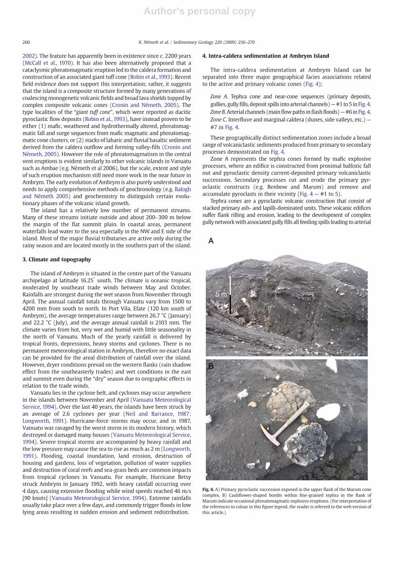
Fig. 6. A) Primary pyroclastic succession exposed in the upper flank of the Marum conecomplex. B) Cauliflower-shaped bombs within fine-grained tephra in the flank ofMarum indicate occasional phreatomagmatic explosive eruptions. (For interpretation ofthe references to colour in this figure legend, the reader is referred to the web version ofthis article.)
260 K. Németh et al. / Sedimentary Geology 220 (2009) 256–270

Author's personal copy
channels (Fig. 4 — #1 to 5). Arterial channels are defined as the mainpathways of flash floods that carry sediment load away from the cones(Fig. 4 — #6). They evolve into wide and flat, poorly confined channelsystems between interfluve areas in the marginal areas of the caldera.
The Ambrym caldera appears to have existed as a depression for atleast the last c. 2200 years, formedwithin a deeplyeroded, older terrain.Scales and styles of volcanism on the island appear to show a steadystate of activity, similar to detailed historic observations over the last c.100 years, and occasional reports goingback to 1774whenCaptainCookvisited the region (Gregory, 1917; McCall et al., 1970). Historically-described flank eruptions were always coincident with or followedinitial summit eruptions, suggesting a strong coupling mechanism(Purey-Cust, 1896; Frater, 1917; Gregory, 1917; Németh and Cronin,2007). Magma rise in the island's centre and the presence of a shallowmagma storage region below the central edifice is indicated by theconstant low-level lava lake activity in the intra-caldera vent systems aswell as thehuge ratesof CO2, SO2 andhalogendegassing fromthe centre(e.g. Bani et al., in review). During periodic larger eruptive episodes,magma ascent to near-surface levels is followed by intense summitdegassing and intra-caldera explosive eruptions. Larger events lead todrainage of degassed magma along lateral dykes (east and westwardalong the rift system) to form fissures and effusion of lava on the lateralflanks (e.g. western arm — 1937; eastern arm — 1954; Wiart, 1995).These combined processes cause a gradual but cumulatively substantialvolume loss from the stable central shallow magma system.
Present-day intra-caldera activity is focused on the two large activepyroclastic cone complexes (Benbow and Marum; Fig. 5A,B), althoughat least one older dormant cone system within the caldera attests toalternative earlier focal points of intra-caldera volcanism. Near the two
major active intra-caldera centres, deposits from fall and subordinatebase surge and/or small volume scoria-and-ash flows dominate thevolcaniclastic sequences (Fig. 6 A). The exposed interior walls ofBenbow are mainly pyroclastic in nature, with minor interbedded lavaflows, solidified lava-lake remnants, sills and dykes outcropping. Incontrast, the outwardly similar Marum complex has a much largerproportion of shallow intrusive rocks, solidified lava-lake remnants,and occasional radiating lava flows (e.g. 1989 eruption; Wiart, 1995).Despite this variety of hard-rock lithologies, the bulk of the edificecomprises ubiquitous thick successions of phreatomagmatic andscoria-ceous tephra (Németh and Cronin, 2008). Each vent/crater of Marum islarge, up to 200 m deep and floored with either a lava lake or mud.
The two intra-caldera eruptive centres produce frequent (weekly–monthly) small-volume eruptions ranging from Strombolian eventsthrough to phreatomagmatic explosions. More rarely (c. 30 yearintervals) larger sub-Plinian and Vulcanian eruptions occur (Fig. 3).These centres hence supply huge volumes of tephra (lapilli and ash) tothe surrounding summit area. Along with the intense acidic degassingfrom these vents (e.g., Bani et al., in review) vegetation growth ishindered, creating an exceptionally large badlands landscape or “ashplain” within the caldera (Fig. 2).
5. Tephra cones and near cone sequences — primary gullies,gully fills, deposit spills into arterial channels
5.1. Description
This complex sedimentary environment is dominated by near-ventprimaryandproximal secondary volcaniclastic sediments forming zone
Fig. 7. A) Termination of dense shallowgully systems at the foot of theMarum cone complex. B) Gully headwall of a typical gully on the upper flank of Benbowcone. C) Disaggregatingcollapsed tephra wall in a gully in the upper flank of Benbow. D) Coarse-grained, granular debris flow deposits forming well-defined lobes in the middle section of one of the gullieson the Marum cone complex.
261K. Németh et al. / Sedimentary Geology 220 (2009) 256–270

Author's personal copy
A in Fig. 4. The primary pyroclastic beds surrounding the Benbow andMarum complexes are dominated by cm-to-dm thick layers of highlyvesicular, basaltic, scoriaceous ash and lapilli with subordinate volcaniclithic fragments (Fig. 6A). The dominantly angular scoriaceous ash andlapilli have well-developed inter-connected vesicle networks withsmooth intra-vesicle surfaces. Falls from minor “background” activityform intercalating sequences of beds dominated by Pele's tears andwelldeveloped Pele's hair up to 10 cm long. All juvenile ash and lapilli arecrystal-poor, glassy, and black to dark red in colour. The scoria particlesare typically blocky and equant, with very rare flattened particles. Freepyrogenetic crystals are rare and dominantly pyroxenes. In near-ventlocations, occasional lobes of lava spatter/welded agglutinate also occurwithin the tephra-dominated sequences. Contrasting, pale-coloured,poorly sorted, fine-ash dominated surge-generated beds occur inter-spersed within the sequences. These matrix-supported tephra unitscontain more common accidental (weathered and hydrothermallyaltered) fragments, including lithic and cauliflower bombs up to250 mm in diameter (Fig. 6B). Near the vents these beds commonlyshow low-angle cross-bedding, andplasteringeffects on the craterwardside of large pre-existing blocks and bombs.
The cone complexes are dissected by narrow, box-shaped gulliescut into their flanks (Fig. 4 — #1–5) that deepen and widen towardthe lower slopes (Fig. 7A). The headward eroding gullies begin with ametre-scale abrupt step, around one-third of the way down the cones.The gullies are evenly distributed around the cone systems and aretypically spaced c. 10–15 m apart (Fig. 4). Although there are manymeanders, some systems meet and amalgamate. The outer slopesequences are exposed in the gully walls and dominated by ash-rich
fall beds, along with common intercalated scoria lapilli fall units atleast 10 cm thick. Bedding surfaces in the successions are slope-parallel and reflect accumulation on slopes of between 10 and 25°. Lesscommon matrix-supported surge beds are interspersed between thefall units. They contain ash aggregates and accretionary lapilli, andform megaripples, along with channel cut-and-fill structures as wellas 10-centimetre-scale slumping structures.
The floors of erosion gullies on the upper cones tend to containlittle or no re-sedimented material until around two-thirds of the waydown the cone, where the side walls collapse to form 45–50° wedgesof talus, including intact blocks of semi-consolidated tephra. Thesecollapsed tephra blocks are quickly disaggregated to create shallowfans of ash-lapilli dominated sediment (Fig. 7B and C), which overlapto eventually cover gully floors between rain-storm events.
In the upper, and steep (25–30°) narrower part of the gullies the filldeposits form steep-margined 0.3 m thick lobate units, with convexupper surfaces that are traceable over tens ofmetres (Fig. 4—#2–3). Atthe lower ends of the gully systems, toward the base of the cones, gully-fill deposits form a complex morphology of thousands of overlappingand anatomising long and narrow lobes (Fig. 4 — #5). Typically theseunits are on the scale of 1–5 m across and 50–100 m long with thick-nesses up to 0.5 m. The lobes have well-defined lateral levee–channelsurface forms at their tails, grading into flat-topped or gently humpedfrontal lobes, 0.2–0.3m thick. Theycollectively stretch bank-to-bank inthe c. 20–50 mwide channels (Fig. 7D). The levee structures typicallycomprise the coarsest-grained fragments and many individual units,including channel–levee structures cross-cut one another (Fig. 8A), orform mini-breakout lobes (Fig. 8B). Marginal levees are clearly clast-
Fig. 8. A)Well-developed levee in a small cross-cutting granular debris flow. The initiation point of this flow lobe is marked with a square. Hammer in circle is c. 30 cm long. B) Smallside lobe initiated from the center lobe complex (dashed circle) of agranular debris flow deposit on the flank of the Marum cone complex. Hammer in circle is c. 30 cm long. C) Lowergully floor section on Benbowwith wider debris flow deposits with well-developed lobe traceable over a fewmetres. Hammer in circle is c. 30 cm long. D) Lower gully floor overviewon the flank of Benbow. Note the finer-grained channels associated with the meandering debris flow lobes, suggesting water saturation of the flow during transportation.
262 K. Németh et al. / Sedimentary Geology 220 (2009) 256–270

Author's personal copy
supported, and apparently better sorted than central parts of the lobes.In the lower, flatter (10–15o) gully reaches the individual lobes arewider and flatter at only 0.1–0.2 m thick (Fig. 8C–D).
At the base of the main cones these gullies terminate where theyjoin into sub-perpendicular, broader secondary valleys that are up to100–200 m wide. Grain-flow channel and levee structures protrude(between floods) into these second-generation channels, terminatingin humpy fan structures. The remainder of these larger valleys arefilled by broad flatter lobes (Fig. 9A) that are almost tabular. Tabular-form deposits, 0.1–0.3 m thick, are exposed at channel margins and“island” banks (Fig. 9B). Some cross-bedded deposits occur, normallywithin well-sorted, clast-supported, matrix-poor ash and lapilli.Cross-sections exposed in side walls show mantle-bedded ashand lapilli fall units up to 15 cm thick that drape older side-gullymorphologies (Fig. 9 C). In the immediate vicinity of Benbow andMarum, the gully networks form a dendritic pattern, feeding intoprogressively wider and shallower channels (Fig. 5A,B). Especiallybetween Marum and Benbow, the base of the edifices is partiallyburied by ash and lapilli-dominated, flat-lying beds. The transitionfrom the pyroclastic construct to their foothill area is represented byzone B, where volcaniclastics directly feed from the erodingpyroclastic construct (Fig. 4 — #5–6). These wide, sediment-chokedshallow valleys formed in the foothills of the cones lead toward a flat“ash plain” region where they interconnect and form, shallow arterialchannels N300 m wide (Fig. 4 — #6).
5.2. Synopsis— pyroclastic cones and near-source sediment redistributionstructures
The exposed gully walls on both cones demonstrate transportationand deposition dominated by tephra fall and subordinate base surgeactivity from mafic explosive eruptions. The style of fragmentationand transportation of pyroclasts and the resulting deposit morphologyare very similar to those found around any mafic explosive volcanoesthat develop complex scoria cones through intermittent phreatomag-matic activity (Houghton and Schmincke, 1989; Calvari and Pinkerton,2004). Particle and deposit textures indicate Strombolian explosiveactivity (Mangan et al., 1993), Vulcanian eruptions (Self et al., 1979;Stix et al., 1997) and phreatomagmatic eruptions (Dzurisin et al.,1995). The limited distribution of phreatomagmatic base-surge bedsindicates these were relatively low-energy events, with depositsconfined to the cones, whereas many fall events were large enough toleave significant deposits well away from the cone structures.
Given the high eruption rates of these two centres and theyouthfulness of the cone-complex slopes, the well-developed den-dritic erosion structures indicate rapid remobilisation of tephra duringfrequent and high-intensity rainfall events. The immediate erosion offreshly deposited tephra forms small granular avalanches or densegranular debris flows that are apparently self-confining and “freeze”into lobes. These features and scales of flow are similar to dense,granular debris flows generated in large-scale flume experiments(Major, 1997; Major and Iverson, 1999), albeit involving coarser andbetter sorted sediment at Ambrym. In flume experiments the resultingdeposits exhibited lobate snouts, blunt marginal levees, arcuatesurface ridges, clusters, and streaks of accumulated surface gravel,and preferentially aligned particles along surge perimeters (Major,1997; Major, 1998; Major and Iverson, 1999). The distribution andfreezing of these lobes appear to be volume-controlled, similar tolarger-scale rock or scoria avalanche deposits (Lube et al., 2007). Theseunits are notably fines-poor, and appear to be generated from rainfall-induced collapses of saturated lapilli and ash beds from the banks ofbox-gullies, and perhaps from steep talus toes of lapilli and ashsediment, similar to deposits reported from gullies in the uppersection of Vulcano in Italy (Ferrucci et al., 2005). The structure of thecone flanks probably helps build excess hydrostatic pressures incoarse lapilli and ash beds that are sandwiched between poorly-sorted
and fine-grained surge deposits that act as aquitards. In addition, thepyroclastic sequences contain many “glazed” layers a few mm-thick,where fine-grained pyroclastic deposits are cemented and altered byprecipitates from intense local degassing (Schiffman et al., 2006). Thisalternation of aquitard layers and loose lapilli and ash units leads toformation of the box-gully structures.
Fig. 9. A) Typical debris flow lobes with well-developed levees traceable over tens ofmetres in the sites where cone-gullies spill into the main artery valley between Benbowand Marum. People in circle are for scale. B) Collapsed wall of the artery valley locallyfeeding debris into the main artery. The wall exposes hyperconcentrated flow depositsof earlier sedimentation around the active cones. Hammer in circle is c. 30 cm long.C) Older interfluve erosional surface covered by mantling tephra deposits (arrows).
263K. Németh et al. / Sedimentary Geology 220 (2009) 256–270

Author's personal copy
The gully-filling granular lobes with minor matrix and moderatesorting suggest transportation and deposition by cohesionless debrisflows (Pierson, 1980). The sedimentary textures (and size) of theselobes are strikingly similar to cohesionless granular debris flowsproduced in large-scale flume experiments (Major, 1997). Theexperimental large-scale debris flow deposits showed similar geome-trical parameters in their width, length, levee dimensions, and ridgesizes to the upper gully lobes. In experimental debris flows texturaldifferences have been identified between unsaturated and saturatedgranular debris flows (Major, 1997). Unsaturated flows producedrelatively thick lobes with high aspect ratios and arcuate surfaceridges, very similar by texture and dimension to those lobes describedfrom the upper gully floors., The lobes in the upper gully floors atAmbrym tend to be pushed into each other and shoulder asidepreviously deposited sediments in a very similar fashion to thosedescribed in the experimental unsaturated debris flows.
Small, rare holes occurring in the coarse-grained head and lowerlevee margins at Ambrym are interpreted to be “sieve holes” throughwhich finer-grained sediment and water may have escaped from theotherwise coarse-grained and granular lobes (c.f., Krainer, 1988;Shakesby and Matthews, 2002). The Ambrym debris flow deposits areso coarse and well-sorted (due to a source from tephra fall deposits),as well as having a high clast vesicularity, that water and finesdrainage is probably extremewithout the need to generatemany sieveholes (c.f., Shakesby and Matthews, 2002).
In areas where the slope angle reduces to about 15°, complex lobestend to override each other and/or younger lobes seemed to bedeflected by earlier deposited lobes. These geometrical features havebeen identified predominantly in saturated debris flows in large-scaleexperiments (Major, 1997). In the lower wider gullies, lobes tend todevelop broader coarse-grained snouts and lower levees, which seemto function as dam structures, holding finer-grained sediment behind.This textural characteristic has been reported from saturated debrisflows generated by large-scale flume experiments and explained aswater-rich fines-enriched sediment ponds behind the lobe heads(Major, 1997).
This spatial distribution suggests that initial debris flows and grainflows were less saturated than those developed in the cone basalzones. This could be explained by the high porosity and coarseness ofthe individual grains (scoriaceous lapilli and ash) forming the steepupper flank, allowing rapid vertical drainage of pore water. In thelower zones, escaping shallow groundwater as well as surface run-offthrough the gully network are likely to have initiated saturated debrisflows. In the lower gully network, primary finer tephra (ash grade) ismore common as a local sediment source and therefore the resultingmass flows were more poorly sorted, similar to normal debris flows asdescribed elsewhere (Major, 1997; Major and Iverson, 1999).
The progression of overlapping lobes down the upper gullysystems implies that generation of these flows is a sporadic butrepeated process with many individual flow-triggering collapsesoccurring during any one rainstorm from multiple source areasalong the sides of the box-cut valleys. These lobate deposits are erodedand incorporated into successive flows in places or otherwise justpiled up. Larger flows gradually sweep the ash and lapilli materialtoward main arterial channels.
At the base of the cones, the toes of these grain-flows spill intoarterial channels, where greater amounts of water are focused. Here,during particularly intense or long-duration storms, debris flows andhyperconcentrated flows are formed, truncating tributary grain-flowlobes (that are presumably formed under awider range of conditions).Initial debris flows rapidly transform into shallow hyperconcentratedflows as they flow down increasingly broad arterial channels and ontothe ash plain. Lenses and lags of fines interbedded between thetabular hyperconcentrated flow deposits occur during periods ofponding, along with occasional fluvial reworking and sorting ofdeposits in localised areas.
6. Arterial channels (main flow paths in flash floods)
6.1. Description
The volcaniclasts remobilized from the pyroclastic constructgradually reach the zone B sedimentation area at the relatively flatbase of the cones (Fig. 4 — #6). The sedimentary system of the mainash plain shows significant differences from that in the gullies of thevolcanic cones (Fig. 9A). The slope angle reduces to b10o, and channelseither disappear or remain broad and shallow until reaching calderaexit points (sometimes having to skirt around lava-flow or otherstructural features near the ring-faulted margins of the caldera). Theshallow valleys that remain on the ash plain form straight, box-formedand broad (100–300mwide) features that are only a fewmetres deep.Remobilised tephra fills these valleys to form sheets, bars and lobes ofmixed ash and lapilli deposits, slightly finer-grained than in theproximal valley systems. Gently lobate bars, 20–100 m long and a fewmetres wide, are formed of coarse ash and lapilli. Vertical or near-vertical channel margins expose coarse ash-dominated tabularscoriaceous fall deposits, interbedded with volumetrically dominantmatrix-supported ash-rich beds containing lenses (several metreslong and a few cm thick) of coarse lapilli (Fig. 9B). Periodic erosion ininterfluve areas has also created an irregular surface, comprising anetwork of shallow (1–4 m deep) gullies. These systems appear to beepisodically active, since mantle-bedded scoriaceous fall depositsoverlie them in many instances (Fig. 9C). Toward the caldera marginschannels widen and the fill deposits are of lower relief and morehomogeneous, comprising broad and shallow tabular beds of fine ashand lapilli.
6.2. Interpretation
The volcaniclastic facies identified in the main ash plain zone areinterpreted as units transported and deposited by hyperconcentratedflows and debris flows in the main valley network running throughthe ash plain, similar to those described from other more desert-likeenvironments (Smith and Lowe, 1991; Lirer et al., 2001; Giordanoet al., 2002). These broad channels serve as themain arterial pathwaysfor distributing cone-derived volcaniclastics to the outer caldera andbeyond. They are also periodically inundated by pyroclastic fall. Thewide valleys and their low slope angles mean that hyperconcentratedflows are shallow sheet-like flows. Visual observations in 1989 ofsuch flows within the arterial channels indicated that they were nomore than 30 cm in depth, appeared as sandy floods, were initiatedrapidly during intense rainstorms and ceased within 30 min of therain stopping.
Both cut and fill processes are occurring within these arterialchannels. However, despite channel fills of sandy hyperconcentratedflow and flood deposits, the presence of vertical channel walls andcross-sections of fall and flow deposits in the interfluves show thatthere is net downcutting and removal of sediment from thesestretches. This downcutting is limited by the base level of theelevation of hard-rock rims in the main outlets from the caldera,especially on the western side.
At least one consistent set of angular unconformities betweenflat-lying beds and mantling tephra fall units in the interfluvesedimentary sequences shows that periodic storm events involvesevere erosion across broad areas of the SW caldera, presumablyassociated with deep erosion in the main arterial channels. Theseextraordinary events developed dense network gullies of a fewmetres depth in interfluve areas. The present day gully network cutsthrough these mantle-bedded sequences in places. Older paleosur-faces and sequences exposed in the present main valley wallssuggest periodic shifts in locus of valleys and perhaps the sourcesand transport paths of sediment. An older extinct cone-complex tothe north (Fig. 10) of Marum shows that intra-caldera sedimentary
264 K. Németh et al. / Sedimentary Geology 220 (2009) 256–270

Author's personal copy
sourceswere not always from the currently activeMarum and Benbowcomplexes.
7. Interfluve and marginal caldera — dunes and side valleys
7.1. Description
Major artery valleys become wide and shallow over distances of2–3 km from the base of the pyroclastic constructs (Fig. 4 — #7). Inthese areas, distal fallout tephra can uniformly blanket the majorvalleys and other slightly elevated parts of the ash plain. At themargins of the ash plain, especially in the SW quadrant, sedimentsare dominated by cross-bedded aeolian dune sands. Longitudinal ashdunes are a few metres high, and tens of metres long (Fig. 11A),forming an upward-migrating sequence toward the SW caldera rim.In some locations near the caldera margin a steep-sided and deepvalley runs parallel to the outer wall, before passing into a hard-rock-based outflow channel. In other cases, sand dunes overtop the caldera
rim to accumulate on the uppermost outer flank, c. 100 m below therim crest.
Aside from the main arterial channels, small tributaries can betraced in the entire ash plain following the gently sloping localmorphology toward the caldera margins. These side valleys areusually not more than a few metres deep and bounded by whalebackshaped hills covered by fresh fallout tephra. These side valleyscommonly initiate with a few narrow (b0.5 m) erosion cuts of ametre or more in depth, that quickly develop to a few metre-wide,flat-bottom channels. Due to the low slope angles of these gullymargins only occasional slide blocks of a few metre-scale coarsedebris fans occur. The side valley floors are covered by fine-grainedsediments and a few bars of coarser lapilli material.
7.2. Interpretation
Due to strong winds at the high altitude of the ash plain, largecross-bedded dunes are formed on the western margin of the ash
Fig. 10. A) Major tributary (arrows) carries dominantly scoriaceous sand-sized sediment, feeding volcaniclastic fans in coastal areas. B) Older, strongly eroded pyroclastic cone ofMarumliglar with similar dense box-shaped gully network to those on the active cones of Benbow and Marum.
265K. Németh et al. / Sedimentary Geology 220 (2009) 256–270

Author's personal copy
plain (downwind of the dry-season easterly trade winds). Thesedunes are entirely composed of fine ash to fine lapilli derived from thefreshly accumulated, and probably immediately remobilized, tephracover that accumulates during eruptions. The dunes form climbingfeatures especially in the SW part of the ash plain, where its flatplateau-like top gradually covers the caldera margin. Aeolian redis-tribution of tephra in the ash plain is probably an importantsedimentary process due to constant winds at an elevation of 700–1000 m.
Side valleys in the interfluve areas appear to be significantly cutdown only during the rarer largest rain storms. These potentially alsosupply significant volumes of fine-grained sediment to the mainarterial channels.
8. Extra-caldera sequences
The extra-caldera sedimentary system of Ambrym is similar tosedimentary systems described from other volcanic terrains with highannual rainfall in tropical climates, and can be separated into 3 majorreaches; 1) narrow, steep and deep upper channels, 2) lava-based,broad and shallow lower channels, and 3) coastal prograding fans. Thecharacteristic feature of all of these reaches is that surface water flowis ephemeral and occurs normally only during moderate-large rainstorms.
8.1. Description
The main channels leading out of the caldera are initiallycontrolled by hard-rock (lava) rims at the caldera edge (Fig. 11B).
They tend to be narrow and deeply eroded into older pyroclasticdeposits or strongly confined to smoothed lava channels. Typicallyephemeral and mostly dry, any lower-gradient, near-caldera reachesof the channels are filled with volcanic sand-dominated sequences(Fig. 11C). Downslope, the channels pass into a steep-gradient reachwhere valleys alternate between stretches of 20–50 m deep, narrow(10–30 metre-wide) cuts into weathered older pyroclastic units, andcataracts and waterfalls at outcrops of hard rock (lava and cementedolder pyroclastic rock sequences).
Toward lower-gradient lower slopes the channels broaden again,forming broad, dominantly sandy expanses of low relief. These are cutinto low banks exposing 1–3 m deep sequences of medium-to-coarsevolcanic sands, horizontally bedded on a 10–30 centimetre-scale.Within 100 m of sea–level, the valleys become shallower and wider,discharging onto volcaniclastic fans along the coast line (Fig. 11D).These fans are dominated by well-sorted, black medium-to-coarsevolcanic sands. High-energy beach environments cause strong round-ing, abrasion and better sorting of the sands in comparison to depositsof the fluvial channels inland. In these environments, obviouslyscoriaceous particles are rare, free crystals (olivine and pyroxene) arecommon, and exotic lithologies of dense coherent lava clasts (frommid-slope channels) are over-represented.
8.2. Interpretation
On the upper slopes of Ambrym Island, high slope angles result inactive erosion or formation of stable channels in hard-rock, hence,typically little sedimentation takes place. These merely act as conduitsof caldera-derived or occasional direct fall sediment to lowland areas.
Fig. 11. A) Aeolian dune sands with fine volcaniclastic sand in the SW side of the caldera ash plain. Hammer is c. 30 cm long. B) Deep and narrow valley exits the caldera on itssouthern margin. C) Gently whaleback-shaped fill of scoriaceous sand in valley leading out of the western Ambrym caldera. Arrows point to small coarse-grained bar. D) Upperreaches of a typical volcaniclastic fan on the northern coastline of Ambrym Island.
266 K. Németh et al. / Sedimentary Geology 220 (2009) 256–270

Author's personal copy
From c. 500 m below the caldera rim, the radiating valleys becomemore obvious, being wider and filled with volcanic sand-dominateddeposits. In the lower valley reaches volcaniclastic sediments aretypically better sorted and significantly finer-grained than intra-caldera sequences. They contain other bedding features indicative ofmore dilute fluvial flows and possibly transitional hyperconcentratedflows (cf. Pierson and Scott, 1985; Lavigne and Suwa, 2004). In thesenormally dry channels flash floodswere observed on several occasionsto last for several hours to days and typically involve broad shallow(b1 m deep) flows with major bed-load motion and several metres ofdowncutting.
9. Discussion
9.1. Volcaniclastic sedimentary deposition systems at Ambrym Island
The volcaniclastic sedimentary deposition systems identified onAmbrym Island can be summarised (Fig. 12) into four distinctiveareas: (1) intra-caldera cone-complexes, where primary volcanic andlocally reworked deposits overlap (A to E on Fig. 12); (2) intra-calderaarterial valleys, which are the main conduit for sediment transportfrom near-cone sequences to inner-caldera deposition sites and/orcaldera outlets (F on Fig. 12); (3) intra-caldera storage areas wherereworked sand-dominated deposits form stacked dune sequences inthe SW caldera or sandy–gravel hyperconcentrated flow and fluvialunits, intercalated with fall deposits, form a broad partly dissected“bad-lands” landscape (partially F,G and H on Fig. 12); and (4) near-
coastal broad valley systems filled with sandy fluvial and hypercon-centrated flow deposits along with prograding fans of sediment,sorted and reworked on high-energy coastlines (I and J on Fig. 12). Thewestern Ambrym caldera margin is obscured by thick fall deposits andthe lower flanks of the Benbow edifice. In addition, parts of the SWmargin are overtopped by dune sands, and in general the caldera isdeeply filled by volcaniclastic sediments. The volcaniclastic sedimen-tary fill is estimated to be about 400 m on average, based ongeophysical measurements (McCall et al., 1970). While supply of newmaterial is presently concentrated at Marum and Benbow, previouspoint-source supply areas include Marumliglar (Fig. 10B) to the NE ofMarum, as well as another cone-complex that appears to have been aproto-Benbow, indicated by pyroclastic sequences near the westerncaldera margin. The redistributed eruption products have graduallyfilled the central depression on Ambrym Island over the c. 2000 yearssince the inferred caldera inception (McCall et al., 1970). This intra-caldera filling appears to have kept pace with subsidence in parts ofthe large caldera structure and contribute to its very distinctive form.
9.2. Triggering of debris and grain flows
Ambrym volcano constantly produces large volumes of pyroclasticmaterial that accumulates in the major cone complexes as well as to alesser extent, throughout the entire caldera. This loose, scoriaceous(hence porous and low density) material is highly erodible throughwind and rainfall, as well as the lack of vegetation which isexacerbated by ongoing gas and acid rain production. The tropical
Fig. 12. Diagrammatic representation of the volcaniclastic sedimentary system of Ambrym Island. A) Magmatic-fragmentation-driven tephra fall units in proximal areas of the activecones, B) fine-grained dune-bedded, pyroclastic density current deposits in proximal sections of the active cone complexes, C) upper granular, cohesionless, unsaturated debris-flowlobes initiated from the headwalls of box-shaped gullies of the active cone complexes, D) grain-flow dominated gravity mass flow deposited lobes in the headwall of gullies of theactive cone complexes, E) complex saturated cohesionless debris-flow sediment lobes in the middle sections of the active cone complexes, F) artery valleys filled with tabular andlow-wedge-form deposits from saturated debris flow and hyperconcentrated flows close to the exit points of the gullies into the main artery networks, G) aeolian dunes flank theinner calderawalls in downwind direction, H) caldera margin channels with whaleback formed volcaniclastic sand infills, and I) deep, and narrow channels lead out from the calderawith low sedimentation rates. The floor of these valleys is commonly coherent lava flows, J) coastal volcaniclastic fans and deltas.
267K. Németh et al. / Sedimentary Geology 220 (2009) 256–270

Author's personal copy
and humid climate on Ambrym volcano produces frequent storms ofhigh-intensity and heavy rainfall events. These cause saturation andcollapse of lapilli and ash beds (fall units) on the pyroclastic cones,particularly where aquitards of glazed surfaces or poorly-sorted, fine-grained surge deposits generate overpressures of water in theintervening beds, and at times piping. Small-scale collapses andminor landslides eventually trigger debris flows and grain flows in theupper flanks of the bare volcanic cones. Despite the high averageannual rainfall over Ambrym, no permanent watercourses occur inintra-caldera ash plain, resulting from the highly porous and perme-able caldera-fill and cone complexes. Hence sediment transport isepisodic and chaotic in relation to the occurrence of high-intensitycontinuous rainfalls that reactivate fluvial systems.
Eyewitness accounts and historic records document that extremelyheavy rainfall events occur both during cyclones and smaller tropicaldepressions. These produce flash floods and shallow, brief, sediment-gravity currents in themain tributaries of the ash plain. They are activefor hours, followed by rapid water loss, presumably resulting fromvertical drainage. These sediment movement events occur on aperiodicity of reputedly 2–10 times a year. The infrequent large-scalesedimentmotion contributes to the choking of the tributaries near theactive cones. The addition of tephra fall deposits, especially in thewestern areas, also contributes broad fans of finer ash-grade sedimentthat is periodically washed into intra- and extra-caldera tributariesduring flash floods.
The two active cone complexes with frequent activity and ongoinggas emission keep the central and upper western areas of Ambrymdevegetated and therefore prone to erosion. The resulting thin soilcover and the coarse and porous nature of the primary pyroclasticdeposits cause a sedimentary environment that is not unlike ariddesert-like systems. This makes it similar to other non-volcanic(Church and Miles, 1987) or volcanic regions (Miyabuchi andDaimaru, 2004) where rainfall-generated debris flows dominatesediment transport. Debris flow triggering is generally expected tobe a result of brief high-intensity rainfalls (Church and Miles, 1987).However, in addition, in maritime climates debris flows may also beinitiated by persistent and long-term rainfall events, where saturationand pore pressures may build up gradually (Church and Miles, 1987).The summit area of Ambrym receives certainly N3000 mm/year ofannual rainfall and in most times of the year, moist clouds cover thetop of the island. Despite such conditions, constant high porepressures in sediments on upper Ambrym do not exist. This is causedby (1) the total lack of vegetation and hence therefore little organicmatter and soil cover, and (2) deep (up to 400 m) coarse, highlyporous and highly permeable loose scoriaceous tephra. Many eye-witness accounts report, that despite low-intensity rain, no surfacestreams are active and sediment is immobile in all parts of the system.Triggering mechanisms for debris flows on steep slopes due to rainfallhas been characterised by the intensity of the rainfall and the texturalcharacteristics of the cover of the slope (Wieczorek, 1987). Manystudies put a threshold of the rainfall intensity and duration to triggerlandslides that may initiate debris flow however the numbers varygreatly (Caine, 1980; Wilson et al., 1992; Larsen and Simon, 1993). In asimilar tropical climate to Ambrym in Puerto Rico, landslides andassociated debris flows on steep slopes are reported to be initiated byintense and prolonged rainfalls (Larsen and Simon, 1993). In a 33-yearperiod in Puerto Rico, 41 out of 256 intense rainfalls initiatedlandslides and debris flows (Larsen and Simon, 1993), resulting in arecurrence rate of 1.2 years. The brief high-intensity rainfallsgenerated only shallow soil slips and debris flow; longer period butlower-intensity rainfall led to deeper debris avalanches and slumps(Larsen and Simon, 1993). Reports from Puerto Rico also noted thatrainfall duration up to 10 h is needed, with about three times theintensity of thresholds in temperate climates. Similarly high rainfallthresholds for widespread landsliding in other tropical countries hasalso been suggested (Carson and Kirkby,1972), however the reason for
this is unclear. Climatic conditions from Puerto Rico are similar tothose in Ambrym; however, the landslides reported occurred in areaswith soil cover and associated vegetation. Therefore the reported dataare unlikely to be directly relevant to characterise the threshold valuesfor Ambrym due to its bare and highly permeable deposits. Theimplication of this for Ambrym is that cone-flank failure and thereforesediment movement are triggered only by prolonged, high intensityrainfalls, which is in good concert with eyewitness accounts of the lowrecurrence rates for flash flooding in the intra-caldera area.
In non-volcanic terrains three basic types of slope failure have beenrecognised; 1) deep slumps, 2) shallow slumps and slides, and 3) veryshallow slumps over bedrock (Wieczorek, 1987). However theserecorded initial slumps were documented in areas with soil cover, andtherefore cannot be directly compared with the bare loose pyroclastconstructs of Ambrym. In non-volcanic examples, the depth andmagnitude of landslides resulting from increases in pore-waterpressure depend on the relative depth of the soil, position of hillsideprofile, hillside shape and the storm intensity and duration (Wiec-zorek, 1987). In theoretical models, relatively impermeable bedrock isassumed to exist beneath the soil cover in order to generate positivepore-pressures and initiate flank failure (Wieczorek,1987). In the caseof Ambrym, there is no soil cover. Continuous acidic and salt-richvolcanic degassing from the active vents however form a hard andimpermeable “glazing” or coating that probably acts in similar way toa soil cover in terms of allowing pore pressures to build up. Its brittleand weak nature leads to sudden block-shaped failures over smallscales as observed.
9.3. Mass flow evolution at Ambrym
Identified grain- and debris-flow deposits in the gully networkdeveloped in the pyroclastic constructs of Ambrym are very similar insize, architecture and texture to those granular non-cohesive debrisflows formed during large-scale flume experiments (Major, 1997). Thesignificant difference is that the Ambrym deposits are better sorted.Many textural features of the Ambrym deposits indicate that theywere initiated as unsaturated, non-cohesive debris flows in the upperreaches. The initial flows are replaced by more saturated equivalentsin the lower reaches on the pyroclastic cones. The high vesicularityand hence low particle densities probably exacerbate sorting duringmovement and result in slightly graded deposits at flow fronts andlevees. Higher vesicularity also facilitates rapid water infiltration intothe substrate, causing flows to “freeze” once they slow. The lack ofclear and abundant “sieve holes” can be explained by the lack of finesand high vesicularity and permeability of particles.
In more distal areas, at low slope angles, and with local supplies offiner-grained sediment, the gravity currents are more similar tonormal, saturated non-cohesive debris flows. In the broader arterialchannels, both the deposits and rare observations indicate typicalhyperconcentrated flows associated with normal high-concentrationstream flows. In more distal areas, the sedimentary network is similarto small-scale braided fluvial systems produced by shallow, repeatedhyperconcentrated flow deposits.
The sedimentary system on the pyroclastic cone flanks of Ambrymshows similarities in textural characteristics to the gully fills andnetwork of Vulcano in Italy (Ferrucci et al., 2005) despite the twosettings being located in very different climates. The gully fills atVulcano are dominated by debris flow deposits initiated from theupper third of the cone (Ferrucci et al., 2005), in a similar location tothose described from Ambrym. The upper gully headwalls at Vulcanoare neither as well-defined nor as box-shaped as at Ambrym. AtVulcano, collapses are clearly initiated from slips of coarse-grainedtephra over mud-rich phreatomagmatic tephra substrates (Ferrucciet al., 2005), which is not the case at Ambrym. The debris flows inVulcano hence show textural evidence of more cohesion andsaturation. The top third of the Vulcano cone is inferred to be a
268 K. Németh et al. / Sedimentary Geology 220 (2009) 256–270

Author's personal copy
water-supply zone collecting surface water during storm events,which flows out on the fine-grained phreatomagmatic rock units(Ferrucci et al., 2005). Shallow rills and gullies lead surface water tothe lower part of the cone where debris flows are initiated. Ambrymdoes not have such an impermeable bedrock layer although box-shaped gullies are formed in a similar position, in the upper third ofthe cone. Between Ambrym and Vulcano, at least four variables can beidentified that may cause differences in the initial cone-derived massflows and their deposits: 1) existence of impermeable bedrock atVulcano that can effectively drive surface water from the water supplyzone of the cone; 2) poor sorting and higher fines content of depositsat Vulcano leading to more typical debris flows; 3) high vesicularityand permeability of clasts and substrate deposits at Ambrym leadingto unsaturated flows and rapid deposit “freezing”; and 4) differencesbetween the arid climate of Vulcano and tropical climate of Ambrym,in which intermittent flows may be more frequent at the latter.
10. Conclusion
The volcaniclastic sedimentary facies of Ambrym Island demon-strate a step-wise and episodic volcaniclastic redistribution systemdeveloped in response to very high sediment production rates fromthe intra-caldera mafic cone-complexes (Fig. 12). Over at least the last2000 years, steady high rates of tephra production from intra-calderacones, lateral magma drainage into axial flank rift zones, andenormous degassing rates have produced a gradually subsidingbroad summit caldera. Primary pyroclastic deposits from theintracaldera cone-complexes are redistributed to distal intra-calderastorage sites in a general order of (1) unsaturated debris flows,(2) saturated debris flows, (3) hyperconcentrated flows (during flash-flood events in the stormy tropical climate), and to a lesser extentaeolian sand dunes. In addition to these storage areas, the bulk ofvolcaniclastic sands and scoriaceous gravels are moved out of thecaldera into radial valley systems, accumulating in short coastal riverflood plain and fan systems.
The constant acid rain around active vents, along with rareproduction of fine-grained, poorly sorted pyroclastic surge deposits,forms very thin, hardened aquitard layers in the primary pyroclasticsequences of the cone. Saturation of the layers between these duringperiods of heavy rainfall causes flushing and en-masse collapse ofblocks of tephra sequences from cone sides. These collapses feedsmall-volume debris flows. Stepwise remobilisation and collapse ofthese primary deposits and debris flow lobes lead to transport ofvolcaniclastic sediments into fans spilling into arterial valleys. Heavieror longer rainstorms generate sediment-rich floods and hyperconcen-trated flows in all valley systems, to remobilise the stubby debris flowlobes and remove sediment to outer parts of the caldera or intochannels leading out from the caldera.
This extremely active redistribution system is exacerbated by thelack of vegetation on W–SW part of the caldera, which is caused byintense acid degassing from the active intra-caldera volcanic vents.The loose, highly vesicular, and relatively coarse (coarse ash to lapilli)nature of the bulk eruptive products limits flow and depositionprocesses in this sedimentary system to flash-flood events, whererainfalls of extremely high intensity are needed to overcome the rapiddrainage of water through the loose volcaniclastic pile.
Acknowledgements
This work has been supported by the New Zealand FRST Post-doctoral research grant (KN) (MAUX0405) and FRST-PGST funding —
MAUX0401 (SJC, RBS). We thank Esline Garae, the people of Lalinda,Ranon, Craig Cove and Endu villages and “kastom” landowners forassistance and permission of access to sites in carrying out thefieldwork. Helpful reviews by Prof Young Kwan Sohn and Prof.Hiromitsu Yamagishi are also thankfully acknowledged.
References
Ballance, P.F., Gregory, M.R., 1991. Parnell grits— large subaqueous volcaniclastic gravityflows with multiple particle-support mechanisms. In: Fisher, R.V., Smith, G.A.(Eds.), Sedimentation in Volcanic Settings: Society of Economic Paleontologists andMineralogists Special Publication, vol. 45, pp. 189–200.
Balogh, K., Németh, K., 2005. Evidence for the Neogene small-volume intracontinental.volcanism in western Hungary: K/Ar geochronology of the Tihany Maar volcaniccomplex. Geologica Carpathica 56 (1), 91–99.
Bani, P., Oppenheimer, C., Tsanev, V.I., Cronin, S., Crimp, R., Calkins, J., Charley, D., Carn, S.A.,Lardy, M., in review. Extreme rates of sulphur and bromine degassing from Ambrymvolcano, Vanuatu. Submitted to Geology (July 2007).
Braitseva, O.A.,Melekestsev, I.V., Ponomareva,V.V., Kirianov, V.Y.,1996. Thecaldera-formingeruptionofKsudachvolcanoabout calAD240: thegreatest explosive eventof ourera inKamchatka, Russia. Journal of Volcanology and Geothermal Research 70, 49–65.
Caine, N., 1980. The rainfall intensity-duration control of shallow landslides and debrisflows. Geografiska Annaler Series A-Physical Geography 62 A, 23–27.
Calvari, S., Pinkerton, H., 2004. Birth, growth and morphologic cinder cone during theevolution of the ‘Laghetto’ 2001 Etna eruption. Journal of Volcanology andGeothermal Research 132, 225–239.
Capra, L., Poblete, M.A., Alvarado, R., 2004. The 1997 and 2001 lahars of Popocatepetlvolcano (Central Mexico): textural and sedimentological constraints on their originand hazards. Journal of Volcanology and Geothermal Research 131, 351–369.
Carniel, R., Di Cecca, M., Rouland, D., 2003. Ambrym, Vanuatu (July–August 2000):spectral and dynamical transitions on the hours-to-days timescale. Journal ofVolcanology and Geothermal Research 128, 1–13.
Carson, S.H., Kirkby, M.J., 1972. Hillslope Form and Process. InCambridge UniversityPress, Cambridge, p. 475.
Chadwick, W.W., Deroy, T., Carrasco, A., 1991. The September 1988 intracalderaavalanche and eruption at Fernandina Volcano, Galapagos-Islands. Bulletin ofVolcanology 53, 276–286.
Church, M., Miles, M.J., 1987. Meterological antecedents to debris flow in southwesternBritish Columbia; some case studies. In: Costa, J.E., Wieczorek, G.F. (Eds.), Debrisflows/avalanches: process, recognition, and mitigation. In: Reviews in EngineeringGeology, vol. 7. Geological Society of America, pp. 63–79.
Cronin, S.J., Neall, V.E., 1997. A Late Quaternary stratigraphic framework for thenortheastern Ruapehu and eastern Tongariro ring plains, New Zealand. NewZealand Journal of Geology and Geophysics 40, 185–197.
Cronin, S., Németh, K., 2005. Where are the giant tuff cone and ignimbrites of Ambrym?A more conventional story of mafic volcanism at Ambrym Volcano, Vanuatu. In: J.Pettinga, J.R., Wandres, A.M. (Eds.), Geological Society of New Zealand 50th AnnualConference: Geological Society of New Zealand Miscellaneous Publication, vol.119A, pp. 21–22.
Donoghue, S.L., Neall, V.E., Palmer, A.S., Stewart, R.B., 1997. The volcanic history ofRuapehu during the past 2 millennia based on the record of Tufa Trig tephras.Bulletin of Volcanology 59, 136–146.
Dzurisin, D., Lockwood, J.P., Casadevall, T.J., Rubin, M., 1995. The Uwekahuna AshMember of the Puna Basalt — product of violent phreatomagmatic eruptions atKilauea Volcano, Hawaii, between 2800 and 2100 C-14 years ago. Journal ofVolcanology and Geothermal Research 66, 163–184.
Ferrucci, M., Pertusati, S., Sulpizio, R., Zanchetta, G., Pareschi, M.T., Santacroce, R., 2005.Volcaniclastic debris flows at La Fossa Volcano (Vulcano Island, southern Italy):insights for erosion behaviour of loose pyroclastic material on steep slopes. Journalof Volcanology and Geothermal Research 145, 173–191.
Fisher, R.V., Schmincke, H.-U., 1984. Pyroclastic Rocks. Springer, Heidelberg. 474 pp.Frater, M., 1917. Volcanic eruption, Ambrym Island (1913). Geological Magazine 6,
496–503.Geist, D., White, W.M., Albarede, F., Harpp, K., Reynolds, R., Blichert-Toft, J., Kurz, M.D.,
2002. Volcanic evolution in the Galapagos: the dissected shield of Volcan Ecuador.Geochemistry Geophysics Geosystems 3, 1061. doi:10.1029/2002GC000355.
Giordano, G., De Rita, D., Fabbri, M., Rodani, S., 2002. Facies associations of rain-generated versus crater lake-withdrawal lahar deposits fromQuaternary volcanoes,central Italy. Journal of Volcanology and Geothermal Research 118, 145–159.
Gregory, J.W., 1917. The Ambrym eruptions of 1913–1914. Geological Magazine 1917,496–503 December.
Houghton, B.F., Schmincke, H.U., 1989. Rothenberg scoria cone, East Eifel; a complexStrombolian and phreatomagmatic volcano. Bulletin of Volcanology 52, 28–48.
Karátson, D., Németh, K., 2001. Lithofacies associations of an emerging volcaniclasticapron in a Miocene volcanic complex: an example from the Börzsöny Mountains,Hungary. International Journal of Earth Sciences 90, 776–794.
Krainer, K., 1988. Sieve deposition on a small modern alluvial-fan in the Lechtal Alps(Tyrol, Austria). Zeitschrift für Geomorphologie 32, 289–298.
Larsen, M.C., Simon, A., 1993. A rainfall intensity-duration threshold for landslides in ahumid–tropical environment, Puerto Rico. Geografiska Annaler. Series A, PhysicalGeography 75, 13–23.
Lavigne, F., Suwa, H., 2004. Contrasts between debris flows, hyperconcentrated flows andstream flows at a channel of Mount Semeru, East Java, Indonesia. Geomorphology 61,41–58.
Lecointre, J.A., Neall, V.E., Palmer, A.S., 1998. Quaternary lahar stratigraphy of thewestern Ruapehu ring plain, New Zealand. New Zealand Journal of Geology andGeophysics 41, 225–245.
Lirer, L., Vinci, A., Alberico, I., Gifuni, T., Bellucci, F., Petrosino, P., Tinterri, R., 2001.Occurrence of inter-eruption debris flow and hyperconcentrated flood-flowdeposits on Vesuvio volcano, Italy. Sedimentary Geology 139, 151–167.
Longworth, W.M., 1991. Tropical cyclones in Vanuatu: 1847–1991. Vila, VanuatuMeteorological Service, p. 24.
269K. Németh et al. / Sedimentary Geology 220 (2009) 256–270

Author's personal copy
Lube, G., Cronin, S.J., Platz, T., Freundt, A., Procter, J.N., Henderson, C., Sheridan, M.F.,2007. Flow and deposition of pyroclastic granular flows: a type example from the1975 Ngauruhoe eruption, New Zealand. Journal of Volcanology and GeothermalResearch 161, 165–186.
Major, J.J., 1997. Depositional processes in large-scale debris-flow experiments. Journalof Geology 105, 345–366.
Major, J.J., 1998. Pebble orientation on large, experimental debris-flow deposits.Sedimentary Geology 117, 151–164.
Major, J.J., Iverson, R.M., 1999. Debris-flow deposition: effects of pore-fluid pressure andfriction concentrated at flow margins. Geological Society of America Bulletin 111,1424–1434.
Major, J.J., Pierson, T.C., Dinehart, R.L., Costa, J.E., 2000. Sediment yield following severevolcanic disturbance — a two-decade perspective from Mount St. Helens. Geology28, 819–822.
Mangan, M.T., Cashman, K.V., Newman, S., 1993. Vesiculation of basaltic magma duringeruption. Geology 21, 157–160.
Manville, V., Hodgson, K.A., Houghton, B.F., Keys, J.R.H., White, J.D.L., 2000. Tephra, snowand water: complex sedimentary responses at an active snow-capped stratovol-cano, Ruapehu, New Zealand. Bulletin of Volcanology 62, 278–293.
Manville, V., Segschneider, B., Newton, E., White, J.D.L., Wilson, C.J.N., Houghton, B.F.,2009. Environmental impact of the 1.8 ka Taupo eruption: landscape responses to alarge-scale explosive rhyolite eruption. In: Nemeth, K., Manville, V., Kano, K. (Eds.),Source to sink: fromvolcanic eruptions to volcaniclastic deposits on the Pacific Rim:Sedimentary Geology, vol. 220, pp. 318–336 (this volume).
McCall, G.J.H., LeMaitre, R.W.,Malahoff,A., Robinson,G.P., Stephenson,P.J.,1970. Thegeologyand geophysics of the Ambrym Caldera. New Hebrides. Bulletin Volcanologique 34,681–696.
Miyabuchi, Y., Daimaru, H., 2004. The June 2001 rainfall-induced landslides andassociated lahars at Aso volcano (southwestern Japan): implications for hazardassessment. Acta Vulcanologica 16, 21–36.
Munro, D.C., Rowland, S.K., 1996. Caldera morphology in the western Galapagos andimplications for volcano eruptive behavior and mechanisms of caldera formation.Journal of Volcanology and Geothermal Research 72, 85–100.
Neil, P.E., Barrance, A.J., 1987. Cyclone damage in Vanuatu. Commonwealth ForestryReview 66, 255–264.
Németh, K., Cronin, S.J., 2007. Syn- and post-eruptive erosion, gully formation, andmorphological evolution of a tephra ring in tropical climate erupted in 1913 inWestAmbrym, Vanuatu. Geomorphology 86, 115–130.
Németh, K., Cronin, S.J., 2008. Volcanic craters, pit craters and high-levelmagma-feedingsystems of a mafic island-arc volcano: Ambrym, Vanuatu, South Pacific. In:Thomson, K., Petford, N. (Eds.), Structure and Emplacement of High-LevelMagmaticSystems: Geological Society of London, Special Publication, vol. 302, pp. 87–102.
Németh, K., Cronin, S.J., 2009a. Phreatomagmatic eruption in AD 1913 in West Ambrym(Vanuatu, SW Pacific) and its implications for rift-edge phreatomagmatism involcanic islands. In: Haller, M.J., Massaferro, G.I. (Eds.), Abstract Volume of theIAVCEI-IAS 3rd International Maar Conference – Asociacion Geologica ArgentinaPublicaciones Especiales – Resumenes y Eventos Serie D No 12 [ISSN 0328-2767],81–82.
Németh, K., Cronin, S.J., 2009b. Phreatomagmatic volcanic hazards where rift-systemsmeet the sea, a study from Ambae Island, Vanuatu. Journal of Volcanology andGeothermal Research 180 (2–4), 246–258.
Németh, K., Cronin, S.J., Charley, D., Harrison, M., Garae, E., 2006. Exploding lakes inVanuatu - "Surtseyan-style" eruptions witnessed on Ambae Island. Episodes 29 (2),87–92.
Pickard, C., Monzier, M., Eissen, J.-P., Robin, C., 1995. Concomitant evolution of tecto-nic environment and magma geochemistry, Ambrym volcano (Vanuatu, NewHebrides arc). In: Smellie, J.L. (Ed.), Volcanism associated with extension at con-suming plate margins: Geological Society of London Special Publication, vol. 81,pp. 135–154.
Pierson, T.C., 1980. Erosion and deposition by debris flows at Mt Thomas, north-Canterbury, New-Zealand. Earth Surface Processes and Landforms 5, 227–247.
Pierson, T.C., Scott, K.M., 1985. Downstream dilution of a lahar — transition from debrisflow to hyperconcentrated streamflow. Water Resources Research 21, 1511–1524.
Purey-Cust, H.E., 1896. The eruption of Ambrym Volcano, New Hebrides, South-WestPacific, 1894. Geographical Journal VIII, 585–602.
Robin, C., Eissen, J.P., Monzier, M., 1993. Giant tuff cone and 12-km-wide associatedcaldera at Ambrym Volcano (Vanuatu, New-Hebrides-Arc). Journal of Volcanologyand Geothermal Research 55, 225–238.
Schiffman, P., Zierenberg, R., Marks, N., Bishop, J.L., Dyar, M.D., 2006. Acid-fog depositionat Kilauea volcano: a possible mechanism for the formation of siliceous-sulfate rockcoatings on Mars. Geology 34, 921–924.
Scott, K.M., Vallance, J.W., Kerle, N., Macias, J.L., Strauch, W., Devoli, G., 2005.Catastrophic precipitation-triggered lahar at Casita volcano, Nicaragua: occurrence,bulking and transformation. Earth Surface Processes and Landforms 30, 59–79.
Self, S., Wilson, L., Nairn, I.A., 1979. Vulcanian eruption mechanisms. Nature 277, 440–443.Shakesby, R.A., Matthews, J.A., 2002. Sieve deposition by debris flow on a permeable
substrate, Leirdalen, Norway. Earth Surface Processes and Landforms 27,1031–1041.Siebe, C., Abrams, M., Sheridan, M.F., 1993. Major holocene block-and-ash fan at the
western slope of ice-capped Pico-de-Orizaba Volcano, Mexico — implications forfuture hazards. Journal of Volcanology and Geothermal Research 59, 1–33.
Smith, G.A., Lowe, D.R., 1991. Lahars: volcano-hydrologic events and deposition in thedebris flow — hyperconcentrated flow continuum. In: Fisher, R.V., Smith, G.A.(Eds.), Sedimentation in Volcanic Settings: Society of Economic Paleontologists andMineralogists Special Publication, vol. 45, pp. 59–70.
Stix, J., Torres, R., Narvaez, L., Cortes, G.P., Raigosa, J., Gomez, D., Castonguay, R., 1997. Amodel of vulcanian eruptions at Galeras volcano, Colombia. Journal of Volcanologyand Geothermal Research 77, 285–303.
Thouret, J.C., 2005. The stratigraphy, depositional processes, and environment of theLate Pleistocene Polallie-period deposits at Mount Hood Volcano, Oregon, USA.Geomorphology 70, 12–32.
Torres, R., Mouginis-Mark, P., Self, S., Garbeil, H., Kallianpur, K., Quiambao, R., 2004.Monitoring the evolution of the Pasig–Potrero alluvial fan, Pinatubo Volcano, usinga decade of remote sensing data. Journal of Volcanology and Geothermal Research138, 371–392.
Vallance, J.W., Scott, K.M., 1997. The Osceola mudflow from Mount Rainier:sedimentology and hazard implications of a huge clay-rich debris flow. GeologicalSociety of America Bulletin 109, 143–163.
Vanuatu Meteorological Service, 1994. Tropical cyclones in Vanuatu (1847–1994).Vanuatu Meteorological Service, pp. 1–21. Publication No. VMS/C/01/93.
Wiart, P., 1995. Impact et gestion des risques volcaniques au Vanuatu. Notes Techniques,Sciences de la Terre, Geologie–geophysique. In: Vanuatu, vol. 13. ORSTOM, pp.1–80.
Wieczorek, G.F., 1987. Effect of rainfall intensity and duration on debris flows incentral Santa Cruz Mountains, California. In: Costa, J.E., Wieczorek, G.F. (Eds.),Debris flows/avalanches: process, recognition, and mitigation. In: Reviews inEngineering Geology, vol. 7. Geological Society of America, pp. 93–104.
Wilson, R.C., Torikai, J.D., Ellen, S.D., 1992. Development of rainfall warning thresholdsfor debris flows in the Honolulu district, Oahu. US Geological Survey Open FileReport, 92–521. 35 pp.
270 K. Németh et al. / Sedimentary Geology 220 (2009) 256–270