Geology, soils and climate of the Margaret River wine region
50
Research Library Research Library All other publications Research Publications 8-2020 Geology, soils and climate of the Margaret River wine region Geology, soils and climate of the Margaret River wine region Peter J. Tille [email protected] Angela Stuart-Street [email protected] Peter S. Gardiner [email protected] Follow this and additional works at: https://researchlibrary.agric.wa.gov.au/pubns Part of the Geology Commons, Soil Science Commons, and the Viticulture and Oenology Commons Recommended Citation Recommended Citation Tille, P, Stuart-Street, A & Gardiner, P 2020, Geology, soils and climate of the Margaret River wine region, Department of Primary Industries and Regional Development, Perth. This report is brought to you for free and open access by the Research Publications at Research Library. It has been accepted for inclusion in All other publications by an authorized administrator of Research Library. For more information, please contact [email protected].
-
Upload
khangminh22 -
Category
Documents
-
view
2 -
download
0
Transcript of Geology, soils and climate of the Margaret River wine region
Research Library Research Library
All other publications Research Publications
8-2020
Geology, soils and climate of the Margaret River wine region Geology, soils and climate of the Margaret River wine region
Peter J. Tille [email protected]
Angela Stuart-Street [email protected]
Peter S. Gardiner [email protected]
Follow this and additional works at: https://researchlibrary.agric.wa.gov.au/pubns
Part of the Geology Commons, Soil Science Commons, and the Viticulture and Oenology Commons
Recommended Citation Recommended Citation Tille, P, Stuart-Street, A & Gardiner, P 2020, Geology, soils and climate of the Margaret River wine region,
Department of Primary Industries and Regional Development, Perth.
This report is brought to you for free and open access by the Research Publications at Research Library. It has been accepted for inclusion in All other publications by an authorized administrator of Research Library. For more information, please contact [email protected].
Geology, soils and climate of the Margaret River wine region

Geology, soils and climate of the Margaret River wine region
Peter Tille, Angela Stuart-Street and Peter Gardiner
© State of Western Australia (Department of Primary Industries and Regional Development), 2020
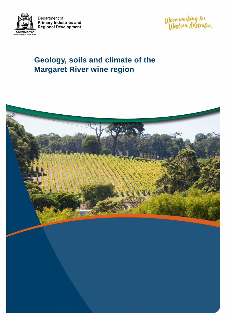
Cover: Margaret River winery (photo: DPIRD)
Unless otherwise indicated, Geology, soils and climate of the Margaret River wine region by Department of Primary Industries and Regional Development is licensed under a Creative Commons Attribution 3.0 Australian Licence. This report is available at dpird.wa.gov.au.
The Creative Commons licence does not apply to the State Crest or logos of organisations.
Recommended reference Tille, P, Stuart-Street, A & Gardiner, P 2020, Geology, soils and climate of the Margaret River wine region, Department of Primary Industries and Regional Development, Perth.
Disclaimer The Chief Executive Officer of the Department of Primary Industries and Regional Development, and the State of Western Australia accept no liability whatsoever by reason of negligence or otherwise arising from the use or release of this information or any part of it.
Copies of this document are available in alternative formats upon request.
Department of Primary Industries and Regional Development 3 Baron-Hay Court, South Perth WA 6151 Telephone: +61 (0)8 9368 3333 Email: [email protected] Website: dpird.wa.gov.au
iii
Contents Acknowledgements .................................................................................................. iv
Data sources ............................................................................................................. iv
Notes for map users ................................................................................................. iv
1 Introduction ....................................................................................................... 1
2 Margaret River region ....................................................................................... 2
3 Geology and landforms .................................................................................... 4
4 Soil-landscapes ................................................................................................. 8
4.1 Soil-landscape systems ............................................................................ 10
5 Soils ................................................................................................................. 12
5.1 Main soils .................................................................................................. 12
5.2 Distribution of the main soils ..................................................................... 14
5.3 Main viticultural soils ................................................................................. 17
6 Climate ............................................................................................................. 20
6.1 Climate parameters for viticulture ............................................................. 21
7 Distribution maps and soil profile images of the main soils ....................... 30
Appendix A ............................................................................................................... 38
Shortened forms ...................................................................................................... 39
References ............................................................................................................... 40
iv
Acknowledgements We are grateful for all the assistance received for this work. Specific thanks to: • Glynn Ward, Richard Fennessy and Andrew Taylor (Department of Primary
Industries and Regional Development [DPIRD] viticulture team) for helping with information, feedback and industry liaison
• Phil Goulding and Avril Russell (DPIRD) for reviewing the mapping • Jim Campbell-Clause (AHA Viticulture) for a technical review of the report • Melanie Strawbridge (Director, Agricultural Resource Management and
Assessment, DPIRD) and Rohan Prince (Director, Horticulture, DPIRD) for supporting our work
• Angela Rogerson (DPIRD) for editing the report • the Margaret River Region Project Soils Subcommittee of the Margaret River Wine
Association for providing local knowledge, reviews, encouragement and feedback.
Data sources Data sources for this report:
• soil-landscape mapping, data and soil classifications, soil profile photographs and vineyard location information was provided by DPIRD
• geological mapping information was provided by Geological Survey of Western Australia
• digital elevation model mapping underlay and elevation mapping was provided by Landgate
• climate indices were derived from SILO patched point data (Queensland Government) and Bureau of Meteorology (BoM) records.
Notes for map users The maps in this report are generated from the best currently available information. Databases maintained by DPIRD and other state government agencies are the primary source. The soil-landscape maps and other features reliant on it are designed for use at publication scales, in this case 1:100 000. The scale and method of linework capture influences the uniformity of a map unit and the accuracy of the lines.
1 Introduction
1
1 Introduction This report is an extract from the broader description and analysis of the geology, soils and climate of all the wine regions of Western Australia currently being developed by DPIRD (Tille et al. in press). It expands on the brief descriptions in the second edition of Viticulture (Coombe & Dry 2004) concerning the soils and landscapes of Western Australia’s main wine growing regions.
We have tailored this report extract to the specific needs of the Margaret River wine region. It contains local soil names and soil-landscape zones and systems maps.
The wine industry recognises the importance of giving customers an understanding of the vines’ environment and how that may influence wine character and quality. This allows growers to tell the story of their wine and their label to form direct connections between the wine producer and the consumer. This story has become even more important in the 21st century when, in addition to direct cellar sales, a good online presence is essential. The information in this report will support that story and underpin it with the most current geology, soil and climatic data:
• Section 2 describes the location, varieties and production, including the main towns; the latitude, longitude and elevation; a brief history of viticulture in the region; the most recently available data on the area planted, common varieties and tonnes of grapes produced.
• Section 3 details the geology, physiography and elevation, with broad descriptions of the dominant rocks underlying the region as well as the geological history and how this influences the shape of the land.
• Section 4 provides soil-landscape zone and system mapping and descriptions. • Section 5 gives a summary and map of the main soils in the region. It also provides
the proportion and qualities of the main soil types currently supporting viticulture. • Section 6 contains a summary and maps of the climate, including rainfall,
temperature and other important climate parameters for viticulture, such as mean January temperature, average diurnal temperatures and average rainfall for selected time periods.
• Section 7 contains maps of the distribution of the main soils and photos of typical soil profiles in the Margaret River region.
Geology, soils and climate of the Margaret River wine region
2
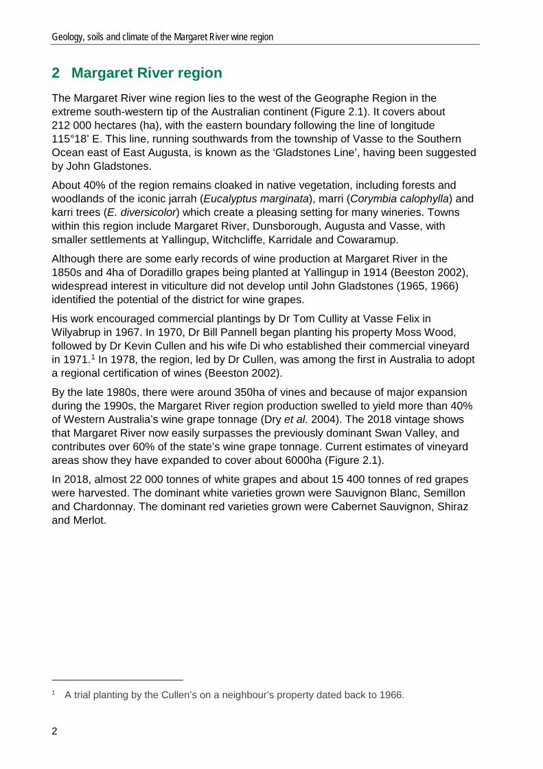
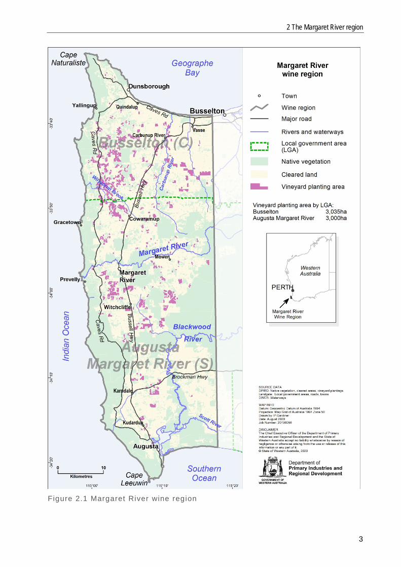
2 Margaret River region The Margaret River wine region lies to the west of the Geographe Region in the extreme south-western tip of the Australian continent (Figure 2.1). It covers about 212 000 hectares (ha), with the eastern boundary following the line of longitude 115°18’ E. This line, running southwards from the township of Vasse to the Southern Ocean east of East Augusta, is known as the ‘Gladstones Line’, having been suggested by John Gladstones.
About 40% of the region remains cloaked in native vegetation, including forests and woodlands of the iconic jarrah (Eucalyptus marginata), marri (Corymbia calophylla) and karri trees (E. diversicolor) which create a pleasing setting for many wineries. Towns within this region include Margaret River, Dunsborough, Augusta and Vasse, with smaller settlements at Yallingup, Witchcliffe, Karridale and Cowaramup.
Although there are some early records of wine production at Margaret River in the 1850s and 4ha of Doradillo grapes being planted at Yallingup in 1914 (Beeston 2002), widespread interest in viticulture did not develop until John Gladstones (1965, 1966) identified the potential of the district for wine grapes.
His work encouraged commercial plantings by Dr Tom Cullity at Vasse Felix in Wilyabrup in 1967. In 1970, Dr Bill Pannell began planting his property Moss Wood, followed by Dr Kevin Cullen and his wife Di who established their commercial vineyard in 1971.1 In 1978, the region, led by Dr Cullen, was among the first in Australia to adopt a regional certification of wines (Beeston 2002).
By the late 1980s, there were around 350ha of vines and because of major expansion during the 1990s, the Margaret River region production swelled to yield more than 40% of Western Australia’s wine grape tonnage (Dry et al. 2004). The 2018 vintage shows that Margaret River now easily surpasses the previously dominant Swan Valley, and contributes over 60% of the state’s wine grape tonnage. Current estimates of vineyard areas show they have expanded to cover about 6000ha (Figure 2.1).
In 2018, almost 22 000 tonnes of white grapes and about 15 400 tonnes of red grapes were harvested. The dominant white varieties grown were Sauvignon Blanc, Semillon and Chardonnay. The dominant red varieties grown were Cabernet Sauvignon, Shiraz and Merlot.
1 A trial planting by the Cullen’s on a neighbour’s property dated back to 1966.
2 The Margaret River region
3
Figure 2.1 Margaret River wine region
Geology, soils and climate of the Margaret River wine region
4
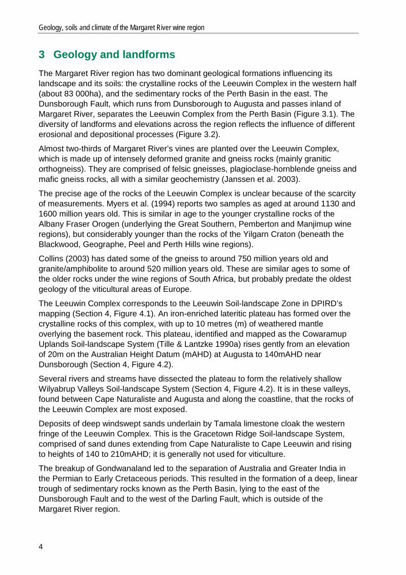
3 Geology and landforms The Margaret River region has two dominant geological formations influencing its landscape and its soils: the crystalline rocks of the Leeuwin Complex in the western half (about 83 000ha), and the sedimentary rocks of the Perth Basin in the east. The Dunsborough Fault, which runs from Dunsborough to Augusta and passes inland of Margaret River, separates the Leeuwin Complex from the Perth Basin (Figure 3.1). The diversity of landforms and elevations across the region reflects the influence of different erosional and depositional processes (Figure 3.2).
Almost two-thirds of Margaret River’s vines are planted over the Leeuwin Complex, which is made up of intensely deformed granite and gneiss rocks (mainly granitic orthogneiss). They are comprised of felsic gneisses, plagioclase-hornblende gneiss and mafic gneiss rocks, all with a similar geochemistry (Janssen et al. 2003).
The precise age of the rocks of the Leeuwin Complex is unclear because of the scarcity of measurements. Myers et al. (1994) reports two samples as aged at around 1130 and 1600 million years old. This is similar in age to the younger crystalline rocks of the Albany Fraser Orogen (underlying the Great Southern, Pemberton and Manjimup wine regions), but considerably younger than the rocks of the Yilgarn Craton (beneath the Blackwood, Geographe, Peel and Perth Hills wine regions).
Collins (2003) has dated some of the gneiss to around 750 million years old and granite/amphibolite to around 520 million years old. These are similar ages to some of the older rocks under the wine regions of South Africa, but probably predate the oldest geology of the viticultural areas of Europe.
The Leeuwin Complex corresponds to the Leeuwin Soil-landscape Zone in DPIRD’s mapping (Section 4, Figure 4.1). An iron-enriched lateritic plateau has formed over the crystalline rocks of this complex, with up to 10 metres (m) of weathered mantle overlying the basement rock. This plateau, identified and mapped as the Cowaramup Uplands Soil-landscape System (Tille & Lantzke 1990a) rises gently from an elevation of 20m on the Australian Height Datum (mAHD) at Augusta to 140mAHD near Dunsborough (Section 4, Figure 4.2).
Several rivers and streams have dissected the plateau to form the relatively shallow Wilyabrup Valleys Soil-landscape System (Section 4, Figure 4.2). It is in these valleys, found between Cape Naturaliste and Augusta and along the coastline, that the rocks of the Leeuwin Complex are most exposed.
Deposits of deep windswept sands underlain by Tamala limestone cloak the western fringe of the Leeuwin Complex. This is the Gracetown Ridge Soil-landscape System, comprised of sand dunes extending from Cape Naturaliste to Cape Leeuwin and rising to heights of 140 to 210mAHD; it is generally not used for viticulture.
The breakup of Gondwanaland led to the separation of Australia and Greater India in the Permian to Early Cretaceous periods. This resulted in the formation of a deep, linear trough of sedimentary rocks known as the Perth Basin, lying to the east of the Dunsborough Fault and to the west of the Darling Fault, which is outside of the Margaret River region.

3 Geology and landforms
5
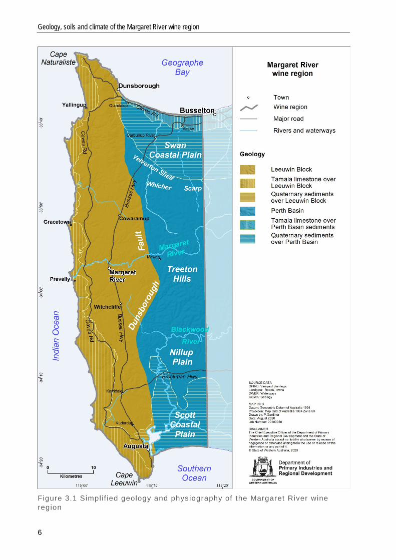
Within the region, the central portion of the Perth Basin is the Donnybrook Sunkland, represented by the Donnybrook Sunkland Soil-landscape Zone in DPIRD’s mapping (Section 4, Figure 4.1). This elevated terrain formed about 150 million years ago on sedimentary rocks — mainly sandstones, siltstones and shale — mostly obscured by a mantle of deeply weathered laterite.2 This zone contains almost a quarter of the vines within the region. The Donnybrook Sunkland Zone has three distinct systems (Section 4, Figure 4.2). Firstly, the Whicher Soil-landscape System begins at the northern boundary of the zone which marks a curved ancient shoreline rising abruptly from the Swan Coastal Plain. The gently inclined Yelverton Shelf sits at about 60mAHD (Figure 3.1). The Whicher Scarp, an older marine escarpment that gently climbs to 90mAHD, is located to the south of this shelf. The second system is south of the Whicher Scarp, where the zone transforms to the undulating, dissected lateritic plateau of the Treeton Hills Soil-landscape System. This series of ridges and valleys, including those of the Carbunup River, Margaret River and upper Chapman Brook, sits at 40–130mAHD. The Treeton Hills System gradually descends to the winding Blackwood River from where it gives way to the broad flats of the Nillup Plain Soil-landscape System, the third system in the zone. The Nillup Plain system merges southward into the extensive Quaternary deposits of the Scott Coastal Plain. Defined by the Scott Coastal Soil-landscape Zone (Section 4, Figure 4.1), this flat, swampy terrain terminates at the prominent D’Entrecasteaux dunes fringing the waters of the Southern Ocean east of Augusta. North of the Donnybrook Sunkland Zone is the relatively flat Swan Coastal Plain, reaching only 40mAHD. The shape of the plain evolved as the rocks of the Perth Basin were stripped by marine erosion and buried by more-recent (10–20 million years of age) marine and terrestrial sediments. The plain has a series of subdued dune systems mirroring the shoreline. The first of these is within the Perth Coastal Soil-landscape Zone (Section 4, Figure 4.2), which extends from this area northward up the coast to Jurien Bay. It includes calcareous and quartz dune ridges and estuarine deposits underlain by Tamala limestone typical all along the west coast. Further inland, a discontinuous arc of older low quartz dunes runs parallel to the coast — the Bassendean Soil-landscape Zone — marking the location of an ancient shoreline (Figure 3.2). A sequence of alluvial deposits makes up the remainder of the coastal plain. This is the flat Abba Soil-landscape System — part of the Pinjarra Soil-landscape Zone — the better-drained portions of which contain the remaining 14% of the region’s vines. The elevation of the region ranges from 0 to 231mAHD, with vineyard plantings located between 3 and 139mAHD. On the Leeuwin Zone, vineyards are situated mostly at elevations between 40 and 100mAHD, while those on the Donnybrook Sunkland Zone are usually at 40–80mAHD. Around Carbunup and Jindong on the Swan Coastal Plain, vineyard elevations are 3–40mAHD (Figure 3.2). 2 Despite its name, the Donnybrook Sunkland is elevated. The name derives from the fact that
the sedimentary rocks were formed in a trough and lie at a lower level than the rocks of the Yilgarn Craton. These rise up above the Sunkland to the east of the Darling Fault.
Geology, soils and climate of the Margaret River wine region
6
Figure 3.1 Simplif ied geology and physiography of the Margaret River wine region
3 Geology and landforms
7
Figure 3.2 Elevation of the Margaret River wine region
Geology, soils and climate of the Margaret River wine region
8
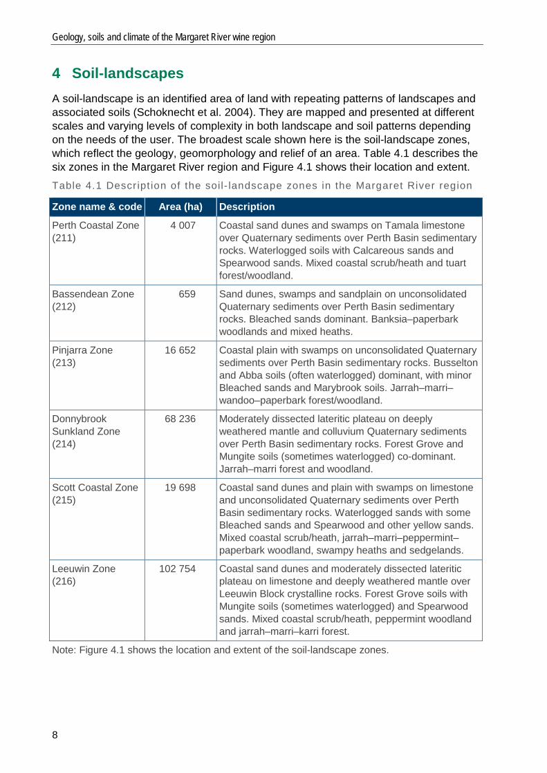
4 Soil-landscapes A soil-landscape is an identified area of land with repeating patterns of landscapes and associated soils (Schoknecht et al. 2004). They are mapped and presented at different scales and varying levels of complexity in both landscape and soil patterns depending on the needs of the user. The broadest scale shown here is the soil-landscape zones, which reflect the geology, geomorphology and relief of an area. Table 4.1 describes the six zones in the Margaret River region and Figure 4.1 shows their location and extent. Table 4.1 Descr ipt ion of the soil- landscape zones in the Margaret River region
Zone name & code Area (ha) Description
Perth Coastal Zone (211)
4 007 Coastal sand dunes and swamps on Tamala limestone over Quaternary sediments over Perth Basin sedimentary rocks. Waterlogged soils with Calcareous sands and Spearwood sands. Mixed coastal scrub/heath and tuart forest/woodland.
Bassendean Zone (212)
659 Sand dunes, swamps and sandplain on unconsolidated Quaternary sediments over Perth Basin sedimentary rocks. Bleached sands dominant. Banksia–paperbark woodlands and mixed heaths.
Pinjarra Zone (213)
16 652 Coastal plain with swamps on unconsolidated Quaternary sediments over Perth Basin sedimentary rocks. Busselton and Abba soils (often waterlogged) dominant, with minor Bleached sands and Marybrook soils. Jarrah–marri–wandoo–paperbark forest/woodland.
Donnybrook Sunkland Zone (214)
68 236 Moderately dissected lateritic plateau on deeply weathered mantle and colluvium Quaternary sediments over Perth Basin sedimentary rocks. Forest Grove and Mungite soils (sometimes waterlogged) co-dominant. Jarrah–marri forest and woodland.
Scott Coastal Zone (215)
19 698 Coastal sand dunes and plain with swamps on limestone and unconsolidated Quaternary sediments over Perth Basin sedimentary rocks. Waterlogged sands with some Bleached sands and Spearwood and other yellow sands. Mixed coastal scrub/heath, jarrah–marri–peppermint–paperbark woodland, swampy heaths and sedgelands.
Leeuwin Zone (216)
102 754 Coastal sand dunes and moderately dissected lateritic plateau on limestone and deeply weathered mantle over Leeuwin Block crystalline rocks. Forest Grove soils with Mungite soils (sometimes waterlogged) and Spearwood sands. Mixed coastal scrub/heath, peppermint woodland and jarrah–marri–karri forest.
Note: Figure 4.1 shows the location and extent of the soil-landscape zones.
4 Soil-landscapes
9
Note: Table 4.1 describes the soil-landscape zones shown on this map. Figure 4.1 Locat ion and extent of the soi l- landscape zones in the Margaret River region
Geology, soils and climate of the Margaret River wine region
10
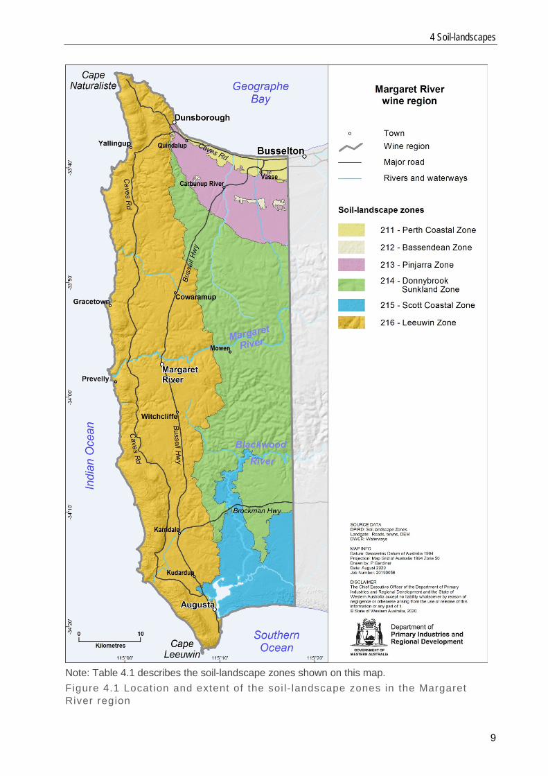
4.1 Soil-landscape systems Soil-landscape systems are subdivisions of the soil-landscape zones. They provide more detail about the relief, landform pattern, main soils and their parent materials. Fourteen systems are in the region, described in Table 4.2 and shown in Figure 4.2. Table 4.2 Descr ipt ion of the soil- landscape systems in the Margaret River region System name & code Area (ha) Description Quindalup South System (211Qu)
1 231 Coastal dunes with sand flats on aeolian sand over sedimentary rocks. Calcareous sands dominant. Mixed coastal scrub.
Spearwood System (211Sp)
1 437 Sand dunes and plains on aeolian sand and limestone over sedimentary rocks. Spearwood sands dominant. Tuart–marri forest and woodland in south, heath and open woodland in north.
Vasse System (211Va)
1 340 Estuaries, swampy depressions and poorly drained flats on alluvium over sedimentary rocks. Waterlogged soils dominant. Samphire flats and paperbark woodlands.
Bassendean System (212Bs)
659 Sand dunes, swamps and sandplain on unconsolidated sediments over sedimentary rocks. Bleached sands dominant. Banksia–paperbark woodlands and mixed heaths.
Abba System (213Ab) 16 652 Coastal plain with swamps on unconsolidated sediments over sedimentary rocks. Busselton and Abba soils (often waterlogged) dominant, with minor Bleached sands and Marybrook soils. Jarrah–marri–wandoo–paperbark forest/woodland.
Blackwood Plateau System (214Bp)
3 265 Lateritic plateau with broad swampy depressions on deeply weathered mantle over sedimentary rocks. Forest Grove soils dominant. Jarrah–marri forest.
Nillup Plain System (214Np)
9 238 Plain with broad swampy depressions on deeply weathered mantle over sedimentary rocks. Mungite soils (often waterlogged) with some Bleached sands. Jarrah–marri–paperbark woodland.
Treeton Hills System (214Th)
44 728 Undulating terrain on deeply weathered mantle and colluvium over sedimentary rocks. Mungite soils and Forest Grove soils co-dominant, with minor Waterlogged soils. Jarrah–marri forest and woodland.
Whicher System (214Ws)
10 049 Low scarp slopes and terrace on laterite, colluvium and alluvium over sedimentary rocks. Forest Grove soils and Mungite soils (sometimes waterlogged). Jarrah–marri forest and woodland.
D'Entrecasteaux Dunes System (215Dx)
1 905 Coastal dunes on aeolian sand and limestone over sedimentary rocks. Major Calcareous sands, with some Bleached sands. Mixed coastal scrub and peppermint–jarrah–marri woodland.
Scott River Plain System (215Sr)
17 794 Poorly drained coastal plain with dunes and swamps on Quaternary deposits over Perth Basin sediments. Waterlogged soils with some Bleached sands and Yellow sands. Heaths, sedgelands and jarrah–marri–paperbark woodland.
Cowaramup Uplands System (216Co)
51 429 Lateritic plateau with broad swampy depressions on weathered mantle over granitic rocks. Forest Grove soils with Mungite soils (sometimes waterlogged) and Bleached sands. Jarrah–marri forest.
Gracetown Ridge System (216Gr)
26 980 Dunes and rocky coast on aeolian sand and limestone over granitic rocks. Spearwood sands and Calcareous sands co-dominant. Mixed coastal scrub, peppermint woodland and jarrah–marri–karri forest.
Wilyabrup Valleys System (216Wv)
24 345 Major valleys on colluvium over granitic rocks. Forest Grove soils dominant, with some Keenan soils and Mungite soils. Jarrah–marri–karri forest.
Note: Figure 4.2 shows the location and extent of the soil-landscape systems.
4 Soil-landscapes
11
Note: Table 4.2 describes the soil-landscape systems shown on this map. Figure 4.2 Locat ion and extent of the soi l- landscape systems in the Margaret River region
Geology, soils and climate of the Margaret River wine region
12
5 Soils 5.1 Main soils The soil and mapping information in this report is adapted from the department’s broad-scale soil-landscape mapping that can be viewed on NRInfo on DPIRD’s website. This mapping uses the Western Australian Soil Groups classification (WA Soil Groups; Schoknecht & Pathan 2013).
It is important to note that very few map units are composed of a single soil type or one combination of soil and landscape position. At the scale of mapping presented, these maps represent not one, but several, soil and landscape combinations presented as a proportion of each area mapped (Schoknecht et al. 2004).
Here we have used local soil names for the Margaret River region — see Tille and Lantzke (1990b) for more specific details about these soils — because these names (shown in bold below) are well established and understood across the region. The way they relate to soils described in the other wine regions in Western Australia (Tille et al. in press) is in the following manner:
• Forest Grove soils = Ironstone gravelly soils: sandy or loamy topsoils that contain more than 20% ferruginous nodules, over clay or a hard layer at depth
• Mungite, Busselton and Abba soils = Sandy duplex soils: topsoil layers are typically sandy with a sudden increase to clay layers at depth; some soils have a more gradual change to clay
• Spearwood and Yellow sands = Coloured deep sands: yellow, brown or red coloured sand which extends beyond 80cm
• Bleached sands = Pale deep sands: grey or pale yellow–brown coloured sand which extends beyond 80cm
• Calcareous sands = Alkaline soils: here these soils are the strongly alkaline deep sands of the coastal dune systems
• Keenan soils = Red–brown loams: typically a reddish-brown sandy loam to clay loam soil with less than 20% ferruginous nodules; they are commonly associated with freshly weathered rock in valleys and often contains fragments of rock or quartz
• Marybrook soils = Alluvial sands and loams: often a highly variable mix of soils found along major rivers; includes coloured sands and reddish-brown sandy loam to clay loam soils.
Section 7 contains distribution maps of each of these groups of local soils, with photos showing examples of typical soil profiles.
The remaining soil names used here are the same as those described for the other wine regions. One of these other groupings of soils is Difficult soils, which are typically areas with seasonally high watertables or shallow rock. Our analysis suggests that there are some vineyards planted on Difficult soils. Some of the Difficult soils have been altered — for example, mounded, drained or rocks removed — to allow cultivation to wine grapes. These analyses were based on reasonably accurate mapping of the vineyards combined with broad-scale (1:100 000) soil-landscape mapping. As described above, this mapping is not detailed enough to reflect all the intricate changes in soil type across the landscape. As most map units contain a combination of
5 Soils
13
favourable and unfavourable soils, the unsuitable soils will naturally be avoided and the better soils preferentially selected where possible.
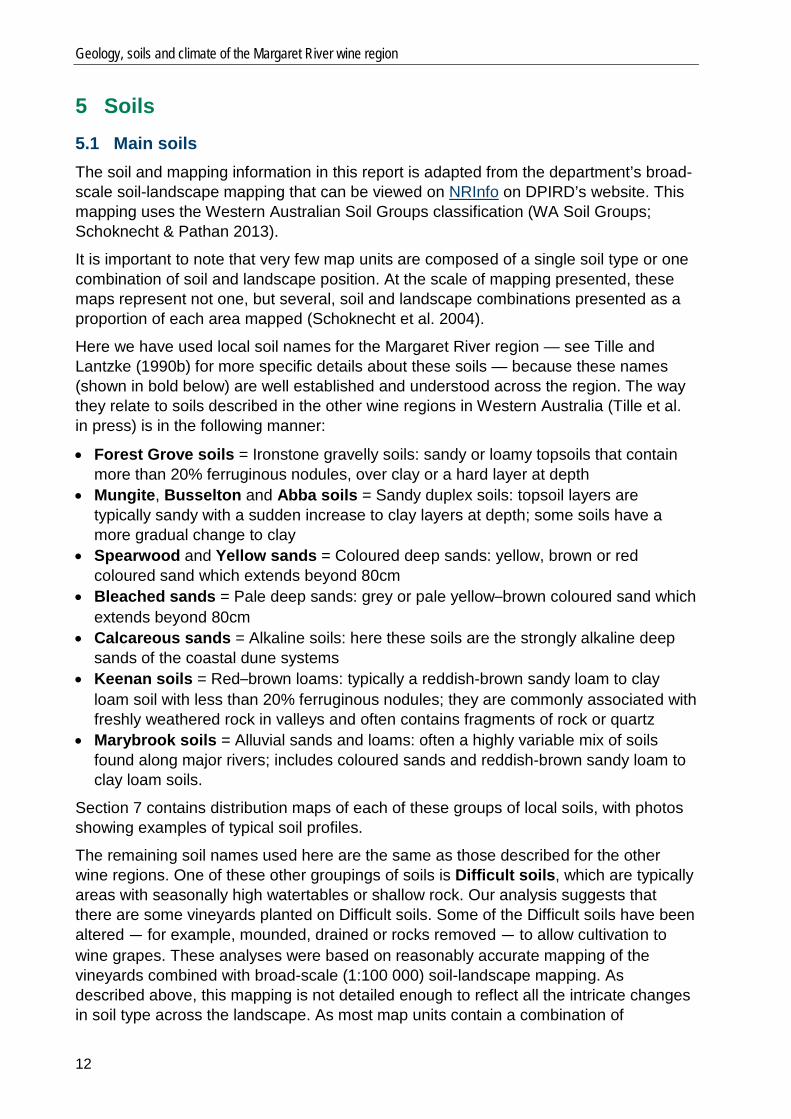
Figure 5.1 compares the proportion of the main soils (in pale green) occurring across the Margaret River region. Forest Grove soils are the most common overall, followed by a mixture of Mungite, Busselton and Abba soils. To indicate the preferred soils for viticulture, we included the proportion of the main soils planted to vines (in dark green). More details about the soils are in the following sections and Appendix A.
Figure 5.1 Proport ion of main soi ls across the Margaret River region compared with main soi ls used for vit iculture
0% 10% 20% 30% 40% 50%
Forest Grove soils
Mungite, Busselton & Abba soils
Difficult soils
Bleached sands
Spearwood & Yellow sands
Calcareous sands
Shallow sands
Keenan soils
Marybrook soils
Heavy soils
Proportion of soil in region (%) Proportion of soil planted to vines (%)
Geology, soils and climate of the Margaret River wine region
14
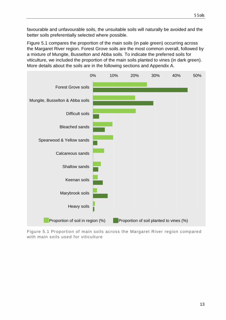
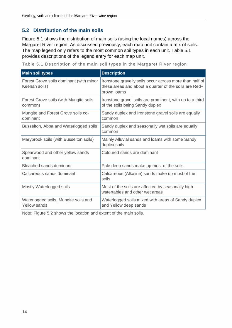
5.2 Distribution of the main soils Figure 5.1 shows the distribution of main soils (using the local names) across the Margaret River region. As discussed previously, each map unit contain a mix of soils. The map legend only refers to the most common soil types in each unit. Table 5.1 provides descriptions of the legend entry for each map unit. Table 5.1 Descr ipt ion of the main soi l types in the Margaret River region
Main soil types Description
Forest Grove soils dominant (with minor Keenan soils)
Ironstone gravelly soils occur across more than half of these areas and about a quarter of the soils are Red–brown loams
Forest Grove soils (with Mungite soils common)
Ironstone gravel soils are prominent, with up to a third of the soils being Sandy duplex
Mungite and Forest Grove soils co-dominant
Sandy duplex and Ironstone gravel soils are equally common
Busselton, Abba and Waterlogged soils Sandy duplex and seasonally wet soils are equally common
Marybrook soils (with Busselton soils) Mainly Alluvial sands and loams with some Sandy duplex soils
Spearwood and other yellow sands dominant
Coloured sands are dominant
Bleached sands dominant Pale deep sands make up most of the soils
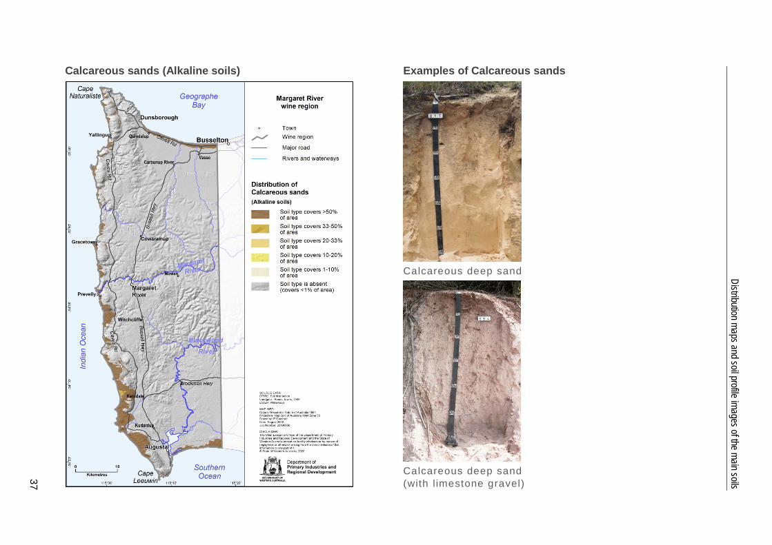
Calcareous sands dominant Calcareous (Alkaline) sands make up most of the soils
Mostly Waterlogged soils Most of the soils are affected by seasonally high watertables and other wet areas
Waterlogged soils, Mungite soils and Yellow sands
Waterlogged soils mixed with areas of Sandy duplex and Yellow deep sands
Note: Figure 5.2 shows the location and extent of the main soils.
5 Soils
15
Note: Table 5.1 describes the main soil types shown on this map. Figure 5.2 Main soi l types in the Margaret River region
Geology, soils and climate of the Margaret River wine region
16
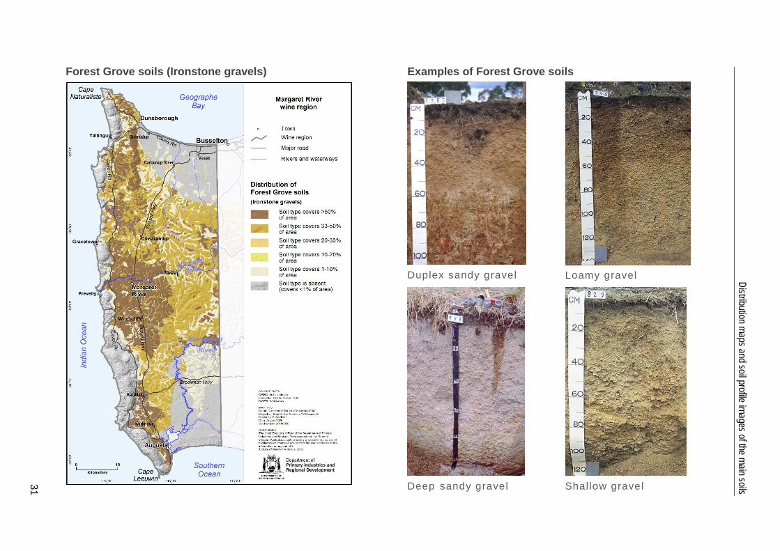
The lateritic mantle covering the crystalline rocks of the Leeuwin Complex and the sedimentary rocks of the Perth Basin have given rise to the Forest Grove soils. These soils cover over a quarter of the land in the Margaret River region (Figure 5.1, Table A1 in Appendix A).
West of the Dunsborough Fault, they are the dominant soils of the Wilyabrup Valleys Soil-landscape System and cover almost half of the Cowaramup Uplands System (Table 4.2, Figure 4.2). On the Cowaramup Uplands System, they are particularly common on gently sloping terrain and the broad crests.
East of the Dunsborough Fault, the Forest Grove soils cover almost a third of the Treeton Hills System and a quarter of the Yelverton Shelf (part of the Whicher Scarp System). They are dominant on broad ridge crests, but are more commonly found in a mix with Mungite soils on sloping land below the crests and broad flats. Forest Grove soils are very minor on the coastal plains.
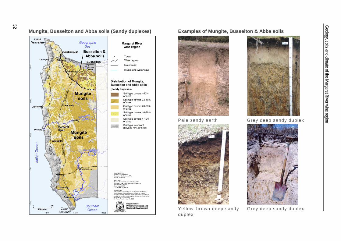
Mungite, Busselton and Abba soils are the next most common soils in the region, covering almost a quarter of the cleared land. The Mungite soils are frequently found in a mix with Forest Grove soils. They cover almost a third of the Treeton Hills System, mainly on the undulating valley slopes. They are also present on the broad flats and depressions of the Yelverton Shelf and the Nillup Plain.
West of the Dunsborough Fault, Mungite soils are found on the broad flats and depressions of the lateritic plateau, covering almost 30% of the Cowaramup Uplands System, usually in combination with Forest Grove soils.
Busselton and Abba soils are restricted to older alluvial deposits on the Swan Coastal Plain, on low rises and in depressions.
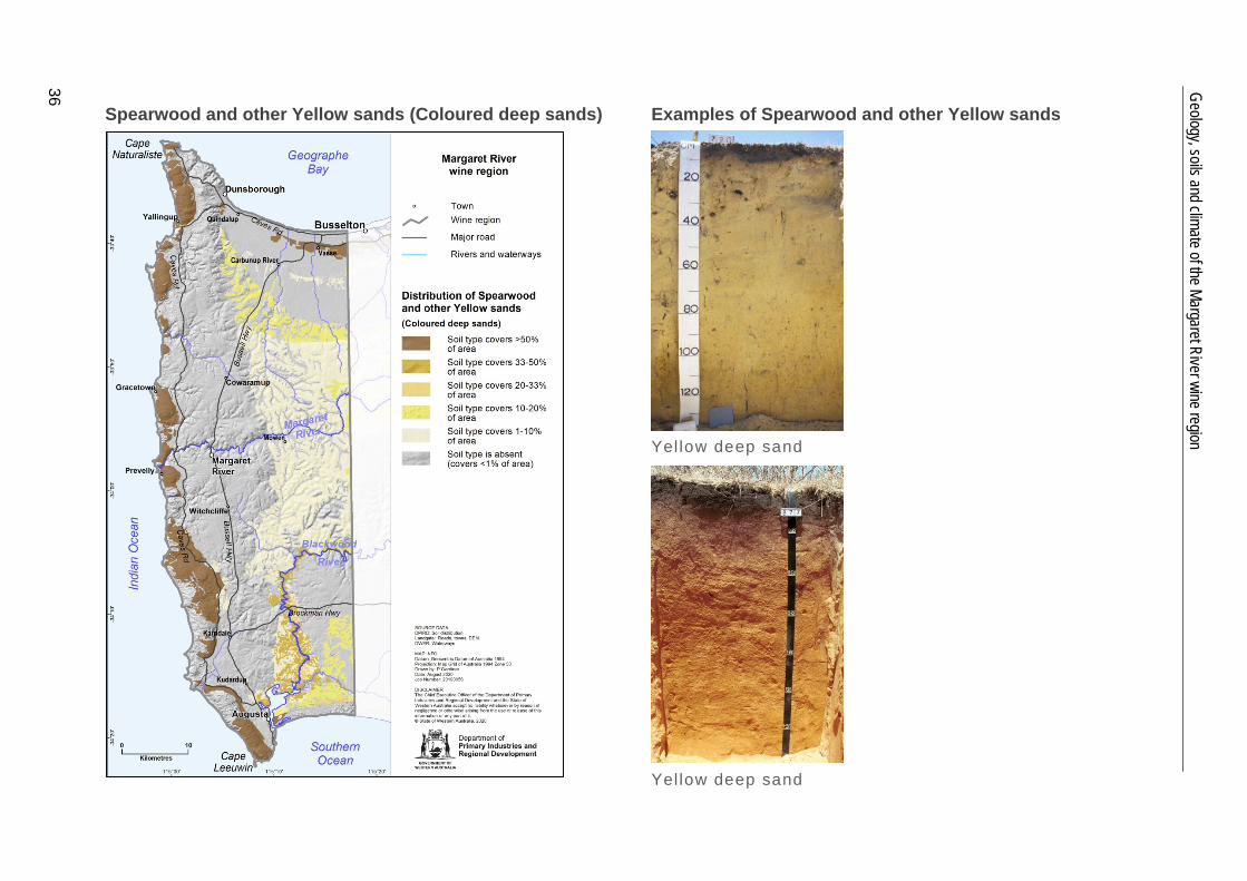
Spearwood and other yellow deep sands are found in about 10% of the region, but only about half of these are on land cleared for agriculture. They are prominent on the Gracetown Ridge System along the coast between Cape Naturaliste and Cape Leeuwin. This discontinuous ridge of sand dunes has a core of Tamala limestone. Spearwood sands are also dominant in the band of low coastal dunes over Tamala limestone (Spearwood dunes) on the Swan Coastal Plain. Broad areas of yellow deep sands are found on flats flanking the Blackwood and lower Scott rivers.
Bleached sands occur in patches covering about 10% of the region. They dominate the Bassendean System on the Swan Coastal Plain and are prominent on low dunes and flats on the Scott River Plain and D’Entrecasteaux dunes of the south coast. Bleached sands also occur along the inland margin of the Gracetown Ridge. They are scattered across the remainder of the Whicher, Abba, Cowaramup, Treeton and Nillup systems.
Keenan soils and Marybrook soils are not such common soils, both found on only about 3% of the cleared land in the region. Keenan soils are associated mainly with exposures of the freshly weathered crystalline bedrock in the Wilyabrup Valleys and Cowaramup Uplands systems.
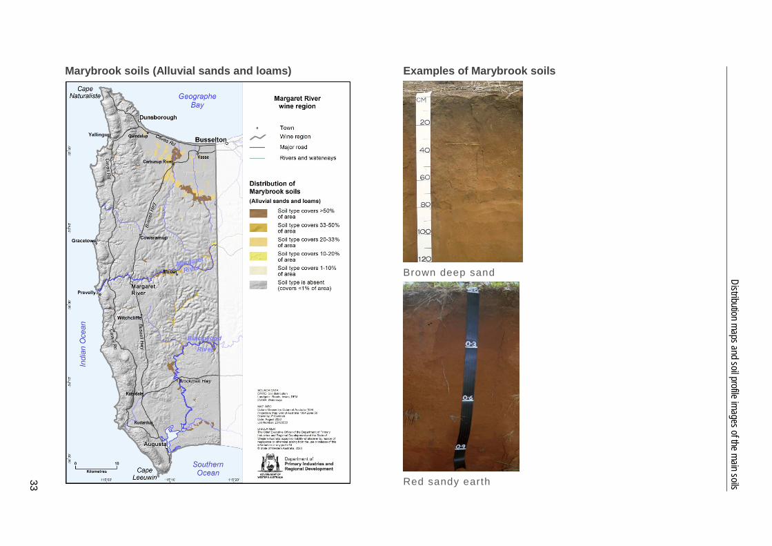
Marybrook soils are most prominent on the Swan Coastal Plain. They are associated with younger alluvial deposits on the better-drained alluvial fans and river terraces of the Abba System (around Jindong and Carbunup). They are also on well-drained flats flanking watercourses and at the base of the Yelverton Shelf where fine, fertile
5 Soils
17
sediments are deposited from short drainage lines descending from the upland plateau. Away from the Swan Coastal Plain, other well-drained river and stream flats also feature these soils, including along Margaret River, Chapman Brook and the Blackwood and Scott rivers.
Calcareous sands are minor soils closely associated with the region’s coastal fringes and are typically not cleared. These are mainly windswept calcareous dunes and beach ridges of the Quindalup, Gracetown and D’Entrecasteaux systems.
Shallow sands are also minor, most prominently associated with Tamala limestone on the coastal Spearwood and Gracetown systems. Pockets of shallow sands over cemented ironstone are scattered across the Leeuwin and Donnybrook Sunkland zones.
The small areas of Heavy soils are mostly associated with poorly drained areas in the Nillup Plains and Abba systems and adjoining the lower Blackwood River in the Scott River Plain System.
We grouped together as Difficult soils the areas where productivity may be affected by land dominated by seasonally high watertables; or valley floors, swamps and lakes; or where exposed or shallow rock or cemented laterite or stony soils are prevalent. Particularly frequent on the coastal plains, most of these areas remain uncleared, making up about a fifth of the region.
Soil-landscape mapping covering this entire region is published in the Busselton – Margaret River – Augusta survey (Tille & Lantzke 1990a).
5.3 Main viticultural soils The sites selected for grape growing by the pioneers of the modern Margaret River wine industry were on Forest Grove soils3 in the valley formed by Wilyabrup Brook. These were the soils supporting ‘a predominance and good growth of redgum’4 that Gladstones (1966) recommended as being most suitable.
Forest Grove soils are the most common in these valley landscapes found across the Leeuwin Complex, and the preference for them continues. Despite covering just over a quarter of the land in the Margaret River region (Figure 5.1), they are the most widely planted type of soils, supporting more than 40% of the region’s vines (Figure 5.3, Table A2 in Appendix A).
Forest Grove soils typically consist of lateritic colluvium sitting over clay derived from the deeply weathered mantle. The topsoil is typically a yellowish-brown loamy sand to sandy loam with up to 60% rounded ironstone gravels. This overlies mottled yellow clay at about 50cm. In the WA Soil Groups, they are mainly Duplex sandy gravels and Loamy gravels.5 Deep sandy gravels, where the sandy topsoil extends to over 80cm in depth, and Shallow gravels, where ironstone duricrust overlies the clay subsoil, are planted to a lesser extent.
3 First described by Smith (1951). 4 Redgum is the common name for Marri (Corymbia calophylla). 5 Schoknecht and Pathan (2013) describe the WA Soil Groups (shown in italics).
Geology, soils and climate of the Margaret River wine region
18
Figure 5.3 Proport ions of the main soi ls used for vit iculture in the Margaret River region
Almost a quarter of the region’s vines are growing in the Wilyabrup Valleys System (Figure 4.2), with at least 60% planted on Forest Grove soils. The loamy topsoils recommended for plantings by Gladstones (1966) are most common in these valleys because there is greater influence from freshly weathered bedrock here than other areas. It is also around the fresh rock that red–brown colours are more likely to be found.
Plantings on the Cowaramup Uplands System are now more widespread, accounting for around 40% of the region’s vines. In this system, at least half of the vines grow on Forest Grove soils.
Over the sedimentary rocks of the Perth Basin (Figure 3.1), the main areas of Forest Grove soils planted to vines are on the Treeton Hills System and the Yelverton Shelf. The Forest Grove soils have a similar appearance to those formed over the crystalline rocks of the Leeuwin Complex. However, there is a higher proportion of Duplex sandy gravels, with fewer Loamy gravels being encountered.
On the Cowaramup Uplands System, Treeton Hills System and the Yelverton Shelf, plantings are often established on a mix of Forest Grove and Mungite soils.6 The Mungite soils have a grey–brown sandy to loamy topsoil over a pale-grey, mottled clay subsoil at around 50cm. Sometimes there is a texture contrast between the topsoil and subsoil, but there is often a gradual boundary. In both cases, the subsoil restricts profile 6 Mungite soils were first described by Smith (1951). In terms of the main soils described by
Tille et al. (in press), they mostly fall into the Sandy duplex grouping, even though many have a gradational profile and some have a loamy topsoil.
Forest Grove soils45%
Mungite, Busselton & Abba soils
29%
Marybrook soils 7%
Bleached sands6%
Keenan soils5%
Minor soils8%
5 Soils
19
drainage. In the WA Soil Groups, Mungite soils are mainly Pale sandy earths, Grey deep sandy duplexes and Semi-wet soils.7 Waterlogging can be an issue on these soils, but with winter rainfall decreasing and with soil amelioration (mounding and drainage), the area of plantings has increased, possibly supporting up to quarter of the region’s vines. Sloping ground is preferred for vines and subsoil drainage may need to be installed.
Around 7% of the region’s vines grow on Marybrook soils8 located mainly around Jindong on the Abba System (Figure 4.2). These soils have formed in relatively young, well-drained alluvium and have red fine sand to loam topsoils, sometimes grading to a clay with depth. In the WA Soil Groups, they are mainly Red deep sands, Red sandy earths and Friable red–brown loamy earths. There are also some Marybrook soils planted on the flats adjacent to the Margaret River and upper Chapman Brook.
Associated with the Marybrook soils on the Swan Coastal Plain, areas of better-drained Busselton soils9 have been planted. These typically consist of a grey–brown fine loamy sand grading into a mottled sandy clay with depth. In the WA Soil Groups, they are mainly Pale sandy earths and Pale deep sands. They are like some of the Mungite soils and have also been more widely planted as winter rainfall has decreased. About 4% of the vines in the region grow on these soils.
About 5% of the region’s vines grow on Bleached sands — Pale deep sand and Gravelly pale deep sand in the WA Soil Groups. The sands are generally pale grey and extend more than 80cm in depth. Sometimes they contain ironstone gravels below a sandy topsoil and in some cases, a clay layer can be found at more than 80cm below the sandy surface. These soils are generally not preferred for planting, but often occur as small pockets among the better soils in vineyards.
About 4% of the plantings grow on Keenan soils10 derived from freshly weathered crystalline basement rock of the Leeuwin Complex, mostly in the Wilyabrup Valleys System. They tend to have brown, or occasionally red, loamy topsoils over clay subsoil. These well-structured soils are typically a mixture of Brown loamy earth, Brown deep loamy duplex and Friable red–brown loamy earths (WA Soil Groups). They are often found in combination with the loamy Forest Grove soils and areas of rock outcrop (often as granite boulders) and stony soils.
Although suitable for vines, only a very small area of Spearwood sands (Yellow deep sands and some Red deep sands around Boranup) is planted in the region. On the Swan Coastal Plain, urban development has reduced the area available, and between Cape Leeuwin and Cape Naturaliste, much of these soils are in the Leeuwin Naturaliste National Park. Other yellow sands (Yellow deep sands in the WA Soil Groups) have been planted mainly on the Yelverton Shelf and Treeton Hills System, but these support only about 2% of the region’s vines.
7 Some of the loamy variants of the Mungite soils do not sit comfortably into any of the WA Soil
Groups. 8 First described by McArthur and Bettenay (1958). 9 First described by McArthur and Bettenay (1958). 10 First described by O'Donnell and Lockhart (1945).
Geology, soils and climate of the Margaret River wine region
20
6 Climate The climate of the Margaret River area first drew John Gladstones to its potential for viticulture. He felt it had distinct advantages over all other wine districts in Australia (Gladstones 1965). Oceans form the north, west and southern borders of the region, creating a strong maritime influence over its climate, with low temperature variability.
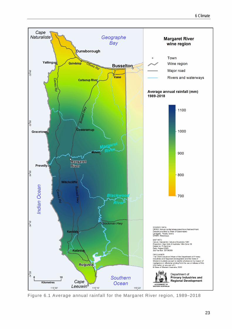
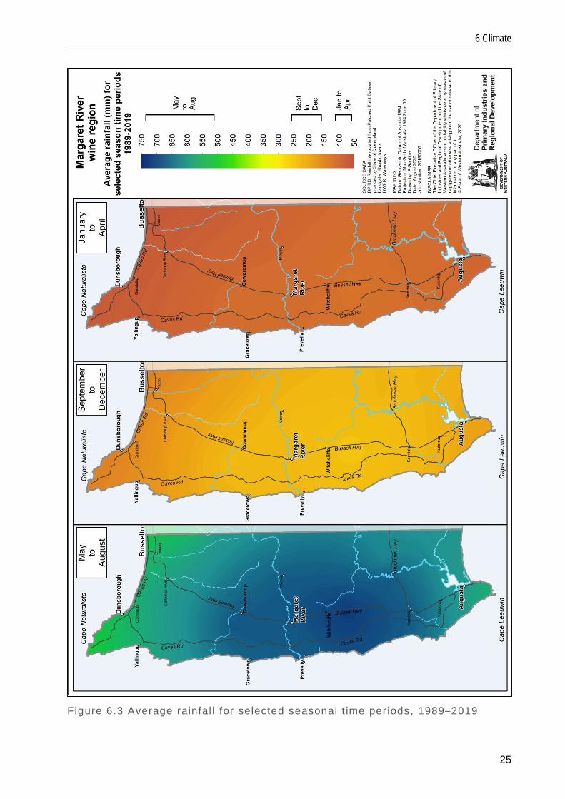
The average annual rainfall (1989–2018) across the region is 977 millimetres (mm), ranging from almost 800mm at Cape Naturaliste in the north to over 1120mm in the south-east. Most of the rainfall occurs during the winter and spring months (Table 6.1, Figure 6.1). All other climate data is based on the period 1989–2019.
Table 6.1 Rainfall stat ist ics for the Margaret River region, 1989–2018
Statistic Annual rainfall
(mm) Growing season (October–
April) rainfall (mm)
Minimum 732 143
Maximum 1123 261
Average 977 214
The region’s average annual relative humidity (using the more-central Witchcliffe BoM weather station data) is about 72% in the morning (9 am reading) and 58% in the afternoon (3 pm reading), which results in ideal growing conditions, but carries a moderate risk of fungal disease. In seasons where rainfall arrives early in autumn, there is a moderate risk of bunch rot in susceptible varieties.
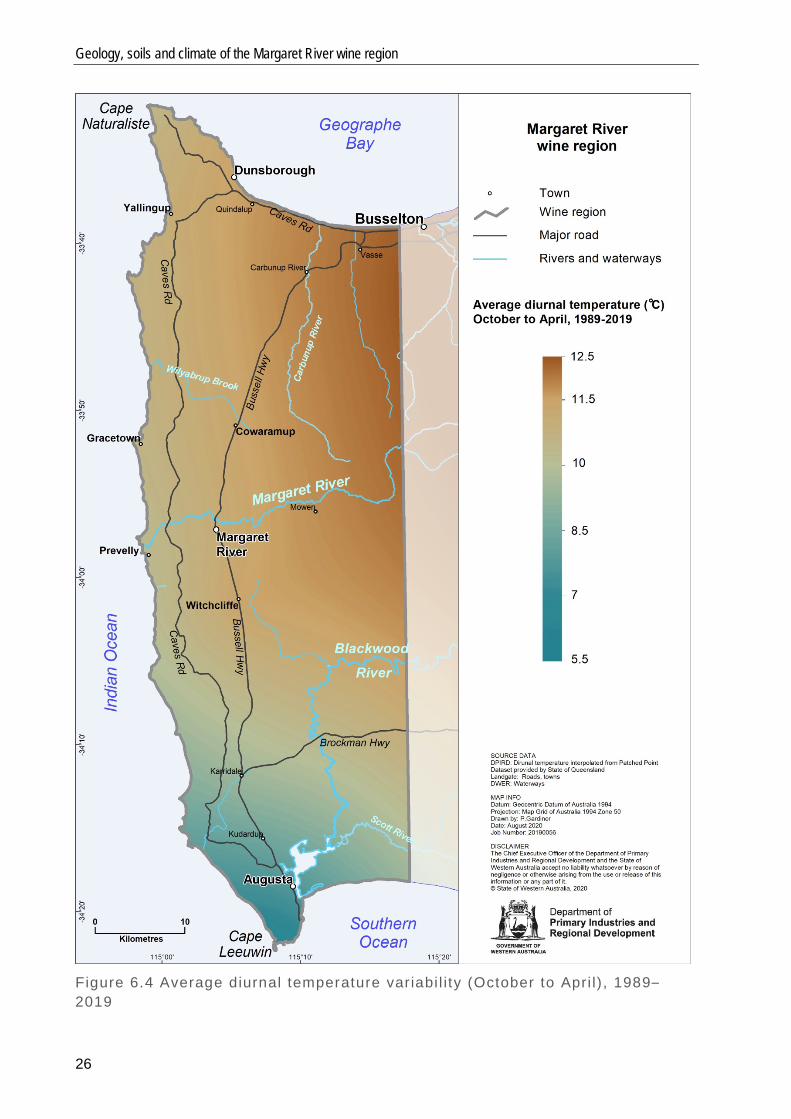
Because of the proximity to the ocean, temperature variability is low and spring frosts are uncommon. Mean minimum temperatures in the coldest months (July and August) near Augusta are as high as 11°C, while mean daily July temperatures at Margaret River are 12.8°C. The warmest and driest conditions are found around Jindong and Carbunup on the Swan Coastal Plain in the north-east (Beeston 2002). This area is relatively sheltered from southerly and westerly winds by the Leeuwin Naturaliste Ridge and the Whicher Scarp, but is exposed to warm, dry winds from the north-east.
There is a downward gradient of temperature and sunshine hours from the north to the south of the region, with temperatures marginally increasing again south of Karridale. An abrupt increase in cloudiness south of Witchcliffe is a common summer feature. South of this point, the warm northerly winds have limited effect. The main climatic influence is the moderating coastal winds from the Indian and Southern oceans.
Because of the coastal influences and relatively low elevations, spring frosts are uncommon in the region, with an overall lower risk around the coastal areas, increasing slightly for inland valley locations. Temperatures below 2°C may occasionally occur after budburst in August and September.
Margaret River, like most Western Australian coastal locations, is a windy region, particularly in spring and summer where the typical pattern brings cool afternoon sea breezes with high relative humidity. While this brings relief from the heat and aridity in summer, it can be detrimental to vine growth and development in spring because
6 Climate
21
exposure to strong ocean winds can damage new shoots and flowers, thus reducing fruit set.
In spring, the predominant winds come from the east and south-east in the morning and from the south in the afternoon, with 20% of the wind being stronger than 40 kilometres per hour (km/h).
The overall average 3 pm wind speed at Witchcliffe is 19km/h. Wind speeds are higher at the prominent capes to the north and south of the region, rising to an average of 25km/h at Cape Leeuwin and up to 29km/h at Cape Naturaliste.
6.1 Climate parameters for viticulture Table 6.2 gives an overview of the temperature statistics significant for viticulture in the Margaret River region. They include: • mean January temperature, which represents the month of the highest annual
temperature • growing season (October to April) mean temperature • growing degree days, which is a summation of heat for vines over the growing
season (October to April), using the base 10 method (Hall & Jones 2010) • diurnal temperatures, which are the ranges between minimum average daily and
maximum average daily temperatures. Hall and Jones (2010) and Dry and Coombe (2004) provide more details about these parameters. Table 6.2 Temperature stat ist ics for the Margaret River region, 1989–2019
Measurement Value
Mean January temperature (°C) 20.6
Growing season (October–April) minimum mean temperature (°C) 18.2
Growing season (October–April) maximum mean temperature (°C) 19.5
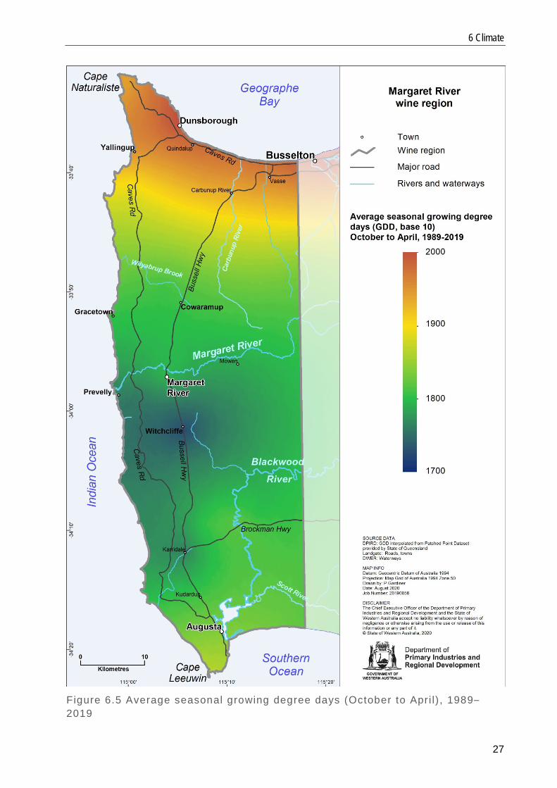
Mean growing degree days (October–April) 1939
Minimum average diurnal temperature (°C) 5.7
Maximum average diurnal temperature (°C) 12.0
Average diurnal temperature (°C) 10.1
The following maps show important climatic parameters for viticulture across the Margaret River region:
• average annual rainfall, 1989–2018 (Figure 6.1) • average growing season (October to April) temperature (Figure 6.2) • average rainfall for selected seasonal time periods (Figure 6.3) • average diurnal temperature variability from October to April (Figure 6.4). These
temperatures are the differences between the average daily minimum and maximum temperatures and indicates the extent of overnight cooling
Geology, soils and climate of the Margaret River wine region
22
• average seasonal growing degree days, using the base 10 method (Figure 6.5). This provides an estimation of the useful heat for vines, using daily mean temperature higher than 10°C over the growing season (October to April)
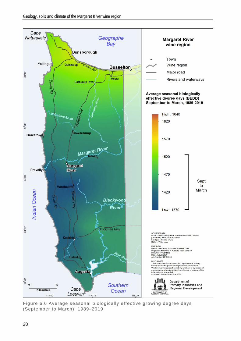
• average seasonal biologically effective growing degree days from September to March (Figure 6.6) and from October to April (Figure 6.7). This is an estimation of the heat affecting the vine growth and development during the growing season for early-ripening varieties (Figure 6.6) and for late-ripening varieties (Figure 6.7). These maps are calculated by adjusting degree days (Figure 6.5) for latitude / daylength for the selected time period.
Hall and Jones (2010) and Dry and Coombe (2004) provide more details about these parameters.
6 Climate
23
Figure 6.1 Average annual rainfal l for the Margaret River region, 1989–2018

Geology, soils and climate of the Margaret River wine region
24
Figure 6.2 Average growing season (October–Apri l) temperature, 1989–2019
6 Climate
25
Figure 6.3 Average rainfal l for selected seasonal t ime per iods, 1989–2019
Geology, soils and climate of the Margaret River wine region
26
Figure 6.4 Average diurnal temperature variabi l i ty (October to Apri l) , 1989–2019
6 Climate
27
Figure 6.5 Average seasonal growing degree days (October to Apri l) , 1989–2019
Geology, soils and climate of the Margaret River wine region
28
Figure 6.6 Average seasonal biological ly effect ive growing degree days (September to March), 1989–2019

6 Climate
29
Figure 6.7 Average seasonal biological ly effect ive growing degree days (October to Apri l) , 1989–2019

Geology, soils and climate of the Margaret River wine region
30
7 Distribution maps and soil profile images of the main soils
Distribution maps and soil profile images of the main soils
31
Forest Grove soils (Ironstone gravels) Examples of Forest Grove soils
Duplex sandy gravel
Loamy gravel
Deep sandy gravel
Shal low gravel
Geology, soils and climate of the Margaret River wine region
32
Mungite, Busselton and Abba soils (Sandy duplexes) Examples of Mungite, Busselton & Abba soils
Pale sandy earth
Grey deep sandy duplex
Yel low–brown deep sandy duplex
Grey deep sandy duplex
Distribution maps and soil profile images of the main soils
33
Marybrook soils (Alluvial sands and loams) Examples of Marybrook soils
Brown deep sand
Red sandy earth

Geology, soils and climate of the Margaret River wine region
34
Bleached sands (Pale deep sands) Examples of Bleached sands
Pale deep sand (over clay)
Pale deep sand (over gravel)
Gravel ly pale deep sand

Distribution maps and soil profile images of the main soils
35
Keenan soils (Red–brown loams) Examples of Keenan soils
Friable red–brown loamy earth
Brown deep loamy duplex
Brown loamy earth
Red deep loamy duplex
Geology, soils and climate of the Margaret River wine region
36
Spearwood and other Yellow sands (Coloured deep sands) Examples of Spearwood and other Yellow sands
Yel low deep sand
Yellow deep sand
Distribution maps and soil profile images of the main soils
37
Calcareous sands (Alkaline soils) Examples of Calcareous sands
Calcareous deep sand
Calcareous deep sand (with l imestone gravel)


Geology, soils and climate of the Margaret River wine region
38
Appendix A Table A1 Main soi ls in the Margaret River region
Soil Approximate
area (ha) Approximate area
(%)
Forest Grove soils 54 884 26
Mungite, Busselton & Abba soils 42 900 20
Difficult soils 43 418 20
Spearwood & Yellow sands 20 562 10
Bleached sands 19 799 9
Calcareous sands 11 378 5
Shallow sands 8 050 4
Marybrook soils 4 132 2
Keenan soils 4 855 2
Heavy soils 2 026 1
Total 212 006 Table A2: Main soi ls used for vit iculture in the Margaret River region
Soil Estimated area of vine plantings (ha)
Estimated area of vine plantings (%)
Forest Grove soils 2750 45
Mungite, Busselton & Abba soils 1760 29
Marybrook soils 430 7
Bleached sands 350 6
Keenan soils 290 5
Shallow sands 150 3
Difficult soils 150 2
Spearwood & Yellow sands 130 2
Heavy soils 40 1
Calcareous sands 0 0
Total 6050
Shortened forms
39
Shortened forms Short form Long form
°C degrees Celsius
AHD Australian Height Datum
BoM Bureau of Meteorology
cm centimetre
DPIRD Department of Primary Industries and Regional Development
h hour
ha hectare
km kilometre
m metre
mm millimetre
WA Western Australia
Geology, soils and climate of the Margaret River wine region
40
References Beeston, J 2002, The wine regions of Australia’, 2nd edn, Allen & Unwin, Crows Nest, New South Wales.
Collins, AS 2003, ‘Structure and age of the northern Leeuwin Complex, Western Australia: constraints from field mapping and U–Pb isotopic analysis’, Australian Journal of Earth Sciences, vol. 50, no. 4, pp. 585–599.
Dry, PR & Coombe, BG (eds.) 2004, Viticulture – Volume 1: Resources, 2nd edn, Winetitles, Adelaide.
Dry, PR, Maschmedt, DJ, Anderson, CJ, Riley, E, Bell, S-J & Goodchild, WS 2004, ‘The grapegrowing regions of Australia’, in PR Dry & BG Coombe (eds.), Viticulture – Volume 1: Resources, 2nd edn, Winetitles, Adelaide, pp. 17–55.
Gladstones, JS 1965, ‘The climate and soils of south-western Australia in relation to vine growing’, Journal of the Australian Institute of Agricultural Science, vol. 31, pp. 275–288.
Gladstones, JS 1966, Soils and climate of the Margaret River-Busselton area: Their suitability for wine grape production, Department of Agronomy, University of Western Australia, Perth.
Hall, A & Jones, GV 2010, ‘Spatial analysis of climate in winegrape-growing regions in Australia’, Australian Journal of Grape and Wine Research, vol. 16, pp. 389–404.
Janssen, DP, Collins, AS & Fitzsimons, CW 2003, Structure and tectonics of the Leeuwin Complex and Darling Fault Zone, Southern Pinjarra Orogen, Western Australia – a field guide, Western Australia Geological Survey Record 2003/15, Geological Survey of Western Australia, Perth. McArthur, WM & Bettenay, E 1958, The soils of the Busselton area, Western Australia, Divisional report 3/58, Commonwealth Scientific and Industrial Research Organisation, Melbourne.
Myers, JS, Geological Society of Australia, Western Australian Division & Australian Geological Convention 1994, Late proterozoic high-grade gneiss complex between Cape Leeuwin and Cape Naturaliste, Geological Society of Australia (WA Division), East Perth, Western Australia.
O'Donnell, J & Lockhart, W 1945, ‘Pines in the Margaret River area’, Australian Forestry, vol. 9, no. 3, p. 60.
Schoknecht, N, Tille, P & Purdie, B 2004, ‘Soil-landscape mapping in south-western Australia: overview of methodology and outputs’, Resource management technical report 280, Department of Agriculture, Perth.
Schoknecht, N & Pathan, S 2013, ‘Soil Groups of Western Australia: a simple guide to the main soils of Western Australia’, 4th edn, Resource management technical report 380, Department of Agriculture and Food, Western Australia, Perth.
References
41
Smith, R 1951, Soils of the Margaret River – Lower Blackwood River districts, Western Australia, Bulletin 262, Commonwealth Scientific and Industrial Research Organisation, Melbourne.
Tille, PJ, Stuart-Street, A & Gardiner, P in press, ‘Geology, soils and climate of Western Australia’s wine regions’, Department of Primary Industries and Regional Development, Perth.
Tille, PJ & Lantzke, NC 1990a, Busselton – Margaret River – Augusta land capability study, Land Resources Series No. 5, Department of Agriculture, Perth.
Tille, P & Lantzke, NC 1990b, ‘Busselton – Margaret River – Augusta land capability study: methodology and results’, Resource management technical report 109, Department of Agriculture, Perth.