Geoid height versus topography of the Northern Ninetyeast Ridge: Implications on crustal...
14
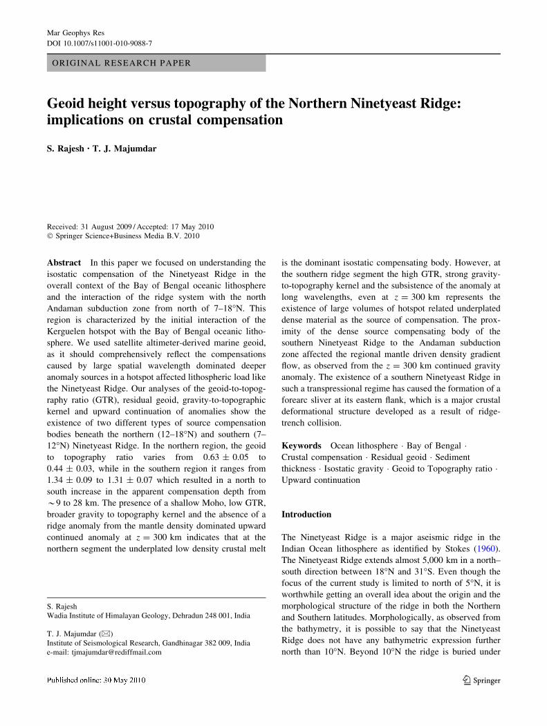
ORIGINAL RESEARCH PAPER Geoid height versus topography of the Northern Ninetyeast Ridge: implications on crustal compensation S. Rajesh • T. J. Majumdar Received: 31 August 2009 / Accepted: 17 May 2010 Ó Springer Science+Business Media B.V. 2010 Abstract In this paper we focused on understanding the isostatic compensation of the Ninetyeast Ridge in the overall context of the Bay of Bengal oceanic lithosphere and the interaction of the ridge system with the north Andaman subduction zone from north of 7–18°N. This region is characterized by the initial interaction of the Kerguelen hotspot with the Bay of Bengal oceanic litho- sphere. We used satellite altimeter-derived marine geoid, as it should comprehensively reflect the compensations caused by large spatial wavelength dominated deeper anomaly sources in a hotspot affected lithospheric load like the Ninetyeast Ridge. Our analyses of the geoid-to-topog- raphy ratio (GTR), residual geoid, gravity-to-topographic kernel and upward continuation of anomalies show the existence of two different types of source compensation bodies beneath the northern (12–18°N) and southern (7– 12°N) Ninetyeast Ridge. In the northern region, the geoid to topography ratio varies from 0.63 ± 0.05 to 0.44 ± 0.03, while in the southern region it ranges from 1.34 ± 0.09 to 1.31 ± 0.07 which resulted in a north to south increase in the apparent compensation depth from *9 to 28 km. The presence of a shallow Moho, low GTR, broader gravity to topography kernel and the absence of a ridge anomaly from the mantle density dominated upward continued anomaly at z = 300 km indicates that at the northern segment the underplated low density crustal melt is the dominant isostatic compensating body. However, at the southern ridge segment the high GTR, strong gravity- to-topography kernel and the subsistence of the anomaly at long wavelengths, even at z = 300 km represents the existence of large volumes of hotspot related underplated dense material as the source of compensation. The prox- imity of the dense source compensating body of the southern Ninetyeast Ridge to the Andaman subduction zone affected the regional mantle driven density gradient flow, as observed from the z = 300 km continued gravity anomaly. The existence of a southern Ninetyeast Ridge in such a transpressional regime has caused the formation of a forearc sliver at its eastern flank, which is a major crustal deformational structure developed as a result of ridge- trench collision. Keywords Ocean lithosphere Bay of Bengal Crustal compensation Residual geoid Sediment thickness Isostatic gravity Geoid to Topography ratio Upward continuation Introduction The Ninetyeast Ridge is a major aseismic ridge in the Indian Ocean lithosphere as identified by Stokes (1960). The Ninetyeast Ridge extends almost 5,000 km in a north– south direction between 18°N and 31°S. Even though the focus of the current study is limited to north of 5°N, it is worthwhile getting an overall idea about the origin and the morphological structure of the ridge in both the Northern and Southern latitudes. Morphologically, as observed from the bathymetry, it is possible to say that the Ninetyeast Ridge does not have any bathymetric expression further north than 10°N. Beyond 10°N the ridge is buried under S. Rajesh Wadia Institute of Himalayan Geology, Dehradun 248 001, India T. J. Majumdar (&) Institute of Seismological Research, Gandhinagar 382 009, India e-mail: [email protected] 123 Mar Geophys Res DOI 10.1007/s11001-010-9088-7
Transcript of Geoid height versus topography of the Northern Ninetyeast Ridge: Implications on crustal...
ORIGINAL RESEARCH PAPER
Geoid height versus topography of the Northern Ninetyeast Ridge:implications on crustal compensation
S. Rajesh • T. J. Majumdar
Received: 31 August 2009 / Accepted: 17 May 2010
� Springer Science+Business Media B.V. 2010
Abstract In this paper we focused on understanding the
isostatic compensation of the Ninetyeast Ridge in the
overall context of the Bay of Bengal oceanic lithosphere
and the interaction of the ridge system with the north
Andaman subduction zone from north of 7–18�N. This
region is characterized by the initial interaction of the
Kerguelen hotspot with the Bay of Bengal oceanic litho-
sphere. We used satellite altimeter-derived marine geoid,
as it should comprehensively reflect the compensations
caused by large spatial wavelength dominated deeper
anomaly sources in a hotspot affected lithospheric load like
the Ninetyeast Ridge. Our analyses of the geoid-to-topog-
raphy ratio (GTR), residual geoid, gravity-to-topographic
kernel and upward continuation of anomalies show the
existence of two different types of source compensation
bodies beneath the northern (12–18�N) and southern (7–
12�N) Ninetyeast Ridge. In the northern region, the geoid
to topography ratio varies from 0.63 ± 0.05 to
0.44 ± 0.03, while in the southern region it ranges from
1.34 ± 0.09 to 1.31 ± 0.07 which resulted in a north to
south increase in the apparent compensation depth from
*9 to 28 km. The presence of a shallow Moho, low GTR,
broader gravity to topography kernel and the absence of a
ridge anomaly from the mantle density dominated upward
continued anomaly at z = 300 km indicates that at the
northern segment the underplated low density crustal melt
is the dominant isostatic compensating body. However, at
the southern ridge segment the high GTR, strong gravity-
to-topography kernel and the subsistence of the anomaly at
long wavelengths, even at z = 300 km represents the
existence of large volumes of hotspot related underplated
dense material as the source of compensation. The prox-
imity of the dense source compensating body of the
southern Ninetyeast Ridge to the Andaman subduction
zone affected the regional mantle driven density gradient
flow, as observed from the z = 300 km continued gravity
anomaly. The existence of a southern Ninetyeast Ridge in
such a transpressional regime has caused the formation of a
forearc sliver at its eastern flank, which is a major crustal
deformational structure developed as a result of ridge-
trench collision.
Keywords Ocean lithosphere � Bay of Bengal �Crustal compensation � Residual geoid � Sediment
thickness � Isostatic gravity � Geoid to Topography ratio �Upward continuation
Introduction
The Ninetyeast Ridge is a major aseismic ridge in the
Indian Ocean lithosphere as identified by Stokes (1960).
The Ninetyeast Ridge extends almost 5,000 km in a north–
south direction between 18�N and 31�S. Even though the
focus of the current study is limited to north of 5�N, it is
worthwhile getting an overall idea about the origin and the
morphological structure of the ridge in both the Northern
and Southern latitudes. Morphologically, as observed from
the bathymetry, it is possible to say that the Ninetyeast
Ridge does not have any bathymetric expression further
north than 10�N. Beyond 10�N the ridge is buried under
S. Rajesh
Wadia Institute of Himalayan Geology, Dehradun 248 001, India
T. J. Majumdar (&)
Institute of Seismological Research, Gandhinagar 382 009, India
e-mail: [email protected]
123
Mar Geophys Res
DOI 10.1007/s11001-010-9088-7

Bengal fan sediments (Curray et al. 1982). Around half a
kilometer of sediment is present over the ridge and hence
its bathymetry is subdued. The Ninetyeast Ridge shows
different widths along its north–south strike and has an
average width of 200 km. The morphological features of
the Ninetyeast Ridge could be revealed from the earlier
works of Sclater and Fisher (1974) and later Krishna et al.
(1995) observed that the ridge is wider and shallower at its
southern latitudes, based upon bathymetric and marine
magnetic anomaly studies. In northern latitudes the western
flank of the buried ridge is gentler in comparison with its
eastern flank (Subrahmanyam et al. 2008). The origin of
Ninetyeast Ridge was attributed to Kerguelen hotspot
activity through geochemical (Mahoney et al. 1983; Weis
et al. 1991), geo-chronological (Duncan 1991), subsidence
history (Bowin 1973) and marine geophysical studies
(Neprochnov et al. 1979). Clift (2005) reported slower
subsidence history of the Ninetyeast Ridge than predicted
for normal oceanic crust of corresponding age. The
Ninetyeast Ridge was formed as a hotspot trail during the
northward movement of the Indian plate over the Ker-
guelen hotspot during the period 82–38 Ma, following the
formation of the Rajmahal Traps on the Indian subconti-
nent (Mahoney et al. 1983; Kent et al. 2002). Later,
Krishna et al. (1999) have proposed a three phase forma-
tion of the Ninetyeast Ridge system in its Southern and
Northern latitudes. Thus, the formation of northern (above
equator) Ninetyeast Ridge occurred purely because of the
intraplate Kerguelen hotspot magmatism; while at the
southern latitudes, the combined interaction of the hotspot
with the Wharton Ridge spreading axis during the period
60–54 Ma has been proposed. The occurrence of intraplate
seismic event of M 7.7 (1928) and large scale surface
deformational structures identified at the southern Indian
Ocean close to the ridge has helped to re-define the
southern tectonic boundary of the Indian plate as diffused
plate boundary (Wiens et al. 1985). Thus, towards the south
of the equator, the geodynamic traits of this ridge, its for-
mation, and mode of isostasy are quite well studied.
In this paper we focused on understanding the isostatic
compensation of the Ninetyeast Ridge, its regional gravi-
tational stability in the overall context of the Bay of Bengal
oceanic lithosphere and the interaction of the ridge system
with the north Andaman subduction zone from north of 7–
18�N. Little information is available about the geody-
namics of this region in the context of the Ninetyeast
Ridge. The characteristics of this region are: first it signi-
fies the area of the initial eruption of Kerguelen hotspot
magma and its first interaction with the Bay of Bengal
oceanic lithosphere, especially between 12�S and 18�N.
Thus, factors such as the nature of compensation of the
ridge and the role of hotspot magma in determining those
compensation processes are yet to be investigated.
Secondly, the interaction of the ridge with the north And-
aman convergence zone and other major lithospheric
structures in the Bay of Bengal basin, like the Central basin
depression, where average sediment thickness is quite high
(*9 km) (Rajesh and Majumdar 2004). In this work, these
aspects have been addressed through the analysis of
residual geoid, geoid-to-topography ratio, gravity-to-
topography ratio and the upward continuation of marine
gravity anomalies obtained from satellite altimeter-derived
instantaneous sea surface height. Analysis of results along
with the continuation of the anomaly of the ridge system
shows that the source of compensation at its northern (12–
18�N) and southern (7–12�N) segments, respectively are
different. Less dense underplated crustal melt fraction
dominates in the shallow root of the northern segment,
while in south, strong positive anomalies and greater
crustal root indicate the role of accumulated dense hotspot
material as the dominant source of compensation.
Objectives
Major objectives of this study are as follows:
(i) To study the geoid-to-topography and the Pratt
apparent isostatic compensation depths along the
northern Ninetyeast Ridge,
(ii) To study the upward continuation of gravity anom-
alies of the Bay of Bengal basin at different heights,
and ascertain the role of lithospheric density anom-
alies in the isostatic compensation processes, and
(iii) Generation of an integrated crustal structure of the
northern Ninetyeast Ridge in the Bay of Bengal
basin.
Study area and data sources
The area selected for lithospheric investigations is a part of
the Bay of Bengal and is also known as the Northeastern
Indian Ocean. The coordinate locations of the area are from
7 to 20�N and 82 to 95�E in the Bay of Bengal and shown
as box in Fig. 1.
Satellite altimeter and ship-borne data
In this study we used (i) Geosat Exact Repeat Mission
(ERM) instantaneous sea surface height data with a repeat
period of 17.6 days and (ii) Two data sets of ERS-1/2
satellites in the ocean mode measurement. One set of data
is from the geodetic phase of the ERS-1 with 168 day
repeat orbit period and with approximately 16 km track
spacing and the other is ERM-2 with a 35 day repeat period
orbit and a 80 km track spacing at the equator. The ERS-1
Mar Geophys Res
123
geodetic data consists of a total of 165 tracks, which fall
over the whole Northern Indian Ocean, ranging from 0 to
25�N latitude and 55 to 105�E. (iii) The third set of data
used is the merged 1 year TOPEX/POSEIDON data
obtained from the Physical Oceanography Distributed
Active Archive Center (PODAAC), USA. Satellite-derived
geoid and gravity data have been generated from the
observed instantaneous sea surface height using these three
sets of altimeter data. Details of data processing have been
discussed by Majumdar et al. (1998) and validation of the
satellite data with ship-borne gravity by Rajesh and
Majumdar (2004).
Regional bathymetry
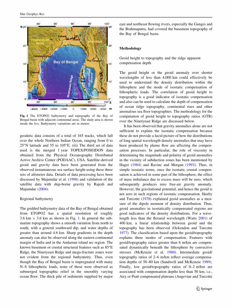
The gridded bathymetry data of the Bay of Bengal obtained
from ETOPO2 has a spatial resolution of roughly
3.6 km 9 3.6 km as shown in Fig. 1. In general the sub-
marine topography shows a smooth variation from north to
south, with a general southward dip, and water depths of
greater than around 4.6 km. Sharp gradients in the depth
anomaly can also be observed along the eastern continental
margin of India and in the Andaman island arc region. The
known basement or crustal structural features such as 85�E
Ridge, the Ninetyeast Ridge and mega-fracture zones were
not evident from the regional bathymetry. Thus, even
though the Bay of Bengal basin is impregnated with many
N–S lithospheric loads, none of these were observed as
submerged topographic relief in the smoothly varying
ocean floor. The thick pile of sediments supplied by major
east and northeast flowing rivers, especially the Ganges and
the Brahmaputra, had covered the basement topography of
the Bay of Bengal basin.
Methodology
Geoid height to topography and the ridge apparent
compensation depth
The geoid height or the geoid anomaly over shorter
wavelengths of less than 4,000 km could effectively be
used to understand the density distribution within the
lithosphere and the mode of isostatic compensation of
lithospheric loads. The correlation of geoid height to
topography is a good indicator of isostatic compensation
and also can be used to calculate the depth of compensation
of ocean ridge topography, continental rises and other
anomalous sea floor topographies. The methodology for the
computation of geoid height to topography ratios (GTR)
over the Ninetyeast Ridge are discussed below.
It has been observed that gravity anomalies alone are not
sufficient to explain the isostatic compensation because
these do not provide a lucid picture of how the distributions
of long spatial wavelength density anomalies that may have
been produced by plume flow are affecting the compen-
sation processes. In particular, the role of viscosity in
determining the magnitude and polarity of geoid anomalies
in the vicinity of subduction zones has been mentioned by
Hager (1984) and Ravine and Morgan (1993). Thus, in
simple isostatic terms, once the isostatic crustal compen-
sation is achieved in some part of the lithosphere, the effect
of mass imbalance due to excess mass will be zero, which
subsequently produces zero free-air gravity anomaly.
However, the gravitational potential, and hence the geoid is
not zero in such regions of isostatic compensation. Haxby
and Turcotte (1978) explained geoid anomalies as a mea-
sure of the dipole moment of density distribution. Thus,
geoid anomalies in isostatically compensated regions are
good indicators of the density distributions. For a wave-
length less than the flexural wavelength (Watts 2001) of
400 km, a linear relationship between geoid and the
topography has been observed (Ockendon and Turcotte
1977). The classification based upon the geoid/topography
explains three modes of compensation. Features with
geoid/topography ratios greater than 6 m/km are compen-
sated dynamically beneath the lithosphere by convective
stresses (McKenzie et al. 1980). Intermediate geoid/
topography ratios of 2–6 m/km reflect average compensa-
tion depths of 50–80 km (Sandwell and McKenzie 1989).
Finally, low geoid/topography ratios of 0–2 m/km are
associated with compensation depths less than 50 km, i.e.,
Airy or Pratt compensated plateaus (Angevine and Turcotte
Fig. 1 The ETOPO2 bathymetry and topography of the Bay of
Bengal basin with adjacent continental areas. The study area is shown
inside the box. Bathymetry variations are in meters
Mar Geophys Res
123
1983). One of the basic assumptions, as far as the com-
pensation of features is concerned, is that the average depth
of compensation should be smaller than the characteristic
wavelength of the topography.
In this study, the residual geoid anomalies are obtained
after removing the deeper Earth anomalies from the grid-
ded classical geoid anomaly data. We computed deeper
anomaly effects through spherical harmonic analysis using
EGM96 coefficients (Lemoine et al. 1998) up to degree and
order of harmonics 50. The resultant residual geoid
anomaly data has been utilized for correlation with the
residual basement depth. The residual basement depth was
calculated by removing the sediment effect from the
observed gridded bathymetry over the study region of the
northern and the southern Ninetyeast Ridge systems. This
was followed by removing the regional long wavelength
basement undulation polynomial of the order of two from
the sediment-corrected equal length bathymetry profiles
selected from the gridded data taken across the Ninetyeast
Ridge in the northern (above 12�N) and the southern
regions (above 5�N). The sediment correction to bathym-
etry is justified because of the lack of expression of the
Ninetyeast Ridge basement topography against the ocean
floor. The geoid/topography ratio (GTR) is obtained from
the slope of the best fitting regression line through the
correlation of the residual geoid and the residual basement
(topography) along respective profiles taken across the
strike of the Ninetyeast Ridge in the northern and southern
latitudes, all north of 5�N. The estimated GTR has been
used to compute the Pratt’s isostatic apparent depths of
compensation of the Ninetyeast Ridge at various northern
and southern latitudinal profiles. The expression used for
the computation of apparent compensation depth (dc) using
GTR is given by Monnereau and Cazenave (1988):
dc ¼gðGTRÞ
pG qm � qwð Þ ð1Þ
where g = acceleration due to gravity, 9.8 ms-2,
G = Gravitational Constant, 6.672 9 10-11 m3 kg-1 s-2,
qm = density of mantle, 3,300 kg m-3 and qw = sea water
density, 1,030 kg m-3, respectively. The expression in
Eq. 1 shows that the geoid-to-topography ratio is propor-
tional to the apparent depth of compensation for a positive
topography like the Ninetyeast Ridge in the study area.
The gravity to topography ratio over the Ninetyeast
Ridge
The relation between gravity and the topography, as well as
the effect on gravity by the deflection or compensation
produced in the crust have been explained by Sandwell and
McKenzie (1989). Their combined effects will generate the
resultant gravity due to Airy crustal compensation (Watts
2001) of the lithospheric load, which, when expressed in
the wave number domain, is
DgðkÞtotal ¼ 2pGðqc � qwÞHðkÞe�kdð1� e�ktÞ ð2Þ
where G is the Universal Gravitational Constant, qc and qw
are the densities of crust and the water layer, respectively, d
and t are the mean water depth and the crustal thickness.
H(k) is the Fourier transform of topography of the
lithospheric load. Substitution of Z(k) for parameters
other than H(k) will give a linear relationship between
gravity and topography in wave number domain as
DgðkÞ ¼ ZðkÞHðkÞ ð3Þ
Here Z(k) is a linear filter function, which reflects the
system property or the Airy isostatic filter function in the
wave number domain. It can be defined that the input
topographic load of the ridge as H(k) causes the gravity
output Dg(k) through the kernel Z(k). Thus, the kernel Z(k)
is the admittance (Dorman and Lewis 1972; McKenzie and
Bowin 1976; McNutt 1979; Watts 2001; Tiwari et al.
2003), which reflects the mode of compensation of the
lithospheric load.
In this study, the cross-spectral analysis of the free-air
gravity and the topography as given by McKenzie and
Bowin (1976) has been utilized to find the gravity-to-
topography ratio of the Ninetyeast Ridge along various
profiles in its northern and southern latitudes, as shown in
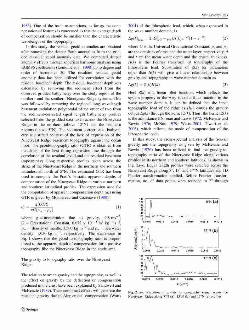
Fig. 2a–c. Equal length profiles were selected across the
Ninetyeast Ridge along 8�, 13� and 17�N latitudes and 1D
Fourier transformation applied. Before Fourier transfor-
mation, no. of data points were rounded to 28 through
020406080
100120
0.0018 0.0218 0.0418 0.0618 0.0818 0.1018
020406080
100120140
(a)
0
2
4
6
8
10
(b)
(c)
8°N
13°N
17°N
k (km-1)
Z(k
) (m
Gal
/km
)
0.0018 0.0218 0.0418 0.0618 0.0818 0.1018
0.0018 0.0218 0.0418 0.0618 0.0818 0.1018
Fig. 2 a–c Variation of gravity to topography kernel across the
Ninetyeast Ridge along 8�N (a), 13�N (b) and 17�N (c) profiles
Mar Geophys Res
123
padding with zeroes at the end and profile edge filters have
been applied in order to avoid Gibb’s oscillations.
The cross spectra between the topography and gravity,
as well as their respective powers were calculated before
the computation of Z(k) of the Ninetyeast Ridge. The total
length of each profile was 555.55 km. The topography data
were corrected for the sediment effect before the compu-
tation of their Fourier transform. As per Eq. 3, it is clear
that unless the topography has a good spectral correlation
with the corresponding gravity anomaly, the Z(k) compu-
tation will not give satisfactory results. In the Bay of
Bengal basin, the ocean floor topography and the oceanic
basement undulation have little resemblance. As a result,
the sediment-corrected topography of the respective grav-
ity profiles has been taken for the computation of Z(k). The
geoid-to-topography ratio and the gravity-to-topography
kernel would give the compensation depth and the nature
of compensation of the ridge system, respectively. How-
ever, relative strength of the deeper anomaly signals that
may contribute by the hotspot material in large spatial
wavelength windows are also to be investigated through
the upward continuation of anomalies.
Upward continuation of free-air gravity anomaly
over the Bay of Bengal basin
The continuation of free-air gravity anomalies over the Bay
of Bengal has been studied at various heights from the
geoid datum in order to understand the role of mantle level
compensation of the basin, and particularly over the
Ninetyeast Ridge. The continuation of anomalies at various
heights gives a clearer picture of the distribution of various
density anomaly structures by removing the unwanted,
very shallow or near surface anomaly signals.
Gravity data measured on a given plane can be trans-
formed mathematically to data measured at a higher or
lower elevation, thus attenuating or emphasizing shorter
wavelength anomalies. These analytic continuations lead to
convolution integrals that can be solved either in the space
or in the frequency domain (Bhattacharya 1965). The
theory behind this filtering technique is that, if the sub-
surface body is at great depth compared to the datum then
its gravity signals will be weak, but of long wavelength in
nature compared with the strong and short wavelength
nature of the shallow subsurface bodies. Thus, if one is
interested in deep anomaly signals then the shallow noise
anomaly can be removed from the observed data by just
shifting the observed datum plane upwards by a specific
amount and then computing the anomaly at a new plane.
By doing this one can retain the long wavelength waveform
and hence the distribution of the anomaly sources. Thus,
the upward continuation effectively acts as a low-pass
spatial frequency filter.
Since the objective of this study is to isolate the signals
with a deep origin associated with mantle level compen-
sation of the Ninetyeast Ridge system, in particular, along
with the general overall background of the basement, we
assumed a flat Earth approximation of the coordinates with
linear combination of the harmonic functions with an
exponential decay in the anomaly signals with height for
the computation. Based upon Bhattacharya (1965) the two-
dimensional gridded free-air gravity anomaly was expan-
ded in terms of the linear combination of harmonic terms in
the flat Earth approximation or in a Cartesian coordinate
system. The respective equations can be written as,
Dgðx; y; zÞ ¼X1
m¼0
X1
n¼0
Dgðx; yÞe2pz m2=L2xþn2=L2
y½ �1=2 ð4Þ
Here Dg(x, y) is the 2D gridded free-air gravity data, Dg(x,
y, z) is the respective continued data either upward or
downward by a factor of z. If z is positive then it will be a
downward continuation, while negative value of z
corresponds to an upward continuation. Lx and Ly are the
fundamental wavelengths in two directions x and y,
respectively. Thus, with negative z, the exponential term
decays the effect of gravity at the datum to the specified
height z. Lx and Ly represent the fundamental wavelengths
such that Lx = Nxdx and Ly = Nydy, respectively. Here dx
and dy represent the cell width of the 2D gridded data in
the x and y directions and Nx, Ny represents the number of
data points along the profiles in the x and y directions,
respectively. The upper limit for converging the series is
m0� Nx � 1ð Þ=2 and n0� Ny � 1� �
=2 respectively. The
Dg(x, y) can be expanded as the linear combination of
harmonic terms as:
Dgðx; yÞ ¼Amn cos 2pmx=Lx
� �cos 2pny
�Ly
� �
þ Bmn cos 2pmx=Lx
� �sin 2pny
�Ly
� �
þ Cmn sin 2pmx=Lxð Þ cos 2pny�
Ly
� �
þ Dmn sin 2pmx=Lxð Þ sin 2pny�
Ly
� �ð5Þ
The coefficients Amn, Bmn, Cmn, and Dmn are computed
from the respective normal equations expressed in terms of
Dg(x, y) and the combination of cosine and sin harmonic
terms (Bhattacharya 1965).
Results and discussion
The results of gravity-to-topographic kernel of the ridge
taken along a few crossing profiles are shown in Fig. 2a–c.
In general, Airy isostatic compensation takes place at
longer wavelength (*555 km) lithospheric loads and has a
lower cut off wavelength at around 45 km. Accordingly,
lithospheric loads with wavelength \ 45 km, have not
Mar Geophys Res
123
been effectively compensated. The compensation wave-
length range is compatible with the average 200 km width
of the Ninetyeast Ridge. The amplitude of the Airy com-
pensation filter along 13�N is less than 10 mGal/km, which
is less than the 140 and 120 mGal/km of the other two
profiles. This indicates a relatively better state of isostatic
balance of the Ninetyeast Ridge at 13�N. The gravity
anomaly caused by the topography could be effectively
countered by the near approximate thickening of the crustal
root into the mantle. But in the southern 8�N profile, the
amplitude shows a clear, single, narrow, straight peak with
high amplitude; this suggests that the gravity anomaly due
to topography is subdued compared to the gravity effect of
the thickened crustal root. The gravity effect of the crustal
root is more because of the increase in density of the
compensating material. The single lobe of the Z(k) ampli-
tude, rather than being observed along with the side lobes,
represents the non-fragmentation of the ridge compensat-
ing load along these latitudes, such that only a single
prominent component is taking part in the process of
compensation. However, in the 13�N profile, even though
the ridge is in a near balanced state of compensation, the
presence of side lobes indicates its broader compensation,
which takes place not only at its center, but also on its
widened flanks. The same is true for the case of the
northernmost 17�N profile, where the number of side peaks
is more in addition to the main lobe.
Thus north of 12�N, the compensating source body of
the ridge anomaly is obscured, possibly because of the
presence of short wavelength shallow density anomaly
structures, while at southern (between 5 and 12�N) lati-
tudes the compensating source body is stronger, clear and
predominantly dense. Hence, the amplitude of gravity-to-
topography ratio can give constraints on the state of iso-
static compensation. Furthermore, its distribution in the
wave number domain also shows whether the ridge is
compensated by a single unit or by fractured form at a
single location. However, this analysis cannot give the
depth of compensation of the crustal roots at the southern
and the northern regions of the Ninetyeast Ridge.
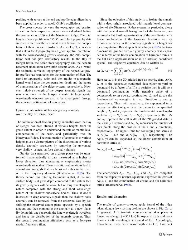
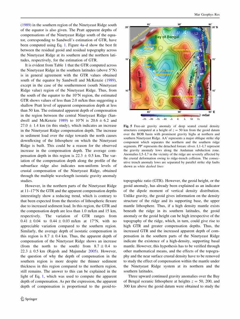
Figure 3 shows the residual geoid anomaly of the Bay of
Bengal oceanic lithosphere, which ranges from -11.5 m in
the north Andaman subduction zone region to more than
4 m at the southern portion of the Ninetyeast Ridge system.
As explained above, geoid anomalies are sensitive to
compensations by large wavelength lithospheric density
Fig. 3 The residual geoid anomaly contours in meters over the Bay of Bengal basin. NN0 represents variation in trend of the Ninetyeast Ridge.
PP0 at the eastern flank of the Ninetyeast Ridge shows the trend of the detached forearc sliver as a result of ridge-trench collision
Mar Geophys Res
123
anomalies and their consequent lithospheric flow. The
observed north Andaman trench anomaly lows are rela-
tively wide owing to the gentle bending of the down-going
subducted slab. But at south Andaman, the trench geoid
anomalies juxtaposing the southern Ninetyeast Ridge are
narrower which suggests steep bending of the subducted
slab. In addition, other basin features, such as the Central
basin depression, the Mahanadi Basin and the 85�E Ridge
are also observed as geoid anomaly lows.
The trend of the Ninetyeast Ridge is shown in Fig. 3 as
NN0. The ridge geoid anomaly as well as its area increases
from the ridge head at the north to its tail at the south. This
variation shows how the density of lithospheric mantle
influences the compensation process of the ridge. Rela-
tively high geoid observed at the southern segment (south
of 12�N) of the ridge represents occurrences of thicker
crust that may have been generated by major phases of
magmatism linked to the Kerguelen hotspot, although the
northern segment oceanic lithosphere experienced the ini-
tiation phase. The estimated GTR and the Pratt apparent
depths of compensation of the profiles ranging from 7 to
17�N across the strike of Ninetyeast Ridge north of the
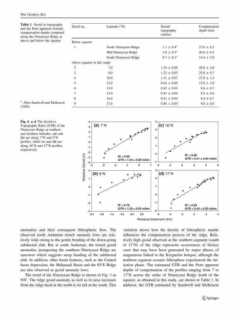
equator, as obtained in this study, are shown in Table 1. In
addition, the GTR estimated by Sandwell and McKenzie
Table 1 Geoid to topography
and the Pratt apparent isostatic
compensation depths computed
along the Ninetyeast Ridge at
above and below the equator
a After Sandwell and McKenzie
(1989)
Serial no. Latitude (�N) Geoid/
topography
(m/km)
Compensation
depth (km)
Below equator
1 North Ninetyeast Ridge 1.1 ± 0.4a 23.0 ± 8.2
Mid-Ninetyeast Ridge 1.0 ± 0.3a 20.6 ± 6.2
South Ninetyeast Ridge 0.7 ± 0.1a 14.4 ± 2.0
Above equator in this study
2 7.0 1.34 ± 0.09 28.0 ± 2.0
3 8.0 1.23 ± 0.03 25.0 ± 0.7
4 10.0 1.31 ± 0.07 27.0 ± 1.4
5 12.0 0.63 ± 0.05 13.0 ± 1.0
6 13.0 0.42 ± 0.03 8.6 ± 0.7
7 15.0 0.43 ± 0.04 8.9 ± 0.8
8 16.0 0.41 ± 0.04 8.4 ± 0.7
9 17.0 0.44 ± 0.03 9.0 ± 0.6
-4
-3
-2
-1
0
1
2
3
4
-3
-2
-1
0
1
2
Res
idua
l Geo
id(m
)
-1
0
1
2
3
4
-4 -3 -2 -1 0 1
-2.5 -2.0 -1.5 -1.0 -0.5 0.0
-4 -2 0 2 4 6
-6 -4 -2 0 2 4-2
-1
0
1
2
3
(a) 7°N
(b) 8°N
(c) 16°N
(d) 17°N
R2 = 0.95GTR = 1.34 ± 0.09 m/km
R2 = 0.79GTR = 1.23 ± 0.03 m/km
R2 = 0.90GTR = 0.41 ± 0.04 m/km
R2 = 0.93GTR = 0.44 ± 0.03 m/km
Residual basement (km)
Fig. 4 a–d The Geoid to
Topography Ratio (GTR) of the
Ninetyeast Ridge at southern
and northern latitudes. (a) and
(b) are along 7�N and 8�N
profiles, while (c) and (d) are
along 16�N and 17�N profiles,
respectively
Mar Geophys Res
123
(1989) in the southern region of the Ninetyeast Ridge south
of the equator is also given. The Pratt apparent depths of
compensations of the Ninetyeast Ridge south of the equa-
tor, corresponding to Sandwell’s estimation of GTR, have
been computed using Eq. 1. Figure 4a–d show the best fit
between the residual geoid and residual topography across
the Ninetyeast Ridge at its southern and the northern lati-
tudes, respectively, for the estimation of GTR.
It is evident from Table 1 that the GTR computed across
the Ninetyeast Ridge in the southern latitudes (above 5�N)
is in general agreement with the GTR values obtained
south of the equator by Sandwell and McKenzie (1989),
except in the case of the southernmost (south Ninetyeast
Ridge value) region of the Ninetyeast Ridge. Thus, from
the south of the equator to the 10�N region, the estimated
GTR shows values of less than 2.0 m/km thus suggesting a
shallow Pratt level of apparent compensation depth at less
than 50 km. The estimated apparent depth of compensation
in the region between the central Ninetyeast Ridge (San-
dwell and McKenzie 1989) to 10�N is 20.6 ± 6.2 and
27.0 ± 1.4 km (in this study), which indicates an increase
in the Ninetyeast Ridge compensation depth. The increase
in sediment load over the ridge towards the north causes
downflexing of the lithosphere on which the Ninetyeast
Ridge is built. This could be a reason for the observed
increase in the compensation depth. The average com-
pensation depth in this region is 22.3 ± 0.5 km. The var-
iation of the compensation depth along the profile of the
subsurface ridge also indicates non-uniform levels of
crustal compensation of the Ninetyeast Ridge, obtained
through the multiple wavelength isostatic gravity anomaly
studies.
However, in the northern parts of the Ninetyeast Ridge
at 11–17�N the GTR and the apparent compensation depths
interestingly show a reducing trend, which is contrary to
that been expected from the theories of lithospheric flexure
due to increased sediment load. In this region, the GTR and
the compensation depth are less than 1.0 m/km and 15 km,
respectively. The variation of GTR ranges from
0.41 ± 0.04 to 0.44 ± 0.03 m/km at 17�N, with no
appreciable variation compared to the southern region.
Similarly, the average depth of isostatic compensation in
this region is 8.7 ± 0.4 km. Thus, the apparent depth of
compensation of the Ninetyeast Ridge shows an increase
(from the north to the south) from 8.7 ± 0.4 to
22.3 ± 0.5 km (Rajesh and Majumdar 2005). However,
the question of why the depth of compensation in the
southern region is more despite the thinner sediment
thickness in this region compared to the northern region,
still remains. The answer to this can be explained in the
light of Eq. 1, which was used to compute the apparent
depth of compensation. As per the expression, the apparent
depth of compensation is proportional to the geoid-to-
topographic ratio (GTR). However, the geoid height, or the
geoid anomaly, has already been explained as an indicator
of the dipole moment of vertical density distribution.
Unlike gravity, the geoid gives information on the density
structure of the ridge and its supporting base, the upper
mantle lithosphere. Thus, if a high density mantle exists
beneath the ridge in its southern latitudes, the geoid
anomaly or the geoid height can be high irrespective of the
topography of the ridge, which, in turn, could give rise to
high GTR and greater compensation depths. Thus, the
increased GTR and the increased apparent depth of com-
pensation in the southern parts of the Ninetyeast Ridge
indicate the existence of a high-density, supporting basal
mantle. However, this hypothesis has to be verified through
other mathematical means, and the effects of the topogra-
phy and the near surface crustal density have to be removed
to study the effect of compensation within the mantle under
the Ninetyeast Ridge system at its northern and the
southern latitudes.
Three upward continued gravity anomalies over the Bay
of Bengal oceanic lithosphere at heights z = 50, 200, and
300 km above the geoid datum were obtained to study the
Fig. 5 Free-air gravity anomaly of deep seated crustal density
structures computed at a height of z = 50 km from the geoid datum
over the BOB basin with prominent gravity highs at northern and
southern Ninetyeast Ridge. AA0 represents a major oblique strike slip
component which separates the northern and the southern ridge
segments. PP0 represents the detached forearc sliver. L1–L7 represent
the gravity anomaly lows along the Andaman subduction zone.
Anomalies L5–L7 in the vicinity of the ridge are severely affected by
the crustal deformation owing to ridge-trench collision. The consec-
utive trench anomaly lows are separated by parallel strike slip faults
shown as white dashed lines
Mar Geophys Res
123
features of interest in the study area. These are shown in
Figs. 5, 6, and 7, respectively.
The free-air gravity anomalies derived from the satellite
altimeter measured instantaneous sea surface height (SSH)
and have an anomaly range from -86.0 to 64.0 mGal over
the Bay of Bengal basin (Majumdar and Bhattacharyya
2004). After applying the upward continuation at a height
of z = 50 km from the geoid datum, the free-air anomaly
shows a range between -26.0 and 16.0 mGal. Around
50 mGal reduction has occurred in the amplitudes of the
free-air gravity anomalies and most of the short wavelength
features have been removed, so that only the broad crustal
features like 85�E Ridge, the Central Basin, the Ninetyeast
Ridge, the Marginal High and the Andaman subduction
zone, along with the continental highs are retained (Fig. 5).
The sources of these anomalous gravity features lie below
the upper crust. The northern and the southern segments of
Ninetyeast Ridge system are very clear, and are separated
by a NE–SW oriented fault, as shown as AA‘ in Fig. 5. In
addition, the eastern flank of the Ninetyeast Ridge that has
subsided into the Andaman subduction zone which is evi-
dent with the presence of a faulted region represented by
PP0 (Fig. 5). The effect of the topography and the presence
of sediment-load-induced flexure of the lithosphere, whose
spatial wavelength is more than 100 km, are clearly
distinguished in Fig. 5. The effect of the topographic
depression on the anomaly magnitudes is evident from the
very low value of less than -19.0 mGal seen in the area of
the Andaman Trench, as well as in the depression produced
in the Central Basin region. The over-compensation of the
85�E Ridge causes the flexural uplift of its western region,
which could be observed as a Marginal High or Margin
flexural uplift.
Considering the Ninetyeast Ridge system, it is evident
that in its northern portion, the anomalies are almost
14 mGal less compared to the southern region. The high
anomaly of the Ninetyeast Ridge in the southern region
could be explained by the enhanced topography of the
ridge. As a result, the free-air anomaly at z = 50 km level
is mainly dominated by the topographic effect and the
sediment load thicknesses. Thus, in order to study the
mantle level compensation of the ridge, still larger heights
are required to filter out the effect of topography and the
crustal surface loads from the gravity anomaly.
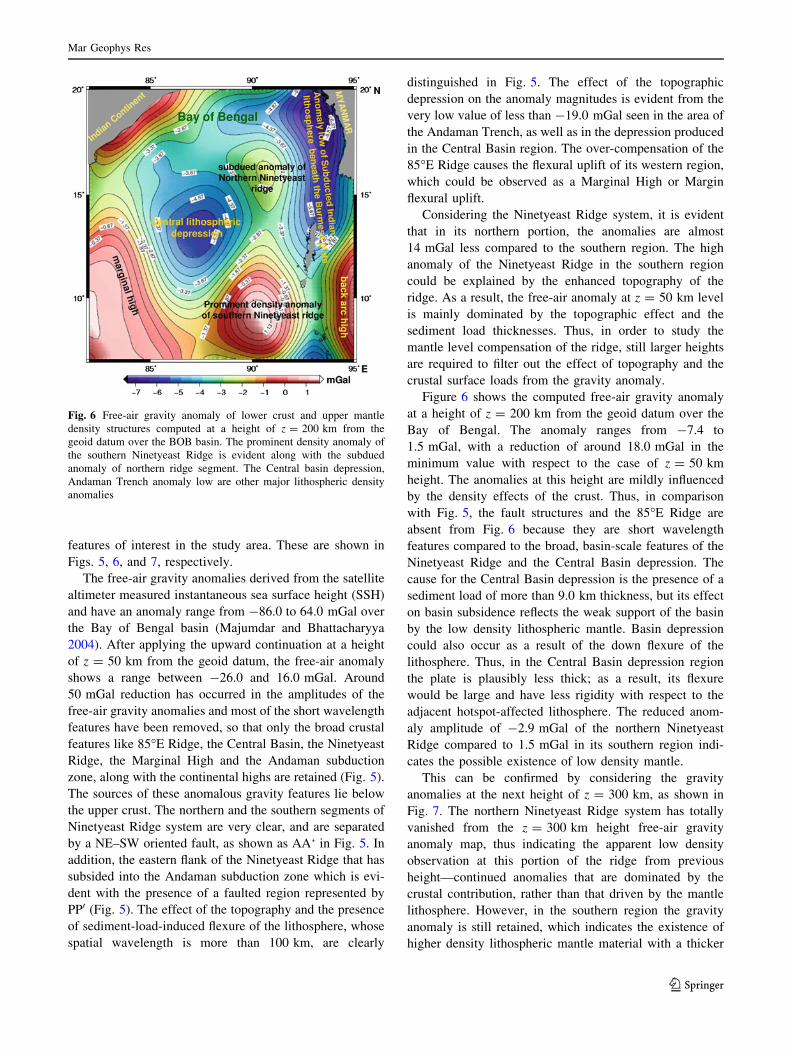
Figure 6 shows the computed free-air gravity anomaly
at a height of z = 200 km from the geoid datum over the
Bay of Bengal. The anomaly ranges from -7.4 to
1.5 mGal, with a reduction of around 18.0 mGal in the
minimum value with respect to the case of z = 50 km
height. The anomalies at this height are mildly influenced
by the density effects of the crust. Thus, in comparison
with Fig. 5, the fault structures and the 85�E Ridge are
absent from Fig. 6 because they are short wavelength
features compared to the broad, basin-scale features of the
Ninetyeast Ridge and the Central Basin depression. The
cause for the Central Basin depression is the presence of a
sediment load of more than 9.0 km thickness, but its effect
on basin subsidence reflects the weak support of the basin
by the low density lithospheric mantle. Basin depression
could also occur as a result of the down flexure of the
lithosphere. Thus, in the Central Basin depression region
the plate is plausibly less thick; as a result, its flexure
would be large and have less rigidity with respect to the
adjacent hotspot-affected lithosphere. The reduced anom-
aly amplitude of -2.9 mGal of the northern Ninetyeast
Ridge compared to 1.5 mGal in its southern region indi-
cates the possible existence of low density mantle.
This can be confirmed by considering the gravity
anomalies at the next height of z = 300 km, as shown in
Fig. 7. The northern Ninetyeast Ridge system has totally
vanished from the z = 300 km height free-air gravity
anomaly map, thus indicating the apparent low density
observation at this portion of the ridge from previous
height—continued anomalies that are dominated by the
crustal contribution, rather than that driven by the mantle
lithosphere. However, in the southern region the gravity
anomaly is still retained, which indicates the existence of
higher density lithospheric mantle material with a thicker
Fig. 6 Free-air gravity anomaly of lower crust and upper mantle
density structures computed at a height of z = 200 km from the
geoid datum over the BOB basin. The prominent density anomaly of
the southern Ninetyeast Ridge is evident along with the subdued
anomaly of northern ridge segment. The Central basin depression,
Andaman Trench anomaly low are other major lithospheric density
anomalies
Mar Geophys Res
123
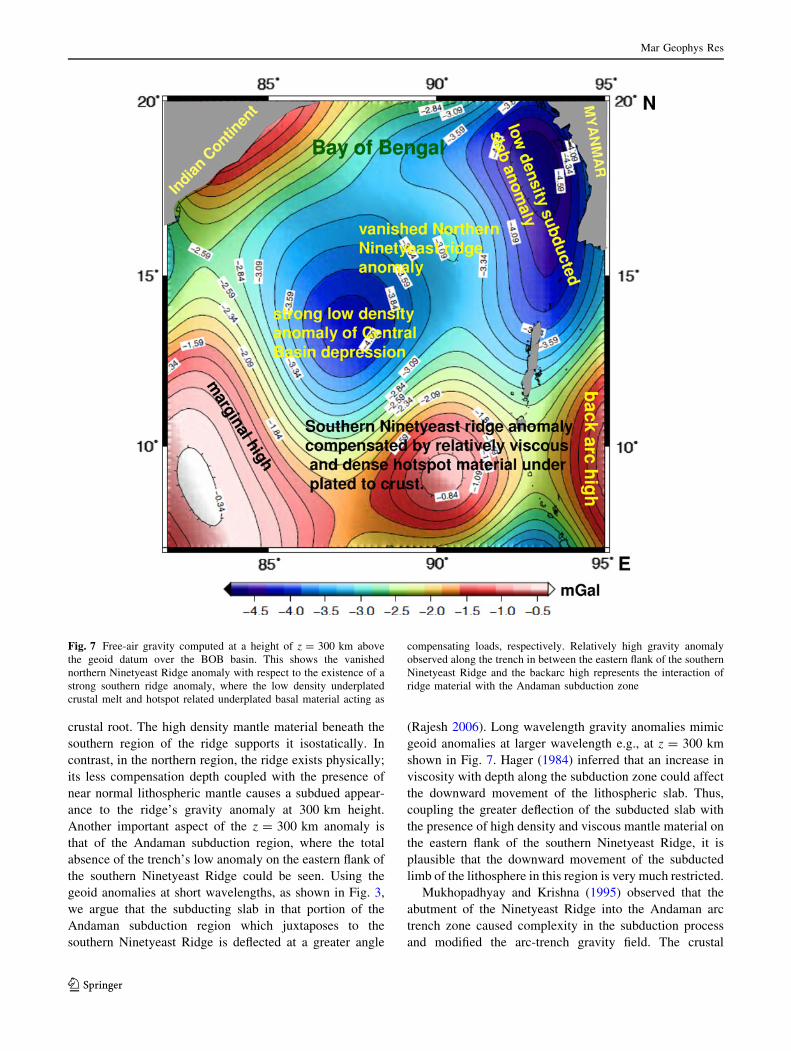
crustal root. The high density mantle material beneath the
southern region of the ridge supports it isostatically. In
contrast, in the northern region, the ridge exists physically;
its less compensation depth coupled with the presence of
near normal lithospheric mantle causes a subdued appear-
ance to the ridge’s gravity anomaly at 300 km height.
Another important aspect of the z = 300 km anomaly is
that of the Andaman subduction region, where the total
absence of the trench’s low anomaly on the eastern flank of
the southern Ninetyeast Ridge could be seen. Using the
geoid anomalies at short wavelengths, as shown in Fig. 3,
we argue that the subducting slab in that portion of the
Andaman subduction region which juxtaposes to the
southern Ninetyeast Ridge is deflected at a greater angle
(Rajesh 2006). Long wavelength gravity anomalies mimic
geoid anomalies at larger wavelength e.g., at z = 300 km
shown in Fig. 7. Hager (1984) inferred that an increase in
viscosity with depth along the subduction zone could affect
the downward movement of the lithospheric slab. Thus,
coupling the greater deflection of the subducted slab with
the presence of high density and viscous mantle material on
the eastern flank of the southern Ninetyeast Ridge, it is
plausible that the downward movement of the subducted
limb of the lithosphere in this region is very much restricted.
Mukhopadhyay and Krishna (1995) observed that the
abutment of the Ninetyeast Ridge into the Andaman arc
trench zone caused complexity in the subduction process
and modified the arc-trench gravity field. The crustal
Fig. 7 Free-air gravity computed at a height of z = 300 km above
the geoid datum over the BOB basin. This shows the vanished
northern Ninetyeast Ridge anomaly with respect to the existence of a
strong southern ridge anomaly, where the low density underplated
crustal melt and hotspot related underplated basal material acting as
compensating loads, respectively. Relatively high gravity anomaly
observed along the trench in between the eastern flank of the southern
Ninetyeast Ridge and the backarc high represents the interaction of
ridge material with the Andaman subduction zone
Mar Geophys Res
123
signature of hindered down going of slab is evident from
the south Andaman trench gravity anomaly, as shown in
Fig. 5 (blue color) juxtaposed against the southern Ninet-
yeast Ridge. The trench anomalies (L6 and L7) are very
close and narrow in comparison with the trench anomalies
(L2–L4) close to the northern Ninetyeast Ridge region.
This suggests that the crust of the southern portion of the
ridge in the vicinity of the trench experiences greater
deformation. In general subduction zone anomalies are also
affected by crustal shortening where complex stress
regimes are developed: (1) due to the combined movement
of thrust systems either oblique or perpendicular to the
convergent boundary and (2) formation of strike-slip
components which cause a series of parallel faults to form
along the axis of the convergent boundary and transverse in
the EW thrust direction. Such transverse structures are
evident from Fig. 5 and are shown as white dashed lines.
The anomaly lows marked from L1 to L7 are formed in
between such transverse structures, along the axis of the
Andaman convergent zone. Thus, the undercompensated
southern Ninetyeast Ridge modulates the regional scenario
of the crustal deformation and hence tightening of the
trench anomaly contours L6 and L7. Deformational
structures associated with the ridge in such a transpres-
sional regime are evident on the eastern flank of the
southern Ninetyeast Ridge as a forearc sliver, which is
marked as dashed violet lines in Fig. 5 and as PP0 in Fig. 3.
Interestingly, such structures are not present in Figs. 6 and
7, where the effect of mantle lithosphere dominates the low
gravity anomaly of the north Andaman subduction zone
and the southern Ninetyeast Ridge. The absence of the
continuation of the low density subducted slab anomaly
between the eastern flank of the southern Ninetyeast Ridge
and the backarc high is conspicuous. This shows that at
lithospheric depth, the compensating load of the ridge
affects the internal driving density contrast that leads to
subduction and appears at surface as a case of oblique
ridge-trench collision.
An integrated crustal structure of northern and southern
portion of the Ninetyeast Ridge in the Bay of Bengal
basin
An integrated crustal structural model of the Ninetyeast
Ridge system north of 5�N has been developed by putting
together all the results gathered through geoid-to-
Water Column (1.03 gm/cm3)
Sediment (2.5 gm/cm3)
Oceanic Basalt (2.9 gm/cm3)
Mantle (3.4 gm/cm3)
Mantle (3.0 gm/cm3)8.7 ±±±± 0.4 km
Ridge crest
Ridge flank
Water Column (1.03 gm/cm3)
Sediment (2.5 gm/cm3)
Oceanic Basalt (2.9 gm/cm3)
Mantle (3.4 gm/cm3)
Mantle (3.0 gm/cm3) 22.3 ±±±± 0.5 km
Ridge crest
Ridge flank
(a)
(b)
Support of low density crustal melt
Support of viscous, dense under plated hotspot material
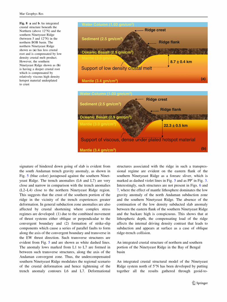
Fig. 8 a and b An integrated
crustal structure beneath the
Northern (above 12�N) and the
southern Ninetyeast Ridge
(between 5 and 12�N) in the
northern BOB basin. The
northern Ninetyeast Ridge
shown as (a) has less crustal
root and is compensated by low
density crustal melt product.
However, the southern
Ninetyeast Ridge shown as (b)
is having a deeper crustal root
which is compensated by
relatively viscous high density
hotspot material underplated
to crust
Mar Geophys Res
123
topography, residual geoid, gravity-to-topography and the
harmonic analyses of the Bay of Bengal gravity anomaly.
Figure 8a and b show the integrated crustal structure of the
Ninetyeast Ridge, representing its northern (north of 12�N)
and the southern portions (between 12 and 5�N) in the Bay
of Bengal. The isostatic compensation processes prevailing
in the Bay of Bengal basin, especially along the aseismic
Ninetyeast Ridge, reflect not only a simple crustal root
compensation process, but also depends upon the gravita-
tional support provided by the upper mantle. Grevemeyer
and Flueh (2000) have reported the compensation phe-
nomena as subsurface loading at a depth of 25 km in the
southern portion of the ridge, south of the equator.
Mahoney et al. (1983) reported upper mantle accretion
beneath the ridge at its southern latitudes south of the
equator.
In the present study, based upon geoid to topography
ratio, we inferred that the average crustal compensation of
the southern Ninetyeast Ridge system from 5 to 12�N is
around 22.3 km (Fig. 8b), which is much higher in com-
parison with the observed average 8 km compensation
depth for the northern ridge system between 12 and 17�N.
This indicates a shallow Moho in the northern portion of
the Ninetyeast Ridge compared to the southern region.
Recent studies based upon geoid to age offsets of the
Ninetyeast Ridge, Majumdar et al.(2009) estimated an
average lithospheric thickness of around 125 km. Krishna
et al.(2001) estimated effective elastic thickness (Te) as
35 km by considering an average lithospheric age of
80 Ma. The continuation of gravity anomalies at various
heights above the geoid datum have been used to under-
stand the strength of long wavelength mantle density
anomalies. This shows that from 5 to 12�N there exist
strong lithospheric mantle density anomalies below the
ridge, which dominate in all the upward continuation
heights. Furthermore, the gravity-to-topography kernel of
the southern Ninetyeast Ridge also shows the presence of a
single strong compensating source body. Thus, in general,
a substantial portion of mantle lithosphere is supporting the
ridge system towards its gravitational stability, especially
between 5 and 12�N. The dominance of mantle lithosphere
in supporting the ridge as a subsurface load can be
explained on the basis of the hotspot related material un-
derplated to the crust beneath the ridge during the north-
ward movement of the Bay of Bengal oceanic lithosphere
over the Kerguelen hotspot (Phipps Morgan et al. 1995).
From Fig. 5, it is evident that the area occupied by the
emplacement of Kerguelen hotspot magma over the Bay of
Bengal lithosphere grows from 17 to 5�N with an apparent
break at around 12–13�N (shown as black oblique arrows).
The region from 17 to 12�N represents the northernmost
and the initial phase of interaction of Kerguelen hotspot
magma with the Bay of Bengal oceanic lithosphere. While
from south of 13–5�N and even further south up to the
equator, the aerial occupation of hotspot magma was not
only large but also strong, representing the later phase of
Kerguelen hotspot magmatism (Phipps Morgan et al.
1995). Thus, there exists a subsurface load below the ridge
from the northernmost 17–5�N at varying compensation
depths due to variation in the hotspot related underplated
magmatic material during the northward movement of the
Bay of Bengal oceanic lithosphere over the Kerguelen
hotspot.
The presence of underplated magmatic mantle material
beneath the ridge between 5 and 12�N can also be
explained on the basis of residual geoid anomalies and
thermal diffusion. Geoid anomalies are sensitive to vis-
cosity of the mantle lithosphere and hence its flow due to
thermal diffusion. Figure 3 shows high residual geoid
anomaly of more than 3.5 m over the ridge system between
5 and 12�N. High geoid anomalies are expected if the
underplated hotspot related material beneath the ridge is
highly viscous and would not diffuse away from the ridge,
as shown in Fig. 8b.
However, beneath the northern ridge segment (from 12
to 17�N), the presence of low density crustal melt product,
as shown in Fig. 8a, has a role in determining the relatively
subdued gravity anomaly. The shallow compensation depth
of around 8 km also suggests the possibility of the existence
of low density melt products at the crustal level. Mukho-
padhyay and Krishna (1995) also reported the presence of
relatively low density crustal material in this portion of the
ridge. The gravity-to-topography kernel also shows multi-
ple side lobes in this region, which indicates that the com-
pensating source body of the ridge anomaly is possibly
obscured by the presence of short wavelength shallow
density anomaly structures. This is also evident in the
continuum field of the northern segment, shown in Fig. 7,
where at z = 300 km the density effect of the northern ridge
segment had completely vanished. If there was mantle
plume material present or dominant beneath the northern
segment of the ridge as a subsurface load, then its density
effect would have prevailed at z = 300 km. Apart from
this, the northern segment of the ridge system represents the
initial phase of interaction of the Kerguelen magmatism
with the Bay of Bengal oceanic lithosphere and occupies a
smaller area of eruption not much influenced by the plume
mantle density. Thus, the subdued gravity effect of the
northern segment is plausibly due to the dominance in the
low density effect of the underplated crustal melt product.
Conclusions
In this paper, the isostatic compensation mechanism of the
Ninetyeast Ridge system north of 5�N was studied using
Mar Geophys Res
123
satellite altimeter-derived geoid and gravity data. This
region is characterized by the first interaction phase of the
Kerguelen hotspot magma with the Bay of Bengal oceanic
lithosphere. Results were analysed through geoid-to-
topography ratio, residual geoid, gravity-to-topography
kernel and the upward continuation of free-air gravity
anomalies. In this area, the ridge has been observed as
having different northern (between 12 and 17�N) and
southern segments (between 5 and 12�N) with two different
sources of isostatic compensating load.
The analysis of Geoid/Topography ratios (GTR) in the
northern Ninetyeast Ridge system and the subsequent
computation of the apparent compensation depth show that
the Ninetyeast Ridge is in Pratt’s mode of isostatic com-
pensation with an average compensation depth of
8.7 ± 0.4 km. The subdued gravity signal of the ridge in
this region and its total absence from the z = 300 km
height continued anomaly indicates the source compensa-
tion body is mainly dominated by the low density under-
plated crustal melt. Gravity-to-topography kernel also
corroborates the existence of shallow multiple sources as
compensation loads.
The southern Ninetyeast Ridge system shows greater
depth of compensation of 22.3 ± 0.5 km obtained through
GTR and hence relatively deeper Moho. Gravity-to-
topography kernel and residual geoid show that a single,
prominent and long wavelength source body, which dom-
inated in all the continuation heights, provides the much
gravitational support of the ridge in this region. This
indicates the presence of dense, relatively cool and viscous
hotspot related underplated basal magmatic material that
accumulated beneath the ridge during the fast (*9 cm/a)
movement of the Indian plate over the Kerguelen hotspot.
Such relatively dense and viscous underplated magmatic
body might not diffuse away and could remain as a rela-
tively buoyant, under-compensated feature to gravitation-
ally stabilize the ridge system.
Results from residual geoid and free-air anomaly con-
tinued at a height of z = 50 km revealed the interaction of
the Ninetyeast Ridge systems with the Andaman Trench
zone, especially with the southern Ninetyeast Ridge. The
southern Ninetyeast Ridge is situated in a transpressional
regime, where the undercompensated ridge is subjected to
subduction-related thrust movement and shear along the
convergent plate boundary, which leads to the formation of
a forearc sliver at its eastern flank. Thus, the low trench
anomalies (L6 and L7 in Fig. 5) in the vicinity of southern
Ninetyeast Ridge bear the signatures of severe crustal
shortening compared to other trench anomalies in the
vicinity of the northern Ninetyeast Ridge. It has also
revealed, from large wavelength gravity anomalies, that the
cause of the observed trench crustal deformational signa-
tures in z = 50 km juxtaposing the southern Ninetyeast
Ridge is because of the interaction of the ridge compen-
sating source body with the depth-dependent internal
mantle driving density contrast of the plate subduction.
Acknowledgments The authors are thankful to Dr. Peter Clift,
Editor-in-Chief, MGR and another anonymous Referee for their
valuable suggestions for improvement of the manuscript. They also
wish to thank Director, WIHG, Dehradun, Dr. B. K. Rastogi,
Director General, ISR, Gandhinagar, Dr. R. R. Navalgund, Director,
SAC, Dr. J. S. Parihar, DD, RESA/SAC and Dr. Ajai, GD, MESG/
RESA/SAC, Ahmedabad for their keen interest in this study. They
also thank Mr. K. M. Sreejith, MESG for his help. Figures are
plotted using GMT software.
References
Angevine CL, Turcotte DL (1983) Correlation of geoid and depth
anomalies over the Agulhas Plateau. Tectonophys 100:43–52
Bhattacharya BK (1965) Two-dimensional harmonic analysis as a
tool for magnetic interpretation. Geophys 30(5):829–857
Bowin C (1973) Origin of the Ninety East Ridge from studies near the
equator. J Geophys Res 78(26):6029–6042
Clift PD (2005) Sedimentary evidence for moderate mantle temper-
ature anomalies associated with hotspot volcanism. Spec Paper
Geol Soc Am 388:279–287
Curray JR, Emmel FJ, Moore DG, Raitt MW (1982) Structure,
tectonics and geological history of the Northeastern Indian
Ocean. In: Nairn AEM, Stehli FG, Uyeda S (eds) The ocean
basin and margins, vol 6. The Indian Ocean Plenum, NY, pp
399–449
Dorman LM, Lewis BTR (1972) Experimental isostasy 3: inversion
of the isostatic Green’s function and lateral density changes.
J Geophys Res 77:3068–3077
Duncan RA (1991) Age distribution of volcanism along aseismic
ridges in the eastern Indian Ocean. Proc Ocean Drill Program Sci
Results (College Station, Texas) 121:507–517
Grevemeyer I, Flueh ER (2000) Crustal underplating and its
implications for subsidence and state of isostacy along the
Ninetyeast Ridge hotspot trail. Geophys J Int 142:643–649
Hager BH (1984) Subducted slabs and the geoid: constraints on
mantle rheology and flow. J Geophys Res 89(B7):6003–6015
Haxby WF, Turcotte DL (1978) On isostatic geoid anomalies.
J Geophys Res 83:5473–5478
Kent RW, Pringle MS, Muller RD, Saunders AD, Ghose NC (2002)40Ar/39Ar geochronology of the Rajmahal Basalts, India and
their relationship to the Kerguelen Plateau. J Petrology
43(7):1141–1153
Krishna KS, Rao DG, Ramana MV, Subrahmanyam V, Sarma
KVLNS, Pilipenko AI, Scherabakov VS, Murthy IVR (1995)
Tectonic models for the evolution of oceanic crust in the
northeastern Indian Ocean from the late Creataceous to the early
Tertiary. J Geophys Res 100(B10):20011–20024
Krishna KS, Gopala Rao D, Subba Raju LV, Chaubey AK,
Scherbakov VS, Pilipenko AI, Murthy IVR (1999) Paleocene
on-spreading-axis hotspot volcanism along the Ninetyeast Ridge:
an interaction between the Kerguelen hotspot and the Wharton
spreading center. Proc Ind Acad Sci (Earth Planet Sci) 108:
255–267
Krishna KS, Neprochnov YP, Rao DG, Grinko BN (2001) Crustal
structure and tectonics of the Ninetyeast Ridge from seismic and
gravity studies. Tectonics 20:416–433
Lemoine FG, Kenyon SC, Factor JK, Trimmer RG, Pavlis NK, Chinn
DS, Cox CM, Klosko SM, Luthcke SB, Torrence MH, Wang
Mar Geophys Res
123
YM, Williamson RG, Pavlis EC, Rapp RH, Olson TR (1998)
The development of the joint NASA-GSFC and the National
Imagery and Mapping Agency (NIMA) geopotential model
EGM96. NASA/TP-1998-206861: www.cddis.gsfc.nasa.gov
Mahoney JJ, Macdougall JD, Lugmair GW, Gopalan K (1983)
Kerguelen hotspot source for Rajmahal traps and Ninetyeast
Ridge? Nature 303:385–389
Majumdar TJ, Bhattacharyya R (2004) An Atlas of very high
resolution satellite geoid/gravity over the Indian offshore. SAC
Tech Note No. SAC/RESIPA/MWRG/ESHD/TR-21/2004. Nov
2004, p 46
Majumdar TJ, Mohanty KK, Srivastava AK (1998) On the utilization
of ERS-1 altimeter data for offshore oil exploration. Int J Rem
Sens 19:1953–1968
Majumdar TJ, Bhattacharya R, Chatterjee S, Krishna KS (2009)
Utilization of high resolution satellite data for estimation of
lithospheric thickness in the Bay of Bengal. Ind J Mar Sci
38(4):382–389
McKenzie DP, Bowin C (1976) Some remarks on heat flow and
gravity anomalies. J Geophys Res 72:6261–6273
McKenzie DP, Watts AB, Parsons B, Roufouse M (1980) Platform of
mantle convection beneath the Pacific Ocean. Nature 288:442–
446
McNutt M (1979) Compensation of oceanic topography: An appli-
cation of the response function technique to the Surveyor area.
J Geophys Res 84:7589–7598
Monnereau M, Cazenave A (1988) Variation of the apparent
compensation depth of hotspot swells with age of plate. Earth
Planet Sci Lett 91:179–197
Mukhopadhyay M, Krishna MR (1995) Gravity anomalies and deep
structure of the Ninetyeast Ridge north of the equator, eastern
Indian Ocean: a hot spot trace model. Mar Geophys Res 17:
201–216
Neprochnov YP, Merklin LR, Shreyder AA, Sedov VV, Yel’nikov IN
(1979) The structure of the East Indian (Ninety East) Ridge
according to the results of combined geophysical researches.
Oceanology 19:431–438
Ockendon JR, Turcotte DL (1977) On the gravitational potential and
field anomalies due to thin mass layers. Geophys J R Astron Soc
48:479–492
Phipps Morgan J, Morgan WJ, Price E (1995) Hotspot melting
generates both hotspot melting and a hotspot swell. J Geophys
Res 100:8045–8062. doi:10.1029/94JB02887
Rajesh S (2006, March) Studies on the Bay of Bengal Oceanic
Lithosphere based on Satellite Altimeter-Derived Geoid and
Gravity Data. PhD Thesis, Gujarat University, Ahmedabad,
p 187
Rajesh S, Majumdar TJ (2004) Generation of 3-D geoidal surface of
the Bay of Bengal lithosphere and its tectonic implications. Int J
Remote Sens 25(15):2897–2902
Rajesh S, Majumdar TJ (2005) Analysis of residual geoid and
topography of northern (above 5�N) Ninetyeast Ridge: inference
on the nature of ridge crustal compensation. In: International
workshop on tectonic and oceanic processes along the Indian
Ocean ridge system. National Institute of Oceanography, Dona
Paula, 19–21 January 2005
Ravine MA, Morgan JP (1993) Geoid effects of lateral viscosity
variation near the top of the mantle: a 2D model. Earth Planet Sci
Lett 119:617–625
Sandwell DT, McKenzie KR (1989) Geoid height versus topography
for oceanic plateaus and swells. J Geophys Res 94:7403–7418
Sclater JG, Fisher RL (1974) The evolution of the east central Indian
Ocean. Bull Geol Soc Am 85:683–702
Stokes Th (1960) Zur Bodengestalt des Indischen Ozeans, Erdkunde.
Archiv fur wiss Geogr 14:161–170
Subrahmanyam C, Gireesh R, Chand S, Kamesh Raju KA, Gopal Rao
D (2008) Geophysical characteristic of the Ninetyeast Ridge-
Andaman island arc/trench convergent zone. Earth Planet Sci
Lett 266:29–45
Tiwari VM, Diament M, Singh SC (2003) Analysis of satellite gravity
and bathymetry data over Ninety-East Ridge: variation in the
compensation mechanism and implication for emplacement
processes. J Geophys Res 108:2109. doi:10.1029/2000JB
000047
Watts AB (2001) Isostasy and flexure of the lithosphere. Cambridge
University Press, Cambridge, p 458
Weis D, Frey FA, Saunders A, Gibson I, Leg 121 Scientific Shipboard
party (1991) Ninetyeast Ridge (Indian Ocean): A 5,000 km
record of a Duple mantle plume. Geology 19:99–102
Wiens DA, DeMets C, Gordon RG, Stein S, Argus D, Engelin JF,
Lundgren P, Quible D, Stein C, Weinstein S, Woods DF (1985)
A diffuse plate boundary model for Indian Ocean tectonics.
Geophy Res Lett 12(7):429–432
Mar Geophys Res
123